

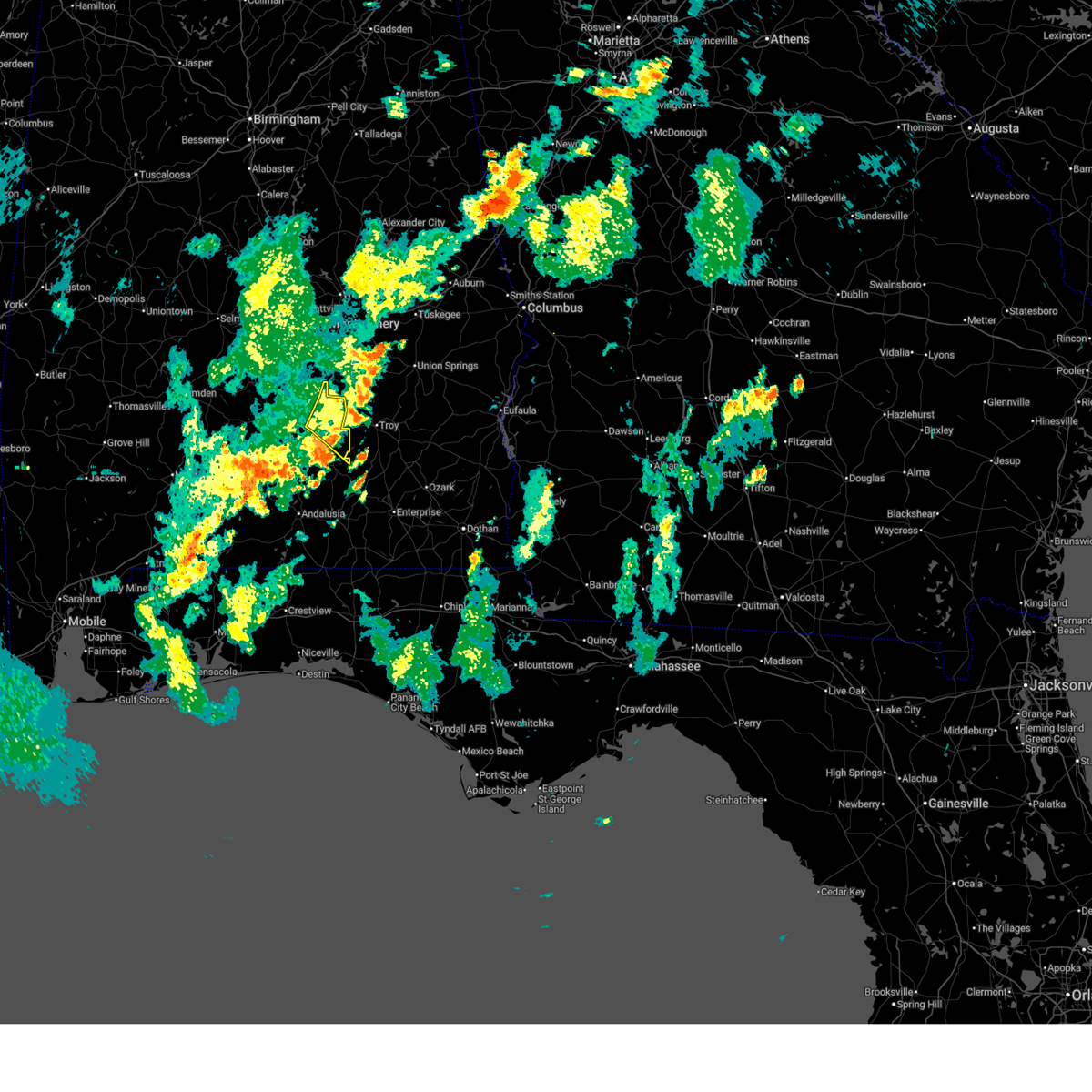
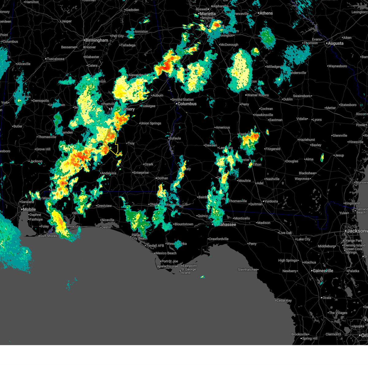
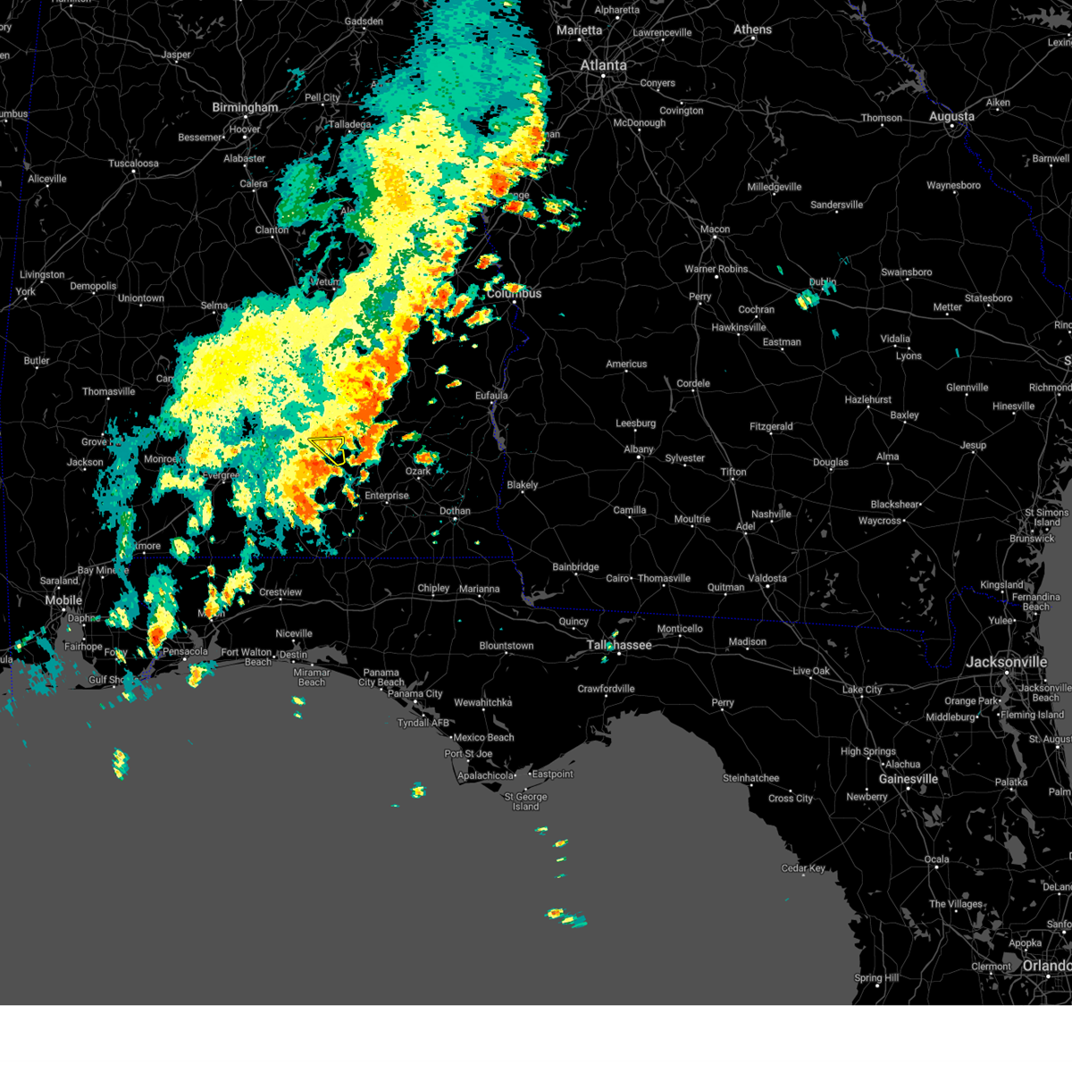
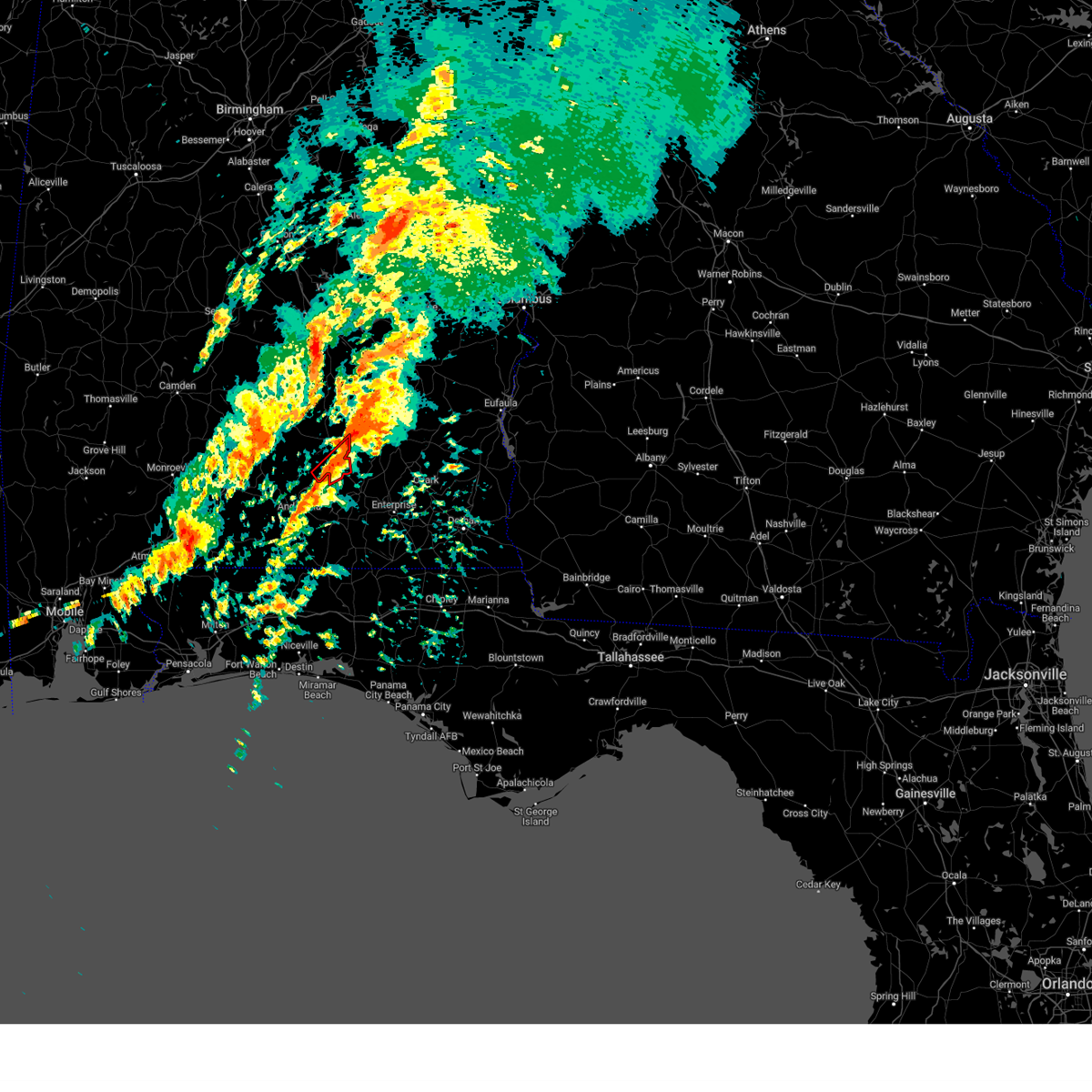
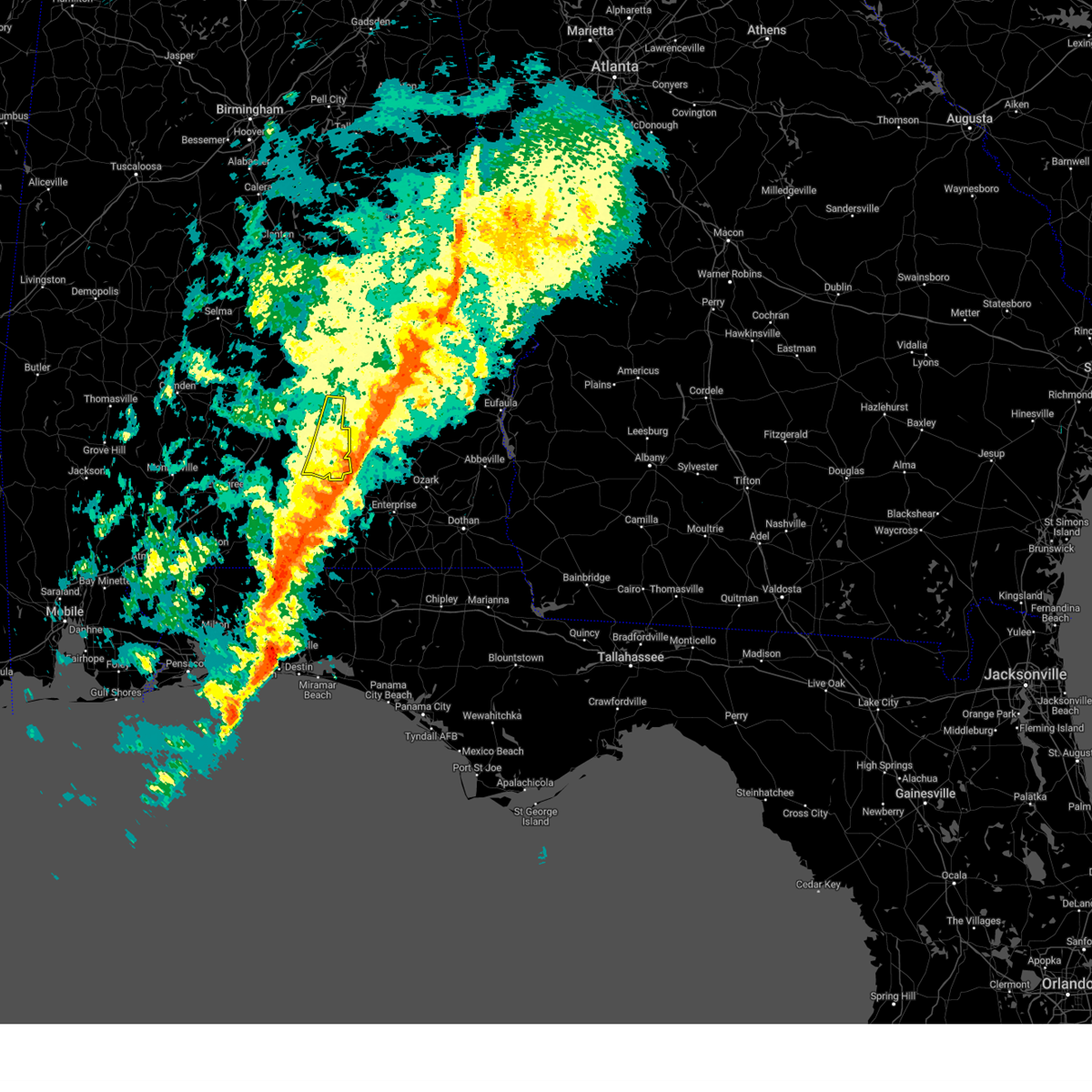
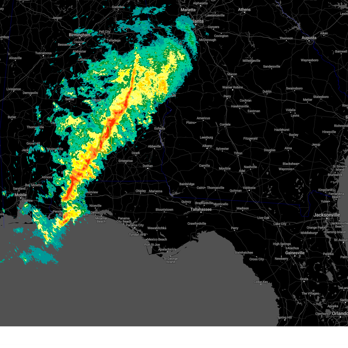
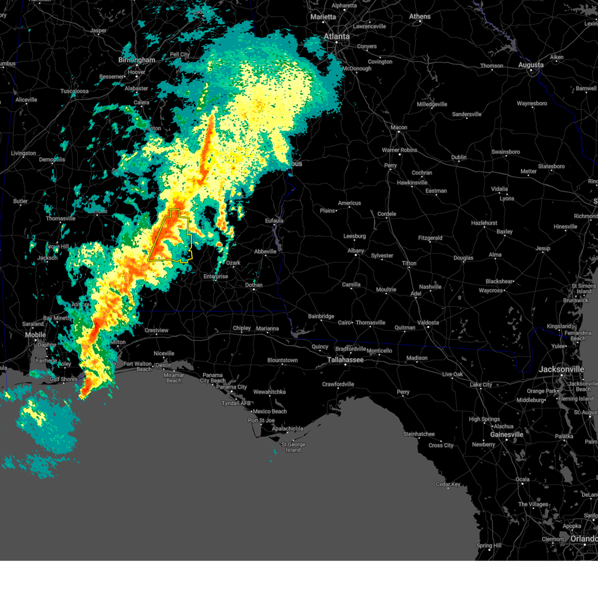
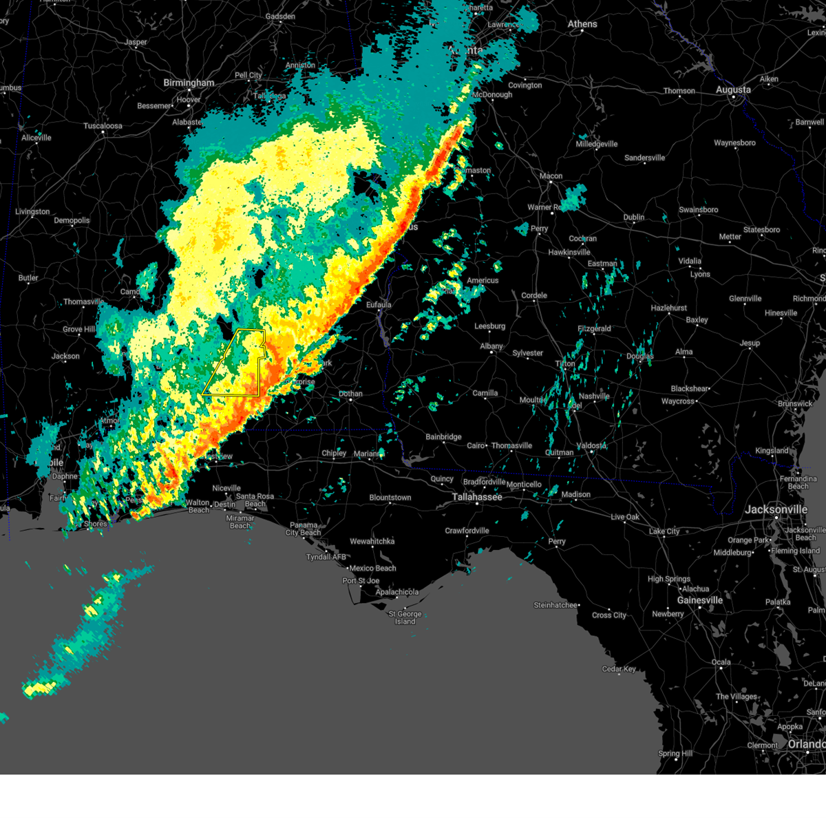
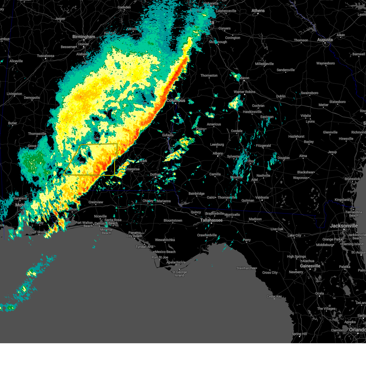
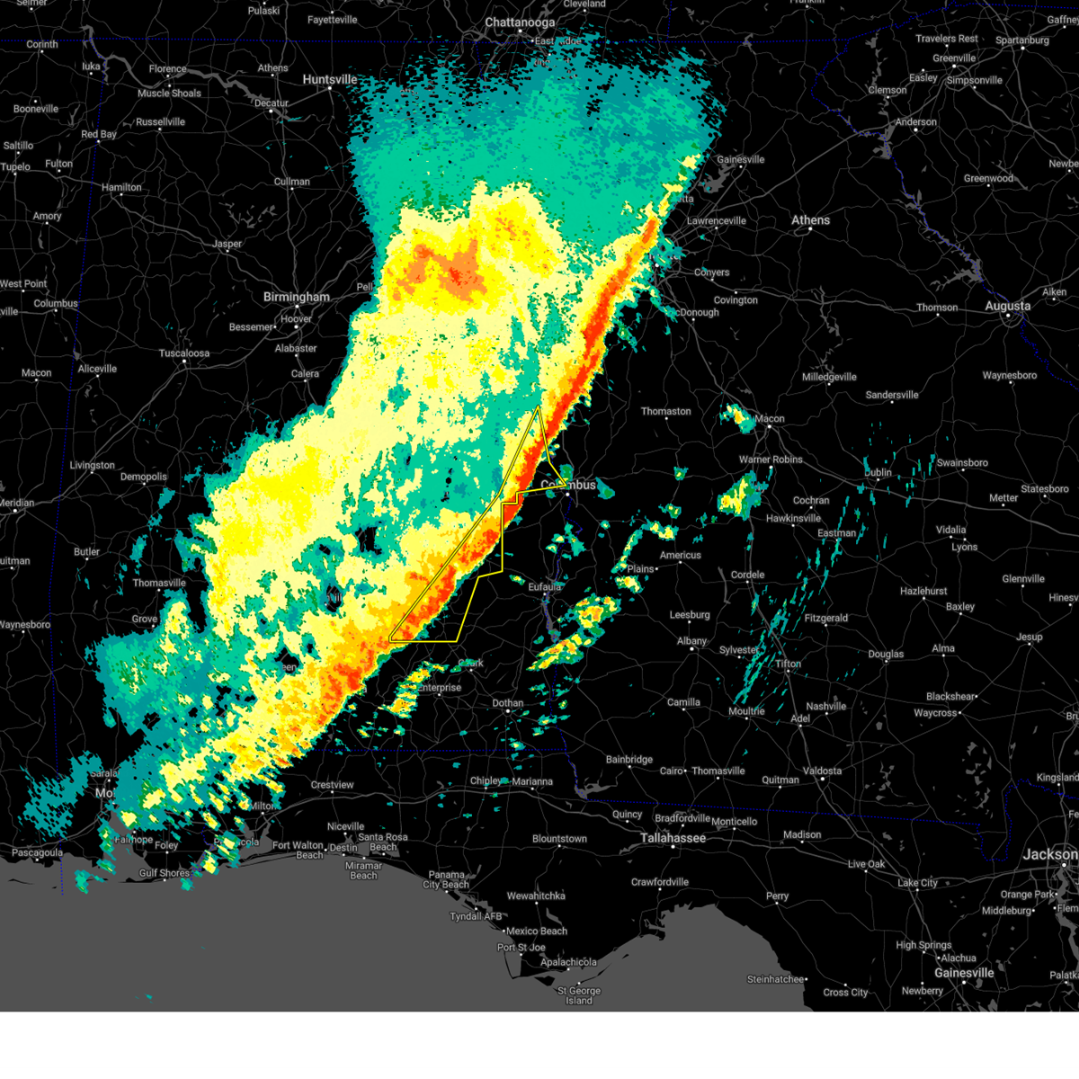
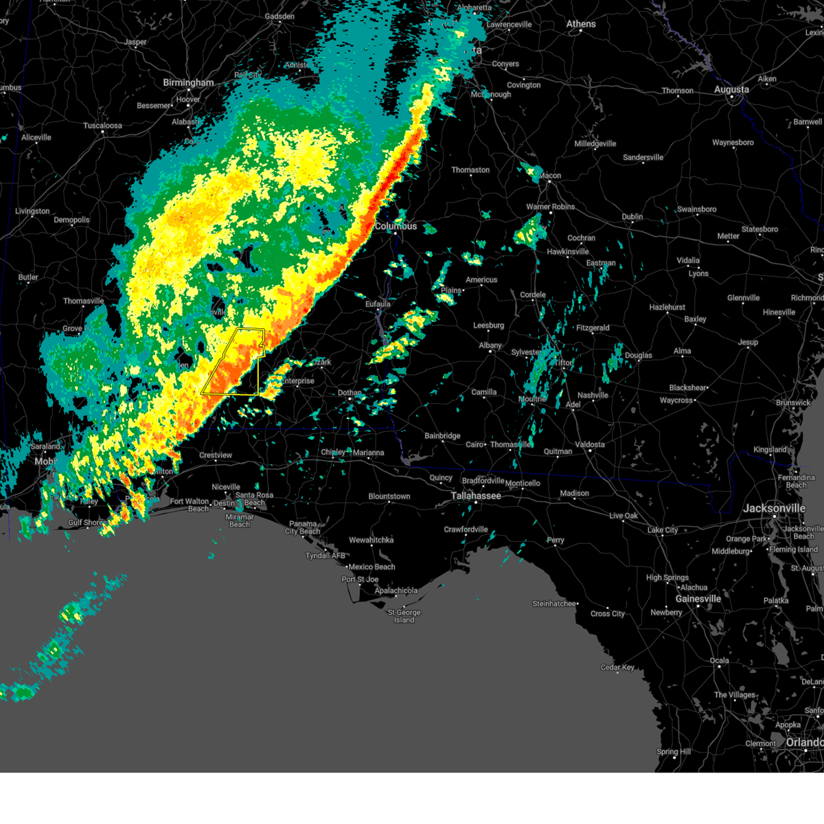
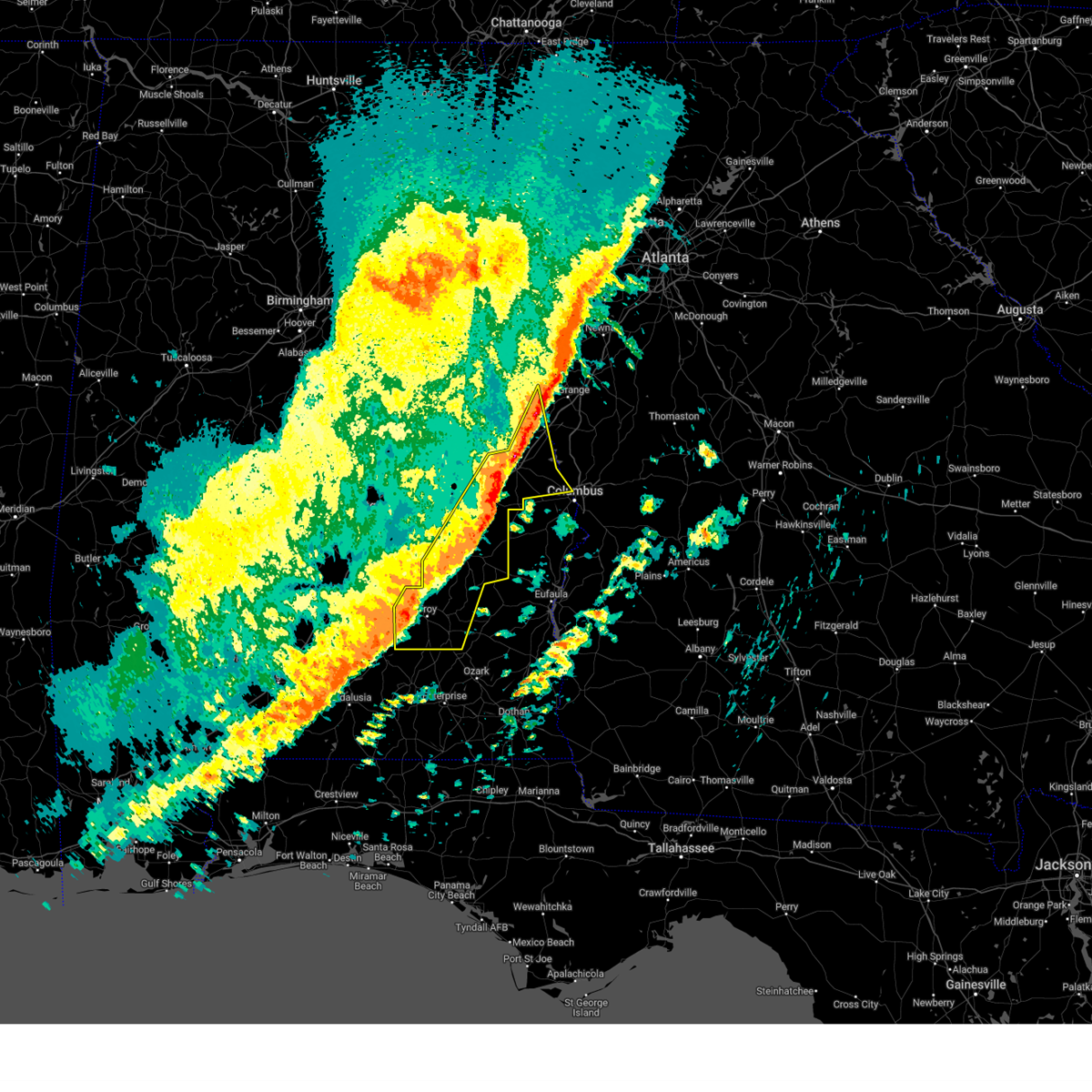
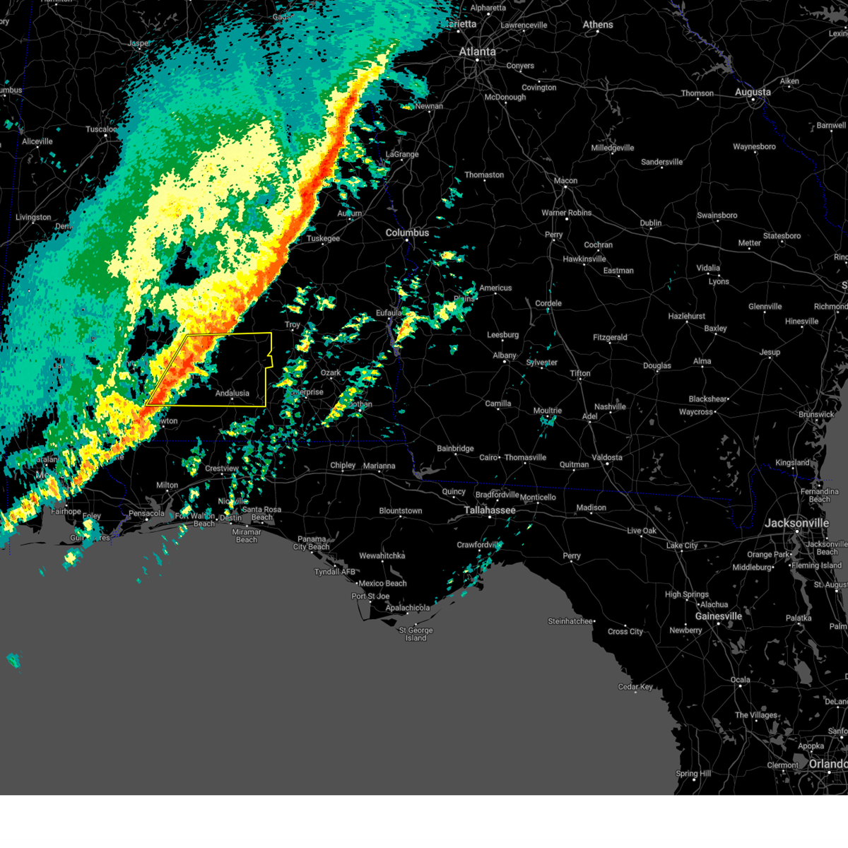
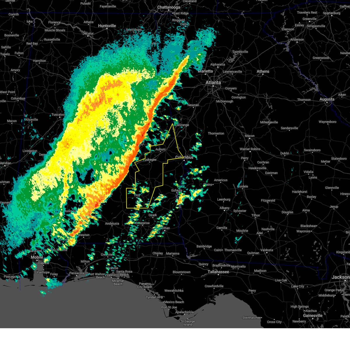
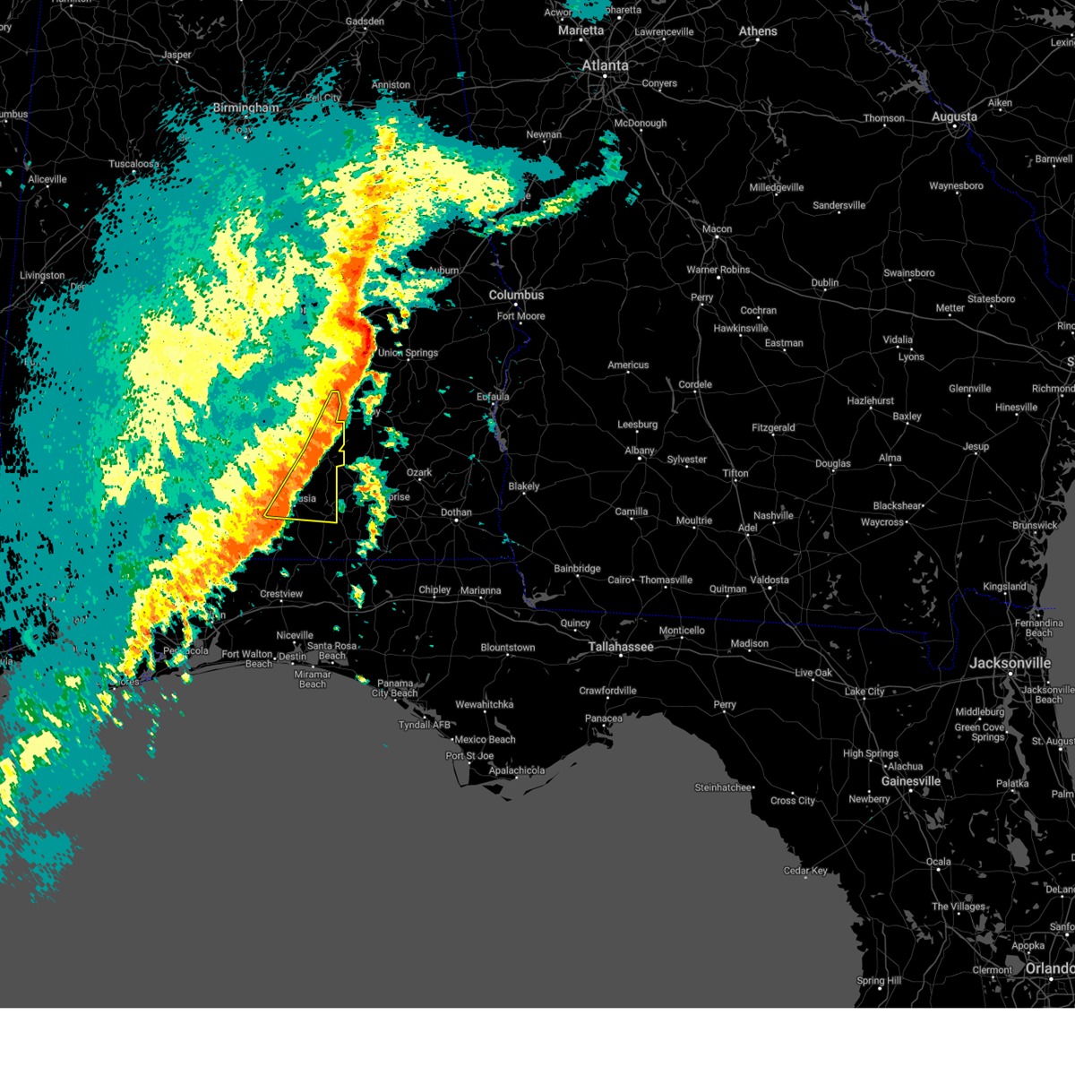
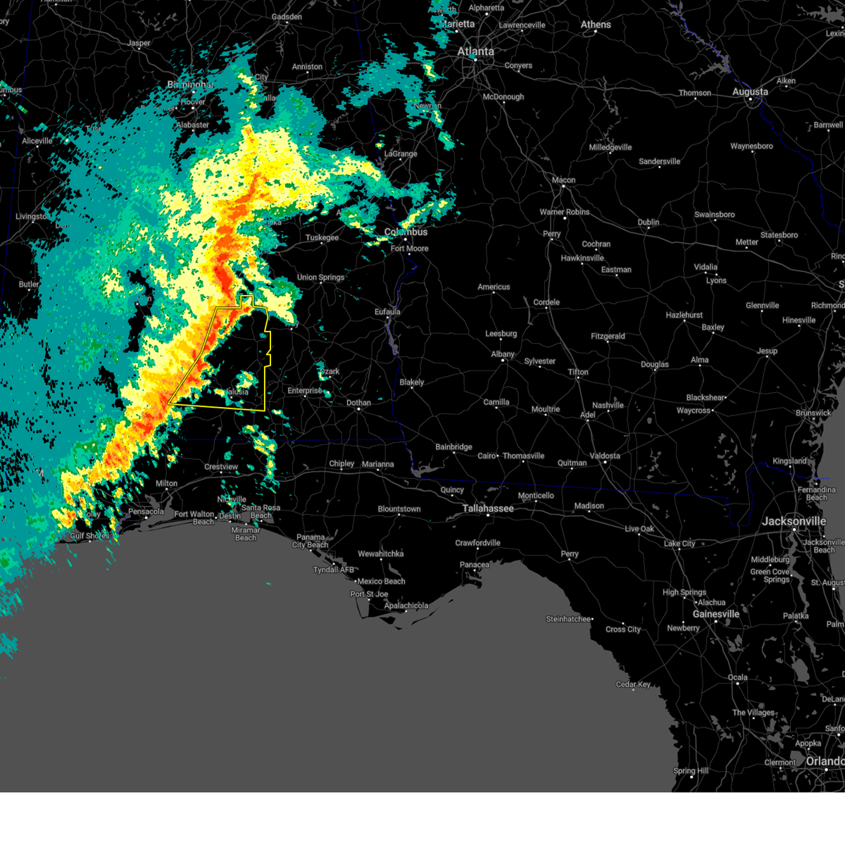
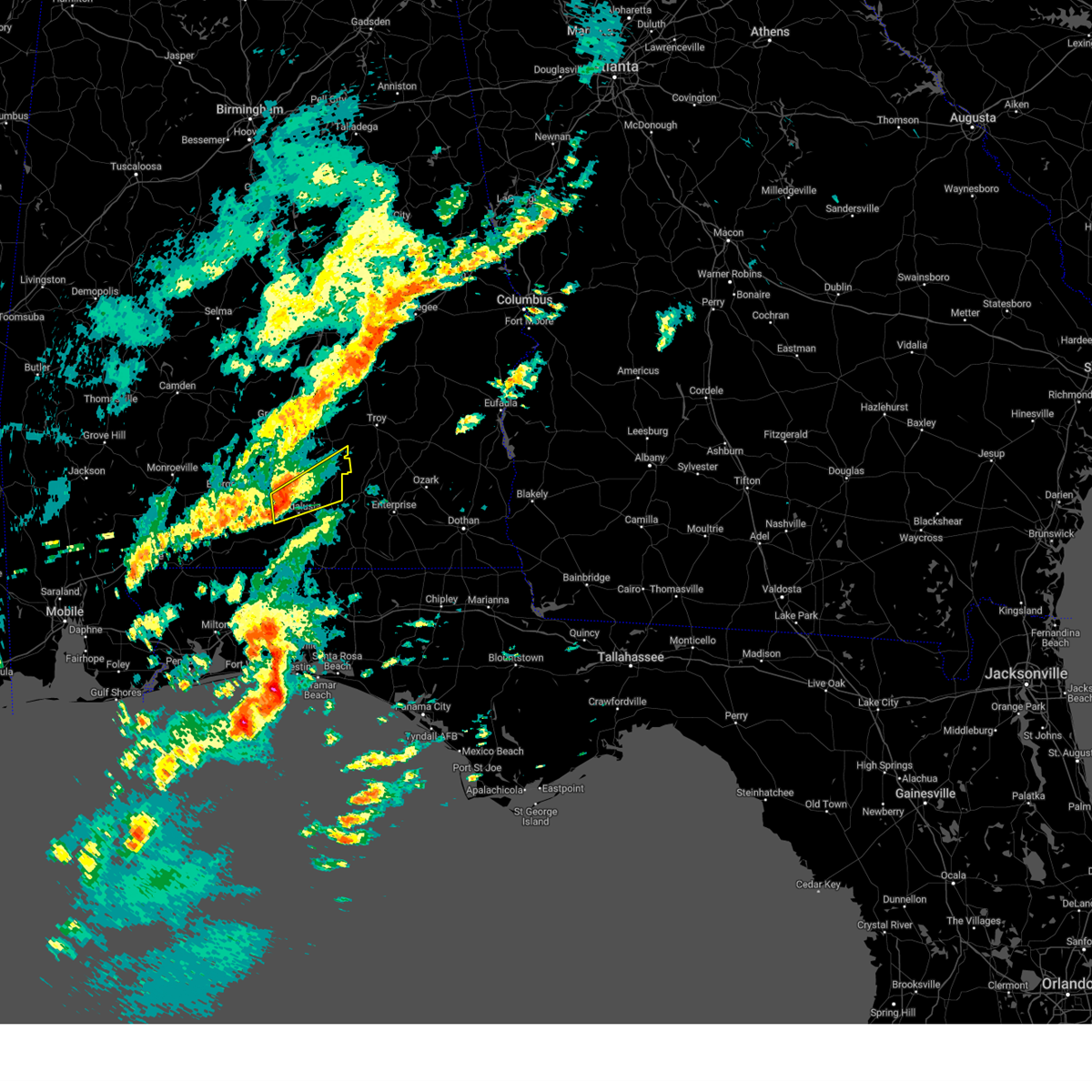
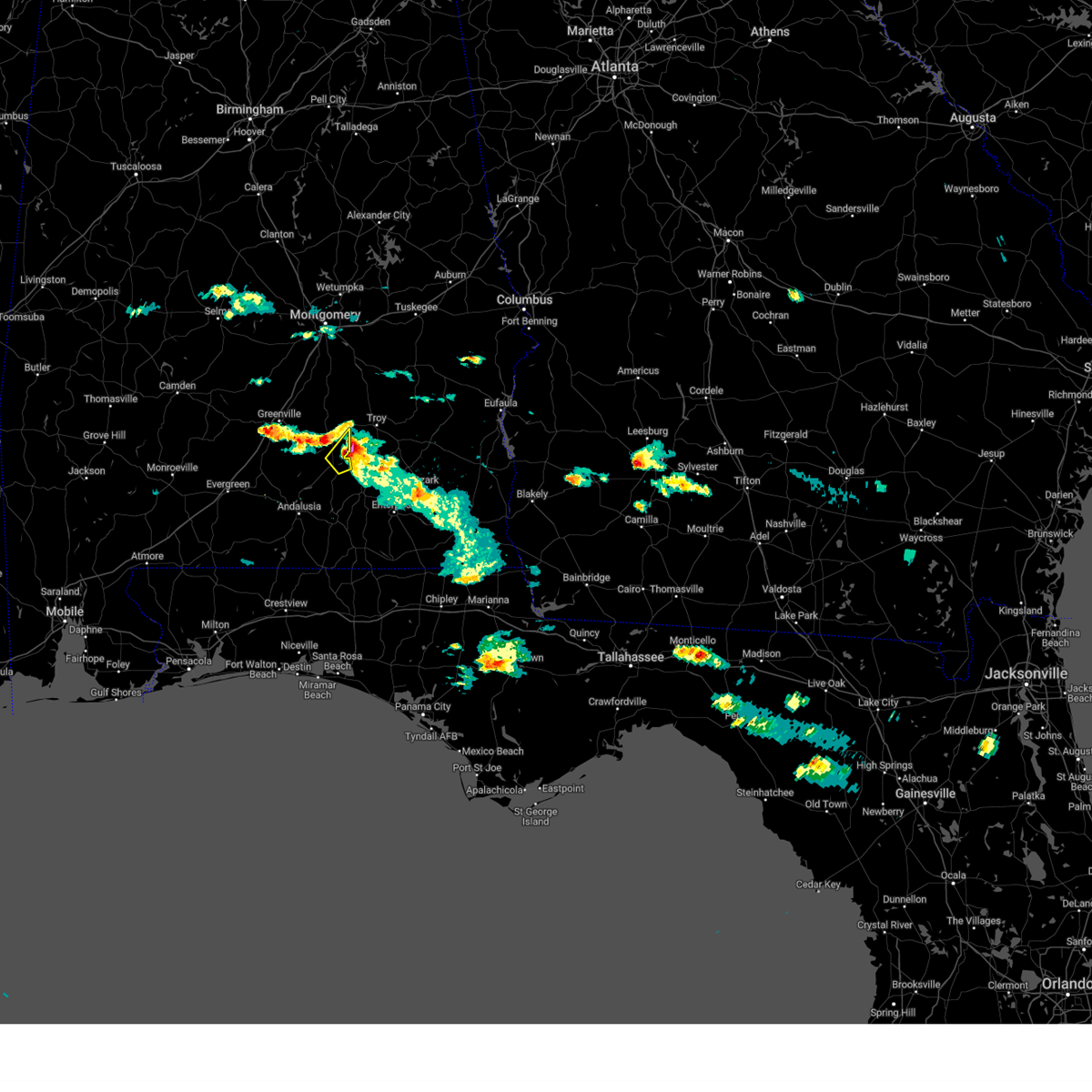
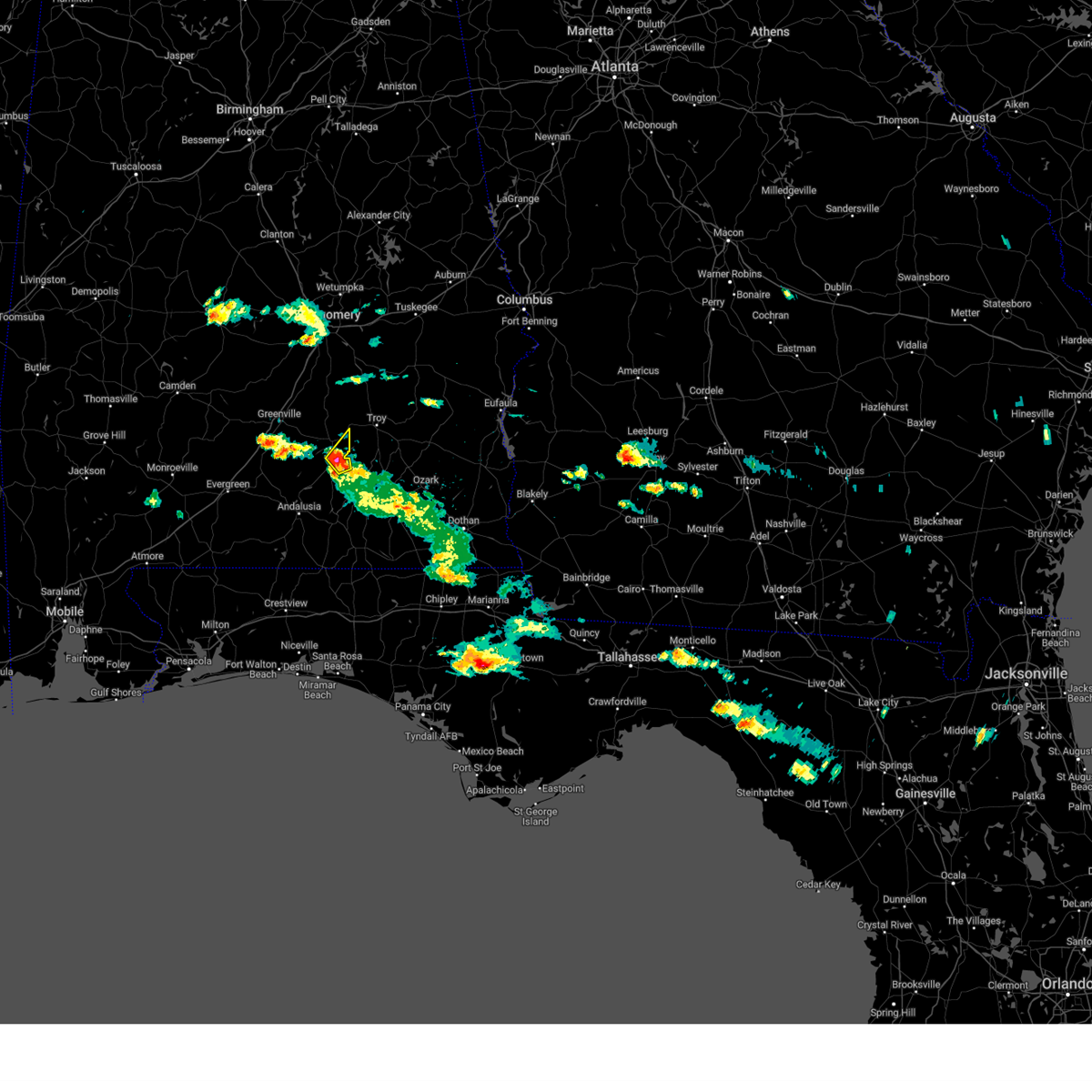
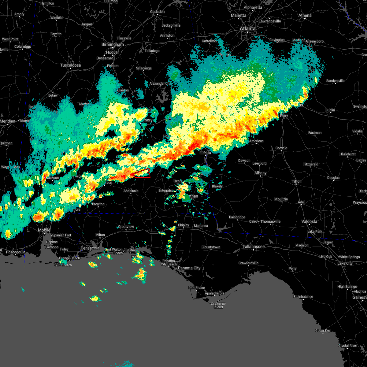
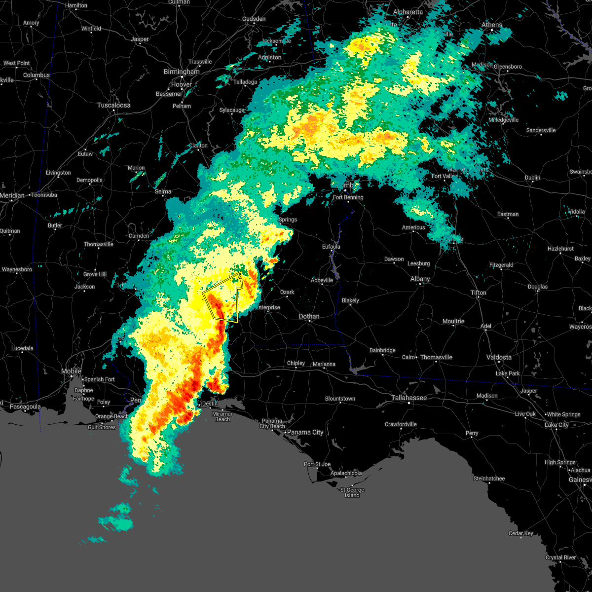
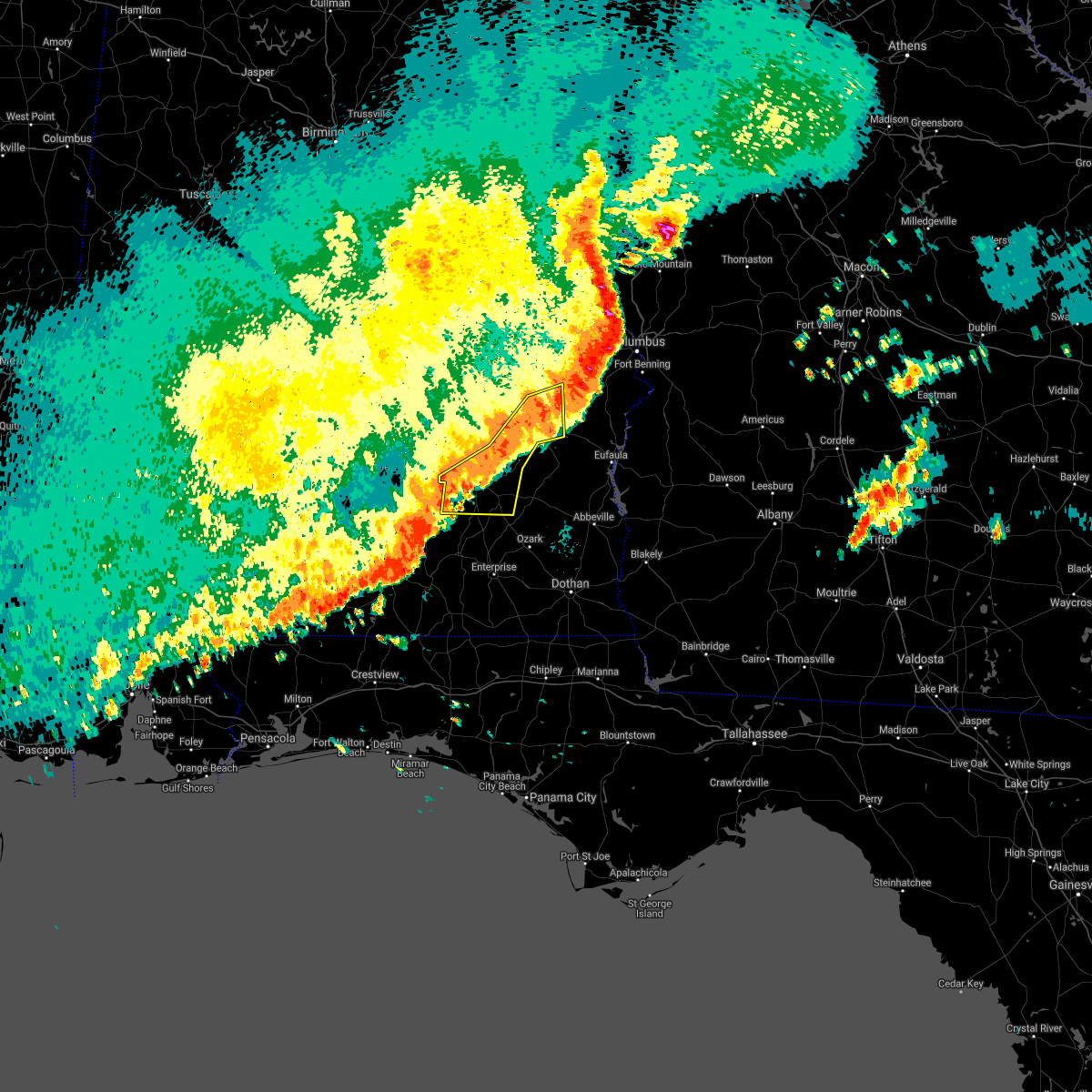
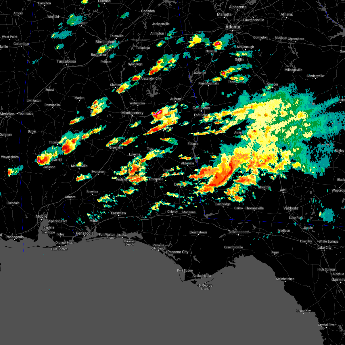
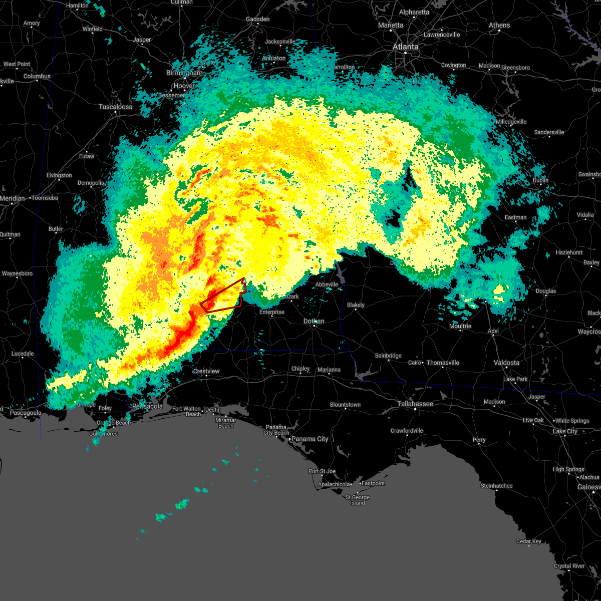
Hail Map for Glenwood, AL
The Glenwood, AL area has had 0 reports of on-the-ground hail by trained spotters, and has been under severe weather warnings 22 times during the past 12 months. Doppler radar has detected hail at or near Glenwood, AL on 42 occasions.
| Name: | Glenwood, AL |
| Where Located: | 69.5 miles ESE of Camden, AL |
| Map: | Google Map for Glenwood, AL |
| Population: | 187 |
| Housing Units: | 110 |
| More Info: | Search Google for Glenwood, AL |
0
The Top Recent Hail Date for Glenwood, AL is Saturday, May 25, 2024 (18th out of 42)

Hail and Wind Damage Spotted near Glenwood, AL
| Date / Time | Report Details |
|---|---|
| 7/1/2025 7:13 PM CDT |
 the severe thunderstorm warning has been cancelled and is no longer in effect the severe thunderstorm warning has been cancelled and is no longer in effect
|
| 7/1/2025 6:52 PM CDT |
 At 651 pm cdt, severe thunderstorms were located along a line extending from grady to 3 miles west of petrey to 8 miles northwest of rutledge, moving southeast at 30 mph (radar indicated). Hazards include 60 mph wind gusts. Expect damage to roofs, siding, and trees. Locations impacted include, luverne, rutledge, glenwood, petrey, and highland home. At 651 pm cdt, severe thunderstorms were located along a line extending from grady to 3 miles west of petrey to 8 miles northwest of rutledge, moving southeast at 30 mph (radar indicated). Hazards include 60 mph wind gusts. Expect damage to roofs, siding, and trees. Locations impacted include, luverne, rutledge, glenwood, petrey, and highland home.
|
| 7/1/2025 6:52 PM CDT |
 the severe thunderstorm warning has been cancelled and is no longer in effect the severe thunderstorm warning has been cancelled and is no longer in effect
|
| 7/1/2025 6:41 PM CDT | Svrmob the national weather service in mobile has issued a * severe thunderstorm warning for, northeastern butler county in south central alabama, northern crenshaw county in south central alabama, * until 730 pm cdt. * at 641 pm cdt, severe thunderstorms were located along a line extending from near strata to 3 miles south of highland home to 9 miles south of logan, moving southeast at 30 mph (radar indicated). Hazards include 60 mph wind gusts. expect damage to roofs, siding, and trees |
| 5/27/2025 2:02 PM CDT |
 the severe thunderstorm warning has been cancelled and is no longer in effect the severe thunderstorm warning has been cancelled and is no longer in effect
|
| 5/27/2025 1:44 PM CDT |
 Svrmob the national weather service in mobile has issued a * severe thunderstorm warning for, southeastern crenshaw county in south central alabama, * until 230 pm cdt. * at 144 pm cdt, a severe thunderstorm was located 4 miles southwest of luverne, moving southeast at 30 mph (radar indicated). Hazards include 60 mph wind gusts and penny size hail. expect damage to roofs, siding, and trees Svrmob the national weather service in mobile has issued a * severe thunderstorm warning for, southeastern crenshaw county in south central alabama, * until 230 pm cdt. * at 144 pm cdt, a severe thunderstorm was located 4 miles southwest of luverne, moving southeast at 30 mph (radar indicated). Hazards include 60 mph wind gusts and penny size hail. expect damage to roofs, siding, and trees
|
| 3/15/2025 10:52 PM CDT |
 The storm which prompted the warning has moved out of the area. therefore, the warning will be allowed to expire. a tornado watch remains in effect until 300 am cdt for south central alabama. The storm which prompted the warning has moved out of the area. therefore, the warning will be allowed to expire. a tornado watch remains in effect until 300 am cdt for south central alabama.
|
| 3/15/2025 10:37 PM CDT | Tormob the national weather service in mobile has issued a * tornado warning for, southeastern crenshaw county in south central alabama, * until 1100 pm cdt. * at 1036 pm cdt, a severe thunderstorm capable of producing a tornado was located over brantley, or 10 miles south of luverne, moving northeast at 50 mph (radar indicated rotation). Hazards include tornado. Flying debris will be dangerous to those caught without shelter. mobile homes will be damaged or destroyed. damage to roofs, windows, and vehicles will occur. tree damage is likely. this dangerous storm will be near, brantley around 1040 pm cdt. Glenwood around 1045 pm cdt. |
| 3/4/2025 11:28 PM CST |
 The storms which prompted the warning have moved out of the area. therefore, the warning will be allowed to expire. a tornado watch remains in effect until 100 am cst for south central alabama. The storms which prompted the warning have moved out of the area. therefore, the warning will be allowed to expire. a tornado watch remains in effect until 100 am cst for south central alabama.
|
| 3/4/2025 11:06 PM CST |
 the severe thunderstorm warning has been cancelled and is no longer in effect the severe thunderstorm warning has been cancelled and is no longer in effect
|
| 3/4/2025 11:06 PM CST |
 At 1105 pm cst, severe thunderstorms were located along a line extending from near shopton to 3 miles southeast of petrey to near brantley, moving east at 35 mph (radar indicated). Hazards include 60 mph wind gusts. Expect damage to roofs, siding, and trees. Locations impacted include, glenwood, rutledge, luverne, petrey, and brantley. At 1105 pm cst, severe thunderstorms were located along a line extending from near shopton to 3 miles southeast of petrey to near brantley, moving east at 35 mph (radar indicated). Hazards include 60 mph wind gusts. Expect damage to roofs, siding, and trees. Locations impacted include, glenwood, rutledge, luverne, petrey, and brantley.
|
| 3/4/2025 10:31 PM CST |
 Svrmob the national weather service in mobile has issued a * severe thunderstorm warning for, eastern butler county in south central alabama, crenshaw county in south central alabama, * until 1130 pm cst. * at 1030 pm cst, severe thunderstorms were located along a line extending from sellers to 8 miles southeast of greenville to 5 miles east of mckenzie, moving east at 35 mph (radar indicated). Hazards include 60 mph wind gusts. expect damage to roofs, siding, and trees Svrmob the national weather service in mobile has issued a * severe thunderstorm warning for, eastern butler county in south central alabama, crenshaw county in south central alabama, * until 1130 pm cst. * at 1030 pm cst, severe thunderstorms were located along a line extending from sellers to 8 miles southeast of greenville to 5 miles east of mckenzie, moving east at 35 mph (radar indicated). Hazards include 60 mph wind gusts. expect damage to roofs, siding, and trees
|
| 2/16/2025 3:46 AM CST |
 The storms which prompted the warning have moved out of the area. therefore, the warning has been allowed to expire. a tornado watch remains in effect until 600 am cst for south central alabama. The storms which prompted the warning have moved out of the area. therefore, the warning has been allowed to expire. a tornado watch remains in effect until 600 am cst for south central alabama.
|
| 2/16/2025 3:27 AM CST |
 The storms which prompted the warning have moved out of the area. therefore, the warning will be allowed to expire. a tornado watch remains in effect until 600 am cst for south central alabama. remember, a severe thunderstorm warning still remains in effect for southern crenshaw and southern covington counties until 345 am. The storms which prompted the warning have moved out of the area. therefore, the warning will be allowed to expire. a tornado watch remains in effect until 600 am cst for south central alabama. remember, a severe thunderstorm warning still remains in effect for southern crenshaw and southern covington counties until 345 am.
|
| 2/16/2025 3:26 AM CST |
 At 326 am cst, severe thunderstorms were located along a line extending from near west point to near uchee to 8 miles southeast of goshen, moving east at 60 mph (radar indicated). Hazards include 70 mph wind gusts. Expect considerable tree damage. damage is likely to mobile homes, roofs, and outbuildings. Locations impacted include, opelika, troy, valley, lanett, union springs, brundidge, midway, goshen, smiths, smiths station, west point, banks, lakeview, pickett, beulah, aberfoil, beans mill, beans crossroads, guerryton, and linwood. At 326 am cst, severe thunderstorms were located along a line extending from near west point to near uchee to 8 miles southeast of goshen, moving east at 60 mph (radar indicated). Hazards include 70 mph wind gusts. Expect considerable tree damage. damage is likely to mobile homes, roofs, and outbuildings. Locations impacted include, opelika, troy, valley, lanett, union springs, brundidge, midway, goshen, smiths, smiths station, west point, banks, lakeview, pickett, beulah, aberfoil, beans mill, beans crossroads, guerryton, and linwood.
|
| 2/16/2025 3:25 AM CST |
 Svrmob the national weather service in mobile has issued a * severe thunderstorm warning for, southern crenshaw county in south central alabama, northern covington county in south central alabama, * until 345 am cst. * at 325 am cst, severe thunderstorms were located along a line extending from near goshen to near andalusia, moving east at 60 mph (radar indicated). Hazards include 60 mph wind gusts. expect damage to roofs, siding, and trees Svrmob the national weather service in mobile has issued a * severe thunderstorm warning for, southern crenshaw county in south central alabama, northern covington county in south central alabama, * until 345 am cst. * at 325 am cst, severe thunderstorms were located along a line extending from near goshen to near andalusia, moving east at 60 mph (radar indicated). Hazards include 60 mph wind gusts. expect damage to roofs, siding, and trees
|
| 2/16/2025 3:10 AM CST |
 At 309 am cst, severe thunderstorms were located along a line extending from fredonia to 6 miles north of troy municipal airport, moving east at 65 mph (radar indicated). Hazards include 70 mph wind gusts. Expect considerable tree damage. damage is likely to mobile homes, roofs, and outbuildings. Locations impacted include, auburn, opelika, troy, tuskegee, valley, lanett, union springs, brundidge, notasulga, midway, goshen, smiths, smiths station, west point, glenwood, banks, lakeview, cusseta, pickett, and beulah. At 309 am cst, severe thunderstorms were located along a line extending from fredonia to 6 miles north of troy municipal airport, moving east at 65 mph (radar indicated). Hazards include 70 mph wind gusts. Expect considerable tree damage. damage is likely to mobile homes, roofs, and outbuildings. Locations impacted include, auburn, opelika, troy, tuskegee, valley, lanett, union springs, brundidge, notasulga, midway, goshen, smiths, smiths station, west point, glenwood, banks, lakeview, cusseta, pickett, and beulah.
|
| 2/16/2025 2:41 AM CST |
 Svrmob the national weather service in mobile has issued a * severe thunderstorm warning for, southern butler county in south central alabama, crenshaw county in south central alabama, northern escambia county in south central alabama, conecuh county in south central alabama, northern covington county in south central alabama, * until 330 am cst. * at 241 am cst, severe thunderstorms were located along a line extending from 5 miles southwest of greenville to 5 miles northwest of castleberry, moving east at 55 mph (radar indicated). Hazards include 60 mph wind gusts. expect damage to roofs, siding, and trees Svrmob the national weather service in mobile has issued a * severe thunderstorm warning for, southern butler county in south central alabama, crenshaw county in south central alabama, northern escambia county in south central alabama, conecuh county in south central alabama, northern covington county in south central alabama, * until 330 am cst. * at 241 am cst, severe thunderstorms were located along a line extending from 5 miles southwest of greenville to 5 miles northwest of castleberry, moving east at 55 mph (radar indicated). Hazards include 60 mph wind gusts. expect damage to roofs, siding, and trees
|
| 2/16/2025 2:35 AM CST |
 Svrbmx the national weather service in birmingham has issued a * severe thunderstorm warning for, pike county in southeastern alabama, lee county in east central alabama, bullock county in southeastern alabama, macon county in southeastern alabama, eastern chambers county in east central alabama, * until 400 am cst. * at 234 am cst, severe thunderstorms were located along a line extending from near new site to near logan, moving east at 65 mph (radar indicated). Hazards include 70 mph wind gusts. Expect considerable tree damage. Damage is likely to mobile homes, roofs, and outbuildings. Svrbmx the national weather service in birmingham has issued a * severe thunderstorm warning for, pike county in southeastern alabama, lee county in east central alabama, bullock county in southeastern alabama, macon county in southeastern alabama, eastern chambers county in east central alabama, * until 400 am cst. * at 234 am cst, severe thunderstorms were located along a line extending from near new site to near logan, moving east at 65 mph (radar indicated). Hazards include 70 mph wind gusts. Expect considerable tree damage. Damage is likely to mobile homes, roofs, and outbuildings.
|
| 12/29/2024 1:21 AM CST |
 At 120 am cst, severe thunderstorms were located along a line extending from 3 miles north of troy municipal airport to brantley to 4 miles south of andalusia, moving east at 35 mph (radar indicated). Hazards include 60 mph wind gusts. Expect damage to roofs, siding, and trees. Locations impacted include, gantt, rutledge, brantley, andalusia, river falls, glenwood, dozier, luverne, petrey, heath, and opp. At 120 am cst, severe thunderstorms were located along a line extending from 3 miles north of troy municipal airport to brantley to 4 miles south of andalusia, moving east at 35 mph (radar indicated). Hazards include 60 mph wind gusts. Expect damage to roofs, siding, and trees. Locations impacted include, gantt, rutledge, brantley, andalusia, river falls, glenwood, dozier, luverne, petrey, heath, and opp.
|
| 12/29/2024 1:21 AM CST |
 the severe thunderstorm warning has been cancelled and is no longer in effect the severe thunderstorm warning has been cancelled and is no longer in effect
|
| 12/29/2024 12:30 AM CST |
 Svrmob the national weather service in mobile has issued a * severe thunderstorm warning for, eastern butler county in south central alabama, crenshaw county in south central alabama, northern escambia county in south central alabama, southeastern conecuh county in south central alabama, northern covington county in south central alabama, * until 130 am cst. * at 1229 am cst, severe thunderstorms were located along a line extending from logan to 6 miles east of georgiana to 4 miles south of castleberry, moving east at 45 mph (radar indicated). Hazards include 60 mph wind gusts. expect damage to roofs, siding, and trees Svrmob the national weather service in mobile has issued a * severe thunderstorm warning for, eastern butler county in south central alabama, crenshaw county in south central alabama, northern escambia county in south central alabama, southeastern conecuh county in south central alabama, northern covington county in south central alabama, * until 130 am cst. * at 1229 am cst, severe thunderstorms were located along a line extending from logan to 6 miles east of georgiana to 4 miles south of castleberry, moving east at 45 mph (radar indicated). Hazards include 60 mph wind gusts. expect damage to roofs, siding, and trees
|
| 5/10/2024 3:06 AM CDT |
 The storms which prompted the warning have moved out of the area. therefore, the warning will be allowed to expire. a severe thunderstorm watch remains in effect until 500 am cdt for south central alabama. The storms which prompted the warning have moved out of the area. therefore, the warning will be allowed to expire. a severe thunderstorm watch remains in effect until 500 am cdt for south central alabama.
|
| 5/10/2024 2:39 AM CDT |
 the severe thunderstorm warning has been cancelled and is no longer in effect the severe thunderstorm warning has been cancelled and is no longer in effect
|
| 5/10/2024 2:39 AM CDT |
 At 239 am cdt, severe thunderstorms were located along a line extending from 9 miles east of greenville to 10 miles southwest of rutledge to 6 miles north of red level, moving east at 70 mph (radar indicated). Hazards include 60 mph wind gusts and quarter size hail. Hail damage to vehicles is expected. expect wind damage to roofs, siding, and trees. Locations impacted include, luverne, brantley, rutledge, dozier, glenwood, petrey, and highland home. At 239 am cdt, severe thunderstorms were located along a line extending from 9 miles east of greenville to 10 miles southwest of rutledge to 6 miles north of red level, moving east at 70 mph (radar indicated). Hazards include 60 mph wind gusts and quarter size hail. Hail damage to vehicles is expected. expect wind damage to roofs, siding, and trees. Locations impacted include, luverne, brantley, rutledge, dozier, glenwood, petrey, and highland home.
|
| 5/10/2024 2:18 AM CDT |
 Svrmob the national weather service in mobile has issued a * severe thunderstorm warning for, butler county in south central alabama, crenshaw county in south central alabama, northeastern conecuh county in south central alabama, northern covington county in south central alabama, * until 315 am cdt. * at 218 am cdt, a severe thunderstorm was located 8 miles west of georgiana, or 17 miles north of evergreen, moving east at 55 mph (radar indicated). Hazards include 60 mph wind gusts and quarter size hail. Hail damage to vehicles is expected. Expect wind damage to roofs, siding, and trees. Svrmob the national weather service in mobile has issued a * severe thunderstorm warning for, butler county in south central alabama, crenshaw county in south central alabama, northeastern conecuh county in south central alabama, northern covington county in south central alabama, * until 315 am cdt. * at 218 am cdt, a severe thunderstorm was located 8 miles west of georgiana, or 17 miles north of evergreen, moving east at 55 mph (radar indicated). Hazards include 60 mph wind gusts and quarter size hail. Hail damage to vehicles is expected. Expect wind damage to roofs, siding, and trees.
|
| 3/15/2024 3:15 PM CDT |
 The storm which prompted the warning is moving out of the area. therefore, the warning will be allowed to expire. a severe thunderstorm watch remains in effect until 700 pm cdt for south central alabama. The storm which prompted the warning is moving out of the area. therefore, the warning will be allowed to expire. a severe thunderstorm watch remains in effect until 700 pm cdt for south central alabama.
|
| 3/15/2024 2:54 PM CDT |
 At 253 pm cdt, a severe thunderstorm was located 7 miles northwest of dozier, or 12 miles southwest of luverne, moving east at 40 mph (radar indicated). Hazards include 60 mph wind gusts and quarter size hail. Hail damage to vehicles is expected. expect wind damage to roofs, siding, and trees. Locations impacted include, luverne, brantley, and glenwood. At 253 pm cdt, a severe thunderstorm was located 7 miles northwest of dozier, or 12 miles southwest of luverne, moving east at 40 mph (radar indicated). Hazards include 60 mph wind gusts and quarter size hail. Hail damage to vehicles is expected. expect wind damage to roofs, siding, and trees. Locations impacted include, luverne, brantley, and glenwood.
|
| 3/15/2024 2:54 PM CDT |
 the severe thunderstorm warning has been cancelled and is no longer in effect the severe thunderstorm warning has been cancelled and is no longer in effect
|
| 3/15/2024 2:43 PM CDT |
 At 242 pm cdt, a severe thunderstorm was located 10 miles east of mckenzie, or 16 miles south of greenville, moving east at 35 mph (radar indicated). Hazards include 60 mph wind gusts and half dollar size hail. Hail damage to vehicles is expected. expect wind damage to roofs, siding, and trees. Locations impacted include, luverne, brantley, rutledge, and glenwood. At 242 pm cdt, a severe thunderstorm was located 10 miles east of mckenzie, or 16 miles south of greenville, moving east at 35 mph (radar indicated). Hazards include 60 mph wind gusts and half dollar size hail. Hail damage to vehicles is expected. expect wind damage to roofs, siding, and trees. Locations impacted include, luverne, brantley, rutledge, and glenwood.
|
| 3/15/2024 2:27 PM CDT |
 Svrmob the national weather service in mobile has issued a * severe thunderstorm warning for, southeastern butler county in south central alabama, southern crenshaw county in south central alabama, * until 315 pm cdt. * at 226 pm cdt, a severe thunderstorm was located 4 miles east of georgiana, or 15 miles south of greenville, moving east at 40 mph (radar indicated). Hazards include 60 mph wind gusts and quarter size hail. Hail damage to vehicles is expected. Expect wind damage to roofs, siding, and trees. Svrmob the national weather service in mobile has issued a * severe thunderstorm warning for, southeastern butler county in south central alabama, southern crenshaw county in south central alabama, * until 315 pm cdt. * at 226 pm cdt, a severe thunderstorm was located 4 miles east of georgiana, or 15 miles south of greenville, moving east at 40 mph (radar indicated). Hazards include 60 mph wind gusts and quarter size hail. Hail damage to vehicles is expected. Expect wind damage to roofs, siding, and trees.
|
| 1/9/2024 6:05 AM CST |
 At 605 am cst, severe thunderstorms were located along a line extending from 7 miles southwest of rutledge to andalusia, moving northeast at 55 mph (radar indicated). Hazards include 60 mph wind gusts. expect damage to roofs, siding, and trees At 605 am cst, severe thunderstorms were located along a line extending from 7 miles southwest of rutledge to andalusia, moving northeast at 55 mph (radar indicated). Hazards include 60 mph wind gusts. expect damage to roofs, siding, and trees
|
| 12/10/2023 4:03 AM CST |
 At 402 am cst, a severe thunderstorm was located over gantt, or 6 miles north of andalusia, moving northeast at 30 mph (radar indicated). Hazards include 60 mph wind gusts and quarter size hail. Hail damage to vehicles is expected. Expect wind damage to roofs, siding, and trees. At 402 am cst, a severe thunderstorm was located over gantt, or 6 miles north of andalusia, moving northeast at 30 mph (radar indicated). Hazards include 60 mph wind gusts and quarter size hail. Hail damage to vehicles is expected. Expect wind damage to roofs, siding, and trees.
|
| 8/8/2023 2:53 PM CDT |
 The severe thunderstorm warning for east central crenshaw county will expire at 300 pm cdt, the storm which prompted the warning has moved out of the area. therefore, the warning will be allowed to expire. The severe thunderstorm warning for east central crenshaw county will expire at 300 pm cdt, the storm which prompted the warning has moved out of the area. therefore, the warning will be allowed to expire.
|
| 8/8/2023 2:42 PM CDT |
 At 242 pm cdt, a severe thunderstorm was located over goshen, moving east at 30 mph (radar indicated). Hazards include 60 mph wind gusts. Expect damage to roofs, siding, and trees. locations impacted include, luverne and rutledge. hail threat, radar indicated max hail size, <. 75 in wind threat, radar indicated max wind gust, 60 mph. At 242 pm cdt, a severe thunderstorm was located over goshen, moving east at 30 mph (radar indicated). Hazards include 60 mph wind gusts. Expect damage to roofs, siding, and trees. locations impacted include, luverne and rutledge. hail threat, radar indicated max hail size, <. 75 in wind threat, radar indicated max wind gust, 60 mph.
|
| 6/25/2023 11:05 PM CDT |
 At 1104 pm cdt, a severe thunderstorm was located over petrey, or 7 miles northeast of luverne, moving south at 10 mph (radar indicated). Hazards include 60 mph wind gusts and quarter size hail. Hail damage to vehicles is expected. Expect wind damage to roofs, siding, and trees. At 1104 pm cdt, a severe thunderstorm was located over petrey, or 7 miles northeast of luverne, moving south at 10 mph (radar indicated). Hazards include 60 mph wind gusts and quarter size hail. Hail damage to vehicles is expected. Expect wind damage to roofs, siding, and trees.
|
| 6/19/2023 4:49 AM CDT |
 At 448 am cdt, severe thunderstorms were located along a line extending from near beechwood to 3 miles southwest of logan to greenville to 3 miles northwest of georgiana, moving east at 65 mph (radar indicated). Hazards include 70 mph wind gusts. Expect considerable tree damage. Damage is likely to mobile homes, roofs, and outbuildings. At 448 am cdt, severe thunderstorms were located along a line extending from near beechwood to 3 miles southwest of logan to greenville to 3 miles northwest of georgiana, moving east at 65 mph (radar indicated). Hazards include 70 mph wind gusts. Expect considerable tree damage. Damage is likely to mobile homes, roofs, and outbuildings.
|
| 6/16/2023 8:28 AM CDT |
 At 827 am cdt, severe thunderstorms were located along a line extending from near pine apple to 6 miles west of i65 and us 84 to 8 miles southwest of bratt, moving east at 65 mph (radar indicated). Hazards include 70 mph wind gusts and penny size hail. Expect considerable tree damage. Damage is likely to mobile homes, roofs, and outbuildings. At 827 am cdt, severe thunderstorms were located along a line extending from near pine apple to 6 miles west of i65 and us 84 to 8 miles southwest of bratt, moving east at 65 mph (radar indicated). Hazards include 70 mph wind gusts and penny size hail. Expect considerable tree damage. Damage is likely to mobile homes, roofs, and outbuildings.
|
| 6/14/2023 6:00 PM CDT | Multiple trees and power lines blown down in the southern part of the count in pike county AL, 5.5 miles W of Glenwood, AL |
| 6/14/2023 5:57 PM CDT |
 At 556 pm cdt, severe thunderstorms were located along a line extending from 4 miles northwest of ansley to goshen to 8 miles northwest of dozier to 7 miles northeast of evergreen, moving southeast at 60 mph (radar indicated). Hazards include 70 mph wind gusts and penny size hail. Expect considerable tree damage. Damage is likely to mobile homes, roofs, and outbuildings. At 556 pm cdt, severe thunderstorms were located along a line extending from 4 miles northwest of ansley to goshen to 8 miles northwest of dozier to 7 miles northeast of evergreen, moving southeast at 60 mph (radar indicated). Hazards include 70 mph wind gusts and penny size hail. Expect considerable tree damage. Damage is likely to mobile homes, roofs, and outbuildings.
|
| 6/14/2023 5:49 PM CDT |
 At 549 pm cdt, severe thunderstorms were located along a line extending from lapine to petrey to 6 miles southwest of rutledge to 7 miles east of georgiana, moving southeast at 65 mph (radar indicated). Hazards include 60 mph wind gusts and quarter size hail. Hail damage to vehicles is expected. expect wind damage to roofs, siding, and trees. locations impacted include, greenville, luverne, brantley, rutledge, glenwood, petrey and highland home. hail threat, radar indicated max hail size, 1. 00 in wind threat, radar indicated max wind gust, 60 mph. At 549 pm cdt, severe thunderstorms were located along a line extending from lapine to petrey to 6 miles southwest of rutledge to 7 miles east of georgiana, moving southeast at 65 mph (radar indicated). Hazards include 60 mph wind gusts and quarter size hail. Hail damage to vehicles is expected. expect wind damage to roofs, siding, and trees. locations impacted include, greenville, luverne, brantley, rutledge, glenwood, petrey and highland home. hail threat, radar indicated max hail size, 1. 00 in wind threat, radar indicated max wind gust, 60 mph.
|
| 6/14/2023 5:15 PM CDT |
 At 514 pm cdt, severe thunderstorms were located along a line extending from 5 miles west of gordonville to 10 miles southwest of beechwood to 5 miles northwest of pine apple, moving southeast at 50 mph (radar indicated). Hazards include 60 mph wind gusts and quarter size hail. Hail damage to vehicles is expected. Expect wind damage to roofs, siding, and trees. At 514 pm cdt, severe thunderstorms were located along a line extending from 5 miles west of gordonville to 10 miles southwest of beechwood to 5 miles northwest of pine apple, moving southeast at 50 mph (radar indicated). Hazards include 60 mph wind gusts and quarter size hail. Hail damage to vehicles is expected. Expect wind damage to roofs, siding, and trees.
|
| 4/26/2023 5:12 PM CDT |
 The severe thunderstorm warning for southeastern crenshaw county will expire at 515 pm cdt, the storm which prompted the warning has moved out of the area. therefore, the warning will be allowed to expire. however gusty winds are still possible with this thunderstorm. The severe thunderstorm warning for southeastern crenshaw county will expire at 515 pm cdt, the storm which prompted the warning has moved out of the area. therefore, the warning will be allowed to expire. however gusty winds are still possible with this thunderstorm.
|
| 4/26/2023 5:05 PM CDT | Multiple trees down in glenwood with one tree on a residence. numerous power outages across the area. time estimated by rada in crenshaw county AL, 0.5 miles NNW of Glenwood, AL |
| 4/26/2023 4:50 PM CDT |
 At 449 pm cdt, a severe thunderstorm was located near glenwood, or 7 miles southeast of luverne, moving northeast at 30 mph (radar indicated). Hazards include 60 mph wind gusts and quarter size hail. Hail damage to vehicles is expected. Expect wind damage to roofs, siding, and trees. At 449 pm cdt, a severe thunderstorm was located near glenwood, or 7 miles southeast of luverne, moving northeast at 30 mph (radar indicated). Hazards include 60 mph wind gusts and quarter size hail. Hail damage to vehicles is expected. Expect wind damage to roofs, siding, and trees.
|
| 11/30/2022 5:17 AM CST |
 At 516 am cst, severe thunderstorms were located along a line extending from 5 miles northwest of rutledge to 6 miles southwest of red level to 5 miles northeast of mccullough, moving east at 60 mph (radar indicated). Hazards include 70 mph wind gusts. Expect considerable tree damage. damage is likely to mobile homes, roofs, and outbuildings. Locations impacted include, andalusia, opp, evergreen, luverne, brantley, river falls, castleberry, red level, rutledge, dozier, heath, gantt, glenwood, petrey, i65 and us 84 and i65 and al 113. At 516 am cst, severe thunderstorms were located along a line extending from 5 miles northwest of rutledge to 6 miles southwest of red level to 5 miles northeast of mccullough, moving east at 60 mph (radar indicated). Hazards include 70 mph wind gusts. Expect considerable tree damage. damage is likely to mobile homes, roofs, and outbuildings. Locations impacted include, andalusia, opp, evergreen, luverne, brantley, river falls, castleberry, red level, rutledge, dozier, heath, gantt, glenwood, petrey, i65 and us 84 and i65 and al 113.
|
| 11/30/2022 4:48 AM CST |
 At 448 am cst, severe thunderstorms were located along a line extending from 7 miles southeast of greenville to 9 miles southeast of evergreen to 3 miles northwest of mccullough, moving east at 60 mph (radar indicated). Hazards include 70 mph wind gusts. Expect considerable tree damage. damage is likely to mobile homes, roofs, and outbuildings. Locations impacted include, andalusia, greenville, opp, evergreen, luverne, frisco city, mccullough, georgiana, uriah, brantley, mckenzie, river falls, castleberry, excel, red level, rutledge, dozier, repton, heath and gantt. At 448 am cst, severe thunderstorms were located along a line extending from 7 miles southeast of greenville to 9 miles southeast of evergreen to 3 miles northwest of mccullough, moving east at 60 mph (radar indicated). Hazards include 70 mph wind gusts. Expect considerable tree damage. damage is likely to mobile homes, roofs, and outbuildings. Locations impacted include, andalusia, greenville, opp, evergreen, luverne, frisco city, mccullough, georgiana, uriah, brantley, mckenzie, river falls, castleberry, excel, red level, rutledge, dozier, repton, heath and gantt.
|
| 11/30/2022 4:37 AM CST | At 436 am cst, severe thunderstorms were located along a line extending from 5 miles southwest of greenville to 3 miles northeast of castleberry to 12 miles northwest of poarch creek reservation, moving east at 55 mph (radar indicated). Hazards include 60 mph wind gusts. expect damage to roofs, siding, and trees |
| 7/21/2022 8:45 PM CDT |
 At 844 pm cdt, severe thunderstorms were located along a line extending from near lauderdale to 7 miles north of yellow bluff to 3 miles northwest of greenville to 6 miles north of troy municipal airport, moving south at 35 mph (public). Hazards include 60 mph wind gusts and quarter size hail. Hail damage to vehicles is expected. expect wind damage to roofs, siding, and trees. locations impacted include, greenville, monroeville, thomasville, luverne, camden, butler, grove hill, peterman, georgiana, whatley, pine hill, brantley, lisman, mckenzie, red level, rutledge, beatrice, dozier, coffeeville and pennington. hail threat, radar indicated max hail size, 1. 00 in wind threat, observed max wind gust, 60 mph. At 844 pm cdt, severe thunderstorms were located along a line extending from near lauderdale to 7 miles north of yellow bluff to 3 miles northwest of greenville to 6 miles north of troy municipal airport, moving south at 35 mph (public). Hazards include 60 mph wind gusts and quarter size hail. Hail damage to vehicles is expected. expect wind damage to roofs, siding, and trees. locations impacted include, greenville, monroeville, thomasville, luverne, camden, butler, grove hill, peterman, georgiana, whatley, pine hill, brantley, lisman, mckenzie, red level, rutledge, beatrice, dozier, coffeeville and pennington. hail threat, radar indicated max hail size, 1. 00 in wind threat, observed max wind gust, 60 mph.
|
| 7/21/2022 8:11 PM CDT |
 At 810 pm cdt, severe thunderstorms were located along a line extending from 4 miles southeast of alamucha to near thomaston to mosses to 5 miles south of pike road, moving south at 35 mph (public). Hazards include 60 mph wind gusts and quarter size hail. Hail damage to vehicles is expected. Expect wind damage to roofs, siding, and trees. At 810 pm cdt, severe thunderstorms were located along a line extending from 4 miles southeast of alamucha to near thomaston to mosses to 5 miles south of pike road, moving south at 35 mph (public). Hazards include 60 mph wind gusts and quarter size hail. Hail damage to vehicles is expected. Expect wind damage to roofs, siding, and trees.
|
| 6/15/2022 8:40 PM CDT | One tree dow in coffee county AL, 7.4 miles WNW of Glenwood, AL |
| 5/6/2022 5:46 AM CDT |
 At 546 am cdt, severe thunderstorms were located along a line extending from 8 miles southwest of rutledge to 3 miles northeast of dozier to 11 miles east of heath to 4 miles west of opp, moving east at 50 mph (radar indicated). Hazards include 60 mph wind gusts. Expect damage to roofs, siding, and trees. Locations impacted include, opp, luverne, brantley, rutledge, dozier, heath and glenwood. At 546 am cdt, severe thunderstorms were located along a line extending from 8 miles southwest of rutledge to 3 miles northeast of dozier to 11 miles east of heath to 4 miles west of opp, moving east at 50 mph (radar indicated). Hazards include 60 mph wind gusts. Expect damage to roofs, siding, and trees. Locations impacted include, opp, luverne, brantley, rutledge, dozier, heath and glenwood.
|
| 5/6/2022 5:12 AM CDT |
 At 512 am cdt, severe thunderstorms were located along a line extending from 6 miles west of mckenzie to 10 miles east of evergreen to 9 miles southwest of red level to 17 miles southeast of castleberry, moving east at 50 mph (radar indicated). Hazards include 60 mph wind gusts. expect damage to roofs, siding, and trees At 512 am cdt, severe thunderstorms were located along a line extending from 6 miles west of mckenzie to 10 miles east of evergreen to 9 miles southwest of red level to 17 miles southeast of castleberry, moving east at 50 mph (radar indicated). Hazards include 60 mph wind gusts. expect damage to roofs, siding, and trees
|
| 4/14/2022 12:28 AM CDT |
 The severe thunderstorm warning for crenshaw and northeastern covington counties will expire at 1230 am cdt, the storms which prompted the warning have moved out of the area. therefore, the warning will be allowed to expire. a severe thunderstorm watch remains in effect until 200 am cdt for south central alabama. The severe thunderstorm warning for crenshaw and northeastern covington counties will expire at 1230 am cdt, the storms which prompted the warning have moved out of the area. therefore, the warning will be allowed to expire. a severe thunderstorm watch remains in effect until 200 am cdt for south central alabama.
|
| 4/14/2022 12:09 AM CDT |
 At 1209 am cdt, severe thunderstorms were located along a line extending from 4 miles southeast of lapine to luverne to 3 miles north of dozier, moving east at 50 mph (radar indicated). Hazards include 60 mph wind gusts. Expect damage to roofs, siding, and trees. Locations impacted include, luverne, brantley, rutledge, dozier, glenwood and petrey. At 1209 am cdt, severe thunderstorms were located along a line extending from 4 miles southeast of lapine to luverne to 3 miles north of dozier, moving east at 50 mph (radar indicated). Hazards include 60 mph wind gusts. Expect damage to roofs, siding, and trees. Locations impacted include, luverne, brantley, rutledge, dozier, glenwood and petrey.
|
| 4/13/2022 11:57 PM CDT |
 At 1157 pm cdt, severe thunderstorms were located along a line extending from near highland home to 4 miles west of rutledge to 9 miles northwest of dozier, moving east at 50 mph (radar indicated). Hazards include 60 mph wind gusts. Expect damage to roofs, siding, and trees. Locations impacted include, luverne, brantley, mckenzie, rutledge, dozier, glenwood, petrey and highland home. At 1157 pm cdt, severe thunderstorms were located along a line extending from near highland home to 4 miles west of rutledge to 9 miles northwest of dozier, moving east at 50 mph (radar indicated). Hazards include 60 mph wind gusts. Expect damage to roofs, siding, and trees. Locations impacted include, luverne, brantley, mckenzie, rutledge, dozier, glenwood, petrey and highland home.
|
| 4/13/2022 11:23 PM CDT |
 At 1123 pm cdt, severe thunderstorms were located along a line extending from 12 miles southwest of gordonville to 10 miles northwest of georgiana to 12 miles north of evergreen, moving east at 50 mph (radar indicated). Hazards include 60 mph wind gusts. expect damage to roofs, siding, and trees At 1123 pm cdt, severe thunderstorms were located along a line extending from 12 miles southwest of gordonville to 10 miles northwest of georgiana to 12 miles north of evergreen, moving east at 50 mph (radar indicated). Hazards include 60 mph wind gusts. expect damage to roofs, siding, and trees
|
| 4/5/2022 12:08 PM CDT |
 The severe thunderstorm warning for central crenshaw county will expire at 1215 pm cdt, the storm which prompted the warning has moved out of the area. therefore, the warning will be allowed to expire. a tornado watch remains in effect until 200 pm cdt for south central alabama. The severe thunderstorm warning for central crenshaw county will expire at 1215 pm cdt, the storm which prompted the warning has moved out of the area. therefore, the warning will be allowed to expire. a tornado watch remains in effect until 200 pm cdt for south central alabama.
|
| 4/5/2022 11:45 AM CDT |
 At 1144 am cdt, a severe thunderstorm was located 4 miles southwest of luverne, moving east at 35 mph (radar indicated). Hazards include 60 mph wind gusts and nickel size hail. expect damage to roofs, siding, and trees At 1144 am cdt, a severe thunderstorm was located 4 miles southwest of luverne, moving east at 35 mph (radar indicated). Hazards include 60 mph wind gusts and nickel size hail. expect damage to roofs, siding, and trees
|
| 4/5/2022 11:26 AM CDT |
 At 1126 am cdt, severe thunderstorms were located along a line extending from near meadville to 4 miles southeast of petrey to 3 miles south of luverne, moving east at 50 mph (radar indicated). Hazards include 70 mph wind gusts and quarter size hail. Hail damage to vehicles is expected. expect considerable tree damage. wind damage is also likely to mobile homes, roofs, and outbuildings. Locations impacted include, luverne, rutledge and glenwood. At 1126 am cdt, severe thunderstorms were located along a line extending from near meadville to 4 miles southeast of petrey to 3 miles south of luverne, moving east at 50 mph (radar indicated). Hazards include 70 mph wind gusts and quarter size hail. Hail damage to vehicles is expected. expect considerable tree damage. wind damage is also likely to mobile homes, roofs, and outbuildings. Locations impacted include, luverne, rutledge and glenwood.
|
| 4/5/2022 11:21 AM CDT | At 1120 am cdt, severe thunderstorms were located along a line extending from near waugh to 8 miles southeast of glenwood, moving east at 60 mph (radar indicated). Hazards include 60 mph wind gusts and penny size hail. expect damage to roofs, siding, and trees |
| 4/5/2022 11:03 AM CDT |
 At 1102 am cdt, severe thunderstorms were located along a line extending from near davenport to 7 miles west of rutledge to 11 miles east of georgiana, moving east at 60 mph. these are destructive storms for luverne and petrey (radar indicated). Hazards include 80 mph wind gusts and quarter size hail. Flying debris will be dangerous to those caught without shelter. mobile homes will be heavily damaged. expect considerable damage to roofs, windows, and vehicles. Extensive tree damage and power outages are likely. At 1102 am cdt, severe thunderstorms were located along a line extending from near davenport to 7 miles west of rutledge to 11 miles east of georgiana, moving east at 60 mph. these are destructive storms for luverne and petrey (radar indicated). Hazards include 80 mph wind gusts and quarter size hail. Flying debris will be dangerous to those caught without shelter. mobile homes will be heavily damaged. expect considerable damage to roofs, windows, and vehicles. Extensive tree damage and power outages are likely.
|
| 4/5/2022 10:51 AM CDT |
 At 1050 am cdt, severe thunderstorms were located along a line extending from lowndes county airport to 9 miles northeast of georgiana to 3 miles north of evergreen to 3 miles southwest of excel, moving east at 45 mph (radar indicated). Hazards include 70 mph wind gusts and quarter size hail. Hail damage to vehicles is expected. expect considerable tree damage. wind damage is also likely to mobile homes, roofs, and outbuildings. Locations impacted include, greenville, monroeville, evergreen, luverne, frisco city, peterman, georgiana, brantley, mckenzie, excel, red level, rutledge, dozier, repton, gantt, glenwood, petrey, i65 and us 84 and highland home. At 1050 am cdt, severe thunderstorms were located along a line extending from lowndes county airport to 9 miles northeast of georgiana to 3 miles north of evergreen to 3 miles southwest of excel, moving east at 45 mph (radar indicated). Hazards include 70 mph wind gusts and quarter size hail. Hail damage to vehicles is expected. expect considerable tree damage. wind damage is also likely to mobile homes, roofs, and outbuildings. Locations impacted include, greenville, monroeville, evergreen, luverne, frisco city, peterman, georgiana, brantley, mckenzie, excel, red level, rutledge, dozier, repton, gantt, glenwood, petrey, i65 and us 84 and highland home.
|
| 4/5/2022 10:23 AM CDT |
 At 1023 am cdt, severe thunderstorms were located along a line extending from 10 miles north of pine apple to 12 miles west of georgiana to 6 miles north of uriah, moving east at 60 mph (radar indicated). Hazards include 70 mph wind gusts and quarter size hail. Hail damage to vehicles is expected. expect considerable tree damage. Wind damage is also likely to mobile homes, roofs, and outbuildings. At 1023 am cdt, severe thunderstorms were located along a line extending from 10 miles north of pine apple to 12 miles west of georgiana to 6 miles north of uriah, moving east at 60 mph (radar indicated). Hazards include 70 mph wind gusts and quarter size hail. Hail damage to vehicles is expected. expect considerable tree damage. Wind damage is also likely to mobile homes, roofs, and outbuildings.
|
| 4/5/2022 7:58 AM CDT |
 The severe thunderstorm warning for east central crenshaw county will expire at 800 am cdt, the storm which prompted the warning has moved out of the area. therefore, the warning will be allowed to expire. a tornado watch remains in effect until 200 pm cdt for south central alabama. The severe thunderstorm warning for east central crenshaw county will expire at 800 am cdt, the storm which prompted the warning has moved out of the area. therefore, the warning will be allowed to expire. a tornado watch remains in effect until 200 pm cdt for south central alabama.
|
| 4/5/2022 7:46 AM CDT |
 At 745 am cdt, a severe thunderstorm was located over luverne, moving northeast at 55 mph (radar indicated). Hazards include golf ball size hail and 60 mph wind gusts. People and animals outdoors will be injured. expect hail damage to roofs, siding, windows, and vehicles. expect wind damage to roofs, siding, and trees. locations impacted include, luverne, rutledge, glenwood and petrey. thunderstorm damage threat, considerable hail threat, radar indicated max hail size, 1. 75 in wind threat, radar indicated max wind gust, 60 mph. At 745 am cdt, a severe thunderstorm was located over luverne, moving northeast at 55 mph (radar indicated). Hazards include golf ball size hail and 60 mph wind gusts. People and animals outdoors will be injured. expect hail damage to roofs, siding, windows, and vehicles. expect wind damage to roofs, siding, and trees. locations impacted include, luverne, rutledge, glenwood and petrey. thunderstorm damage threat, considerable hail threat, radar indicated max hail size, 1. 75 in wind threat, radar indicated max wind gust, 60 mph.
|
| 4/5/2022 7:35 AM CDT |
 At 734 am cdt, a severe thunderstorm was located 5 miles west of rutledge, or 8 miles west of luverne, moving northeast at 40 mph (radar indicated). Hazards include golf ball size hail and 60 mph wind gusts. People and animals outdoors will be injured. expect hail damage to roofs, siding, windows, and vehicles. expect wind damage to roofs, siding, and trees. locations impacted include, luverne, rutledge, glenwood and petrey. thunderstorm damage threat, considerable hail threat, radar indicated max hail size, 1. 75 in wind threat, radar indicated max wind gust, 60 mph. At 734 am cdt, a severe thunderstorm was located 5 miles west of rutledge, or 8 miles west of luverne, moving northeast at 40 mph (radar indicated). Hazards include golf ball size hail and 60 mph wind gusts. People and animals outdoors will be injured. expect hail damage to roofs, siding, windows, and vehicles. expect wind damage to roofs, siding, and trees. locations impacted include, luverne, rutledge, glenwood and petrey. thunderstorm damage threat, considerable hail threat, radar indicated max hail size, 1. 75 in wind threat, radar indicated max wind gust, 60 mph.
|
| 4/5/2022 7:16 AM CDT |
 At 716 am cdt, a severe thunderstorm was located 9 miles northeast of mckenzie, or 15 miles south of greenville, moving northeast at 45 mph (radar indicated). Hazards include golf ball size hail and 60 mph wind gusts. People and animals outdoors will be injured. expect hail damage to roofs, siding, windows, and vehicles. Expect wind damage to roofs, siding, and trees. At 716 am cdt, a severe thunderstorm was located 9 miles northeast of mckenzie, or 15 miles south of greenville, moving northeast at 45 mph (radar indicated). Hazards include golf ball size hail and 60 mph wind gusts. People and animals outdoors will be injured. expect hail damage to roofs, siding, windows, and vehicles. Expect wind damage to roofs, siding, and trees.
|
| 3/31/2022 2:25 AM CDT |
 The severe thunderstorm warning for eastern crenshaw and covington counties will expire at 230 am cdt, the storms which prompted the warning have weakened below severe limits, and have exited the warned area. therefore, the warning will be allowed to expire. a tornado watch remains in effect until 400 am cdt for south central alabama, and northwestern florida. The severe thunderstorm warning for eastern crenshaw and covington counties will expire at 230 am cdt, the storms which prompted the warning have weakened below severe limits, and have exited the warned area. therefore, the warning will be allowed to expire. a tornado watch remains in effect until 400 am cdt for south central alabama, and northwestern florida.
|
| 3/31/2022 1:53 AM CDT |
 At 153 am cdt, severe thunderstorms were located along a line extending from near grady to 4 miles northwest of laurel hill, moving east at 30 mph (radar indicated). Hazards include 60 mph wind gusts. Expect damage to roofs, siding, and trees. Locations impacted include, andalusia, opp, luverne, florala, brantley, lockhart, rutledge, dozier, heath, glenwood and petrey. At 153 am cdt, severe thunderstorms were located along a line extending from near grady to 4 miles northwest of laurel hill, moving east at 30 mph (radar indicated). Hazards include 60 mph wind gusts. Expect damage to roofs, siding, and trees. Locations impacted include, andalusia, opp, luverne, florala, brantley, lockhart, rutledge, dozier, heath, glenwood and petrey.
|
| 3/31/2022 1:29 AM CDT |
 At 128 am cdt, severe thunderstorms were located along a line extending from near highland home to 14 miles north of baker, moving east at 30 mph (radar indicated). Hazards include 60 mph wind gusts. expect damage to roofs, siding, and trees At 128 am cdt, severe thunderstorms were located along a line extending from near highland home to 14 miles north of baker, moving east at 30 mph (radar indicated). Hazards include 60 mph wind gusts. expect damage to roofs, siding, and trees
|
| 3/31/2022 1:16 AM CDT |
 At 116 am cdt, severe thunderstorms were located along a line extending from 3 miles northwest of highland home to 15 miles northwest of baker, moving east at 35 mph (radar indicated). Hazards include 70 mph wind gusts. Expect considerable tree damage. damage is likely to mobile homes, roofs, and outbuildings. Locations impacted include, andalusia, luverne, brantley, river falls, red level, rutledge, dozier, heath, gantt, glenwood, petrey and highland home. At 116 am cdt, severe thunderstorms were located along a line extending from 3 miles northwest of highland home to 15 miles northwest of baker, moving east at 35 mph (radar indicated). Hazards include 70 mph wind gusts. Expect considerable tree damage. damage is likely to mobile homes, roofs, and outbuildings. Locations impacted include, andalusia, luverne, brantley, river falls, red level, rutledge, dozier, heath, gantt, glenwood, petrey and highland home.
|
| 3/31/2022 12:58 AM CDT |
 At 1258 am cdt, severe thunderstorms were located along a line extending from near logan to 6 miles southeast of riverview, moving east at 25 mph (radar indicated). Hazards include 70 mph wind gusts. Expect considerable tree damage. damage is likely to mobile homes, roofs, and outbuildings. Locations impacted include, andalusia, greenville, brewton, luverne, east brewton, georgiana, brantley, mckenzie, river falls, red level, rutledge, dozier, heath, gantt, glenwood, riverview, petrey and highland home. At 1258 am cdt, severe thunderstorms were located along a line extending from near logan to 6 miles southeast of riverview, moving east at 25 mph (radar indicated). Hazards include 70 mph wind gusts. Expect considerable tree damage. damage is likely to mobile homes, roofs, and outbuildings. Locations impacted include, andalusia, greenville, brewton, luverne, east brewton, georgiana, brantley, mckenzie, river falls, red level, rutledge, dozier, heath, gantt, glenwood, riverview, petrey and highland home.
|
| 3/31/2022 12:23 AM CDT |
 At 1223 am cdt, severe thunderstorms were located along a line extending from 11 miles west of lowndes county airport to near pollard, moving east at 35 mph (radar indicated). Hazards include 60 mph wind gusts. expect damage to roofs, siding, and trees At 1223 am cdt, severe thunderstorms were located along a line extending from 11 miles west of lowndes county airport to near pollard, moving east at 35 mph (radar indicated). Hazards include 60 mph wind gusts. expect damage to roofs, siding, and trees
|
| 3/18/2022 10:29 AM CDT |
 At 1029 am cdt, a severe thunderstorm capable of producing a tornado was located over brantley, or 9 miles south of luverne, moving northeast at 45 mph (radar indicated rotation). Hazards include tornado, destructive winds up to 80 mph, and quarter size hail. Flying debris will be dangerous to those caught without shelter. mobile homes will be damaged or destroyed. damage to roofs, windows, and vehicles will occur. tree damage is likely. This dangerous storm will be near, glenwood around 1040 am cdt. At 1029 am cdt, a severe thunderstorm capable of producing a tornado was located over brantley, or 9 miles south of luverne, moving northeast at 45 mph (radar indicated rotation). Hazards include tornado, destructive winds up to 80 mph, and quarter size hail. Flying debris will be dangerous to those caught without shelter. mobile homes will be damaged or destroyed. damage to roofs, windows, and vehicles will occur. tree damage is likely. This dangerous storm will be near, glenwood around 1040 am cdt.
|
| 3/18/2022 10:20 AM CDT |
 At 1019 am cdt, a severe thunderstorm capable of producing a tornado was located 5 miles northwest of dozier, or 15 miles north of andalusia, moving northeast at 45 mph (radar indicated rotation). Hazards include tornado and quarter size hail. Flying debris will be dangerous to those caught without shelter. mobile homes will be damaged or destroyed. damage to roofs, windows, and vehicles will occur. tree damage is likely. this dangerous storm will be near, brantley around 1030 am cdt. Glenwood around 1040 am cdt. At 1019 am cdt, a severe thunderstorm capable of producing a tornado was located 5 miles northwest of dozier, or 15 miles north of andalusia, moving northeast at 45 mph (radar indicated rotation). Hazards include tornado and quarter size hail. Flying debris will be dangerous to those caught without shelter. mobile homes will be damaged or destroyed. damage to roofs, windows, and vehicles will occur. tree damage is likely. this dangerous storm will be near, brantley around 1030 am cdt. Glenwood around 1040 am cdt.
|
| 3/18/2022 9:58 AM CDT |
 At 958 am cdt, a severe thunderstorm was located 8 miles east of evergreen, moving northeast at 45 mph (radar indicated). Hazards include 60 mph wind gusts and quarter size hail. Hail damage to vehicles is expected. Expect wind damage to roofs, siding, and trees. At 958 am cdt, a severe thunderstorm was located 8 miles east of evergreen, moving northeast at 45 mph (radar indicated). Hazards include 60 mph wind gusts and quarter size hail. Hail damage to vehicles is expected. Expect wind damage to roofs, siding, and trees.
|
| 3/16/2022 10:51 AM CDT |
 At 1051 am cdt, a severe thunderstorm was located over brantley, or 8 miles south of luverne, moving east at 10 mph (radar indicated). Hazards include 60 mph wind gusts and half dollar size hail. Hail damage to vehicles is expected. Expect wind damage to roofs, siding, and trees. At 1051 am cdt, a severe thunderstorm was located over brantley, or 8 miles south of luverne, moving east at 10 mph (radar indicated). Hazards include 60 mph wind gusts and half dollar size hail. Hail damage to vehicles is expected. Expect wind damage to roofs, siding, and trees.
|
| 2/3/2022 5:43 PM CST |
 At 542 pm cst, severe thunderstorms were located along a line extending from 3 miles west of strata to 5 miles northwest of rutledge to 8 miles east of georgiana, moving east at 45 mph (radar indicated). Hazards include 70 mph wind gusts. Expect considerable tree damage. Damage is likely to mobile homes, roofs, and outbuildings. At 542 pm cst, severe thunderstorms were located along a line extending from 3 miles west of strata to 5 miles northwest of rutledge to 8 miles east of georgiana, moving east at 45 mph (radar indicated). Hazards include 70 mph wind gusts. Expect considerable tree damage. Damage is likely to mobile homes, roofs, and outbuildings.
|
| 2/3/2022 5:03 PM CST |
 At 503 pm cst, severe thunderstorms were located along a line extending from pine apple to 15 miles east of beatrice to 12 miles west of georgiana to 11 miles north of evergreen to 9 miles northwest of i65 and us 84, moving east at 65 mph (radar indicated). Hazards include 70 mph wind gusts. Expect considerable tree damage. Damage is likely to mobile homes, roofs, and outbuildings. At 503 pm cst, severe thunderstorms were located along a line extending from pine apple to 15 miles east of beatrice to 12 miles west of georgiana to 11 miles north of evergreen to 9 miles northwest of i65 and us 84, moving east at 65 mph (radar indicated). Hazards include 70 mph wind gusts. Expect considerable tree damage. Damage is likely to mobile homes, roofs, and outbuildings.
|
| 1/9/2022 6:03 PM CST |
 At 603 pm cst, a severe thunderstorm capable of producing a tornado was located 6 miles north of dozier, or 11 miles southwest of luverne, moving east at 40 mph (radar indicated rotation). Hazards include tornado and quarter size hail. Flying debris will be dangerous to those caught without shelter. mobile homes will be damaged or destroyed. damage to roofs, windows, and vehicles will occur. tree damage is likely. this dangerous storm will be near, brantley around 615 pm cst. Glenwood around 620 pm cst. At 603 pm cst, a severe thunderstorm capable of producing a tornado was located 6 miles north of dozier, or 11 miles southwest of luverne, moving east at 40 mph (radar indicated rotation). Hazards include tornado and quarter size hail. Flying debris will be dangerous to those caught without shelter. mobile homes will be damaged or destroyed. damage to roofs, windows, and vehicles will occur. tree damage is likely. this dangerous storm will be near, brantley around 615 pm cst. Glenwood around 620 pm cst.
|
| 8/11/2021 7:30 PM CDT |
 At 730 pm cdt, severe thunderstorms were located along a line extending from 10 miles east of georgiana to 5 miles southeast of glenwood, moving north at 15 mph (radar indicated). Hazards include 60 mph wind gusts and penny size hail. expect damage to roofs, siding, and trees At 730 pm cdt, severe thunderstorms were located along a line extending from 10 miles east of georgiana to 5 miles southeast of glenwood, moving north at 15 mph (radar indicated). Hazards include 60 mph wind gusts and penny size hail. expect damage to roofs, siding, and trees
|
| 8/11/2021 7:07 PM CDT |
 The severe thunderstorm warning for southeastern crenshaw county will expire at 715 pm cdt, the storm which prompted the warning has weakened to below severe limits, and no longer poses an immediate threat to life or property. therefore, the warning will be allowed to expire. however, heavy rain is still possible with this thunderstorm. remember, a severe thunderstorm warning still remains in effect for southern crenshaw county in south-central alabama until 745 pm cdt. The severe thunderstorm warning for southeastern crenshaw county will expire at 715 pm cdt, the storm which prompted the warning has weakened to below severe limits, and no longer poses an immediate threat to life or property. therefore, the warning will be allowed to expire. however, heavy rain is still possible with this thunderstorm. remember, a severe thunderstorm warning still remains in effect for southern crenshaw county in south-central alabama until 745 pm cdt.
|
| 8/11/2021 6:29 PM CDT |
 At 627 pm cdt, a severe thunderstorm was located 4 miles south of ansley, or 7 miles west of troy, moving southwest at 10 mph (radar indicated). Hazards include 60 mph wind gusts and penny size hail. expect damage to roofs, siding, and trees At 627 pm cdt, a severe thunderstorm was located 4 miles south of ansley, or 7 miles west of troy, moving southwest at 10 mph (radar indicated). Hazards include 60 mph wind gusts and penny size hail. expect damage to roofs, siding, and trees
|
| 5/12/2021 6:56 AM CDT |
 At 655 am cdt, a severe thunderstorm was located 7 miles southeast of dozier, or 8 miles north of opp, moving northeast at 70 mph (radar indicated). Hazards include 60 mph wind gusts. expect damage to roofs, siding, and trees At 655 am cdt, a severe thunderstorm was located 7 miles southeast of dozier, or 8 miles north of opp, moving northeast at 70 mph (radar indicated). Hazards include 60 mph wind gusts. expect damage to roofs, siding, and trees
|
| 5/4/2021 7:31 PM CDT |
 A severe thunderstorm warning remains in effect until 800 pm cdt for pike. bullock and southeastern macon counties. at 730 pm cdt, severe thunderstorms were located along a line extending from near griffen mill to near midway to 7 miles southwest of antioch, moving east at 55 mph. hazard. 60 mph wind gusts. A wind gust to 53 mph was recently. A severe thunderstorm warning remains in effect until 800 pm cdt for pike. bullock and southeastern macon counties. at 730 pm cdt, severe thunderstorms were located along a line extending from near griffen mill to near midway to 7 miles southwest of antioch, moving east at 55 mph. hazard. 60 mph wind gusts. A wind gust to 53 mph was recently.
|
| 5/4/2021 7:15 PM CDT |
 At 714 pm cdt, severe thunderstorms were located along a line extending from near society hill to aberfoil to near goshen, moving east at 50 mph (radar indicated). Hazards include 60 mph wind gusts. Expect damage to roofs, siding, and trees. Locations impacted include, troy, tuskegee, union springs, brundidge, midway, goshen, banks, pickett, aberfoil, franklin field, lake tuskegee, beans crossroads, guerryton, linwood, shopton, tuskegee national forest, davisville, antioch, ansley and troy municipal airport. At 714 pm cdt, severe thunderstorms were located along a line extending from near society hill to aberfoil to near goshen, moving east at 50 mph (radar indicated). Hazards include 60 mph wind gusts. Expect damage to roofs, siding, and trees. Locations impacted include, troy, tuskegee, union springs, brundidge, midway, goshen, banks, pickett, aberfoil, franklin field, lake tuskegee, beans crossroads, guerryton, linwood, shopton, tuskegee national forest, davisville, antioch, ansley and troy municipal airport.
|
| 5/4/2021 7:12 PM CDT |
 At 711 pm cdt, severe thunderstorms were located along a line extending from sellers to 5 miles northwest of rutledge to 10 miles northwest of dozier to 5 miles west of red level, moving east at 50 mph (radar indicated). Hazards include 60 mph wind gusts. Expect damage to roofs, siding, and trees. Locations impacted include, luverne, brantley, mckenzie, red level, rutledge, dozier, gantt, glenwood, petrey and highland home. At 711 pm cdt, severe thunderstorms were located along a line extending from sellers to 5 miles northwest of rutledge to 10 miles northwest of dozier to 5 miles west of red level, moving east at 50 mph (radar indicated). Hazards include 60 mph wind gusts. Expect damage to roofs, siding, and trees. Locations impacted include, luverne, brantley, mckenzie, red level, rutledge, dozier, gantt, glenwood, petrey and highland home.
|
| 5/4/2021 6:58 PM CDT |
 At 657 pm cdt, severe thunderstorms were located along a line extending from 4 miles west of davenport to greenville to georgiana to 8 miles north of evergreen, moving east at 45 mph (radar indicated). Hazards include 60 mph wind gusts. Expect damage to roofs, siding, and trees. Locations impacted include, greenville, luverne, georgiana, brantley, mckenzie, red level, rutledge, dozier, gantt, glenwood, petrey and highland home. At 657 pm cdt, severe thunderstorms were located along a line extending from 4 miles west of davenport to greenville to georgiana to 8 miles north of evergreen, moving east at 45 mph (radar indicated). Hazards include 60 mph wind gusts. Expect damage to roofs, siding, and trees. Locations impacted include, greenville, luverne, georgiana, brantley, mckenzie, red level, rutledge, dozier, gantt, glenwood, petrey and highland home.
|
| 5/4/2021 6:47 PM CDT |
 At 646 pm cdt, severe thunderstorms were located along a line extending from 4 miles southeast of beechwood to 5 miles west of greenville to 8 miles west of georgiana to 11 miles east of peterman, moving east at 45 mph (radar indicated). Hazards include 60 mph wind gusts. Expect damage to roofs, siding, and trees. Locations impacted include, greenville, luverne, georgiana, brantley, mckenzie, red level, rutledge, dozier, gantt, glenwood, petrey and highland home. At 646 pm cdt, severe thunderstorms were located along a line extending from 4 miles southeast of beechwood to 5 miles west of greenville to 8 miles west of georgiana to 11 miles east of peterman, moving east at 45 mph (radar indicated). Hazards include 60 mph wind gusts. Expect damage to roofs, siding, and trees. Locations impacted include, greenville, luverne, georgiana, brantley, mckenzie, red level, rutledge, dozier, gantt, glenwood, petrey and highland home.
|
| 5/4/2021 6:37 PM CDT |
 At 636 pm cdt, severe thunderstorms were located along a line extending from near southern lake martin to greenville, moving east at 40 mph (radar indicated). Hazards include 60 mph wind gusts. a wind gust to 58 mph was recently recorded at the montgomery airport. wind damage has also been reported with this line of storms. expect damage to roofs, siding, and trees At 636 pm cdt, severe thunderstorms were located along a line extending from near southern lake martin to greenville, moving east at 40 mph (radar indicated). Hazards include 60 mph wind gusts. a wind gust to 58 mph was recently recorded at the montgomery airport. wind damage has also been reported with this line of storms. expect damage to roofs, siding, and trees
|
| 5/4/2021 6:28 PM CDT |
 At 628 pm cdt, severe thunderstorms were located along a line extending from 4 miles southwest of gordonville to 4 miles east of pine apple to 6 miles east of beatrice to peterman, moving east at 45 mph (radar indicated). Hazards include 60 mph wind gusts. expect damage to roofs, siding, and trees At 628 pm cdt, severe thunderstorms were located along a line extending from 4 miles southwest of gordonville to 4 miles east of pine apple to 6 miles east of beatrice to peterman, moving east at 45 mph (radar indicated). Hazards include 60 mph wind gusts. expect damage to roofs, siding, and trees
|
| 4/24/2021 5:18 PM CDT |
 At 518 pm cdt, a severe thunderstorm was located near mckenzie, or 18 miles northeast of evergreen, moving east at 50 mph (radar indicated). Hazards include golf ball size hail and 60 mph wind gusts. People and animals outdoors will be injured. expect hail damage to roofs, siding, windows, and vehicles. expect wind damage to roofs, siding, and trees. Locations impacted include, luverne, brantley, rutledge and glenwood. At 518 pm cdt, a severe thunderstorm was located near mckenzie, or 18 miles northeast of evergreen, moving east at 50 mph (radar indicated). Hazards include golf ball size hail and 60 mph wind gusts. People and animals outdoors will be injured. expect hail damage to roofs, siding, windows, and vehicles. expect wind damage to roofs, siding, and trees. Locations impacted include, luverne, brantley, rutledge and glenwood.
|
| 4/24/2021 5:10 PM CDT |
 At 510 pm cdt, a severe thunderstorm was located over brantley, or 10 miles south of luverne, moving east at 60 mph. this is a very dangerous storm (radar indicated). Hazards include baseball size hail and 60 mph wind gusts. People and animals outdoors will be severely injured. expect shattered windows, extensive damage to roofs, siding, and vehicles. Locations impacted include, luverne, brantley, rutledge and glenwood. At 510 pm cdt, a severe thunderstorm was located over brantley, or 10 miles south of luverne, moving east at 60 mph. this is a very dangerous storm (radar indicated). Hazards include baseball size hail and 60 mph wind gusts. People and animals outdoors will be severely injured. expect shattered windows, extensive damage to roofs, siding, and vehicles. Locations impacted include, luverne, brantley, rutledge and glenwood.
|
| 4/24/2021 5:05 PM CDT |
 At 505 pm cdt, a severe thunderstorm was located near brantley, or 10 miles south of luverne, moving east at 60 mph (radar indicated). Hazards include ping pong ball size hail and 60 mph wind gusts. People and animals outdoors will be injured. expect hail damage to roofs, siding, windows, and vehicles. expect wind damage to roofs, siding, and trees. Locations impacted include, luverne, brantley, rutledge and glenwood. At 505 pm cdt, a severe thunderstorm was located near brantley, or 10 miles south of luverne, moving east at 60 mph (radar indicated). Hazards include ping pong ball size hail and 60 mph wind gusts. People and animals outdoors will be injured. expect hail damage to roofs, siding, windows, and vehicles. expect wind damage to roofs, siding, and trees. Locations impacted include, luverne, brantley, rutledge and glenwood.
|
| 4/24/2021 4:47 PM CDT |
 At 447 pm cdt, a severe thunderstorm was located 6 miles east of mckenzie, or 18 miles northwest of andalusia, moving east at 40 mph (radar indicated). Hazards include ping pong ball size hail and 60 mph wind gusts. People and animals outdoors will be injured. expect hail damage to roofs, siding, windows, and vehicles. Expect wind damage to roofs, siding, and trees. At 447 pm cdt, a severe thunderstorm was located 6 miles east of mckenzie, or 18 miles northwest of andalusia, moving east at 40 mph (radar indicated). Hazards include ping pong ball size hail and 60 mph wind gusts. People and animals outdoors will be injured. expect hail damage to roofs, siding, windows, and vehicles. Expect wind damage to roofs, siding, and trees.
|
| 4/24/2021 3:48 PM CDT |
 At 348 pm cdt, a severe thunderstorm was located over dozier, or 13 miles north of opp, moving east at 65 mph (radar indicated). Hazards include 70 mph wind gusts and half dollar size hail. Hail damage to vehicles is expected. expect considerable tree damage. wind damage is also likely to mobile homes, roofs, and outbuildings. Locations impacted include, brantley, dozier and glenwood. At 348 pm cdt, a severe thunderstorm was located over dozier, or 13 miles north of opp, moving east at 65 mph (radar indicated). Hazards include 70 mph wind gusts and half dollar size hail. Hail damage to vehicles is expected. expect considerable tree damage. wind damage is also likely to mobile homes, roofs, and outbuildings. Locations impacted include, brantley, dozier and glenwood.
|
| 4/24/2021 3:35 PM CDT |
 At 335 pm cdt, a severe thunderstorm was located near red level, or 14 miles northwest of andalusia, moving east at 65 mph (radar indicated). Hazards include golf ball size hail and 70 mph wind gusts. People and animals outdoors will be injured. expect hail damage to roofs, siding, windows, and vehicles. expect considerable tree damage. wind damage is also likely to mobile homes, roofs, and outbuildings. Locations impacted include, luverne, brantley, red level, dozier, gantt and glenwood. At 335 pm cdt, a severe thunderstorm was located near red level, or 14 miles northwest of andalusia, moving east at 65 mph (radar indicated). Hazards include golf ball size hail and 70 mph wind gusts. People and animals outdoors will be injured. expect hail damage to roofs, siding, windows, and vehicles. expect considerable tree damage. wind damage is also likely to mobile homes, roofs, and outbuildings. Locations impacted include, luverne, brantley, red level, dozier, gantt and glenwood.
|
| 4/24/2021 3:20 PM CDT |
 At 319 pm cdt, a severe thunderstorm was located near evergreen, moving east at 45 mph (radar indicated). Hazards include golf ball size hail and 70 mph wind gusts. People and animals outdoors will be injured. expect hail damage to roofs, siding, windows, and vehicles. expect considerable tree damage. Wind damage is also likely to mobile homes, roofs, and outbuildings. At 319 pm cdt, a severe thunderstorm was located near evergreen, moving east at 45 mph (radar indicated). Hazards include golf ball size hail and 70 mph wind gusts. People and animals outdoors will be injured. expect hail damage to roofs, siding, windows, and vehicles. expect considerable tree damage. Wind damage is also likely to mobile homes, roofs, and outbuildings.
|
| 4/24/2021 6:42 AM CDT |
 At 641 am cdt, severe thunderstorms were located along a line extending from 6 miles north of opp to 9 miles north of lockhart to 14 miles southeast of riverview, moving east at 80 mph (radar indicated). Hazards include 70 mph wind gusts. Expect considerable tree damage. Damage is likely to mobile homes, roofs, and outbuildings. At 641 am cdt, severe thunderstorms were located along a line extending from 6 miles north of opp to 9 miles north of lockhart to 14 miles southeast of riverview, moving east at 80 mph (radar indicated). Hazards include 70 mph wind gusts. Expect considerable tree damage. Damage is likely to mobile homes, roofs, and outbuildings.
|
| 4/24/2021 6:33 AM CDT |
 At 632 am cdt, a severe thunderstorm capable of producing a tornado was located over dozier, or 15 miles south of luverne, moving northeast at 65 mph (radar indicated rotation). Hazards include tornado. Flying debris will be dangerous to those caught without shelter. mobile homes will be damaged or destroyed. damage to roofs, windows, and vehicles will occur. tree damage is likely. This dangerous storm will be near, brantley around 640 am cdt. At 632 am cdt, a severe thunderstorm capable of producing a tornado was located over dozier, or 15 miles south of luverne, moving northeast at 65 mph (radar indicated rotation). Hazards include tornado. Flying debris will be dangerous to those caught without shelter. mobile homes will be damaged or destroyed. damage to roofs, windows, and vehicles will occur. tree damage is likely. This dangerous storm will be near, brantley around 640 am cdt.
|
| 4/24/2021 6:21 AM CDT |
 At 620 am cdt, a severe thunderstorm capable of producing a tornado was located over gantt, or 7 miles north of andalusia, moving east at 70 mph (radar indicated rotation). Hazards include tornado. Flying debris will be dangerous to those caught without shelter. mobile homes will be damaged or destroyed. damage to roofs, windows, and vehicles will occur. tree damage is likely. this dangerous storm will be near, dozier around 630 am cdt. Brantley around 635 am cdt. At 620 am cdt, a severe thunderstorm capable of producing a tornado was located over gantt, or 7 miles north of andalusia, moving east at 70 mph (radar indicated rotation). Hazards include tornado. Flying debris will be dangerous to those caught without shelter. mobile homes will be damaged or destroyed. damage to roofs, windows, and vehicles will occur. tree damage is likely. this dangerous storm will be near, dozier around 630 am cdt. Brantley around 635 am cdt.
|
| 4/24/2021 5:51 AM CDT |
 At 551 am cdt, severe thunderstorms were located along a line extending from 9 miles northwest of georgiana to 3 miles southeast of castleberry to 4 miles west of flomaton, moving east at 45 mph (radar indicated). Hazards include 70 mph wind gusts. Expect considerable tree damage. Damage is likely to mobile homes, roofs, and outbuildings. At 551 am cdt, severe thunderstorms were located along a line extending from 9 miles northwest of georgiana to 3 miles southeast of castleberry to 4 miles west of flomaton, moving east at 45 mph (radar indicated). Hazards include 70 mph wind gusts. Expect considerable tree damage. Damage is likely to mobile homes, roofs, and outbuildings.
|
| 4/10/2021 4:33 AM CDT |
 At 432 am cdt, severe thunderstorms were located along a line extending from 3 miles southwest of logan to 5 miles north of red level to 15 miles southeast of castleberry, moving east at 50 mph (radar indicated). Hazards include 60 mph wind gusts and penny size hail. expect damage to roofs, siding, and trees At 432 am cdt, severe thunderstorms were located along a line extending from 3 miles southwest of logan to 5 miles north of red level to 15 miles southeast of castleberry, moving east at 50 mph (radar indicated). Hazards include 60 mph wind gusts and penny size hail. expect damage to roofs, siding, and trees
|
| 3/31/2021 4:15 PM CDT |
 At 414 pm cdt, severe thunderstorms were located along a line extending from 4 miles south of petrey to 3 miles west of glenwood to 3 miles southwest of brantley, moving east at 60 mph (radar indicated). Hazards include 60 mph wind gusts and penny size hail. Expect damage to roofs, siding, and trees. Locations impacted include, luverne, brantley, dozier and glenwood. At 414 pm cdt, severe thunderstorms were located along a line extending from 4 miles south of petrey to 3 miles west of glenwood to 3 miles southwest of brantley, moving east at 60 mph (radar indicated). Hazards include 60 mph wind gusts and penny size hail. Expect damage to roofs, siding, and trees. Locations impacted include, luverne, brantley, dozier and glenwood.
|
| 3/31/2021 3:58 PM CDT |
 At 358 pm cdt, severe thunderstorms were located along a line extending from 9 miles southwest of highland home to 8 miles west of rutledge to 10 miles east of mckenzie, moving east at 60 mph (radar indicated). Hazards include 60 mph wind gusts and quarter size hail. Hail damage to vehicles is expected. Expect wind damage to roofs, siding, and trees. At 358 pm cdt, severe thunderstorms were located along a line extending from 9 miles southwest of highland home to 8 miles west of rutledge to 10 miles east of mckenzie, moving east at 60 mph (radar indicated). Hazards include 60 mph wind gusts and quarter size hail. Hail damage to vehicles is expected. Expect wind damage to roofs, siding, and trees.
|
| 3/25/2021 1:38 AM CDT |
 At 137 am cdt, a severe thunderstorm was located over rutledge, or 4 miles west of luverne, moving east at 40 mph (radar indicated). Hazards include 60 mph wind gusts and penny size hail. expect damage to roofs, siding, and trees At 137 am cdt, a severe thunderstorm was located over rutledge, or 4 miles west of luverne, moving east at 40 mph (radar indicated). Hazards include 60 mph wind gusts and penny size hail. expect damage to roofs, siding, and trees
|
| 3/18/2021 4:18 AM CDT |
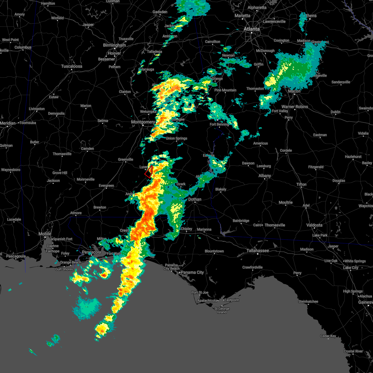 At 417 am cdt, a severe thunderstorm capable of producing a tornado was located over glenwood, or over goshen, moving northeast at 40 mph (radar indicated rotation). Hazards include tornado. Flying debris will be dangerous to those caught without shelter. mobile homes will be damaged or destroyed. damage to roofs, windows, and vehicles will occur. tree damage is likely. This tornadic thunderstorm will remain over mainly rural areas of east central crenshaw county. At 417 am cdt, a severe thunderstorm capable of producing a tornado was located over glenwood, or over goshen, moving northeast at 40 mph (radar indicated rotation). Hazards include tornado. Flying debris will be dangerous to those caught without shelter. mobile homes will be damaged or destroyed. damage to roofs, windows, and vehicles will occur. tree damage is likely. This tornadic thunderstorm will remain over mainly rural areas of east central crenshaw county.
|
| 3/18/2021 4:00 AM CDT |
 At 359 am cdt, a severe thunderstorm capable of producing a tornado was located near brantley, or 11 miles south of luverne, moving northeast at 40 mph (radar indicated rotation). Hazards include tornado. Flying debris will be dangerous to those caught without shelter. mobile homes will be damaged or destroyed. damage to roofs, windows, and vehicles will occur. tree damage is likely. This dangerous storm will be near, glenwood around 415 am cdt. At 359 am cdt, a severe thunderstorm capable of producing a tornado was located near brantley, or 11 miles south of luverne, moving northeast at 40 mph (radar indicated rotation). Hazards include tornado. Flying debris will be dangerous to those caught without shelter. mobile homes will be damaged or destroyed. damage to roofs, windows, and vehicles will occur. tree damage is likely. This dangerous storm will be near, glenwood around 415 am cdt.
|
| 9/28/2020 8:21 PM CDT |
 The severe thunderstorm warning for southeastern crenshaw and northeastern covington counties will expire at 830 pm cdt, the storm which prompted the warning has weakened below severe limits, and has exited the warned area. therefore, the warning will be allowed to expire. The severe thunderstorm warning for southeastern crenshaw and northeastern covington counties will expire at 830 pm cdt, the storm which prompted the warning has weakened below severe limits, and has exited the warned area. therefore, the warning will be allowed to expire.
|
| 9/28/2020 7:56 PM CDT |
 At 756 pm cdt, a severe thunderstorm was located over brantley, or 11 miles south of luverne, moving east at 20 mph (radar indicated). Hazards include 60 mph wind gusts. expect damage to roofs, siding, and trees At 756 pm cdt, a severe thunderstorm was located over brantley, or 11 miles south of luverne, moving east at 20 mph (radar indicated). Hazards include 60 mph wind gusts. expect damage to roofs, siding, and trees
|
| 7/12/2020 5:57 PM CDT |
 At 556 pm cdt, a cluster of severe thunderstorms was located along a line extending from elba to near andalusia to near castleberry, moving southeast at 45 mph (radar indicated). Hazards include 60 mph wind gusts. expect damage to roofs, siding, and trees At 556 pm cdt, a cluster of severe thunderstorms was located along a line extending from elba to near andalusia to near castleberry, moving southeast at 45 mph (radar indicated). Hazards include 60 mph wind gusts. expect damage to roofs, siding, and trees
|
| 6/24/2020 4:41 PM CDT |
 At 441 pm cdt, severe thunderstorms were located along a line extending from 3 miles south of grady to luverne to dozier, moving southeast at 50 mph (radar indicated). Hazards include 60 mph wind gusts. Expect damage to roofs, siding, and trees. Locations impacted include, luverne, brantley, rutledge, glenwood, petrey and highland home. At 441 pm cdt, severe thunderstorms were located along a line extending from 3 miles south of grady to luverne to dozier, moving southeast at 50 mph (radar indicated). Hazards include 60 mph wind gusts. Expect damage to roofs, siding, and trees. Locations impacted include, luverne, brantley, rutledge, glenwood, petrey and highland home.
|
| 6/24/2020 4:27 PM CDT |
 At 427 pm cdt, a severe thunderstorm was located 9 miles southwest of highland home, or 12 miles northwest of luverne, moving northeast at 40 mph (radar indicated). Hazards include 60 mph wind gusts. Expect damage to roofs, siding, and trees. Locations impacted include, luverne, brantley, rutledge, glenwood, petrey and highland home. At 427 pm cdt, a severe thunderstorm was located 9 miles southwest of highland home, or 12 miles northwest of luverne, moving northeast at 40 mph (radar indicated). Hazards include 60 mph wind gusts. Expect damage to roofs, siding, and trees. Locations impacted include, luverne, brantley, rutledge, glenwood, petrey and highland home.
|
| 6/24/2020 4:11 PM CDT |
 At 410 pm cdt, a severe thunderstorm was located near greenville, moving northeast at 25 mph (radar indicated). Hazards include 60 mph wind gusts. Expect damage to roofs, siding, and trees. Locations impacted include, greenville, luverne, brantley, mckenzie, rutledge, glenwood, petrey and highland home. At 410 pm cdt, a severe thunderstorm was located near greenville, moving northeast at 25 mph (radar indicated). Hazards include 60 mph wind gusts. Expect damage to roofs, siding, and trees. Locations impacted include, greenville, luverne, brantley, mckenzie, rutledge, glenwood, petrey and highland home.
|
| 6/24/2020 3:54 PM CDT |
 The national weather service in mobile has issued a * severe thunderstorm warning for. butler county in south central alabama. crenshaw county in south central alabama. east central conecuh county in south central alabama. Northwestern covington county in south central alabama. The national weather service in mobile has issued a * severe thunderstorm warning for. butler county in south central alabama. crenshaw county in south central alabama. east central conecuh county in south central alabama. Northwestern covington county in south central alabama.
|
| 5/24/2020 6:13 PM CDT |
 At 612 pm cdt, a severe thunderstorm was located over brantley, or 8 miles south of luverne, moving northwest at 20 mph (radar indicated). Hazards include 60 mph wind gusts. expect damage to roofs, siding, and trees At 612 pm cdt, a severe thunderstorm was located over brantley, or 8 miles south of luverne, moving northwest at 20 mph (radar indicated). Hazards include 60 mph wind gusts. expect damage to roofs, siding, and trees
|
| 4/19/2020 10:49 PM CDT | Numerous trees down near glenwood (and between luverne and glenwood in crenshaw county AL, 0.5 miles ESE of Glenwood, AL |
| 4/19/2020 10:40 PM CDT |
 At 1039 pm cdt, severe thunderstorms were located along a line extending from 3 miles north of petrey to 4 miles north of gantt, moving east at 60 mph (radar indicated). Hazards include 60 mph wind gusts. expect damage to roofs, siding, and trees At 1039 pm cdt, severe thunderstorms were located along a line extending from 3 miles north of petrey to 4 miles north of gantt, moving east at 60 mph (radar indicated). Hazards include 60 mph wind gusts. expect damage to roofs, siding, and trees
|
| 4/19/2020 3:50 PM CDT |
 At 350 pm cdt, a severe thunderstorm was located 6 miles south of brantley, or 10 miles northwest of elba, moving northeast at 35 mph (radar indicated). Hazards include 60 mph wind gusts and quarter size hail. Hail damage to vehicles is expected. Expect wind damage to roofs, siding, and trees. At 350 pm cdt, a severe thunderstorm was located 6 miles south of brantley, or 10 miles northwest of elba, moving northeast at 35 mph (radar indicated). Hazards include 60 mph wind gusts and quarter size hail. Hail damage to vehicles is expected. Expect wind damage to roofs, siding, and trees.
|
| 3/31/2020 10:07 AM CDT |
 At 1007 am cdt, severe thunderstorms were located along a line extending from 6 miles northwest of rutledge to 9 miles east of mckenzie to 7 miles southeast of evergreen to mccullough, moving east at 40 mph (radar indicated). Hazards include 70 mph wind gusts and quarter size hail. Hail damage to vehicles is expected. expect considerable tree damage. Wind damage is also likely to mobile homes, roofs, and outbuildings. At 1007 am cdt, severe thunderstorms were located along a line extending from 6 miles northwest of rutledge to 9 miles east of mckenzie to 7 miles southeast of evergreen to mccullough, moving east at 40 mph (radar indicated). Hazards include 70 mph wind gusts and quarter size hail. Hail damage to vehicles is expected. expect considerable tree damage. Wind damage is also likely to mobile homes, roofs, and outbuildings.
|
| 3/4/2020 6:35 AM CST |
 At 635 am cst, severe thunderstorms were located along a line extending from 8 miles west of lowndes county airport to 5 miles west of greenville to 9 miles northwest of georgiana, moving east at 40 mph (radar indicated). Hazards include 60 mph wind gusts and quarter size hail. Hail damage to vehicles is expected. expect wind damage to roofs, siding, and trees. Locations impacted include, greenville, luverne, rutledge, glenwood, petrey and highland home. At 635 am cst, severe thunderstorms were located along a line extending from 8 miles west of lowndes county airport to 5 miles west of greenville to 9 miles northwest of georgiana, moving east at 40 mph (radar indicated). Hazards include 60 mph wind gusts and quarter size hail. Hail damage to vehicles is expected. expect wind damage to roofs, siding, and trees. Locations impacted include, greenville, luverne, rutledge, glenwood, petrey and highland home.
|
| 3/4/2020 6:18 AM CST |
 At 617 am cst, severe thunderstorms were located along a line extending from 12 miles south of belknap to near pine apple to 8 miles east of beatrice, moving east at 45 mph (radar indicated). Hazards include 60 mph wind gusts and quarter size hail. Hail damage to vehicles is expected. Expect wind damage to roofs, siding, and trees. At 617 am cst, severe thunderstorms were located along a line extending from 12 miles south of belknap to near pine apple to 8 miles east of beatrice, moving east at 45 mph (radar indicated). Hazards include 60 mph wind gusts and quarter size hail. Hail damage to vehicles is expected. Expect wind damage to roofs, siding, and trees.
|
| 2/6/2020 12:42 AM CST |
 At 1242 am cst, a severe thunderstorm capable of producing a tornado was located near glenwood, or 4 miles southeast of luverne, moving northeast at 40 mph (radar indicated rotation). Hazards include tornado. Flying debris will be dangerous to those caught without shelter. mobile homes will be damaged or destroyed. damage to roofs, windows, and vehicles will occur. tree damage is likely. This dangerous storm will be near, glenwood around 1245 am cst. At 1242 am cst, a severe thunderstorm capable of producing a tornado was located near glenwood, or 4 miles southeast of luverne, moving northeast at 40 mph (radar indicated rotation). Hazards include tornado. Flying debris will be dangerous to those caught without shelter. mobile homes will be damaged or destroyed. damage to roofs, windows, and vehicles will occur. tree damage is likely. This dangerous storm will be near, glenwood around 1245 am cst.
|
| 1/11/2020 3:26 PM CST |
 At 326 pm cst, severe thunderstorms were located along a line extending from near auburn university to guerryton to 9 miles southwest of antioch, moving northeast at 55 mph (radar indicated). Hazards include 70 mph wind gusts. Expect considerable tree damage. damage is likely to mobile homes, roofs, and outbuildings. Locations impacted include, troy, tuskegee, union springs, brundidge, notasulga, midway, goshen, banks, pickett, aberfoil, lake tuskegee, beans crossroads, guerryton, linwood, tuskegee national forest, davisville, antioch, troy municipal airport, society hill and troy university. At 326 pm cst, severe thunderstorms were located along a line extending from near auburn university to guerryton to 9 miles southwest of antioch, moving northeast at 55 mph (radar indicated). Hazards include 70 mph wind gusts. Expect considerable tree damage. damage is likely to mobile homes, roofs, and outbuildings. Locations impacted include, troy, tuskegee, union springs, brundidge, notasulga, midway, goshen, banks, pickett, aberfoil, lake tuskegee, beans crossroads, guerryton, linwood, tuskegee national forest, davisville, antioch, troy municipal airport, society hill and troy university.
|
| 1/11/2020 3:19 PM CST |
 At 319 pm cst, severe thunderstorms were located along a line extending from troy municipal airport to 6 miles north of opp, moving northeast at 45 mph (radar indicated). Hazards include 60 mph wind gusts. Expect damage to roofs, siding, and trees. Locations impacted include, opp, brantley and glenwood. At 319 pm cst, severe thunderstorms were located along a line extending from troy municipal airport to 6 miles north of opp, moving northeast at 45 mph (radar indicated). Hazards include 60 mph wind gusts. Expect damage to roofs, siding, and trees. Locations impacted include, opp, brantley and glenwood.
|
| 1/11/2020 3:10 PM CST |
 At 310 pm cst, severe thunderstorms were located along a line extending from near liberty city to union springs to near goshen, moving east at 55 mph (radar indicated). Hazards include 60 mph wind gusts. Expect damage to roofs, siding, and trees. Locations impacted include, troy, tuskegee, union springs, brundidge, notasulga, midway, goshen, milstead, shorter, banks, franklin, pickett, lake tuskegee, beans crossroads, guerryton, tuskegee national forest, liverpool, liberty city, hardaway and troy municipal airport. At 310 pm cst, severe thunderstorms were located along a line extending from near liberty city to union springs to near goshen, moving east at 55 mph (radar indicated). Hazards include 60 mph wind gusts. Expect damage to roofs, siding, and trees. Locations impacted include, troy, tuskegee, union springs, brundidge, notasulga, midway, goshen, milstead, shorter, banks, franklin, pickett, lake tuskegee, beans crossroads, guerryton, tuskegee national forest, liverpool, liberty city, hardaway and troy municipal airport.
|
| 1/11/2020 3:01 PM CST |
 At 300 pm cst, severe thunderstorms were located along a line extending from 4 miles northeast of luverne to near andalusia, moving east at 35 mph (radar indicated). Hazards include 60 mph wind gusts. Expect damage to roofs, siding, and trees. Locations impacted include, andalusia, opp, luverne, brantley, river falls, rutledge, dozier, heath, gantt, glenwood and petrey. At 300 pm cst, severe thunderstorms were located along a line extending from 4 miles northeast of luverne to near andalusia, moving east at 35 mph (radar indicated). Hazards include 60 mph wind gusts. Expect damage to roofs, siding, and trees. Locations impacted include, andalusia, opp, luverne, brantley, river falls, rutledge, dozier, heath, gantt, glenwood and petrey.
|
| 1/11/2020 2:40 PM CST |
 At 240 pm cst, severe thunderstorms were located along a line extending from near mount meigs to brantley, moving northeast at 55 mph (radar indicated). Hazards include 60 mph wind gusts. expect damage to roofs, siding, and trees At 240 pm cst, severe thunderstorms were located along a line extending from near mount meigs to brantley, moving northeast at 55 mph (radar indicated). Hazards include 60 mph wind gusts. expect damage to roofs, siding, and trees
|
| 1/11/2020 2:39 PM CST |
 At 239 pm cst, severe thunderstorms were located along a line extending from near grady to 7 miles south of red level, moving northeast at 40 mph (radar indicated). Hazards include 60 mph wind gusts. expect damage to roofs, siding, and trees At 239 pm cst, severe thunderstorms were located along a line extending from near grady to 7 miles south of red level, moving northeast at 40 mph (radar indicated). Hazards include 60 mph wind gusts. expect damage to roofs, siding, and trees
|
| 9/9/2019 2:27 PM CDT |
 At 226 pm cdt, a severe thunderstorm was located 8 miles west of rutledge, or 10 miles west of luverne, moving northwest at 10 mph (radar indicated). Hazards include 60 mph wind gusts. expect damage to roofs, siding, and trees At 226 pm cdt, a severe thunderstorm was located 8 miles west of rutledge, or 10 miles west of luverne, moving northwest at 10 mph (radar indicated). Hazards include 60 mph wind gusts. expect damage to roofs, siding, and trees
|
| 4/18/2019 10:06 PM CDT |
 The severe thunderstorm warning for crenshaw county will expire at 1015 pm cdt, the storms which prompted the warning have weakened below severe limits, and the warning will be allowed to expire. a tornado watch remains in effect until 1100 pm cdt for south central alabama. The severe thunderstorm warning for crenshaw county will expire at 1015 pm cdt, the storms which prompted the warning have weakened below severe limits, and the warning will be allowed to expire. a tornado watch remains in effect until 1100 pm cdt for south central alabama.
|
| 4/18/2019 9:31 PM CDT |
 At 930 pm cdt, severe thunderstorms were located along a line extending from 5 miles southeast of logan to 3 miles north of dozier, moving east at 45 mph (radar indicated). Hazards include 60 mph wind gusts. Expect damage to roofs, siding, and trees. Locations impacted include, luverne, brantley, rutledge, glenwood, petrey and highland home. At 930 pm cdt, severe thunderstorms were located along a line extending from 5 miles southeast of logan to 3 miles north of dozier, moving east at 45 mph (radar indicated). Hazards include 60 mph wind gusts. Expect damage to roofs, siding, and trees. Locations impacted include, luverne, brantley, rutledge, glenwood, petrey and highland home.
|
| 4/18/2019 9:10 PM CDT |
 At 910 pm cdt, severe thunderstorms were located along a line extending from near fort deposit to mckenzie, moving east at 35 mph (radar indicated). Hazards include 60 mph wind gusts. expect damage to roofs, siding, and trees At 910 pm cdt, severe thunderstorms were located along a line extending from near fort deposit to mckenzie, moving east at 35 mph (radar indicated). Hazards include 60 mph wind gusts. expect damage to roofs, siding, and trees
|
| 4/14/2019 6:43 AM CDT |
 At 642 am cdt, a severe thunderstorm capable of producing a tornado was located near glenwood, or 5 miles south of luverne, moving northeast at 40 mph (radar indicated rotation). Hazards include tornado. Flying debris will be dangerous to those caught without shelter. mobile homes will be damaged or destroyed. damage to roofs, windows, and vehicles will occur. tree damage is likely. This tornadic thunderstorm will remain over mainly rural areas of east central crenshaw county. At 642 am cdt, a severe thunderstorm capable of producing a tornado was located near glenwood, or 5 miles south of luverne, moving northeast at 40 mph (radar indicated rotation). Hazards include tornado. Flying debris will be dangerous to those caught without shelter. mobile homes will be damaged or destroyed. damage to roofs, windows, and vehicles will occur. tree damage is likely. This tornadic thunderstorm will remain over mainly rural areas of east central crenshaw county.
|
| 4/14/2019 6:32 AM CDT |
 At 631 am cdt, severe thunderstorms were located along a line extending from 8 miles west of rutledge to near brantley to dozier to 5 miles northeast of gantt, moving northeast at 40 mph (radar indicated). Hazards include 70 mph wind gusts. Expect considerable tree damage. damage is likely to mobile homes, roofs, and outbuildings. Locations impacted include, luverne, brantley, rutledge, dozier, glenwood and petrey. At 631 am cdt, severe thunderstorms were located along a line extending from 8 miles west of rutledge to near brantley to dozier to 5 miles northeast of gantt, moving northeast at 40 mph (radar indicated). Hazards include 70 mph wind gusts. Expect considerable tree damage. damage is likely to mobile homes, roofs, and outbuildings. Locations impacted include, luverne, brantley, rutledge, dozier, glenwood and petrey.
|
| 4/14/2019 6:22 AM CDT |
 At 622 am cdt, severe thunderstorms were located along a line extending from 11 miles east of georgiana to 11 miles west of brantley to dozier to 7 miles north of heath to gantt, moving northeast at 35 mph (radar indicated). Hazards include 70 mph wind gusts. Expect considerable tree damage. damage is likely to mobile homes, roofs, and outbuildings. Locations impacted include, luverne, brantley, rutledge, dozier, glenwood, petrey and highland home. At 622 am cdt, severe thunderstorms were located along a line extending from 11 miles east of georgiana to 11 miles west of brantley to dozier to 7 miles north of heath to gantt, moving northeast at 35 mph (radar indicated). Hazards include 70 mph wind gusts. Expect considerable tree damage. damage is likely to mobile homes, roofs, and outbuildings. Locations impacted include, luverne, brantley, rutledge, dozier, glenwood, petrey and highland home.
|
| 4/14/2019 6:11 AM CDT |
 At 611 am cdt, severe thunderstorms were located along a line extending from naftel to 8 miles east of mckenzie, moving northeast at 90 mph (radar indicated). Hazards include 60 mph wind gusts. expect damage to roofs, siding, and trees At 611 am cdt, severe thunderstorms were located along a line extending from naftel to 8 miles east of mckenzie, moving northeast at 90 mph (radar indicated). Hazards include 60 mph wind gusts. expect damage to roofs, siding, and trees
|
| 4/14/2019 5:26 AM CDT |
 At 526 am cdt, severe thunderstorms were located along a line extending from 3 miles southwest of lowndes county airport to 4 miles northeast of evergreen, moving east at 35 mph (radar indicated). Hazards include 60 mph wind gusts. expect damage to roofs, siding, and trees At 526 am cdt, severe thunderstorms were located along a line extending from 3 miles southwest of lowndes county airport to 4 miles northeast of evergreen, moving east at 35 mph (radar indicated). Hazards include 60 mph wind gusts. expect damage to roofs, siding, and trees
|
| 4/14/2019 4:48 AM CDT |
 At 448 am cdt, severe thunderstorms were located along a line extending from 4 miles southwest of gordonville to 8 miles northwest of greenville to 8 miles northwest of i65 and us 84, moving northeast at 75 mph (radar indicated). Hazards include 60 mph wind gusts. expect damage to roofs, siding, and trees At 448 am cdt, severe thunderstorms were located along a line extending from 4 miles southwest of gordonville to 8 miles northwest of greenville to 8 miles northwest of i65 and us 84, moving northeast at 75 mph (radar indicated). Hazards include 60 mph wind gusts. expect damage to roofs, siding, and trees
|
| 3/3/2019 3:15 PM CST |
 At 315 pm cst, severe thunderstorms were located along a line extending from 3 miles northeast of troy university to near red level, moving east at 65 mph (radar indicated). Hazards include 60 mph wind gusts and nickel size hail. Expect damage to roofs, siding, and trees. locations impacted include, luverne, brantley, red level, rutledge, dozier, gantt and glenwood. A tornado watch remains in effect until 600 pm cst for south central alabama. At 315 pm cst, severe thunderstorms were located along a line extending from 3 miles northeast of troy university to near red level, moving east at 65 mph (radar indicated). Hazards include 60 mph wind gusts and nickel size hail. Expect damage to roofs, siding, and trees. locations impacted include, luverne, brantley, red level, rutledge, dozier, gantt and glenwood. A tornado watch remains in effect until 600 pm cst for south central alabama.
|
| 3/3/2019 2:23 PM CST |
 At 223 pm cst, severe thunderstorms were located along a line extending from 4 miles west of greenville to 5 miles southwest of excel, moving east at 45 mph (radar indicated). Hazards include 60 mph wind gusts and nickel size hail. expect damage to roofs, siding, and trees At 223 pm cst, severe thunderstorms were located along a line extending from 4 miles west of greenville to 5 miles southwest of excel, moving east at 45 mph (radar indicated). Hazards include 60 mph wind gusts and nickel size hail. expect damage to roofs, siding, and trees
|
| 2/24/2019 3:25 AM CST |
 At 324 am cst, a severe thunderstorm was located over luverne, moving east at 55 mph (radar indicated). Hazards include 60 mph wind gusts. expect damage to roofs, siding, and trees At 324 am cst, a severe thunderstorm was located over luverne, moving east at 55 mph (radar indicated). Hazards include 60 mph wind gusts. expect damage to roofs, siding, and trees
|
| 6/28/2018 6:09 PM CDT |
 At 542 pm cdt, severe thunderstorms were located along a line extending from georgiana to 4 miles northwest of dozier to 6 miles northwest of fort rucker, moving southeast at 35 mph (radar indicated). Hazards include 60 mph wind gusts. expect damage to roofs, siding, and trees At 542 pm cdt, severe thunderstorms were located along a line extending from georgiana to 4 miles northwest of dozier to 6 miles northwest of fort rucker, moving southeast at 35 mph (radar indicated). Hazards include 60 mph wind gusts. expect damage to roofs, siding, and trees
|
| 6/28/2018 5:43 PM CDT |
 At 542 pm cdt, severe thunderstorms were located along a line extending from georgiana to 4 miles northwest of dozier to 6 miles northwest of fort rucker, moving southeast at 35 mph (radar indicated). Hazards include 60 mph wind gusts. expect damage to roofs, siding, and trees At 542 pm cdt, severe thunderstorms were located along a line extending from georgiana to 4 miles northwest of dozier to 6 miles northwest of fort rucker, moving southeast at 35 mph (radar indicated). Hazards include 60 mph wind gusts. expect damage to roofs, siding, and trees
|
| 6/28/2018 5:31 PM CDT |
 At 530 pm cdt, severe thunderstorms were located along a line extending from 9 miles west of greenville to 5 miles north of dozier to 5 miles east of brantley, moving south at 45 mph (radar indicated). Hazards include 60 mph wind gusts. Expect damage to roofs, siding, and trees. Locations impacted include, greenville, luverne, georgiana, brantley, rutledge, dozier, glenwood, petrey and highland home. At 530 pm cdt, severe thunderstorms were located along a line extending from 9 miles west of greenville to 5 miles north of dozier to 5 miles east of brantley, moving south at 45 mph (radar indicated). Hazards include 60 mph wind gusts. Expect damage to roofs, siding, and trees. Locations impacted include, greenville, luverne, georgiana, brantley, rutledge, dozier, glenwood, petrey and highland home.
|
| 6/28/2018 4:59 PM CDT |
 The national weather service in mobile has issued a * severe thunderstorm warning for. butler county in south central alabama. crenshaw county in south central alabama. until 545 pm cdt. At 458 pm cdt, severe thunderstorms were located along a line. The national weather service in mobile has issued a * severe thunderstorm warning for. butler county in south central alabama. crenshaw county in south central alabama. until 545 pm cdt. At 458 pm cdt, severe thunderstorms were located along a line.
|
| 5/14/2018 3:37 PM CDT |
 At 337 pm cdt, a severe thunderstorm was located over glenwood, or 4 miles southwest of goshen, moving southwest at 15 mph (radar indicated). Hazards include 60 mph wind gusts. expect damage to roofs, siding, and trees At 337 pm cdt, a severe thunderstorm was located over glenwood, or 4 miles southwest of goshen, moving southwest at 15 mph (radar indicated). Hazards include 60 mph wind gusts. expect damage to roofs, siding, and trees
|
| 4/5/2017 11:00 AM CDT |
 At 1100 am cdt, a severe thunderstorm was located 9 miles northwest of dozier, or 11 miles southwest of luverne, moving east at 40 mph (radar indicated). Hazards include 60 mph wind gusts and quarter size hail. Hail damage to vehicles is expected. expect wind damage to roofs, siding, and trees. locations impacted include, luverne, brantley, rutledge, dozier and glenwood. A tornado watch remains in effect until noon cdt for south central alabama. At 1100 am cdt, a severe thunderstorm was located 9 miles northwest of dozier, or 11 miles southwest of luverne, moving east at 40 mph (radar indicated). Hazards include 60 mph wind gusts and quarter size hail. Hail damage to vehicles is expected. expect wind damage to roofs, siding, and trees. locations impacted include, luverne, brantley, rutledge, dozier and glenwood. A tornado watch remains in effect until noon cdt for south central alabama.
|
| 4/5/2017 10:42 AM CDT |
 At 1041 am cdt, a severe thunderstorm was located near mckenzie, or 18 miles south of greenville, moving northeast at 50 mph (radar indicated). Hazards include 60 mph wind gusts and half dollar size hail. Hail damage to vehicles is expected. expect wind damage to roofs, siding, and trees. locations impacted include, luverne, brantley, red level, rutledge, dozier, gantt and glenwood. A tornado watch remains in effect until noon cdt for south central alabama. At 1041 am cdt, a severe thunderstorm was located near mckenzie, or 18 miles south of greenville, moving northeast at 50 mph (radar indicated). Hazards include 60 mph wind gusts and half dollar size hail. Hail damage to vehicles is expected. expect wind damage to roofs, siding, and trees. locations impacted include, luverne, brantley, red level, rutledge, dozier, gantt and glenwood. A tornado watch remains in effect until noon cdt for south central alabama.
|
| 4/5/2017 10:26 AM CDT |
 At 1026 am cdt, a severe thunderstorm was located near mckenzie, or 11 miles northeast of evergreen, moving east at 40 mph (radar indicated). Hazards include 60 mph wind gusts and quarter size hail. Hail damage to vehicles is expected. Expect wind damage to roofs, siding, and trees. At 1026 am cdt, a severe thunderstorm was located near mckenzie, or 11 miles northeast of evergreen, moving east at 40 mph (radar indicated). Hazards include 60 mph wind gusts and quarter size hail. Hail damage to vehicles is expected. Expect wind damage to roofs, siding, and trees.
|
| 4/5/2017 2:58 AM CDT |
 The severe thunderstorm warning for southeastern butler, southern crenshaw and northwestern covington counties will expire at 300 am cdt, the storm which prompted the warning has weakened below severe limits, therefore the warning will be allowed to expire. a severe thunderstorm watch remains in effect until 800 am cdt for south central alabama. The severe thunderstorm warning for southeastern butler, southern crenshaw and northwestern covington counties will expire at 300 am cdt, the storm which prompted the warning has weakened below severe limits, therefore the warning will be allowed to expire. a severe thunderstorm watch remains in effect until 800 am cdt for south central alabama.
|
| 4/5/2017 2:40 AM CDT |
 At 239 am cdt, a severe thunderstorm was located near red level, or 13 miles northwest of andalusia, moving northeast at 30 mph (radar indicated). Hazards include 60 mph wind gusts. Expect damage to roofs, siding, and trees. Locations impacted include, luverne, brantley, red level, rutledge and dozier. At 239 am cdt, a severe thunderstorm was located near red level, or 13 miles northwest of andalusia, moving northeast at 30 mph (radar indicated). Hazards include 60 mph wind gusts. Expect damage to roofs, siding, and trees. Locations impacted include, luverne, brantley, red level, rutledge and dozier.
|
| 4/5/2017 2:13 AM CDT |
 At 212 am cdt, a severe thunderstorm was located 11 miles southeast of evergreen, moving northeast at 50 mph (radar indicated). Hazards include 60 mph wind gusts and quarter size hail. Hail damage to vehicles is expected. Expect wind damage to roofs, siding, and trees. At 212 am cdt, a severe thunderstorm was located 11 miles southeast of evergreen, moving northeast at 50 mph (radar indicated). Hazards include 60 mph wind gusts and quarter size hail. Hail damage to vehicles is expected. Expect wind damage to roofs, siding, and trees.
|
| 4/3/2017 9:22 AM CDT |
 The severe thunderstorm warning for eastern butler, crenshaw, eastern escambia, southeastern conecuh, covington, northern okaloosa and northeastern santa rosa counties will expire at 930 am cdt, the storms which prompted the warning have have weakened and will moved out of the warned area. it is possible a new warnign may be issued across northern okaloosa and covington counties however. a tornado watch remains in effect until 100 pm cdt for south central alabama, and northwestern florida. The severe thunderstorm warning for eastern butler, crenshaw, eastern escambia, southeastern conecuh, covington, northern okaloosa and northeastern santa rosa counties will expire at 930 am cdt, the storms which prompted the warning have have weakened and will moved out of the warned area. it is possible a new warnign may be issued across northern okaloosa and covington counties however. a tornado watch remains in effect until 100 pm cdt for south central alabama, and northwestern florida.
|
| 4/3/2017 9:09 AM CDT |
 At 909 am cdt, severe thunderstorms were located along a line extending from near ansley to near opp to 6 miles northwest of lockhart, moving southeast at 30 mph (radar indicated). Hazards include 60 mph wind gusts and quarter size hail. Hail damage to vehicles is expected. expect wind damage to roofs, siding, and trees. locations impacted include, andalusia, greenville, opp, luverne, florala, brantley, mckenzie, river falls, red level, laurel hill, lockhart, rutledge, dozier, heath, gantt, glenwood and petrey. A tornado watch remains in effect until 100 pm cdt for south central alabama, and northwestern florida. At 909 am cdt, severe thunderstorms were located along a line extending from near ansley to near opp to 6 miles northwest of lockhart, moving southeast at 30 mph (radar indicated). Hazards include 60 mph wind gusts and quarter size hail. Hail damage to vehicles is expected. expect wind damage to roofs, siding, and trees. locations impacted include, andalusia, greenville, opp, luverne, florala, brantley, mckenzie, river falls, red level, laurel hill, lockhart, rutledge, dozier, heath, gantt, glenwood and petrey. A tornado watch remains in effect until 100 pm cdt for south central alabama, and northwestern florida.
|
| 4/3/2017 8:45 AM CDT |
 At 845 am cdt, severe thunderstorms were located along a line extending from near highland home to gantt to 14 miles west of laurel hill, moving northeast at 40 mph (radar indicated). Hazards include 60 mph wind gusts and quarter size hail. Hail damage to vehicles is expected. expect wind damage to roofs, siding, and trees. locations impacted include, andalusia, greenville, opp, luverne, florala, georgiana, brantley, mckenzie, river falls, red level, laurel hill, lockhart, rutledge, dozier, heath, gantt, glenwood and petrey. A tornado watch remains in effect until 100 pm cdt for south central alabama, and northwestern florida. At 845 am cdt, severe thunderstorms were located along a line extending from near highland home to gantt to 14 miles west of laurel hill, moving northeast at 40 mph (radar indicated). Hazards include 60 mph wind gusts and quarter size hail. Hail damage to vehicles is expected. expect wind damage to roofs, siding, and trees. locations impacted include, andalusia, greenville, opp, luverne, florala, georgiana, brantley, mckenzie, river falls, red level, laurel hill, lockhart, rutledge, dozier, heath, gantt, glenwood and petrey. A tornado watch remains in effect until 100 pm cdt for south central alabama, and northwestern florida.
|
| 4/3/2017 8:26 AM CDT |
 At 825 am cdt, severe thunderstorms were located along a line extending from near greenville to 7 miles south of red level to 12 miles southeast of riverview, moving northeast at 40 mph (radar indicated). Hazards include 60 mph wind gusts and quarter size hail. Hail damage to vehicles is expected. Expect wind damage to roofs, siding, and trees. At 825 am cdt, severe thunderstorms were located along a line extending from near greenville to 7 miles south of red level to 12 miles southeast of riverview, moving northeast at 40 mph (radar indicated). Hazards include 60 mph wind gusts and quarter size hail. Hail damage to vehicles is expected. Expect wind damage to roofs, siding, and trees.
|
| 1/21/2017 10:00 PM CST |
 At 959 pm cst, severe thunderstorms were located along a line extending from 9 miles northeast of georgiana to 8 miles north of gantt to near river falls, moving northeast at 60 mph (radar indicated). Hazards include 60 mph wind gusts and half dollar size hail. Hail damage to vehicles is expected. expect wind damage to roofs, siding, and trees. locations impacted include, andalusia, opp, luverne, brantley, river falls, red level, dozier, heath, gantt and glenwood. A tornado watch remains in effect until 300 am cst for south central alabama. At 959 pm cst, severe thunderstorms were located along a line extending from 9 miles northeast of georgiana to 8 miles north of gantt to near river falls, moving northeast at 60 mph (radar indicated). Hazards include 60 mph wind gusts and half dollar size hail. Hail damage to vehicles is expected. expect wind damage to roofs, siding, and trees. locations impacted include, andalusia, opp, luverne, brantley, river falls, red level, dozier, heath, gantt and glenwood. A tornado watch remains in effect until 300 am cst for south central alabama.
|
| 1/21/2017 9:31 PM CST |
 At 931 pm cst, severe thunderstorms were located along a line extending from 11 miles north of i65 and us 84 to near evergreen to castleberry, moving east at 55 mph (radar indicated). Hazards include 60 mph wind gusts and half dollar size hail. Hail damage to vehicles is expected. Expect wind damage to roofs, siding, and trees. At 931 pm cst, severe thunderstorms were located along a line extending from 11 miles north of i65 and us 84 to near evergreen to castleberry, moving east at 55 mph (radar indicated). Hazards include 60 mph wind gusts and half dollar size hail. Hail damage to vehicles is expected. Expect wind damage to roofs, siding, and trees.
|
| 1/21/2017 8:43 AM CST |
 At 843 am cst, severe thunderstorms were located along a line extending from near highland home to near red level, moving east at 60 mph (radar indicated). Hazards include 60 mph wind gusts. Expect damage to roofs, siding, and trees. locations impacted include, luverne, brantley, red level, rutledge, dozier, gantt, glenwood, petrey, highland home and lapine. A tornado watch remains in effect until 1100 am cst for south central alabama. At 843 am cst, severe thunderstorms were located along a line extending from near highland home to near red level, moving east at 60 mph (radar indicated). Hazards include 60 mph wind gusts. Expect damage to roofs, siding, and trees. locations impacted include, luverne, brantley, red level, rutledge, dozier, gantt, glenwood, petrey, highland home and lapine. A tornado watch remains in effect until 1100 am cst for south central alabama.
|
| 1/21/2017 8:32 AM CST |
 At 831 am cst, severe thunderstorms were located along a line extending from near lowndes county airport to 6 miles west of red level, moving east at 45 mph (radar indicated). Hazards include 60 mph wind gusts. Expect damage to roofs, siding, and trees. locations impacted include, greenville, luverne, brantley, mckenzie, red level, rutledge, dozier, gantt, glenwood, petrey, highland home and lapine. A tornado watch remains in effect until 1100 am cst for south central alabama. At 831 am cst, severe thunderstorms were located along a line extending from near lowndes county airport to 6 miles west of red level, moving east at 45 mph (radar indicated). Hazards include 60 mph wind gusts. Expect damage to roofs, siding, and trees. locations impacted include, greenville, luverne, brantley, mckenzie, red level, rutledge, dozier, gantt, glenwood, petrey, highland home and lapine. A tornado watch remains in effect until 1100 am cst for south central alabama.
|
| 1/21/2017 8:18 AM CST |
 At 818 am cst, severe thunderstorms were located along a line extending from 9 miles northwest of greenville to 6 miles east of evergreen, moving east at 60 mph (radar indicated). Hazards include 60 mph wind gusts. expect damage to roofs, siding, and trees At 818 am cst, severe thunderstorms were located along a line extending from 9 miles northwest of greenville to 6 miles east of evergreen, moving east at 60 mph (radar indicated). Hazards include 60 mph wind gusts. expect damage to roofs, siding, and trees
|
| 1/2/2017 3:23 PM CST |
 At 323 pm cst, a severe thunderstorm capable of producing a tornado was located near luverne, moving northeast at 30 mph (radar indicated rotation). Hazards include tornado and quarter size hail. Flying debris will be dangerous to those caught without shelter. mobile homes will be damaged or destroyed. damage to roofs, windows, and vehicles will occur. tree damage is likely. This tornadic thunderstorm will remain over mainly rural areas of east central crenshaw county. At 323 pm cst, a severe thunderstorm capable of producing a tornado was located near luverne, moving northeast at 30 mph (radar indicated rotation). Hazards include tornado and quarter size hail. Flying debris will be dangerous to those caught without shelter. mobile homes will be damaged or destroyed. damage to roofs, windows, and vehicles will occur. tree damage is likely. This tornadic thunderstorm will remain over mainly rural areas of east central crenshaw county.
|
| 1/2/2017 3:13 PM CST |
 At 313 pm cst, severe thunderstorms were located along a line extending from near beechwood to greenville to near georgiana, moving east at 40 mph (radar indicated). Hazards include 60 mph wind gusts. expect damage to roofs, siding, and trees At 313 pm cst, severe thunderstorms were located along a line extending from near beechwood to greenville to near georgiana, moving east at 40 mph (radar indicated). Hazards include 60 mph wind gusts. expect damage to roofs, siding, and trees
|
| 1/2/2017 3:09 PM CST |
 At 309 pm cst, a severe thunderstorm capable of producing a tornado was located near rutledge, or near luverne, moving northeast at 35 mph (radar indicated rotation). Hazards include tornado and quarter size hail. Flying debris will be dangerous to those caught without shelter. mobile homes will be damaged or destroyed. damage to roofs, windows, and vehicles will occur. tree damage is likely. this dangerous storm will be near, luverne around 315 pm cst. glenwood around 320 pm cst. Petrey around 330 pm cst. At 309 pm cst, a severe thunderstorm capable of producing a tornado was located near rutledge, or near luverne, moving northeast at 35 mph (radar indicated rotation). Hazards include tornado and quarter size hail. Flying debris will be dangerous to those caught without shelter. mobile homes will be damaged or destroyed. damage to roofs, windows, and vehicles will occur. tree damage is likely. this dangerous storm will be near, luverne around 315 pm cst. glenwood around 320 pm cst. Petrey around 330 pm cst.
|
| 1/2/2017 2:50 PM CST |
 At 250 pm cst, a severe thunderstorm capable of producing a tornado was located near dozier, or 12 miles southwest of luverne, moving northeast at 45 mph (radar indicated rotation). Hazards include tornado and quarter size hail. Flying debris will be dangerous to those caught without shelter. mobile homes will be damaged or destroyed. damage to roofs, windows, and vehicles will occur. tree damage is likely. this dangerous storm will be near, brantley around 300 pm cst. luverne and rutledge around 305 pm cst. glenwood around 310 pm cst. Petrey around 315 pm cst. At 250 pm cst, a severe thunderstorm capable of producing a tornado was located near dozier, or 12 miles southwest of luverne, moving northeast at 45 mph (radar indicated rotation). Hazards include tornado and quarter size hail. Flying debris will be dangerous to those caught without shelter. mobile homes will be damaged or destroyed. damage to roofs, windows, and vehicles will occur. tree damage is likely. this dangerous storm will be near, brantley around 300 pm cst. luverne and rutledge around 305 pm cst. glenwood around 310 pm cst. Petrey around 315 pm cst.
|
| 7/6/2016 1:28 PM CDT | The severe thunderstorm warning for southern crenshaw county will expire at 130 pm cdt, the storm which prompted the warning has weakened below severe limits, and no longer pose an immediate threat to life or property. therefore the warning will be allowed to expire. however heavy rain is still possible with this thunderstorm. |
| 7/6/2016 1:06 PM CDT |
 At 106 pm cdt, a severe thunderstorm was located over brantley, or 9 miles south of luverne, moving northeast at 30 mph (radar indicated). Hazards include 60 mph wind gusts. Expect damage to roofs. siding. And trees. At 106 pm cdt, a severe thunderstorm was located over brantley, or 9 miles south of luverne, moving northeast at 30 mph (radar indicated). Hazards include 60 mph wind gusts. Expect damage to roofs. siding. And trees.
|
| 6/17/2016 6:11 PM CDT |
 At 610 pm cdt, severe thunderstorms were located along a line extending from near moss to 6 miles southwest of state line to near castleberry to near goshen, moving southeast at 50 mph (radar indicated). Hazards include 60 mph wind gusts and quarter size hail. Hail damage to vehicles is expected. expect wind damage to roofs, siding, and trees. Locations impacted include, andalusia, atmore, greenville, monroeville, opp, brewton, jackson, waynesboro, citronelle, evergreen, luverne, florala, frisco city, chatom, richton, leakesville, mccullough, peterman, saint stephens and wagarville. At 610 pm cdt, severe thunderstorms were located along a line extending from near moss to 6 miles southwest of state line to near castleberry to near goshen, moving southeast at 50 mph (radar indicated). Hazards include 60 mph wind gusts and quarter size hail. Hail damage to vehicles is expected. expect wind damage to roofs, siding, and trees. Locations impacted include, andalusia, atmore, greenville, monroeville, opp, brewton, jackson, waynesboro, citronelle, evergreen, luverne, florala, frisco city, chatom, richton, leakesville, mccullough, peterman, saint stephens and wagarville.
|
| 6/17/2016 6:00 PM CDT |
 At 559 pm cdt, severe thunderstorms were located along a line extending from bay springs to near buckatunna to near i65 and us 84 to near lapine, moving southeast at 50 mph (radar indicated). Hazards include 60 mph wind gusts and nickel size hail. Expect damage to roofs. siding. And trees. At 559 pm cdt, severe thunderstorms were located along a line extending from bay springs to near buckatunna to near i65 and us 84 to near lapine, moving southeast at 50 mph (radar indicated). Hazards include 60 mph wind gusts and nickel size hail. Expect damage to roofs. siding. And trees.
|
| 6/17/2016 5:26 PM CDT |
 At 523 pm cdt, severe thunderstorms were located along a line extending from near pintlala to near pine apple to near silas to bay springs, moving south at 45 mph (radar indicated. several reports of winds around 60 mph have been received with this line of storms. trees have been blown down in choctaw and clarke counties). Hazards include 60 mph wind gusts and quarter size hail. Hail damage to vehicles is expected. expect wind damage to roofs, siding, and trees. Locations impacted include, greenville, monroeville, jackson, waynesboro, thomasville, luverne, camden, butler, frisco city, grove hill, chatom, peterman, saint stephens, wagarville, leroy, clara, georgiana, whatley, pine hill and mckenzie. At 523 pm cdt, severe thunderstorms were located along a line extending from near pintlala to near pine apple to near silas to bay springs, moving south at 45 mph (radar indicated. several reports of winds around 60 mph have been received with this line of storms. trees have been blown down in choctaw and clarke counties). Hazards include 60 mph wind gusts and quarter size hail. Hail damage to vehicles is expected. expect wind damage to roofs, siding, and trees. Locations impacted include, greenville, monroeville, jackson, waynesboro, thomasville, luverne, camden, butler, frisco city, grove hill, chatom, peterman, saint stephens, wagarville, leroy, clara, georgiana, whatley, pine hill and mckenzie.
|
| 6/17/2016 5:02 PM CDT |
 At 500 pm cdt, severe thunderstorms were located along a line extending from near dannelly field to 10 miles southeast of dannelly reservoir to near butler to near conehatta, moving south at 45 mph. additional severe thunderstorm development is possible ahead of the main line (radar indicated). Hazards include 60 mph wind gusts and quarter size hail. Hail damage to vehicles is expected. Expect wind damage to roofs, siding, and trees. At 500 pm cdt, severe thunderstorms were located along a line extending from near dannelly field to 10 miles southeast of dannelly reservoir to near butler to near conehatta, moving south at 45 mph. additional severe thunderstorm development is possible ahead of the main line (radar indicated). Hazards include 60 mph wind gusts and quarter size hail. Hail damage to vehicles is expected. Expect wind damage to roofs, siding, and trees.
|
| 4/27/2016 4:49 PM CDT |
 At 449 pm cdt, another severe thunderstorm was located 8 miles southeast of greenville, moving northeast at 25 mph (radar indicated). Hazards include 60 mph wind gusts. Expect damage to roofs. siding. And trees. At 449 pm cdt, another severe thunderstorm was located 8 miles southeast of greenville, moving northeast at 25 mph (radar indicated). Hazards include 60 mph wind gusts. Expect damage to roofs. siding. And trees.
|
| 3/24/2016 3:12 PM CDT |
 At 312 pm cdt, severe thunderstorms were located along a line extending from 8 miles northwest of rutledge to glenwood to near elba, moving northeast at 45 mph (radar indicated). Hazards include 60 mph wind gusts and penny size hail. Expect damage to roofs. siding. And trees. At 312 pm cdt, severe thunderstorms were located along a line extending from 8 miles northwest of rutledge to glenwood to near elba, moving northeast at 45 mph (radar indicated). Hazards include 60 mph wind gusts and penny size hail. Expect damage to roofs. siding. And trees.
|
| 3/24/2016 2:53 PM CDT |
 At 253 pm cdt, severe thunderstorms were located along a line extending from near greenville to 6 miles southeast of rose hill to babbie to near laurel hill, moving east at 50 mph (radar indicated). Hazards include 70 mph wind gusts and penny size hail. Expect considerable tree damage. damage is likely to mobile homes, roofs, and outbuildings. locations impacted include, andalusia, greenville, opp, luverne, florala, brantley, babbie, river falls, lockhart, red level, rutledge, dozier, carolina, heath, sanford, horn hill, gantt, glenwood, onycha and libertyville. A tornado watch remains in effect until 700 pm cdt for south central alabama. At 253 pm cdt, severe thunderstorms were located along a line extending from near greenville to 6 miles southeast of rose hill to babbie to near laurel hill, moving east at 50 mph (radar indicated). Hazards include 70 mph wind gusts and penny size hail. Expect considerable tree damage. damage is likely to mobile homes, roofs, and outbuildings. locations impacted include, andalusia, greenville, opp, luverne, florala, brantley, babbie, river falls, lockhart, red level, rutledge, dozier, carolina, heath, sanford, horn hill, gantt, glenwood, onycha and libertyville. A tornado watch remains in effect until 700 pm cdt for south central alabama.
|
| 3/24/2016 2:31 PM CDT |
 At 231 pm cdt, severe thunderstorms were located along a line extending from near i65 and al 10 to near river falls to 8 miles southwest of carolina to 11 miles south of us 29 and cr 43, moving east at 55 mph (radar indicated). Hazards include 70 mph wind gusts and penny size hail. Expect considerable tree damage. Damage is likely to mobile homes, roofs, and outbuildings. At 231 pm cdt, severe thunderstorms were located along a line extending from near i65 and al 10 to near river falls to 8 miles southwest of carolina to 11 miles south of us 29 and cr 43, moving east at 55 mph (radar indicated). Hazards include 70 mph wind gusts and penny size hail. Expect considerable tree damage. Damage is likely to mobile homes, roofs, and outbuildings.
|
| 3/3/2016 5:39 PM CST |
 The severe thunderstorm warning for central crenshaw county will expire at 545 pm cst, the storm which prompted the warning has moved out of the area. therefore the warning will be allowed to expire. to report severe weather, contact your nearest law enforcement agency. they will relay your report to the national weather service mobile. The severe thunderstorm warning for central crenshaw county will expire at 545 pm cst, the storm which prompted the warning has moved out of the area. therefore the warning will be allowed to expire. to report severe weather, contact your nearest law enforcement agency. they will relay your report to the national weather service mobile.
|
| 3/3/2016 5:30 PM CST | Numerous trees down in henderson and along hwy 2276 and 2278. barn damage by trees down on hwy 228 in pike county AL, 5.5 miles W of Glenwood, AL |
| 3/3/2016 5:30 PM CST | Barn roof torn off and mobile home damaged on hwy 2287 in pike county AL, 7.3 miles W of Glenwood, AL |
| 3/3/2016 5:30 PM CST | Numerous trees down and power lines down on hwy 2277 in pike county AL, 4.5 miles WNW of Glenwood, AL |
| 3/3/2016 5:24 PM CST |
 At 523 pm cst, a severe thunderstorm was located over luverne, moving east at 70 mph (radar indicated). Hazards include 60 mph wind gusts and quarter size hail. Hail damage to vehicles is expected. expect wind damage to roofs, siding, and trees. Locations impacted include, luverne, rutledge and glenwood. At 523 pm cst, a severe thunderstorm was located over luverne, moving east at 70 mph (radar indicated). Hazards include 60 mph wind gusts and quarter size hail. Hail damage to vehicles is expected. expect wind damage to roofs, siding, and trees. Locations impacted include, luverne, rutledge and glenwood.
|
| 3/3/2016 5:15 PM CST |
 At 514 pm cst, a severe thunderstorm was located near rutledge, or 8 miles west of luverne, moving east at 70 mph (radar indicated). Hazards include 60 mph wind gusts and quarter size hail. Hail damage to vehicles is expected. Expect wind damage to roofs, siding, and trees. At 514 pm cst, a severe thunderstorm was located near rutledge, or 8 miles west of luverne, moving east at 70 mph (radar indicated). Hazards include 60 mph wind gusts and quarter size hail. Hail damage to vehicles is expected. Expect wind damage to roofs, siding, and trees.
|
| 2/15/2016 6:10 PM CST | Reports of trees and power lines down in the northwest part of coffee county in coffee county AL, 9 miles NW of Glenwood, AL |
| 2/15/2016 5:30 PM CST |
 At 528 pm cst, a severe thunderstorm capable of producing a tornado was located near rutledge, or near luverne, moving northeast at 45 mph. there have been numerous reports of tornadoes and damage associated with this severe thunderstorm (radar indicated rotation). Hazards include tornado and quarter size hail. Flying debris will be dangerous to those caught without shelter. mobile homes will be damaged or destroyed. damage to roofs, windows, and vehicles will occur. tree damage is likely. this dangerous storm will be near, luverne around 535 pm cst. Petrey around 545 pm cst. At 528 pm cst, a severe thunderstorm capable of producing a tornado was located near rutledge, or near luverne, moving northeast at 45 mph. there have been numerous reports of tornadoes and damage associated with this severe thunderstorm (radar indicated rotation). Hazards include tornado and quarter size hail. Flying debris will be dangerous to those caught without shelter. mobile homes will be damaged or destroyed. damage to roofs, windows, and vehicles will occur. tree damage is likely. this dangerous storm will be near, luverne around 535 pm cst. Petrey around 545 pm cst.
|
| 2/15/2016 5:21 PM CST |
 At 518 pm cst, a severe thunderstorm capable of producing a tornado was located 10 miles southwest of rutledge, or 12 miles west of luverne, moving northeast at 45 mph. there have been numerous reports of tornadoes and damage associated with this severe thunderstorm (radar indicated rotation). Hazards include tornado and quarter size hail. Flying debris will be dangerous to those caught without shelter. mobile homes will be damaged or destroyed. damage to roofs, windows, and vehicles will occur. tree damage is likely. this dangerous storm will be near, luverne and rutledge around 530 pm cst. petrey around 545 pm cst. Lapine around 550 pm cst. At 518 pm cst, a severe thunderstorm capable of producing a tornado was located 10 miles southwest of rutledge, or 12 miles west of luverne, moving northeast at 45 mph. there have been numerous reports of tornadoes and damage associated with this severe thunderstorm (radar indicated rotation). Hazards include tornado and quarter size hail. Flying debris will be dangerous to those caught without shelter. mobile homes will be damaged or destroyed. damage to roofs, windows, and vehicles will occur. tree damage is likely. this dangerous storm will be near, luverne and rutledge around 530 pm cst. petrey around 545 pm cst. Lapine around 550 pm cst.
|
| 2/15/2016 5:10 PM CST |
 At 508 pm cst, a confirmed tornado was located 9 miles east of mckenzie, or 17 miles north of andalusia, moving northeast at 50 mph. numerous reports of tornadoes and damage have been received in association with this tornadic thunderstorm (weather spotters confirmed tornado). Hazards include damaging tornado and quarter size hail. Flying debris will be dangerous to those caught without shelter. mobile homes will be damaged or destroyed. damage to roofs, windows, and vehicles will occur. tree damage is likely. the tornado will be near, rutledge around 530 pm cst. luverne around 535 pm cst. petrey around 545 pm cst. Lapine around 550 pm cst. At 508 pm cst, a confirmed tornado was located 9 miles east of mckenzie, or 17 miles north of andalusia, moving northeast at 50 mph. numerous reports of tornadoes and damage have been received in association with this tornadic thunderstorm (weather spotters confirmed tornado). Hazards include damaging tornado and quarter size hail. Flying debris will be dangerous to those caught without shelter. mobile homes will be damaged or destroyed. damage to roofs, windows, and vehicles will occur. tree damage is likely. the tornado will be near, rutledge around 530 pm cst. luverne around 535 pm cst. petrey around 545 pm cst. Lapine around 550 pm cst.
|
| 7/4/2015 6:52 PM CDT |
 At 652 pm cdt, the storm that prompted the warning for southeastern butler and southern crenshaw counties has weakened below severe limits thus the severe thunderstorm warning will be allowed to expire at 700 pm cdt. At 652 pm cdt, the storm that prompted the warning for southeastern butler and southern crenshaw counties has weakened below severe limits thus the severe thunderstorm warning will be allowed to expire at 700 pm cdt.
|
| 7/4/2015 5:56 PM CDT |
 At 556 pm cdt, a severe thunderstorm capable of producing damaging winds over 60 mph was located 11 miles northwest of dozier, or 17 miles south of greenville, and moving east at 25 mph. At 556 pm cdt, a severe thunderstorm capable of producing damaging winds over 60 mph was located 11 miles northwest of dozier, or 17 miles south of greenville, and moving east at 25 mph.
|
| 6/23/2015 6:38 PM CDT |
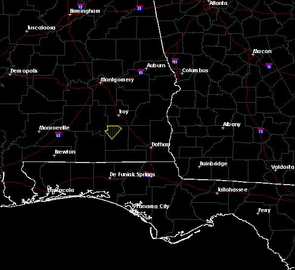 At 637 pm cdt, a severe thunderstorm capable of producing damaging winds over 60 mph was located over glenwood, or near goshen, and was nearly stationary. At 637 pm cdt, a severe thunderstorm capable of producing damaging winds over 60 mph was located over glenwood, or near goshen, and was nearly stationary.
|
| 4/25/2015 4:43 PM CDT | At 442 pm cdt, a line of severe thunderstorms capable of producing damaging winds over 60 mph was located along a line extending from near mckenzie to near crestview, and moving east at 25 mph. |
| 4/25/2015 4:43 PM CDT | At 442 pm cdt, a line of severe thunderstorms capable of producing damaging winds over 60 mph was located along a line extending from near mckenzie to near crestview, and moving east at 25 mph. |
| 4/19/2015 6:48 AM CDT | At 647 am cdt, a severe thunderstorm capable of producing quarter size hail and damaging winds over 60 mph was located near dozier, or 12 miles southwest of luverne, moving northeast at 50 mph. |
| 4/19/2015 6:05 AM CDT | At 604 am cdt, a severe thunderstorm capable of producing quarter size hail and damaging winds over 60 mph was located over us 29 and cr 43, or 17 miles east of east brewton, and moving northeast at 55 mph. |
Hail Maps for Glenwood, AL


Connect with Interactive Hail Maps