

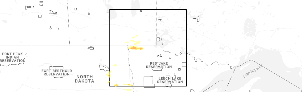
Hail Map for Greenbush, MN
The Greenbush, MN area has had 8 reports of on-the-ground hail by trained spotters, and has been under severe weather warnings 9 times during the past 12 months. Doppler radar has detected hail at or near Greenbush, MN on 33 occasions, including 3 occasions during the past year.
| Name: | Greenbush, MN |
| Where Located: | 21.6 miles WSW of Roseau, MN |
| Map: | Google Map for Greenbush, MN |
| Population: | 719 |
| Housing Units: | 354 |
| More Info: | Search Google for Greenbush, MN |
0
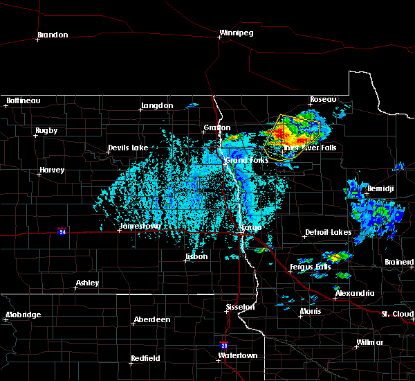
The Top Recent Hail Date for Greenbush, MN is Saturday, June 28, 2025 (15th out of 33)
Hail and Wind Damage Spotted near Greenbush, MN
| Date / Time | Report Details |
|---|---|
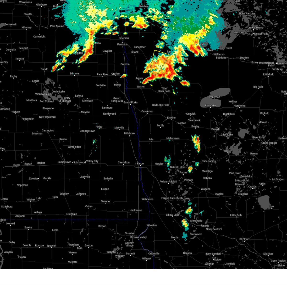
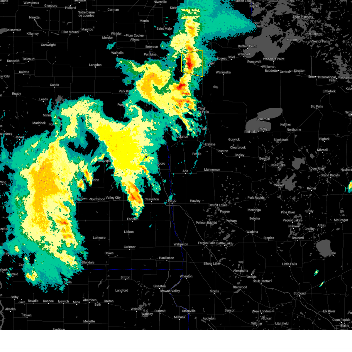
| 6/28/2025 6:32 PM CDT |
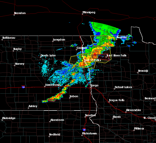
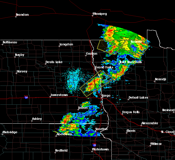
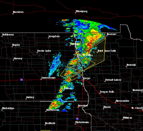
 Svrfgf the national weather service in grand forks has issued a * severe thunderstorm warning for, western roseau county in northwestern minnesota, * until 730 pm cdt. * at 631 pm cdt, a severe thunderstorm was located near haug, or 23 miles west of roseau, moving east at 25 mph (radar indicated). Hazards include two inch hail and 60 mph wind gusts. People and animals outdoors will be injured. expect hail damage to roofs, siding, windows, and vehicles. Expect wind damage to roofs, siding, and trees. Svrfgf the national weather service in grand forks has issued a * severe thunderstorm warning for, western roseau county in northwestern minnesota, * until 730 pm cdt. * at 631 pm cdt, a severe thunderstorm was located near haug, or 23 miles west of roseau, moving east at 25 mph (radar indicated). Hazards include two inch hail and 60 mph wind gusts. People and animals outdoors will be injured. expect hail damage to roofs, siding, windows, and vehicles. Expect wind damage to roofs, siding, and trees.
|
| 5/15/2025 5:39 PM CDT |
 The storms which prompted the warning have moved out of the area. therefore, the warning will be allowed to expire. however, heavy rain is still possible with these thunderstorms. The storms which prompted the warning have moved out of the area. therefore, the warning will be allowed to expire. however, heavy rain is still possible with these thunderstorms.
|
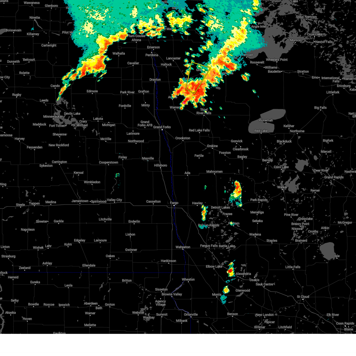
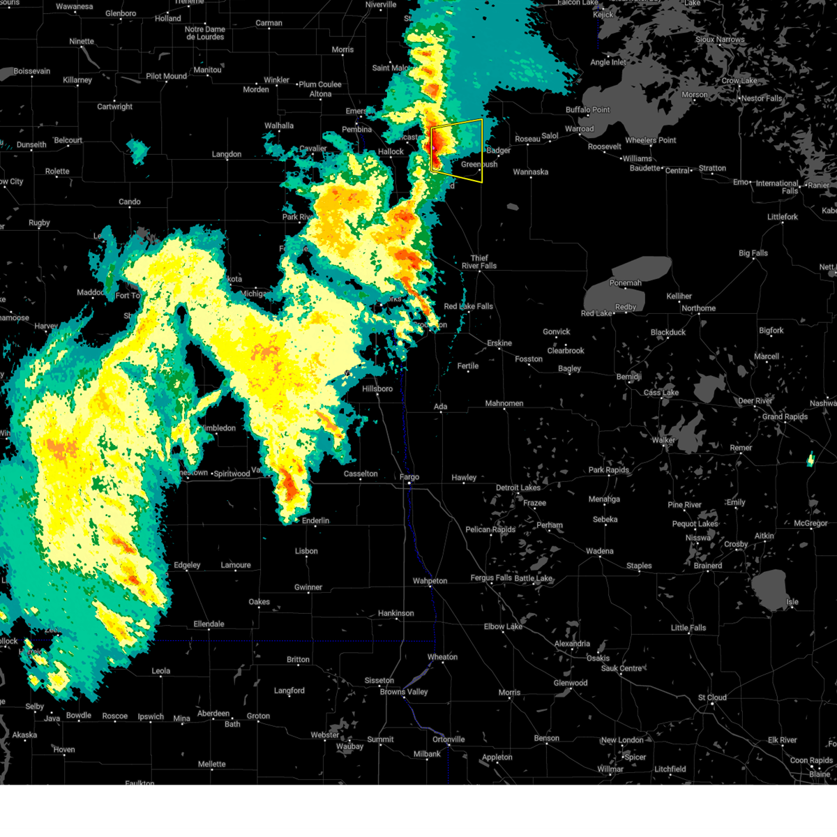
| 5/15/2025 5:15 PM CDT |
 the severe thunderstorm warning has been cancelled and is no longer in effect the severe thunderstorm warning has been cancelled and is no longer in effect
|
| 5/15/2025 5:15 PM CDT |
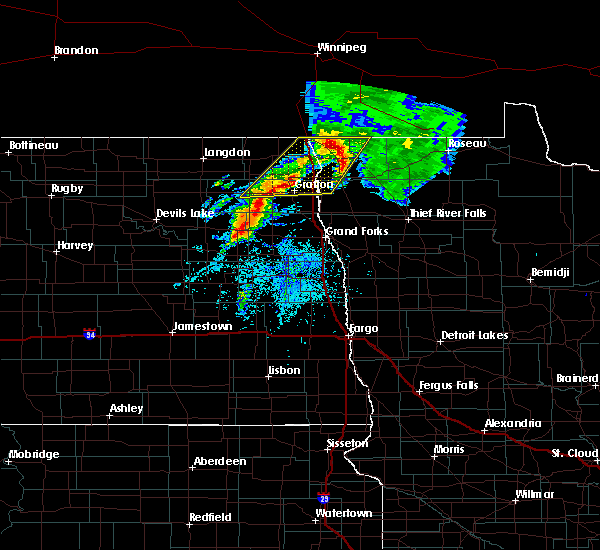
 At 514 pm cdt, severe thunderstorms were located along a line extending from joliette to badger, moving northwest at 45 mph (radar indicated). Hazards include 60 mph wind gusts and penny size hail. Expect damage to roofs, siding, and trees. Locations impacted include, hallock, greenbush, pembina, badger, neche, lancaster, and lake bronson. At 514 pm cdt, severe thunderstorms were located along a line extending from joliette to badger, moving northwest at 45 mph (radar indicated). Hazards include 60 mph wind gusts and penny size hail. Expect damage to roofs, siding, and trees. Locations impacted include, hallock, greenbush, pembina, badger, neche, lancaster, and lake bronson.
|
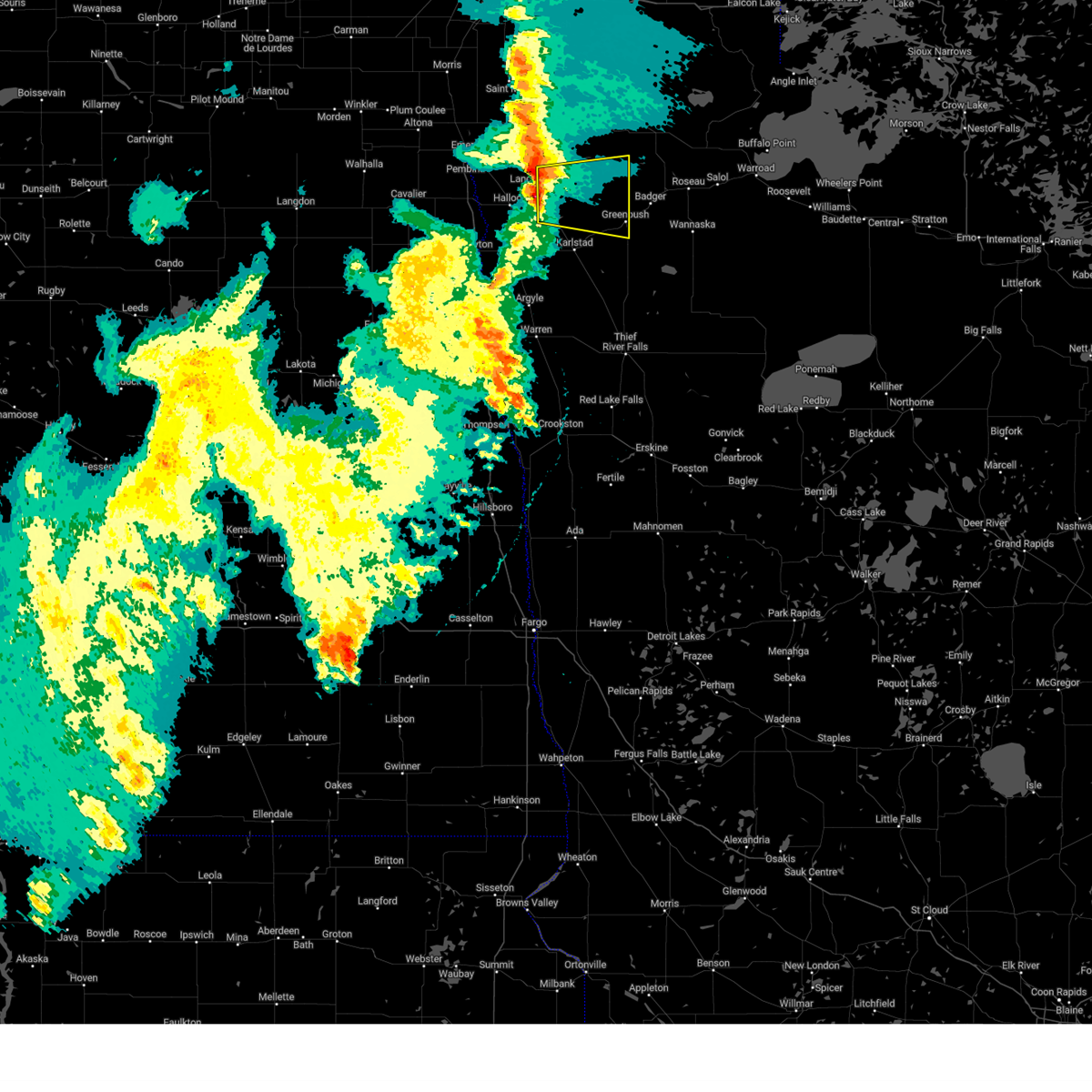
| 5/15/2025 5:05 PM CDT | Damage to playset... via social medi in roseau county MN, 0.4 miles SW of Greenbush, MN |
| 5/15/2025 4:43 PM CDT | Svrfgf the national weather service in grand forks has issued a * severe thunderstorm warning for, northern marshall county in northwestern minnesota, kittson county in northwestern minnesota, western roseau county in northwestern minnesota, eastern pembina county in northeastern north dakota, * until 545 pm cdt. * at 443 pm cdt, severe thunderstorms were located along a line extending from near robbin to 7 miles northwest of gatzke, moving northwest at 45 mph (radar indicated). Hazards include 60 mph wind gusts and penny size hail. expect damage to roofs, siding, and trees |
| 9/16/2024 6:39 PM CDT |
 The storm which prompted the warning has weakened below severe limits, and has exited the warned area. therefore, the warning will be allowed to expire. however, heavy rain is still possible with this thunderstorm. The storm which prompted the warning has weakened below severe limits, and has exited the warned area. therefore, the warning will be allowed to expire. however, heavy rain is still possible with this thunderstorm.
|
| 9/16/2024 6:13 PM CDT |
 At 612 pm cdt, a severe thunderstorm was located over strandquist, or 28 miles northwest of thief river falls, moving northeast at 30 mph (radar indicated). Hazards include quarter size hail. Damage to vehicles is expected. Locations impacted include, karlstad, greenbush, strandquist, and leo. At 612 pm cdt, a severe thunderstorm was located over strandquist, or 28 miles northwest of thief river falls, moving northeast at 30 mph (radar indicated). Hazards include quarter size hail. Damage to vehicles is expected. Locations impacted include, karlstad, greenbush, strandquist, and leo.
|
| 9/16/2024 5:43 PM CDT |
 Svrfgf the national weather service in grand forks has issued a * severe thunderstorm warning for, central marshall county in northwestern minnesota, southeastern kittson county in northwestern minnesota, southwestern roseau county in northwestern minnesota, * until 645 pm cdt. * at 543 pm cdt, a severe thunderstorm was located over old mill state park, or 25 miles northwest of thief river falls, moving northeast at 40 mph (radar indicated). Hazards include 60 mph wind gusts and quarter size hail. Hail damage to vehicles is expected. Expect wind damage to roofs, siding, and trees. Svrfgf the national weather service in grand forks has issued a * severe thunderstorm warning for, central marshall county in northwestern minnesota, southeastern kittson county in northwestern minnesota, southwestern roseau county in northwestern minnesota, * until 645 pm cdt. * at 543 pm cdt, a severe thunderstorm was located over old mill state park, or 25 miles northwest of thief river falls, moving northeast at 40 mph (radar indicated). Hazards include 60 mph wind gusts and quarter size hail. Hail damage to vehicles is expected. Expect wind damage to roofs, siding, and trees.
|
| 9/16/2024 9:28 AM CDT |
 Svrfgf the national weather service in grand forks has issued a * severe thunderstorm warning for, northeastern marshall county in northwestern minnesota, southwestern roseau county in northwestern minnesota, * until 1000 am cdt. * at 928 am cdt, a severe thunderstorm was located 9 miles east of strathcona, or 19 miles southwest of roseau, moving east at 40 mph (radar indicated). Hazards include 60 mph wind gusts and quarter size hail. Hail damage to vehicles is expected. Expect wind damage to roofs, siding, and trees. Svrfgf the national weather service in grand forks has issued a * severe thunderstorm warning for, northeastern marshall county in northwestern minnesota, southwestern roseau county in northwestern minnesota, * until 1000 am cdt. * at 928 am cdt, a severe thunderstorm was located 9 miles east of strathcona, or 19 miles southwest of roseau, moving east at 40 mph (radar indicated). Hazards include 60 mph wind gusts and quarter size hail. Hail damage to vehicles is expected. Expect wind damage to roofs, siding, and trees.
|
| 5/17/2024 9:35 PM CDT |
 The storm which prompted the warning has weakened below severe limits, and no longer poses an immediate threat to life or property. therefore, the warning will be allowed to expire. a severe thunderstorm watch remains in effect until midnight cdt for northwestern minnesota. The storm which prompted the warning has weakened below severe limits, and no longer poses an immediate threat to life or property. therefore, the warning will be allowed to expire. a severe thunderstorm watch remains in effect until midnight cdt for northwestern minnesota.
|
| 5/17/2024 9:19 PM CDT |
 At 918 pm cdt, a severe thunderstorm was located 9 miles northeast of lake bronson, or 33 miles west of roseau, moving east at 25 mph (radar indicated). Hazards include 60 mph wind gusts and quarter size hail. Hail damage to vehicles is expected. expect wind damage to roofs, siding, and trees. Locations impacted include, greenbush, leo, and haug. At 918 pm cdt, a severe thunderstorm was located 9 miles northeast of lake bronson, or 33 miles west of roseau, moving east at 25 mph (radar indicated). Hazards include 60 mph wind gusts and quarter size hail. Hail damage to vehicles is expected. expect wind damage to roofs, siding, and trees. Locations impacted include, greenbush, leo, and haug.
|
| 5/17/2024 9:03 PM CDT |
 Svrfgf the national weather service in grand forks has issued a * severe thunderstorm warning for, northeastern kittson county in northwestern minnesota, northwestern roseau county in northwestern minnesota, * until 945 pm cdt. * at 903 pm cdt, a severe thunderstorm was located near lake bronson, or 40 miles west of roseau, moving east at 25 mph (radar indicated). Hazards include 60 mph wind gusts and quarter size hail. Hail damage to vehicles is expected. Expect wind damage to roofs, siding, and trees. Svrfgf the national weather service in grand forks has issued a * severe thunderstorm warning for, northeastern kittson county in northwestern minnesota, northwestern roseau county in northwestern minnesota, * until 945 pm cdt. * at 903 pm cdt, a severe thunderstorm was located near lake bronson, or 40 miles west of roseau, moving east at 25 mph (radar indicated). Hazards include 60 mph wind gusts and quarter size hail. Hail damage to vehicles is expected. Expect wind damage to roofs, siding, and trees.
|
| 9/5/2023 1:50 AM CDT | Mesonet station mn169 t.h.11 - karlstad - mp 37. in roseau county MN, 9.4 miles ENE of Greenbush, MN |
| 9/5/2023 1:45 AM CDT |
 At 145 am cdt, severe thunderstorms were located along a line extending from 7 miles east of lake bronson state park to near greenbush to 7 miles west of gatzke, moving northeast at 50 mph. these are destructive storms for the greenbush area! (radar indicated). Hazards include 80 mph wind gusts. Flying debris will be dangerous to those caught without shelter. mobile homes will be heavily damaged. expect considerable damage to roofs, windows, and vehicles. extensive tree damage and power outages are likely. locations impacted include, karlstad, greenbush, badger, middle river, lake bronson, halma and wannaska. thunderstorm damage threat, destructive hail threat, radar indicated max hail size, <. 75 in wind threat, observed max wind gust, 80 mph. At 145 am cdt, severe thunderstorms were located along a line extending from 7 miles east of lake bronson state park to near greenbush to 7 miles west of gatzke, moving northeast at 50 mph. these are destructive storms for the greenbush area! (radar indicated). Hazards include 80 mph wind gusts. Flying debris will be dangerous to those caught without shelter. mobile homes will be heavily damaged. expect considerable damage to roofs, windows, and vehicles. extensive tree damage and power outages are likely. locations impacted include, karlstad, greenbush, badger, middle river, lake bronson, halma and wannaska. thunderstorm damage threat, destructive hail threat, radar indicated max hail size, <. 75 in wind threat, observed max wind gust, 80 mph.
|
| 9/5/2023 1:30 AM CDT |
 At 129 am cdt, severe thunderstorms were located along a line extending from near englund to near strandquist to near holt, moving north at 40 mph. these are destructive storms for the strathcona and karlstad areas! (radar indicated). Hazards include 80 mph wind gusts. Flying debris will be dangerous to those caught without shelter. mobile homes will be heavily damaged. expect considerable damage to roofs, windows, and vehicles. extensive tree damage and power outages are likely. locations impacted include, karlstad, greenbush, stephen, badger, newfolden, middle river and lake bronson. thunderstorm damage threat, destructive hail threat, radar indicated max hail size, <. 75 in wind threat, observed max wind gust, 80 mph. At 129 am cdt, severe thunderstorms were located along a line extending from near englund to near strandquist to near holt, moving north at 40 mph. these are destructive storms for the strathcona and karlstad areas! (radar indicated). Hazards include 80 mph wind gusts. Flying debris will be dangerous to those caught without shelter. mobile homes will be heavily damaged. expect considerable damage to roofs, windows, and vehicles. extensive tree damage and power outages are likely. locations impacted include, karlstad, greenbush, stephen, badger, newfolden, middle river and lake bronson. thunderstorm damage threat, destructive hail threat, radar indicated max hail size, <. 75 in wind threat, observed max wind gust, 80 mph.
|
| 9/5/2023 1:12 AM CDT |
 At 110 am cdt, severe thunderstorms were located along a line extending from near stephen to old mill state park to near carpenters corner, moving northeast at 45 mph. 79 mile per hour wind gusts have been observed near warren. these are destructive storms for the warned area (radar indicated). Hazards include 80 mph wind gusts. Flying debris will be dangerous to those caught without shelter. mobile homes will be heavily damaged. expect considerable damage to roofs, windows, and vehicles. Extensive tree damage and power outages are likely. At 110 am cdt, severe thunderstorms were located along a line extending from near stephen to old mill state park to near carpenters corner, moving northeast at 45 mph. 79 mile per hour wind gusts have been observed near warren. these are destructive storms for the warned area (radar indicated). Hazards include 80 mph wind gusts. Flying debris will be dangerous to those caught without shelter. mobile homes will be heavily damaged. expect considerable damage to roofs, windows, and vehicles. Extensive tree damage and power outages are likely.
|
| 9/5/2023 1:06 AM CDT | At 106 am cdt, severe thunderstorms were located along a line extending from 16 miles northwest of neche to near hallock to near warren, moving east at 55 mph (radar indicated). Hazards include 60 mph wind gusts. Expect damage to roofs, siding, and trees. locations impacted include, thief river falls, grafton, warren, cavalier, hallock, drayton and karlstad. this includes interstate 29 between mile markers 161 and 217. hail threat, radar indicated max hail size, <. 75 in wind threat, observed max wind gust, 60 mph. |
| 9/5/2023 1:06 AM CDT | At 106 am cdt, severe thunderstorms were located along a line extending from 16 miles northwest of neche to near hallock to near warren, moving east at 55 mph (radar indicated). Hazards include 60 mph wind gusts. Expect damage to roofs, siding, and trees. locations impacted include, thief river falls, grafton, warren, cavalier, hallock, drayton and karlstad. this includes interstate 29 between mile markers 161 and 217. hail threat, radar indicated max hail size, <. 75 in wind threat, observed max wind gust, 60 mph. |
| 9/5/2023 12:24 AM CDT |
 At 1224 am cdt, severe thunderstorms were located along a line extending from near olga to near grafton to near thompson, moving northeast at 55 mph (radar indicated). Hazards include 60 mph wind gusts. expect damage to roofs, siding, and trees At 1224 am cdt, severe thunderstorms were located along a line extending from near olga to near grafton to near thompson, moving northeast at 55 mph (radar indicated). Hazards include 60 mph wind gusts. expect damage to roofs, siding, and trees
|
| 7/13/2023 6:59 PM CDT |
 At 659 pm cdt, a severe thunderstorm was located near haug, or 23 miles west of roseau, moving southeast at 30 mph (radar indicated). Hazards include quarter size hail. damage to vehicles is expected At 659 pm cdt, a severe thunderstorm was located near haug, or 23 miles west of roseau, moving southeast at 30 mph (radar indicated). Hazards include quarter size hail. damage to vehicles is expected
|
| 7/19/2022 7:07 AM CDT |
 The severe thunderstorm warning for northern marshall, kittson and roseau counties will expire at 715 am cdt, the storms which prompted the warning have weakened below severe limits, and no longer pose an immediate threat to life or property. therefore, the warning will be allowed to expire. however gusty winds are still possible with these thunderstorms. to report severe weather, contact your nearest law enforcement agency. they will relay your report to the national weather service grand forks. The severe thunderstorm warning for northern marshall, kittson and roseau counties will expire at 715 am cdt, the storms which prompted the warning have weakened below severe limits, and no longer pose an immediate threat to life or property. therefore, the warning will be allowed to expire. however gusty winds are still possible with these thunderstorms. to report severe weather, contact your nearest law enforcement agency. they will relay your report to the national weather service grand forks.
|
| 7/19/2022 6:27 AM CDT |
 At 626 am cdt, severe thunderstorms were located along a line extending from 13 miles northwest of caribou to 8 miles northeast of lake bronson to near donaldson, moving east at 55 mph (radar indicated). Hazards include 60 mph wind gusts and quarter size hail. Hail damage to vehicles is expected. expect wind damage to roofs, siding, and trees. locations impacted include, englund, florian, haug, halma, karlstad, strandquist, ross, pinecreek, fox, strathcona and greenbush. hail threat, radar indicated max hail size, 1. 00 in wind threat, observed max wind gust, 60 mph. At 626 am cdt, severe thunderstorms were located along a line extending from 13 miles northwest of caribou to 8 miles northeast of lake bronson to near donaldson, moving east at 55 mph (radar indicated). Hazards include 60 mph wind gusts and quarter size hail. Hail damage to vehicles is expected. expect wind damage to roofs, siding, and trees. locations impacted include, englund, florian, haug, halma, karlstad, strandquist, ross, pinecreek, fox, strathcona and greenbush. hail threat, radar indicated max hail size, 1. 00 in wind threat, observed max wind gust, 60 mph.
|
| 7/19/2022 6:11 AM CDT |
 At 610 am cdt, severe thunderstorms were located along a line extending from 12 miles north of orleans to near lancaster to near herrick, moving east at 55 mph (radar indicated. !** weakened). Hazards include 60 mph wind gusts and quarter size hail. Hail damage to vehicles is expected. expect wind damage to roofs, siding, and trees. severe thunderstorms will be near, lancaster around 615 am cdt. lake bronson around 620 am cdt. stephen and donaldson around 625 am cdt. other locations in the path of these severe thunderstorms include englund, florian, leo, karlstad and haug. this includes interstate 29 between mile markers 170 and 206. hail threat, radar indicated max hail size, 1. 00 in wind threat, observed max wind gust, 60 mph. At 610 am cdt, severe thunderstorms were located along a line extending from 12 miles north of orleans to near lancaster to near herrick, moving east at 55 mph (radar indicated. !** weakened). Hazards include 60 mph wind gusts and quarter size hail. Hail damage to vehicles is expected. expect wind damage to roofs, siding, and trees. severe thunderstorms will be near, lancaster around 615 am cdt. lake bronson around 620 am cdt. stephen and donaldson around 625 am cdt. other locations in the path of these severe thunderstorms include englund, florian, leo, karlstad and haug. this includes interstate 29 between mile markers 170 and 206. hail threat, radar indicated max hail size, 1. 00 in wind threat, observed max wind gust, 60 mph.
|
| 7/19/2022 2:00 AM CDT |
 At 200 am cdt, a severe thunderstorm was located near badger, or 13 miles southwest of roseau, moving northeast at 30 mph (radar indicated). Hazards include 60 mph wind gusts and half dollar size hail. Hail damage to vehicles is expected. expect wind damage to roofs, siding, and trees. this severe thunderstorm will be near, fox around 215 am cdt. other locations in the path of this severe thunderstorm include malung, roseau, salol, longworth, springsteel island and warroad. hail threat, radar indicated max hail size, 1. 25 in wind threat, radar indicated max wind gust, 60 mph. At 200 am cdt, a severe thunderstorm was located near badger, or 13 miles southwest of roseau, moving northeast at 30 mph (radar indicated). Hazards include 60 mph wind gusts and half dollar size hail. Hail damage to vehicles is expected. expect wind damage to roofs, siding, and trees. this severe thunderstorm will be near, fox around 215 am cdt. other locations in the path of this severe thunderstorm include malung, roseau, salol, longworth, springsteel island and warroad. hail threat, radar indicated max hail size, 1. 25 in wind threat, radar indicated max wind gust, 60 mph.
|
| 7/10/2022 9:09 AM CDT |
 At 909 am cdt, severe thunderstorms were located along a line extending from near badger to red lake nation to near mcintosh, moving east at 50 mph (radar indicated). Hazards include 60 mph wind gusts and quarter size hail. Hail damage to vehicles is expected. expect wind damage to roofs, siding, and trees. severe thunderstorms will be near, red lake nation around 910 am cdt. malung, gully and wannaska around 920 am cdt. weme, pencer and gonvick around 925 am cdt. other locations in the path of these severe thunderstorms include clearbrook, thorhult, upper red lake and leonard. hail threat, radar indicated max hail size, 1. 00 in wind threat, radar indicated max wind gust, 60 mph. At 909 am cdt, severe thunderstorms were located along a line extending from near badger to red lake nation to near mcintosh, moving east at 50 mph (radar indicated). Hazards include 60 mph wind gusts and quarter size hail. Hail damage to vehicles is expected. expect wind damage to roofs, siding, and trees. severe thunderstorms will be near, red lake nation around 910 am cdt. malung, gully and wannaska around 920 am cdt. weme, pencer and gonvick around 925 am cdt. other locations in the path of these severe thunderstorms include clearbrook, thorhult, upper red lake and leonard. hail threat, radar indicated max hail size, 1. 00 in wind threat, radar indicated max wind gust, 60 mph.
|
| 7/10/2022 8:38 AM CDT |
 At 838 am cdt, severe thunderstorms were located along a line extending from 6 miles northeast of halma to near thief river falls to near maple bay, moving east at 55 mph (radar indicated). Hazards include 60 mph wind gusts and quarter size hail. Hail damage to vehicles is expected. expect wind damage to roofs, siding, and trees. these severe storms will be near, maple bay, hazel and thief river falls around 840 am cdt. other locations in the path of these severe thunderstorms include mentor, leo, mavie, high landing, erskine, greenbush, mcintosh and badger. hail threat, radar indicated max hail size, 1. 00 in wind threat, radar indicated max wind gust, 60 mph. At 838 am cdt, severe thunderstorms were located along a line extending from 6 miles northeast of halma to near thief river falls to near maple bay, moving east at 55 mph (radar indicated). Hazards include 60 mph wind gusts and quarter size hail. Hail damage to vehicles is expected. expect wind damage to roofs, siding, and trees. these severe storms will be near, maple bay, hazel and thief river falls around 840 am cdt. other locations in the path of these severe thunderstorms include mentor, leo, mavie, high landing, erskine, greenbush, mcintosh and badger. hail threat, radar indicated max hail size, 1. 00 in wind threat, radar indicated max wind gust, 60 mph.
|
| 7/10/2022 8:22 AM CDT |
 At 822 am cdt, severe thunderstorms were located along a line extending from 6 miles west of lake bronson to near carpenters corner to greenview, moving east at 55 mph (radar indicated). Hazards include 60 mph wind gusts and quarter size hail. Hail damage to vehicles is expected. expect wind damage to roofs, siding, and trees. severe thunderstorms will be near, harold and carpenters corner around 825 am cdt. melvin and rosewood around 830 am cdt. thief river falls, st. hilaire and dakota junction around 835 am cdt. maple bay, hazel and dugdale around 840 am cdt. other locations in the path of these severe thunderstorms include mavie and mentor. hail threat, radar indicated max hail size, 1. 00 in wind threat, radar indicated max wind gust, 60 mph. At 822 am cdt, severe thunderstorms were located along a line extending from 6 miles west of lake bronson to near carpenters corner to greenview, moving east at 55 mph (radar indicated). Hazards include 60 mph wind gusts and quarter size hail. Hail damage to vehicles is expected. expect wind damage to roofs, siding, and trees. severe thunderstorms will be near, harold and carpenters corner around 825 am cdt. melvin and rosewood around 830 am cdt. thief river falls, st. hilaire and dakota junction around 835 am cdt. maple bay, hazel and dugdale around 840 am cdt. other locations in the path of these severe thunderstorms include mavie and mentor. hail threat, radar indicated max hail size, 1. 00 in wind threat, radar indicated max wind gust, 60 mph.
|
| 6/24/2022 7:40 PM CDT |
 At 739 pm cdt, severe thunderstorms were located along a line extending from near donaldson to dorothy, moving northeast at 25 mph. these are destructive storms (radar indicated). Hazards include 80 mph wind gusts and half dollar size hail. Flying debris will be dangerous to those caught without shelter. mobile homes will be heavily damaged. expect considerable damage to roofs, windows, and vehicles. extensive tree damage and power outages are likely. locations impacted include, dorothy, huot, donaldson, wylie, kennedy, red lake falls, st. Hilaire and hazel. At 739 pm cdt, severe thunderstorms were located along a line extending from near donaldson to dorothy, moving northeast at 25 mph. these are destructive storms (radar indicated). Hazards include 80 mph wind gusts and half dollar size hail. Flying debris will be dangerous to those caught without shelter. mobile homes will be heavily damaged. expect considerable damage to roofs, windows, and vehicles. extensive tree damage and power outages are likely. locations impacted include, dorothy, huot, donaldson, wylie, kennedy, red lake falls, st. Hilaire and hazel.
|
| 6/24/2022 7:19 PM CDT |
 At 719 pm cdt, severe thunderstorms were located along a line extending from near robbin to 6 miles north of crookston, moving northeast at 25 mph. these are destructive storms for thief river falls and karlstad (radar indicated). Hazards include 90 mph wind gusts and half dollar size hail. You are in a life-threatening situation. flying debris may be deadly to those caught without shelter. mobile homes will be heavily damaged or destroyed. homes and businesses will have substantial roof and window damage. expect extensive tree damage and power outages. these severe storms will be near, euclid and gentilly around 725 pm cdt. other locations in the path of these severe thunderstorms include dorothy, huot, donaldson, wylie, kennedy, red lake falls and st. hilaire. This includes interstate 29 between mile markers 168 and 184. At 719 pm cdt, severe thunderstorms were located along a line extending from near robbin to 6 miles north of crookston, moving northeast at 25 mph. these are destructive storms for thief river falls and karlstad (radar indicated). Hazards include 90 mph wind gusts and half dollar size hail. You are in a life-threatening situation. flying debris may be deadly to those caught without shelter. mobile homes will be heavily damaged or destroyed. homes and businesses will have substantial roof and window damage. expect extensive tree damage and power outages. these severe storms will be near, euclid and gentilly around 725 pm cdt. other locations in the path of these severe thunderstorms include dorothy, huot, donaldson, wylie, kennedy, red lake falls and st. hilaire. This includes interstate 29 between mile markers 168 and 184.
|
| 6/24/2022 7:07 PM CDT |
 At 706 pm cdt, severe thunderstorms were located along a line extending from herrick to near crookston, moving northeast at 25 mph. these are destructive storms for thief river falls and old mill state park (radar indicated). Hazards include 90 mph wind gusts and half dollar size hail. You are in a life-threatening situation. flying debris may be deadly to those caught without shelter. mobile homes will be heavily damaged or destroyed. homes and businesses will have substantial roof and window damage. expect extensive tree damage and power outages. severe thunderstorms will be near, crookston around 710 pm cdt. robbin and euclid around 720 pm cdt. other locations in the path of these severe thunderstorms include huot, dorothy and donaldson. this includes interstate 29 between mile markers 168 and 184. thunderstorm damage threat, destructive hail threat, radar indicated max hail size, 1. 25 in wind threat, observed max wind gust, 90 mph. At 706 pm cdt, severe thunderstorms were located along a line extending from herrick to near crookston, moving northeast at 25 mph. these are destructive storms for thief river falls and old mill state park (radar indicated). Hazards include 90 mph wind gusts and half dollar size hail. You are in a life-threatening situation. flying debris may be deadly to those caught without shelter. mobile homes will be heavily damaged or destroyed. homes and businesses will have substantial roof and window damage. expect extensive tree damage and power outages. severe thunderstorms will be near, crookston around 710 pm cdt. robbin and euclid around 720 pm cdt. other locations in the path of these severe thunderstorms include huot, dorothy and donaldson. this includes interstate 29 between mile markers 168 and 184. thunderstorm damage threat, destructive hail threat, radar indicated max hail size, 1. 25 in wind threat, observed max wind gust, 90 mph.
|
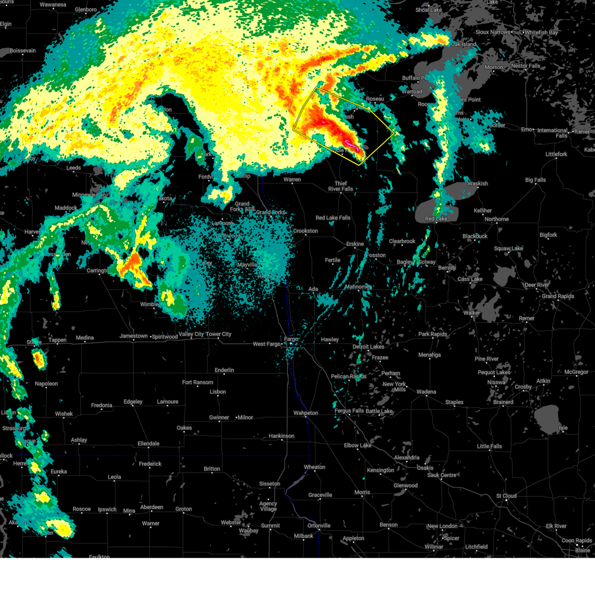
| 6/24/2022 8:33 AM CDT | Ping Pong Ball sized hail reported 0.4 miles SW of Greenbush, MN, relayed from media....mostly quarter sized hail but a few were ping pong ball sized. |
| 6/24/2022 8:15 AM CDT | Golf Ball sized hail reported 0.4 miles SW of Greenbush, MN, hail started as golf ball... then became pea sized. |
| 6/24/2022 8:15 AM CDT |
 At 815 am cdt, severe thunderstorms were located along a line extending from near greenbush to near strathcona to near newfolden, moving east at 30 mph (radar indicated). Hazards include ping pong ball size hail and 60 mph wind gusts. People and animals outdoors will be injured. expect hail damage to roofs, siding, windows, and vehicles. expect wind damage to roofs, siding, and trees. severe thunderstorms will be near, strathcona, haug and greenbush around 820 am cdt. badger around 830 am cdt. other locations in the path of these severe thunderstorms include fox, malung, torfin, roseau, casperson and pencer. hail threat, radar indicated max hail size, 1. 50 in wind threat, radar indicated max wind gust, 60 mph. At 815 am cdt, severe thunderstorms were located along a line extending from near greenbush to near strathcona to near newfolden, moving east at 30 mph (radar indicated). Hazards include ping pong ball size hail and 60 mph wind gusts. People and animals outdoors will be injured. expect hail damage to roofs, siding, windows, and vehicles. expect wind damage to roofs, siding, and trees. severe thunderstorms will be near, strathcona, haug and greenbush around 820 am cdt. badger around 830 am cdt. other locations in the path of these severe thunderstorms include fox, malung, torfin, roseau, casperson and pencer. hail threat, radar indicated max hail size, 1. 50 in wind threat, radar indicated max wind gust, 60 mph.
|
| 6/14/2022 8:36 AM CDT |
 At 835 am cdt, severe thunderstorms were located along a line extending from 6 miles east of noyes to 7 miles south of caribou to near greenbush, moving northeast at 50 mph (radar indicated). Hazards include 60 mph wind gusts. Expect damage to roofs, siding, and trees. locations impacted include, badger, caribou, fox, ross and roseau. this includes interstate 29 between mile markers 161 and 217. hail threat, radar indicated max hail size, <. 75 in wind threat, radar indicated max wind gust, 60 mph. At 835 am cdt, severe thunderstorms were located along a line extending from 6 miles east of noyes to 7 miles south of caribou to near greenbush, moving northeast at 50 mph (radar indicated). Hazards include 60 mph wind gusts. Expect damage to roofs, siding, and trees. locations impacted include, badger, caribou, fox, ross and roseau. this includes interstate 29 between mile markers 161 and 217. hail threat, radar indicated max hail size, <. 75 in wind threat, radar indicated max wind gust, 60 mph.
|
| 6/14/2022 8:07 AM CDT |
 At 806 am cdt, severe thunderstorms were located along a line extending from glasston to near donaldson to near old mill state park, moving northeast at 70 mph (radar indicated). Hazards include 60 mph wind gusts. Expect damage to roofs, siding, and trees. severe thunderstorms will be near, newfolden around 810 am cdt. lake bronson, halma and strandquist around 815 am cdt. middle river around 820 am cdt. strathcona, humboldt and noyes around 825 am cdt. other locations in the path of these severe thunderstorms include greenbush and caribou. this includes interstate 29 between mile markers 127 and 217. hail threat, radar indicated max hail size, <. 75 in wind threat, radar indicated max wind gust, 60 mph. At 806 am cdt, severe thunderstorms were located along a line extending from glasston to near donaldson to near old mill state park, moving northeast at 70 mph (radar indicated). Hazards include 60 mph wind gusts. Expect damage to roofs, siding, and trees. severe thunderstorms will be near, newfolden around 810 am cdt. lake bronson, halma and strandquist around 815 am cdt. middle river around 820 am cdt. strathcona, humboldt and noyes around 825 am cdt. other locations in the path of these severe thunderstorms include greenbush and caribou. this includes interstate 29 between mile markers 127 and 217. hail threat, radar indicated max hail size, <. 75 in wind threat, radar indicated max wind gust, 60 mph.
|
| 8/9/2020 2:10 PM CDT |
 The severe thunderstorm warning for eastern kittson and western roseau counties will expire at 215 pm cdt, the storms which prompted the warning have moved out of the area. therefore, the warning will be allowed to expire. a severe thunderstorm watch remains in effect until 700 pm cdt for northwestern minnesota. The severe thunderstorm warning for eastern kittson and western roseau counties will expire at 215 pm cdt, the storms which prompted the warning have moved out of the area. therefore, the warning will be allowed to expire. a severe thunderstorm watch remains in effect until 700 pm cdt for northwestern minnesota.
|
| 8/9/2020 1:30 PM CDT |
 At 130 pm cdt, severe thunderstorms were located along a line extending from 11 miles west of caribou to karlstad, moving east at 40 mph (radar indicated). Hazards include 60 mph wind gusts and quarter size hail. Hail damage to vehicles is expected. expect wind damage to roofs, siding, and trees. Locations impacted include, greenbush, lake bronson, halma, lake bronson state park, leo, haug and caribou. At 130 pm cdt, severe thunderstorms were located along a line extending from 11 miles west of caribou to karlstad, moving east at 40 mph (radar indicated). Hazards include 60 mph wind gusts and quarter size hail. Hail damage to vehicles is expected. expect wind damage to roofs, siding, and trees. Locations impacted include, greenbush, lake bronson, halma, lake bronson state park, leo, haug and caribou.
|
| 8/9/2020 1:08 PM CDT |
 The national weather service in grand forks has issued a * severe thunderstorm warning for. kittson county in northwestern minnesota. western roseau county in northwestern minnesota. until 215 pm cdt. At 108 pm cdt, severe thunderstorms were located along a line. The national weather service in grand forks has issued a * severe thunderstorm warning for. kittson county in northwestern minnesota. western roseau county in northwestern minnesota. until 215 pm cdt. At 108 pm cdt, severe thunderstorms were located along a line.
|
| 7/24/2020 11:17 PM CDT |
 At 1117 pm cdt, a severe thunderstorm was located over englund, or 32 miles northwest of thief river falls, moving north at 45 mph (radar indicated). Hazards include 60 mph wind gusts. expect damage to roofs, siding, and trees At 1117 pm cdt, a severe thunderstorm was located over englund, or 32 miles northwest of thief river falls, moving north at 45 mph (radar indicated). Hazards include 60 mph wind gusts. expect damage to roofs, siding, and trees
|
| 6/17/2020 10:56 PM CDT |
 The severe thunderstorm warning for east central kittson and western roseau counties will expire at 1100 pm cdt, the severe thunderstorm which prompted the warning has weakened. therefore, the warning will be allowed to expire. however gusty winds are still possible with this thunderstorm. a severe thunderstorm watch remains in effect until midnight cdt for northwestern minnesota. The severe thunderstorm warning for east central kittson and western roseau counties will expire at 1100 pm cdt, the severe thunderstorm which prompted the warning has weakened. therefore, the warning will be allowed to expire. however gusty winds are still possible with this thunderstorm. a severe thunderstorm watch remains in effect until midnight cdt for northwestern minnesota.
|
| 6/17/2020 10:50 PM CDT |
 At 1049 pm cdt, a severe thunderstorm was located near leo, or 28 miles west of roseau, moving northeast at 55 mph (radar indicated). Hazards include 60 mph wind gusts and penny size hail. Expect damage to roofs, siding, and trees. this severe storm will be near, leo and greenbush around 1055 pm cdt. haug around 1105 pm cdt. Pinecreek around 1120 pm cdt. At 1049 pm cdt, a severe thunderstorm was located near leo, or 28 miles west of roseau, moving northeast at 55 mph (radar indicated). Hazards include 60 mph wind gusts and penny size hail. Expect damage to roofs, siding, and trees. this severe storm will be near, leo and greenbush around 1055 pm cdt. haug around 1105 pm cdt. Pinecreek around 1120 pm cdt.
|
| 6/17/2020 10:37 PM CDT |
 At 1037 pm cdt, severe thunderstorms were located along a line extending from 9 miles northeast of orleans to leo, moving northeast at 45 mph (radar indicated). Hazards include 60 mph wind gusts and penny size hail. Expect damage to roofs, siding, and trees. these severe storms will be near, leo around 1040 pm cdt. haug around 1045 pm cdt. Pinecreek around 1110 pm cdt. At 1037 pm cdt, severe thunderstorms were located along a line extending from 9 miles northeast of orleans to leo, moving northeast at 45 mph (radar indicated). Hazards include 60 mph wind gusts and penny size hail. Expect damage to roofs, siding, and trees. these severe storms will be near, leo around 1040 pm cdt. haug around 1045 pm cdt. Pinecreek around 1110 pm cdt.
|
| 6/17/2020 10:14 PM CDT |
 At 1014 pm cdt, severe thunderstorms were located along a line extending from near northcote to near karlstad, moving northeast at 50 mph (radar indicated). Hazards include 70 mph wind gusts and penny size hail. Expect considerable tree damage. damage is likely to mobile homes, roofs, and outbuildings. severe thunderstorms will be near, lancaster around 1025 pm cdt. leo and greenbush around 1030 pm cdt. Haug around 1040 pm cdt. At 1014 pm cdt, severe thunderstorms were located along a line extending from near northcote to near karlstad, moving northeast at 50 mph (radar indicated). Hazards include 70 mph wind gusts and penny size hail. Expect considerable tree damage. damage is likely to mobile homes, roofs, and outbuildings. severe thunderstorms will be near, lancaster around 1025 pm cdt. leo and greenbush around 1030 pm cdt. Haug around 1040 pm cdt.
|
| 6/17/2020 9:47 PM CDT | Tree damage relayed via social media phot in roseau county MN, 0.4 miles SW of Greenbush, MN |
| 6/17/2020 9:43 PM CDT |
 At 942 pm cdt, severe thunderstorms were located along a line extending from 8 miles southeast of caribou to near torfin, moving northeast at 45 mph (radar indicated). Hazards include 70 mph wind gusts and penny size hail. Expect considerable tree damage. damage is likely to mobile homes, roofs, and outbuildings. severe thunderstorms will be near, torfin, casperson and skime around 950 pm cdt. wannaska and hayes lake state park around 955 pm cdt. pencer around 1000 pm cdt. malung around 1005 pm cdt. Salol around 1015 pm cdt. At 942 pm cdt, severe thunderstorms were located along a line extending from 8 miles southeast of caribou to near torfin, moving northeast at 45 mph (radar indicated). Hazards include 70 mph wind gusts and penny size hail. Expect considerable tree damage. damage is likely to mobile homes, roofs, and outbuildings. severe thunderstorms will be near, torfin, casperson and skime around 950 pm cdt. wannaska and hayes lake state park around 955 pm cdt. pencer around 1000 pm cdt. malung around 1005 pm cdt. Salol around 1015 pm cdt.
|
| 6/17/2020 9:35 PM CDT |
 At 935 pm cdt, severe thunderstorms were located along a line extending from near haug to badger to near wannaska, moving northeast at 45 mph (radar indicated). Hazards include 70 mph wind gusts and penny size hail. Expect considerable tree damage. damage is likely to mobile homes, roofs, and outbuildings. Locations impacted include, roseau, warroad, karlstad, greenbush, badger, springsteel island and strandquist. At 935 pm cdt, severe thunderstorms were located along a line extending from near haug to badger to near wannaska, moving northeast at 45 mph (radar indicated). Hazards include 70 mph wind gusts and penny size hail. Expect considerable tree damage. damage is likely to mobile homes, roofs, and outbuildings. Locations impacted include, roseau, warroad, karlstad, greenbush, badger, springsteel island and strandquist.
|
| 6/17/2020 9:13 PM CDT |
 At 913 pm cdt, a severe thunderstorm capable of producing a tornado was located near middle river, or 26 miles north of thief river falls, moving northeast at 50 mph (radar indicated rotation). Hazards include tornado. expect damage to mobile homes, roofs, and vehicles At 913 pm cdt, a severe thunderstorm capable of producing a tornado was located near middle river, or 26 miles north of thief river falls, moving northeast at 50 mph (radar indicated rotation). Hazards include tornado. expect damage to mobile homes, roofs, and vehicles
|
| 6/17/2020 9:02 PM CDT |
 At 901 pm cdt, severe thunderstorms were located along a line extending from 15 miles north of pinecreek to ross to near middle river, moving northeast at 50 mph (radar indicated). Hazards include 70 mph wind gusts and penny size hail. Expect considerable tree damage. Damage is likely to mobile homes, roofs, and outbuildings. At 901 pm cdt, severe thunderstorms were located along a line extending from 15 miles north of pinecreek to ross to near middle river, moving northeast at 50 mph (radar indicated). Hazards include 70 mph wind gusts and penny size hail. Expect considerable tree damage. Damage is likely to mobile homes, roofs, and outbuildings.
|
| 6/17/2020 8:46 PM CDT |
 At 846 pm cdt, severe thunderstorms were located along a line extending from 25 miles north of caribou to 7 miles north of haug to near old mill state park, moving northeast at 40 mph (radar indicated). Hazards include 70 mph wind gusts and penny size hail. Expect considerable tree damage. damage is likely to mobile homes, roofs, and outbuildings. Locations impacted include, karlstad, greenbush, stephen, badger, lake bronson, strandquist and halma. At 846 pm cdt, severe thunderstorms were located along a line extending from 25 miles north of caribou to 7 miles north of haug to near old mill state park, moving northeast at 40 mph (radar indicated). Hazards include 70 mph wind gusts and penny size hail. Expect considerable tree damage. damage is likely to mobile homes, roofs, and outbuildings. Locations impacted include, karlstad, greenbush, stephen, badger, lake bronson, strandquist and halma.
|
| 6/17/2020 8:44 PM CDT | Storm damage reported in roseau county MN, 7.1 miles E of Greenbush, MN |
| 6/17/2020 8:26 PM CDT |
 At 826 pm cdt, severe thunderstorms were located along a line extending from 14 miles north of caribou to near leo to near radium, moving northeast at 40 mph (radar indicated). Hazards include 70 mph wind gusts and penny size hail. Expect considerable tree damage. Damage is likely to mobile homes, roofs, and outbuildings. At 826 pm cdt, severe thunderstorms were located along a line extending from 14 miles north of caribou to near leo to near radium, moving northeast at 40 mph (radar indicated). Hazards include 70 mph wind gusts and penny size hail. Expect considerable tree damage. Damage is likely to mobile homes, roofs, and outbuildings.
|
| 6/17/2020 5:47 PM CDT |
 At 547 pm cdt, a severe thunderstorm capable of producing a tornado was located near haug, or 14 miles west of roseau, moving northeast at 35 mph (weather spotters reported a funnel cloud). Hazards include tornado and golf ball size hail. Expect damage to mobile homes, roofs, and vehicles. Locations impacted include, greenbush, badger, fox, pinecreek, ross and haug. At 547 pm cdt, a severe thunderstorm capable of producing a tornado was located near haug, or 14 miles west of roseau, moving northeast at 35 mph (weather spotters reported a funnel cloud). Hazards include tornado and golf ball size hail. Expect damage to mobile homes, roofs, and vehicles. Locations impacted include, greenbush, badger, fox, pinecreek, ross and haug.
|
| 6/17/2020 5:33 PM CDT |
 At 533 pm cdt, a severe thunderstorm was located over haug, or 18 miles west of roseau, moving northeast at 35 mph (radar indicated). Hazards include ping pong ball size hail and 60 mph wind gusts. People and animals outdoors will be injured. expect hail damage to roofs, siding, windows, and vehicles. expect wind damage to roofs, siding, and trees. Locations impacted include, greenbush, badger, leo, haug and fox. At 533 pm cdt, a severe thunderstorm was located over haug, or 18 miles west of roseau, moving northeast at 35 mph (radar indicated). Hazards include ping pong ball size hail and 60 mph wind gusts. People and animals outdoors will be injured. expect hail damage to roofs, siding, windows, and vehicles. expect wind damage to roofs, siding, and trees. Locations impacted include, greenbush, badger, leo, haug and fox.
|
| 6/17/2020 5:27 PM CDT |
 At 527 pm cdt, a severe thunderstorm capable of producing a tornado was located over leo, or 22 miles west of roseau, moving northeast at 35 mph (radar indicated rotation). Hazards include tornado and ping pong ball size hail. expect damage to mobile homes, roofs, and vehicles At 527 pm cdt, a severe thunderstorm capable of producing a tornado was located over leo, or 22 miles west of roseau, moving northeast at 35 mph (radar indicated rotation). Hazards include tornado and ping pong ball size hail. expect damage to mobile homes, roofs, and vehicles
|
| 6/17/2020 5:08 PM CDT |
 At 508 pm cdt, a severe thunderstorm was located 7 miles northeast of karlstad, or 31 miles southwest of roseau, moving northeast at 35 mph (radar indicated). Hazards include 60 mph wind gusts and quarter size hail. Hail damage to vehicles is expected. expect wind damage to roofs, siding, and trees. Locations impacted include, karlstad, greenbush, badger, leo, haug and fox. At 508 pm cdt, a severe thunderstorm was located 7 miles northeast of karlstad, or 31 miles southwest of roseau, moving northeast at 35 mph (radar indicated). Hazards include 60 mph wind gusts and quarter size hail. Hail damage to vehicles is expected. expect wind damage to roofs, siding, and trees. Locations impacted include, karlstad, greenbush, badger, leo, haug and fox.
|
| 6/17/2020 4:45 PM CDT |
 At 445 pm cdt, a severe thunderstorm was located over englund, or 31 miles northwest of thief river falls, moving northeast at 35 mph (radar indicated). Hazards include 60 mph wind gusts and quarter size hail. Hail damage to vehicles is expected. Expect wind damage to roofs, siding, and trees. At 445 pm cdt, a severe thunderstorm was located over englund, or 31 miles northwest of thief river falls, moving northeast at 35 mph (radar indicated). Hazards include 60 mph wind gusts and quarter size hail. Hail damage to vehicles is expected. Expect wind damage to roofs, siding, and trees.
|
| 6/7/2020 10:45 PM CDT |
 At 1045 pm cdt, severe thunderstorms were located along a line extending from near badger to near gatzke to 7 miles southeast of espelie, moving northeast at 55 mph (radar indicated). Hazards include 60 mph wind gusts. Expect damage to roofs, siding, and trees. severe thunderstorms will be near, fox and skime around 1055 pm cdt. jelle, carmel and ross around 1100 pm cdt. roseau, thorhult and fourtown around 1105 pm cdt. salol around 1110 pm cdt. Norris camp around 1115 pm cdt. At 1045 pm cdt, severe thunderstorms were located along a line extending from near badger to near gatzke to 7 miles southeast of espelie, moving northeast at 55 mph (radar indicated). Hazards include 60 mph wind gusts. Expect damage to roofs, siding, and trees. severe thunderstorms will be near, fox and skime around 1055 pm cdt. jelle, carmel and ross around 1100 pm cdt. roseau, thorhult and fourtown around 1105 pm cdt. salol around 1110 pm cdt. Norris camp around 1115 pm cdt.
|
| 6/7/2020 10:33 PM CDT |
 At 1032 pm cdt, severe thunderstorms were located along a line extending from near old mill state park to 10 miles east of holt to near high landing, moving northeast at 65 mph (radar indicated). Hazards include 60 mph wind gusts. Expect damage to roofs, siding, and trees. a wind gust of 62 mph was reported at thief river falls regional airport at 1021 pm. these severe storms will be near, gatzke around 1045 pm cdt. strathcona around 1050 pm cdt. skime and greenbush around 1055 pm cdt. badger around 1105 pm cdt. Wannaska around 1110 pm cdt. At 1032 pm cdt, severe thunderstorms were located along a line extending from near old mill state park to 10 miles east of holt to near high landing, moving northeast at 65 mph (radar indicated). Hazards include 60 mph wind gusts. Expect damage to roofs, siding, and trees. a wind gust of 62 mph was reported at thief river falls regional airport at 1021 pm. these severe storms will be near, gatzke around 1045 pm cdt. strathcona around 1050 pm cdt. skime and greenbush around 1055 pm cdt. badger around 1105 pm cdt. Wannaska around 1110 pm cdt.
|
| 6/7/2020 10:24 PM CDT |
 At 1023 pm cdt, severe thunderstorms were located along a line extending from 8 miles southwest of caribou to leo to 8 miles east of middle river, moving northeast at 75 mph (radar indicated). Hazards include 70 mph wind gusts and penny size hail. Expect considerable tree damage. damage is likely to mobile homes, roofs, and outbuildings. these severe storms will be near, leo around 1025 pm cdt. caribou, haug and badger around 1030 pm cdt. wannaska, torfin and ross around 1035 pm cdt. pinecreek, malung and pencer around 1040 pm cdt. Roseau around 1045 pm cdt. At 1023 pm cdt, severe thunderstorms were located along a line extending from 8 miles southwest of caribou to leo to 8 miles east of middle river, moving northeast at 75 mph (radar indicated). Hazards include 70 mph wind gusts and penny size hail. Expect considerable tree damage. damage is likely to mobile homes, roofs, and outbuildings. these severe storms will be near, leo around 1025 pm cdt. caribou, haug and badger around 1030 pm cdt. wannaska, torfin and ross around 1035 pm cdt. pinecreek, malung and pencer around 1040 pm cdt. Roseau around 1045 pm cdt.
|
| 6/7/2020 10:04 PM CDT |
 At 1004 pm cdt, severe thunderstorms were located along a line extending from near donaldson to near strandquist to near rosewood, moving northeast at 75 mph (radar indicated). Hazards include 70 mph wind gusts and penny size hail. Expect considerable tree damage. damage is likely to mobile homes, roofs, and outbuildings. severe thunderstorms will be near, strandquist around 1005 pm cdt. holt, halma and karlstad around 1010 pm cdt. lake bronson and lake bronson state park around 1015 pm cdt. greenbush, leo and middle river around 1020 pm cdt. haug and badger around 1025 pm cdt. other locations impacted by these severe thunderstorms include grand forks airport. This includes interstate 29 between mile markers 124 and 151. At 1004 pm cdt, severe thunderstorms were located along a line extending from near donaldson to near strandquist to near rosewood, moving northeast at 75 mph (radar indicated). Hazards include 70 mph wind gusts and penny size hail. Expect considerable tree damage. damage is likely to mobile homes, roofs, and outbuildings. severe thunderstorms will be near, strandquist around 1005 pm cdt. holt, halma and karlstad around 1010 pm cdt. lake bronson and lake bronson state park around 1015 pm cdt. greenbush, leo and middle river around 1020 pm cdt. haug and badger around 1025 pm cdt. other locations impacted by these severe thunderstorms include grand forks airport. This includes interstate 29 between mile markers 124 and 151.
|
| 6/7/2020 5:08 PM CDT |
 The severe thunderstorm warning for north central marshall and southwestern roseau counties will expire at 515 pm cdt, the storm which prompted the warning has weakened below severe limits, and no longer pose an immediate threat to life or property. therefore, the warning will be allowed to expire. however nickel sized hail is still possible with this thunderstorm. a tornado watch remains in effect until 1000 pm cdt for northwestern minnesota. The severe thunderstorm warning for north central marshall and southwestern roseau counties will expire at 515 pm cdt, the storm which prompted the warning has weakened below severe limits, and no longer pose an immediate threat to life or property. therefore, the warning will be allowed to expire. however nickel sized hail is still possible with this thunderstorm. a tornado watch remains in effect until 1000 pm cdt for northwestern minnesota.
|
| 6/7/2020 4:26 PM CDT |
 At 426 pm cdt, a severe thunderstorm was located near middle river, or 19 miles north of thief river falls, moving north at 40 mph (radar indicated). Hazards include 60 mph wind gusts and quarter size hail. Hail damage to vehicles is expected. Expect wind damage to roofs, siding, and trees. At 426 pm cdt, a severe thunderstorm was located near middle river, or 19 miles north of thief river falls, moving north at 40 mph (radar indicated). Hazards include 60 mph wind gusts and quarter size hail. Hail damage to vehicles is expected. Expect wind damage to roofs, siding, and trees.
|
| 6/7/2020 4:04 PM CDT |
 At 403 pm cdt, a severe thunderstorm was located 7 miles southeast of holt, or 10 miles northeast of thief river falls, moving northeast at 65 mph (radar indicated). Hazards include golf ball size hail and 60 mph wind gusts. People and animals outdoors will be injured. expect hail damage to roofs, siding, windows, and vehicles. expect wind damage to roofs, siding, and trees. locations impacted include, thief river falls, newfolden, middle river, st. Hilaire, viking, holt and strathcona. At 403 pm cdt, a severe thunderstorm was located 7 miles southeast of holt, or 10 miles northeast of thief river falls, moving northeast at 65 mph (radar indicated). Hazards include golf ball size hail and 60 mph wind gusts. People and animals outdoors will be injured. expect hail damage to roofs, siding, windows, and vehicles. expect wind damage to roofs, siding, and trees. locations impacted include, thief river falls, newfolden, middle river, st. Hilaire, viking, holt and strathcona.
|
| 6/7/2020 3:40 PM CDT |
 At 339 pm cdt, a severe thunderstorm was located over thief river falls, moving north at 50 mph (radar indicated). Hazards include 60 mph wind gusts and quarter size hail. Hail damage to vehicles is expected. Expect wind damage to roofs, siding, and trees. At 339 pm cdt, a severe thunderstorm was located over thief river falls, moving north at 50 mph (radar indicated). Hazards include 60 mph wind gusts and quarter size hail. Hail damage to vehicles is expected. Expect wind damage to roofs, siding, and trees.
|
| 9/20/2019 10:13 PM CDT |
 The severe thunderstorm warning for northeastern marshall, east central kittson and roseau counties will expire at 1015 pm cdt, the storms which prompted the warning have moved out of the area. therefore, the warning will be allowed to expire. however gusty winds and heavy rain are still possible with these thunderstorms. a severe thunderstorm watch remains in effect until 300 am cdt for northwestern minnesota. to report severe weather, contact your nearest law enforcement agency. they will relay your report to the national weather service grand forks. remember, a severe thunderstorm warning still remains in effect for portions of roseau and eastern marshall counties. The severe thunderstorm warning for northeastern marshall, east central kittson and roseau counties will expire at 1015 pm cdt, the storms which prompted the warning have moved out of the area. therefore, the warning will be allowed to expire. however gusty winds and heavy rain are still possible with these thunderstorms. a severe thunderstorm watch remains in effect until 300 am cdt for northwestern minnesota. to report severe weather, contact your nearest law enforcement agency. they will relay your report to the national weather service grand forks. remember, a severe thunderstorm warning still remains in effect for portions of roseau and eastern marshall counties.
|
| 9/20/2019 10:11 PM CDT |
 At 1011 pm cdt, a severe thunderstorm was located near middle river, or 17 miles north of thief river falls, moving northeast at 45 mph (radar indicated). Hazards include 60 mph wind gusts and penny size hail. Expect damage to roofs, siding, and trees. this severe thunderstorm will be near, middle river around 1020 pm cdt. strathcona around 1025 pm cdt. badger around 1050 pm cdt. malung around 1055 pm cdt. Fox around 1100 pm cdt. At 1011 pm cdt, a severe thunderstorm was located near middle river, or 17 miles north of thief river falls, moving northeast at 45 mph (radar indicated). Hazards include 60 mph wind gusts and penny size hail. Expect damage to roofs, siding, and trees. this severe thunderstorm will be near, middle river around 1020 pm cdt. strathcona around 1025 pm cdt. badger around 1050 pm cdt. malung around 1055 pm cdt. Fox around 1100 pm cdt.
|
| 9/20/2019 10:04 PM CDT |
 At 1004 pm cdt, severe thunderstorms were located along a line extending from near haug to near middle river, moving northeast at 60 mph (radar indicated). Hazards include 60 mph wind gusts and penny size hail. Expect damage to roofs, siding, and trees. these severe storms will be near, haug and leo around 1005 pm cdt. Pinecreek and strathcona around 1015 pm cdt. At 1004 pm cdt, severe thunderstorms were located along a line extending from near haug to near middle river, moving northeast at 60 mph (radar indicated). Hazards include 60 mph wind gusts and penny size hail. Expect damage to roofs, siding, and trees. these severe storms will be near, haug and leo around 1005 pm cdt. Pinecreek and strathcona around 1015 pm cdt.
|
| 9/20/2019 9:27 PM CDT |
 At 927 pm cdt, severe thunderstorms were located along a line extending from caribou to near strandquist, moving northeast at 35 mph (radar indicated). Hazards include 60 mph wind gusts and penny size hail. Expect damage to roofs, siding, and trees. severe thunderstorms will be near, caribou around 930 pm cdt. strathcona around 940 pm cdt. greenbush and leo around 955 pm cdt. badger and haug around 1005 pm cdt. Fox and ross around 1015 pm cdt. At 927 pm cdt, severe thunderstorms were located along a line extending from caribou to near strandquist, moving northeast at 35 mph (radar indicated). Hazards include 60 mph wind gusts and penny size hail. Expect damage to roofs, siding, and trees. severe thunderstorms will be near, caribou around 930 pm cdt. strathcona around 940 pm cdt. greenbush and leo around 955 pm cdt. badger and haug around 1005 pm cdt. Fox and ross around 1015 pm cdt.
|
| 9/20/2019 9:27 PM CDT |
 At 927 pm cdt, severe thunderstorms were located along a line extending from caribou to near strandquist, moving northeast at 45 mph (radar indicated). Hazards include 60 mph wind gusts and penny size hail. Expect damage to roofs, siding, and trees. severe thunderstorms will be near, caribou around 930 pm cdt. strathcona around 940 pm cdt. Greenbush and leo around 950 pm cdt. At 927 pm cdt, severe thunderstorms were located along a line extending from caribou to near strandquist, moving northeast at 45 mph (radar indicated). Hazards include 60 mph wind gusts and penny size hail. Expect damage to roofs, siding, and trees. severe thunderstorms will be near, caribou around 930 pm cdt. strathcona around 940 pm cdt. Greenbush and leo around 950 pm cdt.
|
| 9/20/2019 9:24 PM CDT |
 At 924 pm cdt, severe thunderstorms were located along a line extending from caribou to near strandquist, moving northeast at 35 mph (radar indicated). Hazards include 60 mph wind gusts and nickel size hail. Expect damage to roofs, siding, and trees. These severe storms will be near, caribou around 930 pm cdt. At 924 pm cdt, severe thunderstorms were located along a line extending from caribou to near strandquist, moving northeast at 35 mph (radar indicated). Hazards include 60 mph wind gusts and nickel size hail. Expect damage to roofs, siding, and trees. These severe storms will be near, caribou around 930 pm cdt.
|
| 9/20/2019 9:06 PM CDT |
 At 905 pm cdt, severe thunderstorms were located along a line extending from 9 miles southwest of caribou to near old mill state park, moving northeast at 45 mph (radar indicated). Hazards include 60 mph wind gusts and nickel size hail. Expect damage to roofs, siding, and trees. these severe storms will be near, caribou around 915 pm cdt. karlstad around 920 pm cdt. Greenbush around 930 pm cdt. At 905 pm cdt, severe thunderstorms were located along a line extending from 9 miles southwest of caribou to near old mill state park, moving northeast at 45 mph (radar indicated). Hazards include 60 mph wind gusts and nickel size hail. Expect damage to roofs, siding, and trees. these severe storms will be near, caribou around 915 pm cdt. karlstad around 920 pm cdt. Greenbush around 930 pm cdt.
|
| 9/20/2019 8:45 PM CDT |
 At 844 pm cdt, severe thunderstorms were located along a line extending from near lake bronson to near radium, moving northeast at 45 mph (radar indicated). Hazards include 70 mph wind gusts and nickel size hail. Expect considerable tree damage. damage is likely to mobile homes, roofs, and outbuildings. severe thunderstorms will be near, lake bronson and lake bronson state park around 850 pm cdt. florian and englund around 905 pm cdt. strandquist and caribou around 915 pm cdt. karlstad around 920 pm cdt. Greenbush around 930 pm cdt. At 844 pm cdt, severe thunderstorms were located along a line extending from near lake bronson to near radium, moving northeast at 45 mph (radar indicated). Hazards include 70 mph wind gusts and nickel size hail. Expect considerable tree damage. damage is likely to mobile homes, roofs, and outbuildings. severe thunderstorms will be near, lake bronson and lake bronson state park around 850 pm cdt. florian and englund around 905 pm cdt. strandquist and caribou around 915 pm cdt. karlstad around 920 pm cdt. Greenbush around 930 pm cdt.
|
| 8/26/2018 11:20 PM CDT |
 A severe thunderstorm warning remains in effect until 1145 pm cdt for eastern marshall and roseau counties. at 1120 pm cdt, severe thunderstorms were located along a line extending from 8 miles north of haug to near carpenters corner, moving east at 60 mph. hazard. 70 mph wind gusts and quarter size hail. A severe thunderstorm warning remains in effect until 1145 pm cdt for eastern marshall and roseau counties. at 1120 pm cdt, severe thunderstorms were located along a line extending from 8 miles north of haug to near carpenters corner, moving east at 60 mph. hazard. 70 mph wind gusts and quarter size hail.
|
| 8/26/2018 10:52 PM CDT |
 At 1051 pm cdt, severe thunderstorms were located along a line extending from near orleans to alvarado, moving east at 60 mph (radar indicated). Hazards include 70 mph wind gusts and quarter size hail. Hail damage to vehicles is expected. expect considerable tree damage. wind damage is also likely to mobile homes, roofs, and outbuildings. severe thunderstorms will be near, lancaster around 1055 pm cdt. warren around 1100 pm cdt. caribou and radium around 1110 pm cdt. viking and haug around 1120 pm cdt. Rosewood around 1125 pm cdt. At 1051 pm cdt, severe thunderstorms were located along a line extending from near orleans to alvarado, moving east at 60 mph (radar indicated). Hazards include 70 mph wind gusts and quarter size hail. Hail damage to vehicles is expected. expect considerable tree damage. wind damage is also likely to mobile homes, roofs, and outbuildings. severe thunderstorms will be near, lancaster around 1055 pm cdt. warren around 1100 pm cdt. caribou and radium around 1110 pm cdt. viking and haug around 1120 pm cdt. Rosewood around 1125 pm cdt.
|
| 7/4/2018 5:13 AM CDT |
 The severe thunderstorm warning for marshall, north central polk, kittson, roseau, northwestern beltrami and pennington counties will expire at 515 am cdt, the storms which prompted the warning have weakened below severe limits, and no longer poses an immediate threat to life or property. therefore, the warning will be allowed to expire. however gusty winds and heavy rain are still possible with these thunderstorms. a severe thunderstorm watch remains in effect until 900 am cdt for north central and northwestern minnesota, and northeastern north dakota. The severe thunderstorm warning for marshall, north central polk, kittson, roseau, northwestern beltrami and pennington counties will expire at 515 am cdt, the storms which prompted the warning have weakened below severe limits, and no longer poses an immediate threat to life or property. therefore, the warning will be allowed to expire. however gusty winds and heavy rain are still possible with these thunderstorms. a severe thunderstorm watch remains in effect until 900 am cdt for north central and northwestern minnesota, and northeastern north dakota.
|
| 7/4/2018 4:41 AM CDT |
 At 440 am cdt, severe thunderstorms were located along a line extending from 9 miles northeast of orleans to near leo to near holt, moving east at 60 mph (radar indicated). Hazards include 70 mph wind gusts and nickel size hail. Expect considerable tree damage. damage is likely to mobile homes, roofs, and outbuildings. these severe storms will be near, leo, greenbush and middle river around 445 am cdt. haug around 450 am cdt. badger around 455 am cdt. fox, gatzke and ross around 500 am cdt. roseau around 505 am cdt. Other locations impacted by these severe thunderstorms include thief river falls airport. At 440 am cdt, severe thunderstorms were located along a line extending from 9 miles northeast of orleans to near leo to near holt, moving east at 60 mph (radar indicated). Hazards include 70 mph wind gusts and nickel size hail. Expect considerable tree damage. damage is likely to mobile homes, roofs, and outbuildings. these severe storms will be near, leo, greenbush and middle river around 445 am cdt. haug around 450 am cdt. badger around 455 am cdt. fox, gatzke and ross around 500 am cdt. roseau around 505 am cdt. Other locations impacted by these severe thunderstorms include thief river falls airport.
|
| 7/4/2018 4:16 AM CDT |
 At 416 am cdt, severe thunderstorms were located along a line extending from near leroy to near kennedy to near radium, moving northeast at 60 mph (radar indicated). Hazards include 70 mph wind gusts and nickel size hail. Expect considerable tree damage. damage is likely to mobile homes, roofs, and outbuildings. severe thunderstorms will be near, radium, carpenters corner and kennedy around 420 am cdt. lake bronson, viking and halma around 425 am cdt. lake bronson state park around 430 am cdt. newfolden and holt around 435 am cdt. middle river around 445 am cdt. other locations impacted by these severe thunderstorms include thief river falls airport. This includes interstate 29 between mile markers 196 and 217. At 416 am cdt, severe thunderstorms were located along a line extending from near leroy to near kennedy to near radium, moving northeast at 60 mph (radar indicated). Hazards include 70 mph wind gusts and nickel size hail. Expect considerable tree damage. damage is likely to mobile homes, roofs, and outbuildings. severe thunderstorms will be near, radium, carpenters corner and kennedy around 420 am cdt. lake bronson, viking and halma around 425 am cdt. lake bronson state park around 430 am cdt. newfolden and holt around 435 am cdt. middle river around 445 am cdt. other locations impacted by these severe thunderstorms include thief river falls airport. This includes interstate 29 between mile markers 196 and 217.
|
| 6/29/2018 4:42 AM CDT |
 At 424 am cdt, severe thunderstorms were located along a line extending from near ardoch to near key west to 6 miles northwest of lockhart, moving east at 70 mph. these are very dangerous storms (radar indicated). Hazards include 80 mph wind gusts and quarter size hail. Flying debris will be dangerous to those caught without shelter. mobile homes will be heavily damaged. expect considerable damage to roofs, windows, and vehicles. extensive tree damage and power outages are likely. severe thunderstorms will be near, key west, sherack and angus around 425 am cdt. beltrami, euclid and greenview around 430 am cdt. big woods, melvin and dorothy around 435 am cdt. fertile and wylie around 440 am cdt. argyle, st. hilaire and maple bay around 445 am cdt. other locations impacted by these severe thunderstorms include thief river falls airport. This includes interstate 29 between mile markers 142 and 174. At 424 am cdt, severe thunderstorms were located along a line extending from near ardoch to near key west to 6 miles northwest of lockhart, moving east at 70 mph. these are very dangerous storms (radar indicated). Hazards include 80 mph wind gusts and quarter size hail. Flying debris will be dangerous to those caught without shelter. mobile homes will be heavily damaged. expect considerable damage to roofs, windows, and vehicles. extensive tree damage and power outages are likely. severe thunderstorms will be near, key west, sherack and angus around 425 am cdt. beltrami, euclid and greenview around 430 am cdt. big woods, melvin and dorothy around 435 am cdt. fertile and wylie around 440 am cdt. argyle, st. hilaire and maple bay around 445 am cdt. other locations impacted by these severe thunderstorms include thief river falls airport. This includes interstate 29 between mile markers 142 and 174.
|
| 6/29/2018 4:25 AM CDT |
 At 424 am cdt, severe thunderstorms were located along a line extending from near ardoch to near key west to 6 miles northwest of lockhart, moving east at 70 mph. these are very dangerous storms (radar indicated). Hazards include 80 mph wind gusts and quarter size hail. Flying debris will be dangerous to those caught without shelter. mobile homes will be heavily damaged. expect considerable damage to roofs, windows, and vehicles. extensive tree damage and power outages are likely. severe thunderstorms will be near, key west, sherack and angus around 425 am cdt. beltrami, euclid and greenview around 430 am cdt. big woods, melvin and dorothy around 435 am cdt. fertile and wylie around 440 am cdt. argyle, st. hilaire and maple bay around 445 am cdt. other locations impacted by these severe thunderstorms include thief river falls airport. This includes interstate 29 between mile markers 142 and 174. At 424 am cdt, severe thunderstorms were located along a line extending from near ardoch to near key west to 6 miles northwest of lockhart, moving east at 70 mph. these are very dangerous storms (radar indicated). Hazards include 80 mph wind gusts and quarter size hail. Flying debris will be dangerous to those caught without shelter. mobile homes will be heavily damaged. expect considerable damage to roofs, windows, and vehicles. extensive tree damage and power outages are likely. severe thunderstorms will be near, key west, sherack and angus around 425 am cdt. beltrami, euclid and greenview around 430 am cdt. big woods, melvin and dorothy around 435 am cdt. fertile and wylie around 440 am cdt. argyle, st. hilaire and maple bay around 445 am cdt. other locations impacted by these severe thunderstorms include thief river falls airport. This includes interstate 29 between mile markers 142 and 174.
|
| 8/28/2016 6:14 PM CDT |
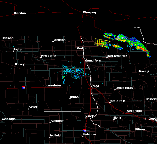 At 613 pm cdt, a severe thunderstorm was located over halma, or 37 miles west of roseau, moving northeast at 15 mph (radar indicated). Hazards include quarter size hail. Damage to vehicles is expected. This severe thunderstorm will be near, lake bronson around 625 pm cdt. At 613 pm cdt, a severe thunderstorm was located over halma, or 37 miles west of roseau, moving northeast at 15 mph (radar indicated). Hazards include quarter size hail. Damage to vehicles is expected. This severe thunderstorm will be near, lake bronson around 625 pm cdt.
|
| 7/20/2016 10:32 PM CDT |
 At 1031 pm cdt, a severe thunderstorm was located near fox, or 10 miles west of roseau, moving east at 40 mph (radar indicated). Hazards include 60 mph wind gusts and quarter size hail. Hail damage to vehicles is expected. expect wind damage to roofs, siding, and trees. this severe storm will be near, ross around 1035 pm cdt. fox around 1040 pm cdt. roseau and malung around 1050 pm cdt. Salol around 1100 pm cdt. At 1031 pm cdt, a severe thunderstorm was located near fox, or 10 miles west of roseau, moving east at 40 mph (radar indicated). Hazards include 60 mph wind gusts and quarter size hail. Hail damage to vehicles is expected. expect wind damage to roofs, siding, and trees. this severe storm will be near, ross around 1035 pm cdt. fox around 1040 pm cdt. roseau and malung around 1050 pm cdt. Salol around 1100 pm cdt.
|
| 7/20/2016 9:59 PM CDT |
 At 958 pm cdt, a severe thunderstorm was located 10 miles northwest of leo, or 31 miles west of roseau, moving east at 45 mph. wind gusts of 80 mph were reported in hallock from this storm. this is a very dangerous storm (radar indicated). Hazards include 80 mph wind gusts and quarter size hail. Flying debris will be dangerous to those caught without shelter. mobile homes will be heavily damaged. expect considerable damage to roofs, windows, and vehicles. extensive tree damage and power outages are likely. this severe thunderstorm will be near, leo around 1010 pm cdt. haug around 1015 pm cdt. badger around 1025 pm cdt. fox and ross around 1030 pm cdt. Roseau and malung around 1040 pm cdt. At 958 pm cdt, a severe thunderstorm was located 10 miles northwest of leo, or 31 miles west of roseau, moving east at 45 mph. wind gusts of 80 mph were reported in hallock from this storm. this is a very dangerous storm (radar indicated). Hazards include 80 mph wind gusts and quarter size hail. Flying debris will be dangerous to those caught without shelter. mobile homes will be heavily damaged. expect considerable damage to roofs, windows, and vehicles. extensive tree damage and power outages are likely. this severe thunderstorm will be near, leo around 1010 pm cdt. haug around 1015 pm cdt. badger around 1025 pm cdt. fox and ross around 1030 pm cdt. Roseau and malung around 1040 pm cdt.
|
| 7/20/2016 9:48 PM CDT |
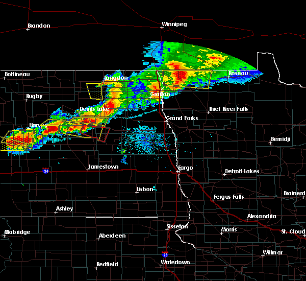 At 946 pm cdt, a severe thunderstorm was located 9 miles northeast of lake bronson, or 37 miles west of roseau, moving east at 80 mph. this is a very dangerous storm (radar indicated. at 934 pm...the hallock airport reported 83 mile per hour winds). Hazards include 80 mph wind gusts and half dollar size hail. Flying debris will be dangerous to those caught without shelter. mobile homes will be heavily damaged. expect considerable damage to roofs, windows, and vehicles. extensive tree damage and power outages are likely. This severe storm will be near, haug and leo around 1000 pm cdt. At 946 pm cdt, a severe thunderstorm was located 9 miles northeast of lake bronson, or 37 miles west of roseau, moving east at 80 mph. this is a very dangerous storm (radar indicated. at 934 pm...the hallock airport reported 83 mile per hour winds). Hazards include 80 mph wind gusts and half dollar size hail. Flying debris will be dangerous to those caught without shelter. mobile homes will be heavily damaged. expect considerable damage to roofs, windows, and vehicles. extensive tree damage and power outages are likely. This severe storm will be near, haug and leo around 1000 pm cdt.
|
| 7/20/2016 9:36 PM CDT |
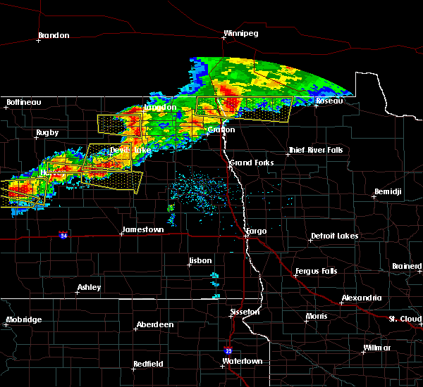 At 936 pm cdt, a severe thunderstorm was located near lancaster, or 43 miles northeast of grafton, moving east at 75 mph (radar indicated). Hazards include 70 mph wind gusts and half dollar size hail. Hail damage to vehicles is expected. expect considerable tree damage. wind damage is also likely to mobile homes, roofs, and outbuildings. This severe storm will be near, haug and leo around 955 pm cdt. At 936 pm cdt, a severe thunderstorm was located near lancaster, or 43 miles northeast of grafton, moving east at 75 mph (radar indicated). Hazards include 70 mph wind gusts and half dollar size hail. Hail damage to vehicles is expected. expect considerable tree damage. wind damage is also likely to mobile homes, roofs, and outbuildings. This severe storm will be near, haug and leo around 955 pm cdt.
|
| 7/20/2016 9:29 PM CDT |
 At 928 pm cdt, a severe thunderstorm was located near lancaster, or 39 miles northeast of grafton, moving east at 50 mph (radar indicated. indications are for large hail within the storm). Hazards include 70 mph wind gusts and half dollar size hail. Hail damage to vehicles is expected. expect considerable tree damage. wind damage is also likely to mobile homes, roofs, and outbuildings. this severe storm will be near, lancaster around 935 pm cdt. haug and leo around 1000 pm cdt. Also includes interstate 29 between mile markers 196 and 217. At 928 pm cdt, a severe thunderstorm was located near lancaster, or 39 miles northeast of grafton, moving east at 50 mph (radar indicated. indications are for large hail within the storm). Hazards include 70 mph wind gusts and half dollar size hail. Hail damage to vehicles is expected. expect considerable tree damage. wind damage is also likely to mobile homes, roofs, and outbuildings. this severe storm will be near, lancaster around 935 pm cdt. haug and leo around 1000 pm cdt. Also includes interstate 29 between mile markers 196 and 217.
|
| 7/20/2016 9:01 PM CDT |
 At 901 pm cdt, a severe thunderstorm was located near neche, or 38 miles north of grafton, moving east at 50 mph (radar indicated). Hazards include 70 mph wind gusts and nickel size hail. Expect considerable tree damage. damage is likely to mobile homes, roofs, and outbuildings. this severe thunderstorm will be near, pembina, st. vincent and noyes around 910 pm cdt. humboldt around 920 pm cdt. orleans around 925 pm cdt. lancaster around 935 pm cdt. caribou around 950 pm cdt. Also includes interstate 29 between mile markers 196 and 217. At 901 pm cdt, a severe thunderstorm was located near neche, or 38 miles north of grafton, moving east at 50 mph (radar indicated). Hazards include 70 mph wind gusts and nickel size hail. Expect considerable tree damage. damage is likely to mobile homes, roofs, and outbuildings. this severe thunderstorm will be near, pembina, st. vincent and noyes around 910 pm cdt. humboldt around 920 pm cdt. orleans around 925 pm cdt. lancaster around 935 pm cdt. caribou around 950 pm cdt. Also includes interstate 29 between mile markers 196 and 217.
|
| 6/17/2016 9:27 AM CDT |
 At 926 am cdt, severe thunderstorms were located along a line extending from 8 miles east of caribou to near gates corner to 7 miles west of little rock, moving east at 60 mph (radar indicated). Hazards include 60 mph wind gusts and quarter size hail. Hail damage to vehicles is expected. expect wind damage to roofs, siding, and trees. these severe storms will be near, lower red lake and gates corner around 930 am cdt. pinecreek, oaks corner and ross around 940 am cdt. Saum and shotley around 950 am cdt. At 926 am cdt, severe thunderstorms were located along a line extending from 8 miles east of caribou to near gates corner to 7 miles west of little rock, moving east at 60 mph (radar indicated). Hazards include 60 mph wind gusts and quarter size hail. Hail damage to vehicles is expected. expect wind damage to roofs, siding, and trees. these severe storms will be near, lower red lake and gates corner around 930 am cdt. pinecreek, oaks corner and ross around 940 am cdt. Saum and shotley around 950 am cdt.
|
| 6/17/2016 8:59 AM CDT |
 At 858 am cdt, severe thunderstorms were located along a line extending from near hallock to 7 miles southeast of middle river to near berner, moving northeast at 50 mph (radar indicated). Hazards include 60 mph wind gusts and quarter size hail. Hail damage to vehicles is expected. expect wind damage to roofs, siding, and trees. severe thunderstorms will be near, berner and gully around 900 am cdt. lower red lake and gatzke around 915 am cdt. skime and casperson around 925 am cdt. hayes lake state park around 930 am cdt. Ponemah around 935 am cdt. At 858 am cdt, severe thunderstorms were located along a line extending from near hallock to 7 miles southeast of middle river to near berner, moving northeast at 50 mph (radar indicated). Hazards include 60 mph wind gusts and quarter size hail. Hail damage to vehicles is expected. expect wind damage to roofs, siding, and trees. severe thunderstorms will be near, berner and gully around 900 am cdt. lower red lake and gatzke around 915 am cdt. skime and casperson around 925 am cdt. hayes lake state park around 930 am cdt. Ponemah around 935 am cdt.
|
| 8/12/2015 8:06 PM CDT |
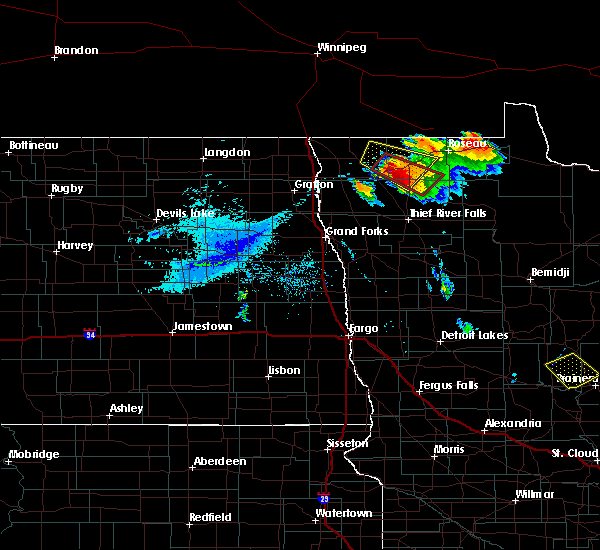 At 806 pm cdt, a severe thunderstorm capable of producing a tornado was located near karlstad, or 32 miles southwest of roseau, moving southeast at 30 mph (weather spotters reported a funnel cloud). Hazards include tornado and ping pong ball size hail. Expect damage to mobile homes. roofs and vehicles. This dangerous storm will be near, strathcona around 825 pm cdt. At 806 pm cdt, a severe thunderstorm capable of producing a tornado was located near karlstad, or 32 miles southwest of roseau, moving southeast at 30 mph (weather spotters reported a funnel cloud). Hazards include tornado and ping pong ball size hail. Expect damage to mobile homes. roofs and vehicles. This dangerous storm will be near, strathcona around 825 pm cdt.
|
| 8/12/2015 8:00 PM CDT | Quarter sized hail reported 1.6 miles NE of Greenbush, MN |
| 8/12/2015 7:51 PM CDT |
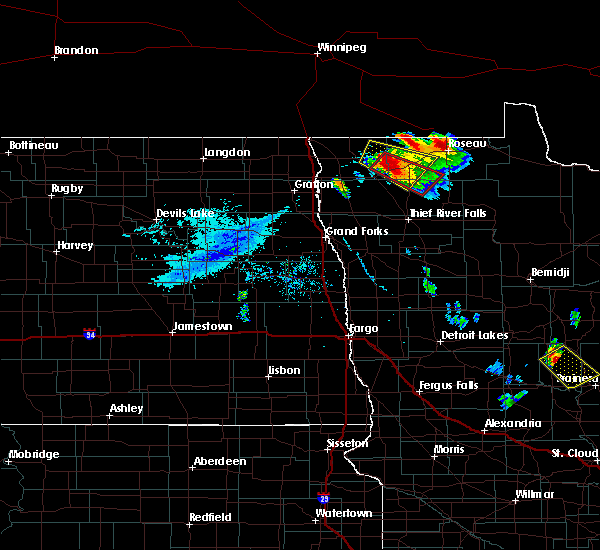 At 750 pm cdt, a severe thunderstorm capable of producing a tornado was located 8 miles southwest of leo, or 30 miles west of roseau, moving southeast at 25 mph (weather spotters reported funnel cloud). Hazards include tornado and ping pong ball size hail. Expect damage to mobile homes. roofs and vehicles. this dangerous storm will be near, leo around 800 pm cdt. greenbush around 810 pm cdt. Strathcona around 825 pm cdt. At 750 pm cdt, a severe thunderstorm capable of producing a tornado was located 8 miles southwest of leo, or 30 miles west of roseau, moving southeast at 25 mph (weather spotters reported funnel cloud). Hazards include tornado and ping pong ball size hail. Expect damage to mobile homes. roofs and vehicles. this dangerous storm will be near, leo around 800 pm cdt. greenbush around 810 pm cdt. Strathcona around 825 pm cdt.
|
| 8/12/2015 7:24 PM CDT |
 At 723 pm cdt, a severe thunderstorm was located 7 miles northeast of lake bronson, or 35 miles west of roseau, moving east at 25 mph (radar indicated). Hazards include 60 mph wind gusts and quarter size hail. Hail damage to vehicles is expected. expect wind damage to roofs, siding and trees. this severe thunderstorm will be near, leo and haug around 755 pm cdt. greenbush around 805 pm cdt. Badger around 815 pm cdt. At 723 pm cdt, a severe thunderstorm was located 7 miles northeast of lake bronson, or 35 miles west of roseau, moving east at 25 mph (radar indicated). Hazards include 60 mph wind gusts and quarter size hail. Hail damage to vehicles is expected. expect wind damage to roofs, siding and trees. this severe thunderstorm will be near, leo and haug around 755 pm cdt. greenbush around 805 pm cdt. Badger around 815 pm cdt.
|
| 8/12/2015 3:34 PM CDT |
 At 333 pm cdt, a severe thunderstorm was located near strathcona, or 22 miles southwest of roseau, moving east at 20 mph (radar indicated). Hazards include half dollar size hail. Damage to vehicles is expected. This severe storm will be near, torfin, casperson and wannaska around 400 pm cdt. At 333 pm cdt, a severe thunderstorm was located near strathcona, or 22 miles southwest of roseau, moving east at 20 mph (radar indicated). Hazards include half dollar size hail. Damage to vehicles is expected. This severe storm will be near, torfin, casperson and wannaska around 400 pm cdt.
|
| 8/12/2015 3:24 PM CDT |
 At 323 pm cdt, a severe thunderstorm was located over strathcona, or 25 miles southwest of roseau, moving east at 20 mph (radar indicated). Hazards include quarter size hail. Damage to vehicles is expected. This severe storm will be near, torfin and wannaska around 400 pm cdt. At 323 pm cdt, a severe thunderstorm was located over strathcona, or 25 miles southwest of roseau, moving east at 20 mph (radar indicated). Hazards include quarter size hail. Damage to vehicles is expected. This severe storm will be near, torfin and wannaska around 400 pm cdt.
|
| 8/12/2015 2:57 PM CDT |
 At 257 pm cdt, a severe thunderstorm was located near strathcona, or 30 miles southwest of roseau, moving east at 25 mph (radar indicated). Hazards include half dollar size hail. Damage to vehicles is expected. this severe thunderstorm will be near, greenbush around 305 pm cdt. strathcona around 310 pm cdt. torfin and wannaska around 350 pm cdt. Casperson around 355 pm cdt. At 257 pm cdt, a severe thunderstorm was located near strathcona, or 30 miles southwest of roseau, moving east at 25 mph (radar indicated). Hazards include half dollar size hail. Damage to vehicles is expected. this severe thunderstorm will be near, greenbush around 305 pm cdt. strathcona around 310 pm cdt. torfin and wannaska around 350 pm cdt. Casperson around 355 pm cdt.
|
| 8/1/2015 11:42 PM CDT |
 At 1141 pm cdt, a severe thunderstorm was located near lancaster, or 42 miles west of roseau, moving east at 35 mph (trained weather spotters). Hazards include quarter size hail. Damage to vehicles is expected. this severe storm will be near, leo and haug around 1200 am cdt. greenbush around 1205 am cdt. badger around 1210 am cdt. Fox and malung around 1215 am cdt. At 1141 pm cdt, a severe thunderstorm was located near lancaster, or 42 miles west of roseau, moving east at 35 mph (trained weather spotters). Hazards include quarter size hail. Damage to vehicles is expected. this severe storm will be near, leo and haug around 1200 am cdt. greenbush around 1205 am cdt. badger around 1210 am cdt. Fox and malung around 1215 am cdt.
|
| 8/1/2015 11:22 PM CDT |
 At 1121 pm cdt, a severe thunderstorm was located near humboldt, or 42 miles north of grafton, moving east at 35 mph (radar indicated). Hazards include half dollar size hail. Damage to vehicles is expected. this severe thunderstorm will be near, orleans around 1130 pm cdt. lancaster around 1140 pm cdt. caribou around 1200 am cdt. Haug and leo around 1215 am cdt. At 1121 pm cdt, a severe thunderstorm was located near humboldt, or 42 miles north of grafton, moving east at 35 mph (radar indicated). Hazards include half dollar size hail. Damage to vehicles is expected. this severe thunderstorm will be near, orleans around 1130 pm cdt. lancaster around 1140 pm cdt. caribou around 1200 am cdt. Haug and leo around 1215 am cdt.
|
| 7/12/2015 6:39 PM CDT |
 The severe thunderstorm warning for kittson, northeastern marshall, roseau, central pennington and southeastern pembina counties will expire at 645 pm cdt, the storms which prompted the warning have weakened below severe limits, and no longer pose an immediate threat to life or property. therefore the warning will be allowed to expire. a severe thunderstorm watch remains in effect until 1000 pm cdt for northwestern minnesota and northeastern north dakota. The severe thunderstorm warning for kittson, northeastern marshall, roseau, central pennington and southeastern pembina counties will expire at 645 pm cdt, the storms which prompted the warning have weakened below severe limits, and no longer pose an immediate threat to life or property. therefore the warning will be allowed to expire. a severe thunderstorm watch remains in effect until 1000 pm cdt for northwestern minnesota and northeastern north dakota.
|
| 7/12/2015 6:18 PM CDT |
 At 618 pm cdt, severe thunderstorms were located along a line extending from 7 miles northeast of orleans to near norris camp, moving northeast at 70 mph (radar indicated). Hazards include 60 mph wind gusts and half dollar size hail. Hail damage to vehicles is expected. expect wind damage to roofs, siding and trees. These severe thunderstorms will remain over mainly rural areas of kittson, northeastern marshall, roseau, central pennington and southeastern pembina counties. At 618 pm cdt, severe thunderstorms were located along a line extending from 7 miles northeast of orleans to near norris camp, moving northeast at 70 mph (radar indicated). Hazards include 60 mph wind gusts and half dollar size hail. Hail damage to vehicles is expected. expect wind damage to roofs, siding and trees. These severe thunderstorms will remain over mainly rural areas of kittson, northeastern marshall, roseau, central pennington and southeastern pembina counties.
|
| 7/12/2015 5:43 PM CDT |
 At 543 pm cdt, severe thunderstorms were located along a line extending from near auburn to near high landing, moving northeast at 70 mph (radar indicated). Hazards include 60 mph wind gusts and half dollar size hail. Hail damage to vehicles is expected. expect wind damage to roofs, siding and trees. severe thunderstorms will be near, goodridge and high landing around 545 pm cdt. espelie and robbin around 550 pm cdt. bowesmont and mattson around 555 pm cdt. joliette around 600 pm cdt. Northcote and humboldt around 605 pm cdt. At 543 pm cdt, severe thunderstorms were located along a line extending from near auburn to near high landing, moving northeast at 70 mph (radar indicated). Hazards include 60 mph wind gusts and half dollar size hail. Hail damage to vehicles is expected. expect wind damage to roofs, siding and trees. severe thunderstorms will be near, goodridge and high landing around 545 pm cdt. espelie and robbin around 550 pm cdt. bowesmont and mattson around 555 pm cdt. joliette around 600 pm cdt. Northcote and humboldt around 605 pm cdt.
|
| 7/12/2015 5:43 PM CDT | The national weather service in grand forks has issued a * severe thunderstorm warning for. kittson county in northwestern minnesota. marshall county in northwestern minnesota. roseau county in northwestern minnesota. Pennington county in northwestern minnesota. |
| 9/19/2014 7:40 PM CDT | Golf Ball sized hail reported 1.6 miles NE of Greenbush, MN, wind driven hail broke several windows. |
| 9/19/2014 7:30 PM CDT | Quarter sized hail reported 1 miles SSW of Greenbush, MN |
| 9/19/2014 7:10 PM CDT | Ping Pong Ball sized hail reported 11 miles ESE of Greenbush, MN, via social media. time approximate based on radar and photo time. |
| 7/2/2012 1:55 PM CDT | Quarter sized hail reported 3 miles W of Greenbush, MN |
| 1/1/0001 12:00 AM | Peak wind measured at the ndawn site west of greenbush on cr in roseau county MN, 7.1 miles E of Greenbush, MN |
| 1/1/0001 12:00 AM | Extensive tree and house damage in greenbush. time approximat in roseau county MN, 0.4 miles SW of Greenbush, MN |
| 1/1/0001 12:00 AM | Extensive tree and house damage in greenbush. time approximat in roseau county MN, 0.4 miles SW of Greenbush, MN |
| 1/1/0001 12:00 AM | Trees blown down on cars in town. empty grain bin rolle in roseau county MN, 0.4 miles SW of Greenbush, MN |
| 1/1/0001 12:00 AM | Measured wind gust at greenbush ndaw in roseau county MN, 7.1 miles E of Greenbush, MN |
| 1/1/0001 12:00 AM | 6 to 8 inch diameter trees felled in roseau county MN, 0.4 miles SW of Greenbush, MN |
| 1/1/0001 12:00 AM | Quarter sized hail reported 7.9 miles S of Greenbush, MN |
Hail Maps for Greenbush, MN


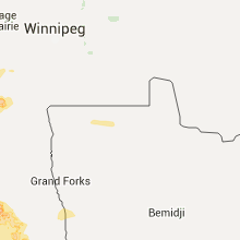


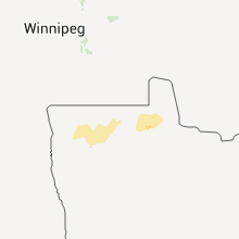
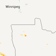


Connect with Interactive Hail Maps