

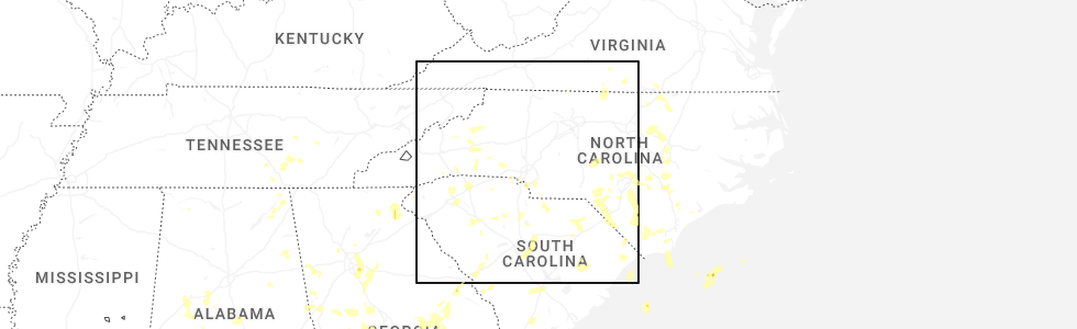
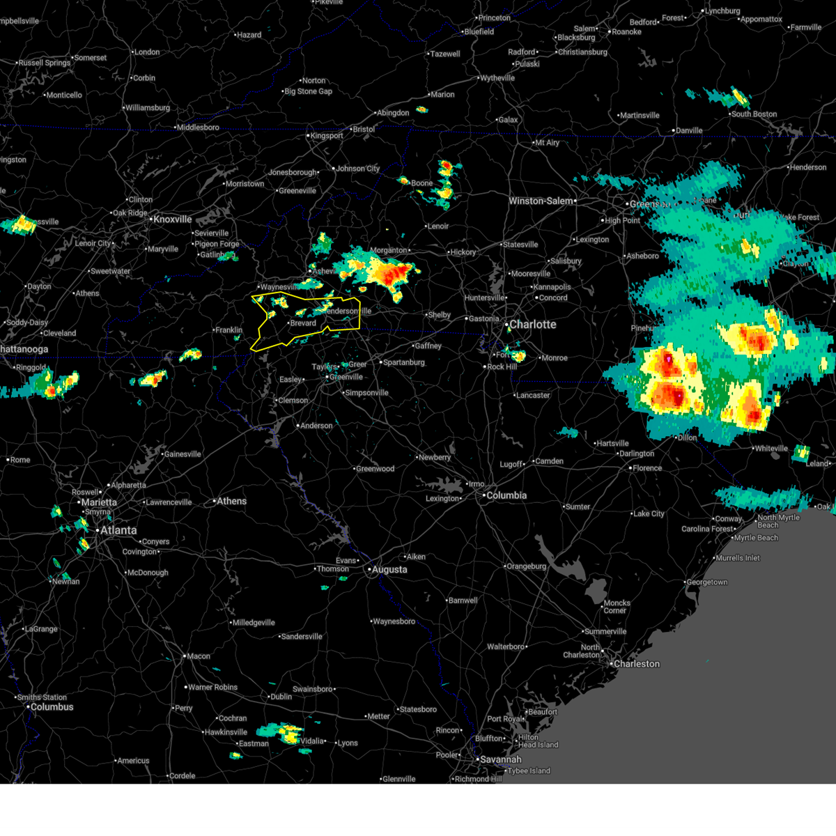
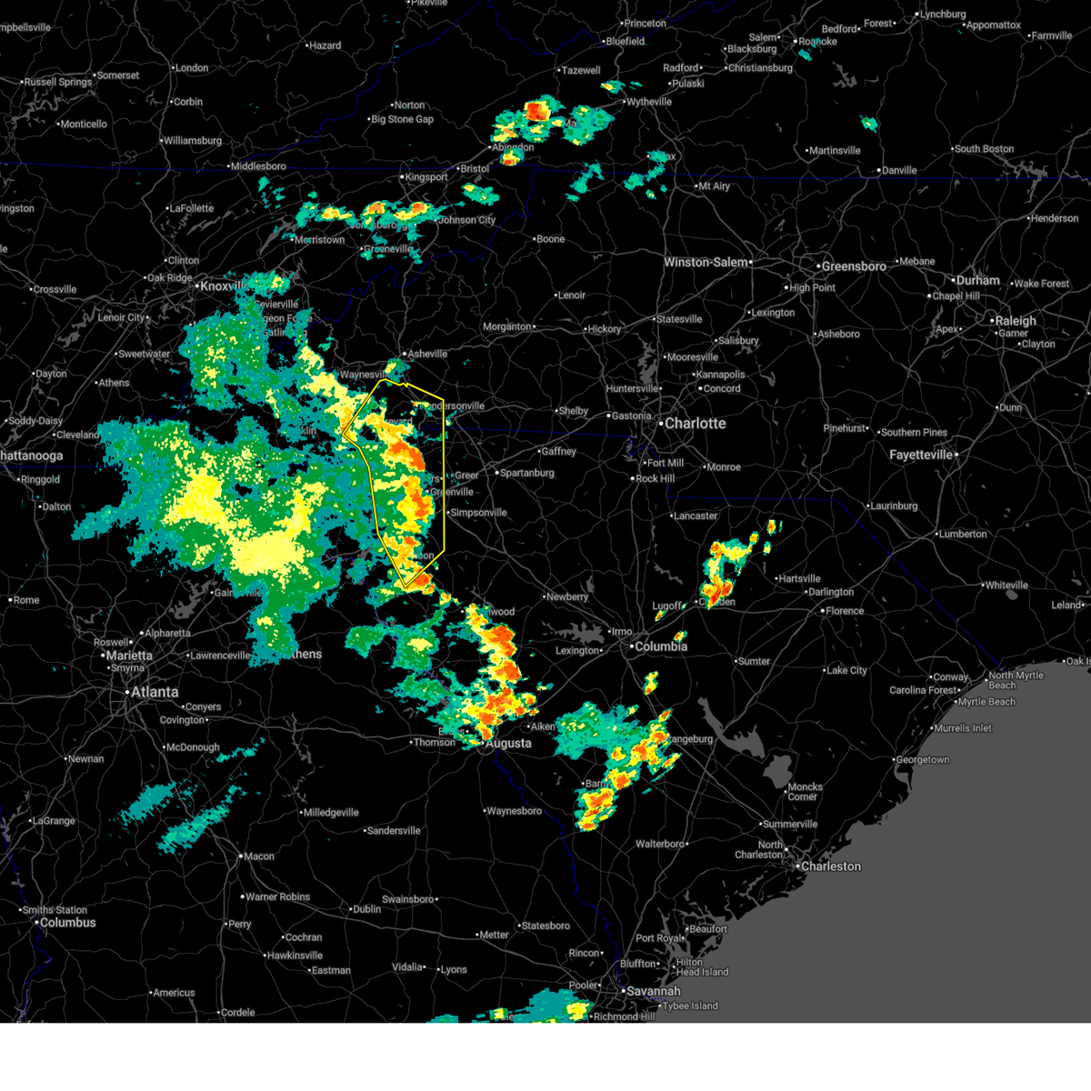
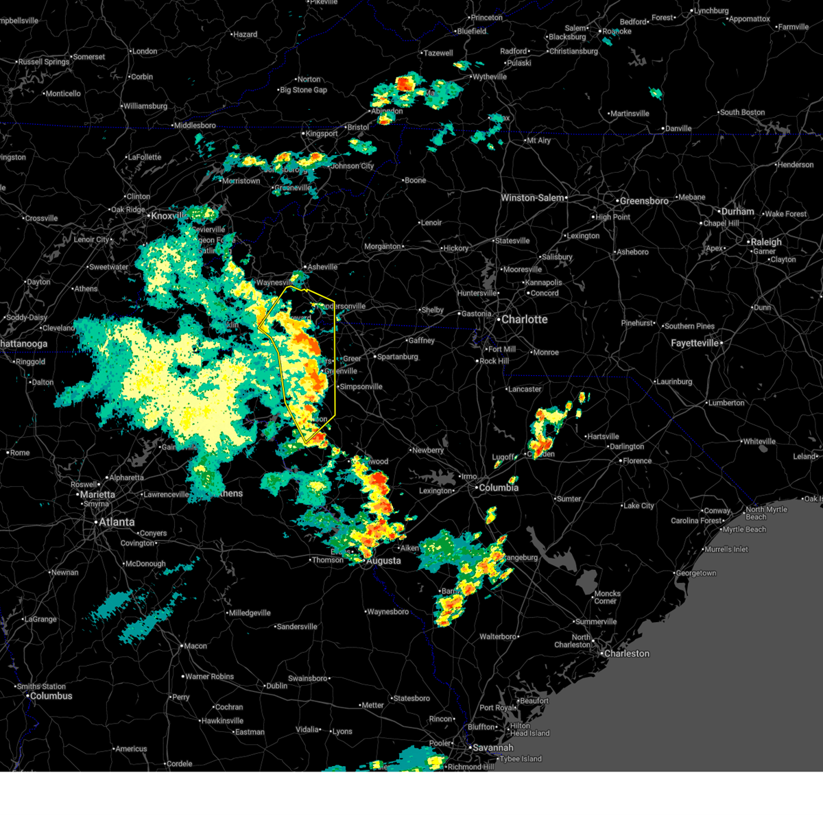
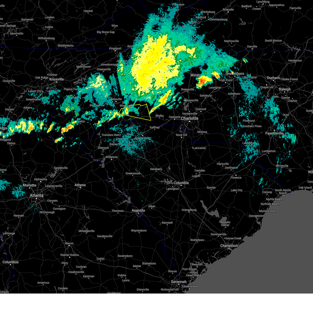
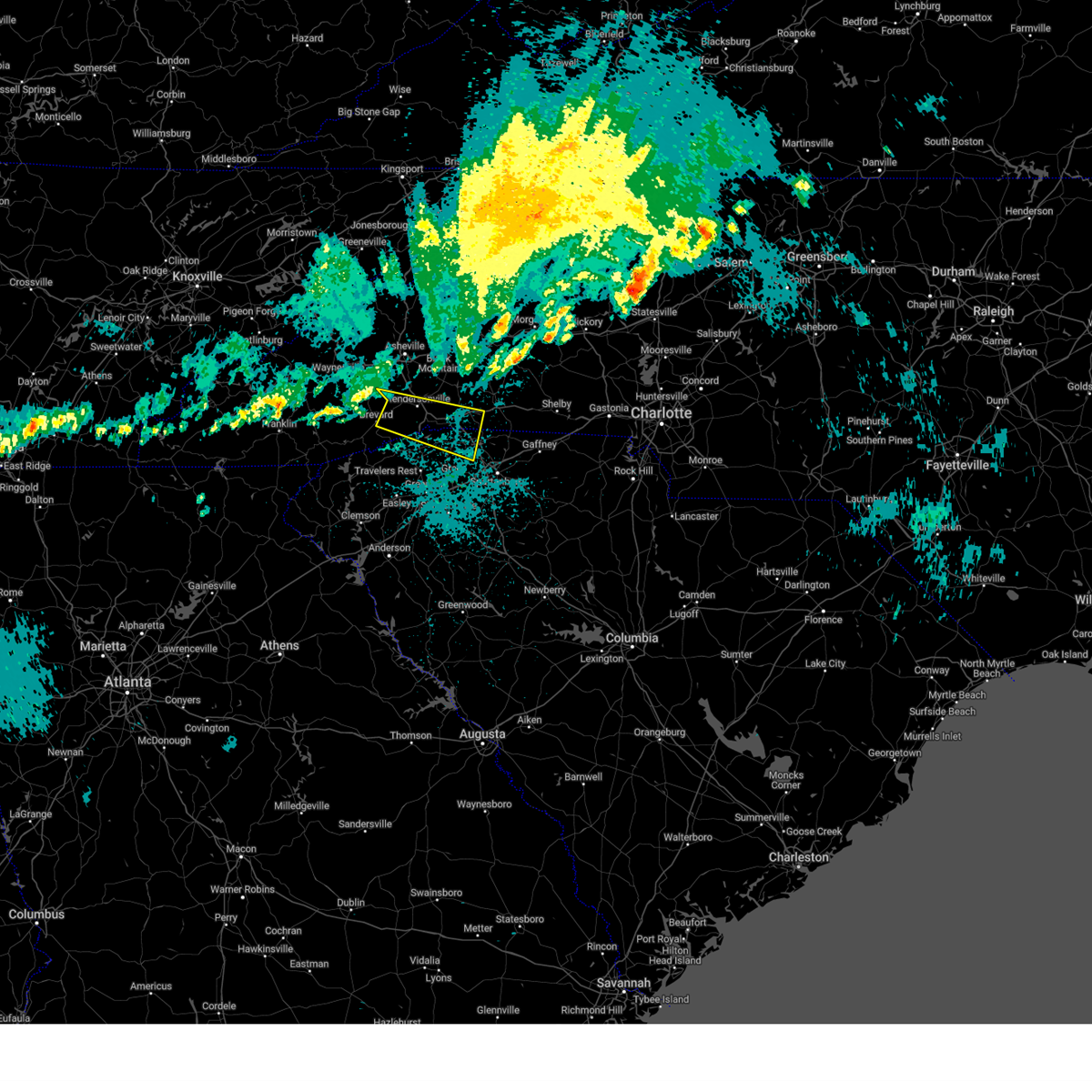
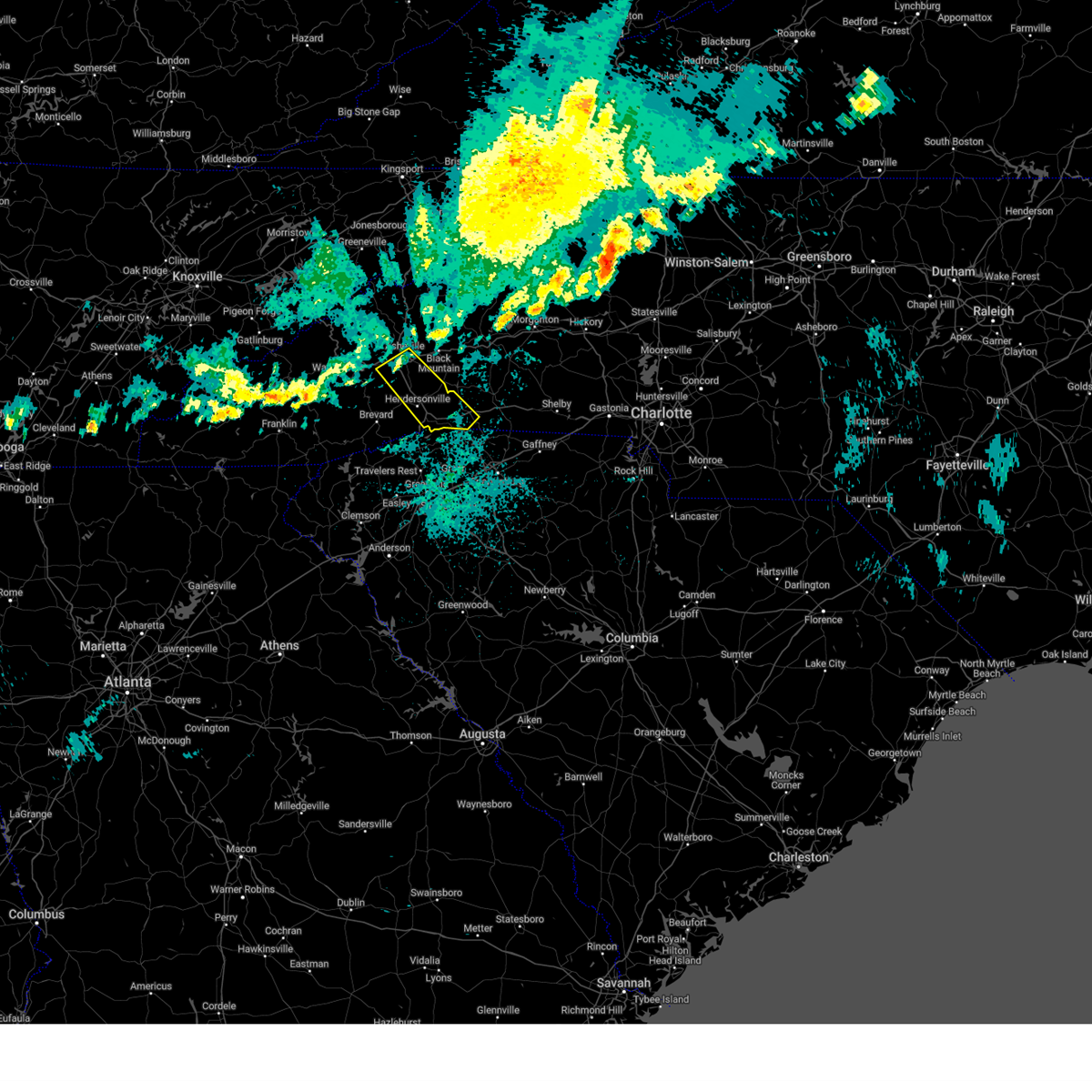
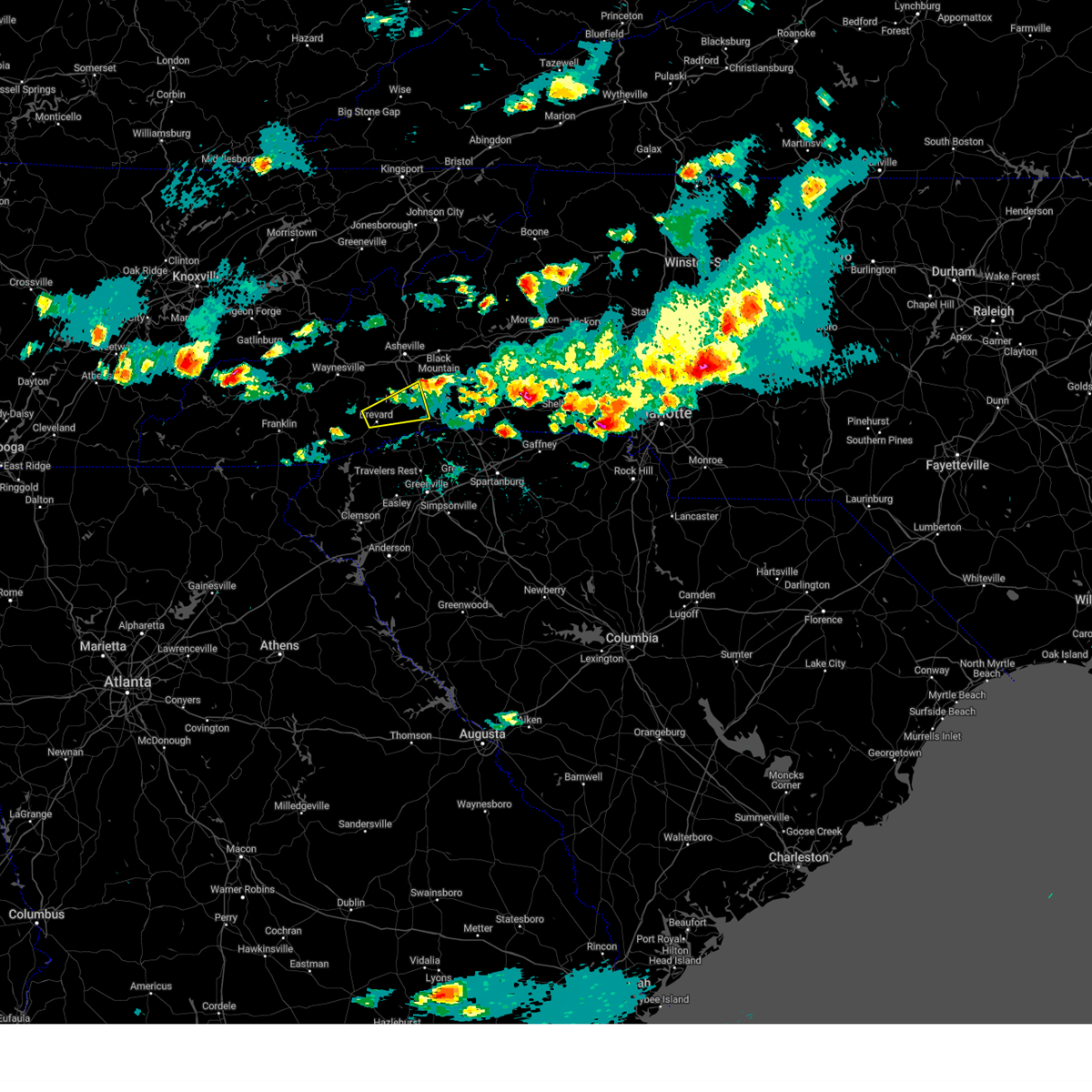
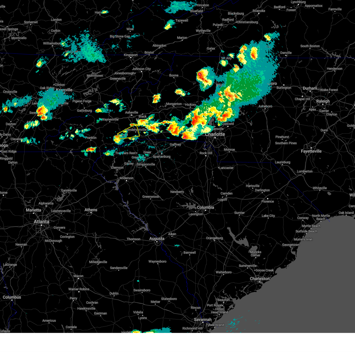
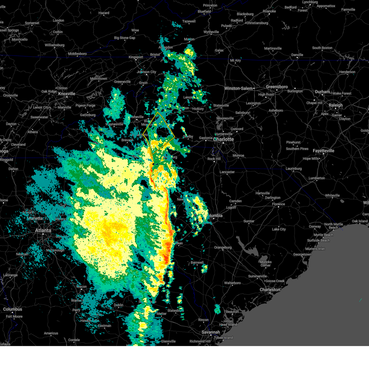
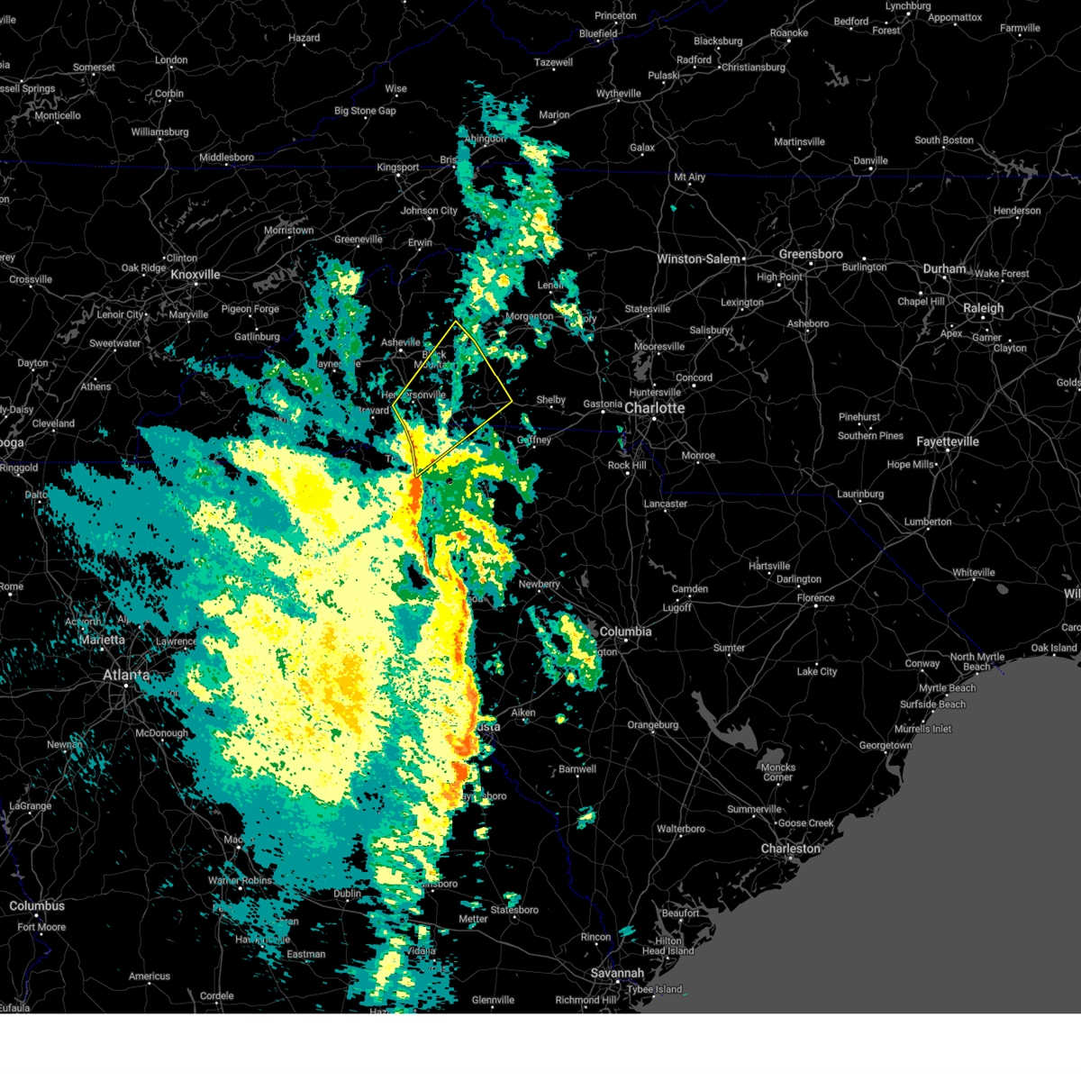
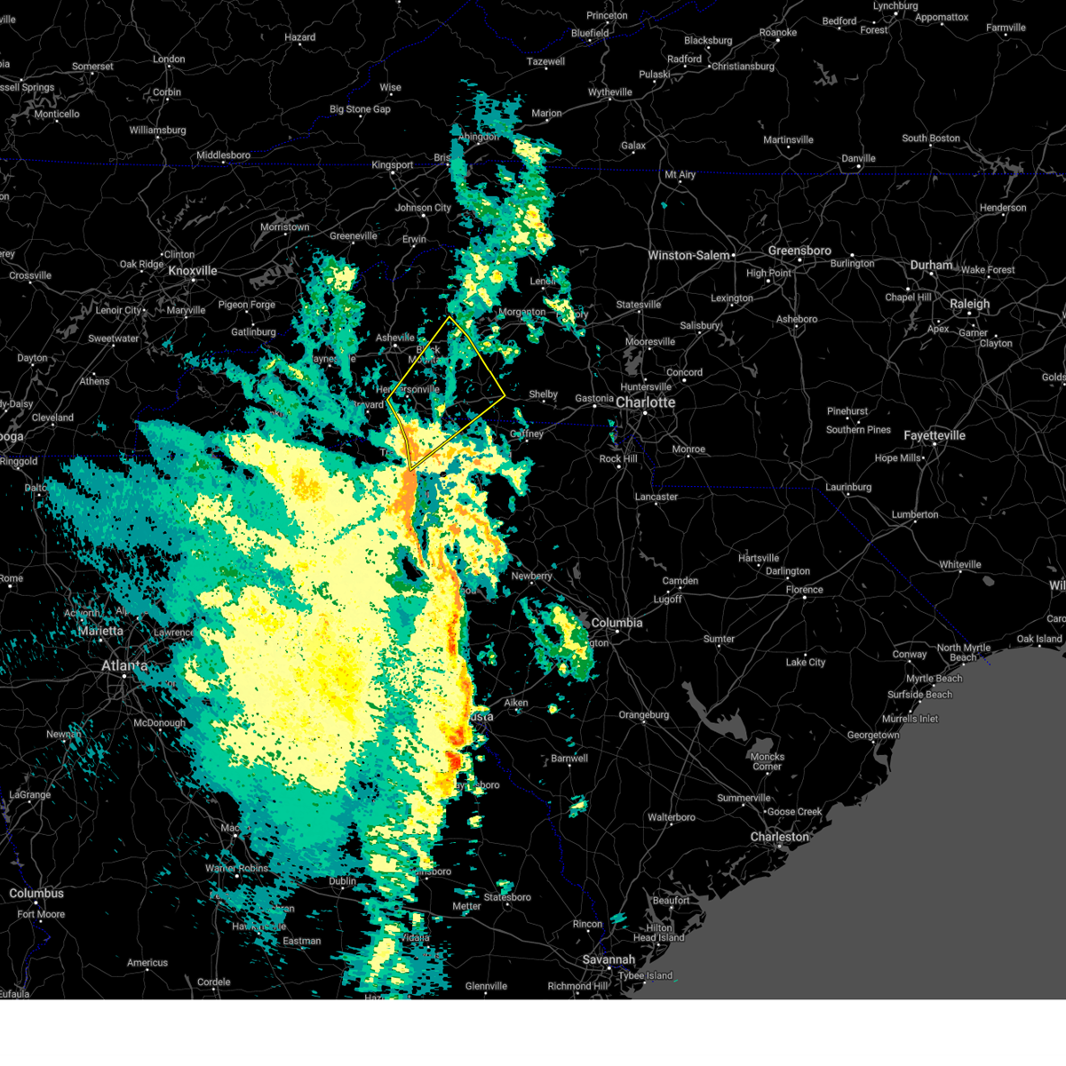
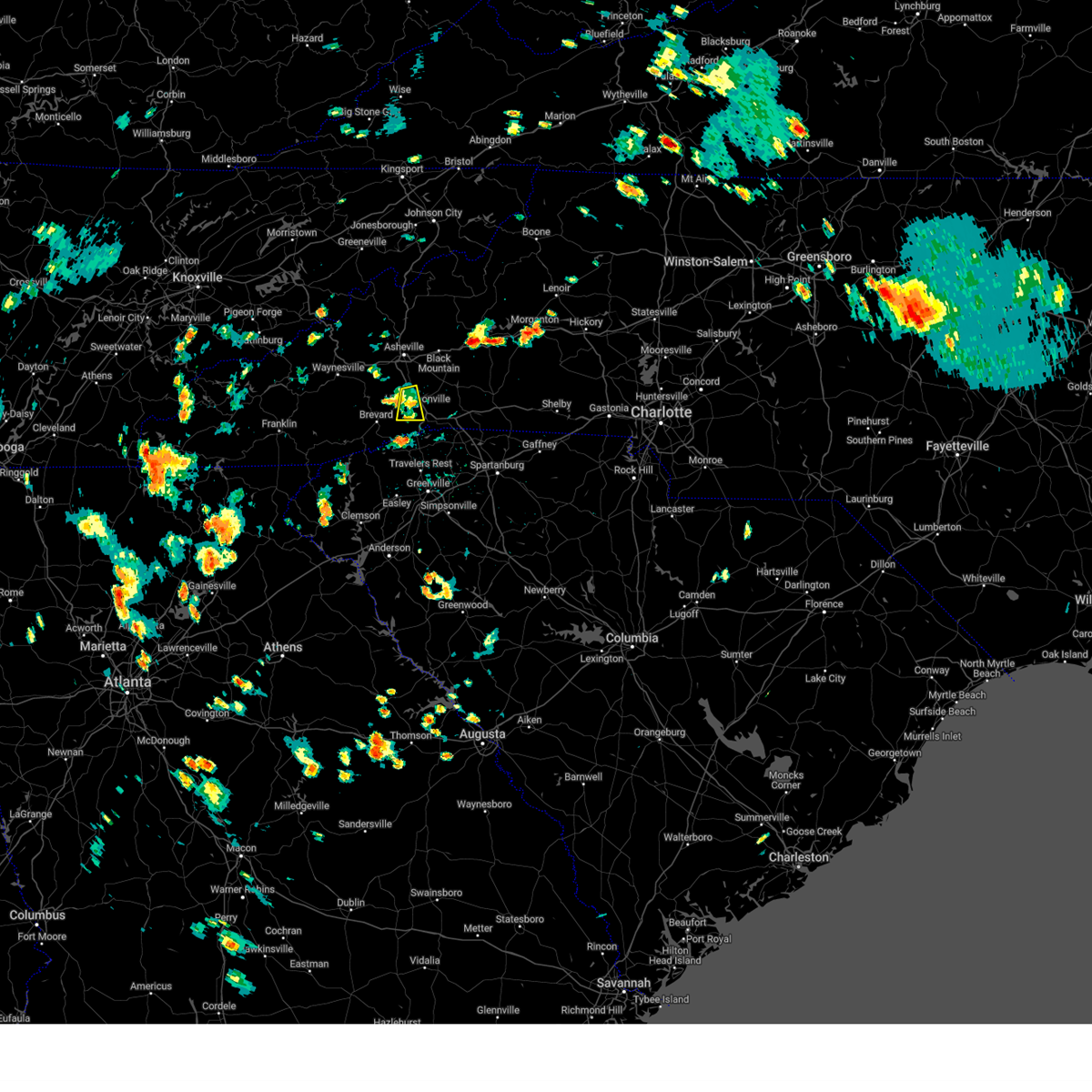
Hail Map for Hendersonville, NC
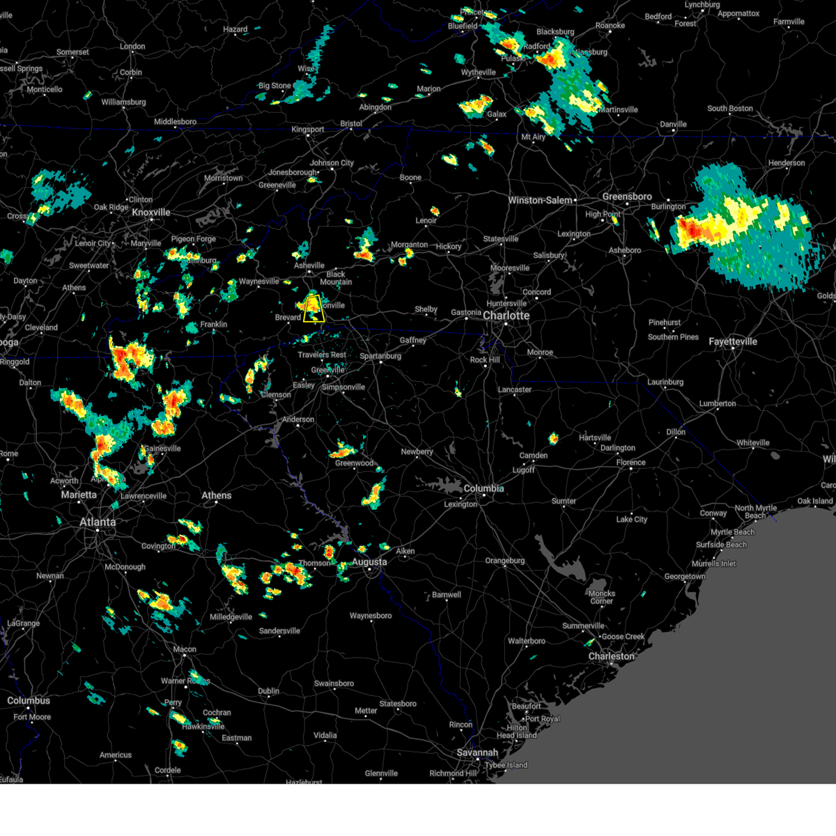
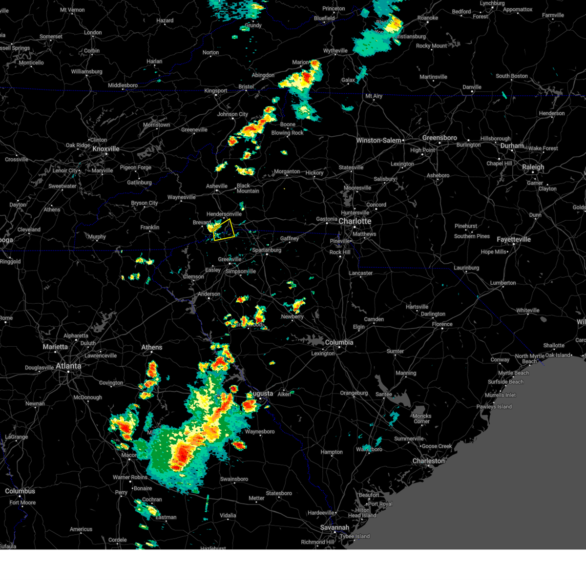
The Hendersonville, NC area has had 12 reports of on-the-ground hail by trained spotters, and has been under severe weather warnings 26 times during the past 12 months. Doppler radar has detected hail at or near Hendersonville, NC on 38 occasions, including 3 occasions during the past year.
| Name: | Hendersonville, NC |
| Where Located: | 35 miles NNE of Greenville, SC |
| Map: | Google Map for Hendersonville, NC |
| Population: | 13137 |
| Housing Units: | 7744 |
| More Info: | Search Google for Hendersonville, NC |
0
The Top Recent Hail Date for Hendersonville, NC is Wednesday, June 25, 2025 (15th out of 38)
Hail and Wind Damage Spotted near Hendersonville, NC
| Date / Time | Report Details |
|---|---|
| 7/11/2025 4:45 PM EDT |
 the severe thunderstorm warning has been cancelled and is no longer in effect the severe thunderstorm warning has been cancelled and is no longer in effect
|
| 7/11/2025 3:58 PM EDT |
 Svrgsp the national weather service in greenville-spartanburg has issued a * severe thunderstorm warning for, southeastern henderson county in western north carolina, southwestern polk county in western north carolina, * until 500 pm edt. * at 358 pm edt, a severe thunderstorm was located near hendersonville, or near flat rock, moving southeast at 10 mph (radar indicated). Hazards include ping pong ball size hail and 60 mph wind gusts. People and animals outdoors will be injured. expect hail damage to roofs, siding, windows, and vehicles. Expect wind damage to trees and power lines. Svrgsp the national weather service in greenville-spartanburg has issued a * severe thunderstorm warning for, southeastern henderson county in western north carolina, southwestern polk county in western north carolina, * until 500 pm edt. * at 358 pm edt, a severe thunderstorm was located near hendersonville, or near flat rock, moving southeast at 10 mph (radar indicated). Hazards include ping pong ball size hail and 60 mph wind gusts. People and animals outdoors will be injured. expect hail damage to roofs, siding, windows, and vehicles. Expect wind damage to trees and power lines.
|
| 6/25/2025 6:00 PM EDT | Large trees and utility lines downed along laurel park r in henderson county NC, 3.3 miles ENE of Hendersonville, NC |
| 6/25/2025 5:52 PM EDT | Tree down on utility equipmen in henderson county NC, 5.8 miles NE of Hendersonville, NC |
| 6/25/2025 5:26 PM EDT | the severe thunderstorm warning has been cancelled and is no longer in effect |
| 6/25/2025 5:26 PM EDT | At 525 pm edt, a severe thunderstorm was located near hendersonville, and is nearly stationary (radar indicated). Hazards include 60 mph wind gusts and quarter size hail. Minor hail damage to vehicles is expected. expect wind damage to trees and power lines. Locations impacted include, hendersonville, brevard, columbus, flat rock, etowah, mountain home, laurel park, tryon, saluda, and rosman. |
| 6/25/2025 5:11 PM EDT |
 At 511 pm edt, a severe thunderstorm was located near hendersonville, moving southwest at 15 mph (radar indicated). Hazards include 60 mph wind gusts and quarter size hail. Minor hail damage to vehicles is expected. expect wind damage to trees and power lines. Locations impacted include, hendersonville, brevard, columbus, mills river, flat rock, etowah, mountain home, laurel park, tryon, and saluda. At 511 pm edt, a severe thunderstorm was located near hendersonville, moving southwest at 15 mph (radar indicated). Hazards include 60 mph wind gusts and quarter size hail. Minor hail damage to vehicles is expected. expect wind damage to trees and power lines. Locations impacted include, hendersonville, brevard, columbus, mills river, flat rock, etowah, mountain home, laurel park, tryon, and saluda.
|
| 6/25/2025 4:49 PM EDT |
 Svrgsp the national weather service in greenville-spartanburg has issued a * severe thunderstorm warning for, transylvania county in western north carolina, henderson county in western north carolina, polk county in western north carolina, southeastern haywood county in western north carolina, * until 600 pm edt. * at 449 pm edt, a severe thunderstorm was located 7 miles northeast of hendersonville, or 6 miles southwest of bat cave, and is nearly stationary (radar indicated). Hazards include 60 mph wind gusts and nickel size hail. expect damage to trees and power lines Svrgsp the national weather service in greenville-spartanburg has issued a * severe thunderstorm warning for, transylvania county in western north carolina, henderson county in western north carolina, polk county in western north carolina, southeastern haywood county in western north carolina, * until 600 pm edt. * at 449 pm edt, a severe thunderstorm was located 7 miles northeast of hendersonville, or 6 miles southwest of bat cave, and is nearly stationary (radar indicated). Hazards include 60 mph wind gusts and nickel size hail. expect damage to trees and power lines
|
| 6/17/2025 8:53 PM EDT |
 the severe thunderstorm warning has been cancelled and is no longer in effect the severe thunderstorm warning has been cancelled and is no longer in effect
|
| 6/17/2025 8:53 PM EDT |
 At 853 pm edt, severe thunderstorms were located along a line extending from 3 miles southwest of brevard to 14 miles south of hendersonville to 7 miles southeast of anderson, moving east at 30 mph (radar indicated). Hazards include 60 mph wind gusts. Expect damage to trees and power lines. Locations impacted include, greenville downtown, anderson, easley, hendersonville, brevard, pickens, greenville eastside, west greenville, mauldin, and taylors. At 853 pm edt, severe thunderstorms were located along a line extending from 3 miles southwest of brevard to 14 miles south of hendersonville to 7 miles southeast of anderson, moving east at 30 mph (radar indicated). Hazards include 60 mph wind gusts. Expect damage to trees and power lines. Locations impacted include, greenville downtown, anderson, easley, hendersonville, brevard, pickens, greenville eastside, west greenville, mauldin, and taylors.
|
| 6/17/2025 8:12 PM EDT |
 Svrgsp the national weather service in greenville-spartanburg has issued a * severe thunderstorm warning for, north central elbert county in northeastern georgia, central hart county in northeastern georgia, transylvania county in western north carolina, henderson county in western north carolina, southwestern polk county in western north carolina, greenville county in upstate south carolina, anderson county in upstate south carolina, pickens county in upstate south carolina, northwestern abbeville county in upstate south carolina, oconee county in upstate south carolina, * until 915 pm edt. * at 812 pm edt, severe thunderstorms were located along a line extending from 14 miles north of walhalla to 5 miles west of pickens to 9 miles northeast of elberton, moving northeast at 35 mph (radar indicated). Hazards include 60 mph wind gusts. expect damage to trees and power lines Svrgsp the national weather service in greenville-spartanburg has issued a * severe thunderstorm warning for, north central elbert county in northeastern georgia, central hart county in northeastern georgia, transylvania county in western north carolina, henderson county in western north carolina, southwestern polk county in western north carolina, greenville county in upstate south carolina, anderson county in upstate south carolina, pickens county in upstate south carolina, northwestern abbeville county in upstate south carolina, oconee county in upstate south carolina, * until 915 pm edt. * at 812 pm edt, severe thunderstorms were located along a line extending from 14 miles north of walhalla to 5 miles west of pickens to 9 miles northeast of elberton, moving northeast at 35 mph (radar indicated). Hazards include 60 mph wind gusts. expect damage to trees and power lines
|
| 5/17/2025 5:28 AM EDT |
 Svrgsp the national weather service in greenville-spartanburg has issued a * severe thunderstorm warning for, rutherford county in western north carolina, northeastern henderson county in western north carolina, northern polk county in western north carolina, * until 615 am edt. * at 527 am edt, a severe thunderstorm was located 9 miles east of hendersonville, or 5 miles south of bat cave, moving east at 55 mph (radar indicated). Hazards include 60 mph wind gusts and quarter size hail. Minor hail damage to vehicles is expected. Expect wind damage to trees and power lines. Svrgsp the national weather service in greenville-spartanburg has issued a * severe thunderstorm warning for, rutherford county in western north carolina, northeastern henderson county in western north carolina, northern polk county in western north carolina, * until 615 am edt. * at 527 am edt, a severe thunderstorm was located 9 miles east of hendersonville, or 5 miles south of bat cave, moving east at 55 mph (radar indicated). Hazards include 60 mph wind gusts and quarter size hail. Minor hail damage to vehicles is expected. Expect wind damage to trees and power lines.
|
| 5/17/2025 5:06 AM EDT |
 Svrgsp the national weather service in greenville-spartanburg has issued a * severe thunderstorm warning for, east central transylvania county in western north carolina, central henderson county in western north carolina, polk county in western north carolina, northeastern greenville county in upstate south carolina, northwestern spartanburg county in upstate south carolina, * until 545 am edt. * at 506 am edt, a severe thunderstorm was located near brevard, moving east at 45 mph (radar indicated). Hazards include 60 mph wind gusts and quarter size hail. Minor hail damage to vehicles is expected. Expect wind damage to trees and power lines. Svrgsp the national weather service in greenville-spartanburg has issued a * severe thunderstorm warning for, east central transylvania county in western north carolina, central henderson county in western north carolina, polk county in western north carolina, northeastern greenville county in upstate south carolina, northwestern spartanburg county in upstate south carolina, * until 545 am edt. * at 506 am edt, a severe thunderstorm was located near brevard, moving east at 45 mph (radar indicated). Hazards include 60 mph wind gusts and quarter size hail. Minor hail damage to vehicles is expected. Expect wind damage to trees and power lines.
|
| 5/17/2025 4:35 AM EDT |
 Svrgsp the national weather service in greenville-spartanburg has issued a * severe thunderstorm warning for, henderson county in western north carolina, polk county in western north carolina, southwestern buncombe county in western north carolina, * until 500 am edt. * at 435 am edt, a severe thunderstorm was located 6 miles south of downtown asheville, or near skyland, moving southeast at 50 mph (radar indicated). Hazards include 60 mph wind gusts and nickel size hail. expect damage to trees and power lines Svrgsp the national weather service in greenville-spartanburg has issued a * severe thunderstorm warning for, henderson county in western north carolina, polk county in western north carolina, southwestern buncombe county in western north carolina, * until 500 am edt. * at 435 am edt, a severe thunderstorm was located 6 miles south of downtown asheville, or near skyland, moving southeast at 50 mph (radar indicated). Hazards include 60 mph wind gusts and nickel size hail. expect damage to trees and power lines
|
| 5/8/2025 7:39 PM EDT |
 The storm which prompted the warning has weakened below severe limits, and has exited the warned area. therefore, the warning will be allowed to expire. a severe thunderstorm watch remains in effect until midnight edt for western north carolina. The storm which prompted the warning has weakened below severe limits, and has exited the warned area. therefore, the warning will be allowed to expire. a severe thunderstorm watch remains in effect until midnight edt for western north carolina.
|
| 5/8/2025 7:03 PM EDT |
 Svrgsp the national weather service in greenville-spartanburg has issued a * severe thunderstorm warning for, northeastern transylvania county in western north carolina, central henderson county in western north carolina, * until 745 pm edt. * at 703 pm edt, a severe thunderstorm was located near brevard, moving east at 25 mph (radar indicated). Hazards include 60 mph wind gusts and quarter size hail. Minor hail damage to vehicles is expected. Expect wind damage to trees and power lines. Svrgsp the national weather service in greenville-spartanburg has issued a * severe thunderstorm warning for, northeastern transylvania county in western north carolina, central henderson county in western north carolina, * until 745 pm edt. * at 703 pm edt, a severe thunderstorm was located near brevard, moving east at 25 mph (radar indicated). Hazards include 60 mph wind gusts and quarter size hail. Minor hail damage to vehicles is expected. Expect wind damage to trees and power lines.
|
| 12/29/2024 8:01 AM EST |
 At 801 am est, severe thunderstorms were located along a line extending from 9 miles northeast of hendersonville to 3 miles southeast of columbus to 16 miles northwest of spartanburg, moving northeast at 55 mph (radar indicated). Hazards include 60 mph wind gusts. Expect damage to trees and power lines. Locations impacted include, forest city, rutherfordton, columbus, spindale, landrum, tryon, lake lure, old fort, campobello, and bostic. At 801 am est, severe thunderstorms were located along a line extending from 9 miles northeast of hendersonville to 3 miles southeast of columbus to 16 miles northwest of spartanburg, moving northeast at 55 mph (radar indicated). Hazards include 60 mph wind gusts. Expect damage to trees and power lines. Locations impacted include, forest city, rutherfordton, columbus, spindale, landrum, tryon, lake lure, old fort, campobello, and bostic.
|
| 12/29/2024 7:43 AM EST |
 the severe thunderstorm warning has been cancelled and is no longer in effect the severe thunderstorm warning has been cancelled and is no longer in effect
|
| 12/29/2024 7:43 AM EST |
 At 743 am est, severe thunderstorms were located along a line extending from 13 miles northeast of brevard to near hendersonville to 11 miles southwest of columbus to 13 miles north of greenville downtown, moving northeast at 50 mph (radar indicated). Hazards include 60 mph wind gusts. Expect damage to trees and power lines. Locations impacted include, hendersonville, forest city, rutherfordton, columbus, travelers rest, spindale, flat rock, landrum, mountain home, and laurel park. At 743 am est, severe thunderstorms were located along a line extending from 13 miles northeast of brevard to near hendersonville to 11 miles southwest of columbus to 13 miles north of greenville downtown, moving northeast at 50 mph (radar indicated). Hazards include 60 mph wind gusts. Expect damage to trees and power lines. Locations impacted include, hendersonville, forest city, rutherfordton, columbus, travelers rest, spindale, flat rock, landrum, mountain home, and laurel park.
|
| 12/29/2024 7:26 AM EST |
 Svrgsp the national weather service in greenville-spartanburg has issued a * severe thunderstorm warning for, southwestern mcdowell county in western north carolina, central rutherford county in western north carolina, east central transylvania county in western north carolina, henderson county in western north carolina, polk county in western north carolina, southeastern buncombe county in western north carolina, southeastern yancey county in western north carolina, northern greenville county in upstate south carolina, northwestern spartanburg county in upstate south carolina, * until 845 am est. * at 726 am est, severe thunderstorms were located along a line extending from near brevard to 14 miles southwest of hendersonville to 13 miles northeast of pickens to 6 miles north of easley, moving northeast at 50 mph (radar indicated). Hazards include 60 mph wind gusts. expect damage to trees and power lines Svrgsp the national weather service in greenville-spartanburg has issued a * severe thunderstorm warning for, southwestern mcdowell county in western north carolina, central rutherford county in western north carolina, east central transylvania county in western north carolina, henderson county in western north carolina, polk county in western north carolina, southeastern buncombe county in western north carolina, southeastern yancey county in western north carolina, northern greenville county in upstate south carolina, northwestern spartanburg county in upstate south carolina, * until 845 am est. * at 726 am est, severe thunderstorms were located along a line extending from near brevard to 14 miles southwest of hendersonville to 13 miles northeast of pickens to 6 miles north of easley, moving northeast at 50 mph (radar indicated). Hazards include 60 mph wind gusts. expect damage to trees and power lines
|
| 8/30/2024 3:42 PM EDT |
 the severe thunderstorm warning has been cancelled and is no longer in effect the severe thunderstorm warning has been cancelled and is no longer in effect
|
| 8/30/2024 3:27 PM EDT |
 At 327 pm edt, a severe thunderstorm was located near hendersonville, or over laurel park, moving south at 5 mph (radar indicated). Hazards include 60 mph wind gusts. Expect damage to trees and power lines. Locations impacted include, hendersonville, mills river, flat rock, mountain home, laurel park, valley hill, horse shoe, crab creek, and etowah. At 327 pm edt, a severe thunderstorm was located near hendersonville, or over laurel park, moving south at 5 mph (radar indicated). Hazards include 60 mph wind gusts. Expect damage to trees and power lines. Locations impacted include, hendersonville, mills river, flat rock, mountain home, laurel park, valley hill, horse shoe, crab creek, and etowah.
|
| 8/30/2024 3:05 PM EDT | At least 2 trees blown down and a couple power line in henderson county NC, 5.8 miles ESE of Hendersonville, NC |
| 8/30/2024 2:56 PM EDT |
 Svrgsp the national weather service in greenville-spartanburg has issued a * severe thunderstorm warning for, central henderson county in western north carolina, * until 400 pm edt. * at 256 pm edt, a severe thunderstorm was located near hendersonville, or over mountain home, moving south at 5 mph (radar indicated). Hazards include 60 mph wind gusts and quarter size hail. Minor hail damage to vehicles is expected. Expect wind damage to trees and power lines. Svrgsp the national weather service in greenville-spartanburg has issued a * severe thunderstorm warning for, central henderson county in western north carolina, * until 400 pm edt. * at 256 pm edt, a severe thunderstorm was located near hendersonville, or over mountain home, moving south at 5 mph (radar indicated). Hazards include 60 mph wind gusts and quarter size hail. Minor hail damage to vehicles is expected. Expect wind damage to trees and power lines.
|
| 8/17/2024 4:49 PM EDT |
 Svrgsp the national weather service in greenville-spartanburg has issued a * severe thunderstorm warning for, southeastern henderson county in western north carolina, polk county in western north carolina, northeastern greenville county in upstate south carolina, northwestern spartanburg county in upstate south carolina, * until 530 pm edt. * at 448 pm edt, a severe thunderstorm was located 6 miles northwest of columbus, or 5 miles northeast of saluda, moving southeast at 15 mph (radar indicated). Hazards include 60 mph wind gusts and quarter size hail. Minor hail damage to vehicles is expected. Expect wind damage to trees and power lines. Svrgsp the national weather service in greenville-spartanburg has issued a * severe thunderstorm warning for, southeastern henderson county in western north carolina, polk county in western north carolina, northeastern greenville county in upstate south carolina, northwestern spartanburg county in upstate south carolina, * until 530 pm edt. * at 448 pm edt, a severe thunderstorm was located 6 miles northwest of columbus, or 5 miles northeast of saluda, moving southeast at 15 mph (radar indicated). Hazards include 60 mph wind gusts and quarter size hail. Minor hail damage to vehicles is expected. Expect wind damage to trees and power lines.
|
| 8/2/2024 2:56 PM EDT |
 the severe thunderstorm warning has been cancelled and is no longer in effect the severe thunderstorm warning has been cancelled and is no longer in effect
|
| 8/2/2024 2:16 PM EDT |
 Svrgsp the national weather service in greenville-spartanburg has issued a * severe thunderstorm warning for, west central rutherford county in western north carolina, northeastern henderson county in western north carolina, southeastern buncombe county in western north carolina, * until 315 pm edt. * at 216 pm edt, a severe thunderstorm was located 6 miles northeast of hendersonville, or 5 miles east of fletcher, moving northeast at 15 mph (radar indicated). Hazards include 60 mph wind gusts. expect damage to trees and power lines Svrgsp the national weather service in greenville-spartanburg has issued a * severe thunderstorm warning for, west central rutherford county in western north carolina, northeastern henderson county in western north carolina, southeastern buncombe county in western north carolina, * until 315 pm edt. * at 216 pm edt, a severe thunderstorm was located 6 miles northeast of hendersonville, or 5 miles east of fletcher, moving northeast at 15 mph (radar indicated). Hazards include 60 mph wind gusts. expect damage to trees and power lines
|
| 7/30/2024 5:50 PM EDT |
 At 550 pm edt, a severe thunderstorm was located 6 miles southeast of hendersonville, or near saluda, moving southeast at 10 mph (radar indicated). Hazards include 60 mph wind gusts and quarter size hail. Minor hail damage to vehicles is expected. expect wind damage to trees and power lines. Locations impacted include, flat rock, saluda, tuxedo, east flat rock, tryon, and north saluda reservoir. At 550 pm edt, a severe thunderstorm was located 6 miles southeast of hendersonville, or near saluda, moving southeast at 10 mph (radar indicated). Hazards include 60 mph wind gusts and quarter size hail. Minor hail damage to vehicles is expected. expect wind damage to trees and power lines. Locations impacted include, flat rock, saluda, tuxedo, east flat rock, tryon, and north saluda reservoir.
|
| 7/30/2024 5:21 PM EDT | Svrgsp the national weather service in greenville-spartanburg has issued a * severe thunderstorm warning for, southeastern henderson county in western north carolina, southwestern polk county in western north carolina, north central greenville county in upstate south carolina, * until 600 pm edt. * at 520 pm edt, a severe thunderstorm was located near hendersonville, or near flat rock, moving southeast at 10 mph (radar indicated). Hazards include 60 mph wind gusts and quarter size hail. Minor hail damage to vehicles is expected. Expect wind damage to trees and power lines. |
| 7/18/2024 3:00 PM EDT | Tree down on sugarloaf mountain r in henderson county NC, 11.3 miles WSW of Hendersonville, NC |
| 7/18/2024 2:50 PM EDT | Power line down near st pauls rd and old clear creek r in henderson county NC, 10.1 miles SW of Hendersonville, NC |
| 5/9/2024 12:35 AM EDT |
 The storm which prompted the warning has moved out of the area. therefore, the warning will be allowed to expire. a tornado watch remains in effect until 400 am edt for western north carolina. The storm which prompted the warning has moved out of the area. therefore, the warning will be allowed to expire. a tornado watch remains in effect until 400 am edt for western north carolina.
|
| 5/8/2024 11:56 PM EDT |
 Svrgsp the national weather service in greenville-spartanburg has issued a * severe thunderstorm warning for, southwestern mcdowell county in western north carolina, northeastern henderson county in western north carolina, east central haywood county in western north carolina, buncombe county in western north carolina, * until 1245 am edt. * at 1155 pm edt, a severe thunderstorm was located 8 miles west of downtown asheville, or near leicester, moving southeast at 45 mph (radar indicated). Hazards include 60 mph wind gusts. expect damage to trees and power lines Svrgsp the national weather service in greenville-spartanburg has issued a * severe thunderstorm warning for, southwestern mcdowell county in western north carolina, northeastern henderson county in western north carolina, east central haywood county in western north carolina, buncombe county in western north carolina, * until 1245 am edt. * at 1155 pm edt, a severe thunderstorm was located 8 miles west of downtown asheville, or near leicester, moving southeast at 45 mph (radar indicated). Hazards include 60 mph wind gusts. expect damage to trees and power lines
|
| 5/8/2024 2:53 PM EDT |
 the severe thunderstorm warning has been cancelled and is no longer in effect the severe thunderstorm warning has been cancelled and is no longer in effect
|
| 5/8/2024 2:15 PM EDT | 911 call center reported scattered trees down across edneyvill in henderson county NC, 7.9 miles SW of Hendersonville, NC |
| 5/8/2024 2:11 PM EDT |
 Svrgsp the national weather service in greenville-spartanburg has issued a * severe thunderstorm warning for, northeastern transylvania county in western north carolina, henderson county in western north carolina, southwestern polk county in western north carolina, * until 315 pm edt. * at 211 pm edt, a severe thunderstorm was located near hendersonville, or near mountain home, moving southeast at 50 mph (radar indicated). Hazards include 70 mph wind gusts and quarter size hail. Minor hail damage to vehicles is expected. expect considerable tree damage. Wind damage is also likely to mobile homes, roofs, and outbuildings. Svrgsp the national weather service in greenville-spartanburg has issued a * severe thunderstorm warning for, northeastern transylvania county in western north carolina, henderson county in western north carolina, southwestern polk county in western north carolina, * until 315 pm edt. * at 211 pm edt, a severe thunderstorm was located near hendersonville, or near mountain home, moving southeast at 50 mph (radar indicated). Hazards include 70 mph wind gusts and quarter size hail. Minor hail damage to vehicles is expected. expect considerable tree damage. Wind damage is also likely to mobile homes, roofs, and outbuildings.
|
| 1/9/2024 11:25 AM EST | Numerous streets flooded around hendersonvill in henderson county NC, 1 miles NNE of Hendersonville, NC |
| 9/7/2023 3:50 PM EDT |
 At 349 pm edt, a severe thunderstorm was located near jones gap state park, or 12 miles south of hendersonville, moving east at 10 mph (radar indicated). Hazards include 60 mph wind gusts and quarter size hail. Minor hail damage to vehicles is expected. Expect wind damage to trees and power lines. At 349 pm edt, a severe thunderstorm was located near jones gap state park, or 12 miles south of hendersonville, moving east at 10 mph (radar indicated). Hazards include 60 mph wind gusts and quarter size hail. Minor hail damage to vehicles is expected. Expect wind damage to trees and power lines.
|
| 9/7/2023 2:53 PM EDT |
 The severe thunderstorm warning for northeastern henderson and south central buncombe counties will expire at 300 pm edt, the storm which prompted the warning has weakened below severe limits, and no longer poses an immediate threat to life or property. therefore, the warning will be allowed to expire. however small hail and gusty winds are still possible with this thunderstorm. The severe thunderstorm warning for northeastern henderson and south central buncombe counties will expire at 300 pm edt, the storm which prompted the warning has weakened below severe limits, and no longer poses an immediate threat to life or property. therefore, the warning will be allowed to expire. however small hail and gusty winds are still possible with this thunderstorm.
|
| 9/7/2023 2:35 PM EDT | County 911 reports trees down at hwy 191 and n. rugby r in henderson county NC, 4.9 miles SE of Hendersonville, NC |
| 9/7/2023 2:23 PM EDT |
 At 222 pm edt, a severe thunderstorm was located near mills river, or 5 miles northwest of hendersonville, moving northeast at 10 mph (radar indicated). Hazards include 60 mph wind gusts and quarter size hail. Minor hail damage to vehicles is expected. Expect wind damage to trees and power lines. At 222 pm edt, a severe thunderstorm was located near mills river, or 5 miles northwest of hendersonville, moving northeast at 10 mph (radar indicated). Hazards include 60 mph wind gusts and quarter size hail. Minor hail damage to vehicles is expected. Expect wind damage to trees and power lines.
|
| 8/27/2023 2:40 PM EDT |
 At 240 pm edt, a severe thunderstorm was located 10 miles southeast of downtown asheville, or near fairview in buncombe county, moving east at 15 mph (radar indicated). Hazards include 60 mph wind gusts. expect damage to trees and power lines At 240 pm edt, a severe thunderstorm was located 10 miles southeast of downtown asheville, or near fairview in buncombe county, moving east at 15 mph (radar indicated). Hazards include 60 mph wind gusts. expect damage to trees and power lines
|
| 8/12/2023 5:40 PM EDT |
 At 540 pm edt, severe thunderstorms were located along a line extending from 12 miles west of marion to 14 miles northwest of rutherfordton to 6 miles southwest of columbus, moving east at 20 mph (radar indicated). Hazards include 60 mph wind gusts and penny size hail. Expect damage to trees and power lines. locations impacted include, forest city, marion, rutherfordton, columbus, black mountain, spindale, tryon, lake lure, old fort and saluda. hail threat, radar indicated max hail size, 0. 75 in wind threat, radar indicated max wind gust, 60 mph. At 540 pm edt, severe thunderstorms were located along a line extending from 12 miles west of marion to 14 miles northwest of rutherfordton to 6 miles southwest of columbus, moving east at 20 mph (radar indicated). Hazards include 60 mph wind gusts and penny size hail. Expect damage to trees and power lines. locations impacted include, forest city, marion, rutherfordton, columbus, black mountain, spindale, tryon, lake lure, old fort and saluda. hail threat, radar indicated max hail size, 0. 75 in wind threat, radar indicated max wind gust, 60 mph.
|
| 8/12/2023 5:39 PM EDT |
 At 539 pm edt, a severe thunderstorm was located 7 miles northwest of columbus, or 7 miles south of bat cave, moving east at 15 mph (radar indicated). Hazards include 60 mph wind gusts. Expect damage to trees and power lines. locations impacted include, dana and edneyville. hail threat, radar indicated max hail size, <. 75 in wind threat, radar indicated max wind gust, 60 mph. At 539 pm edt, a severe thunderstorm was located 7 miles northwest of columbus, or 7 miles south of bat cave, moving east at 15 mph (radar indicated). Hazards include 60 mph wind gusts. Expect damage to trees and power lines. locations impacted include, dana and edneyville. hail threat, radar indicated max hail size, <. 75 in wind threat, radar indicated max wind gust, 60 mph.
|
| 8/12/2023 5:27 PM EDT |
 At 527 pm edt, severe thunderstorms were located along a line extending from 12 miles south of burnsville to 16 miles southwest of marion to 6 miles west of columbus, moving east at 20 mph (radar indicated). Hazards include 60 mph wind gusts and penny size hail. expect damage to trees and power lines At 527 pm edt, severe thunderstorms were located along a line extending from 12 miles south of burnsville to 16 miles southwest of marion to 6 miles west of columbus, moving east at 20 mph (radar indicated). Hazards include 60 mph wind gusts and penny size hail. expect damage to trees and power lines
|
| 8/12/2023 5:01 PM EDT | Trees down on power lines/utility equipmen in henderson county NC, 5 miles SE of Hendersonville, NC |
| 8/12/2023 4:50 PM EDT |
 At 450 pm edt, a severe thunderstorm was located near hendersonville, or near mountain home, moving east at 15 mph (radar indicated). Hazards include 60 mph wind gusts and half dollar size hail. Minor hail damage to vehicles is expected. expect wind damage to trees and power lines. locations impacted include, hendersonville, mountain home, laurel park, dana, horse shoe, edneyville, mills river and east flat rock. hail threat, radar indicated max hail size, 1. 25 in wind threat, radar indicated max wind gust, 60 mph. At 450 pm edt, a severe thunderstorm was located near hendersonville, or near mountain home, moving east at 15 mph (radar indicated). Hazards include 60 mph wind gusts and half dollar size hail. Minor hail damage to vehicles is expected. expect wind damage to trees and power lines. locations impacted include, hendersonville, mountain home, laurel park, dana, horse shoe, edneyville, mills river and east flat rock. hail threat, radar indicated max hail size, 1. 25 in wind threat, radar indicated max wind gust, 60 mph.
|
| 8/12/2023 4:45 PM EDT |
 At 445 pm edt, a severe thunderstorm was located near hendersonville, or near mountain home, moving east at 15 mph (radar indicated). Hazards include 60 mph wind gusts and nickel size hail. expect damage to trees and power lines At 445 pm edt, a severe thunderstorm was located near hendersonville, or near mountain home, moving east at 15 mph (radar indicated). Hazards include 60 mph wind gusts and nickel size hail. expect damage to trees and power lines
|
| 8/7/2023 4:21 PM EDT |
 At 421 pm edt, severe thunderstorms were located along a line extending from 10 miles southwest of marion to 5 miles southeast of brevard, moving east at 50 mph (radar indicated). Hazards include 60 mph wind gusts. Expect damage to trees and power lines. locations impacted include, hendersonville, brevard, marion, rutherfordton, columbus, flat rock, etowah, mountain home, laurel park and tryon. hail threat, radar indicated max hail size, <. 75 in wind threat, radar indicated max wind gust, 60 mph. At 421 pm edt, severe thunderstorms were located along a line extending from 10 miles southwest of marion to 5 miles southeast of brevard, moving east at 50 mph (radar indicated). Hazards include 60 mph wind gusts. Expect damage to trees and power lines. locations impacted include, hendersonville, brevard, marion, rutherfordton, columbus, flat rock, etowah, mountain home, laurel park and tryon. hail threat, radar indicated max hail size, <. 75 in wind threat, radar indicated max wind gust, 60 mph.
|
| 8/7/2023 4:02 PM EDT |
 At 401 pm edt, severe thunderstorms were located along a line extending from 9 miles east of downtown asheville to 9 miles southwest of brevard, moving east at 50 mph (radar indicated). Hazards include 70 mph wind gusts and penny size hail. Expect considerable tree damage. Damage is likely to mobile homes, roofs, and outbuildings. At 401 pm edt, severe thunderstorms were located along a line extending from 9 miles east of downtown asheville to 9 miles southwest of brevard, moving east at 50 mph (radar indicated). Hazards include 70 mph wind gusts and penny size hail. Expect considerable tree damage. Damage is likely to mobile homes, roofs, and outbuildings.
|
| 8/7/2023 3:50 PM EDT |
 At 349 pm edt, severe thunderstorms were located along a line extending from 4 miles north of downtown asheville to 8 miles northwest of brevard to 15 miles southeast of sylva, moving east at 50 mph (radar indicated). Hazards include 70 mph wind gusts and penny size hail. Expect considerable tree damage. damage is likely to mobile homes, roofs, and outbuildings. locations impacted include, downtown asheville, brevard, sylva, waynesville, burnsville, east asheville, arden, west asheville, north asheville and black mountain. thunderstorm damage threat, considerable hail threat, radar indicated max hail size, 0. 75 in wind threat, radar indicated max wind gust, 70 mph. At 349 pm edt, severe thunderstorms were located along a line extending from 4 miles north of downtown asheville to 8 miles northwest of brevard to 15 miles southeast of sylva, moving east at 50 mph (radar indicated). Hazards include 70 mph wind gusts and penny size hail. Expect considerable tree damage. damage is likely to mobile homes, roofs, and outbuildings. locations impacted include, downtown asheville, brevard, sylva, waynesville, burnsville, east asheville, arden, west asheville, north asheville and black mountain. thunderstorm damage threat, considerable hail threat, radar indicated max hail size, 0. 75 in wind threat, radar indicated max wind gust, 70 mph.
|
| 8/7/2023 3:34 PM EDT |
 At 334 pm edt, severe thunderstorms were located along a line extending from 14 miles southwest of marshall to 7 miles south of waynesville to 9 miles south of sylva, moving east at 50 mph (radar indicated). Hazards include 70 mph wind gusts and quarter size hail. Minor hail damage to vehicles is expected. expect considerable tree damage. Wind damage is also likely to mobile homes, roofs, and outbuildings. At 334 pm edt, severe thunderstorms were located along a line extending from 14 miles southwest of marshall to 7 miles south of waynesville to 9 miles south of sylva, moving east at 50 mph (radar indicated). Hazards include 70 mph wind gusts and quarter size hail. Minor hail damage to vehicles is expected. expect considerable tree damage. Wind damage is also likely to mobile homes, roofs, and outbuildings.
|
| 7/29/2023 6:42 PM EDT |
 At 642 pm edt, severe thunderstorms were located along a line extending from 9 miles northwest of hendersonville to 8 miles northwest of brevard, moving southeast at 30 mph (radar indicated). Hazards include 60 mph wind gusts and penny size hail. expect damage to trees and power lines At 642 pm edt, severe thunderstorms were located along a line extending from 9 miles northwest of hendersonville to 8 miles northwest of brevard, moving southeast at 30 mph (radar indicated). Hazards include 60 mph wind gusts and penny size hail. expect damage to trees and power lines
|
| 7/29/2023 6:35 PM EDT |
 At 635 pm edt, a severe thunderstorm was located 6 miles southeast of hendersonville, or near flat rock, moving southeast at 20 mph (radar indicated). Hazards include 60 mph wind gusts and penny size hail. Expect damage to trees and power lines. locations impacted include, hendersonville, flat rock, laurel park, saluda, valley hill, dana, tuxedo, crab creek, east flat rock and tryon. hail threat, radar indicated max hail size, 0. 75 in wind threat, radar indicated max wind gust, 60 mph. At 635 pm edt, a severe thunderstorm was located 6 miles southeast of hendersonville, or near flat rock, moving southeast at 20 mph (radar indicated). Hazards include 60 mph wind gusts and penny size hail. Expect damage to trees and power lines. locations impacted include, hendersonville, flat rock, laurel park, saluda, valley hill, dana, tuxedo, crab creek, east flat rock and tryon. hail threat, radar indicated max hail size, 0. 75 in wind threat, radar indicated max wind gust, 60 mph.
|
| 7/29/2023 6:26 PM EDT |
 At 625 pm edt, a severe thunderstorm was located near hendersonville, or near flat rock, moving southeast at 20 mph (radar indicated). Hazards include 60 mph wind gusts and penny size hail. expect damage to trees and power lines At 625 pm edt, a severe thunderstorm was located near hendersonville, or near flat rock, moving southeast at 20 mph (radar indicated). Hazards include 60 mph wind gusts and penny size hail. expect damage to trees and power lines
|
| 7/29/2023 6:20 PM EDT | Metal basketball goal pole snapped by strong winds along castleton ln in hendersonville. the goal fell onto a car and shattered the back windo in henderson county NC, 3.6 miles SE of Hendersonville, NC |
| 7/29/2023 6:18 PM EDT |
 At 618 pm edt, a severe thunderstorm was located near hendersonville, or over laurel park, moving southeast at 20 mph (radar indicated). Hazards include 60 mph wind gusts and quarter size hail. Minor hail damage to vehicles is expected. Expect wind damage to trees and power lines. At 618 pm edt, a severe thunderstorm was located near hendersonville, or over laurel park, moving southeast at 20 mph (radar indicated). Hazards include 60 mph wind gusts and quarter size hail. Minor hail damage to vehicles is expected. Expect wind damage to trees and power lines.
|
| 7/19/2023 1:26 AM EDT |
 At 125 am edt, severe thunderstorms were located along a line extending from 7 miles east of brevard to 15 miles south of hendersonville to 6 miles northeast of easley, moving east at 30 mph (radar indicated). Hazards include 60 mph wind gusts and penny size hail. Expect damage to trees and power lines. locations impacted include, hendersonville, travelers rest, flat rock, slater-marietta, laurel park, paris mountain state park, tigerville, pleasant ridge state park, cherrydale point and furman university. hail threat, radar indicated max hail size, 0. 75 in wind threat, radar indicated max wind gust, 60 mph. At 125 am edt, severe thunderstorms were located along a line extending from 7 miles east of brevard to 15 miles south of hendersonville to 6 miles northeast of easley, moving east at 30 mph (radar indicated). Hazards include 60 mph wind gusts and penny size hail. Expect damage to trees and power lines. locations impacted include, hendersonville, travelers rest, flat rock, slater-marietta, laurel park, paris mountain state park, tigerville, pleasant ridge state park, cherrydale point and furman university. hail threat, radar indicated max hail size, 0. 75 in wind threat, radar indicated max wind gust, 60 mph.
|
| 7/19/2023 1:12 AM EDT |
 At 112 am edt, severe thunderstorms were located along a line extending from near brevard to near pickens, moving east at 25 mph (radar indicated). Hazards include 60 mph wind gusts and penny size hail. expect damage to trees and power lines At 112 am edt, severe thunderstorms were located along a line extending from near brevard to near pickens, moving east at 25 mph (radar indicated). Hazards include 60 mph wind gusts and penny size hail. expect damage to trees and power lines
|
| 7/18/2023 6:06 PM EDT |
 The severe thunderstorm warning for central henderson county will expire at 615 pm edt, the storm which prompted the warning has weakened below severe limits, and has exited the warned area. therefore, the warning will be allowed to expire. however small hail, gusty winds and heavy rain are still possible with this thunderstorm. The severe thunderstorm warning for central henderson county will expire at 615 pm edt, the storm which prompted the warning has weakened below severe limits, and has exited the warned area. therefore, the warning will be allowed to expire. however small hail, gusty winds and heavy rain are still possible with this thunderstorm.
|
| 7/18/2023 5:35 PM EDT | County officials report multiple trees blown down west of hendersonville from mills river south toward laurel par in henderson county NC, 4.3 miles E of Hendersonville, NC |
| 7/18/2023 5:26 PM EDT | Several trees down on power lines/utility equipment in the horse shoe are in henderson county NC, 5.6 miles ESE of Hendersonville, NC |
| 7/18/2023 5:14 PM EDT |
 At 513 pm edt, a severe thunderstorm was located 4 miles northwest of hendersonville, or near mountain home, moving southeast at 15 mph (radar indicated). Hazards include 60 mph wind gusts and quarter size hail. Minor hail damage to vehicles is expected. Expect wind damage to trees and power lines. At 513 pm edt, a severe thunderstorm was located 4 miles northwest of hendersonville, or near mountain home, moving southeast at 15 mph (radar indicated). Hazards include 60 mph wind gusts and quarter size hail. Minor hail damage to vehicles is expected. Expect wind damage to trees and power lines.
|
| 7/18/2023 4:31 PM EDT |
 At 430 pm edt, a severe thunderstorm was located 4 miles southwest of downtown asheville, or near west asheville, moving southeast at 20 mph (radar indicated). Hazards include 60 mph wind gusts and quarter size hail. Minor hail damage to vehicles is expected. Expect wind damage to trees and power lines. At 430 pm edt, a severe thunderstorm was located 4 miles southwest of downtown asheville, or near west asheville, moving southeast at 20 mph (radar indicated). Hazards include 60 mph wind gusts and quarter size hail. Minor hail damage to vehicles is expected. Expect wind damage to trees and power lines.
|
| 7/4/2023 4:28 PM EDT |
 The severe thunderstorm warning for southeastern henderson, southwestern polk and north central greenville counties will expire at 430 pm edt, the storm which prompted the warning has weakened below severe limits, and no longer poses an immediate threat to life or property. therefore, the warning will be allowed to expire at 430 pm. however, gusty winds to 40 mph are still possible with this thunderstorm. The severe thunderstorm warning for southeastern henderson, southwestern polk and north central greenville counties will expire at 430 pm edt, the storm which prompted the warning has weakened below severe limits, and no longer poses an immediate threat to life or property. therefore, the warning will be allowed to expire at 430 pm. however, gusty winds to 40 mph are still possible with this thunderstorm.
|
| 7/4/2023 4:02 PM EDT |
 At 402 pm edt, a severe thunderstorm was located 4 miles southeast of hendersonville, or near flat rock, moving southeast at 10 mph (radar indicated). Hazards include 60 mph wind gusts and quarter size hail. Minor hail damage to vehicles is expected. expect wind damage to trees and power lines. locations impacted include, hendersonville, flat rock, tryon, saluda, valley hill, tuxedo, north saluda reservoir, glassy mountain, crab creek and dana. hail threat, radar indicated max hail size, 1. 00 in wind threat, radar indicated max wind gust, 60 mph. At 402 pm edt, a severe thunderstorm was located 4 miles southeast of hendersonville, or near flat rock, moving southeast at 10 mph (radar indicated). Hazards include 60 mph wind gusts and quarter size hail. Minor hail damage to vehicles is expected. expect wind damage to trees and power lines. locations impacted include, hendersonville, flat rock, tryon, saluda, valley hill, tuxedo, north saluda reservoir, glassy mountain, crab creek and dana. hail threat, radar indicated max hail size, 1. 00 in wind threat, radar indicated max wind gust, 60 mph.
|
| 7/4/2023 3:47 PM EDT |
 At 347 pm edt, a severe thunderstorm was located near hendersonville, or near flat rock, moving southeast at 5 mph (radar indicated). Hazards include 60 mph wind gusts and quarter size hail. Minor hail damage to vehicles is expected. Expect wind damage to trees and power lines. At 347 pm edt, a severe thunderstorm was located near hendersonville, or near flat rock, moving southeast at 5 mph (radar indicated). Hazards include 60 mph wind gusts and quarter size hail. Minor hail damage to vehicles is expected. Expect wind damage to trees and power lines.
|
| 5/7/2023 7:46 PM EDT |
 At 746 pm edt, a severe thunderstorm was located 6 miles west of columbus, or near saluda, moving southeast at 35 mph (radar indicated). Hazards include 60 mph wind gusts. Expect damage to trees and power lines. locations impacted include, flat rock, etowah, laurel park, valley hill, dana, horse shoe, tuxedo, east flat rock, hendersonville and saluda. hail threat, radar indicated max hail size, <. 75 in wind threat, radar indicated max wind gust, 60 mph. At 746 pm edt, a severe thunderstorm was located 6 miles west of columbus, or near saluda, moving southeast at 35 mph (radar indicated). Hazards include 60 mph wind gusts. Expect damage to trees and power lines. locations impacted include, flat rock, etowah, laurel park, valley hill, dana, horse shoe, tuxedo, east flat rock, hendersonville and saluda. hail threat, radar indicated max hail size, <. 75 in wind threat, radar indicated max wind gust, 60 mph.
|
| 5/7/2023 7:35 PM EDT | 911 call center reports a tree down and shingles blown off roof of a hous in henderson county NC, 2.7 miles WSW of Hendersonville, NC |
| 5/7/2023 7:30 PM EDT |
 At 730 pm edt, a severe thunderstorm was located near hendersonville, or over laurel park, moving southeast at 30 mph (radar indicated). Hazards include 60 mph wind gusts and penny size hail. Expect damage to trees and power lines. locations impacted include, hendersonville, mills river, flat rock, etowah, mountain home, laurel park, lake lure, chimney rock village, chimney rock state park and bat cave. hail threat, radar indicated max hail size, 0. 75 in wind threat, radar indicated max wind gust, 60 mph. At 730 pm edt, a severe thunderstorm was located near hendersonville, or over laurel park, moving southeast at 30 mph (radar indicated). Hazards include 60 mph wind gusts and penny size hail. Expect damage to trees and power lines. locations impacted include, hendersonville, mills river, flat rock, etowah, mountain home, laurel park, lake lure, chimney rock village, chimney rock state park and bat cave. hail threat, radar indicated max hail size, 0. 75 in wind threat, radar indicated max wind gust, 60 mph.
|
| 5/7/2023 7:14 PM EDT |
 At 713 pm edt, a severe thunderstorm was located 9 miles northwest of hendersonville, or near mills river, moving southeast at 35 mph (radar indicated). Hazards include 60 mph wind gusts and penny size hail. expect damage to trees and power lines At 713 pm edt, a severe thunderstorm was located 9 miles northwest of hendersonville, or near mills river, moving southeast at 35 mph (radar indicated). Hazards include 60 mph wind gusts and penny size hail. expect damage to trees and power lines
|
| 1/12/2023 4:33 PM EST |
 At 432 pm est, a severe thunderstorm was located 6 miles east of hendersonville, or 6 miles north of saluda, moving northeast at 70 mph (radar indicated). Hazards include 60 mph wind gusts and quarter size hail. Minor hail damage to vehicles is expected. expect wind damage to trees and power lines. locations impacted include, flat rock, lake lure, saluda, chimney rock village, chimney rock state park, bat cave, pleasant ridge state park, jones gap state park, tuxedo and north saluda reservoir. hail threat, radar indicated max hail size, 1. 00 in wind threat, radar indicated max wind gust, 60 mph. At 432 pm est, a severe thunderstorm was located 6 miles east of hendersonville, or 6 miles north of saluda, moving northeast at 70 mph (radar indicated). Hazards include 60 mph wind gusts and quarter size hail. Minor hail damage to vehicles is expected. expect wind damage to trees and power lines. locations impacted include, flat rock, lake lure, saluda, chimney rock village, chimney rock state park, bat cave, pleasant ridge state park, jones gap state park, tuxedo and north saluda reservoir. hail threat, radar indicated max hail size, 1. 00 in wind threat, radar indicated max wind gust, 60 mph.
|
| 1/12/2023 4:21 PM EST |
 At 421 pm est, a severe thunderstorm was located 8 miles south of hendersonville, or 5 miles south of flat rock, moving northeast at 70 mph (radar indicated). Hazards include 60 mph wind gusts and quarter size hail. Minor hail damage to vehicles is expected. Expect wind damage to trees and power lines. At 421 pm est, a severe thunderstorm was located 8 miles south of hendersonville, or 5 miles south of flat rock, moving northeast at 70 mph (radar indicated). Hazards include 60 mph wind gusts and quarter size hail. Minor hail damage to vehicles is expected. Expect wind damage to trees and power lines.
|
| 7/25/2022 2:56 PM EDT |
 At 255 pm edt, a severe thunderstorm was located 7 miles east of hendersonville, or 6 miles north of saluda, moving east at 15 mph (radar indicated). Hazards include 60 mph wind gusts and quarter size hail. Minor hail damage to vehicles is expected. Expect wind damage to trees and power lines. At 255 pm edt, a severe thunderstorm was located 7 miles east of hendersonville, or 6 miles north of saluda, moving east at 15 mph (radar indicated). Hazards include 60 mph wind gusts and quarter size hail. Minor hail damage to vehicles is expected. Expect wind damage to trees and power lines.
|
| 7/19/2022 5:27 PM EDT |
 At 527 pm edt, a severe thunderstorm was located 4 miles south of hendersonville, or near flat rock, moving southeast at 15 mph (radar indicated). Hazards include 60 mph wind gusts and quarter size hail. Minor hail damage to vehicles is expected. expect wind damage to trees and power lines. locations impacted include, hendersonville, columbus, flat rock, laurel park, tryon, saluda, tigerville, pleasant ridge state park, valley hill and tuxedo. hail threat, radar indicated max hail size, 1. 00 in wind threat, radar indicated max wind gust, 60 mph. At 527 pm edt, a severe thunderstorm was located 4 miles south of hendersonville, or near flat rock, moving southeast at 15 mph (radar indicated). Hazards include 60 mph wind gusts and quarter size hail. Minor hail damage to vehicles is expected. expect wind damage to trees and power lines. locations impacted include, hendersonville, columbus, flat rock, laurel park, tryon, saluda, tigerville, pleasant ridge state park, valley hill and tuxedo. hail threat, radar indicated max hail size, 1. 00 in wind threat, radar indicated max wind gust, 60 mph.
|
| 7/19/2022 5:12 PM EDT | Trees down off finley r in henderson county NC, 1.4 miles NE of Hendersonville, NC |
| 7/19/2022 5:07 PM EDT |
 At 507 pm edt, a severe thunderstorm was located 5 miles southwest of hendersonville, or near flat rock, moving southeast at 15 mph (radar indicated). Hazards include 60 mph wind gusts and quarter size hail. Minor hail damage to vehicles is expected. Expect wind damage to trees and power lines. At 507 pm edt, a severe thunderstorm was located 5 miles southwest of hendersonville, or near flat rock, moving southeast at 15 mph (radar indicated). Hazards include 60 mph wind gusts and quarter size hail. Minor hail damage to vehicles is expected. Expect wind damage to trees and power lines.
|
| 7/6/2022 5:08 PM EDT |
 At 508 pm edt, a severe thunderstorm was located over hendersonville, moving east at 15 mph (radar indicated). Hazards include 60 mph wind gusts and half dollar size hail. Minor hail damage to vehicles is expected. Expect wind damage to trees and power lines. At 508 pm edt, a severe thunderstorm was located over hendersonville, moving east at 15 mph (radar indicated). Hazards include 60 mph wind gusts and half dollar size hail. Minor hail damage to vehicles is expected. Expect wind damage to trees and power lines.
|
| 7/6/2022 5:00 PM EDT | 911 call center reported numerous trees down in hendersonville in henderson county NC, 0.5 miles NE of Hendersonville, NC |
| 7/5/2022 7:29 PM EDT |
 At 729 pm edt, severe thunderstorms were located along a line extending from 5 miles west of downtown asheville to 12 miles southwest of marion to 10 miles south of morganton, moving south at 20 mph (radar indicated). Hazards include 60 mph wind gusts and nickel size hail. expect damage to trees and power lines At 729 pm edt, severe thunderstorms were located along a line extending from 5 miles west of downtown asheville to 12 miles southwest of marion to 10 miles south of morganton, moving south at 20 mph (radar indicated). Hazards include 60 mph wind gusts and nickel size hail. expect damage to trees and power lines
|
| 7/1/2022 7:13 PM EDT |
 The severe thunderstorm warning for south central henderson county will expire at 715 pm edt, the storm which prompted the warning has weakened below severe limits, and has exited the warned area. therefore, the warning will be allowed to expire. The severe thunderstorm warning for south central henderson county will expire at 715 pm edt, the storm which prompted the warning has weakened below severe limits, and has exited the warned area. therefore, the warning will be allowed to expire.
|
| 7/1/2022 6:47 PM EDT |
 At 646 pm edt, a severe thunderstorm was located 4 miles southwest of hendersonville, or near laurel park, moving west at 15 mph (radar indicated). Hazards include 60 mph wind gusts and quarter size hail. Minor hail damage to vehicles is expected. expect wind damage to trees and power lines. locations impacted include, hendersonville, flat rock, etowah, laurel park, valley hill, horse shoe, tuxedo, crab creek, east flat rock and forge mountain. hail threat, radar indicated max hail size, 1. 00 in wind threat, radar indicated max wind gust, 60 mph. At 646 pm edt, a severe thunderstorm was located 4 miles southwest of hendersonville, or near laurel park, moving west at 15 mph (radar indicated). Hazards include 60 mph wind gusts and quarter size hail. Minor hail damage to vehicles is expected. expect wind damage to trees and power lines. locations impacted include, hendersonville, flat rock, etowah, laurel park, valley hill, horse shoe, tuxedo, crab creek, east flat rock and forge mountain. hail threat, radar indicated max hail size, 1. 00 in wind threat, radar indicated max wind gust, 60 mph.
|
| 7/1/2022 6:34 PM EDT |
 At 634 pm edt, a severe thunderstorm was located near hendersonville, or over flat rock, moving west at 15 mph (radar indicated). Hazards include 60 mph wind gusts and quarter size hail. Minor hail damage to vehicles is expected. Expect wind damage to trees and power lines. At 634 pm edt, a severe thunderstorm was located near hendersonville, or over flat rock, moving west at 15 mph (radar indicated). Hazards include 60 mph wind gusts and quarter size hail. Minor hail damage to vehicles is expected. Expect wind damage to trees and power lines.
|
| 6/15/2022 2:57 PM EDT |
 At 257 pm edt, a severe thunderstorm was located 5 miles northeast of hendersonville, or 5 miles east of mountain home, moving south at 10 mph (radar indicated). Hazards include 60 mph wind gusts and quarter size hail. Minor hail damage to vehicles is expected. expect wind damage to trees and power lines. locations impacted include, hendersonville, flat rock, laurel park, saluda, valley hill, edneyville, dana, east flat rock, bat cave and tuxedo. hail threat, radar indicated max hail size, 1. 00 in wind threat, radar indicated max wind gust, 60 mph. At 257 pm edt, a severe thunderstorm was located 5 miles northeast of hendersonville, or 5 miles east of mountain home, moving south at 10 mph (radar indicated). Hazards include 60 mph wind gusts and quarter size hail. Minor hail damage to vehicles is expected. expect wind damage to trees and power lines. locations impacted include, hendersonville, flat rock, laurel park, saluda, valley hill, edneyville, dana, east flat rock, bat cave and tuxedo. hail threat, radar indicated max hail size, 1. 00 in wind threat, radar indicated max wind gust, 60 mph.
|
| 6/15/2022 2:38 PM EDT |
 At 238 pm edt, a severe thunderstorm was located 8 miles northeast of hendersonville, or 5 miles west of bat cave, moving south at 10 mph (radar indicated). Hazards include 60 mph wind gusts and quarter size hail. Minor hail damage to vehicles is expected. Expect wind damage to trees and power lines. At 238 pm edt, a severe thunderstorm was located 8 miles northeast of hendersonville, or 5 miles west of bat cave, moving south at 10 mph (radar indicated). Hazards include 60 mph wind gusts and quarter size hail. Minor hail damage to vehicles is expected. Expect wind damage to trees and power lines.
|
| 6/2/2022 4:50 PM EDT |
 At 450 pm edt, a severe thunderstorm was located 6 miles northwest of columbus, moving east at 10 mph (radar indicated). Hazards include 60 mph wind gusts and quarter size hail. Minor hail damage to vehicles is expected. expect wind damage to trees and power lines. locations impacted include, hendersonville, columbus, flat rock, saluda, dana, mill spring, edneyville, lake adger, east flat rock and tryon. hail threat, radar indicated max hail size, 1. 00 in wind threat, radar indicated max wind gust, 60 mph. At 450 pm edt, a severe thunderstorm was located 6 miles northwest of columbus, moving east at 10 mph (radar indicated). Hazards include 60 mph wind gusts and quarter size hail. Minor hail damage to vehicles is expected. expect wind damage to trees and power lines. locations impacted include, hendersonville, columbus, flat rock, saluda, dana, mill spring, edneyville, lake adger, east flat rock and tryon. hail threat, radar indicated max hail size, 1. 00 in wind threat, radar indicated max wind gust, 60 mph.
|
| 6/2/2022 4:32 PM EDT |
 At 432 pm edt, a severe thunderstorm was located 7 miles northwest of columbus, or 5 miles north of saluda, moving east at 10 mph (radar indicated). Hazards include 60 mph wind gusts and quarter size hail. Minor hail damage to vehicles is expected. Expect wind damage to trees and power lines. At 432 pm edt, a severe thunderstorm was located 7 miles northwest of columbus, or 5 miles north of saluda, moving east at 10 mph (radar indicated). Hazards include 60 mph wind gusts and quarter size hail. Minor hail damage to vehicles is expected. Expect wind damage to trees and power lines.
|
| 6/2/2022 3:45 PM EDT |
 At 345 pm edt, a severe thunderstorm was located 7 miles northwest of columbus, or 5 miles north of saluda, moving east at 10 mph (radar indicated). Hazards include 60 mph wind gusts and penny size hail. expect damage to trees and power lines At 345 pm edt, a severe thunderstorm was located 7 miles northwest of columbus, or 5 miles north of saluda, moving east at 10 mph (radar indicated). Hazards include 60 mph wind gusts and penny size hail. expect damage to trees and power lines
|
| 3/23/2022 8:05 PM EDT |
 The severe thunderstorm warning for northeastern transylvania, central henderson and south central buncombe counties will expire at 815 pm edt, the storm which prompted the warning has weakened below severe limits, and no longer poses an immediate threat to life or property. therefore, the warning will be allowed to expire. however small hail and heavy rain are still possible with this thunderstorm. The severe thunderstorm warning for northeastern transylvania, central henderson and south central buncombe counties will expire at 815 pm edt, the storm which prompted the warning has weakened below severe limits, and no longer poses an immediate threat to life or property. therefore, the warning will be allowed to expire. however small hail and heavy rain are still possible with this thunderstorm.
|
| 3/23/2022 8:02 PM EDT |
 At 802 pm edt, a severe thunderstorm was located 4 miles northeast of brevard, or 4 miles southwest of etowah, moving northeast at 45 mph (radar indicated). Hazards include 60 mph wind gusts and penny size hail. Expect damage to trees and power lines. Locations impacted include, mills river, flat rock, etowah, laurel park, dupont state forest, valley hill, horse shoe, tuxedo, penrose and connestee. At 802 pm edt, a severe thunderstorm was located 4 miles northeast of brevard, or 4 miles southwest of etowah, moving northeast at 45 mph (radar indicated). Hazards include 60 mph wind gusts and penny size hail. Expect damage to trees and power lines. Locations impacted include, mills river, flat rock, etowah, laurel park, dupont state forest, valley hill, horse shoe, tuxedo, penrose and connestee.
|
| 3/23/2022 7:49 PM EDT |
 The national weather service in greenville-spartanburg has issued a * severe thunderstorm warning for. transylvania county in western north carolina. central henderson county in western north carolina. northwestern greenville county in upstate south carolina. Until 815 pm edt. The national weather service in greenville-spartanburg has issued a * severe thunderstorm warning for. transylvania county in western north carolina. central henderson county in western north carolina. northwestern greenville county in upstate south carolina. Until 815 pm edt.
|
| 3/23/2022 7:49 PM EDT |
 At 749 pm edt, a severe thunderstorm was located 4 miles southwest of brevard, or near rosman, moving northeast at 45 mph (radar indicated). Hazards include 60 mph wind gusts and penny size hail. expect damage to trees and power lines At 749 pm edt, a severe thunderstorm was located 4 miles southwest of brevard, or near rosman, moving northeast at 45 mph (radar indicated). Hazards include 60 mph wind gusts and penny size hail. expect damage to trees and power lines
|
| 3/23/2022 7:27 PM EDT |
 At 727 pm edt, a severe thunderstorm was located near brevard, moving northeast at 50 mph (radar indicated). Hazards include 60 mph wind gusts and quarter size hail. Minor hail damage to vehicles is expected. Expect wind damage to trees and power lines. At 727 pm edt, a severe thunderstorm was located near brevard, moving northeast at 50 mph (radar indicated). Hazards include 60 mph wind gusts and quarter size hail. Minor hail damage to vehicles is expected. Expect wind damage to trees and power lines.
|
| 9/8/2021 1:38 PM EDT | Quarter sized hail reported 7 miles WSW of Hendersonville, NC, dime to quarter sized hail for about 5 minutes. very little wind. about one mile south of edneyville. |
| 8/31/2021 4:30 PM EDT |
 At 429 pm edt, severe thunderstorms were located along a line extending from 15 miles north of greenville downtown to 12 miles south of columbus to 10 miles west of spartanburg, moving north at 45 mph (radar indicated). Hazards include 60 mph wind gusts. expect damage to trees and power lines At 429 pm edt, severe thunderstorms were located along a line extending from 15 miles north of greenville downtown to 12 miles south of columbus to 10 miles west of spartanburg, moving north at 45 mph (radar indicated). Hazards include 60 mph wind gusts. expect damage to trees and power lines
|
| 8/19/2021 4:06 PM EDT |
 The severe thunderstorm warning for west central rutherford, henderson and western polk counties will expire at 415 pm edt, the storm which prompted the warning has weakened below severe limits, and no longer poses an immediate threat to life or property. therefore, the warning will be allowed to expire. however gusty winds and heavy rain are still possible with this thunderstorm. The severe thunderstorm warning for west central rutherford, henderson and western polk counties will expire at 415 pm edt, the storm which prompted the warning has weakened below severe limits, and no longer poses an immediate threat to life or property. therefore, the warning will be allowed to expire. however gusty winds and heavy rain are still possible with this thunderstorm.
|
| 8/19/2021 3:52 PM EDT |
 At 352 pm edt, a severe thunderstorm was located near hendersonville, moving east at 25 mph (radar indicated). Hazards include 60 mph wind gusts and penny size hail. Expect damage to trees and power lines. locations impacted include, hendersonville, columbus, fletcher, flat rock, etowah, mountain home, laurel park, lake lure, saluda and chimney rock village. hail threat, radar indicated max hail size, 0. 75 in wind threat, radar indicated max wind gust, 60 mph. At 352 pm edt, a severe thunderstorm was located near hendersonville, moving east at 25 mph (radar indicated). Hazards include 60 mph wind gusts and penny size hail. Expect damage to trees and power lines. locations impacted include, hendersonville, columbus, fletcher, flat rock, etowah, mountain home, laurel park, lake lure, saluda and chimney rock village. hail threat, radar indicated max hail size, 0. 75 in wind threat, radar indicated max wind gust, 60 mph.
|
| 8/19/2021 3:35 PM EDT |
 At 335 pm edt, a severe thunderstorm was located 6 miles west of hendersonville, or near etowah, moving east at 25 mph (radar indicated). Hazards include 60 mph wind gusts and penny size hail. expect damage to trees and power lines At 335 pm edt, a severe thunderstorm was located 6 miles west of hendersonville, or near etowah, moving east at 25 mph (radar indicated). Hazards include 60 mph wind gusts and penny size hail. expect damage to trees and power lines
|
| 8/14/2021 5:05 PM EDT |
 The severe thunderstorm warning for northeastern henderson and southeastern buncombe counties will expire at 515 pm edt, the storm which prompted the warning has weakened below severe limits, and no longer poses an immediate threat to life or property. therefore, the warning will be allowed to expire. however, gusty winds and heavy rain are still possible with this thunderstorm. The severe thunderstorm warning for northeastern henderson and southeastern buncombe counties will expire at 515 pm edt, the storm which prompted the warning has weakened below severe limits, and no longer poses an immediate threat to life or property. therefore, the warning will be allowed to expire. however, gusty winds and heavy rain are still possible with this thunderstorm.
|
| 8/14/2021 4:50 PM EDT |
 At 450 pm edt, a severe thunderstorm was located 8 miles southeast of downtown asheville, or near fairview in buncombe county, and is nearly stationary (radar indicated). Hazards include 60 mph wind gusts and quarter size hail. Minor hail damage to vehicles is expected. expect wind damage to trees and power lines. locations impacted include, east asheville, arden, black mountain, mills river, fletcher, swannanoa, fairview in buncombe county, mountain home, biltmore forest and bat cave. hail threat, radar indicated max hail size, 1. 00 in wind threat, radar indicated max wind gust, 60 mph. At 450 pm edt, a severe thunderstorm was located 8 miles southeast of downtown asheville, or near fairview in buncombe county, and is nearly stationary (radar indicated). Hazards include 60 mph wind gusts and quarter size hail. Minor hail damage to vehicles is expected. expect wind damage to trees and power lines. locations impacted include, east asheville, arden, black mountain, mills river, fletcher, swannanoa, fairview in buncombe county, mountain home, biltmore forest and bat cave. hail threat, radar indicated max hail size, 1. 00 in wind threat, radar indicated max wind gust, 60 mph.
|
| 8/14/2021 4:22 PM EDT |
 At 422 pm edt, a severe thunderstorm was located 9 miles southeast of downtown asheville, or near fairview in buncombe county, moving south at 10 mph (radar indicated). Hazards include 60 mph wind gusts and quarter size hail. Minor hail damage to vehicles is expected. Expect wind damage to trees and power lines. At 422 pm edt, a severe thunderstorm was located 9 miles southeast of downtown asheville, or near fairview in buncombe county, moving south at 10 mph (radar indicated). Hazards include 60 mph wind gusts and quarter size hail. Minor hail damage to vehicles is expected. Expect wind damage to trees and power lines.
|
| 8/14/2021 3:04 PM EDT |
 At 304 pm edt, a severe thunderstorm was located 10 miles southeast of brevard, or near jones gap state park, moving east at 10 mph (radar indicated). Hazards include 60 mph wind gusts and quarter size hail. Minor hail damage to vehicles is expected. Expect wind damage to trees and power lines. At 304 pm edt, a severe thunderstorm was located 10 miles southeast of brevard, or near jones gap state park, moving east at 10 mph (radar indicated). Hazards include 60 mph wind gusts and quarter size hail. Minor hail damage to vehicles is expected. Expect wind damage to trees and power lines.
|
| 8/19/2020 3:00 PM EDT |
 At 300 pm edt, a severe thunderstorm was located 6 miles west of columbus, or near saluda, moving southeast at 15 mph (radar indicated). Hazards include 60 mph wind gusts and penny size hail. expect damage to trees and power lines At 300 pm edt, a severe thunderstorm was located 6 miles west of columbus, or near saluda, moving southeast at 15 mph (radar indicated). Hazards include 60 mph wind gusts and penny size hail. expect damage to trees and power lines
|
| 7/22/2020 2:30 PM EDT | 4 trees and 1 powerline down between east flat rock and hendersonvill in henderson county NC, 2.5 miles NW of Hendersonville, NC |
| 7/22/2020 2:20 PM EDT |
 At 220 pm edt, a severe thunderstorm was located 4 miles southeast of hendersonville, or near flat rock, moving northeast at 15 mph (radar indicated). Hazards include 60 mph wind gusts and quarter size hail. Minor hail damage to vehicles is expected. Expect wind damage to trees and power lines. At 220 pm edt, a severe thunderstorm was located 4 miles southeast of hendersonville, or near flat rock, moving northeast at 15 mph (radar indicated). Hazards include 60 mph wind gusts and quarter size hail. Minor hail damage to vehicles is expected. Expect wind damage to trees and power lines.
|
| 7/21/2020 3:13 PM EDT |
 At 313 pm edt, a severe thunderstorm was located 10 miles north of columbus, or 4 miles south of chimney rock village, moving east at 10 mph (radar indicated). Hazards include 60 mph wind gusts and quarter size hail. Minor hail damage to vehicles is expected. expect wind damage to trees and power lines. Locations impacted include, lake lure, chimney rock village, chimney rock state park, bat cave, dana, gerton, edneyville and lake adger. At 313 pm edt, a severe thunderstorm was located 10 miles north of columbus, or 4 miles south of chimney rock village, moving east at 10 mph (radar indicated). Hazards include 60 mph wind gusts and quarter size hail. Minor hail damage to vehicles is expected. expect wind damage to trees and power lines. Locations impacted include, lake lure, chimney rock village, chimney rock state park, bat cave, dana, gerton, edneyville and lake adger.
|
| 7/21/2020 3:01 PM EDT |
 At 301 pm edt, a severe thunderstorm was located near hendersonville, or over flat rock, moving east at 5 mph (radar indicated). Hazards include 60 mph wind gusts. Expect damage to trees and power lines. Locations impacted include, hendersonville, flat rock, laurel park, valley hill, dana, tuxedo, crab creek, east flat rock and saluda. At 301 pm edt, a severe thunderstorm was located near hendersonville, or over flat rock, moving east at 5 mph (radar indicated). Hazards include 60 mph wind gusts. Expect damage to trees and power lines. Locations impacted include, hendersonville, flat rock, laurel park, valley hill, dana, tuxedo, crab creek, east flat rock and saluda.
|
| 7/21/2020 3:00 PM EDT | 911 call center reported trees and power lines down near hendersonville and flat rock in henderson county NC, 0.4 miles NW of Hendersonville, NC |
| 7/21/2020 2:59 PM EDT |
 The national weather service in greenville-spartanburg has issued a * severe thunderstorm warning for. western rutherford county in western north carolina. northeastern henderson county in western north carolina. northwestern polk county in western north carolina. Southeastern buncombe county in western north carolina. The national weather service in greenville-spartanburg has issued a * severe thunderstorm warning for. western rutherford county in western north carolina. northeastern henderson county in western north carolina. northwestern polk county in western north carolina. Southeastern buncombe county in western north carolina.
|
| 7/21/2020 2:40 PM EDT |
 At 240 pm edt, a severe thunderstorm was located 4 miles south of hendersonville, or near flat rock, moving east at 5 mph (radar indicated). Hazards include 60 mph wind gusts and quarter size hail. Minor hail damage to vehicles is expected. Expect wind damage to trees and power lines. At 240 pm edt, a severe thunderstorm was located 4 miles south of hendersonville, or near flat rock, moving east at 5 mph (radar indicated). Hazards include 60 mph wind gusts and quarter size hail. Minor hail damage to vehicles is expected. Expect wind damage to trees and power lines.
|
| 7/19/2020 2:54 PM EDT |
 At 254 pm edt, a severe thunderstorm was located 4 miles east of hendersonville, moving northeast at 15 mph (radar indicated). Hazards include 60 mph wind gusts and quarter size hail. Minor hail damage to vehicles is expected. expect wind damage to trees and power lines. Locations impacted include, hendersonville, flat rock, laurel park, valley hill, dana, crab creek, east flat rock, edneyville, saluda and mountain home. At 254 pm edt, a severe thunderstorm was located 4 miles east of hendersonville, moving northeast at 15 mph (radar indicated). Hazards include 60 mph wind gusts and quarter size hail. Minor hail damage to vehicles is expected. expect wind damage to trees and power lines. Locations impacted include, hendersonville, flat rock, laurel park, valley hill, dana, crab creek, east flat rock, edneyville, saluda and mountain home.
|
| 7/19/2020 2:38 PM EDT |
 At 237 pm edt, a severe thunderstorm was located over hendersonville, moving northeast at 10 mph (radar indicated). Hazards include 60 mph wind gusts and quarter size hail. Minor hail damage to vehicles is expected. Expect wind damage to trees and power lines. At 237 pm edt, a severe thunderstorm was located over hendersonville, moving northeast at 10 mph (radar indicated). Hazards include 60 mph wind gusts and quarter size hail. Minor hail damage to vehicles is expected. Expect wind damage to trees and power lines.
|
| 7/17/2020 3:37 PM EDT |
 At 337 pm edt, a severe thunderstorm was located 7 miles north of hendersonville, or 5 miles east of fletcher, moving northwest at 5 mph (radar indicated). Hazards include 60 mph wind gusts and quarter size hail. Minor hail damage to vehicles is expected. expect wind damage to trees and power lines. Locations impacted include, hendersonville, arden, fletcher, flat rock, edneyville, dana, gerton, east flat rock, mountain home and valley hill. At 337 pm edt, a severe thunderstorm was located 7 miles north of hendersonville, or 5 miles east of fletcher, moving northwest at 5 mph (radar indicated). Hazards include 60 mph wind gusts and quarter size hail. Minor hail damage to vehicles is expected. expect wind damage to trees and power lines. Locations impacted include, hendersonville, arden, fletcher, flat rock, edneyville, dana, gerton, east flat rock, mountain home and valley hill.
|
| 7/17/2020 3:25 PM EDT | One tree needed to be removed from the roadway very near edneyville. also had some pea sized hai in henderson county NC, 7.4 miles SW of Hendersonville, NC |
| 7/17/2020 3:18 PM EDT |
 At 318 pm edt, a severe thunderstorm was located 6 miles northeast of hendersonville, moving northwest at 5 mph (radar indicated). Hazards include 60 mph wind gusts and quarter size hail. Minor hail damage to vehicles is expected. Expect wind damage to trees and power lines. At 318 pm edt, a severe thunderstorm was located 6 miles northeast of hendersonville, moving northwest at 5 mph (radar indicated). Hazards include 60 mph wind gusts and quarter size hail. Minor hail damage to vehicles is expected. Expect wind damage to trees and power lines.
|
| 7/9/2020 5:10 PM EDT |
 At 510 pm edt, a severe thunderstorm was located 7 miles west of hendersonville, or near etowah, moving southeast at 20 mph (radar indicated). Hazards include 60 mph wind gusts and quarter size hail. Minor hail damage to vehicles is expected. Expect wind damage to trees and power lines. At 510 pm edt, a severe thunderstorm was located 7 miles west of hendersonville, or near etowah, moving southeast at 20 mph (radar indicated). Hazards include 60 mph wind gusts and quarter size hail. Minor hail damage to vehicles is expected. Expect wind damage to trees and power lines.
|
| 5/24/2020 2:25 PM EDT |
 The severe thunderstorm warning for east central henderson county will expire at 230 pm edt, the storm which prompted the warning has weakened below severe limits, and no longer poses an immediate threat to life or property. therefore the warning will be allowed to expire. if you observed large hail or wind damage, please report it to the national weather service greenville-spartanburg by calling toll free, 1, 800, 2 6 7, 8 1 0 1, or by posting on our facebook page, or tweet it using hashtag nwsgsp. your message should describe the event and the specific location where it occurred. The severe thunderstorm warning for east central henderson county will expire at 230 pm edt, the storm which prompted the warning has weakened below severe limits, and no longer poses an immediate threat to life or property. therefore the warning will be allowed to expire. if you observed large hail or wind damage, please report it to the national weather service greenville-spartanburg by calling toll free, 1, 800, 2 6 7, 8 1 0 1, or by posting on our facebook page, or tweet it using hashtag nwsgsp. your message should describe the event and the specific location where it occurred.
|
| 5/24/2020 1:56 PM EDT |
 At 156 pm edt, a severe thunderstorm was located near hendersonville, or near flat rock, moving northeast at 10 mph (radar indicated). Hazards include 60 mph wind gusts and quarter size hail. Minor hail damage to vehicles is expected. Expect wind damage to trees and power lines. At 156 pm edt, a severe thunderstorm was located near hendersonville, or near flat rock, moving northeast at 10 mph (radar indicated). Hazards include 60 mph wind gusts and quarter size hail. Minor hail damage to vehicles is expected. Expect wind damage to trees and power lines.
|
| 2/13/2020 7:28 AM EST |
 At 727 am est, severe thunderstorms were located along a line extending from 11 miles southwest of brevard to 4 miles east of walhalla to 9 miles east of toccoa, moving northeast at 65 mph (radar indicated). Hazards include 60 mph wind gusts. expect damage to trees and power lines At 727 am est, severe thunderstorms were located along a line extending from 11 miles southwest of brevard to 4 miles east of walhalla to 9 miles east of toccoa, moving northeast at 65 mph (radar indicated). Hazards include 60 mph wind gusts. expect damage to trees and power lines
|
| 1/11/2020 7:43 PM EST |
 The severe thunderstorm warning for central henderson and central buncombe counties will expire at 745 pm est, the storms which prompted the warning have moved out of the area. therefore the warning will be allowed to expire. a tornado watch remains in effect until midnight est for western north carolina, and upstate south carolina. The severe thunderstorm warning for central henderson and central buncombe counties will expire at 745 pm est, the storms which prompted the warning have moved out of the area. therefore the warning will be allowed to expire. a tornado watch remains in effect until midnight est for western north carolina, and upstate south carolina.
|
| 1/11/2020 7:33 PM EST | Several trees and powerlines blown down across the county. a tree down on patrol car...no occupant in henderson county NC, 5.5 miles SE of Hendersonville, NC |
| 1/11/2020 7:32 PM EST |
 At 732 pm est, severe thunderstorms were located along a line extending from 10 miles southwest of burnsville to 10 miles south of hendersonville, moving northeast at 40 mph (radar indicated). Hazards include 60 mph wind gusts. expect damage to trees and power lines At 732 pm est, severe thunderstorms were located along a line extending from 10 miles southwest of burnsville to 10 miles south of hendersonville, moving northeast at 40 mph (radar indicated). Hazards include 60 mph wind gusts. expect damage to trees and power lines
|
| 1/11/2020 7:30 PM EST |
 At 730 pm est, severe thunderstorms were located along a line extending from 5 miles south of marshall to 7 miles south of brevard, moving northeast at 15 mph (radar indicated). Hazards include 60 mph wind gusts. Expect damage to trees and power lines. locations impacted include, downtown asheville, hendersonville, east asheville, arden, west asheville, north asheville, mills river, woodfin, fletcher and flat rock. A tornado watch remains in effect until midnight est for western north carolina, and upstate south carolina. At 730 pm est, severe thunderstorms were located along a line extending from 5 miles south of marshall to 7 miles south of brevard, moving northeast at 15 mph (radar indicated). Hazards include 60 mph wind gusts. Expect damage to trees and power lines. locations impacted include, downtown asheville, hendersonville, east asheville, arden, west asheville, north asheville, mills river, woodfin, fletcher and flat rock. A tornado watch remains in effect until midnight est for western north carolina, and upstate south carolina.
|
| 1/11/2020 7:02 PM EST |
 At 702 pm est, severe thunderstorms were located along a line extending from 12 miles southwest of marshall to 13 miles southwest of brevard, moving northeast at 40 mph (radar indicated). Hazards include 60 mph wind gusts. expect damage to trees and power lines At 702 pm est, severe thunderstorms were located along a line extending from 12 miles southwest of marshall to 13 miles southwest of brevard, moving northeast at 40 mph (radar indicated). Hazards include 60 mph wind gusts. expect damage to trees and power lines
|
| 9/30/2019 3:01 PM EDT |
 At 301 pm edt, a severe thunderstorm was located 6 miles southeast of hendersonville, or near saluda, moving south at 10 mph (radar indicated). Hazards include 60 mph wind gusts and quarter size hail. Minor hail damage to vehicles is expected. Expect wind damage to trees and power lines. At 301 pm edt, a severe thunderstorm was located 6 miles southeast of hendersonville, or near saluda, moving south at 10 mph (radar indicated). Hazards include 60 mph wind gusts and quarter size hail. Minor hail damage to vehicles is expected. Expect wind damage to trees and power lines.
|
| 9/13/2019 6:12 PM EDT |
 At 612 pm edt, a severe thunderstorm was located 6 miles north of hendersonville, or 4 miles east of fletcher, moving west at 15 mph (radar indicated). Hazards include 60 mph wind gusts and quarter size hail. Minor hail damage to vehicles is expected. Expect wind damage to trees and power lines. At 612 pm edt, a severe thunderstorm was located 6 miles north of hendersonville, or 4 miles east of fletcher, moving west at 15 mph (radar indicated). Hazards include 60 mph wind gusts and quarter size hail. Minor hail damage to vehicles is expected. Expect wind damage to trees and power lines.
|
| 8/22/2019 2:18 PM EDT |
 At 156 pm edt, severe thunderstorms were located along a line extending from 12 miles east of spruce pine to 8 miles east of marion to 15 miles northwest of rutherfordton to near hendersonville, moving east at 10 mph (radar indicated). Hazards include 60 mph wind gusts and quarter size hail. Minor hail damage to vehicles is expected. Expect wind damage to trees and power lines. At 156 pm edt, severe thunderstorms were located along a line extending from 12 miles east of spruce pine to 8 miles east of marion to 15 miles northwest of rutherfordton to near hendersonville, moving east at 10 mph (radar indicated). Hazards include 60 mph wind gusts and quarter size hail. Minor hail damage to vehicles is expected. Expect wind damage to trees and power lines.
|
| 8/22/2019 1:56 PM EDT |
 At 156 pm edt, severe thunderstorms were located along a line extending from 12 miles east of spruce pine to 8 miles east of marion to 15 miles northwest of rutherfordton to near hendersonville, moving east at 10 mph (radar indicated). Hazards include 60 mph wind gusts and quarter size hail. Minor hail damage to vehicles is expected. Expect wind damage to trees and power lines. At 156 pm edt, severe thunderstorms were located along a line extending from 12 miles east of spruce pine to 8 miles east of marion to 15 miles northwest of rutherfordton to near hendersonville, moving east at 10 mph (radar indicated). Hazards include 60 mph wind gusts and quarter size hail. Minor hail damage to vehicles is expected. Expect wind damage to trees and power lines.
|
| 8/21/2019 1:55 PM EDT | Cummings grove golf course had 3 trees blown dow in henderson county NC, 6.1 miles E of Hendersonville, NC |
| 8/1/2019 2:17 PM EDT |
 At 217 pm edt, a severe thunderstorm was located 4 miles east of hendersonville, moving east at 15 mph (radar indicated). Hazards include 60 mph wind gusts and quarter size hail. Minor hail damage to vehicles is expected. expect wind damage to trees and power lines. Locations impacted include, hendersonville, flat rock, east flat rock and dana. At 217 pm edt, a severe thunderstorm was located 4 miles east of hendersonville, moving east at 15 mph (radar indicated). Hazards include 60 mph wind gusts and quarter size hail. Minor hail damage to vehicles is expected. expect wind damage to trees and power lines. Locations impacted include, hendersonville, flat rock, east flat rock and dana.
|
| 8/1/2019 1:55 PM EDT |
 At 155 pm edt, a severe thunderstorm was located near hendersonville, or near laurel park, moving east at 10 mph (radar indicated). Hazards include 60 mph wind gusts and quarter size hail. Minor hail damage to vehicles is expected. Expect wind damage to trees and power lines. At 155 pm edt, a severe thunderstorm was located near hendersonville, or near laurel park, moving east at 10 mph (radar indicated). Hazards include 60 mph wind gusts and quarter size hail. Minor hail damage to vehicles is expected. Expect wind damage to trees and power lines.
|
| 7/4/2019 8:03 PM EDT |
 At 802 pm edt, a severe thunderstorm was located near columbus, or near tryon, moving southeast at 5 mph (radar indicated). Hazards include 60 mph wind gusts and quarter size hail. Minor hail damage to vehicles is expected. expect wind damage to trees and power lines. Locations impacted include, columbus, tryon, saluda, east flat rock and dana. At 802 pm edt, a severe thunderstorm was located near columbus, or near tryon, moving southeast at 5 mph (radar indicated). Hazards include 60 mph wind gusts and quarter size hail. Minor hail damage to vehicles is expected. expect wind damage to trees and power lines. Locations impacted include, columbus, tryon, saluda, east flat rock and dana.
|
| 7/4/2019 7:43 PM EDT |
 At 743 pm edt, a severe thunderstorm was located 5 miles west of columbus, or near saluda, moving southeast at 5 mph (radar indicated). Hazards include 60 mph wind gusts and quarter size hail. Minor hail damage to vehicles is expected. Expect wind damage to trees and power lines. At 743 pm edt, a severe thunderstorm was located 5 miles west of columbus, or near saluda, moving southeast at 5 mph (radar indicated). Hazards include 60 mph wind gusts and quarter size hail. Minor hail damage to vehicles is expected. Expect wind damage to trees and power lines.
|
| 6/23/2019 2:46 PM EDT |
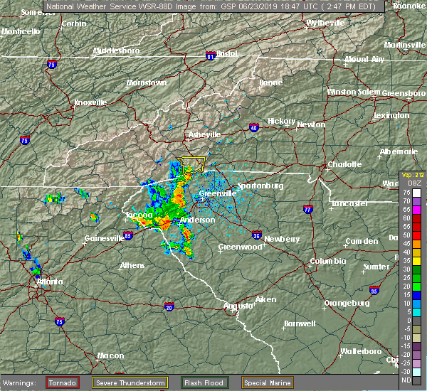 At 246 pm edt, a severe thunderstorm was located 7 miles south of hendersonville, or 5 miles southwest of flat rock, moving east at 20 mph (radar indicated). Hazards include 60 mph wind gusts and quarter size hail. Minor hail damage to vehicles is expected. expect wind damage to trees and power lines. Locations impacted include, hendersonville, flat rock, etowah, laurel park, valley hill, horse shoe, tuxedo, crab creek, dana and east flat rock. At 246 pm edt, a severe thunderstorm was located 7 miles south of hendersonville, or 5 miles southwest of flat rock, moving east at 20 mph (radar indicated). Hazards include 60 mph wind gusts and quarter size hail. Minor hail damage to vehicles is expected. expect wind damage to trees and power lines. Locations impacted include, hendersonville, flat rock, etowah, laurel park, valley hill, horse shoe, tuxedo, crab creek, dana and east flat rock.
|
| 6/23/2019 2:25 PM EDT |
 At 225 pm edt, a severe thunderstorm was located 4 miles east of brevard, or near dupont state forest, moving east at 20 mph (radar indicated). Hazards include 60 mph wind gusts and quarter size hail. Minor hail damage to vehicles is expected. Expect wind damage to trees and power lines. At 225 pm edt, a severe thunderstorm was located 4 miles east of brevard, or near dupont state forest, moving east at 20 mph (radar indicated). Hazards include 60 mph wind gusts and quarter size hail. Minor hail damage to vehicles is expected. Expect wind damage to trees and power lines.
|
| 4/19/2019 9:30 AM EDT | 911 call center reported trees down in hendersonville. time estimated from rada in henderson county NC, 0.5 miles NE of Hendersonville, NC |
| 4/19/2019 9:25 AM EDT |
 At 924 am edt, a severe thunderstorm was located 11 miles south of hendersonville, or 4 miles north of pleasant ridge state park, moving northeast at 40 mph (radar indicated). Hazards include 60 mph wind gusts. expect damage to trees and power lines At 924 am edt, a severe thunderstorm was located 11 miles south of hendersonville, or 4 miles north of pleasant ridge state park, moving northeast at 40 mph (radar indicated). Hazards include 60 mph wind gusts. expect damage to trees and power lines
|
| 9/27/2018 6:53 PM EDT |
 The national weather service in greenville-spartanburg has issued a * severe thunderstorm warning for. southeastern henderson county in western north carolina. southern polk county in western north carolina. northwestern laurens county in upstate south carolina. Greenville county in upstate south carolina. The national weather service in greenville-spartanburg has issued a * severe thunderstorm warning for. southeastern henderson county in western north carolina. southern polk county in western north carolina. northwestern laurens county in upstate south carolina. Greenville county in upstate south carolina.
|
| 7/21/2018 6:19 PM EDT |
 At 619 pm edt, a severe thunderstorm was located 10 miles northeast of hendersonville, or near bat cave, moving southeast at 10 mph (radar indicated). Hazards include 60 mph wind gusts and nickel size hail. Expect damage to trees and power lines. Locations impacted include, chimney rock state park, bat cave, dana, gerton, edneyville and mountain home. At 619 pm edt, a severe thunderstorm was located 10 miles northeast of hendersonville, or near bat cave, moving southeast at 10 mph (radar indicated). Hazards include 60 mph wind gusts and nickel size hail. Expect damage to trees and power lines. Locations impacted include, chimney rock state park, bat cave, dana, gerton, edneyville and mountain home.
|
| 7/21/2018 6:15 PM EDT | Hen Egg sized hail reported 9.8 miles WSW of Hendersonville, NC, trained spotter reported 2 inch (2.00 in) size hail on sugarloaf mountain rd in edneyville. time estimated from radar. |
| 7/21/2018 5:55 PM EDT |
 At 555 pm edt, a severe thunderstorm was located 8 miles northeast of hendersonville, or 5 miles west of bat cave, moving southeast at 15 mph (radar indicated). Hazards include 70 mph wind gusts and quarter size hail. Minor hail damage to vehicles is expected. expect considerable tree damage. Wind damage is also likely to mobile homes, roofs, and outbuildings. At 555 pm edt, a severe thunderstorm was located 8 miles northeast of hendersonville, or 5 miles west of bat cave, moving southeast at 15 mph (radar indicated). Hazards include 70 mph wind gusts and quarter size hail. Minor hail damage to vehicles is expected. expect considerable tree damage. Wind damage is also likely to mobile homes, roofs, and outbuildings.
|
| 7/6/2018 1:40 PM EDT |
 The severe thunderstorm warning for west central rutherford, northeastern henderson, northwestern polk and southeastern buncombe counties will expire at 145 pm edt, the storm which prompted the warning has weakened below severe limits, and no longer poses an immediate threat to life or property. therefore the warning will be allowed to expire. The severe thunderstorm warning for west central rutherford, northeastern henderson, northwestern polk and southeastern buncombe counties will expire at 145 pm edt, the storm which prompted the warning has weakened below severe limits, and no longer poses an immediate threat to life or property. therefore the warning will be allowed to expire.
|
| 7/6/2018 1:29 PM EDT |
 At 128 pm edt, a severe thunderstorm was located 11 miles northeast of hendersonville, or near bat cave, moving south at 15 mph. storm has weakend, but severe wind gusts will be possible for another 15 minutes (radar indicated). Hazards include 60 mph wind gusts. Expect damage to trees and power lines. Locations impacted include, fairview in buncombe county, chimney rock state park, bat cave, dana, gerton, edneyville, lake adger, mill spring, hendersonville and east flat rock. At 128 pm edt, a severe thunderstorm was located 11 miles northeast of hendersonville, or near bat cave, moving south at 15 mph. storm has weakend, but severe wind gusts will be possible for another 15 minutes (radar indicated). Hazards include 60 mph wind gusts. Expect damage to trees and power lines. Locations impacted include, fairview in buncombe county, chimney rock state park, bat cave, dana, gerton, edneyville, lake adger, mill spring, hendersonville and east flat rock.
|
| 7/6/2018 12:58 PM EDT |
 At 1258 pm edt, a severe thunderstorm was located 15 miles east of downtown asheville, or 4 miles north of bat cave, moving south at 15 mph (radar indicated). Hazards include 60 mph wind gusts and quarter size hail. Minor hail damage to vehicles is expected. Expect wind damage to trees and power lines. At 1258 pm edt, a severe thunderstorm was located 15 miles east of downtown asheville, or 4 miles north of bat cave, moving south at 15 mph (radar indicated). Hazards include 60 mph wind gusts and quarter size hail. Minor hail damage to vehicles is expected. Expect wind damage to trees and power lines.
|
| 6/26/2018 7:14 PM EDT |
 At 713 pm edt, severe thunderstorms were located along a line extending from near downtown asheville to 14 miles northwest of hendersonville to 9 miles northwest of brevard, moving southeast at 30 mph (radar indicated). Hazards include 60 mph wind gusts and quarter size hail. Minor hail damage to vehicles is expected. expect wind damage to trees and power lines. Locations impacted include, downtown asheville, waynesville, east asheville, arden, west asheville, north asheville, mills river, woodfin, fletcher and canton. At 713 pm edt, severe thunderstorms were located along a line extending from near downtown asheville to 14 miles northwest of hendersonville to 9 miles northwest of brevard, moving southeast at 30 mph (radar indicated). Hazards include 60 mph wind gusts and quarter size hail. Minor hail damage to vehicles is expected. expect wind damage to trees and power lines. Locations impacted include, downtown asheville, waynesville, east asheville, arden, west asheville, north asheville, mills river, woodfin, fletcher and canton.
|
| 6/26/2018 6:49 PM EDT |
 At 648 pm edt, severe thunderstorms were located along a line extending from near marshall to 13 miles west of downtown asheville to 3 miles northeast of waynesville, moving southeast at 30 mph (radar indicated). Hazards include 60 mph wind gusts and quarter size hail. Minor hail damage to vehicles is expected. Expect wind damage to trees and power lines. At 648 pm edt, severe thunderstorms were located along a line extending from near marshall to 13 miles west of downtown asheville to 3 miles northeast of waynesville, moving southeast at 30 mph (radar indicated). Hazards include 60 mph wind gusts and quarter size hail. Minor hail damage to vehicles is expected. Expect wind damage to trees and power lines.
|
| 6/26/2018 2:26 PM EDT |
 At 226 pm edt, a severe thunderstorm was located 8 miles northwest of hendersonville, or over mills river, moving east at 10 mph (radar indicated). Hazards include 60 mph wind gusts and quarter size hail. Minor hail damage to vehicles is expected. expect wind damage to trees and power lines. Locations impacted include, mills river, fletcher, etowah, mountain home, forge mountain, horse shoe, asheville airport and laurel park. At 226 pm edt, a severe thunderstorm was located 8 miles northwest of hendersonville, or over mills river, moving east at 10 mph (radar indicated). Hazards include 60 mph wind gusts and quarter size hail. Minor hail damage to vehicles is expected. expect wind damage to trees and power lines. Locations impacted include, mills river, fletcher, etowah, mountain home, forge mountain, horse shoe, asheville airport and laurel park.
|
| 6/26/2018 2:06 PM EDT |
 At 206 pm edt, a severe thunderstorm was located 10 miles northwest of hendersonville, or near mills river, moving southeast at 5 mph (radar indicated). Hazards include 60 mph wind gusts and quarter size hail. Minor hail damage to vehicles is expected. Expect wind damage to trees and power lines. At 206 pm edt, a severe thunderstorm was located 10 miles northwest of hendersonville, or near mills river, moving southeast at 5 mph (radar indicated). Hazards include 60 mph wind gusts and quarter size hail. Minor hail damage to vehicles is expected. Expect wind damage to trees and power lines.
|
| 6/25/2018 5:09 PM EDT |
 At 508 pm edt, a severe thunderstorm was located near columbus, moving southeast at 15 mph (radar indicated). Hazards include 60 mph wind gusts and quarter size hail. Minor hail damage to vehicles is expected. Expect wind damage to trees and power lines. At 508 pm edt, a severe thunderstorm was located near columbus, moving southeast at 15 mph (radar indicated). Hazards include 60 mph wind gusts and quarter size hail. Minor hail damage to vehicles is expected. Expect wind damage to trees and power lines.
|
| 6/23/2018 5:36 PM EDT |
 At 535 pm edt, severe thunderstorms were located along a line extending from 5 miles northwest of hendersonville to 13 miles southwest of columbus to 5 miles southeast of greenville downtown to 15 miles east of anderson, moving east at 45 mph (radar indicated). Hazards include 60 mph wind gusts. Expect damage to trees and power lines. Locations impacted include, greenville downtown, spartanburg, hendersonville, columbus, greenville eastside, west greenville, greer, mauldin, taylors and simpsonville. At 535 pm edt, severe thunderstorms were located along a line extending from 5 miles northwest of hendersonville to 13 miles southwest of columbus to 5 miles southeast of greenville downtown to 15 miles east of anderson, moving east at 45 mph (radar indicated). Hazards include 60 mph wind gusts. Expect damage to trees and power lines. Locations impacted include, greenville downtown, spartanburg, hendersonville, columbus, greenville eastside, west greenville, greer, mauldin, taylors and simpsonville.
|
| 6/23/2018 5:03 PM EDT |
 At 502 pm edt, severe thunderstorms were located along a line extending from 9 miles southeast of waynesville to 5 miles south of brevard to 5 miles south of pickens to 7 miles southeast of clemson, moving east at 55 mph (radar indicated). Hazards include 60 mph wind gusts. expect damage to trees and power lines At 502 pm edt, severe thunderstorms were located along a line extending from 9 miles southeast of waynesville to 5 miles south of brevard to 5 miles south of pickens to 7 miles southeast of clemson, moving east at 55 mph (radar indicated). Hazards include 60 mph wind gusts. expect damage to trees and power lines
|
| 6/20/2018 3:14 PM EDT |
 At 314 pm edt, a severe thunderstorm was located 7 miles northwest of hendersonville, or over mills river, moving east at 10 mph (radar indicated). Hazards include 60 mph wind gusts and quarter size hail. Minor hail damage to vehicles is expected. expect wind damage to trees and power lines. Locations impacted include, mills river, fletcher, mountain home and asheville airport. At 314 pm edt, a severe thunderstorm was located 7 miles northwest of hendersonville, or over mills river, moving east at 10 mph (radar indicated). Hazards include 60 mph wind gusts and quarter size hail. Minor hail damage to vehicles is expected. expect wind damage to trees and power lines. Locations impacted include, mills river, fletcher, mountain home and asheville airport.
|
| 6/20/2018 2:59 PM EDT |
 At 258 pm edt, a severe thunderstorm was located 9 miles northwest of hendersonville, or near mills river, moving east at 10 mph (radar indicated). Hazards include 60 mph wind gusts and quarter size hail. Minor hail damage to vehicles is expected. Expect wind damage to trees and power lines. At 258 pm edt, a severe thunderstorm was located 9 miles northwest of hendersonville, or near mills river, moving east at 10 mph (radar indicated). Hazards include 60 mph wind gusts and quarter size hail. Minor hail damage to vehicles is expected. Expect wind damage to trees and power lines.
|
| 6/3/2018 6:02 PM EDT |
 At 543 pm edt, a severe thunderstorm was located near hendersonville, moving southeast at 15 mph (radar indicated). Hazards include 60 mph wind gusts and quarter size hail. Minor hail damage to vehicles is expected. Expect wind damage to trees and power lines. At 543 pm edt, a severe thunderstorm was located near hendersonville, moving southeast at 15 mph (radar indicated). Hazards include 60 mph wind gusts and quarter size hail. Minor hail damage to vehicles is expected. Expect wind damage to trees and power lines.
|
| 6/3/2018 5:50 PM EDT | Quarter sized hail reported 4.9 miles SE of Hendersonville, NC, quarter size hail at hwy 191 and north rugby rd. |
| 6/3/2018 5:50 PM EDT | Numerous trees blown down in east hendrsonville and to the east near dan in henderson county NC, 0.8 miles WNW of Hendersonville, NC |
| 6/3/2018 5:43 PM EDT |
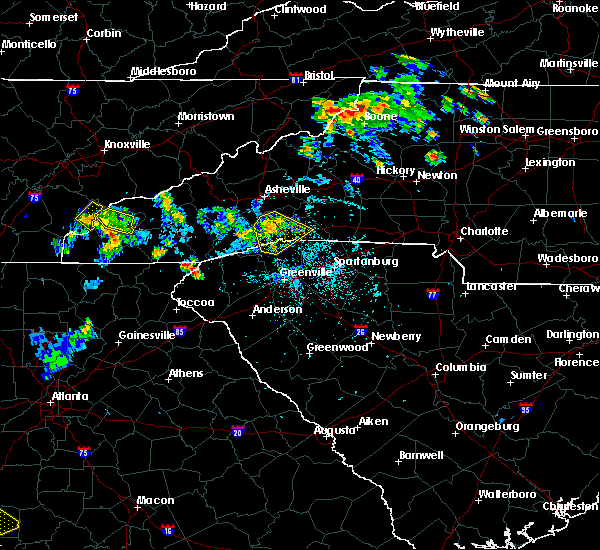 At 543 pm edt, a severe thunderstorm was located near hendersonville, moving southeast at 15 mph (radar indicated). Hazards include 60 mph wind gusts and quarter size hail. Minor hail damage to vehicles is expected. Expect wind damage to trees and power lines. At 543 pm edt, a severe thunderstorm was located near hendersonville, moving southeast at 15 mph (radar indicated). Hazards include 60 mph wind gusts and quarter size hail. Minor hail damage to vehicles is expected. Expect wind damage to trees and power lines.
|
| 6/3/2018 5:24 PM EDT |
 At 524 pm edt, a severe thunderstorm was located 7 miles northwest of hendersonville, or near mills river, moving southeast at 15 mph (radar indicated). Hazards include 60 mph wind gusts and half dollar size hail. Minor hail damage to vehicles is expected. expect wind damage to trees and power lines. locations impacted include, hendersonville, arden, mills river, fletcher, flat rock, etowah, mountain home, laurel park, b. r. Parkway-mount pisgah to the nc arboretum and asheville airport. At 524 pm edt, a severe thunderstorm was located 7 miles northwest of hendersonville, or near mills river, moving southeast at 15 mph (radar indicated). Hazards include 60 mph wind gusts and half dollar size hail. Minor hail damage to vehicles is expected. expect wind damage to trees and power lines. locations impacted include, hendersonville, arden, mills river, fletcher, flat rock, etowah, mountain home, laurel park, b. r. Parkway-mount pisgah to the nc arboretum and asheville airport.
|
| 6/3/2018 5:06 PM EDT |
 At 506 pm edt, a severe thunderstorm was located 9 miles northwest of hendersonville, or near asheville airport, moving southeast at 25 mph (radar indicated). Hazards include 60 mph wind gusts and quarter size hail. Minor hail damage to vehicles is expected. Expect wind damage to trees and power lines. At 506 pm edt, a severe thunderstorm was located 9 miles northwest of hendersonville, or near asheville airport, moving southeast at 25 mph (radar indicated). Hazards include 60 mph wind gusts and quarter size hail. Minor hail damage to vehicles is expected. Expect wind damage to trees and power lines.
|
| 5/31/2018 9:25 PM EDT |
 At 925 pm edt, a severe thunderstorm was located 4 miles northwest of hendersonville, or over mountain home, moving southeast at 25 mph (radar indicated). Hazards include 60 mph wind gusts. expect damage to trees and power lines At 925 pm edt, a severe thunderstorm was located 4 miles northwest of hendersonville, or over mountain home, moving southeast at 25 mph (radar indicated). Hazards include 60 mph wind gusts. expect damage to trees and power lines
|
| 7/23/2017 2:01 PM EDT |
 At 201 pm edt, a severe thunderstorm was located 4 miles northeast of hendersonville, or 4 miles east of mountain home, moving southeast at 15 mph (radar indicated). Hazards include 60 mph wind gusts and quarter size hail. Minor hail damage to vehicles is expected. expect wind damage to trees and power lines. Locations impacted include, dana and edneyville. At 201 pm edt, a severe thunderstorm was located 4 miles northeast of hendersonville, or 4 miles east of mountain home, moving southeast at 15 mph (radar indicated). Hazards include 60 mph wind gusts and quarter size hail. Minor hail damage to vehicles is expected. expect wind damage to trees and power lines. Locations impacted include, dana and edneyville.
|
| 7/23/2017 1:42 PM EDT |
 At 142 pm edt, a severe thunderstorm was located 7 miles north of hendersonville, or near fletcher, moving southeast at 15 mph (radar indicated). Hazards include 60 mph wind gusts and quarter size hail. Minor hail damage to vehicles is expected. Expect wind damage to trees and power lines. At 142 pm edt, a severe thunderstorm was located 7 miles north of hendersonville, or near fletcher, moving southeast at 15 mph (radar indicated). Hazards include 60 mph wind gusts and quarter size hail. Minor hail damage to vehicles is expected. Expect wind damage to trees and power lines.
|
| 7/18/2017 6:00 PM EDT | Quarter sized hail reported 3.1 miles ENE of Hendersonville, NC, quarter size hail near cummings cove country club. |
| 7/18/2017 5:55 PM EDT |
 At 555 pm edt, a severe thunderstorm was located 7 miles west of hendersonville, or near etowah, moving southwest at 15 mph (radar indicated). Hazards include 60 mph wind gusts and quarter size hail. Minor hail damage to vehicles is expected. Expect wind damage to trees and power lines. At 555 pm edt, a severe thunderstorm was located 7 miles west of hendersonville, or near etowah, moving southwest at 15 mph (radar indicated). Hazards include 60 mph wind gusts and quarter size hail. Minor hail damage to vehicles is expected. Expect wind damage to trees and power lines.
|
| 7/15/2017 1:37 PM EDT |
 The severe thunderstorm warning for east central transylvania, southern henderson, southwestern polk and north central greenville counties will expire at 145 pm edt, the storm which prompted the warning has weakened below severe limits, and no longer poses an immediate threat to life or property. therefore the warning will be allowed to expire. however gusty winds are still possible with this thunderstorm. The severe thunderstorm warning for east central transylvania, southern henderson, southwestern polk and north central greenville counties will expire at 145 pm edt, the storm which prompted the warning has weakened below severe limits, and no longer poses an immediate threat to life or property. therefore the warning will be allowed to expire. however gusty winds are still possible with this thunderstorm.
|
| 7/15/2017 1:22 PM EDT |
 At 121 pm edt, a severe thunderstorm was located 6 miles south of hendersonville, or near flat rock, moving east at 5 mph (radar indicated). Hazards include 60 mph wind gusts and quarter size hail. Minor hail damage to vehicles is expected. expect wind damage to trees and power lines. Locations impacted include, hendersonville, flat rock, etowah, laurel park, saluda, dupont state forest, valley hill, horse shoe, north saluda reservoir and tuxedo. At 121 pm edt, a severe thunderstorm was located 6 miles south of hendersonville, or near flat rock, moving east at 5 mph (radar indicated). Hazards include 60 mph wind gusts and quarter size hail. Minor hail damage to vehicles is expected. expect wind damage to trees and power lines. Locations impacted include, hendersonville, flat rock, etowah, laurel park, saluda, dupont state forest, valley hill, horse shoe, north saluda reservoir and tuxedo.
|
| 7/15/2017 1:15 PM EDT | 911 call center reported a few trees down in valley hil in henderson county NC, 2.2 miles NE of Hendersonville, NC |
| 7/15/2017 1:04 PM EDT |
 At 104 pm edt, a severe thunderstorm was located 6 miles south of hendersonville, or 4 miles southwest of flat rock, moving east at 5 mph (radar indicated). Hazards include 60 mph wind gusts and quarter size hail. Minor hail damage to vehicles is expected. Expect wind damage to trees and power lines. At 104 pm edt, a severe thunderstorm was located 6 miles south of hendersonville, or 4 miles southwest of flat rock, moving east at 5 mph (radar indicated). Hazards include 60 mph wind gusts and quarter size hail. Minor hail damage to vehicles is expected. Expect wind damage to trees and power lines.
|
| 7/13/2017 5:40 PM EDT | 911 call center reported a downed tree on gerton hwy (us 74a in henderson county NC, 12 miles SW of Hendersonville, NC |
| 7/8/2017 4:33 PM EDT |
 At 432 pm edt, a severe thunderstorm was located near hendersonville, or near flat rock, moving east at 15 mph. storm has weakened slightly, but some golf-ball sized hail was reported 10 minutes ago and the potential continues form hail and severe wind gusts (radar indicated). Hazards include 60 mph wind gusts and nickel size hail. Expect damage to trees and power lines. Locations impacted include, hendersonville, columbus, flat rock, laurel park, tryon, saluda, valley hill, tuxedo, edneyville and crab creek. At 432 pm edt, a severe thunderstorm was located near hendersonville, or near flat rock, moving east at 15 mph. storm has weakened slightly, but some golf-ball sized hail was reported 10 minutes ago and the potential continues form hail and severe wind gusts (radar indicated). Hazards include 60 mph wind gusts and nickel size hail. Expect damage to trees and power lines. Locations impacted include, hendersonville, columbus, flat rock, laurel park, tryon, saluda, valley hill, tuxedo, edneyville and crab creek.
|
| 7/8/2017 4:23 PM EDT | Golf Ball sized hail reported 0.5 miles NE of Hendersonville, NC, report of golf ball sized hail. wind not too bad at his location. |
| 7/8/2017 4:15 PM EDT |
 At 414 pm edt, a severe thunderstorm was located near hendersonville, or near laurel park, moving east at 15 mph (radar indicated). Hazards include 60 mph wind gusts and nickel size hail. expect damage to trees and power lines At 414 pm edt, a severe thunderstorm was located near hendersonville, or near laurel park, moving east at 15 mph (radar indicated). Hazards include 60 mph wind gusts and nickel size hail. expect damage to trees and power lines
|
| 6/24/2017 2:51 PM EDT | County reports tree knocking down powerline at crab creek road and misty cove lan in henderson county NC, 8.4 miles NE of Hendersonville, NC |
| 6/13/2017 6:01 PM EDT |
 At 532 pm edt, a severe thunderstorm was located 5 miles south of hendersonville, or near flat rock, and is nearly stationary (radar indicated). Hazards include 60 mph wind gusts and quarter size hail. Minor hail damage to vehicles is expected. Expect wind damage to trees and power lines. At 532 pm edt, a severe thunderstorm was located 5 miles south of hendersonville, or near flat rock, and is nearly stationary (radar indicated). Hazards include 60 mph wind gusts and quarter size hail. Minor hail damage to vehicles is expected. Expect wind damage to trees and power lines.
|
| 6/13/2017 5:32 PM EDT |
 At 532 pm edt, a severe thunderstorm was located 5 miles south of hendersonville, or near flat rock, and is nearly stationary (radar indicated). Hazards include 60 mph wind gusts and quarter size hail. Minor hail damage to vehicles is expected. Expect wind damage to trees and power lines. At 532 pm edt, a severe thunderstorm was located 5 miles south of hendersonville, or near flat rock, and is nearly stationary (radar indicated). Hazards include 60 mph wind gusts and quarter size hail. Minor hail damage to vehicles is expected. Expect wind damage to trees and power lines.
|
| 6/13/2017 2:27 PM EDT |
 At 227 pm edt, a severe thunderstorm was located 4 miles northwest of hendersonville, or near mountain home, moving northwest at 10 mph (radar indicated). Hazards include quarter size hail. Minor damage to vehicles is expected. Locations impacted include, hendersonville, mountain home, laurel park, valley hill, horse shoe, crab creek and etowah. At 227 pm edt, a severe thunderstorm was located 4 miles northwest of hendersonville, or near mountain home, moving northwest at 10 mph (radar indicated). Hazards include quarter size hail. Minor damage to vehicles is expected. Locations impacted include, hendersonville, mountain home, laurel park, valley hill, horse shoe, crab creek and etowah.
|
| 6/13/2017 2:10 PM EDT | Trees down in the vicinity of laurel par in henderson county NC, 1.8 miles ENE of Hendersonville, NC |
| 6/13/2017 2:04 PM EDT |
 At 204 pm edt, a severe thunderstorm was located near hendersonville, or near flat rock, moving southwest at 10 mph (radar indicated). Hazards include 60 mph wind gusts and quarter size hail. Minor hail damage to vehicles is expected. Expect wind damage to trees and power lines. At 204 pm edt, a severe thunderstorm was located near hendersonville, or near flat rock, moving southwest at 10 mph (radar indicated). Hazards include 60 mph wind gusts and quarter size hail. Minor hail damage to vehicles is expected. Expect wind damage to trees and power lines.
|
| 5/28/2017 12:40 AM EDT | County reports scattered trees down countywide with a few in hendersonvill in henderson county NC, 0.5 miles NE of Hendersonville, NC |
| 5/28/2017 12:18 AM EDT |
 At 1217 am edt, severe thunderstorms were located along a line extending from 4 miles northwest of downtown asheville to 6 miles northeast of brevard to 17 miles northwest of pickens, moving southeast at 45 mph (radar indicated). Hazards include 60 mph wind gusts and penny size hail. expect damage to trees and power lines At 1217 am edt, severe thunderstorms were located along a line extending from 4 miles northwest of downtown asheville to 6 miles northeast of brevard to 17 miles northwest of pickens, moving southeast at 45 mph (radar indicated). Hazards include 60 mph wind gusts and penny size hail. expect damage to trees and power lines
|
| 5/19/2017 3:57 PM EDT |
 The severe thunderstorm warning for northeastern transylvania and henderson counties will expire at 400 pm edt, the storms which prompted the warning have weakened below severe limits, and no longer pose an immediate threat to life or property. therefore the warning will be allowed to expire. however small hail and heavy rain are still possible with these thunderstorms. The severe thunderstorm warning for northeastern transylvania and henderson counties will expire at 400 pm edt, the storms which prompted the warning have weakened below severe limits, and no longer pose an immediate threat to life or property. therefore the warning will be allowed to expire. however small hail and heavy rain are still possible with these thunderstorms.
|
| 5/19/2017 3:36 PM EDT |
 At 336 pm edt, severe thunderstorms were located along a line extending from 8 miles north of brevard to 7 miles southwest of hendersonville, and are nearly stationary (radar indicated). Hazards include 60 mph wind gusts and quarter size hail. Minor hail damage to vehicles is expected. expect wind damage to trees and power lines. Locations impacted include, hendersonville, brevard, mills river, fletcher, flat rock, etowah, mountain home, laurel park, looking glass and dupont state forest. At 336 pm edt, severe thunderstorms were located along a line extending from 8 miles north of brevard to 7 miles southwest of hendersonville, and are nearly stationary (radar indicated). Hazards include 60 mph wind gusts and quarter size hail. Minor hail damage to vehicles is expected. expect wind damage to trees and power lines. Locations impacted include, hendersonville, brevard, mills river, fletcher, flat rock, etowah, mountain home, laurel park, looking glass and dupont state forest.
|
| 5/19/2017 3:09 PM EDT |
 At 309 pm edt, severe thunderstorms were located along a line extending from 6 miles north of brevard to 5 miles south of hendersonville, moving east at 15 mph (radar indicated). Hazards include 60 mph wind gusts and quarter size hail. Minor hail damage to vehicles is expected. Expect wind damage to trees and power lines. At 309 pm edt, severe thunderstorms were located along a line extending from 6 miles north of brevard to 5 miles south of hendersonville, moving east at 15 mph (radar indicated). Hazards include 60 mph wind gusts and quarter size hail. Minor hail damage to vehicles is expected. Expect wind damage to trees and power lines.
|
| 5/19/2017 1:42 PM EDT |
 At 141 pm edt, a severe thunderstorm was located 4 miles east of hendersonville, moving southeast at 20 mph (radar indicated). Hazards include 60 mph wind gusts and quarter size hail. Minor hail damage to vehicles is expected. Expect wind damage to trees and power lines. At 141 pm edt, a severe thunderstorm was located 4 miles east of hendersonville, moving southeast at 20 mph (radar indicated). Hazards include 60 mph wind gusts and quarter size hail. Minor hail damage to vehicles is expected. Expect wind damage to trees and power lines.
|
| 3/21/2017 10:32 PM EDT |
 At 1030 pm edt, an outflow of severe winds from the decaying thunderstorms stretched along a line extending from 12 miles southwest of downtown asheville to 7 miles east of brevard to 16 miles southwest of hendersonville. the leading edge of these winds were moving east at 35 mph. 40 to 60 mph winds will remain possible behind the passing outflow through 1045 pm (radar indicated). Hazards include 60 mph wind gusts. Expect damage to siding and trees. Locations impacted include, hendersonville, brevard, arden, mills river, fletcher, flat rock, etowah, mountain home, laurel park and rosman. At 1030 pm edt, an outflow of severe winds from the decaying thunderstorms stretched along a line extending from 12 miles southwest of downtown asheville to 7 miles east of brevard to 16 miles southwest of hendersonville. the leading edge of these winds were moving east at 35 mph. 40 to 60 mph winds will remain possible behind the passing outflow through 1045 pm (radar indicated). Hazards include 60 mph wind gusts. Expect damage to siding and trees. Locations impacted include, hendersonville, brevard, arden, mills river, fletcher, flat rock, etowah, mountain home, laurel park and rosman.
|
| 3/21/2017 9:59 PM EDT |
 At 958 pm edt, outflows from severe thunderstorms were located along a line extending from 8 miles southeast of waynesville to 8 miles west of brevard to 17 miles northwest of pickens, moving east at 55 mph (radar indicated). Hazards include 60 mph wind gusts. Expect damage to roofs. Siding and trees. At 958 pm edt, outflows from severe thunderstorms were located along a line extending from 8 miles southeast of waynesville to 8 miles west of brevard to 17 miles northwest of pickens, moving east at 55 mph (radar indicated). Hazards include 60 mph wind gusts. Expect damage to roofs. Siding and trees.
|
| 8/17/2016 1:21 PM EDT |
 The severe thunderstorm warning for northeastern transylvania, south central buncombe, southeastern haywood and northwestern henderson counties will expire at 130 pm edt, the storm which prompted the warning has weakened below severe limits, and no longer poses an immediate threat to life or property. therefore the warning will be allowed to expire. The severe thunderstorm warning for northeastern transylvania, south central buncombe, southeastern haywood and northwestern henderson counties will expire at 130 pm edt, the storm which prompted the warning has weakened below severe limits, and no longer poses an immediate threat to life or property. therefore the warning will be allowed to expire.
|
| 8/17/2016 12:52 PM EDT |
 At 1252 pm edt, a severe thunderstorm was located 8 miles north of brevard, or 4 miles north of looking glass, moving northeast at 15 mph (radar indicated). Hazards include 60 mph wind gusts. Expect damage to roofs. Siding and trees. At 1252 pm edt, a severe thunderstorm was located 8 miles north of brevard, or 4 miles north of looking glass, moving northeast at 15 mph (radar indicated). Hazards include 60 mph wind gusts. Expect damage to roofs. Siding and trees.
|
| 7/14/2016 7:35 PM EDT | Storm blew down a few trees on fairway knoll drive located just north of cummings cove golf and country clu in henderson county NC, 6.7 miles E of Hendersonville, NC |
| 7/8/2016 8:56 PM EDT |
 At 855 pm edt, severe thunderstorms were located along a line extending from 8 miles northeast of hendersonville to 7 miles east of hartwell, moving east at 35 mph (radar indicated). Hazards include 60 mph wind gusts and quarter size hail. Hail damage to vehicles is expected. Expect wind damage to roofs, siding and trees. At 855 pm edt, severe thunderstorms were located along a line extending from 8 miles northeast of hendersonville to 7 miles east of hartwell, moving east at 35 mph (radar indicated). Hazards include 60 mph wind gusts and quarter size hail. Hail damage to vehicles is expected. Expect wind damage to roofs, siding and trees.
|
| 7/7/2016 8:37 PM EDT |
 At 836 pm edt, severe thunderstorms were located along a line extending from 9 miles north of hendersonville to 5 miles west of brevard, moving southeast at 35 mph (radar indicated). Hazards include 60 mph wind gusts. Expect damage to roofs. siding and trees. Locations impacted include, hendersonville, brevard, arden, mills river, fletcher, flat rock, etowah, fairview in buncombe county, mountain home and laurel park. At 836 pm edt, severe thunderstorms were located along a line extending from 9 miles north of hendersonville to 5 miles west of brevard, moving southeast at 35 mph (radar indicated). Hazards include 60 mph wind gusts. Expect damage to roofs. siding and trees. Locations impacted include, hendersonville, brevard, arden, mills river, fletcher, flat rock, etowah, fairview in buncombe county, mountain home and laurel park.
|
| 7/7/2016 7:59 PM EDT |
 At 759 pm edt, severe thunderstorms were located along a line extending from 12 miles southwest of greeneville to 5 miles west of waynesville, moving southeast at 60 mph (radar indicated). Hazards include 60 mph wind gusts. Expect damage to roofs. Siding and trees. At 759 pm edt, severe thunderstorms were located along a line extending from 12 miles southwest of greeneville to 5 miles west of waynesville, moving southeast at 60 mph (radar indicated). Hazards include 60 mph wind gusts. Expect damage to roofs. Siding and trees.
|
| 7/6/2016 7:48 PM EDT |
 At 747 pm edt, a severe thunderstorm was located 4 miles northeast of hendersonville, or 4 miles east of mountain home, moving east at 20 mph. quarter size hail has been reported with this storm as well as winds to 55 mph (radar indicated). Hazards include 60 mph wind gusts and quarter size hail. Hail damage to vehicles is expected. expect wind damage to roofs, siding and trees. Locations impacted include, hendersonville, arden, mills river, fletcher, flat rock, mountain home, laurel park, asheville airport, skyland and valley hill. At 747 pm edt, a severe thunderstorm was located 4 miles northeast of hendersonville, or 4 miles east of mountain home, moving east at 20 mph. quarter size hail has been reported with this storm as well as winds to 55 mph (radar indicated). Hazards include 60 mph wind gusts and quarter size hail. Hail damage to vehicles is expected. expect wind damage to roofs, siding and trees. Locations impacted include, hendersonville, arden, mills river, fletcher, flat rock, mountain home, laurel park, asheville airport, skyland and valley hill.
|
| 7/6/2016 7:43 PM EDT | Quarter sized hail reported 3.2 miles SSW of Hendersonville, NC, mostly marble to nickel sized hail...but a few stones up to quarter-sized. |
| 7/6/2016 7:27 PM EDT |
 At 726 pm edt, a severe thunderstorm was located 8 miles northwest of hendersonville, or over asheville airport, moving east at 20 mph (radar indicated). Hazards include 60 mph wind gusts and quarter size hail. Hail damage to vehicles is expected. Expect wind damage to roofs, siding and trees. At 726 pm edt, a severe thunderstorm was located 8 miles northwest of hendersonville, or over asheville airport, moving east at 20 mph (radar indicated). Hazards include 60 mph wind gusts and quarter size hail. Hail damage to vehicles is expected. Expect wind damage to roofs, siding and trees.
|
| 8/4/2015 4:08 PM EDT |
 At 408 pm edt, doppler radar indicated a severe thunderstorm capable of producing quarter size hail and damaging winds in excess of 60 mph. this storm was located 6 miles south of hendersonville, or near flat rock, moving southeast at 20 mph. locations impacted include, hendersonville, flat rock, laurel park, valley hill, crab creek, tuxedo, east flat rock, dana and dupont state forest. At 408 pm edt, doppler radar indicated a severe thunderstorm capable of producing quarter size hail and damaging winds in excess of 60 mph. this storm was located 6 miles south of hendersonville, or near flat rock, moving southeast at 20 mph. locations impacted include, hendersonville, flat rock, laurel park, valley hill, crab creek, tuxedo, east flat rock, dana and dupont state forest.
|
| 8/4/2015 3:48 PM EDT |
 At 347 pm edt, doppler radar indicated a severe thunderstorm capable of producing quarter size hail and damaging winds in excess of 60 mph. this storm was located 7 miles west of hendersonville, or over etowah, moving southeast at 15 mph. locations impacted include, hendersonville, mills river, flat rock, etowah, mountain home, laurel park, dupont state forest, valley hill, east flat rock and forge mountain. At 347 pm edt, doppler radar indicated a severe thunderstorm capable of producing quarter size hail and damaging winds in excess of 60 mph. this storm was located 7 miles west of hendersonville, or over etowah, moving southeast at 15 mph. locations impacted include, hendersonville, mills river, flat rock, etowah, mountain home, laurel park, dupont state forest, valley hill, east flat rock and forge mountain.
|
| 8/4/2015 3:29 PM EDT |
 At 329 pm edt, doppler radar indicated a severe thunderstorm capable of producing quarter size hail and damaging winds in excess of 60 mph. this storm was located 12 miles north of brevard, or over mount pisgah, and moving southeast at 20 mph. * locations in the warning include, hendersonville, mills river, flat rock, etowah, mountain home, laurel park, dupont state forest, b.r. parkway-mount pisgah to the nc arboretum, valley hill and east flat rock. At 329 pm edt, doppler radar indicated a severe thunderstorm capable of producing quarter size hail and damaging winds in excess of 60 mph. this storm was located 12 miles north of brevard, or over mount pisgah, and moving southeast at 20 mph. * locations in the warning include, hendersonville, mills river, flat rock, etowah, mountain home, laurel park, dupont state forest, b.r. parkway-mount pisgah to the nc arboretum, valley hill and east flat rock.
|
| 7/20/2015 8:36 PM EDT |
 At 835 pm edt, doppler radar indicated a line of severe thunderstorms capable of producing damaging winds in excess of 60 mph. these storms were located along a line extending from 5 miles west of hendersonville to 15 miles north of easley to 6 miles southwest of pickens, and moving east at 30 mph. * locations in the warning include, greenville downtown, spartanburg, easley, hendersonville, pickens, columbus, greer, mauldin, taylors and simpsonville. At 835 pm edt, doppler radar indicated a line of severe thunderstorms capable of producing damaging winds in excess of 60 mph. these storms were located along a line extending from 5 miles west of hendersonville to 15 miles north of easley to 6 miles southwest of pickens, and moving east at 30 mph. * locations in the warning include, greenville downtown, spartanburg, easley, hendersonville, pickens, columbus, greer, mauldin, taylors and simpsonville.
|
| 7/14/2015 8:41 AM EDT |
 The severe thunderstorm warning for rutherford, southern buncombe, southern mcdowell, polk and henderson counties will expire at 845 am edt, the line of storms which prompted the warning have weakened below severe limits, and no longer poses an immediate threat to life or property. therefore the warning will be allowed to expire. however gusty winds and heavy rain are still possible with these thunderstorms. The severe thunderstorm warning for rutherford, southern buncombe, southern mcdowell, polk and henderson counties will expire at 845 am edt, the line of storms which prompted the warning have weakened below severe limits, and no longer poses an immediate threat to life or property. therefore the warning will be allowed to expire. however gusty winds and heavy rain are still possible with these thunderstorms.
|
| 7/14/2015 8:08 AM EDT |
 At 808 am edt, doppler radar indicated a line of severe thunderstorms capable of producing damaging winds in excess of 60 mph. these storms were located along a line extending from 10 miles southwest of morganton to 16 miles north of columbus to 12 miles east of waynesville, moving southeast at 50 mph. penny size hail may also accompany the damaging winds. locations impacted include, hendersonville, forest city, marion, rutherfordton, columbus, arden, mills river, fletcher, spindale and flat rock. At 808 am edt, doppler radar indicated a line of severe thunderstorms capable of producing damaging winds in excess of 60 mph. these storms were located along a line extending from 10 miles southwest of morganton to 16 miles north of columbus to 12 miles east of waynesville, moving southeast at 50 mph. penny size hail may also accompany the damaging winds. locations impacted include, hendersonville, forest city, marion, rutherfordton, columbus, arden, mills river, fletcher, spindale and flat rock.
|
| 7/14/2015 7:47 AM EDT |
 At 747 am edt, doppler radar indicated a line of severe thunderstorms capable of producing damaging winds in excess of 60 mph. these storms were located along a line extending from 9 miles north of marion to 11 miles northeast of downtown asheville to 9 miles northeast of waynesville, and moving southeast at 50 mph. penny size hail may also accompany the damaging winds. At 747 am edt, doppler radar indicated a line of severe thunderstorms capable of producing damaging winds in excess of 60 mph. these storms were located along a line extending from 9 miles north of marion to 11 miles northeast of downtown asheville to 9 miles northeast of waynesville, and moving southeast at 50 mph. penny size hail may also accompany the damaging winds.
|
| 7/13/2015 8:16 PM EDT |
 At 815 pm edt, doppler radar indicated a line of showers and thunderstorms capable of producing damaging winds in excess of 60 mph. these storms were located along a line extending from 9 miles south of marion to 8 miles north of brevard, and moving southeast at 35 mph. At 815 pm edt, doppler radar indicated a line of showers and thunderstorms capable of producing damaging winds in excess of 60 mph. these storms were located along a line extending from 9 miles south of marion to 8 miles north of brevard, and moving southeast at 35 mph.
|
| 6/26/2015 5:11 PM EDT | The severe thunderstorm warning for henderson county will expire at 515 pm edt, the storm which prompted the warning has weakened below severe limits, and no longer poses an immediate threat to life or property. therefore the warning will be allowed to expire. |
| 6/26/2015 4:48 PM EDT | At 447 pm edt, doppler radar indicated a severe thunderstorm capable of producing damaging winds in excess of 60 mph. this storm was located over hendersonville, moving east at 15 mph. nickel size hail may also accompany the damaging winds. locations impacted include, hendersonville, mills river, fletcher, flat rock, etowah, mountain home, laurel park, valley hill, east flat rock and edneyville. |
| 6/26/2015 4:45 PM EDT | Trees down off north rugby rd in hendersonville... n in henderson county NC, 0.5 miles NE of Hendersonville, NC |
| 6/26/2015 4:37 PM EDT | At 436 pm edt, doppler radar indicated a severe thunderstorm capable of producing quarter size hail and damaging winds in excess of 60 mph. this storm was located near hendersonville, or near mountain home, and moving east at 10 mph. |
| 6/22/2015 4:40 PM EDT |
 The severe thunderstorm warning for southwestern buncombe, east central haywood and northern henderson counties will expire at 445 pm edt, the storm which prompted the warning has weakened below severe limits, and no longer poses an immediate threat to life or property. therefore the warning will be allowed to expire. however gusty winds are still possible with this thunderstorm. The severe thunderstorm warning for southwestern buncombe, east central haywood and northern henderson counties will expire at 445 pm edt, the storm which prompted the warning has weakened below severe limits, and no longer poses an immediate threat to life or property. therefore the warning will be allowed to expire. however gusty winds are still possible with this thunderstorm.
|
| 6/22/2015 4:30 PM EDT |
 At 430 pm edt, doppler radar indicated a severe thunderstorm capable of producing quarter size hail and damaging winds in excess of 60 mph. this storm was located 10 miles northwest of hendersonville, or near mills river, moving east at 20 mph. locations impacted include, arden, asheville airport, skyland, mills river, fletcher, fairview in buncombe county, mountain home, biltmore forest, b.r. parkway, mount pisgah to the nc arboretum and b.r. parkway, nc arboretum to east asheville. At 430 pm edt, doppler radar indicated a severe thunderstorm capable of producing quarter size hail and damaging winds in excess of 60 mph. this storm was located 10 miles northwest of hendersonville, or near mills river, moving east at 20 mph. locations impacted include, arden, asheville airport, skyland, mills river, fletcher, fairview in buncombe county, mountain home, biltmore forest, b.r. parkway, mount pisgah to the nc arboretum and b.r. parkway, nc arboretum to east asheville.
|
| 6/22/2015 3:59 PM EDT |
 At 359 pm edt, doppler radar indicated a severe thunderstorm capable of producing quarter size hail and damaging winds in excess of 60 mph. this storm was located 12 miles southwest of west asheville, or near mount pisgah, and moving east at 20 mph. At 359 pm edt, doppler radar indicated a severe thunderstorm capable of producing quarter size hail and damaging winds in excess of 60 mph. this storm was located 12 miles southwest of west asheville, or near mount pisgah, and moving east at 20 mph.
|
| 6/21/2015 7:54 PM EDT |
 At 754 pm edt, doppler radar indicated a severe thunderstorm capable of producing quarter size hail and damaging winds in excess of 60 mph. this storm was located near hendersonville, moving east at 20 mph. locations impacted include, hendersonville, mills river, fletcher, flat rock, etowah, mountain home, laurel park, valley hill, east flat rock and edneyville. At 754 pm edt, doppler radar indicated a severe thunderstorm capable of producing quarter size hail and damaging winds in excess of 60 mph. this storm was located near hendersonville, moving east at 20 mph. locations impacted include, hendersonville, mills river, fletcher, flat rock, etowah, mountain home, laurel park, valley hill, east flat rock and edneyville.
|
| 6/21/2015 7:35 PM EDT | Quarter sized hail reported 3.3 miles SSE of Hendersonville, NC, quarter-sized hail reported off of i26 at rest area north of hendersonville |
| 6/21/2015 7:33 PM EDT |
 At 732 pm edt, doppler radar indicated a severe thunderstorm capable of producing quarter size hail and damaging winds in excess of 60 mph. this storm was located 6 miles northwest of hendersonville, or near mills river, and moving east at 20 mph. At 732 pm edt, doppler radar indicated a severe thunderstorm capable of producing quarter size hail and damaging winds in excess of 60 mph. this storm was located 6 miles northwest of hendersonville, or near mills river, and moving east at 20 mph.
|
| 6/18/2015 5:04 PM EDT | At 504 pm edt, doppler radar indicated a severe thunderstorm capable of producing quarter size hail and damaging winds in excess of 60 mph. this storm was located 7 miles northwest of hendersonville, or over mills river, moving east at 10 mph. locations impacted include, hendersonville, mills river, fletcher, flat rock, etowah, mountain home, laurel park, b.r. parkway, mount pisgah to the nc arboretum, valley hill and forge mountain. |
| 6/18/2015 4:57 PM EDT | At 456 pm edt, doppler radar indicated a severe thunderstorm capable of producing quarter size hail and damaging winds in excess of 60 mph. this storm was located 9 miles northwest of hendersonville, or near mills river, moving east at 15 mph. locations impacted include, hendersonville, arden, asheville airport, skyland, mills river, fletcher, flat rock, etowah, mountain home and laurel park. |
| 6/18/2015 4:37 PM EDT | At 437 pm edt, doppler radar indicated a severe thunderstorm capable of producing large damaging hail up to golf ball size and damaging winds in excess of 60 mph. this storm was located 12 miles southwest of west asheville, or near b.r. parkway, mount pisgah to the nc arboretum, and moving east at 10 mph. |
| 6/17/2015 3:49 PM EDT |
 At 349 pm edt, doppler radar indicated a severe thunderstorm capable of producing damaging winds in excess of 60 mph. this storm was located 4 miles south of hendersonville, or near flat rock, moving east at 10 mph. penny size hail may also accompany the damaging winds. locations impacted include, flat rock, laurel park, tryon, saluda, pleasant ridge state park, tigerville, lake robinson, valley hill, east flat rock and north saluda reservoir. At 349 pm edt, doppler radar indicated a severe thunderstorm capable of producing damaging winds in excess of 60 mph. this storm was located 4 miles south of hendersonville, or near flat rock, moving east at 10 mph. penny size hail may also accompany the damaging winds. locations impacted include, flat rock, laurel park, tryon, saluda, pleasant ridge state park, tigerville, lake robinson, valley hill, east flat rock and north saluda reservoir.
|
| 6/17/2015 3:37 PM EDT |
 At 336 pm edt, doppler radar indicated a severe thunderstorm capable of producing damaging winds in excess of 60 mph. this storm was located 7 miles southwest of hendersonville, or 5 miles southwest of flat rock, and moving southeast at 15 mph. penny size hail may also accompany the damaging winds. At 336 pm edt, doppler radar indicated a severe thunderstorm capable of producing damaging winds in excess of 60 mph. this storm was located 7 miles southwest of hendersonville, or 5 miles southwest of flat rock, and moving southeast at 15 mph. penny size hail may also accompany the damaging winds.
|
| 6/8/2015 10:32 PM EDT | At 1032 pm edt, doppler radar indicated a line of severe thunderstorms capable of producing damaging winds in excess of 60 mph. these storms were located along a line extending from 4 miles southwest of hendersonville to 6 miles west of pickens, moving east at 35 mph. locations impacted include, easley, hendersonville, brevard, walhalla, pickens, columbus, berea, travelers rest, liberty and flat rock. |
| 6/8/2015 10:32 PM EDT | At 1032 pm edt, doppler radar indicated a line of severe thunderstorms capable of producing damaging winds in excess of 60 mph. these storms were located along a line extending from 4 miles southwest of hendersonville to 6 miles west of pickens, moving east at 35 mph. locations impacted include, easley, hendersonville, brevard, walhalla, pickens, columbus, berea, travelers rest, liberty and flat rock. |
| 6/8/2015 10:05 PM EDT | At 1004 pm edt, doppler radar indicated a line of severe thunderstorms capable of producing damaging winds in excess of 60 mph. these storms were located along a line extending from 4 miles west of brevard to 3 miles northwest of walhalla, and moving east at 35 mph. |
| 6/8/2015 10:05 PM EDT | At 1004 pm edt, doppler radar indicated a line of severe thunderstorms capable of producing damaging winds in excess of 60 mph. these storms were located along a line extending from 4 miles west of brevard to 3 miles northwest of walhalla, and moving east at 35 mph. |
| 6/2/2015 2:28 PM EDT | At 227 pm edt, doppler radar indicated a severe thunderstorm capable of producing quarter size hail and damaging winds in excess of 60 mph. this storm was located near hendersonville, or over laurel park, moving east at 20 mph. locations impacted include, east asheville, hendersonville, arden, asheville airport, skyland, mills river, fletcher, etowah, fairview in buncombe county and mountain home. |
| 6/2/2015 2:05 PM EDT | At 205 pm edt, doppler radar indicated a severe thunderstorm capable of producing quarter size hail and damaging winds in excess of 60 mph. this storm was located 7 miles northeast of brevard, or over etowah, and moving northeast at 20 mph. |
| 4/7/2015 5:22 PM EDT | The national weather service in greenville-spartanburg has issued a * severe thunderstorm warning for. northwestern rutherford county in western north carolina. polk county in western north carolina. eastern henderson county in western north carolina. Until 600 pm edt. |
| 8/21/2014 4:08 PM EDT | A maple tree tipped over during strong wind gus in henderson county NC, 1.8 miles NNW of Hendersonville, NC |
| 7/25/2013 6:55 PM EDT | Tree blocking rutledge driv in henderson county NC, 2.4 miles N of Hendersonville, NC |
| 7/27/2012 3:30 PM EDT | Numerous trees blown down in hendersonville and on the north side of town. reports of trees down on 7 different roads so fa in henderson county NC, 0.5 miles NE of Hendersonville, NC |
| 7/17/2012 2:24 PM EDT | Multiple trees and power lines down on 4th ave west near north washington s in henderson county NC, 0.5 miles NE of Hendersonville, NC |
| 4/26/2012 8:40 PM EDT | Half Dollar sized hail reported 0.5 miles NE of Hendersonville, NC, public reports quarter to half dollar size hail. |
| 1/1/0001 12:00 AM | Tree down on lakewood road. dime size hail at radio statio in henderson county NC, 0.5 miles NE of Hendersonville, NC |
| 1/1/0001 12:00 AM | At least five trees down...mainly around and s of hendersonville. one on a house near etowa in henderson county NC, 0.5 miles NE of Hendersonville, NC |
| 1/1/0001 12:00 AM | Quarter sized hail reported 2.7 miles NE of Hendersonville, NC, dispatcher reported having nickel to quarter sized hail at their residence yesterday afternoon near the valley hill fire department. |
| 1/1/0001 12:00 AM | Quarter sized hail reported 0.4 miles SSW of Hendersonville, NC, media reports quarter size hail at highway 64 and interstate 26. |
| 1/1/0001 12:00 AM | Quarter sized hail reported 4.1 miles SSW of Hendersonville, NC, quarter sized hail fell at clear creek elementary school. |
| 1/1/0001 12:00 AM | Golf Ball sized hail reported 4.1 miles SE of Hendersonville, NC |
Hail Maps for Hendersonville, NC


Connect with Interactive Hail Maps