

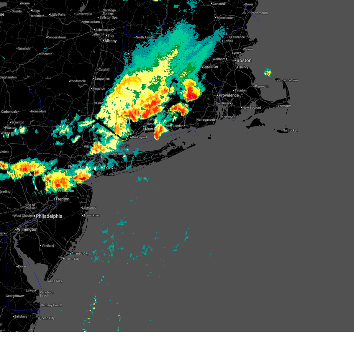
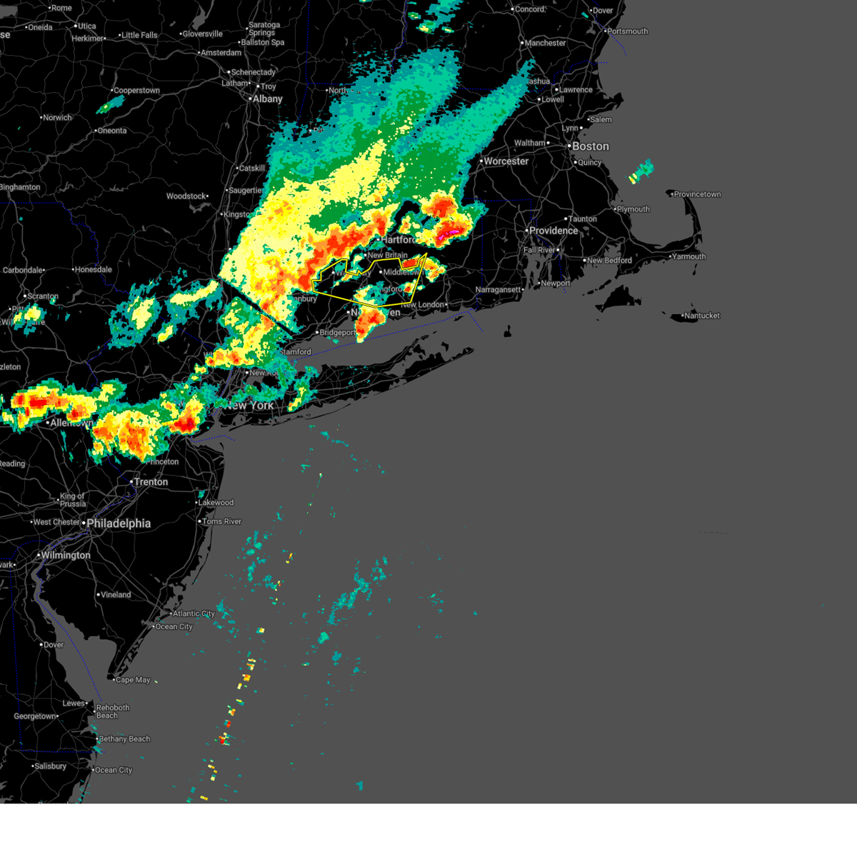
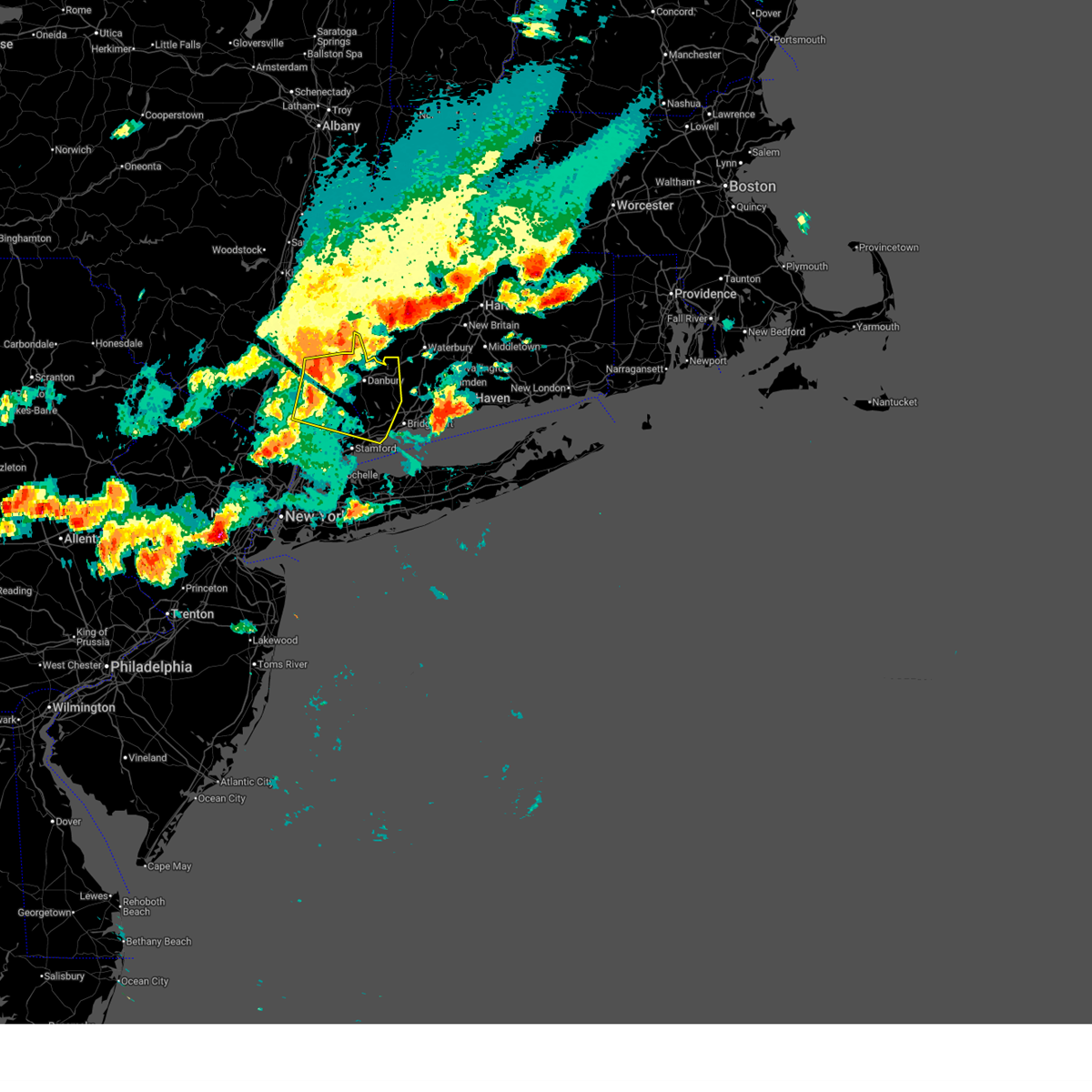
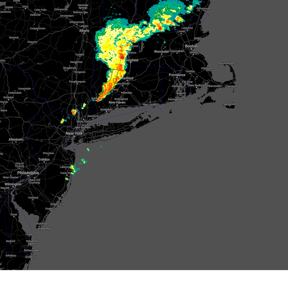
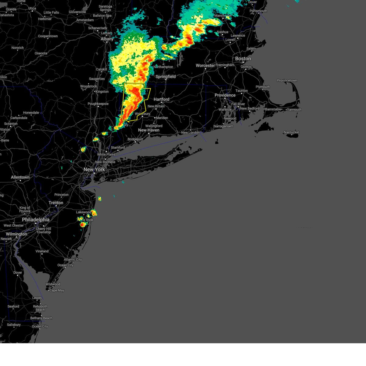
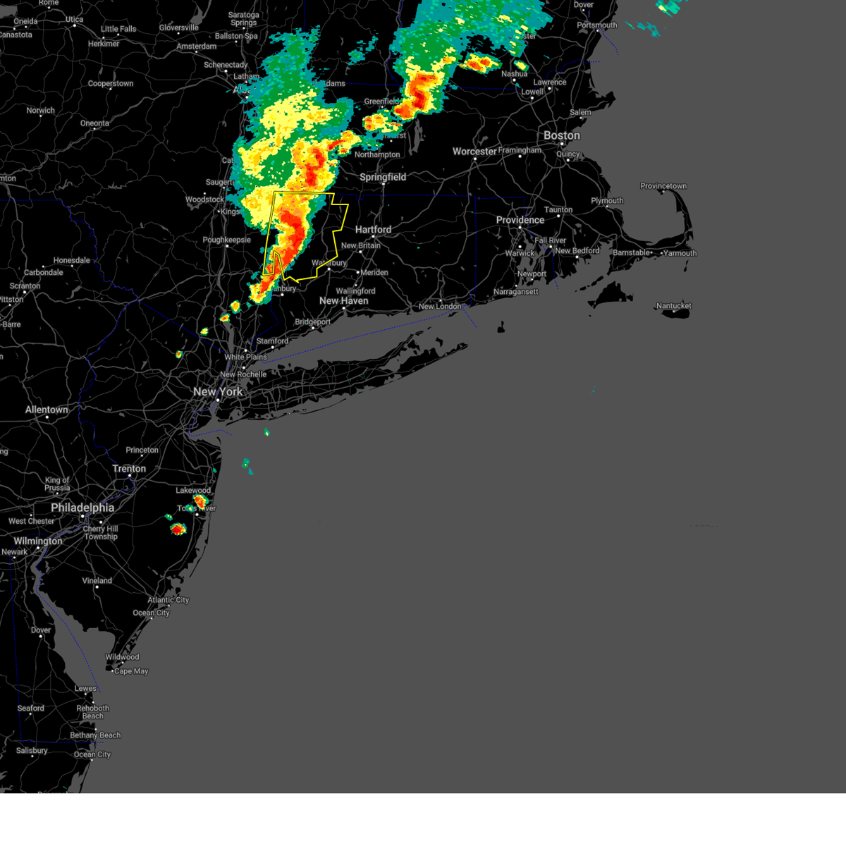
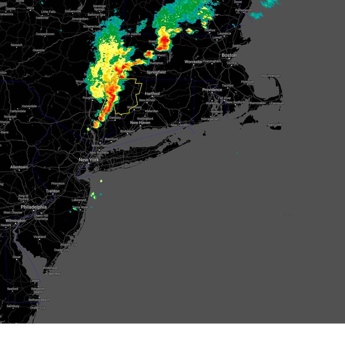
Hail Map for Heritage Village, CT
The Heritage Village, CT area has had 0 reports of on-the-ground hail by trained spotters, and has been under severe weather warnings 15 times during the past 12 months. Doppler radar has detected hail at or near Heritage Village, CT on 21 occasions, including 1 occasion during the past year.
| Name: | Heritage Village, CT |
| Where Located: | 67.5 miles NE of Brooklyn, NY |
| Map: | Google Map for Heritage Village, CT |
| Population: | 3736 |
| Housing Units: | 2881 |
| More Info: | Search Google for Heritage Village, CT |
0
The Top Recent Hail Date for Heritage Village, CT is Wednesday, July 17, 2024 (13th out of 21)

Hail and Wind Damage Spotted near Heritage Village, CT
| Date / Time | Report Details |
|---|---|
| 7/3/2025 6:31 PM EDT |
 the severe thunderstorm warning has been cancelled and is no longer in effect the severe thunderstorm warning has been cancelled and is no longer in effect
|
| 7/3/2025 6:31 PM EDT |
 At 631 pm edt, severe thunderstorms were located along a line extending from near new milford to bethel to near georgetown to near new canaan, moving southeast at 50 mph (radar indicated). Hazards include 60 mph wind gusts. Expect damage to trees and power lines. These severe storms will be near, norwalk and southbury around 635 pm edt. At 631 pm edt, severe thunderstorms were located along a line extending from near new milford to bethel to near georgetown to near new canaan, moving southeast at 50 mph (radar indicated). Hazards include 60 mph wind gusts. Expect damage to trees and power lines. These severe storms will be near, norwalk and southbury around 635 pm edt.
|
| 7/3/2025 6:24 PM EDT |
 Svrokx the national weather service in upton ny has issued a * severe thunderstorm warning for, northwestern new london county in southern connecticut, middlesex county in southern connecticut, central new haven county in southern connecticut, * until 715 pm edt. * at 624 pm edt, severe thunderstorms were located along a line extending from terryville to oakville to middlebury to near southbury, moving east at 40 mph (radar indicated). Hazards include 60 mph wind gusts and quarter size hail. Minor hail damage to vehicles is possible. expect wind damage to trees and power lines. severe thunderstorms will be near, waterbury and naugatuck around 630 pm edt. meriden and hamden around 635 pm edt. wallingford and north haven around 640 pm edt. middletown and north branford around 645 pm edt. guilford and durham around 650 pm edt. haddam and killingworth around 655 pm edt. east hampton around 700 pm edt. North madison around 705 pm edt. Svrokx the national weather service in upton ny has issued a * severe thunderstorm warning for, northwestern new london county in southern connecticut, middlesex county in southern connecticut, central new haven county in southern connecticut, * until 715 pm edt. * at 624 pm edt, severe thunderstorms were located along a line extending from terryville to oakville to middlebury to near southbury, moving east at 40 mph (radar indicated). Hazards include 60 mph wind gusts and quarter size hail. Minor hail damage to vehicles is possible. expect wind damage to trees and power lines. severe thunderstorms will be near, waterbury and naugatuck around 630 pm edt. meriden and hamden around 635 pm edt. wallingford and north haven around 640 pm edt. middletown and north branford around 645 pm edt. guilford and durham around 650 pm edt. haddam and killingworth around 655 pm edt. east hampton around 700 pm edt. North madison around 705 pm edt.
|
| 7/3/2025 6:05 PM EDT |
 Svrokx the national weather service in upton ny has issued a * severe thunderstorm warning for, fairfield county in southern connecticut, western new haven county in southern connecticut, northern westchester county in southeastern new york, putnam county in southeastern new york, * until 645 pm edt. * at 604 pm edt, severe thunderstorms were located along a line extending from near hopewell junction to 6 miles east of fishkill to near fahnestock state park to near yorktown heights, moving east at 55 mph (radar indicated). Hazards include 60 mph wind gusts and quarter size hail. Minor hail damage to vehicles is possible. expect wind damage to trees and power lines. severe thunderstorms will be near, mount kisco and mahopac around 610 pm edt. danbury and sherman around 615 pm edt. stamford and new canaan around 620 pm edt. norwalk and southbury around 625 pm edt. Fairfield and trumbull around 630 pm edt. Svrokx the national weather service in upton ny has issued a * severe thunderstorm warning for, fairfield county in southern connecticut, western new haven county in southern connecticut, northern westchester county in southeastern new york, putnam county in southeastern new york, * until 645 pm edt. * at 604 pm edt, severe thunderstorms were located along a line extending from near hopewell junction to 6 miles east of fishkill to near fahnestock state park to near yorktown heights, moving east at 55 mph (radar indicated). Hazards include 60 mph wind gusts and quarter size hail. Minor hail damage to vehicles is possible. expect wind damage to trees and power lines. severe thunderstorms will be near, mount kisco and mahopac around 610 pm edt. danbury and sherman around 615 pm edt. stamford and new canaan around 620 pm edt. norwalk and southbury around 625 pm edt. Fairfield and trumbull around 630 pm edt.
|
| 5/3/2025 3:52 PM EDT |
 At 352 pm edt, severe thunderstorms were located along a line extending from montgomery to near east granby to near middlebury, moving northeast at 55 mph (radar indicated). Hazards include 60 mph wind gusts. Expect damage to roofs, siding, and trees. Locations impacted include, hotchkissville, pequabuck, reynolds bridge, pomeraug, beech rock, harwinton, east litchfield, plymouth green, morris, delano field, bethlehem village, bethlehem, plymouth, pine meadow, sandy beach, northwest harwinton, east morris, horse heaven, watertown, and bakersville. At 352 pm edt, severe thunderstorms were located along a line extending from montgomery to near east granby to near middlebury, moving northeast at 55 mph (radar indicated). Hazards include 60 mph wind gusts. Expect damage to roofs, siding, and trees. Locations impacted include, hotchkissville, pequabuck, reynolds bridge, pomeraug, beech rock, harwinton, east litchfield, plymouth green, morris, delano field, bethlehem village, bethlehem, plymouth, pine meadow, sandy beach, northwest harwinton, east morris, horse heaven, watertown, and bakersville.
|
| 5/3/2025 3:33 PM EDT |
 the severe thunderstorm warning has been cancelled and is no longer in effect the severe thunderstorm warning has been cancelled and is no longer in effect
|
| 5/3/2025 3:33 PM EDT |
 At 332 pm edt, severe thunderstorms were located along a line extending from near sandisfield to near northwest harwinton to near bethel, moving east at 55 mph (radar indicated). Hazards include 60 mph wind gusts. Expect damage to roofs, siding, and trees. Locations impacted include, cornwall, west torrington, south canaan, haight vineyard, wrightville, marble dale, east litchfield, taconic, north kent, plymouth green, cornwall bridge pottery, delano field, dempsey landing, lime rock, litchfield green, hatch four corners, bethlehem, plymouth, newfield, and pine meadow. At 332 pm edt, severe thunderstorms were located along a line extending from near sandisfield to near northwest harwinton to near bethel, moving east at 55 mph (radar indicated). Hazards include 60 mph wind gusts. Expect damage to roofs, siding, and trees. Locations impacted include, cornwall, west torrington, south canaan, haight vineyard, wrightville, marble dale, east litchfield, taconic, north kent, plymouth green, cornwall bridge pottery, delano field, dempsey landing, lime rock, litchfield green, hatch four corners, bethlehem, plymouth, newfield, and pine meadow.
|
| 5/3/2025 3:16 PM EDT |
 At 316 pm edt, severe thunderstorms were located along a line extending from near canaan to near cornwall bridge to carmel, moving northeast at 55 mph (radar indicated). Hazards include 60 mph wind gusts. Expect damage to roofs, siding, and trees. Locations impacted include, south canaan, wrightville, salisbury, south amenia, east litchfield, plymouth green, bulls bridge, delano field, dempsey landing, litchfield green, hatch four corners, bethlehem, hammertown, gaylordsville station, wellsville, northwest harwinton, mcclaveville, horse heaven, carlsons grove, and winchester center. At 316 pm edt, severe thunderstorms were located along a line extending from near canaan to near cornwall bridge to carmel, moving northeast at 55 mph (radar indicated). Hazards include 60 mph wind gusts. Expect damage to roofs, siding, and trees. Locations impacted include, south canaan, wrightville, salisbury, south amenia, east litchfield, plymouth green, bulls bridge, delano field, dempsey landing, litchfield green, hatch four corners, bethlehem, hammertown, gaylordsville station, wellsville, northwest harwinton, mcclaveville, horse heaven, carlsons grove, and winchester center.
|
| 5/3/2025 3:05 PM EDT |
 Svraly the national weather service in albany has issued a * severe thunderstorm warning for, litchfield county in northern connecticut, eastern dutchess county in east central new york, * until 400 pm edt. * at 304 pm edt, severe thunderstorms were located along a line extending from near millerton to kent to near yorktown heights, moving northeast at 50 mph (radar indicated). Hazards include 60 mph wind gusts. expect damage to roofs, siding, and trees Svraly the national weather service in albany has issued a * severe thunderstorm warning for, litchfield county in northern connecticut, eastern dutchess county in east central new york, * until 400 pm edt. * at 304 pm edt, severe thunderstorms were located along a line extending from near millerton to kent to near yorktown heights, moving northeast at 50 mph (radar indicated). Hazards include 60 mph wind gusts. expect damage to roofs, siding, and trees
|
| 7/17/2024 9:48 PM EDT |
 the severe thunderstorm warning has been cancelled and is no longer in effect the severe thunderstorm warning has been cancelled and is no longer in effect
|
| 7/17/2024 9:16 PM EDT |
 Svrokx the national weather service in upton ny has issued a * severe thunderstorm warning for, central fairfield county in southern connecticut, central new haven county in southern connecticut, * until 1000 pm edt. * at 916 pm edt, a severe thunderstorm was located over newtown, moving northeast at 40 mph (radar indicated). Hazards include 60 mph wind gusts and quarter size hail. Minor hail damage to vehicles is possible. expect wind damage to trees and power lines. this severe thunderstorm will be near, shelton and southbury around 920 pm edt. naugatuck and seymour around 925 pm edt. bethany around 930 pm edt. waterbury and prospect around 935 pm edt. hamden and cheshire around 940 pm edt. Meriden and wallingford around 945 pm edt. Svrokx the national weather service in upton ny has issued a * severe thunderstorm warning for, central fairfield county in southern connecticut, central new haven county in southern connecticut, * until 1000 pm edt. * at 916 pm edt, a severe thunderstorm was located over newtown, moving northeast at 40 mph (radar indicated). Hazards include 60 mph wind gusts and quarter size hail. Minor hail damage to vehicles is possible. expect wind damage to trees and power lines. this severe thunderstorm will be near, shelton and southbury around 920 pm edt. naugatuck and seymour around 925 pm edt. bethany around 930 pm edt. waterbury and prospect around 935 pm edt. hamden and cheshire around 940 pm edt. Meriden and wallingford around 945 pm edt.
|
| 7/17/2024 5:06 PM EDT |
 The storms which prompted the warning have moved out of the area. therefore, the warning will be allowed to expire. a new severe thunderstorm warning has been issued. a severe thunderstorm watch remains in effect until 800 pm edt for southern connecticut, northeastern new jersey, and southeastern new york. The storms which prompted the warning have moved out of the area. therefore, the warning will be allowed to expire. a new severe thunderstorm warning has been issued. a severe thunderstorm watch remains in effect until 800 pm edt for southern connecticut, northeastern new jersey, and southeastern new york.
|
| 7/17/2024 4:53 PM EDT |
 the severe thunderstorm warning has been cancelled and is no longer in effect the severe thunderstorm warning has been cancelled and is no longer in effect
|
| 7/17/2024 4:53 PM EDT |
 At 452 pm edt, severe thunderstorms were located along a line extending from near danbury to near greenwich to bronxville, moving east at 25 mph (radar indicated). Hazards include 60 mph wind gusts. Expect damage to trees and power lines. these severe storms will be near, stamford and norwalk around 500 pm edt. monroe around 505 pm edt. southbury and westport around 510 pm edt. Fairfield and trumbull around 515 pm edt. At 452 pm edt, severe thunderstorms were located along a line extending from near danbury to near greenwich to bronxville, moving east at 25 mph (radar indicated). Hazards include 60 mph wind gusts. Expect damage to trees and power lines. these severe storms will be near, stamford and norwalk around 500 pm edt. monroe around 505 pm edt. southbury and westport around 510 pm edt. Fairfield and trumbull around 515 pm edt.
|
| 7/17/2024 4:33 PM EDT | Svrokx the national weather service in upton ny has issued a * severe thunderstorm warning for, fairfield county in southern connecticut, western new haven county in southern connecticut, east central bergen county in northeastern new jersey, westchester county in southeastern new york, eastern putnam county in southeastern new york, bronx county in southeastern new york, rockland county in southeastern new york, * until 515 pm edt. * at 432 pm edt, severe thunderstorms were located along a line extending from near brewster to near hawthorne to englewood, moving east at 25 mph (radar indicated). Hazards include 60 mph wind gusts. Expect damage to trees and power lines. severe thunderstorms will be near, yonkers and stamford around 435 pm edt. harrison and redding around 440 pm edt. new rochelle and new canaan around 445 pm edt. port chester around 450 pm edt. rye and newtown around 455 pm edt. Norwalk around 500 pm edt. |
| 6/30/2024 2:16 PM EDT |
 At 215 pm edt, a severe thunderstorm was located near seymour, or near naugatuck, moving east at 40 mph (radar indicated). Hazards include golf ball size hail and 60 mph wind gusts. People and animals outdoors will be injured. expect hail damage to roofs, siding, windows, and vehicles. expect wind damage to trees and power lines. this severe storm will be near, naugatuck and hamden around 220 pm edt. new haven and north haven around 225 pm edt. wallingford around 230 pm edt. north branford around 235 pm edt. guilford and branford around 240 pm edt. killingworth and north madison around 250 pm edt. clinton around 255 pm edt. Westbrook around 300 pm edt. At 215 pm edt, a severe thunderstorm was located near seymour, or near naugatuck, moving east at 40 mph (radar indicated). Hazards include golf ball size hail and 60 mph wind gusts. People and animals outdoors will be injured. expect hail damage to roofs, siding, windows, and vehicles. expect wind damage to trees and power lines. this severe storm will be near, naugatuck and hamden around 220 pm edt. new haven and north haven around 225 pm edt. wallingford around 230 pm edt. north branford around 235 pm edt. guilford and branford around 240 pm edt. killingworth and north madison around 250 pm edt. clinton around 255 pm edt. Westbrook around 300 pm edt.
|
| 6/30/2024 1:57 PM EDT |
 Svrokx the national weather service in upton ny has issued a * severe thunderstorm warning for, central fairfield county in southern connecticut, southern middlesex county in southern connecticut, new haven county in southern connecticut, * until 300 pm edt. * at 156 pm edt, a severe thunderstorm was located over brookfield, or near newtown, moving east at 40 mph (radar indicated). Hazards include 60 mph wind gusts and quarter size hail. Minor hail damage to vehicles is possible. expect wind damage to trees and power lines. this severe thunderstorm will be near, southbury and newtown around 200 pm edt. monroe and seymour around 210 pm edt. naugatuck and woodbridge around 215 pm edt. new haven and hamden around 225 pm edt. north haven around 230 pm edt. wallingford and branford around 235 pm edt. guilford around 240 pm edt. killingworth and north madison around 250 pm edt. Clinton around 255 pm edt. Svrokx the national weather service in upton ny has issued a * severe thunderstorm warning for, central fairfield county in southern connecticut, southern middlesex county in southern connecticut, new haven county in southern connecticut, * until 300 pm edt. * at 156 pm edt, a severe thunderstorm was located over brookfield, or near newtown, moving east at 40 mph (radar indicated). Hazards include 60 mph wind gusts and quarter size hail. Minor hail damage to vehicles is possible. expect wind damage to trees and power lines. this severe thunderstorm will be near, southbury and newtown around 200 pm edt. monroe and seymour around 210 pm edt. naugatuck and woodbridge around 215 pm edt. new haven and hamden around 225 pm edt. north haven around 230 pm edt. wallingford and branford around 235 pm edt. guilford around 240 pm edt. killingworth and north madison around 250 pm edt. Clinton around 255 pm edt.
|
| 6/26/2024 9:22 PM EDT | Power outage caused by fallen tree limb in new haven county CT, 3.4 miles NNE of Heritage Village, CT |
| 6/26/2024 9:07 PM EDT |
 Svrokx the national weather service in upton ny has issued a * severe thunderstorm warning for, fairfield county in southern connecticut, central middlesex county in southern connecticut, new haven county in southern connecticut, northern westchester county in southeastern new york, eastern putnam county in southeastern new york, * until 945 pm edt. * at 907 pm edt, severe thunderstorms were located along a line extending from near dover plains to near ridgefield to near darien, moving east at 45 mph (radar indicated). Hazards include 60 mph wind gusts. Expect damage to trees and power lines. severe thunderstorms will be near, stamford and norwalk around 910 pm edt. southbury and fairfield around 915 pm edt. bridgeport and shelton around 920 pm edt. stratford and seymour around 925 pm edt. milford and naugatuck around 930 pm edt. new haven and waterbury around 935 pm edt. Prospect around 940 pm edt. Svrokx the national weather service in upton ny has issued a * severe thunderstorm warning for, fairfield county in southern connecticut, central middlesex county in southern connecticut, new haven county in southern connecticut, northern westchester county in southeastern new york, eastern putnam county in southeastern new york, * until 945 pm edt. * at 907 pm edt, severe thunderstorms were located along a line extending from near dover plains to near ridgefield to near darien, moving east at 45 mph (radar indicated). Hazards include 60 mph wind gusts. Expect damage to trees and power lines. severe thunderstorms will be near, stamford and norwalk around 910 pm edt. southbury and fairfield around 915 pm edt. bridgeport and shelton around 920 pm edt. stratford and seymour around 925 pm edt. milford and naugatuck around 930 pm edt. new haven and waterbury around 935 pm edt. Prospect around 940 pm edt.
|
| 6/23/2024 8:08 PM EDT |
 At 807 pm edt, severe thunderstorms were located along a line extending from wolcott to near hamden, moving east at 55 mph (radar indicated. widespread wind damage has also been reported). Hazards include 60 mph wind gusts. Expect damage to trees and power lines. these severe storms will be near, waterbury and meriden around 810 pm edt. middletown and guilford around 815 pm edt. Cromwell and portland around 820 pm edt. At 807 pm edt, severe thunderstorms were located along a line extending from wolcott to near hamden, moving east at 55 mph (radar indicated. widespread wind damage has also been reported). Hazards include 60 mph wind gusts. Expect damage to trees and power lines. these severe storms will be near, waterbury and meriden around 810 pm edt. middletown and guilford around 815 pm edt. Cromwell and portland around 820 pm edt.
|
| 6/23/2024 8:08 PM EDT |
 the severe thunderstorm warning has been cancelled and is no longer in effect the severe thunderstorm warning has been cancelled and is no longer in effect
|
| 6/23/2024 7:57 PM EDT |
 At 756 pm edt, severe thunderstorms were located along a line extending from near middlebury to near derby, moving east at 55 mph (radar indicated). Hazards include 60 mph wind gusts. Expect damage to trees and power lines. these severe storms will be near, new haven and waterbury around 800 pm edt. wallingford and north haven around 805 pm edt. meriden and north branford around 810 pm edt. middletown and guilford around 815 pm edt. portland and haddam around 820 pm edt. Lake pocotopaug--east hampton around 825 pm edt. At 756 pm edt, severe thunderstorms were located along a line extending from near middlebury to near derby, moving east at 55 mph (radar indicated). Hazards include 60 mph wind gusts. Expect damage to trees and power lines. these severe storms will be near, new haven and waterbury around 800 pm edt. wallingford and north haven around 805 pm edt. meriden and north branford around 810 pm edt. middletown and guilford around 815 pm edt. portland and haddam around 820 pm edt. Lake pocotopaug--east hampton around 825 pm edt.
|
| 6/23/2024 7:40 PM EDT |
 Svrokx the national weather service in upton ny has issued a * severe thunderstorm warning for, central fairfield county in southern connecticut, northern middlesex county in southern connecticut, new haven county in southern connecticut, * until 830 pm edt. * at 740 pm edt, severe thunderstorms were located along a line extending from new milford to near redding, moving east at 55 mph (radar indicated). Hazards include 60 mph wind gusts. Expect damage to trees and power lines. severe thunderstorms will be near, southbury and newtown around 745 pm edt. shelton and trumbull around 750 pm edt. waterbury and naugatuck around 755 pm edt. new haven and hamden around 800 pm edt. meriden and wallingford around 805 pm edt. north branford around 810 pm edt. middletown and guilford around 815 pm edt. Portland and haddam around 820 pm edt. Svrokx the national weather service in upton ny has issued a * severe thunderstorm warning for, central fairfield county in southern connecticut, northern middlesex county in southern connecticut, new haven county in southern connecticut, * until 830 pm edt. * at 740 pm edt, severe thunderstorms were located along a line extending from new milford to near redding, moving east at 55 mph (radar indicated). Hazards include 60 mph wind gusts. Expect damage to trees and power lines. severe thunderstorms will be near, southbury and newtown around 745 pm edt. shelton and trumbull around 750 pm edt. waterbury and naugatuck around 755 pm edt. new haven and hamden around 800 pm edt. meriden and wallingford around 805 pm edt. north branford around 810 pm edt. middletown and guilford around 815 pm edt. Portland and haddam around 820 pm edt.
|
| 6/22/2024 7:26 PM EDT |
 the severe thunderstorm warning has been cancelled and is no longer in effect the severe thunderstorm warning has been cancelled and is no longer in effect
|
| 6/22/2024 7:15 PM EDT |
 At 715 pm edt, a severe thunderstorm was located over newtown, moving southeast at 20 mph (radar indicated). Hazards include ping pong ball size hail and 60 mph wind gusts. People and animals outdoors will be injured. expect hail damage to roofs, siding, windows, and vehicles. expect wind damage to trees and power lines. this severe storm will be near, shelton and southbury around 720 pm edt. seymour around 725 pm edt. Derby around 730 pm edt. At 715 pm edt, a severe thunderstorm was located over newtown, moving southeast at 20 mph (radar indicated). Hazards include ping pong ball size hail and 60 mph wind gusts. People and animals outdoors will be injured. expect hail damage to roofs, siding, windows, and vehicles. expect wind damage to trees and power lines. this severe storm will be near, shelton and southbury around 720 pm edt. seymour around 725 pm edt. Derby around 730 pm edt.
|
| 6/22/2024 7:01 PM EDT |
 Svrokx the national weather service in upton ny has issued a * severe thunderstorm warning for, central fairfield county in southern connecticut, west central new haven county in southern connecticut, * until 745 pm edt. * at 700 pm edt, a severe thunderstorm was located over newtown, moving southeast at 20 mph (radar indicated). Hazards include 60 mph wind gusts and penny size hail. Expect damage to trees and power lines. this severe thunderstorm will be near, southbury and newtown around 705 pm edt. monroe around 715 pm edt. shelton around 720 pm edt. seymour around 725 pm edt. Derby around 730 pm edt. Svrokx the national weather service in upton ny has issued a * severe thunderstorm warning for, central fairfield county in southern connecticut, west central new haven county in southern connecticut, * until 745 pm edt. * at 700 pm edt, a severe thunderstorm was located over newtown, moving southeast at 20 mph (radar indicated). Hazards include 60 mph wind gusts and penny size hail. Expect damage to trees and power lines. this severe thunderstorm will be near, southbury and newtown around 705 pm edt. monroe around 715 pm edt. shelton around 720 pm edt. seymour around 725 pm edt. Derby around 730 pm edt.
|
| 6/22/2024 5:18 PM EDT | Downed tree on sachem r in new haven county CT, 4.5 miles E of Heritage Village, CT |
| 5/23/2024 10:40 AM EDT |
 The storms which prompted the warning have exited and weakened below severe limits. therefore, the warning will be allowed to expire. The storms which prompted the warning have exited and weakened below severe limits. therefore, the warning will be allowed to expire.
|
| 5/23/2024 9:54 AM EDT |
 Svrokx the national weather service in upton ny has issued a * severe thunderstorm warning for, fairfield county in southern connecticut, west central new haven county in southern connecticut, hudson county in northeastern new jersey, eastern bergen county in northeastern new jersey, eastern putnam county in southeastern new york, queens county in southeastern new york, bronx county in southeastern new york, richmond county in southeastern new york, kings county in southeastern new york, rockland county in southeastern new york, westchester county in southeastern new york, west central suffolk county in southeastern new york, new york (manhattan) county in southeastern new york, nassau county in southeastern new york, * until 1045 am edt. * at 954 am edt, severe thunderstorms were located along a line extending from yorktown heights to yonkers to park slope, moving east at 55 mph (radar indicated). Hazards include 60 mph wind gusts. Expect damage to trees and power lines. severe thunderstorms will be near, jamaica and new rochelle around 1000 am edt. stamford and danbury around 1005 am edt. garden city and mineola around 1010 am edt. norwalk and syosset around 1015 am edt. levittown and huntington station around 1020 am edt. bridgeport and shelton around 1025 am edt. commack and deer park around 1030 am edt. Naugatuck and middlebury around 1035 am edt. Svrokx the national weather service in upton ny has issued a * severe thunderstorm warning for, fairfield county in southern connecticut, west central new haven county in southern connecticut, hudson county in northeastern new jersey, eastern bergen county in northeastern new jersey, eastern putnam county in southeastern new york, queens county in southeastern new york, bronx county in southeastern new york, richmond county in southeastern new york, kings county in southeastern new york, rockland county in southeastern new york, westchester county in southeastern new york, west central suffolk county in southeastern new york, new york (manhattan) county in southeastern new york, nassau county in southeastern new york, * until 1045 am edt. * at 954 am edt, severe thunderstorms were located along a line extending from yorktown heights to yonkers to park slope, moving east at 55 mph (radar indicated). Hazards include 60 mph wind gusts. Expect damage to trees and power lines. severe thunderstorms will be near, jamaica and new rochelle around 1000 am edt. stamford and danbury around 1005 am edt. garden city and mineola around 1010 am edt. norwalk and syosset around 1015 am edt. levittown and huntington station around 1020 am edt. bridgeport and shelton around 1025 am edt. commack and deer park around 1030 am edt. Naugatuck and middlebury around 1035 am edt.
|
| 5/23/2024 9:12 AM EDT |
 The storm which prompted the warning has weakened below severe limits, and no longer poses an immediate threat to life or property. therefore, the warning will be allowed to expire. however, small hail, gusty winds and heavy rain are still possible with this thunderstorm. The storm which prompted the warning has weakened below severe limits, and no longer poses an immediate threat to life or property. therefore, the warning will be allowed to expire. however, small hail, gusty winds and heavy rain are still possible with this thunderstorm.
|
| 5/23/2024 8:39 AM EDT |
 Svrokx the national weather service in upton ny has issued a * severe thunderstorm warning for, central fairfield county in southern connecticut, new haven county in southern connecticut, eastern putnam county in southeastern new york, * until 915 am edt. * at 839 am edt, a severe thunderstorm was located over brookfield, or near newtown, moving northeast at 30 mph (radar indicated). Hazards include 60 mph wind gusts and quarter size hail. Minor hail damage to vehicles is possible. expect wind damage to trees and power lines. this severe thunderstorm will be near, southbury and newtown around 845 am edt. middlebury around 850 am edt. Waterbury and naugatuck around 900 am edt. Svrokx the national weather service in upton ny has issued a * severe thunderstorm warning for, central fairfield county in southern connecticut, new haven county in southern connecticut, eastern putnam county in southeastern new york, * until 915 am edt. * at 839 am edt, a severe thunderstorm was located over brookfield, or near newtown, moving northeast at 30 mph (radar indicated). Hazards include 60 mph wind gusts and quarter size hail. Minor hail damage to vehicles is possible. expect wind damage to trees and power lines. this severe thunderstorm will be near, southbury and newtown around 845 am edt. middlebury around 850 am edt. Waterbury and naugatuck around 900 am edt.
|
| 9/8/2023 5:17 PM EDT | Limbs and wires dow in fairfield county CT, 4.4 miles N of Heritage Village, CT |
| 9/8/2023 4:13 PM EDT |
 At 413 pm edt, a severe thunderstorm was located over brewster, moving east at 40 mph (radar indicated). Hazards include 60 mph wind gusts and quarter size hail. Minor hail damage to vehicles is possible. expect wind damage to trees and power lines. this severe thunderstorm will be near, danbury and ridgefield around 420 pm edt. bethel and brookfield around 425 pm edt. newtown around 430 pm edt. southbury around 435 pm edt. middlebury around 445 pm edt. waterbury and naugatuck around 450 pm edt. hail threat, radar indicated max hail size, 1. 00 in wind threat, radar indicated max wind gust, 60 mph. At 413 pm edt, a severe thunderstorm was located over brewster, moving east at 40 mph (radar indicated). Hazards include 60 mph wind gusts and quarter size hail. Minor hail damage to vehicles is possible. expect wind damage to trees and power lines. this severe thunderstorm will be near, danbury and ridgefield around 420 pm edt. bethel and brookfield around 425 pm edt. newtown around 430 pm edt. southbury around 435 pm edt. middlebury around 445 pm edt. waterbury and naugatuck around 450 pm edt. hail threat, radar indicated max hail size, 1. 00 in wind threat, radar indicated max wind gust, 60 mph.
|
| 8/12/2023 9:10 PM EDT | Tree down on vehicle on west purchase roa in new haven county CT, 4 miles E of Heritage Village, CT |
| 8/12/2023 9:10 PM EDT |
 The severe thunderstorm warning for central fairfield, northwestern new haven, northern westchester and eastern putnam counties will expire at 915 pm edt, the storm which prompted the warning has moved out of the area. therefore, the warning will be allowed to expire. however, gusty winds are still possible with this thunderstorm. a severe thunderstorm watch remains in effect until midnight edt for southern connecticut, and southeastern new york. remember, a severe thunderstorm warning still remains in effect for fairfield and new haven counties. The severe thunderstorm warning for central fairfield, northwestern new haven, northern westchester and eastern putnam counties will expire at 915 pm edt, the storm which prompted the warning has moved out of the area. therefore, the warning will be allowed to expire. however, gusty winds are still possible with this thunderstorm. a severe thunderstorm watch remains in effect until midnight edt for southern connecticut, and southeastern new york. remember, a severe thunderstorm warning still remains in effect for fairfield and new haven counties.
|
| 8/12/2023 9:09 PM EDT |
 At 909 pm edt, a severe thunderstorm was located near newtown, moving east at 40 mph (radar indicated). Hazards include 60 mph wind gusts and penny size hail. expect damage to trees and power lines At 909 pm edt, a severe thunderstorm was located near newtown, moving east at 40 mph (radar indicated). Hazards include 60 mph wind gusts and penny size hail. expect damage to trees and power lines
|
| 8/12/2023 8:57 PM EDT |
 At 857 pm edt, a severe thunderstorm was located over newtown, moving east at 45 mph (radar indicated). Hazards include 60 mph wind gusts and quarter size hail. Minor hail damage to vehicles is possible. expect wind damage to trees and power lines. locations impacted include, danbury, southbury, mahopac, lake carmel, sherman, brewster, newtown, ridgefield, monroe, bethel, wilton, brookfield, new fairfield, weston, and redding. hail threat, radar indicated max hail size, 1. 00 in wind threat, radar indicated max wind gust, 60 mph. At 857 pm edt, a severe thunderstorm was located over newtown, moving east at 45 mph (radar indicated). Hazards include 60 mph wind gusts and quarter size hail. Minor hail damage to vehicles is possible. expect wind damage to trees and power lines. locations impacted include, danbury, southbury, mahopac, lake carmel, sherman, brewster, newtown, ridgefield, monroe, bethel, wilton, brookfield, new fairfield, weston, and redding. hail threat, radar indicated max hail size, 1. 00 in wind threat, radar indicated max wind gust, 60 mph.
|
| 8/12/2023 8:35 PM EDT |
 At 835 pm edt, a severe thunderstorm was located over lake carmel, moving east at 45 mph (radar indicated). Hazards include 60 mph wind gusts and quarter size hail. Minor hail damage to vehicles is possible. Expect wind damage to trees and power lines. At 835 pm edt, a severe thunderstorm was located over lake carmel, moving east at 45 mph (radar indicated). Hazards include 60 mph wind gusts and quarter size hail. Minor hail damage to vehicles is possible. Expect wind damage to trees and power lines.
|
| 7/27/2023 6:07 PM EDT |
 At 607 pm edt, severe thunderstorms were located along a line extending from thomaston to woodbury center to near bethel, moving east at 45 mph (radar indicated). Hazards include 60 mph wind gusts. Expect damage to trees and power lines. these severe storms will be near, waterbury and naugatuck around 610 pm edt. shelton and trumbull around 615 pm edt. meriden and wallingford around 620 pm edt. middletown and north haven around 625 pm edt. hail threat, radar indicated max hail size, <. 75 in wind threat, radar indicated max wind gust, 60 mph. At 607 pm edt, severe thunderstorms were located along a line extending from thomaston to woodbury center to near bethel, moving east at 45 mph (radar indicated). Hazards include 60 mph wind gusts. Expect damage to trees and power lines. these severe storms will be near, waterbury and naugatuck around 610 pm edt. shelton and trumbull around 615 pm edt. meriden and wallingford around 620 pm edt. middletown and north haven around 625 pm edt. hail threat, radar indicated max hail size, <. 75 in wind threat, radar indicated max wind gust, 60 mph.
|
| 7/27/2023 5:34 PM EDT |
 At 534 pm edt, severe thunderstorms were located along a line extending from near dover plains to near wingdale to near fahnestock state park, moving east at 45 mph (radar indicated). Hazards include 60 mph wind gusts and penny size hail. Expect damage to trees and power lines. severe thunderstorms will be near, lake carmel and sherman around 540 pm edt. brewster and new fairfield around 545 pm edt. danbury and brookfield around 550 pm edt. southbury and newtown around 555 pm edt. middlebury around 600 pm edt. waterbury and wolcott around 605 pm edt. hail threat, radar indicated max hail size, 0. 75 in wind threat, radar indicated max wind gust, 60 mph. At 534 pm edt, severe thunderstorms were located along a line extending from near dover plains to near wingdale to near fahnestock state park, moving east at 45 mph (radar indicated). Hazards include 60 mph wind gusts and penny size hail. Expect damage to trees and power lines. severe thunderstorms will be near, lake carmel and sherman around 540 pm edt. brewster and new fairfield around 545 pm edt. danbury and brookfield around 550 pm edt. southbury and newtown around 555 pm edt. middlebury around 600 pm edt. waterbury and wolcott around 605 pm edt. hail threat, radar indicated max hail size, 0. 75 in wind threat, radar indicated max wind gust, 60 mph.
|
| 7/21/2022 2:39 PM EDT |
 The severe thunderstorm warning for central fairfield, northwestern new haven, northern westchester and eastern putnam counties will expire at 245 pm edt, the storm which prompted the warning has moved out of the area. therefore, the warning will be allowed to expire. a severe thunderstorm watch remains in effect until 800 pm edt for southern connecticut, and southeastern new york. The severe thunderstorm warning for central fairfield, northwestern new haven, northern westchester and eastern putnam counties will expire at 245 pm edt, the storm which prompted the warning has moved out of the area. therefore, the warning will be allowed to expire. a severe thunderstorm watch remains in effect until 800 pm edt for southern connecticut, and southeastern new york.
|
| 7/21/2022 2:34 PM EDT |
 At 234 pm edt, a severe thunderstorm was located over middlebury, or near waterbury, moving northeast at 30 mph (radar indicated). Hazards include 60 mph wind gusts and quarter size hail. Minor hail damage to vehicles is possible. expect wind damage to trees and power lines. this severe thunderstorm will be near, prospect around 240 pm edt. waterbury and cheshire around 245 pm edt. wolcott around 250 pm edt. meriden around 300 pm edt. hail threat, radar indicated max hail size, 1. 00 in wind threat, radar indicated max wind gust, 60 mph. At 234 pm edt, a severe thunderstorm was located over middlebury, or near waterbury, moving northeast at 30 mph (radar indicated). Hazards include 60 mph wind gusts and quarter size hail. Minor hail damage to vehicles is possible. expect wind damage to trees and power lines. this severe thunderstorm will be near, prospect around 240 pm edt. waterbury and cheshire around 245 pm edt. wolcott around 250 pm edt. meriden around 300 pm edt. hail threat, radar indicated max hail size, 1. 00 in wind threat, radar indicated max wind gust, 60 mph.
|
| 7/21/2022 1:59 PM EDT |
 At 158 pm edt, a severe thunderstorm was located over ridgefield, or near danbury, moving northeast at 30 mph (radar indicated). Hazards include 60 mph wind gusts and quarter size hail. Minor hail damage to vehicles is possible. expect wind damage to trees and power lines. this severe thunderstorm will be near, redding around 210 pm edt. danbury and bethel around 215 pm edt. newtown around 220 pm edt. southbury around 230 pm edt. middlebury around 240 pm edt. hail threat, radar indicated max hail size, 1. 00 in wind threat, radar indicated max wind gust, 60 mph. At 158 pm edt, a severe thunderstorm was located over ridgefield, or near danbury, moving northeast at 30 mph (radar indicated). Hazards include 60 mph wind gusts and quarter size hail. Minor hail damage to vehicles is possible. expect wind damage to trees and power lines. this severe thunderstorm will be near, redding around 210 pm edt. danbury and bethel around 215 pm edt. newtown around 220 pm edt. southbury around 230 pm edt. middlebury around 240 pm edt. hail threat, radar indicated max hail size, 1. 00 in wind threat, radar indicated max wind gust, 60 mph.
|
| 7/2/2022 6:00 PM EDT |
 At 559 pm edt, a severe thunderstorm was located near pawling, moving east at 35 mph (radar indicated). Hazards include 60 mph wind gusts and quarter size hail. Minor hail damage to vehicles is possible. expect wind damage to trees and power lines. this severe thunderstorm will be near, new fairfield around 605 pm edt. danbury and brookfield around 615 pm edt. newtown and bethel around 620 pm edt. redding around 625 pm edt. monroe around 635 pm edt. shelton and trumbull around 640 pm edt. seymour and derby around 645 pm edt. milford and stratford around 650 pm edt. orange around 655 pm edt. new haven around 700 pm edt. hail threat, radar indicated max hail size, 1. 00 in wind threat, radar indicated max wind gust, 60 mph. At 559 pm edt, a severe thunderstorm was located near pawling, moving east at 35 mph (radar indicated). Hazards include 60 mph wind gusts and quarter size hail. Minor hail damage to vehicles is possible. expect wind damage to trees and power lines. this severe thunderstorm will be near, new fairfield around 605 pm edt. danbury and brookfield around 615 pm edt. newtown and bethel around 620 pm edt. redding around 625 pm edt. monroe around 635 pm edt. shelton and trumbull around 640 pm edt. seymour and derby around 645 pm edt. milford and stratford around 650 pm edt. orange around 655 pm edt. new haven around 700 pm edt. hail threat, radar indicated max hail size, 1. 00 in wind threat, radar indicated max wind gust, 60 mph.
|
| 5/16/2022 5:47 PM EDT |
 At 547 pm edt, a severe thunderstorm was located over woodbury center, or near southbury, moving northeast at 45 mph (radar indicated). Hazards include 60 mph wind gusts and penny size hail. Expect damage to trees and power lines. this severe storm will be near, naugatuck and prospect around 555 pm edt. waterbury and cheshire around 600 pm edt. wolcott around 605 pm edt. hail threat, radar indicated max hail size, 0. 75 in wind threat, radar indicated max wind gust, 60 mph. At 547 pm edt, a severe thunderstorm was located over woodbury center, or near southbury, moving northeast at 45 mph (radar indicated). Hazards include 60 mph wind gusts and penny size hail. Expect damage to trees and power lines. this severe storm will be near, naugatuck and prospect around 555 pm edt. waterbury and cheshire around 600 pm edt. wolcott around 605 pm edt. hail threat, radar indicated max hail size, 0. 75 in wind threat, radar indicated max wind gust, 60 mph.
|
| 5/16/2022 5:27 PM EDT |
 At 526 pm edt, a severe thunderstorm was located over danbury, moving northeast at 45 mph (radar indicated). Hazards include 60 mph wind gusts and penny size hail. Expect damage to trees and power lines. this severe thunderstorm will be near, brookfield around 530 pm edt. newtown around 535 pm edt. southbury around 550 pm edt. naugatuck and prospect around 555 pm edt. waterbury and wolcott around 600 pm edt. hail threat, radar indicated max hail size, 0. 75 in wind threat, radar indicated max wind gust, 60 mph. At 526 pm edt, a severe thunderstorm was located over danbury, moving northeast at 45 mph (radar indicated). Hazards include 60 mph wind gusts and penny size hail. Expect damage to trees and power lines. this severe thunderstorm will be near, brookfield around 530 pm edt. newtown around 535 pm edt. southbury around 550 pm edt. naugatuck and prospect around 555 pm edt. waterbury and wolcott around 600 pm edt. hail threat, radar indicated max hail size, 0. 75 in wind threat, radar indicated max wind gust, 60 mph.
|
| 10/16/2021 6:21 PM EDT |
 At 621 pm edt, severe thunderstorms were located along a line extending from new milford to near georgetown, moving northeast at 35 mph (radar indicated). Hazards include 60 mph wind gusts. Expect damage to trees and power lines. these severe storms will be near, brookfield around 625 pm edt. trumbull around 645 pm edt. monroe around 650 pm edt. southbury around 700 pm edt. hail threat, radar indicated max hail size, <. 75 in wind threat, radar indicated max wind gust, 60 mph. At 621 pm edt, severe thunderstorms were located along a line extending from new milford to near georgetown, moving northeast at 35 mph (radar indicated). Hazards include 60 mph wind gusts. Expect damage to trees and power lines. these severe storms will be near, brookfield around 625 pm edt. trumbull around 645 pm edt. monroe around 650 pm edt. southbury around 700 pm edt. hail threat, radar indicated max hail size, <. 75 in wind threat, radar indicated max wind gust, 60 mph.
|
| 10/16/2021 5:54 PM EDT |
 At 553 pm edt, severe thunderstorms were located along a line extending from near lake carmel to harrison, moving northeast at 40 mph (radar indicated). Hazards include 60 mph wind gusts. Expect damage to trees and power lines. severe thunderstorms will be near, lake carmel around 600 pm edt. new fairfield and bedford around 605 pm edt. stamford and darien around 610 pm edt. sherman around 615 pm edt. norwalk and new canaan around 620 pm edt. wilton and georgetown around 625 pm edt. westport and weston around 630 pm edt. fairfield around 635 pm edt. trumbull and monroe around 645 pm edt. hail threat, radar indicated max hail size, <. 75 in wind threat, radar indicated max wind gust, 60 mph. At 553 pm edt, severe thunderstorms were located along a line extending from near lake carmel to harrison, moving northeast at 40 mph (radar indicated). Hazards include 60 mph wind gusts. Expect damage to trees and power lines. severe thunderstorms will be near, lake carmel around 600 pm edt. new fairfield and bedford around 605 pm edt. stamford and darien around 610 pm edt. sherman around 615 pm edt. norwalk and new canaan around 620 pm edt. wilton and georgetown around 625 pm edt. westport and weston around 630 pm edt. fairfield around 635 pm edt. trumbull and monroe around 645 pm edt. hail threat, radar indicated max hail size, <. 75 in wind threat, radar indicated max wind gust, 60 mph.
|
| 7/27/2021 7:35 PM EDT |
 At 735 pm edt, a severe thunderstorm was located over ridgefield, or 7 miles south of danbury, moving east at 25 mph (radar indicated). Hazards include 60 mph wind gusts and quarter size hail. Minor hail damage to vehicles is possible. expect wind damage to trees and power lines. this severe thunderstorm will be near, wilton and georgetown around 740 pm edt. weston around 750 pm edt. bethel and redding around 755 pm edt. trumbull around 810 pm edt. Shelton and monroe around 815 pm edt. At 735 pm edt, a severe thunderstorm was located over ridgefield, or 7 miles south of danbury, moving east at 25 mph (radar indicated). Hazards include 60 mph wind gusts and quarter size hail. Minor hail damage to vehicles is possible. expect wind damage to trees and power lines. this severe thunderstorm will be near, wilton and georgetown around 740 pm edt. weston around 750 pm edt. bethel and redding around 755 pm edt. trumbull around 810 pm edt. Shelton and monroe around 815 pm edt.
|
| 7/8/2021 2:40 PM EDT |
 The severe thunderstorm warning for central fairfield and northwestern new haven counties will expire at 245 pm edt, the storm which prompted the warning has weakened below severe limits, and no longer poses an immediate threat to life or property. therefore, the warning will be allowed to expire. however wind gusts in excess of 40 mph, pea size hail, and heavy rain are still possible with this thunderstorm as it moves east through northern new haven county. a severe thunderstorm watch remains in effect until 900 pm edt for southern connecticut, and southeastern new york. to report severe weather, contact your nearest law enforcement agency. they will relay your report to the national weather service upton ny. The severe thunderstorm warning for central fairfield and northwestern new haven counties will expire at 245 pm edt, the storm which prompted the warning has weakened below severe limits, and no longer poses an immediate threat to life or property. therefore, the warning will be allowed to expire. however wind gusts in excess of 40 mph, pea size hail, and heavy rain are still possible with this thunderstorm as it moves east through northern new haven county. a severe thunderstorm watch remains in effect until 900 pm edt for southern connecticut, and southeastern new york. to report severe weather, contact your nearest law enforcement agency. they will relay your report to the national weather service upton ny.
|
| 7/8/2021 2:00 PM EDT |
 At 159 pm edt, a severe thunderstorm was located over danbury, moving east at 15 mph (radar indicated). Hazards include 60 mph wind gusts and penny size hail. Expect damage to trees and power lines. this severe thunderstorm will be near, brookfield around 205 pm edt. bethel around 210 pm edt. redding around 220 pm edt. newtown around 225 pm edt. Shelton and southbury around 245 pm edt. At 159 pm edt, a severe thunderstorm was located over danbury, moving east at 15 mph (radar indicated). Hazards include 60 mph wind gusts and penny size hail. Expect damage to trees and power lines. this severe thunderstorm will be near, brookfield around 205 pm edt. bethel around 210 pm edt. redding around 220 pm edt. newtown around 225 pm edt. Shelton and southbury around 245 pm edt.
|
| 6/30/2021 7:52 PM EDT |
 At 751 pm edt, a severe thunderstorm was located over southbury, moving east at 40 mph (radar indicated). Hazards include 60 mph wind gusts and penny size hail. Expect damage to trees and power lines. this severe thunderstorm will be near, naugatuck and middlebury around 805 pm edt. prospect and beacon falls around 810 pm edt. hamden and cheshire around 815 pm edt. wallingford around 825 pm edt. Meriden and durham around 830 pm edt. At 751 pm edt, a severe thunderstorm was located over southbury, moving east at 40 mph (radar indicated). Hazards include 60 mph wind gusts and penny size hail. Expect damage to trees and power lines. this severe thunderstorm will be near, naugatuck and middlebury around 805 pm edt. prospect and beacon falls around 810 pm edt. hamden and cheshire around 815 pm edt. wallingford around 825 pm edt. Meriden and durham around 830 pm edt.
|
| 4/21/2021 3:51 PM EDT |
 The severe thunderstorm warning for southern fairfield, new haven and northern middlesex counties will expire at 400 pm edt, the storms which prompted the warning have weakened below severe limits, and no longer pose an immediate threat to life or property. therefore, the warning will be allowed to expire. however gusty winds are still possible with these thunderstorms. The severe thunderstorm warning for southern fairfield, new haven and northern middlesex counties will expire at 400 pm edt, the storms which prompted the warning have weakened below severe limits, and no longer pose an immediate threat to life or property. therefore, the warning will be allowed to expire. however gusty winds are still possible with these thunderstorms.
|
| 4/21/2021 3:28 PM EDT |
 At 327 pm edt, severe thunderstorms were located along a line extending from oakville to 7 miles south of westport, moving east at 40 mph (radar indicated). Hazards include 60 mph wind gusts and penny size hail. Expect damage to trees and power lines. Locations impacted include, bridgeport, new haven, waterbury, meriden, milford, middletown, wallingford, shelton, naugatuck, guilford, southbury, wolcott, durham, newtown and fairfield. At 327 pm edt, severe thunderstorms were located along a line extending from oakville to 7 miles south of westport, moving east at 40 mph (radar indicated). Hazards include 60 mph wind gusts and penny size hail. Expect damage to trees and power lines. Locations impacted include, bridgeport, new haven, waterbury, meriden, milford, middletown, wallingford, shelton, naugatuck, guilford, southbury, wolcott, durham, newtown and fairfield.
|
| 4/21/2021 2:53 PM EDT |
 At 253 pm edt, severe thunderstorms were located along a line extending from gaylordsville to port washington, moving east at 40 mph (radar indicated). Hazards include 60 mph wind gusts and penny size hail. expect damage to trees and power lines At 253 pm edt, severe thunderstorms were located along a line extending from gaylordsville to port washington, moving east at 40 mph (radar indicated). Hazards include 60 mph wind gusts and penny size hail. expect damage to trees and power lines
|
| 11/15/2020 8:41 PM EST |
 At 840 pm est, severe thunderstorms were located along a line extending from lake carmel to near sandy hook, moving east at 70 mph (radar indicated). Hazards include 60 mph wind gusts. Expect damage to trees and power lines. severe thunderstorms will be near, brewster around 845 pm est. danbury and bethel around 850 pm est. long beach and newtown around 855 pm est. freeport and jones beach around 900 pm est. massapequa and southbury around 905 pm est. waterbury and lindenhurst around 910 pm est. islip and brentwood around 915 pm est. ronkonkoma and sayville around 920 pm est. patchogue and holbrook around 925 pm est. shirley and medford around 930 pm est. manorville and center moriches around 935 pm est. Calverton around 940 pm est. At 840 pm est, severe thunderstorms were located along a line extending from lake carmel to near sandy hook, moving east at 70 mph (radar indicated). Hazards include 60 mph wind gusts. Expect damage to trees and power lines. severe thunderstorms will be near, brewster around 845 pm est. danbury and bethel around 850 pm est. long beach and newtown around 855 pm est. freeport and jones beach around 900 pm est. massapequa and southbury around 905 pm est. waterbury and lindenhurst around 910 pm est. islip and brentwood around 915 pm est. ronkonkoma and sayville around 920 pm est. patchogue and holbrook around 925 pm est. shirley and medford around 930 pm est. manorville and center moriches around 935 pm est. Calverton around 940 pm est.
|
| 10/7/2020 6:04 PM EDT |
 At 603 pm edt, severe thunderstorms were located along a line extending from near portland to near newtown, moving east at 45 mph (radar indicated). Hazards include 60 mph wind gusts. Expect damage to trees and power lines. these severe storms will be near, durham and killingworth around 610 pm edt. bridgeport around 615 pm edt. shelton and stratford around 620 pm edt. orange around 625 pm edt. new haven and milford around 630 pm edt. Branford and north brandford around 640 pm edt. At 603 pm edt, severe thunderstorms were located along a line extending from near portland to near newtown, moving east at 45 mph (radar indicated). Hazards include 60 mph wind gusts. Expect damage to trees and power lines. these severe storms will be near, durham and killingworth around 610 pm edt. bridgeport around 615 pm edt. shelton and stratford around 620 pm edt. orange around 625 pm edt. new haven and milford around 630 pm edt. Branford and north brandford around 640 pm edt.
|
| 10/7/2020 5:30 PM EDT |
 At 529 pm edt, severe thunderstorms were located along a line extending from near wolcott to lake carmel, moving east at 45 mph (radar indicated). Hazards include 60 mph wind gusts. Expect damage to trees and power lines. severe thunderstorms will be near, waterbury and wolcott around 535 pm edt. cheshire around 540 pm edt. meriden and brookfield around 545 pm edt. danbury and middletown around 550 pm edt. newtown and hartford around 555 pm edt. durham and redding around 600 pm edt. monroe around 605 pm edt. bridgeport and trumbull around 610 pm edt. New haven and milford around 615 pm edt. At 529 pm edt, severe thunderstorms were located along a line extending from near wolcott to lake carmel, moving east at 45 mph (radar indicated). Hazards include 60 mph wind gusts. Expect damage to trees and power lines. severe thunderstorms will be near, waterbury and wolcott around 535 pm edt. cheshire around 540 pm edt. meriden and brookfield around 545 pm edt. danbury and middletown around 550 pm edt. newtown and hartford around 555 pm edt. durham and redding around 600 pm edt. monroe around 605 pm edt. bridgeport and trumbull around 610 pm edt. New haven and milford around 615 pm edt.
|
| 8/27/2020 4:00 PM EDT | Video of a tree down blocking 1 lane on i-84 in new haven county CT, 0.8 miles WSW of Heritage Village, CT |
| 8/27/2020 3:45 PM EDT |
 At 344 pm edt, severe thunderstorms were located along a line extending from near hartford to near thomaston, moving southeast at 65 mph (radar indicated). Hazards include 70 mph wind gusts and quarter size hail. Minor hail damage to vehicles is possible. expect considerable tree damage. wind damage is also likely to mobile homes, roofs, and outbuildings. these severe storms will be near, hartford and cromwell around 350 pm edt. naugatuck and east hampton around 355 pm edt. cheshire around 400 pm edt. meriden and middletown around 405 pm edt. guilford and durham around 410 pm edt. killingworth and north madison around 415 pm edt. clinton and chester around 420 pm edt. Old saybrook and westbrook around 425 pm edt. At 344 pm edt, severe thunderstorms were located along a line extending from near hartford to near thomaston, moving southeast at 65 mph (radar indicated). Hazards include 70 mph wind gusts and quarter size hail. Minor hail damage to vehicles is possible. expect considerable tree damage. wind damage is also likely to mobile homes, roofs, and outbuildings. these severe storms will be near, hartford and cromwell around 350 pm edt. naugatuck and east hampton around 355 pm edt. cheshire around 400 pm edt. meriden and middletown around 405 pm edt. guilford and durham around 410 pm edt. killingworth and north madison around 415 pm edt. clinton and chester around 420 pm edt. Old saybrook and westbrook around 425 pm edt.
|
| 8/27/2020 3:17 PM EDT |
 At 316 pm edt, severe thunderstorms were located along a line extending from near litchfield to near amenia, moving southeast at 65 mph (radar indicated). Hazards include 60 mph wind gusts and quarter size hail. Minor hail damage to vehicles is possible. expect wind damage to trees and power lines. severe thunderstorms will be near, meriden around 340 pm edt. middletown and hartford around 345 pm edt. waterbury and naugatuck around 350 pm edt. wolcott and east hampton around 355 pm edt. chester and hamden around 400 pm edt. wallingford and old saybrook around 405 pm edt. guilford and old lyme around 410 pm edt. Clinton and north madison around 415 pm edt. At 316 pm edt, severe thunderstorms were located along a line extending from near litchfield to near amenia, moving southeast at 65 mph (radar indicated). Hazards include 60 mph wind gusts and quarter size hail. Minor hail damage to vehicles is possible. expect wind damage to trees and power lines. severe thunderstorms will be near, meriden around 340 pm edt. middletown and hartford around 345 pm edt. waterbury and naugatuck around 350 pm edt. wolcott and east hampton around 355 pm edt. chester and hamden around 400 pm edt. wallingford and old saybrook around 405 pm edt. guilford and old lyme around 410 pm edt. Clinton and north madison around 415 pm edt.
|
| 8/24/2020 3:10 PM EDT |
 At 309 pm edt, a severe thunderstorm was located over brookfield, or near newtown, moving east at 10 mph. this thunderstorm while having weakened could reintensify (radar indicated). Hazards include 60 mph wind gusts and quarter size hail. Minor hail damage to vehicles is possible. expect wind damage to trees and power lines. this severe storm will be near, newtown around 325 pm edt. Monroe and seymour around 415 pm edt. At 309 pm edt, a severe thunderstorm was located over brookfield, or near newtown, moving east at 10 mph. this thunderstorm while having weakened could reintensify (radar indicated). Hazards include 60 mph wind gusts and quarter size hail. Minor hail damage to vehicles is possible. expect wind damage to trees and power lines. this severe storm will be near, newtown around 325 pm edt. Monroe and seymour around 415 pm edt.
|
| 8/24/2020 2:39 PM EDT |
 At 239 pm edt, a severe thunderstorm was located over brookfield, or near danbury, moving east at 15 mph (radar indicated). Hazards include 60 mph wind gusts and quarter size hail. Minor hail damage to vehicles is possible. expect wind damage to trees and power lines. this severe thunderstorm will be near, brookfield around 245 pm edt. bethel around 250 pm edt. newtown around 305 pm edt. southbury and monroe around 340 pm edt. Seymour around 345 pm edt. At 239 pm edt, a severe thunderstorm was located over brookfield, or near danbury, moving east at 15 mph (radar indicated). Hazards include 60 mph wind gusts and quarter size hail. Minor hail damage to vehicles is possible. expect wind damage to trees and power lines. this severe thunderstorm will be near, brookfield around 245 pm edt. bethel around 250 pm edt. newtown around 305 pm edt. southbury and monroe around 340 pm edt. Seymour around 345 pm edt.
|
| 8/3/2020 10:39 PM EDT |
 The severe thunderstorm warning for fairfield, new haven, central middlesex, central westchester and eastern putnam counties will expire at 1045 pm edt, the storms which prompted the warning have weakened below severe limits, and no longer pose an immediate threat to life or property. therefore, the warning will be allowed to expire. however gusty winds over 40 mph are still possible with these thunderstorms. The severe thunderstorm warning for fairfield, new haven, central middlesex, central westchester and eastern putnam counties will expire at 1045 pm edt, the storms which prompted the warning have weakened below severe limits, and no longer pose an immediate threat to life or property. therefore, the warning will be allowed to expire. however gusty winds over 40 mph are still possible with these thunderstorms.
|
| 8/3/2020 10:22 PM EDT |
 At 1022 pm edt, severe thunderstorms were located along a line extending from near yorktown heights to near bridgeport--stamford to near branford, moving northeast at 60 mph (radar indicated). Hazards include 60 mph wind gusts. Expect damage to trees and power lines. these severe storms will be near, new haven and milford around 1025 pm edt. branford and north brandford around 1030 pm edt. newtown and lake carmel around 1035 pm edt. wallingford and guilford around 1040 pm edt. Naugatuck and durham around 1045 pm edt. At 1022 pm edt, severe thunderstorms were located along a line extending from near yorktown heights to near bridgeport--stamford to near branford, moving northeast at 60 mph (radar indicated). Hazards include 60 mph wind gusts. Expect damage to trees and power lines. these severe storms will be near, new haven and milford around 1025 pm edt. branford and north brandford around 1030 pm edt. newtown and lake carmel around 1035 pm edt. wallingford and guilford around 1040 pm edt. Naugatuck and durham around 1045 pm edt.
|
| 8/3/2020 9:45 PM EDT |
 At 945 pm edt, severe thunderstorms were located along a line extending from tappan to near stony brook, moving northeast at 30 mph (radar indicated). Hazards include 60 mph wind gusts. Expect damage to trees and power lines. severe thunderstorms will be near, white plains around 955 pm edt. mount kisco around 1020 pm edt. milford and bedford around 1030 pm edt. Brewster and lake carmel around 1045 pm edt. At 945 pm edt, severe thunderstorms were located along a line extending from tappan to near stony brook, moving northeast at 30 mph (radar indicated). Hazards include 60 mph wind gusts. Expect damage to trees and power lines. severe thunderstorms will be near, white plains around 955 pm edt. mount kisco around 1020 pm edt. milford and bedford around 1030 pm edt. Brewster and lake carmel around 1045 pm edt.
|
| 6/29/2020 3:08 PM EDT |
 At 307 pm edt, a severe thunderstorm was located over naugatuck, moving southeast at 15 mph (radar indicated). Hazards include quarter size hail. Minor damage to vehicles is possible. this severe thunderstorm will be near, prospect and beacon falls around 315 pm edt. monroe around 320 pm edt. woodbridge and bethany around 335 pm edt. seymour and derby around 340 pm edt. new haven around 355 pm edt. Milford and shelton around 400 pm edt. At 307 pm edt, a severe thunderstorm was located over naugatuck, moving southeast at 15 mph (radar indicated). Hazards include quarter size hail. Minor damage to vehicles is possible. this severe thunderstorm will be near, prospect and beacon falls around 315 pm edt. monroe around 320 pm edt. woodbridge and bethany around 335 pm edt. seymour and derby around 340 pm edt. new haven around 355 pm edt. Milford and shelton around 400 pm edt.
|
| 6/3/2020 8:39 PM EDT |
 The severe thunderstorm warning for central fairfield, west central new haven, northeastern bergen, westchester, southeastern orange, putnam and rockland counties will expire at 845 pm edt, the storms which prompted the warning have weakened below severe limits and are about to move out of the warned area, and no longer pose an immediate threat to life or property. therefore, the warning will be allowed to expire. The severe thunderstorm warning for central fairfield, west central new haven, northeastern bergen, westchester, southeastern orange, putnam and rockland counties will expire at 845 pm edt, the storms which prompted the warning have weakened below severe limits and are about to move out of the warned area, and no longer pose an immediate threat to life or property. therefore, the warning will be allowed to expire.
|
| 6/3/2020 8:17 PM EDT |
 At 817 pm edt, severe thunderstorms were located along a line extending from brewster to new city, moving east at 70 mph (radar indicated). Hazards include 60 mph wind gusts. Expect damage to trees and power lines. these severe storms will be near, danbury and bethel around 825 pm edt. newtown and redding around 830 pm edt. bedford around 835 pm edt. Greenwich around 840 pm edt. At 817 pm edt, severe thunderstorms were located along a line extending from brewster to new city, moving east at 70 mph (radar indicated). Hazards include 60 mph wind gusts. Expect damage to trees and power lines. these severe storms will be near, danbury and bethel around 825 pm edt. newtown and redding around 830 pm edt. bedford around 835 pm edt. Greenwich around 840 pm edt.
|
| 6/3/2020 7:57 PM EDT |
 At 757 pm edt, severe thunderstorms were located along a line extending from near new windsor to near vernon valley, moving east at 70 mph (radar indicated). Hazards include 60 mph wind gusts. Expect damage to trees and power lines. severe thunderstorms will be near, newburgh and cold spring around 800 pm edt. fahnestock state park around 805 pm edt. suffern and sloatsburg around 810 pm edt. brewster and monsey around 815 pm edt. haverstraw and nyack around 820 pm edt. danbury and ossining around 825 pm edt. mount kisco and newtown around 830 pm edt. Greenwich and bedford around 835 pm edt. At 757 pm edt, severe thunderstorms were located along a line extending from near new windsor to near vernon valley, moving east at 70 mph (radar indicated). Hazards include 60 mph wind gusts. Expect damage to trees and power lines. severe thunderstorms will be near, newburgh and cold spring around 800 pm edt. fahnestock state park around 805 pm edt. suffern and sloatsburg around 810 pm edt. brewster and monsey around 815 pm edt. haverstraw and nyack around 820 pm edt. danbury and ossining around 825 pm edt. mount kisco and newtown around 830 pm edt. Greenwich and bedford around 835 pm edt.
|
| 5/15/2020 9:08 PM EDT |
 At 907 pm edt, a severe thunderstorm was located over woodbury center, or near southbury, moving east at 45 mph (radar indicated). Hazards include 60 mph wind gusts. Expect damage to trees and power lines. this severe thunderstorm will be near, waterbury and naugatuck around 920 pm edt. wolcott and prospect around 925 pm edt. cheshire and bethany around 930 pm edt. hamden and north haven around 935 pm edt. wallingford and middlefield around 940 pm edt. guilford and north branford around 945 pm edt. durham and killingworth around 950 pm edt. Clinton and chester around 1000 pm edt. At 907 pm edt, a severe thunderstorm was located over woodbury center, or near southbury, moving east at 45 mph (radar indicated). Hazards include 60 mph wind gusts. Expect damage to trees and power lines. this severe thunderstorm will be near, waterbury and naugatuck around 920 pm edt. wolcott and prospect around 925 pm edt. cheshire and bethany around 930 pm edt. hamden and north haven around 935 pm edt. wallingford and middlefield around 940 pm edt. guilford and north branford around 945 pm edt. durham and killingworth around 950 pm edt. Clinton and chester around 1000 pm edt.
|
| 8/3/2019 6:47 PM EDT |
 At 646 pm edt, severe thunderstorms were located along a line extending from oakville to near brookfield, moving southeast at 15 mph (radar indicated). Hazards include 60 mph wind gusts and quarter size hail. Minor hail damage to vehicles is possible. expect wind damage to trees and power lines. these severe storms will be near, newtown and middlebury around 650 pm edt. southbury around 655 pm edt. Naugatuck and monroe around 700 pm edt. At 646 pm edt, severe thunderstorms were located along a line extending from oakville to near brookfield, moving southeast at 15 mph (radar indicated). Hazards include 60 mph wind gusts and quarter size hail. Minor hail damage to vehicles is possible. expect wind damage to trees and power lines. these severe storms will be near, newtown and middlebury around 650 pm edt. southbury around 655 pm edt. Naugatuck and monroe around 700 pm edt.
|
| 8/3/2019 6:15 PM EDT |
 At 615 pm edt, severe thunderstorms were located along a line extending from 6 miles west of thomaston to new milford, moving southeast at 15 mph (radar indicated). Hazards include 60 mph wind gusts and quarter size hail. Minor hail damage to vehicles is possible. expect wind damage to trees and power lines. severe thunderstorms will be near, brookfield around 625 pm edt. danbury around 635 pm edt. newtown and bethel around 650 pm edt. waterbury and southbury around 655 pm edt. Naugatuck and cheshire around 700 pm edt. At 615 pm edt, severe thunderstorms were located along a line extending from 6 miles west of thomaston to new milford, moving southeast at 15 mph (radar indicated). Hazards include 60 mph wind gusts and quarter size hail. Minor hail damage to vehicles is possible. expect wind damage to trees and power lines. severe thunderstorms will be near, brookfield around 625 pm edt. danbury around 635 pm edt. newtown and bethel around 650 pm edt. waterbury and southbury around 655 pm edt. Naugatuck and cheshire around 700 pm edt.
|
| 7/22/2019 5:35 PM EDT |
 The severe thunderstorm warning for central fairfield, new haven and middlesex counties will expire at 545 pm edt, the storms which prompted the warning are weakening as the move out of the warned area. therefore, the warning will be allowed to expire. a severe thunderstorm watch remains in effect until 1000 pm edt for southern connecticut. The severe thunderstorm warning for central fairfield, new haven and middlesex counties will expire at 545 pm edt, the storms which prompted the warning are weakening as the move out of the warned area. therefore, the warning will be allowed to expire. a severe thunderstorm watch remains in effect until 1000 pm edt for southern connecticut.
|
| 7/22/2019 4:43 PM EDT |
 At 443 pm edt, severe thunderstorms were located along a line extending from near new preston to near monroe to wilton, moving east at 35 mph (radar indicated). Hazards include 60 mph wind gusts. Expect damage to trees and power lines. severe thunderstorms will be near, monroe around 450 pm edt. shelton around 455 pm edt. bridgeport and milford around 500 pm edt. waterbury and orange around 505 pm edt. cheshire and bethany around 510 pm edt. new haven and wolcott around 515 pm edt. branford around 520 pm edt. north haven around 525 pm edt. meriden and middletown around 530 pm edt. guilford around 535 pm edt. cromwell and killingworth around 540 pm edt. Clinton and east hampton around 545 pm edt. At 443 pm edt, severe thunderstorms were located along a line extending from near new preston to near monroe to wilton, moving east at 35 mph (radar indicated). Hazards include 60 mph wind gusts. Expect damage to trees and power lines. severe thunderstorms will be near, monroe around 450 pm edt. shelton around 455 pm edt. bridgeport and milford around 500 pm edt. waterbury and orange around 505 pm edt. cheshire and bethany around 510 pm edt. new haven and wolcott around 515 pm edt. branford around 520 pm edt. north haven around 525 pm edt. meriden and middletown around 530 pm edt. guilford around 535 pm edt. cromwell and killingworth around 540 pm edt. Clinton and east hampton around 545 pm edt.
|
| 7/22/2019 4:36 PM EDT |
 At 435 pm edt, severe thunderstorms were located along a line extending from near brookfield to near redding to new canaan, moving east at 35 mph (radar indicated). Hazards include 60 mph wind gusts. Expect damage to trees and power lines. these severe storms will be near, newtown around 440 pm edt. Bridgeport and shelton around 445 pm edt. At 435 pm edt, severe thunderstorms were located along a line extending from near brookfield to near redding to new canaan, moving east at 35 mph (radar indicated). Hazards include 60 mph wind gusts. Expect damage to trees and power lines. these severe storms will be near, newtown around 440 pm edt. Bridgeport and shelton around 445 pm edt.
|
| 7/22/2019 3:56 PM EDT |
 At 355 pm edt, severe thunderstorms were located along a line extending from near fahnestock state park to near yorktown heights to ossining, moving east at 35 mph (radar indicated). Hazards include 60 mph wind gusts. Expect damage to trees and power lines. severe thunderstorms will be near, mahopac around 400 pm edt. lake carmel and carmel around 405 pm edt. mount kisco and brewster around 410 pm edt. new fairfield and bedford around 420 pm edt. ridgefield and brookfield around 425 pm edt. stamford and danbury around 430 pm edt. norwalk and new canaan around 435 pm edt. Bridgeport and shelton around 445 pm edt. At 355 pm edt, severe thunderstorms were located along a line extending from near fahnestock state park to near yorktown heights to ossining, moving east at 35 mph (radar indicated). Hazards include 60 mph wind gusts. Expect damage to trees and power lines. severe thunderstorms will be near, mahopac around 400 pm edt. lake carmel and carmel around 405 pm edt. mount kisco and brewster around 410 pm edt. new fairfield and bedford around 420 pm edt. ridgefield and brookfield around 425 pm edt. stamford and danbury around 430 pm edt. norwalk and new canaan around 435 pm edt. Bridgeport and shelton around 445 pm edt.
|
| 5/28/2019 9:27 PM EDT |
 At 927 pm edt, a severe thunderstorm was located over woodbridge, or near new haven, and is nearly stationary (radar indicated). Hazards include 60 mph wind gusts and quarter size hail. Minor hail damage to vehicles is possible. expect wind damage to trees and power lines. this severe storm will be near, new haven around 935 pm edt. north haven around 940 pm edt. branford around 945 pm edt. North madison around 1000 pm edt. At 927 pm edt, a severe thunderstorm was located over woodbridge, or near new haven, and is nearly stationary (radar indicated). Hazards include 60 mph wind gusts and quarter size hail. Minor hail damage to vehicles is possible. expect wind damage to trees and power lines. this severe storm will be near, new haven around 935 pm edt. north haven around 940 pm edt. branford around 945 pm edt. North madison around 1000 pm edt.
|
| 5/28/2019 8:56 PM EDT |
 The national weather service in upton ny has issued a * severe thunderstorm warning for. central fairfield county in southern connecticut. southern new haven county in southern connecticut. until 1000 pm edt. At 856 pm edt, a severe thunderstorm was located over newtown,. The national weather service in upton ny has issued a * severe thunderstorm warning for. central fairfield county in southern connecticut. southern new haven county in southern connecticut. until 1000 pm edt. At 856 pm edt, a severe thunderstorm was located over newtown,.
|
| 8/8/2018 6:18 PM EDT |
 At 617 pm edt, a severe thunderstorm was located over monroe, or near newtown, moving east at 10 mph (radar indicated). Hazards include 60 mph wind gusts and quarter size hail. Minor hail damage to vehicles is possible. expect wind damage to trees and power lines. this severe storm will be near, monroe around 640 pm edt. Milford and shelton around 645 pm edt. At 617 pm edt, a severe thunderstorm was located over monroe, or near newtown, moving east at 10 mph (radar indicated). Hazards include 60 mph wind gusts and quarter size hail. Minor hail damage to vehicles is possible. expect wind damage to trees and power lines. this severe storm will be near, monroe around 640 pm edt. Milford and shelton around 645 pm edt.
|
| 8/8/2018 6:00 PM EDT |
 At 559 pm edt, a severe thunderstorm was located near redding, or near newtown, moving east at 10 mph. another severe thunderstorm was located just east of waterbury (radar indicated). Hazards include 60 mph wind gusts and quarter size hail. Minor hail damage to vehicles is possible. expect wind damage to trees and power lines. this severe thunderstorm will be near, bridgeport around 605 pm edt. trumbull around 625 pm edt. monroe around 640 pm edt. Milford and shelton around 645 pm edt. At 559 pm edt, a severe thunderstorm was located near redding, or near newtown, moving east at 10 mph. another severe thunderstorm was located just east of waterbury (radar indicated). Hazards include 60 mph wind gusts and quarter size hail. Minor hail damage to vehicles is possible. expect wind damage to trees and power lines. this severe thunderstorm will be near, bridgeport around 605 pm edt. trumbull around 625 pm edt. monroe around 640 pm edt. Milford and shelton around 645 pm edt.
|
| 5/15/2018 5:19 PM EDT |
 At 516 pm edt, severe thunderstorms were located along a line extending from near tolland to plainville to near hamden to stamford to kearny to near white house station, moving east at 50 mph (trained weather spotters and automated surface observations, with numerous reports of wind damage). Hazards include 70 mph wind gusts and nickel size hail. Expect considerable tree damage. damage is likely to mobile homes, roofs, and outbuildings. Locations impacted include, newark, jersey city, jamaica, yonkers, paterson, bridgeport, new haven, elizabeth, stamford, flatbush, waterbury, norwalk, danbury, new rochelle and flushing. At 516 pm edt, severe thunderstorms were located along a line extending from near tolland to plainville to near hamden to stamford to kearny to near white house station, moving east at 50 mph (trained weather spotters and automated surface observations, with numerous reports of wind damage). Hazards include 70 mph wind gusts and nickel size hail. Expect considerable tree damage. damage is likely to mobile homes, roofs, and outbuildings. Locations impacted include, newark, jersey city, jamaica, yonkers, paterson, bridgeport, new haven, elizabeth, stamford, flatbush, waterbury, norwalk, danbury, new rochelle and flushing.
|
| 5/15/2018 4:57 PM EDT |
 At 457 pm edt, a severe squall line capable of producing both tornadoes and extensive straight line wind damage was located near southbury, moving east at 60 mph (radar indicated rotation). Hazards include tornado. Flying debris will be dangerous to those caught without shelter. mobile homes will be damaged or destroyed. damage to roofs, windows, and vehicles will occur. tree damage is likely. these dangerous storms will be near, prospect and bethany around 505 pm edt. hamden and cheshire around 510 pm edt. Wallingford and north haven around 515 pm edt. At 457 pm edt, a severe squall line capable of producing both tornadoes and extensive straight line wind damage was located near southbury, moving east at 60 mph (radar indicated rotation). Hazards include tornado. Flying debris will be dangerous to those caught without shelter. mobile homes will be damaged or destroyed. damage to roofs, windows, and vehicles will occur. tree damage is likely. these dangerous storms will be near, prospect and bethany around 505 pm edt. hamden and cheshire around 510 pm edt. Wallingford and north haven around 515 pm edt.
|
| 5/15/2018 4:56 PM EDT | Several trees down on cobbler lane in southbur in new haven county CT, 3.5 miles NNW of Heritage Village, CT |
| 5/15/2018 4:51 PM EDT |
 At 448 pm edt, severe thunderstorms were located along a line extending from near windsor locks to sherman to danbury to near pomona to boonton to near bloomsbury, moving east at 45 mph (mesonet observations and trained weather spotters. the new york state mesonet site at beacon reported winds of 78 mph at 420 pm). Hazards include 70 mph wind gusts and quarter size hail. Minor hail damage to vehicles is possible. expect considerable tree damage. Wind damage is also likely to mobile homes, roofs, and outbuildings. At 448 pm edt, severe thunderstorms were located along a line extending from near windsor locks to sherman to danbury to near pomona to boonton to near bloomsbury, moving east at 45 mph (mesonet observations and trained weather spotters. the new york state mesonet site at beacon reported winds of 78 mph at 420 pm). Hazards include 70 mph wind gusts and quarter size hail. Minor hail damage to vehicles is possible. expect considerable tree damage. Wind damage is also likely to mobile homes, roofs, and outbuildings.
|
| 5/15/2018 4:43 PM EDT |
 At 442 pm edt, a severe thunderstorm capable of producing a tornado was located over new fairfield, or near danbury, moving east at 55 mph (radar indicated rotation). Hazards include tornado. Flying debris will be dangerous to those caught without shelter. mobile homes will be damaged or destroyed. damage to roofs, windows, and vehicles will occur. tree damage is likely. this dangerous storm will be near, southbury and seymour around 500 pm edt. waterbury and naugatuck around 505 pm edt. hamden and cheshire around 510 pm edt. Meriden and wallingford around 515 pm edt. At 442 pm edt, a severe thunderstorm capable of producing a tornado was located over new fairfield, or near danbury, moving east at 55 mph (radar indicated rotation). Hazards include tornado. Flying debris will be dangerous to those caught without shelter. mobile homes will be damaged or destroyed. damage to roofs, windows, and vehicles will occur. tree damage is likely. this dangerous storm will be near, southbury and seymour around 500 pm edt. waterbury and naugatuck around 505 pm edt. hamden and cheshire around 510 pm edt. Meriden and wallingford around 515 pm edt.
|
| 5/15/2018 4:38 PM EDT |
 At 437 pm edt, severe thunderstorms were located along a line extending from lake carmel to near west point to victory gardens to washington to near coffeetown, moving east at 45 mph. these are very dangerous storms (the new york state mesonet site at beacon reported winds of 78 mph at 420 pm). Hazards include 80 mph wind gusts and penny size hail. Flying debris will be dangerous to those caught without shelter. mobile homes will be heavily damaged. expect considerable damage to roofs, windows, and vehicles. extensive tree damage and power outages are likely. Locations impacted include, yonkers, paterson, stamford, waterbury, danbury, passaic, white plains, wayne, bloomfield, hackensack, shelton, new city, naugatuck, orange and newburgh. At 437 pm edt, severe thunderstorms were located along a line extending from lake carmel to near west point to victory gardens to washington to near coffeetown, moving east at 45 mph. these are very dangerous storms (the new york state mesonet site at beacon reported winds of 78 mph at 420 pm). Hazards include 80 mph wind gusts and penny size hail. Flying debris will be dangerous to those caught without shelter. mobile homes will be heavily damaged. expect considerable damage to roofs, windows, and vehicles. extensive tree damage and power outages are likely. Locations impacted include, yonkers, paterson, stamford, waterbury, danbury, passaic, white plains, wayne, bloomfield, hackensack, shelton, new city, naugatuck, orange and newburgh.
|
| 5/15/2018 4:06 PM EDT |
 At 405 pm edt, severe thunderstorms were located along a line extending from near wallkill to near high point to near dingmans ferry to stormville to near tamaqua, moving east at 110 mph (radar indicated). Hazards include 70 mph wind gusts and quarter size hail. Minor hail damage to vehicles is possible. expect considerable tree damage. wind damage is also likely to mobile homes, roofs, and outbuildings. Locations that could be impacted include, yonkers, paterson, stamford, waterbury, danbury, passaic, white plains, wayne, bloomfield, hackensack, shelton, new city, naugatuck, orange and newburgh. At 405 pm edt, severe thunderstorms were located along a line extending from near wallkill to near high point to near dingmans ferry to stormville to near tamaqua, moving east at 110 mph (radar indicated). Hazards include 70 mph wind gusts and quarter size hail. Minor hail damage to vehicles is possible. expect considerable tree damage. wind damage is also likely to mobile homes, roofs, and outbuildings. Locations that could be impacted include, yonkers, paterson, stamford, waterbury, danbury, passaic, white plains, wayne, bloomfield, hackensack, shelton, new city, naugatuck, orange and newburgh.
|
| 5/15/2018 3:34 PM EDT |
 At 331 pm edt, severe thunderstorms were located along a line extending from hazel to near lava to new boston-morea, moving east at 70 mph (radar indicated). Hazards include 70 mph wind gusts and quarter size hail. Minor hail damage to vehicles is possible. expect considerable tree damage. wind damage is also likely to mobile homes, roofs, and outbuildings. severe thunderstorms will be near, howells around 350 pm edt. montgomery around 400 pm edt. walden around 405 pm edt. newburgh and new windsor around 410 pm edt. fahnestock state park around 420 pm edt. lake carmel around 425 pm edt. brookfield and new fairfield around 435 pm edt. danbury and newtown around 440 pm edt. summit and southbury around 450 pm edt. waterbury and naugatuck around 455 pm edt. Bloomfield and rutherford around 500 pm edt. At 331 pm edt, severe thunderstorms were located along a line extending from hazel to near lava to new boston-morea, moving east at 70 mph (radar indicated). Hazards include 70 mph wind gusts and quarter size hail. Minor hail damage to vehicles is possible. expect considerable tree damage. wind damage is also likely to mobile homes, roofs, and outbuildings. severe thunderstorms will be near, howells around 350 pm edt. montgomery around 400 pm edt. walden around 405 pm edt. newburgh and new windsor around 410 pm edt. fahnestock state park around 420 pm edt. lake carmel around 425 pm edt. brookfield and new fairfield around 435 pm edt. danbury and newtown around 440 pm edt. summit and southbury around 450 pm edt. waterbury and naugatuck around 455 pm edt. Bloomfield and rutherford around 500 pm edt.
|
| 9/5/2017 7:32 PM EDT |
 At 731 pm edt, a severe thunderstorm was located over brookfield, or near newtown, moving northeast at 30 mph (radar indicated). Hazards include 60 mph wind gusts and quarter size hail. Minor hail damage to vehicles is possible. expect wind damage to trees and power lines. this severe thunderstorm will be near, newtown around 740 pm edt. southbury around 800 pm edt. naugatuck and middlebury around 805 pm edt. prospect and beacon falls around 810 pm edt. waterbury around 815 pm edt. cheshire around 820 pm edt. wolcott around 825 pm edt. Meriden and southington around 830 pm edt. At 731 pm edt, a severe thunderstorm was located over brookfield, or near newtown, moving northeast at 30 mph (radar indicated). Hazards include 60 mph wind gusts and quarter size hail. Minor hail damage to vehicles is possible. expect wind damage to trees and power lines. this severe thunderstorm will be near, newtown around 740 pm edt. southbury around 800 pm edt. naugatuck and middlebury around 805 pm edt. prospect and beacon falls around 810 pm edt. waterbury around 815 pm edt. cheshire around 820 pm edt. wolcott around 825 pm edt. Meriden and southington around 830 pm edt.
|
| 8/2/2017 4:51 PM EDT |
 At 450 pm edt, a severe thunderstorm was located near southbury, moving east at 15 mph (radar indicated). Hazards include 60 mph wind gusts and quarter size hail. Hail damage to vehicles is expected. expect wind damage to roofs, siding, and trees. this severe thunderstorm will be near, southbury around 520 pm edt. seymour around 525 pm edt. Naugatuck and hamden around 530 pm edt. At 450 pm edt, a severe thunderstorm was located near southbury, moving east at 15 mph (radar indicated). Hazards include 60 mph wind gusts and quarter size hail. Hail damage to vehicles is expected. expect wind damage to roofs, siding, and trees. this severe thunderstorm will be near, southbury around 520 pm edt. seymour around 525 pm edt. Naugatuck and hamden around 530 pm edt.
|
| 6/19/2017 6:22 PM EDT |
 The severe thunderstorm warning for fairfield, western new haven and northern westchester counties will expire at 630 pm edt, the storm which prompted the warning has weakened below severe limits, and no longer poses an immediate threat to life or property. therefore the warning will be allowed to expire. however gusty winds are still possible with this thunderstorm. a severe thunderstorm watch remains in effect until 800 pm edt for southern connecticut, and southeastern new york. remember, a severe thunderstorm warning still remains in effect until 8 pm. The severe thunderstorm warning for fairfield, western new haven and northern westchester counties will expire at 630 pm edt, the storm which prompted the warning has weakened below severe limits, and no longer poses an immediate threat to life or property. therefore the warning will be allowed to expire. however gusty winds are still possible with this thunderstorm. a severe thunderstorm watch remains in effect until 800 pm edt for southern connecticut, and southeastern new york. remember, a severe thunderstorm warning still remains in effect until 8 pm.
|
| 6/19/2017 5:57 PM EDT |
 At 534 pm edt, a severe thunderstorm was located over new canaan, moving northeast at 45 mph (radar indicated). Hazards include 60 mph wind gusts and penny size hail. Expect damage to roofs, siding, and trees. this severe thunderstorm will be near, georgetown around 540 pm edt. weston around 545 pm edt. bridgeport and fairfield around 550 pm edt. trumbull around 555 pm edt. milford and shelton around 600 pm edt. orange and derby around 605 pm edt. seymour and woodbridge around 610 pm edt. naugatuck and beacon falls around 615 pm edt. hamden and prospect around 620 pm edt. wallingford and cheshire around 625 pm edt. Wolcott around 630 pm edt. At 534 pm edt, a severe thunderstorm was located over new canaan, moving northeast at 45 mph (radar indicated). Hazards include 60 mph wind gusts and penny size hail. Expect damage to roofs, siding, and trees. this severe thunderstorm will be near, georgetown around 540 pm edt. weston around 545 pm edt. bridgeport and fairfield around 550 pm edt. trumbull around 555 pm edt. milford and shelton around 600 pm edt. orange and derby around 605 pm edt. seymour and woodbridge around 610 pm edt. naugatuck and beacon falls around 615 pm edt. hamden and prospect around 620 pm edt. wallingford and cheshire around 625 pm edt. Wolcott around 630 pm edt.
|
| 6/19/2017 5:57 PM EDT |
 At 556 pm edt, a severe thunderstorm was located over monroe, or near shelton, moving northeast at 45 mph (radar indicated). Hazards include 60 mph wind gusts and penny size hail. Expect damage to roofs, siding, and trees. this severe storm will be near, milford and shelton around 600 pm edt. derby around 605 pm edt. southbury and seymour around 610 pm edt. naugatuck and beacon falls around 615 pm edt. hamden and prospect around 620 pm edt. wallingford and cheshire around 625 pm edt. Wolcott around 630 pm edt. At 556 pm edt, a severe thunderstorm was located over monroe, or near shelton, moving northeast at 45 mph (radar indicated). Hazards include 60 mph wind gusts and penny size hail. Expect damage to roofs, siding, and trees. this severe storm will be near, milford and shelton around 600 pm edt. derby around 605 pm edt. southbury and seymour around 610 pm edt. naugatuck and beacon falls around 615 pm edt. hamden and prospect around 620 pm edt. wallingford and cheshire around 625 pm edt. Wolcott around 630 pm edt.
|
| 6/19/2017 5:36 PM EDT | Branch down on stone gate drive covering three quarters of the road in new haven county CT, 0.8 miles WSW of Heritage Village, CT |
| 6/19/2017 5:34 PM EDT |
 At 534 pm edt, a severe thunderstorm was located over new canaan, moving northeast at 45 mph (radar indicated). Hazards include 60 mph wind gusts and penny size hail. Expect damage to roofs, siding, and trees. this severe thunderstorm will be near, georgetown around 540 pm edt. weston around 545 pm edt. bridgeport and fairfield around 550 pm edt. trumbull around 555 pm edt. milford and shelton around 600 pm edt. orange and derby around 605 pm edt. seymour and woodbridge around 610 pm edt. naugatuck and beacon falls around 615 pm edt. hamden and prospect around 620 pm edt. wallingford and cheshire around 625 pm edt. Wolcott around 630 pm edt. At 534 pm edt, a severe thunderstorm was located over new canaan, moving northeast at 45 mph (radar indicated). Hazards include 60 mph wind gusts and penny size hail. Expect damage to roofs, siding, and trees. this severe thunderstorm will be near, georgetown around 540 pm edt. weston around 545 pm edt. bridgeport and fairfield around 550 pm edt. trumbull around 555 pm edt. milford and shelton around 600 pm edt. orange and derby around 605 pm edt. seymour and woodbridge around 610 pm edt. naugatuck and beacon falls around 615 pm edt. hamden and prospect around 620 pm edt. wallingford and cheshire around 625 pm edt. Wolcott around 630 pm edt.
|
| 6/13/2017 4:21 PM EDT |
 At 420 pm edt, severe thunderstorms were located along a line extending from near brookfield to brewster, moving east at 30 mph (radar indicated). Hazards include 60 mph wind gusts and quarter size hail. Hail damage to vehicles is expected. expect wind damage to roofs, siding, and trees. these severe storms will be near, newtown around 425 pm edt. brookfield around 435 pm edt. southbury and bethel around 440 pm edt. Naugatuck and redding around 445 pm edt. At 420 pm edt, severe thunderstorms were located along a line extending from near brookfield to brewster, moving east at 30 mph (radar indicated). Hazards include 60 mph wind gusts and quarter size hail. Hail damage to vehicles is expected. expect wind damage to roofs, siding, and trees. these severe storms will be near, newtown around 425 pm edt. brookfield around 435 pm edt. southbury and bethel around 440 pm edt. Naugatuck and redding around 445 pm edt.
|
| 6/13/2017 3:59 PM EDT |
 At 357 pm edt, severe thunderstorms were located along a line extending from near sherman to near fahnestock state park, moving east at 30 mph (radar indicated). Hazards include 60 mph wind gusts and quarter size hail. Hail damage to vehicles is expected. expect wind damage to roofs, siding, and trees. severe thunderstorms will be near, new fairfield around 400 pm edt. danbury and brookfield around 410 pm edt. brewster around 415 pm edt. newtown around 420 pm edt. ridgefield and bethel around 435 pm edt. southbury and middlebury around 440 pm edt. Naugatuck and redding around 445 pm edt. At 357 pm edt, severe thunderstorms were located along a line extending from near sherman to near fahnestock state park, moving east at 30 mph (radar indicated). Hazards include 60 mph wind gusts and quarter size hail. Hail damage to vehicles is expected. expect wind damage to roofs, siding, and trees. severe thunderstorms will be near, new fairfield around 400 pm edt. danbury and brookfield around 410 pm edt. brewster around 415 pm edt. newtown around 420 pm edt. ridgefield and bethel around 435 pm edt. southbury and middlebury around 440 pm edt. Naugatuck and redding around 445 pm edt.
|
| 8/14/2016 5:29 PM EDT |
 At 528 pm edt, a severe thunderstorm was located near lake carmel, moving east at 40 mph (radar indicated). Hazards include 60 mph wind gusts. Expect damage to roofs. siding. and trees. this severe thunderstorm will be near, brewster around 540 pm edt. new fairfield around 545 pm edt. brookfield around 550 pm edt. danbury and bethel around 555 pm edt. newtown and redding around 600 pm edt. Shelton, trumbull, monroe, seymour, derby and bridgeport-- stamford around 615 pm edt. At 528 pm edt, a severe thunderstorm was located near lake carmel, moving east at 40 mph (radar indicated). Hazards include 60 mph wind gusts. Expect damage to roofs. siding. and trees. this severe thunderstorm will be near, brewster around 540 pm edt. new fairfield around 545 pm edt. brookfield around 550 pm edt. danbury and bethel around 555 pm edt. newtown and redding around 600 pm edt. Shelton, trumbull, monroe, seymour, derby and bridgeport-- stamford around 615 pm edt.
|
| 8/14/2016 12:36 AM EDT |
 At 1236 am edt, a severe thunderstorm was located over naugatuck, moving east at 35 mph (radar indicated). Hazards include 60 mph wind gusts. Expect damage to roofs. siding. and trees. this severe thunderstorm will be near, prospect and bethany around 1240 am edt. hamden and cheshire around 1245 am edt. wolcott around 1250 am edt. wallingford around 1255 am edt. meriden, durham, hartford and middlefield around 105 am edt. middletown and berlin around 110 am edt. east hampton, cromwell and portland around 115 am edt. Other locations impacted by this severe thunderstorm include oxford, moodus, higganum, ansonia, easton, east haven and madison. At 1236 am edt, a severe thunderstorm was located over naugatuck, moving east at 35 mph (radar indicated). Hazards include 60 mph wind gusts. Expect damage to roofs. siding. and trees. this severe thunderstorm will be near, prospect and bethany around 1240 am edt. hamden and cheshire around 1245 am edt. wolcott around 1250 am edt. wallingford around 1255 am edt. meriden, durham, hartford and middlefield around 105 am edt. middletown and berlin around 110 am edt. east hampton, cromwell and portland around 115 am edt. Other locations impacted by this severe thunderstorm include oxford, moodus, higganum, ansonia, easton, east haven and madison.
|
| 8/13/2016 9:37 PM EDT |
 The severe thunderstorm warning for central fairfield and west central new haven counties will expire at 945 pm edt, the storm which prompted the warning has weakened below severe limits, and no longer poses an immediate threat to life or property. therefore, the warning will be allowed to expire. however gusty winds up to 40 mph are still possible with this thunderstorm. a severe thunderstorm watch remains in effect until 100 am edt. The severe thunderstorm warning for central fairfield and west central new haven counties will expire at 945 pm edt, the storm which prompted the warning has weakened below severe limits, and no longer poses an immediate threat to life or property. therefore, the warning will be allowed to expire. however gusty winds up to 40 mph are still possible with this thunderstorm. a severe thunderstorm watch remains in effect until 100 am edt.
|
| 8/13/2016 9:22 PM EDT |
 At 921 pm edt, a severe thunderstorm was located near newtown, moving east at 40 mph (radar indicated). Hazards include 60 mph wind gusts. Expect damage to roofs. siding. and trees. this severe storm will be near, monroe around 930 pm edt. shelton, southbury, and derby and around 935 pm edt. naugatuck, seymour and woodbridge around 940 pm edt. beacon falls around 945 pm edt. Other locations impacted by this severe thunderstorm include ansonia, oxford and easton. At 921 pm edt, a severe thunderstorm was located near newtown, moving east at 40 mph (radar indicated). Hazards include 60 mph wind gusts. Expect damage to roofs. siding. and trees. this severe storm will be near, monroe around 930 pm edt. shelton, southbury, and derby and around 935 pm edt. naugatuck, seymour and woodbridge around 940 pm edt. beacon falls around 945 pm edt. Other locations impacted by this severe thunderstorm include ansonia, oxford and easton.
|
| 8/13/2016 9:03 PM EDT |
 At 902 pm edt, a severe thunderstorm was located over brewster, moving east at 30 mph (radar indicated). Hazards include 60 mph wind gusts. Expect damage to roofs. siding. and trees. this severe thunderstorm will be near, new fairfield around 910 pm edt. danbury, bethel and brookfield around 920 pm edt. redding around 925 pm edt. newtown around 930 pm edt. monroe around 940 pm edt. Shelton, naugatuck, southbury, seymour, middlebury, beacon falls and bridgeport--stamford around 945 pm edt. At 902 pm edt, a severe thunderstorm was located over brewster, moving east at 30 mph (radar indicated). Hazards include 60 mph wind gusts. Expect damage to roofs. siding. and trees. this severe thunderstorm will be near, new fairfield around 910 pm edt. danbury, bethel and brookfield around 920 pm edt. redding around 925 pm edt. newtown around 930 pm edt. monroe around 940 pm edt. Shelton, naugatuck, southbury, seymour, middlebury, beacon falls and bridgeport--stamford around 945 pm edt.
|
| 7/25/2016 4:11 PM EDT | The severe thunderstorm warning for fairfield, southern middlesex, new haven and central westchester counties will expire at 415 pm edt, the storms which prompted the warning have weakened. therefore, the warning will be allowed to expire. a severe thunderstorm watch remains in effect until 800 pm edt for southern connecticut, and southeastern new york. |
| 7/25/2016 4:11 PM EDT | The severe thunderstorm warning for fairfield, southern middlesex, new haven and central westchester counties will expire at 415 pm edt, the storms which prompted the warning have weakened. therefore, the warning will be allowed to expire. a severe thunderstorm watch remains in effect until 800 pm edt for southern connecticut, and southeastern new york. |
| 7/25/2016 3:09 PM EDT |
 At 308 pm edt, severe thunderstorms were located along a line extending from brookfield to near danbury to bedford to hawthorne, moving east at 45 mph (radar indicated). Hazards include 60 mph wind gusts. Expect damage to roofs. siding. and trees. severe thunderstorms will be near, new canaan, newtown, bethel, wilton, redding and georgetown around 315 pm edt. norwalk, darien and weston around 320 pm edt. shelton, southbury, fairfield, monroe and bridgeport--stamford around 325 pm edt. bridgeport, naugatuck, trumbull, westport, seymour and derby around 330 pm edt. milford, woodbridge, beacon falls and bethany around 335 pm edt. hamden, stratford and orange around 340 pm edt. new haven around 345 pm edt. branford and north haven around 350 pm edt. Other locations impacted by these severe thunderstorms include peach lake, pleasantville, oxford, easton, deep river, essex, madison, rye brook, thornwood and ansonia. At 308 pm edt, severe thunderstorms were located along a line extending from brookfield to near danbury to bedford to hawthorne, moving east at 45 mph (radar indicated). Hazards include 60 mph wind gusts. Expect damage to roofs. siding. and trees. severe thunderstorms will be near, new canaan, newtown, bethel, wilton, redding and georgetown around 315 pm edt. norwalk, darien and weston around 320 pm edt. shelton, southbury, fairfield, monroe and bridgeport--stamford around 325 pm edt. bridgeport, naugatuck, trumbull, westport, seymour and derby around 330 pm edt. milford, woodbridge, beacon falls and bethany around 335 pm edt. hamden, stratford and orange around 340 pm edt. new haven around 345 pm edt. branford and north haven around 350 pm edt. Other locations impacted by these severe thunderstorms include peach lake, pleasantville, oxford, easton, deep river, essex, madison, rye brook, thornwood and ansonia.
|
| 7/25/2016 2:51 PM EDT |
 At 250 pm edt, severe thunderstorms were located along a line extending from near great barrington to near cornwall bridge to new milford to near brewster, moving east at 30 mph (radar indicated). Hazards include 60 mph wind gusts. Expect damage to roofs. siding. and trees. Locations impacted include, bristol, torrington, new milford, southbury, great barrington, brookfield, canton, thomaston, new hartford, sheffield, norfolk, litchfield, canaan, sandisfield, tolland, new hartford center, northwest harwinton, falls village, new preston and cornwall bridge. At 250 pm edt, severe thunderstorms were located along a line extending from near great barrington to near cornwall bridge to new milford to near brewster, moving east at 30 mph (radar indicated). Hazards include 60 mph wind gusts. Expect damage to roofs. siding. and trees. Locations impacted include, bristol, torrington, new milford, southbury, great barrington, brookfield, canton, thomaston, new hartford, sheffield, norfolk, litchfield, canaan, sandisfield, tolland, new hartford center, northwest harwinton, falls village, new preston and cornwall bridge.
|
| 7/25/2016 2:17 PM EDT |
 At 217 pm edt, severe thunderstorms were located along a line extending from near claverack to dover plains to near beacon, moving east at 45 mph (radar indicated). Hazards include 60 mph wind gusts and quarter size hail. Hail damage to vehicles is expected. Expect wind damage to roofs, siding, and trees. At 217 pm edt, severe thunderstorms were located along a line extending from near claverack to dover plains to near beacon, moving east at 45 mph (radar indicated). Hazards include 60 mph wind gusts and quarter size hail. Hail damage to vehicles is expected. Expect wind damage to roofs, siding, and trees.
|
| 2/25/2016 12:27 AM EST | The severe thunderstorm warning for western new haven, fairfield, union, essex, hudson, eastern passaic, bergen, eastern orange, kings, queens, richmond, rockland, westchester, new york, bronx, central nassau and putnam counties will expire at 1230 am est, the storms which prompted the warning have moved out of the warned area. therefore the warning will be allowed to expire. |
| 2/25/2016 12:27 AM EST | The severe thunderstorm warning for western new haven, fairfield, union, essex, hudson, eastern passaic, bergen, eastern orange, kings, queens, richmond, rockland, westchester, new york, bronx, central nassau and putnam counties will expire at 1230 am est, the storms which prompted the warning have moved out of the warned area. therefore the warning will be allowed to expire. |
| 2/25/2016 12:27 AM EST | The severe thunderstorm warning for western new haven, fairfield, union, essex, hudson, eastern passaic, bergen, eastern orange, kings, queens, richmond, rockland, westchester, new york, bronx, central nassau and putnam counties will expire at 1230 am est, the storms which prompted the warning have moved out of the warned area. therefore the warning will be allowed to expire. |
| 2/25/2016 12:00 AM EST |
 At 1159 pm est, doppler radar indicated a line of severe thunderstorms capable of producing damaging winds in excess of 60 mph. these storms were located along a line extending from near myers corner to near new city to lyndhurst, moving northeast at 50 mph. these severe storms will be near, peekskill around 1205 am est. ridgewood, yorktown heights and riverdale around 1210 am est. yonkers, dobbs ferry, tappan, mahopac, bronxville, norwood and pearl river around 1215 am est. white plains, tarrytown, nyack, brewster, north tarrytown, lake carmel, nanuet, carmel, upper nyack and orangeburg around 1220 am est. new york--newark and hawthorne around 1225 am est. mount kisco, pawling and new fairfield around 1230 am est. other locations impacted by these severe thunderstorms include west hempstead, thomaston, west haverstraw, pleasantville, springfield, mount vernon, montclair, spring valley, hillside and washington heights. At 1159 pm est, doppler radar indicated a line of severe thunderstorms capable of producing damaging winds in excess of 60 mph. these storms were located along a line extending from near myers corner to near new city to lyndhurst, moving northeast at 50 mph. these severe storms will be near, peekskill around 1205 am est. ridgewood, yorktown heights and riverdale around 1210 am est. yonkers, dobbs ferry, tappan, mahopac, bronxville, norwood and pearl river around 1215 am est. white plains, tarrytown, nyack, brewster, north tarrytown, lake carmel, nanuet, carmel, upper nyack and orangeburg around 1220 am est. new york--newark and hawthorne around 1225 am est. mount kisco, pawling and new fairfield around 1230 am est. other locations impacted by these severe thunderstorms include west hempstead, thomaston, west haverstraw, pleasantville, springfield, mount vernon, montclair, spring valley, hillside and washington heights.
|
| 2/24/2016 11:26 PM EST |
 At 1122 pm est, doppler radar indicated a line of severe thunderstorms capable of producing damaging winds in excess of 60 mph. this line extending across the lower hudson valley of new york through portions of new york city and portions of northeast new jersey. it was moving northeast at 40 mph. * severe thunderstorms will be near, bergenfield, and riverdale around 1130 pm est. yonkers, tappan, norwood and orangeburg around 1135 pm est. new rochelle, tarrytown, dobbs ferry, nyack, bronxville and upper nyack around 1140 pm est. north tarrytown and scarsdale around 1145 pm est. white plains, perth amboy, harrison, hawthorne and colonia around 1150 pm est. port chester around 1155 pm est. linden, greenwich and carteret around 1200 am est. bedford and port richmond around 1205 am est. other locations impacted by these severe thunderstorms include west hempstead, thomaston, west haverstraw, pleasantville, springfield, mount vernon, montclair, spring valley, hillside and washington heights. At 1122 pm est, doppler radar indicated a line of severe thunderstorms capable of producing damaging winds in excess of 60 mph. this line extending across the lower hudson valley of new york through portions of new york city and portions of northeast new jersey. it was moving northeast at 40 mph. * severe thunderstorms will be near, bergenfield, and riverdale around 1130 pm est. yonkers, tappan, norwood and orangeburg around 1135 pm est. new rochelle, tarrytown, dobbs ferry, nyack, bronxville and upper nyack around 1140 pm est. north tarrytown and scarsdale around 1145 pm est. white plains, perth amboy, harrison, hawthorne and colonia around 1150 pm est. port chester around 1155 pm est. linden, greenwich and carteret around 1200 am est. bedford and port richmond around 1205 am est. other locations impacted by these severe thunderstorms include west hempstead, thomaston, west haverstraw, pleasantville, springfield, mount vernon, montclair, spring valley, hillside and washington heights.
|
| 6/23/2015 4:09 PM EDT |
 At 408 pm edt, doppler radar indicated a severe thunderstorm capable of producing damaging winds in excess of 60 mph. this storm was located over monroe, or near newtown, moving east at 65 mph. penny size hail may also accompany the damaging winds. locations impacted include, bridgeport, norwalk, danbury, milford, shelton, naugatuck, southbury, sherman, newtown, fairfield, stratford, trumbull, westport, ridgefield, monroe, bethel, wilton, seymour, brookfield and orange. At 408 pm edt, doppler radar indicated a severe thunderstorm capable of producing damaging winds in excess of 60 mph. this storm was located over monroe, or near newtown, moving east at 65 mph. penny size hail may also accompany the damaging winds. locations impacted include, bridgeport, norwalk, danbury, milford, shelton, naugatuck, southbury, sherman, newtown, fairfield, stratford, trumbull, westport, ridgefield, monroe, bethel, wilton, seymour, brookfield and orange.
|
| 6/23/2015 3:44 PM EDT |
 At 343 pm edt, doppler radar indicated an area of severe thunderstorms capable of producing destructive winds in excess of 60 mph. these storms are located near yorktown heights, or near mount kisco, and moving east at 60 mph. penny size hail may also accompany the damaging winds. At 343 pm edt, doppler radar indicated an area of severe thunderstorms capable of producing destructive winds in excess of 60 mph. these storms are located near yorktown heights, or near mount kisco, and moving east at 60 mph. penny size hail may also accompany the damaging winds.
|
| 5/28/2015 3:58 PM EDT | At 357 pm edt, doppler radar indicated a severe thunderstorm capable of producing quarter size hail and damaging winds in excess of 60 mph. this storm was located over newtown, moving southeast at 20 mph. this severe storm will be near, shelton, trumbull, monroe, seymour and derby around 415 pm edt. other locations impacted by this severe thunderstorm include ansonia, oxford and roxbury falls. |
| 5/28/2015 3:36 PM EDT | At 335 pm edt, doppler radar indicated a severe thunderstorm capable of producing quarter size hail and damaging winds in excess of 60 mph. this storm was located near danbury, and moving east at 15 mph. * this severe thunderstorm will be near, newtown around 355 pm edt. heritage village around 405 pm edt. southbury around 410 pm edt. shelton, trumbull, monroe, seymour and derby around 415 pm edt. other locations impacted by this severe thunderstorm include ansonia, oxford and roxbury falls. |
| 5/27/2015 6:38 PM EDT | At 638 pm edt, severe thunderstorms were located along a line extending from near norfolk to near new milford, moving east at 35 mph (radar indicated). Hazards include 60 mph wind gusts and penny size hail. Expect damage to roofs. siding and trees. these severe storms will be near, hartland and winsted around 645 pm edt. Other locations impacted by these severe thunderstorms include dean corners, minortown, south kent, delano field, goose green, nepaug, east cornwall, bridgewater, cornwall bridge pottery and kelly corner. |
| 5/27/2015 6:19 PM EDT | At 619 pm edt, severe thunderstorms were located along a line extending from near norfolk to near new milford, moving east at 50 mph (radar indicated). Hazards include 60 mph wind gusts and penny size hail. Expect damage to roofs. siding and trees. these severe storms will be near, hartland and winsted around 625 pm edt. middlebury, litchfield and oakville around 635 pm edt. waterbury, thomaston, terryville and northwest harwinton around 640 pm edt. bristol, wolcott and burlington around 645 pm edt. Other locations impacted by these severe thunderstorms include dean corners, arthursburg, sharon valley, minortown, birch groves, netherwood, east cornwall, kelly corner, hurd corners and shunpike. |
| 5/27/2015 6:19 PM EDT | At 619 pm edt, severe thunderstorms were located along a line extending from near norfolk to near new milford, moving east at 50 mph (radar indicated). Hazards include 60 mph wind gusts and penny size hail. Expect damage to roofs. siding and trees. these severe storms will be near, hartland and winsted around 625 pm edt. middlebury, litchfield and oakville around 635 pm edt. waterbury, thomaston, terryville and northwest harwinton around 640 pm edt. bristol, wolcott and burlington around 645 pm edt. Other locations impacted by these severe thunderstorms include dean corners, arthursburg, sharon valley, minortown, birch groves, netherwood, east cornwall, kelly corner, hurd corners and shunpike. |
| 5/27/2015 5:40 PM EDT | At 539 pm edt, severe thunderstorms were located along a line extending from stanfordville to cold spring, moving east at 50 mph (radar indicated). Hazards include 60 mph wind gusts and penny size hail. Expect damage to roofs. siding and trees. severe thunderstorms will be near, millbrook around 545 pm edt. amenia around 550 pm edt. sharon and hopewell junction around 555 pm edt. pawling around 605 pm edt. brookfield, new fairfield and wingdale around 610 pm edt. sherman and gaylordsville around 615 pm edt. new milford and winsted around 620 pm edt. hartland, new preston and woodbury center around 625 pm edt. Other locations impacted by these severe thunderstorms include dean corners, ohioville, arthursburg, sharon valley, birch groves, minortown, macdonnell heights, netherwood, east cornwall and clintondale station. |
| 5/27/2015 5:40 PM EDT | At 539 pm edt, severe thunderstorms were located along a line extending from stanfordville to cold spring, moving east at 50 mph (radar indicated). Hazards include 60 mph wind gusts and penny size hail. Expect damage to roofs. siding and trees. severe thunderstorms will be near, millbrook around 545 pm edt. amenia around 550 pm edt. sharon and hopewell junction around 555 pm edt. pawling around 605 pm edt. brookfield, new fairfield and wingdale around 610 pm edt. sherman and gaylordsville around 615 pm edt. new milford and winsted around 620 pm edt. hartland, new preston and woodbury center around 625 pm edt. Other locations impacted by these severe thunderstorms include dean corners, ohioville, arthursburg, sharon valley, birch groves, minortown, macdonnell heights, netherwood, east cornwall and clintondale station. |
| 5/27/2014 7:30 PM EDT | Multiple trees down across tow in new haven county CT, 0.8 miles WSW of Heritage Village, CT |
| 1/1/0001 12:00 AM | Trees and wires down on 172 near flag swamp road. time estimated by rada in new haven county CT, 0.8 miles WSW of Heritage Village, CT |
Hail Maps for Heritage Village, CT


Connect with Interactive Hail Maps