

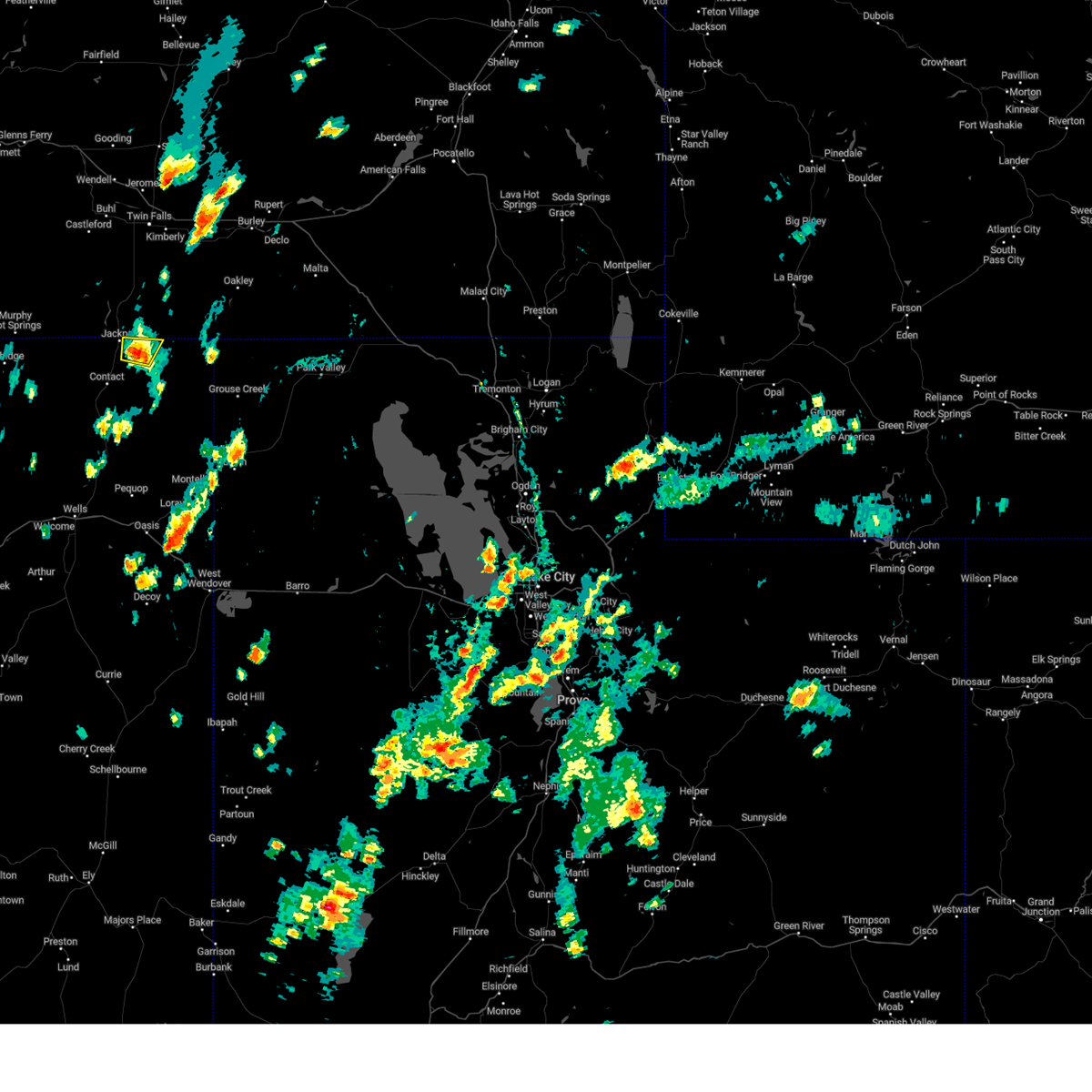
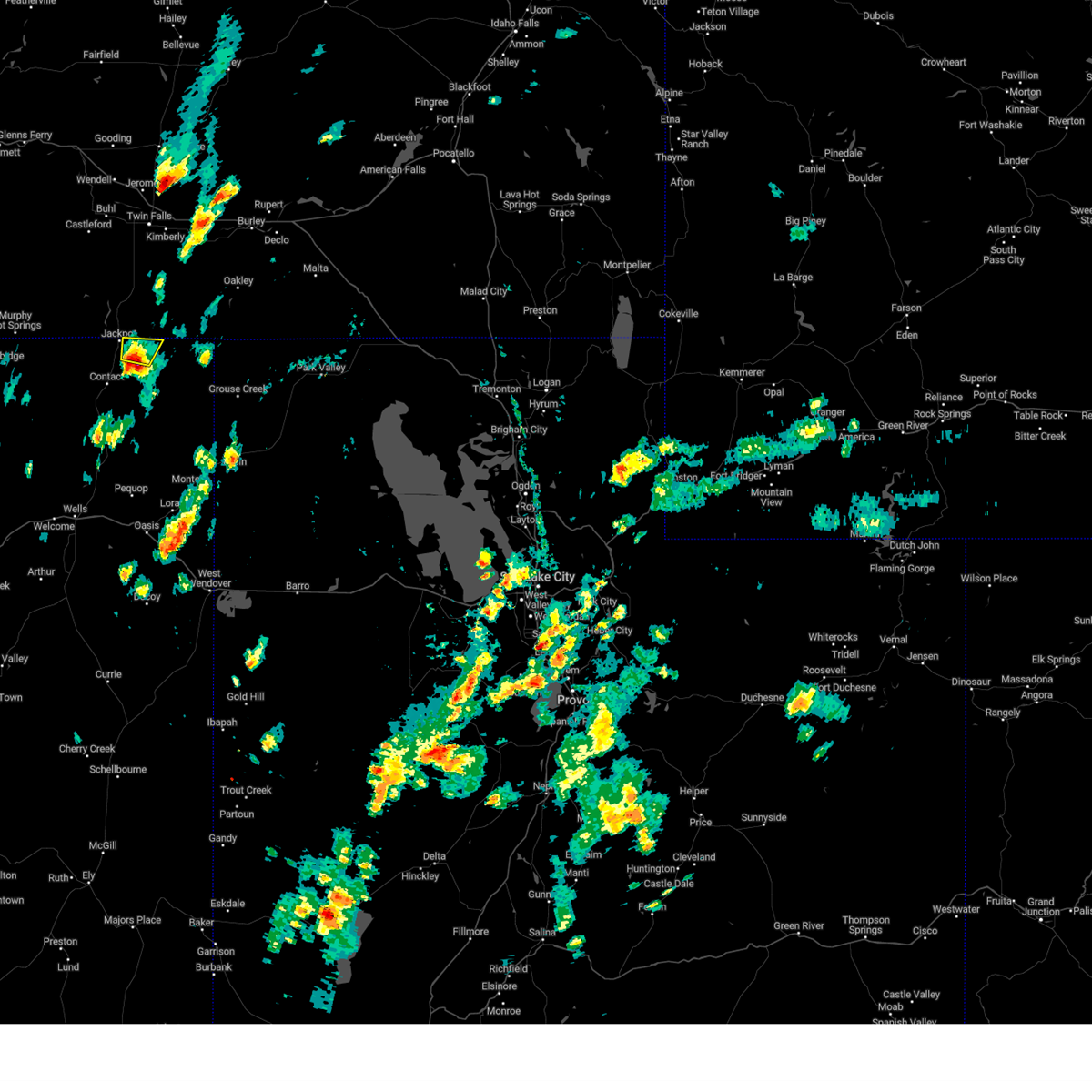
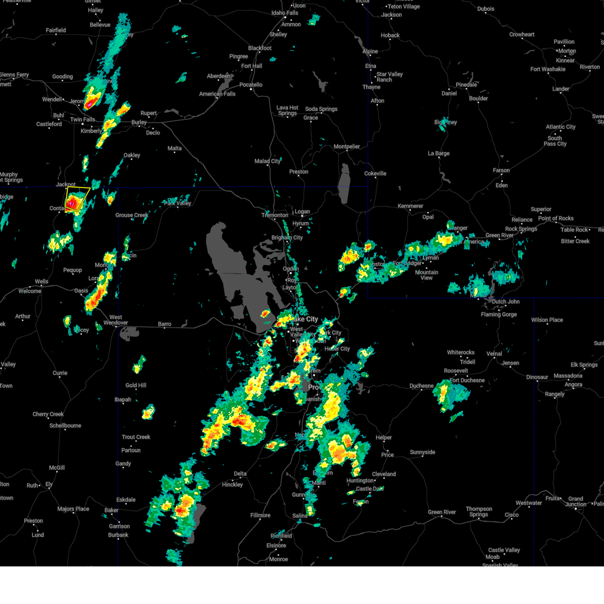
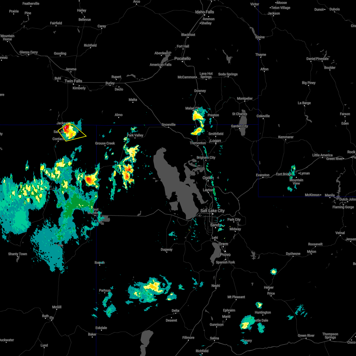
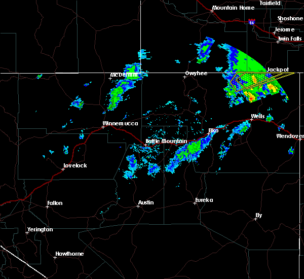
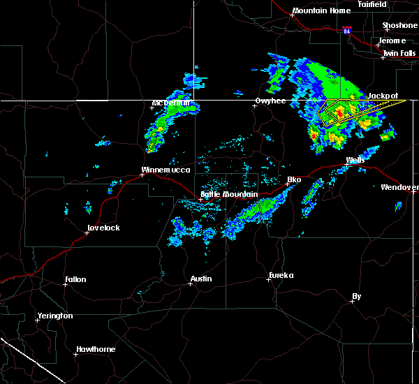
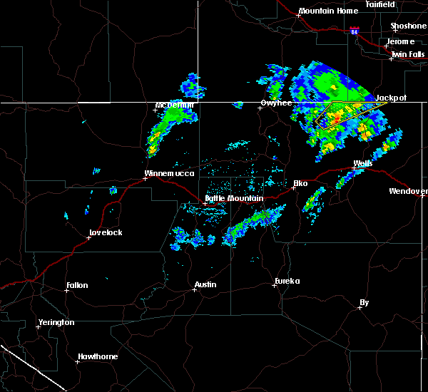
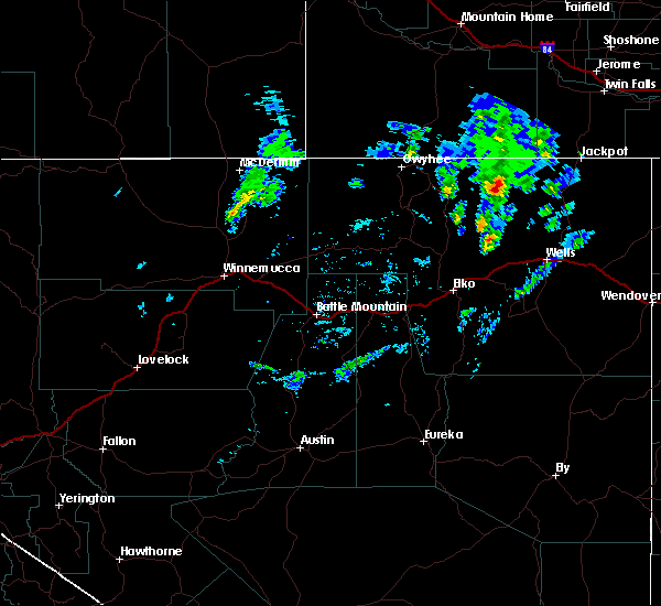
Hail Map for Jackpot, NV
The Jackpot, NV area has had 0 reports of on-the-ground hail by trained spotters, and has been under severe weather warnings 3 times during the past 12 months. Doppler radar has detected hail at or near Jackpot, NV on 6 occasions, including 1 occasion during the past year.
| Name: | Jackpot, NV |
| Where Located: | 41.1 miles SSW of Twin Falls, ID |
| Map: | Google Map for Jackpot, NV |
| Population: | 1195 |
| Housing Units: | 622 |
| More Info: | Search Google for Jackpot, NV |
0
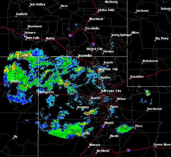
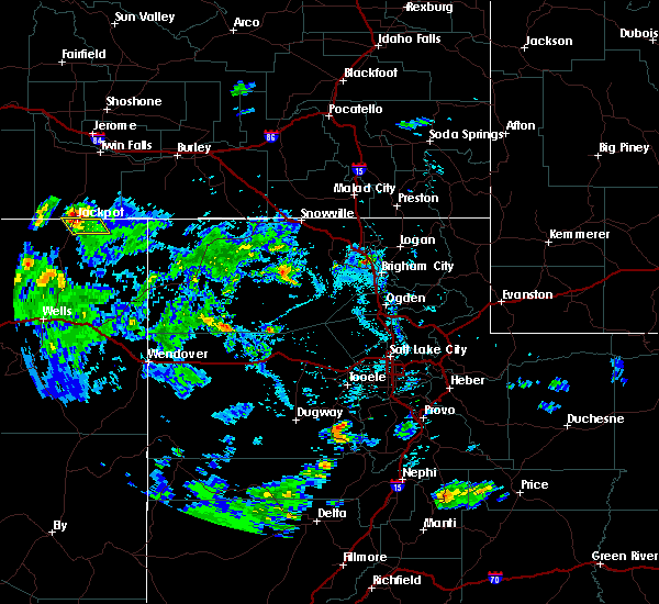
The Top Recent Hail Date for Jackpot, NV is Sunday, August 18, 2024 (4th out of 6)

Hail and Wind Damage Spotted near Jackpot, NV
| Date / Time | Report Details |
|---|---|
| 8/18/2024 3:52 PM PDT |
 The storm which prompted the warning has weakened below severe limits, and has exited the warned area. therefore, the warning will be allowed to expire. however, gusty winds are still possible with this thunderstorm. The storm which prompted the warning has weakened below severe limits, and has exited the warned area. therefore, the warning will be allowed to expire. however, gusty winds are still possible with this thunderstorm.
|
| 8/18/2024 3:46 PM PDT |
 At 346 pm pdt, a severe thunderstorm was located near jackpot, moving north at 25 mph (radar indicated). Hazards include golf ball size hail and 70 mph wind gusts. People and animals outdoors will be injured. expect hail damage to roofs, siding, windows, and vehicles. expect considerable tree damage. wind damage is also likely to mobile homes, roofs, and outbuildings. This severe thunderstorm will remain over mainly rural areas of northeastern elko county. At 346 pm pdt, a severe thunderstorm was located near jackpot, moving north at 25 mph (radar indicated). Hazards include golf ball size hail and 70 mph wind gusts. People and animals outdoors will be injured. expect hail damage to roofs, siding, windows, and vehicles. expect considerable tree damage. wind damage is also likely to mobile homes, roofs, and outbuildings. This severe thunderstorm will remain over mainly rural areas of northeastern elko county.
|
| 8/18/2024 3:37 PM PDT |
 Svrlkn the national weather service in elko nevada has issued a * severe thunderstorm warning for, northeastern elko county in northeastern nevada, * until 400 pm pdt. * at 337 pm pdt, a severe thunderstorm was located 8 miles southeast of jackpot, moving north at 25 mph (radar indicated). Hazards include golf ball size hail and 70 mph wind gusts. People and animals outdoors will be injured. expect hail damage to roofs, siding, windows, and vehicles. expect considerable tree damage. wind damage is also likely to mobile homes, roofs, and outbuildings. This severe thunderstorm will remain over mainly rural areas of northeastern elko county. Svrlkn the national weather service in elko nevada has issued a * severe thunderstorm warning for, northeastern elko county in northeastern nevada, * until 400 pm pdt. * at 337 pm pdt, a severe thunderstorm was located 8 miles southeast of jackpot, moving north at 25 mph (radar indicated). Hazards include golf ball size hail and 70 mph wind gusts. People and animals outdoors will be injured. expect hail damage to roofs, siding, windows, and vehicles. expect considerable tree damage. wind damage is also likely to mobile homes, roofs, and outbuildings. This severe thunderstorm will remain over mainly rural areas of northeastern elko county.
|
| 6/4/2021 5:56 PM PDT |
 At 555 pm pdt, a severe thunderstorm was located 8 miles south of jackpot, moving east northeast at 10 mph (radar indicated). Hazards include 60 mph wind gusts and quarter size hail. Hail damage to vehicles is expected. expect wind damage to roofs, siding, and trees. This severe thunderstorm will remain over mainly rural areas of northeastern elko county. At 555 pm pdt, a severe thunderstorm was located 8 miles south of jackpot, moving east northeast at 10 mph (radar indicated). Hazards include 60 mph wind gusts and quarter size hail. Hail damage to vehicles is expected. expect wind damage to roofs, siding, and trees. This severe thunderstorm will remain over mainly rural areas of northeastern elko county.
|
| 6/4/2021 5:39 PM PDT |
 At 538 pm pdt, a severe thunderstorm was located near contact, moving east northeast at 10 mph (radar indicated). Hazards include 60 mph wind gusts and quarter size hail. Hail damage to vehicles is expected. expect wind damage to roofs, siding, and trees. This severe thunderstorm will remain over mainly rural areas of northeastern elko county. At 538 pm pdt, a severe thunderstorm was located near contact, moving east northeast at 10 mph (radar indicated). Hazards include 60 mph wind gusts and quarter size hail. Hail damage to vehicles is expected. expect wind damage to roofs, siding, and trees. This severe thunderstorm will remain over mainly rural areas of northeastern elko county.
|
| 9/10/2019 1:28 PM PDT |
 A severe thunderstorm warning remains in effect until 200 pm pdt for north central elko county. at 128 pm pdt, a severe thunderstorm was located 11 miles northwest of contact, moving northeast at 20 mph. hazard. 60 mph wind gusts and quarter size hail. source. Radar indicated. A severe thunderstorm warning remains in effect until 200 pm pdt for north central elko county. at 128 pm pdt, a severe thunderstorm was located 11 miles northwest of contact, moving northeast at 20 mph. hazard. 60 mph wind gusts and quarter size hail. source. Radar indicated.
|
| 9/10/2019 1:08 PM PDT |
 At 107 pm pdt, a severe thunderstorm was located 14 miles west of contact, moving northeast at 20 mph (radar indicated). Hazards include 60 mph wind gusts and quarter size hail. Hail damage to vehicles is expected. Expect wind damage to roofs, siding, and trees. At 107 pm pdt, a severe thunderstorm was located 14 miles west of contact, moving northeast at 20 mph (radar indicated). Hazards include 60 mph wind gusts and quarter size hail. Hail damage to vehicles is expected. Expect wind damage to roofs, siding, and trees.
|
| 9/10/2019 12:44 PM PDT |
 At 1243 pm pdt, a severe thunderstorm was located 14 miles southeast of jarbidge, moving northeast at 25 mph (radar indicated). Hazards include 60 mph wind gusts and quarter size hail. Hail damage to vehicles is expected. Expect wind damage to roofs, siding, and trees. At 1243 pm pdt, a severe thunderstorm was located 14 miles southeast of jarbidge, moving northeast at 25 mph (radar indicated). Hazards include 60 mph wind gusts and quarter size hail. Hail damage to vehicles is expected. Expect wind damage to roofs, siding, and trees.
|
| 9/10/2019 12:28 PM PDT |
 At 1226 pm pdt, a severe thunderstorm was located 11 miles southeast of jarbidge, moving east at 20 mph (radar indicated). Hazards include 60 mph wind gusts and quarter size hail. Hail damage to vehicles is expected. expect wind damage to roofs, siding, and trees. locations impacted include, jackpot and u. s. 93 near jackpot. At 1226 pm pdt, a severe thunderstorm was located 11 miles southeast of jarbidge, moving east at 20 mph (radar indicated). Hazards include 60 mph wind gusts and quarter size hail. Hail damage to vehicles is expected. expect wind damage to roofs, siding, and trees. locations impacted include, jackpot and u. s. 93 near jackpot.
|
| 9/10/2019 12:06 PM PDT |
 At 1205 pm pdt, a severe thunderstorm was located 8 miles northeast of charleston, moving northeast at 15 mph (radar indicated). Hazards include 60 mph wind gusts and quarter size hail. Hail damage to vehicles is expected. Expect wind damage to roofs, siding, and trees. At 1205 pm pdt, a severe thunderstorm was located 8 miles northeast of charleston, moving northeast at 15 mph (radar indicated). Hazards include 60 mph wind gusts and quarter size hail. Hail damage to vehicles is expected. Expect wind damage to roofs, siding, and trees.
|
| 5/17/2018 2:31 PM PDT |
 At 231 pm pdt, a severe thunderstorm was located 20 miles southeast of contact, and is nearly stationary (radar indicated). Hazards include 60 mph wind gusts and half dollar size hail. Hail damage to vehicles is expected. Expect wind damage to roofs, siding, and trees. At 231 pm pdt, a severe thunderstorm was located 20 miles southeast of contact, and is nearly stationary (radar indicated). Hazards include 60 mph wind gusts and half dollar size hail. Hail damage to vehicles is expected. Expect wind damage to roofs, siding, and trees.
|
| 8/11/2015 4:30 PM MDT | Itd22 near jackpot reported a thunderstorm wind gust of 50 mp in twin falls county ID, 2.8 miles S of Jackpot, NV |
| 6/30/2015 7:07 PM PDT |
 The severe thunderstorm warning for northeastern elko county will expire at 715 pm pdt, the storm which prompted the warning has weakened below severe limits and exited the warned area. therefore the warning will be allowed to expire. however small hail, gusty winds and heavy rain are still possible with additional storms moving in from the west. to report severe weather, contact your nearest law enforcement agency. they will relay your report to the national weather service elko. The severe thunderstorm warning for northeastern elko county will expire at 715 pm pdt, the storm which prompted the warning has weakened below severe limits and exited the warned area. therefore the warning will be allowed to expire. however small hail, gusty winds and heavy rain are still possible with additional storms moving in from the west. to report severe weather, contact your nearest law enforcement agency. they will relay your report to the national weather service elko.
|
| 6/30/2015 6:53 PM PDT |
 At 652 pm pdt, doppler radar indicated a severe thunderstorm capable of producing quarter size hail and damaging winds in excess of 60 mph. this storm was located east of jackpot. this storm was moving northeasta at 15 mph. this severe thunderstorm will remain over mainly rural areas of northeastern elko county. At 652 pm pdt, doppler radar indicated a severe thunderstorm capable of producing quarter size hail and damaging winds in excess of 60 mph. this storm was located east of jackpot. this storm was moving northeasta at 15 mph. this severe thunderstorm will remain over mainly rural areas of northeastern elko county.
|
| 6/30/2015 6:25 PM PDT |
 At 625 pm pdt, doppler radar indicated a severe thunderstorm capable of producing quarter size hail and damaging winds in excess of 60 mph. this storm was located over jackpot, and moving northeast at 10 mph. At 625 pm pdt, doppler radar indicated a severe thunderstorm capable of producing quarter size hail and damaging winds in excess of 60 mph. this storm was located over jackpot, and moving northeast at 10 mph.
|
| 6/1/2015 1:08 PM MDT | At 107 pm mdt, doppler radar indicated a line of severe thunderstorms capable of producing quarter size hail and damaging winds in excess of 60 mph. these storms were located along a line extending from near buhl to near china mountain, and moving northeast at 40 mph. * severe thunderstorms will be near, buhl around 110 pm mdt. filer around 120 pm mdt. jerome, twin falls, rogerson and winter spring around 130 pm mdt. kimberly, hansen and timber butte around 140 pm mdt. eden, magic mountain ski area and minidoka national monument around 150 pm mdt. |
Hail Maps for Jackpot, NV


Connect with Interactive Hail Maps