

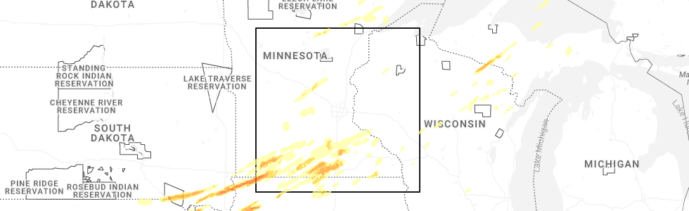
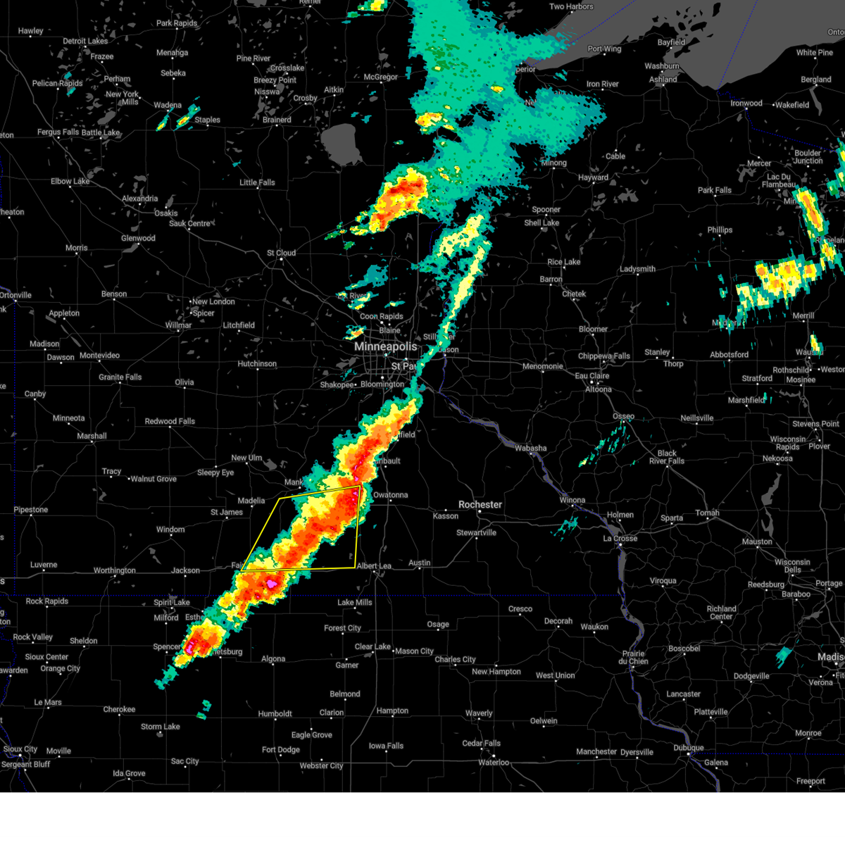
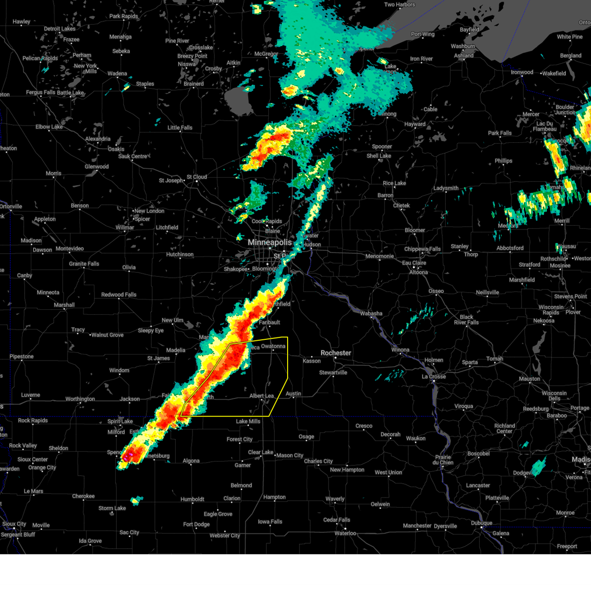
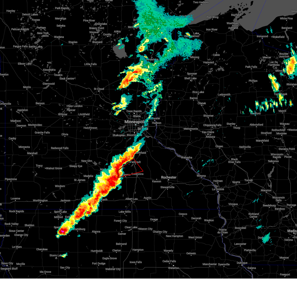
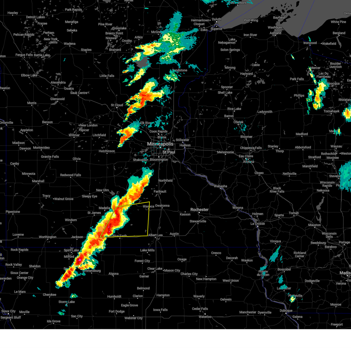
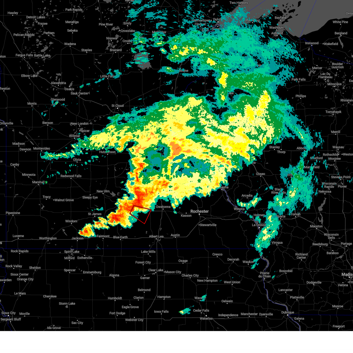
Hail Map for Janesville, MN
The Janesville, MN area has had 4 reports of on-the-ground hail by trained spotters, and has been under severe weather warnings 18 times during the past 12 months. Doppler radar has detected hail at or near Janesville, MN on 61 occasions, including 4 occasions during the past year.
| Name: | Janesville, MN |
| Where Located: | 63.1 miles SSW of Minneapolis, MN |
| Map: | Google Map for Janesville, MN |
| Population: | 2256 |
| Housing Units: | 958 |
| More Info: | Search Google for Janesville, MN |
3
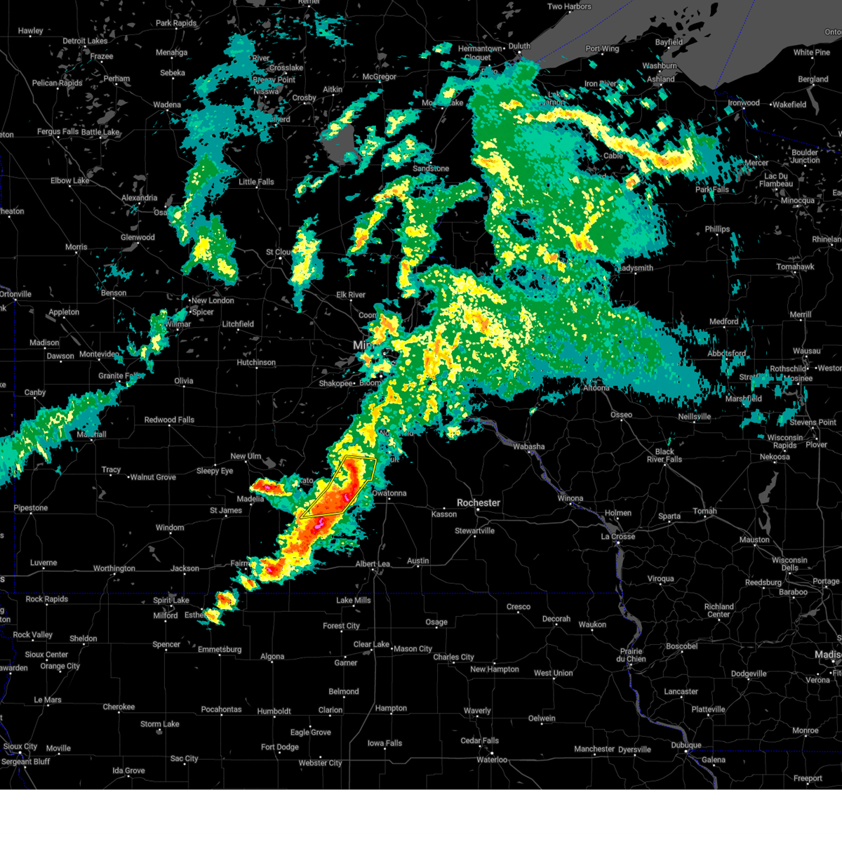
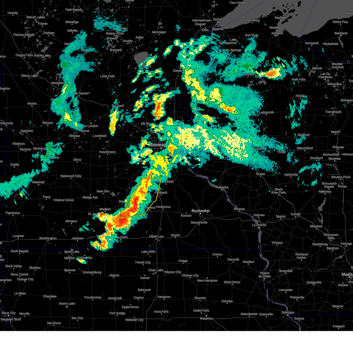
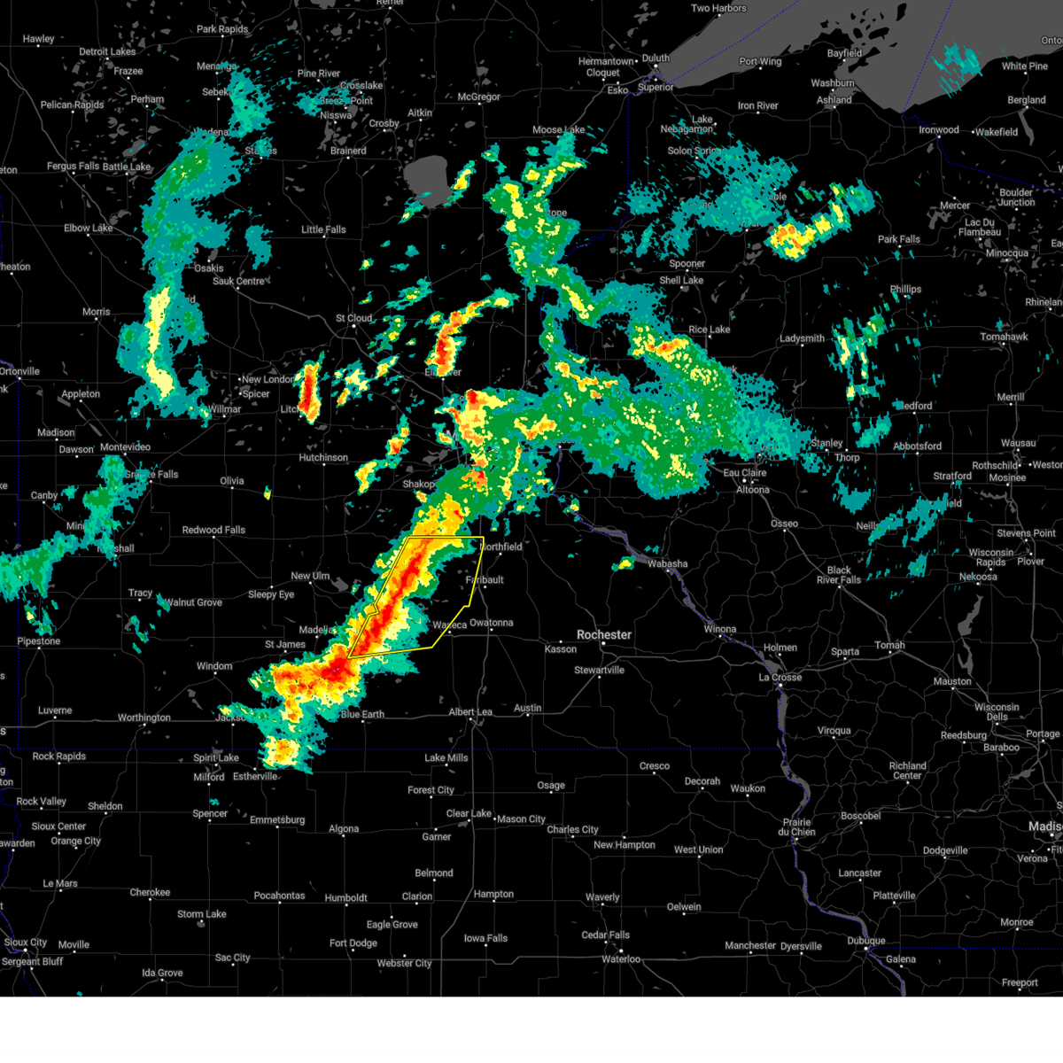
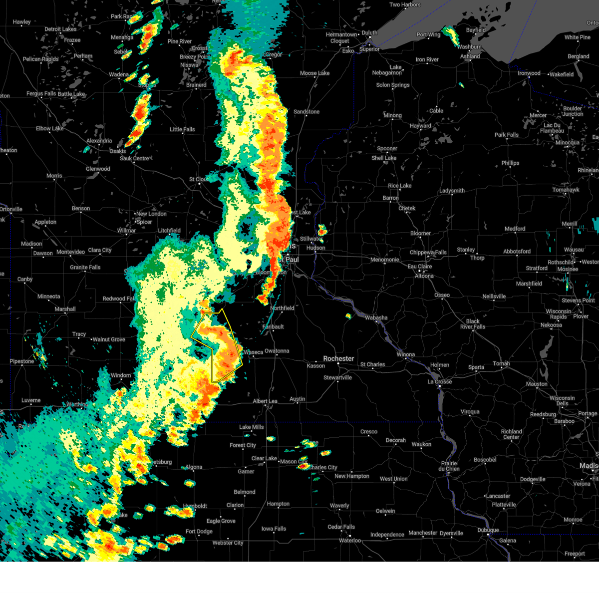
The Top Recent Hail Date for Janesville, MN is Monday, April 28, 2025 (15th out of 61)
Hail and Wind Damage Spotted near Janesville, MN
| Date / Time | Report Details |
|---|---|
| 6/16/2025 7:50 PM CDT |
 At 750 pm cdt, a severe thunderstorm was located over eagle lake, or near mankato, moving east at 20 mph (trained spotters reported ping pong ball-size hail at 745 pm near mankato). Hazards include ping pong ball size hail. People and animals outdoors will be injured. expect damage to roofs, siding, windows, and vehicles. locations impacted include, mankato, waseca, eagle lake, janesville, madison lake, st. Clair, elysian, smiths mill, greenland, alma city and waseca airport. At 750 pm cdt, a severe thunderstorm was located over eagle lake, or near mankato, moving east at 20 mph (trained spotters reported ping pong ball-size hail at 745 pm near mankato). Hazards include ping pong ball size hail. People and animals outdoors will be injured. expect damage to roofs, siding, windows, and vehicles. locations impacted include, mankato, waseca, eagle lake, janesville, madison lake, st. Clair, elysian, smiths mill, greenland, alma city and waseca airport.
|
| 6/16/2025 7:50 PM CDT |
 the severe thunderstorm warning has been cancelled and is no longer in effect the severe thunderstorm warning has been cancelled and is no longer in effect
|
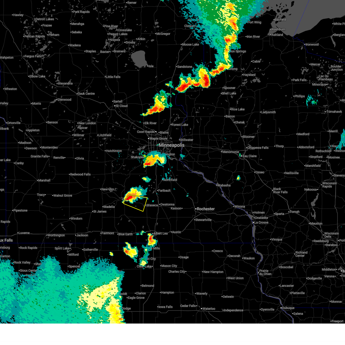
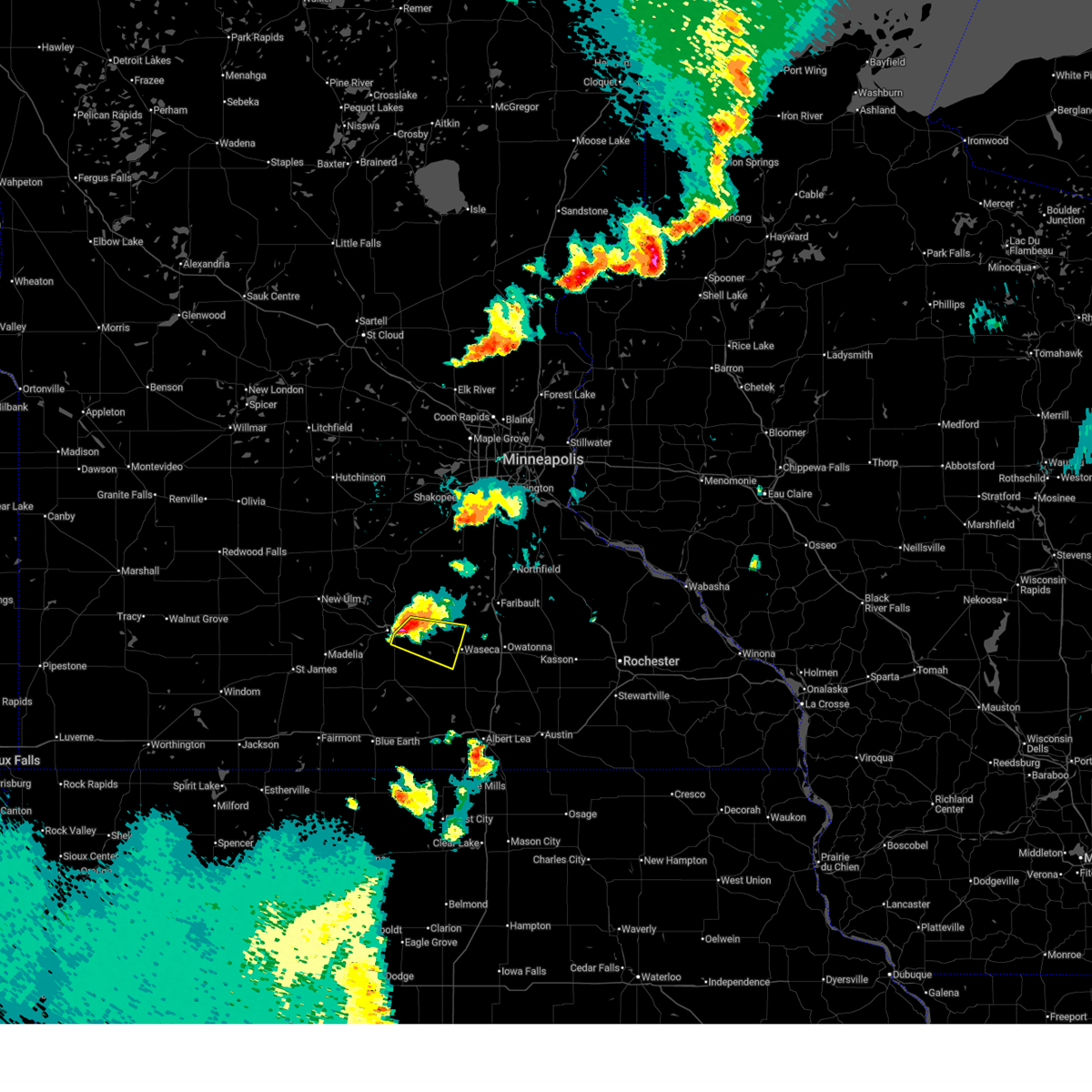
| 6/16/2025 7:35 PM CDT | Svrmpx the national weather service in the twin cities has issued a * severe thunderstorm warning for, northeastern blue earth county in south central minnesota, southern le sueur county in south central minnesota, southwestern rice county in south central minnesota, northern waseca county in south central minnesota, * until 815 pm cdt. * at 735 pm cdt, a severe thunderstorm was located over eagle lake, or near mankato, moving east at 30 mph (radar indicated). Hazards include half dollar size hail. damage to vehicles is expected |
| 4/28/2025 6:17 PM CDT |
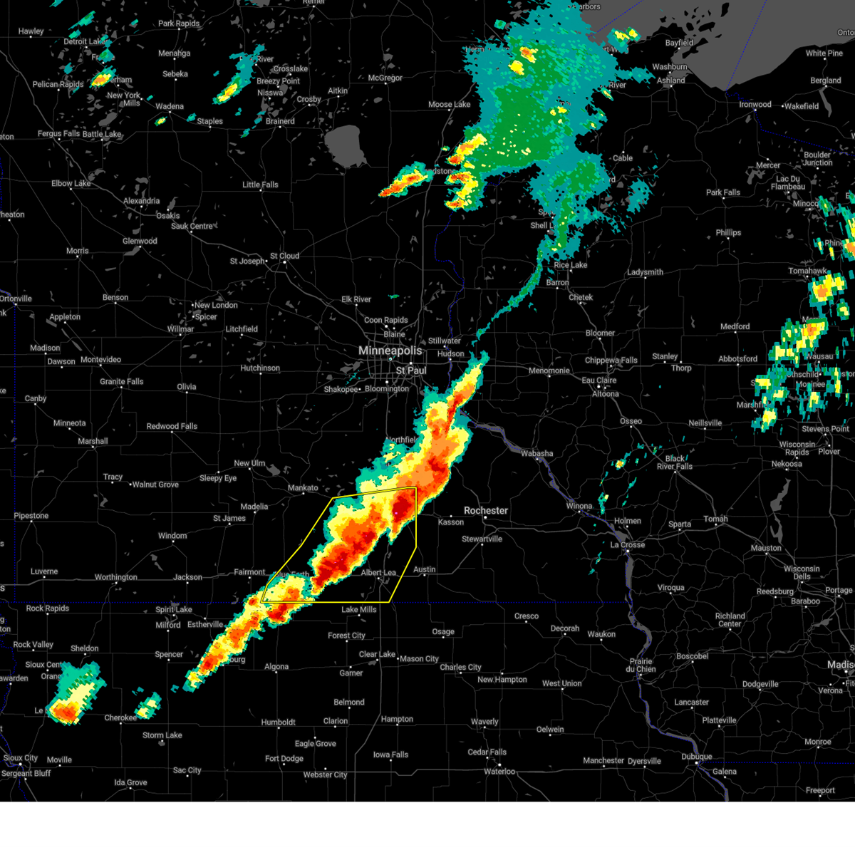 The severe thunderstorm warning that was previously in effect has been reissued for and is in effect until 700 pm cdt. please refer to those bulletins for the latest severe weather information. a tornado watch remains in effect until 800 pm cdt for a portion of south central minnesota. The severe thunderstorm warning that was previously in effect has been reissued for and is in effect until 700 pm cdt. please refer to those bulletins for the latest severe weather information. a tornado watch remains in effect until 800 pm cdt for a portion of south central minnesota.
|
| 4/28/2025 5:33 PM CDT |
 The storms which prompted the warning have moved out of the area. therefore, the warning has been allowed to expire. a severe thunderstorm warning still remains in effect for southeastern blue earth, waseca, faribault, southeastern martin, and freeborn counties. The storms which prompted the warning have moved out of the area. therefore, the warning has been allowed to expire. a severe thunderstorm warning still remains in effect for southeastern blue earth, waseca, faribault, southeastern martin, and freeborn counties.
|
| 4/28/2025 5:29 PM CDT |
 Svrmpx the national weather service in the twin cities has issued a * severe thunderstorm warning for, southeastern blue earth county in south central minnesota, faribault county in south central minnesota, freeborn county in south central minnesota, southeastern martin county in south central minnesota, steele county in south central minnesota, waseca county in south central minnesota, * until 615 pm cdt. * at 529 pm cdt, severe thunderstorms were located along a line from over waseca to near elmore, or along a line from 13 miles west of owatonna to 17 miles southeast of fairmont, moving east at 50 mph (radar indicated). Hazards include 60 mph wind gusts and half dollar size hail. Hail damage to vehicles is expected. Expect wind damage to roofs, siding, and trees. Svrmpx the national weather service in the twin cities has issued a * severe thunderstorm warning for, southeastern blue earth county in south central minnesota, faribault county in south central minnesota, freeborn county in south central minnesota, southeastern martin county in south central minnesota, steele county in south central minnesota, waseca county in south central minnesota, * until 615 pm cdt. * at 529 pm cdt, severe thunderstorms were located along a line from over waseca to near elmore, or along a line from 13 miles west of owatonna to 17 miles southeast of fairmont, moving east at 50 mph (radar indicated). Hazards include 60 mph wind gusts and half dollar size hail. Hail damage to vehicles is expected. Expect wind damage to roofs, siding, and trees.
|
| 4/28/2025 5:20 PM CDT |
 Tormpx the national weather service in the twin cities has issued a * tornado warning for, southeastern le sueur county in south central minnesota, southwestern rice county in south central minnesota, northwestern steele county in south central minnesota, northern waseca county in south central minnesota, * until 545 pm cdt. * at 520 pm cdt, a severe thunderstorm capable of producing a tornado was located 5 miles northwest of waseca, or 19 miles west of owatonna, moving northeast at 60 mph (radar indicated rotation). Hazards include tornado and quarter size hail. Flying debris will be dangerous to those caught without shelter. mobile homes will be damaged or destroyed. damage to roofs, windows and vehicles will occur. Tree damage is likely. Tormpx the national weather service in the twin cities has issued a * tornado warning for, southeastern le sueur county in south central minnesota, southwestern rice county in south central minnesota, northwestern steele county in south central minnesota, northern waseca county in south central minnesota, * until 545 pm cdt. * at 520 pm cdt, a severe thunderstorm capable of producing a tornado was located 5 miles northwest of waseca, or 19 miles west of owatonna, moving northeast at 60 mph (radar indicated rotation). Hazards include tornado and quarter size hail. Flying debris will be dangerous to those caught without shelter. mobile homes will be damaged or destroyed. damage to roofs, windows and vehicles will occur. Tree damage is likely.
|
| 4/28/2025 4:52 PM CDT |
 Svrmpx the national weather service in the twin cities has issued a * severe thunderstorm warning for, blue earth county in south central minnesota, northern faribault county in south central minnesota, northwestern freeborn county in south central minnesota, northeastern martin county in south central minnesota, waseca county in south central minnesota, * until 530 pm cdt. * at 452 pm cdt, severe thunderstorms were located along a line from 6 miles north of good thunder to over winnebago, or along a line from 7 miles southwest of mankato to 14 miles northeast of fairmont, moving northeast at 60 mph (radar indicated). Hazards include 60 mph wind gusts and half dollar size hail. Hail damage to vehicles is expected. Expect wind damage to roofs, siding, and trees. Svrmpx the national weather service in the twin cities has issued a * severe thunderstorm warning for, blue earth county in south central minnesota, northern faribault county in south central minnesota, northwestern freeborn county in south central minnesota, northeastern martin county in south central minnesota, waseca county in south central minnesota, * until 530 pm cdt. * at 452 pm cdt, severe thunderstorms were located along a line from 6 miles north of good thunder to over winnebago, or along a line from 7 miles southwest of mankato to 14 miles northeast of fairmont, moving northeast at 60 mph (radar indicated). Hazards include 60 mph wind gusts and half dollar size hail. Hail damage to vehicles is expected. Expect wind damage to roofs, siding, and trees.
|
| 4/17/2025 5:20 PM CDT |
 The storms which prompted the warning have weakened below severe limits, and have exited the warned area. therefore, the warning will be allowed to expire. however, gusty winds and heavy rain are still possible with these thunderstorms. a severe thunderstorm watch remains in effect until 1000 pm cdt thursday for a portion of south central minnesota. The storms which prompted the warning have weakened below severe limits, and have exited the warned area. therefore, the warning will be allowed to expire. however, gusty winds and heavy rain are still possible with these thunderstorms. a severe thunderstorm watch remains in effect until 1000 pm cdt thursday for a portion of south central minnesota.
|
| 4/17/2025 5:15 PM CDT |
 At 515 pm cdt, severe thunderstorms were located along a line from near elko new market to 6 miles south of waterville, or along a line from 11 miles northwest of northfield to 18 miles southwest of faribault, moving east at 30 mph (radar indicated). Hazards include 60 mph wind gusts and small hail. Expect damage to roofs, siding, and trees. locations impacted include, st. Clair, pemberton, smiths mill, elysian, alma city, kilkenny, janesville, waterville, sakatah lake state park, waseca airport, waseca, morristown, faribault and warsaw. At 515 pm cdt, severe thunderstorms were located along a line from near elko new market to 6 miles south of waterville, or along a line from 11 miles northwest of northfield to 18 miles southwest of faribault, moving east at 30 mph (radar indicated). Hazards include 60 mph wind gusts and small hail. Expect damage to roofs, siding, and trees. locations impacted include, st. Clair, pemberton, smiths mill, elysian, alma city, kilkenny, janesville, waterville, sakatah lake state park, waseca airport, waseca, morristown, faribault and warsaw.
|
| 4/17/2025 4:53 PM CDT |
 At 453 pm cdt, severe thunderstorms were located along a line from near new prague to near st. clair, or along a line from 17 miles northwest of northfield to 10 miles southeast of mankato, moving east at 30 mph (radar indicated). Hazards include 60 mph wind gusts and small hail. Expect damage to roofs, siding, and trees. locations impacted include, vernon center, mankato, good thunder, le center, eagle lake, madison lake, new prague, st. Clair, montgomery, pemberton, elysian, kilkenny, janesville, lonsdale, waterville, webster, waseca, morristown, faribault and warsaw. At 453 pm cdt, severe thunderstorms were located along a line from near new prague to near st. clair, or along a line from 17 miles northwest of northfield to 10 miles southeast of mankato, moving east at 30 mph (radar indicated). Hazards include 60 mph wind gusts and small hail. Expect damage to roofs, siding, and trees. locations impacted include, vernon center, mankato, good thunder, le center, eagle lake, madison lake, new prague, st. Clair, montgomery, pemberton, elysian, kilkenny, janesville, lonsdale, waterville, webster, waseca, morristown, faribault and warsaw.
|
| 4/17/2025 4:33 PM CDT |
 Svrmpx the national weather service in the twin cities has issued a * severe thunderstorm warning for, northeastern blue earth county in south central minnesota, le sueur county in south central minnesota, western rice county in south central minnesota, northern waseca county in south central minnesota, * until 530 pm cdt. * at 433 pm cdt, severe thunderstorms were located along a line from near new prague to 7 miles south of mankato, or along a line from 24 miles northwest of faribault to 7 miles south of mankato, moving east at 30 mph (radar indicated). Hazards include 60 mph wind gusts and small hail. expect damage to roofs, siding, and trees Svrmpx the national weather service in the twin cities has issued a * severe thunderstorm warning for, northeastern blue earth county in south central minnesota, le sueur county in south central minnesota, western rice county in south central minnesota, northern waseca county in south central minnesota, * until 530 pm cdt. * at 433 pm cdt, severe thunderstorms were located along a line from near new prague to 7 miles south of mankato, or along a line from 24 miles northwest of faribault to 7 miles south of mankato, moving east at 30 mph (radar indicated). Hazards include 60 mph wind gusts and small hail. expect damage to roofs, siding, and trees
|
| 8/29/2024 4:44 PM CDT |
 the severe thunderstorm warning has been cancelled and is no longer in effect the severe thunderstorm warning has been cancelled and is no longer in effect
|
| 8/29/2024 4:37 PM CDT | At 437 pm cdt, severe thunderstorms were located along a line extending from near st. peter to kasota to near madison lake to janesville to pemberton, moving east at 40 mph (radar indicated). Hazards include 60 mph wind gusts. Expect damage to roofs, siding, and trees. locations impacted include, mankato, north mankato, st. peter, le sueur, eagle lake, janesville, mapleton, nicollet, madison lake, st. Clair, kasota, and pemberton. |
| 8/29/2024 4:23 PM CDT | the severe thunderstorm warning has been cancelled and is no longer in effect |
| 8/29/2024 4:23 PM CDT | At 423 pm cdt, severe thunderstorms were located along a line extending from near nicollet to near north mankato to near mankato to mapleton, moving northeast at 40 mph (radar indicated). Hazards include 60 mph wind gusts. Expect damage to roofs, siding, and trees. locations impacted include, mankato, north mankato, st. peter, le sueur, lake crystal, eagle lake, janesville, mapleton, nicollet, madison lake, st. Clair, and kasota. |
| 8/29/2024 4:08 PM CDT | Svrmpx the national weather service in the twin cities has issued a * severe thunderstorm warning for, north central faribault county in south central minnesota, western le sueur county in south central minnesota, blue earth county in south central minnesota, northwestern waseca county in south central minnesota, eastern nicollet county in south central minnesota, * until 500 pm cdt. * at 407 pm cdt, severe thunderstorms were located along a line extending from near lake crystal to near vernon center to near delavan, moving northeast at 40 mph (radar indicated). Hazards include 60 mph wind gusts. expect damage to roofs, siding, and trees |
| 8/5/2024 6:22 PM CDT |
 Tormpx the national weather service in the twin cities has issued a * tornado warning for, east central blue earth county in south central minnesota, southern waseca county in south central minnesota, * until 645 pm cdt. * at 622 pm cdt, a severe thunderstorm capable of producing a tornado was located over st. clair, or 10 miles southeast of mankato, moving east at 20 mph (radar indicated rotation). Hazards include tornado. Flying debris will be dangerous to those caught without shelter. mobile homes will be damaged or destroyed. damage to roofs, windows, and vehicles will occur. tree damage is likely. this dangerous storm will be near, pemberton around 625 pm cdt. Other locations impacted by this tornadic thunderstorm include waseca airport and alma city. Tormpx the national weather service in the twin cities has issued a * tornado warning for, east central blue earth county in south central minnesota, southern waseca county in south central minnesota, * until 645 pm cdt. * at 622 pm cdt, a severe thunderstorm capable of producing a tornado was located over st. clair, or 10 miles southeast of mankato, moving east at 20 mph (radar indicated rotation). Hazards include tornado. Flying debris will be dangerous to those caught without shelter. mobile homes will be damaged or destroyed. damage to roofs, windows, and vehicles will occur. tree damage is likely. this dangerous storm will be near, pemberton around 625 pm cdt. Other locations impacted by this tornadic thunderstorm include waseca airport and alma city.
|
| 6/17/2024 5:32 AM CDT |
 the severe thunderstorm warning has been cancelled and is no longer in effect the severe thunderstorm warning has been cancelled and is no longer in effect
|
| 6/17/2024 5:18 AM CDT |
 At 518 am cdt, severe thunderstorms were located along a line extending from near janesville to hartland to near emmons, moving east at 35 mph (radar indicated). Hazards include 60 mph wind gusts. Expect damage to roofs, siding, and trees. Locations impacted include, albert lea, waseca, wells, janesville, new richland, alden, emmons, hartland, freeborn, mansfield, waldorf, and twin lakes. At 518 am cdt, severe thunderstorms were located along a line extending from near janesville to hartland to near emmons, moving east at 35 mph (radar indicated). Hazards include 60 mph wind gusts. Expect damage to roofs, siding, and trees. Locations impacted include, albert lea, waseca, wells, janesville, new richland, alden, emmons, hartland, freeborn, mansfield, waldorf, and twin lakes.
|
| 6/17/2024 5:18 AM CDT |
 the severe thunderstorm warning has been cancelled and is no longer in effect the severe thunderstorm warning has been cancelled and is no longer in effect
|
| 6/17/2024 5:10 AM CDT |
 At 509 am cdt, severe thunderstorms were located along a line extending from near pemberton to near freeborn to near mansfield, moving east at 35 mph (radar indicated). Hazards include 60 mph wind gusts. Expect damage to roofs, siding, and trees. locations impacted include, albert lea, waseca, wells, janesville, new richland, st. Clair, minnesota lake, alden, emmons, bricelyn, hartland, and freeborn. At 509 am cdt, severe thunderstorms were located along a line extending from near pemberton to near freeborn to near mansfield, moving east at 35 mph (radar indicated). Hazards include 60 mph wind gusts. Expect damage to roofs, siding, and trees. locations impacted include, albert lea, waseca, wells, janesville, new richland, st. Clair, minnesota lake, alden, emmons, bricelyn, hartland, and freeborn.
|
| 6/17/2024 4:51 AM CDT |
 Svrmpx the national weather service in the twin cities has issued a * severe thunderstorm warning for, western freeborn county in south central minnesota, eastern faribault county in south central minnesota, southeastern blue earth county in south central minnesota, waseca county in south central minnesota, * until 545 am cdt. * at 450 am cdt, severe thunderstorms were located along a line extending from near good thunder to easton to near bricelyn, moving east at 30 mph (radar indicated). Hazards include 60 mph wind gusts. expect damage to roofs, siding, and trees Svrmpx the national weather service in the twin cities has issued a * severe thunderstorm warning for, western freeborn county in south central minnesota, eastern faribault county in south central minnesota, southeastern blue earth county in south central minnesota, waseca county in south central minnesota, * until 545 am cdt. * at 450 am cdt, severe thunderstorms were located along a line extending from near good thunder to easton to near bricelyn, moving east at 30 mph (radar indicated). Hazards include 60 mph wind gusts. expect damage to roofs, siding, and trees
|
| 5/21/2024 5:04 PM CDT |
 the tornado warning has been cancelled and is no longer in effect the tornado warning has been cancelled and is no longer in effect
|
| 5/21/2024 4:53 PM CDT |
 At 452 pm cdt, a severe thunderstorm capable of producing a tornado was located over janesville, or 13 miles east of mankato, moving northeast at 60 mph (radar indicated rotation). Hazards include tornado. Flying debris will be dangerous to those caught without shelter. mobile homes will be damaged or destroyed. damage to roofs, windows, and vehicles will occur. tree damage is likely. this dangerous storm will be near, waterville and elysian around 500 pm cdt. Other locations impacted by this tornadic thunderstorm include kilkenny, smiths mill, greenland, and sakatah lake state park. At 452 pm cdt, a severe thunderstorm capable of producing a tornado was located over janesville, or 13 miles east of mankato, moving northeast at 60 mph (radar indicated rotation). Hazards include tornado. Flying debris will be dangerous to those caught without shelter. mobile homes will be damaged or destroyed. damage to roofs, windows, and vehicles will occur. tree damage is likely. this dangerous storm will be near, waterville and elysian around 500 pm cdt. Other locations impacted by this tornadic thunderstorm include kilkenny, smiths mill, greenland, and sakatah lake state park.
|
| 5/21/2024 4:43 PM CDT |
 At 442 pm cdt, severe thunderstorms capable of producing tornadoes were located along a line extending from 5 miles northwest of waterville to near elysian, moving northeast at 40 mph (radar indicated rotation). Hazards include tornado. Flying debris will be dangerous to those caught without shelter. mobile homes will be damaged or destroyed. damage to roofs, windows, and vehicles will occur. tree damage is likely. these dangerous storms will be near, montgomery around 450 pm cdt. Other locations impacted by these tornadic storms include lake jefferson, kilkenny, smiths mill, greenland, and sakatah lake state park. At 442 pm cdt, severe thunderstorms capable of producing tornadoes were located along a line extending from 5 miles northwest of waterville to near elysian, moving northeast at 40 mph (radar indicated rotation). Hazards include tornado. Flying debris will be dangerous to those caught without shelter. mobile homes will be damaged or destroyed. damage to roofs, windows, and vehicles will occur. tree damage is likely. these dangerous storms will be near, montgomery around 450 pm cdt. Other locations impacted by these tornadic storms include lake jefferson, kilkenny, smiths mill, greenland, and sakatah lake state park.
|
| 5/21/2024 4:31 PM CDT |
 Tormpx the national weather service in the twin cities has issued a * tornado warning for, southeastern le sueur county in south central minnesota, northwestern waseca county in south central minnesota, * until 515 pm cdt. * at 431 pm cdt, severe thunderstorms capable of producing a tornado were located along a line extending from elysian to near st. clair, moving northeast at 40 mph (radar indicated rotation). Hazards include tornado. Flying debris will be dangerous to those caught without shelter. mobile homes will be damaged or destroyed. damage to roofs, windows, and vehicles will occur. tree damage is likely. these dangerous storms will be near, janesville, waterville, and elysian around 435 pm cdt. montgomery around 455 pm cdt. other locations impacted by these tornadic storms include lake jefferson, kilkenny, smiths mill, greenland, and sakatah lake state park. this includes u. s. Highway 14 between mile markers 144 and 148. Tormpx the national weather service in the twin cities has issued a * tornado warning for, southeastern le sueur county in south central minnesota, northwestern waseca county in south central minnesota, * until 515 pm cdt. * at 431 pm cdt, severe thunderstorms capable of producing a tornado were located along a line extending from elysian to near st. clair, moving northeast at 40 mph (radar indicated rotation). Hazards include tornado. Flying debris will be dangerous to those caught without shelter. mobile homes will be damaged or destroyed. damage to roofs, windows, and vehicles will occur. tree damage is likely. these dangerous storms will be near, janesville, waterville, and elysian around 435 pm cdt. montgomery around 455 pm cdt. other locations impacted by these tornadic storms include lake jefferson, kilkenny, smiths mill, greenland, and sakatah lake state park. this includes u. s. Highway 14 between mile markers 144 and 148.
|
| 7/28/2023 12:51 AM CDT |
 At 1251 am cdt, severe thunderstorms were located along a line extending from near waterville to 5 miles southeast of janesville to near waldorf, moving southeast at 35 mph (radar indicated). Hazards include 60 mph wind gusts. Expect damage to roofs, siding, and trees. these severe storms will be near, waseca around 1255 am cdt. other locations impacted by these severe thunderstorms include waseca airport, sakatah lake state park, lake jefferson, alma city, smiths mill and greenland. hail threat, radar indicated max hail size, <. 75 in wind threat, radar indicated max wind gust, 60 mph. At 1251 am cdt, severe thunderstorms were located along a line extending from near waterville to 5 miles southeast of janesville to near waldorf, moving southeast at 35 mph (radar indicated). Hazards include 60 mph wind gusts. Expect damage to roofs, siding, and trees. these severe storms will be near, waseca around 1255 am cdt. other locations impacted by these severe thunderstorms include waseca airport, sakatah lake state park, lake jefferson, alma city, smiths mill and greenland. hail threat, radar indicated max hail size, <. 75 in wind threat, radar indicated max wind gust, 60 mph.
|
| 7/28/2023 12:38 AM CDT | 10 inch diameter tree limb blocking roadway. delayed report via law enforcement. time estimated by rada in waseca county MN, 0.2 miles NW of Janesville, MN |
| 7/28/2023 12:35 AM CDT |
 At 1235 am cdt, severe thunderstorms were located along a line extending from near cleveland to near eagle lake to near st. clair, moving southeast at 35 mph (radar indicated). Hazards include 60 mph wind gusts and quarter size hail. Hail damage to vehicles is expected. expect wind damage to roofs, siding, and trees. these severe storms will be near, janesville around 1245 am cdt. elysian and pemberton around 1250 am cdt. waseca, waterville and waldorf around 100 am cdt. other locations impacted by these severe thunderstorms include waseca airport, sakatah lake state park, lake jefferson, alma city, smiths mill and greenland. hail threat, radar indicated max hail size, 1. 00 in wind threat, radar indicated max wind gust, 60 mph. At 1235 am cdt, severe thunderstorms were located along a line extending from near cleveland to near eagle lake to near st. clair, moving southeast at 35 mph (radar indicated). Hazards include 60 mph wind gusts and quarter size hail. Hail damage to vehicles is expected. expect wind damage to roofs, siding, and trees. these severe storms will be near, janesville around 1245 am cdt. elysian and pemberton around 1250 am cdt. waseca, waterville and waldorf around 100 am cdt. other locations impacted by these severe thunderstorms include waseca airport, sakatah lake state park, lake jefferson, alma city, smiths mill and greenland. hail threat, radar indicated max hail size, 1. 00 in wind threat, radar indicated max wind gust, 60 mph.
|
| 7/28/2023 12:22 AM CDT |
 At 1222 am cdt, severe thunderstorms were located along a line extending from st. peter to mankato to 6 miles south of north mankato, moving southeast at 30 mph (radar indicated). Hazards include 60 mph wind gusts and quarter size hail. Hail damage to vehicles is expected. expect wind damage to roofs, siding, and trees. severe thunderstorms will be near, mankato around 1225 am cdt. eagle lake around 1230 am cdt. madison lake around 1235 am cdt. st. clair around 1240 am cdt. other locations in the path of these severe thunderstorms include janesville, pemberton, elysian, waterville, waseca and waldorf. hail threat, radar indicated max hail size, 1. 00 in wind threat, radar indicated max wind gust, 60 mph. At 1222 am cdt, severe thunderstorms were located along a line extending from st. peter to mankato to 6 miles south of north mankato, moving southeast at 30 mph (radar indicated). Hazards include 60 mph wind gusts and quarter size hail. Hail damage to vehicles is expected. expect wind damage to roofs, siding, and trees. severe thunderstorms will be near, mankato around 1225 am cdt. eagle lake around 1230 am cdt. madison lake around 1235 am cdt. st. clair around 1240 am cdt. other locations in the path of these severe thunderstorms include janesville, pemberton, elysian, waterville, waseca and waldorf. hail threat, radar indicated max hail size, 1. 00 in wind threat, radar indicated max wind gust, 60 mph.
|
| 7/13/2023 7:52 PM CDT |
 The severe thunderstorm warning for northwestern waseca county will expire at 800 pm cdt, the storm which prompted the warning has moved out of the area. therefore, the warning will be allowed to expire. a severe thunderstorm watch remains in effect until midnight cdt for south central minnesota. remember, a severe thunderstorm warning still remains in effect for eastern waseca county until 815 pm. The severe thunderstorm warning for northwestern waseca county will expire at 800 pm cdt, the storm which prompted the warning has moved out of the area. therefore, the warning will be allowed to expire. a severe thunderstorm watch remains in effect until midnight cdt for south central minnesota. remember, a severe thunderstorm warning still remains in effect for eastern waseca county until 815 pm.
|
| 7/13/2023 7:35 PM CDT | Quarter sized hail reported 3 miles N of Janesville, MN |
| 7/13/2023 7:33 PM CDT |
 At 732 pm cdt, a severe thunderstorm was located over janesville, or 15 miles east of mankato, moving southeast at 30 mph (radar indicated). Hazards include 60 mph wind gusts and half dollar size hail. Hail damage to vehicles is expected. expect wind damage to roofs, siding, and trees. Locations impacted include, waseca. At 732 pm cdt, a severe thunderstorm was located over janesville, or 15 miles east of mankato, moving southeast at 30 mph (radar indicated). Hazards include 60 mph wind gusts and half dollar size hail. Hail damage to vehicles is expected. expect wind damage to roofs, siding, and trees. Locations impacted include, waseca.
|
| 7/13/2023 7:15 PM CDT |
 At 715 pm cdt, a severe thunderstorm was located near eagle lake, or 8 miles east of mankato, moving southeast at 30 mph (radar indicated). Hazards include 60 mph wind gusts and half dollar size hail. Hail damage to vehicles is expected. expect wind damage to roofs, siding, and trees. this severe thunderstorm will be near, janesville around 725 pm cdt. pemberton around 730 pm cdt. Other locations in the path of this severe thunderstorm include waseca. At 715 pm cdt, a severe thunderstorm was located near eagle lake, or 8 miles east of mankato, moving southeast at 30 mph (radar indicated). Hazards include 60 mph wind gusts and half dollar size hail. Hail damage to vehicles is expected. expect wind damage to roofs, siding, and trees. this severe thunderstorm will be near, janesville around 725 pm cdt. pemberton around 730 pm cdt. Other locations in the path of this severe thunderstorm include waseca.
|
| 7/13/2023 7:13 PM CDT |
 At 712 pm cdt, a severe thunderstorm was located over eagle lake, or 7 miles east of mankato, moving southeast at 25 mph (radar indicated). Hazards include 60 mph wind gusts and half dollar size hail. Hail damage to vehicles is expected. expect wind damage to roofs, siding, and trees. this severe thunderstorm will be near, janesville around 725 pm cdt. pemberton around 730 pm cdt. other locations in the path of this severe thunderstorm include waseca. hail threat, radar indicated max hail size, 1. 25 in wind threat, radar indicated max wind gust, 60 mph. At 712 pm cdt, a severe thunderstorm was located over eagle lake, or 7 miles east of mankato, moving southeast at 25 mph (radar indicated). Hazards include 60 mph wind gusts and half dollar size hail. Hail damage to vehicles is expected. expect wind damage to roofs, siding, and trees. this severe thunderstorm will be near, janesville around 725 pm cdt. pemberton around 730 pm cdt. other locations in the path of this severe thunderstorm include waseca. hail threat, radar indicated max hail size, 1. 25 in wind threat, radar indicated max wind gust, 60 mph.
|
| 7/13/2023 6:05 PM CDT | Quarter sized hail reported 9.9 miles N of Janesville, MN, dime to quarter size hail. |
| 7/10/2023 9:25 PM CDT |
 The severe thunderstorm warning for southeastern blue earth and northern waseca counties will expire at 930 pm cdt, the storms which prompted the warning have weakened below severe limits, and no longer pose an immediate threat to life or property. therefore, the warning will be allowed to expire. The severe thunderstorm warning for southeastern blue earth and northern waseca counties will expire at 930 pm cdt, the storms which prompted the warning have weakened below severe limits, and no longer pose an immediate threat to life or property. therefore, the warning will be allowed to expire.
|
| 7/10/2023 9:06 PM CDT |
 At 906 pm cdt, severe thunderstorms were located along a line extending from near good thunder to near eagle lake, moving southeast at 20 mph (radar indicated). Hazards include quarter size hail. Damage to vehicles is expected. these severe storms will be near, st. clair around 915 pm cdt. other locations in the path of these severe thunderstorms include janesville, pemberton and waseca. hail threat, radar indicated max hail size, 1. 00 in wind threat, radar indicated max wind gust, <50 mph. At 906 pm cdt, severe thunderstorms were located along a line extending from near good thunder to near eagle lake, moving southeast at 20 mph (radar indicated). Hazards include quarter size hail. Damage to vehicles is expected. these severe storms will be near, st. clair around 915 pm cdt. other locations in the path of these severe thunderstorms include janesville, pemberton and waseca. hail threat, radar indicated max hail size, 1. 00 in wind threat, radar indicated max wind gust, <50 mph.
|
| 7/10/2023 8:56 PM CDT |
 At 856 pm cdt, severe thunderstorms were located along a line extending from near lake crystal to eagle lake, moving southeast at 20 mph (radar indicated). Hazards include quarter size hail. Damage to vehicles is expected. severe thunderstorms will be near, eagle lake and madison lake around 900 pm cdt. st. clair around 915 pm cdt. other locations in the path of these severe thunderstorms include good thunder, janesville, mapleton and pemberton. hail threat, radar indicated max hail size, 1. 00 in wind threat, radar indicated max wind gust, <50 mph. At 856 pm cdt, severe thunderstorms were located along a line extending from near lake crystal to eagle lake, moving southeast at 20 mph (radar indicated). Hazards include quarter size hail. Damage to vehicles is expected. severe thunderstorms will be near, eagle lake and madison lake around 900 pm cdt. st. clair around 915 pm cdt. other locations in the path of these severe thunderstorms include good thunder, janesville, mapleton and pemberton. hail threat, radar indicated max hail size, 1. 00 in wind threat, radar indicated max wind gust, <50 mph.
|
| 6/24/2023 3:53 PM CDT |
 At 353 pm cdt, a severe thunderstorm was located near waterville, or 12 miles west of faribault, moving northeast at 30 mph (radar indicated). Hazards include 60 mph wind gusts and quarter size hail. Hail damage to vehicles is expected. expect wind damage to roofs, siding, and trees. Locations impacted include, janesville, waterville, elysian, smiths mill, greenland and sakatah lake state park. At 353 pm cdt, a severe thunderstorm was located near waterville, or 12 miles west of faribault, moving northeast at 30 mph (radar indicated). Hazards include 60 mph wind gusts and quarter size hail. Hail damage to vehicles is expected. expect wind damage to roofs, siding, and trees. Locations impacted include, janesville, waterville, elysian, smiths mill, greenland and sakatah lake state park.
|
| 6/24/2023 3:50 PM CDT |
 At 350 pm cdt, a severe thunderstorm capable of producing a tornado was located over janesville, or 15 miles east of mankato, moving northeast at 20 mph (weather spotters reported a funnel cloud halfway to the ground). Hazards include tornado and quarter size hail. Flying debris will be dangerous to those caught without shelter. mobile homes will be damaged or destroyed. damage to roofs, windows, and vehicles will occur. tree damage is likely. Locations impacted include, elysian. At 350 pm cdt, a severe thunderstorm capable of producing a tornado was located over janesville, or 15 miles east of mankato, moving northeast at 20 mph (weather spotters reported a funnel cloud halfway to the ground). Hazards include tornado and quarter size hail. Flying debris will be dangerous to those caught without shelter. mobile homes will be damaged or destroyed. damage to roofs, windows, and vehicles will occur. tree damage is likely. Locations impacted include, elysian.
|
| 6/24/2023 3:45 PM CDT |
 At 344 pm cdt, a severe thunderstorm was located over waterville, or 15 miles west of faribault, moving northeast at 30 mph (radar indicated). Hazards include 60 mph wind gusts and quarter size hail. Hail damage to vehicles is expected. expect wind damage to roofs, siding, and trees. This severe thunderstorm will remain over mainly rural areas of southeastern le sueur and northwestern waseca counties, including the following locations, sakatah lake state park, alma city, smiths mill and greenland. At 344 pm cdt, a severe thunderstorm was located over waterville, or 15 miles west of faribault, moving northeast at 30 mph (radar indicated). Hazards include 60 mph wind gusts and quarter size hail. Hail damage to vehicles is expected. expect wind damage to roofs, siding, and trees. This severe thunderstorm will remain over mainly rural areas of southeastern le sueur and northwestern waseca counties, including the following locations, sakatah lake state park, alma city, smiths mill and greenland.
|
| 6/24/2023 3:31 PM CDT |
 At 331 pm cdt, a severe thunderstorm capable of producing a tornado was located near janesville, or 12 miles southeast of mankato, moving northeast at 20 mph (weather spotters reported funnel cloud). Hazards include tornado and quarter size hail. Flying debris will be dangerous to those caught without shelter. mobile homes will be damaged or destroyed. damage to roofs, windows, and vehicles will occur. tree damage is likely. this dangerous storm will be near, janesville around 340 pm cdt. Other locations in the path of this tornadic thunderstorm include elysian. At 331 pm cdt, a severe thunderstorm capable of producing a tornado was located near janesville, or 12 miles southeast of mankato, moving northeast at 20 mph (weather spotters reported funnel cloud). Hazards include tornado and quarter size hail. Flying debris will be dangerous to those caught without shelter. mobile homes will be damaged or destroyed. damage to roofs, windows, and vehicles will occur. tree damage is likely. this dangerous storm will be near, janesville around 340 pm cdt. Other locations in the path of this tornadic thunderstorm include elysian.
|
| 6/24/2023 3:24 PM CDT |
 At 323 pm cdt, a severe thunderstorm was located over janesville, or 13 miles east of mankato, moving northeast at 30 mph (radar indicated). Hazards include 60 mph wind gusts and quarter size hail. Hail damage to vehicles is expected. expect wind damage to roofs, siding, and trees. this severe thunderstorm will be near, elysian around 335 pm cdt. Other locations in the path of this severe thunderstorm include waterville. At 323 pm cdt, a severe thunderstorm was located over janesville, or 13 miles east of mankato, moving northeast at 30 mph (radar indicated). Hazards include 60 mph wind gusts and quarter size hail. Hail damage to vehicles is expected. expect wind damage to roofs, siding, and trees. this severe thunderstorm will be near, elysian around 335 pm cdt. Other locations in the path of this severe thunderstorm include waterville.
|
| 7/23/2022 8:23 PM CDT |
 At 822 pm cdt, a severe thunderstorm was located near waseca, or 18 miles west of owatonna, moving east at 50 mph (radar indicated). Hazards include ping pong ball size hail and 60 mph wind gusts. People and animals outdoors will be injured. expect hail damage to roofs, siding, windows, and vehicles. expect wind damage to roofs, siding, and trees. this severe storm will be near, owatonna and medford around 845 pm cdt. other locations impacted by this severe thunderstorm include clinton falls, waseca airport, alma city, lemond, merton, bixby, deerfield, owatonna airport, smiths mill and moland. hail threat, radar indicated max hail size, 1. 50 in wind threat, radar indicated max wind gust, 60 mph. At 822 pm cdt, a severe thunderstorm was located near waseca, or 18 miles west of owatonna, moving east at 50 mph (radar indicated). Hazards include ping pong ball size hail and 60 mph wind gusts. People and animals outdoors will be injured. expect hail damage to roofs, siding, windows, and vehicles. expect wind damage to roofs, siding, and trees. this severe storm will be near, owatonna and medford around 845 pm cdt. other locations impacted by this severe thunderstorm include clinton falls, waseca airport, alma city, lemond, merton, bixby, deerfield, owatonna airport, smiths mill and moland. hail threat, radar indicated max hail size, 1. 50 in wind threat, radar indicated max wind gust, 60 mph.
|
| 7/23/2022 8:17 PM CDT |
 At 817 pm cdt, a severe thunderstorm was located over janesville, or 16 miles east of mankato, moving east at 50 mph (radar indicated). Hazards include 60 mph wind gusts and quarter size hail. Hail damage to vehicles is expected. expect wind damage to roofs, siding, and trees. this severe thunderstorm will be near, waseca around 825 pm cdt. medford around 840 pm cdt. owatonna around 845 pm cdt. other locations impacted by this severe thunderstorm include clinton falls, waseca airport, alma city, lemond, merton, bixby, deerfield, owatonna airport, smiths mill and moland. hail threat, radar indicated max hail size, 1. 00 in wind threat, radar indicated max wind gust, 60 mph. At 817 pm cdt, a severe thunderstorm was located over janesville, or 16 miles east of mankato, moving east at 50 mph (radar indicated). Hazards include 60 mph wind gusts and quarter size hail. Hail damage to vehicles is expected. expect wind damage to roofs, siding, and trees. this severe thunderstorm will be near, waseca around 825 pm cdt. medford around 840 pm cdt. owatonna around 845 pm cdt. other locations impacted by this severe thunderstorm include clinton falls, waseca airport, alma city, lemond, merton, bixby, deerfield, owatonna airport, smiths mill and moland. hail threat, radar indicated max hail size, 1. 00 in wind threat, radar indicated max wind gust, 60 mph.
|
| 7/23/2022 11:57 AM CDT |
 At 1157 am cdt, a severe thunderstorm was located over janesville, or 13 miles east of mankato, moving east at 40 mph (radar indicated). Hazards include 60 mph wind gusts and quarter size hail. Hail damage to vehicles is expected. expect wind damage to roofs, siding, and trees. this severe thunderstorm will be near, elysian around 1200 pm cdt. waseca and waterville around 1210 pm cdt. other locations in the path of this severe thunderstorm include owatonna and medford. hail threat, radar indicated max hail size, 1. 00 in wind threat, radar indicated max wind gust, 60 mph. At 1157 am cdt, a severe thunderstorm was located over janesville, or 13 miles east of mankato, moving east at 40 mph (radar indicated). Hazards include 60 mph wind gusts and quarter size hail. Hail damage to vehicles is expected. expect wind damage to roofs, siding, and trees. this severe thunderstorm will be near, elysian around 1200 pm cdt. waseca and waterville around 1210 pm cdt. other locations in the path of this severe thunderstorm include owatonna and medford. hail threat, radar indicated max hail size, 1. 00 in wind threat, radar indicated max wind gust, 60 mph.
|
| 5/11/2022 8:33 PM CDT | At 833 pm cdt, a severe thunderstorm capable of producing a tornado was located near waldorf, or 20 miles southeast of mankato, moving northeast at 50 mph (radar indicated rotation). Hazards include tornado and quarter size hail. Flying debris will be dangerous to those caught without shelter. mobile homes will be damaged or destroyed. damage to roofs, windows, and vehicles will occur. tree damage is likely. This dangerous storm will be near, waseca around 850 pm cdt. |
| 5/11/2022 8:03 PM CDT |
 At 803 pm cdt, a severe thunderstorm was located near pemberton, or 17 miles southeast of mankato, moving northeast at 60 mph (radar indicated). Hazards include 70 mph wind gusts. Expect considerable tree damage. damage is likely to mobile homes, roofs, and outbuildings. this severe thunderstorm will be near, waseca around 815 pm cdt. Other locations in the path of this severe thunderstorm include owatonna and medford. At 803 pm cdt, a severe thunderstorm was located near pemberton, or 17 miles southeast of mankato, moving northeast at 60 mph (radar indicated). Hazards include 70 mph wind gusts. Expect considerable tree damage. damage is likely to mobile homes, roofs, and outbuildings. this severe thunderstorm will be near, waseca around 815 pm cdt. Other locations in the path of this severe thunderstorm include owatonna and medford.
|
| 4/23/2022 8:00 AM CDT |
 At 759 am cdt, a severe thunderstorm was located over eagle lake, or 7 miles east of mankato, moving northeast at 60 mph (radar indicated). Hazards include 60 mph wind gusts and quarter size hail. Hail damage to vehicles is expected. expect wind damage to roofs, siding, and trees. this severe thunderstorm will be near, elysian around 810 am cdt. cleveland around 815 am cdt. other locations in the path of this severe thunderstorm include le center and montgomery. hail threat, radar indicated max hail size, 1. 00 in wind threat, radar indicated max wind gust, 60 mph. At 759 am cdt, a severe thunderstorm was located over eagle lake, or 7 miles east of mankato, moving northeast at 60 mph (radar indicated). Hazards include 60 mph wind gusts and quarter size hail. Hail damage to vehicles is expected. expect wind damage to roofs, siding, and trees. this severe thunderstorm will be near, elysian around 810 am cdt. cleveland around 815 am cdt. other locations in the path of this severe thunderstorm include le center and montgomery. hail threat, radar indicated max hail size, 1. 00 in wind threat, radar indicated max wind gust, 60 mph.
|
| 3/10/2021 4:23 PM CST |
 At 423 pm cst, a severe thunderstorm capable of producing a tornado was located near janesville, or 14 miles southeast of mankato, moving northeast at 50 mph (radar indicated rotation). Hazards include tornado. Flying debris will be dangerous to those caught without shelter. mobile homes will be damaged or destroyed. damage to roofs, windows, and vehicles will occur. tree damage is likely. this dangerous storm will be near, elysian around 435 pm cst. waterville around 440 pm cst. morristown around 445 pm cst. warsaw around 450 pm cst. Other locations impacted by this tornadic thunderstorm include kilkenny and alma city. At 423 pm cst, a severe thunderstorm capable of producing a tornado was located near janesville, or 14 miles southeast of mankato, moving northeast at 50 mph (radar indicated rotation). Hazards include tornado. Flying debris will be dangerous to those caught without shelter. mobile homes will be damaged or destroyed. damage to roofs, windows, and vehicles will occur. tree damage is likely. this dangerous storm will be near, elysian around 435 pm cst. waterville around 440 pm cst. morristown around 445 pm cst. warsaw around 450 pm cst. Other locations impacted by this tornadic thunderstorm include kilkenny and alma city.
|
| 9/6/2020 12:44 AM CDT | Large tree down in town. time estimated from rada in waseca county MN, 0.2 miles NW of Janesville, MN |
| 7/11/2020 4:01 PM CDT |
 At 400 pm cdt, a severe thunderstorm was located near ellendale, or 13 miles north of albert lea, moving southeast at 55 mph (radar indicated). Hazards include 70 mph wind gusts and quarter size hail. Hail damage to vehicles is expected. expect considerable tree damage. wind damage is also likely to mobile homes, roofs, and outbuildings. Locations impacted include, owatonna, waseca, wells, janesville, new richland, minnesota lake, hartland, freeborn, waldorf, otisco, lemond and hope. At 400 pm cdt, a severe thunderstorm was located near ellendale, or 13 miles north of albert lea, moving southeast at 55 mph (radar indicated). Hazards include 70 mph wind gusts and quarter size hail. Hail damage to vehicles is expected. expect considerable tree damage. wind damage is also likely to mobile homes, roofs, and outbuildings. Locations impacted include, owatonna, waseca, wells, janesville, new richland, minnesota lake, hartland, freeborn, waldorf, otisco, lemond and hope.
|
| 7/11/2020 3:45 PM CDT | Large tree snapped. reported via facebook. photo included. time estimate in waseca county MN, 0.2 miles NW of Janesville, MN |
| 7/11/2020 3:40 PM CDT | Several large tree limbs down. reported via twitter. time estimate in blue earth county MN, 3.1 miles ESE of Janesville, MN |
| 7/11/2020 3:32 PM CDT |
 At 332 pm cdt, a severe thunderstorm was located near st. clair, or 12 miles southeast of mankato, moving southeast at 55 mph (radar indicated). Hazards include 70 mph wind gusts and quarter size hail. Hail damage to vehicles is expected. expect considerable tree damage. Wind damage is also likely to mobile homes, roofs, and outbuildings. At 332 pm cdt, a severe thunderstorm was located near st. clair, or 12 miles southeast of mankato, moving southeast at 55 mph (radar indicated). Hazards include 70 mph wind gusts and quarter size hail. Hail damage to vehicles is expected. expect considerable tree damage. Wind damage is also likely to mobile homes, roofs, and outbuildings.
|
| 8/18/2019 1:04 AM CDT |
 At 103 am cdt, severe thunderstorms were located along a line extending from waterville to near waseca to near ellendale, moving east at 55 mph (public). Hazards include 60 mph wind gusts. Expect damage to roofs, siding, and trees. Locations impacted include, waseca, janesville, new richland, elysian, otisco and waseca airport. At 103 am cdt, severe thunderstorms were located along a line extending from waterville to near waseca to near ellendale, moving east at 55 mph (public). Hazards include 60 mph wind gusts. Expect damage to roofs, siding, and trees. Locations impacted include, waseca, janesville, new richland, elysian, otisco and waseca airport.
|
| 8/18/2019 12:54 AM CDT | Large tree fell on house in janesville - delayed report... time estimated from rada in waseca county MN, 0.2 miles NW of Janesville, MN |
| 8/18/2019 12:34 AM CDT |
 At 1233 am cdt, severe thunderstorms were located along a line extending from near mankato to near mapleton to easton, moving east at 55 mph (public reported branches down in winnebago). Hazards include 60 mph wind gusts. expect damage to roofs, siding, and trees At 1233 am cdt, severe thunderstorms were located along a line extending from near mankato to near mapleton to easton, moving east at 55 mph (public reported branches down in winnebago). Hazards include 60 mph wind gusts. expect damage to roofs, siding, and trees
|
| 8/13/2019 3:48 PM CDT |
 At 348 pm cdt, a severe thunderstorm capable of producing a tornado was located near janesville, or 18 miles east of mankato, moving southeast at 30 mph (radar indicated rotation). Hazards include tornado and quarter size hail. Flying debris will be dangerous to those caught without shelter. mobile homes will be damaged or destroyed. damage to roofs, windows, and vehicles will occur. tree damage is likely. this dangerous storm will be near, waseca around 355 pm cdt. Other locations impacted by this tornadic thunderstorm include waseca airport. At 348 pm cdt, a severe thunderstorm capable of producing a tornado was located near janesville, or 18 miles east of mankato, moving southeast at 30 mph (radar indicated rotation). Hazards include tornado and quarter size hail. Flying debris will be dangerous to those caught without shelter. mobile homes will be damaged or destroyed. damage to roofs, windows, and vehicles will occur. tree damage is likely. this dangerous storm will be near, waseca around 355 pm cdt. Other locations impacted by this tornadic thunderstorm include waseca airport.
|
| 8/13/2019 3:40 PM CDT |
 The severe thunderstorm warning for south central le sueur, northeastern blue earth and northwestern waseca counties will expire at 345 pm cdt, the storm which prompted the warning has moved out of the area. therefore, the warning will be allowed to expire. The severe thunderstorm warning for south central le sueur, northeastern blue earth and northwestern waseca counties will expire at 345 pm cdt, the storm which prompted the warning has moved out of the area. therefore, the warning will be allowed to expire.
|
| 8/13/2019 3:38 PM CDT |
 At 338 pm cdt, a severe thunderstorm capable of producing a tornado was located over janesville, or 13 miles east of mankato, moving southeast at 35 mph (radar indicated rotation. law enforcement reported a funnel cloud). Hazards include tornado. Flying debris will be dangerous to those caught without shelter. mobile homes will be damaged or destroyed. damage to roofs, windows, and vehicles will occur. tree damage is likely. this dangerous storm will be near, waseca around 355 pm cdt. other locations impacted by this tornadic thunderstorm include smiths mill and waseca airport. this includes u. s. Highway 14 between mile markers 144 and 160. At 338 pm cdt, a severe thunderstorm capable of producing a tornado was located over janesville, or 13 miles east of mankato, moving southeast at 35 mph (radar indicated rotation. law enforcement reported a funnel cloud). Hazards include tornado. Flying debris will be dangerous to those caught without shelter. mobile homes will be damaged or destroyed. damage to roofs, windows, and vehicles will occur. tree damage is likely. this dangerous storm will be near, waseca around 355 pm cdt. other locations impacted by this tornadic thunderstorm include smiths mill and waseca airport. this includes u. s. Highway 14 between mile markers 144 and 160.
|
| 8/13/2019 3:35 PM CDT |
 At 335 pm cdt, a severe thunderstorm was located over elysian, or 16 miles east of mankato, moving southeast at 30 mph (trained weather spotters). Hazards include golf ball size hail. People and animals outdoors will be injured. Expect damage to roofs, siding, windows, and vehicles. At 335 pm cdt, a severe thunderstorm was located over elysian, or 16 miles east of mankato, moving southeast at 30 mph (trained weather spotters). Hazards include golf ball size hail. People and animals outdoors will be injured. Expect damage to roofs, siding, windows, and vehicles.
|
| 8/13/2019 3:29 PM CDT |
 At 329 pm cdt, a severe thunderstorm was located over elysian, or 12 miles east of mankato, moving east at 30 mph (trained weather spotters). Hazards include golf ball size hail and 60 mph wind gusts. People and animals outdoors will be injured. expect hail damage to roofs, siding, windows, and vehicles. expect wind damage to roofs, siding, and trees. Locations impacted include, madison lake, elysian, smiths mill and greenland. At 329 pm cdt, a severe thunderstorm was located over elysian, or 12 miles east of mankato, moving east at 30 mph (trained weather spotters). Hazards include golf ball size hail and 60 mph wind gusts. People and animals outdoors will be injured. expect hail damage to roofs, siding, windows, and vehicles. expect wind damage to roofs, siding, and trees. Locations impacted include, madison lake, elysian, smiths mill and greenland.
|
| 8/13/2019 3:22 PM CDT |
 At 321 pm cdt, a severe thunderstorm was located over madison lake, or 9 miles east of mankato, moving east at 30 mph (radar indicated). Hazards include ping pong ball size hail and 60 mph wind gusts. People and animals outdoors will be injured. expect hail damage to roofs, siding, windows, and vehicles. expect wind damage to roofs, siding, and trees. Locations impacted include, madison lake, elysian, lake jefferson, mankato airport, smiths mill and greenland. At 321 pm cdt, a severe thunderstorm was located over madison lake, or 9 miles east of mankato, moving east at 30 mph (radar indicated). Hazards include ping pong ball size hail and 60 mph wind gusts. People and animals outdoors will be injured. expect hail damage to roofs, siding, windows, and vehicles. expect wind damage to roofs, siding, and trees. Locations impacted include, madison lake, elysian, lake jefferson, mankato airport, smiths mill and greenland.
|
| 8/13/2019 3:07 PM CDT |
 The national weather service in the twin cities has issued a * severe thunderstorm warning for. southwestern le sueur county in south central minnesota. northeastern blue earth county in south central minnesota. northwestern waseca county in south central minnesota. Until 345 pm cdt. The national weather service in the twin cities has issued a * severe thunderstorm warning for. southwestern le sueur county in south central minnesota. northeastern blue earth county in south central minnesota. northwestern waseca county in south central minnesota. Until 345 pm cdt.
|
| 7/20/2019 10:38 AM CDT | Multiple trees down across tow in waseca county MN, 0.2 miles NW of Janesville, MN |
| 7/20/2019 10:34 AM CDT |
 At 1033 am cdt, a severe thunderstorm was located near janesville, or 12 miles southeast of mankato, moving east at 55 mph. this storm has a history of producing wind gusts in excess of 60 mph (radar indicated). Hazards include 60 mph wind gusts. expect damage to roofs, siding, and trees At 1033 am cdt, a severe thunderstorm was located near janesville, or 12 miles southeast of mankato, moving east at 55 mph. this storm has a history of producing wind gusts in excess of 60 mph (radar indicated). Hazards include 60 mph wind gusts. expect damage to roofs, siding, and trees
|
| 7/20/2019 10:28 AM CDT |
 At 1027 am cdt, a severe thunderstorm was located near minnesota lake, or 20 miles southeast of mankato, moving east at 65 mph. at 1007 am a wind gust of 64 mph was measured at the fairmont airport. additionally, a trained spotter in winnebago reported wind gusts around 60 mph (radar indicated). Hazards include 60 mph wind gusts and penny size hail. Expect damage to roofs, siding, and trees. locations impacted include, mankato, fairmont, north mankato, blue earth, lake crystal, eagle lake, wells, janesville, mapleton, winnebago, madison lake and st. Clair. At 1027 am cdt, a severe thunderstorm was located near minnesota lake, or 20 miles southeast of mankato, moving east at 65 mph. at 1007 am a wind gust of 64 mph was measured at the fairmont airport. additionally, a trained spotter in winnebago reported wind gusts around 60 mph (radar indicated). Hazards include 60 mph wind gusts and penny size hail. Expect damage to roofs, siding, and trees. locations impacted include, mankato, fairmont, north mankato, blue earth, lake crystal, eagle lake, wells, janesville, mapleton, winnebago, madison lake and st. Clair.
|
| 7/20/2019 10:01 AM CDT |
 At 1000 am cdt, a severe thunderstorm was located near lewisville, or 21 miles north of fairmont, moving east at 65 mph (radar indicated). Hazards include 60 mph wind gusts and penny size hail. expect damage to roofs, siding, and trees At 1000 am cdt, a severe thunderstorm was located near lewisville, or 21 miles north of fairmont, moving east at 65 mph (radar indicated). Hazards include 60 mph wind gusts and penny size hail. expect damage to roofs, siding, and trees
|
| 6/27/2019 9:32 AM CDT |
 At 932 am cdt, a severe thunderstorm was located over janesville, or 14 miles east of mankato, moving east at 25 mph (radar indicated). Hazards include quarter size hail. Damage to vehicles is expected. Locations impacted include, waseca, janesville, waterville, elysian, waseca airport, alma city, smiths mill and greenland. At 932 am cdt, a severe thunderstorm was located over janesville, or 14 miles east of mankato, moving east at 25 mph (radar indicated). Hazards include quarter size hail. Damage to vehicles is expected. Locations impacted include, waseca, janesville, waterville, elysian, waseca airport, alma city, smiths mill and greenland.
|
| 6/27/2019 9:11 AM CDT |
 The national weather service in the twin cities has issued a * severe thunderstorm warning for. southeastern le sueur county in south central minnesota. northeastern blue earth county in south central minnesota. northwestern waseca county in south central minnesota. Until 945 am cdt. The national weather service in the twin cities has issued a * severe thunderstorm warning for. southeastern le sueur county in south central minnesota. northeastern blue earth county in south central minnesota. northwestern waseca county in south central minnesota. Until 945 am cdt.
|
| 6/4/2019 4:47 PM CDT |
 At 446 pm cdt, a severe thunderstorm was located over medford, or near faribault, moving east at 55 mph (emergency management). Hazards include 60 mph wind gusts and penny size hail. expect damage to roofs, siding, and trees At 446 pm cdt, a severe thunderstorm was located over medford, or near faribault, moving east at 55 mph (emergency management). Hazards include 60 mph wind gusts and penny size hail. expect damage to roofs, siding, and trees
|
| 9/20/2018 6:26 PM CDT | Phone call to relay that a house was destroyed. no photo provide in waseca county MN, 2.6 miles SE of Janesville, MN |
| 9/20/2018 6:25 PM CDT |
 At 625 pm cdt, severe thunderstorms were located along a line extending from near lake jefferson to near janesville to near pemberton to wells to bricelyn, moving east at 70 mph (radar indicated). Hazards include 70 mph wind gusts. Expect considerable tree damage. damage is likely to mobile homes, roofs, and outbuildings. these severe storms will be near, elysian around 630 pm cdt. other locations impacted by these severe thunderstorms include alma city, mankato airport, matawan, baroda, brush creek, walters, smiths mill and waseca airport. A tornado watch remains in effect until 1100 pm cdt for south central minnesota. At 625 pm cdt, severe thunderstorms were located along a line extending from near lake jefferson to near janesville to near pemberton to wells to bricelyn, moving east at 70 mph (radar indicated). Hazards include 70 mph wind gusts. Expect considerable tree damage. damage is likely to mobile homes, roofs, and outbuildings. these severe storms will be near, elysian around 630 pm cdt. other locations impacted by these severe thunderstorms include alma city, mankato airport, matawan, baroda, brush creek, walters, smiths mill and waseca airport. A tornado watch remains in effect until 1100 pm cdt for south central minnesota.
|
| 9/20/2018 6:19 PM CDT |
 At 619 pm cdt, a severe thunderstorm capable of producing a tornado was located over janesville, or 13 miles east of mankato, moving northeast at 65 mph (radar indicated rotation). Hazards include tornado. Flying debris will be dangerous to those caught without shelter. mobile homes will be damaged or destroyed. damage to roofs, windows, and vehicles will occur. tree damage is likely. this dangerous storm will be near, waterville around 625 pm cdt. morristown and warsaw around 635 pm cdt. faribault around 640 pm cdt. northfield, dundas and nerstrand around 650 pm cdt. Other locations impacted by this tornadic thunderstorm include bridgewater, ruskin, faribault airport, kilkenny, smiths mill and greenland. At 619 pm cdt, a severe thunderstorm capable of producing a tornado was located over janesville, or 13 miles east of mankato, moving northeast at 65 mph (radar indicated rotation). Hazards include tornado. Flying debris will be dangerous to those caught without shelter. mobile homes will be damaged or destroyed. damage to roofs, windows, and vehicles will occur. tree damage is likely. this dangerous storm will be near, waterville around 625 pm cdt. morristown and warsaw around 635 pm cdt. faribault around 640 pm cdt. northfield, dundas and nerstrand around 650 pm cdt. Other locations impacted by this tornadic thunderstorm include bridgewater, ruskin, faribault airport, kilkenny, smiths mill and greenland.
|
| 9/20/2018 6:07 PM CDT |
 At 607 pm cdt, severe thunderstorms were located along a line extending from 6 miles east of lewisville to near amboy to near blue earth to near elmore, moving northeast at 65 mph. these are very dangerous storms (radar indicated). Hazards include 80 mph wind gusts. Flying debris will be dangerous to those caught without shelter. mobile homes will be heavily damaged. expect considerable damage to roofs, windows, and vehicles. extensive tree damage and power outages are likely. these severe storms will be near, mapleton and easton around 615 pm cdt. minnesota lake and good thunder around 620 pm cdt. mankato and pemberton around 625 pm cdt. eagle lake, wells, janesville, st. clair and waldorf around 630 pm cdt. madison lake around 635 pm cdt. elysian around 640 pm cdt. A tornado watch remains in effect until 1100 pm cdt for south central minnesota. At 607 pm cdt, severe thunderstorms were located along a line extending from 6 miles east of lewisville to near amboy to near blue earth to near elmore, moving northeast at 65 mph. these are very dangerous storms (radar indicated). Hazards include 80 mph wind gusts. Flying debris will be dangerous to those caught without shelter. mobile homes will be heavily damaged. expect considerable damage to roofs, windows, and vehicles. extensive tree damage and power outages are likely. these severe storms will be near, mapleton and easton around 615 pm cdt. minnesota lake and good thunder around 620 pm cdt. mankato and pemberton around 625 pm cdt. eagle lake, wells, janesville, st. clair and waldorf around 630 pm cdt. madison lake around 635 pm cdt. elysian around 640 pm cdt. A tornado watch remains in effect until 1100 pm cdt for south central minnesota.
|
| 9/20/2018 5:59 PM CDT |
 At 559 pm cdt, severe thunderstorms were located along a line extending from truman to near huntley to near ledyard, moving northeast at 70 mph. these are very dangerous storms (radar indicated). Hazards include 80 mph wind gusts. Flying debris will be dangerous to those caught without shelter. mobile homes will be heavily damaged. expect considerable damage to roofs, windows, and vehicles. extensive tree damage and power outages are likely. severe thunderstorms will be near, amboy and vernon center around 610 pm cdt. lake crystal, mapleton, good thunder and frost around 615 pm cdt. mankato, easton and delavan around 620 pm cdt. wells, st. clair, minnesota lake and pemberton around 625 pm cdt. eagle lake, janesville and madison lake around 630 pm cdt. elysian and waldorf around 635 pm cdt. other locations impacted by these severe thunderstorms include kiester, skyline, alma city, mankato airport, matawan, baroda, brush creek, walters, garden city and smiths mill. A tornado watch remains in effect until 1100 pm cdt for south central minnesota. At 559 pm cdt, severe thunderstorms were located along a line extending from truman to near huntley to near ledyard, moving northeast at 70 mph. these are very dangerous storms (radar indicated). Hazards include 80 mph wind gusts. Flying debris will be dangerous to those caught without shelter. mobile homes will be heavily damaged. expect considerable damage to roofs, windows, and vehicles. extensive tree damage and power outages are likely. severe thunderstorms will be near, amboy and vernon center around 610 pm cdt. lake crystal, mapleton, good thunder and frost around 615 pm cdt. mankato, easton and delavan around 620 pm cdt. wells, st. clair, minnesota lake and pemberton around 625 pm cdt. eagle lake, janesville and madison lake around 630 pm cdt. elysian and waldorf around 635 pm cdt. other locations impacted by these severe thunderstorms include kiester, skyline, alma city, mankato airport, matawan, baroda, brush creek, walters, garden city and smiths mill. A tornado watch remains in effect until 1100 pm cdt for south central minnesota.
|
| 8/31/2018 6:10 AM CDT |
 At 609 am cdt, severe thunderstorms were located along a line extending from near janesville to near pemberton, moving east at 30 mph (radar indicated). Hazards include half dollar size hail. Damage to vehicles is expected. severe thunderstorms will be near, waseca around 645 am cdt. Medford around 650 am cdt. At 609 am cdt, severe thunderstorms were located along a line extending from near janesville to near pemberton, moving east at 30 mph (radar indicated). Hazards include half dollar size hail. Damage to vehicles is expected. severe thunderstorms will be near, waseca around 645 am cdt. Medford around 650 am cdt.
|
| 8/27/2018 4:39 PM CDT |
 The severe thunderstorm warning for northeastern blue earth, northwestern waseca and southeastern nicollet counties will expire at 445 pm cdt, the storms which prompted the warning have moved out of the area. therefore, the warning will be allowed to expire. a severe thunderstorm watch remains in effect until 1000 pm cdt for south central minnesota. to report severe weather, contact your nearest law enforcement agency. they will relay your report to the national weather service the twin cities. The severe thunderstorm warning for northeastern blue earth, northwestern waseca and southeastern nicollet counties will expire at 445 pm cdt, the storms which prompted the warning have moved out of the area. therefore, the warning will be allowed to expire. a severe thunderstorm watch remains in effect until 1000 pm cdt for south central minnesota. to report severe weather, contact your nearest law enforcement agency. they will relay your report to the national weather service the twin cities.
|
| 8/27/2018 4:29 PM CDT |
 At 428 pm cdt, severe thunderstorms were located along a line extending from near oshawa to smiths mill, moving northeast at 55 mph (radar indicated). Hazards include 70 mph wind gusts and quarter size hail. Hail damage to vehicles is expected. expect considerable tree damage. wind damage is also likely to mobile homes, roofs, and outbuildings. these severe storms will be near, elysian around 435 pm cdt. Other locations impacted by these severe thunderstorms include skyline, alma city, mankato airport, smiths mill and judson. At 428 pm cdt, severe thunderstorms were located along a line extending from near oshawa to smiths mill, moving northeast at 55 mph (radar indicated). Hazards include 70 mph wind gusts and quarter size hail. Hail damage to vehicles is expected. expect considerable tree damage. wind damage is also likely to mobile homes, roofs, and outbuildings. these severe storms will be near, elysian around 435 pm cdt. Other locations impacted by these severe thunderstorms include skyline, alma city, mankato airport, smiths mill and judson.
|
| 8/27/2018 4:22 PM CDT |
 At 422 pm cdt, severe thunderstorms were located along a line extending from oshawa to near st. clair, moving northeast at 55 mph (radar indicated). Hazards include 70 mph wind gusts and quarter size hail. Hail damage to vehicles is expected. expect considerable tree damage. wind damage is also likely to mobile homes, roofs, and outbuildings. these severe storms will be near, janesville around 425 pm cdt. madison lake around 430 pm cdt. elysian around 435 pm cdt. Other locations impacted by these severe thunderstorms include skyline, alma city, garden city, mankato airport, smiths mill and judson. At 422 pm cdt, severe thunderstorms were located along a line extending from oshawa to near st. clair, moving northeast at 55 mph (radar indicated). Hazards include 70 mph wind gusts and quarter size hail. Hail damage to vehicles is expected. expect considerable tree damage. wind damage is also likely to mobile homes, roofs, and outbuildings. these severe storms will be near, janesville around 425 pm cdt. madison lake around 430 pm cdt. elysian around 435 pm cdt. Other locations impacted by these severe thunderstorms include skyline, alma city, garden city, mankato airport, smiths mill and judson.
|
| 8/27/2018 4:04 PM CDT |
 At 403 pm cdt, severe thunderstorms were located along a line extending from near lake crystal to near mapleton, moving northeast at 55 mph (public). Hazards include 70 mph wind gusts and quarter size hail. Hail damage to vehicles is expected. expect considerable tree damage. wind damage is also likely to mobile homes, roofs, and outbuildings. these severe storms will be near, nicollet around 415 pm cdt. st. clair and pemberton around 420 pm cdt. eagle lake, janesville and madison lake around 425 pm cdt. elysian around 430 pm cdt. Other locations impacted by these severe thunderstorms include skyline, alma city, garden city, mankato airport, smiths mill and judson. At 403 pm cdt, severe thunderstorms were located along a line extending from near lake crystal to near mapleton, moving northeast at 55 mph (public). Hazards include 70 mph wind gusts and quarter size hail. Hail damage to vehicles is expected. expect considerable tree damage. wind damage is also likely to mobile homes, roofs, and outbuildings. these severe storms will be near, nicollet around 415 pm cdt. st. clair and pemberton around 420 pm cdt. eagle lake, janesville and madison lake around 425 pm cdt. elysian around 430 pm cdt. Other locations impacted by these severe thunderstorms include skyline, alma city, garden city, mankato airport, smiths mill and judson.
|
| 8/27/2018 3:52 PM CDT |
 At 352 pm cdt, severe thunderstorms were located along a line extending from madelia to near winnebago, moving northeast at 55 mph (radar indicated). Hazards include 60 mph wind gusts. Expect damage to roofs, siding, and trees. severe thunderstorms will be near, lake crystal, mapleton and good thunder around 405 pm cdt. nicollet and pemberton around 415 pm cdt. eagle lake and st. clair around 420 pm cdt. janesville and madison lake around 425 pm cdt. Elysian around 430 pm cdt. At 352 pm cdt, severe thunderstorms were located along a line extending from madelia to near winnebago, moving northeast at 55 mph (radar indicated). Hazards include 60 mph wind gusts. Expect damage to roofs, siding, and trees. severe thunderstorms will be near, lake crystal, mapleton and good thunder around 405 pm cdt. nicollet and pemberton around 415 pm cdt. eagle lake and st. clair around 420 pm cdt. janesville and madison lake around 425 pm cdt. Elysian around 430 pm cdt.
|
| 9/4/2017 5:35 PM CDT | A large tree over 6 inches in diameter was knocked ove in waseca county MN, 0.2 miles NW of Janesville, MN |
| 7/19/2017 4:11 PM CDT |
 The severe thunderstorm warning for southeastern le sueur, eastern blue earth, waseca and southwestern rice counties will expire at 415 pm cdt, the storms which prompted the warning have moved out of the area. therefore the warning will be allowed to expire. a severe thunderstorm watch remains in effect until 600 pm cdt for south central minnesota. remember, a severe thunderstorm warning still remains in effect for eastern waseca county. The severe thunderstorm warning for southeastern le sueur, eastern blue earth, waseca and southwestern rice counties will expire at 415 pm cdt, the storms which prompted the warning have moved out of the area. therefore the warning will be allowed to expire. a severe thunderstorm watch remains in effect until 600 pm cdt for south central minnesota. remember, a severe thunderstorm warning still remains in effect for eastern waseca county.
|
| 7/19/2017 3:42 PM CDT | Tree dow in waseca county MN, 0.2 miles NW of Janesville, MN |
| 7/19/2017 3:42 PM CDT | Two trees down along county line roa in waseca county MN, 4.1 miles NE of Janesville, MN |
| 7/19/2017 3:38 PM CDT |
 At 338 pm cdt, severe thunderstorms were located along a line extending from near kasota to st. clair to near mapleton, moving east at 60 mph (radar indicated). Hazards include 60 mph wind gusts and penny size hail. Expect damage to roofs, siding, and trees. severe thunderstorms will be near, janesville and pemberton around 345 pm cdt. waseca, elysian and waldorf around 355 pm cdt. waterville around 400 pm cdt. new richland around 405 pm cdt. morristown around 410 pm cdt. Other locations impacted by these severe thunderstorms include otisco, alma city, smiths mill and greenland. At 338 pm cdt, severe thunderstorms were located along a line extending from near kasota to st. clair to near mapleton, moving east at 60 mph (radar indicated). Hazards include 60 mph wind gusts and penny size hail. Expect damage to roofs, siding, and trees. severe thunderstorms will be near, janesville and pemberton around 345 pm cdt. waseca, elysian and waldorf around 355 pm cdt. waterville around 400 pm cdt. new richland around 405 pm cdt. morristown around 410 pm cdt. Other locations impacted by these severe thunderstorms include otisco, alma city, smiths mill and greenland.
|
| 7/9/2017 10:15 PM CDT |
 At 1015 pm cdt, a severe thunderstorm was located over alma city, or 18 miles southeast of mankato, moving south at 20 mph (public). Hazards include golf ball size hail and 70 mph wind gusts. People and animals outdoors will be injured. expect hail damage to roofs, siding, windows, and vehicles. expect considerable tree damage. wind damage is also likely to mobile homes, roofs, and outbuildings. this severe storm will be near, waldorf around 1035 pm cdt. other locations impacted by this severe thunderstorm include waseca airport, alma city, lemond, mankato airport, otisco, deerfield, smiths mill and hope. A tornado watch remains in effect until 100 am cdt for south central minnesota. At 1015 pm cdt, a severe thunderstorm was located over alma city, or 18 miles southeast of mankato, moving south at 20 mph (public). Hazards include golf ball size hail and 70 mph wind gusts. People and animals outdoors will be injured. expect hail damage to roofs, siding, windows, and vehicles. expect considerable tree damage. wind damage is also likely to mobile homes, roofs, and outbuildings. this severe storm will be near, waldorf around 1035 pm cdt. other locations impacted by this severe thunderstorm include waseca airport, alma city, lemond, mankato airport, otisco, deerfield, smiths mill and hope. A tornado watch remains in effect until 100 am cdt for south central minnesota.
|
| 7/9/2017 9:51 PM CDT |
 At 950 pm cdt, severe thunderstorms were located along a line extending from near janesville to nerstrand, moving southeast at 35 mph (public). Hazards include golf ball size hail and 70 mph wind gusts. People and animals outdoors will be injured. expect hail damage to roofs, siding, windows, and vehicles. expect considerable tree damage. wind damage is also likely to mobile homes, roofs, and outbuildings. severe thunderstorms will be near, waldorf around 1010 pm cdt. new richland around 1020 pm cdt. other locations impacted by these severe thunderstorms include waseca airport, alma city, lemond, mankato airport, owatonna airport, clinton falls, merton, steele center, otisco and bixby. this includes the following highways, interstate 35 between mile markers 26 and 49. u. s. highway 14 between mile markers 135 and 182. A tornado watch remains in effect until 100 am cdt for south central minnesota. At 950 pm cdt, severe thunderstorms were located along a line extending from near janesville to nerstrand, moving southeast at 35 mph (public). Hazards include golf ball size hail and 70 mph wind gusts. People and animals outdoors will be injured. expect hail damage to roofs, siding, windows, and vehicles. expect considerable tree damage. wind damage is also likely to mobile homes, roofs, and outbuildings. severe thunderstorms will be near, waldorf around 1010 pm cdt. new richland around 1020 pm cdt. other locations impacted by these severe thunderstorms include waseca airport, alma city, lemond, mankato airport, owatonna airport, clinton falls, merton, steele center, otisco and bixby. this includes the following highways, interstate 35 between mile markers 26 and 49. u. s. highway 14 between mile markers 135 and 182. A tornado watch remains in effect until 100 am cdt for south central minnesota.
|
| 7/9/2017 9:45 PM CDT |
 At 945 pm cdt, severe thunderstorms were located along a line extending from near waterville to near st. clair to skyline, moving south at 30 mph (public). Hazards include 70 mph wind gusts and ping pong ball size hail. People and animals outdoors will be injured. expect hail damage to roofs, siding, windows, and vehicles. expect considerable tree damage. wind damage is also likely to mobile homes, roofs, and outbuildings. these severe storms will be near, janesville and st. clair around 950 pm cdt. other locations impacted by these severe thunderstorms include skyline, oshawa, mankato airport, kilkenny, lake jefferson, smiths mill and greenland. A tornado watch remains in effect until 100 am cdt for south central minnesota. At 945 pm cdt, severe thunderstorms were located along a line extending from near waterville to near st. clair to skyline, moving south at 30 mph (public). Hazards include 70 mph wind gusts and ping pong ball size hail. People and animals outdoors will be injured. expect hail damage to roofs, siding, windows, and vehicles. expect considerable tree damage. wind damage is also likely to mobile homes, roofs, and outbuildings. these severe storms will be near, janesville and st. clair around 950 pm cdt. other locations impacted by these severe thunderstorms include skyline, oshawa, mankato airport, kilkenny, lake jefferson, smiths mill and greenland. A tornado watch remains in effect until 100 am cdt for south central minnesota.
|
| 7/9/2017 9:11 PM CDT |
 At 910 pm cdt, severe thunderstorms were located along a line extending from montgomery to near cleveland to near norseland, moving south at 30 mph (radar indicated). Hazards include 60 mph wind gusts and quarter size hail. Hail damage to vehicles is expected. expect wind damage to roofs, siding, and trees. severe thunderstorms will be near, st. peter and cleveland around 915 pm cdt. kasota around 925 pm cdt. eagle lake and madison lake around 935 pm cdt. north mankato, waterville and elysian around 940 pm cdt. janesville around 945 pm cdt. st. clair around 950 pm cdt. A tornado watch remains in effect until 100 am cdt for south central minnesota. At 910 pm cdt, severe thunderstorms were located along a line extending from montgomery to near cleveland to near norseland, moving south at 30 mph (radar indicated). Hazards include 60 mph wind gusts and quarter size hail. Hail damage to vehicles is expected. expect wind damage to roofs, siding, and trees. severe thunderstorms will be near, st. peter and cleveland around 915 pm cdt. kasota around 925 pm cdt. eagle lake and madison lake around 935 pm cdt. north mankato, waterville and elysian around 940 pm cdt. janesville around 945 pm cdt. st. clair around 950 pm cdt. A tornado watch remains in effect until 100 am cdt for south central minnesota.
|
| 6/12/2017 1:19 PM CDT |
 At 118 pm cdt, severe thunderstorms were located along a line extending from near smiths mill to near alma city to near minnesota lake, moving northeast at 40 mph (radar indicated). Hazards include 60 mph wind gusts and penny size hail. Expect damage to roofs, siding, and trees. locations impacted include, mankato, janesville, mapleton, st. Clair, pemberton, waldorf, otisco, skyline, alma city and smiths mill. At 118 pm cdt, severe thunderstorms were located along a line extending from near smiths mill to near alma city to near minnesota lake, moving northeast at 40 mph (radar indicated). Hazards include 60 mph wind gusts and penny size hail. Expect damage to roofs, siding, and trees. locations impacted include, mankato, janesville, mapleton, st. Clair, pemberton, waldorf, otisco, skyline, alma city and smiths mill.
|
| 6/12/2017 12:54 PM CDT |
 At 1254 pm cdt, a severe thunderstorm was located near mapleton, or 19 miles south of mankato, moving northeast at 45 mph (radar indicated). Hazards include 60 mph wind gusts and penny size hail. Expect damage to roofs, siding, and trees. this severe thunderstorm will be near, st. clair and pemberton around 115 pm cdt. janesville around 125 pm cdt. other locations impacted by this severe thunderstorm include otisco, alma city, garden city, smiths mill and skyline. this includes the following highways, u. s. highway 14 between mile markers 142 and 154, and between mile markers 156 and 157. u. s. Highway 169 between mile markers 26 and 46. At 1254 pm cdt, a severe thunderstorm was located near mapleton, or 19 miles south of mankato, moving northeast at 45 mph (radar indicated). Hazards include 60 mph wind gusts and penny size hail. Expect damage to roofs, siding, and trees. this severe thunderstorm will be near, st. clair and pemberton around 115 pm cdt. janesville around 125 pm cdt. other locations impacted by this severe thunderstorm include otisco, alma city, garden city, smiths mill and skyline. this includes the following highways, u. s. highway 14 between mile markers 142 and 154, and between mile markers 156 and 157. u. s. Highway 169 between mile markers 26 and 46.
|
| 5/15/2017 10:06 PM CDT |
 At 1006 pm cdt, a severe thunderstorm was located near mapleton, or 17 miles southeast of mankato, moving northeast at 45 mph (radar indicated). Hazards include half dollar size hail. Damage to vehicles is expected. this severe storm will be near, pemberton and waldorf around 1015 pm cdt. janesville around 1025 pm cdt. Other locations impacted by this severe thunderstorm include alma city. At 1006 pm cdt, a severe thunderstorm was located near mapleton, or 17 miles southeast of mankato, moving northeast at 45 mph (radar indicated). Hazards include half dollar size hail. Damage to vehicles is expected. this severe storm will be near, pemberton and waldorf around 1015 pm cdt. janesville around 1025 pm cdt. Other locations impacted by this severe thunderstorm include alma city.
|
| 5/15/2017 9:55 PM CDT |
 At 955 pm cdt, a severe thunderstorm was located near mapleton, or 19 miles south of mankato, moving northeast at 45 mph (radar indicated). Hazards include quarter size hail. Damage to vehicles is expected. this severe thunderstorm will be near, mapleton around 1000 pm cdt. pemberton and waldorf around 1015 pm cdt. janesville around 1025 pm cdt. other locations impacted by this severe thunderstorm include alma city. this includes the following highways, u. s. highway 14 between mile markers 146 and 147. u. s. Highway 169 near mile marker 27. At 955 pm cdt, a severe thunderstorm was located near mapleton, or 19 miles south of mankato, moving northeast at 45 mph (radar indicated). Hazards include quarter size hail. Damage to vehicles is expected. this severe thunderstorm will be near, mapleton around 1000 pm cdt. pemberton and waldorf around 1015 pm cdt. janesville around 1025 pm cdt. other locations impacted by this severe thunderstorm include alma city. this includes the following highways, u. s. highway 14 between mile markers 146 and 147. u. s. Highway 169 near mile marker 27.
|
| 9/21/2016 12:27 AM CDT |
 The severe thunderstorm warning for northwestern steele and northern waseca counties will expire at 1230 am cdt, the storm which prompted the warning has moved out of the area. therefore the warning will be allowed to expire. however small hail is still possible with this thunderstorm. a severe thunderstorm watch remains in effect until 300 am cdt for south central minnesota. The severe thunderstorm warning for northwestern steele and northern waseca counties will expire at 1230 am cdt, the storm which prompted the warning has moved out of the area. therefore the warning will be allowed to expire. however small hail is still possible with this thunderstorm. a severe thunderstorm watch remains in effect until 300 am cdt for south central minnesota.
|
| 9/21/2016 12:06 AM CDT |
 At 1205 am cdt, a severe thunderstorm was located near waseca airport, or 19 miles east of mankato, moving east at 30 mph (radar indicated). Hazards include 60 mph wind gusts and half dollar size hail. Hail damage to vehicles is expected. expect wind damage to roofs, siding, and trees. this severe thunderstorm will be near, waseca around 1215 am cdt. other locations impacted by this severe thunderstorm include lemond, alma city, deerfield and waseca airport. this includes u. s. Highway 14 between mile markers 145 and 167. At 1205 am cdt, a severe thunderstorm was located near waseca airport, or 19 miles east of mankato, moving east at 30 mph (radar indicated). Hazards include 60 mph wind gusts and half dollar size hail. Hail damage to vehicles is expected. expect wind damage to roofs, siding, and trees. this severe thunderstorm will be near, waseca around 1215 am cdt. other locations impacted by this severe thunderstorm include lemond, alma city, deerfield and waseca airport. this includes u. s. Highway 14 between mile markers 145 and 167.
|
| 9/20/2016 10:51 PM CDT |
 At 1051 pm cdt, a severe thunderstorm was located over smiths mill, or 11 miles east of mankato, moving east at 30 mph (radar indicated). Hazards include ping pong ball size hail and 60 mph wind gusts. People and animals outdoors will be injured. expect hail damage to roofs, siding, windows, and vehicles. expect wind damage to roofs, siding, and trees. this severe storm will be near, janesville around 1055 pm cdt. Other locations impacted by this severe thunderstorm include smiths mill. At 1051 pm cdt, a severe thunderstorm was located over smiths mill, or 11 miles east of mankato, moving east at 30 mph (radar indicated). Hazards include ping pong ball size hail and 60 mph wind gusts. People and animals outdoors will be injured. expect hail damage to roofs, siding, windows, and vehicles. expect wind damage to roofs, siding, and trees. this severe storm will be near, janesville around 1055 pm cdt. Other locations impacted by this severe thunderstorm include smiths mill.
|
| 9/20/2016 10:23 PM CDT |
 At 1022 pm cdt, a severe thunderstorm was located over mankato, moving east at 25 mph (radar indicated). Hazards include ping pong ball size hail and 60 mph wind gusts. People and animals outdoors will be injured. expect hail damage to roofs, siding, windows, and vehicles. expect wind damage to roofs, siding, and trees. this severe thunderstorm will be near, eagle lake around 1035 pm cdt. st. clair around 1040 pm cdt. madison lake around 1045 pm cdt. janesville around 1055 pm cdt. other locations impacted by this severe thunderstorm include smiths mill and skyline. this includes the following highways, u. s. highway 14 between mile markers 133 and 147. u. s. Highway 169 between mile markers 52 and 53. At 1022 pm cdt, a severe thunderstorm was located over mankato, moving east at 25 mph (radar indicated). Hazards include ping pong ball size hail and 60 mph wind gusts. People and animals outdoors will be injured. expect hail damage to roofs, siding, windows, and vehicles. expect wind damage to roofs, siding, and trees. this severe thunderstorm will be near, eagle lake around 1035 pm cdt. st. clair around 1040 pm cdt. madison lake around 1045 pm cdt. janesville around 1055 pm cdt. other locations impacted by this severe thunderstorm include smiths mill and skyline. this includes the following highways, u. s. highway 14 between mile markers 133 and 147. u. s. Highway 169 between mile markers 52 and 53.
|
| 8/10/2016 7:25 PM CDT | Quarter sized hail reported 0.2 miles NW of Janesville, MN, . |
| 7/5/2016 7:56 PM CDT |
 At 755 pm cdt, a severe thunderstorm was located over janesville, or 16 miles east of mankato, moving southeast at 40 mph (radar indicated). Hazards include 60 mph wind gusts and quarter size hail. Hail damage to vehicles is expected. expect wind damage to roofs, siding, and trees. this severe thunderstorm will be near, waseca around 805 pm cdt. ellendale around 835 pm cdt. blooming prairie around 850 pm cdt. other locations impacted by this severe thunderstorm include lemond, otisco, bixby, owatonna airport, hope, steele center, moland, merton, alma city and deerfield. this includes the following highways, interstate 35 between mile markers 26 and 49. u. s. Highway 14 between mile markers 145 and 182. At 755 pm cdt, a severe thunderstorm was located over janesville, or 16 miles east of mankato, moving southeast at 40 mph (radar indicated). Hazards include 60 mph wind gusts and quarter size hail. Hail damage to vehicles is expected. expect wind damage to roofs, siding, and trees. this severe thunderstorm will be near, waseca around 805 pm cdt. ellendale around 835 pm cdt. blooming prairie around 850 pm cdt. other locations impacted by this severe thunderstorm include lemond, otisco, bixby, owatonna airport, hope, steele center, moland, merton, alma city and deerfield. this includes the following highways, interstate 35 between mile markers 26 and 49. u. s. Highway 14 between mile markers 145 and 182.
|
| 6/14/2016 4:33 PM CDT |
 At 433 pm cdt, severe thunderstorms were located along a line extending from near smiths mill to near minnesota lake to near kiester, moving east at 30 mph (radar indicated). Hazards include 60 mph wind gusts. Expect damage to roofs. siding. and trees. severe thunderstorms will be near, janesville around 440 pm cdt. freeborn and waldorf around 445 pm cdt. elysian around 450 pm cdt. waseca, emmons and hartland around 455 pm cdt. waterville, new richland, alden and conger around 500 pm cdt. other locations impacted by these severe thunderstorms include kiester, lemond, walters, matawan, smiths mill, baroda, albert lea airport, alma city, waseca airport and greenland. A tornado watch remains in effect until 1000 pm cdt for south central minnesota. At 433 pm cdt, severe thunderstorms were located along a line extending from near smiths mill to near minnesota lake to near kiester, moving east at 30 mph (radar indicated). Hazards include 60 mph wind gusts. Expect damage to roofs. siding. and trees. severe thunderstorms will be near, janesville around 440 pm cdt. freeborn and waldorf around 445 pm cdt. elysian around 450 pm cdt. waseca, emmons and hartland around 455 pm cdt. waterville, new richland, alden and conger around 500 pm cdt. other locations impacted by these severe thunderstorms include kiester, lemond, walters, matawan, smiths mill, baroda, albert lea airport, alma city, waseca airport and greenland. A tornado watch remains in effect until 1000 pm cdt for south central minnesota.
|
| 6/14/2016 10:33 AM CDT |
 At 433 pm cdt, severe thunderstorms were located along a line extending from near smiths mill to near minnesota lake to near kiester, moving east at 30 mph (radar indicated). Hazards include 60 mph wind gusts. Expect damage to roofs. siding. and trees. severe thunderstorms will be near, janesville around 440 pm cdt. freeborn and waldorf around 445 pm cdt. elysian around 450 pm cdt. waseca, emmons and hartland around 455 pm cdt. waterville, new richland, alden and conger around 500 pm cdt. other locations impacted by these severe thunderstorms include kiester, lemond, walters, matawan, smiths mill, baroda, albert lea airport, alma city, waseca airport and greenland. A tornado watch remains in effect until 1000 pm cdt for south central minnesota. At 433 pm cdt, severe thunderstorms were located along a line extending from near smiths mill to near minnesota lake to near kiester, moving east at 30 mph (radar indicated). Hazards include 60 mph wind gusts. Expect damage to roofs. siding. and trees. severe thunderstorms will be near, janesville around 440 pm cdt. freeborn and waldorf around 445 pm cdt. elysian around 450 pm cdt. waseca, emmons and hartland around 455 pm cdt. waterville, new richland, alden and conger around 500 pm cdt. other locations impacted by these severe thunderstorms include kiester, lemond, walters, matawan, smiths mill, baroda, albert lea airport, alma city, waseca airport and greenland. A tornado watch remains in effect until 1000 pm cdt for south central minnesota.
|
| 6/10/2016 4:25 PM CDT |
 At 424 pm cdt, severe thunderstorms were located along a line extending from near waseca to near amboy, moving east at 35 mph (radar indicated). Hazards include 60 mph wind gusts and penny size hail. Expect damage to roofs. siding. and trees. locations impacted include, janesville, mapleton, st. Clair, amboy, pemberton and alma city. At 424 pm cdt, severe thunderstorms were located along a line extending from near waseca to near amboy, moving east at 35 mph (radar indicated). Hazards include 60 mph wind gusts and penny size hail. Expect damage to roofs. siding. and trees. locations impacted include, janesville, mapleton, st. Clair, amboy, pemberton and alma city.
|
| 6/10/2016 4:01 PM CDT |
 At 401 pm cdt, severe thunderstorms were located along a line extending from smiths mill to near truman, moving east at 30 mph (radar indicated). Hazards include 60 mph wind gusts and nickel size hail. Expect damage to roofs. siding. and trees. locations impacted include, mankato, eagle lake, janesville, mapleton, st. Clair, elysian, good thunder, amboy, vernon center, pemberton, smiths mill and alma city. At 401 pm cdt, severe thunderstorms were located along a line extending from smiths mill to near truman, moving east at 30 mph (radar indicated). Hazards include 60 mph wind gusts and nickel size hail. Expect damage to roofs. siding. and trees. locations impacted include, mankato, eagle lake, janesville, mapleton, st. Clair, elysian, good thunder, amboy, vernon center, pemberton, smiths mill and alma city.
|
| 6/10/2016 3:28 PM CDT |
 At 327 pm cdt, severe thunderstorms were located along a line extending from near lake crystal to near truman, moving east at 35 mph (radar indicated). Hazards include 60 mph wind gusts and quarter size hail. Hail damage to vehicles is expected. Expect wind damage to roofs, siding, and trees. At 327 pm cdt, severe thunderstorms were located along a line extending from near lake crystal to near truman, moving east at 35 mph (radar indicated). Hazards include 60 mph wind gusts and quarter size hail. Hail damage to vehicles is expected. Expect wind damage to roofs, siding, and trees.
|
| 6/22/2015 6:31 AM CDT |
 At 631 am cdt, severe thunderstorms were located along a line extending from st thomas to near waldorf to near mansfield, moving east at 70 mph (radar indicated). Hazards include 70 mph wind gusts and quarter size hail. Hail damage to vehicles is expected. expect considerable tree damage. Wind damage is also likely to mobile homes, roofs and outbuildings. At 631 am cdt, severe thunderstorms were located along a line extending from st thomas to near waldorf to near mansfield, moving east at 70 mph (radar indicated). Hazards include 70 mph wind gusts and quarter size hail. Hail damage to vehicles is expected. expect considerable tree damage. Wind damage is also likely to mobile homes, roofs and outbuildings.
|
| 6/22/2015 6:21 AM CDT |
 At 620 am cdt, severe thunderstorms were located along a line extending from near rush river to near mapleton to frost, moving east at 70 mph (radar indicated). Hazards include 70 mph wind gusts and quarter size hail. Hail damage to vehicles is expected. expect considerable tree damage. wind damage is also likely to mobile homes, roofs and outbuildings. locations impacted include, mankato, albert lea, new ulm, north mankato, st. peter, waseca, blue earth, montgomery, lake crystal, le center, eagle lake and wells. This includes interstate 90 between mile markers 108 and 156. At 620 am cdt, severe thunderstorms were located along a line extending from near rush river to near mapleton to frost, moving east at 70 mph (radar indicated). Hazards include 70 mph wind gusts and quarter size hail. Hail damage to vehicles is expected. expect considerable tree damage. wind damage is also likely to mobile homes, roofs and outbuildings. locations impacted include, mankato, albert lea, new ulm, north mankato, st. peter, waseca, blue earth, montgomery, lake crystal, le center, eagle lake and wells. This includes interstate 90 between mile markers 108 and 156.
|
| 6/22/2015 6:00 AM CDT |
 At 559 am cdt, severe thunderstorms were located along a line extending from near lafayette to near lewisville to near east chain, moving east at 70 mph (radar indicated). Hazards include 70 mph wind gusts and quarter size hail. Hail damage to vehicles is expected. expect considerable tree damage. wind damage is also likely to mobile homes, roofs and outbuildings. severe thunderstorms will be near, amboy and vernon center around 605 am cdt. blue earth, elmore and good thunder around 610 am cdt. mapleton and frost around 615 am cdt. minnesota lake and bricelyn around 620 am cdt. pemberton around 625 am cdt. le center, mansfield and waldorf around 630 am cdt. waseca, montgomery, new richland, alden and emmons around 635 am cdt. albert lea and twin lakes around 640 am cdt. other locations impacted by these severe thunderstorms include norseland, klossner, matawan, alma city, kilkenny, brush creek, guckeen, greenland, east chain and lake jefferson. This includes interstate 90 between mile markers 108 and 156. At 559 am cdt, severe thunderstorms were located along a line extending from near lafayette to near lewisville to near east chain, moving east at 70 mph (radar indicated). Hazards include 70 mph wind gusts and quarter size hail. Hail damage to vehicles is expected. expect considerable tree damage. wind damage is also likely to mobile homes, roofs and outbuildings. severe thunderstorms will be near, amboy and vernon center around 605 am cdt. blue earth, elmore and good thunder around 610 am cdt. mapleton and frost around 615 am cdt. minnesota lake and bricelyn around 620 am cdt. pemberton around 625 am cdt. le center, mansfield and waldorf around 630 am cdt. waseca, montgomery, new richland, alden and emmons around 635 am cdt. albert lea and twin lakes around 640 am cdt. other locations impacted by these severe thunderstorms include norseland, klossner, matawan, alma city, kilkenny, brush creek, guckeen, greenland, east chain and lake jefferson. This includes interstate 90 between mile markers 108 and 156.
|
| 5/25/2015 6:37 PM CDT | At 636 pm cdt, a severe thunderstorm was located over elysian, or 18 miles east of mankato, moving northeast at 35 mph (radar indicated). Hazards include 60 mph wind gusts and quarter size hail. Hail damage to vehicles is expected. expect wind damage to roofs, siding and trees. this severe storm will be near, waterville around 640 pm cdt. Other locations impacted by this severe thunderstorm include smiths mill and greenland. |
| 5/25/2015 6:23 PM CDT | At 623 pm cdt, a severe thunderstorm was located over smiths mill, or 10 miles east of mankato, moving northeast at 40 mph (radar indicated). Hazards include 60 mph wind gusts and quarter size hail. Hail damage to vehicles is expected. expect wind damage to roofs, siding and trees. this severe thunderstorm will be near, elysian around 630 pm cdt. waterville around 640 pm cdt. Other locations impacted by this severe thunderstorm include smiths mill and greenland. |
| 5/7/2014 10:27 PM CDT | Quarter sized hail reported 6.7 miles W of Janesville, MN |
Hail Maps for Janesville, MN


Connect with Interactive Hail Maps