

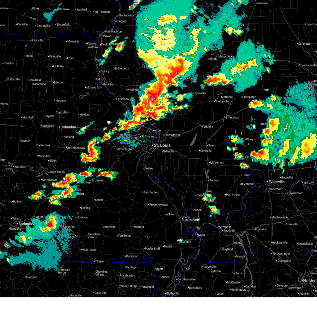
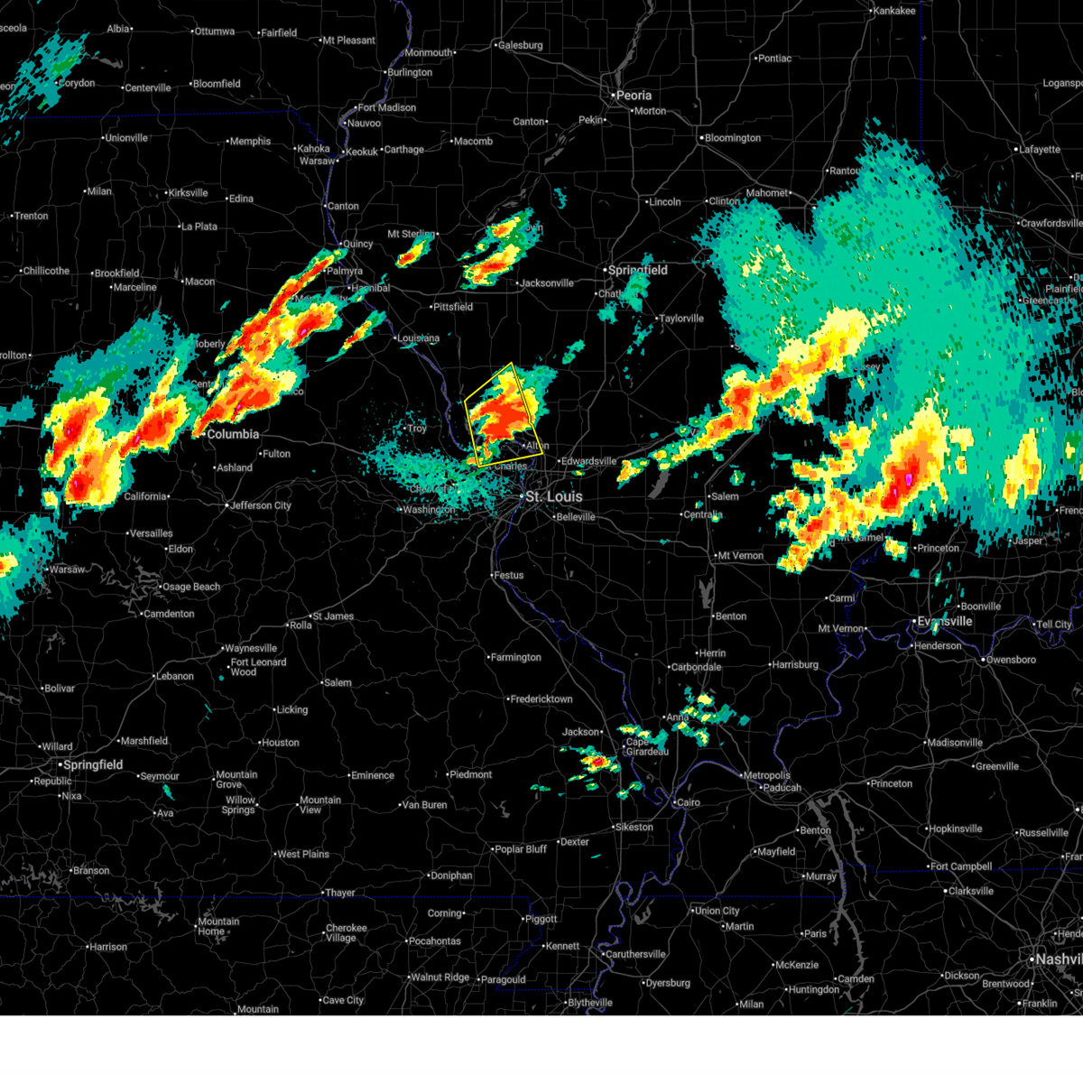
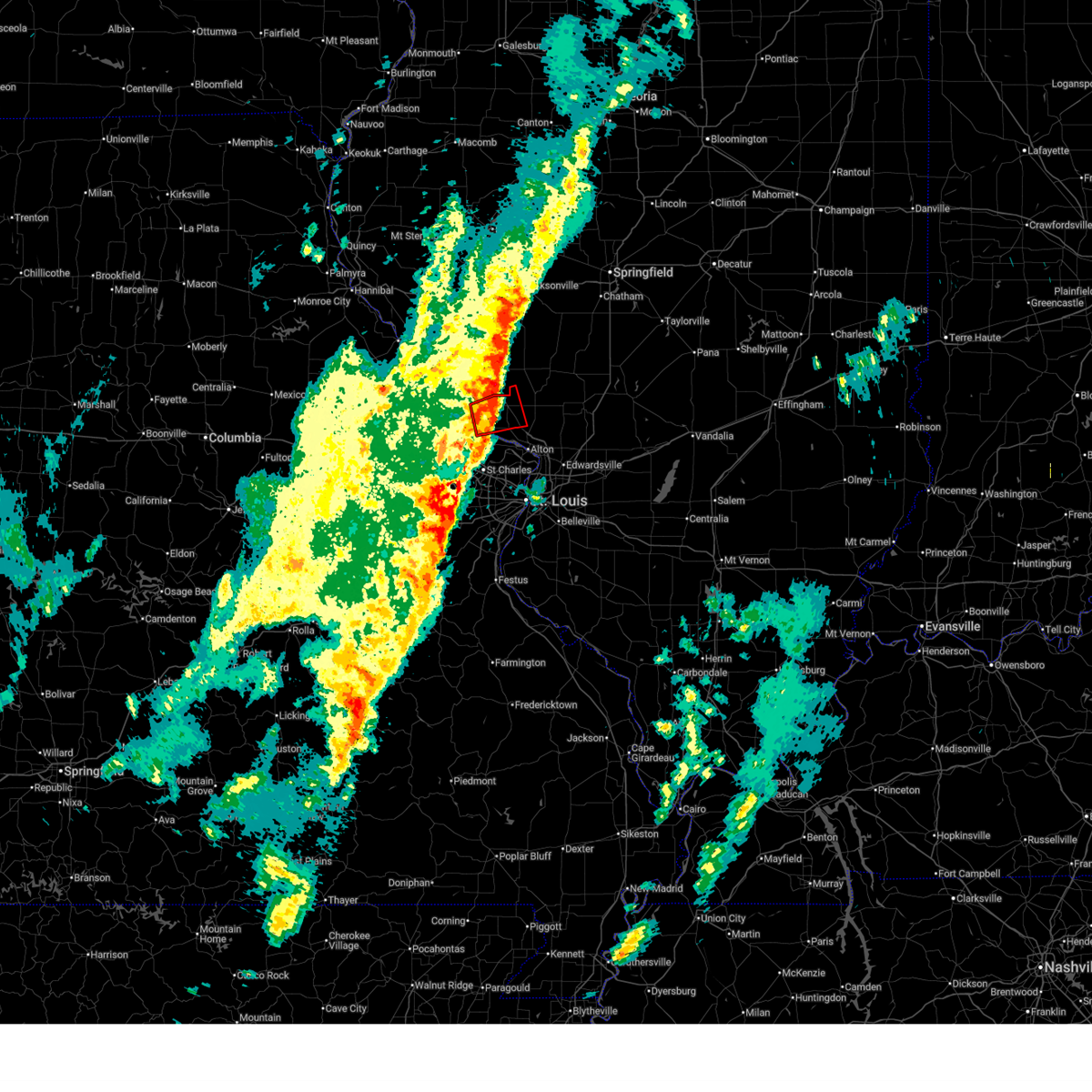
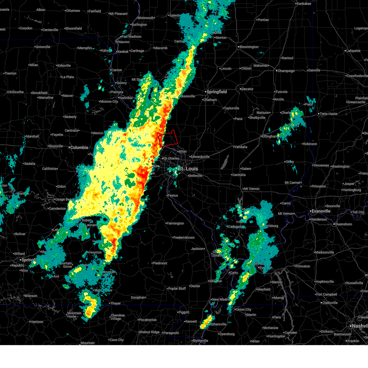
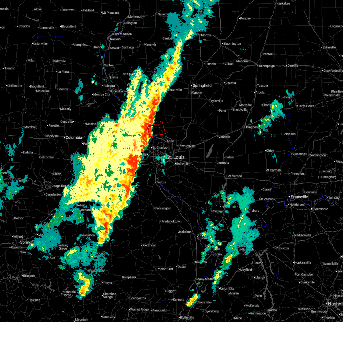
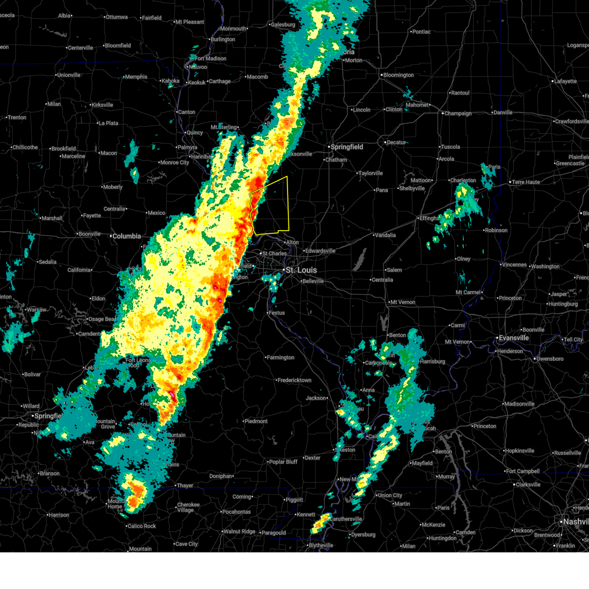
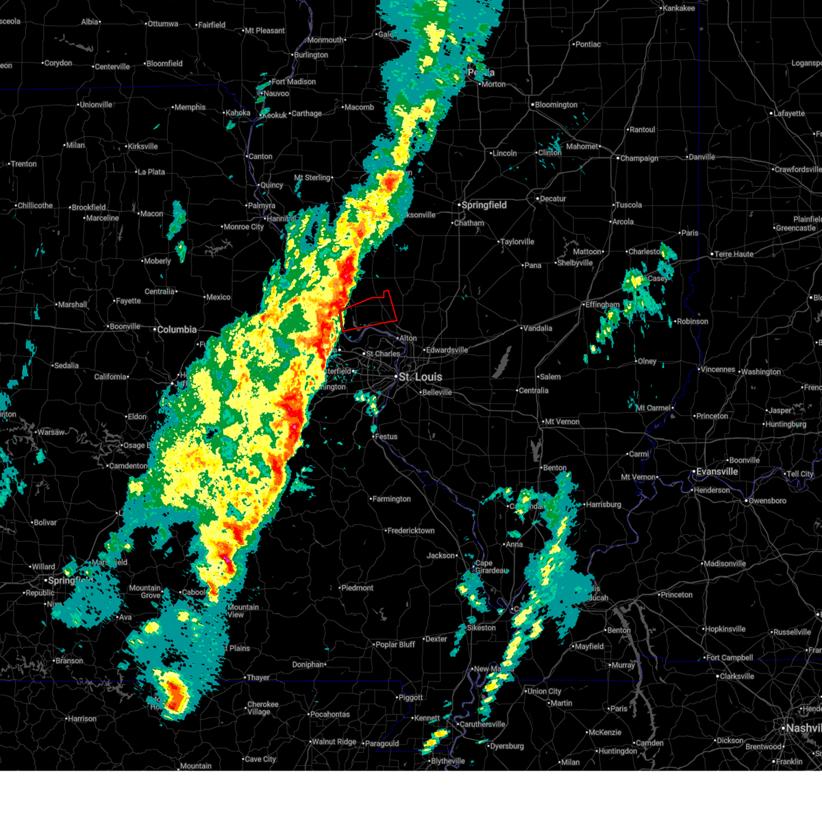
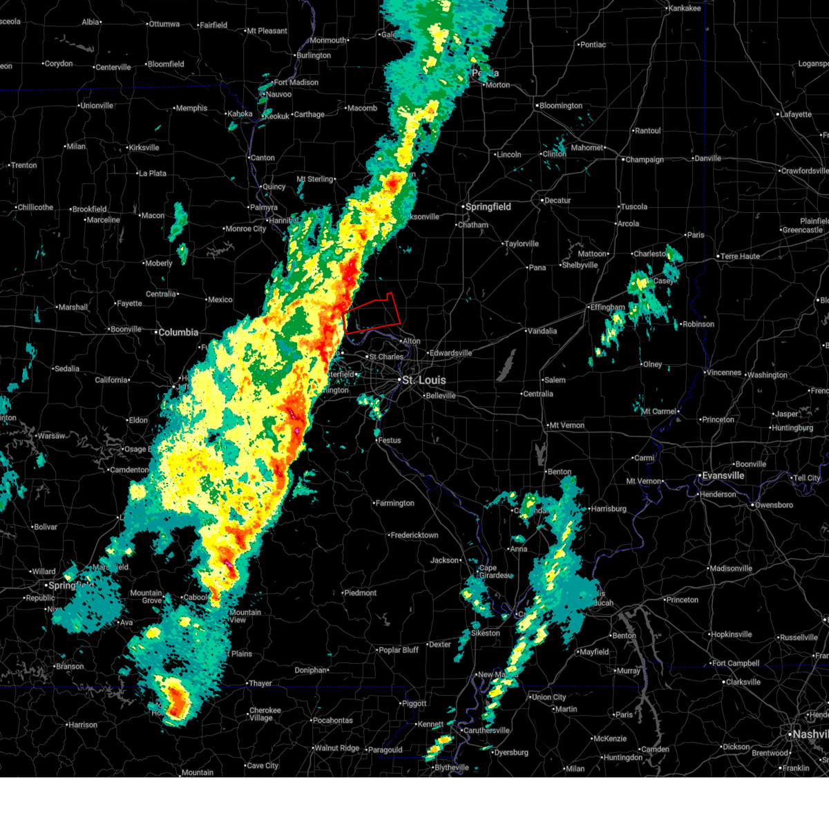
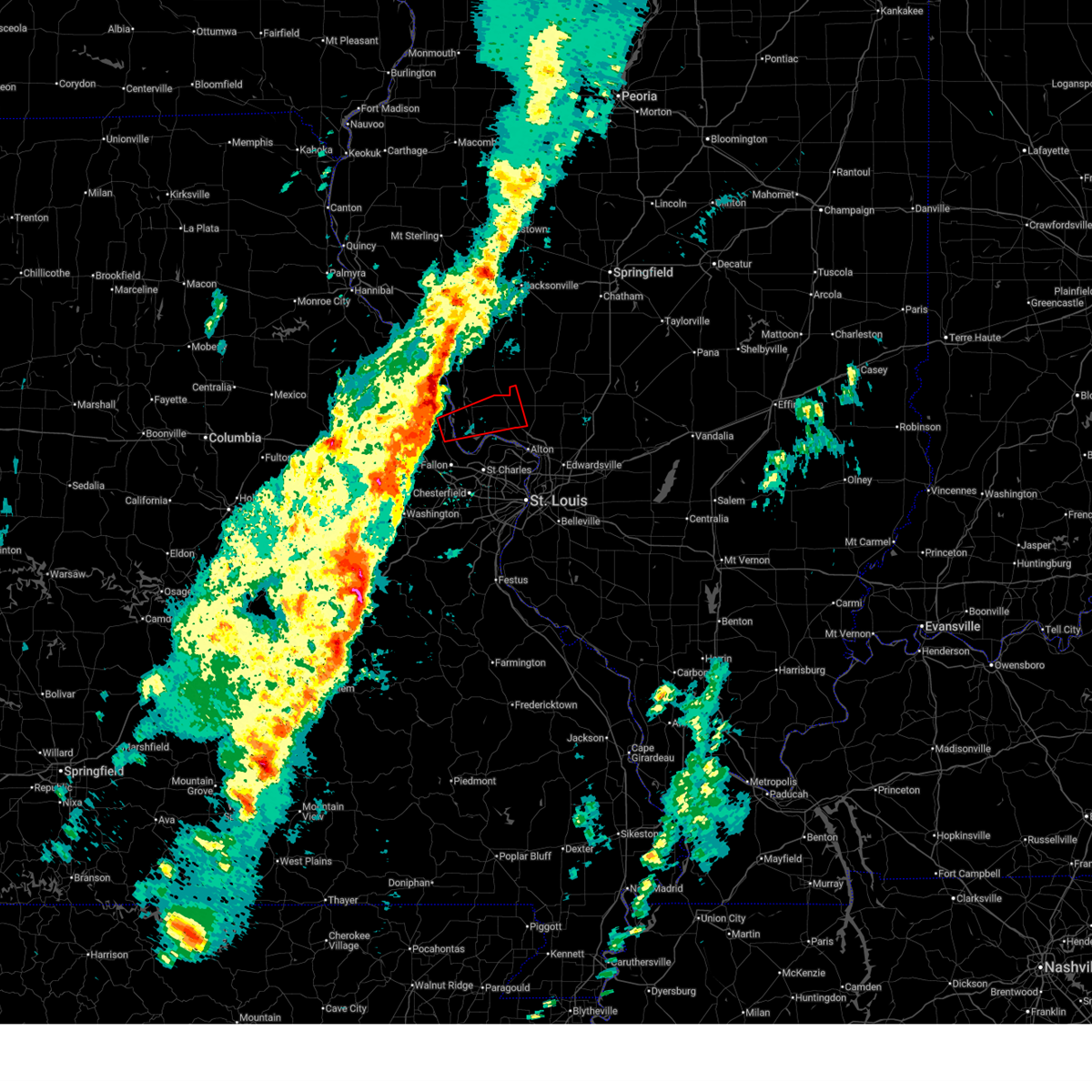
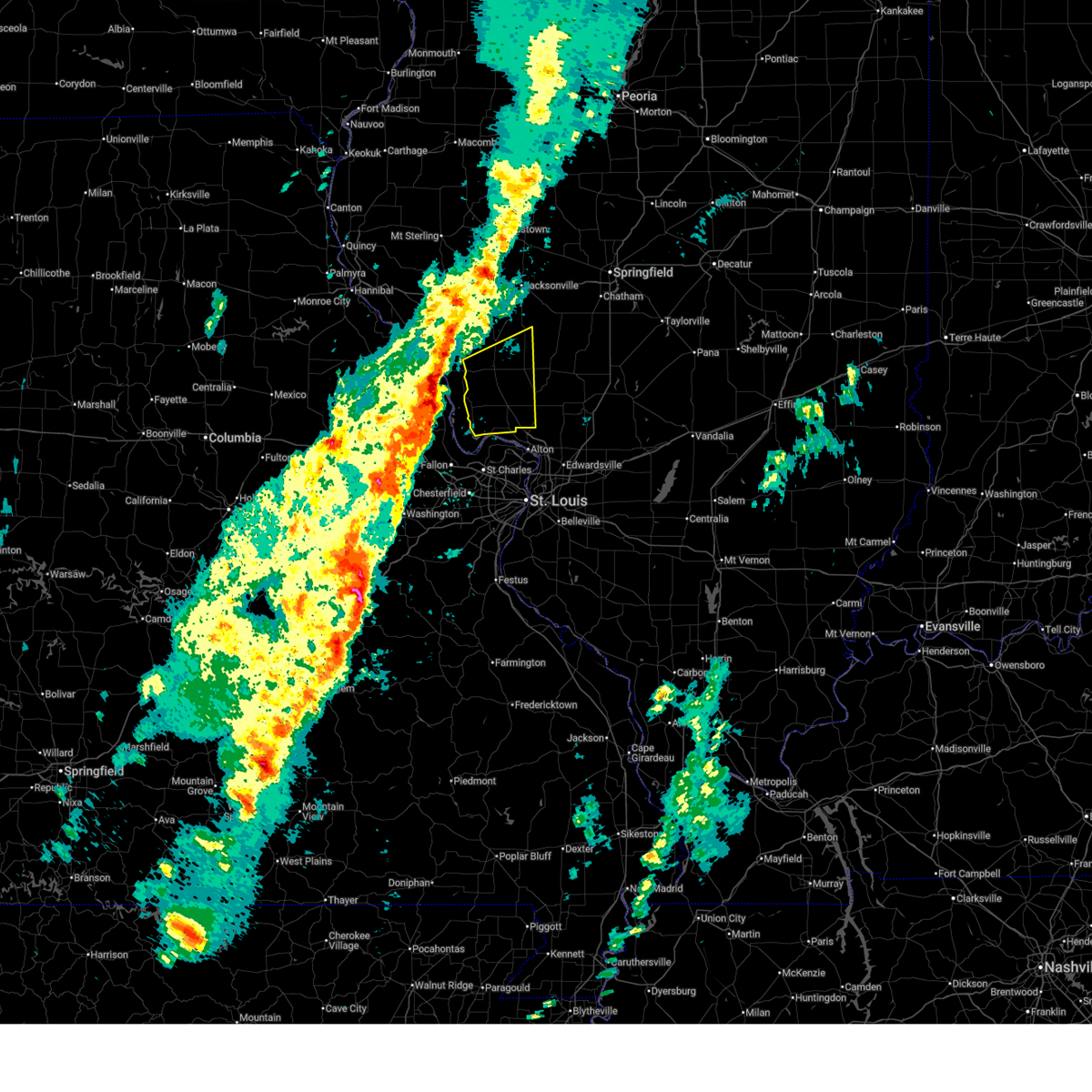
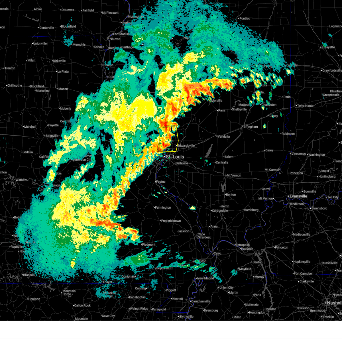
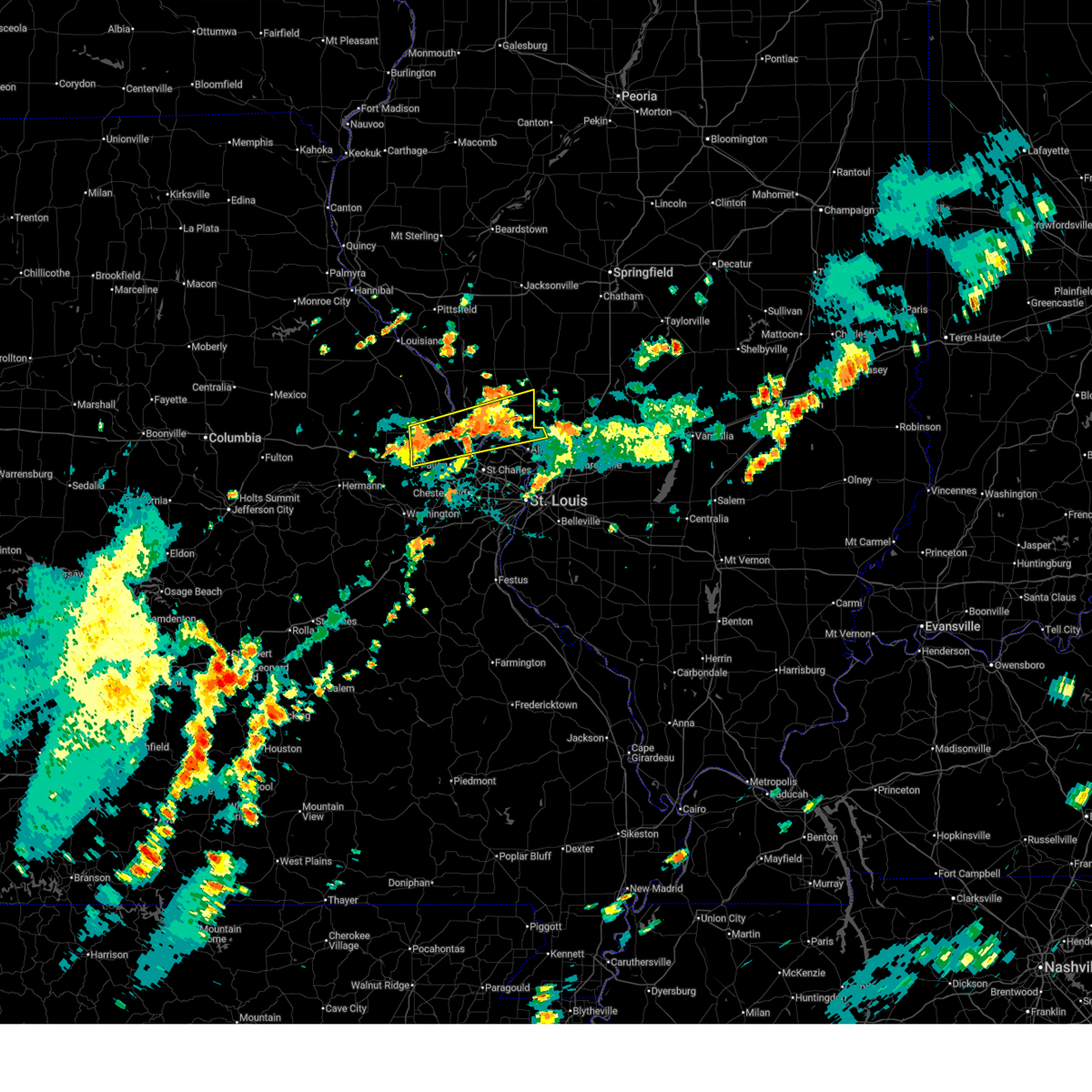
Hail Map for Jerseyville, IL
The Jerseyville, IL area has had 11 reports of on-the-ground hail by trained spotters, and has been under severe weather warnings 46 times during the past 12 months. Doppler radar has detected hail at or near Jerseyville, IL on 70 occasions, including 3 occasions during the past year.
| Name: | Jerseyville, IL |
| Where Located: | 34.3 miles NNW of Saint Louis, MO |
| Map: | Google Map for Jerseyville, IL |
| Population: | 8465 |
| Housing Units: | 3756 |
| More Info: | Search Google for Jerseyville, IL |
5
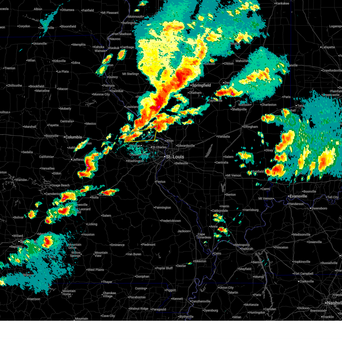
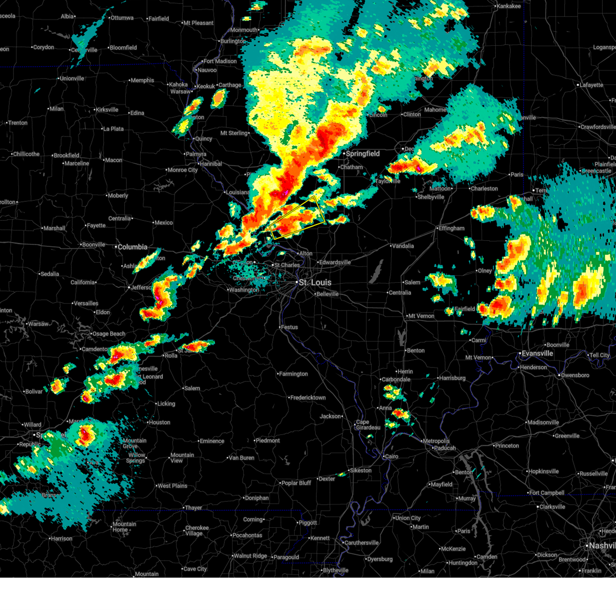
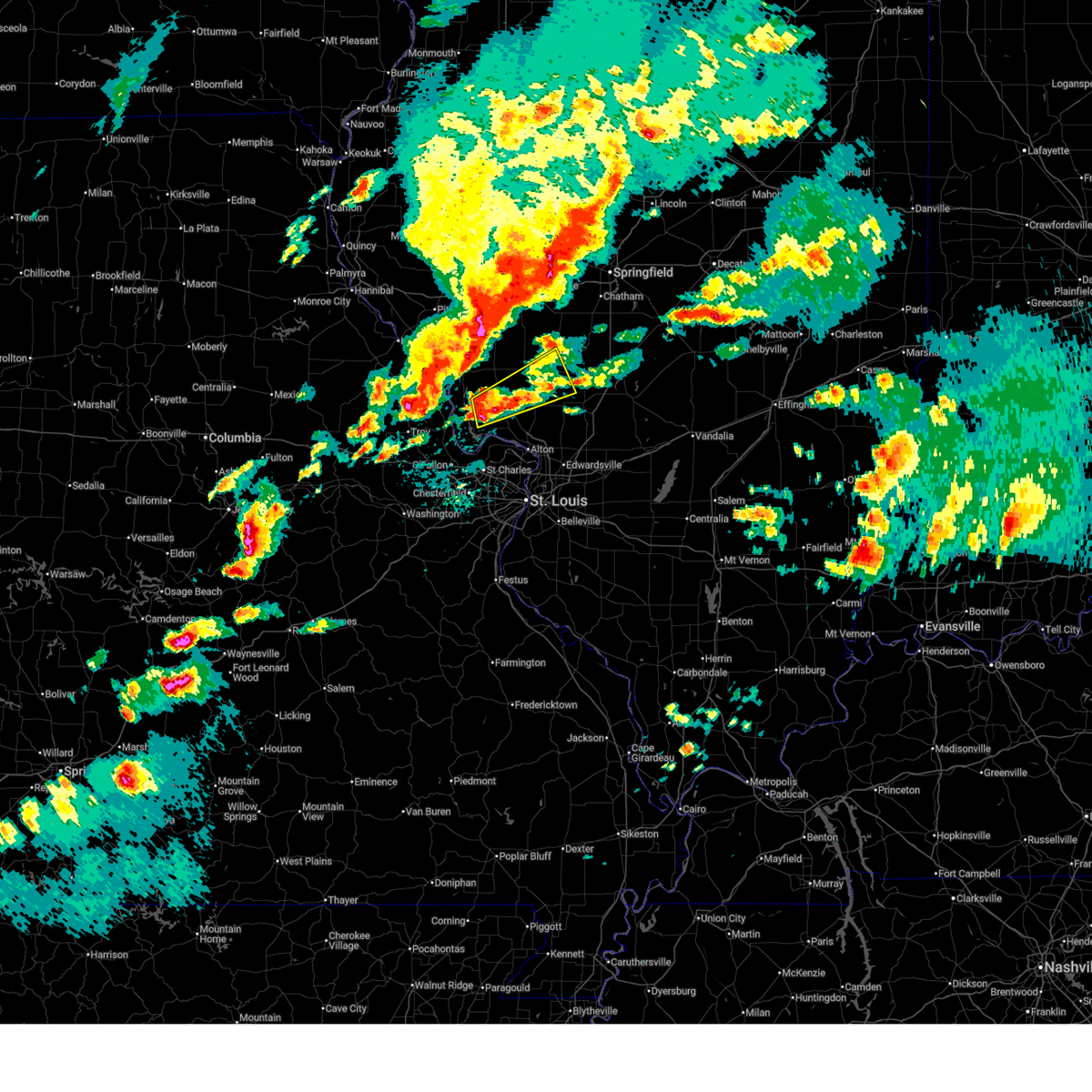
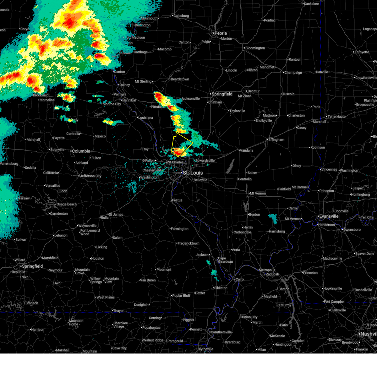
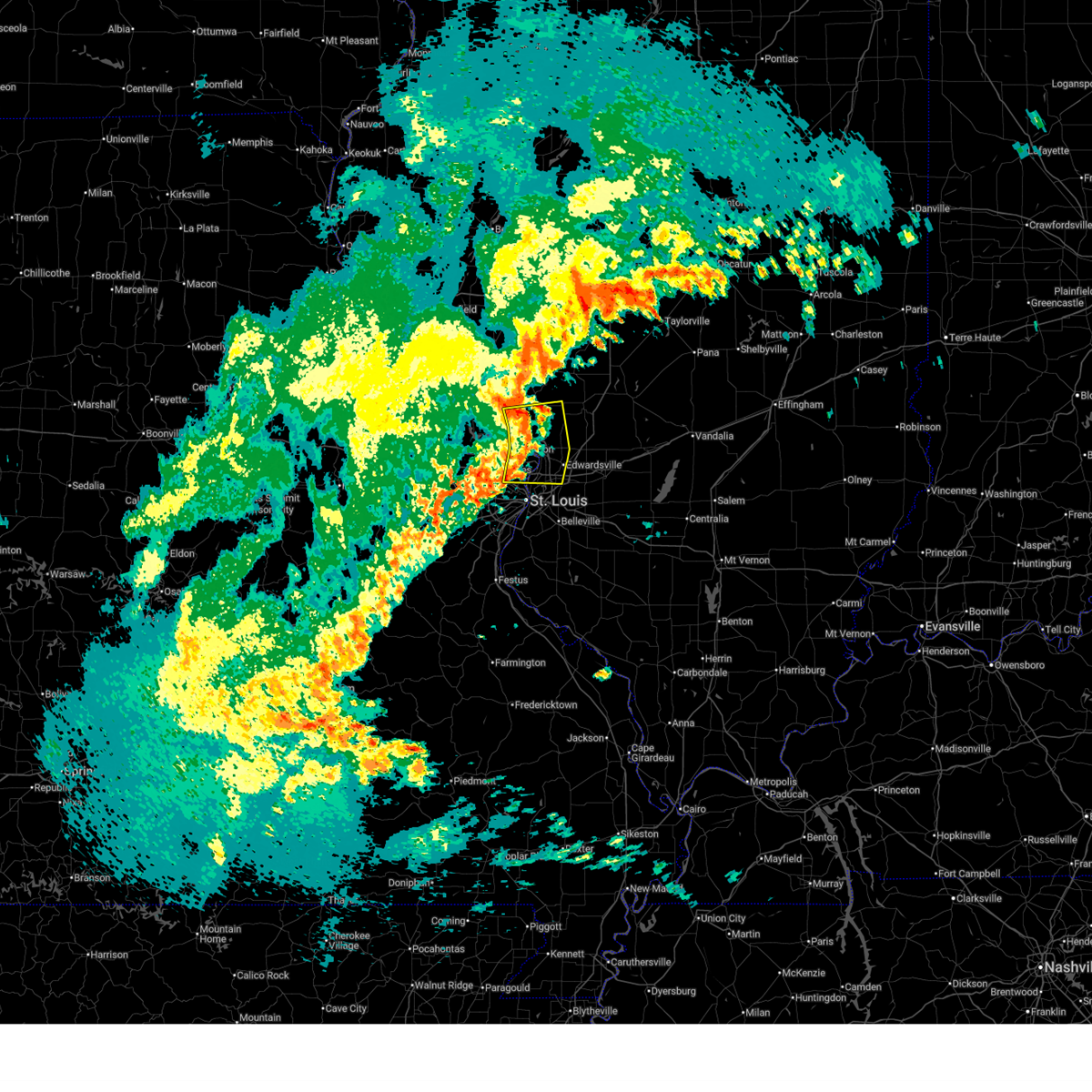
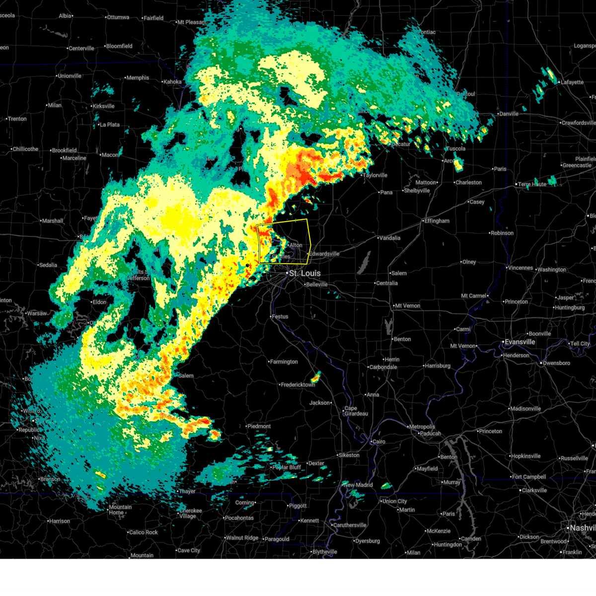
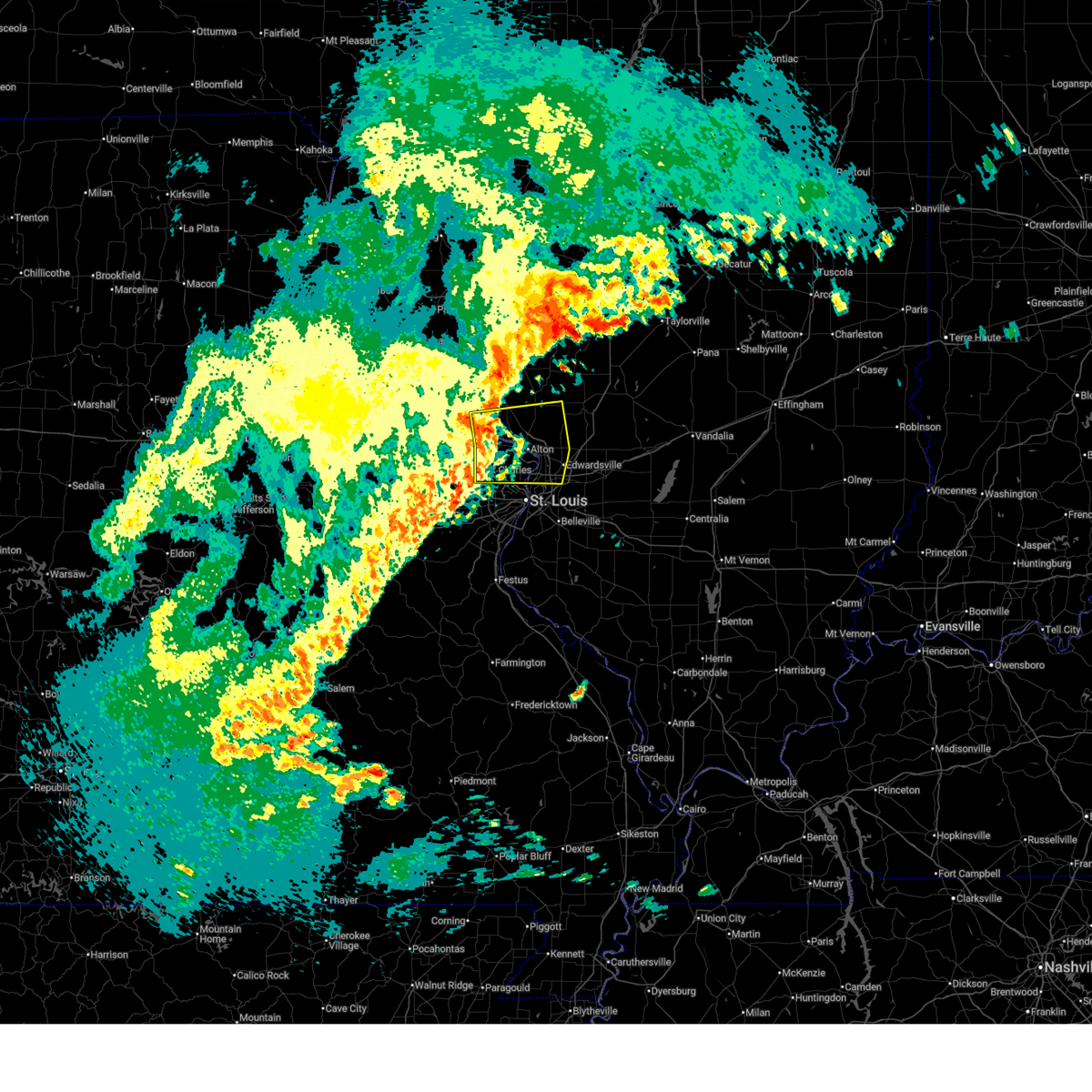
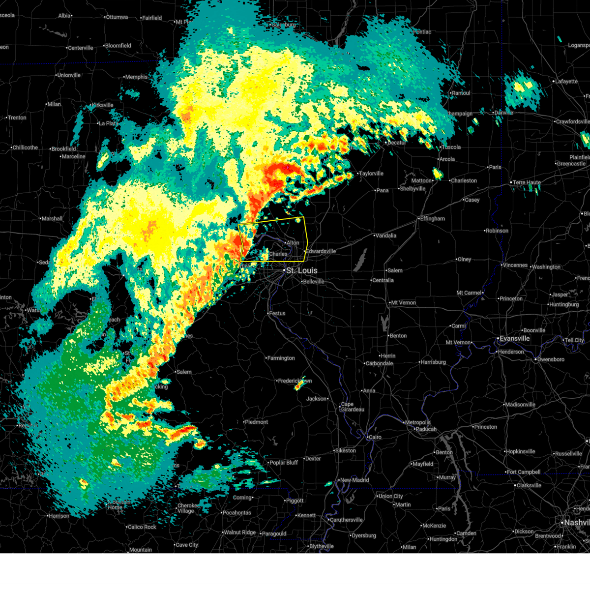
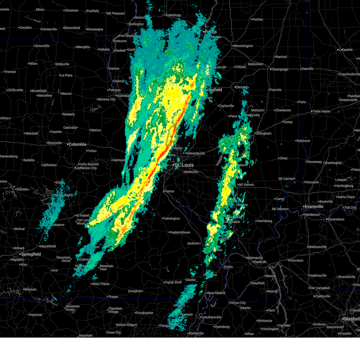
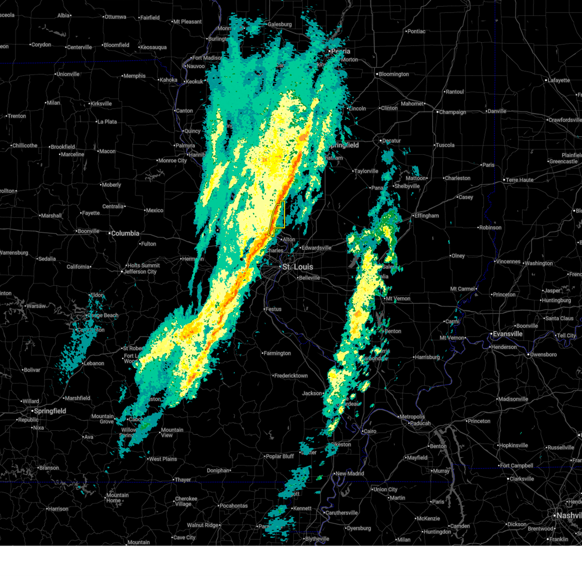
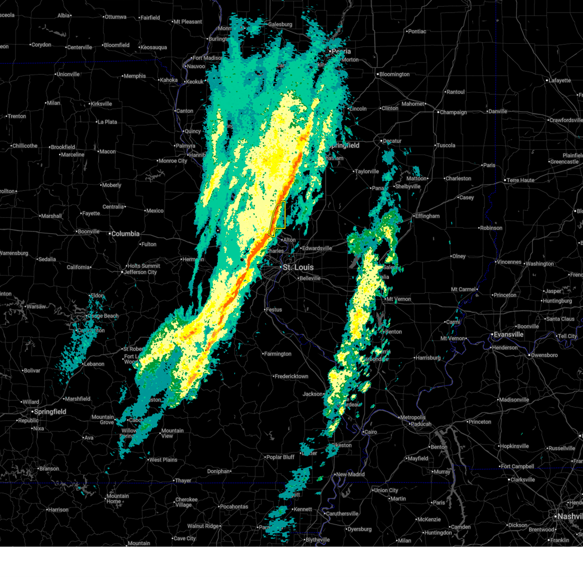
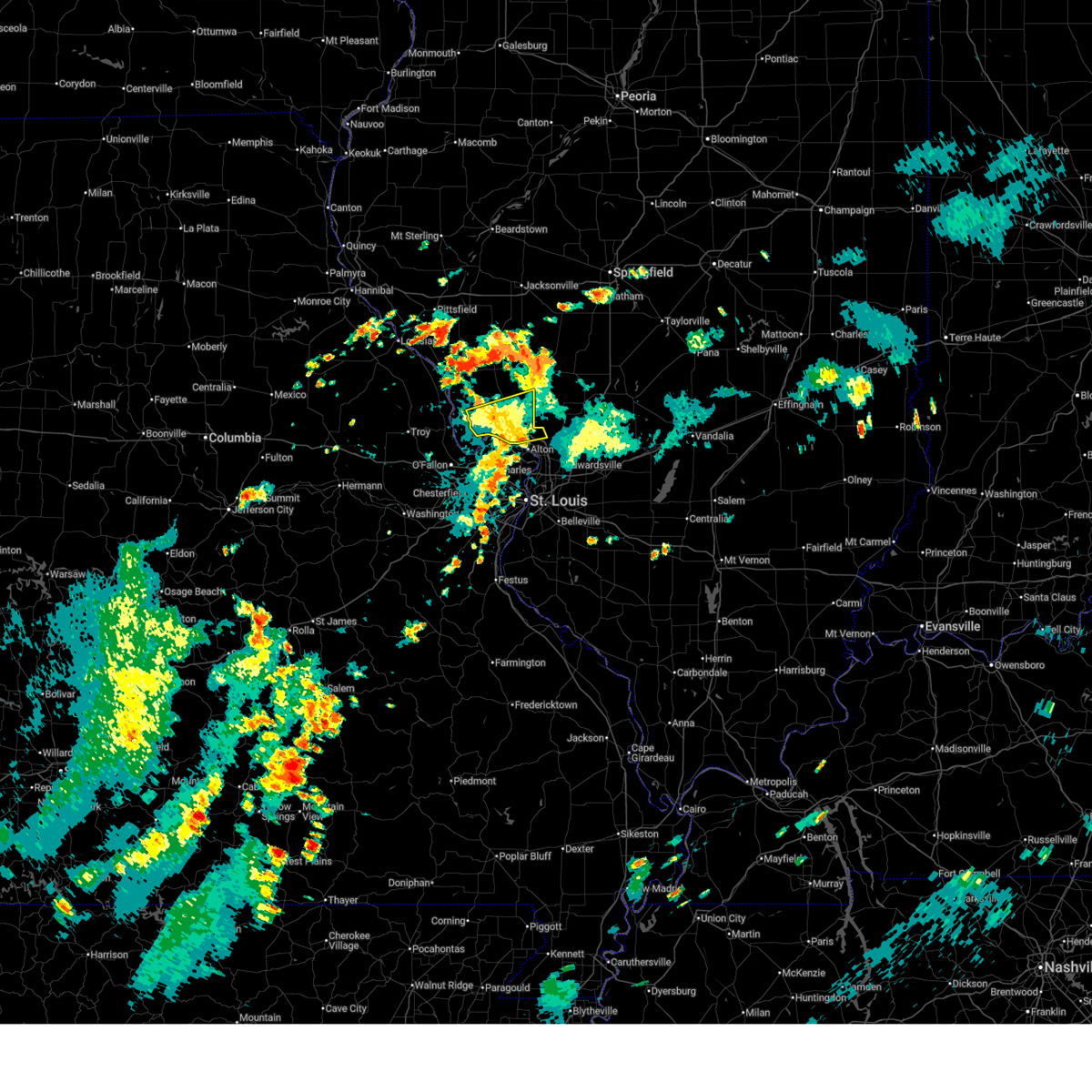
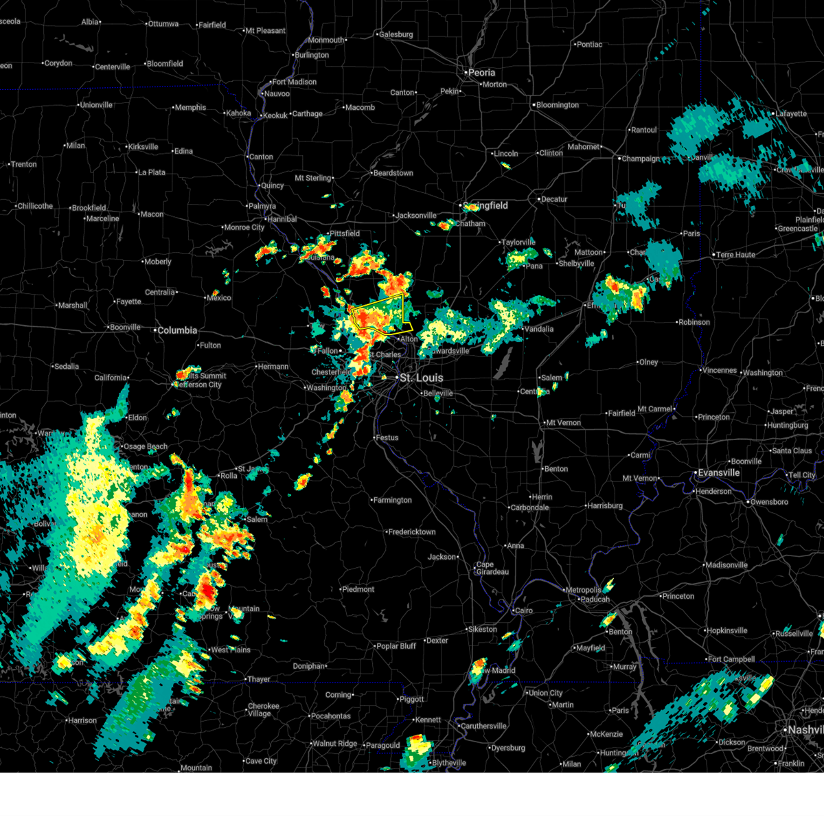
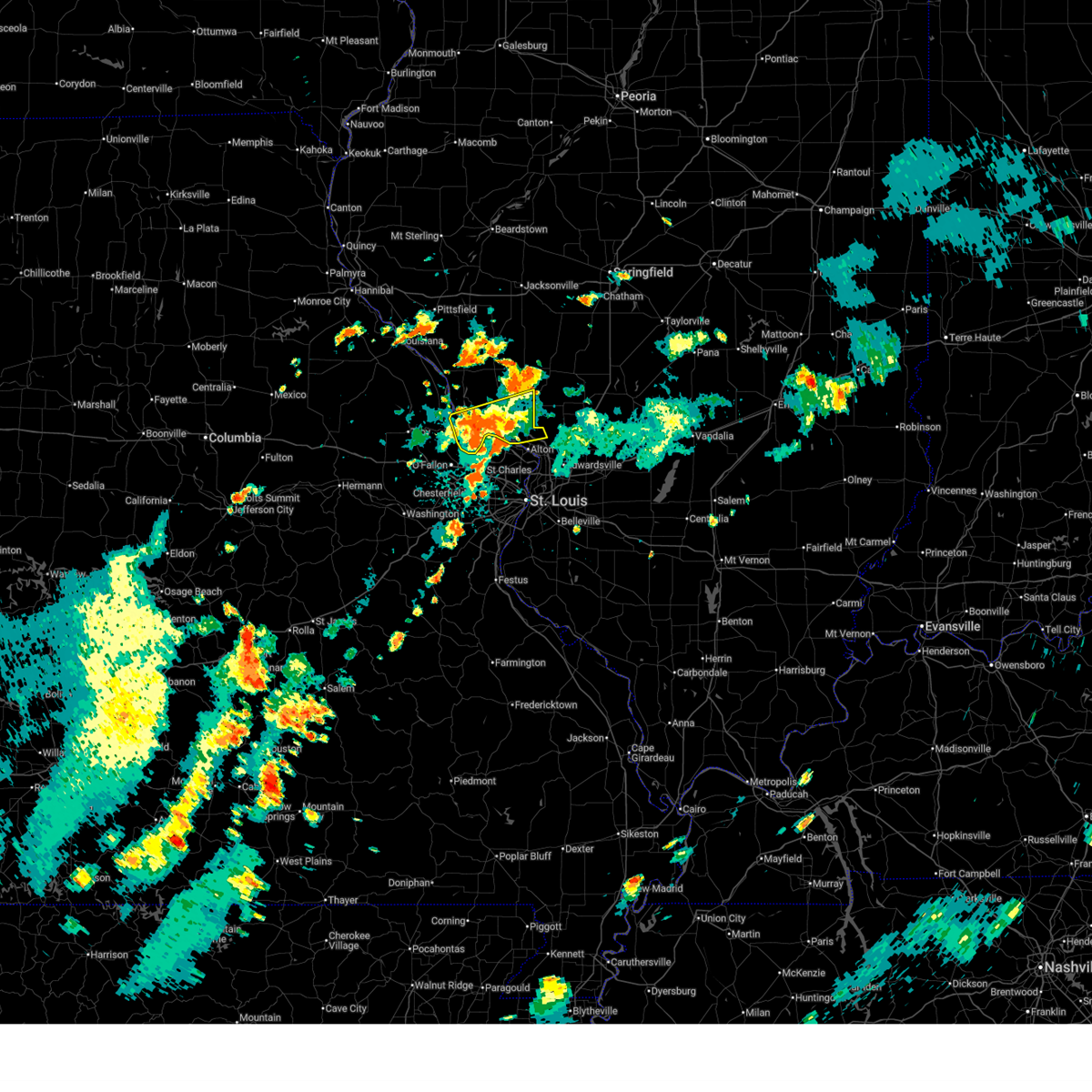
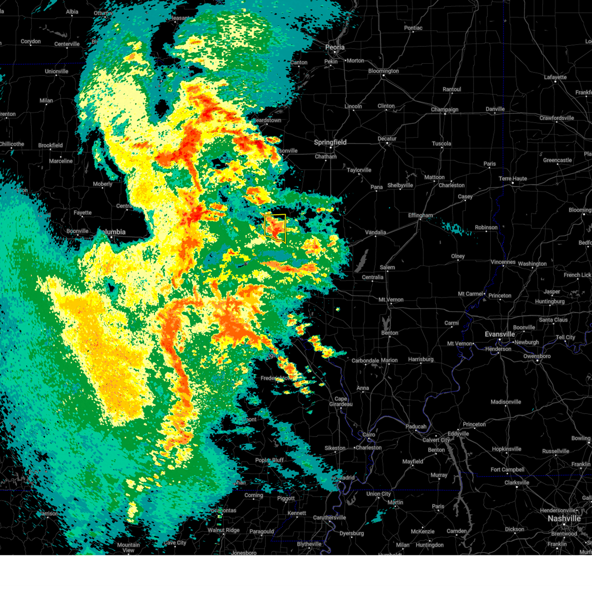
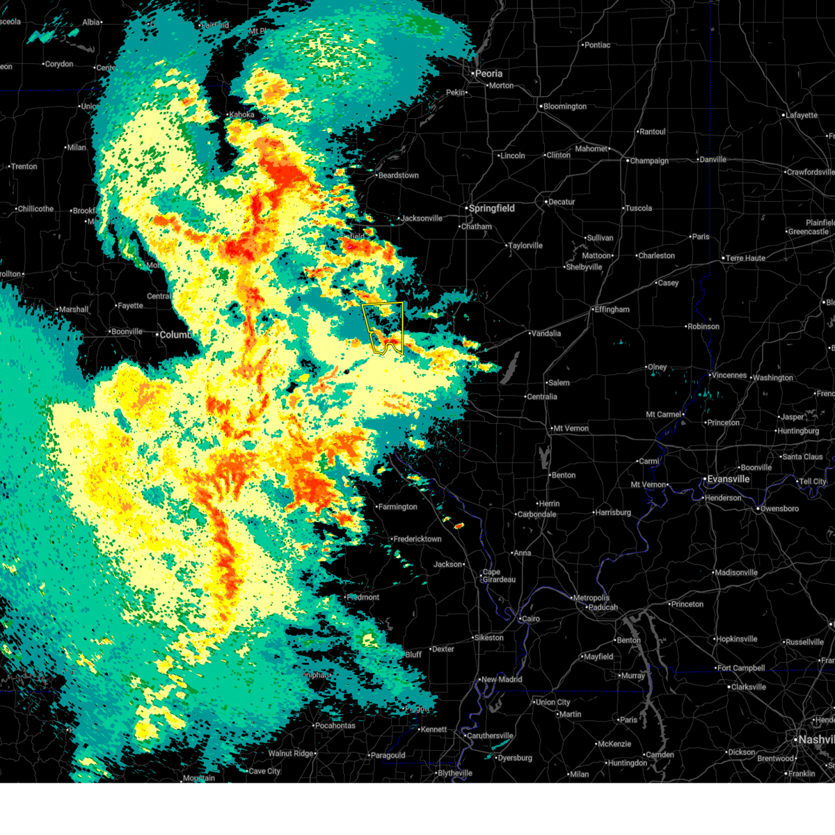
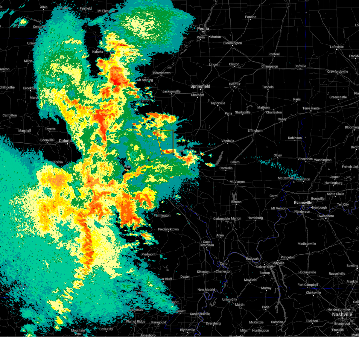
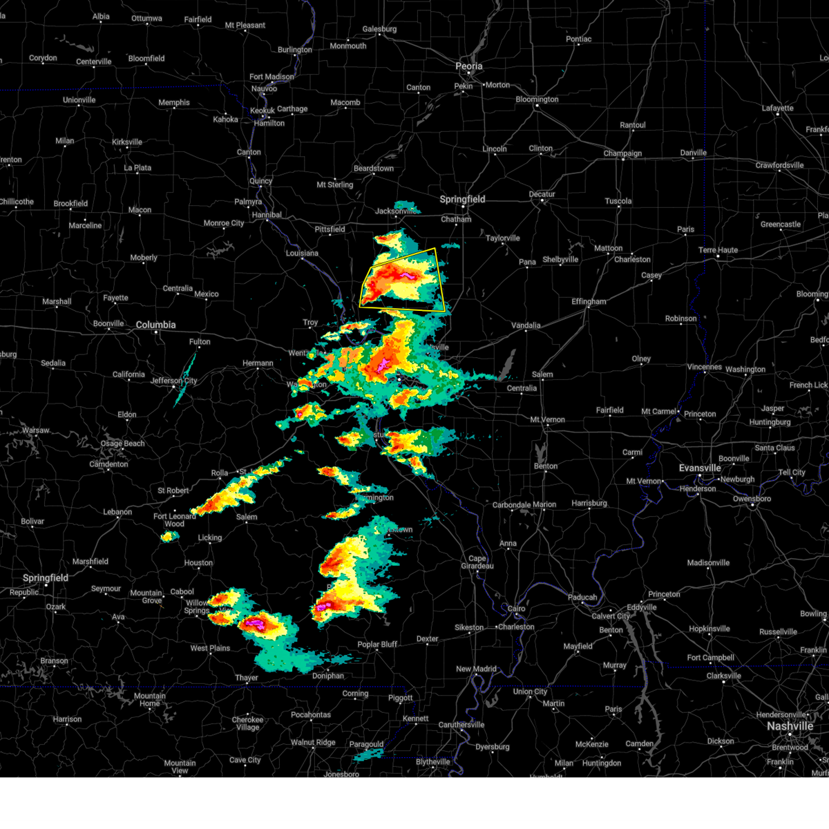
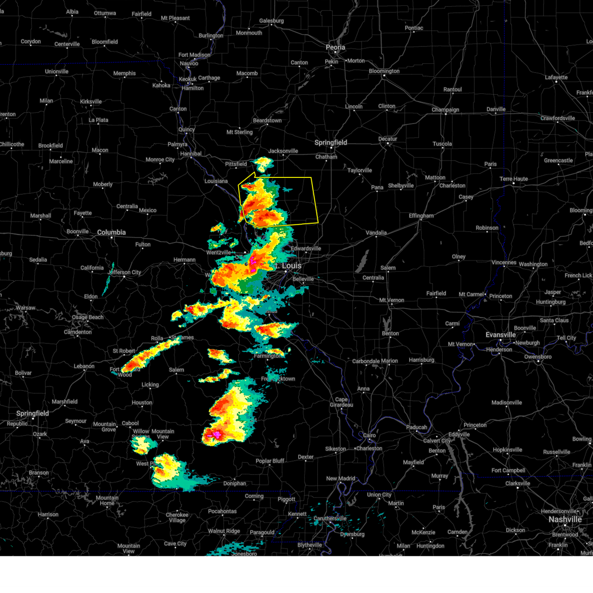
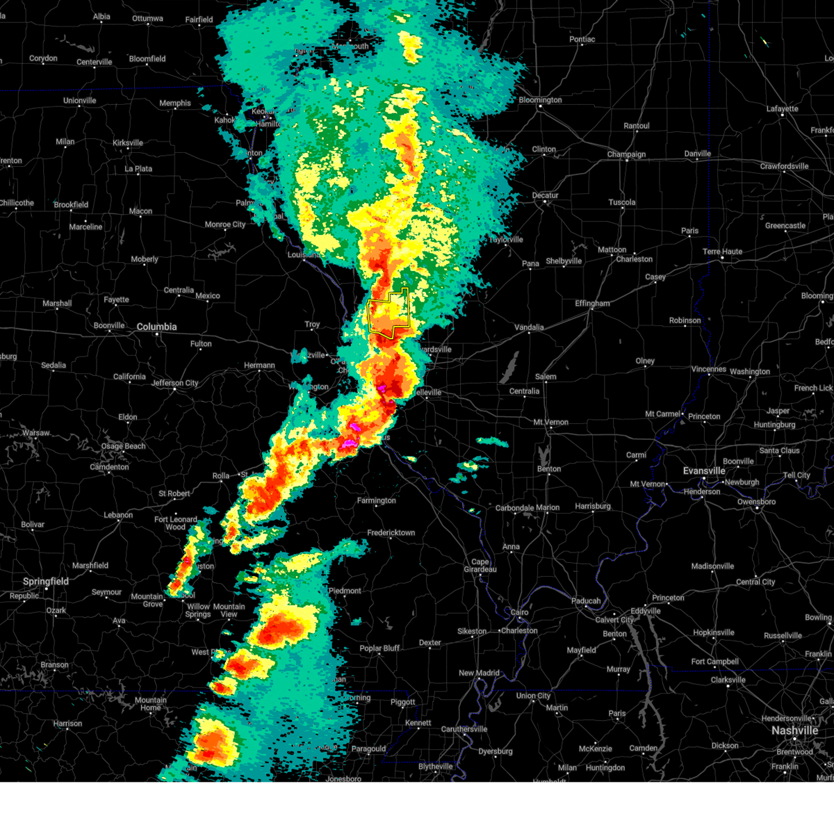
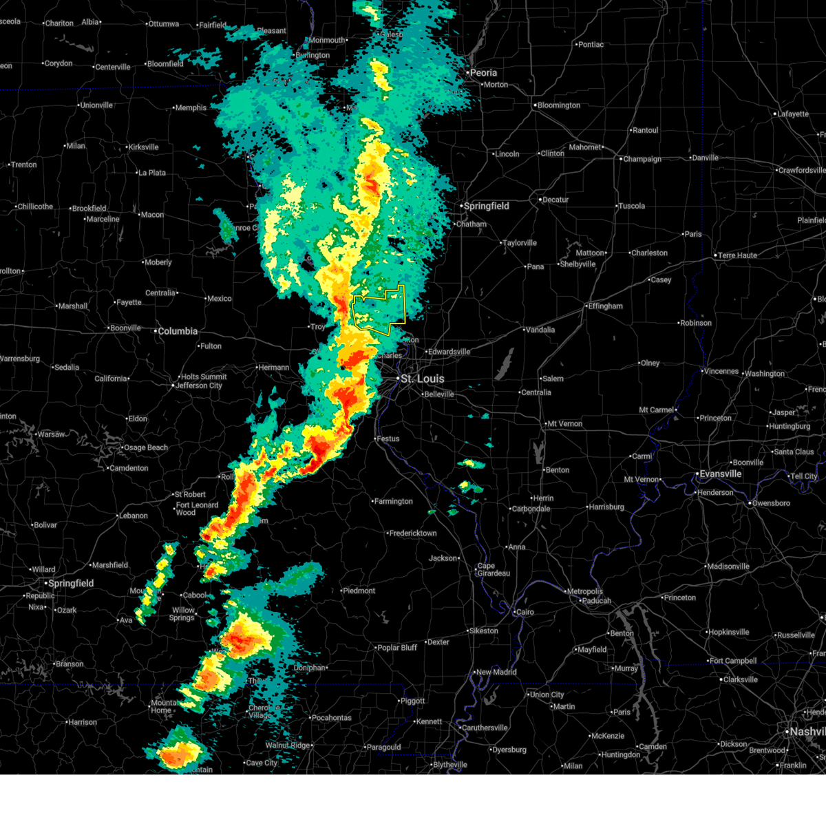
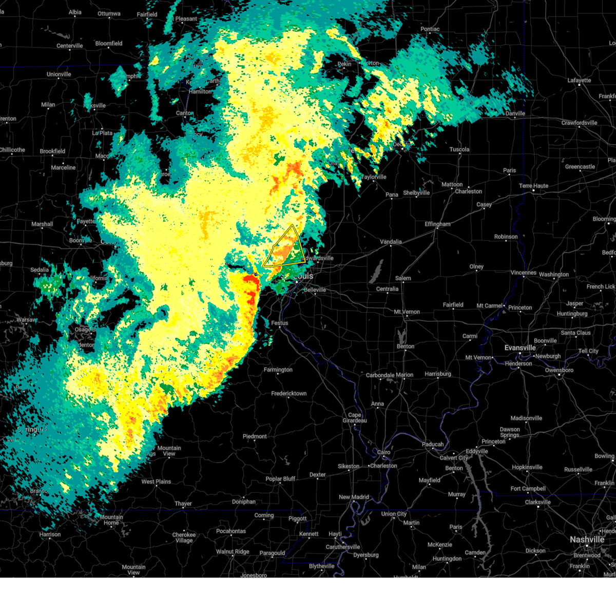
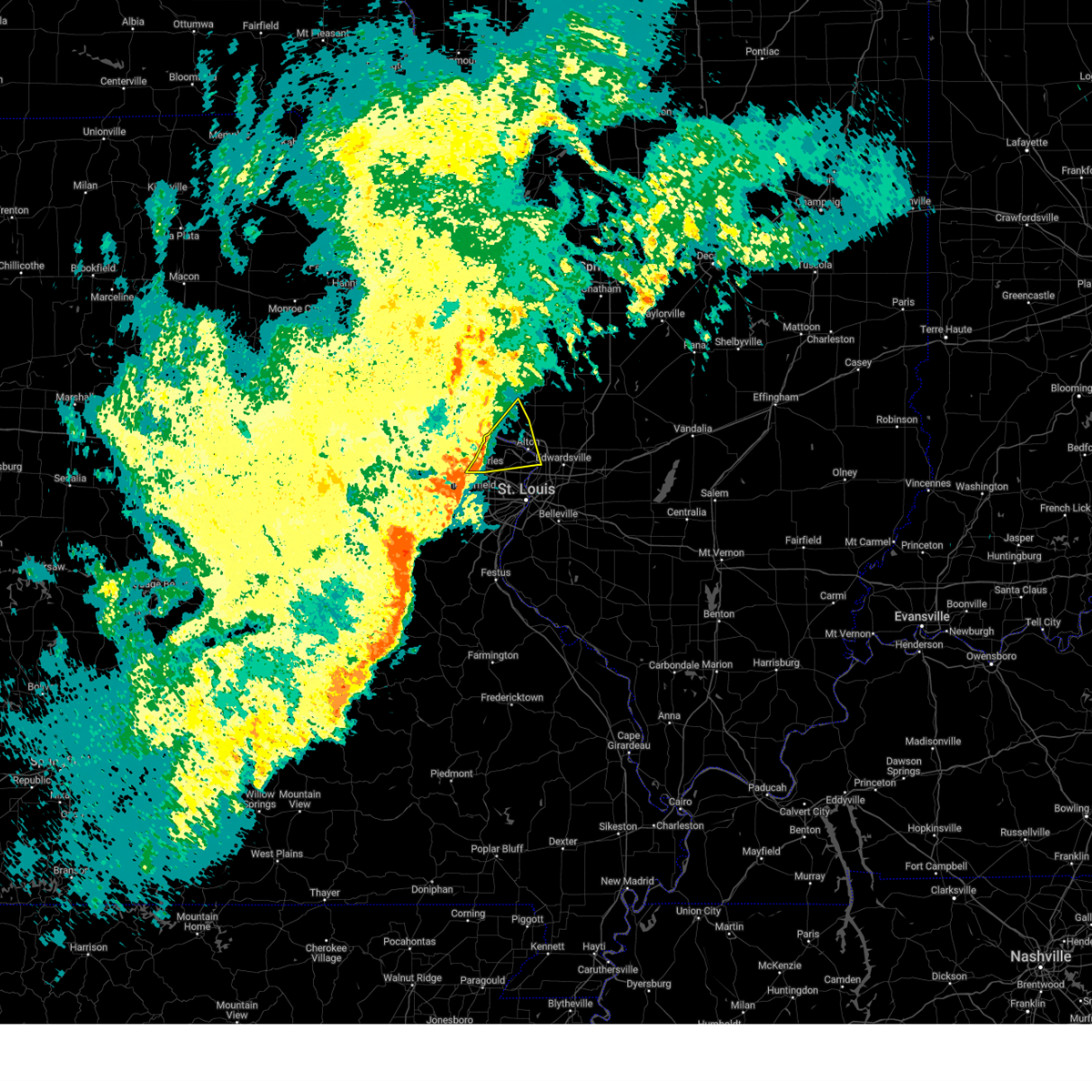
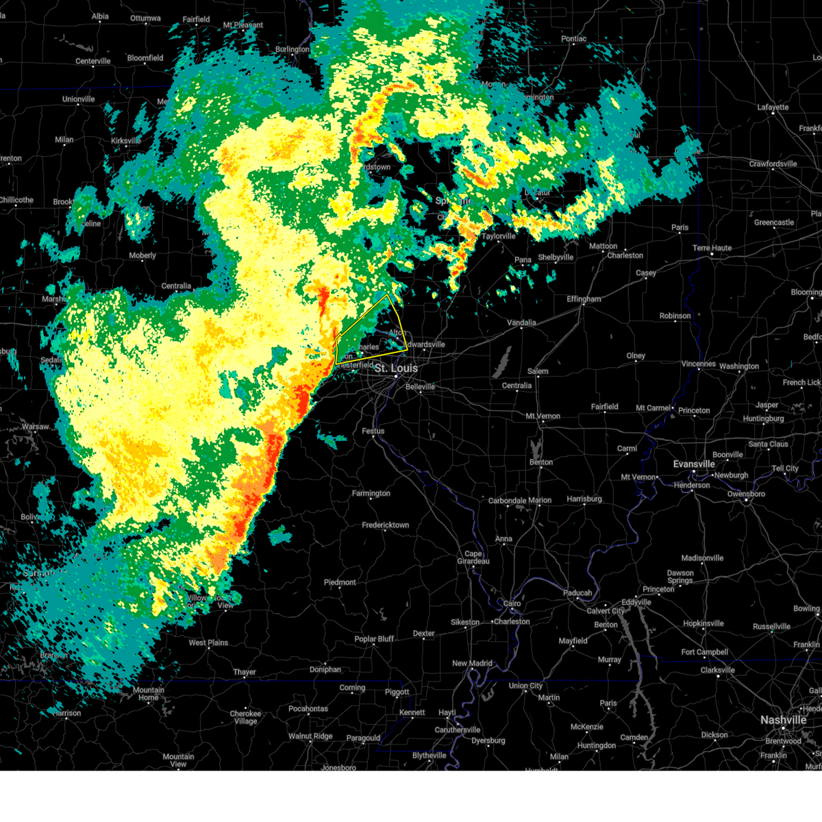
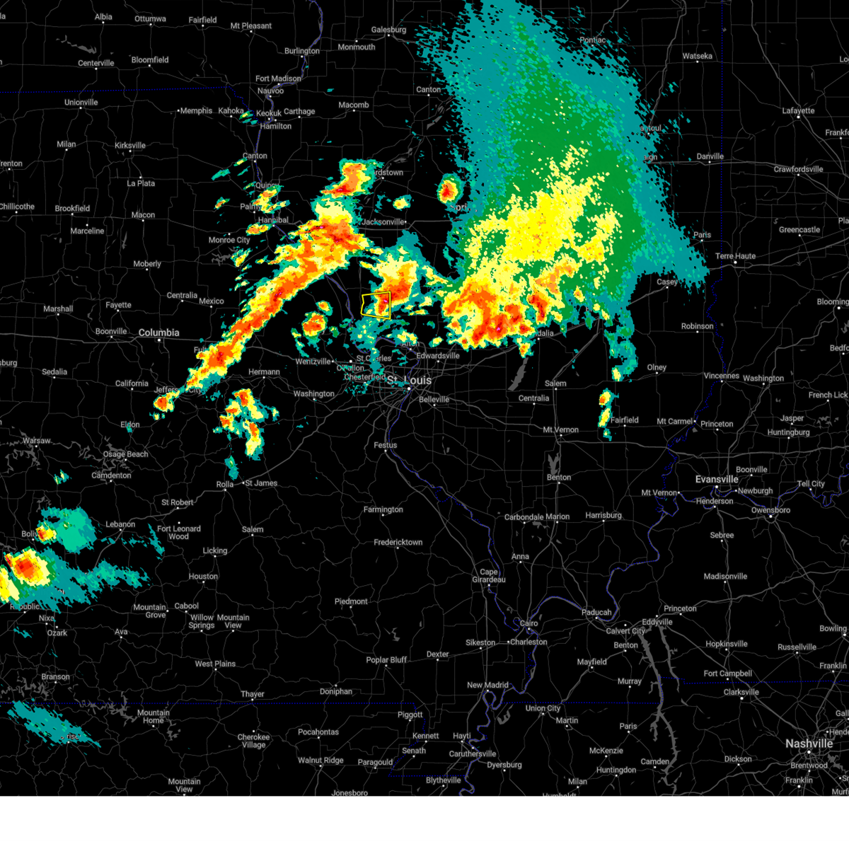
The Top Recent Hail Date for Jerseyville, IL is Monday, April 27, 2026 (1st out of 70)

Hail and Wind Damage Spotted near Jerseyville, IL
| Date / Time | Report Details |
|---|---|
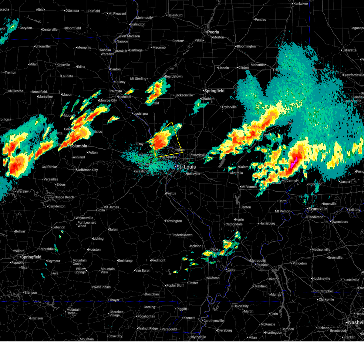
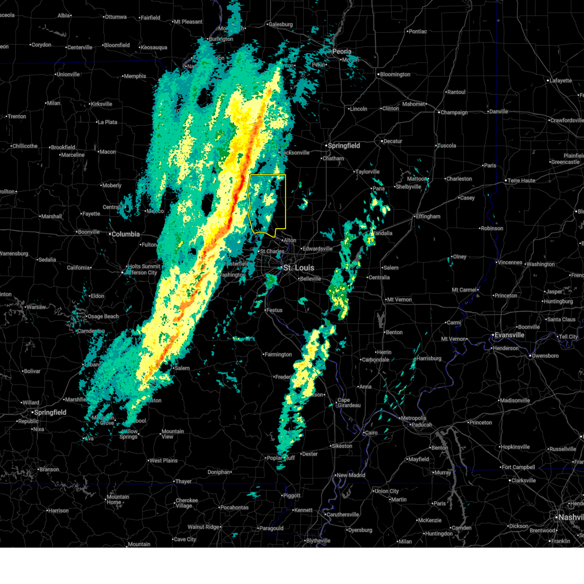
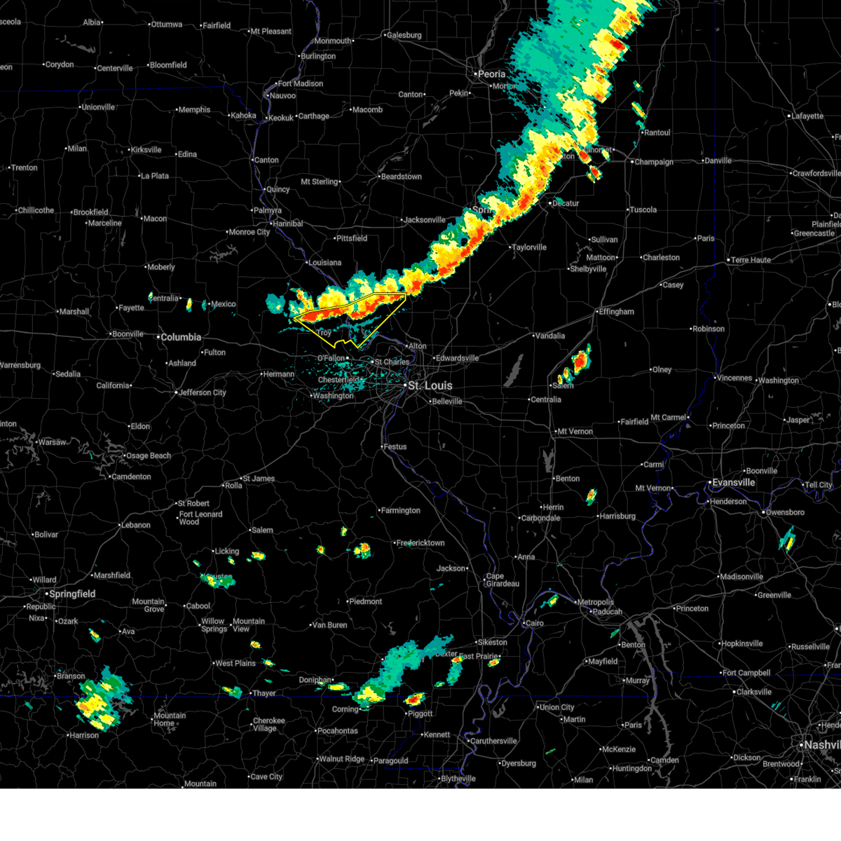
| 4/27/2026 6:43 PM CDT |
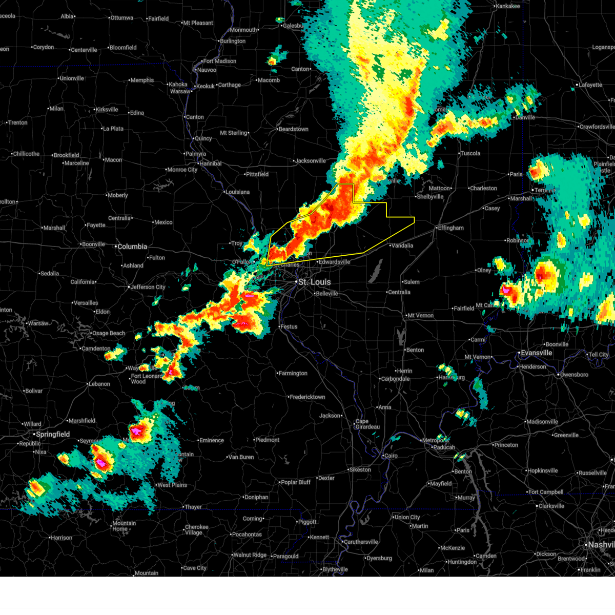 At 643 pm cdt, severe thunderstorms were located along a line from 14 miles north of nokomis to over west alton, or along a line from 14 miles north of nokomis to over alton, moving east at 65 mph (radar indicated). Hazards include ping pong ball size hail and 60 mph wind gusts. People and animals outdoors will be injured. expect hail damage to roofs, siding, windows, and vehicles. expect wind damage to roofs, siding, and trees. locations impacted include, jerseyville, carlinville, godfrey, st. charles, brighton, bridgeton, hazelwood, gillespie, florissant, alton, litchfield, black jack, bethalto, east alton, hillsboro, wood river, staunton, nokomis and greenville. this includes the following state parks, confluence state park, first missouri state capitol historic site, ramsey lake state park, beaver dam state park and lake lou yaeger. this includes the following highways, interstate 55 in illinois between exits 30 and 63. Interstate 70 in missouri between exits 227 and 228. At 643 pm cdt, severe thunderstorms were located along a line from 14 miles north of nokomis to over west alton, or along a line from 14 miles north of nokomis to over alton, moving east at 65 mph (radar indicated). Hazards include ping pong ball size hail and 60 mph wind gusts. People and animals outdoors will be injured. expect hail damage to roofs, siding, windows, and vehicles. expect wind damage to roofs, siding, and trees. locations impacted include, jerseyville, carlinville, godfrey, st. charles, brighton, bridgeton, hazelwood, gillespie, florissant, alton, litchfield, black jack, bethalto, east alton, hillsboro, wood river, staunton, nokomis and greenville. this includes the following state parks, confluence state park, first missouri state capitol historic site, ramsey lake state park, beaver dam state park and lake lou yaeger. this includes the following highways, interstate 55 in illinois between exits 30 and 63. Interstate 70 in missouri between exits 227 and 228.
|
| 4/27/2026 6:28 PM CDT |
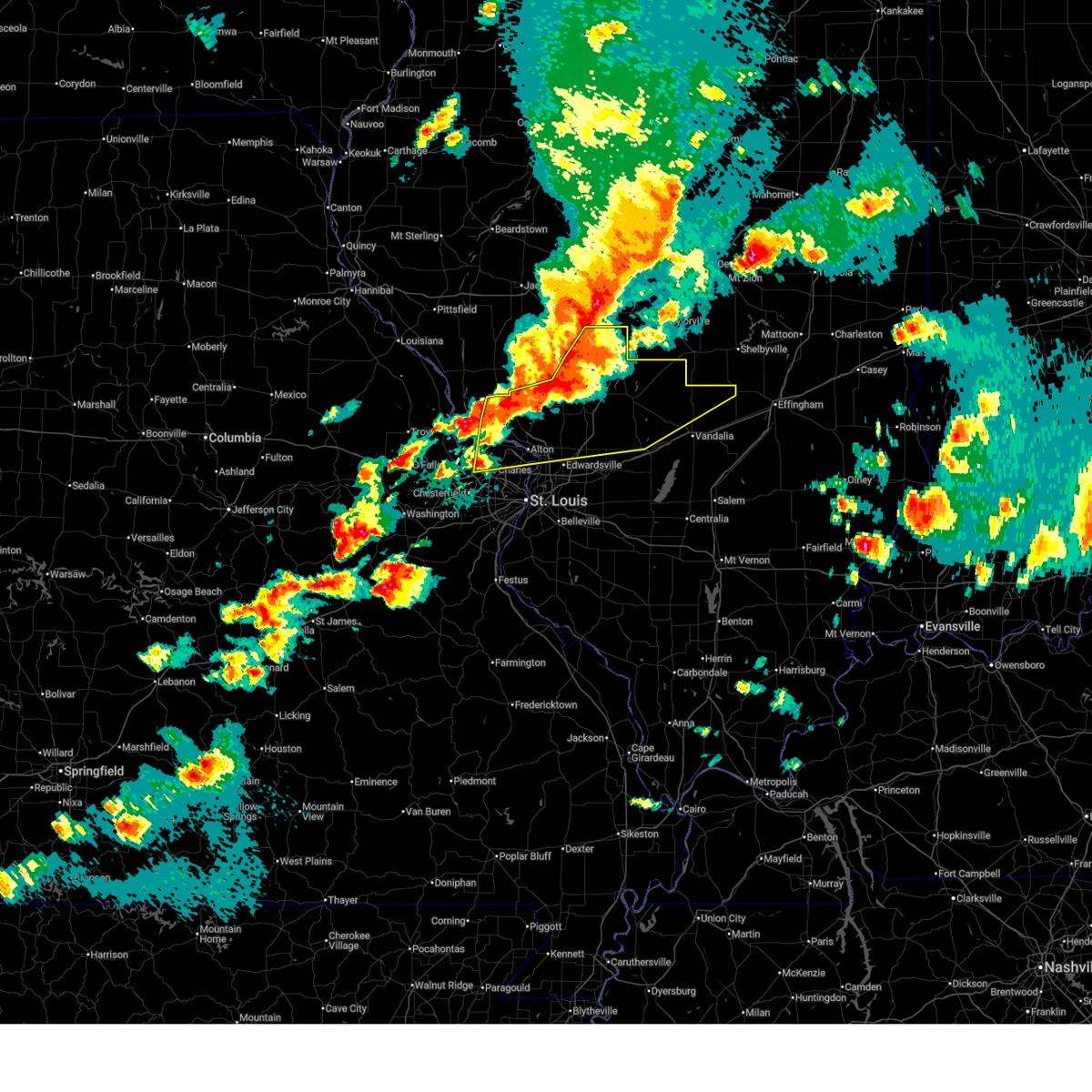 Svrlsx the national weather service in st louis has issued a * severe thunderstorm warning for, northern bond county in south central illinois, northwestern fayette county in south central illinois, montgomery county in south central illinois, eastern calhoun county in southwestern illinois, jersey county in southwestern illinois, macoupin county in southwestern illinois, northern madison county in southwestern illinois, northeastern saint charles county in east central missouri, northeastern saint louis county in east central missouri, * until 715 pm cdt. * at 628 pm cdt, severe thunderstorms were located along a line from near farmersville to over orchard farms, or along a line from 6 miles east of virden to 5 miles northeast of st. charles, moving east at 65 mph (radar indicated). Hazards include ping pong ball size hail and 60 mph wind gusts. People and animals outdoors will be injured. expect hail damage to roofs, siding, windows, and vehicles. Expect wind damage to roofs, siding, and trees. Svrlsx the national weather service in st louis has issued a * severe thunderstorm warning for, northern bond county in south central illinois, northwestern fayette county in south central illinois, montgomery county in south central illinois, eastern calhoun county in southwestern illinois, jersey county in southwestern illinois, macoupin county in southwestern illinois, northern madison county in southwestern illinois, northeastern saint charles county in east central missouri, northeastern saint louis county in east central missouri, * until 715 pm cdt. * at 628 pm cdt, severe thunderstorms were located along a line from near farmersville to over orchard farms, or along a line from 6 miles east of virden to 5 miles northeast of st. charles, moving east at 65 mph (radar indicated). Hazards include ping pong ball size hail and 60 mph wind gusts. People and animals outdoors will be injured. expect hail damage to roofs, siding, windows, and vehicles. Expect wind damage to roofs, siding, and trees.
|
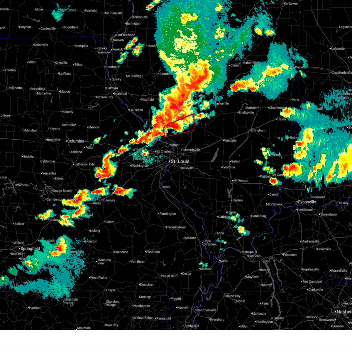
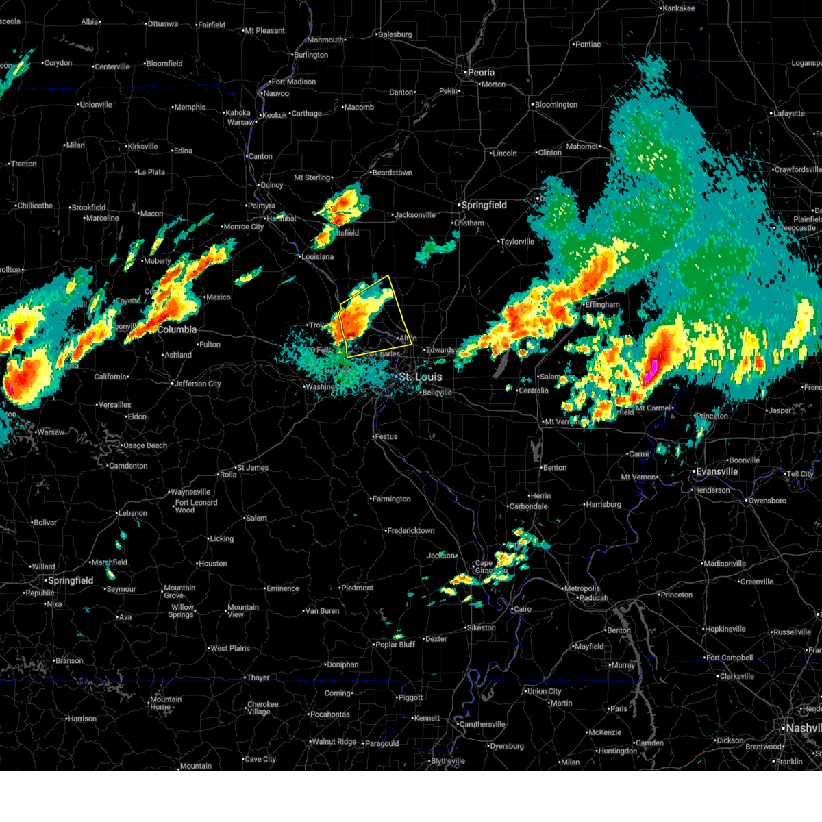
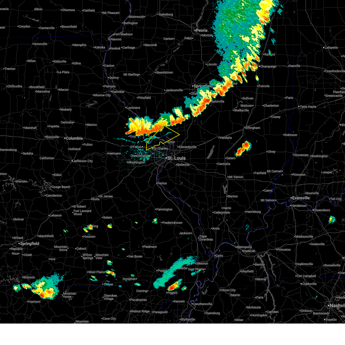
| 4/27/2026 6:14 PM CDT |
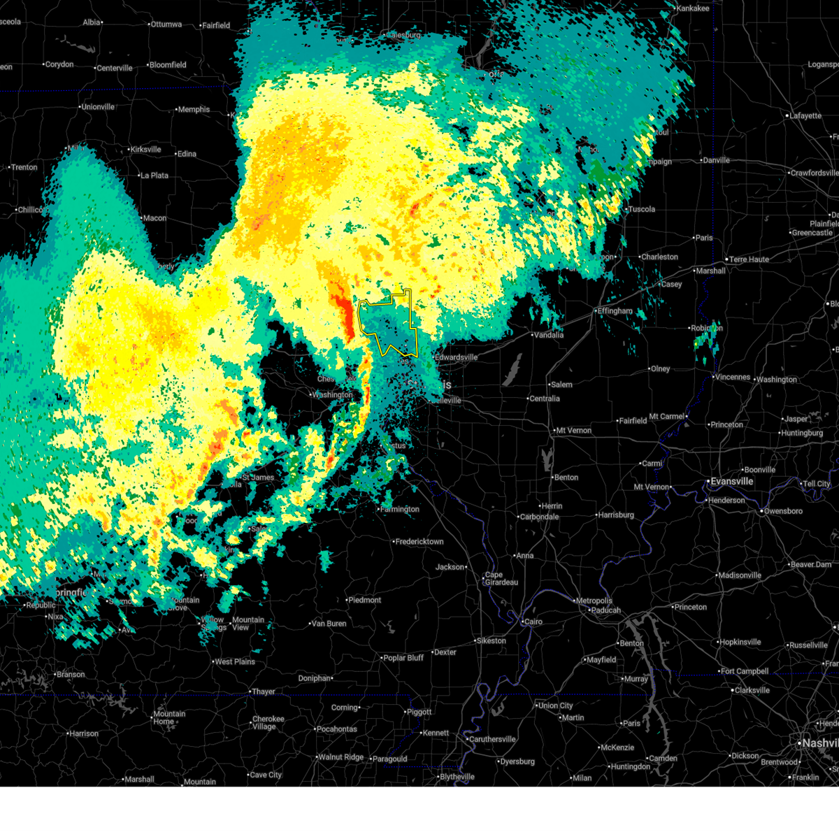
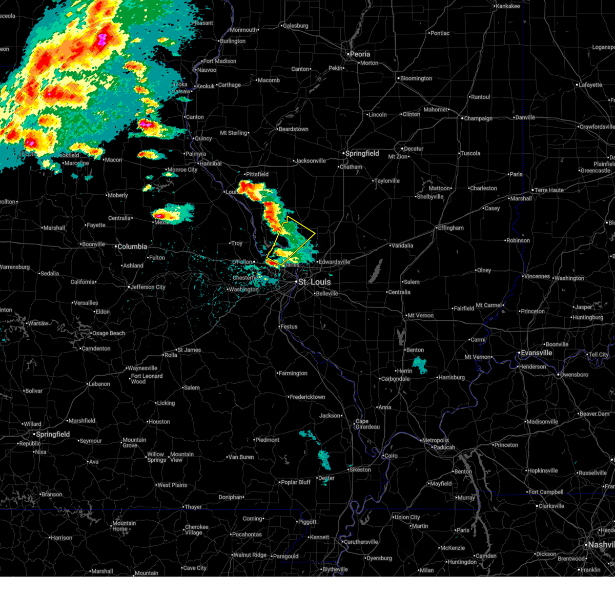
 At 614 pm cdt, a severe thunderstorm was located over kemper, or 9 miles northeast of jerseyville, moving northeast at 40 mph (radar indicated). Hazards include ping pong ball size hail and 60 mph wind gusts. People and animals outdoors will be injured. expect hail damage to roofs, siding, windows, and vehicles. expect wind damage to roofs, siding, and trees. locations impacted include, jerseyville, fidelity, piasa, medora, kemper, rockbridge, chesterfield, plainview and hettick. This includes the following state parks, beaver dam state park. At 614 pm cdt, a severe thunderstorm was located over kemper, or 9 miles northeast of jerseyville, moving northeast at 40 mph (radar indicated). Hazards include ping pong ball size hail and 60 mph wind gusts. People and animals outdoors will be injured. expect hail damage to roofs, siding, windows, and vehicles. expect wind damage to roofs, siding, and trees. locations impacted include, jerseyville, fidelity, piasa, medora, kemper, rockbridge, chesterfield, plainview and hettick. This includes the following state parks, beaver dam state park.
|
| 4/27/2026 6:13 PM CDT |
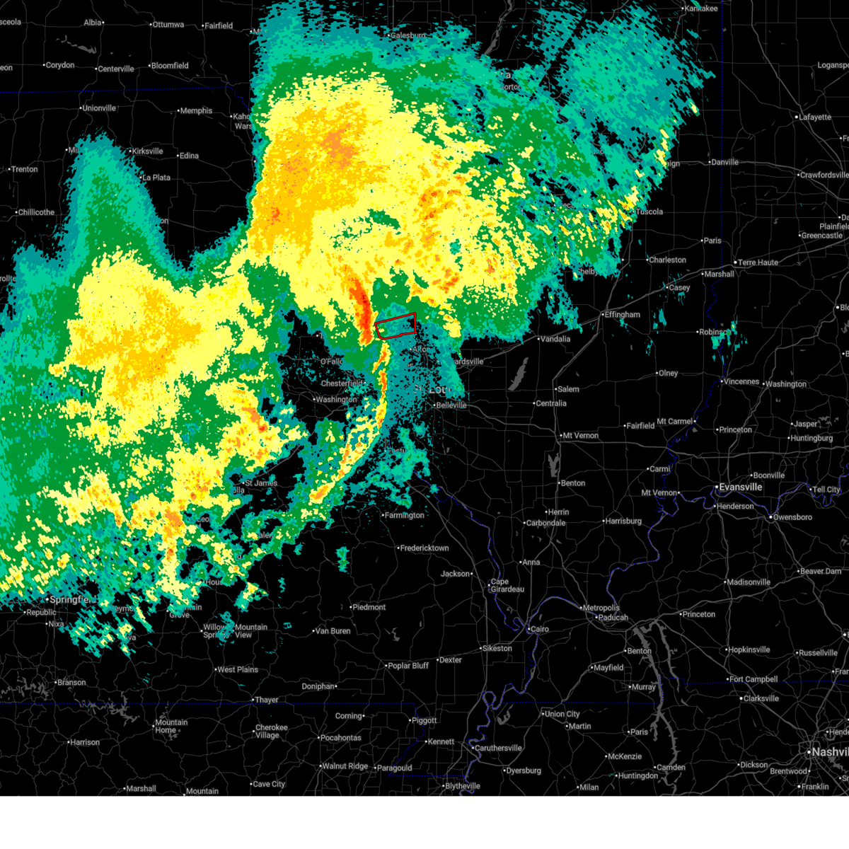
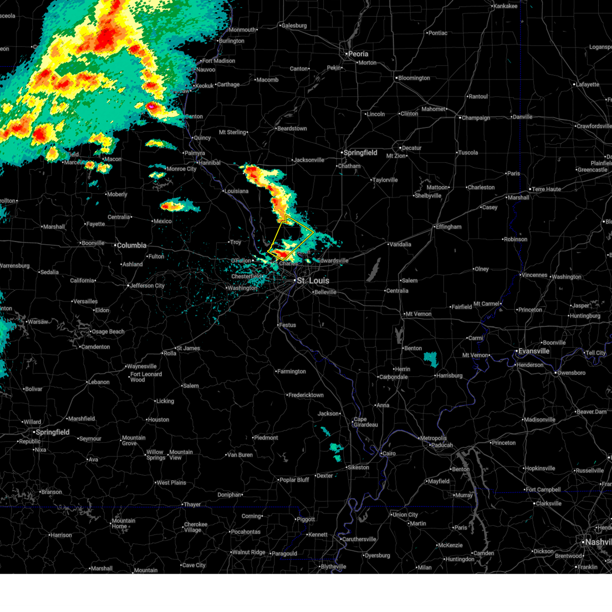
 At 613 pm cdt, a severe thunderstorm capable of producing a tornado was located 6 miles south of kemper, or 8 miles east of jerseyville, moving northeast at 50 mph (radar indicated rotation). Hazards include tornado and ping pong ball size hail. Flying debris will be dangerous to those caught without shelter. mobile homes will be damaged or destroyed. damage to roofs, windows and vehicles will occur. tree damage is likely. locations impacted include, jerseyville, brighton, fidelity, piasa, miles station, medora, kemper, shipman, chesterfield, plainview, royal lakes, dorchester, mount clare, gillespie, carlinville, east gillespie, eagarville, hornsby, atwater and standard city. This includes the following state parks, beaver dam state park. At 613 pm cdt, a severe thunderstorm capable of producing a tornado was located 6 miles south of kemper, or 8 miles east of jerseyville, moving northeast at 50 mph (radar indicated rotation). Hazards include tornado and ping pong ball size hail. Flying debris will be dangerous to those caught without shelter. mobile homes will be damaged or destroyed. damage to roofs, windows and vehicles will occur. tree damage is likely. locations impacted include, jerseyville, brighton, fidelity, piasa, miles station, medora, kemper, shipman, chesterfield, plainview, royal lakes, dorchester, mount clare, gillespie, carlinville, east gillespie, eagarville, hornsby, atwater and standard city. This includes the following state parks, beaver dam state park.
|
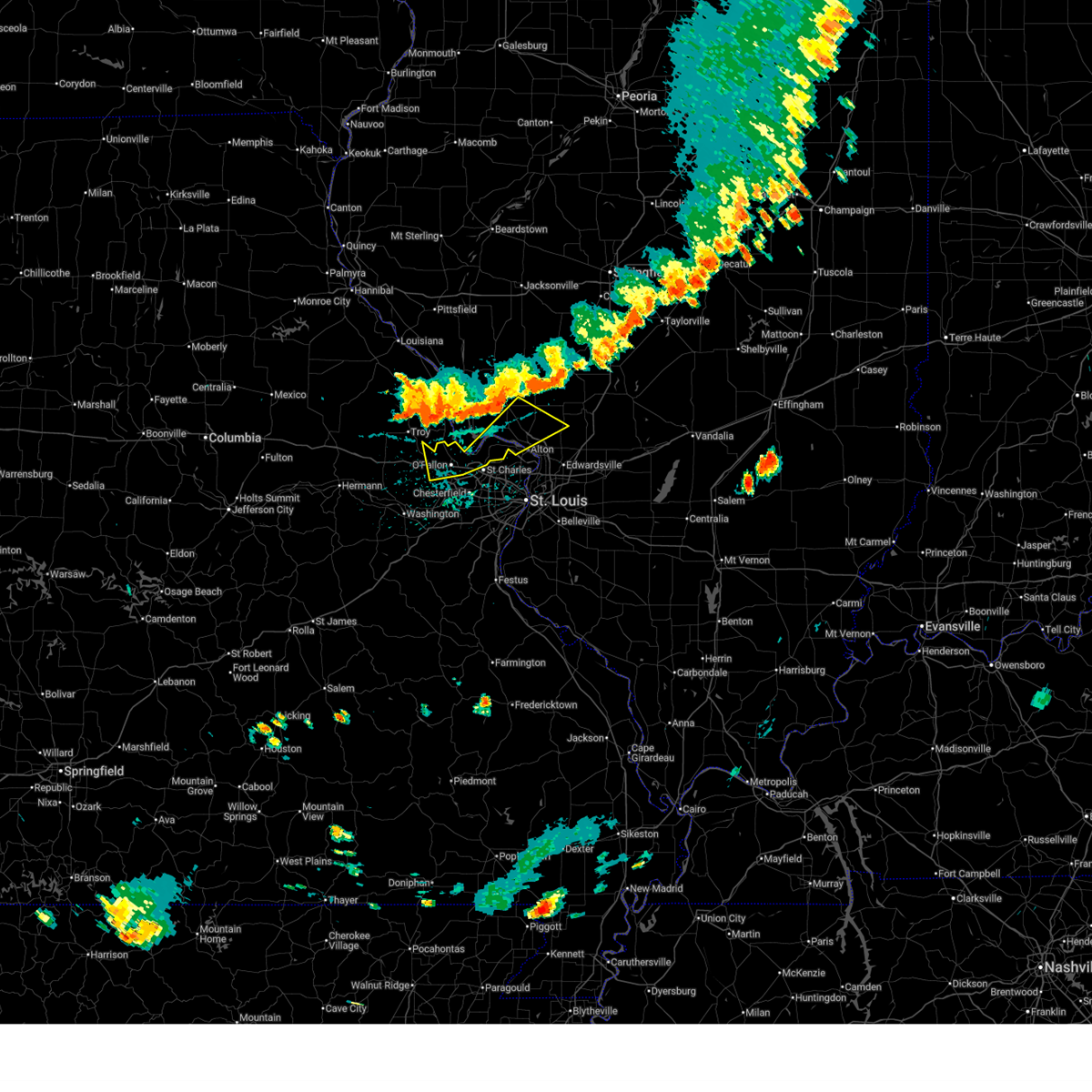
| 4/27/2026 6:04 PM CDT |
 At 604 pm cdt, a severe thunderstorm was located 5 miles southwest of kemper, or 6 miles northeast of jerseyville, moving northeast at 50 mph (trained spotters reported tennis ball size hail near jerseyville). Hazards include tennis ball size hail and 60 mph wind gusts. People and animals outdoors will be injured. expect hail damage to roofs, siding, windows, and vehicles. expect wind damage to roofs, siding, and trees. locations impacted include, otterville, jerseyville, kane, old kane, fidelity, piasa, kemper, medora, rockbridge, chesterfield, plainview and hettick. This includes the following state parks, beaver dam state park. At 604 pm cdt, a severe thunderstorm was located 5 miles southwest of kemper, or 6 miles northeast of jerseyville, moving northeast at 50 mph (trained spotters reported tennis ball size hail near jerseyville). Hazards include tennis ball size hail and 60 mph wind gusts. People and animals outdoors will be injured. expect hail damage to roofs, siding, windows, and vehicles. expect wind damage to roofs, siding, and trees. locations impacted include, otterville, jerseyville, kane, old kane, fidelity, piasa, kemper, medora, rockbridge, chesterfield, plainview and hettick. This includes the following state parks, beaver dam state park.
|
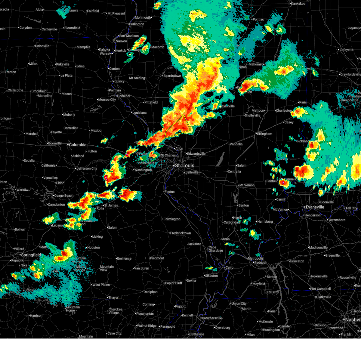
| 4/27/2026 6:01 PM CDT |
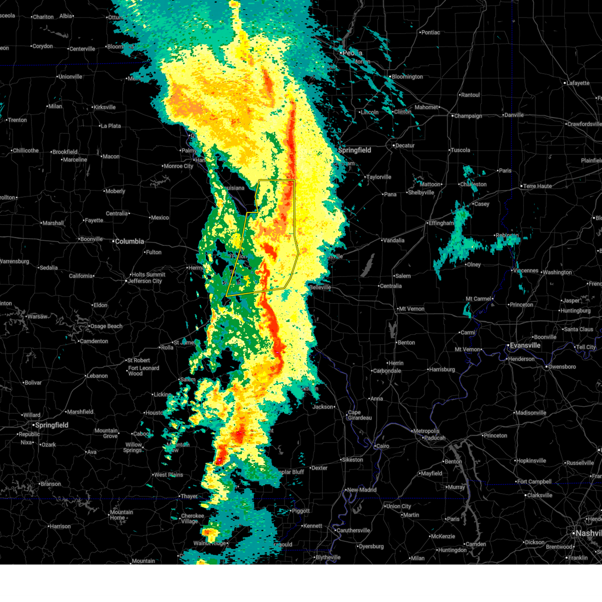
 Torlsx the national weather service in st louis has issued a * tornado warning for, eastern jersey county in southwestern illinois, central macoupin county in southwestern illinois, * until 645 pm cdt. * at 601 pm cdt, a severe thunderstorm capable of producing a tornado was located near jerseyville, moving northeast at 50 mph (radar indicated rotation). Hazards include tornado and quarter size hail. Flying debris will be dangerous to those caught without shelter. mobile homes will be damaged or destroyed. damage to roofs, windows and vehicles will occur. Tree damage is likely. Torlsx the national weather service in st louis has issued a * tornado warning for, eastern jersey county in southwestern illinois, central macoupin county in southwestern illinois, * until 645 pm cdt. * at 601 pm cdt, a severe thunderstorm capable of producing a tornado was located near jerseyville, moving northeast at 50 mph (radar indicated rotation). Hazards include tornado and quarter size hail. Flying debris will be dangerous to those caught without shelter. mobile homes will be damaged or destroyed. damage to roofs, windows and vehicles will occur. Tree damage is likely.
|
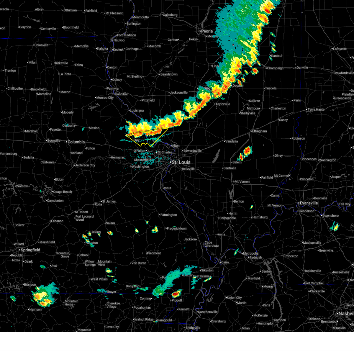
| 4/27/2026 6:00 PM CDT | Tennis Ball sized hail reported 0.4 miles S of Jerseyville, IL |
| 4/27/2026 5:59 PM CDT |
 Svrlsx the national weather service in st louis has issued a * severe thunderstorm warning for, southeastern calhoun county in southwestern illinois, southwestern jersey county in southwestern illinois, southeastern lincoln county in east central missouri, northwestern saint charles county in east central missouri, * until 645 pm cdt. * at 559 pm cdt, a severe thunderstorm was located over winfield, or 8 miles north of st. paul, moving east at 50 mph (radar indicated). Hazards include 60 mph wind gusts and quarter size hail. Hail damage to vehicles is expected. Expect wind damage to roofs, siding, and trees. Svrlsx the national weather service in st louis has issued a * severe thunderstorm warning for, southeastern calhoun county in southwestern illinois, southwestern jersey county in southwestern illinois, southeastern lincoln county in east central missouri, northwestern saint charles county in east central missouri, * until 645 pm cdt. * at 559 pm cdt, a severe thunderstorm was located over winfield, or 8 miles north of st. paul, moving east at 50 mph (radar indicated). Hazards include 60 mph wind gusts and quarter size hail. Hail damage to vehicles is expected. Expect wind damage to roofs, siding, and trees.
|
| 4/27/2026 5:58 PM CDT | Quarter sized hail reported 1.9 miles SSW of Jerseyville, IL, report from mping: quarter (1.00 in.). |
| 4/27/2026 5:56 PM CDT |
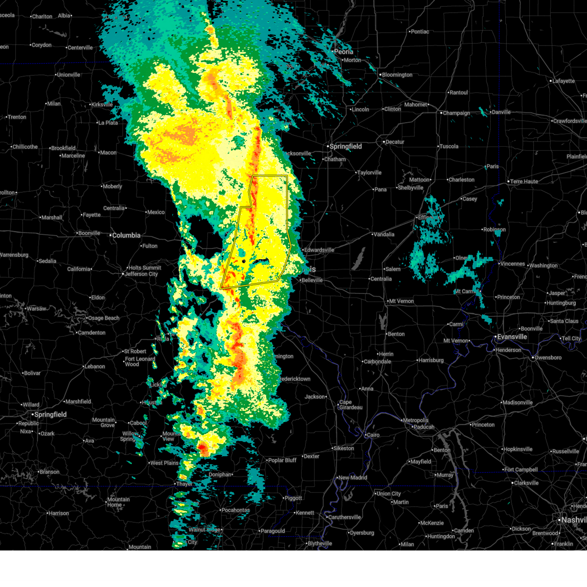
 At 556 pm cdt, a severe thunderstorm was located over jerseyville, moving northeast at 50 mph (radar indicated). Hazards include ping pong ball size hail and 60 mph wind gusts. People and animals outdoors will be injured. expect hail damage to roofs, siding, windows, and vehicles. expect wind damage to roofs, siding, and trees. locations impacted include, fieldon, otterville, jerseyville, kane, old kane, fidelity, piasa, kemper, medora, rockbridge, chesterfield, plainview and hettick. This includes the following state parks, beaver dam state park. At 556 pm cdt, a severe thunderstorm was located over jerseyville, moving northeast at 50 mph (radar indicated). Hazards include ping pong ball size hail and 60 mph wind gusts. People and animals outdoors will be injured. expect hail damage to roofs, siding, windows, and vehicles. expect wind damage to roofs, siding, and trees. locations impacted include, fieldon, otterville, jerseyville, kane, old kane, fidelity, piasa, kemper, medora, rockbridge, chesterfield, plainview and hettick. This includes the following state parks, beaver dam state park.
|
| 4/27/2026 5:55 PM CDT | Ping Pong Ball sized hail reported 0.4 miles S of Jerseyville, IL |
| 4/27/2026 5:50 PM CDT |
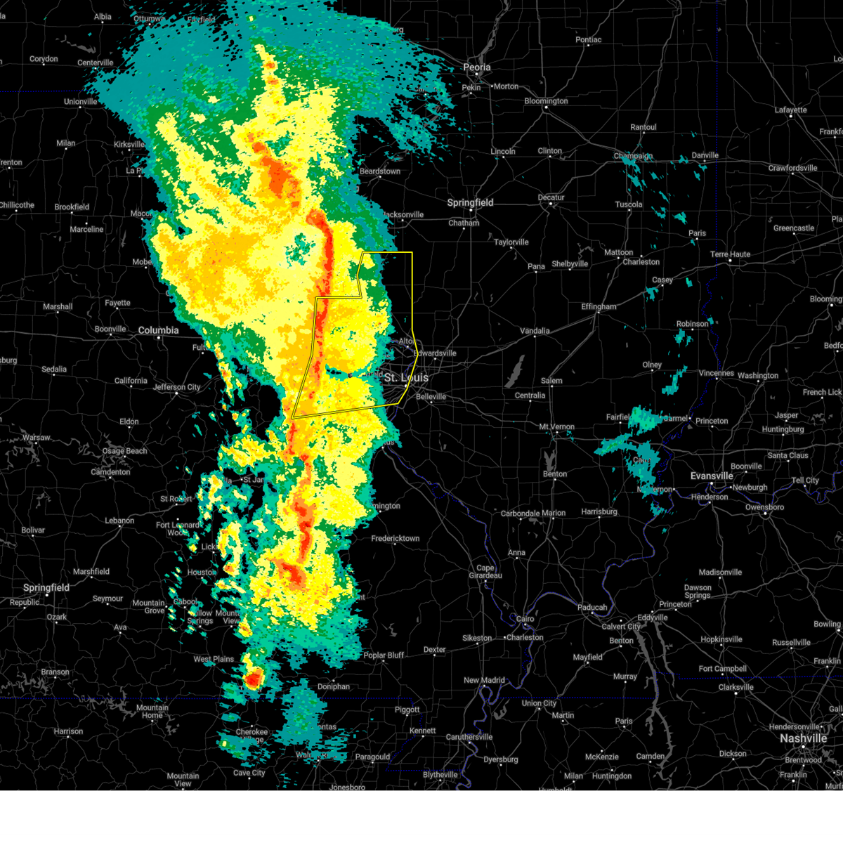
 Svrlsx the national weather service in st louis has issued a * severe thunderstorm warning for, southeastern greene county in southwestern illinois, central jersey county in southwestern illinois, west central macoupin county in southwestern illinois, * until 630 pm cdt. * at 550 pm cdt, a severe thunderstorm was located 7 miles southwest of old kane, or 6 miles west of jerseyville, moving northeast at 50 mph (radar indicated). Hazards include 60 mph wind gusts and half dollar size hail. Hail damage to vehicles is expected. Expect wind damage to roofs, siding, and trees. Svrlsx the national weather service in st louis has issued a * severe thunderstorm warning for, southeastern greene county in southwestern illinois, central jersey county in southwestern illinois, west central macoupin county in southwestern illinois, * until 630 pm cdt. * at 550 pm cdt, a severe thunderstorm was located 7 miles southwest of old kane, or 6 miles west of jerseyville, moving northeast at 50 mph (radar indicated). Hazards include 60 mph wind gusts and half dollar size hail. Hail damage to vehicles is expected. Expect wind damage to roofs, siding, and trees.
|
| 4/27/2026 3:36 PM CDT |
 At 336 pm cdt, a severe thunderstorm was located over elsah, or 6 miles west of godfrey, moving east at 50 mph (radar indicated). Hazards include 60 mph wind gusts and quarter size hail. Hail damage to vehicles is expected. expect wind damage to roofs, siding, and trees. locations impacted include, st. charles, bridgeton, hazelwood, orchard farms, florissant, grafton, elsah, portage des sioux, west alton, old kane, godfrey, jerseyville, kane, alton, wood river, east alton and rosewood heights. This includes the following state parks, pere marquette state park. At 336 pm cdt, a severe thunderstorm was located over elsah, or 6 miles west of godfrey, moving east at 50 mph (radar indicated). Hazards include 60 mph wind gusts and quarter size hail. Hail damage to vehicles is expected. expect wind damage to roofs, siding, and trees. locations impacted include, st. charles, bridgeton, hazelwood, orchard farms, florissant, grafton, elsah, portage des sioux, west alton, old kane, godfrey, jerseyville, kane, alton, wood river, east alton and rosewood heights. This includes the following state parks, pere marquette state park.
|
| 4/27/2026 3:31 PM CDT |
 At 331 pm cdt, a severe thunderstorm was located over elsah, or 8 miles west of godfrey, moving east at 50 mph (radar indicated). Hazards include 60 mph wind gusts and quarter size hail. Hail damage to vehicles is expected. expect wind damage to roofs, siding, and trees. locations impacted include, st. peters, st. charles, hazelwood, bridgeton, orchard farms, florissant, grafton, elsah, portage des sioux, west alton, old kane, godfrey, jerseyville, alton, east alton, wood river and rosewood heights. this includes the following state parks, pere marquette state park. This includes interstate 70 in missouri between exits 224 and 227. At 331 pm cdt, a severe thunderstorm was located over elsah, or 8 miles west of godfrey, moving east at 50 mph (radar indicated). Hazards include 60 mph wind gusts and quarter size hail. Hail damage to vehicles is expected. expect wind damage to roofs, siding, and trees. locations impacted include, st. peters, st. charles, hazelwood, bridgeton, orchard farms, florissant, grafton, elsah, portage des sioux, west alton, old kane, godfrey, jerseyville, alton, east alton, wood river and rosewood heights. this includes the following state parks, pere marquette state park. This includes interstate 70 in missouri between exits 224 and 227.
|
| 4/27/2026 3:14 PM CDT |
 Svrlsx the national weather service in st louis has issued a * severe thunderstorm warning for, southeastern calhoun county in southwestern illinois, southern greene county in southwestern illinois, jersey county in southwestern illinois, northwestern madison county in southwestern illinois, northeastern saint charles county in east central missouri, north central saint louis county in east central missouri, * until 400 pm cdt. * at 314 pm cdt, a severe thunderstorm was located 9 miles north of st. peters, or 8 miles northeast of st. paul, moving east at 50 mph (radar indicated). Hazards include 60 mph wind gusts and quarter size hail. Hail damage to vehicles is expected. Expect wind damage to roofs, siding, and trees. Svrlsx the national weather service in st louis has issued a * severe thunderstorm warning for, southeastern calhoun county in southwestern illinois, southern greene county in southwestern illinois, jersey county in southwestern illinois, northwestern madison county in southwestern illinois, northeastern saint charles county in east central missouri, north central saint louis county in east central missouri, * until 400 pm cdt. * at 314 pm cdt, a severe thunderstorm was located 9 miles north of st. peters, or 8 miles northeast of st. paul, moving east at 50 mph (radar indicated). Hazards include 60 mph wind gusts and quarter size hail. Hail damage to vehicles is expected. Expect wind damage to roofs, siding, and trees.
|
| 4/17/2026 10:33 PM CDT |
 At 1033 pm cdt, severe thunderstorms were located along a line from over old kane to near west alton, or along a line from 7 miles north of jerseyville to near godfrey, moving east at 50 mph (radar indicated). Hazards include 60 mph wind gusts and small hail. Expect damage to roofs, siding, and trees. this severe thunderstorm will be near, alton, godfrey, jerseyville, west alton, elsah and portage des sioux around 1035 pm cdt. brighton, east alton, kemper, wood river and hartford around 1040 pm cdt. other locations impacted by the severe thunderstorm include delhi, mcclusky, otterville and fidelity. This includes the following state parks, confluence state park. At 1033 pm cdt, severe thunderstorms were located along a line from over old kane to near west alton, or along a line from 7 miles north of jerseyville to near godfrey, moving east at 50 mph (radar indicated). Hazards include 60 mph wind gusts and small hail. Expect damage to roofs, siding, and trees. this severe thunderstorm will be near, alton, godfrey, jerseyville, west alton, elsah and portage des sioux around 1035 pm cdt. brighton, east alton, kemper, wood river and hartford around 1040 pm cdt. other locations impacted by the severe thunderstorm include delhi, mcclusky, otterville and fidelity. This includes the following state parks, confluence state park.
|
| 4/17/2026 10:26 PM CDT |
 Torlsx the national weather service in st louis has issued a * tornado warning for, southeastern jersey county in southwestern illinois, * until 1045 pm cdt. * at 1026 pm cdt, a severe thunderstorm capable of producing a tornado was located over grafton, or 9 miles southwest of jerseyville, moving east at 50 mph (radar indicated rotation). Hazards include tornado. Flying debris will be dangerous to those caught without shelter. mobile homes will be damaged or destroyed. damage to roofs, windows and vehicles will occur. tree damage is likely. this tornado will be near, grafton around 1030 pm cdt. godfrey around 1035 pm cdt. brighton around 1040 pm cdt. Other locations impacted by the tornado include otterville, mcclusky and delhi. Torlsx the national weather service in st louis has issued a * tornado warning for, southeastern jersey county in southwestern illinois, * until 1045 pm cdt. * at 1026 pm cdt, a severe thunderstorm capable of producing a tornado was located over grafton, or 9 miles southwest of jerseyville, moving east at 50 mph (radar indicated rotation). Hazards include tornado. Flying debris will be dangerous to those caught without shelter. mobile homes will be damaged or destroyed. damage to roofs, windows and vehicles will occur. tree damage is likely. this tornado will be near, grafton around 1030 pm cdt. godfrey around 1035 pm cdt. brighton around 1040 pm cdt. Other locations impacted by the tornado include otterville, mcclusky and delhi.
|
| 4/17/2026 10:14 PM CDT |
 Svrlsx the national weather service in st louis has issued a * severe thunderstorm warning for, jersey county in southwestern illinois, northwestern madison county in southwestern illinois, northeastern saint charles county in east central missouri, * until 1045 pm cdt. * at 1014 pm cdt, severe thunderstorms were located along a line from over hardin to over orchard farms, or along a line from 10 miles east of elsberry to near st. charles, moving east at 50 mph (radar indicated). Hazards include 60 mph wind gusts and small hail. Expect damage to roofs, siding, and trees. this severe thunderstorm will be near, hazelwood around 1015 pm cdt. grafton, portage des sioux and florissant around 1020 pm cdt. elsah around 1025 pm cdt. other locations impacted by the severe thunderstorm include fieldon, nutwood, otterville, mcclusky, delhi and fidelity. This includes the following state parks, confluence state park. Svrlsx the national weather service in st louis has issued a * severe thunderstorm warning for, jersey county in southwestern illinois, northwestern madison county in southwestern illinois, northeastern saint charles county in east central missouri, * until 1045 pm cdt. * at 1014 pm cdt, severe thunderstorms were located along a line from over hardin to over orchard farms, or along a line from 10 miles east of elsberry to near st. charles, moving east at 50 mph (radar indicated). Hazards include 60 mph wind gusts and small hail. Expect damage to roofs, siding, and trees. this severe thunderstorm will be near, hazelwood around 1015 pm cdt. grafton, portage des sioux and florissant around 1020 pm cdt. elsah around 1025 pm cdt. other locations impacted by the severe thunderstorm include fieldon, nutwood, otterville, mcclusky, delhi and fidelity. This includes the following state parks, confluence state park.
|
| 4/17/2026 4:31 PM CDT |
 the severe thunderstorm warning has been cancelled and is no longer in effect the severe thunderstorm warning has been cancelled and is no longer in effect
|
| 4/17/2026 4:31 PM CDT |
 At 431 pm cdt, a severe thunderstorm was located over godfrey, moving northeast at 25 mph (radar indicated). Hazards include 60 mph wind gusts and quarter size hail. Hail damage to vehicles is expected. expect wind damage to roofs, siding, and trees. Locations impacted include, portage des sioux, elsah, west alton, godfrey, mcclusky, delhi, jerseyville, brighton, miles station, piasa and fidelity. At 431 pm cdt, a severe thunderstorm was located over godfrey, moving northeast at 25 mph (radar indicated). Hazards include 60 mph wind gusts and quarter size hail. Hail damage to vehicles is expected. expect wind damage to roofs, siding, and trees. Locations impacted include, portage des sioux, elsah, west alton, godfrey, mcclusky, delhi, jerseyville, brighton, miles station, piasa and fidelity.
|
| 4/17/2026 4:22 PM CDT |
 At 422 pm cdt, a severe thunderstorm was located over portage des sioux, or 7 miles north of florissant, moving northeast at 35 mph (radar indicated). Hazards include 60 mph wind gusts and quarter size hail. Hail damage to vehicles is expected. expect wind damage to roofs, siding, and trees. Locations impacted include, orchard farms, portage des sioux, grafton, elsah, west alton, otterville, godfrey, mcclusky, delhi, jerseyville, brighton, miles station, piasa and fidelity. At 422 pm cdt, a severe thunderstorm was located over portage des sioux, or 7 miles north of florissant, moving northeast at 35 mph (radar indicated). Hazards include 60 mph wind gusts and quarter size hail. Hail damage to vehicles is expected. expect wind damage to roofs, siding, and trees. Locations impacted include, orchard farms, portage des sioux, grafton, elsah, west alton, otterville, godfrey, mcclusky, delhi, jerseyville, brighton, miles station, piasa and fidelity.
|
| 4/17/2026 4:11 PM CDT |
 Svrlsx the national weather service in st louis has issued a * severe thunderstorm warning for, eastern jersey county in southwestern illinois, southwestern macoupin county in southwestern illinois, northwestern madison county in southwestern illinois, northeastern saint charles county in east central missouri, north central saint louis county in east central missouri, * until 500 pm cdt. * at 411 pm cdt, a severe thunderstorm was located near orchard farms, or near hazelwood, moving northeast at 35 mph (radar indicated). Hazards include 60 mph wind gusts and quarter size hail. Hail damage to vehicles is expected. Expect wind damage to roofs, siding, and trees. Svrlsx the national weather service in st louis has issued a * severe thunderstorm warning for, eastern jersey county in southwestern illinois, southwestern macoupin county in southwestern illinois, northwestern madison county in southwestern illinois, northeastern saint charles county in east central missouri, north central saint louis county in east central missouri, * until 500 pm cdt. * at 411 pm cdt, a severe thunderstorm was located near orchard farms, or near hazelwood, moving northeast at 35 mph (radar indicated). Hazards include 60 mph wind gusts and quarter size hail. Hail damage to vehicles is expected. Expect wind damage to roofs, siding, and trees.
|
| 3/15/2026 4:54 PM CDT |
 the severe thunderstorm warning has been cancelled and is no longer in effect the severe thunderstorm warning has been cancelled and is no longer in effect
|
| 3/15/2026 4:37 PM CDT |
 At 437 pm cdt, severe thunderstorms were located along a line from over athensville to over jerseyville, or along a line from 10 miles east of white hall to over jerseyville, moving northeast at 40 mph (radar indicated). Hazards include 60 mph wind gusts. Expect damage to roofs, siding, and trees. Locations impacted include, grafton, belltown, carrollton, berdan, white hall, otterville, old kane, kane, wrights, mcclusky, jerseyville, delhi, greenfield, athensville, rockbridge, kemper and fidelity. At 437 pm cdt, severe thunderstorms were located along a line from over athensville to over jerseyville, or along a line from 10 miles east of white hall to over jerseyville, moving northeast at 40 mph (radar indicated). Hazards include 60 mph wind gusts. Expect damage to roofs, siding, and trees. Locations impacted include, grafton, belltown, carrollton, berdan, white hall, otterville, old kane, kane, wrights, mcclusky, jerseyville, delhi, greenfield, athensville, rockbridge, kemper and fidelity.
|
| 3/15/2026 4:32 PM CDT |
 the tornado warning has been cancelled and is no longer in effect the tornado warning has been cancelled and is no longer in effect
|
| 3/15/2026 4:21 PM CDT |
 At 421 pm cdt, a severe thunderstorm capable of producing a tornado was located 7 miles north of grafton, or 8 miles southwest of jerseyville, moving east at 35 mph (radar indicated rotation). Hazards include tornado. Flying debris will be dangerous to those caught without shelter. mobile homes will be damaged or destroyed. damage to roofs, windows and vehicles will occur. tree damage is likely. Locations impacted include, nutwood, grafton, fieldon, otterville, jerseyville, mcclusky and delhi. At 421 pm cdt, a severe thunderstorm capable of producing a tornado was located 7 miles north of grafton, or 8 miles southwest of jerseyville, moving east at 35 mph (radar indicated rotation). Hazards include tornado. Flying debris will be dangerous to those caught without shelter. mobile homes will be damaged or destroyed. damage to roofs, windows and vehicles will occur. tree damage is likely. Locations impacted include, nutwood, grafton, fieldon, otterville, jerseyville, mcclusky and delhi.
|
| 3/15/2026 4:21 PM CDT |
 the tornado warning has been cancelled and is no longer in effect the tornado warning has been cancelled and is no longer in effect
|
| 3/15/2026 4:16 PM CDT |
 At 416 pm cdt, severe thunderstorms were located along a line from 5 miles northwest of carrollton to 8 miles northwest of grafton, or along a line from 6 miles southwest of white hall to 11 miles west of jerseyville, moving northeast at 40 mph (public reported). Hazards include 60 mph wind gusts. Expect damage to roofs, siding, and trees. locations impacted include, eldred, woody, fieldon, grafton, belltown, carrollton, berdan, white hall, otterville, old kane, kane, wrights, jerseyville, greenfield, athensville, rockbridge, brighton, kemper and fidelity. This includes the following state parks, pere marquette state park. At 416 pm cdt, severe thunderstorms were located along a line from 5 miles northwest of carrollton to 8 miles northwest of grafton, or along a line from 6 miles southwest of white hall to 11 miles west of jerseyville, moving northeast at 40 mph (public reported). Hazards include 60 mph wind gusts. Expect damage to roofs, siding, and trees. locations impacted include, eldred, woody, fieldon, grafton, belltown, carrollton, berdan, white hall, otterville, old kane, kane, wrights, jerseyville, greenfield, athensville, rockbridge, brighton, kemper and fidelity. This includes the following state parks, pere marquette state park.
|
| 3/15/2026 4:09 PM CDT |
 the tornado warning has been cancelled and is no longer in effect the tornado warning has been cancelled and is no longer in effect
|
| 3/15/2026 4:09 PM CDT |
 At 409 pm cdt, a severe thunderstorm capable of producing a tornado was located 8 miles south of hardin, or 13 miles southeast of elsberry, moving east at 35 mph (radar indicated rotation). Hazards include tornado. Flying debris will be dangerous to those caught without shelter. mobile homes will be damaged or destroyed. damage to roofs, windows and vehicles will occur. tree damage is likely. locations impacted include, beechville, batchtown, brussels, meppen, nutwood, grafton, fieldon, otterville, mcclusky, jerseyville and delhi. This includes the following state parks, pere marquette state park. At 409 pm cdt, a severe thunderstorm capable of producing a tornado was located 8 miles south of hardin, or 13 miles southeast of elsberry, moving east at 35 mph (radar indicated rotation). Hazards include tornado. Flying debris will be dangerous to those caught without shelter. mobile homes will be damaged or destroyed. damage to roofs, windows and vehicles will occur. tree damage is likely. locations impacted include, beechville, batchtown, brussels, meppen, nutwood, grafton, fieldon, otterville, mcclusky, jerseyville and delhi. This includes the following state parks, pere marquette state park.
|
| 3/15/2026 3:59 PM CDT |
 Torlsx the national weather service in st louis has issued a * tornado warning for, southeastern calhoun county in southwestern illinois, jersey county in southwestern illinois, east central lincoln county in east central missouri, * until 445 pm cdt. * at 359 pm cdt, a severe thunderstorm capable of producing a tornado was located over winfield, or 11 miles north of st. paul, moving east at 35 mph (radar indicated rotation). Hazards include tornado. Flying debris will be dangerous to those caught without shelter. mobile homes will be damaged or destroyed. damage to roofs, windows and vehicles will occur. Tree damage is likely. Torlsx the national weather service in st louis has issued a * tornado warning for, southeastern calhoun county in southwestern illinois, jersey county in southwestern illinois, east central lincoln county in east central missouri, * until 445 pm cdt. * at 359 pm cdt, a severe thunderstorm capable of producing a tornado was located over winfield, or 11 miles north of st. paul, moving east at 35 mph (radar indicated rotation). Hazards include tornado. Flying debris will be dangerous to those caught without shelter. mobile homes will be damaged or destroyed. damage to roofs, windows and vehicles will occur. Tree damage is likely.
|
| 3/15/2026 3:56 PM CDT |
 Svrlsx the national weather service in st louis has issued a * severe thunderstorm warning for, greene county in southwestern illinois, jersey county in southwestern illinois, * until 500 pm cdt. * at 356 pm cdt, a severe thunderstorm was located near hardin, or 5 miles southeast of elsberry, moving east at 35 mph (radar indicated). Hazards include 60 mph wind gusts. expect damage to roofs, siding, and trees Svrlsx the national weather service in st louis has issued a * severe thunderstorm warning for, greene county in southwestern illinois, jersey county in southwestern illinois, * until 500 pm cdt. * at 356 pm cdt, a severe thunderstorm was located near hardin, or 5 miles southeast of elsberry, moving east at 35 mph (radar indicated). Hazards include 60 mph wind gusts. expect damage to roofs, siding, and trees
|
| 3/11/2026 3:50 AM CDT |
 The storms which prompted the warning have weakened below severe limits, and no longer pose an immediate threat to life or property. therefore, the warning will be allowed to expire. however, gusty winds are still possible with these thunderstorms. The storms which prompted the warning have weakened below severe limits, and no longer pose an immediate threat to life or property. therefore, the warning will be allowed to expire. however, gusty winds are still possible with these thunderstorms.
|
| 3/11/2026 3:40 AM CDT |
 At 340 am cdt, severe thunderstorms were located along a line from near brighton to over riverview, or along a line from 5 miles north of godfrey to over riverview, moving east at 55 mph (radar indicated). Hazards include 60 mph wind gusts. Expect damage to roofs, siding, and trees. locations impacted include, florissant, berkeley, ferguson, godfrey, black jack, bellefontaine neighbors, jennings, alton, wood river, granite city, bethalto, pontoon beach, edwardsville, glen carbon and maryville. This includes the following state parks, confluence state park. At 340 am cdt, severe thunderstorms were located along a line from near brighton to over riverview, or along a line from 5 miles north of godfrey to over riverview, moving east at 55 mph (radar indicated). Hazards include 60 mph wind gusts. Expect damage to roofs, siding, and trees. locations impacted include, florissant, berkeley, ferguson, godfrey, black jack, bellefontaine neighbors, jennings, alton, wood river, granite city, bethalto, pontoon beach, edwardsville, glen carbon and maryville. This includes the following state parks, confluence state park.
|
| 3/11/2026 3:40 AM CDT |
 the severe thunderstorm warning has been cancelled and is no longer in effect the severe thunderstorm warning has been cancelled and is no longer in effect
|
| 3/11/2026 3:26 AM CDT |
 At 326 am cdt, severe thunderstorms were located along a line from near grafton to over champ, or along a line from 9 miles southwest of jerseyville to over maryland heights, moving east at 55 mph (radar indicated). Hazards include 60 mph wind gusts. Expect damage to roofs, siding, and trees. locations impacted include, st. charles, maryland heights, bridgeton, hazelwood, florissant, st. ann, berkeley, ferguson, godfrey, bellefontaine neighbors, jennings, alton, wood river, granite city, bethalto, edwardsville and glen carbon. this includes the following state parks, confluence state park, first missouri state capitol historic site and pere marquette state park. This includes interstate 70 in missouri between exits 227 and 231. At 326 am cdt, severe thunderstorms were located along a line from near grafton to over champ, or along a line from 9 miles southwest of jerseyville to over maryland heights, moving east at 55 mph (radar indicated). Hazards include 60 mph wind gusts. Expect damage to roofs, siding, and trees. locations impacted include, st. charles, maryland heights, bridgeton, hazelwood, florissant, st. ann, berkeley, ferguson, godfrey, bellefontaine neighbors, jennings, alton, wood river, granite city, bethalto, edwardsville and glen carbon. this includes the following state parks, confluence state park, first missouri state capitol historic site and pere marquette state park. This includes interstate 70 in missouri between exits 227 and 231.
|
| 3/11/2026 3:26 AM CDT |
 the severe thunderstorm warning has been cancelled and is no longer in effect the severe thunderstorm warning has been cancelled and is no longer in effect
|
| 3/11/2026 3:17 AM CDT |
 Svrlsx the national weather service in st louis has issued a * severe thunderstorm warning for, southeastern calhoun county in southwestern illinois, southern jersey county in southwestern illinois, southwestern macoupin county in southwestern illinois, western madison county in southwestern illinois, east central lincoln county in east central missouri, northeastern saint charles county in east central missouri, northeastern saint louis county in east central missouri, northeastern saint louis city in east central missouri, * until 400 am cdt. * at 317 am cdt, severe thunderstorms were located along a line from 6 miles northeast of winfield to over cottleville, or along a line from 13 miles southeast of elsberry to over cottleville, moving east at 55 mph (radar indicated). Hazards include 60 mph wind gusts. expect damage to roofs, siding, and trees Svrlsx the national weather service in st louis has issued a * severe thunderstorm warning for, southeastern calhoun county in southwestern illinois, southern jersey county in southwestern illinois, southwestern macoupin county in southwestern illinois, western madison county in southwestern illinois, east central lincoln county in east central missouri, northeastern saint charles county in east central missouri, northeastern saint louis county in east central missouri, northeastern saint louis city in east central missouri, * until 400 am cdt. * at 317 am cdt, severe thunderstorms were located along a line from 6 miles northeast of winfield to over cottleville, or along a line from 13 miles southeast of elsberry to over cottleville, moving east at 55 mph (radar indicated). Hazards include 60 mph wind gusts. expect damage to roofs, siding, and trees
|
| 12/18/2025 11:32 AM CST |
 The storms which prompted the warning have moved out of the area. therefore, the warning has been allowed to expire. however, gusty winds are still possible with these thunderstorms. The storms which prompted the warning have moved out of the area. therefore, the warning has been allowed to expire. however, gusty winds are still possible with these thunderstorms.
|
| 12/18/2025 11:24 AM CST |
 At 1124 am cst, severe thunderstorms were located along a line from 16 miles northwest of virden to over godfrey, moving east at 45 mph (radar indicated). Hazards include 60 mph wind gusts. Expect damage to roofs, siding, and trees. this severe thunderstorm will be near, godfrey, kemper, west alton, brighton and elsah around 1125 am cst. Other locations impacted by the severe thunderstorm include fidelity, delhi and mcclusky. At 1124 am cst, severe thunderstorms were located along a line from 16 miles northwest of virden to over godfrey, moving east at 45 mph (radar indicated). Hazards include 60 mph wind gusts. Expect damage to roofs, siding, and trees. this severe thunderstorm will be near, godfrey, kemper, west alton, brighton and elsah around 1125 am cst. Other locations impacted by the severe thunderstorm include fidelity, delhi and mcclusky.
|
| 12/18/2025 11:24 AM CST |
 the severe thunderstorm warning has been cancelled and is no longer in effect the severe thunderstorm warning has been cancelled and is no longer in effect
|
| 12/18/2025 10:35 AM CST |
 Svrlsx the national weather service in st louis has issued a * severe thunderstorm warning for, greene county in southwestern illinois, jersey county in southwestern illinois, * until 1130 am cst. * at 1035 am cst, severe thunderstorms were located along a line from 12 miles northwest of roodhouse to near wright city, or along a line from 13 miles northwest of white hall to near wright city, moving east at 40 mph (radar indicated). Hazards include 60 mph wind gusts. Expect damage to roofs, siding, and trees. this severe thunderstorm will be near, white hall and roodhouse around 1050 am cst. other locations impacted by the severe thunderstorm include hillview, walkersville, eldred, patterson, haypress, woody, nutwood, barrow, fieldon and berdan. This includes the following state parks, pere marquette state park. Svrlsx the national weather service in st louis has issued a * severe thunderstorm warning for, greene county in southwestern illinois, jersey county in southwestern illinois, * until 1130 am cst. * at 1035 am cst, severe thunderstorms were located along a line from 12 miles northwest of roodhouse to near wright city, or along a line from 13 miles northwest of white hall to near wright city, moving east at 40 mph (radar indicated). Hazards include 60 mph wind gusts. Expect damage to roofs, siding, and trees. this severe thunderstorm will be near, white hall and roodhouse around 1050 am cst. other locations impacted by the severe thunderstorm include hillview, walkersville, eldred, patterson, haypress, woody, nutwood, barrow, fieldon and berdan. This includes the following state parks, pere marquette state park.
|
| 7/16/2025 4:16 PM CDT |
 the severe thunderstorm warning has been cancelled and is no longer in effect the severe thunderstorm warning has been cancelled and is no longer in effect
|
| 7/16/2025 4:16 PM CDT |
 At 416 pm cdt, severe thunderstorms were located along a line from 6 miles southeast of jerseyville to over fountain n' lakes, or along a line from 6 miles southeast of jerseyville to 8 miles east of troy, moving southeast at 15 mph (radar indicated). Hazards include 60 mph wind gusts and small hail. Expect damage to roofs, siding, and trees. locations impacted include, st. charles, st. peters, alton, hazelwood, godfrey, jerseyville, brighton, bunker hill, grafton, elsah, west alton, portage des sioux, orchard farms, otterville, mcclusky, delhi, miles station, fosterburg, deer plain and kampville. This includes interstate 70 in missouri between exits 224 and 225. At 416 pm cdt, severe thunderstorms were located along a line from 6 miles southeast of jerseyville to over fountain n' lakes, or along a line from 6 miles southeast of jerseyville to 8 miles east of troy, moving southeast at 15 mph (radar indicated). Hazards include 60 mph wind gusts and small hail. Expect damage to roofs, siding, and trees. locations impacted include, st. charles, st. peters, alton, hazelwood, godfrey, jerseyville, brighton, bunker hill, grafton, elsah, west alton, portage des sioux, orchard farms, otterville, mcclusky, delhi, miles station, fosterburg, deer plain and kampville. This includes interstate 70 in missouri between exits 224 and 225.
|
| 7/16/2025 4:06 PM CDT |
 At 406 pm cdt, severe thunderstorms were located along a line from 5 miles east of jerseyville to over fountain n' lakes, or along a line from 5 miles east of jerseyville to 5 miles east of troy, moving east at 25 mph (radar indicated). Hazards include 60 mph wind gusts and small hail. Expect damage to roofs, siding, and trees. locations impacted include, troy, jerseyville, moscow mills, winfield, davis, fountain n' lakes, chain of rocks, old monroe, batchtown, foley, brussels, otterville, cave, beechville, meppen and nutwood. This includes the following state parks, cuivre river state park and pere marquette state park. At 406 pm cdt, severe thunderstorms were located along a line from 5 miles east of jerseyville to over fountain n' lakes, or along a line from 5 miles east of jerseyville to 5 miles east of troy, moving east at 25 mph (radar indicated). Hazards include 60 mph wind gusts and small hail. Expect damage to roofs, siding, and trees. locations impacted include, troy, jerseyville, moscow mills, winfield, davis, fountain n' lakes, chain of rocks, old monroe, batchtown, foley, brussels, otterville, cave, beechville, meppen and nutwood. This includes the following state parks, cuivre river state park and pere marquette state park.
|
| 7/16/2025 4:04 PM CDT |
 Svrlsx the national weather service in st louis has issued a * severe thunderstorm warning for, southeastern calhoun county in southwestern illinois, southeastern jersey county in southwestern illinois, southwestern macoupin county in southwestern illinois, northwestern madison county in southwestern illinois, southeastern lincoln county in east central missouri, northern saint charles county in east central missouri, * until 445 pm cdt. * at 404 pm cdt, severe thunderstorms were located along a line from near jerseyville to over fountain n' lakes, or along a line from near jerseyville to 6 miles east of troy, moving southeast at 15 mph (radar indicated). Hazards include 60 mph wind gusts and small hail. expect damage to roofs, siding, and trees Svrlsx the national weather service in st louis has issued a * severe thunderstorm warning for, southeastern calhoun county in southwestern illinois, southeastern jersey county in southwestern illinois, southwestern macoupin county in southwestern illinois, northwestern madison county in southwestern illinois, southeastern lincoln county in east central missouri, northern saint charles county in east central missouri, * until 445 pm cdt. * at 404 pm cdt, severe thunderstorms were located along a line from near jerseyville to over fountain n' lakes, or along a line from near jerseyville to 6 miles east of troy, moving southeast at 15 mph (radar indicated). Hazards include 60 mph wind gusts and small hail. expect damage to roofs, siding, and trees
|
| 7/16/2025 4:03 PM CDT | Ham radio relayed a report of 60 mph wind gusts and 8 inch tree limbs down near bluebird lane and il route 109. time estimated by rada in jersey county IL, 1.1 miles NNW of Jerseyville, IL |
| 7/16/2025 3:53 PM CDT |
 At 353 pm cdt, severe thunderstorms were located along a line from over jerseyville to near troy, moving east at 25 mph (radar indicated). Hazards include 60 mph wind gusts and small hail. Expect damage to roofs, siding, and trees. locations impacted include, troy, jerseyville, moscow mills, winfield, davis, fountain n' lakes, chain of rocks, old monroe, fieldon, batchtown, foley, brussels, otterville, cave, beechville, meppen and nutwood. This includes the following state parks, cuivre river state park and pere marquette state park. At 353 pm cdt, severe thunderstorms were located along a line from over jerseyville to near troy, moving east at 25 mph (radar indicated). Hazards include 60 mph wind gusts and small hail. Expect damage to roofs, siding, and trees. locations impacted include, troy, jerseyville, moscow mills, winfield, davis, fountain n' lakes, chain of rocks, old monroe, fieldon, batchtown, foley, brussels, otterville, cave, beechville, meppen and nutwood. This includes the following state parks, cuivre river state park and pere marquette state park.
|
| 7/16/2025 3:53 PM CDT |
 the severe thunderstorm warning has been cancelled and is no longer in effect the severe thunderstorm warning has been cancelled and is no longer in effect
|
| 7/16/2025 3:41 PM CDT |
 Svrlsx the national weather service in st louis has issued a * severe thunderstorm warning for, southeastern calhoun county in southwestern illinois, southern greene county in southwestern illinois, northwestern jersey county in southwestern illinois, northeastern lincoln county in east central missouri, * until 415 pm cdt. * at 341 pm cdt, severe thunderstorms were located along a line from over old kane to over davis, or along a line from 5 miles northwest of jerseyville to 6 miles northwest of troy, moving east at 25 mph (radar indicated). Hazards include 60 mph wind gusts and small hail. expect damage to roofs, siding, and trees Svrlsx the national weather service in st louis has issued a * severe thunderstorm warning for, southeastern calhoun county in southwestern illinois, southern greene county in southwestern illinois, northwestern jersey county in southwestern illinois, northeastern lincoln county in east central missouri, * until 415 pm cdt. * at 341 pm cdt, severe thunderstorms were located along a line from over old kane to over davis, or along a line from 5 miles northwest of jerseyville to 6 miles northwest of troy, moving east at 25 mph (radar indicated). Hazards include 60 mph wind gusts and small hail. expect damage to roofs, siding, and trees
|
| 6/27/2025 3:08 PM CDT |
 The storm which prompted the warning has weakened below severe limits, and no longer poses an immediate threat to life or property. therefore, the warning will be allowed to expire. however, gusty winds and heavy rain are still possible with this thunderstorm. to report severe weather, contact your nearest law enforcement agency. they will send your report to the national weather service office. The storm which prompted the warning has weakened below severe limits, and no longer poses an immediate threat to life or property. therefore, the warning will be allowed to expire. however, gusty winds and heavy rain are still possible with this thunderstorm. to report severe weather, contact your nearest law enforcement agency. they will send your report to the national weather service office.
|
| 6/27/2025 3:01 PM CDT |
 the severe thunderstorm warning has been cancelled and is no longer in effect the severe thunderstorm warning has been cancelled and is no longer in effect
|
| 6/27/2025 3:01 PM CDT |
 At 301 pm cdt, a severe thunderstorm was located near godfrey, moving east at 25 mph (radar indicated). Hazards include 60 mph wind gusts and small hail. Expect damage to roofs, siding, and trees. locations impacted include, alton, godfrey, jerseyville, brighton, grafton, elsah, west alton, fieldon, otterville, fidelity, mcclusky, delhi, nutwood and fosterburg. This includes the following state parks, pere marquette state park. At 301 pm cdt, a severe thunderstorm was located near godfrey, moving east at 25 mph (radar indicated). Hazards include 60 mph wind gusts and small hail. Expect damage to roofs, siding, and trees. locations impacted include, alton, godfrey, jerseyville, brighton, grafton, elsah, west alton, fieldon, otterville, fidelity, mcclusky, delhi, nutwood and fosterburg. This includes the following state parks, pere marquette state park.
|
| 6/27/2025 2:51 PM CDT |
 the severe thunderstorm warning has been cancelled and is no longer in effect the severe thunderstorm warning has been cancelled and is no longer in effect
|
| 6/27/2025 2:51 PM CDT |
 At 251 pm cdt, a severe thunderstorm was located over elsah, or 7 miles west of godfrey, moving east at 25 mph (radar indicated). Hazards include 60 mph wind gusts and small hail. Expect damage to roofs, siding, and trees. locations impacted include, alton, godfrey, jerseyville, brighton, grafton, elsah, west alton, fieldon, batchtown, brussels, otterville, fidelity, mcclusky, delhi, deer plain, nutwood, meppen, golden eagle, beechville and fosterburg. This includes the following state parks, pere marquette state park. At 251 pm cdt, a severe thunderstorm was located over elsah, or 7 miles west of godfrey, moving east at 25 mph (radar indicated). Hazards include 60 mph wind gusts and small hail. Expect damage to roofs, siding, and trees. locations impacted include, alton, godfrey, jerseyville, brighton, grafton, elsah, west alton, fieldon, batchtown, brussels, otterville, fidelity, mcclusky, delhi, deer plain, nutwood, meppen, golden eagle, beechville and fosterburg. This includes the following state parks, pere marquette state park.
|
| 6/27/2025 2:27 PM CDT |
 Svrlsx the national weather service in st louis has issued a * severe thunderstorm warning for, southeastern calhoun county in southwestern illinois, jersey county in southwestern illinois, northwestern madison county in southwestern illinois, southeastern lincoln county in east central missouri, northwestern saint charles county in east central missouri, * until 315 pm cdt. * at 227 pm cdt, a severe thunderstorm was located near grafton, or 11 miles north of st. charles, moving east at 25 mph (radar indicated). Hazards include 60 mph wind gusts and small hail. expect damage to roofs, siding, and trees Svrlsx the national weather service in st louis has issued a * severe thunderstorm warning for, southeastern calhoun county in southwestern illinois, jersey county in southwestern illinois, northwestern madison county in southwestern illinois, southeastern lincoln county in east central missouri, northwestern saint charles county in east central missouri, * until 315 pm cdt. * at 227 pm cdt, a severe thunderstorm was located near grafton, or 11 miles north of st. charles, moving east at 25 mph (radar indicated). Hazards include 60 mph wind gusts and small hail. expect damage to roofs, siding, and trees
|
| 5/19/2025 11:12 PM CDT |
 the severe thunderstorm warning has been cancelled and is no longer in effect the severe thunderstorm warning has been cancelled and is no longer in effect
|
| 5/19/2025 10:43 PM CDT |
 Svrlsx the national weather service in st louis has issued a * severe thunderstorm warning for, southeastern greene county in southwestern illinois, eastern jersey county in southwestern illinois, southwestern macoupin county in southwestern illinois, northwestern madison county in southwestern illinois, * until 1130 pm cdt. * at 1043 pm cdt, a severe thunderstorm was located 5 miles northwest of godfrey, moving northeast at 20 mph (radar indicated). Hazards include 60 mph wind gusts and quarter size hail. Hail damage to vehicles is expected. Expect wind damage to roofs, siding, and trees. Svrlsx the national weather service in st louis has issued a * severe thunderstorm warning for, southeastern greene county in southwestern illinois, eastern jersey county in southwestern illinois, southwestern macoupin county in southwestern illinois, northwestern madison county in southwestern illinois, * until 1130 pm cdt. * at 1043 pm cdt, a severe thunderstorm was located 5 miles northwest of godfrey, moving northeast at 20 mph (radar indicated). Hazards include 60 mph wind gusts and quarter size hail. Hail damage to vehicles is expected. Expect wind damage to roofs, siding, and trees.
|
| 5/19/2025 10:34 PM CDT |
 At 1034 pm cdt, a severe thunderstorm was located over godfrey, moving northeast at 20 mph (radar indicated). Hazards include 60 mph wind gusts and quarter size hail. Hail damage to vehicles is expected. expect wind damage to roofs, siding, and trees. Other locations impacted by the severe thunderstorm include delhi and mcclusky. At 1034 pm cdt, a severe thunderstorm was located over godfrey, moving northeast at 20 mph (radar indicated). Hazards include 60 mph wind gusts and quarter size hail. Hail damage to vehicles is expected. expect wind damage to roofs, siding, and trees. Other locations impacted by the severe thunderstorm include delhi and mcclusky.
|
| 5/19/2025 10:29 PM CDT |
 the severe thunderstorm warning has been cancelled and is no longer in effect the severe thunderstorm warning has been cancelled and is no longer in effect
|
| 5/19/2025 10:29 PM CDT |
 At 1029 pm cdt, a severe thunderstorm was located near elsah, or 6 miles northwest of godfrey, moving north at 20 mph (radar indicated). Hazards include 60 mph wind gusts and quarter size hail. Hail damage to vehicles is expected. expect wind damage to roofs, siding, and trees. this severe thunderstorm will be near, west alton and alton around 1010 pm cdt. Other locations impacted by the severe thunderstorm include mcclusky, delhi and otterville. At 1029 pm cdt, a severe thunderstorm was located near elsah, or 6 miles northwest of godfrey, moving north at 20 mph (radar indicated). Hazards include 60 mph wind gusts and quarter size hail. Hail damage to vehicles is expected. expect wind damage to roofs, siding, and trees. this severe thunderstorm will be near, west alton and alton around 1010 pm cdt. Other locations impacted by the severe thunderstorm include mcclusky, delhi and otterville.
|
| 5/19/2025 10:15 PM CDT |
 At 1015 pm cdt, a severe thunderstorm was located over elsah, or 6 miles west of godfrey, moving north at 30 mph (radar indicated). Hazards include 60 mph wind gusts and quarter size hail. Hail damage to vehicles is expected. expect wind damage to roofs, siding, and trees. this severe thunderstorm will be near, florissant, alton and orchard farms around 1005 pm cdt. portage des sioux, west alton and godfrey around 1010 pm cdt. Other locations impacted by the severe thunderstorm include mcclusky, otterville, delhi and fieldon. At 1015 pm cdt, a severe thunderstorm was located over elsah, or 6 miles west of godfrey, moving north at 30 mph (radar indicated). Hazards include 60 mph wind gusts and quarter size hail. Hail damage to vehicles is expected. expect wind damage to roofs, siding, and trees. this severe thunderstorm will be near, florissant, alton and orchard farms around 1005 pm cdt. portage des sioux, west alton and godfrey around 1010 pm cdt. Other locations impacted by the severe thunderstorm include mcclusky, otterville, delhi and fieldon.
|
| 5/19/2025 10:15 PM CDT |
 the severe thunderstorm warning has been cancelled and is no longer in effect the severe thunderstorm warning has been cancelled and is no longer in effect
|
| 5/19/2025 10:01 PM CDT |
 Svrlsx the national weather service in st louis has issued a * severe thunderstorm warning for, jersey county in southwestern illinois, northwestern madison county in southwestern illinois, northeastern saint charles county in east central missouri, northeastern saint louis county in east central missouri, * until 1045 pm cdt. * at 1001 pm cdt, a severe thunderstorm was located near portage des sioux, or near florissant, moving north at 30 mph (radar indicated). Hazards include 60 mph wind gusts and quarter size hail. Hail damage to vehicles is expected. expect wind damage to roofs, siding, and trees. this severe thunderstorm will be near, florissant, black jack, hazelwood, alton, orchard farms and spanish lake around 1005 pm cdt. portage des sioux, west alton and godfrey around 1010 pm cdt. Other locations impacted by the severe thunderstorm include mcclusky, otterville, delhi and fieldon. Svrlsx the national weather service in st louis has issued a * severe thunderstorm warning for, jersey county in southwestern illinois, northwestern madison county in southwestern illinois, northeastern saint charles county in east central missouri, northeastern saint louis county in east central missouri, * until 1045 pm cdt. * at 1001 pm cdt, a severe thunderstorm was located near portage des sioux, or near florissant, moving north at 30 mph (radar indicated). Hazards include 60 mph wind gusts and quarter size hail. Hail damage to vehicles is expected. expect wind damage to roofs, siding, and trees. this severe thunderstorm will be near, florissant, black jack, hazelwood, alton, orchard farms and spanish lake around 1005 pm cdt. portage des sioux, west alton and godfrey around 1010 pm cdt. Other locations impacted by the severe thunderstorm include mcclusky, otterville, delhi and fieldon.
|
| 5/16/2025 2:42 PM CDT |
 the severe thunderstorm warning has been cancelled and is no longer in effect the severe thunderstorm warning has been cancelled and is no longer in effect
|
| 5/16/2025 2:42 PM CDT |
 At 242 pm cdt, a severe thunderstorm was located over old kane, or 7 miles northwest of jerseyville, moving east at 55 mph (radar indicated). Hazards include 60 mph wind gusts and quarter size hail. Hail damage to vehicles is expected. expect wind damage to roofs, siding, and trees. locations impacted include, jerseyville, carlinville, gillespie, carrollton, benld, greenfield, palmyra, shipman, mount clare, east gillespie, kemper, old kane, piasa, kane, medora, wrights, royal lakes, modesto, chesterfield and hettick. This includes the following state parks, beaver dam state park. At 242 pm cdt, a severe thunderstorm was located over old kane, or 7 miles northwest of jerseyville, moving east at 55 mph (radar indicated). Hazards include 60 mph wind gusts and quarter size hail. Hail damage to vehicles is expected. expect wind damage to roofs, siding, and trees. locations impacted include, jerseyville, carlinville, gillespie, carrollton, benld, greenfield, palmyra, shipman, mount clare, east gillespie, kemper, old kane, piasa, kane, medora, wrights, royal lakes, modesto, chesterfield and hettick. This includes the following state parks, beaver dam state park.
|
| 5/16/2025 2:26 PM CDT |
 Svrlsx the national weather service in st louis has issued a * severe thunderstorm warning for, north central calhoun county in southwestern illinois, greene county in southwestern illinois, jersey county in southwestern illinois, western macoupin county in southwestern illinois, southeastern pike county in west central illinois, * until 315 pm cdt. * at 226 pm cdt, a severe thunderstorm was located near hardin, or 7 miles northeast of elsberry, moving northeast at 60 mph (radar indicated). Hazards include 60 mph wind gusts and half dollar size hail. Hail damage to vehicles is expected. Expect wind damage to roofs, siding, and trees. Svrlsx the national weather service in st louis has issued a * severe thunderstorm warning for, north central calhoun county in southwestern illinois, greene county in southwestern illinois, jersey county in southwestern illinois, western macoupin county in southwestern illinois, southeastern pike county in west central illinois, * until 315 pm cdt. * at 226 pm cdt, a severe thunderstorm was located near hardin, or 7 miles northeast of elsberry, moving northeast at 60 mph (radar indicated). Hazards include 60 mph wind gusts and half dollar size hail. Hail damage to vehicles is expected. Expect wind damage to roofs, siding, and trees.
|
| 4/20/2025 8:01 PM CDT |
 The storms which prompted the warning have weakened below severe limits, and no longer pose an immediate threat to life or property. therefore, the warning has been allowed to expire. however, gusty winds are still possible with these thunderstorms. The storms which prompted the warning have weakened below severe limits, and no longer pose an immediate threat to life or property. therefore, the warning has been allowed to expire. however, gusty winds are still possible with these thunderstorms.
|
| 4/20/2025 7:23 PM CDT |
 the severe thunderstorm warning has been cancelled and is no longer in effect the severe thunderstorm warning has been cancelled and is no longer in effect
|
| 4/20/2025 7:23 PM CDT |
 At 723 pm cdt, severe thunderstorms were located along a line from 7 miles west of carrollton to near pacific, or along a line from 11 miles southwest of white hall to near pacific, moving east at 40 mph (radar indicated). Hazards include 60 mph wind gusts and small hail. Expect damage to roofs, siding, and trees. locations impacted include, st. louis, o'fallon, st. charles, st. peters, florissant, chesterfield, wildwood, university city, ballwin, granite city, wentzville, alton, kirkwood, maryland heights, east st. louis, hazelwood, webster groves, ferguson, manchester and godfrey. this includes the following state parks, babler memorial state park, scott joplin historic site, route 66 state park, castlewood state park, confluence state park, first missouri state capitol historic site and pere marquette state park. this includes the following highways, interstate 70 in missouri between exits 212 and 231. Interstate 44 in missouri between exits 251 and 277. At 723 pm cdt, severe thunderstorms were located along a line from 7 miles west of carrollton to near pacific, or along a line from 11 miles southwest of white hall to near pacific, moving east at 40 mph (radar indicated). Hazards include 60 mph wind gusts and small hail. Expect damage to roofs, siding, and trees. locations impacted include, st. louis, o'fallon, st. charles, st. peters, florissant, chesterfield, wildwood, university city, ballwin, granite city, wentzville, alton, kirkwood, maryland heights, east st. louis, hazelwood, webster groves, ferguson, manchester and godfrey. this includes the following state parks, babler memorial state park, scott joplin historic site, route 66 state park, castlewood state park, confluence state park, first missouri state capitol historic site and pere marquette state park. this includes the following highways, interstate 70 in missouri between exits 212 and 231. Interstate 44 in missouri between exits 251 and 277.
|
| 4/20/2025 6:56 PM CDT |
 Svrlsx the national weather service in st louis has issued a * severe thunderstorm warning for, eastern calhoun county in southwestern illinois, greene county in southwestern illinois, jersey county in southwestern illinois, western madison county in southwestern illinois, northeastern franklin county in east central missouri, north central jefferson county in east central missouri, eastern lincoln county in east central missouri, saint charles county in east central missouri, saint louis county in east central missouri, southeastern warren county in east central missouri, saint louis city in east central missouri, * until 800 pm cdt. * at 656 pm cdt, severe thunderstorms were located along a line from 5 miles northwest of elsberry to over union, moving east at 40 mph (radar indicated). Hazards include 60 mph wind gusts and small hail. expect damage to roofs, siding, and trees Svrlsx the national weather service in st louis has issued a * severe thunderstorm warning for, eastern calhoun county in southwestern illinois, greene county in southwestern illinois, jersey county in southwestern illinois, western madison county in southwestern illinois, northeastern franklin county in east central missouri, north central jefferson county in east central missouri, eastern lincoln county in east central missouri, saint charles county in east central missouri, saint louis county in east central missouri, southeastern warren county in east central missouri, saint louis city in east central missouri, * until 800 pm cdt. * at 656 pm cdt, severe thunderstorms were located along a line from 5 miles northwest of elsberry to over union, moving east at 40 mph (radar indicated). Hazards include 60 mph wind gusts and small hail. expect damage to roofs, siding, and trees
|
| 3/14/2025 9:44 PM CDT |
 At 944 pm cdt, severe thunderstorms were located along a line from near greenfield to near jerseyville, or along a line from 10 miles southeast of white hall to near jerseyville, moving northeast at 40 mph (radar indicated). Hazards include 60 mph wind gusts and small hail. Expect damage to roofs, siding, and trees. this severe thunderstorm will be near, grafton around 935 pm cdt. Other locations impacted by the severe thunderstorm include otterville, mcclusky, delhi and fidelity. At 944 pm cdt, severe thunderstorms were located along a line from near greenfield to near jerseyville, or along a line from 10 miles southeast of white hall to near jerseyville, moving northeast at 40 mph (radar indicated). Hazards include 60 mph wind gusts and small hail. Expect damage to roofs, siding, and trees. this severe thunderstorm will be near, grafton around 935 pm cdt. Other locations impacted by the severe thunderstorm include otterville, mcclusky, delhi and fidelity.
|
| 3/14/2025 9:23 PM CDT |
 Svrlsx the national weather service in st louis has issued a * severe thunderstorm warning for, jersey county in southwestern illinois, * until 1015 pm cdt. * at 923 pm cdt, severe thunderstorms were located along a line from 9 miles north of hardin to 8 miles south of hardin, or along a line from 14 miles southwest of white hall to 13 miles southeast of elsberry, moving northeast at 75 mph (radar indicated). Hazards include 70 mph wind gusts and small hail. Expect considerable tree damage. damage is likely to mobile homes, roofs, and outbuildings. this severe thunderstorm will be near, jerseyville around 935 pm cdt. Other locations impacted by the severe thunderstorm include nutwood, fieldon and otterville. Svrlsx the national weather service in st louis has issued a * severe thunderstorm warning for, jersey county in southwestern illinois, * until 1015 pm cdt. * at 923 pm cdt, severe thunderstorms were located along a line from 9 miles north of hardin to 8 miles south of hardin, or along a line from 14 miles southwest of white hall to 13 miles southeast of elsberry, moving northeast at 75 mph (radar indicated). Hazards include 70 mph wind gusts and small hail. Expect considerable tree damage. damage is likely to mobile homes, roofs, and outbuildings. this severe thunderstorm will be near, jerseyville around 935 pm cdt. Other locations impacted by the severe thunderstorm include nutwood, fieldon and otterville.
|
| 11/4/2024 10:42 PM CST |
 The storms which prompted the warning have weakened below severe limits, and no longer pose an immediate threat to life or property. therefore, the warning will be allowed to expire. however, gusty winds and heavy rain are still possible with these thunderstorms. The storms which prompted the warning have weakened below severe limits, and no longer pose an immediate threat to life or property. therefore, the warning will be allowed to expire. however, gusty winds and heavy rain are still possible with these thunderstorms.
|
| 11/4/2024 10:20 PM CST |
 the severe thunderstorm warning has been cancelled and is no longer in effect the severe thunderstorm warning has been cancelled and is no longer in effect
|
| 11/4/2024 10:20 PM CST |
 At 1020 pm cst, severe thunderstorms were located along a line from over grafton to over st. charles, or along a line from 11 miles north of hazelwood to over st. charles, moving northeast at 40 mph (radar indicated). Hazards include 60 mph wind gusts and small hail. Expect damage to roofs, siding, and trees. this severe thunderstorm will be near, st. peters around 1005 pm cst. st. charles around 1010 pm cst. other locations impacted by the severe thunderstorm include mcclusky and delhi. this includes the following state parks, confluence state park and first missouri state capitol historic site. This includes interstate 70 in missouri between exits 225 and 228. At 1020 pm cst, severe thunderstorms were located along a line from over grafton to over st. charles, or along a line from 11 miles north of hazelwood to over st. charles, moving northeast at 40 mph (radar indicated). Hazards include 60 mph wind gusts and small hail. Expect damage to roofs, siding, and trees. this severe thunderstorm will be near, st. peters around 1005 pm cst. st. charles around 1010 pm cst. other locations impacted by the severe thunderstorm include mcclusky and delhi. this includes the following state parks, confluence state park and first missouri state capitol historic site. This includes interstate 70 in missouri between exits 225 and 228.
|
| 11/4/2024 10:03 PM CST |
 Svrlsx the national weather service in st louis has issued a * severe thunderstorm warning for, southeastern calhoun county in southwestern illinois, southeastern jersey county in southwestern illinois, northwestern madison county in southwestern illinois, northeastern saint charles county in east central missouri, northeastern saint louis county in east central missouri, * until 1045 pm cst. * at 1003 pm cst, severe thunderstorms were located along a line from 7 miles north of st. peters to over cottleville, or along a line from 6 miles east of st. paul to over cottleville, moving northeast at 40 mph (radar indicated). Hazards include 60 mph wind gusts and small hail. Expect damage to roofs, siding, and trees. this severe thunderstorm will be near, st. peters, cottleville, weldon spring, o'fallon, dardenne prairie and st. paul around 1005 pm cst. st. charles and harvester around 1010 pm cst. other locations impacted by the severe thunderstorm include kampville, golden eagle, brussels, deer plain, otterville, mcclusky and delhi. this includes the following state parks, confluence state park, first missouri state capitol historic site and pere marquette state park. This includes interstate 70 in missouri between exits 217 and 231. Svrlsx the national weather service in st louis has issued a * severe thunderstorm warning for, southeastern calhoun county in southwestern illinois, southeastern jersey county in southwestern illinois, northwestern madison county in southwestern illinois, northeastern saint charles county in east central missouri, northeastern saint louis county in east central missouri, * until 1045 pm cst. * at 1003 pm cst, severe thunderstorms were located along a line from 7 miles north of st. peters to over cottleville, or along a line from 6 miles east of st. paul to over cottleville, moving northeast at 40 mph (radar indicated). Hazards include 60 mph wind gusts and small hail. Expect damage to roofs, siding, and trees. this severe thunderstorm will be near, st. peters, cottleville, weldon spring, o'fallon, dardenne prairie and st. paul around 1005 pm cst. st. charles and harvester around 1010 pm cst. other locations impacted by the severe thunderstorm include kampville, golden eagle, brussels, deer plain, otterville, mcclusky and delhi. this includes the following state parks, confluence state park, first missouri state capitol historic site and pere marquette state park. This includes interstate 70 in missouri between exits 217 and 231.
|
| 5/26/2024 5:12 PM CDT |
 At 512 pm cdt, a severe thunderstorm was located near old kane, moving east at 40 mph (radar indicated). Hazards include 60 mph wind gusts and quarter size hail. Hail damage to vehicles is expected. expect wind damage to roofs, siding, and trees. This severe storm will be near, kemper around 520 pm cdt. At 512 pm cdt, a severe thunderstorm was located near old kane, moving east at 40 mph (radar indicated). Hazards include 60 mph wind gusts and quarter size hail. Hail damage to vehicles is expected. expect wind damage to roofs, siding, and trees. This severe storm will be near, kemper around 520 pm cdt.
|
| 5/26/2024 5:00 PM CDT |
 At 500 pm cdt, a severe thunderstorm was located near old kane, moving east at 40 mph (radar indicated). Hazards include 60 mph wind gusts and quarter size hail. Hail damage to vehicles is expected. expect wind damage to roofs, siding, and trees. this severe storm will be near, jerseyville and old kane around 505 pm cdt. Other locations in the path of this severe thunderstorm include kemper. At 500 pm cdt, a severe thunderstorm was located near old kane, moving east at 40 mph (radar indicated). Hazards include 60 mph wind gusts and quarter size hail. Hail damage to vehicles is expected. expect wind damage to roofs, siding, and trees. this severe storm will be near, jerseyville and old kane around 505 pm cdt. Other locations in the path of this severe thunderstorm include kemper.
|
| 5/26/2024 5:00 PM CDT |
 the severe thunderstorm warning has been cancelled and is no longer in effect the severe thunderstorm warning has been cancelled and is no longer in effect
|
| 5/26/2024 4:45 PM CDT |
 Svrlsx the national weather service in st louis has issued a * severe thunderstorm warning for, central calhoun county in southwestern illinois, southern greene county in southwestern illinois, jersey county in southwestern illinois, * until 530 pm cdt. * at 444 pm cdt, a severe thunderstorm was located over hardin, moving east at 40 mph (radar indicated). Hazards include 60 mph wind gusts and quarter size hail. Hail damage to vehicles is expected. expect wind damage to roofs, siding, and trees. this severe thunderstorm will be near, hardin around 450 pm cdt. old kane around 500 pm cdt. Other locations in the path of this severe thunderstorm include jerseyville and kemper. Svrlsx the national weather service in st louis has issued a * severe thunderstorm warning for, central calhoun county in southwestern illinois, southern greene county in southwestern illinois, jersey county in southwestern illinois, * until 530 pm cdt. * at 444 pm cdt, a severe thunderstorm was located over hardin, moving east at 40 mph (radar indicated). Hazards include 60 mph wind gusts and quarter size hail. Hail damage to vehicles is expected. expect wind damage to roofs, siding, and trees. this severe thunderstorm will be near, hardin around 450 pm cdt. old kane around 500 pm cdt. Other locations in the path of this severe thunderstorm include jerseyville and kemper.
|
| 5/24/2024 6:43 PM CDT |
 The storm which prompted the warning has weakened below severe limits, and no longer poses an immediate threat to life or property. therefore, the warning will be allowed to expire. a severe thunderstorm watch remains in effect until 900 pm cdt for southwestern illinois. to report severe weather, contact your nearest law enforcement agency. they will relay your report to the national weather service st louis. The storm which prompted the warning has weakened below severe limits, and no longer poses an immediate threat to life or property. therefore, the warning will be allowed to expire. a severe thunderstorm watch remains in effect until 900 pm cdt for southwestern illinois. to report severe weather, contact your nearest law enforcement agency. they will relay your report to the national weather service st louis.
|
| 5/24/2024 6:31 PM CDT |
 the severe thunderstorm warning has been cancelled and is no longer in effect the severe thunderstorm warning has been cancelled and is no longer in effect
|
| 5/24/2024 6:31 PM CDT |
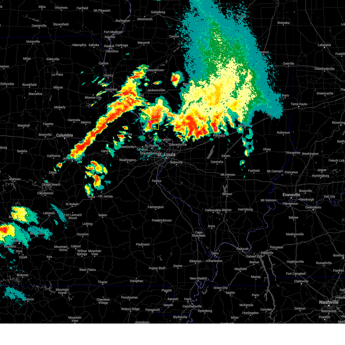 At 631 pm cdt, a severe thunderstorm was located near hardin, moving east at 20 mph (radar indicated). Hazards include golf ball size hail and 60 mph wind gusts. People and animals outdoors will be injured. expect hail damage to roofs, siding, windows, and vehicles. expect wind damage to roofs, siding, and trees. Locations impacted include, old kane, kane, and fieldon. At 631 pm cdt, a severe thunderstorm was located near hardin, moving east at 20 mph (radar indicated). Hazards include golf ball size hail and 60 mph wind gusts. People and animals outdoors will be injured. expect hail damage to roofs, siding, windows, and vehicles. expect wind damage to roofs, siding, and trees. Locations impacted include, old kane, kane, and fieldon.
|
| 5/24/2024 6:14 PM CDT |
 At 613 pm cdt, a severe thunderstorm was located near hardin, moving east at 30 mph (radar indicated). Hazards include tennis ball size hail and 60 mph wind gusts. People and animals outdoors will be injured. expect hail damage to roofs, siding, windows, and vehicles. expect wind damage to roofs, siding, and trees. Locations impacted include, carrollton, hardin, old kane, kane, fieldon, hamburg, woody, and michael. At 613 pm cdt, a severe thunderstorm was located near hardin, moving east at 30 mph (radar indicated). Hazards include tennis ball size hail and 60 mph wind gusts. People and animals outdoors will be injured. expect hail damage to roofs, siding, windows, and vehicles. expect wind damage to roofs, siding, and trees. Locations impacted include, carrollton, hardin, old kane, kane, fieldon, hamburg, woody, and michael.
|
| 5/24/2024 6:14 PM CDT |
 the severe thunderstorm warning has been cancelled and is no longer in effect the severe thunderstorm warning has been cancelled and is no longer in effect
|
| 5/24/2024 6:09 PM CDT |
 At 609 pm cdt, a severe thunderstorm was located near elsberry, moving east at 30 mph (radar indicated). Hazards include golf ball size hail and 60 mph wind gusts. People and animals outdoors will be injured. expect hail damage to roofs, siding, windows, and vehicles. expect wind damage to roofs, siding, and trees. Locations impacted include, elsberry, carrollton, hardin, old kane, kane, fieldon, hamburg, annada, woody, and michael. At 609 pm cdt, a severe thunderstorm was located near elsberry, moving east at 30 mph (radar indicated). Hazards include golf ball size hail and 60 mph wind gusts. People and animals outdoors will be injured. expect hail damage to roofs, siding, windows, and vehicles. expect wind damage to roofs, siding, and trees. Locations impacted include, elsberry, carrollton, hardin, old kane, kane, fieldon, hamburg, annada, woody, and michael.
|
| 5/24/2024 6:05 PM CDT |
 Svrlsx the national weather service in st louis has issued a * severe thunderstorm warning for, central calhoun county in southwestern illinois, southwestern greene county in southwestern illinois, west central jersey county in southwestern illinois, northeastern lincoln county in east central missouri, southeastern pike county in northeastern missouri, * until 645 pm cdt. * at 604 pm cdt, a severe thunderstorm was located over elsberry, moving east at 30 mph (radar indicated). Hazards include 60 mph wind gusts and quarter size hail. Hail damage to vehicles is expected. Expect wind damage to roofs, siding, and trees. Svrlsx the national weather service in st louis has issued a * severe thunderstorm warning for, central calhoun county in southwestern illinois, southwestern greene county in southwestern illinois, west central jersey county in southwestern illinois, northeastern lincoln county in east central missouri, southeastern pike county in northeastern missouri, * until 645 pm cdt. * at 604 pm cdt, a severe thunderstorm was located over elsberry, moving east at 30 mph (radar indicated). Hazards include 60 mph wind gusts and quarter size hail. Hail damage to vehicles is expected. Expect wind damage to roofs, siding, and trees.
|
| 5/24/2024 5:40 PM CDT |
 the severe thunderstorm warning has been cancelled and is no longer in effect the severe thunderstorm warning has been cancelled and is no longer in effect
|
| 5/24/2024 5:40 PM CDT |
 At 540 pm cdt, a severe thunderstorm was located over brighton, moving east at 30 mph (radar indicated). Hazards include 60 mph wind gusts and quarter size hail. Hail damage to vehicles is expected. expect wind damage to roofs, siding, and trees. Locations impacted include, alton, godfrey, wood river, bethalto, jerseyville, east alton, brighton, bunker hill, roxana, shipman, west alton, dorsey, rosewood heights, piasa, royal lakes, fidelity, delhi, mcclusky, miles station, and fosterburg. At 540 pm cdt, a severe thunderstorm was located over brighton, moving east at 30 mph (radar indicated). Hazards include 60 mph wind gusts and quarter size hail. Hail damage to vehicles is expected. expect wind damage to roofs, siding, and trees. Locations impacted include, alton, godfrey, wood river, bethalto, jerseyville, east alton, brighton, bunker hill, roxana, shipman, west alton, dorsey, rosewood heights, piasa, royal lakes, fidelity, delhi, mcclusky, miles station, and fosterburg.
|
| 5/24/2024 5:24 PM CDT |
 Svrlsx the national weather service in st louis has issued a * severe thunderstorm warning for, northwestern madison county in southwestern illinois, southwestern macoupin county in southwestern illinois, jersey county in southwestern illinois, northeastern st. charles county in east central missouri, * until 615 pm cdt. * at 523 pm cdt, a severe thunderstorm was located near grafton, moving southeast at 35 mph (radar indicated). Hazards include 60 mph wind gusts and half dollar size hail. Hail damage to vehicles is expected. Expect wind damage to roofs, siding, and trees. Svrlsx the national weather service in st louis has issued a * severe thunderstorm warning for, northwestern madison county in southwestern illinois, southwestern macoupin county in southwestern illinois, jersey county in southwestern illinois, northeastern st. charles county in east central missouri, * until 615 pm cdt. * at 523 pm cdt, a severe thunderstorm was located near grafton, moving southeast at 35 mph (radar indicated). Hazards include 60 mph wind gusts and half dollar size hail. Hail damage to vehicles is expected. Expect wind damage to roofs, siding, and trees.
|
| 5/24/2024 5:17 PM CDT |
 At 516 pm cdt, a severe thunderstorm was located near old kane, moving east at 30 mph (radar indicated). Hazards include ping pong ball size hail and 60 mph wind gusts. People and animals outdoors will be injured. expect hail damage to roofs, siding, windows, and vehicles. expect wind damage to roofs, siding, and trees. Locations impacted include, jerseyville, brighton, kemper, old kane, kane, fieldon, rockbridge, otterville, fidelity, delhi, mcclusky, and nutwood. At 516 pm cdt, a severe thunderstorm was located near old kane, moving east at 30 mph (radar indicated). Hazards include ping pong ball size hail and 60 mph wind gusts. People and animals outdoors will be injured. expect hail damage to roofs, siding, windows, and vehicles. expect wind damage to roofs, siding, and trees. Locations impacted include, jerseyville, brighton, kemper, old kane, kane, fieldon, rockbridge, otterville, fidelity, delhi, mcclusky, and nutwood.
|
| 5/24/2024 5:17 PM CDT |
 the severe thunderstorm warning has been cancelled and is no longer in effect the severe thunderstorm warning has been cancelled and is no longer in effect
|
| 5/24/2024 4:49 PM CDT |
 At 448 pm cdt, a severe thunderstorm was located near hardin, moving east at 25 mph (radar indicated). Hazards include ping pong ball size hail and 60 mph wind gusts. People and animals outdoors will be injured. expect hail damage to roofs, siding, windows, and vehicles. expect wind damage to roofs, siding, and trees. Locations impacted include, jerseyville, carrollton, brighton, hardin, old kane, kemper, kane, fieldon, rockbridge, otterville, fidelity, delhi, mcclusky, woody, michael, and nutwood. At 448 pm cdt, a severe thunderstorm was located near hardin, moving east at 25 mph (radar indicated). Hazards include ping pong ball size hail and 60 mph wind gusts. People and animals outdoors will be injured. expect hail damage to roofs, siding, windows, and vehicles. expect wind damage to roofs, siding, and trees. Locations impacted include, jerseyville, carrollton, brighton, hardin, old kane, kemper, kane, fieldon, rockbridge, otterville, fidelity, delhi, mcclusky, woody, michael, and nutwood.
|
| 5/24/2024 4:43 PM CDT |
 Svrlsx the national weather service in st louis has issued a * severe thunderstorm warning for, central calhoun county in southwestern illinois, southern greene county in southwestern illinois, jersey county in southwestern illinois, * until 530 pm cdt. * at 442 pm cdt, a severe thunderstorm was located over hardin, moving east at 30 mph (radar indicated). Hazards include 60 mph wind gusts and quarter size hail. Hail damage to vehicles is expected. Expect wind damage to roofs, siding, and trees. Svrlsx the national weather service in st louis has issued a * severe thunderstorm warning for, central calhoun county in southwestern illinois, southern greene county in southwestern illinois, jersey county in southwestern illinois, * until 530 pm cdt. * at 442 pm cdt, a severe thunderstorm was located over hardin, moving east at 30 mph (radar indicated). Hazards include 60 mph wind gusts and quarter size hail. Hail damage to vehicles is expected. Expect wind damage to roofs, siding, and trees.
|
| 5/24/2024 1:04 PM CDT |
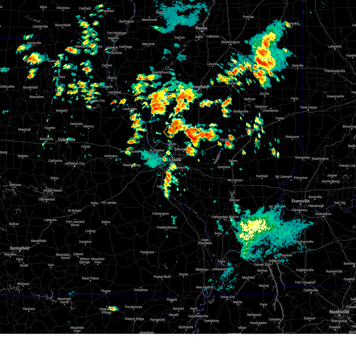 the severe thunderstorm warning has been cancelled and is no longer in effect the severe thunderstorm warning has been cancelled and is no longer in effect
|
| 5/24/2024 12:49 PM CDT |
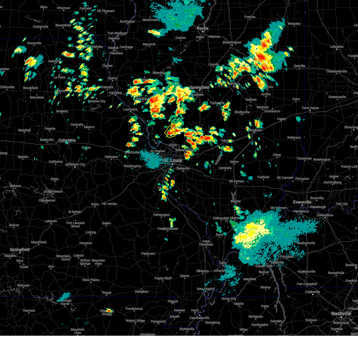 At 1248 pm cdt, a severe thunderstorm was located near jerseyville, moving northeast at 20 mph (radar indicated). Hazards include 60 mph wind gusts and quarter size hail. Hail damage to vehicles is expected. expect wind damage to roofs, siding, and trees. Locations impacted include, jerseyville, kemper, fidelity, and delhi. At 1248 pm cdt, a severe thunderstorm was located near jerseyville, moving northeast at 20 mph (radar indicated). Hazards include 60 mph wind gusts and quarter size hail. Hail damage to vehicles is expected. expect wind damage to roofs, siding, and trees. Locations impacted include, jerseyville, kemper, fidelity, and delhi.
|
| 5/24/2024 12:37 PM CDT |
 Svrlsx the national weather service in st louis has issued a * severe thunderstorm warning for, northeastern jersey county in southwestern illinois, * until 115 pm cdt. * at 1237 pm cdt, a severe thunderstorm was located near jerseyville, moving northeast at 20 mph (radar indicated). Hazards include 60 mph wind gusts and quarter size hail. Hail damage to vehicles is expected. Expect wind damage to roofs, siding, and trees. Svrlsx the national weather service in st louis has issued a * severe thunderstorm warning for, northeastern jersey county in southwestern illinois, * until 115 pm cdt. * at 1237 pm cdt, a severe thunderstorm was located near jerseyville, moving northeast at 20 mph (radar indicated). Hazards include 60 mph wind gusts and quarter size hail. Hail damage to vehicles is expected. Expect wind damage to roofs, siding, and trees.
|
| 5/4/2024 3:34 PM CDT |
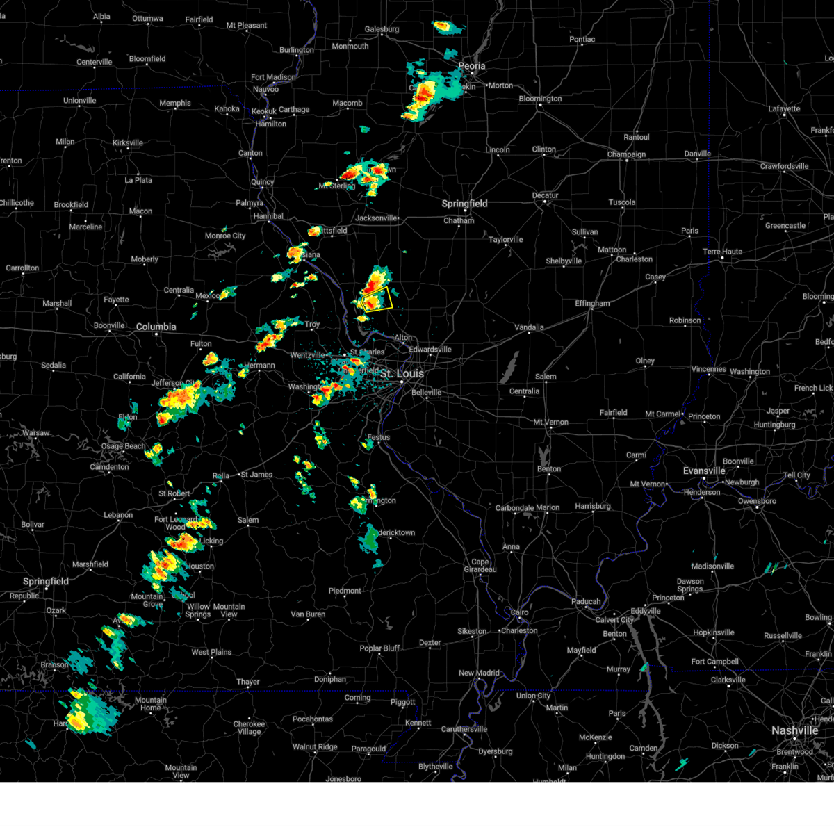 At 334 pm cdt, a severe thunderstorm was located near old kane, moving east at 25 mph (radar indicated). Hazards include 60 mph wind gusts and quarter size hail. Hail damage to vehicles is expected. expect wind damage to roofs, siding, and trees. Locations impacted include, jerseyville, old kane, kane, and fieldon. At 334 pm cdt, a severe thunderstorm was located near old kane, moving east at 25 mph (radar indicated). Hazards include 60 mph wind gusts and quarter size hail. Hail damage to vehicles is expected. expect wind damage to roofs, siding, and trees. Locations impacted include, jerseyville, old kane, kane, and fieldon.
|
| 5/4/2024 3:24 PM CDT |
 At 323 pm cdt, a severe thunderstorm was located near hardin, moving east at 20 mph (radar indicated). Hazards include 60 mph wind gusts and quarter size hail. Hail damage to vehicles is expected. expect wind damage to roofs, siding, and trees. Locations impacted include, jerseyville, hardin, old kane, kane, and fieldon. At 323 pm cdt, a severe thunderstorm was located near hardin, moving east at 20 mph (radar indicated). Hazards include 60 mph wind gusts and quarter size hail. Hail damage to vehicles is expected. expect wind damage to roofs, siding, and trees. Locations impacted include, jerseyville, hardin, old kane, kane, and fieldon.
|
| 5/4/2024 3:24 PM CDT |
 the severe thunderstorm warning has been cancelled and is no longer in effect the severe thunderstorm warning has been cancelled and is no longer in effect
|
| 5/4/2024 3:09 PM CDT |
 Svrlsx the national weather service in st louis has issued a * severe thunderstorm warning for, central calhoun county in southwestern illinois, southwestern greene county in southwestern illinois, northwestern jersey county in southwestern illinois, * until 400 pm cdt. * at 308 pm cdt, a severe thunderstorm was located over hardin, moving northeast at 25 mph (radar indicated). Hazards include 60 mph wind gusts and quarter size hail. Hail damage to vehicles is expected. Expect wind damage to roofs, siding, and trees. Svrlsx the national weather service in st louis has issued a * severe thunderstorm warning for, central calhoun county in southwestern illinois, southwestern greene county in southwestern illinois, northwestern jersey county in southwestern illinois, * until 400 pm cdt. * at 308 pm cdt, a severe thunderstorm was located over hardin, moving northeast at 25 mph (radar indicated). Hazards include 60 mph wind gusts and quarter size hail. Hail damage to vehicles is expected. Expect wind damage to roofs, siding, and trees.
|
| 4/18/2024 5:30 PM CDT |
 Svrlsx the national weather service in st louis has issued a * severe thunderstorm warning for, southeastern greene county in southwestern illinois, macoupin county in southwestern illinois, northeastern jersey county in southwestern illinois, * until 630 pm cdt. * at 530 pm cdt, severe thunderstorms were located along a line extending from near greenfield to near jerseyville to near elsah, moving east at 40 mph (radar indicated). Hazards include 60 mph wind gusts and quarter size hail. Hail damage to vehicles is expected. Expect wind damage to roofs, siding, and trees. Svrlsx the national weather service in st louis has issued a * severe thunderstorm warning for, southeastern greene county in southwestern illinois, macoupin county in southwestern illinois, northeastern jersey county in southwestern illinois, * until 630 pm cdt. * at 530 pm cdt, severe thunderstorms were located along a line extending from near greenfield to near jerseyville to near elsah, moving east at 40 mph (radar indicated). Hazards include 60 mph wind gusts and quarter size hail. Hail damage to vehicles is expected. Expect wind damage to roofs, siding, and trees.
|
| 4/18/2024 4:52 PM CDT |
 Svrlsx the national weather service in st louis has issued a * severe thunderstorm warning for, central greene county in southwestern illinois, jersey county in southwestern illinois, * until 530 pm cdt. * at 452 pm cdt, a cluster of severe thunderstorms was located from near elsberry to eldred, moving east at 30 mph (radar indicated). Hazards include 60 mph wind gusts and half dollar size hail. Hail damage to vehicles is expected. Expect wind damage to roofs, siding, and trees. Svrlsx the national weather service in st louis has issued a * severe thunderstorm warning for, central greene county in southwestern illinois, jersey county in southwestern illinois, * until 530 pm cdt. * at 452 pm cdt, a cluster of severe thunderstorms was located from near elsberry to eldred, moving east at 30 mph (radar indicated). Hazards include 60 mph wind gusts and half dollar size hail. Hail damage to vehicles is expected. Expect wind damage to roofs, siding, and trees.
|
| 4/16/2024 3:53 PM CDT |
 The storm which prompted the warning has weakened below severe limits, and has exited the warned area. therefore, the warning will be allowed to expire. a severe thunderstorm watch remains in effect until 900 pm cdt for southwestern illinois. The storm which prompted the warning has weakened below severe limits, and has exited the warned area. therefore, the warning will be allowed to expire. a severe thunderstorm watch remains in effect until 900 pm cdt for southwestern illinois.
|
| 4/16/2024 3:47 PM CDT |
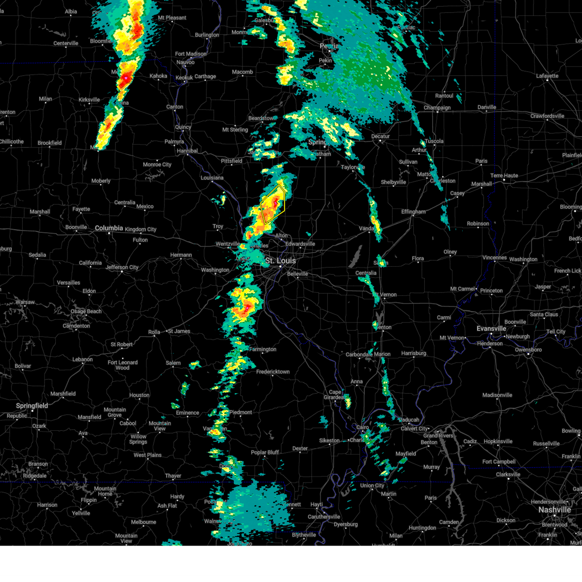 At 347 pm cdt, a severe thunderstorm was located near greenfield, moving northeast at 60 mph (radar indicated). Hazards include 60 mph wind gusts and penny size hail. Expect damage to roofs, siding, and trees. Locations impacted include, jerseyville, carrollton, greenfield, kemper, old kane, kane, rockbridge, and otterville. At 347 pm cdt, a severe thunderstorm was located near greenfield, moving northeast at 60 mph (radar indicated). Hazards include 60 mph wind gusts and penny size hail. Expect damage to roofs, siding, and trees. Locations impacted include, jerseyville, carrollton, greenfield, kemper, old kane, kane, rockbridge, and otterville.
|
| 4/16/2024 3:39 PM CDT |
 At 339 pm cdt, a severe thunderstorm was located near old kane, moving northeast at 60 mph (radar indicated). Hazards include 60 mph wind gusts and nickel size hail. Expect damage to roofs, siding, and trees. locations impacted include, jerseyville, carrollton, greenfield, hardin, old kane, kemper, kane, wrights, fieldon, rockbridge, otterville, nutwood, and woody. This also includes pere marquette state park. At 339 pm cdt, a severe thunderstorm was located near old kane, moving northeast at 60 mph (radar indicated). Hazards include 60 mph wind gusts and nickel size hail. Expect damage to roofs, siding, and trees. locations impacted include, jerseyville, carrollton, greenfield, hardin, old kane, kemper, kane, wrights, fieldon, rockbridge, otterville, nutwood, and woody. This also includes pere marquette state park.
|
| 4/16/2024 3:39 PM CDT |
 the severe thunderstorm warning has been cancelled and is no longer in effect the severe thunderstorm warning has been cancelled and is no longer in effect
|
| 4/16/2024 3:31 PM CDT |
 At 331 pm cdt, a severe thunderstorm was located near old kane, moving northeast at 60 mph (radar indicated). Hazards include 60 mph wind gusts and quarter size hail. Hail damage to vehicles is expected. expect wind damage to roofs, siding, and trees. locations impacted include, jerseyville, carrollton, greenfield, hardin, old kane, kemper, kane, wrights, fieldon, batchtown, rockbridge, brussels, otterville, meppen, beechville, nutwood, and woody. This also includes pere marquette state park. At 331 pm cdt, a severe thunderstorm was located near old kane, moving northeast at 60 mph (radar indicated). Hazards include 60 mph wind gusts and quarter size hail. Hail damage to vehicles is expected. expect wind damage to roofs, siding, and trees. locations impacted include, jerseyville, carrollton, greenfield, hardin, old kane, kemper, kane, wrights, fieldon, batchtown, rockbridge, brussels, otterville, meppen, beechville, nutwood, and woody. This also includes pere marquette state park.
|
| 4/16/2024 3:31 PM CDT |
 the severe thunderstorm warning has been cancelled and is no longer in effect the severe thunderstorm warning has been cancelled and is no longer in effect
|
| 4/16/2024 3:14 PM CDT |
 Svrlsx the national weather service in st louis has issued a * severe thunderstorm warning for, southeastern calhoun county in southwestern illinois, central greene county in southwestern illinois, jersey county in southwestern illinois, north central st. charles county in east central missouri, southeastern lincoln county in east central missouri, * until 400 pm cdt. * at 314 pm cdt, a severe thunderstorm was located near winfield, moving northeast at 60 mph (radar indicated). Hazards include 60 mph wind gusts and quarter size hail. Hail damage to vehicles is expected. Expect wind damage to roofs, siding, and trees. Svrlsx the national weather service in st louis has issued a * severe thunderstorm warning for, southeastern calhoun county in southwestern illinois, central greene county in southwestern illinois, jersey county in southwestern illinois, north central st. charles county in east central missouri, southeastern lincoln county in east central missouri, * until 400 pm cdt. * at 314 pm cdt, a severe thunderstorm was located near winfield, moving northeast at 60 mph (radar indicated). Hazards include 60 mph wind gusts and quarter size hail. Hail damage to vehicles is expected. Expect wind damage to roofs, siding, and trees.
|
| 3/14/2024 6:52 PM CDT |
 The storms which prompted the warning have weakened below severe limits, and no longer pose an immediate threat to life or property. therefore, the warning will be allowed to expire. however, gusty winds are still possible with these thunderstorms. a tornado watch remains in effect until 900 pm cdt for southwestern illinois, and east central missouri. The storms which prompted the warning have weakened below severe limits, and no longer pose an immediate threat to life or property. therefore, the warning will be allowed to expire. however, gusty winds are still possible with these thunderstorms. a tornado watch remains in effect until 900 pm cdt for southwestern illinois, and east central missouri.
|
| 3/14/2024 6:34 PM CDT |
 At 633 pm cdt, severe thunderstorms were located along a line extending from near davis to near winfield to harvester, moving northeast at 60 mph (trained weather spotters). Hazards include 60 mph wind gusts and penny size hail. Expect damage to roofs, siding, and trees. locations impacted include, o'fallon, st. charles, st. peters, chesterfield, wentzville, maryland heights, hazelwood, godfrey, lake st. louis, bridgeton, dardenne prairie, troy, jerseyville, weldon spring, cottleville, elsberry, st. paul, moscow mills, winfield, and davis. this also includes cuivre river state park, first missouri state capitol historic site, and pere marquette state park. This includes interstate 70 in missouri between exits 208 and 229. At 633 pm cdt, severe thunderstorms were located along a line extending from near davis to near winfield to harvester, moving northeast at 60 mph (trained weather spotters). Hazards include 60 mph wind gusts and penny size hail. Expect damage to roofs, siding, and trees. locations impacted include, o'fallon, st. charles, st. peters, chesterfield, wentzville, maryland heights, hazelwood, godfrey, lake st. louis, bridgeton, dardenne prairie, troy, jerseyville, weldon spring, cottleville, elsberry, st. paul, moscow mills, winfield, and davis. this also includes cuivre river state park, first missouri state capitol historic site, and pere marquette state park. This includes interstate 70 in missouri between exits 208 and 229.
|
| 3/14/2024 6:24 PM CDT |
 At 624 pm cdt, severe thunderstorms were located along a line extending from near hawk point to near wentzville to near defiance, moving northeast at 35 mph (trained weather spotters reported a 63 mph wind gust near warrenton around 618 pm). Hazards include 70 mph wind gusts and quarter size hail. Hail damage to vehicles is expected. expect considerable tree damage. wind damage is also likely to mobile homes, roofs, and outbuildings. locations impacted include, o'fallon, st. charles, st. peters, chesterfield, wentzville, maryland heights, hazelwood, godfrey, lake st. louis, bridgeton, dardenne prairie, troy, jerseyville, weldon spring, cottleville, elsberry, st. paul, moscow mills, winfield, and davis. this also includes cuivre river state park, first missouri state capitol historic site, and pere marquette state park. This includes interstate 70 in missouri between exits 203 and 229. At 624 pm cdt, severe thunderstorms were located along a line extending from near hawk point to near wentzville to near defiance, moving northeast at 35 mph (trained weather spotters reported a 63 mph wind gust near warrenton around 618 pm). Hazards include 70 mph wind gusts and quarter size hail. Hail damage to vehicles is expected. expect considerable tree damage. wind damage is also likely to mobile homes, roofs, and outbuildings. locations impacted include, o'fallon, st. charles, st. peters, chesterfield, wentzville, maryland heights, hazelwood, godfrey, lake st. louis, bridgeton, dardenne prairie, troy, jerseyville, weldon spring, cottleville, elsberry, st. paul, moscow mills, winfield, and davis. this also includes cuivre river state park, first missouri state capitol historic site, and pere marquette state park. This includes interstate 70 in missouri between exits 203 and 229.
|
| 3/14/2024 6:09 PM CDT |
 Svrlsx the national weather service in st louis has issued a * severe thunderstorm warning for, southeastern calhoun county in southwestern illinois, jersey county in southwestern illinois, st. charles county in east central missouri, lincoln county in east central missouri, * until 700 pm cdt. * at 609 pm cdt, severe thunderstorms were located along a line extending from near bellflower to innsbrook to near augusta, moving northeast at 60 mph (radar indicated). Hazards include 70 mph wind gusts and quarter size hail. Hail damage to vehicles is expected. expect considerable tree damage. Wind damage is also likely to mobile homes, roofs, and outbuildings. Svrlsx the national weather service in st louis has issued a * severe thunderstorm warning for, southeastern calhoun county in southwestern illinois, jersey county in southwestern illinois, st. charles county in east central missouri, lincoln county in east central missouri, * until 700 pm cdt. * at 609 pm cdt, severe thunderstorms were located along a line extending from near bellflower to innsbrook to near augusta, moving northeast at 60 mph (radar indicated). Hazards include 70 mph wind gusts and quarter size hail. Hail damage to vehicles is expected. expect considerable tree damage. Wind damage is also likely to mobile homes, roofs, and outbuildings.
|
| 3/14/2024 4:21 PM CDT |
 Svrlsx the national weather service in st louis has issued a * severe thunderstorm warning for, north central calhoun county in southwestern illinois, greene county in southwestern illinois, northern jersey county in southwestern illinois, northeastern lincoln county in east central missouri, southeastern pike county in northeastern missouri, * until 515 pm cdt. * at 420 pm cdt, a severe thunderstorm was located near eolia, moving east at 50 mph (radar indicated). Hazards include ping pong ball size hail and 60 mph wind gusts. People and animals outdoors will be injured. expect hail damage to roofs, siding, windows, and vehicles. Expect wind damage to roofs, siding, and trees. Svrlsx the national weather service in st louis has issued a * severe thunderstorm warning for, north central calhoun county in southwestern illinois, greene county in southwestern illinois, northern jersey county in southwestern illinois, northeastern lincoln county in east central missouri, southeastern pike county in northeastern missouri, * until 515 pm cdt. * at 420 pm cdt, a severe thunderstorm was located near eolia, moving east at 50 mph (radar indicated). Hazards include ping pong ball size hail and 60 mph wind gusts. People and animals outdoors will be injured. expect hail damage to roofs, siding, windows, and vehicles. Expect wind damage to roofs, siding, and trees.
|
| 3/14/2024 7:52 AM CDT |
 the tornado warning has been cancelled and is no longer in effect the tornado warning has been cancelled and is no longer in effect
|
| 3/14/2024 7:32 AM CDT |
 Torlsx the national weather service in st louis has issued a * tornado warning for, central jersey county in southwestern illinois, * until 815 am cdt. * at 732 am cdt, a severe thunderstorm capable of producing a tornado was located near jerseyville, moving east at 35 mph (radar indicated rotation). Hazards include tornado. Flying debris will be dangerous to those caught without shelter. mobile homes will be damaged or destroyed. damage to roofs, windows, and vehicles will occur. tree damage is likely. this dangerous storm will be near, jerseyville around 740 am cdt. Brighton around 750 am cdt. Torlsx the national weather service in st louis has issued a * tornado warning for, central jersey county in southwestern illinois, * until 815 am cdt. * at 732 am cdt, a severe thunderstorm capable of producing a tornado was located near jerseyville, moving east at 35 mph (radar indicated rotation). Hazards include tornado. Flying debris will be dangerous to those caught without shelter. mobile homes will be damaged or destroyed. damage to roofs, windows, and vehicles will occur. tree damage is likely. this dangerous storm will be near, jerseyville around 740 am cdt. Brighton around 750 am cdt.
|
| 3/14/2024 7:31 AM CDT | Roof of machine shed blown off and damage to rafters underneat in jersey county IL, 4.4 miles ENE of Jerseyville, IL |
| 3/14/2024 7:25 AM CDT |
 Svrlsx the national weather service in st louis has issued a * severe thunderstorm warning for, southeastern calhoun county in southwestern illinois, eastern greene county in southwestern illinois, northwestern madison county in southwestern illinois, macoupin county in southwestern illinois, jersey county in southwestern illinois, western montgomery county in south central illinois, northeastern st. charles county in east central missouri, * until 815 am cdt. * at 725 am cdt, severe thunderstorms were located along a line extending from near manchester to near st. paul, moving east at 60 mph (radar indicated). Hazards include 60 mph wind gusts. Expect damage to roofs, siding, and trees. severe thunderstorms will be near, jerseyville, carrollton, greenfield, grafton, athensville, orchard farms, and old kane around 730 am cdt. elsah and portage des sioux around 735 am cdt. godfrey, west alton, and kemper around 740 am cdt. alton, brighton, and palmyra around 745 am cdt. other locations in the path of these severe thunderstorms include shipman, carlinville, virden, girard, bunker hill, dorsey, wilsonville, gillespie, benld, white oak, farmersville, sawyerville, mount clare, east gillespie and eagarville. this includes the following highways, interstate 55 in illinois between exits 37 and 63. interstate 70 in missouri between exits 219 and 222. This also includes confluence state park, pere marquette state park, beaver dam state park, and lake lou yaeger. Svrlsx the national weather service in st louis has issued a * severe thunderstorm warning for, southeastern calhoun county in southwestern illinois, eastern greene county in southwestern illinois, northwestern madison county in southwestern illinois, macoupin county in southwestern illinois, jersey county in southwestern illinois, western montgomery county in south central illinois, northeastern st. charles county in east central missouri, * until 815 am cdt. * at 725 am cdt, severe thunderstorms were located along a line extending from near manchester to near st. paul, moving east at 60 mph (radar indicated). Hazards include 60 mph wind gusts. Expect damage to roofs, siding, and trees. severe thunderstorms will be near, jerseyville, carrollton, greenfield, grafton, athensville, orchard farms, and old kane around 730 am cdt. elsah and portage des sioux around 735 am cdt. godfrey, west alton, and kemper around 740 am cdt. alton, brighton, and palmyra around 745 am cdt. other locations in the path of these severe thunderstorms include shipman, carlinville, virden, girard, bunker hill, dorsey, wilsonville, gillespie, benld, white oak, farmersville, sawyerville, mount clare, east gillespie and eagarville. this includes the following highways, interstate 55 in illinois between exits 37 and 63. interstate 70 in missouri between exits 219 and 222. This also includes confluence state park, pere marquette state park, beaver dam state park, and lake lou yaeger.
|
| 3/14/2024 7:20 AM CDT | Numerous 18 to 24 inch diameter pine trees stripped of branches and snapped near their tops. large tree branch snapped near bas in jersey county IL, 3.8 miles N of Jerseyville, IL |
| 8/12/2023 4:34 AM CDT |
 At 434 am cdt, severe thunderstorms were located along a line extending from near hardin to near orchard farms to near maryland heights to near augusta, moving southeast at 60 mph (radar indicated). Hazards include 70 mph wind gusts. Expect considerable tree damage. damage is likely to mobile homes, roofs, and outbuildings. locations impacted include, st. louis, o`fallon, st. charles, st. peters, florissant, chesterfield, wildwood, university city, ballwin, wentzville, alton, kirkwood, maryland heights, hazelwood, webster groves, ferguson, arnold, manchester, godfrey, and creve coeur. this also includes babler memorial state park, scott joplin historic site, route 66 state park, castlewood state park, confluence state park, mastodon historic site, first missouri state capitol historic site, and pere marquette state park. this includes the following highways, interstate 44 in missouri between exits 257 and 277. interstate 55 in missouri between exits 185 and 191. interstate 70 in missouri between exits 203 and 231. thunderstorm damage threat, considerable hail threat, radar indicated max hail size, <. 75 in wind threat, observed max wind gust, 70 mph. At 434 am cdt, severe thunderstorms were located along a line extending from near hardin to near orchard farms to near maryland heights to near augusta, moving southeast at 60 mph (radar indicated). Hazards include 70 mph wind gusts. Expect considerable tree damage. damage is likely to mobile homes, roofs, and outbuildings. locations impacted include, st. louis, o`fallon, st. charles, st. peters, florissant, chesterfield, wildwood, university city, ballwin, wentzville, alton, kirkwood, maryland heights, hazelwood, webster groves, ferguson, arnold, manchester, godfrey, and creve coeur. this also includes babler memorial state park, scott joplin historic site, route 66 state park, castlewood state park, confluence state park, mastodon historic site, first missouri state capitol historic site, and pere marquette state park. this includes the following highways, interstate 44 in missouri between exits 257 and 277. interstate 55 in missouri between exits 185 and 191. interstate 70 in missouri between exits 203 and 231. thunderstorm damage threat, considerable hail threat, radar indicated max hail size, <. 75 in wind threat, observed max wind gust, 70 mph.
|
| 8/12/2023 4:22 AM CDT |
 At 421 am cdt, severe thunderstorms were located along a line extending from elsberry to near st. paul to near treloar, moving southeast at 60 mph (radar indicated. at 403 am, news media reported trees down in troy missouri). Hazards include 70 mph wind gusts. Expect considerable tree damage. damage is likely to mobile homes, roofs, and outbuildings. locations impacted include, st. louis, o`fallon, st. charles, st. peters, florissant, chesterfield, wildwood, university city, ballwin, wentzville, alton, kirkwood, maryland heights, hazelwood, webster groves, ferguson, arnold, manchester, godfrey, and creve coeur. this also includes babler memorial state park, scott joplin historic site, route 66 state park, castlewood state park, confluence state park, mastodon historic site, first missouri state capitol historic site, and pere marquette state park. this includes the following highways, interstate 44 in missouri between exits 257 and 277. interstate 55 in missouri between exits 185 and 191. interstate 70 in missouri between exits 203 and 231. thunderstorm damage threat, considerable hail threat, radar indicated max hail size, <. 75 in wind threat, radar indicated max wind gust, 70 mph. At 421 am cdt, severe thunderstorms were located along a line extending from elsberry to near st. paul to near treloar, moving southeast at 60 mph (radar indicated. at 403 am, news media reported trees down in troy missouri). Hazards include 70 mph wind gusts. Expect considerable tree damage. damage is likely to mobile homes, roofs, and outbuildings. locations impacted include, st. louis, o`fallon, st. charles, st. peters, florissant, chesterfield, wildwood, university city, ballwin, wentzville, alton, kirkwood, maryland heights, hazelwood, webster groves, ferguson, arnold, manchester, godfrey, and creve coeur. this also includes babler memorial state park, scott joplin historic site, route 66 state park, castlewood state park, confluence state park, mastodon historic site, first missouri state capitol historic site, and pere marquette state park. this includes the following highways, interstate 44 in missouri between exits 257 and 277. interstate 55 in missouri between exits 185 and 191. interstate 70 in missouri between exits 203 and 231. thunderstorm damage threat, considerable hail threat, radar indicated max hail size, <. 75 in wind threat, radar indicated max wind gust, 70 mph.
|
| 8/12/2023 4:08 AM CDT |
 At 408 am cdt, severe thunderstorms were located along a line extending from near elsberry to fountain n` lakes to 6 miles south of jonesburg, moving southeast at 65 mph (radar indicated). Hazards include 70 mph wind gusts. Expect considerable tree damage. Damage is likely to mobile homes, roofs, and outbuildings. At 408 am cdt, severe thunderstorms were located along a line extending from near elsberry to fountain n` lakes to 6 miles south of jonesburg, moving southeast at 65 mph (radar indicated). Hazards include 70 mph wind gusts. Expect considerable tree damage. Damage is likely to mobile homes, roofs, and outbuildings.
|
| 8/12/2023 2:38 AM CDT |
 At 238 am cdt, a severe thunderstorm was located over greenfield, moving east at 55 mph (radar indicated). Hazards include 60 mph wind gusts and penny size hail. expect damage to roofs, siding, and trees At 238 am cdt, a severe thunderstorm was located over greenfield, moving east at 55 mph (radar indicated). Hazards include 60 mph wind gusts and penny size hail. expect damage to roofs, siding, and trees
|
| 7/29/2023 3:57 PM CDT |
 At 356 pm cdt, severe thunderstorms were located along a line extending from near jerseyville to madison to oakville, moving southeast at 45 mph (trained weather spotters. widespread wind damage reported across northern st. charles county). Hazards include 70 mph wind gusts and quarter size hail. Hail damage to vehicles is expected. expect considerable tree damage. wind damage is also likely to mobile homes, roofs, and outbuildings. severe thunderstorms will be near, belleville, granite city, alton, east st. louis, collinsville, edwardsville, godfrey, fairview heights, cahokia, and glen carbon around 400 pm cdt. o`fallon, swansea, maryville, and millstadt around 405 pm cdt. shiloh, troy, smithton, and dorsey around 410 pm cdt. lebanon, freeburg, scott afb, and prairietown around 415 pm cdt. other locations in the path of these severe thunderstorms include mascoutah, new athens, carpenter, new baden, st. jacob, worden, marine, highland, marissa and alhambra. this includes the following highways, interstate 70 in illinois between exits 21 and 30. interstate 55 in illinois between exits 23 and 41. interstate 64 in illinois between exits 9 and 27. interstate 44 in missouri between exits 272 and 277. interstate 55 in missouri between exits 170 and 191. this also includes scott joplin historic site, confluence state park, mastodon historic site, sandy creek covered bridge historic site, gov. dunklin`s grave historic site, and horseshoe lake state park. thunderstorm damage threat, considerable hail threat, radar indicated max hail size, 1. 00 in wind threat, observed max wind gust, 70 mph. At 356 pm cdt, severe thunderstorms were located along a line extending from near jerseyville to madison to oakville, moving southeast at 45 mph (trained weather spotters. widespread wind damage reported across northern st. charles county). Hazards include 70 mph wind gusts and quarter size hail. Hail damage to vehicles is expected. expect considerable tree damage. wind damage is also likely to mobile homes, roofs, and outbuildings. severe thunderstorms will be near, belleville, granite city, alton, east st. louis, collinsville, edwardsville, godfrey, fairview heights, cahokia, and glen carbon around 400 pm cdt. o`fallon, swansea, maryville, and millstadt around 405 pm cdt. shiloh, troy, smithton, and dorsey around 410 pm cdt. lebanon, freeburg, scott afb, and prairietown around 415 pm cdt. other locations in the path of these severe thunderstorms include mascoutah, new athens, carpenter, new baden, st. jacob, worden, marine, highland, marissa and alhambra. this includes the following highways, interstate 70 in illinois between exits 21 and 30. interstate 55 in illinois between exits 23 and 41. interstate 64 in illinois between exits 9 and 27. interstate 44 in missouri between exits 272 and 277. interstate 55 in missouri between exits 170 and 191. this also includes scott joplin historic site, confluence state park, mastodon historic site, sandy creek covered bridge historic site, gov. dunklin`s grave historic site, and horseshoe lake state park. thunderstorm damage threat, considerable hail threat, radar indicated max hail size, 1. 00 in wind threat, observed max wind gust, 70 mph.
|
| 7/29/2023 3:37 PM CDT |
 At 335 pm cdt, severe thunderstorms were located along a line extending from 8 miles southeast of belleview to near orchard farms to ellisville to lonedell, moving east at 40 mph (trained weather spotters. at 335 pm a wind gust of 72 mph was reported in new town, st. charles, missouri). Hazards include 70 mph wind gusts and quarter size hail. Hail damage to vehicles is expected. expect considerable tree damage. wind damage is also likely to mobile homes, roofs, and outbuildings. these severe storms will be near, florissant, chesterfield, wildwood, ballwin, kirkwood, maryland heights, hazelwood, ferguson, manchester, and creve coeur around 340 pm cdt. other locations in the path of these severe thunderstorms include university city, webster groves, godfrey, clayton, jennings, crestwood, bellefontaine neighbors, richmond heights, sunset hills, jerseyville, st. louis, alton, arnold, shrewsbury, riverview, hillsboro, lakeshire, affton, mehlville, antonia, granite city, cahokia, madison, venice, lemay, oakville, barnhart, east alton, hartford, brooklyn, east st. louis, edwardsville, festus, wood river, columbia, pontoon beach, pevely, dupo, herculaneum, cahokia parks airport, collinsville, glen carbon, bethalto, maryville, centreville, crystal city, caseyville, washington park, alorton and valmeyer. this also includes babler memorial state park, scott joplin historic site, route 66 state park, castlewood state park, confluence state park, mastodon historic site, sandy creek covered bridge historic site, gov. dunklin`s grave historic site, first missouri state capitol historic site, robertsville state park, pere marquette state park, and horseshoe lake state park. this includes the following highways, interstate 55 in illinois near exit 23. interstate 64 in illinois between exits 9 and 19. interstate 44 in missouri between exits 247 and 277. interstate 55 in missouri between exits 170 and 191. interstate 70 in missouri between exits 216 and 231. thunderstorm damage threat, considerable hail threat, radar indicated max hail size, 1. 00 in wind threat, observed max wind gust, 70 mph. At 335 pm cdt, severe thunderstorms were located along a line extending from 8 miles southeast of belleview to near orchard farms to ellisville to lonedell, moving east at 40 mph (trained weather spotters. at 335 pm a wind gust of 72 mph was reported in new town, st. charles, missouri). Hazards include 70 mph wind gusts and quarter size hail. Hail damage to vehicles is expected. expect considerable tree damage. wind damage is also likely to mobile homes, roofs, and outbuildings. these severe storms will be near, florissant, chesterfield, wildwood, ballwin, kirkwood, maryland heights, hazelwood, ferguson, manchester, and creve coeur around 340 pm cdt. other locations in the path of these severe thunderstorms include university city, webster groves, godfrey, clayton, jennings, crestwood, bellefontaine neighbors, richmond heights, sunset hills, jerseyville, st. louis, alton, arnold, shrewsbury, riverview, hillsboro, lakeshire, affton, mehlville, antonia, granite city, cahokia, madison, venice, lemay, oakville, barnhart, east alton, hartford, brooklyn, east st. louis, edwardsville, festus, wood river, columbia, pontoon beach, pevely, dupo, herculaneum, cahokia parks airport, collinsville, glen carbon, bethalto, maryville, centreville, crystal city, caseyville, washington park, alorton and valmeyer. this also includes babler memorial state park, scott joplin historic site, route 66 state park, castlewood state park, confluence state park, mastodon historic site, sandy creek covered bridge historic site, gov. dunklin`s grave historic site, first missouri state capitol historic site, robertsville state park, pere marquette state park, and horseshoe lake state park. this includes the following highways, interstate 55 in illinois near exit 23. interstate 64 in illinois between exits 9 and 19. interstate 44 in missouri between exits 247 and 277. interstate 55 in missouri between exits 170 and 191. interstate 70 in missouri between exits 216 and 231. thunderstorm damage threat, considerable hail threat, radar indicated max hail size, 1. 00 in wind threat, observed max wind gust, 70 mph.
|
| 7/29/2023 3:24 PM CDT |
 At 321 pm cdt, severe thunderstorms were located along a line extending from near belleview to near st. peters to near defiance to parkway, moving east at 40 mph (trained weather spotters. at 315 pm tree damage was reported in saint paul, missouri). Hazards include 70 mph wind gusts and quarter size hail. Hail damage to vehicles is expected. expect considerable tree damage. wind damage is also likely to mobile homes, roofs, and outbuildings. severe thunderstorms will be near, st. charles, st. peters, chesterfield, wildwood, ballwin, maryland heights, bridgeton, eureka, ellisville, and pacific around 325 pm cdt. florissant, hazelwood, manchester, creve coeur, town and country, lambert-st. louis international airport, winchester, grafton, and champ around 330 pm cdt. overland, st. ann, berkeley, des peres, valley park, woodson terrace, frontenac, byrnes mill, cedar hill, and high ridge around 335 pm cdt. university city, kirkwood, ferguson, clayton, richmond heights, ladue, sunset hills, brentwood, olivette, and black jack around 340 pm cdt. other locations in the path of these severe thunderstorms include st. louis, webster groves, godfrey, jennings, crestwood, bellefontaine neighbors, jerseyville, maplewood, shrewsbury, northwoods, alton, arnold, madison, hillsboro, lakeshire, mehlville, antonia, lemay, oakville and green park. this includes the following highways, interstate 55 in illinois near exit 23. interstate 64 in illinois between exits 9 and 19. interstate 44 in missouri between exits 247 and 277. interstate 55 in missouri between exits 170 and 191. interstate 70 in missouri between exits 216 and 231. this also includes babler memorial state park, scott joplin historic site, route 66 state park, castlewood state park, confluence state park, mastodon historic site, sandy creek covered bridge historic site, gov. dunklin`s grave historic site, first missouri state capitol historic site, robertsville state park, pere marquette state park, and horseshoe lake state park. thunderstorm damage threat, considerable hail threat, radar indicated max hail size, 1. 00 in wind threat, observed max wind gust, 70 mph. At 321 pm cdt, severe thunderstorms were located along a line extending from near belleview to near st. peters to near defiance to parkway, moving east at 40 mph (trained weather spotters. at 315 pm tree damage was reported in saint paul, missouri). Hazards include 70 mph wind gusts and quarter size hail. Hail damage to vehicles is expected. expect considerable tree damage. wind damage is also likely to mobile homes, roofs, and outbuildings. severe thunderstorms will be near, st. charles, st. peters, chesterfield, wildwood, ballwin, maryland heights, bridgeton, eureka, ellisville, and pacific around 325 pm cdt. florissant, hazelwood, manchester, creve coeur, town and country, lambert-st. louis international airport, winchester, grafton, and champ around 330 pm cdt. overland, st. ann, berkeley, des peres, valley park, woodson terrace, frontenac, byrnes mill, cedar hill, and high ridge around 335 pm cdt. university city, kirkwood, ferguson, clayton, richmond heights, ladue, sunset hills, brentwood, olivette, and black jack around 340 pm cdt. other locations in the path of these severe thunderstorms include st. louis, webster groves, godfrey, jennings, crestwood, bellefontaine neighbors, jerseyville, maplewood, shrewsbury, northwoods, alton, arnold, madison, hillsboro, lakeshire, mehlville, antonia, lemay, oakville and green park. this includes the following highways, interstate 55 in illinois near exit 23. interstate 64 in illinois between exits 9 and 19. interstate 44 in missouri between exits 247 and 277. interstate 55 in missouri between exits 170 and 191. interstate 70 in missouri between exits 216 and 231. this also includes babler memorial state park, scott joplin historic site, route 66 state park, castlewood state park, confluence state park, mastodon historic site, sandy creek covered bridge historic site, gov. dunklin`s grave historic site, first missouri state capitol historic site, robertsville state park, pere marquette state park, and horseshoe lake state park. thunderstorm damage threat, considerable hail threat, radar indicated max hail size, 1. 00 in wind threat, observed max wind gust, 70 mph.
|
| 7/1/2023 3:58 PM CDT | Power lines down along crystal lake road west of range line roa in jersey county IL, 3.7 miles WNW of Jerseyville, IL |
| 7/1/2023 3:53 PM CDT | Trees reported down at lodi road and highway 109. time estimated from rada in jersey county IL, 3.1 miles N of Jerseyville, IL |
| 6/29/2023 12:24 PM CDT | Reports of trees down along hagen road south of jerseyvill in jersey county IL, 4.7 miles NNW of Jerseyville, IL |
| 6/29/2023 12:24 PM CDT |
 The severe thunderstorm warning for eastern greene, western macoupin and jersey counties will expire at 1230 pm cdt, the storms which prompted the warning have moved out of the area. therefore, the warning will be allowed to expire. a severe thunderstorm watch remains in effect until 500 pm cdt for southwestern illinois. remember, a severe thunderstorm warning still remains in effect for eastern and southern macoupin county until 100 pm cdt. The severe thunderstorm warning for eastern greene, western macoupin and jersey counties will expire at 1230 pm cdt, the storms which prompted the warning have moved out of the area. therefore, the warning will be allowed to expire. a severe thunderstorm watch remains in effect until 500 pm cdt for southwestern illinois. remember, a severe thunderstorm warning still remains in effect for eastern and southern macoupin county until 100 pm cdt.
|
| 6/29/2023 12:17 PM CDT |
 At 1217 pm cdt, severe thunderstorms were located along a line extending from near palmyra to near kemper to grafton, moving east at 65 mph (radar indicated). Hazards include 60 mph wind gusts and quarter size hail. Hail damage to vehicles is expected. expect wind damage to roofs, siding, and trees. locations impacted include, jerseyville, brighton, greenfield, palmyra, grafton, elsah, shipman, athensville, old kane, kemper, piasa, kane, medora, wrights, modesto, chesterfield, hettick, rockbridge, otterville, and scottville. this also includes beaver dam state park. hail threat, radar indicated max hail size, 1. 00 in wind threat, radar indicated max wind gust, 60 mph. At 1217 pm cdt, severe thunderstorms were located along a line extending from near palmyra to near kemper to grafton, moving east at 65 mph (radar indicated). Hazards include 60 mph wind gusts and quarter size hail. Hail damage to vehicles is expected. expect wind damage to roofs, siding, and trees. locations impacted include, jerseyville, brighton, greenfield, palmyra, grafton, elsah, shipman, athensville, old kane, kemper, piasa, kane, medora, wrights, modesto, chesterfield, hettick, rockbridge, otterville, and scottville. this also includes beaver dam state park. hail threat, radar indicated max hail size, 1. 00 in wind threat, radar indicated max wind gust, 60 mph.
|
| 6/29/2023 12:08 PM CDT |
 At 1208 pm cdt, severe thunderstorms were located along a line extending from 6 miles northwest of palmyra to near old kane to 7 miles west of grafton, moving east at 65 mph (radar indicated). Hazards include 60 mph wind gusts and quarter size hail. Hail damage to vehicles is expected. expect wind damage to roofs, siding, and trees. locations impacted include, jerseyville, white hall, carrollton, brighton, roodhouse, greenfield, hardin, palmyra, grafton, elsah, shipman, athensville, old kane, kemper, piasa, patterson, kane, medora, kampsville, and wrights. this also includes pere marquette state park and beaver dam state park. hail threat, radar indicated max hail size, 1. 00 in wind threat, radar indicated max wind gust, 60 mph. At 1208 pm cdt, severe thunderstorms were located along a line extending from 6 miles northwest of palmyra to near old kane to 7 miles west of grafton, moving east at 65 mph (radar indicated). Hazards include 60 mph wind gusts and quarter size hail. Hail damage to vehicles is expected. expect wind damage to roofs, siding, and trees. locations impacted include, jerseyville, white hall, carrollton, brighton, roodhouse, greenfield, hardin, palmyra, grafton, elsah, shipman, athensville, old kane, kemper, piasa, patterson, kane, medora, kampsville, and wrights. this also includes pere marquette state park and beaver dam state park. hail threat, radar indicated max hail size, 1. 00 in wind threat, radar indicated max wind gust, 60 mph.
|
| 6/29/2023 11:53 AM CDT |
 At 1153 am cdt, severe thunderstorms were located along a line extending from alsey to 8 miles west of carrollton to near elsberry, moving southeast at 50 mph (radar indicated). Hazards include 60 mph wind gusts and quarter size hail. Hail damage to vehicles is expected. expect wind damage to roofs, siding, and trees. locations impacted include, white hall, carrollton, roodhouse, hardin, old kane, jerseyville, greenfield, athensville, grafton, kemper, elsah, brighton and shipman. this also includes pere marquette state park and beaver dam state park. hail threat, radar indicated max hail size, 1. 00 in wind threat, radar indicated max wind gust, 60 mph. At 1153 am cdt, severe thunderstorms were located along a line extending from alsey to 8 miles west of carrollton to near elsberry, moving southeast at 50 mph (radar indicated). Hazards include 60 mph wind gusts and quarter size hail. Hail damage to vehicles is expected. expect wind damage to roofs, siding, and trees. locations impacted include, white hall, carrollton, roodhouse, hardin, old kane, jerseyville, greenfield, athensville, grafton, kemper, elsah, brighton and shipman. this also includes pere marquette state park and beaver dam state park. hail threat, radar indicated max hail size, 1. 00 in wind threat, radar indicated max wind gust, 60 mph.
|
| 6/29/2023 11:37 AM CDT |
 At 1137 am cdt, severe thunderstorms were located along a line extending from 6 miles southeast of griggsville to near belleview to near eolia, moving east at 65 mph (radar indicated). Hazards include 60 mph wind gusts and quarter size hail. Hail damage to vehicles is expected. expect wind damage to roofs, siding, and trees. severe thunderstorms will be near, elsberry around 1145 am cdt. white hall, carrollton, roodhouse, and hardin around 1150 am cdt. other locations in the path of these severe thunderstorms include jerseyville, greenfield, athensville, old kane, grafton, kemper, palmyra, brighton and shipman. this also includes pere marquette state park and beaver dam state park. hail threat, radar indicated max hail size, 1. 00 in wind threat, radar indicated max wind gust, 60 mph. At 1137 am cdt, severe thunderstorms were located along a line extending from 6 miles southeast of griggsville to near belleview to near eolia, moving east at 65 mph (radar indicated). Hazards include 60 mph wind gusts and quarter size hail. Hail damage to vehicles is expected. expect wind damage to roofs, siding, and trees. severe thunderstorms will be near, elsberry around 1145 am cdt. white hall, carrollton, roodhouse, and hardin around 1150 am cdt. other locations in the path of these severe thunderstorms include jerseyville, greenfield, athensville, old kane, grafton, kemper, palmyra, brighton and shipman. this also includes pere marquette state park and beaver dam state park. hail threat, radar indicated max hail size, 1. 00 in wind threat, radar indicated max wind gust, 60 mph.
|
| 5/6/2023 12:21 PM CDT |
 At 1220 pm cdt, a severe thunderstorm was located near carrollton, moving east at 25 mph (radar indicated). Hazards include quarter size hail. Damage to vehicles is expected. locations impacted include, jerseyville, carrollton, greenfield, old kane, kane, eldred, woody, berdan, and haypress. hail threat, radar indicated max hail size, 1. 00 in wind threat, radar indicated max wind gust, <50 mph. At 1220 pm cdt, a severe thunderstorm was located near carrollton, moving east at 25 mph (radar indicated). Hazards include quarter size hail. Damage to vehicles is expected. locations impacted include, jerseyville, carrollton, greenfield, old kane, kane, eldred, woody, berdan, and haypress. hail threat, radar indicated max hail size, 1. 00 in wind threat, radar indicated max wind gust, <50 mph.
|
| 5/6/2023 12:06 PM CDT |
 At 1206 pm cdt, a severe thunderstorm was located 9 miles east of belleview, moving east at 30 mph (radar indicated). Hazards include quarter size hail. damage to vehicles is expected At 1206 pm cdt, a severe thunderstorm was located 9 miles east of belleview, moving east at 30 mph (radar indicated). Hazards include quarter size hail. damage to vehicles is expected
|
| 4/20/2023 5:28 PM CDT |
 At 528 pm cdt, a severe thunderstorm was located near palmyra, moving northeast at 40 mph (radar indicated). Hazards include half dollar size hail. Damage to vehicles is expected. locations impacted include, jerseyville, carlinville, virden, girard, greenfield, white oak, farmersville, palmyra, old kane, kemper, kane, medora, waggoner, nilwood, modesto, chesterfield, hettick, rockbridge, standard city, and scottville. hail threat, radar indicated max hail size, 1. 25 in wind threat, radar indicated max wind gust, <50 mph. At 528 pm cdt, a severe thunderstorm was located near palmyra, moving northeast at 40 mph (radar indicated). Hazards include half dollar size hail. Damage to vehicles is expected. locations impacted include, jerseyville, carlinville, virden, girard, greenfield, white oak, farmersville, palmyra, old kane, kemper, kane, medora, waggoner, nilwood, modesto, chesterfield, hettick, rockbridge, standard city, and scottville. hail threat, radar indicated max hail size, 1. 25 in wind threat, radar indicated max wind gust, <50 mph.
|
| 4/20/2023 5:16 PM CDT |
 At 516 pm cdt, a severe thunderstorm was located near kemper, moving northeast at 40 mph (radar indicated). Hazards include quarter size hail. damage to vehicles is expected At 516 pm cdt, a severe thunderstorm was located near kemper, moving northeast at 40 mph (radar indicated). Hazards include quarter size hail. damage to vehicles is expected
|
| 4/20/2023 4:30 PM CDT |
 At 429 pm cdt, a severe thunderstorm was located near hardin, moving northeast at 45 mph (radar indicated). Hazards include golf ball size hail and 60 mph wind gusts. People and animals outdoors will be injured. expect hail damage to roofs, siding, windows, and vehicles. expect wind damage to roofs, siding, and trees. locations impacted include, jerseyville, carrollton, hardin, old kane, kane, fieldon, batchtown, otterville, woody, and nutwood. thunderstorm damage threat, considerable hail threat, radar indicated max hail size, 1. 75 in wind threat, radar indicated max wind gust, 60 mph. At 429 pm cdt, a severe thunderstorm was located near hardin, moving northeast at 45 mph (radar indicated). Hazards include golf ball size hail and 60 mph wind gusts. People and animals outdoors will be injured. expect hail damage to roofs, siding, windows, and vehicles. expect wind damage to roofs, siding, and trees. locations impacted include, jerseyville, carrollton, hardin, old kane, kane, fieldon, batchtown, otterville, woody, and nutwood. thunderstorm damage threat, considerable hail threat, radar indicated max hail size, 1. 75 in wind threat, radar indicated max wind gust, 60 mph.
|
| 4/20/2023 4:21 PM CDT |
 At 421 pm cdt, a severe thunderstorm was located near hardin, moving northeast at 45 mph (public reported golf ball size hail in foley). Hazards include golf ball size hail and 60 mph wind gusts. People and animals outdoors will be injured. expect hail damage to roofs, siding, windows, and vehicles. expect wind damage to roofs, siding, and trees. locations impacted include, jerseyville, carrollton, winfield, hardin, old kane, kane, fieldon, batchtown, foley, otterville, woody, and nutwood. thunderstorm damage threat, considerable hail threat, observed max hail size, 1. 75 in wind threat, radar indicated max wind gust, 60 mph. At 421 pm cdt, a severe thunderstorm was located near hardin, moving northeast at 45 mph (public reported golf ball size hail in foley). Hazards include golf ball size hail and 60 mph wind gusts. People and animals outdoors will be injured. expect hail damage to roofs, siding, windows, and vehicles. expect wind damage to roofs, siding, and trees. locations impacted include, jerseyville, carrollton, winfield, hardin, old kane, kane, fieldon, batchtown, foley, otterville, woody, and nutwood. thunderstorm damage threat, considerable hail threat, observed max hail size, 1. 75 in wind threat, radar indicated max wind gust, 60 mph.
|
| 4/20/2023 4:06 PM CDT |
 At 405 pm cdt, a severe thunderstorm was located near fountain n` lakes, moving northeast at 50 mph (trained weather spotters reported golf ball size hail in troy). Hazards include golf ball size hail and 60 mph wind gusts. People and animals outdoors will be injured. expect hail damage to roofs, siding, windows, and vehicles. Expect wind damage to roofs, siding, and trees. At 405 pm cdt, a severe thunderstorm was located near fountain n` lakes, moving northeast at 50 mph (trained weather spotters reported golf ball size hail in troy). Hazards include golf ball size hail and 60 mph wind gusts. People and animals outdoors will be injured. expect hail damage to roofs, siding, windows, and vehicles. Expect wind damage to roofs, siding, and trees.
|
| 4/15/2023 6:36 PM CDT |
 At 635 pm cdt, severe thunderstorms were located along a line extending from near grafton to near portage des sioux to st. john, moving northeast at 45 mph (trained weather spotters reported quarter sized hail in st. peters and st. charles, missouri). Hazards include 60 mph wind gusts and quarter size hail. Hail damage to vehicles is expected. Expect wind damage to roofs, siding, and trees. At 635 pm cdt, severe thunderstorms were located along a line extending from near grafton to near portage des sioux to st. john, moving northeast at 45 mph (trained weather spotters reported quarter sized hail in st. peters and st. charles, missouri). Hazards include 60 mph wind gusts and quarter size hail. Hail damage to vehicles is expected. Expect wind damage to roofs, siding, and trees.
|
| 2/22/2023 8:04 AM CST |
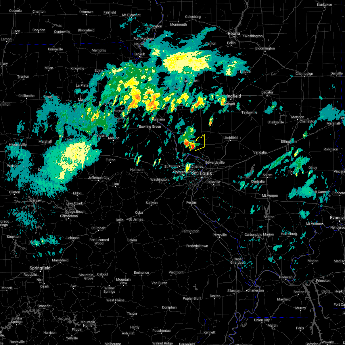 At 804 am cst, a severe thunderstorm was located over jerseyville, moving northeast at 60 mph (radar indicated). Hazards include quarter size hail. Damage to vehicles is expected. locations impacted include, kemper. hail threat, radar indicated max hail size, 1. 00 in wind threat, radar indicated max wind gust, <50 mph. At 804 am cst, a severe thunderstorm was located over jerseyville, moving northeast at 60 mph (radar indicated). Hazards include quarter size hail. Damage to vehicles is expected. locations impacted include, kemper. hail threat, radar indicated max hail size, 1. 00 in wind threat, radar indicated max wind gust, <50 mph.
|
| 2/22/2023 7:51 AM CST |
 At 751 am cst, a severe thunderstorm was located near grafton, moving northeast at 60 mph (radar indicated). Hazards include quarter size hail. Damage to vehicles is expected. this severe storm will be near, grafton around 755 am cst. elsah around 800 am cst. other locations in the path of this severe thunderstorm include jerseyville, brighton and kemper. this also includes pere marquette state park. hail threat, radar indicated max hail size, 1. 00 in wind threat, radar indicated max wind gust, <50 mph. At 751 am cst, a severe thunderstorm was located near grafton, moving northeast at 60 mph (radar indicated). Hazards include quarter size hail. Damage to vehicles is expected. this severe storm will be near, grafton around 755 am cst. elsah around 800 am cst. other locations in the path of this severe thunderstorm include jerseyville, brighton and kemper. this also includes pere marquette state park. hail threat, radar indicated max hail size, 1. 00 in wind threat, radar indicated max wind gust, <50 mph.
|
| 2/22/2023 7:41 AM CST |
 At 741 am cst, a severe thunderstorm was located near st. paul, moving northeast at 60 mph (radar indicated). Hazards include quarter size hail. Damage to vehicles is expected. this severe thunderstorm will be near, grafton around 755 am cst. elsah around 800 am cst. other locations in the path of this severe thunderstorm include jerseyville, brighton and kemper. this also includes pere marquette state park. hail threat, radar indicated max hail size, 1. 00 in wind threat, radar indicated max wind gust, <50 mph. At 741 am cst, a severe thunderstorm was located near st. paul, moving northeast at 60 mph (radar indicated). Hazards include quarter size hail. Damage to vehicles is expected. this severe thunderstorm will be near, grafton around 755 am cst. elsah around 800 am cst. other locations in the path of this severe thunderstorm include jerseyville, brighton and kemper. this also includes pere marquette state park. hail threat, radar indicated max hail size, 1. 00 in wind threat, radar indicated max wind gust, <50 mph.
|
| 8/3/2022 4:31 PM CDT |
 At 431 pm cdt, a severe thunderstorm was located near jerseyville, moving northeast at 25 mph (law enforcement). Hazards include 60 mph wind gusts and quarter size hail. Hail damage to vehicles is expected. expect wind damage to roofs, siding, and trees. locations impacted include, jerseyville, kemper, old kane, kane, rockbridge, fidelity and delhi. hail threat, radar indicated max hail size, 1. 00 in wind threat, observed max wind gust, 60 mph. At 431 pm cdt, a severe thunderstorm was located near jerseyville, moving northeast at 25 mph (law enforcement). Hazards include 60 mph wind gusts and quarter size hail. Hail damage to vehicles is expected. expect wind damage to roofs, siding, and trees. locations impacted include, jerseyville, kemper, old kane, kane, rockbridge, fidelity and delhi. hail threat, radar indicated max hail size, 1. 00 in wind threat, observed max wind gust, 60 mph.
|
| 8/3/2022 4:22 PM CDT |
 At 422 pm cdt, a severe thunderstorm was located over jerseyville, moving east at 25 mph (radar indicated). Hazards include 60 mph wind gusts and quarter size hail. Hail damage to vehicles is expected. Expect wind damage to roofs, siding, and trees. At 422 pm cdt, a severe thunderstorm was located over jerseyville, moving east at 25 mph (radar indicated). Hazards include 60 mph wind gusts and quarter size hail. Hail damage to vehicles is expected. Expect wind damage to roofs, siding, and trees.
|
| 8/3/2022 4:08 PM CDT |
 At 408 pm cdt, a severe thunderstorm was located near hardin, moving northeast at 25 mph (radar indicated). Hazards include 60 mph wind gusts and quarter size hail. Hail damage to vehicles is expected. expect wind damage to roofs, siding, and trees. locations impacted include, jerseyville, carrollton, hardin, old kane, kane, fieldon, woody and nutwood. hail threat, radar indicated max hail size, 1. 00 in wind threat, radar indicated max wind gust, 60 mph. At 408 pm cdt, a severe thunderstorm was located near hardin, moving northeast at 25 mph (radar indicated). Hazards include 60 mph wind gusts and quarter size hail. Hail damage to vehicles is expected. expect wind damage to roofs, siding, and trees. locations impacted include, jerseyville, carrollton, hardin, old kane, kane, fieldon, woody and nutwood. hail threat, radar indicated max hail size, 1. 00 in wind threat, radar indicated max wind gust, 60 mph.
|
| 8/3/2022 3:59 PM CDT |
 At 358 pm cdt, a severe thunderstorm was located near hardin, moving northeast at 25 mph (radar indicated). Hazards include 60 mph wind gusts and quarter size hail. Hail damage to vehicles is expected. expect wind damage to roofs, siding, and trees. locations impacted include, jerseyville, carrollton, hardin, old kane, kane, fieldon, woody, michael and nutwood. hail threat, radar indicated max hail size, 1. 00 in wind threat, radar indicated max wind gust, 60 mph. At 358 pm cdt, a severe thunderstorm was located near hardin, moving northeast at 25 mph (radar indicated). Hazards include 60 mph wind gusts and quarter size hail. Hail damage to vehicles is expected. expect wind damage to roofs, siding, and trees. locations impacted include, jerseyville, carrollton, hardin, old kane, kane, fieldon, woody, michael and nutwood. hail threat, radar indicated max hail size, 1. 00 in wind threat, radar indicated max wind gust, 60 mph.
|
| 8/3/2022 3:45 PM CDT |
 At 344 pm cdt, a severe thunderstorm was located near hardin, moving east at 20 mph (radar indicated). Hazards include 60 mph wind gusts and quarter size hail. Hail damage to vehicles is expected. Expect wind damage to roofs, siding, and trees. At 344 pm cdt, a severe thunderstorm was located near hardin, moving east at 20 mph (radar indicated). Hazards include 60 mph wind gusts and quarter size hail. Hail damage to vehicles is expected. Expect wind damage to roofs, siding, and trees.
|
| 6/17/2022 4:56 AM CDT |
 At 455 am cdt, severe thunderstorms were located along a line extending from near athensville to greenfield to near old kane to 8 miles west of orchard farms, moving east at 40 mph (trained weather spotters reported power outages across several towns and a national weather service employee estimated 60 mph gusts). Hazards include 60 mph wind gusts and penny size hail. Expect damage to roofs, siding, and trees. these severe storms will be near, greenfield around 500 am cdt. grafton around 510 am cdt. other locations in the path of these severe thunderstorms include florissant, hazelwood, berkeley, palmyra, elsah, portage des sioux, kemper, ferguson, carlinville, brighton, calverton park, west alton, bellefontaine neighbors, black jack, spanish lake, castle point, st. louis, godfrey, virden, girard, shipman, glasgow village, alton, wood river, madison, east alton, bunker hill, hartford, bethalto, pontoon beach, south roxana, roxana and rosewood heights. this also includes babler memorial state park, scott joplin historic site, route 66 state park, castlewood state park, confluence state park, first missouri state capitol historic site, beaver dam state park, and horseshoe lake state park. this includes the following highways, interstate 55 in illinois between exits 23 and 44. interstate 44 in missouri between exits 261 and 277. interstate 70 in missouri between exits 216 and 231. hail threat, radar indicated max hail size, 0. 75 in wind threat, radar indicated max wind gust, 60 mph. At 455 am cdt, severe thunderstorms were located along a line extending from near athensville to greenfield to near old kane to 8 miles west of orchard farms, moving east at 40 mph (trained weather spotters reported power outages across several towns and a national weather service employee estimated 60 mph gusts). Hazards include 60 mph wind gusts and penny size hail. Expect damage to roofs, siding, and trees. these severe storms will be near, greenfield around 500 am cdt. grafton around 510 am cdt. other locations in the path of these severe thunderstorms include florissant, hazelwood, berkeley, palmyra, elsah, portage des sioux, kemper, ferguson, carlinville, brighton, calverton park, west alton, bellefontaine neighbors, black jack, spanish lake, castle point, st. louis, godfrey, virden, girard, shipman, glasgow village, alton, wood river, madison, east alton, bunker hill, hartford, bethalto, pontoon beach, south roxana, roxana and rosewood heights. this also includes babler memorial state park, scott joplin historic site, route 66 state park, castlewood state park, confluence state park, first missouri state capitol historic site, beaver dam state park, and horseshoe lake state park. this includes the following highways, interstate 55 in illinois between exits 23 and 44. interstate 44 in missouri between exits 261 and 277. interstate 70 in missouri between exits 216 and 231. hail threat, radar indicated max hail size, 0. 75 in wind threat, radar indicated max wind gust, 60 mph.
|
| 6/17/2022 4:51 AM CDT |
 At 451 am cdt, severe thunderstorms were located along a line extending from near manchester to greenfield to 6 miles southwest of old kane to 6 miles northeast of st. paul, moving east at 40 mph (radar indicated). Hazards include 60 mph wind gusts and penny size hail. Expect damage to roofs, siding, and trees. these severe storms will be near, greenfield and athensville around 455 am cdt. old kane around 500 am cdt. other locations in the path of these severe thunderstorms include jerseyville, grafton, orchard farms, florissant, hazelwood, palmyra, elsah, portage des sioux, kemper, carlinville, brighton, west alton, black jack, spanish lake, godfrey, virden, girard and shipman. this also includes babler memorial state park, scott joplin historic site, route 66 state park, castlewood state park, confluence state park, first missouri state capitol historic site, pere marquette state park, beaver dam state park, and horseshoe lake state park. this includes the following highways, interstate 55 in illinois between exits 23 and 44. interstate 44 in missouri between exits 261 and 277. interstate 70 in missouri between exits 214 and 231. hail threat, radar indicated max hail size, 0. 75 in wind threat, radar indicated max wind gust, 60 mph. At 451 am cdt, severe thunderstorms were located along a line extending from near manchester to greenfield to 6 miles southwest of old kane to 6 miles northeast of st. paul, moving east at 40 mph (radar indicated). Hazards include 60 mph wind gusts and penny size hail. Expect damage to roofs, siding, and trees. these severe storms will be near, greenfield and athensville around 455 am cdt. old kane around 500 am cdt. other locations in the path of these severe thunderstorms include jerseyville, grafton, orchard farms, florissant, hazelwood, palmyra, elsah, portage des sioux, kemper, carlinville, brighton, west alton, black jack, spanish lake, godfrey, virden, girard and shipman. this also includes babler memorial state park, scott joplin historic site, route 66 state park, castlewood state park, confluence state park, first missouri state capitol historic site, pere marquette state park, beaver dam state park, and horseshoe lake state park. this includes the following highways, interstate 55 in illinois between exits 23 and 44. interstate 44 in missouri between exits 261 and 277. interstate 70 in missouri between exits 214 and 231. hail threat, radar indicated max hail size, 0. 75 in wind threat, radar indicated max wind gust, 60 mph.
|
| 6/17/2022 4:40 AM CDT |
 At 440 am cdt, severe thunderstorms were located along a line extending from roodhouse to near carrollton to hardin to near chain of rocks, moving east at 40 mph (radar indicated). Hazards include 60 mph wind gusts and penny size hail. Expect damage to roofs, siding, and trees. severe thunderstorms will be near, carrollton around 445 am cdt. greenfield around 450 am cdt. athensville around 455 am cdt. st. charles, jerseyville and old kane around 500 am cdt. other locations in the path of these severe thunderstorms include orchard farms, bridgeton, grafton, elsah, florissant, hazelwood, berkeley, palmyra, portage des sioux, kemper, ferguson, carlinville, dellwood, brighton, calverton park and west alton. this includes the following highways, interstate 55 in illinois between exits 23 and 44. interstate 44 in missouri between exits 261 and 277. interstate 70 in missouri between exits 208 and 231. this also includes babler memorial state park, scott joplin historic site, route 66 state park, castlewood state park, confluence state park, first missouri state capitol historic site, pere marquette state park, beaver dam state park, and horseshoe lake state park. hail threat, radar indicated max hail size, 0. 75 in wind threat, radar indicated max wind gust, 60 mph. At 440 am cdt, severe thunderstorms were located along a line extending from roodhouse to near carrollton to hardin to near chain of rocks, moving east at 40 mph (radar indicated). Hazards include 60 mph wind gusts and penny size hail. Expect damage to roofs, siding, and trees. severe thunderstorms will be near, carrollton around 445 am cdt. greenfield around 450 am cdt. athensville around 455 am cdt. st. charles, jerseyville and old kane around 500 am cdt. other locations in the path of these severe thunderstorms include orchard farms, bridgeton, grafton, elsah, florissant, hazelwood, berkeley, palmyra, portage des sioux, kemper, ferguson, carlinville, dellwood, brighton, calverton park and west alton. this includes the following highways, interstate 55 in illinois between exits 23 and 44. interstate 44 in missouri between exits 261 and 277. interstate 70 in missouri between exits 208 and 231. this also includes babler memorial state park, scott joplin historic site, route 66 state park, castlewood state park, confluence state park, first missouri state capitol historic site, pere marquette state park, beaver dam state park, and horseshoe lake state park. hail threat, radar indicated max hail size, 0. 75 in wind threat, radar indicated max wind gust, 60 mph.
|
| 6/17/2022 4:29 AM CDT |
 At 429 am cdt, severe thunderstorms were located along a line extending from near old kane to near winfield to near treloar, moving east at 80 mph (radar indicated). Hazards include 60 mph wind gusts and nickel size hail. Expect damage to roofs, siding, and trees. locations impacted include, o`fallon, st. charles, st. peters, chesterfield, wentzville, maryland heights, hazelwood, lake st. louis, washington, bridgeton, dardenne prairie, troy, jerseyville, warrenton, weldon spring, wright city, cottleville, hermann, new haven and elsberry. this also includes cuivre river state park, first missouri state capitol historic site, and pere marquette state park. this includes interstate 70 in missouri between exits 188 and 229. hail threat, radar indicated max hail size, 0. 88 in wind threat, radar indicated max wind gust, 60 mph. At 429 am cdt, severe thunderstorms were located along a line extending from near old kane to near winfield to near treloar, moving east at 80 mph (radar indicated). Hazards include 60 mph wind gusts and nickel size hail. Expect damage to roofs, siding, and trees. locations impacted include, o`fallon, st. charles, st. peters, chesterfield, wentzville, maryland heights, hazelwood, lake st. louis, washington, bridgeton, dardenne prairie, troy, jerseyville, warrenton, weldon spring, wright city, cottleville, hermann, new haven and elsberry. this also includes cuivre river state park, first missouri state capitol historic site, and pere marquette state park. this includes interstate 70 in missouri between exits 188 and 229. hail threat, radar indicated max hail size, 0. 88 in wind threat, radar indicated max wind gust, 60 mph.
|
| 6/17/2022 4:19 AM CDT |
 At 419 am cdt, severe thunderstorms were located along a line extending from near hardin to near fountain n` lakes to 6 miles east of big spring, moving east at 65 mph (radar indicated). Hazards include 60 mph wind gusts and nickel size hail. Expect damage to roofs, siding, and trees. locations impacted include, winfield, hardin, fountain n` lakes, chain of rocks, warrenton, st. paul, truesdale, treloar, marthasville, innsbrook, st. charles, jerseyville, dutzow, grafton, elsah, new melle, portage des sioux, augusta, orchard farms, kemper, hazelwood, bridgeton, brighton, west alton, defiance and weldon spring heights. this also includes deutschheim historic site, cuivre river state park, graham cave state park, first missouri state capitol historic site, and pere marquette state park. this includes interstate 70 in missouri between exits 170 and 229. hail threat, radar indicated max hail size, 0. 88 in wind threat, radar indicated max wind gust, 60 mph. At 419 am cdt, severe thunderstorms were located along a line extending from near hardin to near fountain n` lakes to 6 miles east of big spring, moving east at 65 mph (radar indicated). Hazards include 60 mph wind gusts and nickel size hail. Expect damage to roofs, siding, and trees. locations impacted include, winfield, hardin, fountain n` lakes, chain of rocks, warrenton, st. paul, truesdale, treloar, marthasville, innsbrook, st. charles, jerseyville, dutzow, grafton, elsah, new melle, portage des sioux, augusta, orchard farms, kemper, hazelwood, bridgeton, brighton, west alton, defiance and weldon spring heights. this also includes deutschheim historic site, cuivre river state park, graham cave state park, first missouri state capitol historic site, and pere marquette state park. this includes interstate 70 in missouri between exits 170 and 229. hail threat, radar indicated max hail size, 0. 88 in wind threat, radar indicated max wind gust, 60 mph.
|
| 6/17/2022 3:59 AM CDT |
 At 358 am cdt, severe thunderstorms were located along a line extending from near eolia to 6 miles northeast of bellflower to near williamsburg, moving east at 80 mph (radar indicated). Hazards include 60 mph wind gusts and penny size hail. Expect damage to roofs, siding, and trees. severe thunderstorms will be near, hawk point and eolia around 405 am cdt. elsberry, davis and new florence around 410 am cdt. troy, hermann, moscow mills, jonesburg and fountain n` lakes around 415 am cdt. other locations in the path of these severe thunderstorms include st. paul, winfield, hardin, chain of rocks, warrenton, new haven, truesdale, treloar, st. charles, washington, jerseyville, marthasville, innsbrook, dutzow, maryland heights, bridgeton, elsah, new melle, portage des sioux, augusta, orchard farms, hazelwood, brighton, west alton and defiance. this includes interstate 70 in missouri between exits 155 and 229. this also includes deutschheim historic site, cuivre river state park, clarks hill/norton historic site, graham cave state park, first missouri state capitol historic site, and pere marquette state park. hail threat, radar indicated max hail size, 0. 75 in wind threat, radar indicated max wind gust, 60 mph. At 358 am cdt, severe thunderstorms were located along a line extending from near eolia to 6 miles northeast of bellflower to near williamsburg, moving east at 80 mph (radar indicated). Hazards include 60 mph wind gusts and penny size hail. Expect damage to roofs, siding, and trees. severe thunderstorms will be near, hawk point and eolia around 405 am cdt. elsberry, davis and new florence around 410 am cdt. troy, hermann, moscow mills, jonesburg and fountain n` lakes around 415 am cdt. other locations in the path of these severe thunderstorms include st. paul, winfield, hardin, chain of rocks, warrenton, new haven, truesdale, treloar, st. charles, washington, jerseyville, marthasville, innsbrook, dutzow, maryland heights, bridgeton, elsah, new melle, portage des sioux, augusta, orchard farms, hazelwood, brighton, west alton and defiance. this includes interstate 70 in missouri between exits 155 and 229. this also includes deutschheim historic site, cuivre river state park, clarks hill/norton historic site, graham cave state park, first missouri state capitol historic site, and pere marquette state park. hail threat, radar indicated max hail size, 0. 75 in wind threat, radar indicated max wind gust, 60 mph.
|
| 3/5/2022 10:52 PM CST |
 At 1052 pm cst, a severe thunderstorm was located near jerseyville, moving east at 60 mph (radar indicated). Hazards include 60 mph wind gusts. Expect damage to roofs, siding, and trees. this severe thunderstorm will be near, shipman around 1105 pm cst. bunker hill around 1110 pm cst. other locations in the path of this severe thunderstorm include gillespie, benld, wilsonville, sawyerville, mount clare, east gillespie, mount olive and eagarville. this includes interstate 55 in illinois near exit 44. this also includes beaver dam state park. hail threat, radar indicated max hail size, <. 75 in wind threat, radar indicated max wind gust, 60 mph. At 1052 pm cst, a severe thunderstorm was located near jerseyville, moving east at 60 mph (radar indicated). Hazards include 60 mph wind gusts. Expect damage to roofs, siding, and trees. this severe thunderstorm will be near, shipman around 1105 pm cst. bunker hill around 1110 pm cst. other locations in the path of this severe thunderstorm include gillespie, benld, wilsonville, sawyerville, mount clare, east gillespie, mount olive and eagarville. this includes interstate 55 in illinois near exit 44. this also includes beaver dam state park. hail threat, radar indicated max hail size, <. 75 in wind threat, radar indicated max wind gust, 60 mph.
|
| 12/10/2021 8:09 PM CST | Jersey county dispatch reported a metal sign and tree limb down across the road at state hwy 16 in jerseyville. time estimated using rada in jersey county IL, 0.4 miles S of Jerseyville, IL |
| 8/8/2021 4:55 PM CDT |
 The severe thunderstorm warning for eastern greene and eastern jersey counties will expire at 500 pm cdt, the storms which prompted the warning have weakened below severe limits, and no longer pose an immediate threat to life or property. therefore, the warning will be allowed to expire. a severe thunderstorm watch remains in effect until 800 pm cdt for southwestern illinois, and east central missouri. The severe thunderstorm warning for eastern greene and eastern jersey counties will expire at 500 pm cdt, the storms which prompted the warning have weakened below severe limits, and no longer pose an immediate threat to life or property. therefore, the warning will be allowed to expire. a severe thunderstorm watch remains in effect until 800 pm cdt for southwestern illinois, and east central missouri.
|
| 8/8/2021 4:47 PM CDT |
 At 447 pm cdt, severe thunderstorms were located along a line extending from near carrollton to near kemper, moving northeast at 45 mph (radar indicated). Hazards include 60 mph wind gusts. Expect damage to roofs, siding, and trees. locations impacted include, jerseyville, brighton, greenfield, elsah, athensville, kemper, kane, wrights, rockbridge, fidelity, delhi, belltown, berdan and mcclusky. hail threat, radar indicated max hail size, <. 75 in wind threat, radar indicated max wind gust, 60 mph. At 447 pm cdt, severe thunderstorms were located along a line extending from near carrollton to near kemper, moving northeast at 45 mph (radar indicated). Hazards include 60 mph wind gusts. Expect damage to roofs, siding, and trees. locations impacted include, jerseyville, brighton, greenfield, elsah, athensville, kemper, kane, wrights, rockbridge, fidelity, delhi, belltown, berdan and mcclusky. hail threat, radar indicated max hail size, <. 75 in wind threat, radar indicated max wind gust, 60 mph.
|
| 8/8/2021 4:24 PM CDT |
 At 424 pm cdt, severe thunderstorms were located along a line extending from near hardin to near grafton, moving northeast at 45 mph (radar indicated). Hazards include 60 mph wind gusts. Expect damage to roofs, siding, and trees. locations impacted include, jerseyville, carrollton, brighton, greenfield, hardin, grafton, elsah, athensville, old kane, kemper, kane, wrights, fieldon, eldred, rockbridge, otterville, fidelity, delhi, belltown and berdan. this also includes pere marquette state park. hail threat, radar indicated max hail size, <. 75 in wind threat, radar indicated max wind gust, 60 mph. At 424 pm cdt, severe thunderstorms were located along a line extending from near hardin to near grafton, moving northeast at 45 mph (radar indicated). Hazards include 60 mph wind gusts. Expect damage to roofs, siding, and trees. locations impacted include, jerseyville, carrollton, brighton, greenfield, hardin, grafton, elsah, athensville, old kane, kemper, kane, wrights, fieldon, eldred, rockbridge, otterville, fidelity, delhi, belltown and berdan. this also includes pere marquette state park. hail threat, radar indicated max hail size, <. 75 in wind threat, radar indicated max wind gust, 60 mph.
|
| 8/8/2021 3:54 PM CDT |
 At 353 pm cdt, severe thunderstorms were located along a line extending from near fountain n` lakes to near o`fallon, moving northeast at 45 mph (radar indicated). Hazards include 60 mph wind gusts. expect damage to roofs, siding, and trees At 353 pm cdt, severe thunderstorms were located along a line extending from near fountain n` lakes to near o`fallon, moving northeast at 45 mph (radar indicated). Hazards include 60 mph wind gusts. expect damage to roofs, siding, and trees
|
| 7/9/2021 11:59 PM CDT |
 At 1158 pm cdt, severe thunderstorms were located along a line extending from near grafton to near chain of rocks to innsbrook to near treloar, moving south at 30 mph (trained weather spotters). Hazards include 70 mph wind gusts and penny size hail. Expect considerable tree damage. damage is likely to mobile homes, roofs, and outbuildings. severe thunderstorms will be near, innsbrook and treloar around 1205 am cdt. new haven and josephville around 1210 am cdt. wentzville, lake st. louis and marthasville around 1215 am cdt. other locations in the path of these severe thunderstorms include dardenne prairie, dutzow, st. charles, florissant, washington, new melle, hazelwood, maryland heights, ferguson, bridgeton, berkeley, lambert-st. louis international airport, calverton park, st. ann, union, st. john, normandy, woodson terrace, bel-ridge, cool valley, kinloch, breckenridge hills and edmundson. this includes the following highways, interstate 44 in missouri between exits 230 and 277. interstate 55 in missouri between exits 187 and 191. interstate 70 in missouri between exits 199 and 231. This also includes babler memorial state park, scott joplin historic site, route 66 state park, castlewood state park, confluence state park, mastodon historic site, first missouri state capitol historic site, robertsville state park, pere marquette state park, and horseshoe lake state park. At 1158 pm cdt, severe thunderstorms were located along a line extending from near grafton to near chain of rocks to innsbrook to near treloar, moving south at 30 mph (trained weather spotters). Hazards include 70 mph wind gusts and penny size hail. Expect considerable tree damage. damage is likely to mobile homes, roofs, and outbuildings. severe thunderstorms will be near, innsbrook and treloar around 1205 am cdt. new haven and josephville around 1210 am cdt. wentzville, lake st. louis and marthasville around 1215 am cdt. other locations in the path of these severe thunderstorms include dardenne prairie, dutzow, st. charles, florissant, washington, new melle, hazelwood, maryland heights, ferguson, bridgeton, berkeley, lambert-st. louis international airport, calverton park, st. ann, union, st. john, normandy, woodson terrace, bel-ridge, cool valley, kinloch, breckenridge hills and edmundson. this includes the following highways, interstate 44 in missouri between exits 230 and 277. interstate 55 in missouri between exits 187 and 191. interstate 70 in missouri between exits 199 and 231. This also includes babler memorial state park, scott joplin historic site, route 66 state park, castlewood state park, confluence state park, mastodon historic site, first missouri state capitol historic site, robertsville state park, pere marquette state park, and horseshoe lake state park.
|
| 6/25/2021 1:43 AM CDT |
 The severe thunderstorm warning for calhoun, greene and western jersey counties in southwestern illinois, northeastern lincoln county in east central missouri and southeastern pike counties in northeastern missouri will expire at 145 am cdt, the storms which prompted the warning have weakened below severe limits, and no longer pose an immediate threat to life or property. therefore, the warning will be allowed to expire. however gusty winds are still possible with these thunderstorms. a tornado watch remains in effect until 400 am cdt for southwestern illinois, and northeastern and east central missouri. The severe thunderstorm warning for calhoun, greene and western jersey counties in southwestern illinois, northeastern lincoln county in east central missouri and southeastern pike counties in northeastern missouri will expire at 145 am cdt, the storms which prompted the warning have weakened below severe limits, and no longer pose an immediate threat to life or property. therefore, the warning will be allowed to expire. however gusty winds are still possible with these thunderstorms. a tornado watch remains in effect until 400 am cdt for southwestern illinois, and northeastern and east central missouri.
|
| 6/25/2021 1:27 AM CDT |
 At 126 am cdt, severe thunderstorms were located along a line extending from woodson to hardin to winfield, moving east at 35 mph (radar indicated). Hazards include 60 mph wind gusts. Expect damage to roofs, siding, and trees. locations impacted include, jerseyville, white hall, elsberry, carrollton, roodhouse, winfield, greenfield, hardin, grafton, athensville, old kane, patterson, kane, kampsville, wrights, fieldon, batchtown, eldred, hillview and rockbridge. This also includes cuivre river state park. At 126 am cdt, severe thunderstorms were located along a line extending from woodson to hardin to winfield, moving east at 35 mph (radar indicated). Hazards include 60 mph wind gusts. Expect damage to roofs, siding, and trees. locations impacted include, jerseyville, white hall, elsberry, carrollton, roodhouse, winfield, greenfield, hardin, grafton, athensville, old kane, patterson, kane, kampsville, wrights, fieldon, batchtown, eldred, hillview and rockbridge. This also includes cuivre river state park.
|
| 6/25/2021 12:57 AM CDT |
 At 1257 am cdt, severe thunderstorms were located along a line extending from 7 miles southwest of littleton to 8 miles east of pleasant hill to near hawk point, moving east at 40 mph (radar indicated). Hazards include 60 mph wind gusts. expect damage to roofs, siding, and trees At 1257 am cdt, severe thunderstorms were located along a line extending from 7 miles southwest of littleton to 8 miles east of pleasant hill to near hawk point, moving east at 40 mph (radar indicated). Hazards include 60 mph wind gusts. expect damage to roofs, siding, and trees
|
| 6/19/2021 3:34 PM CDT |
 At 333 pm cdt, a severe thunderstorm was located 7 miles south of hardin, moving southeast at 35 mph (law enforcement reported power lines down in elsberry). Hazards include ping pong ball size hail and 60 mph wind gusts. People and animals outdoors will be injured. expect hail damage to roofs, siding, windows, and vehicles. expect wind damage to roofs, siding, and trees. Locations impacted include, jerseyville, elsberry, hardin, grafton, fieldon, batchtown, otterville and nutwood. At 333 pm cdt, a severe thunderstorm was located 7 miles south of hardin, moving southeast at 35 mph (law enforcement reported power lines down in elsberry). Hazards include ping pong ball size hail and 60 mph wind gusts. People and animals outdoors will be injured. expect hail damage to roofs, siding, windows, and vehicles. expect wind damage to roofs, siding, and trees. Locations impacted include, jerseyville, elsberry, hardin, grafton, fieldon, batchtown, otterville and nutwood.
|
| 6/19/2021 3:19 PM CDT |
 At 319 pm cdt, a severe thunderstorm was located near hardin, moving southeast at 20 mph (radar indicated). Hazards include ping pong ball size hail and 60 mph wind gusts. People and animals outdoors will be injured. expect hail damage to roofs, siding, windows, and vehicles. expect wind damage to roofs, siding, and trees. Locations impacted include, jerseyville, elsberry, hardin, grafton, fieldon, batchtown, otterville and nutwood. At 319 pm cdt, a severe thunderstorm was located near hardin, moving southeast at 20 mph (radar indicated). Hazards include ping pong ball size hail and 60 mph wind gusts. People and animals outdoors will be injured. expect hail damage to roofs, siding, windows, and vehicles. expect wind damage to roofs, siding, and trees. Locations impacted include, jerseyville, elsberry, hardin, grafton, fieldon, batchtown, otterville and nutwood.
|
| 6/19/2021 3:15 PM CDT |
 At 314 pm cdt, a severe thunderstorm was located near hardin, moving southeast at 20 mph (radar indicated). Hazards include 60 mph wind gusts and half dollar size hail. Hail damage to vehicles is expected. expect wind damage to roofs, siding, and trees. Locations impacted include, jerseyville, elsberry, hardin, grafton, fieldon, batchtown, otterville and nutwood. At 314 pm cdt, a severe thunderstorm was located near hardin, moving southeast at 20 mph (radar indicated). Hazards include 60 mph wind gusts and half dollar size hail. Hail damage to vehicles is expected. expect wind damage to roofs, siding, and trees. Locations impacted include, jerseyville, elsberry, hardin, grafton, fieldon, batchtown, otterville and nutwood.
|
| 6/19/2021 2:55 PM CDT |
 At 254 pm cdt, a severe thunderstorm was located over elsberry, moving southeast at 20 mph (radar indicated). Hazards include 60 mph wind gusts and quarter size hail. Hail damage to vehicles is expected. Expect wind damage to roofs, siding, and trees. At 254 pm cdt, a severe thunderstorm was located over elsberry, moving southeast at 20 mph (radar indicated). Hazards include 60 mph wind gusts and quarter size hail. Hail damage to vehicles is expected. Expect wind damage to roofs, siding, and trees.
|
| 5/27/2021 12:09 PM CDT |
 At 1208 pm cdt, severe thunderstorms were located along a line extending from near palmyra to near orchard farms to dutzow, moving east at 45 mph (radar indicated). Hazards include 70 mph wind gusts and quarter size hail. Hail damage to vehicles is expected. expect considerable tree damage. wind damage is also likely to mobile homes, roofs, and outbuildings. locations impacted include, florissant, elsah, portage des sioux, black jack, spanish lake, west alton, new melle, east alton, girard, alton, godfrey, wood river, brighton, roxana, hartford, wildwood, bethalto, spirit of st. louis airport, weldon spring heights, rosewood heights, o`fallon, st. peters, ballwin, ellisville, weldon spring, cottleville, clarkson valley, winchester, dorsey, manchester, town and country, bunker hill, prairietown, harvester, chesterfield, kirkwood, maryland heights, des peres, frontenac, warson woods, crystal lake park, huntleigh, westwood and country life acres. this also includes babler memorial state park, scott joplin historic site, castlewood state park, confluence state park, first missouri state capitol historic site, pere marquette state park, beaver dam state park, and horseshoe lake state park. this includes the following highways, interstate 44 in missouri between exits 272 and 277. Interstate 70 in missouri between exits 209 and 231. At 1208 pm cdt, severe thunderstorms were located along a line extending from near palmyra to near orchard farms to dutzow, moving east at 45 mph (radar indicated). Hazards include 70 mph wind gusts and quarter size hail. Hail damage to vehicles is expected. expect considerable tree damage. wind damage is also likely to mobile homes, roofs, and outbuildings. locations impacted include, florissant, elsah, portage des sioux, black jack, spanish lake, west alton, new melle, east alton, girard, alton, godfrey, wood river, brighton, roxana, hartford, wildwood, bethalto, spirit of st. louis airport, weldon spring heights, rosewood heights, o`fallon, st. peters, ballwin, ellisville, weldon spring, cottleville, clarkson valley, winchester, dorsey, manchester, town and country, bunker hill, prairietown, harvester, chesterfield, kirkwood, maryland heights, des peres, frontenac, warson woods, crystal lake park, huntleigh, westwood and country life acres. this also includes babler memorial state park, scott joplin historic site, castlewood state park, confluence state park, first missouri state capitol historic site, pere marquette state park, beaver dam state park, and horseshoe lake state park. this includes the following highways, interstate 44 in missouri between exits 272 and 277. Interstate 70 in missouri between exits 209 and 231.
|
| 5/27/2021 11:50 AM CDT |
 At 1150 am cdt, severe thunderstorms were located along a line extending from greenfield to near grafton to new melle, moving east at 45 mph (radar indicated). Hazards include 70 mph wind gusts and quarter size hail. Hail damage to vehicles is expected. expect considerable tree damage. wind damage is also likely to mobile homes, roofs, and outbuildings. severe thunderstorms will be near, greenfield and grafton around 1155 am cdt. jerseyville, st. paul, weldon spring heights and old kane around 1205 pm cdt. o`fallon, weldon spring and cottleville around 1210 pm cdt. other locations in the path of these severe thunderstorms include st. peters, brighton, harvester, st. charles, maryland heights, kemper, girard, shipman, champ, florissant, hazelwood, bridgeton, orchard farms, elsah and portage des sioux. this includes the following highways, interstate 44 in missouri between exits 272 and 277. interstate 70 in missouri between exits 203 and 231. This also includes babler memorial state park, scott joplin historic site, castlewood state park, confluence state park, first missouri state capitol historic site, pere marquette state park, beaver dam state park, and horseshoe lake state park. At 1150 am cdt, severe thunderstorms were located along a line extending from greenfield to near grafton to new melle, moving east at 45 mph (radar indicated). Hazards include 70 mph wind gusts and quarter size hail. Hail damage to vehicles is expected. expect considerable tree damage. wind damage is also likely to mobile homes, roofs, and outbuildings. severe thunderstorms will be near, greenfield and grafton around 1155 am cdt. jerseyville, st. paul, weldon spring heights and old kane around 1205 pm cdt. o`fallon, weldon spring and cottleville around 1210 pm cdt. other locations in the path of these severe thunderstorms include st. peters, brighton, harvester, st. charles, maryland heights, kemper, girard, shipman, champ, florissant, hazelwood, bridgeton, orchard farms, elsah and portage des sioux. this includes the following highways, interstate 44 in missouri between exits 272 and 277. interstate 70 in missouri between exits 203 and 231. This also includes babler memorial state park, scott joplin historic site, castlewood state park, confluence state park, first missouri state capitol historic site, pere marquette state park, beaver dam state park, and horseshoe lake state park.
|
| 5/27/2021 11:38 AM CDT |
 At 1138 am cdt, severe thunderstorms were located along a line extending from near carrollton to 8 miles northwest of grafton to wentzville, moving east at 45 mph (radar indicated). Hazards include 70 mph wind gusts and nickel size hail. Expect considerable tree damage. damage is likely to mobile homes, roofs, and outbuildings. locations impacted include, carrollton, grafton, st. peters, jerseyville, greenfield, kemper, old kane, harvester, st. charles, orchard farms and elsah. this also includes pere marquette state park. This includes interstate 70 in missouri between exits 200 and 227. At 1138 am cdt, severe thunderstorms were located along a line extending from near carrollton to 8 miles northwest of grafton to wentzville, moving east at 45 mph (radar indicated). Hazards include 70 mph wind gusts and nickel size hail. Expect considerable tree damage. damage is likely to mobile homes, roofs, and outbuildings. locations impacted include, carrollton, grafton, st. peters, jerseyville, greenfield, kemper, old kane, harvester, st. charles, orchard farms and elsah. this also includes pere marquette state park. This includes interstate 70 in missouri between exits 200 and 227.
|
| 5/27/2021 11:22 AM CDT |
 At 1122 am cdt, severe thunderstorms were located along a line extending from near hardin to near winfield to innsbrook, moving east at 40 mph (radar indicated). Hazards include 70 mph wind gusts and nickel size hail. Expect considerable tree damage. damage is likely to mobile homes, roofs, and outbuildings. these severe storms will be near, winfield and hardin around 1125 am cdt. other locations in the path of these severe thunderstorms include wentzville, carrollton, old kane, lake st. louis, st. paul, josephville, o`fallon, dardenne prairie, grafton, st. peters, cottleville, greenfield, kemper, harvester, jerseyville, st. charles and orchard farms. this also includes pere marquette state park. This includes interstate 70 in missouri between exits 199 and 227. At 1122 am cdt, severe thunderstorms were located along a line extending from near hardin to near winfield to innsbrook, moving east at 40 mph (radar indicated). Hazards include 70 mph wind gusts and nickel size hail. Expect considerable tree damage. damage is likely to mobile homes, roofs, and outbuildings. these severe storms will be near, winfield and hardin around 1125 am cdt. other locations in the path of these severe thunderstorms include wentzville, carrollton, old kane, lake st. louis, st. paul, josephville, o`fallon, dardenne prairie, grafton, st. peters, cottleville, greenfield, kemper, harvester, jerseyville, st. charles and orchard farms. this also includes pere marquette state park. This includes interstate 70 in missouri between exits 199 and 227.
|
| 5/27/2021 11:13 AM CDT |
 At 1112 am cdt, severe thunderstorms were located along a line extending from near elsberry to moscow mills to 6 miles southwest of truesdale, moving northeast at 45 mph (radar indicated). Hazards include 60 mph wind gusts and nickel size hail. Expect damage to roofs, siding, and trees. severe thunderstorms will be near, fountain n` lakes around 1120 am cdt. winfield and hardin around 1125 am cdt. other locations in the path of these severe thunderstorms include wentzville, carrollton, lake st. louis, st. paul, josephville, chain of rocks, jerseyville, greenfield and old kane. this includes interstate 70 in missouri between exits 199 and 227. This also includes pere marquette state park. At 1112 am cdt, severe thunderstorms were located along a line extending from near elsberry to moscow mills to 6 miles southwest of truesdale, moving northeast at 45 mph (radar indicated). Hazards include 60 mph wind gusts and nickel size hail. Expect damage to roofs, siding, and trees. severe thunderstorms will be near, fountain n` lakes around 1120 am cdt. winfield and hardin around 1125 am cdt. other locations in the path of these severe thunderstorms include wentzville, carrollton, lake st. louis, st. paul, josephville, chain of rocks, jerseyville, greenfield and old kane. this includes interstate 70 in missouri between exits 199 and 227. This also includes pere marquette state park.
|
| 8/10/2020 5:24 PM CDT |
 At 523 pm cdt, severe thunderstorms were located along a line extending from near greenfield to fountain n` lakes to near warrenton, moving southeast at 25 mph (radar indicated). Hazards include 60 mph wind gusts. Expect damage to roofs, siding, and trees. locations impacted include, florissant, granite city, alton, hazelwood, edwardsville, godfrey, glen carbon, wood river, troy, bethalto, jerseyville, black jack, staunton, gillespie, st. paul, spanish lake, east alton, moscow mills, brighton and mount olive. this also includes confluence state park, pere marquette state park, and beaver dam state park. This includes interstate 55 in illinois between exits 23 and 44. At 523 pm cdt, severe thunderstorms were located along a line extending from near greenfield to fountain n` lakes to near warrenton, moving southeast at 25 mph (radar indicated). Hazards include 60 mph wind gusts. Expect damage to roofs, siding, and trees. locations impacted include, florissant, granite city, alton, hazelwood, edwardsville, godfrey, glen carbon, wood river, troy, bethalto, jerseyville, black jack, staunton, gillespie, st. paul, spanish lake, east alton, moscow mills, brighton and mount olive. this also includes confluence state park, pere marquette state park, and beaver dam state park. This includes interstate 55 in illinois between exits 23 and 44.
|
| 8/10/2020 5:09 PM CDT |
 At 508 pm cdt, severe thunderstorms were located along a line extending from greenfield to near troy to near jonesburg, moving southeast at 25 mph (emergency management reported a tree down and highway signs blown down in and around troy). Hazards include 60 mph wind gusts. Expect damage to roofs, siding, and trees. locations impacted include, florissant, granite city, alton, hazelwood, edwardsville, godfrey, glen carbon, wood river, troy, bethalto, jerseyville, black jack, staunton, gillespie, elsberry, st. paul, spanish lake, east alton, moscow mills and carrollton. this also includes cuivre river state park, confluence state park, pere marquette state park, and beaver dam state park. This includes interstate 55 in illinois between exits 23 and 44. At 508 pm cdt, severe thunderstorms were located along a line extending from greenfield to near troy to near jonesburg, moving southeast at 25 mph (emergency management reported a tree down and highway signs blown down in and around troy). Hazards include 60 mph wind gusts. Expect damage to roofs, siding, and trees. locations impacted include, florissant, granite city, alton, hazelwood, edwardsville, godfrey, glen carbon, wood river, troy, bethalto, jerseyville, black jack, staunton, gillespie, elsberry, st. paul, spanish lake, east alton, moscow mills and carrollton. this also includes cuivre river state park, confluence state park, pere marquette state park, and beaver dam state park. This includes interstate 55 in illinois between exits 23 and 44.
|
| 8/10/2020 4:56 PM CDT |
 At 456 pm cdt, severe thunderstorms were located along a line extending from near greenfield to davis to near bellflower, moving southeast at 25 mph (radar indicated). Hazards include 60 mph wind gusts. expect damage to roofs, siding, and trees At 456 pm cdt, severe thunderstorms were located along a line extending from near greenfield to davis to near bellflower, moving southeast at 25 mph (radar indicated). Hazards include 60 mph wind gusts. expect damage to roofs, siding, and trees
|
| 4/28/2020 7:14 PM CDT |
 At 714 pm cdt, severe thunderstorms were located along a line extending from near jerseyville to dardenne prairie, moving east at 30 mph (radar indicated). Hazards include 60 mph wind gusts and quarter size hail. Hail damage to vehicles is expected. expect wind damage to roofs, siding, and trees. locations impacted include, o`fallon, st. charles, st. peters, wentzville, lake st. louis, dardenne prairie, jerseyville, weldon spring, cottleville, st. paul, brighton, grafton, elsah, josephville, portage des sioux, weldon spring heights, harvester, orchard farms, flint hill and foristell. this also includes pere marquette state park. This includes interstate 70 in missouri between exits 208 and 228. At 714 pm cdt, severe thunderstorms were located along a line extending from near jerseyville to dardenne prairie, moving east at 30 mph (radar indicated). Hazards include 60 mph wind gusts and quarter size hail. Hail damage to vehicles is expected. expect wind damage to roofs, siding, and trees. locations impacted include, o`fallon, st. charles, st. peters, wentzville, lake st. louis, dardenne prairie, jerseyville, weldon spring, cottleville, st. paul, brighton, grafton, elsah, josephville, portage des sioux, weldon spring heights, harvester, orchard farms, flint hill and foristell. this also includes pere marquette state park. This includes interstate 70 in missouri between exits 208 and 228.
|
| 4/28/2020 6:51 PM CDT |
 At 650 pm cdt, severe thunderstorms were located along a line extending from 8 miles southeast of hardin to near wentzville, moving east at 30 mph (radar indicated). Hazards include 60 mph wind gusts and quarter size hail. Hail damage to vehicles is expected. Expect wind damage to roofs, siding, and trees. At 650 pm cdt, severe thunderstorms were located along a line extending from 8 miles southeast of hardin to near wentzville, moving east at 30 mph (radar indicated). Hazards include 60 mph wind gusts and quarter size hail. Hail damage to vehicles is expected. Expect wind damage to roofs, siding, and trees.
|
| 4/8/2020 6:57 PM CDT |
 The severe thunderstorm warning for southeastern calhoun and southwestern jersey counties will expire at 700 pm cdt, the storm which prompted the warning has moved out of the area. therefore, the warning will be allowed to expire. a severe thunderstorm watch remains in effect until 900 pm cdt for southwestern illinois, and east central missouri. remember, a severe thunderstorm warning still remains in effect for eastern portions of jersey county. The severe thunderstorm warning for southeastern calhoun and southwestern jersey counties will expire at 700 pm cdt, the storm which prompted the warning has moved out of the area. therefore, the warning will be allowed to expire. a severe thunderstorm watch remains in effect until 900 pm cdt for southwestern illinois, and east central missouri. remember, a severe thunderstorm warning still remains in effect for eastern portions of jersey county.
|
| 4/8/2020 6:47 PM CDT |
 At 646 pm cdt, severe thunderstorms were located along a line extending from near grafton to near orchard farms to near st. peters, moving east at 40 mph (radar indicated). Hazards include 60 mph wind gusts and quarter size hail. Hail damage to vehicles is expected. Expect wind damage to roofs, siding, and trees. At 646 pm cdt, severe thunderstorms were located along a line extending from near grafton to near orchard farms to near st. peters, moving east at 40 mph (radar indicated). Hazards include 60 mph wind gusts and quarter size hail. Hail damage to vehicles is expected. Expect wind damage to roofs, siding, and trees.
|
| 4/8/2020 6:40 PM CDT |
 At 639 pm cdt, a severe thunderstorm was located near grafton, moving east at 40 mph (radar indicated). Hazards include 60 mph wind gusts and quarter size hail. Hail damage to vehicles is expected. expect wind damage to roofs, siding, and trees. locations impacted include, grafton, batchtown, brussels, otterville, meppen, deer plain, beechville and nutwood. This also includes pere marquette state park. At 639 pm cdt, a severe thunderstorm was located near grafton, moving east at 40 mph (radar indicated). Hazards include 60 mph wind gusts and quarter size hail. Hail damage to vehicles is expected. expect wind damage to roofs, siding, and trees. locations impacted include, grafton, batchtown, brussels, otterville, meppen, deer plain, beechville and nutwood. This also includes pere marquette state park.
|
| 4/8/2020 6:25 PM CDT |
 At 625 pm cdt, a severe thunderstorm was located over winfield, moving east at 40 mph (trained weather spotters). Hazards include golf ball size hail and 60 mph wind gusts. People and animals outdoors will be injured. expect hail damage to roofs, siding, windows, and vehicles. expect wind damage to roofs, siding, and trees. locations impacted include, winfield, grafton, fountain n` lakes, old monroe, batchtown, foley, brussels, otterville, meppen, deer plain, beechville and nutwood. This also includes pere marquette state park. At 625 pm cdt, a severe thunderstorm was located over winfield, moving east at 40 mph (trained weather spotters). Hazards include golf ball size hail and 60 mph wind gusts. People and animals outdoors will be injured. expect hail damage to roofs, siding, windows, and vehicles. expect wind damage to roofs, siding, and trees. locations impacted include, winfield, grafton, fountain n` lakes, old monroe, batchtown, foley, brussels, otterville, meppen, deer plain, beechville and nutwood. This also includes pere marquette state park.
|
| 4/8/2020 6:17 PM CDT |
 At 616 pm cdt, a severe thunderstorm was located over fountain n` lakes, moving east at 40 mph (radar indicated). Hazards include 60 mph wind gusts and quarter size hail. Hail damage to vehicles is expected. Expect wind damage to roofs, siding, and trees. At 616 pm cdt, a severe thunderstorm was located over fountain n` lakes, moving east at 40 mph (radar indicated). Hazards include 60 mph wind gusts and quarter size hail. Hail damage to vehicles is expected. Expect wind damage to roofs, siding, and trees.
|
| 3/28/2020 12:27 AM CDT |
 The severe thunderstorm warning for southwestern macoupin and central jersey counties will expire at 1230 am cdt, the storm which prompted the warning has weakened below severe limits, and has exited the warned area. therefore, the warning will be allowed to expire. a severe thunderstorm watch remains in effect until 400 am cdt for southwestern illinois. The severe thunderstorm warning for southwestern macoupin and central jersey counties will expire at 1230 am cdt, the storm which prompted the warning has weakened below severe limits, and has exited the warned area. therefore, the warning will be allowed to expire. a severe thunderstorm watch remains in effect until 400 am cdt for southwestern illinois.
|
| 3/28/2020 12:11 AM CDT |
 At 1211 am cdt, a severe thunderstorm was located near jerseyville, moving east at 60 mph (radar indicated). Hazards include quarter size hail. Damage to vehicles is expected. Locations impacted include, jerseyville, brighton, shipman, piasa, medora, fieldon, otterville, fidelity, miles station, delhi and mcclusky. At 1211 am cdt, a severe thunderstorm was located near jerseyville, moving east at 60 mph (radar indicated). Hazards include quarter size hail. Damage to vehicles is expected. Locations impacted include, jerseyville, brighton, shipman, piasa, medora, fieldon, otterville, fidelity, miles station, delhi and mcclusky.
|
| 3/28/2020 12:02 AM CDT |
 At 1201 am cdt, a severe thunderstorm was located near grafton, moving east at 60 mph (trained weather spotters. this storm has a long history of large hail). Hazards include golf ball size hail. People and animals outdoors will be injured. expect damage to roofs, siding, windows, and vehicles. locations impacted include, jerseyville, brighton, hardin, grafton, shipman, piasa, medora, fieldon, batchtown, brussels, otterville, fidelity, delhi, meppen, mcclusky, miles station and nutwood. This also includes pere marquette state park. At 1201 am cdt, a severe thunderstorm was located near grafton, moving east at 60 mph (trained weather spotters. this storm has a long history of large hail). Hazards include golf ball size hail. People and animals outdoors will be injured. expect damage to roofs, siding, windows, and vehicles. locations impacted include, jerseyville, brighton, hardin, grafton, shipman, piasa, medora, fieldon, batchtown, brussels, otterville, fidelity, delhi, meppen, mcclusky, miles station and nutwood. This also includes pere marquette state park.
|
| 3/27/2020 11:43 PM CDT |
 At 1142 pm cdt, a severe thunderstorm was located over fountain n` lakes, moving east at 65 mph. this is a very dangerous storm (trained weather spotters). Hazards include baseball size hail and 60 mph wind gusts. People and animals outdoors will be severely injured. Expect shattered windows, extensive damage to roofs, siding, and vehicles. At 1142 pm cdt, a severe thunderstorm was located over fountain n` lakes, moving east at 65 mph. this is a very dangerous storm (trained weather spotters). Hazards include baseball size hail and 60 mph wind gusts. People and animals outdoors will be severely injured. Expect shattered windows, extensive damage to roofs, siding, and vehicles.
|
| 1/10/2020 7:54 PM CST |
 The severe thunderstorm warning for southeastern calhoun, greene, jersey, northwestern st. charles and southeastern lincoln counties will expire at 800 pm cst, the storms which prompted the warning have weakened below severe limits, and no longer pose an immediate threat to life or property. therefore, the warning will be allowed to expire. The severe thunderstorm warning for southeastern calhoun, greene, jersey, northwestern st. charles and southeastern lincoln counties will expire at 800 pm cst, the storms which prompted the warning have weakened below severe limits, and no longer pose an immediate threat to life or property. therefore, the warning will be allowed to expire.
|
| 1/10/2020 7:35 PM CST |
 At 734 pm cst, severe thunderstorms were located along a line extending from near white hall to near old kane to near orchard farms to cottleville, moving northeast at 60 mph (radar indicated). Hazards include 60 mph wind gusts and nickel size hail. Expect damage to roofs, siding, and trees. locations impacted include, o`fallon, st. charles, st. peters, wentzville, lake st. louis, dardenne prairie, jerseyville, white hall, st. paul, carrollton, brighton, roodhouse, winfield, greenfield, hardin, grafton, elsah, new melle, josephville and athensville. this also includes pere marquette state park. This includes interstate 70 in missouri between exits 210 and 222. At 734 pm cst, severe thunderstorms were located along a line extending from near white hall to near old kane to near orchard farms to cottleville, moving northeast at 60 mph (radar indicated). Hazards include 60 mph wind gusts and nickel size hail. Expect damage to roofs, siding, and trees. locations impacted include, o`fallon, st. charles, st. peters, wentzville, lake st. louis, dardenne prairie, jerseyville, white hall, st. paul, carrollton, brighton, roodhouse, winfield, greenfield, hardin, grafton, elsah, new melle, josephville and athensville. this also includes pere marquette state park. This includes interstate 70 in missouri between exits 210 and 222.
|
| 1/10/2020 7:31 PM CST |
 At 730 pm cst, severe thunderstorms were located along a line extending from near carrollton to 7 miles southwest of old kane to near st. charles to weldon spring heights, moving northeast at 60 mph (radar indicated). Hazards include 60 mph wind gusts and nickel size hail. Expect damage to roofs, siding, and trees. locations impacted include, o`fallon, st. charles, st. peters, wentzville, lake st. louis, dardenne prairie, jerseyville, white hall, st. paul, carrollton, brighton, roodhouse, winfield, greenfield, hardin, grafton, elsah, new melle, josephville and athensville. this also includes pere marquette state park. This includes interstate 70 in missouri between exits 210 and 222. At 730 pm cst, severe thunderstorms were located along a line extending from near carrollton to 7 miles southwest of old kane to near st. charles to weldon spring heights, moving northeast at 60 mph (radar indicated). Hazards include 60 mph wind gusts and nickel size hail. Expect damage to roofs, siding, and trees. locations impacted include, o`fallon, st. charles, st. peters, wentzville, lake st. louis, dardenne prairie, jerseyville, white hall, st. paul, carrollton, brighton, roodhouse, winfield, greenfield, hardin, grafton, elsah, new melle, josephville and athensville. this also includes pere marquette state park. This includes interstate 70 in missouri between exits 210 and 222.
|
| 1/10/2020 7:09 PM CST |
 At 709 pm cst, severe thunderstorms were located along a line extending from near elsberry to 6 miles southwest of hardin to near chain of rocks, moving northeast at 80 mph (radar indicated). Hazards include 60 mph wind gusts. expect damage to roofs, siding, and trees At 709 pm cst, severe thunderstorms were located along a line extending from near elsberry to 6 miles southwest of hardin to near chain of rocks, moving northeast at 80 mph (radar indicated). Hazards include 60 mph wind gusts. expect damage to roofs, siding, and trees
|
| 7/17/2019 5:27 PM CDT |
 At 526 pm cdt, severe thunderstorms were located along a line extending from near carlinville to near orchard farms, moving southeast at 45 mph (trained weather spotters reported damage across northeast missouri and western illinois with this line of storms). Hazards include 60 mph wind gusts. expect damage to roofs, siding, and trees At 526 pm cdt, severe thunderstorms were located along a line extending from near carlinville to near orchard farms, moving southeast at 45 mph (trained weather spotters reported damage across northeast missouri and western illinois with this line of storms). Hazards include 60 mph wind gusts. expect damage to roofs, siding, and trees
|
| 7/17/2019 5:14 PM CDT |
 At 514 pm cdt, severe thunderstorms were located along a line extending from near kemper to 8 miles south of hardin to near fountain n` lakes, moving east at 45 mph (radar indicated). Hazards include 60 mph wind gusts. Expect damage to roofs, siding, and trees. locations impacted include, o`fallon, st. charles, st. peters, alton, hazelwood, godfrey, jerseyville, carlinville, cottleville, elsberry, st. paul, carrollton, brighton, bunker hill, winfield, greenfield, hardin, palmyra, grafton and elsah. this also includes pere marquette state park and beaver dam state park. This includes interstate 70 in missouri between exits 217 and 227. At 514 pm cdt, severe thunderstorms were located along a line extending from near kemper to 8 miles south of hardin to near fountain n` lakes, moving east at 45 mph (radar indicated). Hazards include 60 mph wind gusts. Expect damage to roofs, siding, and trees. locations impacted include, o`fallon, st. charles, st. peters, alton, hazelwood, godfrey, jerseyville, carlinville, cottleville, elsberry, st. paul, carrollton, brighton, bunker hill, winfield, greenfield, hardin, palmyra, grafton and elsah. this also includes pere marquette state park and beaver dam state park. This includes interstate 70 in missouri between exits 217 and 227.
|
| 7/17/2019 4:51 PM CDT |
 At 451 pm cdt, severe thunderstorms were located along a line extending from near roodhouse to 7 miles northeast of elsberry to near eolia, moving southeast at 45 mph (radar indicated). Hazards include 60 mph wind gusts and penny size hail. expect damage to roofs, siding, and trees At 451 pm cdt, severe thunderstorms were located along a line extending from near roodhouse to 7 miles northeast of elsberry to near eolia, moving southeast at 45 mph (radar indicated). Hazards include 60 mph wind gusts and penny size hail. expect damage to roofs, siding, and trees
|
| 6/21/2019 11:48 AM CDT |
 At 1147 am cdt, severe thunderstorms were located along a line extending from near kemper to near defiance, moving southeast at 30 mph (radar indicated). Hazards include 60 mph wind gusts and penny size hail. Expect damage to roofs, siding, and trees. locations impacted include, o`fallon, st. charles, st. peters, lake st. louis, dardenne prairie, jerseyville, weldon spring, cottleville, st. paul, grafton, elsah, new melle, weldon spring heights, harvester, old kane, orchard farms, kemper, kane, rockbridge and brussels. this also includes pere marquette state park. This includes interstate 70 in missouri between exits 214 and 228. At 1147 am cdt, severe thunderstorms were located along a line extending from near kemper to near defiance, moving southeast at 30 mph (radar indicated). Hazards include 60 mph wind gusts and penny size hail. Expect damage to roofs, siding, and trees. locations impacted include, o`fallon, st. charles, st. peters, lake st. louis, dardenne prairie, jerseyville, weldon spring, cottleville, st. paul, grafton, elsah, new melle, weldon spring heights, harvester, old kane, orchard farms, kemper, kane, rockbridge and brussels. this also includes pere marquette state park. This includes interstate 70 in missouri between exits 214 and 228.
|
| 6/21/2019 11:35 AM CDT |
 At 1135 am cdt, severe thunderstorms were located along a line extending from near carrollton to near josephville, moving east at 45 mph (radar indicated). Hazards include 60 mph wind gusts and penny size hail. Expect damage to roofs, siding, and trees. locations impacted include, o`fallon, st. charles, st. peters, wentzville, lake st. louis, dardenne prairie, jerseyville, weldon spring, wright city, cottleville, st. paul, winfield, grafton, elsah, innsbrook, new melle, josephville, chain of rocks, weldon spring heights and harvester. this also includes pere marquette state park. This includes interstate 70 in missouri between exits 203 and 228. At 1135 am cdt, severe thunderstorms were located along a line extending from near carrollton to near josephville, moving east at 45 mph (radar indicated). Hazards include 60 mph wind gusts and penny size hail. Expect damage to roofs, siding, and trees. locations impacted include, o`fallon, st. charles, st. peters, wentzville, lake st. louis, dardenne prairie, jerseyville, weldon spring, wright city, cottleville, st. paul, winfield, grafton, elsah, innsbrook, new melle, josephville, chain of rocks, weldon spring heights and harvester. this also includes pere marquette state park. This includes interstate 70 in missouri between exits 203 and 228.
|
| 6/21/2019 11:02 AM CDT |
 At 1102 am cdt, severe thunderstorms were located along a line extending from near belleview to near warrenton, moving east at 45 mph (radar indicated). Hazards include 60 mph wind gusts and penny size hail. expect damage to roofs, siding, and trees At 1102 am cdt, severe thunderstorms were located along a line extending from near belleview to near warrenton, moving east at 45 mph (radar indicated). Hazards include 60 mph wind gusts and penny size hail. expect damage to roofs, siding, and trees
|
| 6/15/2019 2:03 PM CDT |
 At 202 pm cdt, a severe thunderstorm capable of producing a tornado was located near jerseyville, moving east at 30 mph (radar indicated rotation). Hazards include tornado. Flying debris will be dangerous to those caught without shelter. mobile homes will be damaged or destroyed. damage to roofs, windows, and vehicles will occur. tree damage is likely. this dangerous storm will be near, brighton around 215 pm cdt. Other locations impacted by this tornadic thunderstorm include delhi and mcclusky. At 202 pm cdt, a severe thunderstorm capable of producing a tornado was located near jerseyville, moving east at 30 mph (radar indicated rotation). Hazards include tornado. Flying debris will be dangerous to those caught without shelter. mobile homes will be damaged or destroyed. damage to roofs, windows, and vehicles will occur. tree damage is likely. this dangerous storm will be near, brighton around 215 pm cdt. Other locations impacted by this tornadic thunderstorm include delhi and mcclusky.
|
| 6/15/2019 1:53 PM CDT |
 At 153 pm cdt, a severe thunderstorm capable of producing a tornado was located near jerseyville, moving east at 15 mph (radar indicated rotation). Hazards include tornado. Flying debris will be dangerous to those caught without shelter. mobile homes will be damaged or destroyed. damage to roofs, windows, and vehicles will occur. tree damage is likely. this dangerous storm will be near, jerseyville around 200 pm cdt. brighton around 235 pm cdt. Other locations impacted by this tornadic thunderstorm include otterville, delhi and mcclusky. At 153 pm cdt, a severe thunderstorm capable of producing a tornado was located near jerseyville, moving east at 15 mph (radar indicated rotation). Hazards include tornado. Flying debris will be dangerous to those caught without shelter. mobile homes will be damaged or destroyed. damage to roofs, windows, and vehicles will occur. tree damage is likely. this dangerous storm will be near, jerseyville around 200 pm cdt. brighton around 235 pm cdt. Other locations impacted by this tornadic thunderstorm include otterville, delhi and mcclusky.
|
| 6/1/2019 7:19 PM CDT |
 At 719 pm cdt, severe thunderstorms were located along a line extending from davis to near winfield to near grafton, moving southeast at 35 mph (radar indicated). Hazards include 70 mph wind gusts and ping pong ball size hail. People and animals outdoors will be injured. expect hail damage to roofs, siding, windows, and vehicles. expect considerable tree damage. wind damage is also likely to mobile homes, roofs, and outbuildings. locations impacted include, troy, jerseyville, elsberry, moscow mills, winfield, davis, hardin, grafton, hawk point, fountain n` lakes, chain of rocks, old monroe, fieldon, batchtown, silex, foley, brussels, otterville, cave and delhi. This also includes cuivre river state park and pere marquette state park. At 719 pm cdt, severe thunderstorms were located along a line extending from davis to near winfield to near grafton, moving southeast at 35 mph (radar indicated). Hazards include 70 mph wind gusts and ping pong ball size hail. People and animals outdoors will be injured. expect hail damage to roofs, siding, windows, and vehicles. expect considerable tree damage. wind damage is also likely to mobile homes, roofs, and outbuildings. locations impacted include, troy, jerseyville, elsberry, moscow mills, winfield, davis, hardin, grafton, hawk point, fountain n` lakes, chain of rocks, old monroe, fieldon, batchtown, silex, foley, brussels, otterville, cave and delhi. This also includes cuivre river state park and pere marquette state park.
|
| 6/1/2019 7:00 PM CDT |
 At 700 pm cdt, severe thunderstorms were located along a line extending from 7 miles southwest of eolia to near elsberry to near hardin, moving southeast at 35 mph (radar indicated). Hazards include 70 mph wind gusts and ping pong ball size hail. People and animals outdoors will be injured. expect hail damage to roofs, siding, windows, and vehicles. expect considerable tree damage. wind damage is also likely to mobile homes, roofs, and outbuildings. locations impacted include, troy, jerseyville, elsberry, moscow mills, winfield, davis, hardin, grafton, hawk point, eolia, fountain n` lakes, chain of rocks, new hartford, kampsville, old monroe, fieldon, batchtown, eldred, silex and foley. This also includes cuivre river state park and pere marquette state park. At 700 pm cdt, severe thunderstorms were located along a line extending from 7 miles southwest of eolia to near elsberry to near hardin, moving southeast at 35 mph (radar indicated). Hazards include 70 mph wind gusts and ping pong ball size hail. People and animals outdoors will be injured. expect hail damage to roofs, siding, windows, and vehicles. expect considerable tree damage. wind damage is also likely to mobile homes, roofs, and outbuildings. locations impacted include, troy, jerseyville, elsberry, moscow mills, winfield, davis, hardin, grafton, hawk point, eolia, fountain n` lakes, chain of rocks, new hartford, kampsville, old monroe, fieldon, batchtown, eldred, silex and foley. This also includes cuivre river state park and pere marquette state park.
|
| 6/1/2019 6:42 PM CDT |
 At 641 pm cdt, severe thunderstorms were located along a line extending from near bowling green to near belleview, moving southeast at 30 mph (radar indicated). Hazards include 70 mph wind gusts and ping pong ball size hail. People and animals outdoors will be injured. expect hail damage to roofs, siding, windows, and vehicles. expect considerable tree damage. Wind damage is also likely to mobile homes, roofs, and outbuildings. At 641 pm cdt, severe thunderstorms were located along a line extending from near bowling green to near belleview, moving southeast at 30 mph (radar indicated). Hazards include 70 mph wind gusts and ping pong ball size hail. People and animals outdoors will be injured. expect hail damage to roofs, siding, windows, and vehicles. expect considerable tree damage. Wind damage is also likely to mobile homes, roofs, and outbuildings.
|
| 5/23/2019 2:07 AM CDT |
 At 207 am cdt, a severe thunderstorm was located over orchard farms, moving east at 60 mph (radar indicated). Hazards include 60 mph wind gusts. Expect damage to roofs, siding, and trees. this severe thunderstorm will be near, florissant, grafton, elsah and portage des sioux around 215 am cdt. west alton around 220 am cdt. alton, godfrey and east alton around 225 am cdt. wood river, bethalto, brighton and rosewood heights around 230 am cdt. other locations impacted by this severe thunderstorm include miles station, delhi, fidelity, medora, otterville, fosterburg, mcclusky and piasa. This also includes confluence state park and pere marquette state park. At 207 am cdt, a severe thunderstorm was located over orchard farms, moving east at 60 mph (radar indicated). Hazards include 60 mph wind gusts. Expect damage to roofs, siding, and trees. this severe thunderstorm will be near, florissant, grafton, elsah and portage des sioux around 215 am cdt. west alton around 220 am cdt. alton, godfrey and east alton around 225 am cdt. wood river, bethalto, brighton and rosewood heights around 230 am cdt. other locations impacted by this severe thunderstorm include miles station, delhi, fidelity, medora, otterville, fosterburg, mcclusky and piasa. This also includes confluence state park and pere marquette state park.
|
| 5/23/2019 12:15 AM CDT |
 At 1215 am cdt, a severe thunderstorm capable of producing a tornado was located near grafton, moving east at 35 mph (radar indicated rotation). Hazards include tornado. Flying debris will be dangerous to those caught without shelter. mobile homes will be damaged or destroyed. damage to roofs, windows, and vehicles will occur. tree damage is likely. this dangerous storm will be near, jerseyville around 1225 am cdt. brighton around 1240 am cdt. shipman and dorsey around 1250 am cdt. bunker hill around 1255 am cdt. staunton, gillespie, benld, wilsonville, sawyerville, mount clare, east gillespie and eagarville around 100 am cdt. Other locations impacted by this tornadic thunderstorm include delhi, fidelity, mcclusky, piasa, miles station, williamson, pruett, otterville, fosterburg and royal lakes. At 1215 am cdt, a severe thunderstorm capable of producing a tornado was located near grafton, moving east at 35 mph (radar indicated rotation). Hazards include tornado. Flying debris will be dangerous to those caught without shelter. mobile homes will be damaged or destroyed. damage to roofs, windows, and vehicles will occur. tree damage is likely. this dangerous storm will be near, jerseyville around 1225 am cdt. brighton around 1240 am cdt. shipman and dorsey around 1250 am cdt. bunker hill around 1255 am cdt. staunton, gillespie, benld, wilsonville, sawyerville, mount clare, east gillespie and eagarville around 100 am cdt. Other locations impacted by this tornadic thunderstorm include delhi, fidelity, mcclusky, piasa, miles station, williamson, pruett, otterville, fosterburg and royal lakes.
|
| 5/22/2019 11:55 PM CDT |
 At 1155 pm cdt, a severe thunderstorm was located near winfield, moving east at 50 mph (radar indicated). Hazards include 60 mph wind gusts. expect damage to roofs, siding, and trees At 1155 pm cdt, a severe thunderstorm was located near winfield, moving east at 50 mph (radar indicated). Hazards include 60 mph wind gusts. expect damage to roofs, siding, and trees
|
| 5/22/2019 11:49 PM CDT |
 At 1149 pm cdt, severe thunderstorms were located along a line extending from manchester to near white hall to 6 miles southeast of hardin, moving east at 55 mph (radar indicated). Hazards include 60 mph wind gusts and penny size hail. Expect damage to roofs, siding, and trees. locations impacted include, jerseyville, carlinville, white hall, carrollton, girard, roodhouse, greenfield, hardin, palmyra, athensville, old kane, kemper, patterson, kane, medora, wrights, fieldon, nilwood, eldred and hillview. This also includes beaver dam state park. At 1149 pm cdt, severe thunderstorms were located along a line extending from manchester to near white hall to 6 miles southeast of hardin, moving east at 55 mph (radar indicated). Hazards include 60 mph wind gusts and penny size hail. Expect damage to roofs, siding, and trees. locations impacted include, jerseyville, carlinville, white hall, carrollton, girard, roodhouse, greenfield, hardin, palmyra, athensville, old kane, kemper, patterson, kane, medora, wrights, fieldon, nilwood, eldred and hillview. This also includes beaver dam state park.
|
| 5/22/2019 11:29 PM CDT |
 At 1129 pm cdt, severe thunderstorms were located along a line extending from near pittsfield to near belleview to near hardin, moving east at 50 mph (radar indicated). Hazards include 60 mph wind gusts and quarter size hail. Hail damage to vehicles is expected. Expect wind damage to roofs, siding, and trees. At 1129 pm cdt, severe thunderstorms were located along a line extending from near pittsfield to near belleview to near hardin, moving east at 50 mph (radar indicated). Hazards include 60 mph wind gusts and quarter size hail. Hail damage to vehicles is expected. Expect wind damage to roofs, siding, and trees.
|
| 3/9/2019 3:37 PM CST |
 At 337 pm cst, severe thunderstorms were located along a line extending from near grafton to st. ann, moving east at 50 mph (radar indicated). Hazards include 60 mph wind gusts and penny size hail. expect damage to roofs, siding, and trees At 337 pm cst, severe thunderstorms were located along a line extending from near grafton to st. ann, moving east at 50 mph (radar indicated). Hazards include 60 mph wind gusts and penny size hail. expect damage to roofs, siding, and trees
|
| 7/19/2018 10:49 PM CDT |
 A severe thunderstorm warning remains in effect until 1100 pm cdt for northwestern madison. southwestern macoupin and eastern jersey counties in southwestern illinois. At 1049 pm cdt, severe thunderstorms were located along a line extending from near shipman to brighton to portage des sioux, moving southeast at 50 mph. A severe thunderstorm warning remains in effect until 1100 pm cdt for northwestern madison. southwestern macoupin and eastern jersey counties in southwestern illinois. At 1049 pm cdt, severe thunderstorms were located along a line extending from near shipman to brighton to portage des sioux, moving southeast at 50 mph.
|
| 7/19/2018 10:37 PM CDT |
 At 1036 pm cdt, severe thunderstorms were located along a line extending from near kemper to near jerseyville to near grafton, moving east at 50 mph (radar indicated). Hazards include 60 mph wind gusts and nickel size hail. Expect damage to roofs, siding, and trees. Locations impacted include, alton, godfrey, bethalto, jerseyville, east alton, brighton, bunker hill, grafton, elsah, shipman, old kane, piasa, kane, medora, fieldon, royal lakes, dorchester, otterville, fidelity and delhi. At 1036 pm cdt, severe thunderstorms were located along a line extending from near kemper to near jerseyville to near grafton, moving east at 50 mph (radar indicated). Hazards include 60 mph wind gusts and nickel size hail. Expect damage to roofs, siding, and trees. Locations impacted include, alton, godfrey, bethalto, jerseyville, east alton, brighton, bunker hill, grafton, elsah, shipman, old kane, piasa, kane, medora, fieldon, royal lakes, dorchester, otterville, fidelity and delhi.
|
| 7/19/2018 10:19 PM CDT |
 At 1018 pm cdt, a severe thunderstorm was located near old kane, moving southeast at 50 mph (radar indicated). Hazards include 60 mph wind gusts and nickel size hail. expect damage to roofs, siding, and trees At 1018 pm cdt, a severe thunderstorm was located near old kane, moving southeast at 50 mph (radar indicated). Hazards include 60 mph wind gusts and nickel size hail. expect damage to roofs, siding, and trees
|
| 7/14/2018 4:44 PM CDT |
 At 444 pm cdt, severe thunderstorms were located along a line extending from near athensville to near old kane, moving east at 25 mph (radar indicated). Hazards include 60 mph wind gusts and quarter size hail. Hail damage to vehicles is expected. expect wind damage to roofs, siding, and trees. Locations impacted include, jerseyville, carrollton, greenfield, palmyra, athensville, old kane, kemper, kane, medora, wrights, modesto, chesterfield, hettick, rockbridge, scottville and fidelity. At 444 pm cdt, severe thunderstorms were located along a line extending from near athensville to near old kane, moving east at 25 mph (radar indicated). Hazards include 60 mph wind gusts and quarter size hail. Hail damage to vehicles is expected. expect wind damage to roofs, siding, and trees. Locations impacted include, jerseyville, carrollton, greenfield, palmyra, athensville, old kane, kemper, kane, medora, wrights, modesto, chesterfield, hettick, rockbridge, scottville and fidelity.
|
| 7/14/2018 4:29 PM CDT |
 The national weather service in st louis has issued a * severe thunderstorm warning for. greene county in southwestern illinois. northwestern macoupin county in southwestern illinois. northern jersey county in southwestern illinois. Until 515 pm cdt. The national weather service in st louis has issued a * severe thunderstorm warning for. greene county in southwestern illinois. northwestern macoupin county in southwestern illinois. northern jersey county in southwestern illinois. Until 515 pm cdt.
|
| 6/28/2018 5:08 PM CDT |
 At 508 pm cdt, severe thunderstorms were located along a line extending from near illiopolis to morrisonville to near hardin, moving southeast at 45 mph (radar indicated). Hazards include 60 mph wind gusts. Expect damage to roofs, siding, and trees. locations impacted include, jerseyville, litchfield, hillsboro, carlinville, virden, gillespie, nokomis, carrollton, brighton, girard, benld, greenfield, raymond, witt, white oak, farmersville, palmyra, shipman, schram city and mount clare. this also includes beaver dam state park and lake lou yaeger. This includes interstate 55 in illinois between exits 52 and 63. At 508 pm cdt, severe thunderstorms were located along a line extending from near illiopolis to morrisonville to near hardin, moving southeast at 45 mph (radar indicated). Hazards include 60 mph wind gusts. Expect damage to roofs, siding, and trees. locations impacted include, jerseyville, litchfield, hillsboro, carlinville, virden, gillespie, nokomis, carrollton, brighton, girard, benld, greenfield, raymond, witt, white oak, farmersville, palmyra, shipman, schram city and mount clare. this also includes beaver dam state park and lake lou yaeger. This includes interstate 55 in illinois between exits 52 and 63.
|
| 6/28/2018 4:59 PM CDT | Tree across highway 1 in jersey county IL, 8 miles E of Jerseyville, IL |
| 6/28/2018 4:39 PM CDT |
 At 439 pm cdt, severe thunderstorms were located along a line extending from near middletown to near auburn to near alsey, moving southeast at 55 mph (radar indicated). Hazards include 60 mph wind gusts and penny size hail. expect damage to roofs, siding, and trees At 439 pm cdt, severe thunderstorms were located along a line extending from near middletown to near auburn to near alsey, moving southeast at 55 mph (radar indicated). Hazards include 60 mph wind gusts and penny size hail. expect damage to roofs, siding, and trees
|
| 6/20/2018 7:33 PM CDT |
 At 732 pm cdt, a severe thunderstorm was located near kemper, moving northeast at 30 mph (radar indicated). Hazards include 60 mph wind gusts and quarter size hail. Hail damage to vehicles is expected. expect wind damage to roofs, siding, and trees. Locations impacted include, jerseyville, greenfield, kemper, piasa, medora, chesterfield, hettick, rockbridge and fidelity. At 732 pm cdt, a severe thunderstorm was located near kemper, moving northeast at 30 mph (radar indicated). Hazards include 60 mph wind gusts and quarter size hail. Hail damage to vehicles is expected. expect wind damage to roofs, siding, and trees. Locations impacted include, jerseyville, greenfield, kemper, piasa, medora, chesterfield, hettick, rockbridge and fidelity.
|
| 6/20/2018 7:16 PM CDT |
 At 716 pm cdt, a severe thunderstorm was located near jerseyville, moving north at 30 mph (radar indicated). Hazards include 60 mph wind gusts. expect damage to roofs, siding, and trees At 716 pm cdt, a severe thunderstorm was located near jerseyville, moving north at 30 mph (radar indicated). Hazards include 60 mph wind gusts. expect damage to roofs, siding, and trees
|
| 6/9/2018 12:49 PM CDT |
 At 1248 pm cdt, a severe thunderstorm was located near hardin, moving east at 10 mph (radar indicated). Hazards include 60 mph wind gusts and quarter size hail. Hail damage to vehicles is expected. Expect wind damage to roofs, siding, and trees. At 1248 pm cdt, a severe thunderstorm was located near hardin, moving east at 10 mph (radar indicated). Hazards include 60 mph wind gusts and quarter size hail. Hail damage to vehicles is expected. Expect wind damage to roofs, siding, and trees.
|
| 5/14/2018 5:33 PM CDT |
 At 532 pm cdt, severe thunderstorms were located along a line extending from 7 miles southwest of white hall to near st. peters, moving east at 45 mph (trained weather spotters). Hazards include 70 mph wind gusts. Expect considerable tree damage. damage is likely to mobile homes, roofs, and outbuildings. locations impacted include, o`fallon, st. charles, st. peters, florissant, chesterfield, granite city, alton, maryland heights, hazelwood, ferguson, godfrey, st. ann, bridgeton, bellefontaine neighbors, wood river, berkeley, jerseyville, black jack, weldon spring and dellwood. this also includes confluence state park, first missouri state capitol historic site, and pere marquette state park. This includes interstate 70 in missouri between exits 219 and 231. At 532 pm cdt, severe thunderstorms were located along a line extending from 7 miles southwest of white hall to near st. peters, moving east at 45 mph (trained weather spotters). Hazards include 70 mph wind gusts. Expect considerable tree damage. damage is likely to mobile homes, roofs, and outbuildings. locations impacted include, o`fallon, st. charles, st. peters, florissant, chesterfield, granite city, alton, maryland heights, hazelwood, ferguson, godfrey, st. ann, bridgeton, bellefontaine neighbors, wood river, berkeley, jerseyville, black jack, weldon spring and dellwood. this also includes confluence state park, first missouri state capitol historic site, and pere marquette state park. This includes interstate 70 in missouri between exits 219 and 231.
|
| 5/14/2018 5:19 PM CDT |
 At 519 pm cdt, severe thunderstorms were located along a line extending from near belleview to o`fallon, moving east at 45 mph (trained weather spotters). Hazards include 70 mph wind gusts. Expect considerable tree damage. Damage is likely to mobile homes, roofs, and outbuildings. At 519 pm cdt, severe thunderstorms were located along a line extending from near belleview to o`fallon, moving east at 45 mph (trained weather spotters). Hazards include 70 mph wind gusts. Expect considerable tree damage. Damage is likely to mobile homes, roofs, and outbuildings.
|
| 7/23/2017 2:48 AM CDT |
 At 248 am cdt, severe thunderstorms were located along a line extending from near atlas to near elsberry to wentzville, moving east at 50 mph (radar indicated). Hazards include 60 mph wind gusts and quarter size hail. Hail damage to vehicles is expected. Expect wind damage to roofs, siding, and trees. At 248 am cdt, severe thunderstorms were located along a line extending from near atlas to near elsberry to wentzville, moving east at 50 mph (radar indicated). Hazards include 60 mph wind gusts and quarter size hail. Hail damage to vehicles is expected. Expect wind damage to roofs, siding, and trees.
|
| 6/14/2017 7:48 PM CDT |
 At 748 pm cdt, severe thunderstorms were located along a line extending from near athensville to near hardin, moving east at 25 mph (radar indicated). Hazards include 60 mph wind gusts and penny size hail. expect damage to roofs, siding, and trees At 748 pm cdt, severe thunderstorms were located along a line extending from near athensville to near hardin, moving east at 25 mph (radar indicated). Hazards include 60 mph wind gusts and penny size hail. expect damage to roofs, siding, and trees
|
| 6/14/2017 12:21 PM CDT |
 At 1220 pm cdt, a severe thunderstorm was located near elsah, moving east at 20 mph (radar indicated). Hazards include 60 mph wind gusts and penny size hail. expect damage to roofs, siding, and trees At 1220 pm cdt, a severe thunderstorm was located near elsah, moving east at 20 mph (radar indicated). Hazards include 60 mph wind gusts and penny size hail. expect damage to roofs, siding, and trees
|
| 5/19/2017 5:30 AM CDT |
 At 530 am cdt, severe thunderstorms were located along a line extending from old kane to near freeburg, moving northeast at 55 mph. these are very dangerous storms (radar indicated). Hazards include 80 mph wind gusts. Flying debris will be dangerous to those caught without shelter. mobile homes will be heavily damaged. expect considerable damage to roofs, windows, and vehicles. extensive tree damage and power outages are likely. locations impacted include, st. louis, belleville, granite city, o`fallon, alton, east st. louis, collinsville, edwardsville, godfrey, fairview heights, cahokia, swansea, glen carbon, shiloh, wood river, highland, troy, columbia, bethalto and jerseyville. this also includes horseshoe lake state park. this includes the following highways, interstate 70 in illinois between exits 21 and 30. interstate 55 in illinois between exits 23 and 37. Interstate 64 in illinois between exits 9 and 27. At 530 am cdt, severe thunderstorms were located along a line extending from old kane to near freeburg, moving northeast at 55 mph. these are very dangerous storms (radar indicated). Hazards include 80 mph wind gusts. Flying debris will be dangerous to those caught without shelter. mobile homes will be heavily damaged. expect considerable damage to roofs, windows, and vehicles. extensive tree damage and power outages are likely. locations impacted include, st. louis, belleville, granite city, o`fallon, alton, east st. louis, collinsville, edwardsville, godfrey, fairview heights, cahokia, swansea, glen carbon, shiloh, wood river, highland, troy, columbia, bethalto and jerseyville. this also includes horseshoe lake state park. this includes the following highways, interstate 70 in illinois between exits 21 and 30. interstate 55 in illinois between exits 23 and 37. Interstate 64 in illinois between exits 9 and 27.
|
| 5/19/2017 5:13 AM CDT |
 At 513 am cdt, severe thunderstorms were located along a line extending from near hardin to near waterloo, moving northeast at 60 mph (radar indicated). Hazards include 70 mph wind gusts. Expect considerable tree damage. Damage is likely to mobile homes, roofs, and outbuildings. At 513 am cdt, severe thunderstorms were located along a line extending from near hardin to near waterloo, moving northeast at 60 mph (radar indicated). Hazards include 70 mph wind gusts. Expect considerable tree damage. Damage is likely to mobile homes, roofs, and outbuildings.
|
| 4/29/2017 4:06 PM CDT |
 At 406 pm cdt, severe thunderstorms were located along a line extending from near jerseyville to near bethalto to south roxana, moving northeast at 50 mph (trained weather spotters). Hazards include 60 mph wind gusts and quarter size hail. Hail damage to vehicles is expected. expect wind damage to roofs, siding, and trees. locations impacted include, st. louis, granite city, alton, edwardsville, ferguson, godfrey, jennings, bellefontaine neighbors, wood river, bethalto, jerseyville, black jack, dellwood, madison, riverview, spanish lake, east alton, pine lawn, moline acres and brighton. This also includes confluence state park. At 406 pm cdt, severe thunderstorms were located along a line extending from near jerseyville to near bethalto to south roxana, moving northeast at 50 mph (trained weather spotters). Hazards include 60 mph wind gusts and quarter size hail. Hail damage to vehicles is expected. expect wind damage to roofs, siding, and trees. locations impacted include, st. louis, granite city, alton, edwardsville, ferguson, godfrey, jennings, bellefontaine neighbors, wood river, bethalto, jerseyville, black jack, dellwood, madison, riverview, spanish lake, east alton, pine lawn, moline acres and brighton. This also includes confluence state park.
|
| 4/29/2017 3:50 PM CDT |
 At 349 pm cdt, severe thunderstorms were located along a line extending from 7 miles west of jerseyville to west alton to flordell hills, moving northeast at 50 mph (trained weather spotters observed quarter size hail in bridgeton and cars and boats were overturned in northern st. charles county north of kampville). Hazards include 60 mph wind gusts and quarter size hail. Hail damage to vehicles is expected. expect wind damage to roofs, siding, and trees. locations impacted include, st. louis, florissant, university city, granite city, alton, hazelwood, collinsville, edwardsville, ferguson, godfrey, overland, clayton, jennings, glen carbon, bellefontaine neighbors, wood river, troy, bethalto, berkeley and jerseyville. This also includes confluence state park and horseshoe lake state park. At 349 pm cdt, severe thunderstorms were located along a line extending from 7 miles west of jerseyville to west alton to flordell hills, moving northeast at 50 mph (trained weather spotters observed quarter size hail in bridgeton and cars and boats were overturned in northern st. charles county north of kampville). Hazards include 60 mph wind gusts and quarter size hail. Hail damage to vehicles is expected. expect wind damage to roofs, siding, and trees. locations impacted include, st. louis, florissant, university city, granite city, alton, hazelwood, collinsville, edwardsville, ferguson, godfrey, overland, clayton, jennings, glen carbon, bellefontaine neighbors, wood river, troy, bethalto, berkeley and jerseyville. This also includes confluence state park and horseshoe lake state park.
|
| 4/29/2017 3:42 PM CDT |
 At 341 pm cdt, severe thunderstorms were located along a line extending from 8 miles southeast of hardin to florissant to university city, moving northeast at 50 mph (trained weather spotters reported quarter size hail in bridgeton). Hazards include 60 mph wind gusts and quarter size hail. Hail damage to vehicles is expected. expect wind damage to roofs, siding, and trees. locations impacted include, st. louis, st. charles, florissant, university city, granite city, alton, maryland heights, hazelwood, collinsville, edwardsville, ferguson, godfrey, creve coeur, overland, clayton, jennings, st. ann, glen carbon, bridgeton and bellefontaine neighbors. this also includes confluence state park, pere marquette state park, and horseshoe lake state park. This includes interstate 70 in missouri near exit 231. At 341 pm cdt, severe thunderstorms were located along a line extending from 8 miles southeast of hardin to florissant to university city, moving northeast at 50 mph (trained weather spotters reported quarter size hail in bridgeton). Hazards include 60 mph wind gusts and quarter size hail. Hail damage to vehicles is expected. expect wind damage to roofs, siding, and trees. locations impacted include, st. louis, st. charles, florissant, university city, granite city, alton, maryland heights, hazelwood, collinsville, edwardsville, ferguson, godfrey, creve coeur, overland, clayton, jennings, st. ann, glen carbon, bridgeton and bellefontaine neighbors. this also includes confluence state park, pere marquette state park, and horseshoe lake state park. This includes interstate 70 in missouri near exit 231.
|
| 4/29/2017 3:24 PM CDT |
 At 323 pm cdt, severe thunderstorms were located along a line extending from near winfield to harvester to ballwin, moving northeast at 50 mph (radar indicated). Hazards include 60 mph wind gusts and penny size hail. expect damage to roofs, siding, and trees At 323 pm cdt, severe thunderstorms were located along a line extending from near winfield to harvester to ballwin, moving northeast at 50 mph (radar indicated). Hazards include 60 mph wind gusts and penny size hail. expect damage to roofs, siding, and trees
|
| 4/10/2017 4:39 PM CDT |
 The severe thunderstorm warning for eastern jersey county will expire at 445 pm cdt, the storm which prompted the warning has weakened below severe limits, and has exited the warned area. therefore, the warning will be allowed to expire. however small hail and heavy rain are still possible with this thunderstorm. The severe thunderstorm warning for eastern jersey county will expire at 445 pm cdt, the storm which prompted the warning has weakened below severe limits, and has exited the warned area. therefore, the warning will be allowed to expire. however small hail and heavy rain are still possible with this thunderstorm.
|
| 4/10/2017 4:23 PM CDT |
 At 421 pm cdt, a severe thunderstorm was located just southwest of jerseyville, moving northeast at 35 mph (radar indicated). Hazards include 60 mph wind gusts and quarter size hail. Hail damage to vehicles is expected. expect wind damage to roofs, siding, and trees. Locations impacted include, jerseyville, kemper, otterville, fidelity, delhi and mcclusky. At 421 pm cdt, a severe thunderstorm was located just southwest of jerseyville, moving northeast at 35 mph (radar indicated). Hazards include 60 mph wind gusts and quarter size hail. Hail damage to vehicles is expected. expect wind damage to roofs, siding, and trees. Locations impacted include, jerseyville, kemper, otterville, fidelity, delhi and mcclusky.
|
| 4/10/2017 4:02 PM CDT |
 At 401 pm cdt, a severe thunderstorm was located near grafton, moving northeast at 50 mph (radar indicated). Hazards include 60 mph wind gusts and quarter size hail. Hail damage to vehicles is expected. Expect wind damage to roofs, siding, and trees. At 401 pm cdt, a severe thunderstorm was located near grafton, moving northeast at 50 mph (radar indicated). Hazards include 60 mph wind gusts and quarter size hail. Hail damage to vehicles is expected. Expect wind damage to roofs, siding, and trees.
|
| 3/30/2017 12:40 PM CDT |
 The severe thunderstorm warning for central greene, west central macoupin and jersey counties will expire at 1245 pm cdt, the storm which prompted the warning has weakened below severe limits, and no longer poses an immediate threat to life or property. therefore, the warning will be allowed to expire. however small hail and gusty winds are still possible with this thunderstorm. a severe thunderstorm watch remains in effect until 800 pm cdt for southwestern illinois. remember, a severe thunderstorm warning still remains in effect for southeast macoupin county until 100 pm. The severe thunderstorm warning for central greene, west central macoupin and jersey counties will expire at 1245 pm cdt, the storm which prompted the warning has weakened below severe limits, and no longer poses an immediate threat to life or property. therefore, the warning will be allowed to expire. however small hail and gusty winds are still possible with this thunderstorm. a severe thunderstorm watch remains in effect until 800 pm cdt for southwestern illinois. remember, a severe thunderstorm warning still remains in effect for southeast macoupin county until 100 pm.
|
| 3/30/2017 12:20 PM CDT |
 At 1220 pm cdt, a severe thunderstorm was located near grafton, moving northeast at 40 mph (radar indicated). Hazards include 60 mph wind gusts and nickel size hail. Expect damage to roofs, siding, and trees. locations impacted include, jerseyville, white hall, carrollton, roodhouse, greenfield, grafton, elsah, old kane, kemper, kane, medora, wrights, fieldon, chesterfield, rockbridge, otterville, fidelity, delhi, belltown and berdan. This also includes pere marquette state park. At 1220 pm cdt, a severe thunderstorm was located near grafton, moving northeast at 40 mph (radar indicated). Hazards include 60 mph wind gusts and nickel size hail. Expect damage to roofs, siding, and trees. locations impacted include, jerseyville, white hall, carrollton, roodhouse, greenfield, grafton, elsah, old kane, kemper, kane, medora, wrights, fieldon, chesterfield, rockbridge, otterville, fidelity, delhi, belltown and berdan. This also includes pere marquette state park.
|
| 3/30/2017 12:05 PM CDT |
 At 1205 pm cdt, a severe thunderstorm was located near grafton, moving northeast at 40 mph (radar indicated). Hazards include 60 mph wind gusts and nickel size hail. expect damage to roofs, siding, and trees At 1205 pm cdt, a severe thunderstorm was located near grafton, moving northeast at 40 mph (radar indicated). Hazards include 60 mph wind gusts and nickel size hail. expect damage to roofs, siding, and trees
|
| 3/7/2017 12:29 AM CST |
 At 1229 am cst, severe thunderstorms were located along a line extending from near palmyra to near kemper to near west alton, moving northeast at 60 mph (trained weather spotters). Hazards include 60 mph wind gusts. Expect damage to roofs, siding, and trees. locations impacted include, florissant, alton, maryland heights, hazelwood, godfrey, bridgeton, wood river, bethalto, jerseyville, litchfield, black jack, carlinville, staunton, virden, gillespie, lambert-st. louis international airport, east alton, carrollton, brighton and girard. this also includes beaver dam state park and lake lou yaeger. this includes the following highways, interstate 55 in illinois between exits 41 and 63. interstate 70 in missouri near exit 231. A tornado watch remains in effect until 400 am cst for south central and southwestern illinois, and east central missouri. At 1229 am cst, severe thunderstorms were located along a line extending from near palmyra to near kemper to near west alton, moving northeast at 60 mph (trained weather spotters). Hazards include 60 mph wind gusts. Expect damage to roofs, siding, and trees. locations impacted include, florissant, alton, maryland heights, hazelwood, godfrey, bridgeton, wood river, bethalto, jerseyville, litchfield, black jack, carlinville, staunton, virden, gillespie, lambert-st. louis international airport, east alton, carrollton, brighton and girard. this also includes beaver dam state park and lake lou yaeger. this includes the following highways, interstate 55 in illinois between exits 41 and 63. interstate 70 in missouri near exit 231. A tornado watch remains in effect until 400 am cst for south central and southwestern illinois, and east central missouri.
|
| 3/7/2017 12:08 AM CST |
 At 1207 am cst, severe thunderstorms were located along a line extending from near carrollton to 7 miles west of grafton to near dardenne prairie, moving northeast at 80 mph (trained weather spotters. 60 mph winds have been reported in o`fallon missouri). Hazards include 60 mph wind gusts. expect damage to roofs, siding, and trees At 1207 am cst, severe thunderstorms were located along a line extending from near carrollton to 7 miles west of grafton to near dardenne prairie, moving northeast at 80 mph (trained weather spotters. 60 mph winds have been reported in o`fallon missouri). Hazards include 60 mph wind gusts. expect damage to roofs, siding, and trees
|
| 7/13/2016 3:39 PM CDT |
 At 338 pm cdt, severe thunderstorms were located along a line extending from near new berlin to crystal city, moving east at 60 mph (trained weather spotters. numerous reports of wind damage and measured winds of 60 to 70 mph. one gust to 72 mph). Hazards include 70 mph wind gusts. Expect considerable tree damage. damage is likely to mobile homes, roofs, and outbuildings. locations impacted include, st. louis, o`fallon, st. charles, st. peters, florissant, belleville, wildwood, university city, ballwin, granite city, alton, kirkwood, maryland heights, east st. louis, hazelwood, collinsville, edwardsville, webster groves, ferguson and arnold. this also includes babler memorial state park, scott joplin historic site, route 66 state park, castlewood state park, confluence state park, mastodon historic site, sandy creek covered bridge historic site, gov. dunklin`s grave historic site, first missouri state capitol historic site, pere marquette state park, beaver dam state park, and horseshoe lake state park. this includes the following highways, interstate 64 in illinois between exits 9 and 12. interstate 44 in missouri between exits 261 and 277. interstate 55 in missouri between exits 174 and 191. Interstate 70 in missouri between exits 220 and 231. At 338 pm cdt, severe thunderstorms were located along a line extending from near new berlin to crystal city, moving east at 60 mph (trained weather spotters. numerous reports of wind damage and measured winds of 60 to 70 mph. one gust to 72 mph). Hazards include 70 mph wind gusts. Expect considerable tree damage. damage is likely to mobile homes, roofs, and outbuildings. locations impacted include, st. louis, o`fallon, st. charles, st. peters, florissant, belleville, wildwood, university city, ballwin, granite city, alton, kirkwood, maryland heights, east st. louis, hazelwood, collinsville, edwardsville, webster groves, ferguson and arnold. this also includes babler memorial state park, scott joplin historic site, route 66 state park, castlewood state park, confluence state park, mastodon historic site, sandy creek covered bridge historic site, gov. dunklin`s grave historic site, first missouri state capitol historic site, pere marquette state park, beaver dam state park, and horseshoe lake state park. this includes the following highways, interstate 64 in illinois between exits 9 and 12. interstate 44 in missouri between exits 261 and 277. interstate 55 in missouri between exits 174 and 191. Interstate 70 in missouri between exits 220 and 231.
|
| 7/13/2016 3:15 PM CDT |
 At 314 pm cdt, severe thunderstorms were located along a line extending from near chapin to near richwoods, moving east at 55 mph (trained weather spotters. numeruus reports of trees down and winds in excess of 60 mph). Hazards include 70 mph wind gusts. Expect considerable tree damage. damage is likely to mobile homes, roofs, and outbuildings. locations impacted include, st. louis, o`fallon, st. charles, st. peters, florissant, belleville, wildwood, university city, ballwin, granite city, wentzville, alton, kirkwood, maryland heights, east st. louis, hazelwood, collinsville, edwardsville, webster groves and ferguson. this also includes babler memorial state park, scott joplin historic site, route 66 state park, castlewood state park, confluence state park, mastodon historic site, sandy creek covered bridge historic site, gov. dunklin`s grave historic site, first missouri state capitol historic site, robertsville state park, meramec state park, pere marquette state park, beaver dam state park, and horseshoe lake state park. this includes the following highways, interstate 64 in illinois between exits 9 and 12. interstate 44 in missouri between exits 230 and 277. interstate 55 in missouri between exits 174 and 191. Interstate 70 in missouri between exits 208 and 231. At 314 pm cdt, severe thunderstorms were located along a line extending from near chapin to near richwoods, moving east at 55 mph (trained weather spotters. numeruus reports of trees down and winds in excess of 60 mph). Hazards include 70 mph wind gusts. Expect considerable tree damage. damage is likely to mobile homes, roofs, and outbuildings. locations impacted include, st. louis, o`fallon, st. charles, st. peters, florissant, belleville, wildwood, university city, ballwin, granite city, wentzville, alton, kirkwood, maryland heights, east st. louis, hazelwood, collinsville, edwardsville, webster groves and ferguson. this also includes babler memorial state park, scott joplin historic site, route 66 state park, castlewood state park, confluence state park, mastodon historic site, sandy creek covered bridge historic site, gov. dunklin`s grave historic site, first missouri state capitol historic site, robertsville state park, meramec state park, pere marquette state park, beaver dam state park, and horseshoe lake state park. this includes the following highways, interstate 64 in illinois between exits 9 and 12. interstate 44 in missouri between exits 230 and 277. interstate 55 in missouri between exits 174 and 191. Interstate 70 in missouri between exits 208 and 231.
|
| 7/13/2016 2:58 PM CDT |
 At 258 pm cdt, severe thunderstorms were located along a line extending from naples to near miramiguoa park, moving east at 55 mph (trained weather spotters). Hazards include 70 mph wind gusts. Expect considerable tree damage. Damage is likely to mobile homes, roofs, and outbuildings. At 258 pm cdt, severe thunderstorms were located along a line extending from naples to near miramiguoa park, moving east at 55 mph (trained weather spotters). Hazards include 70 mph wind gusts. Expect considerable tree damage. Damage is likely to mobile homes, roofs, and outbuildings.
|
| 7/13/2016 2:38 PM CDT |
 At 237 pm cdt, severe thunderstorms were located along a line extending from near barry to troy to 8 miles northwest of bourbon, moving east at 40 mph (trained weather spotters). Hazards include 70 mph wind gusts and penny size hail. Expect considerable tree damage. damage is likely to mobile homes, roofs, and outbuildings. locations impacted include, st. louis, o`fallon, st. charles, st. peters, florissant, chesterfield, wildwood, university city, ballwin, granite city, wentzville, alton, kirkwood, maryland heights, east st. louis, hazelwood, webster groves, ferguson, arnold and manchester. this also includes babler memorial state park, scott joplin historic site, route 66 state park, cuivre river state park, castlewood state park, mastodon historic site, sandy creek covered bridge historic site, gov. dunklin`s grave historic site, first missouri state capitol historic site, robertsville state park, meramec state park, and pere marquette state park. this includes the following highways, interstate 72 between exits 20 and 35. interstate 44 in missouri between exits 225 and 277. interstate 55 in missouri between exits 170 and 191. Interstate 70 in missouri between exits 188 and 231. At 237 pm cdt, severe thunderstorms were located along a line extending from near barry to troy to 8 miles northwest of bourbon, moving east at 40 mph (trained weather spotters). Hazards include 70 mph wind gusts and penny size hail. Expect considerable tree damage. damage is likely to mobile homes, roofs, and outbuildings. locations impacted include, st. louis, o`fallon, st. charles, st. peters, florissant, chesterfield, wildwood, university city, ballwin, granite city, wentzville, alton, kirkwood, maryland heights, east st. louis, hazelwood, webster groves, ferguson, arnold and manchester. this also includes babler memorial state park, scott joplin historic site, route 66 state park, cuivre river state park, castlewood state park, mastodon historic site, sandy creek covered bridge historic site, gov. dunklin`s grave historic site, first missouri state capitol historic site, robertsville state park, meramec state park, and pere marquette state park. this includes the following highways, interstate 72 between exits 20 and 35. interstate 44 in missouri between exits 225 and 277. interstate 55 in missouri between exits 170 and 191. Interstate 70 in missouri between exits 188 and 231.
|
| 7/13/2016 2:06 PM CDT |
 At 206 pm cdt, severe thunderstorms were located along a line extending from near hannibal to bellflower to near belle, moving east at 50 mph (trained weather spotters). Hazards include 70 mph wind gusts and penny size hail. Expect considerable tree damage. Damage is likely to mobile homes, roofs, and outbuildings. At 206 pm cdt, severe thunderstorms were located along a line extending from near hannibal to bellflower to near belle, moving east at 50 mph (trained weather spotters). Hazards include 70 mph wind gusts and penny size hail. Expect considerable tree damage. Damage is likely to mobile homes, roofs, and outbuildings.
|
| 7/7/2016 8:54 AM CDT |
 At 853 am cdt, severe thunderstorms were located along a line extending from 6 miles west of alsey to st. peters to near anthonies mill, moving east at 50 mph (radar indicated). Hazards include 60 mph wind gusts. Expect damage to roofs. siding. and trees. locations impacted include, o`fallon, st. charles, st. peters, florissant, chesterfield, wildwood, university city, ballwin, wentzville, kirkwood, maryland heights, hazelwood, webster groves, ferguson, arnold, manchester, godfrey, creve coeur, overland and clayton. this also includes babler memorial state park, washington state park, route 66 state park, onondaga cave state park, cuivre river state park, castlewood state park, mastodon historic site, sandy creek covered bridge historic site, first missouri state capitol historic site, robertsville state park, meramec state park, and pere marquette state park. this includes the following highways, interstate 44 in missouri between exits 203 and 277. interstate 55 in missouri between exits 175 and 191. Interstate 70 in missouri between exits 203 and 231. At 853 am cdt, severe thunderstorms were located along a line extending from 6 miles west of alsey to st. peters to near anthonies mill, moving east at 50 mph (radar indicated). Hazards include 60 mph wind gusts. Expect damage to roofs. siding. and trees. locations impacted include, o`fallon, st. charles, st. peters, florissant, chesterfield, wildwood, university city, ballwin, wentzville, kirkwood, maryland heights, hazelwood, webster groves, ferguson, arnold, manchester, godfrey, creve coeur, overland and clayton. this also includes babler memorial state park, washington state park, route 66 state park, onondaga cave state park, cuivre river state park, castlewood state park, mastodon historic site, sandy creek covered bridge historic site, first missouri state capitol historic site, robertsville state park, meramec state park, and pere marquette state park. this includes the following highways, interstate 44 in missouri between exits 203 and 277. interstate 55 in missouri between exits 175 and 191. Interstate 70 in missouri between exits 203 and 231.
|
| 7/7/2016 8:36 AM CDT |
 At 835 am cdt, severe thunderstorms were located along a line extending from near pittsfield to wentzville to cuba, moving east at 30 mph (radar indicated). Hazards include 60 mph wind gusts. Expect damage to roofs. siding. and trees. locations impacted include, o`fallon, st. charles, st. peters, florissant, chesterfield, wildwood, university city, ballwin, wentzville, kirkwood, maryland heights, hazelwood, webster groves, ferguson, arnold, manchester, godfrey, creve coeur, overland and clayton. this also includes babler memorial state park, washington state park, route 66 state park, onondaga cave state park, cuivre river state park, castlewood state park, mastodon historic site, sandy creek covered bridge historic site, first missouri state capitol historic site, robertsville state park, meramec state park, and pere marquette state park. this includes the following highways, interstate 44 in missouri between exits 203 and 277. interstate 55 in missouri between exits 175 and 191. Interstate 70 in missouri between exits 188 and 231. At 835 am cdt, severe thunderstorms were located along a line extending from near pittsfield to wentzville to cuba, moving east at 30 mph (radar indicated). Hazards include 60 mph wind gusts. Expect damage to roofs. siding. and trees. locations impacted include, o`fallon, st. charles, st. peters, florissant, chesterfield, wildwood, university city, ballwin, wentzville, kirkwood, maryland heights, hazelwood, webster groves, ferguson, arnold, manchester, godfrey, creve coeur, overland and clayton. this also includes babler memorial state park, washington state park, route 66 state park, onondaga cave state park, cuivre river state park, castlewood state park, mastodon historic site, sandy creek covered bridge historic site, first missouri state capitol historic site, robertsville state park, meramec state park, and pere marquette state park. this includes the following highways, interstate 44 in missouri between exits 203 and 277. interstate 55 in missouri between exits 175 and 191. Interstate 70 in missouri between exits 188 and 231.
|
| 7/7/2016 8:11 AM CDT |
 At 811 am cdt, severe thunderstorms were located along a line extending from 6 miles southwest of barry to warrenton to 8 miles southeast of owensville, moving east at 40 mph (radar indicated). Hazards include 70 mph wind gusts. Expect considerable tree damage. damage is likely to mobile homes, roofs, and outbuildings. locations impacted include, o`fallon, st. charles, st. peters, florissant, chesterfield, wildwood, university city, ballwin, wentzville, kirkwood, maryland heights, hazelwood, webster groves, ferguson, arnold, manchester, godfrey, creve coeur, overland and clayton. this also includes babler memorial state park, washington state park, route 66 state park, onondaga cave state park, deutschheim historic site, cuivre river state park, castlewood state park, mastodon historic site, sandy creek covered bridge historic site, first missouri state capitol historic site, robertsville state park, meramec state park, and pere marquette state park. this includes the following highways, interstate 44 in missouri between exits 203 and 277. interstate 55 in missouri between exits 175 and 191. Interstate 70 in missouri between exits 175 and 231. At 811 am cdt, severe thunderstorms were located along a line extending from 6 miles southwest of barry to warrenton to 8 miles southeast of owensville, moving east at 40 mph (radar indicated). Hazards include 70 mph wind gusts. Expect considerable tree damage. damage is likely to mobile homes, roofs, and outbuildings. locations impacted include, o`fallon, st. charles, st. peters, florissant, chesterfield, wildwood, university city, ballwin, wentzville, kirkwood, maryland heights, hazelwood, webster groves, ferguson, arnold, manchester, godfrey, creve coeur, overland and clayton. this also includes babler memorial state park, washington state park, route 66 state park, onondaga cave state park, deutschheim historic site, cuivre river state park, castlewood state park, mastodon historic site, sandy creek covered bridge historic site, first missouri state capitol historic site, robertsville state park, meramec state park, and pere marquette state park. this includes the following highways, interstate 44 in missouri between exits 203 and 277. interstate 55 in missouri between exits 175 and 191. Interstate 70 in missouri between exits 175 and 231.
|
| 7/7/2016 7:59 AM CDT |
 At 758 am cdt, severe thunderstorms were located along a line extending from 9 miles southeast of hannibal to jonesburg to near bland, moving east at 65 mph (radar indicated). Hazards include 70 mph wind gusts. Expect considerable tree damage. Damage is likely to mobile homes, roofs, and outbuildings. At 758 am cdt, severe thunderstorms were located along a line extending from 9 miles southeast of hannibal to jonesburg to near bland, moving east at 65 mph (radar indicated). Hazards include 70 mph wind gusts. Expect considerable tree damage. Damage is likely to mobile homes, roofs, and outbuildings.
|
| 5/11/2016 8:15 PM CDT |
 At 814 pm cdt, a severe thunderstorm was located over st. charles, moving northeast at 40 mph (trained weather spotters). Hazards include 60 mph wind gusts and quarter size hail. Hail damage to vehicles is expected. Expect wind damage to roofs, siding, and trees. At 814 pm cdt, a severe thunderstorm was located over st. charles, moving northeast at 40 mph (trained weather spotters). Hazards include 60 mph wind gusts and quarter size hail. Hail damage to vehicles is expected. Expect wind damage to roofs, siding, and trees.
|
| 5/7/2016 4:27 PM CDT |
 At 426 pm cdt, severe thunderstorms were located along a line extending from near brighton to orchard farms, moving southeast at 50 mph (nws observation). Hazards include 70 mph wind gusts. Expect considerable tree damage. damage is likely to mobile homes, roofs, and outbuildings. locations impacted include, o`fallon, st. charles, st. peters, alton, godfrey, wood river, bethalto, jerseyville, cottleville, st. paul, east alton, brighton, bunker hill, roxana, hartford, grafton, elsah, west alton, portage des sioux and harvester. this also includes confluence state park and pere marquette state park. This includes interstate 70 in missouri between exits 217 and 228. At 426 pm cdt, severe thunderstorms were located along a line extending from near brighton to orchard farms, moving southeast at 50 mph (nws observation). Hazards include 70 mph wind gusts. Expect considerable tree damage. damage is likely to mobile homes, roofs, and outbuildings. locations impacted include, o`fallon, st. charles, st. peters, alton, godfrey, wood river, bethalto, jerseyville, cottleville, st. paul, east alton, brighton, bunker hill, roxana, hartford, grafton, elsah, west alton, portage des sioux and harvester. this also includes confluence state park and pere marquette state park. This includes interstate 70 in missouri between exits 217 and 228.
|
| 5/7/2016 3:55 PM CDT |
 At 355 pm cdt, severe thunderstorms were located along a line extending from 7 miles northeast of hardin to near davis, moving southeast at 40 mph (radar indicated). Hazards include 60 mph wind gusts and quarter size hail. Hail damage to vehicles is expected. Expect wind damage to roofs, siding, and trees. At 355 pm cdt, severe thunderstorms were located along a line extending from 7 miles northeast of hardin to near davis, moving southeast at 40 mph (radar indicated). Hazards include 60 mph wind gusts and quarter size hail. Hail damage to vehicles is expected. Expect wind damage to roofs, siding, and trees.
|
| 4/30/2016 6:51 PM CDT |
 At 651 pm cdt, a severe thunderstorm was located over portage des sioux, moving east at 30 mph (radar indicated). Hazards include quarter size hail. Damage to vehicles is expected. locations impacted include, st. charles, florissant, alton, hazelwood, godfrey, bridgeton, jerseyville, grafton, elsah, west alton, portage des sioux, orchard farms, otterville, deer plain, delhi and mcclusky. This also includes pere marquette state park. At 651 pm cdt, a severe thunderstorm was located over portage des sioux, moving east at 30 mph (radar indicated). Hazards include quarter size hail. Damage to vehicles is expected. locations impacted include, st. charles, florissant, alton, hazelwood, godfrey, bridgeton, jerseyville, grafton, elsah, west alton, portage des sioux, orchard farms, otterville, deer plain, delhi and mcclusky. This also includes pere marquette state park.
|
| 4/30/2016 6:37 PM CDT |
 At 636 pm cdt, a severe thunderstorm was located over orchard farms, moving northeast at 35 mph (radar indicated). Hazards include quarter size hail. damage to vehicles is expected At 636 pm cdt, a severe thunderstorm was located over orchard farms, moving northeast at 35 mph (radar indicated). Hazards include quarter size hail. damage to vehicles is expected
|
| 8/18/2015 3:14 PM CDT |
 At 314 pm cdt, a severe thunderstorm was located over st. paul, moving northeast at 40 mph (radar indicated). Hazards include 60 mph wind gusts. Expect damage to roofs. Siding and trees. At 314 pm cdt, a severe thunderstorm was located over st. paul, moving northeast at 40 mph (radar indicated). Hazards include 60 mph wind gusts. Expect damage to roofs. Siding and trees.
|
| 7/11/2015 8:51 PM CDT |
 The severe thunderstorm warning for central greene, macoupin and northeastern jersey counties will expire at 900 pm cdt, the storms which prompted the warning have weakened below severe limits, and no longer pose an immediate threat to life or property. therefore the warning will be allowed to expire. however gusty winds and heavy rain are still possible with these thunderstorms. a severe thunderstorm watch remains in effect until 200 am cdt for southwestern illinois. to report severe weather, contact your nearest law enforcement agency. they will relay your report to the national weather service st louis. The severe thunderstorm warning for central greene, macoupin and northeastern jersey counties will expire at 900 pm cdt, the storms which prompted the warning have weakened below severe limits, and no longer pose an immediate threat to life or property. therefore the warning will be allowed to expire. however gusty winds and heavy rain are still possible with these thunderstorms. a severe thunderstorm watch remains in effect until 200 am cdt for southwestern illinois. to report severe weather, contact your nearest law enforcement agency. they will relay your report to the national weather service st louis.
|
| 7/11/2015 8:15 PM CDT |
 At 814 pm cdt, severe thunderstorms were located along a line extending from near athensville to near greenfield to near white hall, moving southeast at 25 mph (radar indicated). Hazards include 60 mph wind gusts and penny size hail. Expect damage to roofs. Siding and trees. At 814 pm cdt, severe thunderstorms were located along a line extending from near athensville to near greenfield to near white hall, moving southeast at 25 mph (radar indicated). Hazards include 60 mph wind gusts and penny size hail. Expect damage to roofs. Siding and trees.
|
| 6/25/2015 5:57 PM CDT | The severe thunderstorm warning for eastern lincoln, calhoun and southwestern jersey counties is being reissued, please refer to that bulletin for the latest severe weather information. additional strong thunderstorms are still possible, and a severe thunderstorm watch remains in effect until midnight. |
| 6/25/2015 5:57 PM CDT | The severe thunderstorm warning for eastern lincoln, calhoun and southwestern jersey counties is being reissued, please refer to that bulletin for the latest severe weather information. additional strong thunderstorms are still possible, and a severe thunderstorm watch remains in effect until midnight. |
| 6/25/2015 5:56 PM CDT |
 At 555 pm cdt, a severe thunderstorm was located 8 miles west of orchard farms, and moving east at 25 mph (radar indicated). Hazards include 60 mph wind gusts and nickel size hail. Expect damage to roofs. Siding and trees. At 555 pm cdt, a severe thunderstorm was located 8 miles west of orchard farms, and moving east at 25 mph (radar indicated). Hazards include 60 mph wind gusts and nickel size hail. Expect damage to roofs. Siding and trees.
|
| 6/25/2015 5:51 PM CDT |
 At 550 pm cdt, a severe thunderstorm was located near grafton, and moving southeast at 40 mph (radar indicated). Hazards include 60 mph wind gusts and nickel size hail. Expect damage to roofs. Siding and trees. At 550 pm cdt, a severe thunderstorm was located near grafton, and moving southeast at 40 mph (radar indicated). Hazards include 60 mph wind gusts and nickel size hail. Expect damage to roofs. Siding and trees.
|
| 6/25/2015 5:43 PM CDT |
 At 542 pm cdt, a severe thunderstorm was located near grafton, and moving east at 20 mph (radar indicated). Hazards include 60 mph wind gusts and nickel size hail. Expect damage to roofs. siding and trees. locations impacted include, mainly rural areas of southern jersey county. This warning includes pere marquette state park. At 542 pm cdt, a severe thunderstorm was located near grafton, and moving east at 20 mph (radar indicated). Hazards include 60 mph wind gusts and nickel size hail. Expect damage to roofs. siding and trees. locations impacted include, mainly rural areas of southern jersey county. This warning includes pere marquette state park.
|
| 6/25/2015 5:00 PM CDT |
 At 459 pm cdt, a severe thunderstorm was located 5 miles southeast of elsberry, and moving east at 20 mph (radar indicated). Hazards include 60 mph wind gusts and nickel size hail. Expect damage to roofs. Siding and trees. At 459 pm cdt, a severe thunderstorm was located 5 miles southeast of elsberry, and moving east at 20 mph (radar indicated). Hazards include 60 mph wind gusts and nickel size hail. Expect damage to roofs. Siding and trees.
|
| 6/21/2015 2:23 AM CDT |
 The severe thunderstorm warning for eastern lincoln, greene, calhoun and jersey counties will expire at 230 am cdt, the line of storms which prompted the warning has weakened below severe limits, and no longer poses an immediate threat to life or property. however, gusty winds to 50 mph and heavy rain are still possible with these thunderstorms. The severe thunderstorm warning for eastern lincoln, greene, calhoun and jersey counties will expire at 230 am cdt, the line of storms which prompted the warning has weakened below severe limits, and no longer poses an immediate threat to life or property. however, gusty winds to 50 mph and heavy rain are still possible with these thunderstorms.
|
| 6/21/2015 1:48 AM CDT |
 At 147 am cdt, severe thunderstorms were located along a line extending from 6 miles northwest of carrollton to 8 miles northeast of hardin to elsberry to 6 miles west of elsberry, and moving southeast at 35 mph (radar indicated). Hazards include 60 mph wind gusts. Expect damage to roofs. Siding and trees. At 147 am cdt, severe thunderstorms were located along a line extending from 6 miles northwest of carrollton to 8 miles northeast of hardin to elsberry to 6 miles west of elsberry, and moving southeast at 35 mph (radar indicated). Hazards include 60 mph wind gusts. Expect damage to roofs. Siding and trees.
|
| 6/12/2015 5:25 PM CDT |
 At 523 pm cdt, a severe thunderstorm was located near orchard farms, and moving northeast at 25 mph (radar indicated). Hazards include 60 mph wind gusts and penny size hail. Expect damage to roofs. Siding and trees. At 523 pm cdt, a severe thunderstorm was located near orchard farms, and moving northeast at 25 mph (radar indicated). Hazards include 60 mph wind gusts and penny size hail. Expect damage to roofs. Siding and trees.
|
| 5/15/2015 3:04 PM CDT | At 303 pm cdt, a severe thunderstorm was located near jerseyville, and moving north at 30 mph (radar indicated). Hazards include 60 mph wind gusts and penny size hail. Expect damage to roofs. siding and trees. locations impacted include, jerseyville. 0. 75in. |
| 5/15/2015 3:00 PM CDT | Several trees down within the city in jersey county IL, 0.4 miles S of Jerseyville, IL |
| 5/15/2015 2:52 PM CDT | At 250 pm cdt, a severe thunderstorm was located near grafton, and moving north at 30 mph (radar indicated). Hazards include 60 mph wind gusts and penny size hail. Expect damage to roofs. Siding and trees. |
| 5/15/2015 2:52 PM CDT | At 250 pm cdt, a severe thunderstorm was located near grafton, and moving north at 30 mph (radar indicated). Hazards include 60 mph wind gusts and penny size hail. Expect damage to roofs. Siding and trees. |
| 5/10/2015 5:42 PM CDT | At 540 pm cdt, a severe thunderstorm was located near brighton, and moving northeast at 50 mph (trained weather spotters). Hazards include 60 mph wind gusts. Expect damage to roofs. siding and trees. locations impacted include, shipman. 75in. |
| 5/10/2015 5:14 PM CDT | At 512 pm cdt, a severe thunderstorm was located near portage des sioux, and moving northeast at 50 mph (trained weather spotters). Hazards include 60 mph wind gusts. Expect damage to roofs. Siding and trees. |
| 5/10/2015 5:14 PM CDT | At 512 pm cdt, a severe thunderstorm was located near portage des sioux, and moving northeast at 50 mph (trained weather spotters). Hazards include 60 mph wind gusts. Expect damage to roofs. Siding and trees. |
| 4/9/2015 6:44 PM CDT | A severe thunderstorm warning remains in effect for south central greene. northwestern madison. southwestern macoupin and eastern jersey counties until 730 pm cdt. at 641 pm cdt. a severe thunderstorm was located near jerseyville. and moving east at 25 mph. hazard. 60 mph wind gusts and half dollar size hail. |
| 4/9/2015 6:43 PM CDT | Hen Egg sized hail reported 0.3 miles N of Jerseyville, IL |
| 4/9/2015 6:41 PM CDT | Broken house window due to wind-driven hai in jersey county IL, 2.4 miles N of Jerseyville, IL |
| 4/9/2015 6:41 PM CDT | Golf Ball sized hail reported 2.4 miles N of Jerseyville, IL, broken house window due to wind-driven hail. |
| 4/9/2015 6:35 PM CDT | The national weather service in st louis has issued a * severe thunderstorm warning for. southwestern greene county in southwest illinois. jersey county in southwest illinois. southwestern macoupin county in southwest illinois. Northwestern madison county in southwest illinois. |
| 4/9/2015 6:27 PM CDT | A severe thunderstorm warning remains in effect for southwestern greene. calhoun. northwestern madison and jersey counties until 645 pm cdt. at 624 pm cdt. a severe thunderstorm was located 8 miles west of jerseyville. and moving east at 55 mph. hazard. Ping pong ball size hail and 60 mph wind gusts. |
| 4/9/2015 6:04 PM CDT | The national weather service in st louis has issued a * severe thunderstorm warning for. calhoun county in southwest illinois. southwestern greene county in southwest illinois. jersey county in southwest illinois. Northwestern madison county in southwest illinois. |
| 4/9/2015 6:04 PM CDT | The national weather service in st louis has issued a * severe thunderstorm warning for. calhoun county in southwest illinois. southwestern greene county in southwest illinois. jersey county in southwest illinois. Northwestern madison county in southwest illinois. |
| 4/8/2015 1:25 PM CDT | A severe thunderstorm warning remains in effect for northwestern madison. southwestern macoupin and jersey counties until 145 pm cdt. at 122 pm cdt. a severe thunderstorm was located 5 miles south of jerseyville. and moving northeast at 45 mph. hazard. Quarter size hail. |
| 4/8/2015 1:07 PM CDT | The national weather service in st louis has issued a * severe thunderstorm warning for. calhoun county in southwest illinois. south central greene county in southwest illinois. jersey county in southwest illinois. Southwestern macoupin county in southwest illinois. |
| 4/8/2015 1:07 PM CDT | The national weather service in st louis has issued a * severe thunderstorm warning for. calhoun county in southwest illinois. south central greene county in southwest illinois. jersey county in southwest illinois. Southwestern macoupin county in southwest illinois. |
| 3/27/2014 4:37 PM CDT | Golf Ball sized hail reported 5.8 miles NE of Jerseyville, IL, lasted about 5 minutes |
| 4/15/2012 8:05 PM CDT | Dispatch reports that a tree fell down in jerseyvill in jersey county IL, 2.2 miles W of Jerseyville, IL |
| 1/1/0001 12:00 AM | Multiple trees and limbs down up to 6 inches in diameter...street lights also damaged in jersey county IL, 0.4 miles S of Jerseyville, IL |
| 1/1/0001 12:00 AM | Multiple tree limbs down 3 to 4 inches in diameter. time estimated from radar in jersey county IL, 0.4 miles S of Jerseyville, IL |
| 1/1/0001 12:00 AM | 2 pieces of plywood blown off of a small shed in jersey county IL, 3.8 miles N of Jerseyville, IL |
| 1/1/0001 12:00 AM | Relayed from isp scanner traffic...power poles down south of jerseyville on us hwy 67 near crystal lake road in jersey county IL, 0.4 miles S of Jerseyville, IL |
| 1/1/0001 12:00 AM | Golf Ball sized hail reported 0.4 miles S of Jerseyville, IL |
| 1/1/0001 12:00 AM | Ping Pong Ball sized hail reported 0.4 miles S of Jerseyville, IL |
| 1/1/0001 12:00 AM | Quarter sized hail reported 0.3 miles N of Jerseyville, IL |
| 1/1/0001 12:00 AM | Golf Ball sized hail reported 0.4 miles S of Jerseyville, IL |
| 1/1/0001 12:00 AM | Half Dollar sized hail reported 2.1 miles E of Jerseyville, IL |
Hail Maps for Jerseyville, IL
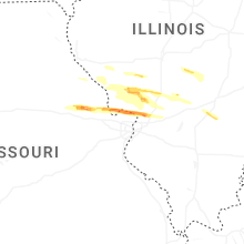

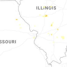


Connect with Interactive Hail Maps