

Hail Map for Kanab, UT
The Kanab, UT area has had 0 reports of on-the-ground hail by trained spotters, and has been under severe weather warnings 0 times during the past 12 months. Doppler radar has detected hail at or near Kanab, UT on 17 occasions.
| Name: | Kanab, UT |
| Where Located: | 58.5 miles E of Saint George, UT |
| Map: | Google Map for Kanab, UT |
| Population: | 4312 |
| Housing Units: | 1999 |
| More Info: | Search Google for Kanab, UT |
0
The Top Recent Hail Date for Kanab, UT is Thursday, June 27, 2024 (7th out of 17)

Hail and Wind Damage Spotted near Kanab, UT
| Date / Time | Report Details |
|---|---|
| 5/14/2023 2:57 PM MDT |
 The severe thunderstorm warning for southwestern kane county will expire at 300 pm mdt, the storm which prompted the warning has weakened below severe limits, and no longer poses an immediate threat to life or property. therefore, the warning will be allowed to expire. however gusty winds and heavy rain are still possible with this thunderstorm. The severe thunderstorm warning for southwestern kane county will expire at 300 pm mdt, the storm which prompted the warning has weakened below severe limits, and no longer poses an immediate threat to life or property. therefore, the warning will be allowed to expire. however gusty winds and heavy rain are still possible with this thunderstorm.
|
| 5/14/2023 2:44 PM MDT |
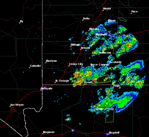
 At 244 pm mdt, a severe thunderstorm was located 9 miles west of kanab, moving northeast at 20 mph (radar indicated). Hazards include 60 mph wind gusts and quarter size hail. Hail damage to vehicles is expected. expect wind damage to roofs, siding, and trees. locations impacted include, kanab and coral pink sand dunes. This includes us route 89 between mile markers 57 and 70. At 244 pm mdt, a severe thunderstorm was located 9 miles west of kanab, moving northeast at 20 mph (radar indicated). Hazards include 60 mph wind gusts and quarter size hail. Hail damage to vehicles is expected. expect wind damage to roofs, siding, and trees. locations impacted include, kanab and coral pink sand dunes. This includes us route 89 between mile markers 57 and 70.
|
| 5/14/2023 2:33 PM MDT |
 At 233 pm mdt, a severe thunderstorm was located 8 miles north of kaibab, or 11 miles west of kanab, moving northeast at 20 mph (radar indicated). Hazards include 60 mph wind gusts and quarter size hail. Hail damage to vehicles is expected. Expect wind damage to roofs, siding, and trees. At 233 pm mdt, a severe thunderstorm was located 8 miles north of kaibab, or 11 miles west of kanab, moving northeast at 20 mph (radar indicated). Hazards include 60 mph wind gusts and quarter size hail. Hail damage to vehicles is expected. Expect wind damage to roofs, siding, and trees.
|
| 10/3/2022 7:14 AM MDT |
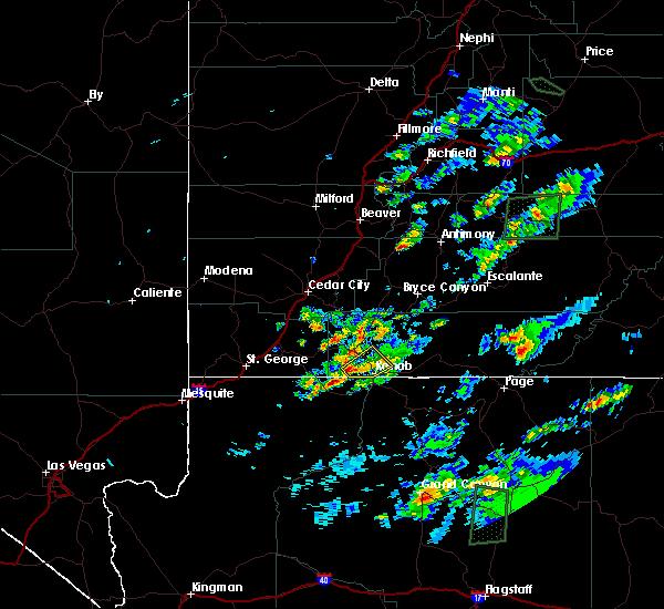
 At 714 am mdt, a severe thunderstorm was located near kanab, moving east at 30 mph (radar indicated). Hazards include 60 mph wind gusts and quarter size hail. Hail damage to vehicles is expected. expect wind damage to roofs, siding, and trees. locations impacted include, kanab. this includes us route 89 between mile markers 51 and 69. hail threat, radar indicated max hail size, 1. 00 in wind threat, radar indicated max wind gust, 60 mph. At 714 am mdt, a severe thunderstorm was located near kanab, moving east at 30 mph (radar indicated). Hazards include 60 mph wind gusts and quarter size hail. Hail damage to vehicles is expected. expect wind damage to roofs, siding, and trees. locations impacted include, kanab. this includes us route 89 between mile markers 51 and 69. hail threat, radar indicated max hail size, 1. 00 in wind threat, radar indicated max wind gust, 60 mph.
|
| 10/3/2022 7:02 AM MDT |
 At 702 am mdt, a severe thunderstorm was located near kanab, moving east at 20 mph (radar indicated). Hazards include 60 mph wind gusts and half dollar size hail. Hail damage to vehicles is expected. expect wind damage to roofs, siding, and trees. locations impacted include, kanab. this includes us route 89 between mile markers 51 and 75. hail threat, radar indicated max hail size, 1. 25 in wind threat, radar indicated max wind gust, 60 mph. At 702 am mdt, a severe thunderstorm was located near kanab, moving east at 20 mph (radar indicated). Hazards include 60 mph wind gusts and half dollar size hail. Hail damage to vehicles is expected. expect wind damage to roofs, siding, and trees. locations impacted include, kanab. this includes us route 89 between mile markers 51 and 75. hail threat, radar indicated max hail size, 1. 25 in wind threat, radar indicated max wind gust, 60 mph.
|
| 10/3/2022 6:53 AM MDT |
 At 653 am mdt, a severe thunderstorm was located 8 miles northwest of kanab, moving east at 15 mph (radar indicated). Hazards include 60 mph wind gusts and half dollar size hail. Hail damage to vehicles is expected. Expect wind damage to roofs, siding, and trees. At 653 am mdt, a severe thunderstorm was located 8 miles northwest of kanab, moving east at 15 mph (radar indicated). Hazards include 60 mph wind gusts and half dollar size hail. Hail damage to vehicles is expected. Expect wind damage to roofs, siding, and trees.
|
| 10/3/2022 6:39 AM MDT |
 At 638 am mdt, a severe thunderstorm was located 11 miles northwest of kanab, moving southeast at 15 mph (radar indicated). Hazards include 60 mph wind gusts and half dollar size hail. Hail damage to vehicles is expected. expect wind damage to roofs, siding, and trees. locations impacted include, kanab and orderville. this includes us route 89 between mile markers 66 and 81. hail threat, radar indicated max hail size, 1. 25 in wind threat, radar indicated max wind gust, 60 mph. At 638 am mdt, a severe thunderstorm was located 11 miles northwest of kanab, moving southeast at 15 mph (radar indicated). Hazards include 60 mph wind gusts and half dollar size hail. Hail damage to vehicles is expected. expect wind damage to roofs, siding, and trees. locations impacted include, kanab and orderville. this includes us route 89 between mile markers 66 and 81. hail threat, radar indicated max hail size, 1. 25 in wind threat, radar indicated max wind gust, 60 mph.
|
| 10/3/2022 6:30 AM MDT |
 At 630 am mdt, a severe thunderstorm was located 14 miles northwest of kanab, moving southeast at 10 mph (radar indicated). Hazards include 60 mph wind gusts and quarter size hail. Hail damage to vehicles is expected. Expect wind damage to roofs, siding, and trees. At 630 am mdt, a severe thunderstorm was located 14 miles northwest of kanab, moving southeast at 10 mph (radar indicated). Hazards include 60 mph wind gusts and quarter size hail. Hail damage to vehicles is expected. Expect wind damage to roofs, siding, and trees.
|
| 8/21/2018 1:27 PM MDT |
 The severe thunderstorm warning for southwestern kane county will expire at 130 pm mdt, the storm which prompted the warning has weakened below severe limits, and no longer poses an immediate threat to life or property. therefore, the warning will be allowed to expire. however small hail and heavy rain are still possible with this thunderstorm. The severe thunderstorm warning for southwestern kane county will expire at 130 pm mdt, the storm which prompted the warning has weakened below severe limits, and no longer poses an immediate threat to life or property. therefore, the warning will be allowed to expire. however small hail and heavy rain are still possible with this thunderstorm.
|
| 8/21/2018 1:17 PM MDT |
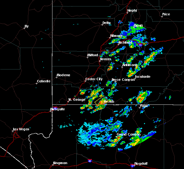
 At 117 pm mdt, a severe thunderstorm was located near kanab, moving northeast at 20 mph (radar indicated). Hazards include 60 mph wind gusts and quarter size hail. Hail damage to vehicles is expected. expect wind damage to roofs, siding, and trees. Locations impacted include, kanab and coral pink sand dunes. At 117 pm mdt, a severe thunderstorm was located near kanab, moving northeast at 20 mph (radar indicated). Hazards include 60 mph wind gusts and quarter size hail. Hail damage to vehicles is expected. expect wind damage to roofs, siding, and trees. Locations impacted include, kanab and coral pink sand dunes.
|
| 8/21/2018 12:56 PM MDT |
 At 1256 pm mdt, a severe thunderstorm was located 10 miles north of kaibab, or 11 miles west of kanab, moving northeast at 20 mph (radar indicated). Hazards include 60 mph wind gusts and quarter size hail. Hail damage to vehicles is expected. Expect wind damage to roofs, siding, and trees. At 1256 pm mdt, a severe thunderstorm was located 10 miles north of kaibab, or 11 miles west of kanab, moving northeast at 20 mph (radar indicated). Hazards include 60 mph wind gusts and quarter size hail. Hail damage to vehicles is expected. Expect wind damage to roofs, siding, and trees.
|
| 8/21/2018 12:10 PM MDT |
 The severe thunderstorm warning for southwestern kane county will expire at 1215 pm mdt, the storm which prompted the warning has weakened below severe limits, and no longer poses an immediate threat to life or property. therefore, the warning will be allowed to expire. however heavy rain and small hail is still possible with this thunderstorm. The severe thunderstorm warning for southwestern kane county will expire at 1215 pm mdt, the storm which prompted the warning has weakened below severe limits, and no longer poses an immediate threat to life or property. therefore, the warning will be allowed to expire. however heavy rain and small hail is still possible with this thunderstorm.
|
| 8/21/2018 11:47 AM MDT |
 At 1146 am mdt, a severe thunderstorm was located near kanab, moving northeast at 15 mph (radar indicated). Hazards include 60 mph wind gusts and quarter size hail. Hail damage to vehicles is expected. Expect wind damage to roofs, siding, and trees. At 1146 am mdt, a severe thunderstorm was located near kanab, moving northeast at 15 mph (radar indicated). Hazards include 60 mph wind gusts and quarter size hail. Hail damage to vehicles is expected. Expect wind damage to roofs, siding, and trees.
|
| 7/28/2016 1:57 PM MDT | Dry microburst at telegraph flat raws in kane county UT, 30.9 miles WSW of Kanab, UT |
| 6/5/2015 3:41 PM MDT | At 340 pm mdt, doppler radar indicated a severe thunderstorm capable of producing quarter size hail and damaging winds in excess of 60 mph. this storm was located near kanab, and moving northeast at 25 mph. |
| 6/5/2015 3:33 PM MDT | At 332 pm mdt, doppler radar indicated a severe thunderstorm capable of producing quarter size hail and damaging winds in excess of 60 mph. this storm was located near kanab, moving northeast at 30 mph. locations impacted include, kanab, orderville, glendale and mt carmel. this warning includes us 89 between mt carmel and the utah and arizona border. hail may accumulate on us 89 under this storm. |
| 6/5/2015 3:22 PM MDT | At 321 pm mdt, doppler radar indicated a severe thunderstorm capable of producing quarter size hail and damaging winds in excess of 60 mph. this storm was located near kanab, and moving northeast at 30 mph. |
Hail Maps for Kanab, UT


Connect with Interactive Hail Maps