

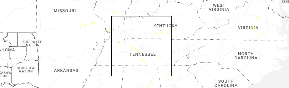
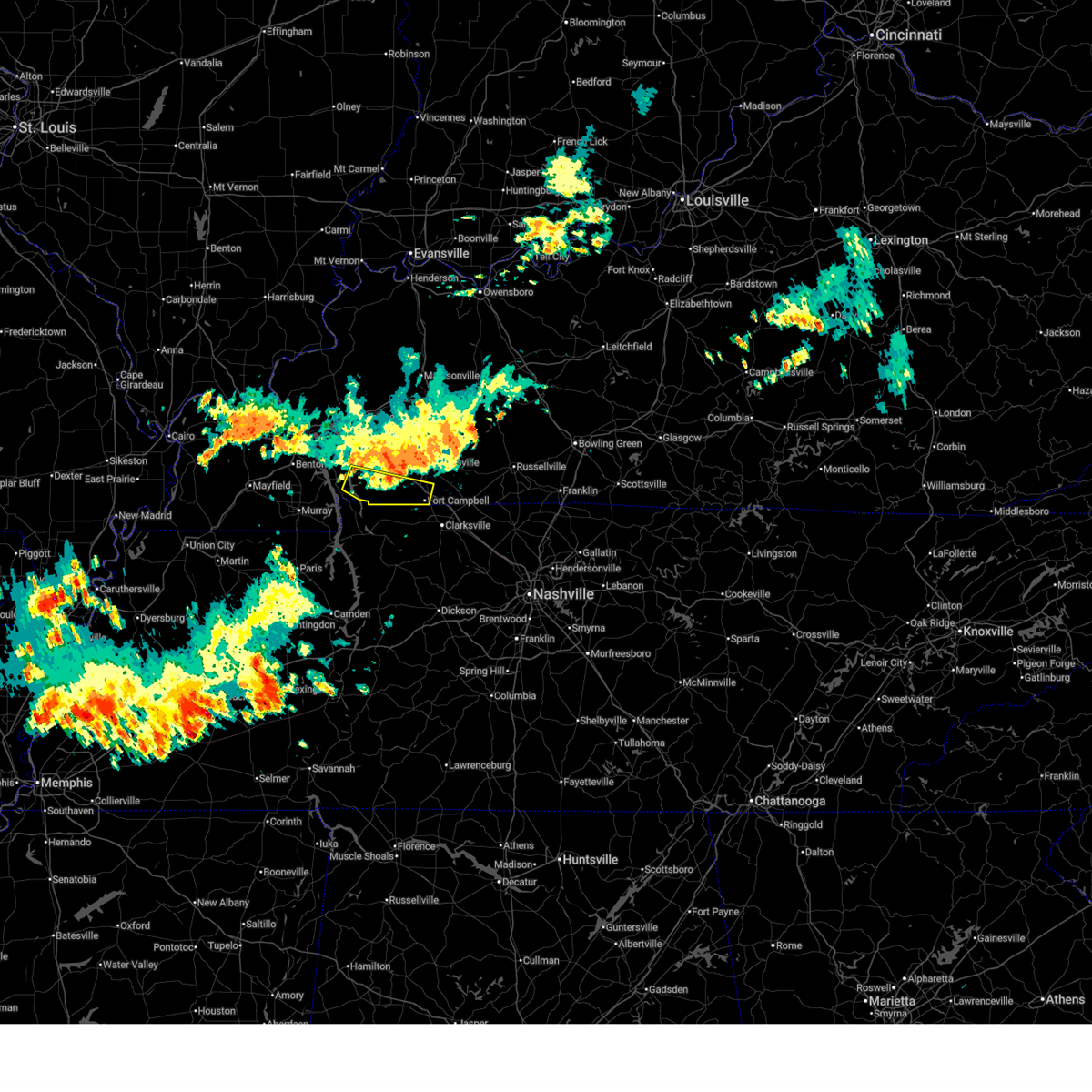
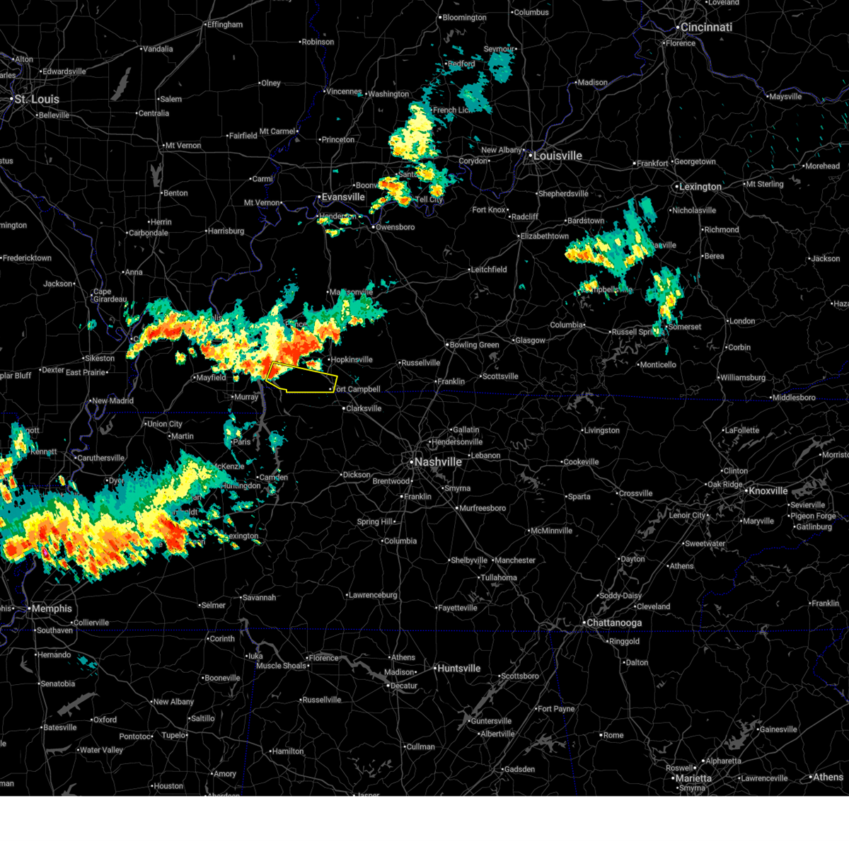
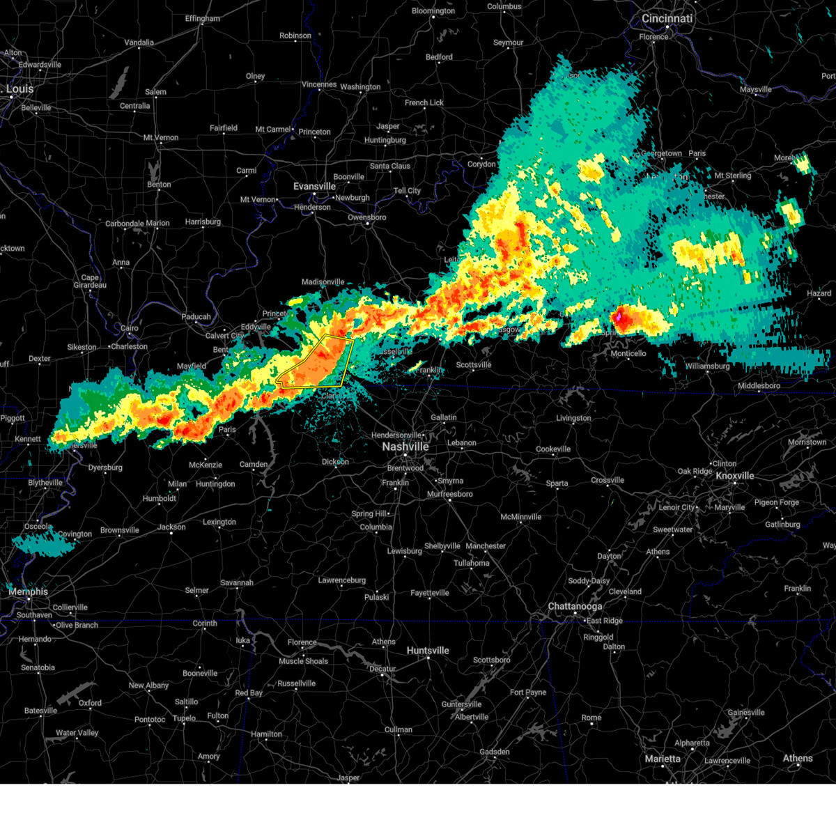
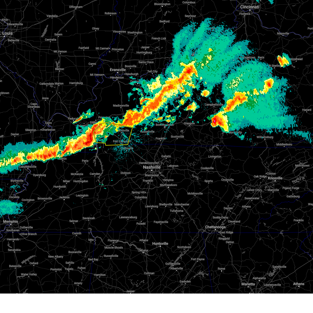
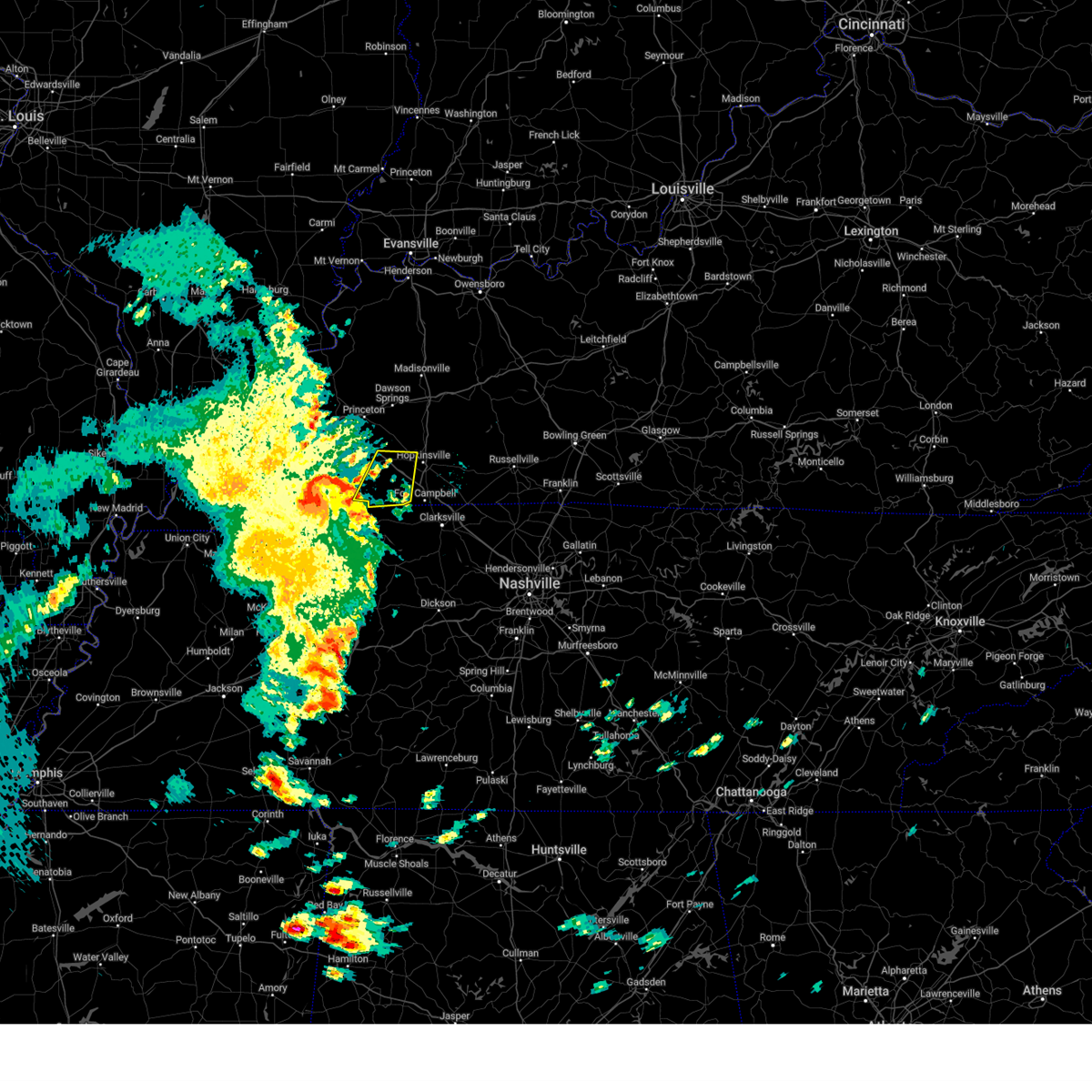
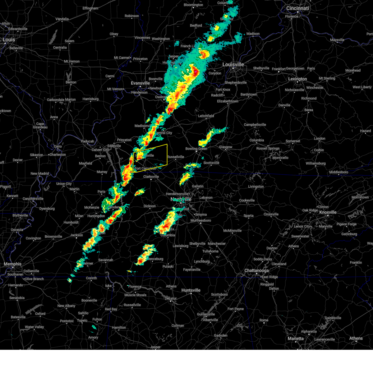
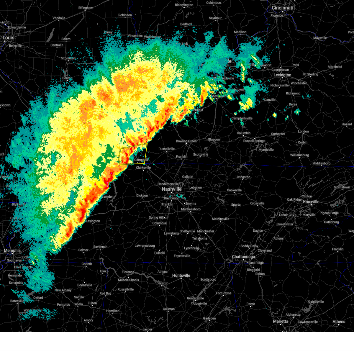
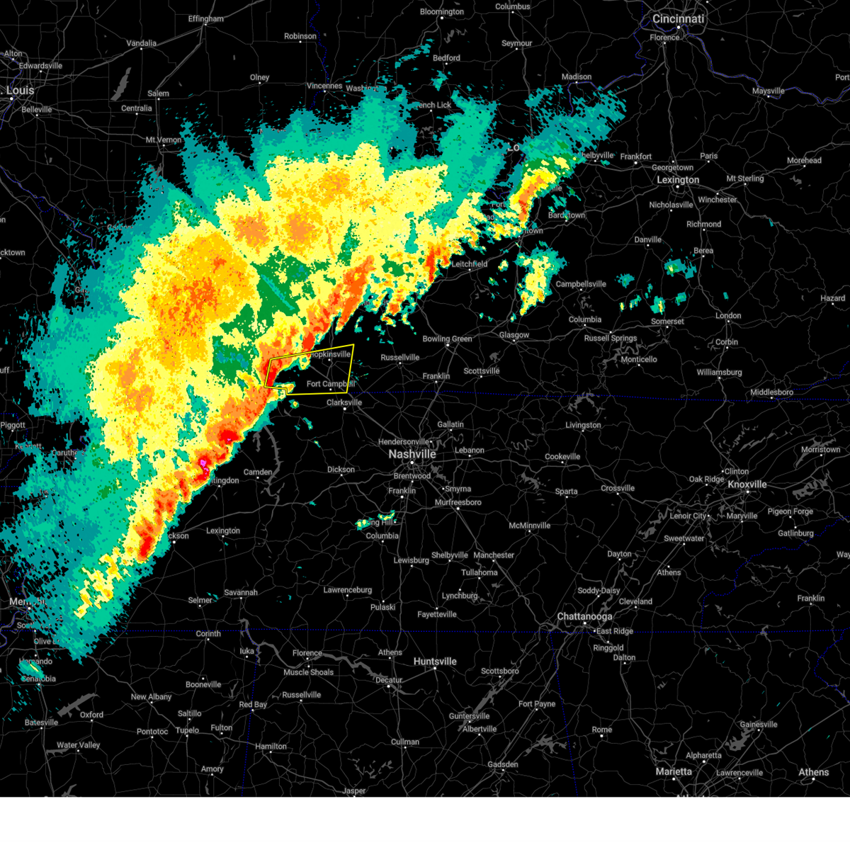
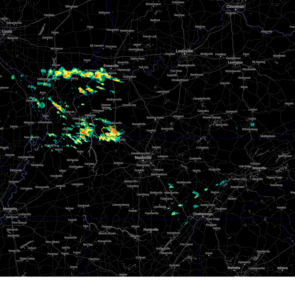
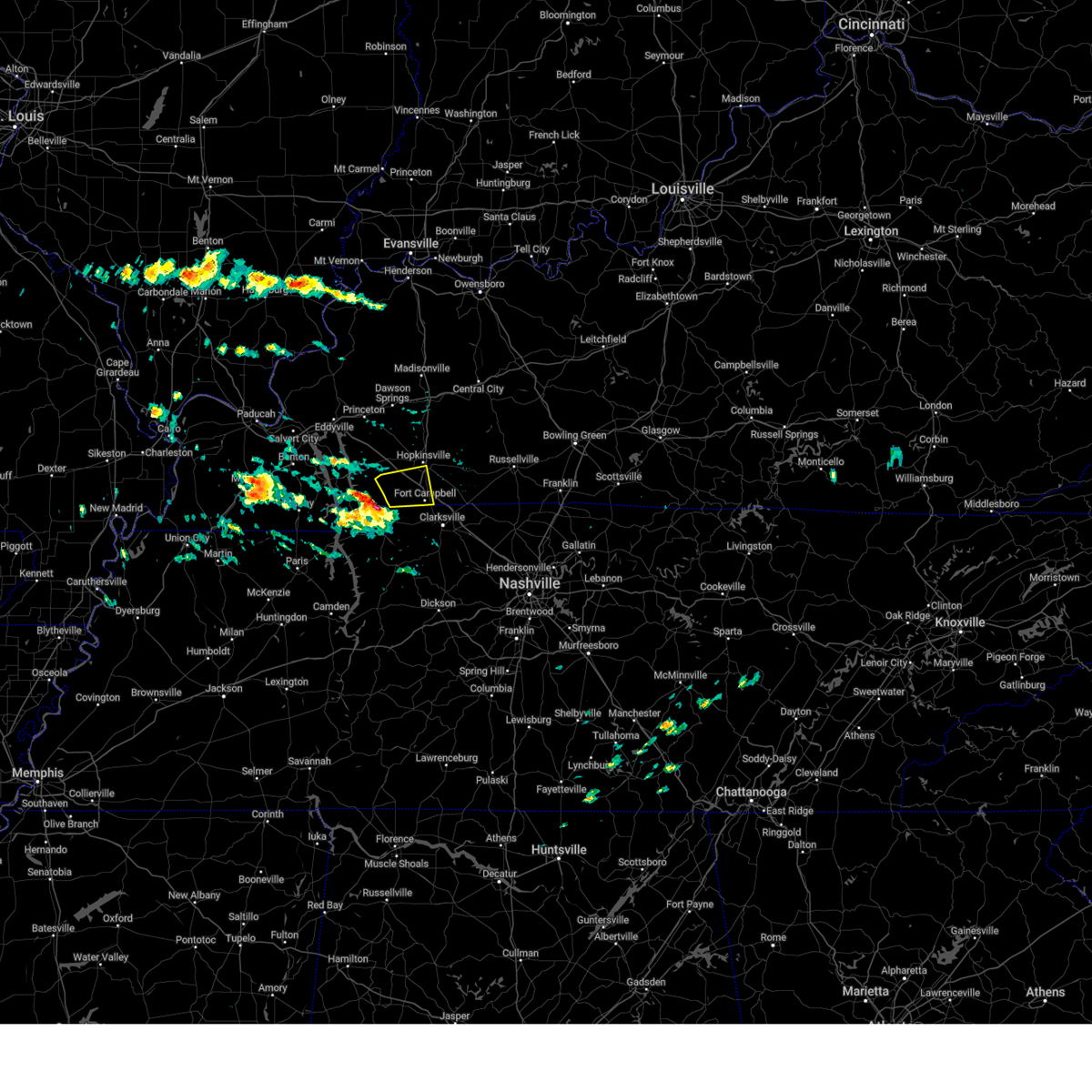
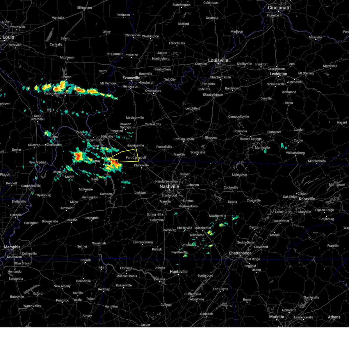
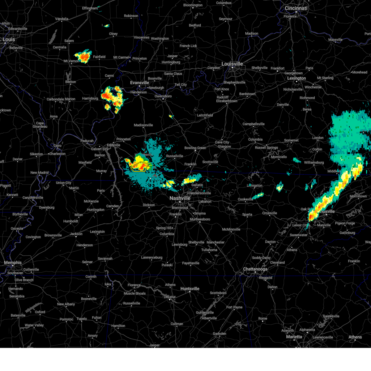
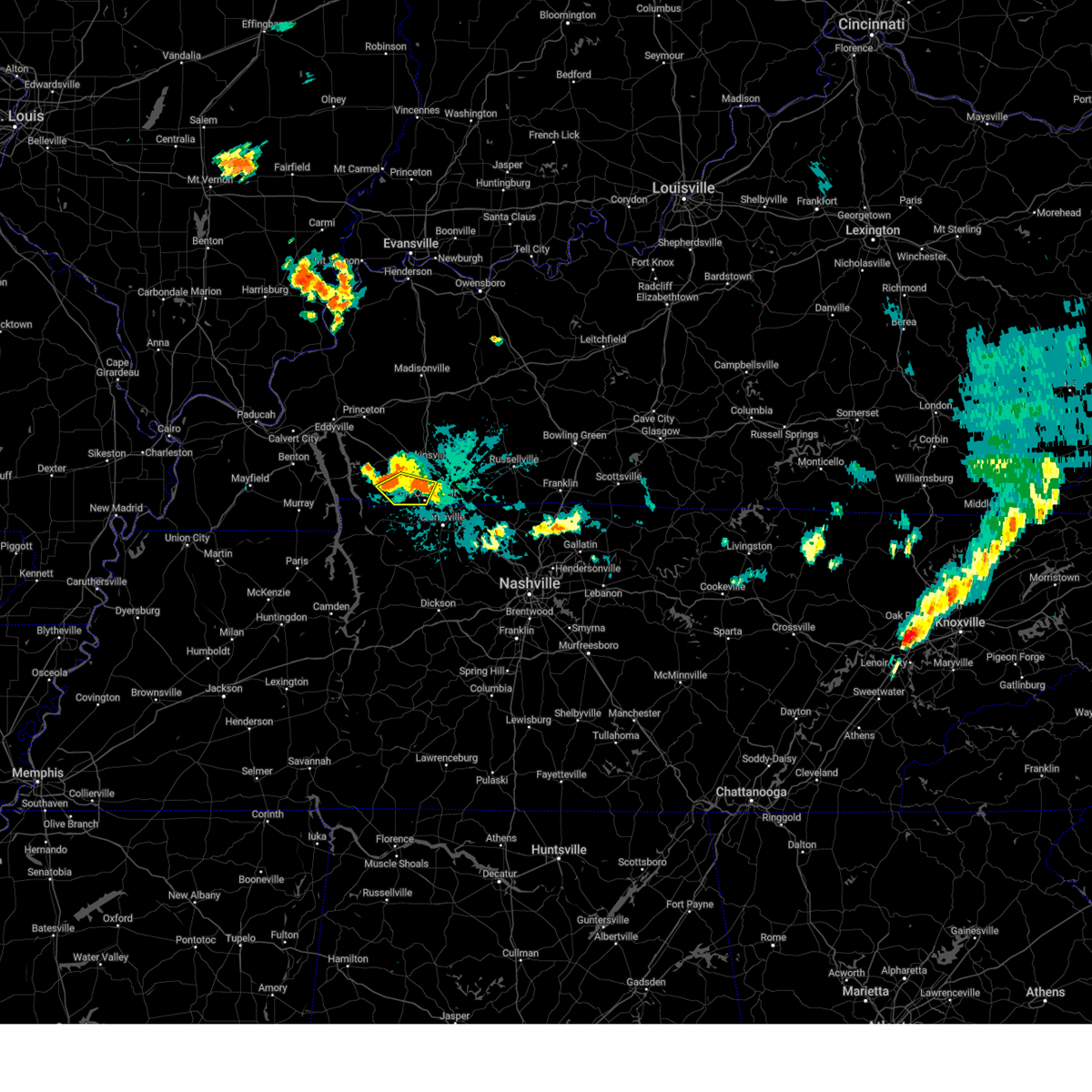
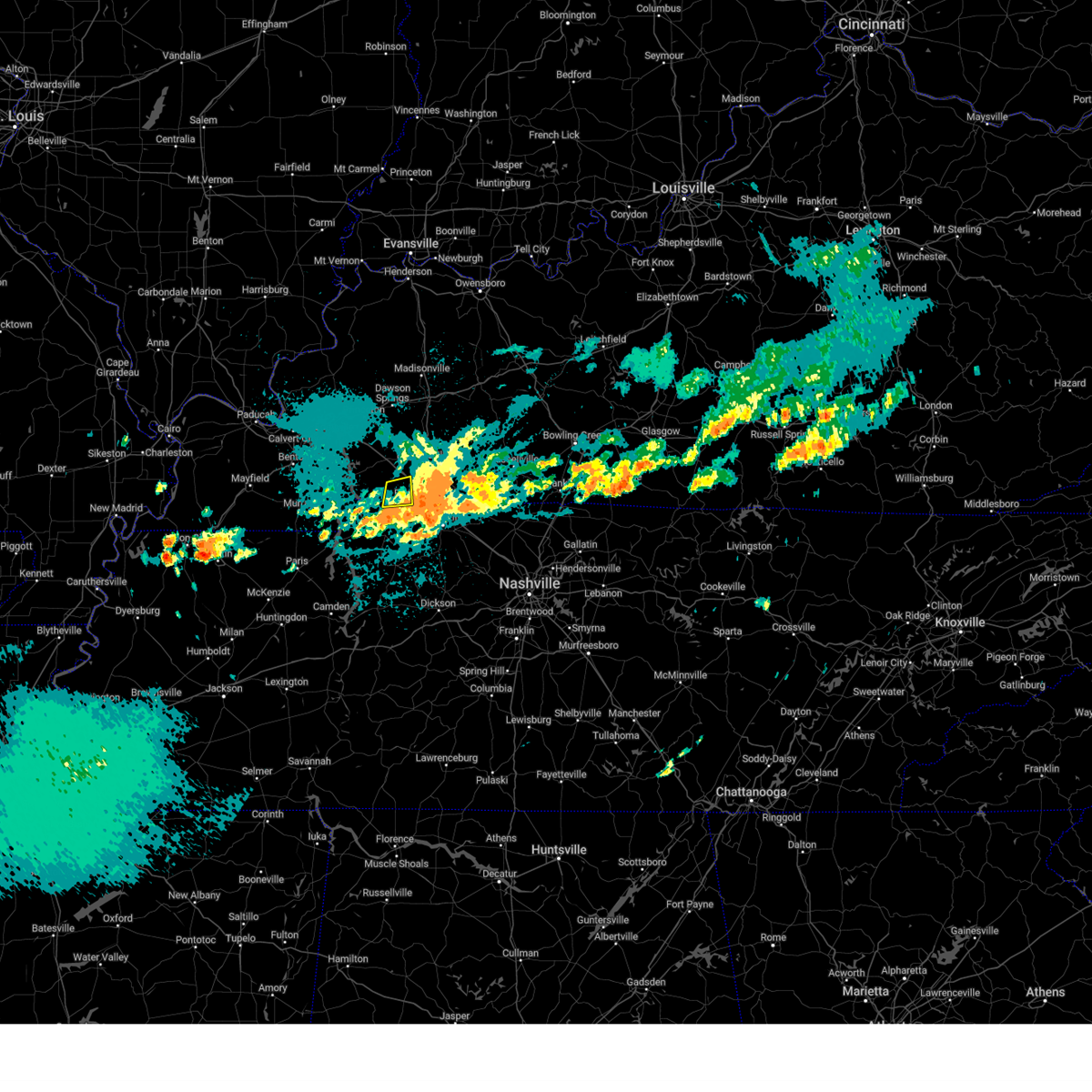
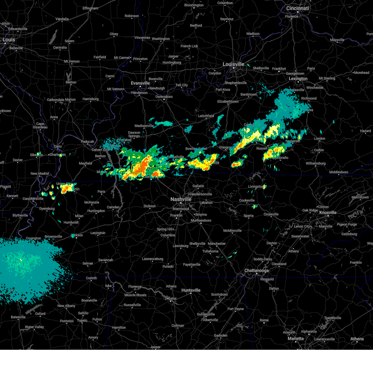
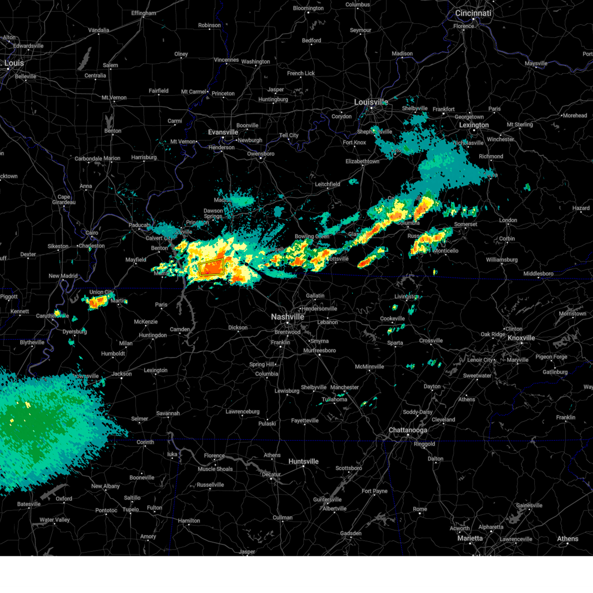
Hail Map for LaFayette, KY
The LaFayette, KY area has had 0 reports of on-the-ground hail by trained spotters, and has been under severe weather warnings 34 times during the past 12 months. Doppler radar has detected hail at or near LaFayette, KY on 48 occasions, including 4 occasions during the past year.
| Name: | LaFayette, KY |
| Where Located: | 59.5 miles NW of Nashville, TN |
| Map: | Google Map for LaFayette, KY |
| Population: | 165 |
| Housing Units: | 82 |
| More Info: | Search Google for LaFayette, KY |
0
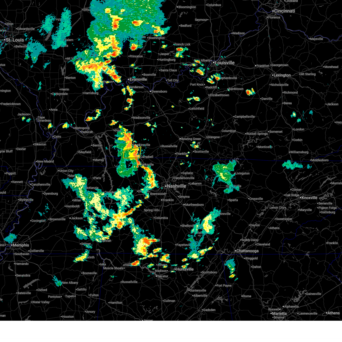
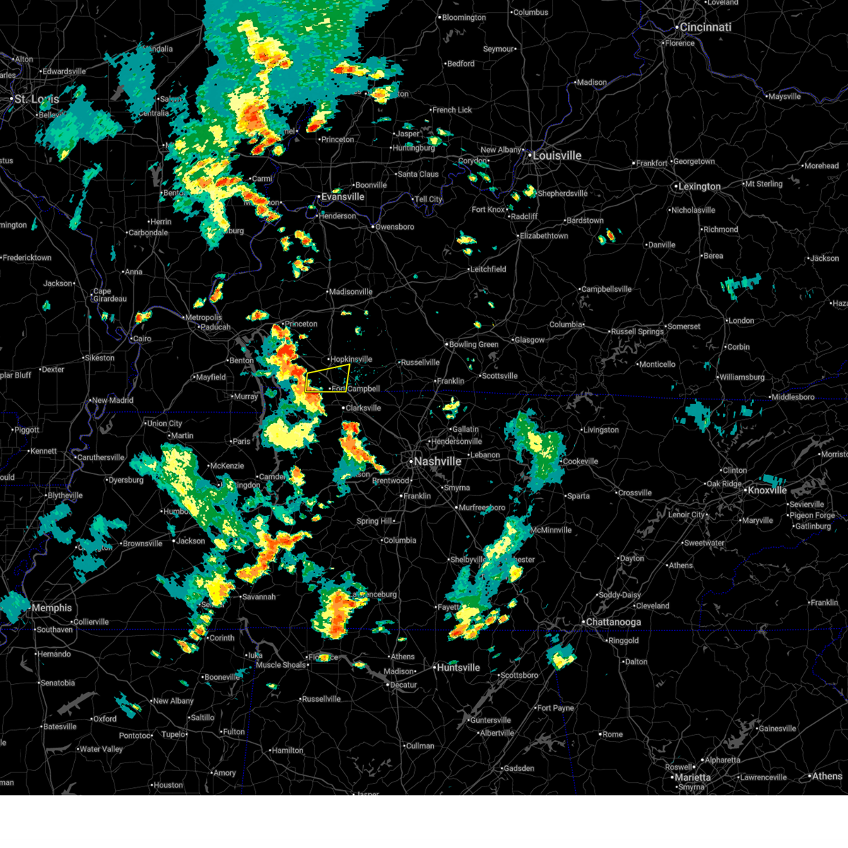
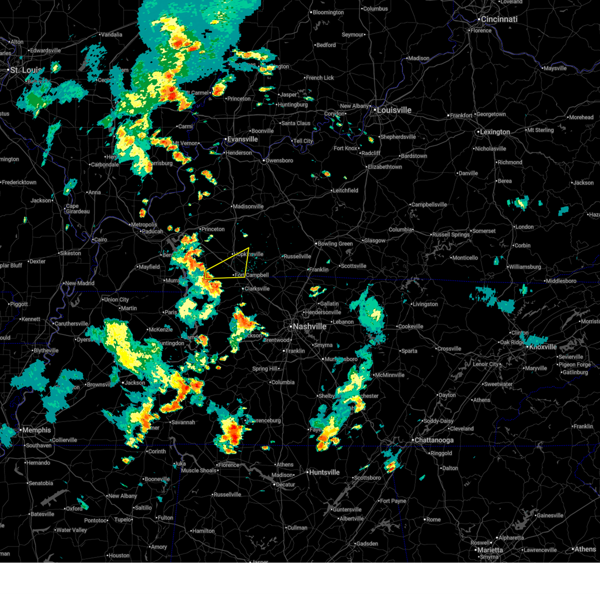
The Top Recent Hail Date for LaFayette, KY is Friday, June 6, 2025 (48th out of 48)
Hail and Wind Damage Spotted near LaFayette, KY
| Date / Time | Report Details |
|---|---|
| 7/13/2025 4:55 PM CDT |
 The storm which prompted the warning has weakened below severe limits, and no longer poses an immediate threat to life or property. therefore, the warning will be allowed to expire. however, gusty winds are still possible with this thunderstorm. The storm which prompted the warning has weakened below severe limits, and no longer poses an immediate threat to life or property. therefore, the warning will be allowed to expire. however, gusty winds are still possible with this thunderstorm.
|
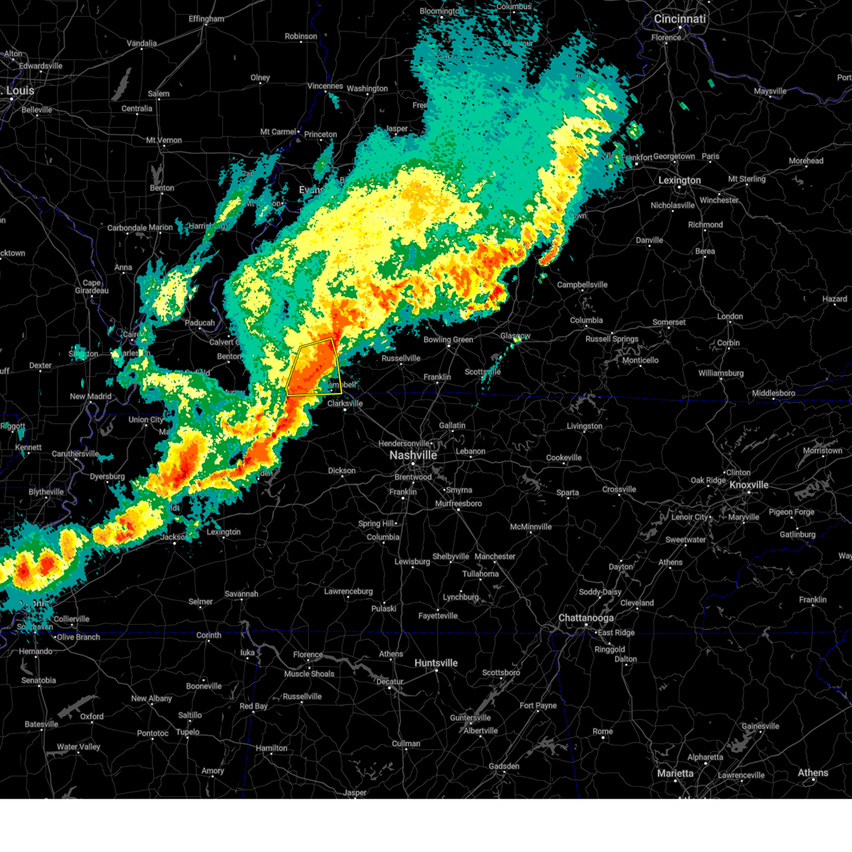
| 7/13/2025 4:30 PM CDT |
 At 429 pm cdt, a severe thunderstorm was located near fort campbell, moving east at 40 mph (radar indicated). Hazards include 60 mph wind gusts. Expect damage to roofs, siding, and trees. locations impacted include, oak grove, fort campbell, pembroke, lafayette, and herndon. this includes the following highways, interstate 24 in kentucky between mile markers 77 and 92. Pennyrile parkway between mile markers 1 and 4. At 429 pm cdt, a severe thunderstorm was located near fort campbell, moving east at 40 mph (radar indicated). Hazards include 60 mph wind gusts. Expect damage to roofs, siding, and trees. locations impacted include, oak grove, fort campbell, pembroke, lafayette, and herndon. this includes the following highways, interstate 24 in kentucky between mile markers 77 and 92. Pennyrile parkway between mile markers 1 and 4.
|
| 7/13/2025 4:30 PM CDT |
 the severe thunderstorm warning has been cancelled and is no longer in effect the severe thunderstorm warning has been cancelled and is no longer in effect
|
| 7/13/2025 4:13 PM CDT |
 Svrpah the national weather service in paducah has issued a * severe thunderstorm warning for, southern christian county in south central kentucky, southeastern trigg county in western kentucky, * until 500 pm cdt. * at 413 pm cdt, a severe thunderstorm was located near big rock, or 13 miles northeast of dover, moving northeast at 35 mph (radar indicated). Hazards include 60 mph wind gusts. expect damage to roofs, siding, and trees Svrpah the national weather service in paducah has issued a * severe thunderstorm warning for, southern christian county in south central kentucky, southeastern trigg county in western kentucky, * until 500 pm cdt. * at 413 pm cdt, a severe thunderstorm was located near big rock, or 13 miles northeast of dover, moving northeast at 35 mph (radar indicated). Hazards include 60 mph wind gusts. expect damage to roofs, siding, and trees
|
| 6/19/2025 1:33 AM CDT |
 the severe thunderstorm warning has been cancelled and is no longer in effect the severe thunderstorm warning has been cancelled and is no longer in effect
|
| 6/19/2025 1:12 AM CDT |
 Svrpah the national weather service in paducah has issued a * severe thunderstorm warning for, southwestern christian county in south central kentucky, southeastern trigg county in western kentucky, * until 200 am cdt. * at 111 am cdt, a severe thunderstorm was located over canton, or near wranglers campground, moving east at 40 mph (radar indicated). Hazards include 60 mph wind gusts and nickel size hail. expect damage to roofs, siding, and trees Svrpah the national weather service in paducah has issued a * severe thunderstorm warning for, southwestern christian county in south central kentucky, southeastern trigg county in western kentucky, * until 200 am cdt. * at 111 am cdt, a severe thunderstorm was located over canton, or near wranglers campground, moving east at 40 mph (radar indicated). Hazards include 60 mph wind gusts and nickel size hail. expect damage to roofs, siding, and trees
|
| 5/20/2025 5:00 PM CDT | the severe thunderstorm warning has been cancelled and is no longer in effect |
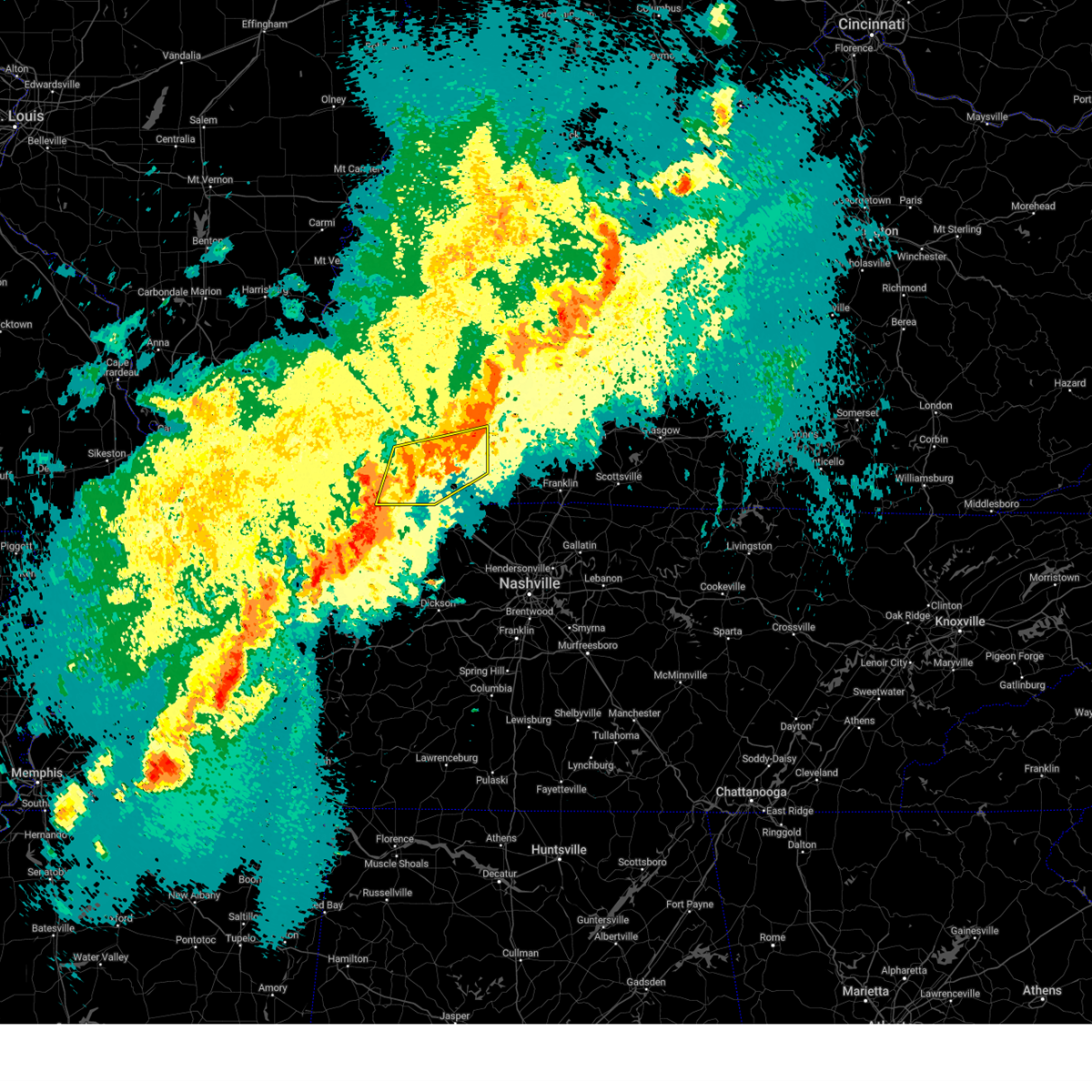
| 5/20/2025 5:00 PM CDT | At 500 pm cdt, severe thunderstorms were located along a line extending from 7 miles southwest of crofton to near hopkinsville to 8 miles west of fort campbell, moving east at 60 mph (radar indicated). Hazards include 70 mph wind gusts and penny size hail. Expect considerable tree damage. damage is likely to mobile homes, roofs, and outbuildings. locations impacted include, hopkinsville, oak grove, fort campbell, clarksville, pembroke, trenton, lafayette, herndon, and allegre. this includes the following highways, interstate 24 in kentucky between mile markers 71 and 92. Pennyrile parkway between mile markers 1 and 20. |
| 5/20/2025 4:42 PM CDT | Svrpah the national weather service in paducah has issued a * severe thunderstorm warning for, christian county in south central kentucky, trigg county in western kentucky, western todd county in south central kentucky, * until 530 pm cdt. * at 442 pm cdt, severe thunderstorms were located along a line extending from 6 miles northwest of cadiz to near canton to 6 miles southeast of wranglers campground, moving east at 55 mph (radar indicated). Hazards include 70 mph wind gusts and penny size hail. Expect considerable tree damage. Damage is likely to mobile homes, roofs, and outbuildings. |
| 5/16/2025 9:59 PM CDT | The storms which prompted the warning have moved out of the area. therefore, the warning will be allowed to expire. |
| 5/16/2025 9:36 PM CDT |
 the severe thunderstorm warning has been cancelled and is no longer in effect the severe thunderstorm warning has been cancelled and is no longer in effect
|
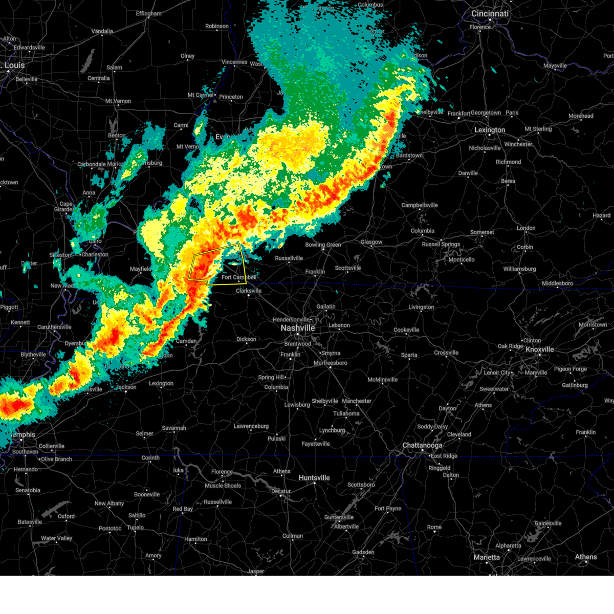
| 5/16/2025 9:36 PM CDT |
 At 935 pm cdt, severe thunderstorms were located along a line extending from 8 miles south of weir to near hopkinsville to 6 miles west of pembroke to big rock, moving east at 65 mph (radar indicated). Hazards include 70 mph wind gusts and quarter size hail. Hail damage to vehicles is expected. expect considerable tree damage. wind damage is also likely to mobile homes, roofs, and outbuildings. locations impacted include, hopkinsville, oak grove, fort campbell, clarksville, pembroke, lafayette, and herndon. this includes the following highways, interstate 24 in kentucky between mile markers 72 and 92. Pennyrile parkway between mile markers 1 and 18. At 935 pm cdt, severe thunderstorms were located along a line extending from 8 miles south of weir to near hopkinsville to 6 miles west of pembroke to big rock, moving east at 65 mph (radar indicated). Hazards include 70 mph wind gusts and quarter size hail. Hail damage to vehicles is expected. expect considerable tree damage. wind damage is also likely to mobile homes, roofs, and outbuildings. locations impacted include, hopkinsville, oak grove, fort campbell, clarksville, pembroke, lafayette, and herndon. this includes the following highways, interstate 24 in kentucky between mile markers 72 and 92. Pennyrile parkway between mile markers 1 and 18.
|
| 5/16/2025 9:35 PM CDT |
 Svrpah the national weather service in paducah has issued a * severe thunderstorm warning for, southeastern christian county in south central kentucky, todd county in south central kentucky, * until 1015 pm cdt. * at 934 pm cdt, severe thunderstorms were located along a line extending from 8 miles southeast of crofton to 7 miles northeast of big rock, moving east at 55 mph. these are destructive storms for eastern christian and todd county! (radar indicated). Hazards include 90 mph wind gusts and nickel size hail. You are in a life-threatening situation. flying debris may be deadly to those caught without shelter. mobile homes will be heavily damaged or destroyed. homes and businesses will have substantial roof and window damage. expect extensive tree damage and power outages. severe thunderstorms will be near, oak grove, fort campbell, clarksville, and pembroke around 940 pm cdt. elkton around 945 pm cdt. guthrie around 955 pm cdt. other locations impacted by these severe thunderstorms include trenton, lafayette, allensville, clifty, herndon, and allegre. this includes the following highways, interstate 24 in kentucky between mile markers 77 and 92. Pennyrile parkway between mile markers 1 and 15. Svrpah the national weather service in paducah has issued a * severe thunderstorm warning for, southeastern christian county in south central kentucky, todd county in south central kentucky, * until 1015 pm cdt. * at 934 pm cdt, severe thunderstorms were located along a line extending from 8 miles southeast of crofton to 7 miles northeast of big rock, moving east at 55 mph. these are destructive storms for eastern christian and todd county! (radar indicated). Hazards include 90 mph wind gusts and nickel size hail. You are in a life-threatening situation. flying debris may be deadly to those caught without shelter. mobile homes will be heavily damaged or destroyed. homes and businesses will have substantial roof and window damage. expect extensive tree damage and power outages. severe thunderstorms will be near, oak grove, fort campbell, clarksville, and pembroke around 940 pm cdt. elkton around 945 pm cdt. guthrie around 955 pm cdt. other locations impacted by these severe thunderstorms include trenton, lafayette, allensville, clifty, herndon, and allegre. this includes the following highways, interstate 24 in kentucky between mile markers 77 and 92. Pennyrile parkway between mile markers 1 and 15.
|
| 5/16/2025 9:04 PM CDT |
 Svrpah the national weather service in paducah has issued a * severe thunderstorm warning for, christian county in south central kentucky, southeastern caldwell county in western kentucky, trigg county in western kentucky, west central todd county in south central kentucky, southeastern lyon county in western kentucky, * until 1000 pm cdt. * at 904 pm cdt, severe thunderstorms were located along a line extending from near cobb to near canton to golden pond visitors center to near murray, moving east at 65 mph (radar indicated). Hazards include 70 mph wind gusts and quarter size hail. Hail damage to vehicles is expected. expect considerable tree damage. Wind damage is also likely to mobile homes, roofs, and outbuildings. Svrpah the national weather service in paducah has issued a * severe thunderstorm warning for, christian county in south central kentucky, southeastern caldwell county in western kentucky, trigg county in western kentucky, west central todd county in south central kentucky, southeastern lyon county in western kentucky, * until 1000 pm cdt. * at 904 pm cdt, severe thunderstorms were located along a line extending from near cobb to near canton to golden pond visitors center to near murray, moving east at 65 mph (radar indicated). Hazards include 70 mph wind gusts and quarter size hail. Hail damage to vehicles is expected. expect considerable tree damage. Wind damage is also likely to mobile homes, roofs, and outbuildings.
|
| 5/2/2025 12:07 PM CDT | The storm which prompted the warning has moved out of the area. therefore, the warning will be allowed to expire. however, gusty winds between 40-50 mph are still possible behind this thunderstorm. a severe thunderstorm watch remains in effect until 500 pm cdt for south central and western kentucky. |
| 5/2/2025 11:33 AM CDT |
 At 1133 am cdt, a severe thunderstorm was located 9 miles northwest of big rock, or 9 miles east of wranglers campground, moving northeast at 40 mph (radar indicated). Hazards include 60 mph wind gusts and quarter size hail. Hail damage to vehicles is expected. expect wind damage to roofs, siding, and trees. locations impacted include, hopkinsville, cadiz, lafayette, linton, and herndon. This includes interstate 24 in kentucky between mile markers 62 and 78. At 1133 am cdt, a severe thunderstorm was located 9 miles northwest of big rock, or 9 miles east of wranglers campground, moving northeast at 40 mph (radar indicated). Hazards include 60 mph wind gusts and quarter size hail. Hail damage to vehicles is expected. expect wind damage to roofs, siding, and trees. locations impacted include, hopkinsville, cadiz, lafayette, linton, and herndon. This includes interstate 24 in kentucky between mile markers 62 and 78.
|
| 5/2/2025 11:25 AM CDT |
 Svrpah the national weather service in paducah has issued a * severe thunderstorm warning for, southwestern christian county in south central kentucky, eastern trigg county in western kentucky, * until 1215 pm cdt. * at 1125 am cdt, a severe thunderstorm was located 7 miles southeast of wranglers campground, moving northeast at 40 mph (radar indicated). Hazards include 70 mph wind gusts. Expect considerable tree damage. Damage is likely to mobile homes, roofs, and outbuildings. Svrpah the national weather service in paducah has issued a * severe thunderstorm warning for, southwestern christian county in south central kentucky, eastern trigg county in western kentucky, * until 1215 pm cdt. * at 1125 am cdt, a severe thunderstorm was located 7 miles southeast of wranglers campground, moving northeast at 40 mph (radar indicated). Hazards include 70 mph wind gusts. Expect considerable tree damage. Damage is likely to mobile homes, roofs, and outbuildings.
|
| 4/2/2025 11:04 PM CDT |
 Svrpah the national weather service in paducah has issued a * severe thunderstorm warning for, christian county in south central kentucky, southeastern trigg county in western kentucky, todd county in south central kentucky, * until 1145 pm cdt. * at 1104 pm cdt, severe thunderstorms were located along a line extending from 7 miles northeast of hopkinsville to near fort campbell to near big rock, moving northeast at 45 mph (radar indicated). Hazards include 60 mph wind gusts. expect damage to roofs, siding, and trees Svrpah the national weather service in paducah has issued a * severe thunderstorm warning for, christian county in south central kentucky, southeastern trigg county in western kentucky, todd county in south central kentucky, * until 1145 pm cdt. * at 1104 pm cdt, severe thunderstorms were located along a line extending from 7 miles northeast of hopkinsville to near fort campbell to near big rock, moving northeast at 45 mph (radar indicated). Hazards include 60 mph wind gusts. expect damage to roofs, siding, and trees
|
| 4/2/2025 10:51 PM CDT | At 1051 pm cdt, severe thunderstorms were located along a line extending from near weir to 6 miles east of hopkinsville to near big rock, moving east at 45 mph (radar indicated). Hazards include 60 mph wind gusts. Expect damage to roofs, siding, and trees. locations impacted include, fort campbell, lafayette, hopkinsville, allegre, oak grove, clifty, herndon, pembroke, linton, and cadiz. this includes the following highways, interstate 24 in kentucky between mile markers 65 and 88. Pennyrile parkway between mile markers 1 and 21. |
| 4/2/2025 10:42 PM CDT | At 1042 pm cdt, severe thunderstorms were located along a line extending from 6 miles northeast of crofton to hopkinsville to big rock, moving east at 45 mph (radar indicated). Hazards include 70 mph wind gusts. Expect considerable tree damage. damage is likely to mobile homes, roofs, and outbuildings. locations impacted include, fort campbell, lafayette, hopkinsville, allegre, oak grove, linton, clifty, herndon, pembroke, and cadiz. this includes the following highways, interstate 24 in kentucky between mile markers 63 and 88. Pennyrile parkway between mile markers 1 and 21. |
| 4/2/2025 10:16 PM CDT | Svrpah the national weather service in paducah has issued a * severe thunderstorm warning for, southeastern muhlenberg county in south central kentucky, christian county in south central kentucky, eastern trigg county in western kentucky, northern todd county in south central kentucky, * until 1100 pm cdt. * at 1016 pm cdt, severe thunderstorms were located along a line extending from 7 miles east of cobb to 7 miles southeast of cadiz to 6 miles northeast of paris landing state park, moving east at 45 mph (radar indicated). Hazards include 60 mph wind gusts. expect damage to roofs, siding, and trees |
| 3/30/2025 9:15 PM CDT |
 At 915 pm cdt, severe thunderstorms were located along a line extending from near cobb to 7 miles west of hopkinsville to 11 miles northeast of big rock, moving east at 55 mph (radar indicated). Hazards include 60 mph wind gusts and nickel size hail. Expect damage to roofs, siding, and trees. locations impacted include, oak grove, fort campbell, lafayette, hopkinsville, herndon, and cadiz. this includes the following highways, interstate 24 in kentucky between mile markers 64 and 89. Pennyrile parkway between mile markers 1 and 17. At 915 pm cdt, severe thunderstorms were located along a line extending from near cobb to 7 miles west of hopkinsville to 11 miles northeast of big rock, moving east at 55 mph (radar indicated). Hazards include 60 mph wind gusts and nickel size hail. Expect damage to roofs, siding, and trees. locations impacted include, oak grove, fort campbell, lafayette, hopkinsville, herndon, and cadiz. this includes the following highways, interstate 24 in kentucky between mile markers 64 and 89. Pennyrile parkway between mile markers 1 and 17.
|
| 3/30/2025 9:14 PM CDT |
 Svrpah the national weather service in paducah has issued a * severe thunderstorm warning for, southeastern christian county in south central kentucky, todd county in south central kentucky, * until 1000 pm cdt. * at 913 pm cdt, severe thunderstorms were located along a line extending from near crofton to near hopkinsville to near big rock, moving east at 60 mph (radar indicated). Hazards include 60 mph wind gusts and penny size hail. expect damage to roofs, siding, and trees Svrpah the national weather service in paducah has issued a * severe thunderstorm warning for, southeastern christian county in south central kentucky, todd county in south central kentucky, * until 1000 pm cdt. * at 913 pm cdt, severe thunderstorms were located along a line extending from near crofton to near hopkinsville to near big rock, moving east at 60 mph (radar indicated). Hazards include 60 mph wind gusts and penny size hail. expect damage to roofs, siding, and trees
|
| 3/30/2025 9:03 PM CDT |
 the severe thunderstorm warning has been cancelled and is no longer in effect the severe thunderstorm warning has been cancelled and is no longer in effect
|
| 3/30/2025 9:03 PM CDT |
 At 903 pm cdt, severe thunderstorms were located along a line extending from near cobb to cadiz to 9 miles east of wranglers campground, moving east at 55 mph (radar indicated). Hazards include 70 mph wind gusts and quarter size hail. Hail damage to vehicles is expected. expect considerable tree damage. wind damage is also likely to mobile homes, roofs, and outbuildings. locations impacted include, fort campbell, rockcastle, lafayette, hopkinsville, oak grove, linton, cadiz, canton, herndon, wranglers campground, and land between the lakes area. this includes the following highways, interstate 24 in kentucky between mile markers 59 and 89. Pennyrile parkway between mile markers 1 and 17. At 903 pm cdt, severe thunderstorms were located along a line extending from near cobb to cadiz to 9 miles east of wranglers campground, moving east at 55 mph (radar indicated). Hazards include 70 mph wind gusts and quarter size hail. Hail damage to vehicles is expected. expect considerable tree damage. wind damage is also likely to mobile homes, roofs, and outbuildings. locations impacted include, fort campbell, rockcastle, lafayette, hopkinsville, oak grove, linton, cadiz, canton, herndon, wranglers campground, and land between the lakes area. this includes the following highways, interstate 24 in kentucky between mile markers 59 and 89. Pennyrile parkway between mile markers 1 and 17.
|
| 3/30/2025 8:42 PM CDT | Svrpah the national weather service in paducah has issued a * severe thunderstorm warning for, eastern calloway county in western kentucky, southwestern christian county in south central kentucky, southeastern marshall county in western kentucky, trigg county in western kentucky, south central lyon county in western kentucky, * until 930 pm cdt. * at 841 pm cdt, severe thunderstorms were located along a line extending from near birmingham ferry recreation area to near turkey bay to 7 miles east of murray, moving east at 55 mph (radar indicated). Hazards include 70 mph wind gusts and quarter size hail. Hail damage to vehicles is expected. expect considerable tree damage. Wind damage is also likely to mobile homes, roofs, and outbuildings. |
| 3/19/2025 8:04 PM CDT |
 Svrpah the national weather service in paducah has issued a * severe thunderstorm warning for, south central muhlenberg county in south central kentucky, christian county in south central kentucky, southeastern trigg county in western kentucky, todd county in south central kentucky, * until 845 pm cdt. * at 804 pm cdt, severe thunderstorms were located along a line extending from 8 miles southwest of crofton to 7 miles southwest of hopkinsville to 9 miles west of fort campbell, moving northeast at 50 mph (radar indicated). Hazards include 60 mph wind gusts. expect damage to roofs, siding, and trees Svrpah the national weather service in paducah has issued a * severe thunderstorm warning for, south central muhlenberg county in south central kentucky, christian county in south central kentucky, southeastern trigg county in western kentucky, todd county in south central kentucky, * until 845 pm cdt. * at 804 pm cdt, severe thunderstorms were located along a line extending from 8 miles southwest of crofton to 7 miles southwest of hopkinsville to 9 miles west of fort campbell, moving northeast at 50 mph (radar indicated). Hazards include 60 mph wind gusts. expect damage to roofs, siding, and trees
|
| 2/15/2025 8:08 PM CST |
 At 808 pm cst, severe thunderstorms were located along a line extending from 7 miles west of hopkinsville to 9 miles northeast of big rock, moving east at 50 mph (radar indicated). Hazards include 60 mph wind gusts and quarter size hail. Hail damage to vehicles is expected. expect wind damage to roofs, siding, and trees. locations impacted include, hopkinsville, oak grove, cadiz, fort campbell, clarksville, pembroke, lafayette, and herndon. this includes the following highways, interstate 24 in kentucky between mile markers 64 and 92. Pennyrile parkway between mile markers 1 and 15. At 808 pm cst, severe thunderstorms were located along a line extending from 7 miles west of hopkinsville to 9 miles northeast of big rock, moving east at 50 mph (radar indicated). Hazards include 60 mph wind gusts and quarter size hail. Hail damage to vehicles is expected. expect wind damage to roofs, siding, and trees. locations impacted include, hopkinsville, oak grove, cadiz, fort campbell, clarksville, pembroke, lafayette, and herndon. this includes the following highways, interstate 24 in kentucky between mile markers 64 and 92. Pennyrile parkway between mile markers 1 and 15.
|
| 2/15/2025 7:42 PM CST |
 Svrpah the national weather service in paducah has issued a * severe thunderstorm warning for, southern christian county in south central kentucky, trigg county in western kentucky, * until 830 pm cst. * at 741 pm cst, severe thunderstorms were located along a line extending from canton to near wranglers campground, moving east at 55 mph (radar indicated). Hazards include 60 mph wind gusts and quarter size hail. Hail damage to vehicles is expected. Expect wind damage to roofs, siding, and trees. Svrpah the national weather service in paducah has issued a * severe thunderstorm warning for, southern christian county in south central kentucky, trigg county in western kentucky, * until 830 pm cst. * at 741 pm cst, severe thunderstorms were located along a line extending from canton to near wranglers campground, moving east at 55 mph (radar indicated). Hazards include 60 mph wind gusts and quarter size hail. Hail damage to vehicles is expected. Expect wind damage to roofs, siding, and trees.
|
| 2/6/2025 2:28 PM CST |
 The storm which prompted the warning has moved out of the area. therefore, the warning will be allowed to expire. The storm which prompted the warning has moved out of the area. therefore, the warning will be allowed to expire.
|
| 2/6/2025 2:08 PM CST |
 At 208 pm cst, a severe thunderstorm was located 8 miles west of fort campbell, moving east at 45 mph (radar indicated). Hazards include 60 mph wind gusts and quarter size hail. Hail damage to vehicles is expected. expect wind damage to roofs, siding, and trees. locations impacted include, hopkinsville, oak grove, fort campbell, lafayette, and herndon. this includes the following highways, interstate 24 in kentucky between mile markers 72 and 86. Pennyrile parkway between mile markers 1 and 7. At 208 pm cst, a severe thunderstorm was located 8 miles west of fort campbell, moving east at 45 mph (radar indicated). Hazards include 60 mph wind gusts and quarter size hail. Hail damage to vehicles is expected. expect wind damage to roofs, siding, and trees. locations impacted include, hopkinsville, oak grove, fort campbell, lafayette, and herndon. this includes the following highways, interstate 24 in kentucky between mile markers 72 and 86. Pennyrile parkway between mile markers 1 and 7.
|
| 2/6/2025 1:53 PM CST |
 Svrpah the national weather service in paducah has issued a * severe thunderstorm warning for, southwestern christian county in south central kentucky, southeastern trigg county in western kentucky, * until 230 pm cst. * at 152 pm cst, a severe thunderstorm was located near big rock, or 11 miles north of dover, moving east at 45 mph (radar indicated). Hazards include 60 mph wind gusts and quarter size hail. Hail damage to vehicles is expected. Expect wind damage to roofs, siding, and trees. Svrpah the national weather service in paducah has issued a * severe thunderstorm warning for, southwestern christian county in south central kentucky, southeastern trigg county in western kentucky, * until 230 pm cst. * at 152 pm cst, a severe thunderstorm was located near big rock, or 11 miles north of dover, moving east at 45 mph (radar indicated). Hazards include 60 mph wind gusts and quarter size hail. Hail damage to vehicles is expected. Expect wind damage to roofs, siding, and trees.
|
| 8/1/2024 8:25 PM CDT |
 At 825 pm cdt, a severe thunderstorm was located 8 miles northwest of fort campbell, moving southeast at 20 mph (radar indicated). Hazards include 60 mph wind gusts. Expect damage to roofs, siding, and trees. locations impacted include, oak grove, fort campbell, lafayette, and herndon. this includes the following highways, interstate 24 in kentucky between mile markers 77 and 86. Pennyrile parkway between mile markers 1 and 2. At 825 pm cdt, a severe thunderstorm was located 8 miles northwest of fort campbell, moving southeast at 20 mph (radar indicated). Hazards include 60 mph wind gusts. Expect damage to roofs, siding, and trees. locations impacted include, oak grove, fort campbell, lafayette, and herndon. this includes the following highways, interstate 24 in kentucky between mile markers 77 and 86. Pennyrile parkway between mile markers 1 and 2.
|
| 8/1/2024 8:11 PM CDT |
 Svrpah the national weather service in paducah has issued a * severe thunderstorm warning for, southwestern christian county in south central kentucky, southeastern trigg county in western kentucky, * until 900 pm cdt. * at 811 pm cdt, a severe thunderstorm was located 10 miles southeast of cadiz, moving southeast at 20 mph (radar indicated). Hazards include 60 mph wind gusts. expect damage to roofs, siding, and trees Svrpah the national weather service in paducah has issued a * severe thunderstorm warning for, southwestern christian county in south central kentucky, southeastern trigg county in western kentucky, * until 900 pm cdt. * at 811 pm cdt, a severe thunderstorm was located 10 miles southeast of cadiz, moving southeast at 20 mph (radar indicated). Hazards include 60 mph wind gusts. expect damage to roofs, siding, and trees
|
| 6/26/2024 5:08 PM CDT |
 Svrpah the national weather service in paducah has issued a * severe thunderstorm warning for, christian county in south central kentucky, eastern trigg county in western kentucky, * until 615 pm cdt. * at 508 pm cdt, severe thunderstorms were located along a line extending from near wranglers campground to 10 miles north of big rock to near fort campbell, moving northeast at 35 mph (radar indicated). Hazards include 60 mph wind gusts and penny size hail. expect damage to roofs, siding, and trees Svrpah the national weather service in paducah has issued a * severe thunderstorm warning for, christian county in south central kentucky, eastern trigg county in western kentucky, * until 615 pm cdt. * at 508 pm cdt, severe thunderstorms were located along a line extending from near wranglers campground to 10 miles north of big rock to near fort campbell, moving northeast at 35 mph (radar indicated). Hazards include 60 mph wind gusts and penny size hail. expect damage to roofs, siding, and trees
|
| 6/17/2024 7:20 PM CDT |
 the severe thunderstorm warning has been cancelled and is no longer in effect the severe thunderstorm warning has been cancelled and is no longer in effect
|
| 6/17/2024 6:57 PM CDT |
 Svrpah the national weather service in paducah has issued a * severe thunderstorm warning for, southwestern christian county in south central kentucky, southeastern trigg county in western kentucky, * until 745 pm cdt. * at 657 pm cdt, severe thunderstorms were located along a line extending from near fort campbell to 6 miles northwest of big rock, moving northeast at 10 mph (radar indicated). Hazards include 60 mph wind gusts. expect damage to roofs, siding, and trees Svrpah the national weather service in paducah has issued a * severe thunderstorm warning for, southwestern christian county in south central kentucky, southeastern trigg county in western kentucky, * until 745 pm cdt. * at 657 pm cdt, severe thunderstorms were located along a line extending from near fort campbell to 6 miles northwest of big rock, moving northeast at 10 mph (radar indicated). Hazards include 60 mph wind gusts. expect damage to roofs, siding, and trees
|
| 5/26/2024 10:15 PM CDT |
 the severe thunderstorm warning has been cancelled and is no longer in effect the severe thunderstorm warning has been cancelled and is no longer in effect
|
| 5/26/2024 10:15 PM CDT |
 At 1015 pm cdt, severe thunderstorms were located along a line extending from 11 miles southeast of crofton to 9 miles southwest of hopkinsville to 8 miles east of murray, moving southeast at 50 mph (radar indicated). Hazards include 60 mph wind gusts and quarter size hail. Hail damage to vehicles is expected. expect wind damage to roofs, siding, and trees. locations impacted include, hopkinsville, murray, oak grove, cadiz, elkton, wranglers campground, energy lake campground, turkey bay, golden pond visitors center, fort campbell, land between the lakes area, clarksville, guthrie, pembroke, canton, dunmor, hazel, trenton, lafayette, and justice. this includes the following highways, interstate 24 in kentucky between mile markers 58 and 92. Pennyrile parkway between mile markers 1 and 21. At 1015 pm cdt, severe thunderstorms were located along a line extending from 11 miles southeast of crofton to 9 miles southwest of hopkinsville to 8 miles east of murray, moving southeast at 50 mph (radar indicated). Hazards include 60 mph wind gusts and quarter size hail. Hail damage to vehicles is expected. expect wind damage to roofs, siding, and trees. locations impacted include, hopkinsville, murray, oak grove, cadiz, elkton, wranglers campground, energy lake campground, turkey bay, golden pond visitors center, fort campbell, land between the lakes area, clarksville, guthrie, pembroke, canton, dunmor, hazel, trenton, lafayette, and justice. this includes the following highways, interstate 24 in kentucky between mile markers 58 and 92. Pennyrile parkway between mile markers 1 and 21.
|
| 5/26/2024 9:37 PM CDT |
 Svrpah the national weather service in paducah has issued a * severe thunderstorm warning for, calloway county in western kentucky, southern muhlenberg county in south central kentucky, christian county in south central kentucky, southern caldwell county in western kentucky, trigg county in western kentucky, todd county in south central kentucky, southeastern graves county in western kentucky, southeastern lyon county in western kentucky, * until 1030 pm cdt. * at 936 pm cdt, severe thunderstorms were located along a line extending from near dawson springs to near cravens bay campground to near mayfield, moving east at 85 mph (radar indicated). Hazards include 60 mph wind gusts and quarter size hail. Hail damage to vehicles is expected. Expect wind damage to roofs, siding, and trees. Svrpah the national weather service in paducah has issued a * severe thunderstorm warning for, calloway county in western kentucky, southern muhlenberg county in south central kentucky, christian county in south central kentucky, southern caldwell county in western kentucky, trigg county in western kentucky, todd county in south central kentucky, southeastern graves county in western kentucky, southeastern lyon county in western kentucky, * until 1030 pm cdt. * at 936 pm cdt, severe thunderstorms were located along a line extending from near dawson springs to near cravens bay campground to near mayfield, moving east at 85 mph (radar indicated). Hazards include 60 mph wind gusts and quarter size hail. Hail damage to vehicles is expected. Expect wind damage to roofs, siding, and trees.
|
| 5/26/2024 9:15 AM CDT |
 the severe thunderstorm warning has been cancelled and is no longer in effect the severe thunderstorm warning has been cancelled and is no longer in effect
|
| 5/26/2024 9:15 AM CDT |
 At 915 am cdt, severe thunderstorms were located along a line extending from near sebree to near madisonville to near fort campbell, moving northeast at 60 mph (trained weather spotters). Hazards include 70 mph wind gusts and penny size hail. Expect considerable tree damage. damage is likely to mobile homes, roofs, and outbuildings. locations impacted include, owensboro, hopkinsville, madisonville, oak grove, central city, dawson springs, elkton, calhoun, fort campbell, sebree, guthrie, earlington, livermore, nortonville, pembroke, mortons gap, dixon, crofton, powderly, and whitesville. this includes the following highways, interstate 24 in kentucky between mile markers 65 and 92. interstate 165 between mile markers 60 and 70. interstate 69 in kentucky between mile markers 94 and 137. western kentucky parkway between mile markers 39 and 65. pennyrile parkway between mile markers 1 and 34. Audubon parkway near mile marker 23. At 915 am cdt, severe thunderstorms were located along a line extending from near sebree to near madisonville to near fort campbell, moving northeast at 60 mph (trained weather spotters). Hazards include 70 mph wind gusts and penny size hail. Expect considerable tree damage. damage is likely to mobile homes, roofs, and outbuildings. locations impacted include, owensboro, hopkinsville, madisonville, oak grove, central city, dawson springs, elkton, calhoun, fort campbell, sebree, guthrie, earlington, livermore, nortonville, pembroke, mortons gap, dixon, crofton, powderly, and whitesville. this includes the following highways, interstate 24 in kentucky between mile markers 65 and 92. interstate 165 between mile markers 60 and 70. interstate 69 in kentucky between mile markers 94 and 137. western kentucky parkway between mile markers 39 and 65. pennyrile parkway between mile markers 1 and 34. Audubon parkway near mile marker 23.
|
| 5/26/2024 8:59 AM CDT |
 At 856 am cdt, severe thunderstorms were located along a line extending from clay to near olney to 7 miles north of big rock, moving east at 70 mph. these are destructive storms for all of caldwell, trigg, hopkins, and christian counties (trained weather spotters). Hazards include 80 mph wind gusts. Flying debris will be dangerous to those caught without shelter. mobile homes will be heavily damaged. expect considerable damage to roofs, windows, and vehicles. extensive tree damage and power outages are likely. locations impacted include, owensboro, hopkinsville, madisonville, oak grove, princeton, central city, providence, dawson springs, cadiz, elkton, calhoun, fort campbell, wranglers campground, land between the lakes area, sebree, guthrie, earlington, livermore, nortonville, and clay. this includes the following highways, interstate 24 in kentucky between mile markers 50 and 92. interstate 165 between mile markers 60 and 70. interstate 69 in kentucky between mile markers 76 and 137. western kentucky parkway between mile markers 39 and 65. pennyrile parkway between mile markers 1 and 34. Audubon parkway near mile marker 23. At 856 am cdt, severe thunderstorms were located along a line extending from clay to near olney to 7 miles north of big rock, moving east at 70 mph. these are destructive storms for all of caldwell, trigg, hopkins, and christian counties (trained weather spotters). Hazards include 80 mph wind gusts. Flying debris will be dangerous to those caught without shelter. mobile homes will be heavily damaged. expect considerable damage to roofs, windows, and vehicles. extensive tree damage and power outages are likely. locations impacted include, owensboro, hopkinsville, madisonville, oak grove, princeton, central city, providence, dawson springs, cadiz, elkton, calhoun, fort campbell, wranglers campground, land between the lakes area, sebree, guthrie, earlington, livermore, nortonville, and clay. this includes the following highways, interstate 24 in kentucky between mile markers 50 and 92. interstate 165 between mile markers 60 and 70. interstate 69 in kentucky between mile markers 76 and 137. western kentucky parkway between mile markers 39 and 65. pennyrile parkway between mile markers 1 and 34. Audubon parkway near mile marker 23.
|
| 5/26/2024 8:59 AM CDT |
 the severe thunderstorm warning has been cancelled and is no longer in effect the severe thunderstorm warning has been cancelled and is no longer in effect
|
| 5/26/2024 8:51 AM CDT |
 Svrpah the national weather service in paducah has issued a * severe thunderstorm warning for, southeastern henderson county in northwestern kentucky, caldwell county in western kentucky, trigg county in western kentucky, hopkins county in northwestern kentucky, southeastern lyon county in western kentucky, daviess county in northwestern kentucky, muhlenberg county in south central kentucky, northeastern crittenden county in western kentucky, christian county in south central kentucky, mclean county in northwestern kentucky, todd county in south central kentucky, south central union county in northwestern kentucky, webster county in northwestern kentucky, * until 930 am cdt. * at 850 am cdt, severe thunderstorms were located along a line extending from 6 miles northeast of marion to farmersville to 7 miles south of wranglers campground, moving east at 65 mph (radar indicated). Hazards include 70 mph wind gusts. Expect considerable tree damage. Damage is likely to mobile homes, roofs, and outbuildings. Svrpah the national weather service in paducah has issued a * severe thunderstorm warning for, southeastern henderson county in northwestern kentucky, caldwell county in western kentucky, trigg county in western kentucky, hopkins county in northwestern kentucky, southeastern lyon county in western kentucky, daviess county in northwestern kentucky, muhlenberg county in south central kentucky, northeastern crittenden county in western kentucky, christian county in south central kentucky, mclean county in northwestern kentucky, todd county in south central kentucky, south central union county in northwestern kentucky, webster county in northwestern kentucky, * until 930 am cdt. * at 850 am cdt, severe thunderstorms were located along a line extending from 6 miles northeast of marion to farmersville to 7 miles south of wranglers campground, moving east at 65 mph (radar indicated). Hazards include 70 mph wind gusts. Expect considerable tree damage. Damage is likely to mobile homes, roofs, and outbuildings.
|
| 5/14/2024 4:36 PM CDT |
 At 436 pm cdt, severe thunderstorms were located along a line extending from near fort campbell to 8 miles northeast of big rock, moving east at 15 mph (radar indicated). Hazards include 60 mph wind gusts and quarter size hail. Hail damage to vehicles is expected. expect wind damage to roofs, siding, and trees. locations impacted include, oak grove, fort campbell, and herndon. this includes the following highways, interstate 24 in kentucky between mile markers 79 and 86. Pennyrile parkway near mile marker 1. At 436 pm cdt, severe thunderstorms were located along a line extending from near fort campbell to 8 miles northeast of big rock, moving east at 15 mph (radar indicated). Hazards include 60 mph wind gusts and quarter size hail. Hail damage to vehicles is expected. expect wind damage to roofs, siding, and trees. locations impacted include, oak grove, fort campbell, and herndon. this includes the following highways, interstate 24 in kentucky between mile markers 79 and 86. Pennyrile parkway near mile marker 1.
|
| 5/14/2024 4:22 PM CDT |
 Svrpah the national weather service in paducah has issued a * severe thunderstorm warning for, southeastern christian county in south central kentucky, * until 500 pm cdt. * at 421 pm cdt, severe thunderstorms were located along a line extending from 6 miles northwest of fort campbell to near big rock, moving east at 15 mph (radar indicated). Hazards include 60 mph wind gusts and quarter size hail. Hail damage to vehicles is expected. Expect wind damage to roofs, siding, and trees. Svrpah the national weather service in paducah has issued a * severe thunderstorm warning for, southeastern christian county in south central kentucky, * until 500 pm cdt. * at 421 pm cdt, severe thunderstorms were located along a line extending from 6 miles northwest of fort campbell to near big rock, moving east at 15 mph (radar indicated). Hazards include 60 mph wind gusts and quarter size hail. Hail damage to vehicles is expected. Expect wind damage to roofs, siding, and trees.
|
| 5/9/2024 12:26 AM CDT |
 At 1226 am cdt, severe thunderstorms were located along a line extending from 9 miles northwest of elkton to near pembroke to 9 miles northeast of big rock, moving east at 40 mph (radar indicated). Hazards include 60 mph wind gusts and quarter size hail. Hail damage to vehicles is expected. expect wind damage to roofs, siding, and trees. locations impacted include, oak grove, elkton, fort campbell, clarksville, guthrie, pembroke, trenton, lafayette, justice, allensville, allegre, clifty, and herndon. this includes the following highways, interstate 24 in kentucky between mile markers 76 and 92. Pennyrile parkway between mile markers 1 and 5. At 1226 am cdt, severe thunderstorms were located along a line extending from 9 miles northwest of elkton to near pembroke to 9 miles northeast of big rock, moving east at 40 mph (radar indicated). Hazards include 60 mph wind gusts and quarter size hail. Hail damage to vehicles is expected. expect wind damage to roofs, siding, and trees. locations impacted include, oak grove, elkton, fort campbell, clarksville, guthrie, pembroke, trenton, lafayette, justice, allensville, allegre, clifty, and herndon. this includes the following highways, interstate 24 in kentucky between mile markers 76 and 92. Pennyrile parkway between mile markers 1 and 5.
|
| 5/8/2024 11:54 PM CDT |
 Svrpah the national weather service in paducah has issued a * severe thunderstorm warning for, christian county in south central kentucky, todd county in south central kentucky, * until 100 am cdt. * at 1153 pm cdt, severe thunderstorms were located along a line extending from 8 miles northwest of hopkinsville to 6 miles southeast of cadiz to 7 miles southeast of wranglers campground, moving east at 40 mph (radar indicated). Hazards include 60 mph wind gusts and quarter size hail. Hail damage to vehicles is expected. Expect wind damage to roofs, siding, and trees. Svrpah the national weather service in paducah has issued a * severe thunderstorm warning for, christian county in south central kentucky, todd county in south central kentucky, * until 100 am cdt. * at 1153 pm cdt, severe thunderstorms were located along a line extending from 8 miles northwest of hopkinsville to 6 miles southeast of cadiz to 7 miles southeast of wranglers campground, moving east at 40 mph (radar indicated). Hazards include 60 mph wind gusts and quarter size hail. Hail damage to vehicles is expected. Expect wind damage to roofs, siding, and trees.
|
| 5/8/2024 9:47 PM CDT |
 Svrpah the national weather service in paducah has issued a * severe thunderstorm warning for, southern christian county in south central kentucky, southeastern trigg county in western kentucky, southwestern todd county in south central kentucky, * until 1030 pm cdt. * at 947 pm cdt, a severe thunderstorm was located 10 miles northwest of fort campbell, moving east at 40 mph (radar indicated). Hazards include 60 mph wind gusts and quarter size hail. Hail damage to vehicles is expected. Expect wind damage to roofs, siding, and trees. Svrpah the national weather service in paducah has issued a * severe thunderstorm warning for, southern christian county in south central kentucky, southeastern trigg county in western kentucky, southwestern todd county in south central kentucky, * until 1030 pm cdt. * at 947 pm cdt, a severe thunderstorm was located 10 miles northwest of fort campbell, moving east at 40 mph (radar indicated). Hazards include 60 mph wind gusts and quarter size hail. Hail damage to vehicles is expected. Expect wind damage to roofs, siding, and trees.
|
| 5/8/2024 4:12 PM CDT |
 The tornado threat has diminished and the tornado warning has been cancelled. however, large hail and damaging winds remain likely and a severe thunderstorm warning remains in effect for the area. a tornado watch remains in effect until 500 pm cdt for south central and western kentucky. The tornado threat has diminished and the tornado warning has been cancelled. however, large hail and damaging winds remain likely and a severe thunderstorm warning remains in effect for the area. a tornado watch remains in effect until 500 pm cdt for south central and western kentucky.
|
| 5/8/2024 3:51 PM CDT |
 At 348 pm cdt, a severe thunderstorm capable of producing a tornado was located near big rock, or 10 miles west of fort campbell, moving east at 30 mph (radar indicated rotation). Hazards include tornado and three inch hail. spottere reported three inch hail in stewart county. Flying debris will be dangerous to those caught without shelter. mobile homes will be damaged or destroyed. damage to roofs, windows, and vehicles will occur. tree damage is likely. this dangerous storm will be near, oak grove, fort campbell, and clarksville around 355 pm cdt. pembroke around 410 pm cdt. other locations impacted by this tornadic thunderstorm include lafayette and herndon. this includes the following highways, interstate 24 in kentucky between mile markers 81 and 92. Pennyrile parkway near mile marker 1. At 348 pm cdt, a severe thunderstorm capable of producing a tornado was located near big rock, or 10 miles west of fort campbell, moving east at 30 mph (radar indicated rotation). Hazards include tornado and three inch hail. spottere reported three inch hail in stewart county. Flying debris will be dangerous to those caught without shelter. mobile homes will be damaged or destroyed. damage to roofs, windows, and vehicles will occur. tree damage is likely. this dangerous storm will be near, oak grove, fort campbell, and clarksville around 355 pm cdt. pembroke around 410 pm cdt. other locations impacted by this tornadic thunderstorm include lafayette and herndon. this includes the following highways, interstate 24 in kentucky between mile markers 81 and 92. Pennyrile parkway near mile marker 1.
|
| 5/8/2024 3:35 PM CDT |
 Torpah the national weather service in paducah has issued a * tornado warning for, southern christian county in south central kentucky, southeastern trigg county in western kentucky, * until 415 pm cdt. * at 335 pm cdt, a severe thunderstorm capable of producing a tornado was located over big rock, or 8 miles northeast of dover, moving east at 30 mph (radar indicated rotation). Hazards include tornado. Flying debris will be dangerous to those caught without shelter. mobile homes will be damaged or destroyed. damage to roofs, windows, and vehicles will occur. tree damage is likely. this dangerous storm will be near, fort campbell around 350 pm cdt. oak grove around 355 pm cdt. other locations impacted by this tornadic thunderstorm include lafayette and herndon. this includes the following highways, interstate 24 in kentucky between mile markers 80 and 92. Pennyrile parkway between mile markers 1 and 2. Torpah the national weather service in paducah has issued a * tornado warning for, southern christian county in south central kentucky, southeastern trigg county in western kentucky, * until 415 pm cdt. * at 335 pm cdt, a severe thunderstorm capable of producing a tornado was located over big rock, or 8 miles northeast of dover, moving east at 30 mph (radar indicated rotation). Hazards include tornado. Flying debris will be dangerous to those caught without shelter. mobile homes will be damaged or destroyed. damage to roofs, windows, and vehicles will occur. tree damage is likely. this dangerous storm will be near, fort campbell around 350 pm cdt. oak grove around 355 pm cdt. other locations impacted by this tornadic thunderstorm include lafayette and herndon. this includes the following highways, interstate 24 in kentucky between mile markers 80 and 92. Pennyrile parkway between mile markers 1 and 2.
|
| 5/8/2024 3:10 PM CDT |
 Svrpah the national weather service in paducah has issued a * severe thunderstorm warning for, southern christian county in south central kentucky, southeastern trigg county in western kentucky, * until 400 pm cdt. * at 309 pm cdt, a severe thunderstorm was located 8 miles northwest of dover, moving east at 30 mph (radar indicated). Hazards include 60 mph wind gusts and half dollar size hail. Hail damage to vehicles is expected. Expect wind damage to roofs, siding, and trees. Svrpah the national weather service in paducah has issued a * severe thunderstorm warning for, southern christian county in south central kentucky, southeastern trigg county in western kentucky, * until 400 pm cdt. * at 309 pm cdt, a severe thunderstorm was located 8 miles northwest of dover, moving east at 30 mph (radar indicated). Hazards include 60 mph wind gusts and half dollar size hail. Hail damage to vehicles is expected. Expect wind damage to roofs, siding, and trees.
|
| 5/8/2024 5:12 AM CDT |
 The part of the storm which prompted the warning has weakened below severe limits, and has exited the warned area. therefore, the warning will be allowed to expire. a tornado watch remains in effect until 600 am cdt for south central and western kentucky. The part of the storm which prompted the warning has weakened below severe limits, and has exited the warned area. therefore, the warning will be allowed to expire. a tornado watch remains in effect until 600 am cdt for south central and western kentucky.
|
| 5/8/2024 5:03 AM CDT |
 At 503 am cdt, a severe thunderstorm was located near fort campbell, moving east at 40 mph (radar indicated). Hazards include 60 mph wind gusts and quarter size hail. Hail damage to vehicles is expected. expect wind damage to roofs, siding, and trees. locations impacted include, lafayette and herndon. This includes interstate 24 in kentucky near mile marker 77. At 503 am cdt, a severe thunderstorm was located near fort campbell, moving east at 40 mph (radar indicated). Hazards include 60 mph wind gusts and quarter size hail. Hail damage to vehicles is expected. expect wind damage to roofs, siding, and trees. locations impacted include, lafayette and herndon. This includes interstate 24 in kentucky near mile marker 77.
|
| 5/8/2024 4:52 AM CDT |
 Svrpah the national weather service in paducah has issued a * severe thunderstorm warning for, southwestern christian county in south central kentucky, southeastern trigg county in western kentucky, * until 515 am cdt. * at 452 am cdt, a severe thunderstorm was located near big rock, or 13 miles north of dover, moving east at 35 mph (radar indicated). Hazards include 60 mph wind gusts and quarter size hail. Hail damage to vehicles is expected. Expect wind damage to roofs, siding, and trees. Svrpah the national weather service in paducah has issued a * severe thunderstorm warning for, southwestern christian county in south central kentucky, southeastern trigg county in western kentucky, * until 515 am cdt. * at 452 am cdt, a severe thunderstorm was located near big rock, or 13 miles north of dover, moving east at 35 mph (radar indicated). Hazards include 60 mph wind gusts and quarter size hail. Hail damage to vehicles is expected. Expect wind damage to roofs, siding, and trees.
|
| 5/8/2024 4:25 AM CDT | Report of trees down in the big rock are in stewart county TN, 7.5 miles NE of LaFayette, KY |
| 3/14/2024 10:20 PM CDT |
 At 1020 pm cdt, a severe thunderstorm was located 8 miles southwest of hopkinsville, moving northeast at 40 mph (radar indicated). Hazards include 70 mph wind gusts and penny size hail. Expect considerable tree damage. damage is likely to mobile homes, roofs, and outbuildings. locations impacted include, oak grove, elkton, fort campbell, clarksville, guthrie, pembroke, trenton, lafayette, and herndon. this includes the following highways, interstate 24 in kentucky between mile markers 76 and 92. Pennyrile parkway between mile markers 1 and 4. At 1020 pm cdt, a severe thunderstorm was located 8 miles southwest of hopkinsville, moving northeast at 40 mph (radar indicated). Hazards include 70 mph wind gusts and penny size hail. Expect considerable tree damage. damage is likely to mobile homes, roofs, and outbuildings. locations impacted include, oak grove, elkton, fort campbell, clarksville, guthrie, pembroke, trenton, lafayette, and herndon. this includes the following highways, interstate 24 in kentucky between mile markers 76 and 92. Pennyrile parkway between mile markers 1 and 4.
|
| 3/14/2024 10:20 PM CDT |
 the severe thunderstorm warning has been cancelled and is no longer in effect the severe thunderstorm warning has been cancelled and is no longer in effect
|
| 3/14/2024 10:08 PM CDT |
 Svrpah the national weather service in paducah has issued a * severe thunderstorm warning for, southern christian county in south central kentucky, southeastern trigg county in western kentucky, southwestern todd county in south central kentucky, * until 1100 pm cdt. * at 1008 pm cdt, a severe thunderstorm was located 8 miles northeast of big rock, or 10 miles west of fort campbell, moving east at 40 mph (radar indicated). Hazards include 60 mph wind gusts and penny size hail. expect damage to roofs, siding, and trees Svrpah the national weather service in paducah has issued a * severe thunderstorm warning for, southern christian county in south central kentucky, southeastern trigg county in western kentucky, southwestern todd county in south central kentucky, * until 1100 pm cdt. * at 1008 pm cdt, a severe thunderstorm was located 8 miles northeast of big rock, or 10 miles west of fort campbell, moving east at 40 mph (radar indicated). Hazards include 60 mph wind gusts and penny size hail. expect damage to roofs, siding, and trees
|
| 3/6/2024 9:05 AM CST |
 Torpah the national weather service in paducah has issued a * this is a test message. tornado warning for, henderson county in northwestern kentucky, caldwell county in western kentucky, marshall county in western kentucky, trigg county in western kentucky, ballard county in western kentucky, mccracken county in western kentucky, hopkins county in northwestern kentucky, lyon county in western kentucky, fulton county in western kentucky, calloway county in western kentucky, daviess county in northwestern kentucky, muhlenberg county in south central kentucky, crittenden county in western kentucky, livingston county in western kentucky, christian county in south central kentucky, carlisle county in western kentucky, hickman county in western kentucky, mclean county in northwestern kentucky, todd county in south central kentucky, union county in northwestern kentucky, webster county in northwestern kentucky, graves county in western kentucky, * this is a test message. until 915 am cst. * this is a test message. this is a test tornado warning message. there is no severe weather occurring at this time. this test warning message is part of the annual kentucky tornado drill. if this were an actual severe weather event, you would be given information about the hazard. the national weather service, kentucky emergency management agency and the kentucky weather preparedness committee encourages the use of this time to activate and review your severe weather safety plans. repeating, this has been a test tornado warning message for the 2024 kentucky tornado drill. this concludes the test (test radar indicated rotation). Hazards include test tornado. There are no impacts. this is a test tornado warning. this is a test message. Locations include, all counties in western kentucky. Torpah the national weather service in paducah has issued a * this is a test message. tornado warning for, henderson county in northwestern kentucky, caldwell county in western kentucky, marshall county in western kentucky, trigg county in western kentucky, ballard county in western kentucky, mccracken county in western kentucky, hopkins county in northwestern kentucky, lyon county in western kentucky, fulton county in western kentucky, calloway county in western kentucky, daviess county in northwestern kentucky, muhlenberg county in south central kentucky, crittenden county in western kentucky, livingston county in western kentucky, christian county in south central kentucky, carlisle county in western kentucky, hickman county in western kentucky, mclean county in northwestern kentucky, todd county in south central kentucky, union county in northwestern kentucky, webster county in northwestern kentucky, graves county in western kentucky, * this is a test message. until 915 am cst. * this is a test message. this is a test tornado warning message. there is no severe weather occurring at this time. this test warning message is part of the annual kentucky tornado drill. if this were an actual severe weather event, you would be given information about the hazard. the national weather service, kentucky emergency management agency and the kentucky weather preparedness committee encourages the use of this time to activate and review your severe weather safety plans. repeating, this has been a test tornado warning message for the 2024 kentucky tornado drill. this concludes the test (test radar indicated rotation). Hazards include test tornado. There are no impacts. this is a test tornado warning. this is a test message. Locations include, all counties in western kentucky.
|
| 12/9/2023 1:27 PM CST |
 At 127 pm cst, severe thunderstorms were located along a line extending from 9 miles west of fort campbell to near dover, moving east at 40 mph (radar indicated). Hazards include 60 mph wind gusts and half dollar size hail. Hail damage to vehicles is expected. expect wind damage to roofs, siding, and trees. locations impacted include, hopkinsville, oak grove, fort campbell, pembroke, lafayette, and herndon. this includes the following highways, interstate 24 in kentucky between mile markers 74 and 92. Pennyrile parkway between mile markers 1 and 7. At 127 pm cst, severe thunderstorms were located along a line extending from 9 miles west of fort campbell to near dover, moving east at 40 mph (radar indicated). Hazards include 60 mph wind gusts and half dollar size hail. Hail damage to vehicles is expected. expect wind damage to roofs, siding, and trees. locations impacted include, hopkinsville, oak grove, fort campbell, pembroke, lafayette, and herndon. this includes the following highways, interstate 24 in kentucky between mile markers 74 and 92. Pennyrile parkway between mile markers 1 and 7.
|
| 12/9/2023 1:13 PM CST |
 At 113 pm cst, severe thunderstorms were located along a line extending from 6 miles northwest of big rock to 6 miles southwest of dover, moving east at 35 mph (radar indicated). Hazards include 60 mph wind gusts and half dollar size hail. Hail damage to vehicles is expected. Expect wind damage to roofs, siding, and trees. At 113 pm cst, severe thunderstorms were located along a line extending from 6 miles northwest of big rock to 6 miles southwest of dover, moving east at 35 mph (radar indicated). Hazards include 60 mph wind gusts and half dollar size hail. Hail damage to vehicles is expected. Expect wind damage to roofs, siding, and trees.
|
| 7/29/2023 8:14 PM CDT |
 At 814 pm cdt, severe thunderstorms were located along a line extending from near weir to 6 miles northeast of hopkinsville to 7 miles northeast of big rock, moving east at 45 mph (trained weather spotters). Hazards include 60 mph wind gusts and nickel size hail. expect damage to roofs, siding, and trees At 814 pm cdt, severe thunderstorms were located along a line extending from near weir to 6 miles northeast of hopkinsville to 7 miles northeast of big rock, moving east at 45 mph (trained weather spotters). Hazards include 60 mph wind gusts and nickel size hail. expect damage to roofs, siding, and trees
|
| 7/18/2023 2:33 PM CDT |
 At 232 pm cdt, severe thunderstorms were located along a line extending from 7 miles northeast of olney to near crofton to near fort campbell to 6 miles northwest of tennessee ridge, moving east at 55 mph (trained weather spotters). Hazards include 70 mph wind gusts. Expect considerable tree damage. damage is likely to mobile homes, roofs, and outbuildings. locations impacted include, hopkinsville, oak grove, dawson springs, fort campbell, earlington, nortonville, pembroke, mortons gap, crofton, olney, st. charles, lafayette, hawkins and herndon. this includes the following highways, interstate 24 in kentucky between mile markers 70 and 92. interstate 69 in kentucky between mile markers 90 and 105. pennyrile parkway between mile markers 1 and 32. thunderstorm damage threat, considerable hail threat, radar indicated max hail size, <. 75 in wind threat, radar indicated max wind gust, 70 mph. At 232 pm cdt, severe thunderstorms were located along a line extending from 7 miles northeast of olney to near crofton to near fort campbell to 6 miles northwest of tennessee ridge, moving east at 55 mph (trained weather spotters). Hazards include 70 mph wind gusts. Expect considerable tree damage. damage is likely to mobile homes, roofs, and outbuildings. locations impacted include, hopkinsville, oak grove, dawson springs, fort campbell, earlington, nortonville, pembroke, mortons gap, crofton, olney, st. charles, lafayette, hawkins and herndon. this includes the following highways, interstate 24 in kentucky between mile markers 70 and 92. interstate 69 in kentucky between mile markers 90 and 105. pennyrile parkway between mile markers 1 and 32. thunderstorm damage threat, considerable hail threat, radar indicated max hail size, <. 75 in wind threat, radar indicated max wind gust, 70 mph.
|
| 7/18/2023 2:19 PM CDT |
 At 219 pm cdt, severe thunderstorms were located along a line extending from near creswell to near cobb to 6 miles north of big rock to near paris landing state park, moving east at 55 mph (radar indicated). Hazards include 60 mph wind gusts. Expect damage to roofs, siding, and trees. locations impacted include, hopkinsville, oak grove, princeton, dawson springs, cadiz, wranglers campground, fort campbell, land between the lakes area, clarksville, earlington, nortonville, pembroke, mortons gap, crofton, olney, creswell, farmersville, cobb, canton and fredonia. this includes the following highways, interstate 24 in kentucky between mile markers 48 and 92. interstate 69 in kentucky between mile markers 74 and 105. pennyrile parkway between mile markers 1 and 32. hail threat, radar indicated max hail size, <. 75 in wind threat, radar indicated max wind gust, 60 mph. At 219 pm cdt, severe thunderstorms were located along a line extending from near creswell to near cobb to 6 miles north of big rock to near paris landing state park, moving east at 55 mph (radar indicated). Hazards include 60 mph wind gusts. Expect damage to roofs, siding, and trees. locations impacted include, hopkinsville, oak grove, princeton, dawson springs, cadiz, wranglers campground, fort campbell, land between the lakes area, clarksville, earlington, nortonville, pembroke, mortons gap, crofton, olney, creswell, farmersville, cobb, canton and fredonia. this includes the following highways, interstate 24 in kentucky between mile markers 48 and 92. interstate 69 in kentucky between mile markers 74 and 105. pennyrile parkway between mile markers 1 and 32. hail threat, radar indicated max hail size, <. 75 in wind threat, radar indicated max wind gust, 60 mph.
|
| 7/18/2023 2:07 PM CDT |
 At 207 pm cdt, severe thunderstorms were located along a line extending from near marion to near cobb to 8 miles southeast of wranglers campground to near paris landing state park, moving east at 45 mph (radar indicated). Hazards include 60 mph wind gusts. Expect damage to roofs, siding, and trees. locations impacted include, hopkinsville, madisonville, oak grove, princeton, providence, dawson springs, cadiz, wranglers campground, fort campbell, land between the lakes area, clarksville, earlington, nortonville, clay, pembroke, mortons gap, crofton, olney, creswell and farmersville. this includes the following highways, interstate 24 in kentucky between mile markers 48 and 92. interstate 69 in kentucky between mile markers 74 and 110. western kentucky parkway near mile marker 39. pennyrile parkway between mile markers 1 and 34. hail threat, radar indicated max hail size, <. 75 in wind threat, radar indicated max wind gust, 60 mph. At 207 pm cdt, severe thunderstorms were located along a line extending from near marion to near cobb to 8 miles southeast of wranglers campground to near paris landing state park, moving east at 45 mph (radar indicated). Hazards include 60 mph wind gusts. Expect damage to roofs, siding, and trees. locations impacted include, hopkinsville, madisonville, oak grove, princeton, providence, dawson springs, cadiz, wranglers campground, fort campbell, land between the lakes area, clarksville, earlington, nortonville, clay, pembroke, mortons gap, crofton, olney, creswell and farmersville. this includes the following highways, interstate 24 in kentucky between mile markers 48 and 92. interstate 69 in kentucky between mile markers 74 and 110. western kentucky parkway near mile marker 39. pennyrile parkway between mile markers 1 and 34. hail threat, radar indicated max hail size, <. 75 in wind threat, radar indicated max wind gust, 60 mph.
|
| 7/18/2023 1:45 PM CDT |
 At 144 pm cdt, severe thunderstorms were located along a line extending from near rosiclare to eddyville to near turkey bay to 6 miles north of cottage grove, moving east at 55 mph (radar indicated). Hazards include 60 mph wind gusts. expect damage to roofs, siding, and trees At 144 pm cdt, severe thunderstorms were located along a line extending from near rosiclare to eddyville to near turkey bay to 6 miles north of cottage grove, moving east at 55 mph (radar indicated). Hazards include 60 mph wind gusts. expect damage to roofs, siding, and trees
|
| 5/7/2023 4:03 PM CDT |
 At 402 pm cdt, a severe thunderstorm was located 8 miles southwest of hopkinsville, moving northeast at 30 mph (radar indicated). Hazards include two inch hail and 60 mph wind gusts. large hail may accumulate as it crosses interstate 24 between mile markers 73 and 78. People and animals outdoors will be injured. expect hail damage to roofs, siding, windows, and vehicles. expect wind damage to roofs, siding, and trees. locations impacted include, hopkinsville, oak grove, elkton, fort campbell, pembroke, trenton, lafayette, allegre and herndon. this includes the following highways, interstate 24 in kentucky between mile markers 71 and 88. pennyrile parkway between mile markers 1 and 12. thunderstorm damage threat, considerable hail threat, radar indicated max hail size, 2. 00 in wind threat, radar indicated max wind gust, 60 mph. At 402 pm cdt, a severe thunderstorm was located 8 miles southwest of hopkinsville, moving northeast at 30 mph (radar indicated). Hazards include two inch hail and 60 mph wind gusts. large hail may accumulate as it crosses interstate 24 between mile markers 73 and 78. People and animals outdoors will be injured. expect hail damage to roofs, siding, windows, and vehicles. expect wind damage to roofs, siding, and trees. locations impacted include, hopkinsville, oak grove, elkton, fort campbell, pembroke, trenton, lafayette, allegre and herndon. this includes the following highways, interstate 24 in kentucky between mile markers 71 and 88. pennyrile parkway between mile markers 1 and 12. thunderstorm damage threat, considerable hail threat, radar indicated max hail size, 2. 00 in wind threat, radar indicated max wind gust, 60 mph.
|
| 5/7/2023 3:55 PM CDT |
 At 355 pm cdt, a severe thunderstorm was located 10 miles northwest of fort campbell, moving northeast at 30 mph (radar indicated). Hazards include two inch hail and 60 mph wind gusts. People and animals outdoors will be injured. expect hail damage to roofs, siding, windows, and vehicles. expect wind damage to roofs, siding, and trees. locations impacted include, hopkinsville, oak grove, elkton, fort campbell, pembroke, trenton, lafayette, allegre and herndon. this includes the following highways, interstate 24 in kentucky between mile markers 71 and 88. pennyrile parkway between mile markers 1 and 12. thunderstorm damage threat, considerable hail threat, radar indicated max hail size, 2. 00 in wind threat, radar indicated max wind gust, 60 mph. At 355 pm cdt, a severe thunderstorm was located 10 miles northwest of fort campbell, moving northeast at 30 mph (radar indicated). Hazards include two inch hail and 60 mph wind gusts. People and animals outdoors will be injured. expect hail damage to roofs, siding, windows, and vehicles. expect wind damage to roofs, siding, and trees. locations impacted include, hopkinsville, oak grove, elkton, fort campbell, pembroke, trenton, lafayette, allegre and herndon. this includes the following highways, interstate 24 in kentucky between mile markers 71 and 88. pennyrile parkway between mile markers 1 and 12. thunderstorm damage threat, considerable hail threat, radar indicated max hail size, 2. 00 in wind threat, radar indicated max wind gust, 60 mph.
|
| 5/7/2023 3:53 PM CDT |
 At 353 pm cdt, a severe thunderstorm was located 10 miles northwest of fort campbell, moving northeast at 30 mph (radar indicated). Hazards include 60 mph wind gusts and half dollar size hail. Hail damage to vehicles is expected. Expect wind damage to roofs, siding, and trees. At 353 pm cdt, a severe thunderstorm was located 10 miles northwest of fort campbell, moving northeast at 30 mph (radar indicated). Hazards include 60 mph wind gusts and half dollar size hail. Hail damage to vehicles is expected. Expect wind damage to roofs, siding, and trees.
|
| 5/7/2023 3:36 PM CDT |
 At 335 pm cdt, a severe thunderstorm was located near fort campbell, moving northeast at 20 mph (trained weather spotters. quarter sized hail was reported in pembroke at 334 pm). Hazards include 60 mph wind gusts and quarter size hail. Hail damage to vehicles is expected. expect wind damage to roofs, siding, and trees. locations impacted include, oak grove, elkton, fort campbell, clarksville, guthrie, pembroke, trenton, lafayette and herndon. this includes the following highways, interstate 24 in kentucky between mile markers 80 and 92. pennyrile parkway between mile markers 1 and 3. hail threat, radar indicated max hail size, 1. 00 in wind threat, radar indicated max wind gust, 60 mph. At 335 pm cdt, a severe thunderstorm was located near fort campbell, moving northeast at 20 mph (trained weather spotters. quarter sized hail was reported in pembroke at 334 pm). Hazards include 60 mph wind gusts and quarter size hail. Hail damage to vehicles is expected. expect wind damage to roofs, siding, and trees. locations impacted include, oak grove, elkton, fort campbell, clarksville, guthrie, pembroke, trenton, lafayette and herndon. this includes the following highways, interstate 24 in kentucky between mile markers 80 and 92. pennyrile parkway between mile markers 1 and 3. hail threat, radar indicated max hail size, 1. 00 in wind threat, radar indicated max wind gust, 60 mph.
|
| 5/7/2023 3:21 PM CDT |
 At 320 pm cdt, a severe thunderstorm was located 8 miles northeast of big rock, or 8 miles west of fort campbell, moving northeast at 20 mph (radar indicated). Hazards include 60 mph wind gusts and quarter size hail. Hail damage to vehicles is expected. Expect wind damage to roofs, siding, and trees. At 320 pm cdt, a severe thunderstorm was located 8 miles northeast of big rock, or 8 miles west of fort campbell, moving northeast at 20 mph (radar indicated). Hazards include 60 mph wind gusts and quarter size hail. Hail damage to vehicles is expected. Expect wind damage to roofs, siding, and trees.
|
| 4/5/2023 3:01 PM CDT |
 At 300 pm cdt, severe thunderstorms were located along a line extending from 10 miles north of graham to 10 miles southeast of crofton to fort campbell, moving east at 60 mph (radar indicated). Hazards include 60 mph wind gusts. Expect damage to roofs, siding, and trees. locations impacted include, hopkinsville, madisonville, oak grove, central city, elkton, calhoun, fort campbell, earlington, livermore, nortonville, pembroke, mortons gap, crofton, powderly, graham, greenville, weir, white plains, hanson and sacramento. this includes the following highways, interstate 24 in kentucky between mile markers 70 and 92. interstate 69 in kentucky between mile markers 98 and 125. western kentucky parkway between mile markers 39 and 59. Pennyrile parkway between mile markers 1 and 34. At 300 pm cdt, severe thunderstorms were located along a line extending from 10 miles north of graham to 10 miles southeast of crofton to fort campbell, moving east at 60 mph (radar indicated). Hazards include 60 mph wind gusts. Expect damage to roofs, siding, and trees. locations impacted include, hopkinsville, madisonville, oak grove, central city, elkton, calhoun, fort campbell, earlington, livermore, nortonville, pembroke, mortons gap, crofton, powderly, graham, greenville, weir, white plains, hanson and sacramento. this includes the following highways, interstate 24 in kentucky between mile markers 70 and 92. interstate 69 in kentucky between mile markers 98 and 125. western kentucky parkway between mile markers 39 and 59. Pennyrile parkway between mile markers 1 and 34.
|
| 4/5/2023 2:43 PM CDT |
 At 242 pm cdt, severe thunderstorms were located along a line extending from 7 miles northwest of madisonville to 8 miles southwest of crofton to 6 miles north of big rock, moving east at 60 mph (radar indicated). Hazards include 60 mph wind gusts. Expect damage to roofs, siding, and trees. locations impacted include, hopkinsville, madisonville, oak grove, central city, dawson springs, cadiz, elkton, calhoun, fort campbell, sebree, earlington, livermore, nortonville, pembroke, mortons gap, crofton, powderly, graham, beech grove and greenville. this includes the following highways, interstate 24 in kentucky between mile markers 61 and 92. interstate 69 in kentucky between mile markers 89 and 136. western kentucky parkway between mile markers 39 and 59. Pennyrile parkway between mile markers 1 and 34. At 242 pm cdt, severe thunderstorms were located along a line extending from 7 miles northwest of madisonville to 8 miles southwest of crofton to 6 miles north of big rock, moving east at 60 mph (radar indicated). Hazards include 60 mph wind gusts. Expect damage to roofs, siding, and trees. locations impacted include, hopkinsville, madisonville, oak grove, central city, dawson springs, cadiz, elkton, calhoun, fort campbell, sebree, earlington, livermore, nortonville, pembroke, mortons gap, crofton, powderly, graham, beech grove and greenville. this includes the following highways, interstate 24 in kentucky between mile markers 61 and 92. interstate 69 in kentucky between mile markers 89 and 136. western kentucky parkway between mile markers 39 and 59. Pennyrile parkway between mile markers 1 and 34.
|
| 4/5/2023 2:27 PM CDT |
 At 226 pm cdt, severe thunderstorms were located along a line extending from near providence to near cobb to near wranglers campground, moving east at 60 mph (radar indicated). Hazards include 60 mph wind gusts. expect damage to roofs, siding, and trees At 226 pm cdt, severe thunderstorms were located along a line extending from near providence to near cobb to near wranglers campground, moving east at 60 mph (radar indicated). Hazards include 60 mph wind gusts. expect damage to roofs, siding, and trees
|
| 3/3/2023 12:23 PM CST |
 At 1222 pm cst, severe thunderstorms were located along a line extending from beech grove to 7 miles north of elkton, moving northeast at 70 mph (trained weather spotters). Hazards include 70 mph wind gusts. Expect considerable tree damage. damage is likely to mobile homes, roofs, and outbuildings. locations impacted include, hopkinsville, madisonville, oak grove, providence, dawson springs, fort campbell, sebree, earlington, nortonville, clay, pembroke, mortons gap, dixon, crofton, white plains, hanson, st. charles, nebo, slaughters and lafayette. this includes the following highways, interstate 24 in kentucky between mile markers 70 and 92. interstate 69 in kentucky between mile markers 90 and 137. western kentucky parkway between mile markers 39 and 42. pennyrile parkway between mile markers 1 and 34. thunderstorm damage threat, considerable hail threat, radar indicated max hail size, <. 75 in wind threat, radar indicated max wind gust, 70 mph. At 1222 pm cst, severe thunderstorms were located along a line extending from beech grove to 7 miles north of elkton, moving northeast at 70 mph (trained weather spotters). Hazards include 70 mph wind gusts. Expect considerable tree damage. damage is likely to mobile homes, roofs, and outbuildings. locations impacted include, hopkinsville, madisonville, oak grove, providence, dawson springs, fort campbell, sebree, earlington, nortonville, clay, pembroke, mortons gap, dixon, crofton, white plains, hanson, st. charles, nebo, slaughters and lafayette. this includes the following highways, interstate 24 in kentucky between mile markers 70 and 92. interstate 69 in kentucky between mile markers 90 and 137. western kentucky parkway between mile markers 39 and 42. pennyrile parkway between mile markers 1 and 34. thunderstorm damage threat, considerable hail threat, radar indicated max hail size, <. 75 in wind threat, radar indicated max wind gust, 70 mph.
|
| 3/3/2023 11:42 AM CST |
 At 1141 am cst, severe thunderstorms were located along a line from about 10 miles southwest of cadiz to near marion. moving northeast at 70 mph. these are dangerous storms with a history of high winds and wind damage (radar indicated). Hazards include 70 mph wind gusts. Expect considerable tree damage. Damage is likely to mobile homes, roofs, and outbuildings. At 1141 am cst, severe thunderstorms were located along a line from about 10 miles southwest of cadiz to near marion. moving northeast at 70 mph. these are dangerous storms with a history of high winds and wind damage (radar indicated). Hazards include 70 mph wind gusts. Expect considerable tree damage. Damage is likely to mobile homes, roofs, and outbuildings.
|
| 1/3/2023 4:50 AM CST |
 The severe thunderstorm warning for christian county will expire at 500 am cst, the storms which prompted the warning have moved out of the area. therefore, the warning will be allowed to expire. a tornado watch remains in effect until 1100 am cst for south central and western kentucky. The severe thunderstorm warning for christian county will expire at 500 am cst, the storms which prompted the warning have moved out of the area. therefore, the warning will be allowed to expire. a tornado watch remains in effect until 1100 am cst for south central and western kentucky.
|
| 1/3/2023 4:25 AM CST |
 At 424 am cst, severe thunderstorms were located along a line extending from 8 miles southwest of crofton to 7 miles north of big rock, moving east at 40 mph (radar indicated). Hazards include 60 mph wind gusts. Expect damage to roofs, siding, and trees. locations impacted include, crofton, hopkinsville, fort campbell, oak grove and pembroke. this includes the following highways, interstate 24 in kentucky between mile markers 71 and 91. Pennyrile parkway between mile markers 1 and 25. At 424 am cst, severe thunderstorms were located along a line extending from 8 miles southwest of crofton to 7 miles north of big rock, moving east at 40 mph (radar indicated). Hazards include 60 mph wind gusts. Expect damage to roofs, siding, and trees. locations impacted include, crofton, hopkinsville, fort campbell, oak grove and pembroke. this includes the following highways, interstate 24 in kentucky between mile markers 71 and 91. Pennyrile parkway between mile markers 1 and 25.
|
| 1/3/2023 4:12 AM CST |
 At 412 am cst, severe thunderstorms were located along a line extending from near cobb to 9 miles northwest of big rock, moving east at 40 mph (radar indicated). Hazards include 60 mph wind gusts. Expect damage to roofs, siding, and trees. severe thunderstorms will be near, crofton around 430 am cst. other locations in the path of these severe thunderstorms include hopkinsville, oak grove and fort campbell. this includes the following highways, interstate 24 in kentucky between mile markers 59 and 91. Pennyrile parkway between mile markers 1 and 25. At 412 am cst, severe thunderstorms were located along a line extending from near cobb to 9 miles northwest of big rock, moving east at 40 mph (radar indicated). Hazards include 60 mph wind gusts. Expect damage to roofs, siding, and trees. severe thunderstorms will be near, crofton around 430 am cst. other locations in the path of these severe thunderstorms include hopkinsville, oak grove and fort campbell. this includes the following highways, interstate 24 in kentucky between mile markers 59 and 91. Pennyrile parkway between mile markers 1 and 25.
|
| 8/2/2022 2:16 AM CDT |
 At 216 am cdt, severe thunderstorms were located along a line extending from near crofton to near hopkinsville to 7 miles northwest of oak grove, moving east at 20 mph (radar indicated). Hazards include 60 mph wind gusts and quarter size hail. Hail damage to vehicles is expected. expect wind damage to roofs, siding, and trees. locations impacted include, hopkinsville, oak grove, fort campbell, pembroke, crofton, lafayette and herndon. this includes the following highways, interstate 24 in kentucky between mile markers 74 and 92. pennyrile parkway between mile markers 1 and 25. hail threat, radar indicated max hail size, 1. 00 in wind threat, radar indicated max wind gust, 60 mph. At 216 am cdt, severe thunderstorms were located along a line extending from near crofton to near hopkinsville to 7 miles northwest of oak grove, moving east at 20 mph (radar indicated). Hazards include 60 mph wind gusts and quarter size hail. Hail damage to vehicles is expected. expect wind damage to roofs, siding, and trees. locations impacted include, hopkinsville, oak grove, fort campbell, pembroke, crofton, lafayette and herndon. this includes the following highways, interstate 24 in kentucky between mile markers 74 and 92. pennyrile parkway between mile markers 1 and 25. hail threat, radar indicated max hail size, 1. 00 in wind threat, radar indicated max wind gust, 60 mph.
|
| 8/2/2022 1:56 AM CDT |
 At 155 am cdt, severe thunderstorms were located along a line extending from near crofton to near hopkinsville to 12 miles northwest of fort campbell, moving east at 20 mph (radar indicated). Hazards include 60 mph wind gusts and quarter size hail. Hail damage to vehicles is expected. expect wind damage to roofs, siding, and trees. locations impacted include, hopkinsville, oak grove, fort campbell, pembroke, crofton, lafayette, hawkins and herndon. this includes the following highways, interstate 24 in kentucky between mile markers 71 and 92. pennyrile parkway between mile markers 1 and 28. hail threat, radar indicated max hail size, 1. 00 in wind threat, radar indicated max wind gust, 60 mph. At 155 am cdt, severe thunderstorms were located along a line extending from near crofton to near hopkinsville to 12 miles northwest of fort campbell, moving east at 20 mph (radar indicated). Hazards include 60 mph wind gusts and quarter size hail. Hail damage to vehicles is expected. expect wind damage to roofs, siding, and trees. locations impacted include, hopkinsville, oak grove, fort campbell, pembroke, crofton, lafayette, hawkins and herndon. this includes the following highways, interstate 24 in kentucky between mile markers 71 and 92. pennyrile parkway between mile markers 1 and 28. hail threat, radar indicated max hail size, 1. 00 in wind threat, radar indicated max wind gust, 60 mph.
|
| 8/2/2022 1:49 AM CDT |
 At 148 am cdt, severe thunderstorms were located along a line extending from near crofton to hopkinsville to 10 miles northwest of fort campbell, moving east at 20 mph. the initial speed of movement was incorrect (radar indicated). Hazards include 60 mph wind gusts and quarter size hail. Hail damage to vehicles is expected. Expect wind damage to roofs, siding, and trees. At 148 am cdt, severe thunderstorms were located along a line extending from near crofton to hopkinsville to 10 miles northwest of fort campbell, moving east at 20 mph. the initial speed of movement was incorrect (radar indicated). Hazards include 60 mph wind gusts and quarter size hail. Hail damage to vehicles is expected. Expect wind damage to roofs, siding, and trees.
|
| 8/2/2022 1:43 AM CDT |
 At 143 am cdt, severe thunderstorms were located along a line extending from near hopkinsville to 6 miles west of pembroke to near fort campbell, moving southeast at 105 mph (radar indicated). Hazards include 60 mph wind gusts and quarter size hail. Hail damage to vehicles is expected. expect wind damage to roofs, siding, and trees. these severe thunderstorms will remain over mainly rural areas of christian and eastern trigg counties, including the following locations, lafayette, hawkins and herndon. this includes the following highways, interstate 24 in kentucky between mile markers 64 and 92. pennyrile parkway between mile markers 1 and 28. hail threat, radar indicated max hail size, 1. 00 in wind threat, radar indicated max wind gust, 60 mph. At 143 am cdt, severe thunderstorms were located along a line extending from near hopkinsville to 6 miles west of pembroke to near fort campbell, moving southeast at 105 mph (radar indicated). Hazards include 60 mph wind gusts and quarter size hail. Hail damage to vehicles is expected. expect wind damage to roofs, siding, and trees. these severe thunderstorms will remain over mainly rural areas of christian and eastern trigg counties, including the following locations, lafayette, hawkins and herndon. this includes the following highways, interstate 24 in kentucky between mile markers 64 and 92. pennyrile parkway between mile markers 1 and 28. hail threat, radar indicated max hail size, 1. 00 in wind threat, radar indicated max wind gust, 60 mph.
|
| 6/17/2022 8:47 AM CDT |
 At 847 am cdt, severe thunderstorms were located along a line extending from 6 miles east of nortonville to 7 miles southeast of cobb to near land between the lakes area, moving southeast at 40 mph (radar indicated). Hazards include 60 mph wind gusts. expect damage to roofs, siding, and trees At 847 am cdt, severe thunderstorms were located along a line extending from 6 miles east of nortonville to 7 miles southeast of cobb to near land between the lakes area, moving southeast at 40 mph (radar indicated). Hazards include 60 mph wind gusts. expect damage to roofs, siding, and trees
|
| 4/13/2022 5:32 PM CDT |
 At 532 pm cdt, severe thunderstorms were located along a line extending from near madisonville to near nortonville to near hopkinsville, moving northeast at 65 mph (radar indicated). Hazards include 70 mph wind gusts and nickel size hail. Expect considerable tree damage. damage is likely to mobile homes, roofs, and outbuildings. locations impacted include, graham, weir, calhoun, powderly, greenville, central city, livermore and dunmor. this includes the following highways, interstate 24 in kentucky between mile markers 74 and 92. interstate 69 in kentucky between mile markers 95 and 133. western kentucky parkway between mile markers 39 and 65. Pennyrile parkway between mile markers 1 and 34. At 532 pm cdt, severe thunderstorms were located along a line extending from near madisonville to near nortonville to near hopkinsville, moving northeast at 65 mph (radar indicated). Hazards include 70 mph wind gusts and nickel size hail. Expect considerable tree damage. damage is likely to mobile homes, roofs, and outbuildings. locations impacted include, graham, weir, calhoun, powderly, greenville, central city, livermore and dunmor. this includes the following highways, interstate 24 in kentucky between mile markers 74 and 92. interstate 69 in kentucky between mile markers 95 and 133. western kentucky parkway between mile markers 39 and 65. Pennyrile parkway between mile markers 1 and 34.
|
| 4/13/2022 5:04 PM CDT |
 At 503 pm cdt, severe thunderstorms were located along a line extending from farmersville to 7 miles northwest of cadiz to near canton, moving northeast at 65 mph (radar indicated). Hazards include 70 mph wind gusts and nickel size hail. Expect considerable tree damage. damage is likely to mobile homes, roofs, and outbuildings. severe thunderstorms will be near, cobb, olney and creswell around 510 pm cdt. providence around 520 pm cdt. other locations in the path of these severe thunderstorms include hopkinsville, madisonville, earlington, crofton, nortonville, mortons gap, graham, weir, central city, calhoun, powderly, greenville, livermore and dunmor. this includes the following highways, interstate 24 in kentucky between mile markers 46 and 92. interstate 69 in kentucky between mile markers 73 and 138. western kentucky parkway between mile markers 39 and 65. Pennyrile parkway between mile markers 1 and 34. At 503 pm cdt, severe thunderstorms were located along a line extending from farmersville to 7 miles northwest of cadiz to near canton, moving northeast at 65 mph (radar indicated). Hazards include 70 mph wind gusts and nickel size hail. Expect considerable tree damage. damage is likely to mobile homes, roofs, and outbuildings. severe thunderstorms will be near, cobb, olney and creswell around 510 pm cdt. providence around 520 pm cdt. other locations in the path of these severe thunderstorms include hopkinsville, madisonville, earlington, crofton, nortonville, mortons gap, graham, weir, central city, calhoun, powderly, greenville, livermore and dunmor. this includes the following highways, interstate 24 in kentucky between mile markers 46 and 92. interstate 69 in kentucky between mile markers 73 and 138. western kentucky parkway between mile markers 39 and 65. Pennyrile parkway between mile markers 1 and 34.
|
| 3/30/2022 6:54 PM CDT |
 The severe thunderstorm warning for christian county will expire at 700 pm cdt, the storm which prompted the warning has moved out of the area. therefore, the warning will be allowed to expire. The severe thunderstorm warning for christian county will expire at 700 pm cdt, the storm which prompted the warning has moved out of the area. therefore, the warning will be allowed to expire.
|
| 3/30/2022 6:34 PM CDT |
 At 634 pm cdt, a severe thunderstorm was located 5 miles west of hopkinsville, moving northeast at 70 mph (radar indicated). Hazards include 60 mph wind gusts. Expect damage to roofs, siding, and trees. locations impacted include, hopkinsville, crofton, lafayette, hawkins and herndon. this includes the following highways, interstate 24 in kentucky between mile markers 70 and 81. pennyrile parkway between mile markers 1 and 25. hail threat, radar indicated max hail size, <. 75 in wind threat, radar indicated max wind gust, 60 mph. At 634 pm cdt, a severe thunderstorm was located 5 miles west of hopkinsville, moving northeast at 70 mph (radar indicated). Hazards include 60 mph wind gusts. Expect damage to roofs, siding, and trees. locations impacted include, hopkinsville, crofton, lafayette, hawkins and herndon. this includes the following highways, interstate 24 in kentucky between mile markers 70 and 81. pennyrile parkway between mile markers 1 and 25. hail threat, radar indicated max hail size, <. 75 in wind threat, radar indicated max wind gust, 60 mph.
|
| 3/30/2022 6:12 PM CDT |
 At 612 pm cdt, a severe thunderstorm was located near big rock, or near dover, moving northeast at 70 mph (radar indicated). Hazards include 60 mph wind gusts. expect damage to roofs, siding, and trees At 612 pm cdt, a severe thunderstorm was located near big rock, or near dover, moving northeast at 70 mph (radar indicated). Hazards include 60 mph wind gusts. expect damage to roofs, siding, and trees
|
| 5/6/2021 4:15 PM CDT |
 At 413 pm cdt, severe thunderstorms were located along a line extending from 8 miles north of elkton to near clarksville, moving east at 40 mph (law enforcement reported scattered trees blown down in christian county). Hazards include 60 mph wind gusts. Expect damage to roofs, siding, and trees. Locations impacted include, hopkinsville, oak grove, elkton, and fort campbell. At 413 pm cdt, severe thunderstorms were located along a line extending from 8 miles north of elkton to near clarksville, moving east at 40 mph (law enforcement reported scattered trees blown down in christian county). Hazards include 60 mph wind gusts. Expect damage to roofs, siding, and trees. Locations impacted include, hopkinsville, oak grove, elkton, and fort campbell.
|
| 5/6/2021 3:53 PM CDT |
 At 352 pm cdt, severe thunderstorms were located along a line extending from 7 miles east of crofton to hopkinsville, moving east at 40 mph (radar indicated). Hazards include 60 mph wind gusts and penny size hail. expect damage to roofs, siding, and trees At 352 pm cdt, severe thunderstorms were located along a line extending from 7 miles east of crofton to hopkinsville, moving east at 40 mph (radar indicated). Hazards include 60 mph wind gusts and penny size hail. expect damage to roofs, siding, and trees
|
| 5/4/2021 5:06 AM CDT |
 At 505 am cdt, severe thunderstorms were located along a line extending from 6 miles northwest of crofton to near fort campbell, moving east at 50 mph (radar indicated). Hazards include 60 mph wind gusts and penny size hail. expect damage to roofs, siding, and trees At 505 am cdt, severe thunderstorms were located along a line extending from 6 miles northwest of crofton to near fort campbell, moving east at 50 mph (radar indicated). Hazards include 60 mph wind gusts and penny size hail. expect damage to roofs, siding, and trees
|
| 5/4/2021 4:40 AM CDT |
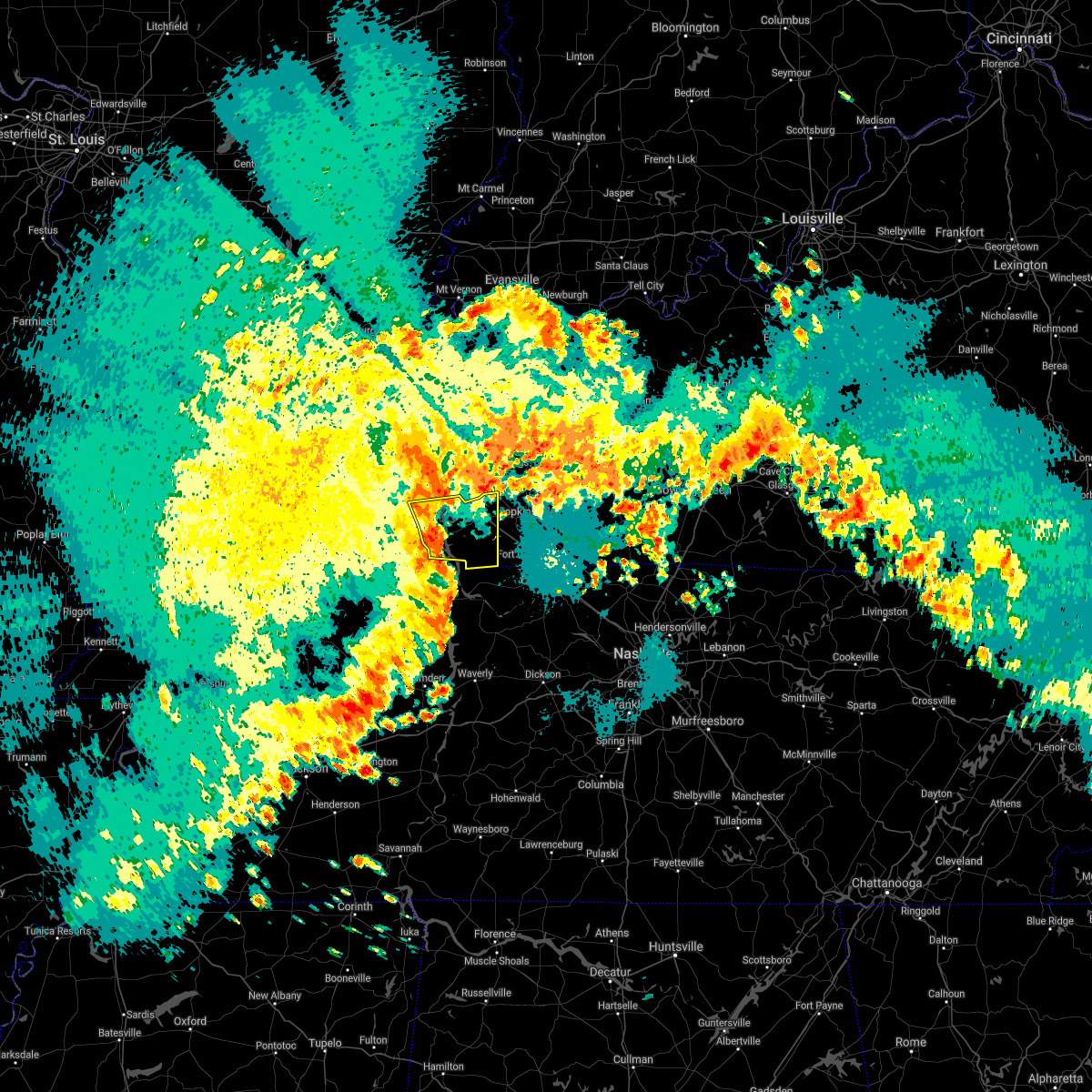 At 438 am cdt, severe thunderstorms were located along a line extending from 8 miles southeast of eddyville to 8 miles northeast of paris landing state park, moving east at 45 mph (trained weather spotters. at 414 am, several trees were reported down in calloway county near hazel). Hazards include 60 mph wind gusts and nickel size hail. Expect damage to roofs, siding, and trees. Locations impacted include, cadiz, land between the lakes area, canton, rockcastle and linton. At 438 am cdt, severe thunderstorms were located along a line extending from 8 miles southeast of eddyville to 8 miles northeast of paris landing state park, moving east at 45 mph (trained weather spotters. at 414 am, several trees were reported down in calloway county near hazel). Hazards include 60 mph wind gusts and nickel size hail. Expect damage to roofs, siding, and trees. Locations impacted include, cadiz, land between the lakes area, canton, rockcastle and linton.
|
| 5/4/2021 4:08 AM CDT |
 At 408 am cdt, severe thunderstorms were located along a line extending from near reidland to 6 miles southeast of lynnville, moving east at 50 mph (radar indicated). Hazards include 60 mph wind gusts and nickel size hail. expect damage to roofs, siding, and trees At 408 am cdt, severe thunderstorms were located along a line extending from near reidland to 6 miles southeast of lynnville, moving east at 50 mph (radar indicated). Hazards include 60 mph wind gusts and nickel size hail. expect damage to roofs, siding, and trees
|
| 4/8/2020 8:55 PM CDT |
 At 854 pm cdt, severe thunderstorms were located along a line extending from near weir to 7 miles southeast of big rock, moving east at 50 mph (radar indicated. quarter size hail and power outages were reported in hopkinsville). Hazards include 60 mph wind gusts and half dollar size hail. Hail damage to vehicles is expected. expect wind damage to roofs, siding, and trees. Locations impacted include, hopkinsville, oak grove, elkton, fort campbell, clarksville, guthrie, pembroke, trenton, lafayette, justice, everett, allensville, allegre, clifty and herndon. At 854 pm cdt, severe thunderstorms were located along a line extending from near weir to 7 miles southeast of big rock, moving east at 50 mph (radar indicated. quarter size hail and power outages were reported in hopkinsville). Hazards include 60 mph wind gusts and half dollar size hail. Hail damage to vehicles is expected. expect wind damage to roofs, siding, and trees. Locations impacted include, hopkinsville, oak grove, elkton, fort campbell, clarksville, guthrie, pembroke, trenton, lafayette, justice, everett, allensville, allegre, clifty and herndon.
|
| 4/8/2020 8:24 PM CDT |
 At 824 pm cdt, severe thunderstorms were located along a line extending from near cobb to near paris landing state park, moving east at 50 mph (radar indicated). Hazards include 60 mph wind gusts and half dollar size hail. Hail damage to vehicles is expected. Expect wind damage to roofs, siding, and trees. At 824 pm cdt, severe thunderstorms were located along a line extending from near cobb to near paris landing state park, moving east at 50 mph (radar indicated). Hazards include 60 mph wind gusts and half dollar size hail. Hail damage to vehicles is expected. Expect wind damage to roofs, siding, and trees.
|
| 3/28/2020 7:39 PM CDT |
 At 739 pm cdt, a severe thunderstorm was located near fort campbell, moving northeast at 50 mph (radar indicated). Hazards include 70 mph wind gusts and half dollar size hail. Hail damage to vehicles is expected. expect considerable tree damage. wind damage is also likely to mobile homes, roofs, and outbuildings. Locations impacted include, hopkinsville, oak grove, elkton, fort campbell, pembroke, trenton, lafayette, allegre and herndon. At 739 pm cdt, a severe thunderstorm was located near fort campbell, moving northeast at 50 mph (radar indicated). Hazards include 70 mph wind gusts and half dollar size hail. Hail damage to vehicles is expected. expect considerable tree damage. wind damage is also likely to mobile homes, roofs, and outbuildings. Locations impacted include, hopkinsville, oak grove, elkton, fort campbell, pembroke, trenton, lafayette, allegre and herndon.
|
| 3/28/2020 7:22 PM CDT |
 At 721 pm cdt, a severe thunderstorm was located near big rock, or near dover, moving northeast at 50 mph (radar indicated). Hazards include golf ball size hail and 70 mph wind gusts. People and animals outdoors will be injured. expect hail damage to roofs, siding, windows, and vehicles. expect considerable tree damage. Wind damage is also likely to mobile homes, roofs, and outbuildings. At 721 pm cdt, a severe thunderstorm was located near big rock, or near dover, moving northeast at 50 mph (radar indicated). Hazards include golf ball size hail and 70 mph wind gusts. People and animals outdoors will be injured. expect hail damage to roofs, siding, windows, and vehicles. expect considerable tree damage. Wind damage is also likely to mobile homes, roofs, and outbuildings.
|
| 1/11/2020 7:37 AM CST |
 At 737 am cst, a severe thunderstorm capable of producing a tornado was located near oak grove, moving northeast at 55 mph (radar indicated rotation). Hazards include tornado. Flying debris will be dangerous to those caught without shelter. mobile homes will be damaged or destroyed. damage to roofs, windows, and vehicles will occur. tree damage is likely. this dangerous storm will be near, pembroke around 745 am cst. Other locations impacted by this tornadic thunderstorm include lafayette and herndon. At 737 am cst, a severe thunderstorm capable of producing a tornado was located near oak grove, moving northeast at 55 mph (radar indicated rotation). Hazards include tornado. Flying debris will be dangerous to those caught without shelter. mobile homes will be damaged or destroyed. damage to roofs, windows, and vehicles will occur. tree damage is likely. this dangerous storm will be near, pembroke around 745 am cst. Other locations impacted by this tornadic thunderstorm include lafayette and herndon.
|
| 1/11/2020 7:23 AM CST |
 At 722 am cst, a severe thunderstorm capable of producing a tornado was located near big rock, or 14 miles west of fort campbell, moving northeast at 55 mph (radar indicated rotation). Hazards include tornado. Flying debris will be dangerous to those caught without shelter. mobile homes will be damaged or destroyed. damage to roofs, windows, and vehicles will occur. tree damage is likely. this dangerous storm will be near, fort campbell around 735 am cst. hopkinsville around 740 am cst. pembroke around 745 am cst. other locations impacted by this tornadic thunderstorm include lafayette and herndon. this includes the following highways, interstate 24 in kentucky between mile markers 72 and 92. Pennyrile parkway between mile markers 1 and 10. At 722 am cst, a severe thunderstorm capable of producing a tornado was located near big rock, or 14 miles west of fort campbell, moving northeast at 55 mph (radar indicated rotation). Hazards include tornado. Flying debris will be dangerous to those caught without shelter. mobile homes will be damaged or destroyed. damage to roofs, windows, and vehicles will occur. tree damage is likely. this dangerous storm will be near, fort campbell around 735 am cst. hopkinsville around 740 am cst. pembroke around 745 am cst. other locations impacted by this tornadic thunderstorm include lafayette and herndon. this includes the following highways, interstate 24 in kentucky between mile markers 72 and 92. Pennyrile parkway between mile markers 1 and 10.
|
| 1/11/2020 6:54 AM CST |
 At 654 am cst, severe thunderstorms were located along a line extending from near land between the lakes area to 6 miles north of paris landing state park, moving northeast at 70 mph (radar indicated). Hazards include 60 mph wind gusts. expect damage to roofs, siding, and trees At 654 am cst, severe thunderstorms were located along a line extending from near land between the lakes area to 6 miles north of paris landing state park, moving northeast at 70 mph (radar indicated). Hazards include 60 mph wind gusts. expect damage to roofs, siding, and trees
|
| 6/23/2019 6:49 PM CDT |
 At 649 pm cdt, severe thunderstorms were located along a line extending from near weir to 11 miles east of crofton to near hopkinsville to 8 miles west of fort campbell north, moving east at 25 mph (radar indicated). Hazards include 60 mph wind gusts and penny size hail. Expect damage to roofs, siding, and trees. Locations impacted include, hopkinsville, oak grove, elkton, fort campbell north, clarksville, guthrie, pembroke, trenton, lafayette, allensville, allegre, clifty and herndon. At 649 pm cdt, severe thunderstorms were located along a line extending from near weir to 11 miles east of crofton to near hopkinsville to 8 miles west of fort campbell north, moving east at 25 mph (radar indicated). Hazards include 60 mph wind gusts and penny size hail. Expect damage to roofs, siding, and trees. Locations impacted include, hopkinsville, oak grove, elkton, fort campbell north, clarksville, guthrie, pembroke, trenton, lafayette, allensville, allegre, clifty and herndon.
|
| 6/23/2019 6:11 PM CDT |
 At 611 pm cdt, severe thunderstorms were located along a line extending from 6 miles east of madisonville to near graham to near crofton to near big rock, moving east at 50 mph (radar indicated). Hazards include 60 mph wind gusts and penny size hail. expect damage to roofs, siding, and trees At 611 pm cdt, severe thunderstorms were located along a line extending from 6 miles east of madisonville to near graham to near crofton to near big rock, moving east at 50 mph (radar indicated). Hazards include 60 mph wind gusts and penny size hail. expect damage to roofs, siding, and trees
|
| 6/23/2019 5:14 PM CDT |
 At 513 pm cdt, severe thunderstorms were located along a line extending from 10 miles northeast of dixon springs to joy to burna to 8 miles southwest of salem to near calvert city to near benton to 9 miles northeast of cottage grove to near dresden, moving east at 60 mph (radar indicated). Hazards include 70 mph wind gusts and quarter size hail. Hail damage to vehicles is expected. expect considerable tree damage. Wind damage is also likely to mobile homes, roofs, and outbuildings. At 513 pm cdt, severe thunderstorms were located along a line extending from 10 miles northeast of dixon springs to joy to burna to 8 miles southwest of salem to near calvert city to near benton to 9 miles northeast of cottage grove to near dresden, moving east at 60 mph (radar indicated). Hazards include 70 mph wind gusts and quarter size hail. Hail damage to vehicles is expected. expect considerable tree damage. Wind damage is also likely to mobile homes, roofs, and outbuildings.
|
| 6/22/2019 3:12 PM CDT |
 At 312 pm cdt, severe thunderstorms were located along a line extending from near hopkinsville to 8 miles west of fort campbell north, moving east at 50 mph (radar indicated). Hazards include 60 mph wind gusts and quarter size hail. Hail damage to vehicles is expected. Expect wind damage to roofs, siding, and trees. At 312 pm cdt, severe thunderstorms were located along a line extending from near hopkinsville to 8 miles west of fort campbell north, moving east at 50 mph (radar indicated). Hazards include 60 mph wind gusts and quarter size hail. Hail damage to vehicles is expected. Expect wind damage to roofs, siding, and trees.
|
| 6/21/2019 6:33 PM CDT |
 The national weather service in paducah has issued a * severe thunderstorm warning for. christian county in south central kentucky. todd county in south central kentucky. until 730 pm cdt. At 631 pm cdt, severe thunderstorms were located along a line. The national weather service in paducah has issued a * severe thunderstorm warning for. christian county in south central kentucky. todd county in south central kentucky. until 730 pm cdt. At 631 pm cdt, severe thunderstorms were located along a line.
|
| 6/21/2019 5:43 PM CDT |
 At 541 pm cdt, severe thunderstorms were located along a line extending from near marion to near mayfield to near troy, moving east at 55 mph (law enforcement, emergency managers, and spotters have reported 60 to 70 mph winds, extensive tree damage, torrential rainfall, and power outages over southeast missouri, southern illinois, and parts of west kentucky). Hazards include 70 mph wind gusts and nickel size hail. Expect considerable tree damage. Damage is likely to mobile homes, roofs, and outbuildings. At 541 pm cdt, severe thunderstorms were located along a line extending from near marion to near mayfield to near troy, moving east at 55 mph (law enforcement, emergency managers, and spotters have reported 60 to 70 mph winds, extensive tree damage, torrential rainfall, and power outages over southeast missouri, southern illinois, and parts of west kentucky). Hazards include 70 mph wind gusts and nickel size hail. Expect considerable tree damage. Damage is likely to mobile homes, roofs, and outbuildings.
|
| 6/19/2019 4:53 PM CDT |
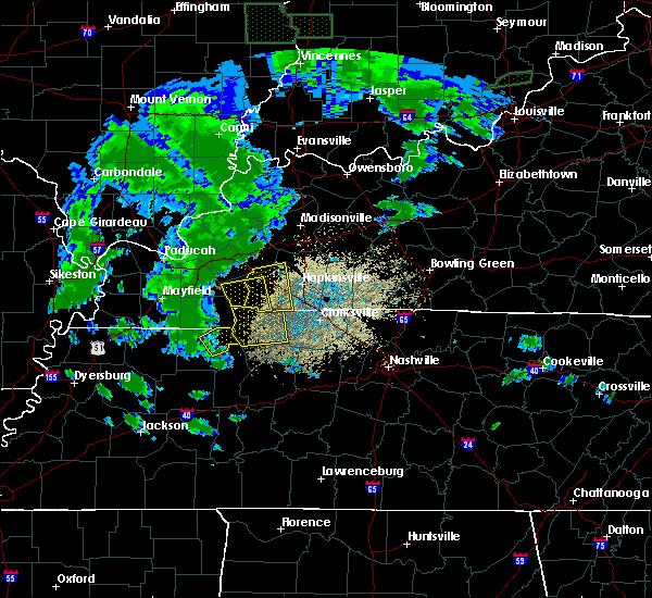 At 453 pm cdt, a severe thunderstorm was located near canton, or near cadiz, moving east at 50 mph (radar indicated). Hazards include 60 mph wind gusts. expect damage to roofs, siding, and trees At 453 pm cdt, a severe thunderstorm was located near canton, or near cadiz, moving east at 50 mph (radar indicated). Hazards include 60 mph wind gusts. expect damage to roofs, siding, and trees
|
| 12/31/2018 12:49 PM CST |
 At 1248 pm cst, severe winds with showers and isolated thunder were located along a line extending from 6 miles southeast of cobb to near big rock, moving east at 55 mph (radar indicated). Hazards include 60 mph wind gusts. expect damage to roofs, siding, and trees At 1248 pm cst, severe winds with showers and isolated thunder were located along a line extending from 6 miles southeast of cobb to near big rock, moving east at 55 mph (radar indicated). Hazards include 60 mph wind gusts. expect damage to roofs, siding, and trees
|
| 12/31/2018 12:44 PM CST |
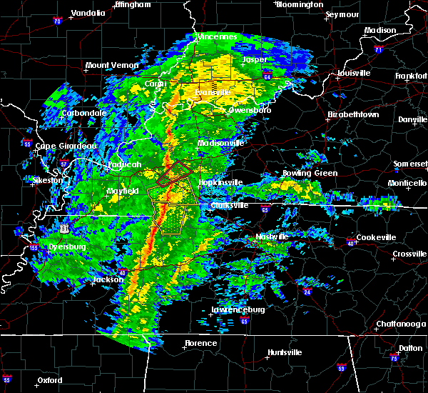 At 1244 pm cst, a severe thunderstorm was located 7 miles southeast of cadiz, moving east at 60 mph (radar indicated). Hazards include 60 mph wind gusts. Expect damage to roofs, siding, and trees. Locations impacted include, cadiz, lafayette, linton and herndon. At 1244 pm cst, a severe thunderstorm was located 7 miles southeast of cadiz, moving east at 60 mph (radar indicated). Hazards include 60 mph wind gusts. Expect damage to roofs, siding, and trees. Locations impacted include, cadiz, lafayette, linton and herndon.
|
| 12/31/2018 12:28 PM CST |
 At 1226 pm cst, a severe thunderstorm was located 7 miles south of land between the lakes area, moving east at 60 mph (radar indicated. winds near 60 mph were reported in calloway county with this line of showers with basically no lightning). Hazards include 60 mph wind gusts. expect damage to roofs, siding, and trees At 1226 pm cst, a severe thunderstorm was located 7 miles south of land between the lakes area, moving east at 60 mph (radar indicated. winds near 60 mph were reported in calloway county with this line of showers with basically no lightning). Hazards include 60 mph wind gusts. expect damage to roofs, siding, and trees
|
| 6/28/2018 9:39 PM CDT |
 The severe thunderstorm warning for southwestern muhlenberg, christian, southeastern trigg, southeastern hopkins and todd counties will expire at 945 pm cdt, the storms which prompted the warning have weakened below severe limits, and no longer pose an immediate threat to life or property. therefore, the warning will be allowed to expire. a severe thunderstorm watch remains in effect until 100 am cdt for south central, western and northwestern kentucky. The severe thunderstorm warning for southwestern muhlenberg, christian, southeastern trigg, southeastern hopkins and todd counties will expire at 945 pm cdt, the storms which prompted the warning have weakened below severe limits, and no longer pose an immediate threat to life or property. therefore, the warning will be allowed to expire. a severe thunderstorm watch remains in effect until 100 am cdt for south central, western and northwestern kentucky.
|
| 6/28/2018 9:16 PM CDT |
 At 915 pm cdt, severe thunderstorms were located along a line extending from near graham to near pembroke to 6 miles south of big rock, moving southeast at 40 mph. these are very dangerous storms (emergency management. 80 mph winds were measured 4 miles northwest of hopkinsville). Hazards include 80 mph wind gusts. Flying debris will be dangerous to those caught without shelter. mobile homes will be heavily damaged. expect considerable damage to roofs, windows, and vehicles. extensive tree damage and power outages are likely. Locations impacted include, hopkinsville, madisonville, oak grove, elkton, fort campbell north, clarksville, guthrie, pembroke, crofton, weir, white plains, trenton, lafayette, justice, everett, allensville, allegre, clifty and herndon. At 915 pm cdt, severe thunderstorms were located along a line extending from near graham to near pembroke to 6 miles south of big rock, moving southeast at 40 mph. these are very dangerous storms (emergency management. 80 mph winds were measured 4 miles northwest of hopkinsville). Hazards include 80 mph wind gusts. Flying debris will be dangerous to those caught without shelter. mobile homes will be heavily damaged. expect considerable damage to roofs, windows, and vehicles. extensive tree damage and power outages are likely. Locations impacted include, hopkinsville, madisonville, oak grove, elkton, fort campbell north, clarksville, guthrie, pembroke, crofton, weir, white plains, trenton, lafayette, justice, everett, allensville, allegre, clifty and herndon.
|
| 6/28/2018 9:10 PM CDT |
 At 910 pm cdt, severe thunderstorms were located along a line extending from near graham to near pembroke to near big rock, moving southeast at 40 mph (radar indicated). Hazards include 60 mph wind gusts. Expect damage to roofs, siding, and trees. Locations impacted include, hopkinsville, madisonville, oak grove, elkton, fort campbell north, clarksville, guthrie, pembroke, crofton, weir, white plains, trenton, lafayette, justice, everett, allensville, allegre, clifty and herndon. At 910 pm cdt, severe thunderstorms were located along a line extending from near graham to near pembroke to near big rock, moving southeast at 40 mph (radar indicated). Hazards include 60 mph wind gusts. Expect damage to roofs, siding, and trees. Locations impacted include, hopkinsville, madisonville, oak grove, elkton, fort campbell north, clarksville, guthrie, pembroke, crofton, weir, white plains, trenton, lafayette, justice, everett, allensville, allegre, clifty and herndon.
|
| 6/28/2018 8:39 PM CDT |
 At 839 pm cdt, severe thunderstorms were located along a line extending from near dixon to 6 miles northeast of cobb to near land between the lakes area, moving southeast at 55 mph (radar indicated). Hazards include 60 mph wind gusts. expect damage to roofs, siding, and trees At 839 pm cdt, severe thunderstorms were located along a line extending from near dixon to 6 miles northeast of cobb to near land between the lakes area, moving southeast at 55 mph (radar indicated). Hazards include 60 mph wind gusts. expect damage to roofs, siding, and trees
|
| 6/26/2018 8:59 PM CDT |
 At 859 pm cdt, a severe thunderstorm was located 7 miles northeast of big rock, or 12 miles west of fort campbell north, moving east at 30 mph (radar indicated). Hazards include 60 mph wind gusts and quarter size hail. Hail damage to vehicles is expected. expect wind damage to roofs, siding, and trees. Locations impacted include, oak grove, fort campbell north, clarksville, lafayette and herndon. At 859 pm cdt, a severe thunderstorm was located 7 miles northeast of big rock, or 12 miles west of fort campbell north, moving east at 30 mph (radar indicated). Hazards include 60 mph wind gusts and quarter size hail. Hail damage to vehicles is expected. expect wind damage to roofs, siding, and trees. Locations impacted include, oak grove, fort campbell north, clarksville, lafayette and herndon.
|
| 6/26/2018 8:26 PM CDT |
 At 826 pm cdt, a severe thunderstorm was located near big rock, or 12 miles north of dover, moving east at 35 mph (radar indicated). Hazards include 60 mph wind gusts and quarter size hail. Hail damage to vehicles is expected. Expect wind damage to roofs, siding, and trees. At 826 pm cdt, a severe thunderstorm was located near big rock, or 12 miles north of dover, moving east at 35 mph (radar indicated). Hazards include 60 mph wind gusts and quarter size hail. Hail damage to vehicles is expected. Expect wind damage to roofs, siding, and trees.
|
| 2/24/2018 8:31 PM CST |
 At 831 pm cst, severe thunderstorms were located along a line extending from near cobb to 8 miles east of cadiz to 8 miles northeast of big rock, moving east at 50 mph (radar indicated). Hazards include 60 mph wind gusts. expect damage to roofs, siding, and trees At 831 pm cst, severe thunderstorms were located along a line extending from near cobb to 8 miles east of cadiz to 8 miles northeast of big rock, moving east at 50 mph (radar indicated). Hazards include 60 mph wind gusts. expect damage to roofs, siding, and trees
|
| 5/27/2017 7:32 PM CDT |
 At 732 pm cdt, severe thunderstorms were located along a line extending from near weir to 11 miles south of greenville to 7 miles northeast of pembroke to 6 miles west of fort campbell north, moving east at 75 mph (radar indicated). Hazards include 60 mph wind gusts. Expect damage to roofs, siding, and trees. Locations impacted include, hopkinsville, oak grove, elkton, fort campbell north, guthrie, pembroke, crofton, trenton, lafayette, allensville, allegre, clifty and herndon. At 732 pm cdt, severe thunderstorms were located along a line extending from near weir to 11 miles south of greenville to 7 miles northeast of pembroke to 6 miles west of fort campbell north, moving east at 75 mph (radar indicated). Hazards include 60 mph wind gusts. Expect damage to roofs, siding, and trees. Locations impacted include, hopkinsville, oak grove, elkton, fort campbell north, guthrie, pembroke, crofton, trenton, lafayette, allensville, allegre, clifty and herndon.
|
| 5/27/2017 7:17 PM CDT |
 At 717 pm cdt, severe thunderstorms were located along a line extending from near providence to near earlington to 8 miles southwest of crofton to 6 miles southeast of canton, moving east at 70 mph (radar indicated). Hazards include 60 mph wind gusts. Expect damage to roofs, siding, and trees. Locations impacted include, hopkinsville, oak grove, cadiz, elkton, fort campbell north, guthrie, pembroke, crofton, canton, trenton, lafayette, linton, allensville, allegre, clifty and herndon. At 717 pm cdt, severe thunderstorms were located along a line extending from near providence to near earlington to 8 miles southwest of crofton to 6 miles southeast of canton, moving east at 70 mph (radar indicated). Hazards include 60 mph wind gusts. Expect damage to roofs, siding, and trees. Locations impacted include, hopkinsville, oak grove, cadiz, elkton, fort campbell north, guthrie, pembroke, crofton, canton, trenton, lafayette, linton, allensville, allegre, clifty and herndon.
|
| 5/27/2017 7:09 PM CDT |
 At 709 pm cdt, severe thunderstorms were located along a line extending from near clay to 6 miles southeast of providence to near cobb to near canton, moving east at 70 mph (radar indicated). Hazards include 70 mph wind gusts. Expect considerable tree damage. damage is likely to mobile homes, roofs, and outbuildings. Locations impacted include, hopkinsville, madisonville, oak grove, princeton, central city, greenville, dawson springs, cadiz, elkton, fort campbell north, land between the lakes area, guthrie, earlington, nortonville, pembroke, mortons gap, crofton, powderly, graham and olney. At 709 pm cdt, severe thunderstorms were located along a line extending from near clay to 6 miles southeast of providence to near cobb to near canton, moving east at 70 mph (radar indicated). Hazards include 70 mph wind gusts. Expect considerable tree damage. damage is likely to mobile homes, roofs, and outbuildings. Locations impacted include, hopkinsville, madisonville, oak grove, princeton, central city, greenville, dawson springs, cadiz, elkton, fort campbell north, land between the lakes area, guthrie, earlington, nortonville, pembroke, mortons gap, crofton, powderly, graham and olney.
|
| 5/27/2017 7:02 PM CDT |
 At 701 pm cdt, severe thunderstorms were located along a line extending from near sturgis to near providence to near cobb to near land between the lakes area, moving east at 75 mph (radar indicated). Hazards include 70 mph wind gusts. Expect considerable tree damage. damage is likely to mobile homes, roofs, and outbuildings. Locations impacted include, hopkinsville, madisonville, oak grove, princeton, central city, greenville, marion, dawson springs, cadiz, eddyville, elkton, fort campbell north, land between the lakes area, guthrie, earlington, nortonville, pembroke, mortons gap, salem and crofton. At 701 pm cdt, severe thunderstorms were located along a line extending from near sturgis to near providence to near cobb to near land between the lakes area, moving east at 75 mph (radar indicated). Hazards include 70 mph wind gusts. Expect considerable tree damage. damage is likely to mobile homes, roofs, and outbuildings. Locations impacted include, hopkinsville, madisonville, oak grove, princeton, central city, greenville, marion, dawson springs, cadiz, eddyville, elkton, fort campbell north, land between the lakes area, guthrie, earlington, nortonville, pembroke, mortons gap, salem and crofton.
|
| 5/27/2017 6:40 PM CDT |
 At 638 pm cdt, severe thunderstorms were located along a line extending from 9 miles north of golconda to joy to near calvert city to near mayfield, moving east at 70 mph (radar indicated. these storms downed trees in mccracken county). Hazards include 70 mph wind gusts. Expect considerable tree damage. Damage is likely to mobile homes, roofs, and outbuildings. At 638 pm cdt, severe thunderstorms were located along a line extending from 9 miles north of golconda to joy to near calvert city to near mayfield, moving east at 70 mph (radar indicated. these storms downed trees in mccracken county). Hazards include 70 mph wind gusts. Expect considerable tree damage. Damage is likely to mobile homes, roofs, and outbuildings.
|
| 3/27/2017 2:36 PM CDT |
 At 236 pm cdt, severe thunderstorms were located along a line extending from dawson springs to 6 miles northwest of hopkinsville to 9 miles northwest of fort campbell north, moving northeast at 55 mph (radar indicated). Hazards include 60 mph wind gusts and half dollar size hail. Hail damage to vehicles is expected. expect wind damage to roofs, siding, and trees. locations impacted include, hopkinsville, madisonville, oak grove, dawson springs, fort campbell north, earlington, nortonville, pembroke, mortons gap, crofton, cobb, white plains, st. Charles, lafayette, hawkins and herndon. At 236 pm cdt, severe thunderstorms were located along a line extending from dawson springs to 6 miles northwest of hopkinsville to 9 miles northwest of fort campbell north, moving northeast at 55 mph (radar indicated). Hazards include 60 mph wind gusts and half dollar size hail. Hail damage to vehicles is expected. expect wind damage to roofs, siding, and trees. locations impacted include, hopkinsville, madisonville, oak grove, dawson springs, fort campbell north, earlington, nortonville, pembroke, mortons gap, crofton, cobb, white plains, st. Charles, lafayette, hawkins and herndon.
|
| 3/27/2017 2:23 PM CDT |
 At 223 pm cdt, severe thunderstorms were located along a line extending from near princeton to near cadiz to near big rock, moving northeast at 65 mph (radar indicated). Hazards include 60 mph wind gusts and half dollar size hail. Hail damage to vehicles is expected. Expect wind damage to roofs, siding, and trees. At 223 pm cdt, severe thunderstorms were located along a line extending from near princeton to near cadiz to near big rock, moving northeast at 65 mph (radar indicated). Hazards include 60 mph wind gusts and half dollar size hail. Hail damage to vehicles is expected. Expect wind damage to roofs, siding, and trees.
|
| 3/1/2017 6:11 AM CST |
 At 611 am cst, severe thunderstorms were located along a line extending from near earlington to near big rock, moving east at 65 mph. these are very dangerous storms (radar indicated). Hazards include 80 mph wind gusts and penny size hail. Flying debris will be dangerous to those caught without shelter. mobile homes will be heavily damaged. expect considerable damage to roofs, windows, and vehicles. Extensive tree damage and power outages are likely. At 611 am cst, severe thunderstorms were located along a line extending from near earlington to near big rock, moving east at 65 mph. these are very dangerous storms (radar indicated). Hazards include 80 mph wind gusts and penny size hail. Flying debris will be dangerous to those caught without shelter. mobile homes will be heavily damaged. expect considerable damage to roofs, windows, and vehicles. Extensive tree damage and power outages are likely.
|
| 3/1/2017 5:44 AM CST |
 At 543 am cst, severe thunderstorms were located along a line extending from near marion to 7 miles south of murray, moving east at 75 mph (radar indicated). Hazards include 70 mph wind gusts and penny size hail. Expect considerable tree damage. Damage is likely to mobile homes, roofs, and outbuildings. At 543 am cst, severe thunderstorms were located along a line extending from near marion to 7 miles south of murray, moving east at 75 mph (radar indicated). Hazards include 70 mph wind gusts and penny size hail. Expect considerable tree damage. Damage is likely to mobile homes, roofs, and outbuildings.
|
| 12/17/2016 6:52 PM CST |
 At 651 pm cst, a severe thunderstorm was located 7 miles northwest of hopkinsville, moving northeast at 55 mph (radar indicated). Hazards include 60 mph wind gusts and quarter size hail. this storm has a history of 50 mph and nickel size hail. Hail damage to vehicles is expected. Expect wind damage to roofs, siding, and trees. At 651 pm cst, a severe thunderstorm was located 7 miles northwest of hopkinsville, moving northeast at 55 mph (radar indicated). Hazards include 60 mph wind gusts and quarter size hail. this storm has a history of 50 mph and nickel size hail. Hail damage to vehicles is expected. Expect wind damage to roofs, siding, and trees.
|
| 7/8/2016 7:43 PM CDT |
 At 743 pm cdt, severe thunderstorms were located along a line extending from hopkinsville to near fort campbell north, moving east at 50 mph (radar indicated). Hazards include 60 mph wind gusts. Expect damage to roofs. siding. And trees. At 743 pm cdt, severe thunderstorms were located along a line extending from hopkinsville to near fort campbell north, moving east at 50 mph (radar indicated). Hazards include 60 mph wind gusts. Expect damage to roofs. siding. And trees.
|
| 7/8/2016 7:24 PM CDT |
 At 724 pm cdt, severe thunderstorms were located along a line extending from near cadiz to near big rock, moving east at 50 mph (radar indicated). Hazards include 60 mph wind gusts. Expect damage to roofs. siding. And trees. At 724 pm cdt, severe thunderstorms were located along a line extending from near cadiz to near big rock, moving east at 50 mph (radar indicated). Hazards include 60 mph wind gusts. Expect damage to roofs. siding. And trees.
|
| 7/6/2016 2:18 PM CDT |
 At 217 pm cdt, severe thunderstorms were located along a line extending from marion to near energy to 8 miles southeast of murray, moving east at 60 mph (radar indicated). Hazards include 70 mph wind gusts and penny size hail. Expect considerable tree damage. Damage is likely to mobile homes, roofs, and outbuildings. At 217 pm cdt, severe thunderstorms were located along a line extending from marion to near energy to 8 miles southeast of murray, moving east at 60 mph (radar indicated). Hazards include 70 mph wind gusts and penny size hail. Expect considerable tree damage. Damage is likely to mobile homes, roofs, and outbuildings.
|
| 6/15/2016 3:00 PM CDT |
 At 259 pm cdt, a severe thunderstorm was located near pembroke, and near hopkinsville, moving southeast at 30 mph (trained weather spotters). Hazards include 60 mph wind gusts. Expect damage to roofs. siding. And trees. At 259 pm cdt, a severe thunderstorm was located near pembroke, and near hopkinsville, moving southeast at 30 mph (trained weather spotters). Hazards include 60 mph wind gusts. Expect damage to roofs. siding. And trees.
|
| 6/15/2016 2:32 PM CDT |
 At 232 pm cdt, severe thunderstorms were located along a line extending from 9 miles northwest of hopkinsville to near big rock, moving east at 45 mph (radar indicated). Hazards include 60 mph wind gusts. Expect damage to roofs. siding. And trees. At 232 pm cdt, severe thunderstorms were located along a line extending from 9 miles northwest of hopkinsville to near big rock, moving east at 45 mph (radar indicated). Hazards include 60 mph wind gusts. Expect damage to roofs. siding. And trees.
|
| 5/10/2016 7:49 PM CDT |
 At 748 pm cdt, a severe thunderstorm capable of producing a tornado was located 7 miles northeast of big rock, or 11 miles west of fort campbell north, moving east at 30 mph (radar indicated rotation). Hazards include tornado and quarter size hail. Flying debris will be dangerous to those caught without shelter. mobile homes will be damaged or destroyed. damage to roofs, windows, and vehicles will occur. tree damage is likely. Locations impacted include, lafayette. At 748 pm cdt, a severe thunderstorm capable of producing a tornado was located 7 miles northeast of big rock, or 11 miles west of fort campbell north, moving east at 30 mph (radar indicated rotation). Hazards include tornado and quarter size hail. Flying debris will be dangerous to those caught without shelter. mobile homes will be damaged or destroyed. damage to roofs, windows, and vehicles will occur. tree damage is likely. Locations impacted include, lafayette.
|
| 5/10/2016 7:41 PM CDT |
 At 741 pm cdt, a severe thunderstorm capable of producing a tornado was located near big rock, or 14 miles northeast of dover, moving east at 30 mph (radar indicated rotation). Hazards include tornado and quarter size hail. Flying debris will be dangerous to those caught without shelter. mobile homes will be damaged or destroyed. damage to roofs, windows, and vehicles will occur. tree damage is likely. This tornadic thunderstorm will remain over mainly rural areas of southeastern trigg and southwestern christian counties, including the following locations: lafayette. At 741 pm cdt, a severe thunderstorm capable of producing a tornado was located near big rock, or 14 miles northeast of dover, moving east at 30 mph (radar indicated rotation). Hazards include tornado and quarter size hail. Flying debris will be dangerous to those caught without shelter. mobile homes will be damaged or destroyed. damage to roofs, windows, and vehicles will occur. tree damage is likely. This tornadic thunderstorm will remain over mainly rural areas of southeastern trigg and southwestern christian counties, including the following locations: lafayette.
|
| 12/23/2015 5:55 PM CST | At 553 pm cst, a severe thunderstorm was located hopkinsville, moving east at 65 mph (spotters continue to report 60 mph winds in and around hopkinsville). Hazards include 60 mph wind gusts and penny size hail. Expect damage to roofs. Siding and trees. |
| 12/23/2015 5:28 PM CST | The national weather service in paducah has issued a * severe thunderstorm warning for. southern christian county in south central kentucky. until 600 pm cst * at 528 pm cst. a severe thunderstorm was located 7 miles northeast of big rock. or 12 miles west of fort campbell north. Moving. |
| 6/26/2015 3:28 PM CDT | At 327 pm cdt, a severe thunderstorm was located 7 miles northeast of big rock, or 11 miles west of fort campbell north, moving east at 25 mph (radar indicated). Hazards include 60 mph wind gusts and quarter size hail. Hail damage to vehicles is expected. expect wind damage to roofs, siding and trees. Locations impacted include, hopkinsville, oak grove, fort campbell north, pembroke, lafayette and herndon. |
| 6/26/2015 3:25 PM CDT | Outbuildings damaged and small trees down. winds estimated to be 60 mp in christian county KY, 0.2 miles ESE of LaFayette, KY |
| 6/26/2015 3:11 PM CDT | At 311 pm cdt, a severe thunderstorm was located near big rock, or 12 miles north of dover, moving east at 25 mph (radar indicated). Hazards include 60 mph wind gusts and quarter size hail. Hail damage to vehicles is expected. Expect wind damage to roofs, siding and trees. |
| 5/16/2015 4:43 PM CDT | At 443 pm cdt, a severe thunderstorm capable of producing a tornado was located 8 miles west of fort campbell north, moving northeast at 10 mph (radar indicated rotation). Hazards include tornado. Flying debris will be dangerous to those caught without shelter. mobile homes will be damaged or destroyed. damage to roofs, windows and vehicles will occur. tree damage is likely. this tornadic thunderstorm will remain over mainly rural areas of southwestern christian county, including the following locations, herndon and lafayette. Radar indicated. |
| 5/14/2014 4:00 PM CDT | Tree down across powerlines. fire department responding in christian county KY, 0.2 miles ESE of LaFayette, KY |
| 5/14/2014 4:00 PM CDT | 4 large hollowed trees down along roaring springs roa in christian county KY, 1.1 miles SE of LaFayette, KY |
| 1/30/2013 1:35 AM CST | Peak winds were estimated at 100 mph. a swath of damage averaging 1 mile wide extended from 4 miles south of herndon to 9 miles east of herndon or 10 miles southeast of in christian county KY, 3.2 miles W of LaFayette, KY |
| 1/30/2013 1:34 AM CST | Peak winds estimated at 105 mph. a 300 yard swath of damage extended from 1/2 mile east of herndon to 4 miles east of herndon. the damage included an empty grain bin th in christian county KY, 5.5 miles SW of LaFayette, KY |
| 5/29/2012 8:00 AM CDT | Clarskville leaf chronicle reported roof damage to 2 buildings on wallace town road at hwy 79. one roof landed on top of a truck. time estimate in stewart county TN, 8.2 miles N of LaFayette, KY |
| 5/29/2012 8:00 AM CDT | Updated information. clarskville leaf chronicle reported damage to 3 buildings on wallace town road at hwy 79. the roof of a 40 ft by 100 ft warehouse was completely bl in stewart county TN, 8.2 miles N of LaFayette, KY |
| 1/1/0001 12:00 AM | Late report. 3 sided barn or lean to was blown across a road. four greenhouses damage in christian county KY, 3.2 miles WSW of LaFayette, KY |
Hail Maps for LaFayette, KY


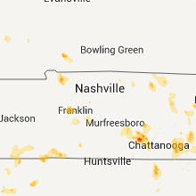


Connect with Interactive Hail Maps