

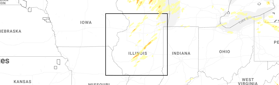
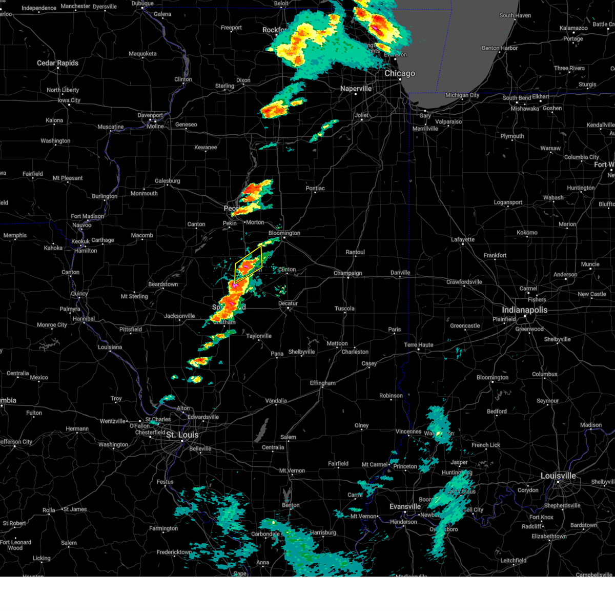
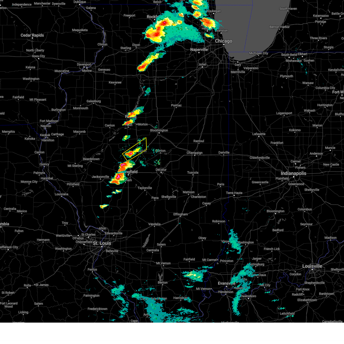
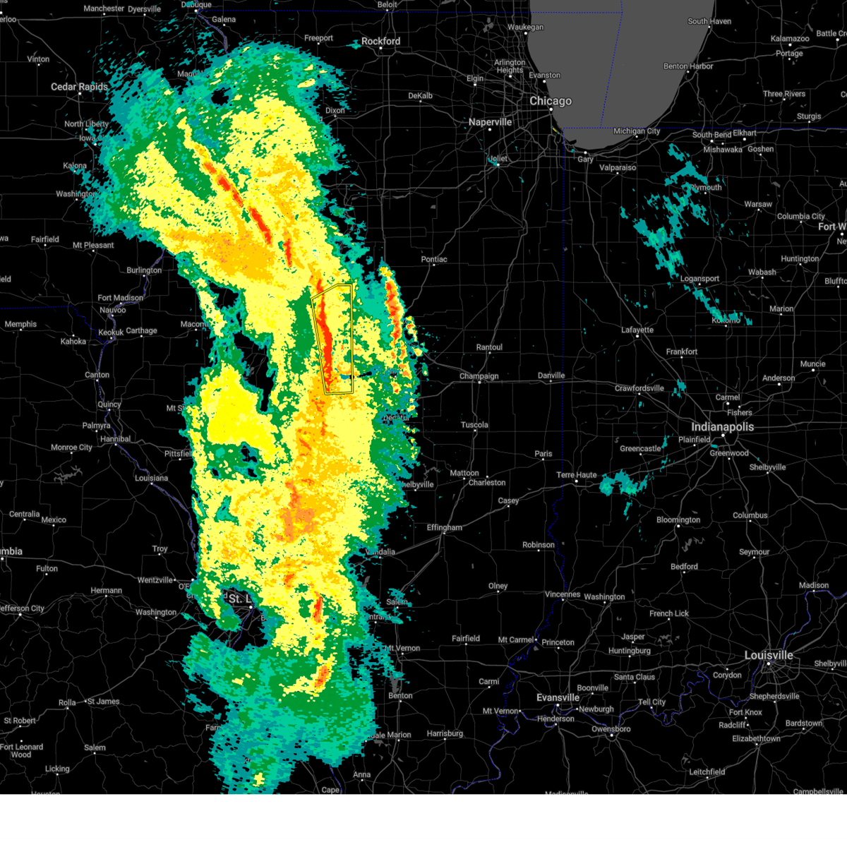
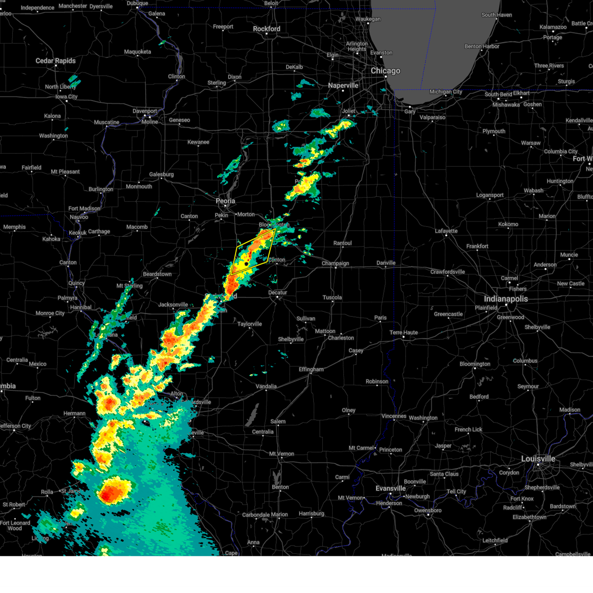
Hail Map for Lincoln, IL
The Lincoln, IL area has had 6 reports of on-the-ground hail by trained spotters, and has been under severe weather warnings 28 times during the past 12 months. Doppler radar has detected hail at or near Lincoln, IL on 42 occasions, including 2 occasions during the past year.
| Name: | Lincoln, IL |
| Where Located: | 39.2 miles SSE of Peoria, IL |
| Map: | Google Map for Lincoln, IL |
| Population: | 14504 |
| Housing Units: | 6411 |
| More Info: | Search Google for Lincoln, IL |
3
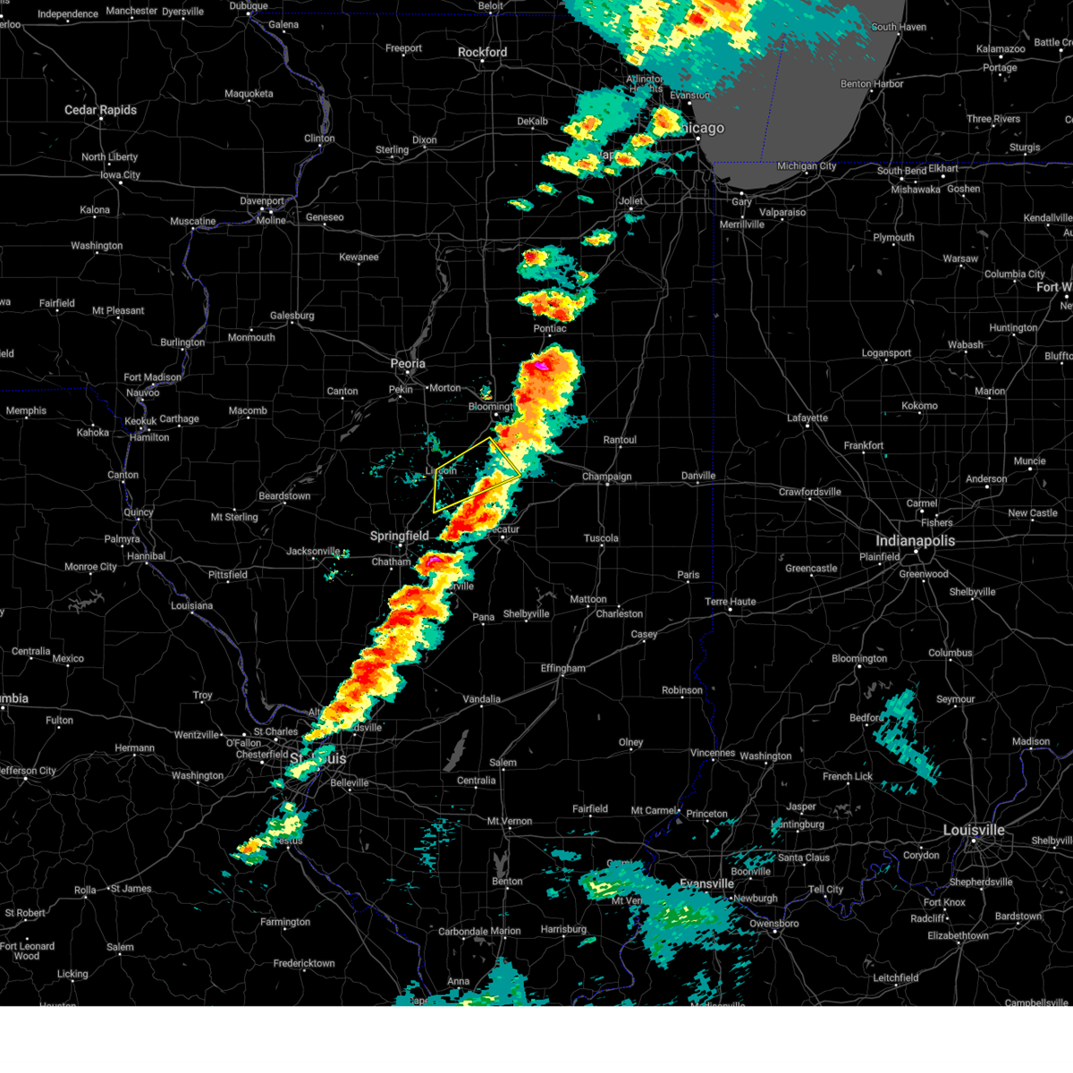
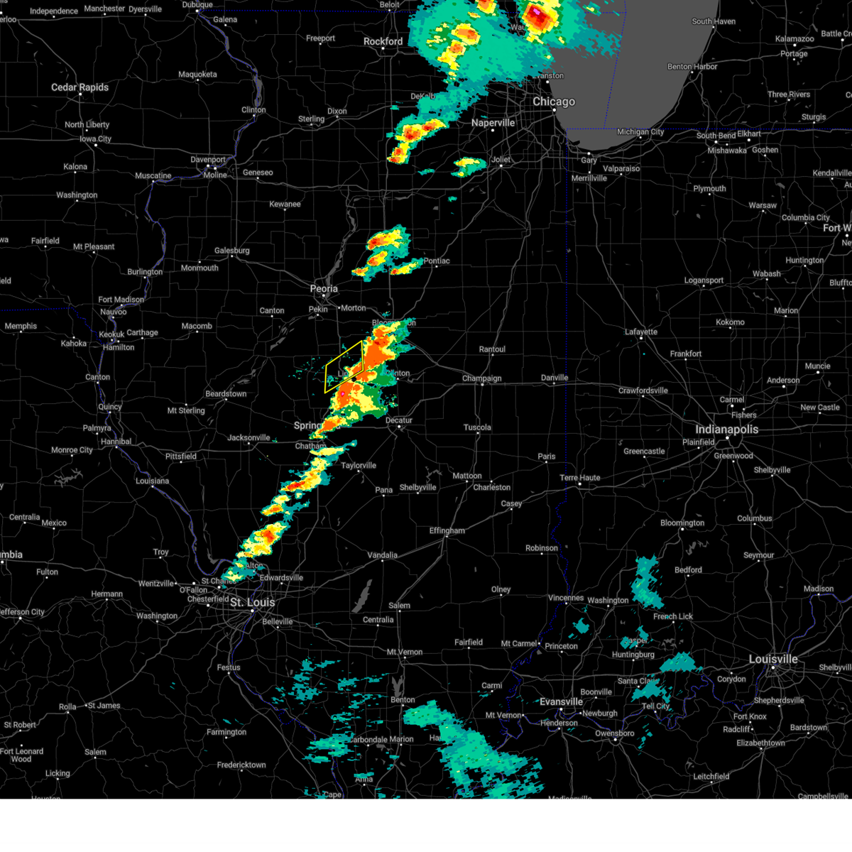
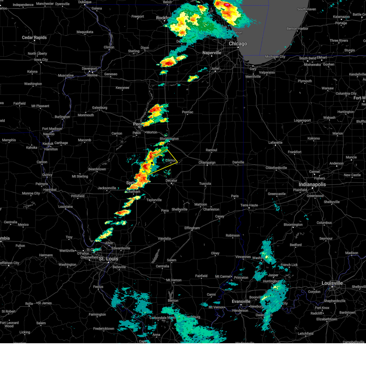
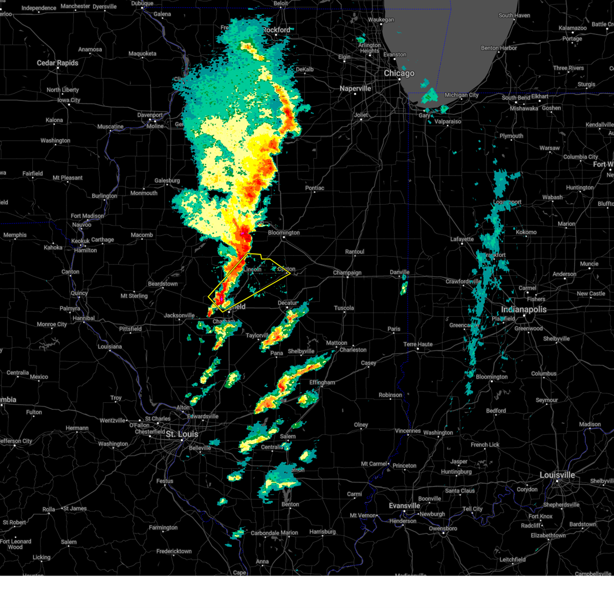
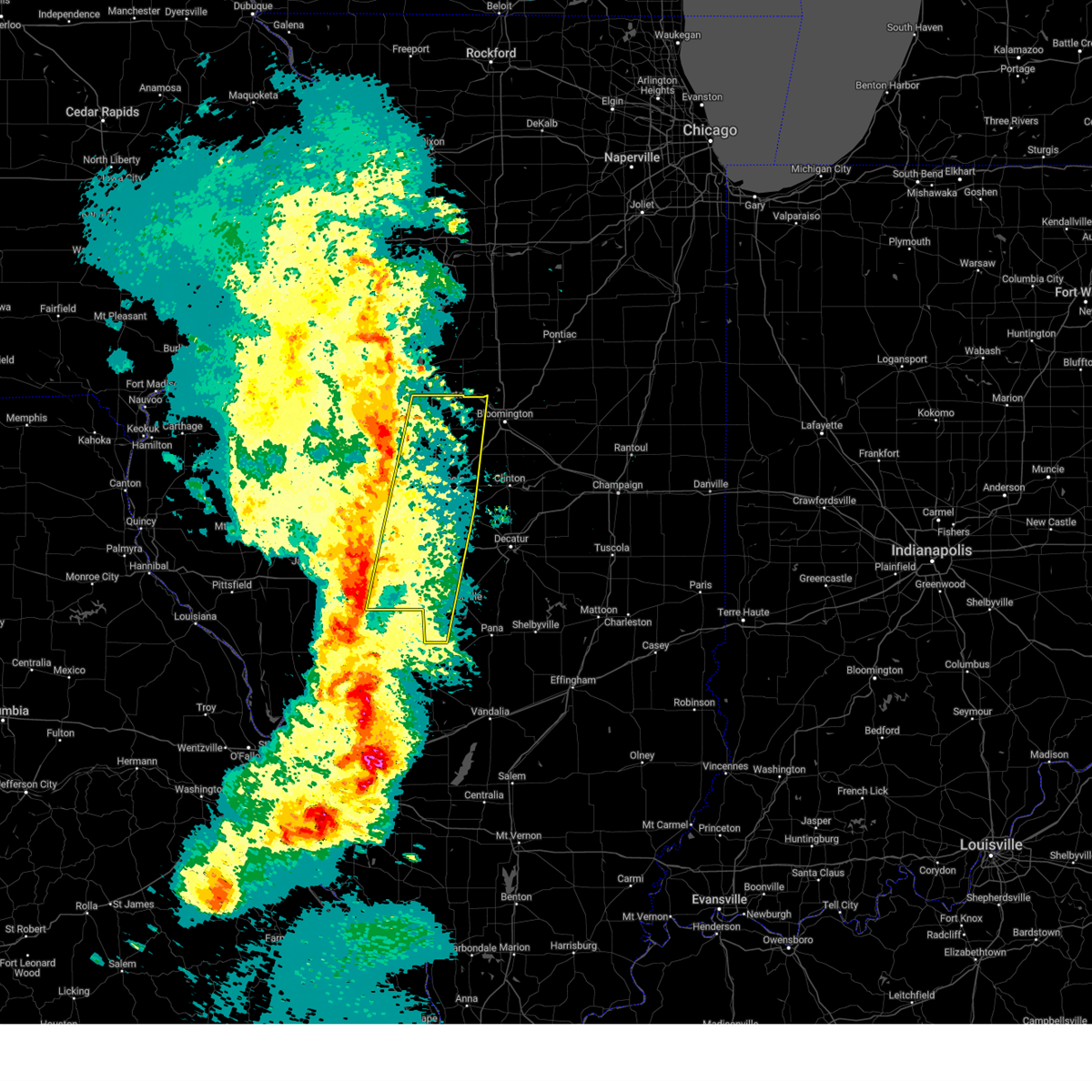
The Top Recent Hail Date for Lincoln, IL is Thursday, May 15, 2025 (9th out of 42)
Hail and Wind Damage Spotted near Lincoln, IL
| Date / Time | Report Details |
|---|---|
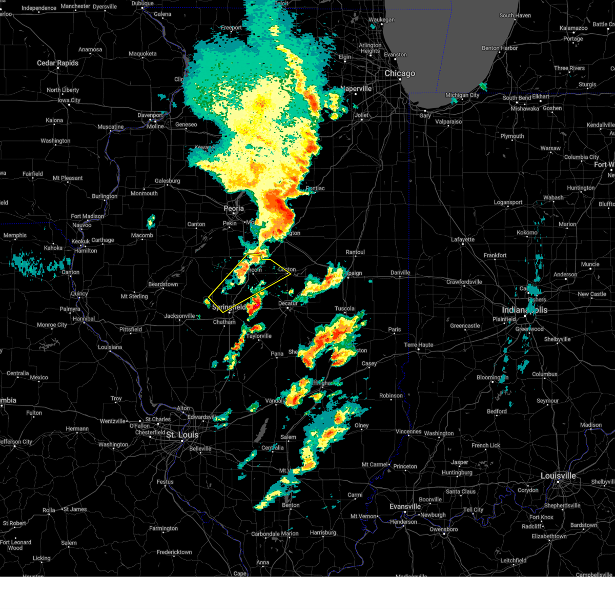
| 5/16/2025 3:24 PM CDT | Svrilx the national weather service in lincoln has issued a * severe thunderstorm warning for, southeastern logan county in central illinois, northeastern sangamon county in central illinois, western de witt county in central illinois, northern macon county in central illinois, * until 415 pm cdt. * at 324 pm cdt, a severe thunderstorm was located over dawson, or 12 miles northeast of springfield, moving northeast at 65 mph (trained weather spotters). Hazards include two inch hail and 60 mph wind gusts. People and animals outdoors will be injured. expect hail damage to roofs, siding, windows, and vehicles. expect wind damage to roofs, siding, and trees. this severe thunderstorm will be near, mount pulaski and cornland around 330 pm cdt. chestnut around 340 pm cdt. other locations in the path of this severe thunderstorm include kenney, beason, clinton and wapella. this includes the following highways, interstate 55 mile marker 103 and near mile marker 140. Interstate 72 between mile markers 108 and 116. |
| 5/15/2025 7:26 PM CDT |
 The storms which prompted the warning have weakened below severe limits, and have exited the warned area. therefore, the warning will be allowed to expire. however, small hail and gusty winds are still possible with these thunderstorms. a tornado watch remains in effect until 1000 pm cdt for central illinois. a severe thunderstorm warning remains in effect for southeast logan and southern de witt co unties. The storms which prompted the warning have weakened below severe limits, and have exited the warned area. therefore, the warning will be allowed to expire. however, small hail and gusty winds are still possible with these thunderstorms. a tornado watch remains in effect until 1000 pm cdt for central illinois. a severe thunderstorm warning remains in effect for southeast logan and southern de witt co unties.
|
| 5/15/2025 7:04 PM CDT |
 At 704 pm cdt, severe thunderstorms were located along a line extending from near waynesville to mount pulaski, moving east at 45 mph (trained weather spotters). Hazards include 70 mph wind gusts and quarter size hail. Hail damage to vehicles is expected. expect considerable tree damage. wind damage is also likely to mobile homes, roofs, and outbuildings. these severe storms will be near, heyworth, waynesville, kenney, chestnut, and beason around 710 pm cdt. clinton and wapella around 715 pm cdt. other locations impacted by these severe thunderstorms include lawndale, midland city, and hallsville. This includes interstate 55 between mile markers 128 and 141. At 704 pm cdt, severe thunderstorms were located along a line extending from near waynesville to mount pulaski, moving east at 45 mph (trained weather spotters). Hazards include 70 mph wind gusts and quarter size hail. Hail damage to vehicles is expected. expect considerable tree damage. wind damage is also likely to mobile homes, roofs, and outbuildings. these severe storms will be near, heyworth, waynesville, kenney, chestnut, and beason around 710 pm cdt. clinton and wapella around 715 pm cdt. other locations impacted by these severe thunderstorms include lawndale, midland city, and hallsville. This includes interstate 55 between mile markers 128 and 141.
|
| 5/15/2025 6:58 PM CDT |
 The storm which prompted the warning has moved out of the area. therefore, the warning will be allowed to expire. a tornado watch remains in effect until 1000 pm cdt for central illinois. to report severe weather, contact your nearest law enforcement agency. they will relay your report to the national weather service lincoln. a severe thunderstorm warning still remains in effect for logan county in areas near and east of i-55. The storm which prompted the warning has moved out of the area. therefore, the warning will be allowed to expire. a tornado watch remains in effect until 1000 pm cdt for central illinois. to report severe weather, contact your nearest law enforcement agency. they will relay your report to the national weather service lincoln. a severe thunderstorm warning still remains in effect for logan county in areas near and east of i-55.
|
| 5/15/2025 6:50 PM CDT | At 649 pm cdt, a severe thunderstorm was located over lincoln, moving northeast at 65 mph (trained weather spotters. at 648 pm, golf ball size hail was reported on the west side of lincoln, and quarter size hail was reported at the national weather service office just south of the airport). Hazards include golf ball size hail and 70 mph wind gusts. People and animals outdoors will be injured. expect hail damage to roofs, siding, windows, and vehicles. expect considerable tree damage. wind damage is also likely to mobile homes, roofs, and outbuildings. this severe storm will be near, beason around 655 pm cdt. waynesville around 700 pm cdt. heyworth around 705 pm cdt. wapella around 710 pm cdt. other locations impacted by this severe thunderstorm include lawndale, midland city, hallsville, and broadwell. this includes the following highways, interstate 155 near mile marker 0. Interstate 55 between mile markers 117 and 142. |
| 5/15/2025 6:49 PM CDT | Quarter sized hail reported 2.1 miles W of Lincoln, IL |
| 5/15/2025 6:48 PM CDT | Golf Ball sized hail reported 0.2 miles S of Lincoln, IL |
| 5/15/2025 6:48 PM CDT | Quarter sized hail reported 1.9 miles ESE of Lincoln, IL, report from mping: quarter (1.00 in.). |
| 5/15/2025 6:44 PM CDT |
 Svrilx the national weather service in lincoln has issued a * severe thunderstorm warning for, central logan county in central illinois, western de witt county in central illinois, southwestern mclean county in central illinois, * until 730 pm cdt. * at 642 pm cdt, a severe thunderstorm was located aobut 5 miles southwest of lincoln, moving northeast at 65 mph (trained weather spotters. at 640 pm, a 70 mph wind gust was estimated near hartsburg, and two semi trucks were blown over on i-155 at mile marker 3. hail up to ping pong size was also reported). Hazards include 70 mph wind gusts and ping pong ball size hail. People and animals outdoors will be injured. expect hail damage to roofs, siding, windows, and vehicles. expect considerable tree damage. wind damage is also likely to mobile homes, roofs, and outbuildings. this severe thunderstorm will be near, lincoln around 650 pm cdt. beason around 655 pm cdt. waynesville around 700 pm cdt. other locations in the path of this severe thunderstorm include heyworth and wapella. this includes the following highways, interstate 155 near mile marker 0. Interstate 55 between mile markers 117 and 142. Svrilx the national weather service in lincoln has issued a * severe thunderstorm warning for, central logan county in central illinois, western de witt county in central illinois, southwestern mclean county in central illinois, * until 730 pm cdt. * at 642 pm cdt, a severe thunderstorm was located aobut 5 miles southwest of lincoln, moving northeast at 65 mph (trained weather spotters. at 640 pm, a 70 mph wind gust was estimated near hartsburg, and two semi trucks were blown over on i-155 at mile marker 3. hail up to ping pong size was also reported). Hazards include 70 mph wind gusts and ping pong ball size hail. People and animals outdoors will be injured. expect hail damage to roofs, siding, windows, and vehicles. expect considerable tree damage. wind damage is also likely to mobile homes, roofs, and outbuildings. this severe thunderstorm will be near, lincoln around 650 pm cdt. beason around 655 pm cdt. waynesville around 700 pm cdt. other locations in the path of this severe thunderstorm include heyworth and wapella. this includes the following highways, interstate 155 near mile marker 0. Interstate 55 between mile markers 117 and 142.
|
| 5/15/2025 6:36 PM CDT |
 the severe thunderstorm warning has been cancelled and is no longer in effect the severe thunderstorm warning has been cancelled and is no longer in effect
|
| 5/15/2025 6:36 PM CDT |
 At 636 pm cdt, a severe thunderstorm was located over hartsburg, moving northeast at 45 mph (radar indicated). Hazards include 60 mph wind gusts and half dollar size hail. Hail damage to vehicles is expected. expect wind damage to roofs, siding, and trees. this severe storm will be near, hartsburg around 640 pm cdt. armington around 645 pm cdt. other locations impacted by this severe thunderstorm include lawndale. this includes the following highways, interstate 155 between mile markers 0 and 9. Interstate 55 between mile markers 124 and 136. At 636 pm cdt, a severe thunderstorm was located over hartsburg, moving northeast at 45 mph (radar indicated). Hazards include 60 mph wind gusts and half dollar size hail. Hail damage to vehicles is expected. expect wind damage to roofs, siding, and trees. this severe storm will be near, hartsburg around 640 pm cdt. armington around 645 pm cdt. other locations impacted by this severe thunderstorm include lawndale. this includes the following highways, interstate 155 between mile markers 0 and 9. Interstate 55 between mile markers 124 and 136.
|
| 5/15/2025 6:35 PM CDT | Report of two semi trucks blown over on i-155 near mile marker 3. report was relayed by emergency manager and time was estimated by rada in logan county IL, 5.8 miles SE of Lincoln, IL |
| 5/15/2025 6:23 PM CDT |
 Svrilx the national weather service in lincoln has issued a * severe thunderstorm warning for, northeastern menard county in central illinois, northwestern logan county in central illinois, southeastern tazewell county in central illinois, southeastern mason county in central illinois, * until 700 pm cdt. * at 623 pm cdt, a severe thunderstorm was located over middletown, moving northeast at 55 mph (radar indicated). Hazards include 60 mph wind gusts and half dollar size hail. Hail damage to vehicles is expected. expect wind damage to roofs, siding, and trees. this severe thunderstorm will be near, hartsburg around 630 pm cdt. other locations in the path of this severe thunderstorm include armington. this includes the following highways, interstate 155 between mile markers 0 and 9. Interstate 55 between mile markers 124 and 136. Svrilx the national weather service in lincoln has issued a * severe thunderstorm warning for, northeastern menard county in central illinois, northwestern logan county in central illinois, southeastern tazewell county in central illinois, southeastern mason county in central illinois, * until 700 pm cdt. * at 623 pm cdt, a severe thunderstorm was located over middletown, moving northeast at 55 mph (radar indicated). Hazards include 60 mph wind gusts and half dollar size hail. Hail damage to vehicles is expected. expect wind damage to roofs, siding, and trees. this severe thunderstorm will be near, hartsburg around 630 pm cdt. other locations in the path of this severe thunderstorm include armington. this includes the following highways, interstate 155 between mile markers 0 and 9. Interstate 55 between mile markers 124 and 136.
|
| 4/20/2025 8:59 PM CDT | The storms over logan county have weakened below severe limits, and no longer pose an immediate threat to life or property. a new severe thunderstorm warning has been issued for portions of tazewell and peoria counties. a tornado watch remains in effect until 1100 pm cdt for central illinois. remember, a severe thunderstorm warning still remains in effect for portions of tazewell and peoria counties until 9:30 pm!. |
| 4/20/2025 8:48 PM CDT |
 the severe thunderstorm warning has been cancelled and is no longer in effect the severe thunderstorm warning has been cancelled and is no longer in effect
|
| 4/20/2025 8:48 PM CDT |
 At 848 pm cdt, severe thunderstorms were located along a line extending from west peoria to near middletown, moving east at 50 mph (radar indicated). Hazards include 60 mph wind gusts and penny size hail. Expect damage to roofs, siding, and trees. these severe storms will be near, hartsburg, mackinaw, tremont, east peoria, morton, emden, hopedale, washington, and lincoln around 855 pm cdt. other locations impacted by these severe thunderstorms include north pekin, groveland, broadwell, and dillon. this includes the following highways, interstate 155 between mile markers 0 and 31. interstate 474 between mile markers 6 and 14. interstate 55 between mile markers 117 and 131. Interstate 74 between mile markers 94 and 108. At 848 pm cdt, severe thunderstorms were located along a line extending from west peoria to near middletown, moving east at 50 mph (radar indicated). Hazards include 60 mph wind gusts and penny size hail. Expect damage to roofs, siding, and trees. these severe storms will be near, hartsburg, mackinaw, tremont, east peoria, morton, emden, hopedale, washington, and lincoln around 855 pm cdt. other locations impacted by these severe thunderstorms include north pekin, groveland, broadwell, and dillon. this includes the following highways, interstate 155 between mile markers 0 and 31. interstate 474 between mile markers 6 and 14. interstate 55 between mile markers 117 and 131. Interstate 74 between mile markers 94 and 108.
|
| 4/20/2025 8:34 PM CDT | the severe thunderstorm warning has been cancelled and is no longer in effect |
| 4/20/2025 8:34 PM CDT | At 833 pm cdt, severe thunderstorms were located along a line extending from near mapleton to near abraham lincoln capital airport, moving east at 55 mph (radar indicated). Hazards include 60 mph wind gusts. Expect damage to roofs, siding, and trees. these severe storms will be near, williamsville, peoria, middletown, san jose, delavan, new holland, marquette heights, tremont, creve coeur, and east peoria around 840 pm cdt. hartsburg, cornland, hopedale, washington, and lincoln around 845 pm cdt. mackinaw and deer creek around 850 pm cdt. other locations impacted by these severe thunderstorms include spaulding, north pekin, dillon, powerton, cantrall, groveland, fancy prairie, broadwell, kingston mines, and sweetwater. this includes the following highways, interstate 155 between mile markers 0 and 31. interstate 474 between mile markers 6 and 14. interstate 55 between mile markers 102 and 131. Interstate 74 between mile markers 93 and 108. |
| 4/20/2025 8:25 PM CDT | Svrilx the national weather service in lincoln has issued a * severe thunderstorm warning for, menard county in central illinois, logan county in central illinois, northwestern christian county in central illinois, sangamon county in central illinois, tazewell county in central illinois, eastern mason county in central illinois, southeastern peoria county in central illinois, * until 900 pm cdt. * at 825 pm cdt, severe thunderstorms were located along a line extending from glasford to near virden, moving northeast at 55 mph (radar indicated). Hazards include 60 mph wind gusts. Expect damage to roofs, siding, and trees. severe thunderstorms will be near, mason city, greenview, south pekin, mapleton, bartonville, chatham, peoria international airport, manito, green valley, and pekin around 830 pm cdt. west peoria, peoria, middletown, bellevue, san jose, new holland, marquette heights, creve coeur, east peoria, and sherman around 835 pm cdt. williamsville, delavan, rochester, and riverton around 840 pm cdt. tremont, morton, elkhart, emden, and washington around 845 pm cdt. other locations in the path of these severe thunderstorms include dawson, hartsburg, cornland, buffalo, hopedale, lincoln and mechanicsburg. this includes the following highways, interstate 155 between mile markers 0 and 31. interstate 474 between mile markers 6 and 14. interstate 55 between mile markers 77 and 131. interstate 72 between mile markers 86 and 119. Interstate 74 between mile markers 92 and 108. |
| 4/2/2025 3:26 PM CDT |
 Svrilx the national weather service in lincoln has issued a * severe thunderstorm warning for, northern logan county in central illinois, northwestern de witt county in central illinois, southeastern tazewell county in central illinois, southwestern mclean county in central illinois, * until 400 pm cdt. * at 325 pm cdt, severe thunderstorms were located along a line extending from atlanta to near lincoln, moving northeast at 55 mph (radar indicated). Hazards include 60 mph wind gusts and quarter size hail. Hail damage to vehicles is expected. expect wind damage to roofs, siding, and trees. severe thunderstorms will be near, atlanta, mclean, and lincoln around 330 pm cdt. bloomington around 340 pm cdt. waynesville around 345 pm cdt. this includes the following highways, interstate 155 between mile markers 0 and 9. interstate 55 between mile markers 119 and 157. Interstate 74 between mile markers 133 and 135. Svrilx the national weather service in lincoln has issued a * severe thunderstorm warning for, northern logan county in central illinois, northwestern de witt county in central illinois, southeastern tazewell county in central illinois, southwestern mclean county in central illinois, * until 400 pm cdt. * at 325 pm cdt, severe thunderstorms were located along a line extending from atlanta to near lincoln, moving northeast at 55 mph (radar indicated). Hazards include 60 mph wind gusts and quarter size hail. Hail damage to vehicles is expected. expect wind damage to roofs, siding, and trees. severe thunderstorms will be near, atlanta, mclean, and lincoln around 330 pm cdt. bloomington around 340 pm cdt. waynesville around 345 pm cdt. this includes the following highways, interstate 155 between mile markers 0 and 9. interstate 55 between mile markers 119 and 157. Interstate 74 between mile markers 133 and 135.
|
| 4/2/2025 10:27 AM CDT | Semi blown over at exit 133 on i-5 in logan county IL, 2.6 miles SW of Lincoln, IL |
| 4/2/2025 10:26 AM CDT | 2 powerlines down in lincol in logan county IL, 1 miles WSW of Lincoln, IL |
| 4/2/2025 10:26 AM CDT | Roof ripped off eaton manufacturing buildin in logan county IL, 1.7 miles SSW of Lincoln, IL |
| 4/2/2025 10:25 AM CDT | Large tree branch down and in the roa in logan county IL, 1.1 miles SSE of Lincoln, IL |
| 4/2/2025 10:24 AM CDT |
 Svrilx the national weather service in lincoln has issued a * severe thunderstorm warning for, central logan county in central illinois, de witt county in central illinois, southeastern tazewell county in central illinois, southwestern mclean county in central illinois, * until 1100 am cdt. * at 1023 am cdt, severe thunderstorms were located along a line extending from near hartsburg to near lincoln, moving east at 45 mph (radar indicated). Hazards include 70 mph wind gusts. Expect considerable tree damage. damage is likely to mobile homes, roofs, and outbuildings. severe thunderstorms will be near, atlanta, armington, and lincoln around 1030 am cdt. beason and mclean around 1035 am cdt. waynesville around 1040 am cdt. other locations in the path of these severe thunderstorms include heyworth. this includes the following highways, interstate 155 between mile markers 0 and 13. interstate 55 between mile markers 118 and 152. Interstate 74 between mile markers 140 and 155. Svrilx the national weather service in lincoln has issued a * severe thunderstorm warning for, central logan county in central illinois, de witt county in central illinois, southeastern tazewell county in central illinois, southwestern mclean county in central illinois, * until 1100 am cdt. * at 1023 am cdt, severe thunderstorms were located along a line extending from near hartsburg to near lincoln, moving east at 45 mph (radar indicated). Hazards include 70 mph wind gusts. Expect considerable tree damage. damage is likely to mobile homes, roofs, and outbuildings. severe thunderstorms will be near, atlanta, armington, and lincoln around 1030 am cdt. beason and mclean around 1035 am cdt. waynesville around 1040 am cdt. other locations in the path of these severe thunderstorms include heyworth. this includes the following highways, interstate 155 between mile markers 0 and 13. interstate 55 between mile markers 118 and 152. Interstate 74 between mile markers 140 and 155.
|
| 3/19/2025 4:18 PM CDT |
 the severe thunderstorm warning has been cancelled and is no longer in effect the severe thunderstorm warning has been cancelled and is no longer in effect
|
| 3/19/2025 3:43 PM CDT |
 Svrilx the national weather service in lincoln has issued a * severe thunderstorm warning for, eastern menard county in central illinois, logan county in central illinois, north central sangamon county in central illinois, southwestern de witt county in central illinois, southeastern mason county in central illinois, * until 430 pm cdt. * at 343 pm cdt, a severe thunderstorm was located over athens, moving northeast at 55 mph (radar indicated). Hazards include 70 mph wind gusts and quarter size hail. Hail damage to vehicles is expected. expect considerable tree damage. wind damage is also likely to mobile homes, roofs, and outbuildings. this severe thunderstorm will be near, williamsville around 350 pm cdt. middletown and elkhart around 355 pm cdt. lincoln around 400 pm cdt. other locations in the path of this severe thunderstorm include atlanta. this includes the following highways, interstate 155 between mile markers 0 and 10. Interstate 55 between mile markers 102 and 141. Svrilx the national weather service in lincoln has issued a * severe thunderstorm warning for, eastern menard county in central illinois, logan county in central illinois, north central sangamon county in central illinois, southwestern de witt county in central illinois, southeastern mason county in central illinois, * until 430 pm cdt. * at 343 pm cdt, a severe thunderstorm was located over athens, moving northeast at 55 mph (radar indicated). Hazards include 70 mph wind gusts and quarter size hail. Hail damage to vehicles is expected. expect considerable tree damage. wind damage is also likely to mobile homes, roofs, and outbuildings. this severe thunderstorm will be near, williamsville around 350 pm cdt. middletown and elkhart around 355 pm cdt. lincoln around 400 pm cdt. other locations in the path of this severe thunderstorm include atlanta. this includes the following highways, interstate 155 between mile markers 0 and 10. Interstate 55 between mile markers 102 and 141.
|
| 3/14/2025 10:04 PM CDT |
 Svrilx the national weather service in lincoln has issued a * severe thunderstorm warning for, eastern menard county in central illinois, logan county in central illinois, western christian county in central illinois, sangamon county in central illinois, tazewell county in central illinois, southwestern mclean county in central illinois, east central mason county in central illinois, * until 1100 pm cdt. * at 1004 pm cdt, severe thunderstorms were located along a line extending from near manito to near greenview to near waverly, moving northeast at 60 mph (radar indicated). Hazards include 70 mph wind gusts. Expect considerable tree damage. damage is likely to mobile homes, roofs, and outbuildings. severe thunderstorms will be near, mason city, middletown, san jose, delavan, new holland, chatham, green valley, pekin, sherman, and springfield around 1010 pm cdt. williamsville, hartsburg, tremont, morton, elkhart, emden, hopedale, and riverton around 1015 pm cdt. mackinaw, rochester, and lincoln around 1020 pm cdt. other locations in the path of these severe thunderstorms include dawson, minier, buffalo, cornland, armington, mechanicsburg, mount pulaski, atlanta, stanford, danvers, beason, mclean, illiopolis and carlock. this includes the following highways, interstate 155 between mile markers 0 and 31. interstate 55 between mile markers 77 and 145. interstate 72 between mile markers 87 and 122. Interstate 74 between mile markers 119 and 121. Svrilx the national weather service in lincoln has issued a * severe thunderstorm warning for, eastern menard county in central illinois, logan county in central illinois, western christian county in central illinois, sangamon county in central illinois, tazewell county in central illinois, southwestern mclean county in central illinois, east central mason county in central illinois, * until 1100 pm cdt. * at 1004 pm cdt, severe thunderstorms were located along a line extending from near manito to near greenview to near waverly, moving northeast at 60 mph (radar indicated). Hazards include 70 mph wind gusts. Expect considerable tree damage. damage is likely to mobile homes, roofs, and outbuildings. severe thunderstorms will be near, mason city, middletown, san jose, delavan, new holland, chatham, green valley, pekin, sherman, and springfield around 1010 pm cdt. williamsville, hartsburg, tremont, morton, elkhart, emden, hopedale, and riverton around 1015 pm cdt. mackinaw, rochester, and lincoln around 1020 pm cdt. other locations in the path of these severe thunderstorms include dawson, minier, buffalo, cornland, armington, mechanicsburg, mount pulaski, atlanta, stanford, danvers, beason, mclean, illiopolis and carlock. this includes the following highways, interstate 155 between mile markers 0 and 31. interstate 55 between mile markers 77 and 145. interstate 72 between mile markers 87 and 122. Interstate 74 between mile markers 119 and 121.
|
| 8/1/2024 3:49 AM CDT |
 The storms which prompted the warning have moved out of the area. therefore, the warning has been allowed to expire. The storms which prompted the warning have moved out of the area. therefore, the warning has been allowed to expire.
|
| 8/1/2024 3:30 AM CDT |
 At 330 am cdt, severe thunderstorms were located along a line extending from near delavan to near abraham lincoln capital airport, moving east at 40 mph (radar indicated). Hazards include 60 mph wind gusts and quarter size hail. Hail damage to vehicles is expected. expect wind damage to roofs, siding, and trees. these severe storms will be near, springfield, sherman, williamsville, emden, middletown, hartsburg, new holland, abraham lincoln capital airport, and illinois state fairgrounds around 335 am cdt. lincoln, riverton, elkhart, and armington around 340 am cdt. dawson and cornland around 350 am cdt. buffalo around 355 am cdt. other locations impacted by these severe thunderstorms include salisbury, spaulding, clear lake, grandview, cantrall, fancy prairie, broadwell, leland grove, sweetwater, and lawndale. this includes the following highways, interstate 155 between mile markers 0 and 14. interstate 55 between mile markers 96 and 134. Interstate 72 between mile markers 102 and 114. At 330 am cdt, severe thunderstorms were located along a line extending from near delavan to near abraham lincoln capital airport, moving east at 40 mph (radar indicated). Hazards include 60 mph wind gusts and quarter size hail. Hail damage to vehicles is expected. expect wind damage to roofs, siding, and trees. these severe storms will be near, springfield, sherman, williamsville, emden, middletown, hartsburg, new holland, abraham lincoln capital airport, and illinois state fairgrounds around 335 am cdt. lincoln, riverton, elkhart, and armington around 340 am cdt. dawson and cornland around 350 am cdt. buffalo around 355 am cdt. other locations impacted by these severe thunderstorms include salisbury, spaulding, clear lake, grandview, cantrall, fancy prairie, broadwell, leland grove, sweetwater, and lawndale. this includes the following highways, interstate 155 between mile markers 0 and 14. interstate 55 between mile markers 96 and 134. Interstate 72 between mile markers 102 and 114.
|
| 8/1/2024 3:07 AM CDT |
 Svrilx the national weather service in lincoln has issued a * severe thunderstorm warning for, menard county in central illinois, logan county in central illinois, northwestern sangamon county in central illinois, southeastern tazewell county in central illinois, southeastern mason county in central illinois, * until 345 am cdt. * at 306 am cdt, severe thunderstorms were located along a line extending from 6 miles northeast of easton to near ashland, moving east at 40 mph (radar indicated). Hazards include 60 mph wind gusts and quarter size hail. Hail damage to vehicles is expected. expect wind damage to roofs, siding, and trees. severe thunderstorms will be near, mason city, petersburg, pleasant plains, and greenview around 310 am cdt. athens and san jose around 315 am cdt. delavan and new holland around 320 am cdt. springfield, emden, middletown, and abraham lincoln capital airport around 325 am cdt. other locations in the path of these severe thunderstorms include sherman, hartsburg, illinois state fairgrounds, williamsville and elkhart. this includes the following highways, interstate 155 between mile markers 0 and 14. interstate 55 between mile markers 96 and 134. Interstate 72 between mile markers 102 and 114. Svrilx the national weather service in lincoln has issued a * severe thunderstorm warning for, menard county in central illinois, logan county in central illinois, northwestern sangamon county in central illinois, southeastern tazewell county in central illinois, southeastern mason county in central illinois, * until 345 am cdt. * at 306 am cdt, severe thunderstorms were located along a line extending from 6 miles northeast of easton to near ashland, moving east at 40 mph (radar indicated). Hazards include 60 mph wind gusts and quarter size hail. Hail damage to vehicles is expected. expect wind damage to roofs, siding, and trees. severe thunderstorms will be near, mason city, petersburg, pleasant plains, and greenview around 310 am cdt. athens and san jose around 315 am cdt. delavan and new holland around 320 am cdt. springfield, emden, middletown, and abraham lincoln capital airport around 325 am cdt. other locations in the path of these severe thunderstorms include sherman, hartsburg, illinois state fairgrounds, williamsville and elkhart. this includes the following highways, interstate 155 between mile markers 0 and 14. interstate 55 between mile markers 96 and 134. Interstate 72 between mile markers 102 and 114.
|
| 7/31/2024 8:04 AM CDT |
 the severe thunderstorm warning has been cancelled and is no longer in effect the severe thunderstorm warning has been cancelled and is no longer in effect
|
| 7/31/2024 7:53 AM CDT |
 the severe thunderstorm warning has been cancelled and is no longer in effect the severe thunderstorm warning has been cancelled and is no longer in effect
|
| 7/31/2024 7:53 AM CDT |
 At 752 am cdt, a severe thunderstorm was located near beason, or 5 miles east of lincoln, moving east at 55 mph (radar indicated). Hazards include 60 mph wind gusts. Expect damage to roofs, siding, and trees. this severe storm will be near, beason around 800 am cdt. other locations impacted by this severe thunderstorm include broadwell and lawndale. this includes the following highways, interstate 155 between mile markers 0 and 6. Interstate 55 between mile markers 118 and 139. At 752 am cdt, a severe thunderstorm was located near beason, or 5 miles east of lincoln, moving east at 55 mph (radar indicated). Hazards include 60 mph wind gusts. Expect damage to roofs, siding, and trees. this severe storm will be near, beason around 800 am cdt. other locations impacted by this severe thunderstorm include broadwell and lawndale. this includes the following highways, interstate 155 between mile markers 0 and 6. Interstate 55 between mile markers 118 and 139.
|
| 7/31/2024 7:48 AM CDT | Delayed report. 14 in tree limb down on power lines. neighborhood lost power for a couple hours... but restored no in logan county IL, 2.3 miles WSW of Lincoln, IL |
| 7/31/2024 7:46 AM CDT |
 At 745 am cdt, a severe thunderstorm was located over lincoln, moving east at 60 mph (radar indicated). Hazards include 60 mph wind gusts. Expect damage to roofs, siding, and trees. this severe storm will be near, lincoln around 750 am cdt. beason around 755 am cdt. other locations impacted by this severe thunderstorm include broadwell and lawndale. this includes the following highways, interstate 155 between mile markers 0 and 7. Interstate 55 between mile markers 118 and 139. At 745 am cdt, a severe thunderstorm was located over lincoln, moving east at 60 mph (radar indicated). Hazards include 60 mph wind gusts. Expect damage to roofs, siding, and trees. this severe storm will be near, lincoln around 750 am cdt. beason around 755 am cdt. other locations impacted by this severe thunderstorm include broadwell and lawndale. this includes the following highways, interstate 155 between mile markers 0 and 7. Interstate 55 between mile markers 118 and 139.
|
| 7/31/2024 7:29 AM CDT |
 Svrilx the national weather service in lincoln has issued a * severe thunderstorm warning for, central menard county in central illinois, logan county in central illinois, southeastern mason county in central illinois, * until 815 am cdt. * at 728 am cdt, a severe thunderstorm was located near greenview, or 7 miles southwest of mason city, moving east at 55 mph (radar indicated). Hazards include 60 mph wind gusts. Expect damage to roofs, siding, and trees. this severe thunderstorm will be near, greenview and middletown around 735 am cdt. other locations in the path of this severe thunderstorm include mount pulaski and chestnut. this includes the following highways, interstate 155 between mile markers 0 and 7. Interstate 55 between mile markers 112 and 139. Svrilx the national weather service in lincoln has issued a * severe thunderstorm warning for, central menard county in central illinois, logan county in central illinois, southeastern mason county in central illinois, * until 815 am cdt. * at 728 am cdt, a severe thunderstorm was located near greenview, or 7 miles southwest of mason city, moving east at 55 mph (radar indicated). Hazards include 60 mph wind gusts. Expect damage to roofs, siding, and trees. this severe thunderstorm will be near, greenview and middletown around 735 am cdt. other locations in the path of this severe thunderstorm include mount pulaski and chestnut. this includes the following highways, interstate 155 between mile markers 0 and 7. Interstate 55 between mile markers 112 and 139.
|
| 7/15/2024 9:03 PM CDT |
 At 902 pm cdt, severe thunderstorms were located along a line extending from near flanagan to near danvers to near san jose, moving southeast at 55 mph. these are destructive storms (trained weather spotters and law enforcement have reported wind gusts of 70-80+ mph). Hazards include 80 mph wind gusts and penny size hail. Flying debris will be dangerous to those caught without shelter. mobile homes will be heavily damaged. expect considerable damage to roofs, windows, and vehicles. extensive tree damage and power outages are likely. these severe storms will be near, bloomington, normal, lincoln, hudson, gridley, danvers, stanford, armington, and hartsburg around 910 pm cdt. atlanta, mclean, and towanda around 915 pm cdt. heyworth and waynesville around 920 pm cdt. other locations impacted by these severe thunderstorms include lawndale, north pekin, kappa, banner, dillon, powerton, panola, cazenovia, low point, and groveland. this includes the following highways, interstate 155 between mile markers 0 and 31. interstate 39 between mile markers 0 and 40. interstate 474 between mile markers 6 and 14. interstate 55 between mile markers 123 and 172. Interstate 74 between mile markers 91 and 139. At 902 pm cdt, severe thunderstorms were located along a line extending from near flanagan to near danvers to near san jose, moving southeast at 55 mph. these are destructive storms (trained weather spotters and law enforcement have reported wind gusts of 70-80+ mph). Hazards include 80 mph wind gusts and penny size hail. Flying debris will be dangerous to those caught without shelter. mobile homes will be heavily damaged. expect considerable damage to roofs, windows, and vehicles. extensive tree damage and power outages are likely. these severe storms will be near, bloomington, normal, lincoln, hudson, gridley, danvers, stanford, armington, and hartsburg around 910 pm cdt. atlanta, mclean, and towanda around 915 pm cdt. heyworth and waynesville around 920 pm cdt. other locations impacted by these severe thunderstorms include lawndale, north pekin, kappa, banner, dillon, powerton, panola, cazenovia, low point, and groveland. this includes the following highways, interstate 155 between mile markers 0 and 31. interstate 39 between mile markers 0 and 40. interstate 474 between mile markers 6 and 14. interstate 55 between mile markers 123 and 172. Interstate 74 between mile markers 91 and 139.
|
| 7/15/2024 9:03 PM CDT |
 the severe thunderstorm warning has been cancelled and is no longer in effect the severe thunderstorm warning has been cancelled and is no longer in effect
|
| 7/15/2024 8:51 PM CDT |
 At 850 pm cdt, severe thunderstorms were located along a line extending from near minonk to deer creek to near green valley, moving southeast at 60 mph (trained weather spotters reported 70 mph wind gusts near henry, illinois in marshall county). Hazards include 70 mph wind gusts and penny size hail. Expect considerable tree damage. damage is likely to mobile homes, roofs, and outbuildings. these severe storms will be near, el paso, minonk, mackinaw, delavan, minier, hopedale, goodfield, san jose, emden, and congerville around 855 pm cdt. hudson, gridley, danvers, stanford, carlock, armington, and hartsburg around 900 pm cdt. bloomington, normal, lincoln, atlanta, and mclean around 905 pm cdt. towanda and waynesville around 910 pm cdt. heyworth around 915 pm cdt. other locations impacted by these severe thunderstorms include lawndale, smithville, dillon, powerton, panola, norwood, kickapoo, la rose, peoria heights, and shirley. this includes the following highways, interstate 155 between mile markers 0 and 31. interstate 39 between mile markers 0 and 40. interstate 474 between mile markers 0 and 14. interstate 55 between mile markers 123 and 172. Interstate 74 between mile markers 77 and 139. At 850 pm cdt, severe thunderstorms were located along a line extending from near minonk to deer creek to near green valley, moving southeast at 60 mph (trained weather spotters reported 70 mph wind gusts near henry, illinois in marshall county). Hazards include 70 mph wind gusts and penny size hail. Expect considerable tree damage. damage is likely to mobile homes, roofs, and outbuildings. these severe storms will be near, el paso, minonk, mackinaw, delavan, minier, hopedale, goodfield, san jose, emden, and congerville around 855 pm cdt. hudson, gridley, danvers, stanford, carlock, armington, and hartsburg around 900 pm cdt. bloomington, normal, lincoln, atlanta, and mclean around 905 pm cdt. towanda and waynesville around 910 pm cdt. heyworth around 915 pm cdt. other locations impacted by these severe thunderstorms include lawndale, smithville, dillon, powerton, panola, norwood, kickapoo, la rose, peoria heights, and shirley. this includes the following highways, interstate 155 between mile markers 0 and 31. interstate 39 between mile markers 0 and 40. interstate 474 between mile markers 0 and 14. interstate 55 between mile markers 123 and 172. Interstate 74 between mile markers 77 and 139.
|
| 7/15/2024 8:27 PM CDT |
 Svrilx the national weather service in lincoln has issued a * severe thunderstorm warning for, marshall county in central illinois, northern logan county in central illinois, woodford county in central illinois, northeastern fulton county in west central illinois, stark county in north central illinois, southeastern knox county in west central illinois, northwestern de witt county in central illinois, tazewell county in central illinois, western mclean county in central illinois, northeastern mason county in central illinois, peoria county in central illinois, * until 930 pm cdt. * at 827 pm cdt, severe thunderstorms were located along a line extending from near camp grove to near dunlap to near canton, moving southeast at 55 mph (radar indicated). Hazards include 70 mph wind gusts and penny size hail. Expect considerable tree damage. damage is likely to mobile homes, roofs, and outbuildings. severe thunderstorms will be near, peoria, chillicothe, bartonville, west peoria, bellevue, rome, hanna city, glasford, spring bay, and sparland around 830 pm cdt. pekin, east peoria, lacon, washington, creve coeur, germantown hills, marquette heights, manito, and mapleton around 835 pm cdt. morton, metamora, and south pekin around 840 pm cdt. tremont, washburn, green valley, and deer creek around 845 pm cdt. other locations in the path of these severe thunderstorms include eureka, mackinaw, delavan, goodfield, san jose, roanoke, hopedale, emden, congerville, minier, danvers, stanford, carlock, benson, secor, hartsburg, el paso and armington. this includes the following highways, interstate 155 between mile markers 0 and 31. interstate 39 between mile markers 0 and 40. interstate 474 between mile markers 0 and 14. interstate 55 between mile markers 123 and 172. Interstate 74 between mile markers 64 and 139. Svrilx the national weather service in lincoln has issued a * severe thunderstorm warning for, marshall county in central illinois, northern logan county in central illinois, woodford county in central illinois, northeastern fulton county in west central illinois, stark county in north central illinois, southeastern knox county in west central illinois, northwestern de witt county in central illinois, tazewell county in central illinois, western mclean county in central illinois, northeastern mason county in central illinois, peoria county in central illinois, * until 930 pm cdt. * at 827 pm cdt, severe thunderstorms were located along a line extending from near camp grove to near dunlap to near canton, moving southeast at 55 mph (radar indicated). Hazards include 70 mph wind gusts and penny size hail. Expect considerable tree damage. damage is likely to mobile homes, roofs, and outbuildings. severe thunderstorms will be near, peoria, chillicothe, bartonville, west peoria, bellevue, rome, hanna city, glasford, spring bay, and sparland around 830 pm cdt. pekin, east peoria, lacon, washington, creve coeur, germantown hills, marquette heights, manito, and mapleton around 835 pm cdt. morton, metamora, and south pekin around 840 pm cdt. tremont, washburn, green valley, and deer creek around 845 pm cdt. other locations in the path of these severe thunderstorms include eureka, mackinaw, delavan, goodfield, san jose, roanoke, hopedale, emden, congerville, minier, danvers, stanford, carlock, benson, secor, hartsburg, el paso and armington. this includes the following highways, interstate 155 between mile markers 0 and 31. interstate 39 between mile markers 0 and 40. interstate 474 between mile markers 0 and 14. interstate 55 between mile markers 123 and 172. Interstate 74 between mile markers 64 and 139.
|
| 4/18/2024 7:20 PM CDT |
 At 719 pm cdt, severe thunderstorms were located along a line extending from near beason to near mount auburn, moving east at 45 mph (radar indicated). Hazards include 60 mph wind gusts. Expect damage to roofs, siding, and trees. these severe storms will be near, illiopolis, niantic, mount auburn, latham, kenney, chestnut, and beason around 725 pm cdt. harristown and warrensburg around 730 pm cdt. other locations impacted by these severe thunderstorms include midland city and hallsville. This includes interstate 72 between mile markers 114 and 132. At 719 pm cdt, severe thunderstorms were located along a line extending from near beason to near mount auburn, moving east at 45 mph (radar indicated). Hazards include 60 mph wind gusts. Expect damage to roofs, siding, and trees. these severe storms will be near, illiopolis, niantic, mount auburn, latham, kenney, chestnut, and beason around 725 pm cdt. harristown and warrensburg around 730 pm cdt. other locations impacted by these severe thunderstorms include midland city and hallsville. This includes interstate 72 between mile markers 114 and 132.
|
| 4/18/2024 7:05 PM CDT |
 Svrilx the national weather service in lincoln has issued a * severe thunderstorm warning for, southern logan county in central illinois, northern christian county in central illinois, northeastern sangamon county in central illinois, western de witt county in central illinois, western macon county in central illinois, * until 745 pm cdt. * at 705 pm cdt, severe thunderstorms were located along a line extending from near elkhart to near rochester, moving east at 45 mph (radar indicated). Hazards include 60 mph wind gusts. Expect damage to roofs, siding, and trees. severe thunderstorms will be near, lincoln, mount pulaski, mechanicsburg, buffalo, and cornland around 710 pm cdt. illiopolis and mount auburn around 715 pm cdt. latham, chestnut, and beason around 720 pm cdt. niantic and kenney around 725 pm cdt. other locations in the path of these severe thunderstorms include harristown and warrensburg. this includes the following highways, interstate 55 between mile markers 113 and 124. Interstate 72 between mile markers 108 and 132. Svrilx the national weather service in lincoln has issued a * severe thunderstorm warning for, southern logan county in central illinois, northern christian county in central illinois, northeastern sangamon county in central illinois, western de witt county in central illinois, western macon county in central illinois, * until 745 pm cdt. * at 705 pm cdt, severe thunderstorms were located along a line extending from near elkhart to near rochester, moving east at 45 mph (radar indicated). Hazards include 60 mph wind gusts. Expect damage to roofs, siding, and trees. severe thunderstorms will be near, lincoln, mount pulaski, mechanicsburg, buffalo, and cornland around 710 pm cdt. illiopolis and mount auburn around 715 pm cdt. latham, chestnut, and beason around 720 pm cdt. niantic and kenney around 725 pm cdt. other locations in the path of these severe thunderstorms include harristown and warrensburg. this includes the following highways, interstate 55 between mile markers 113 and 124. Interstate 72 between mile markers 108 and 132.
|
| 3/31/2024 7:25 PM CDT | Half Dollar sized hail reported 6.7 miles NNW of Lincoln, IL, report from mping: half dollar (1.25 in.). |
| 3/31/2024 7:18 PM CDT |
 At 718 pm cdt, a severe thunderstorm was located over mount pulaski, or 10 miles south of lincoln, moving east at 40 mph (emergency management). Hazards include ping pong ball size hail and 60 mph wind gusts. People and animals outdoors will be injured. expect hail damage to roofs, siding, windows, and vehicles. expect wind damage to roofs, siding, and trees. this severe storm will be near, latham around 725 pm cdt. other locations impacted by this severe thunderstorm include broadwell. This includes interstate 55 between mile markers 116 and 124. At 718 pm cdt, a severe thunderstorm was located over mount pulaski, or 10 miles south of lincoln, moving east at 40 mph (emergency management). Hazards include ping pong ball size hail and 60 mph wind gusts. People and animals outdoors will be injured. expect hail damage to roofs, siding, windows, and vehicles. expect wind damage to roofs, siding, and trees. this severe storm will be near, latham around 725 pm cdt. other locations impacted by this severe thunderstorm include broadwell. This includes interstate 55 between mile markers 116 and 124.
|
| 3/31/2024 7:15 PM CDT | Quarter sized hail reported 1 miles WSW of Lincoln, IL, quarter size hail on west side of lincoln. |
| 3/31/2024 7:04 PM CDT |
 At 703 pm cdt, a severe thunderstorm was located over elkhart, or 8 miles southwest of lincoln, moving east at 40 mph (emergency management). Hazards include golf ball size hail and 60 mph wind gusts. People and animals outdoors will be injured. expect hail damage to roofs, siding, windows, and vehicles. expect wind damage to roofs, siding, and trees. this severe storm will be near, mount pulaski around 715 pm cdt. latham around 725 pm cdt. other locations impacted by this severe thunderstorm include lawndale and broadwell. this includes the following highways, interstate 155 between mile markers 0 and 3. Interstate 55 between mile markers 111 and 141. At 703 pm cdt, a severe thunderstorm was located over elkhart, or 8 miles southwest of lincoln, moving east at 40 mph (emergency management). Hazards include golf ball size hail and 60 mph wind gusts. People and animals outdoors will be injured. expect hail damage to roofs, siding, windows, and vehicles. expect wind damage to roofs, siding, and trees. this severe storm will be near, mount pulaski around 715 pm cdt. latham around 725 pm cdt. other locations impacted by this severe thunderstorm include lawndale and broadwell. this includes the following highways, interstate 155 between mile markers 0 and 3. Interstate 55 between mile markers 111 and 141.
|
| 3/31/2024 6:58 PM CDT |
 At 657 pm cdt, a severe thunderstorm was located over middletown, or 10 miles southeast of mason city, moving east at 40 mph (emergency management). Hazards include golf ball size hail and 60 mph wind gusts. People and animals outdoors will be injured. expect hail damage to roofs, siding, windows, and vehicles. expect wind damage to roofs, siding, and trees. this severe storm will be near, elkhart around 705 pm cdt. mount pulaski around 715 pm cdt. latham around 725 pm cdt. other locations impacted by this severe thunderstorm include lawndale and broadwell. this includes the following highways, interstate 155 between mile markers 0 and 10. Interstate 55 between mile markers 111 and 141. At 657 pm cdt, a severe thunderstorm was located over middletown, or 10 miles southeast of mason city, moving east at 40 mph (emergency management). Hazards include golf ball size hail and 60 mph wind gusts. People and animals outdoors will be injured. expect hail damage to roofs, siding, windows, and vehicles. expect wind damage to roofs, siding, and trees. this severe storm will be near, elkhart around 705 pm cdt. mount pulaski around 715 pm cdt. latham around 725 pm cdt. other locations impacted by this severe thunderstorm include lawndale and broadwell. this includes the following highways, interstate 155 between mile markers 0 and 10. Interstate 55 between mile markers 111 and 141.
|
| 3/31/2024 6:47 PM CDT |
 Svrilx the national weather service in lincoln has issued a * severe thunderstorm warning for, logan county in central illinois, * until 745 pm cdt. * at 646 pm cdt, a severe thunderstorm was located near greenview, or near mason city, moving east at 40 mph (radar indicated). Hazards include 60 mph wind gusts and half dollar size hail. Hail damage to vehicles is expected. expect wind damage to roofs, siding, and trees. this severe thunderstorm will be near, middletown around 650 pm cdt. elkhart around 700 pm cdt. other locations in the path of this severe thunderstorm include mount pulaski and latham. this includes the following highways, interstate 155 between mile markers 0 and 10. Interstate 55 between mile markers 111 and 141. Svrilx the national weather service in lincoln has issued a * severe thunderstorm warning for, logan county in central illinois, * until 745 pm cdt. * at 646 pm cdt, a severe thunderstorm was located near greenview, or near mason city, moving east at 40 mph (radar indicated). Hazards include 60 mph wind gusts and half dollar size hail. Hail damage to vehicles is expected. expect wind damage to roofs, siding, and trees. this severe thunderstorm will be near, middletown around 650 pm cdt. elkhart around 700 pm cdt. other locations in the path of this severe thunderstorm include mount pulaski and latham. this includes the following highways, interstate 155 between mile markers 0 and 10. Interstate 55 between mile markers 111 and 141.
|
| 8/25/2023 8:10 PM CDT |
 At 810 pm cdt, a severe thunderstorm was located over mount pulaski, or 10 miles south of lincoln, moving southeast at 45 mph (radar indicated). Hazards include 60 mph wind gusts and quarter size hail. Hail damage to vehicles is expected. expect wind damage to roofs, siding, and trees. this severe thunderstorm will be near, chestnut around 815 pm cdt. illiopolis and latham around 820 pm cdt. niantic around 825 pm cdt. harristown and warrensburg around 830 pm cdt. other locations in the path of this severe thunderstorm include decatur, forsyth, mount zion and long creek. this includes the following highways, interstate 55 between mile markers 106 and 124, and between mile markers 129 and 131. interstate 72 between mile markers 112 and 148. hail threat, radar indicated max hail size, 1. 00 in wind threat, radar indicated max wind gust, 60 mph. At 810 pm cdt, a severe thunderstorm was located over mount pulaski, or 10 miles south of lincoln, moving southeast at 45 mph (radar indicated). Hazards include 60 mph wind gusts and quarter size hail. Hail damage to vehicles is expected. expect wind damage to roofs, siding, and trees. this severe thunderstorm will be near, chestnut around 815 pm cdt. illiopolis and latham around 820 pm cdt. niantic around 825 pm cdt. harristown and warrensburg around 830 pm cdt. other locations in the path of this severe thunderstorm include decatur, forsyth, mount zion and long creek. this includes the following highways, interstate 55 between mile markers 106 and 124, and between mile markers 129 and 131. interstate 72 between mile markers 112 and 148. hail threat, radar indicated max hail size, 1. 00 in wind threat, radar indicated max wind gust, 60 mph.
|
| 8/25/2023 7:50 PM CDT |
 At 749 pm cdt, a severe thunderstorm was located over middletown, or 8 miles southeast of mason city, moving southeast at 30 mph (radar indicated). Hazards include 70 mph wind gusts. Expect considerable tree damage. damage is likely to mobile homes, roofs, and outbuildings. this severe thunderstorm will be near, williamsville and elkhart around 805 pm cdt. other locations in the path of this severe thunderstorm include mount pulaski and cornland. this includes the following highways, interstate 155 between mile markers 0 and 5. interstate 55 between mile markers 107 and 135. thunderstorm damage threat, considerable hail threat, radar indicated max hail size, <. 75 in wind threat, radar indicated max wind gust, 70 mph. At 749 pm cdt, a severe thunderstorm was located over middletown, or 8 miles southeast of mason city, moving southeast at 30 mph (radar indicated). Hazards include 70 mph wind gusts. Expect considerable tree damage. damage is likely to mobile homes, roofs, and outbuildings. this severe thunderstorm will be near, williamsville and elkhart around 805 pm cdt. other locations in the path of this severe thunderstorm include mount pulaski and cornland. this includes the following highways, interstate 155 between mile markers 0 and 5. interstate 55 between mile markers 107 and 135. thunderstorm damage threat, considerable hail threat, radar indicated max hail size, <. 75 in wind threat, radar indicated max wind gust, 70 mph.
|
| 8/11/2023 8:28 AM CDT | Four power poles down on woodlawn roa in logan county IL, 1 miles WSW of Lincoln, IL |
| 6/29/2023 12:35 PM CDT | Power lines down on i-55 near mile marker 133... prompting some road closure in logan county IL, 4.3 miles SW of Lincoln, IL |
| 6/29/2023 12:30 PM CDT | Tree fell onto residence causing significant damag in logan county IL, 0.2 miles S of Lincoln, IL |
| 6/29/2023 12:30 PM CDT | 7 to 8 power poles were blown down at i-55 exit 133 just north of lincoln. power lines were draped across the bridge that goes over route 6 in logan county IL, 4.7 miles SW of Lincoln, IL |
| 6/29/2023 12:30 PM CDT | Large tree broken along 1400th ave... and several tree branches down along airport r in logan county IL, 2.8 miles WSW of Lincoln, IL |
| 6/29/2023 12:30 PM CDT | Large tree branches dow in logan county IL, 7 miles WSW of Lincoln, IL |
| 6/29/2023 12:30 PM CDT | Many power lines down in lincol in logan county IL, 1 miles WSW of Lincoln, IL |
| 6/29/2023 12:30 PM CDT | Many power lines down along route 12 in logan county IL, 2.8 miles NW of Lincoln, IL |
| 6/29/2023 12:27 PM CDT | Two foot diameter tree blown down. shingles blown off apartment complex. possibly caused by tornado. time estimated by rada in logan county IL, 1.6 miles S of Lincoln, IL |
| 6/29/2023 12:27 PM CDT | Storm damage reported in logan county IL, 1 miles SSW of Lincoln, IL |
| 6/29/2023 12:10 PM CDT |
 At 1209 pm cdt, severe thunderstorms were located along a line extending from san jose to near waverly, moving east at 70 mph (emergency management). Hazards include 70 mph wind gusts and half dollar size hail. Hail damage to vehicles is expected. expect considerable tree damage. wind damage is also likely to mobile homes, roofs, and outbuildings. severe thunderstorms will be near, san jose and emden around 1215 pm cdt. hartsburg around 1220 pm cdt. auburn and divernon around 1225 pm cdt. other locations in the path of these severe thunderstorms include pawnee, atlanta, waynesville, bulpitt, taylorville, kincaid, edinburg, jeisyville, stonington and moweaqua. this includes the following highways, interstate 155 between mile markers 0 and 11. interstate 55 between mile markers 77 and 141. Interstate 72 between mile markers 77 and 146. At 1209 pm cdt, severe thunderstorms were located along a line extending from san jose to near waverly, moving east at 70 mph (emergency management). Hazards include 70 mph wind gusts and half dollar size hail. Hail damage to vehicles is expected. expect considerable tree damage. wind damage is also likely to mobile homes, roofs, and outbuildings. severe thunderstorms will be near, san jose and emden around 1215 pm cdt. hartsburg around 1220 pm cdt. auburn and divernon around 1225 pm cdt. other locations in the path of these severe thunderstorms include pawnee, atlanta, waynesville, bulpitt, taylorville, kincaid, edinburg, jeisyville, stonington and moweaqua. this includes the following highways, interstate 155 between mile markers 0 and 11. interstate 55 between mile markers 77 and 141. Interstate 72 between mile markers 77 and 146.
|
| 5/7/2023 12:41 AM CDT |
 At 1240 am cdt, severe thunderstorms were located along a line extending from near gridley to near downs to near beason, moving east at 50 mph (radar indicated). Hazards include 60 mph wind gusts. Expect damage to roofs, siding, and trees. these severe storms will be near, lexington and cooksville around 1245 am cdt. chenoa around 1250 am cdt. this includes the following highways, interstate 155 between mile markers 0 and 8. interstate 55 between mile markers 118 and 144, and between mile markers 166 and 186. interstate 74 between mile markers 136 and 148. hail threat, radar indicated max hail size, <. 75 in wind threat, radar indicated max wind gust, 60 mph. At 1240 am cdt, severe thunderstorms were located along a line extending from near gridley to near downs to near beason, moving east at 50 mph (radar indicated). Hazards include 60 mph wind gusts. Expect damage to roofs, siding, and trees. these severe storms will be near, lexington and cooksville around 1245 am cdt. chenoa around 1250 am cdt. this includes the following highways, interstate 155 between mile markers 0 and 8. interstate 55 between mile markers 118 and 144, and between mile markers 166 and 186. interstate 74 between mile markers 136 and 148. hail threat, radar indicated max hail size, <. 75 in wind threat, radar indicated max wind gust, 60 mph.
|
| 5/7/2023 12:31 AM CDT |
 At 1231 am cdt, severe thunderstorms were located along a line extending from near el paso to near downs to near beason, moving east at 55 mph (radar indicated). Hazards include 60 mph wind gusts. Expect damage to roofs, siding, and trees. these severe storms will be near, gridley and downs around 1235 am cdt. cooksville around 1240 am cdt. other locations in the path of these severe thunderstorms include clinton, lexington, chenoa and wapella. this includes the following highways, interstate 155 between mile markers 0 and 8. interstate 39 between mile markers 0 and 16. interstate 55 between mile markers 118 and 186. interstate 74 between mile markers 121 and 148. hail threat, radar indicated max hail size, <. 75 in wind threat, radar indicated max wind gust, 60 mph. At 1231 am cdt, severe thunderstorms were located along a line extending from near el paso to near downs to near beason, moving east at 55 mph (radar indicated). Hazards include 60 mph wind gusts. Expect damage to roofs, siding, and trees. these severe storms will be near, gridley and downs around 1235 am cdt. cooksville around 1240 am cdt. other locations in the path of these severe thunderstorms include clinton, lexington, chenoa and wapella. this includes the following highways, interstate 155 between mile markers 0 and 8. interstate 39 between mile markers 0 and 16. interstate 55 between mile markers 118 and 186. interstate 74 between mile markers 121 and 148. hail threat, radar indicated max hail size, <. 75 in wind threat, radar indicated max wind gust, 60 mph.
|
| 5/7/2023 12:21 AM CDT |
 At 1220 am cdt, severe thunderstorms were located along a line extending from near secor to near stanford to near lincoln, moving east at 50 mph (radar indicated). Hazards include 60 mph wind gusts and nickel size hail. Expect damage to roofs, siding, and trees. these severe storms will be near, el paso around 1225 am cdt. other locations in the path of these severe thunderstorms include bloomington, normal, gridley, downs, waynesville, lexington, kenney, clinton, chenoa, wapella and cooksville. this includes the following highways, interstate 155 between mile markers 0 and 12. interstate 39 between mile markers 0 and 16. interstate 55 between mile markers 118 and 186. interstate 74 between mile markers 110 and 148. hail threat, radar indicated max hail size, 0. 88 in wind threat, radar indicated max wind gust, 60 mph. At 1220 am cdt, severe thunderstorms were located along a line extending from near secor to near stanford to near lincoln, moving east at 50 mph (radar indicated). Hazards include 60 mph wind gusts and nickel size hail. Expect damage to roofs, siding, and trees. these severe storms will be near, el paso around 1225 am cdt. other locations in the path of these severe thunderstorms include bloomington, normal, gridley, downs, waynesville, lexington, kenney, clinton, chenoa, wapella and cooksville. this includes the following highways, interstate 155 between mile markers 0 and 12. interstate 39 between mile markers 0 and 16. interstate 55 between mile markers 118 and 186. interstate 74 between mile markers 110 and 148. hail threat, radar indicated max hail size, 0. 88 in wind threat, radar indicated max wind gust, 60 mph.
|
| 5/7/2023 12:08 AM CDT |
 At 1208 am cdt, severe thunderstorms were located along a line extending from eureka to near hopedale to near mason city, moving east at 50 mph (radar indicated). Hazards include 60 mph wind gusts and quarter size hail. Hail damage to vehicles is expected. expect wind damage to roofs, siding, and trees. severe thunderstorms will be near, eureka around 1215 am cdt. danvers, stanford and secor around 1220 am cdt. lincoln and el paso around 1225 am cdt. other locations in the path of these severe thunderstorms include bloomington, hudson, atlanta, normal, gridley, beason, lexington, downs, waynesville, kenney, chenoa, clinton and wapella. this includes the following highways, interstate 155 between mile markers 0 and 18. interstate 39 between mile markers 0 and 16. interstate 55 between mile markers 118 and 187. interstate 74 between mile markers 106 and 148. hail threat, radar indicated max hail size, 1. 00 in wind threat, radar indicated max wind gust, 60 mph. At 1208 am cdt, severe thunderstorms were located along a line extending from eureka to near hopedale to near mason city, moving east at 50 mph (radar indicated). Hazards include 60 mph wind gusts and quarter size hail. Hail damage to vehicles is expected. expect wind damage to roofs, siding, and trees. severe thunderstorms will be near, eureka around 1215 am cdt. danvers, stanford and secor around 1220 am cdt. lincoln and el paso around 1225 am cdt. other locations in the path of these severe thunderstorms include bloomington, hudson, atlanta, normal, gridley, beason, lexington, downs, waynesville, kenney, chenoa, clinton and wapella. this includes the following highways, interstate 155 between mile markers 0 and 18. interstate 39 between mile markers 0 and 16. interstate 55 between mile markers 118 and 187. interstate 74 between mile markers 106 and 148. hail threat, radar indicated max hail size, 1. 00 in wind threat, radar indicated max wind gust, 60 mph.
|
| 2/22/2023 12:00 PM CST | Quarter sized hail reported 2.1 miles W of Lincoln, IL |
| 8/3/2022 2:21 PM CDT |
 The severe thunderstorm warning for northeastern logan county will expire at 230 pm cdt, the storm which prompted the warning has weakened below severe limits, and has exited the warned area. therefore, the warning will be allowed to expire. however gusty winds are still possible with this thunderstorm. a severe thunderstorm watch remains in effect until 900 pm cdt for central illinois. The severe thunderstorm warning for northeastern logan county will expire at 230 pm cdt, the storm which prompted the warning has weakened below severe limits, and has exited the warned area. therefore, the warning will be allowed to expire. however gusty winds are still possible with this thunderstorm. a severe thunderstorm watch remains in effect until 900 pm cdt for central illinois.
|
| 8/3/2022 2:03 PM CDT |
 At 203 pm cdt, a severe thunderstorm was located near lincoln, moving east at 20 mph (radar indicated). Hazards include 60 mph wind gusts and penny size hail. Expect damage to roofs, siding, and trees. locations impacted include, lincoln, beason and lawndale. this includes interstate 55 between mile markers 129 and 136. hail threat, radar indicated max hail size, 0. 75 in wind threat, radar indicated max wind gust, 60 mph. At 203 pm cdt, a severe thunderstorm was located near lincoln, moving east at 20 mph (radar indicated). Hazards include 60 mph wind gusts and penny size hail. Expect damage to roofs, siding, and trees. locations impacted include, lincoln, beason and lawndale. this includes interstate 55 between mile markers 129 and 136. hail threat, radar indicated max hail size, 0. 75 in wind threat, radar indicated max wind gust, 60 mph.
|
| 8/3/2022 1:52 PM CDT |
 At 151 pm cdt, a severe thunderstorm was located over lincoln, moving east at 20 mph (radar indicated). Hazards include 60 mph wind gusts and penny size hail. expect damage to roofs, siding, and trees At 151 pm cdt, a severe thunderstorm was located over lincoln, moving east at 20 mph (radar indicated). Hazards include 60 mph wind gusts and penny size hail. expect damage to roofs, siding, and trees
|
| 8/2/2022 8:36 AM CDT |
 At 836 am cdt, a severe thunderstorm was located over waynesville, or 13 miles northwest of clinton, moving southeast at 45 mph (radar indicated). Hazards include 60 mph wind gusts. Expect damage to roofs, siding, and trees. locations impacted include, bloomington, lincoln, clinton, eureka, normal, le roy, heyworth, el paso, petersburg, lexington, farmer city, athens, hudson, chenoa, atlanta, mount pulaski, minier, danvers, colfax and downs. this includes the following highways, interstate 155 between mile markers 0 and 5. interstate 39 between mile markers 0 and 14. interstate 55 between mile markers 112 and 186. interstate 74 between mile markers 110 and 157. hail threat, radar indicated max hail size, <. 75 in wind threat, radar indicated max wind gust, 60 mph. At 836 am cdt, a severe thunderstorm was located over waynesville, or 13 miles northwest of clinton, moving southeast at 45 mph (radar indicated). Hazards include 60 mph wind gusts. Expect damage to roofs, siding, and trees. locations impacted include, bloomington, lincoln, clinton, eureka, normal, le roy, heyworth, el paso, petersburg, lexington, farmer city, athens, hudson, chenoa, atlanta, mount pulaski, minier, danvers, colfax and downs. this includes the following highways, interstate 155 between mile markers 0 and 5. interstate 39 between mile markers 0 and 14. interstate 55 between mile markers 112 and 186. interstate 74 between mile markers 110 and 157. hail threat, radar indicated max hail size, <. 75 in wind threat, radar indicated max wind gust, 60 mph.
|
| 8/2/2022 8:35 AM CDT | Power lines downed from high wind in logan county IL, 1 miles WSW of Lincoln, IL |
| 8/2/2022 8:12 AM CDT |
 At 812 am cdt, a severe thunderstorm was located over hopedale, or 13 miles southeast of pekin, moving southeast at 55 mph (radar indicated). Hazards include 60 mph wind gusts. expect damage to roofs, siding, and trees At 812 am cdt, a severe thunderstorm was located over hopedale, or 13 miles southeast of pekin, moving southeast at 55 mph (radar indicated). Hazards include 60 mph wind gusts. expect damage to roofs, siding, and trees
|
| 8/1/2022 5:11 AM CDT |
 At 510 am cdt, a severe thunderstorm was located near lincoln, moving southeast at 50 mph (radar indicated). Hazards include 60 mph wind gusts. expect damage to roofs, siding, and trees At 510 am cdt, a severe thunderstorm was located near lincoln, moving southeast at 50 mph (radar indicated). Hazards include 60 mph wind gusts. expect damage to roofs, siding, and trees
|
| 8/1/2022 4:31 AM CDT |
 At 430 am cdt, a severe thunderstorm was located near manito, or 13 miles southeast of canton, moving southeast at 50 mph (radar indicated). Hazards include 60 mph wind gusts and penny size hail. expect damage to roofs, siding, and trees At 430 am cdt, a severe thunderstorm was located near manito, or 13 miles southeast of canton, moving southeast at 50 mph (radar indicated). Hazards include 60 mph wind gusts and penny size hail. expect damage to roofs, siding, and trees
|
| 5/25/2022 8:58 PM CDT |
 The severe thunderstorm warning for logan county will expire at 900 pm cdt, the storm which prompted the warning has weakened below severe limits, and has exited the warned area. therefore, the warning will be allowed to expire. The severe thunderstorm warning for logan county will expire at 900 pm cdt, the storm which prompted the warning has weakened below severe limits, and has exited the warned area. therefore, the warning will be allowed to expire.
|
| 5/25/2022 8:22 PM CDT |
 At 822 pm cdt, a severe thunderstorm was located near mount pulaski, or 13 miles south of lincoln, moving north at 45 mph (radar indicated). Hazards include 60 mph wind gusts. Expect damage to roofs, siding, and trees. this severe thunderstorm will be near, mount pulaski around 825 pm cdt. chestnut around 830 pm cdt. lincoln and beason around 835 pm cdt. other locations in the path of this severe thunderstorm include atlanta. this includes the following highways, interstate 155 between mile markers 0 and 10. interstate 55 between mile markers 116 and 141. hail threat, radar indicated max hail size, <. 75 in wind threat, radar indicated max wind gust, 60 mph. At 822 pm cdt, a severe thunderstorm was located near mount pulaski, or 13 miles south of lincoln, moving north at 45 mph (radar indicated). Hazards include 60 mph wind gusts. Expect damage to roofs, siding, and trees. this severe thunderstorm will be near, mount pulaski around 825 pm cdt. chestnut around 830 pm cdt. lincoln and beason around 835 pm cdt. other locations in the path of this severe thunderstorm include atlanta. this includes the following highways, interstate 155 between mile markers 0 and 10. interstate 55 between mile markers 116 and 141. hail threat, radar indicated max hail size, <. 75 in wind threat, radar indicated max wind gust, 60 mph.
|
| 10/24/2021 7:43 PM CDT |
 The severe thunderstorm warning for eastern menard, logan, northeastern sangamon, western de witt, southeastern tazewell, southwestern mclean and northwestern macon counties will expire at 745 pm cdt, the storms which prompted the warning have weakened below severe limits, and no longer pose an immediate threat to life or property. therefore, the warning will be allowed to expire. however small hail, gusty winds and heavy rain are still possible with these thunderstorms. a tornado watch remains in effect until 100 am cdt for central illinois. The severe thunderstorm warning for eastern menard, logan, northeastern sangamon, western de witt, southeastern tazewell, southwestern mclean and northwestern macon counties will expire at 745 pm cdt, the storms which prompted the warning have weakened below severe limits, and no longer pose an immediate threat to life or property. therefore, the warning will be allowed to expire. however small hail, gusty winds and heavy rain are still possible with these thunderstorms. a tornado watch remains in effect until 100 am cdt for central illinois.
|
| 10/24/2021 7:21 PM CDT |
 At 720 pm cdt, severe thunderstorms were located along a line extending from near mclean to near cornland, moving east at 50 mph (radar indicated). Hazards include 60 mph wind gusts and penny size hail. Expect damage to roofs, siding, and trees. locations impacted include, atlanta, mclean, bloomington, beason and kenney. this includes the following highways, interstate 155 between mile markers 0 and 13. interstate 55 between mile markers 106 and 155. interstate 72 between mile markers 105 and 117. hail threat, radar indicated max hail size, 0. 75 in wind threat, radar indicated max wind gust, 60 mph. At 720 pm cdt, severe thunderstorms were located along a line extending from near mclean to near cornland, moving east at 50 mph (radar indicated). Hazards include 60 mph wind gusts and penny size hail. Expect damage to roofs, siding, and trees. locations impacted include, atlanta, mclean, bloomington, beason and kenney. this includes the following highways, interstate 155 between mile markers 0 and 13. interstate 55 between mile markers 106 and 155. interstate 72 between mile markers 105 and 117. hail threat, radar indicated max hail size, 0. 75 in wind threat, radar indicated max wind gust, 60 mph.
|
| 10/24/2021 7:04 PM CDT |
 At 704 pm cdt, severe thunderstorms were located along a line extending from near delavan to near sherman, moving northeast at 45 mph (radar indicated). Hazards include 60 mph wind gusts and quarter size hail. Hail damage to vehicles is expected. expect wind damage to roofs, siding, and trees. severe thunderstorms will be near, emden around 710 pm cdt. armington around 715 pm cdt. other locations in the path of these severe thunderstorms include mount pulaski, latham, chestnut, bloomington, beason and kenney. this includes the following highways, interstate 155 between mile markers 0 and 13. interstate 55 between mile markers 106 and 155. interstate 72 between mile markers 105 and 117. hail threat, radar indicated max hail size, 1. 00 in wind threat, radar indicated max wind gust, 60 mph. At 704 pm cdt, severe thunderstorms were located along a line extending from near delavan to near sherman, moving northeast at 45 mph (radar indicated). Hazards include 60 mph wind gusts and quarter size hail. Hail damage to vehicles is expected. expect wind damage to roofs, siding, and trees. severe thunderstorms will be near, emden around 710 pm cdt. armington around 715 pm cdt. other locations in the path of these severe thunderstorms include mount pulaski, latham, chestnut, bloomington, beason and kenney. this includes the following highways, interstate 155 between mile markers 0 and 13. interstate 55 between mile markers 106 and 155. interstate 72 between mile markers 105 and 117. hail threat, radar indicated max hail size, 1. 00 in wind threat, radar indicated max wind gust, 60 mph.
|
| 8/12/2021 4:40 AM CDT |
 At 440 am cdt, a severe thunderstorm was located over atlanta, or 9 miles northeast of lincoln, moving southeast at 45 mph (radar indicated). Hazards include 60 mph wind gusts. Expect damage to roofs, siding, and trees. locations impacted include, beason. this includes the following highways, interstate 155 between mile markers 5 and 13. interstate 55 between mile markers 129 and 145. hail threat, radar indicated max hail size, <. 75 in wind threat, radar indicated max wind gust, 60 mph. At 440 am cdt, a severe thunderstorm was located over atlanta, or 9 miles northeast of lincoln, moving southeast at 45 mph (radar indicated). Hazards include 60 mph wind gusts. Expect damage to roofs, siding, and trees. locations impacted include, beason. this includes the following highways, interstate 155 between mile markers 5 and 13. interstate 55 between mile markers 129 and 145. hail threat, radar indicated max hail size, <. 75 in wind threat, radar indicated max wind gust, 60 mph.
|
| 8/12/2021 4:26 AM CDT |
 At 426 am cdt, a severe thunderstorm was located near emden, or 12 miles north of lincoln, moving southeast at 45 mph (radar indicated). Hazards include 60 mph wind gusts. Expect damage to roofs, siding, and trees. this severe thunderstorm will be near, armington around 435 am cdt. lincoln and atlanta around 440 am cdt. mclean around 445 am cdt. other locations in the path of this severe thunderstorm include beason. this includes the following highways, interstate 155 between mile markers 5 and 20. interstate 55 between mile markers 129 and 145. hail threat, radar indicated max hail size, <. 75 in wind threat, radar indicated max wind gust, 60 mph. At 426 am cdt, a severe thunderstorm was located near emden, or 12 miles north of lincoln, moving southeast at 45 mph (radar indicated). Hazards include 60 mph wind gusts. Expect damage to roofs, siding, and trees. this severe thunderstorm will be near, armington around 435 am cdt. lincoln and atlanta around 440 am cdt. mclean around 445 am cdt. other locations in the path of this severe thunderstorm include beason. this includes the following highways, interstate 155 between mile markers 5 and 20. interstate 55 between mile markers 129 and 145. hail threat, radar indicated max hail size, <. 75 in wind threat, radar indicated max wind gust, 60 mph.
|
| 7/15/2021 4:37 PM CDT |
 The severe thunderstorm warning for logan and northeastern sangamon counties will expire at 445 pm cdt, the storms which prompted the warning have moved out of the area. therefore, the warning will be allowed to expire. The severe thunderstorm warning for logan and northeastern sangamon counties will expire at 445 pm cdt, the storms which prompted the warning have moved out of the area. therefore, the warning will be allowed to expire.
|
| 7/15/2021 4:09 PM CDT |
 A severe thunderstorm warning remains in effect until 445 pm cdt for logan and northeastern sangamon counties. at 408 pm cdt, severe thunderstorms were located along a line extending from near emden to near elkhart to near williamsville, moving east at 30 mph. hazard. 60 mph wind gusts. A severe thunderstorm warning remains in effect until 445 pm cdt for logan and northeastern sangamon counties. at 408 pm cdt, severe thunderstorms were located along a line extending from near emden to near elkhart to near williamsville, moving east at 30 mph. hazard. 60 mph wind gusts.
|
| 7/15/2021 3:39 PM CDT |
 At 339 pm cdt, severe thunderstorms were located along a line extending from near mason city to near greenview to 6 miles east of pleasant plains, moving east at 35 mph (radar indicated). Hazards include 60 mph wind gusts. Expect damage to roofs, siding, and trees. severe thunderstorms will be near, mason city around 345 pm cdt. middletown around 350 pm cdt. other locations in the path of these severe thunderstorms include sherman, elkhart, williamsville, hartsburg, lincoln, mount pulaski, cornland and atlanta. this includes the following highways, interstate 155 between mile markers 0 and 7. Interstate 55 between mile markers 104 and 141. At 339 pm cdt, severe thunderstorms were located along a line extending from near mason city to near greenview to 6 miles east of pleasant plains, moving east at 35 mph (radar indicated). Hazards include 60 mph wind gusts. Expect damage to roofs, siding, and trees. severe thunderstorms will be near, mason city around 345 pm cdt. middletown around 350 pm cdt. other locations in the path of these severe thunderstorms include sherman, elkhart, williamsville, hartsburg, lincoln, mount pulaski, cornland and atlanta. this includes the following highways, interstate 155 between mile markers 0 and 7. Interstate 55 between mile markers 104 and 141.
|
| 6/26/2021 3:57 PM CDT |
 The severe thunderstorm warning for northeastern logan county will expire at 400 pm cdt, the storm which prompted the warning has moved out of the area. therefore, the warning will be allowed to expire. a tornado watch remains in effect until 700 pm cdt for central illinois. The severe thunderstorm warning for northeastern logan county will expire at 400 pm cdt, the storm which prompted the warning has moved out of the area. therefore, the warning will be allowed to expire. a tornado watch remains in effect until 700 pm cdt for central illinois.
|
| 6/26/2021 3:33 PM CDT |
 At 333 pm cdt, a severe thunderstorm was located over lincoln, moving northeast at 55 mph (radar indicated). Hazards include 60 mph wind gusts. Expect damage to roofs, siding, and trees. this severe thunderstorm will be near, atlanta around 345 pm cdt. this includes the following highways, interstate 155 between mile markers 0 and 2. Interstate 55 between mile markers 124 and 140. At 333 pm cdt, a severe thunderstorm was located over lincoln, moving northeast at 55 mph (radar indicated). Hazards include 60 mph wind gusts. Expect damage to roofs, siding, and trees. this severe thunderstorm will be near, atlanta around 345 pm cdt. this includes the following highways, interstate 155 between mile markers 0 and 2. Interstate 55 between mile markers 124 and 140.
|
| 6/25/2021 9:25 PM CDT |
 The severe thunderstorm warning for northeastern menard, central logan, south central tazewell and east central mason counties will expire at 930 pm cdt, the storm which prompted the warning has weakened below severe limits, and no longer poses an immediate threat to life or property. therefore, the warning will be allowed to expire. however gusty winds up to 40 mph are still possible with this storm. a severe thunderstorm watch remains in effect until 1100 pm cdt for central illinois. The severe thunderstorm warning for northeastern menard, central logan, south central tazewell and east central mason counties will expire at 930 pm cdt, the storm which prompted the warning has weakened below severe limits, and no longer poses an immediate threat to life or property. therefore, the warning will be allowed to expire. however gusty winds up to 40 mph are still possible with this storm. a severe thunderstorm watch remains in effect until 1100 pm cdt for central illinois.
|
| 6/25/2021 9:05 PM CDT |
 At 904 pm cdt, a severe thunderstorm was located over middletown, or 11 miles southeast of mason city, moving northeast at 35 mph (radar indicated). Hazards include 60 mph wind gusts. expect damage to roofs, siding, and trees At 904 pm cdt, a severe thunderstorm was located over middletown, or 11 miles southeast of mason city, moving northeast at 35 mph (radar indicated). Hazards include 60 mph wind gusts. expect damage to roofs, siding, and trees
|
| 7/11/2020 9:34 PM CDT |
 At 933 pm cdt, severe thunderstorms were located along a line extending from near colfax to wapella to near elkhart, moving southeast at 50 mph (radar indicated). Hazards include 70 mph wind gusts and quarter size hail. Hail damage to vehicles is expected. expect considerable tree damage. wind damage is also likely to mobile homes, roofs, and outbuildings. locations impacted include, lincoln, clinton, le roy, heyworth, lexington, chenoa, atlanta, mount pulaski, colfax, downs, wapella, waynesville, kenney, chestnut, cooksville, beason, pleasant hill, arrowsmith, cropsey and ellsworth. this includes the following highways, interstate 155 near mile marker 0. interstate 55 between mile markers 118 and 140, and between mile markers 181 and 185. Interstate 74 between mile markers 138 and 152. At 933 pm cdt, severe thunderstorms were located along a line extending from near colfax to wapella to near elkhart, moving southeast at 50 mph (radar indicated). Hazards include 70 mph wind gusts and quarter size hail. Hail damage to vehicles is expected. expect considerable tree damage. wind damage is also likely to mobile homes, roofs, and outbuildings. locations impacted include, lincoln, clinton, le roy, heyworth, lexington, chenoa, atlanta, mount pulaski, colfax, downs, wapella, waynesville, kenney, chestnut, cooksville, beason, pleasant hill, arrowsmith, cropsey and ellsworth. this includes the following highways, interstate 155 near mile marker 0. interstate 55 between mile markers 118 and 140, and between mile markers 181 and 185. Interstate 74 between mile markers 138 and 152.
|
| 7/11/2020 9:03 PM CDT |
 At 902 pm cdt, severe thunderstorms were located along a line extending from flanagan to near minier to near easton, moving southeast at 50 mph (radar indicated). Hazards include 70 mph wind gusts and quarter size hail. Hail damage to vehicles is expected. expect considerable tree damage. Wind damage is also likely to mobile homes, roofs, and outbuildings. At 902 pm cdt, severe thunderstorms were located along a line extending from flanagan to near minier to near easton, moving southeast at 50 mph (radar indicated). Hazards include 70 mph wind gusts and quarter size hail. Hail damage to vehicles is expected. expect considerable tree damage. Wind damage is also likely to mobile homes, roofs, and outbuildings.
|
| 4/28/2020 6:43 PM CDT |
 The severe thunderstorm warning for central logan county will expire at 645 pm cdt, the storm which prompted the warning has weakened below severe limits, and no longer poses an immediate threat to life or property. therefore, the warning will be allowed to expire. a severe thunderstorm watch remains in effect until 1100 pm cdt for central illinois. The severe thunderstorm warning for central logan county will expire at 645 pm cdt, the storm which prompted the warning has weakened below severe limits, and no longer poses an immediate threat to life or property. therefore, the warning will be allowed to expire. a severe thunderstorm watch remains in effect until 1100 pm cdt for central illinois.
|
| 4/28/2020 6:29 PM CDT |
 At 628 pm cdt, a severe thunderstorm was located over lincoln, moving east at 20 mph (radar indicated). Hazards include 60 mph wind gusts. Expect damage to roofs, siding, and trees. locations impacted include, lincoln, atlanta, mount pulaski, beason, lawndale and broadwell. this includes the following highways, interstate 155 between mile markers 0 and 2. Interstate 55 between mile markers 118 and 141. At 628 pm cdt, a severe thunderstorm was located over lincoln, moving east at 20 mph (radar indicated). Hazards include 60 mph wind gusts. Expect damage to roofs, siding, and trees. locations impacted include, lincoln, atlanta, mount pulaski, beason, lawndale and broadwell. this includes the following highways, interstate 155 between mile markers 0 and 2. Interstate 55 between mile markers 118 and 141.
|
| 4/28/2020 6:02 PM CDT |
 At 602 pm cdt, a severe thunderstorm was located near hartsburg, or near lincoln, moving east at 30 mph (radar indicated). Hazards include 60 mph wind gusts. expect damage to roofs, siding, and trees At 602 pm cdt, a severe thunderstorm was located near hartsburg, or near lincoln, moving east at 30 mph (radar indicated). Hazards include 60 mph wind gusts. expect damage to roofs, siding, and trees
|
| 4/8/2020 5:55 PM CDT | Trained spotter reported 20 power poles snapped along 1350th street near entrance to logan correctional cente in logan county IL, 2.6 miles NNE of Lincoln, IL |
| 4/8/2020 5:21 PM CDT | At nws offic in logan county IL, 2.1 miles W of Lincoln, IL |
| 4/8/2020 5:20 PM CDT | Storm damage reported in logan county IL, 0.5 miles WSW of Lincoln, IL |
| 4/8/2020 5:20 PM CDT | Power poles down on primm road on the south side of lincoln. power lines down at railsplitter state par in logan county IL, 0.7 miles NW of Lincoln, IL |
| 4/8/2020 5:16 PM CDT |
 At 515 pm cdt, a severe thunderstorm was located near hartsburg, or near lincoln, moving east at 65 mph. this is a very dangerous storm (radar indicated). Hazards include 80 mph wind gusts and golf ball size hail. Flying debris will be dangerous to those caught without shelter. mobile homes will be heavily damaged. expect considerable damage to roofs, windows, and vehicles. Extensive tree damage and power outages are likely. At 515 pm cdt, a severe thunderstorm was located near hartsburg, or near lincoln, moving east at 65 mph. this is a very dangerous storm (radar indicated). Hazards include 80 mph wind gusts and golf ball size hail. Flying debris will be dangerous to those caught without shelter. mobile homes will be heavily damaged. expect considerable damage to roofs, windows, and vehicles. Extensive tree damage and power outages are likely.
|
| 4/8/2020 5:15 PM CDT | Three tractor trailers were blown over on i-55 between lincoln and elkhar in logan county IL, 2.5 miles NE of Lincoln, IL |
| 4/8/2020 5:15 PM CDT | Corrects previous tstm wnd dmg report from 3 ssw lincoln. trained spotter reported 20 power poles snapped along 1350th street near entrance to logan correctional center in logan county IL, 2.6 miles NNE of Lincoln, IL |
| 4/8/2020 5:15 PM CDT | Two tractor trailers overturned on i-55 north of lincoln. one at mile marker 123 and another near mile marker 11 in logan county IL, 1.7 miles SSW of Lincoln, IL |
| 8/20/2019 10:06 AM CDT |
 At 1005 am cdt, severe thunderstorms were located along a line extending from hudson to near atlanta to elkhart, moving east at 35 mph (radar indicated). Hazards include 60 mph wind gusts and quarter size hail. Hail damage to vehicles is expected. Expect wind damage to roofs, siding, and trees. At 1005 am cdt, severe thunderstorms were located along a line extending from hudson to near atlanta to elkhart, moving east at 35 mph (radar indicated). Hazards include 60 mph wind gusts and quarter size hail. Hail damage to vehicles is expected. Expect wind damage to roofs, siding, and trees.
|
| 8/20/2019 10:05 AM CDT | Power lines blown down in 2 locations in lincoln...leaving 500+ customers without powe in logan county IL, 0.5 miles WSW of Lincoln, IL |
| 8/17/2019 8:45 AM CDT | Broken tree limb damaged power line on adams street in logan county IL, 0.5 miles WSW of Lincoln, IL |
| 6/30/2019 9:15 PM CDT | Large tree downed on power line in logan county IL, 0.5 miles WSW of Lincoln, IL |
| 6/30/2019 9:10 PM CDT |
 The severe thunderstorm warning for northeastern logan, northwestern de witt, southeastern tazewell and southwestern mclean counties will expire at 915 pm cdt, the storm which prompted the warning has weakened below severe limits, and no longer poses an immediate threat to life or property. therefore, the warning will be allowed to expire. however gusty winds are still possible with this thunderstorm. The severe thunderstorm warning for northeastern logan, northwestern de witt, southeastern tazewell and southwestern mclean counties will expire at 915 pm cdt, the storm which prompted the warning has weakened below severe limits, and no longer poses an immediate threat to life or property. therefore, the warning will be allowed to expire. however gusty winds are still possible with this thunderstorm.
|
| 6/30/2019 9:02 PM CDT |
 At 901 pm cdt, a severe thunderstorm was located near armington, or 10 miles north of lincoln, moving southeast at 40 mph (radar indicated). Hazards include 60 mph wind gusts. Expect damage to roofs, siding, and trees. locations impacted include, lincoln, heyworth, atlanta, mclean, wapella, waynesville, armington, beason, lawndale, midland city and hallsville. this includes the following highways, interstate 155 between mile markers 9 and 11. Interstate 55 between mile markers 131 and 148. At 901 pm cdt, a severe thunderstorm was located near armington, or 10 miles north of lincoln, moving southeast at 40 mph (radar indicated). Hazards include 60 mph wind gusts. Expect damage to roofs, siding, and trees. locations impacted include, lincoln, heyworth, atlanta, mclean, wapella, waynesville, armington, beason, lawndale, midland city and hallsville. this includes the following highways, interstate 155 between mile markers 9 and 11. Interstate 55 between mile markers 131 and 148.
|
| 6/30/2019 8:51 PM CDT |
 At 851 pm cdt, a severe thunderstorm was located near bloomington, moving southeast at 45 mph (radar indicated). Hazards include 60 mph wind gusts. Expect damage to roofs, siding, and trees. locations impacted include, bloomington, lincoln, normal, le roy, heyworth, lexington, hudson, atlanta, delavan, gridley, minier, danvers, colfax, downs, hopedale, mclean, stanford, wapella, carlock and towanda. this includes the following highways, interstate 155 between mile markers 9 and 17. interstate 39 between mile markers 0 and 9. interstate 55 between mile markers 131 and 181. Interstate 74 between mile markers 119 and 150. At 851 pm cdt, a severe thunderstorm was located near bloomington, moving southeast at 45 mph (radar indicated). Hazards include 60 mph wind gusts. Expect damage to roofs, siding, and trees. locations impacted include, bloomington, lincoln, normal, le roy, heyworth, lexington, hudson, atlanta, delavan, gridley, minier, danvers, colfax, downs, hopedale, mclean, stanford, wapella, carlock and towanda. this includes the following highways, interstate 155 between mile markers 9 and 17. interstate 39 between mile markers 0 and 9. interstate 55 between mile markers 131 and 181. Interstate 74 between mile markers 119 and 150.
|
| 6/30/2019 8:32 PM CDT |
 At 831 pm cdt, a severe thunderstorm was located near goodfield, or 8 miles southeast of eureka, moving southeast at 45 mph (radar indicated). Hazards include 60 mph wind gusts. expect damage to roofs, siding, and trees At 831 pm cdt, a severe thunderstorm was located near goodfield, or 8 miles southeast of eureka, moving southeast at 45 mph (radar indicated). Hazards include 60 mph wind gusts. expect damage to roofs, siding, and trees
|
| 6/5/2019 12:00 PM CDT |
 At 1159 am cdt, a severe thunderstorm was located over lincoln, moving southeast at 30 mph (emergency management. at 1153 am cdt trees were blown down 4 miles west of hartsburg). Hazards include 70 mph wind gusts and quarter size hail. Hail damage to vehicles is expected. expect considerable tree damage. Wind damage is also likely to mobile homes, roofs, and outbuildings. At 1159 am cdt, a severe thunderstorm was located over lincoln, moving southeast at 30 mph (emergency management. at 1153 am cdt trees were blown down 4 miles west of hartsburg). Hazards include 70 mph wind gusts and quarter size hail. Hail damage to vehicles is expected. expect considerable tree damage. Wind damage is also likely to mobile homes, roofs, and outbuildings.
|
| 6/5/2019 11:53 AM CDT | 7 trees down... largest 18 inches in diameter in logan county IL, 0.5 miles WSW of Lincoln, IL |
| 6/5/2019 11:51 AM CDT |
 A severe thunderstorm warning remains in effect until noon cdt for northern logan county. at 1150 am cdt, a severe thunderstorm was located near hartsburg, or near lincoln, moving southeast at 35 mph. this is a very dangerous storm. hazard. 80 mph wind gusts and quarter size hail. A severe thunderstorm warning remains in effect until noon cdt for northern logan county. at 1150 am cdt, a severe thunderstorm was located near hartsburg, or near lincoln, moving southeast at 35 mph. this is a very dangerous storm. hazard. 80 mph wind gusts and quarter size hail.
|
| 6/5/2019 11:40 AM CDT |
 At 1140 am cdt, a severe thunderstorm was located near san jose, or 10 miles northeast of mason city, moving southeast at 35 mph (radar indicated). Hazards include 70 mph wind gusts and half dollar size hail. Hail damage to vehicles is expected. expect considerable tree damage. wind damage is also likely to mobile homes, roofs, and outbuildings. locations impacted include, lincoln, atlanta, delavan, san jose, emden, hartsburg, new holland and lawndale. this includes the following highways, interstate 155 between mile markers 0 and 15. Interstate 55 between mile markers 120 and 141. At 1140 am cdt, a severe thunderstorm was located near san jose, or 10 miles northeast of mason city, moving southeast at 35 mph (radar indicated). Hazards include 70 mph wind gusts and half dollar size hail. Hail damage to vehicles is expected. expect considerable tree damage. wind damage is also likely to mobile homes, roofs, and outbuildings. locations impacted include, lincoln, atlanta, delavan, san jose, emden, hartsburg, new holland and lawndale. this includes the following highways, interstate 155 between mile markers 0 and 15. Interstate 55 between mile markers 120 and 141.
|
| 6/5/2019 11:21 AM CDT |
 At 1121 am cdt, a severe thunderstorm was located near manito, or 12 miles south of pekin, moving southeast at 30 mph (radar indicated). Hazards include 60 mph wind gusts and quarter size hail. Hail damage to vehicles is expected. Expect wind damage to roofs, siding, and trees. At 1121 am cdt, a severe thunderstorm was located near manito, or 12 miles south of pekin, moving southeast at 30 mph (radar indicated). Hazards include 60 mph wind gusts and quarter size hail. Hail damage to vehicles is expected. Expect wind damage to roofs, siding, and trees.
|
| 5/28/2019 9:04 PM CDT |
 At 904 pm cdt, a severe thunderstorm was located near south pekin, or 8 miles south of pekin, moving east at 45 mph (radar indicated). Hazards include 70 mph wind gusts and quarter size hail. Hail damage to vehicles is expected. expect considerable tree damage. Wind damage is also likely to mobile homes, roofs, and outbuildings. At 904 pm cdt, a severe thunderstorm was located near south pekin, or 8 miles south of pekin, moving east at 45 mph (radar indicated). Hazards include 70 mph wind gusts and quarter size hail. Hail damage to vehicles is expected. expect considerable tree damage. Wind damage is also likely to mobile homes, roofs, and outbuildings.
|
| 5/26/2019 12:19 AM CDT |
 At 1219 am cdt, severe thunderstorms were located along a line extending from near hartsburg to near lincoln to 6 miles northwest of mount pulaski, moving east at 40 mph. additional strong storms were located near waynesville, also moving east at 40 mph (radar indicated). Hazards include 60 mph wind gusts. Expect damage to roofs, siding, and trees. locations impacted include, lincoln, clinton, atlanta, wapella, waynesville, kenney, beason, lawndale, weldon springs state park, lane, clinton lake dam, midland city, rowell and hallsville. This includes the following highways, interstate 55 between mile markers 122 and 141. At 1219 am cdt, severe thunderstorms were located along a line extending from near hartsburg to near lincoln to 6 miles northwest of mount pulaski, moving east at 40 mph. additional strong storms were located near waynesville, also moving east at 40 mph (radar indicated). Hazards include 60 mph wind gusts. Expect damage to roofs, siding, and trees. locations impacted include, lincoln, clinton, atlanta, wapella, waynesville, kenney, beason, lawndale, weldon springs state park, lane, clinton lake dam, midland city, rowell and hallsville. This includes the following highways, interstate 55 between mile markers 122 and 141.
|
| 5/25/2019 11:54 PM CDT |
 At 1153 pm cdt, severe thunderstorms were located along a line extending from near armington to near atlanta to near lincoln, moving east at 45 mph (radar indicated). Hazards include 60 mph wind gusts. expect damage to roofs, siding, and trees At 1153 pm cdt, severe thunderstorms were located along a line extending from near armington to near atlanta to near lincoln, moving east at 45 mph (radar indicated). Hazards include 60 mph wind gusts. expect damage to roofs, siding, and trees
|
| 5/23/2019 12:36 AM CDT | Two vehicles blown off of interstate 5 in logan county IL, 2.6 miles SW of Lincoln, IL |
| 5/23/2019 12:34 AM CDT | 12 inch tree limb down in logan county IL, 0.5 miles WSW of Lincoln, IL |
| 5/23/2019 12:25 AM CDT |
 At 1225 am cdt, a severe thunderstorm capable of producing a tornado was located over elkhart, or 10 miles southwest of lincoln, moving northeast at 75 mph (radar indicated rotation). Hazards include tornado and quarter size hail. Flying debris will be dangerous to those caught without shelter. mobile homes will be damaged or destroyed. damage to roofs, windows, and vehicles will occur. tree damage is likely. this dangerous storm will be near, lincoln around 1235 am cdt. beason around 1240 am cdt. atlanta around 1245 am cdt. other locations impacted by this tornadic thunderstorm include broadwell and lawndale. this includes the following highways, interstate 155 between mile markers 0 and 3. Interstate 55 between mile markers 112 and 141. At 1225 am cdt, a severe thunderstorm capable of producing a tornado was located over elkhart, or 10 miles southwest of lincoln, moving northeast at 75 mph (radar indicated rotation). Hazards include tornado and quarter size hail. Flying debris will be dangerous to those caught without shelter. mobile homes will be damaged or destroyed. damage to roofs, windows, and vehicles will occur. tree damage is likely. this dangerous storm will be near, lincoln around 1235 am cdt. beason around 1240 am cdt. atlanta around 1245 am cdt. other locations impacted by this tornadic thunderstorm include broadwell and lawndale. this includes the following highways, interstate 155 between mile markers 0 and 3. Interstate 55 between mile markers 112 and 141.
|
| 5/23/2019 12:21 AM CDT |
 At 1220 am cdt, a severe thunderstorm was located near middletown, or 11 miles south of mason city, moving east at 60 mph. this is a very dangerous storm (radar indicated). Hazards include 80 mph wind gusts and quarter size hail. Flying debris will be dangerous to those caught without shelter. mobile homes will be heavily damaged. expect considerable damage to roofs, windows, and vehicles. Extensive tree damage and power outages are likely. At 1220 am cdt, a severe thunderstorm was located near middletown, or 11 miles south of mason city, moving east at 60 mph. this is a very dangerous storm (radar indicated). Hazards include 80 mph wind gusts and quarter size hail. Flying debris will be dangerous to those caught without shelter. mobile homes will be heavily damaged. expect considerable damage to roofs, windows, and vehicles. Extensive tree damage and power outages are likely.
|
| 12/1/2018 6:43 PM CST |
 The severe thunderstorm warning for east central menard and logan counties will expire at 645 pm cst, the storm which prompted the warning has weakened below severe limits, and no longer poses an immediate threat to life or property. therefore, the warning will be allowed to expire. however heavy rain is still possible with this thunderstorm. a tornado watch remains in effect until 700 pm cst for central illinois. The severe thunderstorm warning for east central menard and logan counties will expire at 645 pm cst, the storm which prompted the warning has weakened below severe limits, and no longer poses an immediate threat to life or property. therefore, the warning will be allowed to expire. however heavy rain is still possible with this thunderstorm. a tornado watch remains in effect until 700 pm cst for central illinois.
|
| 12/1/2018 6:10 PM CST | Large tree blocking prime road and 1200 avenu in logan county IL, 3.9 miles N of Lincoln, IL |
| 12/1/2018 5:54 PM CST |
 At 553 pm cst, a severe thunderstorm was located over elkhart, or 12 miles southwest of lincoln, moving northeast at 30 mph (radar indicated). Hazards include 60 mph wind gusts and quarter size hail. Hail damage to vehicles is expected. Expect wind damage to roofs, siding, and trees. At 553 pm cst, a severe thunderstorm was located over elkhart, or 12 miles southwest of lincoln, moving northeast at 30 mph (radar indicated). Hazards include 60 mph wind gusts and quarter size hail. Hail damage to vehicles is expected. Expect wind damage to roofs, siding, and trees.
|
| 8/7/2018 2:06 AM CDT |
 The tornado warning for northern logan county will expire at 215 am cdt, the tornado threat has diminished and the tornado warning has been cancelled. however, large hail and damaging winds remain likely and a severe thunderstorm warning remains in effect for the area. The tornado warning for northern logan county will expire at 215 am cdt, the tornado threat has diminished and the tornado warning has been cancelled. however, large hail and damaging winds remain likely and a severe thunderstorm warning remains in effect for the area.
|
| 8/7/2018 2:05 AM CDT | Tree branch down on power lines in logan county IL, 0.5 miles WSW of Lincoln, IL |
| 8/7/2018 2:00 AM CDT |
 A tornado warning remains in effect until 215 am cdt for northern logan county. at 200 am cdt, a severe thunderstorm capable of producing a tornado was located near lincoln, moving east at 40 mph. hazard. tornado. source. Radar indicated rotation. A tornado warning remains in effect until 215 am cdt for northern logan county. at 200 am cdt, a severe thunderstorm capable of producing a tornado was located near lincoln, moving east at 40 mph. hazard. tornado. source. Radar indicated rotation.
|
| 8/7/2018 1:41 AM CDT |
 At 141 am cdt, a severe thunderstorm capable of producing a tornado was located over san jose, or near mason city, moving east at 40 mph (radar indicated rotation). Hazards include tornado. Flying debris will be dangerous to those caught without shelter. mobile homes will be damaged or destroyed. damage to roofs, windows, and vehicles will occur. tree damage is likely. this dangerous storm will be near, emden around 150 am cdt. hartsburg around 155 am cdt. lincoln around 205 am cdt. atlanta around 210 am cdt. beason around 215 am cdt. other locations impacted by this tornadic thunderstorm include lawndale and new holland. this includes the following highways, interstate 155 between mile markers 0 and 9. Interstate 55 between mile markers 122 and 141. At 141 am cdt, a severe thunderstorm capable of producing a tornado was located over san jose, or near mason city, moving east at 40 mph (radar indicated rotation). Hazards include tornado. Flying debris will be dangerous to those caught without shelter. mobile homes will be damaged or destroyed. damage to roofs, windows, and vehicles will occur. tree damage is likely. this dangerous storm will be near, emden around 150 am cdt. hartsburg around 155 am cdt. lincoln around 205 am cdt. atlanta around 210 am cdt. beason around 215 am cdt. other locations impacted by this tornadic thunderstorm include lawndale and new holland. this includes the following highways, interstate 155 between mile markers 0 and 9. Interstate 55 between mile markers 122 and 141.
|
| 8/7/2018 1:35 AM CDT |
 At 135 am cdt, severe thunderstorms were located along a line extending from south pekin to near san jose to near greenview, moving east at 35 mph (radar indicated). Hazards include 60 mph wind gusts and nickel size hail. expect damage to roofs, siding, and trees At 135 am cdt, severe thunderstorms were located along a line extending from south pekin to near san jose to near greenview, moving east at 35 mph (radar indicated). Hazards include 60 mph wind gusts and nickel size hail. expect damage to roofs, siding, and trees
|
| 6/28/2018 4:59 PM CDT | 6 inch tree limb down on a car in logan county IL, 0.5 miles WSW of Lincoln, IL |
| 6/28/2018 4:18 PM CDT |
 At 418 pm cdt, severe thunderstorms were located along a line extending from manito to petersburg to near alexander, moving east at 55 mph (radar indicated). Hazards include 70 mph wind gusts. Expect considerable tree damage. Damage is likely to mobile homes, roofs, and outbuildings. At 418 pm cdt, severe thunderstorms were located along a line extending from manito to petersburg to near alexander, moving east at 55 mph (radar indicated). Hazards include 70 mph wind gusts. Expect considerable tree damage. Damage is likely to mobile homes, roofs, and outbuildings.
|
| 6/10/2018 1:53 PM CDT |
 The severe thunderstorm warning for eastern logan, northwestern de witt and southwestern mclean counties will expire at 200 pm cdt, the storm which prompted the warning has weakened below severe limits, and no longer poses an immediate threat to life or property. therefore the warning will be allowed to expire. however gusty winds are still possible with this thunderstorm. a severe thunderstorm watch remains in effect until 800 pm cdt for central illinois. to report severe weather, contact your nearest law enforcement agency. they will relay your report to the national weather service lincoln. The severe thunderstorm warning for eastern logan, northwestern de witt and southwestern mclean counties will expire at 200 pm cdt, the storm which prompted the warning has weakened below severe limits, and no longer poses an immediate threat to life or property. therefore the warning will be allowed to expire. however gusty winds are still possible with this thunderstorm. a severe thunderstorm watch remains in effect until 800 pm cdt for central illinois. to report severe weather, contact your nearest law enforcement agency. they will relay your report to the national weather service lincoln.
|
| 6/10/2018 1:41 PM CDT |
 At 140 pm cdt, a severe thunderstorm was located near atlanta, or near lincoln, moving southeast at 40 mph (radar indicated). Hazards include 60 mph wind gusts and quarter size hail. Hail damage to vehicles is expected. expect wind damage to roofs, siding, and trees. locations impacted include, lincoln, atlanta, wapella, emden, waynesville, hartsburg, chestnut, beason, lawndale, midland city and hallsville. this includes the following highways, interstate 155 between mile markers 1 and 9. Interstate 55 between mile markers 127 and 142. At 140 pm cdt, a severe thunderstorm was located near atlanta, or near lincoln, moving southeast at 40 mph (radar indicated). Hazards include 60 mph wind gusts and quarter size hail. Hail damage to vehicles is expected. expect wind damage to roofs, siding, and trees. locations impacted include, lincoln, atlanta, wapella, emden, waynesville, hartsburg, chestnut, beason, lawndale, midland city and hallsville. this includes the following highways, interstate 155 between mile markers 1 and 9. Interstate 55 between mile markers 127 and 142.
|
| 6/10/2018 1:26 PM CDT |
 At 124 pm cdt, a severe thunderstorm was located near hartsburg, or 10 miles north of lincoln, moving southeast at 45 mph (public reported trees down north of delevan and estimated 60 mph winds). Hazards include 60 mph wind gusts and quarter size hail. Hail damage to vehicles is expected. expect wind damage to roofs, siding, and trees. locations impacted include, lincoln, mason city, atlanta, mount pulaski, mclean, san jose, wapella, emden, waynesville, elkhart, armington, hartsburg, chestnut, beason, new holland, lawndale, broadwell, midland city and hallsville. this includes the following highways, interstate 155 between mile markers 0 and 13. Interstate 55 between mile markers 116 and 149. At 124 pm cdt, a severe thunderstorm was located near hartsburg, or 10 miles north of lincoln, moving southeast at 45 mph (public reported trees down north of delevan and estimated 60 mph winds). Hazards include 60 mph wind gusts and quarter size hail. Hail damage to vehicles is expected. expect wind damage to roofs, siding, and trees. locations impacted include, lincoln, mason city, atlanta, mount pulaski, mclean, san jose, wapella, emden, waynesville, elkhart, armington, hartsburg, chestnut, beason, new holland, lawndale, broadwell, midland city and hallsville. this includes the following highways, interstate 155 between mile markers 0 and 13. Interstate 55 between mile markers 116 and 149.
|
| 6/10/2018 1:12 PM CDT |
 At 112 pm cdt, a severe thunderstorm was located over delavan, or 13 miles south of pekin, moving southeast at 45 mph (radar indicated). Hazards include 60 mph wind gusts and quarter size hail. Hail damage to vehicles is expected. Expect wind damage to roofs, siding, and trees. At 112 pm cdt, a severe thunderstorm was located over delavan, or 13 miles south of pekin, moving southeast at 45 mph (radar indicated). Hazards include 60 mph wind gusts and quarter size hail. Hail damage to vehicles is expected. Expect wind damage to roofs, siding, and trees.
|
| 1/22/2018 2:03 PM CST |
 At 202 pm cst, a severe thunderstorm was located near athens, or 12 miles south of mason city, moving north at 50 mph (radar indicated). Hazards include 60 mph wind gusts and quarter size hail. Hail damage to vehicles is expected. expect wind damage to roofs, siding, and trees. locations impacted include, lincoln, mason city, petersburg, athens, pleasant plains, greenview, tallula, middletown, easton, new holland, lincolns new salem and sweetwater. this includes the following highways, interstate 155 near mile marker 0. Interstate 55 between mile markers 125 and 127. At 202 pm cst, a severe thunderstorm was located near athens, or 12 miles south of mason city, moving north at 50 mph (radar indicated). Hazards include 60 mph wind gusts and quarter size hail. Hail damage to vehicles is expected. expect wind damage to roofs, siding, and trees. locations impacted include, lincoln, mason city, petersburg, athens, pleasant plains, greenview, tallula, middletown, easton, new holland, lincolns new salem and sweetwater. this includes the following highways, interstate 155 near mile marker 0. Interstate 55 between mile markers 125 and 127.
|
| 1/22/2018 1:42 PM CST |
 At 142 pm cst, a severe thunderstorm was located near easton, or near mason city, moving north at 50 mph (radar indicated). Hazards include 60 mph wind gusts and quarter size hail. Hail damage to vehicles is expected. expect wind damage to roofs, siding, and trees. locations impacted include, lincoln, mason city, petersburg, athens, pleasant plains, greenview, tallula, middletown, easton, new holland, lincolns new salem and sweetwater. this includes the following highways, interstate 155 near mile marker 0. Interstate 55 between mile markers 125 and 127. At 142 pm cst, a severe thunderstorm was located near easton, or near mason city, moving north at 50 mph (radar indicated). Hazards include 60 mph wind gusts and quarter size hail. Hail damage to vehicles is expected. expect wind damage to roofs, siding, and trees. locations impacted include, lincoln, mason city, petersburg, athens, pleasant plains, greenview, tallula, middletown, easton, new holland, lincolns new salem and sweetwater. this includes the following highways, interstate 155 near mile marker 0. Interstate 55 between mile markers 125 and 127.
|
| 1/22/2018 1:29 PM CST |
 At 129 pm cst, a severe thunderstorm was located over petersburg, or 15 miles southwest of mason city, moving northeast at 55 mph (radar indicated). Hazards include 60 mph wind gusts and quarter size hail. Hail damage to vehicles is expected. Expect wind damage to roofs, siding, and trees. At 129 pm cst, a severe thunderstorm was located over petersburg, or 15 miles southwest of mason city, moving northeast at 55 mph (radar indicated). Hazards include 60 mph wind gusts and quarter size hail. Hail damage to vehicles is expected. Expect wind damage to roofs, siding, and trees.
|
| 7/26/2017 9:36 PM CDT |
 At 936 pm cdt, a severe thunderstorm was located near lincoln, moving east at 30 mph (radar indicated). Hazards include 60 mph wind gusts and penny size hail. Expect damage to roofs, siding, and trees. locations impacted include, lincoln, mount pulaski, elkhart, middletown, new holland and broadwell. this includes the following highways, interstate 155 near mile marker 0. Interstate 55 between mile markers 114 and 133. At 936 pm cdt, a severe thunderstorm was located near lincoln, moving east at 30 mph (radar indicated). Hazards include 60 mph wind gusts and penny size hail. Expect damage to roofs, siding, and trees. locations impacted include, lincoln, mount pulaski, elkhart, middletown, new holland and broadwell. this includes the following highways, interstate 155 near mile marker 0. Interstate 55 between mile markers 114 and 133.
|
| 7/26/2017 9:14 PM CDT |
 At 914 pm cdt, a severe thunderstorm was located over middletown, or 9 miles southeast of mason city, moving east at 30 mph (radar indicated). Hazards include 60 mph wind gusts and penny size hail. expect damage to roofs, siding, and trees At 914 pm cdt, a severe thunderstorm was located over middletown, or 9 miles southeast of mason city, moving east at 30 mph (radar indicated). Hazards include 60 mph wind gusts and penny size hail. expect damage to roofs, siding, and trees
|
| 7/11/2017 9:10 AM CDT | Numerous trees and powerlines blown down in the cit in logan county IL, 0.5 miles WSW of Lincoln, IL |
| 7/11/2017 9:05 AM CDT | Reported by equipment at the nws office in logan county IL, 0.5 miles WSW of Lincoln, IL |
| 7/11/2017 8:54 AM CDT |
 At 854 am cdt, a severe thunderstorm was located over lincoln, moving east at 40 mph (radar indicated). Hazards include 60 mph wind gusts. expect damage to roofs, siding, and trees At 854 am cdt, a severe thunderstorm was located over lincoln, moving east at 40 mph (radar indicated). Hazards include 60 mph wind gusts. expect damage to roofs, siding, and trees
|
| 7/10/2017 8:35 PM CDT | Storm damage reported in logan county IL, 2.6 miles W of Lincoln, IL |
| 7/10/2017 8:28 PM CDT |
 A severe thunderstorm warning remains in effect until 845 pm cdt for logan. western de witt and northern macon counties. at 827 pm cdt, a severe thunderstorm was located over chestnut, or 8 miles southeast of lincoln, moving southeast at 35 mph. hazard. 70 mph wind gusts and penny size hail. source. radar indicated. At 827 pm, winds continue to gust to over. A severe thunderstorm warning remains in effect until 845 pm cdt for logan. western de witt and northern macon counties. at 827 pm cdt, a severe thunderstorm was located over chestnut, or 8 miles southeast of lincoln, moving southeast at 35 mph. hazard. 70 mph wind gusts and penny size hail. source. radar indicated. At 827 pm, winds continue to gust to over.
|
| 7/10/2017 8:14 PM CDT | At wfo ilx in logan county IL, 2.6 miles W of Lincoln, IL |
| 7/10/2017 8:14 PM CDT | Numerous power lines and poles down in town in logan county IL, 0.5 miles WSW of Lincoln, IL |
| 7/10/2017 8:14 PM CDT |
 At 813 pm cdt, a severe thunderstorm was located from lincoln to beason, moving southeast at 40 mph (radar indicated. at 813 pm, multiple power lines were blown down in lincoln, and a 62 mph wind gust was reported at the national weather service office at the logan county airport). Hazards include 70 mph wind gusts and penny size hail. Expect considerable tree damage. damage is likely to mobile homes, roofs, and outbuildings. locations impacted include, decatur, lincoln, clinton, forsyth, maroa, atlanta, mount pulaski, warrensburg, mclean, emden, waynesville, latham, kenney, hartsburg, chestnut, beason, lawndale, broadwell, weldon springs state park and midland city. this includes the following highways, interstate 155 between mile markers 0 and 11. interstate 55 between mile markers 119 and 145. Interstate 72 between mile markers 136 and 140. At 813 pm cdt, a severe thunderstorm was located from lincoln to beason, moving southeast at 40 mph (radar indicated. at 813 pm, multiple power lines were blown down in lincoln, and a 62 mph wind gust was reported at the national weather service office at the logan county airport). Hazards include 70 mph wind gusts and penny size hail. Expect considerable tree damage. damage is likely to mobile homes, roofs, and outbuildings. locations impacted include, decatur, lincoln, clinton, forsyth, maroa, atlanta, mount pulaski, warrensburg, mclean, emden, waynesville, latham, kenney, hartsburg, chestnut, beason, lawndale, broadwell, weldon springs state park and midland city. this includes the following highways, interstate 155 between mile markers 0 and 11. interstate 55 between mile markers 119 and 145. Interstate 72 between mile markers 136 and 140.
|
| 7/10/2017 8:10 PM CDT | Two 15-20 inch diameter trees snapped on 400 block of 10th street... blocking road in logan county IL, 0.5 miles WSW of Lincoln, IL |
| 7/10/2017 8:02 PM CDT |
 At 802 pm cdt, a severe thunderstorm was located near hartsburg, or 6 miles north of lincoln, moving southeast at 45 mph (radar indicated). Hazards include 70 mph wind gusts and penny size hail. Expect considerable tree damage. Damage is likely to mobile homes, roofs, and outbuildings. At 802 pm cdt, a severe thunderstorm was located near hartsburg, or 6 miles north of lincoln, moving southeast at 45 mph (radar indicated). Hazards include 70 mph wind gusts and penny size hail. Expect considerable tree damage. Damage is likely to mobile homes, roofs, and outbuildings.
|
| 5/10/2017 7:04 PM CDT |
 At 703 pm cdt, severe thunderstorms were located along a line extending from near atlanta to near williamsville, moving east at 40 mph (radar indicated). Hazards include 70 mph wind gusts. Expect considerable tree damage. damage is likely to mobile homes, roofs, and outbuildings. locations impacted include, lincoln, atlanta, mount pulaski, elkhart, latham, hartsburg, chestnut, beason, lawndale and broadwell. this includes the following highways, interstate 155 between mile markers 0 and 5. Interstate 55 between mile markers 112 and 141. At 703 pm cdt, severe thunderstorms were located along a line extending from near atlanta to near williamsville, moving east at 40 mph (radar indicated). Hazards include 70 mph wind gusts. Expect considerable tree damage. damage is likely to mobile homes, roofs, and outbuildings. locations impacted include, lincoln, atlanta, mount pulaski, elkhart, latham, hartsburg, chestnut, beason, lawndale and broadwell. this includes the following highways, interstate 155 between mile markers 0 and 5. Interstate 55 between mile markers 112 and 141.
|
| 5/10/2017 6:41 PM CDT |
 At 640 pm cdt, severe thunderstorms were located along a line extending from near san jose to near petersburg, moving east at 40 mph (radar indicated). Hazards include 70 mph wind gusts. Expect considerable tree damage. Damage is likely to mobile homes, roofs, and outbuildings. At 640 pm cdt, severe thunderstorms were located along a line extending from near san jose to near petersburg, moving east at 40 mph (radar indicated). Hazards include 70 mph wind gusts. Expect considerable tree damage. Damage is likely to mobile homes, roofs, and outbuildings.
|
| 4/29/2017 5:28 PM CDT |
 The severe thunderstorm warning for northern logan county will expire at 530 pm cdt. the storm which prompted the warning has weakened below severe limits, and no longer poses an immediate threat to life or property. therefore the warning will be allowed to expire. However gusty winds and heavy rain are still possible with this thunderstorm. The severe thunderstorm warning for northern logan county will expire at 530 pm cdt. the storm which prompted the warning has weakened below severe limits, and no longer poses an immediate threat to life or property. therefore the warning will be allowed to expire. However gusty winds and heavy rain are still possible with this thunderstorm.
|
| 4/29/2017 5:15 PM CDT | Several power poles down along 600th ave south of highway 10. two farmsteads with outbuilding damag in logan county IL, 5.3 miles E of Lincoln, IL |
| 4/29/2017 5:07 PM CDT |
 At 507 pm cdt, a severe thunderstorm was located near hartsburg, or near lincoln, moving northeast at 45 mph (radar indicated). Hazards include 60 mph wind gusts. Expect damage to roofs, siding, and trees. locations impacted include, lincoln, atlanta, emden, hartsburg, new holland, lawndale and broadwell. this includes the following highways, interstate 155 between mile markers 0 and 10. Interstate 55 between mile markers 119 and 141. At 507 pm cdt, a severe thunderstorm was located near hartsburg, or near lincoln, moving northeast at 45 mph (radar indicated). Hazards include 60 mph wind gusts. Expect damage to roofs, siding, and trees. locations impacted include, lincoln, atlanta, emden, hartsburg, new holland, lawndale and broadwell. this includes the following highways, interstate 155 between mile markers 0 and 10. Interstate 55 between mile markers 119 and 141.
|
| 4/29/2017 4:50 PM CDT |
 At 450 pm cdt, a severe thunderstorm was located near greenview, or 9 miles south of mason city, moving northeast at 45 mph (radar indicated). Hazards include 60 mph wind gusts. expect damage to roofs, siding, and trees At 450 pm cdt, a severe thunderstorm was located near greenview, or 9 miles south of mason city, moving northeast at 45 mph (radar indicated). Hazards include 60 mph wind gusts. expect damage to roofs, siding, and trees
|
| 3/7/2017 12:19 AM CST |
 At 1218 am cst, severe thunderstorms were located along a line extending from near metamora to elkhart, moving east at 55 mph (radar indicated). Hazards include 70 mph wind gusts and quarter size hail. Hail damage to vehicles is expected. expect considerable tree damage. wind damage is also likely to mobile homes, roofs, and outbuildings. locations impacted include, lincoln, morton, washington, tremont, athens, mackinaw, delavan, mount pulaski, williamsville, minier, hopedale, goodfield, deer creek, san jose, emden, elkhart, armington, middletown, hartsburg and new holland. this includes the following highways, interstate 155 between mile markers 0 and 31. interstate 55 between mile markers 108 and 137. interstate 74 between mile markers 102 and 109. A tornado watch remains in effect until 400 am cst for central illinois. At 1218 am cst, severe thunderstorms were located along a line extending from near metamora to elkhart, moving east at 55 mph (radar indicated). Hazards include 70 mph wind gusts and quarter size hail. Hail damage to vehicles is expected. expect considerable tree damage. wind damage is also likely to mobile homes, roofs, and outbuildings. locations impacted include, lincoln, morton, washington, tremont, athens, mackinaw, delavan, mount pulaski, williamsville, minier, hopedale, goodfield, deer creek, san jose, emden, elkhart, armington, middletown, hartsburg and new holland. this includes the following highways, interstate 155 between mile markers 0 and 31. interstate 55 between mile markers 108 and 137. interstate 74 between mile markers 102 and 109. A tornado watch remains in effect until 400 am cst for central illinois.
|
| 3/6/2017 11:49 PM CST |
 At 1148 pm cst, severe thunderstorms were located along a line extending from near hanna city to near tallula, moving east at 55 mph (radar indicated). Hazards include 70 mph wind gusts and quarter size hail. Hail damage to vehicles is expected. expect considerable tree damage. Wind damage is also likely to mobile homes, roofs, and outbuildings. At 1148 pm cst, severe thunderstorms were located along a line extending from near hanna city to near tallula, moving east at 55 mph (radar indicated). Hazards include 70 mph wind gusts and quarter size hail. Hail damage to vehicles is expected. expect considerable tree damage. Wind damage is also likely to mobile homes, roofs, and outbuildings.
|
| 8/25/2016 1:48 AM CDT |
 At 148 am cdt, severe thunderstorms were located along a line extending from south pekin to near elkhart, moving east at 50 mph (radar indicated). Hazards include 60 mph wind gusts and nickel size hail. Expect damage to roofs. siding. and trees. locations impacted include, pekin, lincoln, mason city, delavan, manito, south pekin, hopedale, greenview, green valley, san jose, emden, elkhart, middletown, easton, hartsburg, dillon, new holland, forest city, broadwell and sweetwater. this includes the following highways, interstate 155 between mile markers 0 and 21. Interstate 55 between mile markers 115 and 132. At 148 am cdt, severe thunderstorms were located along a line extending from south pekin to near elkhart, moving east at 50 mph (radar indicated). Hazards include 60 mph wind gusts and nickel size hail. Expect damage to roofs. siding. and trees. locations impacted include, pekin, lincoln, mason city, delavan, manito, south pekin, hopedale, greenview, green valley, san jose, emden, elkhart, middletown, easton, hartsburg, dillon, new holland, forest city, broadwell and sweetwater. this includes the following highways, interstate 155 between mile markers 0 and 21. Interstate 55 between mile markers 115 and 132.
|
| 8/25/2016 1:26 AM CDT |
 At 125 am cdt, a severe thunderstorm was located near easton, or 7 miles southeast of havana, moving east at 45 mph (radar indicated). Hazards include 60 mph wind gusts and nickel size hail. Expect damage to roofs. siding. And trees. At 125 am cdt, a severe thunderstorm was located near easton, or 7 miles southeast of havana, moving east at 45 mph (radar indicated). Hazards include 60 mph wind gusts and nickel size hail. Expect damage to roofs. siding. And trees.
|
| 7/18/2016 8:34 AM CDT |
 At 832 am cdt, a severe thunderstorm was located over hartsburg moving east southeast at 35 mph (radar indicated). Hazards include 60 mph wind gusts. Expect damage to roofs. siding. and trees. locations impacted include, lincoln, atlanta, mount pulaski, emden, armington, hartsburg, beason and lawndale. this includes the following highways, interstate 155 between mile markers 0 and 11. Interstate 55 between mile markers 121 and 141. At 832 am cdt, a severe thunderstorm was located over hartsburg moving east southeast at 35 mph (radar indicated). Hazards include 60 mph wind gusts. Expect damage to roofs. siding. and trees. locations impacted include, lincoln, atlanta, mount pulaski, emden, armington, hartsburg, beason and lawndale. this includes the following highways, interstate 155 between mile markers 0 and 11. Interstate 55 between mile markers 121 and 141.
|
| 7/18/2016 8:12 AM CDT |
 At 812 am cdt, a severe thunderstorm was located over san jose, or 8 miles northeast of mason city, moving southeast at 45 mph (radar indicated). Hazards include 60 mph wind gusts. Expect damage to roofs. siding. And trees. At 812 am cdt, a severe thunderstorm was located over san jose, or 8 miles northeast of mason city, moving southeast at 45 mph (radar indicated). Hazards include 60 mph wind gusts. Expect damage to roofs. siding. And trees.
|
| 7/13/2016 4:50 PM CDT | Numerous trees down on west side of town in logan county IL, 0.5 miles WSW of Lincoln, IL |
| 7/13/2016 4:31 PM CDT |
 At 431 pm cdt, severe thunderstorms were located along a line extending from near mason city to near williamsville, moving east at 40 mph (radar indicated). Hazards include 60 mph wind gusts. Expect damage to roofs. siding. And trees. At 431 pm cdt, severe thunderstorms were located along a line extending from near mason city to near williamsville, moving east at 40 mph (radar indicated). Hazards include 60 mph wind gusts. Expect damage to roofs. siding. And trees.
|
| 6/22/2016 5:38 AM CDT |
 At 537 am cdt, severe thunderstorms were located along a line extending from near bloomington to near atlanta to near athens, moving southeast at 45 mph (radar indicated). Hazards include 60 mph wind gusts and penny size hail. Expect damage to roofs. siding. And trees. At 537 am cdt, severe thunderstorms were located along a line extending from near bloomington to near atlanta to near athens, moving southeast at 45 mph (radar indicated). Hazards include 60 mph wind gusts and penny size hail. Expect damage to roofs. siding. And trees.
|
| 6/20/2016 9:38 PM CDT |
 At 938 pm cdt, a severe thunderstorm was located over wapella, or near clinton, moving east at 50 mph (radar indicated). Hazards include 60 mph wind gusts and nickel size hail. Expect damage to roofs. siding. and trees. locations impacted include, lincoln, clinton, le roy, heyworth, farmer city, atlanta, mount pulaski, downs, mclean, wapella, emden, waynesville, weldon, kenney, hartsburg, chestnut, beason, de witt, lawndale and lane. this includes the following highways, interstate 155 between mile markers 0 and 9. interstate 55 between mile markers 121 and 149. Interstate 74 between mile markers 141 and 162. At 938 pm cdt, a severe thunderstorm was located over wapella, or near clinton, moving east at 50 mph (radar indicated). Hazards include 60 mph wind gusts and nickel size hail. Expect damage to roofs. siding. and trees. locations impacted include, lincoln, clinton, le roy, heyworth, farmer city, atlanta, mount pulaski, downs, mclean, wapella, emden, waynesville, weldon, kenney, hartsburg, chestnut, beason, de witt, lawndale and lane. this includes the following highways, interstate 155 between mile markers 0 and 9. interstate 55 between mile markers 121 and 149. Interstate 74 between mile markers 141 and 162.
|
| 6/20/2016 9:12 PM CDT |
 At 912 pm cdt, a severe thunderstorm was located near beason, or near lincoln, moving east at 45 mph (radar indicated). Hazards include 70 mph wind gusts and nickel size hail. Expect considerable tree damage. damage is likely to mobile homes, roofs, and outbuildings. locations impacted include, lincoln, clinton, le roy, heyworth, farmer city, atlanta, mount pulaski, downs, mclean, wapella, emden, waynesville, weldon, kenney, hartsburg, chestnut, beason, de witt, lawndale and lane. this includes the following highways, interstate 155 between mile markers 0 and 9. interstate 55 between mile markers 121 and 149. Interstate 74 between mile markers 141 and 162. At 912 pm cdt, a severe thunderstorm was located near beason, or near lincoln, moving east at 45 mph (radar indicated). Hazards include 70 mph wind gusts and nickel size hail. Expect considerable tree damage. damage is likely to mobile homes, roofs, and outbuildings. locations impacted include, lincoln, clinton, le roy, heyworth, farmer city, atlanta, mount pulaski, downs, mclean, wapella, emden, waynesville, weldon, kenney, hartsburg, chestnut, beason, de witt, lawndale and lane. this includes the following highways, interstate 155 between mile markers 0 and 9. interstate 55 between mile markers 121 and 149. Interstate 74 between mile markers 141 and 162.
|
| 6/20/2016 9:11 PM CDT |
 At 911 pm cdt, a severe thunderstorm was located over middletown, or 9 miles southeast of mason city, moving east at 45 mph (radar indicated). Hazards include 60 mph wind gusts. Expect damage to roofs. siding. And trees. At 911 pm cdt, a severe thunderstorm was located over middletown, or 9 miles southeast of mason city, moving east at 45 mph (radar indicated). Hazards include 60 mph wind gusts. Expect damage to roofs. siding. And trees.
|
| 6/20/2016 9:05 PM CDT | Numerous tree limbs down on powerlines in town. construction signage displaced by the win in logan county IL, 0.5 miles WSW of Lincoln, IL |
| 6/20/2016 9:04 PM CDT |
 At 904 pm cdt, a severe thunderstorm was located near lincoln, moving east at 55 mph (radar indicated). Hazards include 60 mph wind gusts and nickel size hail. Expect damage to roofs. siding. And trees. At 904 pm cdt, a severe thunderstorm was located near lincoln, moving east at 55 mph (radar indicated). Hazards include 60 mph wind gusts and nickel size hail. Expect damage to roofs. siding. And trees.
|
| 4/28/2016 1:10 AM CDT |
 The severe thunderstorm warning for northeastern logan county will expire at 115 am cdt, the storm which prompted the warning has weakened below severe limits, and no longer pose an immediate threat to life or property. therefore the warning will be allowed to expire. however gusty winds to 45 mph are still possible with this thunderstorm. The severe thunderstorm warning for northeastern logan county will expire at 115 am cdt, the storm which prompted the warning has weakened below severe limits, and no longer pose an immediate threat to life or property. therefore the warning will be allowed to expire. however gusty winds to 45 mph are still possible with this thunderstorm.
|
| 4/28/2016 12:49 AM CDT |
 At 1249 am cdt, a severe thunderstorm was located over hartsburg, or 6 miles northwest of lincoln, moving northeast at 30 mph (radar indicated). Hazards include 60 mph wind gusts. Expect damage to roofs. siding. and trees. locations impacted include, atlanta, emden, hartsburg and lawndale. this includes the following highways, interstate 155 between mile markers 0 and 10. Interstate 55 between mile markers 126 and 141. At 1249 am cdt, a severe thunderstorm was located over hartsburg, or 6 miles northwest of lincoln, moving northeast at 30 mph (radar indicated). Hazards include 60 mph wind gusts. Expect damage to roofs. siding. and trees. locations impacted include, atlanta, emden, hartsburg and lawndale. this includes the following highways, interstate 155 between mile markers 0 and 10. Interstate 55 between mile markers 126 and 141.
|
| 6/20/2015 10:07 PM CDT |
 At 1007 pm cdt, severe thunderstorms were located along a line extending from 4 miles southeast of wenona to mclean to elkhart, moving east at 40 mph (trained weather spotters). Hazards include 60 mph wind gusts. Expect damage to roofs. siding and trees. locations impacted include, bloomington, normal, lincoln, clinton, heyworth, el paso, minonk, lexington, hudson, atlanta, mount pulaski, gridley, danvers, wenona, downs, mclean, stanford, wapella, carlock and towanda. this includes the following highways, interstate 155 between mile markers 0 and 1. interstate 39 between mile markers 0 and 40. interstate 55 between mile markers 112 and 179. interstate 74 between mile markers 116 and 147. A tornado watch remains in effect until 1100 pm cdt for central illinois. At 1007 pm cdt, severe thunderstorms were located along a line extending from 4 miles southeast of wenona to mclean to elkhart, moving east at 40 mph (trained weather spotters). Hazards include 60 mph wind gusts. Expect damage to roofs. siding and trees. locations impacted include, bloomington, normal, lincoln, clinton, heyworth, el paso, minonk, lexington, hudson, atlanta, mount pulaski, gridley, danvers, wenona, downs, mclean, stanford, wapella, carlock and towanda. this includes the following highways, interstate 155 between mile markers 0 and 1. interstate 39 between mile markers 0 and 40. interstate 55 between mile markers 112 and 179. interstate 74 between mile markers 116 and 147. A tornado watch remains in effect until 1100 pm cdt for central illinois.
|
| 6/20/2015 9:39 PM CDT |
 At 939 pm cdt, severe thunderstorms were located along a line extending from henry to near delavan to near greenview, moving east at 40 mph (trained weather spotters). Hazards include 60 mph wind gusts and penny size hail. Expect damage to roofs. Siding and trees. At 939 pm cdt, severe thunderstorms were located along a line extending from henry to near delavan to near greenview, moving east at 40 mph (trained weather spotters). Hazards include 60 mph wind gusts and penny size hail. Expect damage to roofs. Siding and trees.
|
| 6/13/2015 8:25 PM CDT | Power pole snapped and powerlines on the groun in logan county IL, 1.9 miles NNW of Lincoln, IL |
| 6/13/2015 8:22 PM CDT |
 At 822 pm cdt, a severe thunderstorm was located near lincoln, moving northeast at 30 mph (radar indicated). Hazards include 70 mph wind gusts. Expect considerable tree damage. Damage is likely to mobile homes, roofs and outbuildings. At 822 pm cdt, a severe thunderstorm was located near lincoln, moving northeast at 30 mph (radar indicated). Hazards include 70 mph wind gusts. Expect considerable tree damage. Damage is likely to mobile homes, roofs and outbuildings.
|
| 6/7/2015 8:25 PM CDT | Power lines blown down. lincoln idot yard out of service due to fallen power line across their yard gat in logan county IL, 0.5 miles WSW of Lincoln, IL |
| 6/7/2015 7:52 PM CDT | At 751 pm cdt, severe thunderstorms were located along a line extending from near eureka to delavan to near greenview, moving east at 45 mph (radar indicated). Hazards include 70 mph wind gusts. Expect considerable tree damage. Damage is likely to mobile homes, roofs and outbuildings. |
| 6/7/2015 7:36 PM CDT | At 736 pm cdt, a severe thunderstorm was located near hartsburg, or 6 miles north of lincoln, moving east at 45 mph (radar indicated). Hazards include 60 mph wind gusts. Expect damage to roofs. Siding and trees. |
| 5/15/2015 4:36 PM CDT | Tree limb fell on a power line. from gust fron in logan county IL, 0.5 miles WSW of Lincoln, IL |
| 5/10/2015 7:42 PM CDT | At 741 pm cdt, severe thunderstorms were located along a line extending from near atlanta to near waynesville to near maroa, moving northeast at 50 mph (radar indicated). Hazards include 60 mph wind gusts and penny size hail. Expect damage to roofs. siding and trees. locations impacted include, lincoln, clinton, maroa, atlanta, mount pulaski, warrensburg, wapella, waynesville, latham, kenney, chestnut, beason, lawndale, midland city, hallsville, clinton lake dam, weldon springs state park and rowell. this includes interstate 55 between mile markers 130 and 140. 0. 75in. |
| 5/10/2015 7:32 PM CDT | At 732 pm cdt, severe thunderstorms were located along a line extending from lincoln to beason to latham, moving northeast at 50 mph (radar indicated). Hazards include 60 mph wind gusts and penny size hail. Expect damage to roofs. siding and trees. locations impacted include, lincoln, clinton, maroa, atlanta, mount pulaski, warrensburg, illiopolis, wapella, waynesville, latham, kenney, chestnut, beason, lawndale, broadwell, midland city, hallsville, clinton lake dam, weldon springs state park and rowell. this includes the following highways, interstate 55 between mile markers 118 and 125, and between mile markers 130 and 140. interstate 72 near mile marker 122. 0. 75in. |
| 5/10/2015 7:23 PM CDT | At 723 pm cdt, severe thunderstorms were located along a line extending from near elkhart to near mount pulaski to near illiopolis, moving northeast at 50 mph (radar indicated). Hazards include 60 mph wind gusts and penny size hail. Expect damage to roofs. siding and trees. locations impacted include, lincoln, clinton, maroa, atlanta, mount pulaski, warrensburg, illiopolis, wapella, waynesville, elkhart, latham, kenney, chestnut, cornland, beason, lawndale, broadwell, midland city, hallsville and clinton lake dam. this includes the following highways, interstate 55 between mile markers 112 and 125, and between mile markers 129 and 140. interstate 72 between mile markers 116 and 122. 0. 75in. |
| 5/10/2015 7:10 PM CDT | At 709 pm cdt, severe thunderstorms were located along a line extending from near elkhart to near mount pulaski to near illiopolis, moving northeast at 50 mph (radar indicated). Hazards include 60 mph wind gusts and penny size hail. Expect damage to roofs. Siding and trees. |
| 7/8/2014 2:32 AM CDT | A few 2-4 foot diameter trees...numerous 4-6 inch tree limbs...and several power lines down in the central part of the city of lincol in logan county IL, 0.5 miles WSW of Lincoln, IL |
| 6/30/2014 11:05 PM CDT | Semi blown over at i-55 mile marker 12 in logan county IL, 1.1 miles ESE of Lincoln, IL |
| 7/10/2013 8:03 AM CDT | Large tree branch down at 5th and state street. time estimate in logan county IL, 0.5 miles WSW of Lincoln, IL |
| 6/24/2013 5:27 PM CDT | Rsois measured 62 mph wind gust at the national weather service office in lincol in logan county IL, 0.5 miles WSW of Lincoln, IL |
| 6/24/2013 5:25 PM CDT | Tree limbs down on north kickapoo and on the east side of lincol in logan county IL, 0.5 miles WSW of Lincoln, IL |
| 6/24/2013 5:22 PM CDT | Tree down blocking union stree in logan county IL, 0.5 miles WSW of Lincoln, IL |
| 4/25/2012 4:20 PM CDT | Tree down at hamilton and tremont s in logan county IL, 1.7 miles SSW of Lincoln, IL |
| 4/25/2012 4:20 PM CDT | Tree blown down across route 121 and 2000th avenu in logan county IL, 3.1 miles S of Lincoln, IL |
| 1/1/0001 12:00 AM | Empty grain bin shifted off foundation in logan county IL, 3 miles S of Lincoln, IL |
| 1/1/0001 12:00 AM | 2 trees blown into power pole and took the power lines dow in logan county IL, 0.5 miles WSW of Lincoln, IL |
| 1/1/0001 12:00 AM | Tree topped at wfo lincoln in logan county IL, 2.6 miles W of Lincoln, IL |
| 1/1/0001 12:00 AM | Large tree limb broken off...one foot in diameter...in lincoln on 5th street. from two nws employee in logan county IL, 0.5 miles WSW of Lincoln, IL |
Hail Maps for Lincoln, IL


Connect with Interactive Hail Maps