

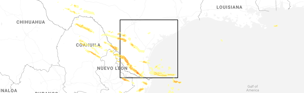
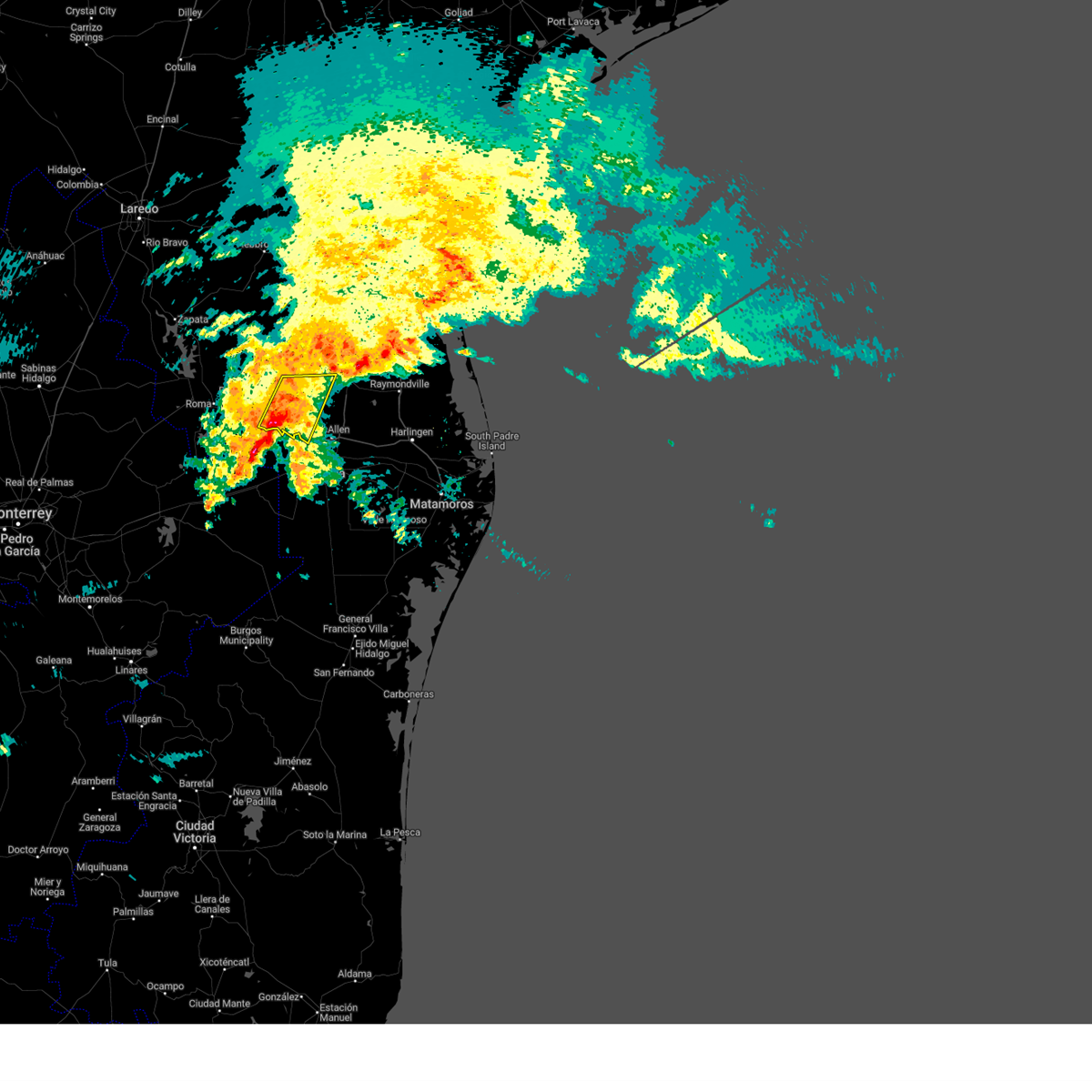
Hail Map for Loma Linda East, TX
The Loma Linda East, TX area has had 0 reports of on-the-ground hail by trained spotters, and has been under severe weather warnings 11 times during the past 12 months. Doppler radar has detected hail at or near Loma Linda East, TX on 63 occasions, including 2 occasions during the past year.
| Name: | Loma Linda East, TX |
| Where Located: | 48.1 miles W of Corpus Christi, TX |
| Map: | Google Map for Loma Linda East, TX |
| Population: | 254 |
| Housing Units: | 78 |
| More Info: | Search Google for Loma Linda East, TX |
3
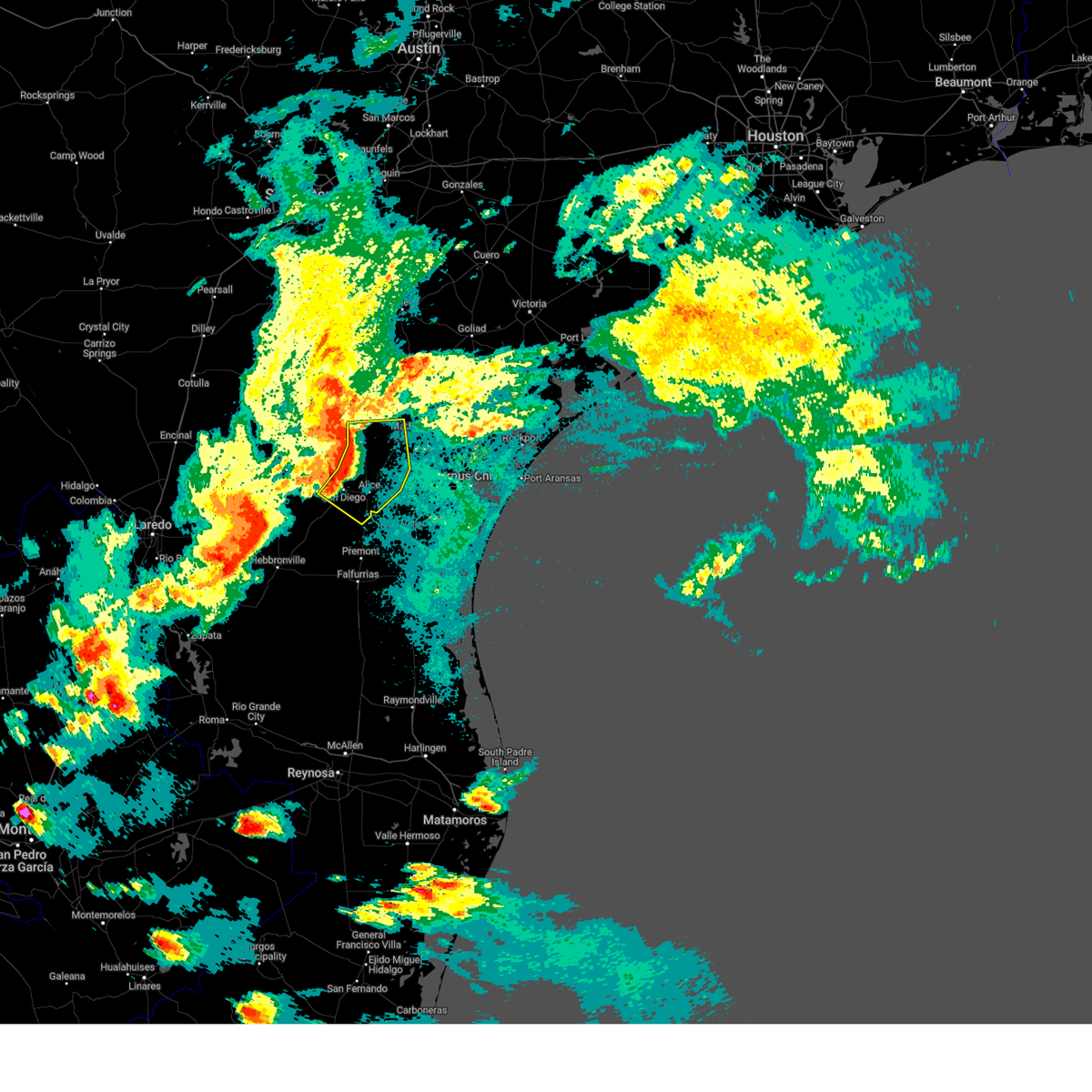
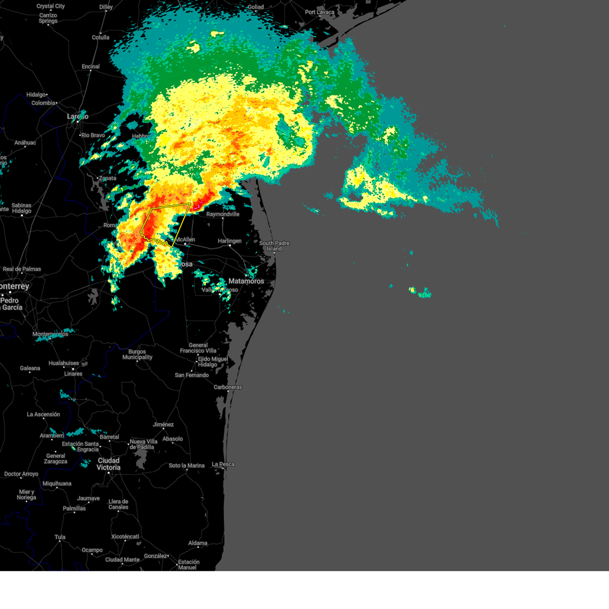
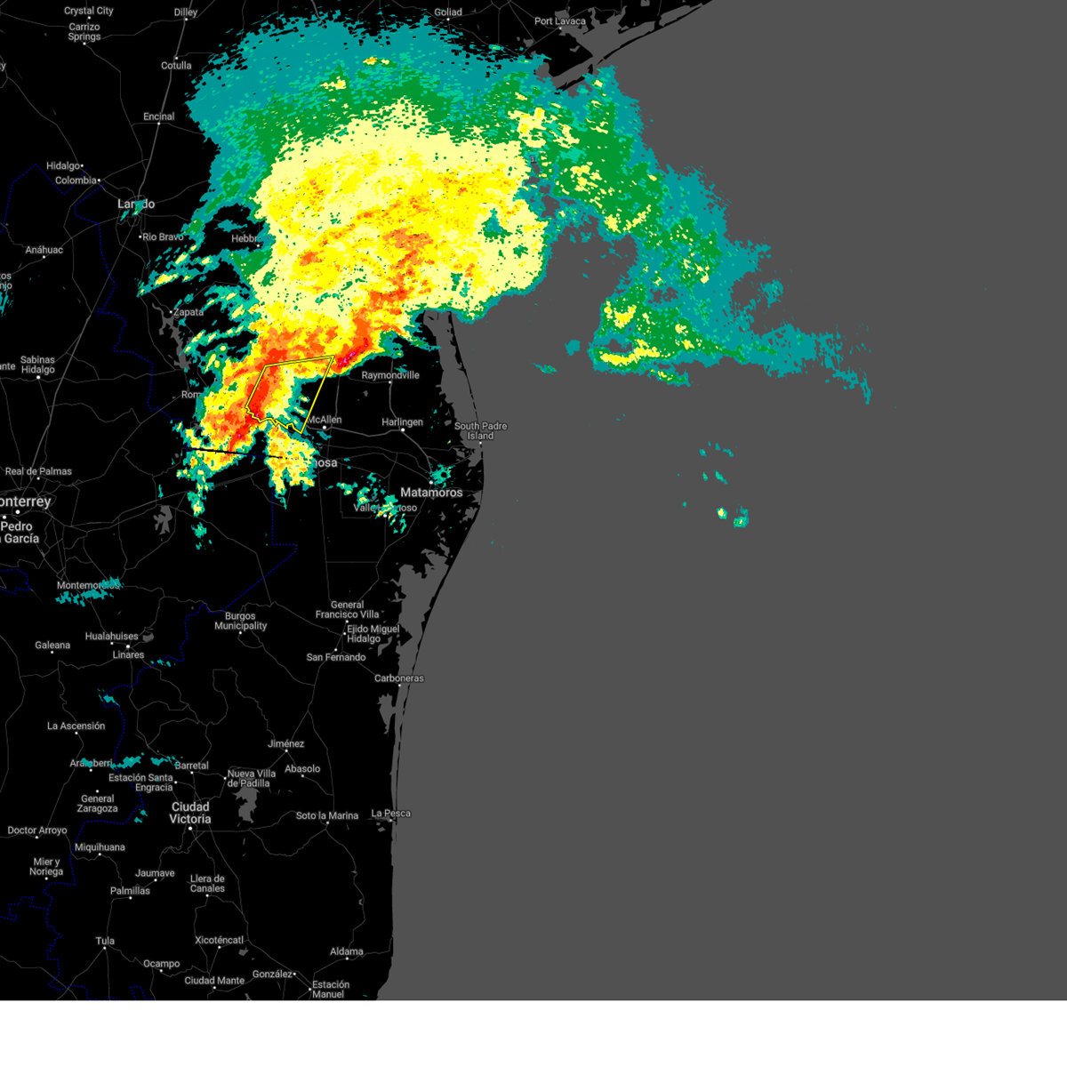
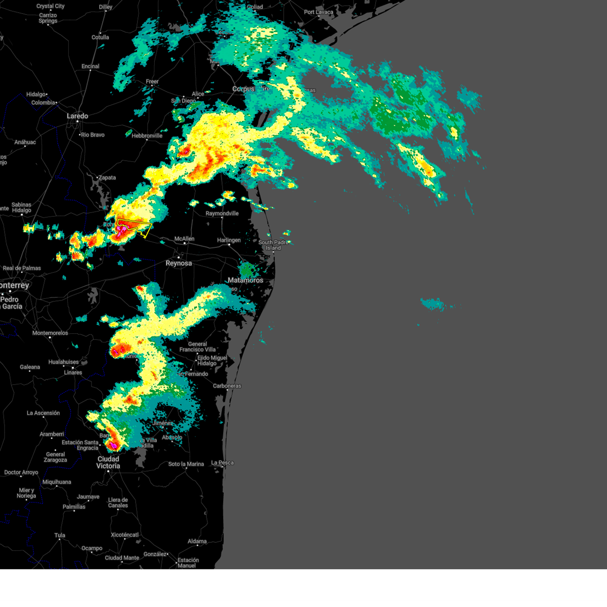
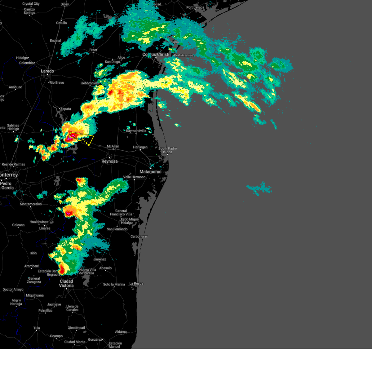
The Top Recent Hail Date for Loma Linda East, TX is Thursday, May 8, 2025 (3rd out of 63)
Hail and Wind Damage Spotted near Loma Linda East, TX
| Date / Time | Report Details |
|---|---|
| 5/8/2025 9:10 PM CDT |
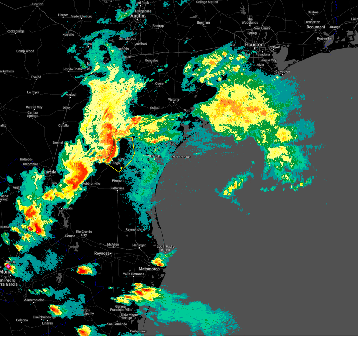 At 909 pm cdt, severe thunderstorms were located along a line extending from 6 miles west of lagarto to near westdale to near alice to near san diego, moving southeast at 30 mph (radar indicated). Hazards include 60 mph wind gusts and nickel size hail. Expect damage to roofs, siding, and trees. locations impacted include, alice, mathis, san diego, orange grove, lake city, midway, lagarto, alfred-south la paloma, westdale, ben bolt, sandia, tecalote, annarose, argenta, alice acres, alfred, agua dulce, lakeside, lake corpus christi, and pernitas point. this includes the following highways, interstate 37 between mile markers 38 and 41. Us highway 281 between mile markers 644 and 684. At 909 pm cdt, severe thunderstorms were located along a line extending from 6 miles west of lagarto to near westdale to near alice to near san diego, moving southeast at 30 mph (radar indicated). Hazards include 60 mph wind gusts and nickel size hail. Expect damage to roofs, siding, and trees. locations impacted include, alice, mathis, san diego, orange grove, lake city, midway, lagarto, alfred-south la paloma, westdale, ben bolt, sandia, tecalote, annarose, argenta, alice acres, alfred, agua dulce, lakeside, lake corpus christi, and pernitas point. this includes the following highways, interstate 37 between mile markers 38 and 41. Us highway 281 between mile markers 644 and 684.
|
| 5/8/2025 9:10 PM CDT |
 the severe thunderstorm warning has been cancelled and is no longer in effect the severe thunderstorm warning has been cancelled and is no longer in effect
|
| 5/8/2025 8:37 PM CDT | Svrcrp the national weather service in corpus christi has issued a * severe thunderstorm warning for, northeastern duval county in south central texas, northwestern nueces county in south central texas, northwestern san patricio county in south central texas, southeastern mcmullen county in south central texas, jim wells county in south central texas, southern live oak county in south central texas, * until 930 pm cdt. * at 836 pm cdt, severe thunderstorms were located along a line extending from 9 miles north of clegg to near rancho de la parita to near rosita, moving east at 25 mph (radar indicated). Hazards include 60 mph wind gusts and nickel size hail. expect damage to roofs, siding, and trees |
| 5/8/2025 6:32 PM CDT | At 632 pm cdt, a severe thunderstorm was located near citrus city, or near la joya, moving southeast at 45 mph (radar indicated). Hazards include two inch hail and 60 mph wind gusts. People and animals outdoors will be injured. expect hail damage to roofs, siding, windows, and vehicles. expect wind damage to roofs, siding, and trees. locations impacted include, mcallen high school, narciso g. Cavazos elementary school, doffing, la victoria, las palmas community center, enrique camarena elementary school, retama park, lincoln school, la joya, and mission regional medical center. |
| 5/8/2025 6:09 PM CDT |
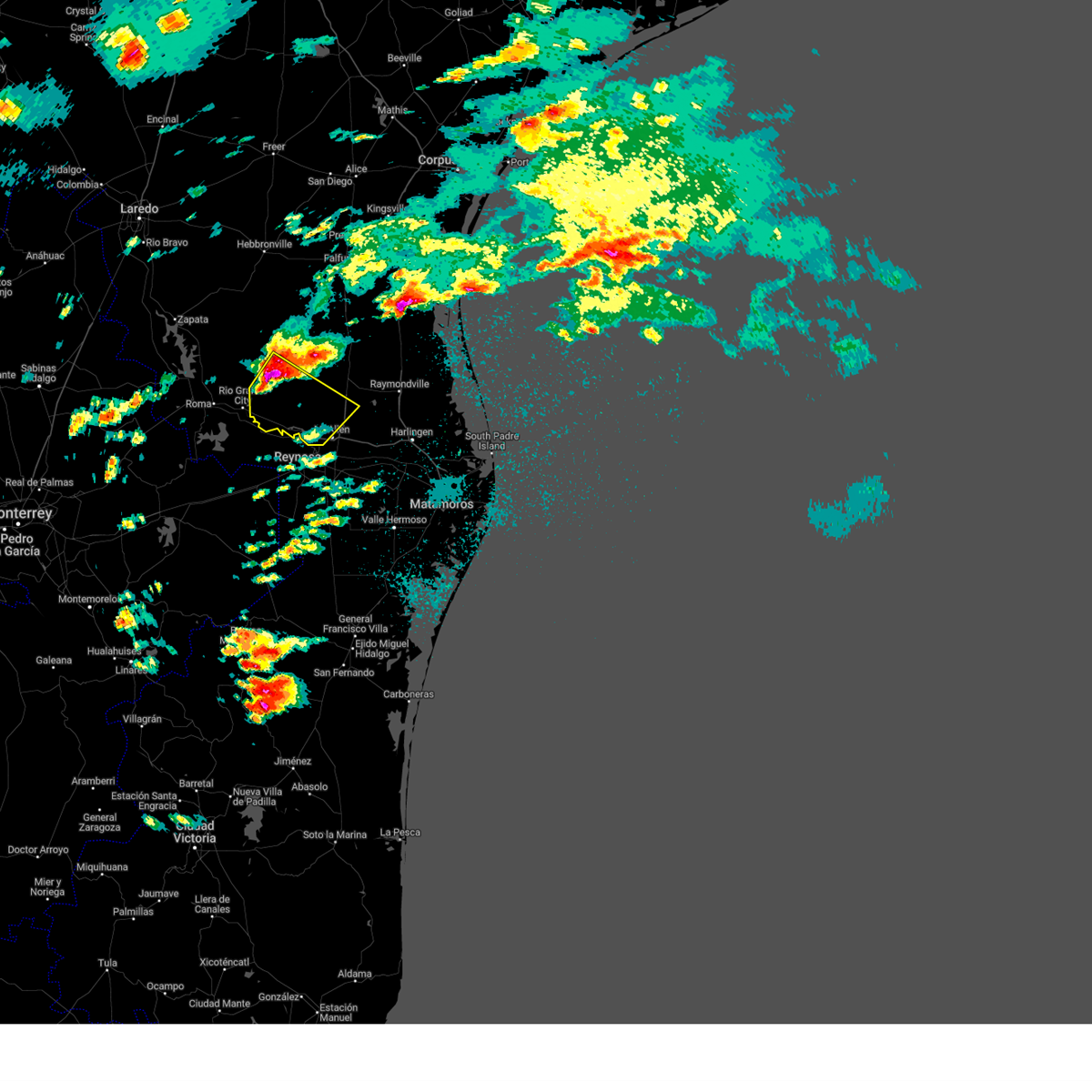 Svrbro the national weather service in brownsville has issued a * severe thunderstorm warning for, southwestern hidalgo county in deep south texas, eastern starr county in deep south texas, * until 700 pm cdt. * at 608 pm cdt, a severe thunderstorm was located 9 miles southwest of santa catarina, or 14 miles east of el sauz, moving southeast at 45 mph (radar indicated). Hazards include two inch hail and 60 mph wind gusts. People and animals outdoors will be injured. expect hail damage to roofs, siding, windows, and vehicles. Expect wind damage to roofs, siding, and trees. Svrbro the national weather service in brownsville has issued a * severe thunderstorm warning for, southwestern hidalgo county in deep south texas, eastern starr county in deep south texas, * until 700 pm cdt. * at 608 pm cdt, a severe thunderstorm was located 9 miles southwest of santa catarina, or 14 miles east of el sauz, moving southeast at 45 mph (radar indicated). Hazards include two inch hail and 60 mph wind gusts. People and animals outdoors will be injured. expect hail damage to roofs, siding, windows, and vehicles. Expect wind damage to roofs, siding, and trees.
|
| 3/27/2025 1:45 PM CDT |
 At 145 pm cdt, severe thunderstorms were located along a line extending from near mccook to near sullivan city to 12 miles south of la grulla, moving east at 20 mph (radar indicated). Hazards include 60 mph wind gusts and quarter size hail. Hail damage to vehicles is expected. expect wind damage to roofs, siding, and trees. locations impacted include, narciso g. Cavazos elementary school, abram-perezville, los ebanos, cesar chavez middle school, doffing, john f kennedy elementary school, la victoria, guillermo flores elementary school, la grulla, and lorenzo de zavala middle school. At 145 pm cdt, severe thunderstorms were located along a line extending from near mccook to near sullivan city to 12 miles south of la grulla, moving east at 20 mph (radar indicated). Hazards include 60 mph wind gusts and quarter size hail. Hail damage to vehicles is expected. expect wind damage to roofs, siding, and trees. locations impacted include, narciso g. Cavazos elementary school, abram-perezville, los ebanos, cesar chavez middle school, doffing, john f kennedy elementary school, la victoria, guillermo flores elementary school, la grulla, and lorenzo de zavala middle school.
|
| 3/27/2025 1:24 PM CDT |
 At 124 pm cdt, severe thunderstorms were located along a line extending from 7 miles northwest of mccook to cuevitas to 14 miles southwest of la grulla, moving east at 25 mph (radar indicated). Hazards include 60 mph wind gusts. Expect damage to roofs, siding, and trees. locations impacted include, narciso g. Cavazos elementary school, abram-perezville, los ebanos, cesar chavez middle school, doffing, john f kennedy elementary school, la victoria, guillermo flores elementary school, la grulla, and lorenzo de zavala middle school. At 124 pm cdt, severe thunderstorms were located along a line extending from 7 miles northwest of mccook to cuevitas to 14 miles southwest of la grulla, moving east at 25 mph (radar indicated). Hazards include 60 mph wind gusts. Expect damage to roofs, siding, and trees. locations impacted include, narciso g. Cavazos elementary school, abram-perezville, los ebanos, cesar chavez middle school, doffing, john f kennedy elementary school, la victoria, guillermo flores elementary school, la grulla, and lorenzo de zavala middle school.
|
| 3/27/2025 1:16 PM CDT |
 Svrbro the national weather service in brownsville has issued a * severe thunderstorm warning for, western hidalgo county in deep south texas, southeastern starr county in deep south texas, * until 200 pm cdt. * at 115 pm cdt, severe thunderstorms were located along a line extending from 8 miles southeast of santa catarina to grulla middle school to 16 miles southwest of la grulla, moving east at 25 mph (radar indicated). Hazards include 60 mph wind gusts. expect damage to roofs, siding, and trees Svrbro the national weather service in brownsville has issued a * severe thunderstorm warning for, western hidalgo county in deep south texas, southeastern starr county in deep south texas, * until 200 pm cdt. * at 115 pm cdt, severe thunderstorms were located along a line extending from 8 miles southeast of santa catarina to grulla middle school to 16 miles southwest of la grulla, moving east at 25 mph (radar indicated). Hazards include 60 mph wind gusts. expect damage to roofs, siding, and trees
|
| 3/26/2025 8:26 PM CDT |
 The storm which prompted the warning has moved out of the area. therefore, the warning will be allowed to expire. The storm which prompted the warning has moved out of the area. therefore, the warning will be allowed to expire.
|
| 3/26/2025 8:14 PM CDT |
 At 812 pm cdt, a severe thunderstorm was located over starr county memorial hospital, or over rio grande city, moving east at 25 mph (radar indicated). Hazards include 60 mph wind gusts and quarter size hail. Hail damage to vehicles is expected. expect wind damage to roofs, siding, and trees. Locations impacted include, los alvarez, fort ringgold county park, garceno, starr county sheriffs office, roma city hall, roma, escobares, rio grande city fire department, roma park, and north escobares. At 812 pm cdt, a severe thunderstorm was located over starr county memorial hospital, or over rio grande city, moving east at 25 mph (radar indicated). Hazards include 60 mph wind gusts and quarter size hail. Hail damage to vehicles is expected. expect wind damage to roofs, siding, and trees. Locations impacted include, los alvarez, fort ringgold county park, garceno, starr county sheriffs office, roma city hall, roma, escobares, rio grande city fire department, roma park, and north escobares.
|
| 3/26/2025 7:49 PM CDT |
 Svrbro the national weather service in brownsville has issued a * severe thunderstorm warning for, southwestern starr county in deep south texas, * until 830 pm cdt. * at 749 pm cdt, a severe thunderstorm was located over roma public library, or over roma, moving east at 30 mph (radar indicated). Hazards include 60 mph wind gusts and quarter size hail. Hail damage to vehicles is expected. Expect wind damage to roofs, siding, and trees. Svrbro the national weather service in brownsville has issued a * severe thunderstorm warning for, southwestern starr county in deep south texas, * until 830 pm cdt. * at 749 pm cdt, a severe thunderstorm was located over roma public library, or over roma, moving east at 30 mph (radar indicated). Hazards include 60 mph wind gusts and quarter size hail. Hail damage to vehicles is expected. Expect wind damage to roofs, siding, and trees.
|
| 6/20/2024 1:18 AM CDT |
 the tornado warning has been cancelled and is no longer in effect the tornado warning has been cancelled and is no longer in effect
|
| 6/20/2024 1:13 AM CDT |
 At 113 am cdt, a severe thunderstorm capable of producing a tornado was located over san diego, moving west at 40 mph (radar indicated rotation). Hazards include tornado. Flying debris will be dangerous to those caught without shelter. mobile homes will be damaged or destroyed. damage to roofs, windows, and vehicles will occur. tree damage is likely. This dangerous storm will be near, rosita around 120 am cdt. At 113 am cdt, a severe thunderstorm capable of producing a tornado was located over san diego, moving west at 40 mph (radar indicated rotation). Hazards include tornado. Flying debris will be dangerous to those caught without shelter. mobile homes will be damaged or destroyed. damage to roofs, windows, and vehicles will occur. tree damage is likely. This dangerous storm will be near, rosita around 120 am cdt.
|
| 6/20/2024 1:02 AM CDT |
 Torcrp the national weather service in corpus christi has issued a * tornado warning for, east central duval county in south central texas, west central jim wells county in south central texas, * until 145 am cdt. * at 102 am cdt, a severe thunderstorm capable of producing a tornado was located near san diego, moving west at 40 mph (radar indicated rotation). Hazards include tornado. Flying debris will be dangerous to those caught without shelter. mobile homes will be damaged or destroyed. damage to roofs, windows, and vehicles will occur. tree damage is likely. this dangerous storm will be near, san diego around 105 am cdt. rosita around 120 am cdt. This includes us highway 281 near mile marker 674. Torcrp the national weather service in corpus christi has issued a * tornado warning for, east central duval county in south central texas, west central jim wells county in south central texas, * until 145 am cdt. * at 102 am cdt, a severe thunderstorm capable of producing a tornado was located near san diego, moving west at 40 mph (radar indicated rotation). Hazards include tornado. Flying debris will be dangerous to those caught without shelter. mobile homes will be damaged or destroyed. damage to roofs, windows, and vehicles will occur. tree damage is likely. this dangerous storm will be near, san diego around 105 am cdt. rosita around 120 am cdt. This includes us highway 281 near mile marker 674.
|
| 6/20/2024 12:34 AM CDT |
 At 1234 am cdt, a severe thunderstorm capable of producing a tornado was located over alice acres, or over alice, moving west at 35 mph (radar indicated rotation). Hazards include tornado. Flying debris will be dangerous to those caught without shelter. mobile homes will be damaged or destroyed. damage to roofs, windows, and vehicles will occur. tree damage is likely. locations impacted include, alice and alice acres. This includes us highway 281 between mile markers 672 and 676. At 1234 am cdt, a severe thunderstorm capable of producing a tornado was located over alice acres, or over alice, moving west at 35 mph (radar indicated rotation). Hazards include tornado. Flying debris will be dangerous to those caught without shelter. mobile homes will be damaged or destroyed. damage to roofs, windows, and vehicles will occur. tree damage is likely. locations impacted include, alice and alice acres. This includes us highway 281 between mile markers 672 and 676.
|
| 6/20/2024 12:25 AM CDT |
 Torcrp the national weather service in corpus christi has issued a * tornado warning for, west central jim wells county in south central texas, * until 1245 am cdt. * at 1225 am cdt, a severe thunderstorm capable of producing a tornado was located near alice, moving west at 35 mph (radar indicated rotation). Hazards include tornado. Flying debris will be dangerous to those caught without shelter. mobile homes will be damaged or destroyed. damage to roofs, windows, and vehicles will occur. Tree damage is likely. Torcrp the national weather service in corpus christi has issued a * tornado warning for, west central jim wells county in south central texas, * until 1245 am cdt. * at 1225 am cdt, a severe thunderstorm capable of producing a tornado was located near alice, moving west at 35 mph (radar indicated rotation). Hazards include tornado. Flying debris will be dangerous to those caught without shelter. mobile homes will be damaged or destroyed. damage to roofs, windows, and vehicles will occur. Tree damage is likely.
|
| 5/27/2024 8:29 PM CDT |
 The storms which prompted the warning have weakened below severe limits, and no longer pose an immediate threat to life or property. therefore, the warning will be allowed to expire. however, small hail, gusty winds and heavy rain are still possible with these thunderstorms. a severe thunderstorm watch remains in effect until midnight cdt for deep south texas. to report severe weather, contact your nearest law enforcement agency. they will relay your report to the national weather service brownsville. The storms which prompted the warning have weakened below severe limits, and no longer pose an immediate threat to life or property. therefore, the warning will be allowed to expire. however, small hail, gusty winds and heavy rain are still possible with these thunderstorms. a severe thunderstorm watch remains in effect until midnight cdt for deep south texas. to report severe weather, contact your nearest law enforcement agency. they will relay your report to the national weather service brownsville.
|
| 5/27/2024 8:16 PM CDT |
 At 816 pm cdt, severe thunderstorms were located along a line extending from 15 miles west of falcon dam to near roma high school to 7 miles south of los garzas, moving north at 45 mph (radar indicated). Hazards include 60 mph wind gusts and quarter size hail. Hail damage to vehicles is expected. expect wind damage to roofs, siding, and trees. Locations impacted include, rio grande city, roma, escobares, el sauz, lopeno, garciasville, la rosita, la grulla, new falcon, and la victoria. At 816 pm cdt, severe thunderstorms were located along a line extending from 15 miles west of falcon dam to near roma high school to 7 miles south of los garzas, moving north at 45 mph (radar indicated). Hazards include 60 mph wind gusts and quarter size hail. Hail damage to vehicles is expected. expect wind damage to roofs, siding, and trees. Locations impacted include, rio grande city, roma, escobares, el sauz, lopeno, garciasville, la rosita, la grulla, new falcon, and la victoria.
|
| 5/27/2024 7:51 PM CDT |
 Svrbro the national weather service in brownsville has issued a * severe thunderstorm warning for, western starr county in deep south texas, southeastern zapata county in deep south texas, * until 830 pm cdt. * at 750 pm cdt, severe thunderstorms were located along a line extending from 24 miles southwest of fronton to 11 miles south of roma park to 25 miles southwest of la grulla, moving north at 45 mph (radar indicated). Hazards include 60 mph wind gusts and quarter size hail. Hail damage to vehicles is expected. Expect wind damage to roofs, siding, and trees. Svrbro the national weather service in brownsville has issued a * severe thunderstorm warning for, western starr county in deep south texas, southeastern zapata county in deep south texas, * until 830 pm cdt. * at 750 pm cdt, severe thunderstorms were located along a line extending from 24 miles southwest of fronton to 11 miles south of roma park to 25 miles southwest of la grulla, moving north at 45 mph (radar indicated). Hazards include 60 mph wind gusts and quarter size hail. Hail damage to vehicles is expected. Expect wind damage to roofs, siding, and trees.
|
| 5/13/2024 7:24 PM CDT |
 Svrbro the national weather service in brownsville has issued a * severe thunderstorm warning for, west central hidalgo county in deep south texas, southeastern starr county in deep south texas, * until 815 pm cdt. * at 723 pm cdt, a severe thunderstorm was located over rio grande city municipal airport, or near rio grande city, moving east at 35 mph (radar indicated). Hazards include 60 mph wind gusts and half dollar size hail. Hail damage to vehicles is expected. Expect wind damage to roofs, siding, and trees. Svrbro the national weather service in brownsville has issued a * severe thunderstorm warning for, west central hidalgo county in deep south texas, southeastern starr county in deep south texas, * until 815 pm cdt. * at 723 pm cdt, a severe thunderstorm was located over rio grande city municipal airport, or near rio grande city, moving east at 35 mph (radar indicated). Hazards include 60 mph wind gusts and half dollar size hail. Hail damage to vehicles is expected. Expect wind damage to roofs, siding, and trees.
|
| 5/13/2024 5:26 PM CDT |
 the severe thunderstorm warning has been cancelled and is no longer in effect the severe thunderstorm warning has been cancelled and is no longer in effect
|
| 5/13/2024 5:12 PM CDT |
 Svrcrp the national weather service in corpus christi has issued a * severe thunderstorm warning for, northeastern duval county in south central texas, northwestern jim wells county in south central texas, * until 600 pm cdt. * at 512 pm cdt, a severe thunderstorm was located near san diego, moving northeast at 25 mph (radar indicated). Hazards include quarter size hail. damage to vehicles is expected Svrcrp the national weather service in corpus christi has issued a * severe thunderstorm warning for, northeastern duval county in south central texas, northwestern jim wells county in south central texas, * until 600 pm cdt. * at 512 pm cdt, a severe thunderstorm was located near san diego, moving northeast at 25 mph (radar indicated). Hazards include quarter size hail. damage to vehicles is expected
|
| 5/5/2024 5:16 PM CDT |
 the severe thunderstorm warning has been cancelled and is no longer in effect the severe thunderstorm warning has been cancelled and is no longer in effect
|
| 5/5/2024 5:16 PM CDT |
 At 515 pm cdt, severe thunderstorms were located along a line extending from near rancho de la parita to 6 miles northwest of san diego to 13 miles west of benavides, moving east at 35 mph (radar indicated). Hazards include 60 mph wind gusts and quarter size hail. Hail damage to vehicles is expected. expect wind damage to roofs, siding, and trees. locations impacted include, alice, san diego, freer, benavides, seven sisters, san jose, ben bolt, palito blanco, tecalote, realitos, annarose, rancho de la parita, alice acres, rosita, and lake alice. this includes the following highways, us highway 281 between mile markers 660 and 682. Us highway 59 between mile markers 746 and 772. At 515 pm cdt, severe thunderstorms were located along a line extending from near rancho de la parita to 6 miles northwest of san diego to 13 miles west of benavides, moving east at 35 mph (radar indicated). Hazards include 60 mph wind gusts and quarter size hail. Hail damage to vehicles is expected. expect wind damage to roofs, siding, and trees. locations impacted include, alice, san diego, freer, benavides, seven sisters, san jose, ben bolt, palito blanco, tecalote, realitos, annarose, rancho de la parita, alice acres, rosita, and lake alice. this includes the following highways, us highway 281 between mile markers 660 and 682. Us highway 59 between mile markers 746 and 772.
|
| 5/5/2024 4:58 PM CDT |
 Svrcrp the national weather service in corpus christi has issued a * severe thunderstorm warning for, duval county in south central texas, east central webb county in south central texas, southeastern mcmullen county in south central texas, northwestern jim wells county in south central texas, southwestern live oak county in south central texas, * until 545 pm cdt. * at 457 pm cdt, severe thunderstorms were located along a line extending from 8 miles southwest of clegg to near rosita to 15 miles north of bruni, moving east at 35 mph (radar indicated). Hazards include 60 mph wind gusts and quarter size hail. Hail damage to vehicles is expected. Expect wind damage to roofs, siding, and trees. Svrcrp the national weather service in corpus christi has issued a * severe thunderstorm warning for, duval county in south central texas, east central webb county in south central texas, southeastern mcmullen county in south central texas, northwestern jim wells county in south central texas, southwestern live oak county in south central texas, * until 545 pm cdt. * at 457 pm cdt, severe thunderstorms were located along a line extending from 8 miles southwest of clegg to near rosita to 15 miles north of bruni, moving east at 35 mph (radar indicated). Hazards include 60 mph wind gusts and quarter size hail. Hail damage to vehicles is expected. Expect wind damage to roofs, siding, and trees.
|
| 6/3/2023 9:16 PM CDT |
 At 915 pm cdt, a severe thunderstorm was located near citrus city, or 7 miles north of la joya, moving east at 55 mph (radar indicated). Hazards include 60 mph wind gusts and quarter size hail. Hail damage to vehicles is expected. expect wind damage to roofs, siding, and trees. locations impacted include, edinburg, mission, pharr, rio grande city, hidalgo, palmview, penitas, sullivan city, la joya and palmhurst. hail threat, radar indicated max hail size, 1. 00 in wind threat, radar indicated max wind gust, 60 mph. At 915 pm cdt, a severe thunderstorm was located near citrus city, or 7 miles north of la joya, moving east at 55 mph (radar indicated). Hazards include 60 mph wind gusts and quarter size hail. Hail damage to vehicles is expected. expect wind damage to roofs, siding, and trees. locations impacted include, edinburg, mission, pharr, rio grande city, hidalgo, palmview, penitas, sullivan city, la joya and palmhurst. hail threat, radar indicated max hail size, 1. 00 in wind threat, radar indicated max wind gust, 60 mph.
|
| 6/3/2023 8:54 PM CDT |
 At 853 pm cdt, a severe thunderstorm was located over las lomas, or near rio grande city, moving east at 55 mph (radar indicated). Hazards include 60 mph wind gusts and quarter size hail. Hail damage to vehicles is expected. Expect wind damage to roofs, siding, and trees. At 853 pm cdt, a severe thunderstorm was located over las lomas, or near rio grande city, moving east at 55 mph (radar indicated). Hazards include 60 mph wind gusts and quarter size hail. Hail damage to vehicles is expected. Expect wind damage to roofs, siding, and trees.
|
| 5/29/2023 9:42 PM CDT |
 At 941 pm cdt, severe thunderstorms were located along a line extending from 7 miles west of red gate to 6 miles northwest of b.l. garza middle school to doffing to near la grulla to rio grande city, moving southeast at 15 mph (radar indicated). Hazards include 60 mph wind gusts and penny size hail. Expect damage to roofs, siding, and trees. locations impacted include, mission, palmview, penitas, sullivan city, la joya, palmhurst, garciasville, north mcallen, los ebanos and sharyland. hail threat, radar indicated max hail size, 0. 75 in wind threat, radar indicated max wind gust, 60 mph. At 941 pm cdt, severe thunderstorms were located along a line extending from 7 miles west of red gate to 6 miles northwest of b.l. garza middle school to doffing to near la grulla to rio grande city, moving southeast at 15 mph (radar indicated). Hazards include 60 mph wind gusts and penny size hail. Expect damage to roofs, siding, and trees. locations impacted include, mission, palmview, penitas, sullivan city, la joya, palmhurst, garciasville, north mcallen, los ebanos and sharyland. hail threat, radar indicated max hail size, 0. 75 in wind threat, radar indicated max wind gust, 60 mph.
|
| 5/29/2023 9:27 PM CDT |
 At 926 pm cdt, severe thunderstorms were located along a line extending from near puerto rico to 6 miles southeast of mccook to near doffing to grulla middle school to los alvarez, moving southeast at 15 mph (radar indicated). Hazards include 60 mph wind gusts and quarter size hail. Hail damage to vehicles is expected. Expect wind damage to roofs, siding, and trees. At 926 pm cdt, severe thunderstorms were located along a line extending from near puerto rico to 6 miles southeast of mccook to near doffing to grulla middle school to los alvarez, moving southeast at 15 mph (radar indicated). Hazards include 60 mph wind gusts and quarter size hail. Hail damage to vehicles is expected. Expect wind damage to roofs, siding, and trees.
|
| 5/29/2023 9:09 PM CDT |
 At 909 pm cdt, severe thunderstorms were located along a line extending from puerto rico to near mccook to near citrus city to near garciasville to near el sauz, moving southeast at 20 mph (radar indicated). Hazards include ping pong ball size hail and 60 mph wind gusts. People and animals outdoors will be injured. expect hail damage to roofs, siding, windows, and vehicles. expect wind damage to roofs, siding, and trees. locations impacted include, rio grande city, sullivan city, la joya, los ebanos, el sauz, garciasville, mccook, la grulla, puerto rico and john f kennedy elementary school. hail threat, radar indicated max hail size, 1. 50 in wind threat, radar indicated max wind gust, 60 mph. At 909 pm cdt, severe thunderstorms were located along a line extending from puerto rico to near mccook to near citrus city to near garciasville to near el sauz, moving southeast at 20 mph (radar indicated). Hazards include ping pong ball size hail and 60 mph wind gusts. People and animals outdoors will be injured. expect hail damage to roofs, siding, windows, and vehicles. expect wind damage to roofs, siding, and trees. locations impacted include, rio grande city, sullivan city, la joya, los ebanos, el sauz, garciasville, mccook, la grulla, puerto rico and john f kennedy elementary school. hail threat, radar indicated max hail size, 1. 50 in wind threat, radar indicated max wind gust, 60 mph.
|
| 5/29/2023 8:57 PM CDT |
 At 856 pm cdt, severe thunderstorms were located along a line extending from near la reforma to near mccook to 8 miles northeast of sullivan city to near las lomas to near el sauz, moving southeast at 15 mph (radar indicated). Hazards include 60 mph wind gusts and nickel size hail. expect damage to roofs, siding, and trees At 856 pm cdt, severe thunderstorms were located along a line extending from near la reforma to near mccook to 8 miles northeast of sullivan city to near las lomas to near el sauz, moving southeast at 15 mph (radar indicated). Hazards include 60 mph wind gusts and nickel size hail. expect damage to roofs, siding, and trees
|
| 5/29/2023 5:11 PM CDT |
 The severe thunderstorm warning for east central duval and western jim wells counties will expire at 515 pm cdt, the storm which prompted the warning has weakened below severe limits, and no longer poses an immediate threat to life or property. therefore, the warning will be allowed to expire. however small hail is still possible with this thunderstorm. The severe thunderstorm warning for east central duval and western jim wells counties will expire at 515 pm cdt, the storm which prompted the warning has weakened below severe limits, and no longer poses an immediate threat to life or property. therefore, the warning will be allowed to expire. however small hail is still possible with this thunderstorm.
|
| 5/29/2023 4:56 PM CDT |
 At 456 pm cdt, a severe thunderstorm was located over san diego, moving southeast at 10 mph (radar indicated). Hazards include 60 mph wind gusts and quarter size hail. Hail damage to vehicles is expected. expect wind damage to roofs, siding, and trees. locations impacted include, san diego. hail threat, radar indicated max hail size, 1. 00 in wind threat, radar indicated max wind gust, 60 mph. At 456 pm cdt, a severe thunderstorm was located over san diego, moving southeast at 10 mph (radar indicated). Hazards include 60 mph wind gusts and quarter size hail. Hail damage to vehicles is expected. expect wind damage to roofs, siding, and trees. locations impacted include, san diego. hail threat, radar indicated max hail size, 1. 00 in wind threat, radar indicated max wind gust, 60 mph.
|
| 5/29/2023 4:35 PM CDT |
 At 434 pm cdt, a severe thunderstorm was located near san diego, and is nearly stationary (radar indicated). Hazards include 60 mph wind gusts and half dollar size hail. Hail damage to vehicles is expected. Expect wind damage to roofs, siding, and trees. At 434 pm cdt, a severe thunderstorm was located near san diego, and is nearly stationary (radar indicated). Hazards include 60 mph wind gusts and half dollar size hail. Hail damage to vehicles is expected. Expect wind damage to roofs, siding, and trees.
|
| 5/13/2023 1:16 AM CDT |
 At 116 am cdt, severe thunderstorms were located along a line extending from 6 miles northeast of las lomas to citrus city to near hidalgo high school, moving northeast at 35 mph (radar indicated). Hazards include 60 mph wind gusts and nickel size hail. Expect damage to roofs, siding, and trees. locations impacted include, edinburg, mission, pharr, san juan, alamo, donna, rio grande city, hidalgo, palmview and penitas. hail threat, radar indicated max hail size, 0. 88 in wind threat, radar indicated max wind gust, 60 mph. At 116 am cdt, severe thunderstorms were located along a line extending from 6 miles northeast of las lomas to citrus city to near hidalgo high school, moving northeast at 35 mph (radar indicated). Hazards include 60 mph wind gusts and nickel size hail. Expect damage to roofs, siding, and trees. locations impacted include, edinburg, mission, pharr, san juan, alamo, donna, rio grande city, hidalgo, palmview and penitas. hail threat, radar indicated max hail size, 0. 88 in wind threat, radar indicated max wind gust, 60 mph.
|
| 5/13/2023 12:50 AM CDT |
 At 1249 am cdt, severe thunderstorms were located along a line extending from near starr county memorial hospital to near los ebanos to 16 miles southwest of granjero, moving northeast at 35 mph (radar indicated). Hazards include 60 mph wind gusts and nickel size hail. expect damage to roofs, siding, and trees At 1249 am cdt, severe thunderstorms were located along a line extending from near starr county memorial hospital to near los ebanos to 16 miles southwest of granjero, moving northeast at 35 mph (radar indicated). Hazards include 60 mph wind gusts and nickel size hail. expect damage to roofs, siding, and trees
|
| 5/7/2023 10:42 PM CDT |
 The severe thunderstorm warning for southwestern hidalgo and south central starr counties will expire at 1045 pm cdt, the storm which prompted the warning has weakened below severe limits, and no longer poses an immediate threat to life or property. therefore, the warning will be allowed to expire. however heavy rain is still possible with this thunderstorm. The severe thunderstorm warning for southwestern hidalgo and south central starr counties will expire at 1045 pm cdt, the storm which prompted the warning has weakened below severe limits, and no longer poses an immediate threat to life or property. therefore, the warning will be allowed to expire. however heavy rain is still possible with this thunderstorm.
|
| 5/7/2023 10:35 PM CDT |
 At 1035 pm cdt, a severe thunderstorm was located near la joya high school, or near la joya, moving east at 30 mph (radar indicated). Hazards include 60 mph wind gusts and quarter size hail. Hail damage to vehicles is expected. expect wind damage to roofs, siding, and trees. locations impacted include, mission, palmview, penitas, sullivan city, la joya, palmhurst, garciasville, los ebanos, sharyland and south mcallen. hail threat, radar indicated max hail size, 1. 00 in wind threat, radar indicated max wind gust, 60 mph. At 1035 pm cdt, a severe thunderstorm was located near la joya high school, or near la joya, moving east at 30 mph (radar indicated). Hazards include 60 mph wind gusts and quarter size hail. Hail damage to vehicles is expected. expect wind damage to roofs, siding, and trees. locations impacted include, mission, palmview, penitas, sullivan city, la joya, palmhurst, garciasville, los ebanos, sharyland and south mcallen. hail threat, radar indicated max hail size, 1. 00 in wind threat, radar indicated max wind gust, 60 mph.
|
| 5/7/2023 10:22 PM CDT |
 At 1021 pm cdt, a severe thunderstorm was located over grulla middle school, or near sullivan city, moving east at 35 mph (radar indicated). Hazards include 60 mph wind gusts and quarter size hail. Hail damage to vehicles is expected. Expect wind damage to roofs, siding, and trees. At 1021 pm cdt, a severe thunderstorm was located over grulla middle school, or near sullivan city, moving east at 35 mph (radar indicated). Hazards include 60 mph wind gusts and quarter size hail. Hail damage to vehicles is expected. Expect wind damage to roofs, siding, and trees.
|
| 4/29/2023 12:23 AM CDT |
 At 1222 am cdt, a severe thunderstorm was located near la joya high school, or near la joya, moving southeast at 45 mph. this is a destructive storm for southeastern starr and southern hidalgo county (radar indicated). Hazards include 80 mph wind gusts. Flying debris will be dangerous to those caught without shelter. mobile homes will be heavily damaged. expect considerable damage to roofs, windows, and vehicles. Extensive tree damage and power outages are likely. At 1222 am cdt, a severe thunderstorm was located near la joya high school, or near la joya, moving southeast at 45 mph. this is a destructive storm for southeastern starr and southern hidalgo county (radar indicated). Hazards include 80 mph wind gusts. Flying debris will be dangerous to those caught without shelter. mobile homes will be heavily damaged. expect considerable damage to roofs, windows, and vehicles. Extensive tree damage and power outages are likely.
|
| 4/29/2023 12:11 AM CDT |
 The severe thunderstorm warning for southwestern starr county will expire at 1215 am cdt, the storm which prompted the warning has moved out of the area. therefore, the warning will be allowed to expire. a severe thunderstorm watch remains in effect until 100 am cdt for deep south texas. The severe thunderstorm warning for southwestern starr county will expire at 1215 am cdt, the storm which prompted the warning has moved out of the area. therefore, the warning will be allowed to expire. a severe thunderstorm watch remains in effect until 100 am cdt for deep south texas.
|
| 4/28/2023 11:59 PM CDT |
 At 1159 pm cdt, a severe thunderstorm was located over sullivan city, moving southeast at 45 mph. this is a destructive storm for southern hidalgo county (radar indicated). Hazards include 80 mph wind gusts and half dollar size hail. Flying debris will be dangerous to those caught without shelter. mobile homes will be heavily damaged. expect considerable damage to roofs, windows, and vehicles. extensive tree damage and power outages are likely. locations impacted include, penitas, sullivan city, la joya, los ebanos, garciasville, la grulla, narciso g. cavazos elementary school, abram-perezville, cesar chavez middle school and doffing. thunderstorm damage threat, destructive hail threat, radar indicated max hail size, 1. 25 in wind threat, radar indicated max wind gust, 80 mph. At 1159 pm cdt, a severe thunderstorm was located over sullivan city, moving southeast at 45 mph. this is a destructive storm for southern hidalgo county (radar indicated). Hazards include 80 mph wind gusts and half dollar size hail. Flying debris will be dangerous to those caught without shelter. mobile homes will be heavily damaged. expect considerable damage to roofs, windows, and vehicles. extensive tree damage and power outages are likely. locations impacted include, penitas, sullivan city, la joya, los ebanos, garciasville, la grulla, narciso g. cavazos elementary school, abram-perezville, cesar chavez middle school and doffing. thunderstorm damage threat, destructive hail threat, radar indicated max hail size, 1. 25 in wind threat, radar indicated max wind gust, 80 mph.
|
| 4/28/2023 11:51 PM CDT |
 At 1151 pm cdt, a severe thunderstorm was located over garciasville, moving southeast at 35 mph (radar indicated). Hazards include 70 mph wind gusts and half dollar size hail. Hail damage to vehicles is expected. expect considerable tree damage. Wind damage is also likely to mobile homes, roofs, and outbuildings. At 1151 pm cdt, a severe thunderstorm was located over garciasville, moving southeast at 35 mph (radar indicated). Hazards include 70 mph wind gusts and half dollar size hail. Hail damage to vehicles is expected. expect considerable tree damage. Wind damage is also likely to mobile homes, roofs, and outbuildings.
|
| 4/28/2023 11:34 PM CDT |
 At 1133 pm cdt, a severe thunderstorm was located over garceno, or over escobares, moving southeast at 25 mph (radar indicated). Hazards include golf ball size hail and 60 mph wind gusts. People and animals outdoors will be injured. expect hail damage to roofs, siding, windows, and vehicles. Expect wind damage to roofs, siding, and trees. At 1133 pm cdt, a severe thunderstorm was located over garceno, or over escobares, moving southeast at 25 mph (radar indicated). Hazards include golf ball size hail and 60 mph wind gusts. People and animals outdoors will be injured. expect hail damage to roofs, siding, windows, and vehicles. Expect wind damage to roofs, siding, and trees.
|
| 4/23/2023 1:42 PM CDT |
 The severe thunderstorm warning for southwestern hidalgo and southwestern starr counties will expire at 145 pm cdt, the storms which prompted the warning have moved out of the area. therefore, the warning will be allowed to expire. a severe thunderstorm watch remains in effect until 200 pm cdt for deep south texas. The severe thunderstorm warning for southwestern hidalgo and southwestern starr counties will expire at 145 pm cdt, the storms which prompted the warning have moved out of the area. therefore, the warning will be allowed to expire. a severe thunderstorm watch remains in effect until 200 pm cdt for deep south texas.
|
| 4/23/2023 1:21 PM CDT |
 At 121 pm cdt, severe thunderstorms were located along a line extending from north escobares to 7 miles south of los ebanos to near progreso city offices, moving southeast at 40 mph (radar indicated). Hazards include 70 mph wind gusts. Expect considerable tree damage. Damage is likely to mobile homes, roofs, and outbuildings. At 121 pm cdt, severe thunderstorms were located along a line extending from north escobares to 7 miles south of los ebanos to near progreso city offices, moving southeast at 40 mph (radar indicated). Hazards include 70 mph wind gusts. Expect considerable tree damage. Damage is likely to mobile homes, roofs, and outbuildings.
|
| 10/17/2022 5:56 PM CDT |
 The severe thunderstorm warning for west central hidalgo and southern starr counties will expire at 600 pm cdt, the storm which prompted the warning has moved south into mexico and out of the area. therefore, the warning will be allowed to expire. however gusty winds and heavy rain are still possible with this thunderstorm. The severe thunderstorm warning for west central hidalgo and southern starr counties will expire at 600 pm cdt, the storm which prompted the warning has moved south into mexico and out of the area. therefore, the warning will be allowed to expire. however gusty winds and heavy rain are still possible with this thunderstorm.
|
| 10/17/2022 5:37 PM CDT |
 At 537 pm cdt, a severe thunderstorm was located over santa cruz, or near rio grande city, moving east at 30 mph (radar indicated). Hazards include 60 mph wind gusts and quarter size hail. Hail damage to vehicles is expected. expect wind damage to roofs, siding, and trees. locations impacted include, rio grande city, sullivan city, escobares, los ebanos, garciasville, la rosita, la grulla, la victoria, los alvarez and fort ringgold county park. hail threat, radar indicated max hail size, 1. 00 in wind threat, radar indicated max wind gust, 60 mph. At 537 pm cdt, a severe thunderstorm was located over santa cruz, or near rio grande city, moving east at 30 mph (radar indicated). Hazards include 60 mph wind gusts and quarter size hail. Hail damage to vehicles is expected. expect wind damage to roofs, siding, and trees. locations impacted include, rio grande city, sullivan city, escobares, los ebanos, garciasville, la rosita, la grulla, la victoria, los alvarez and fort ringgold county park. hail threat, radar indicated max hail size, 1. 00 in wind threat, radar indicated max wind gust, 60 mph.
|
| 10/17/2022 5:15 PM CDT |
 At 514 pm cdt, a severe thunderstorm was located over escobares, moving east at 30 mph (radar indicated). Hazards include 60 mph wind gusts and quarter size hail. Hail damage to vehicles is expected. Expect wind damage to roofs, siding, and trees. At 514 pm cdt, a severe thunderstorm was located over escobares, moving east at 30 mph (radar indicated). Hazards include 60 mph wind gusts and quarter size hail. Hail damage to vehicles is expected. Expect wind damage to roofs, siding, and trees.
|
| 5/23/2022 11:10 PM CDT |
 The severe thunderstorm warning for southwestern hidalgo and southeastern starr counties will expire at 1115 pm cdt, the severe thunderstorm which prompted the warning continues to move east at 30 to 35 mph. a new warning has been issued for hidalgo county. hail and gusty winds are still possible with this thunderstorm. remember, a severe thunderstorm warning still remains in effect for hidalgo county until midnight. The severe thunderstorm warning for southwestern hidalgo and southeastern starr counties will expire at 1115 pm cdt, the severe thunderstorm which prompted the warning continues to move east at 30 to 35 mph. a new warning has been issued for hidalgo county. hail and gusty winds are still possible with this thunderstorm. remember, a severe thunderstorm warning still remains in effect for hidalgo county until midnight.
|
| 5/23/2022 10:55 PM CDT |
 At 1055 pm cdt, a severe thunderstorm was located near la joya high school, or near la joya, moving east at 35 mph (radar indicated). Hazards include 70 mph wind gusts and half dollar size hail. Hail damage to vehicles is expected. expect considerable tree damage. wind damage is also likely to mobile homes, roofs, and outbuildings. locations impacted include, mission, rio grande city, palmview, penitas, sullivan city, la joya, palmhurst, garciasville, los ebanos and sharyland. thunderstorm damage threat, considerable hail threat, radar indicated max hail size, 1. 25 in wind threat, radar indicated max wind gust, 70 mph. At 1055 pm cdt, a severe thunderstorm was located near la joya high school, or near la joya, moving east at 35 mph (radar indicated). Hazards include 70 mph wind gusts and half dollar size hail. Hail damage to vehicles is expected. expect considerable tree damage. wind damage is also likely to mobile homes, roofs, and outbuildings. locations impacted include, mission, rio grande city, palmview, penitas, sullivan city, la joya, palmhurst, garciasville, los ebanos and sharyland. thunderstorm damage threat, considerable hail threat, radar indicated max hail size, 1. 25 in wind threat, radar indicated max wind gust, 70 mph.
|
| 5/23/2022 10:40 PM CDT |
 At 1039 pm cdt, a severe thunderstorm was located over la victoria, or near sullivan city, moving east at 35 mph (radar indicated). Hazards include 60 mph wind gusts and half dollar size hail. Hail damage to vehicles is expected. expect wind damage to roofs, siding, and trees. locations impacted include, mission, rio grande city, palmview, penitas, sullivan city, la joya, palmhurst, garciasville, los ebanos and sharyland. hail threat, radar indicated max hail size, 1. 25 in wind threat, radar indicated max wind gust, 60 mph. At 1039 pm cdt, a severe thunderstorm was located over la victoria, or near sullivan city, moving east at 35 mph (radar indicated). Hazards include 60 mph wind gusts and half dollar size hail. Hail damage to vehicles is expected. expect wind damage to roofs, siding, and trees. locations impacted include, mission, rio grande city, palmview, penitas, sullivan city, la joya, palmhurst, garciasville, los ebanos and sharyland. hail threat, radar indicated max hail size, 1. 25 in wind threat, radar indicated max wind gust, 60 mph.
|
| 5/23/2022 10:28 PM CDT |
 The severe thunderstorm warning for southeastern jim hogg and starr counties will expire at 1030 pm cdt, the severe thunderstorm which prompted the warning continues to move east and has been replaced by new warnings. this warning will be allowed to expire. a severe thunderstorm watch remains in effect until midnight cdt for deep south texas. remember, a severe thunderstorm warning still remains in effect for eastern starr county and southeastern jim hogg county until 11:15 pm. The severe thunderstorm warning for southeastern jim hogg and starr counties will expire at 1030 pm cdt, the severe thunderstorm which prompted the warning continues to move east and has been replaced by new warnings. this warning will be allowed to expire. a severe thunderstorm watch remains in effect until midnight cdt for deep south texas. remember, a severe thunderstorm warning still remains in effect for eastern starr county and southeastern jim hogg county until 11:15 pm.
|
| 5/23/2022 10:25 PM CDT |
 At 1025 pm cdt, a severe thunderstorm was located near las lomas, or near garciasville, moving east at 35 mph (radar indicated). Hazards include 60 mph wind gusts and half dollar size hail. Hail damage to vehicles is expected. Expect wind damage to roofs, siding, and trees. At 1025 pm cdt, a severe thunderstorm was located near las lomas, or near garciasville, moving east at 35 mph (radar indicated). Hazards include 60 mph wind gusts and half dollar size hail. Hail damage to vehicles is expected. Expect wind damage to roofs, siding, and trees.
|
| 5/23/2022 10:15 PM CDT |
 At 1015 pm cdt, a severe thunderstorm was located 7 miles northwest of mccook, moving southeast at 30 mph (radar indicated). Hazards include ping pong ball size hail and 60 mph wind gusts. People and animals outdoors will be injured. expect hail damage to roofs, siding, windows, and vehicles. expect wind damage to roofs, siding, and trees. locations impacted include, rio grande city, roma, escobares, agua nueva, el sauz, viboras, garciasville, la rosita, los alvarez and fort ringgold county park. hail threat, radar indicated max hail size, 1. 50 in wind threat, radar indicated max wind gust, 60 mph. At 1015 pm cdt, a severe thunderstorm was located 7 miles northwest of mccook, moving southeast at 30 mph (radar indicated). Hazards include ping pong ball size hail and 60 mph wind gusts. People and animals outdoors will be injured. expect hail damage to roofs, siding, windows, and vehicles. expect wind damage to roofs, siding, and trees. locations impacted include, rio grande city, roma, escobares, agua nueva, el sauz, viboras, garciasville, la rosita, los alvarez and fort ringgold county park. hail threat, radar indicated max hail size, 1. 50 in wind threat, radar indicated max wind gust, 60 mph.
|
| 5/23/2022 9:56 PM CDT |
 At 955 pm cdt, a severe thunderstorm was located near santa catarina, or 14 miles southeast of viboras, moving southeast at 25 mph (radar indicated). Hazards include 60 mph wind gusts and half dollar size hail. Hail damage to vehicles is expected. expect wind damage to roofs, siding, and trees. locations impacted include, rio grande city, roma, escobares, agua nueva, el sauz, viboras, garciasville, la rosita, los alvarez and fort ringgold county park. hail threat, radar indicated max hail size, 1. 25 in wind threat, radar indicated max wind gust, 60 mph. At 955 pm cdt, a severe thunderstorm was located near santa catarina, or 14 miles southeast of viboras, moving southeast at 25 mph (radar indicated). Hazards include 60 mph wind gusts and half dollar size hail. Hail damage to vehicles is expected. expect wind damage to roofs, siding, and trees. locations impacted include, rio grande city, roma, escobares, agua nueva, el sauz, viboras, garciasville, la rosita, los alvarez and fort ringgold county park. hail threat, radar indicated max hail size, 1. 25 in wind threat, radar indicated max wind gust, 60 mph.
|
| 5/23/2022 9:39 PM CDT |
 At 939 pm cdt, a severe thunderstorm was located near viboras, moving southeast at 30 mph (radar indicated). Hazards include 60 mph wind gusts and half dollar size hail. Hail damage to vehicles is expected. Expect wind damage to roofs, siding, and trees. At 939 pm cdt, a severe thunderstorm was located near viboras, moving southeast at 30 mph (radar indicated). Hazards include 60 mph wind gusts and half dollar size hail. Hail damage to vehicles is expected. Expect wind damage to roofs, siding, and trees.
|
| 4/25/2022 10:10 PM CDT |
 The severe thunderstorm warning for south central starr county will expire at 1015 pm cdt, the storm which prompted the warning has moved out of the area. therefore, the warning will be allowed to expire. however gusty winds are still possible with this thunderstorm. The severe thunderstorm warning for south central starr county will expire at 1015 pm cdt, the storm which prompted the warning has moved out of the area. therefore, the warning will be allowed to expire. however gusty winds are still possible with this thunderstorm.
|
| 4/25/2022 9:52 PM CDT |
 At 951 pm cdt, a severe thunderstorm was located over garciasville, moving south-southeast at 5 mph (radar indicated). Hazards include 60 mph wind gusts. Expect damage to roofs, siding, and trees. locations impacted include, sullivan city, garciasville, la grulla, la puerta, alto bonito, las lomas, la victoria, grulla middle school, santa cruz and la casita. hail threat, radar indicated max hail size, <. 75 in wind threat, radar indicated max wind gust, 60 mph. At 951 pm cdt, a severe thunderstorm was located over garciasville, moving south-southeast at 5 mph (radar indicated). Hazards include 60 mph wind gusts. Expect damage to roofs, siding, and trees. locations impacted include, sullivan city, garciasville, la grulla, la puerta, alto bonito, las lomas, la victoria, grulla middle school, santa cruz and la casita. hail threat, radar indicated max hail size, <. 75 in wind threat, radar indicated max wind gust, 60 mph.
|
| 4/25/2022 9:46 PM CDT |
 At 945 pm cdt, a severe thunderstorm was located over garciasville, moving south-southeast at 5 mph (radar indicated). Hazards include 60 mph wind gusts and quarter size hail. Hail damage to vehicles is expected. expect wind damage to roofs, siding, and trees. locations impacted include, sullivan city, garciasville, la grulla, la puerta, alto bonito, las lomas, la victoria, grulla middle school, santa cruz and la casita. hail threat, radar indicated max hail size, 1. 00 in wind threat, radar indicated max wind gust, 60 mph. At 945 pm cdt, a severe thunderstorm was located over garciasville, moving south-southeast at 5 mph (radar indicated). Hazards include 60 mph wind gusts and quarter size hail. Hail damage to vehicles is expected. expect wind damage to roofs, siding, and trees. locations impacted include, sullivan city, garciasville, la grulla, la puerta, alto bonito, las lomas, la victoria, grulla middle school, santa cruz and la casita. hail threat, radar indicated max hail size, 1. 00 in wind threat, radar indicated max wind gust, 60 mph.
|
| 4/25/2022 9:27 PM CDT |
 At 926 pm cdt, a severe thunderstorm was located over la puerta, or near garciasville, moving south at 15 to 20 mph (radar indicated). Hazards include 60 mph wind gusts and quarter size hail. Hail damage to vehicles is expected. Expect wind damage to roofs, siding, and trees. At 926 pm cdt, a severe thunderstorm was located over la puerta, or near garciasville, moving south at 15 to 20 mph (radar indicated). Hazards include 60 mph wind gusts and quarter size hail. Hail damage to vehicles is expected. Expect wind damage to roofs, siding, and trees.
|
| 4/25/2022 9:09 PM CDT |
 At 909 pm cdt, a severe thunderstorm was located near fort ringgold county park, or near rio grande city, moving south at 10 mph (radar indicated). Hazards include two inch hail and 60 mph wind gusts. People and animals outdoors will be injured. expect hail damage to roofs, siding, windows, and vehicles. expect wind damage to roofs, siding, and trees. locations impacted include, rio grande city, garciasville, la puerta, ringgold middle school, la victoria, fort ringgold county park, starr county sheriffs office, las lomas, rio grande city fire department and santa cruz. thunderstorm damage threat, considerable hail threat, radar indicated max hail size, 2. 00 in wind threat, radar indicated max wind gust, 60 mph. At 909 pm cdt, a severe thunderstorm was located near fort ringgold county park, or near rio grande city, moving south at 10 mph (radar indicated). Hazards include two inch hail and 60 mph wind gusts. People and animals outdoors will be injured. expect hail damage to roofs, siding, windows, and vehicles. expect wind damage to roofs, siding, and trees. locations impacted include, rio grande city, garciasville, la puerta, ringgold middle school, la victoria, fort ringgold county park, starr county sheriffs office, las lomas, rio grande city fire department and santa cruz. thunderstorm damage threat, considerable hail threat, radar indicated max hail size, 2. 00 in wind threat, radar indicated max wind gust, 60 mph.
|
| 4/25/2022 8:59 PM CDT |
 At 859 pm cdt, a severe thunderstorm was located near las lomas, or 7 miles northeast of rio grande city, moving south at 15 mph (radar indicated). Hazards include 60 mph wind gusts and quarter size hail. Hail damage to vehicles is expected. Expect wind damage to roofs, siding, and trees. At 859 pm cdt, a severe thunderstorm was located near las lomas, or 7 miles northeast of rio grande city, moving south at 15 mph (radar indicated). Hazards include 60 mph wind gusts and quarter size hail. Hail damage to vehicles is expected. Expect wind damage to roofs, siding, and trees.
|
| 4/25/2022 6:24 PM CDT |
 At 623 pm cdt, a severe thunderstorm was located near alice, moving south at 15 mph (radar indicated). Hazards include 60 mph wind gusts and quarter size hail. Hail damage to vehicles is expected. expect wind damage to roofs, siding, and trees. locations impacted include, alice, ben bolt, alice acres, palito blanco and lake alice. this includes us highway 281 between mile markers 672 and 682. hail threat, radar indicated max hail size, 1. 00 in wind threat, radar indicated max wind gust, 60 mph. At 623 pm cdt, a severe thunderstorm was located near alice, moving south at 15 mph (radar indicated). Hazards include 60 mph wind gusts and quarter size hail. Hail damage to vehicles is expected. expect wind damage to roofs, siding, and trees. locations impacted include, alice, ben bolt, alice acres, palito blanco and lake alice. this includes us highway 281 between mile markers 672 and 682. hail threat, radar indicated max hail size, 1. 00 in wind threat, radar indicated max wind gust, 60 mph.
|
| 4/25/2022 5:58 PM CDT |
 At 557 pm cdt, a severe thunderstorm was located near alice, moving south at 15 mph (radar indicated). Hazards include 60 mph wind gusts and half dollar size hail. Hail damage to vehicles is expected. Expect wind damage to roofs, siding, and trees. At 557 pm cdt, a severe thunderstorm was located near alice, moving south at 15 mph (radar indicated). Hazards include 60 mph wind gusts and half dollar size hail. Hail damage to vehicles is expected. Expect wind damage to roofs, siding, and trees.
|
| 4/25/2022 5:46 PM CDT |
 At 546 pm cdt, a severe thunderstorm was located over tecalote, or 8 miles north of alice, moving south at 10 mph (radar indicated). Hazards include 60 mph wind gusts and half dollar size hail. Hail damage to vehicles is expected. expect wind damage to roofs, siding, and trees. locations impacted include, alice, san diego, orange grove, tecalote, rancho de la parita, alfred-south la paloma, alfred, westdale and lake alice. this includes us highway 281 between mile markers 656 and 672. hail threat, radar indicated max hail size, 1. 25 in wind threat, radar indicated max wind gust, 60 mph. At 546 pm cdt, a severe thunderstorm was located over tecalote, or 8 miles north of alice, moving south at 10 mph (radar indicated). Hazards include 60 mph wind gusts and half dollar size hail. Hail damage to vehicles is expected. expect wind damage to roofs, siding, and trees. locations impacted include, alice, san diego, orange grove, tecalote, rancho de la parita, alfred-south la paloma, alfred, westdale and lake alice. this includes us highway 281 between mile markers 656 and 672. hail threat, radar indicated max hail size, 1. 25 in wind threat, radar indicated max wind gust, 60 mph.
|
| 4/25/2022 5:41 PM CDT |
 At 541 pm cdt, a severe thunderstorm was located over tecalote, or 8 miles north of alice, moving south at 15 mph (radar indicated). Hazards include 60 mph wind gusts and quarter size hail. Hail damage to vehicles is expected. expect wind damage to roofs, siding, and trees. locations impacted include, alice, san diego, orange grove, tecalote, rancho de la parita, alfred-south la paloma, alfred, westdale and lake alice. this includes us highway 281 between mile markers 656 and 672. hail threat, radar indicated max hail size, 1. 00 in wind threat, radar indicated max wind gust, 60 mph. At 541 pm cdt, a severe thunderstorm was located over tecalote, or 8 miles north of alice, moving south at 15 mph (radar indicated). Hazards include 60 mph wind gusts and quarter size hail. Hail damage to vehicles is expected. expect wind damage to roofs, siding, and trees. locations impacted include, alice, san diego, orange grove, tecalote, rancho de la parita, alfred-south la paloma, alfred, westdale and lake alice. this includes us highway 281 between mile markers 656 and 672. hail threat, radar indicated max hail size, 1. 00 in wind threat, radar indicated max wind gust, 60 mph.
|
| 4/25/2022 5:22 PM CDT |
 At 521 pm cdt, a severe thunderstorm was located near tecalote, or 13 miles north of alice, moving south at 10 mph (radar indicated). Hazards include 60 mph wind gusts and quarter size hail. Hail damage to vehicles is expected. Expect wind damage to roofs, siding, and trees. At 521 pm cdt, a severe thunderstorm was located near tecalote, or 13 miles north of alice, moving south at 10 mph (radar indicated). Hazards include 60 mph wind gusts and quarter size hail. Hail damage to vehicles is expected. Expect wind damage to roofs, siding, and trees.
|
| 6/14/2021 7:50 PM CDT |
 At 750 pm cdt, a severe thunderstorm was located over banquete, or 9 miles west of robstown, moving southwest at 10 mph (radar indicated). Hazards include 60 mph wind gusts and nickel size hail. expect damage to roofs, siding, and trees At 750 pm cdt, a severe thunderstorm was located over banquete, or 9 miles west of robstown, moving southwest at 10 mph (radar indicated). Hazards include 60 mph wind gusts and nickel size hail. expect damage to roofs, siding, and trees
|
| 6/3/2021 8:19 PM CDT |
 At 819 pm cdt, severe thunderstorms were located along a line extending from 7 miles east of viboras to starr county memorial hospital, moving east at 10 to 15 mph (radar indicated). Hazards include 60 mph wind gusts and penny size hail. Expect damage to roofs, siding, and trees. Locations impacted include, rio grande city, roma, escobares, el sauz, viboras, garciasville, la rosita, la victoria, los alvarez and fort ringgold county park. At 819 pm cdt, severe thunderstorms were located along a line extending from 7 miles east of viboras to starr county memorial hospital, moving east at 10 to 15 mph (radar indicated). Hazards include 60 mph wind gusts and penny size hail. Expect damage to roofs, siding, and trees. Locations impacted include, rio grande city, roma, escobares, el sauz, viboras, garciasville, la rosita, la victoria, los alvarez and fort ringgold county park.
|
| 6/3/2021 8:03 PM CDT |
 At 803 pm cdt, national weather service doppler radar indicated severe thunderstorms located along a line extending from near viboras to la rosita, moving southeast at 10 mph (radar indicated). Hazards include 60 mph wind gusts and penny size hail. expect damage to roofs, siding, and trees At 803 pm cdt, national weather service doppler radar indicated severe thunderstorms located along a line extending from near viboras to la rosita, moving southeast at 10 mph (radar indicated). Hazards include 60 mph wind gusts and penny size hail. expect damage to roofs, siding, and trees
|
| 6/3/2021 7:07 PM CDT |
 At 706 pm cdt, a severe thunderstorm was located near la victoria, moving north at 10 mph (radar indicated). Hazards include 60 mph wind gusts and quarter size hail. Hail damage to vehicles is expected. Expect wind damage to roofs, siding, and trees. At 706 pm cdt, a severe thunderstorm was located near la victoria, moving north at 10 mph (radar indicated). Hazards include 60 mph wind gusts and quarter size hail. Hail damage to vehicles is expected. Expect wind damage to roofs, siding, and trees.
|
| 5/19/2021 7:47 AM CDT |
 At 747 am cdt, severe thunderstorms were located along a line extending from 12 miles southeast of south fork estates to near los ebanos, moving southeast at 35 mph (radar indicated). Hazards include 60 mph wind gusts. expect damage to roofs, siding, and trees At 747 am cdt, severe thunderstorms were located along a line extending from 12 miles southeast of south fork estates to near los ebanos, moving southeast at 35 mph (radar indicated). Hazards include 60 mph wind gusts. expect damage to roofs, siding, and trees
|
| 5/19/2021 7:27 AM CDT |
 At 726 am cdt, a severe thunderstorm was located near rio grande city municipal airport, or 7 miles southeast of el sauz, moving east at 30 mph (radar indicated). Hazards include 60 mph wind gusts. expect damage to roofs, siding, and trees At 726 am cdt, a severe thunderstorm was located near rio grande city municipal airport, or 7 miles southeast of el sauz, moving east at 30 mph (radar indicated). Hazards include 60 mph wind gusts. expect damage to roofs, siding, and trees
|
| 5/19/2021 7:11 AM CDT |
 The national weather service in brownsville has issued a * severe thunderstorm warning for. southwestern hidalgo county in deep south texas. southeastern starr county in deep south texas. until 815 am cdt. At 711 am cdt, a severe thunderstorm was located near santa cruz,. The national weather service in brownsville has issued a * severe thunderstorm warning for. southwestern hidalgo county in deep south texas. southeastern starr county in deep south texas. until 815 am cdt. At 711 am cdt, a severe thunderstorm was located near santa cruz,.
|
| 5/19/2021 6:51 AM CDT |
 At 651 am cdt, a severe thunderstorm was located over fronton, or near roma, moving east at 50 mph (radar indicated). Hazards include 60 mph wind gusts and nickel size hail. expect damage to roofs, siding, and trees At 651 am cdt, a severe thunderstorm was located over fronton, or near roma, moving east at 50 mph (radar indicated). Hazards include 60 mph wind gusts and nickel size hail. expect damage to roofs, siding, and trees
|
| 5/18/2021 1:43 AM CDT |
 At 143 am cdt, severe thunderstorms were located along a line extending from near tecalote to kingsville naval air station to riviera beach, moving east at 50 mph (radar indicated). Hazards include 70 mph wind gusts and penny size hail. Expect considerable tree damage. damage is likely to mobile homes, roofs, and outbuildings. severe thunderstorms will be near, riviera beach around 150 am cdt. alfred-south la paloma around 200 am cdt. banquete around 210 am cdt. other locations impacted by these severe thunderstorms include loyola beach, pernitas point, agua dulce, lake alice and petronila. this includes the following highways, us highway 281 between mile markers 656 and 708. Us highway 77 between mile markers 674 and 708. At 143 am cdt, severe thunderstorms were located along a line extending from near tecalote to kingsville naval air station to riviera beach, moving east at 50 mph (radar indicated). Hazards include 70 mph wind gusts and penny size hail. Expect considerable tree damage. damage is likely to mobile homes, roofs, and outbuildings. severe thunderstorms will be near, riviera beach around 150 am cdt. alfred-south la paloma around 200 am cdt. banquete around 210 am cdt. other locations impacted by these severe thunderstorms include loyola beach, pernitas point, agua dulce, lake alice and petronila. this includes the following highways, us highway 281 between mile markers 656 and 708. Us highway 77 between mile markers 674 and 708.
|
| 5/18/2021 1:21 AM CDT |
 At 121 am cdt, severe thunderstorms were located along a line extending from 6 miles southwest of san diego to 7 miles northeast of premont to 7 miles west of sarita, moving east at 45 mph (radar indicated). Hazards include 60 mph wind gusts and nickel size hail. Expect damage to roofs, siding, and trees. these severe storms will be near, riviera around 130 am cdt. kingsville and ricardo around 135 am cdt. alice acres and ben bolt around 140 am cdt. alice around 145 am cdt. other locations impacted by these severe thunderstorms include lake alice. this includes the following highways, us highway 281 between mile markers 670 and 708. Us highway 77 between mile markers 696 and 708. At 121 am cdt, severe thunderstorms were located along a line extending from 6 miles southwest of san diego to 7 miles northeast of premont to 7 miles west of sarita, moving east at 45 mph (radar indicated). Hazards include 60 mph wind gusts and nickel size hail. Expect damage to roofs, siding, and trees. these severe storms will be near, riviera around 130 am cdt. kingsville and ricardo around 135 am cdt. alice acres and ben bolt around 140 am cdt. alice around 145 am cdt. other locations impacted by these severe thunderstorms include lake alice. this includes the following highways, us highway 281 between mile markers 670 and 708. Us highway 77 between mile markers 696 and 708.
|
| 5/18/2021 12:57 AM CDT |
 The national weather service in corpus christi has issued a * severe thunderstorm warning for. southeastern duval county in south central texas. southwestern jim wells county in south central texas. western kleberg county in south central texas. Until 145 am cdt. The national weather service in corpus christi has issued a * severe thunderstorm warning for. southeastern duval county in south central texas. southwestern jim wells county in south central texas. western kleberg county in south central texas. Until 145 am cdt.
|
| 5/11/2021 11:56 PM CDT |
 At 1155 pm cdt, a severe thunderstorm was located near north escobares, or near escobares, moving southeast at 25 mph (radar indicated). Hazards include ping pong ball size hail and 60 mph wind gusts. People and animals outdoors will be injured. expect hail damage to roofs, siding, windows, and vehicles. Expect wind damage to roofs, siding, and trees. At 1155 pm cdt, a severe thunderstorm was located near north escobares, or near escobares, moving southeast at 25 mph (radar indicated). Hazards include ping pong ball size hail and 60 mph wind gusts. People and animals outdoors will be injured. expect hail damage to roofs, siding, windows, and vehicles. Expect wind damage to roofs, siding, and trees.
|
| 5/11/2021 9:38 PM CDT |
 At 937 pm cdt, a severe thunderstorm was located over alice acres, or near alice, moving east at 20 mph (radar indicated). Hazards include 60 mph wind gusts and quarter size hail. Hail damage to vehicles is expected. expect wind damage to roofs, siding, and trees. this severe thunderstorm will be near, ben bolt around 945 pm cdt. kingsville around 1030 pm cdt. other locations impacted by this severe thunderstorm include agua dulce and lake alice. This includes us highway 281 between mile markers 670 and 688. At 937 pm cdt, a severe thunderstorm was located over alice acres, or near alice, moving east at 20 mph (radar indicated). Hazards include 60 mph wind gusts and quarter size hail. Hail damage to vehicles is expected. expect wind damage to roofs, siding, and trees. this severe thunderstorm will be near, ben bolt around 945 pm cdt. kingsville around 1030 pm cdt. other locations impacted by this severe thunderstorm include agua dulce and lake alice. This includes us highway 281 between mile markers 670 and 688.
|
| 5/11/2021 9:08 PM CDT |
 At 908 pm cdt, a severe thunderstorm was located over westdale, or 14 miles southwest of mathis, moving east at 20 mph (radar indicated). Hazards include 60 mph wind gusts and quarter size hail. Hail damage to vehicles is expected. expect wind damage to roofs, siding, and trees. locations impacted include, alice, robstown, mathis, san diego, driscoll, orange grove, lake city, san patricio, midway, edroy, banquete, sandia, west sinton, tecalote, annarose, rancho de la parita, alfred-south la paloma, bluntzer, westdale and alice acres. this includes the following highways, interstate 37 between mile markers 21 and 35. us highway 281 between mile markers 648 and 678. Us highway 77 between mile markers 678 and 682. At 908 pm cdt, a severe thunderstorm was located over westdale, or 14 miles southwest of mathis, moving east at 20 mph (radar indicated). Hazards include 60 mph wind gusts and quarter size hail. Hail damage to vehicles is expected. expect wind damage to roofs, siding, and trees. locations impacted include, alice, robstown, mathis, san diego, driscoll, orange grove, lake city, san patricio, midway, edroy, banquete, sandia, west sinton, tecalote, annarose, rancho de la parita, alfred-south la paloma, bluntzer, westdale and alice acres. this includes the following highways, interstate 37 between mile markers 21 and 35. us highway 281 between mile markers 648 and 678. Us highway 77 between mile markers 678 and 682.
|
| 5/11/2021 8:52 PM CDT |
 At 851 pm cdt, a severe thunderstorm was located over midway, or 16 miles north of alice, moving east at 20 mph (radar indicated). Hazards include 60 mph wind gusts and quarter size hail. Hail damage to vehicles is expected. Expect wind damage to roofs, siding, and trees. At 851 pm cdt, a severe thunderstorm was located over midway, or 16 miles north of alice, moving east at 20 mph (radar indicated). Hazards include 60 mph wind gusts and quarter size hail. Hail damage to vehicles is expected. Expect wind damage to roofs, siding, and trees.
|
| 5/11/2021 8:19 PM CDT |
 At 819 pm cdt, a severe thunderstorm was located over rancho de la parita, or 18 miles north of san diego, moving southeast at 15 mph (radar indicated). Hazards include 60 mph wind gusts and quarter size hail. Hail damage to vehicles is expected. Expect wind damage to roofs, siding, and trees. At 819 pm cdt, a severe thunderstorm was located over rancho de la parita, or 18 miles north of san diego, moving southeast at 15 mph (radar indicated). Hazards include 60 mph wind gusts and quarter size hail. Hail damage to vehicles is expected. Expect wind damage to roofs, siding, and trees.
|
| 8/20/2020 6:44 PM CDT |
 At 643 pm cdt, a severe thunderstorm was located over palito blanco, or 12 miles south of san diego, moving southeast at 25 mph (radar indicated). Hazards include 60 mph wind gusts and quarter size hail. Hail damage to vehicles is expected. Expect wind damage to roofs, siding, and trees. At 643 pm cdt, a severe thunderstorm was located over palito blanco, or 12 miles south of san diego, moving southeast at 25 mph (radar indicated). Hazards include 60 mph wind gusts and quarter size hail. Hail damage to vehicles is expected. Expect wind damage to roofs, siding, and trees.
|
| 8/20/2020 6:30 PM CDT |
 At 630 pm cdt, a severe thunderstorm was located over palito blanco, or 9 miles south of san diego, moving southeast at 25 mph (radar indicated). Hazards include 60 mph wind gusts and quarter size hail. Hail damage to vehicles is expected. expect wind damage to roofs, siding, and trees. Locations impacted include, san diego, benavides, ben bolt, palito blanco, alice acres, rios, san jose and rosita. At 630 pm cdt, a severe thunderstorm was located over palito blanco, or 9 miles south of san diego, moving southeast at 25 mph (radar indicated). Hazards include 60 mph wind gusts and quarter size hail. Hail damage to vehicles is expected. expect wind damage to roofs, siding, and trees. Locations impacted include, san diego, benavides, ben bolt, palito blanco, alice acres, rios, san jose and rosita.
|
| 8/20/2020 6:15 PM CDT |
 At 614 pm cdt, a severe thunderstorm was located near san diego, moving southeast at 25 mph (radar indicated). Hazards include 60 mph wind gusts and quarter size hail. Hail damage to vehicles is expected. Expect wind damage to roofs, siding, and trees. At 614 pm cdt, a severe thunderstorm was located near san diego, moving southeast at 25 mph (radar indicated). Hazards include 60 mph wind gusts and quarter size hail. Hail damage to vehicles is expected. Expect wind damage to roofs, siding, and trees.
|
| 8/2/2020 8:37 PM CDT |
 At 836 pm cdt, severe thunderstorms were located along a line extending from near rosita to near alice acres to near alice, moving south at 15 mph (radar indicated). Hazards include 60 mph wind gusts and quarter size hail. Hail damage to vehicles is expected. expect wind damage to roofs, siding, and trees. Locations impacted include, alice, san diego, alfred-south la paloma, alice acres, alfred and lake alice. At 836 pm cdt, severe thunderstorms were located along a line extending from near rosita to near alice acres to near alice, moving south at 15 mph (radar indicated). Hazards include 60 mph wind gusts and quarter size hail. Hail damage to vehicles is expected. expect wind damage to roofs, siding, and trees. Locations impacted include, alice, san diego, alfred-south la paloma, alice acres, alfred and lake alice.
|
| 8/2/2020 8:15 PM CDT |
 At 815 pm cdt, severe thunderstorms were located along a line extending from near rosita to near alice to 6 miles south of alfred, moving south at 15 mph (radar indicated). Hazards include 60 mph wind gusts and quarter size hail. Hail damage to vehicles is expected. Expect wind damage to roofs, siding, and trees. At 815 pm cdt, severe thunderstorms were located along a line extending from near rosita to near alice to 6 miles south of alfred, moving south at 15 mph (radar indicated). Hazards include 60 mph wind gusts and quarter size hail. Hail damage to vehicles is expected. Expect wind damage to roofs, siding, and trees.
|
| 8/2/2020 7:49 PM CDT |
 At 749 pm cdt, a severe thunderstorm was located near tecalote, or 8 miles northeast of san diego, moving southwest at 30 mph (radar indicated). Hazards include 60 mph wind gusts and quarter size hail. Hail damage to vehicles is expected. Expect wind damage to roofs, siding, and trees. At 749 pm cdt, a severe thunderstorm was located near tecalote, or 8 miles northeast of san diego, moving southwest at 30 mph (radar indicated). Hazards include 60 mph wind gusts and quarter size hail. Hail damage to vehicles is expected. Expect wind damage to roofs, siding, and trees.
|
| 7/26/2020 10:52 AM CDT |
 At 1051 am cdt, a severe thunderstorm capable of producing a tornado was located 7 miles south of ben bolt, or 11 miles west of kingsville, moving northwest at 30 mph (radar indicated rotation). Hazards include tornado. Flying debris will be dangerous to those caught without shelter. mobile homes will be damaged or destroyed. damage to roofs, windows, and vehicles will occur. tree damage is likely. Locations impacted include, san diego. At 1051 am cdt, a severe thunderstorm capable of producing a tornado was located 7 miles south of ben bolt, or 11 miles west of kingsville, moving northwest at 30 mph (radar indicated rotation). Hazards include tornado. Flying debris will be dangerous to those caught without shelter. mobile homes will be damaged or destroyed. damage to roofs, windows, and vehicles will occur. tree damage is likely. Locations impacted include, san diego.
|
| 7/26/2020 10:38 AM CDT |
 At 1038 am cdt, a severe thunderstorm capable of producing a tornado was located over san diego, moving northwest at 30 mph (radar indicated rotation). Hazards include tornado. Flying debris will be dangerous to those caught without shelter. mobile homes will be damaged or destroyed. damage to roofs, windows, and vehicles will occur. Tree damage is likely. At 1038 am cdt, a severe thunderstorm capable of producing a tornado was located over san diego, moving northwest at 30 mph (radar indicated rotation). Hazards include tornado. Flying debris will be dangerous to those caught without shelter. mobile homes will be damaged or destroyed. damage to roofs, windows, and vehicles will occur. Tree damage is likely.
|
| 6/10/2020 3:49 PM CDT |
 At 348 pm cdt, a severe thunderstorm was located over las lomas, or over rio grande city, and is nearly stationary (radar indicated). Hazards include ping pong ball size hail and 60 mph wind gusts. People and animals outdoors will be injured. expect hail damage to roofs, siding, windows, and vehicles. Expect wind damage to roofs, siding, and trees. At 348 pm cdt, a severe thunderstorm was located over las lomas, or over rio grande city, and is nearly stationary (radar indicated). Hazards include ping pong ball size hail and 60 mph wind gusts. People and animals outdoors will be injured. expect hail damage to roofs, siding, windows, and vehicles. Expect wind damage to roofs, siding, and trees.
|
| 5/26/2020 3:26 AM CDT |
 The severe thunderstorm warning for southwestern hidalgo and southeastern starr counties will expire at 330 am cdt, the strongest storms which prompted the warning have moved out of the area. therefore, the warning will be allowed to expire. however gusty winds and heavy rain are still possible with these thunderstorms. a severe thunderstorm watch remains in effect until 400 am cdt for deep south texas. The severe thunderstorm warning for southwestern hidalgo and southeastern starr counties will expire at 330 am cdt, the strongest storms which prompted the warning have moved out of the area. therefore, the warning will be allowed to expire. however gusty winds and heavy rain are still possible with these thunderstorms. a severe thunderstorm watch remains in effect until 400 am cdt for deep south texas.
|
| 5/26/2020 3:13 AM CDT |
 At 312 am cdt, severe thunderstorms were located along a line extending from 7 miles southwest of mccook to near los ebanos to 21 miles southwest of la grulla, moving east at 20 to 25 mph (radar indicated). Hazards include 70 mph wind gusts and ping pong ball size hail. People and animals outdoors will be injured. expect hail damage to roofs, siding, windows, and vehicles. expect considerable tree damage. wind damage is also likely to mobile homes, roofs, and outbuildings. Locations impacted include, mission, palmview, penitas, sullivan city, la joya, palmhurst, garciasville, north mcallen, los ebanos and sharyland. At 312 am cdt, severe thunderstorms were located along a line extending from 7 miles southwest of mccook to near los ebanos to 21 miles southwest of la grulla, moving east at 20 to 25 mph (radar indicated). Hazards include 70 mph wind gusts and ping pong ball size hail. People and animals outdoors will be injured. expect hail damage to roofs, siding, windows, and vehicles. expect considerable tree damage. wind damage is also likely to mobile homes, roofs, and outbuildings. Locations impacted include, mission, palmview, penitas, sullivan city, la joya, palmhurst, garciasville, north mcallen, los ebanos and sharyland.
|
| 5/26/2020 2:25 AM CDT |
 At 224 am cdt, severe thunderstorms were located along a line extending from near santa catarina to near la victoria to 11 miles south of roma park, moving southeast at 25 mph (radar indicated). Hazards include 70 mph wind gusts and ping pong ball size hail. People and animals outdoors will be injured. expect hail damage to roofs, siding, windows, and vehicles. expect considerable tree damage. Wind damage is also likely to mobile homes, roofs, and outbuildings. At 224 am cdt, severe thunderstorms were located along a line extending from near santa catarina to near la victoria to 11 miles south of roma park, moving southeast at 25 mph (radar indicated). Hazards include 70 mph wind gusts and ping pong ball size hail. People and animals outdoors will be injured. expect hail damage to roofs, siding, windows, and vehicles. expect considerable tree damage. Wind damage is also likely to mobile homes, roofs, and outbuildings.
|
| 5/26/2020 2:05 AM CDT |
 At 205 am cdt, severe thunderstorms were located along a line extending from 9 miles southwest of agua nueva to 8 miles southeast of el sauz to 6 miles south of roma park, moving east at 35 mph (radar indicated). Hazards include golf ball size hail and 70 mph wind gusts. People and animals outdoors will be injured. expect hail damage to roofs, siding, windows, and vehicles. expect considerable tree damage. wind damage is also likely to mobile homes, roofs, and outbuildings. Locations impacted include, rio grande city, roma, escobares, el sauz, viboras, garciasville, la rosita, la grulla, puerto rico and la victoria. At 205 am cdt, severe thunderstorms were located along a line extending from 9 miles southwest of agua nueva to 8 miles southeast of el sauz to 6 miles south of roma park, moving east at 35 mph (radar indicated). Hazards include golf ball size hail and 70 mph wind gusts. People and animals outdoors will be injured. expect hail damage to roofs, siding, windows, and vehicles. expect considerable tree damage. wind damage is also likely to mobile homes, roofs, and outbuildings. Locations impacted include, rio grande city, roma, escobares, el sauz, viboras, garciasville, la rosita, la grulla, puerto rico and la victoria.
|
| 5/26/2020 1:27 AM CDT |
 At 126 am cdt, severe thunderstorms were located along a line extending from near mirando city to near viboras to 16 miles southwest of falcon dam, moving east at 40 mph. these are very dangerous storms (radar indicated). Hazards include 80 mph wind gusts and golf ball size hail. Flying debris will be dangerous to those caught without shelter. mobile homes will be heavily damaged. expect considerable damage to roofs, windows, and vehicles. Extensive tree damage and power outages are likely. At 126 am cdt, severe thunderstorms were located along a line extending from near mirando city to near viboras to 16 miles southwest of falcon dam, moving east at 40 mph. these are very dangerous storms (radar indicated). Hazards include 80 mph wind gusts and golf ball size hail. Flying debris will be dangerous to those caught without shelter. mobile homes will be heavily damaged. expect considerable damage to roofs, windows, and vehicles. Extensive tree damage and power outages are likely.
|
| 5/26/2020 12:08 AM CDT |
 At 1208 am cdt, severe thunderstorms were located along a line extending from near seven sisters to 14 miles southwest of freer, moving east at 30 mph (radar indicated). Hazards include quarter size hail. damage to vehicles is expected At 1208 am cdt, severe thunderstorms were located along a line extending from near seven sisters to 14 miles southwest of freer, moving east at 30 mph (radar indicated). Hazards include quarter size hail. damage to vehicles is expected
|
| 5/24/2020 11:29 PM CDT |
 At 1129 pm cdt, a severe thunderstorm was located over olivero garza sr elementary school, or near north mcallen, moving east at 30 mph (radar indicated). Hazards include 60 mph wind gusts and penny size hail. expect damage to roofs, siding, and trees At 1129 pm cdt, a severe thunderstorm was located over olivero garza sr elementary school, or near north mcallen, moving east at 30 mph (radar indicated). Hazards include 60 mph wind gusts and penny size hail. expect damage to roofs, siding, and trees
|
| 5/16/2020 6:57 AM CDT |
 The severe thunderstorm warning for south central starr county will expire at 700 am cdt, the storm which prompted the warning has weakened below severe limits, and no longer poses an immediate threat to life or property. therefore, the warning will be allowed to expire. however small hail and gusty winds are still possible with this thunderstorm. The severe thunderstorm warning for south central starr county will expire at 700 am cdt, the storm which prompted the warning has weakened below severe limits, and no longer poses an immediate threat to life or property. therefore, the warning will be allowed to expire. however small hail and gusty winds are still possible with this thunderstorm.
|
| 5/16/2020 6:46 AM CDT |
 At 646 am cdt, a severe thunderstorm was located near sullivan city, moving east at 20 mph (radar indicated). Hazards include 60 mph wind gusts and quarter size hail. Hail damage to vehicles is expected. expect wind damage to roofs, siding, and trees. Locations impacted include, sullivan city, garciasville, la grulla, cuevitas, alto bonito, la victoria, grulla middle school, la casita and rio grande city--roma. At 646 am cdt, a severe thunderstorm was located near sullivan city, moving east at 20 mph (radar indicated). Hazards include 60 mph wind gusts and quarter size hail. Hail damage to vehicles is expected. expect wind damage to roofs, siding, and trees. Locations impacted include, sullivan city, garciasville, la grulla, cuevitas, alto bonito, la victoria, grulla middle school, la casita and rio grande city--roma.
|
| 5/16/2020 6:19 AM CDT |
 At 618 am cdt, a severe thunderstorm was located near garciasville, moving east at 20 mph (radar indicated). Hazards include 60 mph wind gusts and quarter size hail. Hail damage to vehicles is expected. Expect wind damage to roofs, siding, and trees. At 618 am cdt, a severe thunderstorm was located near garciasville, moving east at 20 mph (radar indicated). Hazards include 60 mph wind gusts and quarter size hail. Hail damage to vehicles is expected. Expect wind damage to roofs, siding, and trees.
|
| 5/16/2020 1:22 AM CDT |
 At 121 am cdt, severe thunderstorms were located along a line extending from near westdale to near benavides, moving east at 50 mph (radar indicated). Hazards include 60 mph wind gusts and penny size hail. Expect damage to roofs, siding, and trees. Locations impacted include, alice, mathis, san diego, benavides, orange grove, lake city, san patricio, midway, tynan, san jose, sandia, west sinton, tecalote, annarose, argenta, rancho de la parita, rosita, lagarto, alfred-south la paloma and bluntzer. At 121 am cdt, severe thunderstorms were located along a line extending from near westdale to near benavides, moving east at 50 mph (radar indicated). Hazards include 60 mph wind gusts and penny size hail. Expect damage to roofs, siding, and trees. Locations impacted include, alice, mathis, san diego, benavides, orange grove, lake city, san patricio, midway, tynan, san jose, sandia, west sinton, tecalote, annarose, argenta, rancho de la parita, rosita, lagarto, alfred-south la paloma and bluntzer.
|
| 5/16/2020 12:54 AM CDT |
 At 1254 am cdt, severe thunderstorms were located along a line extending from 9 miles east of seven sisters to 7 miles northeast of bruni, moving east at 50 mph (radar indicated). Hazards include 60 mph wind gusts and penny size hail. expect damage to roofs, siding, and trees At 1254 am cdt, severe thunderstorms were located along a line extending from 9 miles east of seven sisters to 7 miles northeast of bruni, moving east at 50 mph (radar indicated). Hazards include 60 mph wind gusts and penny size hail. expect damage to roofs, siding, and trees
|
| 4/4/2020 2:27 AM CDT |
 At 227 am cdt, a severe thunderstorm was located over rosita, or 10 miles west of san diego, moving northeast at 40 mph (radar indicated). Hazards include quarter size hail. Damage to vehicles is expected. Locations impacted include, san diego and rosita. At 227 am cdt, a severe thunderstorm was located over rosita, or 10 miles west of san diego, moving northeast at 40 mph (radar indicated). Hazards include quarter size hail. Damage to vehicles is expected. Locations impacted include, san diego and rosita.
|
| 4/4/2020 1:54 AM CDT |
 At 153 am cdt, a severe thunderstorm was located 15 miles northeast of bruni, or 18 miles west of benavides, moving northeast at 40 mph (radar indicated). Hazards include quarter size hail. damage to vehicles is expected At 153 am cdt, a severe thunderstorm was located 15 miles northeast of bruni, or 18 miles west of benavides, moving northeast at 40 mph (radar indicated). Hazards include quarter size hail. damage to vehicles is expected
|
| 7/3/2019 7:52 PM CDT |
 At 751 pm cdt, a severe thunderstorm was located over alfred, or 9 miles north of alice, moving southeast at 30 mph (radar indicated). Hazards include 60 mph wind gusts and quarter size hail. Hail damage to vehicles is expected. expect wind damage to roofs, siding, and trees. Locations impacted include, alice, san diego, orange grove, lake city, midway, lagarto, alfred-south la paloma, westdale, tecalote, annarose, rancho de la parita, alice acres, alfred, sandia, lake corpus christi, pernitas point and lake alice. At 751 pm cdt, a severe thunderstorm was located over alfred, or 9 miles north of alice, moving southeast at 30 mph (radar indicated). Hazards include 60 mph wind gusts and quarter size hail. Hail damage to vehicles is expected. expect wind damage to roofs, siding, and trees. Locations impacted include, alice, san diego, orange grove, lake city, midway, lagarto, alfred-south la paloma, westdale, tecalote, annarose, rancho de la parita, alice acres, alfred, sandia, lake corpus christi, pernitas point and lake alice.
|
| 7/3/2019 7:24 PM CDT |
 At 723 pm cdt, a severe thunderstorm was located over rancho de la parita, or 17 miles north of san diego, moving southeast at 30 mph (radar indicated). Hazards include 60 mph wind gusts and quarter size hail. Hail damage to vehicles is expected. Expect wind damage to roofs, siding, and trees. At 723 pm cdt, a severe thunderstorm was located over rancho de la parita, or 17 miles north of san diego, moving southeast at 30 mph (radar indicated). Hazards include 60 mph wind gusts and quarter size hail. Hail damage to vehicles is expected. Expect wind damage to roofs, siding, and trees.
|
| 6/24/2019 6:20 PM CDT |
 At 620 pm cdt, a severe thunderstorm was located 7 miles northeast of la victoria, or 9 miles north of sullivan city, moving south at 15 mph (radar indicated). Hazards include 60 mph wind gusts and quarter size hail. Hail damage to vehicles is expected. Expect wind damage to roofs, siding, and trees. At 620 pm cdt, a severe thunderstorm was located 7 miles northeast of la victoria, or 9 miles north of sullivan city, moving south at 15 mph (radar indicated). Hazards include 60 mph wind gusts and quarter size hail. Hail damage to vehicles is expected. Expect wind damage to roofs, siding, and trees.
|
| 5/3/2019 9:02 AM CDT |
 At 902 am cdt, a severe thunderstorm was located over annaville, or near robstown, moving northeast at 40 mph (radar indicated). Hazards include 70 mph wind gusts. Expect considerable tree damage. damage is likely to mobile homes, roofs, and outbuildings. locations impacted include, corpus christi, kingsville, alice, portland, robstown, sinton, mathis, port aransas, taft, driscoll, corpus christi international airport, skidmore, ingleside, aransas pass, bishop, odem, gregory, orange grove, st. Paul and ingleside on the bay. At 902 am cdt, a severe thunderstorm was located over annaville, or near robstown, moving northeast at 40 mph (radar indicated). Hazards include 70 mph wind gusts. Expect considerable tree damage. damage is likely to mobile homes, roofs, and outbuildings. locations impacted include, corpus christi, kingsville, alice, portland, robstown, sinton, mathis, port aransas, taft, driscoll, corpus christi international airport, skidmore, ingleside, aransas pass, bishop, odem, gregory, orange grove, st. Paul and ingleside on the bay.
|
| 5/3/2019 8:26 AM CDT |
 At 825 am cdt, a severe thunderstorm was located 8 miles southeast of alice, moving northeast at 40 mph. this is a very dangerous storm (radar indicated). Hazards include 80 mph wind gusts. Flying debris will be dangerous to those caught without shelter. mobile homes will be heavily damaged. expect considerable damage to roofs, windows, and vehicles. Extensive tree damage and power outages are likely. At 825 am cdt, a severe thunderstorm was located 8 miles southeast of alice, moving northeast at 40 mph. this is a very dangerous storm (radar indicated). Hazards include 80 mph wind gusts. Flying debris will be dangerous to those caught without shelter. mobile homes will be heavily damaged. expect considerable damage to roofs, windows, and vehicles. Extensive tree damage and power outages are likely.
|
| 5/3/2019 8:20 AM CDT |
 At 820 am cdt, a severe thunderstorm was located over alice acres, or over alice, moving eastnortheast at 40 mph. this is a very dangerous storm (radar indicated). Hazards include 80 mph wind gusts. Flying debris will be dangerous to those caught without shelter. mobile homes will be heavily damaged. expect considerable damage to roofs, windows, and vehicles. extensive tree damage and power outages are likely. Locations impacted include, kingsville, alice, san diego, benavides, midway, alfred-south la paloma, san jose, ben bolt, concepcion, palito blanco, tecalote, cruz calle, alice acres, alfred, rios, rosita, westdale, agua dulce and lake alice. At 820 am cdt, a severe thunderstorm was located over alice acres, or over alice, moving eastnortheast at 40 mph. this is a very dangerous storm (radar indicated). Hazards include 80 mph wind gusts. Flying debris will be dangerous to those caught without shelter. mobile homes will be heavily damaged. expect considerable damage to roofs, windows, and vehicles. extensive tree damage and power outages are likely. Locations impacted include, kingsville, alice, san diego, benavides, midway, alfred-south la paloma, san jose, ben bolt, concepcion, palito blanco, tecalote, cruz calle, alice acres, alfred, rios, rosita, westdale, agua dulce and lake alice.
|
| 5/3/2019 8:13 AM CDT |
 At 812 am cdt, a severe thunderstorm was located over alice acres, or near alice, moving eastnortheast at 40 mph. this is a very dangerous storm (radar indicated). Hazards include 80 mph wind gusts and quarter size hail. Flying debris will be dangerous to those caught without shelter. mobile homes will be heavily damaged. expect considerable damage to roofs, windows, and vehicles. extensive tree damage and power outages are likely. Locations impacted include, kingsville, alice, san diego, benavides, midway, alfred-south la paloma, ramirez, san jose, ben bolt, concepcion, palito blanco, tecalote, realitos, cruz calle, alice acres, alfred, rios, rosita, westdale and agua dulce. At 812 am cdt, a severe thunderstorm was located over alice acres, or near alice, moving eastnortheast at 40 mph. this is a very dangerous storm (radar indicated). Hazards include 80 mph wind gusts and quarter size hail. Flying debris will be dangerous to those caught without shelter. mobile homes will be heavily damaged. expect considerable damage to roofs, windows, and vehicles. extensive tree damage and power outages are likely. Locations impacted include, kingsville, alice, san diego, benavides, midway, alfred-south la paloma, ramirez, san jose, ben bolt, concepcion, palito blanco, tecalote, realitos, cruz calle, alice acres, alfred, rios, rosita, westdale and agua dulce.
|
| 5/3/2019 7:41 AM CDT |
 At 741 am cdt, a severe thunderstorm was located over benavides, moving eastnortheast at 40 mph. this is a very dangerous storm (radar indicated). Hazards include 80 mph wind gusts and quarter size hail. Flying debris will be dangerous to those caught without shelter. mobile homes will be heavily damaged. expect considerable damage to roofs, windows, and vehicles. Extensive tree damage and power outages are likely. At 741 am cdt, a severe thunderstorm was located over benavides, moving eastnortheast at 40 mph. this is a very dangerous storm (radar indicated). Hazards include 80 mph wind gusts and quarter size hail. Flying debris will be dangerous to those caught without shelter. mobile homes will be heavily damaged. expect considerable damage to roofs, windows, and vehicles. Extensive tree damage and power outages are likely.
|
| 4/24/2019 6:49 PM CDT |
 At 648 pm cdt, a severe thunderstorm was located near alice, moving east at 35 mph (radar indicated). Hazards include 60 mph wind gusts and nickel size hail. expect damage to roofs, siding, and trees At 648 pm cdt, a severe thunderstorm was located near alice, moving east at 35 mph (radar indicated). Hazards include 60 mph wind gusts and nickel size hail. expect damage to roofs, siding, and trees
|
| 4/7/2019 7:42 AM CDT |
 At 741 am cdt, severe thunderstorms were located along a line extending from near rio grande city to la gloria, moving east at 35 mph (radar indicated). Hazards include 60 mph wind gusts and quarter size hail. Hail damage to vehicles is expected. Expect wind damage to roofs, siding, and trees. At 741 am cdt, severe thunderstorms were located along a line extending from near rio grande city to la gloria, moving east at 35 mph (radar indicated). Hazards include 60 mph wind gusts and quarter size hail. Hail damage to vehicles is expected. Expect wind damage to roofs, siding, and trees.
|
| 4/7/2019 7:14 AM CDT |
 At 713 am cdt, severe thunderstorms were located along a line extending from argenta to 6 miles east of alice to premont, moving east at 40 mph (radar indicated). Hazards include 70 mph wind gusts and quarter size hail. Hail damage to vehicles is expected. expect considerable tree damage. wind damage is also likely to mobile homes, roofs, and outbuildings. Locations impacted include, kingsville, alice, robstown, mathis, san diego, premont, george west, driscoll, skidmore, bishop, orange grove, lake city, san patricio, midway, edroy, river creek acres, banquete, tynan, san jose and sandia. At 713 am cdt, severe thunderstorms were located along a line extending from argenta to 6 miles east of alice to premont, moving east at 40 mph (radar indicated). Hazards include 70 mph wind gusts and quarter size hail. Hail damage to vehicles is expected. expect considerable tree damage. wind damage is also likely to mobile homes, roofs, and outbuildings. Locations impacted include, kingsville, alice, robstown, mathis, san diego, premont, george west, driscoll, skidmore, bishop, orange grove, lake city, san patricio, midway, edroy, river creek acres, banquete, tynan, san jose and sandia.
|
| 4/7/2019 6:51 AM CDT |
 At 650 am cdt, severe thunderstorms were located along a line extending from near river creek acres to near tecalote to rios, moving east at 45 mph (radar indicated). Hazards include 60 mph wind gusts and nickel size hail. expect damage to roofs, siding, and trees At 650 am cdt, severe thunderstorms were located along a line extending from near river creek acres to near tecalote to rios, moving east at 45 mph (radar indicated). Hazards include 60 mph wind gusts and nickel size hail. expect damage to roofs, siding, and trees
|
| 5/4/2018 4:34 PM CDT |
 At 433 pm cdt, a severe thunderstorm was located near san diego, moving east at 15 mph (radar indicated). Hazards include 60 mph wind gusts and penny size hail. expect damage to roofs, siding, and trees At 433 pm cdt, a severe thunderstorm was located near san diego, moving east at 15 mph (radar indicated). Hazards include 60 mph wind gusts and penny size hail. expect damage to roofs, siding, and trees
|
| 5/4/2018 4:28 PM CDT |
 At 427 pm cdt, a severe thunderstorm was located 7 miles southwest of san diego, moving east at 15 mph (radar indicated). Hazards include 60 mph wind gusts and penny to nickel size hail. Expect damage to roofs, siding, and trees. Locations impacted include, san diego. At 427 pm cdt, a severe thunderstorm was located 7 miles southwest of san diego, moving east at 15 mph (radar indicated). Hazards include 60 mph wind gusts and penny to nickel size hail. Expect damage to roofs, siding, and trees. Locations impacted include, san diego.
|
| 5/4/2018 4:07 PM CDT |
 At 406 pm cdt, a severe thunderstorm was located near rosita, or 9 miles west of san diego, moving east at 5 mph (radar indicated). Hazards include 60 mph wind gusts and nickel size hail. expect damage to roofs, siding, and trees At 406 pm cdt, a severe thunderstorm was located near rosita, or 9 miles west of san diego, moving east at 5 mph (radar indicated). Hazards include 60 mph wind gusts and nickel size hail. expect damage to roofs, siding, and trees
|
| 4/14/2018 2:09 AM CDT |
 At 208 am cdt, severe thunderstorms were located along a line extending from edroy to near ben bolt, moving southeast at 50 mph (radar indicated). Hazards include 60 mph wind gusts. Expect damage to roofs, siding, and trees. Locations impacted include, corpus christi, kingsville, alice, portland, robstown, mathis, port aransas, driscoll, corpus christi international airport, ingleside, aransas pass, bishop, odem, gregory, orange grove, ingleside on the bay, san patricio, christus spohn hospital south, corpus christi north beach and bay area medical center. At 208 am cdt, severe thunderstorms were located along a line extending from edroy to near ben bolt, moving southeast at 50 mph (radar indicated). Hazards include 60 mph wind gusts. Expect damage to roofs, siding, and trees. Locations impacted include, corpus christi, kingsville, alice, portland, robstown, mathis, port aransas, driscoll, corpus christi international airport, ingleside, aransas pass, bishop, odem, gregory, orange grove, ingleside on the bay, san patricio, christus spohn hospital south, corpus christi north beach and bay area medical center.
|
| 4/14/2018 1:58 AM CDT |
 At 157 am cdt, severe thunderstorms were located along a line extending from near west sinton to near alice acres, moving southeast at 50 mph (radar indicated). Hazards include 60 mph wind gusts. expect damage to roofs, siding, and trees At 157 am cdt, severe thunderstorms were located along a line extending from near west sinton to near alice acres, moving southeast at 50 mph (radar indicated). Hazards include 60 mph wind gusts. expect damage to roofs, siding, and trees
|
| 3/29/2018 12:33 AM CDT |
 At 1232 am cdt, severe thunderstorms were located along a line extending from near weesatche to near west sinton to near alice acres, moving east at 45 mph (radar indicated). Hazards include 70 mph wind gusts and penny size hail. Expect considerable tree damage. damage is likely to mobile homes, roofs, and outbuildings. Locations impacted include, corpus christi, victoria, alice, portland, beeville, robstown, sinton, mathis, san diego, taft, refugio, george west, goliad, woodsboro, driscoll, mcfaddin, corpus christi international airport, skidmore, guadalupe and fannin. At 1232 am cdt, severe thunderstorms were located along a line extending from near weesatche to near west sinton to near alice acres, moving east at 45 mph (radar indicated). Hazards include 70 mph wind gusts and penny size hail. Expect considerable tree damage. damage is likely to mobile homes, roofs, and outbuildings. Locations impacted include, corpus christi, victoria, alice, portland, beeville, robstown, sinton, mathis, san diego, taft, refugio, george west, goliad, woodsboro, driscoll, mcfaddin, corpus christi international airport, skidmore, guadalupe and fannin.
|
| 3/29/2018 12:14 AM CDT |
 At 1213 am cdt, severe thunderstorms were located along a line extending from near charco to near sandia to near benavides, moving east at 45 mph (radar indicated). Hazards include 70 mph wind gusts. Expect considerable tree damage. Damage is likely to mobile homes, roofs, and outbuildings. At 1213 am cdt, severe thunderstorms were located along a line extending from near charco to near sandia to near benavides, moving east at 45 mph (radar indicated). Hazards include 70 mph wind gusts. Expect considerable tree damage. Damage is likely to mobile homes, roofs, and outbuildings.
|
| 3/28/2018 11:59 PM CDT |
 At 1159 pm cdt, a severe thunderstorm was located 9 miles northeast of rosita, or 11 miles northwest of san diego, moving east at 45 mph (radar indicated). Hazards include 70 mph wind gusts. Expect considerable tree damage. damage is likely to mobile homes, roofs, and outbuildings. Locations impacted include, alice, san diego, orange grove, midway, seven sisters, alfred-south la paloma, westdale, sandia, tecalote, rancho de la parita, alice acres, alfred, rosita, pernitas point and lake alice. At 1159 pm cdt, a severe thunderstorm was located 9 miles northeast of rosita, or 11 miles northwest of san diego, moving east at 45 mph (radar indicated). Hazards include 70 mph wind gusts. Expect considerable tree damage. damage is likely to mobile homes, roofs, and outbuildings. Locations impacted include, alice, san diego, orange grove, midway, seven sisters, alfred-south la paloma, westdale, sandia, tecalote, rancho de la parita, alice acres, alfred, rosita, pernitas point and lake alice.
|
| 3/28/2018 11:47 PM CDT |
 At 1147 pm cdt, a severe thunderstorm was located 7 miles northwest of rosita, or 8 miles east of freer, moving east at 45 mph (radar indicated). Hazards include 60 mph wind gusts and quarter size hail. Hail damage to vehicles is expected. Expect wind damage to roofs, siding, and trees. At 1147 pm cdt, a severe thunderstorm was located 7 miles northwest of rosita, or 8 miles east of freer, moving east at 45 mph (radar indicated). Hazards include 60 mph wind gusts and quarter size hail. Hail damage to vehicles is expected. Expect wind damage to roofs, siding, and trees.
|
| 3/28/2018 9:48 PM CDT |
 At 947 pm cdt, a severe thunderstorm was located near alice, moving north at 40 mph (radar indicated). Hazards include quarter size hail. Damage to vehicles is expected. Locations impacted include, alice, alfred-south la paloma, alice acres, tecalote, alfred and lake alice. At 947 pm cdt, a severe thunderstorm was located near alice, moving north at 40 mph (radar indicated). Hazards include quarter size hail. Damage to vehicles is expected. Locations impacted include, alice, alfred-south la paloma, alice acres, tecalote, alfred and lake alice.
|
| 3/28/2018 9:23 PM CDT |
 The national weather service in corpus christi has issued a * severe thunderstorm warning for. northwestern jim wells county in south central texas. Until 1015 pm cdt * at 923 pm cdt, a severe thunderstorm was located over palito blanco, or 12 miles southwest of alice, moving north at 40 mph. The national weather service in corpus christi has issued a * severe thunderstorm warning for. northwestern jim wells county in south central texas. Until 1015 pm cdt * at 923 pm cdt, a severe thunderstorm was located over palito blanco, or 12 miles southwest of alice, moving north at 40 mph.
|
| 3/28/2018 8:09 PM CDT |
 At 753 pm cdt, a severe thunderstorm was located near grulla middle school, or near garciasville, moving north at 35 mph (radar indicated). Hazards include 60 mph wind gusts and quarter size hail. Hail damage to vehicles is expected. expect wind damage to roofs, siding, and trees. Locations impacted include, sullivan city, garciasville, la grulla, la puerta, ringgold middle school, la victoria, fort ringgold county park, starr county sheriffs office, alto bonito and las lomas. At 753 pm cdt, a severe thunderstorm was located near grulla middle school, or near garciasville, moving north at 35 mph (radar indicated). Hazards include 60 mph wind gusts and quarter size hail. Hail damage to vehicles is expected. expect wind damage to roofs, siding, and trees. Locations impacted include, sullivan city, garciasville, la grulla, la puerta, ringgold middle school, la victoria, fort ringgold county park, starr county sheriffs office, alto bonito and las lomas.
|
| 3/28/2018 7:53 PM CDT |
 At 753 pm cdt, a severe thunderstorm was located near grulla middle school, or near garciasville, moving north at 35 mph (radar indicated). Hazards include 60 mph wind gusts and quarter size hail. Hail damage to vehicles is expected. expect wind damage to roofs, siding, and trees. Locations impacted include, sullivan city, garciasville, la grulla, la puerta, ringgold middle school, la victoria, fort ringgold county park, starr county sheriffs office, alto bonito and las lomas. At 753 pm cdt, a severe thunderstorm was located near grulla middle school, or near garciasville, moving north at 35 mph (radar indicated). Hazards include 60 mph wind gusts and quarter size hail. Hail damage to vehicles is expected. expect wind damage to roofs, siding, and trees. Locations impacted include, sullivan city, garciasville, la grulla, la puerta, ringgold middle school, la victoria, fort ringgold county park, starr county sheriffs office, alto bonito and las lomas.
|
| 3/28/2018 7:27 PM CDT |
 At 727 pm cdt, a severe thunderstorm was located over la puerta, or near garciasville, moving north at 40 mph (radar indicated). Hazards include golf ball size hail and 60 mph wind gusts. People and animals outdoors will be injured. expect hail damage to roofs, siding, windows, and vehicles. expect wind damage to roofs, siding, and trees. Locations impacted include, sullivan city, garciasville, la grulla, la puerta, ringgold middle school, la victoria, fort ringgold county park, starr county sheriffs office, alto bonito and las lomas. At 727 pm cdt, a severe thunderstorm was located over la puerta, or near garciasville, moving north at 40 mph (radar indicated). Hazards include golf ball size hail and 60 mph wind gusts. People and animals outdoors will be injured. expect hail damage to roofs, siding, windows, and vehicles. expect wind damage to roofs, siding, and trees. Locations impacted include, sullivan city, garciasville, la grulla, la puerta, ringgold middle school, la victoria, fort ringgold county park, starr county sheriffs office, alto bonito and las lomas.
|
| 3/28/2018 7:08 PM CDT |
 At 708 pm cdt, a severe thunderstorm was located 10 miles south of santa cruz, or 10 miles southwest of garciasville, moving northeast at 20 mph (radar indicated). Hazards include golf ball size hail and 60 mph wind gusts. People and animals outdoors will be injured. expect hail damage to roofs, siding, windows, and vehicles. Expect wind damage to roofs, siding, and trees. At 708 pm cdt, a severe thunderstorm was located 10 miles south of santa cruz, or 10 miles southwest of garciasville, moving northeast at 20 mph (radar indicated). Hazards include golf ball size hail and 60 mph wind gusts. People and animals outdoors will be injured. expect hail damage to roofs, siding, windows, and vehicles. Expect wind damage to roofs, siding, and trees.
|
| 6/5/2017 6:34 PM CDT |
 At 633 pm cdt, a severe thunderstorm was located over rio grande city municipal airport, or over rio grande city, moving southeast at 40 mph (radar indicated). Hazards include 60 mph wind gusts and quarter size hail. Hail damage to vehicles. including cracked windshields and minor exterior dents can expected. some damage to crops and trees is expected. expect minor wind damage to mobile homes, some roofs, siding and some fences. tree limbs will blow down and small trees will be uprooted. damage to power lines and some power poles is expected. Locations impacted include, rio grande city, escobares, la rosita, garciasville, starr county memorial hospital, la puerta, ringgold middle school, los alvarez, fort ringgold county park and garceno. At 633 pm cdt, a severe thunderstorm was located over rio grande city municipal airport, or over rio grande city, moving southeast at 40 mph (radar indicated). Hazards include 60 mph wind gusts and quarter size hail. Hail damage to vehicles. including cracked windshields and minor exterior dents can expected. some damage to crops and trees is expected. expect minor wind damage to mobile homes, some roofs, siding and some fences. tree limbs will blow down and small trees will be uprooted. damage to power lines and some power poles is expected. Locations impacted include, rio grande city, escobares, la rosita, garciasville, starr county memorial hospital, la puerta, ringgold middle school, los alvarez, fort ringgold county park and garceno.
|
| 6/5/2017 6:21 PM CDT |
 At 620 pm cdt, a severe thunderstorm was located near north escobares, or near escobares, moving southeast at 40 mph (radar indicated). Hazards include 60 mph wind gusts and quarter size hail. Hail damage to vehicles. including cracked windshields and minor exterior dents can expected. some damage to crops and trees is expected. expect minor wind damage to mobile homes, some roofs, siding and some fences. tree limbs will blow down and small trees will be uprooted. Damage to power lines and some power poles is expected. At 620 pm cdt, a severe thunderstorm was located near north escobares, or near escobares, moving southeast at 40 mph (radar indicated). Hazards include 60 mph wind gusts and quarter size hail. Hail damage to vehicles. including cracked windshields and minor exterior dents can expected. some damage to crops and trees is expected. expect minor wind damage to mobile homes, some roofs, siding and some fences. tree limbs will blow down and small trees will be uprooted. Damage to power lines and some power poles is expected.
|
| 5/29/2017 2:44 AM CDT |
 At 243 am cdt, a severe thunderstorm was located near edroy, or 8 miles north of robstown, moving northeast at 50 mph (radar indicated). Hazards include 70 mph wind gusts. Expect considerable tree damage. damage is likely to mobile homes, roofs, and outbuildings. Locations impacted include, kingsville, alice, robstown, driscoll, bishop, riviera beach, ricardo, alfred-south la paloma, bluntzer, banquete, ben bolt, riviera, tecalote, alice acres, alfred, kingsville naval air station, agua dulce, petronila, loyola beach and north san pedro. At 243 am cdt, a severe thunderstorm was located near edroy, or 8 miles north of robstown, moving northeast at 50 mph (radar indicated). Hazards include 70 mph wind gusts. Expect considerable tree damage. damage is likely to mobile homes, roofs, and outbuildings. Locations impacted include, kingsville, alice, robstown, driscoll, bishop, riviera beach, ricardo, alfred-south la paloma, bluntzer, banquete, ben bolt, riviera, tecalote, alice acres, alfred, kingsville naval air station, agua dulce, petronila, loyola beach and north san pedro.
|
| 5/29/2017 2:19 AM CDT |
 At 218 am cdt, a severe thunderstorm was located near alfred, or near alice, moving northeast at 50 mph (radar indicated). Hazards include 70 mph wind gusts. Expect considerable tree damage. Damage is likely to mobile homes, roofs, and outbuildings. At 218 am cdt, a severe thunderstorm was located near alfred, or near alice, moving northeast at 50 mph (radar indicated). Hazards include 70 mph wind gusts. Expect considerable tree damage. Damage is likely to mobile homes, roofs, and outbuildings.
|
| 5/29/2017 1:58 AM CDT |
 At 157 am cdt, a severe thunderstorm was located near palito blanco, or 7 miles south of san diego, moving northeast at 20 mph (radar indicated). Hazards include 60 mph wind gusts and penny size hail. Expect damage to roofs, siding, and trees. Locations impacted include, alice, san diego, premont, benavides, san jose, ben bolt, concepcion, realitos, palito blanco, la gloria, cruz calle, alice acres, rios and lake alice. At 157 am cdt, a severe thunderstorm was located near palito blanco, or 7 miles south of san diego, moving northeast at 20 mph (radar indicated). Hazards include 60 mph wind gusts and penny size hail. Expect damage to roofs, siding, and trees. Locations impacted include, alice, san diego, premont, benavides, san jose, ben bolt, concepcion, realitos, palito blanco, la gloria, cruz calle, alice acres, rios and lake alice.
|
| 5/29/2017 1:23 AM CDT |
 At 122 am cdt, a severe thunderstorm was located near san jose, or 9 miles southeast of benavides, moving northeast at 20 mph (radar indicated). Hazards include 70 mph wind gusts and penny size hail. Expect considerable tree damage. Damage is likely to mobile homes, roofs, and outbuildings. At 122 am cdt, a severe thunderstorm was located near san jose, or 9 miles southeast of benavides, moving northeast at 20 mph (radar indicated). Hazards include 70 mph wind gusts and penny size hail. Expect considerable tree damage. Damage is likely to mobile homes, roofs, and outbuildings.
|
| 5/29/2017 12:51 AM CDT |
 At 1251 am cdt, severe thunderstorms were located along a line extending from near san rafael ranch airport to near san isidro to 9 miles southwest of mccook to alto bonito, moving east at 40 mph (radar indicated). Hazards include 60 mph wind gusts and quarter size hail. Hail damage to vehicles. including cracked windshields and minor exterior dents can expected. some damage to crops and trees is expected. expect minor wind damage to mobile homes, some roofs, siding and some fences. tree limbs will blow down and small trees will be uprooted. damage to power lines and some power poles is expected. Locations impacted include, rio grande city, penitas, sullivan city, la joya, escobares, el sauz, garciasville, la rosita, mccook and los ebanos. At 1251 am cdt, severe thunderstorms were located along a line extending from near san rafael ranch airport to near san isidro to 9 miles southwest of mccook to alto bonito, moving east at 40 mph (radar indicated). Hazards include 60 mph wind gusts and quarter size hail. Hail damage to vehicles. including cracked windshields and minor exterior dents can expected. some damage to crops and trees is expected. expect minor wind damage to mobile homes, some roofs, siding and some fences. tree limbs will blow down and small trees will be uprooted. damage to power lines and some power poles is expected. Locations impacted include, rio grande city, penitas, sullivan city, la joya, escobares, el sauz, garciasville, la rosita, mccook and los ebanos.
|
| 5/29/2017 12:23 AM CDT |
 At 1221 am cdt, severe thunderstorms were located along a line extending from 7 miles southwest of aqua nuevo to 7 miles southeast of viboras to el saul to 7 miles southwest of , moving east at 45 mph (radar indicated). Hazards include 60 mph wind gusts and quarter size hail. Hail damage to vehicles. including cracked windshields and minor exterior dents can expected. some damage to crops and trees is expected. expect minor wind damage to mobile homes, some roofs, siding and some fences. tree limbs will blow down and small trees will be uprooted. Damage to power lines and some power poles is expected. At 1221 am cdt, severe thunderstorms were located along a line extending from 7 miles southwest of aqua nuevo to 7 miles southeast of viboras to el saul to 7 miles southwest of , moving east at 45 mph (radar indicated). Hazards include 60 mph wind gusts and quarter size hail. Hail damage to vehicles. including cracked windshields and minor exterior dents can expected. some damage to crops and trees is expected. expect minor wind damage to mobile homes, some roofs, siding and some fences. tree limbs will blow down and small trees will be uprooted. Damage to power lines and some power poles is expected.
|
| 5/21/2017 8:46 PM CDT |
 At 846 pm cdt, a severe thunderstorm was located near la victoria, or near garciasville, moving east at 40 mph (radar indicated). Hazards include 60 mph wind gusts and quarter size hail. Hail damage to vehicles. including cracked windshields and minor exterior dents can expected. some damage to crops and trees is expected. expect minor wind damage to mobile homes, some roofs, siding and some fences. tree limbs will blow down and small trees will be uprooted. damage to power lines and some power poles is expected. Locations impacted include, penitas, sullivan city, la joya, los ebanos, garciasville, la grulla, jimmy carter high school, john f kennedy elementary school, la victoria and lorenzo de zavala middle school. At 846 pm cdt, a severe thunderstorm was located near la victoria, or near garciasville, moving east at 40 mph (radar indicated). Hazards include 60 mph wind gusts and quarter size hail. Hail damage to vehicles. including cracked windshields and minor exterior dents can expected. some damage to crops and trees is expected. expect minor wind damage to mobile homes, some roofs, siding and some fences. tree limbs will blow down and small trees will be uprooted. damage to power lines and some power poles is expected. Locations impacted include, penitas, sullivan city, la joya, los ebanos, garciasville, la grulla, jimmy carter high school, john f kennedy elementary school, la victoria and lorenzo de zavala middle school.
|
| 5/21/2017 8:27 PM CDT |
 At 826 pm cdt, a severe thunderstorm was located over fort ringgold county park, or over rio grande city, moving east at 20 mph (radar indicated). Hazards include 60 mph wind gusts and quarter size hail. Hail damage to vehicles. including cracked windshields and minor exterior dents can expected. some damage to crops and trees is expected. expect minor wind damage to mobile homes, some roofs, siding and some fences. tree limbs will blow down and small trees will be uprooted. Damage to power lines and some power poles is expected. At 826 pm cdt, a severe thunderstorm was located over fort ringgold county park, or over rio grande city, moving east at 20 mph (radar indicated). Hazards include 60 mph wind gusts and quarter size hail. Hail damage to vehicles. including cracked windshields and minor exterior dents can expected. some damage to crops and trees is expected. expect minor wind damage to mobile homes, some roofs, siding and some fences. tree limbs will blow down and small trees will be uprooted. Damage to power lines and some power poles is expected.
|
| 5/21/2017 7:59 PM CDT |
 At 757 pm cdt, a severe thunderstorm was located over fronton, or near roma, moving southeast at 25 mph (radar indicated). Hazards include 60 mph wind gusts and half dollar size hail. Hail damage to vehicles. including cracked windshields and minor exterior dents can expected. some damage to crops and trees is expected. expect minor wind damage to mobile homes, some roofs, siding and some fences. tree limbs will blow down and small trees will be uprooted. Damage to power lines and some power poles is expected. At 757 pm cdt, a severe thunderstorm was located over fronton, or near roma, moving southeast at 25 mph (radar indicated). Hazards include 60 mph wind gusts and half dollar size hail. Hail damage to vehicles. including cracked windshields and minor exterior dents can expected. some damage to crops and trees is expected. expect minor wind damage to mobile homes, some roofs, siding and some fences. tree limbs will blow down and small trees will be uprooted. Damage to power lines and some power poles is expected.
|
| 5/4/2017 3:26 AM CDT |
 The severe thunderstorm warning for south central starr county will expire at 330 am cdt, the storm which prompted the warning has weakened below severe limits, and no longer poses an immediate threat to life or property. therefore the warning will be allowed to expire. however small hail and gusty winds are still possible with this thunderstorm. The severe thunderstorm warning for south central starr county will expire at 330 am cdt, the storm which prompted the warning has weakened below severe limits, and no longer poses an immediate threat to life or property. therefore the warning will be allowed to expire. however small hail and gusty winds are still possible with this thunderstorm.
|
| 5/4/2017 3:06 AM CDT |
 At 306 am cdt, a severe thunderstorm was located over santa cruz, or over garciasville, moving southeast at 20 mph (radar indicated). Hazards include 60 mph wind gusts and half dollar size hail. Hail damage to vehicles. including cracked windshields and minor exterior dents can expected. some damage to crops and trees is expected. expect minor wind damage to mobile homes, some roofs, siding and some fences. tree limbs will blow down and small trees will be uprooted. Damage to power lines and some power poles is expected. At 306 am cdt, a severe thunderstorm was located over santa cruz, or over garciasville, moving southeast at 20 mph (radar indicated). Hazards include 60 mph wind gusts and half dollar size hail. Hail damage to vehicles. including cracked windshields and minor exterior dents can expected. some damage to crops and trees is expected. expect minor wind damage to mobile homes, some roofs, siding and some fences. tree limbs will blow down and small trees will be uprooted. Damage to power lines and some power poles is expected.
|
| 4/17/2017 4:30 AM CDT |
 At 430 am cdt, severe thunderstorms were located along a line extending from near alfred to la gloria, moving east at 50 mph (radar indicated). Hazards include 60 mph wind gusts and penny size hail. Expect damage to roofs, siding, and trees. Locations impacted include, kingsville, alice, san diego, premont, benavides, bishop, ricardo, alfred-south la paloma, ramirez, bluntzer, banquete, san jose, ben bolt, concepcion, tecalote, palito blanco, la gloria, cruz calle, alice acres and alfred. At 430 am cdt, severe thunderstorms were located along a line extending from near alfred to la gloria, moving east at 50 mph (radar indicated). Hazards include 60 mph wind gusts and penny size hail. Expect damage to roofs, siding, and trees. Locations impacted include, kingsville, alice, san diego, premont, benavides, bishop, ricardo, alfred-south la paloma, ramirez, bluntzer, banquete, san jose, ben bolt, concepcion, tecalote, palito blanco, la gloria, cruz calle, alice acres and alfred.
|
| 4/17/2017 4:01 AM CDT |
 At 400 am cdt, severe thunderstorms were located along a line extending from 8 miles southeast of seven sisters to 7 miles west of ramirez, moving east at 50 mph (radar indicated). Hazards include 60 mph wind gusts and penny size hail. expect damage to roofs, siding, and trees At 400 am cdt, severe thunderstorms were located along a line extending from 8 miles southeast of seven sisters to 7 miles west of ramirez, moving east at 50 mph (radar indicated). Hazards include 60 mph wind gusts and penny size hail. expect damage to roofs, siding, and trees
|
| 12/3/2016 8:53 PM CST |
 At 852 pm cst, a severe thunderstorm was located near garciasville, moving northeast at 30 mph (radar indicated). Hazards include 60 mph wind gusts and quarter size hail. Hail damage to vehicles. including cracked windshields and minor exterior dents can expected. some damage to crops and trees is expected. expect minor wind damage to mobile homes, some roofs, siding and some fences. tree limbs will blow down and small trees will be uprooted. Damage to power lines and some power poles is expected. At 852 pm cst, a severe thunderstorm was located near garciasville, moving northeast at 30 mph (radar indicated). Hazards include 60 mph wind gusts and quarter size hail. Hail damage to vehicles. including cracked windshields and minor exterior dents can expected. some damage to crops and trees is expected. expect minor wind damage to mobile homes, some roofs, siding and some fences. tree limbs will blow down and small trees will be uprooted. Damage to power lines and some power poles is expected.
|
| 4/18/2016 6:17 PM CDT |
 At 616 pm cdt, a severe thunderstorm was located over alto bonito, or over garciasville, moving northeast at 15 mph (radar indicated). Hazards include 60 mph wind gusts and half dollar size hail. Hail damage to vehicles. including cracked windshields and minor exterior dents can expected. some damage to crops and trees is expected. expect minor wind damage to mobile homes, some roofs, siding and some fences. tree limbs will blow down and small trees will be uprooted. damage to power lines and some power poles is expected. Locations impacted include, rio grande city, sullivan city, garciasville, la grulla, grulla middle school, la puerta, santa cruz, starr county memorial hospital, las lomas and alto bonito. At 616 pm cdt, a severe thunderstorm was located over alto bonito, or over garciasville, moving northeast at 15 mph (radar indicated). Hazards include 60 mph wind gusts and half dollar size hail. Hail damage to vehicles. including cracked windshields and minor exterior dents can expected. some damage to crops and trees is expected. expect minor wind damage to mobile homes, some roofs, siding and some fences. tree limbs will blow down and small trees will be uprooted. damage to power lines and some power poles is expected. Locations impacted include, rio grande city, sullivan city, garciasville, la grulla, grulla middle school, la puerta, santa cruz, starr county memorial hospital, las lomas and alto bonito.
|
| 4/18/2016 5:51 PM CDT |
 At 551 pm cdt, a severe thunderstorm was located near garciasville, moving northeast at 10 mph (radar indicated). Hazards include golf ball size hail and 60 mph wind gusts. People and animals outdoors will be injured. expect hail damage to roofs, siding, windows and property. vehicle damage will include cracked or shattered windshields and major dents requiring significant repairs. expect minor wind damage to mobile homes, some roofs, siding and some fences. tree limbs will blow down and small trees will be uprooted. Damage to power lines and some power poles is expected. At 551 pm cdt, a severe thunderstorm was located near garciasville, moving northeast at 10 mph (radar indicated). Hazards include golf ball size hail and 60 mph wind gusts. People and animals outdoors will be injured. expect hail damage to roofs, siding, windows and property. vehicle damage will include cracked or shattered windshields and major dents requiring significant repairs. expect minor wind damage to mobile homes, some roofs, siding and some fences. tree limbs will blow down and small trees will be uprooted. Damage to power lines and some power poles is expected.
|
| 4/18/2016 5:05 PM CDT |
 At 505 pm cdt, a severe thunderstorm was located near alice, moving east at 20 mph (radar indicated). Hazards include quarter size hail. damage to vehicles is expected At 505 pm cdt, a severe thunderstorm was located near alice, moving east at 20 mph (radar indicated). Hazards include quarter size hail. damage to vehicles is expected
|
| 3/19/2016 12:39 AM CDT |
 The severe thunderstorm warning for western nueces, jim wells and western kleberg counties will expire at 1245 am cdt, the storms which prompted the warning have moved out of the area. therefore the warning will be allowed to expire. a severe thunderstorm watch remains in effect until 400 am cdt for central texas. The severe thunderstorm warning for western nueces, jim wells and western kleberg counties will expire at 1245 am cdt, the storms which prompted the warning have moved out of the area. therefore the warning will be allowed to expire. a severe thunderstorm watch remains in effect until 400 am cdt for central texas.
|
| 3/19/2016 12:14 AM CDT |
 At 1213 am cdt, severe thunderstorms were located along a line extending from 9 miles east of alice to near kingsville to 9 miles east of premont, moving southeast at 45 mph. these storms have produced wind gusts of 64 mph in alice (radar indicated). Hazards include 60 mph wind gusts and nickel size hail. Expect damage to roofs. siding. And trees. At 1213 am cdt, severe thunderstorms were located along a line extending from 9 miles east of alice to near kingsville to 9 miles east of premont, moving southeast at 45 mph. these storms have produced wind gusts of 64 mph in alice (radar indicated). Hazards include 60 mph wind gusts and nickel size hail. Expect damage to roofs. siding. And trees.
|
| 3/18/2016 11:37 PM CDT |
 At 1137 pm cdt, severe thunderstorms were located along a line extending from near rosita to near san jose to near ramirez, moving southeast at 45 mph (radar indicated). Hazards include 60 to 70 mph wind gusts and quarter size hail. Hail damage to vehicles is expected. expect considerable tree damage. Wind damage is also likely to mobile homes, roofs, and outbuildings. At 1137 pm cdt, severe thunderstorms were located along a line extending from near rosita to near san jose to near ramirez, moving southeast at 45 mph (radar indicated). Hazards include 60 to 70 mph wind gusts and quarter size hail. Hail damage to vehicles is expected. expect considerable tree damage. Wind damage is also likely to mobile homes, roofs, and outbuildings.
|
| 10/24/2015 12:55 PM CDT |
 At 1252 pm cdt, severe thunderstorms were located along a line extending from near alfred to near aguilares, moving south at 25 mph (trained weather spotters). Hazards include 60 mph wind gusts. Expect damage to roofs. Siding and trees. At 1252 pm cdt, severe thunderstorms were located along a line extending from near alfred to near aguilares, moving south at 25 mph (trained weather spotters). Hazards include 60 mph wind gusts. Expect damage to roofs. Siding and trees.
|
| 10/24/2015 12:19 PM CDT |
 At 1217 pm cdt, severe thunderstorms were located along a line extending from near tecalote to 11 miles north of ranchitos las lomas, moving south at 30 mph (law enforcement. at 1215 pm law enforcement reported trees down within the city of freer). Hazards include 60 mph wind gusts. Expect damage to roofs. Siding and trees. At 1217 pm cdt, severe thunderstorms were located along a line extending from near tecalote to 11 miles north of ranchitos las lomas, moving south at 30 mph (law enforcement. at 1215 pm law enforcement reported trees down within the city of freer). Hazards include 60 mph wind gusts. Expect damage to roofs. Siding and trees.
|
| 8/20/2015 12:37 AM CDT |
 At 1235 am cdt, local law enforcement reported damaging hail up to golf ball size. these storms were located along a line extending from near las lomas to mcallen recycling center, moving east at 15 mph. locations impacted include, edinburg, mission, palmview, penitas, sullivan city, la joya, palmhurst, garciasville, los ebanos and north mcallen. At 1235 am cdt, local law enforcement reported damaging hail up to golf ball size. these storms were located along a line extending from near las lomas to mcallen recycling center, moving east at 15 mph. locations impacted include, edinburg, mission, palmview, penitas, sullivan city, la joya, palmhurst, garciasville, los ebanos and north mcallen.
|
| 8/20/2015 12:28 AM CDT |
 At 1227 am cdt, doppler radar indicated a line of severe thunderstorms capable of producing quarter size hail and damaging winds in excess of 60 mph. these storms were located along a line extending from near las lomas to mission fire station number 3, and moving northeast at 15 mph. At 1227 am cdt, doppler radar indicated a line of severe thunderstorms capable of producing quarter size hail and damaging winds in excess of 60 mph. these storms were located along a line extending from near las lomas to mission fire station number 3, and moving northeast at 15 mph.
|
| 6/17/2015 5:19 PM CDT |
 At 518 pm cdt, doppler radar indicated a severe thunderstorm capable of producing damaging winds in excess of 60 mph. this storm was located over alfred, or 10 miles northeast of alice, and moving southwest at 15 mph. nickel size hail may also accompany the damaging winds. At 518 pm cdt, doppler radar indicated a severe thunderstorm capable of producing damaging winds in excess of 60 mph. this storm was located over alfred, or 10 miles northeast of alice, and moving southwest at 15 mph. nickel size hail may also accompany the damaging winds.
|
| 5/24/2015 12:14 AM CDT | At 1213 am cdt, doppler radar indicated a line of severe thunderstorms capable of producing damaging winds in excess of 60 mph. these storms were located along a line extending from 14 miles southwest of seven sisters to near freer to near benavides to near ramirez, moving northeast at 30 mph. locations impacted include, alice, san diego, freer, premont, benavides, rancho de la parita, seven sisters, tecalote, cruz calle, la gloria, concepcion, palito blanco, rosita, rios, san jose and ben bolt. a tornado watch remains in effect until 300 am cdt for south central texas. |
| 5/23/2015 11:47 PM CDT | At 1146 pm cdt, doppler radar indicated a line of severe thunderstorms capable of producing damaging winds in excess of 60 mph. these storms were located along a line extending from 20 miles northeast of oilton to 13 miles southwest of freer to 7 miles northwest of realitos to near hebbronville high school, and moving northeast at 45 mph. |
| 5/23/2015 11:39 PM CDT | At 1138 pm cdt, doppler radar indicated a line of severe thunderstorms capable of producing damaging winds in excess of 60 mph. these storms were located along a line extending from near concepcion to 11 miles northwest of encino to 7 miles northeast of la reforma to 9 miles south of santa catarina, moving east at 45 mph. locations impacted include, mcallen, rio grande city, falfurrias..sullivan city, la joya and la grulla. |
| 5/23/2015 11:12 PM CDT | At 1110 pm cdt, doppler radar indicated a line of severe thunderstorms capable of producing damaging winds in excess of 60 mph. these storms were located along a line extending from hebbronville to near agua nueva to santa catarina to near rio grande city, moving east at 45 mph. |
| 5/21/2015 10:52 AM CDT | At 1051 am cdt, national weather service doppler radar indicated a severe thunderstorm capable of producing quarter size hail and damaging winds in excess of 60 mph. this storm was located over las lomas, or over ringgold middle school, moving southeast at 15 mph. locations impacted include, rio grande city, la rosita, starr county sheriffs office, rio grande city fire department, rio grande city library, ringgold middle school, sullivan city, la grulla, grulla middle school, garciasville, la puerta, santa cruz, starr county memorial hospital, los garzas, los alvarez, las lomas, alto bonito, rio grande city municipal airport and fort ringgold county park. |
| 5/21/2015 10:30 AM CDT | At 1029 am cdt, national weather service meteorologists detected a severe thunderstorm capable of producing half dollar size hail and destructive winds in excess of 70 mph. this storm was located over rio grande city municipal airport, or over starr county sheriffs office, and moving southeast at 15 mph. |
| 5/15/2015 11:34 AM CDT | At 1134 am cdt, doppler radar indicated a severe thunderstorm capable of producing damaging winds in excess of 60 mph. this storm was located near tecalote, or 10 miles northeast of san diego, and moving east at 50 mph. |
| 5/11/2015 10:55 PM CDT | At 1054 pm cdt, doppler radar indicated a severe thunderstorm capable of producing quarter size hail and damaging winds in excess of 60 mph. this storm was located near la victoria, or 8 miles east of ringgold middle school, moving northeast at 15 mph. locations impacted include, sullivan city, la grulla, grulla middle school, garciasville, la puerta, cuevitas, santa cruz, las lomas, alto bonito, la victoria, and la casita. |
| 5/11/2015 10:30 PM CDT | At 1029 pm cdt, local law enforcement reported a severe thunderstorm producing quarter size hail. damaging winds to 60 mph will also be possible. this storm was located over la puerta, or near ringgold middle school, and moving northeast at 15 mph. |
| 4/22/2015 12:27 PM CDT | At 1226 pm cdt, doppler radar indicated a severe thunderstorm capable of producing half dollar size hail and damaging winds in excess of 60 mph. this storm was located near alfred, or near alice, and moving east at 50 mph. |
| 4/17/2015 8:40 PM CDT | A tornado warning remains in effect until 900 pm cdt for northwestern jim wells county. at 838 pm cdt. storm chaser reported a tornado just east of the city of alice. this tornadic storm was located just east of alice along highway 44. moving east-southeast at 20 mph. The alice international airport asos reported 62 mph wind gust at. |
| 4/17/2015 8:34 PM CDT | A tornado warning remains in effect until 900 pm cdt for northwestern jim wells county. at 834 pm cdt. trained weather spotters reported a funnel cloud just north of the wal-mart in alice. a tornado may develop at any time. this dangerous storm was located over alice. Moving to the east-southeast at 20 mph. |
| 4/17/2015 8:27 PM CDT | The national weather service in corpus christi has issued a * tornado warning for. central jim wells county in south central texas. until 900 pm cdt * at 825 pm cdt. doppler radar indicated a severe thunderstorm capable of producing a tornado. This dangerous storm was located. |
| 4/17/2015 8:11 PM CDT | A tornado warning remains in effect until 830 pm cdt for northwestern jim wells and east central duval counties. at 809 pm cdt. doppler radar indicated a severe thunderstorm capable of producing a tornado. this dangerous storm was located 5 miles north-northeast of near san diego. moving east at 25 mph. in addition. Golf ball to baseball sized hail will occur with. |
| 4/17/2015 8:00 PM CDT | The national weather service in corpus christi has issued a * tornado warning for. northwestern jim wells county in south central texas. east central duval county in south central texas. until 830 pm cdt * at 758 pm cdt. Doppler radar indicated a severe thunderstorm. |
| 4/12/2015 10:58 PM CDT | A severe thunderstorm warning remains in effect until 1115 pm cdt for western nueces. jim wells. western kleberg and eastern duval counties. at 1057 pm cdt. doppler radar indicated a line of severe thunderstorms capable of producing quarter size hail and damaging winds in excess of 60 mph. These storms were located along a line. |
| 4/12/2015 10:52 PM CDT | A severe thunderstorm warning remains in effect until 1130 pm cdt for hidalgo. kenedy. northwestern cameron. brooks. eastern starr and willacy counties. at 1048 pm cdt. doppler radar indicated a line of severe thunderstorms capable of producing quarter size hail and damaging winds in excess of 60 mph. These storms were located along a line. |
| 4/12/2015 10:30 PM CDT | The national weather service in corpus christi has issued a * severe thunderstorm warning for. western nueces county in south central texas. jim wells county in south central texas. western kleberg county in south central texas. Eastern duval county in south central texas. |
| 4/12/2015 10:28 PM CDT | The national weather service in brownsville has issued a * severe thunderstorm warning for. hidalgo county in deep south texas. eastern jim hogg county in deep south texas. kenedy county in deep south texas. Northwestern cameron county in deep south texas. |
| 4/12/2015 10:15 PM CDT | A severe thunderstorm warning remains in effect until 1030 pm cdt for jim hogg. western brooks and starr counties. at 1013 pm cdt. doppler radar indicated a line of severe thunderstorms capable of producing quarter size hail and destructive winds in excess of 70 mph. These storms were located along a line extending from 7 miles southwest of ramirez to near santa elena to. |
| 4/12/2015 10:04 PM CDT | A severe thunderstorm warning remains in effect until 1030 pm cdt for jim hogg. zapata. western brooks and starr counties. at 1001 pm cdt. doppler radar indicated a line of severe thunderstorms capable of producing quarter size hail and destructive winds in excess of 80 mph. These storms were located along a line extending from near hebbronville high school to 7 miles southwest of. |
| 4/12/2015 9:46 PM CDT | A severe thunderstorm warning remains in effect until 1030 pm cdt for jim hogg. zapata. western brooks and starr counties. at 942 pm cdt. doppler radar indicated a line of severe thunderstorms capable of producing quarter size hail and destructive winds in excess of 80 mph. These storms were located along a line extending from 6 miles west of south fork estates to near guerra to. |
| 4/12/2015 9:32 PM CDT | The national weather service in brownsville has issued a * severe thunderstorm warning for. jim hogg county in deep south texas. zapata county in deep south texas. western brooks county in deep south texas. Starr county in deep south texas. |
Hail Maps for Loma Linda East, TX
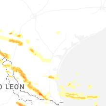
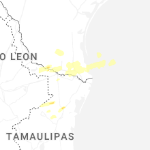


Connect with Interactive Hail Maps