

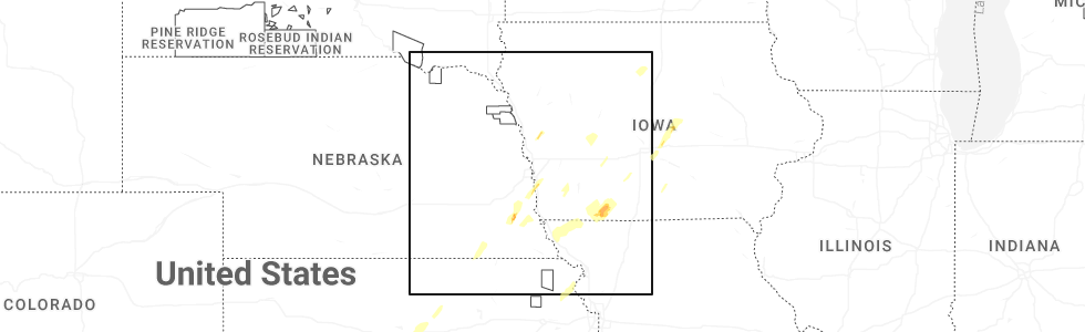
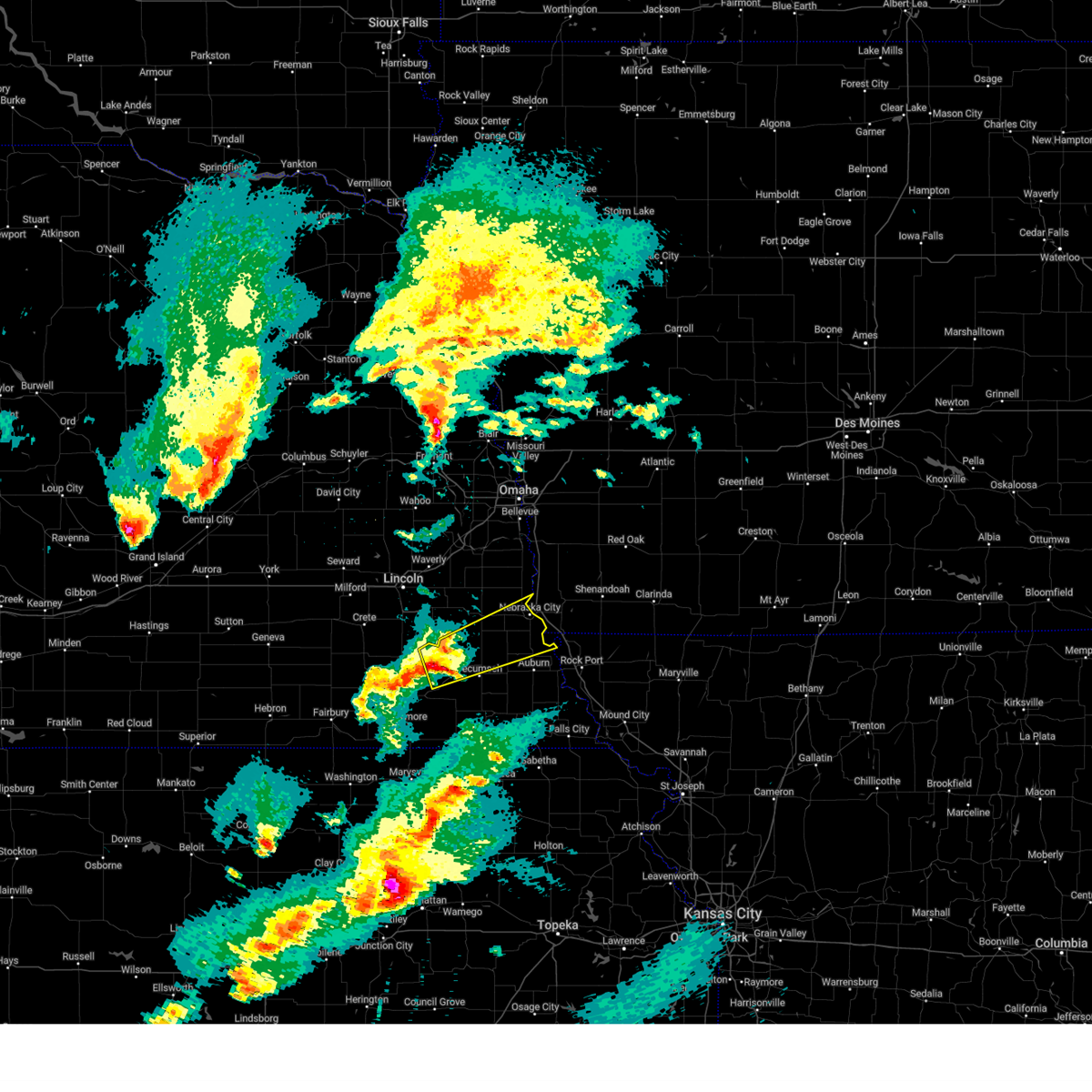
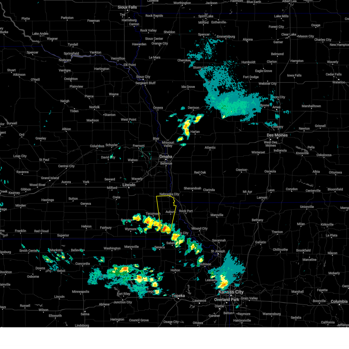
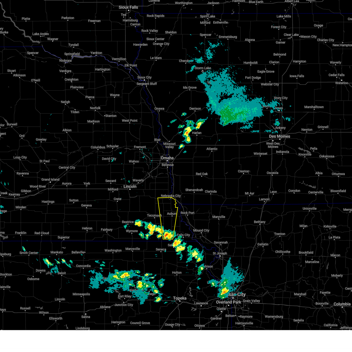
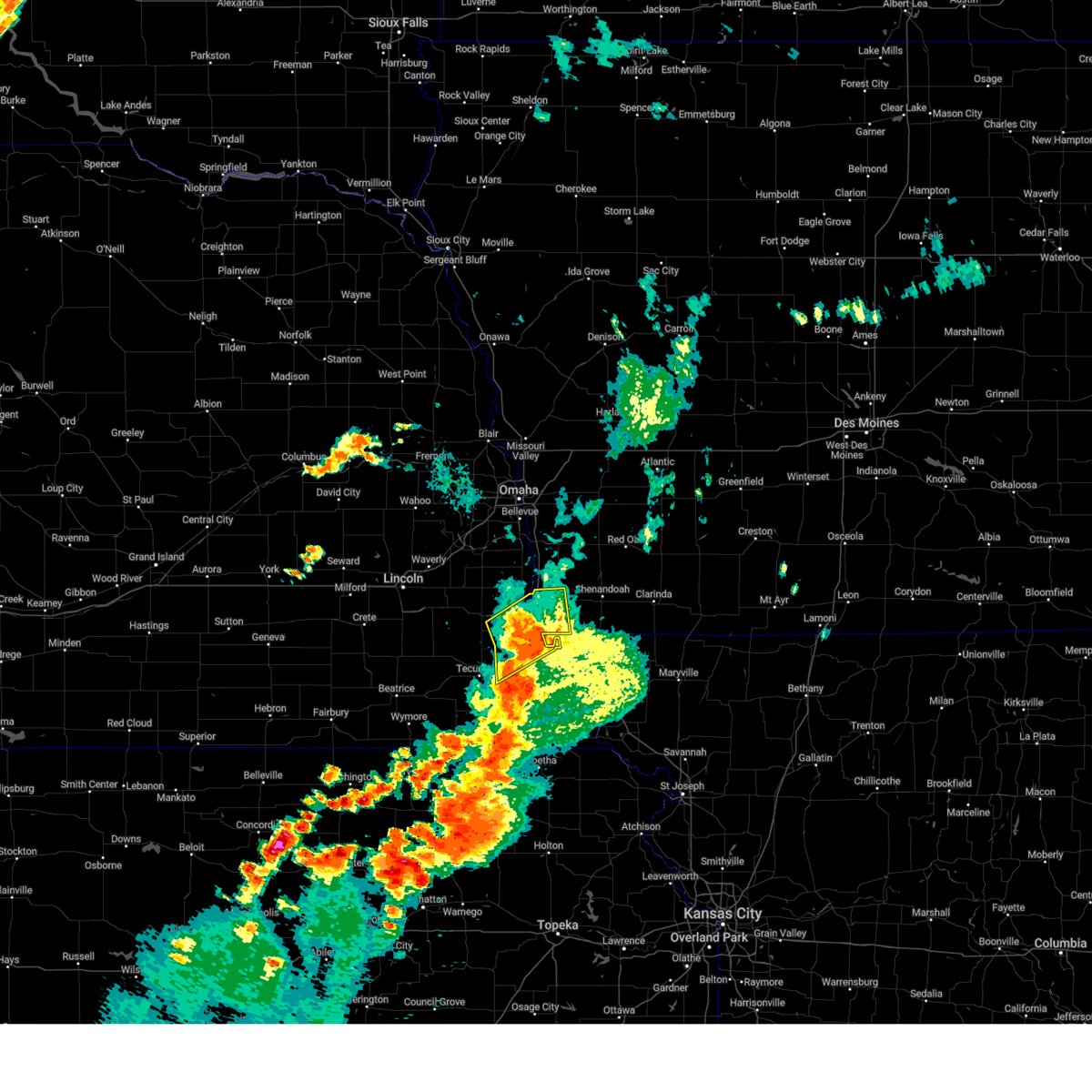
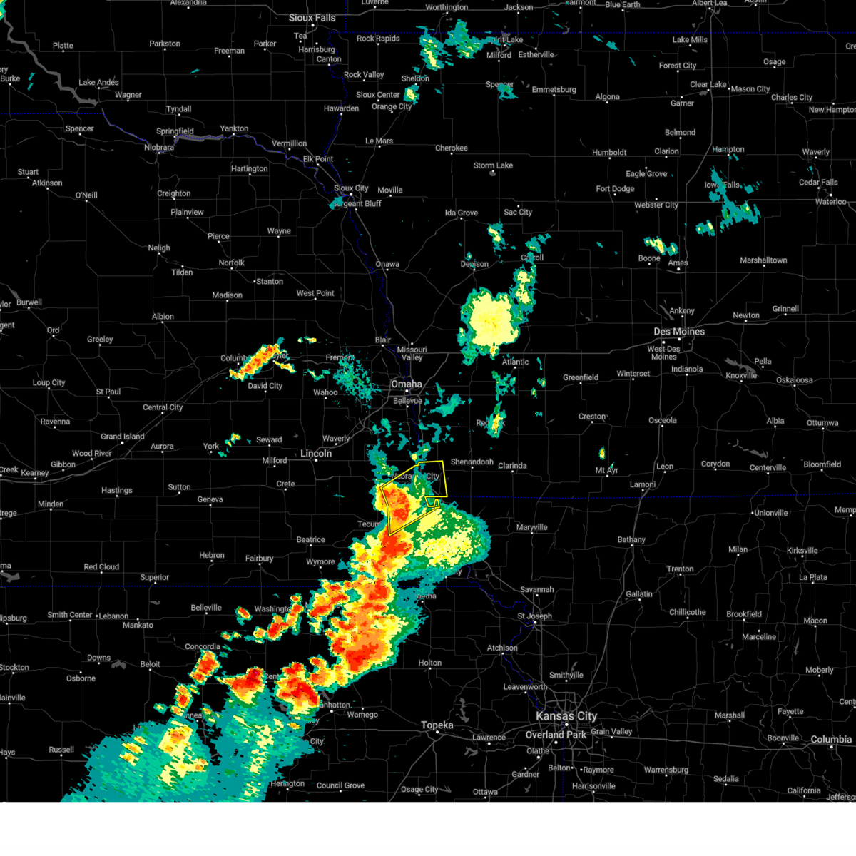
Hail Map for Lorton, NE
The Lorton, NE area has had 0 reports of on-the-ground hail by trained spotters, and has been under severe weather warnings 21 times during the past 12 months. Doppler radar has detected hail at or near Lorton, NE on 83 occasions, including 2 occasions during the past year.
| Name: | Lorton, NE |
| Where Located: | 46 miles S of Omaha, NE |
| Map: | Google Map for Lorton, NE |
| Population: | 41 |
| Housing Units: | 20 |
| More Info: | Search Google for Lorton, NE |
2
The Top Recent Hail Date for Lorton, NE is Wednesday, October 30, 2024 (28th out of 83)
Hail and Wind Damage Spotted near Lorton, NE
| Date / Time | Report Details |
|---|---|
| 6/29/2025 6:37 AM CDT |
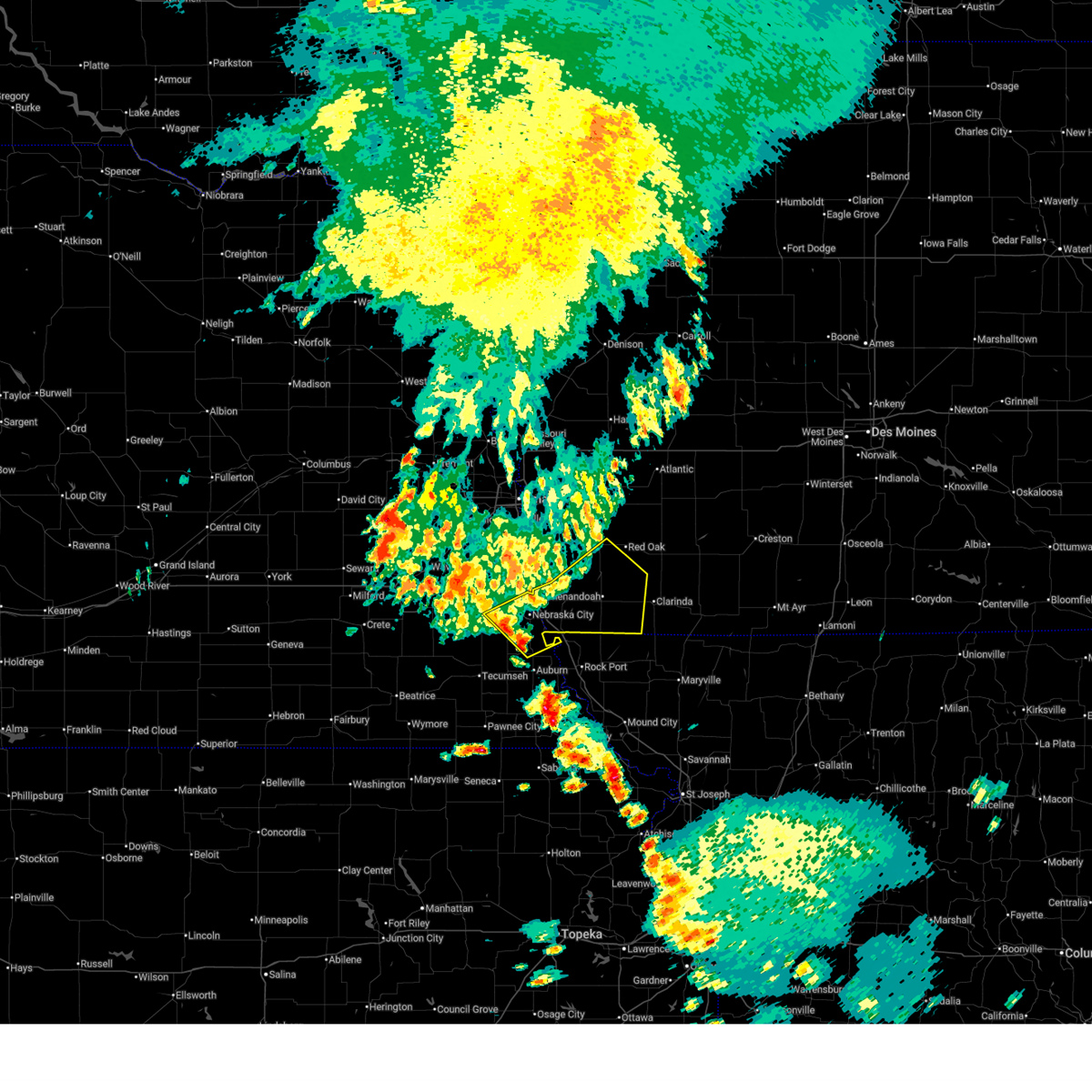
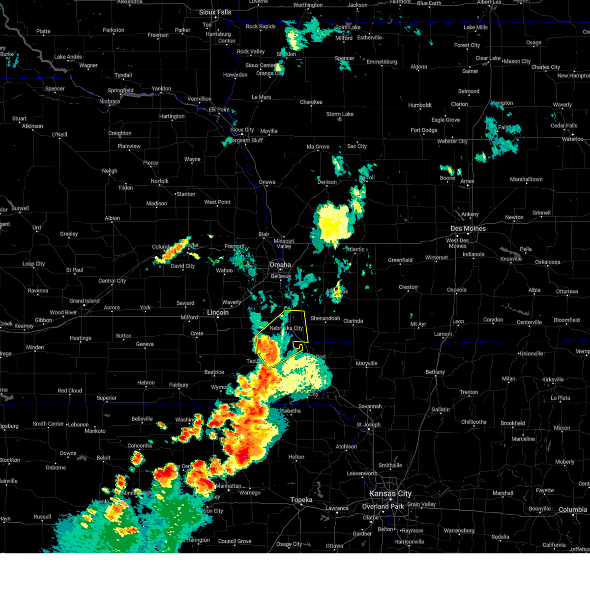
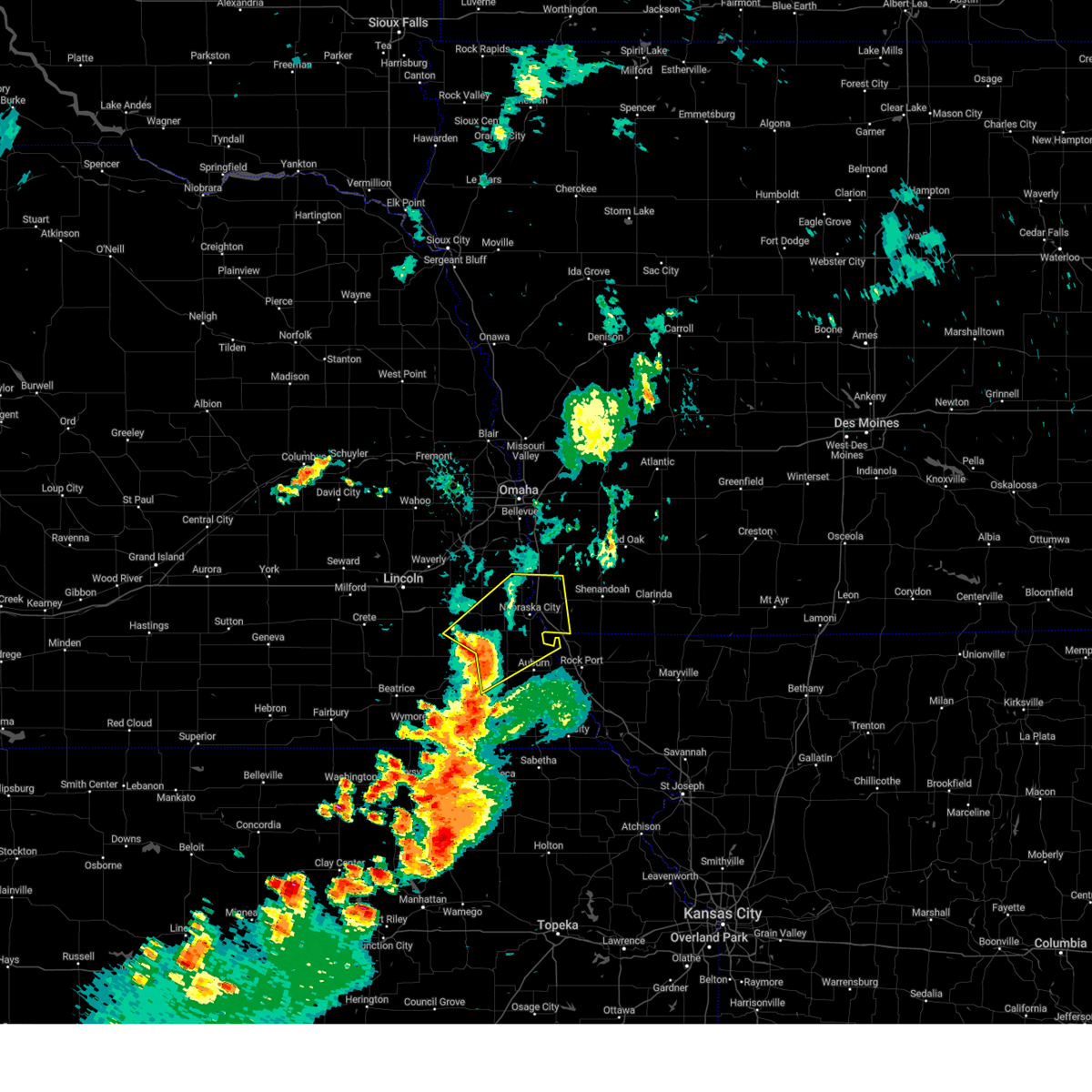
 At 637 am cdt, severe thunderstorms were located along a line extending from 2 miles northeast of red oak to 4 miles northwest of shenandoah to 2 miles southwest of nebraska city, moving east at 55 mph (radar indicated). Hazards include 60 mph wind gusts. Expect damage to roofs, siding, and trees. Locations impacted include, shenandoah, hamburg, essex, farragut, riverton and coin. At 637 am cdt, severe thunderstorms were located along a line extending from 2 miles northeast of red oak to 4 miles northwest of shenandoah to 2 miles southwest of nebraska city, moving east at 55 mph (radar indicated). Hazards include 60 mph wind gusts. Expect damage to roofs, siding, and trees. Locations impacted include, shenandoah, hamburg, essex, farragut, riverton and coin.
|
| 6/29/2025 6:37 AM CDT |
 the severe thunderstorm warning has been cancelled and is no longer in effect the severe thunderstorm warning has been cancelled and is no longer in effect
|
| 6/29/2025 6:15 AM CDT |
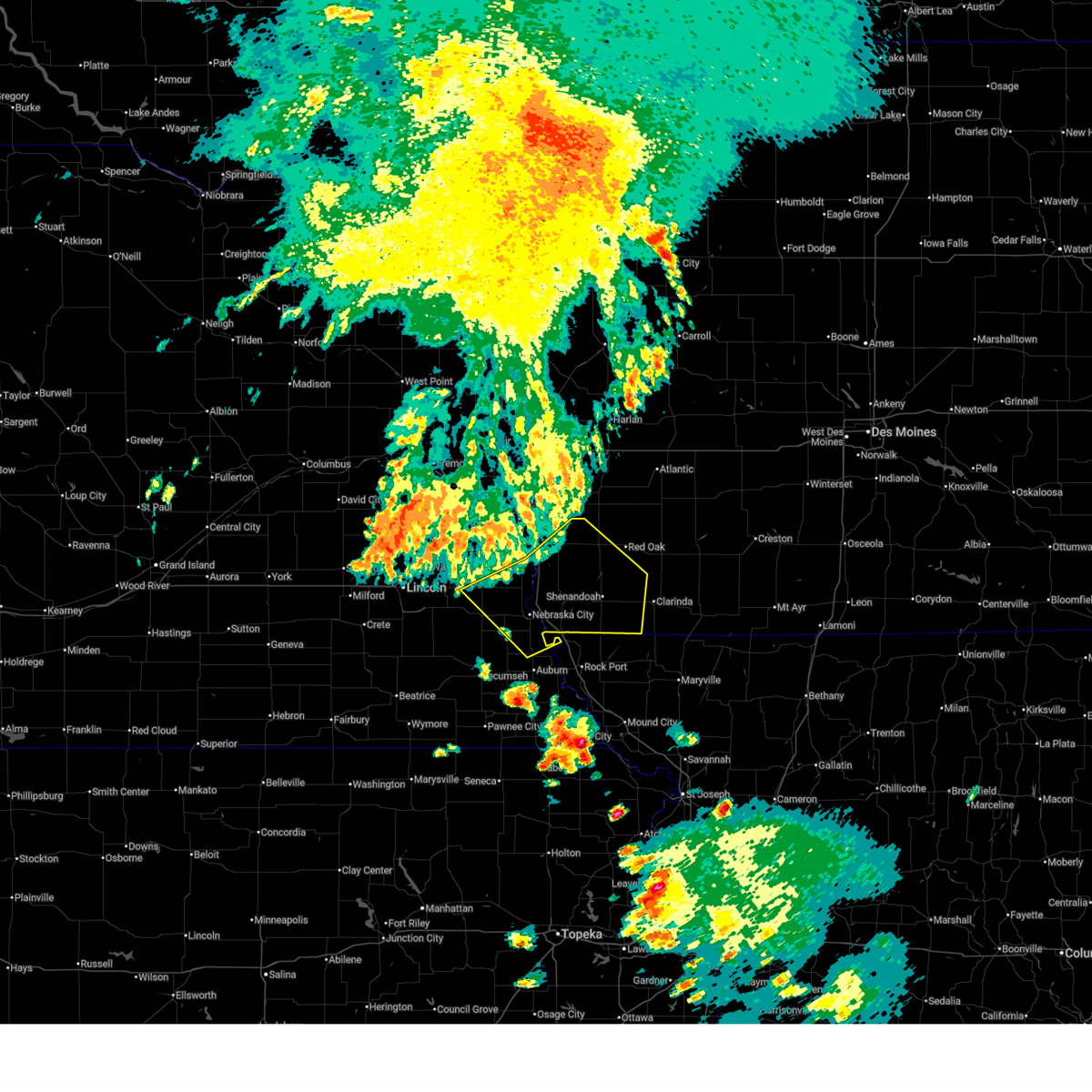 Svroax the national weather service in omaha has issued a * severe thunderstorm warning for, fremont county in southwestern iowa, southwestern montgomery county in southwestern iowa, mills county in southwestern iowa, page county in southwestern iowa, north central nemaha county in southeastern nebraska, eastern otoe county in southeastern nebraska, southeastern cass county in southeastern nebraska, * until 645 am cdt. * at 614 am cdt, severe thunderstorms were located along a line extending from 2 miles west of henderson to 3 miles west of tabor to 4 miles southwest of avoca, moving southeast at 55 mph (radar indicated). Hazards include 60 mph wind gusts. Expect damage to roofs, siding, and trees. severe thunderstorms will be near, malvern, tabor, emerson, union, dunbar, randolph, and hastings around 620 am cdt. nebraska city and sidney around 625 am cdt. other locations in the path of these severe thunderstorms include shenandoah, hamburg, essex, farragut and riverton. This includes interstate 29 between mile markers 1 and 32. Svroax the national weather service in omaha has issued a * severe thunderstorm warning for, fremont county in southwestern iowa, southwestern montgomery county in southwestern iowa, mills county in southwestern iowa, page county in southwestern iowa, north central nemaha county in southeastern nebraska, eastern otoe county in southeastern nebraska, southeastern cass county in southeastern nebraska, * until 645 am cdt. * at 614 am cdt, severe thunderstorms were located along a line extending from 2 miles west of henderson to 3 miles west of tabor to 4 miles southwest of avoca, moving southeast at 55 mph (radar indicated). Hazards include 60 mph wind gusts. Expect damage to roofs, siding, and trees. severe thunderstorms will be near, malvern, tabor, emerson, union, dunbar, randolph, and hastings around 620 am cdt. nebraska city and sidney around 625 am cdt. other locations in the path of these severe thunderstorms include shenandoah, hamburg, essex, farragut and riverton. This includes interstate 29 between mile markers 1 and 32.
|
| 4/1/2025 10:22 PM CDT |
 the severe thunderstorm warning has been cancelled and is no longer in effect the severe thunderstorm warning has been cancelled and is no longer in effect
|
| 4/1/2025 10:08 PM CDT |
 Svroax the national weather service in omaha has issued a * severe thunderstorm warning for, johnson county in southeastern nebraska, northwestern nemaha county in southeastern nebraska, southeastern otoe county in southeastern nebraska, northeastern gage county in southeastern nebraska, * until 1045 pm cdt. * at 1007 pm cdt, a severe thunderstorm was located near sterling, or 11 miles west of tecumseh, moving northeast at 60 mph (radar indicated). Hazards include 60 mph wind gusts and quarter size hail. Hail damage to vehicles is expected. Expect wind damage to roofs, siding, and trees. Svroax the national weather service in omaha has issued a * severe thunderstorm warning for, johnson county in southeastern nebraska, northwestern nemaha county in southeastern nebraska, southeastern otoe county in southeastern nebraska, northeastern gage county in southeastern nebraska, * until 1045 pm cdt. * at 1007 pm cdt, a severe thunderstorm was located near sterling, or 11 miles west of tecumseh, moving northeast at 60 mph (radar indicated). Hazards include 60 mph wind gusts and quarter size hail. Hail damage to vehicles is expected. Expect wind damage to roofs, siding, and trees.
|
| 3/14/2025 4:30 PM CDT |
 At 430 pm cdt, severe thunderstorms were located along a line extending from near avoca to near farragut, moving north at 45 mph (radar indicated). Hazards include 70 mph wind gusts and quarter size hail. Hail damage to vehicles is expected. expect considerable tree damage. wind damage is also likely to mobile homes, roofs, and outbuildings. Locations impacted include, camp catron, lorton, talmage, beaver lake, riverton, hamburg, murray, malvern, union, avoca, tabor, plattsmouth, nehawka, randolph, thurman, nebraska city, hastings, farragut, sidney, and waubonsie state park. At 430 pm cdt, severe thunderstorms were located along a line extending from near avoca to near farragut, moving north at 45 mph (radar indicated). Hazards include 70 mph wind gusts and quarter size hail. Hail damage to vehicles is expected. expect considerable tree damage. wind damage is also likely to mobile homes, roofs, and outbuildings. Locations impacted include, camp catron, lorton, talmage, beaver lake, riverton, hamburg, murray, malvern, union, avoca, tabor, plattsmouth, nehawka, randolph, thurman, nebraska city, hastings, farragut, sidney, and waubonsie state park.
|
| 3/14/2025 4:07 PM CDT |
 Svroax the national weather service in omaha has issued a * severe thunderstorm warning for, fremont county in southwestern iowa, southern mills county in southwestern iowa, central otoe county in southeastern nebraska, eastern cass county in southeastern nebraska, * until 500 pm cdt. * at 407 pm cdt, severe thunderstorms were located along a line extending from 3 miles west of cook to 4 miles south of hamburg, moving north at 45 mph (radar indicated). Hazards include 60 mph wind gusts and quarter size hail. Hail damage to vehicles is expected. Expect wind damage to roofs, siding, and trees. Svroax the national weather service in omaha has issued a * severe thunderstorm warning for, fremont county in southwestern iowa, southern mills county in southwestern iowa, central otoe county in southeastern nebraska, eastern cass county in southeastern nebraska, * until 500 pm cdt. * at 407 pm cdt, severe thunderstorms were located along a line extending from 3 miles west of cook to 4 miles south of hamburg, moving north at 45 mph (radar indicated). Hazards include 60 mph wind gusts and quarter size hail. Hail damage to vehicles is expected. Expect wind damage to roofs, siding, and trees.
|
| 3/14/2025 3:37 PM CDT |
 the severe thunderstorm warning has been cancelled and is no longer in effect the severe thunderstorm warning has been cancelled and is no longer in effect
|
| 3/14/2025 3:37 PM CDT |
 At 336 pm cdt, a severe thunderstorm was located 3 miles southeast of johnson, or 6 miles west of auburn, moving north at 50 mph (radar indicated). Hazards include 60 mph wind gusts and quarter size hail. Hail damage to vehicles is expected. expect wind damage to roofs, siding, and trees. Locations impacted include, brock, nebraska city, johnson, lorton, talmage, dunbar, and julian. At 336 pm cdt, a severe thunderstorm was located 3 miles southeast of johnson, or 6 miles west of auburn, moving north at 50 mph (radar indicated). Hazards include 60 mph wind gusts and quarter size hail. Hail damage to vehicles is expected. expect wind damage to roofs, siding, and trees. Locations impacted include, brock, nebraska city, johnson, lorton, talmage, dunbar, and julian.
|
| 3/14/2025 3:20 PM CDT |
 At 320 pm cdt, a severe thunderstorm was located near humboldt, or 11 miles northeast of pawnee city, moving north at 55 mph (radar indicated). Hazards include 60 mph wind gusts and quarter size hail. Hail damage to vehicles is expected. expect wind damage to roofs, siding, and trees. Locations impacted include, nebraska city, johnson, lorton, talmage, humboldt, auburn, duck creek recreation area, brock, the highway 62 and 105 junction, howe, dunbar, kirkmans cove recreation area, julian, and peru. At 320 pm cdt, a severe thunderstorm was located near humboldt, or 11 miles northeast of pawnee city, moving north at 55 mph (radar indicated). Hazards include 60 mph wind gusts and quarter size hail. Hail damage to vehicles is expected. expect wind damage to roofs, siding, and trees. Locations impacted include, nebraska city, johnson, lorton, talmage, humboldt, auburn, duck creek recreation area, brock, the highway 62 and 105 junction, howe, dunbar, kirkmans cove recreation area, julian, and peru.
|
| 3/14/2025 3:13 PM CDT |
 Svroax the national weather service in omaha has issued a * severe thunderstorm warning for, northeastern johnson county in southeastern nebraska, nemaha county in southeastern nebraska, southeastern otoe county in southeastern nebraska, western richardson county in southeastern nebraska, northeastern pawnee county in southeastern nebraska, * until 400 pm cdt. * at 313 pm cdt, a severe thunderstorm was located 3 miles south of humboldt, or 11 miles east of pawnee city, moving north at 55 mph (radar indicated). Hazards include 60 mph wind gusts and quarter size hail. Hail damage to vehicles is expected. Expect wind damage to roofs, siding, and trees. Svroax the national weather service in omaha has issued a * severe thunderstorm warning for, northeastern johnson county in southeastern nebraska, nemaha county in southeastern nebraska, southeastern otoe county in southeastern nebraska, western richardson county in southeastern nebraska, northeastern pawnee county in southeastern nebraska, * until 400 pm cdt. * at 313 pm cdt, a severe thunderstorm was located 3 miles south of humboldt, or 11 miles east of pawnee city, moving north at 55 mph (radar indicated). Hazards include 60 mph wind gusts and quarter size hail. Hail damage to vehicles is expected. Expect wind damage to roofs, siding, and trees.
|
| 8/14/2024 8:04 PM CDT |
 the severe thunderstorm warning has been cancelled and is no longer in effect the severe thunderstorm warning has been cancelled and is no longer in effect
|
| 8/14/2024 7:59 PM CDT |
 At 758 pm cdt, severe thunderstorms were located along a line extending from near dunbar to 3 miles south of nebraska city to 4 miles north of auburn, moving east at 40 mph (radar indicated). Hazards include 60 mph wind gusts. Expect damage to roofs, siding, and trees. Locations impacted include, nebraska city, hamburg, sidney, peru, johnson, talmage, dunbar, brock, julian, lorton, camp catron, duck creek recreation area, and waubonsie state park. At 758 pm cdt, severe thunderstorms were located along a line extending from near dunbar to 3 miles south of nebraska city to 4 miles north of auburn, moving east at 40 mph (radar indicated). Hazards include 60 mph wind gusts. Expect damage to roofs, siding, and trees. Locations impacted include, nebraska city, hamburg, sidney, peru, johnson, talmage, dunbar, brock, julian, lorton, camp catron, duck creek recreation area, and waubonsie state park.
|
| 8/14/2024 7:59 PM CDT |
 the severe thunderstorm warning has been cancelled and is no longer in effect the severe thunderstorm warning has been cancelled and is no longer in effect
|
| 8/14/2024 7:50 PM CDT |
 At 750 pm cdt, severe thunderstorms were located along a line extending from near syracuse to 3 miles east of lorton to 3 miles southeast of brock, moving northeast at 45 mph (radar indicated). Hazards include 60 mph wind gusts. Expect damage to roofs, siding, and trees. Locations impacted include, nebraska city, syracuse, hamburg, sidney, peru, johnson, cook, talmage, union, dunbar, brock, julian, lorton, thurman, camp catron, duck creek recreation area, and waubonsie state park. At 750 pm cdt, severe thunderstorms were located along a line extending from near syracuse to 3 miles east of lorton to 3 miles southeast of brock, moving northeast at 45 mph (radar indicated). Hazards include 60 mph wind gusts. Expect damage to roofs, siding, and trees. Locations impacted include, nebraska city, syracuse, hamburg, sidney, peru, johnson, cook, talmage, union, dunbar, brock, julian, lorton, thurman, camp catron, duck creek recreation area, and waubonsie state park.
|
| 8/14/2024 7:33 PM CDT |
 Svroax the national weather service in omaha has issued a * severe thunderstorm warning for, western fremont county in southwestern iowa, eastern johnson county in southeastern nebraska, northwestern nemaha county in southeastern nebraska, otoe county in southeastern nebraska, southeastern cass county in southeastern nebraska, * until 815 pm cdt. * at 733 pm cdt, severe thunderstorms were located along a line extending from 2 miles southeast of douglas to near cook to 3 miles southeast of tecumseh, moving northeast at 45 mph (radar indicated). Hazards include 60 mph wind gusts and penny size hail. expect damage to roofs, siding, and trees Svroax the national weather service in omaha has issued a * severe thunderstorm warning for, western fremont county in southwestern iowa, eastern johnson county in southeastern nebraska, northwestern nemaha county in southeastern nebraska, otoe county in southeastern nebraska, southeastern cass county in southeastern nebraska, * until 815 pm cdt. * at 733 pm cdt, severe thunderstorms were located along a line extending from 2 miles southeast of douglas to near cook to 3 miles southeast of tecumseh, moving northeast at 45 mph (radar indicated). Hazards include 60 mph wind gusts and penny size hail. expect damage to roofs, siding, and trees
|
| 7/10/2024 7:39 PM CDT |
 Svroax the national weather service in omaha has issued a * severe thunderstorm warning for, central nemaha county in southeastern nebraska, southeastern otoe county in southeastern nebraska, * until 815 pm cdt. * at 738 pm cdt, a severe thunderstorm was located over lorton, or 11 miles southwest of nebraska city, moving southeast at 40 mph (radar indicated). Hazards include 60 mph wind gusts and quarter size hail. Hail damage to vehicles is expected. Expect wind damage to roofs, siding, and trees. Svroax the national weather service in omaha has issued a * severe thunderstorm warning for, central nemaha county in southeastern nebraska, southeastern otoe county in southeastern nebraska, * until 815 pm cdt. * at 738 pm cdt, a severe thunderstorm was located over lorton, or 11 miles southwest of nebraska city, moving southeast at 40 mph (radar indicated). Hazards include 60 mph wind gusts and quarter size hail. Hail damage to vehicles is expected. Expect wind damage to roofs, siding, and trees.
|
| 7/6/2024 7:51 PM CDT |
 The storms which prompted the warning have weakened below severe limits, and no longer pose an immediate threat to life or property. therefore, the warning will be allowed to expire. however, gusty winds and heavy rain are still possible with these thunderstorms. a severe thunderstorm watch remains in effect until midnight cdt for southeastern nebraska. The storms which prompted the warning have weakened below severe limits, and no longer pose an immediate threat to life or property. therefore, the warning will be allowed to expire. however, gusty winds and heavy rain are still possible with these thunderstorms. a severe thunderstorm watch remains in effect until midnight cdt for southeastern nebraska.
|
| 7/6/2024 7:41 PM CDT |
 At 741 pm cdt, severe thunderstorms were located along a line extending from 2 miles north of elmwood to 4 miles southeast of syracuse to 3 miles west of elk creek, moving east at 40 mph (radar indicated). Hazards include 60 mph wind gusts. Expect damage to roofs, siding, and trees. Locations impacted include, tecumseh, syracuse, johnson, cook, unadilla, avoca, talmage, nehawka, dunbar, brock, elk creek, lorton, otoe, and st mary. At 741 pm cdt, severe thunderstorms were located along a line extending from 2 miles north of elmwood to 4 miles southeast of syracuse to 3 miles west of elk creek, moving east at 40 mph (radar indicated). Hazards include 60 mph wind gusts. Expect damage to roofs, siding, and trees. Locations impacted include, tecumseh, syracuse, johnson, cook, unadilla, avoca, talmage, nehawka, dunbar, brock, elk creek, lorton, otoe, and st mary.
|
| 7/6/2024 7:34 PM CDT |
 At 734 pm cdt, severe thunderstorms were located along a line extending from 3 miles west of elmwood to 5 miles south of syracuse to 7 miles east of lewiston, moving east at 40 mph (radar indicated). Hazards include 60 mph wind gusts. Expect damage to roofs, siding, and trees. Locations impacted include, tecumseh, syracuse, weeping water, elmwood, palmyra, sterling, johnson, cook, unadilla, avoca, talmage, nehawka, dunbar, douglas, brock, elk creek, lewiston, lorton, crab orchard, and otoe. At 734 pm cdt, severe thunderstorms were located along a line extending from 3 miles west of elmwood to 5 miles south of syracuse to 7 miles east of lewiston, moving east at 40 mph (radar indicated). Hazards include 60 mph wind gusts. Expect damage to roofs, siding, and trees. Locations impacted include, tecumseh, syracuse, weeping water, elmwood, palmyra, sterling, johnson, cook, unadilla, avoca, talmage, nehawka, dunbar, douglas, brock, elk creek, lewiston, lorton, crab orchard, and otoe.
|
| 7/6/2024 7:06 PM CDT |
 Svroax the national weather service in omaha has issued a * severe thunderstorm warning for, johnson county in southeastern nebraska, western nemaha county in southeastern nebraska, otoe county in southeastern nebraska, northwestern pawnee county in southeastern nebraska, southwestern cass county in southeastern nebraska, * until 800 pm cdt. * at 706 pm cdt, severe thunderstorms were located along a line extending from lincoln to 3 miles north of adams to 3 miles east of holmesville, moving east at 40 mph (radar indicated). Hazards include 60 mph wind gusts. expect damage to roofs, siding, and trees Svroax the national weather service in omaha has issued a * severe thunderstorm warning for, johnson county in southeastern nebraska, western nemaha county in southeastern nebraska, otoe county in southeastern nebraska, northwestern pawnee county in southeastern nebraska, southwestern cass county in southeastern nebraska, * until 800 pm cdt. * at 706 pm cdt, severe thunderstorms were located along a line extending from lincoln to 3 miles north of adams to 3 miles east of holmesville, moving east at 40 mph (radar indicated). Hazards include 60 mph wind gusts. expect damage to roofs, siding, and trees
|
| 6/26/2024 1:31 AM CDT |
 Svroax the national weather service in omaha has issued a * severe thunderstorm warning for, johnson county in southeastern nebraska, nemaha county in southeastern nebraska, southern otoe county in southeastern nebraska, richardson county in southeastern nebraska, pawnee county in southeastern nebraska, * until 230 am cdt. * at 131 am cdt, severe thunderstorms were located along a line extending from 3 miles northeast of talmage to near adams, moving south at 40 mph (radar indicated). Hazards include 60 mph wind gusts. expect damage to roofs, siding, and trees Svroax the national weather service in omaha has issued a * severe thunderstorm warning for, johnson county in southeastern nebraska, nemaha county in southeastern nebraska, southern otoe county in southeastern nebraska, richardson county in southeastern nebraska, pawnee county in southeastern nebraska, * until 230 am cdt. * at 131 am cdt, severe thunderstorms were located along a line extending from 3 miles northeast of talmage to near adams, moving south at 40 mph (radar indicated). Hazards include 60 mph wind gusts. expect damage to roofs, siding, and trees
|
| 6/25/2024 11:37 PM CDT |
 At 1136 pm cdt, a severe thunderstorm was located over peru, or 8 miles northeast of auburn, moving east at 30 mph (radar indicated). Hazards include 60 mph wind gusts and half dollar size hail. Hail damage to vehicles is expected. expect wind damage to roofs, siding, and trees. Locations impacted include, auburn, peru, talmage, brownville, brock, julian, lorton, brownville state recreation area, and duck creek recreation area. At 1136 pm cdt, a severe thunderstorm was located over peru, or 8 miles northeast of auburn, moving east at 30 mph (radar indicated). Hazards include 60 mph wind gusts and half dollar size hail. Hail damage to vehicles is expected. expect wind damage to roofs, siding, and trees. Locations impacted include, auburn, peru, talmage, brownville, brock, julian, lorton, brownville state recreation area, and duck creek recreation area.
|
| 6/25/2024 11:37 PM CDT |
 the severe thunderstorm warning has been cancelled and is no longer in effect the severe thunderstorm warning has been cancelled and is no longer in effect
|
| 6/25/2024 11:34 PM CDT |
 Svroax the national weather service in omaha has issued a * severe thunderstorm warning for, south central fremont county in southwestern iowa, central nemaha county in southeastern nebraska, southeastern otoe county in southeastern nebraska, * until 1215 am cdt. * at 1134 pm cdt, a severe thunderstorm was located over peru, or 7 miles northeast of auburn, moving east at 30 mph (radar indicated). Hazards include 60 mph wind gusts and half dollar size hail. Hail damage to vehicles is expected. Expect wind damage to roofs, siding, and trees. Svroax the national weather service in omaha has issued a * severe thunderstorm warning for, south central fremont county in southwestern iowa, central nemaha county in southeastern nebraska, southeastern otoe county in southeastern nebraska, * until 1215 am cdt. * at 1134 pm cdt, a severe thunderstorm was located over peru, or 7 miles northeast of auburn, moving east at 30 mph (radar indicated). Hazards include 60 mph wind gusts and half dollar size hail. Hail damage to vehicles is expected. Expect wind damage to roofs, siding, and trees.
|
| 6/15/2024 7:03 PM CDT |
 Svroax the national weather service in omaha has issued a * severe thunderstorm warning for, western fremont county in southwestern iowa, western mills county in southwestern iowa, east central sarpy county in east central nebraska, central otoe county in southeastern nebraska, eastern cass county in southeastern nebraska, * until 745 pm cdt. * at 703 pm cdt, severe thunderstorms were located along a line extending from 3 miles east of cedar creek to 4 miles north of cook, moving east at 20 mph (radar indicated). Hazards include 60 mph wind gusts. expect damage to roofs, siding, and trees Svroax the national weather service in omaha has issued a * severe thunderstorm warning for, western fremont county in southwestern iowa, western mills county in southwestern iowa, east central sarpy county in east central nebraska, central otoe county in southeastern nebraska, eastern cass county in southeastern nebraska, * until 745 pm cdt. * at 703 pm cdt, severe thunderstorms were located along a line extending from 3 miles east of cedar creek to 4 miles north of cook, moving east at 20 mph (radar indicated). Hazards include 60 mph wind gusts. expect damage to roofs, siding, and trees
|
| 5/24/2024 3:12 AM CDT |
 Svroax the national weather service in omaha has issued a * severe thunderstorm warning for, southwestern fremont county in southwestern iowa, nemaha county in southeastern nebraska, southeastern otoe county in southeastern nebraska, richardson county in southeastern nebraska, eastern pawnee county in southeastern nebraska, * until 400 am cdt. * at 312 am cdt, severe thunderstorms were located along a line extending from near talmage to 5 miles southwest of auburn to 2 miles southwest of du bois, moving east at 45 mph (radar indicated). Hazards include 60 mph wind gusts and penny size hail. expect damage to roofs, siding, and trees Svroax the national weather service in omaha has issued a * severe thunderstorm warning for, southwestern fremont county in southwestern iowa, nemaha county in southeastern nebraska, southeastern otoe county in southeastern nebraska, richardson county in southeastern nebraska, eastern pawnee county in southeastern nebraska, * until 400 am cdt. * at 312 am cdt, severe thunderstorms were located along a line extending from near talmage to 5 miles southwest of auburn to 2 miles southwest of du bois, moving east at 45 mph (radar indicated). Hazards include 60 mph wind gusts and penny size hail. expect damage to roofs, siding, and trees
|
| 5/24/2024 2:58 AM CDT |
 At 258 am cdt, severe thunderstorms were located along a line extending from 4 miles northeast of dunbar to near johnson to 4 miles east of summerfield, moving east at 60 mph (radar indicated). Hazards include 70 mph wind gusts and quarter size hail. Hail damage to vehicles is expected. expect considerable tree damage. wind damage is also likely to mobile homes, roofs, and outbuildings. Locations impacted include, nebraska city, auburn, tecumseh, pawnee city, syracuse, hamburg, humboldt, peru, farragut, johnson, cook, unadilla, riverton, table rock, talmage, dunbar, verdon, summerfield, stella, and shubert. At 258 am cdt, severe thunderstorms were located along a line extending from 4 miles northeast of dunbar to near johnson to 4 miles east of summerfield, moving east at 60 mph (radar indicated). Hazards include 70 mph wind gusts and quarter size hail. Hail damage to vehicles is expected. expect considerable tree damage. wind damage is also likely to mobile homes, roofs, and outbuildings. Locations impacted include, nebraska city, auburn, tecumseh, pawnee city, syracuse, hamburg, humboldt, peru, farragut, johnson, cook, unadilla, riverton, table rock, talmage, dunbar, verdon, summerfield, stella, and shubert.
|
| 5/24/2024 2:58 AM CDT |
 the severe thunderstorm warning has been cancelled and is no longer in effect the severe thunderstorm warning has been cancelled and is no longer in effect
|
| 5/24/2024 2:49 AM CDT |
 At 249 am cdt, severe thunderstorms were located along a line extending from 4 miles northeast of syracuse to near tecumseh to 3 miles west of summerfield, moving east at 60 mph (radar indicated). Hazards include 70 mph wind gusts and quarter size hail. Hail damage to vehicles is expected. expect considerable tree damage. wind damage is also likely to mobile homes, roofs, and outbuildings. Locations impacted include, nebraska city, auburn, tecumseh, pawnee city, syracuse, wymore, hamburg, humboldt, peru, bennet, adams, palmyra, farragut, sterling, blue springs, johnson, cook, unadilla, riverton, and table rock. At 249 am cdt, severe thunderstorms were located along a line extending from 4 miles northeast of syracuse to near tecumseh to 3 miles west of summerfield, moving east at 60 mph (radar indicated). Hazards include 70 mph wind gusts and quarter size hail. Hail damage to vehicles is expected. expect considerable tree damage. wind damage is also likely to mobile homes, roofs, and outbuildings. Locations impacted include, nebraska city, auburn, tecumseh, pawnee city, syracuse, wymore, hamburg, humboldt, peru, bennet, adams, palmyra, farragut, sterling, blue springs, johnson, cook, unadilla, riverton, and table rock.
|
| 5/24/2024 2:32 AM CDT |
 Svroax the national weather service in omaha has issued a * severe thunderstorm warning for, southern fremont county in southwestern iowa, southwestern page county in southwestern iowa, southeastern lancaster county in southeastern nebraska, johnson county in southeastern nebraska, nemaha county in southeastern nebraska, otoe county in southeastern nebraska, richardson county in southeastern nebraska, pawnee county in southeastern nebraska, gage county in southeastern nebraska, * until 315 am cdt. * at 231 am cdt, severe thunderstorms were located along a line extending from near palmyra to 4 miles south of adams to 5 miles southeast of odell, moving east at 60 mph (radar indicated). Hazards include 70 mph wind gusts and quarter size hail. Hail damage to vehicles is expected. expect considerable tree damage. Wind damage is also likely to mobile homes, roofs, and outbuildings. Svroax the national weather service in omaha has issued a * severe thunderstorm warning for, southern fremont county in southwestern iowa, southwestern page county in southwestern iowa, southeastern lancaster county in southeastern nebraska, johnson county in southeastern nebraska, nemaha county in southeastern nebraska, otoe county in southeastern nebraska, richardson county in southeastern nebraska, pawnee county in southeastern nebraska, gage county in southeastern nebraska, * until 315 am cdt. * at 231 am cdt, severe thunderstorms were located along a line extending from near palmyra to 4 miles south of adams to 5 miles southeast of odell, moving east at 60 mph (radar indicated). Hazards include 70 mph wind gusts and quarter size hail. Hail damage to vehicles is expected. expect considerable tree damage. Wind damage is also likely to mobile homes, roofs, and outbuildings.
|
| 5/21/2024 1:15 PM CDT |
 Toroax the national weather service in omaha has issued a * tornado warning for, west central fremont county in southwestern iowa, central otoe county in southeastern nebraska, southeastern cass county in southeastern nebraska, * until 200 pm cdt. * at 115 pm cdt, a severe thunderstorm capable of producing a tornado was located 6 miles southwest of syracuse, or 15 miles north of tecumseh, moving northeast at 55 mph (radar indicated rotation). Hazards include tornado and quarter size hail. Flying debris will be dangerous to those caught without shelter. mobile homes will be damaged or destroyed. damage to roofs, windows, and vehicles will occur. tree damage is likely. this dangerous storm will be near, syracuse around 120 pm cdt. avoca around 130 pm cdt. nehawka around 135 pm cdt. Other locations in the path of this tornadic thunderstorm include union. Toroax the national weather service in omaha has issued a * tornado warning for, west central fremont county in southwestern iowa, central otoe county in southeastern nebraska, southeastern cass county in southeastern nebraska, * until 200 pm cdt. * at 115 pm cdt, a severe thunderstorm capable of producing a tornado was located 6 miles southwest of syracuse, or 15 miles north of tecumseh, moving northeast at 55 mph (radar indicated rotation). Hazards include tornado and quarter size hail. Flying debris will be dangerous to those caught without shelter. mobile homes will be damaged or destroyed. damage to roofs, windows, and vehicles will occur. tree damage is likely. this dangerous storm will be near, syracuse around 120 pm cdt. avoca around 130 pm cdt. nehawka around 135 pm cdt. Other locations in the path of this tornadic thunderstorm include union.
|
| 5/21/2024 1:06 PM CDT |
 At 106 pm cdt, a severe thunderstorm was located 5 miles southeast of douglas, or 12 miles northwest of tecumseh, moving northeast at 55 mph (radar indicated). Hazards include 60 mph wind gusts and half dollar size hail. Hail damage to vehicles is expected. expect wind damage to roofs, siding, and trees. Locations impacted include, syracuse, sterling, cook, unadilla, talmage, douglas, lorton, burr, and st mary. At 106 pm cdt, a severe thunderstorm was located 5 miles southeast of douglas, or 12 miles northwest of tecumseh, moving northeast at 55 mph (radar indicated). Hazards include 60 mph wind gusts and half dollar size hail. Hail damage to vehicles is expected. expect wind damage to roofs, siding, and trees. Locations impacted include, syracuse, sterling, cook, unadilla, talmage, douglas, lorton, burr, and st mary.
|
| 5/21/2024 1:06 PM CDT |
 the severe thunderstorm warning has been cancelled and is no longer in effect the severe thunderstorm warning has been cancelled and is no longer in effect
|
| 5/21/2024 12:58 PM CDT |
 At 1258 pm cdt, a severe thunderstorm was located over sterling, or 12 miles northwest of tecumseh, moving northeast at 50 mph (radar indicated). Hazards include 60 mph wind gusts and half dollar size hail. Hail damage to vehicles is expected. expect wind damage to roofs, siding, and trees. Locations impacted include, syracuse, adams, sterling, cook, unadilla, talmage, douglas, lorton, crab orchard, burr, and st mary. At 1258 pm cdt, a severe thunderstorm was located over sterling, or 12 miles northwest of tecumseh, moving northeast at 50 mph (radar indicated). Hazards include 60 mph wind gusts and half dollar size hail. Hail damage to vehicles is expected. expect wind damage to roofs, siding, and trees. Locations impacted include, syracuse, adams, sterling, cook, unadilla, talmage, douglas, lorton, crab orchard, burr, and st mary.
|
| 5/21/2024 12:45 PM CDT |
 Svroax the national weather service in omaha has issued a * severe thunderstorm warning for, northern johnson county in southeastern nebraska, western otoe county in southeastern nebraska, northeastern gage county in southeastern nebraska, * until 130 pm cdt. * at 1245 pm cdt, a severe thunderstorm was located 5 miles northwest of crab orchard, or 13 miles northeast of beatrice, moving northeast at 45 mph (radar indicated). Hazards include 60 mph wind gusts and quarter size hail. Hail damage to vehicles is expected. Expect wind damage to roofs, siding, and trees. Svroax the national weather service in omaha has issued a * severe thunderstorm warning for, northern johnson county in southeastern nebraska, western otoe county in southeastern nebraska, northeastern gage county in southeastern nebraska, * until 130 pm cdt. * at 1245 pm cdt, a severe thunderstorm was located 5 miles northwest of crab orchard, or 13 miles northeast of beatrice, moving northeast at 45 mph (radar indicated). Hazards include 60 mph wind gusts and quarter size hail. Hail damage to vehicles is expected. Expect wind damage to roofs, siding, and trees.
|
| 5/19/2024 6:33 PM CDT |
 At 632 pm cdt, a severe thunderstorm was located 4 miles northwest of nebraska city, moving east at 45 mph (radar indicated). Hazards include 60 mph wind gusts and quarter size hail. Hail damage to vehicles is expected. expect wind damage to roofs, siding, and trees. Locations impacted include, nebraska city, shenandoah, syracuse, hamburg, sidney, tabor, peru, farragut, unadilla, riverton, avoca, talmage, union, nehawka, dunbar, randolph, julian, lorton, thurman, and otoe. At 632 pm cdt, a severe thunderstorm was located 4 miles northwest of nebraska city, moving east at 45 mph (radar indicated). Hazards include 60 mph wind gusts and quarter size hail. Hail damage to vehicles is expected. expect wind damage to roofs, siding, and trees. Locations impacted include, nebraska city, shenandoah, syracuse, hamburg, sidney, tabor, peru, farragut, unadilla, riverton, avoca, talmage, union, nehawka, dunbar, randolph, julian, lorton, thurman, and otoe.
|
| 5/19/2024 6:17 PM CDT |
 Svroax the national weather service in omaha has issued a * severe thunderstorm warning for, fremont county in southwestern iowa, southeastern mills county in southwestern iowa, northern nemaha county in southeastern nebraska, otoe county in southeastern nebraska, southeastern cass county in southeastern nebraska, * until 700 pm cdt. * at 616 pm cdt, a severe thunderstorm was located 3 miles west of dunbar, or 11 miles west of nebraska city, moving east at 40 mph (radar indicated). Hazards include 60 mph wind gusts and quarter size hail. Hail damage to vehicles is expected. Expect wind damage to roofs, siding, and trees. Svroax the national weather service in omaha has issued a * severe thunderstorm warning for, fremont county in southwestern iowa, southeastern mills county in southwestern iowa, northern nemaha county in southeastern nebraska, otoe county in southeastern nebraska, southeastern cass county in southeastern nebraska, * until 700 pm cdt. * at 616 pm cdt, a severe thunderstorm was located 3 miles west of dunbar, or 11 miles west of nebraska city, moving east at 40 mph (radar indicated). Hazards include 60 mph wind gusts and quarter size hail. Hail damage to vehicles is expected. Expect wind damage to roofs, siding, and trees.
|
| 5/6/2024 8:28 PM CDT |
 At 828 pm cdt, severe thunderstorms were located along a line extending from 2 miles west of nebraska city to 2 miles southeast of du bois, moving northeast at 50 mph (radar indicated). Hazards include 60 mph wind gusts and quarter size hail. Hail damage to vehicles is expected. expect wind damage to roofs, siding, and trees. Locations impacted include, nebraska city, auburn, tecumseh, pawnee city, humboldt, johnson, cook, table rock, talmage, du bois, dawson, brock, elk creek, julian, lorton, the highway 62 and 105 junction, howe, the highway 75 and 8 junction, kirkmans cove recreation area, and camp cornhusker. At 828 pm cdt, severe thunderstorms were located along a line extending from 2 miles west of nebraska city to 2 miles southeast of du bois, moving northeast at 50 mph (radar indicated). Hazards include 60 mph wind gusts and quarter size hail. Hail damage to vehicles is expected. expect wind damage to roofs, siding, and trees. Locations impacted include, nebraska city, auburn, tecumseh, pawnee city, humboldt, johnson, cook, table rock, talmage, du bois, dawson, brock, elk creek, julian, lorton, the highway 62 and 105 junction, howe, the highway 75 and 8 junction, kirkmans cove recreation area, and camp cornhusker.
|
| 5/6/2024 8:16 PM CDT |
 Svroax the national weather service in omaha has issued a * severe thunderstorm warning for, eastern johnson county in southeastern nebraska, western nemaha county in southeastern nebraska, southeastern otoe county in southeastern nebraska, western richardson county in southeastern nebraska, eastern pawnee county in southeastern nebraska, * until 900 pm cdt. * at 816 pm cdt, severe thunderstorms were located along a line extending from 3 miles east of cook to 6 miles west of du bois, moving northeast at 50 mph (radar indicated). Hazards include 60 mph wind gusts and quarter size hail. Hail damage to vehicles is expected. Expect wind damage to roofs, siding, and trees. Svroax the national weather service in omaha has issued a * severe thunderstorm warning for, eastern johnson county in southeastern nebraska, western nemaha county in southeastern nebraska, southeastern otoe county in southeastern nebraska, western richardson county in southeastern nebraska, eastern pawnee county in southeastern nebraska, * until 900 pm cdt. * at 816 pm cdt, severe thunderstorms were located along a line extending from 3 miles east of cook to 6 miles west of du bois, moving northeast at 50 mph (radar indicated). Hazards include 60 mph wind gusts and quarter size hail. Hail damage to vehicles is expected. Expect wind damage to roofs, siding, and trees.
|
| 5/2/2024 3:40 AM CDT |
 The storms which prompted the warning have weakened below severe limits, and have started to exit the warned area. therefore, the warning will be allowed to expire. however, gusty winds are still possible with additional thunderstorms in the area. a severe thunderstorm watch remains in effect until 600 am cdt for southeastern nebraska. The storms which prompted the warning have weakened below severe limits, and have started to exit the warned area. therefore, the warning will be allowed to expire. however, gusty winds are still possible with additional thunderstorms in the area. a severe thunderstorm watch remains in effect until 600 am cdt for southeastern nebraska.
|
| 5/2/2024 3:27 AM CDT |
 At 326 am cdt, severe thunderstorms were located along a line extending from 2 miles northeast of nehawka to 2 miles northwest of brock, moving east at 45 mph (radar indicated). Hazards include 60 mph wind gusts and quarter size hail. Hail damage to vehicles is expected. expect wind damage to roofs, siding, and trees. Locations impacted include, nebraska city, syracuse, sterling, johnson, cook, unadilla, avoca, talmage, union, dunbar, brock, lorton, otoe, burr, st mary, and camp catron. At 326 am cdt, severe thunderstorms were located along a line extending from 2 miles northeast of nehawka to 2 miles northwest of brock, moving east at 45 mph (radar indicated). Hazards include 60 mph wind gusts and quarter size hail. Hail damage to vehicles is expected. expect wind damage to roofs, siding, and trees. Locations impacted include, nebraska city, syracuse, sterling, johnson, cook, unadilla, avoca, talmage, union, dunbar, brock, lorton, otoe, burr, st mary, and camp catron.
|
| 5/2/2024 3:17 AM CDT |
 At 316 am cdt, severe thunderstorms were located along a line extending from near avoca to 4 miles southeast of cook, moving east at 45 mph (radar indicated). Hazards include 60 mph wind gusts and quarter size hail. Hail damage to vehicles is expected. expect wind damage to roofs, siding, and trees. Locations impacted include, nebraska city, syracuse, palmyra, sterling, johnson, cook, unadilla, avoca, talmage, union, dunbar, douglas, brock, lorton, otoe, burr, st mary, and camp catron. At 316 am cdt, severe thunderstorms were located along a line extending from near avoca to 4 miles southeast of cook, moving east at 45 mph (radar indicated). Hazards include 60 mph wind gusts and quarter size hail. Hail damage to vehicles is expected. expect wind damage to roofs, siding, and trees. Locations impacted include, nebraska city, syracuse, palmyra, sterling, johnson, cook, unadilla, avoca, talmage, union, dunbar, douglas, brock, lorton, otoe, burr, st mary, and camp catron.
|
| 5/2/2024 3:17 AM CDT |
 the severe thunderstorm warning has been cancelled and is no longer in effect the severe thunderstorm warning has been cancelled and is no longer in effect
|
| 5/2/2024 2:59 AM CDT |
 Svroax the national weather service in omaha has issued a * severe thunderstorm warning for, southeastern lancaster county in southeastern nebraska, northern johnson county in southeastern nebraska, northwestern nemaha county in southeastern nebraska, otoe county in southeastern nebraska, southern cass county in southeastern nebraska, * until 345 am cdt. * at 259 am cdt, severe thunderstorms were located along a line extending from 3 miles south of eagle to 3 miles south of adams, moving east at 45 mph (radar indicated). Hazards include 60 mph wind gusts and quarter size hail. Hail damage to vehicles is expected. Expect wind damage to roofs, siding, and trees. Svroax the national weather service in omaha has issued a * severe thunderstorm warning for, southeastern lancaster county in southeastern nebraska, northern johnson county in southeastern nebraska, northwestern nemaha county in southeastern nebraska, otoe county in southeastern nebraska, southern cass county in southeastern nebraska, * until 345 am cdt. * at 259 am cdt, severe thunderstorms were located along a line extending from 3 miles south of eagle to 3 miles south of adams, moving east at 45 mph (radar indicated). Hazards include 60 mph wind gusts and quarter size hail. Hail damage to vehicles is expected. Expect wind damage to roofs, siding, and trees.
|
| 4/26/2024 4:08 PM CDT |
 Toroax the national weather service in omaha has issued a * tornado warning for, eastern johnson county in southeastern nebraska, western nemaha county in southeastern nebraska, southeastern otoe county in southeastern nebraska, northeastern pawnee county in southeastern nebraska, * until 500 pm cdt. * at 408 pm cdt, a severe thunderstorm capable of producing a tornado was located 4 miles northwest of table rock, or 7 miles north of pawnee city, moving north at 35 mph (radar indicated rotation). Hazards include tornado and golf ball size hail. Flying debris will be dangerous to those caught without shelter. mobile homes will be damaged or destroyed. damage to roofs, windows, and vehicles will occur. tree damage is likely. this dangerous storm will be near, elk creek around 415 pm cdt. Other locations in the path of this tornadic thunderstorm include johnson, talmage and lorton. Toroax the national weather service in omaha has issued a * tornado warning for, eastern johnson county in southeastern nebraska, western nemaha county in southeastern nebraska, southeastern otoe county in southeastern nebraska, northeastern pawnee county in southeastern nebraska, * until 500 pm cdt. * at 408 pm cdt, a severe thunderstorm capable of producing a tornado was located 4 miles northwest of table rock, or 7 miles north of pawnee city, moving north at 35 mph (radar indicated rotation). Hazards include tornado and golf ball size hail. Flying debris will be dangerous to those caught without shelter. mobile homes will be damaged or destroyed. damage to roofs, windows, and vehicles will occur. tree damage is likely. this dangerous storm will be near, elk creek around 415 pm cdt. Other locations in the path of this tornadic thunderstorm include johnson, talmage and lorton.
|
| 4/26/2024 3:54 PM CDT |
 Svroax the national weather service in omaha has issued a * severe thunderstorm warning for, southwestern fremont county in southwestern iowa, eastern johnson county in southeastern nebraska, nemaha county in southeastern nebraska, southeastern otoe county in southeastern nebraska, western richardson county in southeastern nebraska, eastern pawnee county in southeastern nebraska, * until 445 pm cdt. * at 354 pm cdt, severe thunderstorms were located along a line extending from 2 miles northeast of talmage to du bois, moving northeast at 20 mph (radar indicated). Hazards include 60 mph wind gusts and quarter size hail. Hail damage to vehicles is expected. Expect wind damage to roofs, siding, and trees. Svroax the national weather service in omaha has issued a * severe thunderstorm warning for, southwestern fremont county in southwestern iowa, eastern johnson county in southeastern nebraska, nemaha county in southeastern nebraska, southeastern otoe county in southeastern nebraska, western richardson county in southeastern nebraska, eastern pawnee county in southeastern nebraska, * until 445 pm cdt. * at 354 pm cdt, severe thunderstorms were located along a line extending from 2 miles northeast of talmage to du bois, moving northeast at 20 mph (radar indicated). Hazards include 60 mph wind gusts and quarter size hail. Hail damage to vehicles is expected. Expect wind damage to roofs, siding, and trees.
|
| 7/29/2023 9:26 AM CDT |
 At 925 am cdt, severe thunderstorms were located along a line extending from 3 miles southwest of nebraska city to 2 miles southeast of peru to 3 miles east of shubert, moving east at 45 mph (radar indicated). Hazards include 60 mph wind gusts and penny size hail. Expect damage to roofs, siding, and trees. these severe thunderstorms will remain over mainly rural areas of nemaha, southeastern otoe, northwestern richardson and northeastern pawnee counties, including the following locations, brownville state recreation area, duck creek recreation area, the highway 62 and 105 junction, barada, and howe. hail threat, radar indicated max hail size, 0. 75 in wind threat, radar indicated max wind gust, 60 mph. At 925 am cdt, severe thunderstorms were located along a line extending from 3 miles southwest of nebraska city to 2 miles southeast of peru to 3 miles east of shubert, moving east at 45 mph (radar indicated). Hazards include 60 mph wind gusts and penny size hail. Expect damage to roofs, siding, and trees. these severe thunderstorms will remain over mainly rural areas of nemaha, southeastern otoe, northwestern richardson and northeastern pawnee counties, including the following locations, brownville state recreation area, duck creek recreation area, the highway 62 and 105 junction, barada, and howe. hail threat, radar indicated max hail size, 0. 75 in wind threat, radar indicated max wind gust, 60 mph.
|
| 7/29/2023 9:13 AM CDT |
 At 913 am cdt, severe thunderstorms were located along a line extending from 4 miles southeast of nebraska city to 2 miles east of auburn, moving east at 50 mph (radar indicated). Hazards include 70 mph wind gusts and penny size hail. Expect considerable tree damage. damage is likely to mobile homes, roofs, and outbuildings. locations impacted include, nebraska city, auburn, tecumseh, syracuse, hamburg, peru, johnson, cook, unadilla, talmage, dunbar, stella, shubert, nemaha, brownville, brock, elk creek, julian, lorton, and barada. people attending otoe county fair should seek safe shelter immediately! thunderstorm damage threat, considerable hail threat, radar indicated max hail size, 0. 75 in wind threat, radar indicated max wind gust, 70 mph. At 913 am cdt, severe thunderstorms were located along a line extending from 4 miles southeast of nebraska city to 2 miles east of auburn, moving east at 50 mph (radar indicated). Hazards include 70 mph wind gusts and penny size hail. Expect considerable tree damage. damage is likely to mobile homes, roofs, and outbuildings. locations impacted include, nebraska city, auburn, tecumseh, syracuse, hamburg, peru, johnson, cook, unadilla, talmage, dunbar, stella, shubert, nemaha, brownville, brock, elk creek, julian, lorton, and barada. people attending otoe county fair should seek safe shelter immediately! thunderstorm damage threat, considerable hail threat, radar indicated max hail size, 0. 75 in wind threat, radar indicated max wind gust, 70 mph.
|
| 7/29/2023 8:47 AM CDT |
 At 847 am cdt, severe thunderstorms were located along a line extending from 2 miles south of syracuse to near tecumseh, moving east at 50 mph. these are destructive storms for johnson, nemaha, otoe, and northen pawnee and richardson counties (radar indicated). Hazards include 80 mph wind gusts and penny size hail. Flying debris will be dangerous to those caught without shelter. mobile homes will be heavily damaged. expect considerable damage to roofs, windows, and vehicles. Extensive tree damage and power outages are likely. At 847 am cdt, severe thunderstorms were located along a line extending from 2 miles south of syracuse to near tecumseh, moving east at 50 mph. these are destructive storms for johnson, nemaha, otoe, and northen pawnee and richardson counties (radar indicated). Hazards include 80 mph wind gusts and penny size hail. Flying debris will be dangerous to those caught without shelter. mobile homes will be heavily damaged. expect considerable damage to roofs, windows, and vehicles. Extensive tree damage and power outages are likely.
|
| 7/29/2023 8:36 AM CDT |
 At 835 am cdt, severe thunderstorms with a history of strong wind gusts were located along a line extending from 3 miles northwest of douglas to 4 miles south of sterling to 2 miles east of liberty, moving east at 55 mph (radar indicated). Hazards include 70 mph wind gusts and penny size hail. Expect considerable tree damage. damage is likely to mobile homes, roofs, and outbuildings. severe thunderstorms will be near, sterling, douglas, and burchard around 840 am cdt. tecumseh, pawnee city, syracuse, cook, and elk creek around 845 am cdt. table rock around 850 am cdt. johnson, talmage, du bois, and lorton around 855 am cdt. other locations in the path of these severe thunderstorms include humboldt, brock, auburn, dawson and julian. people attending otoe county fair should seek safe shelter immediately! this includes interstate 29 between mile markers 1 and 20. thunderstorm damage threat, considerable hail threat, radar indicated max hail size, 0. 75 in wind threat, observed max wind gust, 70 mph. At 835 am cdt, severe thunderstorms with a history of strong wind gusts were located along a line extending from 3 miles northwest of douglas to 4 miles south of sterling to 2 miles east of liberty, moving east at 55 mph (radar indicated). Hazards include 70 mph wind gusts and penny size hail. Expect considerable tree damage. damage is likely to mobile homes, roofs, and outbuildings. severe thunderstorms will be near, sterling, douglas, and burchard around 840 am cdt. tecumseh, pawnee city, syracuse, cook, and elk creek around 845 am cdt. table rock around 850 am cdt. johnson, talmage, du bois, and lorton around 855 am cdt. other locations in the path of these severe thunderstorms include humboldt, brock, auburn, dawson and julian. people attending otoe county fair should seek safe shelter immediately! this includes interstate 29 between mile markers 1 and 20. thunderstorm damage threat, considerable hail threat, radar indicated max hail size, 0. 75 in wind threat, observed max wind gust, 70 mph.
|
| 7/24/2023 4:53 AM CDT |
 The severe thunderstorm warning for northeastern johnson, west central nemaha, central otoe and southeastern cass counties will expire at 500 am cdt, the storm which prompted the warning has weakened below severe limits, and no longer poses an immediate threat to life or property. therefore, the warning will be allowed to expire. however gusty winds are still possible with this thunderstorm. a severe thunderstorm watch remains in effect until 900 am cdt for southeastern nebraska. The severe thunderstorm warning for northeastern johnson, west central nemaha, central otoe and southeastern cass counties will expire at 500 am cdt, the storm which prompted the warning has weakened below severe limits, and no longer poses an immediate threat to life or property. therefore, the warning will be allowed to expire. however gusty winds are still possible with this thunderstorm. a severe thunderstorm watch remains in effect until 900 am cdt for southeastern nebraska.
|
| 7/24/2023 4:36 AM CDT |
 At 436 am cdt, a severe thunderstorm was located near syracuse, or 15 miles west of nebraska city, moving east at 30 mph (radar indicated). Hazards include 60 mph wind gusts and quarter size hail. Hail damage to vehicles is expected. expect wind damage to roofs, siding, and trees. locations impacted include, dunbar and lorton. hail threat, radar indicated max hail size, 1. 00 in wind threat, radar indicated max wind gust, 60 mph. At 436 am cdt, a severe thunderstorm was located near syracuse, or 15 miles west of nebraska city, moving east at 30 mph (radar indicated). Hazards include 60 mph wind gusts and quarter size hail. Hail damage to vehicles is expected. expect wind damage to roofs, siding, and trees. locations impacted include, dunbar and lorton. hail threat, radar indicated max hail size, 1. 00 in wind threat, radar indicated max wind gust, 60 mph.
|
| 7/24/2023 4:20 AM CDT |
 At 420 am cdt, a severe thunderstorm was located near unadilla, or 21 miles east of lincoln, moving east at 30 mph (radar indicated). Hazards include 60 mph wind gusts and quarter size hail. Hail damage to vehicles is expected. expect wind damage to roofs, siding, and trees. this severe thunderstorm will be near, syracuse around 435 am cdt. other locations in the path of this severe thunderstorm include dunbar, talmage and lorton. hail threat, radar indicated max hail size, 1. 00 in wind threat, radar indicated max wind gust, 60 mph. At 420 am cdt, a severe thunderstorm was located near unadilla, or 21 miles east of lincoln, moving east at 30 mph (radar indicated). Hazards include 60 mph wind gusts and quarter size hail. Hail damage to vehicles is expected. expect wind damage to roofs, siding, and trees. this severe thunderstorm will be near, syracuse around 435 am cdt. other locations in the path of this severe thunderstorm include dunbar, talmage and lorton. hail threat, radar indicated max hail size, 1. 00 in wind threat, radar indicated max wind gust, 60 mph.
|
| 7/12/2023 7:14 AM CDT |
 At 713 am cdt, severe thunderstorms were located along a line extending from 4 miles northeast of peru to 4 miles northeast of crab orchard, moving southeast at 50 mph (radar indicated). Hazards include 60 mph wind gusts. Expect damage to roofs, siding, and trees. locations impacted include, peru, brownville, nemaha and elk creek. hail threat, radar indicated max hail size, <. 75 in wind threat, radar indicated max wind gust, 60 mph. At 713 am cdt, severe thunderstorms were located along a line extending from 4 miles northeast of peru to 4 miles northeast of crab orchard, moving southeast at 50 mph (radar indicated). Hazards include 60 mph wind gusts. Expect damage to roofs, siding, and trees. locations impacted include, peru, brownville, nemaha and elk creek. hail threat, radar indicated max hail size, <. 75 in wind threat, radar indicated max wind gust, 60 mph.
|
| 7/12/2023 6:40 AM CDT |
 At 640 am cdt, severe thunderstorms were located along a line extending from union to 3 miles north of roca, moving southeast at 50 mph (radar indicated). Hazards include 60 mph wind gusts. Expect damage to roofs, siding, and trees. severe thunderstorms will be near, union and nehawka around 645 am cdt. nebraska city around 650 am cdt. firth around 655 am cdt. douglas around 700 am cdt. other locations in the path of these severe thunderstorms include adams, sterling, peru, crab orchard, tecumseh and brownville. this includes interstate 80 in nebraska between mile markers 395 and 420. hail threat, radar indicated max hail size, <. 75 in wind threat, radar indicated max wind gust, 60 mph. At 640 am cdt, severe thunderstorms were located along a line extending from union to 3 miles north of roca, moving southeast at 50 mph (radar indicated). Hazards include 60 mph wind gusts. Expect damage to roofs, siding, and trees. severe thunderstorms will be near, union and nehawka around 645 am cdt. nebraska city around 650 am cdt. firth around 655 am cdt. douglas around 700 am cdt. other locations in the path of these severe thunderstorms include adams, sterling, peru, crab orchard, tecumseh and brownville. this includes interstate 80 in nebraska between mile markers 395 and 420. hail threat, radar indicated max hail size, <. 75 in wind threat, radar indicated max wind gust, 60 mph.
|
| 7/4/2023 8:48 PM CDT |
 At 848 pm cdt, severe thunderstorms were located along a line extending from 4 miles west of hamburg to 4 miles west of stella to 3 miles east of pawnee city to 2 miles northeast of barneston, moving southeast at 35 mph (radar indicated). Hazards include 60 mph wind gusts and penny size hail. Expect damage to roofs, siding, and trees. these severe storms will be near, humboldt, peru and stella around 855 pm cdt. other locations in the path of these severe thunderstorms include shubert, du bois, dawson and verdon. hail threat, radar indicated max hail size, 0. 75 in wind threat, radar indicated max wind gust, 60 mph. At 848 pm cdt, severe thunderstorms were located along a line extending from 4 miles west of hamburg to 4 miles west of stella to 3 miles east of pawnee city to 2 miles northeast of barneston, moving southeast at 35 mph (radar indicated). Hazards include 60 mph wind gusts and penny size hail. Expect damage to roofs, siding, and trees. these severe storms will be near, humboldt, peru and stella around 855 pm cdt. other locations in the path of these severe thunderstorms include shubert, du bois, dawson and verdon. hail threat, radar indicated max hail size, 0. 75 in wind threat, radar indicated max wind gust, 60 mph.
|
| 7/4/2023 8:37 PM CDT |
 At 837 pm cdt, severe thunderstorms were located along a line extending from 2 miles southeast of nebraska city to 7 miles north of humboldt to 4 miles northwest of pawnee city to 2 miles east of wymore, moving southeast at 35 mph (radar indicated). Hazards include 60 mph wind gusts and penny size hail. Expect damage to roofs, siding, and trees. these severe storms will be near, pawnee city, humboldt and table rock around 845 pm cdt. other locations in the path of these severe thunderstorms include peru, stella, dawson, shubert, du bois, verdon and summerfield. hail threat, radar indicated max hail size, 0. 75 in wind threat, radar indicated max wind gust, 60 mph. At 837 pm cdt, severe thunderstorms were located along a line extending from 2 miles southeast of nebraska city to 7 miles north of humboldt to 4 miles northwest of pawnee city to 2 miles east of wymore, moving southeast at 35 mph (radar indicated). Hazards include 60 mph wind gusts and penny size hail. Expect damage to roofs, siding, and trees. these severe storms will be near, pawnee city, humboldt and table rock around 845 pm cdt. other locations in the path of these severe thunderstorms include peru, stella, dawson, shubert, du bois, verdon and summerfield. hail threat, radar indicated max hail size, 0. 75 in wind threat, radar indicated max wind gust, 60 mph.
|
| 7/4/2023 8:27 PM CDT |
 At 826 pm cdt, severe thunderstorms were located along a line extending from 3 miles northwest of nebraska city to 4 miles northeast of elk creek to 5 miles northeast of burchard to 2 miles northwest of blue springs, moving southeast at 35 mph (radar indicated). Hazards include 60 mph wind gusts and penny size hail. Expect damage to roofs, siding, and trees. severe thunderstorms will be near, johnson and elk creek around 830 pm cdt. table rock around 840 pm cdt. pawnee city, humboldt and barneston around 845 pm cdt. other locations in the path of these severe thunderstorms include liberty, peru, stella, du bois, dawson, shubert, verdon and summerfield. hail threat, radar indicated max hail size, 0. 75 in wind threat, radar indicated max wind gust, 60 mph. At 826 pm cdt, severe thunderstorms were located along a line extending from 3 miles northwest of nebraska city to 4 miles northeast of elk creek to 5 miles northeast of burchard to 2 miles northwest of blue springs, moving southeast at 35 mph (radar indicated). Hazards include 60 mph wind gusts and penny size hail. Expect damage to roofs, siding, and trees. severe thunderstorms will be near, johnson and elk creek around 830 pm cdt. table rock around 840 pm cdt. pawnee city, humboldt and barneston around 845 pm cdt. other locations in the path of these severe thunderstorms include liberty, peru, stella, du bois, dawson, shubert, verdon and summerfield. hail threat, radar indicated max hail size, 0. 75 in wind threat, radar indicated max wind gust, 60 mph.
|
| 7/4/2023 8:17 PM CDT |
 At 817 pm cdt, severe thunderstorms were located along a line extending from 5 miles north of dunbar to 4 miles north of tecumseh to near crab orchard, moving southeast at 35 mph (radar indicated). Hazards include 60 mph wind gusts and penny size hail. Expect damage to roofs, siding, and trees. these severe storms will be near, crab orchard around 820 pm cdt. tecumseh around 825 pm cdt. other locations in the path of these severe thunderstorms include lorton and talmage. hail threat, radar indicated max hail size, 0. 75 in wind threat, radar indicated max wind gust, 60 mph. At 817 pm cdt, severe thunderstorms were located along a line extending from 5 miles north of dunbar to 4 miles north of tecumseh to near crab orchard, moving southeast at 35 mph (radar indicated). Hazards include 60 mph wind gusts and penny size hail. Expect damage to roofs, siding, and trees. these severe storms will be near, crab orchard around 820 pm cdt. tecumseh around 825 pm cdt. other locations in the path of these severe thunderstorms include lorton and talmage. hail threat, radar indicated max hail size, 0. 75 in wind threat, radar indicated max wind gust, 60 mph.
|
| 7/4/2023 8:07 PM CDT |
 At 807 pm cdt, severe thunderstorms were located along a line extending from 2 miles north of avoca to 4 miles west of cook to 3 miles southwest of adams, moving southeast at 30 mph (radar indicated). Hazards include 70 mph wind gusts and penny size hail. Expect considerable tree damage. damage is likely to mobile homes, roofs, and outbuildings. these severe storms will be near, sterling around 810 pm cdt. other locations in the path of these severe thunderstorms include cook, union, crab orchard, tecumseh, dunbar, lorton and talmage. thunderstorm damage threat, considerable hail threat, radar indicated max hail size, 0. 75 in wind threat, radar indicated max wind gust, 70 mph. At 807 pm cdt, severe thunderstorms were located along a line extending from 2 miles north of avoca to 4 miles west of cook to 3 miles southwest of adams, moving southeast at 30 mph (radar indicated). Hazards include 70 mph wind gusts and penny size hail. Expect considerable tree damage. damage is likely to mobile homes, roofs, and outbuildings. these severe storms will be near, sterling around 810 pm cdt. other locations in the path of these severe thunderstorms include cook, union, crab orchard, tecumseh, dunbar, lorton and talmage. thunderstorm damage threat, considerable hail threat, radar indicated max hail size, 0. 75 in wind threat, radar indicated max wind gust, 70 mph.
|
| 7/4/2023 7:50 PM CDT |
 At 750 pm cdt, severe thunderstorms were located along a line extending from 3 miles northwest of weeping water to 4 miles northeast of douglas to 3 miles west of adams, moving southeast at 30 mph (radar indicated). Hazards include 70 mph wind gusts and quarter size hail. Hail damage to vehicles is expected. expect considerable tree damage. wind damage is also likely to mobile homes, roofs, and outbuildings. severe thunderstorms will be near, adams and douglas around 755 pm cdt. sterling and nehawka around 810 pm cdt. other locations in the path of these severe thunderstorms include cook, crab orchard, filley, syracuse, tecumseh, dunbar and lorton. this includes interstate 80 in nebraska between mile markers 418 and 420. thunderstorm damage threat, considerable hail threat, radar indicated max hail size, 1. 00 in wind threat, radar indicated max wind gust, 70 mph. At 750 pm cdt, severe thunderstorms were located along a line extending from 3 miles northwest of weeping water to 4 miles northeast of douglas to 3 miles west of adams, moving southeast at 30 mph (radar indicated). Hazards include 70 mph wind gusts and quarter size hail. Hail damage to vehicles is expected. expect considerable tree damage. wind damage is also likely to mobile homes, roofs, and outbuildings. severe thunderstorms will be near, adams and douglas around 755 pm cdt. sterling and nehawka around 810 pm cdt. other locations in the path of these severe thunderstorms include cook, crab orchard, filley, syracuse, tecumseh, dunbar and lorton. this includes interstate 80 in nebraska between mile markers 418 and 420. thunderstorm damage threat, considerable hail threat, radar indicated max hail size, 1. 00 in wind threat, radar indicated max wind gust, 70 mph.
|
| 5/7/2023 11:43 PM CDT |
 At 1141 pm cdt, severe thunderstorms were located along a line extending from bennet to 5 miles southwest of cook to 3 miles northeast of table rock, moving east at 35 mph (emergency management). Hazards include 60 mph wind gusts and nickel size hail. though these storms have a history of wind gusts to 70 mph, recent radar data suggests they have weakened slightly. Expect damage to roofs, siding, and trees. locations impacted include, tecumseh, cook, johnson, unadilla, talmage, brock, lorton, syracuse, julian and dunbar. hail threat, radar indicated max hail size, 0. 88 in wind threat, observed max wind gust, 60 mph. At 1141 pm cdt, severe thunderstorms were located along a line extending from bennet to 5 miles southwest of cook to 3 miles northeast of table rock, moving east at 35 mph (emergency management). Hazards include 60 mph wind gusts and nickel size hail. though these storms have a history of wind gusts to 70 mph, recent radar data suggests they have weakened slightly. Expect damage to roofs, siding, and trees. locations impacted include, tecumseh, cook, johnson, unadilla, talmage, brock, lorton, syracuse, julian and dunbar. hail threat, radar indicated max hail size, 0. 88 in wind threat, observed max wind gust, 60 mph.
|
| 5/7/2023 11:10 PM CDT |
 At 1109 pm cdt, severe thunderstorms were located along a line extending from 5 miles east of crete to 6 miles southwest of adams to 3 miles west of burchard, moving northeast at 35 mph (emergency management. there have been several reports of wind gusts to 70 mph with this line of storms). Hazards include 70 mph wind gusts and nickel size hail. Expect considerable tree damage. damage is likely to mobile homes, roofs, and outbuildings. severe thunderstorms will be near, burchard and lewiston around 1115 pm cdt. adams and crab orchard around 1120 pm cdt. other locations in the path of these severe thunderstorms include pawnee city, hickman, firth, sterling, roca, table rock, elk creek, tecumseh, bennet, panama, humboldt, palmyra, cook, douglas, johnson, unadilla, talmage, lorton, stella and brock. thunderstorm damage threat, considerable hail threat, radar indicated max hail size, 0. 88 in wind threat, observed max wind gust, 70 mph. At 1109 pm cdt, severe thunderstorms were located along a line extending from 5 miles east of crete to 6 miles southwest of adams to 3 miles west of burchard, moving northeast at 35 mph (emergency management. there have been several reports of wind gusts to 70 mph with this line of storms). Hazards include 70 mph wind gusts and nickel size hail. Expect considerable tree damage. damage is likely to mobile homes, roofs, and outbuildings. severe thunderstorms will be near, burchard and lewiston around 1115 pm cdt. adams and crab orchard around 1120 pm cdt. other locations in the path of these severe thunderstorms include pawnee city, hickman, firth, sterling, roca, table rock, elk creek, tecumseh, bennet, panama, humboldt, palmyra, cook, douglas, johnson, unadilla, talmage, lorton, stella and brock. thunderstorm damage threat, considerable hail threat, radar indicated max hail size, 0. 88 in wind threat, observed max wind gust, 70 mph.
|
| 5/7/2023 8:22 PM CDT |
 At 821 pm cdt, a severe thunderstorm was located 3 miles southwest of nebraska city, moving northeast at 45 mph (radar indicated). Hazards include quarter size hail. Damage to vehicles is expected. locations impacted include, cook, talmage, brock, julian and lorton. hail threat, radar indicated max hail size, 1. 00 in wind threat, radar indicated max wind gust, <50 mph. At 821 pm cdt, a severe thunderstorm was located 3 miles southwest of nebraska city, moving northeast at 45 mph (radar indicated). Hazards include quarter size hail. Damage to vehicles is expected. locations impacted include, cook, talmage, brock, julian and lorton. hail threat, radar indicated max hail size, 1. 00 in wind threat, radar indicated max wind gust, <50 mph.
|
| 5/7/2023 8:06 PM CDT |
 At 806 pm cdt, a severe thunderstorm was located 3 miles northeast of cook, or 13 miles north of tecumseh, moving northeast at 45 mph (radar indicated). Hazards include quarter size hail. Damage to vehicles is expected. locations impacted include, talmage, lorton and dunbar. hail threat, radar indicated max hail size, 1. 00 in wind threat, radar indicated max wind gust, <50 mph. At 806 pm cdt, a severe thunderstorm was located 3 miles northeast of cook, or 13 miles north of tecumseh, moving northeast at 45 mph (radar indicated). Hazards include quarter size hail. Damage to vehicles is expected. locations impacted include, talmage, lorton and dunbar. hail threat, radar indicated max hail size, 1. 00 in wind threat, radar indicated max wind gust, <50 mph.
|
| 5/7/2023 7:57 PM CDT |
 The severe thunderstorm warning for north central johnson and western otoe counties will expire at 800 pm cdt, the severe thunderstorm which prompted the warning has moved out of the warned area. however, a severe thunderstorm warning still remains in effect for portions of otoe and johnson counties. a severe thunderstorm watch remains in effect until 100 am cdt for southeastern nebraska. The severe thunderstorm warning for north central johnson and western otoe counties will expire at 800 pm cdt, the severe thunderstorm which prompted the warning has moved out of the warned area. however, a severe thunderstorm warning still remains in effect for portions of otoe and johnson counties. a severe thunderstorm watch remains in effect until 100 am cdt for southeastern nebraska.
|
| 5/7/2023 7:48 PM CDT |
 At 747 pm cdt, a severe thunderstorm was located near sterling, or 8 miles northwest of tecumseh, moving northeast at 35 mph (radar indicated). Hazards include quarter size hail. Damage to vehicles is expected. this severe thunderstorm will be near, cook around 800 pm cdt. other locations in the path of this severe thunderstorm include talmage, lorton and dunbar. hail threat, radar indicated max hail size, 1. 00 in wind threat, radar indicated max wind gust, <50 mph. At 747 pm cdt, a severe thunderstorm was located near sterling, or 8 miles northwest of tecumseh, moving northeast at 35 mph (radar indicated). Hazards include quarter size hail. Damage to vehicles is expected. this severe thunderstorm will be near, cook around 800 pm cdt. other locations in the path of this severe thunderstorm include talmage, lorton and dunbar. hail threat, radar indicated max hail size, 1. 00 in wind threat, radar indicated max wind gust, <50 mph.
|
| 5/7/2023 7:46 PM CDT |
 At 746 pm cdt, a severe thunderstorm was located 3 miles northwest of nebraska city, moving east at 25 mph (emergency management. at 740 pm, golf ball sized hail was reported near dunbar). Hazards include two inch hail and 60 mph wind gusts. People and animals outdoors will be injured. expect hail damage to roofs, siding, windows, and vehicles. expect wind damage to roofs, siding, and trees. locations impacted include, nebraska city, glenwood, syracuse, hamburg, sidney, tabor, murray, avoca, union, nehawka, dunbar, lorton, beaver lake, thurman, otoe, camp catron and waubonsie state park. thunderstorm damage threat, considerable hail threat, observed max hail size, 2. 00 in wind threat, radar indicated max wind gust, 60 mph. At 746 pm cdt, a severe thunderstorm was located 3 miles northwest of nebraska city, moving east at 25 mph (emergency management. at 740 pm, golf ball sized hail was reported near dunbar). Hazards include two inch hail and 60 mph wind gusts. People and animals outdoors will be injured. expect hail damage to roofs, siding, windows, and vehicles. expect wind damage to roofs, siding, and trees. locations impacted include, nebraska city, glenwood, syracuse, hamburg, sidney, tabor, murray, avoca, union, nehawka, dunbar, lorton, beaver lake, thurman, otoe, camp catron and waubonsie state park. thunderstorm damage threat, considerable hail threat, observed max hail size, 2. 00 in wind threat, radar indicated max wind gust, 60 mph.
|
| 5/7/2023 7:44 PM CDT |
 At 743 pm cdt, a severe thunderstorm was located 3 miles south of unadilla, or 18 miles north of tecumseh, moving northeast at 40 mph (radar indicated). Hazards include quarter size hail. Damage to vehicles is expected. locations impacted include, syracuse, palmyra, cook, unadilla, dunbar, douglas, lorton and burr. hail threat, radar indicated max hail size, 1. 00 in wind threat, radar indicated max wind gust, <50 mph. At 743 pm cdt, a severe thunderstorm was located 3 miles south of unadilla, or 18 miles north of tecumseh, moving northeast at 40 mph (radar indicated). Hazards include quarter size hail. Damage to vehicles is expected. locations impacted include, syracuse, palmyra, cook, unadilla, dunbar, douglas, lorton and burr. hail threat, radar indicated max hail size, 1. 00 in wind threat, radar indicated max wind gust, <50 mph.
|
| 5/7/2023 7:30 PM CDT |
 At 730 pm cdt, a severe thunderstorm was located 3 miles southeast of douglas, or 14 miles northwest of tecumseh, moving northeast at 30 mph (radar indicated). Hazards include 60 mph wind gusts and quarter size hail. Hail damage to vehicles is expected. expect wind damage to roofs, siding, and trees. locations impacted include, unadilla, syracuse and dunbar. hail threat, radar indicated max hail size, 1. 00 in wind threat, radar indicated max wind gust, 60 mph. At 730 pm cdt, a severe thunderstorm was located 3 miles southeast of douglas, or 14 miles northwest of tecumseh, moving northeast at 30 mph (radar indicated). Hazards include 60 mph wind gusts and quarter size hail. Hail damage to vehicles is expected. expect wind damage to roofs, siding, and trees. locations impacted include, unadilla, syracuse and dunbar. hail threat, radar indicated max hail size, 1. 00 in wind threat, radar indicated max wind gust, 60 mph.
|
| 5/7/2023 7:17 PM CDT |
 At 717 pm cdt, a severe thunderstorm was located near adams, or 15 miles west of tecumseh, moving northeast at 30 mph (radar indicated). Hazards include 60 mph wind gusts and quarter size hail. Hail damage to vehicles is expected. expect wind damage to roofs, siding, and trees. this severe thunderstorm will be near, sterling around 725 pm cdt. douglas around 735 pm cdt. other locations in the path of this severe thunderstorm include syracuse, unadilla and dunbar. hail threat, radar indicated max hail size, 1. 00 in wind threat, radar indicated max wind gust, 60 mph. At 717 pm cdt, a severe thunderstorm was located near adams, or 15 miles west of tecumseh, moving northeast at 30 mph (radar indicated). Hazards include 60 mph wind gusts and quarter size hail. Hail damage to vehicles is expected. expect wind damage to roofs, siding, and trees. this severe thunderstorm will be near, sterling around 725 pm cdt. douglas around 735 pm cdt. other locations in the path of this severe thunderstorm include syracuse, unadilla and dunbar. hail threat, radar indicated max hail size, 1. 00 in wind threat, radar indicated max wind gust, 60 mph.
|
| 5/7/2023 7:06 PM CDT |
 At 705 pm cdt, a cluster of severe thunderstorms was located 3 miles west of dunbar, or 12 miles west of nebraska city, moving northeast at 40 mph (radar indicated). Hazards include 60 mph wind gusts and half dollar size hail. Hail damage to vehicles is expected. expect wind damage to roofs, siding, and trees. this severe thunderstorm will be near, dunbar around 710 pm cdt. nebraska city, union and nehawka around 725 pm cdt. other locations in the path of this severe thunderstorm include sidney and tabor. this includes interstate 29 between mile markers 1 and 29. hail threat, radar indicated max hail size, 1. 25 in wind threat, radar indicated max wind gust, 60 mph. At 705 pm cdt, a cluster of severe thunderstorms was located 3 miles west of dunbar, or 12 miles west of nebraska city, moving northeast at 40 mph (radar indicated). Hazards include 60 mph wind gusts and half dollar size hail. Hail damage to vehicles is expected. expect wind damage to roofs, siding, and trees. this severe thunderstorm will be near, dunbar around 710 pm cdt. nebraska city, union and nehawka around 725 pm cdt. other locations in the path of this severe thunderstorm include sidney and tabor. this includes interstate 29 between mile markers 1 and 29. hail threat, radar indicated max hail size, 1. 25 in wind threat, radar indicated max wind gust, 60 mph.
|
| 4/20/2023 1:37 AM CDT |
 At 136 am cdt, a severe thunderstorm was located near tecumseh, moving northeast at 30 mph (radar indicated). Hazards include quarter size hail. Damage to vehicles is expected. locations impacted include, cook, brock, talmage and lorton. hail threat, radar indicated max hail size, 1. 00 in wind threat, radar indicated max wind gust, <50 mph. At 136 am cdt, a severe thunderstorm was located near tecumseh, moving northeast at 30 mph (radar indicated). Hazards include quarter size hail. Damage to vehicles is expected. locations impacted include, cook, brock, talmage and lorton. hail threat, radar indicated max hail size, 1. 00 in wind threat, radar indicated max wind gust, <50 mph.
|
| 4/20/2023 1:21 AM CDT |
 At 120 am cdt, a severe thunderstorm was located 4 miles northeast of lewiston, or 10 miles southwest of tecumseh, moving northeast at 25 mph. another severe thunderstorm was located near julian, also moving northeast at 25 mph (radar indicated). Hazards include ping pong ball size hail. People and animals outdoors will be injured. expect damage to roofs, siding, windows, and vehicles. this severe thunderstorm will be near, elk creek around 140 am cdt. other locations in the path of this severe thunderstorm include tecumseh, johnson and cook. hail threat, radar indicated max hail size, 1. 50 in wind threat, radar indicated max wind gust, <50 mph. At 120 am cdt, a severe thunderstorm was located 4 miles northeast of lewiston, or 10 miles southwest of tecumseh, moving northeast at 25 mph. another severe thunderstorm was located near julian, also moving northeast at 25 mph (radar indicated). Hazards include ping pong ball size hail. People and animals outdoors will be injured. expect damage to roofs, siding, windows, and vehicles. this severe thunderstorm will be near, elk creek around 140 am cdt. other locations in the path of this severe thunderstorm include tecumseh, johnson and cook. hail threat, radar indicated max hail size, 1. 50 in wind threat, radar indicated max wind gust, <50 mph.
|
| 4/14/2023 9:20 PM CDT |
 At 918 pm cdt, severe thunderstorms were located along a line extending from 3 miles northwest of nehawka to 5 miles northwest of nebraska city to 4 miles northeast of julian, moving northeast at 45 mph (emergency management. at 9 pm, a 60 mph wind gust was reported near talmage). Hazards include 60 mph wind gusts and quarter size hail. Hail damage to vehicles is expected. expect wind damage to roofs, siding, and trees. these severe thunderstorms will remain over mainly rural areas of central otoe county, including the following locations, otoe. hail threat, radar indicated max hail size, 1. 00 in wind threat, observed max wind gust, 60 mph. At 918 pm cdt, severe thunderstorms were located along a line extending from 3 miles northwest of nehawka to 5 miles northwest of nebraska city to 4 miles northeast of julian, moving northeast at 45 mph (emergency management. at 9 pm, a 60 mph wind gust was reported near talmage). Hazards include 60 mph wind gusts and quarter size hail. Hail damage to vehicles is expected. expect wind damage to roofs, siding, and trees. these severe thunderstorms will remain over mainly rural areas of central otoe county, including the following locations, otoe. hail threat, radar indicated max hail size, 1. 00 in wind threat, observed max wind gust, 60 mph.
|
| 4/14/2023 8:52 PM CDT |
 At 850 pm cdt, severe thunderstorms were located along a line extending from 2 miles west of unadilla to 4 miles northwest of cook to 4 miles southwest of tecumseh, moving northeast at 30 mph (trained weather spotters. these storms have a history of producing wind damage to power lines and road signs). Hazards include 60 mph wind gusts and quarter size hail. Hail damage to vehicles is expected. expect wind damage to roofs, siding, and trees. severe thunderstorms will be near, unadilla around 855 pm cdt. syracuse around 905 pm cdt. other locations in the path of these severe thunderstorms include dunbar, brock, talmage and lorton. hail threat, radar indicated max hail size, 1. 00 in wind threat, observed max wind gust, 60 mph. At 850 pm cdt, severe thunderstorms were located along a line extending from 2 miles west of unadilla to 4 miles northwest of cook to 4 miles southwest of tecumseh, moving northeast at 30 mph (trained weather spotters. these storms have a history of producing wind damage to power lines and road signs). Hazards include 60 mph wind gusts and quarter size hail. Hail damage to vehicles is expected. expect wind damage to roofs, siding, and trees. severe thunderstorms will be near, unadilla around 855 pm cdt. syracuse around 905 pm cdt. other locations in the path of these severe thunderstorms include dunbar, brock, talmage and lorton. hail threat, radar indicated max hail size, 1. 00 in wind threat, observed max wind gust, 60 mph.
|
| 4/14/2023 7:31 PM CDT |
 At 731 pm cdt, severe thunderstorms were located along a line extending from 4 miles north of syracuse to 4 miles west of johnson to 6 miles east of summerfield, moving northeast at 25 mph (public. at 723 pm, half dollar sized hail was reported 6 miles south of burchard). Hazards include 60 mph wind gusts and half dollar size hail. Hail damage to vehicles is expected. expect wind damage to roofs, siding, and trees. locations impacted include, syracuse, johnson, cook, unadilla, dunbar, talmage, brock, lorton, table rock and elk creek. hail threat, observed max hail size, 1. 25 in wind threat, radar indicated max wind gust, 60 mph. At 731 pm cdt, severe thunderstorms were located along a line extending from 4 miles north of syracuse to 4 miles west of johnson to 6 miles east of summerfield, moving northeast at 25 mph (public. at 723 pm, half dollar sized hail was reported 6 miles south of burchard). Hazards include 60 mph wind gusts and half dollar size hail. Hail damage to vehicles is expected. expect wind damage to roofs, siding, and trees. locations impacted include, syracuse, johnson, cook, unadilla, dunbar, talmage, brock, lorton, table rock and elk creek. hail threat, observed max hail size, 1. 25 in wind threat, radar indicated max wind gust, 60 mph.
|
| 4/14/2023 7:10 PM CDT |
 At 709 pm cdt, severe thunderstorms were located along a line extending from 5 miles northwest of cook to 2 miles north of tecumseh to 5 miles west of pawnee city, moving north at 40 mph (public. at 707 pm, quarter sized hail was reported 6 miles south of burchard). Hazards include 60 mph wind gusts and quarter size hail. Hail damage to vehicles is expected. expect wind damage to roofs, siding, and trees. these severe storms will be near, cook around 720 pm cdt. syracuse, unadilla and table rock around 725 pm cdt. other locations in the path of these severe thunderstorms include elk creek, lorton, tecumseh, dunbar, johnson, talmage and brock. hail threat, observed max hail size, 1. 00 in wind threat, radar indicated max wind gust, 60 mph. At 709 pm cdt, severe thunderstorms were located along a line extending from 5 miles northwest of cook to 2 miles north of tecumseh to 5 miles west of pawnee city, moving north at 40 mph (public. at 707 pm, quarter sized hail was reported 6 miles south of burchard). Hazards include 60 mph wind gusts and quarter size hail. Hail damage to vehicles is expected. expect wind damage to roofs, siding, and trees. these severe storms will be near, cook around 720 pm cdt. syracuse, unadilla and table rock around 725 pm cdt. other locations in the path of these severe thunderstorms include elk creek, lorton, tecumseh, dunbar, johnson, talmage and brock. hail threat, observed max hail size, 1. 00 in wind threat, radar indicated max wind gust, 60 mph.
|
| 4/14/2023 7:05 PM CDT |
 At 704 pm cdt, severe thunderstorms were located along a line extending from 5 miles west of cook to near tecumseh to 5 miles northeast of summerfield, moving northeast at 40 mph (radar indicated). Hazards include 60 mph wind gusts and quarter size hail. Hail damage to vehicles is expected. expect wind damage to roofs, siding, and trees. severe thunderstorms will be near, tecumseh around 710 pm cdt. cook and unadilla around 720 pm cdt. other locations in the path of these severe thunderstorms include syracuse, table rock, elk creek, lorton, dunbar, johnson, brock and talmage. hail threat, radar indicated max hail size, 1. 00 in wind threat, radar indicated max wind gust, 60 mph. At 704 pm cdt, severe thunderstorms were located along a line extending from 5 miles west of cook to near tecumseh to 5 miles northeast of summerfield, moving northeast at 40 mph (radar indicated). Hazards include 60 mph wind gusts and quarter size hail. Hail damage to vehicles is expected. expect wind damage to roofs, siding, and trees. severe thunderstorms will be near, tecumseh around 710 pm cdt. cook and unadilla around 720 pm cdt. other locations in the path of these severe thunderstorms include syracuse, table rock, elk creek, lorton, dunbar, johnson, brock and talmage. hail threat, radar indicated max hail size, 1. 00 in wind threat, radar indicated max wind gust, 60 mph.
|
| 10/12/2022 12:09 AM CDT |
 The severe thunderstorm warning for johnson, western nemaha, south central otoe and pawnee counties will expire at 1215 am cdt, the storms which prompted the warning have weakened below severe limits, and no longer pose an immediate threat to life or property. therefore, the warning will be allowed to expire. however gusty winds up to 55 mph and heavy rain are still possible with these thunderstorms. The severe thunderstorm warning for johnson, western nemaha, south central otoe and pawnee counties will expire at 1215 am cdt, the storms which prompted the warning have weakened below severe limits, and no longer pose an immediate threat to life or property. therefore, the warning will be allowed to expire. however gusty winds up to 55 mph and heavy rain are still possible with these thunderstorms.
|
| 10/12/2022 12:03 AM CDT |
 At 1203 am cdt, severe thunderstorms were located along a line extending from near nebraska city to 4 miles south of burchard, moving east at 35 mph (trained weather spotters). Hazards include 60 mph wind gusts. Expect damage to roofs, siding, and trees. locations impacted include, tecumseh, pawnee city, sterling, johnson, cook, table rock, talmage, summerfield, du bois, elk creek, burchard, lewiston, lorton, crab orchard, steinauer, st mary, the highway 62 and 105 junction and vesta. hail threat, radar indicated max hail size, <. 75 in wind threat, radar indicated max wind gust, 60 mph. At 1203 am cdt, severe thunderstorms were located along a line extending from near nebraska city to 4 miles south of burchard, moving east at 35 mph (trained weather spotters). Hazards include 60 mph wind gusts. Expect damage to roofs, siding, and trees. locations impacted include, tecumseh, pawnee city, sterling, johnson, cook, table rock, talmage, summerfield, du bois, elk creek, burchard, lewiston, lorton, crab orchard, steinauer, st mary, the highway 62 and 105 junction and vesta. hail threat, radar indicated max hail size, <. 75 in wind threat, radar indicated max wind gust, 60 mph.
|
| 10/11/2022 11:50 PM CDT |
 At 1150 pm cdt, severe thunderstorms were located along a line extending from 4 miles northeast of dunbar to near liberty, moving east at 35 mph (trained weather spotters). Hazards include 70 mph wind gusts. Expect considerable tree damage. damage is likely to mobile homes, roofs, and outbuildings. locations impacted include, tecumseh, pawnee city, syracuse, sterling, johnson, cook, unadilla, table rock, talmage, dunbar, douglas, summerfield, du bois, elk creek, burchard, lewiston, lorton, crab orchard, otoe and steinauer. thunderstorm damage threat, considerable hail threat, radar indicated max hail size, <. 75 in wind threat, radar indicated max wind gust, 70 mph. At 1150 pm cdt, severe thunderstorms were located along a line extending from 4 miles northeast of dunbar to near liberty, moving east at 35 mph (trained weather spotters). Hazards include 70 mph wind gusts. Expect considerable tree damage. damage is likely to mobile homes, roofs, and outbuildings. locations impacted include, tecumseh, pawnee city, syracuse, sterling, johnson, cook, unadilla, table rock, talmage, dunbar, douglas, summerfield, du bois, elk creek, burchard, lewiston, lorton, crab orchard, otoe and steinauer. thunderstorm damage threat, considerable hail threat, radar indicated max hail size, <. 75 in wind threat, radar indicated max wind gust, 70 mph.
|
| 10/11/2022 11:39 PM CDT |
 At 1138 pm cdt, severe thunderstorms were located along a line extending from 4 miles northwest of dunbar to 4 miles east of wymore, moving east at 35 mph (trained weather spotters). Hazards include 70 mph wind gusts and penny size hail. Expect considerable tree damage. damage is likely to mobile homes, roofs, and outbuildings. locations impacted include, dunbar, burchard, summerfield, pawnee city and du bois. thunderstorm damage threat, considerable hail threat, radar indicated max hail size, 0. 75 in wind threat, radar indicated max wind gust, 70 mph. At 1138 pm cdt, severe thunderstorms were located along a line extending from 4 miles northwest of dunbar to 4 miles east of wymore, moving east at 35 mph (trained weather spotters). Hazards include 70 mph wind gusts and penny size hail. Expect considerable tree damage. damage is likely to mobile homes, roofs, and outbuildings. locations impacted include, dunbar, burchard, summerfield, pawnee city and du bois. thunderstorm damage threat, considerable hail threat, radar indicated max hail size, 0. 75 in wind threat, radar indicated max wind gust, 70 mph.
|
| 10/11/2022 11:09 PM CDT |
 At 1109 pm cdt, severe thunderstorms were located along a line extending from 2 miles northwest of palmyra to 3 miles northwest of beatrice, moving east at 35 mph (radar indicated). Hazards include 70 mph wind gusts and penny size hail. Expect considerable tree damage. damage is likely to mobile homes, roofs, and outbuildings. severe thunderstorms will be near, palmyra around 1115 pm cdt. unadilla around 1125 pm cdt. other locations in the path of these severe thunderstorms include syracuse, crab orchard, dunbar, lewiston, lorton, burchard, pawnee city, table rock and elk creek. thunderstorm damage threat, considerable hail threat, radar indicated max hail size, 0. 75 in wind threat, radar indicated max wind gust, 70 mph. At 1109 pm cdt, severe thunderstorms were located along a line extending from 2 miles northwest of palmyra to 3 miles northwest of beatrice, moving east at 35 mph (radar indicated). Hazards include 70 mph wind gusts and penny size hail. Expect considerable tree damage. damage is likely to mobile homes, roofs, and outbuildings. severe thunderstorms will be near, palmyra around 1115 pm cdt. unadilla around 1125 pm cdt. other locations in the path of these severe thunderstorms include syracuse, crab orchard, dunbar, lewiston, lorton, burchard, pawnee city, table rock and elk creek. thunderstorm damage threat, considerable hail threat, radar indicated max hail size, 0. 75 in wind threat, radar indicated max wind gust, 70 mph.
|
| 8/19/2022 3:27 PM CDT |
 The severe thunderstorm warning for southwestern fremont. northeastern johnson. northwestern nemaha and southeastern otoe counties will expire at 330 pm cdt. the storm which prompted the warning has moved out of the area. therefore, the warning will be allowed to expire. Remember, a severe thunderstorm warning still remains in effect. The severe thunderstorm warning for southwestern fremont. northeastern johnson. northwestern nemaha and southeastern otoe counties will expire at 330 pm cdt. the storm which prompted the warning has moved out of the area. therefore, the warning will be allowed to expire. Remember, a severe thunderstorm warning still remains in effect.
|
| 8/19/2022 3:17 PM CDT |
 At 317 pm cdt, a severe thunderstorm was located over julian, or 8 miles north of auburn, moving southeast at 35 mph (radar indicated). Hazards include 60 mph wind gusts and quarter size hail. Hail damage to vehicles is expected. expect wind damage to roofs, siding, and trees. this severe thunderstorm will be near, auburn and peru around 330 pm cdt. other locations in the path of this severe thunderstorm include nemaha and brownville. people attending johnson county fair grounds should seek safe shelter immediately! hail threat, radar indicated max hail size, 1. 00 in wind threat, radar indicated max wind gust, 60 mph. At 317 pm cdt, a severe thunderstorm was located over julian, or 8 miles north of auburn, moving southeast at 35 mph (radar indicated). Hazards include 60 mph wind gusts and quarter size hail. Hail damage to vehicles is expected. expect wind damage to roofs, siding, and trees. this severe thunderstorm will be near, auburn and peru around 330 pm cdt. other locations in the path of this severe thunderstorm include nemaha and brownville. people attending johnson county fair grounds should seek safe shelter immediately! hail threat, radar indicated max hail size, 1. 00 in wind threat, radar indicated max wind gust, 60 mph.
|
| 8/19/2022 3:06 PM CDT |
 At 306 pm cdt, a severe thunderstorm was located over unadilla, or 21 miles west of nebraska city, moving east at 20 mph (radar indicated). Hazards include 60 mph wind gusts and quarter size hail. Hail damage to vehicles is expected. expect wind damage to roofs, siding, and trees. locations impacted include, nebraska city, syracuse, peru, johnson, cook, talmage, dunbar, brock, julian, lorton and duck creek recreation area. hail threat, radar indicated max hail size, 1. 00 in wind threat, radar indicated max wind gust, 60 mph. At 306 pm cdt, a severe thunderstorm was located over unadilla, or 21 miles west of nebraska city, moving east at 20 mph (radar indicated). Hazards include 60 mph wind gusts and quarter size hail. Hail damage to vehicles is expected. expect wind damage to roofs, siding, and trees. locations impacted include, nebraska city, syracuse, peru, johnson, cook, talmage, dunbar, brock, julian, lorton and duck creek recreation area. hail threat, radar indicated max hail size, 1. 00 in wind threat, radar indicated max wind gust, 60 mph.
|
| 8/19/2022 2:58 PM CDT |
 At 257 pm cdt, a severe thunderstorm was located near unadilla, or 20 miles east of lincoln, and is nearly stationary (radar indicated). Hazards include 60 mph wind gusts and quarter size hail. Hail damage to vehicles is expected. expect wind damage to roofs, siding, and trees. locations impacted include, nebraska city, syracuse, peru, johnson, cook, talmage, dunbar, brock, julian, lorton, camp catron and duck creek recreation area. hail threat, radar indicated max hail size, 1. 00 in wind threat, radar indicated max wind gust, 60 mph. At 257 pm cdt, a severe thunderstorm was located near unadilla, or 20 miles east of lincoln, and is nearly stationary (radar indicated). Hazards include 60 mph wind gusts and quarter size hail. Hail damage to vehicles is expected. expect wind damage to roofs, siding, and trees. locations impacted include, nebraska city, syracuse, peru, johnson, cook, talmage, dunbar, brock, julian, lorton, camp catron and duck creek recreation area. hail threat, radar indicated max hail size, 1. 00 in wind threat, radar indicated max wind gust, 60 mph.
|
| 8/19/2022 2:49 PM CDT |
 At 249 pm cdt, a severe thunderstorm was located near palmyra, or 19 miles east of lincoln, moving east at 20 mph (radar indicated). Hazards include 60 mph wind gusts and quarter size hail. Hail damage to vehicles is expected. expect wind damage to roofs, siding, and trees. locations impacted include, unadilla, syracuse, dunbar, talmage and lorton. hail threat, radar indicated max hail size, 1. 00 in wind threat, radar indicated max wind gust, 60 mph. At 249 pm cdt, a severe thunderstorm was located near palmyra, or 19 miles east of lincoln, moving east at 20 mph (radar indicated). Hazards include 60 mph wind gusts and quarter size hail. Hail damage to vehicles is expected. expect wind damage to roofs, siding, and trees. locations impacted include, unadilla, syracuse, dunbar, talmage and lorton. hail threat, radar indicated max hail size, 1. 00 in wind threat, radar indicated max wind gust, 60 mph.
|
| 8/19/2022 2:36 PM CDT |
 At 236 pm cdt, a severe thunderstorm was located 3 miles west of unadilla, or 20 miles east of lincoln, moving east at 20 mph (radar indicated). Hazards include 60 mph wind gusts and quarter size hail. Hail damage to vehicles is expected. expect wind damage to roofs, siding, and trees. this severe thunderstorm will be near, unadilla around 245 pm cdt. other locations in the path of this severe thunderstorm include syracuse, dunbar, talmage and lorton. this includes interstate 29 between mile markers 10 and 15. hail threat, radar indicated max hail size, 1. 00 in wind threat, radar indicated max wind gust, 60 mph. At 236 pm cdt, a severe thunderstorm was located 3 miles west of unadilla, or 20 miles east of lincoln, moving east at 20 mph (radar indicated). Hazards include 60 mph wind gusts and quarter size hail. Hail damage to vehicles is expected. expect wind damage to roofs, siding, and trees. this severe thunderstorm will be near, unadilla around 245 pm cdt. other locations in the path of this severe thunderstorm include syracuse, dunbar, talmage and lorton. this includes interstate 29 between mile markers 10 and 15. hail threat, radar indicated max hail size, 1. 00 in wind threat, radar indicated max wind gust, 60 mph.
|
| 6/17/2022 2:13 AM CDT |
 The severe thunderstorm warning for northwestern nemaha and southeastern otoe counties will expire at 215 am cdt, the severe thunderstorm which prompted the warning has weakened. therefore, the warning will be allowed to expire. a severe thunderstorm watch remains in effect until 400 am cdt for southeastern nebraska. The severe thunderstorm warning for northwestern nemaha and southeastern otoe counties will expire at 215 am cdt, the severe thunderstorm which prompted the warning has weakened. therefore, the warning will be allowed to expire. a severe thunderstorm watch remains in effect until 400 am cdt for southeastern nebraska.
|
| 6/17/2022 2:05 AM CDT |
 At 205 am cdt, a severe thunderstorm was located 3 miles west of lorton, or 13 miles southwest of nebraska city, moving southeast at 35 mph (radar indicated). Hazards include quarter size hail. Damage to vehicles is expected. locations impacted include, talmage, brock, julian and lorton. hail threat, radar indicated max hail size, 1. 00 in wind threat, radar indicated max wind gust, <50 mph. At 205 am cdt, a severe thunderstorm was located 3 miles west of lorton, or 13 miles southwest of nebraska city, moving southeast at 35 mph (radar indicated). Hazards include quarter size hail. Damage to vehicles is expected. locations impacted include, talmage, brock, julian and lorton. hail threat, radar indicated max hail size, 1. 00 in wind threat, radar indicated max wind gust, <50 mph.
|
| 6/17/2022 1:59 AM CDT |
 At 158 am cdt, a severe thunderstorm was located over lorton, or 10 miles southwest of nebraska city, moving southeast at 55 mph (radar indicated). Hazards include quarter size hail. Damage to vehicles is expected. locations impacted include, brock and julian. hail threat, radar indicated max hail size, 1. 00 in wind threat, radar indicated max wind gust, <50 mph. At 158 am cdt, a severe thunderstorm was located over lorton, or 10 miles southwest of nebraska city, moving southeast at 55 mph (radar indicated). Hazards include quarter size hail. Damage to vehicles is expected. locations impacted include, brock and julian. hail threat, radar indicated max hail size, 1. 00 in wind threat, radar indicated max wind gust, <50 mph.
|
| 6/17/2022 1:37 AM CDT |
 At 137 am cdt, a severe thunderstorm was located near unadilla, or 20 miles west of nebraska city, moving southeast at 50 mph (radar indicated). Hazards include quarter size hail. Damage to vehicles is expected. this severe thunderstorm will be near, syracuse around 145 am cdt. dunbar around 150 am cdt. talmage and lorton around 155 am cdt. other locations in the path of this severe thunderstorm include brock and julian. hail threat, radar indicated max hail size, 1. 00 in wind threat, radar indicated max wind gust, <50 mph. At 137 am cdt, a severe thunderstorm was located near unadilla, or 20 miles west of nebraska city, moving southeast at 50 mph (radar indicated). Hazards include quarter size hail. Damage to vehicles is expected. this severe thunderstorm will be near, syracuse around 145 am cdt. dunbar around 150 am cdt. talmage and lorton around 155 am cdt. other locations in the path of this severe thunderstorm include brock and julian. hail threat, radar indicated max hail size, 1. 00 in wind threat, radar indicated max wind gust, <50 mph.
|
| 6/16/2022 10:17 PM CDT |
 At 1016 pm cdt, severe thunderstorms were located along a line extending from 2 miles west of shenandoah to 4 miles northwest of hamburg to 2 miles northwest of lorton, moving east at 35 mph (radar indicated). Hazards include 60 mph wind gusts and nickel size hail. Expect damage to roofs, siding, and trees. locations impacted include, sidney, hamburg, riverton and julian. hail threat, radar indicated max hail size, 0. 88 in wind threat, radar indicated max wind gust, 60 mph. At 1016 pm cdt, severe thunderstorms were located along a line extending from 2 miles west of shenandoah to 4 miles northwest of hamburg to 2 miles northwest of lorton, moving east at 35 mph (radar indicated). Hazards include 60 mph wind gusts and nickel size hail. Expect damage to roofs, siding, and trees. locations impacted include, sidney, hamburg, riverton and julian. hail threat, radar indicated max hail size, 0. 88 in wind threat, radar indicated max wind gust, 60 mph.
|
| 6/16/2022 9:51 PM CDT |
 At 950 pm cdt, severe thunderstorms were located along a line extending from 3 miles south of tabor to 5 miles southwest of union to 2 miles west of unadilla, moving southeast at 35 mph (radar indicated). Hazards include 60 mph wind gusts and nickel size hail. Expect damage to roofs, siding, and trees. severe thunderstorms will be near, sidney around 1000 pm cdt. nebraska city around 1005 pm cdt. other locations in the path of these severe thunderstorms include lorton, hamburg, talmage, riverton and julian. this includes interstate 29 between mile markers 1 and 20. hail threat, radar indicated max hail size, 0. 88 in wind threat, radar indicated max wind gust, 60 mph. At 950 pm cdt, severe thunderstorms were located along a line extending from 3 miles south of tabor to 5 miles southwest of union to 2 miles west of unadilla, moving southeast at 35 mph (radar indicated). Hazards include 60 mph wind gusts and nickel size hail. Expect damage to roofs, siding, and trees. severe thunderstorms will be near, sidney around 1000 pm cdt. nebraska city around 1005 pm cdt. other locations in the path of these severe thunderstorms include lorton, hamburg, talmage, riverton and julian. this includes interstate 29 between mile markers 1 and 20. hail threat, radar indicated max hail size, 0. 88 in wind threat, radar indicated max wind gust, 60 mph.
|
| 6/11/2022 6:45 PM CDT |
 At 644 pm cdt, a severe thunderstorm was located near cook, or 7 miles north of tecumseh, moving south at 30 mph (radar indicated). Hazards include ping pong ball size hail and 60 mph wind gusts. People and animals outdoors will be injured. expect hail damage to roofs, siding, windows, and vehicles. expect wind damage to roofs, siding, and trees. Locations impacted include, johnson. At 644 pm cdt, a severe thunderstorm was located near cook, or 7 miles north of tecumseh, moving south at 30 mph (radar indicated). Hazards include ping pong ball size hail and 60 mph wind gusts. People and animals outdoors will be injured. expect hail damage to roofs, siding, windows, and vehicles. expect wind damage to roofs, siding, and trees. Locations impacted include, johnson.
|
| 6/11/2022 6:12 PM CDT |
 At 611 pm cdt, a severe thunderstorm was located near syracuse, or 17 miles west of nebraska city, moving south at 40 mph (radar indicated. this storm has a history of producing quarter sized hail). Hazards include ping pong ball size hail and 60 mph wind gusts. People and animals outdoors will be injured. expect hail damage to roofs, siding, windows, and vehicles. expect wind damage to roofs, siding, and trees. this severe thunderstorm will be near, syracuse around 615 pm cdt. lorton around 625 pm cdt. cook around 630 pm cdt. Other locations in the path of this severe thunderstorm include talmage, brock and johnson. At 611 pm cdt, a severe thunderstorm was located near syracuse, or 17 miles west of nebraska city, moving south at 40 mph (radar indicated. this storm has a history of producing quarter sized hail). Hazards include ping pong ball size hail and 60 mph wind gusts. People and animals outdoors will be injured. expect hail damage to roofs, siding, windows, and vehicles. expect wind damage to roofs, siding, and trees. this severe thunderstorm will be near, syracuse around 615 pm cdt. lorton around 625 pm cdt. cook around 630 pm cdt. Other locations in the path of this severe thunderstorm include talmage, brock and johnson.
|
| 6/7/2022 10:11 PM CDT |
 At 1011 pm cdt, a severe thunderstorm was located 3 miles east of talmage, or 11 miles southwest of nebraska city, moving southeast at 35 mph (radar indicated). Hazards include 60 mph wind gusts and quarter size hail. Hail damage to vehicles is expected. expect wind damage to roofs, siding, and trees. locations impacted include, julian, auburn and peru. hail threat, radar indicated max hail size, 1. 00 in wind threat, radar indicated max wind gust, 60 mph. At 1011 pm cdt, a severe thunderstorm was located 3 miles east of talmage, or 11 miles southwest of nebraska city, moving southeast at 35 mph (radar indicated). Hazards include 60 mph wind gusts and quarter size hail. Hail damage to vehicles is expected. expect wind damage to roofs, siding, and trees. locations impacted include, julian, auburn and peru. hail threat, radar indicated max hail size, 1. 00 in wind threat, radar indicated max wind gust, 60 mph.
|
| 6/7/2022 9:52 PM CDT |
 At 952 pm cdt, a severe thunderstorm was located 3 miles southeast of syracuse, or 14 miles west of nebraska city, moving southeast at 35 mph (radar indicated). Hazards include 60 mph wind gusts and quarter size hail. Hail damage to vehicles is expected. expect wind damage to roofs, siding, and trees. this severe thunderstorm will be near, talmage and lorton around 1005 pm cdt. other locations in the path of this severe thunderstorm include brock, julian, auburn and peru. this includes interstate 29 between mile markers 1 and 15. hail threat, radar indicated max hail size, 1. 00 in wind threat, radar indicated max wind gust, 60 mph. At 952 pm cdt, a severe thunderstorm was located 3 miles southeast of syracuse, or 14 miles west of nebraska city, moving southeast at 35 mph (radar indicated). Hazards include 60 mph wind gusts and quarter size hail. Hail damage to vehicles is expected. expect wind damage to roofs, siding, and trees. this severe thunderstorm will be near, talmage and lorton around 1005 pm cdt. other locations in the path of this severe thunderstorm include brock, julian, auburn and peru. this includes interstate 29 between mile markers 1 and 15. hail threat, radar indicated max hail size, 1. 00 in wind threat, radar indicated max wind gust, 60 mph.
|
| 6/7/2022 7:44 PM CDT |
 At 744 pm cdt, a severe thunderstorm was located 3 miles west of brock, or 10 miles northeast of tecumseh, moving east at 30 mph (radar indicated). Hazards include tennis ball size hail and 60 mph wind gusts. People and animals outdoors will be injured. expect hail damage to roofs, siding, windows, and vehicles. expect wind damage to roofs, siding, and trees. locations impacted include, johnson, talmage, brock, julian and lorton. thunderstorm damage threat, considerable hail threat, radar indicated max hail size, 2. 50 in wind threat, radar indicated max wind gust, 60 mph. At 744 pm cdt, a severe thunderstorm was located 3 miles west of brock, or 10 miles northeast of tecumseh, moving east at 30 mph (radar indicated). Hazards include tennis ball size hail and 60 mph wind gusts. People and animals outdoors will be injured. expect hail damage to roofs, siding, windows, and vehicles. expect wind damage to roofs, siding, and trees. locations impacted include, johnson, talmage, brock, julian and lorton. thunderstorm damage threat, considerable hail threat, radar indicated max hail size, 2. 50 in wind threat, radar indicated max wind gust, 60 mph.
|
| 6/7/2022 7:36 PM CDT |
 At 736 pm cdt, a severe thunderstorm was located near cook, or 8 miles northeast of tecumseh, moving east at 30 mph (radar indicated). Hazards include tennis ball size hail and 60 mph wind gusts. People and animals outdoors will be injured. expect hail damage to roofs, siding, windows, and vehicles. expect wind damage to roofs, siding, and trees. locations impacted include, johnson, cook, talmage, brock, julian and lorton. thunderstorm damage threat, considerable hail threat, radar indicated max hail size, 2. 50 in wind threat, radar indicated max wind gust, 60 mph. At 736 pm cdt, a severe thunderstorm was located near cook, or 8 miles northeast of tecumseh, moving east at 30 mph (radar indicated). Hazards include tennis ball size hail and 60 mph wind gusts. People and animals outdoors will be injured. expect hail damage to roofs, siding, windows, and vehicles. expect wind damage to roofs, siding, and trees. locations impacted include, johnson, cook, talmage, brock, julian and lorton. thunderstorm damage threat, considerable hail threat, radar indicated max hail size, 2. 50 in wind threat, radar indicated max wind gust, 60 mph.
|
| 6/7/2022 7:35 PM CDT |
 At 734 pm cdt, a severe thunderstorm was located near cook, or 8 miles north of tecumseh, moving east at 30 mph (trained weather spotters). Hazards include golf ball size hail and 60 mph wind gusts. People and animals outdoors will be injured. expect hail damage to roofs, siding, windows, and vehicles. expect wind damage to roofs, siding, and trees. locations impacted include, johnson, cook, talmage, brock, julian and lorton. thunderstorm damage threat, considerable hail threat, radar indicated max hail size, 1. 75 in wind threat, radar indicated max wind gust, 60 mph. At 734 pm cdt, a severe thunderstorm was located near cook, or 8 miles north of tecumseh, moving east at 30 mph (trained weather spotters). Hazards include golf ball size hail and 60 mph wind gusts. People and animals outdoors will be injured. expect hail damage to roofs, siding, windows, and vehicles. expect wind damage to roofs, siding, and trees. locations impacted include, johnson, cook, talmage, brock, julian and lorton. thunderstorm damage threat, considerable hail threat, radar indicated max hail size, 1. 75 in wind threat, radar indicated max wind gust, 60 mph.
|
| 6/7/2022 7:28 PM CDT |
 At 727 pm cdt, a severe thunderstorm was located over cook, or 8 miles north of tecumseh, moving east at 30 mph (public). Hazards include golf ball size hail and 60 mph wind gusts. People and animals outdoors will be injured. expect hail damage to roofs, siding, windows, and vehicles. expect wind damage to roofs, siding, and trees. Locations impacted include, talmage, johnson, brock and julian. At 727 pm cdt, a severe thunderstorm was located over cook, or 8 miles north of tecumseh, moving east at 30 mph (public). Hazards include golf ball size hail and 60 mph wind gusts. People and animals outdoors will be injured. expect hail damage to roofs, siding, windows, and vehicles. expect wind damage to roofs, siding, and trees. Locations impacted include, talmage, johnson, brock and julian.
|
| 6/7/2022 7:19 PM CDT |
 At 719 pm cdt, a severe thunderstorm was located 5 miles west of cook, or 9 miles northwest of tecumseh, moving east at 30 mph (radar indicated). Hazards include golf ball size hail and 60 mph wind gusts. People and animals outdoors will be injured. expect hail damage to roofs, siding, windows, and vehicles. expect wind damage to roofs, siding, and trees. this severe storm will be near, cook around 730 pm cdt. Other locations in the path of this severe thunderstorm include talmage, johnson, brock and julian. At 719 pm cdt, a severe thunderstorm was located 5 miles west of cook, or 9 miles northwest of tecumseh, moving east at 30 mph (radar indicated). Hazards include golf ball size hail and 60 mph wind gusts. People and animals outdoors will be injured. expect hail damage to roofs, siding, windows, and vehicles. expect wind damage to roofs, siding, and trees. this severe storm will be near, cook around 730 pm cdt. Other locations in the path of this severe thunderstorm include talmage, johnson, brock and julian.
|
| 6/7/2022 7:16 PM CDT |
 At 716 pm cdt, a severe thunderstorm was located 4 miles northeast of sterling, or 9 miles northwest of tecumseh, moving east at 30 mph (radar indicated). Hazards include ping pong ball size hail and 60 mph wind gusts. People and animals outdoors will be injured. expect hail damage to roofs, siding, windows, and vehicles. expect wind damage to roofs, siding, and trees. this severe storm will be near, cook around 730 pm cdt. Other locations in the path of this severe thunderstorm include talmage, johnson, brock and julian. At 716 pm cdt, a severe thunderstorm was located 4 miles northeast of sterling, or 9 miles northwest of tecumseh, moving east at 30 mph (radar indicated). Hazards include ping pong ball size hail and 60 mph wind gusts. People and animals outdoors will be injured. expect hail damage to roofs, siding, windows, and vehicles. expect wind damage to roofs, siding, and trees. this severe storm will be near, cook around 730 pm cdt. Other locations in the path of this severe thunderstorm include talmage, johnson, brock and julian.
|
| 6/7/2022 7:11 PM CDT |
 At 710 pm cdt, a severe thunderstorm was located 5 miles northeast of sterling, or 11 miles northwest of tecumseh, moving east at 30 mph (radar indicated). Hazards include 60 mph wind gusts and quarter size hail. Hail damage to vehicles is expected. expect wind damage to roofs, siding, and trees. this severe thunderstorm will be near, cook around 725 pm cdt. other locations in the path of this severe thunderstorm include lorton, talmage, johnson, brock and julian. hail threat, radar indicated max hail size, 1. 00 in wind threat, radar indicated max wind gust, 60 mph. At 710 pm cdt, a severe thunderstorm was located 5 miles northeast of sterling, or 11 miles northwest of tecumseh, moving east at 30 mph (radar indicated). Hazards include 60 mph wind gusts and quarter size hail. Hail damage to vehicles is expected. expect wind damage to roofs, siding, and trees. this severe thunderstorm will be near, cook around 725 pm cdt. other locations in the path of this severe thunderstorm include lorton, talmage, johnson, brock and julian. hail threat, radar indicated max hail size, 1. 00 in wind threat, radar indicated max wind gust, 60 mph.
|
| 5/30/2022 9:33 PM CDT |
 At 932 pm cdt, severe thunderstorms were located along a line extending from 3 miles west of tabor to 3 miles west of brock, moving east at 30 mph (radar indicated). Hazards include 60 mph wind gusts and quarter size hail. Hail damage to vehicles is expected. expect wind damage to roofs, siding, and trees. locations impacted include, nebraska city, sidney, tabor, talmage, union, dunbar, randolph, brock, julian, lorton, thurman, camp catron, duck creek recreation area and waubonsie state park. hail threat, radar indicated max hail size, 1. 00 in wind threat, radar indicated max wind gust, 60 mph. At 932 pm cdt, severe thunderstorms were located along a line extending from 3 miles west of tabor to 3 miles west of brock, moving east at 30 mph (radar indicated). Hazards include 60 mph wind gusts and quarter size hail. Hail damage to vehicles is expected. expect wind damage to roofs, siding, and trees. locations impacted include, nebraska city, sidney, tabor, talmage, union, dunbar, randolph, brock, julian, lorton, thurman, camp catron, duck creek recreation area and waubonsie state park. hail threat, radar indicated max hail size, 1. 00 in wind threat, radar indicated max wind gust, 60 mph.
|
| 5/30/2022 9:14 PM CDT |
 At 914 pm cdt, severe thunderstorms were located along a line extending from 2 miles southeast of beaver lake to 4 miles southwest of cook, moving east at 30 mph (radar indicated). Hazards include 60 mph wind gusts and quarter size hail. Hail damage to vehicles is expected. expect wind damage to roofs, siding, and trees. locations impacted include, tabor, talmage, randolph, brock, lorton and julian. hail threat, radar indicated max hail size, 1. 00 in wind threat, radar indicated max wind gust, 60 mph. At 914 pm cdt, severe thunderstorms were located along a line extending from 2 miles southeast of beaver lake to 4 miles southwest of cook, moving east at 30 mph (radar indicated). Hazards include 60 mph wind gusts and quarter size hail. Hail damage to vehicles is expected. expect wind damage to roofs, siding, and trees. locations impacted include, tabor, talmage, randolph, brock, lorton and julian. hail threat, radar indicated max hail size, 1. 00 in wind threat, radar indicated max wind gust, 60 mph.
|
| 5/30/2022 9:04 PM CDT |
 At 904 pm cdt, severe thunderstorms were located along a line extending from 2 miles south of murray to 5 miles southeast of sterling, moving east at 30 mph (radar indicated). Hazards include 60 mph wind gusts and quarter size hail. Hail damage to vehicles is expected. expect wind damage to roofs, siding, and trees. severe thunderstorms will be near, union and nehawka around 910 pm cdt. other locations in the path of these severe thunderstorms include tabor, talmage, randolph, brock, lorton and julian. this includes interstate 29 between mile markers 1 and 25. hail threat, radar indicated max hail size, 1. 00 in wind threat, radar indicated max wind gust, 60 mph. At 904 pm cdt, severe thunderstorms were located along a line extending from 2 miles south of murray to 5 miles southeast of sterling, moving east at 30 mph (radar indicated). Hazards include 60 mph wind gusts and quarter size hail. Hail damage to vehicles is expected. expect wind damage to roofs, siding, and trees. severe thunderstorms will be near, union and nehawka around 910 pm cdt. other locations in the path of these severe thunderstorms include tabor, talmage, randolph, brock, lorton and julian. this includes interstate 29 between mile markers 1 and 25. hail threat, radar indicated max hail size, 1. 00 in wind threat, radar indicated max wind gust, 60 mph.
|
| 5/14/2022 5:52 PM CDT |
 The severe thunderstorm warning for northeastern johnson and south central otoe counties will expire at 600 pm cdt, the storm which prompted the warning has weakened below severe limits, and no longer poses an immediate threat to life or property. therefore, the warning will be allowed to expire. however small hail is still possible with this thunderstorm. The severe thunderstorm warning for northeastern johnson and south central otoe counties will expire at 600 pm cdt, the storm which prompted the warning has weakened below severe limits, and no longer poses an immediate threat to life or property. therefore, the warning will be allowed to expire. however small hail is still possible with this thunderstorm.
|
| 5/14/2022 5:36 PM CDT |
 At 535 pm cdt, a severe thunderstorm was located 3 miles northwest of cook, or 12 miles north of tecumseh, moving northeast at 25 mph (radar indicated). Hazards include 60 mph wind gusts and quarter size hail. Hail damage to vehicles is expected. expect wind damage to roofs, siding, and trees. locations impacted include, talmage, lorton and dunbar. hail threat, radar indicated max hail size, 1. 00 in wind threat, radar indicated max wind gust, 60 mph. At 535 pm cdt, a severe thunderstorm was located 3 miles northwest of cook, or 12 miles north of tecumseh, moving northeast at 25 mph (radar indicated). Hazards include 60 mph wind gusts and quarter size hail. Hail damage to vehicles is expected. expect wind damage to roofs, siding, and trees. locations impacted include, talmage, lorton and dunbar. hail threat, radar indicated max hail size, 1. 00 in wind threat, radar indicated max wind gust, 60 mph.
|
| 5/14/2022 5:24 PM CDT |
 At 524 pm cdt, a severe thunderstorm was located 5 miles west of cook, or 10 miles northwest of tecumseh, moving northeast at 25 mph (radar indicated). Hazards include 60 mph wind gusts and quarter size hail. Hail damage to vehicles is expected. expect wind damage to roofs, siding, and trees. this severe thunderstorm will be near, cook around 540 pm cdt. other locations in the path of this severe thunderstorm include talmage, dunbar and lorton. hail threat, radar indicated max hail size, 1. 00 in wind threat, radar indicated max wind gust, 60 mph. At 524 pm cdt, a severe thunderstorm was located 5 miles west of cook, or 10 miles northwest of tecumseh, moving northeast at 25 mph (radar indicated). Hazards include 60 mph wind gusts and quarter size hail. Hail damage to vehicles is expected. expect wind damage to roofs, siding, and trees. this severe thunderstorm will be near, cook around 540 pm cdt. other locations in the path of this severe thunderstorm include talmage, dunbar and lorton. hail threat, radar indicated max hail size, 1. 00 in wind threat, radar indicated max wind gust, 60 mph.
|
| 4/29/2022 8:57 PM CDT |
 The severe thunderstorm warning for fremont, central nemaha, eastern otoe and southeastern cass counties will expire at 900 pm cdt, the storms which prompted the warning have weakened below severe limits, and no longer pose an immediate threat to life or property. therefore, the warning will be allowed to expire. however small hail and gusty winds are still possible with these thunderstorms. a tornado watch remains in effect until 1100 pm cdt for southeastern nebraska. a severe thunderstorm watch remains in effect until midnight cdt for southwestern iowa, and southeastern nebraska. The severe thunderstorm warning for fremont, central nemaha, eastern otoe and southeastern cass counties will expire at 900 pm cdt, the storms which prompted the warning have weakened below severe limits, and no longer pose an immediate threat to life or property. therefore, the warning will be allowed to expire. however small hail and gusty winds are still possible with these thunderstorms. a tornado watch remains in effect until 1100 pm cdt for southeastern nebraska. a severe thunderstorm watch remains in effect until midnight cdt for southwestern iowa, and southeastern nebraska.
|
| 4/29/2022 8:37 PM CDT |
 At 837 pm cdt, severe thunderstorms were located along a line extending from union to 7 miles north of nebraska city to 5 miles southwest of hamburg, moving northeast at 65 mph (radar indicated). Hazards include 70 mph wind gusts and half dollar size hail. Hail damage to vehicles is expected. expect considerable tree damage. wind damage is also likely to mobile homes, roofs, and outbuildings. locations impacted include, sidney and riverton. people attending 2022 arbor day should seek safe shelter immediately! thunderstorm damage threat, considerable hail threat, radar indicated max hail size, 1. 25 in wind threat, radar indicated max wind gust, 70 mph. At 837 pm cdt, severe thunderstorms were located along a line extending from union to 7 miles north of nebraska city to 5 miles southwest of hamburg, moving northeast at 65 mph (radar indicated). Hazards include 70 mph wind gusts and half dollar size hail. Hail damage to vehicles is expected. expect considerable tree damage. wind damage is also likely to mobile homes, roofs, and outbuildings. locations impacted include, sidney and riverton. people attending 2022 arbor day should seek safe shelter immediately! thunderstorm damage threat, considerable hail threat, radar indicated max hail size, 1. 25 in wind threat, radar indicated max wind gust, 70 mph.
|
| 4/29/2022 8:17 PM CDT |
 At 816 pm cdt, severe thunderstorms were located along a line extending from 4 miles north of cook to near talmage to 7 miles south of johnson, moving northeast at 55 mph. these are destructive storms for auburn and nebraska city (radar indicated. these storms have a history of producing 80 mph wind gusts ). Hazards include 80 mph wind gusts and half dollar size hail. Flying debris will be dangerous to those caught without shelter. mobile homes will be heavily damaged. expect considerable damage to roofs, windows, and vehicles. extensive tree damage and power outages are likely. severe thunderstorms will be near, talmage and lorton around 820 pm cdt. auburn around 825 pm cdt. nebraska city and peru around 835 pm cdt. other locations in the path of these severe thunderstorms include union, hamburg, sidney and riverton. people attending 2022 arbor day should seek safe shelter immediately! this includes interstate 29 between mile markers 1 and 24. thunderstorm damage threat, destructive hail threat, observed max hail size, 1. 25 in wind threat, observed max wind gust, 80 mph. At 816 pm cdt, severe thunderstorms were located along a line extending from 4 miles north of cook to near talmage to 7 miles south of johnson, moving northeast at 55 mph. these are destructive storms for auburn and nebraska city (radar indicated. these storms have a history of producing 80 mph wind gusts ). Hazards include 80 mph wind gusts and half dollar size hail. Flying debris will be dangerous to those caught without shelter. mobile homes will be heavily damaged. expect considerable damage to roofs, windows, and vehicles. extensive tree damage and power outages are likely. severe thunderstorms will be near, talmage and lorton around 820 pm cdt. auburn around 825 pm cdt. nebraska city and peru around 835 pm cdt. other locations in the path of these severe thunderstorms include union, hamburg, sidney and riverton. people attending 2022 arbor day should seek safe shelter immediately! this includes interstate 29 between mile markers 1 and 24. thunderstorm damage threat, destructive hail threat, observed max hail size, 1. 25 in wind threat, observed max wind gust, 80 mph.
|
| 4/12/2022 9:25 PM CDT |
 At 925 pm cdt, severe thunderstorms were located along a line extending from 5 miles west of atlantic to 6 miles southeast of macedonia to near sidney, moving east at 45 mph (radar indicated). Hazards include 60 mph wind gusts. Expect damage to roofs, siding, and trees. severe thunderstorms will be near, red oak around 930 pm cdt. elliott around 935 pm cdt. shenandoah around 940 pm cdt. other locations in the path of these severe thunderstorms include essex, coin and clarinda. this includes interstate 29 between mile markers 1 and 24. hail threat, radar indicated max hail size, <. 75 in wind threat, observed max wind gust, 60 mph. At 925 pm cdt, severe thunderstorms were located along a line extending from 5 miles west of atlantic to 6 miles southeast of macedonia to near sidney, moving east at 45 mph (radar indicated). Hazards include 60 mph wind gusts. Expect damage to roofs, siding, and trees. severe thunderstorms will be near, red oak around 930 pm cdt. elliott around 935 pm cdt. shenandoah around 940 pm cdt. other locations in the path of these severe thunderstorms include essex, coin and clarinda. this includes interstate 29 between mile markers 1 and 24. hail threat, radar indicated max hail size, <. 75 in wind threat, observed max wind gust, 60 mph.
|
| 4/12/2022 9:09 PM CDT |
 At 909 pm cdt, severe thunderstorms were located along a line extending from 4 miles west of sidney to near johnson to 5 miles west of summerfield, moving east at 35 mph (radar indicated). Hazards include 60 mph wind gusts and penny size hail. Expect damage to roofs, siding, and trees. locations impacted include, johnson, auburn, riverton and peru. hail threat, radar indicated max hail size, 0. 75 in wind threat, radar indicated max wind gust, 60 mph. At 909 pm cdt, severe thunderstorms were located along a line extending from 4 miles west of sidney to near johnson to 5 miles west of summerfield, moving east at 35 mph (radar indicated). Hazards include 60 mph wind gusts and penny size hail. Expect damage to roofs, siding, and trees. locations impacted include, johnson, auburn, riverton and peru. hail threat, radar indicated max hail size, 0. 75 in wind threat, radar indicated max wind gust, 60 mph.
|
| 4/12/2022 8:43 PM CDT |
 At 842 pm cdt, severe thunderstorms were located along a line extending from 5 miles south of avoca to near tecumseh to 4 miles northwest of oketo, moving east at 40 mph (radar indicated). Hazards include 60 mph wind gusts and quarter size hail. Hail damage to vehicles is expected. expect wind damage to roofs, siding, and trees. severe thunderstorms will be near, tecumseh around 845 pm cdt. cook around 850 pm cdt. nebraska city around 855 pm cdt. johnson around 900 pm cdt. other locations in the path of these severe thunderstorms include summerfield, auburn, hamburg, pawnee city, peru and riverton. this includes interstate 29 between mile markers 1 and 10. hail threat, radar indicated max hail size, 1. 00 in wind threat, radar indicated max wind gust, 60 mph. At 842 pm cdt, severe thunderstorms were located along a line extending from 5 miles south of avoca to near tecumseh to 4 miles northwest of oketo, moving east at 40 mph (radar indicated). Hazards include 60 mph wind gusts and quarter size hail. Hail damage to vehicles is expected. expect wind damage to roofs, siding, and trees. severe thunderstorms will be near, tecumseh around 845 pm cdt. cook around 850 pm cdt. nebraska city around 855 pm cdt. johnson around 900 pm cdt. other locations in the path of these severe thunderstorms include summerfield, auburn, hamburg, pawnee city, peru and riverton. this includes interstate 29 between mile markers 1 and 10. hail threat, radar indicated max hail size, 1. 00 in wind threat, radar indicated max wind gust, 60 mph.
|
| 12/15/2021 4:12 PM CST |
 At 412 pm cst, severe thunderstorms were located along a line extending from 4 miles south of modale to near murray to near westmoreland, moving northeast at 80 mph. these are very destructive storms (trained weather spotters). Hazards include 90 mph wind gusts and penny size hail. You are in a life-threatening situation. flying debris may be deadly to those caught without shelter. mobile homes will be heavily damaged or destroyed. homes and businesses will have substantial roof and window damage. expect extensive tree damage and power outages. Locations impacted include, omaha, falls city, council bluffs, bellevue, papillion, la vista, blair, nebraska city, plattsmouth, ralston, glenwood, auburn, missouri valley, logan, hamburg, malvern, sidney, treynor, underwood and fort calhoun. At 412 pm cst, severe thunderstorms were located along a line extending from 4 miles south of modale to near murray to near westmoreland, moving northeast at 80 mph. these are very destructive storms (trained weather spotters). Hazards include 90 mph wind gusts and penny size hail. You are in a life-threatening situation. flying debris may be deadly to those caught without shelter. mobile homes will be heavily damaged or destroyed. homes and businesses will have substantial roof and window damage. expect extensive tree damage and power outages. Locations impacted include, omaha, falls city, council bluffs, bellevue, papillion, la vista, blair, nebraska city, plattsmouth, ralston, glenwood, auburn, missouri valley, logan, hamburg, malvern, sidney, treynor, underwood and fort calhoun.
|
| 12/15/2021 3:46 PM CST |
 At 345 pm cst, severe thunderstorms were located along a line extending from inglewood to 7 miles north of summerfield, moving east at 65 mph. these are very destructive storms (trained weather spotters). Hazards include 90 mph wind gusts and penny size hail. You are in a life-threatening situation. flying debris may be deadly to those caught without shelter. mobile homes will be heavily damaged or destroyed. homes and businesses will have substantial roof and window damage. expect extensive tree damage and power outages. Locations impacted include, omaha, falls city, council bluffs, bellevue, papillion, la vista, blair, nebraska city, plattsmouth, ralston, glenwood, gretna, auburn, missouri valley, syracuse, tecumseh, logan, springfield, hamburg and malvern. At 345 pm cst, severe thunderstorms were located along a line extending from inglewood to 7 miles north of summerfield, moving east at 65 mph. these are very destructive storms (trained weather spotters). Hazards include 90 mph wind gusts and penny size hail. You are in a life-threatening situation. flying debris may be deadly to those caught without shelter. mobile homes will be heavily damaged or destroyed. homes and businesses will have substantial roof and window damage. expect extensive tree damage and power outages. Locations impacted include, omaha, falls city, council bluffs, bellevue, papillion, la vista, blair, nebraska city, plattsmouth, ralston, glenwood, gretna, auburn, missouri valley, syracuse, tecumseh, logan, springfield, hamburg and malvern.
|
| 12/15/2021 3:35 PM CST |
 At 333 pm cst, severe thunderstorms were located along a line extending from 5 miles northeast of prague to 5 miles north of oketo, moving east at 65 mph. these are destructive storms (radar indicated). Hazards include 80 mph wind gusts and penny size hail. Flying debris will be dangerous to those caught without shelter. mobile homes will be heavily damaged. expect considerable damage to roofs, windows, and vehicles. Extensive tree damage and power outages are likely. At 333 pm cst, severe thunderstorms were located along a line extending from 5 miles northeast of prague to 5 miles north of oketo, moving east at 65 mph. these are destructive storms (radar indicated). Hazards include 80 mph wind gusts and penny size hail. Flying debris will be dangerous to those caught without shelter. mobile homes will be heavily damaged. expect considerable damage to roofs, windows, and vehicles. Extensive tree damage and power outages are likely.
|
| 8/31/2021 7:47 AM CDT |
 At 747 am cdt, severe thunderstorms were located along a line extending from 8 miles southeast of tarkio to summerfield, moving southeast at 40 mph (radar indicated). Hazards include 60 mph wind gusts. Expect damage to roofs, siding, and trees. locations impacted include, beatrice, falls city, auburn, tecumseh, wymore, pawnee city, humboldt, peru, sterling, blue springs, johnson, cook, odell, table rock, diller, talmage, verdon, stella, shubert and lorton. hail threat, radar indicated max hail size, <. 75 in wind threat, radar indicated max wind gust, 60 mph. At 747 am cdt, severe thunderstorms were located along a line extending from 8 miles southeast of tarkio to summerfield, moving southeast at 40 mph (radar indicated). Hazards include 60 mph wind gusts. Expect damage to roofs, siding, and trees. locations impacted include, beatrice, falls city, auburn, tecumseh, wymore, pawnee city, humboldt, peru, sterling, blue springs, johnson, cook, odell, table rock, diller, talmage, verdon, stella, shubert and lorton. hail threat, radar indicated max hail size, <. 75 in wind threat, radar indicated max wind gust, 60 mph.
|
| 8/31/2021 7:36 AM CDT |
 At 735 am cdt, severe thunderstorms were located along a line extending from near rockport to 6 miles southeast of wymore, moving southeast at 40 mph (radar indicated). Hazards include 60 mph wind gusts. Expect damage to roofs, siding, and trees. locations impacted include, pawnee city, table rock, humboldt, verdon and falls city. hail threat, radar indicated max hail size, <. 75 in wind threat, radar indicated max wind gust, 60 mph. At 735 am cdt, severe thunderstorms were located along a line extending from near rockport to 6 miles southeast of wymore, moving southeast at 40 mph (radar indicated). Hazards include 60 mph wind gusts. Expect damage to roofs, siding, and trees. locations impacted include, pawnee city, table rock, humboldt, verdon and falls city. hail threat, radar indicated max hail size, <. 75 in wind threat, radar indicated max wind gust, 60 mph.
|
| 8/31/2021 7:25 AM CDT |
 At 724 am cdt, severe thunderstorms were located along a line extending from peru to odell, moving southeast at 40 mph (radar indicated). Hazards include 60 mph wind gusts. Expect damage to roofs, siding, and trees. these severe storms will be near, peru around 730 am cdt. other locations in the path of these severe thunderstorms include pawnee city, table rock, humboldt, verdon and falls city. hail threat, radar indicated max hail size, <. 75 in wind threat, radar indicated max wind gust, 60 mph. At 724 am cdt, severe thunderstorms were located along a line extending from peru to odell, moving southeast at 40 mph (radar indicated). Hazards include 60 mph wind gusts. Expect damage to roofs, siding, and trees. these severe storms will be near, peru around 730 am cdt. other locations in the path of these severe thunderstorms include pawnee city, table rock, humboldt, verdon and falls city. hail threat, radar indicated max hail size, <. 75 in wind threat, radar indicated max wind gust, 60 mph.
|
| 8/31/2021 7:12 AM CDT |
 At 712 am cdt, severe thunderstorms were located along a line extending from talmage to 5 miles east of fairbury, moving southeast at 75 mph (radar indicated). Hazards include 65 mph wind gusts. Expect damage to roofs, siding, and trees. severe thunderstorms will be near, johnson, talmage and lorton around 715 am cdt. auburn around 720 am cdt. peru and odell around 725 am cdt. hail threat, radar indicated max hail size, <. 75 in wind threat, radar indicated max wind gust, 60 mph. At 712 am cdt, severe thunderstorms were located along a line extending from talmage to 5 miles east of fairbury, moving southeast at 75 mph (radar indicated). Hazards include 65 mph wind gusts. Expect damage to roofs, siding, and trees. severe thunderstorms will be near, johnson, talmage and lorton around 715 am cdt. auburn around 720 am cdt. peru and odell around 725 am cdt. hail threat, radar indicated max hail size, <. 75 in wind threat, radar indicated max wind gust, 60 mph.
|
| 8/31/2021 6:54 AM CDT |
 At 653 am cdt, a severe thunderstorm was located 6 miles southwest of syracuse, or 27 miles southeast of lincoln, moving southeast at 40 mph (radar indicated). Hazards include 60 mph wind gusts. Expect damage to roofs, siding, and trees. locations impacted include, syracuse, hickman, bennet, firth, palmyra, cortland, sterling, cook, unadilla, panama, talmage, hallam, douglas, lorton, adams, roca, dunbar, otoe, sprague and burr. hail threat, radar indicated max hail size, <. 75 in wind threat, radar indicated max wind gust, 60 mph. At 653 am cdt, a severe thunderstorm was located 6 miles southwest of syracuse, or 27 miles southeast of lincoln, moving southeast at 40 mph (radar indicated). Hazards include 60 mph wind gusts. Expect damage to roofs, siding, and trees. locations impacted include, syracuse, hickman, bennet, firth, palmyra, cortland, sterling, cook, unadilla, panama, talmage, hallam, douglas, lorton, adams, roca, dunbar, otoe, sprague and burr. hail threat, radar indicated max hail size, <. 75 in wind threat, radar indicated max wind gust, 60 mph.
|
| 8/31/2021 6:41 AM CDT |
 At 640 am cdt, a severe thunderstorm was located over bennet, or 14 miles southeast of lincoln, moving southeast at 40 mph (radar indicated). Hazards include 60 mph wind gusts. Expect damage to roofs, siding, and trees. locations impacted include, unadilla, douglas, syracuse, cook, talmage and lorton. hail threat, radar indicated max hail size, <. 75 in wind threat, radar indicated max wind gust, 60 mph. At 640 am cdt, a severe thunderstorm was located over bennet, or 14 miles southeast of lincoln, moving southeast at 40 mph (radar indicated). Hazards include 60 mph wind gusts. Expect damage to roofs, siding, and trees. locations impacted include, unadilla, douglas, syracuse, cook, talmage and lorton. hail threat, radar indicated max hail size, <. 75 in wind threat, radar indicated max wind gust, 60 mph.
|
| 8/31/2021 6:28 AM CDT |
 At 628 am cdt, a severe thunderstorm was located over southeastern lincoln, moving southeast at 35 mph (radar indicated). Hazards include 60 mph wind gusts. Expect damage to roofs, siding, and trees. this severe thunderstorm will be near, bennet and panama around 640 am cdt. palmyra around 645 am cdt. other locations in the path of this severe thunderstorm include unadilla, douglas, syracuse, cook, lorton and talmage. this includes interstate 80 in nebraska between mile markers 411 and 414. hail threat, radar indicated max hail size, <. 75 in wind threat, radar indicated max wind gust, 60 mph. At 628 am cdt, a severe thunderstorm was located over southeastern lincoln, moving southeast at 35 mph (radar indicated). Hazards include 60 mph wind gusts. Expect damage to roofs, siding, and trees. this severe thunderstorm will be near, bennet and panama around 640 am cdt. palmyra around 645 am cdt. other locations in the path of this severe thunderstorm include unadilla, douglas, syracuse, cook, lorton and talmage. this includes interstate 80 in nebraska between mile markers 411 and 414. hail threat, radar indicated max hail size, <. 75 in wind threat, radar indicated max wind gust, 60 mph.
|
| 8/7/2021 10:55 PM CDT |
 At 1055 pm cdt, a severe thunderstorm was located near nebraska city, or 30 miles northwest of tarkio, moving southeast at 10 mph (radar indicated). Hazards include 60 mph wind gusts. Expect damage to roofs, siding, and trees. locations impacted include, nebraska city, auburn, hamburg, sidney, peru, johnson, cook, riverton, talmage, lorton, thurman, dunbar, nemaha, brownville, brock, julian, camp catron, 7 miles south of auburn, waubonsie state park and brownville state recreation area. hail threat, radar indicated max hail size, <. 75 in wind threat, radar indicated max wind gust, 60 mph. At 1055 pm cdt, a severe thunderstorm was located near nebraska city, or 30 miles northwest of tarkio, moving southeast at 10 mph (radar indicated). Hazards include 60 mph wind gusts. Expect damage to roofs, siding, and trees. locations impacted include, nebraska city, auburn, hamburg, sidney, peru, johnson, cook, riverton, talmage, lorton, thurman, dunbar, nemaha, brownville, brock, julian, camp catron, 7 miles south of auburn, waubonsie state park and brownville state recreation area. hail threat, radar indicated max hail size, <. 75 in wind threat, radar indicated max wind gust, 60 mph.
|
| 8/7/2021 10:38 PM CDT |
 At 1038 pm cdt, a severe thunderstorm was located near nebraska city, or 31 miles northwest of tarkio, moving southeast at 20 mph (radar indicated). Hazards include 60 mph wind gusts. expect damage to roofs, siding, and trees At 1038 pm cdt, a severe thunderstorm was located near nebraska city, or 31 miles northwest of tarkio, moving southeast at 20 mph (radar indicated). Hazards include 60 mph wind gusts. expect damage to roofs, siding, and trees
|
| 7/10/2021 1:19 AM CDT |
 At 119 am cdt, severe thunderstorms were located along a line extending from peru to 4 miles south of johnson, moving southeast at 55 mph (radar indicated). Hazards include 70 mph wind gusts. Expect considerable tree damage. damage is likely to mobile homes, roofs, and outbuildings. Locations impacted include, falls city, nebraska city, auburn, syracuse, humboldt, peru, johnson, talmage, verdon, stella, shubert, lorton, dunbar, rulo, otoe, nemaha, du bois, dawson, brownville and salem. At 119 am cdt, severe thunderstorms were located along a line extending from peru to 4 miles south of johnson, moving southeast at 55 mph (radar indicated). Hazards include 70 mph wind gusts. Expect considerable tree damage. damage is likely to mobile homes, roofs, and outbuildings. Locations impacted include, falls city, nebraska city, auburn, syracuse, humboldt, peru, johnson, talmage, verdon, stella, shubert, lorton, dunbar, rulo, otoe, nemaha, du bois, dawson, brownville and salem.
|
| 7/10/2021 1:10 AM CDT |
 At 110 am cdt, severe thunderstorms were located along a line extending from 7 miles south of nebraska city to 4 miles northwest of johnson, moving southeast at 55 mph (emergency management). Hazards include 75 mph wind gusts. Expect considerable tree damage. damage is likely to mobile homes, roofs, and outbuildings. Locations impacted include, falls city, nebraska city, auburn, syracuse, weeping water, pawnee city, humboldt, peru, elmwood, murray, johnson, cook, table rock, avoca, talmage, union, nehawka, verdon, stella and shubert. At 110 am cdt, severe thunderstorms were located along a line extending from 7 miles south of nebraska city to 4 miles northwest of johnson, moving southeast at 55 mph (emergency management). Hazards include 75 mph wind gusts. Expect considerable tree damage. damage is likely to mobile homes, roofs, and outbuildings. Locations impacted include, falls city, nebraska city, auburn, syracuse, weeping water, pawnee city, humboldt, peru, elmwood, murray, johnson, cook, table rock, avoca, talmage, union, nehawka, verdon, stella and shubert.
|
| 7/10/2021 1:03 AM CDT |
 At 102 am cdt, severe thunderstorms were located along a line extending from nebraska city to 6 miles east of sterling, moving south at 55 mph (public). Hazards include 75 mph wind gusts. Expect considerable tree damage. damage is likely to mobile homes, roofs, and outbuildings. Locations impacted include, falls city, nebraska city, plattsmouth, auburn, syracuse, tecumseh, weeping water, pawnee city, humboldt, peru, elmwood, palmyra, sterling, murray, johnson, cook, unadilla, table rock, avoca and talmage. At 102 am cdt, severe thunderstorms were located along a line extending from nebraska city to 6 miles east of sterling, moving south at 55 mph (public). Hazards include 75 mph wind gusts. Expect considerable tree damage. damage is likely to mobile homes, roofs, and outbuildings. Locations impacted include, falls city, nebraska city, plattsmouth, auburn, syracuse, tecumseh, weeping water, pawnee city, humboldt, peru, elmwood, palmyra, sterling, murray, johnson, cook, unadilla, table rock, avoca and talmage.
|
| 7/10/2021 12:44 AM CDT |
 At 1243 am cdt, severe thunderstorms were located along a line extending from near nehawka to near palmyra, moving south at 55 mph (radar indicated). Hazards include 75 mph wind gusts and penny size hail. Expect considerable tree damage. Damage is likely to mobile homes, roofs, and outbuildings. At 1243 am cdt, severe thunderstorms were located along a line extending from near nehawka to near palmyra, moving south at 55 mph (radar indicated). Hazards include 75 mph wind gusts and penny size hail. Expect considerable tree damage. Damage is likely to mobile homes, roofs, and outbuildings.
|
| 7/10/2021 12:31 AM CDT |
 At 1230 am cdt, severe thunderstorms were located along a line extending from omaha to 5 miles southeast of sterling, moving east at 60 mph (trained weather spotters). Hazards include 75 mph wind gusts and penny size hail. Expect considerable tree damage. damage is likely to mobile homes, roofs, and outbuildings. Locations impacted include, southern omaha, lincoln, council bluffs, bellevue, papillion, la vista, plattsmouth, ralston, gretna, waverly, ashland, syracuse, tecumseh, hickman, springfield, yutan, louisville, weeping water, bennet and elmwood. At 1230 am cdt, severe thunderstorms were located along a line extending from omaha to 5 miles southeast of sterling, moving east at 60 mph (trained weather spotters). Hazards include 75 mph wind gusts and penny size hail. Expect considerable tree damage. damage is likely to mobile homes, roofs, and outbuildings. Locations impacted include, southern omaha, lincoln, council bluffs, bellevue, papillion, la vista, plattsmouth, ralston, gretna, waverly, ashland, syracuse, tecumseh, hickman, springfield, yutan, louisville, weeping water, bennet and elmwood.
|
| 7/10/2021 12:25 AM CDT |
 At 1224 am cdt, severe thunderstorms were located along a line extending from 4 miles west of millard to 5 miles southwest of sterling, moving east at 55 mph (public). Hazards include 70 mph wind gusts and penny size hail. Expect considerable tree damage. damage is likely to mobile homes, roofs, and outbuildings. Locations impacted include, southern omaha, lincoln, council bluffs, bellevue, papillion, la vista, plattsmouth, ralston, gretna, waverly, ashland, syracuse, tecumseh, hickman, springfield, yutan, louisville, weeping water, bennet and elmwood. At 1224 am cdt, severe thunderstorms were located along a line extending from 4 miles west of millard to 5 miles southwest of sterling, moving east at 55 mph (public). Hazards include 70 mph wind gusts and penny size hail. Expect considerable tree damage. damage is likely to mobile homes, roofs, and outbuildings. Locations impacted include, southern omaha, lincoln, council bluffs, bellevue, papillion, la vista, plattsmouth, ralston, gretna, waverly, ashland, syracuse, tecumseh, hickman, springfield, yutan, louisville, weeping water, bennet and elmwood.
|
| 7/9/2021 11:55 PM CDT |
 At 1154 pm cdt, severe thunderstorms were located along a line extending from weston to de witt, moving east at 60 mph (radar indicated). Hazards include 75 mph wind gusts and penny size hail. Expect considerable tree damage. damage is likely to mobile homes, roofs, and outbuildings. severe thunderstorms will be near, weston around 1200 am cdt. yutan around 1210 am cdt. other locations in the path of these severe thunderstorms include gretna, elkhorn, sterling, millard, papillion, la vista, ralston, tecumseh, bellevue, cook and council bluffs. this includes the following highways, interstate 29 between mile markers 37 and 53. interstate 80 in iowa between mile markers 1 and 5. Interstate 80 in nebraska between mile markers 395 and 454. At 1154 pm cdt, severe thunderstorms were located along a line extending from weston to de witt, moving east at 60 mph (radar indicated). Hazards include 75 mph wind gusts and penny size hail. Expect considerable tree damage. damage is likely to mobile homes, roofs, and outbuildings. severe thunderstorms will be near, weston around 1200 am cdt. yutan around 1210 am cdt. other locations in the path of these severe thunderstorms include gretna, elkhorn, sterling, millard, papillion, la vista, ralston, tecumseh, bellevue, cook and council bluffs. this includes the following highways, interstate 29 between mile markers 37 and 53. interstate 80 in iowa between mile markers 1 and 5. Interstate 80 in nebraska between mile markers 395 and 454.
|
| 6/24/2021 5:31 PM CDT |
 At 530 pm cdt, a severe thunderstorm was located near palmyra, or 20 miles east of lincoln, moving east at 15 mph (radar indicated). Hazards include 60 mph wind gusts and quarter size hail. Hail damage to vehicles is expected. expect wind damage to roofs, siding, and trees. Locations impacted include, syracuse, bennet, elmwood, palmyra, unadilla, panama, douglas, lorton and otoe. At 530 pm cdt, a severe thunderstorm was located near palmyra, or 20 miles east of lincoln, moving east at 15 mph (radar indicated). Hazards include 60 mph wind gusts and quarter size hail. Hail damage to vehicles is expected. expect wind damage to roofs, siding, and trees. Locations impacted include, syracuse, bennet, elmwood, palmyra, unadilla, panama, douglas, lorton and otoe.
|
| 6/24/2021 5:10 PM CDT |
 At 509 pm cdt, a severe thunderstorm was located over palmyra, or 17 miles southeast of lincoln, moving northeast at 20 mph (radar indicated). Hazards include 60 mph wind gusts and quarter size hail. Hail damage to vehicles is expected. Expect wind damage to roofs, siding, and trees. At 509 pm cdt, a severe thunderstorm was located over palmyra, or 17 miles southeast of lincoln, moving northeast at 20 mph (radar indicated). Hazards include 60 mph wind gusts and quarter size hail. Hail damage to vehicles is expected. Expect wind damage to roofs, siding, and trees.
|
| 6/24/2021 3:41 AM CDT |
 At 340 am cdt, severe thunderstorms were located along a line extending from near essex to table rock, moving southeast at 60 mph (radar indicated). Hazards include 60 mph wind gusts. Expect damage to roofs, siding, and trees. these severe storms will be near, shenandoah and essex around 345 am cdt. coin around 355 am cdt. clarinda around 400 am cdt. braddyville around 405 am cdt. Other locations impacted by these severe thunderstorms include dawson, rulo, preston, camp catron, college springs, brownville, coburg, braddyville, shambaugh and tabor. At 340 am cdt, severe thunderstorms were located along a line extending from near essex to table rock, moving southeast at 60 mph (radar indicated). Hazards include 60 mph wind gusts. Expect damage to roofs, siding, and trees. these severe storms will be near, shenandoah and essex around 345 am cdt. coin around 355 am cdt. clarinda around 400 am cdt. braddyville around 405 am cdt. Other locations impacted by these severe thunderstorms include dawson, rulo, preston, camp catron, college springs, brownville, coburg, braddyville, shambaugh and tabor.
|
| 6/24/2021 3:17 AM CDT |
 At 316 am cdt, severe thunderstorms were located along a line extending from 4 miles southeast of glenwood to 8 miles southwest of sterling, moving southeast at 55 mph (radar indicated). Hazards include 60 mph wind gusts. Expect damage to roofs, siding, and trees. severe thunderstorms will be near, malvern around 320 am cdt. other locations in the path of these severe thunderstorms include shenandoah, pawnee city, essex, table rock, humboldt, coin, clarinda and braddyville. This includes interstate 29 between mile markers 1 and 17. At 316 am cdt, severe thunderstorms were located along a line extending from 4 miles southeast of glenwood to 8 miles southwest of sterling, moving southeast at 55 mph (radar indicated). Hazards include 60 mph wind gusts. Expect damage to roofs, siding, and trees. severe thunderstorms will be near, malvern around 320 am cdt. other locations in the path of these severe thunderstorms include shenandoah, pawnee city, essex, table rock, humboldt, coin, clarinda and braddyville. This includes interstate 29 between mile markers 1 and 17.
|
| 6/24/2021 3:12 AM CDT |
 At 311 am cdt, severe thunderstorms were located along a line extending from near glenwood to near panama, moving southeast at 50 mph (radar indicated. papillion, ne reported a 41mph gust at 3:04 am). Hazards include 60 mph wind gusts. Expect damage to roofs, siding, and trees. Locations impacted include, plattsmouth, glenwood, pacific junction, sterling, malvern and tecumseh. At 311 am cdt, severe thunderstorms were located along a line extending from near glenwood to near panama, moving southeast at 50 mph (radar indicated. papillion, ne reported a 41mph gust at 3:04 am). Hazards include 60 mph wind gusts. Expect damage to roofs, siding, and trees. Locations impacted include, plattsmouth, glenwood, pacific junction, sterling, malvern and tecumseh.
|
| 6/24/2021 2:51 AM CDT |
 At 250 am cdt, severe thunderstorms were located along a line extending from omaha to 7 miles northwest of hickman, moving southeast at 50 mph (radar indicated). Hazards include 60 mph wind gusts. Expect damage to roofs, siding, and trees. severe thunderstorms will be near, papillion and la vista around 255 am cdt. bellevue, bennet and offutt afb around 300 am cdt. firth and panama around 305 am cdt. plattsmouth and douglas around 310 am cdt. other locations in the path of these severe thunderstorms include glenwood, pacific junction, sterling, malvern and tecumseh. this includes the following highways, interstate 29 between mile markers 10 and 42. Interstate 80 in nebraska between mile markers 411 and 444. At 250 am cdt, severe thunderstorms were located along a line extending from omaha to 7 miles northwest of hickman, moving southeast at 50 mph (radar indicated). Hazards include 60 mph wind gusts. Expect damage to roofs, siding, and trees. severe thunderstorms will be near, papillion and la vista around 255 am cdt. bellevue, bennet and offutt afb around 300 am cdt. firth and panama around 305 am cdt. plattsmouth and douglas around 310 am cdt. other locations in the path of these severe thunderstorms include glenwood, pacific junction, sterling, malvern and tecumseh. this includes the following highways, interstate 29 between mile markers 10 and 42. Interstate 80 in nebraska between mile markers 411 and 444.
|
| 6/11/2021 11:14 AM CDT |
 At 1114 am cdt, severe thunderstorms were located along a line extending from 4 miles north of cook to 4 miles southeast of tecumseh, moving east at 30 mph (radar indicated). Hazards include 60 mph wind gusts and quarter size hail. Hail damage to vehicles is expected. expect wind damage to roofs, siding, and trees. Locations impacted include, auburn, tecumseh, sterling, johnson, cook, talmage, douglas, lorton, brock, elk creek, julian, burr, crab orchard and 8 miles south of johnson. At 1114 am cdt, severe thunderstorms were located along a line extending from 4 miles north of cook to 4 miles southeast of tecumseh, moving east at 30 mph (radar indicated). Hazards include 60 mph wind gusts and quarter size hail. Hail damage to vehicles is expected. expect wind damage to roofs, siding, and trees. Locations impacted include, auburn, tecumseh, sterling, johnson, cook, talmage, douglas, lorton, brock, elk creek, julian, burr, crab orchard and 8 miles south of johnson.
|
| 6/11/2021 11:06 AM CDT |
 At 1105 am cdt, severe thunderstorms were located along a line extending from syracuse to 4 miles west of tecumseh, moving east at 30 mph (radar indicated). Hazards include 60 mph wind gusts and quarter size hail. Hail damage to vehicles is expected. expect wind damage to roofs, siding, and trees. Locations impacted include, auburn, tecumseh, sterling, johnson, cook, talmage, douglas, lorton, brock, elk creek, julian, burr, crab orchard and 8 miles south of johnson. At 1105 am cdt, severe thunderstorms were located along a line extending from syracuse to 4 miles west of tecumseh, moving east at 30 mph (radar indicated). Hazards include 60 mph wind gusts and quarter size hail. Hail damage to vehicles is expected. expect wind damage to roofs, siding, and trees. Locations impacted include, auburn, tecumseh, sterling, johnson, cook, talmage, douglas, lorton, brock, elk creek, julian, burr, crab orchard and 8 miles south of johnson.
|
| 6/11/2021 10:51 AM CDT |
 At 1051 am cdt, severe thunderstorms were located along a line extending from near palmyra to 5 miles south of sterling, moving east at 30 mph (radar indicated). Hazards include 60 mph wind gusts and quarter size hail. Hail damage to vehicles is expected. Expect wind damage to roofs, siding, and trees. At 1051 am cdt, severe thunderstorms were located along a line extending from near palmyra to 5 miles south of sterling, moving east at 30 mph (radar indicated). Hazards include 60 mph wind gusts and quarter size hail. Hail damage to vehicles is expected. Expect wind damage to roofs, siding, and trees.
|
| 10/11/2020 10:31 PM CDT |
 At 1030 pm cdt, severe thunderstorms were located along a line extending from 5 miles northeast of council bluffs to lorton, moving east at 50 mph (radar indicated). Hazards include 65 mph wind gusts. expect damage to roofs, siding, and trees At 1030 pm cdt, severe thunderstorms were located along a line extending from 5 miles northeast of council bluffs to lorton, moving east at 50 mph (radar indicated). Hazards include 65 mph wind gusts. expect damage to roofs, siding, and trees
|
| 10/11/2020 10:15 PM CDT |
 At 1015 pm cdt, severe thunderstorms were located along a line extending from near springfield to 4 miles north of sterling to near oketo, moving east at 50 mph (radar indicated). Hazards include 65 mph wind gusts. expect damage to roofs, siding, and trees At 1015 pm cdt, severe thunderstorms were located along a line extending from near springfield to 4 miles north of sterling to near oketo, moving east at 50 mph (radar indicated). Hazards include 65 mph wind gusts. expect damage to roofs, siding, and trees
|
| 8/16/2020 6:03 PM CDT |
 At 602 pm cdt, a severe thunderstorm was located over cook, or 34 miles northeast of beatrice, moving southeast at 50 mph (radar indicated). Hazards include 60 mph wind gusts and quarter size hail. Hail damage to vehicles is expected. expect wind damage to roofs, siding, and trees. Locations impacted include, syracuse, bennet, palmyra, sterling, cook, unadilla, avoca, talmage, douglas, lorton, dunbar, otoe and burr. At 602 pm cdt, a severe thunderstorm was located over cook, or 34 miles northeast of beatrice, moving southeast at 50 mph (radar indicated). Hazards include 60 mph wind gusts and quarter size hail. Hail damage to vehicles is expected. expect wind damage to roofs, siding, and trees. Locations impacted include, syracuse, bennet, palmyra, sterling, cook, unadilla, avoca, talmage, douglas, lorton, dunbar, otoe and burr.
|
| 8/16/2020 5:34 PM CDT |
 At 534 pm cdt, a severe thunderstorm was located near palmyra, or 14 miles east of lincoln, moving southeast at 50 mph (radar indicated). Hazards include 70 mph wind gusts and quarter size hail. Hail damage to vehicles is expected. expect considerable tree damage. Wind damage is also likely to mobile homes, roofs, and outbuildings. At 534 pm cdt, a severe thunderstorm was located near palmyra, or 14 miles east of lincoln, moving southeast at 50 mph (radar indicated). Hazards include 70 mph wind gusts and quarter size hail. Hail damage to vehicles is expected. expect considerable tree damage. Wind damage is also likely to mobile homes, roofs, and outbuildings.
|
| 8/10/2020 9:39 AM CDT |
 At 939 am cdt, severe thunderstorms were located along a line extending from 5 miles north of emerson to 7 miles northwest of sidney to near douglas, moving southeast at 65 mph (trained weather spotters and automated weather stations have reported tree damage and wind gusts of 50 to 65 mph). Hazards include 60 mph wind gusts. Expect damage to roofs, siding, and trees. these severe storms will be near, sidney and emerson around 945 am cdt. red oak, farragut and riverton around 950 am cdt. shenandoah and stanton around 955 am cdt. other locations impacted by these severe thunderstorms include thurman, grant, camp catron, hastings, coburg, burr, waubonsie state park, silver city, pierce recreation area and imogene. This includes interstate 29 between mile markers 1 and 29. At 939 am cdt, severe thunderstorms were located along a line extending from 5 miles north of emerson to 7 miles northwest of sidney to near douglas, moving southeast at 65 mph (trained weather spotters and automated weather stations have reported tree damage and wind gusts of 50 to 65 mph). Hazards include 60 mph wind gusts. Expect damage to roofs, siding, and trees. these severe storms will be near, sidney and emerson around 945 am cdt. red oak, farragut and riverton around 950 am cdt. shenandoah and stanton around 955 am cdt. other locations impacted by these severe thunderstorms include thurman, grant, camp catron, hastings, coburg, burr, waubonsie state park, silver city, pierce recreation area and imogene. This includes interstate 29 between mile markers 1 and 29.
|
| 8/10/2020 9:25 AM CDT |
 At 924 am cdt, severe thunderstorms were located along a line extending from 5 miles north of glenwood to 6 miles northwest of bennet, moving southeast at 60 mph (trained weather spotters). Hazards include 60 mph wind gusts. Expect damage to roofs, siding, and trees. severe thunderstorms will be near, south lincoln at 925 am cdt. glenwood around 930 am cdt. malvern around 935 am cdt. emerson, unadilla and douglas around 940 am cdt. syracuse around 945 am cdt. red oak around 950 am cdt. essex, stanton, talmage and lorton around 955 am cdt. other locations impacted by these severe thunderstorms include thurman, grant, camp catron, manley, hastings, coburg, burr, waubonsie state park, silver city and pierce recreation area. This includes interstate 29 between mile markers 1 and 39. At 924 am cdt, severe thunderstorms were located along a line extending from 5 miles north of glenwood to 6 miles northwest of bennet, moving southeast at 60 mph (trained weather spotters). Hazards include 60 mph wind gusts. Expect damage to roofs, siding, and trees. severe thunderstorms will be near, south lincoln at 925 am cdt. glenwood around 930 am cdt. malvern around 935 am cdt. emerson, unadilla and douglas around 940 am cdt. syracuse around 945 am cdt. red oak around 950 am cdt. essex, stanton, talmage and lorton around 955 am cdt. other locations impacted by these severe thunderstorms include thurman, grant, camp catron, manley, hastings, coburg, burr, waubonsie state park, silver city and pierce recreation area. This includes interstate 29 between mile markers 1 and 39.
|
| 7/9/2020 2:05 AM CDT |
 The severe thunderstorm warning for otoe and cass counties will expire at 215 am cdt, the storms which prompted the warning have moved out of the area. therefore, the warning will be allowed to expire. however gusty winds of 40 to 50 mph will still possible with these thunderstorms. a severe thunderstorm watch remains in effect until 500 am cdt for southeastern and east central nebraska. The severe thunderstorm warning for otoe and cass counties will expire at 215 am cdt, the storms which prompted the warning have moved out of the area. therefore, the warning will be allowed to expire. however gusty winds of 40 to 50 mph will still possible with these thunderstorms. a severe thunderstorm watch remains in effect until 500 am cdt for southeastern and east central nebraska.
|
| 7/9/2020 1:40 AM CDT |
 At 140 am cdt, severe thunderstorms were located along a line extending from 4 miles east of ashland to near talmage, moving east at 30 mph. it appears that winds have weakened a bit compared to earlier but they could increase again (radar indicated). Hazards include 60 mph wind gusts. Expect damage to roofs, siding, and trees. locations impacted include, ashland, syracuse, springfield, louisville, weeping water, elmwood, greenwood, palmyra, murray, cedar creek, unadilla, avoca, murdock, talmage, union, nehawka, douglas, lorton, eagle and dunbar. This includes interstate 80 in nebraska between mile markers 415 and 430. At 140 am cdt, severe thunderstorms were located along a line extending from 4 miles east of ashland to near talmage, moving east at 30 mph. it appears that winds have weakened a bit compared to earlier but they could increase again (radar indicated). Hazards include 60 mph wind gusts. Expect damage to roofs, siding, and trees. locations impacted include, ashland, syracuse, springfield, louisville, weeping water, elmwood, greenwood, palmyra, murray, cedar creek, unadilla, avoca, murdock, talmage, union, nehawka, douglas, lorton, eagle and dunbar. This includes interstate 80 in nebraska between mile markers 415 and 430.
|
| 7/9/2020 1:32 AM CDT |
 At 132 am cdt, severe thunderstorms were located along a line extending from 4 miles northeast of ashland to near talmage, moving east at 45 mph (radar indicated). Hazards include 70 mph wind gusts. Expect considerable tree damage. damage is likely to mobile homes, roofs, and outbuildings. locations impacted include, ashland, syracuse, springfield, louisville, weeping water, elmwood, greenwood, palmyra, murray, cedar creek, unadilla, avoca, murdock, talmage, union, nehawka, douglas, lorton, eagle and dunbar. This includes interstate 80 in nebraska between mile markers 415 and 430. At 132 am cdt, severe thunderstorms were located along a line extending from 4 miles northeast of ashland to near talmage, moving east at 45 mph (radar indicated). Hazards include 70 mph wind gusts. Expect considerable tree damage. damage is likely to mobile homes, roofs, and outbuildings. locations impacted include, ashland, syracuse, springfield, louisville, weeping water, elmwood, greenwood, palmyra, murray, cedar creek, unadilla, avoca, murdock, talmage, union, nehawka, douglas, lorton, eagle and dunbar. This includes interstate 80 in nebraska between mile markers 415 and 430.
|
| 7/9/2020 1:21 AM CDT |
 At 121 am cdt, severe thunderstorms were located along a line extending from near ashland to 6 miles northeast of sterling, moving east at 55 mph (radar indicated). Hazards include 70 mph wind gusts. Expect considerable tree damage. damage is likely to mobile homes, roofs, and outbuildings. locations impacted include, ashland, syracuse, springfield, louisville, weeping water, elmwood, greenwood, palmyra, murray, cedar creek, unadilla, avoca, murdock, talmage, union, nehawka, douglas, lorton, eagle and dunbar. This includes interstate 80 in nebraska between mile markers 415 and 430. At 121 am cdt, severe thunderstorms were located along a line extending from near ashland to 6 miles northeast of sterling, moving east at 55 mph (radar indicated). Hazards include 70 mph wind gusts. Expect considerable tree damage. damage is likely to mobile homes, roofs, and outbuildings. locations impacted include, ashland, syracuse, springfield, louisville, weeping water, elmwood, greenwood, palmyra, murray, cedar creek, unadilla, avoca, murdock, talmage, union, nehawka, douglas, lorton, eagle and dunbar. This includes interstate 80 in nebraska between mile markers 415 and 430.
|
| 7/9/2020 1:10 AM CDT |
 At 110 am cdt, severe thunderstorms were located along a line extending from 8 miles south of mead to near panama, moving east at 50 mph (radar indicated). Hazards include 70 mph wind gusts. Expect considerable tree damage. Damage is likely to mobile homes, roofs, and outbuildings. At 110 am cdt, severe thunderstorms were located along a line extending from 8 miles south of mead to near panama, moving east at 50 mph (radar indicated). Hazards include 70 mph wind gusts. Expect considerable tree damage. Damage is likely to mobile homes, roofs, and outbuildings.
|
| 6/28/2020 3:51 AM CDT |
 At 351 am cdt, severe thunderstorms were located along a line extending from 5 miles northwest of nebraska city to auburn, moving east at 60 mph (radar indicated). Hazards include 60 mph wind gusts and penny size hail. expect damage to roofs, siding, and trees At 351 am cdt, severe thunderstorms were located along a line extending from 5 miles northwest of nebraska city to auburn, moving east at 60 mph (radar indicated). Hazards include 60 mph wind gusts and penny size hail. expect damage to roofs, siding, and trees
|
| 6/22/2020 5:45 PM CDT |
 At 545 pm cdt, severe thunderstorms were located along a line extending from 5 miles southeast of elmwood to near bennet to 4 miles southwest of cortland, moving east at 55 mph (trained weather spotters). Hazards include 60 mph wind gusts and nickel size hail. expect damage to roofs, siding, and trees At 545 pm cdt, severe thunderstorms were located along a line extending from 5 miles southeast of elmwood to near bennet to 4 miles southwest of cortland, moving east at 55 mph (trained weather spotters). Hazards include 60 mph wind gusts and nickel size hail. expect damage to roofs, siding, and trees
|
| 6/5/2020 12:38 AM CDT |
 The severe thunderstorm warning for northeastern johnson, central nemaha, otoe and southeastern cass counties will expire at 1245 am cdt, the storms which prompted the warning have weakened below severe limits, and no longer pose an immediate threat to life or property. therefore, the warning will be allowed to expire. however gusty winds are still possible with these thunderstorms. a severe thunderstorm watch remains in effect until 500 am cdt for southwestern iowa, and southeastern nebraska. The severe thunderstorm warning for northeastern johnson, central nemaha, otoe and southeastern cass counties will expire at 1245 am cdt, the storms which prompted the warning have weakened below severe limits, and no longer pose an immediate threat to life or property. therefore, the warning will be allowed to expire. however gusty winds are still possible with these thunderstorms. a severe thunderstorm watch remains in effect until 500 am cdt for southwestern iowa, and southeastern nebraska.
|
| 6/5/2020 12:25 AM CDT |
 At 1225 am cdt, severe thunderstorms were located along a line extending from near nehawka to 5 miles southeast of cook, moving east at 45 mph (radar indicated). Hazards include 60 mph wind gusts. Expect damage to roofs, siding, and trees. Locations impacted include, nebraska city, auburn, syracuse, peru, johnson, cook, unadilla, avoca, talmage, union, nehawka, lorton, dunbar, otoe, brock, julian, burr and camp catron. At 1225 am cdt, severe thunderstorms were located along a line extending from near nehawka to 5 miles southeast of cook, moving east at 45 mph (radar indicated). Hazards include 60 mph wind gusts. Expect damage to roofs, siding, and trees. Locations impacted include, nebraska city, auburn, syracuse, peru, johnson, cook, unadilla, avoca, talmage, union, nehawka, lorton, dunbar, otoe, brock, julian, burr and camp catron.
|
| 6/5/2020 12:12 AM CDT |
 At 1210 am cdt, severe thunderstorms were located along a line extending from near weeping water to 5 miles northeast of sterling, moving east at 45 mph (trained weather spotters. this storm has produced numerous reports of wind damage across lincoln). Hazards include 60 mph wind gusts. Expect damage to roofs, siding, and trees. locations impacted include, nebraska city, auburn, syracuse, weeping water, peru, elmwood, palmyra, johnson, cook, unadilla, avoca, talmage, union, nehawka, douglas, lorton, eagle, dunbar, otoe and alvo. This includes interstate 80 in nebraska near mile marker 415. At 1210 am cdt, severe thunderstorms were located along a line extending from near weeping water to 5 miles northeast of sterling, moving east at 45 mph (trained weather spotters. this storm has produced numerous reports of wind damage across lincoln). Hazards include 60 mph wind gusts. Expect damage to roofs, siding, and trees. locations impacted include, nebraska city, auburn, syracuse, weeping water, peru, elmwood, palmyra, johnson, cook, unadilla, avoca, talmage, union, nehawka, douglas, lorton, eagle, dunbar, otoe and alvo. This includes interstate 80 in nebraska near mile marker 415.
|
| 6/4/2020 11:48 PM CDT |
 At 1147 pm cdt, severe thunderstorms were located along a line extending from near greenwood to near hickman, moving southeast at 50 mph (trained weather spotters. there have been reports of tree damage and measured wind gusts up to 69 mph in lincoln). Hazards include 70 mph wind gusts and penny size hail. Expect considerable tree damage. Damage is likely to mobile homes, roofs, and outbuildings. At 1147 pm cdt, severe thunderstorms were located along a line extending from near greenwood to near hickman, moving southeast at 50 mph (trained weather spotters. there have been reports of tree damage and measured wind gusts up to 69 mph in lincoln). Hazards include 70 mph wind gusts and penny size hail. Expect considerable tree damage. Damage is likely to mobile homes, roofs, and outbuildings.
|
| 6/3/2020 11:11 PM CDT |
 At 1111 pm cdt, severe thunderstorms were located along a line extending from 4 miles northwest of murdock to 9 miles southwest of sterling to 4 miles north of hollenberg, moving southeast at 40 mph (radar indicated). Hazards include 65 mph wind gusts. expect damage to roofs, siding, and trees At 1111 pm cdt, severe thunderstorms were located along a line extending from 4 miles northwest of murdock to 9 miles southwest of sterling to 4 miles north of hollenberg, moving southeast at 40 mph (radar indicated). Hazards include 65 mph wind gusts. expect damage to roofs, siding, and trees
|
| 5/24/2020 6:38 AM CDT |
 At 637 am cdt, severe thunderstorms were located along a line extending from near macedonia to 4 miles southeast of malvern to sidney, moving east at 35 mph (radar indicated). Hazards include 65 mph wind gusts and quarter size hail. Hail damage to vehicles is expected. expect wind damage to roofs, siding, and trees. locations impacted include, nebraska city, red oak, glenwood, shenandoah, hamburg, malvern, sidney, essex, stanton, farragut, pacific junction, emerson, elliott, riverton, union, coin, lorton, tabor, silver city and thurman. This includes interstate 29 between mile markers 1 and 32. At 637 am cdt, severe thunderstorms were located along a line extending from near macedonia to 4 miles southeast of malvern to sidney, moving east at 35 mph (radar indicated). Hazards include 65 mph wind gusts and quarter size hail. Hail damage to vehicles is expected. expect wind damage to roofs, siding, and trees. locations impacted include, nebraska city, red oak, glenwood, shenandoah, hamburg, malvern, sidney, essex, stanton, farragut, pacific junction, emerson, elliott, riverton, union, coin, lorton, tabor, silver city and thurman. This includes interstate 29 between mile markers 1 and 32.
|
| 5/24/2020 6:26 AM CDT |
 At 623 am cdt, severe thunderstorms were located along a line extending from 4 miles southwest of macedonia to 7 miles southwest of malvern to 5 miles northeast of nebraska city, moving east at 35 mph (a trained weather spotter reported wind of 62 mph at 6:16 am in union, nebraska). Hazards include 65 mph wind gusts and nickel size hail. expect damage to roofs, siding, and trees At 623 am cdt, severe thunderstorms were located along a line extending from 4 miles southwest of macedonia to 7 miles southwest of malvern to 5 miles northeast of nebraska city, moving east at 35 mph (a trained weather spotter reported wind of 62 mph at 6:16 am in union, nebraska). Hazards include 65 mph wind gusts and nickel size hail. expect damage to roofs, siding, and trees
|
| 5/24/2020 5:17 AM CDT |
 At 517 am cdt, severe thunderstorms were located along a line extending from omaha to near greenwood to near hickman, moving east at 30 mph (radar indicated). Hazards include 65 mph wind gusts. expect damage to roofs, siding, and trees At 517 am cdt, severe thunderstorms were located along a line extending from omaha to near greenwood to near hickman, moving east at 30 mph (radar indicated). Hazards include 65 mph wind gusts. expect damage to roofs, siding, and trees
|
| 10/20/2019 8:40 PM CDT |
 The severe thunderstorm warning for central otoe and southeastern cass counties will expire at 845 pm cdt, the storm which prompted the warning has weakened below severe limits, and has exited the warned area. therefore, the warning will be allowed to expire. however gusty winds are still possible with this thunderstorm. The severe thunderstorm warning for central otoe and southeastern cass counties will expire at 845 pm cdt, the storm which prompted the warning has weakened below severe limits, and has exited the warned area. therefore, the warning will be allowed to expire. however gusty winds are still possible with this thunderstorm.
|
| 10/20/2019 8:27 PM CDT |
 At 826 pm cdt, a severe thunderstorm was located over syracuse, or 30 miles east of lincoln, moving north at 60 mph (radar indicated). Hazards include 60 mph wind gusts and quarter size hail. Hail damage to vehicles is expected. expect wind damage to roofs, siding, and trees. Locations impacted include, nebraska city, syracuse, weeping water, unadilla, avoca, talmage, union, nehawka, lorton, dunbar, manley, otoe and camp catron. At 826 pm cdt, a severe thunderstorm was located over syracuse, or 30 miles east of lincoln, moving north at 60 mph (radar indicated). Hazards include 60 mph wind gusts and quarter size hail. Hail damage to vehicles is expected. expect wind damage to roofs, siding, and trees. Locations impacted include, nebraska city, syracuse, weeping water, unadilla, avoca, talmage, union, nehawka, lorton, dunbar, manley, otoe and camp catron.
|
| 10/20/2019 8:17 PM CDT |
 The national weather service in omaha has issued a * severe thunderstorm warning for. northeastern johnson county in southeastern nebraska. central otoe county in southeastern nebraska. southeastern cass county in southeastern nebraska. Until 845 pm cdt. The national weather service in omaha has issued a * severe thunderstorm warning for. northeastern johnson county in southeastern nebraska. central otoe county in southeastern nebraska. southeastern cass county in southeastern nebraska. Until 845 pm cdt.
|
| 9/24/2019 8:10 PM CDT |
 At 810 pm cdt, a severe thunderstorm was located over unadilla, or 24 miles east of lincoln, moving east at 25 mph (radar indicated). Hazards include ping pong ball size hail and 60 mph wind gusts. People and animals outdoors will be injured. expect hail damage to roofs, siding, windows, and vehicles. expect wind damage to roofs, siding, and trees. Locations impacted include, syracuse, unadilla, lorton, dunbar and otoe. At 810 pm cdt, a severe thunderstorm was located over unadilla, or 24 miles east of lincoln, moving east at 25 mph (radar indicated). Hazards include ping pong ball size hail and 60 mph wind gusts. People and animals outdoors will be injured. expect hail damage to roofs, siding, windows, and vehicles. expect wind damage to roofs, siding, and trees. Locations impacted include, syracuse, unadilla, lorton, dunbar and otoe.
|
| 9/24/2019 7:54 PM CDT |
 At 754 pm cdt, a severe thunderstorm was located over palmyra, or 18 miles southeast of lincoln, moving east at 25 mph (radar indicated). Hazards include ping pong ball size hail and 60 mph wind gusts. People and animals outdoors will be injured. expect hail damage to roofs, siding, windows, and vehicles. Expect wind damage to roofs, siding, and trees. At 754 pm cdt, a severe thunderstorm was located over palmyra, or 18 miles southeast of lincoln, moving east at 25 mph (radar indicated). Hazards include ping pong ball size hail and 60 mph wind gusts. People and animals outdoors will be injured. expect hail damage to roofs, siding, windows, and vehicles. Expect wind damage to roofs, siding, and trees.
|
| 6/21/2019 7:48 AM CDT |
 At 742 am cdt, a severe thunderstorm was located 5 miles east of nebraska city, or 26 miles northwest of tarkio, moving east at 65 mph (radar indicated). Hazards include 60 mph wind gusts. expect damage to roofs, siding, and trees At 742 am cdt, a severe thunderstorm was located 5 miles east of nebraska city, or 26 miles northwest of tarkio, moving east at 65 mph (radar indicated). Hazards include 60 mph wind gusts. expect damage to roofs, siding, and trees
|
| 6/21/2019 7:48 AM CDT |
 At 747 am cdt, a severe thunderstorm was located near sidney, or 22 miles northwest of tarkio, moving east at 60 mph (radar indicated). Hazards include 60 mph wind gusts. at 740 am the nebraska city airport measured a wind gust of 61 mph. Expect damage to roofs, siding, and trees. locations impacted include, nebraska city, shenandoah, hamburg, sidney, farragut, riverton, lorton, camp catron and waubonsie state park. This includes interstate 29 between mile markers 1 and 15. At 747 am cdt, a severe thunderstorm was located near sidney, or 22 miles northwest of tarkio, moving east at 60 mph (radar indicated). Hazards include 60 mph wind gusts. at 740 am the nebraska city airport measured a wind gust of 61 mph. Expect damage to roofs, siding, and trees. locations impacted include, nebraska city, shenandoah, hamburg, sidney, farragut, riverton, lorton, camp catron and waubonsie state park. This includes interstate 29 between mile markers 1 and 15.
|
| 6/21/2019 7:42 AM CDT |
 At 742 am cdt, a severe thunderstorm was located 5 miles east of nebraska city, or 26 miles northwest of tarkio, moving east at 65 mph (radar indicated). Hazards include 60 mph wind gusts. expect damage to roofs, siding, and trees At 742 am cdt, a severe thunderstorm was located 5 miles east of nebraska city, or 26 miles northwest of tarkio, moving east at 65 mph (radar indicated). Hazards include 60 mph wind gusts. expect damage to roofs, siding, and trees
|
| 6/21/2019 7:41 AM CDT |
 At 740 am cdt, a severe thunderstorm was located 6 miles northwest of auburn, or 27 miles west of tarkio, moving east at 70 mph (radar indicated). Hazards include 60 mph wind gusts. expect damage to roofs, siding, and trees At 740 am cdt, a severe thunderstorm was located 6 miles northwest of auburn, or 27 miles west of tarkio, moving east at 70 mph (radar indicated). Hazards include 60 mph wind gusts. expect damage to roofs, siding, and trees
|
| 6/21/2019 7:26 AM CDT |
 At 725 am cdt, a severe thunderstorm was located 5 miles southwest of cook, or 29 miles northeast of beatrice, moving east at 50 mph (trained weather spotter reported limbs and a large tree down across the road in sterling, nebraska at 720 am). Hazards include 60 mph wind gusts. Expect damage to roofs, siding, and trees. Locations impacted include, auburn, tecumseh, pawnee city, humboldt, sterling, johnson, cook, table rock, talmage, douglas, summerfield, lorton, du bois, barneston, brock, elk creek, burchard, liberty, steinauer and lewiston. At 725 am cdt, a severe thunderstorm was located 5 miles southwest of cook, or 29 miles northeast of beatrice, moving east at 50 mph (trained weather spotter reported limbs and a large tree down across the road in sterling, nebraska at 720 am). Hazards include 60 mph wind gusts. Expect damage to roofs, siding, and trees. Locations impacted include, auburn, tecumseh, pawnee city, humboldt, sterling, johnson, cook, table rock, talmage, douglas, summerfield, lorton, du bois, barneston, brock, elk creek, burchard, liberty, steinauer and lewiston.
|
| 6/21/2019 7:20 AM CDT |
 At 720 am cdt, a severe thunderstorm was located near sterling, or 25 miles northeast of beatrice, moving east at 50 mph (radar indicated). Hazards include 60 mph wind gusts. expect damage to roofs, siding, and trees At 720 am cdt, a severe thunderstorm was located near sterling, or 25 miles northeast of beatrice, moving east at 50 mph (radar indicated). Hazards include 60 mph wind gusts. expect damage to roofs, siding, and trees
|
| 6/21/2019 7:17 AM CDT |
 At 716 am cdt, a severe thunderstorm was located near syracuse, or 26 miles east of lincoln, moving east at 60 mph (radar indicated). Hazards include 60 mph wind gusts. expect damage to roofs, siding, and trees At 716 am cdt, a severe thunderstorm was located near syracuse, or 26 miles east of lincoln, moving east at 60 mph (radar indicated). Hazards include 60 mph wind gusts. expect damage to roofs, siding, and trees
|
| 5/28/2019 9:04 PM CDT |
 At 903 pm cdt, a severe thunderstorm was located over cook, or 36 miles southeast of lincoln, moving north at 40 mph (radar indicated. this storm has a history of quarter size hail in tecumseh). Hazards include quarter size hail. damage to vehicles is expected At 903 pm cdt, a severe thunderstorm was located over cook, or 36 miles southeast of lincoln, moving north at 40 mph (radar indicated. this storm has a history of quarter size hail in tecumseh). Hazards include quarter size hail. damage to vehicles is expected
|
| 5/5/2019 7:01 PM CDT |
 At 700 pm cdt, a severe thunderstorm was located near nebraska city, or 36 miles northwest of tarkio, moving east at 35 mph (radar indicated). Hazards include 60 mph wind gusts and quarter size hail. Hail damage to vehicles is expected. expect wind damage to roofs, siding, and trees. locations impacted include, nebraska city, auburn, syracuse, tecumseh, weeping water, johnson, cook, avoca, talmage, union, nehawka, lorton, thurman, dunbar, otoe, brock, julian, camp catron, 7 miles south of auburn and 8 miles south of johnson. This includes interstate 29 between mile markers 7 and 20. At 700 pm cdt, a severe thunderstorm was located near nebraska city, or 36 miles northwest of tarkio, moving east at 35 mph (radar indicated). Hazards include 60 mph wind gusts and quarter size hail. Hail damage to vehicles is expected. expect wind damage to roofs, siding, and trees. locations impacted include, nebraska city, auburn, syracuse, tecumseh, weeping water, johnson, cook, avoca, talmage, union, nehawka, lorton, thurman, dunbar, otoe, brock, julian, camp catron, 7 miles south of auburn and 8 miles south of johnson. This includes interstate 29 between mile markers 7 and 20.
|
| 5/5/2019 6:50 PM CDT |
 At 650 pm cdt, a severe thunderstorm was located near avoca, or 33 miles east of lincoln, moving east at 35 mph (radar indicated). Hazards include 60 mph wind gusts and quarter size hail. Hail damage to vehicles is expected. Expect wind damage to roofs, siding, and trees. At 650 pm cdt, a severe thunderstorm was located near avoca, or 33 miles east of lincoln, moving east at 35 mph (radar indicated). Hazards include 60 mph wind gusts and quarter size hail. Hail damage to vehicles is expected. Expect wind damage to roofs, siding, and trees.
|
| 9/20/2018 8:52 PM CDT |
 The severe thunderstorm warning for western fremont, western mills, sarpy, eastern johnson, nemaha, eastern otoe, western richardson, eastern pawnee and eastern cass counties will expire at 900 pm cdt, the storms which prompted the warning have moved out of the area. therefore, the warning will be allowed to expire. a severe thunderstorm watch remains in effect until 1100 pm cdt for southwestern iowa, and southeastern and east central nebraska. The severe thunderstorm warning for western fremont, western mills, sarpy, eastern johnson, nemaha, eastern otoe, western richardson, eastern pawnee and eastern cass counties will expire at 900 pm cdt, the storms which prompted the warning have moved out of the area. therefore, the warning will be allowed to expire. a severe thunderstorm watch remains in effect until 1100 pm cdt for southwestern iowa, and southeastern and east central nebraska.
|
| 9/20/2018 8:42 PM CDT |
 At 824 pm cdt, severe thunderstorms were located along a line extending from near greenwood to 4 miles west of lorton to 3 miles east of summerfield, moving east at 50 mph (radar indicated). Hazards include 60 mph wind gusts. expect damage to roofs, siding, and trees At 824 pm cdt, severe thunderstorms were located along a line extending from near greenwood to 4 miles west of lorton to 3 miles east of summerfield, moving east at 50 mph (radar indicated). Hazards include 60 mph wind gusts. expect damage to roofs, siding, and trees
|
| 9/20/2018 8:42 PM CDT |
 A severe thunderstorm warning remains in effect until 900 pm cdt for western fremont. western mills. sarpy. eastern johnson. nemaha. eastern otoe. western richardson. eastern pawnee and eastern cass counties. At 841 pm cdt, severe thunderstorms were located along a line extending from 3 miles north of springfield to 5 miles west of sidney. A severe thunderstorm warning remains in effect until 900 pm cdt for western fremont. western mills. sarpy. eastern johnson. nemaha. eastern otoe. western richardson. eastern pawnee and eastern cass counties. At 841 pm cdt, severe thunderstorms were located along a line extending from 3 miles north of springfield to 5 miles west of sidney.
|
| 9/20/2018 8:24 PM CDT |
 The national weather service in omaha has issued a * severe thunderstorm warning for. western fremont county in southwestern iowa. western mills county in southwestern iowa. sarpy county in east central nebraska. Eastern johnson county in southeastern nebraska. The national weather service in omaha has issued a * severe thunderstorm warning for. western fremont county in southwestern iowa. western mills county in southwestern iowa. sarpy county in east central nebraska. Eastern johnson county in southeastern nebraska.
|
| 9/18/2018 5:10 PM CDT |
 The severe thunderstorm warning for northern otoe and southern cass counties will expire at 515 pm cdt, the storm which prompted the warning has moved out of the area. therefore, the warning will be allowed to expire. however gusty winds are still possible with this thunderstorm. remember, a severe thunderstorm warning still remains in effect for eastern parts of cass and otoe counties until 530 pm cdt!. The severe thunderstorm warning for northern otoe and southern cass counties will expire at 515 pm cdt, the storm which prompted the warning has moved out of the area. therefore, the warning will be allowed to expire. however gusty winds are still possible with this thunderstorm. remember, a severe thunderstorm warning still remains in effect for eastern parts of cass and otoe counties until 530 pm cdt!.
|
| 9/18/2018 4:56 PM CDT |
 At 455 pm cdt, a severe thunderstorm was located 4 miles west of avoca, or 25 miles east of lincoln, moving east at 50 mph (radar indicated). Hazards include 60 mph wind gusts and quarter size hail. Hail damage to vehicles is expected. expect wind damage to roofs, siding, and trees. Locations impacted include, nebraska city, syracuse, weeping water, elmwood, palmyra, unadilla, avoca, union, nehawka, lorton, eagle, dunbar, otoe, alvo and camp catron. At 455 pm cdt, a severe thunderstorm was located 4 miles west of avoca, or 25 miles east of lincoln, moving east at 50 mph (radar indicated). Hazards include 60 mph wind gusts and quarter size hail. Hail damage to vehicles is expected. expect wind damage to roofs, siding, and trees. Locations impacted include, nebraska city, syracuse, weeping water, elmwood, palmyra, unadilla, avoca, union, nehawka, lorton, eagle, dunbar, otoe, alvo and camp catron.
|
| 9/18/2018 4:35 PM CDT |
 At 435 pm cdt, a severe thunderstorm was located 5 miles southeast of waverly, or 11 miles east of lincoln, moving east at 50 mph (radar indicated). Hazards include golf ball size hail and 60 mph wind gusts. People and animals outdoors will be injured. expect hail damage to roofs, siding, windows, and vehicles. Expect wind damage to roofs, siding, and trees. At 435 pm cdt, a severe thunderstorm was located 5 miles southeast of waverly, or 11 miles east of lincoln, moving east at 50 mph (radar indicated). Hazards include golf ball size hail and 60 mph wind gusts. People and animals outdoors will be injured. expect hail damage to roofs, siding, windows, and vehicles. Expect wind damage to roofs, siding, and trees.
|
| 9/18/2018 4:31 PM CDT |
 At 430 pm cdt, a severe thunderstorm was located 4 miles southwest of syracuse, or 26 miles southeast of lincoln, moving east at 35 mph (radar indicated). Hazards include golf ball size hail and 60 mph wind gusts. People and animals outdoors will be injured. expect hail damage to roofs, siding, windows, and vehicles. expect wind damage to roofs, siding, and trees. Locations impacted include, syracuse, unadilla, talmage, douglas, lorton and dunbar. At 430 pm cdt, a severe thunderstorm was located 4 miles southwest of syracuse, or 26 miles southeast of lincoln, moving east at 35 mph (radar indicated). Hazards include golf ball size hail and 60 mph wind gusts. People and animals outdoors will be injured. expect hail damage to roofs, siding, windows, and vehicles. expect wind damage to roofs, siding, and trees. Locations impacted include, syracuse, unadilla, talmage, douglas, lorton and dunbar.
|
| 9/18/2018 4:13 PM CDT |
 At 412 pm cdt, a severe thunderstorm was located near douglas, or 18 miles southeast of lincoln, moving east at 40 mph (radar indicated). Hazards include golf ball size hail and 60 mph wind gusts. People and animals outdoors will be injured. expect hail damage to roofs, siding, windows, and vehicles. Expect wind damage to roofs, siding, and trees. At 412 pm cdt, a severe thunderstorm was located near douglas, or 18 miles southeast of lincoln, moving east at 40 mph (radar indicated). Hazards include golf ball size hail and 60 mph wind gusts. People and animals outdoors will be injured. expect hail damage to roofs, siding, windows, and vehicles. Expect wind damage to roofs, siding, and trees.
|
| 6/30/2018 8:12 PM CDT |
 The severe thunderstorm warning for otoe and southern cass counties will expire at 815 pm cdt, the storms which prompted the warning have weakened below severe limits, and no longer pose an immediate threat to life or property. therefore, the warning will be allowed to expire. however gusty winds and heavy rain are still possible with these thunderstorms. a severe thunderstorm watch remains in effect until 900 pm cdt for southeastern nebraska. The severe thunderstorm warning for otoe and southern cass counties will expire at 815 pm cdt, the storms which prompted the warning have weakened below severe limits, and no longer pose an immediate threat to life or property. therefore, the warning will be allowed to expire. however gusty winds and heavy rain are still possible with these thunderstorms. a severe thunderstorm watch remains in effect until 900 pm cdt for southeastern nebraska.
|
| 6/30/2018 7:47 PM CDT |
 At 747 pm cdt, severe thunderstorms were located along a line extending from 5 miles southeast of waverly to 4 miles southeast of panama, moving east at 30 mph (radar indicated). Hazards include 60 mph wind gusts. expect damage to roofs, siding, and trees At 747 pm cdt, severe thunderstorms were located along a line extending from 5 miles southeast of waverly to 4 miles southeast of panama, moving east at 30 mph (radar indicated). Hazards include 60 mph wind gusts. expect damage to roofs, siding, and trees
|
| 6/30/2018 6:53 PM CDT |
 At 653 pm cdt, a severe thunderstorm was located 5 miles south of syracuse, or 30 miles southeast of lincoln, moving north at 30 mph (radar indicated). Hazards include 70 mph wind gusts. Expect considerable tree damage. Damage is likely to mobile homes, roofs, and outbuildings. At 653 pm cdt, a severe thunderstorm was located 5 miles south of syracuse, or 30 miles southeast of lincoln, moving north at 30 mph (radar indicated). Hazards include 70 mph wind gusts. Expect considerable tree damage. Damage is likely to mobile homes, roofs, and outbuildings.
|
| 6/30/2018 6:15 PM CDT |
 At 615 pm cdt, a severe thunderstorm was located near cook, or 32 miles southeast of lincoln, moving north at 30 mph (radar indicated). Hazards include 60 mph wind gusts and quarter size hail. Hail damage to vehicles is expected. Expect wind damage to roofs, siding, and trees. At 615 pm cdt, a severe thunderstorm was located near cook, or 32 miles southeast of lincoln, moving north at 30 mph (radar indicated). Hazards include 60 mph wind gusts and quarter size hail. Hail damage to vehicles is expected. Expect wind damage to roofs, siding, and trees.
|
| 6/11/2018 7:56 PM CDT |
 The severe thunderstorm warning for fremont, south central mills, southwestern page, northeastern nemaha, eastern otoe and southeastern cass counties will expire at 800 pm cdt, the storms which prompted the warning continue and a new warning has been issued. a tornado watch remains in effect until 1100 pm cdt for southwestern iowa, and southeastern nebraska. The severe thunderstorm warning for fremont, south central mills, southwestern page, northeastern nemaha, eastern otoe and southeastern cass counties will expire at 800 pm cdt, the storms which prompted the warning continue and a new warning has been issued. a tornado watch remains in effect until 1100 pm cdt for southwestern iowa, and southeastern nebraska.
|
| 6/11/2018 7:55 PM CDT |
 The severe thunderstorm warning for southern fremont, southern page, johnson, nemaha, southeastern otoe, richardson, pawnee and southeastern gage counties will expire at 800 pm cdt, the storms which prompted the warning continues and a new warning has been issued. a tornado watch remains in effect until 1100 pm cdt for southwestern iowa, and southeastern nebraska. time, mot, loc 0054z 276deg 126kt 4016 9541 4046 9493. The severe thunderstorm warning for southern fremont, southern page, johnson, nemaha, southeastern otoe, richardson, pawnee and southeastern gage counties will expire at 800 pm cdt, the storms which prompted the warning continues and a new warning has been issued. a tornado watch remains in effect until 1100 pm cdt for southwestern iowa, and southeastern nebraska. time, mot, loc 0054z 276deg 126kt 4016 9541 4046 9493.
|
| 6/11/2018 7:55 PM CDT |
 At 737 pm cdt, severe thunderstorms were located along a line extending from 4 miles northwest of table rock to 4 miles northeast of peru, moving east at 85 mph (trained weather spotters reported golfball sized hail 5mil west of tecumseh at 732 pm). Hazards include golf ball size hail and 70 mph wind gusts. People and animals outdoors will be injured. expect hail damage to roofs, siding, windows, and vehicles. expect considerable tree damage. wind damage is also likely to mobile homes, roofs, and outbuildings. locations impacted include, falls city, nebraska city, auburn, tecumseh, hamburg, pawnee city, humboldt, peru, blue springs, johnson, cook, table rock, talmage, verdon, stella, shubert, lorton, rulo, nemaha and du bois. this includes interstate 29 between mile markers 1 and 7. A tornado watch remains in effect until 1100 pm cdt for southwestern iowa, and southeastern nebraska. At 737 pm cdt, severe thunderstorms were located along a line extending from 4 miles northwest of table rock to 4 miles northeast of peru, moving east at 85 mph (trained weather spotters reported golfball sized hail 5mil west of tecumseh at 732 pm). Hazards include golf ball size hail and 70 mph wind gusts. People and animals outdoors will be injured. expect hail damage to roofs, siding, windows, and vehicles. expect considerable tree damage. wind damage is also likely to mobile homes, roofs, and outbuildings. locations impacted include, falls city, nebraska city, auburn, tecumseh, hamburg, pawnee city, humboldt, peru, blue springs, johnson, cook, table rock, talmage, verdon, stella, shubert, lorton, rulo, nemaha and du bois. this includes interstate 29 between mile markers 1 and 7. A tornado watch remains in effect until 1100 pm cdt for southwestern iowa, and southeastern nebraska.
|
| 6/11/2018 7:38 PM CDT |
 At 737 pm cdt, severe thunderstorms were located along a line extending from 4 miles northwest of table rock to 4 miles northeast of peru, moving east at 85 mph (trained weather spotters reported golfball sized hail 5mil west of tecumseh at 732 pm). Hazards include golf ball size hail and 70 mph wind gusts. People and animals outdoors will be injured. expect hail damage to roofs, siding, windows, and vehicles. expect considerable tree damage. wind damage is also likely to mobile homes, roofs, and outbuildings. locations impacted include, falls city, nebraska city, auburn, tecumseh, hamburg, pawnee city, humboldt, peru, blue springs, johnson, cook, table rock, talmage, verdon, stella, shubert, lorton, rulo, nemaha and du bois. this includes interstate 29 between mile markers 1 and 7. A tornado watch remains in effect until 1100 pm cdt for southwestern iowa, and southeastern nebraska. At 737 pm cdt, severe thunderstorms were located along a line extending from 4 miles northwest of table rock to 4 miles northeast of peru, moving east at 85 mph (trained weather spotters reported golfball sized hail 5mil west of tecumseh at 732 pm). Hazards include golf ball size hail and 70 mph wind gusts. People and animals outdoors will be injured. expect hail damage to roofs, siding, windows, and vehicles. expect considerable tree damage. wind damage is also likely to mobile homes, roofs, and outbuildings. locations impacted include, falls city, nebraska city, auburn, tecumseh, hamburg, pawnee city, humboldt, peru, blue springs, johnson, cook, table rock, talmage, verdon, stella, shubert, lorton, rulo, nemaha and du bois. this includes interstate 29 between mile markers 1 and 7. A tornado watch remains in effect until 1100 pm cdt for southwestern iowa, and southeastern nebraska.
|
| 6/11/2018 7:27 PM CDT |
 At 726 pm cdt, severe thunderstorms were located along a line extending from 3 miles north of table rock to 4 miles southeast of hamburg, moving east at 45 mph (radar indicated). Hazards include two inch hail and 60 mph wind gusts. People and animals outdoors will be injured. expect hail damage to roofs, siding, windows, and vehicles. Expect wind damage to roofs, siding, and trees. At 726 pm cdt, severe thunderstorms were located along a line extending from 3 miles north of table rock to 4 miles southeast of hamburg, moving east at 45 mph (radar indicated). Hazards include two inch hail and 60 mph wind gusts. People and animals outdoors will be injured. expect hail damage to roofs, siding, windows, and vehicles. Expect wind damage to roofs, siding, and trees.
|
| 6/11/2018 7:14 PM CDT |
 At 713 pm cdt, severe thunderstorms were located along a line extending from 3 miles northeast of sidney to near johnson, moving southeast at 45 mph. these are very dangerous storms (trained weather spotters reported 88 mph winds at thurman at 710pm). Hazards include 90 mph wind gusts and half dollar size hail. You are in a life-threatening situation. flying debris may be deadly to those caught without shelter. mobile homes will be heavily damaged or destroyed. homes and businesses will have substantial roof and window damage. expect extensive tree damage and power outages. locations impacted include, nebraska city, shenandoah, hamburg, sidney, peru, farragut, riverton, lorton, tabor, thurman, dunbar, brownville, julian, camp catron, waubonsie state park and brownville state recreation area. this includes interstate 29 between mile markers 1 and 24. A tornado watch remains in effect until 1100 pm cdt for southwestern iowa, and southeastern nebraska. At 713 pm cdt, severe thunderstorms were located along a line extending from 3 miles northeast of sidney to near johnson, moving southeast at 45 mph. these are very dangerous storms (trained weather spotters reported 88 mph winds at thurman at 710pm). Hazards include 90 mph wind gusts and half dollar size hail. You are in a life-threatening situation. flying debris may be deadly to those caught without shelter. mobile homes will be heavily damaged or destroyed. homes and businesses will have substantial roof and window damage. expect extensive tree damage and power outages. locations impacted include, nebraska city, shenandoah, hamburg, sidney, peru, farragut, riverton, lorton, tabor, thurman, dunbar, brownville, julian, camp catron, waubonsie state park and brownville state recreation area. this includes interstate 29 between mile markers 1 and 24. A tornado watch remains in effect until 1100 pm cdt for southwestern iowa, and southeastern nebraska.
|
| 6/11/2018 7:09 PM CDT |
 At 708 pm cdt, severe thunderstorms were located along a line extending from 5 miles north of sidney to near johnson, moving southeast at 45 mph. these are very dangerous storms (trained weather spotters). Hazards include 80 mph wind gusts. Flying debris will be dangerous to those caught without shelter. mobile homes will be heavily damaged. expect considerable damage to roofs, windows, and vehicles. Extensive tree damage and power outages are likely. At 708 pm cdt, severe thunderstorms were located along a line extending from 5 miles north of sidney to near johnson, moving southeast at 45 mph. these are very dangerous storms (trained weather spotters). Hazards include 80 mph wind gusts. Flying debris will be dangerous to those caught without shelter. mobile homes will be heavily damaged. expect considerable damage to roofs, windows, and vehicles. Extensive tree damage and power outages are likely.
|
| 6/11/2018 6:58 PM CDT |
 At 657 pm cdt, a severe thunderstorm capable of producing a tornado was located 5 miles north of lorton, or 34 miles east of lincoln, moving southeast at 30 mph (radar indicated rotation). Hazards include tornado and ping pong ball size hail. Flying debris will be dangerous to those caught without shelter. mobile homes will be damaged or destroyed. damage to roofs, windows, and vehicles will occur. tree damage is likely. this dangerous storm will be near, lorton around 710 pm cdt. Other locations impacted by this tornadic thunderstorm include camp catron, otoe and dunbar. At 657 pm cdt, a severe thunderstorm capable of producing a tornado was located 5 miles north of lorton, or 34 miles east of lincoln, moving southeast at 30 mph (radar indicated rotation). Hazards include tornado and ping pong ball size hail. Flying debris will be dangerous to those caught without shelter. mobile homes will be damaged or destroyed. damage to roofs, windows, and vehicles will occur. tree damage is likely. this dangerous storm will be near, lorton around 710 pm cdt. Other locations impacted by this tornadic thunderstorm include camp catron, otoe and dunbar.
|
| 6/11/2018 6:51 PM CDT |
 At 650 pm cdt, severe thunderstorms were located along a line extending from near weeping water to 5 miles west of sterling, moving southeast at 20 mph (trained weather spotters reported golf ball sized hail at 643pm at elmwood). Hazards include two inch hail and 70 mph wind gusts. People and animals outdoors will be injured. expect hail damage to roofs, siding, windows, and vehicles. expect considerable tree damage. wind damage is also likely to mobile homes, roofs, and outbuildings. locations impacted include, nebraska city, syracuse, tecumseh, weeping water, elmwood, palmyra, sterling, johnson, cook, unadilla, panama, avoca, murdock, talmage, union, nehawka, douglas, lorton, adams and dunbar. this includes interstate 29 between mile markers 15 and 20. A tornado watch remains in effect until 1100 pm cdt for southwestern iowa, and southeastern nebraska. At 650 pm cdt, severe thunderstorms were located along a line extending from near weeping water to 5 miles west of sterling, moving southeast at 20 mph (trained weather spotters reported golf ball sized hail at 643pm at elmwood). Hazards include two inch hail and 70 mph wind gusts. People and animals outdoors will be injured. expect hail damage to roofs, siding, windows, and vehicles. expect considerable tree damage. wind damage is also likely to mobile homes, roofs, and outbuildings. locations impacted include, nebraska city, syracuse, tecumseh, weeping water, elmwood, palmyra, sterling, johnson, cook, unadilla, panama, avoca, murdock, talmage, union, nehawka, douglas, lorton, adams and dunbar. this includes interstate 29 between mile markers 15 and 20. A tornado watch remains in effect until 1100 pm cdt for southwestern iowa, and southeastern nebraska.
|
| 6/11/2018 6:35 PM CDT |
 At 634 pm cdt, severe thunderstorms were located along a line extending from near elmwood to 7 miles southeast of firth, moving southeast at 25 mph (radar indicated). Hazards include ping pong ball size hail and 60 mph wind gusts. People and animals outdoors will be injured. expect hail damage to roofs, siding, windows, and vehicles. Expect wind damage to roofs, siding, and trees. At 634 pm cdt, severe thunderstorms were located along a line extending from near elmwood to 7 miles southeast of firth, moving southeast at 25 mph (radar indicated). Hazards include ping pong ball size hail and 60 mph wind gusts. People and animals outdoors will be injured. expect hail damage to roofs, siding, windows, and vehicles. Expect wind damage to roofs, siding, and trees.
|
| 6/6/2018 11:38 PM CDT |
 At 1138 pm cdt, a severe thunderstorm was located 6 miles north of auburn, or 26 miles west of tarkio, moving south at 25 mph (radar indicated). Hazards include 60 mph wind gusts. Expect damage to roofs, siding, and trees. locations impacted include, auburn, hamburg, peru, johnson, talmage, lorton, nemaha, brownville, brock, elk creek, julian and brownville state recreation area. This includes interstate 29 between mile markers 1 and 4. At 1138 pm cdt, a severe thunderstorm was located 6 miles north of auburn, or 26 miles west of tarkio, moving south at 25 mph (radar indicated). Hazards include 60 mph wind gusts. Expect damage to roofs, siding, and trees. locations impacted include, auburn, hamburg, peru, johnson, talmage, lorton, nemaha, brownville, brock, elk creek, julian and brownville state recreation area. This includes interstate 29 between mile markers 1 and 4.
|
| 6/6/2018 11:24 PM CDT |
 At 1123 pm cdt, a severe thunderstorm was located 7 miles south of nebraska city, or 27 miles west of tarkio, moving south at 25 mph (radar indicated). Hazards include 60 mph wind gusts. expect damage to roofs, siding, and trees At 1123 pm cdt, a severe thunderstorm was located 7 miles south of nebraska city, or 27 miles west of tarkio, moving south at 25 mph (radar indicated). Hazards include 60 mph wind gusts. expect damage to roofs, siding, and trees
|
| 6/16/2017 9:42 PM CDT |
 At 940 pm cdt, severe thunderstorms were located along a line extending from 6 miles north of auburn to 6 miles southeast of western, moving southeast at 35 mph. these are very dangerous storms (trained weather spotters). Hazards include winds were estimated at near 100 mph 6 miles northwest of beatrice at 937 pm cdt. Flying debris will be dangerous to those caught without shelter. mobile homes will be heavily damaged. expect considerable damage to roofs, windows, and vehicles. extensive tree damage and power outages are likely. locations impacted include, beatrice, falls city, nebraska city, fairbury, auburn, syracuse, wilber, tecumseh, hickman, wymore, pawnee city, humboldt, peru, firth, de witt, cortland, sterling, plymouth, blue springs and johnson. this includes the following highways, highway 136 in nebraska between mile markers 141 and 238. highway 2 in nebraska between mile markers 484 and 508. highway 75 in nebraska between mile markers 1 and 51. Highway 77 in nebraska between mile markers 1 and 48. At 940 pm cdt, severe thunderstorms were located along a line extending from 6 miles north of auburn to 6 miles southeast of western, moving southeast at 35 mph. these are very dangerous storms (trained weather spotters). Hazards include winds were estimated at near 100 mph 6 miles northwest of beatrice at 937 pm cdt. Flying debris will be dangerous to those caught without shelter. mobile homes will be heavily damaged. expect considerable damage to roofs, windows, and vehicles. extensive tree damage and power outages are likely. locations impacted include, beatrice, falls city, nebraska city, fairbury, auburn, syracuse, wilber, tecumseh, hickman, wymore, pawnee city, humboldt, peru, firth, de witt, cortland, sterling, plymouth, blue springs and johnson. this includes the following highways, highway 136 in nebraska between mile markers 141 and 238. highway 2 in nebraska between mile markers 484 and 508. highway 75 in nebraska between mile markers 1 and 51. Highway 77 in nebraska between mile markers 1 and 48.
|
| 6/16/2017 9:27 PM CDT |
 At 927 pm cdt, severe thunderstorms were located along a line extending from 4 miles northwest of lorton to 3 miles east of milligan, moving southeast at 40 mph (radar indicated). Hazards include 70 mph wind gusts and quarter size hail. Hail damage to vehicles is expected. expect considerable tree damage. Wind damage is also likely to mobile homes, roofs, and outbuildings. At 927 pm cdt, severe thunderstorms were located along a line extending from 4 miles northwest of lorton to 3 miles east of milligan, moving southeast at 40 mph (radar indicated). Hazards include 70 mph wind gusts and quarter size hail. Hail damage to vehicles is expected. expect considerable tree damage. Wind damage is also likely to mobile homes, roofs, and outbuildings.
|
| 6/16/2017 8:43 PM CDT |
 At 842 pm cdt, severe thunderstorms were located along a line extending from 4 miles southwest of manning to 3 miles northwest of elliott to near farragut to 4 miles west of lorton, moving southeast at 40 mph (radar indicated). Hazards include 70 mph wind gusts. Expect considerable tree damage. Damage is likely to mobile homes, roofs, and outbuildings. At 842 pm cdt, severe thunderstorms were located along a line extending from 4 miles southwest of manning to 3 miles northwest of elliott to near farragut to 4 miles west of lorton, moving southeast at 40 mph (radar indicated). Hazards include 70 mph wind gusts. Expect considerable tree damage. Damage is likely to mobile homes, roofs, and outbuildings.
|
| 6/14/2017 7:27 AM CDT |
 At 726 am cdt, a severe thunderstorm was located near nebraska city, or 26 miles northwest of tarkio, moving northeast at 55 mph (radar indicated). Hazards include 60 mph wind gusts and penny size hail. Expect damage to roofs, siding, and trees. locations impacted include, nebraska city, hamburg, sidney, farragut, riverton, avoca, talmage, union, nehawka, lorton, thurman, dunbar, otoe, brock, julian, camp catron and waubonsie state park. this includes the following highways, highway 2 in nebraska between mile markers 493 and 508. highway 75 in nebraska between mile markers 37 and 59. Interstate 29 between mile markers 1 and 20. At 726 am cdt, a severe thunderstorm was located near nebraska city, or 26 miles northwest of tarkio, moving northeast at 55 mph (radar indicated). Hazards include 60 mph wind gusts and penny size hail. Expect damage to roofs, siding, and trees. locations impacted include, nebraska city, hamburg, sidney, farragut, riverton, avoca, talmage, union, nehawka, lorton, thurman, dunbar, otoe, brock, julian, camp catron and waubonsie state park. this includes the following highways, highway 2 in nebraska between mile markers 493 and 508. highway 75 in nebraska between mile markers 37 and 59. Interstate 29 between mile markers 1 and 20.
|
| 6/14/2017 7:16 AM CDT |
 At 715 am cdt, a severe thunderstorm was located over lorton, or 34 miles west of tarkio, moving northeast at 55 mph (radar indicated). Hazards include 60 mph wind gusts and penny size hail. expect damage to roofs, siding, and trees At 715 am cdt, a severe thunderstorm was located over lorton, or 34 miles west of tarkio, moving northeast at 55 mph (radar indicated). Hazards include 60 mph wind gusts and penny size hail. expect damage to roofs, siding, and trees
|
| 5/27/2017 7:39 AM CDT |
 The severe thunderstorm warning for southwestern fremont, northeastern johnson, northwestern nemaha and southeastern otoe counties will expire at 745 am cdt, the storm which prompted the warning has weakened below severe limits, and no longer poses an immediate threat to life or property. therefore the warning will be allowed to expire. however gusty winds and heavy rain are still possible with this thunderstorm. The severe thunderstorm warning for southwestern fremont, northeastern johnson, northwestern nemaha and southeastern otoe counties will expire at 745 am cdt, the storm which prompted the warning has weakened below severe limits, and no longer poses an immediate threat to life or property. therefore the warning will be allowed to expire. however gusty winds and heavy rain are still possible with this thunderstorm.
|
| 5/27/2017 7:21 AM CDT |
 At 721 am cdt, a severe thunderstorm was located over talmage, or 33 miles west of tarkio, moving northeast at 15 mph (radar indicated). Hazards include quarter size hail. Damage to vehicles is expected. locations impacted include, nebraska city, peru, talmage, lorton, brock and julian. this includes the following highways, highway 2 in nebraska between mile markers 507 and 508. highway 75 in nebraska between mile markers 33 and 48. Interstate 29 between mile markers 4 and 10. At 721 am cdt, a severe thunderstorm was located over talmage, or 33 miles west of tarkio, moving northeast at 15 mph (radar indicated). Hazards include quarter size hail. Damage to vehicles is expected. locations impacted include, nebraska city, peru, talmage, lorton, brock and julian. this includes the following highways, highway 2 in nebraska between mile markers 507 and 508. highway 75 in nebraska between mile markers 33 and 48. Interstate 29 between mile markers 4 and 10.
|
| 5/27/2017 7:09 AM CDT |
 At 709 am cdt, a severe thunderstorm was located near talmage, or 34 miles west of tarkio, moving northeast at 20 mph (radar indicated). Hazards include quarter size hail. damage to vehicles is expected At 709 am cdt, a severe thunderstorm was located near talmage, or 34 miles west of tarkio, moving northeast at 20 mph (radar indicated). Hazards include quarter size hail. damage to vehicles is expected
|
| 5/16/2017 9:34 PM CDT |
 At 934 pm cdt, a severe thunderstorm was located 4 miles northwest of sidney, or 29 miles northwest of tarkio, moving northeast at 50 mph (radar indicated). Hazards include 60 mph wind gusts and nickel size hail. Expect damage to roofs, siding, and trees. Locations impacted include, nebraska city, glenwood, hamburg, malvern, sidney, farragut, pacific junction, riverton, union, nehawka, lorton, tabor, thurman, dunbar, randolph, camp catron and waubonsie state park. At 934 pm cdt, a severe thunderstorm was located 4 miles northwest of sidney, or 29 miles northwest of tarkio, moving northeast at 50 mph (radar indicated). Hazards include 60 mph wind gusts and nickel size hail. Expect damage to roofs, siding, and trees. Locations impacted include, nebraska city, glenwood, hamburg, malvern, sidney, farragut, pacific junction, riverton, union, nehawka, lorton, tabor, thurman, dunbar, randolph, camp catron and waubonsie state park.
|
| 5/16/2017 9:27 PM CDT |
 At 926 pm cdt, an area severe thunderstorm was located 7 miles east of union, or 32 miles northwest of tarkio, moving northeast at 55 mph. strong winds were spreading into much of fremont county iowa (radar indicated). Hazards include 60 mph wind gusts and quarter size hail. Hail damage to vehicles is expected. expect wind damage to roofs, siding, and trees. Locations impacted include, nebraska city, glenwood, hamburg, malvern, sidney, farragut, pacific junction, riverton, union, nehawka, lorton, tabor, thurman, dunbar, randolph, camp catron and waubonsie state park. At 926 pm cdt, an area severe thunderstorm was located 7 miles east of union, or 32 miles northwest of tarkio, moving northeast at 55 mph. strong winds were spreading into much of fremont county iowa (radar indicated). Hazards include 60 mph wind gusts and quarter size hail. Hail damage to vehicles is expected. expect wind damage to roofs, siding, and trees. Locations impacted include, nebraska city, glenwood, hamburg, malvern, sidney, farragut, pacific junction, riverton, union, nehawka, lorton, tabor, thurman, dunbar, randolph, camp catron and waubonsie state park.
|
| 5/16/2017 9:13 PM CDT |
 At 913 pm cdt, a severe thunderstorm was located near nebraska city, or 33 miles northwest of tarkio, moving northeast at 60 mph (radar indicated). Hazards include 70 mph wind gusts and quarter size hail. Hail damage to vehicles is expected. expect considerable tree damage. Wind damage is also likely to mobile homes, roofs, and outbuildings. At 913 pm cdt, a severe thunderstorm was located near nebraska city, or 33 miles northwest of tarkio, moving northeast at 60 mph (radar indicated). Hazards include 70 mph wind gusts and quarter size hail. Hail damage to vehicles is expected. expect considerable tree damage. Wind damage is also likely to mobile homes, roofs, and outbuildings.
|
| 5/16/2017 9:00 PM CDT |
 At 859 pm cdt, a severe thunderstorm was located near unadilla, or 25 miles southeast of lincoln, moving northeast at 60 mph (radar indicated). Hazards include golf ball size hail and 70 mph wind gusts. People and animals outdoors will be injured. expect hail damage to roofs, siding, windows, and vehicles. expect considerable tree damage. wind damage is also likely to mobile homes, roofs, and outbuildings. locations impacted include, nebraska city, syracuse, weeping water, elmwood, palmyra, sterling, cook, unadilla, panama, avoca, murdock, douglas, lorton, dunbar, manley, otoe, burr, camp catron and platte river state park. this includes the following highways, highway 2 in nebraska between mile markers 475 and 508. Highway 75 in nebraska between mile markers 48 and 54. At 859 pm cdt, a severe thunderstorm was located near unadilla, or 25 miles southeast of lincoln, moving northeast at 60 mph (radar indicated). Hazards include golf ball size hail and 70 mph wind gusts. People and animals outdoors will be injured. expect hail damage to roofs, siding, windows, and vehicles. expect considerable tree damage. wind damage is also likely to mobile homes, roofs, and outbuildings. locations impacted include, nebraska city, syracuse, weeping water, elmwood, palmyra, sterling, cook, unadilla, panama, avoca, murdock, douglas, lorton, dunbar, manley, otoe, burr, camp catron and platte river state park. this includes the following highways, highway 2 in nebraska between mile markers 475 and 508. Highway 75 in nebraska between mile markers 48 and 54.
|
| 5/16/2017 8:52 PM CDT |
 At 852 pm cdt, a severe thunderstorm was located near douglas, or 24 miles southeast of lincoln, moving northeast at 60 mph (radar indicated). Hazards include golf ball size hail and 70 mph wind gusts. People and animals outdoors will be injured. expect hail damage to roofs, siding, windows, and vehicles. expect considerable tree damage. Wind damage is also likely to mobile homes, roofs, and outbuildings. At 852 pm cdt, a severe thunderstorm was located near douglas, or 24 miles southeast of lincoln, moving northeast at 60 mph (radar indicated). Hazards include golf ball size hail and 70 mph wind gusts. People and animals outdoors will be injured. expect hail damage to roofs, siding, windows, and vehicles. expect considerable tree damage. Wind damage is also likely to mobile homes, roofs, and outbuildings.
|
| 4/9/2017 9:56 PM CDT |
 The severe thunderstorm warning for northern johnson, northwestern nemaha and otoe counties will expire at 1000 pm cdt, the storm which prompted the warning has weakened below severe limits, and no longer poses an immediate threat to life or property. therefore, the warning will be allowed to expire. however small hail is still possible with this thunderstorm. The severe thunderstorm warning for northern johnson, northwestern nemaha and otoe counties will expire at 1000 pm cdt, the storm which prompted the warning has weakened below severe limits, and no longer poses an immediate threat to life or property. therefore, the warning will be allowed to expire. however small hail is still possible with this thunderstorm.
|
| 4/9/2017 9:41 PM CDT |
 At 941 pm cdt, a severe thunderstorm was located 7 miles north of lorton, or 36 miles east of lincoln, moving east at 50 mph (radar indicated). Hazards include 60 mph wind gusts and quarter size hail. Hail damage to vehicles is expected. expect wind damage to roofs, siding, and trees. locations impacted include, nebraska city, syracuse, palmyra, cook, unadilla, talmage, douglas, lorton, dunbar, otoe, julian, burr and camp catron. this includes the following highways, highway 2 in nebraska between mile markers 475 and 507. Highway 75 in nebraska between mile markers 37 and 54. At 941 pm cdt, a severe thunderstorm was located 7 miles north of lorton, or 36 miles east of lincoln, moving east at 50 mph (radar indicated). Hazards include 60 mph wind gusts and quarter size hail. Hail damage to vehicles is expected. expect wind damage to roofs, siding, and trees. locations impacted include, nebraska city, syracuse, palmyra, cook, unadilla, talmage, douglas, lorton, dunbar, otoe, julian, burr and camp catron. this includes the following highways, highway 2 in nebraska between mile markers 475 and 507. Highway 75 in nebraska between mile markers 37 and 54.
|
| 4/9/2017 9:11 PM CDT |
 At 910 pm cdt, a severe thunderstorm was located over panama, or 17 miles southeast of lincoln, moving east at 45 mph (radar indicated). Hazards include 60 mph wind gusts and quarter size hail. Hail damage to vehicles is expected. Expect wind damage to roofs, siding, and trees. At 910 pm cdt, a severe thunderstorm was located over panama, or 17 miles southeast of lincoln, moving east at 45 mph (radar indicated). Hazards include 60 mph wind gusts and quarter size hail. Hail damage to vehicles is expected. Expect wind damage to roofs, siding, and trees.
|
| 3/6/2017 5:20 PM CST |
 The severe thunderstorm warning for southwestern fremont, eastern johnson, nemaha and southeastern otoe counties will expire at 530 pm cst, the storm which prompted the warning has moved out of the area. therefore the warning will be allowed to expire. however gusty winds are still possible with this thunderstorm. a tornado watch remains in effect until 1000 pm cst for southwestern iowa. a tornado watch also remains in effect until 1000 pm cst for southeastern nebraska. The severe thunderstorm warning for southwestern fremont, eastern johnson, nemaha and southeastern otoe counties will expire at 530 pm cst, the storm which prompted the warning has moved out of the area. therefore the warning will be allowed to expire. however gusty winds are still possible with this thunderstorm. a tornado watch remains in effect until 1000 pm cst for southwestern iowa. a tornado watch also remains in effect until 1000 pm cst for southeastern nebraska.
|
| 3/6/2017 5:04 PM CST |
 At 504 pm cst, a severe thunderstorm was located 5 miles southeast of nebraska city, or 24 miles northwest of tarkio, moving northeast at 60 mph (radar indicated). Hazards include 60 mph wind gusts and quarter size hail. Hail damage to vehicles is expected. expect wind damage to roofs, siding, and trees. locations impacted include, nebraska city, auburn, peru, johnson, talmage, lorton, nemaha, brownville, brock, julian and 8 miles south of johnson. this includes the following highways, highway 136 in nebraska between mile markers 217 and 238. highway 2 in nebraska near mile marker 507. highway 75 in nebraska between mile markers 23 and 45. interstate 29 between mile markers 4 and 7. a tornado watch remains in effect until 1000 pm cst for southwestern iowa. A tornado watch also remains in effect until 1000 pm cst for southeastern nebraska. At 504 pm cst, a severe thunderstorm was located 5 miles southeast of nebraska city, or 24 miles northwest of tarkio, moving northeast at 60 mph (radar indicated). Hazards include 60 mph wind gusts and quarter size hail. Hail damage to vehicles is expected. expect wind damage to roofs, siding, and trees. locations impacted include, nebraska city, auburn, peru, johnson, talmage, lorton, nemaha, brownville, brock, julian and 8 miles south of johnson. this includes the following highways, highway 136 in nebraska between mile markers 217 and 238. highway 2 in nebraska near mile marker 507. highway 75 in nebraska between mile markers 23 and 45. interstate 29 between mile markers 4 and 7. a tornado watch remains in effect until 1000 pm cst for southwestern iowa. A tornado watch also remains in effect until 1000 pm cst for southeastern nebraska.
|
| 3/6/2017 4:53 PM CST |
 At 453 pm cst, a severe thunderstorm was located near talmage, or 31 miles west of tarkio, moving northeast at 60 mph (radar indicated). Hazards include 60 mph wind gusts and quarter size hail. Hail damage to vehicles is expected. Expect wind damage to roofs, siding, and trees. At 453 pm cst, a severe thunderstorm was located near talmage, or 31 miles west of tarkio, moving northeast at 60 mph (radar indicated). Hazards include 60 mph wind gusts and quarter size hail. Hail damage to vehicles is expected. Expect wind damage to roofs, siding, and trees.
|
| 3/6/2017 4:42 PM CST |
 The severe thunderstorm warning for western fremont, northwestern montgomery, mills, southwestern pottawattamie, eastern sarpy, johnson, northwestern nemaha, otoe, pawnee, southeastern gage and eastern cass counties will expire at 445 pm cst, the storm which prompted the warning has weakened below severe limits, and no longer poses an immediate threat to life or property. therefore, the warning will be allowed to expire. however small hail and gusty winds are still possible with this thunderstorm. a tornado watch remains in effect until 1000 pm cst for southwestern iowa. a tornado watch also remains in effect until 1000 pm cst for southeastern nebraska. The severe thunderstorm warning for western fremont, northwestern montgomery, mills, southwestern pottawattamie, eastern sarpy, johnson, northwestern nemaha, otoe, pawnee, southeastern gage and eastern cass counties will expire at 445 pm cst, the storm which prompted the warning has weakened below severe limits, and no longer poses an immediate threat to life or property. therefore, the warning will be allowed to expire. however small hail and gusty winds are still possible with this thunderstorm. a tornado watch remains in effect until 1000 pm cst for southwestern iowa. a tornado watch also remains in effect until 1000 pm cst for southeastern nebraska.
|
| 3/6/2017 4:42 PM CST |
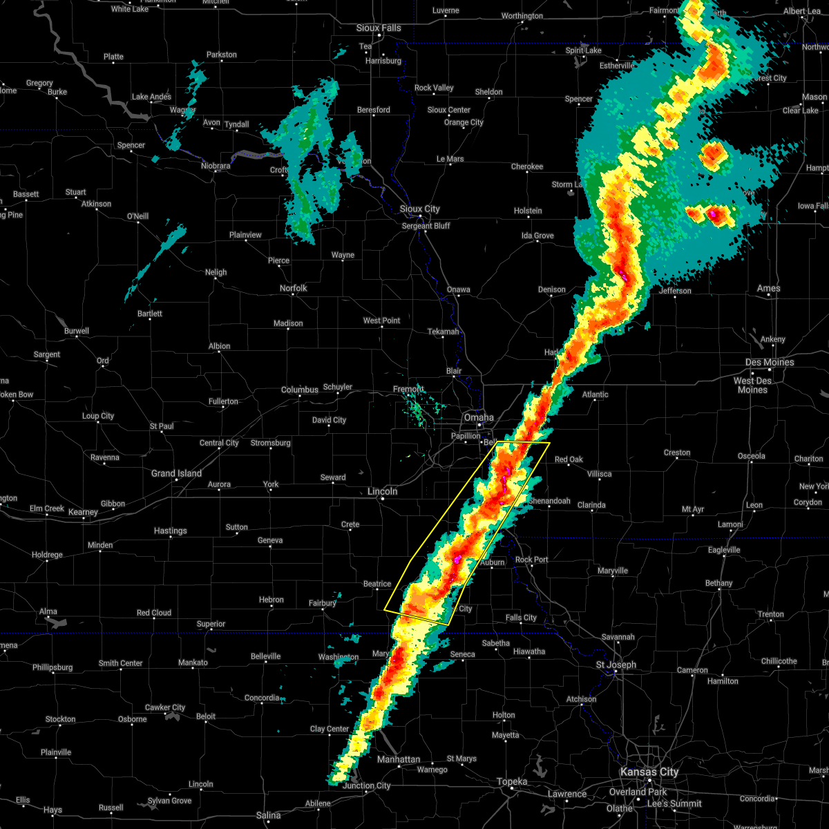 The severe thunderstorm warning for western fremont, northwestern montgomery, mills, southwestern pottawattamie, eastern sarpy, johnson, northwestern nemaha, otoe, pawnee, southeastern gage and eastern cass counties will expire at 445 pm cst, the storm which prompted the warning has weakened below severe limits, and no longer poses an immediate threat to life or property. therefore, the warning will be allowed to expire. however small hail and gusty winds are still possible with this thunderstorm. a tornado watch remains in effect until 1000 pm cst for southwestern iowa. a tornado watch also remains in effect until 1000 pm cst for southeastern nebraska. The severe thunderstorm warning for western fremont, northwestern montgomery, mills, southwestern pottawattamie, eastern sarpy, johnson, northwestern nemaha, otoe, pawnee, southeastern gage and eastern cass counties will expire at 445 pm cst, the storm which prompted the warning has weakened below severe limits, and no longer poses an immediate threat to life or property. therefore, the warning will be allowed to expire. however small hail and gusty winds are still possible with this thunderstorm. a tornado watch remains in effect until 1000 pm cst for southwestern iowa. a tornado watch also remains in effect until 1000 pm cst for southeastern nebraska.
|
| 3/6/2017 4:31 PM CST |
 At 430 pm cst, a severe thunderstorm was located over pacific junction, or 20 miles southeast of omaha, moving northeast at 60 mph. another severe thunderstorm was located just southwest of tecumseh, also moving northeast at 60 mph (radar indicated). Hazards include 60 mph wind gusts and quarter size hail. Hail damage to vehicles is expected. expect wind damage to roofs, siding, and trees. locations impacted include, nebraska city, plattsmouth, glenwood, syracuse, tecumseh, malvern, pawnee city, sterling, pacific junction, murray, blue springs, johnson, cook, avoca, talmage, union, nehawka, lorton, tabor and silver city. this includes the following highways, highway 136 in nebraska between mile markers 188 and 221. highway 2 in nebraska between mile markers 487 and 508. highway 34 in iowa between mile markers 1 and 23. highway 59 in iowa near mile marker 37. highway 75 in nebraska between mile markers 39 and 73. highway 77 in nebraska near mile marker 10. interstate 29 between mile markers 10 and 39. a tornado watch remains in effect until 1000 pm cst for southwestern iowa. A tornado watch also remains in effect until 1000 pm cst for southeastern nebraska. At 430 pm cst, a severe thunderstorm was located over pacific junction, or 20 miles southeast of omaha, moving northeast at 60 mph. another severe thunderstorm was located just southwest of tecumseh, also moving northeast at 60 mph (radar indicated). Hazards include 60 mph wind gusts and quarter size hail. Hail damage to vehicles is expected. expect wind damage to roofs, siding, and trees. locations impacted include, nebraska city, plattsmouth, glenwood, syracuse, tecumseh, malvern, pawnee city, sterling, pacific junction, murray, blue springs, johnson, cook, avoca, talmage, union, nehawka, lorton, tabor and silver city. this includes the following highways, highway 136 in nebraska between mile markers 188 and 221. highway 2 in nebraska between mile markers 487 and 508. highway 34 in iowa between mile markers 1 and 23. highway 59 in iowa near mile marker 37. highway 75 in nebraska between mile markers 39 and 73. highway 77 in nebraska near mile marker 10. interstate 29 between mile markers 10 and 39. a tornado watch remains in effect until 1000 pm cst for southwestern iowa. A tornado watch also remains in effect until 1000 pm cst for southeastern nebraska.
|
| 3/6/2017 4:19 PM CST |
 At 419 pm cst, a severe thunderstorm was located over murray, or 23 miles south of omaha, moving northeast at 95 mph (radar indicated). Hazards include 60 mph wind gusts and quarter size hail. Hail damage to vehicles is expected. expect wind damage to roofs, siding, and trees. locations impacted include, nebraska city, plattsmouth, glenwood, syracuse, tecumseh, malvern, pawnee city, sterling, pacific junction, murray, blue springs, johnson, cook, avoca, talmage, union, nehawka, lorton, tabor and silver city. this includes the following highways, highway 136 in nebraska between mile markers 188 and 221. highway 2 in nebraska between mile markers 487 and 508. highway 34 in iowa between mile markers 1 and 23. highway 59 in iowa near mile marker 37. highway 75 in nebraska between mile markers 39 and 73. highway 77 in nebraska near mile marker 10. interstate 29 between mile markers 10 and 39. a tornado watch remains in effect until 1000 pm cst for southwestern iowa. A tornado watch also remains in effect until 1000 pm cst for southeastern nebraska. At 419 pm cst, a severe thunderstorm was located over murray, or 23 miles south of omaha, moving northeast at 95 mph (radar indicated). Hazards include 60 mph wind gusts and quarter size hail. Hail damage to vehicles is expected. expect wind damage to roofs, siding, and trees. locations impacted include, nebraska city, plattsmouth, glenwood, syracuse, tecumseh, malvern, pawnee city, sterling, pacific junction, murray, blue springs, johnson, cook, avoca, talmage, union, nehawka, lorton, tabor and silver city. this includes the following highways, highway 136 in nebraska between mile markers 188 and 221. highway 2 in nebraska between mile markers 487 and 508. highway 34 in iowa between mile markers 1 and 23. highway 59 in iowa near mile marker 37. highway 75 in nebraska between mile markers 39 and 73. highway 77 in nebraska near mile marker 10. interstate 29 between mile markers 10 and 39. a tornado watch remains in effect until 1000 pm cst for southwestern iowa. A tornado watch also remains in effect until 1000 pm cst for southeastern nebraska.
|
| 3/6/2017 4:09 PM CST |
 At 408 pm cst, a severe thunderstorm was located 5 miles north of blue springs, or 7 miles southeast of beatrice, moving northeast at 60 mph (radar indicated). Hazards include 60 mph wind gusts and quarter size hail. Hail damage to vehicles is expected. Expect wind damage to roofs, siding, and trees. At 408 pm cst, a severe thunderstorm was located 5 miles north of blue springs, or 7 miles southeast of beatrice, moving northeast at 60 mph (radar indicated). Hazards include 60 mph wind gusts and quarter size hail. Hail damage to vehicles is expected. Expect wind damage to roofs, siding, and trees.
|
| 7/7/2016 3:05 AM CDT |
 At 305 am cdt, a severe thunderstorm was located over nebraska city, or 30 miles northwest of tarkio, moving east at 40 mph (radar indicated). Hazards include 60 mph wind gusts and quarter size hail. Hail damage to vehicles is expected. expect wind damage to roofs, siding and trees. Locations impacted include, nebraska city, syracuse, hamburg, sidney, riverton, avoca, union, lorton, thurman, dunbar, otoe, camp catron and waubonsie state park. At 305 am cdt, a severe thunderstorm was located over nebraska city, or 30 miles northwest of tarkio, moving east at 40 mph (radar indicated). Hazards include 60 mph wind gusts and quarter size hail. Hail damage to vehicles is expected. expect wind damage to roofs, siding and trees. Locations impacted include, nebraska city, syracuse, hamburg, sidney, riverton, avoca, union, lorton, thurman, dunbar, otoe, camp catron and waubonsie state park.
|
| 7/7/2016 2:35 AM CDT |
 At 235 am cdt, a severe thunderstorm was located near unadilla, or 25 miles southeast of lincoln, moving east at 40 mph (radar indicated). Hazards include 60 mph wind gusts and quarter size hail. Hail damage to vehicles is expected. Expect wind damage to roofs, siding and trees. At 235 am cdt, a severe thunderstorm was located near unadilla, or 25 miles southeast of lincoln, moving east at 40 mph (radar indicated). Hazards include 60 mph wind gusts and quarter size hail. Hail damage to vehicles is expected. Expect wind damage to roofs, siding and trees.
|
| 5/26/2016 4:57 PM CDT |
 At 457 pm cdt, a severe thunderstorm capable of producing a tornado was located over talmage, or 33 miles west of tarkio, moving east at 30 mph (radar indicated rotation). Hazards include tornado and ping pong ball size hail. Flying debris will be dangerous to those caught without shelter. mobile homes will be damaged or destroyed. damage to roofs, windows and vehicles will occur. tree damage is likely. this tornadic thunderstorm will remain over mainly rural areas of northeastern johnson, northwestern nemaha and southeastern otoe counties, including the following locations: julian and brock. This includes highway 75 in nebraska between mile markers 33 and 45. At 457 pm cdt, a severe thunderstorm capable of producing a tornado was located over talmage, or 33 miles west of tarkio, moving east at 30 mph (radar indicated rotation). Hazards include tornado and ping pong ball size hail. Flying debris will be dangerous to those caught without shelter. mobile homes will be damaged or destroyed. damage to roofs, windows and vehicles will occur. tree damage is likely. this tornadic thunderstorm will remain over mainly rural areas of northeastern johnson, northwestern nemaha and southeastern otoe counties, including the following locations: julian and brock. This includes highway 75 in nebraska between mile markers 33 and 45.
|
| 5/26/2016 4:47 PM CDT |
 At 446 pm cdt, a severe thunderstorm capable of producing a tornado was located over cook, or 35 miles southeast of lincoln, moving east at 25 mph (radar indicated rotation). Hazards include tornado and ping pong ball size hail. Flying debris will be dangerous to those caught without shelter. mobile homes will be damaged or destroyed. damage to roofs, windows and vehicles will occur. tree damage is likely. this dangerous storm will be near, talmage around 500 pm cdt. lorton around 505 pm cdt. other locations impacted by this tornadic thunderstorm include julian and brock. This includes highway 75 in nebraska between mile markers 33 and 45. At 446 pm cdt, a severe thunderstorm capable of producing a tornado was located over cook, or 35 miles southeast of lincoln, moving east at 25 mph (radar indicated rotation). Hazards include tornado and ping pong ball size hail. Flying debris will be dangerous to those caught without shelter. mobile homes will be damaged or destroyed. damage to roofs, windows and vehicles will occur. tree damage is likely. this dangerous storm will be near, talmage around 500 pm cdt. lorton around 505 pm cdt. other locations impacted by this tornadic thunderstorm include julian and brock. This includes highway 75 in nebraska between mile markers 33 and 45.
|
| 5/26/2016 4:40 PM CDT |
 At 440 pm cdt, a severe thunderstorm capable of producing a tornado was located over cook, or 34 miles southeast of lincoln, moving east at 30 mph (radar indicated rotation). Hazards include tornado and ping pong ball size hail. Flying debris will be dangerous to those caught without shelter. mobile homes will be damaged or destroyed. damage to roofs, windows and vehicles will occur. tree damage is likely. this dangerous storm will be near, talmage and lorton around 455 pm cdt. other locations impacted by this tornadic thunderstorm include julian and brock. This includes highway 75 in nebraska between mile markers 33 and 45. At 440 pm cdt, a severe thunderstorm capable of producing a tornado was located over cook, or 34 miles southeast of lincoln, moving east at 30 mph (radar indicated rotation). Hazards include tornado and ping pong ball size hail. Flying debris will be dangerous to those caught without shelter. mobile homes will be damaged or destroyed. damage to roofs, windows and vehicles will occur. tree damage is likely. this dangerous storm will be near, talmage and lorton around 455 pm cdt. other locations impacted by this tornadic thunderstorm include julian and brock. This includes highway 75 in nebraska between mile markers 33 and 45.
|
| 9/18/2015 9:48 AM CDT |
 At 948 am cdt, a severe thunderstorm was located over riverton, or 18 miles northwest of tarkio, moving northeast at 45 mph (radar indicated). Hazards include quarter size hail. Damage to vehicles is expected. locations impacted include, nebraska city, hamburg, sidney, farragut, riverton, union, nehawka, lorton, thurman, dunbar, camp catron and waubonsie state park. this includes the following highways, highway 2 in nebraska between mile markers 496 and 508. highway 59 in iowa between mile markers 1 and 10. highway 75 in nebraska between mile markers 39 and 59. Interstate 29 between mile markers 1 and 20. At 948 am cdt, a severe thunderstorm was located over riverton, or 18 miles northwest of tarkio, moving northeast at 45 mph (radar indicated). Hazards include quarter size hail. Damage to vehicles is expected. locations impacted include, nebraska city, hamburg, sidney, farragut, riverton, union, nehawka, lorton, thurman, dunbar, camp catron and waubonsie state park. this includes the following highways, highway 2 in nebraska between mile markers 496 and 508. highway 59 in iowa between mile markers 1 and 10. highway 75 in nebraska between mile markers 39 and 59. Interstate 29 between mile markers 1 and 20.
|
| 9/18/2015 9:39 AM CDT |
 At 938 am cdt, a severe thunderstorm was located 4 miles south of syracuse, or 31 miles southeast of lincoln, moving northeast at 35 mph (radar indicated). Hazards include quarter size hail. Damage to vehicles is expected. locations impacted include, syracuse, unadilla, talmage, douglas, lorton and burr. This includes highway 2 in nebraska between mile markers 478 and 493. At 938 am cdt, a severe thunderstorm was located 4 miles south of syracuse, or 31 miles southeast of lincoln, moving northeast at 35 mph (radar indicated). Hazards include quarter size hail. Damage to vehicles is expected. locations impacted include, syracuse, unadilla, talmage, douglas, lorton and burr. This includes highway 2 in nebraska between mile markers 478 and 493.
|
| 9/18/2015 9:36 AM CDT |
 At 935 am cdt, a severe thunderstorm was located 4 miles west of hamburg, or 21 miles northwest of tarkio, moving northeast at 50 mph (radar indicated). Hazards include quarter size hail. damage to vehicles is expected At 935 am cdt, a severe thunderstorm was located 4 miles west of hamburg, or 21 miles northwest of tarkio, moving northeast at 50 mph (radar indicated). Hazards include quarter size hail. damage to vehicles is expected
|
| 9/18/2015 9:26 AM CDT |
 At 926 am cdt, a severe thunderstorm was located 5 miles west of cook, or 29 miles southeast of lincoln, moving northeast at 35 mph (radar indicated). Hazards include 60 mph wind gusts and quarter size hail. Hail damage to vehicles is expected. expect wind damage to roofs, siding and trees. locations impacted include, syracuse, cook, unadilla, talmage, douglas, lorton and burr. This includes highway 2 in nebraska between mile markers 478 and 493. At 926 am cdt, a severe thunderstorm was located 5 miles west of cook, or 29 miles southeast of lincoln, moving northeast at 35 mph (radar indicated). Hazards include 60 mph wind gusts and quarter size hail. Hail damage to vehicles is expected. expect wind damage to roofs, siding and trees. locations impacted include, syracuse, cook, unadilla, talmage, douglas, lorton and burr. This includes highway 2 in nebraska between mile markers 478 and 493.
|
| 9/18/2015 9:15 AM CDT |
 At 915 am cdt, a severe thunderstorm was located near sterling, or 27 miles northeast of beatrice, moving northeast at 35 mph (radar indicated). Hazards include 60 mph wind gusts and quarter size hail. Hail damage to vehicles is expected. Expect wind damage to roofs, siding and trees. At 915 am cdt, a severe thunderstorm was located near sterling, or 27 miles northeast of beatrice, moving northeast at 35 mph (radar indicated). Hazards include 60 mph wind gusts and quarter size hail. Hail damage to vehicles is expected. Expect wind damage to roofs, siding and trees.
|
| 5/7/2015 7:11 PM CDT | At 710 pm cdt, a severe thunderstorm was located near lorton, or 33 miles east of lincoln, moving northeast at 30 mph (radar indicated). Hazards include 60 mph wind gusts and quarter size hail. Hail damage to vehicles is expected. expect wind damage to roofs, siding and trees. locations impacted include, nebraska city, syracuse, union, nehawka, lorton, dunbar, otoe and camp catron. this includes the following highways, highway 2 in nebraska between mile markers 490 and 508. highway 75 in nebraska between mile markers 48 and 59. interstate 29 between mile markers 10 and 17. 1. 00in. |
| 5/7/2015 7:11 PM CDT | At 710 pm cdt, a severe thunderstorm was located near lorton, or 33 miles east of lincoln, moving northeast at 30 mph (radar indicated). Hazards include 60 mph wind gusts and quarter size hail. Hail damage to vehicles is expected. expect wind damage to roofs, siding and trees. locations impacted include, nebraska city, syracuse, union, nehawka, lorton, dunbar, otoe and camp catron. this includes the following highways, highway 2 in nebraska between mile markers 490 and 508. highway 75 in nebraska between mile markers 48 and 59. interstate 29 between mile markers 10 and 17. 1. 00in. |
| 5/7/2015 7:04 PM CDT | At 704 pm cdt, a severe thunderstorm was located near syracuse, or 32 miles southeast of lincoln, moving northeast at 30 mph (radar indicated). Hazards include 60 mph wind gusts and quarter size hail. Hail damage to vehicles is expected. Expect wind damage to roofs, siding and trees. |
| 5/7/2015 7:04 PM CDT | At 704 pm cdt, a severe thunderstorm was located near syracuse, or 32 miles southeast of lincoln, moving northeast at 30 mph (radar indicated). Hazards include 60 mph wind gusts and quarter size hail. Hail damage to vehicles is expected. Expect wind damage to roofs, siding and trees. |
| 5/3/2015 8:33 PM CDT | At 832 pm cdt, a severe thunderstorm was located near cook, or 37 miles northeast of beatrice, moving east at 15 mph (radar indicated). Hazards include quarter size hail. damage to vehicles is expected |
| 4/1/2015 11:27 PM CDT | The severe thunderstorm warning for western fremont. southeastern cass and eastern otoe counties will expire at 1130 pm cdt. the storm which prompted the warning has weakened below severe limits. and no longer pose an immediate threat to life or property. therefore the warning will be allowed to expire. However gusty winds to 50 mph are still possible with this thunderstorm. |
| 4/1/2015 11:27 PM CDT | The severe thunderstorm warning for western fremont. southeastern cass and eastern otoe counties will expire at 1130 pm cdt. the storm which prompted the warning has weakened below severe limits. and no longer pose an immediate threat to life or property. therefore the warning will be allowed to expire. However gusty winds to 50 mph are still possible with this thunderstorm. |
| 4/1/2015 11:20 PM CDT | A severe thunderstorm warning remains in effect until 1130 pm cdt for western fremont. southeastern cass and eastern otoe counties. at 1120 pm cdt. a severe thunderstorm was located near union. or 32 miles northwest of tarkio. moving east at 45 mph. hazard. 60 mph wind gusts. source. Radar indicated. |
| 4/1/2015 11:20 PM CDT | A severe thunderstorm warning remains in effect until 1130 pm cdt for western fremont. southeastern cass and eastern otoe counties. at 1120 pm cdt. a severe thunderstorm was located near union. or 32 miles northwest of tarkio. moving east at 45 mph. hazard. 60 mph wind gusts. source. Radar indicated. |
| 4/1/2015 11:15 PM CDT | A severe thunderstorm warning remains in effect until 1130 pm cdt for western fremont. southeastern cass and eastern otoe counties. at 1114 pm cdt. a severe thunderstorm was located near union. or 34 miles south of omaha. moving east at 45 mph. hazard. 60 mph wind gusts. source. Radar indicated. |
| 4/1/2015 11:15 PM CDT | A severe thunderstorm warning remains in effect until 1130 pm cdt for western fremont. southeastern cass and eastern otoe counties. at 1114 pm cdt. a severe thunderstorm was located near union. or 34 miles south of omaha. moving east at 45 mph. hazard. 60 mph wind gusts. source. Radar indicated. |
| 4/1/2015 11:05 PM CDT | The national weather service in omaha has issued a * severe thunderstorm warning for. western fremont county in southwestern iowa. southeastern cass county in southeastern nebraska. central otoe county in southeastern nebraska. Until 1130 pm cdt. |
| 4/1/2015 11:05 PM CDT | The national weather service in omaha has issued a * severe thunderstorm warning for. western fremont county in southwestern iowa. southeastern cass county in southeastern nebraska. central otoe county in southeastern nebraska. Until 1130 pm cdt. |
| 1/1/0001 12:00 AM | All of the vinyl siding ripped off the side of a house and 2 large sliding doors on a shed blown off of their tracks. gusts estimated at 60 mph. dime size hail covered in otoe county NE, 4 miles E of Lorton, NE |
Hail Maps for Lorton, NE


Connect with Interactive Hail Maps