

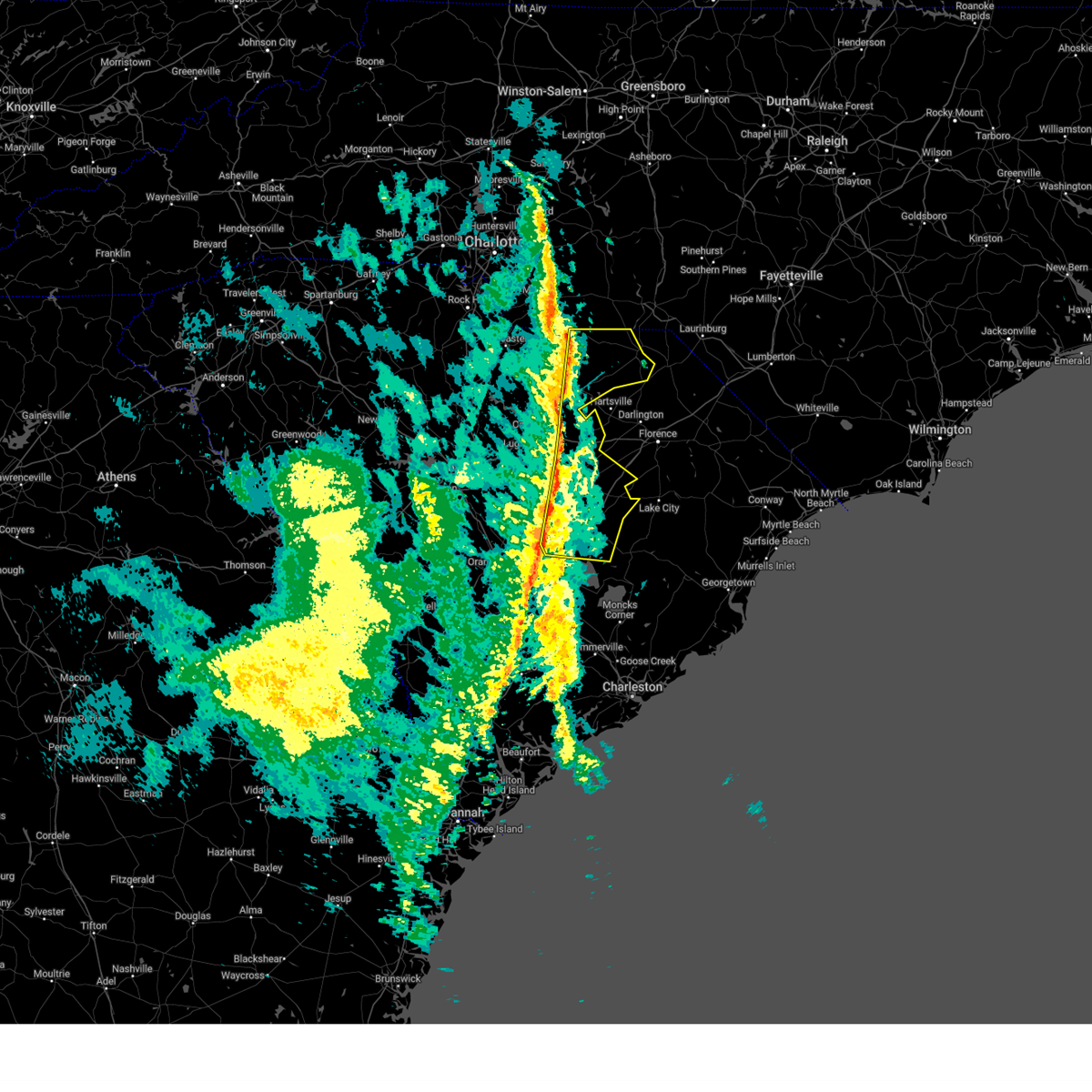
Hail Map for Lydia, SC
The Lydia, SC area has had 0 reports of on-the-ground hail by trained spotters, and has been under severe weather warnings 21 times during the past 12 months. Doppler radar has detected hail at or near Lydia, SC on 56 occasions.
| Name: | Lydia, SC |
| Where Located: | 75.1 miles N of Charleston, SC |
| Map: | Google Map for Lydia, SC |
| Population: | 642 |
| Housing Units: | 302 |
| More Info: | Search Google for Lydia, SC |
1
The Top Recent Hail Date for Lydia, SC is Wednesday, May 8, 2024 (7th out of 56)

Hail and Wind Damage Spotted near Lydia, SC
| Date / Time | Report Details |
|---|---|
| 6/25/2025 7:37 PM EDT |
 The storms which prompted the warning have moved to the southwest and the warning will be allowed to expire. a severe thunderstorm watch remains in effect until midnight edt for northeastern south carolina. please send your reports of hail or wind damage, including trees or large limbs downed, by calling the national weather service office in wilmington at 1 800 697 3901. The storms which prompted the warning have moved to the southwest and the warning will be allowed to expire. a severe thunderstorm watch remains in effect until midnight edt for northeastern south carolina. please send your reports of hail or wind damage, including trees or large limbs downed, by calling the national weather service office in wilmington at 1 800 697 3901.
|
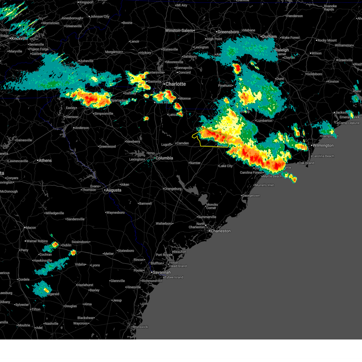
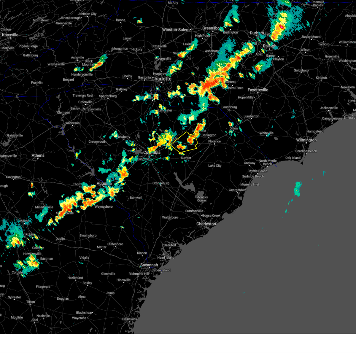
| 6/25/2025 7:21 PM EDT |
 At 721 pm edt, severe thunderstorms were located along a line extending from lydia to near woods bay state park, moving southwest at 25 mph (trained weather spotters). Hazards include 60 mph wind gusts and penny size hail. Expect wind damage to trees and power lines. Locations impacted include, hartsville, lake city, timmonsville, johnsonville, lamar, sardis, effingham, hannah, lydia, poston, cartersville, oats, friendfield, new hope, kellytown, kingsburg, scranton, coward, olanta, and central crossroads. At 721 pm edt, severe thunderstorms were located along a line extending from lydia to near woods bay state park, moving southwest at 25 mph (trained weather spotters). Hazards include 60 mph wind gusts and penny size hail. Expect wind damage to trees and power lines. Locations impacted include, hartsville, lake city, timmonsville, johnsonville, lamar, sardis, effingham, hannah, lydia, poston, cartersville, oats, friendfield, new hope, kellytown, kingsburg, scranton, coward, olanta, and central crossroads.
|
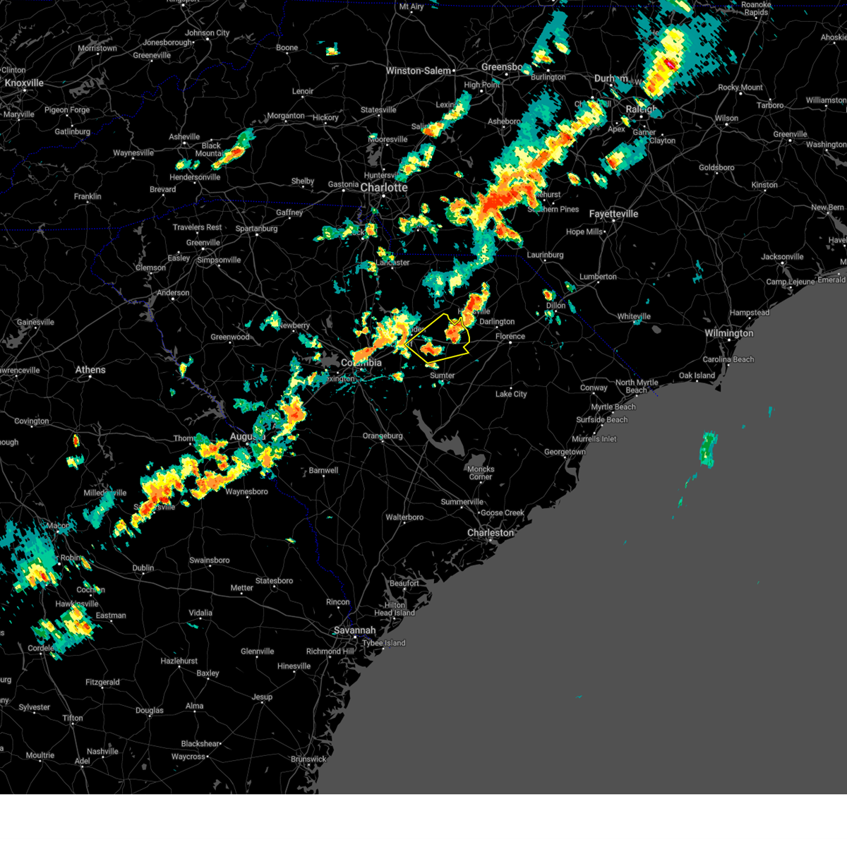
| 6/25/2025 7:00 PM EDT |
 Svrcae the national weather service in columbia has issued a * severe thunderstorm warning for, lee county in central south carolina, clarendon county in central south carolina, sumter county in central south carolina, * until 800 pm edt. * at 700 pm edt, severe thunderstorms were located along a line extending from lee state park to poston, moving southwest at 30 mph (radar indicated). Hazards include 60 mph wind gusts. expect damage to trees and powerlines Svrcae the national weather service in columbia has issued a * severe thunderstorm warning for, lee county in central south carolina, clarendon county in central south carolina, sumter county in central south carolina, * until 800 pm edt. * at 700 pm edt, severe thunderstorms were located along a line extending from lee state park to poston, moving southwest at 30 mph (radar indicated). Hazards include 60 mph wind gusts. expect damage to trees and powerlines
|
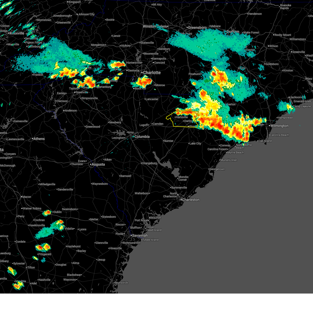
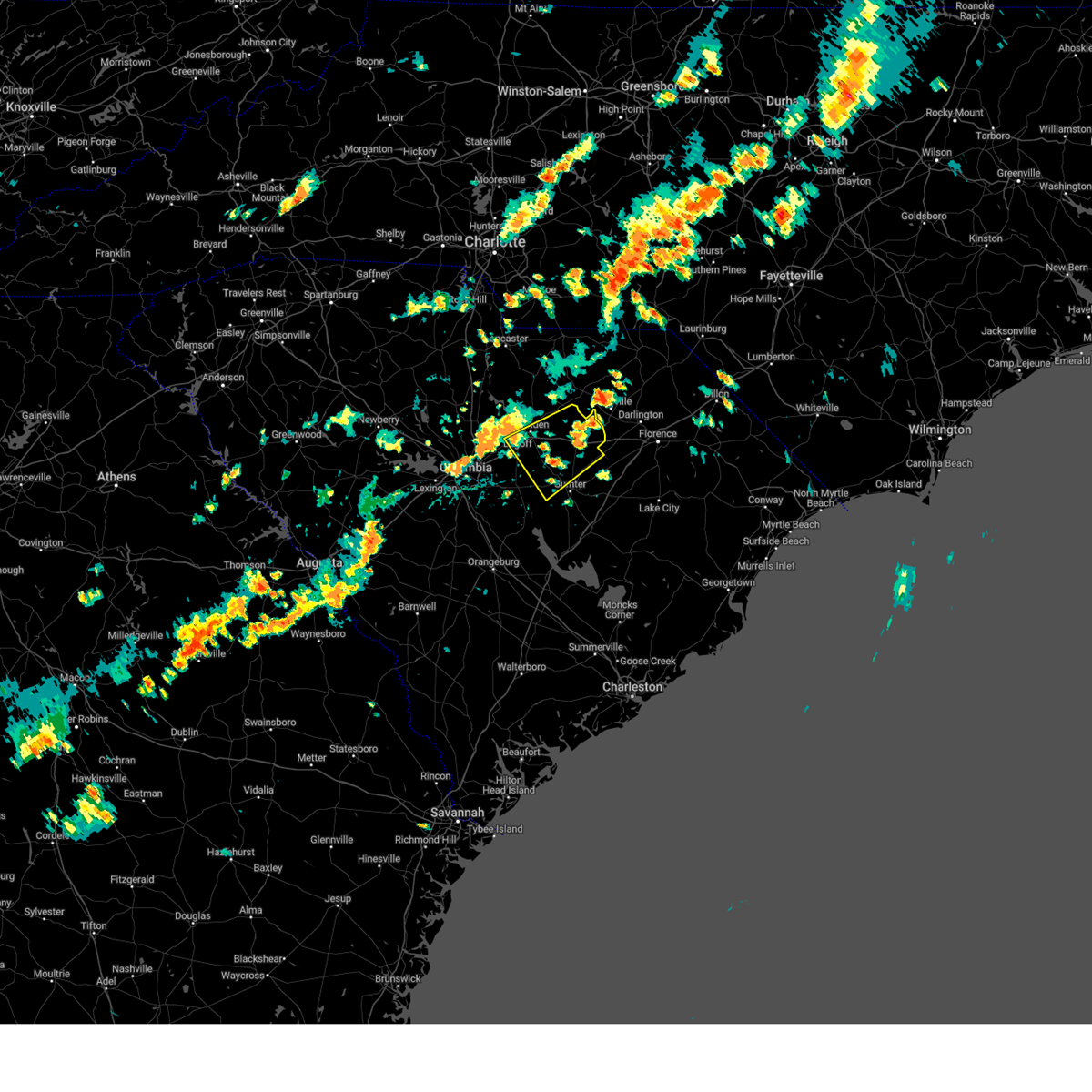
| 6/25/2025 6:43 PM EDT |
 Svrilm the national weather service in wilmington has issued a * severe thunderstorm warning for, florence county in northeastern south carolina, southern darlington county in northeastern south carolina, * until 745 pm edt. * at 642 pm edt, severe thunderstorms were located along a line extending from kellytown to near quinby, moving south at 30 mph (trained weather spotters). Hazards include 60 mph wind gusts and quarter size hail. Minor hail damage to vehicles is possible. Expect wind damage to trees and power lines. Svrilm the national weather service in wilmington has issued a * severe thunderstorm warning for, florence county in northeastern south carolina, southern darlington county in northeastern south carolina, * until 745 pm edt. * at 642 pm edt, severe thunderstorms were located along a line extending from kellytown to near quinby, moving south at 30 mph (trained weather spotters). Hazards include 60 mph wind gusts and quarter size hail. Minor hail damage to vehicles is possible. Expect wind damage to trees and power lines.
|
| 6/25/2025 6:35 PM EDT |
 At 634 pm edt, severe thunderstorms were located along a line extending from near auburn to near brownsville, moving south at 15 mph (radar indicated). Hazards include 60 mph wind gusts and quarter size hail. Minor hail damage to vehicles is possible. expect wind damage to trees and power lines. Locations impacted include, florence, hartsville, darlington, quinby, north hartsville, dovesville, mont clare, mars bluff, lydia, auburn, darlington raceway, swift creek, florence darlington technical college main campus, francis marion university, clyde, mechanicsville, oats, floyd, kellytown, and mcleod regional medical center. At 634 pm edt, severe thunderstorms were located along a line extending from near auburn to near brownsville, moving south at 15 mph (radar indicated). Hazards include 60 mph wind gusts and quarter size hail. Minor hail damage to vehicles is possible. expect wind damage to trees and power lines. Locations impacted include, florence, hartsville, darlington, quinby, north hartsville, dovesville, mont clare, mars bluff, lydia, auburn, darlington raceway, swift creek, florence darlington technical college main campus, francis marion university, clyde, mechanicsville, oats, floyd, kellytown, and mcleod regional medical center.
|
| 6/25/2025 6:20 PM EDT |
 Svrilm the national weather service in wilmington has issued a * severe thunderstorm warning for, northern florence county in northeastern south carolina, darlington county in northeastern south carolina, southeastern marlboro county in northeastern south carolina, * until 715 pm edt. * at 620 pm edt, severe thunderstorms were located along a line extending from near auburn to near brownsville, moving south at 5 mph (radar indicated). Hazards include 60 mph wind gusts and quarter size hail. Minor hail damage to vehicles is possible. Expect wind damage to trees and power lines. Svrilm the national weather service in wilmington has issued a * severe thunderstorm warning for, northern florence county in northeastern south carolina, darlington county in northeastern south carolina, southeastern marlboro county in northeastern south carolina, * until 715 pm edt. * at 620 pm edt, severe thunderstorms were located along a line extending from near auburn to near brownsville, moving south at 5 mph (radar indicated). Hazards include 60 mph wind gusts and quarter size hail. Minor hail damage to vehicles is possible. Expect wind damage to trees and power lines.
|
| 3/16/2025 9:37 AM EDT |
 The storm which prompted the warning has weakened below severe limits, and has exited the warned area. therefore, the warning will be allowed to expire. a tornado watch remains in effect until 200 pm edt for central south carolina. The storm which prompted the warning has weakened below severe limits, and has exited the warned area. therefore, the warning will be allowed to expire. a tornado watch remains in effect until 200 pm edt for central south carolina.
|
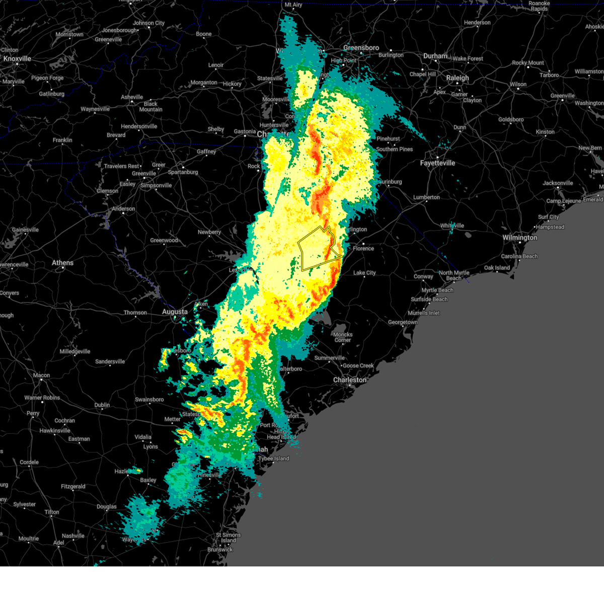
| 3/16/2025 9:11 AM EDT |
 At 910 am edt, a severe thunderstorm was located 9 miles southwest of bishopville, moving northeast at 45 mph (radar indicated). Hazards include 60 mph wind gusts. Expect damage to trees and powerlines. locations impacted include, ashwood, lucknow, oswego, dalzell, lee state park, manville, bishopville, spring hill, lynchburg, oakland, antioch, sumter county airport, st. charles, cherryvale, elliott, shaw air base, wisacky, woodrow, ashland, and sumter. This includes interstate 20 in south carolina between mile markers 101 and 126. At 910 am edt, a severe thunderstorm was located 9 miles southwest of bishopville, moving northeast at 45 mph (radar indicated). Hazards include 60 mph wind gusts. Expect damage to trees and powerlines. locations impacted include, ashwood, lucknow, oswego, dalzell, lee state park, manville, bishopville, spring hill, lynchburg, oakland, antioch, sumter county airport, st. charles, cherryvale, elliott, shaw air base, wisacky, woodrow, ashland, and sumter. This includes interstate 20 in south carolina between mile markers 101 and 126.
|
| 3/16/2025 9:11 AM EDT |
 the severe thunderstorm warning has been cancelled and is no longer in effect the severe thunderstorm warning has been cancelled and is no longer in effect
|
| 3/16/2025 8:45 AM EDT |
 Svrcae the national weather service in columbia has issued a * severe thunderstorm warning for, lee county in central south carolina, northwestern sumter county in central south carolina, east central richland county in central south carolina, southeastern kershaw county in central south carolina, * until 945 am edt. * at 845 am edt, a severe thunderstorm was located 9 miles northeast of mcentire air base, moving northeast at 35 mph (radar indicated). Hazards include 60 mph wind gusts. expect damage to trees and powerlines Svrcae the national weather service in columbia has issued a * severe thunderstorm warning for, lee county in central south carolina, northwestern sumter county in central south carolina, east central richland county in central south carolina, southeastern kershaw county in central south carolina, * until 945 am edt. * at 845 am edt, a severe thunderstorm was located 9 miles northeast of mcentire air base, moving northeast at 35 mph (radar indicated). Hazards include 60 mph wind gusts. expect damage to trees and powerlines
|
| 2/16/2025 8:45 AM EST |
 At 845 am est, severe thunderstorms were located along a line extending from 7 miles northwest of laurinburg to near elliott, moving east at 45 mph (radar indicated). Hazards include 60 mph wind gusts. Expect wind damage to trees and power lines. Locations impacted include, florence, bennettsville, hartsville, dillon, darlington, red springs, pembroke, maxton, timmonsville, mccoll, latta, rowland, lamar, quinby, clio, sellers, blue brick, hamer, brownsville, and darlington raceway. At 845 am est, severe thunderstorms were located along a line extending from 7 miles northwest of laurinburg to near elliott, moving east at 45 mph (radar indicated). Hazards include 60 mph wind gusts. Expect wind damage to trees and power lines. Locations impacted include, florence, bennettsville, hartsville, dillon, darlington, red springs, pembroke, maxton, timmonsville, mccoll, latta, rowland, lamar, quinby, clio, sellers, blue brick, hamer, brownsville, and darlington raceway.
|
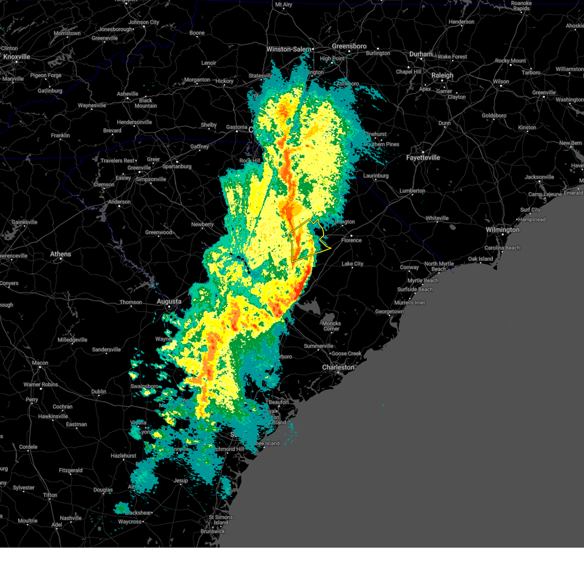
| 2/16/2025 8:29 AM EST |
 Svrcae the national weather service in columbia has issued a * severe thunderstorm warning for, lee county in central south carolina, calhoun county in central south carolina, clarendon county in central south carolina, southeastern barnwell county in central south carolina, bamberg county in central south carolina, sumter county in central south carolina, orangeburg county in central south carolina, southeastern richland county in central south carolina, * until 945 am est. * at 827 am est, severe thunderstorms were located along a line extending from near bishopville to near ulmer, moving east at 45 mph (numerous reports of downed trees from trained weather spotters). Hazards include 60 mph wind gusts. expect damage to trees and powerlines Svrcae the national weather service in columbia has issued a * severe thunderstorm warning for, lee county in central south carolina, calhoun county in central south carolina, clarendon county in central south carolina, southeastern barnwell county in central south carolina, bamberg county in central south carolina, sumter county in central south carolina, orangeburg county in central south carolina, southeastern richland county in central south carolina, * until 945 am est. * at 827 am est, severe thunderstorms were located along a line extending from near bishopville to near ulmer, moving east at 45 mph (numerous reports of downed trees from trained weather spotters). Hazards include 60 mph wind gusts. expect damage to trees and powerlines
|
| 2/16/2025 8:06 AM EST |
 Svrilm the national weather service in wilmington has issued a * severe thunderstorm warning for, northwestern robeson county in southeastern north carolina, northwestern florence county in northeastern south carolina, dillon county in northeastern south carolina, darlington county in northeastern south carolina, northwestern marion county in northeastern south carolina, marlboro county in northeastern south carolina, * until 900 am est. * at 805 am est, severe thunderstorms were located along a line extending from 6 miles north of chesterfield to 7 miles southeast of elgin, moving east at 65 mph (radar indicated). Hazards include 60 mph wind gusts. expect wind damage to trees and power lines Svrilm the national weather service in wilmington has issued a * severe thunderstorm warning for, northwestern robeson county in southeastern north carolina, northwestern florence county in northeastern south carolina, dillon county in northeastern south carolina, darlington county in northeastern south carolina, northwestern marion county in northeastern south carolina, marlboro county in northeastern south carolina, * until 900 am est. * at 805 am est, severe thunderstorms were located along a line extending from 6 miles north of chesterfield to 7 miles southeast of elgin, moving east at 65 mph (radar indicated). Hazards include 60 mph wind gusts. expect wind damage to trees and power lines
|
| 12/29/2024 10:01 AM EST |
 the severe thunderstorm warning has been cancelled and is no longer in effect the severe thunderstorm warning has been cancelled and is no longer in effect
|
| 12/29/2024 10:01 AM EST |
 At 1001 am est, severe thunderstorms were located along a line extending from 6 miles east of pageland to near summerton, moving east at 35 mph (radar indicated). Hazards include 60 mph wind gusts. Expect damage to trees and powerlines. locations impacted include, sumter, cheraw, manning, bishopville, south sumter, chesterfield, summerton, mulberry, cheraw state park, alcolu, northeastern technical college, woods bay state park, santee cooper regional airport, elliott, cheraw municipal airport, lee state park, carolina sandhills wildlife refuge, sumter county airport, millwood, and mcbee. this includes the following highways, interstate 20 in south carolina between mile markers 108 and 125. Interstate 95 between mile markers 105 and 146. At 1001 am est, severe thunderstorms were located along a line extending from 6 miles east of pageland to near summerton, moving east at 35 mph (radar indicated). Hazards include 60 mph wind gusts. Expect damage to trees and powerlines. locations impacted include, sumter, cheraw, manning, bishopville, south sumter, chesterfield, summerton, mulberry, cheraw state park, alcolu, northeastern technical college, woods bay state park, santee cooper regional airport, elliott, cheraw municipal airport, lee state park, carolina sandhills wildlife refuge, sumter county airport, millwood, and mcbee. this includes the following highways, interstate 20 in south carolina between mile markers 108 and 125. Interstate 95 between mile markers 105 and 146.
|
| 12/29/2024 9:41 AM EST |
 Svrcae the national weather service in columbia has issued a * severe thunderstorm warning for, southeastern lancaster county in central south carolina, lee county in central south carolina, east central calhoun county in central south carolina, clarendon county in central south carolina, chesterfield county in central south carolina, sumter county in central south carolina, eastern kershaw county in central south carolina, * until 1045 am est. * at 940 am est, severe thunderstorms were located along a line extending from near pageland to 8 miles north of elloree, moving east at 35 mph (radar indicated). Hazards include 60 mph wind gusts. expect damage to trees and powerlines Svrcae the national weather service in columbia has issued a * severe thunderstorm warning for, southeastern lancaster county in central south carolina, lee county in central south carolina, east central calhoun county in central south carolina, clarendon county in central south carolina, chesterfield county in central south carolina, sumter county in central south carolina, eastern kershaw county in central south carolina, * until 1045 am est. * at 940 am est, severe thunderstorms were located along a line extending from near pageland to 8 miles north of elloree, moving east at 35 mph (radar indicated). Hazards include 60 mph wind gusts. expect damage to trees and powerlines
|
| 8/3/2024 5:43 PM EDT |
 The storm which prompted the warning has weakened below severe limits, and no longer poses an immediate threat to life or property. therefore, the warning will be allowed to expire. however, gusty winds are still possible with this thunderstorm. please send your reports of hail and/or wind damage, including trees or large limbs downed, by calling the national weather service office in wilmington at 1-800-697-3901. The storm which prompted the warning has weakened below severe limits, and no longer poses an immediate threat to life or property. therefore, the warning will be allowed to expire. however, gusty winds are still possible with this thunderstorm. please send your reports of hail and/or wind damage, including trees or large limbs downed, by calling the national weather service office in wilmington at 1-800-697-3901.
|
| 8/3/2024 4:58 PM EDT |
 Svrilm the national weather service in wilmington has issued a * severe thunderstorm warning for, northern darlington county in northeastern south carolina, * until 545 pm edt. * at 458 pm edt, a severe thunderstorm was located over hartsville, moving northeast at 35 mph (radar indicated). Hazards include 60 mph wind gusts and penny size hail. expect wind damage to trees and power lines Svrilm the national weather service in wilmington has issued a * severe thunderstorm warning for, northern darlington county in northeastern south carolina, * until 545 pm edt. * at 458 pm edt, a severe thunderstorm was located over hartsville, moving northeast at 35 mph (radar indicated). Hazards include 60 mph wind gusts and penny size hail. expect wind damage to trees and power lines
|
| 8/3/2024 4:28 PM EDT |
 At 428 pm edt, a severe thunderstorm was located 8 miles west of bishopville, moving northeast at 30 mph (radar indicated). Hazards include 60 mph wind gusts and penny size hail. Expect damage to trees and powerlines. locations impacted include, camden, bishopville, lee state park, ashwood, lucknow, manville, spring hill, rembert, antioch, wisacky, woodrow, and ashland. This includes interstate 20 in south carolina between mile markers 98 and 126. At 428 pm edt, a severe thunderstorm was located 8 miles west of bishopville, moving northeast at 30 mph (radar indicated). Hazards include 60 mph wind gusts and penny size hail. Expect damage to trees and powerlines. locations impacted include, camden, bishopville, lee state park, ashwood, lucknow, manville, spring hill, rembert, antioch, wisacky, woodrow, and ashland. This includes interstate 20 in south carolina between mile markers 98 and 126.
|
| 8/3/2024 4:28 PM EDT |
 the severe thunderstorm warning has been cancelled and is no longer in effect the severe thunderstorm warning has been cancelled and is no longer in effect
|
| 8/3/2024 4:15 PM EDT |
 Svrcae the national weather service in columbia has issued a * severe thunderstorm warning for, lee county in central south carolina, northwestern sumter county in central south carolina, eastern richland county in central south carolina, southern kershaw county in central south carolina, * until 500 pm edt. * at 414 pm edt, a severe thunderstorm was located near sumter county airport, or 7 miles northeast of shaw air base, moving northeast at 35 mph (radar indicated). Hazards include 60 mph wind gusts and penny size hail. expect damage to trees and powerlines Svrcae the national weather service in columbia has issued a * severe thunderstorm warning for, lee county in central south carolina, northwestern sumter county in central south carolina, eastern richland county in central south carolina, southern kershaw county in central south carolina, * until 500 pm edt. * at 414 pm edt, a severe thunderstorm was located near sumter county airport, or 7 miles northeast of shaw air base, moving northeast at 35 mph (radar indicated). Hazards include 60 mph wind gusts and penny size hail. expect damage to trees and powerlines
|
| 6/9/2024 10:27 PM EDT | The storm which prompted the warning has weakened below severe limits, and no longer poses an immediate threat to life or property. therefore, the warning will be allowed to expire. however, gusty winds and heavy rain are still possible with this thunderstorm. |
| 6/9/2024 10:09 PM EDT |
 At 1009 pm edt, a severe thunderstorm was located near elliott, or 12 miles southeast of bishopville, moving southeast at 55 mph (radar indicated). Hazards include 60 mph wind gusts. Expect damage to trees and powerlines. locations impacted include, sumter, bishopville, south sumter, woods bay state park, elliott, mulberry, lee state park, sumter county airport, millwood, mcbee, mayesville, lynchburg, bethune, lucknow, dalzell, dinkins mill, manville, spring hill, brogdon, and boykin. this includes the following highways, interstate 20 in south carolina between mile markers 102 and 126. Interstate 95 between mile markers 135 and 146. At 1009 pm edt, a severe thunderstorm was located near elliott, or 12 miles southeast of bishopville, moving southeast at 55 mph (radar indicated). Hazards include 60 mph wind gusts. Expect damage to trees and powerlines. locations impacted include, sumter, bishopville, south sumter, woods bay state park, elliott, mulberry, lee state park, sumter county airport, millwood, mcbee, mayesville, lynchburg, bethune, lucknow, dalzell, dinkins mill, manville, spring hill, brogdon, and boykin. this includes the following highways, interstate 20 in south carolina between mile markers 102 and 126. Interstate 95 between mile markers 135 and 146.
|
| 6/9/2024 9:39 PM EDT |
 Svrcae the national weather service in columbia has issued a * severe thunderstorm warning for, lee county in central south carolina, south central chesterfield county in central south carolina, central sumter county in central south carolina, kershaw county in central south carolina, * until 1030 pm edt. * at 938 pm edt, a severe thunderstorm was located near goodale state park, or 8 miles northeast of camden, moving southeast at 55 mph (radar indicated). Hazards include 60 mph wind gusts. expect damage to trees and powerlines Svrcae the national weather service in columbia has issued a * severe thunderstorm warning for, lee county in central south carolina, south central chesterfield county in central south carolina, central sumter county in central south carolina, kershaw county in central south carolina, * until 1030 pm edt. * at 938 pm edt, a severe thunderstorm was located near goodale state park, or 8 miles northeast of camden, moving southeast at 55 mph (radar indicated). Hazards include 60 mph wind gusts. expect damage to trees and powerlines
|
| 5/10/2024 6:07 PM EDT |
 At 607 pm edt, severe thunderstorms were located along a line extending from near bishopville to near darlington raceway, moving southeast at 35 mph (radar indicated). Hazards include 60 mph wind gusts and quarter size hail. Minor hail damage to vehicles is possible. expect wind damage to trees and power lines. these severe storms will be near, florence, lamar, and florence darlington technical college main campus around 610 pm edt. timmonsville around 615 pm edt. cartersville around 620 pm edt. Evergreen, effingham, sardis, and claussen around 630 pm edt. At 607 pm edt, severe thunderstorms were located along a line extending from near bishopville to near darlington raceway, moving southeast at 35 mph (radar indicated). Hazards include 60 mph wind gusts and quarter size hail. Minor hail damage to vehicles is possible. expect wind damage to trees and power lines. these severe storms will be near, florence, lamar, and florence darlington technical college main campus around 610 pm edt. timmonsville around 615 pm edt. cartersville around 620 pm edt. Evergreen, effingham, sardis, and claussen around 630 pm edt.
|
| 5/10/2024 5:54 PM EDT |
 Svrilm the national weather service in wilmington has issued a * severe thunderstorm warning for, northwestern florence county in northeastern south carolina, southern darlington county in northeastern south carolina, * until 645 pm edt. * at 554 pm edt, severe thunderstorms were located along a line extending from 8 miles west of bishopville to swift creek, moving southeast at 35 mph (radar indicated). Hazards include 60 mph wind gusts and quarter size hail. Minor hail damage to vehicles is possible. expect wind damage to trees and power lines. severe thunderstorms will be near, darlington, darlington raceway, and oats around 600 pm edt. lamar and florence darlington technical college main campus around 605 pm edt. florence and timmonsville around 610 pm edt. cartersville around 620 pm edt. evergreen, effingham, sardis, and claussen around 630 pm edt. Other locations impacted by these severe thunderstorms include carolinas hospital system, mcleod regional medical center, carolinas hospital system - cedar tower, and health south rehabilitation hospital. Svrilm the national weather service in wilmington has issued a * severe thunderstorm warning for, northwestern florence county in northeastern south carolina, southern darlington county in northeastern south carolina, * until 645 pm edt. * at 554 pm edt, severe thunderstorms were located along a line extending from 8 miles west of bishopville to swift creek, moving southeast at 35 mph (radar indicated). Hazards include 60 mph wind gusts and quarter size hail. Minor hail damage to vehicles is possible. expect wind damage to trees and power lines. severe thunderstorms will be near, darlington, darlington raceway, and oats around 600 pm edt. lamar and florence darlington technical college main campus around 605 pm edt. florence and timmonsville around 610 pm edt. cartersville around 620 pm edt. evergreen, effingham, sardis, and claussen around 630 pm edt. Other locations impacted by these severe thunderstorms include carolinas hospital system, mcleod regional medical center, carolinas hospital system - cedar tower, and health south rehabilitation hospital.
|
| 5/8/2024 6:55 PM EDT |
 At 655 pm edt, severe thunderstorms were located along a line extending from near minturn to near mars bluff to near cartersville, moving east at 40 mph (radar indicated). Hazards include ping pong ball size hail and 60 mph wind gusts. People and animals outdoors will be injured. expect hail damage to roofs, siding, windows, and vehicles. expect wind damage to trees and power lines. Locations impacted include, florence, marion, dillon, lake city, darlington, mullins, timmonsville, latta, pamplico, lamar, quinby, lake view, sellers, blue brick, hamer, brownsville, darlington raceway, swift creek, rains, and floyd. At 655 pm edt, severe thunderstorms were located along a line extending from near minturn to near mars bluff to near cartersville, moving east at 40 mph (radar indicated). Hazards include ping pong ball size hail and 60 mph wind gusts. People and animals outdoors will be injured. expect hail damage to roofs, siding, windows, and vehicles. expect wind damage to trees and power lines. Locations impacted include, florence, marion, dillon, lake city, darlington, mullins, timmonsville, latta, pamplico, lamar, quinby, lake view, sellers, blue brick, hamer, brownsville, darlington raceway, swift creek, rains, and floyd.
|
| 5/8/2024 6:48 PM EDT |
 The storms which prompted the warning have received a new severe thunderstorm warning for darlington, marlboro, florence, dillon, and marion counties, in effect until 745 pm. a severe thunderstorm watch remains in effect until 1000 pm edt for northeastern south carolina. please send your reports of hail and/or wind damage, including trees or large limbs downed, by calling the national weather service office in wilmington at 1-800-697-3901. The storms which prompted the warning have received a new severe thunderstorm warning for darlington, marlboro, florence, dillon, and marion counties, in effect until 745 pm. a severe thunderstorm watch remains in effect until 1000 pm edt for northeastern south carolina. please send your reports of hail and/or wind damage, including trees or large limbs downed, by calling the national weather service office in wilmington at 1-800-697-3901.
|
| 5/8/2024 6:40 PM EDT |
 Svrilm the national weather service in wilmington has issued a * severe thunderstorm warning for, southwestern robeson county in southeastern north carolina, florence county in northeastern south carolina, dillon county in northeastern south carolina, darlington county in northeastern south carolina, marion county in northeastern south carolina, southern marlboro county in northeastern south carolina, * until 745 pm edt. * at 639 pm edt, severe thunderstorms were located along a line extending from near dunbar to near florence darlington technical college main campus to elliott, moving east at 40 mph (radar indicated). Hazards include 60 mph wind gusts and quarter size hail. Minor hail damage to vehicles is possible. Expect wind damage to trees and power lines. Svrilm the national weather service in wilmington has issued a * severe thunderstorm warning for, southwestern robeson county in southeastern north carolina, florence county in northeastern south carolina, dillon county in northeastern south carolina, darlington county in northeastern south carolina, marion county in northeastern south carolina, southern marlboro county in northeastern south carolina, * until 745 pm edt. * at 639 pm edt, severe thunderstorms were located along a line extending from near dunbar to near florence darlington technical college main campus to elliott, moving east at 40 mph (radar indicated). Hazards include 60 mph wind gusts and quarter size hail. Minor hail damage to vehicles is possible. Expect wind damage to trees and power lines.
|
| 5/8/2024 6:35 PM EDT |
 At 634 pm edt, a severe thunderstorm was located over northern lee county, just southwest of ashland, moving east at 30 mph (radar indicated). Hazards include 60 mph wind gusts and half dollar size hail. Hail damage to vehicles is expected. expect wind damage to trees and powerlines. Locations impacted include, bishopville and ashland. At 634 pm edt, a severe thunderstorm was located over northern lee county, just southwest of ashland, moving east at 30 mph (radar indicated). Hazards include 60 mph wind gusts and half dollar size hail. Hail damage to vehicles is expected. expect wind damage to trees and powerlines. Locations impacted include, bishopville and ashland.
|
| 5/8/2024 6:27 PM EDT |
 At 627 pm edt, severe thunderstorms were located along a line extending from laurinburg to near mont clare to near lee state park, moving east at 30 mph (radar indicated). Hazards include ping pong ball size hail and 60 mph wind gusts. People and animals outdoors will be injured. expect hail damage to roofs, siding, windows, and vehicles. expect wind damage to trees and power lines. Locations impacted include, hartsville, darlington, lamar, north hartsville, dovesville, mont clare, brownsville, lydia, darlington raceway, auburn, swift creek, clyde, mechanicsville, oats, floyd, dunbar, kellytown, florence darlington technical college main campus, society hill, and blenheim. At 627 pm edt, severe thunderstorms were located along a line extending from laurinburg to near mont clare to near lee state park, moving east at 30 mph (radar indicated). Hazards include ping pong ball size hail and 60 mph wind gusts. People and animals outdoors will be injured. expect hail damage to roofs, siding, windows, and vehicles. expect wind damage to trees and power lines. Locations impacted include, hartsville, darlington, lamar, north hartsville, dovesville, mont clare, brownsville, lydia, darlington raceway, auburn, swift creek, clyde, mechanicsville, oats, floyd, dunbar, kellytown, florence darlington technical college main campus, society hill, and blenheim.
|
| 5/8/2024 6:16 PM EDT |
 Svrcae the national weather service in columbia has issued a * severe thunderstorm warning for, northern lee county in central south carolina, * until 645 pm edt. * at 616 pm edt, a severe thunderstorm was located near cassatt, or 8 miles northwest of bishopville, moving east at 10 mph (radar indicated). Hazards include 60 mph wind gusts and half dollar size hail. Hail damage to vehicles is expected. Expect wind damage to trees and powerlines. Svrcae the national weather service in columbia has issued a * severe thunderstorm warning for, northern lee county in central south carolina, * until 645 pm edt. * at 616 pm edt, a severe thunderstorm was located near cassatt, or 8 miles northwest of bishopville, moving east at 10 mph (radar indicated). Hazards include 60 mph wind gusts and half dollar size hail. Hail damage to vehicles is expected. Expect wind damage to trees and powerlines.
|
| 5/8/2024 6:13 PM EDT |
 At 613 pm edt, severe thunderstorms were located along a line extending from 6 miles east of hamlet to 8 miles north of dovesville to near cassatt, moving southeast at 35 mph (radar indicated). Hazards include 60 mph wind gusts and quarter size hail. Minor hail damage to vehicles is possible. expect wind damage to trees and power lines. Locations impacted include, bennettsville, hartsville, darlington, mccoll, lamar, clio, mont clare, brownsville, lydia, darlington raceway, swift creek, oats, chavistown, floyd, north hartsville, dovesville, auburn, wallace, clyde, and mechanicsville. At 613 pm edt, severe thunderstorms were located along a line extending from 6 miles east of hamlet to 8 miles north of dovesville to near cassatt, moving southeast at 35 mph (radar indicated). Hazards include 60 mph wind gusts and quarter size hail. Minor hail damage to vehicles is possible. expect wind damage to trees and power lines. Locations impacted include, bennettsville, hartsville, darlington, mccoll, lamar, clio, mont clare, brownsville, lydia, darlington raceway, swift creek, oats, chavistown, floyd, north hartsville, dovesville, auburn, wallace, clyde, and mechanicsville.
|
| 5/8/2024 5:31 PM EDT |
 Svrilm the national weather service in wilmington has issued a * severe thunderstorm warning for, darlington county in northeastern south carolina, marlboro county in northeastern south carolina, * until 645 pm edt. * at 530 pm edt, severe thunderstorms were located along a line extending from 11 miles east of ansonville to near chesterfield to near liberty hill, moving southeast at 35 mph (radar indicated). Hazards include 60 mph wind gusts and quarter size hail. Minor hail damage to vehicles is possible. Expect wind damage to trees and power lines. Svrilm the national weather service in wilmington has issued a * severe thunderstorm warning for, darlington county in northeastern south carolina, marlboro county in northeastern south carolina, * until 645 pm edt. * at 530 pm edt, severe thunderstorms were located along a line extending from 11 miles east of ansonville to near chesterfield to near liberty hill, moving southeast at 35 mph (radar indicated). Hazards include 60 mph wind gusts and quarter size hail. Minor hail damage to vehicles is possible. Expect wind damage to trees and power lines.
|
| 4/20/2024 5:49 PM EDT |
 Svrilm the national weather service in wilmington has issued a * severe thunderstorm warning for, northwestern florence county in northeastern south carolina, northwestern dillon county in northeastern south carolina, darlington county in northeastern south carolina, central marlboro county in northeastern south carolina, * until 700 pm edt. * at 549 pm edt, a severe thunderstorm was located near clyde, or 12 miles west of hartsville, moving southeast at 30 mph (radar indicated). Hazards include 60 mph wind gusts and half dollar size hail. Minor hail damage to vehicles is possible. Expect wind damage to trees and power lines. Svrilm the national weather service in wilmington has issued a * severe thunderstorm warning for, northwestern florence county in northeastern south carolina, northwestern dillon county in northeastern south carolina, darlington county in northeastern south carolina, central marlboro county in northeastern south carolina, * until 700 pm edt. * at 549 pm edt, a severe thunderstorm was located near clyde, or 12 miles west of hartsville, moving southeast at 30 mph (radar indicated). Hazards include 60 mph wind gusts and half dollar size hail. Minor hail damage to vehicles is possible. Expect wind damage to trees and power lines.
|
| 1/9/2024 4:59 PM EST |
 At 457 pm est, severe thunderstorms were located along a line extending from 8 miles southeast of hamlet to near gourdin, moving east at 55 mph (emergency management reported many trees down around darlington). Hazards include 60 mph wind gusts. expect wind damage to trees and power lines At 457 pm est, severe thunderstorms were located along a line extending from 8 miles southeast of hamlet to near gourdin, moving east at 55 mph (emergency management reported many trees down around darlington). Hazards include 60 mph wind gusts. expect wind damage to trees and power lines
|
| 1/9/2024 4:40 PM EST |
 At 439 pm est, severe thunderstorms were located along a line extending from rockingham to 6 miles southwest of cross, moving northeast at 50 mph (emergency management. many trees down around darlington). Hazards include 60 mph wind gusts. Expect wind damage to trees and power lines. Locations impacted include, florence, bennettsville, hartsville, lake city, darlington, kingstree, timmonsville, mccoll, lamar, quinby, clio, brownsville, cades, darlington raceway, swift creek, chavistown, floyd, new hope, north hartsville, and effingham. At 439 pm est, severe thunderstorms were located along a line extending from rockingham to 6 miles southwest of cross, moving northeast at 50 mph (emergency management. many trees down around darlington). Hazards include 60 mph wind gusts. Expect wind damage to trees and power lines. Locations impacted include, florence, bennettsville, hartsville, lake city, darlington, kingstree, timmonsville, mccoll, lamar, quinby, clio, brownsville, cades, darlington raceway, swift creek, chavistown, floyd, new hope, north hartsville, and effingham.
|
| 1/9/2024 4:28 PM EST |
 The tornado warning for central lee and north central sumter counties will expire at 430 pm est, the storm which prompted the warning has moved out of the area. therefore, the warning will be allowed to expire. a tornado watch remains in effect until 600 pm est for central south carolina. The tornado warning for central lee and north central sumter counties will expire at 430 pm est, the storm which prompted the warning has moved out of the area. therefore, the warning will be allowed to expire. a tornado watch remains in effect until 600 pm est for central south carolina.
|
| 1/9/2024 4:20 PM EST | 65 mph wind gust estimated in the town of lydi in darlington county SC, 0.5 miles SSW of Lydia, SC |
| 1/9/2024 4:13 PM EST |
 At 413 pm est, a severe thunderstorm capable of producing a tornado was located near mulberry, or 9 miles northeast of sumter, moving northeast at 50 mph (radar indicated rotation). Hazards include tornado. Flying debris will be dangerous to those caught without shelter. mobile homes will be damaged or destroyed. damage to roofs, windows, and vehicles will occur. tree damage is likely. this dangerous storm will be near, elliott and lee state park around 420 pm est. other locations impacted by this tornadic thunderstorm include oswego, mayesville, wisacky, st. charles, and lynchburg. This includes interstate 20 in south carolina between mile markers 118 and 126. At 413 pm est, a severe thunderstorm capable of producing a tornado was located near mulberry, or 9 miles northeast of sumter, moving northeast at 50 mph (radar indicated rotation). Hazards include tornado. Flying debris will be dangerous to those caught without shelter. mobile homes will be damaged or destroyed. damage to roofs, windows, and vehicles will occur. tree damage is likely. this dangerous storm will be near, elliott and lee state park around 420 pm est. other locations impacted by this tornadic thunderstorm include oswego, mayesville, wisacky, st. charles, and lynchburg. This includes interstate 20 in south carolina between mile markers 118 and 126.
|
| 1/9/2024 3:58 PM EST |
 At 356 pm est, severe thunderstorms were located along a line extending from near ansonville to 7 miles northwest of holly hill, moving northeast at 80 mph (radar indicated). Hazards include 60 mph wind gusts. expect wind damage to trees and power lines At 356 pm est, severe thunderstorms were located along a line extending from near ansonville to 7 miles northwest of holly hill, moving northeast at 80 mph (radar indicated). Hazards include 60 mph wind gusts. expect wind damage to trees and power lines
|
| 8/27/2023 4:26 PM EDT |
 The severe thunderstorm warning for northwestern darlington county will expire at 430 pm edt, the storms which prompted the warning have weakened and no longer pose an immediate threat to life or property. gusty winds and heavy rain are still possible with these thunderstorms. to report severe weather, contact the national weather service in wilmington. The severe thunderstorm warning for northwestern darlington county will expire at 430 pm edt, the storms which prompted the warning have weakened and no longer pose an immediate threat to life or property. gusty winds and heavy rain are still possible with these thunderstorms. to report severe weather, contact the national weather service in wilmington.
|
| 8/27/2023 4:07 PM EDT |
 At 406 pm edt, severe thunderstorms were located along a line extending from near kellytown to near auburn, moving north at 10 mph (radar indicated). Hazards include 60 mph wind gusts and penny size hail. Expect wind damage to trees and power lines. locations impacted include, hartsville, north hartsville, clyde, dovesville, oats, lydia, auburn, floyd, kellytown, and carolina pines regional medical center. hail threat, radar indicated max hail size, 0. 75 in wind threat, radar indicated max wind gust, 60 mph. At 406 pm edt, severe thunderstorms were located along a line extending from near kellytown to near auburn, moving north at 10 mph (radar indicated). Hazards include 60 mph wind gusts and penny size hail. Expect wind damage to trees and power lines. locations impacted include, hartsville, north hartsville, clyde, dovesville, oats, lydia, auburn, floyd, kellytown, and carolina pines regional medical center. hail threat, radar indicated max hail size, 0. 75 in wind threat, radar indicated max wind gust, 60 mph.
|
| 8/27/2023 3:55 PM EDT |
 At 355 pm edt, severe thunderstorms were located along a line extending from lydia to near auburn, moving northwest at 5 mph (radar indicated). Hazards include 60 mph wind gusts and quarter size hail. Minor hail damage to vehicles is possible. expect wind damage to trees and power lines. locations impacted include, hartsville, north hartsville, clyde, dovesville, oats, mont clare, lydia, auburn, floyd, swift creek, kellytown, and carolina pines regional medical center. hail threat, radar indicated max hail size, 1. 00 in wind threat, radar indicated max wind gust, 60 mph. At 355 pm edt, severe thunderstorms were located along a line extending from lydia to near auburn, moving northwest at 5 mph (radar indicated). Hazards include 60 mph wind gusts and quarter size hail. Minor hail damage to vehicles is possible. expect wind damage to trees and power lines. locations impacted include, hartsville, north hartsville, clyde, dovesville, oats, mont clare, lydia, auburn, floyd, swift creek, kellytown, and carolina pines regional medical center. hail threat, radar indicated max hail size, 1. 00 in wind threat, radar indicated max wind gust, 60 mph.
|
| 8/27/2023 3:47 PM EDT |
 At 346 pm edt, severe thunderstorms were located along a line extending from lydia to auburn, and are nearly stationary (radar indicated). Hazards include 60 mph wind gusts and quarter size hail. Minor hail damage to vehicles is possible. Expect wind damage to trees and power lines. At 346 pm edt, severe thunderstorms were located along a line extending from lydia to auburn, and are nearly stationary (radar indicated). Hazards include 60 mph wind gusts and quarter size hail. Minor hail damage to vehicles is possible. Expect wind damage to trees and power lines.
|
| 8/7/2023 8:06 PM EDT |
 The severe thunderstorm warning for northwestern florence, west central dillon, darlington and central marlboro counties will expire at 815 pm edt, the storm which prompted the warning has moved out of the area. therefore, the warning will be allowed to expire. however, gusty winds are still possible with this thunderstorm. a severe thunderstorm watch remains in effect until midnight edt for northeastern south carolina. remember, a severe thunderstorm warning still remains in effect for the florence, sc area until 8:30 pm edt. The severe thunderstorm warning for northwestern florence, west central dillon, darlington and central marlboro counties will expire at 815 pm edt, the storm which prompted the warning has moved out of the area. therefore, the warning will be allowed to expire. however, gusty winds are still possible with this thunderstorm. a severe thunderstorm watch remains in effect until midnight edt for northeastern south carolina. remember, a severe thunderstorm warning still remains in effect for the florence, sc area until 8:30 pm edt.
|
| 8/7/2023 7:43 PM EDT |
 At 743 pm edt, a severe thunderstorm was located over mont clare, or 8 miles north of darlington, moving southeast at 45 mph (radar indicated). Hazards include 60 mph wind gusts and penny size hail. expect wind damage to trees and power lines At 743 pm edt, a severe thunderstorm was located over mont clare, or 8 miles north of darlington, moving southeast at 45 mph (radar indicated). Hazards include 60 mph wind gusts and penny size hail. expect wind damage to trees and power lines
|
| 8/7/2023 7:37 PM EDT |
 The severe thunderstorm warning for northern robeson, northwestern florence, northwestern dillon, darlington and marlboro counties will expire at 745 pm edt, the storm which prompted the warning has begun to move out of the area. therefore, the warning will be allowed to expire. however, gusty winds are still possible with this thunderstorm and a new severe thunderstorm warning will be issued for portions of the area. a severe thunderstorm watch remains in effect until midnight edt for southeastern north carolina, and northeastern south carolina. to report severe weather, contact your nearest law enforcement agency. they will relay your report to the national weather service wilmington. The severe thunderstorm warning for northern robeson, northwestern florence, northwestern dillon, darlington and marlboro counties will expire at 745 pm edt, the storm which prompted the warning has begun to move out of the area. therefore, the warning will be allowed to expire. however, gusty winds are still possible with this thunderstorm and a new severe thunderstorm warning will be issued for portions of the area. a severe thunderstorm watch remains in effect until midnight edt for southeastern north carolina, and northeastern south carolina. to report severe weather, contact your nearest law enforcement agency. they will relay your report to the national weather service wilmington.
|
| 8/7/2023 7:27 PM EDT |
 At 726 pm edt, a severe thunderstorm was located near mccoll, or 9 miles south of laurinburg, moving southeast at 45 mph (trained weather spotters). Hazards include 60 mph wind gusts and penny size hail. Expect wind damage to trees and power lines. locations impacted include, bennettsville, hartsville, darlington, red springs, pembroke, maxton, mccoll, st. pauls, rowland, lamar, quinby, clio, rex, hamer, brownsville, darlington raceway, swift creek, shannon, chavistown, and floyd. hail threat, radar indicated max hail size, 0. 75 in wind threat, observed max wind gust, 60 mph. At 726 pm edt, a severe thunderstorm was located near mccoll, or 9 miles south of laurinburg, moving southeast at 45 mph (trained weather spotters). Hazards include 60 mph wind gusts and penny size hail. Expect wind damage to trees and power lines. locations impacted include, bennettsville, hartsville, darlington, red springs, pembroke, maxton, mccoll, st. pauls, rowland, lamar, quinby, clio, rex, hamer, brownsville, darlington raceway, swift creek, shannon, chavistown, and floyd. hail threat, radar indicated max hail size, 0. 75 in wind threat, observed max wind gust, 60 mph.
|
| 8/7/2023 7:10 PM EDT |
 At 710 pm edt, a severe thunderstorm was located near chavistown, or 7 miles north of bennettsville, moving southeast at 45 mph (radar indicated). Hazards include 60 mph wind gusts and penny size hail. Expect wind damage to trees and power lines. locations impacted include, bennettsville, hartsville, darlington, red springs, pembroke, maxton, mccoll, st. pauls, rowland, lamar, quinby, clio, rex, hamer, brownsville, darlington raceway, swift creek, shannon, chavistown, and floyd. hail threat, radar indicated max hail size, 0. 75 in wind threat, radar indicated max wind gust, 60 mph. At 710 pm edt, a severe thunderstorm was located near chavistown, or 7 miles north of bennettsville, moving southeast at 45 mph (radar indicated). Hazards include 60 mph wind gusts and penny size hail. Expect wind damage to trees and power lines. locations impacted include, bennettsville, hartsville, darlington, red springs, pembroke, maxton, mccoll, st. pauls, rowland, lamar, quinby, clio, rex, hamer, brownsville, darlington raceway, swift creek, shannon, chavistown, and floyd. hail threat, radar indicated max hail size, 0. 75 in wind threat, radar indicated max wind gust, 60 mph.
|
| 8/7/2023 6:43 PM EDT |
 At 643 pm edt, a severe thunderstorm was located near wadesboro, moving southeast at 45 mph (radar indicated). Hazards include 60 mph wind gusts and penny size hail. expect wind damage to trees and power lines At 643 pm edt, a severe thunderstorm was located near wadesboro, moving southeast at 45 mph (radar indicated). Hazards include 60 mph wind gusts and penny size hail. expect wind damage to trees and power lines
|
| 7/3/2022 6:28 PM EDT |
 At 627 pm edt, a severe thunderstorm was located over kellytown, or near hartsville, and is nearly stationary (radar indicated). Hazards include 60 mph wind gusts and quarter size hail. Hail damage to vehicles is expected. Expect wind damage to trees and powerlines. At 627 pm edt, a severe thunderstorm was located over kellytown, or near hartsville, and is nearly stationary (radar indicated). Hazards include 60 mph wind gusts and quarter size hail. Hail damage to vehicles is expected. Expect wind damage to trees and powerlines.
|
| 6/17/2022 7:33 PM EDT |
 At 733 pm edt, severe thunderstorms were located along a line extending from near clyde to 6 miles northeast of sumter county airport, moving east at 20 mph (radar indicated). Hazards include 60 mph wind gusts and quarter size hail. Minor hail damage to vehicles is possible. Expect wind damage to trees and power lines. At 733 pm edt, severe thunderstorms were located along a line extending from near clyde to 6 miles northeast of sumter county airport, moving east at 20 mph (radar indicated). Hazards include 60 mph wind gusts and quarter size hail. Minor hail damage to vehicles is possible. Expect wind damage to trees and power lines.
|
| 6/16/2022 7:02 PM EDT |
 At 702 pm edt, severe thunderstorms were located along a line extending from 6 miles north of bennettsville to near mont clare to near timmonsville, moving southeast at 10 mph (radar indicated). Hazards include 60 mph wind gusts and quarter size hail. Minor hail damage to vehicles is possible. expect wind damage to trees and power lines. locations impacted include, bennettsville, hartsville, darlington, mccoll, lamar, clio, mont clare, brownsville, lydia, darlington raceway, swift creek, oats, chavistown, floyd, minturn, dovesville, auburn, wallace, bingham and mechanicsville. hail threat, radar indicated max hail size, 1. 00 in wind threat, radar indicated max wind gust, 60 mph. At 702 pm edt, severe thunderstorms were located along a line extending from 6 miles north of bennettsville to near mont clare to near timmonsville, moving southeast at 10 mph (radar indicated). Hazards include 60 mph wind gusts and quarter size hail. Minor hail damage to vehicles is possible. expect wind damage to trees and power lines. locations impacted include, bennettsville, hartsville, darlington, mccoll, lamar, clio, mont clare, brownsville, lydia, darlington raceway, swift creek, oats, chavistown, floyd, minturn, dovesville, auburn, wallace, bingham and mechanicsville. hail threat, radar indicated max hail size, 1. 00 in wind threat, radar indicated max wind gust, 60 mph.
|
| 6/16/2022 6:45 PM EDT |
 At 645 pm edt, severe thunderstorms were located along a line extending from near chavistown to near mont clare to near lamar, moving southeast at 15 mph (radar indicated). Hazards include 60 mph wind gusts and quarter size hail. Minor hail damage to vehicles is possible. expect wind damage to trees and power lines. locations impacted include, bennettsville, hartsville, darlington, mccoll, lamar, clio, mont clare, brownsville, lydia, darlington raceway, swift creek, oats, chavistown, floyd, minturn, north hartsville, dovesville, auburn, wallace and bingham. hail threat, radar indicated max hail size, 1. 00 in wind threat, radar indicated max wind gust, 60 mph. At 645 pm edt, severe thunderstorms were located along a line extending from near chavistown to near mont clare to near lamar, moving southeast at 15 mph (radar indicated). Hazards include 60 mph wind gusts and quarter size hail. Minor hail damage to vehicles is possible. expect wind damage to trees and power lines. locations impacted include, bennettsville, hartsville, darlington, mccoll, lamar, clio, mont clare, brownsville, lydia, darlington raceway, swift creek, oats, chavistown, floyd, minturn, north hartsville, dovesville, auburn, wallace and bingham. hail threat, radar indicated max hail size, 1. 00 in wind threat, radar indicated max wind gust, 60 mph.
|
| 6/16/2022 6:08 PM EDT |
 At 608 pm edt, severe thunderstorms were located along a line extending from near cheraw municipal airport to near cassatt, moving southeast at 20 mph (radar indicated). Hazards include 60 mph wind gusts and quarter size hail. Minor hail damage to vehicles is possible. Expect wind damage to trees and power lines. At 608 pm edt, severe thunderstorms were located along a line extending from near cheraw municipal airport to near cassatt, moving southeast at 20 mph (radar indicated). Hazards include 60 mph wind gusts and quarter size hail. Minor hail damage to vehicles is possible. Expect wind damage to trees and power lines.
|
| 6/16/2022 5:55 PM EDT |
 At 554 pm edt, severe thunderstorms were located along a line extending from near westville to near lugoff, moving southeast at 20 mph (radar indicated). Hazards include 60 mph wind gusts and quarter size hail. Hail damage to vehicles is expected. Expect wind damage to trees and powerlines. At 554 pm edt, severe thunderstorms were located along a line extending from near westville to near lugoff, moving southeast at 20 mph (radar indicated). Hazards include 60 mph wind gusts and quarter size hail. Hail damage to vehicles is expected. Expect wind damage to trees and powerlines.
|
| 5/6/2022 6:38 PM EDT |
 The severe thunderstorm warning for northwestern darlington county will expire at 645 pm edt, the storm which prompted the warning has moved out of the area. therefore, the warning will be allowed to expire. a severe thunderstorm watch remains in effect until 1000 pm edt for northeastern south carolina. to report severe weather, contact your nearest law enforcement agency. they will relay your report to the national weather service wilmington. The severe thunderstorm warning for northwestern darlington county will expire at 645 pm edt, the storm which prompted the warning has moved out of the area. therefore, the warning will be allowed to expire. a severe thunderstorm watch remains in effect until 1000 pm edt for northeastern south carolina. to report severe weather, contact your nearest law enforcement agency. they will relay your report to the national weather service wilmington.
|
| 5/6/2022 6:21 PM EDT |
 The severe thunderstorm warning for north central lee county will expire at 630 pm edt, the storm which prompted the warning has moved out of the area. therefore, the warning will be allowed to expire. a severe thunderstorm watch remains in effect until 1000 pm edt for central south carolina. to report severe weather, contact your nearest law enforcement agency. they will relay your report to the national weather service columbia. The severe thunderstorm warning for north central lee county will expire at 630 pm edt, the storm which prompted the warning has moved out of the area. therefore, the warning will be allowed to expire. a severe thunderstorm watch remains in effect until 1000 pm edt for central south carolina. to report severe weather, contact your nearest law enforcement agency. they will relay your report to the national weather service columbia.
|
| 5/6/2022 6:20 PM EDT | Tree blown across the road near the intersection of rainbow view rd. and kellybridge r in darlington county SC, 7.4 miles ESE of Lydia, SC |
| 5/6/2022 6:16 PM EDT |
 At 615 pm edt, a severe thunderstorm was located over clyde, or near hartsville, moving northeast at 50 mph (radar indicated). Hazards include 70 mph wind gusts and ping pong ball size hail. People and animals outdoors will be injured. expect hail damage to roofs, siding, windows, and vehicles. expect considerable tree damage. wind damage is also likely to mobile homes, roofs, and outbuildings. locations impacted include, hartsville, north hartsville, clyde, dovesville, lydia, auburn, floyd, swift creek, kellytown and carolina pines regional medical center. thunderstorm damage threat, considerable hail threat, radar indicated max hail size, 1. 50 in wind threat, radar indicated max wind gust, 70 mph. At 615 pm edt, a severe thunderstorm was located over clyde, or near hartsville, moving northeast at 50 mph (radar indicated). Hazards include 70 mph wind gusts and ping pong ball size hail. People and animals outdoors will be injured. expect hail damage to roofs, siding, windows, and vehicles. expect considerable tree damage. wind damage is also likely to mobile homes, roofs, and outbuildings. locations impacted include, hartsville, north hartsville, clyde, dovesville, lydia, auburn, floyd, swift creek, kellytown and carolina pines regional medical center. thunderstorm damage threat, considerable hail threat, radar indicated max hail size, 1. 50 in wind threat, radar indicated max wind gust, 70 mph.
|
| 5/6/2022 6:08 PM EDT |
 At 608 pm edt, a severe thunderstorm was located near north hartsville, or near hartsville, moving northeast at 50 mph (radar indicated). Hazards include 70 mph wind gusts and ping pong ball size hail. People and animals outdoors will be injured. expect hail damage to roofs, siding, windows, and vehicles. expect considerable tree damage. wind damage is also likely to mobile homes, roofs, and outbuildings. locations impacted include, ashland. thunderstorm damage threat, considerable hail threat, radar indicated max hail size, 1. 50 in wind threat, radar indicated max wind gust, 70 mph. At 608 pm edt, a severe thunderstorm was located near north hartsville, or near hartsville, moving northeast at 50 mph (radar indicated). Hazards include 70 mph wind gusts and ping pong ball size hail. People and animals outdoors will be injured. expect hail damage to roofs, siding, windows, and vehicles. expect considerable tree damage. wind damage is also likely to mobile homes, roofs, and outbuildings. locations impacted include, ashland. thunderstorm damage threat, considerable hail threat, radar indicated max hail size, 1. 50 in wind threat, radar indicated max wind gust, 70 mph.
|
| 5/6/2022 6:00 PM EDT |
 At 600 pm edt, a severe thunderstorm was located near bishopville, moving northeast at 45 mph (radar indicated). Hazards include 60 mph wind gusts and quarter size hail. Minor hail damage to vehicles is possible. Expect wind damage to trees and power lines. At 600 pm edt, a severe thunderstorm was located near bishopville, moving northeast at 45 mph (radar indicated). Hazards include 60 mph wind gusts and quarter size hail. Minor hail damage to vehicles is possible. Expect wind damage to trees and power lines.
|
| 5/6/2022 5:54 PM EDT |
 At 553 pm edt, a severe thunderstorm was located near bishopville, moving northeast at 50 mph (radar indicated). Hazards include 60 mph wind gusts and quarter size hail. Hail damage to vehicles is expected. Expect wind damage to trees and powerlines. At 553 pm edt, a severe thunderstorm was located near bishopville, moving northeast at 50 mph (radar indicated). Hazards include 60 mph wind gusts and quarter size hail. Hail damage to vehicles is expected. Expect wind damage to trees and powerlines.
|
| 5/3/2022 5:27 PM EDT |
 The severe thunderstorm warning for northeastern lee county will expire at 530 pm edt, the storm which prompted the warning has weakened below severe limits, and has exited the warned area. therefore, the warning will be allowed to expire. however gusty winds and heavy rain are still possible with this thunderstorm. The severe thunderstorm warning for northeastern lee county will expire at 530 pm edt, the storm which prompted the warning has weakened below severe limits, and has exited the warned area. therefore, the warning will be allowed to expire. however gusty winds and heavy rain are still possible with this thunderstorm.
|
| 5/3/2022 5:12 PM EDT |
 At 512 pm edt, a severe thunderstorm was located near bishopville, moving northeast at 25 mph (radar indicated). Hazards include 60 mph wind gusts and quarter size hail. Hail damage to vehicles is expected. expect wind damage to trees and powerlines. locations impacted include, bishopville, lee state park, manville and ashland. this includes interstate 20 in south carolina between mile markers 112 and 119. hail threat, radar indicated max hail size, 1. 00 in wind threat, radar indicated max wind gust, 60 mph. At 512 pm edt, a severe thunderstorm was located near bishopville, moving northeast at 25 mph (radar indicated). Hazards include 60 mph wind gusts and quarter size hail. Hail damage to vehicles is expected. expect wind damage to trees and powerlines. locations impacted include, bishopville, lee state park, manville and ashland. this includes interstate 20 in south carolina between mile markers 112 and 119. hail threat, radar indicated max hail size, 1. 00 in wind threat, radar indicated max wind gust, 60 mph.
|
| 5/3/2022 4:56 PM EDT |
 At 456 pm edt, a severe thunderstorm was located over bishopville, moving northeast at 25 mph (radar indicated). Hazards include 60 mph wind gusts and quarter size hail. Hail damage to vehicles is expected. Expect wind damage to trees and powerlines. At 456 pm edt, a severe thunderstorm was located over bishopville, moving northeast at 25 mph (radar indicated). Hazards include 60 mph wind gusts and quarter size hail. Hail damage to vehicles is expected. Expect wind damage to trees and powerlines.
|
| 4/5/2022 7:45 PM EDT |
 At 745 pm edt, severe thunderstorms were located along a line extending from near sardis to 6 miles east of holly hill, moving east at 50 mph (radar indicated). Hazards include 60 mph wind gusts. Expect wind damage to trees and power lines. Locations impacted include, florence, lake city, darlington, kingstree, timmonsville, lamar, quinby, mars bluff, brownsville, lydia, cades, darlington raceway, swift creek, cartersville, florence darlington technical college main campus, oats, hebron, new hope, trio and salters. At 745 pm edt, severe thunderstorms were located along a line extending from near sardis to 6 miles east of holly hill, moving east at 50 mph (radar indicated). Hazards include 60 mph wind gusts. Expect wind damage to trees and power lines. Locations impacted include, florence, lake city, darlington, kingstree, timmonsville, lamar, quinby, mars bluff, brownsville, lydia, cades, darlington raceway, swift creek, cartersville, florence darlington technical college main campus, oats, hebron, new hope, trio and salters.
|
| 4/5/2022 7:29 PM EDT |
 At 729 pm edt, severe thunderstorms were located along a line extending from 8 miles south of elliott to near holly hill, moving east at 50 mph (radar indicated). Hazards include 60 mph wind gusts. expect wind damage to trees and power lines At 729 pm edt, severe thunderstorms were located along a line extending from 8 miles south of elliott to near holly hill, moving east at 50 mph (radar indicated). Hazards include 60 mph wind gusts. expect wind damage to trees and power lines
|
| 1/3/2022 5:29 AM EST |
 At 528 am est, severe thunderstorms were located along a line extending from near auburn to near saint stephen, moving east at 40 mph (radar indicated). Hazards include 60 mph wind gusts. Expect wind damage to trees and power lines. locations impacted include, florence, bennettsville, hartsville, lake city, darlington, kingstree, andrews, timmonsville, pamplico, lamar, quinby, brownsville, cades, darlington raceway, swift creek, chavistown, floyd, new hope, north hartsville and warsaw. hail threat, radar indicated max hail size, <. 75 in wind threat, radar indicated max wind gust, 60 mph. At 528 am est, severe thunderstorms were located along a line extending from near auburn to near saint stephen, moving east at 40 mph (radar indicated). Hazards include 60 mph wind gusts. Expect wind damage to trees and power lines. locations impacted include, florence, bennettsville, hartsville, lake city, darlington, kingstree, andrews, timmonsville, pamplico, lamar, quinby, brownsville, cades, darlington raceway, swift creek, chavistown, floyd, new hope, north hartsville and warsaw. hail threat, radar indicated max hail size, <. 75 in wind threat, radar indicated max wind gust, 60 mph.
|
| 1/3/2022 5:10 AM EST |
 At 509 am est, severe thunderstorms were located along a line extending from near kellytown to cross, moving northeast at 40 mph (radar indicated). Hazards include 60 mph wind gusts. expect wind damage to trees and power lines At 509 am est, severe thunderstorms were located along a line extending from near kellytown to cross, moving northeast at 40 mph (radar indicated). Hazards include 60 mph wind gusts. expect wind damage to trees and power lines
|
| 7/28/2021 6:54 PM EDT |
 At 654 pm edt, a severe thunderstorm was located over goodale state park, or near camden, moving south at 30 mph (radar indicated). Hazards include 60 mph wind gusts and penny size hail. Expect damage to roofs, siding, and trees. locations impacted include, camden, bishopville, cassatt, lee state park, goodale state park, lucknow, north central high school, north towne square shopping center, woodward airfield, antioch, ashland and midway elementary school. hail threat, radar indicated max hail size, 0. 75 in wind threat, radar indicated max wind gust, 60 mph. At 654 pm edt, a severe thunderstorm was located over goodale state park, or near camden, moving south at 30 mph (radar indicated). Hazards include 60 mph wind gusts and penny size hail. Expect damage to roofs, siding, and trees. locations impacted include, camden, bishopville, cassatt, lee state park, goodale state park, lucknow, north central high school, north towne square shopping center, woodward airfield, antioch, ashland and midway elementary school. hail threat, radar indicated max hail size, 0. 75 in wind threat, radar indicated max wind gust, 60 mph.
|
| 7/28/2021 6:19 PM EDT |
 At 617 pm edt, a severe thunderstorm was located 7 miles southwest of carolina sandhills wildlife refuge, or 16 miles northwest of hartsville, moving south at 15 mph (radar indicated). Hazards include 70 mph wind gusts and quarter size hail. this storm is rotating and may produce a funnel cloud. Hail damage to vehicles is expected. expect considerable tree damage. Wind damage is also likely to mobile homes, roofs, and outbuildings. At 617 pm edt, a severe thunderstorm was located 7 miles southwest of carolina sandhills wildlife refuge, or 16 miles northwest of hartsville, moving south at 15 mph (radar indicated). Hazards include 70 mph wind gusts and quarter size hail. this storm is rotating and may produce a funnel cloud. Hail damage to vehicles is expected. expect considerable tree damage. Wind damage is also likely to mobile homes, roofs, and outbuildings.
|
| 7/28/2021 6:14 PM EDT |
 At 614 pm edt, a severe thunderstorm was located near north hartsville, or 7 miles northeast of hartsville, moving south at 35 mph (radar indicated). Hazards include 70 mph wind gusts. Expect considerable tree damage. Damage is likely to mobile homes, roofs, and outbuildings. At 614 pm edt, a severe thunderstorm was located near north hartsville, or 7 miles northeast of hartsville, moving south at 35 mph (radar indicated). Hazards include 70 mph wind gusts. Expect considerable tree damage. Damage is likely to mobile homes, roofs, and outbuildings.
|
| 5/4/2021 6:07 PM EDT |
 At 607 pm edt, severe thunderstorms were located along a line extending from near clyde to near st. matthews, moving southeast at 45 mph (radar indicated). Hazards include 60 mph wind gusts and quarter size hail. Hail damage to vehicles is expected. Expect wind damage to roofs, siding, and trees. At 607 pm edt, severe thunderstorms were located along a line extending from near clyde to near st. matthews, moving southeast at 45 mph (radar indicated). Hazards include 60 mph wind gusts and quarter size hail. Hail damage to vehicles is expected. Expect wind damage to roofs, siding, and trees.
|
| 5/29/2020 12:59 PM EDT |
 At 1258 pm edt, a severe thunderstorm was located over bishopville, moving northeast at 25 mph (radar indicated). Hazards include 60 mph wind gusts and quarter size hail. Minor hail damage to vehicles is possible. expect wind damage to trees and power lines. Heavy rain may cause minor flooding. At 1258 pm edt, a severe thunderstorm was located over bishopville, moving northeast at 25 mph (radar indicated). Hazards include 60 mph wind gusts and quarter size hail. Minor hail damage to vehicles is possible. expect wind damage to trees and power lines. Heavy rain may cause minor flooding.
|
| 5/29/2020 12:54 PM EDT |
 At 1254 pm edt, a severe thunderstorm was located near bishopville, moving northeast at 30 mph (radar indicated). Hazards include 60 mph wind gusts and quarter size hail. Hail damage to vehicles is expected. Expect wind damage to roofs, siding, and trees. At 1254 pm edt, a severe thunderstorm was located near bishopville, moving northeast at 30 mph (radar indicated). Hazards include 60 mph wind gusts and quarter size hail. Hail damage to vehicles is expected. Expect wind damage to roofs, siding, and trees.
|
| 5/22/2020 6:56 PM EDT |
 The severe thunderstorm warning for lee, northeastern clarendon and central sumter counties will expire at 700 pm edt, the storms which prompted the warning have weakened below severe limits. therefore, the warning will be allowed to expire. however gusty winds are still possible with these thunderstorms. to report severe weather, contact your nearest law enforcement agency. they will relay your report to the national weather service columbia. The severe thunderstorm warning for lee, northeastern clarendon and central sumter counties will expire at 700 pm edt, the storms which prompted the warning have weakened below severe limits. therefore, the warning will be allowed to expire. however gusty winds are still possible with these thunderstorms. to report severe weather, contact your nearest law enforcement agency. they will relay your report to the national weather service columbia.
|
| 5/22/2020 6:43 PM EDT |
 At 642 pm edt, severe thunderstorms were located along a line extending from near sumter county airport to near elliott, moving east at 25 mph. this storm has produced one inch diameter hail at shaw air force base near sumter at 624 pm (radar indicated). Hazards include 60 mph wind gusts and quarter size hail. Hail damage to vehicles is expected. expect wind damage to roofs, siding, and trees. locations impacted include, sumter, bishopville, south sumter, shaw air base, woods bay state park, elliott, mulberry, lee state park, sumter county airport, millwood, oakland, turbeville, mayesville, lynchburg, cane savannah, dalzell, manville, spring hill, brogdon and wedgewood. this includes the following highways, interstate 20 in south carolina between mile markers 110 and 125. Interstate 95 between mile markers 128 and 146. At 642 pm edt, severe thunderstorms were located along a line extending from near sumter county airport to near elliott, moving east at 25 mph. this storm has produced one inch diameter hail at shaw air force base near sumter at 624 pm (radar indicated). Hazards include 60 mph wind gusts and quarter size hail. Hail damage to vehicles is expected. expect wind damage to roofs, siding, and trees. locations impacted include, sumter, bishopville, south sumter, shaw air base, woods bay state park, elliott, mulberry, lee state park, sumter county airport, millwood, oakland, turbeville, mayesville, lynchburg, cane savannah, dalzell, manville, spring hill, brogdon and wedgewood. this includes the following highways, interstate 20 in south carolina between mile markers 110 and 125. Interstate 95 between mile markers 128 and 146.
|
| 5/22/2020 6:09 PM EDT |
 At 609 pm edt, severe thunderstorms were located along a line extending from near goodale state park to sumter, moving east at 30 mph (radar indicated). Hazards include 60 mph wind gusts and quarter size hail. Hail damage to vehicles is expected. Expect wind damage to roofs, siding, and trees. At 609 pm edt, severe thunderstorms were located along a line extending from near goodale state park to sumter, moving east at 30 mph (radar indicated). Hazards include 60 mph wind gusts and quarter size hail. Hail damage to vehicles is expected. Expect wind damage to roofs, siding, and trees.
|
| 5/5/2020 7:51 PM EDT |
 At 750 pm edt, a severe thunderstorm was located near clyde, or 9 miles northwest of hartsville, moving east at 40 mph (radar indicated). Hazards include 60 mph wind gusts and half dollar size hail. Minor hail damage to vehicles is possible. Expect wind damage to trees and power lines. At 750 pm edt, a severe thunderstorm was located near clyde, or 9 miles northwest of hartsville, moving east at 40 mph (radar indicated). Hazards include 60 mph wind gusts and half dollar size hail. Minor hail damage to vehicles is possible. Expect wind damage to trees and power lines.
|
| 4/13/2020 7:38 AM EDT |
 The severe thunderstorm warning for northwestern florence, northwestern dillon, darlington and marlboro counties will expire at 745 am edt, the storm which prompted the warning has moved out of the area. therefore, the warning will be allowed to expire. however gusty winds are still possible with this thunderstorm. a tornado watch remains in effect until noon edt for southeastern north carolina, and northeastern south carolina. The severe thunderstorm warning for northwestern florence, northwestern dillon, darlington and marlboro counties will expire at 745 am edt, the storm which prompted the warning has moved out of the area. therefore, the warning will be allowed to expire. however gusty winds are still possible with this thunderstorm. a tornado watch remains in effect until noon edt for southeastern north carolina, and northeastern south carolina.
|
| 4/13/2020 6:58 AM EDT |
 At 658 am edt, a severe thunderstorm was located over auburn, or 7 miles east of hartsville, moving northeast at 75 mph (radar indicated). Hazards include 60 mph wind gusts and penny size hail. expect wind damage to trees and power lines At 658 am edt, a severe thunderstorm was located over auburn, or 7 miles east of hartsville, moving northeast at 75 mph (radar indicated). Hazards include 60 mph wind gusts and penny size hail. expect wind damage to trees and power lines
|
| 4/13/2020 6:49 AM EDT |
 At 649 am edt, a severe thunderstorm was located 7 miles northwest of clyde, or 13 miles northwest of hartsville, moving northeast at 65 mph (radar indicated). Hazards include 60 mph wind gusts and penny size hail. Expect wind damage to trees and power lines. Locations impacted include, bennettsville, hartsville, darlington, timmonsville, mccoll, lamar, mont clare, lydia, darlington raceway, swift creek, cartersville, florence darlington technical college main campus, oats, chavistown, floyd, north hartsville, dovesville, auburn, wallace and clyde. At 649 am edt, a severe thunderstorm was located 7 miles northwest of clyde, or 13 miles northwest of hartsville, moving northeast at 65 mph (radar indicated). Hazards include 60 mph wind gusts and penny size hail. Expect wind damage to trees and power lines. Locations impacted include, bennettsville, hartsville, darlington, timmonsville, mccoll, lamar, mont clare, lydia, darlington raceway, swift creek, cartersville, florence darlington technical college main campus, oats, chavistown, floyd, north hartsville, dovesville, auburn, wallace and clyde.
|
| 4/13/2020 6:39 AM EDT |
 At 639 am edt, severe thunderstorms were located along a line extending from near clyde to near elloree, moving east at 55 mph (radar indicated). Hazards include 70 mph wind gusts and penny size hail. Expect considerable tree damage. Damage is likely to mobile homes, roofs, and outbuildings. At 639 am edt, severe thunderstorms were located along a line extending from near clyde to near elloree, moving east at 55 mph (radar indicated). Hazards include 70 mph wind gusts and penny size hail. Expect considerable tree damage. Damage is likely to mobile homes, roofs, and outbuildings.
|
| 4/13/2020 6:32 AM EDT |
 At 631 am edt, a severe thunderstorm was located 8 miles southeast of camden, moving northeast at 65 mph (radar indicated). Hazards include 60 mph wind gusts and penny size hail. expect wind damage to trees and power lines At 631 am edt, a severe thunderstorm was located 8 miles southeast of camden, moving northeast at 65 mph (radar indicated). Hazards include 60 mph wind gusts and penny size hail. expect wind damage to trees and power lines
|
| 2/13/2020 12:57 PM EST |
 At 1256 pm est, severe thunderstorms were located along a line extending from near lamar to 9 miles west of cartersville to near millwood, moving east at 60 mph (radar indicated). Hazards include 60 mph wind gusts. expect wind damage to trees and power lines At 1256 pm est, severe thunderstorms were located along a line extending from near lamar to 9 miles west of cartersville to near millwood, moving east at 60 mph (radar indicated). Hazards include 60 mph wind gusts. expect wind damage to trees and power lines
|
| 2/6/2020 4:41 PM EST |
 At 441 pm est, a severe thunderstorm was located near bishopville, moving northeast at 65 mph (radar indicated). Hazards include 60 mph wind gusts and quarter size hail. Minor hail damage to vehicles is possible. Expect wind damage to trees and power lines. At 441 pm est, a severe thunderstorm was located near bishopville, moving northeast at 65 mph (radar indicated). Hazards include 60 mph wind gusts and quarter size hail. Minor hail damage to vehicles is possible. Expect wind damage to trees and power lines.
|
| 1/11/2020 11:39 PM EST |
 At 1138 pm est, severe thunderstorms were located along a line extending from fort bragg to 7 miles northeast of mulberry, moving east at 45 mph (radar indicated). Hazards include 60 mph wind gusts. expect wind damage to trees and power lines At 1138 pm est, severe thunderstorms were located along a line extending from fort bragg to 7 miles northeast of mulberry, moving east at 45 mph (radar indicated). Hazards include 60 mph wind gusts. expect wind damage to trees and power lines
|
| 10/31/2019 7:45 PM EDT |
 At 745 pm edt, severe thunderstorms were located along a line extending from 14 miles south of biscoe to 9 miles south of bishopville, moving northeast at 55 mph (radar indicated). Hazards include 60 mph wind gusts. Expect wind damage to trees and power lines. Locations impacted include, hartsville, darlington, timmonsville, lamar, north hartsville, dovesville, lydia, darlington raceway, auburn, swift creek, cartersville, wallace, clyde, oats, chavistown, floyd, kellytown, society hill and carolina pines regional medical center. At 745 pm edt, severe thunderstorms were located along a line extending from 14 miles south of biscoe to 9 miles south of bishopville, moving northeast at 55 mph (radar indicated). Hazards include 60 mph wind gusts. Expect wind damage to trees and power lines. Locations impacted include, hartsville, darlington, timmonsville, lamar, north hartsville, dovesville, lydia, darlington raceway, auburn, swift creek, cartersville, wallace, clyde, oats, chavistown, floyd, kellytown, society hill and carolina pines regional medical center.
|
| 10/31/2019 7:22 PM EDT |
 At 722 pm edt, a line of strong and severe thunderstorms was approaching western marlboro and western darlington counties, moving northeast at 50 mph (radar indicated). Hazards include 60 mph wind gusts. expect wind damage to trees and power lines At 722 pm edt, a line of strong and severe thunderstorms was approaching western marlboro and western darlington counties, moving northeast at 50 mph (radar indicated). Hazards include 60 mph wind gusts. expect wind damage to trees and power lines
|
| 10/31/2019 7:15 PM EDT |
 At 714 pm edt, severe thunderstorms were located along a line extending from near pageland to 7 miles southeast of cassatt to 10 miles southeast of goodale state park, moving east at 50 mph (radar indicated). Hazards include 60 mph wind gusts. Expect damage to roofs, siding, and trees. locations impacted include, camden, cheraw, bishopville, pageland, chesterfield, cheraw state park, northeastern technical college, cassatt, elliott, cheraw municipal airport, lee state park, carolina sandhills wildlife refuge, mt pisgah, goodale state park, mcbee, jefferson, lynchburg, ruby, patrick and bethune. This includes interstate 20 in south carolina between mile markers 98 and 125. At 714 pm edt, severe thunderstorms were located along a line extending from near pageland to 7 miles southeast of cassatt to 10 miles southeast of goodale state park, moving east at 50 mph (radar indicated). Hazards include 60 mph wind gusts. Expect damage to roofs, siding, and trees. locations impacted include, camden, cheraw, bishopville, pageland, chesterfield, cheraw state park, northeastern technical college, cassatt, elliott, cheraw municipal airport, lee state park, carolina sandhills wildlife refuge, mt pisgah, goodale state park, mcbee, jefferson, lynchburg, ruby, patrick and bethune. This includes interstate 20 in south carolina between mile markers 98 and 125.
|
| 10/31/2019 6:53 PM EDT |
 At 653 pm edt, severe thunderstorms were located along a line extending from near camden to near lugoff to 9 miles southeast of elgin, moving east at 50 mph (radar indicated). Hazards include 60 mph wind gusts. expect damage to roofs, siding, and trees At 653 pm edt, severe thunderstorms were located along a line extending from near camden to near lugoff to 9 miles southeast of elgin, moving east at 50 mph (radar indicated). Hazards include 60 mph wind gusts. expect damage to roofs, siding, and trees
|
| 8/23/2019 3:30 PM EDT |
 At 329 pm edt, severe thunderstorms were located along a line extending from 6 miles southwest of bishopville to near sumter to 7 miles southeast of poinsett state park, moving east at 20 mph (radar indicated). Hazards include 60 mph wind gusts and quarter size hail. Hail damage to vehicles is expected. expect wind damage to roofs, siding, and trees. locations impacted include, sumter, bishopville, south sumter, elliott, mulberry, lee state park, sumter county airport, millwood, mayesville, pinewood, lynchburg, paxville, manville, rimini, brogdon, lone star, low falls landing, woodrow, ashwood and oswego. This includes interstate 20 in south carolina between mile markers 110 and 126. At 329 pm edt, severe thunderstorms were located along a line extending from 6 miles southwest of bishopville to near sumter to 7 miles southeast of poinsett state park, moving east at 20 mph (radar indicated). Hazards include 60 mph wind gusts and quarter size hail. Hail damage to vehicles is expected. expect wind damage to roofs, siding, and trees. locations impacted include, sumter, bishopville, south sumter, elliott, mulberry, lee state park, sumter county airport, millwood, mayesville, pinewood, lynchburg, paxville, manville, rimini, brogdon, lone star, low falls landing, woodrow, ashwood and oswego. This includes interstate 20 in south carolina between mile markers 110 and 126.
|
| 8/23/2019 3:08 PM EDT |
 At 308 pm edt, severe thunderstorms were located along a line extending from 9 miles south of goodale state park to near millwood to 8 miles south of poinsett state park, moving east at 20 mph (radar indicated). Hazards include 60 mph wind gusts and quarter size hail. Hail damage to vehicles is expected. Expect wind damage to roofs, siding, and trees. At 308 pm edt, severe thunderstorms were located along a line extending from 9 miles south of goodale state park to near millwood to 8 miles south of poinsett state park, moving east at 20 mph (radar indicated). Hazards include 60 mph wind gusts and quarter size hail. Hail damage to vehicles is expected. Expect wind damage to roofs, siding, and trees.
|
| 6/22/2019 4:46 AM EDT |
 At 445 am edt, severe thunderstorms were located along a line extending from near carolina sandhills wildlife refuge to near poinsett state park, moving east at 45 mph (radar indicated). Hazards include 70 mph wind gusts. Expect considerable tree damage. damage is likely to mobile homes, roofs, and outbuildings. locations impacted include, sumter, cheraw, manning, bishopville, south sumter, shaw air base, oakland, mulberry, cheraw state park, alcolu, northeastern technical college, woods bay state park, cassatt, elliott, lee state park, carolina sandhills wildlife refuge, mt pisgah, sumter county airport, millwood and poinsett state park. this includes the following highways, interstate 20 in south carolina between mile markers 100 and 125. Interstate 26 interstate 95 between mile markers 113 and 146. At 445 am edt, severe thunderstorms were located along a line extending from near carolina sandhills wildlife refuge to near poinsett state park, moving east at 45 mph (radar indicated). Hazards include 70 mph wind gusts. Expect considerable tree damage. damage is likely to mobile homes, roofs, and outbuildings. locations impacted include, sumter, cheraw, manning, bishopville, south sumter, shaw air base, oakland, mulberry, cheraw state park, alcolu, northeastern technical college, woods bay state park, cassatt, elliott, lee state park, carolina sandhills wildlife refuge, mt pisgah, sumter county airport, millwood and poinsett state park. this includes the following highways, interstate 20 in south carolina between mile markers 100 and 125. Interstate 26 interstate 95 between mile markers 113 and 146.
|
| 6/22/2019 4:22 AM EDT |
 At 421 am edt, severe thunderstorms were located along a line extending from near mt pisgah to near eastover, moving east at 80 mph (radar indicated). Hazards include 70 mph wind gusts. Expect considerable tree damage. Damage is likely to mobile homes, roofs, and outbuildings. At 421 am edt, severe thunderstorms were located along a line extending from near mt pisgah to near eastover, moving east at 80 mph (radar indicated). Hazards include 70 mph wind gusts. Expect considerable tree damage. Damage is likely to mobile homes, roofs, and outbuildings.
|
| 6/20/2019 4:50 PM EDT |
 At 449 pm edt, a severe thunderstorm was located near bishopville, moving east at 45 mph (radar indicated). Hazards include 60 mph wind gusts and pea size hail. expect wind damage to trees and power lines At 449 pm edt, a severe thunderstorm was located near bishopville, moving east at 45 mph (radar indicated). Hazards include 60 mph wind gusts and pea size hail. expect wind damage to trees and power lines
|
| 4/19/2019 2:54 PM EDT |
 At 254 pm edt, severe thunderstorms were located along a line extending from 7 miles northwest of bishopville to earle, moving northeast at 60 mph (radar indicated). Hazards include 70 mph wind gusts. Expect considerable tree damage. damage is likely to mobile homes, roofs, and outbuildings. severe thunderstorms will be near, andrews and warsaw around 300 pm edt. clyde, kellytown and morrisville around 305 pm edt. hartsville, rhems and north hartsville around 310 pm edt. outland and auburn around 315 pm edt. dongola around 325 pm edt. wallace around 330 pm edt. conway, bennettsville, chavistown and homewood around 335 pm edt. Other locations impacted by these severe thunderstorms include coward, stuckey, lane, greeleyville, blenheim, aynor, olanta, scranton, society hill and carolinas hospital system. At 254 pm edt, severe thunderstorms were located along a line extending from 7 miles northwest of bishopville to earle, moving northeast at 60 mph (radar indicated). Hazards include 70 mph wind gusts. Expect considerable tree damage. damage is likely to mobile homes, roofs, and outbuildings. severe thunderstorms will be near, andrews and warsaw around 300 pm edt. clyde, kellytown and morrisville around 305 pm edt. hartsville, rhems and north hartsville around 310 pm edt. outland and auburn around 315 pm edt. dongola around 325 pm edt. wallace around 330 pm edt. conway, bennettsville, chavistown and homewood around 335 pm edt. Other locations impacted by these severe thunderstorms include coward, stuckey, lane, greeleyville, blenheim, aynor, olanta, scranton, society hill and carolinas hospital system.
|
| 3/3/2019 7:06 PM EST |
 At 705 pm est, a severe thunderstorm was located near auburn, or 18 miles south of cheraw, moving east at 50 mph (radar indicated). Hazards include 60 mph wind gusts. Expect damage to roofs, siding, and trees. locations impacted include, cheraw, bishopville, lee state park, cheraw state park, patrick, cheraw fish hatchery, alligator fire station, middendorf and ashland. this includes the following highways, interstate 20 in south carolina between mile markers 115 and 116. Interstate 26 a tornado watch remains in effect until 1100 pm est for central south carolina. At 705 pm est, a severe thunderstorm was located near auburn, or 18 miles south of cheraw, moving east at 50 mph (radar indicated). Hazards include 60 mph wind gusts. Expect damage to roofs, siding, and trees. locations impacted include, cheraw, bishopville, lee state park, cheraw state park, patrick, cheraw fish hatchery, alligator fire station, middendorf and ashland. this includes the following highways, interstate 20 in south carolina between mile markers 115 and 116. Interstate 26 a tornado watch remains in effect until 1100 pm est for central south carolina.
|
| 3/3/2019 6:55 PM EST |
 At 654 pm est, a severe thunderstorm was located over kellytown, or near hartsville, moving northeast at 55 mph (radar indicated). Hazards include 60 mph wind gusts. expect wind damage to trees and power lines At 654 pm est, a severe thunderstorm was located over kellytown, or near hartsville, moving northeast at 55 mph (radar indicated). Hazards include 60 mph wind gusts. expect wind damage to trees and power lines
|
| 3/3/2019 6:53 PM EST |
 At 652 pm est, a severe thunderstorm capable of producing a tornado was located near bishopville, moving east at 50 mph (radar indicated rotation). Hazards include tornado. Flying debris will be dangerous to those caught without shelter. mobile homes will be damaged or destroyed. damage to roofs, windows, and vehicles will occur. Tree damage is likely. At 652 pm est, a severe thunderstorm capable of producing a tornado was located near bishopville, moving east at 50 mph (radar indicated rotation). Hazards include tornado. Flying debris will be dangerous to those caught without shelter. mobile homes will be damaged or destroyed. damage to roofs, windows, and vehicles will occur. Tree damage is likely.
|
| 3/3/2019 6:45 PM EST |
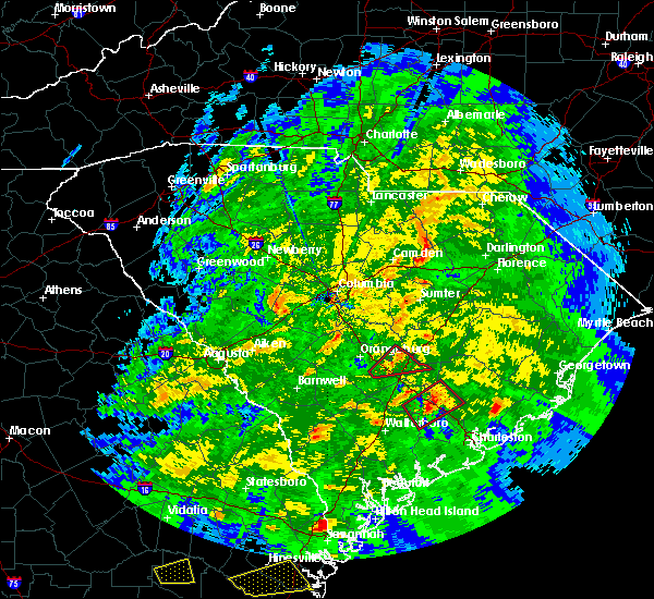 At 644 pm est, a severe thunderstorm was located near clyde, or 9 miles north of bishopville, moving east at 50 mph (radar indicated). Hazards include 60 mph wind gusts. expect damage to roofs, siding, and trees At 644 pm est, a severe thunderstorm was located near clyde, or 9 miles north of bishopville, moving east at 50 mph (radar indicated). Hazards include 60 mph wind gusts. expect damage to roofs, siding, and trees
|
| 2/12/2019 6:38 PM EST |
 At 637 pm est, a severe thunderstorm was located near chavistown, or near cheraw, moving northeast at 55 mph (radar indicated). Hazards include 60 mph wind gusts. Expect wind damage to trees and power lines. Locations impacted include, bennettsville, hartsville, mccoll, clio, north hartsville, dovesville, mont clare, lydia, auburn, wallace, clyde, chavistown, floyd, dunbar, kellytown, society hill, blenheim, tatum and carolina pines regional medical center. At 637 pm est, a severe thunderstorm was located near chavistown, or near cheraw, moving northeast at 55 mph (radar indicated). Hazards include 60 mph wind gusts. Expect wind damage to trees and power lines. Locations impacted include, bennettsville, hartsville, mccoll, clio, north hartsville, dovesville, mont clare, lydia, auburn, wallace, clyde, chavistown, floyd, dunbar, kellytown, society hill, blenheim, tatum and carolina pines regional medical center.
|
| 2/12/2019 6:22 PM EST |
 At 621 pm est, a severe thunderstorm was located 10 miles north of north hartsville, or 12 miles north of hartsville, moving northeast at 70 mph (radar indicated). Hazards include 60 mph wind gusts. expect wind damage to trees and power lines At 621 pm est, a severe thunderstorm was located 10 miles north of north hartsville, or 12 miles north of hartsville, moving northeast at 70 mph (radar indicated). Hazards include 60 mph wind gusts. expect wind damage to trees and power lines
|
| 9/27/2018 11:07 PM EDT |
 At 1107 pm edt, a line of showers and thunderstorms, embedded with isolated strong to severe wind gusts, was moving across weatern darlington county, approaching central darlington county, moving northeast at 40 mph (radar indicated). Hazards include 60 mph wind gusts. Expect possible damage from weakened trees, or trees blown over due to wet ground. locations impacted include, bennettsville, hartsville, dillon, darlington, timmonsville, mccoll, lamar, quinby, clio, hamer, mont clare, brownsville, lydia, south of the border, darlington raceway, florence darlington technical college main campus, chavistown, floyd, minturn and north hartsville. this includes the following highways, interstate 20 between mile markers 126 and 141. Interstate 95 in south carolina near mile marker 146, and between mile markers 159 and 198. At 1107 pm edt, a line of showers and thunderstorms, embedded with isolated strong to severe wind gusts, was moving across weatern darlington county, approaching central darlington county, moving northeast at 40 mph (radar indicated). Hazards include 60 mph wind gusts. Expect possible damage from weakened trees, or trees blown over due to wet ground. locations impacted include, bennettsville, hartsville, dillon, darlington, timmonsville, mccoll, lamar, quinby, clio, hamer, mont clare, brownsville, lydia, south of the border, darlington raceway, florence darlington technical college main campus, chavistown, floyd, minturn and north hartsville. this includes the following highways, interstate 20 between mile markers 126 and 141. Interstate 95 in south carolina near mile marker 146, and between mile markers 159 and 198.
|
| 9/27/2018 10:36 PM EDT |
 At 1036 pm edt, a severe thunderstorm was located 7 miles southwest of clyde, or 8 miles north of bishopville, moving northeast at 40 mph (radar indicated). Hazards include 60 mph wind gusts. expect wind damage to trees and power lines At 1036 pm edt, a severe thunderstorm was located 7 miles southwest of clyde, or 8 miles north of bishopville, moving northeast at 40 mph (radar indicated). Hazards include 60 mph wind gusts. expect wind damage to trees and power lines
|
| 9/27/2018 8:34 PM EDT |
 At 834 pm edt, a severe thunderstorm was located 8 miles northeast of oakland, or 8 miles north of sumter, moving northeast at 35 mph (radar indicated). Hazards include 60 mph wind gusts. expect damage to roofs, siding, and trees At 834 pm edt, a severe thunderstorm was located 8 miles northeast of oakland, or 8 miles north of sumter, moving northeast at 35 mph (radar indicated). Hazards include 60 mph wind gusts. expect damage to roofs, siding, and trees
|
| 9/10/2018 3:47 PM EDT |
 At 346 pm edt, a severe thunderstorm was located 8 miles west of bishopville, moving northeast at 10 mph (radar indicated). Hazards include 60 mph wind gusts and nickel size hail. expect damage to roofs, siding, and trees At 346 pm edt, a severe thunderstorm was located 8 miles west of bishopville, moving northeast at 10 mph (radar indicated). Hazards include 60 mph wind gusts and nickel size hail. expect damage to roofs, siding, and trees
|
| 8/3/2018 3:00 PM EDT |
 At 300 pm edt, a severe thunderstorm was located near bishopville, moving east at 15 mph (radar indicated). Hazards include 60 mph wind gusts. Expect damage to roofs, siding, and trees. locations impacted include, bishopville. This includes interstate 20 in south carolina between mile markers 124 and 125. At 300 pm edt, a severe thunderstorm was located near bishopville, moving east at 15 mph (radar indicated). Hazards include 60 mph wind gusts. Expect damage to roofs, siding, and trees. locations impacted include, bishopville. This includes interstate 20 in south carolina between mile markers 124 and 125.
|
| 8/3/2018 2:41 PM EDT |
 At 240 pm edt, a severe thunderstorm was located near bishopville, moving east at 15 mph (radar indicated). Hazards include 60 mph wind gusts. expect damage to roofs, siding, and trees At 240 pm edt, a severe thunderstorm was located near bishopville, moving east at 15 mph (radar indicated). Hazards include 60 mph wind gusts. expect damage to roofs, siding, and trees
|
| 6/25/2018 9:28 PM EDT |
 The severe thunderstorm warning for lee, central calhoun, west central clarendon, sumter, central kershaw and southeastern richland counties will expire at 930 pm edt, the storms which prompted the warning have weakened below severe limits, and no longer pose an immediate threat to life or property. therefore, the warning will be allowed to expire. however gusty winds, frequent lightning, and heavy rain are still possible with these thunderstorms. a severe thunderstorm watch remains in effect until 1000 pm edt for central south carolina. remember, a severe thunderstorm warning still remains in effect for clarendon and calhoun coutnies through 10 pm. The severe thunderstorm warning for lee, central calhoun, west central clarendon, sumter, central kershaw and southeastern richland counties will expire at 930 pm edt, the storms which prompted the warning have weakened below severe limits, and no longer pose an immediate threat to life or property. therefore, the warning will be allowed to expire. however gusty winds, frequent lightning, and heavy rain are still possible with these thunderstorms. a severe thunderstorm watch remains in effect until 1000 pm edt for central south carolina. remember, a severe thunderstorm warning still remains in effect for clarendon and calhoun coutnies through 10 pm.
|
| 6/25/2018 9:16 PM EDT |
 At 916 pm edt, severe thunderstorms were located along a line extending from near bishopville to 7 miles east of eastover, moving east at 45 mph (radar indicated). Hazards include 60 mph wind gusts. Expect damage to roofs, siding, and trees. locations impacted include, sumter, camden, bishopville, south sumter, st. matthews, eastover, mulberry, oakland, millwood, mayesville, pinewood, bethune, paxville, cane savannah, oswego, dalzell, lakewood, privateer, wedgewood and east sumter. this includes the following highways, interstate 20 in south carolina between mile markers 95 and 125. Interstate 26 between mile markers 131 and 136. At 916 pm edt, severe thunderstorms were located along a line extending from near bishopville to 7 miles east of eastover, moving east at 45 mph (radar indicated). Hazards include 60 mph wind gusts. Expect damage to roofs, siding, and trees. locations impacted include, sumter, camden, bishopville, south sumter, st. matthews, eastover, mulberry, oakland, millwood, mayesville, pinewood, bethune, paxville, cane savannah, oswego, dalzell, lakewood, privateer, wedgewood and east sumter. this includes the following highways, interstate 20 in south carolina between mile markers 95 and 125. Interstate 26 between mile markers 131 and 136.
|
| 6/25/2018 8:43 PM EDT |
 At 843 pm edt, severe thunderstorms were located along a line extending from 9 miles north of camden to near forest acres, moving east at 40 mph (radar indicated). Hazards include 60 mph wind gusts. expect damage to roofs, siding, and trees At 843 pm edt, severe thunderstorms were located along a line extending from 9 miles north of camden to near forest acres, moving east at 40 mph (radar indicated). Hazards include 60 mph wind gusts. expect damage to roofs, siding, and trees
|
| 6/25/2018 5:45 PM EDT |
 At 545 pm edt, a severe thunderstorm was located over lydia, or 8 miles northeast of bishopville, moving east at 15 mph (radar indicated). Hazards include 60 mph wind gusts and quarter size hail. Hail damage to vehicles is expected. expect wind damage to roofs, siding, and trees. This severe thunderstorm will remain over mainly rural areas of north central lee county. At 545 pm edt, a severe thunderstorm was located over lydia, or 8 miles northeast of bishopville, moving east at 15 mph (radar indicated). Hazards include 60 mph wind gusts and quarter size hail. Hail damage to vehicles is expected. expect wind damage to roofs, siding, and trees. This severe thunderstorm will remain over mainly rural areas of north central lee county.
|
| 6/25/2018 5:34 PM EDT |
 At 533 pm edt, a severe thunderstorm was located near kellytown, or near bishopville, moving east at 10 mph (radar indicated). Hazards include 60 mph wind gusts and quarter size hail. Hail damage to vehicles is expected. expect wind damage to roofs, siding, and trees. This severe thunderstorm will remain over mainly rural areas of north central lee county. At 533 pm edt, a severe thunderstorm was located near kellytown, or near bishopville, moving east at 10 mph (radar indicated). Hazards include 60 mph wind gusts and quarter size hail. Hail damage to vehicles is expected. expect wind damage to roofs, siding, and trees. This severe thunderstorm will remain over mainly rural areas of north central lee county.
|
| 6/25/2018 4:56 PM EDT |
 The severe thunderstorm warning for darlington and central marlboro counties will expire at 500 pm edt, the storm which prompted the warning has weakened below severe limits, and no longer pose an immediate threat to life or property. therefore the warning will be allowed to expire. however gusty winds are still possible with this thunderstorm. The severe thunderstorm warning for darlington and central marlboro counties will expire at 500 pm edt, the storm which prompted the warning has weakened below severe limits, and no longer pose an immediate threat to life or property. therefore the warning will be allowed to expire. however gusty winds are still possible with this thunderstorm.
|
| 6/25/2018 4:42 PM EDT |
 At 441 pm edt, a severe thunderstorm was located 13 miles south of bennettsville, moving east at 10 mph (radar indicated). Hazards include 60 mph wind gusts and penny size hail. Expect damage to trees and powerlines. Locations impacted include, bennettsville, hartsville, darlington, clio, north hartsville, dovesville, mont clare and brownsville. At 441 pm edt, a severe thunderstorm was located 13 miles south of bennettsville, moving east at 10 mph (radar indicated). Hazards include 60 mph wind gusts and penny size hail. Expect damage to trees and powerlines. Locations impacted include, bennettsville, hartsville, darlington, clio, north hartsville, dovesville, mont clare and brownsville.
|
| 6/25/2018 4:18 PM EDT |
 At 417 pm edt, a severe thunderstorm was located 12 miles northeast of darlington, moving east at 10 mph (radar indicated). Hazards include 60 mph wind gusts and quarter size hail. Minor hail damage to vehicles is possible. expect wind damage to trees and powerlines. Locations impacted include, bennettsville, hartsville, darlington, clio, north hartsville, dovesville, mont clare and brownsville. At 417 pm edt, a severe thunderstorm was located 12 miles northeast of darlington, moving east at 10 mph (radar indicated). Hazards include 60 mph wind gusts and quarter size hail. Minor hail damage to vehicles is possible. expect wind damage to trees and powerlines. Locations impacted include, bennettsville, hartsville, darlington, clio, north hartsville, dovesville, mont clare and brownsville.
|
| 6/25/2018 4:02 PM EDT |
 At 402 pm edt, a severe thunderstorm was located 10 miles northeast of darlington, moving east at 10 mph (radar indicated). Hazards include 60 mph wind gusts and quarter size hail. Minor hail damage to vehicles is possible. Expect wind damage to trees and powerlines. At 402 pm edt, a severe thunderstorm was located 10 miles northeast of darlington, moving east at 10 mph (radar indicated). Hazards include 60 mph wind gusts and quarter size hail. Minor hail damage to vehicles is possible. Expect wind damage to trees and powerlines.
|
| 4/15/2018 4:03 PM EDT |
 At 401 pm edt, thunderstorms extended from the bishopville area southward to around manning. storm movement was northward near 40 mph. some of the thunderstorms likely contained wind gusts of 40 to 60 mph (radar indicated). Hazards include 60 mph wind gusts. Expect damage to roofs, siding, and trees. locations impacted include, sumter, manning, bishopville, south sumter, summerton, mulberry, millwood, turbeville, mayesville, pinewood, lynchburg, paxville, cane savannah, oswego, dalzell, lakewood, privateer, east sumter, shiloh and cherryvale. this includes the following highways, interstate 20 in south carolina between mile markers 106 and 125. interstate 95 between mile markers 100 and 146. A tornado watch remains in effect until 700 pm edt for central south carolina. At 401 pm edt, thunderstorms extended from the bishopville area southward to around manning. storm movement was northward near 40 mph. some of the thunderstorms likely contained wind gusts of 40 to 60 mph (radar indicated). Hazards include 60 mph wind gusts. Expect damage to roofs, siding, and trees. locations impacted include, sumter, manning, bishopville, south sumter, summerton, mulberry, millwood, turbeville, mayesville, pinewood, lynchburg, paxville, cane savannah, oswego, dalzell, lakewood, privateer, east sumter, shiloh and cherryvale. this includes the following highways, interstate 20 in south carolina between mile markers 106 and 125. interstate 95 between mile markers 100 and 146. A tornado watch remains in effect until 700 pm edt for central south carolina.
|
| 3/1/2018 3:43 PM EST |
 At 342 pm est, showers with damaging wind were in lancaster and western kershaw counties moving eastward near 45 mph and toward chesterfield and parts of lee county (radar indicated). Hazards include 60 mph wind gusts. expect damage to roofs, siding, and trees At 342 pm est, showers with damaging wind were in lancaster and western kershaw counties moving eastward near 45 mph and toward chesterfield and parts of lee county (radar indicated). Hazards include 60 mph wind gusts. expect damage to roofs, siding, and trees
|
| 8/31/2017 6:09 PM EDT |
 The severe thunderstorm warning for darlington county will expire at 615 pm edt, the storm which prompted the warning has weakened below severe limits, and no longer poses an immediate threat to life or property. therefore the warning will be allowed to expire. The severe thunderstorm warning for darlington county will expire at 615 pm edt, the storm which prompted the warning has weakened below severe limits, and no longer poses an immediate threat to life or property. therefore the warning will be allowed to expire.
|
| 8/31/2017 5:45 PM EDT |
 At 544 pm edt, a severe thunderstorm was located over floyd, or near darlington, moving east at 30 mph (radar indicated). Hazards include 60 mph wind gusts and quarter size hail. Minor hail damage to vehicles is possible. expect wind damage to trees and power lines. locations impacted include, hartsville, darlington, north hartsville, dovesville, mont clare, lydia, auburn, darlington raceway, clyde, mechanicsville, oates, floyd, kellytown, florence darlington technical college main campus, society hill, mcleod medical center and carolina pines regional medical center. people attending southern 500 should seek safe shelter immediately! this includes the following highways, interstate 20 between mile markers 129 and 131. Interstate 95 in south carolina mile marker 146 and near mile marker 167. At 544 pm edt, a severe thunderstorm was located over floyd, or near darlington, moving east at 30 mph (radar indicated). Hazards include 60 mph wind gusts and quarter size hail. Minor hail damage to vehicles is possible. expect wind damage to trees and power lines. locations impacted include, hartsville, darlington, north hartsville, dovesville, mont clare, lydia, auburn, darlington raceway, clyde, mechanicsville, oates, floyd, kellytown, florence darlington technical college main campus, society hill, mcleod medical center and carolina pines regional medical center. people attending southern 500 should seek safe shelter immediately! this includes the following highways, interstate 20 between mile markers 129 and 131. Interstate 95 in south carolina mile marker 146 and near mile marker 167.
|
| 8/31/2017 5:42 PM EDT |
 At 541 pm edt, a severe thunderstorm was located over lydia, or 7 miles east of bishopville, moving east at 20 mph. other storms were developing to the west of the area and may move into northern lee county. these storms may intensify and become severe (radar indicated). Hazards include 60 mph wind gusts and penny size hail. Expect damage to roofs, siding, and trees. Locations impacted include, bishopville. At 541 pm edt, a severe thunderstorm was located over lydia, or 7 miles east of bishopville, moving east at 20 mph. other storms were developing to the west of the area and may move into northern lee county. these storms may intensify and become severe (radar indicated). Hazards include 60 mph wind gusts and penny size hail. Expect damage to roofs, siding, and trees. Locations impacted include, bishopville.
|
| 8/31/2017 5:13 PM EDT |
 At 512 pm edt, a severe thunderstorm was located over clyde, or 7 miles west of hartsville, moving east at 30 mph (radar indicated). Hazards include 60 mph wind gusts and quarter size hail. Minor hail damage to vehicles is possible. Expect wind damage to trees and power lines. At 512 pm edt, a severe thunderstorm was located over clyde, or 7 miles west of hartsville, moving east at 30 mph (radar indicated). Hazards include 60 mph wind gusts and quarter size hail. Minor hail damage to vehicles is possible. Expect wind damage to trees and power lines.
|
| 8/31/2017 5:12 PM EDT |
 At 511 pm edt, a severe thunderstorm was located northwest of bishopville, moving east at 20 mph (radar indicated). Hazards include 60 mph wind gusts and penny size hail. expect damage to roofs, siding, and trees At 511 pm edt, a severe thunderstorm was located northwest of bishopville, moving east at 20 mph (radar indicated). Hazards include 60 mph wind gusts and penny size hail. expect damage to roofs, siding, and trees
|
| 7/28/2017 6:06 PM EDT |
 At 606 pm edt, a severe thunderstorm was located 8 miles west of bishopville, moving east at 25 mph (radar indicated). Hazards include 60 mph wind gusts. expect damage to roofs, siding, and trees At 606 pm edt, a severe thunderstorm was located 8 miles west of bishopville, moving east at 25 mph (radar indicated). Hazards include 60 mph wind gusts. expect damage to roofs, siding, and trees
|
| 7/15/2017 5:16 PM EDT |
 At 516 pm edt, a severe thunderstorm was located over kellytown, moving east at 10 mph (radar indicated). Hazards include 60 mph wind gusts and nickel size hail. Expect damage trees and power lines. Locations impacted include, hartsville, darlington, north hartsville, dovesville, lydia, auburn, darlington raceway, clyde, oates, floyd, kellytown, florence darlington technical college main campus, mcleod medical center and carolina pines regional medical center. At 516 pm edt, a severe thunderstorm was located over kellytown, moving east at 10 mph (radar indicated). Hazards include 60 mph wind gusts and nickel size hail. Expect damage trees and power lines. Locations impacted include, hartsville, darlington, north hartsville, dovesville, lydia, auburn, darlington raceway, clyde, oates, floyd, kellytown, florence darlington technical college main campus, mcleod medical center and carolina pines regional medical center.
|
| 7/15/2017 5:02 PM EDT |
 At 502 pm edt, a likely severe thunderstorm was located just north of bishopville, moving east at 15 mph (radar indicated). Hazards include 60 mph wind gusts. Expect damage to roofs, siding, and trees. This severe thunderstorm will remain over mainly rural areas of northeastern lee county. At 502 pm edt, a likely severe thunderstorm was located just north of bishopville, moving east at 15 mph (radar indicated). Hazards include 60 mph wind gusts. Expect damage to roofs, siding, and trees. This severe thunderstorm will remain over mainly rural areas of northeastern lee county.
|
| 7/15/2017 5:01 PM EDT |
 At 501 pm edt, a severe thunderstorm was located over kellytown, or near hartsville, moving east at 10 mph (radar indicated). Hazards include 60 mph wind gusts and nickel size hail. expect damage trees and power lines At 501 pm edt, a severe thunderstorm was located over kellytown, or near hartsville, moving east at 10 mph (radar indicated). Hazards include 60 mph wind gusts and nickel size hail. expect damage trees and power lines
|
| 7/5/2017 4:42 PM EDT |
 At 441 pm edt, a severe thunderstorm was located near auburn, or near hartsville, moving east at 25 mph (radar indicated). Hazards include 60 mph wind gusts and quarter size hail. Minor hail damage to vehicles is possible. Expect wind damage to trees and power lines. At 441 pm edt, a severe thunderstorm was located near auburn, or near hartsville, moving east at 25 mph (radar indicated). Hazards include 60 mph wind gusts and quarter size hail. Minor hail damage to vehicles is possible. Expect wind damage to trees and power lines.
|
| 6/15/2017 7:56 PM EDT |
 At 755 pm edt, a severe thunderstorm was located over timmonsville, or 11 miles southwest of darlington, moving southeast at 20 mph (radar indicated). Hazards include 60 mph wind gusts and quarter size hail. Minor hail damage to vehicles is possible. Expect wind damage to trees and power lines. At 755 pm edt, a severe thunderstorm was located over timmonsville, or 11 miles southwest of darlington, moving southeast at 20 mph (radar indicated). Hazards include 60 mph wind gusts and quarter size hail. Minor hail damage to vehicles is possible. Expect wind damage to trees and power lines.
|
| 5/29/2017 7:32 PM EDT |
 At 732 pm edt, a severe thunderstorm was located 7 miles west of eastover, or 14 miles southeast of forest acres, moving northeast at 40 mph (radar indicated). Hazards include 60 mph wind gusts and quarter size hail. Hail damage to vehicles is expected. Expect wind damage to roofs, siding, and trees. At 732 pm edt, a severe thunderstorm was located 7 miles west of eastover, or 14 miles southeast of forest acres, moving northeast at 40 mph (radar indicated). Hazards include 60 mph wind gusts and quarter size hail. Hail damage to vehicles is expected. Expect wind damage to roofs, siding, and trees.
|
| 4/5/2017 3:50 PM EDT |
 At 349 pm edt, a severe thunderstorm was located 8 miles south of bishopville, moving northeast at 40 mph (radar indicated). Hazards include 60 mph wind gusts and quarter size hail. Hail damage to vehicles is expected. Expect wind damage to roofs, siding, and trees. At 349 pm edt, a severe thunderstorm was located 8 miles south of bishopville, moving northeast at 40 mph (radar indicated). Hazards include 60 mph wind gusts and quarter size hail. Hail damage to vehicles is expected. Expect wind damage to roofs, siding, and trees.
|
| 4/3/2017 5:55 PM EDT |
 At 554 pm edt, a severe thunderstorm was located over mechanicsville, or 7 miles northeast of darlington, moving northeast at 55 mph (radar indicated). Hazards include 60 mph wind gusts and quarter size hail. Hail damage to vehicles is expected. expect wind damage to roofs, siding, and trees. locations impacted include, florence, bennettsville, hartsville, lake city, darlington, timmonsville, mccoll, johnsonville, pamplico, lamar, quinby, clio, brownsville, darlington raceway, chavistown, floyd, new hope, north hartsville, hyman and effingham. this includes the following highways, interstate 20 between mile markers 125 and 141. Interstate 95 in south carolina near mile marker 146, and between mile markers 148 and 175. At 554 pm edt, a severe thunderstorm was located over mechanicsville, or 7 miles northeast of darlington, moving northeast at 55 mph (radar indicated). Hazards include 60 mph wind gusts and quarter size hail. Hail damage to vehicles is expected. expect wind damage to roofs, siding, and trees. locations impacted include, florence, bennettsville, hartsville, lake city, darlington, timmonsville, mccoll, johnsonville, pamplico, lamar, quinby, clio, brownsville, darlington raceway, chavistown, floyd, new hope, north hartsville, hyman and effingham. this includes the following highways, interstate 20 between mile markers 125 and 141. Interstate 95 in south carolina near mile marker 146, and between mile markers 148 and 175.
|
| 4/3/2017 5:36 PM EDT |
 At 535 pm edt, a severe thunderstorm was located near darlington, moving northeast at 50 mph (radar indicated). Hazards include 60 mph wind gusts and quarter size hail. Hail damage to vehicles is expected. expect wind damage to roofs, siding, and trees. locations impacted include, florence, bennettsville, hartsville, lake city, darlington, timmonsville, mccoll, johnsonville, pamplico, lamar, quinby, clio, brownsville, darlington raceway, chavistown, floyd, new hope, north hartsville, hyman and effingham. this includes the following highways, interstate 20 between mile markers 125 and 141. Interstate 95 in south carolina near mile marker 146, and between mile markers 148 and 175. At 535 pm edt, a severe thunderstorm was located near darlington, moving northeast at 50 mph (radar indicated). Hazards include 60 mph wind gusts and quarter size hail. Hail damage to vehicles is expected. expect wind damage to roofs, siding, and trees. locations impacted include, florence, bennettsville, hartsville, lake city, darlington, timmonsville, mccoll, johnsonville, pamplico, lamar, quinby, clio, brownsville, darlington raceway, chavistown, floyd, new hope, north hartsville, hyman and effingham. this includes the following highways, interstate 20 between mile markers 125 and 141. Interstate 95 in south carolina near mile marker 146, and between mile markers 148 and 175.
|
| 4/3/2017 5:18 PM EDT |
 At 518 pm edt, severe thunderstorms were located along a line extending from near chesterfield to 9 miles southeast of lugoff, moving east at 35 mph (radar indicated). Hazards include 70 mph wind gusts. Expect considerable tree damage. damage is likely to mobile homes, roofs, and outbuildings. locations impacted include, camden, cheraw, bishopville, chesterfield, mcbee, ruby, patrick, bethune, mount croghan and rembert. A tornado watch remains in effect until 900 pm edt for central south carolina. At 518 pm edt, severe thunderstorms were located along a line extending from near chesterfield to 9 miles southeast of lugoff, moving east at 35 mph (radar indicated). Hazards include 70 mph wind gusts. Expect considerable tree damage. damage is likely to mobile homes, roofs, and outbuildings. locations impacted include, camden, cheraw, bishopville, chesterfield, mcbee, ruby, patrick, bethune, mount croghan and rembert. A tornado watch remains in effect until 900 pm edt for central south carolina.
|
| 4/3/2017 5:15 PM EDT |
 At 514 pm edt, a severe thunderstorm was located near bishopville, moving northeast at 55 mph (radar indicated). Hazards include 60 mph wind gusts and quarter size hail. Hail damage to vehicles is expected. Expect wind damage to roofs, siding, and trees. At 514 pm edt, a severe thunderstorm was located near bishopville, moving northeast at 55 mph (radar indicated). Hazards include 60 mph wind gusts and quarter size hail. Hail damage to vehicles is expected. Expect wind damage to roofs, siding, and trees.
|
| 4/3/2017 4:51 PM EDT |
 At 451 pm edt, severe thunderstorms were located along a line extending from near pageland to near dentsville, moving east at 60 mph (radar indicated). Hazards include 70 mph wind gusts. Expect considerable tree damage. Damage is likely to mobile homes, roofs, and outbuildings. At 451 pm edt, severe thunderstorms were located along a line extending from near pageland to near dentsville, moving east at 60 mph (radar indicated). Hazards include 70 mph wind gusts. Expect considerable tree damage. Damage is likely to mobile homes, roofs, and outbuildings.
|
| 3/21/2017 11:20 PM EDT | Report of tree down on us hwy 15 near lydia fire department. time estimated by rada in darlington county SC, 0.5 miles SSW of Lydia, SC |
| 3/21/2017 11:15 PM EDT |
 At 1115 pm edt, a severe thunderstorm was located near clyde, or near bishopville, moving east at 40 mph (radar indicated). Hazards include 70 mph wind gusts. Expect considerable tree damage. damage is likely to mobile homes, roofs, and outbuildings. Locations impacted include, bishopville, mcbee, mayesville, lynchburg, bethune and oswego. At 1115 pm edt, a severe thunderstorm was located near clyde, or near bishopville, moving east at 40 mph (radar indicated). Hazards include 70 mph wind gusts. Expect considerable tree damage. damage is likely to mobile homes, roofs, and outbuildings. Locations impacted include, bishopville, mcbee, mayesville, lynchburg, bethune and oswego.
|
| 3/21/2017 11:11 PM EDT |
 At 1111 pm edt, severe thunderstorms were located along a line extending from 7 miles northwest of bishopville to near mulberry, moving east at 45 mph (radar indicated). Hazards include 60 mph wind gusts and penny size hail. expect damage to roofs, siding, and trees At 1111 pm edt, severe thunderstorms were located along a line extending from 7 miles northwest of bishopville to near mulberry, moving east at 45 mph (radar indicated). Hazards include 60 mph wind gusts and penny size hail. expect damage to roofs, siding, and trees
|
| 3/21/2017 10:51 PM EDT |
 At 1050 pm edt, a severe thunderstorm was located near camden, moving east at 40 mph (radar indicated). Hazards include 70 mph wind gusts. Expect considerable tree damage. Damage is likely to mobile homes, roofs, and outbuildings. At 1050 pm edt, a severe thunderstorm was located near camden, moving east at 40 mph (radar indicated). Hazards include 70 mph wind gusts. Expect considerable tree damage. Damage is likely to mobile homes, roofs, and outbuildings.
|
| 2/9/2017 2:25 AM EST |
 At 224 am est, a severe thunderstorm was located near clyde, or 10 miles north of bishopville, moving east at 45 mph (radar indicated). Hazards include 60 mph wind gusts and quarter size hail. Hail damage to vehicles is expected. Expect wind damage to roofs, siding, and trees. At 224 am est, a severe thunderstorm was located near clyde, or 10 miles north of bishopville, moving east at 45 mph (radar indicated). Hazards include 60 mph wind gusts and quarter size hail. Hail damage to vehicles is expected. Expect wind damage to roofs, siding, and trees.
|
| 2/9/2017 2:19 AM EST |
 At 218 am est, a severe thunderstorm was located over lugoff, or near camden, moving east at 55 mph (radar indicated). Hazards include 60 mph wind gusts and penny size hail. expect damage to roofs, siding, and trees At 218 am est, a severe thunderstorm was located over lugoff, or near camden, moving east at 55 mph (radar indicated). Hazards include 60 mph wind gusts and penny size hail. expect damage to roofs, siding, and trees
|
| 7/19/2016 3:52 PM EDT |
 At 352 pm edt, a severe thunderstorm was located near bishopville, moving southeast at 15 mph (radar indicated). Hazards include 60 mph wind gusts and penny size hail. Expect damage to roofs. siding. And trees. At 352 pm edt, a severe thunderstorm was located near bishopville, moving southeast at 15 mph (radar indicated). Hazards include 60 mph wind gusts and penny size hail. Expect damage to roofs. siding. And trees.
|
| 7/19/2016 3:40 PM EDT |
 At 339 pm edt, a severe thunderstorm was located over darlington raceway, or over darlington, moving southeast at 20 mph (radar indicated). Hazards include 60 mph wind gusts and quarter size hail. Hail damage to vehicles is expected. expect wind damage to roofs, siding, and trees. Locations impacted include, hartsville, darlington, lamar, dovesville, darlington raceway, floyd, lydia, auburn, kellytown, oats, mechanicsville, north hartsville, florence darlington technical college main campus, carolina pines regional medical center and mcleod medical center. At 339 pm edt, a severe thunderstorm was located over darlington raceway, or over darlington, moving southeast at 20 mph (radar indicated). Hazards include 60 mph wind gusts and quarter size hail. Hail damage to vehicles is expected. expect wind damage to roofs, siding, and trees. Locations impacted include, hartsville, darlington, lamar, dovesville, darlington raceway, floyd, lydia, auburn, kellytown, oats, mechanicsville, north hartsville, florence darlington technical college main campus, carolina pines regional medical center and mcleod medical center.
|
| 7/19/2016 3:16 PM EDT |
 At 315 pm edt, a severe thunderstorm was located over auburn, or near hartsville, moving southeast at 20 mph (radar indicated). Hazards include 60 mph wind gusts and quarter size hail. Hail damage to vehicles is expected. Expect wind damage to roofs, siding, and trees. At 315 pm edt, a severe thunderstorm was located over auburn, or near hartsville, moving southeast at 20 mph (radar indicated). Hazards include 60 mph wind gusts and quarter size hail. Hail damage to vehicles is expected. Expect wind damage to roofs, siding, and trees.
|
| 7/11/2016 7:12 PM EDT |
 At 711 pm edt, a severe thunderstorm was located near darlington, moving east at 35 mph (radar indicated). Hazards include 70 mph wind gusts and quarter size hail. Hail damage to vehicles is expected. expect considerable tree damage. wind damage is also likely to mobile homes, roofs, and outbuildings. Locations impacted include, florence, bennettsville, darlington, lamar, quinby, florence darlington technical college main campus, dovesville, mont clare, darlington raceway, floyd, mars bluff, oats, mechanicsville, society hill, blenheim, health south rehabilitation hospital, mcleod regional medical center, carolinas hospital system, carolinas hospital system - cedar tower and mcleod medical center. At 711 pm edt, a severe thunderstorm was located near darlington, moving east at 35 mph (radar indicated). Hazards include 70 mph wind gusts and quarter size hail. Hail damage to vehicles is expected. expect considerable tree damage. wind damage is also likely to mobile homes, roofs, and outbuildings. Locations impacted include, florence, bennettsville, darlington, lamar, quinby, florence darlington technical college main campus, dovesville, mont clare, darlington raceway, floyd, mars bluff, oats, mechanicsville, society hill, blenheim, health south rehabilitation hospital, mcleod regional medical center, carolinas hospital system, carolinas hospital system - cedar tower and mcleod medical center.
|
| 7/11/2016 7:06 PM EDT |
 At 705 pm edt, a severe thunderstorm was located near darlington, moving east at 40 mph (radar indicated). Hazards include 60 mph wind gusts and quarter size hail. Hail damage to vehicles is expected. expect wind damage to roofs, siding, and trees. Locations impacted include, florence, bennettsville, darlington, lamar, quinby, florence darlington technical college main campus, dovesville, mont clare, darlington raceway, floyd, mars bluff, auburn, oats, mechanicsville, society hill, blenheim, health south rehabilitation hospital, mcleod regional medical center, carolinas hospital system and carolinas hospital system - cedar tower. At 705 pm edt, a severe thunderstorm was located near darlington, moving east at 40 mph (radar indicated). Hazards include 60 mph wind gusts and quarter size hail. Hail damage to vehicles is expected. expect wind damage to roofs, siding, and trees. Locations impacted include, florence, bennettsville, darlington, lamar, quinby, florence darlington technical college main campus, dovesville, mont clare, darlington raceway, floyd, mars bluff, auburn, oats, mechanicsville, society hill, blenheim, health south rehabilitation hospital, mcleod regional medical center, carolinas hospital system and carolinas hospital system - cedar tower.
|
| 7/11/2016 6:56 PM EDT |
 At 656 pm edt, a severe thunderstorm was located over floyd, or near darlington, moving east at 40 mph (radar indicated). Hazards include 60 mph wind gusts and quarter size hail. Hail damage to vehicles is expected. Expect wind damage to roofs, siding, and trees. At 656 pm edt, a severe thunderstorm was located over floyd, or near darlington, moving east at 40 mph (radar indicated). Hazards include 60 mph wind gusts and quarter size hail. Hail damage to vehicles is expected. Expect wind damage to roofs, siding, and trees.
|
| 7/11/2016 4:43 PM EDT |
 At 443 pm edt, a severe thunderstorm was located near oats, or 9 miles southwest of darlington, moving east at 15 mph (radar indicated). Hazards include 60 mph wind gusts and quarter size hail. Hail damage to vehicles is expected. Expect wind damage to roofs, siding, and trees. At 443 pm edt, a severe thunderstorm was located near oats, or 9 miles southwest of darlington, moving east at 15 mph (radar indicated). Hazards include 60 mph wind gusts and quarter size hail. Hail damage to vehicles is expected. Expect wind damage to roofs, siding, and trees.
|
| 7/9/2016 12:11 AM EDT |
 At 1210 am edt, a severe thunderstorms were located 9 miles southwest of darlington, moving east at 35 mph (radar indicated). Hazards include 60 mph wind gusts and penny size hail. Expect damage to roofs. siding. and trees. Locations impacted include, florence, hartsville, lake city, darlington, timmonsville, lamar, quinby, sardis, bingham, new hope, effingham, kellytown, cartersville, oak grove, florence darlington technical college main campus, brownsville, dovesville, north hartsville, evergreen and mont clare. At 1210 am edt, a severe thunderstorms were located 9 miles southwest of darlington, moving east at 35 mph (radar indicated). Hazards include 60 mph wind gusts and penny size hail. Expect damage to roofs. siding. and trees. Locations impacted include, florence, hartsville, lake city, darlington, timmonsville, lamar, quinby, sardis, bingham, new hope, effingham, kellytown, cartersville, oak grove, florence darlington technical college main campus, brownsville, dovesville, north hartsville, evergreen and mont clare.
|
| 7/8/2016 11:46 PM EDT |
 At 1145 pm edt, severe thunderstorms were located along a line extending from 12 miles west of clyde to 9 miles west of eastover, moving east at 40 mph (radar indicated). Hazards include 60 mph wind gusts. Expect damage to roofs. siding. And trees. At 1145 pm edt, severe thunderstorms were located along a line extending from 12 miles west of clyde to 9 miles west of eastover, moving east at 40 mph (radar indicated). Hazards include 60 mph wind gusts. Expect damage to roofs. siding. And trees.
|
| 7/8/2016 11:40 PM EDT |
 At 1139 pm edt, a severe thunderstorm was located 7 miles west of clyde, or 9 miles northwest of bishopville, moving east at 35 mph (radar indicated). Hazards include 60 mph wind gusts and penny size hail. Expect damage to roofs. siding. And trees. At 1139 pm edt, a severe thunderstorm was located 7 miles west of clyde, or 9 miles northwest of bishopville, moving east at 35 mph (radar indicated). Hazards include 60 mph wind gusts and penny size hail. Expect damage to roofs. siding. And trees.
|
| 7/7/2016 9:01 PM EDT |
 At 859 pm edt, a gust front from a severe thunderstorm was located along a line extending from near quinby to near florence to near timmonsville, moving east at 45 mph (radar indicated). Hazards include 60 mph wind gusts. Expect damage to roofs. siding. and trees. Locations impacted include, florence, hartsville, lake city, darlington, timmonsville, pamplico, lamar, quinby, new hope, effingham, kellytown, florence darlington technical college main campus, north hartsville, evergreen, friendfield, darlington raceway, floyd, mars bluff, clyde and auburn. At 859 pm edt, a gust front from a severe thunderstorm was located along a line extending from near quinby to near florence to near timmonsville, moving east at 45 mph (radar indicated). Hazards include 60 mph wind gusts. Expect damage to roofs. siding. and trees. Locations impacted include, florence, hartsville, lake city, darlington, timmonsville, pamplico, lamar, quinby, new hope, effingham, kellytown, florence darlington technical college main campus, north hartsville, evergreen, friendfield, darlington raceway, floyd, mars bluff, clyde and auburn.
|
| 7/7/2016 8:47 PM EDT |
 At 846 pm edt, a severe thunderstorm was located over oats, or 9 miles south of hartsville, moving southeast at 40 mph (radar indicated). Hazards include 60 mph wind gusts. Expect damage to roofs. siding. And trees. At 846 pm edt, a severe thunderstorm was located over oats, or 9 miles south of hartsville, moving southeast at 40 mph (radar indicated). Hazards include 60 mph wind gusts. Expect damage to roofs. siding. And trees.
|
| 7/7/2016 4:58 PM EDT |
 At 458 pm edt, a severe thunderstorm was located from near clyde to bishopville, moving east at 40 mph (radar indicated). Hazards include 60 mph wind gusts. Expect damage to roofs. siding. And trees. At 458 pm edt, a severe thunderstorm was located from near clyde to bishopville, moving east at 40 mph (radar indicated). Hazards include 60 mph wind gusts. Expect damage to roofs. siding. And trees.
|
| 7/7/2016 4:42 PM EDT |
 At 442 pm edt, a severe thunderstorm was located near bishopville, moving east at 45 mph (law enforcement has reported considerable wind damage from this storm). Hazards include 60 mph wind gusts. Expect damage to roofs. siding. and trees. Locations impacted include, bishopville, mcbee and bethune. At 442 pm edt, a severe thunderstorm was located near bishopville, moving east at 45 mph (law enforcement has reported considerable wind damage from this storm). Hazards include 60 mph wind gusts. Expect damage to roofs. siding. and trees. Locations impacted include, bishopville, mcbee and bethune.
|
| 7/7/2016 4:27 PM EDT |
 At 426 pm edt, a severe thunderstorm was located near camden, moving east at 45 mph (law enforcement has reported widespread wind damage with this storm). Hazards include 60 mph wind gusts. Expect damage to roofs. siding. And trees. At 426 pm edt, a severe thunderstorm was located near camden, moving east at 45 mph (law enforcement has reported widespread wind damage with this storm). Hazards include 60 mph wind gusts. Expect damage to roofs. siding. And trees.
|
| 7/5/2016 6:45 PM EDT |
 At 644 pm edt, severe thunderstorms were located along a line extending from near chavistown to 7 miles northeast of manning, moving east at 35 mph (radar indicated). Hazards include 60 mph wind gusts and penny size hail. Expect damage to roofs. siding. And trees. At 644 pm edt, severe thunderstorms were located along a line extending from near chavistown to 7 miles northeast of manning, moving east at 35 mph (radar indicated). Hazards include 60 mph wind gusts and penny size hail. Expect damage to roofs. siding. And trees.
|
| 7/5/2016 6:23 PM EDT |
 At 622 pm edt, severe thunderstorms were located along a line extending from 9 miles southwest of rockingham to 8 miles northwest of manning, moving east at 50 mph (radar indicated). Hazards include 60 mph wind gusts and penny size hail. Expect damage to roofs. siding. and trees. Locations impacted include, florence, bennettsville, hartsville, darlington, timmonsville, mccoll, lamar, quinby, sardis, chavistown, kellytown, cartersville, florence darlington technical college main campus, dovesville, wallace, north hartsville, mont clare, darlington raceway, floyd and lydia. At 622 pm edt, severe thunderstorms were located along a line extending from 9 miles southwest of rockingham to 8 miles northwest of manning, moving east at 50 mph (radar indicated). Hazards include 60 mph wind gusts and penny size hail. Expect damage to roofs. siding. and trees. Locations impacted include, florence, bennettsville, hartsville, darlington, timmonsville, mccoll, lamar, quinby, sardis, chavistown, kellytown, cartersville, florence darlington technical college main campus, dovesville, wallace, north hartsville, mont clare, darlington raceway, floyd and lydia.
|
| 7/5/2016 6:08 PM EDT |
 At 608 pm edt, severe thunderstorms were located along a line extending from 6 miles north of chesterfield to 11 miles north of elloree, moving east at 50 mph (radar indicated). Hazards include 60 mph wind gusts and penny size hail. Expect damage to roofs. siding. And trees. At 608 pm edt, severe thunderstorms were located along a line extending from 6 miles north of chesterfield to 11 miles north of elloree, moving east at 50 mph (radar indicated). Hazards include 60 mph wind gusts and penny size hail. Expect damage to roofs. siding. And trees.
|
| 7/5/2016 5:45 PM EDT |
 At 542 pm edt, a line of thunderstorms extended from lancaster county southward through kershaw, lower richland and calhoun county. movement was east-northeast near 35 mph. some of the thunderstorms within the line likely contained wind gusts of 40 to 60 mph (radar indicated). Hazards include 60 mph wind gusts. Expect damage to roofs. Siding and trees. At 542 pm edt, a line of thunderstorms extended from lancaster county southward through kershaw, lower richland and calhoun county. movement was east-northeast near 35 mph. some of the thunderstorms within the line likely contained wind gusts of 40 to 60 mph (radar indicated). Hazards include 60 mph wind gusts. Expect damage to roofs. Siding and trees.
|
| 6/14/2016 10:29 PM EDT |
 At 1027 pm edt, a severe thunderstorm was located near lamar, or 9 miles southwest of darlington, moving east at 25 mph. additional severe thunderstorms will develop within the warned area as this activity progresses eastward (radar indicated). Hazards include quarter size hail and 60 mph wind gusts. Hail damage to vehicles is expected. Expect wind damage to roofs, siding, and trees. At 1027 pm edt, a severe thunderstorm was located near lamar, or 9 miles southwest of darlington, moving east at 25 mph. additional severe thunderstorms will develop within the warned area as this activity progresses eastward (radar indicated). Hazards include quarter size hail and 60 mph wind gusts. Hail damage to vehicles is expected. Expect wind damage to roofs, siding, and trees.
|
| 2/3/2016 4:00 PM EST |
 At 400 pm est, doppler radar indicated a line of severe thunderstorms capable of producing damaging winds in excess of 60 mph. these storms were located along a line extending from near auburn to 9 miles west of cartersville, moving east at 35 mph. locations impacted include, florence, bennettsville, hartsville, marion, darlington, timmonsville, latta, lamar, quinby, sellers, sardis, bingham, blue brick, effingham, kellytown, cartersville, oak grove, florence darlington technical college main campus, brownsville and dovesville. this includes the following highways, interstate 20 between mile markers 126 and 141. interstate 95 in south carolina between mile markers 146 and 186. At 400 pm est, doppler radar indicated a line of severe thunderstorms capable of producing damaging winds in excess of 60 mph. these storms were located along a line extending from near auburn to 9 miles west of cartersville, moving east at 35 mph. locations impacted include, florence, bennettsville, hartsville, marion, darlington, timmonsville, latta, lamar, quinby, sellers, sardis, bingham, blue brick, effingham, kellytown, cartersville, oak grove, florence darlington technical college main campus, brownsville and dovesville. this includes the following highways, interstate 20 between mile markers 126 and 141. interstate 95 in south carolina between mile markers 146 and 186.
|
| 2/3/2016 3:41 PM EST |
 The national weather service in wilmington has issued a * severe thunderstorm warning for. northwestern marion county in northeastern south carolina. southwestern dillon county in northeastern south carolina. northwestern florence county in northeastern south carolina. Darlington county in northeastern south carolina. The national weather service in wilmington has issued a * severe thunderstorm warning for. northwestern marion county in northeastern south carolina. southwestern dillon county in northeastern south carolina. northwestern florence county in northeastern south carolina. Darlington county in northeastern south carolina.
|
| 8/6/2015 4:32 PM EDT |
 At 432 pm edt, doppler radar indicated a line of severe thunderstorms capable of producing damaging winds in excess of 60 mph. these storms were located along a line extending from 6 miles west of lugoff to near leesville, and moving east at 25 mph. At 432 pm edt, doppler radar indicated a line of severe thunderstorms capable of producing damaging winds in excess of 60 mph. these storms were located along a line extending from 6 miles west of lugoff to near leesville, and moving east at 25 mph.
|
| 8/5/2015 4:53 PM EDT |
 At 453 pm edt, doppler radar indicated a severe thunderstorm capable of producing destructive winds in excess of 70 mph. this storm was located 8 miles south of bishopville, and moving northeast at 20 mph. penny size hail may also accompany the damaging winds. At 453 pm edt, doppler radar indicated a severe thunderstorm capable of producing destructive winds in excess of 70 mph. this storm was located 8 miles south of bishopville, and moving northeast at 20 mph. penny size hail may also accompany the damaging winds.
|
| 7/21/2015 6:52 PM EDT |
 At 652 pm edt, doppler radar indicated a severe thunderstorm capable of producing quarter size hail and damaging winds in excess of 60 mph. this storm was located over clyde, or 7 miles west of hartsville, and moving southeast at 30 mph. At 652 pm edt, doppler radar indicated a severe thunderstorm capable of producing quarter size hail and damaging winds in excess of 60 mph. this storm was located over clyde, or 7 miles west of hartsville, and moving southeast at 30 mph.
|
| 7/18/2015 6:22 PM EDT |
 At 622 pm edt, doppler radar indicated a line of severe thunderstorms capable of producing damaging winds in excess of 60 mph. these storms were located along a line extending from near pageland to near columbia, and moving southeast at 55 mph. penny size hail may also accompany the damaging winds. At 622 pm edt, doppler radar indicated a line of severe thunderstorms capable of producing damaging winds in excess of 60 mph. these storms were located along a line extending from near pageland to near columbia, and moving southeast at 55 mph. penny size hail may also accompany the damaging winds.
|
| 6/30/2015 6:27 PM EDT | Lee county dispatch reported trees and power lines down county wid in lee county SC, 2.7 miles NE of Lydia, SC |
| 6/30/2015 6:27 PM EDT | Tree down at intersection of bethel and indian branch r in darlington county SC, 4.7 miles W of Lydia, SC |
| 6/30/2015 6:22 PM EDT | Tree down on hwy 40 in darlington county SC, 2.1 miles WNW of Lydia, SC |
| 6/27/2015 7:45 PM EDT |
 At 743 pm edt, doppler radar indicated a severe thunderstorm capable of producing quarter size hail and damaging winds in excess of 60 mph. this storm was located over darlington, moving northeast at 45 mph. locations impacted include, florence, hartsville, lake city, darlington, timmonsville, pamplico, lamar, quinby, kingsburg, sardis, new hope, effingham, kellytown, cartersville, hannah, florence darlington technical college main campus, brownsville, dovesville, evergreen and friendfield. this includes the following highways, interstate 20 between mile markers 125 and 141. interstate 95 in south carolina near mile marker 146, and between mile markers 148 and 175. At 743 pm edt, doppler radar indicated a severe thunderstorm capable of producing quarter size hail and damaging winds in excess of 60 mph. this storm was located over darlington, moving northeast at 45 mph. locations impacted include, florence, hartsville, lake city, darlington, timmonsville, pamplico, lamar, quinby, kingsburg, sardis, new hope, effingham, kellytown, cartersville, hannah, florence darlington technical college main campus, brownsville, dovesville, evergreen and friendfield. this includes the following highways, interstate 20 between mile markers 125 and 141. interstate 95 in south carolina near mile marker 146, and between mile markers 148 and 175.
|
| 6/27/2015 7:27 PM EDT |
 At 727 pm edt, doppler radar indicated a severe thunderstorm capable of producing quarter size hail and damaging winds in excess of 60 mph. this storm was located over lamar, or 10 miles east of bishopville, and moving northeast at 45 mph. At 727 pm edt, doppler radar indicated a severe thunderstorm capable of producing quarter size hail and damaging winds in excess of 60 mph. this storm was located over lamar, or 10 miles east of bishopville, and moving northeast at 45 mph.
|
| 4/19/2015 6:09 PM EDT | The national weather service in wilmington nc has issued a * severe thunderstorm warning for. florence county in northeastern south carolina. darlington county in northeastern south carolina. williamsburg county in northeastern south carolina. Until 715 pm edt. |
| 4/19/2015 6:03 PM EDT | At 558 pm edt, national weather service doppler radar continued to indicate a line of severe thunderstorms capable of producing damaging winds in excess of 60 mph. these storms were located along a line extending from oakland to 10 miles southeast of eutawville, or along a line extending from 11 miles northwest of sumter to 15 miles west of moncks corner, moving northeast at 40 mph. other locations in the warning include but are not limited to millwood, south sumter, mulberry, manning, mayesville, bishopville, turbeville and lynchburg. |
| 4/19/2015 5:24 PM EDT | At 522 pm edt, national weather service doppler radar indicated a line of severe thunderstorms capable of producing damaging winds in excess of 60 mph. these storms were located along a line extending from 13 miles west of eastover to 15 miles south of bowman, or along a line extending from 9 miles south of forest acres to 6 miles southwest of saint george, and moving northeast at 40 mph. * some communities in the warning area include sumter, summerton, st. matthews, south sumter, orangeburg, mulberry, millwood, manning, holly hill, elloree, eastover, brookdale, bowman, bishopville and oakland. |
| 6/18/2013 5:30 PM EDT | Tree in roadway at una rd and cross swamp rd - time estimated based on radar in darlington county SC, 2.3 miles N of Lydia, SC |
| 4/19/2013 6:10 PM EDT | Tree in roadway reported along high point road near lee county line in darlington county SC, 2.5 miles S of Lydia, SC |
| 4/19/2013 5:58 PM EDT | Multiple trees down along high point roa in lee county SC, 2.9 miles ESE of Lydia, SC |
| 6/13/2012 4:59 PM EDT | Public reports large limbs and powerlines down just southwest of ashland. power still out. dime to nickel size hail also reporte in lee county SC, 6.2 miles E of Lydia, SC |
| 4/27/2012 5:16 PM EDT | Tree down on roadway on west seven pines rd. reported by sc highway patro in darlington county SC, 3.3 miles NNW of Lydia, SC |
| 4/27/2012 5:15 PM EDT | Em reports a grove of pine trees snapped and a 2-ft diameter oak tree blown over in darlington county SC, 3 miles NW of Lydia, SC |
| 4/27/2012 5:15 PM EDT | Em reports a roof off a mobile home partially lifted and a large tree down on a liquor store in darlington county SC, 3 miles NW of Lydia, SC |
Hail Maps for Lydia, SC


Connect with Interactive Hail Maps