

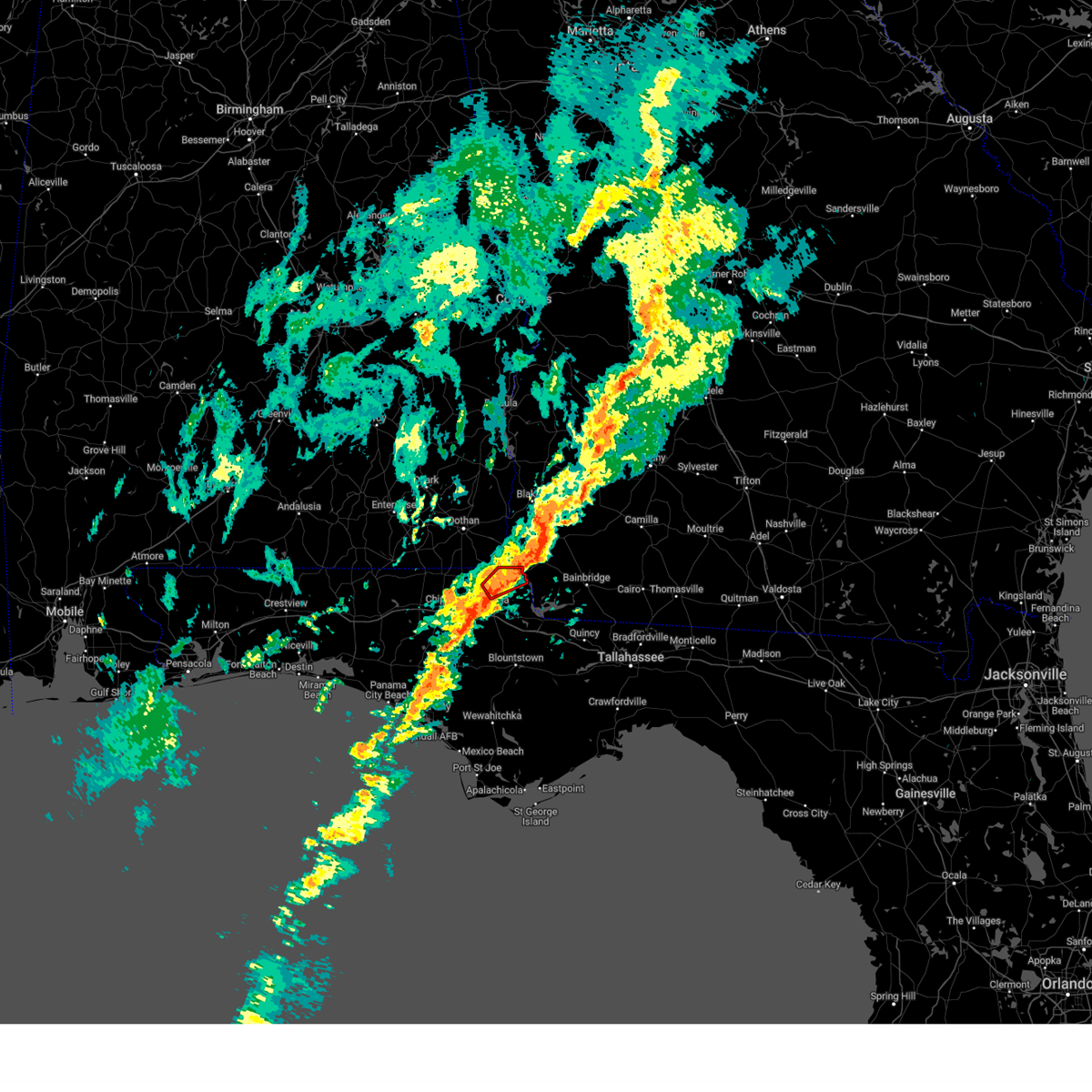
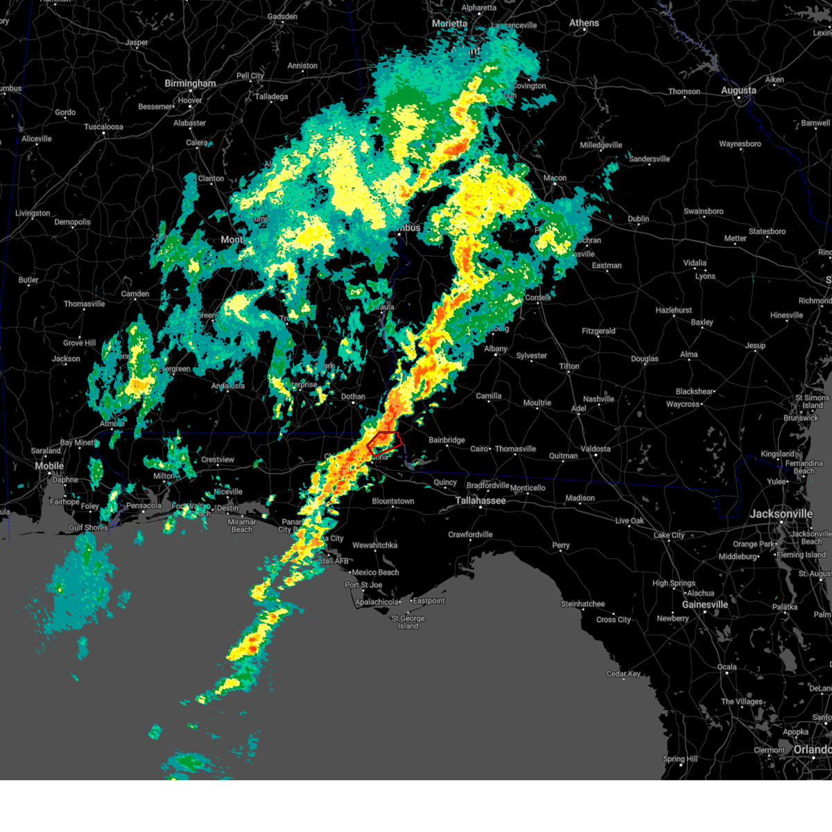
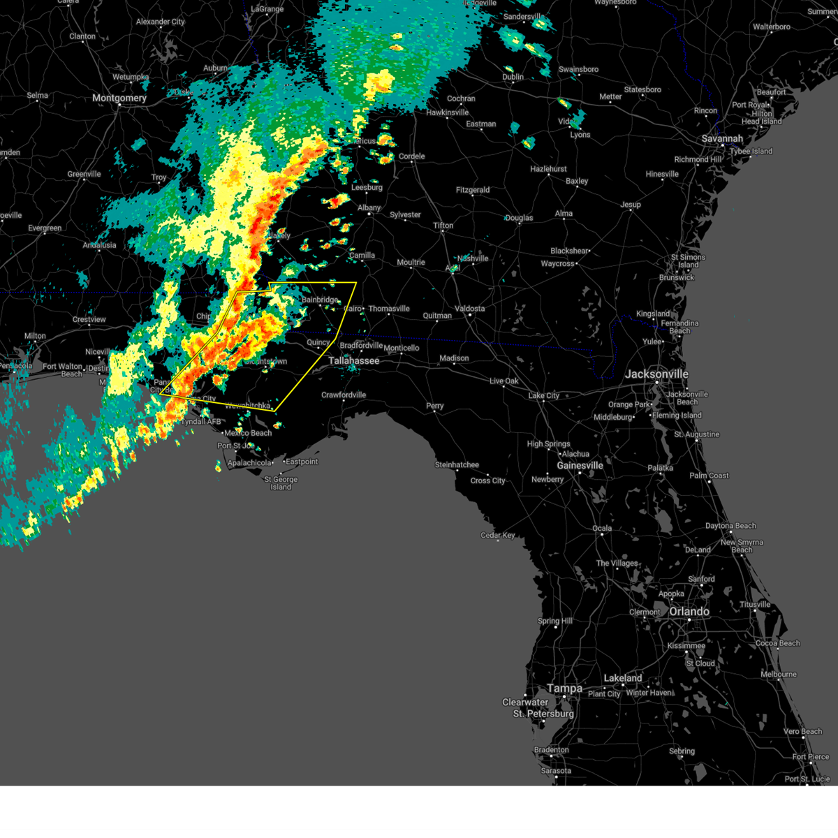
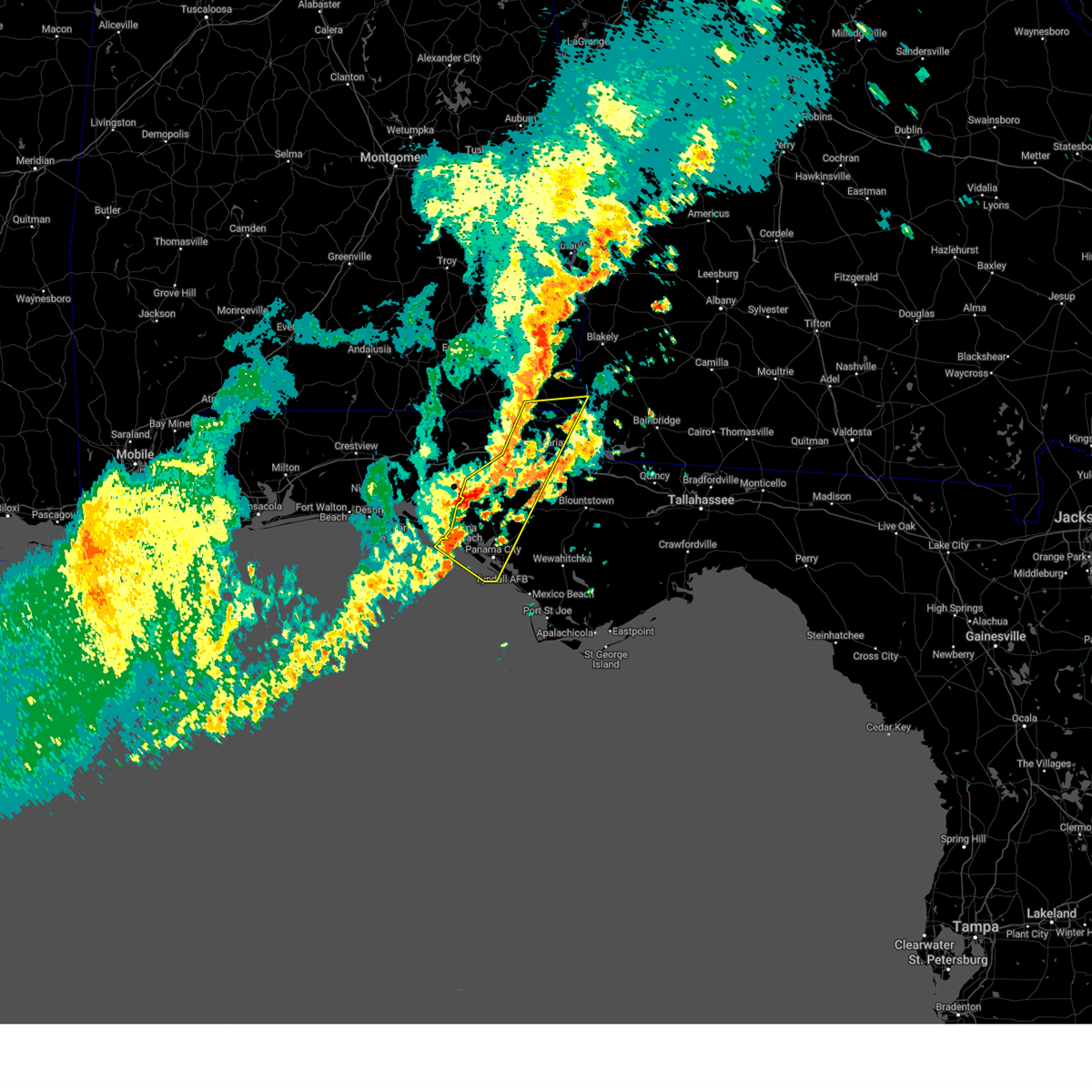
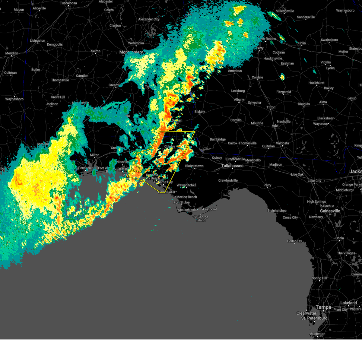
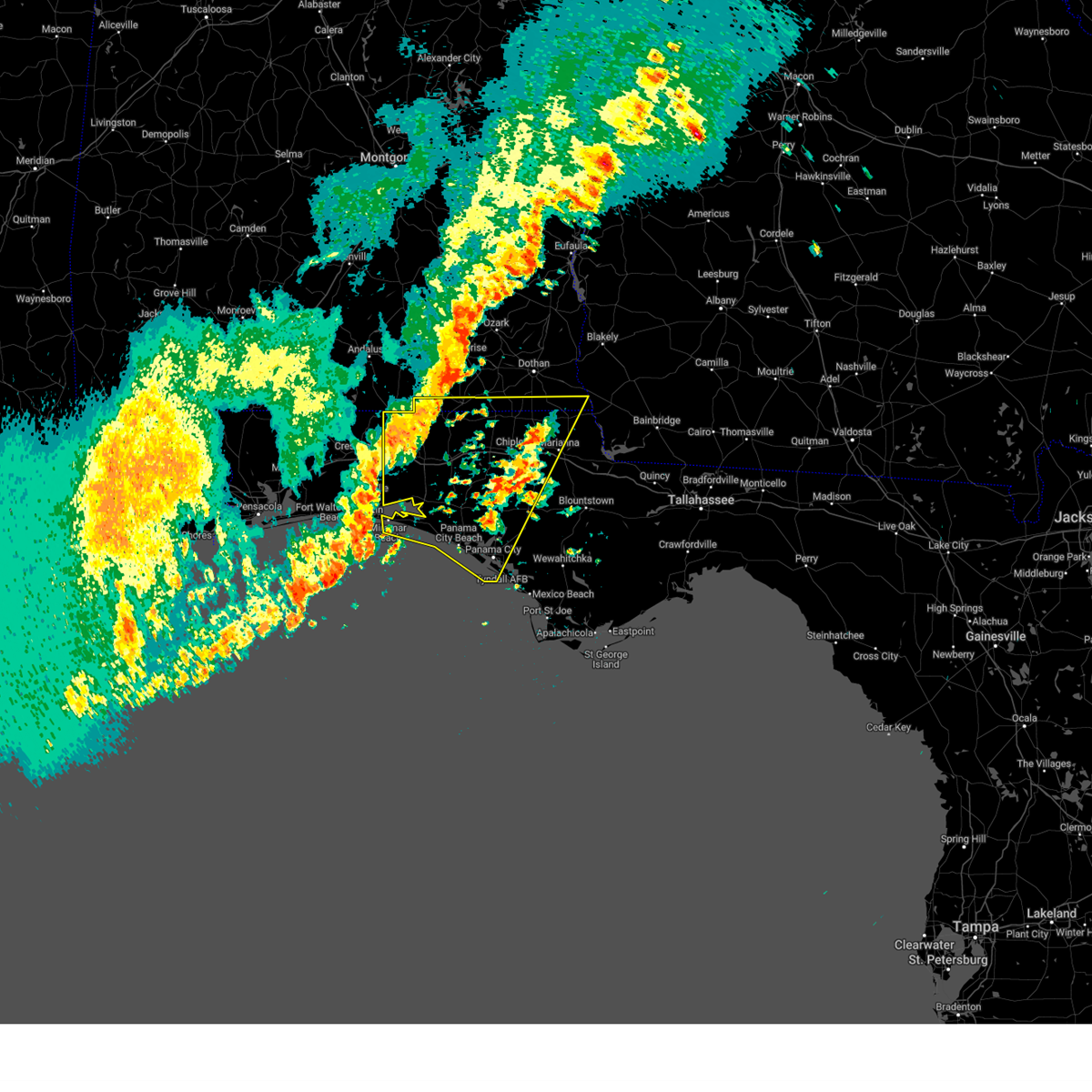
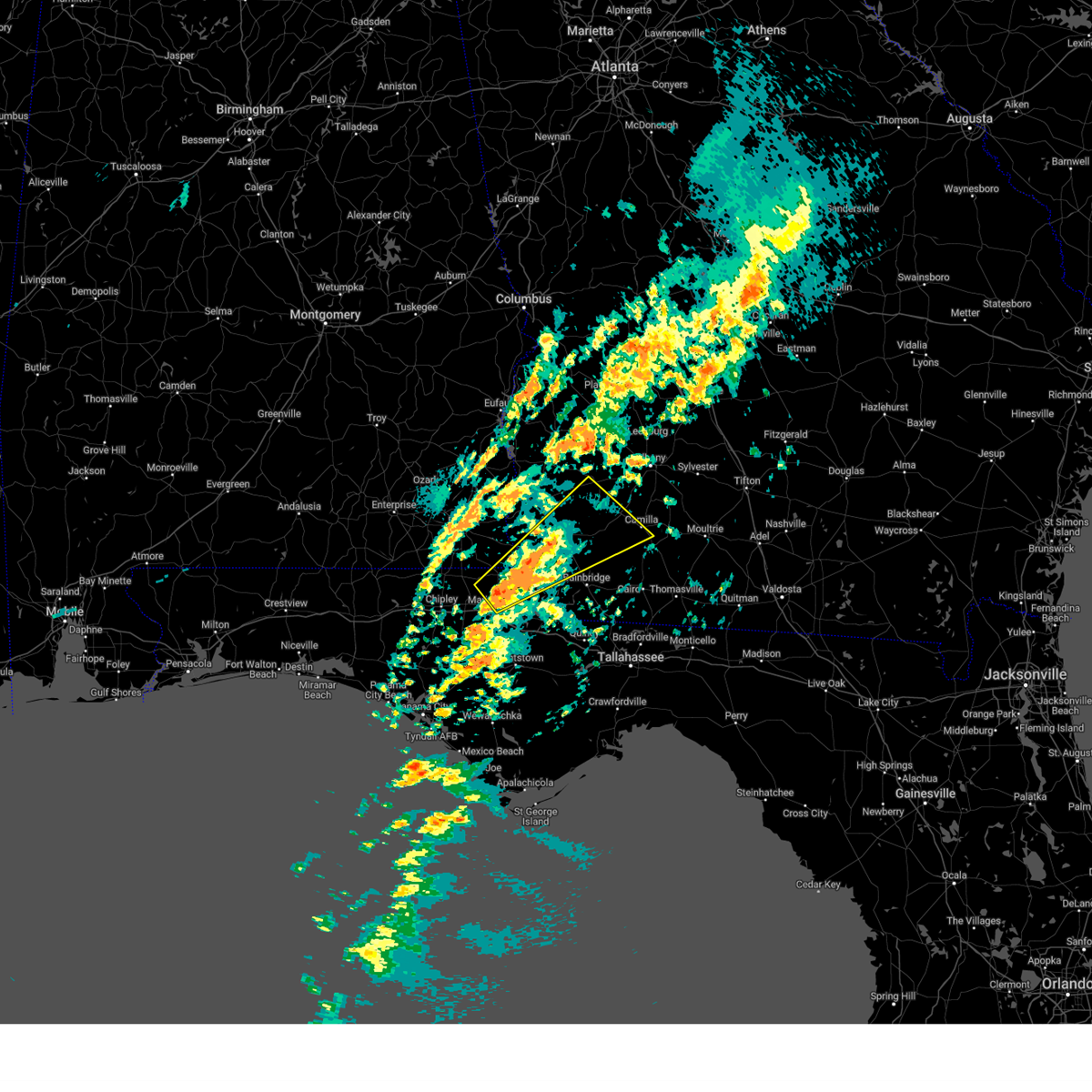
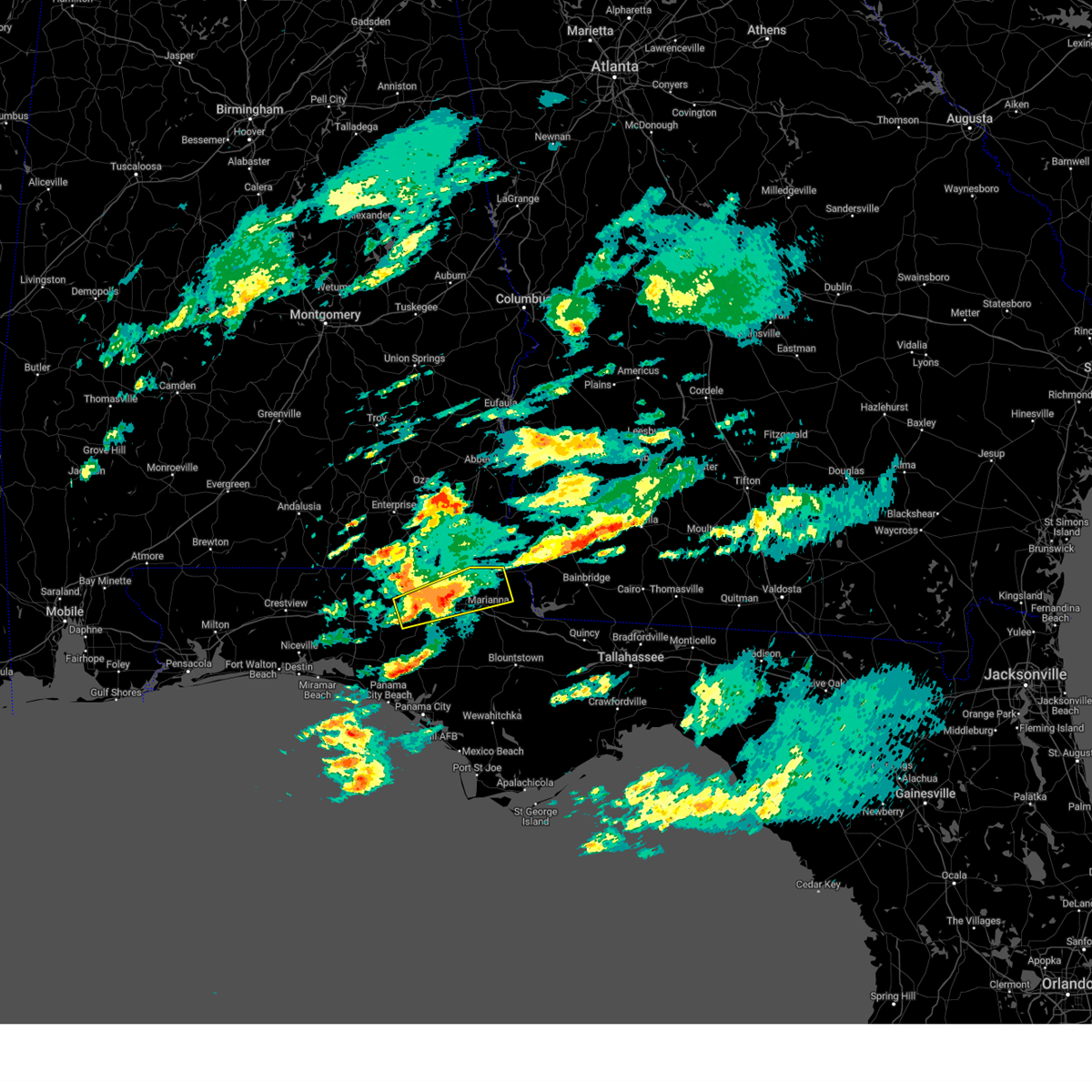
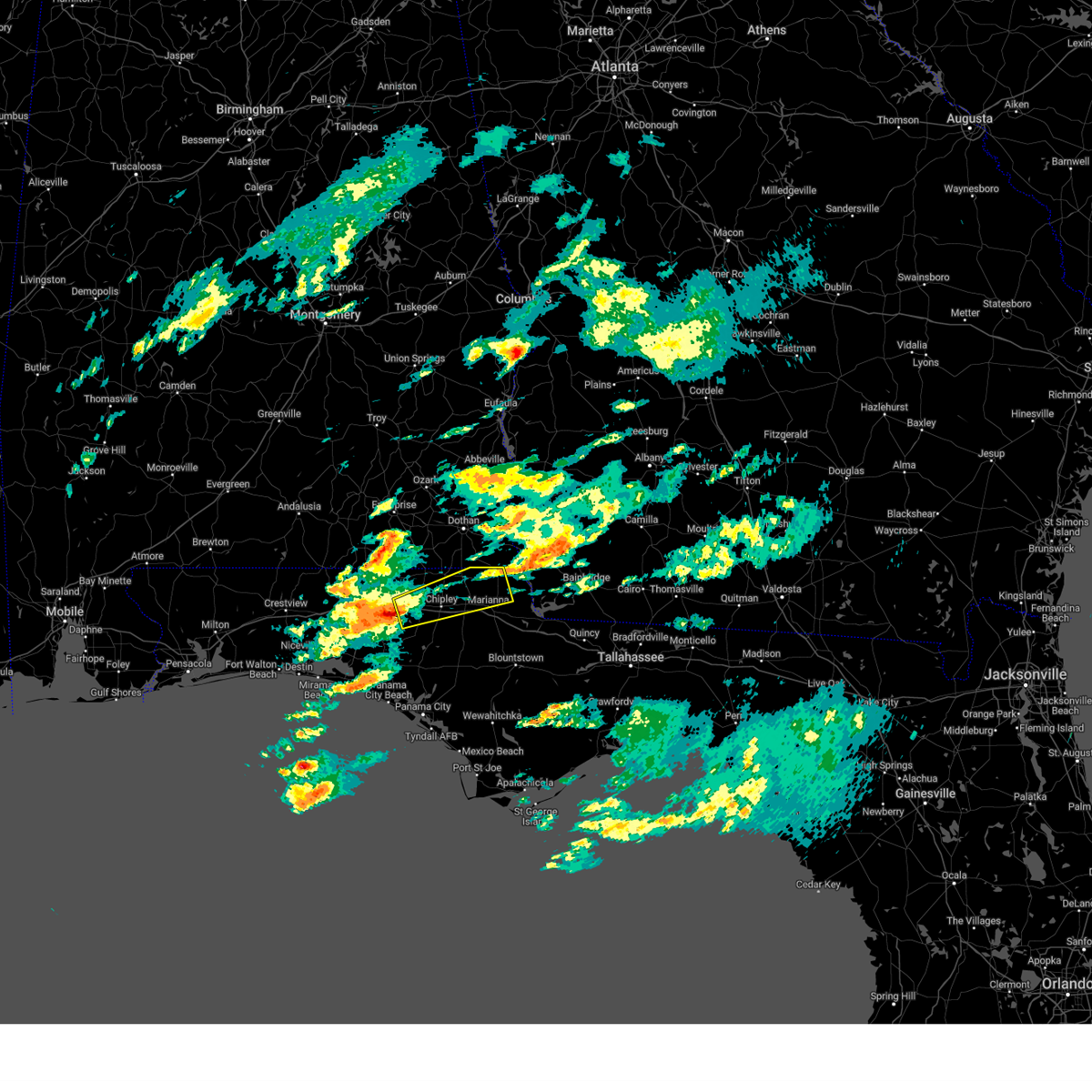
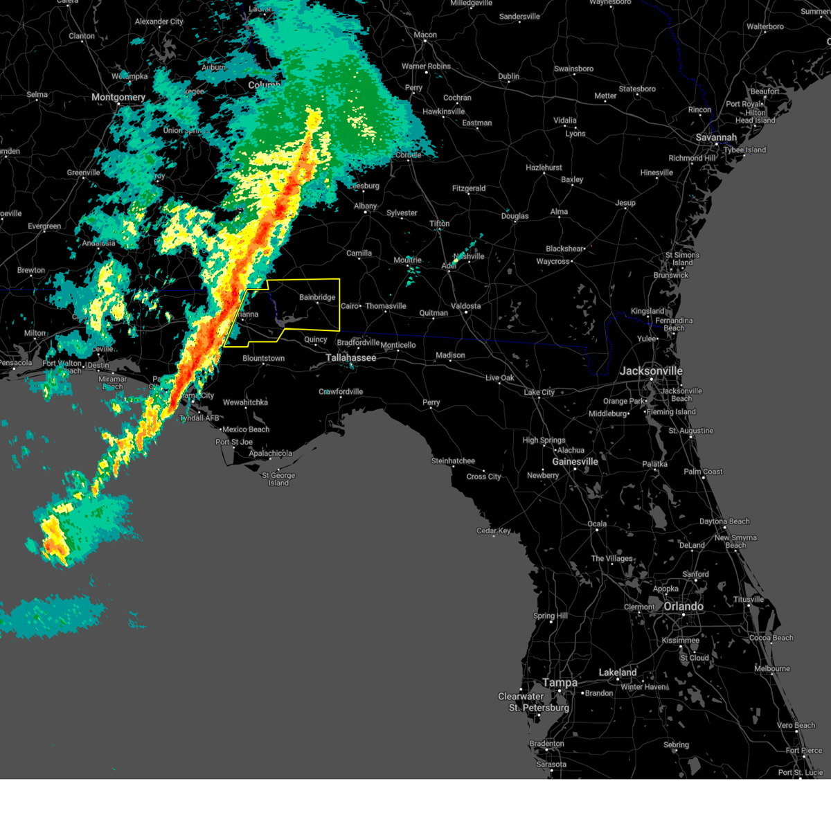
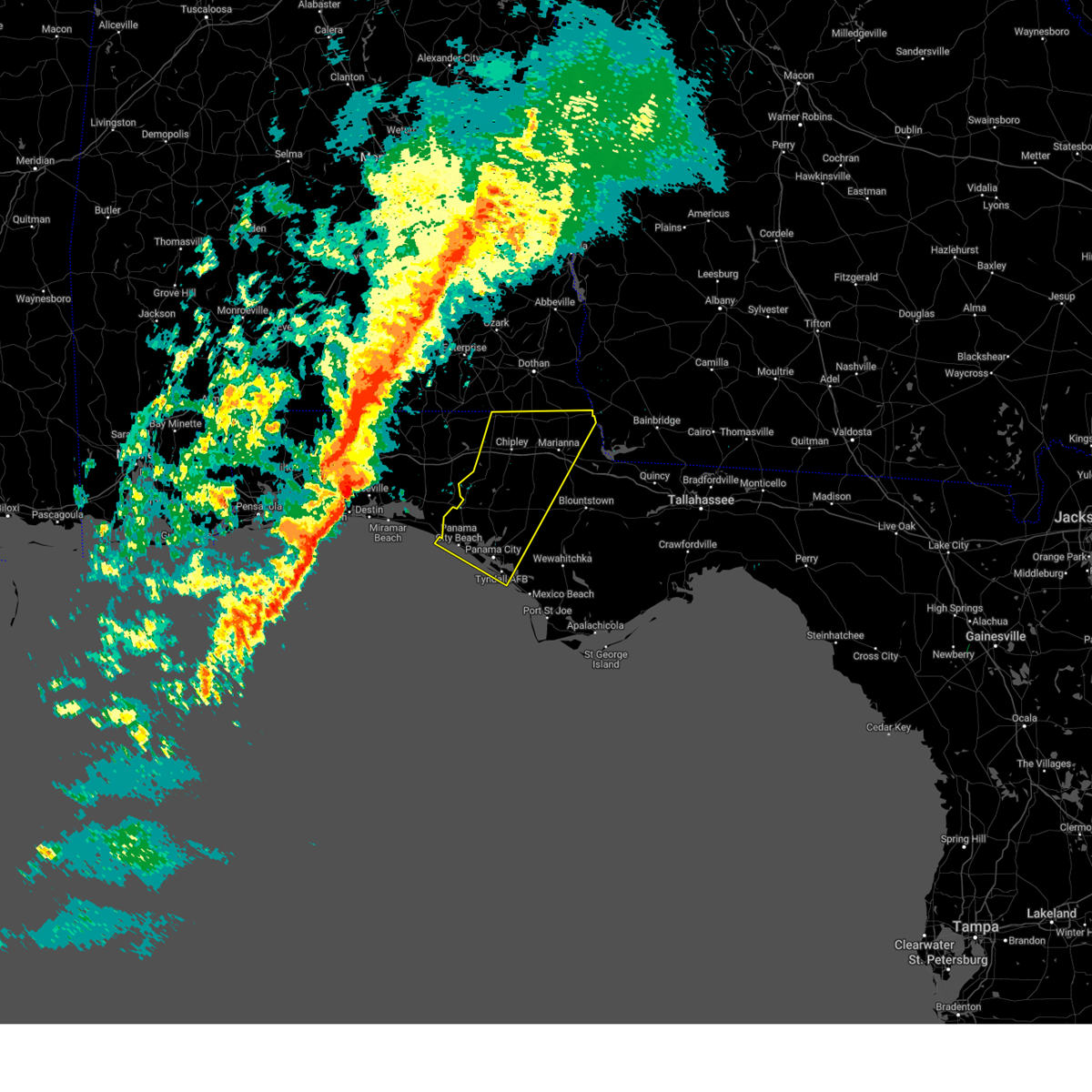
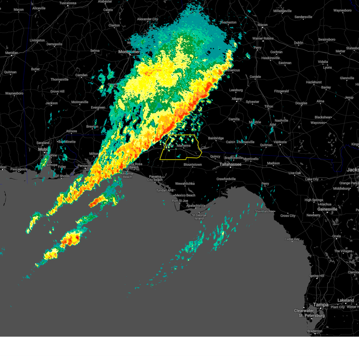
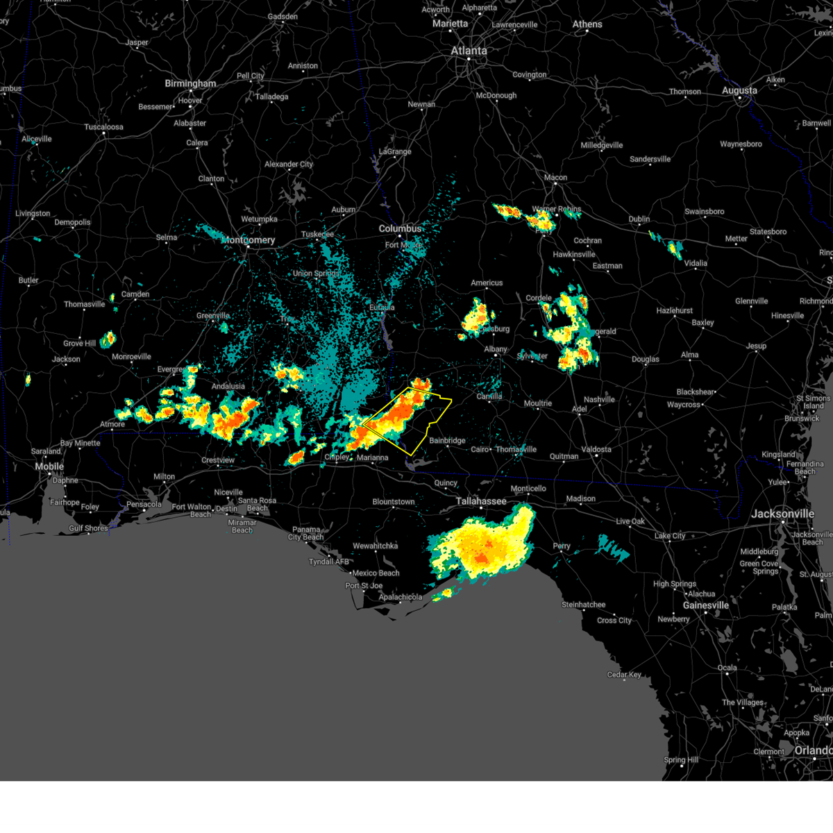
Hail Map for Malone, FL
The Malone, FL area has had 0 reports of on-the-ground hail by trained spotters, and has been under severe weather warnings 19 times during the past 12 months. Doppler radar has detected hail at or near Malone, FL on 51 occasions, including 3 occasions during the past year.
| Name: | Malone, FL |
| Where Located: | 63.3 miles NW of Tallahassee, FL |
| Map: | Google Map for Malone, FL |
| Population: | 2088 |
| Housing Units: | 355 |
| More Info: | Search Google for Malone, FL |
1
The Top Recent Hail Date for Malone, FL is Wednesday, June 25, 2025 (18th out of 51)

Hail and Wind Damage Spotted near Malone, FL
| Date / Time | Report Details |
|---|---|
| 4/7/2025 6:48 AM CDT |
 the tornado warning has been cancelled and is no longer in effect the tornado warning has been cancelled and is no longer in effect
|
| 4/7/2025 6:32 AM CDT |
 Tortae the national weather service in tallahassee has issued a * tornado warning for, northeastern jackson county in the panhandle of florida, * until 700 am cdt. * at 632 am cdt, a severe thunderstorm capable of producing a tornado was located 7 miles north of marianna, moving northeast at 35 mph (radar indicated rotation). Hazards include tornado. Flying debris will be dangerous to those caught without shelter. mobile homes will be damaged or destroyed. damage to roofs, windows, and vehicles will occur. tree damage is likely. This tornadic thunderstorm will remain over mainly rural areas of northeastern jackson county, including the following locations, malone, bascom, greenwood, hornsville, and marianna municipal a/p. Tortae the national weather service in tallahassee has issued a * tornado warning for, northeastern jackson county in the panhandle of florida, * until 700 am cdt. * at 632 am cdt, a severe thunderstorm capable of producing a tornado was located 7 miles north of marianna, moving northeast at 35 mph (radar indicated rotation). Hazards include tornado. Flying debris will be dangerous to those caught without shelter. mobile homes will be damaged or destroyed. damage to roofs, windows, and vehicles will occur. tree damage is likely. This tornadic thunderstorm will remain over mainly rural areas of northeastern jackson county, including the following locations, malone, bascom, greenwood, hornsville, and marianna municipal a/p.
|
| 3/31/2025 12:58 PM CDT |
 Svrtae the national weather service in tallahassee has issued a * severe thunderstorm warning for, jackson county in the panhandle of florida, north central gulf county in the panhandle of florida, bay county in the panhandle of florida, calhoun county in the panhandle of florida, gadsden county in big bend florida, central liberty county in big bend florida, southeastern washington county in the panhandle of florida, decatur county in southwestern georgia, northwestern grady county in southwestern georgia, seminole county in southwestern georgia, * until 300 pm edt/200 pm cdt/. * at 158 pm edt/1258 pm cdt/, severe thunderstorms were located along a line extending from 7 miles east of cottonwood to 13 miles southwest of marianna to 6 miles east of panama city beach, moving east at 40 mph (radar indicated). Hazards include 60 mph wind gusts. expect damage to roofs, siding, and trees Svrtae the national weather service in tallahassee has issued a * severe thunderstorm warning for, jackson county in the panhandle of florida, north central gulf county in the panhandle of florida, bay county in the panhandle of florida, calhoun county in the panhandle of florida, gadsden county in big bend florida, central liberty county in big bend florida, southeastern washington county in the panhandle of florida, decatur county in southwestern georgia, northwestern grady county in southwestern georgia, seminole county in southwestern georgia, * until 300 pm edt/200 pm cdt/. * at 158 pm edt/1258 pm cdt/, severe thunderstorms were located along a line extending from 7 miles east of cottonwood to 13 miles southwest of marianna to 6 miles east of panama city beach, moving east at 40 mph (radar indicated). Hazards include 60 mph wind gusts. expect damage to roofs, siding, and trees
|
| 3/31/2025 12:43 PM CDT |
 At 1243 pm cdt, severe thunderstorms were located along a line extending from near cottonwood to 9 miles southwest of panama city beach, moving east at 50 mph (radar indicated). Hazards include 60 mph wind gusts. Expect damage to roofs, siding, and trees. Locations impacted include, chipley, hiland park, crosby, bradford, grangeburg, dirego park, alford, college station, gulf resort beach, west panama city, bahama beach, holmes valley, millers ferry, bennett, porter lake, brannonville, ebro, panama city beach, millville, and bahoma. At 1243 pm cdt, severe thunderstorms were located along a line extending from near cottonwood to 9 miles southwest of panama city beach, moving east at 50 mph (radar indicated). Hazards include 60 mph wind gusts. Expect damage to roofs, siding, and trees. Locations impacted include, chipley, hiland park, crosby, bradford, grangeburg, dirego park, alford, college station, gulf resort beach, west panama city, bahama beach, holmes valley, millers ferry, bennett, porter lake, brannonville, ebro, panama city beach, millville, and bahoma.
|
| 3/31/2025 12:43 PM CDT |
 the severe thunderstorm warning has been cancelled and is no longer in effect the severe thunderstorm warning has been cancelled and is no longer in effect
|
| 3/31/2025 12:23 PM CDT |
 At 1223 pm cdt, severe thunderstorms were located along a line extending from near slocomb to 18 miles south of santa rosa beach, moving east at 50 mph (radar indicated). Hazards include 60 mph wind gusts. Expect damage to roofs, siding, and trees. Locations impacted include, hiland park, whitehead crossroads, bradford, gulf resort beach, black, gritney, west panama city, rock hill, millers ferry, noma, pleasant ridge, knox hill, four mile village, miller crossroads, west bay, douglass crossroad, santa rosa beach, orange hill, magnolia beach, and bethlehem. At 1223 pm cdt, severe thunderstorms were located along a line extending from near slocomb to 18 miles south of santa rosa beach, moving east at 50 mph (radar indicated). Hazards include 60 mph wind gusts. Expect damage to roofs, siding, and trees. Locations impacted include, hiland park, whitehead crossroads, bradford, gulf resort beach, black, gritney, west panama city, rock hill, millers ferry, noma, pleasant ridge, knox hill, four mile village, miller crossroads, west bay, douglass crossroad, santa rosa beach, orange hill, magnolia beach, and bethlehem.
|
| 3/31/2025 11:58 AM CDT |
 Svrtae the national weather service in tallahassee has issued a * severe thunderstorm warning for, southern geneva county in southeastern alabama, southeastern houston county in southeastern alabama, western jackson county in the panhandle of florida, bay county in the panhandle of florida, northwestern calhoun county in the panhandle of florida, walton county in the panhandle of florida, holmes county in the panhandle of florida, washington county in the panhandle of florida, * until 100 pm cdt. * at 1158 am cdt, severe thunderstorms were located along a line extending from near geneva to 21 miles south of destin, moving east at 50 mph (radar indicated). Hazards include 60 mph wind gusts. expect damage to roofs, siding, and trees Svrtae the national weather service in tallahassee has issued a * severe thunderstorm warning for, southern geneva county in southeastern alabama, southeastern houston county in southeastern alabama, western jackson county in the panhandle of florida, bay county in the panhandle of florida, northwestern calhoun county in the panhandle of florida, walton county in the panhandle of florida, holmes county in the panhandle of florida, washington county in the panhandle of florida, * until 100 pm cdt. * at 1158 am cdt, severe thunderstorms were located along a line extending from near geneva to 21 miles south of destin, moving east at 50 mph (radar indicated). Hazards include 60 mph wind gusts. expect damage to roofs, siding, and trees
|
| 3/16/2025 4:26 AM EDT |
 Svrtae the national weather service in tallahassee has issued a * severe thunderstorm warning for, southeastern houston county in southeastern alabama, northeastern jackson county in the panhandle of florida, northeastern decatur county in southwestern georgia, miller county in southwestern georgia, southwestern mitchell county in southwestern georgia, baker county in southwestern georgia, southeastern calhoun county in southwestern georgia, seminole county in southwestern georgia, central early county in southwestern georgia, * until 515 am edt/415 am cdt/. * at 425 am edt/325 am cdt/, a severe thunderstorm was located 11 miles northeast of marianna, moving northeast at 60 mph (radar indicated). Hazards include 60 mph wind gusts and quarter size hail. Hail damage to vehicles is expected. Expect wind damage to roofs, siding, and trees. Svrtae the national weather service in tallahassee has issued a * severe thunderstorm warning for, southeastern houston county in southeastern alabama, northeastern jackson county in the panhandle of florida, northeastern decatur county in southwestern georgia, miller county in southwestern georgia, southwestern mitchell county in southwestern georgia, baker county in southwestern georgia, southeastern calhoun county in southwestern georgia, seminole county in southwestern georgia, central early county in southwestern georgia, * until 515 am edt/415 am cdt/. * at 425 am edt/325 am cdt/, a severe thunderstorm was located 11 miles northeast of marianna, moving northeast at 60 mph (radar indicated). Hazards include 60 mph wind gusts and quarter size hail. Hail damage to vehicles is expected. Expect wind damage to roofs, siding, and trees.
|
| 3/9/2025 8:34 PM CDT |
 the severe thunderstorm warning has been cancelled and is no longer in effect the severe thunderstorm warning has been cancelled and is no longer in effect
|
| 3/9/2025 8:12 PM CDT |
 Svrtae the national weather service in tallahassee has issued a * severe thunderstorm warning for, northwestern jackson county in the panhandle of florida, central holmes county in the panhandle of florida, northeastern washington county in the panhandle of florida, * until 900 pm cdt. * at 812 pm cdt, a severe thunderstorm was located near bonifay, moving east at 45 mph (radar indicated). Hazards include quarter size hail. damage to vehicles is expected Svrtae the national weather service in tallahassee has issued a * severe thunderstorm warning for, northwestern jackson county in the panhandle of florida, central holmes county in the panhandle of florida, northeastern washington county in the panhandle of florida, * until 900 pm cdt. * at 812 pm cdt, a severe thunderstorm was located near bonifay, moving east at 45 mph (radar indicated). Hazards include quarter size hail. damage to vehicles is expected
|
| 3/5/2025 1:24 AM CST |
 Svrtae the national weather service in tallahassee has issued a * severe thunderstorm warning for, jackson county in the panhandle of florida, decatur county in southwestern georgia, seminole county in southwestern georgia, * until 400 am est/300 am cst/. * at 224 am est/124 am cst/, severe thunderstorms were located along a line extending from 6 miles southeast of cottonwood to 13 miles southeast of chipley, moving east at 50 mph (radar indicated). Hazards include 60 mph wind gusts. expect damage to roofs, siding, and trees Svrtae the national weather service in tallahassee has issued a * severe thunderstorm warning for, jackson county in the panhandle of florida, decatur county in southwestern georgia, seminole county in southwestern georgia, * until 400 am est/300 am cst/. * at 224 am est/124 am cst/, severe thunderstorms were located along a line extending from 6 miles southeast of cottonwood to 13 miles southeast of chipley, moving east at 50 mph (radar indicated). Hazards include 60 mph wind gusts. expect damage to roofs, siding, and trees
|
| 3/5/2025 1:04 AM CST |
 the severe thunderstorm warning has been cancelled and is no longer in effect the severe thunderstorm warning has been cancelled and is no longer in effect
|
| 3/5/2025 1:04 AM CST |
 At 103 am cst, severe thunderstorms were located along a line extending from near graceville to near panama city beach, moving east at 35 mph (radar indicated). Hazards include 60 mph wind gusts. Expect damage to roofs, siding, and trees. Locations impacted include, hiland park, whitehead crossroads, bradford, gulf resort beach, west panama city, millers ferry, noma, dellwood, buena vista, bascom, west bay, orange hill, magnolia beach, parker, recota beach, red head, bonifay, edgewater gulf beach, two egg, and poplar head. At 103 am cst, severe thunderstorms were located along a line extending from near graceville to near panama city beach, moving east at 35 mph (radar indicated). Hazards include 60 mph wind gusts. Expect damage to roofs, siding, and trees. Locations impacted include, hiland park, whitehead crossroads, bradford, gulf resort beach, west panama city, millers ferry, noma, dellwood, buena vista, bascom, west bay, orange hill, magnolia beach, parker, recota beach, red head, bonifay, edgewater gulf beach, two egg, and poplar head.
|
| 3/5/2025 12:19 AM CST |
 Svrtae the national weather service in tallahassee has issued a * severe thunderstorm warning for, jackson county in the panhandle of florida, bay county in the panhandle of florida, northwestern calhoun county in the panhandle of florida, southeastern walton county in the panhandle of florida, holmes county in the panhandle of florida, washington county in the panhandle of florida, * until 145 am cst. * at 1218 am cst, severe thunderstorms were located along a line extending from near geneva to near santa rosa beach, moving east at 45 mph (radar indicated). Hazards include 60 mph wind gusts. expect damage to roofs, siding, and trees Svrtae the national weather service in tallahassee has issued a * severe thunderstorm warning for, jackson county in the panhandle of florida, bay county in the panhandle of florida, northwestern calhoun county in the panhandle of florida, southeastern walton county in the panhandle of florida, holmes county in the panhandle of florida, washington county in the panhandle of florida, * until 145 am cst. * at 1218 am cst, severe thunderstorms were located along a line extending from near geneva to near santa rosa beach, moving east at 45 mph (radar indicated). Hazards include 60 mph wind gusts. expect damage to roofs, siding, and trees
|
| 2/16/2025 4:41 AM CST |
 Svrtae the national weather service in tallahassee has issued a * severe thunderstorm warning for, jackson county in the panhandle of florida, northeastern washington county in the panhandle of florida, * until 615 am cst. * at 441 am cst, severe thunderstorms were located along a line extending from 9 miles southeast of geneva to near de funiak springs, moving east at 55 mph (radar indicated). Hazards include 60 mph wind gusts. expect damage to roofs, siding, and trees Svrtae the national weather service in tallahassee has issued a * severe thunderstorm warning for, jackson county in the panhandle of florida, northeastern washington county in the panhandle of florida, * until 615 am cst. * at 441 am cst, severe thunderstorms were located along a line extending from 9 miles southeast of geneva to near de funiak springs, moving east at 55 mph (radar indicated). Hazards include 60 mph wind gusts. expect damage to roofs, siding, and trees
|
| 8/19/2024 1:39 AM EDT |
 At 139 am edt/1239 am cdt/, severe thunderstorms were located along a line extending from 9 miles northwest of colquitt to 7 miles east of cottonwood, moving east at 35 mph (radar indicated). Hazards include 60 mph wind gusts. Expect damage to roofs, siding, and trees. Locations impacted include, colquitt, cottonwood, donalsonville, centerville, gordon, iron city, damascus, jakin, saffold, pansey, crosby, little hope, mayhaw, boykin, riverturn, sharphagen, hornsville, donaldsonville a/p, hentown, and steam mill. At 139 am edt/1239 am cdt/, severe thunderstorms were located along a line extending from 9 miles northwest of colquitt to 7 miles east of cottonwood, moving east at 35 mph (radar indicated). Hazards include 60 mph wind gusts. Expect damage to roofs, siding, and trees. Locations impacted include, colquitt, cottonwood, donalsonville, centerville, gordon, iron city, damascus, jakin, saffold, pansey, crosby, little hope, mayhaw, boykin, riverturn, sharphagen, hornsville, donaldsonville a/p, hentown, and steam mill.
|
| 8/18/2024 8:46 PM CDT | Svrtae the national weather service in tallahassee has issued a * severe thunderstorm warning for, eastern houston county in southeastern alabama, northeastern jackson county in the panhandle of florida, northwestern seminole county in southwestern georgia, * until 1045 pm edt/945 pm cdt/. * at 946 pm edt/846 pm cdt/, a severe thunderstorm was located near cowarts, or near cottonwood, moving southeast at 25 mph (radar indicated). Hazards include 60 mph wind gusts and quarter size hail. Hail damage to vehicles is expected. Expect wind damage to roofs, siding, and trees. |
| 7/24/2024 6:39 PM CDT |
 the severe thunderstorm warning has been cancelled and is no longer in effect the severe thunderstorm warning has been cancelled and is no longer in effect
|
| 7/24/2024 6:14 PM CDT |
 Svrtae the national weather service in tallahassee has issued a * severe thunderstorm warning for, southeastern houston county in southeastern alabama, central jackson county in the panhandle of florida, east central washington county in the panhandle of florida, * until 700 pm cdt. * at 614 pm cdt, severe thunderstorms were located along a line extending from cottonwood to near marianna to 8 miles south of chipley, moving east at 20 mph (radar indicated). Hazards include 60 mph wind gusts. expect damage to roofs, siding, and trees Svrtae the national weather service in tallahassee has issued a * severe thunderstorm warning for, southeastern houston county in southeastern alabama, central jackson county in the panhandle of florida, east central washington county in the panhandle of florida, * until 700 pm cdt. * at 614 pm cdt, severe thunderstorms were located along a line extending from cottonwood to near marianna to 8 miles south of chipley, moving east at 20 mph (radar indicated). Hazards include 60 mph wind gusts. expect damage to roofs, siding, and trees
|
| 7/1/2024 5:34 PM CDT |
 At 534 pm cdt, severe thunderstorms were located along a line extending from near graceville to 8 miles north of marianna, moving south at 15 mph (radar indicated). Hazards include 60 mph wind gusts. Expect damage to roofs, siding, and trees. Locations impacted include, chipley, graceville, bonifay, marianna, malone, cottondale, greenwood, esto, campbellton, noma, bascom, richter crossroads, tendil crossing, blue spring, cobb crossroads, jacobs, noma junction, bahoma, ellaville, and marianna municipal a/p. At 534 pm cdt, severe thunderstorms were located along a line extending from near graceville to 8 miles north of marianna, moving south at 15 mph (radar indicated). Hazards include 60 mph wind gusts. Expect damage to roofs, siding, and trees. Locations impacted include, chipley, graceville, bonifay, marianna, malone, cottondale, greenwood, esto, campbellton, noma, bascom, richter crossroads, tendil crossing, blue spring, cobb crossroads, jacobs, noma junction, bahoma, ellaville, and marianna municipal a/p.
|
| 7/1/2024 5:34 PM CDT |
 the severe thunderstorm warning has been cancelled and is no longer in effect the severe thunderstorm warning has been cancelled and is no longer in effect
|
| 7/1/2024 5:19 PM CDT |
 Svrtae the national weather service in tallahassee has issued a * severe thunderstorm warning for, southeastern geneva county in southeastern alabama, south central houston county in southeastern alabama, northwestern jackson county in the panhandle of florida, eastern holmes county in the panhandle of florida, northeastern washington county in the panhandle of florida, * until 630 pm cdt. * at 519 pm cdt, severe thunderstorms were located along a line extending from near graceville to near cottonwood, moving south at 10 mph (radar indicated). Hazards include 60 mph wind gusts. expect damage to roofs, siding, and trees Svrtae the national weather service in tallahassee has issued a * severe thunderstorm warning for, southeastern geneva county in southeastern alabama, south central houston county in southeastern alabama, northwestern jackson county in the panhandle of florida, eastern holmes county in the panhandle of florida, northeastern washington county in the panhandle of florida, * until 630 pm cdt. * at 519 pm cdt, severe thunderstorms were located along a line extending from near graceville to near cottonwood, moving south at 10 mph (radar indicated). Hazards include 60 mph wind gusts. expect damage to roofs, siding, and trees
|
| 5/18/2024 8:54 AM CDT |
 Svrtae the national weather service in tallahassee has issued a * severe thunderstorm warning for, southeastern houston county in southeastern alabama, northern jackson county in the panhandle of florida, * until 945 am cdt. * at 853 am cdt, a severe thunderstorm was located 9 miles southeast of graceville, moving east at 35 mph (radar indicated). Hazards include 60 mph wind gusts. expect damage to roofs, siding, and trees Svrtae the national weather service in tallahassee has issued a * severe thunderstorm warning for, southeastern houston county in southeastern alabama, northern jackson county in the panhandle of florida, * until 945 am cdt. * at 853 am cdt, a severe thunderstorm was located 9 miles southeast of graceville, moving east at 35 mph (radar indicated). Hazards include 60 mph wind gusts. expect damage to roofs, siding, and trees
|
| 5/17/2024 6:56 PM CDT |
 Svrtae the national weather service in tallahassee has issued a * severe thunderstorm warning for, western jackson county in the panhandle of florida, east central walton county in the panhandle of florida, eastern holmes county in the panhandle of florida, washington county in the panhandle of florida, * until 800 pm cdt. * at 655 pm cdt, severe thunderstorms were located along a line extending from near graceville to 11 miles west of vernon, moving east at 25 mph (radar indicated). Hazards include 60 mph wind gusts and quarter size hail. Hail damage to vehicles is expected. Expect wind damage to roofs, siding, and trees. Svrtae the national weather service in tallahassee has issued a * severe thunderstorm warning for, western jackson county in the panhandle of florida, east central walton county in the panhandle of florida, eastern holmes county in the panhandle of florida, washington county in the panhandle of florida, * until 800 pm cdt. * at 655 pm cdt, severe thunderstorms were located along a line extending from near graceville to 11 miles west of vernon, moving east at 25 mph (radar indicated). Hazards include 60 mph wind gusts and quarter size hail. Hail damage to vehicles is expected. Expect wind damage to roofs, siding, and trees.
|
| 5/17/2024 6:22 PM CDT |
 Svrtae the national weather service in tallahassee has issued a * severe thunderstorm warning for, southeastern houston county in southeastern alabama, jackson county in the panhandle of florida, northern calhoun county in the panhandle of florida, gadsden county in big bend florida, northwestern liberty county in big bend florida, northeastern washington county in the panhandle of florida, southern decatur county in southwestern georgia, seminole county in southwestern georgia, * until 830 pm edt/730 pm cdt/. * at 722 pm edt/622 pm cdt/, a severe thunderstorm was located near marianna, moving southeast at 35 mph (radar indicated). Hazards include 60 mph wind gusts and nickel size hail. expect damage to roofs, siding, and trees Svrtae the national weather service in tallahassee has issued a * severe thunderstorm warning for, southeastern houston county in southeastern alabama, jackson county in the panhandle of florida, northern calhoun county in the panhandle of florida, gadsden county in big bend florida, northwestern liberty county in big bend florida, northeastern washington county in the panhandle of florida, southern decatur county in southwestern georgia, seminole county in southwestern georgia, * until 830 pm edt/730 pm cdt/. * at 722 pm edt/622 pm cdt/, a severe thunderstorm was located near marianna, moving southeast at 35 mph (radar indicated). Hazards include 60 mph wind gusts and nickel size hail. expect damage to roofs, siding, and trees
|
| 5/17/2024 5:07 PM CDT |
 Svrtae the national weather service in tallahassee has issued a * severe thunderstorm warning for, geneva county in southeastern alabama, southeastern houston county in southeastern alabama, jackson county in the panhandle of florida, northern walton county in the panhandle of florida, holmes county in the panhandle of florida, northern washington county in the panhandle of florida, * until 630 pm cdt. * at 507 pm cdt, severe thunderstorms were located along a line extending from near slocomb to 12 miles north of baker, moving east at 30 mph (radar indicated). Hazards include 60 mph wind gusts and quarter size hail. Hail damage to vehicles is expected. Expect wind damage to roofs, siding, and trees. Svrtae the national weather service in tallahassee has issued a * severe thunderstorm warning for, geneva county in southeastern alabama, southeastern houston county in southeastern alabama, jackson county in the panhandle of florida, northern walton county in the panhandle of florida, holmes county in the panhandle of florida, northern washington county in the panhandle of florida, * until 630 pm cdt. * at 507 pm cdt, severe thunderstorms were located along a line extending from near slocomb to 12 miles north of baker, moving east at 30 mph (radar indicated). Hazards include 60 mph wind gusts and quarter size hail. Hail damage to vehicles is expected. Expect wind damage to roofs, siding, and trees.
|
| 5/14/2024 4:38 AM CDT |
 the severe thunderstorm warning has been cancelled and is no longer in effect the severe thunderstorm warning has been cancelled and is no longer in effect
|
| 5/14/2024 4:17 AM CDT |
 At 517 am edt/417 am cdt/, severe thunderstorms were located along a line extending from near graceville to near stonemill creek, moving northeast at 50 mph (radar indicated). Hazards include 60 mph wind gusts. Expect damage to roofs, siding, and trees. Locations impacted include, graceville, blountstown, marianna, chipley, stonemill creek, chattahoochee, orange, malone, wewahitchka, sneads, bristol, cottondale, grand ridge, greenwood, altha, alford, esto, campbellton, noma, and bascom. At 517 am edt/417 am cdt/, severe thunderstorms were located along a line extending from near graceville to near stonemill creek, moving northeast at 50 mph (radar indicated). Hazards include 60 mph wind gusts. Expect damage to roofs, siding, and trees. Locations impacted include, graceville, blountstown, marianna, chipley, stonemill creek, chattahoochee, orange, malone, wewahitchka, sneads, bristol, cottondale, grand ridge, greenwood, altha, alford, esto, campbellton, noma, and bascom.
|
| 5/14/2024 4:17 AM CDT |
 the severe thunderstorm warning has been cancelled and is no longer in effect the severe thunderstorm warning has been cancelled and is no longer in effect
|
| 5/14/2024 4:09 AM CDT |
 At 509 am edt/409 am cdt/, severe thunderstorms were located along a line extending from near graceville to 7 miles northwest of wewahitchka, moving northeast at 60 mph (radar indicated). Hazards include 60 mph wind gusts. Expect damage to roofs, siding, and trees. Locations impacted include, blountstown, marianna, chipley, graceville, bonifay, stonemill creek, chattahoochee, orange, bradford, malone, wewahitchka, sneads, bristol, cottondale, grand ridge, greenwood, altha, alford, wausau, and esto. At 509 am edt/409 am cdt/, severe thunderstorms were located along a line extending from near graceville to 7 miles northwest of wewahitchka, moving northeast at 60 mph (radar indicated). Hazards include 60 mph wind gusts. Expect damage to roofs, siding, and trees. Locations impacted include, blountstown, marianna, chipley, graceville, bonifay, stonemill creek, chattahoochee, orange, bradford, malone, wewahitchka, sneads, bristol, cottondale, grand ridge, greenwood, altha, alford, wausau, and esto.
|
| 5/14/2024 3:50 AM CDT |
 Svrtae the national weather service in tallahassee has issued a * severe thunderstorm warning for, jackson county in the panhandle of florida, northern gulf county in the panhandle of florida, bay county in the panhandle of florida, calhoun county in the panhandle of florida, central holmes county in the panhandle of florida, western liberty county in big bend florida, washington county in the panhandle of florida, * until 615 am edt/515 am cdt/. * at 449 am edt/349 am cdt/, severe thunderstorms were located along a line extending from 11 miles north of lynn haven to tyndall air force base, moving northeast at 50 mph (radar indicated). Hazards include 60 mph wind gusts. expect damage to roofs, siding, and trees Svrtae the national weather service in tallahassee has issued a * severe thunderstorm warning for, jackson county in the panhandle of florida, northern gulf county in the panhandle of florida, bay county in the panhandle of florida, calhoun county in the panhandle of florida, central holmes county in the panhandle of florida, western liberty county in big bend florida, washington county in the panhandle of florida, * until 615 am edt/515 am cdt/. * at 449 am edt/349 am cdt/, severe thunderstorms were located along a line extending from 11 miles north of lynn haven to tyndall air force base, moving northeast at 50 mph (radar indicated). Hazards include 60 mph wind gusts. expect damage to roofs, siding, and trees
|
| 5/10/2024 5:24 AM CDT |
 The storms which prompted the warning have moved out of the area. therefore, the warning will be allowed to expire. however, gusty winds are still possible with these thunderstorms. a severe thunderstorm watch remains in effect until 800 am edt/700 am cdt/ for southeastern alabama. a severe thunderstorm watch also remains in effect until 1100 am edt/1000 am cdt/ for the panhandle of florida, and southwestern georgia. remember, a severe thunderstorm warning still remains in effect for eastern bay, liberty, and jackson counties until 6:45 am cdt. The storms which prompted the warning have moved out of the area. therefore, the warning will be allowed to expire. however, gusty winds are still possible with these thunderstorms. a severe thunderstorm watch remains in effect until 800 am edt/700 am cdt/ for southeastern alabama. a severe thunderstorm watch also remains in effect until 1100 am edt/1000 am cdt/ for the panhandle of florida, and southwestern georgia. remember, a severe thunderstorm warning still remains in effect for eastern bay, liberty, and jackson counties until 6:45 am cdt.
|
| 5/10/2024 4:02 AM CDT |
 Svrtae the national weather service in tallahassee has issued a * severe thunderstorm warning for, southern geneva county in southeastern alabama, southeastern houston county in southeastern alabama, jackson county in the panhandle of florida, bay county in the panhandle of florida, western calhoun county in the panhandle of florida, walton county in the panhandle of florida, holmes county in the panhandle of florida, washington county in the panhandle of florida, central seminole county in southwestern georgia, * until 630 am edt/530 am cdt/. * at 502 am edt/402 am cdt/, severe thunderstorms were located along a line extending from near river falls to 7 miles southwest of baker to near oriole beach, moving east at 75 mph (radar indicated). Hazards include 70 mph wind gusts and quarter size hail. Hail damage to vehicles is expected. expect considerable tree damage. Wind damage is also likely to mobile homes, roofs, and outbuildings. Svrtae the national weather service in tallahassee has issued a * severe thunderstorm warning for, southern geneva county in southeastern alabama, southeastern houston county in southeastern alabama, jackson county in the panhandle of florida, bay county in the panhandle of florida, western calhoun county in the panhandle of florida, walton county in the panhandle of florida, holmes county in the panhandle of florida, washington county in the panhandle of florida, central seminole county in southwestern georgia, * until 630 am edt/530 am cdt/. * at 502 am edt/402 am cdt/, severe thunderstorms were located along a line extending from near river falls to 7 miles southwest of baker to near oriole beach, moving east at 75 mph (radar indicated). Hazards include 70 mph wind gusts and quarter size hail. Hail damage to vehicles is expected. expect considerable tree damage. Wind damage is also likely to mobile homes, roofs, and outbuildings.
|
| 4/10/2024 4:28 PM CDT |
 the severe thunderstorm warning has been cancelled and is no longer in effect the severe thunderstorm warning has been cancelled and is no longer in effect
|
| 4/10/2024 4:28 PM CDT |
 At 527 pm edt/427 pm cdt/, severe thunderstorms were located along a line extending from near pinckard to 10 miles south of santa rosa beach, moving east at 20 mph (radar indicated). Hazards include 60 mph wind gusts. Expect damage to roofs, siding, and trees. Locations impacted include, panama city, lynn haven, panama city beach, callaway, daleville, cottonwood, vernon, bonifay, geneva, marianna, headland, dothan, santa rosa beach, chipley, graceville, de funiak springs, springfield, hartford, taylor, and midland city. At 527 pm edt/427 pm cdt/, severe thunderstorms were located along a line extending from near pinckard to 10 miles south of santa rosa beach, moving east at 20 mph (radar indicated). Hazards include 60 mph wind gusts. Expect damage to roofs, siding, and trees. Locations impacted include, panama city, lynn haven, panama city beach, callaway, daleville, cottonwood, vernon, bonifay, geneva, marianna, headland, dothan, santa rosa beach, chipley, graceville, de funiak springs, springfield, hartford, taylor, and midland city.
|
| 4/10/2024 3:40 PM CDT |
 Svrtae the national weather service in tallahassee has issued a * severe thunderstorm warning for, dale county in southeastern alabama, southern henry county in southeastern alabama, coffee county in southeastern alabama, geneva county in southeastern alabama, houston county in southeastern alabama, jackson county in the panhandle of florida, northwestern gulf county in the panhandle of florida, bay county in the panhandle of florida, western calhoun county in the panhandle of florida, walton county in the panhandle of florida, holmes county in the panhandle of florida, washington county in the panhandle of florida, * until 615 pm edt/515 pm cdt/. * at 440 pm edt/340 pm cdt/, severe thunderstorms were located along a line extending from 9 miles northeast of samson to 10 miles southwest of geneva to 7 miles southeast of de funiak springs to near santa rosa beach, moving northeast at 35 mph (radar indicated). Hazards include 60 mph wind gusts. expect damage to roofs, siding, and trees Svrtae the national weather service in tallahassee has issued a * severe thunderstorm warning for, dale county in southeastern alabama, southern henry county in southeastern alabama, coffee county in southeastern alabama, geneva county in southeastern alabama, houston county in southeastern alabama, jackson county in the panhandle of florida, northwestern gulf county in the panhandle of florida, bay county in the panhandle of florida, western calhoun county in the panhandle of florida, walton county in the panhandle of florida, holmes county in the panhandle of florida, washington county in the panhandle of florida, * until 615 pm edt/515 pm cdt/. * at 440 pm edt/340 pm cdt/, severe thunderstorms were located along a line extending from 9 miles northeast of samson to 10 miles southwest of geneva to 7 miles southeast of de funiak springs to near santa rosa beach, moving northeast at 35 mph (radar indicated). Hazards include 60 mph wind gusts. expect damage to roofs, siding, and trees
|
| 3/9/2024 7:30 AM EST |
 the severe thunderstorm warning has been cancelled and is no longer in effect the severe thunderstorm warning has been cancelled and is no longer in effect
|
| 3/9/2024 7:30 AM EST |
 At 730 am est/630 am cst/, severe thunderstorms were located along a line extending from 6 miles east of doerun to 6 miles southwest of pelham to west bainbridge, moving east at 55 mph (radar indicated). Hazards include 60 mph wind gusts and penny size hail. Expect damage to roofs, siding, and trees. Locations impacted include, newton, bainbridge, donalsonville, pelham, marianna, camilla, west bainbridge, chattahoochee, malone, sneads, cottondale, grand ridge, greenwood, sale city, iron city, brinson, bascom, recovery, lovedale, and harrells still. At 730 am est/630 am cst/, severe thunderstorms were located along a line extending from 6 miles east of doerun to 6 miles southwest of pelham to west bainbridge, moving east at 55 mph (radar indicated). Hazards include 60 mph wind gusts and penny size hail. Expect damage to roofs, siding, and trees. Locations impacted include, newton, bainbridge, donalsonville, pelham, marianna, camilla, west bainbridge, chattahoochee, malone, sneads, cottondale, grand ridge, greenwood, sale city, iron city, brinson, bascom, recovery, lovedale, and harrells still.
|
| 3/9/2024 6:41 AM EST |
 the severe thunderstorm warning has been cancelled and is no longer in effect the severe thunderstorm warning has been cancelled and is no longer in effect
|
| 3/9/2024 6:41 AM EST |
 At 640 am est/540 am cst/, severe thunderstorms were located along a line extending from 11 miles west of newton to 6 miles northwest of marianna, moving east at 45 mph (radar indicated). Hazards include 60 mph wind gusts. Expect damage to roofs, siding, and trees. Locations impacted include, colquitt, newton, bainbridge, donalsonville, pelham, marianna, camilla, west bainbridge, chattahoochee, malone, sneads, cottondale, grand ridge, greenwood, sale city, iron city, damascus, brinson, jakin, and bascom. At 640 am est/540 am cst/, severe thunderstorms were located along a line extending from 11 miles west of newton to 6 miles northwest of marianna, moving east at 45 mph (radar indicated). Hazards include 60 mph wind gusts. Expect damage to roofs, siding, and trees. Locations impacted include, colquitt, newton, bainbridge, donalsonville, pelham, marianna, camilla, west bainbridge, chattahoochee, malone, sneads, cottondale, grand ridge, greenwood, sale city, iron city, damascus, brinson, jakin, and bascom.
|
| 3/9/2024 5:14 AM CST |
 Svrtae the national weather service in tallahassee has issued a * severe thunderstorm warning for, southeastern houston county in southeastern alabama, jackson county in the panhandle of florida, decatur county in southwestern georgia, northwestern grady county in southwestern georgia, miller county in southwestern georgia, mitchell county in southwestern georgia, southwestern baker county in southwestern georgia, southern early county in southwestern georgia, seminole county in southwestern georgia, * until 745 am est/645 am cst/. * at 614 am est/514 am cst/, severe thunderstorms were located along a line extending from 8 miles southeast of blakely to 6 miles south of graceville, moving east at 50 mph (radar indicated). Hazards include 60 mph wind gusts. expect damage to roofs, siding, and trees Svrtae the national weather service in tallahassee has issued a * severe thunderstorm warning for, southeastern houston county in southeastern alabama, jackson county in the panhandle of florida, decatur county in southwestern georgia, northwestern grady county in southwestern georgia, miller county in southwestern georgia, mitchell county in southwestern georgia, southwestern baker county in southwestern georgia, southern early county in southwestern georgia, seminole county in southwestern georgia, * until 745 am est/645 am cst/. * at 614 am est/514 am cst/, severe thunderstorms were located along a line extending from 8 miles southeast of blakely to 6 miles south of graceville, moving east at 50 mph (radar indicated). Hazards include 60 mph wind gusts. expect damage to roofs, siding, and trees
|
| 1/9/2024 7:52 AM CST |
 At 752 am cst, a confirmed tornado was located near graceville, moving northeast at 60 mph (radar confirmed tornado). Hazards include damaging tornado and quarter size hail. Flying debris will be dangerous to those caught without shelter. mobile homes will be damaged or destroyed. damage to roofs, windows, and vehicles will occur. tree damage is likely. this tornado will be near, cottonwood around 805 am cst. Other locations impacted by this tornadic thunderstorm include malone, grangeburg, garretts crossroads, tendil crossing, wilson mill, southern junction, merritts crossroads, keytons, cobb crossroads, and jacobs. At 752 am cst, a confirmed tornado was located near graceville, moving northeast at 60 mph (radar confirmed tornado). Hazards include damaging tornado and quarter size hail. Flying debris will be dangerous to those caught without shelter. mobile homes will be damaged or destroyed. damage to roofs, windows, and vehicles will occur. tree damage is likely. this tornado will be near, cottonwood around 805 am cst. Other locations impacted by this tornadic thunderstorm include malone, grangeburg, garretts crossroads, tendil crossing, wilson mill, southern junction, merritts crossroads, keytons, cobb crossroads, and jacobs.
|
| 1/9/2024 7:50 AM CST |
 At 750 am cst, a severe thunderstorm capable of producing a tornado was located near graceville, moving northeast at 60 mph (radar indicated rotation). Hazards include tornado and quarter size hail. Flying debris will be dangerous to those caught without shelter. mobile homes will be damaged or destroyed. damage to roofs, windows, and vehicles will occur. tree damage is likely. this dangerous storm will be near, graceville around 755 am cst. cottonwood around 805 am cst. Other locations impacted by this tornadic thunderstorm include malone, grangeburg, garretts crossroads, tendil crossing, wilson mill, southern junction, merritts crossroads, keytons, cobb crossroads, and jacobs. At 750 am cst, a severe thunderstorm capable of producing a tornado was located near graceville, moving northeast at 60 mph (radar indicated rotation). Hazards include tornado and quarter size hail. Flying debris will be dangerous to those caught without shelter. mobile homes will be damaged or destroyed. damage to roofs, windows, and vehicles will occur. tree damage is likely. this dangerous storm will be near, graceville around 755 am cst. cottonwood around 805 am cst. Other locations impacted by this tornadic thunderstorm include malone, grangeburg, garretts crossroads, tendil crossing, wilson mill, southern junction, merritts crossroads, keytons, cobb crossroads, and jacobs.
|
| 1/9/2024 7:00 AM CST |
 At 659 am cst, severe thunderstorms were located along a line extending from 10 miles southwest of samson to near santa rosa beach to 25 miles south of destin, moving northeast at 60 mph (radar indicated). Hazards include 70 mph wind gusts and quarter size hail. Hail damage to vehicles is expected. expect considerable tree damage. Wind damage is also likely to mobile homes, roofs, and outbuildings. At 659 am cst, severe thunderstorms were located along a line extending from 10 miles southwest of samson to near santa rosa beach to 25 miles south of destin, moving northeast at 60 mph (radar indicated). Hazards include 70 mph wind gusts and quarter size hail. Hail damage to vehicles is expected. expect considerable tree damage. Wind damage is also likely to mobile homes, roofs, and outbuildings.
|
| 1/9/2024 6:57 AM CST |
 The tornado warning for southeastern houston, central jackson, southwestern decatur and seminole counties will expire at 800 am est/700 am cst/, the storm which prompted the warning has moved out of the area. therefore, the warning will be allowed to expire. a tornado watch remains in effect until 200 pm est/100 pm cst/ for southeastern alabama, the panhandle of florida, and southwestern georgia. to report severe weather, contact your nearest law enforcement agency. they will relay your report to the national weather service tallahassee. The tornado warning for southeastern houston, central jackson, southwestern decatur and seminole counties will expire at 800 am est/700 am cst/, the storm which prompted the warning has moved out of the area. therefore, the warning will be allowed to expire. a tornado watch remains in effect until 200 pm est/100 pm cst/ for southeastern alabama, the panhandle of florida, and southwestern georgia. to report severe weather, contact your nearest law enforcement agency. they will relay your report to the national weather service tallahassee.
|
| 1/9/2024 6:36 AM CST |
 At 736 am est/636 am cst/, a confirmed large and extremely dangerous tornado was located over marianna, moving northeast at 50 mph. this is a particularly dangerous situation. take cover now! (radar confirmed tornado). Hazards include damaging tornado. You are in a life-threatening situation. flying debris may be deadly to those caught without shelter. mobile homes will be destroyed. considerable damage to homes, businesses, and vehicles is likely and complete destruction is possible. This tornadic thunderstorm will remain over mainly rural areas of southeastern houston, central jackson, southwestern decatur and seminole counties, including the following locations, malone, crosby, grand ridge, little hope, blue spring, union city, lovedale, dellwood, riverturn, and star. At 736 am est/636 am cst/, a confirmed large and extremely dangerous tornado was located over marianna, moving northeast at 50 mph. this is a particularly dangerous situation. take cover now! (radar confirmed tornado). Hazards include damaging tornado. You are in a life-threatening situation. flying debris may be deadly to those caught without shelter. mobile homes will be destroyed. considerable damage to homes, businesses, and vehicles is likely and complete destruction is possible. This tornadic thunderstorm will remain over mainly rural areas of southeastern houston, central jackson, southwestern decatur and seminole counties, including the following locations, malone, crosby, grand ridge, little hope, blue spring, union city, lovedale, dellwood, riverturn, and star.
|
| 1/9/2024 6:21 AM CST |
 The national weather service in tallahassee has issued a * tornado warning for. southeastern houston county in southeastern alabama. central jackson county in the panhandle of florida. southwestern decatur county in southwestern georgia. Seminole county in southwestern georgia. The national weather service in tallahassee has issued a * tornado warning for. southeastern houston county in southeastern alabama. central jackson county in the panhandle of florida. southwestern decatur county in southwestern georgia. Seminole county in southwestern georgia.
|
| 1/9/2024 6:21 AM CST |
 At 721 am est/621 am cst/, a tornado producing storm was located 11 miles southwest of marianna, moving northeast at 50 mph (radar confirmed tornado). Hazards include damaging tornado and quarter size hail. Flying debris will be dangerous to those caught without shelter. mobile homes will be damaged or destroyed. damage to roofs, windows, and vehicles will occur. tree damage is likely. this tornadic storm will be near, marianna around 630 am cst. Other locations impacted by this tornadic thunderstorm include malone, crosby, grand ridge, little hope, blue spring, union city, lovedale, dellwood, riverturn, and star. At 721 am est/621 am cst/, a tornado producing storm was located 11 miles southwest of marianna, moving northeast at 50 mph (radar confirmed tornado). Hazards include damaging tornado and quarter size hail. Flying debris will be dangerous to those caught without shelter. mobile homes will be damaged or destroyed. damage to roofs, windows, and vehicles will occur. tree damage is likely. this tornadic storm will be near, marianna around 630 am cst. Other locations impacted by this tornadic thunderstorm include malone, crosby, grand ridge, little hope, blue spring, union city, lovedale, dellwood, riverturn, and star.
|
| 8/15/2023 4:45 PM EDT |
 At 445 pm edt/345 pm cdt/, severe thunderstorms were located along a line extending from 9 miles southeast of ashford to near marianna, moving east at 25 mph. at 341pm cdt, the marianna municipal airport gusted to 59 mph (radar indicated). Hazards include 60 mph wind gusts and penny size hail. expect damage to roofs, siding, and trees At 445 pm edt/345 pm cdt/, severe thunderstorms were located along a line extending from 9 miles southeast of ashford to near marianna, moving east at 25 mph. at 341pm cdt, the marianna municipal airport gusted to 59 mph (radar indicated). Hazards include 60 mph wind gusts and penny size hail. expect damage to roofs, siding, and trees
|
| 8/15/2023 3:14 PM CDT |
 At 313 pm cdt, severe thunderstorms were located along a line extending from 6 miles southeast of graceville to 8 miles west of marianna to 7 miles southeast of chipley, moving east at 20 mph (radar indicated). Hazards include 60 mph wind gusts and penny size hail. expect damage to roofs, siding, and trees At 313 pm cdt, severe thunderstorms were located along a line extending from 6 miles southeast of graceville to 8 miles west of marianna to 7 miles southeast of chipley, moving east at 20 mph (radar indicated). Hazards include 60 mph wind gusts and penny size hail. expect damage to roofs, siding, and trees
|
| 8/12/2023 5:42 PM CDT |
 The severe thunderstorm warning for jackson and northeastern holmes counties will expire at 545 pm cdt, the storms which prompted the warning have weakened below severe limits, and no longer pose an immediate threat to life or property. therefore, the warning will be allowed to expire. however gusty winds and heavy rain are still possible with these thunderstorms. The severe thunderstorm warning for jackson and northeastern holmes counties will expire at 545 pm cdt, the storms which prompted the warning have weakened below severe limits, and no longer pose an immediate threat to life or property. therefore, the warning will be allowed to expire. however gusty winds and heavy rain are still possible with these thunderstorms.
|
| 8/12/2023 5:06 PM CDT |
 At 506 pm cdt, severe thunderstorms were located along a line extending from near ashford to cottonwood to 6 miles northeast of graceville to slocomb, moving southeast at 35 mph (radar indicated). Hazards include 60 mph wind gusts. expect damage to roofs, siding, and trees At 506 pm cdt, severe thunderstorms were located along a line extending from near ashford to cottonwood to 6 miles northeast of graceville to slocomb, moving southeast at 35 mph (radar indicated). Hazards include 60 mph wind gusts. expect damage to roofs, siding, and trees
|
| 8/8/2023 4:56 PM EDT |
 At 456 pm edt/356 pm cdt/, severe thunderstorms were located along a line extending from near blakely to near slocomb, moving east at 30 mph (radar indicated). Hazards include 60 mph wind gusts. expect damage to roofs, siding, and trees At 456 pm edt/356 pm cdt/, severe thunderstorms were located along a line extending from near blakely to near slocomb, moving east at 30 mph (radar indicated). Hazards include 60 mph wind gusts. expect damage to roofs, siding, and trees
|
| 7/30/2023 5:44 PM CDT |
 At 644 pm edt/544 pm cdt/, severe thunderstorms were located along a line extending from 6 miles southwest of graceville to near marianna to 12 miles northwest of chattahoochee, moving south at 5 mph (radar indicated). Hazards include 60 mph wind gusts. expect damage to roofs, siding, and trees At 644 pm edt/544 pm cdt/, severe thunderstorms were located along a line extending from 6 miles southwest of graceville to near marianna to 12 miles northwest of chattahoochee, moving south at 5 mph (radar indicated). Hazards include 60 mph wind gusts. expect damage to roofs, siding, and trees
|
| 7/22/2023 1:45 PM CDT |
 At 244 pm edt/144 pm cdt/, severe thunderstorms were located along a line extending from 12 miles northeast of west bainbridge to 8 miles south of donalsonville to near marianna, moving east at 40 mph (radar indicated). Hazards include 60 mph wind gusts and penny size hail. Expect damage to roofs, siding, and trees. locations impacted include, donalsonville, marianna, bainbridge, malone, cottondale, greenwood, alford, iron city, brinson, bascom, hanover, ausmac, little hope, blue spring, decatur co a/p, lovedale, dellwood, riverturn, sharphagen and hornsville. hail threat, radar indicated max hail size, 0. 75 in wind threat, radar indicated max wind gust, 60 mph. At 244 pm edt/144 pm cdt/, severe thunderstorms were located along a line extending from 12 miles northeast of west bainbridge to 8 miles south of donalsonville to near marianna, moving east at 40 mph (radar indicated). Hazards include 60 mph wind gusts and penny size hail. Expect damage to roofs, siding, and trees. locations impacted include, donalsonville, marianna, bainbridge, malone, cottondale, greenwood, alford, iron city, brinson, bascom, hanover, ausmac, little hope, blue spring, decatur co a/p, lovedale, dellwood, riverturn, sharphagen and hornsville. hail threat, radar indicated max hail size, 0. 75 in wind threat, radar indicated max wind gust, 60 mph.
|
| 7/22/2023 1:22 PM CDT |
 At 222 pm edt/122 pm cdt/, severe thunderstorms were located along a line extending from near colquitt to 12 miles southeast of cottonwood to 6 miles north of chipley, moving south at 15 mph (radar indicated). Hazards include 60 mph wind gusts and penny size hail. Expect damage to roofs, siding, and trees. locations impacted include, colquitt, cottonwood, chipley, graceville, donalsonville, marianna, bainbridge, malone, cottondale, greenwood, alford, madrid, gordon, iron city, campbellton, brinson, noma, jakin, bascom and crosby. hail threat, radar indicated max hail size, 0. 75 in wind threat, radar indicated max wind gust, 60 mph. At 222 pm edt/122 pm cdt/, severe thunderstorms were located along a line extending from near colquitt to 12 miles southeast of cottonwood to 6 miles north of chipley, moving south at 15 mph (radar indicated). Hazards include 60 mph wind gusts and penny size hail. Expect damage to roofs, siding, and trees. locations impacted include, colquitt, cottonwood, chipley, graceville, donalsonville, marianna, bainbridge, malone, cottondale, greenwood, alford, madrid, gordon, iron city, campbellton, brinson, noma, jakin, bascom and crosby. hail threat, radar indicated max hail size, 0. 75 in wind threat, radar indicated max wind gust, 60 mph.
|
| 7/22/2023 1:09 PM CDT |
 At 209 pm edt/109 pm cdt/, severe thunderstorms were located along a line extending from 6 miles northeast of donalsonville to near taylor, moving east at 40 mph (radar indicated). Hazards include 60 mph wind gusts and penny size hail. expect damage to roofs, siding, and trees At 209 pm edt/109 pm cdt/, severe thunderstorms were located along a line extending from 6 miles northeast of donalsonville to near taylor, moving east at 40 mph (radar indicated). Hazards include 60 mph wind gusts and penny size hail. expect damage to roofs, siding, and trees
|
| 7/16/2023 2:05 PM CDT |
 The severe thunderstorm warning for houston county in southeastern alabama, jackson and northern calhoun counties in the panhandle of florida, northwestern gadsden and north central liberty counties in big bend of florida, southwestern early and seminole counties in southwestern georgia will expire at 315 pm edt/215 pm cdt/, the storms which prompted the warning have moved out of the area. therefore, the warning will be allowed to expire. to report severe weather, contact your nearest law enforcement agency. they will relay your report to the national weather service tallahassee. The severe thunderstorm warning for houston county in southeastern alabama, jackson and northern calhoun counties in the panhandle of florida, northwestern gadsden and north central liberty counties in big bend of florida, southwestern early and seminole counties in southwestern georgia will expire at 315 pm edt/215 pm cdt/, the storms which prompted the warning have moved out of the area. therefore, the warning will be allowed to expire. to report severe weather, contact your nearest law enforcement agency. they will relay your report to the national weather service tallahassee.
|
| 7/16/2023 1:21 PM CDT |
 A severe thunderstorm warning remains in effect until 315 pm edt/215 pm cdt/ for houston county in southeastern alabama. jackson and northern calhoun counties in the panhandle of florida. northwestern gadsden and north central liberty counties in big bend of florida. Southwestern early and seminole counties in southwestern georgia. A severe thunderstorm warning remains in effect until 315 pm edt/215 pm cdt/ for houston county in southeastern alabama. jackson and northern calhoun counties in the panhandle of florida. northwestern gadsden and north central liberty counties in big bend of florida. Southwestern early and seminole counties in southwestern georgia.
|
| 7/16/2023 1:21 PM CDT |
 At 221 pm edt/121 pm cdt/, severe thunderstorms were located along a line extending from near taylor to 15 miles northwest of blountstown, moving east at 25 mph (radar indicated). Hazards include 60 mph wind gusts. Expect damage to roofs, siding, and trees. locations impacted include, cottonwood, marianna, donalsonville, blountstown, dothan, taylor, ashford, cowarts, chattahoochee, malone, sneads, rehobeth, cottondale, grand ridge, greenwood, avon, altha, alford, madrid and gordon. hail threat, radar indicated max hail size, <. 75 in wind threat, radar indicated max wind gust, 60 mph. At 221 pm edt/121 pm cdt/, severe thunderstorms were located along a line extending from near taylor to 15 miles northwest of blountstown, moving east at 25 mph (radar indicated). Hazards include 60 mph wind gusts. Expect damage to roofs, siding, and trees. locations impacted include, cottonwood, marianna, donalsonville, blountstown, dothan, taylor, ashford, cowarts, chattahoochee, malone, sneads, rehobeth, cottondale, grand ridge, greenwood, avon, altha, alford, madrid and gordon. hail threat, radar indicated max hail size, <. 75 in wind threat, radar indicated max wind gust, 60 mph.
|
| 7/16/2023 12:52 PM CDT |
 At 151 pm edt/1251 pm cdt/, severe thunderstorms were located along a line extending from slocomb to 12 miles east of vernon, moving east at 25 mph (radar indicated). Hazards include 60 mph wind gusts. expect damage to roofs, siding, and trees At 151 pm edt/1251 pm cdt/, severe thunderstorms were located along a line extending from slocomb to 12 miles east of vernon, moving east at 25 mph (radar indicated). Hazards include 60 mph wind gusts. expect damage to roofs, siding, and trees
|
| 7/15/2023 6:35 PM EDT |
 At 635 pm edt/535 pm cdt/, severe thunderstorms were located along a line extending from near blakely to 9 miles north of marianna, moving east at 30 mph (radar indicated). Hazards include 60 mph wind gusts. Expect damage to roofs, siding, and trees. locations impacted include, colquitt, newton, donalsonville, bainbridge, columbia, centerville, malone, greenwood, gordon, iron city, damascus, brinson, jakin, bascom, rock hill, lovedale, donaldsonville a/p, buena vista, bellview and howards mill. hail threat, radar indicated max hail size, <. 75 in wind threat, radar indicated max wind gust, 60 mph. At 635 pm edt/535 pm cdt/, severe thunderstorms were located along a line extending from near blakely to 9 miles north of marianna, moving east at 30 mph (radar indicated). Hazards include 60 mph wind gusts. Expect damage to roofs, siding, and trees. locations impacted include, colquitt, newton, donalsonville, bainbridge, columbia, centerville, malone, greenwood, gordon, iron city, damascus, brinson, jakin, bascom, rock hill, lovedale, donaldsonville a/p, buena vista, bellview and howards mill. hail threat, radar indicated max hail size, <. 75 in wind threat, radar indicated max wind gust, 60 mph.
|
| 7/15/2023 6:10 PM EDT |
 At 609 pm edt/509 pm cdt/, severe thunderstorms were located along a line extending from near columbia to near graceville, moving east at 35 mph (radar indicated). Hazards include 60 mph wind gusts. expect damage to roofs, siding, and trees At 609 pm edt/509 pm cdt/, severe thunderstorms were located along a line extending from near columbia to near graceville, moving east at 35 mph (radar indicated). Hazards include 60 mph wind gusts. expect damage to roofs, siding, and trees
|
| 7/8/2023 7:07 PM EDT |
 At 707 pm edt/607 pm cdt/, severe thunderstorms were located along a line extending from near donalsonville to 19 miles southwest of colquitt to near marianna, moving southeast at 30 mph (radar indicated). Hazards include 60 mph wind gusts and penny size hail. Expect damage to roofs, siding, and trees. locations impacted include, colquitt, donalsonville, ashford, cowarts, webb, malone, greenwood, avon, gordon, iron city, jakin, bascom, saffold, pansey, crosby, grangeburg, little hope, enon, mayhaw and lovedale. hail threat, radar indicated max hail size, 0. 75 in wind threat, radar indicated max wind gust, 60 mph. At 707 pm edt/607 pm cdt/, severe thunderstorms were located along a line extending from near donalsonville to 19 miles southwest of colquitt to near marianna, moving southeast at 30 mph (radar indicated). Hazards include 60 mph wind gusts and penny size hail. Expect damage to roofs, siding, and trees. locations impacted include, colquitt, donalsonville, ashford, cowarts, webb, malone, greenwood, avon, gordon, iron city, jakin, bascom, saffold, pansey, crosby, grangeburg, little hope, enon, mayhaw and lovedale. hail threat, radar indicated max hail size, 0. 75 in wind threat, radar indicated max wind gust, 60 mph.
|
| 7/8/2023 5:43 PM CDT |
 The severe thunderstorm warning for southeastern dale, southwestern henry, eastern geneva, houston, northwestern jackson, northeastern holmes and southwestern early counties will expire at 645 pm edt/545 pm cdt/, the storms which prompted the warning have moved out of the area. therefore, the warning will be allowed to expire. remember, a severe thunderstorm warning still remains in effect for houston, early, and jackson counties. The severe thunderstorm warning for southeastern dale, southwestern henry, eastern geneva, houston, northwestern jackson, northeastern holmes and southwestern early counties will expire at 645 pm edt/545 pm cdt/, the storms which prompted the warning have moved out of the area. therefore, the warning will be allowed to expire. remember, a severe thunderstorm warning still remains in effect for houston, early, and jackson counties.
|
| 7/8/2023 5:42 PM CDT |
 At 641 pm edt/541 pm cdt/, severe thunderstorms were located along a line extending from near columbia to 9 miles southeast of ashford to 7 miles southwest of cottonwood, moving southeast at 30 mph (radar indicated). Hazards include 60 mph wind gusts and penny size hail. expect damage to roofs, siding, and trees At 641 pm edt/541 pm cdt/, severe thunderstorms were located along a line extending from near columbia to 9 miles southeast of ashford to 7 miles southwest of cottonwood, moving southeast at 30 mph (radar indicated). Hazards include 60 mph wind gusts and penny size hail. expect damage to roofs, siding, and trees
|
| 7/8/2023 5:32 PM CDT |
 At 630 pm edt/530 pm cdt/, severe thunderstorms were located along a line extending from near fort gaines to near columbia to near graceville, moving east at 40 mph (radar indicated). Hazards include 60 mph wind gusts and penny size hail. Expect damage to roofs, siding, and trees. locations impacted include, cottonwood, graceville, dothan, headland, taylor, midland city, kinsey, ashford, slocomb, cowarts, webb, columbia, malone, malvern, rehobeth, cottondale, grimes, avon, napier field and madrid. hail threat, radar indicated max hail size, 0. 75 in wind threat, radar indicated max wind gust, 60 mph. At 630 pm edt/530 pm cdt/, severe thunderstorms were located along a line extending from near fort gaines to near columbia to near graceville, moving east at 40 mph (radar indicated). Hazards include 60 mph wind gusts and penny size hail. Expect damage to roofs, siding, and trees. locations impacted include, cottonwood, graceville, dothan, headland, taylor, midland city, kinsey, ashford, slocomb, cowarts, webb, columbia, malone, malvern, rehobeth, cottondale, grimes, avon, napier field and madrid. hail threat, radar indicated max hail size, 0. 75 in wind threat, radar indicated max wind gust, 60 mph.
|
| 7/8/2023 4:49 PM CDT |
 At 549 pm edt/449 pm cdt/, severe thunderstorms were located along a line extending from near blue springs to near newton to near geneva, moving east at 40 mph (radar indicated). Hazards include 60 mph wind gusts and penny size hail. expect damage to roofs, siding, and trees At 549 pm edt/449 pm cdt/, severe thunderstorms were located along a line extending from near blue springs to near newton to near geneva, moving east at 40 mph (radar indicated). Hazards include 60 mph wind gusts and penny size hail. expect damage to roofs, siding, and trees
|
| 7/1/2023 9:30 PM CDT |
 At 930 pm cdt, a severe thunderstorm was located near cottonwood, moving southwest at 10 mph (radar indicated). Hazards include 60 mph wind gusts. expect damage to roofs, siding, and trees At 930 pm cdt, a severe thunderstorm was located near cottonwood, moving southwest at 10 mph (radar indicated). Hazards include 60 mph wind gusts. expect damage to roofs, siding, and trees
|
| 6/19/2023 7:20 AM CDT |
 At 820 am edt/720 am cdt/, severe thunderstorms were located along a line extending from 8 miles southeast of colquitt to 13 miles southwest of donalsonville to chipley, moving east at 45 mph (radar indicated). Hazards include 60 mph wind gusts. Expect damage to roofs, siding, and trees. locations impacted include, colquitt, donalsonville, marianna, malone, cottondale, greenwood, iron city, damascus, jakin, bascom, little hope, blue spring, mayhaw, lovedale, dellwood, riverturn, sharphagen, hornsville, donaldsonville a/p and hentown. hail threat, radar indicated max hail size, <. 75 in wind threat, radar indicated max wind gust, 60 mph. At 820 am edt/720 am cdt/, severe thunderstorms were located along a line extending from 8 miles southeast of colquitt to 13 miles southwest of donalsonville to chipley, moving east at 45 mph (radar indicated). Hazards include 60 mph wind gusts. Expect damage to roofs, siding, and trees. locations impacted include, colquitt, donalsonville, marianna, malone, cottondale, greenwood, iron city, damascus, jakin, bascom, little hope, blue spring, mayhaw, lovedale, dellwood, riverturn, sharphagen, hornsville, donaldsonville a/p and hentown. hail threat, radar indicated max hail size, <. 75 in wind threat, radar indicated max wind gust, 60 mph.
|
| 6/19/2023 7:07 AM CDT |
 At 807 am edt/707 am cdt/, severe thunderstorms were located along a line extending from near colquitt to 10 miles southeast of cottonwood to near bonifay, moving east at 45 mph (radar indicated). Hazards include 60 mph wind gusts. Expect damage to roofs, siding, and trees. locations impacted include, colquitt, cottonwood, donalsonville, marianna, graceville, chipley, bonifay, ashford, malone, cottondale, greenwood, avon, madrid, gordon, iron city, campbellton, jakin, bascom, crosby and grangeburg. hail threat, radar indicated max hail size, <. 75 in wind threat, radar indicated max wind gust, 60 mph. At 807 am edt/707 am cdt/, severe thunderstorms were located along a line extending from near colquitt to 10 miles southeast of cottonwood to near bonifay, moving east at 45 mph (radar indicated). Hazards include 60 mph wind gusts. Expect damage to roofs, siding, and trees. locations impacted include, colquitt, cottonwood, donalsonville, marianna, graceville, chipley, bonifay, ashford, malone, cottondale, greenwood, avon, madrid, gordon, iron city, campbellton, jakin, bascom, crosby and grangeburg. hail threat, radar indicated max hail size, <. 75 in wind threat, radar indicated max wind gust, 60 mph.
|
| 6/19/2023 6:25 AM CDT |
 At 725 am edt/625 am cdt/, severe thunderstorms were located along a line extending from near webb to near hartford to 9 miles southwest of samson, moving southeast at 45 mph (radar indicated). Hazards include 60 mph wind gusts. expect damage to roofs, siding, and trees At 725 am edt/625 am cdt/, severe thunderstorms were located along a line extending from near webb to near hartford to 9 miles southwest of samson, moving southeast at 45 mph (radar indicated). Hazards include 60 mph wind gusts. expect damage to roofs, siding, and trees
|
| 6/18/2023 4:24 PM EDT |
 At 423 pm edt/323 pm cdt/, severe thunderstorms were located along a line extending from 10 miles east of cottonwood to near marianna, moving east at 45 mph (radar indicated. at 421 pm cdt, the marianna municipal airport weatherstem gusted to 56 mph). Hazards include 60 mph wind gusts. expect damage to roofs, siding, and trees At 423 pm edt/323 pm cdt/, severe thunderstorms were located along a line extending from 10 miles east of cottonwood to near marianna, moving east at 45 mph (radar indicated. at 421 pm cdt, the marianna municipal airport weatherstem gusted to 56 mph). Hazards include 60 mph wind gusts. expect damage to roofs, siding, and trees
|
| 6/18/2023 3:13 PM CDT |
 At 312 pm cdt, severe thunderstorms were located along a line extending from 9 miles southeast of abbeville to near ashford to near marianna, moving east at 45 mph (radar indicated). Hazards include 70 mph wind gusts. Expect considerable tree damage. damage is likely to mobile homes, roofs, and outbuildings. locations impacted include, abbeville, cottonwood, fort gaines, headland, marianna, dothan, kinsey, ashford, cowarts, webb, columbia, malone, cottondale, greenwood, avon, newville, alford, madrid, gordon and campbellton. thunderstorm damage threat, considerable hail threat, radar indicated max hail size, <. 75 in wind threat, radar indicated max wind gust, 70 mph. At 312 pm cdt, severe thunderstorms were located along a line extending from 9 miles southeast of abbeville to near ashford to near marianna, moving east at 45 mph (radar indicated). Hazards include 70 mph wind gusts. Expect considerable tree damage. damage is likely to mobile homes, roofs, and outbuildings. locations impacted include, abbeville, cottonwood, fort gaines, headland, marianna, dothan, kinsey, ashford, cowarts, webb, columbia, malone, cottondale, greenwood, avon, newville, alford, madrid, gordon and campbellton. thunderstorm damage threat, considerable hail threat, radar indicated max hail size, <. 75 in wind threat, radar indicated max wind gust, 70 mph.
|
| 6/18/2023 3:04 PM CDT |
 At 304 pm cdt, severe thunderstorms were located along a line extending from 6 miles southwest of abbeville to cowarts to 7 miles northeast of chipley, moving east at 50 mph (radar indicated). Hazards include 60 mph wind gusts. Expect damage to roofs, siding, and trees. locations impacted include, abbeville, cottonwood, fort gaines, marianna, graceville, headland, dothan, taylor, midland city, kinsey, ashford, cowarts, webb, columbia, pinckard, malone, rehobeth, cottondale, greenwood and grimes. hail threat, radar indicated max hail size, <. 75 in wind threat, radar indicated max wind gust, 60 mph. At 304 pm cdt, severe thunderstorms were located along a line extending from 6 miles southwest of abbeville to cowarts to 7 miles northeast of chipley, moving east at 50 mph (radar indicated). Hazards include 60 mph wind gusts. Expect damage to roofs, siding, and trees. locations impacted include, abbeville, cottonwood, fort gaines, marianna, graceville, headland, dothan, taylor, midland city, kinsey, ashford, cowarts, webb, columbia, pinckard, malone, rehobeth, cottondale, greenwood and grimes. hail threat, radar indicated max hail size, <. 75 in wind threat, radar indicated max wind gust, 60 mph.
|
| 6/18/2023 2:46 PM CDT |
 At 246 pm cdt, severe thunderstorms were located along a line extending from 6 miles south of blue springs to near taylor to 7 miles northwest of bonifay, moving east at 40 mph (radar indicated). Hazards include 60 mph wind gusts. Expect damage to roofs, siding, and trees. locations impacted include, daleville, abbeville, cottonwood, bonifay, geneva, marianna, chipley, graceville, headland, dothan, fort rucker, ozark, enterprise, hartford, taylor, midland city, kinsey, ashford, level plains and slocomb. hail threat, radar indicated max hail size, <. 75 in wind threat, radar indicated max wind gust, 60 mph. At 246 pm cdt, severe thunderstorms were located along a line extending from 6 miles south of blue springs to near taylor to 7 miles northwest of bonifay, moving east at 40 mph (radar indicated). Hazards include 60 mph wind gusts. Expect damage to roofs, siding, and trees. locations impacted include, daleville, abbeville, cottonwood, bonifay, geneva, marianna, chipley, graceville, headland, dothan, fort rucker, ozark, enterprise, hartford, taylor, midland city, kinsey, ashford, level plains and slocomb. hail threat, radar indicated max hail size, <. 75 in wind threat, radar indicated max wind gust, 60 mph.
|
| 6/18/2023 2:28 PM CDT |
 At 227 pm cdt, severe thunderstorms were located along a line extending from near ariton to near hartford to 9 miles northeast of de funiak springs, moving east at 40 mph (radar indicated). Hazards include 60 mph wind gusts. expect damage to roofs, siding, and trees At 227 pm cdt, severe thunderstorms were located along a line extending from near ariton to near hartford to 9 miles northeast of de funiak springs, moving east at 40 mph (radar indicated). Hazards include 60 mph wind gusts. expect damage to roofs, siding, and trees
|
| 6/16/2023 10:42 AM CDT |
 The severe thunderstorm warning for jackson, northwestern gulf, bay, calhoun, south central walton, eastern holmes and washington counties in the panhandle of florida will expire at 1145 am edt/1045 am cdt/, the storms which prompted the warning have moved out of the area. therefore, the warning will be allowed to expire. however wind gusts to near 50 mph are still possible for through about 1130 am cdt. a severe thunderstorm watch remains in effect until 300 pm edt/200 pm cdt/ for big bend of and the panhandle of florida, and southwestern georgia. remember, a severe thunderstorm warning still remains in effect for gulf county until 1230 pm edt. The severe thunderstorm warning for jackson, northwestern gulf, bay, calhoun, south central walton, eastern holmes and washington counties in the panhandle of florida will expire at 1145 am edt/1045 am cdt/, the storms which prompted the warning have moved out of the area. therefore, the warning will be allowed to expire. however wind gusts to near 50 mph are still possible for through about 1130 am cdt. a severe thunderstorm watch remains in effect until 300 pm edt/200 pm cdt/ for big bend of and the panhandle of florida, and southwestern georgia. remember, a severe thunderstorm warning still remains in effect for gulf county until 1230 pm edt.
|
| 6/16/2023 10:04 AM CDT |
 At 1103 am edt/1003 am cdt/, severe thunderstorms were located along a line extending from graceville to 11 miles south of chipley to 12 miles north of lynn haven to panama city beach, moving east at 65 mph. at 959 am cdt, ecp airport measured a gust of 67 mph (radar indicated). Hazards include 70 mph wind gusts and penny size hail. Expect considerable tree damage. damage is likely to mobile homes, roofs, and outbuildings. locations impacted include, panama city, lynn haven, panama city beach, callaway, vernon, bonifay, blountstown, marianna, chipley, graceville, springfield, mexico beach, hiland park, stonemill creek, tyndall air force base, chattahoochee, bradford, parker, malone and wewahitchka. thunderstorm damage threat, considerable hail threat, radar indicated max hail size, 0. 75 in wind threat, observed max wind gust, 70 mph. At 1103 am edt/1003 am cdt/, severe thunderstorms were located along a line extending from graceville to 11 miles south of chipley to 12 miles north of lynn haven to panama city beach, moving east at 65 mph. at 959 am cdt, ecp airport measured a gust of 67 mph (radar indicated). Hazards include 70 mph wind gusts and penny size hail. Expect considerable tree damage. damage is likely to mobile homes, roofs, and outbuildings. locations impacted include, panama city, lynn haven, panama city beach, callaway, vernon, bonifay, blountstown, marianna, chipley, graceville, springfield, mexico beach, hiland park, stonemill creek, tyndall air force base, chattahoochee, bradford, parker, malone and wewahitchka. thunderstorm damage threat, considerable hail threat, radar indicated max hail size, 0. 75 in wind threat, observed max wind gust, 70 mph.
|
| 6/16/2023 9:51 AM CDT |
 At 1050 am edt/950 am cdt/, severe thunderstorms were located along a line extending from 9 miles south of hartford to near vernon to 17 miles northwest of lynn haven to 12 miles west of panama city beach, moving east at 65 mph (radar indicated). Hazards include 60 mph wind gusts and penny size hail. expect damage to roofs, siding, and trees At 1050 am edt/950 am cdt/, severe thunderstorms were located along a line extending from 9 miles south of hartford to near vernon to 17 miles northwest of lynn haven to 12 miles west of panama city beach, moving east at 65 mph (radar indicated). Hazards include 60 mph wind gusts and penny size hail. expect damage to roofs, siding, and trees
|
| 6/15/2023 5:08 PM EDT |
 At 508 pm edt/408 pm cdt/, a severe thunderstorm was located 12 miles southeast of cottonwood, moving east at 35 mph (radar indicated). Hazards include 60 mph wind gusts. expect damage to roofs, siding, and trees At 508 pm edt/408 pm cdt/, a severe thunderstorm was located 12 miles southeast of cottonwood, moving east at 35 mph (radar indicated). Hazards include 60 mph wind gusts. expect damage to roofs, siding, and trees
|
| 6/15/2023 4:05 PM CDT |
 At 405 pm cdt, severe thunderstorms were located along a line extending from 9 miles east of cottonwood to 10 miles northwest of de funiak springs, moving southeast at 15 mph (radar indicated). Hazards include 60 mph wind gusts and penny size hail. Expect damage to roofs, siding, and trees. locations impacted include, cottonwood, chipley, graceville, de funiak springs, bonifay, marianna, eglin air force base, union, liberty, malone, cottondale, greenwood, paxton, ponce de leon, caryville, esto, madrid, westville, campbellton and noma. hail threat, radar indicated max hail size, 0. 75 in wind threat, radar indicated max wind gust, 60 mph. At 405 pm cdt, severe thunderstorms were located along a line extending from 9 miles east of cottonwood to 10 miles northwest of de funiak springs, moving southeast at 15 mph (radar indicated). Hazards include 60 mph wind gusts and penny size hail. Expect damage to roofs, siding, and trees. locations impacted include, cottonwood, chipley, graceville, de funiak springs, bonifay, marianna, eglin air force base, union, liberty, malone, cottondale, greenwood, paxton, ponce de leon, caryville, esto, madrid, westville, campbellton and noma. hail threat, radar indicated max hail size, 0. 75 in wind threat, radar indicated max wind gust, 60 mph.
|
| 6/15/2023 3:24 PM CDT |
 At 323 pm cdt, severe thunderstorms were located along a line extending from near cowarts to 8 miles east of florala, moving southeast at 20 mph (radar indicated). Hazards include 60 mph wind gusts and penny size hail. expect damage to roofs, siding, and trees At 323 pm cdt, severe thunderstorms were located along a line extending from near cowarts to 8 miles east of florala, moving southeast at 20 mph (radar indicated). Hazards include 60 mph wind gusts and penny size hail. expect damage to roofs, siding, and trees
|
| 6/15/2023 4:14 AM CDT |
 At 514 am edt/414 am cdt/, severe thunderstorms were located along a line extending from near richards crossroads to 6 miles north of midland city to near enterprise, moving southeast at 55 mph (radar indicated). Hazards include 60 mph wind gusts and quarter size hail. Hail damage to vehicles is expected. Expect wind damage to roofs, siding, and trees. At 514 am edt/414 am cdt/, severe thunderstorms were located along a line extending from near richards crossroads to 6 miles north of midland city to near enterprise, moving southeast at 55 mph (radar indicated). Hazards include 60 mph wind gusts and quarter size hail. Hail damage to vehicles is expected. Expect wind damage to roofs, siding, and trees.
|
| 6/14/2023 11:17 PM CDT |
 At 1117 pm cdt, severe thunderstorms were located along a line extending from 6 miles west of colquitt to 6 miles southeast of donalsonville to 7 miles west of chattahoochee, moving east at 65 mph (radar indicated). Hazards include 60 mph wind gusts and penny size hail. Expect damage to roofs, siding, and trees. locations impacted include, marianna, chattahoochee, bradford, malone, sneads, cottondale, grand ridge, greenwood, alford, wausau, campbellton, bascom, crosby, grangeburg, blue spring, union city, lovedale, dellwood, star and hornsville. hail threat, radar indicated max hail size, 0. 75 in wind threat, radar indicated max wind gust, 60 mph. At 1117 pm cdt, severe thunderstorms were located along a line extending from 6 miles west of colquitt to 6 miles southeast of donalsonville to 7 miles west of chattahoochee, moving east at 65 mph (radar indicated). Hazards include 60 mph wind gusts and penny size hail. Expect damage to roofs, siding, and trees. locations impacted include, marianna, chattahoochee, bradford, malone, sneads, cottondale, grand ridge, greenwood, alford, wausau, campbellton, bascom, crosby, grangeburg, blue spring, union city, lovedale, dellwood, star and hornsville. hail threat, radar indicated max hail size, 0. 75 in wind threat, radar indicated max wind gust, 60 mph.
|
| 6/14/2023 10:51 PM CDT |
 At 1050 pm cdt, severe thunderstorms were located along a line extending from near cowarts to 9 miles north of marianna to 9 miles southeast of chipley, moving east at 70 mph (radar indicated). Hazards include 60 mph wind gusts and penny size hail. Expect damage to roofs, siding, and trees. Locations impacted include, cottonwood, chipley, graceville, marianna, dothan, taylor, ashford, slocomb, cowarts, chattahoochee, bradford, malone, sneads, malvern, rehobeth, cottondale, grand ridge, greenwood, avon and alford. At 1050 pm cdt, severe thunderstorms were located along a line extending from near cowarts to 9 miles north of marianna to 9 miles southeast of chipley, moving east at 70 mph (radar indicated). Hazards include 60 mph wind gusts and penny size hail. Expect damage to roofs, siding, and trees. Locations impacted include, cottonwood, chipley, graceville, marianna, dothan, taylor, ashford, slocomb, cowarts, chattahoochee, bradford, malone, sneads, malvern, rehobeth, cottondale, grand ridge, greenwood, avon and alford.
|
| 6/14/2023 10:25 PM CDT |
 At 1025 pm cdt, severe thunderstorms were located along a line extending from 6 miles southwest of level plains to 7 miles east of geneva to 11 miles east of de funiak springs, moving east at 65 mph (radar indicated). Hazards include 60 mph wind gusts and penny size hail. expect damage to roofs, siding, and trees At 1025 pm cdt, severe thunderstorms were located along a line extending from 6 miles southwest of level plains to 7 miles east of geneva to 11 miles east of de funiak springs, moving east at 65 mph (radar indicated). Hazards include 60 mph wind gusts and penny size hail. expect damage to roofs, siding, and trees
|
| 6/14/2023 7:52 PM CDT |
 The severe thunderstorm warning for jackson, northern walton, holmes and washington counties will expire at 800 pm cdt, the storms which prompted the warning have weakened below severe limits, and no longer pose an immediate threat to life or property. therefore, the warning will be allowed to expire. a tornado watch remains in effect until 1100 pm cdt for southeastern alabama, big bend of and the panhandle of florida, and southwestern georgia. to report severe weather, contact your nearest law enforcement agency. they will relay your report to the national weather service tallahassee. The severe thunderstorm warning for jackson, northern walton, holmes and washington counties will expire at 800 pm cdt, the storms which prompted the warning have weakened below severe limits, and no longer pose an immediate threat to life or property. therefore, the warning will be allowed to expire. a tornado watch remains in effect until 1100 pm cdt for southeastern alabama, big bend of and the panhandle of florida, and southwestern georgia. to report severe weather, contact your nearest law enforcement agency. they will relay your report to the national weather service tallahassee.
|
| 6/14/2023 8:13 PM EDT |
 At 812 pm edt/712 pm cdt/, a severe thunderstorm was located near donalsonville, moving southeast at 50 mph. this is a destructive storm for western miller and northern seminole counties (radar indicated). Hazards include 80 mph wind gusts and ping pong ball size hail. Flying debris will be dangerous to those caught without shelter. mobile homes will be heavily damaged. expect considerable damage to roofs, windows, and vehicles. Extensive tree damage and power outages are likely. At 812 pm edt/712 pm cdt/, a severe thunderstorm was located near donalsonville, moving southeast at 50 mph. this is a destructive storm for western miller and northern seminole counties (radar indicated). Hazards include 80 mph wind gusts and ping pong ball size hail. Flying debris will be dangerous to those caught without shelter. mobile homes will be heavily damaged. expect considerable damage to roofs, windows, and vehicles. Extensive tree damage and power outages are likely.
|
| 6/14/2023 6:42 PM CDT |
 At 742 pm edt/642 pm cdt/, a severe thunderstorm was located over kinsey, or near headland, moving east at 55 mph. this is a destructive storm for dothan and nearby areas (radar indicated). Hazards include 80 mph wind gusts. Flying debris will be dangerous to those caught without shelter. mobile homes will be heavily damaged. expect considerable damage to roofs, windows, and vehicles. Extensive tree damage and power outages are likely. At 742 pm edt/642 pm cdt/, a severe thunderstorm was located over kinsey, or near headland, moving east at 55 mph. this is a destructive storm for dothan and nearby areas (radar indicated). Hazards include 80 mph wind gusts. Flying debris will be dangerous to those caught without shelter. mobile homes will be heavily damaged. expect considerable damage to roofs, windows, and vehicles. Extensive tree damage and power outages are likely.
|
| 6/14/2023 6:37 PM CDT |
 At 636 pm cdt, severe thunderstorms were located along a line extending from 12 miles south of andalusia to near midland city, moving southeast at 40 mph (radar indicated). Hazards include 70 mph wind gusts. Expect considerable tree damage. Damage is likely to mobile homes, roofs, and outbuildings. At 636 pm cdt, severe thunderstorms were located along a line extending from 12 miles south of andalusia to near midland city, moving southeast at 40 mph (radar indicated). Hazards include 70 mph wind gusts. Expect considerable tree damage. Damage is likely to mobile homes, roofs, and outbuildings.
|
| 6/12/2023 5:54 PM CDT |
 At 554 pm cdt, a severe thunderstorm was located 8 miles southeast of cottonwood, moving east at 15 mph (radar indicated). Hazards include 60 mph wind gusts and quarter size hail. Hail damage to vehicles is expected. expect wind damage to roofs, siding, and trees. locations impacted include, cottonwood, ashford, malone, avon, gordon, bascom, pansey, crosby, grangeburg, lovetown, sealy springs, hornsville, chattahoochee sp, lucy, farley nuclear plant and ellaville. hail threat, radar indicated max hail size, 1. 00 in wind threat, radar indicated max wind gust, 60 mph. At 554 pm cdt, a severe thunderstorm was located 8 miles southeast of cottonwood, moving east at 15 mph (radar indicated). Hazards include 60 mph wind gusts and quarter size hail. Hail damage to vehicles is expected. expect wind damage to roofs, siding, and trees. locations impacted include, cottonwood, ashford, malone, avon, gordon, bascom, pansey, crosby, grangeburg, lovetown, sealy springs, hornsville, chattahoochee sp, lucy, farley nuclear plant and ellaville. hail threat, radar indicated max hail size, 1. 00 in wind threat, radar indicated max wind gust, 60 mph.
|
| 6/12/2023 5:25 PM CDT |
 At 625 pm edt/525 pm cdt/, a severe thunderstorm was located near cottonwood, moving east at 25 mph (radar indicated). Hazards include 60 mph wind gusts and quarter size hail. Hail damage to vehicles is expected. Expect wind damage to roofs, siding, and trees. At 625 pm edt/525 pm cdt/, a severe thunderstorm was located near cottonwood, moving east at 25 mph (radar indicated). Hazards include 60 mph wind gusts and quarter size hail. Hail damage to vehicles is expected. Expect wind damage to roofs, siding, and trees.
|
| 5/16/2023 5:06 PM CDT |
 The severe thunderstorm warning for northwestern jackson county will expire at 515 pm cdt, the storm which prompted the warning has weakened below severe limits, and no longer poses an immediate threat to life or property. therefore, the warning will be allowed to expire. The severe thunderstorm warning for northwestern jackson county will expire at 515 pm cdt, the storm which prompted the warning has weakened below severe limits, and no longer poses an immediate threat to life or property. therefore, the warning will be allowed to expire.
|
| 5/16/2023 4:31 PM CDT |
 At 431 pm cdt, a severe thunderstorm was located 8 miles south of cottonwood, moving northeast at 15 mph (radar indicated). Hazards include 60 mph wind gusts and penny size hail. expect damage to roofs, siding, and trees At 431 pm cdt, a severe thunderstorm was located 8 miles south of cottonwood, moving northeast at 15 mph (radar indicated). Hazards include 60 mph wind gusts and penny size hail. expect damage to roofs, siding, and trees
|
| 5/12/2023 2:56 PM CDT |
 The severe thunderstorm warning for northeastern jackson county will expire at 300 pm cdt, the storm which prompted the warning has weakened below severe limits, and no longer poses an immediate threat to life or property. therefore, the warning will be allowed to expire. however small hail and gusty winds are still possible with this thunderstorm. The severe thunderstorm warning for northeastern jackson county will expire at 300 pm cdt, the storm which prompted the warning has weakened below severe limits, and no longer poses an immediate threat to life or property. therefore, the warning will be allowed to expire. however small hail and gusty winds are still possible with this thunderstorm.
|
| 5/12/2023 2:37 PM CDT |
 At 237 pm cdt, a severe thunderstorm was located 12 miles northeast of marianna, and is nearly stationary (radar indicated). Hazards include ping pong ball size hail and 60 mph wind gusts. People and animals outdoors will be injured. expect hail damage to roofs, siding, windows, and vehicles. expect wind damage to roofs, siding, and trees. locations impacted include, malone, greenwood, bascom, dellwood, two egg, hornsville, chipola terrace, buena vista, marianna municipal a/p and lovedale. hail threat, radar indicated max hail size, 1. 50 in wind threat, radar indicated max wind gust, 60 mph. At 237 pm cdt, a severe thunderstorm was located 12 miles northeast of marianna, and is nearly stationary (radar indicated). Hazards include ping pong ball size hail and 60 mph wind gusts. People and animals outdoors will be injured. expect hail damage to roofs, siding, windows, and vehicles. expect wind damage to roofs, siding, and trees. locations impacted include, malone, greenwood, bascom, dellwood, two egg, hornsville, chipola terrace, buena vista, marianna municipal a/p and lovedale. hail threat, radar indicated max hail size, 1. 50 in wind threat, radar indicated max wind gust, 60 mph.
|
| 5/12/2023 2:35 PM CDT |
 At 235 pm cdt, a severe thunderstorm was located 12 miles northeast of marianna, and is nearly stationary (radar indicated). Hazards include 60 mph wind gusts and quarter size hail. Hail damage to vehicles is expected. Expect wind damage to roofs, siding, and trees. At 235 pm cdt, a severe thunderstorm was located 12 miles northeast of marianna, and is nearly stationary (radar indicated). Hazards include 60 mph wind gusts and quarter size hail. Hail damage to vehicles is expected. Expect wind damage to roofs, siding, and trees.
|
| 4/15/2023 8:07 PM EDT |
 At 807 pm edt/707 pm cdt/, severe thunderstorms were located along a line extending from 10 miles southwest of west bainbridge to near greensboro to 19 miles southwest of midway to 13 miles northwest of carrabelle to near eastpoint, moving east at 40 mph (radar indicated). Hazards include 60 mph wind gusts. Expect damage to roofs, siding, and trees. locations impacted include, carrabelle, eastpoint, apalachicola, st george island, port st. joe, blountstown, chattahoochee, orange, franklin, malone, sneads, bristol, grand ridge, bascom, rock bluff, jewel fire tower, ocheesee, selman, royal bluff and vilas. hail threat, radar indicated max hail size, <. 75 in wind threat, radar indicated max wind gust, 60 mph. At 807 pm edt/707 pm cdt/, severe thunderstorms were located along a line extending from 10 miles southwest of west bainbridge to near greensboro to 19 miles southwest of midway to 13 miles northwest of carrabelle to near eastpoint, moving east at 40 mph (radar indicated). Hazards include 60 mph wind gusts. Expect damage to roofs, siding, and trees. locations impacted include, carrabelle, eastpoint, apalachicola, st george island, port st. joe, blountstown, chattahoochee, orange, franklin, malone, sneads, bristol, grand ridge, bascom, rock bluff, jewel fire tower, ocheesee, selman, royal bluff and vilas. hail threat, radar indicated max hail size, <. 75 in wind threat, radar indicated max wind gust, 60 mph.
|
| 4/15/2023 7:23 PM EDT |
 At 722 pm edt/622 pm cdt/, severe thunderstorms were located along a line extending from 6 miles north of marianna to 20 miles west of chattahoochee to 9 miles southwest of blountstown to near wewahitchka to 6 miles west of port st. joe, moving east at 40 mph (radar indicated). Hazards include 60 mph wind gusts. expect damage to roofs, siding, and trees At 722 pm edt/622 pm cdt/, severe thunderstorms were located along a line extending from 6 miles north of marianna to 20 miles west of chattahoochee to 9 miles southwest of blountstown to near wewahitchka to 6 miles west of port st. joe, moving east at 40 mph (radar indicated). Hazards include 60 mph wind gusts. expect damage to roofs, siding, and trees
|
| 4/3/2023 1:39 PM EDT |
 At 139 pm edt/1239 pm cdt/, severe thunderstorms were located along a line extending from 7 miles northeast of west bainbridge to 6 miles southwest of bainbridge to 11 miles northwest of chattahoochee, moving southeast at 45 mph (radar indicated). Hazards include golf ball size hail and 60 mph wind gusts. People and animals outdoors will be injured. expect hail damage to roofs, siding, windows, and vehicles. expect wind damage to roofs, siding, and trees. Locations impacted include, bainbridge, donalsonville, quincy, havana, cairo, marianna, whigham, greensboro, west bainbridge, chattahoochee, malone, sneads, gretna, grand ridge, greenwood, attapulgus, iron city, climax, campbellton and brinson. At 139 pm edt/1239 pm cdt/, severe thunderstorms were located along a line extending from 7 miles northeast of west bainbridge to 6 miles southwest of bainbridge to 11 miles northwest of chattahoochee, moving southeast at 45 mph (radar indicated). Hazards include golf ball size hail and 60 mph wind gusts. People and animals outdoors will be injured. expect hail damage to roofs, siding, windows, and vehicles. expect wind damage to roofs, siding, and trees. Locations impacted include, bainbridge, donalsonville, quincy, havana, cairo, marianna, whigham, greensboro, west bainbridge, chattahoochee, malone, sneads, gretna, grand ridge, greenwood, attapulgus, iron city, climax, campbellton and brinson.
|
| 4/3/2023 1:27 PM EDT |
 At 126 pm edt/1226 pm cdt/, severe thunderstorms were located along a line extending from 9 miles north of west bainbridge to 11 miles west of bainbridge to 11 miles northeast of marianna, moving east at 40 mph (radar indicated). Hazards include ping pong ball size hail and 60 mph wind gusts. People and animals outdoors will be injured. expect hail damage to roofs, siding, windows, and vehicles. expect wind damage to roofs, siding, and trees. Locations impacted include, colquitt, bainbridge, donalsonville, quincy, havana, cairo, marianna, whigham, greensboro, west bainbridge, chattahoochee, malone, sneads, gretna, grand ridge, greenwood, attapulgus, iron city, climax and campbellton. At 126 pm edt/1226 pm cdt/, severe thunderstorms were located along a line extending from 9 miles north of west bainbridge to 11 miles west of bainbridge to 11 miles northeast of marianna, moving east at 40 mph (radar indicated). Hazards include ping pong ball size hail and 60 mph wind gusts. People and animals outdoors will be injured. expect hail damage to roofs, siding, windows, and vehicles. expect wind damage to roofs, siding, and trees. Locations impacted include, colquitt, bainbridge, donalsonville, quincy, havana, cairo, marianna, whigham, greensboro, west bainbridge, chattahoochee, malone, sneads, gretna, grand ridge, greenwood, attapulgus, iron city, climax and campbellton.
|
| 4/3/2023 1:01 PM EDT |
 At 101 pm edt/1201 pm cdt/, severe thunderstorms were located along a line extending from 8 miles west of colquitt to 8 miles west of donalsonville to 9 miles south of cottonwood, moving southeast at 45 mph (radar indicated). Hazards include 60 mph wind gusts and quarter size hail. Hail damage to vehicles is expected. Expect wind damage to roofs, siding, and trees. At 101 pm edt/1201 pm cdt/, severe thunderstorms were located along a line extending from 8 miles west of colquitt to 8 miles west of donalsonville to 9 miles south of cottonwood, moving southeast at 45 mph (radar indicated). Hazards include 60 mph wind gusts and quarter size hail. Hail damage to vehicles is expected. Expect wind damage to roofs, siding, and trees.
|
| 4/3/2023 11:51 AM CDT |
 At 1250 pm edt/1150 am cdt/, severe thunderstorms were located along a line extending from near colquitt to 8 miles northwest of donalsonville to near geneva, moving east at 45 mph (radar indicated). Hazards include 60 mph wind gusts and quarter size hail. Hail damage to vehicles is expected. expect wind damage to roofs, siding, and trees. Locations impacted include, colquitt, cottonwood, bonifay, geneva, marianna, graceville, donalsonville, dothan, hartford, taylor, ashford, slocomb, samson, cowarts, webb, chattahoochee, centerville, malone, sneads and malvern. At 1250 pm edt/1150 am cdt/, severe thunderstorms were located along a line extending from near colquitt to 8 miles northwest of donalsonville to near geneva, moving east at 45 mph (radar indicated). Hazards include 60 mph wind gusts and quarter size hail. Hail damage to vehicles is expected. expect wind damage to roofs, siding, and trees. Locations impacted include, colquitt, cottonwood, bonifay, geneva, marianna, graceville, donalsonville, dothan, hartford, taylor, ashford, slocomb, samson, cowarts, webb, chattahoochee, centerville, malone, sneads and malvern.
|
| 4/3/2023 11:15 AM CDT |
 At 1215 pm edt/1115 am cdt/, severe thunderstorms were located along a line extending from 7 miles north of columbia to near dothan to near geneva, moving east at 35 mph (radar indicated). Hazards include 60 mph wind gusts and quarter size hail. Hail damage to vehicles is expected. Expect wind damage to roofs, siding, and trees. At 1215 pm edt/1115 am cdt/, severe thunderstorms were located along a line extending from 7 miles north of columbia to near dothan to near geneva, moving east at 35 mph (radar indicated). Hazards include 60 mph wind gusts and quarter size hail. Hail damage to vehicles is expected. Expect wind damage to roofs, siding, and trees.
|
| 3/27/2023 2:18 PM CDT |
 At 318 pm edt/218 pm cdt/, a severe thunderstorm was located near cottonwood, moving east at 25 mph (radar indicated). Hazards include 60 mph wind gusts and quarter size hail. Hail damage to vehicles is expected. Expect wind damage to roofs, siding, and trees. At 318 pm edt/218 pm cdt/, a severe thunderstorm was located near cottonwood, moving east at 25 mph (radar indicated). Hazards include 60 mph wind gusts and quarter size hail. Hail damage to vehicles is expected. Expect wind damage to roofs, siding, and trees.
|
| 3/25/2023 3:25 PM EDT |
 At 325 pm edt/225 pm cdt/, a severe thunderstorm was located 8 miles west of donalsonville, moving east at 35 mph (radar indicated). Hazards include ping pong ball size hail and 60 mph wind gusts. People and animals outdoors will be injured. expect hail damage to roofs, siding, windows, and vehicles. Expect wind damage to roofs, siding, and trees. At 325 pm edt/225 pm cdt/, a severe thunderstorm was located 8 miles west of donalsonville, moving east at 35 mph (radar indicated). Hazards include ping pong ball size hail and 60 mph wind gusts. People and animals outdoors will be injured. expect hail damage to roofs, siding, windows, and vehicles. Expect wind damage to roofs, siding, and trees.
|
| 3/25/2023 2:15 PM CDT |
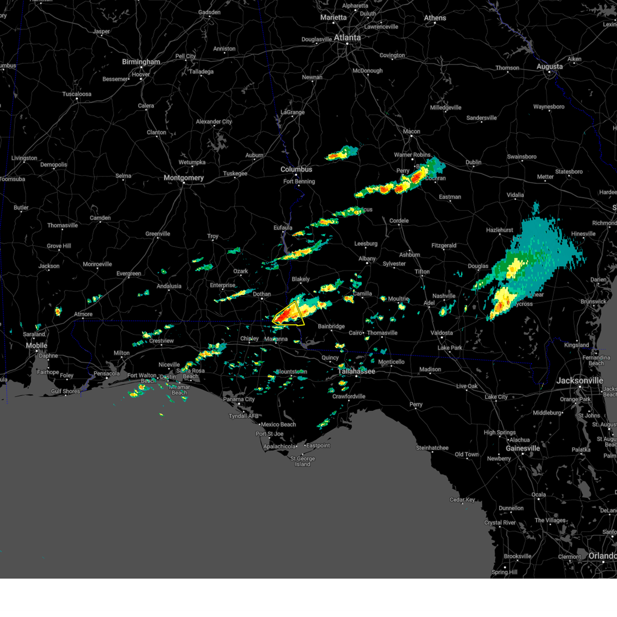 At 314 pm edt/214 pm cdt/, a severe thunderstorm was located 10 miles east of cottonwood, moving east at 25 mph (radar indicated). Hazards include ping pong ball size hail and 60 mph wind gusts. People and animals outdoors will be injured. expect hail damage to roofs, siding, windows, and vehicles. expect wind damage to roofs, siding, and trees. locations impacted include, malone, gordon, jakin, steam mill, saffold, riverturn, crosby, grangeburg, howards mill, chattahoochee sp and lucy. hail threat, radar indicated max hail size, 1. 50 in wind threat, radar indicated max wind gust, 60 mph. At 314 pm edt/214 pm cdt/, a severe thunderstorm was located 10 miles east of cottonwood, moving east at 25 mph (radar indicated). Hazards include ping pong ball size hail and 60 mph wind gusts. People and animals outdoors will be injured. expect hail damage to roofs, siding, windows, and vehicles. expect wind damage to roofs, siding, and trees. locations impacted include, malone, gordon, jakin, steam mill, saffold, riverturn, crosby, grangeburg, howards mill, chattahoochee sp and lucy. hail threat, radar indicated max hail size, 1. 50 in wind threat, radar indicated max wind gust, 60 mph.
|
| 3/25/2023 2:05 PM CDT |
 At 305 pm edt/205 pm cdt/, a severe thunderstorm was located near cottonwood, moving east at 25 mph (radar indicated). Hazards include 60 mph wind gusts and quarter size hail. Hail damage to vehicles is expected. expect wind damage to roofs, siding, and trees. locations impacted include, cottonwood, malone, gordon, jakin, steam mill, saffold, crosby, grangeburg, howards mill, riverturn, chattahoochee sp, lucy, sills and cedar springs. hail threat, radar indicated max hail size, 1. 00 in wind threat, radar indicated max wind gust, 60 mph. At 305 pm edt/205 pm cdt/, a severe thunderstorm was located near cottonwood, moving east at 25 mph (radar indicated). Hazards include 60 mph wind gusts and quarter size hail. Hail damage to vehicles is expected. expect wind damage to roofs, siding, and trees. locations impacted include, cottonwood, malone, gordon, jakin, steam mill, saffold, crosby, grangeburg, howards mill, riverturn, chattahoochee sp, lucy, sills and cedar springs. hail threat, radar indicated max hail size, 1. 00 in wind threat, radar indicated max wind gust, 60 mph.
|
| 3/25/2023 1:41 PM CDT |
 At 241 pm edt/141 pm cdt/, doppler radar indicated a severe thunderstorm capable of producing quarter size hail and damaging winds in excess of 60 mph. this storm was located near cottonwood, and moving east at 30 mph. At 241 pm edt/141 pm cdt/, doppler radar indicated a severe thunderstorm capable of producing quarter size hail and damaging winds in excess of 60 mph. this storm was located near cottonwood, and moving east at 30 mph.
|
| 3/25/2023 9:50 AM CDT |
 At 1050 am edt/950 am cdt/, a severe thunderstorm was located near cottonwood, moving east at 35 mph (radar indicated). Hazards include 60 mph wind gusts and penny size hail. expect damage to roofs, siding, and trees At 1050 am edt/950 am cdt/, a severe thunderstorm was located near cottonwood, moving east at 35 mph (radar indicated). Hazards include 60 mph wind gusts and penny size hail. expect damage to roofs, siding, and trees
|
| 3/12/2023 12:19 PM CDT |
 At 119 pm edt/1219 pm cdt/, a severe thunderstorm was located near marianna, moving east at 35 mph (radar indicated). Hazards include 60 mph wind gusts and quarter size hail. Hail damage to vehicles is expected. Expect wind damage to roofs, siding, and trees. At 119 pm edt/1219 pm cdt/, a severe thunderstorm was located near marianna, moving east at 35 mph (radar indicated). Hazards include 60 mph wind gusts and quarter size hail. Hail damage to vehicles is expected. Expect wind damage to roofs, siding, and trees.
|
| 3/12/2023 11:45 AM CDT |
 At 1145 am cdt, a severe thunderstorm was located near bonifay, moving east at 45 mph (radar indicated). Hazards include 60 mph wind gusts and quarter size hail. Hail damage to vehicles is expected. Expect wind damage to roofs, siding, and trees. At 1145 am cdt, a severe thunderstorm was located near bonifay, moving east at 45 mph (radar indicated). Hazards include 60 mph wind gusts and quarter size hail. Hail damage to vehicles is expected. Expect wind damage to roofs, siding, and trees.
|
| 1/25/2023 6:36 AM CST |
 At 735 am est/635 am cst/, severe thunderstorms were located along a line extending from 12 miles west of donalsonville to 11 miles northeast of callaway, moving east at 35 mph (radar indicated). Hazards include 60 mph wind gusts. Expect damage to roofs, siding, and trees. locations impacted include, panama city, callaway, blountstown, port st. Joe, marianna, springfield, mexico beach, stonemill creek, tyndall air force base, chattahoochee, parker, malone, wewahitchka, sneads, grand ridge, greenwood, altha, bascom, honeyville and moose pond. At 735 am est/635 am cst/, severe thunderstorms were located along a line extending from 12 miles west of donalsonville to 11 miles northeast of callaway, moving east at 35 mph (radar indicated). Hazards include 60 mph wind gusts. Expect damage to roofs, siding, and trees. locations impacted include, panama city, callaway, blountstown, port st. Joe, marianna, springfield, mexico beach, stonemill creek, tyndall air force base, chattahoochee, parker, malone, wewahitchka, sneads, grand ridge, greenwood, altha, bascom, honeyville and moose pond.
|
| 1/25/2023 5:57 AM CST |
 At 657 am est/557 am cst/, severe thunderstorms were located along a line extending from near graceville to near panama city beach, moving east at 30 mph (radar indicated). Hazards include 60 mph wind gusts. Expect damage to roofs, siding, and trees. locations impacted include, panama city, lynn haven, panama city beach, callaway, vernon, blountstown, marianna, chipley, graceville, port st. Joe, springfield, mexico beach, hiland park, stonemill creek, tyndall air force base, chattahoochee, bradford, parker, malone and wewahitchka. At 657 am est/557 am cst/, severe thunderstorms were located along a line extending from near graceville to near panama city beach, moving east at 30 mph (radar indicated). Hazards include 60 mph wind gusts. Expect damage to roofs, siding, and trees. locations impacted include, panama city, lynn haven, panama city beach, callaway, vernon, blountstown, marianna, chipley, graceville, port st. Joe, springfield, mexico beach, hiland park, stonemill creek, tyndall air force base, chattahoochee, bradford, parker, malone and wewahitchka.
|
| 1/25/2023 5:30 AM CST |
 At 629 am est/529 am cst/, severe thunderstorms were located along a line extending from 7 miles south of hartford to near panama city beach, moving east at 35 mph (radar indicated). Hazards include 60 mph wind gusts. expect damage to roofs, siding, and trees At 629 am est/529 am cst/, severe thunderstorms were located along a line extending from 7 miles south of hartford to near panama city beach, moving east at 35 mph (radar indicated). Hazards include 60 mph wind gusts. expect damage to roofs, siding, and trees
|
| 1/12/2023 6:27 PM CST |
 At 727 pm est/627 pm cst/, severe thunderstorms were located along a line extending from near blakely to cottonwood, moving east at 50 mph (radar indicated). Hazards include 60 mph wind gusts and quarter size hail. Hail damage to vehicles is expected. expect wind damage to roofs, siding, and trees. Locations impacted include, cottonwood, graceville, blakely, ashford, columbia, centerville, malone, avon, madrid, gordon, campbellton, saffold, pansey, crosby, grangeburg, garretts crossroads, southern junction, rock hill, early co a/p and farley nuclear plant. At 727 pm est/627 pm cst/, severe thunderstorms were located along a line extending from near blakely to cottonwood, moving east at 50 mph (radar indicated). Hazards include 60 mph wind gusts and quarter size hail. Hail damage to vehicles is expected. expect wind damage to roofs, siding, and trees. Locations impacted include, cottonwood, graceville, blakely, ashford, columbia, centerville, malone, avon, madrid, gordon, campbellton, saffold, pansey, crosby, grangeburg, garretts crossroads, southern junction, rock hill, early co a/p and farley nuclear plant.
|
| 1/12/2023 5:47 PM CST |
 At 646 pm est/546 pm cst/, severe thunderstorms were located along a line extending from near midland city to 7 miles south of geneva, moving east at 50 mph (radar indicated). Hazards include 60 mph wind gusts and quarter size hail. Hail damage to vehicles is expected. Expect wind damage to roofs, siding, and trees. At 646 pm est/546 pm cst/, severe thunderstorms were located along a line extending from near midland city to 7 miles south of geneva, moving east at 50 mph (radar indicated). Hazards include 60 mph wind gusts and quarter size hail. Hail damage to vehicles is expected. Expect wind damage to roofs, siding, and trees.
|
| 1/4/2023 7:51 AM CST |
 The tornado warning for south central houston and northwestern jackson counties will expire at 800 am cst, the tornado threat has diminished and the tornado warning has been cancelled. however, large hail and damaging winds remain likely and a severe thunderstorm warning remains in effect for the area. a tornado watch remains in effect until 1100 am cst for southeastern alabama, the panhandle of florida, and southwestern georgia. The tornado warning for south central houston and northwestern jackson counties will expire at 800 am cst, the tornado threat has diminished and the tornado warning has been cancelled. however, large hail and damaging winds remain likely and a severe thunderstorm warning remains in effect for the area. a tornado watch remains in effect until 1100 am cst for southeastern alabama, the panhandle of florida, and southwestern georgia.
|
| 1/4/2023 7:22 AM CST |
 At 722 am cst, a severe thunderstorm capable of producing a tornado was located 7 miles southeast of graceville, moving northeast at 40 mph (radar indicated rotation). Hazards include tornado. Flying debris will be dangerous to those caught without shelter. mobile homes will be damaged or destroyed. damage to roofs, windows, and vehicles will occur. tree damage is likely. this dangerous storm will be near, cottonwood around 740 am cst. Other locations impacted by this tornadic thunderstorm include malone, bascom, jacob city, grangeburg, jacobs, campbellton and sills. At 722 am cst, a severe thunderstorm capable of producing a tornado was located 7 miles southeast of graceville, moving northeast at 40 mph (radar indicated rotation). Hazards include tornado. Flying debris will be dangerous to those caught without shelter. mobile homes will be damaged or destroyed. damage to roofs, windows, and vehicles will occur. tree damage is likely. this dangerous storm will be near, cottonwood around 740 am cst. Other locations impacted by this tornadic thunderstorm include malone, bascom, jacob city, grangeburg, jacobs, campbellton and sills.
|
| 1/4/2023 7:19 AM CST |
 At 819 am est/719 am cst/, a severe thunderstorm was located near chipley, moving northeast at 45 mph (radar indicated). Hazards include 60 mph wind gusts. expect damage to roofs, siding, and trees At 819 am est/719 am cst/, a severe thunderstorm was located near chipley, moving northeast at 45 mph (radar indicated). Hazards include 60 mph wind gusts. expect damage to roofs, siding, and trees
|
| 11/30/2022 6:45 AM CST |
 At 745 am est/645 am cst/, severe thunderstorms were located along a line extending from 8 miles southeast of fort gaines to columbia to near slocomb to 8 miles south of geneva, moving southeast at 40 mph (radar indicated). Hazards include 60 mph wind gusts. expect damage to roofs, siding, and trees At 745 am est/645 am cst/, severe thunderstorms were located along a line extending from 8 miles southeast of fort gaines to columbia to near slocomb to 8 miles south of geneva, moving southeast at 40 mph (radar indicated). Hazards include 60 mph wind gusts. expect damage to roofs, siding, and trees
|
| 8/6/2022 2:41 PM CDT |
 At 240 pm cdt, a severe thunderstorm was located over cottonwood, moving west at 15 mph (radar indicated). Hazards include 60 mph wind gusts and penny size hail. expect damage to roofs, siding, and trees At 240 pm cdt, a severe thunderstorm was located over cottonwood, moving west at 15 mph (radar indicated). Hazards include 60 mph wind gusts and penny size hail. expect damage to roofs, siding, and trees
|
| 6/16/2022 7:49 PM CDT |
 At 748 pm cdt, a severe thunderstorm was located over bonifay, moving west at 20 mph (radar indicated). Hazards include 60 mph wind gusts and penny size hail. expect damage to roofs, siding, and trees At 748 pm cdt, a severe thunderstorm was located over bonifay, moving west at 20 mph (radar indicated). Hazards include 60 mph wind gusts and penny size hail. expect damage to roofs, siding, and trees
|
| 6/14/2022 5:19 PM CDT |
 At 619 pm edt/519 pm cdt/, severe thunderstorms were located along a line extending from near dothan to 7 miles north of blountstown, moving west at 45 mph (radar indicated). Hazards include 60 mph wind gusts. Expect damage to roofs, siding, and trees. locations impacted include, cottonwood, marianna, headland, dothan, ozark, taylor, midland city, kinsey, ashford, cowarts, newton, webb, pinckard, malone, sneads, rehobeth, cottondale, grand ridge, greenwood and grimes. hail threat, radar indicated max hail size, <. 75 in wind threat, radar indicated max wind gust, 60 mph. At 619 pm edt/519 pm cdt/, severe thunderstorms were located along a line extending from near dothan to 7 miles north of blountstown, moving west at 45 mph (radar indicated). Hazards include 60 mph wind gusts. Expect damage to roofs, siding, and trees. locations impacted include, cottonwood, marianna, headland, dothan, ozark, taylor, midland city, kinsey, ashford, cowarts, newton, webb, pinckard, malone, sneads, rehobeth, cottondale, grand ridge, greenwood and grimes. hail threat, radar indicated max hail size, <. 75 in wind threat, radar indicated max wind gust, 60 mph.
|
| 6/14/2022 4:39 PM CDT |
 At 538 pm edt/438 pm cdt/, severe thunderstorms were located along a line extending from near columbia to 8 miles south of bainbridge, moving west at 50 mph (radar indicated). Hazards include 60 mph wind gusts. expect damage to roofs, siding, and trees At 538 pm edt/438 pm cdt/, severe thunderstorms were located along a line extending from near columbia to 8 miles south of bainbridge, moving west at 50 mph (radar indicated). Hazards include 60 mph wind gusts. expect damage to roofs, siding, and trees
|
| 5/25/2022 10:37 AM CDT |
 At 1037 am cdt, severe thunderstorms were located along a line extending from bonifay to 6 miles south of chipley to 13 miles east of vernon to 19 miles northeast of lynn haven, moving northeast at 40 mph (radar indicated). Hazards include 60 mph wind gusts. expect damage to roofs, siding, and trees At 1037 am cdt, severe thunderstorms were located along a line extending from bonifay to 6 miles south of chipley to 13 miles east of vernon to 19 miles northeast of lynn haven, moving northeast at 40 mph (radar indicated). Hazards include 60 mph wind gusts. expect damage to roofs, siding, and trees
|
| 5/23/2022 3:48 PM EDT |
 At 347 pm edt/247 pm cdt/, severe thunderstorms were located along a line extending from 11 miles east of cottonwood to 6 miles southwest of donalsonville to 6 miles north of chattahoochee, moving northeast at 35 mph (radar indicated). Hazards include 60 mph wind gusts. expect damage to roofs, siding, and trees At 347 pm edt/247 pm cdt/, severe thunderstorms were located along a line extending from 11 miles east of cottonwood to 6 miles southwest of donalsonville to 6 miles north of chattahoochee, moving northeast at 35 mph (radar indicated). Hazards include 60 mph wind gusts. expect damage to roofs, siding, and trees
|
| 5/21/2022 2:21 PM CDT |
 The severe thunderstorm warning for eastern houston and north central jackson counties will expire at 230 pm cdt, the storm which prompted the warning has weakened below severe limits, and no longer poses an immediate threat to life or property. therefore, the warning will be allowed to expire. however gusty winds are still possible with this thunderstorm. The severe thunderstorm warning for eastern houston and north central jackson counties will expire at 230 pm cdt, the storm which prompted the warning has weakened below severe limits, and no longer poses an immediate threat to life or property. therefore, the warning will be allowed to expire. however gusty winds are still possible with this thunderstorm.
|
| 5/21/2022 1:51 PM CDT |
 At 151 pm cdt, a severe thunderstorm was located 10 miles east of cottonwood, moving northwest at 20 mph (radar indicated). Hazards include 60 mph wind gusts and penny size hail. expect damage to roofs, siding, and trees At 151 pm cdt, a severe thunderstorm was located 10 miles east of cottonwood, moving northwest at 20 mph (radar indicated). Hazards include 60 mph wind gusts and penny size hail. expect damage to roofs, siding, and trees
|
| 4/5/2022 2:42 PM CDT |
 At 242 pm cdt, severe thunderstorms were located along a line extending from 6 miles southeast of donalsonville to 9 miles southeast of vernon, moving east at 55 mph (radar indicated). Hazards include 60 mph wind gusts. Expect damage to roofs, siding, and trees. Locations impacted include, panama city beach, vernon, santa rosa beach, marianna, chipley, bradford, live oak, malone, freeport, cottondale, greenwood, alford, wausau, ebro, bascom, blue mountain beach, seaside, lovedale, holmes valley and millers ferry. At 242 pm cdt, severe thunderstorms were located along a line extending from 6 miles southeast of donalsonville to 9 miles southeast of vernon, moving east at 55 mph (radar indicated). Hazards include 60 mph wind gusts. Expect damage to roofs, siding, and trees. Locations impacted include, panama city beach, vernon, santa rosa beach, marianna, chipley, bradford, live oak, malone, freeport, cottondale, greenwood, alford, wausau, ebro, bascom, blue mountain beach, seaside, lovedale, holmes valley and millers ferry.
|
| 4/5/2022 2:31 PM CDT |
 At 231 pm cdt, severe thunderstorms were located along a line extending from near donalsonville to 9 miles southwest of vernon, moving east at 55 mph (radar indicated). Hazards include 60 mph wind gusts. Expect damage to roofs, siding, and trees. Locations impacted include, panama city beach, vernon, chipley, santa rosa beach, bonifay, marianna, bradford, live oak, malone, freeport, cottondale, greenwood, alford, wausau, ebro, campbellton, bascom, whitehead crossroads, blue mountain beach and seaside. At 231 pm cdt, severe thunderstorms were located along a line extending from near donalsonville to 9 miles southwest of vernon, moving east at 55 mph (radar indicated). Hazards include 60 mph wind gusts. Expect damage to roofs, siding, and trees. Locations impacted include, panama city beach, vernon, chipley, santa rosa beach, bonifay, marianna, bradford, live oak, malone, freeport, cottondale, greenwood, alford, wausau, ebro, campbellton, bascom, whitehead crossroads, blue mountain beach and seaside.
|
| 4/5/2022 2:00 PM CDT |
 At 159 pm cdt, severe thunderstorms were located along a line extending from near graceville to 7 miles south of eglin air force base, moving east at 55 mph (radar indicated). Hazards include 60 mph wind gusts. expect damage to roofs, siding, and trees At 159 pm cdt, severe thunderstorms were located along a line extending from near graceville to 7 miles south of eglin air force base, moving east at 55 mph (radar indicated). Hazards include 60 mph wind gusts. expect damage to roofs, siding, and trees
|
| 3/31/2022 4:54 AM CDT |
 At 454 am cdt, severe thunderstorms were located along a line extending from 13 miles northeast of marianna to near panama city beach, moving east at 20 mph (radar indicated). Hazards include 60 mph wind gusts. Expect damage to roofs, siding, and trees. Locations impacted include, panama city, lynn haven, panama city beach, callaway, marianna, springfield, hiland park, tyndall air force base, parker, malone, cottondale, greenwood, alford, bascom, moose pond, dirego park, college station, west panama city, camps head and bahama beach. At 454 am cdt, severe thunderstorms were located along a line extending from 13 miles northeast of marianna to near panama city beach, moving east at 20 mph (radar indicated). Hazards include 60 mph wind gusts. Expect damage to roofs, siding, and trees. Locations impacted include, panama city, lynn haven, panama city beach, callaway, marianna, springfield, hiland park, tyndall air force base, parker, malone, cottondale, greenwood, alford, bascom, moose pond, dirego park, college station, west panama city, camps head and bahama beach.
|
| 3/31/2022 4:33 AM CDT |
 At 433 am cdt, a confirmed tornado was located near marianna, moving northeast at 45 mph (radar confirmed tornado). Hazards include damaging tornado and quarter size hail. Flying debris will be dangerous to those caught without shelter. mobile homes will be damaged or destroyed. damage to roofs, windows, and vehicles will occur. tree damage is likely. This tornadic thunderstorm will remain over mainly rural areas of northeastern jackson county, including the following locations, malone, bascom, dellwood, greenwood, two egg, chipola terrace and marianna municipal a/p. At 433 am cdt, a confirmed tornado was located near marianna, moving northeast at 45 mph (radar confirmed tornado). Hazards include damaging tornado and quarter size hail. Flying debris will be dangerous to those caught without shelter. mobile homes will be damaged or destroyed. damage to roofs, windows, and vehicles will occur. tree damage is likely. This tornadic thunderstorm will remain over mainly rural areas of northeastern jackson county, including the following locations, malone, bascom, dellwood, greenwood, two egg, chipola terrace and marianna municipal a/p.
|
| 3/31/2022 4:23 AM CDT |
 At 423 am cdt, a tornado producing storm was located near marianna, moving northeast at 45 mph (radar confirmed tornado). Hazards include damaging tornado and quarter size hail. Flying debris will be dangerous to those caught without shelter. mobile homes will be damaged or destroyed. damage to roofs, windows, and vehicles will occur. tree damage is likely. this tornadic storm will be near, marianna around 435 am cdt. Other locations impacted by this tornadic thunderstorm include malone, bascom, kynesville, greenwood, cottondale, blue spring, steele city, dellwood, two egg and cottondale airport. At 423 am cdt, a tornado producing storm was located near marianna, moving northeast at 45 mph (radar confirmed tornado). Hazards include damaging tornado and quarter size hail. Flying debris will be dangerous to those caught without shelter. mobile homes will be damaged or destroyed. damage to roofs, windows, and vehicles will occur. tree damage is likely. this tornadic storm will be near, marianna around 435 am cdt. Other locations impacted by this tornadic thunderstorm include malone, bascom, kynesville, greenwood, cottondale, blue spring, steele city, dellwood, two egg and cottondale airport.
|
| 3/31/2022 3:54 AM CDT |
 At 354 am cdt, severe thunderstorms were located along a line extending from near graceville to 8 miles northwest of panama city beach, moving northeast at 35 mph (radar indicated). Hazards include 60 mph wind gusts. expect damage to roofs, siding, and trees At 354 am cdt, severe thunderstorms were located along a line extending from near graceville to 8 miles northwest of panama city beach, moving northeast at 35 mph (radar indicated). Hazards include 60 mph wind gusts. expect damage to roofs, siding, and trees
|
| 3/18/2022 4:17 PM CDT |
 At 417 pm cdt, severe thunderstorms were located along a line extending from near cottonwood to 9 miles south of chipley, moving east at 50 mph (radar indicated). Hazards include 60 mph wind gusts. Expect damage to roofs, siding, and trees. Locations impacted include, chipley, graceville, marianna, bradford, malone, cottondale, alford, wausau, campbellton, richter crossroads, jacobs, smyrna, bahoma, sylvania, ellaville, brock crossroad, jacob city, chipley municipal airport, orange hill and kynesville. At 417 pm cdt, severe thunderstorms were located along a line extending from near cottonwood to 9 miles south of chipley, moving east at 50 mph (radar indicated). Hazards include 60 mph wind gusts. Expect damage to roofs, siding, and trees. Locations impacted include, chipley, graceville, marianna, bradford, malone, cottondale, alford, wausau, campbellton, richter crossroads, jacobs, smyrna, bahoma, sylvania, ellaville, brock crossroad, jacob city, chipley municipal airport, orange hill and kynesville.
|
| 3/18/2022 4:16 PM CDT |
 At 416 pm cdt, severe thunderstorms were located along a line extending from near cottonwood to 7 miles southeast of chipley, moving east at 45 mph (radar indicated). Hazards include 60 mph wind gusts. expect damage to roofs, siding, and trees At 416 pm cdt, severe thunderstorms were located along a line extending from near cottonwood to 7 miles southeast of chipley, moving east at 45 mph (radar indicated). Hazards include 60 mph wind gusts. expect damage to roofs, siding, and trees
|
| 3/18/2022 3:51 PM CDT |
 At 351 pm cdt, severe thunderstorms were located along a line extending from near graceville to 12 miles southeast of de funiak springs, moving east at 40 mph (radar indicated). Hazards include 60 mph wind gusts. expect damage to roofs, siding, and trees At 351 pm cdt, severe thunderstorms were located along a line extending from near graceville to 12 miles southeast of de funiak springs, moving east at 40 mph (radar indicated). Hazards include 60 mph wind gusts. expect damage to roofs, siding, and trees
|
| 3/18/2022 3:05 PM EDT |
 At 305 pm edt/205 pm cdt/, a severe thunderstorm was located over donalsonville, moving east at 30 mph (radar indicated). Hazards include 60 mph wind gusts. Expect damage to roofs, siding, and trees. Locations impacted include, colquitt, donalsonville, bainbridge, west bainbridge, malone, gordon, iron city, brinson, jakin, bascom, hanover, saffold, ausmac, babcock, reynoldsville, little hope, recovery, mayhaw, decatur co a/p and lovedale. At 305 pm edt/205 pm cdt/, a severe thunderstorm was located over donalsonville, moving east at 30 mph (radar indicated). Hazards include 60 mph wind gusts. Expect damage to roofs, siding, and trees. Locations impacted include, colquitt, donalsonville, bainbridge, west bainbridge, malone, gordon, iron city, brinson, jakin, bascom, hanover, saffold, ausmac, babcock, reynoldsville, little hope, recovery, mayhaw, decatur co a/p and lovedale.
|
| 3/18/2022 2:53 PM EDT |
 At 252 pm edt/152 pm cdt/, severe thunderstorms were located along a line extending from 11 miles southwest of albany to 9 miles southwest of west bainbridge, moving east at 30 mph (radar indicated). Hazards include 60 mph wind gusts. Expect damage to roofs, siding, and trees. Locations impacted include, colquitt, newton, albany, donalsonville, bainbridge, west bainbridge, walker, malone, gordon, iron city, brinson, jakin, bascom, recovery, lovedale, donaldsonville a/p, buena vista, bellview, howards mill and hoggard mill. At 252 pm edt/152 pm cdt/, severe thunderstorms were located along a line extending from 11 miles southwest of albany to 9 miles southwest of west bainbridge, moving east at 30 mph (radar indicated). Hazards include 60 mph wind gusts. Expect damage to roofs, siding, and trees. Locations impacted include, colquitt, newton, albany, donalsonville, bainbridge, west bainbridge, walker, malone, gordon, iron city, brinson, jakin, bascom, recovery, lovedale, donaldsonville a/p, buena vista, bellview, howards mill and hoggard mill.
|
| 3/18/2022 2:16 PM EDT |
 At 216 pm edt/116 pm cdt/, severe thunderstorms were located along a line extending from near morgan to 8 miles southwest of donalsonville, moving east at 30 mph (radar indicated). Hazards include 60 mph wind gusts. Expect damage to roofs, siding, and trees. Locations impacted include, colquitt, newton, morgan, albany, donalsonville, bainbridge, edison, arlington, leary, west bainbridge, walker, douglasville, centerville, malone, gordon, iron city, damascus, brinson, jakin and bascom. At 216 pm edt/116 pm cdt/, severe thunderstorms were located along a line extending from near morgan to 8 miles southwest of donalsonville, moving east at 30 mph (radar indicated). Hazards include 60 mph wind gusts. Expect damage to roofs, siding, and trees. Locations impacted include, colquitt, newton, morgan, albany, donalsonville, bainbridge, edison, arlington, leary, west bainbridge, walker, douglasville, centerville, malone, gordon, iron city, damascus, brinson, jakin and bascom.
|
| 3/18/2022 1:53 PM EDT |
 At 153 pm edt/1253 pm cdt/, severe thunderstorms were located along a line extending from 8 miles northwest of edison to 6 miles southeast of cottonwood, moving southeast at 25 mph (radar indicated). Hazards include 60 mph wind gusts. expect damage to roofs, siding, and trees At 153 pm edt/1253 pm cdt/, severe thunderstorms were located along a line extending from 8 miles northwest of edison to 6 miles southeast of cottonwood, moving southeast at 25 mph (radar indicated). Hazards include 60 mph wind gusts. expect damage to roofs, siding, and trees
|
| 1/2/2022 3:21 PM CST |
 The severe thunderstorm warning for jackson, northeastern bay, northwestern calhoun and eastern washington counties in the panhandle of florida will expire at 330 pm cst, the storms which prompted the warning have moved out of the area. therefore, the warning will be allowed to expire. a tornado watch remains in effect until 800 pm cst for southeastern alabama, the panhandle of florida, and southwestern georgia. to report severe weather, contact your nearest law enforcement agency. they will relay your report to the national weather service tallahassee. The severe thunderstorm warning for jackson, northeastern bay, northwestern calhoun and eastern washington counties in the panhandle of florida will expire at 330 pm cst, the storms which prompted the warning have moved out of the area. therefore, the warning will be allowed to expire. a tornado watch remains in effect until 800 pm cst for southeastern alabama, the panhandle of florida, and southwestern georgia. to report severe weather, contact your nearest law enforcement agency. they will relay your report to the national weather service tallahassee.
|
| 1/2/2022 2:27 PM CST |
 At 227 pm cst, severe thunderstorms were located along a line extending from near cottonwood to 10 miles south of vernon, moving east at 30 mph (radar indicated). Hazards include 60 mph wind gusts. expect damage to roofs, siding, and trees At 227 pm cst, severe thunderstorms were located along a line extending from near cottonwood to 10 miles south of vernon, moving east at 30 mph (radar indicated). Hazards include 60 mph wind gusts. expect damage to roofs, siding, and trees
|
| 8/31/2021 9:41 AM CDT |
 At 941 am cdt, a severe thunderstorm capable of producing a tornado was located near graceville, moving northeast at 35 mph (radar indicated rotation). Hazards include tornado. Flying debris will be dangerous to those caught without shelter. mobile homes will be damaged or destroyed. damage to roofs, windows, and vehicles will occur. tree damage is likely. this dangerous storm will be near, graceville around 945 am cdt. Other locations impacted by this tornadic thunderstorm include richter crossroads, malone, jacob city, cottondale airport, cottondale, jacobs, campbellton, browntown, bahoma and ellaville. At 941 am cdt, a severe thunderstorm capable of producing a tornado was located near graceville, moving northeast at 35 mph (radar indicated rotation). Hazards include tornado. Flying debris will be dangerous to those caught without shelter. mobile homes will be damaged or destroyed. damage to roofs, windows, and vehicles will occur. tree damage is likely. this dangerous storm will be near, graceville around 945 am cdt. Other locations impacted by this tornadic thunderstorm include richter crossroads, malone, jacob city, cottondale airport, cottondale, jacobs, campbellton, browntown, bahoma and ellaville.
|
| 8/31/2021 9:31 AM CDT |
 At 930 am cdt, a severe thunderstorm capable of producing a tornado was located over chipley, moving northeast at 40 mph (radar indicated rotation). Hazards include tornado. Flying debris will be dangerous to those caught without shelter. mobile homes will be damaged or destroyed. damage to roofs, windows, and vehicles will occur. tree damage is likely. this dangerous storm will be near, graceville around 950 am cdt. Other locations impacted by this tornadic thunderstorm include richter crossroads, malone, jacob city, chipley municipal airport, cottondale, cottondale airport, jacobs, campbellton, browntown and bahoma. At 930 am cdt, a severe thunderstorm capable of producing a tornado was located over chipley, moving northeast at 40 mph (radar indicated rotation). Hazards include tornado. Flying debris will be dangerous to those caught without shelter. mobile homes will be damaged or destroyed. damage to roofs, windows, and vehicles will occur. tree damage is likely. this dangerous storm will be near, graceville around 950 am cdt. Other locations impacted by this tornadic thunderstorm include richter crossroads, malone, jacob city, chipley municipal airport, cottondale, cottondale airport, jacobs, campbellton, browntown and bahoma.
|
| 7/9/2021 3:05 PM CDT |
 The severe thunderstorm warning for eastern houston and north central jackson counties will expire at 315 pm cdt, the storms which prompted the warning have moved out of the area. therefore, the warning will be allowed to expire. to report severe weather, contact your nearest law enforcement agency. they will relay your report to the national weather service tallahassee. The severe thunderstorm warning for eastern houston and north central jackson counties will expire at 315 pm cdt, the storms which prompted the warning have moved out of the area. therefore, the warning will be allowed to expire. to report severe weather, contact your nearest law enforcement agency. they will relay your report to the national weather service tallahassee.
|
| 7/9/2021 2:58 PM CDT |
 At 246 pm cdt, severe thunderstorms were located along a line extending from near webb to 7 miles northeast of chipley, moving east at 20 mph (radar indicated). Hazards include 60 mph wind gusts. Expect damage to roofs, siding, and trees. Locations impacted include, cottonwood, ashford, cowarts, webb, columbia, malone, avon, madrid, gordon, campbellton, pansey, grangeburg, sigma, enon, wilson mill, barber, keytons, pleasant plains, jacobs and farley nuclear plant. At 246 pm cdt, severe thunderstorms were located along a line extending from near webb to 7 miles northeast of chipley, moving east at 20 mph (radar indicated). Hazards include 60 mph wind gusts. Expect damage to roofs, siding, and trees. Locations impacted include, cottonwood, ashford, cowarts, webb, columbia, malone, avon, madrid, gordon, campbellton, pansey, grangeburg, sigma, enon, wilson mill, barber, keytons, pleasant plains, jacobs and farley nuclear plant.
|
| 7/9/2021 2:58 PM CDT |
 At 258 pm cdt, severe thunderstorms were located along a line extending from 6 miles south of columbia to 8 miles northwest of marianna, moving east at 25 mph (radar indicated). Hazards include 60 mph wind gusts. Expect damage to roofs, siding, and trees. Locations impacted include, cottonwood, ashford, columbia, malone, gordon, pansey, grangeburg, farley nuclear plant, sealy springs, sills and jacob city. At 258 pm cdt, severe thunderstorms were located along a line extending from 6 miles south of columbia to 8 miles northwest of marianna, moving east at 25 mph (radar indicated). Hazards include 60 mph wind gusts. Expect damage to roofs, siding, and trees. Locations impacted include, cottonwood, ashford, columbia, malone, gordon, pansey, grangeburg, farley nuclear plant, sealy springs, sills and jacob city.
|
| 7/9/2021 2:46 PM CDT |
 At 246 pm cdt, severe thunderstorms were located along a line extending from near webb to 7 miles northeast of chipley, moving east at 20 mph (radar indicated). Hazards include 60 mph wind gusts. Expect damage to roofs, siding, and trees. Locations impacted include, cottonwood, ashford, cowarts, webb, columbia, malone, avon, madrid, gordon, campbellton, pansey, grangeburg, sigma, enon, wilson mill, barber, keytons, pleasant plains, jacobs and farley nuclear plant. At 246 pm cdt, severe thunderstorms were located along a line extending from near webb to 7 miles northeast of chipley, moving east at 20 mph (radar indicated). Hazards include 60 mph wind gusts. Expect damage to roofs, siding, and trees. Locations impacted include, cottonwood, ashford, cowarts, webb, columbia, malone, avon, madrid, gordon, campbellton, pansey, grangeburg, sigma, enon, wilson mill, barber, keytons, pleasant plains, jacobs and farley nuclear plant.
|
| 7/9/2021 2:25 PM CDT |
 At 225 pm cdt, severe thunderstorms were located along a line extending from kinsey to near graceville, moving east at 20 mph (radar indicated). Hazards include 60 mph wind gusts. expect damage to roofs, siding, and trees At 225 pm cdt, severe thunderstorms were located along a line extending from kinsey to near graceville, moving east at 20 mph (radar indicated). Hazards include 60 mph wind gusts. expect damage to roofs, siding, and trees
|
| 6/12/2021 2:18 PM CDT |
 At 318 pm edt/218 pm cdt/, severe thunderstorms were located along a line extending from near donalsonville to 8 miles northeast of marianna, moving southeast at 25 mph (radar indicated). Hazards include 60 mph wind gusts. expect damage to roofs, siding, and trees At 318 pm edt/218 pm cdt/, severe thunderstorms were located along a line extending from near donalsonville to 8 miles northeast of marianna, moving southeast at 25 mph (radar indicated). Hazards include 60 mph wind gusts. expect damage to roofs, siding, and trees
|
| 5/4/2021 9:27 PM CDT |
 At 1027 pm edt/927 pm cdt/, severe thunderstorms were located along a line extending from 10 miles west of vernon to 7 miles southeast of cottonwood, moving east at 45 mph (radar indicated). Hazards include 60 mph wind gusts. expect damage to roofs, siding, and trees At 1027 pm edt/927 pm cdt/, severe thunderstorms were located along a line extending from 10 miles west of vernon to 7 miles southeast of cottonwood, moving east at 45 mph (radar indicated). Hazards include 60 mph wind gusts. expect damage to roofs, siding, and trees
|
| 4/10/2021 8:43 AM CDT |
 At 843 am cdt, severe thunderstorms were located along a line extending from 6 miles southwest of cottonwood to 10 miles southeast of chipley, moving northeast at 40 mph (radar indicated). Hazards include 60 mph wind gusts. expect damage to roofs, siding, and trees At 843 am cdt, severe thunderstorms were located along a line extending from 6 miles southwest of cottonwood to 10 miles southeast of chipley, moving northeast at 40 mph (radar indicated). Hazards include 60 mph wind gusts. expect damage to roofs, siding, and trees
|
| 4/10/2021 7:21 AM CDT |
 At 721 am cdt, severe thunderstorms were located along a line extending from 7 miles south of hartford to near santa rosa beach, moving east at 30 mph (radar indicated). Hazards include 60 mph wind gusts. expect damage to roofs, siding, and trees At 721 am cdt, severe thunderstorms were located along a line extending from 7 miles south of hartford to near santa rosa beach, moving east at 30 mph (radar indicated). Hazards include 60 mph wind gusts. expect damage to roofs, siding, and trees
|
| 4/9/2021 7:34 AM CDT |
 At 734 am cdt, a severe thunderstorm was located near bonifay, moving northeast at 30 mph (radar indicated). Hazards include quarter size hail. damage to vehicles is expected At 734 am cdt, a severe thunderstorm was located near bonifay, moving northeast at 30 mph (radar indicated). Hazards include quarter size hail. damage to vehicles is expected
|
| 3/31/2021 7:27 PM EDT |
 At 726 pm edt/626 pm cdt/, severe thunderstorms were located along a line extending from near ochlocknee to near bainbridge to 10 miles east of marianna, moving southeast at 30 mph (radar indicated). Hazards include 60 mph wind gusts. Expect damage to roofs, siding, and trees. Locations impacted include, colquitt, newton, bainbridge, donalsonville, pelham, camilla, whigham, west bainbridge, chattahoochee, malone, sneads, grand ridge, greenwood, sale city, iron city, climax, brinson, jakin, bascom and crosby. At 726 pm edt/626 pm cdt/, severe thunderstorms were located along a line extending from near ochlocknee to near bainbridge to 10 miles east of marianna, moving southeast at 30 mph (radar indicated). Hazards include 60 mph wind gusts. Expect damage to roofs, siding, and trees. Locations impacted include, colquitt, newton, bainbridge, donalsonville, pelham, camilla, whigham, west bainbridge, chattahoochee, malone, sneads, grand ridge, greenwood, sale city, iron city, climax, brinson, jakin, bascom and crosby.
|
| 3/31/2021 6:54 PM EDT |
 The national weather service in tallahassee has issued a * severe thunderstorm warning for. southeastern houston county in southeastern alabama. northeastern jackson county in the panhandle of florida. northwestern gadsden county in big bend of florida. Decatur county in southwestern georgia. The national weather service in tallahassee has issued a * severe thunderstorm warning for. southeastern houston county in southeastern alabama. northeastern jackson county in the panhandle of florida. northwestern gadsden county in big bend of florida. Decatur county in southwestern georgia.
|
| 3/31/2021 6:54 PM EDT |
 At 654 pm edt/554 pm cdt/, severe thunderstorms were located along a line extending from near leary to near colquitt to near cottonwood, moving east at 55 mph (radar indicated). Hazards include 60 mph wind gusts. expect damage to roofs, siding, and trees At 654 pm edt/554 pm cdt/, severe thunderstorms were located along a line extending from near leary to near colquitt to near cottonwood, moving east at 55 mph (radar indicated). Hazards include 60 mph wind gusts. expect damage to roofs, siding, and trees
|
| 3/28/2021 5:15 PM EDT |
 At 515 pm edt/415 pm cdt/, severe thunderstorms were located along a line extending from 8 miles north of colquitt to 7 miles south of cottonwood, moving east at 30 mph (radar indicated). Hazards include 60 mph wind gusts. Expect damage to roofs, siding, and trees. Locations impacted include, colquitt, donalsonville, bainbridge, malone, gordon, iron city, damascus, brinson, jakin, bascom, hanover, saffold, ausmac, babcock, crosby, grangeburg, little hope, mayhaw, decatur co a/p and boykin. At 515 pm edt/415 pm cdt/, severe thunderstorms were located along a line extending from 8 miles north of colquitt to 7 miles south of cottonwood, moving east at 30 mph (radar indicated). Hazards include 60 mph wind gusts. Expect damage to roofs, siding, and trees. Locations impacted include, colquitt, donalsonville, bainbridge, malone, gordon, iron city, damascus, brinson, jakin, bascom, hanover, saffold, ausmac, babcock, crosby, grangeburg, little hope, mayhaw, decatur co a/p and boykin.
|
| 3/28/2021 4:57 PM EDT |
 At 457 pm edt/357 pm cdt/, severe thunderstorms were located along a line extending from near columbia to near cottonwood, moving east at 35 mph (radar indicated). Hazards include 60 mph wind gusts. expect damage to roofs, siding, and trees At 457 pm edt/357 pm cdt/, severe thunderstorms were located along a line extending from near columbia to near cottonwood, moving east at 35 mph (radar indicated). Hazards include 60 mph wind gusts. expect damage to roofs, siding, and trees
|
| 3/28/2021 4:57 PM EDT |
 The national weather service in tallahassee has issued a * severe thunderstorm warning for. southeastern houston county in southeastern alabama. northeastern jackson county in the panhandle of florida. north central decatur county in southwestern georgia. Miller county in southwestern georgia. The national weather service in tallahassee has issued a * severe thunderstorm warning for. southeastern houston county in southeastern alabama. northeastern jackson county in the panhandle of florida. north central decatur county in southwestern georgia. Miller county in southwestern georgia.
|
| 3/18/2021 6:45 AM CDT |
 At 745 am edt/645 am cdt/, severe thunderstorms were located along a line extending from 6 miles southwest of cottonwood to 8 miles southwest of wewahitchka, moving northeast at 35 mph (radar indicated). Hazards include 60 mph wind gusts. Expect damage to roofs, siding, and trees. Locations impacted include, blountstown, marianna, mexico beach, stonemill creek, chattahoochee, tyndall air force base, orange, malone, wewahitchka, sneads, bristol, cottondale, grand ridge, greenwood, altha, alford, campbellton, bascom, rock bluff and honeyville. At 745 am edt/645 am cdt/, severe thunderstorms were located along a line extending from 6 miles southwest of cottonwood to 8 miles southwest of wewahitchka, moving northeast at 35 mph (radar indicated). Hazards include 60 mph wind gusts. Expect damage to roofs, siding, and trees. Locations impacted include, blountstown, marianna, mexico beach, stonemill creek, chattahoochee, tyndall air force base, orange, malone, wewahitchka, sneads, bristol, cottondale, grand ridge, greenwood, altha, alford, campbellton, bascom, rock bluff and honeyville.
|
| 3/18/2021 6:19 AM CDT |
 At 719 am edt/619 am cdt/, severe thunderstorms were located along a line extending from near chipley to near tyndall air force base, moving east at 35 mph (radar indicated). Hazards include 60 mph wind gusts. expect damage to roofs, siding, and trees At 719 am edt/619 am cdt/, severe thunderstorms were located along a line extending from near chipley to near tyndall air force base, moving east at 35 mph (radar indicated). Hazards include 60 mph wind gusts. expect damage to roofs, siding, and trees
|
| 2/15/2021 3:06 PM CST |
 At 406 pm est/306 pm cst/, severe thunderstorms were located along a line extending from 10 miles south of columbia to 11 miles northeast of stonemill creek, moving east at 50 mph (radar indicated). Hazards include 60 mph wind gusts and quarter size hail. Hail damage to vehicles is expected. expect wind damage to roofs, siding, and trees. Locations impacted include, blountstown, marianna, orange, malone, sneads, bristol, grand ridge, greenwood, altha, bascom, clarksville, ocheesee, selman, abe springs, chipola, lovedale, scotts ferry, kennys mill, dellwood and hugh creek. At 406 pm est/306 pm cst/, severe thunderstorms were located along a line extending from 10 miles south of columbia to 11 miles northeast of stonemill creek, moving east at 50 mph (radar indicated). Hazards include 60 mph wind gusts and quarter size hail. Hail damage to vehicles is expected. expect wind damage to roofs, siding, and trees. Locations impacted include, blountstown, marianna, orange, malone, sneads, bristol, grand ridge, greenwood, altha, bascom, clarksville, ocheesee, selman, abe springs, chipola, lovedale, scotts ferry, kennys mill, dellwood and hugh creek.
|
| 2/15/2021 4:03 PM EST |
 At 403 pm est/303 pm cst/, severe thunderstorms were located along a line extending from 10 miles southeast of cottonwood to 8 miles southwest of blountstown, moving northeast at 35 mph (radar indicated). Hazards include 60 mph wind gusts and quarter size hail. Hail damage to vehicles is expected. Expect wind damage to roofs, siding, and trees. At 403 pm est/303 pm cst/, severe thunderstorms were located along a line extending from 10 miles southeast of cottonwood to 8 miles southwest of blountstown, moving northeast at 35 mph (radar indicated). Hazards include 60 mph wind gusts and quarter size hail. Hail damage to vehicles is expected. Expect wind damage to roofs, siding, and trees.
|
| 2/15/2021 2:22 PM CST |
 At 321 pm est/221 pm cst/, severe thunderstorms were located along a line extending from 8 miles west of graceville to near tyndall air force base, moving east at 50 mph (radar indicated). Hazards include 60 mph wind gusts and quarter size hail. Hail damage to vehicles is expected. Expect wind damage to roofs, siding, and trees. At 321 pm est/221 pm cst/, severe thunderstorms were located along a line extending from 8 miles west of graceville to near tyndall air force base, moving east at 50 mph (radar indicated). Hazards include 60 mph wind gusts and quarter size hail. Hail damage to vehicles is expected. Expect wind damage to roofs, siding, and trees.
|
| 2/9/2021 8:28 AM EST |
 At 828 am est/728 am cst/, a severe thunderstorm was located 13 miles southwest of donalsonville, moving east at 35 mph (radar indicated). Hazards include quarter size hail. damage to vehicles is expected At 828 am est/728 am cst/, a severe thunderstorm was located 13 miles southwest of donalsonville, moving east at 35 mph (radar indicated). Hazards include quarter size hail. damage to vehicles is expected
|
| 8/24/2020 7:39 PM CDT |
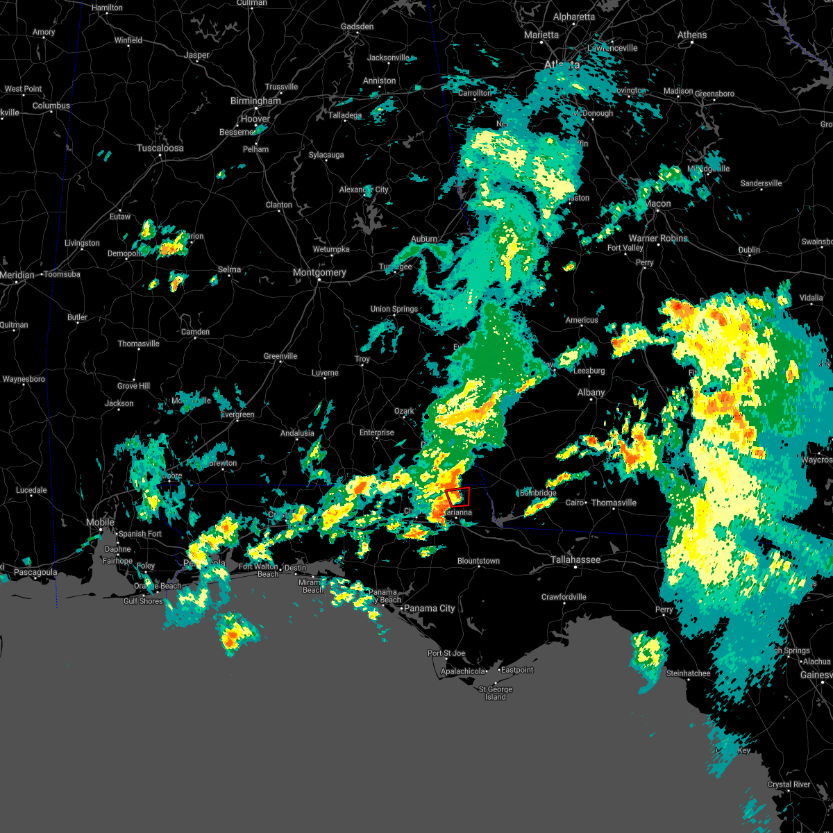 The tornado warning for north central jackson county will expire at 745 pm cdt, the storm which prompted the warning has weakened below severe limits, but we are still monitoring some weak rotation. the warning will be allowed to expire. however gusty winds are still possible with this thunderstorm. a tornado watch remains in effect until 1100 pm cdt for the panhandle of florida. The tornado warning for north central jackson county will expire at 745 pm cdt, the storm which prompted the warning has weakened below severe limits, but we are still monitoring some weak rotation. the warning will be allowed to expire. however gusty winds are still possible with this thunderstorm. a tornado watch remains in effect until 1100 pm cdt for the panhandle of florida.
|
| 8/24/2020 7:28 PM CDT |
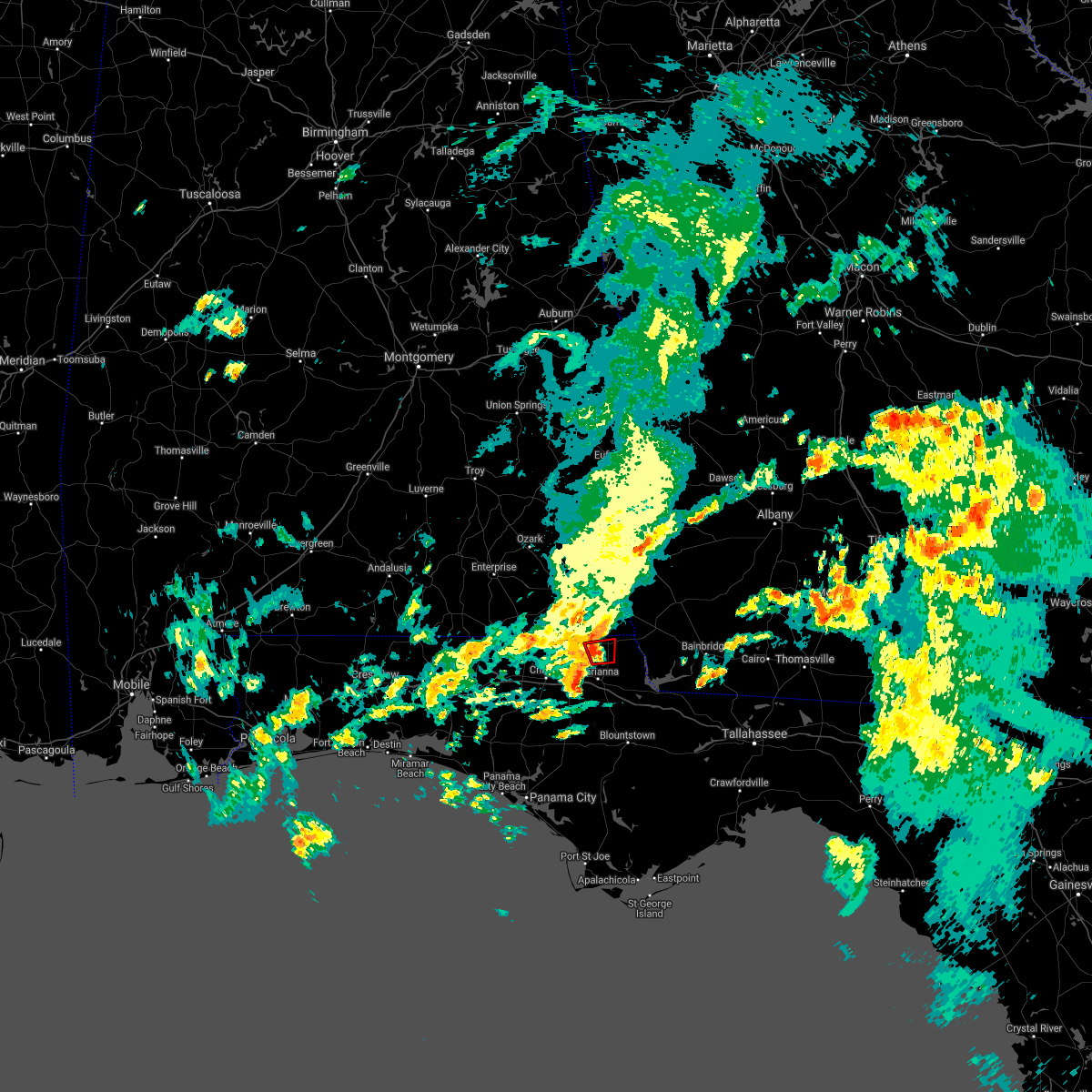 At 728 pm cdt, a severe thunderstorm capable of producing a tornado was located 9 miles southeast of cottonwood, moving north at 20 mph (radar indicated rotation). Hazards include tornado. Flying debris will be dangerous to those caught without shelter. mobile homes will be damaged or destroyed. damage to roofs, windows, and vehicles will occur. tree damage is likely. Locations impacted include, malone, greenwood and sills. At 728 pm cdt, a severe thunderstorm capable of producing a tornado was located 9 miles southeast of cottonwood, moving north at 20 mph (radar indicated rotation). Hazards include tornado. Flying debris will be dangerous to those caught without shelter. mobile homes will be damaged or destroyed. damage to roofs, windows, and vehicles will occur. tree damage is likely. Locations impacted include, malone, greenwood and sills.
|
| 8/24/2020 7:10 PM CDT |
 At 709 pm cdt, a severe thunderstorm capable of producing a tornado was located near marianna, moving north at 20 mph (radar indicated rotation). Hazards include tornado. Flying debris will be dangerous to those caught without shelter. mobile homes will be damaged or destroyed. damage to roofs, windows, and vehicles will occur. tree damage is likely. This tornadic thunderstorm will remain over mainly rural areas of north central jackson county, including the following locations, malone, bascom, greenwood, blue spring, chipola terrace, marianna municipal a/p and sills. At 709 pm cdt, a severe thunderstorm capable of producing a tornado was located near marianna, moving north at 20 mph (radar indicated rotation). Hazards include tornado. Flying debris will be dangerous to those caught without shelter. mobile homes will be damaged or destroyed. damage to roofs, windows, and vehicles will occur. tree damage is likely. This tornadic thunderstorm will remain over mainly rural areas of north central jackson county, including the following locations, malone, bascom, greenwood, blue spring, chipola terrace, marianna municipal a/p and sills.
|
| 8/11/2020 2:05 PM CDT | Several trees reported dow in jackson county FL, 0.1 miles SE of Malone, FL |
| 8/11/2020 1:57 PM CDT |
 At 157 pm cdt, severe thunderstorms were located along a line extending from near cottonwood to 12 miles northwest of chattahoochee, moving southwest at 20 mph (radar indicated). Hazards include 60 mph wind gusts. expect damage to roofs, siding, and trees At 157 pm cdt, severe thunderstorms were located along a line extending from near cottonwood to 12 miles northwest of chattahoochee, moving southwest at 20 mph (radar indicated). Hazards include 60 mph wind gusts. expect damage to roofs, siding, and trees
|
| 7/22/2020 5:25 PM CDT | Tree down near the intersection of us-2 and old us roa in jackson county FL, 4.8 miles E of Malone, FL |
| 7/22/2020 5:15 PM CDT |
 At 615 pm edt/515 pm cdt/, severe thunderstorms were located along a line extending from 12 miles southwest of donalsonville to 6 miles south of wewahitchka, moving northwest at 30 mph (radar indicated). Hazards include 60 mph wind gusts. Expect damage to roofs, siding, and trees. Locations impacted include, blountstown, stonemill creek, malone, wewahitchka, grand ridge, greenwood, altha, bascom, honeyville, clarksville, ocheesee, selman, abe springs, chipola cutoff, blue spring, union city, chipola, henderson mill, lovedale and scotts ferry. At 615 pm edt/515 pm cdt/, severe thunderstorms were located along a line extending from 12 miles southwest of donalsonville to 6 miles south of wewahitchka, moving northwest at 30 mph (radar indicated). Hazards include 60 mph wind gusts. Expect damage to roofs, siding, and trees. Locations impacted include, blountstown, stonemill creek, malone, wewahitchka, grand ridge, greenwood, altha, bascom, honeyville, clarksville, ocheesee, selman, abe springs, chipola cutoff, blue spring, union city, chipola, henderson mill, lovedale and scotts ferry.
|
| 7/22/2020 5:06 PM CDT |
 At 506 pm cdt, severe thunderstorms were located along a line extending from 11 miles southwest of donalsonville to near wewahitchka, moving northwest at 20 mph. these storms have a history of blowing down trees and power lines (radar indicated). Hazards include 60 mph wind gusts. expect damage to roofs, siding, and trees At 506 pm cdt, severe thunderstorms were located along a line extending from 11 miles southwest of donalsonville to near wewahitchka, moving northwest at 20 mph. these storms have a history of blowing down trees and power lines (radar indicated). Hazards include 60 mph wind gusts. expect damage to roofs, siding, and trees
|
| 7/22/2020 5:45 PM EDT |
 At 544 pm edt/444 pm cdt/, severe thunderstorms were located along a line extending from 10 miles southwest of west bainbridge to 9 miles west of carrabelle, moving west at 15 mph (radar indicated). Hazards include 60 mph wind gusts. Expect damage to roofs, siding, and trees. Locations impacted include, blountstown, stonemill creek, chattahoochee, greensboro, orange, malone, wewahitchka, sneads, gretna, bristol, grand ridge, greenwood, altha, bascom, rock bluff, honeyville, jewel fire tower, clarksville, vilas and chipola cutoff. At 544 pm edt/444 pm cdt/, severe thunderstorms were located along a line extending from 10 miles southwest of west bainbridge to 9 miles west of carrabelle, moving west at 15 mph (radar indicated). Hazards include 60 mph wind gusts. Expect damage to roofs, siding, and trees. Locations impacted include, blountstown, stonemill creek, chattahoochee, greensboro, orange, malone, wewahitchka, sneads, gretna, bristol, grand ridge, greenwood, altha, bascom, rock bluff, honeyville, jewel fire tower, clarksville, vilas and chipola cutoff.
|
| 7/22/2020 5:10 PM EDT |
 The national weather service in tallahassee has issued a * severe thunderstorm warning for. eastern jackson county in the panhandle of florida. northern gulf county in the panhandle of florida. calhoun county in the panhandle of florida. Western wakulla county in big bend of florida. The national weather service in tallahassee has issued a * severe thunderstorm warning for. eastern jackson county in the panhandle of florida. northern gulf county in the panhandle of florida. calhoun county in the panhandle of florida. Western wakulla county in big bend of florida.
|
| 7/1/2020 2:26 PM CDT |
 The severe thunderstorm warning for northeastern jackson, southwestern decatur and central seminole counties will expire at 330 pm edt/230 pm cdt/, the storm which prompted the warning has weakened below severe limits, and has exited the warned area. therefore, the warning will be allowed to expire. however gusty winds are still possible with this thunderstorm. The severe thunderstorm warning for northeastern jackson, southwestern decatur and central seminole counties will expire at 330 pm edt/230 pm cdt/, the storm which prompted the warning has weakened below severe limits, and has exited the warned area. therefore, the warning will be allowed to expire. however gusty winds are still possible with this thunderstorm.
|
| 7/1/2020 2:26 PM CDT |
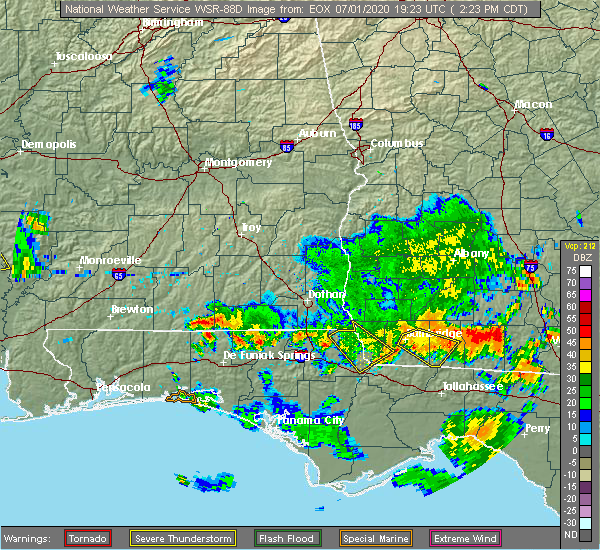 The severe thunderstorm warning for northeastern jackson, southwestern decatur and central seminole counties will expire at 330 pm edt/230 pm cdt/, the storm which prompted the warning has weakened below severe limits, and has exited the warned area. therefore, the warning will be allowed to expire. however gusty winds are still possible with this thunderstorm. The severe thunderstorm warning for northeastern jackson, southwestern decatur and central seminole counties will expire at 330 pm edt/230 pm cdt/, the storm which prompted the warning has weakened below severe limits, and has exited the warned area. therefore, the warning will be allowed to expire. however gusty winds are still possible with this thunderstorm.
|
| 7/1/2020 1:53 PM CDT |
 At 253 pm edt/153 pm cdt/, a severe thunderstorm was located 14 miles northeast of marianna, moving southeast at 30 mph (radar indicated). Hazards include 60 mph wind gusts. expect damage to roofs, siding, and trees At 253 pm edt/153 pm cdt/, a severe thunderstorm was located 14 miles northeast of marianna, moving southeast at 30 mph (radar indicated). Hazards include 60 mph wind gusts. expect damage to roofs, siding, and trees
|
| 7/1/2020 1:53 PM CDT |
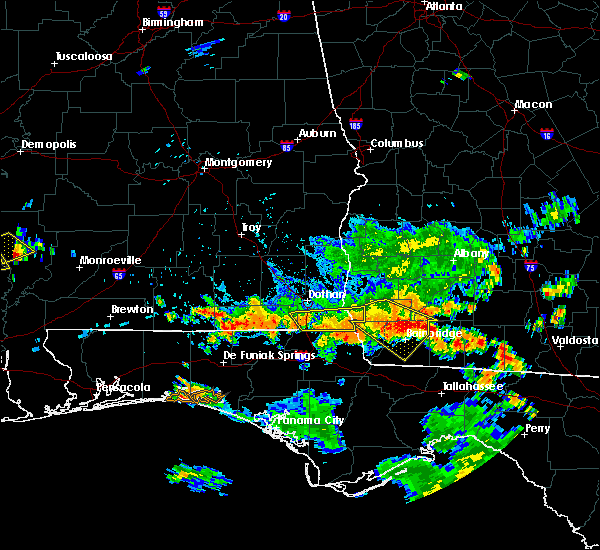 At 253 pm edt/153 pm cdt/, a severe thunderstorm was located 14 miles northeast of marianna, moving southeast at 30 mph (radar indicated). Hazards include 60 mph wind gusts. expect damage to roofs, siding, and trees At 253 pm edt/153 pm cdt/, a severe thunderstorm was located 14 miles northeast of marianna, moving southeast at 30 mph (radar indicated). Hazards include 60 mph wind gusts. expect damage to roofs, siding, and trees
|
| 6/23/2020 1:54 PM CDT |
 At 154 pm cdt, severe thunderstorms were located along a line extending from graceville to 6 miles south of chipley to 11 miles northwest of vernon to 9 miles south of de funiak springs to 13 miles east of eglin air force base to santa rosa beach, moving east at 30 mph (radar indicated). Hazards include 60 mph wind gusts. expect damage to roofs, siding, and trees At 154 pm cdt, severe thunderstorms were located along a line extending from graceville to 6 miles south of chipley to 11 miles northwest of vernon to 9 miles south of de funiak springs to 13 miles east of eglin air force base to santa rosa beach, moving east at 30 mph (radar indicated). Hazards include 60 mph wind gusts. expect damage to roofs, siding, and trees
|
| 4/23/2020 4:06 PM CDT |
 At 506 pm edt/406 pm cdt/, severe thunderstorms were located along a line extending from near columbia to near marianna to 11 miles southwest of panama city, moving east at 55 mph (radar indicated). Hazards include 60 mph wind gusts and quarter size hail. Hail damage to vehicles is expected. Expect wind damage to roofs, siding, and trees. At 506 pm edt/406 pm cdt/, severe thunderstorms were located along a line extending from near columbia to near marianna to 11 miles southwest of panama city, moving east at 55 mph (radar indicated). Hazards include 60 mph wind gusts and quarter size hail. Hail damage to vehicles is expected. Expect wind damage to roofs, siding, and trees.
|
| 4/23/2020 3:48 PM CDT |
 At 447 pm edt/347 pm cdt/, severe thunderstorms were located along a line extending from near cottonwood to 9 miles north of panama city beach, moving east at 55 mph (radar indicated). Hazards include 70 mph wind gusts and quarter size hail. Hail damage to vehicles is expected. expect considerable tree damage. wind damage is also likely to mobile homes, roofs, and outbuildings. Locations impacted include, lynn haven, cottonwood, vernon, bonifay, marianna, chipley, graceville, donalsonville, slocomb, bradford, live oak, malone, sneads, freeport, malvern, rehobeth, cottondale, grand ridge, greenwood and ponce de leon. At 447 pm edt/347 pm cdt/, severe thunderstorms were located along a line extending from near cottonwood to 9 miles north of panama city beach, moving east at 55 mph (radar indicated). Hazards include 70 mph wind gusts and quarter size hail. Hail damage to vehicles is expected. expect considerable tree damage. wind damage is also likely to mobile homes, roofs, and outbuildings. Locations impacted include, lynn haven, cottonwood, vernon, bonifay, marianna, chipley, graceville, donalsonville, slocomb, bradford, live oak, malone, sneads, freeport, malvern, rehobeth, cottondale, grand ridge, greenwood and ponce de leon.
|
| 4/23/2020 3:19 PM CDT |
 At 418 pm edt/318 pm cdt/, severe thunderstorms were located along a line extending from near hartford to near santa rosa beach, moving east at 55 mph (radar indicated). Hazards include 60 mph wind gusts and quarter size hail. Hail damage to vehicles is expected. Expect wind damage to roofs, siding, and trees. At 418 pm edt/318 pm cdt/, severe thunderstorms were located along a line extending from near hartford to near santa rosa beach, moving east at 55 mph (radar indicated). Hazards include 60 mph wind gusts and quarter size hail. Hail damage to vehicles is expected. Expect wind damage to roofs, siding, and trees.
|
| 4/23/2020 3:42 PM EDT |
 At 342 pm edt/242 pm cdt/, severe thunderstorms were located along a line extending from near colquitt to 7 miles southeast of chipley, moving east at 40 mph (radar indicated). Hazards include 60 mph wind gusts and penny size hail. expect damage to roofs, siding, and trees At 342 pm edt/242 pm cdt/, severe thunderstorms were located along a line extending from near colquitt to 7 miles southeast of chipley, moving east at 40 mph (radar indicated). Hazards include 60 mph wind gusts and penny size hail. expect damage to roofs, siding, and trees
|
| 4/23/2020 3:42 PM EDT |
 The national weather service in tallahassee has issued a * severe thunderstorm warning for. southeastern houston county in southeastern alabama. jackson county in the panhandle of florida. northeastern calhoun county in the panhandle of florida. Northern liberty county in big bend of florida. The national weather service in tallahassee has issued a * severe thunderstorm warning for. southeastern houston county in southeastern alabama. jackson county in the panhandle of florida. northeastern calhoun county in the panhandle of florida. Northern liberty county in big bend of florida.
|
| 4/23/2020 3:42 PM EDT |
 At 342 pm edt/242 pm cdt/, severe thunderstorms were located along a line extending from near colquitt to 7 miles southeast of chipley, moving east at 40 mph (radar indicated). Hazards include 60 mph wind gusts and penny size hail. expect damage to roofs, siding, and trees At 342 pm edt/242 pm cdt/, severe thunderstorms were located along a line extending from near colquitt to 7 miles southeast of chipley, moving east at 40 mph (radar indicated). Hazards include 60 mph wind gusts and penny size hail. expect damage to roofs, siding, and trees
|
| 4/23/2020 2:15 PM CDT |
 At 315 pm edt/215 pm cdt/, severe thunderstorms were located along a line extending from cottonwood to 7 miles southwest of chipley, moving east at 40 mph (radar indicated). Hazards include 60 mph wind gusts and penny size hail. expect damage to roofs, siding, and trees At 315 pm edt/215 pm cdt/, severe thunderstorms were located along a line extending from cottonwood to 7 miles southwest of chipley, moving east at 40 mph (radar indicated). Hazards include 60 mph wind gusts and penny size hail. expect damage to roofs, siding, and trees
|
| 4/23/2020 11:36 AM EDT |
 At 1135 am edt/1035 am cdt/, severe thunderstorms were located along a line extending from 8 miles southeast of arlington to 7 miles northeast of colquitt to 14 miles east of marianna, moving east at 55 mph (radar indicated). Hazards include 60 mph wind gusts and penny size hail. Expect damage to roofs, siding, and trees. Locations impacted include, colquitt, newton, donalsonville, marianna, bainbridge, arlington, douglasville, centerville, malone, greenwood, iron city, damascus, brinson, jakin, bascom, iveys mill, crosby, lovedale, dellwood and donaldsonville a/p. At 1135 am edt/1035 am cdt/, severe thunderstorms were located along a line extending from 8 miles southeast of arlington to 7 miles northeast of colquitt to 14 miles east of marianna, moving east at 55 mph (radar indicated). Hazards include 60 mph wind gusts and penny size hail. Expect damage to roofs, siding, and trees. Locations impacted include, colquitt, newton, donalsonville, marianna, bainbridge, arlington, douglasville, centerville, malone, greenwood, iron city, damascus, brinson, jakin, bascom, iveys mill, crosby, lovedale, dellwood and donaldsonville a/p.
|
| 4/23/2020 11:19 AM EDT |
 At 1118 am edt/1018 am cdt/, severe thunderstorms were located along a line extending from near blakely to 9 miles northwest of colquitt to 7 miles north of marianna, moving east at 55 mph (radar indicated). Hazards include 60 mph wind gusts and penny size hail. Expect damage to roofs, siding, and trees. Locations impacted include, colquitt, cottonwood, newton, blakely, donalsonville, marianna, bainbridge, ashford, arlington, columbia, douglasville, centerville, malone, greenwood, avon, madrid, gordon, iron city, damascus and campbellton. At 1118 am edt/1018 am cdt/, severe thunderstorms were located along a line extending from near blakely to 9 miles northwest of colquitt to 7 miles north of marianna, moving east at 55 mph (radar indicated). Hazards include 60 mph wind gusts and penny size hail. Expect damage to roofs, siding, and trees. Locations impacted include, colquitt, cottonwood, newton, blakely, donalsonville, marianna, bainbridge, ashford, arlington, columbia, douglasville, centerville, malone, greenwood, avon, madrid, gordon, iron city, damascus and campbellton.
|
| 4/23/2020 10:58 AM EDT |
 At 1057 am edt/957 am cdt/, severe thunderstorms were located along a line extending from 12 miles east of headland to near columbia to near graceville, moving east at 55 mph (radar indicated). Hazards include 60 mph wind gusts and quarter size hail. Hail damage to vehicles is expected. Expect wind damage to roofs, siding, and trees. At 1057 am edt/957 am cdt/, severe thunderstorms were located along a line extending from 12 miles east of headland to near columbia to near graceville, moving east at 55 mph (radar indicated). Hazards include 60 mph wind gusts and quarter size hail. Hail damage to vehicles is expected. Expect wind damage to roofs, siding, and trees.
|
| 4/23/2020 9:52 AM CDT |
 At 1052 am edt/952 am cdt/, severe thunderstorms were located along a line extending from near webb to near taylor to 7 miles west of graceville to near bonifay, moving east at 50 mph (radar indicated). Hazards include 60 mph wind gusts and quarter size hail. Hail damage to vehicles is expected. expect wind damage to roofs, siding, and trees. Locations impacted include, cottonwood, bonifay, chipley, graceville, dothan, headland, hartford, taylor, midland city, kinsey, ashford, slocomb, cowarts, webb, columbia, centerville, malone, malvern, rehobeth and cottondale. At 1052 am edt/952 am cdt/, severe thunderstorms were located along a line extending from near webb to near taylor to 7 miles west of graceville to near bonifay, moving east at 50 mph (radar indicated). Hazards include 60 mph wind gusts and quarter size hail. Hail damage to vehicles is expected. expect wind damage to roofs, siding, and trees. Locations impacted include, cottonwood, bonifay, chipley, graceville, dothan, headland, hartford, taylor, midland city, kinsey, ashford, slocomb, cowarts, webb, columbia, centerville, malone, malvern, rehobeth and cottondale.
|
| 4/23/2020 9:22 AM CDT |
 At 1021 am edt/921 am cdt/, severe thunderstorms were located along a line extending from daleville to 8 miles north of geneva to 7 miles south of samson to 10 miles north of de funiak springs, moving east at 50 mph (radar indicated). Hazards include 70 mph wind gusts and ping pong ball size hail. People and animals outdoors will be injured. expect hail damage to roofs, siding, windows, and vehicles. expect considerable tree damage. Wind damage is also likely to mobile homes, roofs, and outbuildings. At 1021 am edt/921 am cdt/, severe thunderstorms were located along a line extending from daleville to 8 miles north of geneva to 7 miles south of samson to 10 miles north of de funiak springs, moving east at 50 mph (radar indicated). Hazards include 70 mph wind gusts and ping pong ball size hail. People and animals outdoors will be injured. expect hail damage to roofs, siding, windows, and vehicles. expect considerable tree damage. Wind damage is also likely to mobile homes, roofs, and outbuildings.
|
| 4/20/2020 12:39 AM CDT |
 The severe thunderstorm warning for eastern geneva, houston, jackson, central holmes, northeastern washington, west central miller, southwestern early and northwestern seminole counties will expire at 145 am edt/1245 am cdt/, the storms which prompted the warning have moved out of the area. therefore, the warning will be allowed to expire. a tornado watch remains in effect until 700 am edt/600 am cdt/ for southeastern alabama, the panhandle of florida, and southwestern georgia. to report severe weather, contact your nearest law enforcement agency. they will relay your report to the national weather service tallahassee. The severe thunderstorm warning for eastern geneva, houston, jackson, central holmes, northeastern washington, west central miller, southwestern early and northwestern seminole counties will expire at 145 am edt/1245 am cdt/, the storms which prompted the warning have moved out of the area. therefore, the warning will be allowed to expire. a tornado watch remains in effect until 700 am edt/600 am cdt/ for southeastern alabama, the panhandle of florida, and southwestern georgia. to report severe weather, contact your nearest law enforcement agency. they will relay your report to the national weather service tallahassee.
|
| 4/20/2020 1:26 AM EDT |
 At 126 am edt/1226 am cdt/, severe thunderstorms were located along a line extending from near colquitt to 9 miles west of donalsonville to near marianna to 6 miles southeast of chipley, moving east at 35 mph (radar indicated). Hazards include 70 mph wind gusts. Expect considerable tree damage. Damage is likely to mobile homes, roofs, and outbuildings. At 126 am edt/1226 am cdt/, severe thunderstorms were located along a line extending from near colquitt to 9 miles west of donalsonville to near marianna to 6 miles southeast of chipley, moving east at 35 mph (radar indicated). Hazards include 70 mph wind gusts. Expect considerable tree damage. Damage is likely to mobile homes, roofs, and outbuildings.
|
| 4/19/2020 11:55 PM CDT |
 At 1155 pm cdt, a severe thunderstorm capable of producing a tornado was located near graceville, moving east at 45 mph (radar indicated rotation). Hazards include tornado. Flying debris will be dangerous to those caught without shelter. mobile homes will be damaged or destroyed. damage to roofs, windows, and vehicles will occur. tree damage is likely. this dangerous storm will be near, graceville around 1200 am cdt. cottonwood around 1215 am cdt. Other locations impacted by this tornadic thunderstorm include malone, fadette, pansey, grangeburg, garretts crossroads, tendil crossing, lovetown, southern junction, sealy springs and noma. At 1155 pm cdt, a severe thunderstorm capable of producing a tornado was located near graceville, moving east at 45 mph (radar indicated rotation). Hazards include tornado. Flying debris will be dangerous to those caught without shelter. mobile homes will be damaged or destroyed. damage to roofs, windows, and vehicles will occur. tree damage is likely. this dangerous storm will be near, graceville around 1200 am cdt. cottonwood around 1215 am cdt. Other locations impacted by this tornadic thunderstorm include malone, fadette, pansey, grangeburg, garretts crossroads, tendil crossing, lovetown, southern junction, sealy springs and noma.
|
| 4/19/2020 11:49 PM CDT |
 At 1249 am edt/1149 pm cdt/, severe thunderstorms were located along a line extending from near slocomb to 8 miles west of bonifay, moving east at 40 mph (radar indicated). Hazards include 60 mph wind gusts. expect damage to roofs, siding, and trees At 1249 am edt/1149 pm cdt/, severe thunderstorms were located along a line extending from near slocomb to 8 miles west of bonifay, moving east at 40 mph (radar indicated). Hazards include 60 mph wind gusts. expect damage to roofs, siding, and trees
|
| 4/13/2020 4:04 AM CDT |
 At 504 am edt/404 am cdt/, a severe thunderstorm was located near marianna, moving east at 50 mph (radar indicated). Hazards include 60 mph wind gusts and penny size hail. expect damage to roofs, siding, and trees At 504 am edt/404 am cdt/, a severe thunderstorm was located near marianna, moving east at 50 mph (radar indicated). Hazards include 60 mph wind gusts and penny size hail. expect damage to roofs, siding, and trees
|
| 4/13/2020 3:45 AM CDT |
 At 445 am edt/345 am cdt/, a severe thunderstorm was located 8 miles northeast of marianna, moving east at 55 mph (radar indicated). Hazards include 60 mph wind gusts. Expect damage to roofs, siding, and trees. Locations impacted include, panama city, lynn haven, panama city beach, callaway, vernon, marianna, chipley, donalsonville, graceville, springfield, hiland park, tyndall air force base, bradford, parker, malone, cottondale, grand ridge, greenwood, altha and alford. At 445 am edt/345 am cdt/, a severe thunderstorm was located 8 miles northeast of marianna, moving east at 55 mph (radar indicated). Hazards include 60 mph wind gusts. Expect damage to roofs, siding, and trees. Locations impacted include, panama city, lynn haven, panama city beach, callaway, vernon, marianna, chipley, donalsonville, graceville, springfield, hiland park, tyndall air force base, bradford, parker, malone, cottondale, grand ridge, greenwood, altha and alford.
|
| 4/13/2020 3:09 AM CDT |
 At 409 am edt/309 am cdt/, a severe thunderstorm was located near vernon, moving east at 55 mph (radar indicated). Hazards include 60 mph wind gusts. expect damage to roofs, siding, and trees At 409 am edt/309 am cdt/, a severe thunderstorm was located near vernon, moving east at 55 mph (radar indicated). Hazards include 60 mph wind gusts. expect damage to roofs, siding, and trees
|
| 4/13/2020 2:54 AM CDT |
 At 254 am cdt, a severe thunderstorm was located over graceville, moving east at 55 mph (radar indicated). Hazards include 60 mph wind gusts and penny size hail. Expect damage to roofs, siding, and trees. Locations impacted include, panama city beach, vernon, chipley, graceville, santa rosa beach, bonifay, eglin air force base, bradford, live oak, malone, freeport, cottondale, ponce de leon, alford, caryville, wausau, esto, westville, ebro and campbellton. At 254 am cdt, a severe thunderstorm was located over graceville, moving east at 55 mph (radar indicated). Hazards include 60 mph wind gusts and penny size hail. Expect damage to roofs, siding, and trees. Locations impacted include, panama city beach, vernon, chipley, graceville, santa rosa beach, bonifay, eglin air force base, bradford, live oak, malone, freeport, cottondale, ponce de leon, alford, caryville, wausau, esto, westville, ebro and campbellton.
|
| 4/13/2020 2:22 AM CDT |
 At 222 am cdt, a severe thunderstorm was located 11 miles northeast of de funiak springs, moving east at 55 mph (radar indicated). Hazards include 60 mph wind gusts and penny size hail. expect damage to roofs, siding, and trees At 222 am cdt, a severe thunderstorm was located 11 miles northeast of de funiak springs, moving east at 55 mph (radar indicated). Hazards include 60 mph wind gusts and penny size hail. expect damage to roofs, siding, and trees
|
| 4/8/2020 8:06 PM EDT |
 The severe thunderstorm warning for southeastern houston, northeastern jackson, southwestern miller, southwestern early and seminole counties will expire at 815 pm edt/715 pm cdt/, the storm which prompted the warning has weakened below severe limits, and no longer poses an immediate threat to life or property. therefore, the warning will be allowed to expire. however gusty winds are still possible with this thunderstorm. The severe thunderstorm warning for southeastern houston, northeastern jackson, southwestern miller, southwestern early and seminole counties will expire at 815 pm edt/715 pm cdt/, the storm which prompted the warning has weakened below severe limits, and no longer poses an immediate threat to life or property. therefore, the warning will be allowed to expire. however gusty winds are still possible with this thunderstorm.
|
| 4/8/2020 7:47 PM EDT |
 At 747 pm edt/647 pm cdt/, a severe thunderstorm was located 7 miles east of cottonwood, moving east at 55 mph (radar indicated). Hazards include 60 mph wind gusts and quarter size hail. Hail damage to vehicles is expected. expect wind damage to roofs, siding, and trees. Locations impacted include, cottonwood, donalsonville, malone, gordon, iron city, jakin, bascom, saffold, pansey, crosby, grangeburg, little hope, mayhaw, riverturn, sharphagen, hornsville, donaldsonville a/p, steam mill, howards mill and davis park. At 747 pm edt/647 pm cdt/, a severe thunderstorm was located 7 miles east of cottonwood, moving east at 55 mph (radar indicated). Hazards include 60 mph wind gusts and quarter size hail. Hail damage to vehicles is expected. expect wind damage to roofs, siding, and trees. Locations impacted include, cottonwood, donalsonville, malone, gordon, iron city, jakin, bascom, saffold, pansey, crosby, grangeburg, little hope, mayhaw, riverturn, sharphagen, hornsville, donaldsonville a/p, steam mill, howards mill and davis park.
|
| 4/8/2020 6:37 PM CDT |
 At 737 pm edt/637 pm cdt/, a severe thunderstorm was located near cottonwood, moving east at 55 mph (radar indicated). Hazards include 60 mph wind gusts and quarter size hail. Hail damage to vehicles is expected. expect wind damage to roofs, siding, and trees. Locations impacted include, cottonwood, graceville, donalsonville, malone, greenwood, madrid, gordon, iron city, campbellton, jakin, bascom, memphis, saffold, reynoldsville, pansey, crosby, grangeburg, garretts crossroads, little hope and southern junction. At 737 pm edt/637 pm cdt/, a severe thunderstorm was located near cottonwood, moving east at 55 mph (radar indicated). Hazards include 60 mph wind gusts and quarter size hail. Hail damage to vehicles is expected. expect wind damage to roofs, siding, and trees. Locations impacted include, cottonwood, graceville, donalsonville, malone, greenwood, madrid, gordon, iron city, campbellton, jakin, bascom, memphis, saffold, reynoldsville, pansey, crosby, grangeburg, garretts crossroads, little hope and southern junction.
|
| 4/8/2020 7:29 PM EDT |
 At 729 pm edt/629 pm cdt/, a severe thunderstorm was located near graceville, moving east at 55 mph (radar indicated). Hazards include 60 mph wind gusts and quarter size hail. Hail damage to vehicles is expected. Expect wind damage to roofs, siding, and trees. At 729 pm edt/629 pm cdt/, a severe thunderstorm was located near graceville, moving east at 55 mph (radar indicated). Hazards include 60 mph wind gusts and quarter size hail. Hail damage to vehicles is expected. Expect wind damage to roofs, siding, and trees.
|
| 3/31/2020 1:12 PM CDT |
 At 212 pm edt/112 pm cdt/, severe thunderstorms were located along a line extending from 8 miles northwest of west bainbridge to 13 miles west of panama city beach, moving east at 45 mph (radar indicated). Hazards include 60 mph wind gusts. expect damage to roofs, siding, and trees At 212 pm edt/112 pm cdt/, severe thunderstorms were located along a line extending from 8 miles northwest of west bainbridge to 13 miles west of panama city beach, moving east at 45 mph (radar indicated). Hazards include 60 mph wind gusts. expect damage to roofs, siding, and trees
|
| 3/31/2020 12:14 PM CDT |
 At 114 pm edt/1214 pm cdt/, severe thunderstorms were located along a line extending from near taylor to 12 miles southwest of baker, moving southeast at 50 mph (radar indicated). Hazards include 60 mph wind gusts. expect damage to roofs, siding, and trees At 114 pm edt/1214 pm cdt/, severe thunderstorms were located along a line extending from near taylor to 12 miles southwest of baker, moving southeast at 50 mph (radar indicated). Hazards include 60 mph wind gusts. expect damage to roofs, siding, and trees
|
| 2/6/2020 1:20 PM CST | Multiple trees down in malone... fl. report came from media. time estimated by rada in jackson county FL, 0.1 miles SE of Malone, FL |
| 1/11/2020 6:14 PM CST |
 At 713 pm est/613 pm cst/, a severe thunderstorm was located over marianna, moving northeast at 40 mph (radar indicated). Hazards include 60 mph wind gusts. Expect damage to roofs, siding, and trees. Locations impacted include, donalsonville, marianna, malone, cottondale, grand ridge, greenwood, iron city, bascom, little hope, blue spring, union city, lovedale, dellwood, riverturn, star, sharphagen, hornsville, donaldsonville a/p, compass lake and buena vista. At 713 pm est/613 pm cst/, a severe thunderstorm was located over marianna, moving northeast at 40 mph (radar indicated). Hazards include 60 mph wind gusts. Expect damage to roofs, siding, and trees. Locations impacted include, donalsonville, marianna, malone, cottondale, grand ridge, greenwood, iron city, bascom, little hope, blue spring, union city, lovedale, dellwood, riverturn, star, sharphagen, hornsville, donaldsonville a/p, compass lake and buena vista.
|
| 1/11/2020 5:38 PM CST |
 At 638 pm est/538 pm cst/, severe thunderstorms were located along a line extending from 7 miles southeast of cottonwood to 7 miles southeast of vernon, moving northeast at 40 mph (radar indicated). Hazards include 60 mph wind gusts. expect damage to roofs, siding, and trees At 638 pm est/538 pm cst/, severe thunderstorms were located along a line extending from 7 miles southeast of cottonwood to 7 miles southeast of vernon, moving northeast at 40 mph (radar indicated). Hazards include 60 mph wind gusts. expect damage to roofs, siding, and trees
|
| 6/24/2019 4:00 PM CDT |
 At 336 pm cdt, a severe thunderstorm was located near marianna, moving northeast at 30 mph (radar indicated). Hazards include 60 mph wind gusts. Expect damage to roofs, siding, and trees. Locations impacted include, marianna, malone, cottondale, greenwood, alford, campbellton, bascom, jacob city, kynesville, blue spring, steele city, star, round lake, two egg, simsville, cypress, cottondale airport, jacobs, chipola terrace and ellaville. At 336 pm cdt, a severe thunderstorm was located near marianna, moving northeast at 30 mph (radar indicated). Hazards include 60 mph wind gusts. Expect damage to roofs, siding, and trees. Locations impacted include, marianna, malone, cottondale, greenwood, alford, campbellton, bascom, jacob city, kynesville, blue spring, steele city, star, round lake, two egg, simsville, cypress, cottondale airport, jacobs, chipola terrace and ellaville.
|
| 6/24/2019 3:36 PM CDT |
 At 336 pm cdt, a severe thunderstorm was located near marianna, moving northeast at 30 mph (radar indicated). Hazards include 60 mph wind gusts. Expect damage to roofs, siding, and trees. Locations impacted include, marianna, malone, cottondale, greenwood, alford, campbellton, bascom, jacob city, kynesville, blue spring, steele city, star, round lake, two egg, simsville, cypress, cottondale airport, jacobs, chipola terrace and ellaville. At 336 pm cdt, a severe thunderstorm was located near marianna, moving northeast at 30 mph (radar indicated). Hazards include 60 mph wind gusts. Expect damage to roofs, siding, and trees. Locations impacted include, marianna, malone, cottondale, greenwood, alford, campbellton, bascom, jacob city, kynesville, blue spring, steele city, star, round lake, two egg, simsville, cypress, cottondale airport, jacobs, chipola terrace and ellaville.
|
| 6/24/2019 3:23 PM CDT |
 At 323 pm cdt, severe thunderstorms were located along a line extending from graceville to near chipley, moving northeast at 30 mph (radar indicated). Hazards include 60 mph wind gusts. expect damage to roofs, siding, and trees At 323 pm cdt, severe thunderstorms were located along a line extending from graceville to near chipley, moving northeast at 30 mph (radar indicated). Hazards include 60 mph wind gusts. expect damage to roofs, siding, and trees
|
| 5/4/2019 6:41 PM CDT |
 At 641 pm cdt, a severe thunderstorm was located 7 miles northeast of marianna, moving northeast at 40 mph (radar indicated). Hazards include 60 mph wind gusts. Expect damage to roofs, siding, and trees. Locations impacted include, marianna, malone, greenwood, bascom, blue spring, lovedale, haynes, dellwood, star, two egg, hornsville, chipola terrace, buena vista and marianna municipal a/p. At 641 pm cdt, a severe thunderstorm was located 7 miles northeast of marianna, moving northeast at 40 mph (radar indicated). Hazards include 60 mph wind gusts. Expect damage to roofs, siding, and trees. Locations impacted include, marianna, malone, greenwood, bascom, blue spring, lovedale, haynes, dellwood, star, two egg, hornsville, chipola terrace, buena vista and marianna municipal a/p.
|
| 5/4/2019 6:24 PM CDT |
 At 624 pm cdt, a severe thunderstorm was located near marianna, moving northeast at 40 mph (radar indicated). Hazards include 60 mph wind gusts. expect damage to roofs, siding, and trees At 624 pm cdt, a severe thunderstorm was located near marianna, moving northeast at 40 mph (radar indicated). Hazards include 60 mph wind gusts. expect damage to roofs, siding, and trees
|
| 4/19/2019 6:16 AM CDT |
 At 616 am cdt, a severe thunderstorm was located 12 miles southeast of cottonwood, moving northeast at 50 mph (radar indicated). Hazards include 60 mph wind gusts. Expect damage to roofs, siding, and trees. locations impacted include, marianna, malone, greenwood, bascom, dellwood, two egg, blue spring, chipola terrace, buena vista, marianna municipal a/p, sills and lovedale. A tornado watch remains in effect until 800 am cdt for the panhandle of florida, and southwestern georgia. At 616 am cdt, a severe thunderstorm was located 12 miles southeast of cottonwood, moving northeast at 50 mph (radar indicated). Hazards include 60 mph wind gusts. Expect damage to roofs, siding, and trees. locations impacted include, marianna, malone, greenwood, bascom, dellwood, two egg, blue spring, chipola terrace, buena vista, marianna municipal a/p, sills and lovedale. A tornado watch remains in effect until 800 am cdt for the panhandle of florida, and southwestern georgia.
|
| 4/19/2019 6:15 AM CDT |
 At 715 am edt/615 am cdt/, a severe thunderstorm was located near cottonwood, moving north at 45 mph (radar indicated). Hazards include 60 mph wind gusts. expect damage to roofs, siding, and trees At 715 am edt/615 am cdt/, a severe thunderstorm was located near cottonwood, moving north at 45 mph (radar indicated). Hazards include 60 mph wind gusts. expect damage to roofs, siding, and trees
|
| 4/19/2019 6:06 AM CDT |
 At 606 am cdt, a severe thunderstorm was located near marianna, moving east at 50 mph (radar indicated). Hazards include 60 mph wind gusts. Expect damage to roofs, siding, and trees. locations impacted include, chipley, marianna, bradford, malone, cottondale, grand ridge, greenwood, altha, alford, wausau, bascom, richter crossroads, blue spring, union city, henderson mill, lovedale, dellwood, star, hornsville and jacobs. A tornado watch remains in effect until 800 am cdt for the panhandle of florida, and southwestern georgia. At 606 am cdt, a severe thunderstorm was located near marianna, moving east at 50 mph (radar indicated). Hazards include 60 mph wind gusts. Expect damage to roofs, siding, and trees. locations impacted include, chipley, marianna, bradford, malone, cottondale, grand ridge, greenwood, altha, alford, wausau, bascom, richter crossroads, blue spring, union city, henderson mill, lovedale, dellwood, star, hornsville and jacobs. A tornado watch remains in effect until 800 am cdt for the panhandle of florida, and southwestern georgia.
|
| 4/19/2019 5:38 AM CDT |
 At 538 am cdt, doppler radar indicated a severe thunderstorm capable of producing damaging winds in excess of 60 mph. this storm was located 9 miles south of chipley, and moving northeast at 50 mph. At 538 am cdt, doppler radar indicated a severe thunderstorm capable of producing damaging winds in excess of 60 mph. this storm was located 9 miles south of chipley, and moving northeast at 50 mph.
|
| 3/3/2019 4:37 PM CST |
 At 437 pm cst, severe thunderstorms were located along a line extending from 9 miles south of hartford to near destin, moving east at 45 mph (radar indicated). Hazards include 60 mph wind gusts. expect damage to roofs, siding, and trees At 437 pm cst, severe thunderstorms were located along a line extending from 9 miles south of hartford to near destin, moving east at 45 mph (radar indicated). Hazards include 60 mph wind gusts. expect damage to roofs, siding, and trees
|
| 1/23/2019 8:30 PM CST |
 At 830 pm cst, severe thunderstorms were located along a line extending from 6 miles south of cottonwood to 15 miles west of blountstown, moving east at 45 mph (radar indicated). Hazards include 60 mph wind gusts. Expect damage to roofs, siding, and trees. Locations impacted include, marianna, chattahoochee, malone, sneads, cottondale, grand ridge, greenwood, altha, campbellton, bascom, moose pond, ocheesee, blue spring, union city, chipola, henderson mill, camps head, lovedale, dellwood and star. At 830 pm cst, severe thunderstorms were located along a line extending from 6 miles south of cottonwood to 15 miles west of blountstown, moving east at 45 mph (radar indicated). Hazards include 60 mph wind gusts. Expect damage to roofs, siding, and trees. Locations impacted include, marianna, chattahoochee, malone, sneads, cottondale, grand ridge, greenwood, altha, campbellton, bascom, moose pond, ocheesee, blue spring, union city, chipola, henderson mill, camps head, lovedale, dellwood and star.
|
| 1/23/2019 8:04 PM CST |
 At 804 pm cst, severe thunderstorms were located along a line extending from 7 miles south of hartford to near vernon, moving northeast at 45 mph (radar indicated). Hazards include 60 mph wind gusts. expect damage to roofs, siding, and trees At 804 pm cst, severe thunderstorms were located along a line extending from 7 miles south of hartford to near vernon, moving northeast at 45 mph (radar indicated). Hazards include 60 mph wind gusts. expect damage to roofs, siding, and trees
|
| 1/19/2019 6:06 PM CST |
 At 605 pm cst, severe thunderstorms were located along a line extending from 11 miles northeast of marianna to 16 miles southeast of chipley, moving northeast at 55 mph (radar indicated). Hazards include 60 mph wind gusts. expect damage to roofs, siding, and trees At 605 pm cst, severe thunderstorms were located along a line extending from 11 miles northeast of marianna to 16 miles southeast of chipley, moving northeast at 55 mph (radar indicated). Hazards include 60 mph wind gusts. expect damage to roofs, siding, and trees
|
| 12/2/2018 7:16 AM CST |
 At 816 am est/716 am cst/, a severe thunderstorm was located 13 miles northeast of marianna, moving northeast at 50 mph (radar indicated). Hazards include 60 mph wind gusts. Expect damage to roofs, siding, and trees. locations impacted include, donalsonville, malone, greenwood, bascom, steam mill, crosby, little hope, lela, lovedale, riverturn, two egg, hornsville, donaldsonville a/p, chattahoochee sp, lucy and buena vista. A tornado watch remains in effect until 1100 am est/1000 am cst/ for southeastern alabama, and southwestern georgia. At 816 am est/716 am cst/, a severe thunderstorm was located 13 miles northeast of marianna, moving northeast at 50 mph (radar indicated). Hazards include 60 mph wind gusts. Expect damage to roofs, siding, and trees. locations impacted include, donalsonville, malone, greenwood, bascom, steam mill, crosby, little hope, lela, lovedale, riverturn, two egg, hornsville, donaldsonville a/p, chattahoochee sp, lucy and buena vista. A tornado watch remains in effect until 1100 am est/1000 am cst/ for southeastern alabama, and southwestern georgia.
|
| 12/2/2018 7:03 AM CST |
 At 803 am est/703 am cst/, a severe thunderstorm was located near marianna, moving northeast at 35 mph (radar indicated). Hazards include 60 mph wind gusts. expect damage to roofs, siding, and trees At 803 am est/703 am cst/, a severe thunderstorm was located near marianna, moving northeast at 35 mph (radar indicated). Hazards include 60 mph wind gusts. expect damage to roofs, siding, and trees
|
| 11/25/2018 8:52 PM CST |
 At 852 pm cst, a severe thunderstorm was located 9 miles east of graceville, moving northeast at 50 mph (radar indicated). Hazards include quarter size hail. Damage to vehicles is expected. Locations impacted include, malone, greenwood, campbellton, jacob city, jacobs, browntown, ellaville, marianna municipal a/p and sills. At 852 pm cst, a severe thunderstorm was located 9 miles east of graceville, moving northeast at 50 mph (radar indicated). Hazards include quarter size hail. Damage to vehicles is expected. Locations impacted include, malone, greenwood, campbellton, jacob city, jacobs, browntown, ellaville, marianna municipal a/p and sills.
|
| 11/25/2018 8:36 PM CST |
 At 836 pm cst, a severe thunderstorm was located near chipley, moving northeast at 50 mph (radar indicated). Hazards include quarter size hail. damage to vehicles is expected At 836 pm cst, a severe thunderstorm was located near chipley, moving northeast at 50 mph (radar indicated). Hazards include quarter size hail. damage to vehicles is expected
|
| 9/3/2018 4:50 PM CDT |
 The severe thunderstorm warning for central jackson and southwestern seminole counties will expire at 600 pm edt/500 pm cdt/, the storm which prompted the warning has weakened below severe limits, and no longer poses an immediate threat to life or property. therefore, the warning will be allowed to expire. however gusty winds are still possible with this thunderstorm. The severe thunderstorm warning for central jackson and southwestern seminole counties will expire at 600 pm edt/500 pm cdt/, the storm which prompted the warning has weakened below severe limits, and no longer poses an immediate threat to life or property. therefore, the warning will be allowed to expire. however gusty winds are still possible with this thunderstorm.
|
| 9/3/2018 4:30 PM CDT |
 At 529 pm edt/429 pm cdt/, doppler radar indicated a severe thunderstorm capable of producing damaging winds in excess of 60 mph. this storm was located 9 miles east of marianna, and moving west at 30 mph. At 529 pm edt/429 pm cdt/, doppler radar indicated a severe thunderstorm capable of producing damaging winds in excess of 60 mph. this storm was located 9 miles east of marianna, and moving west at 30 mph.
|
| 7/26/2018 6:50 PM CDT |
 The severe thunderstorm warning for jackson, eastern holmes and northeastern washington counties will expire at 700 pm cdt, the storm which prompted the warning has weakened below severe limits, and no longer poses an immediate threat to life or property. therefore, the warning will be allowed to expire. however gusty winds and heavy rain are still possible with this thunderstorm. The severe thunderstorm warning for jackson, eastern holmes and northeastern washington counties will expire at 700 pm cdt, the storm which prompted the warning has weakened below severe limits, and no longer poses an immediate threat to life or property. therefore, the warning will be allowed to expire. however gusty winds and heavy rain are still possible with this thunderstorm.
|
| 7/26/2018 6:19 PM CDT |
 At 618 pm cdt, a severe thunderstorm was located over graceville, moving southeast at 5 mph (radar indicated). Hazards include 60 mph wind gusts. expect damage to roofs, siding, and trees At 618 pm cdt, a severe thunderstorm was located over graceville, moving southeast at 5 mph (radar indicated). Hazards include 60 mph wind gusts. expect damage to roofs, siding, and trees
|
| 6/28/2018 7:10 PM CDT |
 At 810 pm edt/710 pm cdt/, severe thunderstorms were located along a line extending from 7 miles southwest of donalsonville to 8 miles southeast of chipley, moving south at 40 mph (radar indicated). Hazards include 60 mph wind gusts. Expect damage to roofs, siding, and trees. Locations impacted include, blountstown, marianna, greensboro, chattahoochee, malone, sneads, bristol, cottondale, grand ridge, greenwood, altha, alford, bascom, rock bluff, moose pond, clarksville, ocheesee, juniper, selman and abe springs. At 810 pm edt/710 pm cdt/, severe thunderstorms were located along a line extending from 7 miles southwest of donalsonville to 8 miles southeast of chipley, moving south at 40 mph (radar indicated). Hazards include 60 mph wind gusts. Expect damage to roofs, siding, and trees. Locations impacted include, blountstown, marianna, greensboro, chattahoochee, malone, sneads, bristol, cottondale, grand ridge, greenwood, altha, alford, bascom, rock bluff, moose pond, clarksville, ocheesee, juniper, selman and abe springs.
|
| 6/28/2018 6:54 PM CDT |
 At 754 pm edt/654 pm cdt/, severe thunderstorms were located along a line extending from 6 miles west of donalsonville to 7 miles southeast of graceville, moving south at 40 mph (radar indicated). Hazards include 60 mph wind gusts. expect damage to roofs, siding, and trees At 754 pm edt/654 pm cdt/, severe thunderstorms were located along a line extending from 6 miles west of donalsonville to 7 miles southeast of graceville, moving south at 40 mph (radar indicated). Hazards include 60 mph wind gusts. expect damage to roofs, siding, and trees
|
| 2/7/2018 12:09 PM CST |
 At 109 pm est/1209 pm cst/, a severe thunderstorm was located near cottonwood, moving east at 35 mph (radar indicated). Hazards include 60 mph wind gusts. expect damage to roofs, siding, and trees At 109 pm est/1209 pm cst/, a severe thunderstorm was located near cottonwood, moving east at 35 mph (radar indicated). Hazards include 60 mph wind gusts. expect damage to roofs, siding, and trees
|
| 8/31/2017 3:46 PM CDT |
 At 345 pm cdt, a severe thunderstorm was located 7 miles northeast of marianna, moving northeast at 35 mph (radar indicated). Hazards include 60 mph wind gusts. Expect damage to roofs, siding, and trees. Locations impacted include, marianna, malone, greenwood, bascom, blue spring, lovedale, haynes, dellwood, two egg, hornsville, chipola terrace, buena vista, marianna municipal a/p and sills. At 345 pm cdt, a severe thunderstorm was located 7 miles northeast of marianna, moving northeast at 35 mph (radar indicated). Hazards include 60 mph wind gusts. Expect damage to roofs, siding, and trees. Locations impacted include, marianna, malone, greenwood, bascom, blue spring, lovedale, haynes, dellwood, two egg, hornsville, chipola terrace, buena vista, marianna municipal a/p and sills.
|
| 8/31/2017 3:40 PM CDT |
 At 340 pm cdt, a severe thunderstorm was located near marianna, moving northeast at 35 mph (radar indicated). Hazards include 60 mph wind gusts. Expect damage to roofs, siding, and trees. Locations impacted include, marianna, malone, cottondale, greenwood, bascom, jacob city, blue spring, lovedale, haynes, dellwood, two egg, hornsville, cottondale airport, jacobs, chipola terrace, buena vista, marianna municipal a/p and sills. At 340 pm cdt, a severe thunderstorm was located near marianna, moving northeast at 35 mph (radar indicated). Hazards include 60 mph wind gusts. Expect damage to roofs, siding, and trees. Locations impacted include, marianna, malone, cottondale, greenwood, bascom, jacob city, blue spring, lovedale, haynes, dellwood, two egg, hornsville, cottondale airport, jacobs, chipola terrace, buena vista, marianna municipal a/p and sills.
|
| 8/31/2017 3:26 PM CDT |
 At 326 pm cdt, a severe thunderstorm was located 7 miles west of marianna, moving northeast at 35 mph (radar indicated). Hazards include 60 mph wind gusts. expect damage to roofs, siding, and trees At 326 pm cdt, a severe thunderstorm was located 7 miles west of marianna, moving northeast at 35 mph (radar indicated). Hazards include 60 mph wind gusts. expect damage to roofs, siding, and trees
|
| 7/13/2017 7:16 PM CDT |
 At 716 pm cdt, severe thunderstorms were located along a line extending from near cottonwood to 12 miles south of ashford, moving west at 25 mph (radar indicated). Hazards include 60 mph wind gusts. expect damage to roofs, siding, and trees At 716 pm cdt, severe thunderstorms were located along a line extending from near cottonwood to 12 miles south of ashford, moving west at 25 mph (radar indicated). Hazards include 60 mph wind gusts. expect damage to roofs, siding, and trees
|
| 7/13/2017 7:00 PM CDT | Trees down on sr 2 near malon in jackson county FL, 0.1 miles SE of Malone, FL |
| 5/28/2017 3:51 PM CDT |
 The severe thunderstorm warning for southeastern houston, northwestern jackson and northeastern washington counties will expire at 400 pm cdt, the storm which prompted the warning has weakened below severe limits, and no longer poses an immediate threat to life or property. therefore the warning will be allowed to expire. The severe thunderstorm warning for southeastern houston, northwestern jackson and northeastern washington counties will expire at 400 pm cdt, the storm which prompted the warning has weakened below severe limits, and no longer poses an immediate threat to life or property. therefore the warning will be allowed to expire.
|
| 5/28/2017 3:39 PM CDT |
 At 338 pm cdt, a severe thunderstorm was located 8 miles southeast of cottonwood, moving east at 30 mph (radar indicated). Hazards include 60 mph wind gusts and penny size hail. Expect damage to roofs, siding, and trees. Locations impacted include, cottonwood, chipley, graceville, marianna, dothan, taylor, malone, rehobeth, cottondale, greenwood, alford, madrid, gordon, campbellton, bascom, memphis, richter crossroads, crosby, grangeburg and garretts crossroads. At 338 pm cdt, a severe thunderstorm was located 8 miles southeast of cottonwood, moving east at 30 mph (radar indicated). Hazards include 60 mph wind gusts and penny size hail. Expect damage to roofs, siding, and trees. Locations impacted include, cottonwood, chipley, graceville, marianna, dothan, taylor, malone, rehobeth, cottondale, greenwood, alford, madrid, gordon, campbellton, bascom, memphis, richter crossroads, crosby, grangeburg and garretts crossroads.
|
| 5/28/2017 3:19 PM CDT |
 At 318 pm cdt, severe thunderstorms were located along a line extending from near cottonwood to near chipley, moving east at 30 mph (radar indicated). Hazards include 60 mph wind gusts and quarter size hail. Hail damage to vehicles is expected. Expect wind damage to roofs, siding, and trees. At 318 pm cdt, severe thunderstorms were located along a line extending from near cottonwood to near chipley, moving east at 30 mph (radar indicated). Hazards include 60 mph wind gusts and quarter size hail. Hail damage to vehicles is expected. Expect wind damage to roofs, siding, and trees.
|
| 4/5/2017 2:54 AM CDT |
 The severe thunderstorm warning for southeastern geneva, southeastern houston, northwestern jackson and northeastern holmes counties will expire at 300 am cdt, the storm which prompted the warning has weakened below severe limits, and no longer poses an immediate threat to life or property. therefore the warning will be allowed to expire. a severe thunderstorm watch remains in effect until 800 am cdt for southeastern alabama, and the panhandle of florida. The severe thunderstorm warning for southeastern geneva, southeastern houston, northwestern jackson and northeastern holmes counties will expire at 300 am cdt, the storm which prompted the warning has weakened below severe limits, and no longer poses an immediate threat to life or property. therefore the warning will be allowed to expire. a severe thunderstorm watch remains in effect until 800 am cdt for southeastern alabama, and the panhandle of florida.
|
| 4/5/2017 2:16 AM CDT |
 At 216 am cdt, a severe thunderstorm was located near graceville, moving east at 40 mph (radar indicated). Hazards include 60 mph wind gusts and quarter size hail. Hail damage to vehicles is expected. Expect wind damage to roofs, siding, and trees. At 216 am cdt, a severe thunderstorm was located near graceville, moving east at 40 mph (radar indicated). Hazards include 60 mph wind gusts and quarter size hail. Hail damage to vehicles is expected. Expect wind damage to roofs, siding, and trees.
|
| 4/3/2017 12:28 PM EDT |
 At 1228 pm edt/1128 am cdt/, severe thunderstorms were located along a line extending from columbia to 6 miles east of cottonwood to 9 miles north of marianna to near chipley, moving east at 35 mph (radar indicated). Hazards include 60 mph wind gusts. expect damage to roofs, siding, and trees At 1228 pm edt/1128 am cdt/, severe thunderstorms were located along a line extending from columbia to 6 miles east of cottonwood to 9 miles north of marianna to near chipley, moving east at 35 mph (radar indicated). Hazards include 60 mph wind gusts. expect damage to roofs, siding, and trees
|
| 4/3/2017 10:51 AM CDT |
 At 1150 am edt/1050 am cdt/, severe thunderstorms were located along a line extending from near pinckard to near slocomb to 11 miles south of geneva, moving east at 30 mph (radar indicated). Hazards include 60 mph wind gusts. expect damage to roofs, siding, and trees At 1150 am edt/1050 am cdt/, severe thunderstorms were located along a line extending from near pinckard to near slocomb to 11 miles south of geneva, moving east at 30 mph (radar indicated). Hazards include 60 mph wind gusts. expect damage to roofs, siding, and trees
|
| 2/7/2017 4:35 PM CST |
 At 534 pm est/434 pm cst/, a severe thunderstorm was located near marianna, moving east at 50 mph (radar indicated). Hazards include 70 mph wind gusts. Expect considerable tree damage. damage is likely to mobile homes, roofs, and outbuildings. Locations impacted include, blountstown, graceville, marianna, chattahoochee, orange, malone, sneads, bristol, cottondale, grand ridge, greenwood, altha, alford, campbellton, brinson, bascom, scotts ferry, cypress, moose pond and richter crossroads. At 534 pm est/434 pm cst/, a severe thunderstorm was located near marianna, moving east at 50 mph (radar indicated). Hazards include 70 mph wind gusts. Expect considerable tree damage. damage is likely to mobile homes, roofs, and outbuildings. Locations impacted include, blountstown, graceville, marianna, chattahoochee, orange, malone, sneads, bristol, cottondale, grand ridge, greenwood, altha, alford, campbellton, brinson, bascom, scotts ferry, cypress, moose pond and richter crossroads.
|
| 2/7/2017 4:26 PM CST |
 At 526 pm est/426 pm cst/, doppler radar indicated a severe thunderstorm capable of producing destructive winds in excess of 70 mph. this storm was located near chipley, and moving east at 45 mph. At 526 pm est/426 pm cst/, doppler radar indicated a severe thunderstorm capable of producing destructive winds in excess of 70 mph. this storm was located near chipley, and moving east at 45 mph.
|
| 1/22/2017 12:24 AM CST |
 At 1223 am cst, a severe thunderstorm was located over chipley, moving northeast at 55 mph (radar indicated). Hazards include 60 mph wind gusts and quarter size hail. Hail damage to vehicles is expected. Expect wind damage to roofs, siding, and trees. At 1223 am cst, a severe thunderstorm was located over chipley, moving northeast at 55 mph (radar indicated). Hazards include 60 mph wind gusts and quarter size hail. Hail damage to vehicles is expected. Expect wind damage to roofs, siding, and trees.
|
| 1/2/2017 8:45 PM EST |
 At 844 pm est/744 pm cst/, severe thunderstorms were located along a line extending from near webb to near marianna, moving northeast at 65 mph (radar indicated). Hazards include 70 mph wind gusts. Expect considerable tree damage. Damage is likely to mobile homes, roofs, and outbuildings. At 844 pm est/744 pm cst/, severe thunderstorms were located along a line extending from near webb to near marianna, moving northeast at 65 mph (radar indicated). Hazards include 70 mph wind gusts. Expect considerable tree damage. Damage is likely to mobile homes, roofs, and outbuildings.
|
| 1/2/2017 7:28 PM CST |
 At 726 pm cst, severe thunderstorms were located along a line extending from near daleville to near bonifay to vernon to 16 miles northwest of panama city beach, moving east at 60 mph. these are very dangerous storms (radar indicated). Hazards include 80 mph wind gusts. Flying debris will be dangerous to those caught without shelter. mobile homes will be heavily damaged. expect considerable damage to roofs, windows, and vehicles. extensive tree damage and power outages are likely. locations impacted include, panama city, lynn haven, panama city beach, daleville, cottonwood, vernon, ozark, bonifay, fort rucker, headland, marianna, enterprise, chipley, graceville, dothan, springfield, hartford, taylor, midland city and kinsey. A tornado watch remains in effect until 1000 pm cst for southeastern alabama, and the panhandle of florida. At 726 pm cst, severe thunderstorms were located along a line extending from near daleville to near bonifay to vernon to 16 miles northwest of panama city beach, moving east at 60 mph. these are very dangerous storms (radar indicated). Hazards include 80 mph wind gusts. Flying debris will be dangerous to those caught without shelter. mobile homes will be heavily damaged. expect considerable damage to roofs, windows, and vehicles. extensive tree damage and power outages are likely. locations impacted include, panama city, lynn haven, panama city beach, daleville, cottonwood, vernon, ozark, bonifay, fort rucker, headland, marianna, enterprise, chipley, graceville, dothan, springfield, hartford, taylor, midland city and kinsey. A tornado watch remains in effect until 1000 pm cst for southeastern alabama, and the panhandle of florida.
|
| 1/2/2017 7:05 PM CST |
 At 705 pm cst, severe thunderstorms were located along a line extending from near new brockton to 10 miles south of geneva to 6 miles east of de funiak springs to 7 miles south of eglin air force base, moving east at 55 mph (radar indicated). Hazards include 70 mph wind gusts. Expect considerable tree damage. Damage is likely to mobile homes, roofs, and outbuildings. At 705 pm cst, severe thunderstorms were located along a line extending from near new brockton to 10 miles south of geneva to 6 miles east of de funiak springs to 7 miles south of eglin air force base, moving east at 55 mph (radar indicated). Hazards include 70 mph wind gusts. Expect considerable tree damage. Damage is likely to mobile homes, roofs, and outbuildings.
|
| 8/4/2016 6:41 PM CDT |
 The severe thunderstorm warning for northwestern jackson county will expire at 645 pm cdt, the storm which prompted the warning has weakened below severe limits, and no longer pose an immediate threat to life or property. therefore, the warning will be allowed to expire. The severe thunderstorm warning for northwestern jackson county will expire at 645 pm cdt, the storm which prompted the warning has weakened below severe limits, and no longer pose an immediate threat to life or property. therefore, the warning will be allowed to expire.
|
| 8/4/2016 6:13 PM CDT |
 At 613 pm cdt, a severe thunderstorm was located 13 miles southwest of donalsonville, moving southwest at 15 mph (radar indicated). Hazards include 60 mph wind gusts and nickel size hail. Expect damage to roofs. siding. And trees. At 613 pm cdt, a severe thunderstorm was located 13 miles southwest of donalsonville, moving southwest at 15 mph (radar indicated). Hazards include 60 mph wind gusts and nickel size hail. Expect damage to roofs. siding. And trees.
|
| 8/3/2016 8:14 PM EDT |
 At 814 pm edt/714 pm cdt/, a severe thunderstorm was located near columbia, or 13 miles southwest of blakely, moving south at 20 mph (radar indicated). Hazards include 60 mph wind gusts. Expect damage to roofs. siding. And trees. At 814 pm edt/714 pm cdt/, a severe thunderstorm was located near columbia, or 13 miles southwest of blakely, moving south at 20 mph (radar indicated). Hazards include 60 mph wind gusts. Expect damage to roofs. siding. And trees.
|
| 7/10/2016 1:51 PM CDT |
 At 251 pm edt/151 pm cdt/, a severe thunderstorm was located over ashford, or 9 miles northeast of cottonwood, moving east at 20 mph (radar indicated). Hazards include 60 mph wind gusts and penny size hail. Expect damage to roofs. siding. And trees. At 251 pm edt/151 pm cdt/, a severe thunderstorm was located over ashford, or 9 miles northeast of cottonwood, moving east at 20 mph (radar indicated). Hazards include 60 mph wind gusts and penny size hail. Expect damage to roofs. siding. And trees.
|
| 7/9/2016 6:43 PM EDT |
 At 642 pm edt/542 pm cdt/, a severe thunderstorm was located 7 miles southwest of donalsonville, moving northeast at 10 mph (radar indicated). Hazards include 60 mph wind gusts and penny size hail. Expect damage to roofs. siding. And trees. At 642 pm edt/542 pm cdt/, a severe thunderstorm was located 7 miles southwest of donalsonville, moving northeast at 10 mph (radar indicated). Hazards include 60 mph wind gusts and penny size hail. Expect damage to roofs. siding. And trees.
|
| 6/17/2016 7:56 PM CDT |
 At 855 pm edt/755 pm cdt/, severe thunderstorms were located along a line extending from near graceville to 10 miles northwest of vernon to 7 miles east of postil, moving southeast at 45 mph (radar indicated). Hazards include 60 mph wind gusts and nickel size hail. Expect damage to roofs. siding. And trees. At 855 pm edt/755 pm cdt/, severe thunderstorms were located along a line extending from near graceville to 10 miles northwest of vernon to 7 miles east of postil, moving southeast at 45 mph (radar indicated). Hazards include 60 mph wind gusts and nickel size hail. Expect damage to roofs. siding. And trees.
|
| 6/17/2016 5:11 PM CDT |
 At 511 pm cdt, a severe thunderstorm was located near cottonwood, moving southeast at 10 mph (radar indicated). Hazards include 60 mph wind gusts and quarter size hail. Hail damage to vehicles is expected. Expect wind damage to roofs, siding, and trees. At 511 pm cdt, a severe thunderstorm was located near cottonwood, moving southeast at 10 mph (radar indicated). Hazards include 60 mph wind gusts and quarter size hail. Hail damage to vehicles is expected. Expect wind damage to roofs, siding, and trees.
|
| 6/16/2016 1:28 PM CDT |
 At 227 pm edt/127 pm cdt/, a severe thunderstorm was located near ashford, or 8 miles northeast of cottonwood, moving southeast at 40 mph (radar indicated). Hazards include 70 mph wind gusts and penny size hail. Expect considerable tree damage. Damage is likely to mobile homes, roofs, and outbuildings. At 227 pm edt/127 pm cdt/, a severe thunderstorm was located near ashford, or 8 miles northeast of cottonwood, moving southeast at 40 mph (radar indicated). Hazards include 70 mph wind gusts and penny size hail. Expect considerable tree damage. Damage is likely to mobile homes, roofs, and outbuildings.
|
| 6/13/2016 6:22 PM CDT |
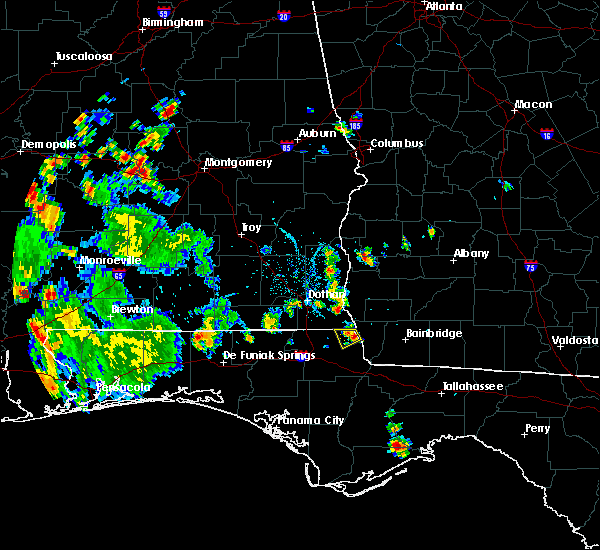 At 721 pm edt/621 pm cdt/, a severe thunderstorm was located 10 miles southwest of donalsonville, and is nearly stationary (radar indicated). Hazards include 60 mph wind gusts and quarter size hail. Hail damage to vehicles is expected. Expect wind damage to roofs, siding, and trees. At 721 pm edt/621 pm cdt/, a severe thunderstorm was located 10 miles southwest of donalsonville, and is nearly stationary (radar indicated). Hazards include 60 mph wind gusts and quarter size hail. Hail damage to vehicles is expected. Expect wind damage to roofs, siding, and trees.
|
| 3/31/2016 5:44 PM EDT |
 At 544 pm edt/444 pm cdt/, a severe thunderstorm was located 10 miles west of donalsonville, moving southeast at 45 mph (radar indicated). Hazards include 60 mph wind gusts and quarter size hail. Hail damage to vehicles is expected. Expect wind damage to roofs, siding, and trees. At 544 pm edt/444 pm cdt/, a severe thunderstorm was located 10 miles west of donalsonville, moving southeast at 45 mph (radar indicated). Hazards include 60 mph wind gusts and quarter size hail. Hail damage to vehicles is expected. Expect wind damage to roofs, siding, and trees.
|
| 3/3/2016 8:45 PM CST |
 At 845 pm cst, severe thunderstorms were located along a line extending from 11 miles southwest of donalsonville to 10 miles south of vernon, moving east at 55 mph (radar indicated). Hazards include 60 mph wind gusts. Expect damage to roofs. siding. and trees. Locations impacted include, vernon, marianna, malone, greenwood, alford, wausau, bascom, moose pond, smyrna, riverside, fountain, marianna municipal a/p, camps head, gilberts mill, holmes valley, betts, porter lake, greenhead, round lake and spring hollow. At 845 pm cst, severe thunderstorms were located along a line extending from 11 miles southwest of donalsonville to 10 miles south of vernon, moving east at 55 mph (radar indicated). Hazards include 60 mph wind gusts. Expect damage to roofs. siding. and trees. Locations impacted include, vernon, marianna, malone, greenwood, alford, wausau, bascom, moose pond, smyrna, riverside, fountain, marianna municipal a/p, camps head, gilberts mill, holmes valley, betts, porter lake, greenhead, round lake and spring hollow.
|
| 3/3/2016 8:36 PM CST |
 At 836 pm cst, severe thunderstorms were located along a line extending from 12 miles southwest of donalsonville to 7 miles southwest of vernon, moving east at 60 mph (radar indicated). Hazards include 60 mph wind gusts. Expect damage to roofs. siding. and trees. Locations impacted include, vernon, marianna, chipley, bradford, malone, cottondale, greenwood, alford, wausau, bascom, moose pond, smyrna, riverside, fountain, kynesville, marianna municipal a/p, camps head, orange hill, gilberts mill and holmes valley. At 836 pm cst, severe thunderstorms were located along a line extending from 12 miles southwest of donalsonville to 7 miles southwest of vernon, moving east at 60 mph (radar indicated). Hazards include 60 mph wind gusts. Expect damage to roofs. siding. and trees. Locations impacted include, vernon, marianna, chipley, bradford, malone, cottondale, greenwood, alford, wausau, bascom, moose pond, smyrna, riverside, fountain, kynesville, marianna municipal a/p, camps head, orange hill, gilberts mill and holmes valley.
|
| 3/3/2016 8:32 PM CST |
 At 932 pm est/832 pm cst/, severe thunderstorms were located along a line extending from 10 miles southeast of cottonwood to 10 miles east of vernon, moving east at 50 mph (radar indicated). Hazards include 60 mph wind gusts. Expect damage to roofs. siding. And trees. At 932 pm est/832 pm cst/, severe thunderstorms were located along a line extending from 10 miles southeast of cottonwood to 10 miles east of vernon, moving east at 50 mph (radar indicated). Hazards include 60 mph wind gusts. Expect damage to roofs. siding. And trees.
|
| 3/3/2016 8:29 PM CST |
 At 829 pm cst, severe thunderstorms were located along a line extending from 10 miles southeast of cottonwood to 11 miles southwest of vernon, moving east at 65 mph. some reports of trees down have been received from holmes and jackson counties (radar indicated). Hazards include 60 mph wind gusts. Expect damage to roofs. siding. and trees. Locations impacted include, vernon, chipley, marianna, bradford, live oak, malone, cottondale, greenwood, alford, wausau, campbellton, bascom, moose pond, richter crossroads, riverside, bahoma, jacobs, marianna municipal a/p, gilberts mill and red head. At 829 pm cst, severe thunderstorms were located along a line extending from 10 miles southeast of cottonwood to 11 miles southwest of vernon, moving east at 65 mph. some reports of trees down have been received from holmes and jackson counties (radar indicated). Hazards include 60 mph wind gusts. Expect damage to roofs. siding. and trees. Locations impacted include, vernon, chipley, marianna, bradford, live oak, malone, cottondale, greenwood, alford, wausau, campbellton, bascom, moose pond, richter crossroads, riverside, bahoma, jacobs, marianna municipal a/p, gilberts mill and red head.
|
| 3/3/2016 8:14 PM CST |
 At 814 pm cst, severe thunderstorms were located along a line extending from near cottonwood to 11 miles south of de funiak springs, moving east at 55 mph (radar indicated). Hazards include 60 mph wind gusts. Expect damage to roofs. siding. and trees. Locations impacted include, vernon, chipley, bonifay, graceville, marianna, bradford, live oak, malone, freeport, cottondale, greenwood, ponce de leon, alford, caryville, wausau, esto, westville, campbellton, noma and bascom. At 814 pm cst, severe thunderstorms were located along a line extending from near cottonwood to 11 miles south of de funiak springs, moving east at 55 mph (radar indicated). Hazards include 60 mph wind gusts. Expect damage to roofs. siding. and trees. Locations impacted include, vernon, chipley, bonifay, graceville, marianna, bradford, live oak, malone, freeport, cottondale, greenwood, ponce de leon, alford, caryville, wausau, esto, westville, campbellton, noma and bascom.
|
| 3/3/2016 8:00 PM CST |
 At 800 pm cst, a severe thunderstorm was located near bonifay, moving east at 65 mph (radar indicated). Hazards include 60 mph wind gusts. Expect damage to roofs. siding. And trees. At 800 pm cst, a severe thunderstorm was located near bonifay, moving east at 65 mph (radar indicated). Hazards include 60 mph wind gusts. Expect damage to roofs. siding. And trees.
|
| 2/24/2016 12:23 AM CST |
 At 123 am est /1223 am cst/, severe thunderstorms were located along a line extending from 8 miles southwest of donalsonville to near callaway, moving east at 25 mph (radar indicated). Hazards include 60 mph wind gusts. Expect damage to roofs. siding and trees. locations impacted include, panama city, lynn haven, callaway, blountstown, bainbridge, marianna, springfield, mexico beach, west bainbridge, chattahoochee, hiland park, tyndall air force base, malone, sneads, bristol, grand ridge, greenwood, altha, brinson and bascom. A tornado watch remains in effect until 400 am est/300 am cst/ for northwest florida and southwestern georgia. At 123 am est /1223 am cst/, severe thunderstorms were located along a line extending from 8 miles southwest of donalsonville to near callaway, moving east at 25 mph (radar indicated). Hazards include 60 mph wind gusts. Expect damage to roofs. siding and trees. locations impacted include, panama city, lynn haven, callaway, blountstown, bainbridge, marianna, springfield, mexico beach, west bainbridge, chattahoochee, hiland park, tyndall air force base, malone, sneads, bristol, grand ridge, greenwood, altha, brinson and bascom. A tornado watch remains in effect until 400 am est/300 am cst/ for northwest florida and southwestern georgia.
|
| 2/23/2016 11:49 PM CST |
 At 1149 pm cst, severe thunderstorms were located along a line extending from 9 miles south of cottonwood to 7 miles southwest of panama city beach, moving east at 20 mph (radar indicated). Hazards include 60 mph wind gusts. Expect damage to roofs. siding and trees. locations impacted include, panama city beach, vernon, chipley, bonifay, graceville, bradford, malone, cottondale, alford, wausau, esto, ebro, campbellton, noma, richter crossroads, laird, riverside, bahoma, bahama beach and jacobs. A tornado watch remains in effect until 300 am cst for northwest florida. At 1149 pm cst, severe thunderstorms were located along a line extending from 9 miles south of cottonwood to 7 miles southwest of panama city beach, moving east at 20 mph (radar indicated). Hazards include 60 mph wind gusts. Expect damage to roofs. siding and trees. locations impacted include, panama city beach, vernon, chipley, bonifay, graceville, bradford, malone, cottondale, alford, wausau, esto, ebro, campbellton, noma, richter crossroads, laird, riverside, bahoma, bahama beach and jacobs. A tornado watch remains in effect until 300 am cst for northwest florida.
|
| 2/23/2016 11:47 PM CST |
 At 1246 am est /1146 pm cst/, severe thunderstorms were located along a line extending from near cottonwood to 7 miles southwest of panama city beach, moving east at 45 mph (radar indicated). Hazards include 60 mph wind gusts. Expect damage to roofs. Siding and trees. At 1246 am est /1146 pm cst/, severe thunderstorms were located along a line extending from near cottonwood to 7 miles southwest of panama city beach, moving east at 45 mph (radar indicated). Hazards include 60 mph wind gusts. Expect damage to roofs. Siding and trees.
|
| 2/23/2016 11:30 PM CST |
 At 1130 pm cst, severe thunderstorms were located along a line extending from near graceville to 11 miles west of panama city beach, moving east at 20 mph (radar indicated). Hazards include 60 mph wind gusts. Expect damage to roofs. siding and trees. locations impacted include, panama city beach, vernon, chipley, bonifay, graceville, bradford, live oak, malone, cottondale, ponce de leon, alford, caryville, wausau, esto, westville, ebro, campbellton, noma, richter crossroads and seminole hills. A tornado watch remains in effect until 300 am cst for northwest florida. At 1130 pm cst, severe thunderstorms were located along a line extending from near graceville to 11 miles west of panama city beach, moving east at 20 mph (radar indicated). Hazards include 60 mph wind gusts. Expect damage to roofs. siding and trees. locations impacted include, panama city beach, vernon, chipley, bonifay, graceville, bradford, live oak, malone, cottondale, ponce de leon, alford, caryville, wausau, esto, westville, ebro, campbellton, noma, richter crossroads and seminole hills. A tornado watch remains in effect until 300 am cst for northwest florida.
|
| 2/23/2016 11:14 PM CST |
 At 1113 pm cst, severe thunderstorms were located along a line extending from near graceville to 14 miles southeast of santa rosa beach, moving east at 25 mph (radar indicated). Hazards include 60 mph wind gusts. Expect damage to roofs. siding and trees. locations impacted include, panama city beach, vernon, chipley, bonifay, graceville, santa rosa beach, bradford, live oak, malone, cottondale, ponce de leon, alford, caryville, wausau, esto, westville, ebro, campbellton, noma and barker store. A tornado watch remains in effect until 300 am cst for northwest florida. At 1113 pm cst, severe thunderstorms were located along a line extending from near graceville to 14 miles southeast of santa rosa beach, moving east at 25 mph (radar indicated). Hazards include 60 mph wind gusts. Expect damage to roofs. siding and trees. locations impacted include, panama city beach, vernon, chipley, bonifay, graceville, santa rosa beach, bradford, live oak, malone, cottondale, ponce de leon, alford, caryville, wausau, esto, westville, ebro, campbellton, noma and barker store. A tornado watch remains in effect until 300 am cst for northwest florida.
|
| 2/23/2016 10:52 PM CST |
 At 1052 pm cst, severe thunderstorms were located along a line extending from 7 miles south of hartford to 11 miles south of santa rosa beach, moving east at 20 mph (radar indicated). Hazards include 60 mph wind gusts. Expect damage to roofs. Siding and trees. At 1052 pm cst, severe thunderstorms were located along a line extending from 7 miles south of hartford to 11 miles south of santa rosa beach, moving east at 20 mph (radar indicated). Hazards include 60 mph wind gusts. Expect damage to roofs. Siding and trees.
|
| 2/15/2016 7:28 PM CST |
 At 827 pm est /727 pm cst/, severe thunderstorms were located along a line extending from 7 miles east of graceville to 8 miles west of panama city beach, moving east at 45 mph (radar indicated). Hazards include 60 mph wind gusts. Expect damage to roofs. Siding and trees. At 827 pm est /727 pm cst/, severe thunderstorms were located along a line extending from 7 miles east of graceville to 8 miles west of panama city beach, moving east at 45 mph (radar indicated). Hazards include 60 mph wind gusts. Expect damage to roofs. Siding and trees.
|
| 1/22/2016 3:54 AM CST | The severe thunderstorm warning for northeastern washington. northeastern holmes and northwestern jackson counties will expire at 400 am cst. the storm which prompted the warning has weakened below severe limits. and no longer pose an immediate threat to life or property. Therefore the warning will be allowed to expire. |
| 1/22/2016 3:34 AM CST | At 334 am cst, a severe thunderstorm was located near graceville, moving east at 50 mph (radar indicated). Hazards include 60 mph wind gusts. Expect damage to roofs. siding and trees. locations impacted include, graceville, marianna, chipley, malone, cottondale, greenwood, campbellton, noma, browntown, richter crossroads, cobb crossroads, bahoma, blue spring, holmes county airport, tendil crossing, sills, ellaville, jacobs, marianna municipal a/p and noma junction. A tornado watch remains in effect until 500 am cst for northwest florida. |
| 1/22/2016 3:12 AM CST | At 312 am cst, a severe thunderstorm was located near bonifay, moving east at 55 mph (radar indicated). Hazards include 60 mph wind gusts. Expect damage to roofs. Siding and trees. |
| 11/2/2015 11:22 AM CST |
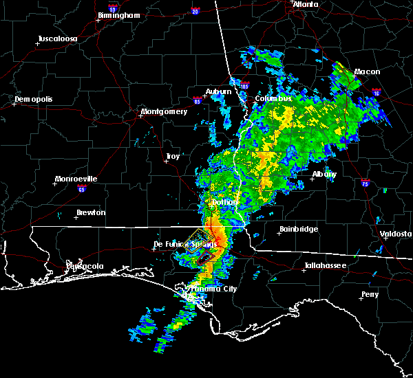 At 1122 am cst, a severe thunderstorm was located over marianna, moving northeast at 45 mph (radar indicated). Hazards include 60 mph wind gusts. Expect damage to roofs. Siding and trees. At 1122 am cst, a severe thunderstorm was located over marianna, moving northeast at 45 mph (radar indicated). Hazards include 60 mph wind gusts. Expect damage to roofs. Siding and trees.
|
| 9/10/2015 7:15 PM EDT |
 At 713 pm edt /613 pm cdt/, national weather service doppler radar indicated a line of severe thunderstorms capable of producing damaging winds in excess of 60 mph. these storms were located along a line extending from 7 miles west of colquitt to 8 miles east of cottonwood, moving east at 30 mph. locations impacted include, colquitt, cottonwood, donalsonville, centerville, malone, gordon, jakin, bascom, cedar springs, hornsville, crosby, grangeburg, jones crossroads, jeterville, donaldsonville a/p, harmon, macedonia, lucy, killarney and davis park. At 713 pm edt /613 pm cdt/, national weather service doppler radar indicated a line of severe thunderstorms capable of producing damaging winds in excess of 60 mph. these storms were located along a line extending from 7 miles west of colquitt to 8 miles east of cottonwood, moving east at 30 mph. locations impacted include, colquitt, cottonwood, donalsonville, centerville, malone, gordon, jakin, bascom, cedar springs, hornsville, crosby, grangeburg, jones crossroads, jeterville, donaldsonville a/p, harmon, macedonia, lucy, killarney and davis park.
|
| 9/10/2015 5:43 PM CDT |
 At 643 pm edt /543 pm cdt/, the national weather service has detected a line of severe thunderstorms capable of producing damaging winds in excess of 60 mph. these storms were located along a line extending from columbia to 6 miles southeast of taylor, and moving east at 30 mph. At 643 pm edt /543 pm cdt/, the national weather service has detected a line of severe thunderstorms capable of producing damaging winds in excess of 60 mph. these storms were located along a line extending from columbia to 6 miles southeast of taylor, and moving east at 30 mph.
|
| 7/24/2015 4:18 PM CDT |
 At 417 pm cdt, national weather service doppler radar indicated a severe thunderstorm capable of producing half dollar size hail and damaging winds in excess of 60 mph. this storm was located 13 miles northeast of marianna, moving southeast at 30 mph. locations impacted include, chattahoochee, malone, sneads, grand ridge, greenwood, bascom, cypress, and chipola terrace. At 417 pm cdt, national weather service doppler radar indicated a severe thunderstorm capable of producing half dollar size hail and damaging winds in excess of 60 mph. this storm was located 13 miles northeast of marianna, moving southeast at 30 mph. locations impacted include, chattahoochee, malone, sneads, grand ridge, greenwood, bascom, cypress, and chipola terrace.
|
| 7/24/2015 3:58 PM CDT |
 At 357 pm cdt, the national weather service has detected a severe thunderstorm capable of producing half dollar size hail and damaging winds in excess of 60 mph. this storm was located 9 miles southeast of cottonwood, and moving southeast at 25 mph. At 357 pm cdt, the national weather service has detected a severe thunderstorm capable of producing half dollar size hail and damaging winds in excess of 60 mph. this storm was located 9 miles southeast of cottonwood, and moving southeast at 25 mph.
|
| 7/22/2015 4:57 PM CDT |
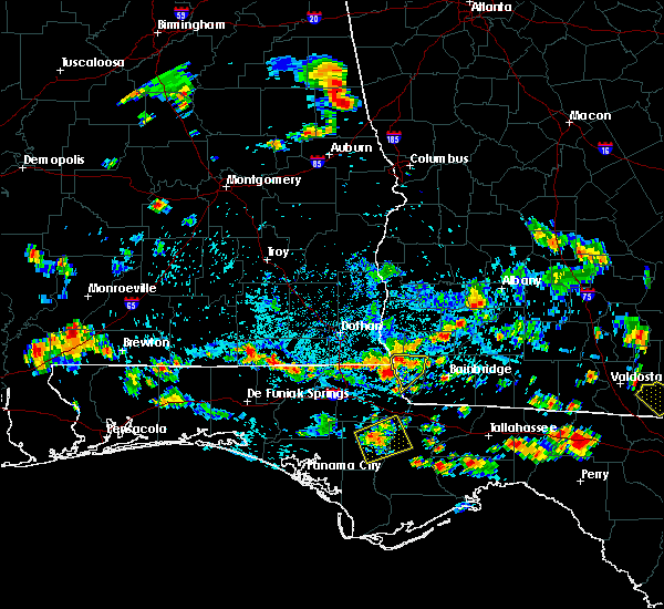 At 457 pm cdt, the national weather service has detected a severe thunderstorm capable of producing damaging winds in excess of 60 mph. this storm was located 11 miles southwest of donalsonville, and moving east at 10 mph. At 457 pm cdt, the national weather service has detected a severe thunderstorm capable of producing damaging winds in excess of 60 mph. this storm was located 11 miles southwest of donalsonville, and moving east at 10 mph.
|
| 7/19/2015 2:30 PM CDT | Several trees and powerlines dow in jackson county FL, 0.1 miles SE of Malone, FL |
| 7/19/2015 2:22 PM CDT |
 At 222 pm cdt, the national weather service has detected a severe thunderstorm capable of producing damaging winds in excess of 60 mph. this storm was located 13 miles southeast of cottonwood, and moving south at 20 mph. At 222 pm cdt, the national weather service has detected a severe thunderstorm capable of producing damaging winds in excess of 60 mph. this storm was located 13 miles southeast of cottonwood, and moving south at 20 mph.
|
| 7/2/2015 2:09 PM EDT |
 At 209 pm edt /109 pm cdt/, doppler radar indicated a line of severe thunderstorms capable of producing damaging winds in excess of 60 mph. these storms were located along a line extending from near blakely to near marianna, moving east at 45 mph. locations impacted include, colquitt, blakely, donalsonville, marianna, ashford, columbia, centerville, malone, sneads, grand ridge, greenwood, gordon, iron city, damascus, jakin, bascom, cedar springs, cuba, crosby and grangeburg. At 209 pm edt /109 pm cdt/, doppler radar indicated a line of severe thunderstorms capable of producing damaging winds in excess of 60 mph. these storms were located along a line extending from near blakely to near marianna, moving east at 45 mph. locations impacted include, colquitt, blakely, donalsonville, marianna, ashford, columbia, centerville, malone, sneads, grand ridge, greenwood, gordon, iron city, damascus, jakin, bascom, cedar springs, cuba, crosby and grangeburg.
|
| 7/2/2015 12:48 PM CDT |
 At 148 pm edt /1248 pm cdt/, the national weather service has detected a line of severe thunderstorms capable of producing damaging winds in excess of 60 mph. these storms were located along a line extending from 7 miles northeast of headland to 9 miles southeast of graceville, and moving east at 45 mph. At 148 pm edt /1248 pm cdt/, the national weather service has detected a line of severe thunderstorms capable of producing damaging winds in excess of 60 mph. these storms were located along a line extending from 7 miles northeast of headland to 9 miles southeast of graceville, and moving east at 45 mph.
|
| 6/30/2015 3:55 PM CDT |
 At 453 pm edt /353 pm cdt/, doppler radar indicated a line of severe thunderstorms capable of producing destructive winds in excess of 70 mph. these storms were located along a line extending from 12 miles southeast of cottonwood to 8 miles east of marianna to near lynn haven, moving east at 60 mph. in addition, at 337 pm cdt, a 68 mph wind gust was measured at northwest florida beaches international airport. locations impacted include, panama city, lynn haven, panama city beach, marianna, hiland park, chattahoochee, malone, sneads, grand ridge, greenwood, altha, bascom, cypress, moose pond, gainer spring, white pond, red oak, chason, blountstown airport and simsville. At 453 pm edt /353 pm cdt/, doppler radar indicated a line of severe thunderstorms capable of producing destructive winds in excess of 70 mph. these storms were located along a line extending from 12 miles southeast of cottonwood to 8 miles east of marianna to near lynn haven, moving east at 60 mph. in addition, at 337 pm cdt, a 68 mph wind gust was measured at northwest florida beaches international airport. locations impacted include, panama city, lynn haven, panama city beach, marianna, hiland park, chattahoochee, malone, sneads, grand ridge, greenwood, altha, bascom, cypress, moose pond, gainer spring, white pond, red oak, chason, blountstown airport and simsville.
|
| 6/30/2015 3:32 PM CDT |
 At 432 pm edt /332 pm cdt/, the national weather service has detected a line of severe thunderstorms capable of producing damaging winds in excess of 60 mph. these storms were located along a line extending from near cottonwood to 6 miles northwest of marianna to near panama city beach, and moving east at 65 mph. At 432 pm edt /332 pm cdt/, the national weather service has detected a line of severe thunderstorms capable of producing damaging winds in excess of 60 mph. these storms were located along a line extending from near cottonwood to 6 miles northwest of marianna to near panama city beach, and moving east at 65 mph.
|
| 6/30/2015 11:56 AM CDT |
 At 1255 pm edt /1155 am cdt/, doppler radar indicated a line of severe thunderstorms capable of producing damaging winds in excess of 60 mph. these storms were located along a line extending from 10 miles southeast of cottonwood to 20 miles southeast of vernon, moving east at 30 mph. locations impacted include, marianna, blountstown, malone, sneads, grand ridge, greenwood, altha, bascom, cypress, moose pond, hornsville, white pond, red oak, chason, durham, lela, nettle ridge, clarksville, blountstown airport and desser. At 1255 pm edt /1155 am cdt/, doppler radar indicated a line of severe thunderstorms capable of producing damaging winds in excess of 60 mph. these storms were located along a line extending from 10 miles southeast of cottonwood to 20 miles southeast of vernon, moving east at 30 mph. locations impacted include, marianna, blountstown, malone, sneads, grand ridge, greenwood, altha, bascom, cypress, moose pond, hornsville, white pond, red oak, chason, durham, lela, nettle ridge, clarksville, blountstown airport and desser.
|
| 6/30/2015 11:25 AM CDT |
 At 1225 pm edt /1125 am cdt/, the national weather service has detected a line of severe thunderstorms capable of producing damaging winds in excess of 60 mph. these storms were located along a line extending from near graceville to 10 miles southeast of vernon, and moving east at 30 mph. At 1225 pm edt /1125 am cdt/, the national weather service has detected a line of severe thunderstorms capable of producing damaging winds in excess of 60 mph. these storms were located along a line extending from near graceville to 10 miles southeast of vernon, and moving east at 30 mph.
|
| 6/30/2015 11:06 AM CDT |
 At 1105 am cdt, the national weather service has detected a severe thunderstorm capable of producing damaging winds in excess of 60 mph. this storm was located near chipley, and moving east at 30 mph. At 1105 am cdt, the national weather service has detected a severe thunderstorm capable of producing damaging winds in excess of 60 mph. this storm was located near chipley, and moving east at 30 mph.
|
| 5/26/2015 12:31 PM CDT | At 1231 pm cdt, doppler radar indicated a line of severe thunderstorms capable of producing damaging winds in excess of 60 mph. these storms were located along a line extending from ashford to near marianna, moving northeast at 20 mph. locations impacted include, cottonwood, marianna, dothan, ashford, cowarts, webb, malone, greenwood, avon, gordon, bascom, memphis, hornsville, crosby, ardilla, grangeburg, hodgesville, enon, harmon and marianna municipal a/p. |
| 5/26/2015 12:31 PM CDT | At 1231 pm cdt, doppler radar indicated a line of severe thunderstorms capable of producing damaging winds in excess of 60 mph. these storms were located along a line extending from ashford to near marianna, moving northeast at 20 mph. locations impacted include, cottonwood, marianna, dothan, ashford, cowarts, webb, malone, greenwood, avon, gordon, bascom, memphis, hornsville, crosby, ardilla, grangeburg, hodgesville, enon, harmon and marianna municipal a/p. |
| 5/26/2015 12:09 PM CDT | At 1209 pm cdt, the national weather service has detected a severe thunderstorm capable of producing damaging winds in excess of 60 mph. this storm was located 7 miles southwest of cottonwood, and moving north at 25 mph. another storm capable of producing damaging winds was located over marianna. |
| 5/26/2015 12:09 PM CDT | At 1209 pm cdt, the national weather service has detected a severe thunderstorm capable of producing damaging winds in excess of 60 mph. this storm was located 7 miles southwest of cottonwood, and moving north at 25 mph. another storm capable of producing damaging winds was located over marianna. |
| 6/8/2014 6:00 PM CDT | Tree down on hickory grove road at county road 81 sout in houston county AL, 6.6 miles SSE of Malone, FL |
| 6/8/2014 5:44 PM CDT | Tree down at sr 2 and hwy 71 in malon in jackson county FL, 0.6 miles N of Malone, FL |
| 1/1/0001 12:00 AM | 1 tree down at 12901 e county road 8. delayed report from wednesda in houston county AL, 6.9 miles SW of Malone, FL |
Hail Maps for Malone, FL


Connect with Interactive Hail Maps