

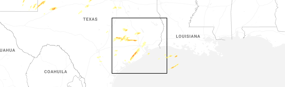
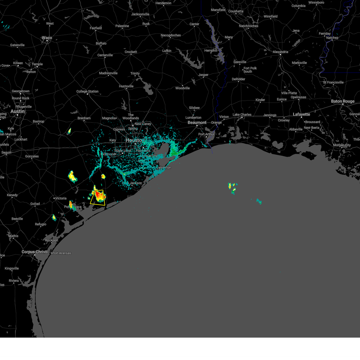
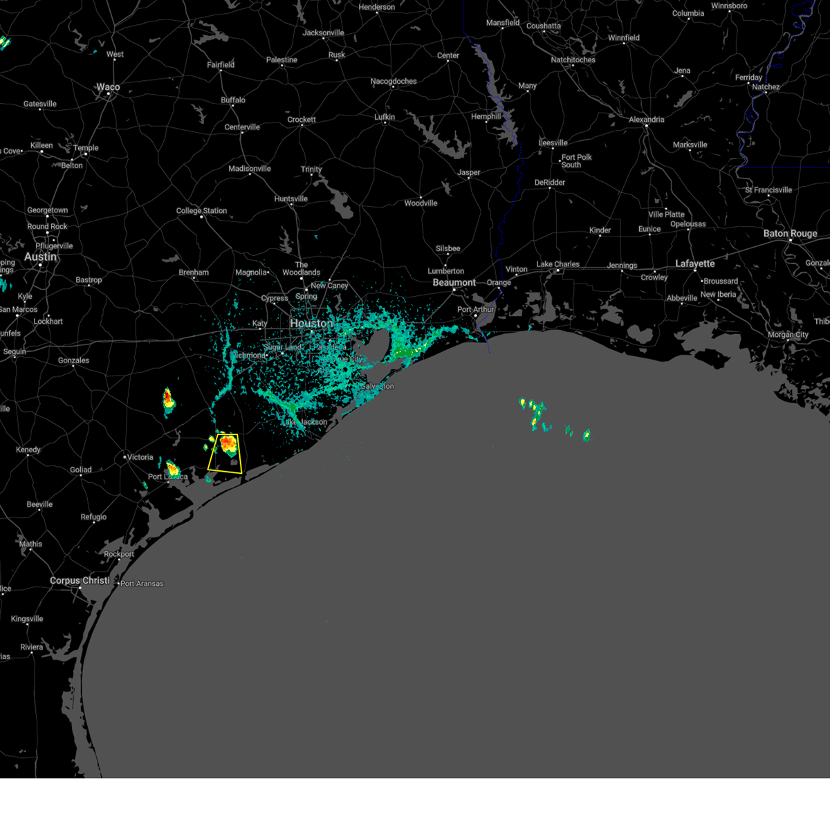
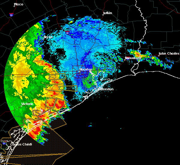
Hail Map for Markham, TX
The Markham, TX area has had 0 reports of on-the-ground hail by trained spotters, and has been under severe weather warnings 3 times during the past 12 months. Doppler radar has detected hail at or near Markham, TX on 26 occasions, including 1 occasion during the past year.
| Name: | Markham, TX |
| Where Located: | 69.2 miles SW of Houston, TX |
| Map: | Google Map for Markham, TX |
| Population: | 1082 |
| Housing Units: | 448 |
| More Info: | Search Google for Markham, TX |
1
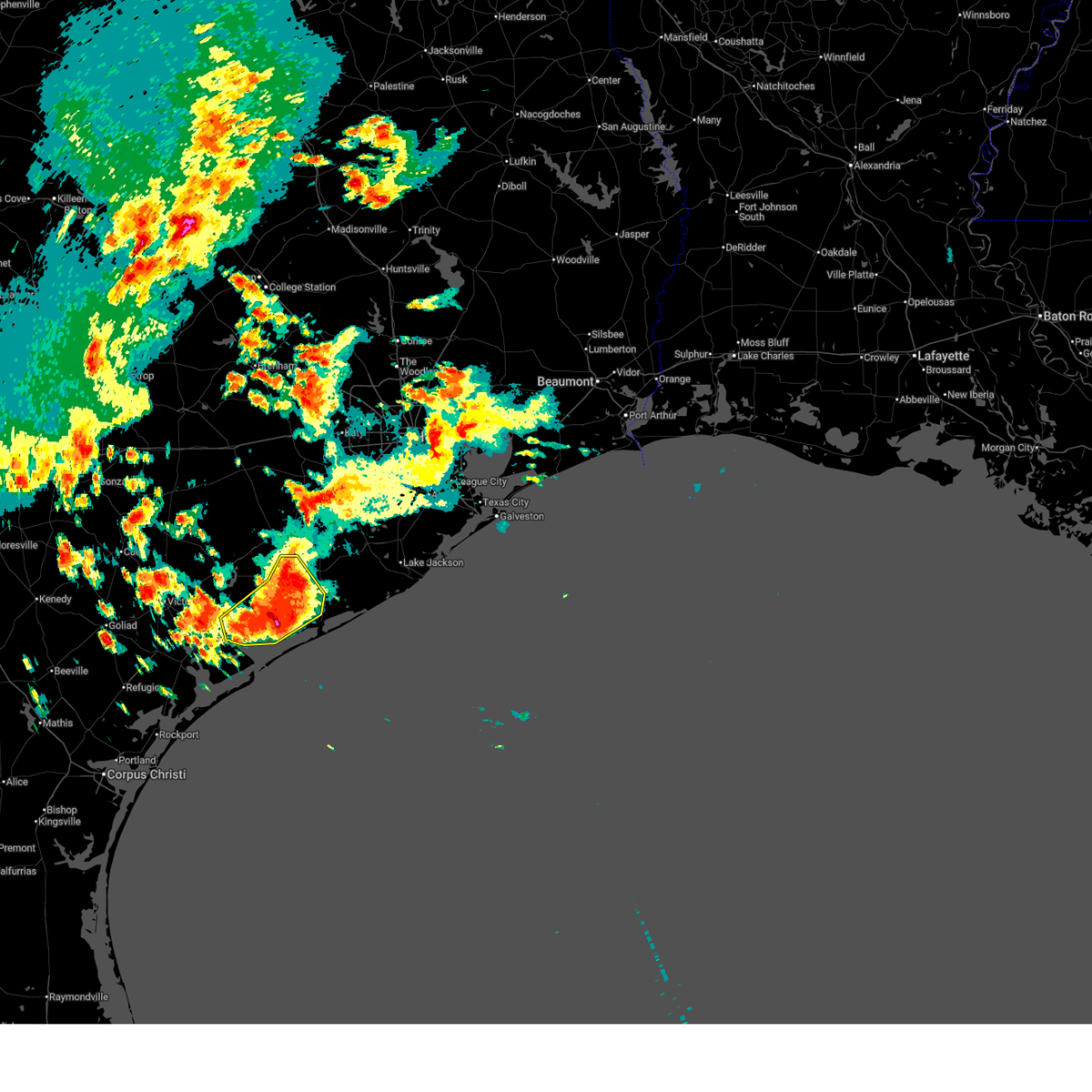
The Top Recent Hail Date for Markham, TX is Monday, May 5, 2025 (10th out of 26)
Hail and Wind Damage Spotted near Markham, TX
| Date / Time | Report Details |
|---|---|
| 6/12/2025 3:44 AM CDT |
 Svrhgx the national weather service in league city has issued a * severe thunderstorm warning for, south central wharton county in southeastern texas, southeastern jackson county in south central texas, northwestern matagorda county in southeastern texas, * until 445 am cdt. * at 344 am cdt, a cluster of training severe thunderstorms was located over palacios, moving northeast at 15 mph (radar indicated). Hazards include 60 mph wind gusts and quarter size hail. Hail damage to vehicles is expected. Expect wind damage to roofs, siding, and trees. Svrhgx the national weather service in league city has issued a * severe thunderstorm warning for, south central wharton county in southeastern texas, southeastern jackson county in south central texas, northwestern matagorda county in southeastern texas, * until 445 am cdt. * at 344 am cdt, a cluster of training severe thunderstorms was located over palacios, moving northeast at 15 mph (radar indicated). Hazards include 60 mph wind gusts and quarter size hail. Hail damage to vehicles is expected. Expect wind damage to roofs, siding, and trees.
|
| 6/12/2025 2:43 AM CDT |
 Svrhgx the national weather service in league city has issued a * severe thunderstorm warning for, eastern jackson county in south central texas, west central matagorda county in southeastern texas, * until 330 am cdt. * at 243 am cdt, a severe thunderstorm was located near blessing, or near palacios, moving north at 15 mph (radar indicated). Hazards include 60 mph wind gusts and quarter size hail. Hail damage to vehicles is expected. Expect wind damage to roofs, siding, and trees. Svrhgx the national weather service in league city has issued a * severe thunderstorm warning for, eastern jackson county in south central texas, west central matagorda county in southeastern texas, * until 330 am cdt. * at 243 am cdt, a severe thunderstorm was located near blessing, or near palacios, moving north at 15 mph (radar indicated). Hazards include 60 mph wind gusts and quarter size hail. Hail damage to vehicles is expected. Expect wind damage to roofs, siding, and trees.
|
| 5/5/2025 3:50 PM CDT | Svrhgx the national weather service in league city has issued a * severe thunderstorm warning for, southwestern brazoria county in southeastern texas, northeastern matagorda county in southeastern texas, * until 430 pm cdt. * at 349 pm cdt, a severe thunderstorm was located near bay city, moving northeast at 40 mph (radar indicated). Hazards include 60 mph wind gusts and quarter size hail. Hail damage to vehicles is expected. Expect wind damage to roofs, siding, and trees. |
| 5/31/2024 6:46 AM CDT |
 Svrhgx the national weather service in league city has issued a * severe thunderstorm warning for, south central wharton county in southeastern texas, east central jackson county in south central texas, northwestern matagorda county in southeastern texas, * until 715 am cdt. * at 645 am cdt, a severe thunderstorm was located 11 miles south of el campo, moving southeast at 15 mph (radar indicated). Hazards include 60 mph wind gusts and nickel size hail. expect damage to roofs, siding, and trees Svrhgx the national weather service in league city has issued a * severe thunderstorm warning for, south central wharton county in southeastern texas, east central jackson county in south central texas, northwestern matagorda county in southeastern texas, * until 715 am cdt. * at 645 am cdt, a severe thunderstorm was located 11 miles south of el campo, moving southeast at 15 mph (radar indicated). Hazards include 60 mph wind gusts and nickel size hail. expect damage to roofs, siding, and trees
|
| 10/5/2023 9:37 AM CDT |
 At 936 am cdt, severe thunderstorms were located along a line extending from near jamaica beach to 11 miles southeast of sargent to schicke point, moving southeast at 35 mph. palacios reported a wind gust of 75 mph at 929 am cdt (radar indicated). Hazards include 70 mph wind gusts. Expect considerable tree damage. Damage is likely to mobile homes, roofs, and outbuildings. At 936 am cdt, severe thunderstorms were located along a line extending from near jamaica beach to 11 miles southeast of sargent to schicke point, moving southeast at 35 mph. palacios reported a wind gust of 75 mph at 929 am cdt (radar indicated). Hazards include 70 mph wind gusts. Expect considerable tree damage. Damage is likely to mobile homes, roofs, and outbuildings.
|
| 10/5/2023 8:39 AM CDT |
 At 839 am cdt, severe thunderstorms were located along a line extending from near wharton to 8 miles south of el campo to near lolita, moving southeast at 40 mph (radar indicated). Hazards include 60 mph wind gusts. Expect damage to roofs, siding, and trees. locations impacted include, el campo, edna, ganado, la ward, pierce, lolita, blessing, markham, cordele, vanderbilt, louise, midfield, lake texana dam, and danevang. hail threat, radar indicated max hail size, <. 75 in wind threat, observed max wind gust, 60 mph. At 839 am cdt, severe thunderstorms were located along a line extending from near wharton to 8 miles south of el campo to near lolita, moving southeast at 40 mph (radar indicated). Hazards include 60 mph wind gusts. Expect damage to roofs, siding, and trees. locations impacted include, el campo, edna, ganado, la ward, pierce, lolita, blessing, markham, cordele, vanderbilt, louise, midfield, lake texana dam, and danevang. hail threat, radar indicated max hail size, <. 75 in wind threat, observed max wind gust, 60 mph.
|
| 10/5/2023 8:21 AM CDT |
 At 820 am cdt, severe thunderstorms were located along a line extending from near pierce to near ganado to near inez, moving east at 40 mph. at 812 am cdt, victoria reported a 61 mph gust with this line of storms (radar indicated). Hazards include 60 mph wind gusts. expect damage to roofs, siding, and trees At 820 am cdt, severe thunderstorms were located along a line extending from near pierce to near ganado to near inez, moving east at 40 mph. at 812 am cdt, victoria reported a 61 mph gust with this line of storms (radar indicated). Hazards include 60 mph wind gusts. expect damage to roofs, siding, and trees
|
| 9/9/2023 4:44 PM CDT |
 At 444 pm cdt, a severe thunderstorm was located near south texas nuclear plant, moving south at 20 mph (radar indicated). Hazards include 60 mph wind gusts and quarter size hail. Hail damage to vehicles is expected. expect wind damage to roofs, siding, and trees. locations impacted include, palacios, south texas nuclear plant, blessing and markham. hail threat, radar indicated max hail size, 1. 00 in wind threat, radar indicated max wind gust, 60 mph. At 444 pm cdt, a severe thunderstorm was located near south texas nuclear plant, moving south at 20 mph (radar indicated). Hazards include 60 mph wind gusts and quarter size hail. Hail damage to vehicles is expected. expect wind damage to roofs, siding, and trees. locations impacted include, palacios, south texas nuclear plant, blessing and markham. hail threat, radar indicated max hail size, 1. 00 in wind threat, radar indicated max wind gust, 60 mph.
|
| 9/9/2023 4:23 PM CDT |
 At 423 pm cdt, a severe thunderstorm was located near markham, or 8 miles northwest of south texas nuclear plant, moving south at 20 mph (radar indicated). Hazards include 60 mph wind gusts and quarter size hail. Hail damage to vehicles is expected. Expect wind damage to roofs, siding, and trees. At 423 pm cdt, a severe thunderstorm was located near markham, or 8 miles northwest of south texas nuclear plant, moving south at 20 mph (radar indicated). Hazards include 60 mph wind gusts and quarter size hail. Hail damage to vehicles is expected. Expect wind damage to roofs, siding, and trees.
|
| 4/21/2023 3:46 AM CDT |
 At 346 am cdt, severe thunderstorms were located along a line extending from needville to 7 miles southeast of boling-iago to 6 miles northwest of van vleck to near markham, moving east at 50 mph (radar indicated). Hazards include 60 mph wind gusts and penny size hail. Expect damage to roofs, siding, and trees. locations impacted include, bay city, wharton, needville, fairchilds, kendleton, markham, van vleck, boling-iago, damon, hungerford and danevang. hail threat, radar indicated max hail size, 0. 75 in wind threat, radar indicated max wind gust, 60 mph. At 346 am cdt, severe thunderstorms were located along a line extending from needville to 7 miles southeast of boling-iago to 6 miles northwest of van vleck to near markham, moving east at 50 mph (radar indicated). Hazards include 60 mph wind gusts and penny size hail. Expect damage to roofs, siding, and trees. locations impacted include, bay city, wharton, needville, fairchilds, kendleton, markham, van vleck, boling-iago, damon, hungerford and danevang. hail threat, radar indicated max hail size, 0. 75 in wind threat, radar indicated max wind gust, 60 mph.
|
| 4/21/2023 3:27 AM CDT |
 At 326 am cdt, severe thunderstorms were located along a line extending from near kendleton to near wharton to 6 miles south of pierce to 9 miles east of ganado, moving east at 45 mph (radar indicated). Hazards include 60 mph wind gusts and penny size hail. expect damage to roofs, siding, and trees At 326 am cdt, severe thunderstorms were located along a line extending from near kendleton to near wharton to 6 miles south of pierce to 9 miles east of ganado, moving east at 45 mph (radar indicated). Hazards include 60 mph wind gusts and penny size hail. expect damage to roofs, siding, and trees
|
| 5/25/2022 2:02 AM CDT |
 At 201 am cdt, severe thunderstorms were located along a line extending from near speaks to near olivia to 21 miles southwest of matagorda island state park, moving east at 30 mph (radar indicated). Hazards include 60 mph wind gusts. expect damage to roofs, siding, and trees At 201 am cdt, severe thunderstorms were located along a line extending from near speaks to near olivia to 21 miles southwest of matagorda island state park, moving east at 30 mph (radar indicated). Hazards include 60 mph wind gusts. expect damage to roofs, siding, and trees
|
| 5/19/2021 3:25 AM CDT |
 At 325 am cdt, severe thunderstorms located near ganado, or near edna, moving east at 50-60 mph (radar indicated). Hazards include 60 mph wind gusts and penny size hail. expect damage to roofs, siding, and trees At 325 am cdt, severe thunderstorms located near ganado, or near edna, moving east at 50-60 mph (radar indicated). Hazards include 60 mph wind gusts and penny size hail. expect damage to roofs, siding, and trees
|
| 5/16/2020 2:44 AM CDT |
 At 244 am cdt, a severe thunderstorm was located over blessing, or 10 miles northwest of south texas nuclear plant, moving north at 25 mph (radar indicated). Hazards include 60 mph wind gusts and quarter size hail. Hail damage to vehicles is expected. Expect wind damage to roofs, siding, and trees. At 244 am cdt, a severe thunderstorm was located over blessing, or 10 miles northwest of south texas nuclear plant, moving north at 25 mph (radar indicated). Hazards include 60 mph wind gusts and quarter size hail. Hail damage to vehicles is expected. Expect wind damage to roofs, siding, and trees.
|
| 6/6/2019 7:16 PM CDT |
 At 714 pm cdt, a cluster of severe thunderstorms was located from wharton down towards ganado, moving east 30 mph (radar indicated). Hazards include 60 mph wind gusts and quarter size hail. Hail damage to vehicles is expected. expect wind damage to roofs, siding, and trees. Locations impacted include, el campo, wharton, ganado, pierce, markham, boling-iago, blessing, cordele, louise, midfield and danevang. At 714 pm cdt, a cluster of severe thunderstorms was located from wharton down towards ganado, moving east 30 mph (radar indicated). Hazards include 60 mph wind gusts and quarter size hail. Hail damage to vehicles is expected. expect wind damage to roofs, siding, and trees. Locations impacted include, el campo, wharton, ganado, pierce, markham, boling-iago, blessing, cordele, louise, midfield and danevang.
|
| 6/6/2019 6:46 PM CDT |
 At 643 pm cdt, a cluster of severe thunderstorms were located from nada down towards cordele, moving east at 35 mph (radar indicated). Hazards include 60 mph wind gusts and quarter size hail. Hail damage to vehicles is expected. Expect wind damage to roofs, siding, and trees. At 643 pm cdt, a cluster of severe thunderstorms were located from nada down towards cordele, moving east at 35 mph (radar indicated). Hazards include 60 mph wind gusts and quarter size hail. Hail damage to vehicles is expected. Expect wind damage to roofs, siding, and trees.
|
| 4/7/2019 11:18 AM CDT |
 At 1118 am cdt, a severe thunderstorm was located near van vleck, or near bay city, moving northeast at 35 mph (radar indicated). Hazards include 60 mph wind gusts. Expect damage to roofs, siding, and trees. Locations impacted include, matagorda, bay city, el campo, wharton, eagle lake, south texas nuclear plant, sargent, pierce, markham, van vleck, boling-iago, egypt, hungerford, wadsworth and garwood. At 1118 am cdt, a severe thunderstorm was located near van vleck, or near bay city, moving northeast at 35 mph (radar indicated). Hazards include 60 mph wind gusts. Expect damage to roofs, siding, and trees. Locations impacted include, matagorda, bay city, el campo, wharton, eagle lake, south texas nuclear plant, sargent, pierce, markham, van vleck, boling-iago, egypt, hungerford, wadsworth and garwood.
|
| 4/7/2019 11:05 AM CDT |
 At 1104 am cdt, a severe thunderstorm was located over markham, or near bay city, moving northeast at 35 mph. this line of thunderstorms produced wind damage earlier this morning near ganado (radar indicated). Hazards include 60 mph wind gusts. expect damage to roofs, siding, and trees At 1104 am cdt, a severe thunderstorm was located over markham, or near bay city, moving northeast at 35 mph. this line of thunderstorms produced wind damage earlier this morning near ganado (radar indicated). Hazards include 60 mph wind gusts. expect damage to roofs, siding, and trees
|
| 3/29/2018 1:52 AM CDT |
 At 151 am cdt, severe thunderstorms were located along a line extending from near boling-iago to near point comfort, moving east at 45 mph (radar indicated). Hazards include 60 mph wind gusts and quarter size hail. Hail damage to vehicles is expected. Expect wind damage to roofs, siding, and trees. At 151 am cdt, severe thunderstorms were located along a line extending from near boling-iago to near point comfort, moving east at 45 mph (radar indicated). Hazards include 60 mph wind gusts and quarter size hail. Hail damage to vehicles is expected. Expect wind damage to roofs, siding, and trees.
|
| 8/27/2017 1:06 AM CDT |
 At 105 am cdt, a severe thunderstorm capable of producing a tornado was located near markham, or 7 miles west of bay city, moving north at 45 mph (radar indicated rotation). Hazards include tornado. Flying debris will be dangerous to those caught without shelter. mobile homes will be damaged or destroyed. damage to roofs, windows, and vehicles will occur. Tree damage is likely. At 105 am cdt, a severe thunderstorm capable of producing a tornado was located near markham, or 7 miles west of bay city, moving north at 45 mph (radar indicated rotation). Hazards include tornado. Flying debris will be dangerous to those caught without shelter. mobile homes will be damaged or destroyed. damage to roofs, windows, and vehicles will occur. Tree damage is likely.
|
| 4/2/2017 5:37 PM CDT |
 At 537 pm cdt, a severe thunderstorm was located 8 miles northeast of la ward, or 14 miles east of edna, moving northeast at 35 mph (radar indicated). Hazards include 60 mph wind gusts and quarter size hail. Hail damage to vehicles is expected. Expect wind damage to roofs, siding, and trees. At 537 pm cdt, a severe thunderstorm was located 8 miles northeast of la ward, or 14 miles east of edna, moving northeast at 35 mph (radar indicated). Hazards include 60 mph wind gusts and quarter size hail. Hail damage to vehicles is expected. Expect wind damage to roofs, siding, and trees.
|
| 2/14/2017 7:25 AM CST |
 At 724 am cst, severe thunderstorms were located along a line extending from near wallis to near lolita, moving east at 30 mph (radar indicated). Hazards include 60 mph wind gusts. expect damage to roofs, siding, and trees At 724 am cst, severe thunderstorms were located along a line extending from near wallis to near lolita, moving east at 30 mph (radar indicated). Hazards include 60 mph wind gusts. expect damage to roofs, siding, and trees
|
| 4/13/2016 2:16 AM CDT |
 At 215 am cdt, a severe thunderstorm was located over van vleck, or near bay city, moving east at 35 mph (radar indicated). Hazards include quarter size hail. damage to vehicles is expected At 215 am cdt, a severe thunderstorm was located over van vleck, or near bay city, moving east at 35 mph (radar indicated). Hazards include quarter size hail. damage to vehicles is expected
|
| 8/11/2015 7:50 PM CDT |
 At 749 pm cdt, doppler radar indicated a line of severe thunderstorms from wharton to just south of nada, and moving southwest at 25 mph. At 749 pm cdt, doppler radar indicated a line of severe thunderstorms from wharton to just south of nada, and moving southwest at 25 mph.
|
| 5/26/2015 12:58 AM CDT | At 1258 am cdt, doppler radar indicated a severe thunderstorm capable of producing damaging winds in excess of 60 mph. this storm was located 9 miles southeast of pierce, or 11 miles southeast of el campo, and moving east at 35 mph. |
| 5/24/2015 4:20 AM CDT | At 419 am cdt, doppler radar indicated a line of severe thunderstorms capable of producing damaging winds in excess of 60 mph. these storms were located along a line extending from near weimar to 7 miles west of eagle lake to 13 miles northwest of wharton to 8 miles southwest of el campo to 17 miles east of port oconnor, and moving east northeast at 40 mph. |
| 4/25/2015 7:39 AM CDT | At 739 am cdt, doppler radar indicated a severe thunderstorm capable of producing quarter size hail. this storm was located over la ward, or 13 miles southeast of edna, and moving northeast at 50 mph. |
| 4/17/2015 6:56 PM CDT | At 655 pm cdt, doppler radar indicated a line of severe thunderstorms capable of producing damaging winds in excess of 60 mph. these storms were located along a line extending from near east bernard to near brazoria, and moving northeast at 35 mph. |
| 4/17/2015 6:21 PM CDT | At 620 pm cdt, doppler radar indicated a line of severe thunderstorms capable of producing damaging winds in excess of 60 mph. these storms were located along a line extending from near columbus to near el campo to lolita, and moving northeast at 45 mph. this storm has a history of producing wind damage in jackson county earlier this evening. |
| 4/16/2015 6:15 PM CDT | The national weather service in league city has issued a * tornado warning for. matagorda county in southeastern texas. until 645 pm cdt * at 614 pm cdt. doppler radar indicated a severe thunderstorm capable of producing a tornado. This dangerous storm was located. |
| 4/16/2015 6:06 PM CDT | A tornado warning remains in effect until 615 pm cdt for matagorda county. at 604 pm cdt. doppler radar indicated a severe thunderstorm capable of producing a tornado. this dangerous storm was located 4 miles east of blessing. or 7 miles northwest of south texas nuclear plant. moving east at 25 mph. Large hail is also likely. |
| 4/16/2015 5:51 PM CDT | A tornado warning remains in effect until 615 pm cdt for matagorda county. at 549 pm cdt. doppler radar indicated a severe thunderstorm capable of producing a tornado. this dangerous storm was located over blessing. or 8 miles north of palacios. moving east at 20 mph. Large hail is also likely with this storm. |
| 4/16/2015 5:35 PM CDT | The national weather service in league city has issued a * tornado warning for. jackson county in south central texas. matagorda county in southeastern texas. until 615 pm cdt * at 534 pm cdt. Doppler radar indicated a severe thunderstorm. |
Hail Maps for Markham, TX


Connect with Interactive Hail Maps