

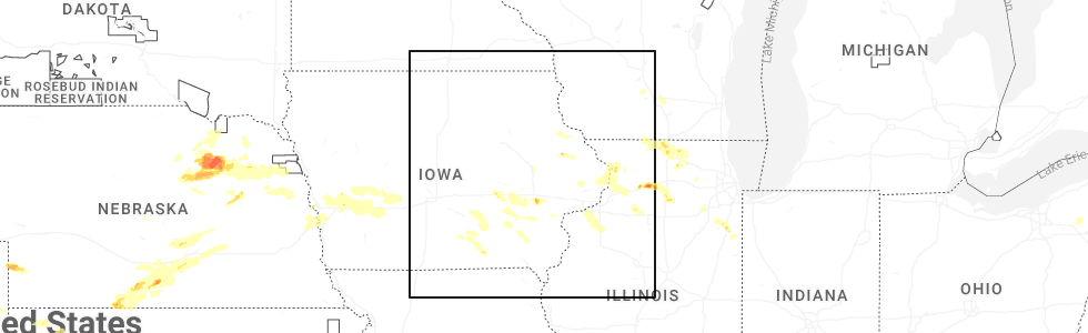
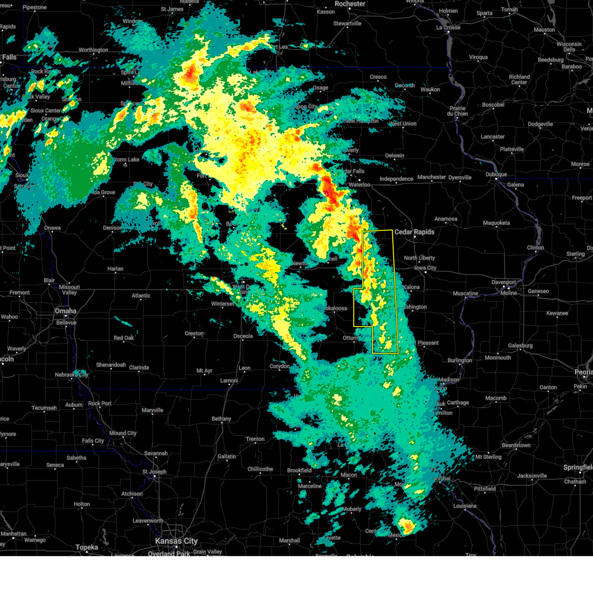
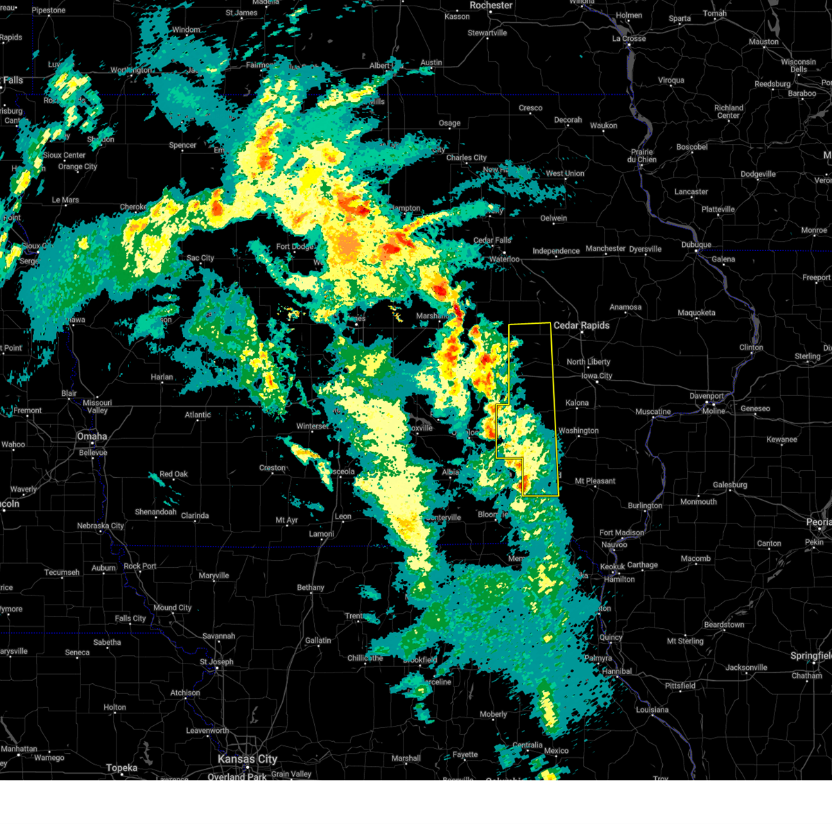
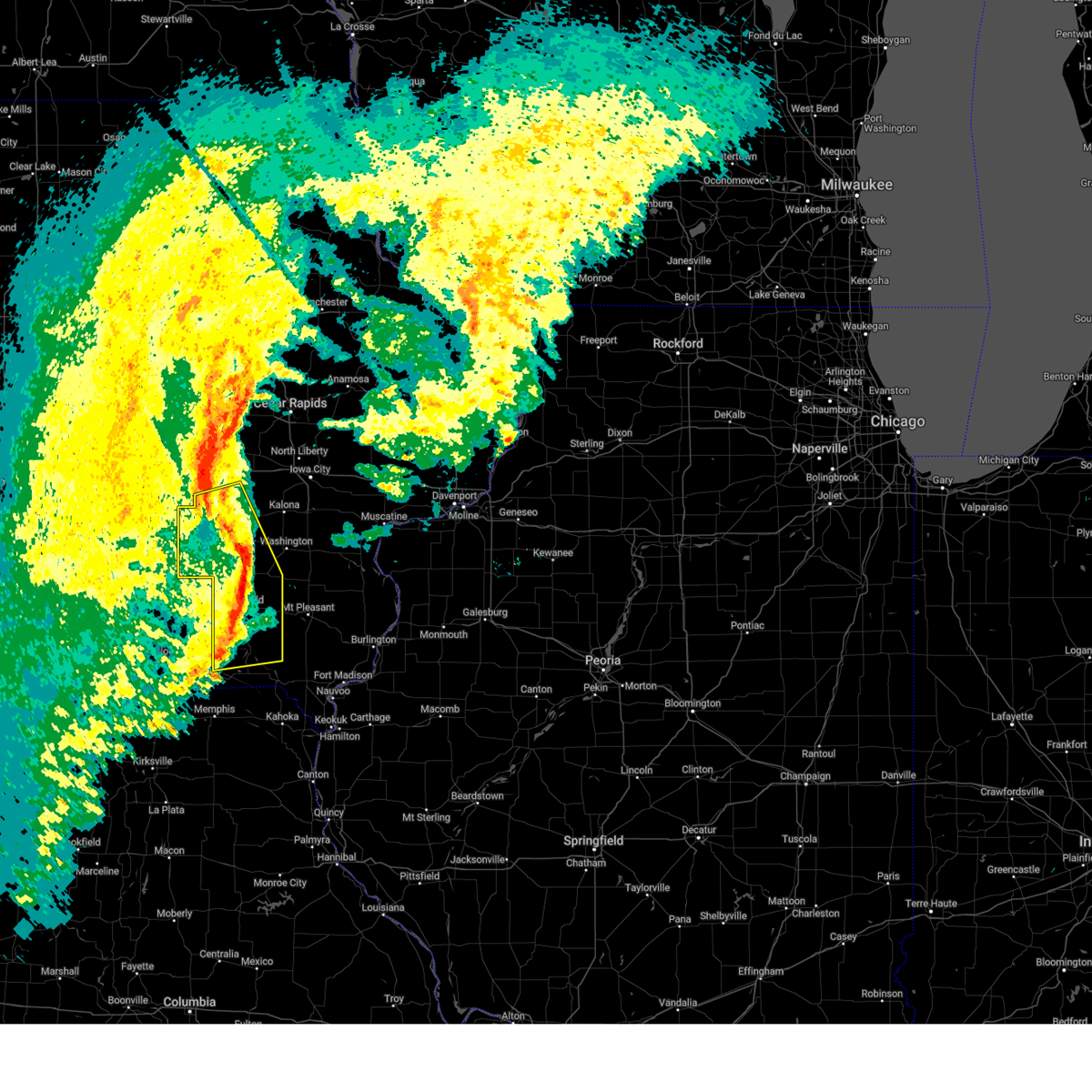
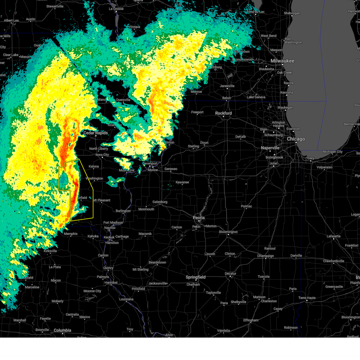
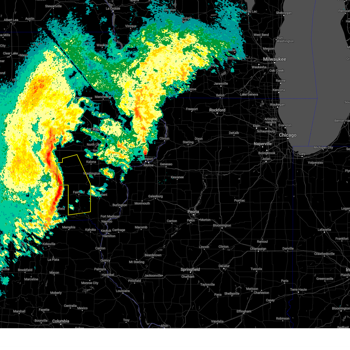
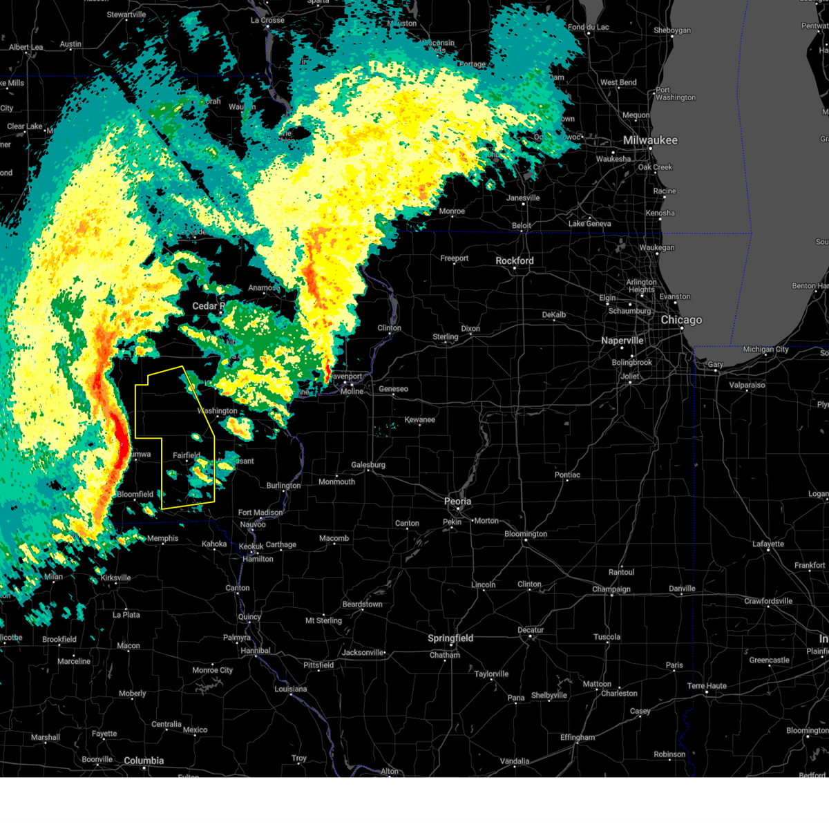
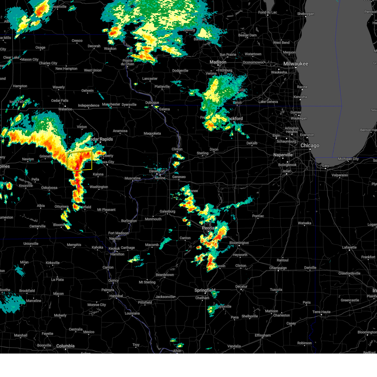
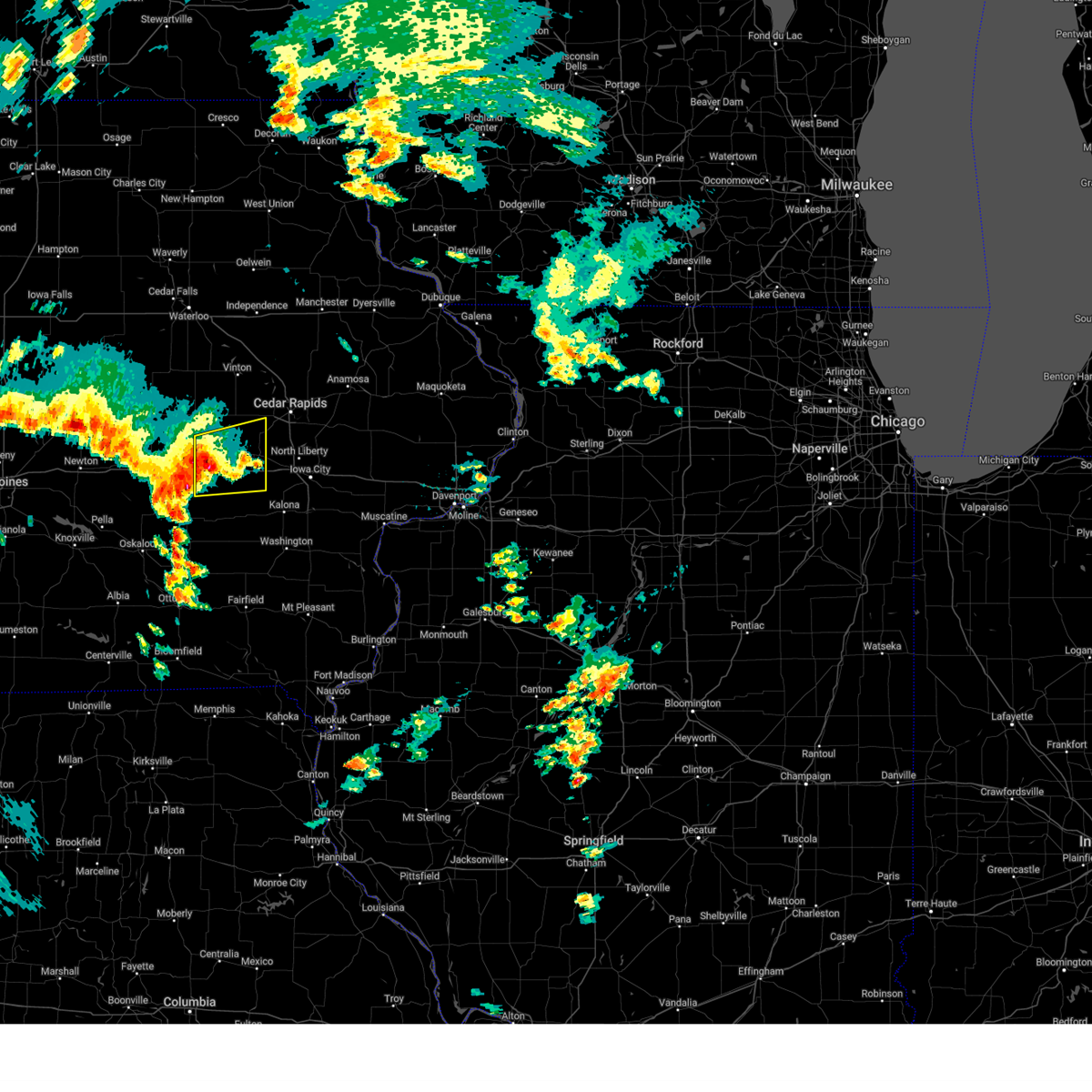
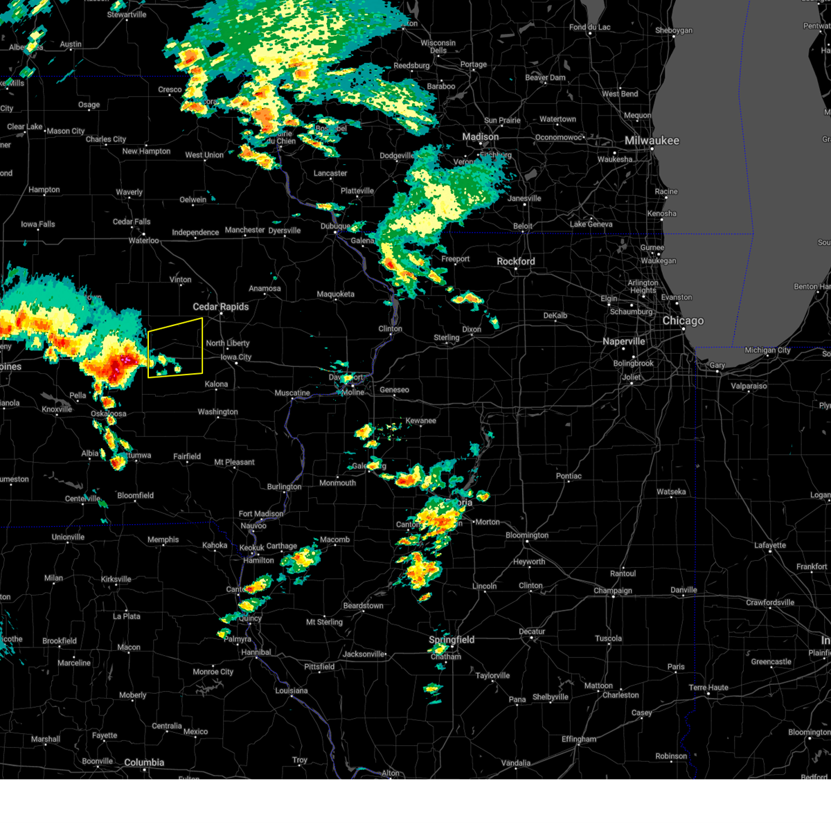
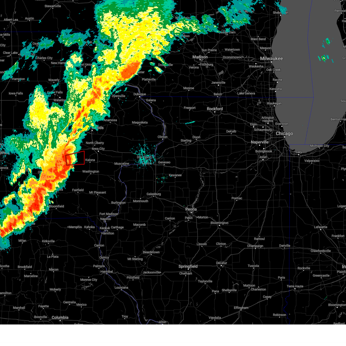
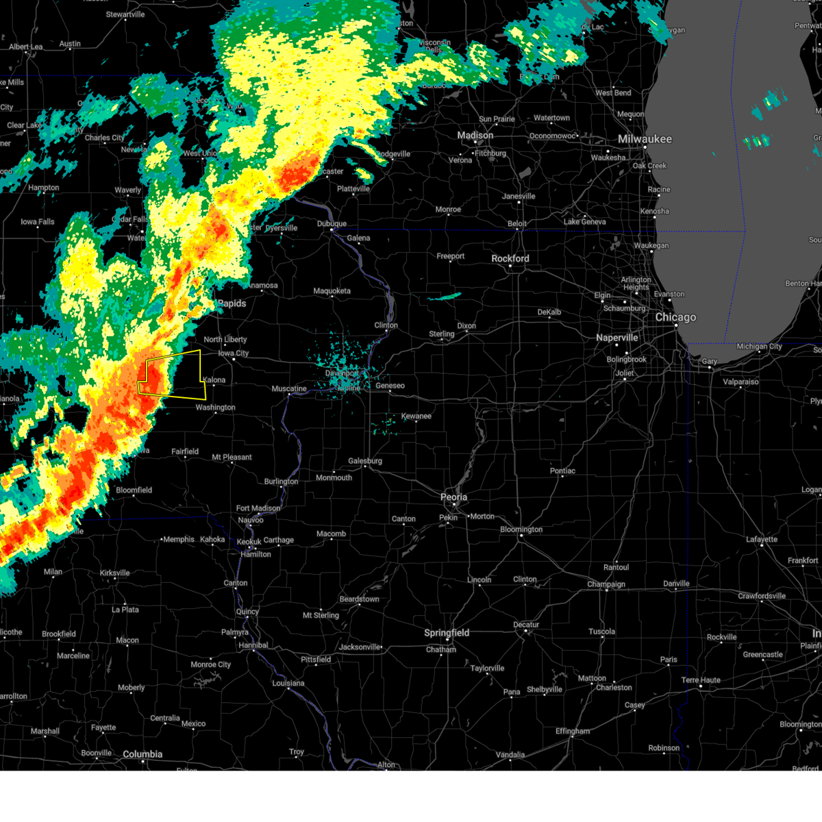
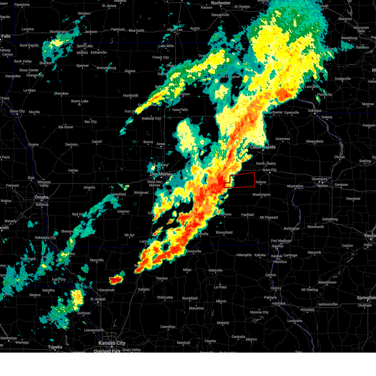
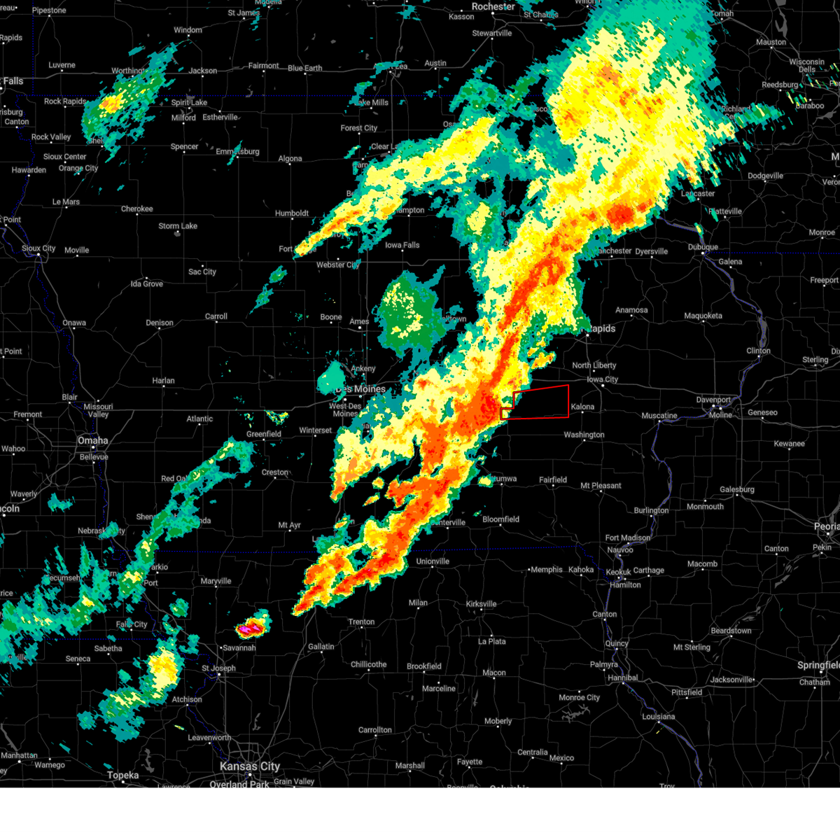
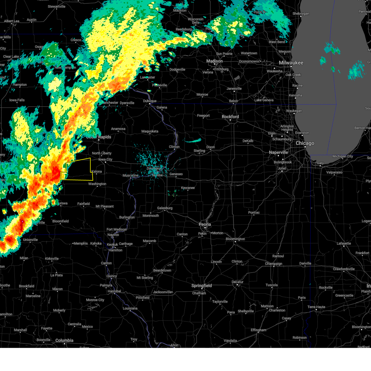
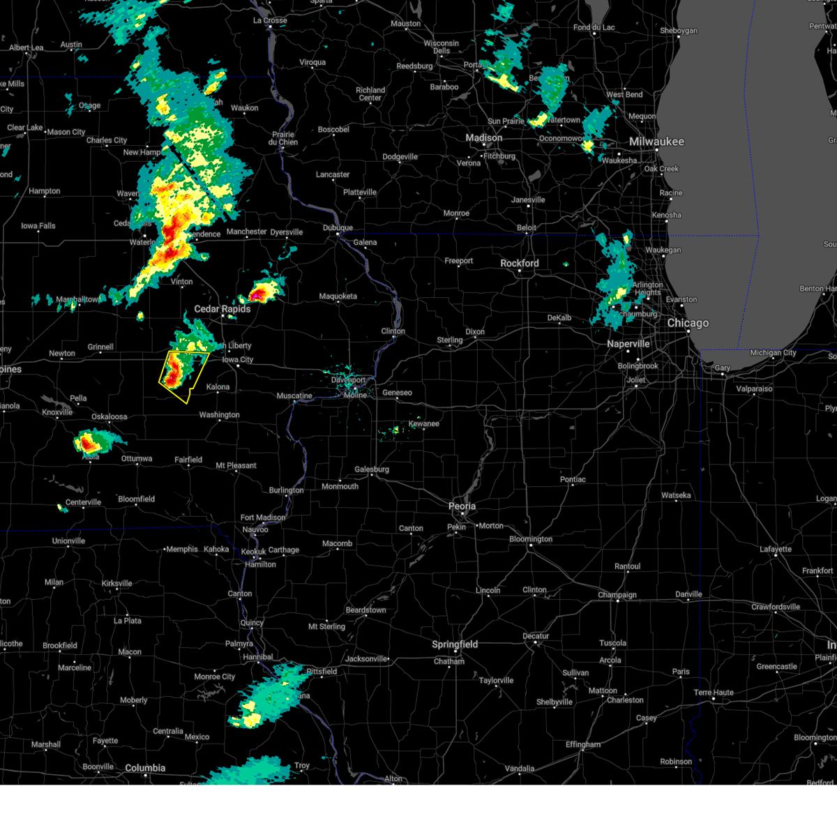
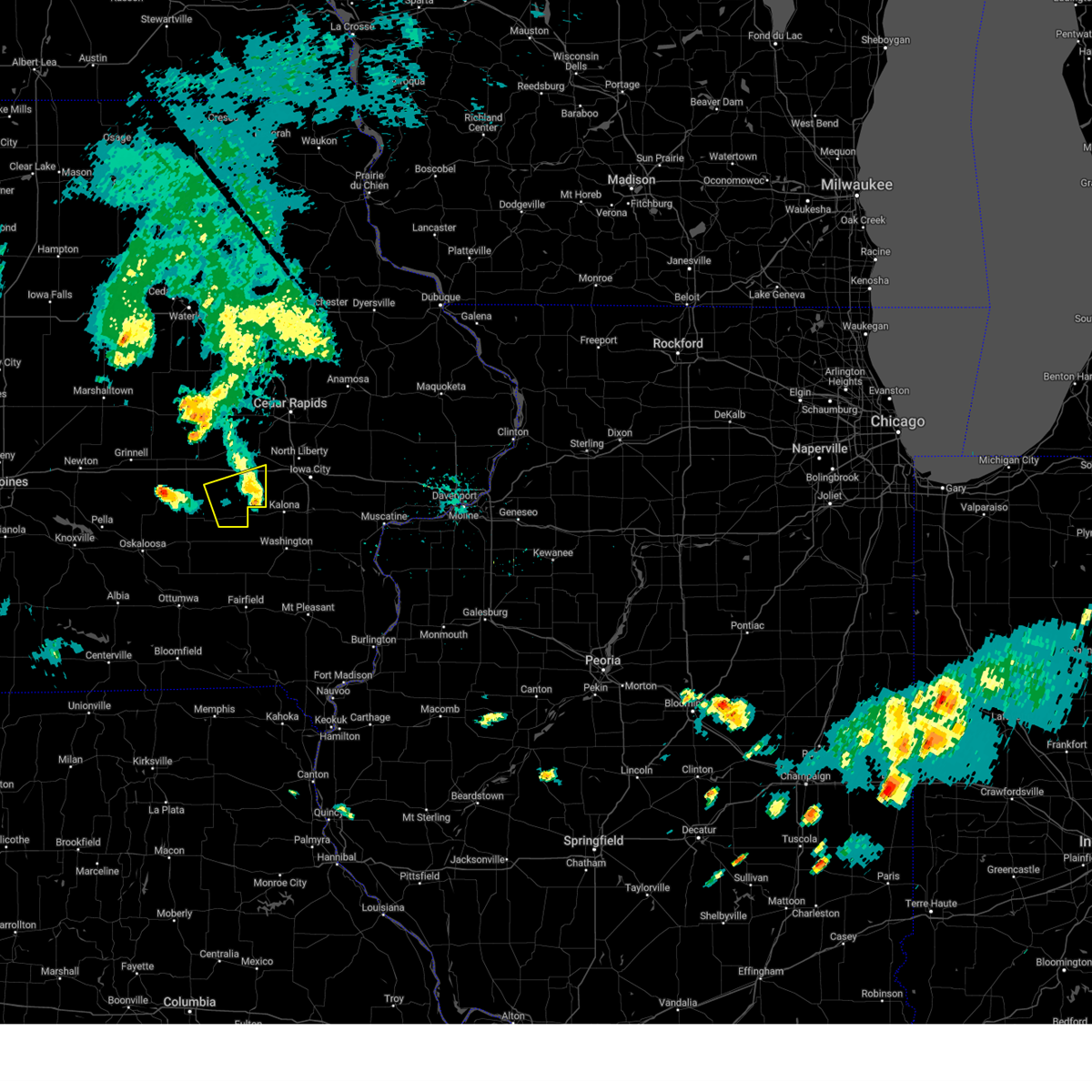
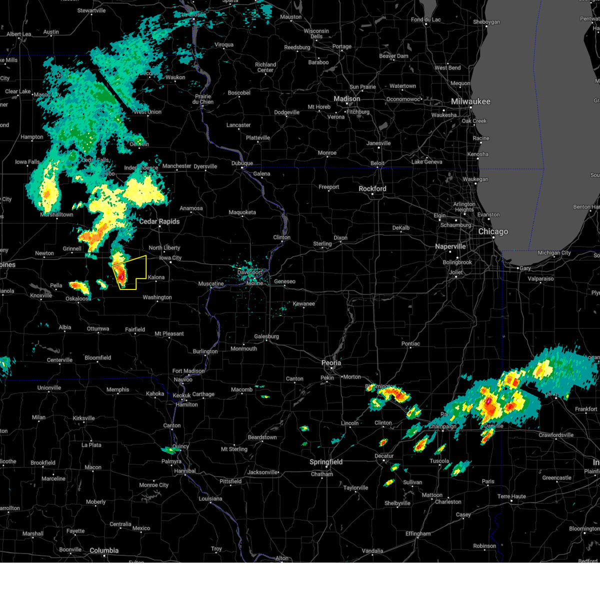
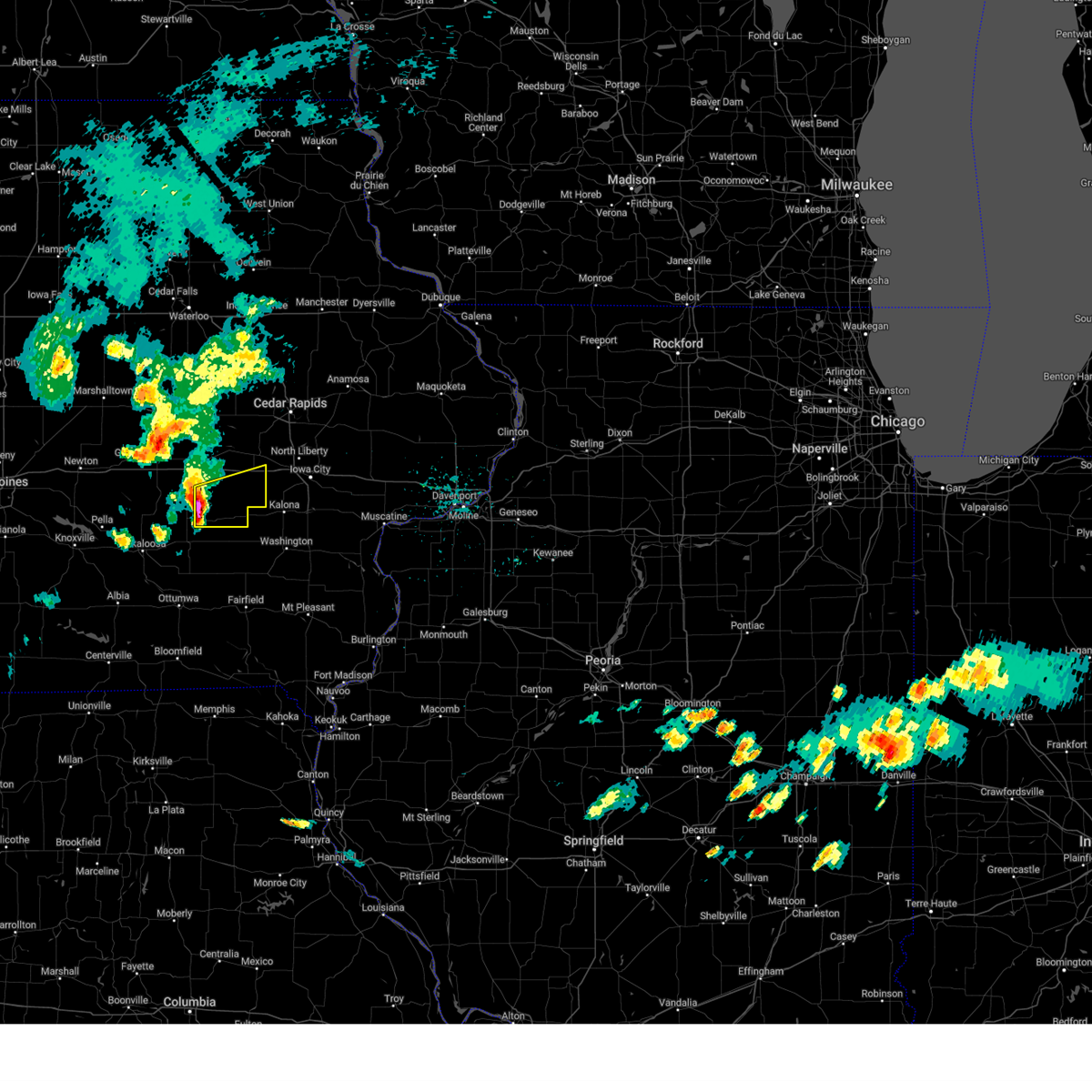
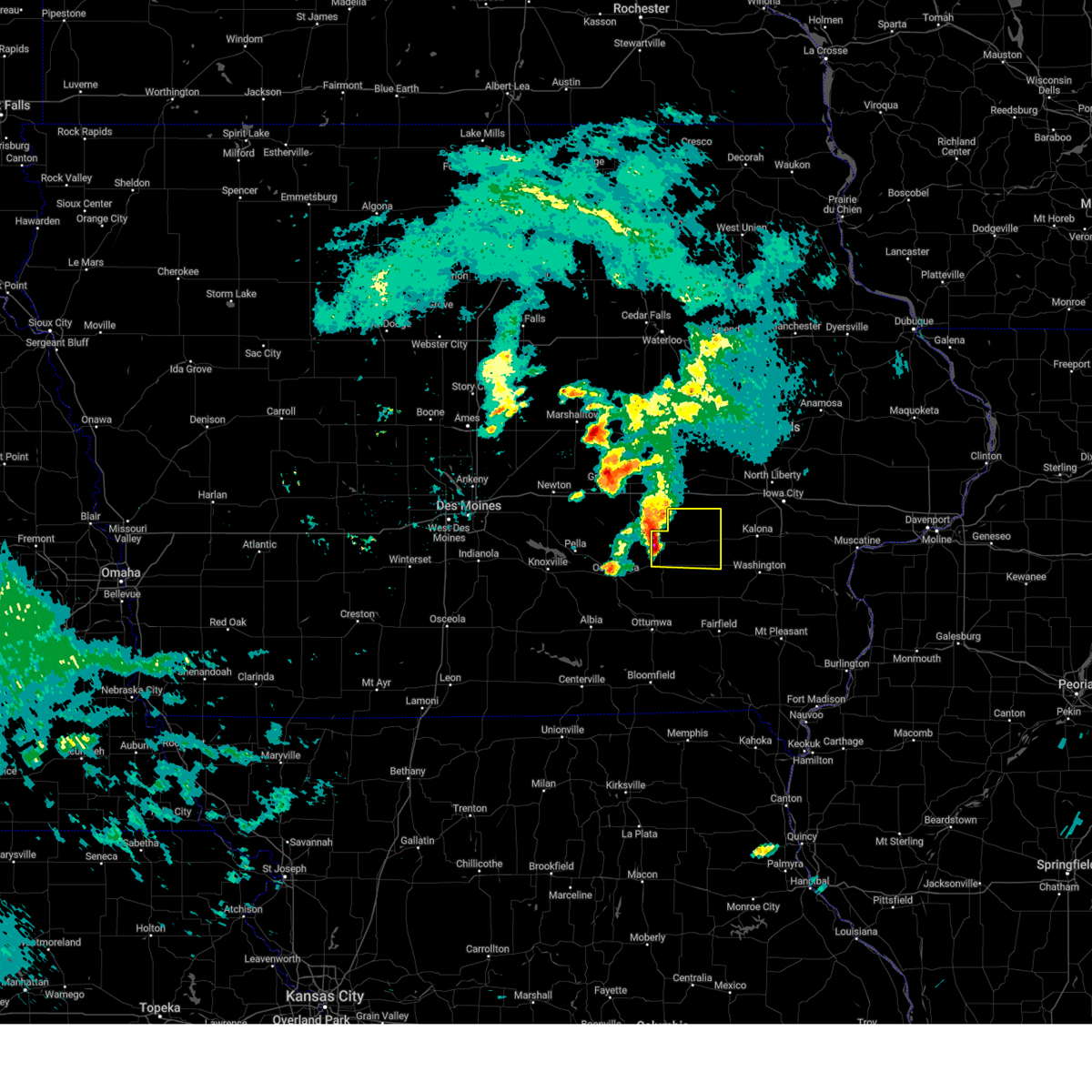
Hail Map for Millersburg, IA
The Millersburg, IA area has had 1 report of on-the-ground hail by trained spotters, and has been under severe weather warnings 15 times during the past 12 months. Doppler radar has detected hail at or near Millersburg, IA on 58 occasions, including 2 occasions during the past year.
| Name: | Millersburg, IA |
| Where Located: | 37.4 miles SW of Cedar Rapids, IA |
| Map: | Google Map for Millersburg, IA |
| Population: | 159 |
| Housing Units: | 81 |
| More Info: | Search Google for Millersburg, IA |
0
The Top Recent Hail Date for Millersburg, IA is Thursday, July 10, 2025 (37th out of 58)
Hail and Wind Damage Spotted near Millersburg, IA
| Date / Time | Report Details |
|---|---|
| 7/11/2025 2:53 AM CDT |
 At 253 am cdt, severe thunderstorms were located along a line extending from near hannen lake park to near parnell, moving east at 40 mph (radar indicated). Hazards include 60 mph wind gusts and penny size hail. Expect damage to roofs, siding, and trees. locations impacted include, marengo, williamsburg, belle plaine, walford, blairstown, norway, ladora, parnell, millersburg, luzerne, amana, conroy, middle amana, upper south amana, east amana, hannen lake park, koszta, high amana, iowa county fairgrounds, and south amana. This includes interstate 80 in iowa between mile markers 208 and 228. At 253 am cdt, severe thunderstorms were located along a line extending from near hannen lake park to near parnell, moving east at 40 mph (radar indicated). Hazards include 60 mph wind gusts and penny size hail. Expect damage to roofs, siding, and trees. locations impacted include, marengo, williamsburg, belle plaine, walford, blairstown, norway, ladora, parnell, millersburg, luzerne, amana, conroy, middle amana, upper south amana, east amana, hannen lake park, koszta, high amana, iowa county fairgrounds, and south amana. This includes interstate 80 in iowa between mile markers 208 and 228.
|
| 7/11/2025 2:48 AM CDT |
 At 247 am cdt, severe thunderstorms were located along a line extending from luzerne to near north english, moving east at 35 mph (radar indicated). Hazards include 60 mph wind gusts and penny size hail. Expect damage to roofs, siding, and trees. locations impacted include, marengo, williamsburg, belle plaine, walford, blairstown, norway, ladora, parnell, millersburg, luzerne, amana, conroy, middle amana, upper south amana, east amana, hannen lake park, koszta, high amana, iowa county fairgrounds, and south amana. This includes interstate 80 in iowa between mile markers 208 and 228. At 247 am cdt, severe thunderstorms were located along a line extending from luzerne to near north english, moving east at 35 mph (radar indicated). Hazards include 60 mph wind gusts and penny size hail. Expect damage to roofs, siding, and trees. locations impacted include, marengo, williamsburg, belle plaine, walford, blairstown, norway, ladora, parnell, millersburg, luzerne, amana, conroy, middle amana, upper south amana, east amana, hannen lake park, koszta, high amana, iowa county fairgrounds, and south amana. This includes interstate 80 in iowa between mile markers 208 and 228.
|
| 7/11/2025 2:41 AM CDT |
 At 241 am cdt, severe thunderstorms were located along a line extending from near luzerne to millersburg, moving east at 35 mph (radar indicated). Hazards include 60 mph wind gusts and penny size hail. Expect damage to roofs, siding, and trees. locations impacted include, marengo, williamsburg, belle plaine, atkins, walford, victor, newhall, blairstown, norway, ladora, parnell, millersburg, luzerne, amana, conroy, middle amana, upper south amana, east amana, hannen lake park, and koszta. This includes interstate 80 in iowa between mile markers 205 and 228. At 241 am cdt, severe thunderstorms were located along a line extending from near luzerne to millersburg, moving east at 35 mph (radar indicated). Hazards include 60 mph wind gusts and penny size hail. Expect damage to roofs, siding, and trees. locations impacted include, marengo, williamsburg, belle plaine, atkins, walford, victor, newhall, blairstown, norway, ladora, parnell, millersburg, luzerne, amana, conroy, middle amana, upper south amana, east amana, hannen lake park, and koszta. This includes interstate 80 in iowa between mile markers 205 and 228.
|
| 7/11/2025 2:34 AM CDT |
 At 234 am cdt, severe thunderstorms were located along a line extending from near belle plaine to millersburg, moving east at 40 mph (radar indicated). Hazards include 60 mph wind gusts and penny size hail. Expect damage to roofs, siding, and trees. locations impacted include, marengo, williamsburg, belle plaine, atkins, walford, victor, newhall, blairstown, norway, ladora, parnell, millersburg, luzerne, amana, conroy, middle amana, upper south amana, east amana, hannen lake park, and koszta. This includes interstate 80 in iowa between mile markers 205 and 228. At 234 am cdt, severe thunderstorms were located along a line extending from near belle plaine to millersburg, moving east at 40 mph (radar indicated). Hazards include 60 mph wind gusts and penny size hail. Expect damage to roofs, siding, and trees. locations impacted include, marengo, williamsburg, belle plaine, atkins, walford, victor, newhall, blairstown, norway, ladora, parnell, millersburg, luzerne, amana, conroy, middle amana, upper south amana, east amana, hannen lake park, and koszta. This includes interstate 80 in iowa between mile markers 205 and 228.
|
| 7/11/2025 2:22 AM CDT |
 Svrdvn the national weather service in the quad cities has issued a * severe thunderstorm warning for, southern benton county in east central iowa, iowa county in east central iowa, * until 315 am cdt. * at 221 am cdt, severe thunderstorms were located along a line extending from near holiday lake to near thornburg, moving east at 40 mph (radar indicated). Hazards include 60 mph wind gusts and penny size hail. expect damage to roofs, siding, and trees Svrdvn the national weather service in the quad cities has issued a * severe thunderstorm warning for, southern benton county in east central iowa, iowa county in east central iowa, * until 315 am cdt. * at 221 am cdt, severe thunderstorms were located along a line extending from near holiday lake to near thornburg, moving east at 40 mph (radar indicated). Hazards include 60 mph wind gusts and penny size hail. expect damage to roofs, siding, and trees
|
| 3/14/2025 7:16 PM CDT |
 At 715 pm cdt, a severe thunderstorm was located near north english, or 13 miles north of sigourney, moving north at 60 mph (radar indicated). Hazards include 70 mph wind gusts. Expect considerable tree damage. damage is likely to mobile homes, roofs, and outbuildings. locations impacted include, newhall, parnell, richland, pekin, jefferson county park, what cheer, high amana, lake darling state park, iowa county fairgrounds, hedrick, abingdon, thornburg, keokuk county fairgrounds, belle plaine, conroy, hayesville, west amana, perlee, lake iowa park, and keswick. This includes interstate 80 in iowa between mile markers 205 and 224. At 715 pm cdt, a severe thunderstorm was located near north english, or 13 miles north of sigourney, moving north at 60 mph (radar indicated). Hazards include 70 mph wind gusts. Expect considerable tree damage. damage is likely to mobile homes, roofs, and outbuildings. locations impacted include, newhall, parnell, richland, pekin, jefferson county park, what cheer, high amana, lake darling state park, iowa county fairgrounds, hedrick, abingdon, thornburg, keokuk county fairgrounds, belle plaine, conroy, hayesville, west amana, perlee, lake iowa park, and keswick. This includes interstate 80 in iowa between mile markers 205 and 224.
|
| 3/14/2025 6:49 PM CDT |
 Svrdvn the national weather service in the quad cities has issued a * severe thunderstorm warning for, keokuk county in southeastern iowa, western washington county in southeastern iowa, southwestern benton county in east central iowa, jefferson county in southeastern iowa, iowa county in east central iowa, * until 745 pm cdt. * at 648 pm cdt, a severe thunderstorm was located over linby, or 12 miles northwest of fairfield, moving north at 60 mph (radar indicated). Hazards include 70 mph wind gusts. Expect considerable tree damage. Damage is likely to mobile homes, roofs, and outbuildings. Svrdvn the national weather service in the quad cities has issued a * severe thunderstorm warning for, keokuk county in southeastern iowa, western washington county in southeastern iowa, southwestern benton county in east central iowa, jefferson county in southeastern iowa, iowa county in east central iowa, * until 745 pm cdt. * at 648 pm cdt, a severe thunderstorm was located over linby, or 12 miles northwest of fairfield, moving north at 60 mph (radar indicated). Hazards include 70 mph wind gusts. Expect considerable tree damage. Damage is likely to mobile homes, roofs, and outbuildings.
|
| 10/30/2024 8:57 PM CDT |
 The storms which prompted the warning have weakened below severe limits, and no longer pose an immediate threat to life or property. therefore, the warning will be allowed to expire. however, gusty winds are still possible with these thunderstorms. The storms which prompted the warning have weakened below severe limits, and no longer pose an immediate threat to life or property. therefore, the warning will be allowed to expire. however, gusty winds are still possible with these thunderstorms.
|
| 10/30/2024 8:50 PM CDT |
 At 850 pm cdt, severe thunderstorms were located along a line extending from near webster to richland to near milton, moving east at 45 mph (radar indicated). Hazards include 60 mph wind gusts. Expect damage to roofs, siding, and trees. Locations impacted include, fairfield, sigourney, keosauqua, north english, hedrick, brighton, what cheer, richland, batavia, birmingham, delta, libertyville, stockport, lockridge, maharishi vedic city, keswick, south english, packwood, parnell, and millersburg. At 850 pm cdt, severe thunderstorms were located along a line extending from near webster to richland to near milton, moving east at 45 mph (radar indicated). Hazards include 60 mph wind gusts. Expect damage to roofs, siding, and trees. Locations impacted include, fairfield, sigourney, keosauqua, north english, hedrick, brighton, what cheer, richland, batavia, birmingham, delta, libertyville, stockport, lockridge, maharishi vedic city, keswick, south english, packwood, parnell, and millersburg.
|
| 10/30/2024 8:31 PM CDT |
 At 831 pm cdt, severe thunderstorms were located along a line extending from gibson to martinsburg to near bloomfield municipal airport, moving east at 45 mph (radar indicated). Hazards include 60 mph wind gusts. Expect damage to roofs, siding, and trees. Locations impacted include, fairfield, sigourney, keosauqua, north english, hedrick, brighton, what cheer, richland, batavia, birmingham, delta, libertyville, stockport, lockridge, maharishi vedic city, keswick, south english, packwood, parnell, and millersburg. At 831 pm cdt, severe thunderstorms were located along a line extending from gibson to martinsburg to near bloomfield municipal airport, moving east at 45 mph (radar indicated). Hazards include 60 mph wind gusts. Expect damage to roofs, siding, and trees. Locations impacted include, fairfield, sigourney, keosauqua, north english, hedrick, brighton, what cheer, richland, batavia, birmingham, delta, libertyville, stockport, lockridge, maharishi vedic city, keswick, south english, packwood, parnell, and millersburg.
|
| 10/30/2024 8:19 PM CDT |
 Svrdvn the national weather service in the quad cities has issued a * severe thunderstorm warning for, van buren county in southeastern iowa, keokuk county in southeastern iowa, western washington county in southeastern iowa, jefferson county in southeastern iowa, southwestern iowa county in east central iowa, * until 900 pm cdt. * at 818 pm cdt, severe thunderstorms were located along a line extending from near new sharon to near ottumwa industrial airport to near moulton, moving east at 45 mph (radar indicated). Hazards include 60 mph wind gusts. expect damage to roofs, siding, and trees Svrdvn the national weather service in the quad cities has issued a * severe thunderstorm warning for, van buren county in southeastern iowa, keokuk county in southeastern iowa, western washington county in southeastern iowa, jefferson county in southeastern iowa, southwestern iowa county in east central iowa, * until 900 pm cdt. * at 818 pm cdt, severe thunderstorms were located along a line extending from near new sharon to near ottumwa industrial airport to near moulton, moving east at 45 mph (radar indicated). Hazards include 60 mph wind gusts. expect damage to roofs, siding, and trees
|
| 10/24/2024 7:30 PM CDT |
 the severe thunderstorm warning has been cancelled and is no longer in effect the severe thunderstorm warning has been cancelled and is no longer in effect
|
| 10/24/2024 7:30 PM CDT |
 At 730 pm cdt, a severe thunderstorm was located over south amana, or near marengo, moving east at 45 mph (radar indicated). Hazards include quarter size hail. Damage to vehicles is expected. locations impacted include, marengo, williamsburg, victor, ladora, parnell, millersburg, amana, conroy, middle amana, south amana, homestead, west amana, lake iowa park, upper south amana, east amana, genoa bluff, high amana, and iowa county fairgrounds. This includes interstate 80 in iowa between mile markers 205 and 229. At 730 pm cdt, a severe thunderstorm was located over south amana, or near marengo, moving east at 45 mph (radar indicated). Hazards include quarter size hail. Damage to vehicles is expected. locations impacted include, marengo, williamsburg, victor, ladora, parnell, millersburg, amana, conroy, middle amana, south amana, homestead, west amana, lake iowa park, upper south amana, east amana, genoa bluff, high amana, and iowa county fairgrounds. This includes interstate 80 in iowa between mile markers 205 and 229.
|
| 10/24/2024 7:15 PM CDT |
 At 715 pm cdt, a severe thunderstorm was located over ladora, or 4 miles east of victor, moving east at 45 mph (radar indicated). Hazards include quarter size hail. Damage to vehicles is expected. locations impacted include, marengo, williamsburg, walford, victor, blairstown, norway, ladora, parnell, millersburg, amana, conroy, middle amana, south amana, homestead, west amana, lake iowa park, upper south amana, east amana, genoa bluff, and hannen lake park. This includes interstate 80 in iowa between mile markers 205 and 229. At 715 pm cdt, a severe thunderstorm was located over ladora, or 4 miles east of victor, moving east at 45 mph (radar indicated). Hazards include quarter size hail. Damage to vehicles is expected. locations impacted include, marengo, williamsburg, walford, victor, blairstown, norway, ladora, parnell, millersburg, amana, conroy, middle amana, south amana, homestead, west amana, lake iowa park, upper south amana, east amana, genoa bluff, and hannen lake park. This includes interstate 80 in iowa between mile markers 205 and 229.
|
| 10/24/2024 7:01 PM CDT |
 Svrdvn the national weather service in the quad cities has issued a * severe thunderstorm warning for, southeastern benton county in east central iowa, iowa county in east central iowa, * until 800 pm cdt. * at 700 pm cdt, a severe thunderstorm was located near brooklyn, or 10 miles northeast of montezuma, moving east at 45 mph (radar indicated). Hazards include half dollar size hail. damage to vehicles is expected Svrdvn the national weather service in the quad cities has issued a * severe thunderstorm warning for, southeastern benton county in east central iowa, iowa county in east central iowa, * until 800 pm cdt. * at 700 pm cdt, a severe thunderstorm was located near brooklyn, or 10 miles northeast of montezuma, moving east at 45 mph (radar indicated). Hazards include half dollar size hail. damage to vehicles is expected
|
| 7/15/2024 7:14 PM CDT | The storms which prompted the warning have moved out of the area. therefore, the warning will be allowed to expire. however, gusty winds and heavy rain are still possible with these thunderstorms. a severe thunderstorm watch remains in effect until 1100 pm cdt for southeastern and east central iowa. |
| 7/15/2024 6:59 PM CDT |
 At 659 pm cdt, severe thunderstorms were located along a line extending from near haskins to packwood, moving southeast at 45 mph (radar indicated). Hazards include 70 mph wind gusts and penny size hail. Expect considerable tree damage. damage is likely to mobile homes, roofs, and outbuildings. locations impacted include, iowa city, washington, sigourney, coralville, north liberty, kalona, solon, tiffin, wellman, lone tree, university heights, north english, riverside, oxford, hedrick, hills, what cheer, richland, delta, and keswick. this includes the following highways, interstate 80 in iowa between mile markers 228 and 253. Interstate 380 between mile markers 1 and 9. At 659 pm cdt, severe thunderstorms were located along a line extending from near haskins to packwood, moving southeast at 45 mph (radar indicated). Hazards include 70 mph wind gusts and penny size hail. Expect considerable tree damage. damage is likely to mobile homes, roofs, and outbuildings. locations impacted include, iowa city, washington, sigourney, coralville, north liberty, kalona, solon, tiffin, wellman, lone tree, university heights, north english, riverside, oxford, hedrick, hills, what cheer, richland, delta, and keswick. this includes the following highways, interstate 80 in iowa between mile markers 228 and 253. Interstate 380 between mile markers 1 and 9.
|
| 7/15/2024 6:59 PM CDT |
 the severe thunderstorm warning has been cancelled and is no longer in effect the severe thunderstorm warning has been cancelled and is no longer in effect
|
| 7/15/2024 6:47 PM CDT |
 At 646 pm cdt, severe thunderstorms were located along a line extending from near richmond to near pekin, moving southeast at 65 mph (trained weather spotters. a wind gust was estimated of at least 70 mph in sigourney at 645 pm cdt). Hazards include 70 mph wind gusts and penny size hail. Expect considerable tree damage. damage is likely to mobile homes, roofs, and outbuildings. locations impacted include, iowa city, washington, marengo, sigourney, coralville, north liberty, williamsburg, kalona, solon, tiffin, walford, wellman, lone tree, university heights, north english, riverside, victor, swisher, oxford, and hedrick. this includes the following highways, interstate 80 in iowa between mile markers 206 and 253. Interstate 380 between mile markers 1 and 12. At 646 pm cdt, severe thunderstorms were located along a line extending from near richmond to near pekin, moving southeast at 65 mph (trained weather spotters. a wind gust was estimated of at least 70 mph in sigourney at 645 pm cdt). Hazards include 70 mph wind gusts and penny size hail. Expect considerable tree damage. damage is likely to mobile homes, roofs, and outbuildings. locations impacted include, iowa city, washington, marengo, sigourney, coralville, north liberty, williamsburg, kalona, solon, tiffin, walford, wellman, lone tree, university heights, north english, riverside, victor, swisher, oxford, and hedrick. this includes the following highways, interstate 80 in iowa between mile markers 206 and 253. Interstate 380 between mile markers 1 and 12.
|
| 7/15/2024 6:44 PM CDT |
 At 643 pm cdt, severe thunderstorms were located along a line extending from near amish to near hayesville, moving southeast at 45 mph (trained weather spotters. at 643 pm winds were estimated to 60 mph just north of south english). Hazards include 70 mph wind gusts and penny size hail. Expect considerable tree damage. damage is likely to mobile homes, roofs, and outbuildings. locations impacted include, iowa city, washington, marengo, sigourney, coralville, north liberty, williamsburg, kalona, solon, tiffin, walford, wellman, lone tree, university heights, north english, riverside, victor, swisher, oxford, and hedrick. this includes the following highways, interstate 80 in iowa between mile markers 206 and 253. Interstate 380 between mile markers 1 and 12. At 643 pm cdt, severe thunderstorms were located along a line extending from near amish to near hayesville, moving southeast at 45 mph (trained weather spotters. at 643 pm winds were estimated to 60 mph just north of south english). Hazards include 70 mph wind gusts and penny size hail. Expect considerable tree damage. damage is likely to mobile homes, roofs, and outbuildings. locations impacted include, iowa city, washington, marengo, sigourney, coralville, north liberty, williamsburg, kalona, solon, tiffin, walford, wellman, lone tree, university heights, north english, riverside, victor, swisher, oxford, and hedrick. this includes the following highways, interstate 80 in iowa between mile markers 206 and 253. Interstate 380 between mile markers 1 and 12.
|
| 7/15/2024 6:36 PM CDT | At 636 pm cdt, severe thunderstorms were located along a line extending from near amish to delta, moving southeast at 50 mph (radar indicated). Hazards include 70 mph wind gusts and penny size hail. Expect considerable tree damage. damage is likely to mobile homes, roofs, and outbuildings. locations impacted include, iowa city, washington, marengo, sigourney, coralville, north liberty, williamsburg, kalona, solon, tiffin, walford, wellman, lone tree, university heights, north english, riverside, victor, swisher, oxford, and hedrick. this includes the following highways, interstate 80 in iowa between mile markers 206 and 253. Interstate 380 between mile markers 1 and 12. |
| 7/15/2024 6:19 PM CDT |
 At 618 pm cdt, severe thunderstorms were located along a line extending from upper south amana to barnes city, moving southeast at 45 mph (trained weather spotters. at 610 pm a 70 mph wind gust was estimated in swisher). Hazards include 70 mph wind gusts and penny size hail. Expect considerable tree damage. damage is likely to mobile homes, roofs, and outbuildings. locations impacted include, iowa city, washington, marengo, sigourney, coralville, north liberty, williamsburg, kalona, solon, tiffin, walford, wellman, lone tree, university heights, north english, riverside, victor, swisher, oxford, and hedrick. this includes the following highways, interstate 80 in iowa between mile markers 205 and 253. Interstate 380 between mile markers 1 and 12. At 618 pm cdt, severe thunderstorms were located along a line extending from upper south amana to barnes city, moving southeast at 45 mph (trained weather spotters. at 610 pm a 70 mph wind gust was estimated in swisher). Hazards include 70 mph wind gusts and penny size hail. Expect considerable tree damage. damage is likely to mobile homes, roofs, and outbuildings. locations impacted include, iowa city, washington, marengo, sigourney, coralville, north liberty, williamsburg, kalona, solon, tiffin, walford, wellman, lone tree, university heights, north english, riverside, victor, swisher, oxford, and hedrick. this includes the following highways, interstate 80 in iowa between mile markers 205 and 253. Interstate 380 between mile markers 1 and 12.
|
| 7/15/2024 6:10 PM CDT | Svrdvn the national weather service in the quad cities has issued a * severe thunderstorm warning for, keokuk county in southeastern iowa, johnson county in east central iowa, washington county in southeastern iowa, southeastern benton county in east central iowa, northwestern jefferson county in southeastern iowa, southwestern linn county in east central iowa, iowa county in east central iowa, * until 715 pm cdt. * at 610 pm cdt, severe thunderstorms were located along a line extending from near iowa county fairgrounds to montezuma, moving southeast at 45 mph (radar indicated). Hazards include 70 mph wind gusts and penny size hail. Expect considerable tree damage. Damage is likely to mobile homes, roofs, and outbuildings. |
| 7/2/2024 5:26 PM CDT |
 Svrdvn the national weather service in the quad cities has issued a * severe thunderstorm warning for, northwestern louisa county in southeastern iowa, northeastern keokuk county in southeastern iowa, southern johnson county in east central iowa, northern washington county in southeastern iowa, southeastern iowa county in east central iowa, * until 615 pm cdt. * at 525 pm cdt, severe thunderstorms were located along a line extending from parnell to near harper, moving east at 35 mph (emergency management). Hazards include 70 mph wind gusts. at 524 pm, wind was estimated to be near 70 mph just west of millersburg. Expect considerable tree damage. damage is likely to mobile homes, roofs, and outbuildings. severe thunderstorms will be near, kinross and holbrook around 530 pm cdt. wellman around 535 pm cdt. frytown and amish around 540 pm cdt. kalona and richmond around 545 pm cdt. sharon center around 550 pm cdt. riverside around 555 pm cdt. hills, haskins, river junction, and hills access around 600 pm cdt. Other locations impacted by these severe thunderstorms include webster, iowa city municipal airport, frytown, windham, amish, johnson county fairgrounds, holbrook, hills access, river junction, and sharon center. Svrdvn the national weather service in the quad cities has issued a * severe thunderstorm warning for, northwestern louisa county in southeastern iowa, northeastern keokuk county in southeastern iowa, southern johnson county in east central iowa, northern washington county in southeastern iowa, southeastern iowa county in east central iowa, * until 615 pm cdt. * at 525 pm cdt, severe thunderstorms were located along a line extending from parnell to near harper, moving east at 35 mph (emergency management). Hazards include 70 mph wind gusts. at 524 pm, wind was estimated to be near 70 mph just west of millersburg. Expect considerable tree damage. damage is likely to mobile homes, roofs, and outbuildings. severe thunderstorms will be near, kinross and holbrook around 530 pm cdt. wellman around 535 pm cdt. frytown and amish around 540 pm cdt. kalona and richmond around 545 pm cdt. sharon center around 550 pm cdt. riverside around 555 pm cdt. hills, haskins, river junction, and hills access around 600 pm cdt. Other locations impacted by these severe thunderstorms include webster, iowa city municipal airport, frytown, windham, amish, johnson county fairgrounds, holbrook, hills access, river junction, and sharon center.
|
| 7/2/2024 5:19 PM CDT |
 At 518 pm cdt, a severe thunderstorm capable of producing a tornado was located over north english, or 15 miles north of sigourney, moving east at 35 mph (radar indicated rotation). Hazards include tornado. Flying debris will be dangerous to those caught without shelter. mobile homes will be damaged or destroyed. damage to roofs, windows, and vehicles will occur. tree damage is likely. this dangerous storm will be near, parnell, kinross, and holbrook around 525 pm cdt. Wellman around 530 pm cdt. At 518 pm cdt, a severe thunderstorm capable of producing a tornado was located over north english, or 15 miles north of sigourney, moving east at 35 mph (radar indicated rotation). Hazards include tornado. Flying debris will be dangerous to those caught without shelter. mobile homes will be damaged or destroyed. damage to roofs, windows, and vehicles will occur. tree damage is likely. this dangerous storm will be near, parnell, kinross, and holbrook around 525 pm cdt. Wellman around 530 pm cdt.
|
| 7/2/2024 5:11 PM CDT |
 At 510 pm cdt, a severe thunderstorm capable of producing a tornado was located near millersburg, or 13 miles north of sigourney, moving east at 40 mph (radar indicated rotation). Hazards include tornado. Flying debris will be dangerous to those caught without shelter. mobile homes will be damaged or destroyed. damage to roofs, windows, and vehicles will occur. tree damage is likely. this dangerous storm will be near, north english, south english, parnell, millersburg, and kinross around 515 pm cdt. holbrook around 520 pm cdt. Other locations in the path of this tornadic thunderstorm include wellman. At 510 pm cdt, a severe thunderstorm capable of producing a tornado was located near millersburg, or 13 miles north of sigourney, moving east at 40 mph (radar indicated rotation). Hazards include tornado. Flying debris will be dangerous to those caught without shelter. mobile homes will be damaged or destroyed. damage to roofs, windows, and vehicles will occur. tree damage is likely. this dangerous storm will be near, north english, south english, parnell, millersburg, and kinross around 515 pm cdt. holbrook around 520 pm cdt. Other locations in the path of this tornadic thunderstorm include wellman.
|
| 7/2/2024 5:09 PM CDT |
 At 509 pm cdt, a severe thunderstorm was located over keswick, or 11 miles north of sigourney, moving east at 35 mph (radar indicated). Hazards include 70 mph wind gusts. Expect considerable tree damage. damage is likely to mobile homes, roofs, and outbuildings. this severe storm will be near, north english, south english, millersburg, and webster around 515 pm cdt. kinross around 520 pm cdt. parnell around 525 pm cdt. holbrook around 530 pm cdt. other locations impacted by this severe thunderstorm include holbrook, webster, thornburg, and lake iowa park. This includes interstate 80 in iowa between mile markers 218 and 229. At 509 pm cdt, a severe thunderstorm was located over keswick, or 11 miles north of sigourney, moving east at 35 mph (radar indicated). Hazards include 70 mph wind gusts. Expect considerable tree damage. damage is likely to mobile homes, roofs, and outbuildings. this severe storm will be near, north english, south english, millersburg, and webster around 515 pm cdt. kinross around 520 pm cdt. parnell around 525 pm cdt. holbrook around 530 pm cdt. other locations impacted by this severe thunderstorm include holbrook, webster, thornburg, and lake iowa park. This includes interstate 80 in iowa between mile markers 218 and 229.
|
| 7/2/2024 5:01 PM CDT |
 At 500 pm cdt, a severe thunderstorm capable of producing a tornado was located near thornburg, or 12 miles east of montezuma, moving east at 40 mph (radar indicated rotation). Hazards include tornado. Flying debris will be dangerous to those caught without shelter. mobile homes will be damaged or destroyed. damage to roofs, windows, and vehicles will occur. tree damage is likely. this dangerous storm will be near, north english, keswick, south english, and millersburg around 505 pm cdt. parnell around 510 pm cdt. Other locations in the path of this tornadic thunderstorm include kinross, holbrook and wellman. At 500 pm cdt, a severe thunderstorm capable of producing a tornado was located near thornburg, or 12 miles east of montezuma, moving east at 40 mph (radar indicated rotation). Hazards include tornado. Flying debris will be dangerous to those caught without shelter. mobile homes will be damaged or destroyed. damage to roofs, windows, and vehicles will occur. tree damage is likely. this dangerous storm will be near, north english, keswick, south english, and millersburg around 505 pm cdt. parnell around 510 pm cdt. Other locations in the path of this tornadic thunderstorm include kinross, holbrook and wellman.
|
| 7/2/2024 4:52 PM CDT |
 Tordvn the national weather service in the quad cities has issued a * tornado warning for, northern keokuk county in southeastern iowa, northwestern washington county in southeastern iowa, southern iowa county in east central iowa, * until 530 pm cdt. * at 452 pm cdt, a severe thunderstorm capable of producing a tornado was located over gibson, or 7 miles southeast of montezuma, moving east at 40 mph (radar indicated rotation). Hazards include tornado. Flying debris will be dangerous to those caught without shelter. mobile homes will be damaged or destroyed. damage to roofs, windows, and vehicles will occur. tree damage is likely. this dangerous storm will be near, keswick, thornburg, and gibson around 455 pm cdt. millersburg around 500 pm cdt. north english and south english around 505 pm cdt. parnell around 510 pm cdt. Other locations in the path of this tornadic thunderstorm include kinross and holbrook. Tordvn the national weather service in the quad cities has issued a * tornado warning for, northern keokuk county in southeastern iowa, northwestern washington county in southeastern iowa, southern iowa county in east central iowa, * until 530 pm cdt. * at 452 pm cdt, a severe thunderstorm capable of producing a tornado was located over gibson, or 7 miles southeast of montezuma, moving east at 40 mph (radar indicated rotation). Hazards include tornado. Flying debris will be dangerous to those caught without shelter. mobile homes will be damaged or destroyed. damage to roofs, windows, and vehicles will occur. tree damage is likely. this dangerous storm will be near, keswick, thornburg, and gibson around 455 pm cdt. millersburg around 500 pm cdt. north english and south english around 505 pm cdt. parnell around 510 pm cdt. Other locations in the path of this tornadic thunderstorm include kinross and holbrook.
|
| 7/2/2024 4:50 PM CDT |
 Svrdvn the national weather service in the quad cities has issued a * severe thunderstorm warning for, northern keokuk county in southeastern iowa, northwestern washington county in southeastern iowa, southern iowa county in east central iowa, * until 530 pm cdt. * at 449 pm cdt, a severe thunderstorm was located over barnes city, or near montezuma, moving east at 45 mph (radar indicated). Hazards include 70 mph wind gusts. Expect considerable tree damage. damage is likely to mobile homes, roofs, and outbuildings. this severe thunderstorm will be near, what cheer, keswick, thornburg, gibson, coal creek, and keokuk county fairgrounds around 455 pm cdt. millersburg and webster around 505 pm cdt. north english, south english, and lake iowa park around 510 pm cdt. parnell and kinross around 515 pm cdt. williamsburg around 520 pm cdt. other locations impacted by this severe thunderstorm include webster, holbrook, thornburg, keokuk county fairgrounds, lake iowa park, coal creek, and gibson. This includes interstate 80 in iowa between mile markers 218 and 229. Svrdvn the national weather service in the quad cities has issued a * severe thunderstorm warning for, northern keokuk county in southeastern iowa, northwestern washington county in southeastern iowa, southern iowa county in east central iowa, * until 530 pm cdt. * at 449 pm cdt, a severe thunderstorm was located over barnes city, or near montezuma, moving east at 45 mph (radar indicated). Hazards include 70 mph wind gusts. Expect considerable tree damage. damage is likely to mobile homes, roofs, and outbuildings. this severe thunderstorm will be near, what cheer, keswick, thornburg, gibson, coal creek, and keokuk county fairgrounds around 455 pm cdt. millersburg and webster around 505 pm cdt. north english, south english, and lake iowa park around 510 pm cdt. parnell and kinross around 515 pm cdt. williamsburg around 520 pm cdt. other locations impacted by this severe thunderstorm include webster, holbrook, thornburg, keokuk county fairgrounds, lake iowa park, coal creek, and gibson. This includes interstate 80 in iowa between mile markers 218 and 229.
|
| 6/25/2024 6:36 PM CDT |
 At 635 pm cdt, a severe thunderstorm was located over parnell, or 15 miles south of marengo, moving east at 40 mph (radar indicated). Hazards include 60 mph wind gusts and quarter size hail. Hail damage to vehicles is expected. expect wind damage to roofs, siding, and trees. locations impacted include, williamsburg, tiffin, wellman, north english, oxford, south english, parnell, millersburg, harper, kinross, conroy, keota, webster, windham, cosgrove, f. w. kent park, amish, holbrook, and talleyrand. This includes interstate 80 in iowa between mile markers 213 and 236. At 635 pm cdt, a severe thunderstorm was located over parnell, or 15 miles south of marengo, moving east at 40 mph (radar indicated). Hazards include 60 mph wind gusts and quarter size hail. Hail damage to vehicles is expected. expect wind damage to roofs, siding, and trees. locations impacted include, williamsburg, tiffin, wellman, north english, oxford, south english, parnell, millersburg, harper, kinross, conroy, keota, webster, windham, cosgrove, f. w. kent park, amish, holbrook, and talleyrand. This includes interstate 80 in iowa between mile markers 213 and 236.
|
| 6/25/2024 6:22 PM CDT |
 Svrdvn the national weather service in the quad cities has issued a * severe thunderstorm warning for, northeastern keokuk county in southeastern iowa, west central johnson county in east central iowa, northwestern washington county in southeastern iowa, iowa county in east central iowa, * until 715 pm cdt. * at 622 pm cdt, a severe thunderstorm was located over lake iowa park, or 13 miles south of marengo, moving east at 40 mph (radar indicated). Hazards include 60 mph wind gusts and quarter size hail. Hail damage to vehicles is expected. Expect wind damage to roofs, siding, and trees. Svrdvn the national weather service in the quad cities has issued a * severe thunderstorm warning for, northeastern keokuk county in southeastern iowa, west central johnson county in east central iowa, northwestern washington county in southeastern iowa, iowa county in east central iowa, * until 715 pm cdt. * at 622 pm cdt, a severe thunderstorm was located over lake iowa park, or 13 miles south of marengo, moving east at 40 mph (radar indicated). Hazards include 60 mph wind gusts and quarter size hail. Hail damage to vehicles is expected. Expect wind damage to roofs, siding, and trees.
|
| 5/27/2024 4:04 PM CDT |
 At 404 pm cdt, severe thunderstorms were located along a line extending from near genoa bluff to millersburg, moving southeast at 35 mph (radar indicated). Hazards include 60 mph wind gusts and quarter size hail. Hail damage to vehicles is expected. expect wind damage to roofs, siding, and trees. locations impacted include, williamsburg, north english, oxford, parnell, millersburg, kinross, conroy, holbrook, and lake iowa park. This includes interstate 80 in iowa between mile markers 213 and 230. At 404 pm cdt, severe thunderstorms were located along a line extending from near genoa bluff to millersburg, moving southeast at 35 mph (radar indicated). Hazards include 60 mph wind gusts and quarter size hail. Hail damage to vehicles is expected. expect wind damage to roofs, siding, and trees. locations impacted include, williamsburg, north english, oxford, parnell, millersburg, kinross, conroy, holbrook, and lake iowa park. This includes interstate 80 in iowa between mile markers 213 and 230.
|
| 5/27/2024 3:57 PM CDT |
 At 356 pm cdt, severe thunderstorms were located along a line extending from ladora to near millersburg, moving southeast at 35 mph (radar indicated). Hazards include 60 mph wind gusts and quarter size hail. Hail damage to vehicles is expected. expect wind damage to roofs, siding, and trees. locations impacted include, williamsburg, north english, oxford, ladora, parnell, millersburg, kinross, conroy, homestead, lake iowa park, upper south amana, genoa bluff, and holbrook. This includes interstate 80 in iowa between mile markers 209 and 229. At 356 pm cdt, severe thunderstorms were located along a line extending from ladora to near millersburg, moving southeast at 35 mph (radar indicated). Hazards include 60 mph wind gusts and quarter size hail. Hail damage to vehicles is expected. expect wind damage to roofs, siding, and trees. locations impacted include, williamsburg, north english, oxford, ladora, parnell, millersburg, kinross, conroy, homestead, lake iowa park, upper south amana, genoa bluff, and holbrook. This includes interstate 80 in iowa between mile markers 209 and 229.
|
| 5/27/2024 3:43 PM CDT |
 Svrdvn the national weather service in the quad cities has issued a * severe thunderstorm warning for, northeastern keokuk county in southeastern iowa, west central johnson county in east central iowa, iowa county in east central iowa, * until 430 pm cdt. * at 343 pm cdt, severe thunderstorms were located along a line extending from near hartwick to guernsey, moving southeast at 35 mph (radar indicated). Hazards include 60 mph wind gusts and quarter size hail. Hail damage to vehicles is expected. Expect wind damage to roofs, siding, and trees. Svrdvn the national weather service in the quad cities has issued a * severe thunderstorm warning for, northeastern keokuk county in southeastern iowa, west central johnson county in east central iowa, iowa county in east central iowa, * until 430 pm cdt. * at 343 pm cdt, severe thunderstorms were located along a line extending from near hartwick to guernsey, moving southeast at 35 mph (radar indicated). Hazards include 60 mph wind gusts and quarter size hail. Hail damage to vehicles is expected. Expect wind damage to roofs, siding, and trees.
|
| 5/24/2024 6:33 AM CDT |
 At 633 am cdt, severe thunderstorms were located along a line extending from near watkins to near west chester to near brookville, moving east at 55 mph (radar indicated). Hazards include 70 mph wind gusts and nickel size hail. Expect considerable tree damage. damage is likely to mobile homes, roofs, and outbuildings. locations impacted include, iowa city, fairfield, washington, marengo, sigourney, coralville, north liberty, williamsburg, kalona, tiffin, wellman, university heights, north english, riverside, victor, swisher, oxford, hedrick, hills, and brighton. this includes the following highways, interstate 80 in iowa between mile markers 205 and 242. Interstate 380 between mile markers 1 and 11. At 633 am cdt, severe thunderstorms were located along a line extending from near watkins to near west chester to near brookville, moving east at 55 mph (radar indicated). Hazards include 70 mph wind gusts and nickel size hail. Expect considerable tree damage. damage is likely to mobile homes, roofs, and outbuildings. locations impacted include, iowa city, fairfield, washington, marengo, sigourney, coralville, north liberty, williamsburg, kalona, tiffin, wellman, university heights, north english, riverside, victor, swisher, oxford, hedrick, hills, and brighton. this includes the following highways, interstate 80 in iowa between mile markers 205 and 242. Interstate 380 between mile markers 1 and 11.
|
| 5/24/2024 6:24 AM CDT |
 At 623 am cdt, a severe squall line capable of producing both tornadoes and extensive straight line wind damage was located over millersburg, or 15 miles south of marengo, moving northeast at 45 mph (radar indicated rotation). Hazards include tornado and quarter size hail. Flying debris will be dangerous to those caught without shelter. mobile homes will be damaged or destroyed. damage to roofs, windows, and vehicles will occur. tree damage is likely. these dangerous storms will be near, williamsburg, parnell, conroy, and holbrook around 630 am cdt. upper south amana, homestead, west amana, high amana, and south amana around 635 am cdt. other locations in the path of this tornadic thunderstorm include amana, east amana and middle amana. This includes interstate 80 in iowa between mile markers 208 and 228. At 623 am cdt, a severe squall line capable of producing both tornadoes and extensive straight line wind damage was located over millersburg, or 15 miles south of marengo, moving northeast at 45 mph (radar indicated rotation). Hazards include tornado and quarter size hail. Flying debris will be dangerous to those caught without shelter. mobile homes will be damaged or destroyed. damage to roofs, windows, and vehicles will occur. tree damage is likely. these dangerous storms will be near, williamsburg, parnell, conroy, and holbrook around 630 am cdt. upper south amana, homestead, west amana, high amana, and south amana around 635 am cdt. other locations in the path of this tornadic thunderstorm include amana, east amana and middle amana. This includes interstate 80 in iowa between mile markers 208 and 228.
|
| 5/24/2024 6:17 AM CDT |
 At 616 am cdt, a severe squall line capable of producing both tornadoes and extensive straight line wind damage was located near north english, or 12 miles north of sigourney, moving east at 55 mph (radar indicated rotation). Hazards include tornado and quarter size hail. Flying debris will be dangerous to those caught without shelter. mobile homes will be damaged or destroyed. damage to roofs, windows, and vehicles will occur. tree damage is likely. these dangerous storms will be near, north english, south english, parnell, kinross, and holbrook around 620 am cdt. other locations in the path of this tornadic thunderstorm include wellman. This includes interstate 80 in iowa between mile markers 208 and 228. At 616 am cdt, a severe squall line capable of producing both tornadoes and extensive straight line wind damage was located near north english, or 12 miles north of sigourney, moving east at 55 mph (radar indicated rotation). Hazards include tornado and quarter size hail. Flying debris will be dangerous to those caught without shelter. mobile homes will be damaged or destroyed. damage to roofs, windows, and vehicles will occur. tree damage is likely. these dangerous storms will be near, north english, south english, parnell, kinross, and holbrook around 620 am cdt. other locations in the path of this tornadic thunderstorm include wellman. This includes interstate 80 in iowa between mile markers 208 and 228.
|
| 5/24/2024 6:15 AM CDT |
 At 614 am cdt, severe thunderstorms were located along a line extending from near koszta to harper to near ottumwa, moving east at 55 mph (radar indicated). Hazards include 70 mph wind gusts and nickel size hail. Expect considerable tree damage. damage is likely to mobile homes, roofs, and outbuildings. locations impacted include, iowa city, fairfield, washington, marengo, sigourney, coralville, north liberty, williamsburg, kalona, tiffin, wellman, university heights, north english, riverside, victor, swisher, oxford, hedrick, hills, and brighton. this includes the following highways, interstate 80 in iowa between mile markers 205 and 242. Interstate 380 between mile markers 1 and 11. At 614 am cdt, severe thunderstorms were located along a line extending from near koszta to harper to near ottumwa, moving east at 55 mph (radar indicated). Hazards include 70 mph wind gusts and nickel size hail. Expect considerable tree damage. damage is likely to mobile homes, roofs, and outbuildings. locations impacted include, iowa city, fairfield, washington, marengo, sigourney, coralville, north liberty, williamsburg, kalona, tiffin, wellman, university heights, north english, riverside, victor, swisher, oxford, hedrick, hills, and brighton. this includes the following highways, interstate 80 in iowa between mile markers 205 and 242. Interstate 380 between mile markers 1 and 11.
|
| 5/24/2024 6:05 AM CDT |
 Svrdvn the national weather service in the quad cities has issued a * severe thunderstorm warning for, keokuk county in southeastern iowa, western johnson county in east central iowa, washington county in southeastern iowa, jefferson county in southeastern iowa, iowa county in east central iowa, * until 645 am cdt. * at 605 am cdt, severe thunderstorms were located along a line extending from holiday lake to sigourney to near blakesburg, moving east at 55 mph (radar indicated). Hazards include 70 mph wind gusts and nickel size hail. Expect considerable tree damage. Damage is likely to mobile homes, roofs, and outbuildings. Svrdvn the national weather service in the quad cities has issued a * severe thunderstorm warning for, keokuk county in southeastern iowa, western johnson county in east central iowa, washington county in southeastern iowa, jefferson county in southeastern iowa, iowa county in east central iowa, * until 645 am cdt. * at 605 am cdt, severe thunderstorms were located along a line extending from holiday lake to sigourney to near blakesburg, moving east at 55 mph (radar indicated). Hazards include 70 mph wind gusts and nickel size hail. Expect considerable tree damage. Damage is likely to mobile homes, roofs, and outbuildings.
|
| 5/24/2024 6:04 AM CDT |
 At 604 am cdt, a severe squall line capable of producing both tornadoes and extensive straight line wind damage was located over gibson, or 10 miles southeast of montezuma, moving northeast at 50 mph (radar indicated rotation). Hazards include tornado and quarter size hail. Flying debris will be dangerous to those caught without shelter. mobile homes will be damaged or destroyed. damage to roofs, windows, and vehicles will occur. tree damage is likely. these dangerous storms will be near, keswick, millersburg, and lake iowa park around 610 am cdt. other locations in the path of this tornadic thunderstorm include williamsburg, north english, genoa bluff, ladora, parnell, conroy, marengo, upper south amana, south amana, iowa county fairgrounds, amana, homestead, west amana, high amana, middle amana and east amana. This includes interstate 80 in iowa between mile markers 208 and 228. At 604 am cdt, a severe squall line capable of producing both tornadoes and extensive straight line wind damage was located over gibson, or 10 miles southeast of montezuma, moving northeast at 50 mph (radar indicated rotation). Hazards include tornado and quarter size hail. Flying debris will be dangerous to those caught without shelter. mobile homes will be damaged or destroyed. damage to roofs, windows, and vehicles will occur. tree damage is likely. these dangerous storms will be near, keswick, millersburg, and lake iowa park around 610 am cdt. other locations in the path of this tornadic thunderstorm include williamsburg, north english, genoa bluff, ladora, parnell, conroy, marengo, upper south amana, south amana, iowa county fairgrounds, amana, homestead, west amana, high amana, middle amana and east amana. This includes interstate 80 in iowa between mile markers 208 and 228.
|
| 5/24/2024 6:00 AM CDT |
 At 559 am cdt, a severe thunderstorm was located over north english, or 16 miles north of sigourney, moving northeast at 40 mph (radar indicated). Hazards include 70 mph wind gusts and quarter size hail. Hail damage to vehicles is expected. expect considerable tree damage. wind damage is also likely to mobile homes, roofs, and outbuildings. locations impacted include, sigourney, north english, victor, what cheer, delta, keswick, south english, millersburg, harper, kinross, hayesville, webster, thornburg, gibson, lancaster, lake iowa park, coal creek, keokuk county expo, lake belva deer park, and yenruogis county park. This includes interstate 80 in iowa between mile markers 205 and 208. At 559 am cdt, a severe thunderstorm was located over north english, or 16 miles north of sigourney, moving northeast at 40 mph (radar indicated). Hazards include 70 mph wind gusts and quarter size hail. Hail damage to vehicles is expected. expect considerable tree damage. wind damage is also likely to mobile homes, roofs, and outbuildings. locations impacted include, sigourney, north english, victor, what cheer, delta, keswick, south english, millersburg, harper, kinross, hayesville, webster, thornburg, gibson, lancaster, lake iowa park, coal creek, keokuk county expo, lake belva deer park, and yenruogis county park. This includes interstate 80 in iowa between mile markers 205 and 208.
|
| 5/24/2024 5:54 AM CDT |
 Tordvn the national weather service in the quad cities has issued a * tornado warning for, keokuk county in southeastern iowa, northwestern washington county in southeastern iowa, iowa county in east central iowa, * until 645 am cdt. * at 554 am cdt, severe thunderstorms capable of producing both tornadoes and extensive straight line wind damage were located near thornburg, or 12 miles east of montezuma, moving northeast at 55 mph (radar indicated rotation). Hazards include tornado and quarter size hail. Flying debris will be dangerous to those caught without shelter. mobile homes will be damaged or destroyed. damage to roofs, windows, and vehicles will occur. tree damage is likely. these dangerous storms will be near, north english, millersburg, and lake iowa park around 600 am cdt. williamsburg, parnell, and genoa bluff around 605 am cdt. marengo, conroy, and upper south amana around 610 am cdt. other locations in the path of this tornadic thunderstorm include homestead, west amana, high amana, middle amana, south amana, iowa county fairgrounds, amana and east amana. This includes interstate 80 in iowa between mile markers 208 and 228. Tordvn the national weather service in the quad cities has issued a * tornado warning for, keokuk county in southeastern iowa, northwestern washington county in southeastern iowa, iowa county in east central iowa, * until 645 am cdt. * at 554 am cdt, severe thunderstorms capable of producing both tornadoes and extensive straight line wind damage were located near thornburg, or 12 miles east of montezuma, moving northeast at 55 mph (radar indicated rotation). Hazards include tornado and quarter size hail. Flying debris will be dangerous to those caught without shelter. mobile homes will be damaged or destroyed. damage to roofs, windows, and vehicles will occur. tree damage is likely. these dangerous storms will be near, north english, millersburg, and lake iowa park around 600 am cdt. williamsburg, parnell, and genoa bluff around 605 am cdt. marengo, conroy, and upper south amana around 610 am cdt. other locations in the path of this tornadic thunderstorm include homestead, west amana, high amana, middle amana, south amana, iowa county fairgrounds, amana and east amana. This includes interstate 80 in iowa between mile markers 208 and 228.
|
| 5/24/2024 5:46 AM CDT |
 At 546 am cdt, a severe thunderstorm was located over keswick, or 8 miles north of sigourney, moving northeast at 40 mph (radar indicated). Hazards include 70 mph wind gusts and quarter size hail. Hail damage to vehicles is expected. expect considerable tree damage. wind damage is also likely to mobile homes, roofs, and outbuildings. locations impacted include, sigourney, north english, victor, what cheer, delta, keswick, south english, millersburg, harper, kinross, hayesville, webster, thornburg, gibson, lancaster, lake iowa park, coal creek, keokuk county expo, lake belva deer park, and yenruogis county park. This includes interstate 80 in iowa between mile markers 205 and 208. At 546 am cdt, a severe thunderstorm was located over keswick, or 8 miles north of sigourney, moving northeast at 40 mph (radar indicated). Hazards include 70 mph wind gusts and quarter size hail. Hail damage to vehicles is expected. expect considerable tree damage. wind damage is also likely to mobile homes, roofs, and outbuildings. locations impacted include, sigourney, north english, victor, what cheer, delta, keswick, south english, millersburg, harper, kinross, hayesville, webster, thornburg, gibson, lancaster, lake iowa park, coal creek, keokuk county expo, lake belva deer park, and yenruogis county park. This includes interstate 80 in iowa between mile markers 205 and 208.
|
| 5/24/2024 5:37 AM CDT |
 At 537 am cdt, a severe thunderstorm was located near what cheer, or near sigourney, moving northeast at 40 mph (radar indicated). Hazards include 60 mph wind gusts and quarter size hail. Hail damage to vehicles is expected. expect wind damage to roofs, siding, and trees. locations impacted include, sigourney, north english, victor, what cheer, delta, keswick, south english, millersburg, harper, kinross, hayesville, webster, thornburg, gibson, lancaster, lake iowa park, coal creek, keokuk county expo, lake belva deer park, and yenruogis county park. This includes interstate 80 in iowa between mile markers 205 and 208. At 537 am cdt, a severe thunderstorm was located near what cheer, or near sigourney, moving northeast at 40 mph (radar indicated). Hazards include 60 mph wind gusts and quarter size hail. Hail damage to vehicles is expected. expect wind damage to roofs, siding, and trees. locations impacted include, sigourney, north english, victor, what cheer, delta, keswick, south english, millersburg, harper, kinross, hayesville, webster, thornburg, gibson, lancaster, lake iowa park, coal creek, keokuk county expo, lake belva deer park, and yenruogis county park. This includes interstate 80 in iowa between mile markers 205 and 208.
|
| 5/24/2024 5:27 AM CDT |
 At 527 am cdt, a severe thunderstorm was located over delta, or 8 miles west of sigourney, moving northeast at 40 mph (radar indicated). Hazards include 60 mph wind gusts and quarter size hail. Hail damage to vehicles is expected. expect wind damage to roofs, siding, and trees. locations impacted include, sigourney, north english, victor, what cheer, delta, keswick, south english, millersburg, harper, kinross, hayesville, webster, thornburg, gibson, lancaster, lake iowa park, coal creek, keokuk county expo, lake belva deer park, and yenruogis county park. This includes interstate 80 in iowa between mile markers 205 and 208. At 527 am cdt, a severe thunderstorm was located over delta, or 8 miles west of sigourney, moving northeast at 40 mph (radar indicated). Hazards include 60 mph wind gusts and quarter size hail. Hail damage to vehicles is expected. expect wind damage to roofs, siding, and trees. locations impacted include, sigourney, north english, victor, what cheer, delta, keswick, south english, millersburg, harper, kinross, hayesville, webster, thornburg, gibson, lancaster, lake iowa park, coal creek, keokuk county expo, lake belva deer park, and yenruogis county park. This includes interstate 80 in iowa between mile markers 205 and 208.
|
| 5/24/2024 5:16 AM CDT |
 Svrdvn the national weather service in the quad cities has issued a * severe thunderstorm warning for, keokuk county in southeastern iowa, southwestern iowa county in east central iowa, * until 615 am cdt. * at 516 am cdt, a severe thunderstorm was located over oskaloosa municipal airport, or 8 miles east of oskaloosa, moving northeast at 40 mph (radar indicated). Hazards include 60 mph wind gusts and quarter size hail. Hail damage to vehicles is expected. Expect wind damage to roofs, siding, and trees. Svrdvn the national weather service in the quad cities has issued a * severe thunderstorm warning for, keokuk county in southeastern iowa, southwestern iowa county in east central iowa, * until 615 am cdt. * at 516 am cdt, a severe thunderstorm was located over oskaloosa municipal airport, or 8 miles east of oskaloosa, moving northeast at 40 mph (radar indicated). Hazards include 60 mph wind gusts and quarter size hail. Hail damage to vehicles is expected. Expect wind damage to roofs, siding, and trees.
|
| 5/21/2024 6:23 PM CDT |
 At 623 pm cdt, a severe thunderstorm was located near deep river, or 11 miles east of montezuma, moving northeast at 60 mph (radar indicated). Hazards include 70 mph wind gusts and half dollar size hail. Hail damage to vehicles is expected. expect considerable tree damage. wind damage is also likely to mobile homes, roofs, and outbuildings. locations impacted include, marengo, williamsburg, belle plaine, victor, blairstown, van horne, norway, ladora, keswick, millersburg, luzerne, amana, conroy, middle amana, upper south amana, east amana, hannen lake park, koszta, high amana, and iowa county fairgrounds. This includes interstate 80 in iowa between mile markers 205 and 226. At 623 pm cdt, a severe thunderstorm was located near deep river, or 11 miles east of montezuma, moving northeast at 60 mph (radar indicated). Hazards include 70 mph wind gusts and half dollar size hail. Hail damage to vehicles is expected. expect considerable tree damage. wind damage is also likely to mobile homes, roofs, and outbuildings. locations impacted include, marengo, williamsburg, belle plaine, victor, blairstown, van horne, norway, ladora, keswick, millersburg, luzerne, amana, conroy, middle amana, upper south amana, east amana, hannen lake park, koszta, high amana, and iowa county fairgrounds. This includes interstate 80 in iowa between mile markers 205 and 226.
|
| 5/21/2024 6:18 PM CDT |
 Svrdvn the national weather service in the quad cities has issued a * severe thunderstorm warning for, northwestern keokuk county in southeastern iowa, northwestern johnson county in east central iowa, southern benton county in east central iowa, iowa county in east central iowa, * until 700 pm cdt. * at 617 pm cdt, a severe thunderstorm was located over gibson, or 9 miles southeast of montezuma, moving northeast at 55 mph (radar indicated). Hazards include 70 mph wind gusts and half dollar size hail. Hail damage to vehicles is expected. expect considerable tree damage. Wind damage is also likely to mobile homes, roofs, and outbuildings. Svrdvn the national weather service in the quad cities has issued a * severe thunderstorm warning for, northwestern keokuk county in southeastern iowa, northwestern johnson county in east central iowa, southern benton county in east central iowa, iowa county in east central iowa, * until 700 pm cdt. * at 617 pm cdt, a severe thunderstorm was located over gibson, or 9 miles southeast of montezuma, moving northeast at 55 mph (radar indicated). Hazards include 70 mph wind gusts and half dollar size hail. Hail damage to vehicles is expected. expect considerable tree damage. Wind damage is also likely to mobile homes, roofs, and outbuildings.
|
| 5/20/2024 12:40 AM CDT |
 the severe thunderstorm warning has been cancelled and is no longer in effect the severe thunderstorm warning has been cancelled and is no longer in effect
|
| 5/20/2024 12:19 AM CDT |
 At 1219 am cdt, severe thunderstorms were located along a line extending from hannen lake park to near williamsburg to lake belva deer park, moving northeast at 25 mph (radar indicated). Hazards include 60 mph wind gusts and quarter size hail. Hail damage to vehicles is expected. expect wind damage to roofs, siding, and trees. locations impacted include, marengo, sigourney, williamsburg, walford, north english, blairstown, norway, ladora, keswick, south english, parnell, millersburg, harper, luzerne, kinross, amana, conroy, keota, webster, and middle amana. This includes interstate 80 in iowa between mile markers 210 and 229. At 1219 am cdt, severe thunderstorms were located along a line extending from hannen lake park to near williamsburg to lake belva deer park, moving northeast at 25 mph (radar indicated). Hazards include 60 mph wind gusts and quarter size hail. Hail damage to vehicles is expected. expect wind damage to roofs, siding, and trees. locations impacted include, marengo, sigourney, williamsburg, walford, north english, blairstown, norway, ladora, keswick, south english, parnell, millersburg, harper, luzerne, kinross, amana, conroy, keota, webster, and middle amana. This includes interstate 80 in iowa between mile markers 210 and 229.
|
| 5/20/2024 12:08 AM CDT |
 Svrdvn the national weather service in the quad cities has issued a * severe thunderstorm warning for, northern keokuk county in southeastern iowa, southeastern benton county in east central iowa, iowa county in east central iowa, * until 100 am cdt. * at 1208 am cdt, severe thunderstorms were located along a line extending from near koszta to near lake iowa park to yenruogis county park, moving northeast at 25 mph (radar indicated). Hazards include 60 mph wind gusts and quarter size hail. Hail damage to vehicles is expected. Expect wind damage to roofs, siding, and trees. Svrdvn the national weather service in the quad cities has issued a * severe thunderstorm warning for, northern keokuk county in southeastern iowa, southeastern benton county in east central iowa, iowa county in east central iowa, * until 100 am cdt. * at 1208 am cdt, severe thunderstorms were located along a line extending from near koszta to near lake iowa park to yenruogis county park, moving northeast at 25 mph (radar indicated). Hazards include 60 mph wind gusts and quarter size hail. Hail damage to vehicles is expected. Expect wind damage to roofs, siding, and trees.
|
| 5/19/2024 5:57 PM CDT |
 the severe thunderstorm warning has been cancelled and is no longer in effect the severe thunderstorm warning has been cancelled and is no longer in effect
|
| 5/19/2024 5:40 PM CDT |
 At 539 pm cdt, a severe thunderstorm was located over parnell, or 15 miles south of marengo, moving east at 35 mph (radar indicated). Hazards include 60 mph wind gusts and quarter size hail. Hail damage to vehicles is expected. expect wind damage to roofs, siding, and trees. locations impacted include, williamsburg, north english, south english, parnell, millersburg, kinross, holbrook, and lake iowa park. This includes interstate 80 in iowa between mile markers 223 and 229. At 539 pm cdt, a severe thunderstorm was located over parnell, or 15 miles south of marengo, moving east at 35 mph (radar indicated). Hazards include 60 mph wind gusts and quarter size hail. Hail damage to vehicles is expected. expect wind damage to roofs, siding, and trees. locations impacted include, williamsburg, north english, south english, parnell, millersburg, kinross, holbrook, and lake iowa park. This includes interstate 80 in iowa between mile markers 223 and 229.
|
| 5/19/2024 5:24 PM CDT |
 Svrdvn the national weather service in the quad cities has issued a * severe thunderstorm warning for, northeastern keokuk county in southeastern iowa, southern iowa county in east central iowa, * until 615 pm cdt. * at 524 pm cdt, a severe thunderstorm was located near millersburg, or 13 miles north of sigourney, moving east at 40 mph (radar indicated). Hazards include 60 mph wind gusts and quarter size hail. Hail damage to vehicles is expected. Expect wind damage to roofs, siding, and trees. Svrdvn the national weather service in the quad cities has issued a * severe thunderstorm warning for, northeastern keokuk county in southeastern iowa, southern iowa county in east central iowa, * until 615 pm cdt. * at 524 pm cdt, a severe thunderstorm was located near millersburg, or 13 miles north of sigourney, moving east at 40 mph (radar indicated). Hazards include 60 mph wind gusts and quarter size hail. Hail damage to vehicles is expected. Expect wind damage to roofs, siding, and trees.
|
| 5/19/2024 5:13 PM CDT |
 At 512 pm cdt, a severe thunderstorm was located over thornburg, or 11 miles northwest of sigourney, moving east at 30 mph (radar indicated). Hazards include 60 mph wind gusts and quarter size hail. Hail damage to vehicles is expected. expect wind damage to roofs, siding, and trees. Locations impacted include, sigourney, north english, what cheer, delta, keswick, south english, parnell, millersburg, harper, kinross, keota, webster, thornburg, gibson, coal creek, keokuk county expo, lake belva deer park, yenruogis county park, and keokuk county fairgrounds. At 512 pm cdt, a severe thunderstorm was located over thornburg, or 11 miles northwest of sigourney, moving east at 30 mph (radar indicated). Hazards include 60 mph wind gusts and quarter size hail. Hail damage to vehicles is expected. expect wind damage to roofs, siding, and trees. Locations impacted include, sigourney, north english, what cheer, delta, keswick, south english, parnell, millersburg, harper, kinross, keota, webster, thornburg, gibson, coal creek, keokuk county expo, lake belva deer park, yenruogis county park, and keokuk county fairgrounds.
|
| 5/19/2024 4:48 PM CDT |
 Svrdvn the national weather service in the quad cities has issued a * severe thunderstorm warning for, northern keokuk county in southeastern iowa, western iowa county in east central iowa, * until 530 pm cdt. * at 447 pm cdt, a severe thunderstorm was located over barnes city, or near montezuma, moving east at 30 mph (radar indicated). Hazards include 60 mph wind gusts and quarter size hail. Hail damage to vehicles is expected. Expect wind damage to roofs, siding, and trees. Svrdvn the national weather service in the quad cities has issued a * severe thunderstorm warning for, northern keokuk county in southeastern iowa, western iowa county in east central iowa, * until 530 pm cdt. * at 447 pm cdt, a severe thunderstorm was located over barnes city, or near montezuma, moving east at 30 mph (radar indicated). Hazards include 60 mph wind gusts and quarter size hail. Hail damage to vehicles is expected. Expect wind damage to roofs, siding, and trees.
|
| 5/7/2024 3:39 AM CDT |
 The storms which prompted the warning have weakened below severe limits, and no longer pose an immediate threat to life or property. therefore, the warning will be allowed to expire. however, gusty winds are still possible with these thunderstorms. The storms which prompted the warning have weakened below severe limits, and no longer pose an immediate threat to life or property. therefore, the warning will be allowed to expire. however, gusty winds are still possible with these thunderstorms.
|
| 5/7/2024 3:25 AM CDT |
 At 325 am cdt, severe thunderstorms were located along a line extending from 6 miles southwest of washburn to garrison to near williamsburg, moving northeast at 50 mph (radar indicated). Hazards include 60 mph wind gusts and penny size hail. Expect damage to roofs, siding, and trees. locations impacted include, vinton, marengo, williamsburg, belle plaine, atkins, walford, urbana, north english, shellsburg, victor, newhall, blairstown, van horne, keystone, norway, garrison, ladora, parnell, millersburg, and mount auburn. this includes the following highways, interstate 80 in iowa between mile markers 206 and 228. Interstate 380 between mile markers 40 and 48. At 325 am cdt, severe thunderstorms were located along a line extending from 6 miles southwest of washburn to garrison to near williamsburg, moving northeast at 50 mph (radar indicated). Hazards include 60 mph wind gusts and penny size hail. Expect damage to roofs, siding, and trees. locations impacted include, vinton, marengo, williamsburg, belle plaine, atkins, walford, urbana, north english, shellsburg, victor, newhall, blairstown, van horne, keystone, norway, garrison, ladora, parnell, millersburg, and mount auburn. this includes the following highways, interstate 80 in iowa between mile markers 206 and 228. Interstate 380 between mile markers 40 and 48.
|
| 5/7/2024 3:16 AM CDT |
 At 316 am cdt, severe thunderstorms were located along a line extending from near washburn to near keystone to williamsburg, moving north at 45 mph (radar indicated). Hazards include 60 mph wind gusts and penny size hail. Expect damage to roofs, siding, and trees. locations impacted include, vinton, marengo, williamsburg, belle plaine, atkins, walford, urbana, north english, shellsburg, victor, newhall, blairstown, van horne, keystone, norway, garrison, ladora, parnell, millersburg, and mount auburn. this includes the following highways, interstate 80 in iowa between mile markers 206 and 228. Interstate 380 between mile markers 40 and 48. At 316 am cdt, severe thunderstorms were located along a line extending from near washburn to near keystone to williamsburg, moving north at 45 mph (radar indicated). Hazards include 60 mph wind gusts and penny size hail. Expect damage to roofs, siding, and trees. locations impacted include, vinton, marengo, williamsburg, belle plaine, atkins, walford, urbana, north english, shellsburg, victor, newhall, blairstown, van horne, keystone, norway, garrison, ladora, parnell, millersburg, and mount auburn. this includes the following highways, interstate 80 in iowa between mile markers 206 and 228. Interstate 380 between mile markers 40 and 48.
|
| 5/7/2024 3:02 AM CDT |
 At 301 am cdt, severe thunderstorms were located along a line extending from near reinbeck to vining to lake iowa park, moving north at 50 mph (radar indicated). Hazards include 60 mph wind gusts and penny size hail. Expect damage to roofs, siding, and trees. locations impacted include, vinton, marengo, williamsburg, belle plaine, atkins, walford, urbana, north english, shellsburg, victor, newhall, blairstown, van horne, keystone, norway, garrison, ladora, parnell, millersburg, and mount auburn. this includes the following highways, interstate 80 in iowa between mile markers 206 and 228. Interstate 380 between mile markers 40 and 48. At 301 am cdt, severe thunderstorms were located along a line extending from near reinbeck to vining to lake iowa park, moving north at 50 mph (radar indicated). Hazards include 60 mph wind gusts and penny size hail. Expect damage to roofs, siding, and trees. locations impacted include, vinton, marengo, williamsburg, belle plaine, atkins, walford, urbana, north english, shellsburg, victor, newhall, blairstown, van horne, keystone, norway, garrison, ladora, parnell, millersburg, and mount auburn. this includes the following highways, interstate 80 in iowa between mile markers 206 and 228. Interstate 380 between mile markers 40 and 48.
|
| 5/7/2024 2:56 AM CDT |
 Svrdvn the national weather service in the quad cities has issued a * severe thunderstorm warning for, benton county in east central iowa, iowa county in east central iowa, * until 345 am cdt. * at 256 am cdt, severe thunderstorms were located along a line extending from near traer to chelsea to near lake iowa park, moving north at 50 mph (radar indicated). Hazards include 60 mph wind gusts and penny size hail. expect damage to roofs, siding, and trees Svrdvn the national weather service in the quad cities has issued a * severe thunderstorm warning for, benton county in east central iowa, iowa county in east central iowa, * until 345 am cdt. * at 256 am cdt, severe thunderstorms were located along a line extending from near traer to chelsea to near lake iowa park, moving north at 50 mph (radar indicated). Hazards include 60 mph wind gusts and penny size hail. expect damage to roofs, siding, and trees
|
| 4/27/2024 7:08 PM CDT |
 At 708 pm cdt, severe thunderstorms were located along a line extending from near north english to keota to near richland, moving east at 60 mph (radar indicated). Hazards include 60 mph wind gusts and quarter size hail. Hail damage to vehicles is expected. expect wind damage to roofs, siding, and trees. locations impacted include, sigourney, williamsburg, north english, hedrick, what cheer, richland, delta, keswick, south english, parnell, millersburg, harper, martinsburg, kinross, hayesville, conroy, keota, ollie, webster, and thornburg. This includes interstate 80 in iowa between mile markers 211 and 226. At 708 pm cdt, severe thunderstorms were located along a line extending from near north english to keota to near richland, moving east at 60 mph (radar indicated). Hazards include 60 mph wind gusts and quarter size hail. Hail damage to vehicles is expected. expect wind damage to roofs, siding, and trees. locations impacted include, sigourney, williamsburg, north english, hedrick, what cheer, richland, delta, keswick, south english, parnell, millersburg, harper, martinsburg, kinross, hayesville, conroy, keota, ollie, webster, and thornburg. This includes interstate 80 in iowa between mile markers 211 and 226.
|
| 4/27/2024 6:51 PM CDT |
 At 650 pm cdt, severe thunderstorms were located along a line extending from gibson to near delta to near agency, moving east at 55 mph (radar indicated). Hazards include 70 mph wind gusts and quarter size hail. Hail damage to vehicles is expected. expect considerable tree damage. wind damage is also likely to mobile homes, roofs, and outbuildings. locations impacted include, sigourney, williamsburg, north english, hedrick, what cheer, richland, delta, keswick, south english, parnell, millersburg, harper, martinsburg, kinross, hayesville, conroy, keota, ollie, webster, and thornburg. This includes interstate 80 in iowa between mile markers 211 and 226. At 650 pm cdt, severe thunderstorms were located along a line extending from gibson to near delta to near agency, moving east at 55 mph (radar indicated). Hazards include 70 mph wind gusts and quarter size hail. Hail damage to vehicles is expected. expect considerable tree damage. wind damage is also likely to mobile homes, roofs, and outbuildings. locations impacted include, sigourney, williamsburg, north english, hedrick, what cheer, richland, delta, keswick, south english, parnell, millersburg, harper, martinsburg, kinross, hayesville, conroy, keota, ollie, webster, and thornburg. This includes interstate 80 in iowa between mile markers 211 and 226.
|
| 4/27/2024 6:35 PM CDT |
 Svrdvn the national weather service in the quad cities has issued a * severe thunderstorm warning for, keokuk county in southeastern iowa, southern iowa county in east central iowa, * until 715 pm cdt. * at 635 pm cdt, severe thunderstorms were located along a line extending from new sharon to rose hill to chillicothe, moving east at 60 mph (radar indicated). Hazards include 70 mph wind gusts and quarter size hail. Hail damage to vehicles is expected. expect considerable tree damage. Wind damage is also likely to mobile homes, roofs, and outbuildings. Svrdvn the national weather service in the quad cities has issued a * severe thunderstorm warning for, keokuk county in southeastern iowa, southern iowa county in east central iowa, * until 715 pm cdt. * at 635 pm cdt, severe thunderstorms were located along a line extending from new sharon to rose hill to chillicothe, moving east at 60 mph (radar indicated). Hazards include 70 mph wind gusts and quarter size hail. Hail damage to vehicles is expected. expect considerable tree damage. Wind damage is also likely to mobile homes, roofs, and outbuildings.
|
| 7/28/2023 9:41 PM CDT |
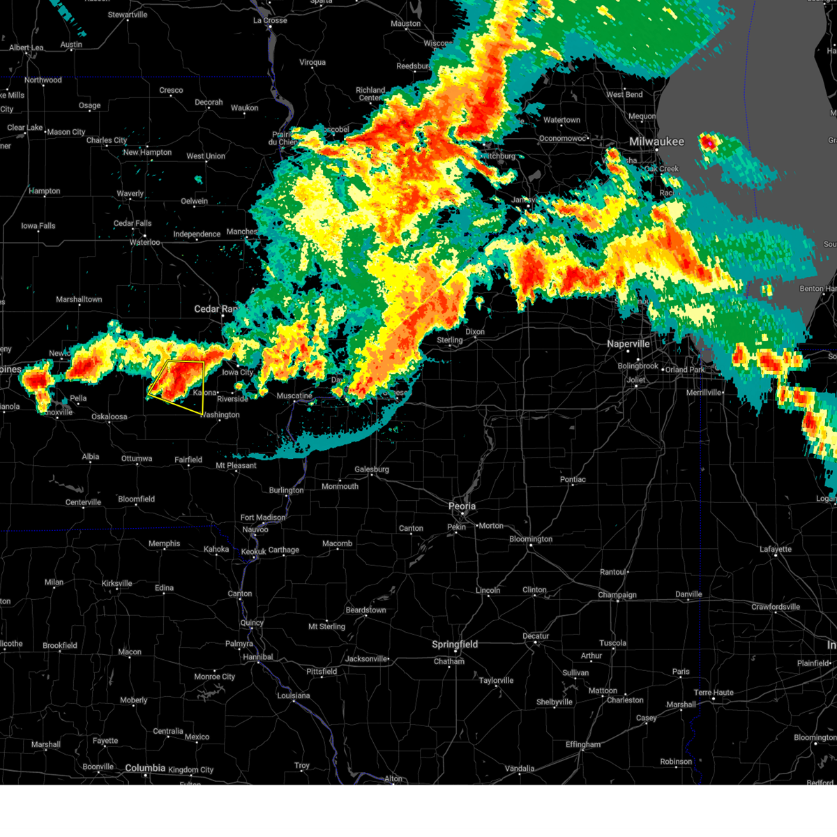 At 940 pm cdt, a severe thunderstorm was located near north english, or 16 miles northeast of sigourney, moving east at 35 mph (radar indicated). Hazards include 60 mph wind gusts and quarter size hail. Hail damage to vehicles is expected. expect wind damage to roofs, siding, and trees. locations impacted include, williamsburg, wellman, north english, keswick, south english, parnell, millersburg, kinross, webster, holbrook and lake iowa park. hail threat, radar indicated max hail size, 1. 00 in wind threat, radar indicated max wind gust, 60 mph. At 940 pm cdt, a severe thunderstorm was located near north english, or 16 miles northeast of sigourney, moving east at 35 mph (radar indicated). Hazards include 60 mph wind gusts and quarter size hail. Hail damage to vehicles is expected. expect wind damage to roofs, siding, and trees. locations impacted include, williamsburg, wellman, north english, keswick, south english, parnell, millersburg, kinross, webster, holbrook and lake iowa park. hail threat, radar indicated max hail size, 1. 00 in wind threat, radar indicated max wind gust, 60 mph.
|
| 7/28/2023 9:27 PM CDT |
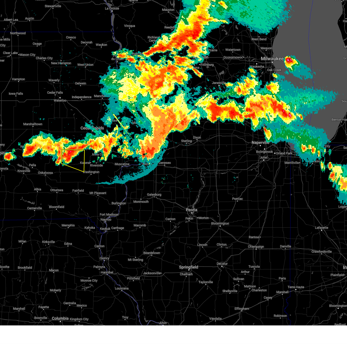 At 926 pm cdt, a severe thunderstorm was located over millersburg, or 15 miles south of marengo, moving east at 30 mph (radar indicated). Hazards include 60 mph wind gusts and quarter size hail. Hail damage to vehicles is expected. Expect wind damage to roofs, siding, and trees. At 926 pm cdt, a severe thunderstorm was located over millersburg, or 15 miles south of marengo, moving east at 30 mph (radar indicated). Hazards include 60 mph wind gusts and quarter size hail. Hail damage to vehicles is expected. Expect wind damage to roofs, siding, and trees.
|
| 7/12/2023 8:39 AM CDT |
 At 839 am cdt, severe thunderstorms were located along a line extending from cedar rapids municipal airport to near cosgrove to near wellman, moving east at 50 mph (radar indicated). Hazards include 60 mph wind gusts. Expect damage to roofs, siding, and trees. locations impacted include, cedar rapids, iowa city, coralville, north liberty, williamsburg, kalona, fairfax, tiffin, ely, walford, wellman, north english, riverside, swisher, oxford, what cheer, shueyville, norway, keswick and south english. hail threat, radar indicated max hail size, <. 75 in wind threat, radar indicated max wind gust, 60 mph. At 839 am cdt, severe thunderstorms were located along a line extending from cedar rapids municipal airport to near cosgrove to near wellman, moving east at 50 mph (radar indicated). Hazards include 60 mph wind gusts. Expect damage to roofs, siding, and trees. locations impacted include, cedar rapids, iowa city, coralville, north liberty, williamsburg, kalona, fairfax, tiffin, ely, walford, wellman, north english, riverside, swisher, oxford, what cheer, shueyville, norway, keswick and south english. hail threat, radar indicated max hail size, <. 75 in wind threat, radar indicated max wind gust, 60 mph.
|
| 7/12/2023 8:33 AM CDT |
 At 833 am cdt, severe thunderstorms were located along a line extending from near walford to cosgrove to near wellman, moving east at 50 mph (radar indicated). Hazards include 60 mph wind gusts. Expect damage to roofs, siding, and trees. locations impacted include, cedar rapids, iowa city, coralville, north liberty, williamsburg, kalona, fairfax, tiffin, ely, walford, wellman, north english, riverside, swisher, oxford, what cheer, shueyville, norway, keswick and south english. hail threat, radar indicated max hail size, <. 75 in wind threat, radar indicated max wind gust, 60 mph. At 833 am cdt, severe thunderstorms were located along a line extending from near walford to cosgrove to near wellman, moving east at 50 mph (radar indicated). Hazards include 60 mph wind gusts. Expect damage to roofs, siding, and trees. locations impacted include, cedar rapids, iowa city, coralville, north liberty, williamsburg, kalona, fairfax, tiffin, ely, walford, wellman, north english, riverside, swisher, oxford, what cheer, shueyville, norway, keswick and south english. hail threat, radar indicated max hail size, <. 75 in wind threat, radar indicated max wind gust, 60 mph.
|
| 7/12/2023 8:25 AM CDT |
 At 825 am cdt, severe thunderstorms were located along a line extending from near norway to near holbrook to near kinross, moving east at 50 mph (radar indicated). Hazards include 60 mph wind gusts. Expect damage to roofs, siding, and trees. locations impacted include, cedar rapids, iowa city, marengo, coralville, north liberty, williamsburg, kalona, fairfax, tiffin, ely, walford, wellman, north english, riverside, swisher, oxford, blairstown, what cheer, shueyville and norway. hail threat, radar indicated max hail size, <. 75 in wind threat, radar indicated max wind gust, 60 mph. At 825 am cdt, severe thunderstorms were located along a line extending from near norway to near holbrook to near kinross, moving east at 50 mph (radar indicated). Hazards include 60 mph wind gusts. Expect damage to roofs, siding, and trees. locations impacted include, cedar rapids, iowa city, marengo, coralville, north liberty, williamsburg, kalona, fairfax, tiffin, ely, walford, wellman, north english, riverside, swisher, oxford, blairstown, what cheer, shueyville and norway. hail threat, radar indicated max hail size, <. 75 in wind threat, radar indicated max wind gust, 60 mph.
|
| 7/12/2023 8:17 AM CDT |
 At 817 am cdt, severe thunderstorms were located along a line extending from hannen lake park to near williamsburg to webster, moving east at 50 mph (radar indicated). Hazards include 60 mph wind gusts. Expect damage to roofs, siding, and trees. locations impacted include, cedar rapids, iowa city, marengo, coralville, north liberty, williamsburg, belle plaine, kalona, fairfax, tiffin, ely, walford, wellman, north english, riverside, victor, swisher, oxford, blairstown and what cheer. hail threat, radar indicated max hail size, <. 75 in wind threat, radar indicated max wind gust, 60 mph. At 817 am cdt, severe thunderstorms were located along a line extending from hannen lake park to near williamsburg to webster, moving east at 50 mph (radar indicated). Hazards include 60 mph wind gusts. Expect damage to roofs, siding, and trees. locations impacted include, cedar rapids, iowa city, marengo, coralville, north liberty, williamsburg, belle plaine, kalona, fairfax, tiffin, ely, walford, wellman, north english, riverside, victor, swisher, oxford, blairstown and what cheer. hail threat, radar indicated max hail size, <. 75 in wind threat, radar indicated max wind gust, 60 mph.
|
| 7/12/2023 8:05 AM CDT |
 At 805 am cdt, severe thunderstorms were located along a line extending from koszta to near keswick, moving east at 40 mph (radar indicated). Hazards include 60 mph wind gusts. expect damage to roofs, siding, and trees At 805 am cdt, severe thunderstorms were located along a line extending from koszta to near keswick, moving east at 40 mph (radar indicated). Hazards include 60 mph wind gusts. expect damage to roofs, siding, and trees
|
| 5/7/2023 5:24 PM CDT |
 At 524 pm cdt, severe thunderstorms were located along a line extending from near genoa bluff to millersburg to near keswick, moving east at 35 mph (radar indicated). Hazards include 60 mph wind gusts and quarter size hail. Hail damage to vehicles is expected. expect wind damage to roofs, siding, and trees. locations impacted include, sigourney, williamsburg, wellman, north english, victor, brighton, what cheer, delta, keswick, south english, parnell, millersburg, harper, kinross, keota, west chester, webster, thornburg, gibson and keokuk county fairgrounds. hail threat, radar indicated max hail size, 1. 00 in wind threat, radar indicated max wind gust, 60 mph. At 524 pm cdt, severe thunderstorms were located along a line extending from near genoa bluff to millersburg to near keswick, moving east at 35 mph (radar indicated). Hazards include 60 mph wind gusts and quarter size hail. Hail damage to vehicles is expected. expect wind damage to roofs, siding, and trees. locations impacted include, sigourney, williamsburg, wellman, north english, victor, brighton, what cheer, delta, keswick, south english, parnell, millersburg, harper, kinross, keota, west chester, webster, thornburg, gibson and keokuk county fairgrounds. hail threat, radar indicated max hail size, 1. 00 in wind threat, radar indicated max wind gust, 60 mph.
|
| 5/7/2023 5:10 PM CDT |
 At 510 pm cdt, severe thunderstorms were located along a line extending from near guernsey to near deep river to coal creek, moving southeast at 55 mph (radar indicated). Hazards include 70 mph wind gusts and half dollar size hail. Hail damage to vehicles is expected. expect considerable tree damage. wind damage is also likely to mobile homes, roofs, and outbuildings. locations impacted include, delta, keswick, millersburg, lake iowa park, genoa bluff, sigourney, north english, south english, webster, yenruogis county park, keokuk county expo, lake belva deer park, williamsburg, parnell, harper, kinross, lancaster, keota, holbrook, wellman, talleyrand, rubio, west chester and brighton. thunderstorm damage threat, considerable hail threat, radar indicated max hail size, 1. 25 in wind threat, radar indicated max wind gust, 70 mph. At 510 pm cdt, severe thunderstorms were located along a line extending from near guernsey to near deep river to coal creek, moving southeast at 55 mph (radar indicated). Hazards include 70 mph wind gusts and half dollar size hail. Hail damage to vehicles is expected. expect considerable tree damage. wind damage is also likely to mobile homes, roofs, and outbuildings. locations impacted include, delta, keswick, millersburg, lake iowa park, genoa bluff, sigourney, north english, south english, webster, yenruogis county park, keokuk county expo, lake belva deer park, williamsburg, parnell, harper, kinross, lancaster, keota, holbrook, wellman, talleyrand, rubio, west chester and brighton. thunderstorm damage threat, considerable hail threat, radar indicated max hail size, 1. 25 in wind threat, radar indicated max wind gust, 70 mph.
|
| 5/7/2023 4:57 PM CDT |
 At 457 pm cdt, severe thunderstorms were located along a line extending from near malcom to near barnes city, moving southeast at 55 mph (radar indicated). Hazards include ping pong ball size hail and 60 mph wind gusts. People and animals outdoors will be injured. expect hail damage to roofs, siding, windows, and vehicles. expect wind damage to roofs, siding, and trees. severe thunderstorms will be near, gibson and coal creek around 505 pm cdt. victor, what cheer, victor, thornburg and keokuk county fairgrounds around 510 pm cdt. delta and keswick around 515 pm cdt. other locations in the path of these severe thunderstorms include sigourney, south english, webster, yenruogis county park, lake iowa park, keokuk county expo, lake belva deer park, genoa bluff, millersburg, harper, lancaster, north english, parnell, keota, kinross, talleyrand, holbrook, west chester and rubio. hail threat, radar indicated max hail size, 1. 50 in wind threat, radar indicated max wind gust, 60 mph. At 457 pm cdt, severe thunderstorms were located along a line extending from near malcom to near barnes city, moving southeast at 55 mph (radar indicated). Hazards include ping pong ball size hail and 60 mph wind gusts. People and animals outdoors will be injured. expect hail damage to roofs, siding, windows, and vehicles. expect wind damage to roofs, siding, and trees. severe thunderstorms will be near, gibson and coal creek around 505 pm cdt. victor, what cheer, victor, thornburg and keokuk county fairgrounds around 510 pm cdt. delta and keswick around 515 pm cdt. other locations in the path of these severe thunderstorms include sigourney, south english, webster, yenruogis county park, lake iowa park, keokuk county expo, lake belva deer park, genoa bluff, millersburg, harper, lancaster, north english, parnell, keota, kinross, talleyrand, holbrook, west chester and rubio. hail threat, radar indicated max hail size, 1. 50 in wind threat, radar indicated max wind gust, 60 mph.
|
| 7/11/2022 6:10 AM CDT |
 At 610 am cdt, severe thunderstorms were located along a line extending from near benton county fairgrounds to near riverside, moving east at 40 mph (radar indicated). Hazards include 60 mph wind gusts. Expect damage to roofs, siding, and trees. locations impacted include, cedar rapids, iowa city, vinton, marengo, marion, coralville, north liberty, hiawatha, robins, williamsburg, belle plaine, center point, kalona, fairfax, solon, tiffin, ely, atkins, walford and urbana. hail threat, radar indicated max hail size, <. 75 in wind threat, radar indicated max wind gust, 60 mph. At 610 am cdt, severe thunderstorms were located along a line extending from near benton county fairgrounds to near riverside, moving east at 40 mph (radar indicated). Hazards include 60 mph wind gusts. Expect damage to roofs, siding, and trees. locations impacted include, cedar rapids, iowa city, vinton, marengo, marion, coralville, north liberty, hiawatha, robins, williamsburg, belle plaine, center point, kalona, fairfax, solon, tiffin, ely, atkins, walford and urbana. hail threat, radar indicated max hail size, <. 75 in wind threat, radar indicated max wind gust, 60 mph.
|
| 7/11/2022 6:03 AM CDT |
 At 603 am cdt, severe thunderstorms were located along a line extending from garrison to near riverside, moving east at 45 mph (radar indicated). Hazards include 60 mph wind gusts and quarter size hail. Hail damage to vehicles is expected. expect wind damage to roofs, siding, and trees. locations impacted include, cedar rapids, iowa city, vinton, marengo, marion, coralville, north liberty, hiawatha, robins, williamsburg, belle plaine, center point, kalona, fairfax, solon, tiffin, ely, atkins, walford and urbana. hail threat, radar indicated max hail size, 1. 00 in wind threat, radar indicated max wind gust, 60 mph. At 603 am cdt, severe thunderstorms were located along a line extending from garrison to near riverside, moving east at 45 mph (radar indicated). Hazards include 60 mph wind gusts and quarter size hail. Hail damage to vehicles is expected. expect wind damage to roofs, siding, and trees. locations impacted include, cedar rapids, iowa city, vinton, marengo, marion, coralville, north liberty, hiawatha, robins, williamsburg, belle plaine, center point, kalona, fairfax, solon, tiffin, ely, atkins, walford and urbana. hail threat, radar indicated max hail size, 1. 00 in wind threat, radar indicated max wind gust, 60 mph.
|
| 7/11/2022 5:51 AM CDT |
 At 551 am cdt, severe thunderstorms were located along a line extending from near dysart to amish, moving east at 45 mph (radar indicated). Hazards include 60 mph wind gusts and quarter size hail. Hail damage to vehicles is expected. expect wind damage to roofs, siding, and trees. locations impacted include, cedar rapids, iowa city, vinton, marengo, marion, coralville, north liberty, hiawatha, robins, williamsburg, belle plaine, center point, kalona, fairfax, solon, tiffin, ely, atkins, walford and urbana. hail threat, radar indicated max hail size, 1. 00 in wind threat, radar indicated max wind gust, 60 mph. At 551 am cdt, severe thunderstorms were located along a line extending from near dysart to amish, moving east at 45 mph (radar indicated). Hazards include 60 mph wind gusts and quarter size hail. Hail damage to vehicles is expected. expect wind damage to roofs, siding, and trees. locations impacted include, cedar rapids, iowa city, vinton, marengo, marion, coralville, north liberty, hiawatha, robins, williamsburg, belle plaine, center point, kalona, fairfax, solon, tiffin, ely, atkins, walford and urbana. hail threat, radar indicated max hail size, 1. 00 in wind threat, radar indicated max wind gust, 60 mph.
|
| 7/11/2022 5:43 AM CDT |
 At 543 am cdt, severe thunderstorms were located along a line extending from near clutier to near holbrook, moving east at 45 mph (radar indicated). Hazards include 60 mph wind gusts and quarter size hail. Hail damage to vehicles is expected. Expect wind damage to roofs, siding, and trees. At 543 am cdt, severe thunderstorms were located along a line extending from near clutier to near holbrook, moving east at 45 mph (radar indicated). Hazards include 60 mph wind gusts and quarter size hail. Hail damage to vehicles is expected. Expect wind damage to roofs, siding, and trees.
|
| 6/21/2022 7:21 PM CDT |
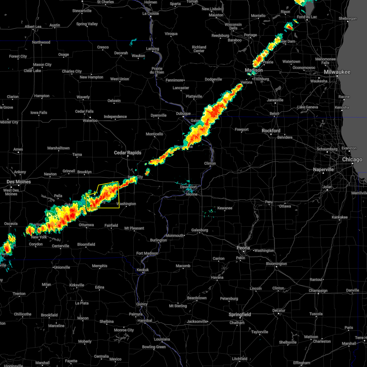 The severe thunderstorm warning for keokuk, northwestern washington and southeastern iowa counties will expire at 730 pm cdt, the storm which prompted the warning has weakened below severe limits, and no longer poses an immediate threat to life or property. therefore, the warning will be allowed to expire. however gusty winds and heavy rain are still possible with this thunderstorm. The severe thunderstorm warning for keokuk, northwestern washington and southeastern iowa counties will expire at 730 pm cdt, the storm which prompted the warning has weakened below severe limits, and no longer poses an immediate threat to life or property. therefore, the warning will be allowed to expire. however gusty winds and heavy rain are still possible with this thunderstorm.
|
| 6/21/2022 7:15 PM CDT |
 At 715 pm cdt, a severe thunderstorm was located over lake belva deer park, or over sigourney, moving east at 30 mph (radar indicated). Hazards include 60 mph wind gusts. Expect damage to roofs, siding, and trees. this severe storm will be near, south english around 720 pm cdt. harper around 725 pm cdt. other locations in the path of this severe thunderstorm include kinross, keota, talleyrand and wellman. hail threat, radar indicated max hail size, <. 75 in wind threat, radar indicated max wind gust, 60 mph. At 715 pm cdt, a severe thunderstorm was located over lake belva deer park, or over sigourney, moving east at 30 mph (radar indicated). Hazards include 60 mph wind gusts. Expect damage to roofs, siding, and trees. this severe storm will be near, south english around 720 pm cdt. harper around 725 pm cdt. other locations in the path of this severe thunderstorm include kinross, keota, talleyrand and wellman. hail threat, radar indicated max hail size, <. 75 in wind threat, radar indicated max wind gust, 60 mph.
|
| 6/21/2022 7:09 PM CDT |
 At 709 pm cdt, a severe thunderstorm was located over kinross, or 13 miles northeast of sigourney, moving east at 35 mph (radar indicated). Hazards include 60 mph wind gusts. Expect damage to roofs, siding, and trees. this severe storm will be near, holbrook around 715 pm cdt. wellman around 725 pm cdt. hail threat, radar indicated max hail size, <. 75 in wind threat, radar indicated max wind gust, 60 mph. At 709 pm cdt, a severe thunderstorm was located over kinross, or 13 miles northeast of sigourney, moving east at 35 mph (radar indicated). Hazards include 60 mph wind gusts. Expect damage to roofs, siding, and trees. this severe storm will be near, holbrook around 715 pm cdt. wellman around 725 pm cdt. hail threat, radar indicated max hail size, <. 75 in wind threat, radar indicated max wind gust, 60 mph.
|
| 6/21/2022 7:05 PM CDT |
 At 705 pm cdt, a severe thunderstorm was located over south english, or 12 miles northeast of sigourney, moving east at 35 mph (radar indicated). Hazards include 60 mph wind gusts. Expect damage to roofs, siding, and trees. this severe storm will be near, kinross and keota around 710 pm cdt. holbrook around 715 pm cdt. other locations in the path of this severe thunderstorm include wellman. hail threat, radar indicated max hail size, <. 75 in wind threat, radar indicated max wind gust, 60 mph. At 705 pm cdt, a severe thunderstorm was located over south english, or 12 miles northeast of sigourney, moving east at 35 mph (radar indicated). Hazards include 60 mph wind gusts. Expect damage to roofs, siding, and trees. this severe storm will be near, kinross and keota around 710 pm cdt. holbrook around 715 pm cdt. other locations in the path of this severe thunderstorm include wellman. hail threat, radar indicated max hail size, <. 75 in wind threat, radar indicated max wind gust, 60 mph.
|
| 6/21/2022 6:56 PM CDT |
 At 655 pm cdt, a severe thunderstorm was located over webster, or 9 miles north of sigourney, moving east at 35 mph (radar indicated). Hazards include 60 mph wind gusts. Expect damage to roofs, siding, and trees. this severe storm will be near, south english around 700 pm cdt. north english and harper around 705 pm cdt. parnell, kinross and keota around 710 pm cdt. other locations in the path of this severe thunderstorm include holbrook and wellman. hail threat, radar indicated max hail size, <. 75 in wind threat, radar indicated max wind gust, 60 mph. At 655 pm cdt, a severe thunderstorm was located over webster, or 9 miles north of sigourney, moving east at 35 mph (radar indicated). Hazards include 60 mph wind gusts. Expect damage to roofs, siding, and trees. this severe storm will be near, south english around 700 pm cdt. north english and harper around 705 pm cdt. parnell, kinross and keota around 710 pm cdt. other locations in the path of this severe thunderstorm include holbrook and wellman. hail threat, radar indicated max hail size, <. 75 in wind threat, radar indicated max wind gust, 60 mph.
|
| 6/21/2022 6:51 PM CDT |
 At 651 pm cdt, a severe thunderstorm was located over keswick, or 9 miles north of sigourney, moving east at 35 mph (radar indicated). Hazards include 60 mph wind gusts. Expect damage to roofs, siding, and trees. this severe storm will be near, millersburg, webster and lake belva deer park around 655 pm cdt. south english around 700 pm cdt. north english and harper around 705 pm cdt. other locations in the path of this severe thunderstorm include parnell, kinross, keota, holbrook and wellman. hail threat, radar indicated max hail size, <. 75 in wind threat, radar indicated max wind gust, 60 mph. At 651 pm cdt, a severe thunderstorm was located over keswick, or 9 miles north of sigourney, moving east at 35 mph (radar indicated). Hazards include 60 mph wind gusts. Expect damage to roofs, siding, and trees. this severe storm will be near, millersburg, webster and lake belva deer park around 655 pm cdt. south english around 700 pm cdt. north english and harper around 705 pm cdt. other locations in the path of this severe thunderstorm include parnell, kinross, keota, holbrook and wellman. hail threat, radar indicated max hail size, <. 75 in wind threat, radar indicated max wind gust, 60 mph.
|
| 6/21/2022 6:46 PM CDT |
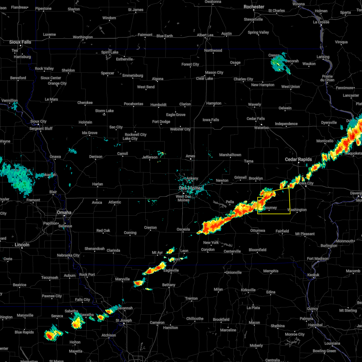 At 646 pm cdt, a severe thunderstorm was located over keswick, or 9 miles north of sigourney, moving east at 40 mph (radar indicated). Hazards include 60 mph wind gusts. Expect damage to roofs, siding, and trees. this severe thunderstorm will be near, sigourney and yenruogis county park around 650 pm cdt. millersburg, webster and lake belva deer park around 655 pm cdt. north english and south english around 700 pm cdt. harper around 705 pm cdt. other locations in the path of this severe thunderstorm include kinross, keota and wellman. hail threat, radar indicated max hail size, <. 75 in wind threat, radar indicated max wind gust, 60 mph. At 646 pm cdt, a severe thunderstorm was located over keswick, or 9 miles north of sigourney, moving east at 40 mph (radar indicated). Hazards include 60 mph wind gusts. Expect damage to roofs, siding, and trees. this severe thunderstorm will be near, sigourney and yenruogis county park around 650 pm cdt. millersburg, webster and lake belva deer park around 655 pm cdt. north english and south english around 700 pm cdt. harper around 705 pm cdt. other locations in the path of this severe thunderstorm include kinross, keota and wellman. hail threat, radar indicated max hail size, <. 75 in wind threat, radar indicated max wind gust, 60 mph.
|
| 12/15/2021 8:02 PM CST |
 At 802 pm cst, severe thunderstorms were located along a line extending from mount auburn to near marengo, moving east at 60 mph (trained weather spotters. a 60 mph wind gust was measured in blairstown). Hazards include 70 mph wind gusts and penny size hail. Expect considerable tree damage. damage is likely to mobile homes, roofs, and outbuildings. Locations impacted include, vinton, marengo, williamsburg, belle plaine, atkins, walford, urbana, dysart, north english, shellsburg, victor, newhall, blairstown, van horne, keystone, norway, garrison, ladora, parnell and millersburg. At 802 pm cst, severe thunderstorms were located along a line extending from mount auburn to near marengo, moving east at 60 mph (trained weather spotters. a 60 mph wind gust was measured in blairstown). Hazards include 70 mph wind gusts and penny size hail. Expect considerable tree damage. damage is likely to mobile homes, roofs, and outbuildings. Locations impacted include, vinton, marengo, williamsburg, belle plaine, atkins, walford, urbana, dysart, north english, shellsburg, victor, newhall, blairstown, van horne, keystone, norway, garrison, ladora, parnell and millersburg.
|
| 12/15/2021 7:50 PM CST |
 At 749 pm cst, severe thunderstorms were located along a line extending from dysart to near victor, moving northeast at 65 mph. these are destructive storms for portions of eastern iowa (radar indicated). Hazards include 80 mph wind gusts and penny size hail. Flying debris will be dangerous to those caught without shelter. mobile homes will be heavily damaged. expect considerable damage to roofs, windows, and vehicles. extensive tree damage and power outages are likely. Locations impacted include, vinton, marengo, williamsburg, belle plaine, atkins, walford, urbana, dysart, north english, shellsburg, victor, newhall, blairstown, van horne, keystone, norway, garrison, ladora, parnell and millersburg. At 749 pm cst, severe thunderstorms were located along a line extending from dysart to near victor, moving northeast at 65 mph. these are destructive storms for portions of eastern iowa (radar indicated). Hazards include 80 mph wind gusts and penny size hail. Flying debris will be dangerous to those caught without shelter. mobile homes will be heavily damaged. expect considerable damage to roofs, windows, and vehicles. extensive tree damage and power outages are likely. Locations impacted include, vinton, marengo, williamsburg, belle plaine, atkins, walford, urbana, dysart, north english, shellsburg, victor, newhall, blairstown, van horne, keystone, norway, garrison, ladora, parnell and millersburg.
|
| 12/15/2021 7:27 PM CST |
 At 726 pm cst, severe thunderstorms were located along a line extending from 6 miles northeast of grinnell to near new sharon, moving northeast at 70 mph. these are destructive storms for portions of eastern iowa (radar indicated). Hazards include 80 mph wind gusts and penny size hail. Flying debris will be dangerous to those caught without shelter. mobile homes will be heavily damaged. expect considerable damage to roofs, windows, and vehicles. extensive tree damage and power outages are likely. Locations impacted include, vinton, marengo, williamsburg, belle plaine, atkins, walford, urbana, dysart, north english, shellsburg, victor, newhall, blairstown, van horne, keystone, norway, garrison, ladora, parnell and millersburg. At 726 pm cst, severe thunderstorms were located along a line extending from 6 miles northeast of grinnell to near new sharon, moving northeast at 70 mph. these are destructive storms for portions of eastern iowa (radar indicated). Hazards include 80 mph wind gusts and penny size hail. Flying debris will be dangerous to those caught without shelter. mobile homes will be heavily damaged. expect considerable damage to roofs, windows, and vehicles. extensive tree damage and power outages are likely. Locations impacted include, vinton, marengo, williamsburg, belle plaine, atkins, walford, urbana, dysart, north english, shellsburg, victor, newhall, blairstown, van horne, keystone, norway, garrison, ladora, parnell and millersburg.
|
| 12/15/2021 7:17 PM CST |
 At 716 pm cst, severe thunderstorms were located along a line extending from 6 miles southeast of marshalltown to 9 miles south of grinnell to near new sharon, moving northeast at 60 mph. these are destructive storms for portions of eastern iowa (radar indicated). Hazards include 80 mph wind gusts and penny size hail. Flying debris will be dangerous to those caught without shelter. mobile homes will be heavily damaged. expect considerable damage to roofs, windows, and vehicles. Extensive tree damage and power outages are likely. At 716 pm cst, severe thunderstorms were located along a line extending from 6 miles southeast of marshalltown to 9 miles south of grinnell to near new sharon, moving northeast at 60 mph. these are destructive storms for portions of eastern iowa (radar indicated). Hazards include 80 mph wind gusts and penny size hail. Flying debris will be dangerous to those caught without shelter. mobile homes will be heavily damaged. expect considerable damage to roofs, windows, and vehicles. Extensive tree damage and power outages are likely.
|
| 8/26/2021 9:21 PM CDT |
 At 921 pm cdt, a severe thunderstorm was located near what cheer, or 11 miles southeast of montezuma, moving southeast at 25 mph (radar indicated). Hazards include 60 mph wind gusts and quarter size hail. Hail damage to vehicles is expected. expect wind damage to roofs, siding, and trees. this severe thunderstorm will be near, what cheer around 930 pm cdt. other locations in the path of this severe thunderstorm include delta, sigourney and hayesville. hail threat, radar indicated max hail size, 1. 00 in wind threat, radar indicated max wind gust, 60 mph. At 921 pm cdt, a severe thunderstorm was located near what cheer, or 11 miles southeast of montezuma, moving southeast at 25 mph (radar indicated). Hazards include 60 mph wind gusts and quarter size hail. Hail damage to vehicles is expected. expect wind damage to roofs, siding, and trees. this severe thunderstorm will be near, what cheer around 930 pm cdt. other locations in the path of this severe thunderstorm include delta, sigourney and hayesville. hail threat, radar indicated max hail size, 1. 00 in wind threat, radar indicated max wind gust, 60 mph.
|
| 6/20/2021 7:34 PM CDT |
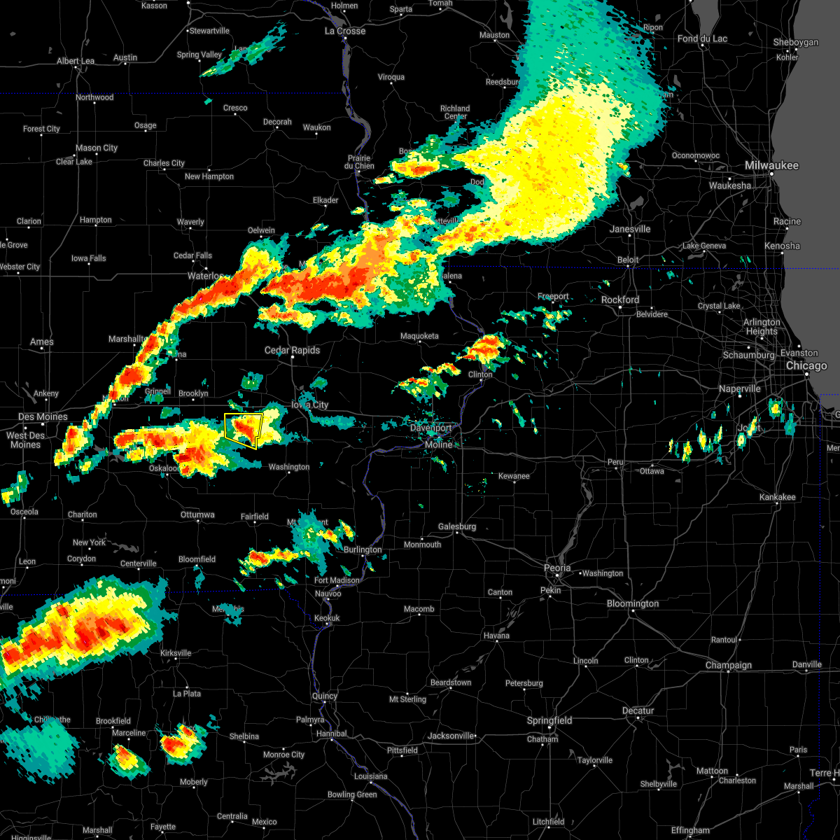 At 734 pm cdt, a severe thunderstorm was located over north english, or 14 miles northeast of sigourney, moving east at 30 mph (radar indicated). Hazards include 60 mph wind gusts and quarter size hail. Hail damage to vehicles is expected. expect wind damage to roofs, siding, and trees. this severe storm will be near, parnell around 740 pm cdt. Other locations in the path of this severe thunderstorm include kinross. At 734 pm cdt, a severe thunderstorm was located over north english, or 14 miles northeast of sigourney, moving east at 30 mph (radar indicated). Hazards include 60 mph wind gusts and quarter size hail. Hail damage to vehicles is expected. expect wind damage to roofs, siding, and trees. this severe storm will be near, parnell around 740 pm cdt. Other locations in the path of this severe thunderstorm include kinross.
|
| 6/20/2021 7:21 PM CDT |
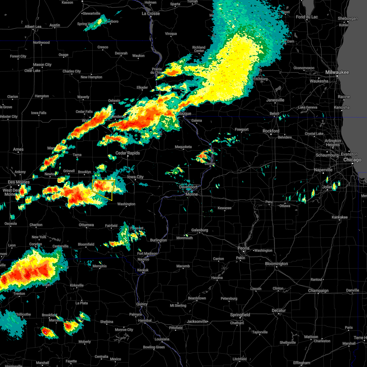 At 720 pm cdt, a severe thunderstorm was located near millersburg, or 14 miles north of sigourney, moving east at 30 mph (radar indicated). Hazards include 60 mph wind gusts and quarter size hail. Hail damage to vehicles is expected. expect wind damage to roofs, siding, and trees. this severe storm will be near, millersburg around 725 pm cdt. Other locations in the path of this severe thunderstorm include north english, south english, parnell and kinross. At 720 pm cdt, a severe thunderstorm was located near millersburg, or 14 miles north of sigourney, moving east at 30 mph (radar indicated). Hazards include 60 mph wind gusts and quarter size hail. Hail damage to vehicles is expected. expect wind damage to roofs, siding, and trees. this severe storm will be near, millersburg around 725 pm cdt. Other locations in the path of this severe thunderstorm include north english, south english, parnell and kinross.
|
| 6/20/2021 7:08 PM CDT |
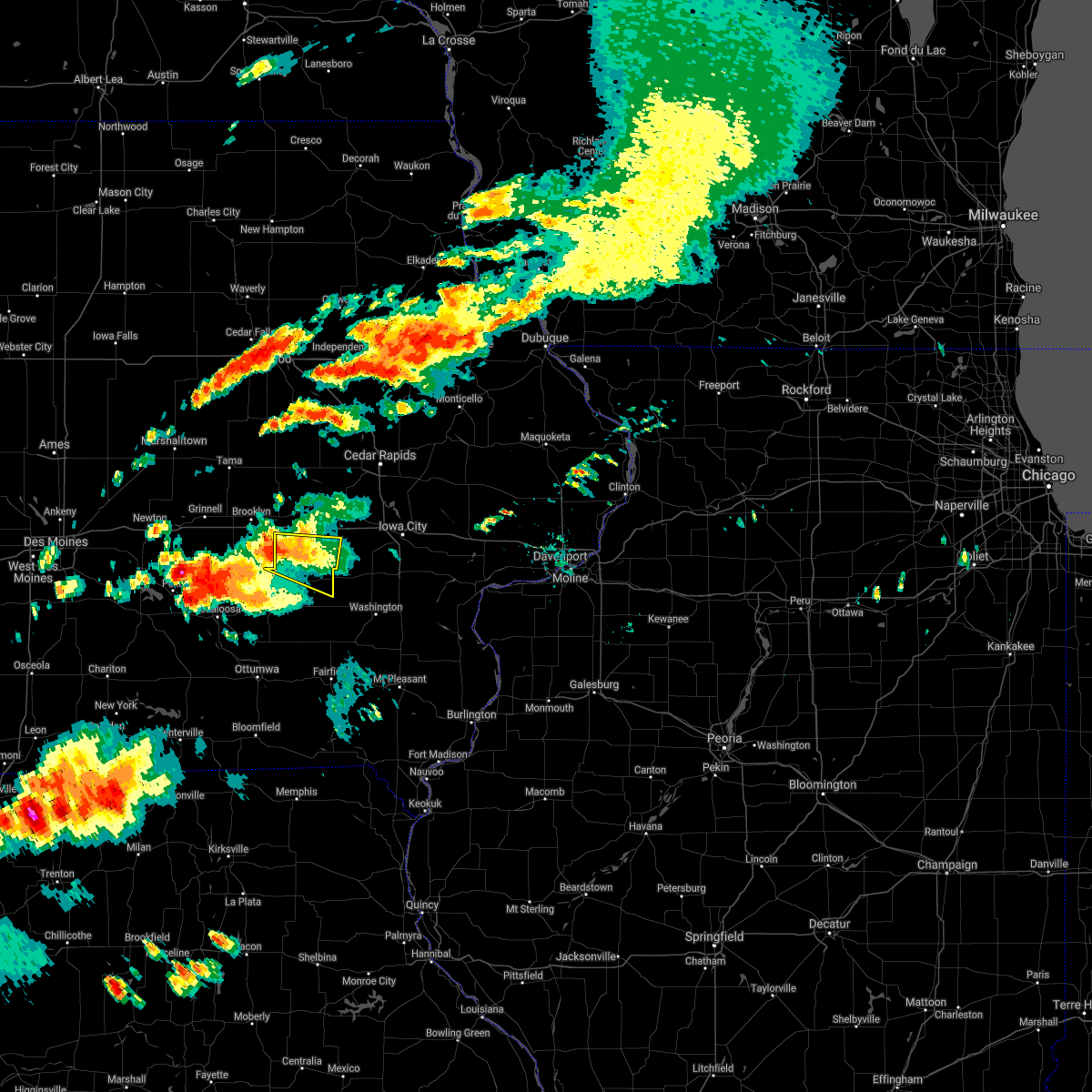 At 708 pm cdt, a severe thunderstorm was located 9 miles west of millersburg, or 9 miles east of montezuma, moving east at 30 mph (radar indicated). Hazards include 60 mph wind gusts and quarter size hail. Hail damage to vehicles is expected. expect wind damage to roofs, siding, and trees. this severe thunderstorm will be near, millersburg around 725 pm cdt. Other locations in the path of this severe thunderstorm include north english, south english, parnell and kinross. At 708 pm cdt, a severe thunderstorm was located 9 miles west of millersburg, or 9 miles east of montezuma, moving east at 30 mph (radar indicated). Hazards include 60 mph wind gusts and quarter size hail. Hail damage to vehicles is expected. expect wind damage to roofs, siding, and trees. this severe thunderstorm will be near, millersburg around 725 pm cdt. Other locations in the path of this severe thunderstorm include north english, south english, parnell and kinross.
|
| 8/10/2020 12:09 PM CDT |
 At 1208 pm cdt, severe thunderstorms were located along a line extending from near dysart to 6 miles south of ladora to near what cheer, moving east at 70 mph. these are very dangerous storms (trained weather spotters. this line of storms has a history of producing 80 to 90 mph winds and significant tree damage over parts of central iowa). Hazards include 90 mph wind gusts. You are in a life-threatening situation. flying debris may be deadly to those caught without shelter. mobile homes will be heavily damaged or destroyed. homes and businesses will have substantial roof and window damage. expect extensive tree damage and power outages. locations impacted include, cedar rapids, iowa city, vinton, marengo, west branch, sigourney, marion, coralville, north liberty, hiawatha, mount vernon, robins, williamsburg, belle plaine, center point, kalona, lisbon, fairfax, solon and tiffin. this includes the following highways, interstate 80 in iowa between mile markers 205 and 253. Interstate 380 between mile markers 1 and 40. At 1208 pm cdt, severe thunderstorms were located along a line extending from near dysart to 6 miles south of ladora to near what cheer, moving east at 70 mph. these are very dangerous storms (trained weather spotters. this line of storms has a history of producing 80 to 90 mph winds and significant tree damage over parts of central iowa). Hazards include 90 mph wind gusts. You are in a life-threatening situation. flying debris may be deadly to those caught without shelter. mobile homes will be heavily damaged or destroyed. homes and businesses will have substantial roof and window damage. expect extensive tree damage and power outages. locations impacted include, cedar rapids, iowa city, vinton, marengo, west branch, sigourney, marion, coralville, north liberty, hiawatha, mount vernon, robins, williamsburg, belle plaine, center point, kalona, lisbon, fairfax, solon and tiffin. this includes the following highways, interstate 80 in iowa between mile markers 205 and 253. Interstate 380 between mile markers 1 and 40.
|
| 8/10/2020 11:48 AM CDT |
 At 1148 am cdt, severe thunderstorms were located along a line extending from 7 miles east of conrad to near montezuma to near pella, moving east at 70 mph. these are very dangerous storms! (radar indicated). Hazards include 80 mph wind gusts. Flying debris will be dangerous to those caught without shelter. mobile homes will be heavily damaged. expect considerable damage to roofs, windows, and vehicles. Extensive tree damage and power outages are likely. At 1148 am cdt, severe thunderstorms were located along a line extending from 7 miles east of conrad to near montezuma to near pella, moving east at 70 mph. these are very dangerous storms! (radar indicated). Hazards include 80 mph wind gusts. Flying debris will be dangerous to those caught without shelter. mobile homes will be heavily damaged. expect considerable damage to roofs, windows, and vehicles. Extensive tree damage and power outages are likely.
|
| 7/11/2020 6:39 PM CDT |
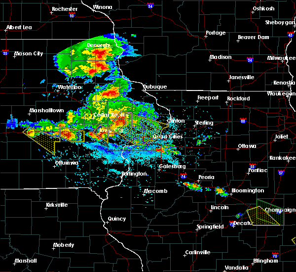 At 639 pm cdt, a severe thunderstorm was located over parnell, or 16 miles south of marengo, moving southeast at 40 mph (radar indicated). Hazards include 60 mph wind gusts and half dollar size hail. Hail damage to vehicles is expected. expect wind damage to roofs, siding, and trees. locations impacted include, williamsburg, north english, victor, parnell, millersburg, holbrook and lake iowa park. This includes interstate 80 in iowa between mile markers 206 and 212. At 639 pm cdt, a severe thunderstorm was located over parnell, or 16 miles south of marengo, moving southeast at 40 mph (radar indicated). Hazards include 60 mph wind gusts and half dollar size hail. Hail damage to vehicles is expected. expect wind damage to roofs, siding, and trees. locations impacted include, williamsburg, north english, victor, parnell, millersburg, holbrook and lake iowa park. This includes interstate 80 in iowa between mile markers 206 and 212.
|
| 7/11/2020 6:18 PM CDT |
 At 617 pm cdt, a severe thunderstorm was located near victor, or 12 miles southwest of marengo, moving east at 40 mph (radar indicated). Hazards include 60 mph wind gusts and half dollar size hail. Hail damage to vehicles is expected. Expect wind damage to roofs, siding, and trees. At 617 pm cdt, a severe thunderstorm was located near victor, or 12 miles southwest of marengo, moving east at 40 mph (radar indicated). Hazards include 60 mph wind gusts and half dollar size hail. Hail damage to vehicles is expected. Expect wind damage to roofs, siding, and trees.
|
| 8/20/2019 6:53 AM CDT |
 A severe thunderstorm warning remains in effect until 730 am cdt for northwestern henry. northwestern louisa. keokuk. johnson. washington. western muscatine. jefferson and iowa counties. At 653 am cdt, severe thunderstorms were located along a line extending from near ladora to near harper to 7 miles northwest of bloomfield, moving east at 60 mph. A severe thunderstorm warning remains in effect until 730 am cdt for northwestern henry. northwestern louisa. keokuk. johnson. washington. western muscatine. jefferson and iowa counties. At 653 am cdt, severe thunderstorms were located along a line extending from near ladora to near harper to 7 miles northwest of bloomfield, moving east at 60 mph.
|
| 8/20/2019 6:28 AM CDT |
 At 627 am cdt, severe thunderstorms were located along a line extending from near brooklyn to near what cheer to near rathbun lake, moving east at 60 mph (radar indicated). Hazards include 60 mph wind gusts. expect damage to roofs, siding, and trees At 627 am cdt, severe thunderstorms were located along a line extending from near brooklyn to near what cheer to near rathbun lake, moving east at 60 mph (radar indicated). Hazards include 60 mph wind gusts. expect damage to roofs, siding, and trees
|
| 6/15/2019 6:37 PM CDT |
 At 635 pm cdt, severe thunderstorms were located along a line extending from blairstown to north english, moving east at 40 mph (spotters have estimated 60 mph winds with this line of storms but higher gusts are possible). Hazards include 70 mph wind gusts. Expect considerable tree damage. damage is likely to mobile homes, roofs, and outbuildings. locations impacted include, marengo, williamsburg, north english, victor, ladora, parnell, millersburg, amana, conroy, middle amana, south amana, homestead, west amana, lake iowa park, upper south amana, east amana, genoa bluff, koszta, high amana and iowa county fairgrounds. This includes interstate 80 in iowa between mile markers 205 and 229. At 635 pm cdt, severe thunderstorms were located along a line extending from blairstown to north english, moving east at 40 mph (spotters have estimated 60 mph winds with this line of storms but higher gusts are possible). Hazards include 70 mph wind gusts. Expect considerable tree damage. damage is likely to mobile homes, roofs, and outbuildings. locations impacted include, marengo, williamsburg, north english, victor, ladora, parnell, millersburg, amana, conroy, middle amana, south amana, homestead, west amana, lake iowa park, upper south amana, east amana, genoa bluff, koszta, high amana and iowa county fairgrounds. This includes interstate 80 in iowa between mile markers 205 and 229.
|
| 6/15/2019 6:19 PM CDT |
 At 619 pm cdt, severe thunderstorms were located along a line extending from belle plaine to near keswick, moving east at 40 mph (radar indicated). Hazards include 70 mph wind gusts. Expect considerable tree damage. damage is likely to mobile homes, roofs, and outbuildings. locations impacted include, marengo, williamsburg, north english, victor, ladora, parnell, millersburg, amana, conroy, middle amana, south amana, homestead, west amana, lake iowa park, upper south amana, east amana, genoa bluff, koszta, high amana and iowa county fairgrounds. This includes interstate 80 in iowa between mile markers 205 and 229. At 619 pm cdt, severe thunderstorms were located along a line extending from belle plaine to near keswick, moving east at 40 mph (radar indicated). Hazards include 70 mph wind gusts. Expect considerable tree damage. damage is likely to mobile homes, roofs, and outbuildings. locations impacted include, marengo, williamsburg, north english, victor, ladora, parnell, millersburg, amana, conroy, middle amana, south amana, homestead, west amana, lake iowa park, upper south amana, east amana, genoa bluff, koszta, high amana and iowa county fairgrounds. This includes interstate 80 in iowa between mile markers 205 and 229.
|
| 6/15/2019 6:06 PM CDT |
 At 606 pm cdt, severe thunderstorms were located along a line extending from near belle plaine to 6 miles northwest of what cheer, moving east at 40 mph (radar indicated). Hazards include 70 mph wind gusts. Expect considerable tree damage. Damage is likely to mobile homes, roofs, and outbuildings. At 606 pm cdt, severe thunderstorms were located along a line extending from near belle plaine to 6 miles northwest of what cheer, moving east at 40 mph (radar indicated). Hazards include 70 mph wind gusts. Expect considerable tree damage. Damage is likely to mobile homes, roofs, and outbuildings.
|
| 5/29/2019 7:37 PM CDT |
 At 735 pm cdt, a severe thunderstorm capable of producing a tornado was located near williamsburg, or 11 miles south of marengo, moving east at 20 mph. another tornadic storm was moving out of the deep river area of poweshiek county and into the western part of the warning in iowa county (radar indicated rotation). Hazards include tornado and quarter size hail. Flying debris will be dangerous to those caught without shelter. mobile homes will be damaged or destroyed. damage to roofs, windows, and vehicles will occur. tree damage is likely. this dangerous storm will be near, parnell around 745 pm cdt. williamsburg around 750 pm cdt. conroy around 755 pm cdt. other locations impacted by this tornadic thunderstorm include genoa bluff, lake iowa park, koszta and victor. This includes interstate 80 in iowa between mile markers 205 and 227. At 735 pm cdt, a severe thunderstorm capable of producing a tornado was located near williamsburg, or 11 miles south of marengo, moving east at 20 mph. another tornadic storm was moving out of the deep river area of poweshiek county and into the western part of the warning in iowa county (radar indicated rotation). Hazards include tornado and quarter size hail. Flying debris will be dangerous to those caught without shelter. mobile homes will be damaged or destroyed. damage to roofs, windows, and vehicles will occur. tree damage is likely. this dangerous storm will be near, parnell around 745 pm cdt. williamsburg around 750 pm cdt. conroy around 755 pm cdt. other locations impacted by this tornadic thunderstorm include genoa bluff, lake iowa park, koszta and victor. This includes interstate 80 in iowa between mile markers 205 and 227.
|
| 5/29/2019 7:18 PM CDT |
 At 716 pm cdt, a severe thunderstorm capable of producing a tornado was located near millersburg, or 14 miles southwest of marengo, moving northeast at 15 mph. another potential tornado was moving into the southwestern iowa county areas out of poweshiek county as well (radar indicated rotation). Hazards include tornado and quarter size hail. Flying debris will be dangerous to those caught without shelter. mobile homes will be damaged or destroyed. damage to roofs, windows, and vehicles will occur. tree damage is likely. this dangerous storm will be near, williamsburg, ladora and conroy around 800 pm cdt. other locations impacted by this tornadic thunderstorm include genoa bluff, lake iowa park, koszta and victor. This includes interstate 80 in iowa between mile markers 205 and 227. At 716 pm cdt, a severe thunderstorm capable of producing a tornado was located near millersburg, or 14 miles southwest of marengo, moving northeast at 15 mph. another potential tornado was moving into the southwestern iowa county areas out of poweshiek county as well (radar indicated rotation). Hazards include tornado and quarter size hail. Flying debris will be dangerous to those caught without shelter. mobile homes will be damaged or destroyed. damage to roofs, windows, and vehicles will occur. tree damage is likely. this dangerous storm will be near, williamsburg, ladora and conroy around 800 pm cdt. other locations impacted by this tornadic thunderstorm include genoa bluff, lake iowa park, koszta and victor. This includes interstate 80 in iowa between mile markers 205 and 227.
|
| 5/16/2019 9:26 PM CDT |
 The severe thunderstorm warning for iowa county will expire at 930 pm cdt, the storms which prompted the warning have weakened below severe limits, and no longer pose an immediate threat to life or property. therefore, the warning will be allowed to expire. however gusty winds and heavy rain are still possible with these thunderstorms. a severe thunderstorm watch remains in effect until 300 am cdt for southeastern and east central iowa. The severe thunderstorm warning for iowa county will expire at 930 pm cdt, the storms which prompted the warning have weakened below severe limits, and no longer pose an immediate threat to life or property. therefore, the warning will be allowed to expire. however gusty winds and heavy rain are still possible with these thunderstorms. a severe thunderstorm watch remains in effect until 300 am cdt for southeastern and east central iowa.
|
| 5/16/2019 9:03 PM CDT |
 At 902 pm cdt, severe thunderstorms were located along a line extending from near amana to near kinross, moving east at 55 mph. these are very dangerous storms (trained weather spotters). Hazards include 80 mph wind gusts and quarter size hail. Flying debris will be dangerous to those caught without shelter. mobile homes will be heavily damaged. expect considerable damage to roofs, windows, and vehicles. extensive tree damage and power outages are likely. locations impacted include, williamsburg, north english, victor, ladora, parnell, millersburg, conroy, genoa bluff, holbrook and lake iowa park. This includes interstate 80 in iowa between mile markers 205 and 229. At 902 pm cdt, severe thunderstorms were located along a line extending from near amana to near kinross, moving east at 55 mph. these are very dangerous storms (trained weather spotters). Hazards include 80 mph wind gusts and quarter size hail. Flying debris will be dangerous to those caught without shelter. mobile homes will be heavily damaged. expect considerable damage to roofs, windows, and vehicles. extensive tree damage and power outages are likely. locations impacted include, williamsburg, north english, victor, ladora, parnell, millersburg, conroy, genoa bluff, holbrook and lake iowa park. This includes interstate 80 in iowa between mile markers 205 and 229.
|
| 5/16/2019 8:37 PM CDT |
 At 837 pm cdt, severe thunderstorms were located along a line extending from near ladora to near keswick, moving east at 35 mph (radar indicated). Hazards include 70 mph wind gusts and half dollar size hail. Hail damage to vehicles is expected. expect considerable tree damage. wind damage is also likely to mobile homes, roofs, and outbuildings. locations impacted include, williamsburg, north english, victor, ladora, parnell, millersburg, conroy, genoa bluff, holbrook and lake iowa park. This includes interstate 80 in iowa between mile markers 205 and 229. At 837 pm cdt, severe thunderstorms were located along a line extending from near ladora to near keswick, moving east at 35 mph (radar indicated). Hazards include 70 mph wind gusts and half dollar size hail. Hail damage to vehicles is expected. expect considerable tree damage. wind damage is also likely to mobile homes, roofs, and outbuildings. locations impacted include, williamsburg, north english, victor, ladora, parnell, millersburg, conroy, genoa bluff, holbrook and lake iowa park. This includes interstate 80 in iowa between mile markers 205 and 229.
|
| 5/16/2019 8:27 PM CDT |
 At 827 pm cdt, severe thunderstorms were located along a line extending from near victor to 8 miles north of what cheer, moving east at 30 mph (radar indicated). Hazards include 60 mph wind gusts and half dollar size hail. Hail damage to vehicles is expected. Expect wind damage to roofs, siding, and trees. At 827 pm cdt, severe thunderstorms were located along a line extending from near victor to 8 miles north of what cheer, moving east at 30 mph (radar indicated). Hazards include 60 mph wind gusts and half dollar size hail. Hail damage to vehicles is expected. Expect wind damage to roofs, siding, and trees.
|
| 10/9/2018 3:10 PM CDT |
 At 310 pm cdt, a severe thunderstorm capable of producing a tornado was located near ladora, or 10 miles southwest of marengo, moving north at 30 mph (weather spotters reported a funnel cloud). Hazards include tornado. Flying debris will be dangerous to those caught without shelter. mobile homes will be damaged or destroyed. damage to roofs, windows, and vehicles will occur. tree damage is likely. this dangerous storm will be near, ladora around 320 pm cdt. marengo around 330 pm cdt. luzerne around 340 pm cdt. newhall, blairstown and van horne around 345 pm cdt. other locations impacted by this tornadic thunderstorm include genoa bluff, hannen lake park, watkins, koszta, iowa county fairgrounds, lake iowa park and victor. This includes interstate 80 in iowa between mile markers 205 and 217. At 310 pm cdt, a severe thunderstorm capable of producing a tornado was located near ladora, or 10 miles southwest of marengo, moving north at 30 mph (weather spotters reported a funnel cloud). Hazards include tornado. Flying debris will be dangerous to those caught without shelter. mobile homes will be damaged or destroyed. damage to roofs, windows, and vehicles will occur. tree damage is likely. this dangerous storm will be near, ladora around 320 pm cdt. marengo around 330 pm cdt. luzerne around 340 pm cdt. newhall, blairstown and van horne around 345 pm cdt. other locations impacted by this tornadic thunderstorm include genoa bluff, hannen lake park, watkins, koszta, iowa county fairgrounds, lake iowa park and victor. This includes interstate 80 in iowa between mile markers 205 and 217.
|
| 10/9/2018 3:06 PM CDT |
 At 305 pm cdt, a severe thunderstorm capable of producing a tornado was located near victor, or 11 miles southwest of marengo, moving north at 35 mph (radar indicated rotation). Hazards include tornado. Flying debris will be dangerous to those caught without shelter. mobile homes will be damaged or destroyed. damage to roofs, windows, and vehicles will occur. tree damage is likely. this dangerous storm will be near, victor and ladora around 315 pm cdt. marengo around 325 pm cdt. belle plaine and luzerne around 335 pm cdt. blairstown around 340 pm cdt. newhall, van horne and keystone around 345 pm cdt. other locations impacted by this tornadic thunderstorm include genoa bluff, hannen lake park, watkins, koszta, iowa county fairgrounds, lake iowa park and victor. This includes interstate 80 in iowa between mile markers 205 and 217. At 305 pm cdt, a severe thunderstorm capable of producing a tornado was located near victor, or 11 miles southwest of marengo, moving north at 35 mph (radar indicated rotation). Hazards include tornado. Flying debris will be dangerous to those caught without shelter. mobile homes will be damaged or destroyed. damage to roofs, windows, and vehicles will occur. tree damage is likely. this dangerous storm will be near, victor and ladora around 315 pm cdt. marengo around 325 pm cdt. belle plaine and luzerne around 335 pm cdt. blairstown around 340 pm cdt. newhall, van horne and keystone around 345 pm cdt. other locations impacted by this tornadic thunderstorm include genoa bluff, hannen lake park, watkins, koszta, iowa county fairgrounds, lake iowa park and victor. This includes interstate 80 in iowa between mile markers 205 and 217.
|
| 8/28/2018 5:47 PM CDT |
 At 547 pm cdt, a severe thunderstorm capable of producing a tornado was located near millersburg, or 14 miles south of marengo, moving northeast at 35 mph (radar indicated rotation). Hazards include tornado. Flying debris will be dangerous to those caught without shelter. mobile homes will be damaged or destroyed. damage to roofs, windows, and vehicles will occur. tree damage is likely. this dangerous storm will be near, parnell around 555 pm cdt. williamsburg around 600 pm cdt. other locations impacted by this tornadic thunderstorm include holbrook. This includes interstate 80 in iowa between mile markers 219 and 225. At 547 pm cdt, a severe thunderstorm capable of producing a tornado was located near millersburg, or 14 miles south of marengo, moving northeast at 35 mph (radar indicated rotation). Hazards include tornado. Flying debris will be dangerous to those caught without shelter. mobile homes will be damaged or destroyed. damage to roofs, windows, and vehicles will occur. tree damage is likely. this dangerous storm will be near, parnell around 555 pm cdt. williamsburg around 600 pm cdt. other locations impacted by this tornadic thunderstorm include holbrook. This includes interstate 80 in iowa between mile markers 219 and 225.
|
| 8/28/2018 5:45 PM CDT |
 At 545 pm cdt, severe thunderstorms were located along a line extending from near williamsburg to near harper, moving east at 50 mph (radar indicated). Hazards include 70 mph wind gusts and penny size hail. Expect considerable tree damage. damage is likely to mobile homes, roofs, and outbuildings. locations impacted include, washington, sigourney, williamsburg, kalona, wellman, north english, what cheer, delta, keswick, south english, parnell, millersburg, harper, kinross, hayesville, richmond, keota, west chester, webster and thornburg. This includes interstate 80 in iowa between mile markers 222 and 236. At 545 pm cdt, severe thunderstorms were located along a line extending from near williamsburg to near harper, moving east at 50 mph (radar indicated). Hazards include 70 mph wind gusts and penny size hail. Expect considerable tree damage. damage is likely to mobile homes, roofs, and outbuildings. locations impacted include, washington, sigourney, williamsburg, kalona, wellman, north english, what cheer, delta, keswick, south english, parnell, millersburg, harper, kinross, hayesville, richmond, keota, west chester, webster and thornburg. This includes interstate 80 in iowa between mile markers 222 and 236.
|
| 8/28/2018 5:40 PM CDT |
 At 540 pm cdt, a severe thunderstorm capable of producing a tornado was located over millersburg, or 14 miles north of sigourney, moving northeast at 35 mph (radar indicated rotation). Hazards include tornado. Flying debris will be dangerous to those caught without shelter. mobile homes will be damaged or destroyed. damage to roofs, windows, and vehicles will occur. tree damage is likely. this dangerous storm will be near, north english around 550 pm cdt. parnell around 555 pm cdt. williamsburg around 600 pm cdt. other locations impacted by this tornadic thunderstorm include holbrook. This includes interstate 80 in iowa between mile markers 219 and 225. At 540 pm cdt, a severe thunderstorm capable of producing a tornado was located over millersburg, or 14 miles north of sigourney, moving northeast at 35 mph (radar indicated rotation). Hazards include tornado. Flying debris will be dangerous to those caught without shelter. mobile homes will be damaged or destroyed. damage to roofs, windows, and vehicles will occur. tree damage is likely. this dangerous storm will be near, north english around 550 pm cdt. parnell around 555 pm cdt. williamsburg around 600 pm cdt. other locations impacted by this tornadic thunderstorm include holbrook. This includes interstate 80 in iowa between mile markers 219 and 225.
|
| 8/28/2018 5:25 PM CDT |
 At 525 pm cdt, severe thunderstorms were located along a line extending from near brooklyn to near delta, moving east at 45 mph (radar indicated). Hazards include 60 mph wind gusts and penny size hail. Expect damage to roofs, siding, and trees. locations impacted include, washington, sigourney, williamsburg, kalona, wellman, north english, victor, oxford, what cheer, delta, ladora, keswick, south english, parnell, millersburg, harper, kinross, hayesville, conroy and richmond. This includes interstate 80 in iowa between mile markers 205 and 236. At 525 pm cdt, severe thunderstorms were located along a line extending from near brooklyn to near delta, moving east at 45 mph (radar indicated). Hazards include 60 mph wind gusts and penny size hail. Expect damage to roofs, siding, and trees. locations impacted include, washington, sigourney, williamsburg, kalona, wellman, north english, victor, oxford, what cheer, delta, ladora, keswick, south english, parnell, millersburg, harper, kinross, hayesville, conroy and richmond. This includes interstate 80 in iowa between mile markers 205 and 236.
|
| 8/28/2018 5:14 PM CDT |
 At 514 pm cdt, severe thunderstorms were located along a line extending from near montezuma to 6 miles east of oskaloosa, moving east at 45 mph (radar indicated). Hazards include 60 mph wind gusts and penny size hail. expect damage to roofs, siding, and trees At 514 pm cdt, severe thunderstorms were located along a line extending from near montezuma to 6 miles east of oskaloosa, moving east at 45 mph (radar indicated). Hazards include 60 mph wind gusts and penny size hail. expect damage to roofs, siding, and trees
|
| 7/13/2018 5:46 PM CDT |
 At 545 pm cdt, severe thunderstorms were located along a line extending from near millersburg to near hayesville, moving northeast at 40 mph (radar indicated). Hazards include 60 mph wind gusts. Expect damage to roofs, siding, and trees. locations impacted include, sigourney, williamsburg, north english, hedrick, what cheer, delta, keswick, south english, parnell, millersburg, harper, martinsburg, kinross, hayesville, conroy, keota, ollie, west chester, webster and thornburg. This includes interstate 80 in iowa between mile markers 215 and 223. At 545 pm cdt, severe thunderstorms were located along a line extending from near millersburg to near hayesville, moving northeast at 40 mph (radar indicated). Hazards include 60 mph wind gusts. Expect damage to roofs, siding, and trees. locations impacted include, sigourney, williamsburg, north english, hedrick, what cheer, delta, keswick, south english, parnell, millersburg, harper, martinsburg, kinross, hayesville, conroy, keota, ollie, west chester, webster and thornburg. This includes interstate 80 in iowa between mile markers 215 and 223.
|
| 7/13/2018 5:29 PM CDT |
 At 529 pm cdt, severe thunderstorms were located along a line extending from 6 miles northwest of what cheer to near hedrick, moving northeast at 65 mph (radar indicated). Hazards include 60 mph wind gusts. expect damage to roofs, siding, and trees At 529 pm cdt, severe thunderstorms were located along a line extending from 6 miles northwest of what cheer to near hedrick, moving northeast at 65 mph (radar indicated). Hazards include 60 mph wind gusts. expect damage to roofs, siding, and trees
|
| 6/20/2018 3:20 PM CDT |
 At 320 pm cdt, severe thunderstorms were located along a line extending from near williamsburg to kalona to near brighton, moving northeast at 40 mph (radar indicated). Hazards include 60 mph wind gusts. Expect damage to roofs, siding, and trees. locations impacted include, iowa city, washington, columbus junction, coralville, north liberty, williamsburg, kalona, tiffin, wellman, lone tree, university heights, north english, riverside, oxford, hills, brighton, ainsworth, columbus city, crawfordsville and parnell. this includes the following highways, interstate 80 in iowa between mile markers 222 and 250. interstate 380 between mile markers 1 and 7. A tornado watch remains in effect until 700 pm cdt for southeastern and east central iowa. At 320 pm cdt, severe thunderstorms were located along a line extending from near williamsburg to kalona to near brighton, moving northeast at 40 mph (radar indicated). Hazards include 60 mph wind gusts. Expect damage to roofs, siding, and trees. locations impacted include, iowa city, washington, columbus junction, coralville, north liberty, williamsburg, kalona, tiffin, wellman, lone tree, university heights, north english, riverside, oxford, hills, brighton, ainsworth, columbus city, crawfordsville and parnell. this includes the following highways, interstate 80 in iowa between mile markers 222 and 250. interstate 380 between mile markers 1 and 7. A tornado watch remains in effect until 700 pm cdt for southeastern and east central iowa.
|
| 6/20/2018 3:10 PM CDT |
 At 309 pm cdt, severe thunderstorms were located along a line extending from parnell to 6 miles northwest of washington to near fairfield, moving east at 35 mph (radar indicated). Hazards include 60 mph wind gusts. expect damage to roofs, siding, and trees At 309 pm cdt, severe thunderstorms were located along a line extending from parnell to 6 miles northwest of washington to near fairfield, moving east at 35 mph (radar indicated). Hazards include 60 mph wind gusts. expect damage to roofs, siding, and trees
|
| 6/9/2018 11:41 PM CDT |
 At 1119 pm cdt, a severe thunderstorm was located near keswick, or 13 miles north of sigourney, moving east at 35 mph (radar indicated). Hazards include quarter size hail. Damage to vehicles is expected. Locations impacted include, wellman, north english, keswick, south english, parnell, millersburg, kinross, webster and holbrook. At 1119 pm cdt, a severe thunderstorm was located near keswick, or 13 miles north of sigourney, moving east at 35 mph (radar indicated). Hazards include quarter size hail. Damage to vehicles is expected. Locations impacted include, wellman, north english, keswick, south english, parnell, millersburg, kinross, webster and holbrook.
|
| 6/9/2018 11:19 PM CDT |
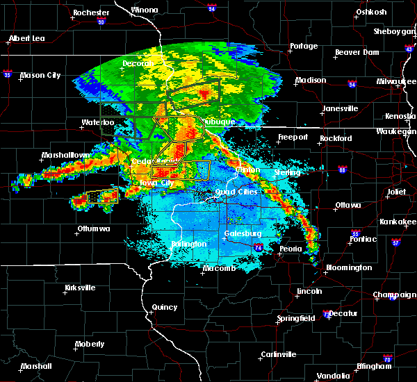 At 1119 pm cdt, a severe thunderstorm was located near keswick, or 13 miles north of sigourney, moving east at 35 mph (radar indicated). Hazards include quarter size hail. Damage to vehicles is expected. Locations impacted include, wellman, north english, keswick, south english, parnell, millersburg, kinross, webster and holbrook. At 1119 pm cdt, a severe thunderstorm was located near keswick, or 13 miles north of sigourney, moving east at 35 mph (radar indicated). Hazards include quarter size hail. Damage to vehicles is expected. Locations impacted include, wellman, north english, keswick, south english, parnell, millersburg, kinross, webster and holbrook.
|
| 6/9/2018 10:56 PM CDT |
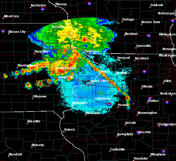 At 1056 pm cdt, a severe thunderstorm was located near millersburg, or 13 miles north of sigourney, moving east at 35 mph (radar indicated). Hazards include quarter size hail. damage to vehicles is expected At 1056 pm cdt, a severe thunderstorm was located near millersburg, or 13 miles north of sigourney, moving east at 35 mph (radar indicated). Hazards include quarter size hail. damage to vehicles is expected
|
| 5/26/2018 12:41 AM CDT |
 At 1240 am cdt, a severe thunderstorm was located over ladora, or 8 miles west of marengo, moving southeast at 15 mph (radar indicated). Hazards include 60 mph wind gusts and quarter size hail. Hail damage to vehicles is expected. expect wind damage to roofs, siding, and trees. locations impacted include, marengo, williamsburg, north english, victor, ladora, parnell, millersburg, conroy, genoa bluff, koszta and lake iowa park. This includes interstate 80 in iowa between mile markers 205 and 223. At 1240 am cdt, a severe thunderstorm was located over ladora, or 8 miles west of marengo, moving southeast at 15 mph (radar indicated). Hazards include 60 mph wind gusts and quarter size hail. Hail damage to vehicles is expected. expect wind damage to roofs, siding, and trees. locations impacted include, marengo, williamsburg, north english, victor, ladora, parnell, millersburg, conroy, genoa bluff, koszta and lake iowa park. This includes interstate 80 in iowa between mile markers 205 and 223.
|
| 5/26/2018 12:35 AM CDT |
 At 1234 am cdt, a severe thunderstorm was located near ladora, or 9 miles west of marengo, moving southeast at 15 mph (radar indicated). Hazards include 60 mph wind gusts and half dollar size hail. Hail damage to vehicles is expected. Expect wind damage to roofs, siding, and trees. At 1234 am cdt, a severe thunderstorm was located near ladora, or 9 miles west of marengo, moving southeast at 15 mph (radar indicated). Hazards include 60 mph wind gusts and half dollar size hail. Hail damage to vehicles is expected. Expect wind damage to roofs, siding, and trees.
|
| 7/21/2017 3:58 PM CDT |
 At 358 pm cdt, a severe thunderstorm was located over williamsburg, or 11 miles southeast of marengo, moving east at 35 mph (radar indicated). Hazards include 60 mph wind gusts and quarter size hail. Hail damage to vehicles is expected. expect wind damage to roofs, siding, and trees. locations impacted include, iowa city, coralville, north liberty, williamsburg, kalona, solon, tiffin, lone tree, university heights, riverside, oxford, hills, ladora, parnell, millersburg, oakdale, conroy, newport, frytown and windham. this includes the following highways, interstate 80 in iowa between mile markers 211 and 253. Interstate 380 between mile markers 1 and 6. At 358 pm cdt, a severe thunderstorm was located over williamsburg, or 11 miles southeast of marengo, moving east at 35 mph (radar indicated). Hazards include 60 mph wind gusts and quarter size hail. Hail damage to vehicles is expected. expect wind damage to roofs, siding, and trees. locations impacted include, iowa city, coralville, north liberty, williamsburg, kalona, solon, tiffin, lone tree, university heights, riverside, oxford, hills, ladora, parnell, millersburg, oakdale, conroy, newport, frytown and windham. this includes the following highways, interstate 80 in iowa between mile markers 211 and 253. Interstate 380 between mile markers 1 and 6.
|
| 7/21/2017 3:51 PM CDT |
 At 350 pm cdt, a severe thunderstorm was located near williamsburg, or 10 miles south of marengo, moving east at 35 mph (radar indicated). Hazards include 60 mph wind gusts and quarter size hail. Hail damage to vehicles is expected. Expect wind damage to roofs, siding, and trees. At 350 pm cdt, a severe thunderstorm was located near williamsburg, or 10 miles south of marengo, moving east at 35 mph (radar indicated). Hazards include 60 mph wind gusts and quarter size hail. Hail damage to vehicles is expected. Expect wind damage to roofs, siding, and trees.
|
| 7/20/2017 11:57 PM CDT |
 At 1148 pm cdt, severe thunderstorms were located along a line extending from 6 miles northwest of keystone to ladora to near what cheer, moving east at 40 mph (radar indicated). Hazards include 60 mph wind gusts. Expect damage to roofs, siding, and trees. locations impacted include, marengo, williamsburg, belle plaine, north english, victor, newhall, blairstown, van horne, what cheer, keystone, norway, ladora, keswick, south english, parnell, millersburg, luzerne, kinross, amana and conroy. This includes interstate 80 in iowa between mile markers 205 and 226. At 1148 pm cdt, severe thunderstorms were located along a line extending from 6 miles northwest of keystone to ladora to near what cheer, moving east at 40 mph (radar indicated). Hazards include 60 mph wind gusts. Expect damage to roofs, siding, and trees. locations impacted include, marengo, williamsburg, belle plaine, north english, victor, newhall, blairstown, van horne, what cheer, keystone, norway, ladora, keswick, south english, parnell, millersburg, luzerne, kinross, amana and conroy. This includes interstate 80 in iowa between mile markers 205 and 226.
|
| 7/20/2017 11:48 PM CDT |
 At 1148 pm cdt, severe thunderstorms were located along a line extending from 6 miles northwest of keystone to ladora to near what cheer, moving east at 40 mph (radar indicated). Hazards include 60 mph wind gusts. Expect damage to roofs, siding, and trees. locations impacted include, marengo, williamsburg, belle plaine, north english, victor, newhall, blairstown, van horne, what cheer, keystone, norway, ladora, keswick, south english, parnell, millersburg, luzerne, kinross, amana and conroy. This includes interstate 80 in iowa between mile markers 205 and 226. At 1148 pm cdt, severe thunderstorms were located along a line extending from 6 miles northwest of keystone to ladora to near what cheer, moving east at 40 mph (radar indicated). Hazards include 60 mph wind gusts. Expect damage to roofs, siding, and trees. locations impacted include, marengo, williamsburg, belle plaine, north english, victor, newhall, blairstown, van horne, what cheer, keystone, norway, ladora, keswick, south english, parnell, millersburg, luzerne, kinross, amana and conroy. This includes interstate 80 in iowa between mile markers 205 and 226.
|
| 7/20/2017 11:39 PM CDT |
 At 1139 pm cdt, severe thunderstorms were located along a line extending from 9 miles west of keystone to near victor to 6 miles northwest of what cheer, moving east at 35 mph (radar indicated). Hazards include 60 mph wind gusts. expect damage to roofs, siding, and trees At 1139 pm cdt, severe thunderstorms were located along a line extending from 9 miles west of keystone to near victor to 6 miles northwest of what cheer, moving east at 35 mph (radar indicated). Hazards include 60 mph wind gusts. expect damage to roofs, siding, and trees
|
| 7/11/2017 5:59 AM CDT |
 At 558 am cdt, severe thunderstorms were located along a line extending from williamsburg to near kinross to near maharishi vedic city, moving east at 55 mph (radar indicated). Hazards include 60 mph wind gusts. Expect damage to roofs, siding, and trees. locations impacted include, iowa city, fairfield, mount pleasant, washington, sigourney, coralville, williamsburg, kalona, tiffin, wellman, lone tree, university heights, north english, riverside, wayland, hills, brighton, richland, ainsworth and lockridge. This includes interstate 80 in iowa between mile markers 209 and 250. At 558 am cdt, severe thunderstorms were located along a line extending from williamsburg to near kinross to near maharishi vedic city, moving east at 55 mph (radar indicated). Hazards include 60 mph wind gusts. Expect damage to roofs, siding, and trees. locations impacted include, iowa city, fairfield, mount pleasant, washington, sigourney, coralville, williamsburg, kalona, tiffin, wellman, lone tree, university heights, north english, riverside, wayland, hills, brighton, richland, ainsworth and lockridge. This includes interstate 80 in iowa between mile markers 209 and 250.
|
| 7/11/2017 5:48 AM CDT |
 At 548 am cdt, severe thunderstorms were located along a line extending from near ladora to near harper to near hedrick, moving east at 55 mph (radar indicated). Hazards include 60 mph wind gusts. Expect damage to roofs, siding, and trees. locations impacted include, iowa city, fairfield, mount pleasant, washington, marengo, sigourney, coralville, north liberty, williamsburg, kalona, solon, tiffin, wellman, lone tree, university heights, north english, riverside, wayland, victor and swisher. this includes the following highways, interstate 80 in iowa between mile markers 205 and 252. Interstate 380 between mile markers 1 and 11. At 548 am cdt, severe thunderstorms were located along a line extending from near ladora to near harper to near hedrick, moving east at 55 mph (radar indicated). Hazards include 60 mph wind gusts. Expect damage to roofs, siding, and trees. locations impacted include, iowa city, fairfield, mount pleasant, washington, marengo, sigourney, coralville, north liberty, williamsburg, kalona, solon, tiffin, wellman, lone tree, university heights, north english, riverside, wayland, victor and swisher. this includes the following highways, interstate 80 in iowa between mile markers 205 and 252. Interstate 380 between mile markers 1 and 11.
|
| 7/11/2017 5:40 AM CDT |
 At 540 am cdt, severe thunderstorms were located along a line extending from victor to near keswick to ottumwa industrial airport, moving east at 55 mph (radar indicated). Hazards include 60 mph wind gusts. expect damage to roofs, siding, and trees At 540 am cdt, severe thunderstorms were located along a line extending from victor to near keswick to ottumwa industrial airport, moving east at 55 mph (radar indicated). Hazards include 60 mph wind gusts. expect damage to roofs, siding, and trees
|
| 5/17/2017 5:58 PM CDT |
 The severe thunderstorm warning for central keokuk, benton and iowa counties will expire at 600 pm cdt, the storms which prompted the warning have moved out of the area. therefore, the warning will be allowed to expire. however heavy rain is still possible with these thunderstorms. a tornado watch remains in effect until 1100 pm cdt for southeastern, northeastern and east central iowa. remember, a severe thunderstorm warning still remains in effect for eastern benton and eastern iowa county. The severe thunderstorm warning for central keokuk, benton and iowa counties will expire at 600 pm cdt, the storms which prompted the warning have moved out of the area. therefore, the warning will be allowed to expire. however heavy rain is still possible with these thunderstorms. a tornado watch remains in effect until 1100 pm cdt for southeastern, northeastern and east central iowa. remember, a severe thunderstorm warning still remains in effect for eastern benton and eastern iowa county.
|
| 5/17/2017 5:51 PM CDT |
 At 551 pm cdt, severe thunderstorms were located along a line extending from near dysart to near norway to near south english, moving northeast at 45 mph (trained weather spotters). Hazards include 70 mph wind gusts and quarter size hail. Hail damage to vehicles is expected. expect considerable tree damage. wind damage is also likely to mobile homes, roofs, and outbuildings. locations impacted include, vinton, marengo, sigourney, williamsburg, belle plaine, atkins, urbana, north english, shellsburg, newhall, hedrick, blairstown, van horne, keystone, norway, garrison, ladora, keswick, south english and parnell. this includes the following highways, interstate 80 in iowa between mile markers 208 and 227. interstate 380 between mile markers 42 and 48. A tornado watch remains in effect until 1100 pm cdt for southeastern, northeastern and east central iowa. At 551 pm cdt, severe thunderstorms were located along a line extending from near dysart to near norway to near south english, moving northeast at 45 mph (trained weather spotters). Hazards include 70 mph wind gusts and quarter size hail. Hail damage to vehicles is expected. expect considerable tree damage. wind damage is also likely to mobile homes, roofs, and outbuildings. locations impacted include, vinton, marengo, sigourney, williamsburg, belle plaine, atkins, urbana, north english, shellsburg, newhall, hedrick, blairstown, van horne, keystone, norway, garrison, ladora, keswick, south english and parnell. this includes the following highways, interstate 80 in iowa between mile markers 208 and 227. interstate 380 between mile markers 42 and 48. A tornado watch remains in effect until 1100 pm cdt for southeastern, northeastern and east central iowa.
|
| 5/17/2017 5:43 PM CDT |
 At 543 pm cdt, severe thunderstorms were located along a line extending from near traer to near marengo to near harper, moving northeast at 40 mph (trained weather spotters). Hazards include 70 mph wind gusts and quarter size hail. Hail damage to vehicles is expected. expect considerable tree damage. wind damage is also likely to mobile homes, roofs, and outbuildings. locations impacted include, vinton, marengo, sigourney, williamsburg, belle plaine, atkins, urbana, dysart, north english, shellsburg, victor, newhall, hedrick, blairstown, van horne, what cheer, keystone, norway, garrison and delta. this includes the following highways, interstate 80 in iowa between mile markers 205 and 227. interstate 380 between mile markers 42 and 48. A tornado watch remains in effect until 1100 pm cdt for southeastern, northeastern and east central iowa. At 543 pm cdt, severe thunderstorms were located along a line extending from near traer to near marengo to near harper, moving northeast at 40 mph (trained weather spotters). Hazards include 70 mph wind gusts and quarter size hail. Hail damage to vehicles is expected. expect considerable tree damage. wind damage is also likely to mobile homes, roofs, and outbuildings. locations impacted include, vinton, marengo, sigourney, williamsburg, belle plaine, atkins, urbana, dysart, north english, shellsburg, victor, newhall, hedrick, blairstown, van horne, what cheer, keystone, norway, garrison and delta. this includes the following highways, interstate 80 in iowa between mile markers 205 and 227. interstate 380 between mile markers 42 and 48. A tornado watch remains in effect until 1100 pm cdt for southeastern, northeastern and east central iowa.
|
| 5/17/2017 5:31 PM CDT |
 At 531 pm cdt, severe thunderstorms were located along a line extending from near traer to near ladora to hayesville, moving northeast at 45 mph (radar indicated). Hazards include 70 mph wind gusts and quarter size hail. Hail damage to vehicles is expected. expect considerable tree damage. wind damage is also likely to mobile homes, roofs, and outbuildings. locations impacted include, vinton, marengo, sigourney, williamsburg, belle plaine, atkins, urbana, dysart, north english, shellsburg, victor, newhall, hedrick, blairstown, van horne, what cheer, keystone, norway, garrison and delta. this includes the following highways, interstate 80 in iowa between mile markers 205 and 227. interstate 380 between mile markers 42 and 48. A tornado watch remains in effect until 1100 pm cdt for southeastern, northeastern and east central iowa. At 531 pm cdt, severe thunderstorms were located along a line extending from near traer to near ladora to hayesville, moving northeast at 45 mph (radar indicated). Hazards include 70 mph wind gusts and quarter size hail. Hail damage to vehicles is expected. expect considerable tree damage. wind damage is also likely to mobile homes, roofs, and outbuildings. locations impacted include, vinton, marengo, sigourney, williamsburg, belle plaine, atkins, urbana, dysart, north english, shellsburg, victor, newhall, hedrick, blairstown, van horne, what cheer, keystone, norway, garrison and delta. this includes the following highways, interstate 80 in iowa between mile markers 205 and 227. interstate 380 between mile markers 42 and 48. A tornado watch remains in effect until 1100 pm cdt for southeastern, northeastern and east central iowa.
|
| 5/17/2017 5:26 PM CDT |
 At 526 pm cdt, severe thunderstorms were located along a line extending from 6 miles south of traer to near ladora to near hayesville, moving northeast at 50 mph (radar indicated). Hazards include 70 mph wind gusts and quarter size hail. Hail damage to vehicles is expected. expect considerable tree damage. wind damage is also likely to mobile homes, roofs, and outbuildings. locations impacted include, vinton, marengo, sigourney, williamsburg, belle plaine, atkins, urbana, dysart, north english, shellsburg, victor, newhall, hedrick, blairstown, van horne, what cheer, keystone, norway, garrison and delta. this includes the following highways, interstate 80 in iowa between mile markers 205 and 227. interstate 380 between mile markers 42 and 48. A tornado watch remains in effect until 1100 pm cdt for southeastern, northeastern and east central iowa. At 526 pm cdt, severe thunderstorms were located along a line extending from 6 miles south of traer to near ladora to near hayesville, moving northeast at 50 mph (radar indicated). Hazards include 70 mph wind gusts and quarter size hail. Hail damage to vehicles is expected. expect considerable tree damage. wind damage is also likely to mobile homes, roofs, and outbuildings. locations impacted include, vinton, marengo, sigourney, williamsburg, belle plaine, atkins, urbana, dysart, north english, shellsburg, victor, newhall, hedrick, blairstown, van horne, what cheer, keystone, norway, garrison and delta. this includes the following highways, interstate 80 in iowa between mile markers 205 and 227. interstate 380 between mile markers 42 and 48. A tornado watch remains in effect until 1100 pm cdt for southeastern, northeastern and east central iowa.
|
| 5/17/2017 5:20 PM CDT |
 At 520 pm cdt, severe thunderstorms were located along a line extending from 6 miles southeast of tama to 6 miles southeast of victor to delta, moving northeast at 50 mph (radar indicated). Hazards include 70 mph wind gusts and quarter size hail. Hail damage to vehicles is expected. expect considerable tree damage. wind damage is also likely to mobile homes, roofs, and outbuildings. locations impacted include, vinton, marengo, sigourney, williamsburg, belle plaine, atkins, urbana, dysart, north english, shellsburg, victor, newhall, hedrick, blairstown, van horne, what cheer, keystone, norway, garrison and delta. this includes the following highways, interstate 80 in iowa between mile markers 205 and 227. interstate 380 between mile markers 42 and 48. A tornado watch remains in effect until 1100 pm cdt for southeastern, northeastern and east central iowa. At 520 pm cdt, severe thunderstorms were located along a line extending from 6 miles southeast of tama to 6 miles southeast of victor to delta, moving northeast at 50 mph (radar indicated). Hazards include 70 mph wind gusts and quarter size hail. Hail damage to vehicles is expected. expect considerable tree damage. wind damage is also likely to mobile homes, roofs, and outbuildings. locations impacted include, vinton, marengo, sigourney, williamsburg, belle plaine, atkins, urbana, dysart, north english, shellsburg, victor, newhall, hedrick, blairstown, van horne, what cheer, keystone, norway, garrison and delta. this includes the following highways, interstate 80 in iowa between mile markers 205 and 227. interstate 380 between mile markers 42 and 48. A tornado watch remains in effect until 1100 pm cdt for southeastern, northeastern and east central iowa.
|
| 5/17/2017 5:12 PM CDT |
 At 512 pm cdt, severe thunderstorms were located along a line extending from near brooklyn to 7 miles west of millersburg to near hedrick, moving northeast at 50 mph (radar indicated). Hazards include 60 mph wind gusts and quarter size hail. Hail damage to vehicles is expected. expect wind damage to roofs, siding, and trees. locations impacted include, vinton, marengo, sigourney, williamsburg, belle plaine, atkins, urbana, dysart, north english, shellsburg, victor, newhall, hedrick, blairstown, van horne, what cheer, keystone, norway, garrison and delta. this includes the following highways, interstate 80 in iowa between mile markers 205 and 227. interstate 380 between mile markers 42 and 48. A tornado watch remains in effect until 1100 pm cdt for southeastern, northeastern and east central iowa. At 512 pm cdt, severe thunderstorms were located along a line extending from near brooklyn to 7 miles west of millersburg to near hedrick, moving northeast at 50 mph (radar indicated). Hazards include 60 mph wind gusts and quarter size hail. Hail damage to vehicles is expected. expect wind damage to roofs, siding, and trees. locations impacted include, vinton, marengo, sigourney, williamsburg, belle plaine, atkins, urbana, dysart, north english, shellsburg, victor, newhall, hedrick, blairstown, van horne, what cheer, keystone, norway, garrison and delta. this includes the following highways, interstate 80 in iowa between mile markers 205 and 227. interstate 380 between mile markers 42 and 48. A tornado watch remains in effect until 1100 pm cdt for southeastern, northeastern and east central iowa.
|
| 5/17/2017 5:03 PM CDT |
 At 503 pm cdt, severe thunderstorms were located along a line extending from near montezuma to near what cheer to near hedrick, moving northeast at 45 mph (radar indicated). Hazards include 60 mph wind gusts and quarter size hail. Hail damage to vehicles is expected. Expect wind damage to roofs, siding, and trees. At 503 pm cdt, severe thunderstorms were located along a line extending from near montezuma to near what cheer to near hedrick, moving northeast at 45 mph (radar indicated). Hazards include 60 mph wind gusts and quarter size hail. Hail damage to vehicles is expected. Expect wind damage to roofs, siding, and trees.
|
| 4/15/2017 7:14 PM CDT |
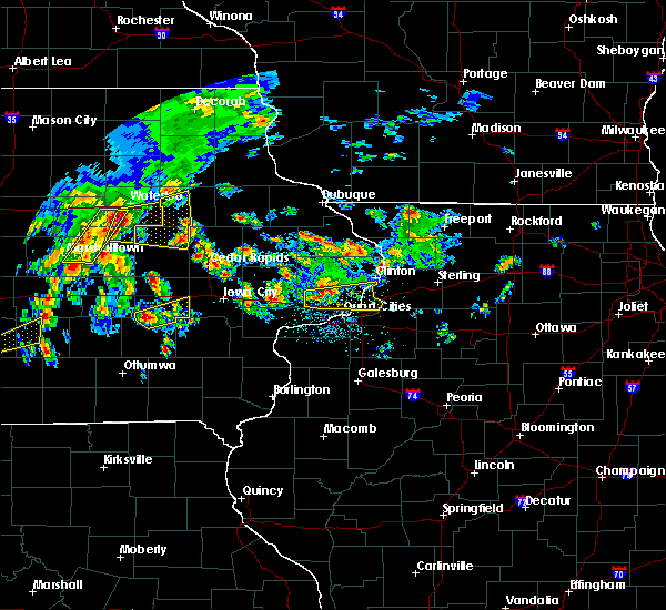 At 713 pm cdt, a severe thunderstorm was located near millersburg, or 13 miles north of sigourney, moving northeast at 35 mph (radar indicated). Hazards include quarter size hail. Damage to vehicles is expected. locations impacted include, north english, keswick, south english, parnell, millersburg, kinross, webster and holbrook. This includes interstate 80 in iowa near mile marker 229. At 713 pm cdt, a severe thunderstorm was located near millersburg, or 13 miles north of sigourney, moving northeast at 35 mph (radar indicated). Hazards include quarter size hail. Damage to vehicles is expected. locations impacted include, north english, keswick, south english, parnell, millersburg, kinross, webster and holbrook. This includes interstate 80 in iowa near mile marker 229.
|
| 4/15/2017 6:58 PM CDT |
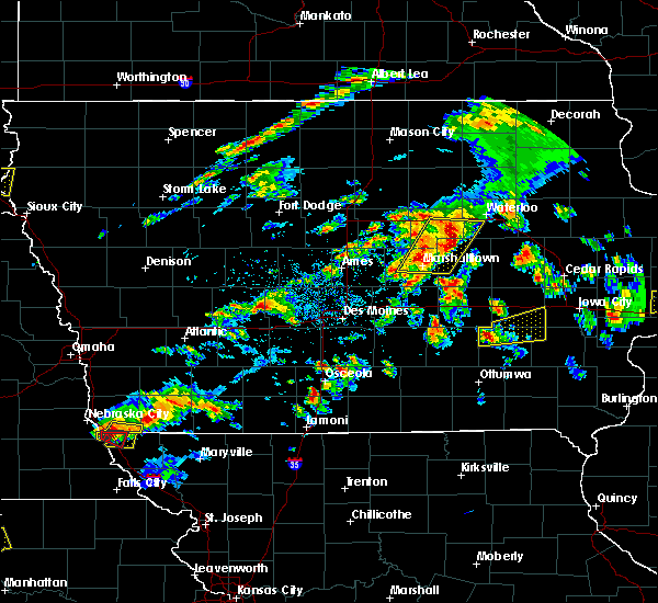 At 658 pm cdt, a severe thunderstorm was located near keswick, or 8 miles northwest of sigourney, moving east at 40 mph (radar indicated). Hazards include quarter size hail. damage to vehicles is expected At 658 pm cdt, a severe thunderstorm was located near keswick, or 8 miles northwest of sigourney, moving east at 40 mph (radar indicated). Hazards include quarter size hail. damage to vehicles is expected
|
| 3/6/2017 8:51 PM CST |
 At 850 pm cst, severe thunderstorms were located along a line extending from near strawberry point to near lamont to quasqueton to near shellsburg to near hiawatha to near williamsburg to near north english, moving northeast at 80 mph (trained weather spotters). Hazards include 70 mph wind gusts. Expect considerable tree damage. damage is likely to mobile homes, roofs, and outbuildings. locations impacted include, independence, vinton, marengo, williamsburg, jesup, atkins, walford, urbana, north english, shellsburg, newhall, winthrop, hazleton, blairstown, van horne, quasqueton, norway, lamont, garrison and brandon. this includes the following highways, interstate 80 in iowa between mile markers 217 and 229. interstate 380 between mile markers 40 and 54. A tornado watch remains in effect until 1000 pm cst for southeastern, northeastern and east central iowa. At 850 pm cst, severe thunderstorms were located along a line extending from near strawberry point to near lamont to quasqueton to near shellsburg to near hiawatha to near williamsburg to near north english, moving northeast at 80 mph (trained weather spotters). Hazards include 70 mph wind gusts. Expect considerable tree damage. damage is likely to mobile homes, roofs, and outbuildings. locations impacted include, independence, vinton, marengo, williamsburg, jesup, atkins, walford, urbana, north english, shellsburg, newhall, winthrop, hazleton, blairstown, van horne, quasqueton, norway, lamont, garrison and brandon. this includes the following highways, interstate 80 in iowa between mile markers 217 and 229. interstate 380 between mile markers 40 and 54. A tornado watch remains in effect until 1000 pm cst for southeastern, northeastern and east central iowa.
|
| 3/6/2017 8:31 PM CST |
 At 831 pm cst, severe thunderstorms were located along a line extending from near maynard to near independence to near mount auburn to near belle plaine to near ladora to near keswick to 6 miles east of oskaloosa, moving east at 50 mph. these are very dangerous storms! (trained weather spotters). Hazards include 90 mph wind gusts. You are in a life-threatening situation. flying debris may be deadly to those caught without shelter. mobile homes will be heavily damaged or destroyed. homes and businesses will have substantial roof and window damage. expect extensive tree damage and power outages. locations impacted include, independence, vinton, marengo, williamsburg, belle plaine, jesup, atkins, walford, urbana, dysart, fairbank, north english, shellsburg, victor, newhall, winthrop, hazleton, blairstown, van horne and keystone. this includes the following highways, interstate 80 in iowa between mile markers 205 and 229. interstate 380 between mile markers 40 and 55. A tornado watch remains in effect until 1000 pm cst for southeastern, northeastern and east central iowa. At 831 pm cst, severe thunderstorms were located along a line extending from near maynard to near independence to near mount auburn to near belle plaine to near ladora to near keswick to 6 miles east of oskaloosa, moving east at 50 mph. these are very dangerous storms! (trained weather spotters). Hazards include 90 mph wind gusts. You are in a life-threatening situation. flying debris may be deadly to those caught without shelter. mobile homes will be heavily damaged or destroyed. homes and businesses will have substantial roof and window damage. expect extensive tree damage and power outages. locations impacted include, independence, vinton, marengo, williamsburg, belle plaine, jesup, atkins, walford, urbana, dysart, fairbank, north english, shellsburg, victor, newhall, winthrop, hazleton, blairstown, van horne and keystone. this includes the following highways, interstate 80 in iowa between mile markers 205 and 229. interstate 380 between mile markers 40 and 55. A tornado watch remains in effect until 1000 pm cst for southeastern, northeastern and east central iowa.
|
| 3/6/2017 8:15 PM CST |
 At 814 pm cst, severe thunderstorms were located along a line extending from near fairbank to near jesup to dysart to 8 miles southeast of tama to near brooklyn to near new sharon to 8 miles northwest of eddyville, moving east at 60 mph (radar indicated). Hazards include 70 mph wind gusts. Expect considerable tree damage. damage is likely to mobile homes, roofs, and outbuildings. locations impacted include, independence, vinton, marengo, williamsburg, belle plaine, jesup, atkins, walford, urbana, dysart, fairbank, north english, shellsburg, victor, newhall, winthrop, hazleton, blairstown, van horne and keystone. this includes the following highways, interstate 80 in iowa between mile markers 205 and 229. interstate 380 between mile markers 40 and 55. A tornado watch remains in effect until 1000 pm cst for southeastern, northeastern and east central iowa. At 814 pm cst, severe thunderstorms were located along a line extending from near fairbank to near jesup to dysart to 8 miles southeast of tama to near brooklyn to near new sharon to 8 miles northwest of eddyville, moving east at 60 mph (radar indicated). Hazards include 70 mph wind gusts. Expect considerable tree damage. damage is likely to mobile homes, roofs, and outbuildings. locations impacted include, independence, vinton, marengo, williamsburg, belle plaine, jesup, atkins, walford, urbana, dysart, fairbank, north english, shellsburg, victor, newhall, winthrop, hazleton, blairstown, van horne and keystone. this includes the following highways, interstate 80 in iowa between mile markers 205 and 229. interstate 380 between mile markers 40 and 55. A tornado watch remains in effect until 1000 pm cst for southeastern, northeastern and east central iowa.
|
| 3/6/2017 8:02 PM CST |
 At 802 pm cst, severe thunderstorms were located along a line extending from 6 miles east of denver to near traer to near tama to near grinnell to 6 miles southwest of new sharon to 12 miles southeast of knoxville, moving east at 50 mph (radar indicated). Hazards include 70 mph wind gusts. Expect considerable tree damage. Damage is likely to mobile homes, roofs, and outbuildings. At 802 pm cst, severe thunderstorms were located along a line extending from 6 miles east of denver to near traer to near tama to near grinnell to 6 miles southwest of new sharon to 12 miles southeast of knoxville, moving east at 50 mph (radar indicated). Hazards include 70 mph wind gusts. Expect considerable tree damage. Damage is likely to mobile homes, roofs, and outbuildings.
|
| 8/4/2016 8:19 PM CDT |
 At 819 pm cdt, severe thunderstorms were located along a line extending from near morley to near oxford to 8 miles south of victor, moving east at 55 mph (radar indicated). Hazards include 60 mph wind gusts. Expect damage to roofs. siding. And trees. At 819 pm cdt, severe thunderstorms were located along a line extending from near morley to near oxford to 8 miles south of victor, moving east at 55 mph (radar indicated). Hazards include 60 mph wind gusts. Expect damage to roofs. siding. And trees.
|
| 7/17/2016 5:31 AM CDT |
 At 531 am cdt, severe thunderstorms were located along a line extending from martelle to lake macbride state park to near what cheer, moving east at 65 mph (radar indicated). Hazards include 60 mph wind gusts. Expect damage to roofs. siding. And trees. At 531 am cdt, severe thunderstorms were located along a line extending from martelle to lake macbride state park to near what cheer, moving east at 65 mph (radar indicated). Hazards include 60 mph wind gusts. Expect damage to roofs. siding. And trees.
|
| 7/17/2016 5:17 AM CDT |
 At 517 am cdt, severe thunderstorms were located along a line extending from near troy mills to near norway to 7 miles north of new sharon, moving southeast at 60 mph (radar indicated). Hazards include 60 mph wind gusts. Expect damage to roofs. siding. and trees. Locations impacted include, cedar rapids, iowa city, marengo, marion, coralville, north liberty, hiawatha, mount vernon, robins, williamsburg, belle plaine, center point, lisbon, fairfax, solon, tiffin, ely, atkins, walford and central city. At 517 am cdt, severe thunderstorms were located along a line extending from near troy mills to near norway to 7 miles north of new sharon, moving southeast at 60 mph (radar indicated). Hazards include 60 mph wind gusts. Expect damage to roofs. siding. and trees. Locations impacted include, cedar rapids, iowa city, marengo, marion, coralville, north liberty, hiawatha, mount vernon, robins, williamsburg, belle plaine, center point, lisbon, fairfax, solon, tiffin, ely, atkins, walford and central city.
|
| 7/17/2016 5:03 AM CDT |
 At 502 am cdt, severe thunderstorms were located along a line extending from near quasqueton to near van horne to near iowa speedway, moving southeast at 50 mph (radar indicated). Hazards include 60 mph wind gusts. Expect damage to roofs. siding. and trees. Locations impacted include, cedar rapids, iowa city, independence, vinton, marengo, marion, coralville, north liberty, hiawatha, mount vernon, robins, williamsburg, belle plaine, jesup, center point, lisbon, fairfax, solon, tiffin and ely. At 502 am cdt, severe thunderstorms were located along a line extending from near quasqueton to near van horne to near iowa speedway, moving southeast at 50 mph (radar indicated). Hazards include 60 mph wind gusts. Expect damage to roofs. siding. and trees. Locations impacted include, cedar rapids, iowa city, independence, vinton, marengo, marion, coralville, north liberty, hiawatha, mount vernon, robins, williamsburg, belle plaine, jesup, center point, lisbon, fairfax, solon, tiffin and ely.
|
| 7/17/2016 4:37 AM CDT |
 At 436 am cdt, severe thunderstorms were located along a line extending from near waterloo to near toledo to near bondurant, moving southeast at 60 mph (radar indicated). Hazards include 60 mph wind gusts. Expect damage to roofs. siding. And trees. At 436 am cdt, severe thunderstorms were located along a line extending from near waterloo to near toledo to near bondurant, moving southeast at 60 mph (radar indicated). Hazards include 60 mph wind gusts. Expect damage to roofs. siding. And trees.
|
| 7/13/2016 1:28 PM CDT |
 At 128 pm cdt, severe thunderstorms were located along a line extending from near montezuma to near oskaloosa, moving east at 45 mph (radar indicated). Hazards include 60 mph wind gusts and penny size hail. Expect damage to roofs. siding. And trees. At 128 pm cdt, severe thunderstorms were located along a line extending from near montezuma to near oskaloosa, moving east at 45 mph (radar indicated). Hazards include 60 mph wind gusts and penny size hail. Expect damage to roofs. siding. And trees.
|
| 5/26/2016 4:59 AM CDT |
 At 458 am cdt, a severe thunderstorm was located near millersburg, or 11 miles south of marengo, moving east at 40 mph (trained weather spotters). Hazards include golf ball size hail and 60 mph wind gusts. People and animals outdoors will be injured. expect hail damage to roofs, siding, windows, and vehicles. expect wind damage to roofs, siding, and trees. this severe thunderstorm will be near, parnell around 505 am cdt. williamsburg and conroy around 510 am cdt. oxford around 525 am cdt. coralville and tiffin around 535 am cdt. north liberty around 540 am cdt. iowa city around 545 am cdt. other locations impacted by this severe thunderstorm include cosgrove, middle amana, windham, high amana, holbrook, upper south amana, east amana, f. w. kent park, homestead and west amana. this includes the following highways, interstate 80 in iowa between mile markers 208 and 240. Interstate 380 between mile markers 1 and 11. At 458 am cdt, a severe thunderstorm was located near millersburg, or 11 miles south of marengo, moving east at 40 mph (trained weather spotters). Hazards include golf ball size hail and 60 mph wind gusts. People and animals outdoors will be injured. expect hail damage to roofs, siding, windows, and vehicles. expect wind damage to roofs, siding, and trees. this severe thunderstorm will be near, parnell around 505 am cdt. williamsburg and conroy around 510 am cdt. oxford around 525 am cdt. coralville and tiffin around 535 am cdt. north liberty around 540 am cdt. iowa city around 545 am cdt. other locations impacted by this severe thunderstorm include cosgrove, middle amana, windham, high amana, holbrook, upper south amana, east amana, f. w. kent park, homestead and west amana. this includes the following highways, interstate 80 in iowa between mile markers 208 and 240. Interstate 380 between mile markers 1 and 11.
|
| 11/11/2015 4:40 PM CST |
 At 440 pm cst, a severe thunderstorm capable of producing a tornado was located near millersburg, or 14 miles north of sigourney, moving northeast at 50 mph (radar indicated rotation). Hazards include tornado. Flying debris will be dangerous to those caught without shelter. mobile homes will be damaged or destroyed. damage to roofs, windows and vehicles will occur. tree damage is likely. this dangerous storm will be near, parnell around 450 pm cst. williamsburg and ladora around 455 pm cst. conroy around 500 pm cst. other locations impacted by this tornadic thunderstorm include genoa bluff, lake iowa park and koszta. This includes interstate 80 in iowa between mile markers 206 and 227. At 440 pm cst, a severe thunderstorm capable of producing a tornado was located near millersburg, or 14 miles north of sigourney, moving northeast at 50 mph (radar indicated rotation). Hazards include tornado. Flying debris will be dangerous to those caught without shelter. mobile homes will be damaged or destroyed. damage to roofs, windows and vehicles will occur. tree damage is likely. this dangerous storm will be near, parnell around 450 pm cst. williamsburg and ladora around 455 pm cst. conroy around 500 pm cst. other locations impacted by this tornadic thunderstorm include genoa bluff, lake iowa park and koszta. This includes interstate 80 in iowa between mile markers 206 and 227.
|
| 11/11/2015 4:28 PM CST |
 At 426 pm cst, severe thunderstorms were located along a line extending from near meskwaki casino to 7 miles west of brooklyn to 7 miles northeast of oskaloosa, moving northeast at 55 mph (radar indicated). Hazards include 60 mph wind gusts and nickel size hail. Expect damage to roofs. siding and trees. locations impacted include, vinton, marengo, williamsburg, belle plaine, atkins, walford, urbana, dysart, north english, shellsburg, victor, newhall, blairstown, van horne, keystone, norway, garrison, ladora, parnell and millersburg. this includes the following highways, interstate 80 in iowa between mile markers 205 and 229. interstate 380 between mile markers 40 and 48. A tornado watch remains in effect until 900 pm cst for northeastern iowa. At 426 pm cst, severe thunderstorms were located along a line extending from near meskwaki casino to 7 miles west of brooklyn to 7 miles northeast of oskaloosa, moving northeast at 55 mph (radar indicated). Hazards include 60 mph wind gusts and nickel size hail. Expect damage to roofs. siding and trees. locations impacted include, vinton, marengo, williamsburg, belle plaine, atkins, walford, urbana, dysart, north english, shellsburg, victor, newhall, blairstown, van horne, keystone, norway, garrison, ladora, parnell and millersburg. this includes the following highways, interstate 80 in iowa between mile markers 205 and 229. interstate 380 between mile markers 40 and 48. A tornado watch remains in effect until 900 pm cst for northeastern iowa.
|
| 11/11/2015 4:25 PM CST |
 At 425 pm cst, a severe thunderstorm capable of producing a tornado was located over what cheer, or 8 miles northwest of sigourney, moving northeast at 50 mph (radar indicated rotation). Hazards include tornado. Flying debris will be dangerous to those caught without shelter. mobile homes will be damaged or destroyed. damage to roofs, windows and vehicles will occur. tree damage is likely. this dangerous storm will be near, keswick around 435 pm cst. north english and millersburg around 445 pm cst. ladora around 455 pm cst. williamsburg and conroy around 500 pm cst. other locations impacted by this tornadic thunderstorm include gibson, thornburg, koszta, keokuk county fairgrounds, coal creek, genoa bluff, lake iowa park and victor. This includes interstate 80 in iowa between mile markers 205 and 227. At 425 pm cst, a severe thunderstorm capable of producing a tornado was located over what cheer, or 8 miles northwest of sigourney, moving northeast at 50 mph (radar indicated rotation). Hazards include tornado. Flying debris will be dangerous to those caught without shelter. mobile homes will be damaged or destroyed. damage to roofs, windows and vehicles will occur. tree damage is likely. this dangerous storm will be near, keswick around 435 pm cst. north english and millersburg around 445 pm cst. ladora around 455 pm cst. williamsburg and conroy around 500 pm cst. other locations impacted by this tornadic thunderstorm include gibson, thornburg, koszta, keokuk county fairgrounds, coal creek, genoa bluff, lake iowa park and victor. This includes interstate 80 in iowa between mile markers 205 and 227.
|
| 11/11/2015 4:17 PM CST |
 At 417 pm cst, a severe thunderstorm capable of producing a tornado was located near delta, or 11 miles west of sigourney, moving northeast at 55 mph (radar indicated rotation). Hazards include tornado. Flying debris will be dangerous to those caught without shelter. mobile homes will be damaged or destroyed. damage to roofs, windows and vehicles will occur. tree damage is likely. this dangerous storm will be near, delta around 420 pm cst. what cheer around 425 pm cst. keswick around 430 pm cst. north english around 440 pm cst. millersburg around 445 pm cst. parnell around 450 pm cst. williamsburg and ladora around 455 pm cst. conroy around 500 pm cst. other locations impacted by this tornadic thunderstorm include gibson, thornburg, koszta, webster, keokuk county fairgrounds, coal creek, genoa bluff, lake iowa park and victor. This includes interstate 80 in iowa between mile markers 205 and 227. At 417 pm cst, a severe thunderstorm capable of producing a tornado was located near delta, or 11 miles west of sigourney, moving northeast at 55 mph (radar indicated rotation). Hazards include tornado. Flying debris will be dangerous to those caught without shelter. mobile homes will be damaged or destroyed. damage to roofs, windows and vehicles will occur. tree damage is likely. this dangerous storm will be near, delta around 420 pm cst. what cheer around 425 pm cst. keswick around 430 pm cst. north english around 440 pm cst. millersburg around 445 pm cst. parnell around 450 pm cst. williamsburg and ladora around 455 pm cst. conroy around 500 pm cst. other locations impacted by this tornadic thunderstorm include gibson, thornburg, koszta, webster, keokuk county fairgrounds, coal creek, genoa bluff, lake iowa park and victor. This includes interstate 80 in iowa between mile markers 205 and 227.
|
| 11/11/2015 4:16 PM CST |
 At 415 pm cst, severe thunderstorms were located along a line extending from near marshalltown to near grinnell to near oskaloosa, moving northeast at 50 mph (radar indicated). Hazards include 60 mph wind gusts and nickel size hail. Expect damage to roofs. Siding and trees. At 415 pm cst, severe thunderstorms were located along a line extending from near marshalltown to near grinnell to near oskaloosa, moving northeast at 50 mph (radar indicated). Hazards include 60 mph wind gusts and nickel size hail. Expect damage to roofs. Siding and trees.
|
| 6/29/2014 11:10 PM CDT | Emergency management relayed a public reports of 50 to 60 mph in southern iowa county in iowa county IA, 0.2 miles NNE of Millersburg, IA |
| 9/7/2012 3:55 AM CDT | Ping Pong Ball sized hail reported 0.2 miles NNE of Millersburg, IA |
Hail Maps for Millersburg, IA


Connect with Interactive Hail Maps