

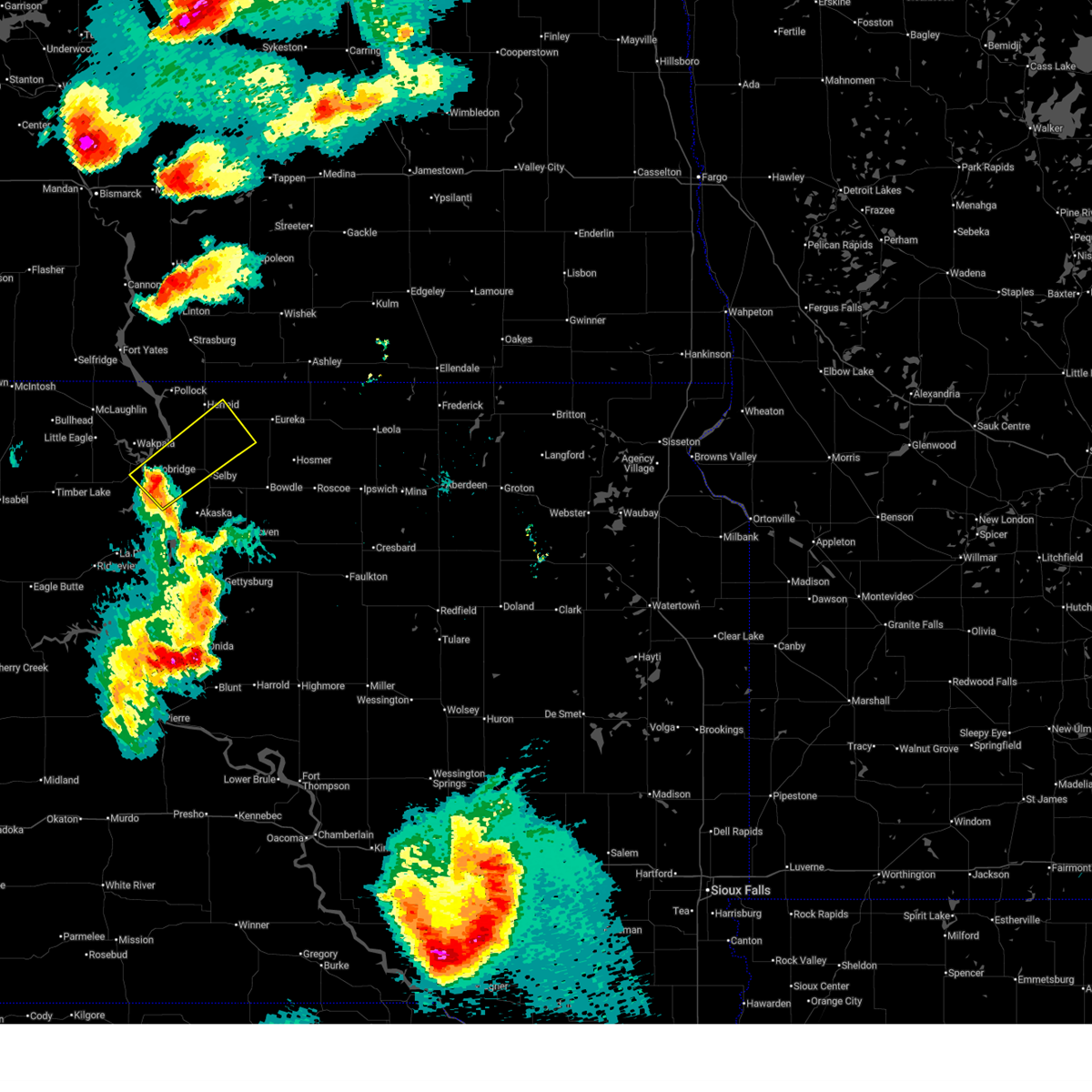
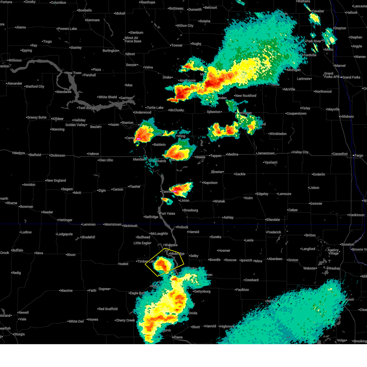
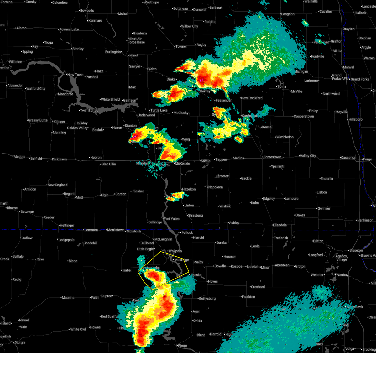
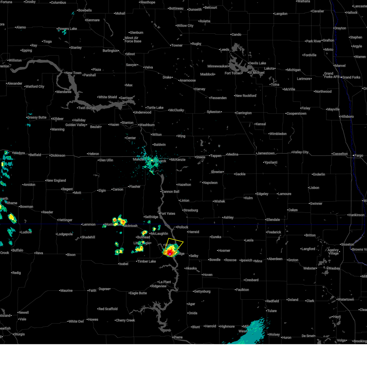
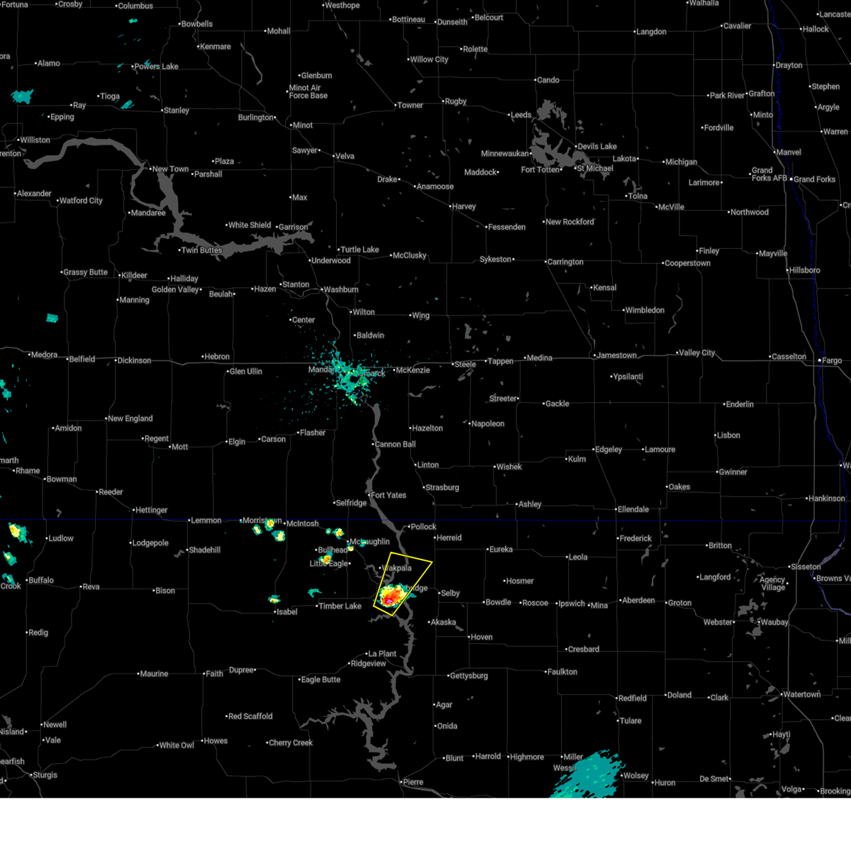
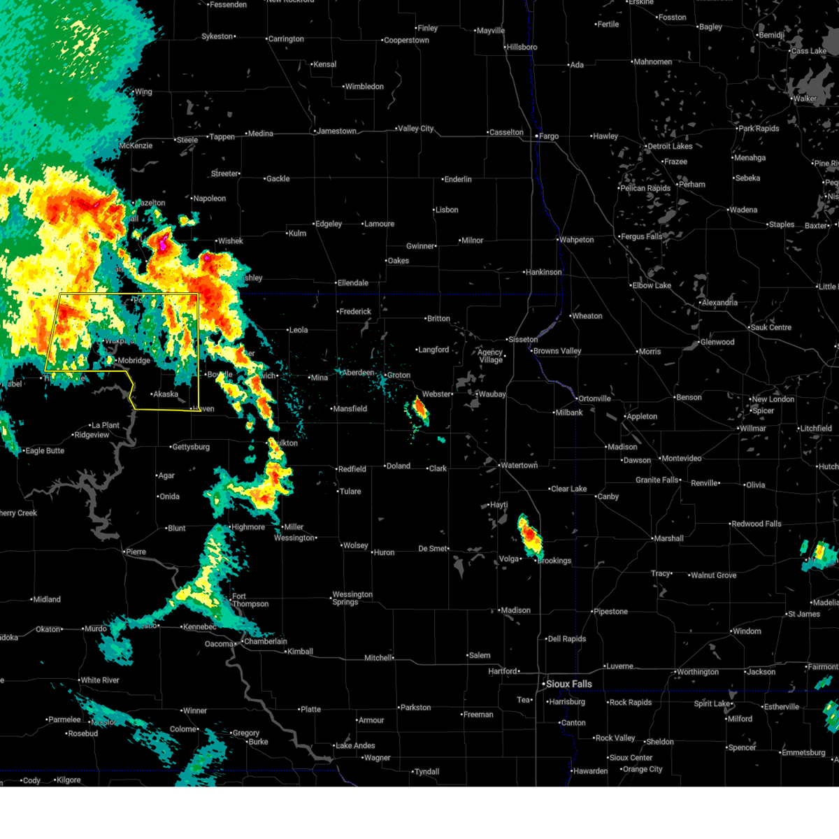
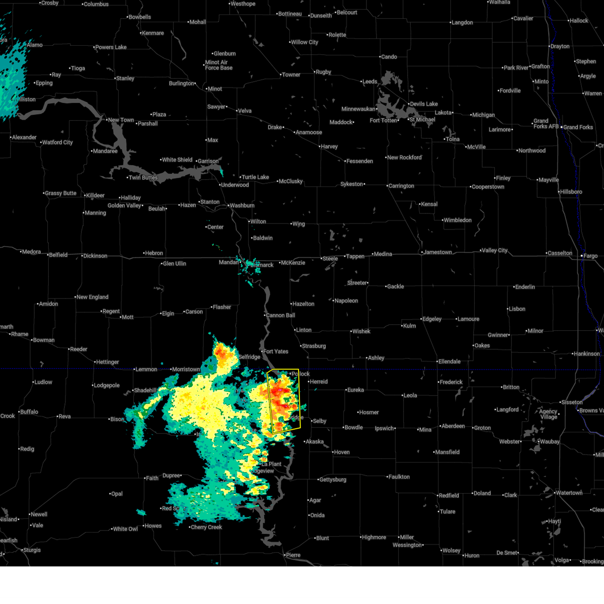
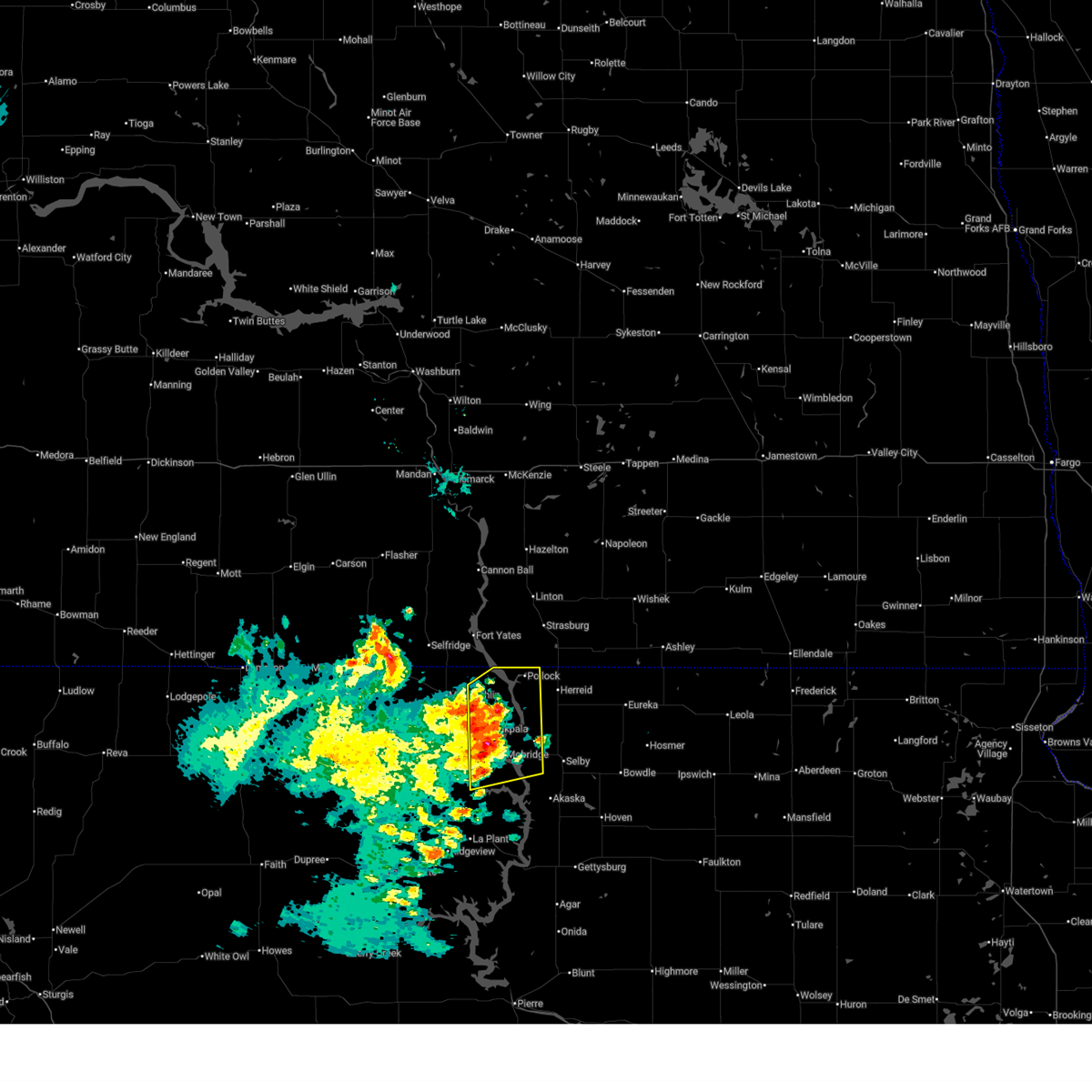
Hail Map for Mobridge, SD
The Mobridge, SD area has had 19 reports of on-the-ground hail by trained spotters, and has been under severe weather warnings 9 times during the past 12 months. Doppler radar has detected hail at or near Mobridge, SD on 52 occasions, including 1 occasion during the past year.
| Name: | Mobridge, SD |
| Where Located: | 81.1 miles N of Pierre, SD |
| Map: | Google Map for Mobridge, SD |
| Population: | 3465 |
| Housing Units: | 1727 |
| More Info: | Search Google for Mobridge, SD |
0
The Top Recent Hail Date for Mobridge, SD is Wednesday, August 14, 2024 (52nd out of 52)

Hail and Wind Damage Spotted near Mobridge, SD
| Date / Time | Report Details |
|---|---|
| 6/27/2025 10:12 PM CDT |
 Svrabr the national weather service in aberdeen has issued a * severe thunderstorm warning for, southeastern corson county in north central south dakota, southeastern campbell county in north central south dakota, northeastern dewey county in north central south dakota, northwestern walworth county in north central south dakota, * until 1100 pm cdt/1000 pm mdt/. * at 1011 pm cdt/911 pm mdt/, a severe thunderstorm was located over glenham, or 8 miles east of mobridge, moving northeast at 35 mph (radar indicated). Hazards include 60 mph wind gusts and quarter size hail. Hail damage to vehicles is expected. expect wind damage to roofs, siding, and trees. This severe thunderstorm will be near, mound city around 1025 pm cdt. Svrabr the national weather service in aberdeen has issued a * severe thunderstorm warning for, southeastern corson county in north central south dakota, southeastern campbell county in north central south dakota, northeastern dewey county in north central south dakota, northwestern walworth county in north central south dakota, * until 1100 pm cdt/1000 pm mdt/. * at 1011 pm cdt/911 pm mdt/, a severe thunderstorm was located over glenham, or 8 miles east of mobridge, moving northeast at 35 mph (radar indicated). Hazards include 60 mph wind gusts and quarter size hail. Hail damage to vehicles is expected. expect wind damage to roofs, siding, and trees. This severe thunderstorm will be near, mound city around 1025 pm cdt.
|
| 6/27/2025 8:54 PM MDT |
 At 953 pm cdt/853 pm mdt/, a severe thunderstorm was located near revheim bay rec area, or near mobridge, moving northeast at 30 mph (radar indicated). Hazards include 60 mph wind gusts and quarter size hail. Hail damage to vehicles is expected. expect wind damage to roofs, siding, and trees. Locations impacted include, mobridge, indian creek rec area, revheim bay rec area and glenham. At 953 pm cdt/853 pm mdt/, a severe thunderstorm was located near revheim bay rec area, or near mobridge, moving northeast at 30 mph (radar indicated). Hazards include 60 mph wind gusts and quarter size hail. Hail damage to vehicles is expected. expect wind damage to roofs, siding, and trees. Locations impacted include, mobridge, indian creek rec area, revheim bay rec area and glenham.
|
| 6/27/2025 8:30 PM MDT |
 Svrabr the national weather service in aberdeen has issued a * severe thunderstorm warning for, southeastern corson county in north central south dakota, northeastern dewey county in north central south dakota, western walworth county in north central south dakota, * until 1015 pm cdt/915 pm mdt/. * at 930 pm cdt/830 pm mdt/, severe thunderstorms were located along a line extending from near timber lake to near promise to near tiospaye topa school, moving northeast at 30 mph (radar indicated). Hazards include 60 mph wind gusts and quarter size hail. Hail damage to vehicles is expected. expect wind damage to roofs, siding, and trees. severe thunderstorms will be near, promise, trail city, and glencross around 835 pm mdt. blackfoot around 845 pm mdt. mobridge and revheim bay rec area around 950 pm cdt. Other locations in the path of these severe thunderstorms include indian creek rec area, indian memorial rec area, grand river casino and new everets resort. Svrabr the national weather service in aberdeen has issued a * severe thunderstorm warning for, southeastern corson county in north central south dakota, northeastern dewey county in north central south dakota, western walworth county in north central south dakota, * until 1015 pm cdt/915 pm mdt/. * at 930 pm cdt/830 pm mdt/, severe thunderstorms were located along a line extending from near timber lake to near promise to near tiospaye topa school, moving northeast at 30 mph (radar indicated). Hazards include 60 mph wind gusts and quarter size hail. Hail damage to vehicles is expected. expect wind damage to roofs, siding, and trees. severe thunderstorms will be near, promise, trail city, and glencross around 835 pm mdt. blackfoot around 845 pm mdt. mobridge and revheim bay rec area around 950 pm cdt. Other locations in the path of these severe thunderstorms include indian creek rec area, indian memorial rec area, grand river casino and new everets resort.
|
| 6/22/2025 2:36 AM CDT |
 the severe thunderstorm warning has been cancelled and is no longer in effect the severe thunderstorm warning has been cancelled and is no longer in effect
|
| 6/22/2025 2:36 AM CDT |
 At 235 am cdt/135 am mdt/, a severe thunderstorm was located over mobridge, moving northeast at 30 mph (radar indicated). Hazards include 60 mph wind gusts and quarter size hail. Hail damage to vehicles is expected. expect wind damage to roofs, siding, and trees. Locations impacted include, mobridge, indian memorial rec area, revheim bay rec area, grand river casino, and indian creek rec area. At 235 am cdt/135 am mdt/, a severe thunderstorm was located over mobridge, moving northeast at 30 mph (radar indicated). Hazards include 60 mph wind gusts and quarter size hail. Hail damage to vehicles is expected. expect wind damage to roofs, siding, and trees. Locations impacted include, mobridge, indian memorial rec area, revheim bay rec area, grand river casino, and indian creek rec area.
|
| 6/22/2025 2:34 AM CDT | Quarter sized hail reported 0.2 miles NW of Mobridge, SD, report from mping: quarter (1.00 in.). time estimated by radar. |
| 6/22/2025 2:23 AM CDT |
 Svrabr the national weather service in aberdeen has issued a * severe thunderstorm warning for, southeastern corson county in north central south dakota, southwestern campbell county in north central south dakota, northeastern dewey county in north central south dakota, northwestern walworth county in north central south dakota, * until 300 am cdt/200 am mdt/. * at 221 am cdt/121 am mdt/, a severe thunderstorm was located near revheim bay rec area, or near mobridge, moving northeast at 30 mph (radar indicated). Hazards include 60 mph wind gusts and quarter size hail. Hail damage to vehicles is expected. Expect wind damage to roofs, siding, and trees. Svrabr the national weather service in aberdeen has issued a * severe thunderstorm warning for, southeastern corson county in north central south dakota, southwestern campbell county in north central south dakota, northeastern dewey county in north central south dakota, northwestern walworth county in north central south dakota, * until 300 am cdt/200 am mdt/. * at 221 am cdt/121 am mdt/, a severe thunderstorm was located near revheim bay rec area, or near mobridge, moving northeast at 30 mph (radar indicated). Hazards include 60 mph wind gusts and quarter size hail. Hail damage to vehicles is expected. Expect wind damage to roofs, siding, and trees.
|
| 6/16/2025 3:01 AM CDT |
 Svrabr the national weather service in aberdeen has issued a * severe thunderstorm warning for, eastern corson county in north central south dakota, campbell county in north central south dakota, north central potter county in north central south dakota, walworth county in north central south dakota, * until 345 am cdt/245 am mdt/. * at 300 am cdt/200 am mdt/, severe thunderstorms were located along a line extending from 7 miles northeast of fort yates to trail city, moving east at 50 mph (radar indicated). Hazards include 60 mph wind gusts and penny size hail. Expect damage to roofs, siding, and trees. severe thunderstorms will be near, wakpala, kenel, indian memorial rec area, and grand river casino around 205 am mdt. mobridge, pollock, indian creek rec area, and revheim bay rec area around 310 am cdt. glenham and new everets resort around 320 am cdt. Other locations in the path of these severe thunderstorms include herreid, mound city, selby and lake hiddenwood rec area. Svrabr the national weather service in aberdeen has issued a * severe thunderstorm warning for, eastern corson county in north central south dakota, campbell county in north central south dakota, north central potter county in north central south dakota, walworth county in north central south dakota, * until 345 am cdt/245 am mdt/. * at 300 am cdt/200 am mdt/, severe thunderstorms were located along a line extending from 7 miles northeast of fort yates to trail city, moving east at 50 mph (radar indicated). Hazards include 60 mph wind gusts and penny size hail. Expect damage to roofs, siding, and trees. severe thunderstorms will be near, wakpala, kenel, indian memorial rec area, and grand river casino around 205 am mdt. mobridge, pollock, indian creek rec area, and revheim bay rec area around 310 am cdt. glenham and new everets resort around 320 am cdt. Other locations in the path of these severe thunderstorms include herreid, mound city, selby and lake hiddenwood rec area.
|
| 6/15/2025 4:04 AM MDT |
 At 503 am cdt/403 am mdt/, severe thunderstorms were located along a line extending from near kenel to revheim bay rec area, moving northeast at 25 mph (radar indicated). Hazards include quarter size hail. Damage to vehicles is expected. Locations impacted include, pollock and glenham. At 503 am cdt/403 am mdt/, severe thunderstorms were located along a line extending from near kenel to revheim bay rec area, moving northeast at 25 mph (radar indicated). Hazards include quarter size hail. Damage to vehicles is expected. Locations impacted include, pollock and glenham.
|
| 6/15/2025 3:43 AM MDT |
 Svrabr the national weather service in aberdeen has issued a * severe thunderstorm warning for, eastern corson county in north central south dakota, western campbell county in north central south dakota, northeastern dewey county in north central south dakota, northwestern walworth county in north central south dakota, * until 530 am cdt/430 am mdt/. * at 443 am cdt/343 am mdt/, severe thunderstorms were located along a line extending from near kenel to near grand river casino, moving northeast at 25 mph (radar indicated). Hazards include quarter size hail. Damage to vehicles is expected. severe thunderstorms will be near, mobridge, indian creek rec area, and revheim bay rec area around 450 am cdt. kenel, indian memorial rec area, and grand river casino around 350 am mdt. Pollock and glenham around 500 am cdt. Svrabr the national weather service in aberdeen has issued a * severe thunderstorm warning for, eastern corson county in north central south dakota, western campbell county in north central south dakota, northeastern dewey county in north central south dakota, northwestern walworth county in north central south dakota, * until 530 am cdt/430 am mdt/. * at 443 am cdt/343 am mdt/, severe thunderstorms were located along a line extending from near kenel to near grand river casino, moving northeast at 25 mph (radar indicated). Hazards include quarter size hail. Damage to vehicles is expected. severe thunderstorms will be near, mobridge, indian creek rec area, and revheim bay rec area around 450 am cdt. kenel, indian memorial rec area, and grand river casino around 350 am mdt. Pollock and glenham around 500 am cdt.
|
| 6/27/2024 10:14 PM MDT |
 The storms which prompted the warning have moved out of the area. therefore, the warning will be allowed to expire. however, gusty winds are still possible with these thunderstorms. a severe thunderstorm watch remains in effect until 200 am cdt/100 am mdt/ for central and north central south dakota. The storms which prompted the warning have moved out of the area. therefore, the warning will be allowed to expire. however, gusty winds are still possible with these thunderstorms. a severe thunderstorm watch remains in effect until 200 am cdt/100 am mdt/ for central and north central south dakota.
|
| 6/27/2024 9:45 PM MDT |
 At 1045 pm cdt/945 pm mdt/, severe thunderstorms were located along a line extending from 6 miles north of glenham to 6 miles southwest of swan creek rec area to 8 miles north of little bend rec area, moving east at 45 mph (radar indicated). Hazards include 60 mph wind gusts and quarter size hail. Hail damage to vehicles is expected. expect wind damage to roofs, siding, and trees. Locations impacted include, akaska, whitlocks bay rec area, swan creek rec area, swiftbird, swiftbird day school, selby, sutton bay rec area and lake hiddenwood rec area. At 1045 pm cdt/945 pm mdt/, severe thunderstorms were located along a line extending from 6 miles north of glenham to 6 miles southwest of swan creek rec area to 8 miles north of little bend rec area, moving east at 45 mph (radar indicated). Hazards include 60 mph wind gusts and quarter size hail. Hail damage to vehicles is expected. expect wind damage to roofs, siding, and trees. Locations impacted include, akaska, whitlocks bay rec area, swan creek rec area, swiftbird, swiftbird day school, selby, sutton bay rec area and lake hiddenwood rec area.
|
| 6/27/2024 9:08 PM MDT |
 Svrabr the national weather service in aberdeen has issued a * severe thunderstorm warning for, northwestern sully county in central south dakota, southeastern corson county in north central south dakota, southwestern campbell county in north central south dakota, western potter county in north central south dakota, dewey county in north central south dakota, central walworth county in north central south dakota, * until 1115 pm cdt/1015 pm mdt/. * at 1007 pm cdt/907 pm mdt/, severe thunderstorms were located along a line extending from 6 miles south of little eagle to near white horse to 6 miles east of intersection of highway 63 and bia road 8, moving east at 45 mph (radar indicated). Hazards include 60 mph wind gusts and quarter size hail. Hail damage to vehicles is expected. expect wind damage to roofs, siding, and trees. severe thunderstorms will be near, laplant, promise, trail city, ridgeview, and tiospaye topa school around 915 pm mdt. wakpala, grand river casino, and indian memorial rec area around 920 pm mdt. mobridge and revheim bay rec area around 1025 pm cdt. Other locations in the path of these severe thunderstorms include indian creek rec area, blackfoot, glenham, new everets resort, swiftbird day school, swan creek rec area, swiftbird, selby, akaska, whitlocks bay rec area, sutton bay rec area and lake hiddenwood rec area. Svrabr the national weather service in aberdeen has issued a * severe thunderstorm warning for, northwestern sully county in central south dakota, southeastern corson county in north central south dakota, southwestern campbell county in north central south dakota, western potter county in north central south dakota, dewey county in north central south dakota, central walworth county in north central south dakota, * until 1115 pm cdt/1015 pm mdt/. * at 1007 pm cdt/907 pm mdt/, severe thunderstorms were located along a line extending from 6 miles south of little eagle to near white horse to 6 miles east of intersection of highway 63 and bia road 8, moving east at 45 mph (radar indicated). Hazards include 60 mph wind gusts and quarter size hail. Hail damage to vehicles is expected. expect wind damage to roofs, siding, and trees. severe thunderstorms will be near, laplant, promise, trail city, ridgeview, and tiospaye topa school around 915 pm mdt. wakpala, grand river casino, and indian memorial rec area around 920 pm mdt. mobridge and revheim bay rec area around 1025 pm cdt. Other locations in the path of these severe thunderstorms include indian creek rec area, blackfoot, glenham, new everets resort, swiftbird day school, swan creek rec area, swiftbird, selby, akaska, whitlocks bay rec area, sutton bay rec area and lake hiddenwood rec area.
|
| 5/17/2024 8:22 PM CDT | Asos station kmbg mobridge muni a in walworth county SD, 0.8 miles SW of Mobridge, SD |
| 7/30/2023 10:28 AM CDT | Quarter sized hail reported 1.1 miles W of Mobridge, SD |
| 7/30/2023 8:58 AM MDT |
 At 958 am cdt/858 am mdt/, a severe thunderstorm was located near wakpala, moving southeast at 50 mph (radar indicated). Hazards include 60 mph wind gusts and half dollar size hail. Hail damage to vehicles is expected. expect wind damage to roofs, siding, and trees. this severe thunderstorm will be near, mobridge around 1005 am cdt. revheim bay rec area and indian creek rec area around 1010 am cdt. glenham around 1015 am cdt. other locations in the path of this severe thunderstorm include new everets resort, akaska, swan creek rec area and lowry. hail threat, radar indicated max hail size, 1. 25 in wind threat, radar indicated max wind gust, 60 mph. At 958 am cdt/858 am mdt/, a severe thunderstorm was located near wakpala, moving southeast at 50 mph (radar indicated). Hazards include 60 mph wind gusts and half dollar size hail. Hail damage to vehicles is expected. expect wind damage to roofs, siding, and trees. this severe thunderstorm will be near, mobridge around 1005 am cdt. revheim bay rec area and indian creek rec area around 1010 am cdt. glenham around 1015 am cdt. other locations in the path of this severe thunderstorm include new everets resort, akaska, swan creek rec area and lowry. hail threat, radar indicated max hail size, 1. 25 in wind threat, radar indicated max wind gust, 60 mph.
|
| 7/30/2023 9:06 AM CDT |
 At 906 am cdt/806 am mdt/, a severe thunderstorm was located near indian creek rec area, or near mobridge, moving southeast at 35 mph (radar indicated). Hazards include 60 mph wind gusts and quarter size hail. Hail damage to vehicles is expected. expect wind damage to roofs, siding, and trees. this severe thunderstorm will remain over mainly rural areas of southeastern corson, southwestern campbell and northeastern walworth counties. hail threat, radar indicated max hail size, 1. 00 in wind threat, radar indicated max wind gust, 60 mph. At 906 am cdt/806 am mdt/, a severe thunderstorm was located near indian creek rec area, or near mobridge, moving southeast at 35 mph (radar indicated). Hazards include 60 mph wind gusts and quarter size hail. Hail damage to vehicles is expected. expect wind damage to roofs, siding, and trees. this severe thunderstorm will remain over mainly rural areas of southeastern corson, southwestern campbell and northeastern walworth counties. hail threat, radar indicated max hail size, 1. 00 in wind threat, radar indicated max wind gust, 60 mph.
|
| 7/30/2023 8:39 AM CDT |
 At 839 am cdt/739 am mdt/, a severe thunderstorm was located near wakpala, moving southeast at 40 mph (radar indicated). Hazards include 60 mph wind gusts and half dollar size hail. Hail damage to vehicles is expected. expect wind damage to roofs, siding, and trees. this severe thunderstorm will be near, indian memorial rec area around 750 am mdt. mobridge around 855 am cdt. other locations in the path of this severe thunderstorm include revheim bay rec area, indian creek rec area, glenham, selby, lake hiddenwood rec area and java. hail threat, radar indicated max hail size, 1. 25 in wind threat, radar indicated max wind gust, 60 mph. At 839 am cdt/739 am mdt/, a severe thunderstorm was located near wakpala, moving southeast at 40 mph (radar indicated). Hazards include 60 mph wind gusts and half dollar size hail. Hail damage to vehicles is expected. expect wind damage to roofs, siding, and trees. this severe thunderstorm will be near, indian memorial rec area around 750 am mdt. mobridge around 855 am cdt. other locations in the path of this severe thunderstorm include revheim bay rec area, indian creek rec area, glenham, selby, lake hiddenwood rec area and java. hail threat, radar indicated max hail size, 1. 25 in wind threat, radar indicated max wind gust, 60 mph.
|
| 6/19/2022 7:12 PM MDT |
 At 812 pm cdt/712 pm mdt/, a severe thunderstorm was located over northeastern lake oahe, or near mobridge, moving northeast at 60 mph (radar indicated). Hazards include 60 mph wind gusts. expect damage to roofs, siding, and trees At 812 pm cdt/712 pm mdt/, a severe thunderstorm was located over northeastern lake oahe, or near mobridge, moving northeast at 60 mph (radar indicated). Hazards include 60 mph wind gusts. expect damage to roofs, siding, and trees
|
| 6/19/2022 8:09 PM CDT | Asos station kmbg mobridge muni a in walworth county SD, 0.8 miles SW of Mobridge, SD |
| 6/13/2022 2:25 AM CDT |
 At 224 am cdt/124 am mdt/, severe thunderstorms were located along a line extending from lake oahe to swan creek rec area, moving northeast at 70 mph (radar indicated). Hazards include 60 mph wind gusts. Expect damage to roofs, siding, and trees. locations impacted include, akaska, selby, lake hiddenwood rec area, java, mound city and herreid. hail threat, radar indicated max hail size, <. 75 in wind threat, radar indicated max wind gust, 60 mph. At 224 am cdt/124 am mdt/, severe thunderstorms were located along a line extending from lake oahe to swan creek rec area, moving northeast at 70 mph (radar indicated). Hazards include 60 mph wind gusts. Expect damage to roofs, siding, and trees. locations impacted include, akaska, selby, lake hiddenwood rec area, java, mound city and herreid. hail threat, radar indicated max hail size, <. 75 in wind threat, radar indicated max wind gust, 60 mph.
|
| 5/12/2022 4:19 AM CDT |
 At 419 am cdt/319 am mdt/, a severe thunderstorm was located 7 miles south of kenel, or 14 miles north of mobridge, moving northeast at 65 mph (radar indicated). Hazards include 70 mph wind gusts and nickel size hail. Expect considerable tree damage. damage is likely to mobile homes, roofs, and outbuildings. this severe thunderstorm will be near, pollock around 430 am cdt. thunderstorm damage threat, considerable hail threat, radar indicated max hail size, 0. 88 in wind threat, radar indicated max wind gust, 70 mph. At 419 am cdt/319 am mdt/, a severe thunderstorm was located 7 miles south of kenel, or 14 miles north of mobridge, moving northeast at 65 mph (radar indicated). Hazards include 70 mph wind gusts and nickel size hail. Expect considerable tree damage. damage is likely to mobile homes, roofs, and outbuildings. this severe thunderstorm will be near, pollock around 430 am cdt. thunderstorm damage threat, considerable hail threat, radar indicated max hail size, 0. 88 in wind threat, radar indicated max wind gust, 70 mph.
|
| 8/28/2021 1:21 AM CDT |
 At 120 am cdt/1220 am mdt/, a severe thunderstorm was located over mobridge, moving east at 45 mph (radar indicated). Hazards include half dollar size hail. Damage to vehicles is expected. this severe storm will be near, glenham around 130 am cdt. hail threat, radar indicated max hail size, 1. 25 in wind threat, radar indicated max wind gust, <50 mph. At 120 am cdt/1220 am mdt/, a severe thunderstorm was located over mobridge, moving east at 45 mph (radar indicated). Hazards include half dollar size hail. Damage to vehicles is expected. this severe storm will be near, glenham around 130 am cdt. hail threat, radar indicated max hail size, 1. 25 in wind threat, radar indicated max wind gust, <50 mph.
|
| 8/28/2021 1:14 AM CDT |
 At 113 am cdt/1213 am mdt/, a severe thunderstorm was located near grand river casino, or near mobridge, moving east at 45 mph (radar indicated). Hazards include quarter size hail. Damage to vehicles is expected. this severe thunderstorm will be near, mobridge around 120 am cdt. revheim bay rec area and indian creek rec area around 125 am cdt. glenham around 130 am cdt. hail threat, radar indicated max hail size, 1. 00 in wind threat, radar indicated max wind gust, <50 mph. At 113 am cdt/1213 am mdt/, a severe thunderstorm was located near grand river casino, or near mobridge, moving east at 45 mph (radar indicated). Hazards include quarter size hail. Damage to vehicles is expected. this severe thunderstorm will be near, mobridge around 120 am cdt. revheim bay rec area and indian creek rec area around 125 am cdt. glenham around 130 am cdt. hail threat, radar indicated max hail size, 1. 00 in wind threat, radar indicated max wind gust, <50 mph.
|
| 8/23/2021 9:32 PM MDT |
 At 1031 pm cdt/931 pm mdt/, a severe thunderstorm was located over mobridge, moving east at 45 mph (radar indicated. at 1008 pm cdt 65 mph winds were reorted 4 miles west of trail city). Hazards include 70 mph wind gusts and quarter size hail. Hail damage to vehicles is expected. expect considerable tree damage. wind damage is also likely to mobile homes, roofs, and outbuildings. This severe storm will be near, glenham around 1040 pm cdt. At 1031 pm cdt/931 pm mdt/, a severe thunderstorm was located over mobridge, moving east at 45 mph (radar indicated. at 1008 pm cdt 65 mph winds were reorted 4 miles west of trail city). Hazards include 70 mph wind gusts and quarter size hail. Hail damage to vehicles is expected. expect considerable tree damage. wind damage is also likely to mobile homes, roofs, and outbuildings. This severe storm will be near, glenham around 1040 pm cdt.
|
| 8/23/2021 9:30 PM MDT |
 At 1028 pm cdt/928 pm mdt/, a severe thunderstorm was located over mobridge, moving east at 45 mph (radar indicated. at 1008 pm cdt 65 mph winds were reorted 4 miles west of trail city). Hazards include 70 mph wind gusts and quarter size hail. Hail damage to vehicles is expected. expect considerable tree damage. wind damage is also likely to mobile homes, roofs, and outbuildings. Locations impacted include, glenham. At 1028 pm cdt/928 pm mdt/, a severe thunderstorm was located over mobridge, moving east at 45 mph (radar indicated. at 1008 pm cdt 65 mph winds were reorted 4 miles west of trail city). Hazards include 70 mph wind gusts and quarter size hail. Hail damage to vehicles is expected. expect considerable tree damage. wind damage is also likely to mobile homes, roofs, and outbuildings. Locations impacted include, glenham.
|
| 8/23/2021 9:01 PM MDT |
 At 1001 pm cdt/901 pm mdt/, a severe thunderstorm was located near glencross, or 20 miles west of mobridge, moving east at 45 mph (radar indicated). Hazards include 60 mph wind gusts and quarter size hail. Hail damage to vehicles is expected. expect wind damage to roofs, siding, and trees. this severe thunderstorm will be near, trail city around 910 pm mdt. Other locations in the path of this severe thunderstorm include grand river casino, indian memorial rec area, mobridge, revheim bay rec area, indian creek rec area and glenham. At 1001 pm cdt/901 pm mdt/, a severe thunderstorm was located near glencross, or 20 miles west of mobridge, moving east at 45 mph (radar indicated). Hazards include 60 mph wind gusts and quarter size hail. Hail damage to vehicles is expected. expect wind damage to roofs, siding, and trees. this severe thunderstorm will be near, trail city around 910 pm mdt. Other locations in the path of this severe thunderstorm include grand river casino, indian memorial rec area, mobridge, revheim bay rec area, indian creek rec area and glenham.
|
| 7/3/2021 5:40 PM MDT | Quarter sized hail reported 12.7 miles N of Mobridge, SD, hail lasted for half an hour... some up to quarter size towards the end. radar estimated time. |
| 8/26/2020 4:58 PM MDT | Quarter sized hail reported 25.1 miles NE of Mobridge, SD, time estimated. |
| 8/12/2020 1:26 AM CDT |
 The severe thunderstorm warning for eastern corson, campbell, potter, northeastern dewey and walworth counties will expire at 130 am cdt/1230 am mdt/, the storms which prompted the warning have weakened below severe limits, and no longer pose an immediate threat to life or property. therefore, the warning will be allowed to expire. however gusty winds are still possible with these thunderstorms. a severe thunderstorm watch remains in effect until 300 am cdt/200 am mdt/ for north central south dakota. to report severe weather, contact your nearest law enforcement agency. they will relay your report to the national weather service aberdeen. The severe thunderstorm warning for eastern corson, campbell, potter, northeastern dewey and walworth counties will expire at 130 am cdt/1230 am mdt/, the storms which prompted the warning have weakened below severe limits, and no longer pose an immediate threat to life or property. therefore, the warning will be allowed to expire. however gusty winds are still possible with these thunderstorms. a severe thunderstorm watch remains in effect until 300 am cdt/200 am mdt/ for north central south dakota. to report severe weather, contact your nearest law enforcement agency. they will relay your report to the national weather service aberdeen.
|
| 8/12/2020 1:09 AM CDT |
 At 109 am cdt/1209 am mdt/, severe thunderstorms were located along a line extending from near pollock to 6 miles northwest of lake hiddenwood rec area to lowry to 6 miles east of whitlocks bay rec area, moving east at 45 mph (radar indicated). Hazards include 60 mph wind gusts. Expect damage to roofs, siding, and trees. Locations impacted include, mobridge, gettysburg, selby, herreid, hoven, wakpala, pollock, java, glenham, mound city, akaska, lowry, mahto, swiftbird, kenel, swiftbird day school, revheim bay rec area, grand river casino, northern lake oahe and new everets resort. At 109 am cdt/1209 am mdt/, severe thunderstorms were located along a line extending from near pollock to 6 miles northwest of lake hiddenwood rec area to lowry to 6 miles east of whitlocks bay rec area, moving east at 45 mph (radar indicated). Hazards include 60 mph wind gusts. Expect damage to roofs, siding, and trees. Locations impacted include, mobridge, gettysburg, selby, herreid, hoven, wakpala, pollock, java, glenham, mound city, akaska, lowry, mahto, swiftbird, kenel, swiftbird day school, revheim bay rec area, grand river casino, northern lake oahe and new everets resort.
|
| 8/11/2020 11:43 PM MDT |
 At 1243 am cdt/1143 pm mdt/, severe thunderstorms were located along a line extending from 7 miles south of fort yates to lake oahe to near blackfoot to near swiftbird day school, moving east at 45 mph (radar indicated). Hazards include 70 mph wind gusts. Expect considerable tree damage. Damage is likely to mobile homes, roofs, and outbuildings. At 1243 am cdt/1143 pm mdt/, severe thunderstorms were located along a line extending from 7 miles south of fort yates to lake oahe to near blackfoot to near swiftbird day school, moving east at 45 mph (radar indicated). Hazards include 70 mph wind gusts. Expect considerable tree damage. Damage is likely to mobile homes, roofs, and outbuildings.
|
| 7/31/2020 6:49 PM CDT |
 At 649 pm cdt, a severe thunderstorm was located over selby, moving east at 40 mph (radar indicated). Hazards include 60 mph wind gusts and quarter size hail. Hail damage to vehicles is expected. expect wind damage to roofs, siding, and trees. Locations impacted include, mobridge, selby, bowdle, roscoe, hosmer, java, glenham, hillsview, new everets resort, revheim bay rec area, lake hiddenwood rec area and indian creek rec area. At 649 pm cdt, a severe thunderstorm was located over selby, moving east at 40 mph (radar indicated). Hazards include 60 mph wind gusts and quarter size hail. Hail damage to vehicles is expected. expect wind damage to roofs, siding, and trees. Locations impacted include, mobridge, selby, bowdle, roscoe, hosmer, java, glenham, hillsview, new everets resort, revheim bay rec area, lake hiddenwood rec area and indian creek rec area.
|
| 7/31/2020 6:43 PM CDT |
 At 643 pm cdt, a severe thunderstorm was located near selby, moving southeast at 40 mph (radar indicated). Hazards include 60 mph wind gusts and quarter size hail. Hail damage to vehicles is expected. Expect wind damage to roofs, siding, and trees. At 643 pm cdt, a severe thunderstorm was located near selby, moving southeast at 40 mph (radar indicated). Hazards include 60 mph wind gusts and quarter size hail. Hail damage to vehicles is expected. Expect wind damage to roofs, siding, and trees.
|
| 7/31/2020 6:38 PM CDT |
 At 637 pm cdt/537 pm mdt/, a severe thunderstorm was located near selby, moving southeast at 40 mph (law enforcement). Hazards include 70 mph wind gusts and quarter size hail. Hail damage to vehicles is expected. expect considerable tree damage. wind damage is also likely to mobile homes, roofs, and outbuildings. Locations impacted include, mobridge, selby, glenham, indian memorial rec area, new everets resort, revheim bay rec area, grand river casino, indian creek rec area and lake hiddenwood rec area. At 637 pm cdt/537 pm mdt/, a severe thunderstorm was located near selby, moving southeast at 40 mph (law enforcement). Hazards include 70 mph wind gusts and quarter size hail. Hail damage to vehicles is expected. expect considerable tree damage. wind damage is also likely to mobile homes, roofs, and outbuildings. Locations impacted include, mobridge, selby, glenham, indian memorial rec area, new everets resort, revheim bay rec area, grand river casino, indian creek rec area and lake hiddenwood rec area.
|
| 7/31/2020 6:19 PM CDT |
 At 603 pm cdt/503 pm mdt/, a severe thunderstorm was located near wakpala, or 13 miles northwest of mobridge, moving southeast at 40 mph (trained weather spotters reported a 71 mph wind gusts 5 nw of mclaughlin). Hazards include 70 mph wind gusts and quarter size hail. Hail damage to vehicles is expected. expect considerable tree damage. Wind damage is also likely to mobile homes, roofs, and outbuildings. At 603 pm cdt/503 pm mdt/, a severe thunderstorm was located near wakpala, or 13 miles northwest of mobridge, moving southeast at 40 mph (trained weather spotters reported a 71 mph wind gusts 5 nw of mclaughlin). Hazards include 70 mph wind gusts and quarter size hail. Hail damage to vehicles is expected. expect considerable tree damage. Wind damage is also likely to mobile homes, roofs, and outbuildings.
|
| 7/31/2020 6:16 PM CDT | Asos station kmbg mobridge muni a in walworth county SD, 0.8 miles SW of Mobridge, SD |
| 7/31/2020 6:04 PM CDT | Power lines down. time estimated by radar and mobridge airport wind gus in walworth county SD, 0.4 miles ENE of Mobridge, SD |
| 7/31/2020 5:04 PM MDT |
 At 603 pm cdt/503 pm mdt/, a severe thunderstorm was located near wakpala, or 13 miles northwest of mobridge, moving southeast at 40 mph (trained weather spotters reported a 71 mph wind gusts 5 nw of mclaughlin). Hazards include 70 mph wind gusts and quarter size hail. Hail damage to vehicles is expected. expect considerable tree damage. Wind damage is also likely to mobile homes, roofs, and outbuildings. At 603 pm cdt/503 pm mdt/, a severe thunderstorm was located near wakpala, or 13 miles northwest of mobridge, moving southeast at 40 mph (trained weather spotters reported a 71 mph wind gusts 5 nw of mclaughlin). Hazards include 70 mph wind gusts and quarter size hail. Hail damage to vehicles is expected. expect considerable tree damage. Wind damage is also likely to mobile homes, roofs, and outbuildings.
|
| 7/4/2020 7:15 AM CDT |
 At 715 am cdt/615 am mdt/, a severe thunderstorm was located near indian memorial rec area, or near mobridge, moving east at 25 mph (radar indicated). Hazards include 60 mph wind gusts and quarter size hail. Hail damage to vehicles is expected. expect wind damage to roofs, siding, and trees. This severe storm will be near, glenham around 730 am cdt. At 715 am cdt/615 am mdt/, a severe thunderstorm was located near indian memorial rec area, or near mobridge, moving east at 25 mph (radar indicated). Hazards include 60 mph wind gusts and quarter size hail. Hail damage to vehicles is expected. expect wind damage to roofs, siding, and trees. This severe storm will be near, glenham around 730 am cdt.
|
| 7/4/2020 6:05 AM MDT | Quarter sized hail reported 8 miles SSE of Mobridge, SD, time estimated. |
| 7/4/2020 7:01 AM CDT |
 At 700 am cdt/600 am mdt/, a severe thunderstorm was located over grand river casino, or near mobridge, moving east at 20 mph (radar indicated). Hazards include 60 mph wind gusts and quarter size hail. Hail damage to vehicles is expected. expect wind damage to roofs, siding, and trees. this severe thunderstorm will be near, indian memorial rec area and grand river casino around 610 am mdt. mobridge around 720 am cdt. revheim bay rec area and indian creek rec area around 730 am cdt. Glenham and new everets resort around 745 am cdt. At 700 am cdt/600 am mdt/, a severe thunderstorm was located over grand river casino, or near mobridge, moving east at 20 mph (radar indicated). Hazards include 60 mph wind gusts and quarter size hail. Hail damage to vehicles is expected. expect wind damage to roofs, siding, and trees. this severe thunderstorm will be near, indian memorial rec area and grand river casino around 610 am mdt. mobridge around 720 am cdt. revheim bay rec area and indian creek rec area around 730 am cdt. Glenham and new everets resort around 745 am cdt.
|
| 7/4/2020 4:51 AM CDT |
 At 450 am cdt/350 am mdt/, severe thunderstorms were located along a line extending from near pollock to 7 miles southwest of mound city to near blackfoot, moving east at 30 mph (radar indicated). Hazards include 60 mph wind gusts and nickel size hail. Expect damage to roofs, siding, and trees. these severe storms will be near, mound city around 500 am cdt. Swan creek rec area and new everets resort around 510 am cdt. At 450 am cdt/350 am mdt/, severe thunderstorms were located along a line extending from near pollock to 7 miles southwest of mound city to near blackfoot, moving east at 30 mph (radar indicated). Hazards include 60 mph wind gusts and nickel size hail. Expect damage to roofs, siding, and trees. these severe storms will be near, mound city around 500 am cdt. Swan creek rec area and new everets resort around 510 am cdt.
|
| 7/4/2020 3:30 AM MDT |
 At 429 am cdt/329 am mdt/, severe thunderstorms were located along a line extending from lake oahe to 8 miles northwest of glenham to promise, moving east at 25 mph (radar indicated). Hazards include 60 mph wind gusts and nickel size hail. Expect damage to roofs, siding, and trees. severe thunderstorms will be near, glenham around 435 am cdt. pollock and blackfoot around 455 am cdt. mound city around 500 am cdt. Swan creek rec area and new everets resort around 510 am cdt. At 429 am cdt/329 am mdt/, severe thunderstorms were located along a line extending from lake oahe to 8 miles northwest of glenham to promise, moving east at 25 mph (radar indicated). Hazards include 60 mph wind gusts and nickel size hail. Expect damage to roofs, siding, and trees. severe thunderstorms will be near, glenham around 435 am cdt. pollock and blackfoot around 455 am cdt. mound city around 500 am cdt. Swan creek rec area and new everets resort around 510 am cdt.
|
| 6/28/2020 10:57 PM CDT |
 The severe thunderstorm warning for southeastern corson, southwestern campbell, northeastern dewey and northwestern walworth counties will expire at 1100 pm cdt/1000 pm mdt/, the storm which prompted the warning has weakened below severe limits, and no longer poses an immediate threat to life or property. therefore, the warning will be allowed to expire. however small hail is still possible with this thunderstorm. a severe thunderstorm watch remains in effect until 100 am cdt/midnight mdt/ for north central south dakota. The severe thunderstorm warning for southeastern corson, southwestern campbell, northeastern dewey and northwestern walworth counties will expire at 1100 pm cdt/1000 pm mdt/, the storm which prompted the warning has weakened below severe limits, and no longer poses an immediate threat to life or property. therefore, the warning will be allowed to expire. however small hail is still possible with this thunderstorm. a severe thunderstorm watch remains in effect until 100 am cdt/midnight mdt/ for north central south dakota.
|
| 6/28/2020 10:32 PM CDT |
 At 1032 pm cdt/932 pm mdt/, a severe thunderstorm was located over indian creek rec area, or near mobridge, moving east at 30 mph (radar indicated). Hazards include 60 mph wind gusts and quarter size hail. Hail damage to vehicles is expected. expect wind damage to roofs, siding, and trees. Locations impacted include, mobridge, glenham, indian memorial rec area, new everets resort, revheim bay rec area, grand river casino, indian creek rec area and blackfoot. At 1032 pm cdt/932 pm mdt/, a severe thunderstorm was located over indian creek rec area, or near mobridge, moving east at 30 mph (radar indicated). Hazards include 60 mph wind gusts and quarter size hail. Hail damage to vehicles is expected. expect wind damage to roofs, siding, and trees. Locations impacted include, mobridge, glenham, indian memorial rec area, new everets resort, revheim bay rec area, grand river casino, indian creek rec area and blackfoot.
|
| 6/28/2020 9:11 PM MDT |
 At 1011 pm cdt/911 pm mdt/, a severe thunderstorm was located near grand river casino, or near mobridge, moving east at 25 mph (radar indicated). Hazards include 60 mph wind gusts and quarter size hail. Hail damage to vehicles is expected. Expect wind damage to roofs, siding, and trees. At 1011 pm cdt/911 pm mdt/, a severe thunderstorm was located near grand river casino, or near mobridge, moving east at 25 mph (radar indicated). Hazards include 60 mph wind gusts and quarter size hail. Hail damage to vehicles is expected. Expect wind damage to roofs, siding, and trees.
|
| 8/25/2019 8:21 PM CDT |
 At 820 pm cdt/720 pm mdt/, severe thunderstorms were located along a line extending from near mound city to near laplant, moving southwest at 10 mph (radar indicated). Hazards include 60 mph wind gusts and quarter size hail. Hail damage to vehicles is expected. expect wind damage to roofs, siding, and trees. Locations impacted include, mobridge, selby, glenham, akaska, new everets resort, swiftbird, laplant, indian creek rec area, blackfoot, tiospaye topa school, promise, swiftbird day school, swan creek rec area, revheim bay rec area, lake hiddenwood rec area and lake oahe. At 820 pm cdt/720 pm mdt/, severe thunderstorms were located along a line extending from near mound city to near laplant, moving southwest at 10 mph (radar indicated). Hazards include 60 mph wind gusts and quarter size hail. Hail damage to vehicles is expected. expect wind damage to roofs, siding, and trees. Locations impacted include, mobridge, selby, glenham, akaska, new everets resort, swiftbird, laplant, indian creek rec area, blackfoot, tiospaye topa school, promise, swiftbird day school, swan creek rec area, revheim bay rec area, lake hiddenwood rec area and lake oahe.
|
| 8/25/2019 6:50 PM MDT |
 At 750 pm cdt/650 pm mdt/, severe thunderstorms were located along a line extending from 10 miles west of mound city to near ridgeview, moving east at 35 mph (radar indicated). Hazards include 60 mph wind gusts and quarter size hail. Hail damage to vehicles is expected. Expect wind damage to roofs, siding, and trees. At 750 pm cdt/650 pm mdt/, severe thunderstorms were located along a line extending from 10 miles west of mound city to near ridgeview, moving east at 35 mph (radar indicated). Hazards include 60 mph wind gusts and quarter size hail. Hail damage to vehicles is expected. Expect wind damage to roofs, siding, and trees.
|
| 8/6/2019 4:24 PM MDT | Quarter sized hail reported 10.5 miles ENE of Mobridge, SD, 40 mph wind estimate. corn crop was stripped. |
| 8/6/2019 4:24 PM MDT |
 At 524 pm cdt/424 pm mdt/, a severe thunderstorm was located near trail city, or 10 miles southwest of mobridge, moving east at 25 mph. this is a very dangerous storm (radar indicated). Hazards include baseball size hail and 70 mph wind gusts. People and animals outdoors will be severely injured. Expect shattered windows, extensive damage to roofs, siding, and vehicles. At 524 pm cdt/424 pm mdt/, a severe thunderstorm was located near trail city, or 10 miles southwest of mobridge, moving east at 25 mph. this is a very dangerous storm (radar indicated). Hazards include baseball size hail and 70 mph wind gusts. People and animals outdoors will be severely injured. Expect shattered windows, extensive damage to roofs, siding, and vehicles.
|
| 7/16/2019 11:07 PM CDT |
 At 1106 pm cdt/1006 pm mdt/, a severe thunderstorm was located near akaska, or 9 miles southwest of selby, moving southeast at 25 mph (radar indicated). Hazards include ping pong ball size hail and 60 mph wind gusts. People and animals outdoors will be injured. expect hail damage to roofs, siding, windows, and vehicles. expect wind damage to roofs, siding, and trees. Locations impacted include, mobridge, glenham, akaska, lowry, new everets resort, swan creek rec area, revheim bay rec area and indian creek rec area. At 1106 pm cdt/1006 pm mdt/, a severe thunderstorm was located near akaska, or 9 miles southwest of selby, moving southeast at 25 mph (radar indicated). Hazards include ping pong ball size hail and 60 mph wind gusts. People and animals outdoors will be injured. expect hail damage to roofs, siding, windows, and vehicles. expect wind damage to roofs, siding, and trees. Locations impacted include, mobridge, glenham, akaska, lowry, new everets resort, swan creek rec area, revheim bay rec area and indian creek rec area.
|
| 7/16/2019 10:46 PM CDT |
 At 1045 pm cdt/945 pm mdt/, a severe thunderstorm was located near glenham, or near selby, moving southeast at 35 mph (radar indicated). Hazards include ping pong ball size hail and 60 mph wind gusts. People and animals outdoors will be injured. expect hail damage to roofs, siding, windows, and vehicles. Expect wind damage to roofs, siding, and trees. At 1045 pm cdt/945 pm mdt/, a severe thunderstorm was located near glenham, or near selby, moving southeast at 35 mph (radar indicated). Hazards include ping pong ball size hail and 60 mph wind gusts. People and animals outdoors will be injured. expect hail damage to roofs, siding, windows, and vehicles. Expect wind damage to roofs, siding, and trees.
|
| 7/16/2019 10:27 PM CDT | Ping Pong Ball sized hail reported 0.4 miles ENE of Mobridge, SD |
| 7/16/2019 10:27 PM CDT |
 At 1026 pm cdt/926 pm mdt/, a severe thunderstorm was located over northeastern lake oahe, or over mobridge, moving southeast at 25 mph (radar indicated. at 1025 pm, ping pong ball size hail was reported in mobridge). Hazards include golf ball size hail and 60 mph wind gusts. People and animals outdoors will be injured. expect hail damage to roofs, siding, windows, and vehicles. expect wind damage to roofs, siding, and trees. Locations impacted include, mobridge, wakpala, glenham, indian memorial rec area, revheim bay rec area, grand river casino and indian creek rec area. At 1026 pm cdt/926 pm mdt/, a severe thunderstorm was located over northeastern lake oahe, or over mobridge, moving southeast at 25 mph (radar indicated. at 1025 pm, ping pong ball size hail was reported in mobridge). Hazards include golf ball size hail and 60 mph wind gusts. People and animals outdoors will be injured. expect hail damage to roofs, siding, windows, and vehicles. expect wind damage to roofs, siding, and trees. Locations impacted include, mobridge, wakpala, glenham, indian memorial rec area, revheim bay rec area, grand river casino and indian creek rec area.
|
| 7/16/2019 8:58 PM MDT |
 At 958 pm cdt/858 pm mdt/, a severe thunderstorm was located near wakpala, or 9 miles northwest of mobridge, moving southeast at 25 mph (radar indicated). Hazards include ping pong ball size hail and 60 mph wind gusts. People and animals outdoors will be injured. expect hail damage to roofs, siding, windows, and vehicles. Expect wind damage to roofs, siding, and trees. At 958 pm cdt/858 pm mdt/, a severe thunderstorm was located near wakpala, or 9 miles northwest of mobridge, moving southeast at 25 mph (radar indicated). Hazards include ping pong ball size hail and 60 mph wind gusts. People and animals outdoors will be injured. expect hail damage to roofs, siding, windows, and vehicles. Expect wind damage to roofs, siding, and trees.
|
| 7/16/2019 5:35 PM MDT | Quarter sized hail reported 9.7 miles SSE of Mobridge, SD, lots of hail covering the ground. |
| 8/26/2018 5:54 AM MDT |
 The severe thunderstorm warning for southeastern corson, northeastern dewey and western walworth counties will expire at 700 am cdt/600 am mdt/, the storm which prompted the warning has weakened below severe limits, and no longer poses an immediate threat to life or property. therefore, the warning will be allowed to expire. however small hail is still possible with this thunderstorm. The severe thunderstorm warning for southeastern corson, northeastern dewey and western walworth counties will expire at 700 am cdt/600 am mdt/, the storm which prompted the warning has weakened below severe limits, and no longer poses an immediate threat to life or property. therefore, the warning will be allowed to expire. however small hail is still possible with this thunderstorm.
|
| 8/26/2018 5:49 AM MDT |
 At 648 am cdt/548 am mdt/, a severe thunderstorm was located near new everets resort, or 7 miles south of mobridge, moving east at 50 mph (radar indicated). Hazards include quarter size hail. Damage to vehicles is expected. Locations impacted include, mobridge, glenham, indian memorial rec area, new everets resort, swan creek rec area, revheim bay rec area, grand river casino, indian creek rec area and blackfoot. At 648 am cdt/548 am mdt/, a severe thunderstorm was located near new everets resort, or 7 miles south of mobridge, moving east at 50 mph (radar indicated). Hazards include quarter size hail. Damage to vehicles is expected. Locations impacted include, mobridge, glenham, indian memorial rec area, new everets resort, swan creek rec area, revheim bay rec area, grand river casino, indian creek rec area and blackfoot.
|
| 8/26/2018 5:32 AM MDT |
 At 632 am cdt/532 am mdt/, a severe thunderstorm was located near trail city, or 13 miles southwest of mobridge, moving east at 50 mph (radar indicated). Hazards include quarter size hail. Damage to vehicles is expected. Locations impacted include, mobridge, glenham, indian memorial rec area, new everets resort, swan creek rec area, trail city, revheim bay rec area, grand river casino, indian creek rec area and blackfoot. At 632 am cdt/532 am mdt/, a severe thunderstorm was located near trail city, or 13 miles southwest of mobridge, moving east at 50 mph (radar indicated). Hazards include quarter size hail. Damage to vehicles is expected. Locations impacted include, mobridge, glenham, indian memorial rec area, new everets resort, swan creek rec area, trail city, revheim bay rec area, grand river casino, indian creek rec area and blackfoot.
|
| 8/26/2018 5:15 AM MDT |
 The national weather service in aberdeen has issued a * severe thunderstorm warning for. southeastern corson county in north central south dakota. northeastern dewey county in north central south dakota. western walworth county in north central south dakota. Until 700 am cdt/600 am mdt/. The national weather service in aberdeen has issued a * severe thunderstorm warning for. southeastern corson county in north central south dakota. northeastern dewey county in north central south dakota. western walworth county in north central south dakota. Until 700 am cdt/600 am mdt/.
|
| 7/4/2018 2:10 AM CDT |
 At 210 am cdt, severe thunderstorms were located along a line extending from near pollock to near lowry to near gorman, moving northeast at 65 mph. these are very dangerous storms (trained weather spotters). Hazards include 90 mph wind gusts. You are in a life-threatening situation. flying debris may be deadly to those caught without shelter. mobile homes will be heavily damaged or destroyed. homes and businesses will have substantial roof and window damage. Expect extensive tree damage and power outages. At 210 am cdt, severe thunderstorms were located along a line extending from near pollock to near lowry to near gorman, moving northeast at 65 mph. these are very dangerous storms (trained weather spotters). Hazards include 90 mph wind gusts. You are in a life-threatening situation. flying debris may be deadly to those caught without shelter. mobile homes will be heavily damaged or destroyed. homes and businesses will have substantial roof and window damage. Expect extensive tree damage and power outages.
|
| 7/4/2018 12:58 AM MDT |
 At 158 am cdt/1258 am mdt/, a severe thunderstorm was located over wakpala, or 7 miles northwest of mobridge, moving northeast at 55 mph. this is a very dangerous storm (trained weather spotters). Hazards include 90 mph wind gusts. You are in a life-threatening situation. flying debris may be deadly to those caught without shelter. mobile homes will be heavily damaged or destroyed. homes and businesses will have substantial roof and window damage. Expect extensive tree damage and power outages. At 158 am cdt/1258 am mdt/, a severe thunderstorm was located over wakpala, or 7 miles northwest of mobridge, moving northeast at 55 mph. this is a very dangerous storm (trained weather spotters). Hazards include 90 mph wind gusts. You are in a life-threatening situation. flying debris may be deadly to those caught without shelter. mobile homes will be heavily damaged or destroyed. homes and businesses will have substantial roof and window damage. Expect extensive tree damage and power outages.
|
| 7/4/2018 1:55 AM CDT | Storm damage reported in walworth county SD, 1.6 miles W of Mobridge, SD |
| 7/4/2018 12:42 AM MDT |
 At 141 am cdt/1241 am mdt/, severe thunderstorms were located along a line extending from near spring lake to near agar, moving east at 40 mph (public). Hazards include 70 mph wind gusts and quarter size hail. Hail damage to vehicles is expected. expect considerable tree damage. Wind damage is also likely to mobile homes, roofs, and outbuildings. At 141 am cdt/1241 am mdt/, severe thunderstorms were located along a line extending from near spring lake to near agar, moving east at 40 mph (public). Hazards include 70 mph wind gusts and quarter size hail. Hail damage to vehicles is expected. expect considerable tree damage. Wind damage is also likely to mobile homes, roofs, and outbuildings.
|
| 7/4/2018 12:07 AM MDT |
 At 107 am cdt/1207 am mdt/, a severe thunderstorm was located near mahto, or 8 miles southeast of mclaughlin, moving east at 30 mph (radar indicated). Hazards include 60 mph wind gusts and half dollar size hail. Hail damage to vehicles is expected. Expect wind damage to roofs, siding, and trees. At 107 am cdt/1207 am mdt/, a severe thunderstorm was located near mahto, or 8 miles southeast of mclaughlin, moving east at 30 mph (radar indicated). Hazards include 60 mph wind gusts and half dollar size hail. Hail damage to vehicles is expected. Expect wind damage to roofs, siding, and trees.
|
| 6/5/2018 11:37 PM CDT |
 At 1136 pm cdt/1036 pm mdt/, a severe thunderstorm was located near selby, moving east at 35 mph (radar indicated). Hazards include 60 mph wind gusts and nickel size hail. Expect damage to roofs, siding, and trees. Locations impacted include, mobridge, selby, java, glenham, new everets resort, revheim bay rec area, lake hiddenwood rec area and indian creek rec area. At 1136 pm cdt/1036 pm mdt/, a severe thunderstorm was located near selby, moving east at 35 mph (radar indicated). Hazards include 60 mph wind gusts and nickel size hail. Expect damage to roofs, siding, and trees. Locations impacted include, mobridge, selby, java, glenham, new everets resort, revheim bay rec area, lake hiddenwood rec area and indian creek rec area.
|
| 6/5/2018 11:21 PM CDT |
 At 1120 pm cdt/1020 pm mdt/, a severe thunderstorm was located over glenham, or 8 miles east of mobridge, moving east at 45 mph (trained weather spotters. at 1113 pm cdt, 64 mph winds was reported at the mobridge airport). Hazards include 60 mph wind gusts and penny size hail. expect damage to roofs, siding, and trees At 1120 pm cdt/1020 pm mdt/, a severe thunderstorm was located over glenham, or 8 miles east of mobridge, moving east at 45 mph (trained weather spotters. at 1113 pm cdt, 64 mph winds was reported at the mobridge airport). Hazards include 60 mph wind gusts and penny size hail. expect damage to roofs, siding, and trees
|
| 6/5/2018 11:13 PM CDT | Storm damage reported in walworth county SD, 0.4 miles ENE of Mobridge, SD |
| 6/1/2018 7:35 PM CDT |
 At 734 pm cdt/634 pm mdt/, a severe thunderstorm was located over glenham, or 9 miles east of mobridge, moving northeast at 35 mph (radar indicated). Hazards include 60 mph wind gusts and quarter size hail. Hail damage to vehicles is expected. expect wind damage to roofs, siding, and trees. Locations impacted include, mobridge, herreid, glenham, mound city, new everets resort, revheim bay rec area and indian creek rec area. At 734 pm cdt/634 pm mdt/, a severe thunderstorm was located over glenham, or 9 miles east of mobridge, moving northeast at 35 mph (radar indicated). Hazards include 60 mph wind gusts and quarter size hail. Hail damage to vehicles is expected. expect wind damage to roofs, siding, and trees. Locations impacted include, mobridge, herreid, glenham, mound city, new everets resort, revheim bay rec area and indian creek rec area.
|
| 6/1/2018 7:00 PM CDT |
 At 658 pm cdt/558 pm mdt/, a severe thunderstorm was located near revheim bay rec area, or near mobridge, moving northeast at 30 mph (law enforcement. at 655 pm cdt, quarter size hail was reported 3 miles south of mobridge). Hazards include 60 mph wind gusts and quarter size hail. Hail damage to vehicles is expected. Expect wind damage to roofs, siding, and trees. At 658 pm cdt/558 pm mdt/, a severe thunderstorm was located near revheim bay rec area, or near mobridge, moving northeast at 30 mph (law enforcement. at 655 pm cdt, quarter size hail was reported 3 miles south of mobridge). Hazards include 60 mph wind gusts and quarter size hail. Hail damage to vehicles is expected. Expect wind damage to roofs, siding, and trees.
|
| 6/1/2018 5:55 PM MDT | Quarter sized hail reported 2.9 miles N of Mobridge, SD |
| 6/1/2018 5:30 PM MDT | Ping Pong Ball sized hail reported 15.3 miles ENE of Mobridge, SD |
| 5/17/2018 6:35 PM CDT | Storm damage reported in walworth county SD, 1.1 miles W of Mobridge, SD |
| 5/17/2018 5:32 PM MDT |
 At 631 pm cdt/531 pm mdt/, severe thunderstorms were located along a line extending from near kenel to near new everets resort, moving east at 20 mph (trained weather spotters. at 6:18 pm cdt, 73 mph wind gusts were reported at the mobridge airport). Hazards include 70 mph wind gusts and nickel size hail. Expect considerable tree damage. Damage is likely to mobile homes, roofs, and outbuildings. At 631 pm cdt/531 pm mdt/, severe thunderstorms were located along a line extending from near kenel to near new everets resort, moving east at 20 mph (trained weather spotters. at 6:18 pm cdt, 73 mph wind gusts were reported at the mobridge airport). Hazards include 70 mph wind gusts and nickel size hail. Expect considerable tree damage. Damage is likely to mobile homes, roofs, and outbuildings.
|
| 5/17/2018 6:18 PM CDT | Storm damage reported in walworth county SD, 1.2 miles WSW of Mobridge, SD |
| 7/20/2017 9:26 PM MDT |
 At 1026 pm cdt/926 pm mdt/, severe thunderstorms were located along a line extending from 6 miles south of pollock to lake oahe to 7 miles southwest of ridgeview, moving east at 30 mph (trained weather spotters. this storm has a history of producing 60 to 70 mph wind gusts across corson and dewey counties). Hazards include 70 mph wind gusts and penny size hail. Expect considerable tree damage. damage is likely to mobile homes, roofs, and outbuildings. Locations impacted include, mobridge, selby, herreid, wakpala, pollock, java, glenham, mound city, akaska, artas, lowry, swiftbird, laplant, kenel, ridgeview, tiospaye topa school, swiftbird day school, revheim bay rec area, grand river casino and northern lake oahe. At 1026 pm cdt/926 pm mdt/, severe thunderstorms were located along a line extending from 6 miles south of pollock to lake oahe to 7 miles southwest of ridgeview, moving east at 30 mph (trained weather spotters. this storm has a history of producing 60 to 70 mph wind gusts across corson and dewey counties). Hazards include 70 mph wind gusts and penny size hail. Expect considerable tree damage. damage is likely to mobile homes, roofs, and outbuildings. Locations impacted include, mobridge, selby, herreid, wakpala, pollock, java, glenham, mound city, akaska, artas, lowry, swiftbird, laplant, kenel, ridgeview, tiospaye topa school, swiftbird day school, revheim bay rec area, grand river casino and northern lake oahe.
|
| 7/20/2017 8:55 PM MDT |
 At 954 pm cdt/854 pm mdt/, severe thunderstorms were located along a line extending from near kenel to 7 miles east of trail city to 10 miles southwest of white horse, moving east at 40 mph (trained weather spotters. at 845 pm mdt, a 63 mph gust was reported in mahto). Hazards include 70 mph wind gusts and penny size hail. Expect considerable tree damage. damage is likely to mobile homes, roofs, and outbuildings. Locations impacted include, mobridge, selby, herreid, wakpala, pollock, java, glenham, mound city, akaska, artas, lowry, trail city, swiftbird, mahto, green grass, laplant, kenel, parade, ridgeview and tiospaye topa school. At 954 pm cdt/854 pm mdt/, severe thunderstorms were located along a line extending from near kenel to 7 miles east of trail city to 10 miles southwest of white horse, moving east at 40 mph (trained weather spotters. at 845 pm mdt, a 63 mph gust was reported in mahto). Hazards include 70 mph wind gusts and penny size hail. Expect considerable tree damage. damage is likely to mobile homes, roofs, and outbuildings. Locations impacted include, mobridge, selby, herreid, wakpala, pollock, java, glenham, mound city, akaska, artas, lowry, trail city, swiftbird, mahto, green grass, laplant, kenel, parade, ridgeview and tiospaye topa school.
|
| 7/20/2017 8:45 PM MDT |
 At 944 pm cdt/844 pm mdt/, severe thunderstorms were located along a line extending from 6 miles west of kenel to near trail city to near green grass, moving east at 40 mph (radar indicated. this storm has a history of producing 60 to 70 mph wind gusts across corson and dewey counties). Hazards include 70 mph wind gusts and penny size hail. Expect considerable tree damage. Damage is likely to mobile homes, roofs, and outbuildings. At 944 pm cdt/844 pm mdt/, severe thunderstorms were located along a line extending from 6 miles west of kenel to near trail city to near green grass, moving east at 40 mph (radar indicated. this storm has a history of producing 60 to 70 mph wind gusts across corson and dewey counties). Hazards include 70 mph wind gusts and penny size hail. Expect considerable tree damage. Damage is likely to mobile homes, roofs, and outbuildings.
|
| 7/19/2017 8:10 AM MDT |
 The severe thunderstorm warning for eastern corson, central campbell and northwestern walworth counties will expire at 915 am cdt/815 am mdt/, the storm which prompted the warning has moved out of the area. therefore the warning will be allowed to expire. The severe thunderstorm warning for eastern corson, central campbell and northwestern walworth counties will expire at 915 am cdt/815 am mdt/, the storm which prompted the warning has moved out of the area. therefore the warning will be allowed to expire.
|
| 7/19/2017 7:39 AM MDT |
 At 836 am cdt/736 am mdt/, a severe thunderstorm was located near wakpala, or 14 miles east of mclaughlin, moving east at 45 mph (radar indicated. at 730 am mdt, a 59 mph wind gust was reported near mahto). Hazards include ping pong ball size hail and 60 mph wind gusts. People and animals outdoors will be injured. expect hail damage to roofs, siding, windows, and vehicles. expect wind damage to roofs, siding, and trees. Locations impacted include, mobridge, mclaughlin, herreid, wakpala, pollock, glenham, mound city, new everets resort, mahto, little eagle, indian creek rec area, kenel, indian memorial rec area, revheim bay rec area and grand river casino. At 836 am cdt/736 am mdt/, a severe thunderstorm was located near wakpala, or 14 miles east of mclaughlin, moving east at 45 mph (radar indicated. at 730 am mdt, a 59 mph wind gust was reported near mahto). Hazards include ping pong ball size hail and 60 mph wind gusts. People and animals outdoors will be injured. expect hail damage to roofs, siding, windows, and vehicles. expect wind damage to roofs, siding, and trees. Locations impacted include, mobridge, mclaughlin, herreid, wakpala, pollock, glenham, mound city, new everets resort, mahto, little eagle, indian creek rec area, kenel, indian memorial rec area, revheim bay rec area and grand river casino.
|
| 7/19/2017 7:18 AM MDT |
 At 818 am cdt/718 am mdt/, a severe thunderstorm was located over mclaughlin, moving east at 40 mph (radar indicated). Hazards include 60 mph wind gusts and half dollar size hail. Hail damage to vehicles is expected. Expect wind damage to roofs, siding, and trees. At 818 am cdt/718 am mdt/, a severe thunderstorm was located over mclaughlin, moving east at 40 mph (radar indicated). Hazards include 60 mph wind gusts and half dollar size hail. Hail damage to vehicles is expected. Expect wind damage to roofs, siding, and trees.
|
| 7/19/2017 7:12 AM MDT |
 The severe thunderstorm warning for southeastern corson, southwestern campbell and northwestern walworth counties will expire at 815 am cdt/715 am mdt/, the storm which prompted the warning has weakened below severe limits, and no longer poses an immediate threat to life or property. therefore the warning will be allowed to expire. The severe thunderstorm warning for southeastern corson, southwestern campbell and northwestern walworth counties will expire at 815 am cdt/715 am mdt/, the storm which prompted the warning has weakened below severe limits, and no longer poses an immediate threat to life or property. therefore the warning will be allowed to expire.
|
| 7/19/2017 6:48 AM MDT |
 At 747 am cdt/647 am mdt/, a severe thunderstorm was located over northern lake oahe, or near mobridge, moving east at 30 mph (radar indicated). Hazards include 60 mph wind gusts and half dollar size hail. Hail damage to vehicles is expected. expect wind damage to roofs, siding, and trees. Locations impacted include, mobridge, wakpala, indian memorial rec area, revheim bay rec area, grand river casino and indian creek rec area. At 747 am cdt/647 am mdt/, a severe thunderstorm was located over northern lake oahe, or near mobridge, moving east at 30 mph (radar indicated). Hazards include 60 mph wind gusts and half dollar size hail. Hail damage to vehicles is expected. expect wind damage to roofs, siding, and trees. Locations impacted include, mobridge, wakpala, indian memorial rec area, revheim bay rec area, grand river casino and indian creek rec area.
|
| 7/19/2017 6:29 AM MDT |
 At 728 am cdt/628 am mdt/, a severe thunderstorm was located 7 miles southeast of little eagle, or 14 miles west of mobridge, moving east at 25 mph (radar indicated). Hazards include 60 mph wind gusts and half dollar size hail. Hail damage to vehicles is expected. Expect wind damage to roofs, siding, and trees. At 728 am cdt/628 am mdt/, a severe thunderstorm was located 7 miles southeast of little eagle, or 14 miles west of mobridge, moving east at 25 mph (radar indicated). Hazards include 60 mph wind gusts and half dollar size hail. Hail damage to vehicles is expected. Expect wind damage to roofs, siding, and trees.
|
| 7/18/2017 3:26 AM CDT |
 At 324 am cdt/224 am mdt/, severe thunderstorms were located along a line extending from near hague to 8 miles southwest of herreid to 7 miles north of glenham to near grand river casino, moving east at 40 mph (at 319 am cdt...mobridge airport reported 65 mph winds). Hazards include 60 mph wind gusts and penny size hail. expect damage to roofs, siding, and trees At 324 am cdt/224 am mdt/, severe thunderstorms were located along a line extending from near hague to 8 miles southwest of herreid to 7 miles north of glenham to near grand river casino, moving east at 40 mph (at 319 am cdt...mobridge airport reported 65 mph winds). Hazards include 60 mph wind gusts and penny size hail. expect damage to roofs, siding, and trees
|
| 7/18/2017 3:19 AM CDT | Occurred with outflow ahead of thunderstorm in walworth county SD, 1.2 miles WSW of Mobridge, SD |
| 6/13/2017 1:53 AM CDT | 59 mph at mobridge airpor in walworth county SD, 0.4 miles ENE of Mobridge, SD |
| 8/10/2016 6:53 PM MDT |
 The severe thunderstorm warning for northeastern dewey, southeastern corson and western walworth counties will expire at 800 pm cdt/700 pm mdt/, the storm which prompted the warning has weakened below severe limits, and no longer poses an immediate threat to life or property. therefore, the warning will be allowed to expire. a severe thunderstorm watch remains in effect until 800 pm cdt/700 pm mdt/ for north central south dakota. to report severe weather, contact your nearest law enforcement agency. they will relay your report to the national weather service aberdeen. The severe thunderstorm warning for northeastern dewey, southeastern corson and western walworth counties will expire at 800 pm cdt/700 pm mdt/, the storm which prompted the warning has weakened below severe limits, and no longer poses an immediate threat to life or property. therefore, the warning will be allowed to expire. a severe thunderstorm watch remains in effect until 800 pm cdt/700 pm mdt/ for north central south dakota. to report severe weather, contact your nearest law enforcement agency. they will relay your report to the national weather service aberdeen.
|
| 8/10/2016 6:26 PM MDT |
 At 725 pm cdt/625 pm mdt/, a severe thunderstorm was located near promise, or 10 miles southwest of mobridge, moving northeast at 20 mph (radar indicated). Hazards include 60 mph wind gusts and quarter size hail. Hail damage to vehicles is expected. expect wind damage to roofs, siding, and trees. this severe thunderstorm will be near, grand river casino around 650 pm mdt. Mobridge and indian memorial rec area around 655 pm mdt. At 725 pm cdt/625 pm mdt/, a severe thunderstorm was located near promise, or 10 miles southwest of mobridge, moving northeast at 20 mph (radar indicated). Hazards include 60 mph wind gusts and quarter size hail. Hail damage to vehicles is expected. expect wind damage to roofs, siding, and trees. this severe thunderstorm will be near, grand river casino around 650 pm mdt. Mobridge and indian memorial rec area around 655 pm mdt.
|
| 8/10/2016 7:05 PM CDT | Half Dollar sized hail reported 0.4 miles ENE of Mobridge, SD, trained spotter from the grand river casino. |
| 8/10/2016 7:03 PM CDT |
 At 702 pm cdt/602 pm mdt/, a severe thunderstorm was located over indian creek rec area, or near mobridge, moving northeast at 30 mph (radar indicated). Hazards include quarter size hail. Damage to vehicles is expected. This severe thunderstorm will be near, mound city around 740 pm cdt. At 702 pm cdt/602 pm mdt/, a severe thunderstorm was located over indian creek rec area, or near mobridge, moving northeast at 30 mph (radar indicated). Hazards include quarter size hail. Damage to vehicles is expected. This severe thunderstorm will be near, mound city around 740 pm cdt.
|
| 8/10/2016 7:01 PM CDT | Quarter sized hail reported 0.4 miles ENE of Mobridge, SD, via mobridge pd. |
| 8/10/2016 12:20 AM CDT | . in walworth county SD, 0.4 miles ENE of Mobridge, SD |
| 8/9/2016 10:55 PM MDT |
 At 1154 pm cdt/1054 pm mdt/, severe thunderstorms were located along a line extending from 8 miles south of fort yates to near mahto to near trail city, moving east at 45 mph (mesonet observations near trail city measured 62 mph. also 68 mph winds were reported at mclaughlin). Hazards include two inch hail and 70 mph wind gusts. People and animals outdoors will be injured. expect hail damage to roofs, siding, windows, and vehicles. expect considerable tree damage. wind damage is also likely to mobile homes, roofs, and outbuildings. these severe storms will be near, wakpala around 1100 pm mdt. kenel around 1110 pm mdt. blackfoot around 1115 pm mdt. Pollock and new everets resort around 1220 am cdt. At 1154 pm cdt/1054 pm mdt/, severe thunderstorms were located along a line extending from 8 miles south of fort yates to near mahto to near trail city, moving east at 45 mph (mesonet observations near trail city measured 62 mph. also 68 mph winds were reported at mclaughlin). Hazards include two inch hail and 70 mph wind gusts. People and animals outdoors will be injured. expect hail damage to roofs, siding, windows, and vehicles. expect considerable tree damage. wind damage is also likely to mobile homes, roofs, and outbuildings. these severe storms will be near, wakpala around 1100 pm mdt. kenel around 1110 pm mdt. blackfoot around 1115 pm mdt. Pollock and new everets resort around 1220 am cdt.
|
| 8/9/2016 10:43 PM MDT |
 At 1143 pm cdt/1043 pm mdt/, severe thunderstorms were located along a line extending from near selfridge to near little eagle to near glencross, moving east at 35 mph (radar indicated). Hazards include two inch hail and 70 mph wind gusts. People and animals outdoors will be injured. expect hail damage to roofs, siding, windows, and vehicles. expect considerable tree damage. wind damage is also likely to mobile homes, roofs, and outbuildings. severe thunderstorms will be near, mahto and trail city around 1055 pm mdt. wakpala around 1105 pm mdt. blackfoot, indian creek rec area and revheim bay rec area around 1125 pm mdt. Pollock and new everets resort around 1230 am cdt. At 1143 pm cdt/1043 pm mdt/, severe thunderstorms were located along a line extending from near selfridge to near little eagle to near glencross, moving east at 35 mph (radar indicated). Hazards include two inch hail and 70 mph wind gusts. People and animals outdoors will be injured. expect hail damage to roofs, siding, windows, and vehicles. expect considerable tree damage. wind damage is also likely to mobile homes, roofs, and outbuildings. severe thunderstorms will be near, mahto and trail city around 1055 pm mdt. wakpala around 1105 pm mdt. blackfoot, indian creek rec area and revheim bay rec area around 1125 pm mdt. Pollock and new everets resort around 1230 am cdt.
|
| 7/30/2016 7:02 PM CDT |
 At 701 pm cdt/601 pm mdt/, a severe thunderstorm was located over indian creek rec area, or near mobridge, moving southeast at 25 mph. this is a very dangerous storm (radar indicated. at 648 pm cdt...a 68 mph wind gust was reported at the mobridge airport). Hazards include baseball size hail and 70 mph wind gusts. People and animals outdoors will be severely injured. expect shattered windows, extensive damage to roofs, siding, and vehicles. this severe storm will be near, new everets resort around 715 pm cdt. blackfoot around 720 pm cdt. Swan creek rec area around 735 pm cdt. At 701 pm cdt/601 pm mdt/, a severe thunderstorm was located over indian creek rec area, or near mobridge, moving southeast at 25 mph. this is a very dangerous storm (radar indicated. at 648 pm cdt...a 68 mph wind gust was reported at the mobridge airport). Hazards include baseball size hail and 70 mph wind gusts. People and animals outdoors will be severely injured. expect shattered windows, extensive damage to roofs, siding, and vehicles. this severe storm will be near, new everets resort around 715 pm cdt. blackfoot around 720 pm cdt. Swan creek rec area around 735 pm cdt.
|
| 7/30/2016 7:00 PM CDT | Power lines and tree limbs dow in walworth county SD, 1.2 miles WSW of Mobridge, SD |
| 7/30/2016 6:59 PM CDT | . in walworth county SD, 1.2 miles WSW of Mobridge, SD |
| 7/30/2016 6:46 PM CDT |
 At 646 pm cdt/546 pm mdt/, a severe thunderstorm was located over mobridge, moving southeast at 20 mph (radar indicated). Hazards include golf ball size hail and 60 mph wind gusts. People and animals outdoors will be injured. expect hail damage to roofs, siding, windows, and vehicles. expect wind damage to roofs, siding, and trees. this severe thunderstorm will be near, indian creek rec area around 655 pm cdt. glenham around 700 pm cdt. new everets resort around 715 pm cdt. Swan creek rec area around 740 pm cdt. At 646 pm cdt/546 pm mdt/, a severe thunderstorm was located over mobridge, moving southeast at 20 mph (radar indicated). Hazards include golf ball size hail and 60 mph wind gusts. People and animals outdoors will be injured. expect hail damage to roofs, siding, windows, and vehicles. expect wind damage to roofs, siding, and trees. this severe thunderstorm will be near, indian creek rec area around 655 pm cdt. glenham around 700 pm cdt. new everets resort around 715 pm cdt. Swan creek rec area around 740 pm cdt.
|
| 7/30/2016 5:20 PM MDT | Water tower collapsed due to winds. time approximated based on rada in corson county SD, 9.7 miles SSE of Mobridge, SD |
| 7/16/2016 10:03 PM CDT | Mobridge aso in walworth county SD, 1.2 miles WSW of Mobridge, SD |
| 7/16/2016 10:01 PM CDT |
 At 1001 pm cdt/901 pm mdt/, a severe thunderstorm was located near lowry, or 10 miles southeast of selby, moving east at 60 mph (trained weather spotters). Hazards include 70 mph wind gusts and quarter size hail. Hail damage to vehicles is expected. expect considerable tree damage. wind damage is also likely to mobile homes, roofs, and outbuildings. This severe storm will be near, bowdle around 1010 pm cdt. At 1001 pm cdt/901 pm mdt/, a severe thunderstorm was located near lowry, or 10 miles southeast of selby, moving east at 60 mph (trained weather spotters). Hazards include 70 mph wind gusts and quarter size hail. Hail damage to vehicles is expected. expect considerable tree damage. wind damage is also likely to mobile homes, roofs, and outbuildings. This severe storm will be near, bowdle around 1010 pm cdt.
|
| 7/16/2016 9:58 PM CDT | . in walworth county SD, 0.4 miles ENE of Mobridge, SD |
| 7/16/2016 9:50 PM CDT |
 At 950 pm cdt/850 pm mdt/, a severe thunderstorm was located near swan creek rec area, or 13 miles southwest of selby, moving east at 50 mph (radar indicated). Hazards include 70 mph wind gusts and quarter size hail. Hail damage to vehicles is expected. expect considerable tree damage. wind damage is also likely to mobile homes, roofs, and outbuildings. this severe thunderstorm will be near, lowry around 1000 pm cdt. Bowdle around 1010 pm cdt. At 950 pm cdt/850 pm mdt/, a severe thunderstorm was located near swan creek rec area, or 13 miles southwest of selby, moving east at 50 mph (radar indicated). Hazards include 70 mph wind gusts and quarter size hail. Hail damage to vehicles is expected. expect considerable tree damage. wind damage is also likely to mobile homes, roofs, and outbuildings. this severe thunderstorm will be near, lowry around 1000 pm cdt. Bowdle around 1010 pm cdt.
|
| 7/16/2016 8:45 PM MDT | . in corson county SD, 10.1 miles E of Mobridge, SD |
| 7/16/2016 1:47 PM CDT | . in walworth county SD, 1.6 miles W of Mobridge, SD |
| 7/11/2016 5:28 PM CDT | Storm damage reported in walworth county SD, 1.2 miles WSW of Mobridge, SD |
| 7/11/2016 5:25 PM CDT |
 At 524 pm cdt/424 pm mdt/, severe thunderstorms were located along a line extending from near pollock to 8 miles north of glenham to 8 miles northeast of tiospaye topa school, moving northeast at 45 mph (radar indicated). Hazards include 70 mph wind gusts and nickel size hail. Expect considerable tree damage. damage is likely to mobile homes, roofs, and outbuildings. severe thunderstorms will be near, pollock around 530 pm cdt. blackfoot around 535 pm cdt. mound city and swan creek rec area around 540 pm cdt. herreid around 545 pm cdt. akaska around 550 pm cdt. artas around 600 pm cdt. Java around 610 pm cdt. At 524 pm cdt/424 pm mdt/, severe thunderstorms were located along a line extending from near pollock to 8 miles north of glenham to 8 miles northeast of tiospaye topa school, moving northeast at 45 mph (radar indicated). Hazards include 70 mph wind gusts and nickel size hail. Expect considerable tree damage. damage is likely to mobile homes, roofs, and outbuildings. severe thunderstorms will be near, pollock around 530 pm cdt. blackfoot around 535 pm cdt. mound city and swan creek rec area around 540 pm cdt. herreid around 545 pm cdt. akaska around 550 pm cdt. artas around 600 pm cdt. Java around 610 pm cdt.
|
| 7/10/2016 11:27 PM CDT |
 At 1127 pm cdt/1027 pm mdt/, severe thunderstorms were located along a line extending from 6 miles northwest of long lake to 8 miles northeast of tiospaye topa school, moving east at 30 mph (radar indicated). Hazards include 60 mph wind gusts and quarter size hail. Hail damage to vehicles is expected. expect wind damage to roofs, siding, and trees. These severe thunderstorms will remain over mainly rural areas of western mcpherson, northeastern dewey, campbell, northwestern edmunds, southeastern corson and northern walworth counties. At 1127 pm cdt/1027 pm mdt/, severe thunderstorms were located along a line extending from 6 miles northwest of long lake to 8 miles northeast of tiospaye topa school, moving east at 30 mph (radar indicated). Hazards include 60 mph wind gusts and quarter size hail. Hail damage to vehicles is expected. expect wind damage to roofs, siding, and trees. These severe thunderstorms will remain over mainly rural areas of western mcpherson, northeastern dewey, campbell, northwestern edmunds, southeastern corson and northern walworth counties.
|
| 7/10/2016 10:38 PM CDT |
 At 1037 pm cdt/937 pm mdt/, severe thunderstorms were located along a line extending from near zeeland to near white horse, moving east at 30 mph (radar indicated). Hazards include 70 mph wind gusts. Expect considerable tree damage. damage is likely to mobile homes, roofs, and outbuildings. severe thunderstorms will be near, artas and greenway around 1045 pm cdt. Promise around 1110 pm cdt. At 1037 pm cdt/937 pm mdt/, severe thunderstorms were located along a line extending from near zeeland to near white horse, moving east at 30 mph (radar indicated). Hazards include 70 mph wind gusts. Expect considerable tree damage. damage is likely to mobile homes, roofs, and outbuildings. severe thunderstorms will be near, artas and greenway around 1045 pm cdt. Promise around 1110 pm cdt.
|
| 7/10/2016 10:29 PM CDT | Storm damage reported in walworth county SD, 1.2 miles WSW of Mobridge, SD |
| 7/9/2016 9:50 PM CDT |
 At 949 pm cdt/849 pm mdt/, severe thunderstorms were located along a line extending from westfield to near whitlocks bay rec area, moving east at 55 mph (radar indicated). Hazards include 60 mph wind gusts. Expect damage to roofs. siding. and trees. These severe thunderstorms will remain over mainly rural areas of northeastern dewey, campbell, eastern corson and northern walworth counties. At 949 pm cdt/849 pm mdt/, severe thunderstorms were located along a line extending from westfield to near whitlocks bay rec area, moving east at 55 mph (radar indicated). Hazards include 60 mph wind gusts. Expect damage to roofs. siding. and trees. These severe thunderstorms will remain over mainly rural areas of northeastern dewey, campbell, eastern corson and northern walworth counties.
|
| 7/9/2016 8:15 PM MDT |
 At 914 pm cdt/814 pm mdt/, severe thunderstorms were located along a line extending from near selfridge to near ridgeview, moving east at 55 mph (radar indicated). Hazards include 60 mph wind gusts. Expect damage to roofs. siding. and trees. severe thunderstorms will be near, laplant around 825 pm mdt. tiospaye topa school around 830 pm mdt. swiftbird day school around 940 pm cdt. swiftbird around 945 pm cdt. whitlocks bay rec area around 950 pm cdt. Gettysburg around 1005 pm cdt. At 914 pm cdt/814 pm mdt/, severe thunderstorms were located along a line extending from near selfridge to near ridgeview, moving east at 55 mph (radar indicated). Hazards include 60 mph wind gusts. Expect damage to roofs. siding. and trees. severe thunderstorms will be near, laplant around 825 pm mdt. tiospaye topa school around 830 pm mdt. swiftbird day school around 940 pm cdt. swiftbird around 945 pm cdt. whitlocks bay rec area around 950 pm cdt. Gettysburg around 1005 pm cdt.
|
| 5/30/2016 3:38 PM CDT |
 The severe thunderstorm warning for western mcpherson, northeastern dewey, southeastern campbell, southeastern corson and northwestern walworth counties will expire at 345 pm cdt/245 pm mdt/, the storm which prompted the warning has weakened below severe limits, and no longer pose an immediate threat to life or property. therefore the warning will be allowed to expire. however small hail and heavy rain are still possible with this thunderstorm. a severe thunderstorm watch remains in effect until 1000 pm cdt/900 pm mdt/ for north central south dakota. The severe thunderstorm warning for western mcpherson, northeastern dewey, southeastern campbell, southeastern corson and northwestern walworth counties will expire at 345 pm cdt/245 pm mdt/, the storm which prompted the warning has weakened below severe limits, and no longer pose an immediate threat to life or property. therefore the warning will be allowed to expire. however small hail and heavy rain are still possible with this thunderstorm. a severe thunderstorm watch remains in effect until 1000 pm cdt/900 pm mdt/ for north central south dakota.
|
| 5/30/2016 3:16 PM CDT |
 At 315 pm cdt/215 pm mdt/, a severe thunderstorm was located near lake hiddenwood rec area, or 7 miles north of selby, moving northeast at 25 mph. quarter size hail was reported on us 83 at the walworth/campbell county line (trained weather spotters). Hazards include 60 mph wind gusts and quarter size hail. Hail damage to vehicles is expected. expect wind damage to roofs, siding, and trees. This severe thunderstorm will remain over mainly rural areas of western mcpherson, northeastern dewey, southeastern campbell, southeastern corson and northwestern walworth counties. At 315 pm cdt/215 pm mdt/, a severe thunderstorm was located near lake hiddenwood rec area, or 7 miles north of selby, moving northeast at 25 mph. quarter size hail was reported on us 83 at the walworth/campbell county line (trained weather spotters). Hazards include 60 mph wind gusts and quarter size hail. Hail damage to vehicles is expected. expect wind damage to roofs, siding, and trees. This severe thunderstorm will remain over mainly rural areas of western mcpherson, northeastern dewey, southeastern campbell, southeastern corson and northwestern walworth counties.
|
| 5/30/2016 2:55 PM CDT |
 At 255 pm cdt/155 pm mdt/, a severe thunderstorm was located near indian creek rec area, or near mobridge, moving northeast at 25 mph (radar indicated). Hazards include 60 mph wind gusts and quarter size hail. Hail damage to vehicles is expected. expect wind damage to roofs, siding, and trees. this severe thunderstorm will be near, new everets resort around 200 pm mdt. glenham around 310 pm cdt. Lake hiddenwood rec area around 335 pm cdt. At 255 pm cdt/155 pm mdt/, a severe thunderstorm was located near indian creek rec area, or near mobridge, moving northeast at 25 mph (radar indicated). Hazards include 60 mph wind gusts and quarter size hail. Hail damage to vehicles is expected. expect wind damage to roofs, siding, and trees. this severe thunderstorm will be near, new everets resort around 200 pm mdt. glenham around 310 pm cdt. Lake hiddenwood rec area around 335 pm cdt.
|
| 5/25/2016 4:16 PM MDT |
 At 515 pm cdt/415 pm mdt/, a severe thunderstorm was located over northeastern lake oahe, or near mobridge, moving northeast at 20 mph (radar indicated). Hazards include 60 mph wind gusts and half dollar size hail. Hail damage to vehicles is expected. expect wind damage to roofs, siding, and trees. This severe thunderstorm will remain over mainly rural areas of southwestern campbell, southeastern corson and northwestern walworth counties. At 515 pm cdt/415 pm mdt/, a severe thunderstorm was located over northeastern lake oahe, or near mobridge, moving northeast at 20 mph (radar indicated). Hazards include 60 mph wind gusts and half dollar size hail. Hail damage to vehicles is expected. expect wind damage to roofs, siding, and trees. This severe thunderstorm will remain over mainly rural areas of southwestern campbell, southeastern corson and northwestern walworth counties.
|
| 5/22/2016 5:30 PM MDT | Quarter sized hail reported 9.4 miles SSE of Mobridge, SD |
| 7/27/2015 11:02 PM CDT |
 At 1102 pm cdt /1002 pm mdt/, severe thunderstorms were located along a line extending from near strasburg to near mound city to near whitlocks bay rec area, moving northeast at 30 mph (radar indicated). Hazards include 60 mph wind gusts. Expect damage to roofs. siding and trees. These severe storms will be near, mound city around 1110 pm cdt. At 1102 pm cdt /1002 pm mdt/, severe thunderstorms were located along a line extending from near strasburg to near mound city to near whitlocks bay rec area, moving northeast at 30 mph (radar indicated). Hazards include 60 mph wind gusts. Expect damage to roofs. siding and trees. These severe storms will be near, mound city around 1110 pm cdt.
|
| 7/27/2015 9:17 PM MDT |
 At 1017 pm cdt /917 pm mdt/, severe thunderstorms were located along a line extending from 7 miles south of fort yates to near grand river casino to 9 miles southeast of ridgeview, moving northeast at 30 mph (radar indicated). Hazards include 70 mph wind gusts and penny size hail. Expect considerable tree damage. damage is likely to mobile homes, roofs and outbuildings. severe thunderstorms will be near, wakpala, grand river casino and indian memorial rec area around 925 pm mdt. mobridge, revheim bay rec area and indian creek rec area around 930 pm mdt. glenham around 1045 pm cdt. swiftbird around 1050 pm cdt. whitlocks bay rec area around 1055 pm cdt. Mound city around 1110 pm cdt. At 1017 pm cdt /917 pm mdt/, severe thunderstorms were located along a line extending from 7 miles south of fort yates to near grand river casino to 9 miles southeast of ridgeview, moving northeast at 30 mph (radar indicated). Hazards include 70 mph wind gusts and penny size hail. Expect considerable tree damage. damage is likely to mobile homes, roofs and outbuildings. severe thunderstorms will be near, wakpala, grand river casino and indian memorial rec area around 925 pm mdt. mobridge, revheim bay rec area and indian creek rec area around 930 pm mdt. glenham around 1045 pm cdt. swiftbird around 1050 pm cdt. whitlocks bay rec area around 1055 pm cdt. Mound city around 1110 pm cdt.
|
| 6/22/2015 1:45 AM CDT | Storm damage reported in walworth county SD, 0.4 miles ENE of Mobridge, SD |
| 6/22/2015 12:38 AM MDT |
 At 138 am cdt /1238 am mdt/, a severe thunderstorm was located near wakpala, or 11 miles north of mobridge, moving east at 55 mph (radar indicated). Hazards include 70 mph wind gusts. Expect considerable tree damage. damage is likely to mobile homes, roofs and outbuildings. This severe thunderstorm will remain over mainly rural areas of northwestern walworth, eastern corson and western campbell counties. At 138 am cdt /1238 am mdt/, a severe thunderstorm was located near wakpala, or 11 miles north of mobridge, moving east at 55 mph (radar indicated). Hazards include 70 mph wind gusts. Expect considerable tree damage. damage is likely to mobile homes, roofs and outbuildings. This severe thunderstorm will remain over mainly rural areas of northwestern walworth, eastern corson and western campbell counties.
|
| 6/22/2015 12:15 AM MDT |
 At 114 am cdt /1214 am mdt/, a severe thunderstorm was located near little eagle, or 9 miles southwest of mclaughlin, moving east at 55 mph (radar indicated). Hazards include 70 mph wind gusts. Expect considerable tree damage. damage is likely to mobile homes, roofs and outbuildings. this severe thunderstorm will be near, mahto around 1225 am mdt. Wakpala around 1235 am mdt. At 114 am cdt /1214 am mdt/, a severe thunderstorm was located near little eagle, or 9 miles southwest of mclaughlin, moving east at 55 mph (radar indicated). Hazards include 70 mph wind gusts. Expect considerable tree damage. damage is likely to mobile homes, roofs and outbuildings. this severe thunderstorm will be near, mahto around 1225 am mdt. Wakpala around 1235 am mdt.
|
| 8/20/2014 9:30 PM CDT | Storm damage reported in walworth county SD, 0.4 miles ENE of Mobridge, SD |
| 6/21/2014 1:45 PM MDT | Quarter sized hail reported 8.4 miles SSE of Mobridge, SD, nickel to quarter size hail |
| 6/13/2014 9:18 PM MDT | Golf Ball sized hail reported 3 miles NW of Mobridge, SD |
| 9/18/2013 8:24 PM CDT | Wind gusting to 60 mph in mobridge in walworth county SD, 0.4 miles ENE of Mobridge, SD |
| 8/25/2013 7:35 PM MDT | Estimated 50 to 60 mph wind gusts with some dime size hai in dewey county SD, 9.9 miles NE of Mobridge, SD |
| 7/14/2013 1:10 AM CDT | Estimated wind gusts of 50 to 60 mp in walworth county SD, 0.4 miles ENE of Mobridge, SD |
| 7/14/2013 12:59 AM CDT | Asos station mobridge muni ap /mbg/ in walworth county SD, 1.2 miles WSW of Mobridge, SD |
| 7/9/2013 12:56 AM CDT | Peak wind measured at kmbg in walworth county SD, 0.4 miles ENE of Mobridge, SD |
| 7/8/2013 10:00 PM MDT | Numerous large branches down. winds estimated over 70 mph. dime sized hail as wel in dewey county SD, 14.6 miles N of Mobridge, SD |
| 8/3/2012 2:29 PM CDT | Quarter sized hail reported 2.2 miles SE of Mobridge, SD, spotter report of quarter sized hail near mobridge |
| 6/7/2012 7:25 PM CDT | Measured at the mobridge municipal airport in walworth county SD, 0.4 miles ENE of Mobridge, SD |
| 6/7/2012 7:25 PM CDT | Measured at the mobridge municipal airport. trees blown down and partial roof blown off buildin in walworth county SD, 0.4 miles ENE of Mobridge, SD |
| 6/7/2012 7:23 PM CDT | Storm damage reported in walworth county SD, 0.4 miles ENE of Mobridge, SD |
| 6/7/2012 6:15 PM MDT | Windows out on west side of house. shingles blown off roof. horse trailer tipped over. wind driven pea sized hail damaged crop in corson county SD, 10.8 miles ENE of Mobridge, SD |
| 6/7/2012 6:10 PM MDT | Roof removed from outbuildin in corson county SD, 14.4 miles ENE of Mobridge, SD |
| 1/1/0001 12:00 AM | Quarter sized hail reported 4.5 miles SSW of Mobridge, SD, quarter hail reported along highway 1804 at walworth campbell coutny line |
| 1/1/0001 12:00 AM | Golf Ball sized hail reported 12.1 miles ENE of Mobridge, SD |
| 1/1/0001 12:00 AM | Ping Pong Ball sized hail reported 11.2 miles E of Mobridge, SD, ping pong ball size hail and 1.15 inches of rain |
| 1/1/0001 12:00 AM | Trees and large branches down in and around mobridge. powerlines down with isolated power outage in walworth county SD, 0.4 miles ENE of Mobridge, SD |
| 1/1/0001 12:00 AM | Storm damage reported in walworth county SD, 0.4 miles ENE of Mobridge, SD |
| 1/1/0001 12:00 AM | Report also mentioned some small tree branches down at the rec area in walworth county SD, 2.5 miles NW of Mobridge, SD |
| 1/1/0001 12:00 AM | Storm damage reported in corson county SD, 11.7 miles S of Mobridge, SD |
Hail Maps for Mobridge, SD


Connect with Interactive Hail Maps