

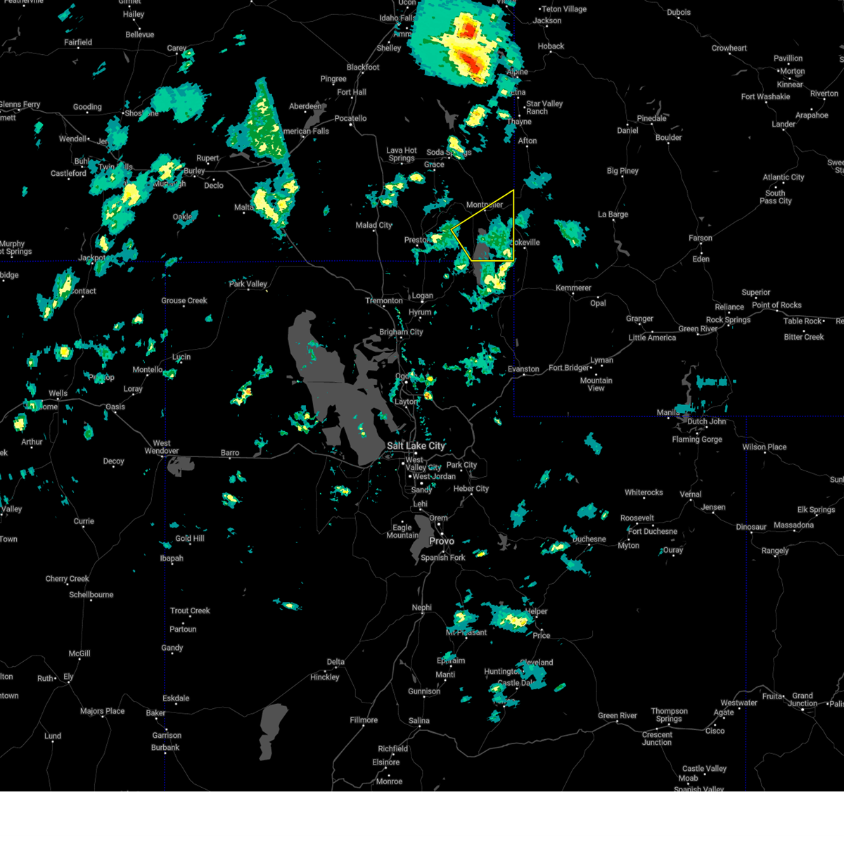
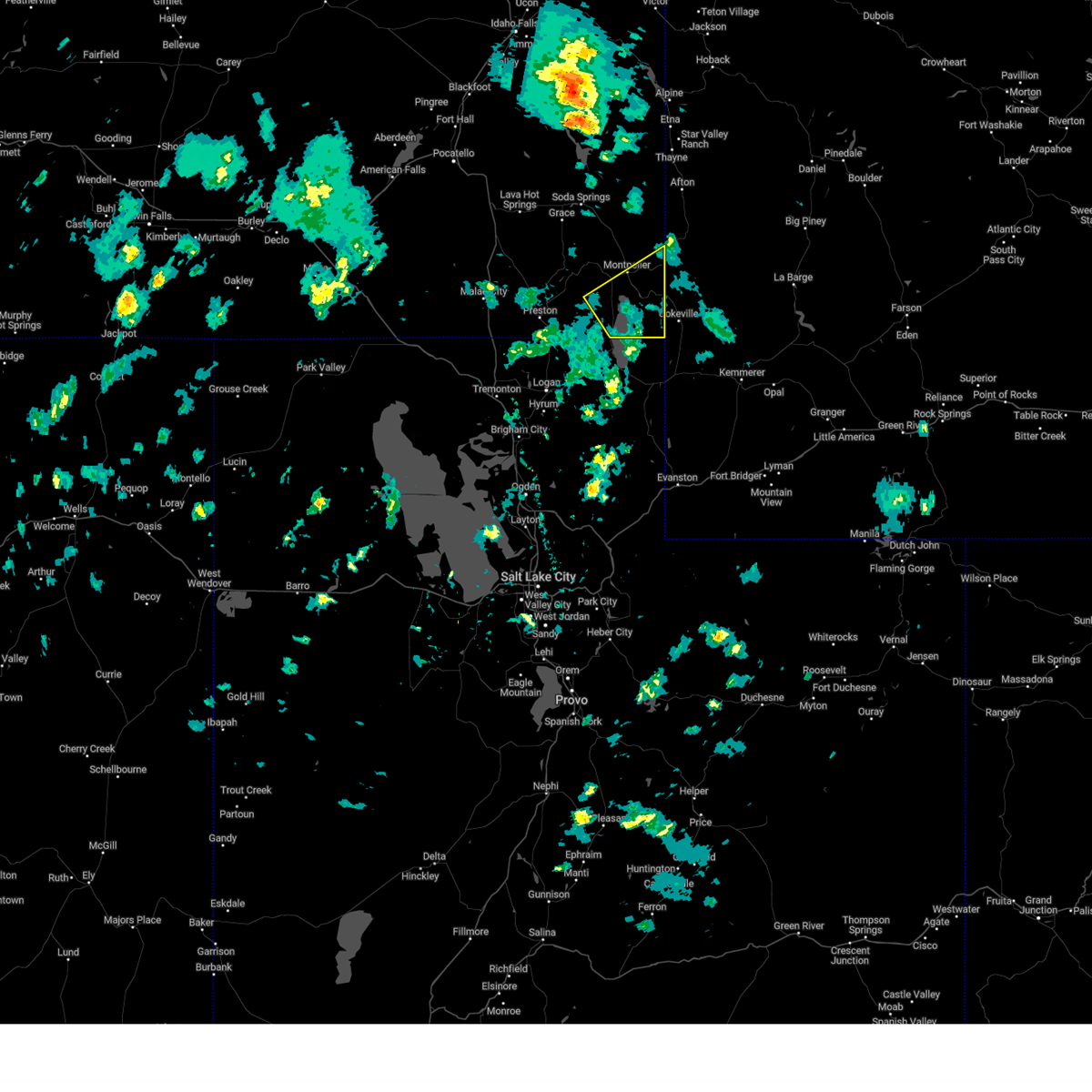
Hail Map for Montpelier, ID
The Montpelier, ID area has had 5 reports of on-the-ground hail by trained spotters, and has been under severe weather warnings 2 times during the past 12 months. Doppler radar has detected hail at or near Montpelier, ID on 5 occasions.
| Name: | Montpelier, ID |
| Where Located: | 88.8 miles SSE of Idaho Falls, ID |
| Map: | Google Map for Montpelier, ID |
| Population: | 2597 |
| Housing Units: | 1234 |
| More Info: | Search Google for Montpelier, ID |
0
The Top Recent Hail Date for Montpelier, ID is Sunday, September 3, 2023 (4th out of 5)

Hail and Wind Damage Spotted near Montpelier, ID
| Date / Time | Report Details |
|---|---|
| 5/11/2025 2:57 PM MDT |
 The storm which prompted the warning has moved out of the area. therefore, the warning will be allowed to expire. however, gusty winds are still possible. a severe thunderstorm watch remains in effect until 800 pm mdt for southeastern idaho. The storm which prompted the warning has moved out of the area. therefore, the warning will be allowed to expire. however, gusty winds are still possible. a severe thunderstorm watch remains in effect until 800 pm mdt for southeastern idaho.
|
| 5/11/2025 2:37 PM MDT |
 Svrpih the national weather service in pocatello has issued a * severe thunderstorm warning for, southern bear lake county in southeastern idaho, * until 300 pm mdt. * at 236 pm mdt, a severe thunderstorm was located over bear lake idaho portion, moving northeast at 45 mph (radar indicated). Hazards include 60 mph wind gusts. expect damage to roofs, siding, and trees Svrpih the national weather service in pocatello has issued a * severe thunderstorm warning for, southern bear lake county in southeastern idaho, * until 300 pm mdt. * at 236 pm mdt, a severe thunderstorm was located over bear lake idaho portion, moving northeast at 45 mph (radar indicated). Hazards include 60 mph wind gusts. expect damage to roofs, siding, and trees
|
| 5/11/2025 2:30 PM MDT | Mesonet station pc506 sheep creek hill in bear lake county ID, 3.8 miles W of Montpelier, ID |
| 5/4/2025 2:30 PM MDT | Mesonet station pc506 sheep creek hill in bear lake county ID, 3.8 miles W of Montpelier, ID |
| 8/23/2024 1:24 PM MDT | About 6 trees blown down in skinner canyon. fire department and power company on scene. time estimate in bear lake county ID, 13.3 miles SE of Montpelier, ID |
| 8/13/2024 5:10 PM MDT | Sheep creek hills id pacficorp mesone in bear lake county ID, 3.8 miles W of Montpelier, ID |
| 7/27/2024 7:10 PM MDT | Mesonet station pc506 sheep creek hill in bear lake county ID, 3.8 miles W of Montpelier, ID |
| 7/13/2022 6:53 PM MDT |
 At 653 pm mdt, severe thunderstorms were located along a line extending from near soda springs to near saint charles, moving east at 30 mph (trained weather spotters). Hazards include 60 mph wind gusts. expect damage to roofs, siding, and trees At 653 pm mdt, severe thunderstorms were located along a line extending from near soda springs to near saint charles, moving east at 30 mph (trained weather spotters). Hazards include 60 mph wind gusts. expect damage to roofs, siding, and trees
|
| 6/6/2019 7:07 PM MDT |
 The severe thunderstorm warning for southeastern caribou and bear lake counties will expire at 715 pm mdt, the storm which prompted the warning has moved out of the area. therefore, the warning will be allowed to expire. a severe thunderstorm watch remains in effect until 1100 pm mdt for southeastern idaho. The severe thunderstorm warning for southeastern caribou and bear lake counties will expire at 715 pm mdt, the storm which prompted the warning has moved out of the area. therefore, the warning will be allowed to expire. a severe thunderstorm watch remains in effect until 1100 pm mdt for southeastern idaho.
|
| 6/6/2019 6:59 PM MDT |
 At 658 pm mdt, severe thunderstorms extend from georgetown to 12 miles south of salt river pass or 17 miles north of cokeville utah, moving east at 40 mph (trained weather spotters). Hazards include 60 mph wind gusts. Expect damage to roofs, siding, and trees. Locations impacted include, montpelier, bear lake idaho portion, georgetown, saint charles, dingle, paris, bloomington, bern, ovid, border summit, geneva, fish haven, clear creek ranger station, pegram, geneva summit and bennington. At 658 pm mdt, severe thunderstorms extend from georgetown to 12 miles south of salt river pass or 17 miles north of cokeville utah, moving east at 40 mph (trained weather spotters). Hazards include 60 mph wind gusts. Expect damage to roofs, siding, and trees. Locations impacted include, montpelier, bear lake idaho portion, georgetown, saint charles, dingle, paris, bloomington, bern, ovid, border summit, geneva, fish haven, clear creek ranger station, pegram, geneva summit and bennington.
|
| 6/6/2019 6:42 PM MDT |
 At 641 pm mdt, severe thunderstorms were located from near georgetown summit to bear lake, moving east at 40 mph (trained weather spotters. at 640 pm, 64 mph winds were reported in bern). Hazards include 60-70 mph wind gusts. expect damage to roofs, siding, and trees At 641 pm mdt, severe thunderstorms were located from near georgetown summit to bear lake, moving east at 40 mph (trained weather spotters. at 640 pm, 64 mph winds were reported in bern). Hazards include 60-70 mph wind gusts. expect damage to roofs, siding, and trees
|
| 6/6/2019 6:36 PM MDT | Mesonet station itd37 rocky point hwy 3 in bear lake county ID, 10.7 miles NNW of Montpelier, ID |
| 6/6/2019 6:30 PM MDT | Storm damage reported in bear lake county ID, 4.4 miles E of Montpelier, ID |
| 8/1/2018 9:21 PM MDT |
 The severe thunderstorm warning for central bear lake county will expire at 930 pm mdt, the storms which prompted the warning have weakened below severe limits, and have exited the warned area. therefore, the warning will be allowed to expire. however gusty winds are still possible with these thunderstorms. The severe thunderstorm warning for central bear lake county will expire at 930 pm mdt, the storms which prompted the warning have weakened below severe limits, and have exited the warned area. therefore, the warning will be allowed to expire. however gusty winds are still possible with these thunderstorms.
|
| 8/1/2018 8:48 PM MDT |
 At 847 pm mdt, severe thunderstorms were located along a line extending from 7 miles west of salt river pass to 8 miles west of montpelier, moving southeast at 20 mph (trained weather spotters in bern reported 60 mph winds). Hazards include 60 mph wind gusts. expect damage to roofs, siding, and trees At 847 pm mdt, severe thunderstorms were located along a line extending from 7 miles west of salt river pass to 8 miles west of montpelier, moving southeast at 20 mph (trained weather spotters in bern reported 60 mph winds). Hazards include 60 mph wind gusts. expect damage to roofs, siding, and trees
|
| 8/1/2018 8:45 PM MDT | Storm damage reported in bear lake county ID, 4.4 miles E of Montpelier, ID |
| 8/1/2018 7:40 PM MDT |
 The severe thunderstorm warning for southern bear lake county will expire at 745 pm mdt, the storm which prompted the warning has weakened below severe limits, and has exited the warned area. therefore, the warning will be allowed to expire. however gusty winds and heavy rain are still possible with this thunderstorm. The severe thunderstorm warning for southern bear lake county will expire at 745 pm mdt, the storm which prompted the warning has weakened below severe limits, and has exited the warned area. therefore, the warning will be allowed to expire. however gusty winds and heavy rain are still possible with this thunderstorm.
|
| 8/1/2018 7:15 PM MDT |
 At 714 pm mdt, a severe thunderstorm was located near dingle or 8 miles south of montpelier, moving southeast at 30 mph (radar indicated. at 710 pm a storm spotter reported 40 to 50 mph winds in montpelier). Hazards include 60 mph wind gusts. Expect damage to roofs, siding, and trees. Locations impacted include, montpelier, bear lake idaho portion, saint charles, dingle, paris, bloomington, bern, ovid, border summit, fish haven, liberty and pegram. At 714 pm mdt, a severe thunderstorm was located near dingle or 8 miles south of montpelier, moving southeast at 30 mph (radar indicated. at 710 pm a storm spotter reported 40 to 50 mph winds in montpelier). Hazards include 60 mph wind gusts. Expect damage to roofs, siding, and trees. Locations impacted include, montpelier, bear lake idaho portion, saint charles, dingle, paris, bloomington, bern, ovid, border summit, fish haven, liberty and pegram.
|
| 8/1/2018 6:56 PM MDT |
 At 656 pm mdt, a severe thunderstorm was located near montpelier, moving southeast at 35 mph (radar indicated). Hazards include 60 mph wind gusts. expect damage to roofs, siding, and trees At 656 pm mdt, a severe thunderstorm was located near montpelier, moving southeast at 35 mph (radar indicated). Hazards include 60 mph wind gusts. expect damage to roofs, siding, and trees
|
| 7/16/2018 5:38 PM MDT |
 At 538 pm mdt, a severe thunderstorm was located 9 miles east of oneida narrows reservoir or 12 miles west of montpelier, moving east at 15 mph (trained weather spotters). Hazards include 60 mph wind gusts. expect damage to roofs, siding, and trees At 538 pm mdt, a severe thunderstorm was located 9 miles east of oneida narrows reservoir or 12 miles west of montpelier, moving east at 15 mph (trained weather spotters). Hazards include 60 mph wind gusts. expect damage to roofs, siding, and trees
|
| 6/17/2018 1:57 PM MDT |
 At 156 pm mdt, a severe thunderstorm was located 11 miles west of salt river pass or 12 miles northeast of montpelier, moving northeast at 30 mph (radar indicated). Hazards include 60 mph wind gusts and half dollar size hail. Hail damage to vehicles is expected. expect wind damage to roofs, siding, and trees. Locations impacted include, montpelier, geneva summit, clear creek ranger station and diamond creek campground. At 156 pm mdt, a severe thunderstorm was located 11 miles west of salt river pass or 12 miles northeast of montpelier, moving northeast at 30 mph (radar indicated). Hazards include 60 mph wind gusts and half dollar size hail. Hail damage to vehicles is expected. expect wind damage to roofs, siding, and trees. Locations impacted include, montpelier, geneva summit, clear creek ranger station and diamond creek campground.
|
| 6/17/2018 1:40 PM MDT |
 At 138 pm mdt, a severe thunderstorm was located near montpelier, moving northeast at 25 mph (radar indicated). Hazards include 50 mph wind gusts and half dollar size hail. Hail damage to vehicles is expected. Expect wind damage to roofs, siding, and trees. At 138 pm mdt, a severe thunderstorm was located near montpelier, moving northeast at 25 mph (radar indicated). Hazards include 50 mph wind gusts and half dollar size hail. Hail damage to vehicles is expected. Expect wind damage to roofs, siding, and trees.
|
| 5/29/2016 7:39 PM MDT | Quarter sized hail reported 11.5 miles W of Montpelier, ID |
| 5/29/2016 7:26 PM MDT |
 At 725 pm mdt, trained weather spotters reported a severe thunderstorm producing quarter size hail. this storm was located 8 miles northeast of montpelier, moving east at 40 mph. locations impacted include, geneva summit and geneva. At 725 pm mdt, trained weather spotters reported a severe thunderstorm producing quarter size hail. this storm was located 8 miles northeast of montpelier, moving east at 40 mph. locations impacted include, geneva summit and geneva.
|
| 5/29/2016 7:14 PM MDT | Quarter sized hail reported 0.7 miles NNE of Montpelier, ID, estimated quarter size hail. some small branches stripped off trees from the hail. |
| 5/29/2016 7:14 PM MDT |
 At 711 pm mdt, doppler radar indicated a severe thunderstorm capable of producing quarter size hail. this storm was located over montpelier, and moving east at 40 mph. winds up to 50mph are also possible. At 711 pm mdt, doppler radar indicated a severe thunderstorm capable of producing quarter size hail. this storm was located over montpelier, and moving east at 40 mph. winds up to 50mph are also possible.
|
| 6/15/2015 8:38 PM MDT |
 The severe thunderstorm warning for eastern caribou, southeastern bonneville, northeastern franklin and northern bear lake counties will expire at 845 pm mdt, the storms which prompted the warning have weakened below severe limits, and no longer poses an immediate threat to life or property. therefore the warning will be allowed to expire. The severe thunderstorm warning for eastern caribou, southeastern bonneville, northeastern franklin and northern bear lake counties will expire at 845 pm mdt, the storms which prompted the warning have weakened below severe limits, and no longer poses an immediate threat to life or property. therefore the warning will be allowed to expire.
|
| 6/15/2015 8:24 PM MDT |
 At 824 pm mdt, doppler radar indicated a line of severe thunderstorms capable of producing quarter size hail. these storms were located along a line extending from 6 miles northeast of wayan to 8 miles west of georgetown, moving east at 30 mph. locations impacted include, soda springs, montpelier, wayan, southern blackfoot reservoir, southern palisades reservoir, georgetown, henry, georgetown summit, geneva, smokey canyon mine, mill canyon campground, grays lake, bern, emmigrant summit, clear creek ranger station, diamond creek campground, geneva summit and bennington. At 824 pm mdt, doppler radar indicated a line of severe thunderstorms capable of producing quarter size hail. these storms were located along a line extending from 6 miles northeast of wayan to 8 miles west of georgetown, moving east at 30 mph. locations impacted include, soda springs, montpelier, wayan, southern blackfoot reservoir, southern palisades reservoir, georgetown, henry, georgetown summit, geneva, smokey canyon mine, mill canyon campground, grays lake, bern, emmigrant summit, clear creek ranger station, diamond creek campground, geneva summit and bennington.
|
| 6/15/2015 8:00 PM MDT |
 At 759 pm mdt, doppler radar indicated a line of severe thunderstorms capable of producing quarter size hail. these storms were located along a line extending from 6 miles north of henry to near thatcher, and moving east at 45 mph. At 759 pm mdt, doppler radar indicated a line of severe thunderstorms capable of producing quarter size hail. these storms were located along a line extending from 6 miles north of henry to near thatcher, and moving east at 45 mph.
|
| 6/1/2015 8:30 PM MDT | Reported that a neighbor's bathroom window was blown out. based on other report and rada in bear lake county ID, 4.4 miles E of Montpelier, ID |
| 6/1/2015 6:28 PM MDT | The severe thunderstorm warning for southeastern caribou, northeastern franklin and northern bear lake counties will expire at 630 pm mdt, the storm which prompted the warning has weakened below severe limits, and no longer poses an immediate threat to life or property. therefore the warning will be allowed to expire. |
| 6/1/2015 5:47 PM MDT | Measured wind gust of 76 mph. gust snapped off quaking aspen tre in bear lake county ID, 4.4 miles E of Montpelier, ID |
| 6/1/2015 5:47 PM MDT | At 547 pm mdt, doppler radar indicated a severe thunderstorm capable of producing quarter size hail and damaging winds in excess of 60 mph. this storm was located near georgetown, or 12 miles northwest of montpelier, and moving northeast at 45 mph. |
| 8/8/2013 5:34 PM MDT | 72 mph wind gusts in bern in bear lake county ID, 4.4 miles E of Montpelier, ID |
| 7/5/2013 6:41 PM MDT | Storm damage reported in bear lake county ID, 4.4 miles E of Montpelier, ID |
| 1/1/0001 12:00 AM | Storm damage reported in bear lake county ID, 4.4 miles E of Montpelier, ID |
| 1/1/0001 12:00 AM | Storm damage reported in bear lake county ID, 4.4 miles E of Montpelier, ID |
| 1/1/0001 12:00 AM | Quarter sized hail reported 0.8 miles SSE of Montpelier, ID, still falling at time of observation. |
| 1/1/0001 12:00 AM | Golf Ball sized hail reported 5.6 miles NNW of Montpelier, ID, some hail slightly larger than golf ball. |
| 1/1/0001 12:00 AM | Hen Egg sized hail reported 0.7 miles NNE of Montpelier, ID |
| 1/1/0001 12:00 AM | Storm damage reported in bear lake county ID, 4.4 miles E of Montpelier, ID |
Hail Maps for Montpelier, ID


Connect with Interactive Hail Maps