

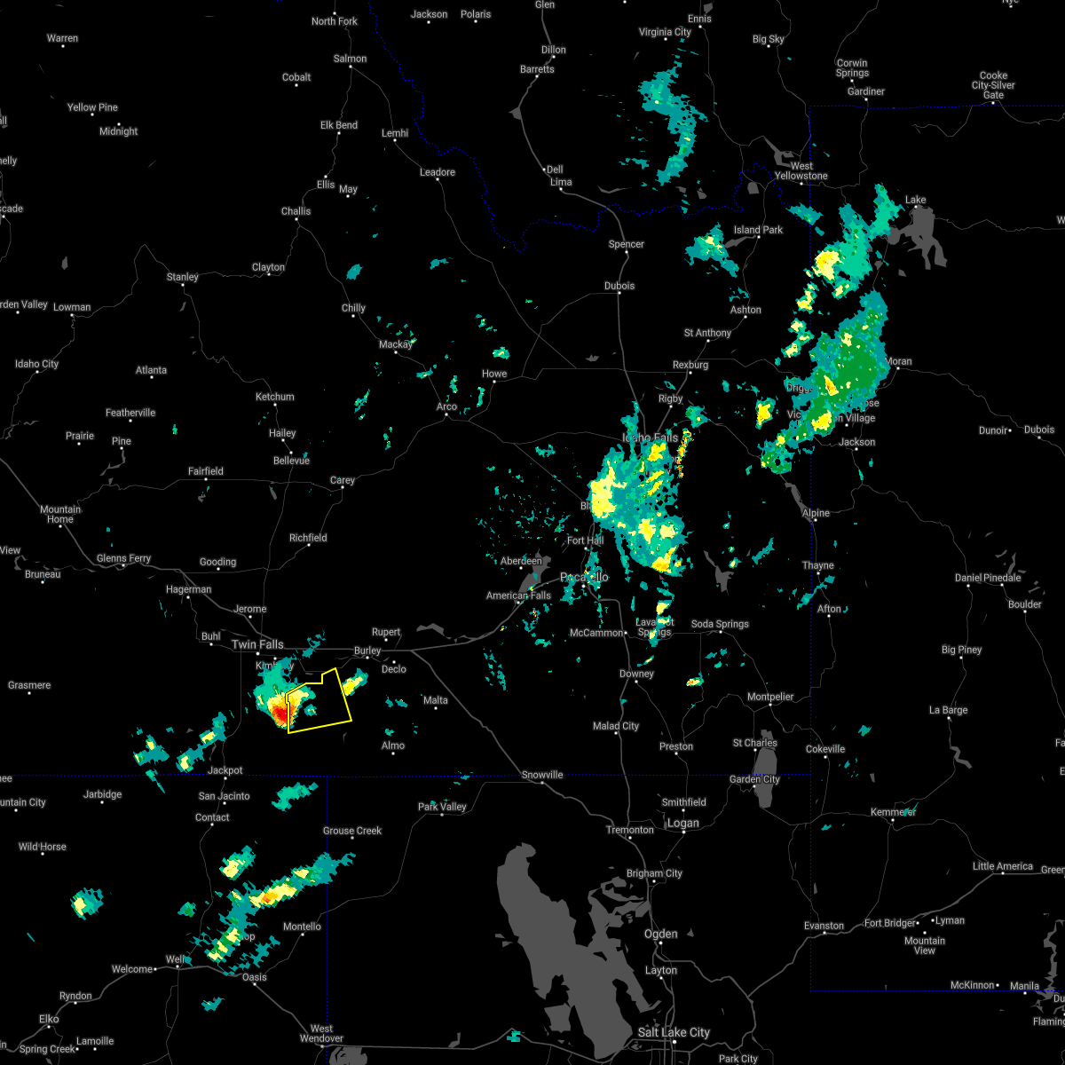
Hail Map for Oakley, ID
The Oakley, ID area has had 2 reports of on-the-ground hail by trained spotters, and has been under severe weather warnings 4 times during the past 12 months. Doppler radar has detected hail at or near Oakley, ID on 7 occasions, including 1 occasion during the past year.
| Name: | Oakley, ID |
| Where Located: | 37.1 miles SE of Twin Falls, ID |
| Map: | Google Map for Oakley, ID |
| Population: | 763 |
| Housing Units: | 280 |
| More Info: | Search Google for Oakley, ID |
0
The Top Recent Hail Date for Oakley, ID is Thursday, July 25, 2024 (7th out of 7)

Hail and Wind Damage Spotted near Oakley, ID
| Date / Time | Report Details |
|---|---|
| 7/1/2025 4:17 PM MDT | Measured at the cotton ridge raws mesonet sit in cassia county ID, 18.7 miles ENE of Oakley, ID |
| 5/11/2025 1:54 PM MDT | Measured near the intersection of id-77 and narrows r in cassia county ID, 16.9 miles WNW of Oakley, ID |
| 5/10/2025 8:20 PM MDT | Mesonet station crii1 cotton ridg in cassia county ID, 17 miles ENE of Oakley, ID |
| 9/15/2024 8:02 PM MDT | Mesonet station crii1 cotton ridg in cassia county ID, 17 miles ENE of Oakley, ID |
| 8/23/2024 3:02 PM MDT | Mesonet station crii1 cotton ridg in cassia county ID, 17 miles ENE of Oakley, ID |
| 8/9/2024 10:02 AM MDT | Mesonet station crii1 - cotton ridg in cassia county ID, 17 miles ENE of Oakley, ID |
| 7/27/2024 3:02 PM MDT | Mesonet station crii1 cotton ridg in cassia county ID, 17 miles ENE of Oakley, ID |
| 7/25/2024 6:06 PM MDT |
 The storms which prompted the warning have weakened below severe limits, and no longer pose an immediate threat to life or property. therefore, the warning will be allowed to expire. however, small hail, gusty winds and heavy rain are still possible with these thunderstorms. The storms which prompted the warning have weakened below severe limits, and no longer pose an immediate threat to life or property. therefore, the warning will be allowed to expire. however, small hail, gusty winds and heavy rain are still possible with these thunderstorms.
|
| 7/25/2024 5:30 PM MDT |
 Svrpih the national weather service in pocatello has issued a * severe thunderstorm warning for, southwestern power county in southeastern idaho, central cassia county in southeastern idaho, south central minidoka county in south central idaho, * until 615 pm mdt. * at 530 pm mdt, severe thunderstorms were located along a line extending from declo to 10 miles west of oakley reservoir, moving northeast at 35 mph (radar indicated). Hazards include 60 mph wind gusts and nickel size hail. expect damage to roofs, siding, and trees Svrpih the national weather service in pocatello has issued a * severe thunderstorm warning for, southwestern power county in southeastern idaho, central cassia county in southeastern idaho, south central minidoka county in south central idaho, * until 615 pm mdt. * at 530 pm mdt, severe thunderstorms were located along a line extending from declo to 10 miles west of oakley reservoir, moving northeast at 35 mph (radar indicated). Hazards include 60 mph wind gusts and nickel size hail. expect damage to roofs, siding, and trees
|
| 7/25/2024 5:30 PM MDT |
 The northern portions of this warning will be allowed to expire. the storms in the southern portion of the warning have redeveloped, and a new warning is expected. The northern portions of this warning will be allowed to expire. the storms in the southern portion of the warning have redeveloped, and a new warning is expected.
|
| 7/25/2024 4:41 PM MDT |
 Svrpih the national weather service in pocatello has issued a * severe thunderstorm warning for, southeastern lincoln county in south central idaho, northwestern cassia county in southeastern idaho, southern minidoka county in south central idaho, * until 530 pm mdt. * at 441 pm mdt, severe thunderstorms were located along a line extending from 12 miles north of paul to 11 miles southwest of burley to 16 miles south of hansen, moving east at 15 mph (radar indicated). Hazards include 60 mph wind gusts and penny size hail. expect damage to roofs, siding, and trees Svrpih the national weather service in pocatello has issued a * severe thunderstorm warning for, southeastern lincoln county in south central idaho, northwestern cassia county in southeastern idaho, southern minidoka county in south central idaho, * until 530 pm mdt. * at 441 pm mdt, severe thunderstorms were located along a line extending from 12 miles north of paul to 11 miles southwest of burley to 16 miles south of hansen, moving east at 15 mph (radar indicated). Hazards include 60 mph wind gusts and penny size hail. expect damage to roofs, siding, and trees
|
| 6/26/2024 4:48 PM MDT |
 At 447 pm mdt, a severe thunderstorm was located near elba, or 14 miles west of malta, moving east at 45 mph (radar indicated). Hazards include golf ball size hail and 60 mph wind gusts. People and animals outdoors will be injured. expect hail damage to roofs, siding, windows, and vehicles. expect wind damage to roofs, siding, and trees. Locations impacted include, oakley and city of rocks. At 447 pm mdt, a severe thunderstorm was located near elba, or 14 miles west of malta, moving east at 45 mph (radar indicated). Hazards include golf ball size hail and 60 mph wind gusts. People and animals outdoors will be injured. expect hail damage to roofs, siding, windows, and vehicles. expect wind damage to roofs, siding, and trees. Locations impacted include, oakley and city of rocks.
|
| 6/26/2024 4:29 PM MDT |
 Svrpih the national weather service in pocatello has issued a * severe thunderstorm warning for, southwestern cassia county in southeastern idaho, * until 500 pm mdt. * at 428 pm mdt, a severe thunderstorm was located over oakley, or near oakley reservoir, moving east at 45 mph (radar indicated). Hazards include golf ball size hail and 60 mph wind gusts. People and animals outdoors will be injured. expect hail damage to roofs, siding, windows, and vehicles. Expect wind damage to roofs, siding, and trees. Svrpih the national weather service in pocatello has issued a * severe thunderstorm warning for, southwestern cassia county in southeastern idaho, * until 500 pm mdt. * at 428 pm mdt, a severe thunderstorm was located over oakley, or near oakley reservoir, moving east at 45 mph (radar indicated). Hazards include golf ball size hail and 60 mph wind gusts. People and animals outdoors will be injured. expect hail damage to roofs, siding, windows, and vehicles. Expect wind damage to roofs, siding, and trees.
|
| 6/26/2024 4:17 PM MDT |
 At 416 pm mdt, a severe thunderstorm was located near oakley reservoir, moving east at 45 mph (radar indicated). Hazards include golf ball size hail and 60 mph wind gusts. People and animals outdoors will be injured. expect hail damage to roofs, siding, windows, and vehicles. expect wind damage to roofs, siding, and trees. Locations impacted include, oakley reservoir, oakley, bostetter ranger station, and city of rocks. At 416 pm mdt, a severe thunderstorm was located near oakley reservoir, moving east at 45 mph (radar indicated). Hazards include golf ball size hail and 60 mph wind gusts. People and animals outdoors will be injured. expect hail damage to roofs, siding, windows, and vehicles. expect wind damage to roofs, siding, and trees. Locations impacted include, oakley reservoir, oakley, bostetter ranger station, and city of rocks.
|
| 6/26/2024 3:59 PM MDT |
 Svrpih the national weather service in pocatello has issued a * severe thunderstorm warning for, southwestern cassia county in southeastern idaho, * until 430 pm mdt. * at 358 pm mdt, a severe thunderstorm was located 15 miles west of oakley reservoir, moving east at 40 mph (radar indicated). Hazards include golf ball size hail and 60 mph wind gusts. People and animals outdoors will be injured. expect hail damage to roofs, siding, windows, and vehicles. Expect wind damage to roofs, siding, and trees. Svrpih the national weather service in pocatello has issued a * severe thunderstorm warning for, southwestern cassia county in southeastern idaho, * until 430 pm mdt. * at 358 pm mdt, a severe thunderstorm was located 15 miles west of oakley reservoir, moving east at 40 mph (radar indicated). Hazards include golf ball size hail and 60 mph wind gusts. People and animals outdoors will be injured. expect hail damage to roofs, siding, windows, and vehicles. Expect wind damage to roofs, siding, and trees.
|
| 5/13/2024 4:09 PM MDT | Private weather station located near the intersection of w 1300 s and s 600 in cassia county ID, 6.9 miles SSE of Oakley, ID |
| 5/13/2024 4:07 PM MDT | Idaho power reports over 100 customers without power south of oakle in cassia county ID, 4.3 miles NNE of Oakley, ID |
| 1/9/2024 3:17 PM MST | Snow squall wind gust at mesonet station crii1 cotton ridg in cassia county ID, 17 miles ENE of Oakley, ID |
| 8/26/2023 3:45 PM MDT | Quarter sized hail reported 9 miles ESE of Oakley, ID, social media report of at least one inch size hail off big cedar road in the south hills. |
| 7/20/2023 3:47 PM MDT | Mesonet station crii1 cotton ridg in cassia county ID, 17 miles ENE of Oakley, ID |
| 9/7/2022 1:32 PM MDT | Mesonet station crii1 cotton ridge recorded a gust to 60 mph associated with a developing thunderstor in cassia county ID, 17 miles ENE of Oakley, ID |
| 10/7/2021 2:35 PM MDT |
 At 233 pm mdt, a severe thunderstorm was located 15 miles east of rogerson, or 20 miles west of oakley reservoir, moving east at 30 mph (radar indicated). Hazards include 60 mph wind gusts and quarter size hail. Hail damage to vehicles is expected. expect wind damage to roofs, siding, and trees. this severe thunderstorm will remain over mainly rural areas of west central cassia county. hail threat, radar indicated max hail size, 1. 00 in wind threat, radar indicated max wind gust, 60 mph. At 233 pm mdt, a severe thunderstorm was located 15 miles east of rogerson, or 20 miles west of oakley reservoir, moving east at 30 mph (radar indicated). Hazards include 60 mph wind gusts and quarter size hail. Hail damage to vehicles is expected. expect wind damage to roofs, siding, and trees. this severe thunderstorm will remain over mainly rural areas of west central cassia county. hail threat, radar indicated max hail size, 1. 00 in wind threat, radar indicated max wind gust, 60 mph.
|
| 6/4/2021 3:40 PM MDT |
 At 340 pm mdt, a severe thunderstorm was located southeast of oakley reservoir, moving east at 25 mph (radar indicated). Hazards include quarter size hail. damage to vehicles is expected At 340 pm mdt, a severe thunderstorm was located southeast of oakley reservoir, moving east at 25 mph (radar indicated). Hazards include quarter size hail. damage to vehicles is expected
|
| 1/4/2021 10:09 PM MST | Mesonet station crii1 cotton ridg in cassia county ID, 17 miles ENE of Oakley, ID |
| 8/25/2020 3:09 PM MDT | Usfs raws system - cotton ridge in cassia county ID, 19.9 miles ENE of Oakley, ID |
| 6/6/2020 2:56 PM MDT |
 The national weather service in pocatello has issued a * severe thunderstorm warning for. southeastern cassia county in southeastern idaho. until 345 pm mdt. At 256 pm mdt, a severe thunderstorm was located 14 miles southwest of almo, or 20 miles southeast of oakley reservoir, moving north at. The national weather service in pocatello has issued a * severe thunderstorm warning for. southeastern cassia county in southeastern idaho. until 345 pm mdt. At 256 pm mdt, a severe thunderstorm was located 14 miles southwest of almo, or 20 miles southeast of oakley reservoir, moving north at.
|
| 4/30/2020 5:40 PM MDT |
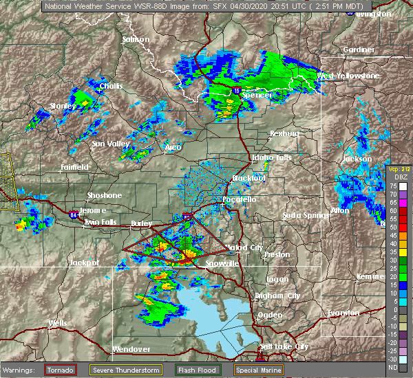
 At 539 pm mdt, severe thunderstorms were located along a line extending from 10 miles south of craters of the moon to 6 miles northeast of minidoka to 7 miles southwest of albion, moving northeast at 55 mph. gusts in excess of 50 mph have been reported by wind sensors in this area (radar indicated). Hazards include 60 mph wind gusts. Expect damage to roofs, siding, and trees. Locations impacted include, burley, rupert, american falls, heyburn, lake walcott, neeley, oakley reservoir, western american falls reservoir, oakley, declo, albion, minidoka, cold water rest area, acequia, yale rest area, massacre rocks, mt harrison, idahome and interstate 84 and 86 junction. At 539 pm mdt, severe thunderstorms were located along a line extending from 10 miles south of craters of the moon to 6 miles northeast of minidoka to 7 miles southwest of albion, moving northeast at 55 mph. gusts in excess of 50 mph have been reported by wind sensors in this area (radar indicated). Hazards include 60 mph wind gusts. Expect damage to roofs, siding, and trees. Locations impacted include, burley, rupert, american falls, heyburn, lake walcott, neeley, oakley reservoir, western american falls reservoir, oakley, declo, albion, minidoka, cold water rest area, acequia, yale rest area, massacre rocks, mt harrison, idahome and interstate 84 and 86 junction.
|
| 4/30/2020 5:17 PM MDT |
 At 516 pm mdt, severe thunderstorms were located along a line extending from 13 miles southeast of carey to 6 miles west of minidoka to near oakley, moving northeast at 55 mph (radar indicated). Hazards include 60 mph wind gusts. expect damage to roofs, siding, and trees At 516 pm mdt, severe thunderstorms were located along a line extending from 13 miles southeast of carey to 6 miles west of minidoka to near oakley, moving northeast at 55 mph (radar indicated). Hazards include 60 mph wind gusts. expect damage to roofs, siding, and trees
|
| 4/30/2020 3:11 PM MDT |
 The tornado warning for northwestern oneida, southwestern power and southeastern cassia counties will expire at 315 pm mdt, the tornadic thunderstorm which prompted the warning has weakened. therefore, the warning will be allowed to expire. however hail and gusty winds are still possible with this thunderstorm. The tornado warning for northwestern oneida, southwestern power and southeastern cassia counties will expire at 315 pm mdt, the tornadic thunderstorm which prompted the warning has weakened. therefore, the warning will be allowed to expire. however hail and gusty winds are still possible with this thunderstorm.
|
| 4/30/2020 2:52 PM MDT |
 At 252 pm mdt, a severe thunderstorm capable of producing a tornado was located 11 miles north of holbrook summit, or 19 miles northwest of malad, moving east at 40 mph (radar indicated rotation). Hazards include tornado and two inch hail. Flying debris will be dangerous to those caught without shelter. mobile homes will be damaged or destroyed. damage to roofs, windows, and vehicles will occur. tree damage is likely. Locations impacted include, malta, oakley, rockland, elba, juniper, idahome, sublett reservoir, mt harrison, roy, sweetzer summit, bridge and massacre rocks. At 252 pm mdt, a severe thunderstorm capable of producing a tornado was located 11 miles north of holbrook summit, or 19 miles northwest of malad, moving east at 40 mph (radar indicated rotation). Hazards include tornado and two inch hail. Flying debris will be dangerous to those caught without shelter. mobile homes will be damaged or destroyed. damage to roofs, windows, and vehicles will occur. tree damage is likely. Locations impacted include, malta, oakley, rockland, elba, juniper, idahome, sublett reservoir, mt harrison, roy, sweetzer summit, bridge and massacre rocks.
|
| 4/30/2020 2:27 PM MDT |
 At 226 pm mdt, a severe thunderstorm capable of producing a tornado was located 14 miles east of malta, moving east at 40 mph (radar indicated rotation). Hazards include tornado and hail up to two inches in diameter. wind gusts up to 50 mph. Flying debris will be dangerous to those caught without shelter. mobile homes will be damaged or destroyed. damage to roofs, windows, and vehicles will occur. tree damage is likely. This tornadic thunderstorm will remain over mainly rural areas of northwestern oneida, southwestern power and southeastern cassia counties, including the following locations, idahome, sublett reservoir, mt harrison, roy, sweetzer summit, bridge and massacre rocks. At 226 pm mdt, a severe thunderstorm capable of producing a tornado was located 14 miles east of malta, moving east at 40 mph (radar indicated rotation). Hazards include tornado and hail up to two inches in diameter. wind gusts up to 50 mph. Flying debris will be dangerous to those caught without shelter. mobile homes will be damaged or destroyed. damage to roofs, windows, and vehicles will occur. tree damage is likely. This tornadic thunderstorm will remain over mainly rural areas of northwestern oneida, southwestern power and southeastern cassia counties, including the following locations, idahome, sublett reservoir, mt harrison, roy, sweetzer summit, bridge and massacre rocks.
|
| 4/30/2020 2:08 PM MDT |
 The severe thunderstorm warning for southern cassia county will expire at 215 pm mdt, the severe thunderstorm which prompted the warning has developed a likely tornado. therefore, the warning will be allowed to expire. however small hail and gusty winds are still possible with this thunderstorm. remember, a tornado warning still remains in effect for cassia county. The severe thunderstorm warning for southern cassia county will expire at 215 pm mdt, the severe thunderstorm which prompted the warning has developed a likely tornado. therefore, the warning will be allowed to expire. however small hail and gusty winds are still possible with this thunderstorm. remember, a tornado warning still remains in effect for cassia county.
|
| 4/30/2020 2:07 PM MDT |
 At 207 pm mdt, a severe thunderstorm capable of producing a tornado was located near almo, or 14 miles east of oakley reservoir, moving east at 50 mph (radar indicated rotation). Hazards include tornado and two inch hail. Flying debris will be dangerous to those caught without shelter. mobile homes will be damaged or destroyed. damage to roofs, windows, and vehicles will occur. tree damage is likely. this dangerous storm will be near, elba around 215 pm mdt. malta around 225 pm mdt. Other locations impacted by this tornadic thunderstorm include bostetter ranger station, mt harrison, city of rocks, idahome and bridge. At 207 pm mdt, a severe thunderstorm capable of producing a tornado was located near almo, or 14 miles east of oakley reservoir, moving east at 50 mph (radar indicated rotation). Hazards include tornado and two inch hail. Flying debris will be dangerous to those caught without shelter. mobile homes will be damaged or destroyed. damage to roofs, windows, and vehicles will occur. tree damage is likely. this dangerous storm will be near, elba around 215 pm mdt. malta around 225 pm mdt. Other locations impacted by this tornadic thunderstorm include bostetter ranger station, mt harrison, city of rocks, idahome and bridge.
|
| 4/30/2020 2:05 PM MDT |
 At 204 pm mdt, a severe thunderstorm capable of producing a tornado was located near almo, or 13 miles east of oakley reservoir, moving east at 50 mph (radar indicated rotation). Hazards include tornado and two inch hail. Flying debris will be dangerous to those caught without shelter. mobile homes will be damaged or destroyed. damage to roofs, windows, and vehicles will occur. tree damage is likely. this dangerous storm will be near, elba around 215 pm mdt. malta around 225 pm mdt. Other locations impacted by this tornadic thunderstorm include bostetter ranger station, mt harrison, city of rocks, idahome and bridge. At 204 pm mdt, a severe thunderstorm capable of producing a tornado was located near almo, or 13 miles east of oakley reservoir, moving east at 50 mph (radar indicated rotation). Hazards include tornado and two inch hail. Flying debris will be dangerous to those caught without shelter. mobile homes will be damaged or destroyed. damage to roofs, windows, and vehicles will occur. tree damage is likely. this dangerous storm will be near, elba around 215 pm mdt. malta around 225 pm mdt. Other locations impacted by this tornadic thunderstorm include bostetter ranger station, mt harrison, city of rocks, idahome and bridge.
|
| 4/30/2020 1:46 PM MDT |
 At 146 pm mdt, a severe thunderstorm capable of producing a tornado was located near oakley reservoir, moving east at 50 mph (radar indicated rotation). Hazards include tornado. Flying debris will be dangerous to those caught without shelter. mobile homes will be damaged or destroyed. damage to roofs, windows, and vehicles will occur. tree damage is likely. this dangerous storm will be near, oakley reservoir around 150 pm mdt. oakley around 155 pm mdt. almo around 205 pm mdt. elba around 215 pm mdt. malta around 230 pm mdt. Other locations impacted by this tornadic thunderstorm include bostetter ranger station, mt harrison, city of rocks, idahome and bridge. At 146 pm mdt, a severe thunderstorm capable of producing a tornado was located near oakley reservoir, moving east at 50 mph (radar indicated rotation). Hazards include tornado. Flying debris will be dangerous to those caught without shelter. mobile homes will be damaged or destroyed. damage to roofs, windows, and vehicles will occur. tree damage is likely. this dangerous storm will be near, oakley reservoir around 150 pm mdt. oakley around 155 pm mdt. almo around 205 pm mdt. elba around 215 pm mdt. malta around 230 pm mdt. Other locations impacted by this tornadic thunderstorm include bostetter ranger station, mt harrison, city of rocks, idahome and bridge.
|
| 4/30/2020 1:22 PM MDT |
 At 122 pm mdt, a severe thunderstorm was located 14 miles southwest of oakley reservoir, moving east at 40 mph (radar indicated). Hazards include two inch hail and 60 mph wind gusts. People and animals outdoors will be injured. expect hail damage to roofs, siding, windows, and vehicles. Expect wind damage to roofs, siding, and trees. At 122 pm mdt, a severe thunderstorm was located 14 miles southwest of oakley reservoir, moving east at 40 mph (radar indicated). Hazards include two inch hail and 60 mph wind gusts. People and animals outdoors will be injured. expect hail damage to roofs, siding, windows, and vehicles. Expect wind damage to roofs, siding, and trees.
|
| 10/19/2019 3:11 PM MDT |
 The severe thunderstorm warning for central cassia and southwestern minidoka counties will expire at 315 pm mdt, the storms which prompted the warning have moved out of the area. therefore, the warning will be allowed to expire. however gusty winds are still possible with these thunderstorms. The severe thunderstorm warning for central cassia and southwestern minidoka counties will expire at 315 pm mdt, the storms which prompted the warning have moved out of the area. therefore, the warning will be allowed to expire. however gusty winds are still possible with these thunderstorms.
|
| 10/19/2019 3:03 PM MDT |
 At 302 pm mdt, severe thunderstorms were located along a line extending from near rupert to 10 miles west of oakley, moving east at 50 mph (radar indicated and ground observation confirmed. the valley interchange itd weather station west of burley recorded a wind gust to 67 mph at 230pm mdt). Hazards include 60 mph wind gusts. Expect damage to roofs, siding, and trees. Locations impacted include, burley, rupert, heyburn, paul, oakley, declo, albion, elba, yale rest area, mt harrison, interstate 84 and 86 junction and idahome. At 302 pm mdt, severe thunderstorms were located along a line extending from near rupert to 10 miles west of oakley, moving east at 50 mph (radar indicated and ground observation confirmed. the valley interchange itd weather station west of burley recorded a wind gust to 67 mph at 230pm mdt). Hazards include 60 mph wind gusts. Expect damage to roofs, siding, and trees. Locations impacted include, burley, rupert, heyburn, paul, oakley, declo, albion, elba, yale rest area, mt harrison, interstate 84 and 86 junction and idahome.
|
| 10/19/2019 2:35 PM MDT |
 At 234 pm mdt, a severe thunderstorm was located 13 miles south of hazelton or 15 miles southwest of burley, moving east at 50 mph (radar indicated and twin falls airport re corded a wind gust to 63 mph). Hazards include 65 mph wind gusts. expect damage to roofs, siding, and trees At 234 pm mdt, a severe thunderstorm was located 13 miles south of hazelton or 15 miles southwest of burley, moving east at 50 mph (radar indicated and twin falls airport re corded a wind gust to 63 mph). Hazards include 65 mph wind gusts. expect damage to roofs, siding, and trees
|
| 5/31/2018 4:45 PM MDT | Thunderstorm wind gust of 73 mph measured by goose creek raws site gski in cassia county ID, 9.8 miles N of Oakley, ID |
| 5/31/2018 4:45 PM MDT | Mesonet station gski1... 10 s oakle in cassia county ID, 10.5 miles N of Oakley, ID |
| 5/30/2018 6:00 PM MDT | Half Dollar sized hail reported 11 miles SE of Oakley, ID, social media picture of half dollar sized hail 6 miles south of murtaugh. |
| 5/30/2018 6:00 PM MDT |
 At 559 pm mdt, a severe thunderstorm was located 13 miles southwest of burley, moving northeast at 40 mph (radar indicated). Hazards include ping pong ball size hail and 60 mph wind gusts. People and animals outdoors will be injured. expect hail damage to roofs, siding, windows, and vehicles. expect wind damage to roofs, siding, and trees. Locations impacted include, burley, oakley, elba and mt harrison. At 559 pm mdt, a severe thunderstorm was located 13 miles southwest of burley, moving northeast at 40 mph (radar indicated). Hazards include ping pong ball size hail and 60 mph wind gusts. People and animals outdoors will be injured. expect hail damage to roofs, siding, windows, and vehicles. expect wind damage to roofs, siding, and trees. Locations impacted include, burley, oakley, elba and mt harrison.
|
| 5/30/2018 5:46 PM MDT |
 At 545 pm mdt, a severe thunderstorm was located over oakley reservoir, moving northeast at 25 mph (radar indicated). Hazards include 60 mph wind gusts and quarter size hail. Hail damage to vehicles is expected. Expect wind damage to roofs, siding, and trees. At 545 pm mdt, a severe thunderstorm was located over oakley reservoir, moving northeast at 25 mph (radar indicated). Hazards include 60 mph wind gusts and quarter size hail. Hail damage to vehicles is expected. Expect wind damage to roofs, siding, and trees.
|
| 8/14/2015 9:26 PM MDT |
 At 925 pm mdt, doppler radar indicated a line of severe thunderstorms capable of producing damaging winds in excess of 60 mph. these storms were located along a line extending from 14 miles south of richfield to 6 miles northwest of paul to 7 miles southeast of oakley, moving east at 40 mph. locations impacted include, burley, rupert, heyburn, malta, oakley reservoir, lake walcott, paul, oakley, richfield, declo, albion, minidoka, elba, almo, dietrich, acequia, interstate 84 and 86 junction, bridge, kimama and mt harrison. At 925 pm mdt, doppler radar indicated a line of severe thunderstorms capable of producing damaging winds in excess of 60 mph. these storms were located along a line extending from 14 miles south of richfield to 6 miles northwest of paul to 7 miles southeast of oakley, moving east at 40 mph. locations impacted include, burley, rupert, heyburn, malta, oakley reservoir, lake walcott, paul, oakley, richfield, declo, albion, minidoka, elba, almo, dietrich, acequia, interstate 84 and 86 junction, bridge, kimama and mt harrison.
|
| 8/14/2015 9:00 PM MDT |
 At 858 pm mdt, doppler radar indicated a line of severe thunderstorms capable of producing damaging winds in excess of 60 mph. these storms were located along a line extending from near jerome to eden to 10 miles southwest of oakley reservoir, and moving east at 40 mph. 61 mph winds were reported in twin falls at 853 pm. At 858 pm mdt, doppler radar indicated a line of severe thunderstorms capable of producing damaging winds in excess of 60 mph. these storms were located along a line extending from near jerome to eden to 10 miles southwest of oakley reservoir, and moving east at 40 mph. 61 mph winds were reported in twin falls at 853 pm.
|
| 8/14/2015 4:30 PM MDT |
 At 428 pm mdt, doppler radar indicated a severe thunderstorm capable of producing damaging winds in excess of 60 mph. this storm was located near oakley, or 7 miles east of oakley reservoir, moving northeast at 30 mph. locations impacted include, oakley reservoir, oakley, elba, city of rocks and mt harrison. At 428 pm mdt, doppler radar indicated a severe thunderstorm capable of producing damaging winds in excess of 60 mph. this storm was located near oakley, or 7 miles east of oakley reservoir, moving northeast at 30 mph. locations impacted include, oakley reservoir, oakley, elba, city of rocks and mt harrison.
|
| 8/14/2015 4:08 PM MDT |
 At 407 pm mdt, doppler radar indicated a severe thunderstorm capable of producing damaging winds in excess of 60 mph. this storm was located near oakley reservoir, and moving northeast at 30 mph. At 407 pm mdt, doppler radar indicated a severe thunderstorm capable of producing damaging winds in excess of 60 mph. this storm was located near oakley reservoir, and moving northeast at 30 mph.
|
| 8/4/2015 5:22 PM MDT |
 The severe thunderstorm warning for northwestern cassia and southwestern minidoka counties will expire at 530 pm mdt, the storm which prompted the warning has weakened below severe limits and is exiting the warned area. therefore the warning will be allowed to expire. however small hail and gusty winds are still possible with this thunderstorm, along with heavy rainfall. The severe thunderstorm warning for northwestern cassia and southwestern minidoka counties will expire at 530 pm mdt, the storm which prompted the warning has weakened below severe limits and is exiting the warned area. therefore the warning will be allowed to expire. however small hail and gusty winds are still possible with this thunderstorm, along with heavy rainfall.
|
| 8/4/2015 5:05 PM MDT |
 At 505 pm mdt, doppler radar indicated a severe thunderstorm capable of producing quarter size hail and damaging winds in excess of 60 mph. this storm was located near declo, or near burley, moving northeast at 45 mph. locations impacted include, burley. At 505 pm mdt, doppler radar indicated a severe thunderstorm capable of producing quarter size hail and damaging winds in excess of 60 mph. this storm was located near declo, or near burley, moving northeast at 45 mph. locations impacted include, burley.
|
| 8/4/2015 4:45 PM MDT |
 At 444 pm mdt, doppler radar indicated a severe thunderstorm capable of producing quarter size hail and damaging winds in excess of 60 mph. this storm was located 9 miles northwest of oakley, or 13 miles north of oakley reservoir, and moving northeast at 25 mph. At 444 pm mdt, doppler radar indicated a severe thunderstorm capable of producing quarter size hail and damaging winds in excess of 60 mph. this storm was located 9 miles northwest of oakley, or 13 miles north of oakley reservoir, and moving northeast at 25 mph.
|
Hail Maps for Oakley, ID


Connect with Interactive Hail Maps