

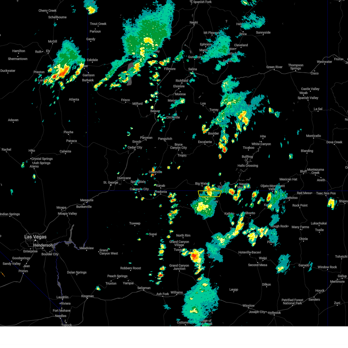
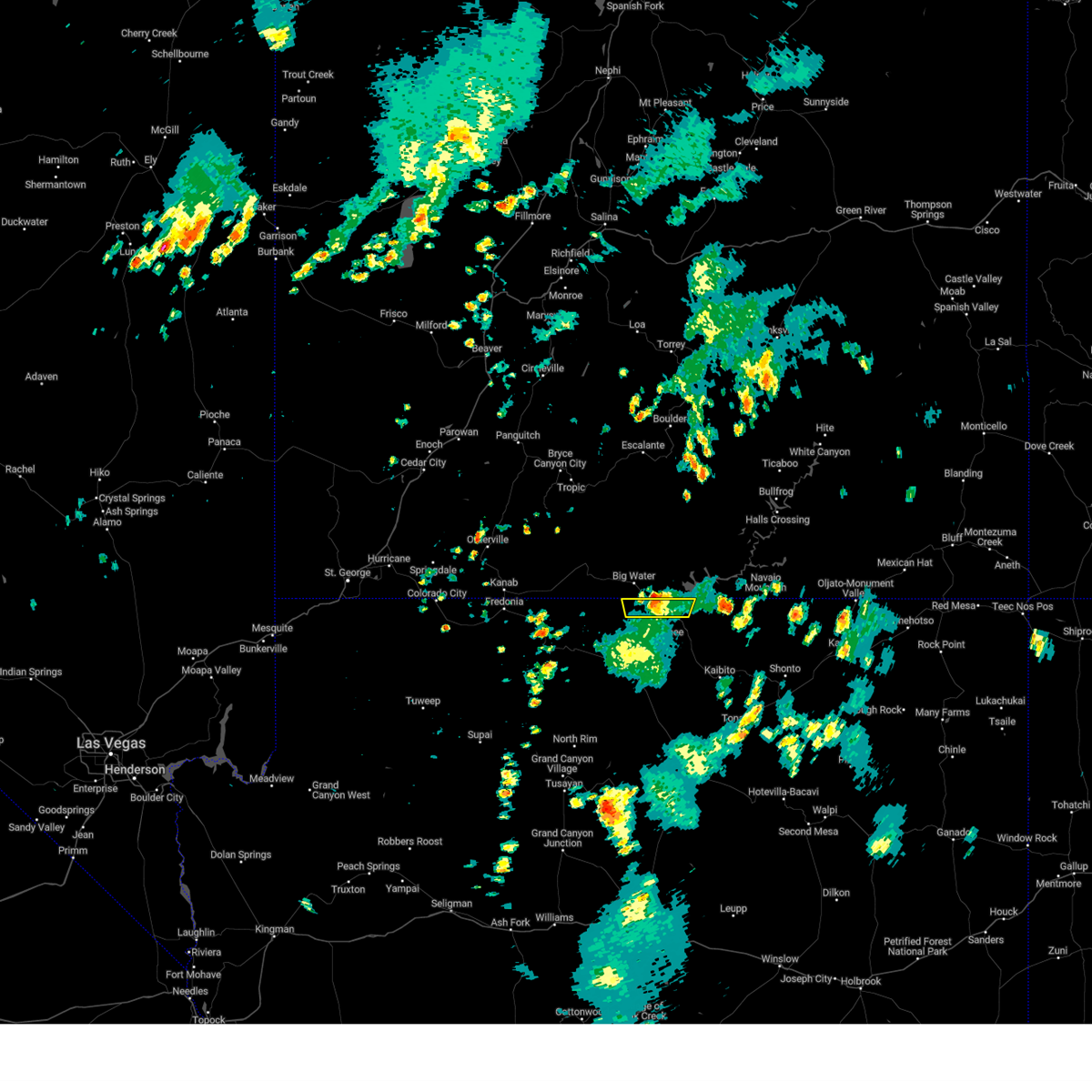
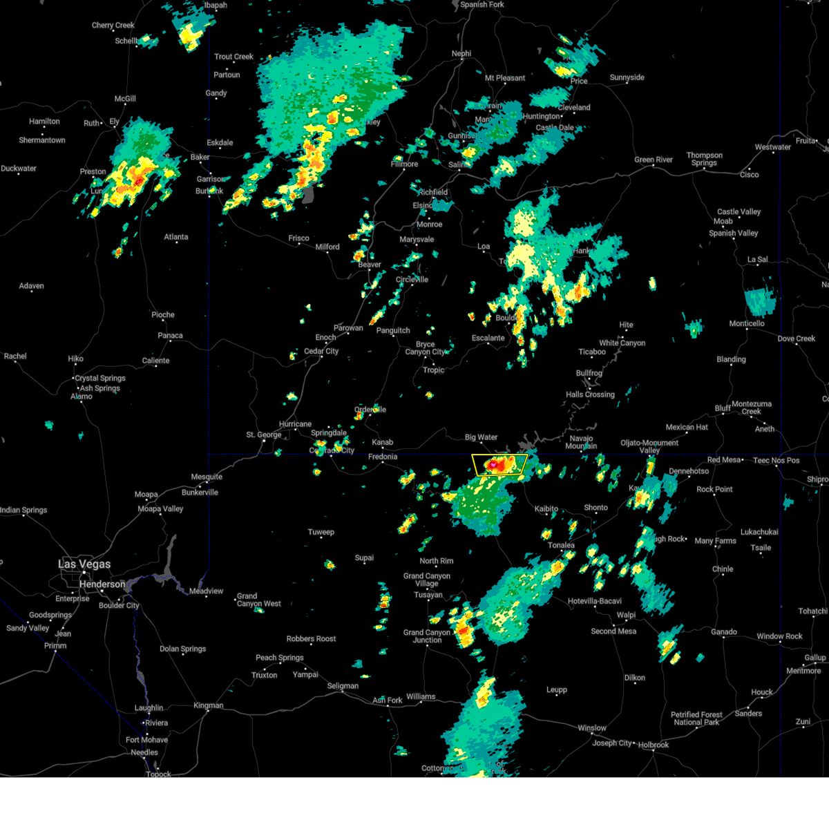
Hail Map for Page, AZ
The Page, AZ area has had 0 reports of on-the-ground hail by trained spotters, and has been under severe weather warnings 3 times during the past 12 months. Doppler radar has detected hail at or near Page, AZ on 7 occasions.
| Name: | Page, AZ |
| Where Located: | 118.2 miles E of Saint George, UT |
| Map: | Google Map for Page, AZ |
| Population: | 7247 |
| Housing Units: | 2787 |
| More Info: | Search Google for Page, AZ |
0
The Top Recent Hail Date for Page, AZ is Thursday, June 27, 2024 (7th out of 7)

Hail and Wind Damage Spotted near Page, AZ
| Date / Time | Report Details |
|---|---|
| 8/12/2024 4:22 PM MST |
 The storm which prompted the warning has moved out of the area. therefore, the warning will be allowed to expire. however, gusty winds and heavy rain are still possible with this thunderstorm over the next hour. The storm which prompted the warning has moved out of the area. therefore, the warning will be allowed to expire. however, gusty winds and heavy rain are still possible with this thunderstorm over the next hour.
|
| 8/12/2024 4:15 PM MST |
 At 414 pm mst/514 pm mdt, a severe thunderstorm was located near stateline wash slot canyon, or 10 miles northwest of page, moving north at 20 mph (radar indicated). Hazards include 60 mph wind gusts. Expect damage to roofs, siding, and trees. locations impacted include, glen canyon dam, vermillion park, labyrinth canyon, trapeze cove, page, antelope island, wahweap, wild horse mesa, nms beach, page municipal airport, elm street fitness park, stud horse point, golliard park, tower butte, antelope point marina, stateline wash slot canyon, lechee, and vermilion cliffs national monument. this includes the following highways, state route 98 between mile markers 548 and 549. u. s. Highway 89 between mile markers 547 and 556. At 414 pm mst/514 pm mdt, a severe thunderstorm was located near stateline wash slot canyon, or 10 miles northwest of page, moving north at 20 mph (radar indicated). Hazards include 60 mph wind gusts. Expect damage to roofs, siding, and trees. locations impacted include, glen canyon dam, vermillion park, labyrinth canyon, trapeze cove, page, antelope island, wahweap, wild horse mesa, nms beach, page municipal airport, elm street fitness park, stud horse point, golliard park, tower butte, antelope point marina, stateline wash slot canyon, lechee, and vermilion cliffs national monument. this includes the following highways, state route 98 between mile markers 548 and 549. u. s. Highway 89 between mile markers 547 and 556.
|
| 8/12/2024 3:58 PM MST |
 Svrfgz the national weather service in flagstaff has issued a * severe thunderstorm warning for, coconino county for the page and lake powell areas in north central arizona, * until 430 pm mst/530 pm mdt. * at 356 pm mst/456 pm mdt, a severe thunderstorm was located over glen canyon dam, or near page, moving north at 20 mph (radar indicated). Hazards include 60 mph wind gusts. expect damage to roofs, siding, and trees Svrfgz the national weather service in flagstaff has issued a * severe thunderstorm warning for, coconino county for the page and lake powell areas in north central arizona, * until 430 pm mst/530 pm mdt. * at 356 pm mst/456 pm mdt, a severe thunderstorm was located over glen canyon dam, or near page, moving north at 20 mph (radar indicated). Hazards include 60 mph wind gusts. expect damage to roofs, siding, and trees
|
| 6/27/2024 2:46 PM MST |
 The storm which prompted the warning has weakened below severe limits. therefore, the warning has been allowed to expire. gusty winds and heavy rain are still possible in this area this afternoon. The storm which prompted the warning has weakened below severe limits. therefore, the warning has been allowed to expire. gusty winds and heavy rain are still possible in this area this afternoon.
|
| 6/27/2024 2:00 PM MST |
 Svrfgz the national weather service in flagstaff has issued a * severe thunderstorm warning for, coconino county near page and lake powell in north central arizona, * until 245 pm mst. * at 158 pm mst, a severe thunderstorm was located around 9 miles west of page, moving east at 30 mph (radar indicated). Hazards include 60 mph wind gusts and quarter size hail. Hail damage to vehicles is expected. Expect wind damage to roofs, siding, and trees. Svrfgz the national weather service in flagstaff has issued a * severe thunderstorm warning for, coconino county near page and lake powell in north central arizona, * until 245 pm mst. * at 158 pm mst, a severe thunderstorm was located around 9 miles west of page, moving east at 30 mph (radar indicated). Hazards include 60 mph wind gusts and quarter size hail. Hail damage to vehicles is expected. Expect wind damage to roofs, siding, and trees.
|
| 6/27/2024 1:45 PM MST |
 At 144 pm mst, a severe thunderstorm was located near paria canyon, or 15 miles west of page, moving east at 30 mph (radar indicated). Hazards include 60 mph wind gusts and penny size hail. Expect damage to roofs, siding, and trees. locations impacted include, glen canyon dam, lower antelope canyon, labyrinth canyon, trapeze cove, page, antelope island, wahweap, paria canyon, horseshoe bend, and lechee. this includes the following highways, state route 98 between mile markers 548 and 549. u. s. Highway 89 between mile markers 546 and 556. At 144 pm mst, a severe thunderstorm was located near paria canyon, or 15 miles west of page, moving east at 30 mph (radar indicated). Hazards include 60 mph wind gusts and penny size hail. Expect damage to roofs, siding, and trees. locations impacted include, glen canyon dam, lower antelope canyon, labyrinth canyon, trapeze cove, page, antelope island, wahweap, paria canyon, horseshoe bend, and lechee. this includes the following highways, state route 98 between mile markers 548 and 549. u. s. Highway 89 between mile markers 546 and 556.
|
| 6/27/2024 1:09 PM MST |
 Svrfgz the national weather service in flagstaff has issued a * severe thunderstorm warning for, coconino county including page and lake powell in north central arizona, * until 200 pm mst. * at 108 pm mst, a severe thunderstorm was 9 miles west of page, moving east at 20 mph (radar indicated). Hazards include 60 mph wind gusts and penny size hail. expect damage to roofs, siding, and trees Svrfgz the national weather service in flagstaff has issued a * severe thunderstorm warning for, coconino county including page and lake powell in north central arizona, * until 200 pm mst. * at 108 pm mst, a severe thunderstorm was 9 miles west of page, moving east at 20 mph (radar indicated). Hazards include 60 mph wind gusts and penny size hail. expect damage to roofs, siding, and trees
|
| 6/27/2024 11:21 AM MST |
 The storm near page which prompted the warning has weakened below severe limits, and has exited the warned area. therefore, the warning will be allowed to expire. The storm near page which prompted the warning has weakened below severe limits, and has exited the warned area. therefore, the warning will be allowed to expire.
|
| 6/27/2024 10:47 AM MST |
 Svrfgz the national weather service in flagstaff has issued a * severe thunderstorm warning for, coconino county near page in north central arizona, * until 1130 am mst. * at 1046 am mst, a severe thunderstorm was located over wahweap, or near page, moving east at 20 mph (radar indicated). Hazards include 60 mph wind gusts and penny size hail. expect damage to roofs, siding, and trees Svrfgz the national weather service in flagstaff has issued a * severe thunderstorm warning for, coconino county near page in north central arizona, * until 1130 am mst. * at 1046 am mst, a severe thunderstorm was located over wahweap, or near page, moving east at 20 mph (radar indicated). Hazards include 60 mph wind gusts and penny size hail. expect damage to roofs, siding, and trees
|
| 8/11/2023 8:43 PM MST |
 The severe thunderstorm warning for the page and lake powell areas in coconino county will expire at 845 pm mst, the storm which prompted the warning has weakened below severe limits, and no longer poses an immediate threat to life or property. therefore, the warning will be allowed to expire. however, gusty winds of 30 to 40 mph are still likely with this thunderstorm. to report severe weather, contact your nearest law enforcement agency. they will relay your report to the national weather service flagstaff. The severe thunderstorm warning for the page and lake powell areas in coconino county will expire at 845 pm mst, the storm which prompted the warning has weakened below severe limits, and no longer poses an immediate threat to life or property. therefore, the warning will be allowed to expire. however, gusty winds of 30 to 40 mph are still likely with this thunderstorm. to report severe weather, contact your nearest law enforcement agency. they will relay your report to the national weather service flagstaff.
|
| 8/11/2023 8:28 PM MST |
 At 825 pm mst, a severe thunderstorm was located near page, moving northeast at 15 mph (radar indicated). Hazards include 60 mph wind gusts. Expect damage to roofs, siding, and trees. locations impacted include, page, marble canyon, cliff dwellers, ramshead canyon, cathedral wash trailhead, mountain sheep canyon, lee`s ferry, rattlesnake canyon, jackass canyon, wahweap, vermilion cliffs n. m. lees ferry, horseshoe bend, tower butte, antelope point marina, glen canyon dam, and lechee. this includes the following highways, state route 98 between mile markers 548 and 549. u. s. highway 89 between mile markers 533 and 556. u. s. highway 89a between mile markers 529 and 548. hail threat, radar indicated max hail size, <. 75 in wind threat, radar indicated max wind gust, 60 mph. At 825 pm mst, a severe thunderstorm was located near page, moving northeast at 15 mph (radar indicated). Hazards include 60 mph wind gusts. Expect damage to roofs, siding, and trees. locations impacted include, page, marble canyon, cliff dwellers, ramshead canyon, cathedral wash trailhead, mountain sheep canyon, lee`s ferry, rattlesnake canyon, jackass canyon, wahweap, vermilion cliffs n. m. lees ferry, horseshoe bend, tower butte, antelope point marina, glen canyon dam, and lechee. this includes the following highways, state route 98 between mile markers 548 and 549. u. s. highway 89 between mile markers 533 and 556. u. s. highway 89a between mile markers 529 and 548. hail threat, radar indicated max hail size, <. 75 in wind threat, radar indicated max wind gust, 60 mph.
|
| 8/11/2023 8:03 PM MST |
 At 800 pm mst, a severe thunderstorm was located from near paria canyon to the page area, moving northeast at 20 mph (radar indicated). Hazards include 60 mph wind gusts. expect damage to roofs, siding, and trees At 800 pm mst, a severe thunderstorm was located from near paria canyon to the page area, moving northeast at 20 mph (radar indicated). Hazards include 60 mph wind gusts. expect damage to roofs, siding, and trees
|
| 8/1/2023 4:47 PM MST |
 At 442 pm mst, a severe thunderstorm was located 8 miles northwest of lake powell, or 14 miles north of page, moving northeast at 20 mph (radar indicated). Hazards include 40-60 mph wind gusts, primarily within and along lake powell. however, winds are beginning to decrease. Expect damage to roofs, siding, and trees. locations impacted include, page and wahweap. this includes the following highways, state route 98 between mile markers 548 and 549. u. s. highway 89 between mile markers 546 and 554. hail threat, radar indicated max hail size, <. 75 in wind threat, radar indicated max wind gust, 60 mph. At 442 pm mst, a severe thunderstorm was located 8 miles northwest of lake powell, or 14 miles north of page, moving northeast at 20 mph (radar indicated). Hazards include 40-60 mph wind gusts, primarily within and along lake powell. however, winds are beginning to decrease. Expect damage to roofs, siding, and trees. locations impacted include, page and wahweap. this includes the following highways, state route 98 between mile markers 548 and 549. u. s. highway 89 between mile markers 546 and 554. hail threat, radar indicated max hail size, <. 75 in wind threat, radar indicated max wind gust, 60 mph.
|
| 8/1/2023 4:26 PM MST |
 At 423 pm mst, a severe thunderstorm was located near wahweap, or near page, moving northeast at 20 mph (radar indicated and observation near page). Hazards include 55-60 mph wind gusts. expect damage to roofs, siding, and trees At 423 pm mst, a severe thunderstorm was located near wahweap, or near page, moving northeast at 20 mph (radar indicated and observation near page). Hazards include 55-60 mph wind gusts. expect damage to roofs, siding, and trees
|
| 6/6/2023 3:26 PM MDT |
 The severe thunderstorm warning for areas near page and lake powell in coconino county will expire at 230 pm mst, the storm which prompted the warning has moved out of the area. therefore, the warning will be allowed to expire. however, gusty winds are still possible with this thunderstorm. The severe thunderstorm warning for areas near page and lake powell in coconino county will expire at 230 pm mst, the storm which prompted the warning has moved out of the area. therefore, the warning will be allowed to expire. however, gusty winds are still possible with this thunderstorm.
|
| 6/6/2023 3:12 PM MDT |
 At 211 pm mst, a severe thunderstorm was located near lake powell, or 10 miles northeast of page, moving northwest at 35 mph (radar indicated). Hazards include 60 mph wind gusts. expect damage to roofs, siding, and trees At 211 pm mst, a severe thunderstorm was located near lake powell, or 10 miles northeast of page, moving northwest at 35 mph (radar indicated). Hazards include 60 mph wind gusts. expect damage to roofs, siding, and trees
|
| 6/29/2021 5:08 PM MDT |
 The severe thunderstorm warning for coconino county will expire at 415 pm mst/515 pm mdt/, the storms which prompted the warning have weakened below severe limits, and no longer pose an immediate threat to life or property. therefore, the warning will be allowed to expire. however gusty winds are still possible with these thunderstorms. The severe thunderstorm warning for coconino county will expire at 415 pm mst/515 pm mdt/, the storms which prompted the warning have weakened below severe limits, and no longer pose an immediate threat to life or property. therefore, the warning will be allowed to expire. however gusty winds are still possible with these thunderstorms.
|
| 6/29/2021 4:39 PM MDT |
 At 338 pm mst/438 pm mdt/, severe thunderstorms were located along a line near lake powell and wahweap boat ramp, moving south at 15 mph (radar indicated). Hazards include 60 mph wind gusts. expect damage to roofs, siding, and trees At 338 pm mst/438 pm mdt/, severe thunderstorms were located along a line near lake powell and wahweap boat ramp, moving south at 15 mph (radar indicated). Hazards include 60 mph wind gusts. expect damage to roofs, siding, and trees
|
| 6/29/2021 3:03 PM MST |
 At 302 pm mst/402 pm mdt/, severe thunderstorms were located along a line extending across the utah/arizona border near lake powell, moving south at 15 mph. this will effect lake powell and wahweap boat ramp (radar indicated). Hazards include 60 mph wind gusts and quarter size hail. Hail damage to vehicles is expected. Expect wind damage to roofs, siding, and trees. At 302 pm mst/402 pm mdt/, severe thunderstorms were located along a line extending across the utah/arizona border near lake powell, moving south at 15 mph. this will effect lake powell and wahweap boat ramp (radar indicated). Hazards include 60 mph wind gusts and quarter size hail. Hail damage to vehicles is expected. Expect wind damage to roofs, siding, and trees.
|
| 10/6/2018 6:31 PM MDT |
 At 530 pm mst/630 pm mdt/, a severe thunderstorm was located over antelope creek basin, or 11 miles southeast of page, moving northeast at 30 mph (radar indicated). Hazards include 60 mph wind gusts and quarter size hail. Hail damage to vehicles is expected. Expect wind damage to roofs, siding, and trees. At 530 pm mst/630 pm mdt/, a severe thunderstorm was located over antelope creek basin, or 11 miles southeast of page, moving northeast at 30 mph (radar indicated). Hazards include 60 mph wind gusts and quarter size hail. Hail damage to vehicles is expected. Expect wind damage to roofs, siding, and trees.
|
| 10/6/2018 6:06 PM MDT |
 At 505 pm mst/605 pm mdt/, a severe thunderstorm was located near bitter springs, or 16 miles south of page, moving northeast at 30 mph (radar indicated). Hazards include 60 mph wind gusts and quarter size hail. Hail damage to vehicles is expected. Expect wind damage to roofs, siding, and trees. At 505 pm mst/605 pm mdt/, a severe thunderstorm was located near bitter springs, or 16 miles south of page, moving northeast at 30 mph (radar indicated). Hazards include 60 mph wind gusts and quarter size hail. Hail damage to vehicles is expected. Expect wind damage to roofs, siding, and trees.
|
| 8/21/2018 1:51 PM MDT |
 The severe thunderstorm warning for coconino county will expire at 100 pm mst, the storm which prompted the warning has moved out of the area and into utah. therefore the warning will be allowed to expire. The severe thunderstorm warning for coconino county will expire at 100 pm mst, the storm which prompted the warning has moved out of the area and into utah. therefore the warning will be allowed to expire.
|
| 8/21/2018 1:15 PM MDT |
 At 1214 pm mst, a severe thunderstorm was located near page, moving northeast at 20 mph (radar indicated). Hazards include 60 mph wind gusts and quarter size hail. Hail damage to vehicles is expected. Expect wind damage to roofs, siding, and trees. At 1214 pm mst, a severe thunderstorm was located near page, moving northeast at 20 mph (radar indicated). Hazards include 60 mph wind gusts and quarter size hail. Hail damage to vehicles is expected. Expect wind damage to roofs, siding, and trees.
|
| 9/14/2017 1:38 PM MDT | Page airport hangar damaged. jet center windows were blown out. a few trees were uprooted in page. page asos recorded a peak wind gust of 56 mph at 12:38 pm ms in coconino county AZ, 2.2 miles SSW of Page, AZ |
| 9/2/2016 4:09 PM MST |
 At 408 pm mst, doppler radar indicated a severe thunderstorm capable of producing damaging winds in excess of 60 mph. this storm was located over page, moving northeast at 25 mph. locations impacted include, page, lees ferry, wahweep, antelope canyon near sr 98, big five, antelope creek basin and lake powell. At 408 pm mst, doppler radar indicated a severe thunderstorm capable of producing damaging winds in excess of 60 mph. this storm was located over page, moving northeast at 25 mph. locations impacted include, page, lees ferry, wahweep, antelope canyon near sr 98, big five, antelope creek basin and lake powell.
|
| 9/2/2016 3:54 PM MST |
 At 353 pm mst, doppler radar indicated a severe thunderstorm capable of producing quarter size hail and damaging winds in excess of 60 mph. this storm was located near page, and moving northeast at 25 mph. At 353 pm mst, doppler radar indicated a severe thunderstorm capable of producing quarter size hail and damaging winds in excess of 60 mph. this storm was located near page, and moving northeast at 25 mph.
|
| 6/28/2016 4:29 PM MDT | Storm damage reported in coconino county AZ, 1.6 miles SSW of Page, AZ |
| 10/19/2015 4:39 AM MDT |
 The severe thunderstorm warning for northern coconino county will expire at 345 am mst, the severe thunderstorm near page which prompted the warning has weakened and moved northeast into utah. therefore, the warning will be allowed to expire. The severe thunderstorm warning for northern coconino county will expire at 345 am mst, the severe thunderstorm near page which prompted the warning has weakened and moved northeast into utah. therefore, the warning will be allowed to expire.
|
| 10/19/2015 4:15 AM MDT |
 At 313 am mst, doppler radar indicated a severe thunderstorm capable of producing quarter size hail and damaging winds in excess of 60 mph. this storm was located over antelope canyon near sr 98, or just southeast of page, and moving northeast at 35 mph. At 313 am mst, doppler radar indicated a severe thunderstorm capable of producing quarter size hail and damaging winds in excess of 60 mph. this storm was located over antelope canyon near sr 98, or just southeast of page, and moving northeast at 35 mph.
|
| 10/19/2015 3:59 AM MDT |
 At 257 am mst, doppler radar indicated a severe thunderstorm capable of producing quarter size hail and damaging winds in excess of 60 mph. this storm was located near le chee, or near page, and moving northeast at 40 mph. At 257 am mst, doppler radar indicated a severe thunderstorm capable of producing quarter size hail and damaging winds in excess of 60 mph. this storm was located near le chee, or near page, and moving northeast at 40 mph.
|
| 9/14/2015 1:55 PM MST |
 The severe thunderstorm warning for northern coconino county will expire at 200 pm mst, the storm which prompted the warning just north of page has weakened below severe limits. therefore the warning will be allowed to expire. however gusty winds are still possible with this thunderstorm. The severe thunderstorm warning for northern coconino county will expire at 200 pm mst, the storm which prompted the warning just north of page has weakened below severe limits. therefore the warning will be allowed to expire. however gusty winds are still possible with this thunderstorm.
|
| 9/14/2015 1:34 PM MST |
 At 131 pm mst, doppler radar indicated a severe thunderstorm capable of producing quarter size hail and damaging winds in excess of 60 mph. this storm was located just north of lees ferry, and moving east at 25 mph. At 131 pm mst, doppler radar indicated a severe thunderstorm capable of producing quarter size hail and damaging winds in excess of 60 mph. this storm was located just north of lees ferry, and moving east at 25 mph.
|
| 8/26/2015 3:56 PM MDT |
 The severe thunderstorm warning for northeastern coconino county will expire at 300 pm mst, the storm which prompted the warning near the page area along the utah border has weakened below severe limits, and no longer poses an immediate threat to life or property. therefore the warning will be allowed to expire. brief torrential rain and large hail fell with this storm as it passed to the north of page and the glen canyon dam, and some roads in the area will likely be difficult to travel through the evening. The severe thunderstorm warning for northeastern coconino county will expire at 300 pm mst, the storm which prompted the warning near the page area along the utah border has weakened below severe limits, and no longer poses an immediate threat to life or property. therefore the warning will be allowed to expire. brief torrential rain and large hail fell with this storm as it passed to the north of page and the glen canyon dam, and some roads in the area will likely be difficult to travel through the evening.
|
| 8/26/2015 3:30 PM MDT |
 At 228 pm mst, doppler radar indicated a severe thunderstorm capable of producing large hail, flash flooding, and destructive winds in excess of 70 mph. this storm was located just north of page, moving east at 25 mph. penny size hail may also accompany the damaging winds. locations impacted include, page, antelope canyon near sr 98, wahweep, big five, antelope creek basin and lake powell. At 228 pm mst, doppler radar indicated a severe thunderstorm capable of producing large hail, flash flooding, and destructive winds in excess of 70 mph. this storm was located just north of page, moving east at 25 mph. penny size hail may also accompany the damaging winds. locations impacted include, page, antelope canyon near sr 98, wahweep, big five, antelope creek basin and lake powell.
|
| 8/26/2015 3:12 PM MDT |
 At 210 pm mst, doppler radar indicated a severe thunderstorm capable of producing quarter size hail, torrential rainfall, flash flooding, and destructive winds in excess of 70 mph. this storm was located near wahweep, or near page, and moving east at 25 mph. At 210 pm mst, doppler radar indicated a severe thunderstorm capable of producing quarter size hail, torrential rainfall, flash flooding, and destructive winds in excess of 70 mph. this storm was located near wahweep, or near page, and moving east at 25 mph.
|
Hail Maps for Page, AZ


Connect with Interactive Hail Maps