

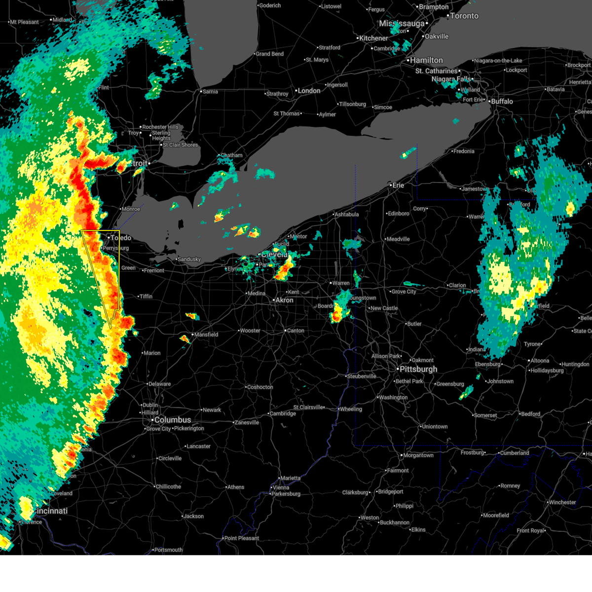
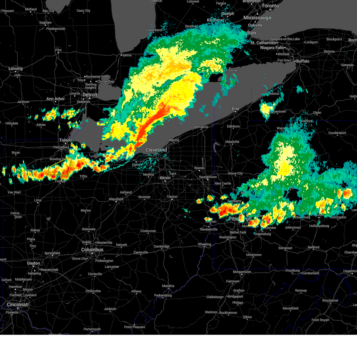
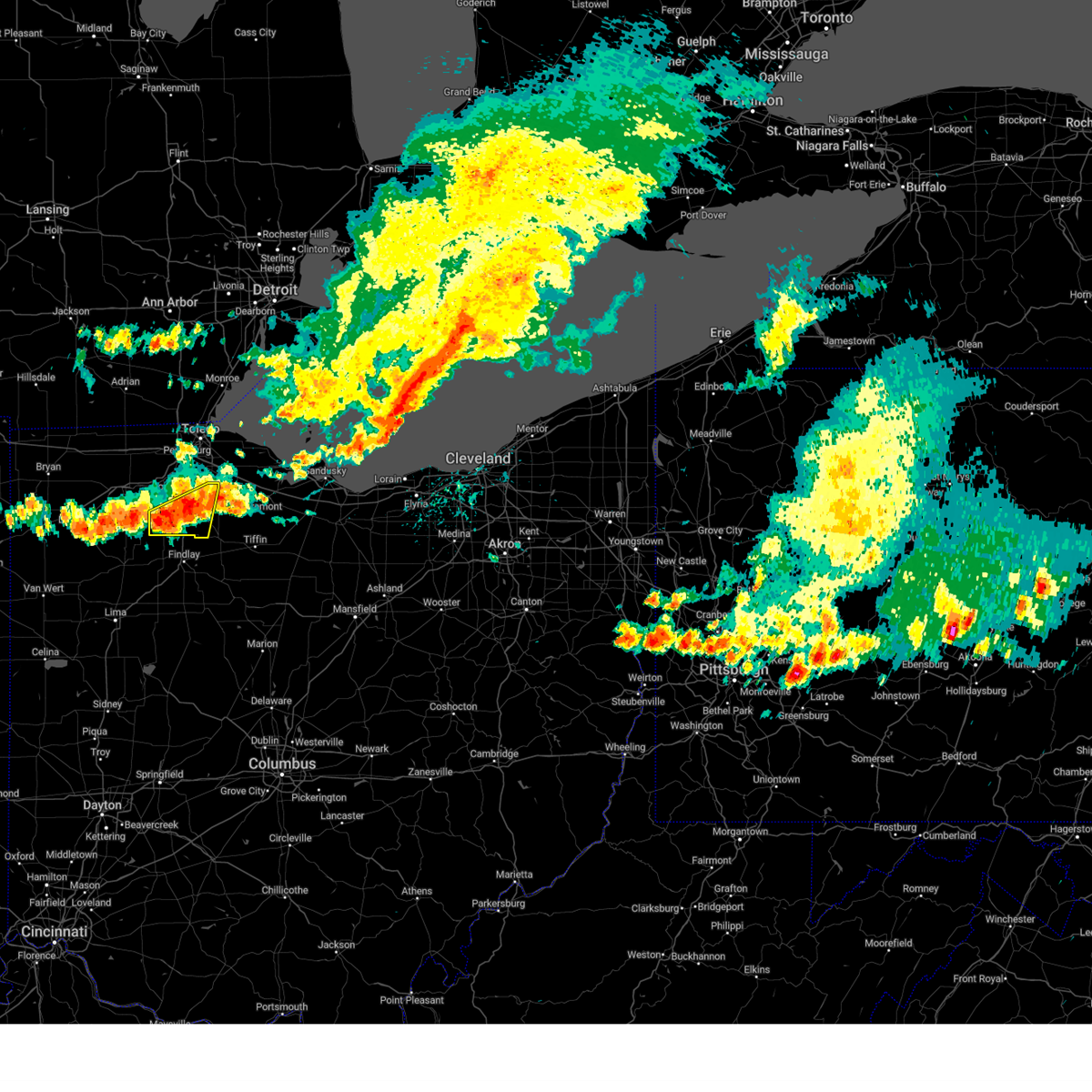
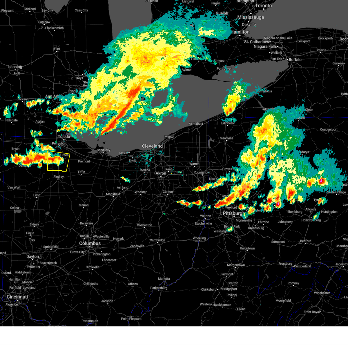
Hail Map for Pemberville, OH
The Pemberville, OH area has had 2 reports of on-the-ground hail by trained spotters, and has been under severe weather warnings 20 times during the past 12 months. Doppler radar has detected hail at or near Pemberville, OH on 34 occasions.
| Name: | Pemberville, OH |
| Where Located: | 88.6 miles ENE of Fort Wayne, IN |
| Map: | Google Map for Pemberville, OH |
| Population: | 1371 |
| Housing Units: | 578 |
| More Info: | Search Google for Pemberville, OH |
0
The Top Recent Hail Date for Pemberville, OH is Monday, May 20, 2024 (31st out of 34)

Hail and Wind Damage Spotted near Pemberville, OH
| Date / Time | Report Details |
|---|---|
| 6/18/2025 7:32 PM EDT |
 At 732 pm edt, severe thunderstorms were located along a line extending from bowling green to near fostoria to near vanlue, moving northeast at 60 mph (radar indicated). Hazards include 70 mph wind gusts. Expect considerable tree damage. damage is likely to mobile homes, roofs, and outbuildings. Locations impacted include, toledo, findlay, bowling green, fostoria, perrysburg, oregon, sylvania, rossford, waterville, northwood, whitehouse, north baltimore, holland, arcadia, vanlue, van buren, maumee, ottawa hills, walbridge, and pemberville. At 732 pm edt, severe thunderstorms were located along a line extending from bowling green to near fostoria to near vanlue, moving northeast at 60 mph (radar indicated). Hazards include 70 mph wind gusts. Expect considerable tree damage. damage is likely to mobile homes, roofs, and outbuildings. Locations impacted include, toledo, findlay, bowling green, fostoria, perrysburg, oregon, sylvania, rossford, waterville, northwood, whitehouse, north baltimore, holland, arcadia, vanlue, van buren, maumee, ottawa hills, walbridge, and pemberville.
|
| 6/18/2025 7:17 PM EDT | At 717 pm edt, severe thunderstorms were located along a line extending from near weston to van buren to near arlington, moving east at 60 mph (radar indicated). Hazards include 70 mph wind gusts. Expect considerable tree damage. damage is likely to mobile homes, roofs, and outbuildings. Locations impacted include, toledo, findlay, bowling green, fostoria, bluffton, swanton, perrysburg, oregon, sylvania, rossford, waterville, northwood, whitehouse, north baltimore, holland, mccomb, weston, arlington, arcadia, and rawson. |
| 6/18/2025 6:42 PM EDT | Svrcle the national weather service in cleveland has issued a * severe thunderstorm warning for, wood county in northwestern ohio, hancock county in northwestern ohio, lucas county in northwestern ohio, * until 745 pm edt. * at 641 pm edt, severe thunderstorms were located along a line extending from near continental to near kalida to near cridersville, moving northeast at 60 mph (radar indicated). Hazards include 60 mph wind gusts. expect damage to trees and power lines |
| 4/2/2025 11:54 PM EDT | At 1154 pm edt, severe thunderstorms were located along a line extending from near bowling green to near fostoria to near forest, moving northeast at 65 mph (radar indicated). Hazards include 70 mph wind gusts. Expect considerable tree damage. damage is likely to mobile homes, roofs, and outbuildings. Locations impacted include, bowling green, tiffin, fremont, fostoria, perrysburg, oregon, bellevue, clyde, rossford, waterville, northwood, whitehouse, north baltimore, oak harbor, gibsonburg, genoa, woodville, weston, elmore, and green springs. |
| 4/2/2025 11:43 PM EDT | Svrcle the national weather service in cleveland has issued a * severe thunderstorm warning for, ottawa county in northwestern ohio, northwestern seneca county in northwestern ohio, northwestern wyandot county in northwestern ohio, sandusky county in northwestern ohio, wood county in northwestern ohio, hancock county in northwestern ohio, central lucas county in northwestern ohio, * until 1230 am edt. * at 1143 pm edt, severe thunderstorms were located along a line extending from near weston to near van buren to dunkirk, moving northeast at 90 mph (radar indicated). Hazards include 60 mph wind gusts. expect damage to trees and power lines |
| 3/30/2025 7:40 PM EDT | Svrcle the national weather service in cleveland has issued a * severe thunderstorm warning for, ottawa county in northwestern ohio, sandusky county in northwestern ohio, southeastern wood county in northwestern ohio, * until 830 pm edt. * at 740 pm edt, severe thunderstorms were located along a line extending from near bowling green to 12 miles west of gibsonburg to near north baltimore, moving northeast at 45 mph (radar indicated). Hazards include 60 mph wind gusts. expect damage to trees and power lines |
| 9/24/2024 7:23 PM EDT |
 Svrcle the national weather service in cleveland has issued a * severe thunderstorm warning for, ottawa county in northwestern ohio, western seneca county in northwestern ohio, western sandusky county in northwestern ohio, wood county in northwestern ohio, northern hancock county in northwestern ohio, * until 815 pm edt. * at 723 pm edt, a severe thunderstorm was located near north baltimore, or 12 miles southwest of bowling green, moving east at 40 mph (radar indicated). Hazards include 60 mph wind gusts and quarter size hail. Minor damage to vehicles is possible. Expect damage to trees and power lines. Svrcle the national weather service in cleveland has issued a * severe thunderstorm warning for, ottawa county in northwestern ohio, western seneca county in northwestern ohio, western sandusky county in northwestern ohio, wood county in northwestern ohio, northern hancock county in northwestern ohio, * until 815 pm edt. * at 723 pm edt, a severe thunderstorm was located near north baltimore, or 12 miles southwest of bowling green, moving east at 40 mph (radar indicated). Hazards include 60 mph wind gusts and quarter size hail. Minor damage to vehicles is possible. Expect damage to trees and power lines.
|
| 9/24/2024 6:36 PM EDT |
 At 636 pm edt, a severe thunderstorm was located near mcclure, or 12 miles east of napoleon, moving east at 30 mph (radar indicated). Hazards include 60 mph wind gusts and quarter size hail. Minor damage to vehicles is possible. expect damage to trees and power lines. Locations impacted include, bowling green, weston, pemberville, millbury, haskins, luckey, bradner, grand rapids, portage, tontogany, custar, milton center, and stony ridge. At 636 pm edt, a severe thunderstorm was located near mcclure, or 12 miles east of napoleon, moving east at 30 mph (radar indicated). Hazards include 60 mph wind gusts and quarter size hail. Minor damage to vehicles is possible. expect damage to trees and power lines. Locations impacted include, bowling green, weston, pemberville, millbury, haskins, luckey, bradner, grand rapids, portage, tontogany, custar, milton center, and stony ridge.
|
| 9/24/2024 6:19 PM EDT |
 Svrcle the national weather service in cleveland has issued a * severe thunderstorm warning for, wood county in northwestern ohio, * until 715 pm edt. * at 619 pm edt, a severe thunderstorm was located near deshler, or 12 miles southeast of napoleon, moving east at 35 mph (radar indicated). Hazards include 60 mph wind gusts and quarter size hail. Minor damage to vehicles is possible. Expect damage to trees and power lines. Svrcle the national weather service in cleveland has issued a * severe thunderstorm warning for, wood county in northwestern ohio, * until 715 pm edt. * at 619 pm edt, a severe thunderstorm was located near deshler, or 12 miles southeast of napoleon, moving east at 35 mph (radar indicated). Hazards include 60 mph wind gusts and quarter size hail. Minor damage to vehicles is possible. Expect damage to trees and power lines.
|
| 9/24/2024 4:01 PM EDT |
 Torcle the national weather service in cleveland has issued a * tornado warning for, ottawa county in northwestern ohio, northwestern sandusky county in northwestern ohio, northeastern wood county in northwestern ohio, northeastern lucas county in northwestern ohio, * until 445 pm edt. * at 401 pm edt, a severe thunderstorm capable of producing a tornado was located over woodville, or 12 miles northwest of fremont, moving northeast at 35 mph (radar indicated rotation). Hazards include tornado. Flying debris will be dangerous to those caught without shelter. mobile homes will be damaged or destroyed. damage to roofs, windows, and vehicles will occur. Tree damage is likely. Torcle the national weather service in cleveland has issued a * tornado warning for, ottawa county in northwestern ohio, northwestern sandusky county in northwestern ohio, northeastern wood county in northwestern ohio, northeastern lucas county in northwestern ohio, * until 445 pm edt. * at 401 pm edt, a severe thunderstorm capable of producing a tornado was located over woodville, or 12 miles northwest of fremont, moving northeast at 35 mph (radar indicated rotation). Hazards include tornado. Flying debris will be dangerous to those caught without shelter. mobile homes will be damaged or destroyed. damage to roofs, windows, and vehicles will occur. Tree damage is likely.
|
| 9/24/2024 3:58 PM EDT |
 At 358 pm edt, a severe thunderstorm was located near woodville, or 13 miles east of bowling green, moving northeast at 30 mph (radar indicated). Hazards include 60 mph wind gusts and penny size hail. Expect damage to trees and power lines. Locations impacted include, bowling green, fremont, perrysburg, oregon, clyde, rossford, northwood, oak harbor, gibsonburg, genoa, woodville, elmore, green springs, ballville, walbridge, pemberville, millbury, luckey, bradner, and wayne. At 358 pm edt, a severe thunderstorm was located near woodville, or 13 miles east of bowling green, moving northeast at 30 mph (radar indicated). Hazards include 60 mph wind gusts and penny size hail. Expect damage to trees and power lines. Locations impacted include, bowling green, fremont, perrysburg, oregon, clyde, rossford, northwood, oak harbor, gibsonburg, genoa, woodville, elmore, green springs, ballville, walbridge, pemberville, millbury, luckey, bradner, and wayne.
|
| 9/24/2024 3:41 PM EDT |
 Svrcle the national weather service in cleveland has issued a * severe thunderstorm warning for, ottawa county in northwestern ohio, northern seneca county in northwestern ohio, sandusky county in northwestern ohio, wood county in northwestern ohio, northeastern lucas county in northwestern ohio, * until 430 pm edt. * at 340 pm edt, a severe thunderstorm was located near bowling green, moving northeast at 40 mph (radar indicated). Hazards include 60 mph wind gusts and penny size hail. expect damage to trees and power lines Svrcle the national weather service in cleveland has issued a * severe thunderstorm warning for, ottawa county in northwestern ohio, northern seneca county in northwestern ohio, sandusky county in northwestern ohio, wood county in northwestern ohio, northeastern lucas county in northwestern ohio, * until 430 pm edt. * at 340 pm edt, a severe thunderstorm was located near bowling green, moving northeast at 40 mph (radar indicated). Hazards include 60 mph wind gusts and penny size hail. expect damage to trees and power lines
|
| 8/27/2024 8:05 PM EDT |
 At 804 pm edt, a severe thunderstorm was located 7 miles south of gibsonburg, or 9 miles southwest of fremont, moving east at 45 mph (radar indicated). Hazards include 60 mph wind gusts and penny size hail. Expect damage to trees and power lines. Locations impacted include, bowling green, fremont, fostoria, north baltimore, gibsonburg, woodville, weston, elmore, ballville, pemberville, haskins, luckey, bradner, grand rapids, wayne, bloomdale, bettsville, risingsun, cygnet, and lindsey. At 804 pm edt, a severe thunderstorm was located 7 miles south of gibsonburg, or 9 miles southwest of fremont, moving east at 45 mph (radar indicated). Hazards include 60 mph wind gusts and penny size hail. Expect damage to trees and power lines. Locations impacted include, bowling green, fremont, fostoria, north baltimore, gibsonburg, woodville, weston, elmore, ballville, pemberville, haskins, luckey, bradner, grand rapids, wayne, bloomdale, bettsville, risingsun, cygnet, and lindsey.
|
| 8/27/2024 8:05 PM EDT |
 the severe thunderstorm warning has been cancelled and is no longer in effect the severe thunderstorm warning has been cancelled and is no longer in effect
|
| 8/27/2024 7:11 PM EDT |
 Svrcle the national weather service in cleveland has issued a * severe thunderstorm warning for, ottawa county in northwestern ohio, northwestern seneca county in northwestern ohio, western sandusky county in northwestern ohio, wood county in northwestern ohio, lucas county in northwestern ohio, * until 815 pm edt. * at 710 pm edt, a severe thunderstorm was located over swanton, moving southeast at 45 mph (radar indicated). Hazards include 70 mph wind gusts and quarter size hail. Minor damage to vehicles is possible. expect considerable tree damage. Wind damage is also likely to mobile homes, roofs, and outbuildings. Svrcle the national weather service in cleveland has issued a * severe thunderstorm warning for, ottawa county in northwestern ohio, northwestern seneca county in northwestern ohio, western sandusky county in northwestern ohio, wood county in northwestern ohio, lucas county in northwestern ohio, * until 815 pm edt. * at 710 pm edt, a severe thunderstorm was located over swanton, moving southeast at 45 mph (radar indicated). Hazards include 70 mph wind gusts and quarter size hail. Minor damage to vehicles is possible. expect considerable tree damage. Wind damage is also likely to mobile homes, roofs, and outbuildings.
|
| 8/6/2024 3:38 PM EDT |
 A new severe thunderstorm warning has been issued for southern wood county until 415 pm edt. a tornado watch remains in effect until 500 pm edt for northwestern ohio. a severe thunderstorm watch remains in effect until 700 pm edt for northwestern ohio. A new severe thunderstorm warning has been issued for southern wood county until 415 pm edt. a tornado watch remains in effect until 500 pm edt for northwestern ohio. a severe thunderstorm watch remains in effect until 700 pm edt for northwestern ohio.
|
| 8/6/2024 3:21 PM EDT |
 Svrcle the national weather service in cleveland has issued a * severe thunderstorm warning for, seneca county in northwestern ohio, sandusky county in northwestern ohio, southern wood county in northwestern ohio, northern hancock county in northwestern ohio, * until 415 pm edt. * at 320 pm edt, severe thunderstorms were located along a line extending from near gibsonburg to 6 miles southeast of bowling green to near deshler, moving east at 40 mph (radar indicated). Hazards include 70 mph wind gusts and quarter size hail. Minor damage to vehicles is possible. expect considerable tree damage. Wind damage is also likely to mobile homes, roofs, and outbuildings. Svrcle the national weather service in cleveland has issued a * severe thunderstorm warning for, seneca county in northwestern ohio, sandusky county in northwestern ohio, southern wood county in northwestern ohio, northern hancock county in northwestern ohio, * until 415 pm edt. * at 320 pm edt, severe thunderstorms were located along a line extending from near gibsonburg to 6 miles southeast of bowling green to near deshler, moving east at 40 mph (radar indicated). Hazards include 70 mph wind gusts and quarter size hail. Minor damage to vehicles is possible. expect considerable tree damage. Wind damage is also likely to mobile homes, roofs, and outbuildings.
|
| 8/6/2024 3:15 PM EDT |
 the severe thunderstorm warning has been cancelled and is no longer in effect the severe thunderstorm warning has been cancelled and is no longer in effect
|
| 8/6/2024 3:15 PM EDT |
 At 315 pm edt, severe thunderstorms were located along a line extending from near woodville to near bowling green to near deshler, moving east at 35 mph (radar indicated). Hazards include 60 mph wind gusts and quarter size hail. Minor damage to vehicles is possible. expect damage to trees and power lines. Locations impacted include, bowling green, north baltimore, pemberville, bradner, wayne, bloomdale, cygnet, portage, jerry city, hoytville, custar, west millgrove, milton center, and bairdstown. At 315 pm edt, severe thunderstorms were located along a line extending from near woodville to near bowling green to near deshler, moving east at 35 mph (radar indicated). Hazards include 60 mph wind gusts and quarter size hail. Minor damage to vehicles is possible. expect damage to trees and power lines. Locations impacted include, bowling green, north baltimore, pemberville, bradner, wayne, bloomdale, cygnet, portage, jerry city, hoytville, custar, west millgrove, milton center, and bairdstown.
|
| 8/6/2024 2:43 PM EDT |
 Svrcle the national weather service in cleveland has issued a * severe thunderstorm warning for, wood county in northwestern ohio, southwestern lucas county in northwestern ohio, * until 345 pm edt. * at 242 pm edt, a severe thunderstorm was located near mcclure, or near napoleon, moving east at 30 mph (radar indicated). Hazards include 60 mph wind gusts and quarter size hail. Minor damage to vehicles is possible. Expect damage to trees and power lines. Svrcle the national weather service in cleveland has issued a * severe thunderstorm warning for, wood county in northwestern ohio, southwestern lucas county in northwestern ohio, * until 345 pm edt. * at 242 pm edt, a severe thunderstorm was located near mcclure, or near napoleon, moving east at 30 mph (radar indicated). Hazards include 60 mph wind gusts and quarter size hail. Minor damage to vehicles is possible. Expect damage to trees and power lines.
|
| 6/20/2024 6:16 PM EDT |
 Svrcle the national weather service in cleveland has issued a * severe thunderstorm warning for, northwestern sandusky county in northwestern ohio, northeastern wood county in northwestern ohio, * until 700 pm edt. * at 616 pm edt, a severe thunderstorm was located near rossford, or 11 miles northeast of bowling green, moving southeast at 10 mph (radar indicated). Hazards include 60 mph wind gusts and quarter size hail. Minor damage to vehicles is possible. Expect damage to trees and power lines. Svrcle the national weather service in cleveland has issued a * severe thunderstorm warning for, northwestern sandusky county in northwestern ohio, northeastern wood county in northwestern ohio, * until 700 pm edt. * at 616 pm edt, a severe thunderstorm was located near rossford, or 11 miles northeast of bowling green, moving southeast at 10 mph (radar indicated). Hazards include 60 mph wind gusts and quarter size hail. Minor damage to vehicles is possible. Expect damage to trees and power lines.
|
| 6/19/2024 8:27 PM EDT |
 the severe thunderstorm warning has been cancelled and is no longer in effect the severe thunderstorm warning has been cancelled and is no longer in effect
|
| 6/19/2024 7:56 PM EDT |
 The storm which prompted the warning has weakened below severe limits, and no longer poses an immediate threat to life or property. therefore, the warning will be allowed to expire. however, gusty winds and heavy rain are still possible with this thunderstorm. remember, a severe thunderstorm warning still remains in effect for portions of wood, seneca, sandusky, and ottawa counties. The storm which prompted the warning has weakened below severe limits, and no longer poses an immediate threat to life or property. therefore, the warning will be allowed to expire. however, gusty winds and heavy rain are still possible with this thunderstorm. remember, a severe thunderstorm warning still remains in effect for portions of wood, seneca, sandusky, and ottawa counties.
|
| 6/19/2024 7:54 PM EDT |
 Svrcle the national weather service in cleveland has issued a * severe thunderstorm warning for, ottawa county in northwestern ohio, northwestern seneca county in northwestern ohio, western sandusky county in northwestern ohio, southeastern wood county in northwestern ohio, * until 845 pm edt. * at 754 pm edt, a severe thunderstorm was located 7 miles north of fostoria, moving northeast at 15 mph (radar indicated). Hazards include 60 mph wind gusts and quarter size hail. Minor damage to vehicles is possible. Expect damage to trees and power lines. Svrcle the national weather service in cleveland has issued a * severe thunderstorm warning for, ottawa county in northwestern ohio, northwestern seneca county in northwestern ohio, western sandusky county in northwestern ohio, southeastern wood county in northwestern ohio, * until 845 pm edt. * at 754 pm edt, a severe thunderstorm was located 7 miles north of fostoria, moving northeast at 15 mph (radar indicated). Hazards include 60 mph wind gusts and quarter size hail. Minor damage to vehicles is possible. Expect damage to trees and power lines.
|
| 6/19/2024 7:22 PM EDT |
 Svrcle the national weather service in cleveland has issued a * severe thunderstorm warning for, ottawa county in northwestern ohio, northwestern seneca county in northwestern ohio, western sandusky county in northwestern ohio, wood county in northwestern ohio, northeastern lucas county in northwestern ohio, * until 800 pm edt. * at 721 pm edt, a severe thunderstorm was located 7 miles southeast of bowling green, moving northeast at 30 mph (radar indicated). Hazards include 60 mph wind gusts and quarter size hail. Minor damage to vehicles is possible. Expect damage to trees and power lines. Svrcle the national weather service in cleveland has issued a * severe thunderstorm warning for, ottawa county in northwestern ohio, northwestern seneca county in northwestern ohio, western sandusky county in northwestern ohio, wood county in northwestern ohio, northeastern lucas county in northwestern ohio, * until 800 pm edt. * at 721 pm edt, a severe thunderstorm was located 7 miles southeast of bowling green, moving northeast at 30 mph (radar indicated). Hazards include 60 mph wind gusts and quarter size hail. Minor damage to vehicles is possible. Expect damage to trees and power lines.
|
| 5/26/2024 6:37 PM EDT |
 the severe thunderstorm warning has been cancelled and is no longer in effect the severe thunderstorm warning has been cancelled and is no longer in effect
|
| 5/26/2024 6:37 PM EDT |
 At 637 pm edt, severe thunderstorms were located along a line extending from sylvania to near woodville to near green springs, moving northeast at 30 mph (radar indicated). Hazards include 60 mph wind gusts. Expect damage to trees and power lines. Locations impacted include, toledo, bowling green, fremont, swanton, perrysburg, oregon, sylvania, rossford, waterville, northwood, whitehouse, oak harbor, gibsonburg, genoa, woodville, holland, elmore, maumee, ballville, and ottawa hills. At 637 pm edt, severe thunderstorms were located along a line extending from sylvania to near woodville to near green springs, moving northeast at 30 mph (radar indicated). Hazards include 60 mph wind gusts. Expect damage to trees and power lines. Locations impacted include, toledo, bowling green, fremont, swanton, perrysburg, oregon, sylvania, rossford, waterville, northwood, whitehouse, oak harbor, gibsonburg, genoa, woodville, holland, elmore, maumee, ballville, and ottawa hills.
|
| 5/26/2024 6:17 PM EDT |
 Svrcle the national weather service in cleveland has issued a * severe thunderstorm warning for, ottawa county in northwestern ohio, northwestern seneca county in northwestern ohio, sandusky county in northwestern ohio, wood county in northwestern ohio, lucas county in northwestern ohio, * until 715 pm edt. * at 617 pm edt, severe thunderstorms were located along a line extending from near swanton to near bloomville, moving north at 40 mph (radar indicated). Hazards include 60 mph wind gusts. expect damage to trees and power lines Svrcle the national weather service in cleveland has issued a * severe thunderstorm warning for, ottawa county in northwestern ohio, northwestern seneca county in northwestern ohio, sandusky county in northwestern ohio, wood county in northwestern ohio, lucas county in northwestern ohio, * until 715 pm edt. * at 617 pm edt, severe thunderstorms were located along a line extending from near swanton to near bloomville, moving north at 40 mph (radar indicated). Hazards include 60 mph wind gusts. expect damage to trees and power lines
|
| 4/17/2024 3:14 PM EDT |
 the severe thunderstorm warning has been cancelled and is no longer in effect the severe thunderstorm warning has been cancelled and is no longer in effect
|
| 4/17/2024 2:59 PM EDT |
 At 259 pm edt, severe thunderstorms were located along a line extending from near perrysburg to near north baltimore to near arlington, moving northeast at 45 mph (radar indicated). Hazards include 60 mph wind gusts and penny size hail. Expect damage to trees and power lines. Locations impacted include, toledo, findlay, bowling green, fostoria, perrysburg, rossford, waterville, northwood, north baltimore, arlington, arcadia, rawson, vanlue, van buren, maumee, walbridge, pemberville, millbury, haskins, and luckey. At 259 pm edt, severe thunderstorms were located along a line extending from near perrysburg to near north baltimore to near arlington, moving northeast at 45 mph (radar indicated). Hazards include 60 mph wind gusts and penny size hail. Expect damage to trees and power lines. Locations impacted include, toledo, findlay, bowling green, fostoria, perrysburg, rossford, waterville, northwood, north baltimore, arlington, arcadia, rawson, vanlue, van buren, maumee, walbridge, pemberville, millbury, haskins, and luckey.
|
| 4/17/2024 2:27 PM EDT |
 Svrcle the national weather service in cleveland has issued a * severe thunderstorm warning for, wood county in northwestern ohio, hancock county in northwestern ohio, southwestern lucas county in northwestern ohio, * until 330 pm edt. * at 227 pm edt, severe thunderstorms were located along a line extending from near mcclure to near elida, moving northeast at 25 mph (radar indicated). Hazards include 60 mph wind gusts and penny size hail. expect damage to trees and power lines Svrcle the national weather service in cleveland has issued a * severe thunderstorm warning for, wood county in northwestern ohio, hancock county in northwestern ohio, southwestern lucas county in northwestern ohio, * until 330 pm edt. * at 227 pm edt, severe thunderstorms were located along a line extending from near mcclure to near elida, moving northeast at 25 mph (radar indicated). Hazards include 60 mph wind gusts and penny size hail. expect damage to trees and power lines
|
| 8/25/2023 1:30 AM EDT |
 At 129 am edt, severe thunderstorms were located along a line extending from near gibsonburg to 6 miles northwest of north baltimore, moving southeast at 35 mph (radar indicated). Hazards include 60 mph wind gusts. expect damage to trees and power lines At 129 am edt, severe thunderstorms were located along a line extending from near gibsonburg to 6 miles northwest of north baltimore, moving southeast at 35 mph (radar indicated). Hazards include 60 mph wind gusts. expect damage to trees and power lines
|
| 8/24/2023 11:28 PM EDT |
 The severe thunderstorm warning for ottawa, northwestern sandusky, central wood and lucas counties will expire at 1130 pm edt, the storms which prompted the warning have moved out of the area. therefore, the warning will be allowed to expire. a severe thunderstorm watch remains in effect until 300 am edt for north central and northwestern ohio. The severe thunderstorm warning for ottawa, northwestern sandusky, central wood and lucas counties will expire at 1130 pm edt, the storms which prompted the warning have moved out of the area. therefore, the warning will be allowed to expire. a severe thunderstorm watch remains in effect until 300 am edt for north central and northwestern ohio.
|
| 8/24/2023 10:57 PM EDT |
 At 1057 pm edt, severe thunderstorms were located along a line extending from 12 miles northwest of put-in-bay to waterville, moving southeast at 65 mph (radar indicated). Hazards include 70 mph wind gusts. Expect considerable tree damage. damage is likely to mobile homes, roofs, and outbuildings. Locations impacted include, toledo, bowling green, port clinton, kelleys island, put-in-bay, perrysburg, oregon, sylvania, rossford, waterville, northwood, whitehouse, oak harbor, gibsonburg, genoa, woodville, holland, weston, elmore and maumee. At 1057 pm edt, severe thunderstorms were located along a line extending from 12 miles northwest of put-in-bay to waterville, moving southeast at 65 mph (radar indicated). Hazards include 70 mph wind gusts. Expect considerable tree damage. damage is likely to mobile homes, roofs, and outbuildings. Locations impacted include, toledo, bowling green, port clinton, kelleys island, put-in-bay, perrysburg, oregon, sylvania, rossford, waterville, northwood, whitehouse, oak harbor, gibsonburg, genoa, woodville, holland, weston, elmore and maumee.
|
| 8/24/2023 10:30 PM EDT |
 At 1029 pm edt, severe thunderstorms were located along a line extending from near carleton to 7 miles southwest of adrian, moving southeast at 65 mph (radar indicated). Hazards include 70 mph wind gusts and penny size hail. Expect considerable tree damage. Damage is likely to mobile homes, roofs, and outbuildings. At 1029 pm edt, severe thunderstorms were located along a line extending from near carleton to 7 miles southwest of adrian, moving southeast at 65 mph (radar indicated). Hazards include 70 mph wind gusts and penny size hail. Expect considerable tree damage. Damage is likely to mobile homes, roofs, and outbuildings.
|
| 8/12/2023 12:22 PM EDT |
 At 1221 pm edt, a severe thunderstorm was located near mccomb, or near findlay, moving northeast at 40 mph (radar indicated). Hazards include 60 mph wind gusts and quarter size hail. Minor damage to vehicles is possible. Expect damage to trees and power lines. At 1221 pm edt, a severe thunderstorm was located near mccomb, or near findlay, moving northeast at 40 mph (radar indicated). Hazards include 60 mph wind gusts and quarter size hail. Minor damage to vehicles is possible. Expect damage to trees and power lines.
|
| 7/29/2023 4:17 AM EDT |
 At 416 am edt, severe thunderstorms were located along a line extending from woodville to near fostoria, moving east at 55 mph (radar indicated). Hazards include 60 mph wind gusts. Expect damage to trees and power lines. locations impacted include, findlay, tiffin, fremont, fostoria, oak harbor, gibsonburg, genoa, woodville, elmore, green springs, bloomville, arcadia, van buren, ballville, pemberville, luckey, bradner, wayne, bloomdale and bettsville. hail threat, radar indicated max hail size, <. 75 in wind threat, radar indicated max wind gust, 60 mph. At 416 am edt, severe thunderstorms were located along a line extending from woodville to near fostoria, moving east at 55 mph (radar indicated). Hazards include 60 mph wind gusts. Expect damage to trees and power lines. locations impacted include, findlay, tiffin, fremont, fostoria, oak harbor, gibsonburg, genoa, woodville, elmore, green springs, bloomville, arcadia, van buren, ballville, pemberville, luckey, bradner, wayne, bloomdale and bettsville. hail threat, radar indicated max hail size, <. 75 in wind threat, radar indicated max wind gust, 60 mph.
|
| 7/29/2023 3:26 AM EDT |
 At 325 am edt, severe thunderstorms were located along a line extending from near archbold to near defiance, moving east at 60 mph (radar indicated). Hazards include 60 mph wind gusts. expect damage to trees and power lines At 325 am edt, severe thunderstorms were located along a line extending from near archbold to near defiance, moving east at 60 mph (radar indicated). Hazards include 60 mph wind gusts. expect damage to trees and power lines
|
| 7/26/2023 3:49 PM EDT | Numerous trees reported downed in pemberville...especially near the intersection of route 199 and 105. time estimated via rada in wood county OH, 0.2 miles E of Pemberville, OH |
| 7/26/2023 3:42 PM EDT |
 At 342 pm edt, severe thunderstorms were located along a line extending from near oregon to near woodville to near north baltimore, moving east at 30 mph (radar indicated). Hazards include 60 mph wind gusts and quarter size hail. Minor damage to vehicles is possible. Expect damage to trees and power lines. At 342 pm edt, severe thunderstorms were located along a line extending from near oregon to near woodville to near north baltimore, moving east at 30 mph (radar indicated). Hazards include 60 mph wind gusts and quarter size hail. Minor damage to vehicles is possible. Expect damage to trees and power lines.
|
| 7/26/2023 3:28 PM EDT |
 At 327 pm edt, severe thunderstorms were located along a line extending from near luna pier to near rossford to deshler, moving east at 50 mph (radar indicated. public reported a measured wind gust of 67 mph in martin, ohio). Hazards include 60 mph wind gusts and quarter size hail. Minor damage to vehicles is possible. expect damage to trees and power lines. locations impacted include, toledo, bowling green, fostoria, perrysburg, oregon, sylvania, rossford, waterville, northwood, whitehouse, north baltimore, holland, weston, maumee, ottawa hills, walbridge, pemberville, millbury, haskins and luckey. hail threat, radar indicated max hail size, 1. 00 in wind threat, observed max wind gust, 60 mph. At 327 pm edt, severe thunderstorms were located along a line extending from near luna pier to near rossford to deshler, moving east at 50 mph (radar indicated. public reported a measured wind gust of 67 mph in martin, ohio). Hazards include 60 mph wind gusts and quarter size hail. Minor damage to vehicles is possible. expect damage to trees and power lines. locations impacted include, toledo, bowling green, fostoria, perrysburg, oregon, sylvania, rossford, waterville, northwood, whitehouse, north baltimore, holland, weston, maumee, ottawa hills, walbridge, pemberville, millbury, haskins and luckey. hail threat, radar indicated max hail size, 1. 00 in wind threat, observed max wind gust, 60 mph.
|
| 7/26/2023 2:50 PM EDT |
 At 250 pm edt, severe thunderstorms were located along a line extending from 7 miles south of adrian to 6 miles northwest of delta to near wauseon to near defiance, moving east at 50 mph (radar indicated). Hazards include 60 mph wind gusts. expect damage to trees and power lines At 250 pm edt, severe thunderstorms were located along a line extending from 7 miles south of adrian to 6 miles northwest of delta to near wauseon to near defiance, moving east at 50 mph (radar indicated). Hazards include 60 mph wind gusts. expect damage to trees and power lines
|
| 7/20/2023 6:42 PM EDT |
 At 641 pm edt, a severe thunderstorm was located near gibsonburg, or 7 miles northwest of fremont, moving east at 40 mph (radar indicated). Hazards include 60 mph wind gusts. Expect damage to trees and power lines. locations impacted include, bowling green, fremont, port clinton, bellevue, clyde, oak harbor, gibsonburg, genoa, woodville, elmore, ballville, catawba island, pemberville, luckey, bradner, marblehead, wayne, bay view, lindsey and rocky ridge. hail threat, radar indicated max hail size, <. 75 in wind threat, radar indicated max wind gust, 60 mph. At 641 pm edt, a severe thunderstorm was located near gibsonburg, or 7 miles northwest of fremont, moving east at 40 mph (radar indicated). Hazards include 60 mph wind gusts. Expect damage to trees and power lines. locations impacted include, bowling green, fremont, port clinton, bellevue, clyde, oak harbor, gibsonburg, genoa, woodville, elmore, ballville, catawba island, pemberville, luckey, bradner, marblehead, wayne, bay view, lindsey and rocky ridge. hail threat, radar indicated max hail size, <. 75 in wind threat, radar indicated max wind gust, 60 mph.
|
| 7/20/2023 6:26 PM EDT |
 At 625 pm edt, a severe thunderstorm was located over genoa, or 13 miles southeast of toledo, moving east at 45 mph (at 618 pm, a 59 mph wind gust was measured at toledo executive airport). Hazards include 60 mph wind gusts and quarter size hail. Minor damage to vehicles is possible. Expect damage to trees and power lines. At 625 pm edt, a severe thunderstorm was located over genoa, or 13 miles southeast of toledo, moving east at 45 mph (at 618 pm, a 59 mph wind gust was measured at toledo executive airport). Hazards include 60 mph wind gusts and quarter size hail. Minor damage to vehicles is possible. Expect damage to trees and power lines.
|
| 7/20/2023 6:09 PM EDT |
 At 608 pm edt, a severe thunderstorm was located over rossford, or near maumee and perrysburg, moving east at 50 mph (radar indicated). Hazards include 60 mph wind gusts and quarter size hail. Minor damage to vehicles is possible. expect damage to trees and power lines. locations impacted include, toledo, bowling green, perrysburg, oregon, rossford, waterville, northwood, whitehouse, genoa, maumee, walbridge, pemberville, millbury, haskins, luckey, grand rapids, tontogany, clay center, williston and bono. hail threat, radar indicated max hail size, 1. 00 in wind threat, radar indicated max wind gust, 60 mph. At 608 pm edt, a severe thunderstorm was located over rossford, or near maumee and perrysburg, moving east at 50 mph (radar indicated). Hazards include 60 mph wind gusts and quarter size hail. Minor damage to vehicles is possible. expect damage to trees and power lines. locations impacted include, toledo, bowling green, perrysburg, oregon, rossford, waterville, northwood, whitehouse, genoa, maumee, walbridge, pemberville, millbury, haskins, luckey, grand rapids, tontogany, clay center, williston and bono. hail threat, radar indicated max hail size, 1. 00 in wind threat, radar indicated max wind gust, 60 mph.
|
| 7/20/2023 5:52 PM EDT |
 At 551 pm edt, severe thunderstorms were located along a line extending from near holland to near wauseon, moving east at 45 mph (radar indicated). Hazards include 60 mph wind gusts and penny size hail. expect damage to trees and power lines At 551 pm edt, severe thunderstorms were located along a line extending from near holland to near wauseon, moving east at 45 mph (radar indicated). Hazards include 60 mph wind gusts and penny size hail. expect damage to trees and power lines
|
| 6/25/2023 7:07 PM EDT |
 The severe thunderstorm warning for southeastern wood county will expire at 715 pm edt, the storm which prompted the warning has moved out of the area. therefore, the warning will be allowed to expire. a tornado watch remains in effect until 1100 pm edt for northwestern ohio. The severe thunderstorm warning for southeastern wood county will expire at 715 pm edt, the storm which prompted the warning has moved out of the area. therefore, the warning will be allowed to expire. a tornado watch remains in effect until 1100 pm edt for northwestern ohio.
|
| 6/25/2023 6:58 PM EDT |
 At 657 pm edt, a severe thunderstorm was located 9 miles north of fostoria, moving east at 45 mph (radar indicated). Hazards include 60 mph wind gusts and quarter size hail. Minor damage to vehicles is possible. expect damage to trees and power lines. locations impacted include, bowling green, fostoria, north baltimore, pemberville, luckey, bradner, wayne, bloomdale, risingsun, cygnet, portage, jerry city, west millgrove and bairdstown. hail threat, radar indicated max hail size, 1. 00 in wind threat, radar indicated max wind gust, 60 mph. At 657 pm edt, a severe thunderstorm was located 9 miles north of fostoria, moving east at 45 mph (radar indicated). Hazards include 60 mph wind gusts and quarter size hail. Minor damage to vehicles is possible. expect damage to trees and power lines. locations impacted include, bowling green, fostoria, north baltimore, pemberville, luckey, bradner, wayne, bloomdale, risingsun, cygnet, portage, jerry city, west millgrove and bairdstown. hail threat, radar indicated max hail size, 1. 00 in wind threat, radar indicated max wind gust, 60 mph.
|
| 6/25/2023 6:42 PM EDT |
 At 642 pm edt, a severe thunderstorm was located near north baltimore, or 9 miles south of bowling green, moving east at 60 mph (radar indicated). Hazards include 60 mph wind gusts and quarter size hail. Minor damage to vehicles is possible. expect damage to trees and power lines. locations impacted include, bowling green, fostoria, north baltimore, weston, pemberville, haskins, luckey, bradner, wayne, bloomdale, risingsun, cygnet, portage, jerry city, tontogany, hoytville, west millgrove and bairdstown. hail threat, radar indicated max hail size, 1. 00 in wind threat, radar indicated max wind gust, 60 mph. At 642 pm edt, a severe thunderstorm was located near north baltimore, or 9 miles south of bowling green, moving east at 60 mph (radar indicated). Hazards include 60 mph wind gusts and quarter size hail. Minor damage to vehicles is possible. expect damage to trees and power lines. locations impacted include, bowling green, fostoria, north baltimore, weston, pemberville, haskins, luckey, bradner, wayne, bloomdale, risingsun, cygnet, portage, jerry city, tontogany, hoytville, west millgrove and bairdstown. hail threat, radar indicated max hail size, 1. 00 in wind threat, radar indicated max wind gust, 60 mph.
|
| 6/25/2023 6:36 PM EDT |
 At 636 pm edt, a severe thunderstorm was located near woodville, or 9 miles east of bowling green, moving east at 50 mph (radar indicated). Hazards include 60 mph wind gusts and quarter size hail. Minor damage to vehicles is possible. Expect damage to trees and power lines. At 636 pm edt, a severe thunderstorm was located near woodville, or 9 miles east of bowling green, moving east at 50 mph (radar indicated). Hazards include 60 mph wind gusts and quarter size hail. Minor damage to vehicles is possible. Expect damage to trees and power lines.
|
| 6/25/2023 6:13 PM EDT |
 At 612 pm edt, a severe thunderstorm was located near holgate, or 12 miles south of napoleon, moving east at 45 mph (radar indicated). Hazards include 60 mph wind gusts and quarter size hail. Minor damage to vehicles is possible. Expect damage to trees and power lines. At 612 pm edt, a severe thunderstorm was located near holgate, or 12 miles south of napoleon, moving east at 45 mph (radar indicated). Hazards include 60 mph wind gusts and quarter size hail. Minor damage to vehicles is possible. Expect damage to trees and power lines.
|
| 4/5/2023 2:33 PM EDT |
 At 232 pm edt, severe thunderstorms were located along a line extending from milan to near holland to near deshler, moving east at 50 mph (emergency management). Hazards include 60 mph wind gusts. Expect damage to trees and power lines. locations impacted include, toledo, bowling green, fostoria, perrysburg, oregon, sylvania, rossford, waterville, northwood, whitehouse, north baltimore, holland, weston, maumee, ottawa hills, walbridge, pemberville, millbury, haskins and luckey. hail threat, radar indicated max hail size, <. 75 in wind threat, radar indicated max wind gust, 60 mph. At 232 pm edt, severe thunderstorms were located along a line extending from milan to near holland to near deshler, moving east at 50 mph (emergency management). Hazards include 60 mph wind gusts. Expect damage to trees and power lines. locations impacted include, toledo, bowling green, fostoria, perrysburg, oregon, sylvania, rossford, waterville, northwood, whitehouse, north baltimore, holland, weston, maumee, ottawa hills, walbridge, pemberville, millbury, haskins and luckey. hail threat, radar indicated max hail size, <. 75 in wind threat, radar indicated max wind gust, 60 mph.
|
| 4/5/2023 2:04 PM EDT |
 At 202 pm edt, severe thunderstorms were located along a line extending from near onsted to near wauseon to near holgate, moving east at 60 mph (emergency management. at 137 pm edt, emergency management reported a tree on a house in ney in defiance county, ohio). Hazards include 60 mph wind gusts. expect damage to trees and power lines At 202 pm edt, severe thunderstorms were located along a line extending from near onsted to near wauseon to near holgate, moving east at 60 mph (emergency management. at 137 pm edt, emergency management reported a tree on a house in ney in defiance county, ohio). Hazards include 60 mph wind gusts. expect damage to trees and power lines
|
| 4/1/2023 11:42 AM EDT |
 The severe thunderstorm warning for ottawa, seneca, wyandot, sandusky, crawford, wood, eastern hancock and lucas counties will expire at 1145 am edt, the storms which prompted the warning have moved out of the area. therefore, the warning will be allowed to expire. even behind the thunderstorms, gusty winds in excess of 50 mph remain possible early this afternoon. The severe thunderstorm warning for ottawa, seneca, wyandot, sandusky, crawford, wood, eastern hancock and lucas counties will expire at 1145 am edt, the storms which prompted the warning have moved out of the area. therefore, the warning will be allowed to expire. even behind the thunderstorms, gusty winds in excess of 50 mph remain possible early this afternoon.
|
| 4/1/2023 11:25 AM EDT |
 At 1124 am edt, severe thunderstorms were located along a line extending from 7 miles north of oak harbor to near bloomville to near morral, moving east at 70 mph. wind gusts in excess of 50 mph are continuing even after the thunderstorms exit (radar indicated). Hazards include 60 mph wind gusts and penny size hail. Expect damage to trees and power lines. locations impacted include, toledo, findlay, bowling green, tiffin, fremont, fostoria, bucyrus, upper sandusky, port clinton, kelleys island, put-in-bay, perrysburg, oregon, sylvania, galion, bellevue, clyde, rossford, waterville and northwood. hail threat, radar indicated max hail size, 0. 75 in wind threat, radar indicated max wind gust, 60 mph. At 1124 am edt, severe thunderstorms were located along a line extending from 7 miles north of oak harbor to near bloomville to near morral, moving east at 70 mph. wind gusts in excess of 50 mph are continuing even after the thunderstorms exit (radar indicated). Hazards include 60 mph wind gusts and penny size hail. Expect damage to trees and power lines. locations impacted include, toledo, findlay, bowling green, tiffin, fremont, fostoria, bucyrus, upper sandusky, port clinton, kelleys island, put-in-bay, perrysburg, oregon, sylvania, galion, bellevue, clyde, rossford, waterville and northwood. hail threat, radar indicated max hail size, 0. 75 in wind threat, radar indicated max wind gust, 60 mph.
|
| 4/1/2023 11:04 AM EDT | Utility pole snapped in geno in wood county OH, 0.2 miles E of Pemberville, OH |
| 4/1/2023 11:00 AM EDT |
 At 1059 am edt, severe thunderstorms were located along a line extending from lambertville to 6 miles northeast of forest, moving east at 65 mph. toledo express airport and allen county airport gusted to 56 mph with these storms (radar indicated). Hazards include 60 mph wind gusts. expect damage to trees and power lines At 1059 am edt, severe thunderstorms were located along a line extending from lambertville to 6 miles northeast of forest, moving east at 65 mph. toledo express airport and allen county airport gusted to 56 mph with these storms (radar indicated). Hazards include 60 mph wind gusts. expect damage to trees and power lines
|
| 2/27/2023 3:55 PM EST |
 At 354 pm est, severe thunderstorms were located along a line extending from near deshler to near ottawa to near lima, moving east at 50 mph (radar indicated). Hazards include 60 mph wind gusts. expect damage to trees and power lines At 354 pm est, severe thunderstorms were located along a line extending from near deshler to near ottawa to near lima, moving east at 50 mph (radar indicated). Hazards include 60 mph wind gusts. expect damage to trees and power lines
|
| 8/29/2022 6:28 PM EDT |
 At 626 pm edt, severe thunderstorms were located along a line extending from oregon to near van buren, moving east at 45 mph (trained weather spotters. numerous reports of tree and power-line damage have been received in lucas county with these storms). Hazards include 60 mph wind gusts. Expect damage to trees and power lines. locations impacted include, toledo, bowling green, fostoria, perrysburg, oregon, sylvania, rossford, waterville, northwood, north baltimore, holland, weston, maumee, ottawa hills, walbridge, pemberville, millbury, haskins, luckey and bradner. hail threat, radar indicated max hail size, <. 75 in wind threat, observed max wind gust, 60 mph. At 626 pm edt, severe thunderstorms were located along a line extending from oregon to near van buren, moving east at 45 mph (trained weather spotters. numerous reports of tree and power-line damage have been received in lucas county with these storms). Hazards include 60 mph wind gusts. Expect damage to trees and power lines. locations impacted include, toledo, bowling green, fostoria, perrysburg, oregon, sylvania, rossford, waterville, northwood, north baltimore, holland, weston, maumee, ottawa hills, walbridge, pemberville, millbury, haskins, luckey and bradner. hail threat, radar indicated max hail size, <. 75 in wind threat, observed max wind gust, 60 mph.
|
| 8/29/2022 6:12 PM EDT |
 At 611 pm edt, severe thunderstorms were located along a line extending from lambertville to near weston, moving east at 50 mph (trained weather spotters. several reports of tree and power- line damage have been recieved from western lucas county. toledo express airport gusted to 59 mph with these storms). Hazards include 60 mph wind gusts. Expect damage to trees and power lines. locations impacted include, toledo, bowling green, fostoria, perrysburg, oregon, sylvania, rossford, waterville, northwood, whitehouse, north baltimore, holland, weston, maumee, ottawa hills, walbridge, pemberville, millbury, haskins and luckey. hail threat, radar indicated max hail size, <. 75 in wind threat, observed max wind gust, 60 mph. At 611 pm edt, severe thunderstorms were located along a line extending from lambertville to near weston, moving east at 50 mph (trained weather spotters. several reports of tree and power- line damage have been recieved from western lucas county. toledo express airport gusted to 59 mph with these storms). Hazards include 60 mph wind gusts. Expect damage to trees and power lines. locations impacted include, toledo, bowling green, fostoria, perrysburg, oregon, sylvania, rossford, waterville, northwood, whitehouse, north baltimore, holland, weston, maumee, ottawa hills, walbridge, pemberville, millbury, haskins and luckey. hail threat, radar indicated max hail size, <. 75 in wind threat, observed max wind gust, 60 mph.
|
| 8/29/2022 5:47 PM EDT |
 At 547 pm edt, severe thunderstorms were located along a line extending from 8 miles southwest of blissfield to near holgate, moving east at 50 mph (emergency management. tree damage was reported in wauseon). Hazards include 60 mph wind gusts. expect damage to trees and power lines At 547 pm edt, severe thunderstorms were located along a line extending from 8 miles southwest of blissfield to near holgate, moving east at 50 mph (emergency management. tree damage was reported in wauseon). Hazards include 60 mph wind gusts. expect damage to trees and power lines
|
| 6/14/2022 2:08 AM EDT |
 At 207 am edt, a severe thunderstorm was located near gibsonburg, or 10 miles east of bowling green, moving southeast at 40 mph (radar indicated). Hazards include 60 mph wind gusts and quarter size hail. Minor damage to vehicles is possible. Expect damage to trees and power lines. At 207 am edt, a severe thunderstorm was located near gibsonburg, or 10 miles east of bowling green, moving southeast at 40 mph (radar indicated). Hazards include 60 mph wind gusts and quarter size hail. Minor damage to vehicles is possible. Expect damage to trees and power lines.
|
| 6/13/2022 10:35 PM EDT |
 The severe thunderstorm warning for ottawa, western sandusky and central wood counties will expire at 1045 pm edt, the storms which prompted the warning have moved out of the area. therefore, the warning will be allowed to expire. however heavy rain is still possible with these thunderstorms. a severe thunderstorm watch remains in effect until 300 am edt for northwestern ohio. The severe thunderstorm warning for ottawa, western sandusky and central wood counties will expire at 1045 pm edt, the storms which prompted the warning have moved out of the area. therefore, the warning will be allowed to expire. however heavy rain is still possible with these thunderstorms. a severe thunderstorm watch remains in effect until 300 am edt for northwestern ohio.
|
| 6/13/2022 10:20 PM EDT |
 At 1020 pm edt, severe thunderstorms were located along a line extending from near bowling green to near north baltimore to near leipsic, moving southeast at 45 mph (radar indicated). Hazards include 60 mph wind gusts and penny size hail. Expect damage to trees and power lines. locations impacted include, bowling green, gibsonburg, genoa, woodville, weston, elmore, pemberville, millbury, luckey, bradner, grand rapids, wayne, risingsun, cygnet, portage, jerry city, clay center, helena, custar and west millgrove. hail threat, radar indicated max hail size, 0. 75 in wind threat, radar indicated max wind gust, 60 mph. At 1020 pm edt, severe thunderstorms were located along a line extending from near bowling green to near north baltimore to near leipsic, moving southeast at 45 mph (radar indicated). Hazards include 60 mph wind gusts and penny size hail. Expect damage to trees and power lines. locations impacted include, bowling green, gibsonburg, genoa, woodville, weston, elmore, pemberville, millbury, luckey, bradner, grand rapids, wayne, risingsun, cygnet, portage, jerry city, clay center, helena, custar and west millgrove. hail threat, radar indicated max hail size, 0. 75 in wind threat, radar indicated max wind gust, 60 mph.
|
| 6/13/2022 10:02 PM EDT |
 At 1002 pm edt, severe thunderstorms were located along a line extending from holland to near weston to near holgate, moving southeast at 45 mph (radar indicated). Hazards include 60 mph wind gusts and penny size hail. Expect damage to trees and power lines. locations impacted include, toledo, bowling green, perrysburg, oregon, rossford, waterville, northwood, whitehouse, gibsonburg, genoa, woodville, holland, weston, elmore, maumee, ottawa hills, walbridge, pemberville, millbury and haskins. hail threat, radar indicated max hail size, 0. 75 in wind threat, radar indicated max wind gust, 60 mph. At 1002 pm edt, severe thunderstorms were located along a line extending from holland to near weston to near holgate, moving southeast at 45 mph (radar indicated). Hazards include 60 mph wind gusts and penny size hail. Expect damage to trees and power lines. locations impacted include, toledo, bowling green, perrysburg, oregon, rossford, waterville, northwood, whitehouse, gibsonburg, genoa, woodville, holland, weston, elmore, maumee, ottawa hills, walbridge, pemberville, millbury and haskins. hail threat, radar indicated max hail size, 0. 75 in wind threat, radar indicated max wind gust, 60 mph.
|
| 6/13/2022 9:38 PM EDT |
 The national weather service in cleveland has issued a * severe thunderstorm warning for. ottawa county in northwestern ohio. western sandusky county in northwestern ohio. wood county in northwestern ohio. Lucas county in northwestern ohio. The national weather service in cleveland has issued a * severe thunderstorm warning for. ottawa county in northwestern ohio. western sandusky county in northwestern ohio. wood county in northwestern ohio. Lucas county in northwestern ohio.
|
| 9/14/2021 10:43 PM EDT |
 The severe thunderstorm warning for ottawa, erie, sandusky and southeastern wood counties will expire at 1045 pm edt, the storms which prompted the warning have weakened. therefore, the warning will be allowed to expire. however small hail and gusty winds are still possible with these thunderstorms. to report severe weather, contact your nearest law enforcement agency. they will relay your report to the national weather service cleveland. The severe thunderstorm warning for ottawa, erie, sandusky and southeastern wood counties will expire at 1045 pm edt, the storms which prompted the warning have weakened. therefore, the warning will be allowed to expire. however small hail and gusty winds are still possible with these thunderstorms. to report severe weather, contact your nearest law enforcement agency. they will relay your report to the national weather service cleveland.
|
| 9/14/2021 10:25 PM EDT |
 At 1024 pm edt, severe thunderstorms were located along a line extending from near put-in-bay to elmore, moving east at 30 mph (radar indicated). Hazards include 60 mph wind gusts and penny size hail. Expect damage to trees and power lines. locations impacted include, sandusky, fremont, port clinton, kelleys island, put-in-bay, clyde, oak harbor, gibsonburg, genoa, woodville, elmore, green springs, castalia, ballville, catawba island, pemberville, luckey, bradner, marblehead and wayne. hail threat, radar indicated max hail size, 0. 75 in wind threat, observed max wind gust, 60 mph. At 1024 pm edt, severe thunderstorms were located along a line extending from near put-in-bay to elmore, moving east at 30 mph (radar indicated). Hazards include 60 mph wind gusts and penny size hail. Expect damage to trees and power lines. locations impacted include, sandusky, fremont, port clinton, kelleys island, put-in-bay, clyde, oak harbor, gibsonburg, genoa, woodville, elmore, green springs, castalia, ballville, catawba island, pemberville, luckey, bradner, marblehead and wayne. hail threat, radar indicated max hail size, 0. 75 in wind threat, observed max wind gust, 60 mph.
|
| 9/14/2021 10:15 PM EDT |
 At 1014 pm edt, severe thunderstorms were located along a line extending from 7 miles west of put-in-bay to woodville, moving east at 30 mph (radar indicated). Hazards include 60 mph wind gusts and nickel size hail. Expect damage to trees and power lines. locations impacted include, bowling green, sandusky, fremont, port clinton, kelleys island, put-in-bay, clyde, oak harbor, gibsonburg, genoa, woodville, elmore, green springs, castalia, ballville, catawba island, walbridge, pemberville, millbury and luckey. hail threat, radar indicated max hail size, 0. 88 in wind threat, observed max wind gust, 60 mph. At 1014 pm edt, severe thunderstorms were located along a line extending from 7 miles west of put-in-bay to woodville, moving east at 30 mph (radar indicated). Hazards include 60 mph wind gusts and nickel size hail. Expect damage to trees and power lines. locations impacted include, bowling green, sandusky, fremont, port clinton, kelleys island, put-in-bay, clyde, oak harbor, gibsonburg, genoa, woodville, elmore, green springs, castalia, ballville, catawba island, walbridge, pemberville, millbury and luckey. hail threat, radar indicated max hail size, 0. 88 in wind threat, observed max wind gust, 60 mph.
|
| 9/14/2021 10:01 PM EDT |
 At 1000 pm edt, severe thunderstorms were located along a line extending from 9 miles northeast of oak harbor to near woodville, moving east at 30 mph (radar indicated. at 952 pm edt, a 68 mph wind gust was measured at the toledo executive airport). Hazards include 60 mph wind gusts and nickel size hail. Expect damage to trees and power lines. locations impacted include, bowling green, sandusky, fremont, port clinton, kelleys island, put-in-bay, perrysburg, oregon, clyde, rossford, waterville, northwood, oak harbor, gibsonburg, genoa, woodville, weston, elmore, green springs and castalia. hail threat, radar indicated max hail size, 0. 88 in wind threat, observed max wind gust, 60 mph. At 1000 pm edt, severe thunderstorms were located along a line extending from 9 miles northeast of oak harbor to near woodville, moving east at 30 mph (radar indicated. at 952 pm edt, a 68 mph wind gust was measured at the toledo executive airport). Hazards include 60 mph wind gusts and nickel size hail. Expect damage to trees and power lines. locations impacted include, bowling green, sandusky, fremont, port clinton, kelleys island, put-in-bay, perrysburg, oregon, clyde, rossford, waterville, northwood, oak harbor, gibsonburg, genoa, woodville, weston, elmore, green springs and castalia. hail threat, radar indicated max hail size, 0. 88 in wind threat, observed max wind gust, 60 mph.
|
| 9/14/2021 9:38 PM EDT |
 At 938 pm edt, severe thunderstorms were located along a line extending from 9 miles east of oregon to near perrysburg, moving east at 30 mph (radar indicated). Hazards include 60 mph wind gusts and nickel size hail. expect damage to trees and power lines At 938 pm edt, severe thunderstorms were located along a line extending from 9 miles east of oregon to near perrysburg, moving east at 30 mph (radar indicated). Hazards include 60 mph wind gusts and nickel size hail. expect damage to trees and power lines
|
| 8/11/2021 4:00 PM EDT |
 At 400 pm edt, a severe thunderstorm was located near oak harbor, or 8 miles north of fremont, moving east at 45 mph (radar indicated). Hazards include 70 mph wind gusts. Expect considerable tree damage. damage is likely to mobile homes, roofs, and outbuildings. locations impacted include, toledo, fremont, fostoria, port clinton, oregon, bellevue, clyde, rossford, northwood, oak harbor, gibsonburg, genoa, woodville, elmore, green springs, ballville, walbridge, pemberville, millbury and luckey. thunderstorm damage threat, considerable hail threat, radar indicated max hail size, <. 75 in wind threat, radar indicated max wind gust, 70 mph. At 400 pm edt, a severe thunderstorm was located near oak harbor, or 8 miles north of fremont, moving east at 45 mph (radar indicated). Hazards include 70 mph wind gusts. Expect considerable tree damage. damage is likely to mobile homes, roofs, and outbuildings. locations impacted include, toledo, fremont, fostoria, port clinton, oregon, bellevue, clyde, rossford, northwood, oak harbor, gibsonburg, genoa, woodville, elmore, green springs, ballville, walbridge, pemberville, millbury and luckey. thunderstorm damage threat, considerable hail threat, radar indicated max hail size, <. 75 in wind threat, radar indicated max wind gust, 70 mph.
|
| 8/11/2021 3:37 PM EDT |
 At 337 pm edt, a severe thunderstorm was located near genoa, or 11 miles northeast of bowling green, moving east at 45 mph (radar indicated). Hazards include 60 mph wind gusts. expect damage to trees and power lines At 337 pm edt, a severe thunderstorm was located near genoa, or 11 miles northeast of bowling green, moving east at 45 mph (radar indicated). Hazards include 60 mph wind gusts. expect damage to trees and power lines
|
| 8/11/2021 3:18 PM EDT |
 At 318 pm edt, severe thunderstorms were located along a line extending from near holland to near mccomb to near wapakoneta, moving east at 55 mph (radar indicated). Hazards include 60 mph wind gusts. Expect damage to trees and power lines. locations impacted include, toledo, findlay, bowling green, fostoria, bluffton, swanton, perrysburg, oregon, sylvania, rossford, waterville, northwood, whitehouse, north baltimore, holland, mccomb, weston, arlington, arcadia and rawson. hail threat, radar indicated max hail size, <. 75 in wind threat, radar indicated max wind gust, 60 mph. At 318 pm edt, severe thunderstorms were located along a line extending from near holland to near mccomb to near wapakoneta, moving east at 55 mph (radar indicated). Hazards include 60 mph wind gusts. Expect damage to trees and power lines. locations impacted include, toledo, findlay, bowling green, fostoria, bluffton, swanton, perrysburg, oregon, sylvania, rossford, waterville, northwood, whitehouse, north baltimore, holland, mccomb, weston, arlington, arcadia and rawson. hail threat, radar indicated max hail size, <. 75 in wind threat, radar indicated max wind gust, 60 mph.
|
| 8/11/2021 2:48 PM EDT |
 At 247 pm edt, severe thunderstorms were located along a line extending from fayette to 6 miles southeast of defiance to near celina, moving east at 55 mph (radar indicated). Hazards include 60 mph wind gusts and penny size hail. expect damage to trees and power lines At 247 pm edt, severe thunderstorms were located along a line extending from fayette to 6 miles southeast of defiance to near celina, moving east at 55 mph (radar indicated). Hazards include 60 mph wind gusts and penny size hail. expect damage to trees and power lines
|
| 8/11/2021 2:40 AM EDT |
 At 239 am edt, a severe thunderstorm was located near genoa, or 13 miles northeast of bowling green, moving northeast at 50 mph (radar indicated). Hazards include 60 mph wind gusts. expect damage to trees and power lines At 239 am edt, a severe thunderstorm was located near genoa, or 13 miles northeast of bowling green, moving northeast at 50 mph (radar indicated). Hazards include 60 mph wind gusts. expect damage to trees and power lines
|
| 6/21/2021 4:35 AM EDT |
 At 435 am edt, severe thunderstorms were located along a line extending from near oregon to genoa to near weston, moving east at 55 mph (radar indicated). Hazards include 60 mph wind gusts. Expect damage to trees and power lines. Locations impacted include, bowling green, port clinton, put-in-bay, oregon, rossford, northwood, oak harbor, gibsonburg, genoa, woodville, elmore, catawba island, walbridge, pemberville, millbury, haskins, luckey, marblehead, bay view and lindsey. At 435 am edt, severe thunderstorms were located along a line extending from near oregon to genoa to near weston, moving east at 55 mph (radar indicated). Hazards include 60 mph wind gusts. Expect damage to trees and power lines. Locations impacted include, bowling green, port clinton, put-in-bay, oregon, rossford, northwood, oak harbor, gibsonburg, genoa, woodville, elmore, catawba island, walbridge, pemberville, millbury, haskins, luckey, marblehead, bay view and lindsey.
|
| 6/21/2021 4:22 AM EDT |
 At 421 am edt, severe thunderstorms were located along a line extending from near carleton to near luna pier to near waterville, moving east at 60 mph (radar indicated). Hazards include 60 mph wind gusts. Expect damage to trees and power lines. Locations impacted include, toledo, bowling green, port clinton, put-in-bay, perrysburg, oregon, rossford, waterville, northwood, whitehouse, oak harbor, gibsonburg, genoa, woodville, holland, elmore, maumee, ottawa hills, catawba island and walbridge. At 421 am edt, severe thunderstorms were located along a line extending from near carleton to near luna pier to near waterville, moving east at 60 mph (radar indicated). Hazards include 60 mph wind gusts. Expect damage to trees and power lines. Locations impacted include, toledo, bowling green, port clinton, put-in-bay, perrysburg, oregon, rossford, waterville, northwood, whitehouse, oak harbor, gibsonburg, genoa, woodville, holland, elmore, maumee, ottawa hills, catawba island and walbridge.
|
| 6/21/2021 3:52 AM EDT |
 At 351 am edt, severe thunderstorms were located along a line extending from near tecumseh to 9 miles southwest of blissfield to 6 miles west of napoleon, moving east at 60 mph (radar indicated). Hazards include 60 mph wind gusts. expect damage to trees and power lines At 351 am edt, severe thunderstorms were located along a line extending from near tecumseh to 9 miles southwest of blissfield to 6 miles west of napoleon, moving east at 60 mph (radar indicated). Hazards include 60 mph wind gusts. expect damage to trees and power lines
|
| 11/15/2020 11:09 AM EST |
 At 1108 am est, severe thunderstorms were located along a line extending from near weston to near lima, moving northeast at 55 mph (radar indicated). Hazards include 70 mph wind gusts. Expect considerable tree damage. damage is likely to mobile homes, roofs, and outbuildings. Locations impacted include, toledo, findlay, bowling green, tiffin, fremont, fostoria, port clinton, bluffton, perrysburg, oregon, rossford, northwood, north baltimore, oak harbor, gibsonburg, genoa, woodville, elmore, arcadia and rawson. At 1108 am est, severe thunderstorms were located along a line extending from near weston to near lima, moving northeast at 55 mph (radar indicated). Hazards include 70 mph wind gusts. Expect considerable tree damage. damage is likely to mobile homes, roofs, and outbuildings. Locations impacted include, toledo, findlay, bowling green, tiffin, fremont, fostoria, port clinton, bluffton, perrysburg, oregon, rossford, northwood, north baltimore, oak harbor, gibsonburg, genoa, woodville, elmore, arcadia and rawson.
|
| 11/15/2020 10:48 AM EST |
 At 1048 am est, severe thunderstorms were located along a line extending from near holgate to near cridersville, moving northeast at 55 mph (radar indicated). Hazards include 70 mph wind gusts and penny size hail. Expect considerable tree damage. Damage is likely to mobile homes, roofs, and outbuildings. At 1048 am est, severe thunderstorms were located along a line extending from near holgate to near cridersville, moving northeast at 55 mph (radar indicated). Hazards include 70 mph wind gusts and penny size hail. Expect considerable tree damage. Damage is likely to mobile homes, roofs, and outbuildings.
|
| 10/23/2020 5:28 PM EDT |
 At 527 pm edt, severe thunderstorms were located along a line extending from near woodville to 6 miles east of bluffton, moving east at 45 mph (radar indicated). Hazards include 70 mph wind gusts and penny size hail. these storms have already produced damaging wind gusts in wood and hancock counties. Expect considerable tree damage. damage is likely to mobile homes, roofs, and outbuildings. Locations impacted include, findlay, bowling green, tiffin, fremont, fostoria, upper sandusky, north baltimore, oak harbor, gibsonburg, woodville, mccomb, forest, arlington, elmore, green springs, sycamore, arcadia, rawson, vanlue and van buren. At 527 pm edt, severe thunderstorms were located along a line extending from near woodville to 6 miles east of bluffton, moving east at 45 mph (radar indicated). Hazards include 70 mph wind gusts and penny size hail. these storms have already produced damaging wind gusts in wood and hancock counties. Expect considerable tree damage. damage is likely to mobile homes, roofs, and outbuildings. Locations impacted include, findlay, bowling green, tiffin, fremont, fostoria, upper sandusky, north baltimore, oak harbor, gibsonburg, woodville, mccomb, forest, arlington, elmore, green springs, sycamore, arcadia, rawson, vanlue and van buren.
|
| 10/23/2020 5:10 PM EDT |
 At 510 pm edt, severe thunderstorms were located along a line extending from near bowling green to near columbus grove, moving east at 45 mph (radar indicated). Hazards include 60 mph wind gusts and penny size hail. expect damage to trees and power lines At 510 pm edt, severe thunderstorms were located along a line extending from near bowling green to near columbus grove, moving east at 45 mph (radar indicated). Hazards include 60 mph wind gusts and penny size hail. expect damage to trees and power lines
|
| 7/10/2020 1:14 PM EDT |
 At 114 pm edt, severe thunderstorms were located along a line extending from toledo to 7 miles west of woodville to 7 miles northwest of fostoria, moving northeast at 25 mph (radar indicated). Hazards include 60 mph wind gusts and penny size hail. Expect damage to trees and power lines. Locations impacted include, toledo, bowling green, fostoria, perrysburg, oregon, sylvania, rossford, waterville, northwood, whitehouse, north baltimore, holland, weston, maumee, ottawa hills, walbridge, pemberville, millbury, haskins and luckey. At 114 pm edt, severe thunderstorms were located along a line extending from toledo to 7 miles west of woodville to 7 miles northwest of fostoria, moving northeast at 25 mph (radar indicated). Hazards include 60 mph wind gusts and penny size hail. Expect damage to trees and power lines. Locations impacted include, toledo, bowling green, fostoria, perrysburg, oregon, sylvania, rossford, waterville, northwood, whitehouse, north baltimore, holland, weston, maumee, ottawa hills, walbridge, pemberville, millbury, haskins and luckey.
|
| 7/10/2020 1:10 PM EDT | Trees down. time estimated via rada in wood county OH, 5.6 miles NE of Pemberville, OH |
| 7/10/2020 12:39 PM EDT |
 At 1239 pm edt, severe thunderstorms were located along a line extending from near ottawa lake to near whitehouse to near deshler, moving northeast at 35 mph (radar indicated). Hazards include 60 mph wind gusts and penny size hail. expect damage to trees and power lines At 1239 pm edt, severe thunderstorms were located along a line extending from near ottawa lake to near whitehouse to near deshler, moving northeast at 35 mph (radar indicated). Hazards include 60 mph wind gusts and penny size hail. expect damage to trees and power lines
|
| 6/27/2020 12:48 AM EDT |
 At 1248 am edt, a severe thunderstorm was located near deshler, or 13 miles southeast of napoleon, moving east at 50 mph (radar indicated). Hazards include 60 mph wind gusts and quarter size hail. Minor damage to vehicles is possible. Expect damage to trees and power lines. At 1248 am edt, a severe thunderstorm was located near deshler, or 13 miles southeast of napoleon, moving east at 50 mph (radar indicated). Hazards include 60 mph wind gusts and quarter size hail. Minor damage to vehicles is possible. Expect damage to trees and power lines.
|
| 6/27/2020 12:37 AM EDT |
 At 1236 am edt, a severe thunderstorm was located 7 miles east of oregon, or 15 miles east of toledo, moving east at 65 mph. a wind gust to 59 mph occurred at the toledo express airport (radar indicated). Hazards include 60 mph wind gusts and quarter size hail. Minor damage to vehicles is possible. expect damage to trees and power lines. Locations impacted include, toledo, sandusky, port clinton, kelleys island, put-in-bay, perrysburg, oregon, sylvania, rossford, waterville, northwood, oak harbor, genoa, woodville, holland, elmore, maumee, ottawa hills, catawba island and walbridge. At 1236 am edt, a severe thunderstorm was located 7 miles east of oregon, or 15 miles east of toledo, moving east at 65 mph. a wind gust to 59 mph occurred at the toledo express airport (radar indicated). Hazards include 60 mph wind gusts and quarter size hail. Minor damage to vehicles is possible. expect damage to trees and power lines. Locations impacted include, toledo, sandusky, port clinton, kelleys island, put-in-bay, perrysburg, oregon, sylvania, rossford, waterville, northwood, oak harbor, genoa, woodville, holland, elmore, maumee, ottawa hills, catawba island and walbridge.
|
| 6/27/2020 12:15 AM EDT |
 At 1213 am edt, a severe thunderstorm was located over holland, or near toledo, moving east at 65 mph. the location of the strongest winds will move east across northern lucas county (radar indicated). Hazards include 70 mph wind gusts and quarter size hail. Minor damage to vehicles is possible. expect considerable tree damage. wind damage is also likely to mobile homes, roofs, and outbuildings. Locations impacted include, toledo, sandusky, port clinton, swanton, kelleys island, put-in-bay, perrysburg, oregon, sylvania, rossford, waterville, northwood, whitehouse, oak harbor, genoa, woodville, holland, elmore, maumee and ottawa hills. At 1213 am edt, a severe thunderstorm was located over holland, or near toledo, moving east at 65 mph. the location of the strongest winds will move east across northern lucas county (radar indicated). Hazards include 70 mph wind gusts and quarter size hail. Minor damage to vehicles is possible. expect considerable tree damage. wind damage is also likely to mobile homes, roofs, and outbuildings. Locations impacted include, toledo, sandusky, port clinton, swanton, kelleys island, put-in-bay, perrysburg, oregon, sylvania, rossford, waterville, northwood, whitehouse, oak harbor, genoa, woodville, holland, elmore, maumee and ottawa hills.
|
| 6/26/2020 11:54 PM EDT |
 At 1153 pm edt, a severe thunderstorm was located near wauseon, moving east at 65 mph (radar indicated). Hazards include 70 mph wind gusts and quarter size hail. Minor damage to vehicles is possible. expect considerable tree damage. Wind damage is also likely to mobile homes, roofs, and outbuildings. At 1153 pm edt, a severe thunderstorm was located near wauseon, moving east at 65 mph (radar indicated). Hazards include 70 mph wind gusts and quarter size hail. Minor damage to vehicles is possible. expect considerable tree damage. Wind damage is also likely to mobile homes, roofs, and outbuildings.
|
| 6/10/2020 6:23 PM EDT |
 The severe thunderstorm warning for ottawa, western sandusky, northeastern wood and northeastern lucas counties will expire at 630 pm edt, the storm which prompted the warning has moved out of the area. therefore, the warning will be allowed to expire. a severe thunderstorm watch remains in effect until 1000 pm edt for northwestern ohio. The severe thunderstorm warning for ottawa, western sandusky, northeastern wood and northeastern lucas counties will expire at 630 pm edt, the storm which prompted the warning has moved out of the area. therefore, the warning will be allowed to expire. a severe thunderstorm watch remains in effect until 1000 pm edt for northwestern ohio.
|
| 6/10/2020 6:05 PM EDT |
 At 605 pm edt, a severe thunderstorm was located over woodville, or 13 miles east of bowling green, moving northeast at 60 mph (radar indicated). Hazards include 70 mph wind gusts and quarter size hail. Minor damage to vehicles is possible. expect considerable tree damage. wind damage is also likely to mobile homes, roofs, and outbuildings. Locations impacted include, toledo, perrysburg, oregon, rossford, northwood, gibsonburg, genoa, woodville, elmore, maumee, ottawa hills, walbridge, pemberville, millbury, haskins, luckey, bradner, wayne, risingsun and clay center. At 605 pm edt, a severe thunderstorm was located over woodville, or 13 miles east of bowling green, moving northeast at 60 mph (radar indicated). Hazards include 70 mph wind gusts and quarter size hail. Minor damage to vehicles is possible. expect considerable tree damage. wind damage is also likely to mobile homes, roofs, and outbuildings. Locations impacted include, toledo, perrysburg, oregon, rossford, northwood, gibsonburg, genoa, woodville, elmore, maumee, ottawa hills, walbridge, pemberville, millbury, haskins, luckey, bradner, wayne, risingsun and clay center.
|
| 6/10/2020 5:58 PM EDT | Several large tree branches dow in wood county OH, 0.2 miles E of Pemberville, OH |
| 6/10/2020 5:55 PM EDT |
 At 555 pm edt, a severe thunderstorm was located near woodville, or 9 miles east of bowling green, moving northeast at 70 mph (radar indicated). Hazards include 70 mph wind gusts and quarter size hail. Minor damage to vehicles is possible. expect considerable tree damage. wind damage is also likely to mobile homes, roofs, and outbuildings. Locations impacted include, toledo, bowling green, fostoria, perrysburg, oregon, sylvania, rossford, waterville, northwood, whitehouse, north baltimore, gibsonburg, genoa, woodville, holland, weston, elmore, maumee, ottawa hills and walbridge. At 555 pm edt, a severe thunderstorm was located near woodville, or 9 miles east of bowling green, moving northeast at 70 mph (radar indicated). Hazards include 70 mph wind gusts and quarter size hail. Minor damage to vehicles is possible. expect considerable tree damage. wind damage is also likely to mobile homes, roofs, and outbuildings. Locations impacted include, toledo, bowling green, fostoria, perrysburg, oregon, sylvania, rossford, waterville, northwood, whitehouse, north baltimore, gibsonburg, genoa, woodville, holland, weston, elmore, maumee, ottawa hills and walbridge.
|
| 6/10/2020 5:26 PM EDT |
 At 525 pm edt, a severe thunderstorm was located near north baltimore, or 11 miles southwest of bowling green, moving northeast at 60 mph (radar indicated). Hazards include 70 mph wind gusts and quarter size hail. Minor damage to vehicles is possible. expect considerable tree damage. Wind damage is also likely to mobile homes, roofs, and outbuildings. At 525 pm edt, a severe thunderstorm was located near north baltimore, or 11 miles southwest of bowling green, moving northeast at 60 mph (radar indicated). Hazards include 70 mph wind gusts and quarter size hail. Minor damage to vehicles is possible. expect considerable tree damage. Wind damage is also likely to mobile homes, roofs, and outbuildings.
|
| 5/10/2020 3:59 PM EDT |
 At 358 pm edt, severe thunderstorms were located along a line extending from near deerfield to near fostoria, moving northeast at 35 mph (radar indicated). Hazards include 60 mph wind gusts. Expect damage to trees and power lines. Locations impacted include, toledo, bowling green, tiffin, fremont, fostoria, perrysburg, oregon, sylvania, rossford, waterville, northwood, whitehouse, north baltimore, oak harbor, gibsonburg, genoa, woodville, holland, weston and elmore. At 358 pm edt, severe thunderstorms were located along a line extending from near deerfield to near fostoria, moving northeast at 35 mph (radar indicated). Hazards include 60 mph wind gusts. Expect damage to trees and power lines. Locations impacted include, toledo, bowling green, tiffin, fremont, fostoria, perrysburg, oregon, sylvania, rossford, waterville, northwood, whitehouse, north baltimore, oak harbor, gibsonburg, genoa, woodville, holland, weston and elmore.
|
| 5/10/2020 3:20 PM EDT |
 At 320 pm edt, severe thunderstorms were located along a line extending from 8 miles south of adrian to near belle center, moving east at 40 mph (radar indicated). Hazards include 60 mph wind gusts. expect damage to trees and power lines At 320 pm edt, severe thunderstorms were located along a line extending from 8 miles south of adrian to near belle center, moving east at 40 mph (radar indicated). Hazards include 60 mph wind gusts. expect damage to trees and power lines
|
| 4/7/2020 11:43 PM EDT |
 At 1143 pm edt, severe thunderstorms were located along a line extending from near woodville to 6 miles north of weston, moving southeast at 45 mph (radar indicated). Hazards include 60 mph wind gusts and quarter size hail. Minor damage to vehicles is possible. expect damage to trees and power lines. Locations impacted include, bowling green, fostoria, perrysburg, waterville, whitehouse, north baltimore, gibsonburg, genoa, woodville, weston, elmore, pemberville, haskins, luckey, bradner, grand rapids, wayne, bloomdale, risingsun and cygnet. At 1143 pm edt, severe thunderstorms were located along a line extending from near woodville to 6 miles north of weston, moving southeast at 45 mph (radar indicated). Hazards include 60 mph wind gusts and quarter size hail. Minor damage to vehicles is possible. expect damage to trees and power lines. Locations impacted include, bowling green, fostoria, perrysburg, waterville, whitehouse, north baltimore, gibsonburg, genoa, woodville, weston, elmore, pemberville, haskins, luckey, bradner, grand rapids, wayne, bloomdale, risingsun and cygnet.
|
| 4/7/2020 11:13 PM EDT |
 At 1112 pm edt, severe thunderstorms were located along a line extending from 7 miles southwest of ottawa lake to wauseon, moving southeast at 55 mph (radar indicated). Hazards include ping pong ball size hail and 60 mph wind gusts. People and animals outdoors will be injured. expect hail damage to roofs, siding, windows, and vehicles. Expect damage to trees and power lines. At 1112 pm edt, severe thunderstorms were located along a line extending from 7 miles southwest of ottawa lake to wauseon, moving southeast at 55 mph (radar indicated). Hazards include ping pong ball size hail and 60 mph wind gusts. People and animals outdoors will be injured. expect hail damage to roofs, siding, windows, and vehicles. Expect damage to trees and power lines.
|
| 4/7/2020 10:57 PM EDT |
 The severe thunderstorm warning for ottawa, erie, central sandusky, northeastern wood and northeastern lucas counties will expire at 1100 pm edt, the storms which prompted the warning have weakened below severe limits, and no longer pose an immediate threat to life or property. therefore, the warning will be allowed to expire. however gusty winds and heavy rain are still possible with these thunderstorms. a severe thunderstorm watch remains in effect until 300 am edt for north central and northwestern ohio. The severe thunderstorm warning for ottawa, erie, central sandusky, northeastern wood and northeastern lucas counties will expire at 1100 pm edt, the storms which prompted the warning have weakened below severe limits, and no longer pose an immediate threat to life or property. therefore, the warning will be allowed to expire. however gusty winds and heavy rain are still possible with these thunderstorms. a severe thunderstorm watch remains in effect until 300 am edt for north central and northwestern ohio.
|
| 4/7/2020 10:41 PM EDT |
 At 1040 pm edt, severe thunderstorms were located along a line extending from near put-in-bay to 10 miles north of oak harbor to near toledo, moving south at 30 mph (radar indicated). Hazards include 60 mph wind gusts and penny size hail. Expect damage to trees and power lines. Locations impacted include, toledo, sandusky, fremont, port clinton, kelleys island, put-in-bay, perrysburg, oregon, rossford, northwood, oak harbor, gibsonburg, genoa, woodville, elmore, castalia, catawba island, walbridge, pemberville and millbury. At 1040 pm edt, severe thunderstorms were located along a line extending from near put-in-bay to 10 miles north of oak harbor to near toledo, moving south at 30 mph (radar indicated). Hazards include 60 mph wind gusts and penny size hail. Expect damage to trees and power lines. Locations impacted include, toledo, sandusky, fremont, port clinton, kelleys island, put-in-bay, perrysburg, oregon, rossford, northwood, oak harbor, gibsonburg, genoa, woodville, elmore, castalia, catawba island, walbridge, pemberville and millbury.
|
| 4/7/2020 10:17 PM EDT |
 At 1016 pm edt, severe thunderstorms were located along a line extending from 15 miles southeast of grosse ile to near ottawa lake, moving south at 45 mph (radar indicated). Hazards include 60 mph wind gusts and quarter size hail. Minor damage to vehicles is possible. Expect damage to trees and power lines. At 1016 pm edt, severe thunderstorms were located along a line extending from 15 miles southeast of grosse ile to near ottawa lake, moving south at 45 mph (radar indicated). Hazards include 60 mph wind gusts and quarter size hail. Minor damage to vehicles is possible. Expect damage to trees and power lines.
|
| 9/13/2019 5:56 PM EDT |
 At 555 pm edt, severe thunderstorms were located along a line extending from near fostoria to near findlay, moving northeast at 50 mph (radar indicated). Hazards include 60 mph wind gusts. Expect damage to trees and power lines. Locations impacted include, findlay, bowling green, tiffin, fostoria, bluffton, north baltimore, arlington, green springs, arcadia, rawson, vanlue, van buren, new riegel, pemberville, bradner, wayne, bloomdale, bettsville, risingsun and cygnet. At 555 pm edt, severe thunderstorms were located along a line extending from near fostoria to near findlay, moving northeast at 50 mph (radar indicated). Hazards include 60 mph wind gusts. Expect damage to trees and power lines. Locations impacted include, findlay, bowling green, tiffin, fostoria, bluffton, north baltimore, arlington, green springs, arcadia, rawson, vanlue, van buren, new riegel, pemberville, bradner, wayne, bloomdale, bettsville, risingsun and cygnet.
|
| 9/13/2019 5:41 PM EDT |
 The national weather service in cleveland has issued a * severe thunderstorm warning for. western seneca county in northwestern ohio. southeastern wood county in northwestern ohio. hancock county in northwestern ohio. Until 630 pm edt. The national weather service in cleveland has issued a * severe thunderstorm warning for. western seneca county in northwestern ohio. southeastern wood county in northwestern ohio. hancock county in northwestern ohio. Until 630 pm edt.
|
| 9/13/2019 5:21 PM EDT |
 At 457 pm edt, severe thunderstorms were located along a line extending from near northwood to near bowling green to near deshler, moving east at 45 mph (radar indicated). Hazards include 60 mph wind gusts and quarter size hail. Minor damage to vehicles is possible. expect damage to trees and power lines. Locations impacted include, bowling green, weston, walbridge, pemberville, millbury, haskins, luckey, bradner, wayne, risingsun, cygnet, portage, jerry city, tontogany, hoytville, custar, west millgrove, milton center and stony ridge. At 457 pm edt, severe thunderstorms were located along a line extending from near northwood to near bowling green to near deshler, moving east at 45 mph (radar indicated). Hazards include 60 mph wind gusts and quarter size hail. Minor damage to vehicles is possible. expect damage to trees and power lines. Locations impacted include, bowling green, weston, walbridge, pemberville, millbury, haskins, luckey, bradner, wayne, risingsun, cygnet, portage, jerry city, tontogany, hoytville, custar, west millgrove, milton center and stony ridge.
|
| 9/13/2019 4:57 PM EDT |
 At 438 pm edt, a severe thunderstorm was located near weston, or 10 miles west of bowling green, moving northeast at 35 mph (radar indicated). Hazards include 60 mph wind gusts and quarter size hail. Minor damage to vehicles is possible. Expect damage to trees and power lines. At 438 pm edt, a severe thunderstorm was located near weston, or 10 miles west of bowling green, moving northeast at 35 mph (radar indicated). Hazards include 60 mph wind gusts and quarter size hail. Minor damage to vehicles is possible. Expect damage to trees and power lines.
|
| 9/13/2019 4:38 PM EDT |
 At 438 pm edt, a severe thunderstorm was located near weston, or 10 miles west of bowling green, moving northeast at 35 mph (radar indicated). Hazards include 60 mph wind gusts and quarter size hail. Minor damage to vehicles is possible. Expect damage to trees and power lines. At 438 pm edt, a severe thunderstorm was located near weston, or 10 miles west of bowling green, moving northeast at 35 mph (radar indicated). Hazards include 60 mph wind gusts and quarter size hail. Minor damage to vehicles is possible. Expect damage to trees and power lines.
|
| 8/20/2019 6:12 PM EDT |
 At 611 pm edt, severe thunderstorms were located along a line extending from 6 miles northwest of port clinton to near castalia, moving northeast at 40 mph (radar indicated). Hazards include 60 mph wind gusts and penny size hail. Expect damage to trees and power lines. Locations impacted include, bowling green, fremont, port clinton, perrysburg, bellevue, clyde, oak harbor, gibsonburg, genoa, woodville, weston, elmore, green springs, ballville, pemberville, haskins, luckey, bradner, wayne and cygnet. At 611 pm edt, severe thunderstorms were located along a line extending from 6 miles northwest of port clinton to near castalia, moving northeast at 40 mph (radar indicated). Hazards include 60 mph wind gusts and penny size hail. Expect damage to trees and power lines. Locations impacted include, bowling green, fremont, port clinton, perrysburg, bellevue, clyde, oak harbor, gibsonburg, genoa, woodville, weston, elmore, green springs, ballville, pemberville, haskins, luckey, bradner, wayne and cygnet.
|
| 8/20/2019 5:31 PM EDT |
 The national weather service in cleveland has issued a * severe thunderstorm warning for. ottawa county in northwestern ohio. northern seneca county in northwestern ohio. sandusky county in northwestern ohio. Wood county in northwestern ohio. The national weather service in cleveland has issued a * severe thunderstorm warning for. ottawa county in northwestern ohio. northern seneca county in northwestern ohio. sandusky county in northwestern ohio. Wood county in northwestern ohio.
|
| 8/18/2019 4:08 PM EDT |
 The national weather service in cleveland has issued a * severe thunderstorm warning for. wood county in northwestern ohio. northern hancock county in northwestern ohio. until 515 pm edt. At 408 pm edt, severe thunderstorms were located along a line. The national weather service in cleveland has issued a * severe thunderstorm warning for. wood county in northwestern ohio. northern hancock county in northwestern ohio. until 515 pm edt. At 408 pm edt, severe thunderstorms were located along a line.
|
| 8/18/2019 10:02 AM EDT |
 At 1001 am edt, severe thunderstorms were located along a line extending from 6 miles south of gibsonburg to arcadia, moving east at 35 mph (radar indicated). Hazards include 60 mph wind gusts. Expect damage to trees and power lines. Locations impacted include, tiffin, fremont, fostoria, north baltimore, gibsonburg, arcadia, van buren, ballville, pemberville, bradner, wayne, bloomdale, bettsville, risingsun, lindsey, jerry city, helena, west millgrove, burgoon and bairdstown. At 1001 am edt, severe thunderstorms were located along a line extending from 6 miles south of gibsonburg to arcadia, moving east at 35 mph (radar indicated). Hazards include 60 mph wind gusts. Expect damage to trees and power lines. Locations impacted include, tiffin, fremont, fostoria, north baltimore, gibsonburg, arcadia, van buren, ballville, pemberville, bradner, wayne, bloomdale, bettsville, risingsun, lindsey, jerry city, helena, west millgrove, burgoon and bairdstown.
|
| 8/18/2019 9:39 AM EDT |
 The national weather service in cleveland has issued a * severe thunderstorm warning for. northwestern seneca county in northwestern ohio. western sandusky county in northwestern ohio. southern wood county in northwestern ohio. Northern hancock county in northwestern ohio. The national weather service in cleveland has issued a * severe thunderstorm warning for. northwestern seneca county in northwestern ohio. western sandusky county in northwestern ohio. southern wood county in northwestern ohio. Northern hancock county in northwestern ohio.
|
| 7/18/2019 3:55 PM EDT |
 The severe thunderstorm warning for ottawa, western sandusky, eastern wood and east central lucas counties will expire at 400 pm edt, the storms which prompted the warning have weakened below severe limits, and have exited the warned area. therefore, the warning will be allowed to expire. however, gusty winds are still possible with these thunderstorms. The severe thunderstorm warning for ottawa, western sandusky, eastern wood and east central lucas counties will expire at 400 pm edt, the storms which prompted the warning have weakened below severe limits, and have exited the warned area. therefore, the warning will be allowed to expire. however, gusty winds are still possible with these thunderstorms.
|
| 7/18/2019 3:41 PM EDT |
 At 340 pm edt, severe thunderstorms were located along a line extending from northwood to 8 miles north of fostoria, moving east at 35 mph (radar indicated). Hazards include 60 mph wind gusts and penny size hail. Expect damage to trees and power lines. Locations impacted include, fremont, perrysburg, oregon, rossford, northwood, oak harbor, gibsonburg, genoa, woodville, elmore, ballville, walbridge, pemberville, millbury, luckey, bradner, wayne, risingsun, lindsey and rocky ridge. At 340 pm edt, severe thunderstorms were located along a line extending from northwood to 8 miles north of fostoria, moving east at 35 mph (radar indicated). Hazards include 60 mph wind gusts and penny size hail. Expect damage to trees and power lines. Locations impacted include, fremont, perrysburg, oregon, rossford, northwood, oak harbor, gibsonburg, genoa, woodville, elmore, ballville, walbridge, pemberville, millbury, luckey, bradner, wayne, risingsun, lindsey and rocky ridge.
|
| 7/18/2019 3:14 PM EDT |
 The national weather service in cleveland has issued a * severe thunderstorm warning for. ottawa county in northwestern ohio. western sandusky county in northwestern ohio. wood county in northwestern ohio. Southern lucas county in northwestern ohio. The national weather service in cleveland has issued a * severe thunderstorm warning for. ottawa county in northwestern ohio. western sandusky county in northwestern ohio. wood county in northwestern ohio. Southern lucas county in northwestern ohio.
|
| 7/10/2019 7:43 PM EDT |
 The severe thunderstorm warning for ottawa, north central seneca, sandusky and east central wood counties will expire at 745 pm edt, the storm which prompted the warning has weakened below severe limits, and no longer poses an immediate threat to life or property. therefore, the warning will be allowed to expire. however heavy rain is still possible with this thunderstorm. The severe thunderstorm warning for ottawa, north central seneca, sandusky and east central wood counties will expire at 745 pm edt, the storm which prompted the warning has weakened below severe limits, and no longer poses an immediate threat to life or property. therefore, the warning will be allowed to expire. however heavy rain is still possible with this thunderstorm.
|
| 7/10/2019 7:35 PM EDT |
 At 735 pm edt, a severe thunderstorm was located over gibsonburg, or 8 miles west of fremont, moving east at 25 mph (radar indicated). Hazards include 60 mph wind gusts. Expect damage to trees and power lines. Locations impacted include, fremont, oak harbor, gibsonburg, woodville, elmore, green springs, ballville, pemberville, bradner, wayne, bettsville, risingsun, lindsey, helena, burgoon, kansas and stony prairie. At 735 pm edt, a severe thunderstorm was located over gibsonburg, or 8 miles west of fremont, moving east at 25 mph (radar indicated). Hazards include 60 mph wind gusts. Expect damage to trees and power lines. Locations impacted include, fremont, oak harbor, gibsonburg, woodville, elmore, green springs, ballville, pemberville, bradner, wayne, bettsville, risingsun, lindsey, helena, burgoon, kansas and stony prairie.
|
| 7/10/2019 7:11 PM EDT | Social media report from mping of large tree branches blown down along pemberville roa in wood county OH, 1.4 miles NNW of Pemberville, OH |
| 7/10/2019 7:09 PM EDT | Public reports on social media with pictures of several large tree branches and limbs down on state route 199 and swan roa in wood county OH, 3.9 miles ENE of Pemberville, OH |
| 7/10/2019 7:08 PM EDT | Public on social media reported trees down near highway 199 and alexander roa in wood county OH, 3.4 miles ENE of Pemberville, OH |
| 7/10/2019 7:04 PM EDT |
 The national weather service in cleveland has issued a * severe thunderstorm warning for. ottawa county in northwestern ohio. north central seneca county in northwestern ohio. sandusky county in northwestern ohio. East central wood county in northwestern ohio. The national weather service in cleveland has issued a * severe thunderstorm warning for. ottawa county in northwestern ohio. north central seneca county in northwestern ohio. sandusky county in northwestern ohio. East central wood county in northwestern ohio.
|
| 7/6/2019 7:30 PM EDT |
 At 729 pm edt, a severe thunderstorm was located 7 miles west of woodville, or 8 miles northeast of bowling green, moving south at 25 mph (radar indicated). Hazards include 60 mph wind gusts and penny size hail. Expect damage to trees and power lines. Locations impacted include, bowling green, pemberville, luckey, bradner and wayne. At 729 pm edt, a severe thunderstorm was located 7 miles west of woodville, or 8 miles northeast of bowling green, moving south at 25 mph (radar indicated). Hazards include 60 mph wind gusts and penny size hail. Expect damage to trees and power lines. Locations impacted include, bowling green, pemberville, luckey, bradner and wayne.
|
| 7/6/2019 7:12 PM EDT |
 At 712 pm edt, a severe thunderstorm was located near northwood, or 14 miles northeast of bowling green, moving south at 20 mph (radar indicated). Hazards include 60 mph wind gusts and quarter size hail. Minor damage to vehicles is possible. expect damage to trees and power lines. Locations impacted include, bowling green, rossford, gibsonburg, genoa, woodville, walbridge, pemberville, millbury, luckey, bradner, wayne, clay center, helena and stony ridge. At 712 pm edt, a severe thunderstorm was located near northwood, or 14 miles northeast of bowling green, moving south at 20 mph (radar indicated). Hazards include 60 mph wind gusts and quarter size hail. Minor damage to vehicles is possible. expect damage to trees and power lines. Locations impacted include, bowling green, rossford, gibsonburg, genoa, woodville, walbridge, pemberville, millbury, luckey, bradner, wayne, clay center, helena and stony ridge.
|
| 7/6/2019 6:58 PM EDT |
 At 657 pm edt, a severe thunderstorm was located over northwood, or 10 miles south of temperance, moving south at 20 mph (radar indicated). Hazards include 60 mph wind gusts and quarter size hail. Minor damage to vehicles is possible. Expect damage to trees and power lines. At 657 pm edt, a severe thunderstorm was located over northwood, or 10 miles south of temperance, moving south at 20 mph (radar indicated). Hazards include 60 mph wind gusts and quarter size hail. Minor damage to vehicles is possible. Expect damage to trees and power lines.
|
| 7/5/2019 8:43 PM EDT |
 At 843 pm edt, a severe thunderstorm was located near woodville, or 14 miles east of bowling green, moving east at 5 mph (radar indicated). Hazards include 60 mph wind gusts and quarter size hail. Minor damage to vehicles is possible. Expect damage to trees and power lines. At 843 pm edt, a severe thunderstorm was located near woodville, or 14 miles east of bowling green, moving east at 5 mph (radar indicated). Hazards include 60 mph wind gusts and quarter size hail. Minor damage to vehicles is possible. Expect damage to trees and power lines.
|
| 7/2/2019 9:33 PM EDT |
 At 931 pm edt, severe thunderstorms were located along a line extending from 6 miles north of fostoria to near kenton, moving east at 35 mph (radar indicated. wind damage was recently reported in hancock county near findlay). Hazards include 60 mph wind gusts and penny size hail. Expect damage to trees and power lines. Locations impacted include, findlay, tiffin, fremont, fostoria, upper sandusky, north baltimore, oak harbor, gibsonburg, genoa, woodville, forest, arlington, elmore, sycamore, arcadia, rawson, morral, vanlue, van buren and new riegel. At 931 pm edt, severe thunderstorms were located along a line extending from 6 miles north of fostoria to near kenton, moving east at 35 mph (radar indicated. wind damage was recently reported in hancock county near findlay). Hazards include 60 mph wind gusts and penny size hail. Expect damage to trees and power lines. Locations impacted include, findlay, tiffin, fremont, fostoria, upper sandusky, north baltimore, oak harbor, gibsonburg, genoa, woodville, forest, arlington, elmore, sycamore, arcadia, rawson, morral, vanlue, van buren and new riegel.
|
| 7/2/2019 9:10 PM EDT |
 At 910 pm edt, severe thunderstorms were located along a line extending from near perrysburg to near bluffton, moving east at 35 mph (radar indicated. these storms have had a history of producing 50 to 60 mph winds across northwest ohio this evening). Hazards include 60 mph wind gusts and penny size hail. expect damage to trees and power lines At 910 pm edt, severe thunderstorms were located along a line extending from near perrysburg to near bluffton, moving east at 35 mph (radar indicated. these storms have had a history of producing 50 to 60 mph winds across northwest ohio this evening). Hazards include 60 mph wind gusts and penny size hail. expect damage to trees and power lines
|
| 6/5/2019 2:43 PM EDT |
 At 243 pm edt, a severe thunderstorm was located over genoa, or 18 miles southeast of temperance, moving southeast at 25 mph (radar indicated). Hazards include 60 mph wind gusts and penny size hail. expect damage to trees and power lines At 243 pm edt, a severe thunderstorm was located over genoa, or 18 miles southeast of temperance, moving southeast at 25 mph (radar indicated). Hazards include 60 mph wind gusts and penny size hail. expect damage to trees and power lines
|
| 6/1/2019 6:27 PM EDT |
 The severe thunderstorm warning for seneca, southern sandusky, wood, northern hancock and southwestern lucas counties will expire at 630 pm edt, the storms which prompted the warning have weakened below severe limits, and no longer pose an immediate threat to life or property. therefore, the warning will be allowed to expire. however small hail, gusty winds and heavy rain are still possible with these thunderstorms. a severe thunderstorm watch remains in effect until 1000 pm edt for northwestern ohio. The severe thunderstorm warning for seneca, southern sandusky, wood, northern hancock and southwestern lucas counties will expire at 630 pm edt, the storms which prompted the warning have weakened below severe limits, and no longer pose an immediate threat to life or property. therefore, the warning will be allowed to expire. however small hail, gusty winds and heavy rain are still possible with these thunderstorms. a severe thunderstorm watch remains in effect until 1000 pm edt for northwestern ohio.
|
| 6/1/2019 6:23 PM EDT |
 The severe thunderstorm warning for seneca, southern sandusky, wood, northern hancock and southwestern lucas counties will expire at 630 pm edt, the storms which prompted the warning have weakened below severe limits, and no longer pose an immediate threat to life or property. therefore, the warning will be allowed to expire. however small hail, gusty winds and heavy rain are still possible with these thunderstorms. a severe thunderstorm watch remains in effect until 1000 pm edt for northwestern ohio. The severe thunderstorm warning for seneca, southern sandusky, wood, northern hancock and southwestern lucas counties will expire at 630 pm edt, the storms which prompted the warning have weakened below severe limits, and no longer pose an immediate threat to life or property. therefore, the warning will be allowed to expire. however small hail, gusty winds and heavy rain are still possible with these thunderstorms. a severe thunderstorm watch remains in effect until 1000 pm edt for northwestern ohio.
|
| 6/1/2019 6:05 PM EDT |
 At 604 pm edt, severe thunderstorms were located along a line extending from near green springs to near waterville, moving east at 25 mph (radar indicated). Hazards include 60 mph wind gusts and quarter size hail. Minor damage to vehicles is possible. expect damage to trees and power lines. Locations impacted include, bowling green, tiffin, fremont, fostoria, bellevue, clyde, waterville, whitehouse, north baltimore, gibsonburg, weston, green springs, bloomville, arcadia, van buren, new riegel, ballville, pemberville, haskins and luckey. At 604 pm edt, severe thunderstorms were located along a line extending from near green springs to near waterville, moving east at 25 mph (radar indicated). Hazards include 60 mph wind gusts and quarter size hail. Minor damage to vehicles is possible. expect damage to trees and power lines. Locations impacted include, bowling green, tiffin, fremont, fostoria, bellevue, clyde, waterville, whitehouse, north baltimore, gibsonburg, weston, green springs, bloomville, arcadia, van buren, new riegel, ballville, pemberville, haskins and luckey.
|
| 6/1/2019 5:33 PM EDT |
 At 532 pm edt, severe thunderstorms were located along a line extending from near fostoria to near weston, moving east at 40 mph (radar indicated). Hazards include 60 mph wind gusts and quarter size hail. Minor damage to vehicles is possible. Expect damage to trees and power lines. At 532 pm edt, severe thunderstorms were located along a line extending from near fostoria to near weston, moving east at 40 mph (radar indicated). Hazards include 60 mph wind gusts and quarter size hail. Minor damage to vehicles is possible. Expect damage to trees and power lines.
|
| 6/1/2019 4:43 PM EDT |
 The severe thunderstorm warning for ottawa. sandusky and east central wood counties will expire at 445 pm edt. the storms which prompted the warning have weakened below severe limits, and no longer pose an immediate threat to life or property. therefore, the warning will be allowed to expire. A severe thunderstorm watch remains in effect until 1000 pm edt for. The severe thunderstorm warning for ottawa. sandusky and east central wood counties will expire at 445 pm edt. the storms which prompted the warning have weakened below severe limits, and no longer pose an immediate threat to life or property. therefore, the warning will be allowed to expire. A severe thunderstorm watch remains in effect until 1000 pm edt for.
|
| 6/1/2019 4:42 PM EDT |
 At 441 pm edt, severe thunderstorms were located along a line extending from near port clinton to near fremont, moving east at 45 mph (radar indicated). Hazards include 60 mph wind gusts and quarter size hail. Minor damage to vehicles is possible. Expect damage to trees and power lines. At 441 pm edt, severe thunderstorms were located along a line extending from near port clinton to near fremont, moving east at 45 mph (radar indicated). Hazards include 60 mph wind gusts and quarter size hail. Minor damage to vehicles is possible. Expect damage to trees and power lines.
|
| 6/1/2019 4:27 PM EDT |
 At 426 pm edt, severe thunderstorms were located along a line extending from near gibsonburg to 9 miles southwest of woodville, moving east at 45 mph (radar indicated). Hazards include ping pong ball size hail and 60 mph wind gusts. People and animals outdoors will be injured. expect hail damage to roofs, siding, windows, and vehicles. expect damage to trees and power lines. Locations impacted include, bowling green, fremont, port clinton, bellevue, clyde, oak harbor, gibsonburg, genoa, woodville, elmore, green springs, ballville, catawba island, pemberville, luckey, bradner, marblehead, wayne, risingsun and lindsey. At 426 pm edt, severe thunderstorms were located along a line extending from near gibsonburg to 9 miles southwest of woodville, moving east at 45 mph (radar indicated). Hazards include ping pong ball size hail and 60 mph wind gusts. People and animals outdoors will be injured. expect hail damage to roofs, siding, windows, and vehicles. expect damage to trees and power lines. Locations impacted include, bowling green, fremont, port clinton, bellevue, clyde, oak harbor, gibsonburg, genoa, woodville, elmore, green springs, ballville, catawba island, pemberville, luckey, bradner, marblehead, wayne, risingsun and lindsey.
|
| 6/1/2019 3:50 PM EDT |
 At 349 pm edt, severe thunderstorms were located along a line extending from near genoa to 7 miles northeast of bowling green, moving east at 35 mph (radar indicated). Hazards include 60 mph wind gusts and quarter size hail. Minor damage to vehicles is possible. Expect damage to trees and power lines. At 349 pm edt, severe thunderstorms were located along a line extending from near genoa to 7 miles northeast of bowling green, moving east at 35 mph (radar indicated). Hazards include 60 mph wind gusts and quarter size hail. Minor damage to vehicles is possible. Expect damage to trees and power lines.
|
| 7/26/2018 4:41 PM EDT |
 At 441 pm edt, a severe thunderstorm was located over woodville, or 13 miles east of bowling green, moving east at 40 mph (radar indicated). Hazards include 60 mph wind gusts and quarter size hail. Minor damage to vehicles is possible. Expect damage to trees and power lines. At 441 pm edt, a severe thunderstorm was located over woodville, or 13 miles east of bowling green, moving east at 40 mph (radar indicated). Hazards include 60 mph wind gusts and quarter size hail. Minor damage to vehicles is possible. Expect damage to trees and power lines.
|
| 5/30/2018 6:27 PM EDT |
 At 625 pm edt, severe thunderstorms were located along a line extending from near holland to near northwood to near fremont, moving north at 35 mph. the strongest winds appeared near holland in lucas county and near woodville in sandusky county (radar indicated). Hazards include 60 mph wind gusts. Expect damage to trees and power lines. Locations impacted include, bowling green, fremont, swanton, perrysburg, oregon, sylvania, rossford, waterville, northwood, whitehouse, gibsonburg, genoa, woodville, holland, elmore, maumee, ballville, ottawa hills, walbridge and pemberville. At 625 pm edt, severe thunderstorms were located along a line extending from near holland to near northwood to near fremont, moving north at 35 mph. the strongest winds appeared near holland in lucas county and near woodville in sandusky county (radar indicated). Hazards include 60 mph wind gusts. Expect damage to trees and power lines. Locations impacted include, bowling green, fremont, swanton, perrysburg, oregon, sylvania, rossford, waterville, northwood, whitehouse, gibsonburg, genoa, woodville, holland, elmore, maumee, ballville, ottawa hills, walbridge and pemberville.
|
| 5/30/2018 6:04 PM EDT |
 At 603 pm edt, severe thunderstorms were located along a line extending from near mcclure to near bowling green to 7 miles northwest of tiffin, moving north at 40 mph (radar indicated). Hazards include 60 mph wind gusts. expect damage to trees and power lines At 603 pm edt, severe thunderstorms were located along a line extending from near mcclure to near bowling green to 7 miles northwest of tiffin, moving north at 40 mph (radar indicated). Hazards include 60 mph wind gusts. expect damage to trees and power lines
|
| 5/14/2018 11:52 PM EDT |
 At 1151 pm edt, a severe thunderstorm was located just south of bowling green, moving east at 35 mph (radar indicated). Hazards include 60 mph wind gusts and quarter size hail. Minor damage to vehicles is possible. expect damage to trees and power lines. Locations impacted include, bowling green, pemberville, luckey, bradner, wayne, risingsun, cygnet, portage, jerry city, hoytville and west millgrove. At 1151 pm edt, a severe thunderstorm was located just south of bowling green, moving east at 35 mph (radar indicated). Hazards include 60 mph wind gusts and quarter size hail. Minor damage to vehicles is possible. expect damage to trees and power lines. Locations impacted include, bowling green, pemberville, luckey, bradner, wayne, risingsun, cygnet, portage, jerry city, hoytville and west millgrove.
|
| 5/14/2018 11:30 PM EDT |
 The national weather service in cleveland has issued a * severe thunderstorm warning for. wood county in northwestern ohio. Until 1230 am edt * at 1129 pm edt, a severe thunderstorm was located near weston, or 13 miles southwest of bowling green, moving east at 30 mph. The national weather service in cleveland has issued a * severe thunderstorm warning for. wood county in northwestern ohio. Until 1230 am edt * at 1129 pm edt, a severe thunderstorm was located near weston, or 13 miles southwest of bowling green, moving east at 30 mph.
|
| 11/5/2017 4:17 PM EDT |
 At 316 pm est, a severe thunderstorm was located 7 miles northwest of fostoria, moving east at 35 mph (radar indicated). Hazards include 60 mph wind gusts and penny size hail. Expect damage to trees and power lines. locations impacted include, fremont, fostoria, gibsonburg, ballville, pemberville, bradner, wayne, bettsville, risingsun, lindsey, helena, west millgrove, burgoon, kansas and stony prairie. A tornado watch remains in effect until 700 pm est for northwestern ohio. At 316 pm est, a severe thunderstorm was located 7 miles northwest of fostoria, moving east at 35 mph (radar indicated). Hazards include 60 mph wind gusts and penny size hail. Expect damage to trees and power lines. locations impacted include, fremont, fostoria, gibsonburg, ballville, pemberville, bradner, wayne, bettsville, risingsun, lindsey, helena, west millgrove, burgoon, kansas and stony prairie. A tornado watch remains in effect until 700 pm est for northwestern ohio.
|
| 11/5/2017 4:13 PM EDT |
 The national weather service in cleveland has issued a * severe thunderstorm warning for. ottawa county in northwestern ohio. northwestern sandusky county in northwestern ohio. northeastern wood county in northwestern ohio. Until 400 pm est. The national weather service in cleveland has issued a * severe thunderstorm warning for. ottawa county in northwestern ohio. northwestern sandusky county in northwestern ohio. northeastern wood county in northwestern ohio. Until 400 pm est.
|
| 11/5/2017 3:53 PM EDT |
 At 252 pm est, a severe thunderstorm was located near north baltimore, or 11 miles southwest of bowling green, moving east at 35 mph (radar indicated). Hazards include 70 mph wind gusts and penny size hail. Expect considerable tree damage. Damage is likely to mobile homes, roofs, and outbuildings. At 252 pm est, a severe thunderstorm was located near north baltimore, or 11 miles southwest of bowling green, moving east at 35 mph (radar indicated). Hazards include 70 mph wind gusts and penny size hail. Expect considerable tree damage. Damage is likely to mobile homes, roofs, and outbuildings.
|
| 11/5/2017 2:16 PM EDT |
 At 116 pm est, a cluster of severe thunderstorms continue to move across eastern lucas and wood counties, moving east at 60 mph (radar indicated). Hazards include 60 mph wind gusts and penny size hail. Expect damage to trees and power lines. locations impacted include, toledo, bowling green, fostoria, oregon, rossford, northwood, north baltimore, walbridge, pemberville, millbury, luckey, bradner, wayne, bloomdale, risingsun, cygnet, portage, jerry city, hoytville and custar. A tornado watch remains in effect until 700 pm est for northwestern ohio. At 116 pm est, a cluster of severe thunderstorms continue to move across eastern lucas and wood counties, moving east at 60 mph (radar indicated). Hazards include 60 mph wind gusts and penny size hail. Expect damage to trees and power lines. locations impacted include, toledo, bowling green, fostoria, oregon, rossford, northwood, north baltimore, walbridge, pemberville, millbury, luckey, bradner, wayne, bloomdale, risingsun, cygnet, portage, jerry city, hoytville and custar. A tornado watch remains in effect until 700 pm est for northwestern ohio.
|
| 11/5/2017 1:58 PM EDT |
 At 1257 pm est, a cluster of severe thunderstorms were located across wood and lucas counties, moving east at 60 mph (radar indicated). Hazards include 60 mph wind gusts and penny size hail. Expect damage to trees and power lines. locations impacted include, toledo, bowling green, fostoria, perrysburg, oregon, sylvania, rossford, waterville, northwood, whitehouse, north baltimore, holland, weston, maumee, ottawa hills, walbridge, pemberville, millbury, haskins and luckey. A tornado watch remains in effect until 700 pm est for northwestern ohio. At 1257 pm est, a cluster of severe thunderstorms were located across wood and lucas counties, moving east at 60 mph (radar indicated). Hazards include 60 mph wind gusts and penny size hail. Expect damage to trees and power lines. locations impacted include, toledo, bowling green, fostoria, perrysburg, oregon, sylvania, rossford, waterville, northwood, whitehouse, north baltimore, holland, weston, maumee, ottawa hills, walbridge, pemberville, millbury, haskins and luckey. A tornado watch remains in effect until 700 pm est for northwestern ohio.
|
| 11/5/2017 1:29 PM EDT |
 At 1229 pm est, a severe thunderstorm was located near delta, or near wauseon, moving east at 60 mph (radar indicated). Hazards include 70 mph wind gusts and nickel size hail. Expect considerable tree damage. Damage is likely to mobile homes, roofs, and outbuildings. At 1229 pm est, a severe thunderstorm was located near delta, or near wauseon, moving east at 60 mph (radar indicated). Hazards include 70 mph wind gusts and nickel size hail. Expect considerable tree damage. Damage is likely to mobile homes, roofs, and outbuildings.
|
| 9/4/2017 7:27 PM EDT |
 At 727 pm edt, severe thunderstorms were located along a line extending from 8 miles east of oregon to near northwood to perrysburg to near whitehouse, moving east southeast at 35 mph (radar indicated). Hazards include 60 mph wind gusts and quarter size hail. Minor damage to vehicles is possible. expect damage to trees and power lines. Locations impacted include, toledo, bowling green, swanton, perrysburg, oregon, rossford, waterville, northwood, whitehouse, holland, maumee, ottawa hills, walbridge, pemberville, millbury, haskins, luckey, grand rapids, tontogany and harbor view. At 727 pm edt, severe thunderstorms were located along a line extending from 8 miles east of oregon to near northwood to perrysburg to near whitehouse, moving east southeast at 35 mph (radar indicated). Hazards include 60 mph wind gusts and quarter size hail. Minor damage to vehicles is possible. expect damage to trees and power lines. Locations impacted include, toledo, bowling green, swanton, perrysburg, oregon, rossford, waterville, northwood, whitehouse, holland, maumee, ottawa hills, walbridge, pemberville, millbury, haskins, luckey, grand rapids, tontogany and harbor view.
|
| 9/4/2017 7:08 PM EDT |
 At 708 pm edt, severe thunderstorms were located along a line extending from near oregon to toledo to holland to near swanton, moving east at 30 mph (radar indicated). Hazards include 60 mph wind gusts and half dollar size hail. People and animals outdoors will be injured. expect hail damage to roofs, siding, windows, and vehicles. expect damage to trees and power lines. Locations impacted include, toledo, bowling green, swanton, perrysburg, oregon, sylvania, rossford, waterville, northwood, whitehouse, holland, maumee, ottawa hills, walbridge, pemberville, millbury, haskins, luckey, grand rapids and tontogany. At 708 pm edt, severe thunderstorms were located along a line extending from near oregon to toledo to holland to near swanton, moving east at 30 mph (radar indicated). Hazards include 60 mph wind gusts and half dollar size hail. People and animals outdoors will be injured. expect hail damage to roofs, siding, windows, and vehicles. expect damage to trees and power lines. Locations impacted include, toledo, bowling green, swanton, perrysburg, oregon, sylvania, rossford, waterville, northwood, whitehouse, holland, maumee, ottawa hills, walbridge, pemberville, millbury, haskins, luckey, grand rapids and tontogany.
|
| 9/4/2017 6:45 PM EDT |
 At 644 pm edt, a severe thunderstorm was located 7 miles north of delta, or 8 miles northwest of swanton, moving east at 45 mph (radar indicated). Hazards include 60 mph wind gusts and half dollar size hail. People and animals outdoors will be injured. expect hail damage to roofs, siding, windows, and vehicles. Expect damage to trees and power lines. At 644 pm edt, a severe thunderstorm was located 7 miles north of delta, or 8 miles northwest of swanton, moving east at 45 mph (radar indicated). Hazards include 60 mph wind gusts and half dollar size hail. People and animals outdoors will be injured. expect hail damage to roofs, siding, windows, and vehicles. Expect damage to trees and power lines.
|
| 7/23/2017 5:46 PM EDT |
 At 545 pm edt, a severe thunderstorm was located near deshler, or 14 miles southeast of napoleon, moving southeast at 30 mph (radar indicated). Hazards include 60 mph wind gusts. expect damage to trees and power lines At 545 pm edt, a severe thunderstorm was located near deshler, or 14 miles southeast of napoleon, moving southeast at 30 mph (radar indicated). Hazards include 60 mph wind gusts. expect damage to trees and power lines
|
| 7/10/2017 10:11 AM EDT |
 At 1010 am edt, a severe thunderstorm was located 9 miles north of fostoria, moving east at 30 mph (radar indicated). Hazards include 60 mph wind gusts and quarter size hail. Minor damage to vehicles is possible. Expect damage to trees and power lines. At 1010 am edt, a severe thunderstorm was located 9 miles north of fostoria, moving east at 30 mph (radar indicated). Hazards include 60 mph wind gusts and quarter size hail. Minor damage to vehicles is possible. Expect damage to trees and power lines.
|
| 7/7/2017 6:18 AM EDT |
 At 617 am edt, severe thunderstorms were located along a line extending from near woodville to near bowling green to weston to 6 miles west of deshler, moving east at 40 mph (radar indicated). Hazards include 60 mph wind gusts. expect damage to trees and power lines At 617 am edt, severe thunderstorms were located along a line extending from near woodville to near bowling green to weston to 6 miles west of deshler, moving east at 40 mph (radar indicated). Hazards include 60 mph wind gusts. expect damage to trees and power lines
|
| 6/13/2017 7:29 PM EDT |
 At 728 pm edt, a severe thunderstorm was located near gibsonburg, or 12 miles north of fostoria, moving east at 15 mph (radar indicated). Hazards include 60 mph wind gusts and quarter size hail. Minor damage to vehicles is possible. expect damage to trees and power lines. Locations impacted include, gibsonburg, ballville, pemberville, bradner, wayne, risingsun, helena and burgoon. At 728 pm edt, a severe thunderstorm was located near gibsonburg, or 12 miles north of fostoria, moving east at 15 mph (radar indicated). Hazards include 60 mph wind gusts and quarter size hail. Minor damage to vehicles is possible. expect damage to trees and power lines. Locations impacted include, gibsonburg, ballville, pemberville, bradner, wayne, risingsun, helena and burgoon.
|
| 6/13/2017 7:10 PM EDT |
 At 710 pm edt, a severe thunderstorm was located 7 miles west of gibsonburg, or 9 miles east of bowling green, moving east at 15 mph (radar indicated). Hazards include 60 mph wind gusts and quarter size hail. Minor damage to vehicles is possible. Expect damage to trees and power lines. At 710 pm edt, a severe thunderstorm was located 7 miles west of gibsonburg, or 9 miles east of bowling green, moving east at 15 mph (radar indicated). Hazards include 60 mph wind gusts and quarter size hail. Minor damage to vehicles is possible. Expect damage to trees and power lines.
|
| 6/13/2017 6:09 PM EDT |
 At 609 pm edt, a severe thunderstorm was located 8 miles northwest of fostoria, moving southeast at 20 mph (radar indicated). Hazards include 60 mph wind gusts and quarter size hail. Minor damage to vehicles is possible. expect damage to trees and power lines. Locations impacted include, bowling green, fremont, fostoria, clyde, north baltimore, gibsonburg, green springs, ballville, pemberville, bradner, wayne, bloomdale, risingsun, cygnet, lindsey, portage, jerry city, helena, west millgrove and burgoon. At 609 pm edt, a severe thunderstorm was located 8 miles northwest of fostoria, moving southeast at 20 mph (radar indicated). Hazards include 60 mph wind gusts and quarter size hail. Minor damage to vehicles is possible. expect damage to trees and power lines. Locations impacted include, bowling green, fremont, fostoria, clyde, north baltimore, gibsonburg, green springs, ballville, pemberville, bradner, wayne, bloomdale, risingsun, cygnet, lindsey, portage, jerry city, helena, west millgrove and burgoon.
|
| 6/13/2017 5:47 PM EDT |
 At 547 pm edt, a severe thunderstorm was located 7 miles east of bowling green, moving east at 15 mph (radar indicated). Hazards include 60 mph wind gusts and quarter size hail. Minor damage to vehicles is possible. Expect damage to trees and power lines. At 547 pm edt, a severe thunderstorm was located 7 miles east of bowling green, moving east at 15 mph (radar indicated). Hazards include 60 mph wind gusts and quarter size hail. Minor damage to vehicles is possible. Expect damage to trees and power lines.
|
| 4/30/2017 6:14 PM EDT |
 At 614 pm edt, a severe thunderstorm was located 7 miles north of fostoria, moving northeast at 40 mph (radar indicated). Hazards include 60 mph wind gusts and quarter size hail. Hail damage to vehicles is expected. expect wind damage to roofs, siding, and trees. Locations impacted include, fremont, gibsonburg, woodville, elmore, ballville, pemberville, bradner, wayne, bettsville, risingsun, lindsey, helena, west millgrove, burgoon and stony prairie. At 614 pm edt, a severe thunderstorm was located 7 miles north of fostoria, moving northeast at 40 mph (radar indicated). Hazards include 60 mph wind gusts and quarter size hail. Hail damage to vehicles is expected. expect wind damage to roofs, siding, and trees. Locations impacted include, fremont, gibsonburg, woodville, elmore, ballville, pemberville, bradner, wayne, bettsville, risingsun, lindsey, helena, west millgrove, burgoon and stony prairie.
|
| 4/30/2017 5:55 PM EDT |
 At 554 pm edt, a severe thunderstorm was located 8 miles southeast of bowling green, moving northeast at 50 mph (radar indicated). Hazards include 60 mph wind gusts and quarter size hail. Hail damage to vehicles is expected. Expect wind damage to roofs, siding, and trees. At 554 pm edt, a severe thunderstorm was located 8 miles southeast of bowling green, moving northeast at 50 mph (radar indicated). Hazards include 60 mph wind gusts and quarter size hail. Hail damage to vehicles is expected. Expect wind damage to roofs, siding, and trees.
|
| 3/1/2017 3:59 AM EST |
 At 359 am est, severe thunderstorms were located along a line extending from 14 miles northwest of put-in-bay to 9 miles north of fostoria to near findlay, moving east at 65 mph (radar indicated). Hazards include 60 mph wind gusts and quarter size hail. Hail damage to vehicles is expected. Expect wind damage to roofs, siding, and trees. At 359 am est, severe thunderstorms were located along a line extending from 14 miles northwest of put-in-bay to 9 miles north of fostoria to near findlay, moving east at 65 mph (radar indicated). Hazards include 60 mph wind gusts and quarter size hail. Hail damage to vehicles is expected. Expect wind damage to roofs, siding, and trees.
|
| 3/1/2017 3:43 AM EST |
 At 342 am est, severe thunderstorms were located along a line extending from near oregon to near weston to near columbus grove, moving east at 55 mph (radar indicated). Hazards include 60 mph wind gusts and quarter size hail. Hail damage to vehicles is expected. expect wind damage to roofs, siding, and trees. Locations impacted include, toledo, findlay, bowling green, tiffin, fremont, fostoria, bluffton, perrysburg, oregon, rossford, waterville, northwood, north baltimore, oak harbor, gibsonburg, genoa, woodville, mccomb, weston and arlington. At 342 am est, severe thunderstorms were located along a line extending from near oregon to near weston to near columbus grove, moving east at 55 mph (radar indicated). Hazards include 60 mph wind gusts and quarter size hail. Hail damage to vehicles is expected. expect wind damage to roofs, siding, and trees. Locations impacted include, toledo, findlay, bowling green, tiffin, fremont, fostoria, bluffton, perrysburg, oregon, rossford, waterville, northwood, north baltimore, oak harbor, gibsonburg, genoa, woodville, mccomb, weston and arlington.
|
| 3/1/2017 3:18 AM EST |
 At 317 am est, severe thunderstorms were located along a line extending from 8 miles north of swanton to near holgate to near van wert, moving east at 65 mph (radar indicated). Hazards include 60 mph wind gusts and quarter size hail. Hail damage to vehicles is expected. Expect wind damage to roofs, siding, and trees. At 317 am est, severe thunderstorms were located along a line extending from 8 miles north of swanton to near holgate to near van wert, moving east at 65 mph (radar indicated). Hazards include 60 mph wind gusts and quarter size hail. Hail damage to vehicles is expected. Expect wind damage to roofs, siding, and trees.
|
| 8/27/2016 2:57 PM EDT |
 At 257 pm edt, severe thunderstorms were located along a line extending from near luna pier to 7 miles southwest of gibsonburg, moving northeast at 30 mph (radar indicated). Hazards include 60 mph wind gusts and quarter size hail. Hail damage to vehicles is expected. expect wind damage to roofs, siding and trees. Locations impacted include, toledo, oregon, rossford, northwood, walbridge, pemberville, millbury, luckey, harbor view, reno beach, bono and stony ridge. At 257 pm edt, severe thunderstorms were located along a line extending from near luna pier to 7 miles southwest of gibsonburg, moving northeast at 30 mph (radar indicated). Hazards include 60 mph wind gusts and quarter size hail. Hail damage to vehicles is expected. expect wind damage to roofs, siding and trees. Locations impacted include, toledo, oregon, rossford, northwood, walbridge, pemberville, millbury, luckey, harbor view, reno beach, bono and stony ridge.
|
| 8/27/2016 2:33 PM EDT |
 At 233 pm edt, severe thunderstorms were located along a line extending from near lambertville to near bowling green, moving northeast at 95 mph (radar indicated). Hazards include 60 mph wind gusts and quarter size hail. Hail damage to vehicles is expected. Expect wind damage to roofs, siding and trees. At 233 pm edt, severe thunderstorms were located along a line extending from near lambertville to near bowling green, moving northeast at 95 mph (radar indicated). Hazards include 60 mph wind gusts and quarter size hail. Hail damage to vehicles is expected. Expect wind damage to roofs, siding and trees.
|
| 8/24/2016 9:55 PM EDT |
 At 954 pm edt, severe thunderstorms were located along a line extending from 6 miles east of bowling green to near north baltimore, moving east at 35 mph (radar indicated). Hazards include 60 mph wind gusts. Expect damage to roofs. siding and trees. locations impacted include, findlay, bowling green, fostoria, perrysburg, north baltimore, arcadia, van buren, pemberville, luckey, bradner, wayne, bloomdale, risingsun, cygnet, portage, jerry city, west millgrove and bairdstown. A tornado watch remains in effect until 1100 pm edt for northwestern ohio. At 954 pm edt, severe thunderstorms were located along a line extending from 6 miles east of bowling green to near north baltimore, moving east at 35 mph (radar indicated). Hazards include 60 mph wind gusts. Expect damage to roofs. siding and trees. locations impacted include, findlay, bowling green, fostoria, perrysburg, north baltimore, arcadia, van buren, pemberville, luckey, bradner, wayne, bloomdale, risingsun, cygnet, portage, jerry city, west millgrove and bairdstown. A tornado watch remains in effect until 1100 pm edt for northwestern ohio.
|
| 8/24/2016 9:35 PM EDT |
 At 935 pm edt, severe thunderstorms were located along a line extending from near waterville to near deshler, moving east at 35 mph (radar indicated). Hazards include 60 mph wind gusts and quarter size hail. Hail damage to vehicles is expected. Expect wind damage to roofs, siding and trees. At 935 pm edt, severe thunderstorms were located along a line extending from near waterville to near deshler, moving east at 35 mph (radar indicated). Hazards include 60 mph wind gusts and quarter size hail. Hail damage to vehicles is expected. Expect wind damage to roofs, siding and trees.
|
| 8/24/2016 9:00 PM EDT |
 At 859 pm edt, a severe thunderstorm capable of producing a tornado was located over bowling green, moving northeast at 30 mph. a wall cloud was reported with this storm at 855 pm near bowling green (radar indicated rotation). Hazards include tornado. Flying debris will be dangerous to those caught without shelter. mobile homes will be damaged or destroyed. damage to roofs, windows and vehicles will occur. tree damage is likely. This tornadic thunderstorm will remain over mainly rural areas of northeastern wood county, including the following locations: portage, haskins, wayne, bradner, millbury, pemberville, walbridge, luckey, stony ridge and maumee. At 859 pm edt, a severe thunderstorm capable of producing a tornado was located over bowling green, moving northeast at 30 mph. a wall cloud was reported with this storm at 855 pm near bowling green (radar indicated rotation). Hazards include tornado. Flying debris will be dangerous to those caught without shelter. mobile homes will be damaged or destroyed. damage to roofs, windows and vehicles will occur. tree damage is likely. This tornadic thunderstorm will remain over mainly rural areas of northeastern wood county, including the following locations: portage, haskins, wayne, bradner, millbury, pemberville, walbridge, luckey, stony ridge and maumee.
|
| 8/24/2016 8:42 PM EDT |
 At 840 pm edt, a severe thunderstorm capable of producing a tornado was located over weston, or 8 miles west of bowling green, moving northeast at 30 mph. a funnel cloud was reported near custar with this storm and the storm has a history of producing tornadoes (radar indicated rotation). Hazards include tornado. Flying debris will be dangerous to those caught without shelter. mobile homes will be damaged or destroyed. damage to roofs, windows and vehicles will occur. tree damage is likely. this dangerous storm will be near, bowling green around 900 pm edt. perrysburg around 920 pm edt. rossford and northwood around 930 pm edt. Other locations impacted by this tornadic thunderstorm include portage, haskins, wayne, stony ridge, grand rapids, bradner, millbury, pemberville, walbridge and tontogany. At 840 pm edt, a severe thunderstorm capable of producing a tornado was located over weston, or 8 miles west of bowling green, moving northeast at 30 mph. a funnel cloud was reported near custar with this storm and the storm has a history of producing tornadoes (radar indicated rotation). Hazards include tornado. Flying debris will be dangerous to those caught without shelter. mobile homes will be damaged or destroyed. damage to roofs, windows and vehicles will occur. tree damage is likely. this dangerous storm will be near, bowling green around 900 pm edt. perrysburg around 920 pm edt. rossford and northwood around 930 pm edt. Other locations impacted by this tornadic thunderstorm include portage, haskins, wayne, stony ridge, grand rapids, bradner, millbury, pemberville, walbridge and tontogany.
|
| 8/24/2016 7:30 PM EDT |
 At 729 pm edt, a confirmed tornado was located near whitehouse, or 7 miles south of swanton, moving east at 25 mph (public confirmed tornado). Hazards include damaging tornado and quarter size hail. Flying debris will be dangerous to those caught without shelter. mobile homes will be damaged or destroyed. damage to roofs, windows and vehicles will occur. tree damage is likely. this tornado will be near, waterville and whitehouse around 745 pm edt. Other locations impacted by this tornadic thunderstorm include haskins, grand rapids, millbury, pemberville, walbridge, tontogany, luckey, neapolis, stony ridge and maumee. At 729 pm edt, a confirmed tornado was located near whitehouse, or 7 miles south of swanton, moving east at 25 mph (public confirmed tornado). Hazards include damaging tornado and quarter size hail. Flying debris will be dangerous to those caught without shelter. mobile homes will be damaged or destroyed. damage to roofs, windows and vehicles will occur. tree damage is likely. this tornado will be near, waterville and whitehouse around 745 pm edt. Other locations impacted by this tornadic thunderstorm include haskins, grand rapids, millbury, pemberville, walbridge, tontogany, luckey, neapolis, stony ridge and maumee.
|
| 8/24/2016 7:09 PM EDT |
 At 707 pm edt, a confirmed large and extremely dangerous tornado was located near liberty center, or near napoleon, moving east at 25 mph. this is a particularly dangerous situation (public and radar confirmed tornado). Hazards include damaging tornado. You are in a life threatening situation. flying debris may be deadly to those caught without shelter. mobile homes will be destroyed. considerable damage to homes, businesses and vehicles is likely and complete destruction is possible. the tornado will be near, weston around 735 pm edt. whitehouse around 740 pm edt. bowling green and waterville around 745 pm edt. Other locations impacted by this tornadic thunderstorm include portage, haskins, wayne, neapolis, stony ridge, grand rapids, bradner, millbury, pemberville and walbridge. At 707 pm edt, a confirmed large and extremely dangerous tornado was located near liberty center, or near napoleon, moving east at 25 mph. this is a particularly dangerous situation (public and radar confirmed tornado). Hazards include damaging tornado. You are in a life threatening situation. flying debris may be deadly to those caught without shelter. mobile homes will be destroyed. considerable damage to homes, businesses and vehicles is likely and complete destruction is possible. the tornado will be near, weston around 735 pm edt. whitehouse around 740 pm edt. bowling green and waterville around 745 pm edt. Other locations impacted by this tornadic thunderstorm include portage, haskins, wayne, neapolis, stony ridge, grand rapids, bradner, millbury, pemberville and walbridge.
|
| 3/27/2016 9:26 PM EDT |
 At 925 pm edt, a severe thunderstorm was located near bowling green, moving northeast at 35 mph. other strong to possibly severe storms were located along a line from southwest of bowling green to near toledo (radar indicated). Hazards include 60 mph wind gusts and quarter size hail. Hail damage to vehicles is expected. expect wind damage to roofs, siding and trees. Locations impacted include, bowling green, perrysburg, oregon, rossford, waterville, northwood, oak harbor, gibsonburg, genoa, woodville, weston, elmore, maumee, walbridge, pemberville, millbury, haskins, luckey, bradner and grand rapids. At 925 pm edt, a severe thunderstorm was located near bowling green, moving northeast at 35 mph. other strong to possibly severe storms were located along a line from southwest of bowling green to near toledo (radar indicated). Hazards include 60 mph wind gusts and quarter size hail. Hail damage to vehicles is expected. expect wind damage to roofs, siding and trees. Locations impacted include, bowling green, perrysburg, oregon, rossford, waterville, northwood, oak harbor, gibsonburg, genoa, woodville, weston, elmore, maumee, walbridge, pemberville, millbury, haskins, luckey, bradner and grand rapids.
|
| 3/27/2016 9:02 PM EDT |
 At 901 pm edt, a severe thunderstorm was located over northwood, or 7 miles southeast of toledo, moving northeast at 30 mph (radar indicated). Hazards include 60 mph wind gusts and quarter size hail. Hail damage to vehicles is expected. Expect wind damage to roofs, siding and trees. At 901 pm edt, a severe thunderstorm was located over northwood, or 7 miles southeast of toledo, moving northeast at 30 mph (radar indicated). Hazards include 60 mph wind gusts and quarter size hail. Hail damage to vehicles is expected. Expect wind damage to roofs, siding and trees.
|
| 12/23/2015 6:31 PM EST | At 629 pm est, severe thunderstorms were located along a line extending from 6 miles northeast of monroe to near new riegel, moving east at 45 mph. a 49 mph gust was measured at the findlay airport at 627 pm (radar indicated). Hazards include 60 mph wind gusts. Expect wind damage to roofs. siding and trees. Locations impacted include, toledo, findlay, bowling green, fostoria, perrysburg, oregon, rossford, northwood, north baltimore, arlington, arcadia, vanlue, van buren, maumee, ottawa hills, walbridge, pemberville, millbury, luckey and bradner. |
| 12/23/2015 5:56 PM EST | At 556 pm est, severe thunderstorms were located along a line extending from near blissfield to near columbus grove, moving east at 65 mph. these are very dangerous storms (radar indicated). Hazards include 80 mph wind gusts and quarter size hail. Flying debris will be dangerous to those caught without shelter. mobile homes will be heavily damaged. expect considerable damage to roofs, windows and vehicles. Extensive tree damage and power outages are likely. |
| 6/22/2015 4:30 PM EDT | Quarter sized hail reported 0.2 miles E of Pemberville, OH |
| 6/22/2015 4:24 PM EDT |
 At 423 pm edt, a severe thunderstorm was located near perrysburg, or near bowling green, moving northeast at 55 mph (radar indicated). Hazards include 60 mph wind gusts and quarter size hail. Hail damage to vehicles is expected. Expect wind damage to roofs, siding and trees. At 423 pm edt, a severe thunderstorm was located near perrysburg, or near bowling green, moving northeast at 55 mph (radar indicated). Hazards include 60 mph wind gusts and quarter size hail. Hail damage to vehicles is expected. Expect wind damage to roofs, siding and trees.
|
| 5/27/2015 4:00 PM EDT | At 400 pm edt, a severe thunderstorm was located over bowling green, moving east at 45 mph (radar indicated). Hazards include 60 mph wind gusts and half dollar size hail. Hail damage to vehicles is expected. expect wind damage to roofs, siding and trees. Locations impacted include, bowling green, pemberville, luckey, bradner, wayne, risingsun, portage and tontogany. |
| 5/27/2015 3:37 PM EDT | At 337 pm edt, a severe thunderstorm was located near deshler, or 11 miles southeast of napoleon, moving east at 30 mph (radar indicated). Hazards include 60 mph wind gusts and half dollar size hail. Hail damage to vehicles is expected. Expect wind damage to roofs, siding and trees. |
| 5/27/2015 2:39 PM EDT | The severe thunderstorm warning for northeastern wood county will expire at 245 pm edt, the storm which prompted the warning has moved out of the area. therefore the warning will be allowed to expire. a severe thunderstorm watch remains in effect until 700 pm edt for northwestern ohio. |
| 5/27/2015 2:23 PM EDT | At 223 pm edt, a severe thunderstorm was located 7 miles east of bowling green, moving northeast at 35 mph (radar indicated). Hazards include 60 mph wind gusts and quarter size hail. Hail damage to vehicles is expected. expect wind damage to roofs, siding and trees. Locations impacted include, bowling green, pemberville, millbury, luckey and stony ridge. |
| 5/27/2015 2:20 PM EDT | Quarter sized hail reported 3.3 miles E of Pemberville, OH |
| 5/27/2015 2:07 PM EDT | At 206 pm edt, a severe thunderstorm was located near bowling green, moving east at 30 mph (radar indicated). Hazards include 60 mph wind gusts and quarter size hail. Hail damage to vehicles is expected. Expect wind damage to roofs, siding and trees. |
| 5/26/2015 5:51 PM EDT | At 550 pm edt, a severe thunderstorm was located over arcadia, or near fostoria, moving northeast at 55 mph (radar indicated). Hazards include 60 mph wind gusts. Expect damage to roofs. Siding and trees. |
| 4/9/2015 8:38 PM EDT | The severe thunderstorm warning for lucas and northern wood counties will expire at 845 pm edt. The storm which prompted the warning has moved out of the warned area. |
| 4/9/2015 7:51 PM EDT | The national weather service in cleveland has issued a * severe thunderstorm warning for. lucas county in northwest ohio. northern wood county in northwest ohio. until 845 pm edt * at 750 pm edt. A severe thunderstorm was located 8 miles southwest. |
| 8/4/2012 8:06 PM EDT | Downed trees and power poles countywid in wood county OH, 0.2 miles E of Pemberville, OH |
| 7/1/2012 6:25 PM EDT | A few large trees were reported dow in wood county OH, 0.2 miles E of Pemberville, OH |
Hail Maps for Pemberville, OH


Connect with Interactive Hail Maps