

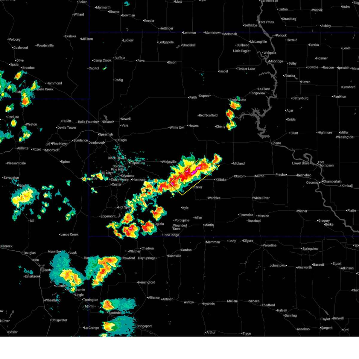
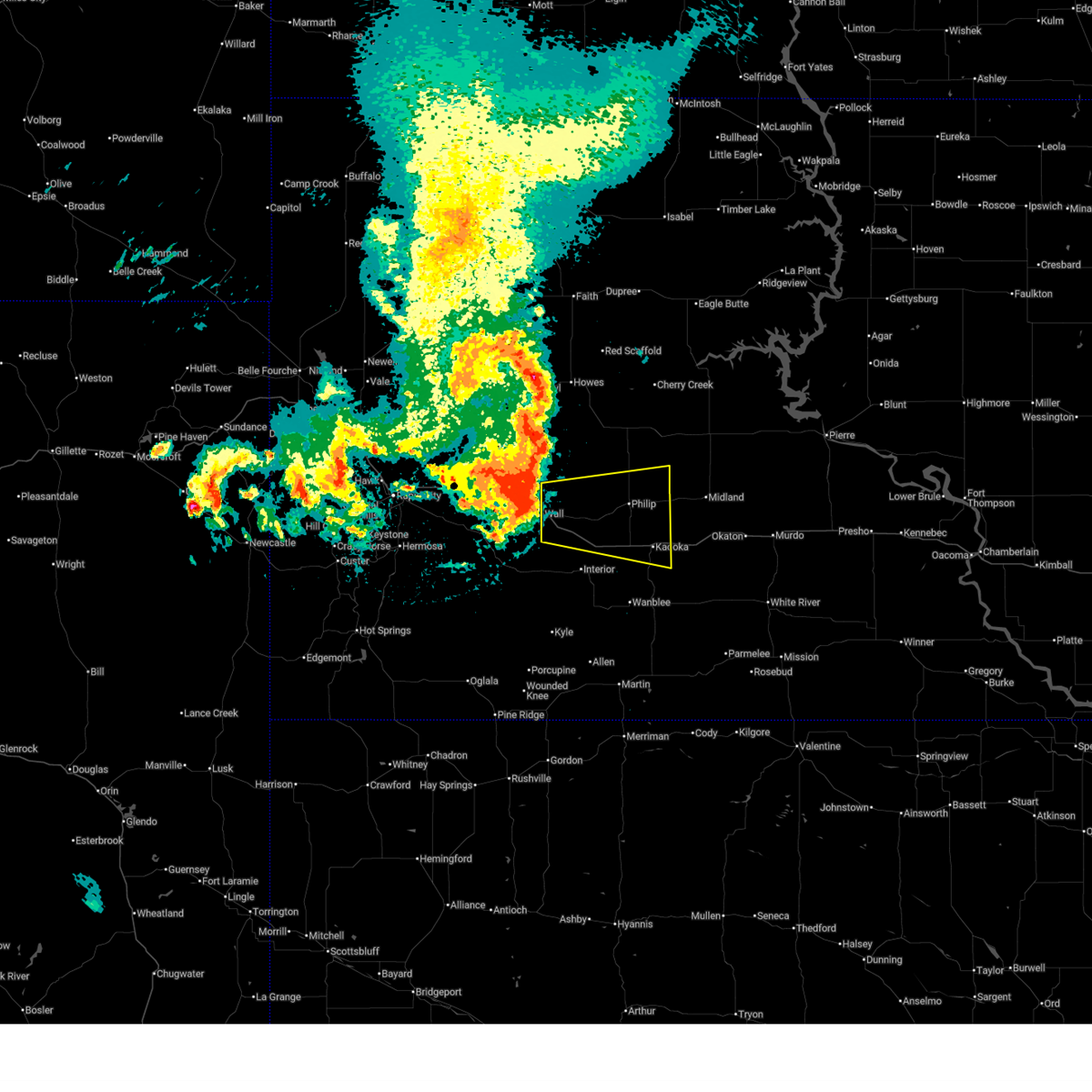
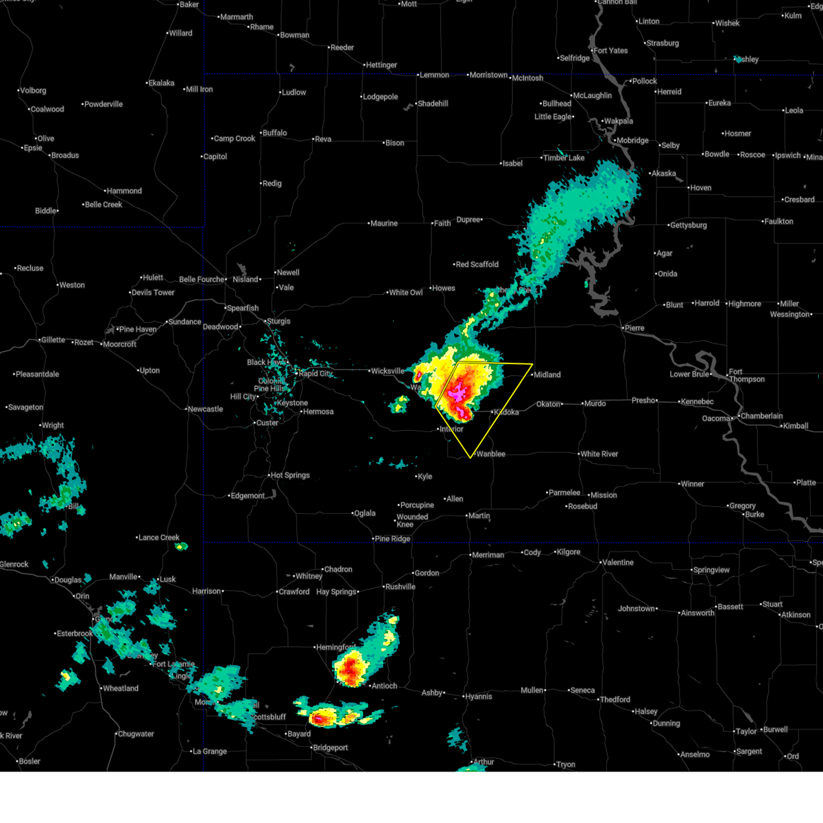
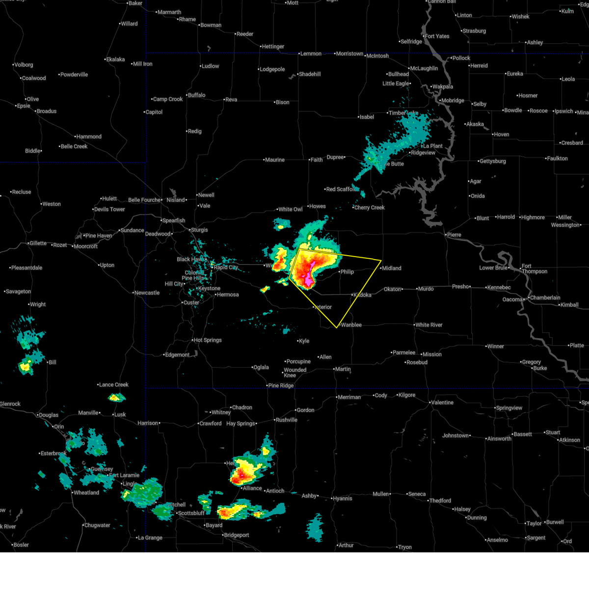
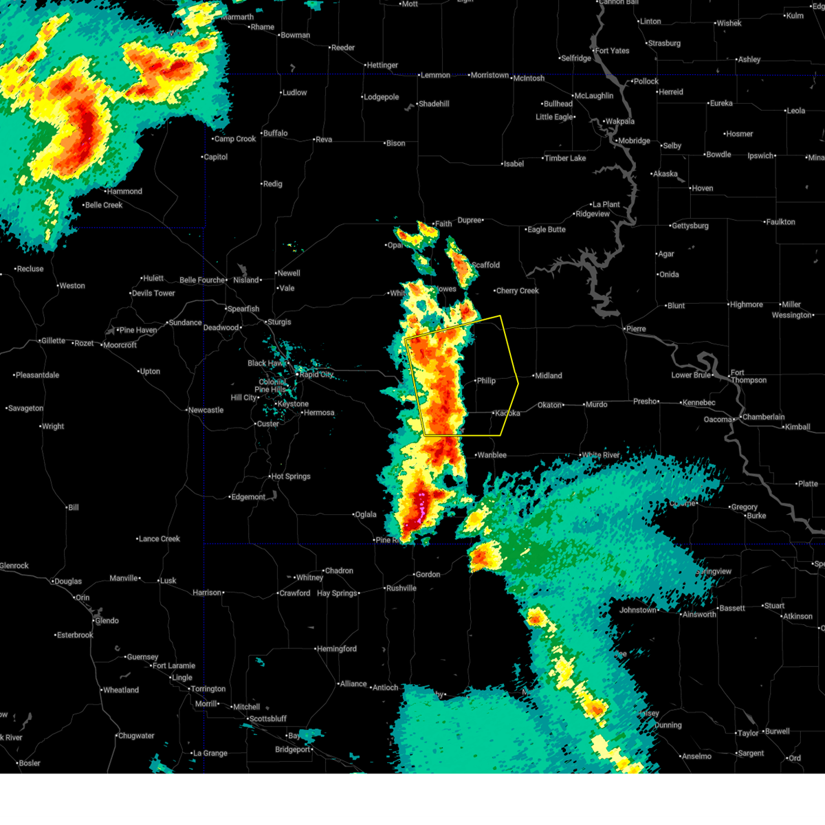
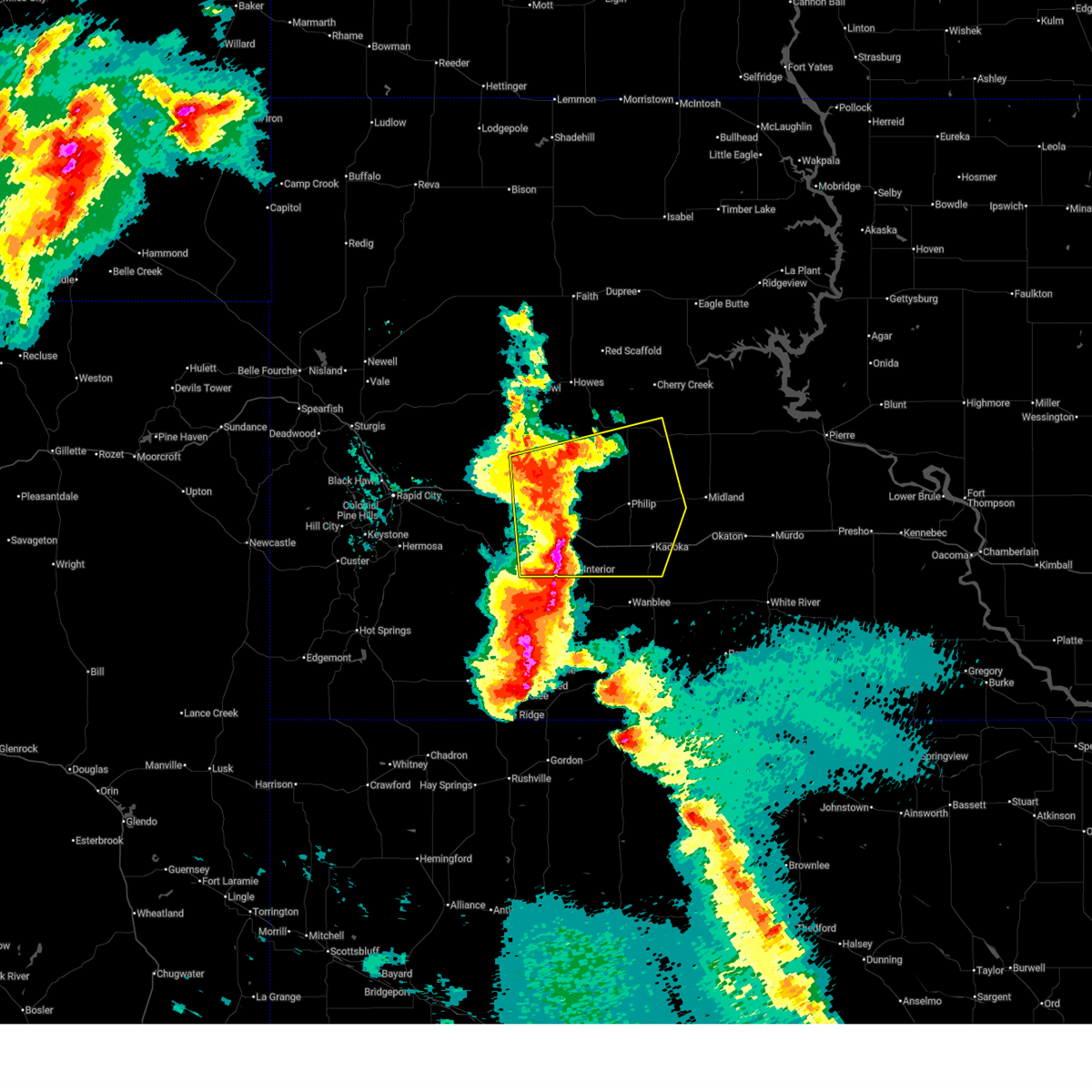
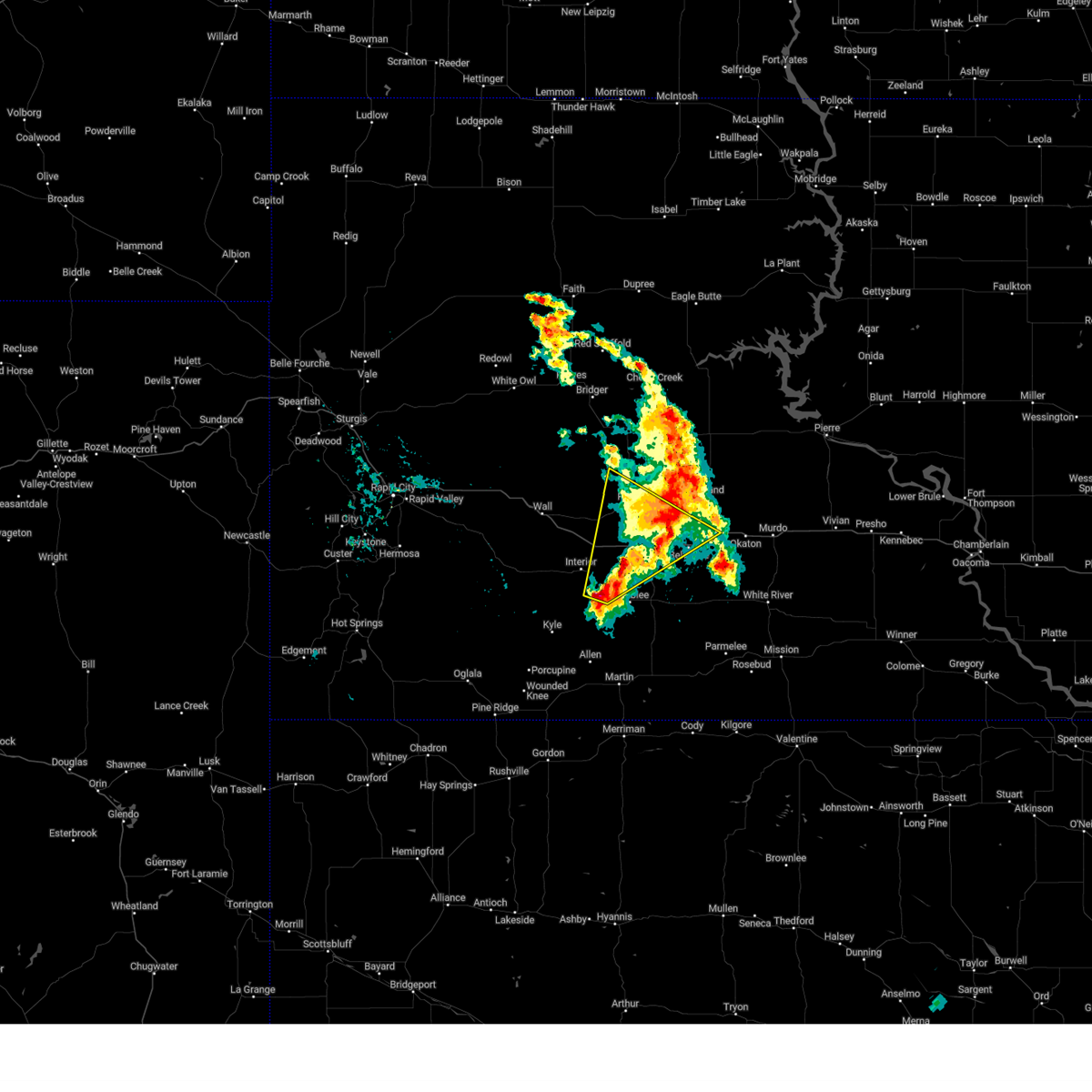
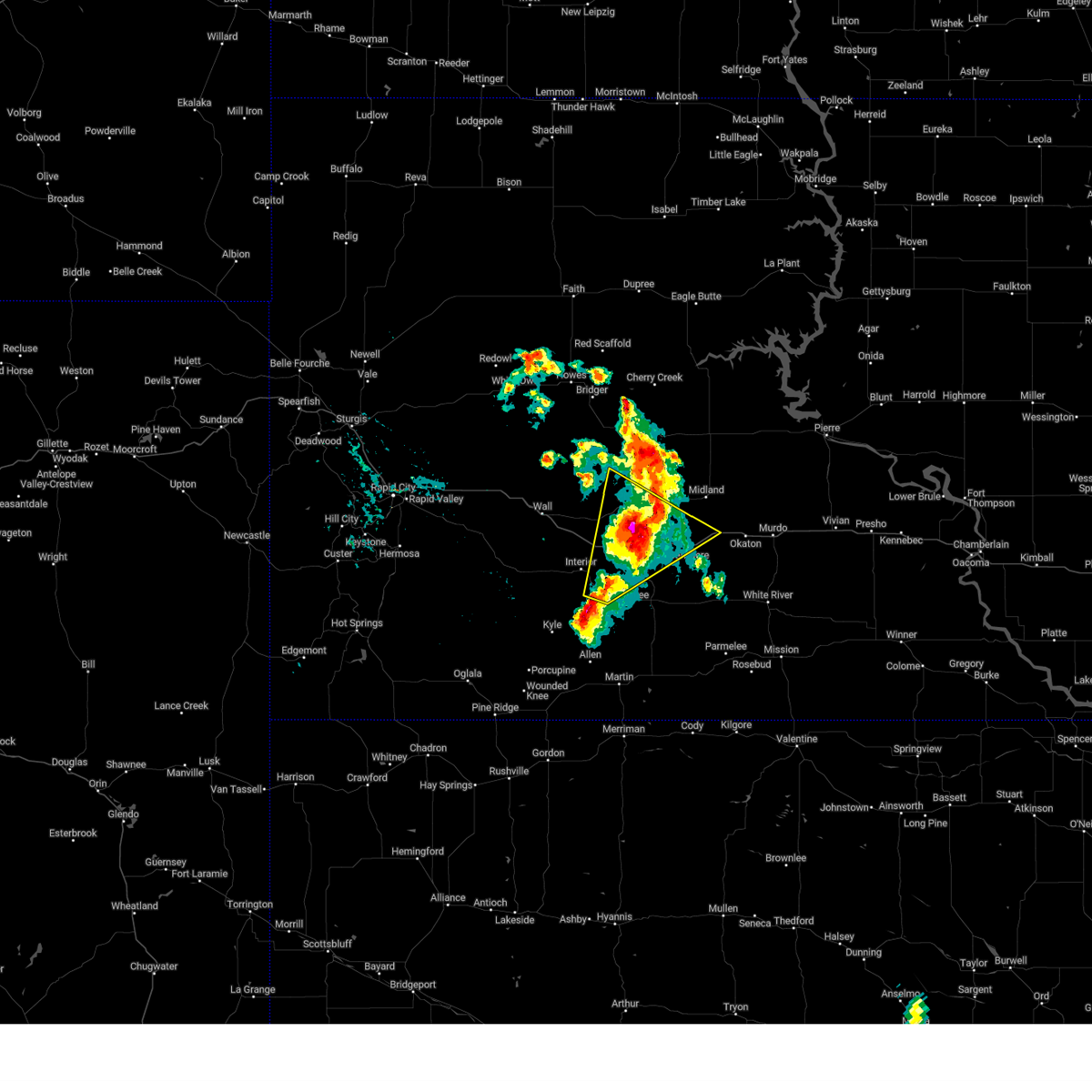
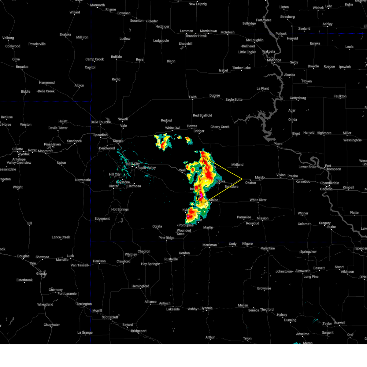
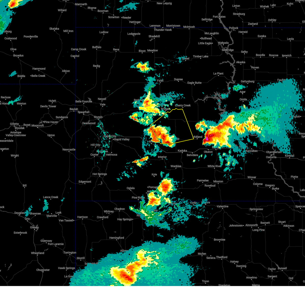
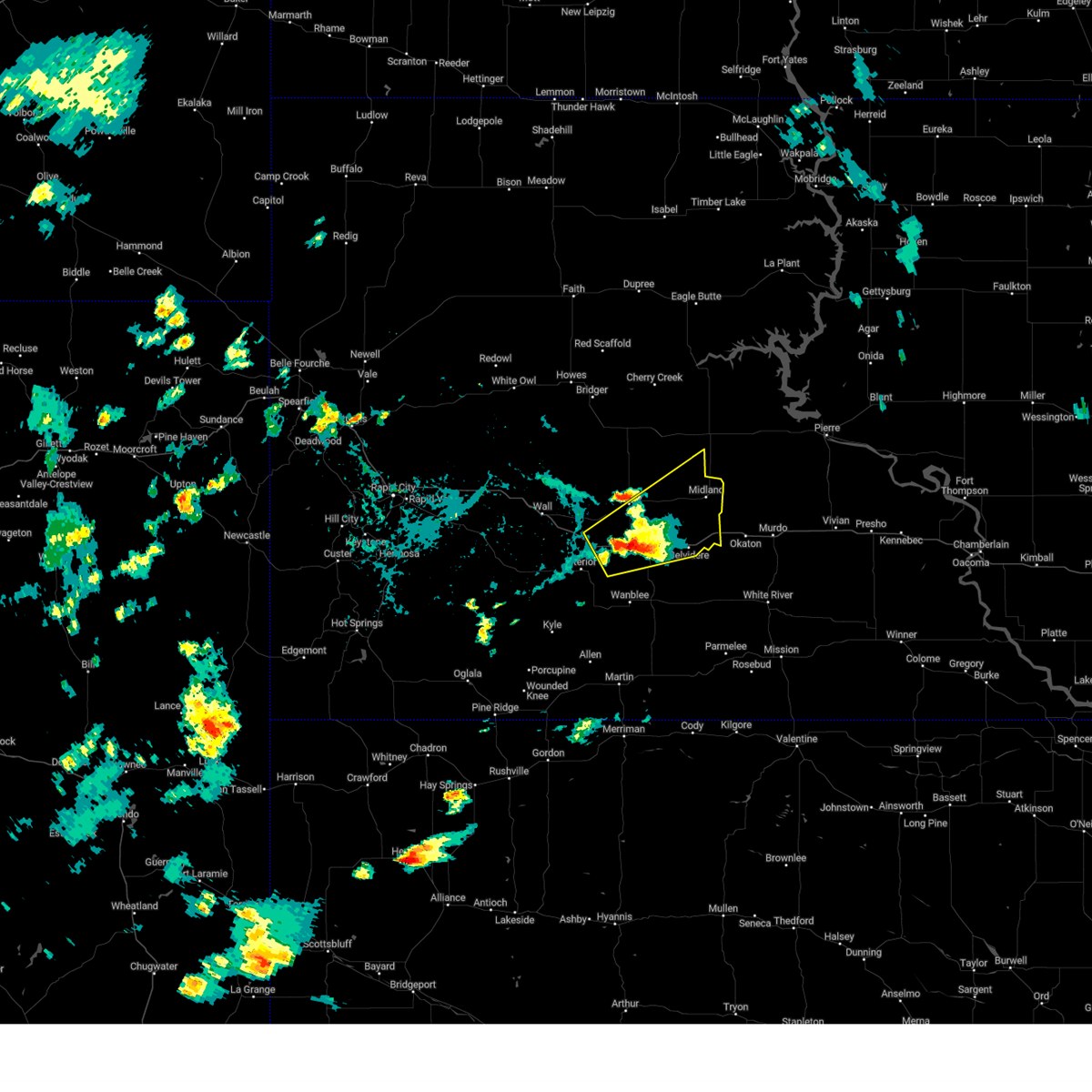
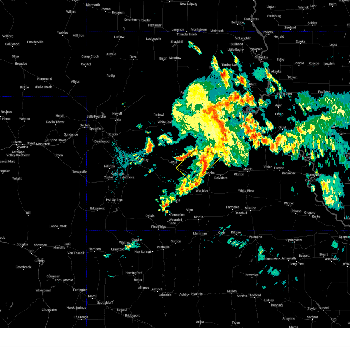
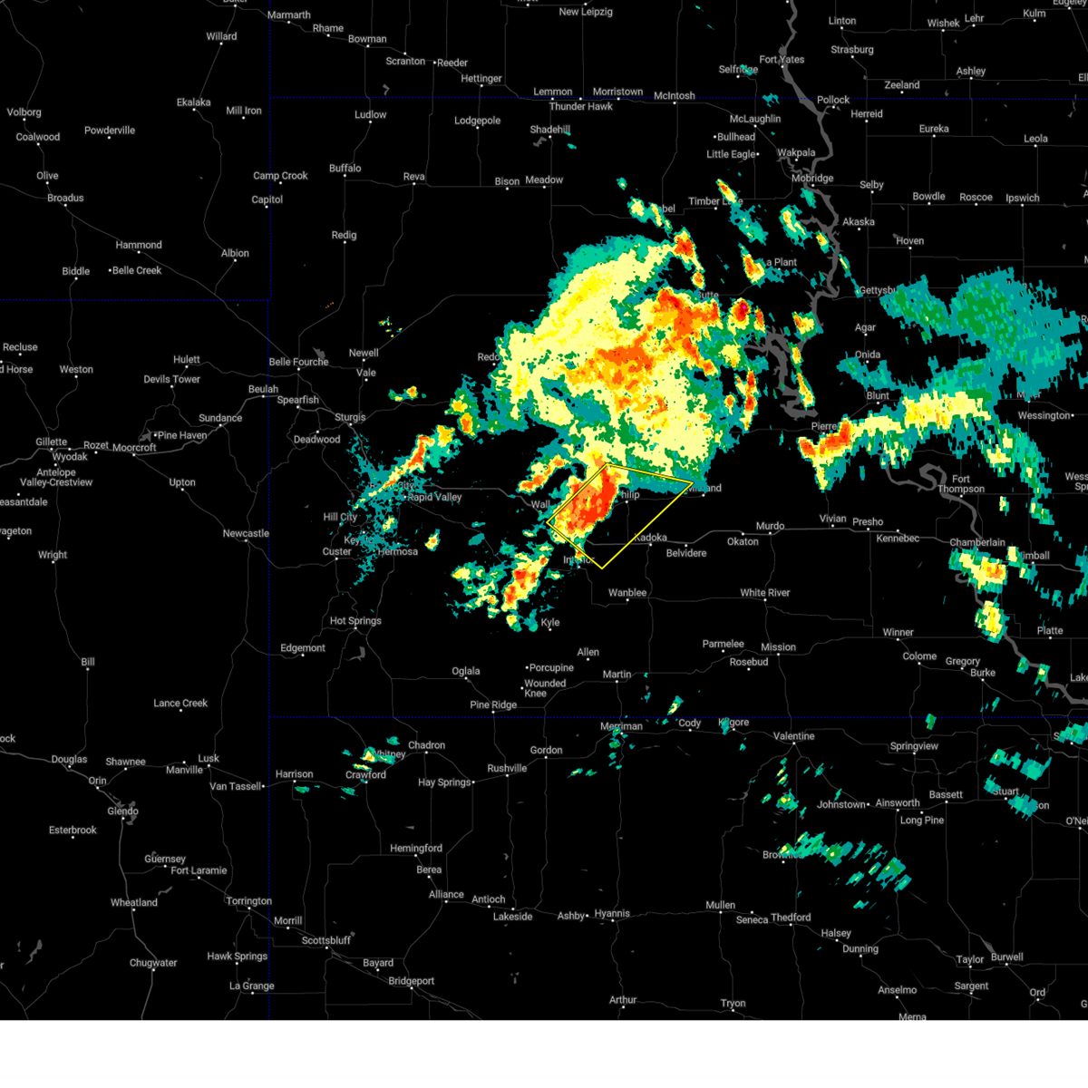
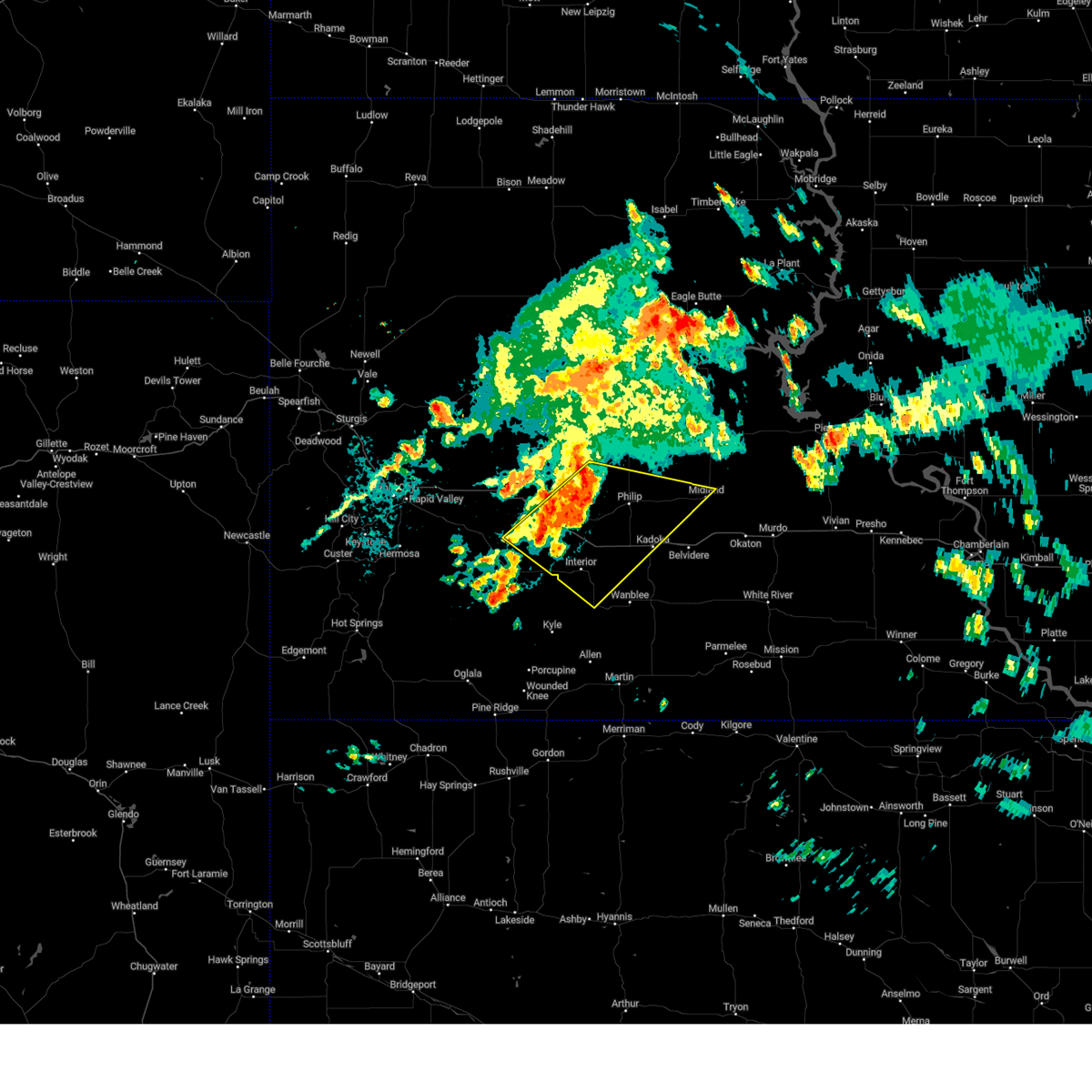
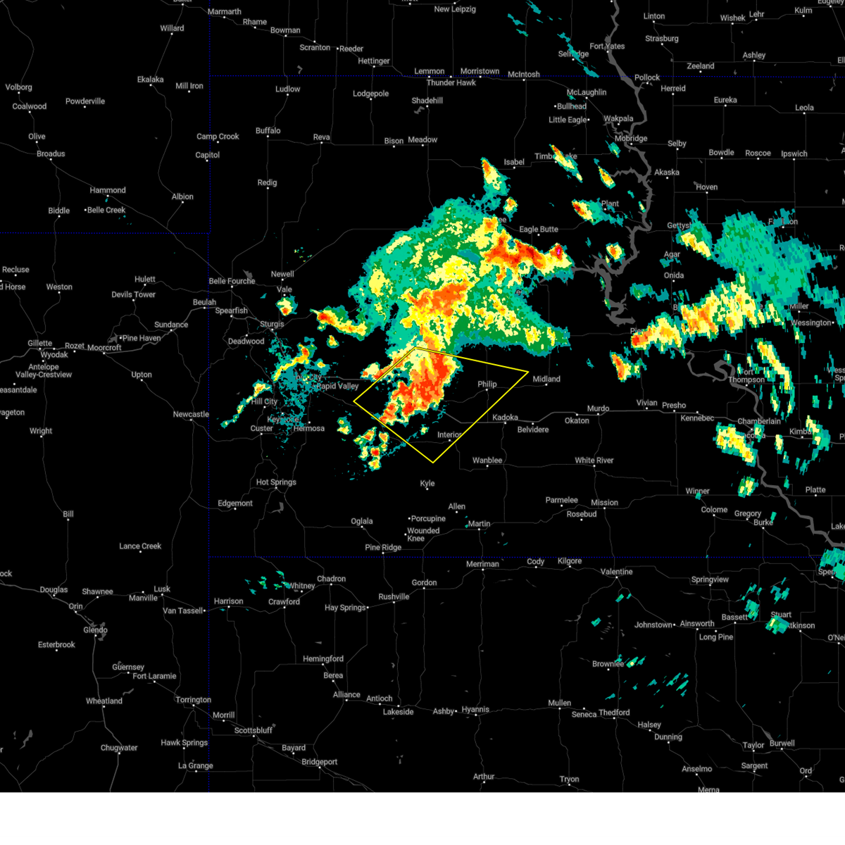
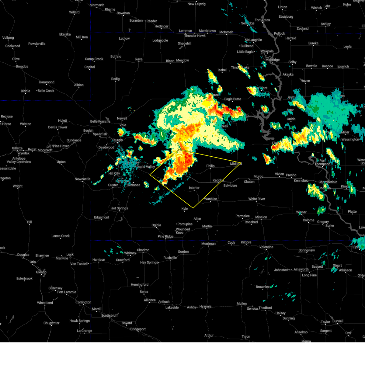
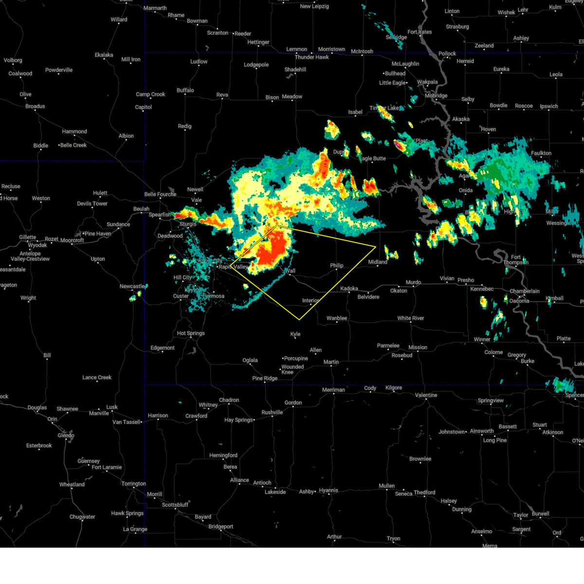
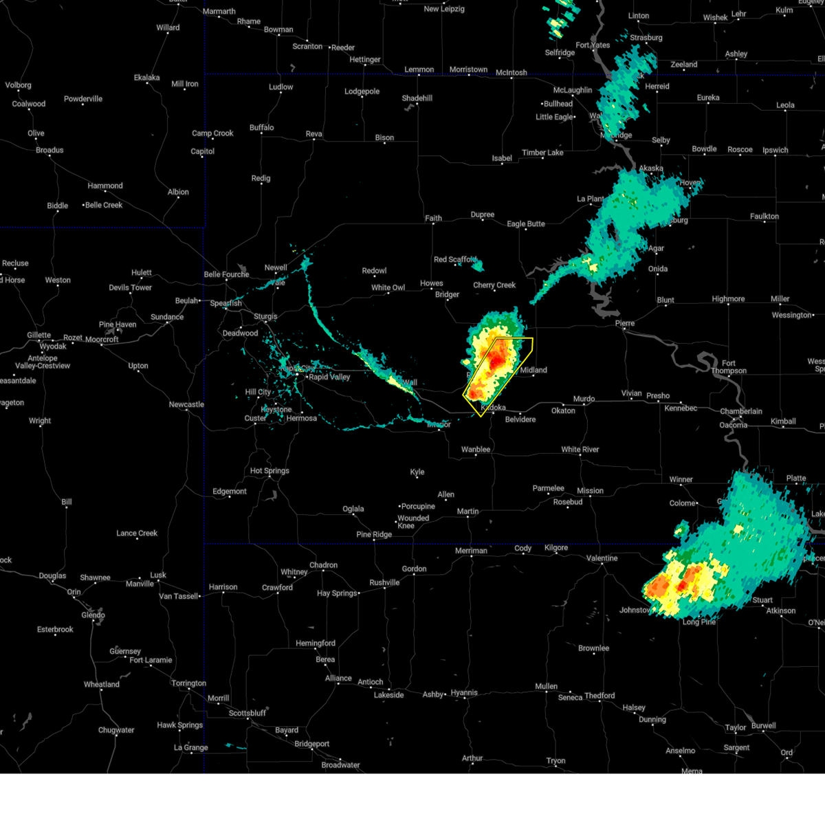
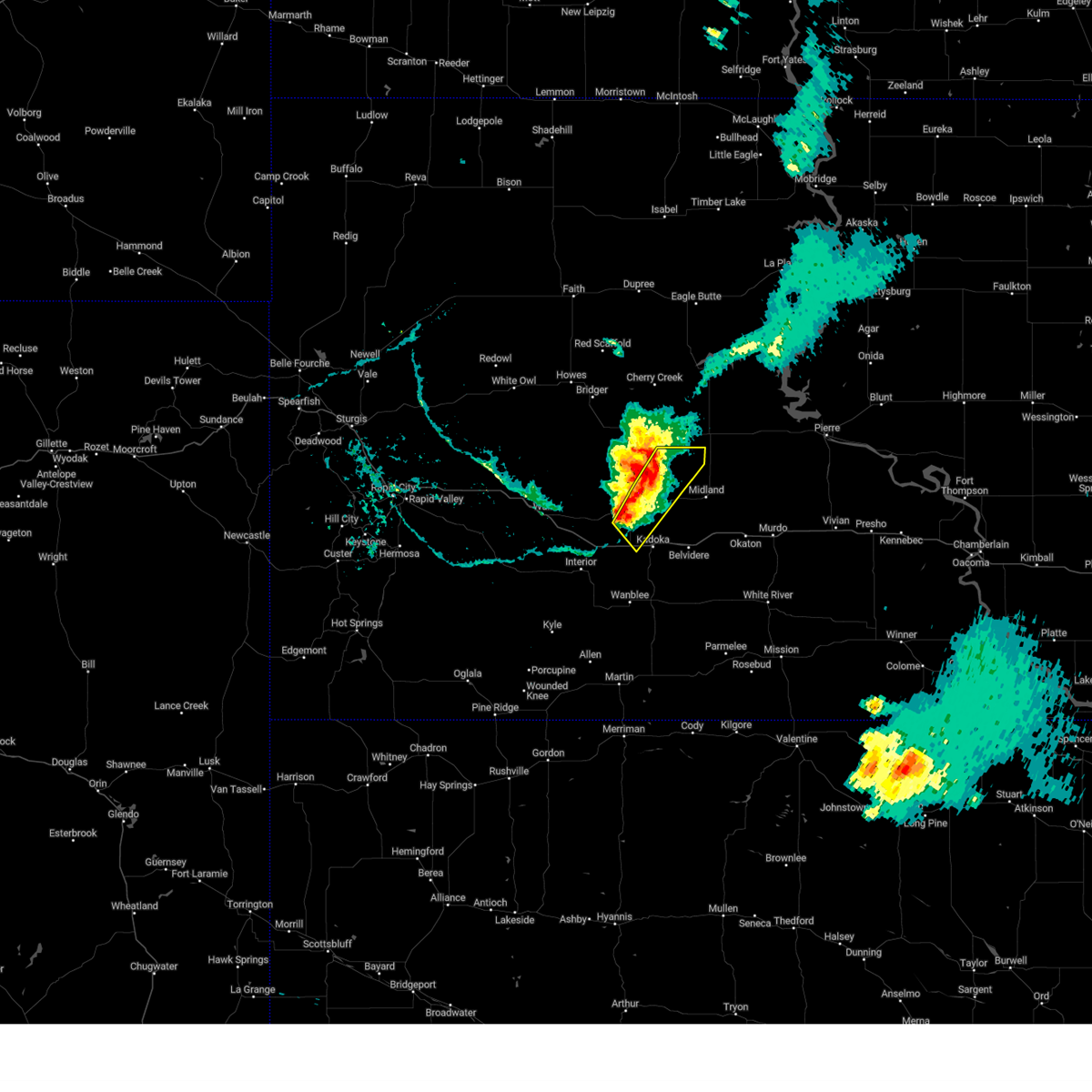
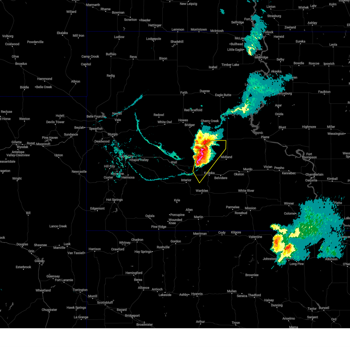
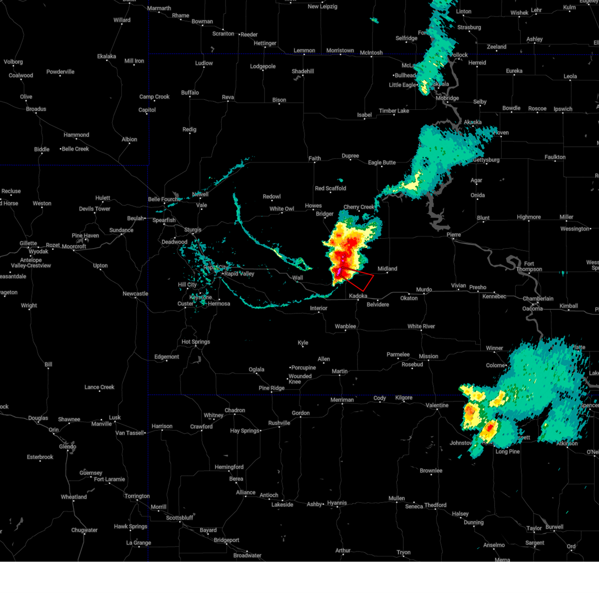
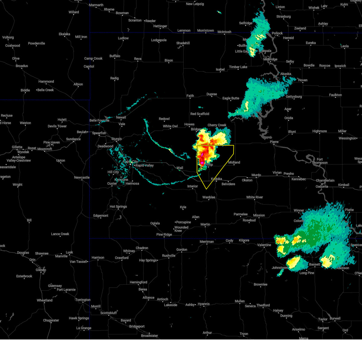
Hail Map for Philip, SD
The Philip, SD area has had 37 reports of on-the-ground hail by trained spotters, and has been under severe weather warnings 37 times during the past 12 months. Doppler radar has detected hail at or near Philip, SD on 66 occasions, including 8 occasions during the past year.
| Name: | Philip, SD |
| Where Located: | 69.2 miles WSW of Pierre, SD |
| Map: | Google Map for Philip, SD |
| Population: | 779 |
| Housing Units: | 423 |
| More Info: | Search Google for Philip, SD |
1
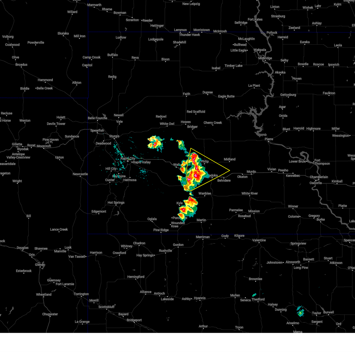
The Top Recent Hail Date for Philip, SD is Tuesday, July 30, 2024 (21st out of 66)

Hail and Wind Damage Spotted near Philip, SD
| Date / Time | Report Details |
|---|---|
| 7/14/2025 4:40 PM MDT |
 Svrunr the national weather service in rapid city has issued a * severe thunderstorm warning for, southwestern haakon county in west central south dakota, northeastern oglala lakota county in southwestern south dakota, northwestern jackson county in southwestern south dakota, southeastern pennington county in west central south dakota, * until 515 pm mdt. * at 440 pm mdt, severe thunderstorms were located along a line extending from 3 miles north of cottonwood to badlands national park, moving southeast at 20 mph (radar indicated). Hazards include 60 mph wind gusts and quarter size hail. Hail damage to vehicles is expected. Expect wind damage to roofs, siding, and trees. Svrunr the national weather service in rapid city has issued a * severe thunderstorm warning for, southwestern haakon county in west central south dakota, northeastern oglala lakota county in southwestern south dakota, northwestern jackson county in southwestern south dakota, southeastern pennington county in west central south dakota, * until 515 pm mdt. * at 440 pm mdt, severe thunderstorms were located along a line extending from 3 miles north of cottonwood to badlands national park, moving southeast at 20 mph (radar indicated). Hazards include 60 mph wind gusts and quarter size hail. Hail damage to vehicles is expected. Expect wind damage to roofs, siding, and trees.
|
| 7/5/2025 10:53 PM MDT |
 Svrunr the national weather service in rapid city has issued a * severe thunderstorm warning for, southeastern haakon county in west central south dakota, northwestern mellette county in south central south dakota, northeastern jackson county in southwestern south dakota, * until 1215 am mdt/115 am cdt/. * at 1053 pm mdt/1153 pm cdt/, a severe thunderstorm was located 7 miles northwest of kadoka, moving east at 30 mph (radar indicated). Hazards include 70 mph wind gusts. Expect considerable tree damage. Damage is likely to mobile homes, roofs, and outbuildings. Svrunr the national weather service in rapid city has issued a * severe thunderstorm warning for, southeastern haakon county in west central south dakota, northwestern mellette county in south central south dakota, northeastern jackson county in southwestern south dakota, * until 1215 am mdt/115 am cdt/. * at 1053 pm mdt/1153 pm cdt/, a severe thunderstorm was located 7 miles northwest of kadoka, moving east at 30 mph (radar indicated). Hazards include 70 mph wind gusts. Expect considerable tree damage. Damage is likely to mobile homes, roofs, and outbuildings.
|
| 7/5/2025 10:40 PM MDT | Storm damage reported in jackson county SD, 15.8 miles NNE of Philip, SD |
| 7/5/2025 10:38 PM MDT |
 At 1038 pm mdt, a severe thunderstorm was located 3 miles south of philip, moving east at 35 mph (radar indicated). Hazards include 70 mph wind gusts. Expect considerable tree damage. damage is likely to mobile homes, roofs, and outbuildings. locations impacted include, philip, kadoka, grindstone, cactus flat, cottonwood, delta 1 launch facility, minuteman missile visitors center, and intersection of highway 73 and white river. This includes interstate 90 in south dakota between mile markers 126 and 156. At 1038 pm mdt, a severe thunderstorm was located 3 miles south of philip, moving east at 35 mph (radar indicated). Hazards include 70 mph wind gusts. Expect considerable tree damage. damage is likely to mobile homes, roofs, and outbuildings. locations impacted include, philip, kadoka, grindstone, cactus flat, cottonwood, delta 1 launch facility, minuteman missile visitors center, and intersection of highway 73 and white river. This includes interstate 90 in south dakota between mile markers 126 and 156.
|
| 7/5/2025 10:30 PM MDT | Storm damage reported in jackson county SD, 10.7 miles ENE of Philip, SD |
| 7/5/2025 10:29 PM MDT |
 the severe thunderstorm warning has been cancelled and is no longer in effect the severe thunderstorm warning has been cancelled and is no longer in effect
|
| 7/5/2025 10:29 PM MDT |
 At 1029 pm mdt, a severe thunderstorm was located 6 miles northeast of cottonwood, or 6 miles southwest of philip, moving east at 35 mph (radar indicated). Hazards include 60 mph wind gusts. Expect damage to roofs, siding, and trees. locations impacted include, philip, kadoka, grindstone, cactus flat, cottonwood, delta 1 launch facility, minuteman missile visitors center, and intersection of highway 73 and white river. This includes interstate 90 in south dakota between mile markers 126 and 156. At 1029 pm mdt, a severe thunderstorm was located 6 miles northeast of cottonwood, or 6 miles southwest of philip, moving east at 35 mph (radar indicated). Hazards include 60 mph wind gusts. Expect damage to roofs, siding, and trees. locations impacted include, philip, kadoka, grindstone, cactus flat, cottonwood, delta 1 launch facility, minuteman missile visitors center, and intersection of highway 73 and white river. This includes interstate 90 in south dakota between mile markers 126 and 156.
|
| 7/5/2025 10:05 PM MDT |
 Svrunr the national weather service in rapid city has issued a * severe thunderstorm warning for, southwestern haakon county in west central south dakota, northwestern jackson county in southwestern south dakota, east central pennington county in west central south dakota, * until 1100 pm mdt. * at 1005 pm mdt, a severe thunderstorm was located near quinn, or 20 miles west of philip, moving east at 35 mph (radar indicated). Hazards include 60 mph wind gusts. expect damage to roofs, siding, and trees Svrunr the national weather service in rapid city has issued a * severe thunderstorm warning for, southwestern haakon county in west central south dakota, northwestern jackson county in southwestern south dakota, east central pennington county in west central south dakota, * until 1100 pm mdt. * at 1005 pm mdt, a severe thunderstorm was located near quinn, or 20 miles west of philip, moving east at 35 mph (radar indicated). Hazards include 60 mph wind gusts. expect damage to roofs, siding, and trees
|
| 7/1/2025 5:25 PM MDT | Half Dollar sized hail reported 20.5 miles NE of Philip, SD |
| 7/1/2025 5:25 PM MDT | Golf Ball sized hail reported 19.1 miles NE of Philip, SD |
| 6/28/2025 6:45 PM MDT | Storm damage reported in jackson county SD, 15.8 miles NNE of Philip, SD |
| 6/28/2025 6:35 PM MDT | Storm damage reported in jackson county SD, 15.8 miles NNE of Philip, SD |
| 6/28/2025 6:34 PM MDT |
 the severe thunderstorm warning has been cancelled and is no longer in effect the severe thunderstorm warning has been cancelled and is no longer in effect
|
| 6/28/2025 6:34 PM MDT |
 At 633 pm mdt, a severe thunderstorm was located 6 miles southeast of cottonwood, or 11 miles southwest of philip, moving southeast at 35 mph (radar indicated). Hazards include tennis ball size hail and 70 mph wind gusts. People and animals outdoors will be injured. expect hail damage to roofs, siding, windows, and vehicles. expect considerable tree damage. wind damage is also likely to mobile homes, roofs, and outbuildings. locations impacted include, philip, kadoka, cactus flat, cottonwood, delta 1 launch facility, nowlin, minuteman missile visitors center, and intersection of highway 73 and white river. This includes interstate 90 in south dakota between mile markers 126 and 155. At 633 pm mdt, a severe thunderstorm was located 6 miles southeast of cottonwood, or 11 miles southwest of philip, moving southeast at 35 mph (radar indicated). Hazards include tennis ball size hail and 70 mph wind gusts. People and animals outdoors will be injured. expect hail damage to roofs, siding, windows, and vehicles. expect considerable tree damage. wind damage is also likely to mobile homes, roofs, and outbuildings. locations impacted include, philip, kadoka, cactus flat, cottonwood, delta 1 launch facility, nowlin, minuteman missile visitors center, and intersection of highway 73 and white river. This includes interstate 90 in south dakota between mile markers 126 and 155.
|
| 6/28/2025 6:30 PM MDT | Storm damage reported in jackson county SD, 15.8 miles NNE of Philip, SD |
| 6/28/2025 6:25 PM MDT | Softball sized hail reported 17.7 miles NE of Philip, SD, took out jackson co. deputy sheriff's windshield on i-90 |
| 6/28/2025 6:25 PM MDT | Storm damage reported in jackson county SD, 15.8 miles NNE of Philip, SD |
| 6/28/2025 6:10 PM MDT |
 Svrunr the national weather service in rapid city has issued a * severe thunderstorm warning for, southern haakon county in west central south dakota, northwestern jackson county in southwestern south dakota, east central pennington county in west central south dakota, * until 715 pm mdt. * at 609 pm mdt, a severe thunderstorm was located 5 miles northeast of quinn, or 18 miles west of philip, moving southeast at 35 mph (radar indicated). Hazards include 70 mph wind gusts and ping pong ball size hail. People and animals outdoors will be injured. expect hail damage to roofs, siding, windows, and vehicles. expect considerable tree damage. Wind damage is also likely to mobile homes, roofs, and outbuildings. Svrunr the national weather service in rapid city has issued a * severe thunderstorm warning for, southern haakon county in west central south dakota, northwestern jackson county in southwestern south dakota, east central pennington county in west central south dakota, * until 715 pm mdt. * at 609 pm mdt, a severe thunderstorm was located 5 miles northeast of quinn, or 18 miles west of philip, moving southeast at 35 mph (radar indicated). Hazards include 70 mph wind gusts and ping pong ball size hail. People and animals outdoors will be injured. expect hail damage to roofs, siding, windows, and vehicles. expect considerable tree damage. Wind damage is also likely to mobile homes, roofs, and outbuildings.
|
| 6/15/2025 10:23 PM MDT | Storm damage reported in jackson county SD, 15.8 miles NNE of Philip, SD |
| 6/15/2025 10:17 PM MDT |
 At 1017 pm mdt, severe thunderstorms were located along a line extending from 5 miles north of grindstone butte to 4 miles southwest of philip to 7 miles east of cedar pass, moving east at 35 mph (radar indicated). Hazards include 70 mph wind gusts. Expect considerable tree damage. damage is likely to mobile homes, roofs, and outbuildings. locations impacted include, philip, kadoka, billsburg, intersection of highway 73 and white river, grindstone butte and nowlin. This includes interstate 90 in south dakota between mile markers 114 and 157. At 1017 pm mdt, severe thunderstorms were located along a line extending from 5 miles north of grindstone butte to 4 miles southwest of philip to 7 miles east of cedar pass, moving east at 35 mph (radar indicated). Hazards include 70 mph wind gusts. Expect considerable tree damage. damage is likely to mobile homes, roofs, and outbuildings. locations impacted include, philip, kadoka, billsburg, intersection of highway 73 and white river, grindstone butte and nowlin. This includes interstate 90 in south dakota between mile markers 114 and 157.
|
| 6/15/2025 10:17 PM MDT |
 the severe thunderstorm warning has been cancelled and is no longer in effect the severe thunderstorm warning has been cancelled and is no longer in effect
|
| 6/15/2025 10:13 PM MDT | Storm damage reported in jackson county SD, 15.8 miles NNE of Philip, SD |
| 6/15/2025 10:00 PM MDT | Storm damage reported in jackson county SD, 10.7 miles ENE of Philip, SD |
| 6/15/2025 9:56 PM MDT |
 Svrunr the national weather service in rapid city has issued a * severe thunderstorm warning for, southwestern haakon county in west central south dakota, southeastern meade county in west central south dakota, northwestern jackson county in southwestern south dakota, southeastern pennington county in west central south dakota, * until 1045 pm mdt. * at 956 pm mdt, severe thunderstorms were located along a line extending from 8 miles east of creighton to 2 miles northwest of cottonwood to 4 miles west of interior, moving east at 40 mph (radar indicated). Hazards include 70 mph wind gusts. Expect considerable tree damage. damage is likely to mobile homes, roofs, and outbuildings. severe thunderstorms will be near, philip, interior, cactus flat, cedar pass, grindstone, cottonwood, delta 1 launch facility, minuteman missile visitors center, eastern badlands national park, and grindstone butte around 1000 pm mdt. billsburg around 1010 pm mdt. kadoka and intersection of highway 73 and white river around 1015 pm mdt. nowlin around 1025 pm mdt. This includes interstate 90 in south dakota between mile markers 99 and 157. Svrunr the national weather service in rapid city has issued a * severe thunderstorm warning for, southwestern haakon county in west central south dakota, southeastern meade county in west central south dakota, northwestern jackson county in southwestern south dakota, southeastern pennington county in west central south dakota, * until 1045 pm mdt. * at 956 pm mdt, severe thunderstorms were located along a line extending from 8 miles east of creighton to 2 miles northwest of cottonwood to 4 miles west of interior, moving east at 40 mph (radar indicated). Hazards include 70 mph wind gusts. Expect considerable tree damage. damage is likely to mobile homes, roofs, and outbuildings. severe thunderstorms will be near, philip, interior, cactus flat, cedar pass, grindstone, cottonwood, delta 1 launch facility, minuteman missile visitors center, eastern badlands national park, and grindstone butte around 1000 pm mdt. billsburg around 1010 pm mdt. kadoka and intersection of highway 73 and white river around 1015 pm mdt. nowlin around 1025 pm mdt. This includes interstate 90 in south dakota between mile markers 99 and 157.
|
| 9/16/2024 1:20 AM MDT | Storm damage reported in jackson county SD, 10.7 miles ENE of Philip, SD |
| 9/16/2024 12:58 AM MDT | Storm damage reported in jackson county SD, 15.8 miles NNE of Philip, SD |
| 9/14/2024 1:15 PM MDT |
 The storm which prompted the warning has weakened below severe limits, and no longer poses an immediate threat to life or property. therefore, the warning has been allowed to expire. however, gusty winds are still possible with this thunderstorm. The storm which prompted the warning has weakened below severe limits, and no longer poses an immediate threat to life or property. therefore, the warning has been allowed to expire. however, gusty winds are still possible with this thunderstorm.
|
| 9/14/2024 1:02 PM MDT |
 At 101 pm mdt, a severe thunderstorm was located 6 miles southwest of nowlin, or 12 miles northeast of kadoka, moving northeast at 45 mph (radar indicated). Hazards include 60 mph wind gusts and penny size hail. Expect damage to roofs, siding, and trees. this severe thunderstorm will remain over mainly rural areas of southwestern haakon and northern jackson counties. This includes interstate 90 in south dakota between mile markers 132 and 174. At 101 pm mdt, a severe thunderstorm was located 6 miles southwest of nowlin, or 12 miles northeast of kadoka, moving northeast at 45 mph (radar indicated). Hazards include 60 mph wind gusts and penny size hail. Expect damage to roofs, siding, and trees. this severe thunderstorm will remain over mainly rural areas of southwestern haakon and northern jackson counties. This includes interstate 90 in south dakota between mile markers 132 and 174.
|
| 9/14/2024 12:26 PM MDT |
 Svrunr the national weather service in rapid city has issued a * severe thunderstorm warning for, southwestern haakon county in west central south dakota, northern jackson county in southwestern south dakota, * until 115 pm mdt. * at 1225 pm mdt, a severe thunderstorm was located 7 miles east of cedar pass, or 16 miles southwest of kadoka, moving northeast at 45 mph (radar indicated). Hazards include 60 mph wind gusts and quarter size hail. Hail damage to vehicles is expected. expect wind damage to roofs, siding, and trees. this severe thunderstorm will be near, cactus flat and minuteman missile visitors center around 1230 pm mdt. kadoka around 1235 pm mdt. philip around 1240 pm mdt. This includes interstate 90 in south dakota between mile markers 132 and 174. Svrunr the national weather service in rapid city has issued a * severe thunderstorm warning for, southwestern haakon county in west central south dakota, northern jackson county in southwestern south dakota, * until 115 pm mdt. * at 1225 pm mdt, a severe thunderstorm was located 7 miles east of cedar pass, or 16 miles southwest of kadoka, moving northeast at 45 mph (radar indicated). Hazards include 60 mph wind gusts and quarter size hail. Hail damage to vehicles is expected. expect wind damage to roofs, siding, and trees. this severe thunderstorm will be near, cactus flat and minuteman missile visitors center around 1230 pm mdt. kadoka around 1235 pm mdt. philip around 1240 pm mdt. This includes interstate 90 in south dakota between mile markers 132 and 174.
|
| 9/14/2024 12:16 PM MDT |
 At 1215 pm mdt, a severe thunderstorm was located 5 miles west of philip, moving northeast at 35 mph (radar indicated. around 12 pm, 60 mph winds were reported near cactus flat by an observer and a weather station). Hazards include 60 mph wind gusts and penny size hail. Expect damage to roofs, siding, and trees. locations impacted include, philip, grindstone and grindstone butte. This includes interstate 90 in south dakota between mile markers 124 and 157. At 1215 pm mdt, a severe thunderstorm was located 5 miles west of philip, moving northeast at 35 mph (radar indicated. around 12 pm, 60 mph winds were reported near cactus flat by an observer and a weather station). Hazards include 60 mph wind gusts and penny size hail. Expect damage to roofs, siding, and trees. locations impacted include, philip, grindstone and grindstone butte. This includes interstate 90 in south dakota between mile markers 124 and 157.
|
| 9/14/2024 12:03 PM MDT | Storm damage reported in jackson county SD, 15.8 miles NNE of Philip, SD |
| 9/14/2024 12:00 PM MDT | Pea sized hail in jackson county SD, 18 miles NE of Philip, SD |
| 9/14/2024 11:52 AM MDT |
 Svrunr the national weather service in rapid city has issued a * severe thunderstorm warning for, southwestern haakon county in west central south dakota, northern jackson county in southwestern south dakota, * until 1230 pm mdt. * at 1151 am mdt, a severe thunderstorm was located over minuteman missile visitors center, or 17 miles southwest of philip, moving northeast at 35 mph (radar indicated). Hazards include 60 mph wind gusts and quarter size hail. Hail damage to vehicles is expected. expect wind damage to roofs, siding, and trees. this severe thunderstorm will be near, cottonwood around 1155 am mdt. philip around 1200 pm mdt. grindstone around 1215 pm mdt. This includes interstate 90 in south dakota between mile markers 124 and 157. Svrunr the national weather service in rapid city has issued a * severe thunderstorm warning for, southwestern haakon county in west central south dakota, northern jackson county in southwestern south dakota, * until 1230 pm mdt. * at 1151 am mdt, a severe thunderstorm was located over minuteman missile visitors center, or 17 miles southwest of philip, moving northeast at 35 mph (radar indicated). Hazards include 60 mph wind gusts and quarter size hail. Hail damage to vehicles is expected. expect wind damage to roofs, siding, and trees. this severe thunderstorm will be near, cottonwood around 1155 am mdt. philip around 1200 pm mdt. grindstone around 1215 pm mdt. This includes interstate 90 in south dakota between mile markers 124 and 157.
|
| 8/21/2024 8:11 PM MDT |
 the severe thunderstorm warning has been cancelled and is no longer in effect the severe thunderstorm warning has been cancelled and is no longer in effect
|
| 8/21/2024 8:11 PM MDT |
 At 810 pm mdt, a severe thunderstorm was located 4 miles west of milesville, or 27 miles north of philip, moving northeast at 50 mph (radar indicated). Hazards include 70 mph wind gusts and quarter size hail. Hail damage to vehicles is expected. expect considerable tree damage. wind damage is also likely to mobile homes, roofs, and outbuildings. Locations impacted include, milesville and billsburg. At 810 pm mdt, a severe thunderstorm was located 4 miles west of milesville, or 27 miles north of philip, moving northeast at 50 mph (radar indicated). Hazards include 70 mph wind gusts and quarter size hail. Hail damage to vehicles is expected. expect considerable tree damage. wind damage is also likely to mobile homes, roofs, and outbuildings. Locations impacted include, milesville and billsburg.
|
| 8/21/2024 7:50 PM MDT |
 Svrunr the national weather service in rapid city has issued a * severe thunderstorm warning for, haakon county in west central south dakota, east central pennington county in west central south dakota, * until 845 pm mdt. * at 750 pm mdt, severe thunderstorms were located along a line extending from 7 miles northeast of creighton to 2 miles southeast of cottonwood, moving northeast at 35 mph (radar indicated). Hazards include 60 mph wind gusts and quarter size hail. Hail damage to vehicles is expected. expect wind damage to roofs, siding, and trees. severe thunderstorms will be near, philip and grindstone butte around 755 pm mdt. billsburg around 805 pm mdt. Milesville around 810 pm mdt. Svrunr the national weather service in rapid city has issued a * severe thunderstorm warning for, haakon county in west central south dakota, east central pennington county in west central south dakota, * until 845 pm mdt. * at 750 pm mdt, severe thunderstorms were located along a line extending from 7 miles northeast of creighton to 2 miles southeast of cottonwood, moving northeast at 35 mph (radar indicated). Hazards include 60 mph wind gusts and quarter size hail. Hail damage to vehicles is expected. expect wind damage to roofs, siding, and trees. severe thunderstorms will be near, philip and grindstone butte around 755 pm mdt. billsburg around 805 pm mdt. Milesville around 810 pm mdt.
|
| 8/21/2024 4:03 PM MDT |
 Svrunr the national weather service in rapid city has issued a * severe thunderstorm warning for, southeastern haakon county in west central south dakota, northern jackson county in southwestern south dakota, * until 515 pm mdt. * at 403 pm mdt, a severe thunderstorm was located 3 miles northwest of kadoka, moving northeast at 40 mph (radar indicated). Hazards include 60 mph wind gusts and half dollar size hail. Hail damage to vehicles is expected. Expect wind damage to roofs, siding, and trees. Svrunr the national weather service in rapid city has issued a * severe thunderstorm warning for, southeastern haakon county in west central south dakota, northern jackson county in southwestern south dakota, * until 515 pm mdt. * at 403 pm mdt, a severe thunderstorm was located 3 miles northwest of kadoka, moving northeast at 40 mph (radar indicated). Hazards include 60 mph wind gusts and half dollar size hail. Hail damage to vehicles is expected. Expect wind damage to roofs, siding, and trees.
|
| 8/20/2024 12:45 AM MDT |
 The storms which prompted the warning have weakened below severe limits, and no longer pose an immediate threat to life or property. therefore, the warning has been allowed to expire. however, gusty winds and heavy rain are still possible with these thunderstorms. The storms which prompted the warning have weakened below severe limits, and no longer pose an immediate threat to life or property. therefore, the warning has been allowed to expire. however, gusty winds and heavy rain are still possible with these thunderstorms.
|
| 8/20/2024 12:14 AM MDT |
 At 1213 am mdt, severe thunderstorms were located along a line extending from 4 miles north of philip to near minuteman missile visitors center, moving east at 35 mph (radar indicated). Hazards include 60 mph wind gusts. Expect damage to roofs, siding, and trees. locations impacted include, philip, quinn, cactus flat, cottonwood, delta 1 launch facility, delta 9 missile silo, minuteman missile visitors center, and grindstone butte. This includes interstate 90 in south dakota between mile markers 116 and 143. At 1213 am mdt, severe thunderstorms were located along a line extending from 4 miles north of philip to near minuteman missile visitors center, moving east at 35 mph (radar indicated). Hazards include 60 mph wind gusts. Expect damage to roofs, siding, and trees. locations impacted include, philip, quinn, cactus flat, cottonwood, delta 1 launch facility, delta 9 missile silo, minuteman missile visitors center, and grindstone butte. This includes interstate 90 in south dakota between mile markers 116 and 143.
|
| 8/20/2024 12:01 AM MDT |
 the severe thunderstorm warning has been cancelled and is no longer in effect the severe thunderstorm warning has been cancelled and is no longer in effect
|
| 8/20/2024 12:01 AM MDT |
 At 1200 am mdt, severe thunderstorms were located along a line extending from 5 miles northwest of philip to 8 miles south of pinnacles ranger station, moving southeast at 30 mph (radar indicated). Hazards include 60 mph wind gusts and penny size hail. Expect damage to roofs, siding, and trees. locations impacted include, philip, kadoka, wall, midland, interior, quinn, grindstone, cactus flat, cedar pass, cottonwood, delta 9 missile silo, minuteman missile visitors center, grindstone butte, pinnacles ranger station, delta 1 launch facility, nowlin, and northeastern badlands national park. This includes interstate 90 in south dakota between mile markers 108 and 153. At 1200 am mdt, severe thunderstorms were located along a line extending from 5 miles northwest of philip to 8 miles south of pinnacles ranger station, moving southeast at 30 mph (radar indicated). Hazards include 60 mph wind gusts and penny size hail. Expect damage to roofs, siding, and trees. locations impacted include, philip, kadoka, wall, midland, interior, quinn, grindstone, cactus flat, cedar pass, cottonwood, delta 9 missile silo, minuteman missile visitors center, grindstone butte, pinnacles ranger station, delta 1 launch facility, nowlin, and northeastern badlands national park. This includes interstate 90 in south dakota between mile markers 108 and 153.
|
| 8/19/2024 11:46 PM MDT |
 At 1146 pm mdt, severe thunderstorms were located along a line extending from 5 miles northwest of grindstone butte to 5 miles northwest of pinnacles ranger station, moving east at 30 mph (radar indicated). Hazards include 60 mph wind gusts and penny size hail. Expect damage to roofs, siding, and trees. locations impacted include, philip, wall, interior, wasta, quinn, owanka, grindstone, cactus flat, cedar pass, creighton, wicksville, cottonwood, delta 9 missile silo, minuteman missile visitors center, grindstone butte, pinnacles ranger station, delta 1 launch facility, and northeastern badlands national park. This includes interstate 90 in south dakota between mile markers 90 and 137. At 1146 pm mdt, severe thunderstorms were located along a line extending from 5 miles northwest of grindstone butte to 5 miles northwest of pinnacles ranger station, moving east at 30 mph (radar indicated). Hazards include 60 mph wind gusts and penny size hail. Expect damage to roofs, siding, and trees. locations impacted include, philip, wall, interior, wasta, quinn, owanka, grindstone, cactus flat, cedar pass, creighton, wicksville, cottonwood, delta 9 missile silo, minuteman missile visitors center, grindstone butte, pinnacles ranger station, delta 1 launch facility, and northeastern badlands national park. This includes interstate 90 in south dakota between mile markers 90 and 137.
|
| 8/19/2024 11:43 PM MDT |
 Svrunr the national weather service in rapid city has issued a * severe thunderstorm warning for, southern haakon county in west central south dakota, southeastern meade county in west central south dakota, northeastern oglala lakota county in southwestern south dakota, northwestern jackson county in southwestern south dakota, southeastern pennington county in west central south dakota, * until 1245 am mdt. * at 1142 pm mdt, severe thunderstorms were located along a line extending from 2 miles east of grindstone to badlands national park, moving southeast at 30 mph (radar indicated). Hazards include 60 mph wind gusts and penny size hail. expect damage to roofs, siding, and trees Svrunr the national weather service in rapid city has issued a * severe thunderstorm warning for, southern haakon county in west central south dakota, southeastern meade county in west central south dakota, northeastern oglala lakota county in southwestern south dakota, northwestern jackson county in southwestern south dakota, southeastern pennington county in west central south dakota, * until 1245 am mdt. * at 1142 pm mdt, severe thunderstorms were located along a line extending from 2 miles east of grindstone to badlands national park, moving southeast at 30 mph (radar indicated). Hazards include 60 mph wind gusts and penny size hail. expect damage to roofs, siding, and trees
|
| 8/19/2024 11:16 PM MDT |
 Svrunr the national weather service in rapid city has issued a * severe thunderstorm warning for, southern haakon county in west central south dakota, southeastern meade county in west central south dakota, northeastern oglala lakota county in southwestern south dakota, northwestern jackson county in southwestern south dakota, eastern pennington county in west central south dakota, * until 1215 am mdt. * at 1116 pm mdt, severe thunderstorms were located along a line extending from 2 miles northeast of creighton to 3 miles south of owanka, moving east at 30 mph (radar indicated). Hazards include 60 mph wind gusts and penny size hail. expect damage to roofs, siding, and trees Svrunr the national weather service in rapid city has issued a * severe thunderstorm warning for, southern haakon county in west central south dakota, southeastern meade county in west central south dakota, northeastern oglala lakota county in southwestern south dakota, northwestern jackson county in southwestern south dakota, eastern pennington county in west central south dakota, * until 1215 am mdt. * at 1116 pm mdt, severe thunderstorms were located along a line extending from 2 miles northeast of creighton to 3 miles south of owanka, moving east at 30 mph (radar indicated). Hazards include 60 mph wind gusts and penny size hail. expect damage to roofs, siding, and trees
|
| 7/30/2024 7:16 PM MDT |
 the severe thunderstorm warning has been cancelled and is no longer in effect the severe thunderstorm warning has been cancelled and is no longer in effect
|
| 7/30/2024 7:08 PM MDT |
 At 707 pm mdt, severe thunderstorms were located along a line extending from 4 miles west of ottumwa to 8 miles west of nowlin to 6 miles south of philip, moving east at 20 mph (radar indicated). Hazards include 60 mph wind gusts and penny size hail. Expect damage to roofs, siding, and trees. locations impacted include, philip and ottumwa. This includes interstate 90 in south dakota between mile markers 144 and 146. At 707 pm mdt, severe thunderstorms were located along a line extending from 4 miles west of ottumwa to 8 miles west of nowlin to 6 miles south of philip, moving east at 20 mph (radar indicated). Hazards include 60 mph wind gusts and penny size hail. Expect damage to roofs, siding, and trees. locations impacted include, philip and ottumwa. This includes interstate 90 in south dakota between mile markers 144 and 146.
|
| 7/30/2024 6:56 PM MDT | Storm damage reported in haakon county SD, 3.4 miles WSW of Philip, SD |
| 7/30/2024 6:55 PM MDT |
 At 655 pm mdt, severe thunderstorms were located along a line extending from 8 miles west of ottumwa to 5 miles northeast of philip to 8 miles east of cottonwood, moving southeast at 25 mph (radar indicated). Hazards include golf ball size hail and 70 mph wind gusts. People and animals outdoors will be injured. expect hail damage to roofs, siding, windows, and vehicles. expect considerable tree damage. wind damage is also likely to mobile homes, roofs, and outbuildings. locations impacted include, philip and ottumwa. This includes interstate 90 in south dakota between mile markers 137 and 146. At 655 pm mdt, severe thunderstorms were located along a line extending from 8 miles west of ottumwa to 5 miles northeast of philip to 8 miles east of cottonwood, moving southeast at 25 mph (radar indicated). Hazards include golf ball size hail and 70 mph wind gusts. People and animals outdoors will be injured. expect hail damage to roofs, siding, windows, and vehicles. expect considerable tree damage. wind damage is also likely to mobile homes, roofs, and outbuildings. locations impacted include, philip and ottumwa. This includes interstate 90 in south dakota between mile markers 137 and 146.
|
| 7/30/2024 6:52 PM MDT |
 the tornado warning has been cancelled and is no longer in effect the tornado warning has been cancelled and is no longer in effect
|
| 7/30/2024 6:45 PM MDT |
 At 645 pm mdt, a severe thunderstorm capable of producing a tornado was located 3 miles northwest of philip, moving southeast at 30 mph (radar indicated rotation). Hazards include tornado and two inch hail. Flying debris will be dangerous to those caught without shelter. mobile homes will be damaged or destroyed. damage to roofs, windows, and vehicles will occur. tree damage is likely. This dangerous storm will be near, philip around 650 pm mdt. At 645 pm mdt, a severe thunderstorm capable of producing a tornado was located 3 miles northwest of philip, moving southeast at 30 mph (radar indicated rotation). Hazards include tornado and two inch hail. Flying debris will be dangerous to those caught without shelter. mobile homes will be damaged or destroyed. damage to roofs, windows, and vehicles will occur. tree damage is likely. This dangerous storm will be near, philip around 650 pm mdt.
|
| 7/30/2024 6:38 PM MDT |
 At 638 pm mdt, a severe thunderstorm was located 3 miles south of grindstone butte, or 8 miles northwest of philip, moving southeast at 20 mph. this is a destructive storm for philip (radar indicated). Hazards include 80 mph wind gusts and two inch hail. Flying debris will be dangerous to those caught without shelter. mobile homes will be heavily damaged. expect considerable damage to roofs, windows, and vehicles. extensive tree damage and power outages are likely. locations impacted include, philip. This includes interstate 90 in south dakota between mile markers 137 and 146. At 638 pm mdt, a severe thunderstorm was located 3 miles south of grindstone butte, or 8 miles northwest of philip, moving southeast at 20 mph. this is a destructive storm for philip (radar indicated). Hazards include 80 mph wind gusts and two inch hail. Flying debris will be dangerous to those caught without shelter. mobile homes will be heavily damaged. expect considerable damage to roofs, windows, and vehicles. extensive tree damage and power outages are likely. locations impacted include, philip. This includes interstate 90 in south dakota between mile markers 137 and 146.
|
| 7/30/2024 6:32 PM MDT | Ping Pong Ball sized hail reported 10.3 miles ESE of Philip, SD |
| 7/30/2024 6:32 PM MDT | Storm damage reported in haakon county SD, 10.3 miles ESE of Philip, SD |
| 7/30/2024 6:32 PM MDT |
 Torunr the national weather service in rapid city has issued a * tornado warning for, southwestern haakon county in west central south dakota, northeastern jackson county in southwestern south dakota, * until 715 pm mdt. * at 632 pm mdt, a severe thunderstorm capable of producing a tornado was located 4 miles south of grindstone butte, or 8 miles northwest of philip, moving southeast at 35 mph (radar indicated rotation). Hazards include tornado and golf ball size hail. Flying debris will be dangerous to those caught without shelter. mobile homes will be damaged or destroyed. damage to roofs, windows, and vehicles will occur. tree damage is likely. This dangerous storm will be near, philip around 635 pm mdt. Torunr the national weather service in rapid city has issued a * tornado warning for, southwestern haakon county in west central south dakota, northeastern jackson county in southwestern south dakota, * until 715 pm mdt. * at 632 pm mdt, a severe thunderstorm capable of producing a tornado was located 4 miles south of grindstone butte, or 8 miles northwest of philip, moving southeast at 35 mph (radar indicated rotation). Hazards include tornado and golf ball size hail. Flying debris will be dangerous to those caught without shelter. mobile homes will be damaged or destroyed. damage to roofs, windows, and vehicles will occur. tree damage is likely. This dangerous storm will be near, philip around 635 pm mdt.
|
| 7/30/2024 6:08 PM MDT |
 Svrunr the national weather service in rapid city has issued a * severe thunderstorm warning for, haakon county in west central south dakota, northwestern jackson county in southwestern south dakota, * until 730 pm mdt. * at 608 pm mdt, severe thunderstorms were located along a line extending from 4 miles south of cherry creek to 2 miles southeast of quinn, moving southeast at 20 mph (radar indicated). Hazards include 70 mph wind gusts and ping pong ball size hail. People and animals outdoors will be injured. expect hail damage to roofs, siding, windows, and vehicles. expect considerable tree damage. wind damage is also likely to mobile homes, roofs, and outbuildings. severe thunderstorms will be near, philip, kirley, cottonwood, and grindstone butte around 615 pm mdt. ottumwa around 630 pm mdt. This includes interstate 90 in south dakota between mile markers 134 and 146. Svrunr the national weather service in rapid city has issued a * severe thunderstorm warning for, haakon county in west central south dakota, northwestern jackson county in southwestern south dakota, * until 730 pm mdt. * at 608 pm mdt, severe thunderstorms were located along a line extending from 4 miles south of cherry creek to 2 miles southeast of quinn, moving southeast at 20 mph (radar indicated). Hazards include 70 mph wind gusts and ping pong ball size hail. People and animals outdoors will be injured. expect hail damage to roofs, siding, windows, and vehicles. expect considerable tree damage. wind damage is also likely to mobile homes, roofs, and outbuildings. severe thunderstorms will be near, philip, kirley, cottonwood, and grindstone butte around 615 pm mdt. ottumwa around 630 pm mdt. This includes interstate 90 in south dakota between mile markers 134 and 146.
|
| 7/30/2024 5:45 PM MDT | Storm damage reported in haakon county SD, 31.9 miles SSE of Philip, SD |
| 7/29/2024 3:22 PM MDT |
 Svrunr the national weather service in rapid city has issued a * severe thunderstorm warning for, southeastern haakon county in west central south dakota, northeastern jackson county in southwestern south dakota, * until 430 pm mdt. * at 322 pm mdt, a severe thunderstorm was located 8 miles west of nowlin, or 9 miles east of philip, moving east at 30 mph (radar indicated). Hazards include 60 mph wind gusts and half dollar size hail. Hail damage to vehicles is expected. Expect wind damage to roofs, siding, and trees. Svrunr the national weather service in rapid city has issued a * severe thunderstorm warning for, southeastern haakon county in west central south dakota, northeastern jackson county in southwestern south dakota, * until 430 pm mdt. * at 322 pm mdt, a severe thunderstorm was located 8 miles west of nowlin, or 9 miles east of philip, moving east at 30 mph (radar indicated). Hazards include 60 mph wind gusts and half dollar size hail. Hail damage to vehicles is expected. Expect wind damage to roofs, siding, and trees.
|
| 7/14/2024 12:05 AM MDT | Storm damage reported in jackson county SD, 10.7 miles ENE of Philip, SD |
| 7/14/2024 12:01 AM MDT |
 At 1200 am mdt, severe thunderstorms were located along a line extending from 5 miles northwest of eagle butte to 6 miles west of sansarc to 6 miles southwest of philip, moving southeast at 35 mph. these are destructive storms for philip, ottumwa, and midland (radar indicated). Hazards include 80 mph wind gusts and penny size hail. Flying debris will be dangerous to those caught without shelter. mobile homes will be heavily damaged. expect considerable damage to roofs, windows, and vehicles. extensive tree damage and power outages are likely. these severe storms will be near, philip, south eagle butte, ottumwa, and nowlin around 1205 am mdt. midland around 1210 am mdt. Other locations impacted by these severe thunderstorms include southern cheyenne river reservation. At 1200 am mdt, severe thunderstorms were located along a line extending from 5 miles northwest of eagle butte to 6 miles west of sansarc to 6 miles southwest of philip, moving southeast at 35 mph. these are destructive storms for philip, ottumwa, and midland (radar indicated). Hazards include 80 mph wind gusts and penny size hail. Flying debris will be dangerous to those caught without shelter. mobile homes will be heavily damaged. expect considerable damage to roofs, windows, and vehicles. extensive tree damage and power outages are likely. these severe storms will be near, philip, south eagle butte, ottumwa, and nowlin around 1205 am mdt. midland around 1210 am mdt. Other locations impacted by these severe thunderstorms include southern cheyenne river reservation.
|
| 7/14/2024 12:01 AM MDT |
 the severe thunderstorm warning has been cancelled and is no longer in effect the severe thunderstorm warning has been cancelled and is no longer in effect
|
| 7/13/2024 11:59 PM MDT | Storm damage reported in jackson county SD, 15.8 miles NNE of Philip, SD |
| 7/13/2024 11:50 PM MDT | Storm damage reported in jackson county SD, 10.7 miles ENE of Philip, SD |
| 7/13/2024 11:50 PM MDT | Storm damage reported in haakon county SD, 3.4 miles WSW of Philip, SD |
| 7/13/2024 11:44 PM MDT | Storm damage reported in haakon county SD, 3.4 miles WSW of Philip, SD |
| 7/13/2024 11:39 PM MDT |
 the severe thunderstorm warning has been cancelled and is no longer in effect the severe thunderstorm warning has been cancelled and is no longer in effect
|
| 7/13/2024 11:39 PM MDT |
 At 1138 pm mdt, severe thunderstorms were located along a line extending from 9 miles east of thunder butte to 5 miles north of kirley to 6 miles northeast of quinn, moving east at 50 mph. these are destructive storms for cherry creek, billsburg, and phillip (radar indicated). Hazards include 80 mph wind gusts and penny size hail. Flying debris will be dangerous to those caught without shelter. mobile homes will be heavily damaged. expect considerable damage to roofs, windows, and vehicles. extensive tree damage and power outages are likely. these severe storms will be near, philip, south eagle butte, ottumwa, kirley, and intersection of highway 63 and bia road 8 around 1145 pm mdt. nowlin around 1155 pm mdt. midland around 1205 am mdt. Other locations impacted by these severe thunderstorms include western cheyenne river reservation. At 1138 pm mdt, severe thunderstorms were located along a line extending from 9 miles east of thunder butte to 5 miles north of kirley to 6 miles northeast of quinn, moving east at 50 mph. these are destructive storms for cherry creek, billsburg, and phillip (radar indicated). Hazards include 80 mph wind gusts and penny size hail. Flying debris will be dangerous to those caught without shelter. mobile homes will be heavily damaged. expect considerable damage to roofs, windows, and vehicles. extensive tree damage and power outages are likely. these severe storms will be near, philip, south eagle butte, ottumwa, kirley, and intersection of highway 63 and bia road 8 around 1145 pm mdt. nowlin around 1155 pm mdt. midland around 1205 am mdt. Other locations impacted by these severe thunderstorms include western cheyenne river reservation.
|
| 7/13/2024 11:23 PM MDT |
 At 1122 pm mdt, severe thunderstorms were located along a line extending from 7 miles west of isabel to 8 miles east of takini to 6 miles north of wall, moving southeast at 50 mph. these are destructive storms for dupree, cherry creek and billsburg (radar indicated). Hazards include 80 mph wind gusts and penny size hail. Flying debris will be dangerous to those caught without shelter. mobile homes will be heavily damaged. expect considerable damage to roofs, windows, and vehicles. extensive tree damage and power outages are likely. these severe storms will be near, dupree, wall, cherry creek, milesville, billsburg, grindstone, intersection of cherry creek and sunnybrook roads, and grindstone butte around 1125 pm mdt. south eagle butte, kirley, and intersection of highway 63 and bia road 8 around 1130 pm mdt. philip around 1140 pm mdt. ottumwa around 1145 pm mdt. nowlin around 1155 pm mdt. midland around 1205 am mdt. other locations impacted by these severe thunderstorms include western cheyenne river reservation. This includes interstate 90 in south dakota between mile markers 87 and 110. At 1122 pm mdt, severe thunderstorms were located along a line extending from 7 miles west of isabel to 8 miles east of takini to 6 miles north of wall, moving southeast at 50 mph. these are destructive storms for dupree, cherry creek and billsburg (radar indicated). Hazards include 80 mph wind gusts and penny size hail. Flying debris will be dangerous to those caught without shelter. mobile homes will be heavily damaged. expect considerable damage to roofs, windows, and vehicles. extensive tree damage and power outages are likely. these severe storms will be near, dupree, wall, cherry creek, milesville, billsburg, grindstone, intersection of cherry creek and sunnybrook roads, and grindstone butte around 1125 pm mdt. south eagle butte, kirley, and intersection of highway 63 and bia road 8 around 1130 pm mdt. philip around 1140 pm mdt. ottumwa around 1145 pm mdt. nowlin around 1155 pm mdt. midland around 1205 am mdt. other locations impacted by these severe thunderstorms include western cheyenne river reservation. This includes interstate 90 in south dakota between mile markers 87 and 110.
|
| 7/13/2024 11:20 PM MDT | Storm damage reported in haakon county SD, 31.9 miles SSE of Philip, SD |
| 7/13/2024 11:10 PM MDT | Storm damage reported in haakon county SD, 31.9 miles SSE of Philip, SD |
| 7/13/2024 11:04 PM MDT |
 Svrunr the national weather service in rapid city has issued a * severe thunderstorm warning for, haakon county in west central south dakota, ziebach county in west central south dakota, eastern meade county in west central south dakota, southeastern perkins county in northwestern south dakota, northeastern pennington county in west central south dakota, * until 1215 am mdt. * at 1102 pm mdt, severe thunderstorms were located along a line extending from near glad valley to 9 miles northeast of marcus to 6 miles northwest of wicksville, moving east at 40 mph. these are destructive storms for faith, milesville, creighton, and red elm (radar indicated). Hazards include 80 mph wind gusts and penny size hail. Flying debris will be dangerous to those caught without shelter. mobile homes will be heavily damaged. expect considerable damage to roofs, windows, and vehicles. extensive tree damage and power outages are likely. severe thunderstorms will be near, wasta, plainview, wicksville, howes, creighton, red scaffold, iron lightning, thunder butte, red elm, and takini around 1105 pm mdt. dupree and bridger around 1110 pm mdt. intersection of cherry creek and sunnybrook roads around 1115 pm mdt. wall around 1120 pm mdt. milesville and grindstone around 1130 pm mdt. cherry creek, south eagle butte, and billsburg around 1135 pm mdt. intersection of highway 63 and bia road 8 and grindstone butte around 1140 pm mdt. kirley around 1150 pm mdt. other locations impacted by these severe thunderstorms include western cheyenne river reservation. This includes interstate 90 in south dakota between mile markers 86 and 110. Svrunr the national weather service in rapid city has issued a * severe thunderstorm warning for, haakon county in west central south dakota, ziebach county in west central south dakota, eastern meade county in west central south dakota, southeastern perkins county in northwestern south dakota, northeastern pennington county in west central south dakota, * until 1215 am mdt. * at 1102 pm mdt, severe thunderstorms were located along a line extending from near glad valley to 9 miles northeast of marcus to 6 miles northwest of wicksville, moving east at 40 mph. these are destructive storms for faith, milesville, creighton, and red elm (radar indicated). Hazards include 80 mph wind gusts and penny size hail. Flying debris will be dangerous to those caught without shelter. mobile homes will be heavily damaged. expect considerable damage to roofs, windows, and vehicles. extensive tree damage and power outages are likely. severe thunderstorms will be near, wasta, plainview, wicksville, howes, creighton, red scaffold, iron lightning, thunder butte, red elm, and takini around 1105 pm mdt. dupree and bridger around 1110 pm mdt. intersection of cherry creek and sunnybrook roads around 1115 pm mdt. wall around 1120 pm mdt. milesville and grindstone around 1130 pm mdt. cherry creek, south eagle butte, and billsburg around 1135 pm mdt. intersection of highway 63 and bia road 8 and grindstone butte around 1140 pm mdt. kirley around 1150 pm mdt. other locations impacted by these severe thunderstorms include western cheyenne river reservation. This includes interstate 90 in south dakota between mile markers 86 and 110.
|
| 7/1/2024 4:41 PM MDT | Storm damage reported in jackson county SD, 22.7 miles NNE of Philip, SD |
| 6/27/2024 8:35 PM MDT | Storm damage reported in haakon county SD, 31.9 miles SSE of Philip, SD |
| 6/25/2024 5:41 PM MDT | Storm damage reported in jackson county SD, 15.8 miles NNE of Philip, SD |
| 6/10/2024 4:51 PM MDT | Storm damage reported in haakon county SD, 3.4 miles WSW of Philip, SD |
| 6/10/2024 4:46 PM MDT |
 Svrunr the national weather service in rapid city has issued a * severe thunderstorm warning for, southeastern haakon county in west central south dakota, northeastern jackson county in southwestern south dakota, * until 530 pm mdt. * at 446 pm mdt, severe thunderstorms were located along a line extending from 10 miles northeast of philip to 9 miles west of intersection of highway 73 and white river, moving east at 40 mph (radar indicated). Hazards include 60 mph wind gusts. Expect damage to roofs, siding, and trees. severe thunderstorms will be near, kadoka, intersection of highway 73 and white river, and nowlin around 450 pm mdt. midland and belvidere around 455 pm mdt. This includes interstate 90 in south dakota between mile markers 138 and 174. Svrunr the national weather service in rapid city has issued a * severe thunderstorm warning for, southeastern haakon county in west central south dakota, northeastern jackson county in southwestern south dakota, * until 530 pm mdt. * at 446 pm mdt, severe thunderstorms were located along a line extending from 10 miles northeast of philip to 9 miles west of intersection of highway 73 and white river, moving east at 40 mph (radar indicated). Hazards include 60 mph wind gusts. Expect damage to roofs, siding, and trees. severe thunderstorms will be near, kadoka, intersection of highway 73 and white river, and nowlin around 450 pm mdt. midland and belvidere around 455 pm mdt. This includes interstate 90 in south dakota between mile markers 138 and 174.
|
| 6/10/2024 4:45 PM MDT | Storm damage reported in jackson county SD, 15.8 miles NNE of Philip, SD |
| 6/10/2024 4:31 PM MDT |
 At 431 pm mdt, severe thunderstorms were located along a line extending from 8 miles northeast of grindstone butte to 9 miles southeast of cottonwood to 5 miles northwest of potato creek, moving east at 50 mph (radar indicated). Hazards include 60 mph wind gusts. Expect damage to roofs, siding, and trees. locations impacted include, philip, interior, grindstone, cactus flat, cedar pass, cottonwood, delta 1 launch facility, minuteman missile visitors center, and grindstone butte. This includes interstate 90 in south dakota between mile markers 125 and 149. At 431 pm mdt, severe thunderstorms were located along a line extending from 8 miles northeast of grindstone butte to 9 miles southeast of cottonwood to 5 miles northwest of potato creek, moving east at 50 mph (radar indicated). Hazards include 60 mph wind gusts. Expect damage to roofs, siding, and trees. locations impacted include, philip, interior, grindstone, cactus flat, cedar pass, cottonwood, delta 1 launch facility, minuteman missile visitors center, and grindstone butte. This includes interstate 90 in south dakota between mile markers 125 and 149.
|
| 6/10/2024 4:31 PM MDT |
 the severe thunderstorm warning has been cancelled and is no longer in effect the severe thunderstorm warning has been cancelled and is no longer in effect
|
| 6/10/2024 4:30 PM MDT | Storm damage reported in jackson county SD, 15.8 miles NNE of Philip, SD |
| 6/10/2024 4:16 PM MDT |
 At 416 pm mdt, severe thunderstorms were located along a line extending from 2 miles northwest of grindstone butte to delta 1 launch facility to 8 miles southeast of badlands national park, moving east at 50 mph (radar indicated). Hazards include 60 mph wind gusts. Expect damage to roofs, siding, and trees. locations impacted include, philip, interior, quinn, grindstone, cactus flat, cedar pass, cottonwood, delta 9 missile silo, minuteman missile visitors center, grindstone butte, pinnacles ranger station, delta 1 launch facility, and eastern badlands national park. This includes interstate 90 in south dakota between mile markers 114 and 149. At 416 pm mdt, severe thunderstorms were located along a line extending from 2 miles northwest of grindstone butte to delta 1 launch facility to 8 miles southeast of badlands national park, moving east at 50 mph (radar indicated). Hazards include 60 mph wind gusts. Expect damage to roofs, siding, and trees. locations impacted include, philip, interior, quinn, grindstone, cactus flat, cedar pass, cottonwood, delta 9 missile silo, minuteman missile visitors center, grindstone butte, pinnacles ranger station, delta 1 launch facility, and eastern badlands national park. This includes interstate 90 in south dakota between mile markers 114 and 149.
|
| 6/10/2024 4:00 PM MDT |
 At 400 pm mdt, severe thunderstorms were located along a line extending from 7 miles east of creighton to near delta 9 missile silo to badlands national park, moving east at 45 mph (radar indicated). Hazards include 60 mph wind gusts. Expect damage to roofs, siding, and trees. locations impacted include, quinn, cactus flat, grindstone, cottonwood, delta 9 missile silo, grindstone butte, minuteman missile visitors center, delta 1 launch facility, pinnacles ranger station, eastern badlands national park, interior, cedar pass and philip. This includes interstate 90 in south dakota between mile markers 99 and 149. At 400 pm mdt, severe thunderstorms were located along a line extending from 7 miles east of creighton to near delta 9 missile silo to badlands national park, moving east at 45 mph (radar indicated). Hazards include 60 mph wind gusts. Expect damage to roofs, siding, and trees. locations impacted include, quinn, cactus flat, grindstone, cottonwood, delta 9 missile silo, grindstone butte, minuteman missile visitors center, delta 1 launch facility, pinnacles ranger station, eastern badlands national park, interior, cedar pass and philip. This includes interstate 90 in south dakota between mile markers 99 and 149.
|
| 6/10/2024 4:00 PM MDT |
 the severe thunderstorm warning has been cancelled and is no longer in effect the severe thunderstorm warning has been cancelled and is no longer in effect
|
| 6/10/2024 3:39 PM MDT |
 Svrunr the national weather service in rapid city has issued a * severe thunderstorm warning for, southwestern haakon county in west central south dakota, northeastern custer county in southwestern south dakota, northeastern oglala lakota county in southwestern south dakota, northwestern jackson county in southwestern south dakota, eastern pennington county in west central south dakota, * until 445 pm mdt. * at 339 pm mdt, severe thunderstorms were located along a line extending from 8 miles northwest of creighton to 3 miles south of wasta to 3 miles southwest of folsom, moving east at 50 mph (radar indicated). Hazards include 60 mph wind gusts. Expect damage to roofs, siding, and trees. severe thunderstorms will be near, wall, scenic, quinn, creighton, delta 9 missile silo, pinnacles ranger station, sheep mountain table, and badlands national park around 345 pm mdt. grindstone around 350 pm mdt. delta 1 launch facility around 355 pm mdt. cactus flat, cottonwood, grindstone butte, and minuteman missile visitors center around 400 pm mdt. interior and cedar pass around 405 pm mdt. philip around 410 pm mdt. This includes interstate 90 in south dakota between mile markers 86 and 149. Svrunr the national weather service in rapid city has issued a * severe thunderstorm warning for, southwestern haakon county in west central south dakota, northeastern custer county in southwestern south dakota, northeastern oglala lakota county in southwestern south dakota, northwestern jackson county in southwestern south dakota, eastern pennington county in west central south dakota, * until 445 pm mdt. * at 339 pm mdt, severe thunderstorms were located along a line extending from 8 miles northwest of creighton to 3 miles south of wasta to 3 miles southwest of folsom, moving east at 50 mph (radar indicated). Hazards include 60 mph wind gusts. Expect damage to roofs, siding, and trees. severe thunderstorms will be near, wall, scenic, quinn, creighton, delta 9 missile silo, pinnacles ranger station, sheep mountain table, and badlands national park around 345 pm mdt. grindstone around 350 pm mdt. delta 1 launch facility around 355 pm mdt. cactus flat, cottonwood, grindstone butte, and minuteman missile visitors center around 400 pm mdt. interior and cedar pass around 405 pm mdt. philip around 410 pm mdt. This includes interstate 90 in south dakota between mile markers 86 and 149.
|
| 5/19/2024 5:52 PM MDT |
 The storm which prompted the warning has moved out of the area. therefore, the warning will be allowed to expire. a severe thunderstorm watch remains in effect until 800 pm mdt for southwestern and west central south dakota. remember, a severe thunderstorm warning still remains in effect for eastern haakon and northeastern jackson counties. The storm which prompted the warning has moved out of the area. therefore, the warning will be allowed to expire. a severe thunderstorm watch remains in effect until 800 pm mdt for southwestern and west central south dakota. remember, a severe thunderstorm warning still remains in effect for eastern haakon and northeastern jackson counties.
|
| 5/19/2024 5:38 PM MDT |
 At 538 pm mdt, a severe thunderstorm was located 9 miles east of philip, moving east at 45 mph (radar indicated). Hazards include 60 mph wind gusts. Expect damage to roofs, siding, and trees. locations impacted include, philip. This includes interstate 90 in south dakota between mile markers 151 and 154. At 538 pm mdt, a severe thunderstorm was located 9 miles east of philip, moving east at 45 mph (radar indicated). Hazards include 60 mph wind gusts. Expect damage to roofs, siding, and trees. locations impacted include, philip. This includes interstate 90 in south dakota between mile markers 151 and 154.
|
| 5/19/2024 5:28 PM MDT | Storm damage reported in haakon county SD, 3.4 miles WSW of Philip, SD |
| 5/19/2024 5:25 PM MDT | Storm damage reported in haakon county SD, 16.9 miles SE of Philip, SD |
| 5/19/2024 5:16 PM MDT |
 At 516 pm mdt, a severe thunderstorm was located 7 miles west of philip, moving east at 55 mph (radar indicated). Hazards include 60 mph wind gusts and penny size hail. Expect damage to roofs, siding, and trees. locations impacted include, philip. This includes interstate 90 in south dakota between mile markers 151 and 154. At 516 pm mdt, a severe thunderstorm was located 7 miles west of philip, moving east at 55 mph (radar indicated). Hazards include 60 mph wind gusts and penny size hail. Expect damage to roofs, siding, and trees. locations impacted include, philip. This includes interstate 90 in south dakota between mile markers 151 and 154.
|
| 5/19/2024 5:16 PM MDT |
 the severe thunderstorm warning has been cancelled and is no longer in effect the severe thunderstorm warning has been cancelled and is no longer in effect
|
| 5/19/2024 4:53 PM MDT |
 Svrunr the national weather service in rapid city has issued a * severe thunderstorm warning for, southwestern haakon county in west central south dakota, northwestern jackson county in southwestern south dakota, east central pennington county in west central south dakota, * until 600 pm mdt. * at 453 pm mdt, a severe thunderstorm was located 6 miles northwest of wall, or 31 miles west of philip, moving east at 50 mph (radar indicated). Hazards include 60 mph wind gusts. Expect damage to roofs, siding, and trees. this severe thunderstorm will be near, wall, quinn, grindstone, and delta 9 missile silo around 500 pm mdt. cottonwood around 505 pm mdt. grindstone butte around 515 pm mdt. philip around 520 pm mdt. This includes interstate 90 in south dakota between mile markers 99 and 119, and between mile markers 151 and 154. Svrunr the national weather service in rapid city has issued a * severe thunderstorm warning for, southwestern haakon county in west central south dakota, northwestern jackson county in southwestern south dakota, east central pennington county in west central south dakota, * until 600 pm mdt. * at 453 pm mdt, a severe thunderstorm was located 6 miles northwest of wall, or 31 miles west of philip, moving east at 50 mph (radar indicated). Hazards include 60 mph wind gusts. Expect damage to roofs, siding, and trees. this severe thunderstorm will be near, wall, quinn, grindstone, and delta 9 missile silo around 500 pm mdt. cottonwood around 505 pm mdt. grindstone butte around 515 pm mdt. philip around 520 pm mdt. This includes interstate 90 in south dakota between mile markers 99 and 119, and between mile markers 151 and 154.
|
| 5/17/2024 7:58 PM MDT | Storm damage reported in haakon county SD, 3.4 miles WSW of Philip, SD |
| 4/25/2024 5:12 PM MDT |
 Svrunr the national weather service in rapid city has issued a * severe thunderstorm warning for, south central haakon county in west central south dakota, central jackson county in southwestern south dakota, * until 615 pm mdt. * at 511 pm mdt, severe thunderstorms were located along a line extending from 6 miles northwest of philip to 6 miles east of cactus flat to 6 miles northeast of potato creek, moving east at 30 mph (radar indicated). Hazards include 60 mph wind gusts and nickel size hail. Expect damage to roofs, siding, and trees. severe thunderstorms will be near, philip, kadoka, wanblee, and intersection of highway 73 and white river around 515 pm mdt. george town around 520 pm mdt. belvidere and nowlin around 540 pm mdt. This includes interstate 90 in south dakota between mile markers 131 and 165. Svrunr the national weather service in rapid city has issued a * severe thunderstorm warning for, south central haakon county in west central south dakota, central jackson county in southwestern south dakota, * until 615 pm mdt. * at 511 pm mdt, severe thunderstorms were located along a line extending from 6 miles northwest of philip to 6 miles east of cactus flat to 6 miles northeast of potato creek, moving east at 30 mph (radar indicated). Hazards include 60 mph wind gusts and nickel size hail. Expect damage to roofs, siding, and trees. severe thunderstorms will be near, philip, kadoka, wanblee, and intersection of highway 73 and white river around 515 pm mdt. george town around 520 pm mdt. belvidere and nowlin around 540 pm mdt. This includes interstate 90 in south dakota between mile markers 131 and 165.
|
| 4/15/2024 11:16 PM MDT | Storm damage reported in haakon county SD, 3.4 miles WSW of Philip, SD |
| 4/15/2024 7:33 PM MDT | Storm damage reported in haakon county SD, 3.4 miles WSW of Philip, SD |
| 7/30/2023 10:19 PM MDT | Storm damage reported in jackson county SD, 15.8 miles NNE of Philip, SD |
| 7/30/2023 10:14 PM MDT | Storm damage reported in jackson county SD, 15.8 miles NNE of Philip, SD |
| 7/29/2023 11:44 PM MDT | Storm damage reported in jackson county SD, 15.8 miles NNE of Philip, SD |
| 7/29/2023 11:28 PM MDT |
 At 1128 pm mdt/1228 am cdt/, a severe thunderstorm was located over cottonwood, or 14 miles southwest of philip, moving southeast at 35 mph (radar indicated). Hazards include 70 mph wind gusts and ping pong ball size hail. People and animals outdoors will be injured. expect hail damage to roofs, siding, windows, and vehicles. expect considerable tree damage. Wind damage is also likely to mobile homes, roofs, and outbuildings. At 1128 pm mdt/1228 am cdt/, a severe thunderstorm was located over cottonwood, or 14 miles southwest of philip, moving southeast at 35 mph (radar indicated). Hazards include 70 mph wind gusts and ping pong ball size hail. People and animals outdoors will be injured. expect hail damage to roofs, siding, windows, and vehicles. expect considerable tree damage. Wind damage is also likely to mobile homes, roofs, and outbuildings.
|
| 7/29/2023 11:12 PM MDT |
 At 1112 pm mdt, a severe thunderstorm was located 5 miles south of grindstone, or 15 miles west of philip, moving southeast at 35 mph (radar indicated). Hazards include 70 mph wind gusts and ping pong ball size hail. People and animals outdoors will be injured. expect hail damage to roofs, siding, windows, and vehicles. expect considerable tree damage. wind damage is also likely to mobile homes, roofs, and outbuildings. locations impacted include, philip, quinn, grindstone, cactus flat, cottonwood, delta 1 launch facility and minuteman missile visitors center. this includes interstate 90 in south dakota between mile markers 116 and 136. thunderstorm damage threat, considerable hail threat, radar indicated max hail size, 1. 50 in wind threat, radar indicated max wind gust, 70 mph. At 1112 pm mdt, a severe thunderstorm was located 5 miles south of grindstone, or 15 miles west of philip, moving southeast at 35 mph (radar indicated). Hazards include 70 mph wind gusts and ping pong ball size hail. People and animals outdoors will be injured. expect hail damage to roofs, siding, windows, and vehicles. expect considerable tree damage. wind damage is also likely to mobile homes, roofs, and outbuildings. locations impacted include, philip, quinn, grindstone, cactus flat, cottonwood, delta 1 launch facility and minuteman missile visitors center. this includes interstate 90 in south dakota between mile markers 116 and 136. thunderstorm damage threat, considerable hail threat, radar indicated max hail size, 1. 50 in wind threat, radar indicated max wind gust, 70 mph.
|
| 7/29/2023 10:58 PM MDT |
 At 1058 pm mdt, a severe thunderstorm was located 4 miles west of grindstone, or 20 miles west of philip, moving southeast at 30 mph (radar indicated). Hazards include 70 mph wind gusts and ping pong ball size hail. People and animals outdoors will be injured. expect hail damage to roofs, siding, windows, and vehicles. expect considerable tree damage. wind damage is also likely to mobile homes, roofs, and outbuildings. locations impacted include, philip, quinn, grindstone, cactus flat, cottonwood, delta 1 launch facility, minuteman missile visitors center and delta 9 missile silo. this includes interstate 90 in south dakota between mile markers 116 and 136. thunderstorm damage threat, considerable hail threat, radar indicated max hail size, 1. 50 in wind threat, radar indicated max wind gust, 70 mph. At 1058 pm mdt, a severe thunderstorm was located 4 miles west of grindstone, or 20 miles west of philip, moving southeast at 30 mph (radar indicated). Hazards include 70 mph wind gusts and ping pong ball size hail. People and animals outdoors will be injured. expect hail damage to roofs, siding, windows, and vehicles. expect considerable tree damage. wind damage is also likely to mobile homes, roofs, and outbuildings. locations impacted include, philip, quinn, grindstone, cactus flat, cottonwood, delta 1 launch facility, minuteman missile visitors center and delta 9 missile silo. this includes interstate 90 in south dakota between mile markers 116 and 136. thunderstorm damage threat, considerable hail threat, radar indicated max hail size, 1. 50 in wind threat, radar indicated max wind gust, 70 mph.
|
| 7/29/2023 10:41 PM MDT |
 At 1041 pm mdt, a severe thunderstorm was located 6 miles northwest of grindstone, or 23 miles northwest of philip, moving southeast at 40 mph (radar indicated). Hazards include golf ball size hail and 70 mph wind gusts. People and animals outdoors will be injured. expect hail damage to roofs, siding, windows, and vehicles. expect considerable tree damage. wind damage is also likely to mobile homes, roofs, and outbuildings. locations impacted include, philip, quinn, grindstone, creighton, cactus flat, cottonwood, delta 1 launch facility, delta 9 missile silo and minuteman missile visitors center. this includes interstate 90 in south dakota between mile markers 113 and 136. thunderstorm damage threat, considerable hail threat, radar indicated max hail size, 1. 75 in wind threat, radar indicated max wind gust, 70 mph. At 1041 pm mdt, a severe thunderstorm was located 6 miles northwest of grindstone, or 23 miles northwest of philip, moving southeast at 40 mph (radar indicated). Hazards include golf ball size hail and 70 mph wind gusts. People and animals outdoors will be injured. expect hail damage to roofs, siding, windows, and vehicles. expect considerable tree damage. wind damage is also likely to mobile homes, roofs, and outbuildings. locations impacted include, philip, quinn, grindstone, creighton, cactus flat, cottonwood, delta 1 launch facility, delta 9 missile silo and minuteman missile visitors center. this includes interstate 90 in south dakota between mile markers 113 and 136. thunderstorm damage threat, considerable hail threat, radar indicated max hail size, 1. 75 in wind threat, radar indicated max wind gust, 70 mph.
|
| 7/29/2023 10:24 PM MDT |
 At 1024 pm mdt, a severe thunderstorm was located 5 miles north of creighton, or 33 miles northwest of philip, moving southeast at 40 mph (radar indicated). Hazards include golf ball size hail and 70 mph wind gusts. People and animals outdoors will be injured. expect hail damage to roofs, siding, windows, and vehicles. expect considerable tree damage. wind damage is also likely to mobile homes, roofs, and outbuildings. this severe thunderstorm will be near, creighton around 1030 pm mdt. other locations in the path of this severe thunderstorm include grindstone, cottonwood, delta 1 launch facility, cactus flat and minuteman missile visitors center. this includes interstate 90 in south dakota between mile markers 111 and 136. thunderstorm damage threat, considerable hail threat, radar indicated max hail size, 1. 75 in wind threat, radar indicated max wind gust, 70 mph. At 1024 pm mdt, a severe thunderstorm was located 5 miles north of creighton, or 33 miles northwest of philip, moving southeast at 40 mph (radar indicated). Hazards include golf ball size hail and 70 mph wind gusts. People and animals outdoors will be injured. expect hail damage to roofs, siding, windows, and vehicles. expect considerable tree damage. wind damage is also likely to mobile homes, roofs, and outbuildings. this severe thunderstorm will be near, creighton around 1030 pm mdt. other locations in the path of this severe thunderstorm include grindstone, cottonwood, delta 1 launch facility, cactus flat and minuteman missile visitors center. this includes interstate 90 in south dakota between mile markers 111 and 136. thunderstorm damage threat, considerable hail threat, radar indicated max hail size, 1. 75 in wind threat, radar indicated max wind gust, 70 mph.
|
| 7/27/2023 6:31 PM MDT | Storm damage reported in jackson county SD, 15.8 miles NNE of Philip, SD |
| 7/27/2023 6:21 PM MDT | Storm damage reported in jackson county SD, 15.8 miles NNE of Philip, SD |
| 7/4/2023 12:37 AM MDT |
 The severe thunderstorm warning for haakon, northwestern mellette and northeastern jackson counties will expire at 1245 am mdt/145 am cdt/, the storms which prompted the warning have moved out of the area. therefore, the warning will be allowed to expire. however, gusty winds are still possible with these thunderstorms. a severe thunderstorm watch remains in effect until 200 am mdt/300 am cdt/ for south central, southwestern and west central south dakota. The severe thunderstorm warning for haakon, northwestern mellette and northeastern jackson counties will expire at 1245 am mdt/145 am cdt/, the storms which prompted the warning have moved out of the area. therefore, the warning will be allowed to expire. however, gusty winds are still possible with these thunderstorms. a severe thunderstorm watch remains in effect until 200 am mdt/300 am cdt/ for south central, southwestern and west central south dakota.
|
| 7/4/2023 12:12 AM MDT | Storm damage reported in jackson county SD, 15.8 miles NNE of Philip, SD |
| 7/4/2023 12:11 AM MDT |
 At 1209 am mdt/109 am cdt/, severe thunderstorms were located along a line extending from 9 miles east of billsburg to 3 miles west of bunker to 8 miles west of okaton, moving northeast at 20 mph. automated observations have recently detected wind gusts around 60 mph 3 miles east of philip and 9 miles east-northeast of belvidere (automated observations). Hazards include 60 mph wind gusts and penny size hail. Expect damage to roofs, siding, and trees. locations impacted include, kirley. this includes interstate 90 in south dakota between mile markers 143 and 174. hail threat, radar indicated max hail size, 0. 75 in wind threat, observed max wind gust, 60 mph. At 1209 am mdt/109 am cdt/, severe thunderstorms were located along a line extending from 9 miles east of billsburg to 3 miles west of bunker to 8 miles west of okaton, moving northeast at 20 mph. automated observations have recently detected wind gusts around 60 mph 3 miles east of philip and 9 miles east-northeast of belvidere (automated observations). Hazards include 60 mph wind gusts and penny size hail. Expect damage to roofs, siding, and trees. locations impacted include, kirley. this includes interstate 90 in south dakota between mile markers 143 and 174. hail threat, radar indicated max hail size, 0. 75 in wind threat, observed max wind gust, 60 mph.
|
| 7/4/2023 12:02 AM MDT | Storm damage reported in jackson county SD, 15.8 miles NNE of Philip, SD |
| 7/3/2023 11:47 PM MDT | Storm damage reported in jackson county SD, 15.8 miles NNE of Philip, SD |
| 7/3/2023 11:44 PM MDT | Storm damage reported in haakon county SD, 3.4 miles WSW of Philip, SD |
| 7/3/2023 11:44 PM MDT |
 At 1143 pm mdt/1243 am cdt/, severe thunderstorms were located along a line extending from 8 miles north of grindstone to 8 miles northeast of philip to 5 miles south of belvidere, moving east at 60 mph (radar indicated). Hazards include 70 mph wind gusts. Expect considerable tree damage. damage is likely to mobile homes, roofs, and outbuildings. severe thunderstorms will be near, belvidere around 1150 pm mdt. ottumwa and nowlin around 1155 pm mdt. midland and billsburg around 1200 am mdt. this includes interstate 90 in south dakota between mile markers 129 and 174. thunderstorm damage threat, considerable hail threat, radar indicated max hail size, <. 75 in wind threat, radar indicated max wind gust, 70 mph. At 1143 pm mdt/1243 am cdt/, severe thunderstorms were located along a line extending from 8 miles north of grindstone to 8 miles northeast of philip to 5 miles south of belvidere, moving east at 60 mph (radar indicated). Hazards include 70 mph wind gusts. Expect considerable tree damage. damage is likely to mobile homes, roofs, and outbuildings. severe thunderstorms will be near, belvidere around 1150 pm mdt. ottumwa and nowlin around 1155 pm mdt. midland and billsburg around 1200 am mdt. this includes interstate 90 in south dakota between mile markers 129 and 174. thunderstorm damage threat, considerable hail threat, radar indicated max hail size, <. 75 in wind threat, radar indicated max wind gust, 70 mph.
|
| 7/3/2023 11:37 PM MDT | Storm damage reported in jackson county SD, 15.8 miles NNE of Philip, SD |
| 7/3/2023 11:32 PM MDT |
 At 1131 pm mdt, severe thunderstorms were located along a line extending from 5 miles southwest of creighton to 2 miles southwest of grindstone to 4 miles west of philip, moving northeast at 55 mph (radar indicated). Hazards include 60 mph wind gusts. Expect damage to roofs, siding, and trees. these severe storms will be near, philip around 1135 pm mdt. grindstone butte around 1145 pm mdt. other locations in the path of these severe thunderstorms include billsburg. hail threat, radar indicated max hail size, <. 75 in wind threat, radar indicated max wind gust, 60 mph. At 1131 pm mdt, severe thunderstorms were located along a line extending from 5 miles southwest of creighton to 2 miles southwest of grindstone to 4 miles west of philip, moving northeast at 55 mph (radar indicated). Hazards include 60 mph wind gusts. Expect damage to roofs, siding, and trees. these severe storms will be near, philip around 1135 pm mdt. grindstone butte around 1145 pm mdt. other locations in the path of these severe thunderstorms include billsburg. hail threat, radar indicated max hail size, <. 75 in wind threat, radar indicated max wind gust, 60 mph.
|
| 7/3/2023 11:30 PM MDT | Storm damage reported in jackson county SD, 10.7 miles ENE of Philip, SD |
| 7/3/2023 11:27 PM MDT | Storm damage reported in jackson county SD, 15.8 miles NNE of Philip, SD |
| 7/3/2023 11:26 PM MDT |
 At 1126 pm mdt, severe thunderstorms were located along a line extending from 9 miles northeast of wasta to 5 miles southwest of grindstone to 3 miles northeast of cottonwood, moving northeast at 50 mph (radar indicated). Hazards include 70 mph wind gusts. Expect considerable tree damage. damage is likely to mobile homes, roofs, and outbuildings. these severe storms will be near, philip, creighton and grindstone around 1135 pm mdt. other locations in the path of these severe thunderstorms include grindstone butte and billsburg. This includes interstate 90 in south dakota between mile markers 97 and 128. At 1126 pm mdt, severe thunderstorms were located along a line extending from 9 miles northeast of wasta to 5 miles southwest of grindstone to 3 miles northeast of cottonwood, moving northeast at 50 mph (radar indicated). Hazards include 70 mph wind gusts. Expect considerable tree damage. damage is likely to mobile homes, roofs, and outbuildings. these severe storms will be near, philip, creighton and grindstone around 1135 pm mdt. other locations in the path of these severe thunderstorms include grindstone butte and billsburg. This includes interstate 90 in south dakota between mile markers 97 and 128.
|
| 7/3/2023 11:22 PM MDT | Storm damage reported in jackson county SD, 15.8 miles NNE of Philip, SD |
| 7/3/2023 11:17 PM MDT |
 At 1117 pm mdt, severe thunderstorms were located along a line extending from 2 miles west of wasta to near wall to near delta 1 launch facility, moving northeast at 50 mph. winds estimated at 70 to 80 mph were recently observed near the pinnacles ranger station at badlands national park (public). Hazards include 70 mph wind gusts. Expect considerable tree damage. damage is likely to mobile homes, roofs, and outbuildings. these severe storms will be near, quinn, cactus flat, delta 1 launch facility and minuteman missile visitors center around 1120 pm mdt. cottonwood around 1125 pm mdt. other locations in the path of these severe thunderstorms include philip, creighton, grindstone, grindstone butte and billsburg. This includes interstate 90 in south dakota between mile markers 89 and 132. At 1117 pm mdt, severe thunderstorms were located along a line extending from 2 miles west of wasta to near wall to near delta 1 launch facility, moving northeast at 50 mph. winds estimated at 70 to 80 mph were recently observed near the pinnacles ranger station at badlands national park (public). Hazards include 70 mph wind gusts. Expect considerable tree damage. damage is likely to mobile homes, roofs, and outbuildings. these severe storms will be near, quinn, cactus flat, delta 1 launch facility and minuteman missile visitors center around 1120 pm mdt. cottonwood around 1125 pm mdt. other locations in the path of these severe thunderstorms include philip, creighton, grindstone, grindstone butte and billsburg. This includes interstate 90 in south dakota between mile markers 89 and 132.
|
| 7/3/2023 11:12 PM MDT |
 At 1112 pm mdt, severe thunderstorms were located along a line extending from 2 miles east of owanka to 2 miles southwest of wall to 4 miles southwest of delta 1 launch facility, moving northeast at 50 mph (radar indicated). Hazards include 60 mph wind gusts. Expect damage to roofs, siding, and trees. these severe storms will be near, wall, delta 1 launch facility and delta 9 missile silo around 1115 pm mdt. quinn, cactus flat and minuteman missile visitors center around 1120 pm mdt. cottonwood around 1125 pm mdt. other locations in the path of these severe thunderstorms include grindstone, philip, creighton, grindstone butte and billsburg. This includes interstate 90 in south dakota between mile markers 89 and 132. At 1112 pm mdt, severe thunderstorms were located along a line extending from 2 miles east of owanka to 2 miles southwest of wall to 4 miles southwest of delta 1 launch facility, moving northeast at 50 mph (radar indicated). Hazards include 60 mph wind gusts. Expect damage to roofs, siding, and trees. these severe storms will be near, wall, delta 1 launch facility and delta 9 missile silo around 1115 pm mdt. quinn, cactus flat and minuteman missile visitors center around 1120 pm mdt. cottonwood around 1125 pm mdt. other locations in the path of these severe thunderstorms include grindstone, philip, creighton, grindstone butte and billsburg. This includes interstate 90 in south dakota between mile markers 89 and 132.
|
| 7/3/2023 11:05 PM MDT |
 At 1104 pm mdt, severe thunderstorms were located along a line extending from 5 miles southwest of owanka to badlands national park to 10 miles west of interior, moving northeast at 50 mph (radar indicated). Hazards include 60 mph wind gusts and penny size hail. Expect damage to roofs, siding, and trees. severe thunderstorms will be near, pinnacles ranger station around 1110 pm mdt. wall and delta 9 missile silo around 1115 pm mdt. wasta and quinn around 1120 pm mdt. other locations in the path of these severe thunderstorms include cactus flat, delta 1 launch facility, minuteman missile visitors center, grindstone, cottonwood, creighton, philip, grindstone butte and billsburg. this includes interstate 90 in south dakota between mile markers 89 and 135. hail threat, radar indicated max hail size, 0. 75 in wind threat, radar indicated max wind gust, 60 mph. At 1104 pm mdt, severe thunderstorms were located along a line extending from 5 miles southwest of owanka to badlands national park to 10 miles west of interior, moving northeast at 50 mph (radar indicated). Hazards include 60 mph wind gusts and penny size hail. Expect damage to roofs, siding, and trees. severe thunderstorms will be near, pinnacles ranger station around 1110 pm mdt. wall and delta 9 missile silo around 1115 pm mdt. wasta and quinn around 1120 pm mdt. other locations in the path of these severe thunderstorms include cactus flat, delta 1 launch facility, minuteman missile visitors center, grindstone, cottonwood, creighton, philip, grindstone butte and billsburg. this includes interstate 90 in south dakota between mile markers 89 and 135. hail threat, radar indicated max hail size, 0. 75 in wind threat, radar indicated max wind gust, 60 mph.
|
| 6/27/2023 7:13 PM MDT | Quarter sized hail reported 4.2 miles S of Philip, SD |
| 6/27/2023 7:11 PM MDT |
 At 711 pm mdt, a severe thunderstorm was located 6 miles north of philip, moving east at 45 mph (radar indicated). Hazards include 70 mph wind gusts and quarter size hail. Hail damage to vehicles is expected. expect considerable tree damage. wind damage is also likely to mobile homes, roofs, and outbuildings. this severe thunderstorm will be near, ottumwa around 730 pm mdt. other locations in the path of this severe thunderstorm include nowlin and midland. thunderstorm damage threat, considerable hail threat, radar indicated max hail size, 1. 00 in wind threat, radar indicated max wind gust, 70 mph. At 711 pm mdt, a severe thunderstorm was located 6 miles north of philip, moving east at 45 mph (radar indicated). Hazards include 70 mph wind gusts and quarter size hail. Hail damage to vehicles is expected. expect considerable tree damage. wind damage is also likely to mobile homes, roofs, and outbuildings. this severe thunderstorm will be near, ottumwa around 730 pm mdt. other locations in the path of this severe thunderstorm include nowlin and midland. thunderstorm damage threat, considerable hail threat, radar indicated max hail size, 1. 00 in wind threat, radar indicated max wind gust, 70 mph.
|
| 6/27/2023 6:58 PM MDT |
 At 657 pm mdt, a severe thunderstorm was located 7 miles southeast of grindstone, or 8 miles west of philip, moving east at 50 mph (radar indicated). Hazards include 60 mph wind gusts and quarter size hail. Hail damage to vehicles is expected. expect wind damage to roofs, siding, and trees. locations impacted include, philip and grindstone. hail threat, radar indicated max hail size, 1. 00 in wind threat, radar indicated max wind gust, 60 mph. At 657 pm mdt, a severe thunderstorm was located 7 miles southeast of grindstone, or 8 miles west of philip, moving east at 50 mph (radar indicated). Hazards include 60 mph wind gusts and quarter size hail. Hail damage to vehicles is expected. expect wind damage to roofs, siding, and trees. locations impacted include, philip and grindstone. hail threat, radar indicated max hail size, 1. 00 in wind threat, radar indicated max wind gust, 60 mph.
|
| 6/27/2023 6:38 PM MDT |
 At 638 pm mdt, a severe thunderstorm was located 5 miles northeast of wall, or 26 miles west of philip, moving east at 45 mph (radar indicated). Hazards include 60 mph wind gusts and quarter size hail. Hail damage to vehicles is expected. expect wind damage to roofs, siding, and trees. locations impacted include, grindstone and philip. this includes interstate 90 in south dakota between mile markers 109 and 113. hail threat, radar indicated max hail size, 1. 00 in wind threat, radar indicated max wind gust, 60 mph. At 638 pm mdt, a severe thunderstorm was located 5 miles northeast of wall, or 26 miles west of philip, moving east at 45 mph (radar indicated). Hazards include 60 mph wind gusts and quarter size hail. Hail damage to vehicles is expected. expect wind damage to roofs, siding, and trees. locations impacted include, grindstone and philip. this includes interstate 90 in south dakota between mile markers 109 and 113. hail threat, radar indicated max hail size, 1. 00 in wind threat, radar indicated max wind gust, 60 mph.
|
| 6/27/2023 6:30 PM MDT | Storm damage reported in jackson county SD, 15.8 miles NNE of Philip, SD |
| 6/27/2023 6:21 PM MDT |
 At 621 pm mdt, a severe thunderstorm was located over wasta, or 38 miles east of rapid city, moving east at 45 mph (radar indicated). Hazards include 60 mph wind gusts and half dollar size hail. Hail damage to vehicles is expected. expect wind damage to roofs, siding, and trees. this severe thunderstorm will be near, wall around 635 pm mdt. other locations in the path of this severe thunderstorm include quinn, grindstone and philip. this includes interstate 90 in south dakota between mile markers 93 and 113. hail threat, radar indicated max hail size, 1. 25 in wind threat, radar indicated max wind gust, 60 mph. At 621 pm mdt, a severe thunderstorm was located over wasta, or 38 miles east of rapid city, moving east at 45 mph (radar indicated). Hazards include 60 mph wind gusts and half dollar size hail. Hail damage to vehicles is expected. expect wind damage to roofs, siding, and trees. this severe thunderstorm will be near, wall around 635 pm mdt. other locations in the path of this severe thunderstorm include quinn, grindstone and philip. this includes interstate 90 in south dakota between mile markers 93 and 113. hail threat, radar indicated max hail size, 1. 25 in wind threat, radar indicated max wind gust, 60 mph.
|
| 6/23/2023 10:44 PM MDT | Storm damage reported in jackson county SD, 15.8 miles NNE of Philip, SD |
| 6/23/2023 10:37 PM MDT | Storm damage reported in haakon county SD, 3.4 miles WSW of Philip, SD |
| 6/23/2023 10:29 PM MDT | Storm damage reported in jackson county SD, 15.8 miles NNE of Philip, SD |
| 5/30/2023 7:59 PM MDT | Storm damage reported in jackson county SD, 15.8 miles NNE of Philip, SD |
| 8/26/2022 9:38 PM MDT | The severe thunderstorm warning for southwestern haakon, northwestern jackson and southeastern pennington counties will expire at 945 pm mdt, the storms which prompted the warning have weakened below severe limits, and no longer pose an immediate threat to life or property. therefore, the warning will be allowed to expire. however gusty winds and heavy rain are still possible with these thunderstorms. |
| 8/26/2022 9:13 PM MDT | At 912 pm mdt, severe thunderstorms were located along a line extending from 3 miles south of grindstone to 5 miles northwest of cedar pass to 6 miles southwest of interior, moving east at 40 mph (radar indicated). Hazards include 60 mph wind gusts. Expect damage to roofs, siding, and trees. locations impacted include, cactus flat, minuteman missile visitors center and philip. this includes interstate 90 in south dakota between mile markers 104 and 149. hail threat, radar indicated max hail size, <. 75 in wind threat, radar indicated max wind gust, 60 mph. |
| 8/26/2022 8:51 PM MDT | At 851 pm mdt, severe thunderstorms were located along a line extending from 7 miles northwest of wall to badlands national park to 8 miles north of rockyford, moving east at 40 mph (radar indicated). Hazards include 60 mph wind gusts. Expect damage to roofs, siding, and trees. severe thunderstorms will be near, wall around 855 pm mdt. pinnacles ranger station around 900 pm mdt. quinn around 905 pm mdt. other locations in the path of these severe thunderstorms include grindstone, interior, cedar pass, delta 1 launch facility, potato creek, cactus flat, minuteman missile visitors center and philip. this includes interstate 90 in south dakota between mile markers 91 and 149. hail threat, radar indicated max hail size, <. 75 in wind threat, radar indicated max wind gust, 60 mph. |
| 7/10/2022 11:42 PM MDT |
 At 1138 pm mdt, severe thunderstorms were located along a line extending from 6 miles south of grindstone to 9 miles northwest of potato creek, moving east at 55 mph (mesonet. at 1120 pm mdt, a 79 mph wind gust was reported 3 miles northwest of scenic). Hazards include 70 mph wind gusts and quarter size hail. Hail damage to vehicles is expected. expect considerable tree damage. wind damage is also likely to mobile homes, roofs, and outbuildings. locations impacted include, cottonwood, potato creek, philip, snake butte, kadoka, hisle, eagle nest butte, long valley and belvidere. this includes interstate 90 in south dakota between mile markers 114 and 172. thunderstorm damage threat, considerable hail threat, radar indicated max hail size, 1. 00 in wind threat, observed max wind gust, 70 mph. At 1138 pm mdt, severe thunderstorms were located along a line extending from 6 miles south of grindstone to 9 miles northwest of potato creek, moving east at 55 mph (mesonet. at 1120 pm mdt, a 79 mph wind gust was reported 3 miles northwest of scenic). Hazards include 70 mph wind gusts and quarter size hail. Hail damage to vehicles is expected. expect considerable tree damage. wind damage is also likely to mobile homes, roofs, and outbuildings. locations impacted include, cottonwood, potato creek, philip, snake butte, kadoka, hisle, eagle nest butte, long valley and belvidere. this includes interstate 90 in south dakota between mile markers 114 and 172. thunderstorm damage threat, considerable hail threat, radar indicated max hail size, 1. 00 in wind threat, observed max wind gust, 70 mph.
|
| 7/10/2022 11:12 PM MDT |
 At 1111 pm mdt, severe thunderstorms were located along a line extending from 3 miles north of wasta to scenic, moving east at 55 mph (radar indicated). Hazards include 70 mph wind gusts and quarter size hail. Hail damage to vehicles is expected. expect considerable tree damage. wind damage is also likely to mobile homes, roofs, and outbuildings. severe thunderstorms will be near, wall around 1125 pm mdt. quinn and delta 9 missile silo around 1130 pm mdt. other locations in the path of these severe thunderstorms include cottonwood, interior, potato creek, kadoka, wanblee, eagle nest butte, intersection of highway 73 and white river, and long valley. this includes interstate 90 in south dakota between mile markers 90 and 172. thunderstorm damage threat, considerable hail threat, radar indicated max hail size, 1. 00 in wind threat, radar indicated max wind gust, 70 mph. At 1111 pm mdt, severe thunderstorms were located along a line extending from 3 miles north of wasta to scenic, moving east at 55 mph (radar indicated). Hazards include 70 mph wind gusts and quarter size hail. Hail damage to vehicles is expected. expect considerable tree damage. wind damage is also likely to mobile homes, roofs, and outbuildings. severe thunderstorms will be near, wall around 1125 pm mdt. quinn and delta 9 missile silo around 1130 pm mdt. other locations in the path of these severe thunderstorms include cottonwood, interior, potato creek, kadoka, wanblee, eagle nest butte, intersection of highway 73 and white river, and long valley. this includes interstate 90 in south dakota between mile markers 90 and 172. thunderstorm damage threat, considerable hail threat, radar indicated max hail size, 1. 00 in wind threat, radar indicated max wind gust, 70 mph.
|
| 7/3/2022 9:15 PM MDT |
 At 915 pm mdt, severe thunderstorms were located along a line extending from 4 miles southeast of grindstone to 3 miles southwest of philip to 9 miles east of cactus flat, moving northeast at 30 mph (radar indicated). Hazards include 60 mph wind gusts. Expect damage to roofs, siding, and trees. severe thunderstorms will be near, philip around 920 pm mdt. kadoka and grindstone butte around 935 pm mdt. other locations in the path of these severe thunderstorms include ottumwa, nowlin and midland. this includes interstate 90 in south dakota between mile markers 134 and 156. hail threat, radar indicated max hail size, <. 75 in wind threat, radar indicated max wind gust, 60 mph. At 915 pm mdt, severe thunderstorms were located along a line extending from 4 miles southeast of grindstone to 3 miles southwest of philip to 9 miles east of cactus flat, moving northeast at 30 mph (radar indicated). Hazards include 60 mph wind gusts. Expect damage to roofs, siding, and trees. severe thunderstorms will be near, philip around 920 pm mdt. kadoka and grindstone butte around 935 pm mdt. other locations in the path of these severe thunderstorms include ottumwa, nowlin and midland. this includes interstate 90 in south dakota between mile markers 134 and 156. hail threat, radar indicated max hail size, <. 75 in wind threat, radar indicated max wind gust, 60 mph.
|
| 7/3/2022 9:05 PM MDT | Storm damage reported in jackson county SD, 10.7 miles ENE of Philip, SD |
| 7/3/2022 5:35 PM MDT | Quarter sized hail reported 10.2 miles WNW of Philip, SD, mostly smaller... but some up to quarter sized. also estimated wind gusts up to 50 mph. |
| 7/3/2022 5:10 PM MDT |
 At 509 pm mdt, a severe thunderstorm was located 5 miles east of philip, moving east at 15 mph (radar indicated). Hazards include 60 mph wind gusts and quarter size hail. Hail damage to vehicles is expected. expect wind damage to roofs, siding, and trees. this severe thunderstorm will impact areas of south central haakon and north central jackson counties between philip and nowlin. hail threat, radar indicated max hail size, 1. 00 in wind threat, radar indicated max wind gust, 60 mph. At 509 pm mdt, a severe thunderstorm was located 5 miles east of philip, moving east at 15 mph (radar indicated). Hazards include 60 mph wind gusts and quarter size hail. Hail damage to vehicles is expected. expect wind damage to roofs, siding, and trees. this severe thunderstorm will impact areas of south central haakon and north central jackson counties between philip and nowlin. hail threat, radar indicated max hail size, 1. 00 in wind threat, radar indicated max wind gust, 60 mph.
|
| 7/3/2022 4:45 PM MDT | Quarter sized hail reported 1.5 miles NNE of Philip, SD |
| 7/3/2022 4:45 PM MDT | Storm damage reported in haakon county SD, 1.5 miles NNE of Philip, SD |
| 7/3/2022 4:41 PM MDT |
 At 440 pm mdt, a severe thunderstorm was located over philip, moving east at 10 mph (radar indicated). Hazards include golf ball size hail and 60 mph wind gusts. People and animals outdoors will be injured. expect hail damage to roofs, siding, windows, and vehicles. expect wind damage to roofs, siding, and trees. this severe thunderstorm will remain over mainly rural areas of south central haakon and north central jackson counties. thunderstorm damage threat, considerable hail threat, radar indicated max hail size, 1. 75 in wind threat, radar indicated max wind gust, 60 mph. At 440 pm mdt, a severe thunderstorm was located over philip, moving east at 10 mph (radar indicated). Hazards include golf ball size hail and 60 mph wind gusts. People and animals outdoors will be injured. expect hail damage to roofs, siding, windows, and vehicles. expect wind damage to roofs, siding, and trees. this severe thunderstorm will remain over mainly rural areas of south central haakon and north central jackson counties. thunderstorm damage threat, considerable hail threat, radar indicated max hail size, 1. 75 in wind threat, radar indicated max wind gust, 60 mph.
|
| 7/3/2022 4:23 PM MDT |
 At 423 pm mdt, a severe thunderstorm was located 6 miles northeast of cottonwood, or 6 miles southwest of philip, moving northeast at 5 mph (radar indicated). Hazards include two inch hail and 60 mph wind gusts. People and animals outdoors will be injured. expect hail damage to roofs, siding, windows, and vehicles. expect wind damage to roofs, siding, and trees. locations impacted include, philip. thunderstorm damage threat, considerable hail threat, radar indicated max hail size, 2. 00 in wind threat, radar indicated max wind gust, 60 mph. At 423 pm mdt, a severe thunderstorm was located 6 miles northeast of cottonwood, or 6 miles southwest of philip, moving northeast at 5 mph (radar indicated). Hazards include two inch hail and 60 mph wind gusts. People and animals outdoors will be injured. expect hail damage to roofs, siding, windows, and vehicles. expect wind damage to roofs, siding, and trees. locations impacted include, philip. thunderstorm damage threat, considerable hail threat, radar indicated max hail size, 2. 00 in wind threat, radar indicated max wind gust, 60 mph.
|
| 7/3/2022 3:49 PM MDT |
 At 349 pm mdt, a severe thunderstorm was located 4 miles east of cottonwood, or 8 miles southwest of philip, moving east at 15 mph (radar indicated). Hazards include ping pong ball size hail and 60 mph wind gusts. People and animals outdoors will be injured. expect hail damage to roofs, siding, windows, and vehicles. Expect wind damage to roofs, siding, and trees. At 349 pm mdt, a severe thunderstorm was located 4 miles east of cottonwood, or 8 miles southwest of philip, moving east at 15 mph (radar indicated). Hazards include ping pong ball size hail and 60 mph wind gusts. People and animals outdoors will be injured. expect hail damage to roofs, siding, windows, and vehicles. Expect wind damage to roofs, siding, and trees.
|
| 7/2/2022 10:03 PM MDT | Storm damage reported in jackson county SD, 15.8 miles NNE of Philip, SD |
| 7/1/2022 6:15 PM MDT | Storm damage reported in jackson county SD, 10.7 miles ENE of Philip, SD |
| 6/29/2022 6:24 PM CDT |
 The severe thunderstorm warning for southeastern haakon, northern mellette and northern jackson counties will expire at 530 pm mdt/630 pm cdt/, the storms which prompted the warning are weakening below severe limits and are exiting the warned area. therefore, the warning will be allowed to expire. however, gusty winds are still possible with these thunderstorms. a severe thunderstorm watch remains in effect until 800 pm mdt/900 pm cdt/ for south central, southwestern and west central south dakota. The severe thunderstorm warning for southeastern haakon, northern mellette and northern jackson counties will expire at 530 pm mdt/630 pm cdt/, the storms which prompted the warning are weakening below severe limits and are exiting the warned area. therefore, the warning will be allowed to expire. however, gusty winds are still possible with these thunderstorms. a severe thunderstorm watch remains in effect until 800 pm mdt/900 pm cdt/ for south central, southwestern and west central south dakota.
|
| 6/29/2022 5:32 PM CDT |
 At 432 pm mdt/532 pm cdt/, severe thunderstorms were located along a line extending from 2 miles northeast of minuteman missile visitors center to 3 miles northeast of kadoka to 3 miles northwest of cedar butte, moving northeast at 45 mph (radar indicated). Hazards include 60 mph wind gusts. Expect damage to roofs, siding, and trees. severe thunderstorms will be near, cedar butte around 540 pm cdt. belvidere around 445 pm mdt. philip around 450 pm mdt. other locations in the path of these severe thunderstorms include nowlin and midland. this includes interstate 90 in south dakota between mile markers 127 and 174. hail threat, radar indicated max hail size, <. 75 in wind threat, radar indicated max wind gust, 60 mph. At 432 pm mdt/532 pm cdt/, severe thunderstorms were located along a line extending from 2 miles northeast of minuteman missile visitors center to 3 miles northeast of kadoka to 3 miles northwest of cedar butte, moving northeast at 45 mph (radar indicated). Hazards include 60 mph wind gusts. Expect damage to roofs, siding, and trees. severe thunderstorms will be near, cedar butte around 540 pm cdt. belvidere around 445 pm mdt. philip around 450 pm mdt. other locations in the path of these severe thunderstorms include nowlin and midland. this includes interstate 90 in south dakota between mile markers 127 and 174. hail threat, radar indicated max hail size, <. 75 in wind threat, radar indicated max wind gust, 60 mph.
|
| 6/20/2022 5:21 PM MDT | Storm damage reported in haakon county SD, 3.4 miles WSW of Philip, SD |
| 6/20/2022 5:14 PM MDT |
 At 513 pm mdt/613 pm cdt/, severe thunderstorms were located along a line extending from 3 miles northeast of philip to 5 miles northeast of kadoka to 9 miles southeast of intersection of highway 73 and white river, moving east at 45 mph (radar indicated). Hazards include 70 mph wind gusts. Expect considerable tree damage. damage is likely to mobile homes, roofs, and outbuildings. locations impacted include, belvidere, nowlin and midland. this includes interstate 90 in south dakota between mile markers 141 and 174. thunderstorm damage threat, considerable hail threat, radar indicated max hail size, <. 75 in wind threat, observed max wind gust, 70 mph. At 513 pm mdt/613 pm cdt/, severe thunderstorms were located along a line extending from 3 miles northeast of philip to 5 miles northeast of kadoka to 9 miles southeast of intersection of highway 73 and white river, moving east at 45 mph (radar indicated). Hazards include 70 mph wind gusts. Expect considerable tree damage. damage is likely to mobile homes, roofs, and outbuildings. locations impacted include, belvidere, nowlin and midland. this includes interstate 90 in south dakota between mile markers 141 and 174. thunderstorm damage threat, considerable hail threat, radar indicated max hail size, <. 75 in wind threat, observed max wind gust, 70 mph.
|
| 6/20/2022 5:05 PM MDT | Storm damage reported in jackson county SD, 10.7 miles ENE of Philip, SD |
| 6/20/2022 4:59 PM MDT | Storm damage reported in jackson county SD, 15.8 miles NNE of Philip, SD |
| 6/20/2022 4:56 PM MDT |
 At 456 pm mdt/556 pm cdt/, severe thunderstorms were located along a line extending from 3 miles northeast of cottonwood to 8 miles west of kadoka to 2 miles northwest of george town, moving east at 40 mph (radar indicated). Hazards include 60 mph wind gusts. Expect damage to roofs, siding, and trees. severe thunderstorms will be near, intersection of highway 73 and white river around 505 pm mdt. philip and kadoka around 510 pm mdt. other locations in the path of these severe thunderstorms include belvidere, nowlin and midland. this includes interstate 90 in south dakota between mile markers 141 and 174. hail threat, radar indicated max hail size, <. 75 in wind threat, observed max wind gust, 60 mph. At 456 pm mdt/556 pm cdt/, severe thunderstorms were located along a line extending from 3 miles northeast of cottonwood to 8 miles west of kadoka to 2 miles northwest of george town, moving east at 40 mph (radar indicated). Hazards include 60 mph wind gusts. Expect damage to roofs, siding, and trees. severe thunderstorms will be near, intersection of highway 73 and white river around 505 pm mdt. philip and kadoka around 510 pm mdt. other locations in the path of these severe thunderstorms include belvidere, nowlin and midland. this includes interstate 90 in south dakota between mile markers 141 and 174. hail threat, radar indicated max hail size, <. 75 in wind threat, observed max wind gust, 60 mph.
|
| 6/20/2022 4:49 PM MDT | Storm damage reported in jackson county SD, 15.8 miles NNE of Philip, SD |
| 6/19/2022 6:18 PM MDT |
 At 617 pm mdt, severe thunderstorms were located along a line extending from near grindstone to 7 miles south of grindstone butte to 8 miles east of philip, moving north at 40 mph (radar indicated). Hazards include 60 mph wind gusts. Expect damage to roofs, siding, and trees. locations impacted include, grindstone butte, ottumwa, billsburg and milesville. hail threat, radar indicated max hail size, <. 75 in wind threat, observed max wind gust, 60 mph. At 617 pm mdt, severe thunderstorms were located along a line extending from near grindstone to 7 miles south of grindstone butte to 8 miles east of philip, moving north at 40 mph (radar indicated). Hazards include 60 mph wind gusts. Expect damage to roofs, siding, and trees. locations impacted include, grindstone butte, ottumwa, billsburg and milesville. hail threat, radar indicated max hail size, <. 75 in wind threat, observed max wind gust, 60 mph.
|
| 6/19/2022 6:05 PM MDT | Storm damage reported in jackson county SD, 10.7 miles ENE of Philip, SD |
| 6/19/2022 6:04 PM MDT |
 At 603 pm mdt, severe thunderstorms were located along a line extending from 5 miles east of quinn to 3 miles southeast of cottonwood to near kadoka, moving north at 40 mph (radar indicated). Hazards include 60 mph wind gusts. Expect damage to roofs, siding, and trees. severe thunderstorms will be near, philip around 615 pm mdt. grindstone around 620 pm mdt. other locations in the path of these severe thunderstorms include grindstone butte, ottumwa, billsburg and milesville. this includes interstate 90 in south dakota between mile markers 142 and 154. hail threat, radar indicated max hail size, <. 75 in wind threat, radar indicated max wind gust, 60 mph. At 603 pm mdt, severe thunderstorms were located along a line extending from 5 miles east of quinn to 3 miles southeast of cottonwood to near kadoka, moving north at 40 mph (radar indicated). Hazards include 60 mph wind gusts. Expect damage to roofs, siding, and trees. severe thunderstorms will be near, philip around 615 pm mdt. grindstone around 620 pm mdt. other locations in the path of these severe thunderstorms include grindstone butte, ottumwa, billsburg and milesville. this includes interstate 90 in south dakota between mile markers 142 and 154. hail threat, radar indicated max hail size, <. 75 in wind threat, radar indicated max wind gust, 60 mph.
|
| 6/19/2022 5:59 PM MDT | Storm damage reported in jackson county SD, 15.8 miles NNE of Philip, SD |
| 6/14/2022 12:10 AM MDT | Storm damage reported in jackson county SD, 15.8 miles NNE of Philip, SD |
| 6/14/2022 12:08 AM MDT |
 At 1208 am mdt, a severe thunderstorm was located 6 miles west of kadoka, moving northeast at 55 mph (radar indicated). Hazards include tennis ball size hail and 70 mph wind gusts. People and animals outdoors will be injured. expect hail damage to roofs, siding, windows, and vehicles. expect considerable tree damage. Wind damage is also likely to mobile homes, roofs, and outbuildings. At 1208 am mdt, a severe thunderstorm was located 6 miles west of kadoka, moving northeast at 55 mph (radar indicated). Hazards include tennis ball size hail and 70 mph wind gusts. People and animals outdoors will be injured. expect hail damage to roofs, siding, windows, and vehicles. expect considerable tree damage. Wind damage is also likely to mobile homes, roofs, and outbuildings.
|
| 6/13/2022 11:55 PM MDT | Storm damage reported in jackson county SD, 15.8 miles NNE of Philip, SD |
| 6/13/2022 11:27 PM MDT | Golf Ball sized hail reported 7.6 miles S of Philip, SD |
| 6/13/2022 11:16 PM MDT |
 At 1115 pm mdt, a severe thunderstorm was located 7 miles west of philip, moving northeast at 45 mph. this is a destructive storm for areas just west of philip (trained weather spotters). Hazards include baseball size hail and 70 mph wind gusts. People and animals outdoors will be severely injured. expect shattered windows, extensive damage to roofs, siding, and vehicles. locations impacted include, philip, milesville, grindstone, billsburg and grindstone butte. thunderstorm damage threat, destructive hail threat, observed max hail size, 2. 75 in wind threat, radar indicated max wind gust, 70 mph. At 1115 pm mdt, a severe thunderstorm was located 7 miles west of philip, moving northeast at 45 mph. this is a destructive storm for areas just west of philip (trained weather spotters). Hazards include baseball size hail and 70 mph wind gusts. People and animals outdoors will be severely injured. expect shattered windows, extensive damage to roofs, siding, and vehicles. locations impacted include, philip, milesville, grindstone, billsburg and grindstone butte. thunderstorm damage threat, destructive hail threat, observed max hail size, 2. 75 in wind threat, radar indicated max wind gust, 70 mph.
|
| 6/13/2022 11:15 PM MDT | Storm damage reported in jackson county SD, 15.8 miles NNE of Philip, SD |
| 6/13/2022 11:10 PM MDT | Storm damage reported in jackson county SD, 10.7 miles ENE of Philip, SD |
| 6/13/2022 11:03 PM MDT |
 At 1102 pm mdt, a severe thunderstorm was located 4 miles northwest of cottonwood, or 15 miles west of philip, moving northeast at 45 mph. this is a destructive storm for cottonwood (radar indicated). Hazards include baseball size hail and 70 mph wind gusts. People and animals outdoors will be severely injured. expect shattered windows, extensive damage to roofs, siding, and vehicles. locations impacted include, philip and grindstone butte. this includes interstate 90 in south dakota between mile markers 128 and 130. thunderstorm damage threat, destructive hail threat, radar indicated max hail size, 2. 75 in wind threat, radar indicated max wind gust, 70 mph. At 1102 pm mdt, a severe thunderstorm was located 4 miles northwest of cottonwood, or 15 miles west of philip, moving northeast at 45 mph. this is a destructive storm for cottonwood (radar indicated). Hazards include baseball size hail and 70 mph wind gusts. People and animals outdoors will be severely injured. expect shattered windows, extensive damage to roofs, siding, and vehicles. locations impacted include, philip and grindstone butte. this includes interstate 90 in south dakota between mile markers 128 and 130. thunderstorm damage threat, destructive hail threat, radar indicated max hail size, 2. 75 in wind threat, radar indicated max wind gust, 70 mph.
|
| 6/13/2022 10:50 PM MDT |
 At 1049 pm mdt, severe thunderstorms were located along a line extending from 4 miles east of wasta to 2 miles northeast of delta 9 missile silo to 6 miles southwest of delta 1 launch facility, moving northeast at 45 mph (radar indicated). Hazards include tennis ball size hail and 70 mph wind gusts. People and animals outdoors will be injured. expect hail damage to roofs, siding, windows, and vehicles. expect considerable tree damage. wind damage is also likely to mobile homes, roofs, and outbuildings. severe thunderstorms will be near, cactus flat, delta 1 launch facility and minuteman missile visitors center around 1100 pm mdt. cottonwood around 1105 pm mdt. other locations in the path of these severe thunderstorms include grindstone, philip, grindstone butte, billsburg and milesville. this includes interstate 90 in south dakota between mile markers 111 and 134. thunderstorm damage threat, considerable hail threat, radar indicated max hail size, 2. 50 in wind threat, radar indicated max wind gust, 70 mph. At 1049 pm mdt, severe thunderstorms were located along a line extending from 4 miles east of wasta to 2 miles northeast of delta 9 missile silo to 6 miles southwest of delta 1 launch facility, moving northeast at 45 mph (radar indicated). Hazards include tennis ball size hail and 70 mph wind gusts. People and animals outdoors will be injured. expect hail damage to roofs, siding, windows, and vehicles. expect considerable tree damage. wind damage is also likely to mobile homes, roofs, and outbuildings. severe thunderstorms will be near, cactus flat, delta 1 launch facility and minuteman missile visitors center around 1100 pm mdt. cottonwood around 1105 pm mdt. other locations in the path of these severe thunderstorms include grindstone, philip, grindstone butte, billsburg and milesville. this includes interstate 90 in south dakota between mile markers 111 and 134. thunderstorm damage threat, considerable hail threat, radar indicated max hail size, 2. 50 in wind threat, radar indicated max wind gust, 70 mph.
|
| 6/12/2022 9:41 PM CDT |
 At 841 pm mdt/941 pm cdt/, severe thunderstorms were located along a line extending from 4 miles north of capa to 6 miles west of okaton to 5 miles northeast of george town, moving southeast at 35 mph (radar indicated). Hazards include tennis ball size hail and 70 mph wind gusts. People and animals outdoors will be injured. expect hail damage to roofs, siding, windows, and vehicles. expect considerable tree damage. wind damage is also likely to mobile homes, roofs, and outbuildings. locations impacted include, kadoka, white river, midland, belvidere, cedar butte, horse creek, swift bear, corn creek, nowlin and intersection of highway 73 and white river. This includes interstate 90 in south dakota between mile markers 142 and 174. At 841 pm mdt/941 pm cdt/, severe thunderstorms were located along a line extending from 4 miles north of capa to 6 miles west of okaton to 5 miles northeast of george town, moving southeast at 35 mph (radar indicated). Hazards include tennis ball size hail and 70 mph wind gusts. People and animals outdoors will be injured. expect hail damage to roofs, siding, windows, and vehicles. expect considerable tree damage. wind damage is also likely to mobile homes, roofs, and outbuildings. locations impacted include, kadoka, white river, midland, belvidere, cedar butte, horse creek, swift bear, corn creek, nowlin and intersection of highway 73 and white river. This includes interstate 90 in south dakota between mile markers 142 and 174.
|
| 6/12/2022 9:30 PM CDT |
 At 830 pm mdt/930 pm cdt/, severe thunderstorms were located along a line extending from 2 miles south of bunker to 10 miles south of midland to 6 miles southwest of intersection of highway 73 and white river, moving southeast at 35 mph (radar indicated). Hazards include two inch hail and 70 mph wind gusts. People and animals outdoors will be injured. expect hail damage to roofs, siding, windows, and vehicles. expect considerable tree damage. wind damage is also likely to mobile homes, roofs, and outbuildings. locations impacted include, corn creek. This includes interstate 90 in south dakota between mile markers 124 and 174. At 830 pm mdt/930 pm cdt/, severe thunderstorms were located along a line extending from 2 miles south of bunker to 10 miles south of midland to 6 miles southwest of intersection of highway 73 and white river, moving southeast at 35 mph (radar indicated). Hazards include two inch hail and 70 mph wind gusts. People and animals outdoors will be injured. expect hail damage to roofs, siding, windows, and vehicles. expect considerable tree damage. wind damage is also likely to mobile homes, roofs, and outbuildings. locations impacted include, corn creek. This includes interstate 90 in south dakota between mile markers 124 and 174.
|
| 6/12/2022 8:20 PM MDT | Storm damage reported in jackson county SD, 10.7 miles ENE of Philip, SD |
| 6/12/2022 8:16 PM MDT | Storm damage reported in jackson county SD, 15.8 miles NNE of Philip, SD |
| 6/12/2022 9:11 PM CDT |
 At 810 pm mdt/910 pm cdt/, severe thunderstorms were located along a line extending from 4 miles northeast of ottumwa to 2 miles south of nowlin to 7 miles southeast of cactus flat, moving southeast at 45 mph (radar indicated). Hazards include two inch hail and 60 mph wind gusts. People and animals outdoors will be injured. expect hail damage to roofs, siding, windows, and vehicles. expect wind damage to roofs, siding, and trees. severe thunderstorms will be near, midland and nowlin around 815 pm mdt. intersection of highway 73 and white river around 825 pm mdt. other locations in the path of these severe thunderstorms include norris, corn creek, black pipe and cedar butte. this includes interstate 90 in south dakota between mile markers 113 and 174. thunderstorm damage threat, considerable hail threat, radar indicated max hail size, 2. 00 in wind threat, radar indicated max wind gust, 60 mph. At 810 pm mdt/910 pm cdt/, severe thunderstorms were located along a line extending from 4 miles northeast of ottumwa to 2 miles south of nowlin to 7 miles southeast of cactus flat, moving southeast at 45 mph (radar indicated). Hazards include two inch hail and 60 mph wind gusts. People and animals outdoors will be injured. expect hail damage to roofs, siding, windows, and vehicles. expect wind damage to roofs, siding, and trees. severe thunderstorms will be near, midland and nowlin around 815 pm mdt. intersection of highway 73 and white river around 825 pm mdt. other locations in the path of these severe thunderstorms include norris, corn creek, black pipe and cedar butte. this includes interstate 90 in south dakota between mile markers 113 and 174. thunderstorm damage threat, considerable hail threat, radar indicated max hail size, 2. 00 in wind threat, radar indicated max wind gust, 60 mph.
|
| 6/12/2022 7:14 PM MDT |
 At 714 pm mdt, a severe thunderstorm was located 4 miles northwest of grindstone, or 20 miles northwest of philip, moving southeast at 40 mph (radar indicated). Hazards include two inch hail and 60 mph wind gusts. People and animals outdoors will be injured. expect hail damage to roofs, siding, windows, and vehicles. expect wind damage to roofs, siding, and trees. this severe thunderstorm will be near, grindstone butte around 730 pm mdt. other locations in the path of this severe thunderstorm include philip and nowlin. this includes interstate 90 in south dakota between mile markers 87 and 126, and between mile markers 136 and 160. thunderstorm damage threat, considerable hail threat, radar indicated max hail size, 2. 00 in wind threat, radar indicated max wind gust, 60 mph. At 714 pm mdt, a severe thunderstorm was located 4 miles northwest of grindstone, or 20 miles northwest of philip, moving southeast at 40 mph (radar indicated). Hazards include two inch hail and 60 mph wind gusts. People and animals outdoors will be injured. expect hail damage to roofs, siding, windows, and vehicles. expect wind damage to roofs, siding, and trees. this severe thunderstorm will be near, grindstone butte around 730 pm mdt. other locations in the path of this severe thunderstorm include philip and nowlin. this includes interstate 90 in south dakota between mile markers 87 and 126, and between mile markers 136 and 160. thunderstorm damage threat, considerable hail threat, radar indicated max hail size, 2. 00 in wind threat, radar indicated max wind gust, 60 mph.
|
| 6/11/2022 10:41 PM MDT |
 At 1040 pm mdt, severe thunderstorms were located along a line extending from 5 miles south of ottumwa to 2 miles southwest of intersection of highway 73 and white river to 8 miles west of potato creek, moving southeast at 55 mph (radar indicated). Hazards include golf ball size hail and 70 mph wind gusts. People and animals outdoors will be injured. expect hail damage to roofs, siding, windows, and vehicles. expect considerable tree damage. wind damage is also likely to mobile homes, roofs, and outbuildings. locations impacted include, philip, kadoka, interior, cactus flat, cedar pass, ottumwa, billsburg, delta 1 launch facility, minuteman missile visitors center, intersection of highway 73 and white river, grindstone butte and southeastern badlands national park. this includes interstate 90 in south dakota between mile markers 127 and 155. thunderstorm damage threat, considerable hail threat, radar indicated max hail size, 1. 75 in wind threat, radar indicated max wind gust, 70 mph. At 1040 pm mdt, severe thunderstorms were located along a line extending from 5 miles south of ottumwa to 2 miles southwest of intersection of highway 73 and white river to 8 miles west of potato creek, moving southeast at 55 mph (radar indicated). Hazards include golf ball size hail and 70 mph wind gusts. People and animals outdoors will be injured. expect hail damage to roofs, siding, windows, and vehicles. expect considerable tree damage. wind damage is also likely to mobile homes, roofs, and outbuildings. locations impacted include, philip, kadoka, interior, cactus flat, cedar pass, ottumwa, billsburg, delta 1 launch facility, minuteman missile visitors center, intersection of highway 73 and white river, grindstone butte and southeastern badlands national park. this includes interstate 90 in south dakota between mile markers 127 and 155. thunderstorm damage threat, considerable hail threat, radar indicated max hail size, 1. 75 in wind threat, radar indicated max wind gust, 70 mph.
|
| 6/11/2022 10:30 PM MDT | Widespread wind damage in philip with damage to several buildings in town in haakon county SD, 0.7 miles SSE of Philip, SD |
| 6/11/2022 10:29 PM MDT |
 At 1028 pm mdt, severe thunderstorms were located along a line extending from 7 miles west of ottumwa to 9 miles east of cactus flat to 7 miles east of badlands national park, moving southeast at 70 mph (radar indicated). Hazards include golf ball size hail and 70 mph wind gusts. People and animals outdoors will be injured. expect hail damage to roofs, siding, windows, and vehicles. expect considerable tree damage. wind damage is also likely to mobile homes, roofs, and outbuildings. locations impacted include, philip, kadoka, interior, quinn, grindstone, cactus flat, cedar pass, ottumwa, billsburg, cottonwood, delta 9 missile silo, minuteman missile visitors center, pinnacles ranger station, grindstone butte, delta 1 launch facility, eastern badlands national park and intersection of highway 73 and white river. this includes interstate 90 in south dakota between mile markers 114 and 155. thunderstorm damage threat, considerable hail threat, radar indicated max hail size, 1. 75 in wind threat, radar indicated max wind gust, 70 mph. At 1028 pm mdt, severe thunderstorms were located along a line extending from 7 miles west of ottumwa to 9 miles east of cactus flat to 7 miles east of badlands national park, moving southeast at 70 mph (radar indicated). Hazards include golf ball size hail and 70 mph wind gusts. People and animals outdoors will be injured. expect hail damage to roofs, siding, windows, and vehicles. expect considerable tree damage. wind damage is also likely to mobile homes, roofs, and outbuildings. locations impacted include, philip, kadoka, interior, quinn, grindstone, cactus flat, cedar pass, ottumwa, billsburg, cottonwood, delta 9 missile silo, minuteman missile visitors center, pinnacles ranger station, grindstone butte, delta 1 launch facility, eastern badlands national park and intersection of highway 73 and white river. this includes interstate 90 in south dakota between mile markers 114 and 155. thunderstorm damage threat, considerable hail threat, radar indicated max hail size, 1. 75 in wind threat, radar indicated max wind gust, 70 mph.
|
| 6/11/2022 10:25 PM MDT | Storm damage reported in jackson county SD, 10.7 miles ENE of Philip, SD |
| 6/11/2022 10:23 PM MDT | Storm damage reported in jackson county SD, 15.8 miles NNE of Philip, SD |
| 6/11/2022 10:15 PM MDT |
 At 1014 pm mdt, severe thunderstorms were located along a line extending from 7 miles northwest of grindstone butte to 5 miles east of quinn to 3 miles northwest of scenic, moving southeast at 55 mph (radar indicated. at 959 pm, a 70 mph wind gust was reported 3 miles northwest of wasta). Hazards include golf ball size hail and 70 mph wind gusts. People and animals outdoors will be injured. expect hail damage to roofs, siding, windows, and vehicles. expect considerable tree damage. wind damage is also likely to mobile homes, roofs, and outbuildings. locations impacted include, cottonwood, delta 1 launch facility, cactus flat, minuteman missile visitors center, grindstone butte, kadoka and intersection of highway 73 and white river. this includes interstate 90 in south dakota between mile markers 101 and 155. thunderstorm damage threat, considerable hail threat, radar indicated max hail size, 1. 75 in wind threat, radar indicated max wind gust, 70 mph. At 1014 pm mdt, severe thunderstorms were located along a line extending from 7 miles northwest of grindstone butte to 5 miles east of quinn to 3 miles northwest of scenic, moving southeast at 55 mph (radar indicated. at 959 pm, a 70 mph wind gust was reported 3 miles northwest of wasta). Hazards include golf ball size hail and 70 mph wind gusts. People and animals outdoors will be injured. expect hail damage to roofs, siding, windows, and vehicles. expect considerable tree damage. wind damage is also likely to mobile homes, roofs, and outbuildings. locations impacted include, cottonwood, delta 1 launch facility, cactus flat, minuteman missile visitors center, grindstone butte, kadoka and intersection of highway 73 and white river. this includes interstate 90 in south dakota between mile markers 101 and 155. thunderstorm damage threat, considerable hail threat, radar indicated max hail size, 1. 75 in wind threat, radar indicated max wind gust, 70 mph.
|
| 6/11/2022 9:57 PM MDT |
 At 956 pm mdt, severe thunderstorms were located along a line extending from 12 miles south of plainview to 7 miles north of wall to 2 miles southeast of farmingdale, moving southeast at 55 mph (radar indicated). Hazards include golf ball size hail and 70 mph wind gusts. People and animals outdoors will be injured. expect hail damage to roofs, siding, windows, and vehicles. expect considerable tree damage. wind damage is also likely to mobile homes, roofs, and outbuildings. severe thunderstorms will be near, wall around 1005 pm mdt. quinn and delta 9 missile silo around 1010 pm mdt. other locations in the path of these severe thunderstorms include scenic, cottonwood, delta 1 launch facility, grindstone butte, cactus flat, minuteman missile visitors center, kadoka and intersection of highway 73 and white river. this includes interstate 90 in south dakota between mile markers 81 and 155. thunderstorm damage threat, considerable hail threat, radar indicated max hail size, 1. 75 in wind threat, radar indicated max wind gust, 70 mph. At 956 pm mdt, severe thunderstorms were located along a line extending from 12 miles south of plainview to 7 miles north of wall to 2 miles southeast of farmingdale, moving southeast at 55 mph (radar indicated). Hazards include golf ball size hail and 70 mph wind gusts. People and animals outdoors will be injured. expect hail damage to roofs, siding, windows, and vehicles. expect considerable tree damage. wind damage is also likely to mobile homes, roofs, and outbuildings. severe thunderstorms will be near, wall around 1005 pm mdt. quinn and delta 9 missile silo around 1010 pm mdt. other locations in the path of these severe thunderstorms include scenic, cottonwood, delta 1 launch facility, grindstone butte, cactus flat, minuteman missile visitors center, kadoka and intersection of highway 73 and white river. this includes interstate 90 in south dakota between mile markers 81 and 155. thunderstorm damage threat, considerable hail threat, radar indicated max hail size, 1. 75 in wind threat, radar indicated max wind gust, 70 mph.
|
| 5/28/2022 6:10 PM MDT |
 At 610 pm mdt, a severe thunderstorm was located 8 miles west of kadoka, moving northeast at 35 mph (radar indicated). Hazards include 60 mph wind gusts and penny size hail. Expect damage to roofs, siding, and trees. locations impacted include, nowlin. this includes interstate 90 in south dakota between mile markers 146 and 148. hail threat, radar indicated max hail size, 0. 75 in wind threat, radar indicated max wind gust, 60 mph. At 610 pm mdt, a severe thunderstorm was located 8 miles west of kadoka, moving northeast at 35 mph (radar indicated). Hazards include 60 mph wind gusts and penny size hail. Expect damage to roofs, siding, and trees. locations impacted include, nowlin. this includes interstate 90 in south dakota between mile markers 146 and 148. hail threat, radar indicated max hail size, 0. 75 in wind threat, radar indicated max wind gust, 60 mph.
|
| 5/28/2022 5:57 PM MDT |
 At 557 pm mdt, a severe thunderstorm was located 7 miles southeast of cactus flat, or 13 miles west of kadoka, moving northeast at 30 mph (radar indicated). Hazards include 60 mph wind gusts and quarter size hail. Hail damage to vehicles is expected. Expect wind damage to roofs, siding, and trees. At 557 pm mdt, a severe thunderstorm was located 7 miles southeast of cactus flat, or 13 miles west of kadoka, moving northeast at 30 mph (radar indicated). Hazards include 60 mph wind gusts and quarter size hail. Hail damage to vehicles is expected. Expect wind damage to roofs, siding, and trees.
|
| 5/27/2022 7:01 PM MDT | Storm damage reported in haakon county SD, 3.4 miles WSW of Philip, SD |
| 5/27/2022 6:58 PM MDT | Storm damage reported in jackson county SD, 15.8 miles NNE of Philip, SD |
| 4/22/2022 6:30 PM MDT | Golf Ball sized hail reported 17.3 miles S of Philip, SD, golfball hail found 15-20 minutes after the storm passed |
| 4/22/2022 6:27 PM MDT | Ping Pong Ball sized hail reported 11.8 miles S of Philip, SD |
| 4/22/2022 6:05 PM MDT |
 At 605 pm mdt, a severe thunderstorm was located 7 miles northwest of philip, moving northeast at 35 mph (radar indicated). Hazards include ping pong ball size hail and 60 mph wind gusts. People and animals outdoors will be injured. expect hail damage to roofs, siding, windows, and vehicles. expect wind damage to roofs, siding, and trees. locations impacted include, philip and grindstone butte. hail threat, radar indicated max hail size, 1. 50 in wind threat, radar indicated max wind gust, 60 mph. At 605 pm mdt, a severe thunderstorm was located 7 miles northwest of philip, moving northeast at 35 mph (radar indicated). Hazards include ping pong ball size hail and 60 mph wind gusts. People and animals outdoors will be injured. expect hail damage to roofs, siding, windows, and vehicles. expect wind damage to roofs, siding, and trees. locations impacted include, philip and grindstone butte. hail threat, radar indicated max hail size, 1. 50 in wind threat, radar indicated max wind gust, 60 mph.
|
| 4/22/2022 6:00 PM MDT | Half Dollar sized hail reported 12.1 miles E of Philip, SD |
| 4/22/2022 5:55 PM MDT | Tea Cup sized hail reported 12.9 miles ENE of Philip, SD, time estimated by radar |
| 4/22/2022 5:41 PM MDT |
 At 541 pm mdt, a severe thunderstorm was located 3 miles northeast of delta 1 launch facility, or 15 miles southwest of philip, moving northeast at 35 mph (radar indicated). Hazards include golf ball size hail and 60 mph wind gusts. People and animals outdoors will be injured. expect hail damage to roofs, siding, windows, and vehicles. expect wind damage to roofs, siding, and trees. locations impacted include, cottonwood, philip and grindstone butte. this includes interstate 90 in south dakota between mile markers 116 and 134. thunderstorm damage threat, considerable hail threat, radar indicated max hail size, 1. 75 in wind threat, radar indicated max wind gust, 60 mph. At 541 pm mdt, a severe thunderstorm was located 3 miles northeast of delta 1 launch facility, or 15 miles southwest of philip, moving northeast at 35 mph (radar indicated). Hazards include golf ball size hail and 60 mph wind gusts. People and animals outdoors will be injured. expect hail damage to roofs, siding, windows, and vehicles. expect wind damage to roofs, siding, and trees. locations impacted include, cottonwood, philip and grindstone butte. this includes interstate 90 in south dakota between mile markers 116 and 134. thunderstorm damage threat, considerable hail threat, radar indicated max hail size, 1. 75 in wind threat, radar indicated max wind gust, 60 mph.
|
| 4/22/2022 5:12 PM MDT |
 At 512 pm mdt, a severe thunderstorm was located near interior, or 26 miles west of kadoka, moving northeast at 40 mph (radar indicated). Hazards include 60 mph wind gusts and half dollar size hail. Hail damage to vehicles is expected. expect wind damage to roofs, siding, and trees. this severe thunderstorm will be near, cactus flat, minuteman missile visitors center and delta 1 launch facility around 525 pm mdt. other locations in the path of this severe thunderstorm include cottonwood and philip. this includes interstate 90 in south dakota between mile markers 112 and 162. hail threat, radar indicated max hail size, 1. 25 in wind threat, radar indicated max wind gust, 60 mph. At 512 pm mdt, a severe thunderstorm was located near interior, or 26 miles west of kadoka, moving northeast at 40 mph (radar indicated). Hazards include 60 mph wind gusts and half dollar size hail. Hail damage to vehicles is expected. expect wind damage to roofs, siding, and trees. this severe thunderstorm will be near, cactus flat, minuteman missile visitors center and delta 1 launch facility around 525 pm mdt. other locations in the path of this severe thunderstorm include cottonwood and philip. this includes interstate 90 in south dakota between mile markers 112 and 162. hail threat, radar indicated max hail size, 1. 25 in wind threat, radar indicated max wind gust, 60 mph.
|
| 8/26/2021 10:31 PM MDT |
 At 1031 pm mdt, severe thunderstorms were located along a line extending from 4 miles northwest of milesville to 4 miles northwest of intersection of highway 73 and white river, moving northeast at 35 mph (radar indicated). Hazards include 60 mph wind gusts and quarter size hail. Hail damage to vehicles is expected. expect wind damage to roofs, siding, and trees. severe thunderstorms will be near, milesville around 1035 pm mdt. other locations in the path of these severe thunderstorms include cherry creek, belvidere and midland. this includes interstate 90 in south dakota between mile markers 137 and 174. hail threat, radar indicated max hail size, 1. 00 in wind threat, radar indicated max wind gust, 60 mph. At 1031 pm mdt, severe thunderstorms were located along a line extending from 4 miles northwest of milesville to 4 miles northwest of intersection of highway 73 and white river, moving northeast at 35 mph (radar indicated). Hazards include 60 mph wind gusts and quarter size hail. Hail damage to vehicles is expected. expect wind damage to roofs, siding, and trees. severe thunderstorms will be near, milesville around 1035 pm mdt. other locations in the path of these severe thunderstorms include cherry creek, belvidere and midland. this includes interstate 90 in south dakota between mile markers 137 and 174. hail threat, radar indicated max hail size, 1. 00 in wind threat, radar indicated max wind gust, 60 mph.
|
| 8/22/2021 4:53 AM MDT | Storm damage reported in jackson county SD, 15.8 miles NNE of Philip, SD |
| 7/16/2021 7:52 PM MDT |
 At 751 pm mdt/851 pm cdt/, severe thunderstorms were located along a line extending from 7 miles northeast of philip to 5 miles south of norris, moving east at 50 mph (radar indicated). Hazards include 60 mph wind gusts and penny size hail. Expect damage to roofs, siding, and trees. locations impacted include, nowlin and midland. This includes interstate 90 in south dakota between mile markers 140 and 174. At 751 pm mdt/851 pm cdt/, severe thunderstorms were located along a line extending from 7 miles northeast of philip to 5 miles south of norris, moving east at 50 mph (radar indicated). Hazards include 60 mph wind gusts and penny size hail. Expect damage to roofs, siding, and trees. locations impacted include, nowlin and midland. This includes interstate 90 in south dakota between mile markers 140 and 174.
|
| 7/16/2021 7:18 PM MDT |
 At 718 pm mdt/818 pm cdt/, severe thunderstorms were located along a line extending from 7 miles southwest of billsburg to 4 miles southwest of wanblee, moving east at 50 mph (radar indicated. winds were measured near 80 mph at cactus flat). Hazards include 70 mph wind gusts and half dollar size hail. Hail damage to vehicles is expected. expect considerable tree damage. wind damage is also likely to mobile homes, roofs, and outbuildings. severe thunderstorms will be near, wanblee around 725 pm mdt. george town around 730 pm mdt. other locations in the path of these severe thunderstorms include ottumwa. This includes interstate 90 in south dakota between mile markers 125 and 174. At 718 pm mdt/818 pm cdt/, severe thunderstorms were located along a line extending from 7 miles southwest of billsburg to 4 miles southwest of wanblee, moving east at 50 mph (radar indicated. winds were measured near 80 mph at cactus flat). Hazards include 70 mph wind gusts and half dollar size hail. Hail damage to vehicles is expected. expect considerable tree damage. wind damage is also likely to mobile homes, roofs, and outbuildings. severe thunderstorms will be near, wanblee around 725 pm mdt. george town around 730 pm mdt. other locations in the path of these severe thunderstorms include ottumwa. This includes interstate 90 in south dakota between mile markers 125 and 174.
|
| 7/16/2021 7:16 PM MDT | Storm damage reported in haakon county SD, 3.4 miles WSW of Philip, SD |
| 7/16/2021 7:04 PM MDT |
 At 703 pm mdt, a severe thunderstorm was located 6 miles southeast of cactus flat, or 14 miles west of kadoka, moving east at 30 mph (radar indicated. a wind gust near 80 mph was recently reported at cactus flats). Hazards include 70 mph wind gusts and penny size hail. Expect considerable tree damage. damage is likely to mobile homes, roofs, and outbuildings. this severe thunderstorm will remain over mainly rural areas of southwestern haakon, northeastern oglala lakota, northwestern jackson and southeastern pennington counties. This includes interstate 90 in south dakota between mile markers 118 and 145. At 703 pm mdt, a severe thunderstorm was located 6 miles southeast of cactus flat, or 14 miles west of kadoka, moving east at 30 mph (radar indicated. a wind gust near 80 mph was recently reported at cactus flats). Hazards include 70 mph wind gusts and penny size hail. Expect considerable tree damage. damage is likely to mobile homes, roofs, and outbuildings. this severe thunderstorm will remain over mainly rural areas of southwestern haakon, northeastern oglala lakota, northwestern jackson and southeastern pennington counties. This includes interstate 90 in south dakota between mile markers 118 and 145.
|
| 7/16/2021 6:50 PM MDT | Storm damage reported in jackson county SD, 15.8 miles NNE of Philip, SD |
| 7/16/2021 6:47 PM MDT |
 At 647 pm mdt, a severe thunderstorm was located 3 miles north of cedar pass, or 23 miles southwest of philip, moving east at 30 mph (radar indicated). Hazards include ping pong ball size hail and 60 mph wind gusts. People and animals outdoors will be injured. expect hail damage to roofs, siding, windows, and vehicles. expect wind damage to roofs, siding, and trees. locations impacted include, cactus flat and minuteman missile visitors center. This includes interstate 90 in south dakota between mile markers 109 and 145. At 647 pm mdt, a severe thunderstorm was located 3 miles north of cedar pass, or 23 miles southwest of philip, moving east at 30 mph (radar indicated). Hazards include ping pong ball size hail and 60 mph wind gusts. People and animals outdoors will be injured. expect hail damage to roofs, siding, windows, and vehicles. expect wind damage to roofs, siding, and trees. locations impacted include, cactus flat and minuteman missile visitors center. This includes interstate 90 in south dakota between mile markers 109 and 145.
|
| 7/16/2021 6:20 PM MDT |
 At 619 pm mdt, a severe thunderstorm was located 5 miles southwest of pinnacles ranger station, or 35 miles southwest of philip, moving east at 30 mph (radar indicated). Hazards include golf ball size hail and 60 mph wind gusts. People and animals outdoors will be injured. expect hail damage to roofs, siding, windows, and vehicles. Expect wind damage to roofs, siding, and trees. At 619 pm mdt, a severe thunderstorm was located 5 miles southwest of pinnacles ranger station, or 35 miles southwest of philip, moving east at 30 mph (radar indicated). Hazards include golf ball size hail and 60 mph wind gusts. People and animals outdoors will be injured. expect hail damage to roofs, siding, windows, and vehicles. Expect wind damage to roofs, siding, and trees.
|
| 7/8/2021 10:25 PM MDT |
 At 1024 pm mdt/1124 pm cdt/, a severe thunderstorm was located 9 miles northeast of philip, moving southeast at 40 mph (radar indicated). Hazards include two inch hail and 60 mph wind gusts. People and animals outdoors will be injured. expect hail damage to roofs, siding, windows, and vehicles. Expect wind damage to roofs, siding, and trees. At 1024 pm mdt/1124 pm cdt/, a severe thunderstorm was located 9 miles northeast of philip, moving southeast at 40 mph (radar indicated). Hazards include two inch hail and 60 mph wind gusts. People and animals outdoors will be injured. expect hail damage to roofs, siding, windows, and vehicles. Expect wind damage to roofs, siding, and trees.
|
| 6/11/2021 12:00 AM MDT |
 At 1200 am mdt/100 am cdt/, severe thunderstorms were located along a line extending from 6 miles southeast of ottumwa to near belvidere to 5 miles southwest of hisle, moving northeast at 60 mph (radar indicated). Hazards include 70 mph wind gusts. Expect considerable tree damage. damage is likely to mobile homes, roofs, and outbuildings. locations impacted include, philip, kadoka, wanblee, potato creek, allen, long valley, norris, midland, interior, belvidere, cedar butte, hisle, cactus flat, cedar pass, black pipe, george town, corn creek, cottonwood, eagle nest butte and snake butte. This includes interstate 90 in south dakota between mile markers 125 and 174. At 1200 am mdt/100 am cdt/, severe thunderstorms were located along a line extending from 6 miles southeast of ottumwa to near belvidere to 5 miles southwest of hisle, moving northeast at 60 mph (radar indicated). Hazards include 70 mph wind gusts. Expect considerable tree damage. damage is likely to mobile homes, roofs, and outbuildings. locations impacted include, philip, kadoka, wanblee, potato creek, allen, long valley, norris, midland, interior, belvidere, cedar butte, hisle, cactus flat, cedar pass, black pipe, george town, corn creek, cottonwood, eagle nest butte and snake butte. This includes interstate 90 in south dakota between mile markers 125 and 174.
|
| 6/10/2021 11:56 PM MDT | Storm damage reported in haakon county SD, 3.4 miles WSW of Philip, SD |
| 6/10/2021 11:49 PM MDT | Storm damage reported in haakon county SD, 0.8 miles SSW of Philip, SD |
| 6/10/2021 11:48 PM MDT | Storm damage reported in haakon county SD, 3.4 miles WSW of Philip, SD |
| 6/10/2021 11:48 PM MDT |
 At 1148 pm mdt/1248 am cdt/, severe thunderstorms were located along a line extending from 8 miles southwest of ottumwa to 6 miles southeast of kadoka to 5 miles southwest of hisle, moving northeast at 60 mph (radar indicated). Hazards include 70 mph wind gusts. Expect considerable tree damage. damage is likely to mobile homes, roofs, and outbuildings. locations impacted include, belvidere, long valley, norris, black pipe, corn creek and cedar butte. This includes interstate 90 in south dakota between mile markers 125 and 174. At 1148 pm mdt/1248 am cdt/, severe thunderstorms were located along a line extending from 8 miles southwest of ottumwa to 6 miles southeast of kadoka to 5 miles southwest of hisle, moving northeast at 60 mph (radar indicated). Hazards include 70 mph wind gusts. Expect considerable tree damage. damage is likely to mobile homes, roofs, and outbuildings. locations impacted include, belvidere, long valley, norris, black pipe, corn creek and cedar butte. This includes interstate 90 in south dakota between mile markers 125 and 174.
|
| 6/10/2021 11:35 PM MDT | Storm damage reported in jackson county SD, 10.7 miles ENE of Philip, SD |
| 6/10/2021 11:12 PM MDT |
 At 1111 pm mdt/1211 am cdt/, severe thunderstorms were located along a line extending from near delta 9 missile silo to 5 miles northwest of potato creek to 5 miles east of porcupine butte housing, moving east at 65 mph (radar indicated). Hazards include 70 mph wind gusts and nickel size hail. Expect considerable tree damage. damage is likely to mobile homes, roofs, and outbuildings. severe thunderstorms will be near, potato creek and delta 9 missile silo around 1115 pm mdt. interior and delta 1 launch facility around 1120 pm mdt. allen, cottonwood and yellow bear canyon around 1125 pm mdt. other locations in the path of these severe thunderstorms include philip, hisle, intersection of highway 73 and white river, kadoka, eagle nest butte, long valley, nowlin and belvidere. This includes interstate 90 in south dakota between mile markers 116 and 174. At 1111 pm mdt/1211 am cdt/, severe thunderstorms were located along a line extending from near delta 9 missile silo to 5 miles northwest of potato creek to 5 miles east of porcupine butte housing, moving east at 65 mph (radar indicated). Hazards include 70 mph wind gusts and nickel size hail. Expect considerable tree damage. damage is likely to mobile homes, roofs, and outbuildings. severe thunderstorms will be near, potato creek and delta 9 missile silo around 1115 pm mdt. interior and delta 1 launch facility around 1120 pm mdt. allen, cottonwood and yellow bear canyon around 1125 pm mdt. other locations in the path of these severe thunderstorms include philip, hisle, intersection of highway 73 and white river, kadoka, eagle nest butte, long valley, nowlin and belvidere. This includes interstate 90 in south dakota between mile markers 116 and 174.
|
| 6/8/2021 11:34 PM MDT | Storm damage reported in jackson county SD, 15.8 miles NNE of Philip, SD |
| 6/8/2021 11:24 PM MDT | Storm damage reported in jackson county SD, 15.8 miles NNE of Philip, SD |
| 5/23/2021 5:59 PM MDT | Storm damage reported in jackson county SD, 18 miles NE of Philip, SD |
| 8/27/2020 9:55 PM MDT | Storm damage reported in haakon county SD, 30 miles SSE of Philip, SD |
| 8/27/2020 9:51 PM MDT |
 At 949 pm mdt, a severe thunderstorm was located 6 miles southwest of ottumwa, or 14 miles northeast of philip, moving southeast at 65 mph (radar indicated). Hazards include 70 mph wind gusts and quarter size hail. Hail damage to vehicles is expected. expect considerable tree damage. wind damage is also likely to mobile homes, roofs, and outbuildings. locations impacted include, philip, kadoka, wanblee, cherry creek, milesville, midland, interior, belvidere, cactus flat, cedar pass, ottumwa, kirley, billsburg, cottonwood, and nowlin. This includes interstate 90 in south dakota between mile markers 126 and 174. At 949 pm mdt, a severe thunderstorm was located 6 miles southwest of ottumwa, or 14 miles northeast of philip, moving southeast at 65 mph (radar indicated). Hazards include 70 mph wind gusts and quarter size hail. Hail damage to vehicles is expected. expect considerable tree damage. wind damage is also likely to mobile homes, roofs, and outbuildings. locations impacted include, philip, kadoka, wanblee, cherry creek, milesville, midland, interior, belvidere, cactus flat, cedar pass, ottumwa, kirley, billsburg, cottonwood, and nowlin. This includes interstate 90 in south dakota between mile markers 126 and 174.
|
| 8/27/2020 9:47 PM MDT | Storm damage reported in haakon county SD, 3.4 miles WSW of Philip, SD |
| 8/27/2020 9:29 PM MDT |
 At 929 pm mdt, a severe thunderstorm was located 8 miles southwest of billsburg, or 22 miles north of philip, moving southeast at 60 mph (radar indicated). Hazards include 70 mph wind gusts and quarter size hail. Hail damage to vehicles is expected. expect considerable tree damage. wind damage is also likely to mobile homes, roofs, and outbuildings. this severe thunderstorm will be near, grindstone butte around 935 pm mdt. ottumwa around 955 pm mdt. nowlin around 1005 pm mdt. midland around 1010 pm mdt. This includes interstate 90 in south dakota between mile markers 102 and 174. At 929 pm mdt, a severe thunderstorm was located 8 miles southwest of billsburg, or 22 miles north of philip, moving southeast at 60 mph (radar indicated). Hazards include 70 mph wind gusts and quarter size hail. Hail damage to vehicles is expected. expect considerable tree damage. wind damage is also likely to mobile homes, roofs, and outbuildings. this severe thunderstorm will be near, grindstone butte around 935 pm mdt. ottumwa around 955 pm mdt. nowlin around 1005 pm mdt. midland around 1010 pm mdt. This includes interstate 90 in south dakota between mile markers 102 and 174.
|
| 8/27/2020 8:50 PM MDT |
 At 850 pm mdt, severe thunderstorms were located along a line extending from 6 miles southeast of enning to 11 miles northwest of grindstone butte to 7 miles east of philip to 10 miles northwest of cedar butte, moving northeast at 40 mph (radar indicated). Hazards include 70 mph wind gusts and quarter size hail. Hail damage to vehicles is expected. expect considerable tree damage. wind damage is also likely to mobile homes, roofs, and outbuildings. these severe storms will be near, ottumwa and billsburg around 910 pm mdt. milesville, marcus and bridger around 915 pm mdt. cherry creek around 935 pm mdt. This includes interstate 90 in south dakota between mile markers 142 and 174. At 850 pm mdt, severe thunderstorms were located along a line extending from 6 miles southeast of enning to 11 miles northwest of grindstone butte to 7 miles east of philip to 10 miles northwest of cedar butte, moving northeast at 40 mph (radar indicated). Hazards include 70 mph wind gusts and quarter size hail. Hail damage to vehicles is expected. expect considerable tree damage. wind damage is also likely to mobile homes, roofs, and outbuildings. these severe storms will be near, ottumwa and billsburg around 910 pm mdt. milesville, marcus and bridger around 915 pm mdt. cherry creek around 935 pm mdt. This includes interstate 90 in south dakota between mile markers 142 and 174.
|
| 8/27/2020 8:37 PM MDT |
 At 836 pm mdt, severe thunderstorms were located along a line extending from 7 miles north of elm springs to 7 miles east of creighton to 4 miles southeast of philip to 8 miles northwest of norris, moving northeast at 40 mph (radar indicated). Hazards include 70 mph wind gusts and quarter size hail. Hail damage to vehicles is expected. expect considerable tree damage. wind damage is also likely to mobile homes, roofs, and outbuildings. severe thunderstorms will be near, philip around 840 pm mdt. billsburg around 905 pm mdt. plainview, marcus, ottumwa and bridger around 910 pm mdt. milesville around 915 pm mdt. cherry creek around 930 pm mdt. This includes interstate 90 in south dakota between mile markers 142 and 174. At 836 pm mdt, severe thunderstorms were located along a line extending from 7 miles north of elm springs to 7 miles east of creighton to 4 miles southeast of philip to 8 miles northwest of norris, moving northeast at 40 mph (radar indicated). Hazards include 70 mph wind gusts and quarter size hail. Hail damage to vehicles is expected. expect considerable tree damage. wind damage is also likely to mobile homes, roofs, and outbuildings. severe thunderstorms will be near, philip around 840 pm mdt. billsburg around 905 pm mdt. plainview, marcus, ottumwa and bridger around 910 pm mdt. milesville around 915 pm mdt. cherry creek around 930 pm mdt. This includes interstate 90 in south dakota between mile markers 142 and 174.
|
| 8/27/2020 8:20 PM MDT | Storm damage reported in jackson county SD, 20.2 miles NE of Philip, SD |
| 8/27/2020 8:17 PM MDT |
 At 817 pm mdt, a severe thunderstorm was located 3 miles northeast of delta 1 launch facility, or 14 miles southwest of philip, moving northeast at 40 mph (radar indicated). Hazards include 60 mph wind gusts and quarter size hail. Hail damage to vehicles is expected. expect wind damage to roofs, siding, and trees. this severe storm will be near, cottonwood around 825 pm mdt. philip around 840 pm mdt. This includes interstate 90 in south dakota between mile markers 118 and 149. At 817 pm mdt, a severe thunderstorm was located 3 miles northeast of delta 1 launch facility, or 14 miles southwest of philip, moving northeast at 40 mph (radar indicated). Hazards include 60 mph wind gusts and quarter size hail. Hail damage to vehicles is expected. expect wind damage to roofs, siding, and trees. this severe storm will be near, cottonwood around 825 pm mdt. philip around 840 pm mdt. This includes interstate 90 in south dakota between mile markers 118 and 149.
|
| 8/27/2020 8:04 PM MDT |
 At 803 pm mdt, a severe thunderstorm was located over northeastern badlands national park, or 23 miles southwest of philip, moving northeast at 40 mph (radar indicated. at 755 pm mdt a 63 mph wind gust was reported 5 miles west of interior). Hazards include 60 mph wind gusts and penny size hail. Expect damage to roofs, siding, and trees. this severe thunderstorm will be near, cactus flat, minuteman missile visitors center and delta 1 launch facility around 810 pm mdt. cottonwood around 825 pm mdt. philip around 840 pm mdt. This includes interstate 90 in south dakota between mile markers 118 and 149. At 803 pm mdt, a severe thunderstorm was located over northeastern badlands national park, or 23 miles southwest of philip, moving northeast at 40 mph (radar indicated. at 755 pm mdt a 63 mph wind gust was reported 5 miles west of interior). Hazards include 60 mph wind gusts and penny size hail. Expect damage to roofs, siding, and trees. this severe thunderstorm will be near, cactus flat, minuteman missile visitors center and delta 1 launch facility around 810 pm mdt. cottonwood around 825 pm mdt. philip around 840 pm mdt. This includes interstate 90 in south dakota between mile markers 118 and 149.
|
| 8/8/2020 8:47 PM MDT |
 At 847 pm mdt/947 pm cdt/, severe thunderstorms were located along a line extending from 5 miles southeast of grindstone butte to 7 miles south of belvidere to 2 miles east of long valley, moving east at 40 mph (radar indicated). Hazards include 60 mph wind gusts and quarter size hail. Hail damage to vehicles is expected. expect wind damage to roofs, siding, and trees. these severe storms will be near, belvidere around 850 pm mdt. norris around 905 pm mdt. ottumwa around 915 pm mdt. cedar butte around 1020 pm cdt. This includes interstate 90 in south dakota between mile markers 129 and 174. At 847 pm mdt/947 pm cdt/, severe thunderstorms were located along a line extending from 5 miles southeast of grindstone butte to 7 miles south of belvidere to 2 miles east of long valley, moving east at 40 mph (radar indicated). Hazards include 60 mph wind gusts and quarter size hail. Hail damage to vehicles is expected. expect wind damage to roofs, siding, and trees. these severe storms will be near, belvidere around 850 pm mdt. norris around 905 pm mdt. ottumwa around 915 pm mdt. cedar butte around 1020 pm cdt. This includes interstate 90 in south dakota between mile markers 129 and 174.
|
| 8/8/2020 8:27 PM MDT |
 At 826 pm mdt/926 pm cdt/, severe thunderstorms were located along a line extending from 4 miles southeast of grindstone to 5 miles southwest of intersection of highway 73 and white river to 2 miles north of hisle, moving east at 35 mph (radar indicated). Hazards include 60 mph wind gusts and nickel size hail. Expect damage to roofs, siding, and trees. severe thunderstorms will be near, intersection of highway 73 and white river around 835 pm mdt. philip around 840 pm mdt. long valley around 845 pm mdt. belvidere around 900 pm mdt. norris around 910 pm mdt. cedar butte around 1030 pm cdt. This includes interstate 90 in south dakota between mile markers 111 and 174. At 826 pm mdt/926 pm cdt/, severe thunderstorms were located along a line extending from 4 miles southeast of grindstone to 5 miles southwest of intersection of highway 73 and white river to 2 miles north of hisle, moving east at 35 mph (radar indicated). Hazards include 60 mph wind gusts and nickel size hail. Expect damage to roofs, siding, and trees. severe thunderstorms will be near, intersection of highway 73 and white river around 835 pm mdt. philip around 840 pm mdt. long valley around 845 pm mdt. belvidere around 900 pm mdt. norris around 910 pm mdt. cedar butte around 1030 pm cdt. This includes interstate 90 in south dakota between mile markers 111 and 174.
|
| 7/9/2020 4:31 AM MDT |
 At 430 am mdt, a severe thunderstorm was located 5 miles southeast of grindstone butte, or 7 miles north of philip, moving east at 10 mph (radar indicated). Hazards include quarter size hail. Damage to vehicles is expected. This severe thunderstorm will affect areas north of philip. At 430 am mdt, a severe thunderstorm was located 5 miles southeast of grindstone butte, or 7 miles north of philip, moving east at 10 mph (radar indicated). Hazards include quarter size hail. Damage to vehicles is expected. This severe thunderstorm will affect areas north of philip.
|
| 7/7/2020 7:27 PM MDT |
 The severe thunderstorm warning for haakon, northwestern jackson and east central pennington counties will expire at 730 pm mdt, the storms which prompted the warning have weakened below severe limits and no longer pose an immediate threat to life or property. therefore, the warning will be allowed to expire. however, small hail, gusty winds, and heavy rain are still possible with these thunderstorms. a severe thunderstorm watch remains in effect until midnight mdt for southwestern and west central south dakota. The severe thunderstorm warning for haakon, northwestern jackson and east central pennington counties will expire at 730 pm mdt, the storms which prompted the warning have weakened below severe limits and no longer pose an immediate threat to life or property. therefore, the warning will be allowed to expire. however, small hail, gusty winds, and heavy rain are still possible with these thunderstorms. a severe thunderstorm watch remains in effect until midnight mdt for southwestern and west central south dakota.
|
| 7/7/2020 6:55 PM MDT | Quarter sized hail reported 9.7 miles WNW of Philip, SD |
| 7/7/2020 6:43 PM MDT |
 At 643 pm mdt, severe thunderstorms were located along a line extending from 4 miles northeast of cottonwood to 4 miles southeast of philip to 6 miles north of kadoka, moving north at 50 mph (radar indicated). Hazards include 60 mph wind gusts and quarter size hail. Hail damage to vehicles is expected. expect wind damage to roofs, siding, and trees. these severe storms will be near, grindstone around 650 pm mdt. nowlin around 655 pm mdt. grindstone butte around 700 pm mdt. ottumwa around 710 pm mdt. billsburg around 715 pm mdt. This includes interstate 90 in south dakota between mile markers 123 and 157. At 643 pm mdt, severe thunderstorms were located along a line extending from 4 miles northeast of cottonwood to 4 miles southeast of philip to 6 miles north of kadoka, moving north at 50 mph (radar indicated). Hazards include 60 mph wind gusts and quarter size hail. Hail damage to vehicles is expected. expect wind damage to roofs, siding, and trees. these severe storms will be near, grindstone around 650 pm mdt. nowlin around 655 pm mdt. grindstone butte around 700 pm mdt. ottumwa around 710 pm mdt. billsburg around 715 pm mdt. This includes interstate 90 in south dakota between mile markers 123 and 157.
|
| 7/7/2020 6:23 PM MDT |
 At 622 pm mdt, severe thunderstorms were located along a line extending from 4 miles southwest of delta 1 launch facility to 8 miles east of cactus flat, moving northeast at 40 mph (radar indicated). Hazards include 60 mph wind gusts and quarter size hail. Hail damage to vehicles is expected. expect wind damage to roofs, siding, and trees. severe thunderstorms will be near, cottonwood around 640 pm mdt. philip around 645 pm mdt. grindstone butte around 705 pm mdt. ottumwa around 710 pm mdt. billsburg around 725 pm mdt. This includes interstate 90 in south dakota between mile markers 123 and 160. At 622 pm mdt, severe thunderstorms were located along a line extending from 4 miles southwest of delta 1 launch facility to 8 miles east of cactus flat, moving northeast at 40 mph (radar indicated). Hazards include 60 mph wind gusts and quarter size hail. Hail damage to vehicles is expected. expect wind damage to roofs, siding, and trees. severe thunderstorms will be near, cottonwood around 640 pm mdt. philip around 645 pm mdt. grindstone butte around 705 pm mdt. ottumwa around 710 pm mdt. billsburg around 725 pm mdt. This includes interstate 90 in south dakota between mile markers 123 and 160.
|
| 7/6/2020 9:50 PM MDT |
 The severe thunderstorm warning for southwestern haakon, northwestern jackson and southeastern pennington counties will expire at 1000 pm mdt, the storm which prompted the warning has moved out of the area. therefore, the warning will be allowed to expire. however gusty winds are still possible with this thunderstorm. a severe thunderstorm watch remains in effect until 400 am mdt for southwestern south dakota. The severe thunderstorm warning for southwestern haakon, northwestern jackson and southeastern pennington counties will expire at 1000 pm mdt, the storm which prompted the warning has moved out of the area. therefore, the warning will be allowed to expire. however gusty winds are still possible with this thunderstorm. a severe thunderstorm watch remains in effect until 400 am mdt for southwestern south dakota.
|
| 7/6/2020 9:27 PM MDT |
 At 926 pm mdt, a severe thunderstorm was located over minuteman missile visitors center, or 18 miles southwest of philip, moving southeast at 50 mph (radar indicated). Hazards include 70 mph wind gusts and penny size hail. Expect considerable tree damage. damage is likely to mobile homes, roofs, and outbuildings. this severe thunderstorm will remain over mainly rural areas of southwestern haakon, northwestern jackson and southeastern pennington counties south and east of cactus flat. This includes interstate 90 in south dakota between mile markers 115 and 140. At 926 pm mdt, a severe thunderstorm was located over minuteman missile visitors center, or 18 miles southwest of philip, moving southeast at 50 mph (radar indicated). Hazards include 70 mph wind gusts and penny size hail. Expect considerable tree damage. damage is likely to mobile homes, roofs, and outbuildings. this severe thunderstorm will remain over mainly rural areas of southwestern haakon, northwestern jackson and southeastern pennington counties south and east of cactus flat. This includes interstate 90 in south dakota between mile markers 115 and 140.
|
| 7/6/2020 9:25 PM MDT | Storm damage reported in haakon county SD, 18 miles SW of Philip, SD |
| 7/6/2020 9:19 PM MDT | Storm damage reported in haakon county SD, 3.4 miles WSW of Philip, SD |
| 7/6/2020 9:08 PM MDT |
 At 906 pm mdt, a severe thunderstorm was located over wall, or 29 miles west of philip, moving southeast at 40 mph (radar indicated). Hazards include 60 mph wind gusts and penny size hail. Expect damage to roofs, siding, and trees. this severe storm will be near, quinn and pinnacles ranger station around 915 pm mdt. interior, cactus flat, and cedar pass around 935 pm mdt. This includes interstate 90 in south dakota between mile markers 99 and 140. At 906 pm mdt, a severe thunderstorm was located over wall, or 29 miles west of philip, moving southeast at 40 mph (radar indicated). Hazards include 60 mph wind gusts and penny size hail. Expect damage to roofs, siding, and trees. this severe storm will be near, quinn and pinnacles ranger station around 915 pm mdt. interior, cactus flat, and cedar pass around 935 pm mdt. This includes interstate 90 in south dakota between mile markers 99 and 140.
|
| 7/6/2020 8:57 PM MDT |
 The national weather service in rapid city has issued a * severe thunderstorm warning for. southwestern haakon county in west central south dakota. southeastern meade county in west central south dakota. northwestern jackson county in southwestern south dakota. Southeastern pennington county in west central south dakota. The national weather service in rapid city has issued a * severe thunderstorm warning for. southwestern haakon county in west central south dakota. southeastern meade county in west central south dakota. northwestern jackson county in southwestern south dakota. Southeastern pennington county in west central south dakota.
|
| 7/4/2020 5:43 PM MDT | Storm damage reported in haakon county SD, 3.4 miles WSW of Philip, SD |
| 7/4/2020 5:37 PM MDT | Storm damage reported in haakon county SD, 3.4 miles WSW of Philip, SD |
| 6/28/2020 9:41 PM MDT | Storm damage reported in haakon county SD, 3.4 miles WSW of Philip, SD |
| 6/7/2020 6:48 PM MDT |
 At 647 pm mdt, a severe thunderstorm was located 9 miles west of ottumwa, or 14 miles northeast of philip, moving northeast at 70 mph (radar indicated). Hazards include 60 mph wind gusts and quarter size hail. Hail damage to vehicles is expected. expect wind damage to roofs, siding, and trees. This severe thunderstorm will affect philip, grindstone butte, nowlin, ottumwa, midland, and kirley. At 647 pm mdt, a severe thunderstorm was located 9 miles west of ottumwa, or 14 miles northeast of philip, moving northeast at 70 mph (radar indicated). Hazards include 60 mph wind gusts and quarter size hail. Hail damage to vehicles is expected. expect wind damage to roofs, siding, and trees. This severe thunderstorm will affect philip, grindstone butte, nowlin, ottumwa, midland, and kirley.
|
| 6/7/2020 6:32 PM MDT |
 At 632 pm mdt, a severe thunderstorm was located 4 miles north of cottonwood, or 11 miles west of philip, moving northeast at 50 mph (radar indicated). Hazards include 60 mph wind gusts and half dollar size hail. Hail damage to vehicles is expected. expect wind damage to roofs, siding, and trees. this severe thunderstorm will be near, philip and grindstone butte around 645 pm mdt. ottumwa around 710 pm mdt. Kirley around 725 pm mdt. At 632 pm mdt, a severe thunderstorm was located 4 miles north of cottonwood, or 11 miles west of philip, moving northeast at 50 mph (radar indicated). Hazards include 60 mph wind gusts and half dollar size hail. Hail damage to vehicles is expected. expect wind damage to roofs, siding, and trees. this severe thunderstorm will be near, philip and grindstone butte around 645 pm mdt. ottumwa around 710 pm mdt. Kirley around 725 pm mdt.
|
| 6/6/2020 8:32 PM MDT |
 At 831 pm mdt, severe thunderstorms were located along a line extending from 3 miles east of faith to 7 miles southwest of cherry creek to nowlin, moving east at 55 mph (radar indicated. at 825 pm mdt a 75 mph gust was reported 1 mile north-northeast of faith). Hazards include 70 mph wind gusts. Expect considerable tree damage. damage is likely to mobile homes, roofs, and outbuildings. these severe storms will be near, nowlin around 835 pm mdt. cherry creek and midland around 840 pm mdt. Dupree and kirley around 850 pm mdt. At 831 pm mdt, severe thunderstorms were located along a line extending from 3 miles east of faith to 7 miles southwest of cherry creek to nowlin, moving east at 55 mph (radar indicated. at 825 pm mdt a 75 mph gust was reported 1 mile north-northeast of faith). Hazards include 70 mph wind gusts. Expect considerable tree damage. damage is likely to mobile homes, roofs, and outbuildings. these severe storms will be near, nowlin around 835 pm mdt. cherry creek and midland around 840 pm mdt. Dupree and kirley around 850 pm mdt.
|
| 6/6/2020 8:24 PM MDT |
 At 823 pm mdt, severe thunderstorms were located along a line extending from 5 miles east of faith to 2 miles southeast of takini school to 4 miles north of philip, moving northeast at 45 mph (radar indicated). Hazards include 70 mph wind gusts. Expect considerable tree damage. damage is likely to mobile homes, roofs, and outbuildings. these severe storms will be near, red elm around 830 pm mdt. iron lightning around 835 pm mdt. ottumwa and thunder butte around 845 pm mdt. intersection of highway 63 and bia road 8 around 905 pm mdt. South eagle butte around 915 pm mdt. At 823 pm mdt, severe thunderstorms were located along a line extending from 5 miles east of faith to 2 miles southeast of takini school to 4 miles north of philip, moving northeast at 45 mph (radar indicated). Hazards include 70 mph wind gusts. Expect considerable tree damage. damage is likely to mobile homes, roofs, and outbuildings. these severe storms will be near, red elm around 830 pm mdt. iron lightning around 835 pm mdt. ottumwa and thunder butte around 845 pm mdt. intersection of highway 63 and bia road 8 around 905 pm mdt. South eagle butte around 915 pm mdt.
|
| 6/6/2020 8:20 PM MDT | Storm damage reported in haakon county SD, 36.2 miles SSE of Philip, SD |
| 6/6/2020 8:09 PM MDT |
 At 809 pm mdt, severe thunderstorms were located along a line extending from 3 miles southwest of durkee lake to 3 miles west of bridger to 5 miles northeast of cottonwood, moving east at 45 mph (radar indicated). Hazards include 70 mph wind gusts. Expect considerable tree damage. damage is likely to mobile homes, roofs, and outbuildings. these severe storms will be near, philip and takini school around 820 pm mdt. milesville and red elm around 830 pm mdt. cherry creek and intersection of cherry creek and sunnybrook roads around 840 pm mdt. dupree and nowlin around 845 pm mdt. midland and kirley around 855 pm mdt. South eagle butte and intersection of highway 63 and bia road 8 around 905 pm mdt. At 809 pm mdt, severe thunderstorms were located along a line extending from 3 miles southwest of durkee lake to 3 miles west of bridger to 5 miles northeast of cottonwood, moving east at 45 mph (radar indicated). Hazards include 70 mph wind gusts. Expect considerable tree damage. damage is likely to mobile homes, roofs, and outbuildings. these severe storms will be near, philip and takini school around 820 pm mdt. milesville and red elm around 830 pm mdt. cherry creek and intersection of cherry creek and sunnybrook roads around 840 pm mdt. dupree and nowlin around 845 pm mdt. midland and kirley around 855 pm mdt. South eagle butte and intersection of highway 63 and bia road 8 around 905 pm mdt.
|
| 6/6/2020 8:00 PM MDT | Storm damage reported in jackson county SD, 10.7 miles ENE of Philip, SD |
| 6/6/2020 7:59 PM MDT | Storm damage reported in jackson county SD, 15.8 miles NNE of Philip, SD |
| 6/6/2020 7:54 PM MDT | Storm damage reported in jackson county SD, 15.8 miles NNE of Philip, SD |
| 6/6/2020 7:46 PM MDT |
 At 746 pm mdt, severe thunderstorms were located along a line extending from 5 miles southeast of opal to 11 miles north of creighton to 2 miles west of quinn, moving northeast at 45 mph (radar indicated). Hazards include 60 mph wind gusts. Expect damage to roofs, siding, and trees. severe thunderstorms will be near, grindstone around 805 pm mdt. howes around 810 pm mdt. faith, bridger and durkee lake around 815 pm mdt. grindstone butte and takini school around 820 pm mdt. red elm around 830 pm mdt. iron lightning around 835 pm mdt. thunder butte around 845 pm mdt. This includes interstate 90 in south dakota between mile markers 107 and 113. At 746 pm mdt, severe thunderstorms were located along a line extending from 5 miles southeast of opal to 11 miles north of creighton to 2 miles west of quinn, moving northeast at 45 mph (radar indicated). Hazards include 60 mph wind gusts. Expect damage to roofs, siding, and trees. severe thunderstorms will be near, grindstone around 805 pm mdt. howes around 810 pm mdt. faith, bridger and durkee lake around 815 pm mdt. grindstone butte and takini school around 820 pm mdt. red elm around 830 pm mdt. iron lightning around 835 pm mdt. thunder butte around 845 pm mdt. This includes interstate 90 in south dakota between mile markers 107 and 113.
|
| 5/23/2020 7:10 PM MDT |
 At 709 pm mdt, severe thunderstorms were located along a line extending from 8 miles south of kirley to 2 miles north of nowlin to 5 miles north of kadoka, moving east at 20 mph (radar indicated). Hazards include ping pong ball size hail and 60 mph wind gusts. People and animals outdoors will be injured. expect hail damage to roofs, siding, windows, and vehicles. expect wind damage to roofs, siding, and trees. these severe storms will be near, nowlin around 715 pm mdt. Midland around 735 pm mdt. At 709 pm mdt, severe thunderstorms were located along a line extending from 8 miles south of kirley to 2 miles north of nowlin to 5 miles north of kadoka, moving east at 20 mph (radar indicated). Hazards include ping pong ball size hail and 60 mph wind gusts. People and animals outdoors will be injured. expect hail damage to roofs, siding, windows, and vehicles. expect wind damage to roofs, siding, and trees. these severe storms will be near, nowlin around 715 pm mdt. Midland around 735 pm mdt.
|
| 5/23/2020 6:56 PM MDT |
 At 656 pm mdt, severe thunderstorms were located along a line extending from 5 miles east of thunder butte to 4 miles southeast of intersection of highway 63 and bia road 8 to 9 miles north of ottumwa, moving northeast at 40 mph (radar indicated). Hazards include 60 mph wind gusts and half dollar size hail. Hail damage to vehicles is expected. expect wind damage to roofs, siding, and trees. these severe storms will be near, intersection of highway 63 and bia road 8 around 700 pm mdt. South eagle butte and kirley around 710 pm mdt. At 656 pm mdt, severe thunderstorms were located along a line extending from 5 miles east of thunder butte to 4 miles southeast of intersection of highway 63 and bia road 8 to 9 miles north of ottumwa, moving northeast at 40 mph (radar indicated). Hazards include 60 mph wind gusts and half dollar size hail. Hail damage to vehicles is expected. expect wind damage to roofs, siding, and trees. these severe storms will be near, intersection of highway 63 and bia road 8 around 700 pm mdt. South eagle butte and kirley around 710 pm mdt.
|
| 5/23/2020 6:14 PM MDT |
 At 613 pm mdt, severe thunderstorms were located along a line extending from 8 miles northwest of red scaffold to 5 miles northeast of milesville to near philip, moving northeast at 40 mph (radar indicated). Hazards include golf ball size hail and 60 mph wind gusts. People and animals outdoors will be injured. expect hail damage to roofs, siding, windows, and vehicles. expect wind damage to roofs, siding, and trees. severe thunderstorms will be near, cherry creek around 625 pm mdt. red elm around 635 pm mdt. dupree and ottumwa around 640 pm mdt. thunder butte around 650 pm mdt. intersection of highway 63 and bia road 8 around 655 pm mdt. South eagle butte around 710 pm mdt. At 613 pm mdt, severe thunderstorms were located along a line extending from 8 miles northwest of red scaffold to 5 miles northeast of milesville to near philip, moving northeast at 40 mph (radar indicated). Hazards include golf ball size hail and 60 mph wind gusts. People and animals outdoors will be injured. expect hail damage to roofs, siding, windows, and vehicles. expect wind damage to roofs, siding, and trees. severe thunderstorms will be near, cherry creek around 625 pm mdt. red elm around 635 pm mdt. dupree and ottumwa around 640 pm mdt. thunder butte around 650 pm mdt. intersection of highway 63 and bia road 8 around 655 pm mdt. South eagle butte around 710 pm mdt.
|
| 5/23/2020 6:00 PM MDT | Quarter sized hail reported 13.9 miles S of Philip, SD, hail covered a 3 mile stretch of highway 73 |
| 5/23/2020 5:44 PM MDT |
 At 544 pm mdt, a severe thunderstorm was located over philip, moving north at 45 mph (radar indicated). Hazards include golf ball size hail and 60 mph wind gusts. People and animals outdoors will be injured. expect hail damage to roofs, siding, windows, and vehicles. expect wind damage to roofs, siding, and trees. this severe thunderstorm will remain over mainly rural areas of southeastern haakon and northwestern jackson counties. This includes interstate 90 in south dakota between mile markers 131 and 155. At 544 pm mdt, a severe thunderstorm was located over philip, moving north at 45 mph (radar indicated). Hazards include golf ball size hail and 60 mph wind gusts. People and animals outdoors will be injured. expect hail damage to roofs, siding, windows, and vehicles. expect wind damage to roofs, siding, and trees. this severe thunderstorm will remain over mainly rural areas of southeastern haakon and northwestern jackson counties. This includes interstate 90 in south dakota between mile markers 131 and 155.
|
| 5/23/2020 5:40 PM MDT | Quarter sized hail reported 14.5 miles SSE of Philip, SD |
| 5/23/2020 4:24 PM MDT | Golf Ball sized hail reported 10.7 miles E of Philip, SD |
| 5/23/2020 2:58 PM MDT | Quarter sized hail reported 20.4 miles NE of Philip, SD |
| 4/30/2020 9:46 PM MDT | Storm damage reported in jackson county SD, 15.8 miles NNE of Philip, SD |
| 9/2/2019 12:25 AM MDT |
 At 1225 am mdt, a severe thunderstorm was located 7 miles northeast of philip, moving south at 10 mph (radar indicated). Hazards include golf ball size hail and 60 mph wind gusts. People and animals outdoors will be injured. expect hail damage to roofs, siding, windows, and vehicles. expect wind damage to roofs, siding, and trees. Locations impacted include, philip and nowlin. At 1225 am mdt, a severe thunderstorm was located 7 miles northeast of philip, moving south at 10 mph (radar indicated). Hazards include golf ball size hail and 60 mph wind gusts. People and animals outdoors will be injured. expect hail damage to roofs, siding, windows, and vehicles. expect wind damage to roofs, siding, and trees. Locations impacted include, philip and nowlin.
|
| 9/2/2019 12:10 AM MDT |
 At 1210 am mdt, a severe thunderstorm was located 9 miles east of grindstone butte, or 10 miles north of philip, moving southeast at 10 mph (radar indicated). Hazards include ping pong ball size hail and 60 mph wind gusts. People and animals outdoors will be injured. expect hail damage to roofs, siding, windows, and vehicles. Expect wind damage to roofs, siding, and trees. At 1210 am mdt, a severe thunderstorm was located 9 miles east of grindstone butte, or 10 miles north of philip, moving southeast at 10 mph (radar indicated). Hazards include ping pong ball size hail and 60 mph wind gusts. People and animals outdoors will be injured. expect hail damage to roofs, siding, windows, and vehicles. Expect wind damage to roofs, siding, and trees.
|
| 8/15/2019 1:46 PM MDT | Storm damage reported in haakon county SD, 3.4 miles WSW of Philip, SD |
| 8/11/2019 8:20 PM MDT |
 The severe thunderstorm warning for southeastern haakon and northeastern jackson counties will expire at 830 pm mdt, the storms which prompted the warning have weakened below severe limits and no longer pose an immediate threat to life or property. therefore, the warning will be allowed to expire. however, gusty winds to 50 mph and heavy rain are still possible with these thunderstorms. a tornado watch remains in effect until midnight mdt for south central, southwestern and west central south dakota. The severe thunderstorm warning for southeastern haakon and northeastern jackson counties will expire at 830 pm mdt, the storms which prompted the warning have weakened below severe limits and no longer pose an immediate threat to life or property. therefore, the warning will be allowed to expire. however, gusty winds to 50 mph and heavy rain are still possible with these thunderstorms. a tornado watch remains in effect until midnight mdt for south central, southwestern and west central south dakota.
|
| 8/11/2019 8:09 PM MDT | Storm damage reported in haakon county SD, 3.4 miles WSW of Philip, SD |
| 8/11/2019 8:08 PM MDT |
 A severe thunderstorm warning remains in effect until 830 pm mdt for southeastern haakon and northeastern jackson counties. at 807 pm mdt, severe thunderstorms were located along a line extending from near philip to 3 miles southeast of kadoka, moving east at 40 mph. hazard. 60 mph wind gusts. A severe thunderstorm warning remains in effect until 830 pm mdt for southeastern haakon and northeastern jackson counties. at 807 pm mdt, severe thunderstorms were located along a line extending from near philip to 3 miles southeast of kadoka, moving east at 40 mph. hazard. 60 mph wind gusts.
|
| 8/11/2019 7:34 PM MDT |
 At 733 pm mdt, severe thunderstorms were located along a line extending from 3 miles west of grindstone to 4 miles north of cottonwood to 3 miles southeast of cactus flat, moving east at 50 mph. a 70 mph wind gust was recently recorded in wall (automated observations). Hazards include 70 mph wind gusts. Expect considerable tree damage. damage is likely to mobile homes, roofs, and outbuildings. locations impacted include, philip, kadoka, wall, milesville, midland, quinn, belvidere, grindstone, cactus flat, ottumwa, kirley, billsburg, cottonwood, delta 9 missile silo, minuteman missile visitors center, pinnacles ranger station, grindstone butte, delta 1 launch facility and nowlin. This includes interstate 90 in south dakota between mile markers 107 and 174. At 733 pm mdt, severe thunderstorms were located along a line extending from 3 miles west of grindstone to 4 miles north of cottonwood to 3 miles southeast of cactus flat, moving east at 50 mph. a 70 mph wind gust was recently recorded in wall (automated observations). Hazards include 70 mph wind gusts. Expect considerable tree damage. damage is likely to mobile homes, roofs, and outbuildings. locations impacted include, philip, kadoka, wall, milesville, midland, quinn, belvidere, grindstone, cactus flat, ottumwa, kirley, billsburg, cottonwood, delta 9 missile silo, minuteman missile visitors center, pinnacles ranger station, grindstone butte, delta 1 launch facility and nowlin. This includes interstate 90 in south dakota between mile markers 107 and 174.
|
| 8/11/2019 7:25 PM MDT |
 At 724 pm mdt, severe thunderstorms were located along a line extending from 8 miles northeast of wall to 5 miles east of quinn to 2 miles southwest of cactus flat, moving east at 55 mph (radar indicated). Hazards include 60 mph wind gusts. expect damage to roofs, siding, and trees At 724 pm mdt, severe thunderstorms were located along a line extending from 8 miles northeast of wall to 5 miles east of quinn to 2 miles southwest of cactus flat, moving east at 55 mph (radar indicated). Hazards include 60 mph wind gusts. expect damage to roofs, siding, and trees
|
| 8/11/2019 7:15 PM MDT |
 At 715 pm mdt, severe thunderstorms were located along a line extending from 4 miles northwest of wall to near delta 9 missile silo to badlands national park, moving northeast at 45 mph (radar indicated). Hazards include 60 mph wind gusts. Expect damage to roofs, siding, and trees. locations impacted include, philip, kadoka, wall, quinn, cactus flat, cottonwood, delta 1 launch facility, delta 9 missile silo, minuteman missile visitors center and pinnacles ranger station. This includes interstate 90 in south dakota between mile markers 105 and 156. At 715 pm mdt, severe thunderstorms were located along a line extending from 4 miles northwest of wall to near delta 9 missile silo to badlands national park, moving northeast at 45 mph (radar indicated). Hazards include 60 mph wind gusts. Expect damage to roofs, siding, and trees. locations impacted include, philip, kadoka, wall, quinn, cactus flat, cottonwood, delta 1 launch facility, delta 9 missile silo, minuteman missile visitors center and pinnacles ranger station. This includes interstate 90 in south dakota between mile markers 105 and 156.
|
| 8/11/2019 6:51 PM MDT |
 At 650 pm mdt, a severe thunderstorm was located 6 miles north of scenic, or 38 miles east of rapid city, moving northeast at 45 mph (radar indicated). Hazards include 60 mph wind gusts. expect damage to roofs, siding, and trees At 650 pm mdt, a severe thunderstorm was located 6 miles north of scenic, or 38 miles east of rapid city, moving northeast at 45 mph (radar indicated). Hazards include 60 mph wind gusts. expect damage to roofs, siding, and trees
|
| 7/17/2019 8:15 PM MDT |
 At 815 pm mdt, a severe thunderstorm was located 10 miles west of ottumwa, or 11 miles northeast of philip, moving east at 25 mph (radar indicated). Hazards include quarter size hail. damage to vehicles is expected At 815 pm mdt, a severe thunderstorm was located 10 miles west of ottumwa, or 11 miles northeast of philip, moving east at 25 mph (radar indicated). Hazards include quarter size hail. damage to vehicles is expected
|
| 7/16/2019 10:03 PM CDT |
 At 902 pm mdt/1002 pm cdt/, severe thunderstorms were located along a line extending from 7 miles west of nowlin to 9 miles south of belvidere to 2 miles north of tuthill, moving northeast at 55 mph (radar indicated). Hazards include 60 mph wind gusts and penny size hail. expect damage to roofs, siding, and trees At 902 pm mdt/1002 pm cdt/, severe thunderstorms were located along a line extending from 7 miles west of nowlin to 9 miles south of belvidere to 2 miles north of tuthill, moving northeast at 55 mph (radar indicated). Hazards include 60 mph wind gusts and penny size hail. expect damage to roofs, siding, and trees
|
| 7/4/2019 10:51 PM MDT |
 At 1050 pm mdt, severe thunderstorms were located along a line extending from 6 miles north of philip to 7 miles north of wanblee to 3 miles south of potato creek, moving southeast at 40 mph. a 79 mph wind gust was recently observed near cactus flat along interstate 90 (trained weather spotters). Hazards include 70 mph wind gusts. Expect considerable tree damage. damage is likely to mobile homes, roofs, and outbuildings. locations impacted include, philip, kadoka, potato creek, wanblee, long valley, hisle, nowlin, eagle nest butte, intersection of highway 73 and white river and snake butte. This includes interstate 90 in south dakota between mile markers 133 and 161. At 1050 pm mdt, severe thunderstorms were located along a line extending from 6 miles north of philip to 7 miles north of wanblee to 3 miles south of potato creek, moving southeast at 40 mph. a 79 mph wind gust was recently observed near cactus flat along interstate 90 (trained weather spotters). Hazards include 70 mph wind gusts. Expect considerable tree damage. damage is likely to mobile homes, roofs, and outbuildings. locations impacted include, philip, kadoka, potato creek, wanblee, long valley, hisle, nowlin, eagle nest butte, intersection of highway 73 and white river and snake butte. This includes interstate 90 in south dakota between mile markers 133 and 161.
|
| 7/4/2019 10:45 PM MDT | Storm damage reported in haakon county SD, 3.4 miles WSW of Philip, SD |
| 7/4/2019 10:38 PM MDT | Storm damage reported in jackson county SD, 15.8 miles NNE of Philip, SD |
| 7/4/2019 10:07 PM MDT |
 At 1006 pm mdt, severe thunderstorms were located along a line extending from 5 miles northeast of wasta to 2 miles north of pinnacles ranger station to badlands national park, moving southeast at 50 mph (radar indicated). Hazards include 70 mph wind gusts. Expect considerable tree damage. Damage is likely to mobile homes, roofs, and outbuildings. At 1006 pm mdt, severe thunderstorms were located along a line extending from 5 miles northeast of wasta to 2 miles north of pinnacles ranger station to badlands national park, moving southeast at 50 mph (radar indicated). Hazards include 70 mph wind gusts. Expect considerable tree damage. Damage is likely to mobile homes, roofs, and outbuildings.
|
| 7/3/2019 7:26 PM MDT | Storm damage reported in haakon county SD, 3.4 miles WSW of Philip, SD |
| 4/18/2019 1:41 PM MDT | Delayed report in haakon county SD, 3.4 miles WSW of Philip, SD |
| 8/27/2018 5:25 PM MDT |
 At 524 pm mdt, severe thunderstorms were located along a line extending from 3 miles north of ottumwa to 2 miles northwest of philip, moving east at 50 mph. these are very dangerous storms (radar indicated). Hazards include baseball size hail and 60 mph wind gusts. People and animals outdoors will be severely injured. expect shattered windows, extensive damage to roofs, siding, and vehicles. Locations impacted include, philip, midland, ottumwa and nowlin. At 524 pm mdt, severe thunderstorms were located along a line extending from 3 miles north of ottumwa to 2 miles northwest of philip, moving east at 50 mph. these are very dangerous storms (radar indicated). Hazards include baseball size hail and 60 mph wind gusts. People and animals outdoors will be severely injured. expect shattered windows, extensive damage to roofs, siding, and vehicles. Locations impacted include, philip, midland, ottumwa and nowlin.
|
| 8/27/2018 5:10 PM MDT | Quarter sized hail reported 16.4 miles SE of Philip, SD |
| 8/27/2018 5:07 PM MDT |
 At 507 pm mdt, severe thunderstorms were located along a line extending from 7 miles southeast of billsburg to 5 miles northeast of grindstone, moving east at 55 mph. these are very dangerous storms (radar indicated). Hazards include baseball size hail and 60 mph wind gusts. People and animals outdoors will be severely injured. Expect shattered windows, extensive damage to roofs, siding, and vehicles. At 507 pm mdt, severe thunderstorms were located along a line extending from 7 miles southeast of billsburg to 5 miles northeast of grindstone, moving east at 55 mph. these are very dangerous storms (radar indicated). Hazards include baseball size hail and 60 mph wind gusts. People and animals outdoors will be severely injured. Expect shattered windows, extensive damage to roofs, siding, and vehicles.
|
| 8/27/2018 4:44 PM MDT | Golf Ball sized hail reported 19 miles SSE of Philip, SD |
| 8/25/2018 6:21 PM MDT | Storm damage reported in jackson county SD, 15.8 miles NNE of Philip, SD |
| 8/23/2018 5:26 PM MDT | Storm damage reported in haakon county SD, 3.4 miles WSW of Philip, SD |
| 8/23/2018 5:10 PM MDT | Storm damage reported in jackson county SD, 15.8 miles NNE of Philip, SD |
| 8/23/2018 5:00 PM MDT | Storm damage reported in jackson county SD, 15.8 miles NNE of Philip, SD |
| 8/23/2018 4:59 PM MDT |
 The national weather service in rapid city has issued a * severe thunderstorm warning for. southwestern haakon county in west central south dakota. northern jackson county in southwestern south dakota. southeastern pennington county in west central south dakota. Until 545 pm mdt. The national weather service in rapid city has issued a * severe thunderstorm warning for. southwestern haakon county in west central south dakota. northern jackson county in southwestern south dakota. southeastern pennington county in west central south dakota. Until 545 pm mdt.
|
| 7/3/2018 11:00 PM MDT | Storm damage reported in haakon county SD, 26.9 miles SSE of Philip, SD |
| 6/29/2018 7:16 PM MDT |
 At 716 pm mdt, severe thunderstorms were located along a line extending from 3 miles northeast of kirley to 2 miles south of philip, moving east at 45 mph (radar indicated. at 705 pm mdt a 60 mph wind gust was reported 11 miles east-northeast of milesville). Hazards include 60 mph wind gusts and quarter size hail. Hail damage to vehicles is expected. expect wind damage to roofs, siding, and trees. Locations impacted include, philip, midland, kirley, ottumwa and nowlin. At 716 pm mdt, severe thunderstorms were located along a line extending from 3 miles northeast of kirley to 2 miles south of philip, moving east at 45 mph (radar indicated. at 705 pm mdt a 60 mph wind gust was reported 11 miles east-northeast of milesville). Hazards include 60 mph wind gusts and quarter size hail. Hail damage to vehicles is expected. expect wind damage to roofs, siding, and trees. Locations impacted include, philip, midland, kirley, ottumwa and nowlin.
|
| 6/29/2018 7:08 PM MDT | Storm damage reported in haakon county SD, 3.4 miles WSW of Philip, SD |
| 6/29/2018 6:52 PM MDT |
 At 652 pm mdt, severe thunderstorms were located along a line extending from 5 miles southwest of cherry creek to 4 miles northwest of cottonwood, moving east at 60 mph (radar indicated). Hazards include 70 mph wind gusts and quarter size hail. Hail damage to vehicles is expected. expect considerable tree damage. Wind damage is also likely to mobile homes, roofs, and outbuildings. At 652 pm mdt, severe thunderstorms were located along a line extending from 5 miles southwest of cherry creek to 4 miles northwest of cottonwood, moving east at 60 mph (radar indicated). Hazards include 70 mph wind gusts and quarter size hail. Hail damage to vehicles is expected. expect considerable tree damage. Wind damage is also likely to mobile homes, roofs, and outbuildings.
|
| 6/28/2018 4:37 AM MDT | Storm damage reported in haakon county SD, 3.4 miles WSW of Philip, SD |
| 6/14/2018 8:15 AM MDT | Storm damage reported in haakon county SD, 3.4 miles WSW of Philip, SD |
| 6/8/2018 5:53 PM MDT |
 At 553 pm mdt, severe thunderstorms were located along a line extending from near bunker to 7 miles southwest of ottumwa to 7 miles south of philip, moving southeast at 15 mph (radar indicated). Hazards include ping pong ball size hail. People and animals outdoors will be injured. expect damage to roofs, siding, windows, and vehicles. locations impacted include, philip, kadoka, midland, belvidere, cactus flat, ottumwa, cottonwood, delta 1 launch facility, nowlin and minuteman missile visitors center. This includes interstate 90 in south dakota between mile markers 125 and 168. At 553 pm mdt, severe thunderstorms were located along a line extending from near bunker to 7 miles southwest of ottumwa to 7 miles south of philip, moving southeast at 15 mph (radar indicated). Hazards include ping pong ball size hail. People and animals outdoors will be injured. expect damage to roofs, siding, windows, and vehicles. locations impacted include, philip, kadoka, midland, belvidere, cactus flat, ottumwa, cottonwood, delta 1 launch facility, nowlin and minuteman missile visitors center. This includes interstate 90 in south dakota between mile markers 125 and 168.
|
| 6/8/2018 5:31 PM MDT |
 At 530 pm mdt, severe thunderstorms were located along a line extending from 7 miles southwest of kirley to near ottumwa to near cactus flat, moving east at 25 mph (radar indicated). Hazards include ping pong ball size hail. People and animals outdoors will be injured. expect damage to roofs, siding, windows, and vehicles. locations impacted include, philip, kadoka, midland, belvidere, grindstone, cactus flat, ottumwa, billsburg, cottonwood, minuteman missile visitors center, grindstone butte, delta 1 launch facility and nowlin. This includes interstate 90 in south dakota between mile markers 125 and 168. At 530 pm mdt, severe thunderstorms were located along a line extending from 7 miles southwest of kirley to near ottumwa to near cactus flat, moving east at 25 mph (radar indicated). Hazards include ping pong ball size hail. People and animals outdoors will be injured. expect damage to roofs, siding, windows, and vehicles. locations impacted include, philip, kadoka, midland, belvidere, grindstone, cactus flat, ottumwa, billsburg, cottonwood, minuteman missile visitors center, grindstone butte, delta 1 launch facility and nowlin. This includes interstate 90 in south dakota between mile markers 125 and 168.
|
| 6/8/2018 4:56 PM MDT |
 At 456 pm mdt, severe thunderstorms were located along a line extending from 8 miles east of milesville to near philip to near cedar pass, moving east at 30 mph (radar indicated). Hazards include ping pong ball size hail. People and animals outdoors will be injured. Expect damage to roofs, siding, windows, and vehicles. At 456 pm mdt, severe thunderstorms were located along a line extending from 8 miles east of milesville to near philip to near cedar pass, moving east at 30 mph (radar indicated). Hazards include ping pong ball size hail. People and animals outdoors will be injured. Expect damage to roofs, siding, windows, and vehicles.
|
| 5/23/2018 9:11 PM MDT |
 The severe thunderstorm warning for southern haakon and north central jackson counties will expire at 915 pm mdt. the storms which prompted the warning have weakened below severe limits, and no longer pose an immediate threat to life or property. therefore the warning will be allowed to expire. However gusty winds and heavy rain are still possible with these thunderstorms. The severe thunderstorm warning for southern haakon and north central jackson counties will expire at 915 pm mdt. the storms which prompted the warning have weakened below severe limits, and no longer pose an immediate threat to life or property. therefore the warning will be allowed to expire. However gusty winds and heavy rain are still possible with these thunderstorms.
|
| 5/23/2018 8:46 PM MDT |
 At 846 pm mdt, severe thunderstorms were located along a line extending from near grindstone butte to 6 miles northeast of philip to near kadoka, moving northeast at 40 mph (radar indicated). Hazards include 60 mph wind gusts. expect damage to roofs, siding, and trees At 846 pm mdt, severe thunderstorms were located along a line extending from near grindstone butte to 6 miles northeast of philip to near kadoka, moving northeast at 40 mph (radar indicated). Hazards include 60 mph wind gusts. expect damage to roofs, siding, and trees
|
| 5/23/2018 8:30 PM MDT | Storm damage reported in jackson county SD, 11.1 miles ENE of Philip, SD |
| 5/23/2018 8:29 PM MDT | Storm damage reported in jackson county SD, 15.8 miles NNE of Philip, SD |
| 8/26/2017 4:30 PM MDT | Golf Ball sized hail reported 6.7 miles NW of Philip, SD, began at 430pm and ended at 447pm. 50 mph wind gusts |
| 8/26/2017 4:20 PM MDT | Quarter sized hail reported 3.5 miles SW of Philip, SD |
| 8/26/2017 3:53 PM MDT |
 At 353 pm mdt, a severe thunderstorm was located near philip, moving east at 15 mph (radar indicated). Hazards include golf ball size hail. People and animals outdoors will be injured. Expect damage to roofs, siding, windows, and vehicles. At 353 pm mdt, a severe thunderstorm was located near philip, moving east at 15 mph (radar indicated). Hazards include golf ball size hail. People and animals outdoors will be injured. Expect damage to roofs, siding, windows, and vehicles.
|
| 8/26/2017 3:34 PM MDT | Quarter sized hail reported 36.2 miles SSE of Philip, SD |
| 7/18/2017 9:21 PM MDT |
 At 921 pm mdt, a severe thunderstorm was located near grindstone, or 22 miles west of philip, moving southeast at 35 mph (radar indicated). Hazards include 60 mph wind gusts and penny size hail. expect damage to roofs, siding, and trees At 921 pm mdt, a severe thunderstorm was located near grindstone, or 22 miles west of philip, moving southeast at 35 mph (radar indicated). Hazards include 60 mph wind gusts and penny size hail. expect damage to roofs, siding, and trees
|
| 7/7/2017 8:10 PM MDT | Storm damage reported in jackson county SD, 15.8 miles NNE of Philip, SD |
| 7/7/2017 8:09 PM MDT |
 The severe thunderstorm warning for south central haakon, northwestern jackson and southeastern pennington counties will expire at 815 pm mdt, the storm which prompted the warning has moved out of the warned area and into central jackson county. therefore the warning will be allowed to expire. The severe thunderstorm warning for south central haakon, northwestern jackson and southeastern pennington counties will expire at 815 pm mdt, the storm which prompted the warning has moved out of the warned area and into central jackson county. therefore the warning will be allowed to expire.
|
| 7/7/2017 7:57 PM MDT |
 At 757 pm mdt, a severe thunderstorm was located near cactus flat, or 14 miles west of kadoka, moving southeast at 30 mph (trained weather spotters). Hazards include 60 mph wind gusts and quarter size hail. Hail damage to vehicles is expected. expect wind damage to roofs, siding, and trees. Locations impacted include, philip, kadoka, interior, cactus flat, cedar pass, cottonwood, delta 1 launch facility, and minuteman missile visitors center. At 757 pm mdt, a severe thunderstorm was located near cactus flat, or 14 miles west of kadoka, moving southeast at 30 mph (trained weather spotters). Hazards include 60 mph wind gusts and quarter size hail. Hail damage to vehicles is expected. expect wind damage to roofs, siding, and trees. Locations impacted include, philip, kadoka, interior, cactus flat, cedar pass, cottonwood, delta 1 launch facility, and minuteman missile visitors center.
|
| 7/7/2017 7:36 PM MDT |
 At 712 pm mdt, a severe thunderstorm was located near grindstone, or 18 miles west of philip, moving southeast at 30 mph (trained weather spotters). Hazards include 60 mph wind gusts. expect damage to roofs, siding, and trees At 712 pm mdt, a severe thunderstorm was located near grindstone, or 18 miles west of philip, moving southeast at 30 mph (trained weather spotters). Hazards include 60 mph wind gusts. expect damage to roofs, siding, and trees
|
| 7/7/2017 7:13 PM MDT |
 At 712 pm mdt, a severe thunderstorm was located near grindstone, or 18 miles west of philip, moving southeast at 30 mph (trained weather spotters). Hazards include 60 mph wind gusts. expect damage to roofs, siding, and trees At 712 pm mdt, a severe thunderstorm was located near grindstone, or 18 miles west of philip, moving southeast at 30 mph (trained weather spotters). Hazards include 60 mph wind gusts. expect damage to roofs, siding, and trees
|
| 6/27/2017 6:52 PM MDT | Storm damage reported in haakon county SD, 3.4 miles WSW of Philip, SD |
| 6/27/2017 6:30 PM MDT | Storm damage reported in jackson county SD, 11.1 miles ENE of Philip, SD |
| 6/27/2017 6:15 PM MDT | Dime size hail in jackson county SD, 19.4 miles NE of Philip, SD |
| 6/27/2017 1:44 PM CDT |
 At 643 pm mdt/743 pm cdt/, severe thunderstorms were located along a line extending from 7 miles north of creighton to 7 miles west of nowlin to 12 miles south of belvidere, moving northeast at 45 mph (radar indicated). Hazards include 70 mph wind gusts and quarter size hail. Hail damage to vehicles is expected. expect considerable tree damage. wind damage is also likely to mobile homes, roofs, and outbuildings. Locations impacted include, philip, kadoka, milesville, midland, belvidere, grindstone, ottumwa, creighton, billsburg, cactus flat, cottonwood, grindstone butte, nowlin and intersection of highway 73 and white river. At 643 pm mdt/743 pm cdt/, severe thunderstorms were located along a line extending from 7 miles north of creighton to 7 miles west of nowlin to 12 miles south of belvidere, moving northeast at 45 mph (radar indicated). Hazards include 70 mph wind gusts and quarter size hail. Hail damage to vehicles is expected. expect considerable tree damage. wind damage is also likely to mobile homes, roofs, and outbuildings. Locations impacted include, philip, kadoka, milesville, midland, belvidere, grindstone, ottumwa, creighton, billsburg, cactus flat, cottonwood, grindstone butte, nowlin and intersection of highway 73 and white river.
|
| 6/27/2017 1:21 PM CDT |
 At 620 pm mdt/720 pm cdt/, severe thunderstorms were located along a line extending from near elm springs to minuteman missile site to near wanblee, moving east at 60 mph (radar indicated). Hazards include 70 mph wind gusts and quarter size hail. Hail damage to vehicles is expected. expect considerable tree damage. Wind damage is also likely to mobile homes, roofs, and outbuildings. At 620 pm mdt/720 pm cdt/, severe thunderstorms were located along a line extending from near elm springs to minuteman missile site to near wanblee, moving east at 60 mph (radar indicated). Hazards include 70 mph wind gusts and quarter size hail. Hail damage to vehicles is expected. expect considerable tree damage. Wind damage is also likely to mobile homes, roofs, and outbuildings.
|
| 6/20/2017 11:43 PM MDT | Storm damage reported in haakon county SD, 3.4 miles WSW of Philip, SD |
| 6/12/2017 10:56 PM MDT |
 At 1056 pm mdt/1156 pm cdt/, severe thunderstorms were located along a line extending from 6 miles southeast of billsburg to near midland to 6 miles west of cedar butte, moving northeast at 45 mph (radar indicated). Hazards include 70 mph wind gusts and quarter size hail. Hail damage to vehicles is expected. expect considerable tree damage. wind damage is also likely to mobile homes, roofs, and outbuildings. locations impacted include, philip, parmelee, spring creek, long valley, norris, midland, tuthill, belvidere, cedar butte, ottumwa, harrington, vetal, nowlin and lacreek wildlife refuge. A tornado watch remains in effect until 200 am mdt/300 am cdt/ for south central, southwestern and west central south dakota. At 1056 pm mdt/1156 pm cdt/, severe thunderstorms were located along a line extending from 6 miles southeast of billsburg to near midland to 6 miles west of cedar butte, moving northeast at 45 mph (radar indicated). Hazards include 70 mph wind gusts and quarter size hail. Hail damage to vehicles is expected. expect considerable tree damage. wind damage is also likely to mobile homes, roofs, and outbuildings. locations impacted include, philip, parmelee, spring creek, long valley, norris, midland, tuthill, belvidere, cedar butte, ottumwa, harrington, vetal, nowlin and lacreek wildlife refuge. A tornado watch remains in effect until 200 am mdt/300 am cdt/ for south central, southwestern and west central south dakota.
|
| 6/12/2017 10:32 PM MDT |
 At 1032 pm mdt/1132 pm cdt/, severe thunderstorms were located along a line extending from 6 miles south of grindstone butte to 7 miles northwest of belvidere to 7 miles southwest of norris, moving northeast at 45 mph (radar indicated). Hazards include 70 mph wind gusts and quarter size hail. Hail damage to vehicles is expected. expect considerable tree damage. wind damage is also likely to mobile homes, roofs, and outbuildings. locations impacted include, philip, kadoka, parmelee, spring creek, long valley, norris, midland, tuthill, belvidere, cedar butte, cactus flat, ottumwa, harrington, billsburg, vetal, cottonwood, grindstone butte, nowlin, intersection of highway 73 and white river and lacreek wildlife refuge. A tornado watch remains in effect until 200 am mdt/300 am cdt/ for south central, southwestern and west central south dakota. At 1032 pm mdt/1132 pm cdt/, severe thunderstorms were located along a line extending from 6 miles south of grindstone butte to 7 miles northwest of belvidere to 7 miles southwest of norris, moving northeast at 45 mph (radar indicated). Hazards include 70 mph wind gusts and quarter size hail. Hail damage to vehicles is expected. expect considerable tree damage. wind damage is also likely to mobile homes, roofs, and outbuildings. locations impacted include, philip, kadoka, parmelee, spring creek, long valley, norris, midland, tuthill, belvidere, cedar butte, cactus flat, ottumwa, harrington, billsburg, vetal, cottonwood, grindstone butte, nowlin, intersection of highway 73 and white river and lacreek wildlife refuge. A tornado watch remains in effect until 200 am mdt/300 am cdt/ for south central, southwestern and west central south dakota.
|
| 6/12/2017 9:59 PM MDT |
 At 958 pm mdt/1058 pm cdt/, severe thunderstorms were located along a line extending from near minuteman missile site to 6 miles northeast of wanblee to near lacreek wildlife refuge, moving northeast at 45 mph (radar indicated). Hazards include 70 mph wind gusts and quarter size hail. Hail damage to vehicles is expected. expect considerable tree damage. Wind damage is also likely to mobile homes, roofs, and outbuildings. At 958 pm mdt/1058 pm cdt/, severe thunderstorms were located along a line extending from near minuteman missile site to 6 miles northeast of wanblee to near lacreek wildlife refuge, moving northeast at 45 mph (radar indicated). Hazards include 70 mph wind gusts and quarter size hail. Hail damage to vehicles is expected. expect considerable tree damage. Wind damage is also likely to mobile homes, roofs, and outbuildings.
|
| 10/3/2016 5:33 PM MDT | Storm damage reported in haakon county SD, 3.4 miles WSW of Philip, SD |
| 10/3/2016 5:22 PM MDT | Storm damage reported in haakon county SD, 4.2 miles S of Philip, SD |
| 10/3/2016 5:16 PM MDT |
 At 516 pm mdt, a severe thunderstorm was located near philip, moving northeast at 50 mph (radar indicated). Hazards include 70 mph wind gusts. Expect considerable tree damage. damage is likely to mobile homes, roofs, and outbuildings. Locations impacted include, philip, grindstone, cactus flat, cottonwood and minuteman missile site. At 516 pm mdt, a severe thunderstorm was located near philip, moving northeast at 50 mph (radar indicated). Hazards include 70 mph wind gusts. Expect considerable tree damage. damage is likely to mobile homes, roofs, and outbuildings. Locations impacted include, philip, grindstone, cactus flat, cottonwood and minuteman missile site.
|
| 10/3/2016 5:09 PM MDT |
 At 508 pm mdt, a severe thunderstorm was located near billsburg, or 19 miles north of philip, moving north at 45 mph (radar indicated). Hazards include 60 mph wind gusts and quarter size hail. Hail damage to vehicles is expected. Expect wind damage to roofs, siding, and trees. At 508 pm mdt, a severe thunderstorm was located near billsburg, or 19 miles north of philip, moving north at 45 mph (radar indicated). Hazards include 60 mph wind gusts and quarter size hail. Hail damage to vehicles is expected. Expect wind damage to roofs, siding, and trees.
|
| 10/3/2016 5:00 PM MDT | Storm damage reported in jackson county SD, 15.8 miles NNE of Philip, SD |
| 10/3/2016 4:50 PM MDT |
 At 450 pm mdt, a severe thunderstorm was located over northeastern badlands national park, or 24 miles west of kadoka, moving northeast at 45 mph (radar indicated). Hazards include 70 mph wind gusts. Expect considerable tree damage. Damage is likely to mobile homes, roofs, and outbuildings. At 450 pm mdt, a severe thunderstorm was located over northeastern badlands national park, or 24 miles west of kadoka, moving northeast at 45 mph (radar indicated). Hazards include 70 mph wind gusts. Expect considerable tree damage. Damage is likely to mobile homes, roofs, and outbuildings.
|
| 8/14/2016 10:22 PM MDT |
 At 1021 pm mdt, severe thunderstorms were located along a line extending from near philip to near kadoka to near wanblee, moving east at 45 mph (radar indicated). Hazards include 60 mph wind gusts. Expect damage to roofs. siding. and trees. Locations impacted include, philip, kadoka, wanblee, belvidere, nowlin and intersection of highway 73 and white river. At 1021 pm mdt, severe thunderstorms were located along a line extending from near philip to near kadoka to near wanblee, moving east at 45 mph (radar indicated). Hazards include 60 mph wind gusts. Expect damage to roofs. siding. and trees. Locations impacted include, philip, kadoka, wanblee, belvidere, nowlin and intersection of highway 73 and white river.
|
| 8/14/2016 10:10 PM MDT | Storm damage reported in jackson county SD, 15.8 miles NNE of Philip, SD |
| 8/14/2016 10:07 PM MDT |
 At 1007 pm mdt, severe thunderstorms were located along a line extending from 7 miles south of grindstone butte to near cactus flat to cedar pass, moving east at 30 mph (radar indicated). Hazards include 60 mph wind gusts. Expect damage to roofs. siding. and trees. Locations impacted include, philip, kadoka, wanblee, interior, belvidere, grindstone, cedar pass, cactus flat, cottonwood, nowlin, intersection of highway 73 and white river and minuteman missile site. At 1007 pm mdt, severe thunderstorms were located along a line extending from 7 miles south of grindstone butte to near cactus flat to cedar pass, moving east at 30 mph (radar indicated). Hazards include 60 mph wind gusts. Expect damage to roofs. siding. and trees. Locations impacted include, philip, kadoka, wanblee, interior, belvidere, grindstone, cedar pass, cactus flat, cottonwood, nowlin, intersection of highway 73 and white river and minuteman missile site.
|
| 8/14/2016 9:42 PM MDT |
 At 942 pm mdt, severe thunderstorms were located along a line extending from near grindstone to near minuteman missile site to 8 miles southeast of pinnacles ranger station, moving east at 30 mph (radar indicated). Hazards include 60 mph wind gusts. Expect damage to roofs. siding. And trees. At 942 pm mdt, severe thunderstorms were located along a line extending from near grindstone to near minuteman missile site to 8 miles southeast of pinnacles ranger station, moving east at 30 mph (radar indicated). Hazards include 60 mph wind gusts. Expect damage to roofs. siding. And trees.
|
| 8/14/2016 5:58 PM MDT |
 At 558 pm mdt, a severe thunderstorm was located 7 miles south of philip, moving east at 20 mph (radar indicated). Hazards include 60 mph wind gusts and quarter size hail. Hail damage to vehicles is expected. Expect wind damage to roofs, siding, and trees. At 558 pm mdt, a severe thunderstorm was located 7 miles south of philip, moving east at 20 mph (radar indicated). Hazards include 60 mph wind gusts and quarter size hail. Hail damage to vehicles is expected. Expect wind damage to roofs, siding, and trees.
|
| 8/14/2016 5:32 PM MDT |
 At 532 pm mdt, a severe thunderstorm was located near philip, moving east at 20 mph (radar indicated). Hazards include 60 mph wind gusts and quarter size hail. Hail damage to vehicles is expected. expect wind damage to roofs, siding, and trees. Locations impacted include, philip, cottonwood and grindstone butte. At 532 pm mdt, a severe thunderstorm was located near philip, moving east at 20 mph (radar indicated). Hazards include 60 mph wind gusts and quarter size hail. Hail damage to vehicles is expected. expect wind damage to roofs, siding, and trees. Locations impacted include, philip, cottonwood and grindstone butte.
|
| 8/14/2016 5:21 PM MDT | 70-80 mph winds took ripped some doors off. pea size hai in haakon county SD, 10.5 miles ESE of Philip, SD |
| 8/14/2016 5:17 PM MDT |
 At 517 pm mdt, a severe thunderstorm was located near philip, moving east at 25 mph (radar indicated). Hazards include 60 mph wind gusts and quarter size hail. Hail damage to vehicles is expected. expect wind damage to roofs, siding, and trees. Locations impacted include, philip, grindstone, cottonwood and grindstone butte. At 517 pm mdt, a severe thunderstorm was located near philip, moving east at 25 mph (radar indicated). Hazards include 60 mph wind gusts and quarter size hail. Hail damage to vehicles is expected. expect wind damage to roofs, siding, and trees. Locations impacted include, philip, grindstone, cottonwood and grindstone butte.
|
| 8/14/2016 4:45 PM MDT |
 At 445 pm mdt, a severe thunderstorm was located over grindstone, or 17 miles west of philip, moving east at 25 mph (radar indicated). Hazards include 60 mph wind gusts and penny size hail. Expect damage to roofs. siding. And trees. At 445 pm mdt, a severe thunderstorm was located over grindstone, or 17 miles west of philip, moving east at 25 mph (radar indicated). Hazards include 60 mph wind gusts and penny size hail. Expect damage to roofs. siding. And trees.
|
| 8/8/2016 8:22 PM MDT |
 At 822 pm mdt, severe thunderstorms were located along a line extending from near billsburg to 11 miles north of philip to 6 miles west of kadoka, moving east at 35 mph (radar indicated). Hazards include 70 mph wind gusts and quarter size hail. Hail damage to vehicles is expected. expect considerable tree damage. wind damage is also likely to mobile homes, roofs, and outbuildings. Locations impacted include, philip, kadoka, wanblee, midland, belvidere and ottumwa. At 822 pm mdt, severe thunderstorms were located along a line extending from near billsburg to 11 miles north of philip to 6 miles west of kadoka, moving east at 35 mph (radar indicated). Hazards include 70 mph wind gusts and quarter size hail. Hail damage to vehicles is expected. expect considerable tree damage. wind damage is also likely to mobile homes, roofs, and outbuildings. Locations impacted include, philip, kadoka, wanblee, midland, belvidere and ottumwa.
|
| 8/8/2016 8:13 PM MDT | Storm damage reported in haakon county SD, 3.4 miles WSW of Philip, SD |
| 8/8/2016 8:10 PM MDT | Storm damage reported in jackson county SD, 15.8 miles NNE of Philip, SD |
| 8/8/2016 7:56 PM MDT |
 At 754 pm mdt, severe thunderstorms were located along a line extending from 8 miles northeast of creighton to grindstone to badlands national park, moving east at 35 mph (radar indicated). Hazards include 70 mph wind gusts and quarter size hail. Hail damage to vehicles is expected. expect considerable tree damage. wind damage is also likely to mobile homes, roofs, and outbuildings. Locations impacted include, philip, kadoka, potato creek, wanblee, midland, interior, quinn, belvidere, grindstone, cedar pass, ottumwa, cactus flat, cottonwood and minuteman missile site. At 754 pm mdt, severe thunderstorms were located along a line extending from 8 miles northeast of creighton to grindstone to badlands national park, moving east at 35 mph (radar indicated). Hazards include 70 mph wind gusts and quarter size hail. Hail damage to vehicles is expected. expect considerable tree damage. wind damage is also likely to mobile homes, roofs, and outbuildings. Locations impacted include, philip, kadoka, potato creek, wanblee, midland, interior, quinn, belvidere, grindstone, cedar pass, ottumwa, cactus flat, cottonwood and minuteman missile site.
|
| 8/8/2016 7:29 PM MDT |
 At 729 pm mdt, severe thunderstorms were located along a line extending from 7 miles east of elm springs to 6 miles north of wall to 12 miles south of pinnacles ranger station, moving east at 35 mph. these are very dangerous storms (radar indicated). Hazards include 80 mph wind gusts and quarter size hail. Flying debris will be dangerous to those caught without shelter. mobile homes will be heavily damaged. expect considerable damage to roofs, windows, and vehicles. Extensive tree damage and power outages are likely. At 729 pm mdt, severe thunderstorms were located along a line extending from 7 miles east of elm springs to 6 miles north of wall to 12 miles south of pinnacles ranger station, moving east at 35 mph. these are very dangerous storms (radar indicated). Hazards include 80 mph wind gusts and quarter size hail. Flying debris will be dangerous to those caught without shelter. mobile homes will be heavily damaged. expect considerable damage to roofs, windows, and vehicles. Extensive tree damage and power outages are likely.
|
| 8/3/2016 6:26 PM MDT |
 At 626 pm mdt, a severe thunderstorm was located over philip, moving east at 30 mph (radar indicated). Hazards include 60 mph wind gusts. Expect damage to roofs. siding. and trees. Locations impacted include, philip, midland and ottumwa. At 626 pm mdt, a severe thunderstorm was located over philip, moving east at 30 mph (radar indicated). Hazards include 60 mph wind gusts. Expect damage to roofs. siding. and trees. Locations impacted include, philip, midland and ottumwa.
|
| 8/3/2016 6:06 PM MDT |
 At 606 pm mdt, a severe thunderstorm was located 7 miles north of cottonwood, or 9 miles west of philip, moving east at 40 mph (radar indicated). Hazards include 60 mph wind gusts. Expect damage to roofs. siding. And trees. At 606 pm mdt, a severe thunderstorm was located 7 miles north of cottonwood, or 9 miles west of philip, moving east at 40 mph (radar indicated). Hazards include 60 mph wind gusts. Expect damage to roofs. siding. And trees.
|
| 8/1/2016 12:25 AM MDT |
 At 1224 am mdt, severe thunderstorms were located along a line extending from 7 miles northwest of chantier creek recreation area to near van metre to 9 miles west of okaton, moving east at 75 mph (radar indicated). Hazards include 70 mph wind gusts and quarter size hail. Hail damage to vehicles is expected. expect considerable tree damage. wind damage is also likely to mobile homes, roofs, and outbuildings. Locations impacted include, philip, midland, kirley and ottumwa. At 1224 am mdt, severe thunderstorms were located along a line extending from 7 miles northwest of chantier creek recreation area to near van metre to 9 miles west of okaton, moving east at 75 mph (radar indicated). Hazards include 70 mph wind gusts and quarter size hail. Hail damage to vehicles is expected. expect considerable tree damage. wind damage is also likely to mobile homes, roofs, and outbuildings. Locations impacted include, philip, midland, kirley and ottumwa.
|
| 8/1/2016 12:06 AM MDT |
 At 1206 am mdt, severe thunderstorms were located along a line extending from 11 miles northeast of kirley to 7 miles northwest of bunker to 8 miles east of philip, moving east at 75 mph (radar indicated). Hazards include 70 mph wind gusts and nickel size hail. Expect considerable tree damage. Damage is likely to mobile homes, roofs, and outbuildings. At 1206 am mdt, severe thunderstorms were located along a line extending from 11 miles northeast of kirley to 7 miles northwest of bunker to 8 miles east of philip, moving east at 75 mph (radar indicated). Hazards include 70 mph wind gusts and nickel size hail. Expect considerable tree damage. Damage is likely to mobile homes, roofs, and outbuildings.
|
| 7/30/2016 10:32 PM MDT |
 At 1030 pm mdt/1130 pm cdt/, severe thunderstorms were located along a line extending from near kadoka to near long valley to 9 miles southwest of martin to 8 miles west of gordon, moving east at 50 mph (radar indicated. at 1025 pm mdt a 69 mph wind gust was reported at batesland and a 55 mph wind gust was reported at cactus flats). Hazards include 70 mph wind gusts and penny size hail. Expect considerable tree damage. damage is likely to mobile homes, roofs, and outbuildings. Locations impacted include, mission, martin, philip, kadoka, rosebud, porcupine, kyle, potato creek, wanblee, saint francis, parmelee, allen, wounded knee, spring creek, long valley, norris, batesland, interior, tuthill and cedar butte. At 1030 pm mdt/1130 pm cdt/, severe thunderstorms were located along a line extending from near kadoka to near long valley to 9 miles southwest of martin to 8 miles west of gordon, moving east at 50 mph (radar indicated. at 1025 pm mdt a 69 mph wind gust was reported at batesland and a 55 mph wind gust was reported at cactus flats). Hazards include 70 mph wind gusts and penny size hail. Expect considerable tree damage. damage is likely to mobile homes, roofs, and outbuildings. Locations impacted include, mission, martin, philip, kadoka, rosebud, porcupine, kyle, potato creek, wanblee, saint francis, parmelee, allen, wounded knee, spring creek, long valley, norris, batesland, interior, tuthill and cedar butte.
|
| 7/30/2016 9:57 PM MDT |
 At 957 pm mdt/1057 pm cdt/, severe thunderstorms were located along a line extending from 10 miles northwest of kadoka to near interior to near batesland to 7 miles southwest of white clay, moving southeast at 50 mph (trained weather spotters). Hazards include 70 mph wind gusts and penny size hail. Expect considerable tree damage. Damage is likely to mobile homes, roofs, and outbuildings. At 957 pm mdt/1057 pm cdt/, severe thunderstorms were located along a line extending from 10 miles northwest of kadoka to near interior to near batesland to 7 miles southwest of white clay, moving southeast at 50 mph (trained weather spotters). Hazards include 70 mph wind gusts and penny size hail. Expect considerable tree damage. Damage is likely to mobile homes, roofs, and outbuildings.
|
| 7/6/2016 6:25 PM MDT |
 The severe thunderstorm warning for northwestern jackson and southwestern haakon counties will expire at 630 pm mdt, the storms which prompted the warning have moved out of the area. therefore the warning will be allowed to expire. however gusty winds are still possible with these thunderstorms. a tornado watch remains in effect until 900 pm mdt for west central and southwestern south dakota. remember, a severe thunderstorm warning still remains in effect for northeastern jackson and southeast haakon counties until 700 pm mdt. The severe thunderstorm warning for northwestern jackson and southwestern haakon counties will expire at 630 pm mdt, the storms which prompted the warning have moved out of the area. therefore the warning will be allowed to expire. however gusty winds are still possible with these thunderstorms. a tornado watch remains in effect until 900 pm mdt for west central and southwestern south dakota. remember, a severe thunderstorm warning still remains in effect for northeastern jackson and southeast haakon counties until 700 pm mdt.
|
| 7/6/2016 6:10 PM MDT | Storm damage reported in jackson county SD, 15.8 miles NNE of Philip, SD |
| 7/6/2016 6:06 PM MDT |
 At 605 pm mdt, severe thunderstorms were located along a line extending from 7 miles north of philip to near badlands national park, moving southeast at 30 mph (radar indicated). Hazards include 60 mph wind gusts and penny size hail. Expect damage to roofs. siding. and trees. locations impacted include, philip, grindstone, cedar pass, cactus flat, cottonwood and minuteman missile site. A tornado watch remains in effect until 900 pm mdt for west central and southwestern south dakota. At 605 pm mdt, severe thunderstorms were located along a line extending from 7 miles north of philip to near badlands national park, moving southeast at 30 mph (radar indicated). Hazards include 60 mph wind gusts and penny size hail. Expect damage to roofs. siding. and trees. locations impacted include, philip, grindstone, cedar pass, cactus flat, cottonwood and minuteman missile site. A tornado watch remains in effect until 900 pm mdt for west central and southwestern south dakota.
|
| 7/6/2016 7:01 PM CDT |
 At 601 pm mdt/701 pm cdt/, severe thunderstorms were located along a line extending from 9 miles north of philip to 9 miles north of wanblee, moving east at 55 mph (radar indicated). Hazards include 60 mph wind gusts and quarter size hail. Hail damage to vehicles is expected. Expect wind damage to roofs, siding, and trees. At 601 pm mdt/701 pm cdt/, severe thunderstorms were located along a line extending from 9 miles north of philip to 9 miles north of wanblee, moving east at 55 mph (radar indicated). Hazards include 60 mph wind gusts and quarter size hail. Hail damage to vehicles is expected. Expect wind damage to roofs, siding, and trees.
|
| 7/6/2016 6:00 PM MDT | Storm damage reported in jackson county SD, 15.8 miles NNE of Philip, SD |
| 7/6/2016 5:50 PM MDT | Storm damage reported in jackson county SD, 19.4 miles NE of Philip, SD |
| 7/6/2016 5:39 PM MDT |
 At 539 pm mdt, severe thunderstorms were located along a line extending from 11 miles north of sansarc to 8 miles north of philip, moving southeast at 70 mph (radar indicated). Hazards include 70 mph wind gusts and ping pong ball size hail. People and animals outdoors will be injured. expect hail damage to roofs, siding, windows, and vehicles. expect considerable tree damage. wind damage is also likely to mobile homes, roofs, and outbuildings. locations impacted include, eagle butte, philip, cherry creek, milesville, midland, grindstone, south eagle butte, billsburg, kirley and ottumwa. A tornado watch remains in effect until 900 pm mdt for west central south dakota. At 539 pm mdt, severe thunderstorms were located along a line extending from 11 miles north of sansarc to 8 miles north of philip, moving southeast at 70 mph (radar indicated). Hazards include 70 mph wind gusts and ping pong ball size hail. People and animals outdoors will be injured. expect hail damage to roofs, siding, windows, and vehicles. expect considerable tree damage. wind damage is also likely to mobile homes, roofs, and outbuildings. locations impacted include, eagle butte, philip, cherry creek, milesville, midland, grindstone, south eagle butte, billsburg, kirley and ottumwa. A tornado watch remains in effect until 900 pm mdt for west central south dakota.
|
| 7/6/2016 5:31 PM MDT |
 At 531 pm mdt, severe thunderstorms were located along a line extending from 11 miles north of grindstone to 9 miles east of folsom, moving southeast at 35 mph (radar indicated). Hazards include 60 mph wind gusts and half dollar size hail. Hail damage to vehicles is expected. Expect wind damage to roofs, siding, and trees. At 531 pm mdt, severe thunderstorms were located along a line extending from 11 miles north of grindstone to 9 miles east of folsom, moving southeast at 35 mph (radar indicated). Hazards include 60 mph wind gusts and half dollar size hail. Hail damage to vehicles is expected. Expect wind damage to roofs, siding, and trees.
|
| 7/6/2016 5:05 PM MDT |
 At 504 pm mdt, severe thunderstorms were located along a line extending from 7 miles south of red elm to 8 miles northeast of grindstone, moving east at 50 mph (radar indicated). Hazards include 70 mph wind gusts and ping pong ball size hail. People and animals outdoors will be injured. expect hail damage to roofs, siding, windows, and vehicles. expect considerable tree damage. Wind damage is also likely to mobile homes, roofs, and outbuildings. At 504 pm mdt, severe thunderstorms were located along a line extending from 7 miles south of red elm to 8 miles northeast of grindstone, moving east at 50 mph (radar indicated). Hazards include 70 mph wind gusts and ping pong ball size hail. People and animals outdoors will be injured. expect hail damage to roofs, siding, windows, and vehicles. expect considerable tree damage. Wind damage is also likely to mobile homes, roofs, and outbuildings.
|
| 7/6/2016 4:55 PM MDT | Trees broken and up rooted... 2 barns destroyed... one barn moved off foundation... pickup truck flipped on its side in haakon county SD, 36 miles SSE of Philip, SD |
| 7/5/2016 11:06 PM MDT |
 At 1106 pm mdt, a severe thunderstorm was located 10 miles east of philip, moving east at 40 mph (radar indicated). Hazards include 60 mph wind gusts and penny size hail. Expect damage to roofs. siding. and trees. Locations impacted include, philip, midland and ottumwa. At 1106 pm mdt, a severe thunderstorm was located 10 miles east of philip, moving east at 40 mph (radar indicated). Hazards include 60 mph wind gusts and penny size hail. Expect damage to roofs. siding. and trees. Locations impacted include, philip, midland and ottumwa.
|
| 7/5/2016 10:44 PM MDT |
 At 1043 pm mdt, severe thunderstorms were located along a line extending from 11 miles northeast of creighton to 9 miles east of cactus flat, moving east at 40 mph (radar indicated). Hazards include 60 mph wind gusts and quarter size hail. Hail damage to vehicles is expected. Expect wind damage to roofs, siding, and trees. At 1043 pm mdt, severe thunderstorms were located along a line extending from 11 miles northeast of creighton to 9 miles east of cactus flat, moving east at 40 mph (radar indicated). Hazards include 60 mph wind gusts and quarter size hail. Hail damage to vehicles is expected. Expect wind damage to roofs, siding, and trees.
|
| 7/5/2016 10:10 PM MDT |
 At 1009 pm mdt, a severe thunderstorm was located over wall and the minuteman missile silo, or 26 miles west of philip, moving northeast at 35 mph (radar indicated). Hazards include ping pong ball size hail and 60 mph wind gusts. People and animals outdoors will be injured. expect hail damage to roofs, siding, windows, and vehicles. expect wind damage to roofs, siding, and trees. Locations impacted include, philip, wall, wasta, quinn, grindstone, creighton, cactus flat, cottonwood, pinnacles ranger station, minuteman missile site, minuteman missile silo and northeastern badlands national park. At 1009 pm mdt, a severe thunderstorm was located over wall and the minuteman missile silo, or 26 miles west of philip, moving northeast at 35 mph (radar indicated). Hazards include ping pong ball size hail and 60 mph wind gusts. People and animals outdoors will be injured. expect hail damage to roofs, siding, windows, and vehicles. expect wind damage to roofs, siding, and trees. Locations impacted include, philip, wall, wasta, quinn, grindstone, creighton, cactus flat, cottonwood, pinnacles ranger station, minuteman missile site, minuteman missile silo and northeastern badlands national park.
|
| 7/5/2016 9:52 PM MDT |
 At 952 pm mdt, a severe thunderstorm was located over northern badlands national park, or 36 miles west of philip, moving northeast at 35 mph (radar indicated). Hazards include ping pong ball size hail and 60 mph wind gusts. People and animals outdoors will be injured. expect hail damage to roofs, siding, windows, and vehicles. Expect wind damage to roofs, siding, and trees. At 952 pm mdt, a severe thunderstorm was located over northern badlands national park, or 36 miles west of philip, moving northeast at 35 mph (radar indicated). Hazards include ping pong ball size hail and 60 mph wind gusts. People and animals outdoors will be injured. expect hail damage to roofs, siding, windows, and vehicles. Expect wind damage to roofs, siding, and trees.
|
| 7/4/2016 12:23 AM MDT | Storm damage reported in jackson county SD, 15.8 miles NNE of Philip, SD |
| 6/29/2016 5:57 PM MDT |
 At 556 pm mdt, severe thunderstorms were located along a line extending from midland to 7 miles south of owanka, moving southeast at 50 mph (radar indicated. philip reported a 66 mph wind gust at 451 pm mdt). Hazards include 70 mph wind gusts and penny size hail. Expect considerable tree damage. damage is likely to mobile homes, roofs, and outbuildings. Locations impacted include, philip, wall, midland, wasta, quinn, owanka, grindstone, wicksville, ottumwa, cactus flat, cottonwood, minuteman missile site, minuteman missile silo, pinnacles ranger station and northern badlands national park. At 556 pm mdt, severe thunderstorms were located along a line extending from midland to 7 miles south of owanka, moving southeast at 50 mph (radar indicated. philip reported a 66 mph wind gust at 451 pm mdt). Hazards include 70 mph wind gusts and penny size hail. Expect considerable tree damage. damage is likely to mobile homes, roofs, and outbuildings. Locations impacted include, philip, wall, midland, wasta, quinn, owanka, grindstone, wicksville, ottumwa, cactus flat, cottonwood, minuteman missile site, minuteman missile silo, pinnacles ranger station and northern badlands national park.
|
| 6/29/2016 5:51 PM MDT | Storm damage reported in haakon county SD, 3.4 miles WSW of Philip, SD |
| 6/29/2016 5:50 PM MDT | Storm damage reported in jackson county SD, 15.8 miles NNE of Philip, SD |
| 6/29/2016 5:38 PM MDT |
 At 537 pm mdt, severe thunderstorms were located along a line extending from near ottumwa to new underwood, moving south at 45 mph. some of the strongest winds extended several miles ahead of the line of thunderstorms (radar indicated). Hazards include 70 mph wind gusts and penny size hail. Expect considerable tree damage. damage is likely to mobile homes, roofs, and outbuildings. Locations impacted include, philip, wall, new underwood, midland, wasta, scenic, quinn, owanka, elm springs, grindstone, farmingdale, wicksville, creighton, billsburg, ottumwa, cactus flat, cottonwood, minuteman missile site, minuteman missile silo and pinnacles ranger station. At 537 pm mdt, severe thunderstorms were located along a line extending from near ottumwa to new underwood, moving south at 45 mph. some of the strongest winds extended several miles ahead of the line of thunderstorms (radar indicated). Hazards include 70 mph wind gusts and penny size hail. Expect considerable tree damage. damage is likely to mobile homes, roofs, and outbuildings. Locations impacted include, philip, wall, new underwood, midland, wasta, scenic, quinn, owanka, elm springs, grindstone, farmingdale, wicksville, creighton, billsburg, ottumwa, cactus flat, cottonwood, minuteman missile site, minuteman missile silo and pinnacles ranger station.
|
| 6/29/2016 5:11 PM MDT |
 At 510 pm mdt, severe thunderstorms were located along a line extending from near kirley to near hereford, moving south at 45 mph (radar indicated. this line of storms has a history of producing 60 to 75 mph wind gusts). Hazards include 70 mph wind gusts and penny size hail. Expect considerable tree damage. Damage is likely to mobile homes, roofs, and outbuildings. At 510 pm mdt, severe thunderstorms were located along a line extending from near kirley to near hereford, moving south at 45 mph (radar indicated. this line of storms has a history of producing 60 to 75 mph wind gusts). Hazards include 70 mph wind gusts and penny size hail. Expect considerable tree damage. Damage is likely to mobile homes, roofs, and outbuildings.
|
| 6/28/2016 5:14 PM MDT | Golf Ball sized hail reported 19 miles S of Philip, SD |
| 6/13/2016 6:12 PM MDT |
 At 612 pm mdt/712 pm cdt/, severe thunderstorms were located along a line extending from near grindstone to near potato creek, moving east at 20 mph (radar indicated). Hazards include 60 mph wind gusts and quarter size hail. Hail damage to vehicles is expected. expect wind damage to roofs, siding, and trees. Locations impacted include, philip, kadoka, wall, potato creek, wanblee, long valley, norris, midland, interior, quinn, belvidere, cedar butte, grindstone, cedar pass, creighton, ottumwa, cactus flat, cottonwood, minuteman missile site and pinnacles ranger station. At 612 pm mdt/712 pm cdt/, severe thunderstorms were located along a line extending from near grindstone to near potato creek, moving east at 20 mph (radar indicated). Hazards include 60 mph wind gusts and quarter size hail. Hail damage to vehicles is expected. expect wind damage to roofs, siding, and trees. Locations impacted include, philip, kadoka, wall, potato creek, wanblee, long valley, norris, midland, interior, quinn, belvidere, cedar butte, grindstone, cedar pass, creighton, ottumwa, cactus flat, cottonwood, minuteman missile site and pinnacles ranger station.
|
| 6/13/2016 5:32 PM MDT |
 At 531 pm mdt/631 pm cdt/, severe thunderstorms were located along a line extending from elm springs to near wasta to badlands national park, moving east at 40 mph (radar indicated). Hazards include 70 mph wind gusts and ping pong ball size hail. People and animals outdoors will be injured. expect hail damage to roofs, siding, windows, and vehicles. expect considerable tree damage. wind damage is also likely to mobile homes, roofs, and outbuildings. Locations impacted include, philip, kadoka, wall, potato creek, wanblee, milesville, long valley, norris, midland, interior, wasta, scenic, quinn, belvidere, cedar butte, owanka, elm springs, grindstone, wicksville and cedar pass. At 531 pm mdt/631 pm cdt/, severe thunderstorms were located along a line extending from elm springs to near wasta to badlands national park, moving east at 40 mph (radar indicated). Hazards include 70 mph wind gusts and ping pong ball size hail. People and animals outdoors will be injured. expect hail damage to roofs, siding, windows, and vehicles. expect considerable tree damage. wind damage is also likely to mobile homes, roofs, and outbuildings. Locations impacted include, philip, kadoka, wall, potato creek, wanblee, milesville, long valley, norris, midland, interior, wasta, scenic, quinn, belvidere, cedar butte, owanka, elm springs, grindstone, wicksville and cedar pass.
|
| 6/13/2016 5:14 PM MDT |
 At 514 pm mdt/614 pm cdt/, severe thunderstorms were located along a line extending from 7 miles southeast of hereford to wicksville to badlands national park, moving east at 50 mph. these are very dangerous storms (radar indicated). Hazards include 100 mph wind gusts and ping pong ball size hail. You are in a life-threatening situation. flying debris may be deadly to those caught without shelter. mobile homes will be destroyed. expect considerable damage to homes and businesses. Expect extensive tree damage and power outages. At 514 pm mdt/614 pm cdt/, severe thunderstorms were located along a line extending from 7 miles southeast of hereford to wicksville to badlands national park, moving east at 50 mph. these are very dangerous storms (radar indicated). Hazards include 100 mph wind gusts and ping pong ball size hail. You are in a life-threatening situation. flying debris may be deadly to those caught without shelter. mobile homes will be destroyed. expect considerable damage to homes and businesses. Expect extensive tree damage and power outages.
|
| 5/30/2016 3:21 PM MDT |
 At 321 pm mdt, a severe thunderstorm was located 11 miles north of philip, moving east at 30 mph (radar indicated). Hazards include tennis ball size hail. People and animals outdoors will be injured. expect damage to roofs, siding, windows, and vehicles. Locations impacted include, philip and billsburg. At 321 pm mdt, a severe thunderstorm was located 11 miles north of philip, moving east at 30 mph (radar indicated). Hazards include tennis ball size hail. People and animals outdoors will be injured. expect damage to roofs, siding, windows, and vehicles. Locations impacted include, philip and billsburg.
|
| 5/30/2016 3:10 PM MDT |
 At 309 pm mdt, a severe thunderstorm was located 8 miles northeast of grindstone, or 12 miles northwest of philip, moving east at 30 mph (radar indicated). Hazards include golf ball size hail. People and animals outdoors will be injured. expect damage to roofs, siding, windows, and vehicles. Locations impacted include, philip, grindstone and billsburg. At 309 pm mdt, a severe thunderstorm was located 8 miles northeast of grindstone, or 12 miles northwest of philip, moving east at 30 mph (radar indicated). Hazards include golf ball size hail. People and animals outdoors will be injured. expect damage to roofs, siding, windows, and vehicles. Locations impacted include, philip, grindstone and billsburg.
|
| 5/30/2016 3:03 PM MDT | Quarter sized hail reported 16.2 miles SE of Philip, SD |
| 5/30/2016 2:56 PM MDT |
 At 255 pm mdt, a severe thunderstorm was located near grindstone, or 16 miles northwest of philip, moving east at 30 mph (trained weather spotters. at 245 pm golf ball sized hail was reported 10 miles north northeast of quinn). Hazards include golf ball size hail. People and animals outdoors will be injured. expect damage to roofs, siding, windows, and vehicles. Locations impacted include, philip, creighton, grindstone and billsburg. At 255 pm mdt, a severe thunderstorm was located near grindstone, or 16 miles northwest of philip, moving east at 30 mph (trained weather spotters. at 245 pm golf ball sized hail was reported 10 miles north northeast of quinn). Hazards include golf ball size hail. People and animals outdoors will be injured. expect damage to roofs, siding, windows, and vehicles. Locations impacted include, philip, creighton, grindstone and billsburg.
|
| 5/30/2016 2:45 PM MDT |
 At 244 pm mdt, a severe thunderstorm was located near grindstone, or 20 miles northwest of philip, moving east at 30 mph (public. at 222 pm quarter sized hail and 60 mph winds were reported 9 miles northeast of wasta). Hazards include 60 mph wind gusts and quarter size hail. Hail damage to vehicles is expected. Expect wind damage to roofs, siding, and trees. At 244 pm mdt, a severe thunderstorm was located near grindstone, or 20 miles northwest of philip, moving east at 30 mph (public. at 222 pm quarter sized hail and 60 mph winds were reported 9 miles northeast of wasta). Hazards include 60 mph wind gusts and quarter size hail. Hail damage to vehicles is expected. Expect wind damage to roofs, siding, and trees.
|
| 5/25/2016 2:26 PM MDT |
 At 225 pm mdt, a severe thunderstorm was located over philip, moving east at 25 mph. this is a very dangerous storm (radar indicated). Hazards include three inch hail and 60 mph wind gusts. People and animals outdoors will be severely injured. expect shattered windows, extensive damage to roofs, siding, and vehicles. Locations impacted include, philip. At 225 pm mdt, a severe thunderstorm was located over philip, moving east at 25 mph. this is a very dangerous storm (radar indicated). Hazards include three inch hail and 60 mph wind gusts. People and animals outdoors will be severely injured. expect shattered windows, extensive damage to roofs, siding, and vehicles. Locations impacted include, philip.
|
| 5/25/2016 2:17 PM MDT | Ping Pong Ball sized hail reported 2.1 miles S of Philip, SD |
| 5/25/2016 2:12 PM MDT |
 At 209 pm mdt, a severe thunderstorm was located near philip, moving east at 25 mph. this is a very dangerous storm (trained weather spotters. a trained weather spotter reported 3 inch hail 12 miles west of philip at 153 pm mdt). Hazards include three inch hail and 60 mph wind gusts. additionally this storm has a history of producing several inches of small hail in a short amount of time. People and animals outdoors will be severely injured. expect shattered windows, extensive damage to roofs, siding, and vehicles. Locations impacted include, philip. At 209 pm mdt, a severe thunderstorm was located near philip, moving east at 25 mph. this is a very dangerous storm (trained weather spotters. a trained weather spotter reported 3 inch hail 12 miles west of philip at 153 pm mdt). Hazards include three inch hail and 60 mph wind gusts. additionally this storm has a history of producing several inches of small hail in a short amount of time. People and animals outdoors will be severely injured. expect shattered windows, extensive damage to roofs, siding, and vehicles. Locations impacted include, philip.
|
| 5/25/2016 1:53 PM MDT | Tea Cup sized hail reported 10.5 miles ESE of Philip, SD, ground is white |
| 5/25/2016 7:49 AM MDT | At 146 pm mdt, a severe thunderstorm was located near grindstone, or 16 miles west of philip, moving east at 25 mph (law enforcement). Hazards include ping pong ball size hail and 60 mph wind gusts. this storm has a history of producing several inches of small hail in a short amount of time. People and animals outdoors will be injured. expect hail damage to roofs, siding, windows, and vehicles. Expect wind damage to roofs, siding, and trees. |
| 8/26/2015 11:21 PM MDT | Storm damage reported in haakon county SD, 3.4 miles WSW of Philip, SD |
| 8/8/2015 7:49 PM MDT |
 At 748 pm mdt, severe thunderstorms were located along a line extending from near philip to 7 miles west of kadoka, moving east at 40 mph. these are very dangerous storms (radar indicated). Hazards include 80 mph wind gusts and ping pong ball size hail. Flying debris will be dangerous to those caught without shelter. mobile homes will be heavily damaged. expect considerable damage to roofs, windows and vehicles. extensive tree damage and power outages are likely. locations impacted include, philip and kadoka. This includes interstate 90 in south dakota between mile markers 136 and 154. At 748 pm mdt, severe thunderstorms were located along a line extending from near philip to 7 miles west of kadoka, moving east at 40 mph. these are very dangerous storms (radar indicated). Hazards include 80 mph wind gusts and ping pong ball size hail. Flying debris will be dangerous to those caught without shelter. mobile homes will be heavily damaged. expect considerable damage to roofs, windows and vehicles. extensive tree damage and power outages are likely. locations impacted include, philip and kadoka. This includes interstate 90 in south dakota between mile markers 136 and 154.
|
| 8/8/2015 7:32 PM MDT |
 A severe thunderstorm warning remains in effect until 815 pm mdt for northwestern jackson and southwestern haakon counties. at 732 pm mdt. severe thunderstorms were located along a line extending from near cottonwood to cactus flat. moving east at 35 mph. These are very dangerous storms. A severe thunderstorm warning remains in effect until 815 pm mdt for northwestern jackson and southwestern haakon counties. at 732 pm mdt. severe thunderstorms were located along a line extending from near cottonwood to cactus flat. moving east at 35 mph. These are very dangerous storms.
|
| 8/8/2015 7:15 PM MDT | Quarter sized hail reported 22.3 miles NE of Philip, SD |
| 8/8/2015 7:13 PM MDT |
 At 713 pm mdt, severe thunderstorms were located along a line extending from 6 miles northeast of quinn to 6 miles west of minuteman missile site, moving east at 30 mph (radar indicated). Hazards include golf ball size hail and 70 mph wind gusts. People and animals outdoors will be injured. expect hail damage to roofs, siding, windows and vehicles. expect considerable tree damage. Wind damage is also likely to mobile homes, roofs and outbuildings. At 713 pm mdt, severe thunderstorms were located along a line extending from 6 miles northeast of quinn to 6 miles west of minuteman missile site, moving east at 30 mph (radar indicated). Hazards include golf ball size hail and 70 mph wind gusts. People and animals outdoors will be injured. expect hail damage to roofs, siding, windows and vehicles. expect considerable tree damage. Wind damage is also likely to mobile homes, roofs and outbuildings.
|
| 7/27/2015 8:25 PM MDT |
 At 825 pm mdt, severe thunderstorms were located along a line extending from near billsburg to 9 miles northeast of kadoka to near hisle, moving east at 60 mph (radar indicated). Hazards include 70 mph wind gusts. Expect considerable tree damage. damage is likely to mobile homes, roofs and outbuildings. these severe storms will be near, midland and kirley around 840 pm mdt. This includes interstate 90 in south dakota between mile markers 128 and 174. At 825 pm mdt, severe thunderstorms were located along a line extending from near billsburg to 9 miles northeast of kadoka to near hisle, moving east at 60 mph (radar indicated). Hazards include 70 mph wind gusts. Expect considerable tree damage. damage is likely to mobile homes, roofs and outbuildings. these severe storms will be near, midland and kirley around 840 pm mdt. This includes interstate 90 in south dakota between mile markers 128 and 174.
|
| 7/27/2015 7:37 PM MDT |
 At 737 pm mdt, severe thunderstorms were located along a line extending from 8 miles south of creighton to 6 miles east of porcupine, moving east at 60 mph (radar indicated). Hazards include 60 mph wind gusts and nickel size hail. Expect damage to roofs. Siding and trees. At 737 pm mdt, severe thunderstorms were located along a line extending from 8 miles south of creighton to 6 miles east of porcupine, moving east at 60 mph (radar indicated). Hazards include 60 mph wind gusts and nickel size hail. Expect damage to roofs. Siding and trees.
|
| 7/25/2015 6:10 AM MDT | Storm damage reported in jackson county SD, 8.8 miles WNW of Philip, SD |
| 7/25/2015 7:05 AM CDT |
 At 603 am mdt /703 am cdt/, a severe thunderstorm was located 10 miles east of philip, moving southeast at 45 mph (radar indicated. at 558 am mdt...a 61 mph gust was reported at the philip airport). Hazards include 60 mph wind gusts and nickel size hail. Expect damage to roofs. Siding and trees. At 603 am mdt /703 am cdt/, a severe thunderstorm was located 10 miles east of philip, moving southeast at 45 mph (radar indicated. at 558 am mdt...a 61 mph gust was reported at the philip airport). Hazards include 60 mph wind gusts and nickel size hail. Expect damage to roofs. Siding and trees.
|
| 7/12/2015 9:11 PM MDT |
 At 911 pm mdt, severe thunderstorms were located along a line extending from near milesville to 10 miles northeast of philip to 8 miles west of kadoka, moving east at 50 mph (radar indicated). Hazards include 60 mph wind gusts. Expect damage to roofs. siding and trees. locations impacted include, philip, kadoka, milesville, midland, belvidere, kirley, billsburg and ottumwa. This includes interstate 90 in south dakota between mile markers 139 and 174. At 911 pm mdt, severe thunderstorms were located along a line extending from near milesville to 10 miles northeast of philip to 8 miles west of kadoka, moving east at 50 mph (radar indicated). Hazards include 60 mph wind gusts. Expect damage to roofs. siding and trees. locations impacted include, philip, kadoka, milesville, midland, belvidere, kirley, billsburg and ottumwa. This includes interstate 90 in south dakota between mile markers 139 and 174.
|
| 7/12/2015 9:00 PM MDT | Storm damage reported in haakon county SD, 0.7 miles SSE of Philip, SD |
| 7/12/2015 8:50 PM MDT | Storm damage reported in haakon county SD, 16.2 miles SE of Philip, SD |
| 7/12/2015 8:45 PM MDT |
 At 844 pm mdt, severe thunderstorms were located along a line extending from 12 miles south of plainview to near grindstone to near pinnacles ranger station, moving east at 45 mph (trained weather spotters). Hazards include 70 mph wind gusts. Expect considerable tree damage. Damage is likely to mobile homes, roofs and outbuildings. At 844 pm mdt, severe thunderstorms were located along a line extending from 12 miles south of plainview to near grindstone to near pinnacles ranger station, moving east at 45 mph (trained weather spotters). Hazards include 70 mph wind gusts. Expect considerable tree damage. Damage is likely to mobile homes, roofs and outbuildings.
|
| 6/30/2015 10:52 PM MDT |
 The severe thunderstorm warning for northeastern jackson, haakon, eastern meade, northeastern pennington and southwestern ziebach counties will expire at 1100 pm mdt, the storm which prompted the warning has weakened below severe limits, and no longer pose an immediate threat to life or property. therefore the warning will be allowed to expire. however gusty winds are still possible with this thunderstorm. a tornado watch remains in effect until 100 am mdt for southwestern south dakota. The severe thunderstorm warning for northeastern jackson, haakon, eastern meade, northeastern pennington and southwestern ziebach counties will expire at 1100 pm mdt, the storm which prompted the warning has weakened below severe limits, and no longer pose an immediate threat to life or property. therefore the warning will be allowed to expire. however gusty winds are still possible with this thunderstorm. a tornado watch remains in effect until 100 am mdt for southwestern south dakota.
|
| 6/30/2015 10:39 PM MDT |
 At 1038 pm mdt, a severe thunderstorm was located 7 miles west of billsburg, or 27 miles north of philip, moving southeast at 50 mph (radar indicated). Hazards include 60 mph wind gusts and quarter size hail. Hail damage to vehicles is expected. expect wind damage to roofs, siding and trees. locations impacted include, philip, milesville, midland, bridger, grindstone, billsburg and ottumwa. A tornado watch remains in effect until 100 am mdt for southwestern south dakota. At 1038 pm mdt, a severe thunderstorm was located 7 miles west of billsburg, or 27 miles north of philip, moving southeast at 50 mph (radar indicated). Hazards include 60 mph wind gusts and quarter size hail. Hail damage to vehicles is expected. expect wind damage to roofs, siding and trees. locations impacted include, philip, milesville, midland, bridger, grindstone, billsburg and ottumwa. A tornado watch remains in effect until 100 am mdt for southwestern south dakota.
|
| 6/30/2015 10:20 PM MDT |
 At 1019 pm mdt, a severe thunderstorm was located near bridger, or 32 miles south of faith, moving southeast at 60 mph (radar indicated). Hazards include golf ball size hail and 70 mph wind gusts. People and animals outdoors will be injured. expect hail damage to roofs, siding, windows and vehicles. expect considerable tree damage. wind damage is also likely to mobile homes, roofs and outbuildings. locations impacted include, philip, cherry creek, milesville, midland, plainview, red scaffold, bridger, grindstone, kirley, billsburg, ottumwa and howes. A tornado watch remains in effect until 100 am mdt for southwestern south dakota. At 1019 pm mdt, a severe thunderstorm was located near bridger, or 32 miles south of faith, moving southeast at 60 mph (radar indicated). Hazards include golf ball size hail and 70 mph wind gusts. People and animals outdoors will be injured. expect hail damage to roofs, siding, windows and vehicles. expect considerable tree damage. wind damage is also likely to mobile homes, roofs and outbuildings. locations impacted include, philip, cherry creek, milesville, midland, plainview, red scaffold, bridger, grindstone, kirley, billsburg, ottumwa and howes. A tornado watch remains in effect until 100 am mdt for southwestern south dakota.
|
| 6/30/2015 9:57 PM MDT |
 At 956 pm mdt, a severe thunderstorm was located 8 miles west of red scaffold, or 17 miles south of faith, moving southeast at 45 mph (radar indicated). Hazards include two inch hail and 70 mph wind gusts. People and animals outdoors will be injured. expect hail damage to roofs, siding, windows and vehicles. expect considerable tree damage. wind damage is also likely to mobile homes, roofs and outbuildings. locations impacted include, philip, faith, cherry creek, milesville, midland, plainview, bridger, marcus, grindstone, howes, red scaffold, kirley, billsburg and ottumwa. A tornado watch remains in effect until 100 am mdt for western south dakota. At 956 pm mdt, a severe thunderstorm was located 8 miles west of red scaffold, or 17 miles south of faith, moving southeast at 45 mph (radar indicated). Hazards include two inch hail and 70 mph wind gusts. People and animals outdoors will be injured. expect hail damage to roofs, siding, windows and vehicles. expect considerable tree damage. wind damage is also likely to mobile homes, roofs and outbuildings. locations impacted include, philip, faith, cherry creek, milesville, midland, plainview, bridger, marcus, grindstone, howes, red scaffold, kirley, billsburg and ottumwa. A tornado watch remains in effect until 100 am mdt for western south dakota.
|
| 6/30/2015 9:49 PM MDT |
 At 949 pm mdt, a severe thunderstorm was located 12 miles northeast of marcus, or 14 miles south of faith, moving southeast at 40 mph (radar indicated). Hazards include two inch hail and 70 mph wind gusts. People and animals outdoors will be injured. expect hail damage to roofs, siding, windows and vehicles. expect considerable tree damage. wind damage is also likely to mobile homes, roofs and outbuildings. locations impacted include, eagle butte, philip, dupree, faith, cherry creek, milesville, midland, plainview, bridger, marcus, grindstone, red elm, south eagle butte, howes, red scaffold, iron lightning, kirley, billsburg, usta and opal. A tornado watch remains in effect until 100 am mdt for western south dakota. At 949 pm mdt, a severe thunderstorm was located 12 miles northeast of marcus, or 14 miles south of faith, moving southeast at 40 mph (radar indicated). Hazards include two inch hail and 70 mph wind gusts. People and animals outdoors will be injured. expect hail damage to roofs, siding, windows and vehicles. expect considerable tree damage. wind damage is also likely to mobile homes, roofs and outbuildings. locations impacted include, eagle butte, philip, dupree, faith, cherry creek, milesville, midland, plainview, bridger, marcus, grindstone, red elm, south eagle butte, howes, red scaffold, iron lightning, kirley, billsburg, usta and opal. A tornado watch remains in effect until 100 am mdt for western south dakota.
|
| 6/30/2015 9:35 PM MDT |
 At 934 pm mdt, a severe thunderstorm was located near faith, moving southeast at 50 mph (radar indicated). Hazards include tennis ball size hail and 70 mph wind gusts. People and animals outdoors will be injured. expect hail damage to roofs, siding, windows and vehicles. expect considerable tree damage. Wind damage is also likely to mobile homes, roofs and outbuildings. At 934 pm mdt, a severe thunderstorm was located near faith, moving southeast at 50 mph (radar indicated). Hazards include tennis ball size hail and 70 mph wind gusts. People and animals outdoors will be injured. expect hail damage to roofs, siding, windows and vehicles. expect considerable tree damage. Wind damage is also likely to mobile homes, roofs and outbuildings.
|
| 6/22/2015 12:41 AM MDT |
 At 1240 am mdt, a severe thunderstorm was located 7 miles north of grindstone, or 22 miles northwest of philip, moving east at 80 mph. this is a very dangerous storm (trained weather spotters reported 80 mph winds north of wall). Hazards include 80 mph wind gusts and half dollar size hail. Flying debris will be dangerous to those caught without shelter. mobile homes will be heavily damaged. expect considerable damage to roofs, windows and vehicles. extensive tree damage and power outages are likely. locations impacted include, philip, kadoka, wall, wanblee, milesville, interior, wasta, scenic, quinn, owanka, grindstone, wicksville, cedar pass, creighton, billsburg, ottumwa, cactus flat, cottonwood, minuteman missile site and northeastern badlands national park. This includes interstate 90 in south dakota between mile markers 87 and 161. At 1240 am mdt, a severe thunderstorm was located 7 miles north of grindstone, or 22 miles northwest of philip, moving east at 80 mph. this is a very dangerous storm (trained weather spotters reported 80 mph winds north of wall). Hazards include 80 mph wind gusts and half dollar size hail. Flying debris will be dangerous to those caught without shelter. mobile homes will be heavily damaged. expect considerable damage to roofs, windows and vehicles. extensive tree damage and power outages are likely. locations impacted include, philip, kadoka, wall, wanblee, milesville, interior, wasta, scenic, quinn, owanka, grindstone, wicksville, cedar pass, creighton, billsburg, ottumwa, cactus flat, cottonwood, minuteman missile site and northeastern badlands national park. This includes interstate 90 in south dakota between mile markers 87 and 161.
|
| 6/22/2015 12:30 AM MDT |
 At 1228 am mdt, a severe thunderstorm was located 7 miles northwest of creighton, or 37 miles northwest of philip, moving east at 80 mph. * this severe storm is also producing a very strong gust front with 70 mph winds well ahead of the actual storm (radar indicated). Hazards include 70 mph wind gusts. Expect considerable tree damage. Damage is likely to mobile homes, roofs and outbuildings. At 1228 am mdt, a severe thunderstorm was located 7 miles northwest of creighton, or 37 miles northwest of philip, moving east at 80 mph. * this severe storm is also producing a very strong gust front with 70 mph winds well ahead of the actual storm (radar indicated). Hazards include 70 mph wind gusts. Expect considerable tree damage. Damage is likely to mobile homes, roofs and outbuildings.
|
| 6/19/2015 11:57 PM MDT |
 At 1156 pm mdt /1256 am cdt/, severe thunderstorms were located along a line extending from 10 miles southwest of ottumwa to near kadoka to near cactus flat, moving east at 60 mph (radar indicated). Hazards include golf ball size hail and 70 mph wind gusts. People and animals outdoors will be injured. expect hail damage to roofs, siding, windows and vehicles. expect considerable tree damage. wind damage is also likely to mobile homes, roofs and outbuildings. locations impacted include, philip, kadoka, midland, interior, belvidere, cedar pass, cactus flat, cottonwood and minuteman missile site. This includes interstate 90 in south dakota between mile markers 125 and 174. At 1156 pm mdt /1256 am cdt/, severe thunderstorms were located along a line extending from 10 miles southwest of ottumwa to near kadoka to near cactus flat, moving east at 60 mph (radar indicated). Hazards include golf ball size hail and 70 mph wind gusts. People and animals outdoors will be injured. expect hail damage to roofs, siding, windows and vehicles. expect considerable tree damage. wind damage is also likely to mobile homes, roofs and outbuildings. locations impacted include, philip, kadoka, midland, interior, belvidere, cedar pass, cactus flat, cottonwood and minuteman missile site. This includes interstate 90 in south dakota between mile markers 125 and 174.
|
| 6/19/2015 11:38 PM MDT |
 The severe thunderstorm warning for jackson, southern haakon, southeastern pennington and northwestern mellette counties will expire at 1145 pm mdt, the storms which prompted the warning have moved out of the area, therefore the warning will be allowed to expire. a severe thunderstorm warning still remains in effect for jackson, southern haakon, southeastern pennington, and western melette counties until 1230 am mdt/130 am cdt. a severe thunderstorm watch remains in effect until 300 am mdt/400 am cdt/ for southwestern south dakota. The severe thunderstorm warning for jackson, southern haakon, southeastern pennington and northwestern mellette counties will expire at 1145 pm mdt, the storms which prompted the warning have moved out of the area, therefore the warning will be allowed to expire. a severe thunderstorm warning still remains in effect for jackson, southern haakon, southeastern pennington, and western melette counties until 1230 am mdt/130 am cdt. a severe thunderstorm watch remains in effect until 300 am mdt/400 am cdt/ for southwestern south dakota.
|
| 6/19/2015 11:31 PM MDT |
 At 1131 pm mdt /1231 am cdt/, severe thunderstorms were located along a line extending from quinn to near pinnacles ranger station to badlands national park, moving east at 65 mph (radar indicated). Hazards include golf ball size hail and 70 mph wind gusts. People and animals outdoors will be injured. expect hail damage to roofs, siding, windows and vehicles. expect considerable tree damage. Wind damage is also likely to mobile homes, roofs and outbuildings. At 1131 pm mdt /1231 am cdt/, severe thunderstorms were located along a line extending from quinn to near pinnacles ranger station to badlands national park, moving east at 65 mph (radar indicated). Hazards include golf ball size hail and 70 mph wind gusts. People and animals outdoors will be injured. expect hail damage to roofs, siding, windows and vehicles. expect considerable tree damage. Wind damage is also likely to mobile homes, roofs and outbuildings.
|
| 6/19/2015 10:46 PM MDT |
 At 1045 pm mdt /1145 pm cdt/, severe thunderstorms were located along a line extending from near ottumwa to near interior, moving east at 25 mph (radar indicated). Hazards include golf ball size hail and 70 mph wind gusts. People and animals outdoors will be injured. expect hail damage to roofs, siding, windows and vehicles. expect considerable tree damage. Wind damage is also likely to mobile homes, roofs and outbuildings. At 1045 pm mdt /1145 pm cdt/, severe thunderstorms were located along a line extending from near ottumwa to near interior, moving east at 25 mph (radar indicated). Hazards include golf ball size hail and 70 mph wind gusts. People and animals outdoors will be injured. expect hail damage to roofs, siding, windows and vehicles. expect considerable tree damage. Wind damage is also likely to mobile homes, roofs and outbuildings.
|
| 6/19/2015 10:16 PM MDT |
 At 1015 pm mdt, a severe thunderstorm was located near quinn, or 18 miles west of philip, moving southeast at 40 mph. this is a very dangerous storm (radar indicated). Hazards include 90 mph wind gusts and three inch hail. You are in a life-threatening situation. flying debris may be deadly to those caught without shelter. mobile homes will be heavily damaged or destroyed. homes and businesses will have substantial roof and window damage. expect extensive tree damage and power outages. locations impacted include, philip, wall, interior, wasta, quinn, owanka, elm springs, grindstone, wicksville, cedar pass, creighton, cactus flat, cottonwood, minuteman missile site and pinnacles ranger station. This includes interstate 90 in south dakota between mile markers 79 and 138. At 1015 pm mdt, a severe thunderstorm was located near quinn, or 18 miles west of philip, moving southeast at 40 mph. this is a very dangerous storm (radar indicated). Hazards include 90 mph wind gusts and three inch hail. You are in a life-threatening situation. flying debris may be deadly to those caught without shelter. mobile homes will be heavily damaged or destroyed. homes and businesses will have substantial roof and window damage. expect extensive tree damage and power outages. locations impacted include, philip, wall, interior, wasta, quinn, owanka, elm springs, grindstone, wicksville, cedar pass, creighton, cactus flat, cottonwood, minuteman missile site and pinnacles ranger station. This includes interstate 90 in south dakota between mile markers 79 and 138.
|
| 6/19/2015 9:41 PM MDT |
 At 940 pm mdt, a severe thunderstorm was located near wasta, or 38 miles west of philip, moving southeast at 40 mph. this is a very dangerous storm (radar indicated). Hazards include 90 mph wind gusts and grapefruit size hail. You are in a life-threatening situation. flying debris may be deadly to those caught without shelter. mobile homes will be heavily damaged or destroyed. homes and businesses will have substantial roof and window damage. Expect extensive tree damage and power outages. At 940 pm mdt, a severe thunderstorm was located near wasta, or 38 miles west of philip, moving southeast at 40 mph. this is a very dangerous storm (radar indicated). Hazards include 90 mph wind gusts and grapefruit size hail. You are in a life-threatening situation. flying debris may be deadly to those caught without shelter. mobile homes will be heavily damaged or destroyed. homes and businesses will have substantial roof and window damage. Expect extensive tree damage and power outages.
|
| 6/2/2015 11:53 PM MDT | Storm damage reported in haakon county SD, 3.4 miles WSW of Philip, SD |
| 6/1/2015 9:36 PM MDT | At 936 pm mdt, a severe thunderstorm was located near grindstone, or 19 miles northwest of philip, moving east at 10 mph (radar indicated). Hazards include golf ball size hail and 60 mph wind gusts. People and animals outdoors will be injured. expect hail damage to roofs, siding, windows and vehicles. Expect wind damage to roofs, siding and trees. |
| 4/23/2015 7:06 PM MDT | At 705 pm mdt, a severe thunderstorm was located near cottonwood, or 10 miles southwest of philip, moving northeast at 15 mph (radar indicated). Hazards include quarter size hail. Damage to vehicles is expected. locations impacted include, philip, cactus flat, cottonwood and minuteman missile site. this includes interstate 90 in south dakota between mile markers 127 and 133. 1. 00in. |
| 4/23/2015 7:01 PM MDT | At 701 pm mdt, a severe thunderstorm was located near cottonwood, or 7 miles southwest of philip, and is nearly stationary (radar indicated). Hazards include quarter size hail. Damage to vehicles is expected. locations impacted include, philip, cactus flat, cottonwood and minuteman missile site. this includes interstate 90 in south dakota between mile markers 127 and 133. 1. 00in. |
| 4/23/2015 6:44 PM MDT | At 643 pm mdt, a severe thunderstorm was located over cottonwood, or 11 miles southwest of philip, moving northeast at 15 mph (radar indicated). Hazards include quarter size hail. Damage to vehicles is expected. locations impacted include, philip, cactus flat, cottonwood and minuteman missile site. this includes interstate 90 in south dakota between mile markers 127 and 133. 1. 00in. |
| 4/23/2015 6:22 PM MDT | At 622 pm mdt, a severe thunderstorm was located near minuteman missile site, or 16 miles southwest of philip, moving northeast at 15 mph (radar indicated). Hazards include quarter size hail. damage to vehicles is expected |
| 6/25/2014 5:28 PM MDT | Quarter sized hail reported 13.4 miles SW of Philip, SD |
| 6/14/2014 8:00 AM MDT | Storm damage reported in haakon county SD, 6.3 miles W of Philip, SD |
| 8/9/2013 5:45 PM MDT | Quarter sized hail reported 14.2 miles SE of Philip, SD |
| 8/7/2013 9:00 PM MDT | Storm damage reported in haakon county SD, 7.5 miles SSW of Philip, SD |
| 7/30/2013 4:00 PM MDT | Storm damage reported in haakon county SD, 0.7 miles SSE of Philip, SD |
| 7/30/2013 3:52 PM MDT | Storm damage reported in haakon county SD, 3.4 miles WSW of Philip, SD |
| 7/30/2013 3:43 PM MDT | Storm damage reported in haakon county SD, 0.7 miles SSE of Philip, SD |
| 7/30/2013 3:39 PM MDT | Golf Ball sized hail reported 0.7 miles SSE of Philip, SD |
| 7/30/2013 3:39 PM MDT | Storm damage reported in haakon county SD, 0.7 miles SSE of Philip, SD |
| 6/16/2013 10:00 AM MDT | Quarter sized hail reported 11.1 miles NNE of Philip, SD |
| 6/16/2013 9:27 AM MDT | Golf Ball sized hail reported 18.3 miles NE of Philip, SD |
| 5/18/2013 8:40 PM MDT | Quarter sized hail reported 0.7 miles SSE of Philip, SD, mostly dimes and nickels |
| 5/18/2013 7:55 PM MDT | Quarter sized hail reported 15.3 miles NNE of Philip, SD |
| 8/2/2012 8:34 PM MDT | Storm damage reported in haakon county SD, 3.4 miles WSW of Philip, SD |
| 8/1/2012 1:55 PM MDT | Quarter sized hail reported 13.2 miles E of Philip, SD |
| 7/24/2012 8:10 PM MDT | Storm damage reported in haakon county SD, 10 miles WSW of Philip, SD |
| 6/30/2012 7:14 PM MDT | Quarter sized hail reported 17.5 miles SE of Philip, SD |
| 6/9/2012 10:20 PM MDT | Branches down in town. large tree down in tow in haakon county SD, 0.7 miles SSE of Philip, SD |
| 6/9/2012 10:20 PM MDT | Semi blown over at weigh statio in haakon county SD, 1.4 miles S of Philip, SD |
| 5/1/2012 7:55 PM MDT | Storm damage reported in haakon county SD, 0.7 miles SSE of Philip, SD |
| 1/1/0001 12:00 AM | Hen Egg sized hail reported 26.2 miles SSE of Philip, SD |
| 1/1/0001 12:00 AM | Kphp asos observatio in haakon county SD, 3.4 miles WSW of Philip, SD |
| 1/1/0001 12:00 AM | Storm damage reported in jackson county SD, 8.8 miles WNW of Philip, SD |
| 1/1/0001 12:00 AM | Storm damage reported in haakon county SD, 0.7 miles SSE of Philip, SD |
| 1/1/0001 12:00 AM | Roof sheeting torn from in haakon county SD, 7.3 miles SSE of Philip, SD |
Hail Maps for Philip, SD
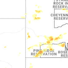
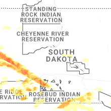
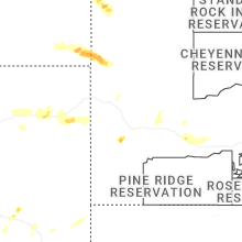


Connect with Interactive Hail Maps