

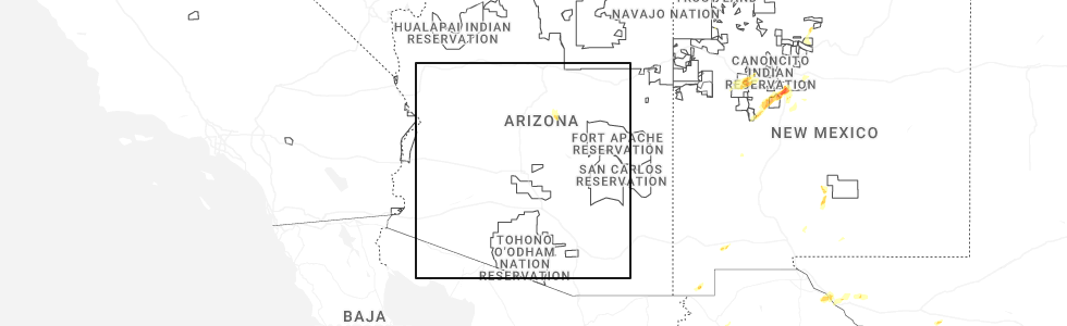
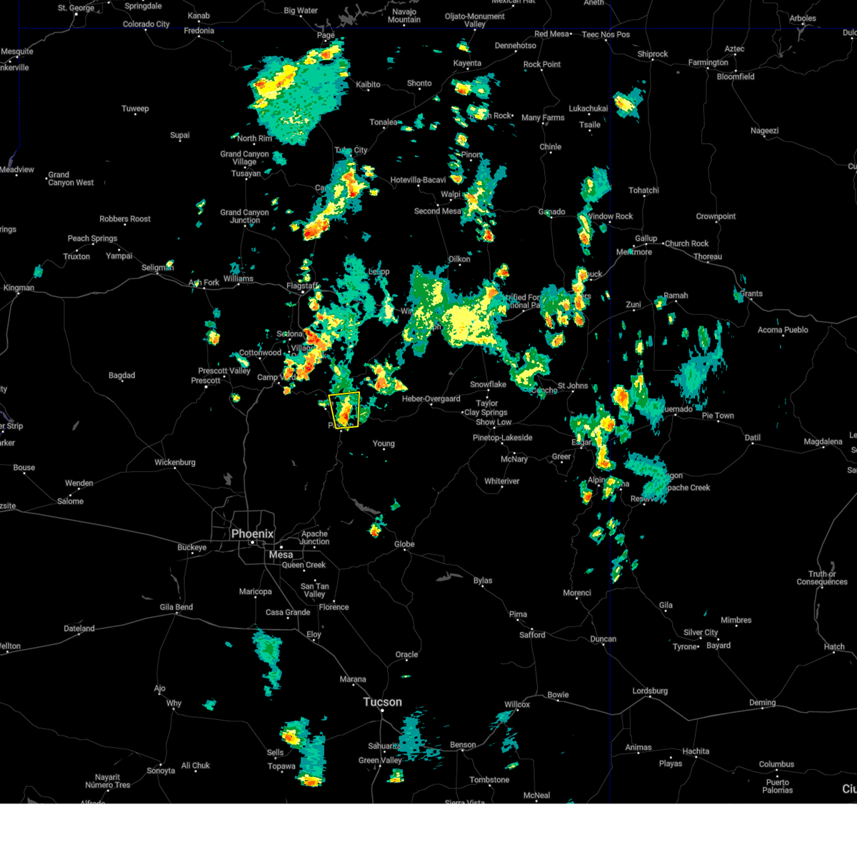
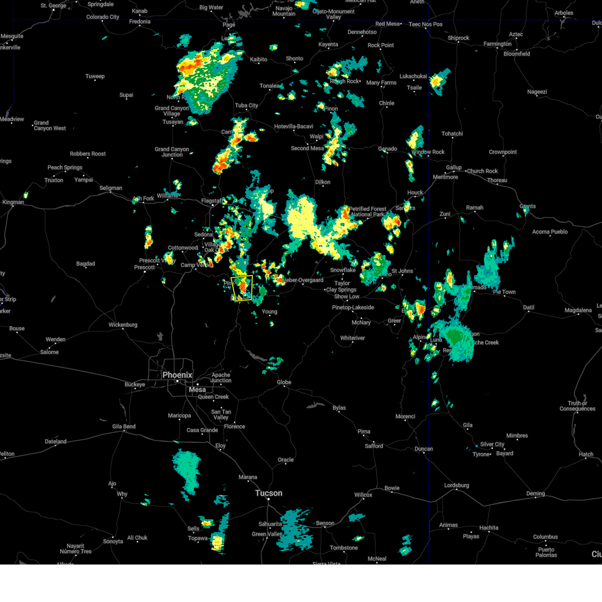
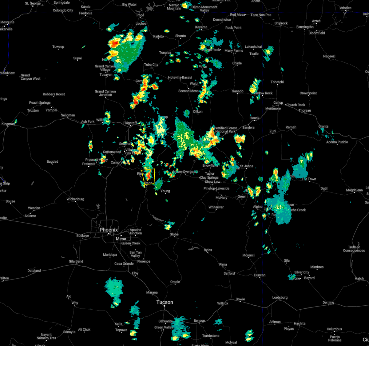
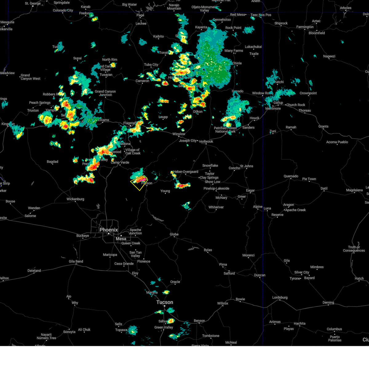
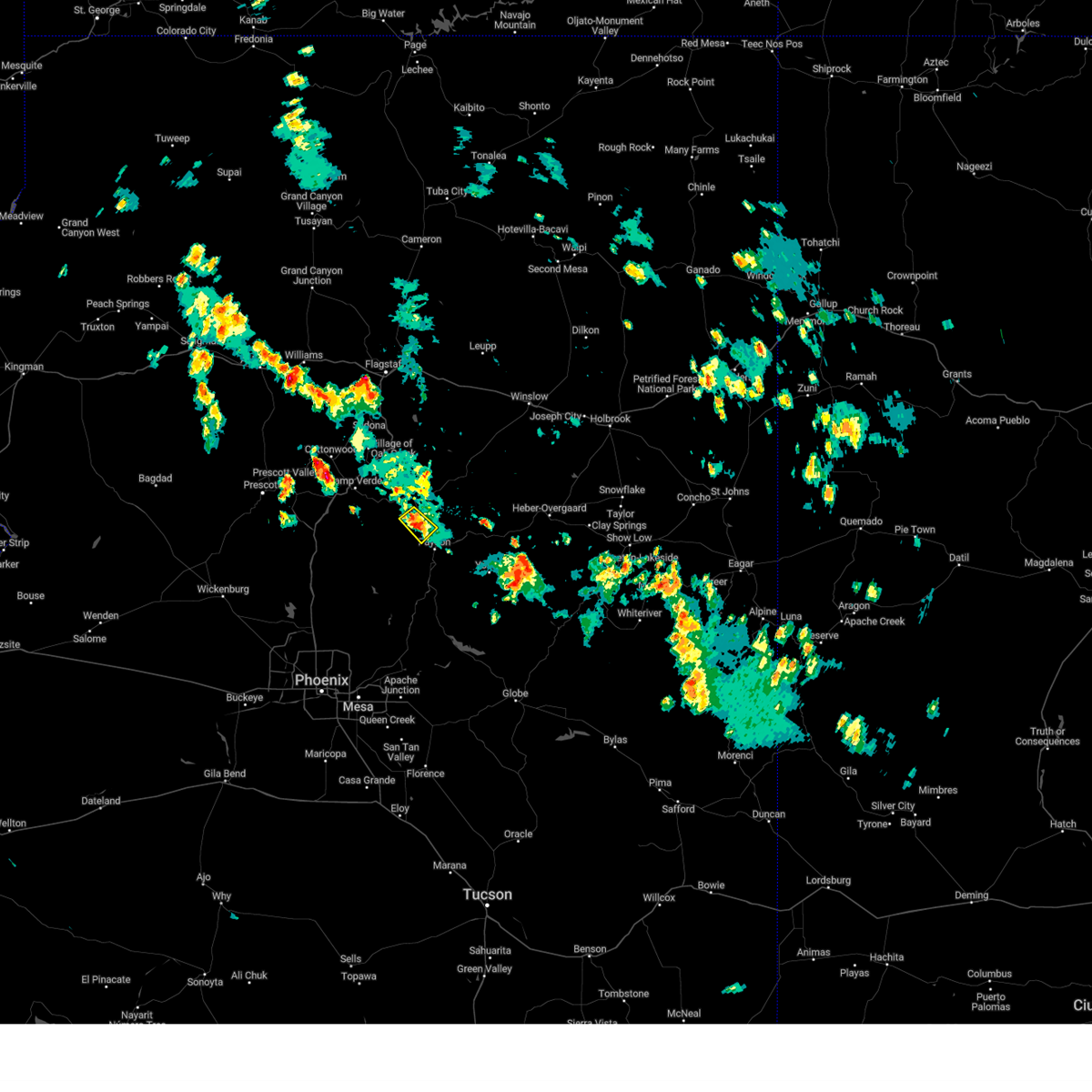
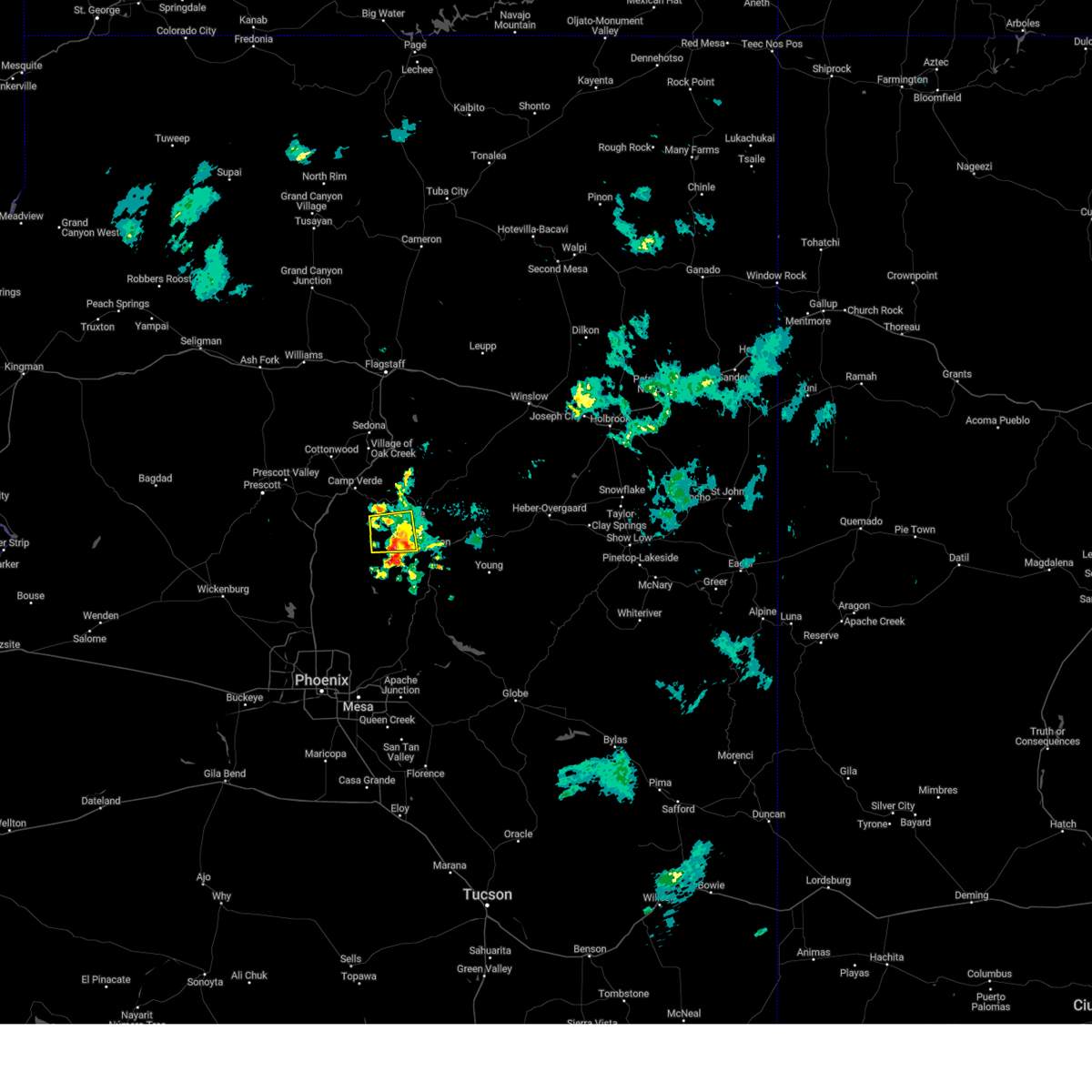
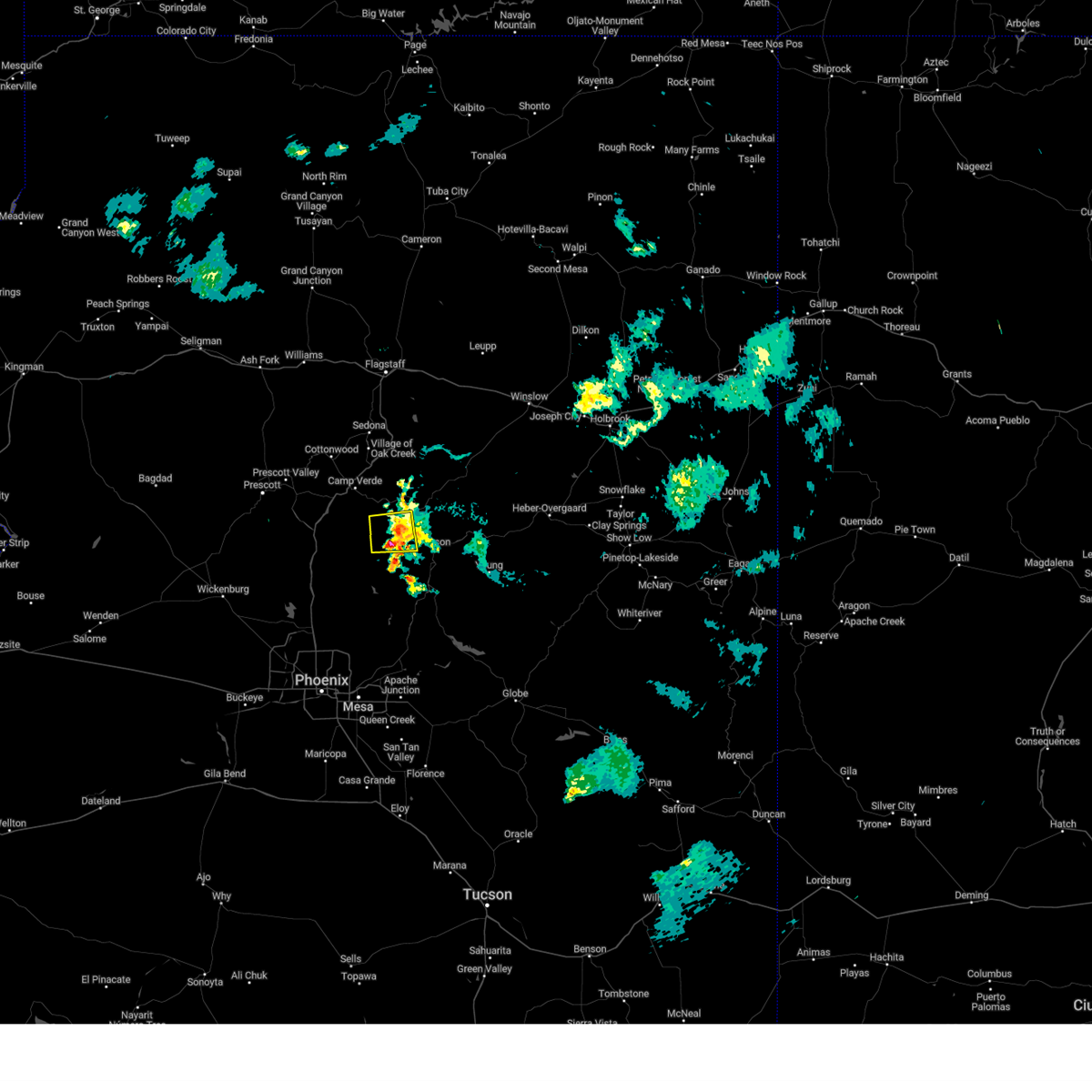
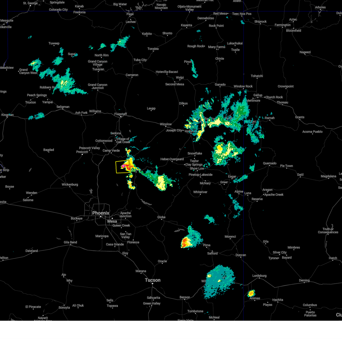
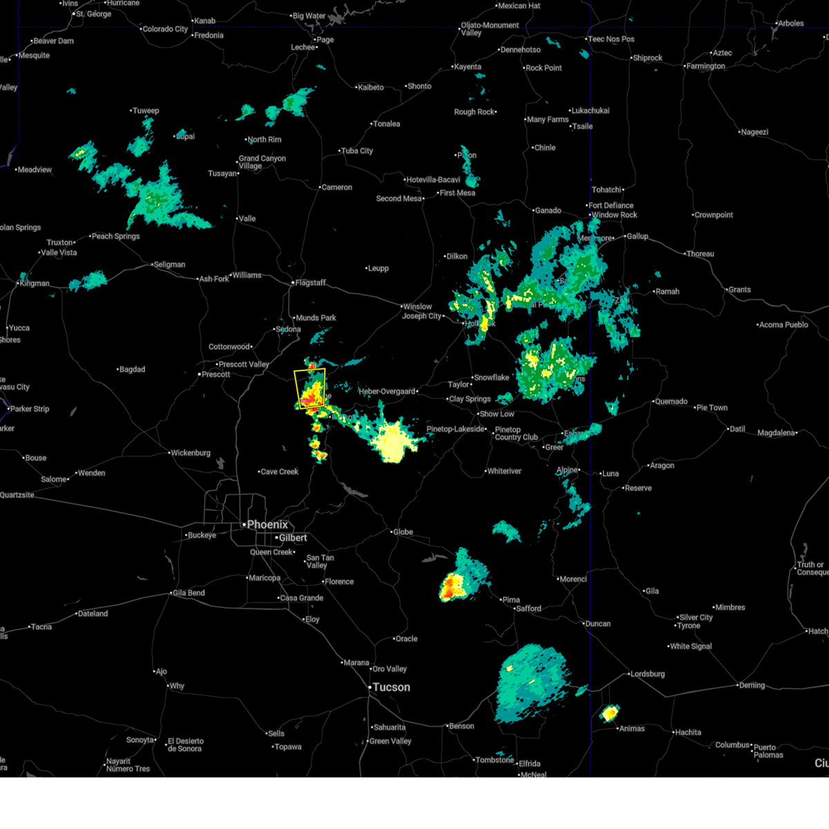
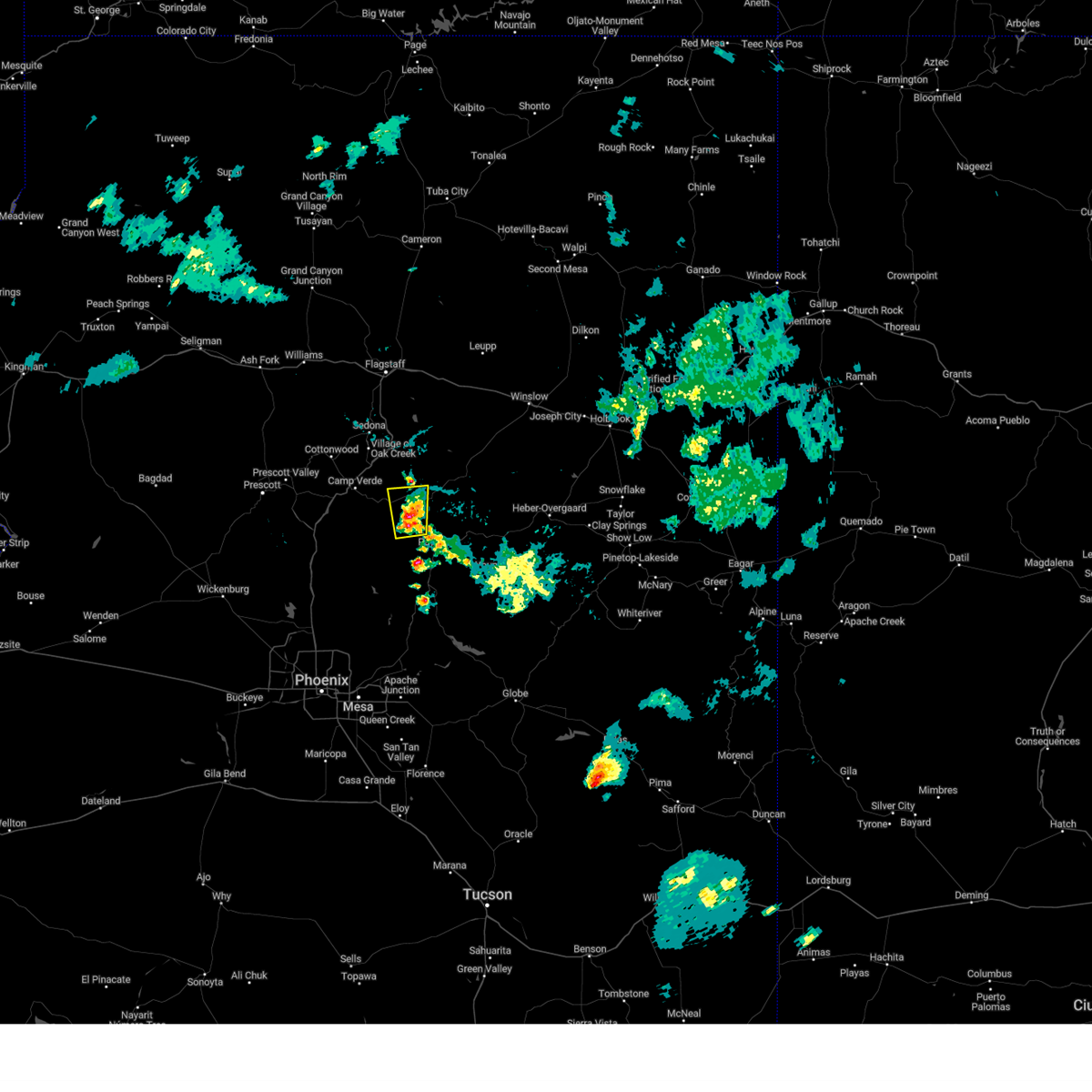
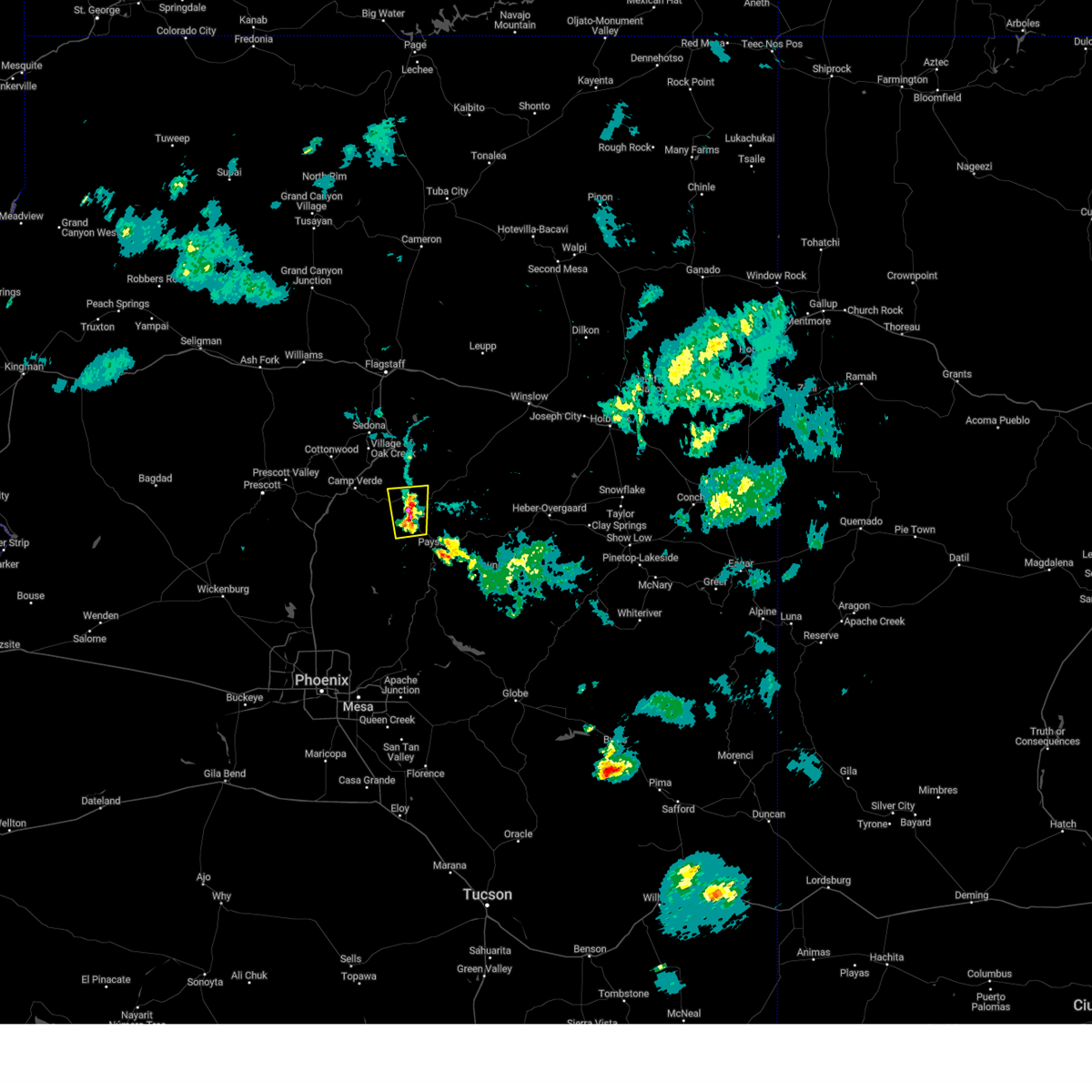
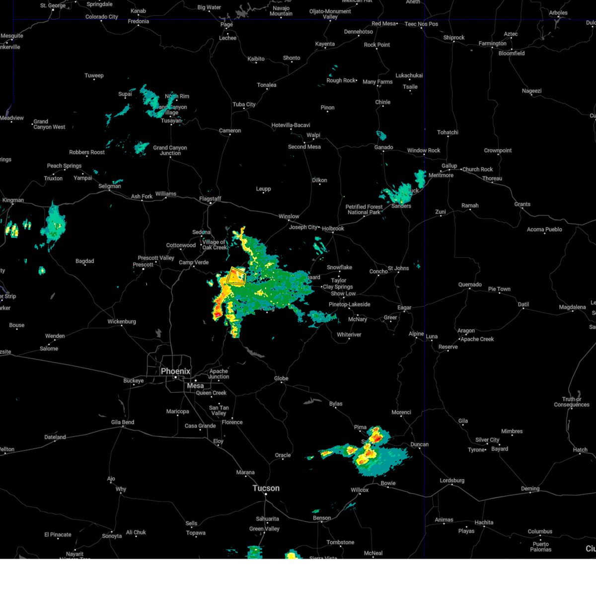
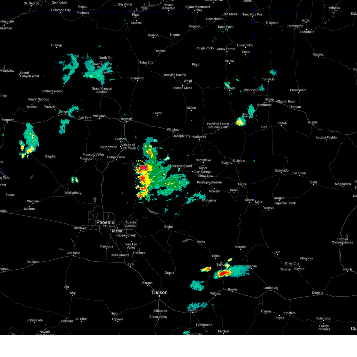
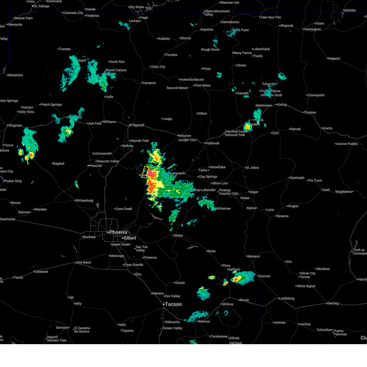
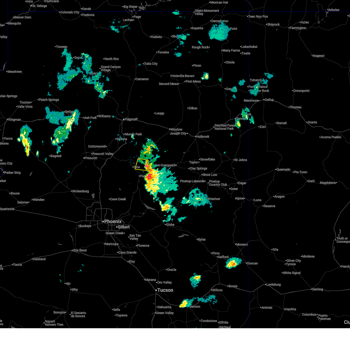
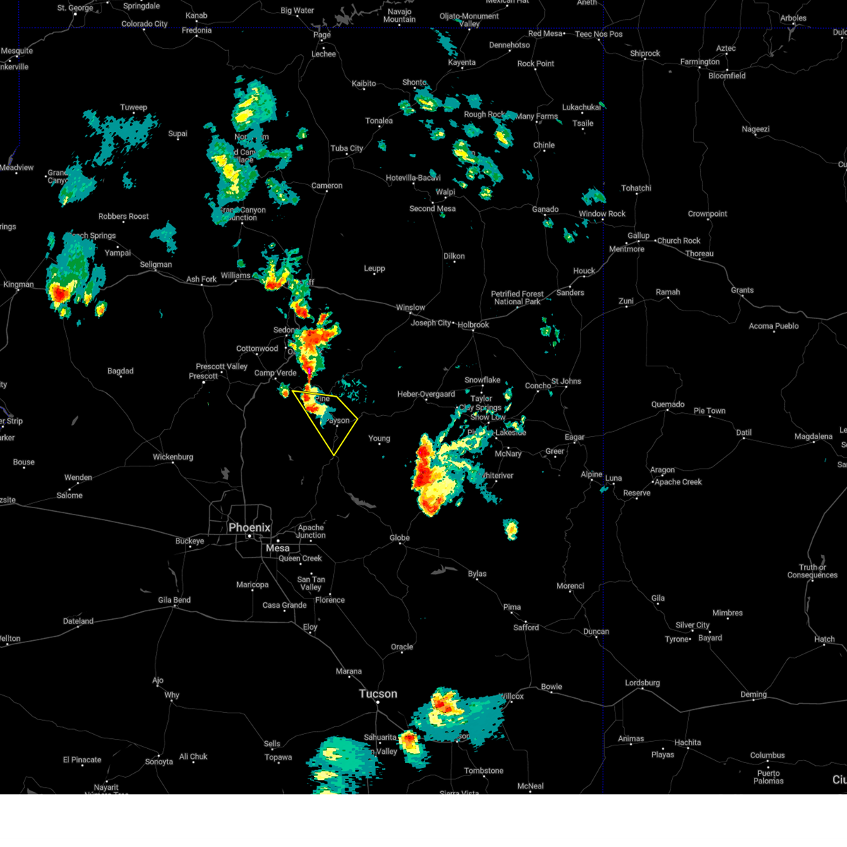
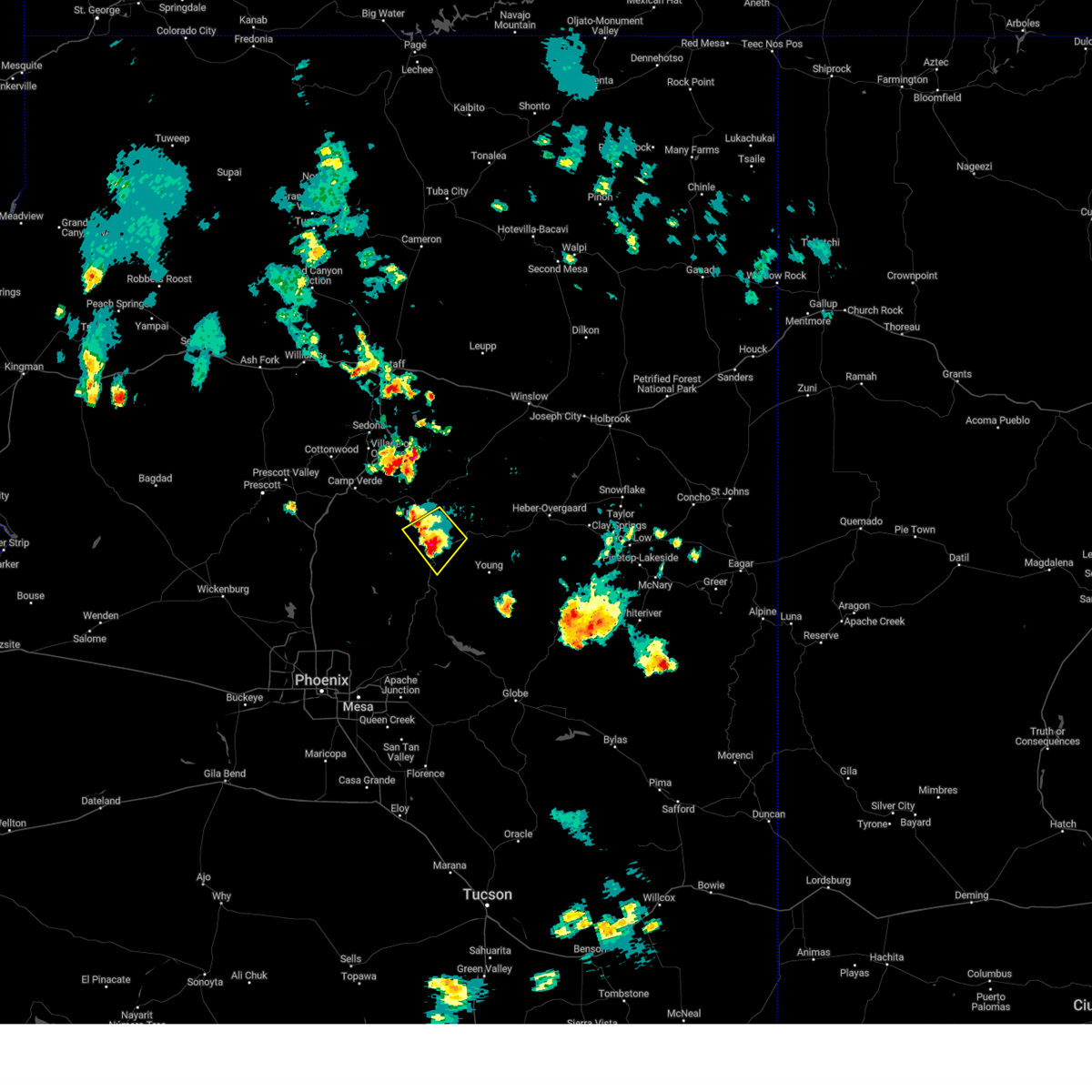
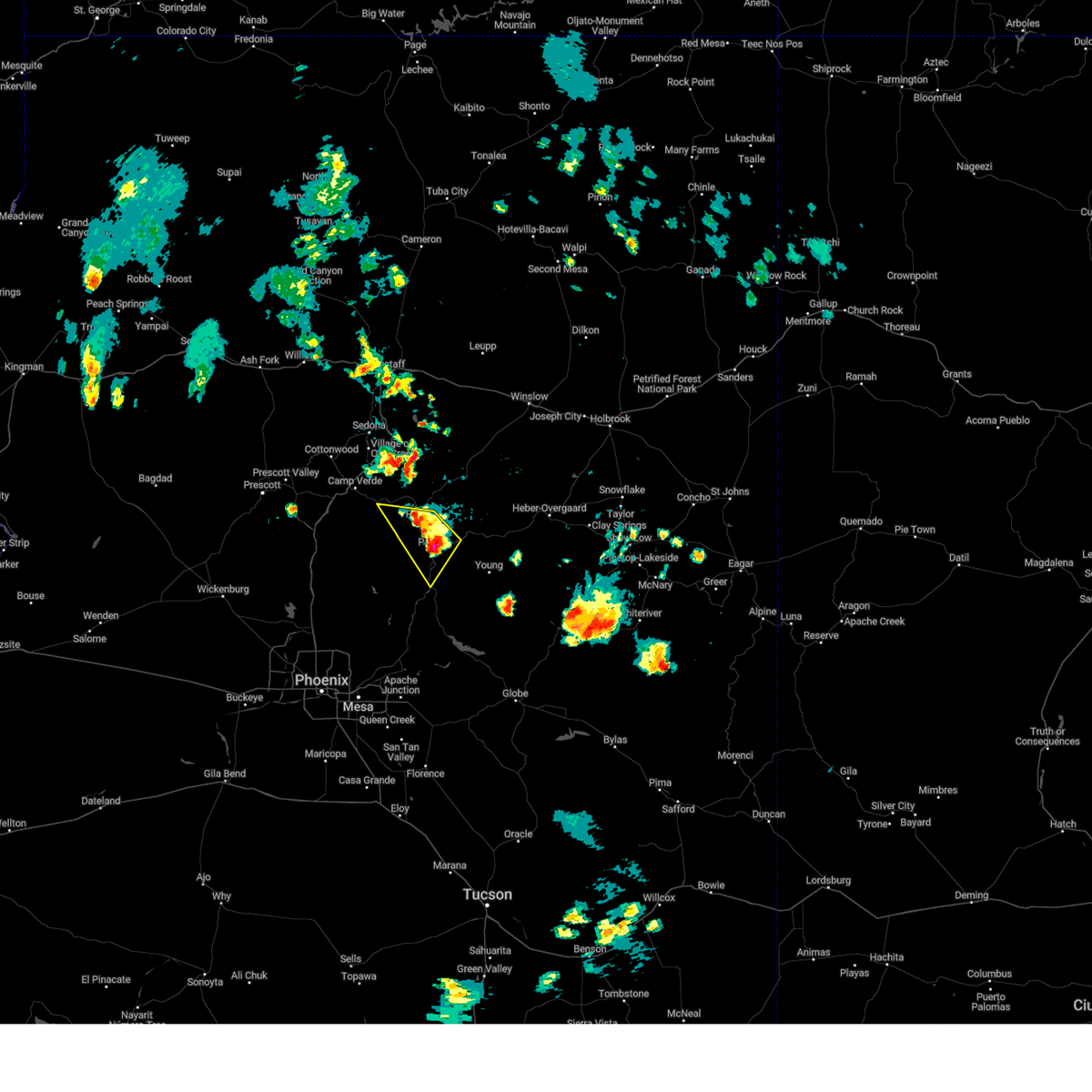
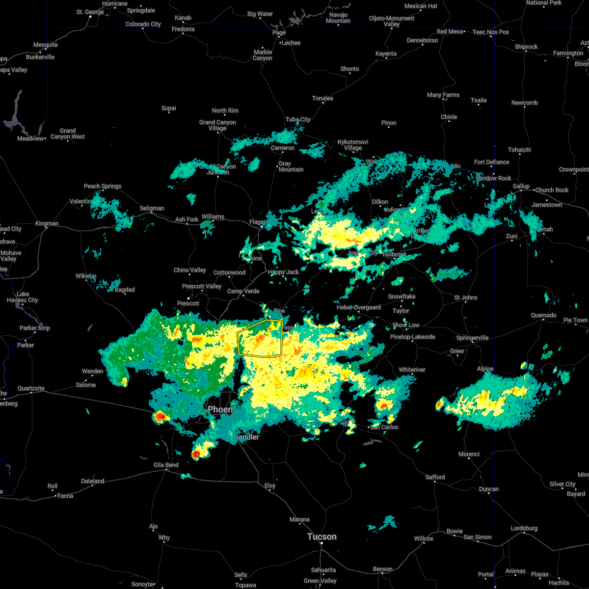
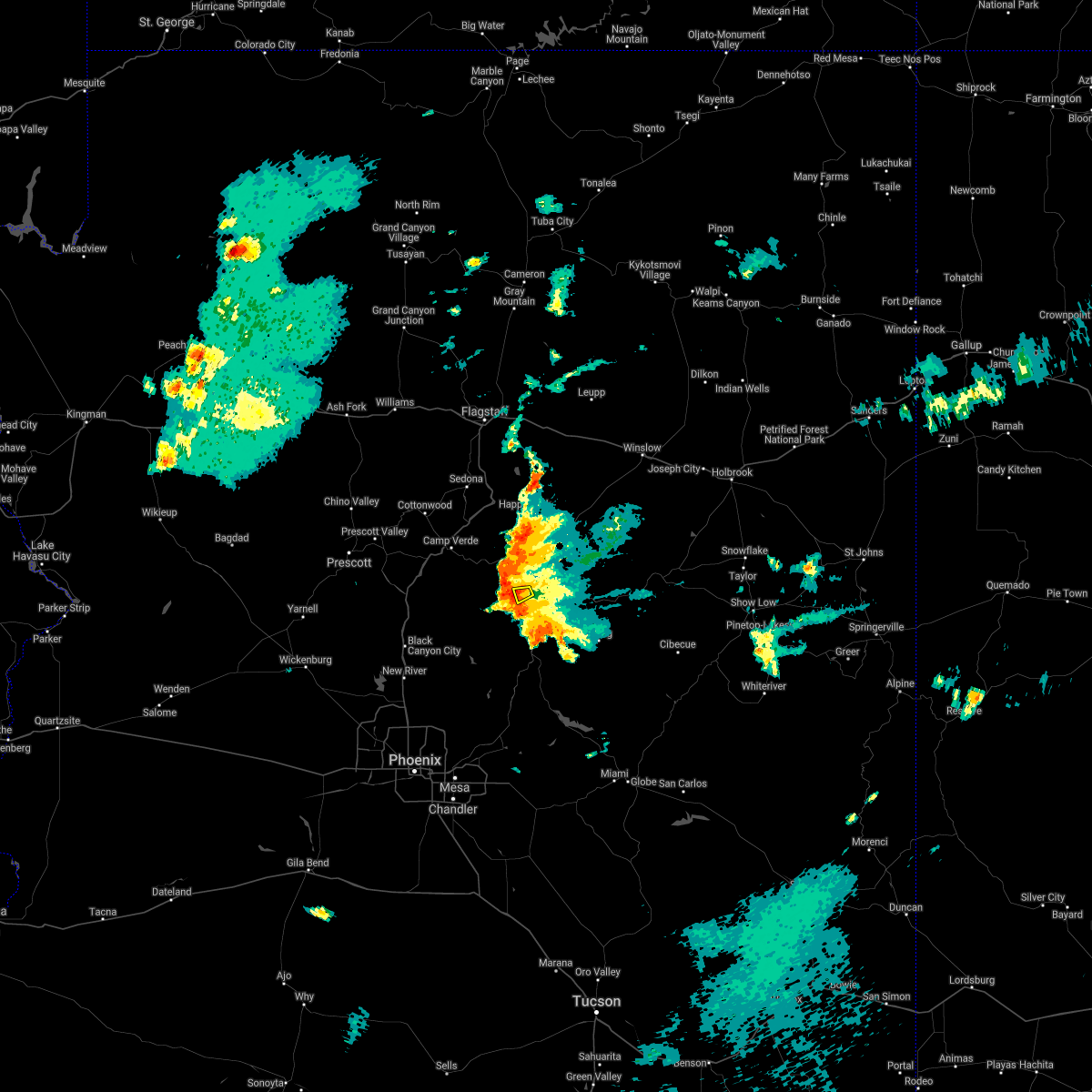
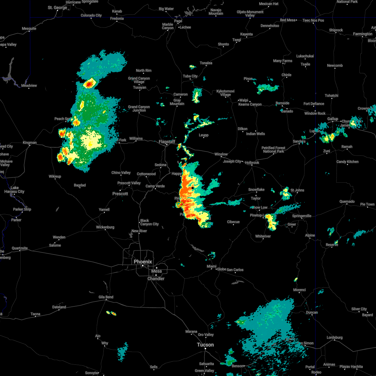
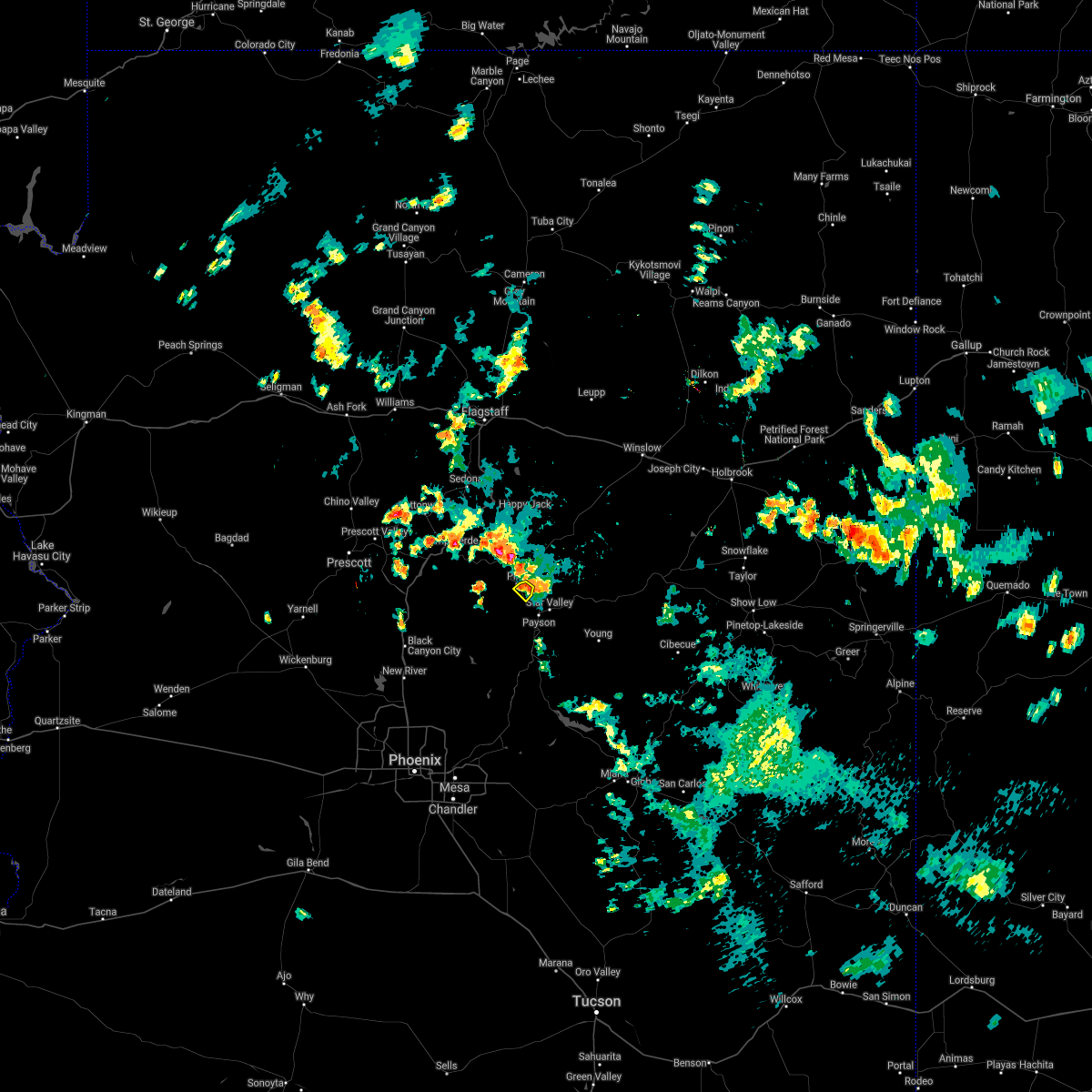
Hail Map for Pine, AZ
The Pine, AZ area has had 1 report of on-the-ground hail by trained spotters, and has been under severe weather warnings 13 times during the past 12 months. Doppler radar has detected hail at or near Pine, AZ on 82 occasions, including 5 occasions during the past year.
| Name: | Pine, AZ |
| Where Located: | 56.6 miles SSE of Flagstaff, AZ |
| Map: | Google Map for Pine, AZ |
| Population: | 1963 |
| Housing Units: | 2588 |
| More Info: | Search Google for Pine, AZ |
2
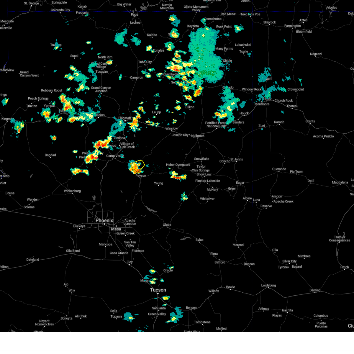
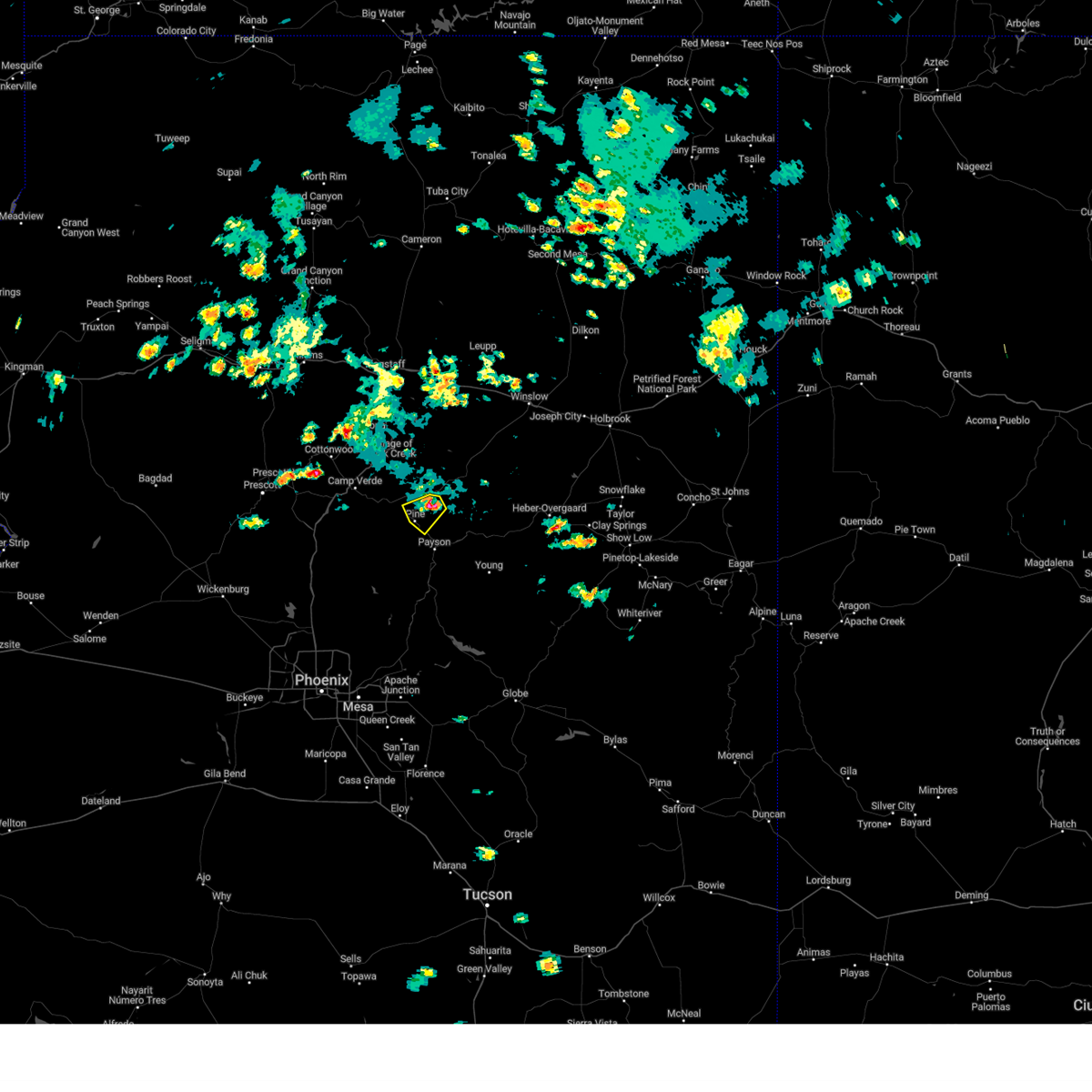
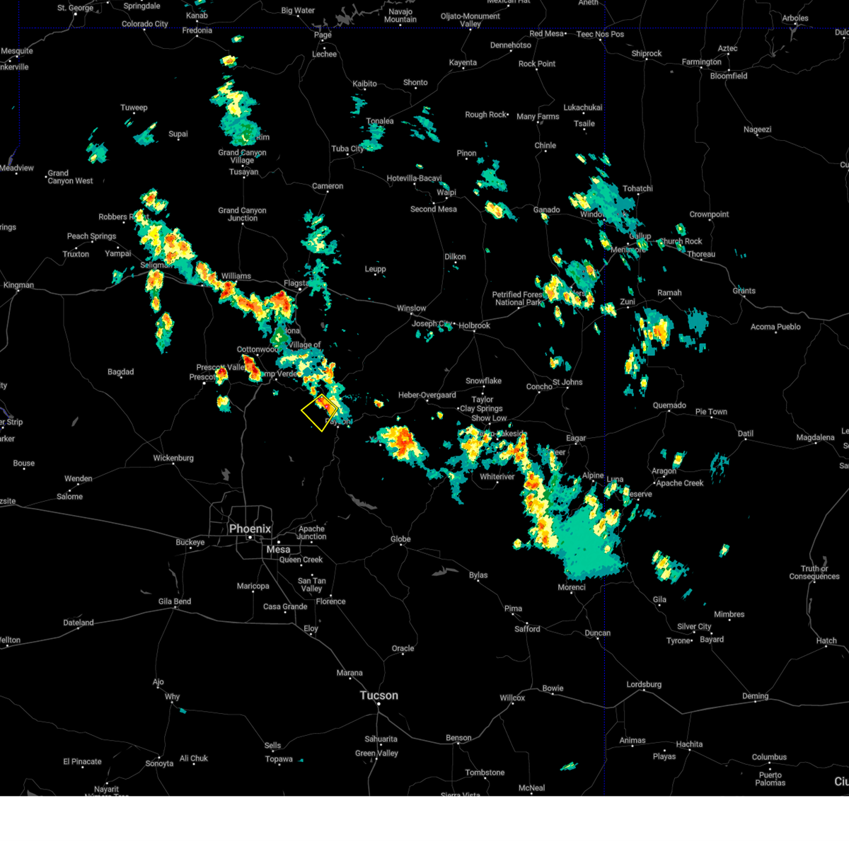
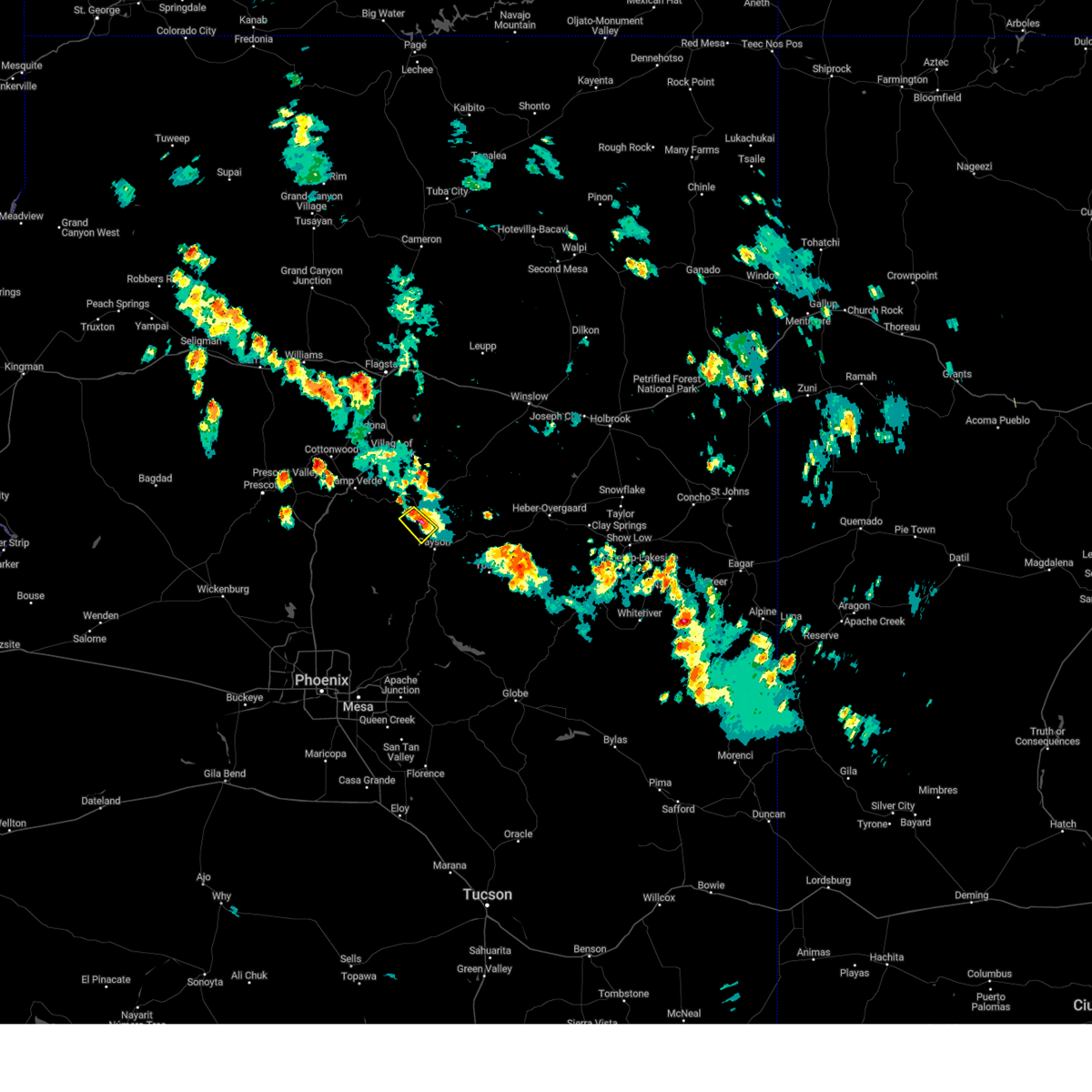
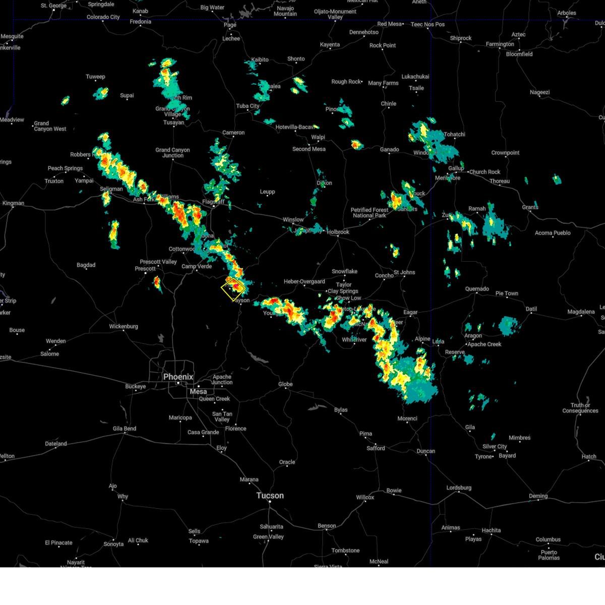
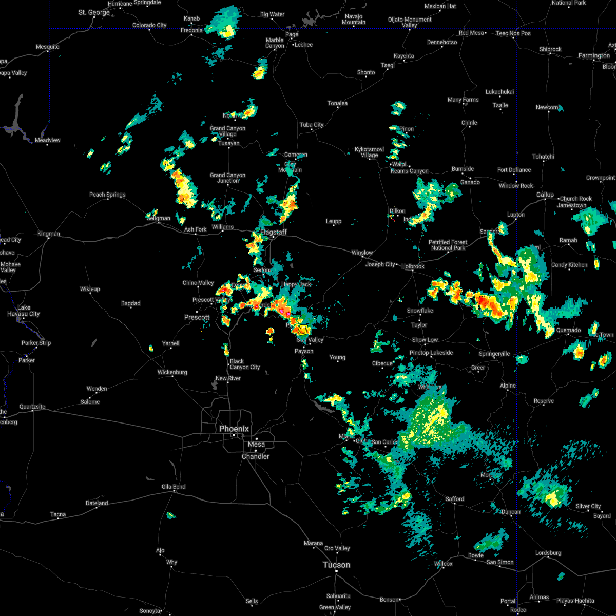
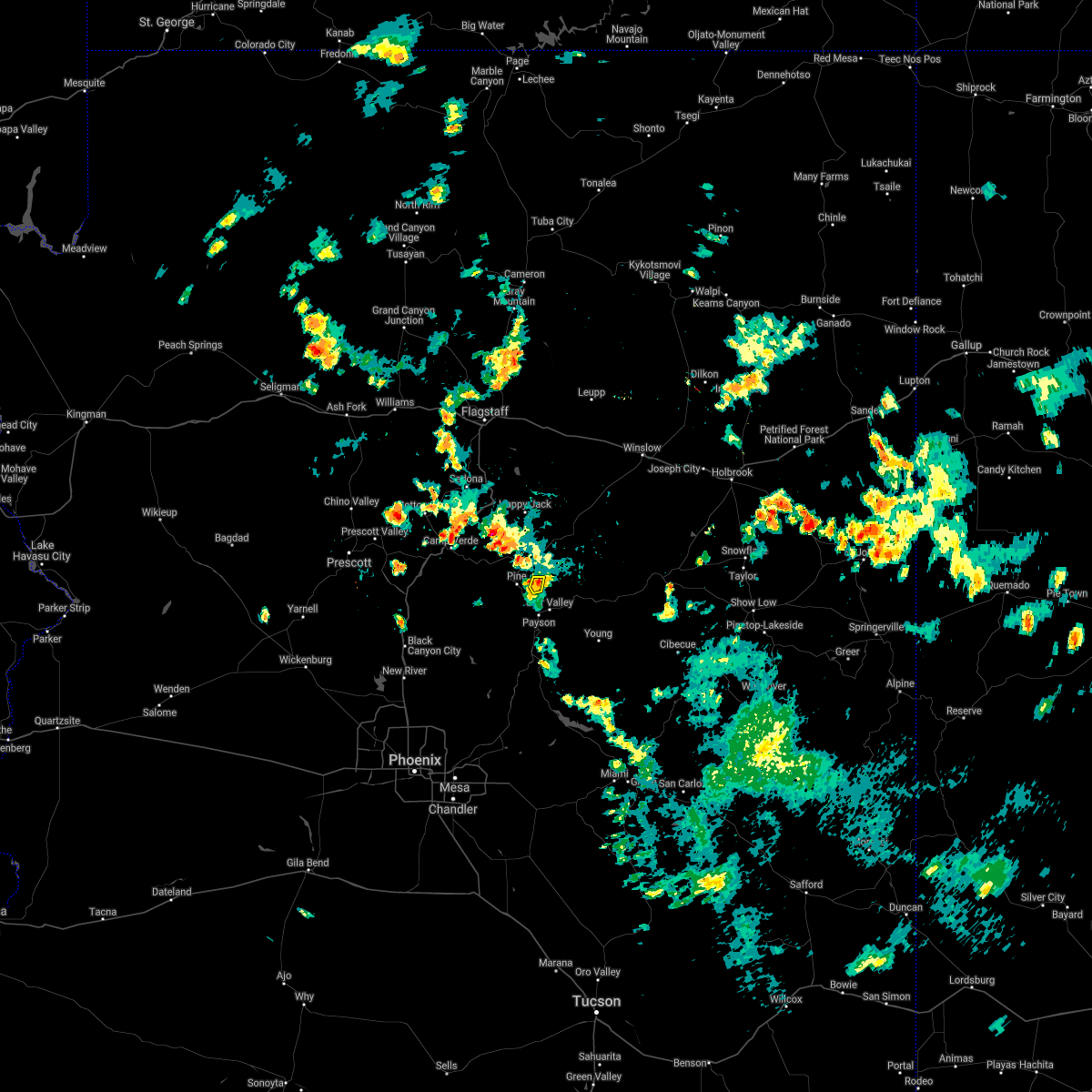
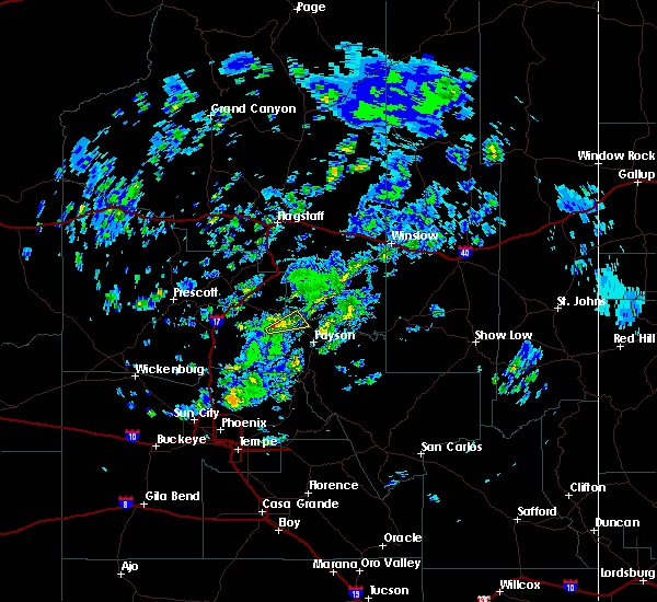
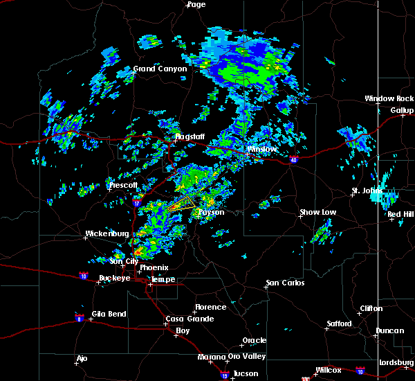
The Top Recent Hail Date for Pine, AZ is Sunday, September 28, 2025 (5th out of 82)
Hail and Wind Damage Spotted near Pine, AZ
| Date / Time | Report Details |
|---|---|
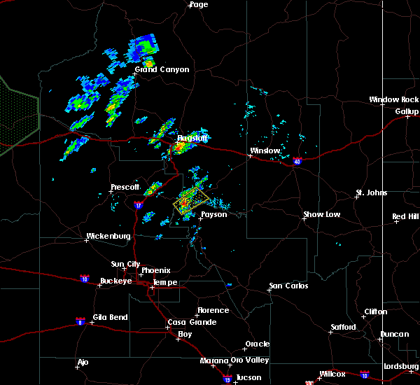
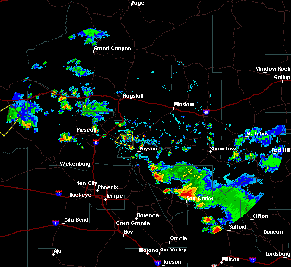
| 9/28/2025 3:43 PM MST | The storm which prompted the warning has weakened below severe limits, and no longer poses an immediate threat to life or property. therefore, the warning will be allowed to expire. however, small hail and heavy rain are still possible with this thunderstorm. a flash flood warning remains in effect until 630 pm mst for areas in and around the west fire scar in gila county. |
| 9/28/2025 3:30 PM MST | At 330 pm mst, a severe thunderstorm was located over geronimo estates, or 7 miles north of payson, moving southeast at 10 mph (radar indicated). Hazards include quarter size hail. Damage to vehicles is expected. locations impacted include, geronimo estates, flowing springs, east verde estates, freedom acres, water wheel falls, ellison creek cascades, pine, beaver valley estates and wonder valley. this includes state route 87 between mile markers 256 and 268. this includes the following recreation areas and campgrounds, geronimo boy scout camp. This includes the following swimming holes, water wheel falls and ellison creek cascades. |
| 9/28/2025 3:15 PM MST | The severe thunderstorm warning that was previously in effect has been reissued for gila and coconino counties and is in effect until 345 pm mst. please refer to that bulletin for the latest severe weather information. |
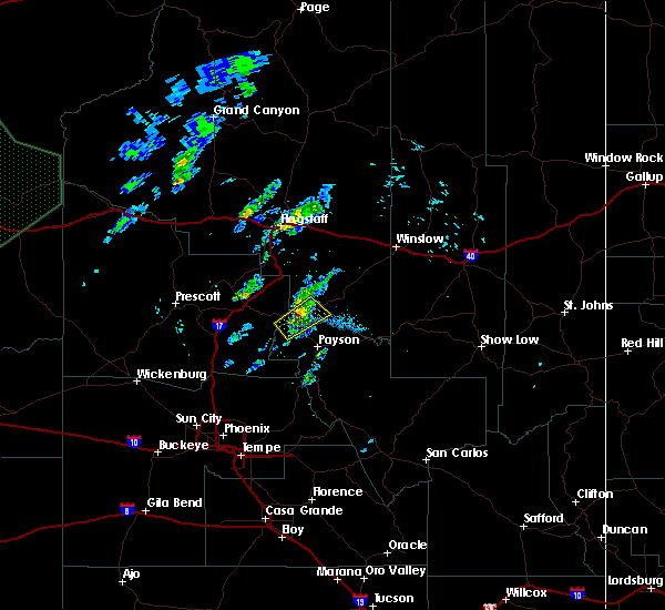
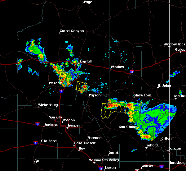
| 9/28/2025 3:14 PM MST | Svrfgz the national weather service in flagstaff has issued a * severe thunderstorm warning for, gila county in east central arizona, coconino county in north central arizona, * until 345 pm mst. * at 314 pm mst, a severe thunderstorm was located over pine, or 11 miles northwest of payson. this storm was stationary (radar indicated). Hazards include quarter size hail. damage to vehicles is expected |
| 9/28/2025 3:04 PM MST | At 304 pm mst, a severe thunderstorm was located over pine, or 12 miles northwest of payson, moving northeast at 5 mph (public reported). Hazards include quarter size hail. Damage to vehicles is expected. locations impacted include, baker butte lookout, pine, geronimo estates, potato lake, strawberry and fossil springs wilderness. this includes the following highways, state route 260 between mile markers 250 and 251. state route 87 between mile markers 266 and 271, and between mile markers 276 and 283. This includes the following recreation areas and campgrounds, geronimo boy scout camp. |
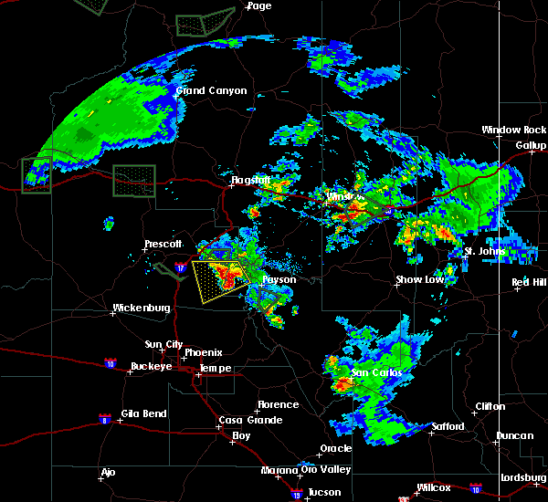
| 9/28/2025 2:44 PM MST | The severe thunderstorm warning that was previously in effect has been reissued for gila and coconino counties and is in effect until 3:15 pm mst. please refer to that bulletin for the latest severe weather information. |
| 9/28/2025 2:43 PM MST | Svrfgz the national weather service in flagstaff has issued a * severe thunderstorm warning for, gila county in east central arizona, coconino county in north central arizona, * until 315 pm mst. * at 243 pm mst, a severe thunderstorm was located over pine, or 14 miles northwest of payson. the storm is nearly stationary (radar indicated). Hazards include 60 mph wind gusts and quarter size hail. Hail damage to vehicles is expected. Expect wind damage to roofs, siding, and trees. |
| 9/28/2025 2:38 PM MST | Quarter sized hail reported 0.5 miles NE of Pine, AZ, public report of quarter size hail in pine. |
| 9/28/2025 2:32 PM MST | the severe thunderstorm warning has been cancelled and is no longer in effect |
| 9/28/2025 2:32 PM MST | At 232 pm mst, a severe thunderstorm was located near strawberry, or 17 miles northwest of payson, moving north at 10 mph (radar indicated). Hazards include 60 mph wind gusts and quarter size hail. Hail damage to vehicles is expected. expect wind damage to roofs, siding, and trees. locations impacted include, baker butte lookout, pine, strawberry, hanging garden, geronimo estates, fossil springs wilderness and west clear creek wilderness. this includes the following highways, state route 260 between mile markers 245 and 251. state route 87 between mile markers 266 and 289. This includes the following recreation areas and campgrounds, geronimo boy scout camp. |
| 9/28/2025 2:21 PM MST | Svrfgz the national weather service in flagstaff has issued a * severe thunderstorm warning for, gila county in east central arizona, coconino county in north central arizona, yavapai county in west central arizona, * until 245 pm mst. * at 221 pm mst, a severe thunderstorm was located over strawberry, or 15 miles northwest of payson, moving north at 10 mph (radar indicated). Hazards include 60 mph wind gusts and quarter size hail. Hail damage to vehicles is expected. Expect wind damage to roofs, siding, and trees. |
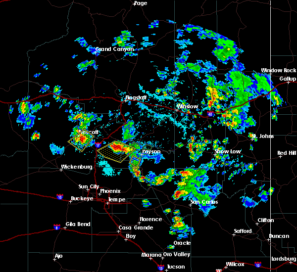
| 9/18/2025 5:42 PM MST | The storm which prompted the warning has weakened below severe limits, and no longer poses an immediate threat to life or property. therefore, the warning will be allowed to expire. however, gusty winds and heavy rain are still possible with this thunderstorm. |
| 9/18/2025 5:32 PM MST | At 532 pm mst, a severe thunderstorm was located 9 miles south of fossil creek day use area, or 14 miles west of payson, moving north at 5 mph (radar indicated). Hazards include 60 mph wind gusts and quarter size hail. Hail damage to vehicles is expected. expect wind damage to roofs, siding, and trees. Locations impacted include, rural areas southwest of pine. |
| 9/18/2025 5:11 PM MST | Svrfgz the national weather service in flagstaff has issued a * severe thunderstorm warning for, gila county in east central arizona, yavapai county in west central arizona, * until 545 pm mst. * at 511 pm mst, a severe thunderstorm was located 11 miles southwest of pine, or 13 miles west of payson. this storm was nearly stationary (radar indicated). Hazards include 60 mph wind gusts and quarter size hail. Hail damage to vehicles is expected. Expect wind damage to roofs, siding, and trees. |
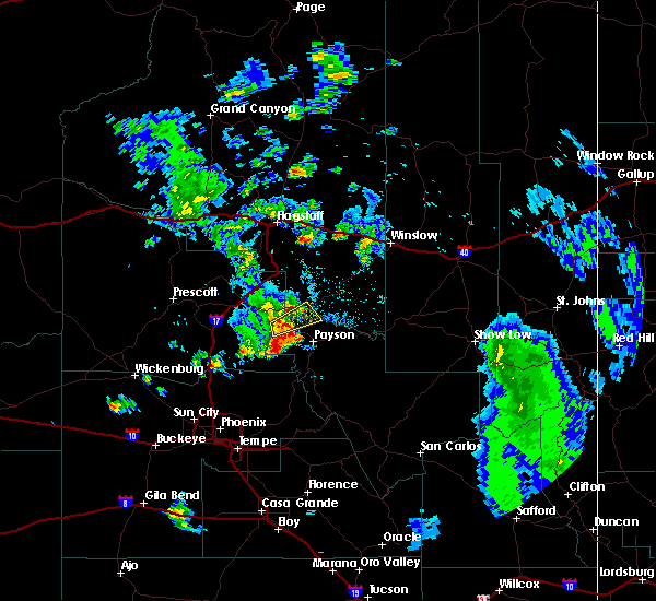
| 8/12/2024 3:24 PM MST |
 The storm which prompted the warning has weakened below severe limits, and no longer poses an immediate threat to life or property. therefore, the warning will be allowed to expire. however, heavy rain is still occurring with this thunderstorm and a flash flood warning is in effect for the washington park area and east verde river through 6:30 pm mst. The storm which prompted the warning has weakened below severe limits, and no longer poses an immediate threat to life or property. therefore, the warning will be allowed to expire. however, heavy rain is still occurring with this thunderstorm and a flash flood warning is in effect for the washington park area and east verde river through 6:30 pm mst.
|
| 8/12/2024 3:03 PM MST |
 At 303 pm mst, a severe thunderstorm was located over whispering pines, or 10 miles north of payson, moving north at 10 mph (radar indicated). Hazards include 60 mph wind gusts and nickel size hail. Expect damage to roofs, siding, and trees. locations impacted include, flowing springs, beaver valley estates, mesa del caballo, water wheel falls, ellison creek estates, ellison creek cascades, geronimo estates, freedom acres, east verde estates, la cienega, bonita creek estates, washington park, whispering pines, baker butte lookout, wonder valley, payson airport, star valley, payson, and pine. this includes the following highways, state route 260 between mile markers 256 and 260. State route 87 between mile markers 254 and 260, and between mile markers 280 and 283. At 303 pm mst, a severe thunderstorm was located over whispering pines, or 10 miles north of payson, moving north at 10 mph (radar indicated). Hazards include 60 mph wind gusts and nickel size hail. Expect damage to roofs, siding, and trees. locations impacted include, flowing springs, beaver valley estates, mesa del caballo, water wheel falls, ellison creek estates, ellison creek cascades, geronimo estates, freedom acres, east verde estates, la cienega, bonita creek estates, washington park, whispering pines, baker butte lookout, wonder valley, payson airport, star valley, payson, and pine. this includes the following highways, state route 260 between mile markers 256 and 260. State route 87 between mile markers 254 and 260, and between mile markers 280 and 283.
|
| 8/12/2024 2:45 PM MST |
 Svrfgz the national weather service in flagstaff has issued a * severe thunderstorm warning for, gila county in east central arizona, coconino county in north central arizona, * until 330 pm mst. * at 245 pm mst, a severe thunderstorm was located over ellison creek cascades, or 7 miles north of payson, moving north at 10 mph (radar indicated). Hazards include 60 mph wind gusts and nickel size hail. expect damage to roofs, siding, and trees Svrfgz the national weather service in flagstaff has issued a * severe thunderstorm warning for, gila county in east central arizona, coconino county in north central arizona, * until 330 pm mst. * at 245 pm mst, a severe thunderstorm was located over ellison creek cascades, or 7 miles north of payson, moving north at 10 mph (radar indicated). Hazards include 60 mph wind gusts and nickel size hail. expect damage to roofs, siding, and trees
|
| 8/6/2024 3:55 PM MST |
 Svrfgz the national weather service in flagstaff has issued a * severe thunderstorm warning for, gila county in east central arizona, * until 430 pm mst. * at 355 pm mst, a severe thunderstorm was located over east verde estates, or 7 miles northwest of payson, moving southwest at 10 mph (radar indicated). Hazards include quarter size hail. damage to vehicles is expected Svrfgz the national weather service in flagstaff has issued a * severe thunderstorm warning for, gila county in east central arizona, * until 430 pm mst. * at 355 pm mst, a severe thunderstorm was located over east verde estates, or 7 miles northwest of payson, moving southwest at 10 mph (radar indicated). Hazards include quarter size hail. damage to vehicles is expected
|
| 8/6/2024 3:41 PM MST |
 The storm which prompted the warning has weakened below severe limits, and no longer poses an immediate threat to life or property. therefore, the warning will be allowed to expire. however, small hail and heavy rain are still possible with this thunderstorm. The storm which prompted the warning has weakened below severe limits, and no longer poses an immediate threat to life or property. therefore, the warning will be allowed to expire. however, small hail and heavy rain are still possible with this thunderstorm.
|
| 8/6/2024 3:10 PM MST |
 Svrfgz the national weather service in flagstaff has issued a * severe thunderstorm warning for, gila county in east central arizona, coconino county in north central arizona, * until 345 pm mst. * at 309 pm mst, a severe thunderstorm was located over baker butte lookout, or 14 miles north of payson, moving southwest at 10 mph (radar indicated). Hazards include quarter size hail. damage to vehicles is expected Svrfgz the national weather service in flagstaff has issued a * severe thunderstorm warning for, gila county in east central arizona, coconino county in north central arizona, * until 345 pm mst. * at 309 pm mst, a severe thunderstorm was located over baker butte lookout, or 14 miles north of payson, moving southwest at 10 mph (radar indicated). Hazards include quarter size hail. damage to vehicles is expected
|
| 7/21/2024 1:05 PM MST |
 The storm which prompted the warning has weakened below severe limits, and no longer poses an immediate threat to life or property. therefore, the warning will be allowed to expire. however, gusty winds are still possible with this thunderstorm. The storm which prompted the warning has weakened below severe limits, and no longer poses an immediate threat to life or property. therefore, the warning will be allowed to expire. however, gusty winds are still possible with this thunderstorm.
|
| 7/21/2024 12:58 PM MST |
 At 1258 pm mst, a severe thunderstorm was located near pine, or 10 miles northwest of payson, moving southwest at 10 mph (radar indicated). Hazards include 60 mph wind gusts. Expect damage to roofs, siding, and trees. locations impacted include, tonto natural bridge state park, pine, strawberry, and east verde estates. This includes state route 87 between mile markers 259 and 273. At 1258 pm mst, a severe thunderstorm was located near pine, or 10 miles northwest of payson, moving southwest at 10 mph (radar indicated). Hazards include 60 mph wind gusts. Expect damage to roofs, siding, and trees. locations impacted include, tonto natural bridge state park, pine, strawberry, and east verde estates. This includes state route 87 between mile markers 259 and 273.
|
| 7/21/2024 12:44 PM MST |
 The severe thunderstorm which prompted the warning has been replaced with another severe thunderstorm warning. remember, a severe thunderstorm warning still remains in effect for the pine and strawberry area until 1:15 pm mst. The severe thunderstorm which prompted the warning has been replaced with another severe thunderstorm warning. remember, a severe thunderstorm warning still remains in effect for the pine and strawberry area until 1:15 pm mst.
|
| 7/21/2024 12:43 PM MST |
 Svrfgz the national weather service in flagstaff has issued a * severe thunderstorm warning for, gila county in east central arizona, coconino county in north central arizona, * until 115 pm mst. * at 1243 pm mst, a severe thunderstorm was located over pine, or 10 miles northwest of payson, moving southwest at 5 mph (radar indicated). Hazards include 60 mph wind gusts and penny size hail. expect damage to roofs, siding, and trees Svrfgz the national weather service in flagstaff has issued a * severe thunderstorm warning for, gila county in east central arizona, coconino county in north central arizona, * until 115 pm mst. * at 1243 pm mst, a severe thunderstorm was located over pine, or 10 miles northwest of payson, moving southwest at 5 mph (radar indicated). Hazards include 60 mph wind gusts and penny size hail. expect damage to roofs, siding, and trees
|
| 7/21/2024 12:38 PM MST |
 At 1238 pm mst, a severe thunderstorm was located over pine, or 10 miles northwest of payson, moving southwest at 5 mph (radar indicated). Hazards include 60 mph wind gusts and quarter size hail. Hail damage to vehicles is expected. expect wind damage to roofs, siding, and trees. locations impacted include, tonto natural bridge state park, geronimo estates, pine, strawberry, east verde estates, and flowing springs. This includes state route 87 between mile markers 259 and 273, and between mile markers 275 and 277. At 1238 pm mst, a severe thunderstorm was located over pine, or 10 miles northwest of payson, moving southwest at 5 mph (radar indicated). Hazards include 60 mph wind gusts and quarter size hail. Hail damage to vehicles is expected. expect wind damage to roofs, siding, and trees. locations impacted include, tonto natural bridge state park, geronimo estates, pine, strawberry, east verde estates, and flowing springs. This includes state route 87 between mile markers 259 and 273, and between mile markers 275 and 277.
|
| 7/21/2024 12:31 PM MST | Phone call received for trees down (approximately a foot in diameter) along hwy 8 in gila county AZ, 1.1 miles NNE of Pine, AZ |
| 7/21/2024 12:20 PM MST |
 Svrfgz the national weather service in flagstaff has issued a * severe thunderstorm warning for, gila county in east central arizona, coconino county in north central arizona, * until 1245 pm mst. * at 1219 pm mst, a severe thunderstorm was located near geronimo estates, or 12 miles north of payson, moving southwest at 5 mph (radar indicated). Hazards include quarter size hail. damage to vehicles is expected Svrfgz the national weather service in flagstaff has issued a * severe thunderstorm warning for, gila county in east central arizona, coconino county in north central arizona, * until 1245 pm mst. * at 1219 pm mst, a severe thunderstorm was located near geronimo estates, or 12 miles north of payson, moving southwest at 5 mph (radar indicated). Hazards include quarter size hail. damage to vehicles is expected
|
| 7/16/2024 7:54 PM MST |
 The storm which prompted the warning has weakened below severe limits, and has exited the warned area. therefore, the warning will be allowed to expire. however, gusty winds and heavy rain are still possible with this thunderstorm. The storm which prompted the warning has weakened below severe limits, and has exited the warned area. therefore, the warning will be allowed to expire. however, gusty winds and heavy rain are still possible with this thunderstorm.
|
| 7/16/2024 7:38 PM MST |
 At 737 pm mst, a severe thunderstorm was located near childs power plant, or 18 miles south of camp verde, moving west at 15 mph (radar indicated). Hazards include 60 mph wind gusts and quarter size hail. Hail damage to vehicles is expected. expect wind damage to roofs, siding, and trees. locations impacted include, fossil creek waterfall, strawberry, fossil creek day use area, the toilet bowl, childs power plant, tonto natural bridge state park, pine, fossil springs wilderness, and pine mountain wilderness. This includes state route 87 between mile markers 270 and 274. At 737 pm mst, a severe thunderstorm was located near childs power plant, or 18 miles south of camp verde, moving west at 15 mph (radar indicated). Hazards include 60 mph wind gusts and quarter size hail. Hail damage to vehicles is expected. expect wind damage to roofs, siding, and trees. locations impacted include, fossil creek waterfall, strawberry, fossil creek day use area, the toilet bowl, childs power plant, tonto natural bridge state park, pine, fossil springs wilderness, and pine mountain wilderness. This includes state route 87 between mile markers 270 and 274.
|
| 7/16/2024 7:12 PM MST |
 Svrfgz the national weather service in flagstaff has issued a * severe thunderstorm warning for, gila county in east central arizona, yavapai county in west central arizona, coconino county in north central arizona, * until 800 pm mst. * at 712 pm mst, a severe thunderstorm was located near childs power plant, or 18 miles west of payson, moving west at 15 mph (radar indicated). Hazards include 60 mph wind gusts and quarter size hail. Hail damage to vehicles is expected. Expect wind damage to roofs, siding, and trees. Svrfgz the national weather service in flagstaff has issued a * severe thunderstorm warning for, gila county in east central arizona, yavapai county in west central arizona, coconino county in north central arizona, * until 800 pm mst. * at 712 pm mst, a severe thunderstorm was located near childs power plant, or 18 miles west of payson, moving west at 15 mph (radar indicated). Hazards include 60 mph wind gusts and quarter size hail. Hail damage to vehicles is expected. Expect wind damage to roofs, siding, and trees.
|
| 7/16/2024 7:09 PM MST |
 The storm which prompted the warning has weakened below severe limits, and has exited the warned area. therefore, the warning will be allowed to expire. however, gusty winds and heavy rain are still possible with this thunderstorm. The storm which prompted the warning has weakened below severe limits, and has exited the warned area. therefore, the warning will be allowed to expire. however, gusty winds and heavy rain are still possible with this thunderstorm.
|
| 7/16/2024 6:58 PM MST |
 At 657 pm mst, a severe thunderstorm was located near strawberry, or 19 miles northwest of payson, moving north at 10 mph (radar indicated). Hazards include 60 mph wind gusts and quarter size hail. Hail damage to vehicles is expected. expect wind damage to roofs, siding, and trees. locations impacted include, fossil springs wilderness, pine, fossil creek waterfall, strawberry, tonto natural bridge state park, the toilet bowl, west clear creek wilderness, baker butte lookout, hanging garden, and indian maiden falls. this includes the following highways, state route 260 between mile markers 239 and 251. State route 87 between mile markers 260 and 284. At 657 pm mst, a severe thunderstorm was located near strawberry, or 19 miles northwest of payson, moving north at 10 mph (radar indicated). Hazards include 60 mph wind gusts and quarter size hail. Hail damage to vehicles is expected. expect wind damage to roofs, siding, and trees. locations impacted include, fossil springs wilderness, pine, fossil creek waterfall, strawberry, tonto natural bridge state park, the toilet bowl, west clear creek wilderness, baker butte lookout, hanging garden, and indian maiden falls. this includes the following highways, state route 260 between mile markers 239 and 251. State route 87 between mile markers 260 and 284.
|
| 7/16/2024 6:39 PM MST |
 Svrfgz the national weather service in flagstaff has issued a * severe thunderstorm warning for, gila county in east central arizona, yavapai county in west central arizona, coconino county in north central arizona, * until 715 pm mst. * at 639 pm mst, a severe thunderstorm was located over strawberry, or 16 miles northwest of payson, moving north at 10 mph (radar indicated). Hazards include 60 mph wind gusts and quarter size hail. Hail damage to vehicles is expected. Expect wind damage to roofs, siding, and trees. Svrfgz the national weather service in flagstaff has issued a * severe thunderstorm warning for, gila county in east central arizona, yavapai county in west central arizona, coconino county in north central arizona, * until 715 pm mst. * at 639 pm mst, a severe thunderstorm was located over strawberry, or 16 miles northwest of payson, moving north at 10 mph (radar indicated). Hazards include 60 mph wind gusts and quarter size hail. Hail damage to vehicles is expected. Expect wind damage to roofs, siding, and trees.
|
| 7/15/2024 7:01 PM MST |
 The storm which prompted the severe thunderstorm warning west of washington park has weakened below severe limits. therefore, the warning will be allowed to expire. small hail and very heavy rain are still possible with this thunderstorm. The storm which prompted the severe thunderstorm warning west of washington park has weakened below severe limits. therefore, the warning will be allowed to expire. small hail and very heavy rain are still possible with this thunderstorm.
|
| 7/15/2024 6:23 PM MST |
 Svrfgz the national weather service in flagstaff has issued a * severe thunderstorm warning for, gila county in east central arizona, coconino county in north central arizona, * until 700 pm mst. * at 623 pm mst, a severe thunderstorm was located over washington park, or 13 miles north of payson, moving west at 20 mph (radar indicated). Hazards include 60 mph wind gusts and quarter size hail. Hail damage to vehicles is expected. Expect wind damage to roofs, siding, and trees. Svrfgz the national weather service in flagstaff has issued a * severe thunderstorm warning for, gila county in east central arizona, coconino county in north central arizona, * until 700 pm mst. * at 623 pm mst, a severe thunderstorm was located over washington park, or 13 miles north of payson, moving west at 20 mph (radar indicated). Hazards include 60 mph wind gusts and quarter size hail. Hail damage to vehicles is expected. Expect wind damage to roofs, siding, and trees.
|
| 7/15/2024 6:14 PM MST |
 The storm which prompted the severe thunderstorm warning near washington park has weakened below severe limits. therefore, the warning will be allowed to expire. as large as dime sized hail and very heavy rain are still possible with this thunderstorm. The storm which prompted the severe thunderstorm warning near washington park has weakened below severe limits. therefore, the warning will be allowed to expire. as large as dime sized hail and very heavy rain are still possible with this thunderstorm.
|
| 7/15/2024 5:45 PM MST |
 Svrfgz the national weather service in flagstaff has issued a * severe thunderstorm warning for, gila county in east central arizona, coconino county in north central arizona, * until 615 pm mst. * at 545 pm mst, a severe thunderstorm was located near washington park, or 13 miles northeast of payson, moving west at 15 mph (radar indicated). Hazards include 60 mph wind gusts and quarter size hail. Hail damage to vehicles is expected. Expect wind damage to roofs, siding, and trees. Svrfgz the national weather service in flagstaff has issued a * severe thunderstorm warning for, gila county in east central arizona, coconino county in north central arizona, * until 615 pm mst. * at 545 pm mst, a severe thunderstorm was located near washington park, or 13 miles northeast of payson, moving west at 15 mph (radar indicated). Hazards include 60 mph wind gusts and quarter size hail. Hail damage to vehicles is expected. Expect wind damage to roofs, siding, and trees.
|
| 7/14/2024 4:51 PM MST |
 The storm which prompted the warning has weakened below severe limits, and no longer poses an immediate threat to life or property. therefore, the warning will be allowed to expire. however, areas of gusty winds and moderate rain are still possible with this thunderstorm. The storm which prompted the warning has weakened below severe limits, and no longer poses an immediate threat to life or property. therefore, the warning will be allowed to expire. however, areas of gusty winds and moderate rain are still possible with this thunderstorm.
|
| 7/14/2024 4:13 PM MST |
 The storm which prompted the warning has moved out of the area. therefore, the warning will be allowed to expire. remember, a severe thunderstorm warning still remains in effect for areas near pine and payson through 5 pm mst. The storm which prompted the warning has moved out of the area. therefore, the warning will be allowed to expire. remember, a severe thunderstorm warning still remains in effect for areas near pine and payson through 5 pm mst.
|
| 7/14/2024 4:10 PM MST |
 Svrfgz the national weather service in flagstaff has issued a * severe thunderstorm warning for, gila county in east central arizona, yavapai county in west central arizona, coconino county in north central arizona, * until 500 pm mst. * at 409 pm mst, a severe thunderstorm was located near oxbow estates, or near payson, moving southwest at 20 mph (radar indicated). Hazards include 60 mph wind gusts and quarter size hail. Hail damage to vehicles is expected. Expect wind damage to roofs, siding, and trees. Svrfgz the national weather service in flagstaff has issued a * severe thunderstorm warning for, gila county in east central arizona, yavapai county in west central arizona, coconino county in north central arizona, * until 500 pm mst. * at 409 pm mst, a severe thunderstorm was located near oxbow estates, or near payson, moving southwest at 20 mph (radar indicated). Hazards include 60 mph wind gusts and quarter size hail. Hail damage to vehicles is expected. Expect wind damage to roofs, siding, and trees.
|
| 7/14/2024 3:43 PM MST |
 The storm northeast of payson continues to push towards the southwest, so a new severe thunderstorm warning has been issued. the previous warning will expire at 3:45 pm mst. The storm northeast of payson continues to push towards the southwest, so a new severe thunderstorm warning has been issued. the previous warning will expire at 3:45 pm mst.
|
| 7/14/2024 3:39 PM MST |
 Svrfgz the national weather service in flagstaff has issued a * severe thunderstorm warning for, gila county in east central arizona, coconino county in north central arizona, * until 415 pm mst. * at 339 pm mst, a severe thunderstorm was located near mesa del caballo, or near payson, moving southwest at 20 mph (radar indicated). Hazards include 60 mph wind gusts and quarter size hail. Hail damage to vehicles is expected. Expect wind damage to roofs, siding, and trees. Svrfgz the national weather service in flagstaff has issued a * severe thunderstorm warning for, gila county in east central arizona, coconino county in north central arizona, * until 415 pm mst. * at 339 pm mst, a severe thunderstorm was located near mesa del caballo, or near payson, moving southwest at 20 mph (radar indicated). Hazards include 60 mph wind gusts and quarter size hail. Hail damage to vehicles is expected. Expect wind damage to roofs, siding, and trees.
|
| 7/14/2024 3:01 PM MST |
 Svrfgz the national weather service in flagstaff has issued a * severe thunderstorm warning for, gila county in east central arizona, coconino county in north central arizona, * until 345 pm mst. * at 301 pm mst, severe thunderstorms were located along a line extending from near tonto village to washington park, moving southwest at 25 mph (radar indicated). Hazards include 60 mph wind gusts and quarter size hail. Hail damage to vehicles is expected. Expect wind damage to roofs, siding, and trees. Svrfgz the national weather service in flagstaff has issued a * severe thunderstorm warning for, gila county in east central arizona, coconino county in north central arizona, * until 345 pm mst. * at 301 pm mst, severe thunderstorms were located along a line extending from near tonto village to washington park, moving southwest at 25 mph (radar indicated). Hazards include 60 mph wind gusts and quarter size hail. Hail damage to vehicles is expected. Expect wind damage to roofs, siding, and trees.
|
| 8/31/2023 5:38 PM MST |
 At 537 pm mst, a severe thunderstorm was located over mesa del caba, or over payson, moving north at 10 mph (radar indicated). Hazards include 60 mph wind gusts and quarter size hail. Hail damage to vehicles is expected. Expect wind damage to roofs, siding, and trees. At 537 pm mst, a severe thunderstorm was located over mesa del caba, or over payson, moving north at 10 mph (radar indicated). Hazards include 60 mph wind gusts and quarter size hail. Hail damage to vehicles is expected. Expect wind damage to roofs, siding, and trees.
|
| 8/31/2023 3:45 PM MST |
 At 344 pm mst, a severe thunderstorm was located over mesa del caba, or over payson, moving north at 10 mph (public. at 340 pm mst, ping pong ball size hail was reported near payson). Hazards include ping pong ball size hail and 60 mph wind gusts. People and animals outdoors will be injured. expect hail damage to roofs, siding, windows, and vehicles. expect wind damage to roofs, siding, and trees. locations impacted include, payson, star valley, oxbow estates, round valley, flowing springs, beaver valley estates, mesa del caballo, water wheel falls, geronimo estates, ellison creek cascades, freedom acres, east verde estates, whispering pines, mesa del caba, payson airport, houston mesa campground, tonto natural bridge state park, and beaver valley. this includes the following highways, state route 260 between mile markers 252 and 259. state route 87 southbound between mile markers 247 and 251. state route 87 between mile markers 247 and 265. hail threat, observed max hail size, 1. 50 in wind threat, radar indicated max wind gust, 60 mph. At 344 pm mst, a severe thunderstorm was located over mesa del caba, or over payson, moving north at 10 mph (public. at 340 pm mst, ping pong ball size hail was reported near payson). Hazards include ping pong ball size hail and 60 mph wind gusts. People and animals outdoors will be injured. expect hail damage to roofs, siding, windows, and vehicles. expect wind damage to roofs, siding, and trees. locations impacted include, payson, star valley, oxbow estates, round valley, flowing springs, beaver valley estates, mesa del caballo, water wheel falls, geronimo estates, ellison creek cascades, freedom acres, east verde estates, whispering pines, mesa del caba, payson airport, houston mesa campground, tonto natural bridge state park, and beaver valley. this includes the following highways, state route 260 between mile markers 252 and 259. state route 87 southbound between mile markers 247 and 251. state route 87 between mile markers 247 and 265. hail threat, observed max hail size, 1. 50 in wind threat, radar indicated max wind gust, 60 mph.
|
| 8/31/2023 3:32 PM MST |
 At 331 pm mst, a severe thunderstorm was located over payson, moving north at 10 mph (nws employee). Hazards include 60 mph wind gusts and quarter size hail. Hail damage to vehicles is expected. expect wind damage to roofs, siding, and trees. locations impacted include, payson, star valley, oxbow estates, round valley, flowing springs, beaver valley estates, mesa del caballo, water wheel falls, geronimo estates, ellison creek cascades, freedom acres, east verde estates, whispering pines, mesa del caba, payson airport, houston mesa campground, tonto natural bridge state park, and beaver valley. this includes the following highways, state route 260 between mile markers 252 and 259. state route 87 southbound between mile markers 247 and 251. state route 87 between mile markers 247 and 265. hail threat, radar indicated max hail size, 1. 00 in wind threat, radar indicated max wind gust, 60 mph. At 331 pm mst, a severe thunderstorm was located over payson, moving north at 10 mph (nws employee). Hazards include 60 mph wind gusts and quarter size hail. Hail damage to vehicles is expected. expect wind damage to roofs, siding, and trees. locations impacted include, payson, star valley, oxbow estates, round valley, flowing springs, beaver valley estates, mesa del caballo, water wheel falls, geronimo estates, ellison creek cascades, freedom acres, east verde estates, whispering pines, mesa del caba, payson airport, houston mesa campground, tonto natural bridge state park, and beaver valley. this includes the following highways, state route 260 between mile markers 252 and 259. state route 87 southbound between mile markers 247 and 251. state route 87 between mile markers 247 and 265. hail threat, radar indicated max hail size, 1. 00 in wind threat, radar indicated max wind gust, 60 mph.
|
| 8/31/2023 3:26 PM MST |
 At 325 pm mst, a severe thunderstorm was located over payson, moving north at 10 mph (radar indicated). Hazards include 60 mph wind gusts and quarter size hail. Hail damage to vehicles is expected. Expect wind damage to roofs, siding, and trees. At 325 pm mst, a severe thunderstorm was located over payson, moving north at 10 mph (radar indicated). Hazards include 60 mph wind gusts and quarter size hail. Hail damage to vehicles is expected. Expect wind damage to roofs, siding, and trees.
|
| 5/17/2023 4:02 PM MST |
 At 401 pm mst, a severe thunderstorm was located over strawberry, or 14 miles northwest of payson, moving southeast at 15 mph (radar indicated). Hazards include quarter size hail. damage to vehicles is expected At 401 pm mst, a severe thunderstorm was located over strawberry, or 14 miles northwest of payson, moving southeast at 15 mph (radar indicated). Hazards include quarter size hail. damage to vehicles is expected
|
| 10/15/2022 6:53 PM MST |
 At 653 pm mst, severe thunderstorms were located along a line extending from near round valley to near east verde estates to near childs power plant to 13 miles north of horseshoe reservoir, moving north at 45 mph (radar indicated). Hazards include 60 mph wind gusts and penny size hail. Expect damage to roofs, siding, and trees. locations impacted include, horseshoe reservoir and tonto natural bridge state park. hail threat, radar indicated max hail size, 0. 75 in wind threat, radar indicated max wind gust, 60 mph. At 653 pm mst, severe thunderstorms were located along a line extending from near round valley to near east verde estates to near childs power plant to 13 miles north of horseshoe reservoir, moving north at 45 mph (radar indicated). Hazards include 60 mph wind gusts and penny size hail. Expect damage to roofs, siding, and trees. locations impacted include, horseshoe reservoir and tonto natural bridge state park. hail threat, radar indicated max hail size, 0. 75 in wind threat, radar indicated max wind gust, 60 mph.
|
| 10/15/2022 6:24 PM MST |
 At 623 pm mst, severe thunderstorms were located along a line extending from near tonto basin to near sycamore creek to near horseshoe reservoir to camp creek, moving north at 45 mph (radar indicated). Hazards include 60 to 65 mph wind gusts and quarter size hail. Hail damage to vehicles is expected. Expect wind damage to roofs, siding, and trees. At 623 pm mst, severe thunderstorms were located along a line extending from near tonto basin to near sycamore creek to near horseshoe reservoir to camp creek, moving north at 45 mph (radar indicated). Hazards include 60 to 65 mph wind gusts and quarter size hail. Hail damage to vehicles is expected. Expect wind damage to roofs, siding, and trees.
|
| 9/12/2022 11:42 PM MST |
 At 1141 pm mst, a severe thunderstorm was located near childs power plant, or 19 miles northwest of payson, moving north at 20 mph (radar indicated). Hazards include 60 mph wind gusts and quarter size hail. Hail damage to vehicles is expected. Expect wind damage to roofs, siding, and trees. At 1141 pm mst, a severe thunderstorm was located near childs power plant, or 19 miles northwest of payson, moving north at 20 mph (radar indicated). Hazards include 60 mph wind gusts and quarter size hail. Hail damage to vehicles is expected. Expect wind damage to roofs, siding, and trees.
|
| 8/23/2022 1:51 PM MST | The severe thunderstorm warning for gila county will expire at 200 pm mst, the storm which prompted the warning has weakened below severe limits, and no longer poses an immediate threat to life or property. therefore, the warning will be allowed to expire. however heavy rain is still possible with this thunderstorm. |
| 8/23/2022 1:24 PM MST | At 124 pm mst, a severe thunderstorm was located over east verde estates, or over payson, moving southwest at 15 mph (radar indicated). Hazards include 60 mph wind gusts and quarter size hail. Hail damage to vehicles is expected. Expect wind damage to roofs, siding, and trees. |
| 8/23/2022 1:23 PM MST | The severe thunderstorm warning for gila and coconino counties will expire at 130 pm mst, the severe thunderstorm which prompted the warning has moved out of portions of the area. therefore, the warning will be allowed to expire. a new severe thunderstorm warning for a portion of the previously warned area has been issued. to report severe weather, contact your nearest law enforcement agency. they will relay your report to the national weather service flagstaff. remember, a severe thunderstorm warning still remains in effect for payson arizona. |
| 8/23/2022 12:53 PM MST | At 1253 pm mst, a severe thunderstorm was located over freedom acres, or near payson, moving southwest at 10 mph (radar indicated). Hazards include 60 mph wind gusts and quarter size hail. Hail damage to vehicles is expected. Expect wind damage to roofs, siding, and trees. |
| 8/1/2022 4:15 PM MST |
 At 414 pm mst, a severe thunderstorm was located over payson, moving northeast at 10 mph (doppler radar and trained weather spotters. at 412 pm mst, penny size hail was reported in payson). Hazards include 60 mph wind gusts and quarter size hail. Hail damage to vehicles is expected. Expect wind damage to roofs, siding, and trees. At 414 pm mst, a severe thunderstorm was located over payson, moving northeast at 10 mph (doppler radar and trained weather spotters. at 412 pm mst, penny size hail was reported in payson). Hazards include 60 mph wind gusts and quarter size hail. Hail damage to vehicles is expected. Expect wind damage to roofs, siding, and trees.
|
| 7/17/2022 3:26 PM MST |
 At 326 pm mst, a severe thunderstorm was located near strawberry, or 18 miles northwest of payson, moving west at 20 mph (radar indicated). Hazards include 60 mph wind gusts and quarter size hail. Hail damage to vehicles is expected. Expect wind damage to roofs, siding, and trees. At 326 pm mst, a severe thunderstorm was located near strawberry, or 18 miles northwest of payson, moving west at 20 mph (radar indicated). Hazards include 60 mph wind gusts and quarter size hail. Hail damage to vehicles is expected. Expect wind damage to roofs, siding, and trees.
|
| 10/11/2021 11:25 PM MST |
 At 1125 pm mst, severe thunderstorms were located along a line extending from near childs power plant to near horseshoe reservoir, moving east at 45 mph (radar indicated). Hazards include 60 mph wind gusts. expect damage to roofs, siding, and trees At 1125 pm mst, severe thunderstorms were located along a line extending from near childs power plant to near horseshoe reservoir, moving east at 45 mph (radar indicated). Hazards include 60 mph wind gusts. expect damage to roofs, siding, and trees
|
| 8/16/2021 9:18 PM MST |
 At 917 pm mst, severe thunderstorms were located along a line extending from pine to near haigler creek, moving south at 25 mph (radar indicated). Hazards include 60 mph wind gusts and quarter size hail. Hail damage to vehicles is expected. Expect wind damage to roofs, siding, and trees. At 917 pm mst, severe thunderstorms were located along a line extending from pine to near haigler creek, moving south at 25 mph (radar indicated). Hazards include 60 mph wind gusts and quarter size hail. Hail damage to vehicles is expected. Expect wind damage to roofs, siding, and trees.
|
| 8/13/2021 7:51 PM MST |
 At 751 pm mst, a severe thunderstorm was located near pine, or 9 miles northwest of payson, moving west at 10 mph (radar indicated). Hazards include quarter size hail. Damage to vehicles is expected. locations impacted include, tonto natural bridge state park. hail threat, radar indicated max hail size, 1. 00 in wind threat, radar indicated max wind gust, <50 mph. At 751 pm mst, a severe thunderstorm was located near pine, or 9 miles northwest of payson, moving west at 10 mph (radar indicated). Hazards include quarter size hail. Damage to vehicles is expected. locations impacted include, tonto natural bridge state park. hail threat, radar indicated max hail size, 1. 00 in wind threat, radar indicated max wind gust, <50 mph.
|
| 8/13/2021 7:39 PM MST |
 At 738 pm mst, a severe thunderstorm was located near pine, or 8 miles northwest of payson, moving west at 10 mph (radar indicated). Hazards include quarter size hail. damage to vehicles is expected At 738 pm mst, a severe thunderstorm was located near pine, or 8 miles northwest of payson, moving west at 10 mph (radar indicated). Hazards include quarter size hail. damage to vehicles is expected
|
| 7/16/2021 5:30 PM MST |
 At 527 pm mst, severe thunderstorms were located 9 miles south of childs power plant, moving southwest at 10 mph (radar indicated). Hazards include half dollar size hail. damage to vehicles is expected At 527 pm mst, severe thunderstorms were located 9 miles south of childs power plant, moving southwest at 10 mph (radar indicated). Hazards include half dollar size hail. damage to vehicles is expected
|
| 7/16/2021 4:48 PM MST |
 At 447 pm mst, a severe thunderstorm was located near pine, or 9 miles northwest of payson, and is nearly stationary (radar indicated). Hazards include ping pong ball size hail and 45 mph wind gusts. People and animals outdoors will be injured. expect hail damage to roofs, siding, windows, and vehicles. This severe thunderstorm will remain over mainly rural areas of gila and coconino counties. At 447 pm mst, a severe thunderstorm was located near pine, or 9 miles northwest of payson, and is nearly stationary (radar indicated). Hazards include ping pong ball size hail and 45 mph wind gusts. People and animals outdoors will be injured. expect hail damage to roofs, siding, windows, and vehicles. This severe thunderstorm will remain over mainly rural areas of gila and coconino counties.
|
| 7/16/2021 4:45 PM MST |
 At 444 pm mst, a severe thunderstorm was located over geronimo estates, or 10 miles north of payson, and is nearly stationary (radar indicated). Hazards include half dollar size hail and 45 mph wind gusts. Hail damage to vehicles is expected. Locations impacted include, geronimo estates. At 444 pm mst, a severe thunderstorm was located over geronimo estates, or 10 miles north of payson, and is nearly stationary (radar indicated). Hazards include half dollar size hail and 45 mph wind gusts. Hail damage to vehicles is expected. Locations impacted include, geronimo estates.
|
| 7/16/2021 4:34 PM MST |
 At 433 pm mst, a severe thunderstorm was located over geronimo estates, or 10 miles north of payson, and is nearly stationary (radar indicated). Hazards include quarter size hail and 45 mph wind gust. hail damage to vehicles is expected At 433 pm mst, a severe thunderstorm was located over geronimo estates, or 10 miles north of payson, and is nearly stationary (radar indicated). Hazards include quarter size hail and 45 mph wind gust. hail damage to vehicles is expected
|
| 7/10/2021 6:12 PM MST |
 At 612 pm mst, severe thunderstorms were located along a line extending from 8 miles southeast of camp verde to near gisela to 11 miles northwest of hilltop, moving southwest at 35 mph (radar indicated). Hazards include 60 mph wind gusts and quarter size hail. Hail damage to vehicles is expected. expect wind damage to roofs, siding, and trees. Locations impacted include, payson, star valley, oxbow estates, round valley, young, flowing springs, mesa del caballo, gisela, horseshoe reservoir, east verde estates, jakes corner, childs power plant, rye, houston mesa campground, tonto natural bridge state park, deer creek, rose creek campground and reynolds creek group campground. At 612 pm mst, severe thunderstorms were located along a line extending from 8 miles southeast of camp verde to near gisela to 11 miles northwest of hilltop, moving southwest at 35 mph (radar indicated). Hazards include 60 mph wind gusts and quarter size hail. Hail damage to vehicles is expected. expect wind damage to roofs, siding, and trees. Locations impacted include, payson, star valley, oxbow estates, round valley, young, flowing springs, mesa del caballo, gisela, horseshoe reservoir, east verde estates, jakes corner, childs power plant, rye, houston mesa campground, tonto natural bridge state park, deer creek, rose creek campground and reynolds creek group campground.
|
| 7/10/2021 5:56 PM MST |
 At 555 pm mst, severe thunderstorms were located along a line extending from 7 miles southeast of rimrock to 7 miles east of gisela to 12 miles northwest of hilltop, moving southwest at 20 mph (radar indicated). Hazards include 60 mph wind gusts. expect damage to roofs, siding, and trees At 555 pm mst, severe thunderstorms were located along a line extending from 7 miles southeast of rimrock to 7 miles east of gisela to 12 miles northwest of hilltop, moving southwest at 20 mph (radar indicated). Hazards include 60 mph wind gusts. expect damage to roofs, siding, and trees
|
| 5/20/2019 11:39 AM MST |
 At 1122 am mst, a severe thunderstorm was located near childs power plant, or 18 miles northwest of payson, moving northeast at 20 mph (radar indicated). Hazards include quarter size hail. damage to vehicles is expected At 1122 am mst, a severe thunderstorm was located near childs power plant, or 18 miles northwest of payson, moving northeast at 20 mph (radar indicated). Hazards include quarter size hail. damage to vehicles is expected
|
| 5/20/2019 11:22 AM MST |
 At 1122 am mst, a severe thunderstorm was located near childs power plant, or 18 miles northwest of payson, moving northeast at 20 mph (radar indicated). Hazards include quarter size hail. damage to vehicles is expected At 1122 am mst, a severe thunderstorm was located near childs power plant, or 18 miles northwest of payson, moving northeast at 20 mph (radar indicated). Hazards include quarter size hail. damage to vehicles is expected
|
| 5/8/2019 1:08 PM MST |
 At 1246 pm mst, severe thunderstorms were located along a line extending from near montezuma castle national monument to near star valley, moving east at 30 mph (radar indicated). Hazards include quarter size hail. Damage to vehicles is expected. locations impacted include, payson, star valley, mesa del caballo, tonto village, geronimo estates, freedom acres, strawberry, east verde estates, whispering pines, flowing springs, kohls ranch, pine, hunter creek, washington park, mead ranch, bear flat, upper tonto creek campground, geronimo boy scout camp, ponderosa campground and beaver valley. this includes the following highways, state route 260 between mile markers 246 and 273. state route 87 southbound near mile marker 251. State route 87 between mile markers 251 and 284. At 1246 pm mst, severe thunderstorms were located along a line extending from near montezuma castle national monument to near star valley, moving east at 30 mph (radar indicated). Hazards include quarter size hail. Damage to vehicles is expected. locations impacted include, payson, star valley, mesa del caballo, tonto village, geronimo estates, freedom acres, strawberry, east verde estates, whispering pines, flowing springs, kohls ranch, pine, hunter creek, washington park, mead ranch, bear flat, upper tonto creek campground, geronimo boy scout camp, ponderosa campground and beaver valley. this includes the following highways, state route 260 between mile markers 246 and 273. state route 87 southbound near mile marker 251. State route 87 between mile markers 251 and 284.
|
| 5/8/2019 12:46 PM MST |
 At 1246 pm mst, severe thunderstorms were located along a line extending from near montezuma castle national monument to near star valley, moving east at 30 mph (radar indicated). Hazards include quarter size hail. Damage to vehicles is expected. locations impacted include, payson, star valley, mesa del caballo, tonto village, geronimo estates, freedom acres, strawberry, east verde estates, whispering pines, flowing springs, kohls ranch, pine, hunter creek, washington park, mead ranch, bear flat, upper tonto creek campground, geronimo boy scout camp, ponderosa campground and beaver valley. this includes the following highways, state route 260 between mile markers 246 and 273. state route 87 southbound near mile marker 251. State route 87 between mile markers 251 and 284. At 1246 pm mst, severe thunderstorms were located along a line extending from near montezuma castle national monument to near star valley, moving east at 30 mph (radar indicated). Hazards include quarter size hail. Damage to vehicles is expected. locations impacted include, payson, star valley, mesa del caballo, tonto village, geronimo estates, freedom acres, strawberry, east verde estates, whispering pines, flowing springs, kohls ranch, pine, hunter creek, washington park, mead ranch, bear flat, upper tonto creek campground, geronimo boy scout camp, ponderosa campground and beaver valley. this includes the following highways, state route 260 between mile markers 246 and 273. state route 87 southbound near mile marker 251. State route 87 between mile markers 251 and 284.
|
| 5/8/2019 12:36 PM MST |
 The national weather service in flagstaff has issued a * severe thunderstorm warning for. gila county in east central arizona. yavapai county in west central arizona. coconino county in north central arizona. Until 115 pm mst. The national weather service in flagstaff has issued a * severe thunderstorm warning for. gila county in east central arizona. yavapai county in west central arizona. coconino county in north central arizona. Until 115 pm mst.
|
| 5/8/2019 12:15 PM MST |
 At 1214 pm mst, severe thunderstorms were located along a line extending from near camp verde to childs power plant, and are moving east at 30 mph (radar indicated). Hazards include golf ball size hail. People and animals outdoors will be injured. expect damage to roofs, siding, windows, and vehicles. locations impacted include, camp verde, childs power plant, montezuma castle national monument, clear creek campgrounds and tonto natural bridge state park. this includes the following highways, interstate 17 between mile markers 280 and 290. State route 260 between mile markers 216 and 239. At 1214 pm mst, severe thunderstorms were located along a line extending from near camp verde to childs power plant, and are moving east at 30 mph (radar indicated). Hazards include golf ball size hail. People and animals outdoors will be injured. expect damage to roofs, siding, windows, and vehicles. locations impacted include, camp verde, childs power plant, montezuma castle national monument, clear creek campgrounds and tonto natural bridge state park. this includes the following highways, interstate 17 between mile markers 280 and 290. State route 260 between mile markers 216 and 239.
|
| 5/8/2019 12:02 PM MST |
 At 1202 pm mst, severe thunderstorms were located along a line extending from near camp verde to childs power plant, moving east at 20 mph (radar indicated). Hazards include quarter size hail. damage to vehicles is expected At 1202 pm mst, severe thunderstorms were located along a line extending from near camp verde to childs power plant, moving east at 20 mph (radar indicated). Hazards include quarter size hail. damage to vehicles is expected
|
| 10/4/2018 3:11 AM MST |
 At 311 am mst, a severe thunderstorm was located near strawberry, or 17 miles north of payson, moving northeast at 35 mph (radar indicated). Hazards include 60 mph wind gusts and penny size hail. Expect damage to roofs, siding, and trees. locations impacted include, clints well, pine, strawberry, geronimo boy scout camp, clints well campground and kehl springs campground. this includes the following highways, state route 260 between mile markers 244 and 251. State route 87 between mile markers 266 and 292. At 311 am mst, a severe thunderstorm was located near strawberry, or 17 miles north of payson, moving northeast at 35 mph (radar indicated). Hazards include 60 mph wind gusts and penny size hail. Expect damage to roofs, siding, and trees. locations impacted include, clints well, pine, strawberry, geronimo boy scout camp, clints well campground and kehl springs campground. this includes the following highways, state route 260 between mile markers 244 and 251. State route 87 between mile markers 266 and 292.
|
| 10/4/2018 2:59 AM MST |
 At 259 am mst, a severe thunderstorm was located over strawberry, or 16 miles northwest of payson, moving northeast at 35 mph (radar indicated). Hazards include 60 mph wind gusts and quarter size hail. Hail damage to vehicles is expected. Expect wind damage to roofs, siding, and trees. At 259 am mst, a severe thunderstorm was located over strawberry, or 16 miles northwest of payson, moving northeast at 35 mph (radar indicated). Hazards include 60 mph wind gusts and quarter size hail. Hail damage to vehicles is expected. Expect wind damage to roofs, siding, and trees.
|
| 10/4/2018 2:22 AM MST |
 The tornado warning for gila and coconino counties will expire at 230 am mst, the storm which prompted the warning has weakened below severe limits, and has exited the warned area. therefore, the warning will be allowed to expire. however gusty thunderstorm outflow winds are still possible. The tornado warning for gila and coconino counties will expire at 230 am mst, the storm which prompted the warning has weakened below severe limits, and has exited the warned area. therefore, the warning will be allowed to expire. however gusty thunderstorm outflow winds are still possible.
|
| 10/4/2018 2:14 AM MST |
 At 213 am mst, a severe thunderstorm capable of producing a tornado was located 7 miles northeast of pine, or 16 miles north of payson, moving northeast at 30 mph (radar indicated rotation. rotation has weakened in the past 15 minutes). Hazards include tornado. Flying debris will be dangerous to those caught without shelter. damage to roofs, windows, and vehicles will occur. tree damage is likely. locations impacted include, geronimo boy scout camp. this includes the following highways, state route 260 between mile markers 249 and 251. State route 87 between mile markers 275 and 283. At 213 am mst, a severe thunderstorm capable of producing a tornado was located 7 miles northeast of pine, or 16 miles north of payson, moving northeast at 30 mph (radar indicated rotation. rotation has weakened in the past 15 minutes). Hazards include tornado. Flying debris will be dangerous to those caught without shelter. damage to roofs, windows, and vehicles will occur. tree damage is likely. locations impacted include, geronimo boy scout camp. this includes the following highways, state route 260 between mile markers 249 and 251. State route 87 between mile markers 275 and 283.
|
| 10/4/2018 1:56 AM MST |
 At 155 am mst, a severe thunderstorm capable of producing a tornado was located 7 miles southwest of pine, or 13 miles west of payson, moving northeast at 25 mph (radar indicated rotation). Hazards include tornado. Flying debris will be dangerous to those caught without shelter. mobile homes will be damaged or destroyed. damage to roofs, windows, and vehicles will occur. Tree damage is likely. At 155 am mst, a severe thunderstorm capable of producing a tornado was located 7 miles southwest of pine, or 13 miles west of payson, moving northeast at 25 mph (radar indicated rotation). Hazards include tornado. Flying debris will be dangerous to those caught without shelter. mobile homes will be damaged or destroyed. damage to roofs, windows, and vehicles will occur. Tree damage is likely.
|
| 8/12/2018 8:42 PM MST |
 At 841 pm mst, the leading edge of outflow winds associated with severe thunderstorms was located along a line extending from near childs power plant to 14 miles southwest of strawberry to 12 miles west of oxbow estates, moving west at 25 mph (radar indicated). Hazards include 60 mph wind gusts. Expect damage to roofs, siding, and trees. locations impacted include, flowing springs, childs power plant, east verde estates and tonto natural bridge state park. This includes state route 87 between mile markers 257 and 267. At 841 pm mst, the leading edge of outflow winds associated with severe thunderstorms was located along a line extending from near childs power plant to 14 miles southwest of strawberry to 12 miles west of oxbow estates, moving west at 25 mph (radar indicated). Hazards include 60 mph wind gusts. Expect damage to roofs, siding, and trees. locations impacted include, flowing springs, childs power plant, east verde estates and tonto natural bridge state park. This includes state route 87 between mile markers 257 and 267.
|
| 8/12/2018 8:25 PM MST |
 At 824 pm mst, the leading edge of outflow winds from severe thunderstorms was located along a line extending from near childs power plant to 7 miles southwest of pine to near east verde estates, moving west at 25 mph (radar indicated). Hazards include 60 mph wind gusts. expect damage to roofs, siding, and trees At 824 pm mst, the leading edge of outflow winds from severe thunderstorms was located along a line extending from near childs power plant to 7 miles southwest of pine to near east verde estates, moving west at 25 mph (radar indicated). Hazards include 60 mph wind gusts. expect damage to roofs, siding, and trees
|
| 8/12/2018 8:03 PM MST |
 At 745 pm mst, a severe thunderstorm was located near clints well, or 20 miles north of payson, moving southwest at 30 mph (radar indicated). Hazards include 60 mph wind gusts. expect damage to roofs, siding, and trees At 745 pm mst, a severe thunderstorm was located near clints well, or 20 miles north of payson, moving southwest at 30 mph (radar indicated). Hazards include 60 mph wind gusts. expect damage to roofs, siding, and trees
|
| 8/12/2018 7:46 PM MST |
 The national weather service in flagstaff has issued a * severe thunderstorm warning for. gila county in east central arizona. yavapai county in west central arizona. coconino county in north central arizona. Until 830 pm mst. The national weather service in flagstaff has issued a * severe thunderstorm warning for. gila county in east central arizona. yavapai county in west central arizona. coconino county in north central arizona. Until 830 pm mst.
|
| 8/12/2018 6:27 PM MST |
 At 627 pm mst, a severe thunderstorm was located 8 miles southwest of pine, or 12 miles west of payson, moving west at 10 mph (radar indicated). Hazards include golf ball size hail and 70 mph wind gusts. People and animals outdoors will be injured. expect hail damage to roofs, siding, windows, and vehicles. expect considerable tree damage. Wind damage is also likely to mobile homes, roofs, and outbuildings. At 627 pm mst, a severe thunderstorm was located 8 miles southwest of pine, or 12 miles west of payson, moving west at 10 mph (radar indicated). Hazards include golf ball size hail and 70 mph wind gusts. People and animals outdoors will be injured. expect hail damage to roofs, siding, windows, and vehicles. expect considerable tree damage. Wind damage is also likely to mobile homes, roofs, and outbuildings.
|
| 8/12/2018 6:07 PM MST |
 At 542 pm mst, a severe thunderstorm was located over mesa del caballo, or near payson, moving south at 15 mph (radar indicated). Hazards include 60 mph wind gusts and quarter size hail. Hail damage to vehicles is expected. Expect wind damage to roofs, siding, and trees. At 542 pm mst, a severe thunderstorm was located over mesa del caballo, or near payson, moving south at 15 mph (radar indicated). Hazards include 60 mph wind gusts and quarter size hail. Hail damage to vehicles is expected. Expect wind damage to roofs, siding, and trees.
|
| 8/12/2018 5:42 PM MST |
 At 542 pm mst, a severe thunderstorm was located over mesa del caballo, or near payson, moving south at 15 mph (radar indicated). Hazards include 60 mph wind gusts and quarter size hail. Hail damage to vehicles is expected. Expect wind damage to roofs, siding, and trees. At 542 pm mst, a severe thunderstorm was located over mesa del caballo, or near payson, moving south at 15 mph (radar indicated). Hazards include 60 mph wind gusts and quarter size hail. Hail damage to vehicles is expected. Expect wind damage to roofs, siding, and trees.
|
| 8/10/2018 2:26 PM MST |
 At 226 pm mst, a severe thunderstorm was located over freedom acres, or near payson, moving west at 10 mph (radar indicated). Hazards include 60 mph wind gusts and half dollar size hail. Hail damage to vehicles is expected. expect wind damage to roofs, siding, and trees. locations impacted include, payson, star valley, oxbow estates, round valley, flowing springs, mesa del caballo, geronimo estates, freedom acres, east verde estates, whispering pines, houston mesa campground, water wheel burn at houston mesa rd- s, tonto natural bridge state park, beaver valley and water wheel burn at houston mesa rd-n. this includes the following highways, state route 260 between mile markers 252 and 263. state route 87 southbound between mile markers 243 and 251. State route 87 between mile markers 246 and 267. At 226 pm mst, a severe thunderstorm was located over freedom acres, or near payson, moving west at 10 mph (radar indicated). Hazards include 60 mph wind gusts and half dollar size hail. Hail damage to vehicles is expected. expect wind damage to roofs, siding, and trees. locations impacted include, payson, star valley, oxbow estates, round valley, flowing springs, mesa del caballo, geronimo estates, freedom acres, east verde estates, whispering pines, houston mesa campground, water wheel burn at houston mesa rd- s, tonto natural bridge state park, beaver valley and water wheel burn at houston mesa rd-n. this includes the following highways, state route 260 between mile markers 252 and 263. state route 87 southbound between mile markers 243 and 251. State route 87 between mile markers 246 and 267.
|
| 8/10/2018 2:14 PM MST |
 At 214 pm mst, a severe thunderstorm was located near freedom acres, or 7 miles northeast of payson, moving west at 10 mph (radar indicated). Hazards include 60 mph wind gusts and half dollar size hail. Hail damage to vehicles is expected. Expect wind damage to roofs, siding, and trees. At 214 pm mst, a severe thunderstorm was located near freedom acres, or 7 miles northeast of payson, moving west at 10 mph (radar indicated). Hazards include 60 mph wind gusts and half dollar size hail. Hail damage to vehicles is expected. Expect wind damage to roofs, siding, and trees.
|
| 8/8/2018 4:47 PM MST |
 At 446 pm mst, severe thunderstorms were located along a line extending from 9 miles southwest of camp verde to near childs power plant, moving south at 10 mph (radar indicated). Hazards include 60 mph wind gusts and penny size hail. Expect damage to roofs, siding, and trees. Locations impacted include, childs power plant. At 446 pm mst, severe thunderstorms were located along a line extending from 9 miles southwest of camp verde to near childs power plant, moving south at 10 mph (radar indicated). Hazards include 60 mph wind gusts and penny size hail. Expect damage to roofs, siding, and trees. Locations impacted include, childs power plant.
|
| 8/8/2018 4:30 PM MST |
 At 429 pm mst, severe thunderstorms were located along a line extending from 8 miles southwest of camp verde to near childs power plant, moving south at 10 mph (radar indicated). Hazards include 60 mph wind gusts and quarter size hail. Hail damage to vehicles is expected. Expect wind damage to roofs, siding, and trees. At 429 pm mst, severe thunderstorms were located along a line extending from 8 miles southwest of camp verde to near childs power plant, moving south at 10 mph (radar indicated). Hazards include 60 mph wind gusts and quarter size hail. Hail damage to vehicles is expected. Expect wind damage to roofs, siding, and trees.
|
| 8/8/2018 4:18 PM MST |
 At 417 pm mst, a severe thunderstorm was located 5 miles northwest of strawberry, or 15 miles east of camp verde, moving southwest at 5 mph (radar indicated). Hazards include 60 mph wind gusts and quarter size hail. Hail damage to vehicles is expected. expect wind damage to roofs, siding, and trees. this severe thunderstorm will remain over mainly rural areas of gila, yavapai and coconino counties. this includes the following highways, state route 260 between mile markers 236 and 251. State route 87 between mile markers 275 and 276, and between mile markers 278 and 282. At 417 pm mst, a severe thunderstorm was located 5 miles northwest of strawberry, or 15 miles east of camp verde, moving southwest at 5 mph (radar indicated). Hazards include 60 mph wind gusts and quarter size hail. Hail damage to vehicles is expected. expect wind damage to roofs, siding, and trees. this severe thunderstorm will remain over mainly rural areas of gila, yavapai and coconino counties. this includes the following highways, state route 260 between mile markers 236 and 251. State route 87 between mile markers 275 and 276, and between mile markers 278 and 282.
|
| 8/8/2018 3:41 PM MST |
 At 341 pm mst, a severe thunderstorm was located 8 miles west of clints well, or 22 miles east of camp verde, moving west at 5 mph (radar indicated). Hazards include 60 mph wind gusts and quarter size hail. Hail damage to vehicles is expected. expect wind damage to roofs, siding, and trees. this severe thunderstorm will remain over mainly rural areas of gila, yavapai and coconino counties. this includes the following highways, state route 260 between mile markers 236 and 251. State route 87 between mile markers 275 and 276, and between mile markers 278 and 283. At 341 pm mst, a severe thunderstorm was located 8 miles west of clints well, or 22 miles east of camp verde, moving west at 5 mph (radar indicated). Hazards include 60 mph wind gusts and quarter size hail. Hail damage to vehicles is expected. expect wind damage to roofs, siding, and trees. this severe thunderstorm will remain over mainly rural areas of gila, yavapai and coconino counties. this includes the following highways, state route 260 between mile markers 236 and 251. State route 87 between mile markers 275 and 276, and between mile markers 278 and 283.
|
| 7/30/2018 5:46 PM MST |
 The severe thunderstorm warning for gila and yavapai counties has expired. the severe thunderstorm which prompted the warning has weakened. Therefore, the warning has been allowed to expire. The severe thunderstorm warning for gila and yavapai counties has expired. the severe thunderstorm which prompted the warning has weakened. Therefore, the warning has been allowed to expire.
|
| 7/30/2018 5:22 PM MST |
 At 521 pm mst, a severe thunderstorm was located just southwest of strawberry and pine, or 18 miles northwest of payson, moving east at 5 mph (radar indicated). Hazards include 60 mph wind gusts and quarter size hail. Hail damage to vehicles is expected. expect wind damage to roofs, siding, and trees. Locations impacted include, childs power plant. At 521 pm mst, a severe thunderstorm was located just southwest of strawberry and pine, or 18 miles northwest of payson, moving east at 5 mph (radar indicated). Hazards include 60 mph wind gusts and quarter size hail. Hail damage to vehicles is expected. expect wind damage to roofs, siding, and trees. Locations impacted include, childs power plant.
|
| 7/30/2018 4:57 PM MST |
 At 456 pm mst, a severe thunderstorm was located near childs power plant, or 17 miles southeast of camp verde, moving east at 10 mph (radar indicated). Hazards include ping pong ball size hail and 60 mph wind gusts. People and animals outdoors will be injured. expect hail damage to roofs, siding, windows, and vehicles. Expect wind damage to roofs, siding, and trees. At 456 pm mst, a severe thunderstorm was located near childs power plant, or 17 miles southeast of camp verde, moving east at 10 mph (radar indicated). Hazards include ping pong ball size hail and 60 mph wind gusts. People and animals outdoors will be injured. expect hail damage to roofs, siding, windows, and vehicles. Expect wind damage to roofs, siding, and trees.
|
| 7/30/2018 4:47 PM MST |
 At 447 pm mst, a severe thunderstorm was located over pine, or 13 miles northwest of payson, and is nearly stationary (radar indicated). Hazards include 60 mph wind gusts and quarter size hail. Hail damage to vehicles is expected. expect wind damage to roofs, siding, and trees. locations impacted include, payson, pine, strawberry, east verde estates and tonto natural bridge state park. This includes state route 87 between mile markers 258 and 274. At 447 pm mst, a severe thunderstorm was located over pine, or 13 miles northwest of payson, and is nearly stationary (radar indicated). Hazards include 60 mph wind gusts and quarter size hail. Hail damage to vehicles is expected. expect wind damage to roofs, siding, and trees. locations impacted include, payson, pine, strawberry, east verde estates and tonto natural bridge state park. This includes state route 87 between mile markers 258 and 274.
|
| 7/30/2018 4:30 PM MST |
 At 429 pm mst, a severe thunderstorm was located over pine and strawberry, or 12 miles northwest of payson, and is nearly stationary (radar indicated). Hazards include 60 mph wind gusts and half dollar size hail. Hail damage to vehicles is expected. Expect wind damage to roofs, siding, and trees. At 429 pm mst, a severe thunderstorm was located over pine and strawberry, or 12 miles northwest of payson, and is nearly stationary (radar indicated). Hazards include 60 mph wind gusts and half dollar size hail. Hail damage to vehicles is expected. Expect wind damage to roofs, siding, and trees.
|
| 7/30/2018 3:48 PM MST |
 At 347 pm mst, a severe thunderstorm was located 7 miles northwest of strawberry, or 17 miles east of camp verde, and is nearly stationary (radar indicated). Hazards include 60 mph wind gusts and quarter size hail. Hail damage to vehicles is expected. Expect wind damage to roofs, siding, and trees. At 347 pm mst, a severe thunderstorm was located 7 miles northwest of strawberry, or 17 miles east of camp verde, and is nearly stationary (radar indicated). Hazards include 60 mph wind gusts and quarter size hail. Hail damage to vehicles is expected. Expect wind damage to roofs, siding, and trees.
|
| 7/19/2018 6:42 PM MST |
 At 641 pm mst, a severe thunderstorm was located near childs power plant, or 17 miles northwest of payson, moving west at 20 mph (radar indicated). Hazards include 60 mph wind gusts and quarter size hail. Hail damage to vehicles is expected. Expect wind damage to roofs, siding, and trees. At 641 pm mst, a severe thunderstorm was located near childs power plant, or 17 miles northwest of payson, moving west at 20 mph (radar indicated). Hazards include 60 mph wind gusts and quarter size hail. Hail damage to vehicles is expected. Expect wind damage to roofs, siding, and trees.
|
| 7/19/2018 5:13 PM MST |
 At 512 pm mst, severe thunderstorms were located along a line extending from geronimo estates to near gisela, moving southwest at 10 mph (radar indicated). Hazards include 60 mph wind gusts and quarter size hail. Hail damage to vehicles is expected. Expect wind damage to roofs, siding, and trees. At 512 pm mst, severe thunderstorms were located along a line extending from geronimo estates to near gisela, moving southwest at 10 mph (radar indicated). Hazards include 60 mph wind gusts and quarter size hail. Hail damage to vehicles is expected. Expect wind damage to roofs, siding, and trees.
|
| 7/16/2017 8:17 PM MST | Raws site tr48 in yavapai county AZ, 13.7 miles E of Pine, AZ |
| 7/15/2017 3:09 PM MST |
 At 302 pm mst, severe thunderstorms were located along a line extending from 11 miles south of camp verde to near childs power plant to 6 miles southwest of strawberry, moving southwest at 15 mph (radar indicated). Hazards include 60 mph wind gusts and quarter size hail. Hail damage to vehicles is expected. Expect wind damage to roofs, siding, and trees. At 302 pm mst, severe thunderstorms were located along a line extending from 11 miles south of camp verde to near childs power plant to 6 miles southwest of strawberry, moving southwest at 15 mph (radar indicated). Hazards include 60 mph wind gusts and quarter size hail. Hail damage to vehicles is expected. Expect wind damage to roofs, siding, and trees.
|
| 7/15/2017 3:02 PM MST |
 At 302 pm mst, severe thunderstorms were located along a line extending from 11 miles south of camp verde to near childs power plant to 6 miles southwest of strawberry, moving southwest at 15 mph (radar indicated). Hazards include 60 mph wind gusts and quarter size hail. Hail damage to vehicles is expected. Expect wind damage to roofs, siding, and trees. At 302 pm mst, severe thunderstorms were located along a line extending from 11 miles south of camp verde to near childs power plant to 6 miles southwest of strawberry, moving southwest at 15 mph (radar indicated). Hazards include 60 mph wind gusts and quarter size hail. Hail damage to vehicles is expected. Expect wind damage to roofs, siding, and trees.
|
| 7/29/2016 5:37 PM MST |
 At 537 pm mst, doppler radar indicated severe thunderstorms capable of producing quarter size hail and damaging winds in excess of 60 mph. these storms were located along a line extending from 7 miles north of childs power plant to near east verde estates, moving southwest at 20 mph. locations impacted include, tonto natural bridge state park. At 537 pm mst, doppler radar indicated severe thunderstorms capable of producing quarter size hail and damaging winds in excess of 60 mph. these storms were located along a line extending from 7 miles north of childs power plant to near east verde estates, moving southwest at 20 mph. locations impacted include, tonto natural bridge state park.
|
| 7/29/2016 5:20 PM MST |
 At 519 pm mst, doppler radar indicated a line of severe thunderstorms capable of producing half dollar size hail and damaging winds in excess of 60 mph. these storms were located along a line extending from 9 miles northwest of strawberry to near geronimo estates, and moving southwest at 20 mph. At 519 pm mst, doppler radar indicated a line of severe thunderstorms capable of producing half dollar size hail and damaging winds in excess of 60 mph. these storms were located along a line extending from 9 miles northwest of strawberry to near geronimo estates, and moving southwest at 20 mph.
|
| 7/1/2016 2:26 PM MST |
 At 226 pm mst, doppler radar indicated a severe thunderstorm capable of producing quarter size hail. this storm was located over strawberry, or 16 miles northwest of payson, and moving northeast at 30 mph. At 226 pm mst, doppler radar indicated a severe thunderstorm capable of producing quarter size hail. this storm was located over strawberry, or 16 miles northwest of payson, and moving northeast at 30 mph.
|
| 10/19/2015 12:20 AM MST |
 At 1217 am mst, doppler radar indicated a severe thunderstorm capable of producing damaging winds in excess of 60 mph. this storm was located northwest of strawberry, or 17 miles east of camp verde, moving north at 30 mph. nickel size hail may also accompany the damaging winds. locations impacted include, areas northwest of strawberry. precautionary/preparedness actions, severe thunderstorms are capable of producing damaging wind gusts, destructive hail, deadly lighting and very heavy rain. for your protection, take cover in a sturdy building and stay away from windows until the storm passes. heavy rain floods roads quickly. do not drive into areas where water covers the road. torrential rainfall is also occurring with this storm, and may lead to flash flooding. do not drive your vehicle through flooded roadways. &&. At 1217 am mst, doppler radar indicated a severe thunderstorm capable of producing damaging winds in excess of 60 mph. this storm was located northwest of strawberry, or 17 miles east of camp verde, moving north at 30 mph. nickel size hail may also accompany the damaging winds. locations impacted include, areas northwest of strawberry. precautionary/preparedness actions, severe thunderstorms are capable of producing damaging wind gusts, destructive hail, deadly lighting and very heavy rain. for your protection, take cover in a sturdy building and stay away from windows until the storm passes. heavy rain floods roads quickly. do not drive into areas where water covers the road. torrential rainfall is also occurring with this storm, and may lead to flash flooding. do not drive your vehicle through flooded roadways. &&.
|
| 10/19/2015 12:01 AM MST |
 At 1159 pm mst, doppler radar indicated a line of severe thunderstorms capable of producing quarter size hail and damaging winds in excess of 60 mph. these storms were located near childs power plant, or 16 miles northwest of payson, and moving north at 30 mph. At 1159 pm mst, doppler radar indicated a line of severe thunderstorms capable of producing quarter size hail and damaging winds in excess of 60 mph. these storms were located near childs power plant, or 16 miles northwest of payson, and moving north at 30 mph.
|
| 10/18/2015 8:40 PM MST | The severe thunderstorm warning for northwestern gila, eastern yavapai and southern coconino counties will expire at 845 pm mst, the storm which prompted the warning has weakened below severe limits and has exited the warned area. therefore the warning will be allowed to expire. |
| 10/18/2015 8:30 PM MST |
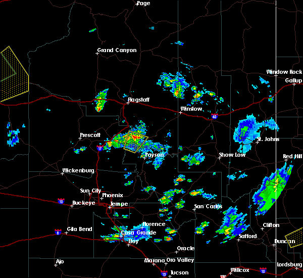 At 828 pm mst, national weather service doppler radar indicated a severe thunderstorm capable of producing quarter size hail and damaging winds in excess of 60 mph. this storm was located 7 miles south of happy jack, or 23 miles east of camp verde, moving northeast at 30 mph. locations impacted include, strawberry, clints well, pine and clints well campground. At 828 pm mst, national weather service doppler radar indicated a severe thunderstorm capable of producing quarter size hail and damaging winds in excess of 60 mph. this storm was located 7 miles south of happy jack, or 23 miles east of camp verde, moving northeast at 30 mph. locations impacted include, strawberry, clints well, pine and clints well campground.
|
| 10/18/2015 8:09 PM MST |
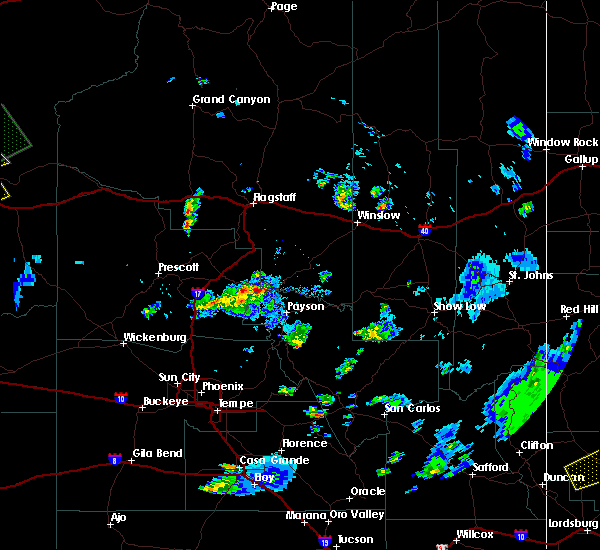 At 808 pm mst, national weather service doppler radar indicated a severe thunderstorm capable of producing quarter size hail and damaging winds in excess of 60 mph. this storm was located near strawberry, or 17 miles southeast of camp verde, and moving north at 35 mph. * this severe thunderstorm will remain over mainly rural areas of northwestern gila, eastern yavapai and southern coconino counties, including the following locations, clints well campground. this includes the following highways, state route 260 between mile markers 236 and 251. state route 87 between mile markers 268 and 286, and between mile markers 288 and 290. At 808 pm mst, national weather service doppler radar indicated a severe thunderstorm capable of producing quarter size hail and damaging winds in excess of 60 mph. this storm was located near strawberry, or 17 miles southeast of camp verde, and moving north at 35 mph. * this severe thunderstorm will remain over mainly rural areas of northwestern gila, eastern yavapai and southern coconino counties, including the following locations, clints well campground. this includes the following highways, state route 260 between mile markers 236 and 251. state route 87 between mile markers 268 and 286, and between mile markers 288 and 290.
|
| 8/23/2015 2:56 PM MST |
 The severe thunderstorm warning for northwestern gila and southern coconino counties will expire at 300 pm mst, the storm north of pine has weakened below severe limits, and no longer poses an immediate threat to life or property. the warning will be allowed to expire. small hail and heavy rain are still occurring near pine with this thunderstorm. The severe thunderstorm warning for northwestern gila and southern coconino counties will expire at 300 pm mst, the storm north of pine has weakened below severe limits, and no longer poses an immediate threat to life or property. the warning will be allowed to expire. small hail and heavy rain are still occurring near pine with this thunderstorm.
|
| 8/23/2015 2:38 PM MST |
 At 236 pm mst, doppler radar indicated a severe thunderstorm capable of producing quarter size hail. this storm was just north of pine and just east of strawberry. the storm was moving southeast at 10 mph. At 236 pm mst, doppler radar indicated a severe thunderstorm capable of producing quarter size hail. this storm was just north of pine and just east of strawberry. the storm was moving southeast at 10 mph.
|
Hail Maps for Pine, AZ
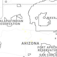
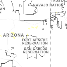
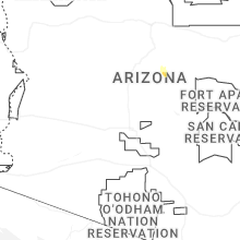
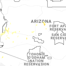


Connect with Interactive Hail Maps