

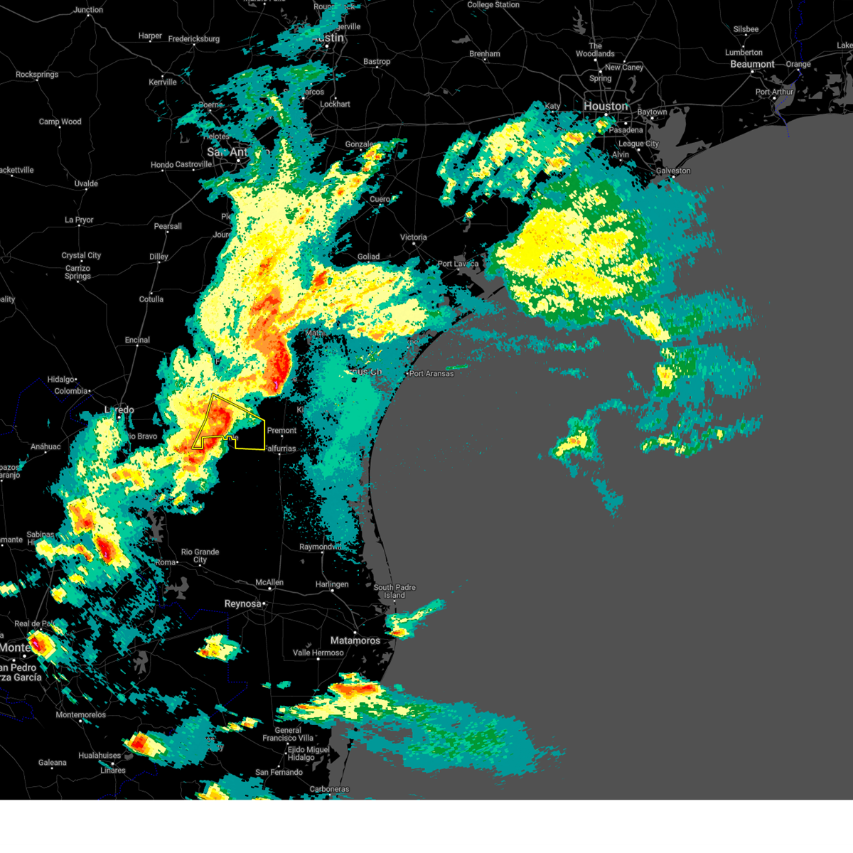
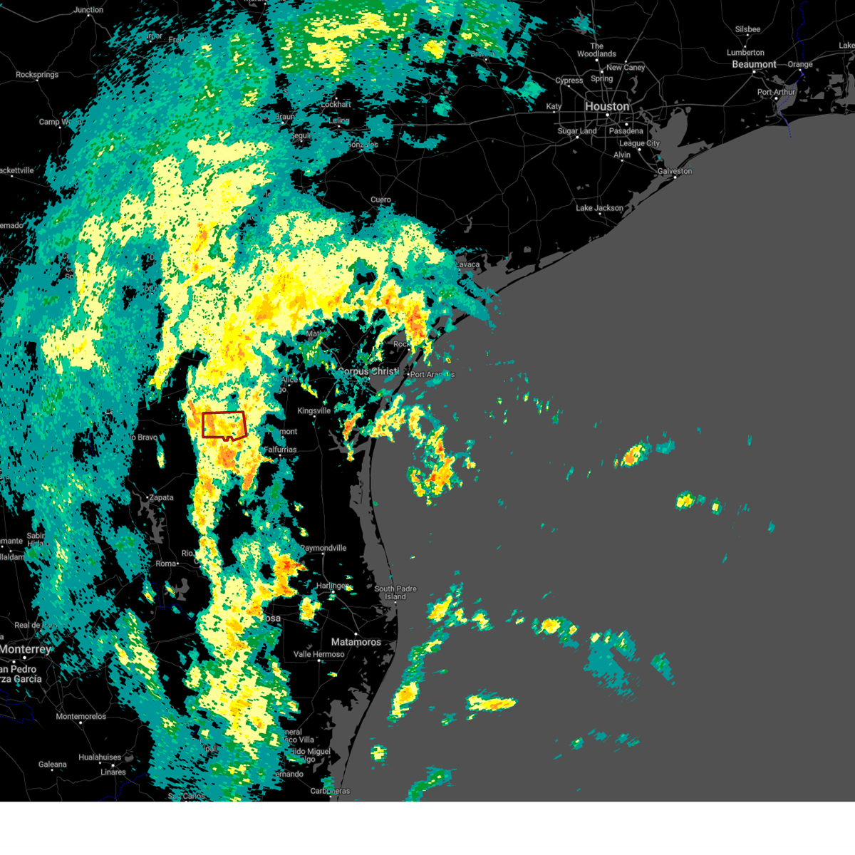
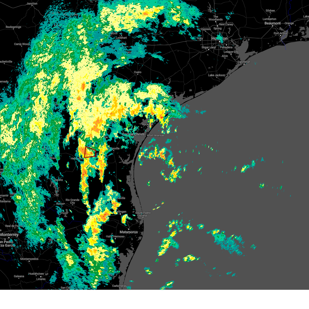
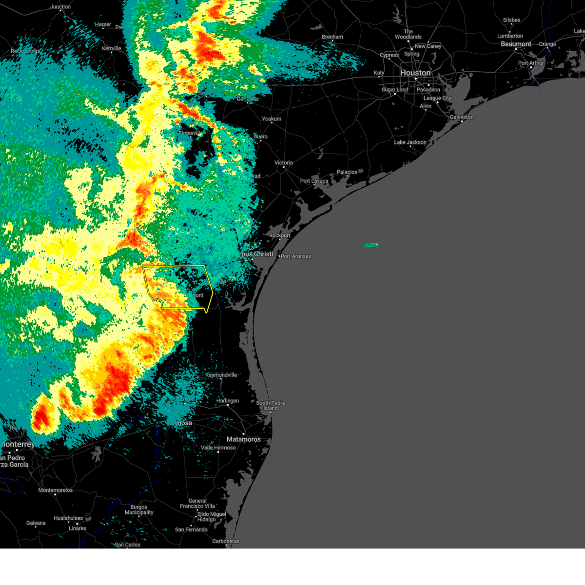
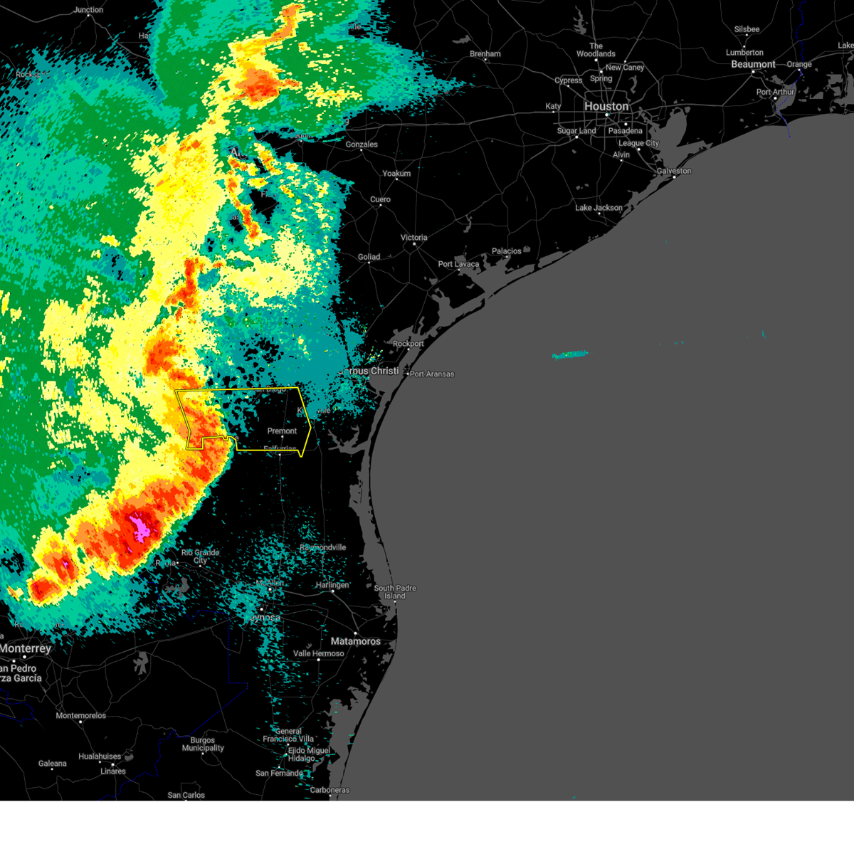
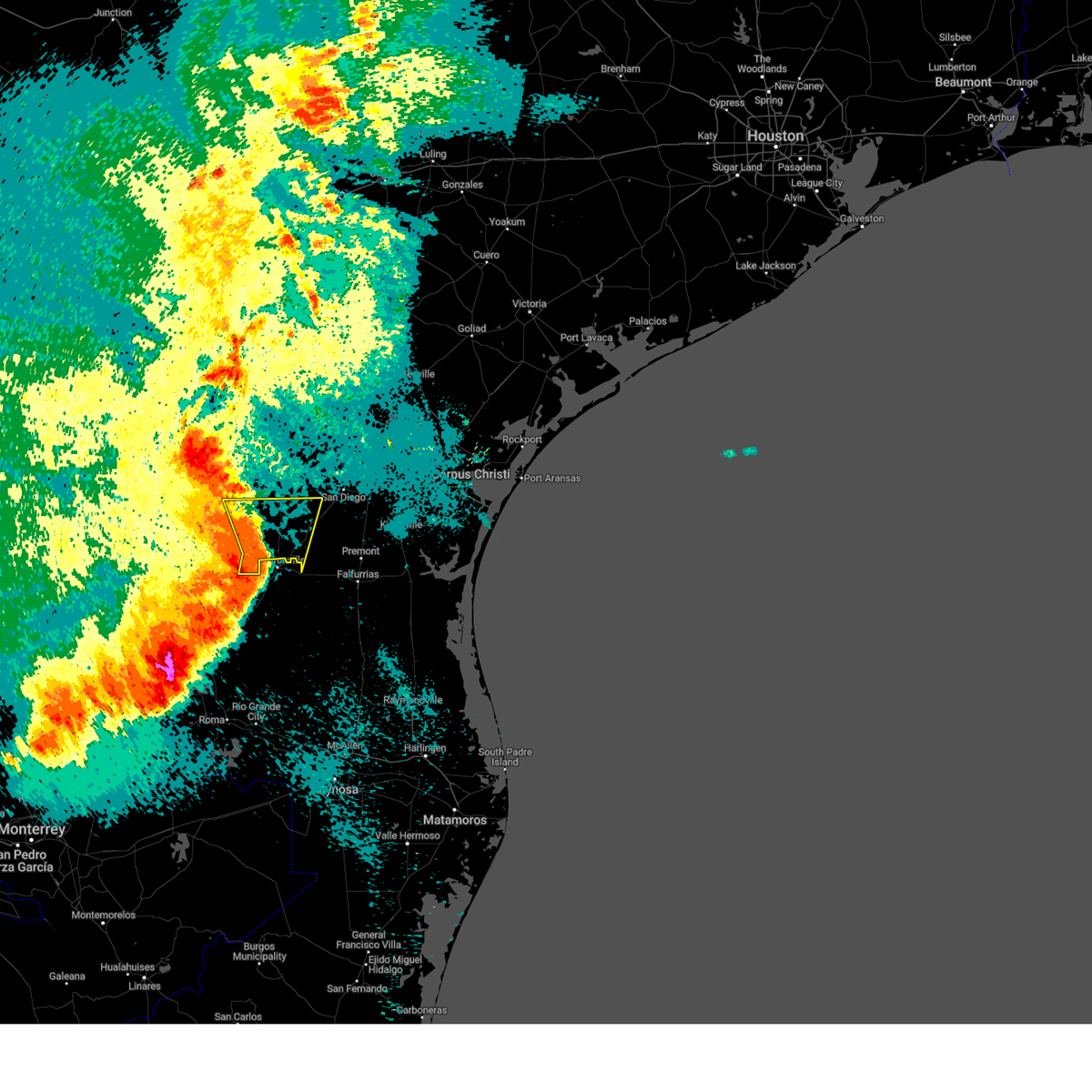
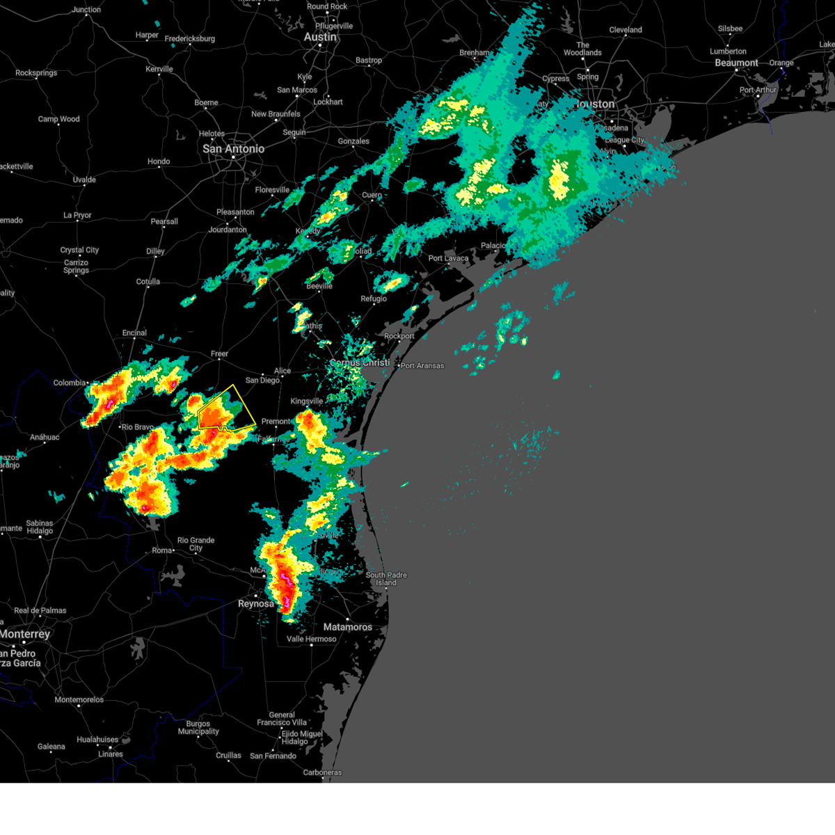
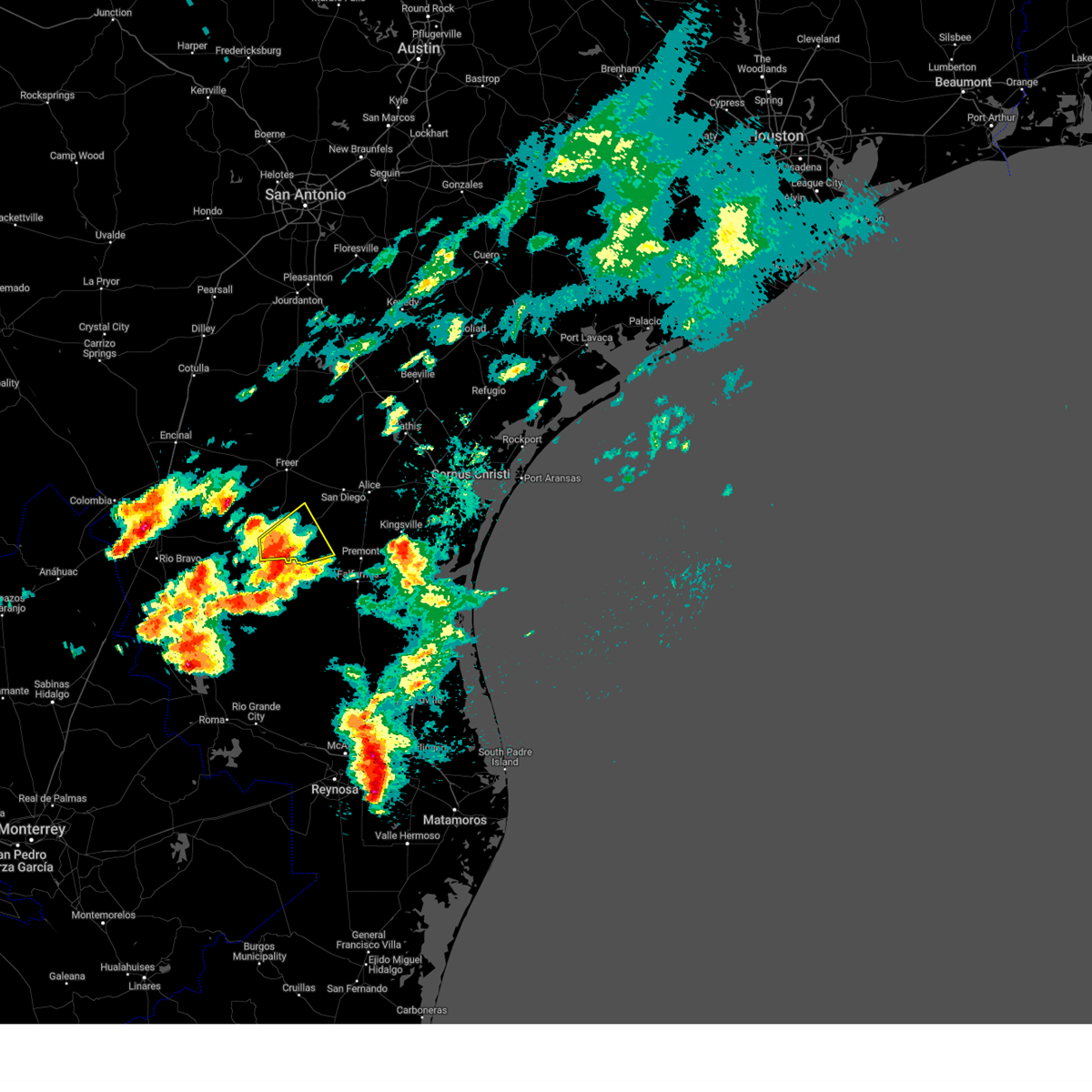
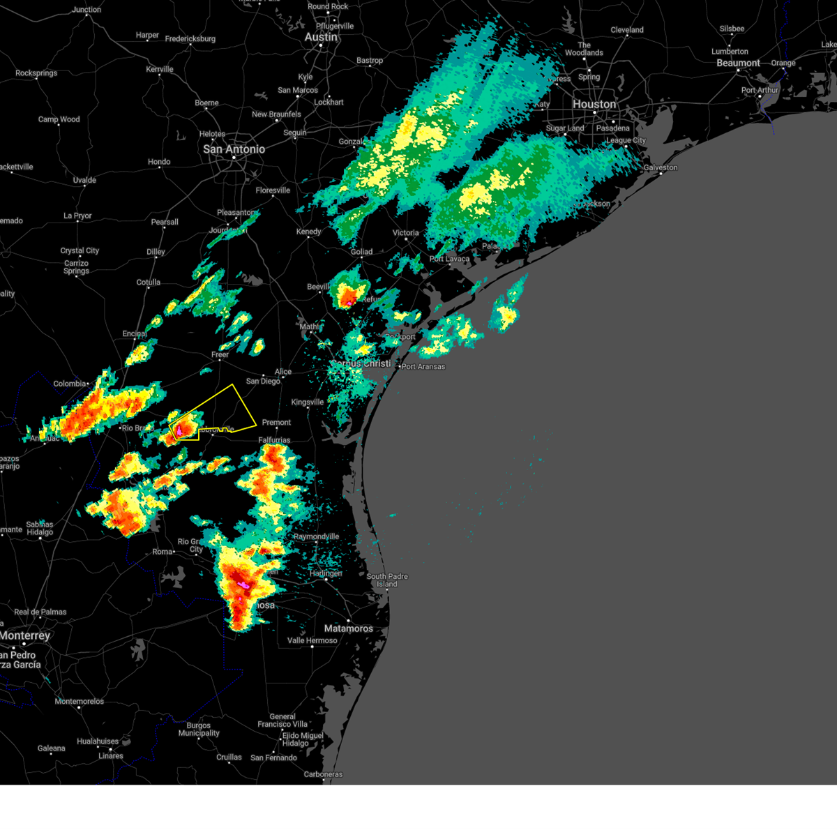
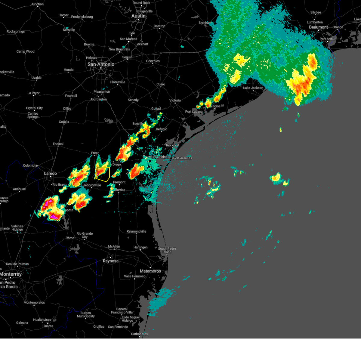
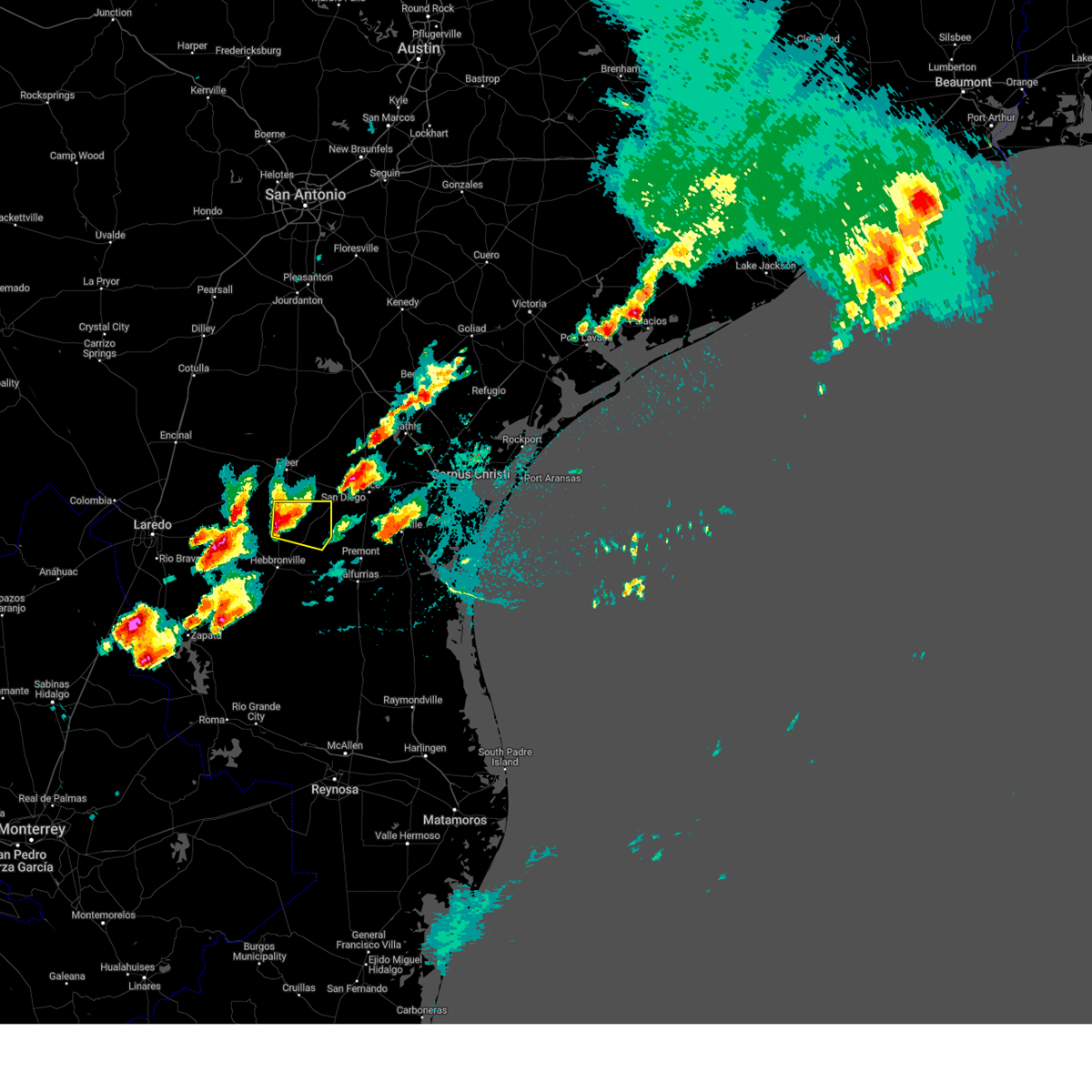
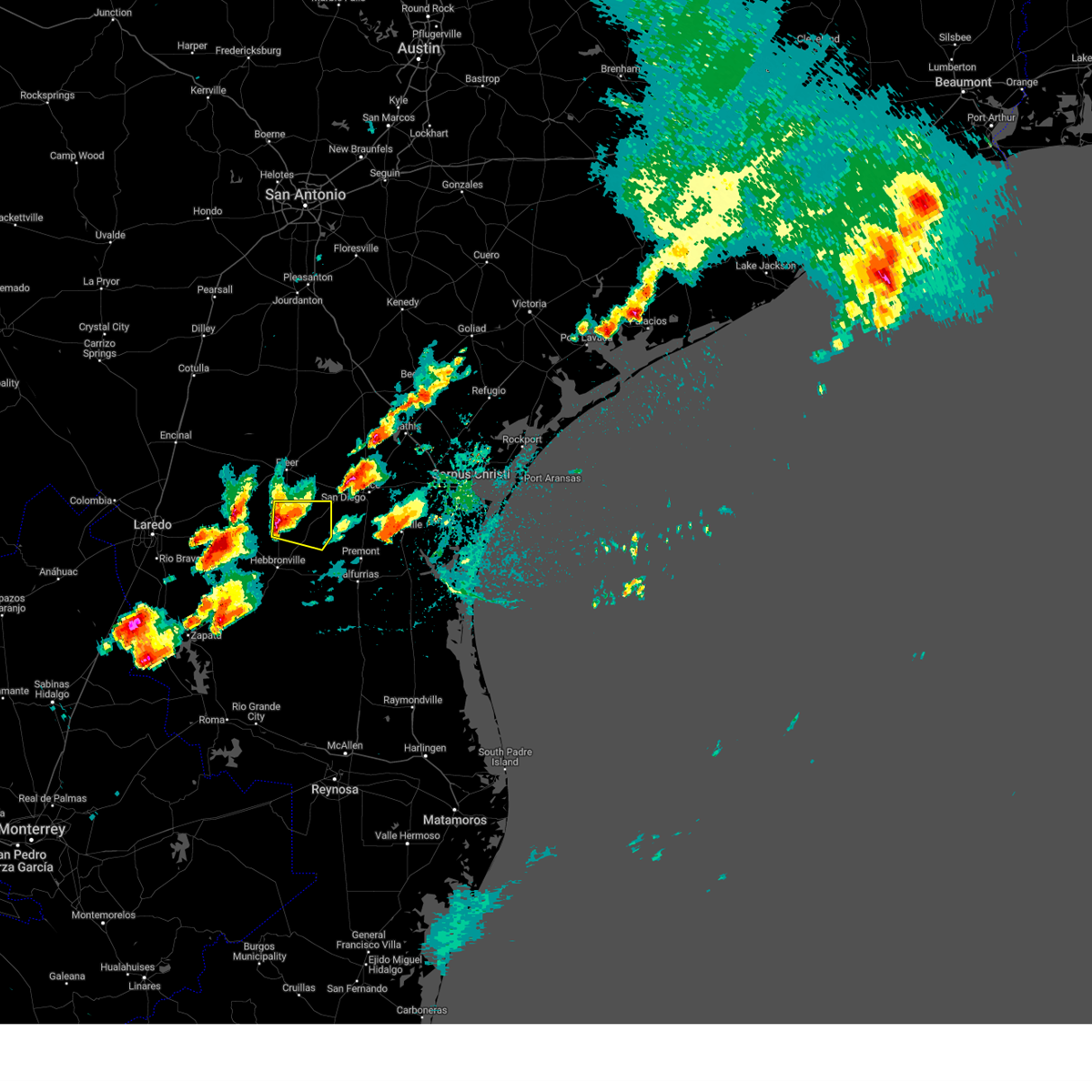
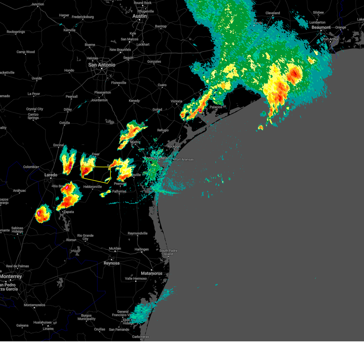
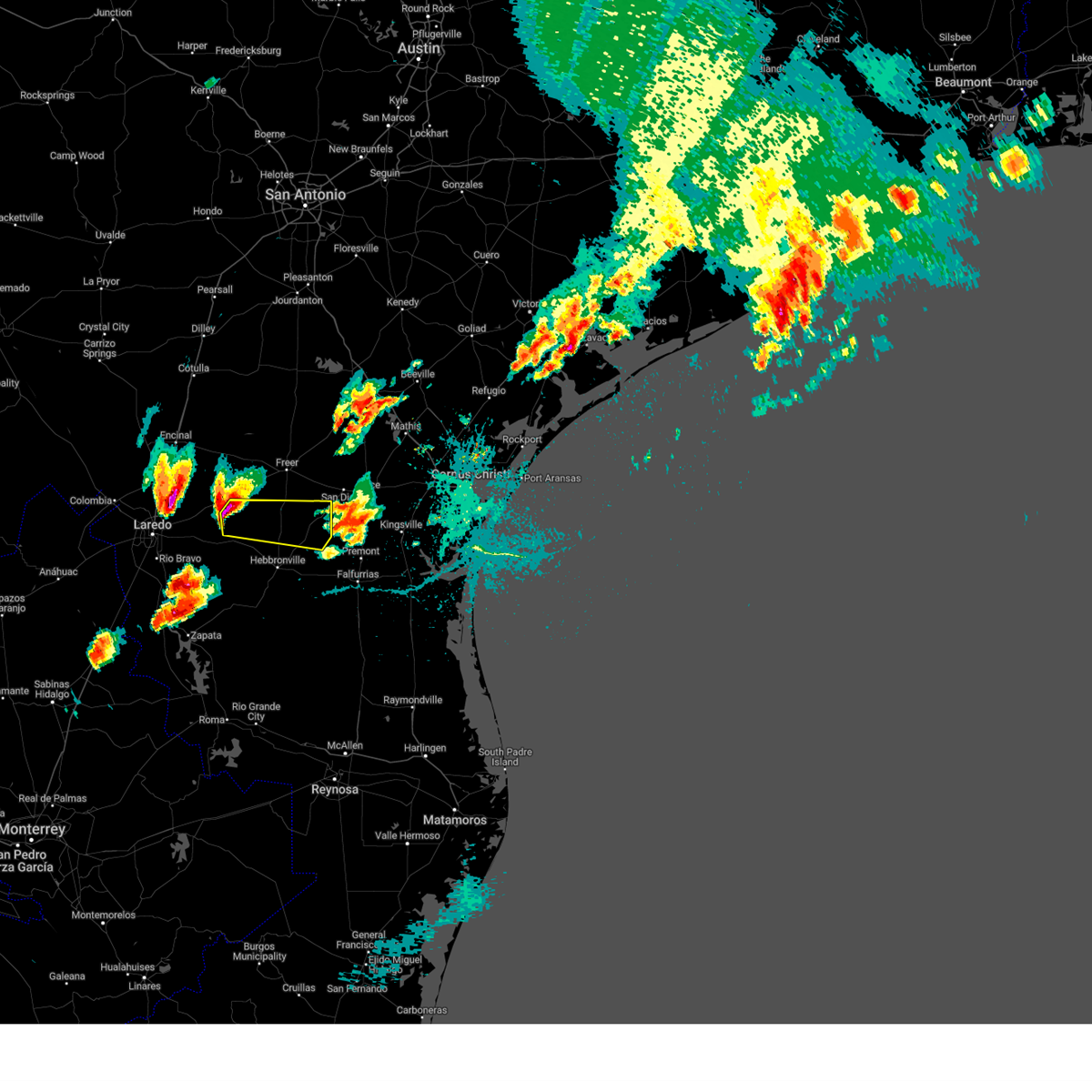
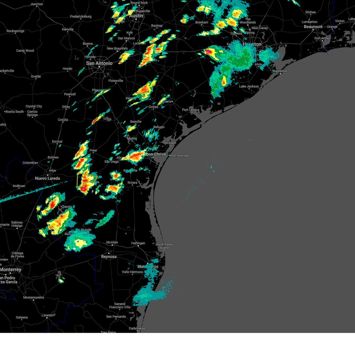
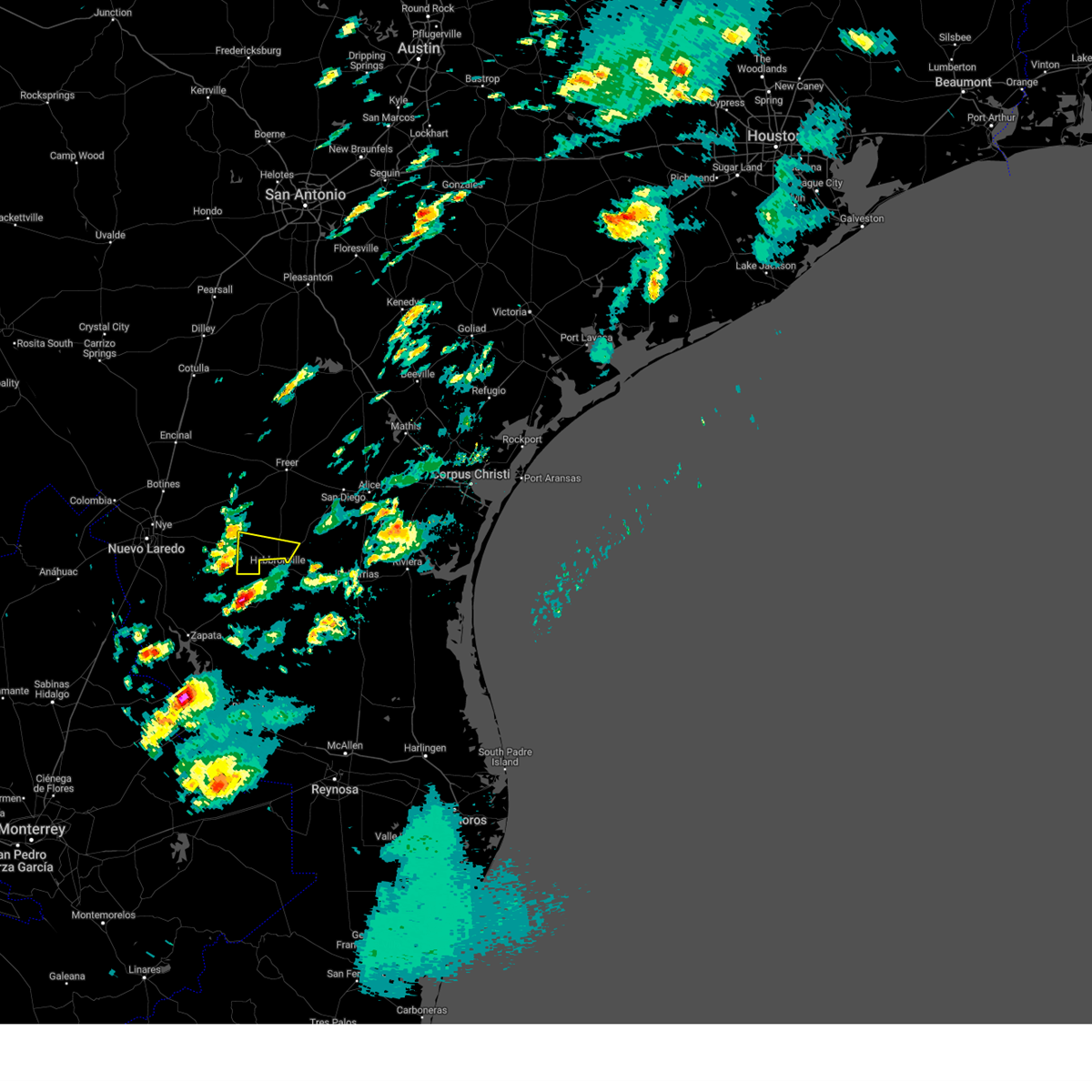
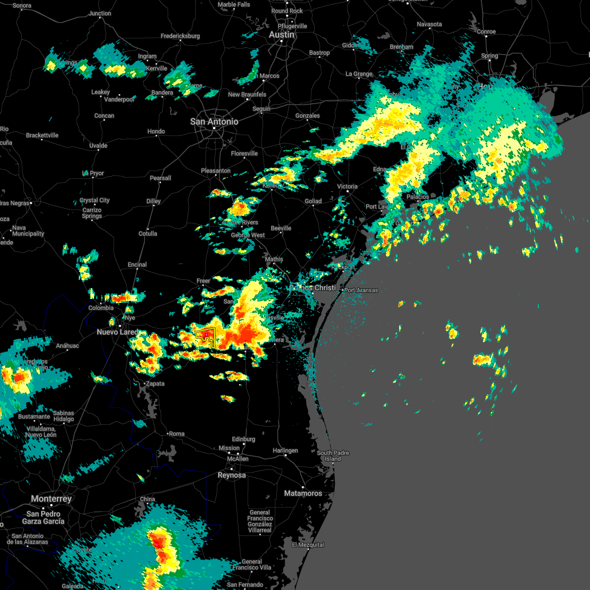
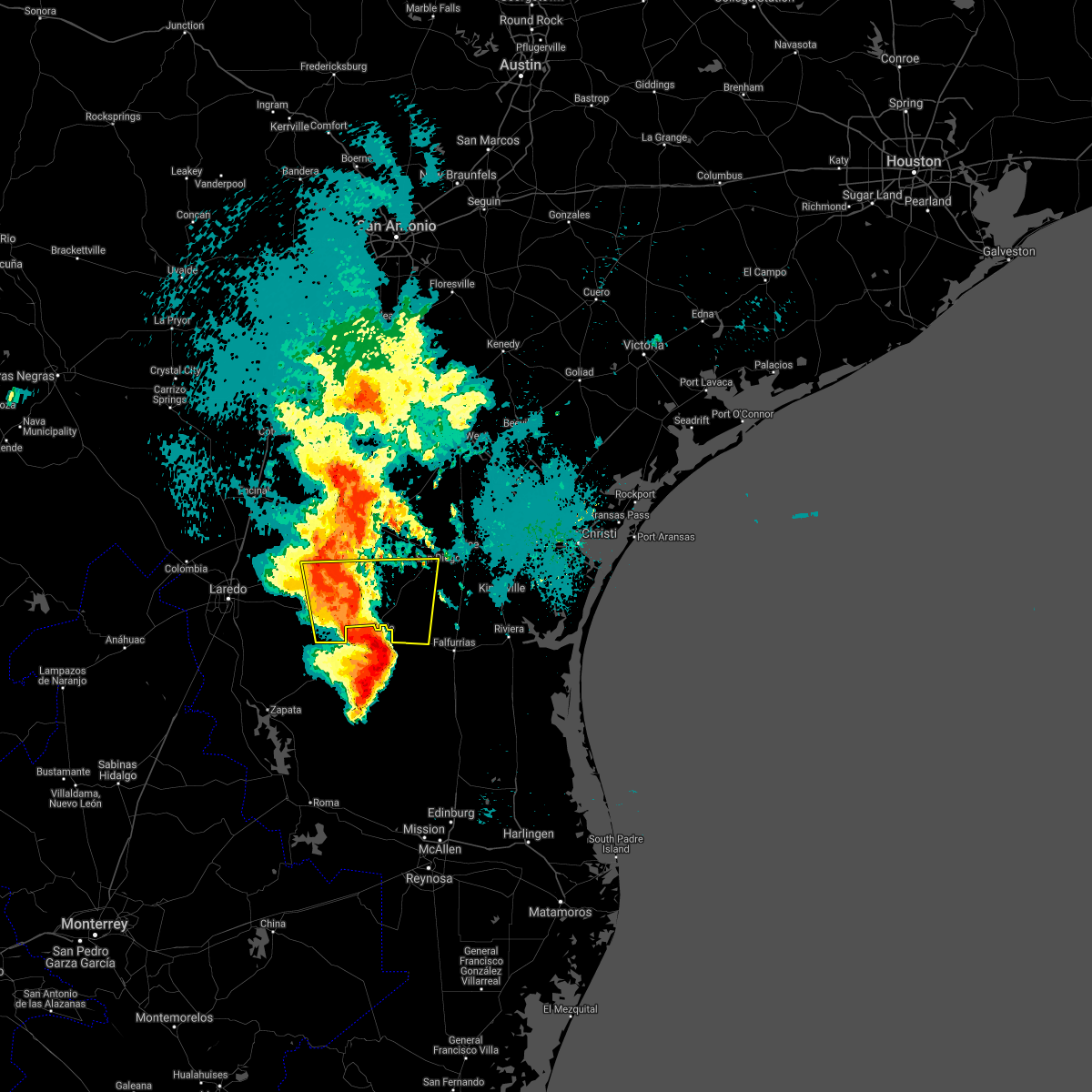
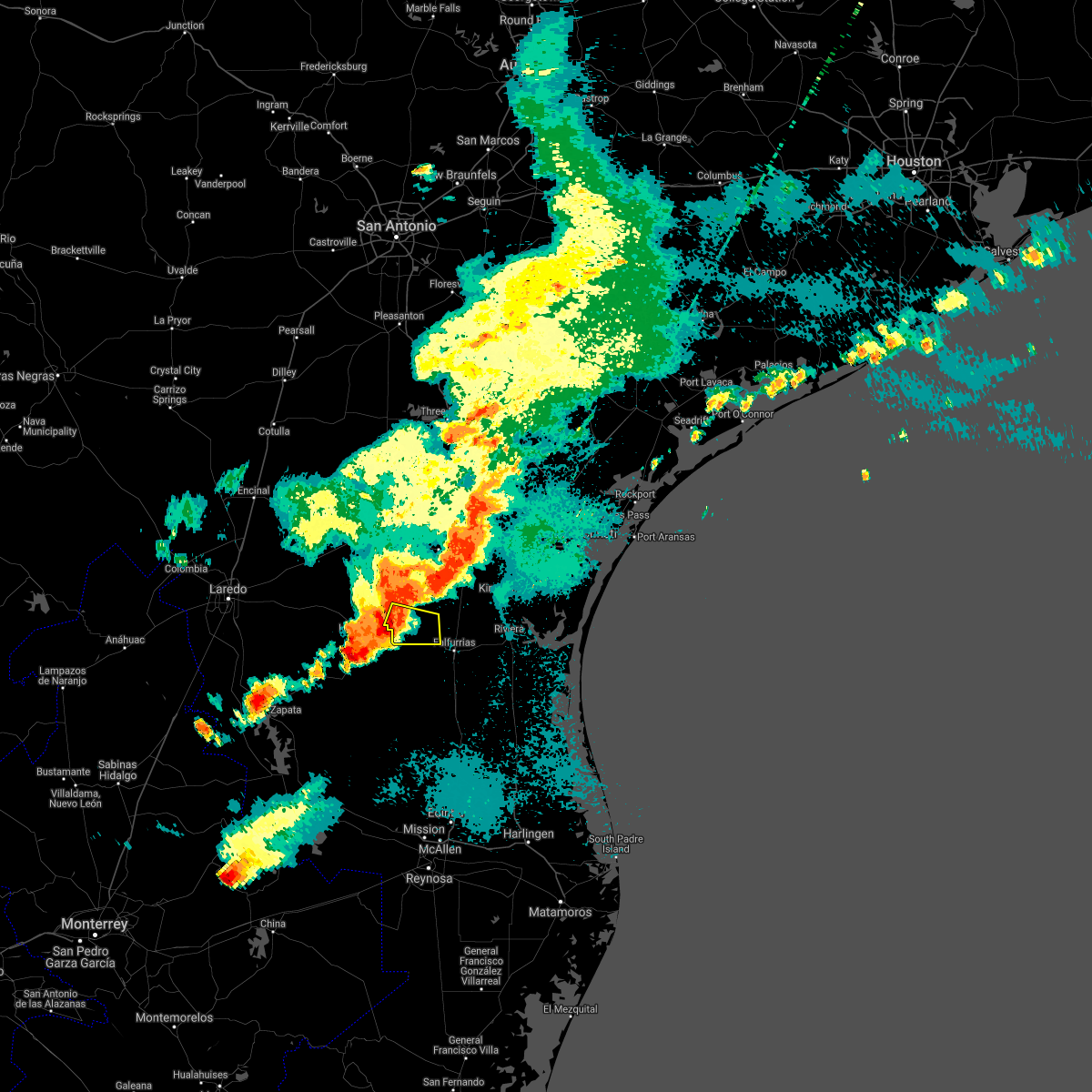
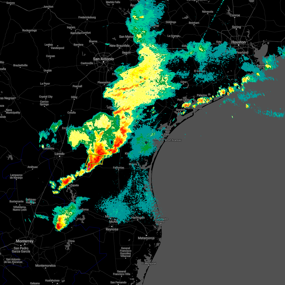
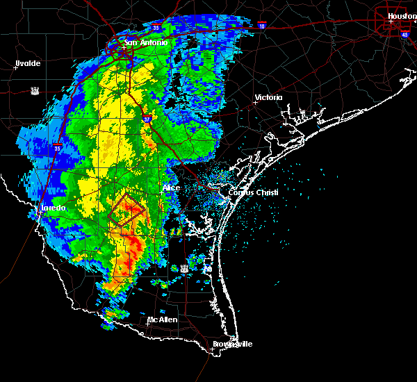
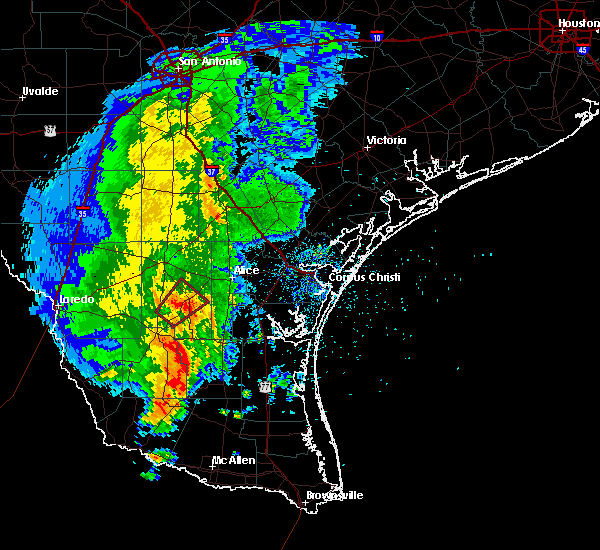
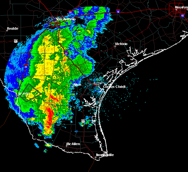
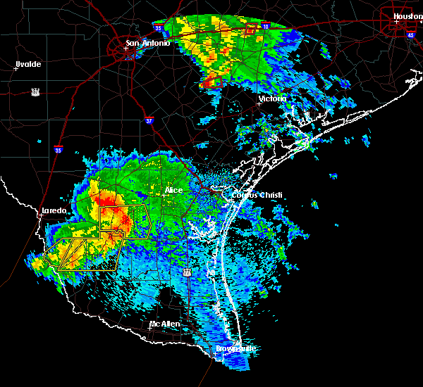
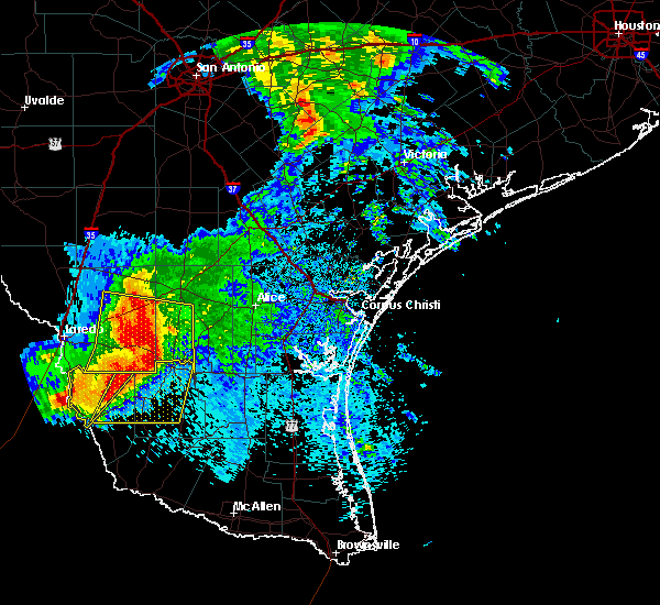
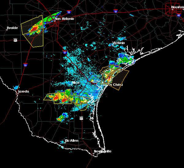
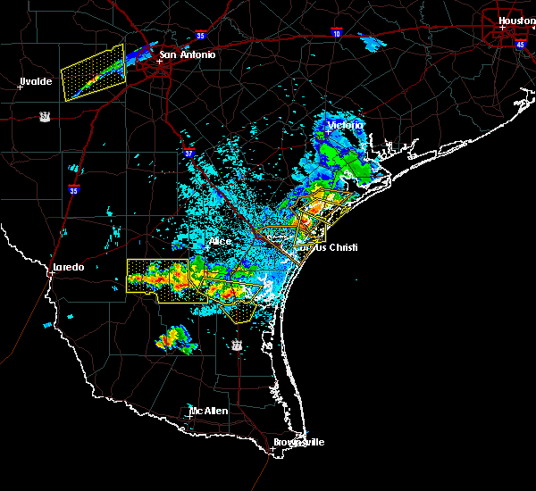
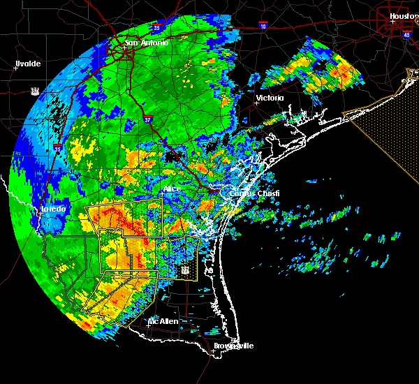
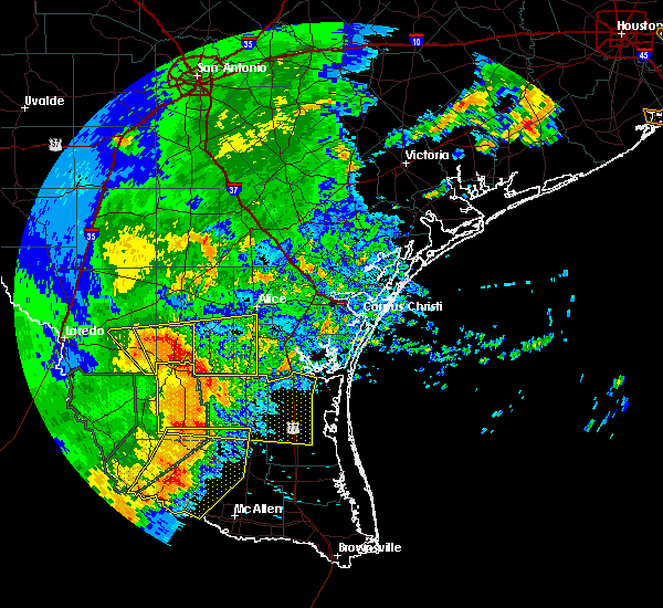
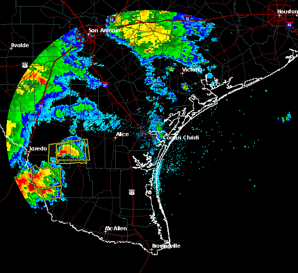
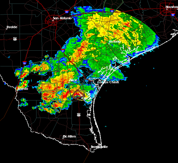
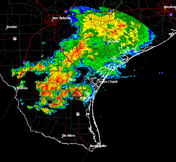
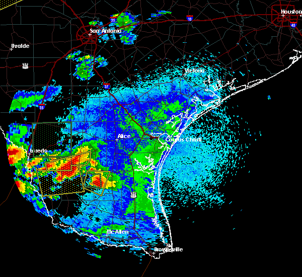
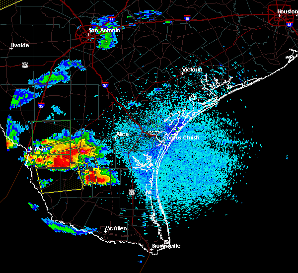
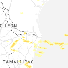
Hail Map for Realitos, TX
The Realitos, TX area has had 1 report of on-the-ground hail by trained spotters, and has been under severe weather warnings 4 times during the past 12 months. Doppler radar has detected hail at or near Realitos, TX on 21 occasions.
| Name: | Realitos, TX |
| Where Located: | 60 miles E of Laredo, TX |
| Map: | Google Map for Realitos, TX |
| Population: | 184 |
| Housing Units: | 105 |
| More Info: | Search Google for Realitos, TX |
1
The Top Recent Hail Date for Realitos, TX is Sunday, May 5, 2024 (4th out of 21)

Hail and Wind Damage Spotted near Realitos, TX
| Date / Time | Report Details |
|---|---|
| 5/8/2025 9:12 PM CDT |
 At 912 pm cdt, severe thunderstorms were located along a line extending from 8 miles northwest of realitos to near las lomitas to 6 miles southwest of south fork estates, moving southeast at 45 mph (radar indicated). Hazards include 60 mph wind gusts. Expect damage to roofs, siding, and trees. Locations impacted include, concepcion, realitos, ramirez, cruz calle, and rios. At 912 pm cdt, severe thunderstorms were located along a line extending from 8 miles northwest of realitos to near las lomitas to 6 miles southwest of south fork estates, moving southeast at 45 mph (radar indicated). Hazards include 60 mph wind gusts. Expect damage to roofs, siding, and trees. Locations impacted include, concepcion, realitos, ramirez, cruz calle, and rios.
|
| 5/8/2025 8:47 PM CDT |
 Svrcrp the national weather service in corpus christi has issued a * severe thunderstorm warning for, southern duval county in south central texas, southeastern webb county in south central texas, * until 930 pm cdt. * at 847 pm cdt, severe thunderstorms were located along a line extending from 15 miles northeast of oilton to near bruni to 8 miles south of mirando city, moving southeast at 45 mph (radar indicated). Hazards include 60 mph wind gusts and penny size hail. expect damage to roofs, siding, and trees Svrcrp the national weather service in corpus christi has issued a * severe thunderstorm warning for, southern duval county in south central texas, southeastern webb county in south central texas, * until 930 pm cdt. * at 847 pm cdt, severe thunderstorms were located along a line extending from 15 miles northeast of oilton to near bruni to 8 miles south of mirando city, moving southeast at 45 mph (radar indicated). Hazards include 60 mph wind gusts and penny size hail. expect damage to roofs, siding, and trees
|
| 5/6/2025 10:21 PM CDT |
 The storm which prompted the warning has moved out of the area. therefore, the warning will be allowed to expire. a severe thunderstorm watch remains in effect until midnight cdt for south central texas. to report severe weather, contact your nearest law enforcement agency. they will relay your report to the national weather service corpus christi. The storm which prompted the warning has moved out of the area. therefore, the warning will be allowed to expire. a severe thunderstorm watch remains in effect until midnight cdt for south central texas. to report severe weather, contact your nearest law enforcement agency. they will relay your report to the national weather service corpus christi.
|
| 5/6/2025 9:44 PM CDT |
 Svrcrp the national weather service in corpus christi has issued a * severe thunderstorm warning for, southwestern duval county in south central texas, southeastern webb county in south central texas, * until 1030 pm cdt. * at 943 pm cdt, a severe thunderstorm was located near thompsonville, or 14 miles west of hebbronville, moving east at 25 mph (radar indicated). Hazards include 60 mph wind gusts and quarter size hail. Hail damage to vehicles is expected. Expect wind damage to roofs, siding, and trees. Svrcrp the national weather service in corpus christi has issued a * severe thunderstorm warning for, southwestern duval county in south central texas, southeastern webb county in south central texas, * until 1030 pm cdt. * at 943 pm cdt, a severe thunderstorm was located near thompsonville, or 14 miles west of hebbronville, moving east at 25 mph (radar indicated). Hazards include 60 mph wind gusts and quarter size hail. Hail damage to vehicles is expected. Expect wind damage to roofs, siding, and trees.
|
| 6/19/2024 8:35 PM CDT |
 Torcrp the national weather service in corpus christi has issued a * tornado warning for, southwestern duval county in south central texas, * until 900 pm cdt. * at 834 pm cdt, a severe thunderstorm capable of producing a tornado was located over realitos, or 12 miles southwest of benavides, moving west at 25 mph (radar indicated rotation). Hazards include tornado. Flying debris will be dangerous to those caught without shelter. mobile homes will be damaged or destroyed. damage to roofs, windows, and vehicles will occur. tree damage is likely. This tornadic thunderstorm will remain over mainly rural areas of southwestern duval county. Torcrp the national weather service in corpus christi has issued a * tornado warning for, southwestern duval county in south central texas, * until 900 pm cdt. * at 834 pm cdt, a severe thunderstorm capable of producing a tornado was located over realitos, or 12 miles southwest of benavides, moving west at 25 mph (radar indicated rotation). Hazards include tornado. Flying debris will be dangerous to those caught without shelter. mobile homes will be damaged or destroyed. damage to roofs, windows, and vehicles will occur. tree damage is likely. This tornadic thunderstorm will remain over mainly rural areas of southwestern duval county.
|
| 6/19/2024 8:08 PM CDT |
 Torcrp the national weather service in corpus christi has issued a * tornado warning for, southeastern duval county in south central texas, * until 830 pm cdt. * at 808 pm cdt, a severe thunderstorm capable of producing a tornado was located near concepcion, or 8 miles south of benavides, moving west at 35 mph (radar indicated rotation). Hazards include tornado. Flying debris will be dangerous to those caught without shelter. mobile homes will be damaged or destroyed. damage to roofs, windows, and vehicles will occur. Tree damage is likely. Torcrp the national weather service in corpus christi has issued a * tornado warning for, southeastern duval county in south central texas, * until 830 pm cdt. * at 808 pm cdt, a severe thunderstorm capable of producing a tornado was located near concepcion, or 8 miles south of benavides, moving west at 35 mph (radar indicated rotation). Hazards include tornado. Flying debris will be dangerous to those caught without shelter. mobile homes will be damaged or destroyed. damage to roofs, windows, and vehicles will occur. Tree damage is likely.
|
| 5/28/2024 11:28 PM CDT |
 the severe thunderstorm warning has been cancelled and is no longer in effect the severe thunderstorm warning has been cancelled and is no longer in effect
|
| 5/28/2024 11:28 PM CDT |
 At 1126 pm cdt, severe thunderstorms were located along a line extending from near rosita to rios to 11 miles west of falfurrias junior high school, moving east at 40 mph (radar indicated). Hazards include 60 mph wind gusts. Expect damage to roofs, siding, and trees. these severe storms will be near, san jose and rios around 1130 pm cdt. premont, palito blanco, and la gloria around 1135 pm cdt. ben bolt and alice acres around 1150 pm cdt. alice around 1155 pm cdt. This includes us highway 281 between mile markers 676 and 708. At 1126 pm cdt, severe thunderstorms were located along a line extending from near rosita to rios to 11 miles west of falfurrias junior high school, moving east at 40 mph (radar indicated). Hazards include 60 mph wind gusts. Expect damage to roofs, siding, and trees. these severe storms will be near, san jose and rios around 1130 pm cdt. premont, palito blanco, and la gloria around 1135 pm cdt. ben bolt and alice acres around 1150 pm cdt. alice around 1155 pm cdt. This includes us highway 281 between mile markers 676 and 708.
|
| 5/28/2024 10:53 PM CDT |
 Svrcrp the national weather service in corpus christi has issued a * severe thunderstorm warning for, southern duval county in south central texas, southeastern webb county in south central texas, southwestern jim wells county in south central texas, western kleberg county in south central texas, * until 1145 pm cdt. * at 1052 pm cdt, severe thunderstorms were located along a line extending from 16 miles west of freer to near realitos to 7 miles southeast of south fork estates, moving east at 40 mph (radar indicated). Hazards include 60 mph wind gusts. Expect damage to roofs, siding, and trees. severe thunderstorms will be near, realitos around 1100 pm cdt. ramirez around 1105 pm cdt. concepcion around 1110 pm cdt. benavides around 1115 pm cdt. cruz calle and rios around 1120 pm cdt. san jose around 1125 pm cdt. premont around 1130 pm cdt. la gloria around 1135 pm cdt. this includes the following highways, us highway 281 between mile markers 676 and 708. Us highway 59 near mile marker 796. Svrcrp the national weather service in corpus christi has issued a * severe thunderstorm warning for, southern duval county in south central texas, southeastern webb county in south central texas, southwestern jim wells county in south central texas, western kleberg county in south central texas, * until 1145 pm cdt. * at 1052 pm cdt, severe thunderstorms were located along a line extending from 16 miles west of freer to near realitos to 7 miles southeast of south fork estates, moving east at 40 mph (radar indicated). Hazards include 60 mph wind gusts. Expect damage to roofs, siding, and trees. severe thunderstorms will be near, realitos around 1100 pm cdt. ramirez around 1105 pm cdt. concepcion around 1110 pm cdt. benavides around 1115 pm cdt. cruz calle and rios around 1120 pm cdt. san jose around 1125 pm cdt. premont around 1130 pm cdt. la gloria around 1135 pm cdt. this includes the following highways, us highway 281 between mile markers 676 and 708. Us highway 59 near mile marker 796.
|
| 5/28/2024 10:46 PM CDT |
 At 1046 pm cdt, severe thunderstorms were located along a line extending from 12 miles north of bruni to near las lomitas to 7 miles east of randado, moving east at 45 mph (radar indicated). Hazards include 60 mph wind gusts. Expect damage to roofs, siding, and trees. these severe storms will be near, realitos around 1050 pm cdt. benavides around 1110 pm cdt. This includes us highway 59 near mile marker 796. At 1046 pm cdt, severe thunderstorms were located along a line extending from 12 miles north of bruni to near las lomitas to 7 miles east of randado, moving east at 45 mph (radar indicated). Hazards include 60 mph wind gusts. Expect damage to roofs, siding, and trees. these severe storms will be near, realitos around 1050 pm cdt. benavides around 1110 pm cdt. This includes us highway 59 near mile marker 796.
|
| 5/28/2024 10:34 PM CDT |
 At 1033 pm cdt, severe thunderstorms were located along a line extending from 9 miles south of fort ewell site to near bruni to near thompsonville, moving east at 45 mph (radar indicated). Hazards include 60 mph wind gusts. Expect damage to roofs, siding, and trees. these severe storms will be near, realitos around 1050 pm cdt. freer around 1055 pm cdt. benavides around 1100 pm cdt. seven sisters and rosita around 1110 pm cdt. This includes us highway 59 between mile markers 754 and 800. At 1033 pm cdt, severe thunderstorms were located along a line extending from 9 miles south of fort ewell site to near bruni to near thompsonville, moving east at 45 mph (radar indicated). Hazards include 60 mph wind gusts. Expect damage to roofs, siding, and trees. these severe storms will be near, realitos around 1050 pm cdt. freer around 1055 pm cdt. benavides around 1100 pm cdt. seven sisters and rosita around 1110 pm cdt. This includes us highway 59 between mile markers 754 and 800.
|
| 5/28/2024 10:23 PM CDT |
 At 1023 pm cdt, severe thunderstorms were located along a line extending from 16 miles south of fort ewell site to near oilton to near thompsonville, moving east at 45 mph (radar indicated). Hazards include 60 mph wind gusts and penny size hail. Expect damage to roofs, siding, and trees. these severe storms will be near, bruni around 1030 pm cdt. realitos around 1045 pm cdt. freer around 1055 pm cdt. benavides around 1100 pm cdt. rosita around 1105 pm cdt. This includes us highway 59 between mile markers 754 and 806. At 1023 pm cdt, severe thunderstorms were located along a line extending from 16 miles south of fort ewell site to near oilton to near thompsonville, moving east at 45 mph (radar indicated). Hazards include 60 mph wind gusts and penny size hail. Expect damage to roofs, siding, and trees. these severe storms will be near, bruni around 1030 pm cdt. realitos around 1045 pm cdt. freer around 1055 pm cdt. benavides around 1100 pm cdt. rosita around 1105 pm cdt. This includes us highway 59 between mile markers 754 and 806.
|
| 5/28/2024 10:09 PM CDT |
 Svrcrp the national weather service in corpus christi has issued a * severe thunderstorm warning for, duval county in south central texas, eastern webb county in south central texas, * until 1115 pm cdt. * at 1008 pm cdt, severe thunderstorms were located along a line extending from 10 miles east of encinal to 6 miles southeast of ranchitos las lomas to 17 miles southwest of aguilares, moving east at 45 mph (radar indicated). Hazards include 60 mph wind gusts and penny size hail. Expect damage to roofs, siding, and trees. severe thunderstorms will be near, aguilares and mirando city around 1015 pm cdt. oilton around 1020 pm cdt. bruni around 1030 pm cdt. freer around 1045 pm cdt. seven sisters around 1055 pm cdt. rosita and realitos around 1100 pm cdt. benavides around 1105 pm cdt. this includes the following highways, interstate 35 between mile markers 31 and 34. Us highway 59 between mile markers 754 and 816. Svrcrp the national weather service in corpus christi has issued a * severe thunderstorm warning for, duval county in south central texas, eastern webb county in south central texas, * until 1115 pm cdt. * at 1008 pm cdt, severe thunderstorms were located along a line extending from 10 miles east of encinal to 6 miles southeast of ranchitos las lomas to 17 miles southwest of aguilares, moving east at 45 mph (radar indicated). Hazards include 60 mph wind gusts and penny size hail. Expect damage to roofs, siding, and trees. severe thunderstorms will be near, aguilares and mirando city around 1015 pm cdt. oilton around 1020 pm cdt. bruni around 1030 pm cdt. freer around 1045 pm cdt. seven sisters around 1055 pm cdt. rosita and realitos around 1100 pm cdt. benavides around 1105 pm cdt. this includes the following highways, interstate 35 between mile markers 31 and 34. Us highway 59 between mile markers 754 and 816.
|
| 5/17/2024 8:19 AM CDT |
 At 818 am cdt, a severe thunderstorm was located near las lomitas, or 7 miles north of hebbronville, moving east at 40 mph (radar indicated). Hazards include quarter size hail. Damage to vehicles is expected. Locations impacted include, concepcion and realitos. At 818 am cdt, a severe thunderstorm was located near las lomitas, or 7 miles north of hebbronville, moving east at 40 mph (radar indicated). Hazards include quarter size hail. Damage to vehicles is expected. Locations impacted include, concepcion and realitos.
|
| 5/17/2024 8:19 AM CDT |
 the severe thunderstorm warning has been cancelled and is no longer in effect the severe thunderstorm warning has been cancelled and is no longer in effect
|
| 5/17/2024 7:55 AM CDT |
 Svrcrp the national weather service in corpus christi has issued a * severe thunderstorm warning for, southern duval county in south central texas, southeastern webb county in south central texas, * until 845 am cdt. * at 754 am cdt, a severe thunderstorm was located 7 miles southwest of bruni, or 13 miles west of hebbronville, moving east at 40 mph (radar indicated). Hazards include half dollar size hail. damage to vehicles is expected Svrcrp the national weather service in corpus christi has issued a * severe thunderstorm warning for, southern duval county in south central texas, southeastern webb county in south central texas, * until 845 am cdt. * at 754 am cdt, a severe thunderstorm was located 7 miles southwest of bruni, or 13 miles west of hebbronville, moving east at 40 mph (radar indicated). Hazards include half dollar size hail. damage to vehicles is expected
|
| 5/13/2024 5:34 PM CDT |
 At 533 pm cdt, a severe thunderstorm was located near benavides, moving east at 30 mph (radar indicated). Hazards include 60 mph wind gusts and quarter size hail. Hail damage to vehicles is expected. expect wind damage to roofs, siding, and trees. This severe storm will be near, benavides around 540 pm cdt. At 533 pm cdt, a severe thunderstorm was located near benavides, moving east at 30 mph (radar indicated). Hazards include 60 mph wind gusts and quarter size hail. Hail damage to vehicles is expected. expect wind damage to roofs, siding, and trees. This severe storm will be near, benavides around 540 pm cdt.
|
| 5/13/2024 5:17 PM CDT |
 At 516 pm cdt, a severe thunderstorm was located 9 miles northwest of realitos, or 12 miles west of benavides, moving east at 40 mph (radar indicated). Hazards include 60 mph wind gusts and quarter size hail. Hail damage to vehicles is expected. expect wind damage to roofs, siding, and trees. This severe storm will be near, benavides around 530 pm cdt. At 516 pm cdt, a severe thunderstorm was located 9 miles northwest of realitos, or 12 miles west of benavides, moving east at 40 mph (radar indicated). Hazards include 60 mph wind gusts and quarter size hail. Hail damage to vehicles is expected. expect wind damage to roofs, siding, and trees. This severe storm will be near, benavides around 530 pm cdt.
|
| 5/13/2024 5:17 PM CDT |
 the severe thunderstorm warning has been cancelled and is no longer in effect the severe thunderstorm warning has been cancelled and is no longer in effect
|
| 5/13/2024 4:59 PM CDT |
 At 459 pm cdt, a severe thunderstorm was located 11 miles north of bruni, or 20 miles north of hebbronville, moving east at 40 mph (radar indicated). Hazards include 60 mph wind gusts and half dollar size hail. Hail damage to vehicles is expected. expect wind damage to roofs, siding, and trees. This severe storm will be near, benavides around 530 pm cdt. At 459 pm cdt, a severe thunderstorm was located 11 miles north of bruni, or 20 miles north of hebbronville, moving east at 40 mph (radar indicated). Hazards include 60 mph wind gusts and half dollar size hail. Hail damage to vehicles is expected. expect wind damage to roofs, siding, and trees. This severe storm will be near, benavides around 530 pm cdt.
|
| 5/13/2024 4:45 PM CDT |
 Svrcrp the national weather service in corpus christi has issued a * severe thunderstorm warning for, central duval county in south central texas, east central webb county in south central texas, * until 545 pm cdt. * at 444 pm cdt, a severe thunderstorm was located 8 miles north of oilton, or 26 miles northwest of hebbronville, moving east at 40 mph (radar indicated). Hazards include 60 mph wind gusts and half dollar size hail. Hail damage to vehicles is expected. expect wind damage to roofs, siding, and trees. This severe thunderstorm will be near, benavides around 530 pm cdt. Svrcrp the national weather service in corpus christi has issued a * severe thunderstorm warning for, central duval county in south central texas, east central webb county in south central texas, * until 545 pm cdt. * at 444 pm cdt, a severe thunderstorm was located 8 miles north of oilton, or 26 miles northwest of hebbronville, moving east at 40 mph (radar indicated). Hazards include 60 mph wind gusts and half dollar size hail. Hail damage to vehicles is expected. expect wind damage to roofs, siding, and trees. This severe thunderstorm will be near, benavides around 530 pm cdt.
|
| 5/5/2024 6:14 PM CDT |
 At 613 pm cdt, a severe thunderstorm was located near premont, moving southeast at 40 mph (radar indicated). Hazards include 60 mph wind gusts and quarter size hail. Hail damage to vehicles is expected. expect wind damage to roofs, siding, and trees. locations impacted include, kingsville, premont, concepcion, palito blanco, realitos, la gloria, cruz calle, ramirez, rios, kingsville naval air station, and san jose. this includes the following highways, us highway 281 between mile markers 686 and 708. Us highway 77 between mile markers 694 and 698. At 613 pm cdt, a severe thunderstorm was located near premont, moving southeast at 40 mph (radar indicated). Hazards include 60 mph wind gusts and quarter size hail. Hail damage to vehicles is expected. expect wind damage to roofs, siding, and trees. locations impacted include, kingsville, premont, concepcion, palito blanco, realitos, la gloria, cruz calle, ramirez, rios, kingsville naval air station, and san jose. this includes the following highways, us highway 281 between mile markers 686 and 708. Us highway 77 between mile markers 694 and 698.
|
| 5/5/2024 5:43 PM CDT |
 Svrcrp the national weather service in corpus christi has issued a * severe thunderstorm warning for, southern duval county in south central texas, southwestern jim wells county in south central texas, west central kleberg county in south central texas, * until 630 pm cdt. * at 542 pm cdt, a severe thunderstorm was located near rios, or 10 miles southeast of benavides, moving southeast at 40 mph (radar indicated). Hazards include 60 mph wind gusts and quarter size hail. Hail damage to vehicles is expected. Expect wind damage to roofs, siding, and trees. Svrcrp the national weather service in corpus christi has issued a * severe thunderstorm warning for, southern duval county in south central texas, southwestern jim wells county in south central texas, west central kleberg county in south central texas, * until 630 pm cdt. * at 542 pm cdt, a severe thunderstorm was located near rios, or 10 miles southeast of benavides, moving southeast at 40 mph (radar indicated). Hazards include 60 mph wind gusts and quarter size hail. Hail damage to vehicles is expected. Expect wind damage to roofs, siding, and trees.
|
| 5/5/2024 5:16 PM CDT |
 the severe thunderstorm warning has been cancelled and is no longer in effect the severe thunderstorm warning has been cancelled and is no longer in effect
|
| 5/5/2024 5:16 PM CDT |
 At 515 pm cdt, severe thunderstorms were located along a line extending from near rancho de la parita to 6 miles northwest of san diego to 13 miles west of benavides, moving east at 35 mph (radar indicated). Hazards include 60 mph wind gusts and quarter size hail. Hail damage to vehicles is expected. expect wind damage to roofs, siding, and trees. locations impacted include, alice, san diego, freer, benavides, seven sisters, san jose, ben bolt, palito blanco, tecalote, realitos, annarose, rancho de la parita, alice acres, rosita, and lake alice. this includes the following highways, us highway 281 between mile markers 660 and 682. Us highway 59 between mile markers 746 and 772. At 515 pm cdt, severe thunderstorms were located along a line extending from near rancho de la parita to 6 miles northwest of san diego to 13 miles west of benavides, moving east at 35 mph (radar indicated). Hazards include 60 mph wind gusts and quarter size hail. Hail damage to vehicles is expected. expect wind damage to roofs, siding, and trees. locations impacted include, alice, san diego, freer, benavides, seven sisters, san jose, ben bolt, palito blanco, tecalote, realitos, annarose, rancho de la parita, alice acres, rosita, and lake alice. this includes the following highways, us highway 281 between mile markers 660 and 682. Us highway 59 between mile markers 746 and 772.
|
| 5/5/2024 4:58 PM CDT |
 Svrcrp the national weather service in corpus christi has issued a * severe thunderstorm warning for, duval county in south central texas, east central webb county in south central texas, southeastern mcmullen county in south central texas, northwestern jim wells county in south central texas, southwestern live oak county in south central texas, * until 545 pm cdt. * at 457 pm cdt, severe thunderstorms were located along a line extending from 8 miles southwest of clegg to near rosita to 15 miles north of bruni, moving east at 35 mph (radar indicated). Hazards include 60 mph wind gusts and quarter size hail. Hail damage to vehicles is expected. Expect wind damage to roofs, siding, and trees. Svrcrp the national weather service in corpus christi has issued a * severe thunderstorm warning for, duval county in south central texas, east central webb county in south central texas, southeastern mcmullen county in south central texas, northwestern jim wells county in south central texas, southwestern live oak county in south central texas, * until 545 pm cdt. * at 457 pm cdt, severe thunderstorms were located along a line extending from 8 miles southwest of clegg to near rosita to 15 miles north of bruni, moving east at 35 mph (radar indicated). Hazards include 60 mph wind gusts and quarter size hail. Hail damage to vehicles is expected. Expect wind damage to roofs, siding, and trees.
|
| 8/22/2023 11:41 AM CDT |
 The tornado warning for southwestern duval county will expire at 1145 am cdt, the storm which prompted the warning has weakened below severe limits, and no longer appears capable of producing a tornado. therefore, the warning will be allowed to expire. The tornado warning for southwestern duval county will expire at 1145 am cdt, the storm which prompted the warning has weakened below severe limits, and no longer appears capable of producing a tornado. therefore, the warning will be allowed to expire.
|
| 8/22/2023 11:30 AM CDT |
 At 1129 am cdt, a severe thunderstorm capable of producing a tornado was located near realitos, or 7 miles southwest of benavides, moving southwest at 40 mph (radar indicated rotation). Hazards include tornado. Flying debris will be dangerous to those caught without shelter. mobile homes will be damaged or destroyed. damage to roofs, windows, and vehicles will occur. tree damage is likely. This dangerous storm will be near, realitos around 1140 am cdt. At 1129 am cdt, a severe thunderstorm capable of producing a tornado was located near realitos, or 7 miles southwest of benavides, moving southwest at 40 mph (radar indicated rotation). Hazards include tornado. Flying debris will be dangerous to those caught without shelter. mobile homes will be damaged or destroyed. damage to roofs, windows, and vehicles will occur. tree damage is likely. This dangerous storm will be near, realitos around 1140 am cdt.
|
| 8/22/2023 11:10 AM CDT |
 At 1110 am cdt, a severe thunderstorm capable of producing a tornado was located near san jose, or 7 miles southwest of san diego, moving west at 35 mph (radar indicated rotation). Hazards include tornado. Flying debris will be dangerous to those caught without shelter. mobile homes will be damaged or destroyed. damage to roofs, windows, and vehicles will occur. tree damage is likely. This dangerous storm will be near, benavides around 1125 am cdt. At 1110 am cdt, a severe thunderstorm capable of producing a tornado was located near san jose, or 7 miles southwest of san diego, moving west at 35 mph (radar indicated rotation). Hazards include tornado. Flying debris will be dangerous to those caught without shelter. mobile homes will be damaged or destroyed. damage to roofs, windows, and vehicles will occur. tree damage is likely. This dangerous storm will be near, benavides around 1125 am cdt.
|
| 4/5/2023 9:37 PM CDT |
 The severe thunderstorm warning for southwestern duval and southeastern webb counties will expire at 945 pm cdt, the storm which prompted the warning has weakened below severe limits, and no longer poses an immediate threat to life or property. therefore, the warning will be allowed to expire. The severe thunderstorm warning for southwestern duval and southeastern webb counties will expire at 945 pm cdt, the storm which prompted the warning has weakened below severe limits, and no longer poses an immediate threat to life or property. therefore, the warning will be allowed to expire.
|
| 4/5/2023 9:20 PM CDT |
 At 920 pm cdt, a severe thunderstorm was located 7 miles southwest of jim hogg county airport, or 10 miles west of hebbronville, moving north at 20 mph (radar indicated). Hazards include quarter size hail. Damage to vehicles is expected. locations impacted include, bruni and realitos. hail threat, radar indicated max hail size, 1. 00 in wind threat, radar indicated max wind gust, <50 mph. At 920 pm cdt, a severe thunderstorm was located 7 miles southwest of jim hogg county airport, or 10 miles west of hebbronville, moving north at 20 mph (radar indicated). Hazards include quarter size hail. Damage to vehicles is expected. locations impacted include, bruni and realitos. hail threat, radar indicated max hail size, 1. 00 in wind threat, radar indicated max wind gust, <50 mph.
|
| 4/5/2023 8:54 PM CDT |
 At 854 pm cdt, a severe thunderstorm was located near thompsonville, or 16 miles southwest of hebbronville, moving north at 20 mph (radar indicated). Hazards include half dollar size hail. damage to vehicles is expected At 854 pm cdt, a severe thunderstorm was located near thompsonville, or 16 miles southwest of hebbronville, moving north at 20 mph (radar indicated). Hazards include half dollar size hail. damage to vehicles is expected
|
| 4/25/2022 6:47 PM CDT |
 At 646 pm cdt, a severe thunderstorm was located near las lomitas, or 7 miles northeast of hebbronville, moving south at 15 mph (radar indicated). Hazards include 60 mph wind gusts and half dollar size hail. Hail damage to vehicles is expected. Expect wind damage to roofs, siding, and trees. At 646 pm cdt, a severe thunderstorm was located near las lomitas, or 7 miles northeast of hebbronville, moving south at 15 mph (radar indicated). Hazards include 60 mph wind gusts and half dollar size hail. Hail damage to vehicles is expected. Expect wind damage to roofs, siding, and trees.
|
| 6/1/2021 3:52 AM CDT |
 At 352 am cdt, severe thunderstorms were located along a line extending from 7 miles west of seven sisters to near oilton to 9 miles east of rio bravo, moving southeast at 30 mph (radar indicated). Hazards include 60 mph wind gusts and penny size hail. Expect damage to roofs, siding, and trees. locations impacted include, laredo, freer, benavides, texas a&m, laredo international airport, seven sisters, loma alta, mirando city, oilton, united south high school, aguilares, realitos, ranchitos las lomas, st augustine high school south laredo, laredo country club, bruni and rosita. this includes the following highways, interstate 35 between mile markers 1 and 4. us highway 59 between mile markers 746 and 824. Us highway 83 between mile markers 718 and 720. At 352 am cdt, severe thunderstorms were located along a line extending from 7 miles west of seven sisters to near oilton to 9 miles east of rio bravo, moving southeast at 30 mph (radar indicated). Hazards include 60 mph wind gusts and penny size hail. Expect damage to roofs, siding, and trees. locations impacted include, laredo, freer, benavides, texas a&m, laredo international airport, seven sisters, loma alta, mirando city, oilton, united south high school, aguilares, realitos, ranchitos las lomas, st augustine high school south laredo, laredo country club, bruni and rosita. this includes the following highways, interstate 35 between mile markers 1 and 4. us highway 59 between mile markers 746 and 824. Us highway 83 between mile markers 718 and 720.
|
| 6/1/2021 3:09 AM CDT |
 At 309 am cdt, severe thunderstorms were located along a line extending from 13 miles south of fowlerton to 17 miles northeast of ranchitos las lomas to near unitec industrial park, moving southeast at 40 mph (radar indicated). Hazards include 60 mph wind gusts and penny size hail. expect damage to roofs, siding, and trees At 309 am cdt, severe thunderstorms were located along a line extending from 13 miles south of fowlerton to 17 miles northeast of ranchitos las lomas to near unitec industrial park, moving southeast at 40 mph (radar indicated). Hazards include 60 mph wind gusts and penny size hail. expect damage to roofs, siding, and trees
|
| 5/18/2021 1:01 AM CDT |
 At 1238 am cdt, severe thunderstorms were located along a line extending from 15 miles southwest of freer to 7 miles southwest of ramirez, moving east at 35 mph (radar indicated). Hazards include 60 mph wind gusts and nickel size hail. Expect damage to roofs, siding, and trees. severe thunderstorms will be near, ramirez around 1245 am cdt. This includes us highway 59 near mile marker 798. At 1238 am cdt, severe thunderstorms were located along a line extending from 15 miles southwest of freer to 7 miles southwest of ramirez, moving east at 35 mph (radar indicated). Hazards include 60 mph wind gusts and nickel size hail. Expect damage to roofs, siding, and trees. severe thunderstorms will be near, ramirez around 1245 am cdt. This includes us highway 59 near mile marker 798.
|
| 5/18/2021 12:39 AM CDT |
 At 1238 am cdt, severe thunderstorms were located along a line extending from 15 miles southwest of freer to 7 miles southwest of ramirez, moving east at 35 mph (radar indicated). Hazards include 60 mph wind gusts and nickel size hail. Expect damage to roofs, siding, and trees. severe thunderstorms will be near, ramirez around 1245 am cdt. This includes us highway 59 near mile marker 798. At 1238 am cdt, severe thunderstorms were located along a line extending from 15 miles southwest of freer to 7 miles southwest of ramirez, moving east at 35 mph (radar indicated). Hazards include 60 mph wind gusts and nickel size hail. Expect damage to roofs, siding, and trees. severe thunderstorms will be near, ramirez around 1245 am cdt. This includes us highway 59 near mile marker 798.
|
| 5/11/2021 9:50 PM CDT |
 At 950 pm cdt, a severe thunderstorm was located near ramirez, or 11 miles east of hebbronville, moving southeast at 30 mph (radar indicated). Hazards include ping pong ball size hail and 60 mph wind gusts. People and animals outdoors will be injured. expect hail damage to roofs, siding, windows, and vehicles. expect wind damage to roofs, siding, and trees. this severe thunderstorm will be near, ramirez and concepcion around 1000 pm cdt. Cruz calle around 1015 pm cdt. At 950 pm cdt, a severe thunderstorm was located near ramirez, or 11 miles east of hebbronville, moving southeast at 30 mph (radar indicated). Hazards include ping pong ball size hail and 60 mph wind gusts. People and animals outdoors will be injured. expect hail damage to roofs, siding, windows, and vehicles. expect wind damage to roofs, siding, and trees. this severe thunderstorm will be near, ramirez and concepcion around 1000 pm cdt. Cruz calle around 1015 pm cdt.
|
| 5/11/2021 9:36 PM CDT |
 At 936 pm cdt, a severe thunderstorm was located near jim hogg county airport, or 8 miles northwest of hebbronville, moving east at 20 mph (radar indicated). Hazards include golf ball size hail and 60 mph wind gusts. People and animals outdoors will be injured. expect hail damage to roofs, siding, windows, and vehicles. expect wind damage to roofs, siding, and trees. This severe storm will be near, realitos around 1015 pm cdt. At 936 pm cdt, a severe thunderstorm was located near jim hogg county airport, or 8 miles northwest of hebbronville, moving east at 20 mph (radar indicated). Hazards include golf ball size hail and 60 mph wind gusts. People and animals outdoors will be injured. expect hail damage to roofs, siding, windows, and vehicles. expect wind damage to roofs, siding, and trees. This severe storm will be near, realitos around 1015 pm cdt.
|
| 5/11/2021 9:15 PM CDT |
 At 914 pm cdt, a severe thunderstorm was located near bruni, or 15 miles northwest of hebbronville, moving east at 20 mph (radar indicated). Hazards include 60 mph wind gusts and half dollar size hail. Hail damage to vehicles is expected. expect wind damage to roofs, siding, and trees. This severe thunderstorm will be near, bruni around 925 pm cdt. At 914 pm cdt, a severe thunderstorm was located near bruni, or 15 miles northwest of hebbronville, moving east at 20 mph (radar indicated). Hazards include 60 mph wind gusts and half dollar size hail. Hail damage to vehicles is expected. expect wind damage to roofs, siding, and trees. This severe thunderstorm will be near, bruni around 925 pm cdt.
|
| 7/25/2020 7:45 PM CDT |
 At 744 pm cdt, a severe thunderstorm capable of producing a tornado was located near cruz calle, or 11 miles west of premont, moving southwest at 45 mph (radar indicated rotation). Hazards include tornado. Flying debris will be dangerous to those caught without shelter. mobile homes will be damaged or destroyed. damage to roofs, windows, and vehicles will occur. tree damage is likely. This dangerous storm will be near, ramirez around 750 pm cdt. At 744 pm cdt, a severe thunderstorm capable of producing a tornado was located near cruz calle, or 11 miles west of premont, moving southwest at 45 mph (radar indicated rotation). Hazards include tornado. Flying debris will be dangerous to those caught without shelter. mobile homes will be damaged or destroyed. damage to roofs, windows, and vehicles will occur. tree damage is likely. This dangerous storm will be near, ramirez around 750 pm cdt.
|
| 7/25/2020 7:24 PM CDT |
 At 722 pm cdt, a severe thunderstorm capable of producing a tornado was located 9 miles southeast of palito blanco, or 10 miles north of premont, moving southwest at 45 mph (radar indicated rotation). Hazards include tornado. Flying debris will be dangerous to those caught without shelter. mobile homes will be damaged or destroyed. damage to roofs, windows, and vehicles will occur. tree damage is likely. this dangerous storm will be near, premont around 735 pm cdt. cruz calle and rios around 740 pm cdt. concepcion around 745 pm cdt. Ramirez around 755 pm cdt. At 722 pm cdt, a severe thunderstorm capable of producing a tornado was located 9 miles southeast of palito blanco, or 10 miles north of premont, moving southwest at 45 mph (radar indicated rotation). Hazards include tornado. Flying debris will be dangerous to those caught without shelter. mobile homes will be damaged or destroyed. damage to roofs, windows, and vehicles will occur. tree damage is likely. this dangerous storm will be near, premont around 735 pm cdt. cruz calle and rios around 740 pm cdt. concepcion around 745 pm cdt. Ramirez around 755 pm cdt.
|
| 4/3/2020 11:30 PM CDT |
 At 1130 pm cdt, a severe thunderstorm was located over realitos, or 10 miles northeast of hebbronville, moving southeast at 30 mph (radar indicated). Hazards include 60 mph wind gusts and quarter size hail. Hail damage to vehicles is expected. expect wind damage to roofs, siding, and trees. Locations impacted include, realitos. At 1130 pm cdt, a severe thunderstorm was located over realitos, or 10 miles northeast of hebbronville, moving southeast at 30 mph (radar indicated). Hazards include 60 mph wind gusts and quarter size hail. Hail damage to vehicles is expected. expect wind damage to roofs, siding, and trees. Locations impacted include, realitos.
|
| 4/3/2020 11:12 PM CDT |
 At 1111 pm cdt, a severe thunderstorm was located 9 miles west of realitos, or 12 miles north of hebbronville, moving southeast at 30 mph (radar indicated). Hazards include tennis ball size hail and 60 mph wind gusts. People and animals outdoors will be injured. expect hail damage to roofs, siding, windows, and vehicles. expect wind damage to roofs, siding, and trees. Locations impacted include, realitos. At 1111 pm cdt, a severe thunderstorm was located 9 miles west of realitos, or 12 miles north of hebbronville, moving southeast at 30 mph (radar indicated). Hazards include tennis ball size hail and 60 mph wind gusts. People and animals outdoors will be injured. expect hail damage to roofs, siding, windows, and vehicles. expect wind damage to roofs, siding, and trees. Locations impacted include, realitos.
|
| 4/3/2020 10:59 PM CDT |
 At 1058 pm cdt, a severe thunderstorm was located 9 miles northeast of bruni, or 16 miles north of hebbronville, moving southeast at 30 mph (radar indicated). Hazards include 60 mph wind gusts and quarter size hail. Hail damage to vehicles is expected. Expect wind damage to roofs, siding, and trees. At 1058 pm cdt, a severe thunderstorm was located 9 miles northeast of bruni, or 16 miles north of hebbronville, moving southeast at 30 mph (radar indicated). Hazards include 60 mph wind gusts and quarter size hail. Hail damage to vehicles is expected. Expect wind damage to roofs, siding, and trees.
|
| 5/9/2019 8:04 PM CDT |
 At 803 pm cdt, a severe thunderstorm was located 15 miles northeast of ranchitos las lomas, or 24 miles southwest of freer, moving east at 20 mph. this storm is crossing highway 59 near the border patrol checkpoint (radar indicated). Hazards include 70 mph wind gusts and quarter size hail. Hail damage to vehicles is expected. expect considerable tree damage. wind damage is also likely to mobile homes, roofs, and outbuildings. Locations impacted include, freer and realitos. At 803 pm cdt, a severe thunderstorm was located 15 miles northeast of ranchitos las lomas, or 24 miles southwest of freer, moving east at 20 mph. this storm is crossing highway 59 near the border patrol checkpoint (radar indicated). Hazards include 70 mph wind gusts and quarter size hail. Hail damage to vehicles is expected. expect considerable tree damage. wind damage is also likely to mobile homes, roofs, and outbuildings. Locations impacted include, freer and realitos.
|
| 5/9/2019 7:41 PM CDT |
 At 740 pm cdt, a severe thunderstorm was located 8 miles northeast of ranchitos las lomas, or 26 miles northeast of laredo, moving east at 30 mph. this storm will cross highway 59 near the border patrol checkpoint (radar indicated). Hazards include golf ball size hail and 70 mph wind gusts. People and animals outdoors will be injured. expect hail damage to roofs, siding, windows, and vehicles. expect considerable tree damage. Wind damage is also likely to mobile homes, roofs, and outbuildings. At 740 pm cdt, a severe thunderstorm was located 8 miles northeast of ranchitos las lomas, or 26 miles northeast of laredo, moving east at 30 mph. this storm will cross highway 59 near the border patrol checkpoint (radar indicated). Hazards include golf ball size hail and 70 mph wind gusts. People and animals outdoors will be injured. expect hail damage to roofs, siding, windows, and vehicles. expect considerable tree damage. Wind damage is also likely to mobile homes, roofs, and outbuildings.
|
| 5/6/2019 11:11 AM CDT |
 The tornado warning for southern duval county will expire at 1115 am cdt, the storm which prompted the warning has weakened below severe limits, and no longer appears capable of producing a tornado. therefore, the warning will be allowed to expire. The tornado warning for southern duval county will expire at 1115 am cdt, the storm which prompted the warning has weakened below severe limits, and no longer appears capable of producing a tornado. therefore, the warning will be allowed to expire.
|
| 5/6/2019 10:58 AM CDT |
 At 1057 am cdt, a severe thunderstorm capable of producing a tornado was located near realitos, or 7 miles southwest of benavides, moving northeast at 20 mph (radar indicated rotation). Hazards include tornado. Flying debris will be dangerous to those caught without shelter. mobile homes will be damaged or destroyed. damage to roofs, windows, and vehicles will occur. tree damage is likely. This dangerous storm will be near, benavides around 1115 am cdt. At 1057 am cdt, a severe thunderstorm capable of producing a tornado was located near realitos, or 7 miles southwest of benavides, moving northeast at 20 mph (radar indicated rotation). Hazards include tornado. Flying debris will be dangerous to those caught without shelter. mobile homes will be damaged or destroyed. damage to roofs, windows, and vehicles will occur. tree damage is likely. This dangerous storm will be near, benavides around 1115 am cdt.
|
| 5/6/2019 10:46 AM CDT |
 At 1046 am cdt, a severe thunderstorm capable of producing a tornado was located near realitos, or 11 miles southwest of benavides, moving northeast at 20 mph (radar indicated rotation). Hazards include tornado. Flying debris will be dangerous to those caught without shelter. mobile homes will be damaged or destroyed. damage to roofs, windows, and vehicles will occur. tree damage is likely. This dangerous storm will be near, benavides around 1115 am cdt. At 1046 am cdt, a severe thunderstorm capable of producing a tornado was located near realitos, or 11 miles southwest of benavides, moving northeast at 20 mph (radar indicated rotation). Hazards include tornado. Flying debris will be dangerous to those caught without shelter. mobile homes will be damaged or destroyed. damage to roofs, windows, and vehicles will occur. tree damage is likely. This dangerous storm will be near, benavides around 1115 am cdt.
|
| 5/3/2019 8:13 AM CDT |
 At 812 am cdt, a severe thunderstorm was located over alice acres, or near alice, moving eastnortheast at 40 mph. this is a very dangerous storm (radar indicated). Hazards include 80 mph wind gusts and quarter size hail. Flying debris will be dangerous to those caught without shelter. mobile homes will be heavily damaged. expect considerable damage to roofs, windows, and vehicles. extensive tree damage and power outages are likely. Locations impacted include, kingsville, alice, san diego, benavides, midway, alfred-south la paloma, ramirez, san jose, ben bolt, concepcion, palito blanco, tecalote, realitos, cruz calle, alice acres, alfred, rios, rosita, westdale and agua dulce. At 812 am cdt, a severe thunderstorm was located over alice acres, or near alice, moving eastnortheast at 40 mph. this is a very dangerous storm (radar indicated). Hazards include 80 mph wind gusts and quarter size hail. Flying debris will be dangerous to those caught without shelter. mobile homes will be heavily damaged. expect considerable damage to roofs, windows, and vehicles. extensive tree damage and power outages are likely. Locations impacted include, kingsville, alice, san diego, benavides, midway, alfred-south la paloma, ramirez, san jose, ben bolt, concepcion, palito blanco, tecalote, realitos, cruz calle, alice acres, alfred, rios, rosita, westdale and agua dulce.
|
| 5/3/2019 7:41 AM CDT |
 At 741 am cdt, a severe thunderstorm was located over benavides, moving eastnortheast at 40 mph. this is a very dangerous storm (radar indicated). Hazards include 80 mph wind gusts and quarter size hail. Flying debris will be dangerous to those caught without shelter. mobile homes will be heavily damaged. expect considerable damage to roofs, windows, and vehicles. Extensive tree damage and power outages are likely. At 741 am cdt, a severe thunderstorm was located over benavides, moving eastnortheast at 40 mph. this is a very dangerous storm (radar indicated). Hazards include 80 mph wind gusts and quarter size hail. Flying debris will be dangerous to those caught without shelter. mobile homes will be heavily damaged. expect considerable damage to roofs, windows, and vehicles. Extensive tree damage and power outages are likely.
|
| 5/3/2019 7:27 AM CDT |
 At 727 am cdt, a severe thunderstorm was located over realitos, or 11 miles southwest of benavides, moving east at 35 mph. this is a very dangerous storm (radar indicated). Hazards include 80 mph wind gusts and quarter size hail. Flying debris will be dangerous to those caught without shelter. mobile homes will be heavily damaged. expect considerable damage to roofs, windows, and vehicles. extensive tree damage and power outages are likely. Locations impacted include, benavides, concepcion, realitos, cruz calle, ramirez, rios and san jose. At 727 am cdt, a severe thunderstorm was located over realitos, or 11 miles southwest of benavides, moving east at 35 mph. this is a very dangerous storm (radar indicated). Hazards include 80 mph wind gusts and quarter size hail. Flying debris will be dangerous to those caught without shelter. mobile homes will be heavily damaged. expect considerable damage to roofs, windows, and vehicles. extensive tree damage and power outages are likely. Locations impacted include, benavides, concepcion, realitos, cruz calle, ramirez, rios and san jose.
|
| 5/3/2019 6:55 AM CDT |
 At 655 am cdt, a severe thunderstorm was located over bruni, or 11 miles northwest of hebbronville, moving east at 40 mph. this is a very dangerous storm (radar indicated). Hazards include 80 mph wind gusts and quarter size hail. Flying debris will be dangerous to those caught without shelter. mobile homes will be heavily damaged. expect considerable damage to roofs, windows, and vehicles. Extensive tree damage and power outages are likely. At 655 am cdt, a severe thunderstorm was located over bruni, or 11 miles northwest of hebbronville, moving east at 40 mph. this is a very dangerous storm (radar indicated). Hazards include 80 mph wind gusts and quarter size hail. Flying debris will be dangerous to those caught without shelter. mobile homes will be heavily damaged. expect considerable damage to roofs, windows, and vehicles. Extensive tree damage and power outages are likely.
|
| 5/3/2019 6:38 AM CDT |
 At 638 am cdt, a severe thunderstorm was located near aguilares, or 26 miles northwest of hebbronville, moving east at 40 mph (radar indicated). Hazards include 70 mph wind gusts and quarter size hail. Hail damage to vehicles is expected. expect considerable tree damage. wind damage is also likely to mobile homes, roofs, and outbuildings. Locations impacted include, oilton, realitos, ranchitos las lomas, mirando city, aguilares and bruni. At 638 am cdt, a severe thunderstorm was located near aguilares, or 26 miles northwest of hebbronville, moving east at 40 mph (radar indicated). Hazards include 70 mph wind gusts and quarter size hail. Hail damage to vehicles is expected. expect considerable tree damage. wind damage is also likely to mobile homes, roofs, and outbuildings. Locations impacted include, oilton, realitos, ranchitos las lomas, mirando city, aguilares and bruni.
|
| 5/3/2019 6:26 AM CDT |
 At 626 am cdt, a severe thunderstorm was located near aguilares, or 20 miles east of laredo, moving east at 25 mph (radar indicated). Hazards include 60 mph wind gusts and quarter size hail. Hail damage to vehicles is expected. expect wind damage to roofs, siding, and trees. Locations impacted include, oilton, realitos, ranchitos las lomas, mirando city, aguilares and bruni. At 626 am cdt, a severe thunderstorm was located near aguilares, or 20 miles east of laredo, moving east at 25 mph (radar indicated). Hazards include 60 mph wind gusts and quarter size hail. Hail damage to vehicles is expected. expect wind damage to roofs, siding, and trees. Locations impacted include, oilton, realitos, ranchitos las lomas, mirando city, aguilares and bruni.
|
| 5/3/2019 5:56 AM CDT |
 At 555 am cdt, a severe thunderstorm was located near texas a&m international university, or 8 miles northeast of laredo, moving east at 25 mph (radar indicated). Hazards include 60 mph wind gusts and quarter size hail. Hail damage to vehicles is expected. Expect wind damage to roofs, siding, and trees. At 555 am cdt, a severe thunderstorm was located near texas a&m international university, or 8 miles northeast of laredo, moving east at 25 mph (radar indicated). Hazards include 60 mph wind gusts and quarter size hail. Hail damage to vehicles is expected. Expect wind damage to roofs, siding, and trees.
|
| 6/5/2017 3:45 PM CDT |
 At 345 pm cdt, a severe thunderstorm was located 8 miles north of bruni, or 18 miles northwest of hebbronville, moving southeast at 20 mph (radar indicated). Hazards include 60 mph wind gusts and quarter size hail. Hail damage to vehicles is expected. Expect wind damage to roofs, siding, and trees. At 345 pm cdt, a severe thunderstorm was located 8 miles north of bruni, or 18 miles northwest of hebbronville, moving southeast at 20 mph (radar indicated). Hazards include 60 mph wind gusts and quarter size hail. Hail damage to vehicles is expected. Expect wind damage to roofs, siding, and trees.
|
| 6/4/2017 10:09 PM CDT |
 At 1008 pm cdt, a severe thunderstorm was located near cruz calle, or 11 miles west of premont, moving south at 15 mph (radar indicated). Hazards include 60 mph wind gusts and half dollar size hail. Hail damage to vehicles is expected. expect wind damage to roofs, siding, and trees. Locations impacted include, premont, concepcion, realitos, la gloria, cruz calle, ramirez and rios. At 1008 pm cdt, a severe thunderstorm was located near cruz calle, or 11 miles west of premont, moving south at 15 mph (radar indicated). Hazards include 60 mph wind gusts and half dollar size hail. Hail damage to vehicles is expected. expect wind damage to roofs, siding, and trees. Locations impacted include, premont, concepcion, realitos, la gloria, cruz calle, ramirez and rios.
|
| 6/4/2017 9:55 PM CDT |
 At 954 pm cdt, a severe thunderstorm was located over concepcion, or 12 miles west of premont, moving south at 15 mph (radar indicated). Hazards include 60 mph wind gusts and quarter size hail. Hail damage to vehicles is expected. expect wind damage to roofs, siding, and trees. Locations impacted include, premont, benavides, concepcion, realitos, la gloria, cruz calle, ramirez, rios and san jose. At 954 pm cdt, a severe thunderstorm was located over concepcion, or 12 miles west of premont, moving south at 15 mph (radar indicated). Hazards include 60 mph wind gusts and quarter size hail. Hail damage to vehicles is expected. expect wind damage to roofs, siding, and trees. Locations impacted include, premont, benavides, concepcion, realitos, la gloria, cruz calle, ramirez, rios and san jose.
|
| 6/4/2017 9:50 PM CDT |
 At 950 pm cdt, a severe thunderstorm was located over concepcion, or 13 miles west of premont, moving south at 15 mph (radar indicated). Hazards include 60 mph wind gusts and quarter size hail. Hail damage to vehicles is expected. Expect wind damage to roofs, siding, and trees. At 950 pm cdt, a severe thunderstorm was located over concepcion, or 13 miles west of premont, moving south at 15 mph (radar indicated). Hazards include 60 mph wind gusts and quarter size hail. Hail damage to vehicles is expected. Expect wind damage to roofs, siding, and trees.
|
| 5/29/2017 1:58 AM CDT |
 At 157 am cdt, a severe thunderstorm was located near palito blanco, or 7 miles south of san diego, moving northeast at 20 mph (radar indicated). Hazards include 60 mph wind gusts and penny size hail. Expect damage to roofs, siding, and trees. Locations impacted include, alice, san diego, premont, benavides, san jose, ben bolt, concepcion, realitos, palito blanco, la gloria, cruz calle, alice acres, rios and lake alice. At 157 am cdt, a severe thunderstorm was located near palito blanco, or 7 miles south of san diego, moving northeast at 20 mph (radar indicated). Hazards include 60 mph wind gusts and penny size hail. Expect damage to roofs, siding, and trees. Locations impacted include, alice, san diego, premont, benavides, san jose, ben bolt, concepcion, realitos, palito blanco, la gloria, cruz calle, alice acres, rios and lake alice.
|
| 5/29/2017 1:23 AM CDT |
 At 122 am cdt, a severe thunderstorm was located near san jose, or 9 miles southeast of benavides, moving northeast at 20 mph (radar indicated). Hazards include 70 mph wind gusts and penny size hail. Expect considerable tree damage. Damage is likely to mobile homes, roofs, and outbuildings. At 122 am cdt, a severe thunderstorm was located near san jose, or 9 miles southeast of benavides, moving northeast at 20 mph (radar indicated). Hazards include 70 mph wind gusts and penny size hail. Expect considerable tree damage. Damage is likely to mobile homes, roofs, and outbuildings.
|
| 5/29/2017 1:11 AM CDT |
 At 109 am cdt, a severe thunderstorm was located over concepcion, or 12 miles west of premont, moving northeast at 35 mph (radar indicated). Hazards include 60 mph wind gusts and penny size hail. Expect damage to roofs, siding, and trees. Locations impacted include, premont, benavides, ramirez, san jose, ben bolt, concepcion, realitos, palito blanco, la gloria, bruni, cruz calle, rios and alice acres. At 109 am cdt, a severe thunderstorm was located over concepcion, or 12 miles west of premont, moving northeast at 35 mph (radar indicated). Hazards include 60 mph wind gusts and penny size hail. Expect damage to roofs, siding, and trees. Locations impacted include, premont, benavides, ramirez, san jose, ben bolt, concepcion, realitos, palito blanco, la gloria, bruni, cruz calle, rios and alice acres.
|
| 5/29/2017 12:54 AM CDT |
 At 1250 am cdt, a severe thunderstorm was located near ramirez, or 13 miles east of hebbronville, moving northeast at 35 mph (radar indicated). Hazards include 60 mph wind gusts and penny size hail. expect damage to roofs, siding, and trees At 1250 am cdt, a severe thunderstorm was located near ramirez, or 13 miles east of hebbronville, moving northeast at 35 mph (radar indicated). Hazards include 60 mph wind gusts and penny size hail. expect damage to roofs, siding, and trees
|
| 5/29/2017 12:11 AM CDT |
 At 1210 am cdt, a severe thunderstorm was located near thompsonville, or 13 miles west of hebbronville, moving east at 20 mph (radar indicated). Hazards include 60 mph wind gusts and penny size hail. expect damage to roofs, siding, and trees At 1210 am cdt, a severe thunderstorm was located near thompsonville, or 13 miles west of hebbronville, moving east at 20 mph (radar indicated). Hazards include 60 mph wind gusts and penny size hail. expect damage to roofs, siding, and trees
|
| 5/21/2017 6:23 PM CDT |
 At 622 pm cdt, a severe thunderstorm was located 7 miles northeast of oilton, or 19 miles northwest of hebbronville, moving east at 25 mph (radar indicated). Hazards include 60 mph wind gusts and half dollar size hail. Hail damage to vehicles is expected. Expect wind damage to roofs, siding, and trees. At 622 pm cdt, a severe thunderstorm was located 7 miles northeast of oilton, or 19 miles northwest of hebbronville, moving east at 25 mph (radar indicated). Hazards include 60 mph wind gusts and half dollar size hail. Hail damage to vehicles is expected. Expect wind damage to roofs, siding, and trees.
|
| 5/21/2017 5:25 PM CDT |
 At 524 pm cdt, a severe thunderstorm was located over oilton, or 22 miles northwest of hebbronville, moving east at 40 mph (trained weather spotters). Hazards include 70 mph wind gusts and ping pong ball size hail. People and animals outdoors will be injured. expect hail damage to roofs, siding, windows, and vehicles. expect considerable tree damage. wind damage is also likely to mobile homes, roofs, and outbuildings. Locations impacted include, laredo, rio bravo, laredo international airport, mirando city, oilton, united south high school, texas a&m international university, aguilares, ranchitos las lomas, st augustine high school south laredo, laredo country club, bruni and realitos. At 524 pm cdt, a severe thunderstorm was located over oilton, or 22 miles northwest of hebbronville, moving east at 40 mph (trained weather spotters). Hazards include 70 mph wind gusts and ping pong ball size hail. People and animals outdoors will be injured. expect hail damage to roofs, siding, windows, and vehicles. expect considerable tree damage. wind damage is also likely to mobile homes, roofs, and outbuildings. Locations impacted include, laredo, rio bravo, laredo international airport, mirando city, oilton, united south high school, texas a&m international university, aguilares, ranchitos las lomas, st augustine high school south laredo, laredo country club, bruni and realitos.
|
| 5/21/2017 5:06 PM CDT |
 At 505 pm cdt, a severe thunderstorm was located near ranchitos las lomas, or 17 miles east of laredo, moving east at 40 mph (trained weather spotters). Hazards include two inch hail and 70 mph wind gusts. People and animals outdoors will be injured. expect hail damage to roofs, siding, windows, and vehicles. expect considerable tree damage. Wind damage is also likely to mobile homes, roofs, and outbuildings. At 505 pm cdt, a severe thunderstorm was located near ranchitos las lomas, or 17 miles east of laredo, moving east at 40 mph (trained weather spotters). Hazards include two inch hail and 70 mph wind gusts. People and animals outdoors will be injured. expect hail damage to roofs, siding, windows, and vehicles. expect considerable tree damage. Wind damage is also likely to mobile homes, roofs, and outbuildings.
|
| 4/17/2017 4:01 AM CDT |
 At 400 am cdt, severe thunderstorms were located along a line extending from 8 miles southeast of seven sisters to 7 miles west of ramirez, moving east at 50 mph (radar indicated). Hazards include 60 mph wind gusts and penny size hail. expect damage to roofs, siding, and trees At 400 am cdt, severe thunderstorms were located along a line extending from 8 miles southeast of seven sisters to 7 miles west of ramirez, moving east at 50 mph (radar indicated). Hazards include 60 mph wind gusts and penny size hail. expect damage to roofs, siding, and trees
|
| 4/17/2017 3:10 AM CDT |
 At 309 am cdt, severe thunderstorms were located along a line extending from 15 miles west of freer to 8 miles northwest of thompsonville, moving east at 45 mph (radar indicated). Hazards include 70 mph wind gusts and quarter size hail. Hail damage to vehicles is expected. expect considerable tree damage. Wind damage is also likely to mobile homes, roofs, and outbuildings. At 309 am cdt, severe thunderstorms were located along a line extending from 15 miles west of freer to 8 miles northwest of thompsonville, moving east at 45 mph (radar indicated). Hazards include 70 mph wind gusts and quarter size hail. Hail damage to vehicles is expected. expect considerable tree damage. Wind damage is also likely to mobile homes, roofs, and outbuildings.
|
| 2/19/2017 8:49 PM CST |
 At 848 pm cst, severe thunderstorms were located along a line extending from 9 miles north of ranchitos las lomas to near oilton to near thompsonville, moving east at 40 mph (radar indicated). Hazards include ping pong ball size hail and 60 mph wind gusts. People and animals outdoors will be injured. expect hail damage to roofs, siding, windows, and vehicles. Expect wind damage to roofs, siding, and trees. At 848 pm cst, severe thunderstorms were located along a line extending from 9 miles north of ranchitos las lomas to near oilton to near thompsonville, moving east at 40 mph (radar indicated). Hazards include ping pong ball size hail and 60 mph wind gusts. People and animals outdoors will be injured. expect hail damage to roofs, siding, windows, and vehicles. Expect wind damage to roofs, siding, and trees.
|
| 5/31/2016 7:10 PM CDT |
 At 710 pm cdt, a severe thunderstorm was located near realitos, or 7 miles northeast of hebbronville high school, moving east at 30 mph (radar indicated). Hazards include 60 mph wind gusts and half dollar size hail. Hail damage to vehicles is expected. expect wind damage to roofs, siding, and trees. Locations impacted include, concepcion, ramirez, rios, cruz calle and realitos. At 710 pm cdt, a severe thunderstorm was located near realitos, or 7 miles northeast of hebbronville high school, moving east at 30 mph (radar indicated). Hazards include 60 mph wind gusts and half dollar size hail. Hail damage to vehicles is expected. expect wind damage to roofs, siding, and trees. Locations impacted include, concepcion, ramirez, rios, cruz calle and realitos.
|
| 5/31/2016 6:54 PM CDT |
 At 654 pm cdt, a severe thunderstorm was located near jim hogg county airport, moving east at 35 mph (radar indicated). Hazards include 60 mph wind gusts and quarter size hail. Hail damage to vehicles is expected. Expect wind damage to roofs, siding, and trees. At 654 pm cdt, a severe thunderstorm was located near jim hogg county airport, moving east at 35 mph (radar indicated). Hazards include 60 mph wind gusts and quarter size hail. Hail damage to vehicles is expected. Expect wind damage to roofs, siding, and trees.
|
| 5/17/2016 8:52 PM CDT |
 At 851 pm cdt, a severe thunderstorm was located 4 miles southeast of bruni, moving southeast at 10 mph (radar indicated). Hazards include 60 mph wind gusts and quarter size hail. Hail damage to vehicles is expected. expect wind damage to roofs, siding, and trees. Locations impacted include, mirando city, bruni and realitos. At 851 pm cdt, a severe thunderstorm was located 4 miles southeast of bruni, moving southeast at 10 mph (radar indicated). Hazards include 60 mph wind gusts and quarter size hail. Hail damage to vehicles is expected. expect wind damage to roofs, siding, and trees. Locations impacted include, mirando city, bruni and realitos.
|
| 5/17/2016 8:24 PM CDT |
 At 823 pm cdt, a severe thunderstorm was located near bruni, or near jim hogg county airport, moving southeast at 10 mph. another severe thunderstorm was located 7 miles north of realitos, moving northeast at 15 mph (radar indicated). Hazards include two inch hail and 70 mph wind gusts. People and animals outdoors will be injured. expect hail damage to roofs, siding, windows, and vehicles. expect considerable tree damage. Wind damage is also likely to mobile homes, roofs, and outbuildings. At 823 pm cdt, a severe thunderstorm was located near bruni, or near jim hogg county airport, moving southeast at 10 mph. another severe thunderstorm was located 7 miles north of realitos, moving northeast at 15 mph (radar indicated). Hazards include two inch hail and 70 mph wind gusts. People and animals outdoors will be injured. expect hail damage to roofs, siding, windows, and vehicles. expect considerable tree damage. Wind damage is also likely to mobile homes, roofs, and outbuildings.
|
| 3/18/2016 11:47 PM CDT |
 At 1146 pm cdt, severe thunderstorms were located along a line extending from near rosita to near san jose to near concepcion, moving southeast at 25 mph. these storms will be out of the area by around midnight (radar indicated). Hazards include 60 mph wind gusts and quarter size hail. Hail damage to vehicles is expected. expect wind damage to roofs, siding, and trees. Locations impacted include, san diego, freer, benavides, concepcion, ramirez, rosita, realitos, seven sisters, rios, san jose and cruz calle. At 1146 pm cdt, severe thunderstorms were located along a line extending from near rosita to near san jose to near concepcion, moving southeast at 25 mph. these storms will be out of the area by around midnight (radar indicated). Hazards include 60 mph wind gusts and quarter size hail. Hail damage to vehicles is expected. expect wind damage to roofs, siding, and trees. Locations impacted include, san diego, freer, benavides, concepcion, ramirez, rosita, realitos, seven sisters, rios, san jose and cruz calle.
|
| 3/18/2016 11:31 PM CDT |
 At 1130 pm cdt, severe thunderstorms were located along a line extending from near rosita to near benavides to near realitos, moving east at 30 mph. these storms are capable of producing a brief tornado along the highest wind gusts (radar indicated). Hazards include 60 to 70 mph wind gusts and quarter size hail. Hail damage to vehicles is expected. expect considerable tree damage. wind damage is also likely to mobile homes, roofs, and outbuildings. Locations impacted include, san diego, freer, benavides, concepcion, ramirez, rosita, realitos, seven sisters, rios, san jose and cruz calle. At 1130 pm cdt, severe thunderstorms were located along a line extending from near rosita to near benavides to near realitos, moving east at 30 mph. these storms are capable of producing a brief tornado along the highest wind gusts (radar indicated). Hazards include 60 to 70 mph wind gusts and quarter size hail. Hail damage to vehicles is expected. expect considerable tree damage. wind damage is also likely to mobile homes, roofs, and outbuildings. Locations impacted include, san diego, freer, benavides, concepcion, ramirez, rosita, realitos, seven sisters, rios, san jose and cruz calle.
|
| 3/18/2016 10:58 PM CDT |
 At 1057 pm cdt, severe thunderstorms were located along a line extending from 14 miles south of fort ewell site to 9 miles northeast of oilton to 6 miles southeast of mirando city, moving east at 35 mph (radar indicated). Hazards include 60 mph wind gusts and quarter size hail. Hail damage to vehicles is expected. Expect wind damage to roofs, siding, and trees. At 1057 pm cdt, severe thunderstorms were located along a line extending from 14 miles south of fort ewell site to 9 miles northeast of oilton to 6 miles southeast of mirando city, moving east at 35 mph (radar indicated). Hazards include 60 mph wind gusts and quarter size hail. Hail damage to vehicles is expected. Expect wind damage to roofs, siding, and trees.
|
| 10/24/2015 12:55 PM CDT |
 At 1252 pm cdt, severe thunderstorms were located along a line extending from near alfred to near aguilares, moving south at 25 mph (trained weather spotters). Hazards include 60 mph wind gusts. Expect damage to roofs. Siding and trees. At 1252 pm cdt, severe thunderstorms were located along a line extending from near alfred to near aguilares, moving south at 25 mph (trained weather spotters). Hazards include 60 mph wind gusts. Expect damage to roofs. Siding and trees.
|
| 5/29/2015 3:55 AM CDT | At 355 am cdt, doppler radar indicated a line of severe thunderstorms capable of producing damaging winds in excess of 60 mph. these storms were located along a line extending from 9 miles northwest of freer to 6 miles southeast of ranchitos las lomas to near ranchos penitas west. these storms were nearly stationary. penny size hail may also accompany the damaging winds. locations impacted include, laredo, freer, benavides, jim hogg county airport, rio bravo, botines, united south high school, bruni, ranchos penitas west, callaghan, rio bravo--el cenizo, aguilares, san jose, unitec industrial park, laredo country club, laredo international airport, ranchitos las lomas, mirando city, texas a&m international university and orvil. |
| 5/29/2015 3:21 AM CDT | At 320 am cdt, doppler radar indicated a line of severe thunderstorms capable of producing damaging winds in excess of 60 mph. these storms were located along a line extending from 9 miles northwest of freer to 6 miles east of ranchitos las lomas to near ranchos penitas west, and moving southeast at 35 mph. penny size hail may also accompany the damaging winds. |
| 5/24/2015 12:14 AM CDT | At 1213 am cdt, doppler radar indicated a line of severe thunderstorms capable of producing damaging winds in excess of 60 mph. these storms were located along a line extending from 14 miles southwest of seven sisters to near freer to near benavides to near ramirez, moving northeast at 30 mph. locations impacted include, alice, san diego, freer, premont, benavides, rancho de la parita, seven sisters, tecalote, cruz calle, la gloria, concepcion, palito blanco, rosita, rios, san jose and ben bolt. a tornado watch remains in effect until 300 am cdt for south central texas. |
| 5/23/2015 11:47 PM CDT | At 1146 pm cdt, doppler radar indicated a line of severe thunderstorms capable of producing damaging winds in excess of 60 mph. these storms were located along a line extending from 20 miles northeast of oilton to 13 miles southwest of freer to 7 miles northwest of realitos to near hebbronville high school, and moving northeast at 45 mph. |
| 5/11/2015 5:46 PM CDT | At 546 pm cdt, doppler radar indicated a severe thunderstorm capable of producing quarter size hail. this storm was located near las lomitas, or near hebbronville high school, and moving north at 10 mph. |
| 5/11/2015 5:35 PM CDT | At 533 pm cdt, doppler radar indicated a severe thunderstorm capable of producing quarter size hail and damaging winds in excess of 60 mph. this storm was located 4 miles west of realitos, or 9 miles north of hebbronville, moving northeast at 15 mph. rotation was evident in this storm also. a rotating wall cloud or funnel cloud could be observed with this storm. locations impacted include, benavides and realitos. |
| 5/11/2015 4:55 PM CDT | At 454 pm cdt, doppler radar indicated a severe thunderstorm capable of producing quarter size hail. this storm was located 10 miles northeast of bruni, or 11 miles north of jim hogg county airport, and moving north at 15 mph. |
| 4/12/2015 10:18 PM CDT | A severe thunderstorm warning remains in effect until 1045 pm cdt for southeastern webb and southern duval counties. at 1017 pm cdt. doppler radar indicated a line of severe thunderstorms capable of producing quarter size hail and damaging winds in excess of 60 mph. these storms were located along a line extending from 17 miles southwest of freer to near ramirez. Moving. |
| 4/12/2015 9:58 PM CDT | The national weather service in corpus christi has issued a * severe thunderstorm warning for. southeastern webb county in south central texas. duval county in south central texas. until 1045 pm cdt * at 957 pm cdt. Doppler radar indicated a line of severe. |
| 6/7/2013 3:28 PM CDT | Quarter sized hail reported 2.2 miles NE of Realitos, TX |
Hail Maps for Realitos, TX


Connect with Interactive Hail Maps