

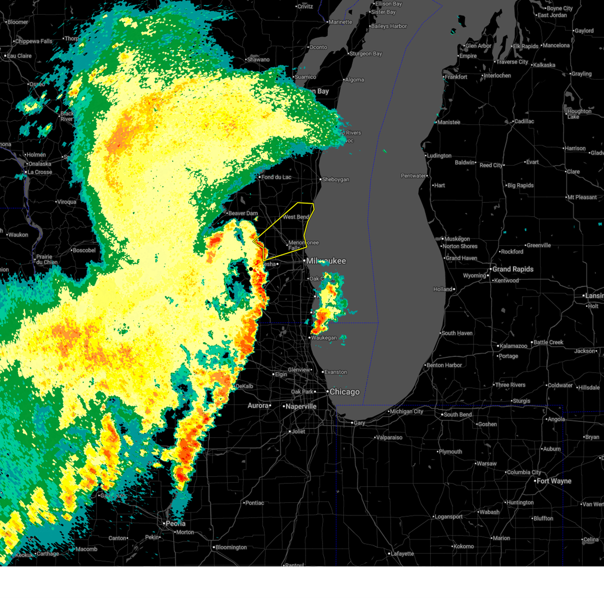
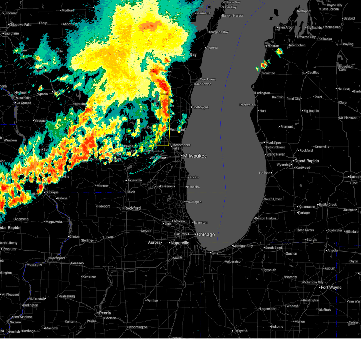
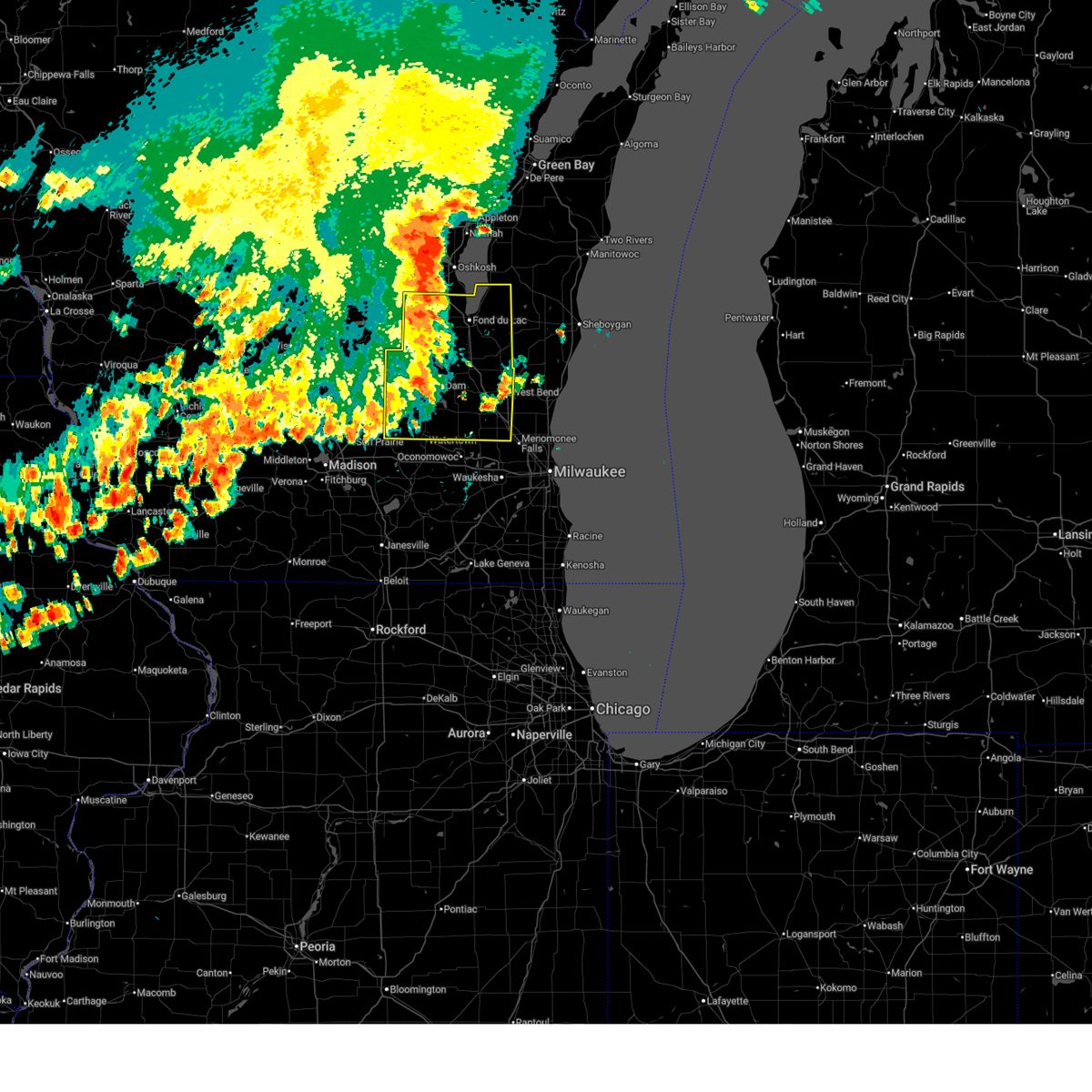
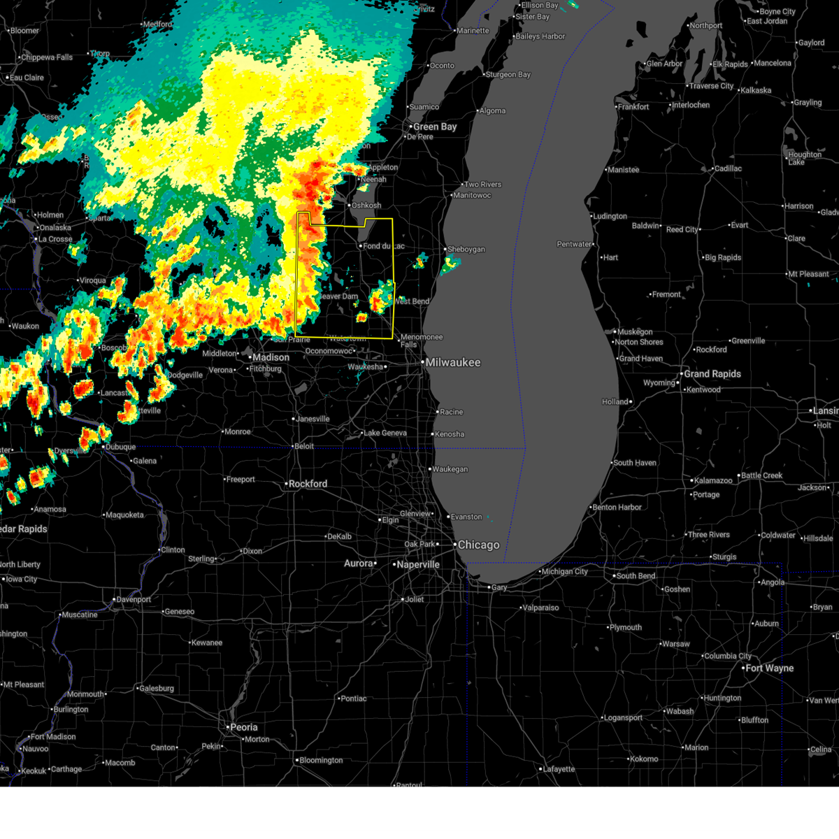
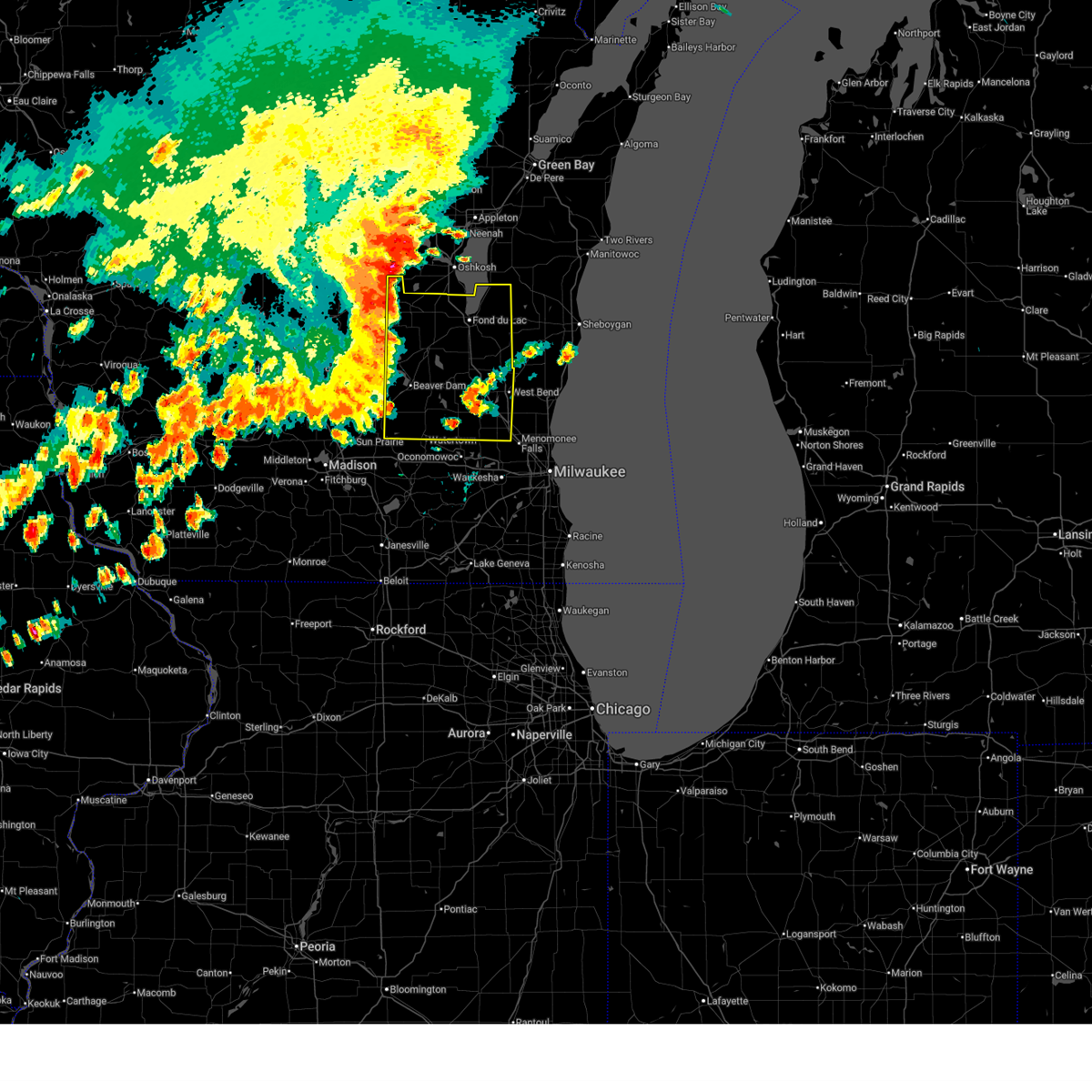
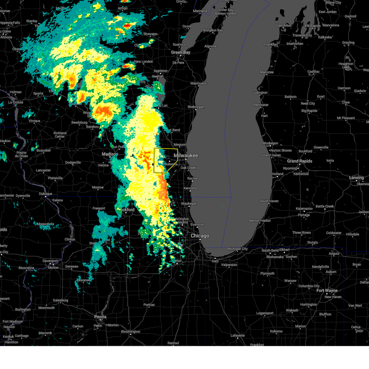
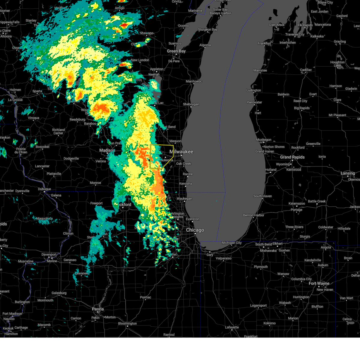
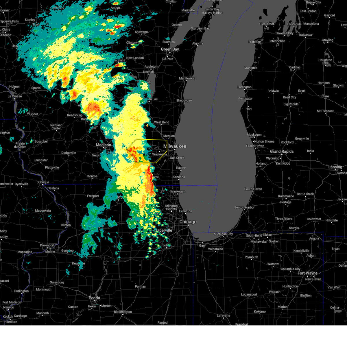
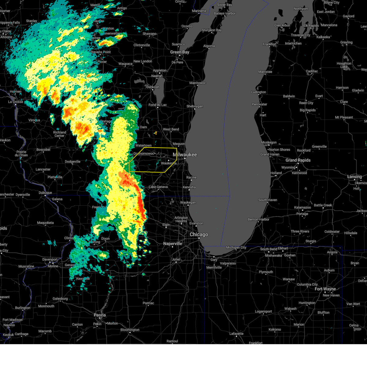
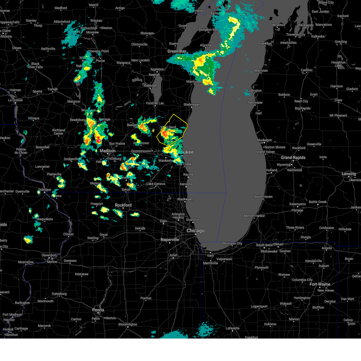
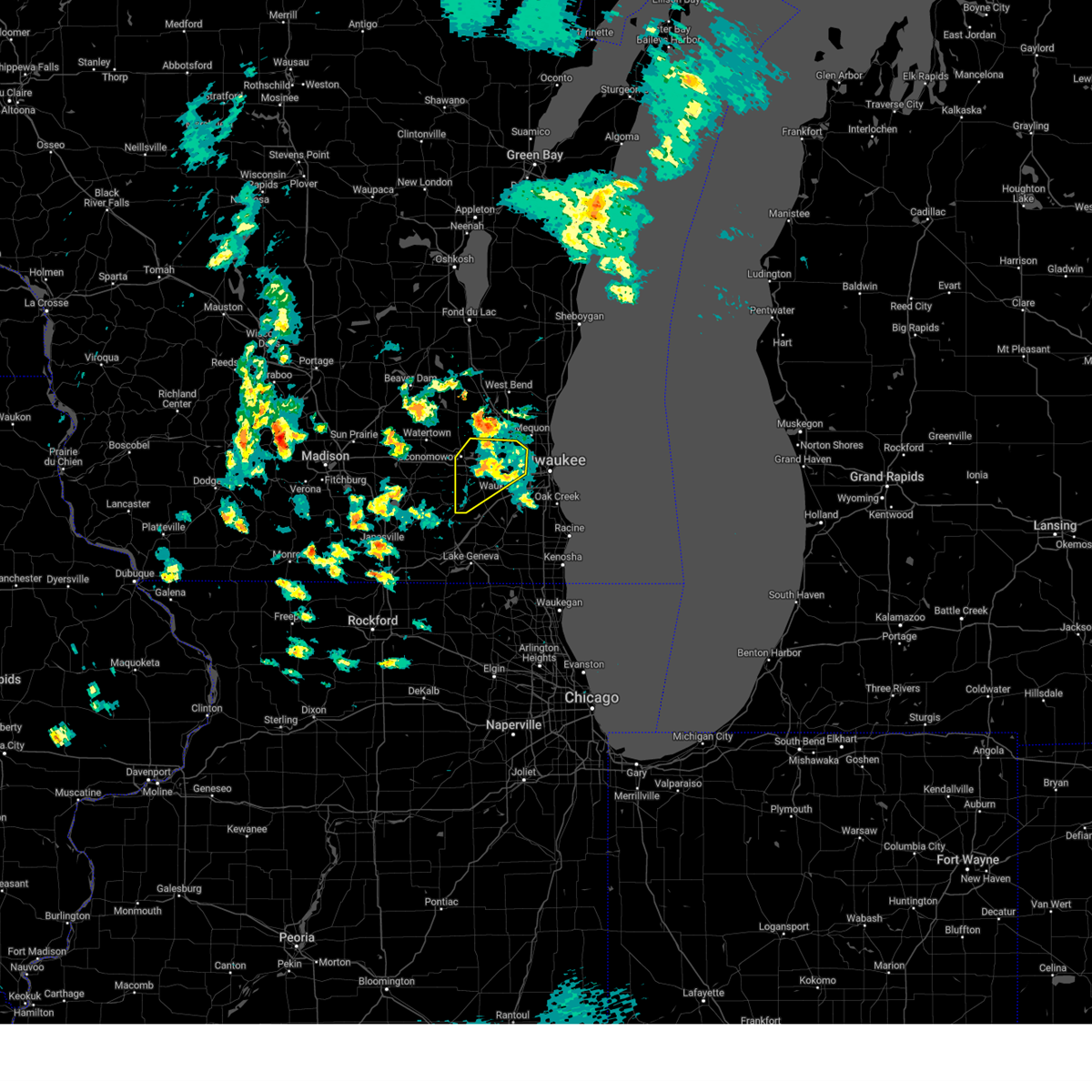
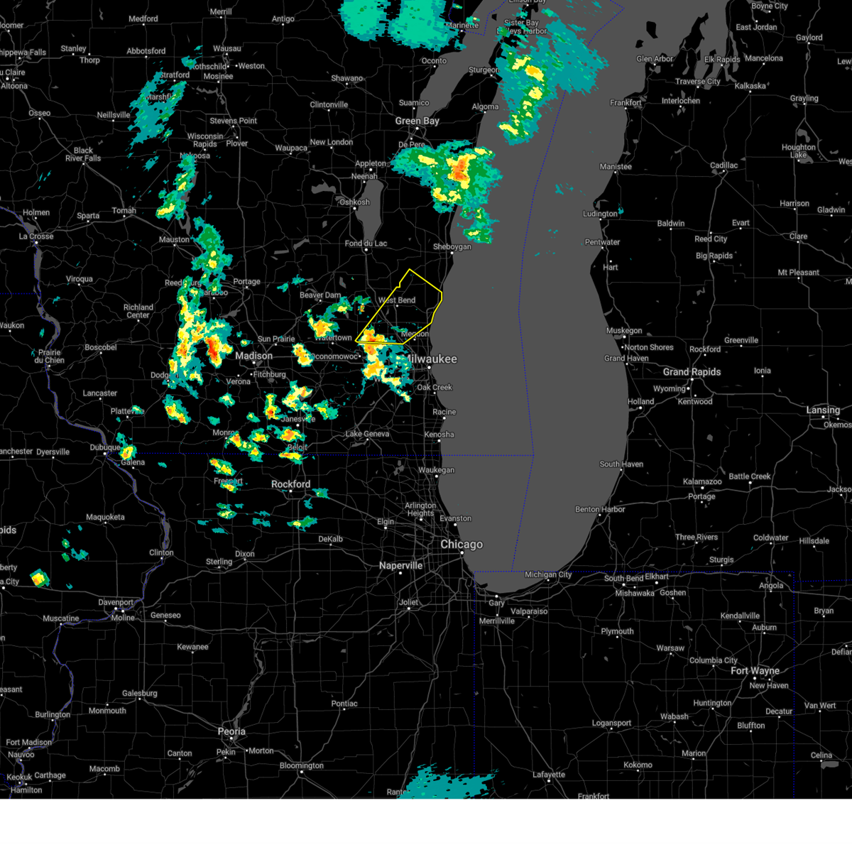
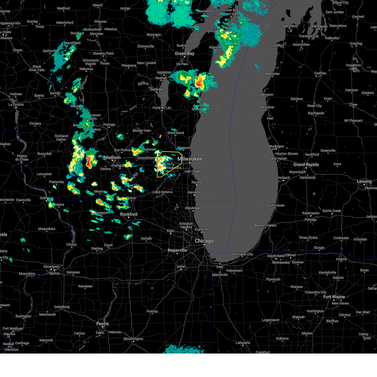
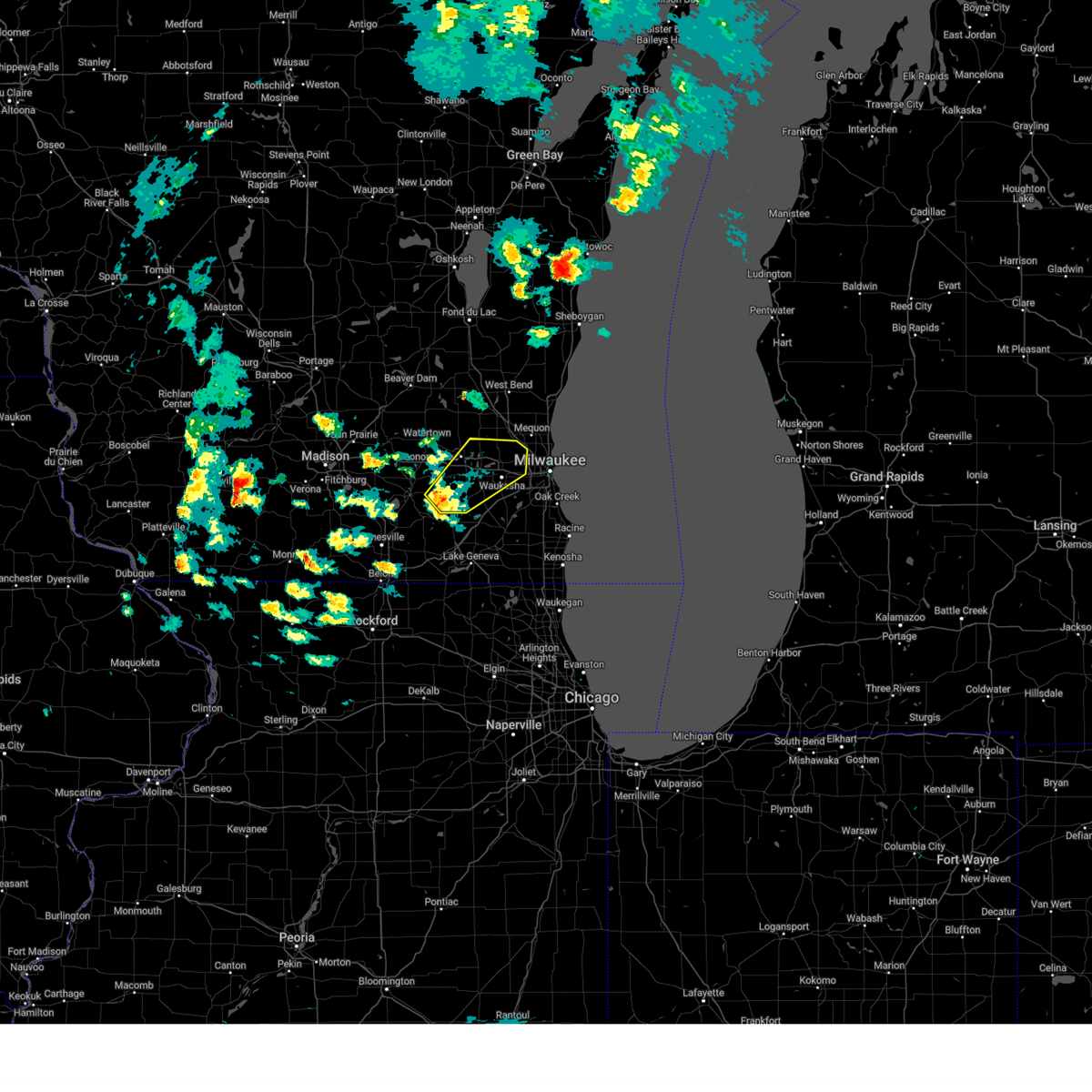
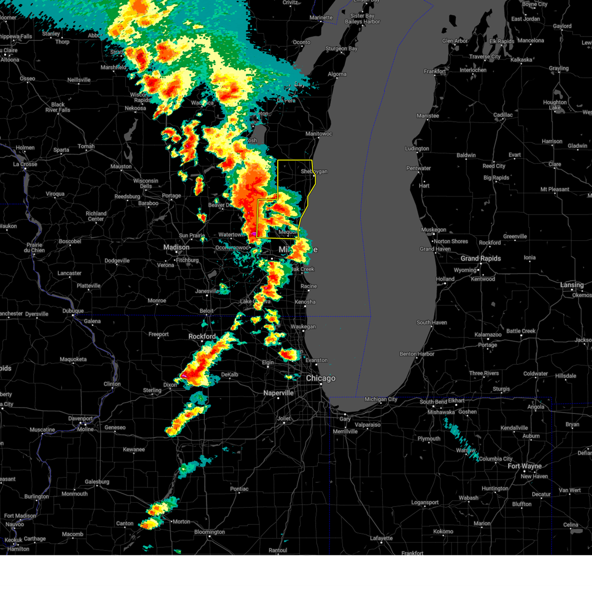
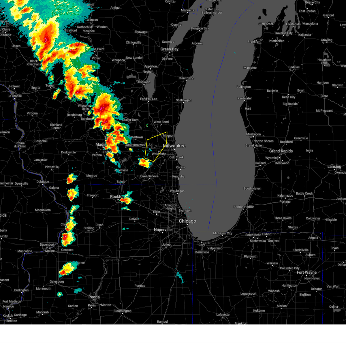
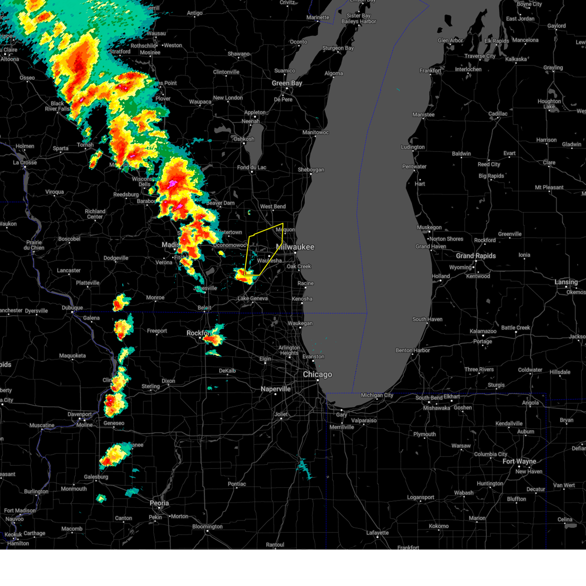
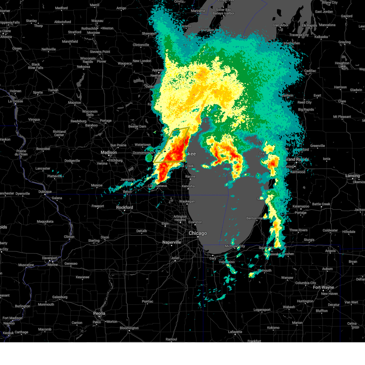
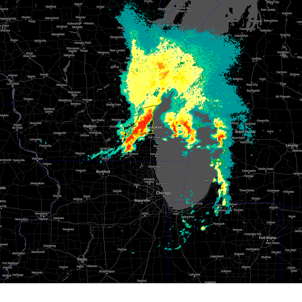
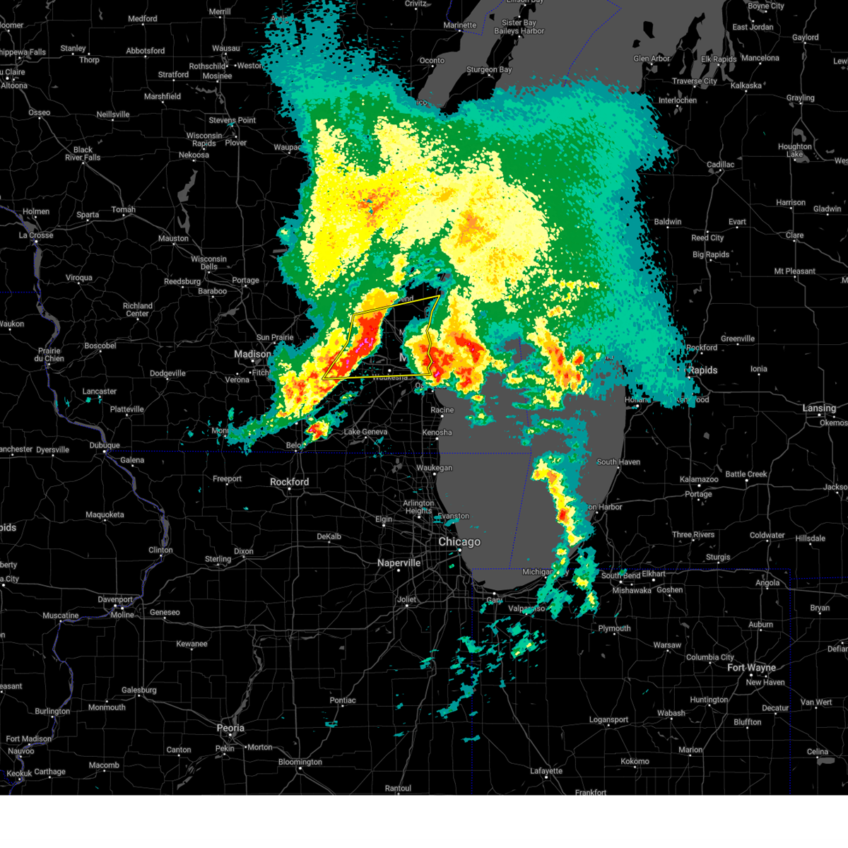
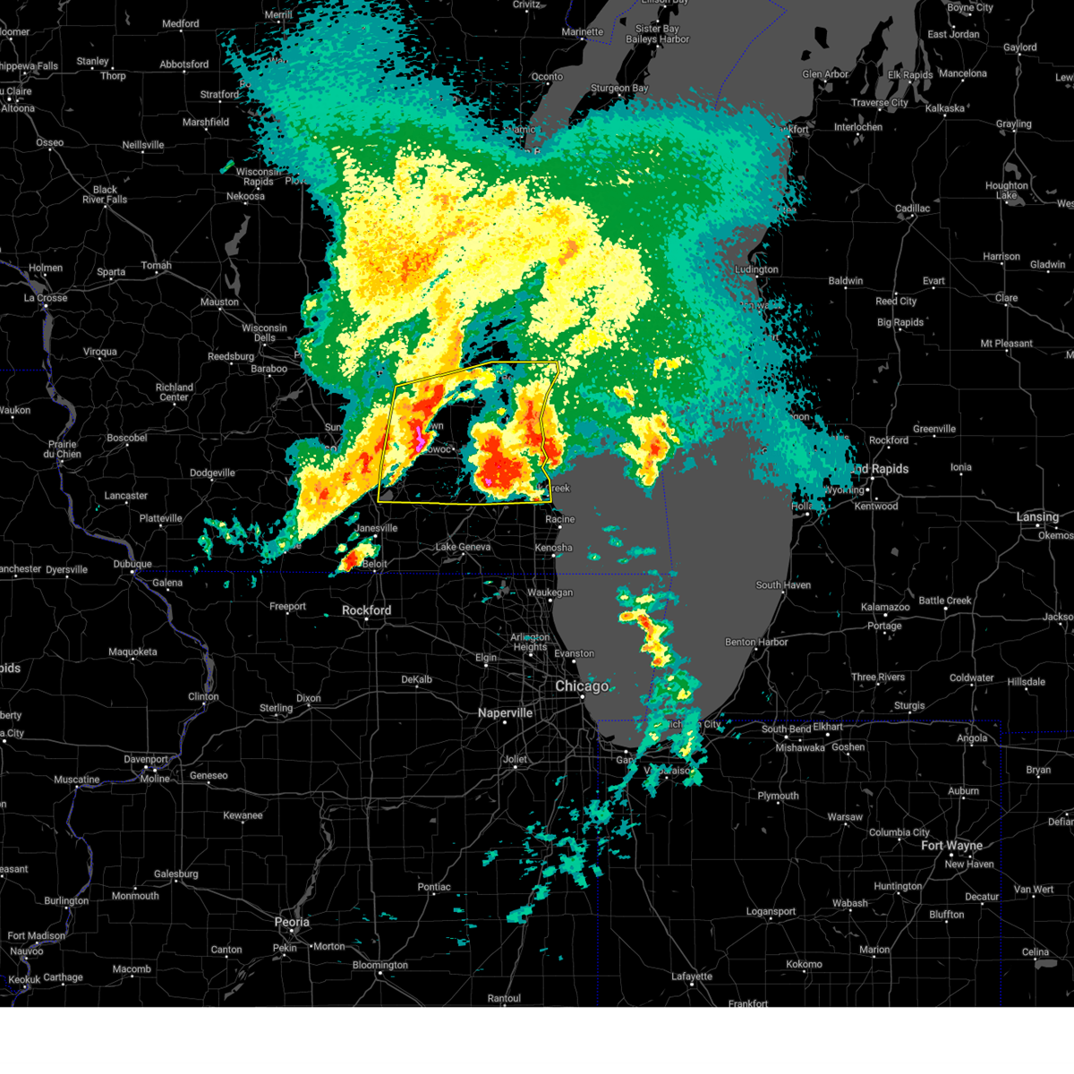
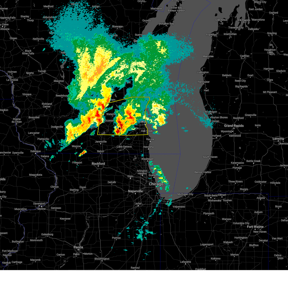
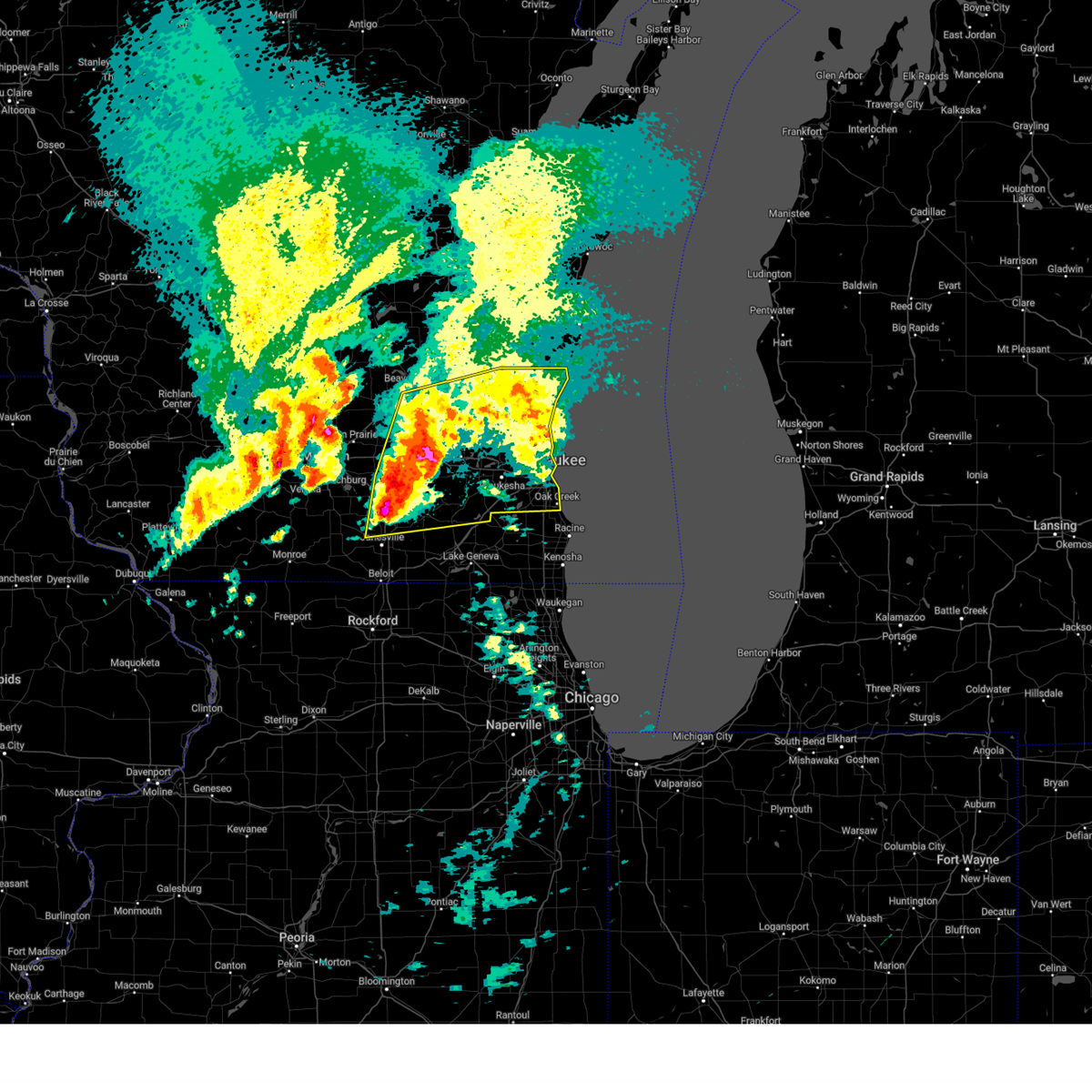
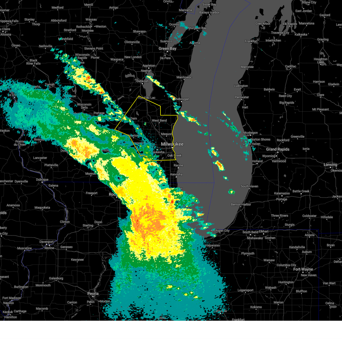
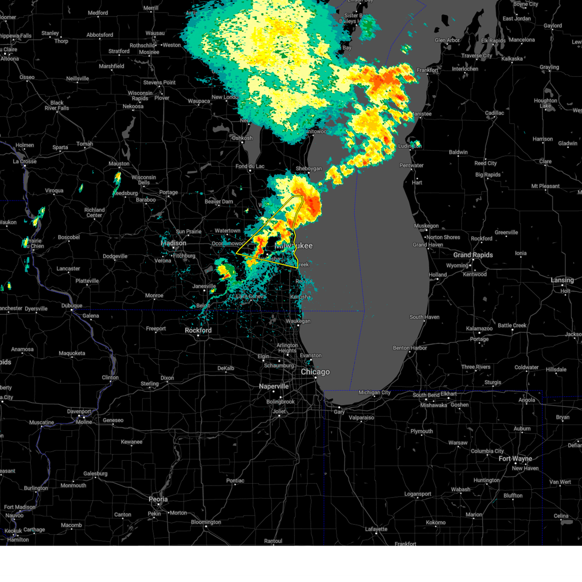
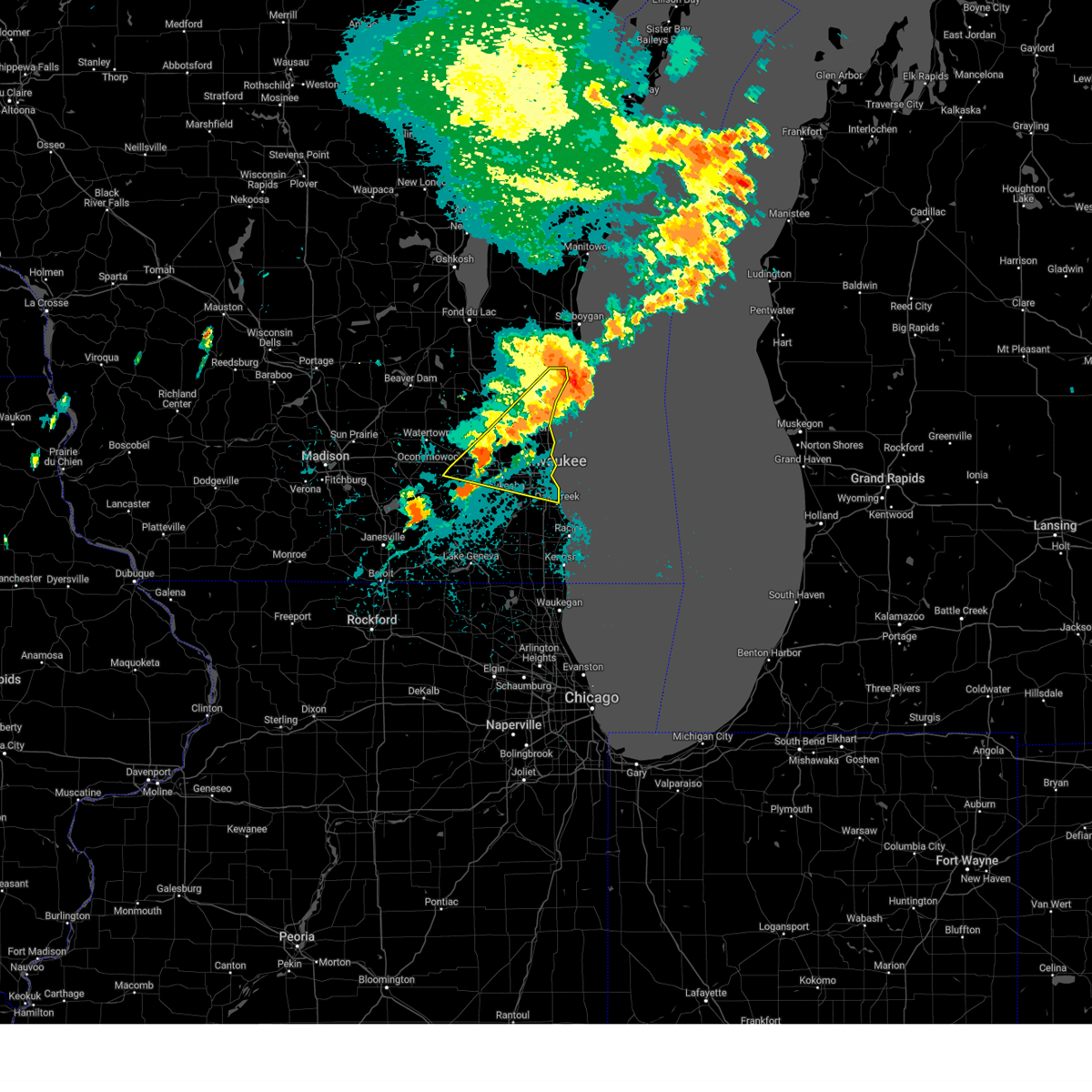
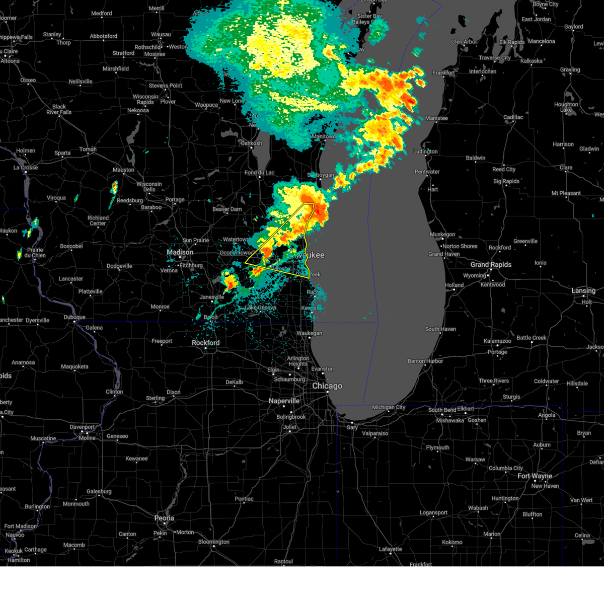
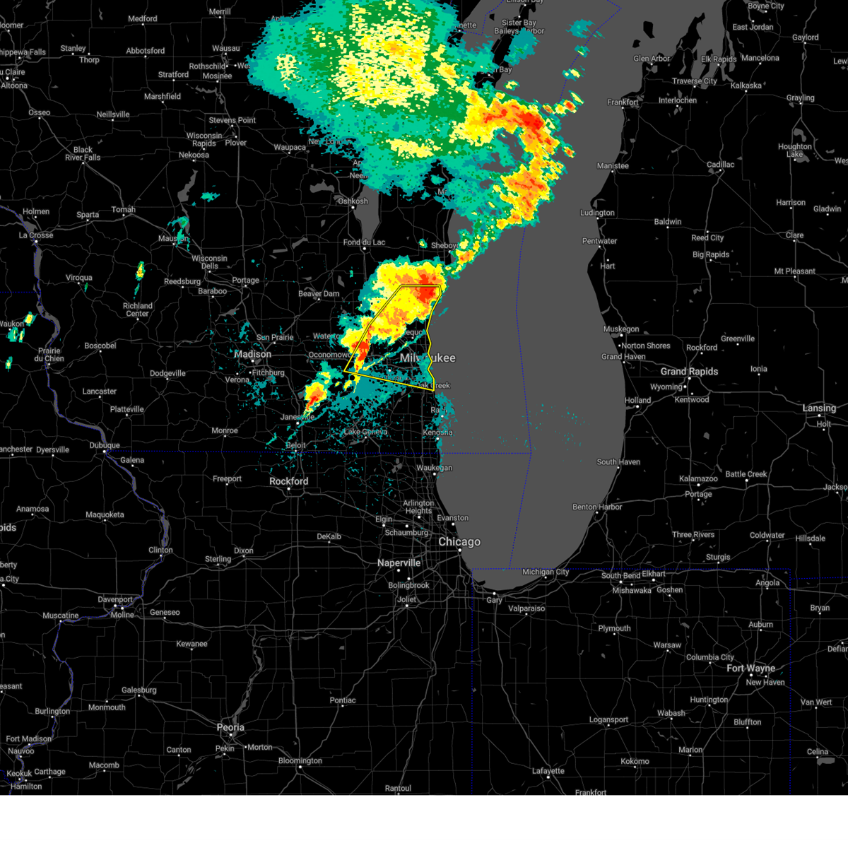
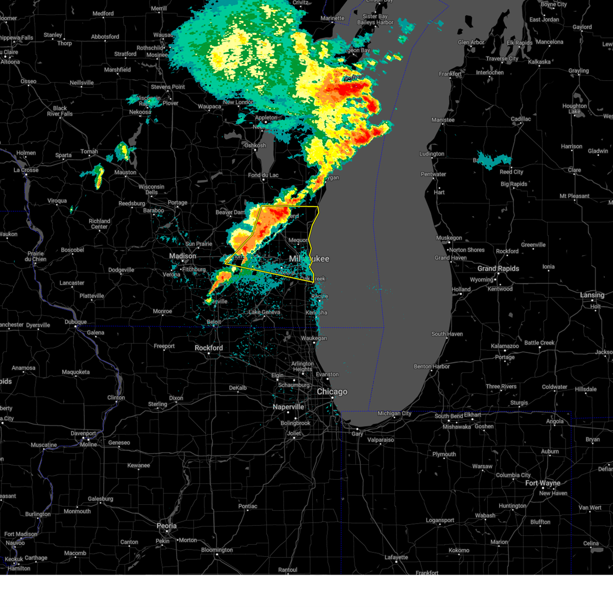
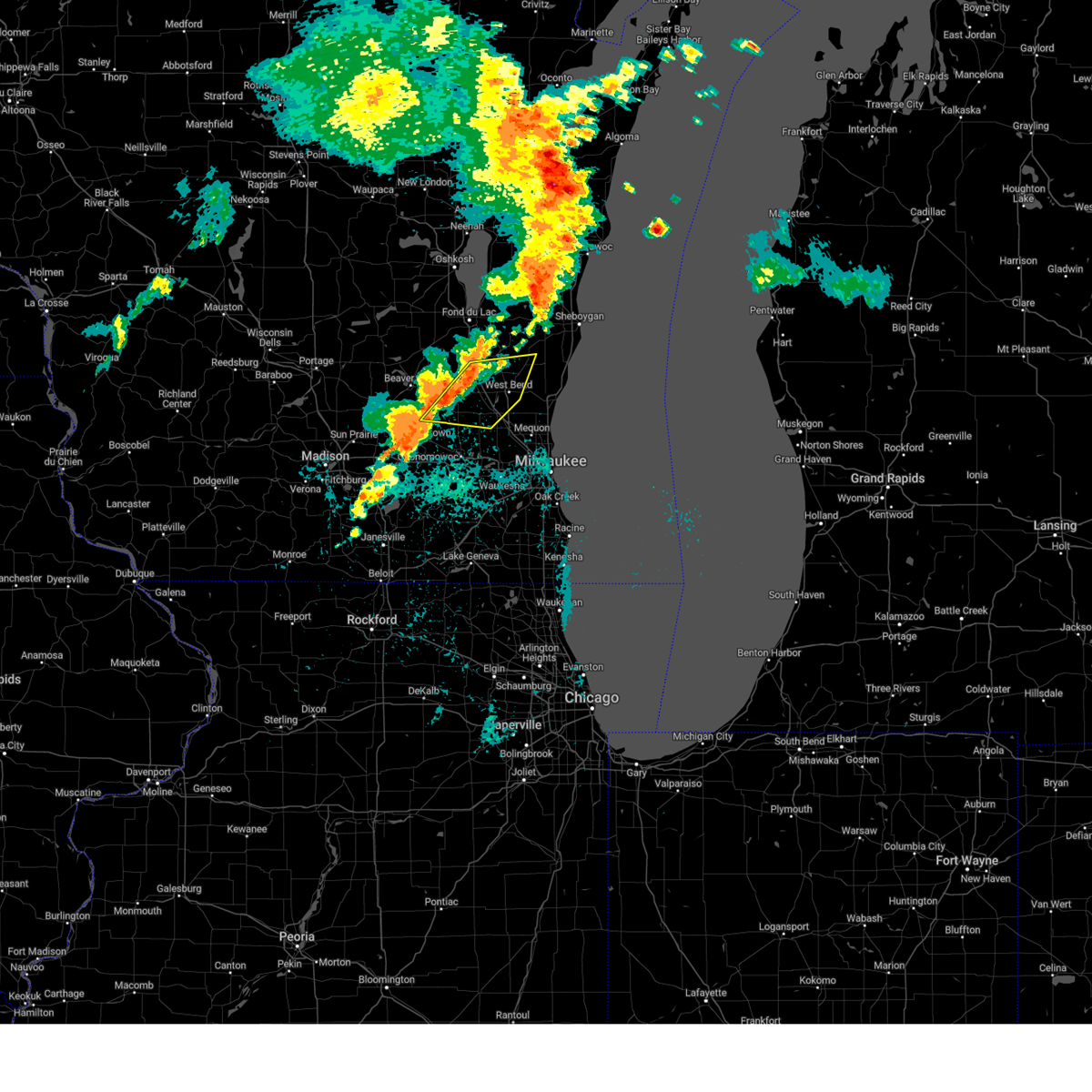
Hail Map for Richfield, WI
The Richfield, WI area has had 3 reports of on-the-ground hail by trained spotters, and has been under severe weather warnings 50 times during the past 12 months. Doppler radar has detected hail at or near Richfield, WI on 66 occasions, including 4 occasions during the past year.
| Name: | Richfield, WI |
| Where Located: | 59.2 miles E of Madison, WI |
| Map: | Google Map for Richfield, WI |
| Population: | 11300 |
| Housing Units: | 4338 |
| More Info: | Search Google for Richfield, WI |
2
The Top Recent Hail Date for Richfield, WI is Thursday, May 15, 2025 (8th out of 66)

Hail and Wind Damage Spotted near Richfield, WI
| Date / Time | Report Details |
|---|---|
| 7/11/2025 8:24 PM CDT | the severe thunderstorm warning has been cancelled and is no longer in effect |
| 7/11/2025 7:57 PM CDT |
 Svrmkx the national weather service in milwaukee/sullivan has issued a * severe thunderstorm warning for, ozaukee county in southeastern wisconsin, northwestern milwaukee county in southeastern wisconsin, northeastern waukesha county in southeastern wisconsin, southern washington county in southeastern wisconsin, southeastern dodge county in southeastern wisconsin, * until 845 pm cdt. * at 756 pm cdt, severe thunderstorms were located along a line extending from near lac la belle to near merton to hartland, moving northeast at 50 mph (radar indicated). Hazards include 60 mph wind gusts. expect damage to roofs, siding, and trees Svrmkx the national weather service in milwaukee/sullivan has issued a * severe thunderstorm warning for, ozaukee county in southeastern wisconsin, northwestern milwaukee county in southeastern wisconsin, northeastern waukesha county in southeastern wisconsin, southern washington county in southeastern wisconsin, southeastern dodge county in southeastern wisconsin, * until 845 pm cdt. * at 756 pm cdt, severe thunderstorms were located along a line extending from near lac la belle to near merton to hartland, moving northeast at 50 mph (radar indicated). Hazards include 60 mph wind gusts. expect damage to roofs, siding, and trees
|
| 6/23/2025 7:25 PM CDT |
 The storms which prompted the warning have moved out of the area. therefore, the warning will be allowed to expire. a severe thunderstorm watch remains in effect until 900 pm cdt for southeastern and east central wisconsin. The storms which prompted the warning have moved out of the area. therefore, the warning will be allowed to expire. a severe thunderstorm watch remains in effect until 900 pm cdt for southeastern and east central wisconsin.
|
| 6/23/2025 7:15 PM CDT |
 the severe thunderstorm warning has been cancelled and is no longer in effect the severe thunderstorm warning has been cancelled and is no longer in effect
|
| 6/23/2025 7:15 PM CDT |
 At 714 pm cdt, severe thunderstorms were located along a line extending from near camp rokilio scout camp to near menomonee falls, moving east at 40 mph (public). Hazards include 60 mph wind gusts. Expect damage to roofs, siding, and trees. locations impacted include, west bend, hartford, jackson, slinger, kewaskum, germantown, campbellsport, southern lake winnebago, richfield, addison, mount calvary, wayne, st. Cloud, waucousta, calvary, marytown, new fane, monches, johnsburg, and saint lawrence. At 714 pm cdt, severe thunderstorms were located along a line extending from near camp rokilio scout camp to near menomonee falls, moving east at 40 mph (public). Hazards include 60 mph wind gusts. Expect damage to roofs, siding, and trees. locations impacted include, west bend, hartford, jackson, slinger, kewaskum, germantown, campbellsport, southern lake winnebago, richfield, addison, mount calvary, wayne, st. Cloud, waucousta, calvary, marytown, new fane, monches, johnsburg, and saint lawrence.
|
| 6/23/2025 6:59 PM CDT |
 At 658 pm cdt, severe thunderstorms were located along a line extending from near st anna to near lisbon, moving east at 45 mph (public. uprooted trees were reported in waupun at 638 pm cdt). Hazards include 60 mph wind gusts. Expect damage to roofs, siding, and trees. Locations impacted include, fond du lac, west bend, watertown, hartford, jackson, mayville, slinger, north fond du lac, kewaskum, horicon, juneau, germantown, lomira, campbellsport, theresa, hustisford, oakfield, iron ridge, southern lake winnebago, and richfield. At 658 pm cdt, severe thunderstorms were located along a line extending from near st anna to near lisbon, moving east at 45 mph (public. uprooted trees were reported in waupun at 638 pm cdt). Hazards include 60 mph wind gusts. Expect damage to roofs, siding, and trees. Locations impacted include, fond du lac, west bend, watertown, hartford, jackson, mayville, slinger, north fond du lac, kewaskum, horicon, juneau, germantown, lomira, campbellsport, theresa, hustisford, oakfield, iron ridge, southern lake winnebago, and richfield.
|
| 6/23/2025 6:36 PM CDT |
 At 634 pm cdt, severe thunderstorms were located along a line extending from 6 miles southwest of oshkosh to near watertown, moving east at 40 mph (law enforcement. scattered trees were reported down earlier when these storms moved through columbia and green lake counties). Hazards include 60 mph wind gusts. Expect damage to roofs, siding, and trees. Locations impacted include, fond du lac, west bend, watertown, beaver dam, hartford, waupun, ripon, jackson, mayville, slinger, north fond du lac, kewaskum, horicon, juneau, germantown, lomira, campbellsport, theresa, hustisford, and oakfield. At 634 pm cdt, severe thunderstorms were located along a line extending from 6 miles southwest of oshkosh to near watertown, moving east at 40 mph (law enforcement. scattered trees were reported down earlier when these storms moved through columbia and green lake counties). Hazards include 60 mph wind gusts. Expect damage to roofs, siding, and trees. Locations impacted include, fond du lac, west bend, watertown, beaver dam, hartford, waupun, ripon, jackson, mayville, slinger, north fond du lac, kewaskum, horicon, juneau, germantown, lomira, campbellsport, theresa, hustisford, and oakfield.
|
| 6/23/2025 6:36 PM CDT |
 the severe thunderstorm warning has been cancelled and is no longer in effect the severe thunderstorm warning has been cancelled and is no longer in effect
|
| 6/23/2025 6:31 PM CDT |
 At 629 pm cdt, severe thunderstorms were located along a line extending from 7 miles northeast of rush lake to near watertown, moving east at 40 mph (radar indicated and reports from law enforcement. scattered tree damage occurred earlier with these storms in green lake and columbia counties). Hazards include 60 mph wind gusts. Expect damage to roofs, siding, and trees. Locations impacted include, fond du lac, west bend, watertown, beaver dam, hartford, waupun, ripon, jackson, berlin, mayville, slinger, north fond du lac, kewaskum, horicon, juneau, germantown, lomira, campbellsport, markesan, and theresa. At 629 pm cdt, severe thunderstorms were located along a line extending from 7 miles northeast of rush lake to near watertown, moving east at 40 mph (radar indicated and reports from law enforcement. scattered tree damage occurred earlier with these storms in green lake and columbia counties). Hazards include 60 mph wind gusts. Expect damage to roofs, siding, and trees. Locations impacted include, fond du lac, west bend, watertown, beaver dam, hartford, waupun, ripon, jackson, berlin, mayville, slinger, north fond du lac, kewaskum, horicon, juneau, germantown, lomira, campbellsport, markesan, and theresa.
|
| 6/23/2025 6:19 PM CDT |
 Svrmkx the national weather service in milwaukee/sullivan has issued a * severe thunderstorm warning for, fond du lac county in east central wisconsin, eastern green lake county in south central wisconsin, washington county in southeastern wisconsin, dodge county in southeastern wisconsin, * until 730 pm cdt. * at 618 pm cdt, severe thunderstorms were located along a line extending from near rush lake to 7 miles northeast of waterloo, moving east at 40 mph (radar indicated). Hazards include 60 mph wind gusts. expect damage to roofs, siding, and trees Svrmkx the national weather service in milwaukee/sullivan has issued a * severe thunderstorm warning for, fond du lac county in east central wisconsin, eastern green lake county in south central wisconsin, washington county in southeastern wisconsin, dodge county in southeastern wisconsin, * until 730 pm cdt. * at 618 pm cdt, severe thunderstorms were located along a line extending from near rush lake to 7 miles northeast of waterloo, moving east at 40 mph (radar indicated). Hazards include 60 mph wind gusts. expect damage to roofs, siding, and trees
|
| 6/3/2025 2:04 PM CDT |
 the severe thunderstorm warning has been cancelled and is no longer in effect the severe thunderstorm warning has been cancelled and is no longer in effect
|
| 6/3/2025 2:04 PM CDT |
 At 203 pm cdt, severe thunderstorms were located along a line extending from near oconomowoc to near wind lake, moving east at 55 mph (radar indicated). Hazards include 60 mph wind gusts. Expect damage to roofs, siding, and trees. Locations impacted include, waukesha, new berlin, brookfield, menomonee falls, pewaukee, sussex, hartland, mukwonago, delafield, elm grove, wales, okauchee lake, oconomowoc, lisbon, vernon, ottawa, merton, dousman, north prairie, and butler. At 203 pm cdt, severe thunderstorms were located along a line extending from near oconomowoc to near wind lake, moving east at 55 mph (radar indicated). Hazards include 60 mph wind gusts. Expect damage to roofs, siding, and trees. Locations impacted include, waukesha, new berlin, brookfield, menomonee falls, pewaukee, sussex, hartland, mukwonago, delafield, elm grove, wales, okauchee lake, oconomowoc, lisbon, vernon, ottawa, merton, dousman, north prairie, and butler.
|
| 6/3/2025 1:58 PM CDT |
 At 158 pm cdt, severe thunderstorms were located along a line extending from near dousman to waterford north, moving northeast at 55 mph (radar indicated). Hazards include 60 mph wind gusts. Expect damage to roofs, siding, and trees. Locations impacted include, waukesha, new berlin, brookfield, menomonee falls, watertown, pewaukee, sussex, hartland, mukwonago, delafield, elm grove, wales, okauchee lake, oconomowoc, lisbon, vernon, ottawa, merton, dousman, and north prairie. At 158 pm cdt, severe thunderstorms were located along a line extending from near dousman to waterford north, moving northeast at 55 mph (radar indicated). Hazards include 60 mph wind gusts. Expect damage to roofs, siding, and trees. Locations impacted include, waukesha, new berlin, brookfield, menomonee falls, watertown, pewaukee, sussex, hartland, mukwonago, delafield, elm grove, wales, okauchee lake, oconomowoc, lisbon, vernon, ottawa, merton, dousman, and north prairie.
|
| 6/3/2025 1:54 PM CDT |
 At 154 pm cdt, severe thunderstorms were located along a line extending from near dousman to near waterford north, moving northeast at 55 mph (radar indicated). Hazards include 60 mph wind gusts. Expect damage to roofs, siding, and trees. Locations impacted include, waukesha, new berlin, brookfield, menomonee falls, watertown, whitewater, pewaukee, fort atkinson, sussex, hartland, jefferson, mukwonago, delafield, elm grove, lake mills, wales, okauchee lake, oconomowoc, lisbon, and vernon. At 154 pm cdt, severe thunderstorms were located along a line extending from near dousman to near waterford north, moving northeast at 55 mph (radar indicated). Hazards include 60 mph wind gusts. Expect damage to roofs, siding, and trees. Locations impacted include, waukesha, new berlin, brookfield, menomonee falls, watertown, whitewater, pewaukee, fort atkinson, sussex, hartland, jefferson, mukwonago, delafield, elm grove, lake mills, wales, okauchee lake, oconomowoc, lisbon, and vernon.
|
| 6/3/2025 1:31 PM CDT |
 Svrmkx the national weather service in milwaukee/sullivan has issued a * severe thunderstorm warning for, waukesha county in southeastern wisconsin, jefferson county in southeastern wisconsin, * until 215 pm cdt. * at 131 pm cdt, severe thunderstorms were located along a line extending from near lake koshkonong to near elkhorn, moving northeast at 55 mph (radar indicated). Hazards include 60 mph wind gusts. expect damage to roofs, siding, and trees Svrmkx the national weather service in milwaukee/sullivan has issued a * severe thunderstorm warning for, waukesha county in southeastern wisconsin, jefferson county in southeastern wisconsin, * until 215 pm cdt. * at 131 pm cdt, severe thunderstorms were located along a line extending from near lake koshkonong to near elkhorn, moving northeast at 55 mph (radar indicated). Hazards include 60 mph wind gusts. expect damage to roofs, siding, and trees
|
| 5/16/2025 6:43 PM CDT | the severe thunderstorm warning has been cancelled and is no longer in effect |
| 5/16/2025 6:36 PM CDT | the severe thunderstorm warning has been cancelled and is no longer in effect |
| 5/16/2025 6:36 PM CDT | At 635 pm cdt, a severe thunderstorm was located over jackson, moving northeast at 45 mph (radar indicated). Hazards include 60 mph wind gusts. Expect damage to roofs, siding, and trees. Locations impacted include, west bend, mequon, cedarburg, port washington, jackson, slinger, saukville, kewaskum, germantown, fredonia, newburg, richfield, waubeka, fillmore, kirchhayn, keowns, and hubertus. |
| 5/16/2025 6:25 PM CDT | Svrmkx the national weather service in milwaukee/sullivan has issued a * severe thunderstorm warning for, northern ozaukee county in southeastern wisconsin, north central waukesha county in southeastern wisconsin, washington county in southeastern wisconsin, * until 700 pm cdt. * at 625 pm cdt, a severe thunderstorm was located near lisbon, or near sussex, moving northeast at 45 mph (radar indicated). Hazards include 60 mph wind gusts. expect damage to roofs, siding, and trees |
| 5/16/2025 4:03 PM CDT |
 the severe thunderstorm warning has been cancelled and is no longer in effect the severe thunderstorm warning has been cancelled and is no longer in effect
|
| 5/16/2025 4:03 PM CDT |
 At 401 pm cdt, a severe thunderstorm was located near slinger, moving northeast at 60 mph (public reported. downed tree branches were reported in occonomowoc). Hazards include 60 mph wind gusts. Expect damage to roofs, siding, and trees. Locations impacted include, west bend, mequon, hartford, grafton, cedarburg, port washington, jackson, slinger, saukville, kewaskum, germantown, belgium, fredonia, random lake, newburg, richfield, beechwood, waubeka, fillmore, and boltonville. At 401 pm cdt, a severe thunderstorm was located near slinger, moving northeast at 60 mph (public reported. downed tree branches were reported in occonomowoc). Hazards include 60 mph wind gusts. Expect damage to roofs, siding, and trees. Locations impacted include, west bend, mequon, hartford, grafton, cedarburg, port washington, jackson, slinger, saukville, kewaskum, germantown, belgium, fredonia, random lake, newburg, richfield, beechwood, waubeka, fillmore, and boltonville.
|
| 5/16/2025 3:57 PM CDT |
 the severe thunderstorm warning has been cancelled and is no longer in effect the severe thunderstorm warning has been cancelled and is no longer in effect
|
| 5/16/2025 3:52 PM CDT |
 Svrmkx the national weather service in milwaukee/sullivan has issued a * severe thunderstorm warning for, ozaukee county in southeastern wisconsin, washington county in southeastern wisconsin, southeastern dodge county in southeastern wisconsin, southwestern sheboygan county in east central wisconsin, * until 430 pm cdt. * at 352 pm cdt, a severe thunderstorm was located near merton, or 8 miles northwest of sussex, moving northeast at 50 mph (radar indicated). Hazards include 60 mph wind gusts. expect damage to roofs, siding, and trees Svrmkx the national weather service in milwaukee/sullivan has issued a * severe thunderstorm warning for, ozaukee county in southeastern wisconsin, washington county in southeastern wisconsin, southeastern dodge county in southeastern wisconsin, southwestern sheboygan county in east central wisconsin, * until 430 pm cdt. * at 352 pm cdt, a severe thunderstorm was located near merton, or 8 miles northwest of sussex, moving northeast at 50 mph (radar indicated). Hazards include 60 mph wind gusts. expect damage to roofs, siding, and trees
|
| 5/16/2025 3:42 PM CDT |
 the severe thunderstorm warning has been cancelled and is no longer in effect the severe thunderstorm warning has been cancelled and is no longer in effect
|
| 5/16/2025 3:42 PM CDT |
 At 342 pm cdt, a severe thunderstorm was located over wales, moving northeast at 50 mph (radar indicated). Hazards include 60 mph wind gusts. Expect damage to roofs, siding, and trees. Locations impacted include, waukesha, wauwatosa, new berlin, brookfield, menomonee falls, pewaukee, sussex, hartland, delafield, elm grove, wales, okauchee lake, oconomowoc, lisbon, ottawa, merton, dousman, north prairie, butler, and lannon. At 342 pm cdt, a severe thunderstorm was located over wales, moving northeast at 50 mph (radar indicated). Hazards include 60 mph wind gusts. Expect damage to roofs, siding, and trees. Locations impacted include, waukesha, wauwatosa, new berlin, brookfield, menomonee falls, pewaukee, sussex, hartland, delafield, elm grove, wales, okauchee lake, oconomowoc, lisbon, ottawa, merton, dousman, north prairie, butler, and lannon.
|
| 5/16/2025 3:30 PM CDT |
 Svrmkx the national weather service in milwaukee/sullivan has issued a * severe thunderstorm warning for, waukesha county in southeastern wisconsin, southeastern jefferson county in southeastern wisconsin, * until 415 pm cdt. * at 330 pm cdt, a severe thunderstorm was located near palmyra, or 10 miles northeast of whitewater, moving northeast at 50 mph (radar indicated). Hazards include 60 mph wind gusts and penny size hail. expect damage to roofs, siding, and trees Svrmkx the national weather service in milwaukee/sullivan has issued a * severe thunderstorm warning for, waukesha county in southeastern wisconsin, southeastern jefferson county in southeastern wisconsin, * until 415 pm cdt. * at 330 pm cdt, a severe thunderstorm was located near palmyra, or 10 miles northeast of whitewater, moving northeast at 50 mph (radar indicated). Hazards include 60 mph wind gusts and penny size hail. expect damage to roofs, siding, and trees
|
| 5/15/2025 6:50 PM CDT |
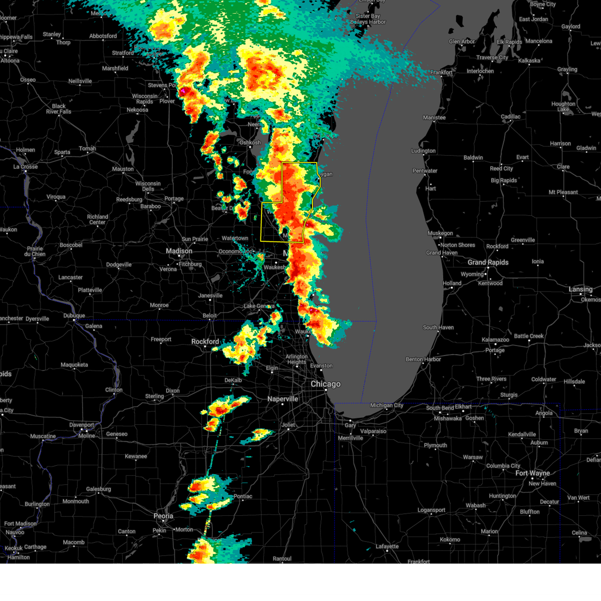 At 650 pm cdt, severe thunderstorms were located along a line extending from near st anna to cedarburg, moving northeast at 35 mph (radar indicated). Hazards include 60 mph wind gusts and quarter size hail. Hail damage to vehicles is expected. expect wind damage to roofs, siding, and trees. Locations impacted include, sheboygan, west bend, mequon, hartford, brown deer, grafton, cedarburg, port washington, plymouth, sheboygan falls, jackson, slinger, saukville, bayside, kewaskum, thiensville, howards grove, germantown, oostburg, and belgium. At 650 pm cdt, severe thunderstorms were located along a line extending from near st anna to cedarburg, moving northeast at 35 mph (radar indicated). Hazards include 60 mph wind gusts and quarter size hail. Hail damage to vehicles is expected. expect wind damage to roofs, siding, and trees. Locations impacted include, sheboygan, west bend, mequon, hartford, brown deer, grafton, cedarburg, port washington, plymouth, sheboygan falls, jackson, slinger, saukville, bayside, kewaskum, thiensville, howards grove, germantown, oostburg, and belgium.
|
| 5/15/2025 6:32 PM CDT |
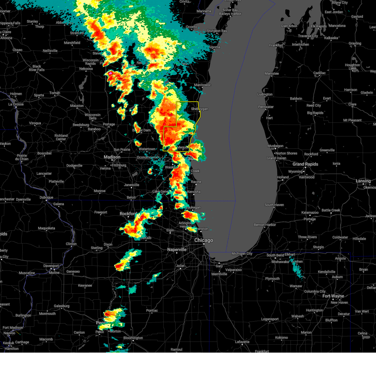 At 631 pm cdt, severe thunderstorms were located along a line extending from 6 miles southeast of central lake winnebago to campbellsport to near slinger, moving northeast at 40 mph (public reports of two inch hail east of ashippun). Hazards include two inch hail and 60 mph wind gusts. People and animals outdoors will be injured. expect hail damage to roofs, siding, windows, and vehicles. expect wind damage to roofs, siding, and trees. Locations impacted include, sheboygan, west bend, mequon, hartford, brown deer, grafton, cedarburg, port washington, plymouth, sheboygan falls, jackson, slinger, saukville, bayside, kewaskum, thiensville, howards grove, germantown, oostburg, and belgium. At 631 pm cdt, severe thunderstorms were located along a line extending from 6 miles southeast of central lake winnebago to campbellsport to near slinger, moving northeast at 40 mph (public reports of two inch hail east of ashippun). Hazards include two inch hail and 60 mph wind gusts. People and animals outdoors will be injured. expect hail damage to roofs, siding, windows, and vehicles. expect wind damage to roofs, siding, and trees. Locations impacted include, sheboygan, west bend, mequon, hartford, brown deer, grafton, cedarburg, port washington, plymouth, sheboygan falls, jackson, slinger, saukville, bayside, kewaskum, thiensville, howards grove, germantown, oostburg, and belgium.
|
| 5/15/2025 6:26 PM CDT |
 Svrmkx the national weather service in milwaukee/sullivan has issued a * severe thunderstorm warning for, ozaukee county in southeastern wisconsin, washington county in southeastern wisconsin, sheboygan county in east central wisconsin, * until 745 pm cdt. * at 625 pm cdt, severe thunderstorms were located along a line extending from near southern lake winnebago to near campbellsport to near slinger, moving northeast at 40 mph (radar indicated). Hazards include two inch hail and 60 mph wind gusts. People and animals outdoors will be injured. expect hail damage to roofs, siding, windows, and vehicles. Expect wind damage to roofs, siding, and trees. Svrmkx the national weather service in milwaukee/sullivan has issued a * severe thunderstorm warning for, ozaukee county in southeastern wisconsin, washington county in southeastern wisconsin, sheboygan county in east central wisconsin, * until 745 pm cdt. * at 625 pm cdt, severe thunderstorms were located along a line extending from near southern lake winnebago to near campbellsport to near slinger, moving northeast at 40 mph (radar indicated). Hazards include two inch hail and 60 mph wind gusts. People and animals outdoors will be injured. expect hail damage to roofs, siding, windows, and vehicles. Expect wind damage to roofs, siding, and trees.
|
| 5/15/2025 5:40 PM CDT | Quarter sized hail reported 2.8 miles N of Richfield, WI |
| 5/15/2025 5:40 PM CDT | Svrmkx the national weather service in milwaukee/sullivan has issued a * severe thunderstorm warning for, northeastern waukesha county in southeastern wisconsin, washington county in southeastern wisconsin, * until 630 pm cdt. * at 539 pm cdt, a severe thunderstorm was located near lisbon, or 7 miles northwest of sussex, moving northeast at 40 mph (radar indicated). Hazards include 60 mph wind gusts and half dollar size hail. Hail damage to vehicles is expected. Expect wind damage to roofs, siding, and trees. |
| 5/15/2025 5:24 PM CDT | At 524 pm cdt, a severe thunderstorm was located over merton, or near sussex, moving east at 55 mph (public report of ping pong ball sized hail in dousman). Hazards include ping pong ball size hail and 60 mph wind gusts. People and animals outdoors will be injured. expect hail damage to roofs, siding, windows, and vehicles. expect wind damage to roofs, siding, and trees. Locations impacted include, waukesha, menomonee falls, pewaukee, sussex, hartland, delafield, wales, germantown, okauchee lake, oconomowoc, lisbon, ottawa, merton, dousman, lannon, brookfield, richfield, nashotah, waterville, and oconomowoc lake. |
| 5/15/2025 5:10 PM CDT |
 At 509 pm cdt, a severe thunderstorm was located over ottawa, or over wales, moving northeast at 55 mph (public. ping pong ball sized hail was reported in eagle at 504 pm). Hazards include ping pong ball size hail and 60 mph wind gusts. People and animals outdoors will be injured. expect hail damage to roofs, siding, windows, and vehicles. expect wind damage to roofs, siding, and trees. Locations impacted include, waukesha, menomonee falls, pewaukee, sussex, hartland, mukwonago, delafield, wales, germantown, okauchee lake, oconomowoc, lisbon, ottawa, merton, dousman, north prairie, lannon, brookfield, richfield, and nashotah. At 509 pm cdt, a severe thunderstorm was located over ottawa, or over wales, moving northeast at 55 mph (public. ping pong ball sized hail was reported in eagle at 504 pm). Hazards include ping pong ball size hail and 60 mph wind gusts. People and animals outdoors will be injured. expect hail damage to roofs, siding, windows, and vehicles. expect wind damage to roofs, siding, and trees. Locations impacted include, waukesha, menomonee falls, pewaukee, sussex, hartland, mukwonago, delafield, wales, germantown, okauchee lake, oconomowoc, lisbon, ottawa, merton, dousman, north prairie, lannon, brookfield, richfield, and nashotah.
|
| 5/15/2025 5:02 PM CDT |
 Svrmkx the national weather service in milwaukee/sullivan has issued a * severe thunderstorm warning for, waukesha county in southeastern wisconsin, southern washington county in southeastern wisconsin, * until 545 pm cdt. * at 502 pm cdt, a severe thunderstorm was located near north prairie, or 8 miles southwest of wales, moving northeast at 55 mph (radar indicated). Hazards include 60 mph wind gusts and quarter size hail. Hail damage to vehicles is expected. Expect wind damage to roofs, siding, and trees. Svrmkx the national weather service in milwaukee/sullivan has issued a * severe thunderstorm warning for, waukesha county in southeastern wisconsin, southern washington county in southeastern wisconsin, * until 545 pm cdt. * at 502 pm cdt, a severe thunderstorm was located near north prairie, or 8 miles southwest of wales, moving northeast at 55 mph (radar indicated). Hazards include 60 mph wind gusts and quarter size hail. Hail damage to vehicles is expected. Expect wind damage to roofs, siding, and trees.
|
| 4/18/2025 8:36 AM CDT |
 the severe thunderstorm warning has been cancelled and is no longer in effect the severe thunderstorm warning has been cancelled and is no longer in effect
|
| 4/18/2025 8:29 AM CDT |
 At 828 am cdt, severe thunderstorms were located along a line extending from near port washington to mequon to waukesha, moving east at 65 mph (radar indicated). Hazards include quarter size hail. Damage to vehicles is expected. Locations impacted include, milwaukee, pewaukee, wales, uw- milwaukee, grafton, west allis, jackson, lannon, glendale, bayside, mequon, keowns, ottawa, lapham peak st park, delafield, hubertus, lisbon, port washington, hartland, and mitchell park domes. At 828 am cdt, severe thunderstorms were located along a line extending from near port washington to mequon to waukesha, moving east at 65 mph (radar indicated). Hazards include quarter size hail. Damage to vehicles is expected. Locations impacted include, milwaukee, pewaukee, wales, uw- milwaukee, grafton, west allis, jackson, lannon, glendale, bayside, mequon, keowns, ottawa, lapham peak st park, delafield, hubertus, lisbon, port washington, hartland, and mitchell park domes.
|
| 4/18/2025 8:29 AM CDT |
 the severe thunderstorm warning has been cancelled and is no longer in effect the severe thunderstorm warning has been cancelled and is no longer in effect
|
| 4/18/2025 8:11 AM CDT |
 Svrmkx the national weather service in milwaukee/sullivan has issued a * severe thunderstorm warning for, ozaukee county in southeastern wisconsin, northern milwaukee county in southeastern wisconsin, waukesha county in southeastern wisconsin, washington county in southeastern wisconsin, northeastern jefferson county in southeastern wisconsin, southeastern dodge county in southeastern wisconsin, * until 900 am cdt. * at 810 am cdt, severe thunderstorms were located along a line extending from near slinger to merton to near dousman, moving east at 65 mph (radar indicated). Hazards include half dollar size hail. damage to vehicles is expected Svrmkx the national weather service in milwaukee/sullivan has issued a * severe thunderstorm warning for, ozaukee county in southeastern wisconsin, northern milwaukee county in southeastern wisconsin, waukesha county in southeastern wisconsin, washington county in southeastern wisconsin, northeastern jefferson county in southeastern wisconsin, southeastern dodge county in southeastern wisconsin, * until 900 am cdt. * at 810 am cdt, severe thunderstorms were located along a line extending from near slinger to merton to near dousman, moving east at 65 mph (radar indicated). Hazards include half dollar size hail. damage to vehicles is expected
|
| 4/18/2025 8:01 AM CDT |
 the severe thunderstorm warning has been cancelled and is no longer in effect the severe thunderstorm warning has been cancelled and is no longer in effect
|
| 4/18/2025 8:01 AM CDT |
 At 800 am cdt, severe thunderstorms were located along a line extending from near cedar grove to 17 miles southeast of port washington to cudahy, moving east at 75 mph (radar indicated. 1.25 inch hail was reported in watertown). Hazards include golf ball size hail and 60 mph wind gusts. People and animals outdoors will be injured. expect hail damage to roofs, siding, windows, and vehicles. expect wind damage to roofs, siding, and trees. Locations impacted include, milwaukee, franklin, nenno, pewaukee, wales, uw- milwaukee, dousman, fillmore, grafton, west allis, summit, mukwonago, north lake, glendale, lac la belle, okauchee lake, cudahy, iron ridge, ottawa, and eagle. At 800 am cdt, severe thunderstorms were located along a line extending from near cedar grove to 17 miles southeast of port washington to cudahy, moving east at 75 mph (radar indicated. 1.25 inch hail was reported in watertown). Hazards include golf ball size hail and 60 mph wind gusts. People and animals outdoors will be injured. expect hail damage to roofs, siding, windows, and vehicles. expect wind damage to roofs, siding, and trees. Locations impacted include, milwaukee, franklin, nenno, pewaukee, wales, uw- milwaukee, dousman, fillmore, grafton, west allis, summit, mukwonago, north lake, glendale, lac la belle, okauchee lake, cudahy, iron ridge, ottawa, and eagle.
|
| 4/18/2025 7:36 AM CDT |
 the severe thunderstorm warning has been cancelled and is no longer in effect the severe thunderstorm warning has been cancelled and is no longer in effect
|
| 4/18/2025 7:36 AM CDT |
 At 736 am cdt, severe thunderstorms were located along a line extending from near west bend to near germantown to near potter lake, moving east at 75 mph (radar indicated). Hazards include two inch hail and 60 mph wind gusts. People and animals outdoors will be injured. expect hail damage to roofs, siding, windows, and vehicles. expect wind damage to roofs, siding, and trees. Locations impacted include, milwaukee, franklin, nenno, pewaukee, wales, uw- milwaukee, dousman, fillmore, grafton, west allis, summit, mukwonago, cambridge, north lake, glendale, lac la belle, okauchee lake, cudahy, iron ridge, and ottawa. At 736 am cdt, severe thunderstorms were located along a line extending from near west bend to near germantown to near potter lake, moving east at 75 mph (radar indicated). Hazards include two inch hail and 60 mph wind gusts. People and animals outdoors will be injured. expect hail damage to roofs, siding, windows, and vehicles. expect wind damage to roofs, siding, and trees. Locations impacted include, milwaukee, franklin, nenno, pewaukee, wales, uw- milwaukee, dousman, fillmore, grafton, west allis, summit, mukwonago, cambridge, north lake, glendale, lac la belle, okauchee lake, cudahy, iron ridge, and ottawa.
|
| 4/18/2025 7:18 AM CDT |
 Svrmkx the national weather service in milwaukee/sullivan has issued a * severe thunderstorm warning for, ozaukee county in southeastern wisconsin, milwaukee county in southeastern wisconsin, northern walworth county in southeastern wisconsin, northeastern rock county in south central wisconsin, waukesha county in southeastern wisconsin, southeastern dane county in south central wisconsin, washington county in southeastern wisconsin, jefferson county in southeastern wisconsin, southern dodge county in southeastern wisconsin, * until 815 am cdt. * at 717 am cdt, severe thunderstorms were located along a line extending from near juneau to near lac la belle to near milton, moving east at 75 mph (radar indicated). Hazards include two inch hail and 60 mph wind gusts. People and animals outdoors will be injured. expect hail damage to roofs, siding, windows, and vehicles. Expect wind damage to roofs, siding, and trees. Svrmkx the national weather service in milwaukee/sullivan has issued a * severe thunderstorm warning for, ozaukee county in southeastern wisconsin, milwaukee county in southeastern wisconsin, northern walworth county in southeastern wisconsin, northeastern rock county in south central wisconsin, waukesha county in southeastern wisconsin, southeastern dane county in south central wisconsin, washington county in southeastern wisconsin, jefferson county in southeastern wisconsin, southern dodge county in southeastern wisconsin, * until 815 am cdt. * at 717 am cdt, severe thunderstorms were located along a line extending from near juneau to near lac la belle to near milton, moving east at 75 mph (radar indicated). Hazards include two inch hail and 60 mph wind gusts. People and animals outdoors will be injured. expect hail damage to roofs, siding, windows, and vehicles. Expect wind damage to roofs, siding, and trees.
|
| 3/15/2025 1:11 AM CDT | Svrmkx the national weather service in milwaukee/sullivan has issued a * severe thunderstorm warning for, ozaukee county in southeastern wisconsin, fond du lac county in east central wisconsin, milwaukee county in southeastern wisconsin, northeastern waukesha county in southeastern wisconsin, washington county in southeastern wisconsin, northern dodge county in southeastern wisconsin, sheboygan county in east central wisconsin, * until 200 am cdt. * at 110 am cdt, severe thunderstorms were located along a line extending from near central lake winnebago to near random lake to 9 miles east of whitefish bay, moving northeast at 40 mph (radar indicated). Hazards include 60 mph wind gusts. expect damage to roofs, siding, and trees |
| 3/15/2025 12:30 AM CDT |
 Svrmkx the national weather service in milwaukee/sullivan has issued a * severe thunderstorm warning for, ozaukee county in southeastern wisconsin, southern fond du lac county in east central wisconsin, milwaukee county in southeastern wisconsin, southeastern columbia county in south central wisconsin, waukesha county in southeastern wisconsin, washington county in southeastern wisconsin, northeastern jefferson county in southeastern wisconsin, dodge county in southeastern wisconsin, * until 115 am cdt. * at 1229 am cdt, severe thunderstorms were located along a line extending from near beaver dam to near hartford to near waukesha, moving northeast at 60 mph (radar indicated). Hazards include 60 mph wind gusts. expect damage to roofs, siding, and trees Svrmkx the national weather service in milwaukee/sullivan has issued a * severe thunderstorm warning for, ozaukee county in southeastern wisconsin, southern fond du lac county in east central wisconsin, milwaukee county in southeastern wisconsin, southeastern columbia county in south central wisconsin, waukesha county in southeastern wisconsin, washington county in southeastern wisconsin, northeastern jefferson county in southeastern wisconsin, dodge county in southeastern wisconsin, * until 115 am cdt. * at 1229 am cdt, severe thunderstorms were located along a line extending from near beaver dam to near hartford to near waukesha, moving northeast at 60 mph (radar indicated). Hazards include 60 mph wind gusts. expect damage to roofs, siding, and trees
|
| 8/27/2024 12:36 PM CDT |
 The storms which prompted the warning have weakened below severe limits, and no longer pose an immediate threat to life or property. therefore, the warning will be allowed to expire. however, gusty winds are still possible with these thunderstorms. a severe thunderstorm watch remains in effect until 400 pm cdt for southeastern wisconsin. The storms which prompted the warning have weakened below severe limits, and no longer pose an immediate threat to life or property. therefore, the warning will be allowed to expire. however, gusty winds are still possible with these thunderstorms. a severe thunderstorm watch remains in effect until 400 pm cdt for southeastern wisconsin.
|
| 8/27/2024 12:30 PM CDT |
 At 1229 pm cdt, severe thunderstorms were located along a line extending from 6 miles east of belgium to brown deer to near north prairie, moving southeast at 30 mph (radar indicated). Hazards include 60 mph wind gusts. Expect damage to roofs, siding, and trees. Locations impacted include, milwaukee, waukesha, west allis, wauwatosa, new berlin, brookfield, greenfield, menomonee falls, oak creek, mequon, south milwaukee, cudahy, whitefish bay, greendale, pewaukee, brown deer, grafton, cedarburg, port washington, and sussex. At 1229 pm cdt, severe thunderstorms were located along a line extending from 6 miles east of belgium to brown deer to near north prairie, moving southeast at 30 mph (radar indicated). Hazards include 60 mph wind gusts. Expect damage to roofs, siding, and trees. Locations impacted include, milwaukee, waukesha, west allis, wauwatosa, new berlin, brookfield, greenfield, menomonee falls, oak creek, mequon, south milwaukee, cudahy, whitefish bay, greendale, pewaukee, brown deer, grafton, cedarburg, port washington, and sussex.
|
| 8/27/2024 12:30 PM CDT |
 the severe thunderstorm warning has been cancelled and is no longer in effect the severe thunderstorm warning has been cancelled and is no longer in effect
|
| 8/27/2024 12:19 PM CDT |
 At 1219 pm cdt, severe thunderstorms were located along a line extending from near belgium to near germantown to north prairie, moving southeast at 30 mph (radar indicated). Hazards include 60 mph wind gusts. Expect damage to roofs, siding, and trees. Locations impacted include, milwaukee, waukesha, west allis, wauwatosa, new berlin, brookfield, greenfield, menomonee falls, oak creek, west bend, muskego, mequon, south milwaukee, cudahy, hartford, whitefish bay, greendale, pewaukee, brown deer, and grafton. At 1219 pm cdt, severe thunderstorms were located along a line extending from near belgium to near germantown to north prairie, moving southeast at 30 mph (radar indicated). Hazards include 60 mph wind gusts. Expect damage to roofs, siding, and trees. Locations impacted include, milwaukee, waukesha, west allis, wauwatosa, new berlin, brookfield, greenfield, menomonee falls, oak creek, west bend, muskego, mequon, south milwaukee, cudahy, hartford, whitefish bay, greendale, pewaukee, brown deer, and grafton.
|
| 8/27/2024 11:59 AM CDT |
 Svrmkx the national weather service in milwaukee/sullivan has issued a * severe thunderstorm warning for, ozaukee county in southeastern wisconsin, milwaukee county in southeastern wisconsin, waukesha county in southeastern wisconsin, washington county in southeastern wisconsin, northeastern jefferson county in southeastern wisconsin, southeastern dodge county in southeastern wisconsin, * until 1245 pm cdt. * at 1158 am cdt, severe thunderstorms were located along a line extending from near random lake to near slinger to 8 miles east of jefferson, moving southeast at 35 mph (radar indicated). Hazards include 60 mph wind gusts and penny size hail. expect damage to roofs, siding, and trees Svrmkx the national weather service in milwaukee/sullivan has issued a * severe thunderstorm warning for, ozaukee county in southeastern wisconsin, milwaukee county in southeastern wisconsin, waukesha county in southeastern wisconsin, washington county in southeastern wisconsin, northeastern jefferson county in southeastern wisconsin, southeastern dodge county in southeastern wisconsin, * until 1245 pm cdt. * at 1158 am cdt, severe thunderstorms were located along a line extending from near random lake to near slinger to 8 miles east of jefferson, moving southeast at 35 mph (radar indicated). Hazards include 60 mph wind gusts and penny size hail. expect damage to roofs, siding, and trees
|
| 8/27/2024 11:41 AM CDT |
 Svrmkx the national weather service in milwaukee/sullivan has issued a * severe thunderstorm warning for, southeastern fond du lac county in east central wisconsin, washington county in southeastern wisconsin, southeastern dodge county in southeastern wisconsin, southwestern sheboygan county in east central wisconsin, * until noon cdt. * at 1141 am cdt, severe thunderstorms were located along a line extending from near campbellsport to 7 miles north of hartford to near hustisford, moving east at 25 mph (radar indicated). Hazards include 60 mph wind gusts and penny size hail. expect damage to roofs, siding, and trees Svrmkx the national weather service in milwaukee/sullivan has issued a * severe thunderstorm warning for, southeastern fond du lac county in east central wisconsin, washington county in southeastern wisconsin, southeastern dodge county in southeastern wisconsin, southwestern sheboygan county in east central wisconsin, * until noon cdt. * at 1141 am cdt, severe thunderstorms were located along a line extending from near campbellsport to 7 miles north of hartford to near hustisford, moving east at 25 mph (radar indicated). Hazards include 60 mph wind gusts and penny size hail. expect damage to roofs, siding, and trees
|
| 6/25/2024 6:28 AM CDT |
 the severe thunderstorm warning has been cancelled and is no longer in effect the severe thunderstorm warning has been cancelled and is no longer in effect
|
| 6/22/2024 8:44 PM CDT |
 The storms which prompted the warning have moved out of the area. therefore, the warning will be allowed to expire. a tornado watch remains in effect until 1000 pm cdt for southeastern wisconsin. The storms which prompted the warning have moved out of the area. therefore, the warning will be allowed to expire. a tornado watch remains in effect until 1000 pm cdt for southeastern wisconsin.
|
| 6/22/2024 8:33 PM CDT |
 At 833 pm cdt, severe thunderstorms were located along a line extending from near fredonia to menomonee falls to near mukwonago, moving east at 50 mph (radar indicated). Hazards include 60 mph wind gusts and quarter size hail. Hail damage to vehicles is expected. expect wind damage to roofs, siding, and trees. Locations impacted include, waukesha, west allis, wauwatosa, new berlin, brookfield, greenfield, menomonee falls, west bend, muskego, pewaukee, sussex, hales corners, mukwonago, jackson, elm grove, germantown, wind lake, lisbon, vernon, and butler. At 833 pm cdt, severe thunderstorms were located along a line extending from near fredonia to menomonee falls to near mukwonago, moving east at 50 mph (radar indicated). Hazards include 60 mph wind gusts and quarter size hail. Hail damage to vehicles is expected. expect wind damage to roofs, siding, and trees. Locations impacted include, waukesha, west allis, wauwatosa, new berlin, brookfield, greenfield, menomonee falls, west bend, muskego, pewaukee, sussex, hales corners, mukwonago, jackson, elm grove, germantown, wind lake, lisbon, vernon, and butler.
|
| 6/22/2024 8:33 PM CDT |
 the severe thunderstorm warning has been cancelled and is no longer in effect the severe thunderstorm warning has been cancelled and is no longer in effect
|
| 6/22/2024 8:18 PM CDT |
 Svrmkx the national weather service in milwaukee/sullivan has issued a * severe thunderstorm warning for, southwestern ozaukee county in southeastern wisconsin, milwaukee county in southeastern wisconsin, eastern waukesha county in southeastern wisconsin, southeastern washington county in southeastern wisconsin, * until 915 pm cdt. * at 818 pm cdt, severe thunderstorms were located along a line extending from jackson to near lisbon to pewaukee to near east troy, moving east at 50 mph (radar indicated). Hazards include 60 mph wind gusts. expect damage to roofs, siding, and trees Svrmkx the national weather service in milwaukee/sullivan has issued a * severe thunderstorm warning for, southwestern ozaukee county in southeastern wisconsin, milwaukee county in southeastern wisconsin, eastern waukesha county in southeastern wisconsin, southeastern washington county in southeastern wisconsin, * until 915 pm cdt. * at 818 pm cdt, severe thunderstorms were located along a line extending from jackson to near lisbon to pewaukee to near east troy, moving east at 50 mph (radar indicated). Hazards include 60 mph wind gusts. expect damage to roofs, siding, and trees
|
| 6/22/2024 7:52 PM CDT |
 Svrmkx the national weather service in milwaukee/sullivan has issued a * severe thunderstorm warning for, waukesha county in southeastern wisconsin, washington county in southeastern wisconsin, eastern jefferson county in southeastern wisconsin, southeastern dodge county in southeastern wisconsin, * until 845 pm cdt. * at 752 pm cdt, severe thunderstorms were located along a line extending from near iron ridge to near johnson creek to near lake koshkonong, moving east at 50 mph (radar indicated). Hazards include 60 mph wind gusts and quarter size hail. Hail damage to vehicles is expected. Expect wind damage to roofs, siding, and trees. Svrmkx the national weather service in milwaukee/sullivan has issued a * severe thunderstorm warning for, waukesha county in southeastern wisconsin, washington county in southeastern wisconsin, eastern jefferson county in southeastern wisconsin, southeastern dodge county in southeastern wisconsin, * until 845 pm cdt. * at 752 pm cdt, severe thunderstorms were located along a line extending from near iron ridge to near johnson creek to near lake koshkonong, moving east at 50 mph (radar indicated). Hazards include 60 mph wind gusts and quarter size hail. Hail damage to vehicles is expected. Expect wind damage to roofs, siding, and trees.
|
| 6/17/2024 11:53 PM CDT |
 The storm which prompted the warning has weakened below severe limits, and no longer poses an immediate threat to life or property. therefore, the warning will be allowed to expire. The storm which prompted the warning has weakened below severe limits, and no longer poses an immediate threat to life or property. therefore, the warning will be allowed to expire.
|
| 6/17/2024 11:43 PM CDT |
 the severe thunderstorm warning has been cancelled and is no longer in effect the severe thunderstorm warning has been cancelled and is no longer in effect
|
| 6/17/2024 11:43 PM CDT |
 At 1140 pm cdt, a severe thunderstorm was located near slinger, moving northeast at 35 mph (radar indicated. a 63 mph measured wind gust was reported at the intersection of highway 67 and i-94 near oconomowoc earlier with this storm). Hazards include 60 mph wind gusts. Expect damage to roofs, siding, and trees. Locations impacted include, west bend, hartford, jackson, slinger, germantown, richfield, monches, keowns, nabob, hubertus, holy hill, and saint lawrence. At 1140 pm cdt, a severe thunderstorm was located near slinger, moving northeast at 35 mph (radar indicated. a 63 mph measured wind gust was reported at the intersection of highway 67 and i-94 near oconomowoc earlier with this storm). Hazards include 60 mph wind gusts. Expect damage to roofs, siding, and trees. Locations impacted include, west bend, hartford, jackson, slinger, germantown, richfield, monches, keowns, nabob, hubertus, holy hill, and saint lawrence.
|
| 6/17/2024 11:26 PM CDT |
 At 1125 pm cdt, a severe thunderstorm was located over merton, or near hartland, moving northeast at 35 mph (dot weather station at highway 67 and i-94). Hazards include 63 mph wind gusts. Expect damage to roofs, siding, and trees. Locations impacted include, west bend, hartford, hartland, delafield, jackson, slinger, okauchee lake, germantown, oconomowoc, merton, lac la belle, richfield, nashotah, oconomowoc lake, chenequa, mapleton, stone bank, north lake, monches, and keowns. At 1125 pm cdt, a severe thunderstorm was located over merton, or near hartland, moving northeast at 35 mph (dot weather station at highway 67 and i-94). Hazards include 63 mph wind gusts. Expect damage to roofs, siding, and trees. Locations impacted include, west bend, hartford, hartland, delafield, jackson, slinger, okauchee lake, germantown, oconomowoc, merton, lac la belle, richfield, nashotah, oconomowoc lake, chenequa, mapleton, stone bank, north lake, monches, and keowns.
|
| 6/17/2024 11:22 PM CDT |
 Svrmkx the national weather service in milwaukee/sullivan has issued a * severe thunderstorm warning for, northwestern waukesha county in southeastern wisconsin, washington county in southeastern wisconsin, * until midnight cdt. * at 1122 pm cdt, a severe thunderstorm was located over merton, or near hartland, moving northeast at 35 mph (radar indicated). Hazards include 60 mph wind gusts. expect damage to roofs, siding, and trees Svrmkx the national weather service in milwaukee/sullivan has issued a * severe thunderstorm warning for, northwestern waukesha county in southeastern wisconsin, washington county in southeastern wisconsin, * until midnight cdt. * at 1122 pm cdt, a severe thunderstorm was located over merton, or near hartland, moving northeast at 35 mph (radar indicated). Hazards include 60 mph wind gusts. expect damage to roofs, siding, and trees
|
| 5/24/2024 11:45 AM CDT |
 The storms which prompted the warning have weakened below severe limits, and no longer pose an immediate threat to life or property. therefore, the warning has been allowed to expire. still expect wind gusts between 40 and 50 mph as these storms continue to move through the area. a severe thunderstorm watch remains in effect until 100 pm cdt for southeastern wisconsin. The storms which prompted the warning have weakened below severe limits, and no longer pose an immediate threat to life or property. therefore, the warning has been allowed to expire. still expect wind gusts between 40 and 50 mph as these storms continue to move through the area. a severe thunderstorm watch remains in effect until 100 pm cdt for southeastern wisconsin.
|
| 5/24/2024 11:32 AM CDT |
 the severe thunderstorm warning has been cancelled and is no longer in effect the severe thunderstorm warning has been cancelled and is no longer in effect
|
| 5/24/2024 11:32 AM CDT |
 At 1131 am cdt, severe thunderstorms were located along a line extending from near hartford to near sussex to new berlin, moving east at 40 mph (radar indicated). Hazards include 60 mph wind gusts and penny size hail. Expect damage to roofs, siding, and trees. Locations impacted include, milwaukee, waukesha, west allis, wauwatosa, new berlin, brookfield, greenfield, menomonee falls, west bend, muskego, mequon, cudahy, whitefish bay, greendale, pewaukee, brown deer, grafton, cedarburg, port washington, and sussex. At 1131 am cdt, severe thunderstorms were located along a line extending from near hartford to near sussex to new berlin, moving east at 40 mph (radar indicated). Hazards include 60 mph wind gusts and penny size hail. Expect damage to roofs, siding, and trees. Locations impacted include, milwaukee, waukesha, west allis, wauwatosa, new berlin, brookfield, greenfield, menomonee falls, west bend, muskego, mequon, cudahy, whitefish bay, greendale, pewaukee, brown deer, grafton, cedarburg, port washington, and sussex.
|
| 5/24/2024 11:18 AM CDT |
 At 1117 am cdt, severe thunderstorms were located along a line extending from near lac la belle to near wales to vernon, moving northeast at 40 mph (radar indicated). Hazards include 60 mph wind gusts and penny size hail. Expect damage to roofs, siding, and trees. Locations impacted include, milwaukee, waukesha, west allis, wauwatosa, new berlin, brookfield, greenfield, menomonee falls, west bend, muskego, mequon, cudahy, whitefish bay, greendale, pewaukee, brown deer, grafton, cedarburg, port washington, and sussex. At 1117 am cdt, severe thunderstorms were located along a line extending from near lac la belle to near wales to vernon, moving northeast at 40 mph (radar indicated). Hazards include 60 mph wind gusts and penny size hail. Expect damage to roofs, siding, and trees. Locations impacted include, milwaukee, waukesha, west allis, wauwatosa, new berlin, brookfield, greenfield, menomonee falls, west bend, muskego, mequon, cudahy, whitefish bay, greendale, pewaukee, brown deer, grafton, cedarburg, port washington, and sussex.
|
| 5/24/2024 11:05 AM CDT |
 Svrmkx the national weather service in milwaukee/sullivan has issued a * severe thunderstorm warning for, ozaukee county in southeastern wisconsin, milwaukee county in southeastern wisconsin, waukesha county in southeastern wisconsin, southern washington county in southeastern wisconsin, southeastern dodge county in southeastern wisconsin, * until 1145 am cdt. * at 1105 am cdt, severe thunderstorms were located along a line extending from near lac la belle to ottawa to mukwonago, moving northeast at 40 mph (radar indicated). Hazards include 60 mph wind gusts and penny size hail. expect damage to roofs, siding, and trees Svrmkx the national weather service in milwaukee/sullivan has issued a * severe thunderstorm warning for, ozaukee county in southeastern wisconsin, milwaukee county in southeastern wisconsin, waukesha county in southeastern wisconsin, southern washington county in southeastern wisconsin, southeastern dodge county in southeastern wisconsin, * until 1145 am cdt. * at 1105 am cdt, severe thunderstorms were located along a line extending from near lac la belle to ottawa to mukwonago, moving northeast at 40 mph (radar indicated). Hazards include 60 mph wind gusts and penny size hail. expect damage to roofs, siding, and trees
|
| 5/22/2024 12:21 AM CDT |
 At 1220 am cdt, a severe thunderstorm was located over mequon, moving northeast at 55 mph (radar indicated). Hazards include 60 mph wind gusts and penny size hail. Expect damage to roofs, siding, and trees. Locations impacted include, northern milwaukee, waukesha, wauwatosa, new berlin, brookfield, menomonee falls, mequon, whitefish bay, pewaukee, brown deer, grafton, cedarburg, port washington, sussex, fox point, elm grove, saukville, bayside, thiensville, and germantown. At 1220 am cdt, a severe thunderstorm was located over mequon, moving northeast at 55 mph (radar indicated). Hazards include 60 mph wind gusts and penny size hail. Expect damage to roofs, siding, and trees. Locations impacted include, northern milwaukee, waukesha, wauwatosa, new berlin, brookfield, menomonee falls, mequon, whitefish bay, pewaukee, brown deer, grafton, cedarburg, port washington, sussex, fox point, elm grove, saukville, bayside, thiensville, and germantown.
|
| 5/22/2024 12:10 AM CDT |
 Svrmkx the national weather service in milwaukee/sullivan has issued a * severe thunderstorm warning for, southern ozaukee county in southeastern wisconsin, northwestern milwaukee county in southeastern wisconsin, northeastern waukesha county in southeastern wisconsin, southeastern washington county in southeastern wisconsin, * until 100 am cdt. * at 1209 am cdt, a severe thunderstorm was located over lannon, or over menomonee falls, moving northeast at 55 mph (radar indicated). Hazards include 60 mph wind gusts and penny size hail. expect damage to roofs, siding, and trees Svrmkx the national weather service in milwaukee/sullivan has issued a * severe thunderstorm warning for, southern ozaukee county in southeastern wisconsin, northwestern milwaukee county in southeastern wisconsin, northeastern waukesha county in southeastern wisconsin, southeastern washington county in southeastern wisconsin, * until 100 am cdt. * at 1209 am cdt, a severe thunderstorm was located over lannon, or over menomonee falls, moving northeast at 55 mph (radar indicated). Hazards include 60 mph wind gusts and penny size hail. expect damage to roofs, siding, and trees
|
| 5/21/2024 9:42 PM CDT |
 The storms which prompted the warning have weakened below severe limits, and no longer pose an immediate threat to life or property. therefore, the warning will be allowed to expire. a tornado watch remains in effect until midnight cdt for southeastern and east central wisconsin. remember, a severe thunderstorm warning still remains in effect for western dodge county. The storms which prompted the warning have weakened below severe limits, and no longer pose an immediate threat to life or property. therefore, the warning will be allowed to expire. a tornado watch remains in effect until midnight cdt for southeastern and east central wisconsin. remember, a severe thunderstorm warning still remains in effect for western dodge county.
|
| 5/21/2024 9:19 PM CDT |
 At 918 pm cdt, severe thunderstorms were located along a line extending from near lomira to near watertown, moving northeast at 45 mph (trained weather spotters. winds between 60 and 70 miles per hour were reported near fox lake and beaver dam). Hazards include 70 mph wind gusts and nickel size hail. Expect considerable tree damage. damage is likely to mobile homes, roofs, and outbuildings. Locations impacted include, west bend, watertown, beaver dam, hartford, waupun, jackson, mayville, slinger, kewaskum, horicon, juneau, germantown, lomira, campbellsport, theresa, newburg, hustisford, oakfield, iron ridge, and burnett. At 918 pm cdt, severe thunderstorms were located along a line extending from near lomira to near watertown, moving northeast at 45 mph (trained weather spotters. winds between 60 and 70 miles per hour were reported near fox lake and beaver dam). Hazards include 70 mph wind gusts and nickel size hail. Expect considerable tree damage. damage is likely to mobile homes, roofs, and outbuildings. Locations impacted include, west bend, watertown, beaver dam, hartford, waupun, jackson, mayville, slinger, kewaskum, horicon, juneau, germantown, lomira, campbellsport, theresa, newburg, hustisford, oakfield, iron ridge, and burnett.
|
| 5/21/2024 9:19 PM CDT |
 the severe thunderstorm warning has been cancelled and is no longer in effect the severe thunderstorm warning has been cancelled and is no longer in effect
|
| 5/21/2024 8:59 PM CDT |
 Svrmkx the national weather service in milwaukee/sullivan has issued a * severe thunderstorm warning for, southern fond du lac county in east central wisconsin, east central columbia county in south central wisconsin, washington county in southeastern wisconsin, dodge county in southeastern wisconsin, southwestern sheboygan county in east central wisconsin, * until 945 pm cdt. * at 858 pm cdt, severe thunderstorms were located along a line extending from near markesan to 6 miles east of waterloo, moving northeast at 55 mph (law enforcement. these storms have a widespread history of producing tree and powerline damage). Hazards include 60 mph wind gusts and nickel size hail. expect damage to roofs, siding, and trees Svrmkx the national weather service in milwaukee/sullivan has issued a * severe thunderstorm warning for, southern fond du lac county in east central wisconsin, east central columbia county in south central wisconsin, washington county in southeastern wisconsin, dodge county in southeastern wisconsin, southwestern sheboygan county in east central wisconsin, * until 945 pm cdt. * at 858 pm cdt, severe thunderstorms were located along a line extending from near markesan to 6 miles east of waterloo, moving northeast at 55 mph (law enforcement. these storms have a widespread history of producing tree and powerline damage). Hazards include 60 mph wind gusts and nickel size hail. expect damage to roofs, siding, and trees
|
| 5/7/2024 8:56 PM CDT |
 The storms which prompted the warning have moved out of the area. therefore, the warning will be allowed to expire. The storms which prompted the warning have moved out of the area. therefore, the warning will be allowed to expire.
|
| 5/7/2024 8:23 PM CDT |
 Svrmkx the national weather service in milwaukee/sullivan has issued a * severe thunderstorm warning for, northeastern walworth county in southeastern wisconsin, waukesha county in southeastern wisconsin, eastern jefferson county in southeastern wisconsin, * until 900 pm cdt. * at 816 pm cdt, severe thunderstorms were located along a line extending from 6 miles west of watertown to near jefferson to 6 miles southwest of whitewater, moving east at 45 mph (radar indicated). Hazards include ping pong ball size hail and 60 mph wind gusts. People and animals outdoors will be injured. expect hail damage to roofs, siding, windows, and vehicles. Expect wind damage to roofs, siding, and trees. Svrmkx the national weather service in milwaukee/sullivan has issued a * severe thunderstorm warning for, northeastern walworth county in southeastern wisconsin, waukesha county in southeastern wisconsin, eastern jefferson county in southeastern wisconsin, * until 900 pm cdt. * at 816 pm cdt, severe thunderstorms were located along a line extending from 6 miles west of watertown to near jefferson to 6 miles southwest of whitewater, moving east at 45 mph (radar indicated). Hazards include ping pong ball size hail and 60 mph wind gusts. People and animals outdoors will be injured. expect hail damage to roofs, siding, windows, and vehicles. Expect wind damage to roofs, siding, and trees.
|
| 5/7/2024 3:18 PM CDT |
 the severe thunderstorm warning has been cancelled and is no longer in effect the severe thunderstorm warning has been cancelled and is no longer in effect
|
| 5/7/2024 2:41 PM CDT |
 Svrmkx the national weather service in milwaukee/sullivan has issued a * severe thunderstorm warning for, ozaukee county in southeastern wisconsin, eastern washington county in southeastern wisconsin, southern sheboygan county in east central wisconsin, * until 330 pm cdt. * at 241 pm cdt, a severe thunderstorm was located near newburg, or near saukville, moving northeast at 45 mph (radar indicated). Hazards include quarter size hail. damage to vehicles is expected Svrmkx the national weather service in milwaukee/sullivan has issued a * severe thunderstorm warning for, ozaukee county in southeastern wisconsin, eastern washington county in southeastern wisconsin, southern sheboygan county in east central wisconsin, * until 330 pm cdt. * at 241 pm cdt, a severe thunderstorm was located near newburg, or near saukville, moving northeast at 45 mph (radar indicated). Hazards include quarter size hail. damage to vehicles is expected
|
| 2/8/2024 6:58 PM CST |
 At 657 pm cst, a severe thunderstorm was located over okauchee lake, moving northeast at 45 mph (radar indicated). Hazards include quarter size hail. damage to vehicles is expected At 657 pm cst, a severe thunderstorm was located over okauchee lake, moving northeast at 45 mph (radar indicated). Hazards include quarter size hail. damage to vehicles is expected
|
| 7/28/2023 11:11 PM CDT |
 The severe thunderstorm warning for ozaukee, milwaukee, eastern waukesha and eastern washington counties will expire at 1115 pm cdt, the storms which prompted the warning are moving out of the area. therefore, the warning will be allowed to expire. a severe thunderstorm watch remains in effect until midnight cdt for southeastern wisconsin. The severe thunderstorm warning for ozaukee, milwaukee, eastern waukesha and eastern washington counties will expire at 1115 pm cdt, the storms which prompted the warning are moving out of the area. therefore, the warning will be allowed to expire. a severe thunderstorm watch remains in effect until midnight cdt for southeastern wisconsin.
|
| 7/28/2023 10:57 PM CDT |
 At 1057 pm cdt, severe thunderstorms were located along a line extending from near random lake to near grafton to west milwaukee to wind lake, moving east at 55 mph (radar indicated). Hazards include 70 mph wind gusts and penny size hail. Expect considerable tree damage. damage is likely to mobile homes, roofs, and outbuildings. locations impacted include, milwaukee, waukesha, west allis, wauwatosa, new berlin, brookfield, greenfield, menomonee falls, oak creek, west bend, muskego, mequon, south milwaukee, cudahy, whitefish bay, greendale, pewaukee, brown deer, grafton, and cedarburg. People attending the oak creek farmers market , german fest in milwaukee , and the washington county fair should seek safe shelter immediately!. At 1057 pm cdt, severe thunderstorms were located along a line extending from near random lake to near grafton to west milwaukee to wind lake, moving east at 55 mph (radar indicated). Hazards include 70 mph wind gusts and penny size hail. Expect considerable tree damage. damage is likely to mobile homes, roofs, and outbuildings. locations impacted include, milwaukee, waukesha, west allis, wauwatosa, new berlin, brookfield, greenfield, menomonee falls, oak creek, west bend, muskego, mequon, south milwaukee, cudahy, whitefish bay, greendale, pewaukee, brown deer, grafton, and cedarburg. People attending the oak creek farmers market , german fest in milwaukee , and the washington county fair should seek safe shelter immediately!.
|
| 7/28/2023 10:55 PM CDT |
 The severe thunderstorm warning for eastern fond du lac and western washington counties will expire at 1100 pm cdt, the storms which prompted the warning have moved out of the warned area. therefore, the warning will be allowed to expire. a severe thunderstorm watch remains in effect until midnight cdt for southeastern and east central wisconsin. The severe thunderstorm warning for eastern fond du lac and western washington counties will expire at 1100 pm cdt, the storms which prompted the warning have moved out of the warned area. therefore, the warning will be allowed to expire. a severe thunderstorm watch remains in effect until midnight cdt for southeastern and east central wisconsin.
|
| 7/28/2023 10:44 PM CDT |
 At 1044 pm cdt, severe thunderstorms were located along a line extending from near random lake to vernon to mukwonago to near elkhorn, moving southeast at 55 mph (radar indicated). Hazards include 70 mph wind gusts and penny size hail. Expect considerable tree damage. damage is likely to mobile homes, roofs, and outbuildings. locations impacted include, fond du lac, west bend, hartford, slinger, kewaskum, campbellsport, southern lake winnebago, taycheedah, addison, ashford, eden, mount calvary, wayne, st. Cloud, nenno, waucousta, calvary, marytown, new fane, and monches. At 1044 pm cdt, severe thunderstorms were located along a line extending from near random lake to vernon to mukwonago to near elkhorn, moving southeast at 55 mph (radar indicated). Hazards include 70 mph wind gusts and penny size hail. Expect considerable tree damage. damage is likely to mobile homes, roofs, and outbuildings. locations impacted include, fond du lac, west bend, hartford, slinger, kewaskum, campbellsport, southern lake winnebago, taycheedah, addison, ashford, eden, mount calvary, wayne, st. Cloud, nenno, waucousta, calvary, marytown, new fane, and monches.
|
| 7/28/2023 10:26 PM CDT |
 At 1025 pm cdt, severe thunderstorms were located along a line extending from lomira to hartford to near dousman to near palmyra, moving east at 60 mph (radar indicated). Hazards include 70 mph wind gusts and penny size hail. Expect considerable tree damage. Damage is likely to mobile homes, roofs, and outbuildings. At 1025 pm cdt, severe thunderstorms were located along a line extending from lomira to hartford to near dousman to near palmyra, moving east at 60 mph (radar indicated). Hazards include 70 mph wind gusts and penny size hail. Expect considerable tree damage. Damage is likely to mobile homes, roofs, and outbuildings.
|
| 7/28/2023 10:04 PM CDT |
 At 1003 pm cdt, severe thunderstorms were located along a line extending from near rosendale to near watertown to near waterloo to near deerfield, moving southeast at 55 mph (radar indicated). Hazards include 70 mph wind gusts and penny size hail. Expect considerable tree damage. Damage is likely to mobile homes, roofs, and outbuildings. At 1003 pm cdt, severe thunderstorms were located along a line extending from near rosendale to near watertown to near waterloo to near deerfield, moving southeast at 55 mph (radar indicated). Hazards include 70 mph wind gusts and penny size hail. Expect considerable tree damage. Damage is likely to mobile homes, roofs, and outbuildings.
|
| 4/19/2023 5:20 PM CDT |
 The severe thunderstorm warning for northeastern waukesha and southern washington counties will expire at 530 pm cdt, the storm which prompted the warning has weakened below severe limits, and no longer poses an immediate threat to life or property. therefore, the warning will be allowed to expire. however, small hail is still possible with this thunderstorm. The severe thunderstorm warning for northeastern waukesha and southern washington counties will expire at 530 pm cdt, the storm which prompted the warning has weakened below severe limits, and no longer poses an immediate threat to life or property. therefore, the warning will be allowed to expire. however, small hail is still possible with this thunderstorm.
|
| 4/19/2023 5:15 PM CDT | Quarter sized hail reported 1.4 miles W of Richfield, WI |
| 4/19/2023 5:08 PM CDT |
 At 508 pm cdt, a severe thunderstorm was located near merton, or near hartland, moving east at 55 mph (radar indicated). Hazards include quarter size hail. damage to vehicles is expected At 508 pm cdt, a severe thunderstorm was located near merton, or near hartland, moving east at 55 mph (radar indicated). Hazards include quarter size hail. damage to vehicles is expected
|
| 4/19/2023 4:45 PM CDT |
 At 445 pm cdt, a severe thunderstorm was located near hartford, moving east at 60 mph (radar indicated). Hazards include quarter size hail. damage to vehicles is expected At 445 pm cdt, a severe thunderstorm was located near hartford, moving east at 60 mph (radar indicated). Hazards include quarter size hail. damage to vehicles is expected
|
| 4/19/2023 3:40 PM CDT |
 At 339 pm cdt, a severe thunderstorm was located over grafton, moving east at 50 mph (public. multiple reports of golf ball sized hail and a report of 2 inch hail near jackson). Hazards include two inch hail. People and animals outdoors will be injured. expect damage to roofs, siding, windows, and vehicles. locations impacted include, mequon, grafton, cedarburg, port washington, jackson, saukville, germantown, keowns, and kirchhayn. thunderstorm damage threat, considerable hail threat, radar indicated max hail size, 2. 00 in wind threat, radar indicated max wind gust, <50 mph. At 339 pm cdt, a severe thunderstorm was located over grafton, moving east at 50 mph (public. multiple reports of golf ball sized hail and a report of 2 inch hail near jackson). Hazards include two inch hail. People and animals outdoors will be injured. expect damage to roofs, siding, windows, and vehicles. locations impacted include, mequon, grafton, cedarburg, port washington, jackson, saukville, germantown, keowns, and kirchhayn. thunderstorm damage threat, considerable hail threat, radar indicated max hail size, 2. 00 in wind threat, radar indicated max wind gust, <50 mph.
|
| 4/19/2023 3:32 PM CDT |
 At 332 pm cdt, a severe thunderstorm was located near jackson, moving east at 50 mph (radar indicated). Hazards include ping pong ball size hail. People and animals outdoors will be injured. Expect damage to roofs, siding, windows, and vehicles. At 332 pm cdt, a severe thunderstorm was located near jackson, moving east at 50 mph (radar indicated). Hazards include ping pong ball size hail. People and animals outdoors will be injured. Expect damage to roofs, siding, windows, and vehicles.
|
| 4/19/2023 3:30 PM CDT |
 At 330 pm cdt, a severe thunderstorm was located over jackson, moving east at 35 mph (radar indicated). Hazards include ping pong ball size hail. People and animals outdoors will be injured. expect damage to roofs, siding, windows, and vehicles. locations impacted include, west bend, hartford, jackson, slinger, saukville, juneau, hustisford, iron ridge, rubicon, woodland, neosho, keowns, and saint lawrence. hail threat, radar indicated max hail size, 1. 50 in wind threat, radar indicated max wind gust, <50 mph. At 330 pm cdt, a severe thunderstorm was located over jackson, moving east at 35 mph (radar indicated). Hazards include ping pong ball size hail. People and animals outdoors will be injured. expect damage to roofs, siding, windows, and vehicles. locations impacted include, west bend, hartford, jackson, slinger, saukville, juneau, hustisford, iron ridge, rubicon, woodland, neosho, keowns, and saint lawrence. hail threat, radar indicated max hail size, 1. 50 in wind threat, radar indicated max wind gust, <50 mph.
|
| 4/19/2023 3:06 PM CDT |
 At 306 pm cdt, severe thunderstorms were located along a line extending from slinger to near iron ridge, moving northeast at 45 mph (radar indicated). Hazards include quarter size hail. damage to vehicles is expected At 306 pm cdt, severe thunderstorms were located along a line extending from slinger to near iron ridge, moving northeast at 45 mph (radar indicated). Hazards include quarter size hail. damage to vehicles is expected
|
| 4/4/2023 11:42 PM CDT |
 The severe thunderstorm warning for ozaukee, northern milwaukee, northeastern waukesha and washington counties will expire at 1145 pm cdt, the storms which prompted the warning have weakened below severe limits, and no longer pose an immediate threat to life or property. therefore, the warning will be allowed to expire. however small hail is still possible with these thunderstorms. The severe thunderstorm warning for ozaukee, northern milwaukee, northeastern waukesha and washington counties will expire at 1145 pm cdt, the storms which prompted the warning have weakened below severe limits, and no longer pose an immediate threat to life or property. therefore, the warning will be allowed to expire. however small hail is still possible with these thunderstorms.
|
| 4/4/2023 11:25 PM CDT |
 At 1124 pm cdt, severe thunderstorms were located along a line extending from near lac la belle to 17 miles east of cudahy, moving northeast at 70 mph (radar indicated). Hazards include quarter size hail. Damage to vehicles is expected. locations impacted include, northern milwaukee, menomonee falls, west bend, mequon, hartford, whitefish bay, brown deer, grafton, cedarburg, port washington, sussex, jackson, fox point, slinger, saukville, bayside, kewaskum, thiensville, germantown, and glendale. hail threat, radar indicated max hail size, 1. 00 in wind threat, radar indicated max wind gust, <50 mph. At 1124 pm cdt, severe thunderstorms were located along a line extending from near lac la belle to 17 miles east of cudahy, moving northeast at 70 mph (radar indicated). Hazards include quarter size hail. Damage to vehicles is expected. locations impacted include, northern milwaukee, menomonee falls, west bend, mequon, hartford, whitefish bay, brown deer, grafton, cedarburg, port washington, sussex, jackson, fox point, slinger, saukville, bayside, kewaskum, thiensville, germantown, and glendale. hail threat, radar indicated max hail size, 1. 00 in wind threat, radar indicated max wind gust, <50 mph.
|
| 4/4/2023 10:59 PM CDT |
 At 1059 pm cdt, severe thunderstorms were located along a line extending from near lake ripley to near raymond, moving northeast at 70 mph (trained weather spotters). Hazards include half dollar size hail. damage to vehicles is expected At 1059 pm cdt, severe thunderstorms were located along a line extending from near lake ripley to near raymond, moving northeast at 70 mph (trained weather spotters). Hazards include half dollar size hail. damage to vehicles is expected
|
| 10/12/2022 12:06 PM CDT |
 At 1205 pm cdt, severe thunderstorms were located along a line extending from 13 miles east of cleveland to menomonee falls, moving east at 40 mph (radar indicated). Hazards include 60 mph wind gusts. Expect damage to roofs, siding, and trees. Locations impacted include, sheboygan, mequon, brown deer, grafton, cedarburg, port washington, saukville, bayside, thiensville, germantown, oostburg, belgium, fredonia, cedar grove, richfield, colgate, kirchhayn, gibbsville and hubertus. At 1205 pm cdt, severe thunderstorms were located along a line extending from 13 miles east of cleveland to menomonee falls, moving east at 40 mph (radar indicated). Hazards include 60 mph wind gusts. Expect damage to roofs, siding, and trees. Locations impacted include, sheboygan, mequon, brown deer, grafton, cedarburg, port washington, saukville, bayside, thiensville, germantown, oostburg, belgium, fredonia, cedar grove, richfield, colgate, kirchhayn, gibbsville and hubertus.
|
| 10/12/2022 11:41 AM CDT |
 At 1140 am cdt, severe thunderstorms were located along a line extending from near cleveland to near okauchee lake, moving east at 35 mph (radar indicated). Hazards include 60 mph wind gusts. expect damage to roofs, siding, and trees At 1140 am cdt, severe thunderstorms were located along a line extending from near cleveland to near okauchee lake, moving east at 35 mph (radar indicated). Hazards include 60 mph wind gusts. expect damage to roofs, siding, and trees
|
| 9/25/2022 6:01 PM CDT |
 At 601 pm cdt, severe thunderstorms were located along a line extending from 10 miles east of sheboygan to 7 miles southeast of belgium to near cedarburg, moving southeast at 45 mph (radar indicated). Hazards include 60 mph wind gusts and nickel size hail. Expect damage to roofs, siding, and trees. locations impacted include, sheboygan, west bend, mequon, brown deer, grafton, cedarburg, port washington, plymouth, sheboygan falls, jackson, slinger, saukville, bayside, thiensville, howards grove, germantown, oostburg, belgium, fredonia and kohler. hail threat, radar indicated max hail size, 0. 88 in wind threat, radar indicated max wind gust, 60 mph. At 601 pm cdt, severe thunderstorms were located along a line extending from 10 miles east of sheboygan to 7 miles southeast of belgium to near cedarburg, moving southeast at 45 mph (radar indicated). Hazards include 60 mph wind gusts and nickel size hail. Expect damage to roofs, siding, and trees. locations impacted include, sheboygan, west bend, mequon, brown deer, grafton, cedarburg, port washington, plymouth, sheboygan falls, jackson, slinger, saukville, bayside, thiensville, howards grove, germantown, oostburg, belgium, fredonia and kohler. hail threat, radar indicated max hail size, 0. 88 in wind threat, radar indicated max wind gust, 60 mph.
|
| 9/25/2022 5:59 PM CDT |
 At 559 pm cdt, severe thunderstorms were located along a line extending from germantown to oconomowoc to fort atkinson, moving southeast at 65 mph (emergency management). Hazards include 60 mph wind gusts and nickel size hail. expect damage to roofs, siding, and trees At 559 pm cdt, severe thunderstorms were located along a line extending from germantown to oconomowoc to fort atkinson, moving southeast at 65 mph (emergency management). Hazards include 60 mph wind gusts and nickel size hail. expect damage to roofs, siding, and trees
|
| 9/25/2022 5:47 PM CDT |
 At 547 pm cdt, severe thunderstorms were located along a line extending from hartford to near deerfield, moving southeast at 55 mph (radar indicated). Hazards include 60 mph wind gusts and nickel size hail. Expect damage to roofs, siding, and trees. locations impacted include, menomonee falls, watertown, hartford, pewaukee, fort atkinson, sussex, hartland, jefferson, delafield, lake mills, slinger, marshall, waterloo, okauchee lake, germantown, oconomowoc, lisbon, cottage grove, merton and johnson creek. hail threat, radar indicated max hail size, 0. 88 in wind threat, radar indicated max wind gust, 60 mph. At 547 pm cdt, severe thunderstorms were located along a line extending from hartford to near deerfield, moving southeast at 55 mph (radar indicated). Hazards include 60 mph wind gusts and nickel size hail. Expect damage to roofs, siding, and trees. locations impacted include, menomonee falls, watertown, hartford, pewaukee, fort atkinson, sussex, hartland, jefferson, delafield, lake mills, slinger, marshall, waterloo, okauchee lake, germantown, oconomowoc, lisbon, cottage grove, merton and johnson creek. hail threat, radar indicated max hail size, 0. 88 in wind threat, radar indicated max wind gust, 60 mph.
|
| 9/25/2022 5:32 PM CDT |
 At 532 pm cdt, severe thunderstorms were located along a line extending from near mayville to sun prairie, moving southeast at 50 mph (radar indicated). Hazards include 60 mph wind gusts and nickel size hail. Expect damage to roofs, siding, and trees. locations impacted include, menomonee falls, sun prairie, watertown, hartford, pewaukee, fort atkinson, sussex, hartland, jefferson, delafield, windsor, lake mills, mayville, slinger, columbus, marshall, horicon, waterloo, juneau and okauchee lake. hail threat, radar indicated max hail size, 0. 88 in wind threat, radar indicated max wind gust, 60 mph. At 532 pm cdt, severe thunderstorms were located along a line extending from near mayville to sun prairie, moving southeast at 50 mph (radar indicated). Hazards include 60 mph wind gusts and nickel size hail. Expect damage to roofs, siding, and trees. locations impacted include, menomonee falls, sun prairie, watertown, hartford, pewaukee, fort atkinson, sussex, hartland, jefferson, delafield, windsor, lake mills, mayville, slinger, columbus, marshall, horicon, waterloo, juneau and okauchee lake. hail threat, radar indicated max hail size, 0. 88 in wind threat, radar indicated max wind gust, 60 mph.
|
| 9/25/2022 5:29 PM CDT |
 At 529 pm cdt, severe thunderstorms were located along a line extending from near camp rokilio scout camp to 8 miles northwest of random lake to near theresa, moving southeast at 45 mph (radar indicated). Hazards include 60 mph wind gusts and nickel size hail. expect damage to roofs, siding, and trees At 529 pm cdt, severe thunderstorms were located along a line extending from near camp rokilio scout camp to 8 miles northwest of random lake to near theresa, moving southeast at 45 mph (radar indicated). Hazards include 60 mph wind gusts and nickel size hail. expect damage to roofs, siding, and trees
|
| 9/25/2022 5:20 PM CDT |
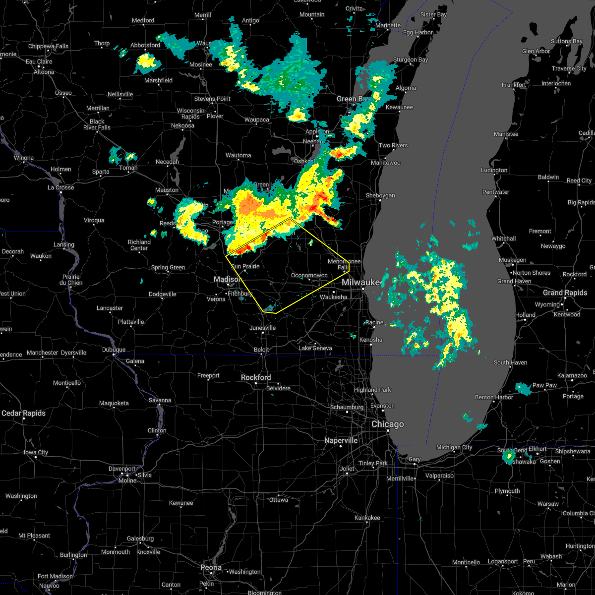 At 520 pm cdt, severe thunderstorms were located along a line extending from 6 miles southeast of waupun to near deforest, moving southeast at 50 mph (radar indicated). Hazards include 60 mph wind gusts and nickel size hail. expect damage to roofs, siding, and trees At 520 pm cdt, severe thunderstorms were located along a line extending from 6 miles southeast of waupun to near deforest, moving southeast at 50 mph (radar indicated). Hazards include 60 mph wind gusts and nickel size hail. expect damage to roofs, siding, and trees
|
| 8/28/2022 4:41 PM CDT | At 440 pm cdt, severe thunderstorms were located along a line extending from near okauchee lake to twin lakes, moving east at 40 mph (radar indicated). Hazards include 60 mph wind gusts and nickel size hail. Expect damage to roofs, siding, and trees. Locations impacted include, waukesha, new berlin, brookfield, menomonee falls, muskego, antioch, pewaukee, sussex, elkhorn, hartland, lake geneva, mukwonago, delafield, elm grove, union grove, east troy, paddock lake, wales, camp lake and okauchee lake. |
| 8/28/2022 4:13 PM CDT | At 413 pm cdt, severe thunderstorms were located along a line extending from watertown to near harvard, moving east at 55 mph (radar indicated). Hazards include 60 mph wind gusts and nickel size hail. expect damage to roofs, siding, and trees |
| 7/24/2022 2:41 AM CDT |
 At 241 am cdt, severe thunderstorms were located along a line extending from near lac la belle to near elkhorn to near clinton, moving east at 45 mph (public). Hazards include 60 mph wind gusts. expect damage to roofs, siding, and trees At 241 am cdt, severe thunderstorms were located along a line extending from near lac la belle to near elkhorn to near clinton, moving east at 45 mph (public). Hazards include 60 mph wind gusts. expect damage to roofs, siding, and trees
|
| 7/23/2022 11:35 PM CDT |
 At 1134 pm cdt, severe thunderstorms were located along a line extending from 19 miles east of whitefish bay to milwaukee to near hartland, moving southeast at 45 mph (radar indicated). Hazards include 60 mph wind gusts and penny size hail. Expect damage to roofs, siding, and trees. locations impacted include, milwaukee, west allis, wauwatosa, new berlin, brookfield, greenfield, menomonee falls, oak creek, muskego, south milwaukee, cudahy, whitefish bay, greendale, pewaukee, brown deer, sussex, st. francis, hales corners, fox point and elm grove. people attending sa: wisconsin state fair park , konkel park , and the milwaukee air and water show should seek safe shelter immediately! hail threat, radar indicated max hail size, 0. 75 in wind threat, radar indicated max wind gust, 60 mph. At 1134 pm cdt, severe thunderstorms were located along a line extending from 19 miles east of whitefish bay to milwaukee to near hartland, moving southeast at 45 mph (radar indicated). Hazards include 60 mph wind gusts and penny size hail. Expect damage to roofs, siding, and trees. locations impacted include, milwaukee, west allis, wauwatosa, new berlin, brookfield, greenfield, menomonee falls, oak creek, muskego, south milwaukee, cudahy, whitefish bay, greendale, pewaukee, brown deer, sussex, st. francis, hales corners, fox point and elm grove. people attending sa: wisconsin state fair park , konkel park , and the milwaukee air and water show should seek safe shelter immediately! hail threat, radar indicated max hail size, 0. 75 in wind threat, radar indicated max wind gust, 60 mph.
|
| 7/23/2022 11:26 PM CDT |
 At 1126 pm cdt, severe thunderstorms were located along a line extending from 10 miles southeast of port washington to germantown, moving east at 40 mph (radar indicated). Hazards include 60 mph wind gusts and nickel size hail. Expect damage to roofs, siding, and trees. locations impacted include, west bend, mequon, hartford, grafton, cedarburg, port washington, jackson, slinger, saukville, thiensville, germantown, newburg, richfield, holy hill, kirchhayn, keowns and hubertus. hail threat, radar indicated max hail size, 0. 88 in wind threat, radar indicated max wind gust, 60 mph. At 1126 pm cdt, severe thunderstorms were located along a line extending from 10 miles southeast of port washington to germantown, moving east at 40 mph (radar indicated). Hazards include 60 mph wind gusts and nickel size hail. Expect damage to roofs, siding, and trees. locations impacted include, west bend, mequon, hartford, grafton, cedarburg, port washington, jackson, slinger, saukville, thiensville, germantown, newburg, richfield, holy hill, kirchhayn, keowns and hubertus. hail threat, radar indicated max hail size, 0. 88 in wind threat, radar indicated max wind gust, 60 mph.
|
| 7/23/2022 11:12 PM CDT |
 At 1112 pm cdt, severe thunderstorms were located along a line extending from 8 miles northeast of bayside to near germantown to 6 miles south of hustisford, moving southeast at 45 mph (radar indicated). Hazards include 60 mph wind gusts and penny size hail. expect damage to roofs, siding, and trees At 1112 pm cdt, severe thunderstorms were located along a line extending from 8 miles northeast of bayside to near germantown to 6 miles south of hustisford, moving southeast at 45 mph (radar indicated). Hazards include 60 mph wind gusts and penny size hail. expect damage to roofs, siding, and trees
|
| 7/23/2022 10:48 PM CDT |
 At 1048 pm cdt, severe thunderstorms were located along a line extending from near west bend to near hartford, moving east at 35 mph (radar indicated). Hazards include 60 mph wind gusts and nickel size hail. expect damage to roofs, siding, and trees At 1048 pm cdt, severe thunderstorms were located along a line extending from near west bend to near hartford, moving east at 35 mph (radar indicated). Hazards include 60 mph wind gusts and nickel size hail. expect damage to roofs, siding, and trees
|
| 7/23/2022 7:08 PM CDT |
 At 708 pm cdt, severe thunderstorms were located along a line extending from near thiensville to delafield, moving southeast at 25 mph (trained weather spotters). Hazards include 60 mph wind gusts. expect damage to roofs, siding, and trees At 708 pm cdt, severe thunderstorms were located along a line extending from near thiensville to delafield, moving southeast at 25 mph (trained weather spotters). Hazards include 60 mph wind gusts. expect damage to roofs, siding, and trees
|
| 7/23/2022 6:21 PM CDT |
 At 620 pm cdt, severe thunderstorms were located along a line extending from near campbellsport to near hustisford to 6 miles east of waterloo, moving southeast at 45 mph (radar indicated). Hazards include 60 mph wind gusts. expect damage to roofs, siding, and trees At 620 pm cdt, severe thunderstorms were located along a line extending from near campbellsport to near hustisford to 6 miles east of waterloo, moving southeast at 45 mph (radar indicated). Hazards include 60 mph wind gusts. expect damage to roofs, siding, and trees
|
| 7/11/2022 7:17 PM CDT |
 At 717 pm cdt, a severe thunderstorm was located over iron ridge, or near horicon, moving east at 50 mph (radar indicated). Hazards include 60 mph wind gusts and nickel size hail. Expect damage to roofs, siding, and trees. locations impacted include, hartford, slinger, horicon, juneau, hustisford, iron ridge, addison, rubicon, lebanon, woodland, neosho, clyman, nenno, holy hill, allenton, monches, nabob and saint lawrence. hail threat, radar indicated max hail size, 0. 88 in wind threat, radar indicated max wind gust, 60 mph. At 717 pm cdt, a severe thunderstorm was located over iron ridge, or near horicon, moving east at 50 mph (radar indicated). Hazards include 60 mph wind gusts and nickel size hail. Expect damage to roofs, siding, and trees. locations impacted include, hartford, slinger, horicon, juneau, hustisford, iron ridge, addison, rubicon, lebanon, woodland, neosho, clyman, nenno, holy hill, allenton, monches, nabob and saint lawrence. hail threat, radar indicated max hail size, 0. 88 in wind threat, radar indicated max wind gust, 60 mph.
|
| 7/11/2022 7:01 PM CDT |
 At 700 pm cdt, a severe thunderstorm was located near beaver dam, moving east at 50 mph (radar indicated). Hazards include 60 mph wind gusts and quarter size hail. Hail damage to vehicles is expected. Expect wind damage to roofs, siding, and trees. At 700 pm cdt, a severe thunderstorm was located near beaver dam, moving east at 50 mph (radar indicated). Hazards include 60 mph wind gusts and quarter size hail. Hail damage to vehicles is expected. Expect wind damage to roofs, siding, and trees.
|
| 6/21/2022 8:51 PM CDT | Some trees down around richfiel in washington county WI, 0.1 miles E of Richfield, WI |
| 6/21/2022 8:45 PM CDT |
 At 844 pm cdt, a severe thunderstorm was located near hartford, moving east at 30 mph (radar indicated). Hazards include 60 mph wind gusts and quarter size hail. Hail damage to vehicles is expected. expect wind damage to roofs, siding, and trees. locations impacted include, menomonee falls, west bend, hartford, sussex, jackson, slinger, germantown, lisbon, merton, newburg, lannon, richfield, ashippun, rubicon, neosho, mapleton, north lake, monches, keowns and saint lawrence. hail threat, radar indicated max hail size, 1. 00 in wind threat, radar indicated max wind gust, 60 mph. At 844 pm cdt, a severe thunderstorm was located near hartford, moving east at 30 mph (radar indicated). Hazards include 60 mph wind gusts and quarter size hail. Hail damage to vehicles is expected. expect wind damage to roofs, siding, and trees. locations impacted include, menomonee falls, west bend, hartford, sussex, jackson, slinger, germantown, lisbon, merton, newburg, lannon, richfield, ashippun, rubicon, neosho, mapleton, north lake, monches, keowns and saint lawrence. hail threat, radar indicated max hail size, 1. 00 in wind threat, radar indicated max wind gust, 60 mph.
|
| 6/21/2022 8:26 PM CDT |
 At 826 pm cdt, a severe thunderstorm was located near hustisford, or 8 miles southwest of hartford, moving east at 30 mph (radar indicated). Hazards include 60 mph wind gusts and quarter size hail. Hail damage to vehicles is expected. Expect wind damage to roofs, siding, and trees. At 826 pm cdt, a severe thunderstorm was located near hustisford, or 8 miles southwest of hartford, moving east at 30 mph (radar indicated). Hazards include 60 mph wind gusts and quarter size hail. Hail damage to vehicles is expected. Expect wind damage to roofs, siding, and trees.
|
| 6/15/2022 9:17 PM CDT |
 At 917 pm cdt, a severe thunderstorm was located over jackson, moving northeast at 35 mph (radar indicated). Hazards include 60 mph wind gusts. expect damage to roofs, siding, and trees At 917 pm cdt, a severe thunderstorm was located over jackson, moving northeast at 35 mph (radar indicated). Hazards include 60 mph wind gusts. expect damage to roofs, siding, and trees
|
| 3/5/2022 10:46 PM CST |
 At 1046 pm cst, severe thunderstorms were located along a line extending from near southern lake winnebago to near west bend to channel lake, moving east at 45 mph (radar indicated). Hazards include 60 mph wind gusts. Expect damage to roofs, siding, and trees. locations impacted include, milwaukee, kenosha, racine, waukesha, west allis, sheboygan, wauwatosa, new berlin, brookfield, greenfield, menomonee falls, oak creek, west bend, mount pleasant, muskego, mequon, south milwaukee, pleasant prairie, cudahy and whitefish bay. hail threat, radar indicated max hail size, <. 75 in wind threat, radar indicated max wind gust, 60 mph. At 1046 pm cst, severe thunderstorms were located along a line extending from near southern lake winnebago to near west bend to channel lake, moving east at 45 mph (radar indicated). Hazards include 60 mph wind gusts. Expect damage to roofs, siding, and trees. locations impacted include, milwaukee, kenosha, racine, waukesha, west allis, sheboygan, wauwatosa, new berlin, brookfield, greenfield, menomonee falls, oak creek, west bend, mount pleasant, muskego, mequon, south milwaukee, pleasant prairie, cudahy and whitefish bay. hail threat, radar indicated max hail size, <. 75 in wind threat, radar indicated max wind gust, 60 mph.
|
| 3/5/2022 10:39 PM CST |
 At 1038 pm cst, a severe thunderstorm was located over oconomowoc, or near okauchee lake, moving east at 40 mph (radar indicated). Hazards include 60 mph wind gusts. Expect damage to roofs, siding, and trees. locations impacted include, waukesha, pewaukee, hartland, delafield, wales, merton, nashotah, chenequa, stone bank, genesee depot, north lake, holy hill, monches and lapham peak st park. hail threat, radar indicated max hail size, <. 75 in wind threat, radar indicated max wind gust, 60 mph. At 1038 pm cst, a severe thunderstorm was located over oconomowoc, or near okauchee lake, moving east at 40 mph (radar indicated). Hazards include 60 mph wind gusts. Expect damage to roofs, siding, and trees. locations impacted include, waukesha, pewaukee, hartland, delafield, wales, merton, nashotah, chenequa, stone bank, genesee depot, north lake, holy hill, monches and lapham peak st park. hail threat, radar indicated max hail size, <. 75 in wind threat, radar indicated max wind gust, 60 mph.
|
| 3/5/2022 10:35 PM CST |
 At 1035 pm cst, severe thunderstorms were located along a line extending from near southern lake winnebago to near slinger to richmond, moving east at 45 mph (radar indicated). Hazards include 60 mph wind gusts. expect damage to roofs, siding, and trees At 1035 pm cst, severe thunderstorms were located along a line extending from near southern lake winnebago to near slinger to richmond, moving east at 45 mph (radar indicated). Hazards include 60 mph wind gusts. expect damage to roofs, siding, and trees
|
| 3/5/2022 10:28 PM CST |
 At 1026 pm cst, a severe thunderstorm was located near johnson creek, or 7 miles northeast of jefferson, moving east at 40 mph (radar indicated). Hazards include 60 mph wind gusts. Expect damage to roofs, siding, and trees. locations impacted include, waukesha, pewaukee, hartland, delafield, wales, okauchee lake, oconomowoc, ottawa, merton, dousman, lac la belle, ixonia, rome, ashippun, nashotah, waterville, sullivan, oconomowoc lake, chenequa and mapleton. hail threat, radar indicated max hail size, <. 75 in wind threat, radar indicated max wind gust, 60 mph. At 1026 pm cst, a severe thunderstorm was located near johnson creek, or 7 miles northeast of jefferson, moving east at 40 mph (radar indicated). Hazards include 60 mph wind gusts. Expect damage to roofs, siding, and trees. locations impacted include, waukesha, pewaukee, hartland, delafield, wales, okauchee lake, oconomowoc, ottawa, merton, dousman, lac la belle, ixonia, rome, ashippun, nashotah, waterville, sullivan, oconomowoc lake, chenequa and mapleton. hail threat, radar indicated max hail size, <. 75 in wind threat, radar indicated max wind gust, 60 mph.
|
| 3/5/2022 10:18 PM CST |
 At 1017 pm cst, a severe thunderstorm was located over jefferson, moving east at 40 mph (radar indicated). Hazards include 60 mph wind gusts. expect damage to roofs, siding, and trees At 1017 pm cst, a severe thunderstorm was located over jefferson, moving east at 40 mph (radar indicated). Hazards include 60 mph wind gusts. expect damage to roofs, siding, and trees
|
| 9/12/2021 3:55 PM CDT |
 At 354 pm cdt, a severe thunderstorm was located near hartford, moving east at 45 mph (radar indicated). Hazards include quarter size hail. Damage to vehicles is expected. locations impacted include, menomonee falls, hartford, sussex, jackson, slinger, germantown, lannon, richfield, colgate, holy hill, kirchhayn, monches, keowns and hubertus. hail threat, radar indicated max hail size, 1. 00 in wind threat, radar indicated max wind gust, <50 mph. At 354 pm cdt, a severe thunderstorm was located near hartford, moving east at 45 mph (radar indicated). Hazards include quarter size hail. Damage to vehicles is expected. locations impacted include, menomonee falls, hartford, sussex, jackson, slinger, germantown, lannon, richfield, colgate, holy hill, kirchhayn, monches, keowns and hubertus. hail threat, radar indicated max hail size, 1. 00 in wind threat, radar indicated max wind gust, <50 mph.
|
| 9/12/2021 3:42 PM CDT |
 At 341 pm cdt, a severe thunderstorm was located near lac la belle, or 8 miles east of watertown, moving east at 45 mph (radar indicated). Hazards include quarter size hail. damage to vehicles is expected At 341 pm cdt, a severe thunderstorm was located near lac la belle, or 8 miles east of watertown, moving east at 45 mph (radar indicated). Hazards include quarter size hail. damage to vehicles is expected
|
| 9/7/2021 11:54 AM CDT |
 At 1154 am cdt, severe thunderstorms were located along a line extending from near cedarburg to brookfield, moving east at 55 mph (radar indicated). Hazards include 60 mph wind gusts and quarter size hail. Hail damage to vehicles is expected. expect wind damage to roofs, siding, and trees. these severe storms will be near, whitefish bay and glendale around 1205 pm cdt. other locations impacted by these severe thunderstorms include marquette university, colgate, chenequa, richfield, uw- milwaukee, stone bank, summit, north lake, kirchhayn and oconomowoc lake. hail threat, radar indicated max hail size, 1. 00 in wind threat, radar indicated max wind gust, 60 mph. At 1154 am cdt, severe thunderstorms were located along a line extending from near cedarburg to brookfield, moving east at 55 mph (radar indicated). Hazards include 60 mph wind gusts and quarter size hail. Hail damage to vehicles is expected. expect wind damage to roofs, siding, and trees. these severe storms will be near, whitefish bay and glendale around 1205 pm cdt. other locations impacted by these severe thunderstorms include marquette university, colgate, chenequa, richfield, uw- milwaukee, stone bank, summit, north lake, kirchhayn and oconomowoc lake. hail threat, radar indicated max hail size, 1. 00 in wind threat, radar indicated max wind gust, 60 mph.
|
| 9/7/2021 11:27 AM CDT |
 At 1126 am cdt, severe thunderstorms were located along a line extending from near hustisford to johnson creek, moving east at 55 mph (radar indicated). Hazards include 60 mph wind gusts and quarter size hail. Hail damage to vehicles is expected. expect wind damage to roofs, siding, and trees. severe thunderstorms will be near, hartford, oconomowoc and lac la belle around 1135 am cdt. delafield and okauchee lake around 1140 am cdt. hartland and merton around 1145 am cdt. waukesha, pewaukee, sussex, jackson, germantown and lisbon around 1150 am cdt. brookfield, cedarburg, elm grove, thiensville, butler and brookfield around 1155 am cdt. wauwatosa, mequon, grafton and bayside around 1200 pm cdt. whitefish bay and glendale around 1205 pm cdt. other locations impacted by these severe thunderstorms include marquette university, colgate, chenequa, richfield, uw- milwaukee, mapleton, stone bank, summit, north lake and holy hill. hail threat, radar indicated max hail size, 1. 00 in wind threat, radar indicated max wind gust, 60 mph. At 1126 am cdt, severe thunderstorms were located along a line extending from near hustisford to johnson creek, moving east at 55 mph (radar indicated). Hazards include 60 mph wind gusts and quarter size hail. Hail damage to vehicles is expected. expect wind damage to roofs, siding, and trees. severe thunderstorms will be near, hartford, oconomowoc and lac la belle around 1135 am cdt. delafield and okauchee lake around 1140 am cdt. hartland and merton around 1145 am cdt. waukesha, pewaukee, sussex, jackson, germantown and lisbon around 1150 am cdt. brookfield, cedarburg, elm grove, thiensville, butler and brookfield around 1155 am cdt. wauwatosa, mequon, grafton and bayside around 1200 pm cdt. whitefish bay and glendale around 1205 pm cdt. other locations impacted by these severe thunderstorms include marquette university, colgate, chenequa, richfield, uw- milwaukee, mapleton, stone bank, summit, north lake and holy hill. hail threat, radar indicated max hail size, 1. 00 in wind threat, radar indicated max wind gust, 60 mph.
|
| 8/10/2021 7:29 PM CDT |
 At 727 pm cdt, severe thunderstorms were located along a line extending from near random lake to near pleasant prairie, moving east at 40 mph (trained weather spotters reported trees down in waukesha county). Hazards include 70 mph wind gusts. Expect considerable tree damage. damage is likely to mobile homes, roofs, and outbuildings. locations impacted include, waukesha, west allis, wauwatosa, new berlin, brookfield, menomonee falls, west bend, muskego, hartford, pewaukee, sussex, elkhorn, hartland, hales corners, lake geneva, mukwonago, delafield, jackson, elm grove and slinger. thunderstorm damage threat, considerable hail threat, radar indicated max hail size, <. 75 in wind threat, radar indicated max wind gust, 70 mph. At 727 pm cdt, severe thunderstorms were located along a line extending from near random lake to near pleasant prairie, moving east at 40 mph (trained weather spotters reported trees down in waukesha county). Hazards include 70 mph wind gusts. Expect considerable tree damage. damage is likely to mobile homes, roofs, and outbuildings. locations impacted include, waukesha, west allis, wauwatosa, new berlin, brookfield, menomonee falls, west bend, muskego, hartford, pewaukee, sussex, elkhorn, hartland, hales corners, lake geneva, mukwonago, delafield, jackson, elm grove and slinger. thunderstorm damage threat, considerable hail threat, radar indicated max hail size, <. 75 in wind threat, radar indicated max wind gust, 70 mph.
|
| 8/10/2021 7:14 PM CDT |
 At 713 pm cdt, severe thunderstorms were located along a line extending from near kewaskum to camp lake, moving east at 40 mph (trained weather spotters. several reports of wind gusts between 60 and 75mph. trees and limbs downed). Hazards include 70 mph wind gusts. Expect considerable tree damage. damage is likely to mobile homes, roofs, and outbuildings. locations impacted include, waukesha, west allis, wauwatosa, new berlin, brookfield, menomonee falls, west bend, muskego, whitewater, hartford, pewaukee, sussex, elkhorn, hartland, delavan, hales corners, lake geneva, mukwonago, delafield and jackson. thunderstorm damage threat, considerable hail threat, radar indicated max hail size, <. 75 in wind threat, radar indicated max wind gust, 70 mph. At 713 pm cdt, severe thunderstorms were located along a line extending from near kewaskum to camp lake, moving east at 40 mph (trained weather spotters. several reports of wind gusts between 60 and 75mph. trees and limbs downed). Hazards include 70 mph wind gusts. Expect considerable tree damage. damage is likely to mobile homes, roofs, and outbuildings. locations impacted include, waukesha, west allis, wauwatosa, new berlin, brookfield, menomonee falls, west bend, muskego, whitewater, hartford, pewaukee, sussex, elkhorn, hartland, delavan, hales corners, lake geneva, mukwonago, delafield and jackson. thunderstorm damage threat, considerable hail threat, radar indicated max hail size, <. 75 in wind threat, radar indicated max wind gust, 70 mph.
|
| 8/10/2021 7:03 PM CDT |
 At 702 pm cdt, severe thunderstorms were located along a line extending from near campbellsport to twin lakes, moving east at 50 mph (trained weather spotters reported a localized wind gust to 77 mph near eagle). Hazards include 60 mph wind gusts. Expect damage to roofs, siding, and trees. locations impacted include, waukesha, west allis, wauwatosa, new berlin, brookfield, menomonee falls, west bend, muskego, whitewater, hartford, pewaukee, sussex, elkhorn, hartland, delavan, hales corners, lake geneva, mukwonago, delafield and jackson. hail threat, radar indicated max hail size, <. 75 in wind threat, radar indicated max wind gust, 60 mph. At 702 pm cdt, severe thunderstorms were located along a line extending from near campbellsport to twin lakes, moving east at 50 mph (trained weather spotters reported a localized wind gust to 77 mph near eagle). Hazards include 60 mph wind gusts. Expect damage to roofs, siding, and trees. locations impacted include, waukesha, west allis, wauwatosa, new berlin, brookfield, menomonee falls, west bend, muskego, whitewater, hartford, pewaukee, sussex, elkhorn, hartland, delavan, hales corners, lake geneva, mukwonago, delafield and jackson. hail threat, radar indicated max hail size, <. 75 in wind threat, radar indicated max wind gust, 60 mph.
|
| 8/10/2021 6:08 PM CDT |
 At 608 pm cdt, severe thunderstorms were located along a line extending from randolph to near beloit, moving east at 40 mph (radar indicated). Hazards include 60 mph wind gusts. expect damage to roofs, siding, and trees At 608 pm cdt, severe thunderstorms were located along a line extending from randolph to near beloit, moving east at 40 mph (radar indicated). Hazards include 60 mph wind gusts. expect damage to roofs, siding, and trees
|
| 7/29/2021 1:32 AM CDT |
 At 131 am cdt, severe thunderstorms were located along a line extending from near germantown to palmyra to near footville, moving southeast at 45 mph (trained weather spotter reports winds of 60 mph in oconomowoc). Hazards include 70 mph wind gusts. Expect considerable tree damage. damage is likely to mobile homes, roofs, and outbuildings. locations impacted include, milwaukee, kenosha, racine, waukesha, janesville, west allis, wauwatosa, new berlin, brookfield, beloit, greenfield, menomonee falls, oak creek, mount pleasant, muskego, south milwaukee, pleasant prairie, cudahy, whitewater and whitefish bay. People attending the waukesha kennel club dog show, the rock county 4h fair in janesville, and the racine county fair in union grove should seek safe shelter immediately!. At 131 am cdt, severe thunderstorms were located along a line extending from near germantown to palmyra to near footville, moving southeast at 45 mph (trained weather spotter reports winds of 60 mph in oconomowoc). Hazards include 70 mph wind gusts. Expect considerable tree damage. damage is likely to mobile homes, roofs, and outbuildings. locations impacted include, milwaukee, kenosha, racine, waukesha, janesville, west allis, wauwatosa, new berlin, brookfield, beloit, greenfield, menomonee falls, oak creek, mount pleasant, muskego, south milwaukee, pleasant prairie, cudahy, whitewater and whitefish bay. People attending the waukesha kennel club dog show, the rock county 4h fair in janesville, and the racine county fair in union grove should seek safe shelter immediately!.
|
| 7/29/2021 1:17 AM CDT |
 At 116 am cdt, severe thunderstorms were located along a line extending from slinger to near jefferson to near brooklyn, moving southeast at 45 mph (trained weather spotter estimated 70 mph winds in johnson creek ). Hazards include 70 mph wind gusts. Expect considerable tree damage. Damage is likely to mobile homes, roofs, and outbuildings. At 116 am cdt, severe thunderstorms were located along a line extending from slinger to near jefferson to near brooklyn, moving southeast at 45 mph (trained weather spotter estimated 70 mph winds in johnson creek ). Hazards include 70 mph wind gusts. Expect considerable tree damage. Damage is likely to mobile homes, roofs, and outbuildings.
|
| 7/29/2021 1:13 AM CDT | Large trees down along highway 167 near holy hill. time estimated from rada in washington county WI, 5.2 miles E of Richfield, WI |
| 7/29/2021 12:57 AM CDT |
 At 1256 am cdt, severe thunderstorms were located along a line extending from near lomira to near waterloo, moving east at 35 mph (radar indicated). Hazards include 60 mph wind gusts. expect damage to roofs, siding, and trees At 1256 am cdt, severe thunderstorms were located along a line extending from near lomira to near waterloo, moving east at 35 mph (radar indicated). Hazards include 60 mph wind gusts. expect damage to roofs, siding, and trees
|
| 7/29/2021 12:29 AM CDT |
 At 1229 am cdt, severe thunderstorms were located along a line extending from near kewaskum to near horicon to near randolph to near rio, moving southeast at 40 mph (radar indicated). Hazards include 60 mph wind gusts. Expect damage to roofs, siding, and trees. Locations impacted include, west bend, watertown, beaver dam, hartford, waupun, jackson, mayville, slinger, kewaskum, horicon, juneau, germantown, lomira, theresa, hustisford, iron ridge, burnett, richfield, addison and ashippun. At 1229 am cdt, severe thunderstorms were located along a line extending from near kewaskum to near horicon to near randolph to near rio, moving southeast at 40 mph (radar indicated). Hazards include 60 mph wind gusts. Expect damage to roofs, siding, and trees. Locations impacted include, west bend, watertown, beaver dam, hartford, waupun, jackson, mayville, slinger, kewaskum, horicon, juneau, germantown, lomira, theresa, hustisford, iron ridge, burnett, richfield, addison and ashippun.
|
| 7/28/2021 11:55 PM CDT |
 The national weather service in milwaukee/sullivan has issued a * severe thunderstorm warning for. washington county in southeastern wisconsin. dodge county in southeastern wisconsin. until 100 am cdt. At 1155 pm cdt, severe thunderstorms were located along a line. The national weather service in milwaukee/sullivan has issued a * severe thunderstorm warning for. washington county in southeastern wisconsin. dodge county in southeastern wisconsin. until 100 am cdt. At 1155 pm cdt, severe thunderstorms were located along a line.
|
| 7/19/2020 4:44 AM CDT |
 At 443 am cdt, severe thunderstorms were located along a line extending from near fond du lac to near mayville to near cambria, moving east at 45 mph (radar indicated. this line does have a history of producing estimated 60-70 mph winds). Hazards include 60 mph wind gusts and quarter size hail. Hail damage to vehicles is expected. Expect wind damage to roofs, siding, and trees. At 443 am cdt, severe thunderstorms were located along a line extending from near fond du lac to near mayville to near cambria, moving east at 45 mph (radar indicated. this line does have a history of producing estimated 60-70 mph winds). Hazards include 60 mph wind gusts and quarter size hail. Hail damage to vehicles is expected. Expect wind damage to roofs, siding, and trees.
|
| 7/9/2020 7:38 PM CDT |
 At 737 pm cdt, severe thunderstorms were located along a line extending from near iron ridge to milwaukee, moving northeast at 45 mph (law enforcement. trees and powerlines have been reported down in the lac la belle, dousman, and eagle areas). Hazards include 60 mph wind gusts and penny size hail. Expect damage to roofs, siding, and trees. Locations impacted include, northern milwaukee, wauwatosa, brookfield, menomonee falls, west bend, mequon, hartford, whitefish bay, pewaukee, brown deer, grafton, cedarburg, port washington, sussex, hartland, jackson, fox point, slinger, saukville and bayside. At 737 pm cdt, severe thunderstorms were located along a line extending from near iron ridge to milwaukee, moving northeast at 45 mph (law enforcement. trees and powerlines have been reported down in the lac la belle, dousman, and eagle areas). Hazards include 60 mph wind gusts and penny size hail. Expect damage to roofs, siding, and trees. Locations impacted include, northern milwaukee, wauwatosa, brookfield, menomonee falls, west bend, mequon, hartford, whitefish bay, pewaukee, brown deer, grafton, cedarburg, port washington, sussex, hartland, jackson, fox point, slinger, saukville and bayside.
|
| 7/9/2020 7:24 PM CDT |
 At 723 pm cdt, severe thunderstorms were located along a line extending from hustisford to pewaukee, moving northeast at 45 mph (radar indicated). Hazards include 60 mph wind gusts and penny size hail. expect damage to roofs, siding, and trees At 723 pm cdt, severe thunderstorms were located along a line extending from hustisford to pewaukee, moving northeast at 45 mph (radar indicated). Hazards include 60 mph wind gusts and penny size hail. expect damage to roofs, siding, and trees
|
| 7/9/2020 6:59 PM CDT |
 At 657 pm cdt, severe thunderstorms were located along a line extending from lake mills to potter lake, moving northeast at 30 mph (public. trees have been reported down across portions of walworth county with these storms). Hazards include 60 mph wind gusts and penny size hail. expect damage to roofs, siding, and trees At 657 pm cdt, severe thunderstorms were located along a line extending from lake mills to potter lake, moving northeast at 30 mph (public. trees have been reported down across portions of walworth county with these storms). Hazards include 60 mph wind gusts and penny size hail. expect damage to roofs, siding, and trees
|
| 6/10/2020 1:50 PM CDT |
 The severe thunderstorm warning for north central waukesha and southern washington counties will expire at 200 pm cdt, the storm which prompted the warning has weakened below severe limits, and has exited the warned area. therefore, the warning will be allowed to expire. The severe thunderstorm warning for north central waukesha and southern washington counties will expire at 200 pm cdt, the storm which prompted the warning has weakened below severe limits, and has exited the warned area. therefore, the warning will be allowed to expire.
|
| 6/10/2020 1:34 PM CDT |
 At 134 pm cdt, a severe thunderstorm was located over jackson, moving northeast at 40 mph (radar indicated). Hazards include 60 mph wind gusts and quarter size hail. Hail damage to vehicles is expected. expect wind damage to roofs, siding, and trees. Locations impacted include, jackson, slinger, richfield, hubertus, colgate and holy hill. At 134 pm cdt, a severe thunderstorm was located over jackson, moving northeast at 40 mph (radar indicated). Hazards include 60 mph wind gusts and quarter size hail. Hail damage to vehicles is expected. expect wind damage to roofs, siding, and trees. Locations impacted include, jackson, slinger, richfield, hubertus, colgate and holy hill.
|
| 6/10/2020 1:22 PM CDT |
 At 121 pm cdt, a severe thunderstorm was located near merton, or near sussex, moving northeast at 30 mph (radar indicated). Hazards include 60 mph wind gusts and quarter size hail. Hail damage to vehicles is expected. Expect wind damage to roofs, siding, and trees. At 121 pm cdt, a severe thunderstorm was located near merton, or near sussex, moving northeast at 30 mph (radar indicated). Hazards include 60 mph wind gusts and quarter size hail. Hail damage to vehicles is expected. Expect wind damage to roofs, siding, and trees.
|
| 6/2/2020 9:09 PM CDT |
 At 908 pm cdt, severe thunderstorms were located along a line extending from near sheboygan falls to near slinger, moving southeast at 40 mph (radar indicated). Hazards include 60 mph wind gusts. Expect damage to roofs, siding, and trees. locations impacted include, west bend, mequon, hartford, grafton, cedarburg, port washington, jackson, slinger, saukville, bayside, kewaskum, thiensville, belgium, fredonia, newburg, richfield, addison, wayne, nenno and waubeka. People attending washington county outdoor testing, outdoor testing at ascension in mequon, outdoor testing at aurora in grafton, and outdoor testing at aurora in hartford should seek safe shelter immediately!. At 908 pm cdt, severe thunderstorms were located along a line extending from near sheboygan falls to near slinger, moving southeast at 40 mph (radar indicated). Hazards include 60 mph wind gusts. Expect damage to roofs, siding, and trees. locations impacted include, west bend, mequon, hartford, grafton, cedarburg, port washington, jackson, slinger, saukville, bayside, kewaskum, thiensville, belgium, fredonia, newburg, richfield, addison, wayne, nenno and waubeka. People attending washington county outdoor testing, outdoor testing at ascension in mequon, outdoor testing at aurora in grafton, and outdoor testing at aurora in hartford should seek safe shelter immediately!.
|
| 6/2/2020 8:44 PM CDT |
 At 843 pm cdt, severe thunderstorms were located along a line extending from 7 miles west of plymouth to near watertown, moving east at 45 mph (radar indicated). Hazards include 60 mph wind gusts and penny size hail. expect damage to roofs, siding, and trees At 843 pm cdt, severe thunderstorms were located along a line extending from 7 miles west of plymouth to near watertown, moving east at 45 mph (radar indicated). Hazards include 60 mph wind gusts and penny size hail. expect damage to roofs, siding, and trees
|
| 4/7/2020 4:02 PM CDT |
 At 402 pm cdt, a severe thunderstorm was located near jackson, moving east at 30 mph (radar indicated). Hazards include golf ball size hail and 60 mph wind gusts. People and animals outdoors will be injured. expect hail damage to roofs, siding, windows, and vehicles. expect wind damage to roofs, siding, and trees. locations impacted include, west bend, mequon, hartford, grafton, cedarburg, port washington, jackson, slinger, saukville, fredonia, newburg, richfield, addison, nenno, waubeka, holy hill, allenton, saint lawrence and kohlsville. People attending outdoor testing at aurora in grafton, outdoor testing at aurora in hartford, and outdoor testing at ascension in mequon should seek safe shelter immediately!. At 402 pm cdt, a severe thunderstorm was located near jackson, moving east at 30 mph (radar indicated). Hazards include golf ball size hail and 60 mph wind gusts. People and animals outdoors will be injured. expect hail damage to roofs, siding, windows, and vehicles. expect wind damage to roofs, siding, and trees. locations impacted include, west bend, mequon, hartford, grafton, cedarburg, port washington, jackson, slinger, saukville, fredonia, newburg, richfield, addison, nenno, waubeka, holy hill, allenton, saint lawrence and kohlsville. People attending outdoor testing at aurora in grafton, outdoor testing at aurora in hartford, and outdoor testing at ascension in mequon should seek safe shelter immediately!.
|
| 4/7/2020 3:40 PM CDT |
 At 340 pm cdt, a severe thunderstorm was located near slinger, moving east at 50 mph (radar indicated). Hazards include 60 mph wind gusts and quarter size hail. Hail damage to vehicles is expected. Expect wind damage to roofs, siding, and trees. At 340 pm cdt, a severe thunderstorm was located near slinger, moving east at 50 mph (radar indicated). Hazards include 60 mph wind gusts and quarter size hail. Hail damage to vehicles is expected. Expect wind damage to roofs, siding, and trees.
|
| 7/20/2019 1:07 PM CDT |
 The severe thunderstorm warning for ozaukee, north central milwaukee, washington and dodge counties will expire at 115 pm cdt, the storms which prompted the warning have weakened below severe limits, and no longer pose an immediate threat to life or property. therefore, the warning will be allowed to expire. however gusty winds to 40 mph are still likely with these thunderstorms. a severe thunderstorm watch remains in effect until 900 pm cdt for south central and southeastern wisconsin. The severe thunderstorm warning for ozaukee, north central milwaukee, washington and dodge counties will expire at 115 pm cdt, the storms which prompted the warning have weakened below severe limits, and no longer pose an immediate threat to life or property. therefore, the warning will be allowed to expire. however gusty winds to 40 mph are still likely with these thunderstorms. a severe thunderstorm watch remains in effect until 900 pm cdt for south central and southeastern wisconsin.
|
| 7/20/2019 12:54 PM CDT |
 At 1254 pm cdt, severe thunderstorms were located along a line extending from 11 miles east of sheboygan to near waterloo, moving southeast at 35 mph (radar indicated). Hazards include 60 mph wind gusts. Expect damage to roofs, siding, and trees. Locations impacted include, west bend, watertown, mequon, beaver dam, hartford, grafton, cedarburg, port washington, jackson, mayville, slinger, saukville, bayside, kewaskum, horicon, thiensville, juneau, belgium, fredonia and newburg. At 1254 pm cdt, severe thunderstorms were located along a line extending from 11 miles east of sheboygan to near waterloo, moving southeast at 35 mph (radar indicated). Hazards include 60 mph wind gusts. Expect damage to roofs, siding, and trees. Locations impacted include, west bend, watertown, mequon, beaver dam, hartford, grafton, cedarburg, port washington, jackson, mayville, slinger, saukville, bayside, kewaskum, horicon, thiensville, juneau, belgium, fredonia and newburg.
|
| 7/20/2019 12:32 PM CDT |
 At 1231 pm cdt, severe thunderstorms were located along a line extending from 13 miles east of sheboygan to near waterloo, moving southeast at 45 mph (radar indicated). Hazards include 60 mph wind gusts. Expect damage to roofs, siding, and trees. Locations impacted include, sheboygan, west bend, watertown, mequon, beaver dam, hartford, grafton, cedarburg, waupun, port washington, plymouth, sheboygan falls, jackson, mayville, slinger, saukville, bayside, kewaskum, horicon and thiensville. At 1231 pm cdt, severe thunderstorms were located along a line extending from 13 miles east of sheboygan to near waterloo, moving southeast at 45 mph (radar indicated). Hazards include 60 mph wind gusts. Expect damage to roofs, siding, and trees. Locations impacted include, sheboygan, west bend, watertown, mequon, beaver dam, hartford, grafton, cedarburg, waupun, port washington, plymouth, sheboygan falls, jackson, mayville, slinger, saukville, bayside, kewaskum, horicon and thiensville.
|
| 7/20/2019 12:18 PM CDT |
 At 1217 pm cdt, severe thunderstorms were located along a line extending from near sheboygan to near columbus, moving southeast at 45 mph (radar indicated). Hazards include 60 mph wind gusts. expect damage to roofs, siding, and trees At 1217 pm cdt, severe thunderstorms were located along a line extending from near sheboygan to near columbus, moving southeast at 45 mph (radar indicated). Hazards include 60 mph wind gusts. expect damage to roofs, siding, and trees
|
| 6/27/2019 5:42 PM CDT |
 The severe thunderstorm warning for ozaukee, washington and sheboygan counties will expire at 545 pm cdt, the strongest winds with the line of storms has moved out over lake michigan. therefore, the warning will be allowed to expire. however gusty winds of 30 mph to 40 mph are still expected through 6 pm over sheboygan and ozaukee counties. a severe thunderstorm watch remains in effect until 900 pm cdt for southeastern and east central wisconsin. The severe thunderstorm warning for ozaukee, washington and sheboygan counties will expire at 545 pm cdt, the strongest winds with the line of storms has moved out over lake michigan. therefore, the warning will be allowed to expire. however gusty winds of 30 mph to 40 mph are still expected through 6 pm over sheboygan and ozaukee counties. a severe thunderstorm watch remains in effect until 900 pm cdt for southeastern and east central wisconsin.
|
| 6/27/2019 5:14 PM CDT |
 At 513 pm cdt, severe thunderstorms were located along a line extending from near st. nazianz to menomonee falls, moving east at 50 mph (radar indicated). Hazards include 60 mph wind gusts and penny size hail. Expect damage to roofs, siding, and trees. Locations impacted include, sheboygan, menomonee falls, west bend, mequon, hartford, brown deer, grafton, cedarburg, port washington, plymouth, sheboygan falls, jackson, slinger, saukville, bayside, kewaskum, thiensville, howards grove, oostburg and belgium. At 513 pm cdt, severe thunderstorms were located along a line extending from near st. nazianz to menomonee falls, moving east at 50 mph (radar indicated). Hazards include 60 mph wind gusts and penny size hail. Expect damage to roofs, siding, and trees. Locations impacted include, sheboygan, menomonee falls, west bend, mequon, hartford, brown deer, grafton, cedarburg, port washington, plymouth, sheboygan falls, jackson, slinger, saukville, bayside, kewaskum, thiensville, howards grove, oostburg and belgium.
|
| 6/27/2019 4:58 PM CDT |
 At 457 pm cdt, severe thunderstorms were located along a line extending from 6 miles southwest of chilton to merton, moving east at 45 mph (radar indicated). Hazards include 60 mph wind gusts and penny size hail. Expect damage to roofs, siding, and trees. Locations impacted include, sheboygan, menomonee falls, west bend, mequon, hartford, brown deer, grafton, cedarburg, port washington, plymouth, sheboygan falls, jackson, slinger, saukville, bayside, kewaskum, thiensville, howards grove, oostburg and belgium. At 457 pm cdt, severe thunderstorms were located along a line extending from 6 miles southwest of chilton to merton, moving east at 45 mph (radar indicated). Hazards include 60 mph wind gusts and penny size hail. Expect damage to roofs, siding, and trees. Locations impacted include, sheboygan, menomonee falls, west bend, mequon, hartford, brown deer, grafton, cedarburg, port washington, plymouth, sheboygan falls, jackson, slinger, saukville, bayside, kewaskum, thiensville, howards grove, oostburg and belgium.
|
| 6/27/2019 4:29 PM CDT |
 At 429 pm cdt, severe thunderstorms were located along a line extending from 6 miles southwest of oshkosh to watertown, moving east at 55 mph (radar indicated). Hazards include 60 mph wind gusts and penny size hail. expect damage to roofs, siding, and trees At 429 pm cdt, severe thunderstorms were located along a line extending from 6 miles southwest of oshkosh to watertown, moving east at 55 mph (radar indicated). Hazards include 60 mph wind gusts and penny size hail. expect damage to roofs, siding, and trees
|
| 5/19/2019 1:04 PM CDT | Damage to a tree and siding. report from fox6 tv viewe in washington county WI, 0.9 miles W of Richfield, WI |
| 8/28/2018 4:59 PM CDT |
 A severe thunderstorm warning remains in effect until 530 pm cdt for southern ozaukee. northwestern milwaukee. northeastern waukesha and southern washington counties. At 458 pm cdt, severe thunderstorms were located along a line extending from near fredonia to near jackson to near merton, moving east at 40 mph. A severe thunderstorm warning remains in effect until 530 pm cdt for southern ozaukee. northwestern milwaukee. northeastern waukesha and southern washington counties. At 458 pm cdt, severe thunderstorms were located along a line extending from near fredonia to near jackson to near merton, moving east at 40 mph.
|
| 8/28/2018 4:41 PM CDT |
 At 441 pm cdt, severe thunderstorms were located along a line extending from near west bend to near hartford to 6 miles north of lac la belle, moving east at 40 mph (radar indicated). Hazards include 60 mph wind gusts. expect damage to roofs, siding, and trees At 441 pm cdt, severe thunderstorms were located along a line extending from near west bend to near hartford to 6 miles north of lac la belle, moving east at 40 mph (radar indicated). Hazards include 60 mph wind gusts. expect damage to roofs, siding, and trees
|
| 8/26/2018 9:49 PM CDT |
 At 949 pm cdt, a severe thunderstorm was located near hartford, moving northeast at 50 mph (radar indicated). Hazards include 60 mph wind gusts and penny size hail. Expect damage to roofs, siding, and trees. Locations impacted include, hartford, slinger, ashippun, saint lawrence, hubertus and holy hill. At 949 pm cdt, a severe thunderstorm was located near hartford, moving northeast at 50 mph (radar indicated). Hazards include 60 mph wind gusts and penny size hail. Expect damage to roofs, siding, and trees. Locations impacted include, hartford, slinger, ashippun, saint lawrence, hubertus and holy hill.
|
| 8/26/2018 9:38 PM CDT |
 At 938 pm cdt, a severe thunderstorm was located near lac la belle, or 7 miles northwest of okauchee lake, moving northeast at 45 mph (radar indicated). Hazards include 60 mph wind gusts and penny size hail. expect damage to roofs, siding, and trees At 938 pm cdt, a severe thunderstorm was located near lac la belle, or 7 miles northwest of okauchee lake, moving northeast at 45 mph (radar indicated). Hazards include 60 mph wind gusts and penny size hail. expect damage to roofs, siding, and trees
|
| 7/1/2018 2:50 PM CDT |
 At 250 pm cdt, a severe thunderstorm was located near mequon, moving northeast at 40 mph (radar indicated). Hazards include 70 mph wind gusts. Expect considerable tree damage. damage is likely to mobile homes, roofs, and outbuildings. locations impacted include, northern milwaukee, brookfield, menomonee falls, mequon, brown deer, grafton, cedarburg, port washington, sussex, saukville, bayside, thiensville, belgium, butler, river hills, lannon, richfield, colgate, harrington beach st park and hubertus. A tornado watch remains in effect until 700 pm cdt for southeastern wisconsin. At 250 pm cdt, a severe thunderstorm was located near mequon, moving northeast at 40 mph (radar indicated). Hazards include 70 mph wind gusts. Expect considerable tree damage. damage is likely to mobile homes, roofs, and outbuildings. locations impacted include, northern milwaukee, brookfield, menomonee falls, mequon, brown deer, grafton, cedarburg, port washington, sussex, saukville, bayside, thiensville, belgium, butler, river hills, lannon, richfield, colgate, harrington beach st park and hubertus. A tornado watch remains in effect until 700 pm cdt for southeastern wisconsin.
|
| 7/1/2018 2:43 PM CDT |
 At 243 pm cdt, a severe thunderstorm was located near menomonee falls, moving northeast at 45 mph (radar indicated). Hazards include 60 mph wind gusts. expect damage to roofs, siding, and trees At 243 pm cdt, a severe thunderstorm was located near menomonee falls, moving northeast at 45 mph (radar indicated). Hazards include 60 mph wind gusts. expect damage to roofs, siding, and trees
|
| 5/27/2018 4:50 PM CDT |
 At 450 pm cdt, a severe thunderstorm was located near merton, or 7 miles south of hartford, moving southeast at 20 mph (radar indicated). Hazards include 60 mph wind gusts and quarter size hail. Hail damage to vehicles is expected. expect wind damage to roofs, siding, and trees. Locations impacted include, waukesha, new berlin, brookfield, menomonee falls, hartford, pewaukee, sussex, hartland, delafield, elm grove, okauchee lake, merton, butler, lannon, lac la belle, richfield, ashippun, nashotah, chenequa and neosho. At 450 pm cdt, a severe thunderstorm was located near merton, or 7 miles south of hartford, moving southeast at 20 mph (radar indicated). Hazards include 60 mph wind gusts and quarter size hail. Hail damage to vehicles is expected. expect wind damage to roofs, siding, and trees. Locations impacted include, waukesha, new berlin, brookfield, menomonee falls, hartford, pewaukee, sussex, hartland, delafield, elm grove, okauchee lake, merton, butler, lannon, lac la belle, richfield, ashippun, nashotah, chenequa and neosho.
|
| 5/27/2018 4:19 PM CDT |
 The national weather service in milwaukee/sullivan has issued a * severe thunderstorm warning for. northern waukesha county in southeastern wisconsin. southern washington county in southeastern wisconsin. northeastern jefferson county in southeastern wisconsin. Southeastern dodge county in southeastern wisconsin. The national weather service in milwaukee/sullivan has issued a * severe thunderstorm warning for. northern waukesha county in southeastern wisconsin. southern washington county in southeastern wisconsin. northeastern jefferson county in southeastern wisconsin. Southeastern dodge county in southeastern wisconsin.
|
| 5/9/2018 5:06 PM CDT |
 At 504 pm cdt, a confirmed tornado was located near jackson, moving east at 30 mph (weather spotters confirmed tornado. at 458 pm, a tornado was reported just west of hubertus by a trained spotter). Hazards include damaging tornado. Flying debris will be dangerous to those caught without shelter. mobile homes will be damaged or destroyed. damage to roofs, windows, and vehicles will occur. tree damage is likely. Locations impacted include, richfield and hubertus. At 504 pm cdt, a confirmed tornado was located near jackson, moving east at 30 mph (weather spotters confirmed tornado. at 458 pm, a tornado was reported just west of hubertus by a trained spotter). Hazards include damaging tornado. Flying debris will be dangerous to those caught without shelter. mobile homes will be damaged or destroyed. damage to roofs, windows, and vehicles will occur. tree damage is likely. Locations impacted include, richfield and hubertus.
|
| 5/9/2018 4:54 PM CDT |
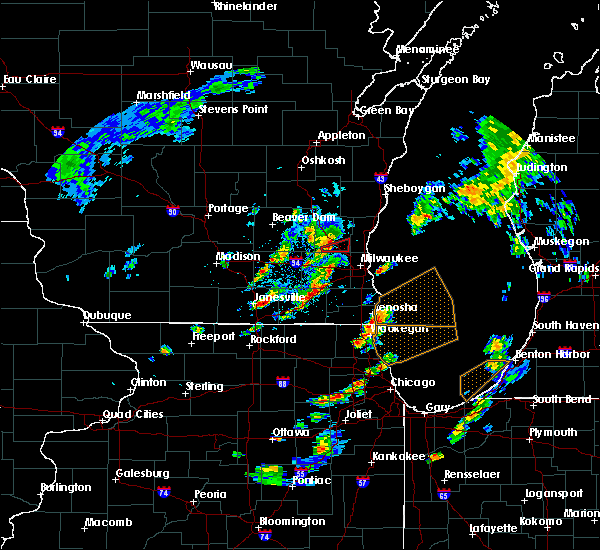 At 454 pm cdt, a severe thunderstorm capable of producing a tornado was located near merton, or 7 miles northwest of sussex, moving east at 30 mph (radar indicated rotation). Hazards include tornado. Flying debris will be dangerous to those caught without shelter. mobile homes will be damaged or destroyed. damage to roofs, windows, and vehicles will occur. tree damage is likely. This tornadic thunderstorm will remain over mainly rural areas of southeastern washington county, including the following locations, richfield, hubertus and holy hill. At 454 pm cdt, a severe thunderstorm capable of producing a tornado was located near merton, or 7 miles northwest of sussex, moving east at 30 mph (radar indicated rotation). Hazards include tornado. Flying debris will be dangerous to those caught without shelter. mobile homes will be damaged or destroyed. damage to roofs, windows, and vehicles will occur. tree damage is likely. This tornadic thunderstorm will remain over mainly rural areas of southeastern washington county, including the following locations, richfield, hubertus and holy hill.
|
| 5/2/2018 8:17 PM CDT |
 At 817 pm cdt, a severe thunderstorm was located near lac la belle, or near okauchee lake, moving east at 25 mph (radar indicated). Hazards include 60 mph wind gusts and quarter size hail. Hail damage to vehicles is expected. Expect wind damage to roofs, siding, and trees. At 817 pm cdt, a severe thunderstorm was located near lac la belle, or near okauchee lake, moving east at 25 mph (radar indicated). Hazards include 60 mph wind gusts and quarter size hail. Hail damage to vehicles is expected. Expect wind damage to roofs, siding, and trees.
|
| 8/10/2017 3:26 PM CDT |
 At 326 pm cdt, a severe thunderstorm was located near jackson, moving east at 40 mph (radar indicated). Hazards include 60 mph wind gusts and quarter size hail. Hail damage to vehicles is expected. Expect wind damage to roofs, siding, and trees. At 326 pm cdt, a severe thunderstorm was located near jackson, moving east at 40 mph (radar indicated). Hazards include 60 mph wind gusts and quarter size hail. Hail damage to vehicles is expected. Expect wind damage to roofs, siding, and trees.
|
| 7/15/2017 11:20 PM CDT |
 At 1120 pm cdt, severe thunderstorms were located along a line extending from 6 miles northeast of watertown to lannon, moving southeast at 30 mph (radar indicated). Hazards include 60 mph wind gusts and quarter size hail. Hail damage to vehicles is expected. Expect wind damage to roofs, siding, and trees. At 1120 pm cdt, severe thunderstorms were located along a line extending from 6 miles northeast of watertown to lannon, moving southeast at 30 mph (radar indicated). Hazards include 60 mph wind gusts and quarter size hail. Hail damage to vehicles is expected. Expect wind damage to roofs, siding, and trees.
|
| 7/15/2017 10:51 PM CDT |
 At 1051 pm cdt, severe thunderstorms were located along a line extending from near saukville to jackson to hartford, moving south at 25 mph (radar indicated). Hazards include 60 mph wind gusts and penny size hail. Expect damage to roofs, siding, and trees. Locations impacted include, west bend, mequon, hartford, brown deer, grafton, cedarburg, port washington, jackson, slinger, saukville, bayside, thiensville, newburg, richfield, addison, wayne, nenno, colgate, holy hill and allenton. At 1051 pm cdt, severe thunderstorms were located along a line extending from near saukville to jackson to hartford, moving south at 25 mph (radar indicated). Hazards include 60 mph wind gusts and penny size hail. Expect damage to roofs, siding, and trees. Locations impacted include, west bend, mequon, hartford, brown deer, grafton, cedarburg, port washington, jackson, slinger, saukville, bayside, thiensville, newburg, richfield, addison, wayne, nenno, colgate, holy hill and allenton.
|
| 7/15/2017 10:33 PM CDT |
 At 1033 pm cdt, severe thunderstorms were located along a line extending from belgium to near fredonia to near newburg to near west bend, moving southeast at 35 mph (radar indicated). Hazards include 60 mph wind gusts and penny size hail. Expect damage to roofs, siding, and trees. Locations impacted include, west bend, mequon, hartford, brown deer, grafton, cedarburg, port washington, jackson, slinger, saukville, bayside, kewaskum, thiensville, belgium, fredonia, newburg, richfield, addison, wayne and nenno. At 1033 pm cdt, severe thunderstorms were located along a line extending from belgium to near fredonia to near newburg to near west bend, moving southeast at 35 mph (radar indicated). Hazards include 60 mph wind gusts and penny size hail. Expect damage to roofs, siding, and trees. Locations impacted include, west bend, mequon, hartford, brown deer, grafton, cedarburg, port washington, jackson, slinger, saukville, bayside, kewaskum, thiensville, belgium, fredonia, newburg, richfield, addison, wayne and nenno.
|
| 7/15/2017 10:16 PM CDT |
 At 1015 pm cdt, severe thunderstorms were located along a line extending from 7 miles northwest of cedar grove to near random lake to 6 miles east of kewaskum to near campbellsport, moving southeast at 35 mph (radar indicated). Hazards include 60 mph wind gusts and penny size hail. Expect damage to roofs, siding, and trees. Locations impacted include, west bend, mequon, hartford, brown deer, grafton, cedarburg, port washington, jackson, slinger, saukville, bayside, kewaskum, thiensville, belgium, fredonia, cedar grove, campbellsport, random lake, newburg and richfield. At 1015 pm cdt, severe thunderstorms were located along a line extending from 7 miles northwest of cedar grove to near random lake to 6 miles east of kewaskum to near campbellsport, moving southeast at 35 mph (radar indicated). Hazards include 60 mph wind gusts and penny size hail. Expect damage to roofs, siding, and trees. Locations impacted include, west bend, mequon, hartford, brown deer, grafton, cedarburg, port washington, jackson, slinger, saukville, bayside, kewaskum, thiensville, belgium, fredonia, cedar grove, campbellsport, random lake, newburg and richfield.
|
| 7/15/2017 10:03 PM CDT |
 At 1003 pm cdt, severe thunderstorms were located along a line extending from near plymouth to 8 miles northwest of random lake to 6 miles east of campbellsport to near lomira, moving southeast at 35 mph (radar indicated). Hazards include 60 mph wind gusts and penny size hail. expect damage to roofs, siding, and trees At 1003 pm cdt, severe thunderstorms were located along a line extending from near plymouth to 8 miles northwest of random lake to 6 miles east of campbellsport to near lomira, moving southeast at 35 mph (radar indicated). Hazards include 60 mph wind gusts and penny size hail. expect damage to roofs, siding, and trees
|
| 7/6/2017 11:41 PM CDT |
 The severe thunderstorm warning for northwestern waukesha, southwestern washington, northeastern jefferson and southeastern dodge counties will expire at 1145 pm cdt, the storm which prompted the warning has weakened below severe limits, and no longer poses an immediate threat to life or property. therefore the warning will be allowed to expire. however gusty winds are still possible with this thunderstorm. The severe thunderstorm warning for northwestern waukesha, southwestern washington, northeastern jefferson and southeastern dodge counties will expire at 1145 pm cdt, the storm which prompted the warning has weakened below severe limits, and no longer poses an immediate threat to life or property. therefore the warning will be allowed to expire. however gusty winds are still possible with this thunderstorm.
|
| 7/6/2017 11:29 PM CDT |
 At 1129 pm cdt, a severe thunderstorm was located over okauchee lake, moving southeast at 35 mph (radar indicated). Hazards include 60 mph wind gusts. Expect damage to roofs, siding, and trees. Locations impacted include, hartford, hartland, delafield, jackson, slinger, wales, okauchee lake, oconomowoc, merton, lac la belle, nashotah, oconomowoc lake, chenequa, mapleton, stone bank, north lake, holy hill, saint lawrence, lapham peak st park and monterey. At 1129 pm cdt, a severe thunderstorm was located over okauchee lake, moving southeast at 35 mph (radar indicated). Hazards include 60 mph wind gusts. Expect damage to roofs, siding, and trees. Locations impacted include, hartford, hartland, delafield, jackson, slinger, wales, okauchee lake, oconomowoc, merton, lac la belle, nashotah, oconomowoc lake, chenequa, mapleton, stone bank, north lake, holy hill, saint lawrence, lapham peak st park and monterey.
|
| 7/6/2017 11:22 PM CDT |
 At 1122 pm cdt, a severe thunderstorm was located over lac la belle, or near okauchee lake, moving southeast at 35 mph (radar indicated). Hazards include 60 mph wind gusts. Expect damage to roofs, siding, and trees. Locations impacted include, hartford, hartland, delafield, jackson, slinger, wales, okauchee lake, oconomowoc, merton, lac la belle, ixonia, ashippun, rubicon, nashotah, oconomowoc lake, chenequa, neosho, mapleton, stone bank and north lake. At 1122 pm cdt, a severe thunderstorm was located over lac la belle, or near okauchee lake, moving southeast at 35 mph (radar indicated). Hazards include 60 mph wind gusts. Expect damage to roofs, siding, and trees. Locations impacted include, hartford, hartland, delafield, jackson, slinger, wales, okauchee lake, oconomowoc, merton, lac la belle, ixonia, ashippun, rubicon, nashotah, oconomowoc lake, chenequa, neosho, mapleton, stone bank and north lake.
|
| 7/6/2017 11:13 PM CDT |
 At 1113 pm cdt, a severe thunderstorm was located near watertown, moving southeast at 35 mph (radar indicated). Hazards include 60 mph wind gusts. expect damage to roofs, siding, and trees At 1113 pm cdt, a severe thunderstorm was located near watertown, moving southeast at 35 mph (radar indicated). Hazards include 60 mph wind gusts. expect damage to roofs, siding, and trees
|
| 6/28/2017 2:45 PM CDT |
 At 745 pm cdt, severe thunderstorms were located along a line extending from near watertown to near whitewater, moving southeast at 55 mph (radar indicated). Hazards include 60 mph wind gusts and penny size hail. expect damage to roofs, siding, and trees At 745 pm cdt, severe thunderstorms were located along a line extending from near watertown to near whitewater, moving southeast at 55 mph (radar indicated). Hazards include 60 mph wind gusts and penny size hail. expect damage to roofs, siding, and trees
|
| 6/28/2017 1:55 PM CDT |
 At 655 pm cdt, severe thunderstorms were located along a line extending from near cedarburg to near mequon to sussex, moving east at 50 mph (radar indicated). Hazards include 60 mph wind gusts and penny size hail. Expect damage to roofs, siding, and trees. locations impacted include, milwaukee, wauwatosa, brookfield, menomonee falls, mequon, whitefish bay, pewaukee, brown deer, grafton, cedarburg, sussex, hartland, delafield, jackson, fox point, elm grove, slinger, bayside, thiensville and okauchee lake. A tornado watch remains in effect until 1000 pm cdt for southeastern wisconsin. At 655 pm cdt, severe thunderstorms were located along a line extending from near cedarburg to near mequon to sussex, moving east at 50 mph (radar indicated). Hazards include 60 mph wind gusts and penny size hail. Expect damage to roofs, siding, and trees. locations impacted include, milwaukee, wauwatosa, brookfield, menomonee falls, mequon, whitefish bay, pewaukee, brown deer, grafton, cedarburg, sussex, hartland, delafield, jackson, fox point, elm grove, slinger, bayside, thiensville and okauchee lake. A tornado watch remains in effect until 1000 pm cdt for southeastern wisconsin.
|
| 6/28/2017 1:45 PM CDT |
 At 645 pm cdt, severe thunderstorms were located along a line extending from jackson to merton, moving east at 50 mph (radar indicated). Hazards include 60 mph wind gusts and penny size hail. expect damage to roofs, siding, and trees At 645 pm cdt, severe thunderstorms were located along a line extending from jackson to merton, moving east at 50 mph (radar indicated). Hazards include 60 mph wind gusts and penny size hail. expect damage to roofs, siding, and trees
|
| 6/12/2017 7:31 PM CDT |
 At 730 pm cdt, severe thunderstorms were located along a line extending from elkhart lake to random lake to near merton, moving east at 65 mph (trained weather spotters). Hazards include 70 mph wind gusts. Expect considerable tree damage. damage is likely to mobile homes, roofs, and outbuildings. locations impacted include, sheboygan, fond du lac, west bend, mequon, hartford, grafton, cedarburg, port washington, plymouth, sheboygan falls, jackson, slinger, saukville, kewaskum, thiensville, howards grove, oostburg, lomira, belgium and fredonia. People attending erin hills golf course, and lenz field house should seek safe shelter immediately!. At 730 pm cdt, severe thunderstorms were located along a line extending from elkhart lake to random lake to near merton, moving east at 65 mph (trained weather spotters). Hazards include 70 mph wind gusts. Expect considerable tree damage. damage is likely to mobile homes, roofs, and outbuildings. locations impacted include, sheboygan, fond du lac, west bend, mequon, hartford, grafton, cedarburg, port washington, plymouth, sheboygan falls, jackson, slinger, saukville, kewaskum, thiensville, howards grove, oostburg, lomira, belgium and fredonia. People attending erin hills golf course, and lenz field house should seek safe shelter immediately!.
|
| 6/12/2017 7:20 PM CDT |
 At 720 pm cdt, severe thunderstorms were located along a line extending from near elkhart lake to 7 miles west of random lake to near hartford, moving east at 55 mph (trained weather spotters). Hazards include 70 mph wind gusts. Expect considerable tree damage. damage is likely to mobile homes, roofs, and outbuildings. locations impacted include, sheboygan, fond du lac, west bend, watertown, mequon, hartford, grafton, cedarburg, port washington, plymouth, sheboygan falls, jackson, mayville, slinger, north fond du lac, saukville, kewaskum, horicon, thiensville and howards grove. People attending erin hills golf course, and lenz field house should seek safe shelter immediately!. At 720 pm cdt, severe thunderstorms were located along a line extending from near elkhart lake to 7 miles west of random lake to near hartford, moving east at 55 mph (trained weather spotters). Hazards include 70 mph wind gusts. Expect considerable tree damage. damage is likely to mobile homes, roofs, and outbuildings. locations impacted include, sheboygan, fond du lac, west bend, watertown, mequon, hartford, grafton, cedarburg, port washington, plymouth, sheboygan falls, jackson, mayville, slinger, north fond du lac, saukville, kewaskum, horicon, thiensville and howards grove. People attending erin hills golf course, and lenz field house should seek safe shelter immediately!.
|
| 6/12/2017 7:06 PM CDT |
 At 706 pm cdt, severe thunderstorms were located along a line extending from near southern lake winnebago to near campbellsport to near watertown, moving east at 55 mph (trained weather spotters). Hazards include 70 mph wind gusts. Expect considerable tree damage. damage is likely to mobile homes, roofs, and outbuildings. locations impacted include, sheboygan, fond du lac, west bend, watertown, mequon, beaver dam, hartford, grafton, cedarburg, port washington, plymouth, sheboygan falls, jackson, mayville, slinger, north fond du lac, saukville, kewaskum, horicon and thiensville. People attending erin hills golf course, and lenz field house should seek safe shelter immediately!. At 706 pm cdt, severe thunderstorms were located along a line extending from near southern lake winnebago to near campbellsport to near watertown, moving east at 55 mph (trained weather spotters). Hazards include 70 mph wind gusts. Expect considerable tree damage. damage is likely to mobile homes, roofs, and outbuildings. locations impacted include, sheboygan, fond du lac, west bend, watertown, mequon, beaver dam, hartford, grafton, cedarburg, port washington, plymouth, sheboygan falls, jackson, mayville, slinger, north fond du lac, saukville, kewaskum, horicon and thiensville. People attending erin hills golf course, and lenz field house should seek safe shelter immediately!.
|
| 6/12/2017 6:58 PM CDT |
 At 658 pm cdt, severe thunderstorms were located along a line extending from southern lake winnebago to lomira to 6 miles northwest of watertown, moving east at 55 mph (radar indicated). Hazards include 70 mph wind gusts. Expect considerable tree damage. damage is likely to mobile homes, roofs, and outbuildings. locations impacted include, sheboygan, fond du lac, west bend, watertown, mequon, beaver dam, hartford, grafton, cedarburg, port washington, plymouth, sheboygan falls, jackson, mayville, slinger, north fond du lac, saukville, kewaskum, horicon and thiensville. People attending erin hills golf course, and lenz field house should seek safe shelter immediately!. At 658 pm cdt, severe thunderstorms were located along a line extending from southern lake winnebago to lomira to 6 miles northwest of watertown, moving east at 55 mph (radar indicated). Hazards include 70 mph wind gusts. Expect considerable tree damage. damage is likely to mobile homes, roofs, and outbuildings. locations impacted include, sheboygan, fond du lac, west bend, watertown, mequon, beaver dam, hartford, grafton, cedarburg, port washington, plymouth, sheboygan falls, jackson, mayville, slinger, north fond du lac, saukville, kewaskum, horicon and thiensville. People attending erin hills golf course, and lenz field house should seek safe shelter immediately!.
|
| 6/12/2017 6:52 PM CDT |
 At 651 pm cdt, severe thunderstorms were located along a line extending from near north fond du lac to 6 miles south of oakfield to 7 miles northeast of waterloo, moving east at 55 mph (radar indicated). Hazards include 70 mph wind gusts. Expect considerable tree damage. Damage is likely to mobile homes, roofs, and outbuildings. At 651 pm cdt, severe thunderstorms were located along a line extending from near north fond du lac to 6 miles south of oakfield to 7 miles northeast of waterloo, moving east at 55 mph (radar indicated). Hazards include 70 mph wind gusts. Expect considerable tree damage. Damage is likely to mobile homes, roofs, and outbuildings.
|
| 5/17/2017 9:50 PM CDT |
 The severe thunderstorm warning for fond du lac, washington and dodge counties will expire at 1000 pm cdt, the storms which prompted the warning have weakened below severe limits, and no longer pose an immediate threat to life or property. therefore the warning will be allowed to expire. however gusty winds are still possible with these thunderstorms. a tornado watch remains in effect until 100 am cdt for southeastern and east central wisconsin. The severe thunderstorm warning for fond du lac, washington and dodge counties will expire at 1000 pm cdt, the storms which prompted the warning have weakened below severe limits, and no longer pose an immediate threat to life or property. therefore the warning will be allowed to expire. however gusty winds are still possible with these thunderstorms. a tornado watch remains in effect until 100 am cdt for southeastern and east central wisconsin.
|
| 5/17/2017 9:34 PM CDT |
 At 934 pm cdt, severe thunderstorms were located along a line extending from near berlin to near waupun to 7 miles northwest of watertown, moving east at 50 mph (radar indicated). Hazards include 60 mph wind gusts. Expect damage to roofs, siding, and trees. locations impacted include, fond du lac, west bend, watertown, beaver dam, hartford, waupun, ripon, jackson, mayville, slinger, north fond du lac, kewaskum, horicon, juneau, lomira, campbellsport, theresa, hustisford, oakfield and rosendale. A tornado watch remains in effect until 100 am cdt for southeastern and east central wisconsin. At 934 pm cdt, severe thunderstorms were located along a line extending from near berlin to near waupun to 7 miles northwest of watertown, moving east at 50 mph (radar indicated). Hazards include 60 mph wind gusts. Expect damage to roofs, siding, and trees. locations impacted include, fond du lac, west bend, watertown, beaver dam, hartford, waupun, ripon, jackson, mayville, slinger, north fond du lac, kewaskum, horicon, juneau, lomira, campbellsport, theresa, hustisford, oakfield and rosendale. A tornado watch remains in effect until 100 am cdt for southeastern and east central wisconsin.
|
| 5/17/2017 9:22 PM CDT |
 At 922 pm cdt, severe thunderstorms were located along a line extending from 6 miles southwest of redgranite to near markesan to near columbus, moving east at 50 mph (radar indicated). Hazards include 60 mph wind gusts and penny size hail. expect damage to roofs, siding, and trees At 922 pm cdt, severe thunderstorms were located along a line extending from 6 miles southwest of redgranite to near markesan to near columbus, moving east at 50 mph (radar indicated). Hazards include 60 mph wind gusts and penny size hail. expect damage to roofs, siding, and trees
|
| 5/17/2017 7:39 PM CDT |
 The severe thunderstorm warning for northwestern waukesha, southwestern washington and southeastern dodge counties will expire at 745 pm cdt, the storm which prompted the warning has weakened below severe limits and is exiting the warned area. therefore, the warning will be allowed to expire. a tornado watch remains in effect until 1100 pm cdt for southeastern wisconsin. The severe thunderstorm warning for northwestern waukesha, southwestern washington and southeastern dodge counties will expire at 745 pm cdt, the storm which prompted the warning has weakened below severe limits and is exiting the warned area. therefore, the warning will be allowed to expire. a tornado watch remains in effect until 1100 pm cdt for southeastern wisconsin.
|
| 5/17/2017 7:32 PM CDT |
 At 731 pm cdt, a severe thunderstorm was located near merton, or near hartland, moving northeast at 55 mph (trained weather spotters). Hazards include 70 mph wind gusts and quarter size hail. Hail damage to vehicles is expected. expect considerable tree damage. wind damage is also likely to mobile homes, roofs, and outbuildings. locations impacted include, menomonee falls, hartford, pewaukee, sussex, hartland, delafield, okauchee lake, oconomowoc, merton, lannon, lac la belle, ashippun, nashotah, oconomowoc lake, chenequa, colgate, mapleton, stone bank, north lake and holy hill. A tornado watch remains in effect until 1100 pm cdt for southeastern wisconsin. At 731 pm cdt, a severe thunderstorm was located near merton, or near hartland, moving northeast at 55 mph (trained weather spotters). Hazards include 70 mph wind gusts and quarter size hail. Hail damage to vehicles is expected. expect considerable tree damage. wind damage is also likely to mobile homes, roofs, and outbuildings. locations impacted include, menomonee falls, hartford, pewaukee, sussex, hartland, delafield, okauchee lake, oconomowoc, merton, lannon, lac la belle, ashippun, nashotah, oconomowoc lake, chenequa, colgate, mapleton, stone bank, north lake and holy hill. A tornado watch remains in effect until 1100 pm cdt for southeastern wisconsin.
|
| 5/17/2017 7:18 PM CDT |
 At 718 pm cdt, a severe thunderstorm was located over dousman, or near delafield, moving northeast at 55 mph (trained weather spotters). Hazards include 70 mph wind gusts and quarter size hail. Hail damage to vehicles is expected. expect considerable tree damage. wind damage is also likely to mobile homes, roofs, and outbuildings. locations impacted include, menomonee falls, hartford, pewaukee, sussex, hartland, delafield, wales, okauchee lake, oconomowoc, merton, dousman, lannon, lac la belle, ixonia, rome, ashippun, nashotah, sullivan, oconomowoc lake and chenequa. A tornado watch remains in effect until 1100 pm cdt for southeastern wisconsin. At 718 pm cdt, a severe thunderstorm was located over dousman, or near delafield, moving northeast at 55 mph (trained weather spotters). Hazards include 70 mph wind gusts and quarter size hail. Hail damage to vehicles is expected. expect considerable tree damage. wind damage is also likely to mobile homes, roofs, and outbuildings. locations impacted include, menomonee falls, hartford, pewaukee, sussex, hartland, delafield, wales, okauchee lake, oconomowoc, merton, dousman, lannon, lac la belle, ixonia, rome, ashippun, nashotah, sullivan, oconomowoc lake and chenequa. A tornado watch remains in effect until 1100 pm cdt for southeastern wisconsin.
|
| 5/17/2017 7:11 PM CDT |
 At 710 pm cdt, a severe thunderstorm was located near palmyra, or 10 miles east of jefferson, moving northeast at 55 mph (radar indicated). Hazards include 70 mph wind gusts and quarter size hail. Hail damage to vehicles is expected. expect considerable tree damage. Wind damage is also likely to mobile homes, roofs, and outbuildings. At 710 pm cdt, a severe thunderstorm was located near palmyra, or 10 miles east of jefferson, moving northeast at 55 mph (radar indicated). Hazards include 70 mph wind gusts and quarter size hail. Hail damage to vehicles is expected. expect considerable tree damage. Wind damage is also likely to mobile homes, roofs, and outbuildings.
|
| 5/15/2017 10:49 PM CDT |
 At 1048 pm cdt, a severe thunderstorm was located near grafton, moving east at 45 mph (law enforcement. at 1049 pm, golf ball sized hail was reported in grafton). Hazards include golf ball size hail. People and animals outdoors will be injured. Expect damage to roofs, siding, windows, and vehicles. At 1048 pm cdt, a severe thunderstorm was located near grafton, moving east at 45 mph (law enforcement. at 1049 pm, golf ball sized hail was reported in grafton). Hazards include golf ball size hail. People and animals outdoors will be injured. Expect damage to roofs, siding, windows, and vehicles.
|
| 3/7/2017 12:50 AM CST |
 At 1249 am cst, severe thunderstorms were located along a line extending from near st. nazianz to mequon, moving east at 60 mph (radar indicated). Hazards include 60 mph wind gusts and penny size hail. Expect damage to roofs, siding, and trees. Locations impacted include, sheboygan, west bend, mequon, brown deer, grafton, cedarburg, port washington, plymouth, sheboygan falls, jackson, saukville, bayside, thiensville, howards grove, oostburg, belgium, fredonia, kohler, cedar grove and random lake. At 1249 am cst, severe thunderstorms were located along a line extending from near st. nazianz to mequon, moving east at 60 mph (radar indicated). Hazards include 60 mph wind gusts and penny size hail. Expect damage to roofs, siding, and trees. Locations impacted include, sheboygan, west bend, mequon, brown deer, grafton, cedarburg, port washington, plymouth, sheboygan falls, jackson, saukville, bayside, thiensville, howards grove, oostburg, belgium, fredonia, kohler, cedar grove and random lake.
|
| 3/7/2017 12:40 AM CST |
 At 1239 am cst, severe thunderstorms were located along a line extending from near st anna to near lannon, moving east at 60 mph (radar indicated). Hazards include 60 mph wind gusts and penny size hail. Expect damage to roofs, siding, and trees. Locations impacted include, sheboygan, west bend, mequon, brown deer, grafton, cedarburg, port washington, plymouth, sheboygan falls, jackson, slinger, saukville, bayside, kewaskum, thiensville, howards grove, oostburg, belgium, fredonia and kohler. At 1239 am cst, severe thunderstorms were located along a line extending from near st anna to near lannon, moving east at 60 mph (radar indicated). Hazards include 60 mph wind gusts and penny size hail. Expect damage to roofs, siding, and trees. Locations impacted include, sheboygan, west bend, mequon, brown deer, grafton, cedarburg, port washington, plymouth, sheboygan falls, jackson, slinger, saukville, bayside, kewaskum, thiensville, howards grove, oostburg, belgium, fredonia and kohler.
|
| 3/7/2017 12:30 AM CST |
 At 1230 am cst, severe thunderstorms were located along a line extending from near st anna to near merton, moving east at 60 mph (radar indicated). Hazards include 60 mph wind gusts and penny size hail. expect damage to roofs, siding, and trees At 1230 am cst, severe thunderstorms were located along a line extending from near st anna to near merton, moving east at 60 mph (radar indicated). Hazards include 60 mph wind gusts and penny size hail. expect damage to roofs, siding, and trees
|
| 3/7/2017 12:28 AM CST |
 At 1227 am cst, severe thunderstorms were located along a line extending from near merton to near hebron, moving east at 55 mph (radar indicated). Hazards include 60 mph wind gusts and penny size hail. expect damage to roofs, siding, and trees At 1227 am cst, severe thunderstorms were located along a line extending from near merton to near hebron, moving east at 55 mph (radar indicated). Hazards include 60 mph wind gusts and penny size hail. expect damage to roofs, siding, and trees
|
| 7/21/2016 6:37 PM CDT |
 At 637 pm cdt, a severe thunderstorm was located near potter lake, or near east troy, moving southeast at 40 mph (law enforcement). Hazards include 60 mph wind gusts. Expect damage to roofs. siding. and trees. locations impacted include, waukesha, new berlin, brookfield, menomonee falls, muskego, whitewater, hartford, pewaukee, sussex, elkhorn, hartland, delavan, mukwonago, delafield, jackson, elm grove, slinger, east troy, wales and okauchee lake. People attending the waukesha county fair should seek safe shelter immediately!. At 637 pm cdt, a severe thunderstorm was located near potter lake, or near east troy, moving southeast at 40 mph (law enforcement). Hazards include 60 mph wind gusts. Expect damage to roofs. siding. and trees. locations impacted include, waukesha, new berlin, brookfield, menomonee falls, muskego, whitewater, hartford, pewaukee, sussex, elkhorn, hartland, delavan, mukwonago, delafield, jackson, elm grove, slinger, east troy, wales and okauchee lake. People attending the waukesha county fair should seek safe shelter immediately!.
|
| 7/21/2016 6:08 PM CDT |
 At 607 pm cdt, a severe thunderstorm was located near dousman, or 8 miles west of wales, moving southeast at 40 mph (radar indicated). Hazards include 70 mph wind gusts. Expect considerable tree damage. Damage is likely to mobile homes, roofs, and outbuildings. At 607 pm cdt, a severe thunderstorm was located near dousman, or 8 miles west of wales, moving southeast at 40 mph (radar indicated). Hazards include 70 mph wind gusts. Expect considerable tree damage. Damage is likely to mobile homes, roofs, and outbuildings.
|
| 4/25/2016 5:10 PM CDT |
 At 509 pm cdt, a severe thunderstorm was located near jackson, moving east at 45 mph (radar indicated). Hazards include golf ball size hail and 60 mph wind gusts. People and animals outdoors will be injured. expect hail damage to roofs, siding, windows, and vehicles. expect wind damage to roofs, siding, and trees. this severe thunderstorm will be near, jackson around 515 pm cdt. brown deer, cedarburg, thiensville and river hills around 525 pm cdt. mequon, grafton, saukville and bayside around 530 pm cdt. port washington around 535 pm cdt. Other locations impacted by this severe thunderstorm include hubertus, harrington beach st park and richfield. At 509 pm cdt, a severe thunderstorm was located near jackson, moving east at 45 mph (radar indicated). Hazards include golf ball size hail and 60 mph wind gusts. People and animals outdoors will be injured. expect hail damage to roofs, siding, windows, and vehicles. expect wind damage to roofs, siding, and trees. this severe thunderstorm will be near, jackson around 515 pm cdt. brown deer, cedarburg, thiensville and river hills around 525 pm cdt. mequon, grafton, saukville and bayside around 530 pm cdt. port washington around 535 pm cdt. Other locations impacted by this severe thunderstorm include hubertus, harrington beach st park and richfield.
|
| 8/14/2015 7:11 PM CDT |
 At 710 pm cdt, a severe thunderstorm was located near lannon, or near sussex, moving southeast at 25 mph (radar indicated). Hazards include 60 mph wind gusts and nickel size hail. Expect damage to roofs. siding and trees. Locations impacted include, menomonee falls, west bend, hartford, jackson, slinger, germantown, richfield, addison, colgate, hubertus, saint lawrence, allenton and holy hill. At 710 pm cdt, a severe thunderstorm was located near lannon, or near sussex, moving southeast at 25 mph (radar indicated). Hazards include 60 mph wind gusts and nickel size hail. Expect damage to roofs. siding and trees. Locations impacted include, menomonee falls, west bend, hartford, jackson, slinger, germantown, richfield, addison, colgate, hubertus, saint lawrence, allenton and holy hill.
|
| 8/14/2015 6:54 PM CDT |
 At 654 pm cdt, a severe thunderstorm was located over slinger, moving south at 60 mph (radar indicated). Hazards include 60 mph wind gusts and nickel size hail. Expect damage to roofs. Siding and trees. At 654 pm cdt, a severe thunderstorm was located over slinger, moving south at 60 mph (radar indicated). Hazards include 60 mph wind gusts and nickel size hail. Expect damage to roofs. Siding and trees.
|
| 8/10/2015 11:27 AM CDT |
 At 1127 am cdt, a severe thunderstorm was located over mequon, moving southeast at 25 mph (radar indicated). Hazards include quarter size hail. damage to vehicles is expected At 1127 am cdt, a severe thunderstorm was located over mequon, moving southeast at 25 mph (radar indicated). Hazards include quarter size hail. damage to vehicles is expected
|
| 8/10/2015 11:25 AM CDT | Golf Ball sized hail reported 4.5 miles W of Richfield, WI, reported at the public work facility |
| 8/2/2015 7:02 PM CDT |
 At 701 pm cdt, severe thunderstorms were located along a line extending from near slinger to jackson, moving east at 40 mph (trained weather spotters). Hazards include golf ball size hail. People and animals outdoors will be injured. expect damage to roofs, siding, windows and vehicles. locations impacted include, menomonee falls, mequon, hartford, brown deer, grafton, cedarburg, jackson, slinger, bayside, thiensville, river hills, germantown, richfield, colgate, hubertus, saint lawrence and holy hill. People attending the ozaukee county fair should seek safe shelter immediately!. At 701 pm cdt, severe thunderstorms were located along a line extending from near slinger to jackson, moving east at 40 mph (trained weather spotters). Hazards include golf ball size hail. People and animals outdoors will be injured. expect damage to roofs, siding, windows and vehicles. locations impacted include, menomonee falls, mequon, hartford, brown deer, grafton, cedarburg, jackson, slinger, bayside, thiensville, river hills, germantown, richfield, colgate, hubertus, saint lawrence and holy hill. People attending the ozaukee county fair should seek safe shelter immediately!.
|
| 8/2/2015 6:56 PM CDT |
 At 655 pm cdt, severe thunderstorms were located along a line extending from hartford to slinger, moving east at 45 mph (trained weather spotters). Hazards include quarter size hail. Damage to vehicles is expected. locations impacted include, menomonee falls, mequon, hartford, brown deer, grafton, cedarburg, jackson, slinger, bayside, thiensville, river hills, germantown, richfield, colgate, hubertus, saint lawrence and holy hill. People attending the ozaukee county fair should seek safe shelter immediately!. At 655 pm cdt, severe thunderstorms were located along a line extending from hartford to slinger, moving east at 45 mph (trained weather spotters). Hazards include quarter size hail. Damage to vehicles is expected. locations impacted include, menomonee falls, mequon, hartford, brown deer, grafton, cedarburg, jackson, slinger, bayside, thiensville, river hills, germantown, richfield, colgate, hubertus, saint lawrence and holy hill. People attending the ozaukee county fair should seek safe shelter immediately!.
|
| 8/2/2015 6:48 PM CDT |
 At 647 pm cdt, severe thunderstorms were located along a line extending from 6 miles east of hustisford to near hartford, moving east at 45 mph (radar indicated). Hazards include 60 mph wind gusts and half dollar size hail. Hail damage to vehicles is expected. Expect wind damage to roofs, siding and trees. At 647 pm cdt, severe thunderstorms were located along a line extending from 6 miles east of hustisford to near hartford, moving east at 45 mph (radar indicated). Hazards include 60 mph wind gusts and half dollar size hail. Hail damage to vehicles is expected. Expect wind damage to roofs, siding and trees.
|
| 7/18/2015 2:24 PM CDT |
 At 223 pm cdt, a severe thunderstorm was located near wales, moving east at 110 mph (radar indicated). Hazards include 60 mph wind gusts and quarter size hail. Hail damage to vehicles is expected. Expect wind damage to roofs, siding and trees. At 223 pm cdt, a severe thunderstorm was located near wales, moving east at 110 mph (radar indicated). Hazards include 60 mph wind gusts and quarter size hail. Hail damage to vehicles is expected. Expect wind damage to roofs, siding and trees.
|
| 7/13/2015 5:21 AM CDT |
 At 521 am cdt, severe thunderstorms were located along a line extending from near newburg to east troy, moving southeast at 20 mph (radar indicated). Hazards include 60 mph wind gusts. Expect damage to roofs. siding and trees. Locations impacted include, waukesha, new berlin, brookfield, menomonee falls, muskego, pewaukee, sussex, mukwonago, jackson, elm grove, wind lake, big bend, lannon, germantown and colgate. At 521 am cdt, severe thunderstorms were located along a line extending from near newburg to east troy, moving southeast at 20 mph (radar indicated). Hazards include 60 mph wind gusts. Expect damage to roofs. siding and trees. Locations impacted include, waukesha, new berlin, brookfield, menomonee falls, muskego, pewaukee, sussex, mukwonago, jackson, elm grove, wind lake, big bend, lannon, germantown and colgate.
|
| 7/13/2015 5:09 AM CDT |
 At 508 am cdt, severe thunderstorms were located along a line extending from near kewaskum to near east troy, moving southeast at 40 mph (radar indicated). Hazards include 60 mph wind gusts. Expect damage to roofs. Siding and trees. At 508 am cdt, severe thunderstorms were located along a line extending from near kewaskum to near east troy, moving southeast at 40 mph (radar indicated). Hazards include 60 mph wind gusts. Expect damage to roofs. Siding and trees.
|
| 7/13/2015 4:57 AM CDT | The severe thunderstorm warning for washington, southwestern sheboygan, southeastern dodge, southeastern fond du lac and waukesha counties will expire at 500 am cdt, the storms which prompted the warning has moved out of the area. therefore the warning will be allowed to expire. however gusty winds are still possible with these storms. a severe thunderstorm watch remains in effect until 1000 am cdt for southeastern wisconsin. |
| 7/13/2015 4:40 AM CDT |
 At 438 am cdt, a severe thunderstorm was located near lac la belle, or near okauchee lake, moving east at 50 mph. there have been multiple reports of trees down with these storms. this is a dangerous situation, take cover now! (trained weather spotters). Hazards include 70 mph wind gusts. Expect considerable tree damage. damage is likely to mobile homes, roofs and outbuildings. Locations impacted include, waukesha, new berlin, brookfield, menomonee falls, west bend, muskego, hartford, pewaukee, sussex, hartland, mukwonago, delafield, jackson, elm grove, slinger, kewaskum, wales, okauchee lake, oconomowoc and merton. At 438 am cdt, a severe thunderstorm was located near lac la belle, or near okauchee lake, moving east at 50 mph. there have been multiple reports of trees down with these storms. this is a dangerous situation, take cover now! (trained weather spotters). Hazards include 70 mph wind gusts. Expect considerable tree damage. damage is likely to mobile homes, roofs and outbuildings. Locations impacted include, waukesha, new berlin, brookfield, menomonee falls, west bend, muskego, hartford, pewaukee, sussex, hartland, mukwonago, delafield, jackson, elm grove, slinger, kewaskum, wales, okauchee lake, oconomowoc and merton.
|
| 7/13/2015 4:22 AM CDT |
 At 421 am cdt, a line of severe thunderstorms was located from dodge into northern jefferson counties, moving east at 50 mph (emergency management). Hazards include 70 mph wind gusts. Expect considerable tree damage. Damage is likely to mobile homes, roofs and outbuildings. At 421 am cdt, a line of severe thunderstorms was located from dodge into northern jefferson counties, moving east at 50 mph (emergency management). Hazards include 70 mph wind gusts. Expect considerable tree damage. Damage is likely to mobile homes, roofs and outbuildings.
|
| 6/22/2015 11:02 AM CDT |
 At 1101 am cdt, severe thunderstorms were located along a line extending from near west bend to hales corners to near browns lake to harvard, moving east at 60 mph (radar indicated). Hazards include 60 mph wind gusts. Expect damage to roofs. siding and trees. locations impacted include, waukesha, milwaukee, burlington, racine, kenosha, brookfield. People attending cycling classic in waukesha should seek safe shelter immediately!. At 1101 am cdt, severe thunderstorms were located along a line extending from near west bend to hales corners to near browns lake to harvard, moving east at 60 mph (radar indicated). Hazards include 60 mph wind gusts. Expect damage to roofs. siding and trees. locations impacted include, waukesha, milwaukee, burlington, racine, kenosha, brookfield. People attending cycling classic in waukesha should seek safe shelter immediately!.
|
| 6/22/2015 10:38 AM CDT |
 At 1037 am cdt, severe thunderstorms were located along a line extending from near markesan to near jefferson to near rockton, moving east at 55 mph (radar indicated). Hazards include 70 mph wind gusts. Expect considerable tree damage. damage is likely to mobile homes, roofs and outbuildings. severe thunderstorms will be near, whitewater and jefferson around 1040 am cdt. palmyra around 1045 am cdt. dousman around 1050 am cdt. wales and north prairie around 1055 am cdt. waukesha, pewaukee, mukwonago, sharon and darien around 1100 am cdt. new berlin, delavan lake, walworth, fontana-on-geneva lake and big bend around 1105 am cdt. muskego, elm grove, williams bay and como around 1110 am cdt. west allis, greenfield, greendale, hales corners and lake geneva around 1115 am cdt. other locations impacted by these severe thunderstorms include kansasville, franklin, waterford, millard, lake lac la belle, franksville, burlington, mapleton, honey creek and genesee. People attending cyling classic in waukesha should seek safe shelter immediately!. At 1037 am cdt, severe thunderstorms were located along a line extending from near markesan to near jefferson to near rockton, moving east at 55 mph (radar indicated). Hazards include 70 mph wind gusts. Expect considerable tree damage. damage is likely to mobile homes, roofs and outbuildings. severe thunderstorms will be near, whitewater and jefferson around 1040 am cdt. palmyra around 1045 am cdt. dousman around 1050 am cdt. wales and north prairie around 1055 am cdt. waukesha, pewaukee, mukwonago, sharon and darien around 1100 am cdt. new berlin, delavan lake, walworth, fontana-on-geneva lake and big bend around 1105 am cdt. muskego, elm grove, williams bay and como around 1110 am cdt. west allis, greenfield, greendale, hales corners and lake geneva around 1115 am cdt. other locations impacted by these severe thunderstorms include kansasville, franklin, waterford, millard, lake lac la belle, franksville, burlington, mapleton, honey creek and genesee. People attending cyling classic in waukesha should seek safe shelter immediately!.
|
| 7/26/2012 1:53 AM CDT | Large highway signs blown down at hwy 60 and hwy 41 estimated wind speed of 60 mph in washington county WI, 3.2 miles SW of Richfield, WI |
| 5/28/2012 6:37 PM CDT | Gustnado observed by fire fighter. moved east-northeast through intersection area of sth 164 and cth q...lasted less than a minute. large tree branches broken. soffit d in waukesha county WI, 3.8 miles NNE of Richfield, WI |
| 1/1/0001 12:00 AM | Numerous trees and powerlines down in the richfield and erin area in washington county WI, 2.8 miles WSW of Richfield, WI |
| 1/1/0001 12:00 AM | Tree down on house in washington county WI, 2.6 miles E of Richfield, WI |
| 1/1/0001 12:00 AM | 6 inch diameter tree down...multiple power lines reported down...no power currently in washington county WI, 3.4 miles ENE of Richfield, WI |
| 1/1/0001 12:00 AM | Tree down on house...time estimated from radar...delayed report in washington county WI, 2.6 miles E of Richfield, WI |
Hail Maps for Richfield, WI


Connect with Interactive Hail Maps