

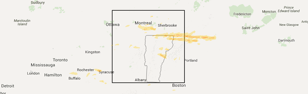
Hail Map for Richford, VT
The Richford, VT area has had 5 reports of on-the-ground hail by trained spotters, and has been under severe weather warnings 7 times during the past 12 months. Doppler radar has detected hail at or near Richford, VT on 6 occasions.
| Name: | Richford, VT |
| Where Located: | 44.8 miles NE of Burlington, VT |
| Map: | Google Map for Richford, VT |
| Population: | 1361 |
| Housing Units: | 641 |
| More Info: | Search Google for Richford, VT |
5
The Top Recent Hail Date for Richford, VT is Monday, July 18, 2016 (1st out of 6)
Hail and Wind Damage Spotted near Richford, VT
| Date / Time | Report Details |
|---|---|
| 7/3/2025 7:35 PM EDT | the severe thunderstorm warning has been cancelled and is no longer in effect |
| 7/3/2025 7:23 PM EDT | At 722 pm edt, a severe thunderstorm was located near lowell, moving east at 15 mph (public). Hazards include 60 mph wind gusts and quarter size hail. Minor hail damage to vehicles is possible. expect wind damage to trees and powerlines. Locations impacted include, newport city, orleans, derby center, jay, newport town, jay in franklin county, orleans village, montgomery center, brownington, albany, montgomery, coventry, barton, troy, brownington village, irasburg, derby line village, westfield, newport center, and north troy village. |
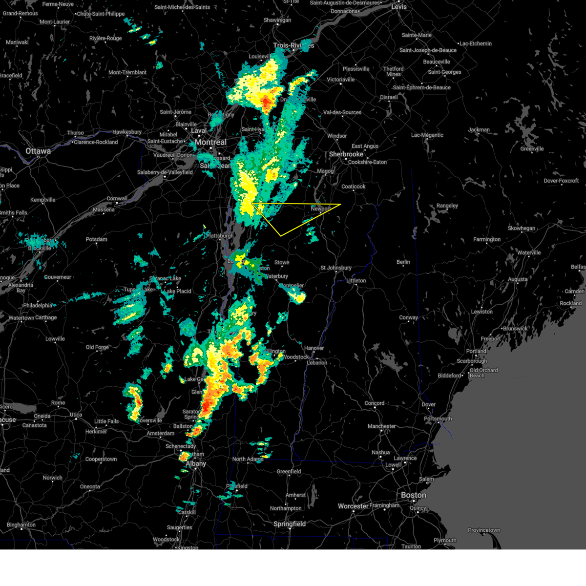
| 7/3/2025 6:55 PM EDT | Quarter sized hail reported 6.2 miles NNE of Richford, VT |
| 7/3/2025 6:55 PM EDT | Svrbtv the national weather service in burlington has issued a * severe thunderstorm warning for, north central lamoille county in northwestern vermont, orleans county in northeastern vermont, northeastern franklin county in northwestern vermont, * until 800 pm edt. * at 655 pm edt, a severe thunderstorm was located over east berkshire, moving east at 35 mph (radar indicated). Hazards include 60 mph wind gusts and quarter size hail. Minor hail damage to vehicles is possible. Expect wind damage to trees and powerlines. |
| 5/17/2025 4:49 PM EDT |
 the severe thunderstorm warning has been cancelled and is no longer in effect the severe thunderstorm warning has been cancelled and is no longer in effect
|
| 5/17/2025 4:16 PM EDT |
 Svrbtv the national weather service in burlington has issued a * severe thunderstorm warning for, north central lamoille county in northwestern vermont, northwestern orleans county in northeastern vermont, northeastern franklin county in northwestern vermont, * until 500 pm edt. * at 413 pm edt, a severe thunderstorm was located over west hill, moving northeast at 30 mph (this storm has a history of blowing down trees as reported by law enforcement). Hazards include 60 mph wind gusts and quarter size hail. Minor hail damage to vehicles is possible. Expect wind damage to trees and powerlines. Svrbtv the national weather service in burlington has issued a * severe thunderstorm warning for, north central lamoille county in northwestern vermont, northwestern orleans county in northeastern vermont, northeastern franklin county in northwestern vermont, * until 500 pm edt. * at 413 pm edt, a severe thunderstorm was located over west hill, moving northeast at 30 mph (this storm has a history of blowing down trees as reported by law enforcement). Hazards include 60 mph wind gusts and quarter size hail. Minor hail damage to vehicles is possible. Expect wind damage to trees and powerlines.
|
| 5/17/2025 3:53 PM EDT |
 At 352 pm edt, a severe thunderstorm was located over st albans, moving northeast at 35 mph (radar indicated). Hazards include 60 mph wind gusts and quarter size hail. Minor hail damage to vehicles is possible. expect wind damage to trees and powerlines. locations impacted include, jay, sheldon junction, stevens mills, bakersfield, north cambridge, berkshire, lazy lady island, montgomery center, north enosburg, south richford, hathaway point, east fairfield, montgomery, west georgia, st. Albans city, fairfax, west berkshire, sheldon, belvidere center, and georgia. At 352 pm edt, a severe thunderstorm was located over st albans, moving northeast at 35 mph (radar indicated). Hazards include 60 mph wind gusts and quarter size hail. Minor hail damage to vehicles is possible. expect wind damage to trees and powerlines. locations impacted include, jay, sheldon junction, stevens mills, bakersfield, north cambridge, berkshire, lazy lady island, montgomery center, north enosburg, south richford, hathaway point, east fairfield, montgomery, west georgia, st. Albans city, fairfax, west berkshire, sheldon, belvidere center, and georgia.
|
| 5/17/2025 3:36 PM EDT |
 Svrbtv the national weather service in burlington has issued a * severe thunderstorm warning for, northern lamoille county in northwestern vermont, northwestern orleans county in northeastern vermont, northeastern chittenden county in northwestern vermont, franklin county in northwestern vermont, * until 415 pm edt. * at 335 pm edt, a severe thunderstorm was located from st albans south through milton, moving northeast at 35 mph (radar indicated). Hazards include 60 mph wind gusts and quarter size hail. Minor hail damage to vehicles is possible. Expect wind damage to trees and powerlines. Svrbtv the national weather service in burlington has issued a * severe thunderstorm warning for, northern lamoille county in northwestern vermont, northwestern orleans county in northeastern vermont, northeastern chittenden county in northwestern vermont, franklin county in northwestern vermont, * until 415 pm edt. * at 335 pm edt, a severe thunderstorm was located from st albans south through milton, moving northeast at 35 mph (radar indicated). Hazards include 60 mph wind gusts and quarter size hail. Minor hail damage to vehicles is possible. Expect wind damage to trees and powerlines.
|
| 6/19/2024 12:10 PM EDT |
 The storm which prompted the warning has moved out of the area. therefore, the warning will be allowed to expire. The storm which prompted the warning has moved out of the area. therefore, the warning will be allowed to expire.
|
| 6/19/2024 11:50 AM EDT |
 At 1150 am edt, a severe thunderstorm was located over enosburg falls, moving east at 25 mph (radar indicated). Hazards include 60 mph wind gusts and penny size hail. Expect damage to trees and powerlines. Locations impacted include, enosburg falls, bakersfield, berkshire, richford, enosburg falls village, belvidere center, lake carmi state park, enosburg, belvidere, franklin, sheldon, fairfield, montgomery, waterville, stevens mills, west hill, north sheldon, enosburg center, west enosburg, and north enosburg. At 1150 am edt, a severe thunderstorm was located over enosburg falls, moving east at 25 mph (radar indicated). Hazards include 60 mph wind gusts and penny size hail. Expect damage to trees and powerlines. Locations impacted include, enosburg falls, bakersfield, berkshire, richford, enosburg falls village, belvidere center, lake carmi state park, enosburg, belvidere, franklin, sheldon, fairfield, montgomery, waterville, stevens mills, west hill, north sheldon, enosburg center, west enosburg, and north enosburg.
|
| 6/19/2024 11:35 AM EDT |
 Svrbtv the national weather service in burlington has issued a * severe thunderstorm warning for, northwestern lamoille county in northwestern vermont, northeastern franklin county in northwestern vermont, * until 1215 pm edt. * at 1135 am edt, a severe thunderstorm was located over sheldon, moving east at 25 mph (radar indicated). Hazards include 60 mph wind gusts and penny size hail. expect damage to trees and powerlines Svrbtv the national weather service in burlington has issued a * severe thunderstorm warning for, northwestern lamoille county in northwestern vermont, northeastern franklin county in northwestern vermont, * until 1215 pm edt. * at 1135 am edt, a severe thunderstorm was located over sheldon, moving east at 25 mph (radar indicated). Hazards include 60 mph wind gusts and penny size hail. expect damage to trees and powerlines
|
| 5/21/2024 5:58 PM EDT |
 The storm which prompted the warning has weakened below severe limits, and no longer poses an immediate threat to life or property. therefore, the warning will be allowed to expire. The storm which prompted the warning has weakened below severe limits, and no longer poses an immediate threat to life or property. therefore, the warning will be allowed to expire.
|
| 5/21/2024 5:40 PM EDT |
 At 540 pm edt, a severe thunderstorm was located over montgomery center, moving east at 30 mph (public). Hazards include 60 mph wind gusts and quarter size hail. Minor hail damage to vehicles is possible. expect wind damage to trees and powerlines. Locations impacted include, newport city, enosburg falls, orleans, jay, newport town, jay in franklin county, irasburg, bakersfield, westfield, orleans village, newport center, berkshire, north troy village, montgomery center, richford, montgomery, coventry, enosburg falls village, troy, and lake carmi state park. At 540 pm edt, a severe thunderstorm was located over montgomery center, moving east at 30 mph (public). Hazards include 60 mph wind gusts and quarter size hail. Minor hail damage to vehicles is possible. expect wind damage to trees and powerlines. Locations impacted include, newport city, enosburg falls, orleans, jay, newport town, jay in franklin county, irasburg, bakersfield, westfield, orleans village, newport center, berkshire, north troy village, montgomery center, richford, montgomery, coventry, enosburg falls village, troy, and lake carmi state park.
|
| 5/21/2024 4:59 PM EDT |
 Svrbtv the national weather service in burlington has issued a * severe thunderstorm warning for, north central lamoille county in northwestern vermont, northwestern orleans county in northeastern vermont, northeastern franklin county in northwestern vermont, * until 600 pm edt. * at 459 pm edt, a severe thunderstorm was located over lake carmi state park, moving east at 25 mph (radar indicated). Hazards include 60 mph wind gusts and quarter size hail. Minor hail damage to vehicles is possible. Expect wind damage to trees and powerlines. Svrbtv the national weather service in burlington has issued a * severe thunderstorm warning for, north central lamoille county in northwestern vermont, northwestern orleans county in northeastern vermont, northeastern franklin county in northwestern vermont, * until 600 pm edt. * at 459 pm edt, a severe thunderstorm was located over lake carmi state park, moving east at 25 mph (radar indicated). Hazards include 60 mph wind gusts and quarter size hail. Minor hail damage to vehicles is possible. Expect wind damage to trees and powerlines.
|
| 9/7/2023 4:36 PM EDT |
 The severe thunderstorm warning for northeastern clinton, lamoille, northern addison, grand isle, chittenden, western washington and franklin counties will expire at 445 pm edt, the storms which prompted the warning have moved out of the warned area. therefore, the warning will be allowed to expire. The severe thunderstorm warning for northeastern clinton, lamoille, northern addison, grand isle, chittenden, western washington and franklin counties will expire at 445 pm edt, the storms which prompted the warning have moved out of the warned area. therefore, the warning will be allowed to expire.
|
| 9/7/2023 3:40 PM EDT | At 340 pm edt, severe thunderstorms were located along a line extending from near shad island to jericho village to near weybridge, moving east at 25 mph (radar indicated). Hazards include 60 mph wind gusts and quarter size hail. Minor hail damage to vehicles is possible. Expect wind damage to trees and powerlines. |
| 9/7/2023 3:40 PM EDT | At 340 pm edt, severe thunderstorms were located along a line extending from near shad island to jericho village to near weybridge, moving east at 25 mph (radar indicated). Hazards include 60 mph wind gusts and quarter size hail. Minor hail damage to vehicles is possible. Expect wind damage to trees and powerlines. |
| 6/15/2023 4:33 PM EDT |
 At 432 pm edt, a severe thunderstorm was located over east sheldon, moving southeast at 25 mph (trained weather spotters reported down trees along route 207 east of highgate along with quarter sized hail). Hazards include 60 mph wind gusts and quarter size hail. Minor hail damage to vehicles is possible. expect wind damage to trees and powerlines. locations impacted include, enosburg falls, franklin, jay, bakersfield, westfield, berkshire, montgomery center, richford, highgate, montgomery, enosburg falls village, sheldon, fairfield, lake carmi state park, enosburg, sheldon junction, highgate center, stevens mills, west hill, and north sheldon. hail threat, radar indicated max hail size, 1. 00 in wind threat, radar indicated max wind gust, 60 mph. At 432 pm edt, a severe thunderstorm was located over east sheldon, moving southeast at 25 mph (trained weather spotters reported down trees along route 207 east of highgate along with quarter sized hail). Hazards include 60 mph wind gusts and quarter size hail. Minor hail damage to vehicles is possible. expect wind damage to trees and powerlines. locations impacted include, enosburg falls, franklin, jay, bakersfield, westfield, berkshire, montgomery center, richford, highgate, montgomery, enosburg falls village, sheldon, fairfield, lake carmi state park, enosburg, sheldon junction, highgate center, stevens mills, west hill, and north sheldon. hail threat, radar indicated max hail size, 1. 00 in wind threat, radar indicated max wind gust, 60 mph.
|
| 6/15/2023 4:26 PM EDT |
 At 426 pm edt, a severe thunderstorm was located over north sheldon, moving southeast at 20 mph (radar indicated). Hazards include 60 mph wind gusts and quarter size hail. Minor hail damage to vehicles is possible. expect wind damage to trees and powerlines. locations impacted include, enosburg falls, franklin, jay, bakersfield, westfield, berkshire, montgomery center, richford, highgate, montgomery, enosburg falls village, sheldon, fairfield, lake carmi state park, enosburg, sheldon junction, highgate center, stevens mills, west hill, and north sheldon. hail threat, radar indicated max hail size, 1. 00 in wind threat, radar indicated max wind gust, 60 mph. At 426 pm edt, a severe thunderstorm was located over north sheldon, moving southeast at 20 mph (radar indicated). Hazards include 60 mph wind gusts and quarter size hail. Minor hail damage to vehicles is possible. expect wind damage to trees and powerlines. locations impacted include, enosburg falls, franklin, jay, bakersfield, westfield, berkshire, montgomery center, richford, highgate, montgomery, enosburg falls village, sheldon, fairfield, lake carmi state park, enosburg, sheldon junction, highgate center, stevens mills, west hill, and north sheldon. hail threat, radar indicated max hail size, 1. 00 in wind threat, radar indicated max wind gust, 60 mph.
|
| 6/15/2023 4:00 PM EDT |
 At 400 pm edt, a severe thunderstorm was located over rock river bay, moving southeast at 25 mph (radar indicated). Hazards include 60 mph wind gusts and quarter size hail. Minor hail damage to vehicles is possible. Expect wind damage to trees and powerlines. At 400 pm edt, a severe thunderstorm was located over rock river bay, moving southeast at 25 mph (radar indicated). Hazards include 60 mph wind gusts and quarter size hail. Minor hail damage to vehicles is possible. Expect wind damage to trees and powerlines.
|
| 9/22/2022 3:26 AM EDT |
 At 324 am edt, a severe thunderstorm was located over northern lake champlain approaching swanton moving east at 50 mph (radar indicated). Hazards include 60 mph wind gusts. Expect damage to trees and powerlines. locations impacted include, newport city, enosburg falls, franklin, jay, newport town, jay in franklin county, swanton village, berkshire, highgate falls, montgomery center, montgomery, coventry, st. albans city, troy, sheldon, lake carmi state park, enosburg, swanton, westfield and newport center. hail threat, radar indicated max hail size, <. 75 in wind threat, radar indicated max wind gust, 60 mph. At 324 am edt, a severe thunderstorm was located over northern lake champlain approaching swanton moving east at 50 mph (radar indicated). Hazards include 60 mph wind gusts. Expect damage to trees and powerlines. locations impacted include, newport city, enosburg falls, franklin, jay, newport town, jay in franklin county, swanton village, berkshire, highgate falls, montgomery center, montgomery, coventry, st. albans city, troy, sheldon, lake carmi state park, enosburg, swanton, westfield and newport center. hail threat, radar indicated max hail size, <. 75 in wind threat, radar indicated max wind gust, 60 mph.
|
| 9/22/2022 2:40 AM EDT |
 At 239 am edt, a severe thunderstorm was located jericho and beekmantown point, moving east at 55 mph (radar indicated). Hazards include 60 mph wind gusts and quarter size hail. Minor hail damage to vehicles is possible. Expect wind damage to trees and powerlines. At 239 am edt, a severe thunderstorm was located jericho and beekmantown point, moving east at 55 mph (radar indicated). Hazards include 60 mph wind gusts and quarter size hail. Minor hail damage to vehicles is possible. Expect wind damage to trees and powerlines.
|
| 8/30/2022 5:50 PM EDT |
 The severe thunderstorm warning for northeastern grand isle and franklin counties will expire at 600 pm edt, the storm which prompted the warning has weakened below severe limits, and has exited the warned area. therefore, the warning will be allowed to expire. The severe thunderstorm warning for northeastern grand isle and franklin counties will expire at 600 pm edt, the storm which prompted the warning has weakened below severe limits, and has exited the warned area. therefore, the warning will be allowed to expire.
|
| 8/30/2022 5:36 PM EDT |
 At 535 pm edt, a severe thunderstorm was located over swanton junction, moving northeast at 45 mph (radar indicated). Hazards include 60 mph wind gusts. Expect damage to trees and powerlines. locations impacted include, enosburg falls, franklin, swanton village, berkshire, highgate falls, st. albans city, fairfax, sheldon, georgia, lake carmi state park, swanton, st. albans town, highgate, enosburg falls village, georgia center, north hero, fairfield, alburgh, enosburg and richford. hail threat, radar indicated max hail size, <. 75 in wind threat, observed max wind gust, 60 mph. At 535 pm edt, a severe thunderstorm was located over swanton junction, moving northeast at 45 mph (radar indicated). Hazards include 60 mph wind gusts. Expect damage to trees and powerlines. locations impacted include, enosburg falls, franklin, swanton village, berkshire, highgate falls, st. albans city, fairfax, sheldon, georgia, lake carmi state park, swanton, st. albans town, highgate, enosburg falls village, georgia center, north hero, fairfield, alburgh, enosburg and richford. hail threat, radar indicated max hail size, <. 75 in wind threat, observed max wind gust, 60 mph.
|
| 8/30/2022 5:17 PM EDT |
 At 516 pm edt, a severe thunderstorm was located over east georgia, moving northeast at 40 mph (radar indicated). Hazards include 60 mph wind gusts. Expect damage to trees and powerlines. locations impacted include, enosburg falls, franklin, jay, montgomery center, westford, sheldon, georgia, waterville, grand isle, st. albans town, south alburgh, alburgh, enosburg falls village, alburgh dunes state park, north hero, milton, bakersfield, cambridge village, berkshire and jeffersonville village. hail threat, radar indicated max hail size, <. 75 in wind threat, observed max wind gust, 60 mph. At 516 pm edt, a severe thunderstorm was located over east georgia, moving northeast at 40 mph (radar indicated). Hazards include 60 mph wind gusts. Expect damage to trees and powerlines. locations impacted include, enosburg falls, franklin, jay, montgomery center, westford, sheldon, georgia, waterville, grand isle, st. albans town, south alburgh, alburgh, enosburg falls village, alburgh dunes state park, north hero, milton, bakersfield, cambridge village, berkshire and jeffersonville village. hail threat, radar indicated max hail size, <. 75 in wind threat, observed max wind gust, 60 mph.
|
| 8/30/2022 5:01 PM EDT |
 At 500 pm edt, a severe thunderstorm was located over winooski, moving northeast at 40 mph (radar indicated). Hazards include 70 mph wind gusts and nickel size hail. Expect considerable tree damage. Damage is likely to mobile homes, roofs, and outbuildings. At 500 pm edt, a severe thunderstorm was located over winooski, moving northeast at 40 mph (radar indicated). Hazards include 70 mph wind gusts and nickel size hail. Expect considerable tree damage. Damage is likely to mobile homes, roofs, and outbuildings.
|
| 7/21/2022 12:48 PM EDT |
 At 1248 pm edt, a severe thunderstorm was located over jay, moving northeast at 30 mph (radar indicated). Hazards include 60 mph wind gusts and quarter size hail. Minor hail damage to vehicles is possible. expect wind damage to trees and powerlines. locations impacted include, newport city, jay, newport town, jay in franklin county, westfield, newport center, north troy village, montgomery center, richford, montgomery, troy, derby line village, berkshire, derby, lowell, enosburg, coventry, north troy, east richford and black island. hail threat, radar indicated max hail size, 1. 00 in wind threat, radar indicated max wind gust, 60 mph. At 1248 pm edt, a severe thunderstorm was located over jay, moving northeast at 30 mph (radar indicated). Hazards include 60 mph wind gusts and quarter size hail. Minor hail damage to vehicles is possible. expect wind damage to trees and powerlines. locations impacted include, newport city, jay, newport town, jay in franklin county, westfield, newport center, north troy village, montgomery center, richford, montgomery, troy, derby line village, berkshire, derby, lowell, enosburg, coventry, north troy, east richford and black island. hail threat, radar indicated max hail size, 1. 00 in wind threat, radar indicated max wind gust, 60 mph.
|
| 7/21/2022 12:29 PM EDT |
 At 1229 pm edt, a severe thunderstorm was located over west hill, moving northeast at 30 mph (radar indicated). Hazards include 60 mph wind gusts and quarter size hail. Minor hail damage to vehicles is possible. Expect wind damage to trees and powerlines. At 1229 pm edt, a severe thunderstorm was located over west hill, moving northeast at 30 mph (radar indicated). Hazards include 60 mph wind gusts and quarter size hail. Minor hail damage to vehicles is possible. Expect wind damage to trees and powerlines.
|
| 6/16/2022 7:11 PM EDT |
 At 711 pm edt, a severe thunderstorm was located over south franklin, moving east at 45 mph (radar indicated). Hazards include 60 mph wind gusts and quarter size hail. Minor hail damage to vehicles is possible. Expect wind damage to trees and powerlines. At 711 pm edt, a severe thunderstorm was located over south franklin, moving east at 45 mph (radar indicated). Hazards include 60 mph wind gusts and quarter size hail. Minor hail damage to vehicles is possible. Expect wind damage to trees and powerlines.
|
| 5/16/2022 7:24 PM EDT |
 The severe thunderstorm warning for northeastern franklin county will expire at 730 pm edt, the storm which prompted the warning has weakened below severe limits, and has exited the warned area. therefore, the warning will be allowed to expire. a severe thunderstorm watch remains in effect until 800 pm edt for northwestern vermont. The severe thunderstorm warning for northeastern franklin county will expire at 730 pm edt, the storm which prompted the warning has weakened below severe limits, and has exited the warned area. therefore, the warning will be allowed to expire. a severe thunderstorm watch remains in effect until 800 pm edt for northwestern vermont.
|
| 5/16/2022 7:09 PM EDT |
 At 709 pm edt, a severe thunderstorm was located over berkshire, moving north at 30 mph (radar indicated). Hazards include 60 mph wind gusts. Expect damage to trees and powerlines. locations impacted include, enosburg falls, berkshire, enosburg falls village, enosburg, richford, sheldon, enosburg center, east berkshire and north enosburg. hail threat, radar indicated max hail size, <. 75 in wind threat, radar indicated max wind gust, 60 mph. At 709 pm edt, a severe thunderstorm was located over berkshire, moving north at 30 mph (radar indicated). Hazards include 60 mph wind gusts. Expect damage to trees and powerlines. locations impacted include, enosburg falls, berkshire, enosburg falls village, enosburg, richford, sheldon, enosburg center, east berkshire and north enosburg. hail threat, radar indicated max hail size, <. 75 in wind threat, radar indicated max wind gust, 60 mph.
|
| 5/16/2022 6:55 PM EDT |
 At 655 pm edt, a severe thunderstorm was located over east enosburg, moving north at 40 mph (radar indicated). Hazards include 60 mph wind gusts. Expect damage to trees and powerlines. locations impacted include, enosburg falls, waterville, jay, bakersfield, berkshire, montgomery center, richford, montgomery, enosburg falls village, enosburg, belvidere, north troy village, fletcher, fairfield, westfield, troy, sheldon, east richford, stevens mills and west hill. hail threat, radar indicated max hail size, <. 75 in wind threat, radar indicated max wind gust, 60 mph. At 655 pm edt, a severe thunderstorm was located over east enosburg, moving north at 40 mph (radar indicated). Hazards include 60 mph wind gusts. Expect damage to trees and powerlines. locations impacted include, enosburg falls, waterville, jay, bakersfield, berkshire, montgomery center, richford, montgomery, enosburg falls village, enosburg, belvidere, north troy village, fletcher, fairfield, westfield, troy, sheldon, east richford, stevens mills and west hill. hail threat, radar indicated max hail size, <. 75 in wind threat, radar indicated max wind gust, 60 mph.
|
| 5/16/2022 6:39 PM EDT |
 At 639 pm edt, a severe thunderstorm was located over north cambridge, moving north at 40 mph (radar indicated). Hazards include 60 mph wind gusts. expect damage to trees and powerlines At 639 pm edt, a severe thunderstorm was located over north cambridge, moving north at 40 mph (radar indicated). Hazards include 60 mph wind gusts. expect damage to trees and powerlines
|
| 10/16/2021 3:56 PM EDT |
 The severe thunderstorm warning for northern lamoille, western orleans, northeastern chittenden and eastern franklin counties will expire at 400 pm edt, the storms which prompted the warning have weakened below severe limits, and no longer pose an immediate threat to life or property. therefore, the warning will be allowed to expire. however gusty winds are still possible with these thunderstorms. a severe thunderstorm watch remains in effect until 700 pm edt for northwestern vermont. The severe thunderstorm warning for northern lamoille, western orleans, northeastern chittenden and eastern franklin counties will expire at 400 pm edt, the storms which prompted the warning have weakened below severe limits, and no longer pose an immediate threat to life or property. therefore, the warning will be allowed to expire. however gusty winds are still possible with these thunderstorms. a severe thunderstorm watch remains in effect until 700 pm edt for northwestern vermont.
|
| 10/16/2021 3:21 PM EDT |
 At 320 pm edt, severe thunderstorms were located along a line extending from 16 miles north of morses line to near east franklin to east sheldon, moving northeast at 60 mph (radar indicated). Hazards include 60 mph wind gusts. Expect damage to trees and powerlines. locations impacted include, enosburg falls, franklin, johnson village, jay, jay in franklin county, eden, cambridge, bakersfield, cambridge village, berkshire, montgomery center, jeffersonville village, hyde park, montgomery, troy, sheldon, belvidere center, lake carmi state park, enosburg and belvidere. hail threat, radar indicated max hail size, <. 75 in wind threat, radar indicated max wind gust, 60 mph. At 320 pm edt, severe thunderstorms were located along a line extending from 16 miles north of morses line to near east franklin to east sheldon, moving northeast at 60 mph (radar indicated). Hazards include 60 mph wind gusts. Expect damage to trees and powerlines. locations impacted include, enosburg falls, franklin, johnson village, jay, jay in franklin county, eden, cambridge, bakersfield, cambridge village, berkshire, montgomery center, jeffersonville village, hyde park, montgomery, troy, sheldon, belvidere center, lake carmi state park, enosburg and belvidere. hail threat, radar indicated max hail size, <. 75 in wind threat, radar indicated max wind gust, 60 mph.
|
| 10/16/2021 2:55 PM EDT |
 At 255 pm edt, severe thunderstorms were located along a line extending from province point to st. albans city to west milton, moving northeast at 55 mph (radar indicated). Hazards include 60 mph wind gusts. expect damage to trees and powerlines At 255 pm edt, severe thunderstorms were located along a line extending from province point to st. albans city to west milton, moving northeast at 55 mph (radar indicated). Hazards include 60 mph wind gusts. expect damage to trees and powerlines
|
| 7/20/2021 8:11 PM EDT |
 At 808 pm edt, a line of severe thunderstorms over northern and central vermont was located along a line extending from near east richford to near wolcott to ainsworth state park to near pittsfield, moving east at 30 mph (radar indicated). Hazards include 60 mph wind gusts and quarter size hail. Expect wind damage to trees and powerlines. minor hail damage to vehicles is possible. these storms have a history of producing wind damage and power outages. locations impacted include, barre, montpelier, island pond, lyndon, st. Johnsbury, middlebury, newport city, vergennes, crown point, morrisville, enosburg falls, orleans, derby center, charleston, braintree hill, glover, waterbury village, montgomery center, websterville and orwell. At 808 pm edt, a line of severe thunderstorms over northern and central vermont was located along a line extending from near east richford to near wolcott to ainsworth state park to near pittsfield, moving east at 30 mph (radar indicated). Hazards include 60 mph wind gusts and quarter size hail. Expect wind damage to trees and powerlines. minor hail damage to vehicles is possible. these storms have a history of producing wind damage and power outages. locations impacted include, barre, montpelier, island pond, lyndon, st. Johnsbury, middlebury, newport city, vergennes, crown point, morrisville, enosburg falls, orleans, derby center, charleston, braintree hill, glover, waterbury village, montgomery center, websterville and orwell.
|
| 7/20/2021 7:32 PM EDT |
 At 730 pm edt, a line of severe thunderstorms over western vermont was located along a line extending from near east franklin to stowe to east warren to mossy point, moving east at 40 mph (radar indicated). Hazards include 60 mph wind gusts and quarter size hail. Expect wind damage to trees and powerlines. minor hail damage to vehicles is possible. This line of storms has a history of producing wind damage and power outages. At 730 pm edt, a line of severe thunderstorms over western vermont was located along a line extending from near east franklin to stowe to east warren to mossy point, moving east at 40 mph (radar indicated). Hazards include 60 mph wind gusts and quarter size hail. Expect wind damage to trees and powerlines. minor hail damage to vehicles is possible. This line of storms has a history of producing wind damage and power outages.
|
| 7/20/2021 7:06 PM EDT |
 At 704 pm edt, a line of severe thunderstorms over northwest vermont and essex county new york was located along a line extending from shad island to south burlington to near chilson, new york moving east at 35 mph (radar indicated). Hazards include 60 mph wind gusts and quarter size hail. Expect wind damage to trees and powerlines. minor hail damage to vehicles is possible. Locations impacted include, essex junction, plattsburgh international airport, burlington, burlington international airport, plattsburgh, middlebury, south burlington, vergennes, peru, beekmantown, moriah, chazy, willsboro, crown point, morrisville, enosburg falls, westport, elizabethtown, champlain and waterbury village. At 704 pm edt, a line of severe thunderstorms over northwest vermont and essex county new york was located along a line extending from shad island to south burlington to near chilson, new york moving east at 35 mph (radar indicated). Hazards include 60 mph wind gusts and quarter size hail. Expect wind damage to trees and powerlines. minor hail damage to vehicles is possible. Locations impacted include, essex junction, plattsburgh international airport, burlington, burlington international airport, plattsburgh, middlebury, south burlington, vergennes, peru, beekmantown, moriah, chazy, willsboro, crown point, morrisville, enosburg falls, westport, elizabethtown, champlain and waterbury village.
|
| 7/20/2021 6:31 PM EDT |
 At 630 pm edt, a line of severe thunderstorms over northeast new york was located along a line extending from near perry mills to near harkness to 9 miles west of schroon falls, moving east at 40 mph (radar indicated). Hazards include 60 mph wind gusts and quarter size hail. Expect wind damage to trees and powerlines. Minor hail damage to vehicles is possible. At 630 pm edt, a line of severe thunderstorms over northeast new york was located along a line extending from near perry mills to near harkness to 9 miles west of schroon falls, moving east at 40 mph (radar indicated). Hazards include 60 mph wind gusts and quarter size hail. Expect wind damage to trees and powerlines. Minor hail damage to vehicles is possible.
|
| 8/29/2020 6:19 PM EDT |
 At 619 pm edt, a severe thunderstorm was located over east franklin, moving east at 35 mph (radar indicated). Hazards include 60 mph wind gusts and penny size hail. Expect damage to trees and powerlines. Locations impacted include, enosburg falls, franklin, berkshire, highgate falls, richford, highgate, enosburg falls village, lake carmi state park, swanton village, sheldon, swanton, enosburg, montgomery, highgate center, stevens mills, rock river bay, north sheldon, east highgate, martindale point and east franklin. At 619 pm edt, a severe thunderstorm was located over east franklin, moving east at 35 mph (radar indicated). Hazards include 60 mph wind gusts and penny size hail. Expect damage to trees and powerlines. Locations impacted include, enosburg falls, franklin, berkshire, highgate falls, richford, highgate, enosburg falls village, lake carmi state park, swanton village, sheldon, swanton, enosburg, montgomery, highgate center, stevens mills, rock river bay, north sheldon, east highgate, martindale point and east franklin.
|
| 8/29/2020 5:46 PM EDT |
 At 546 pm edt, a severe thunderstorm was located over alburgh village, moving east at 35 mph (radar indicated). Hazards include 60 mph wind gusts and penny size hail. expect damage to trees and powerlines At 546 pm edt, a severe thunderstorm was located over alburgh village, moving east at 35 mph (radar indicated). Hazards include 60 mph wind gusts and penny size hail. expect damage to trees and powerlines
|
| 3/20/2020 3:55 PM EDT |
 At 355 pm edt, a severe thunderstorm was located near rock river bay, moving east at 70 mph (radar indicated). Hazards include 60 mph wind gusts and penny size hail. Expect damage to trees and powerlines. locations impacted include, enosburg falls, franklin, swanton village, bakersfield, berkshire, highgate falls, montgomery center, montgomery, st. albans city, sheldon, lake carmi state park, enosburg, swanton, st. Albans town, richford, highgate, enosburg falls village, fairfield, georgia and belvidere. At 355 pm edt, a severe thunderstorm was located near rock river bay, moving east at 70 mph (radar indicated). Hazards include 60 mph wind gusts and penny size hail. Expect damage to trees and powerlines. locations impacted include, enosburg falls, franklin, swanton village, bakersfield, berkshire, highgate falls, montgomery center, montgomery, st. albans city, sheldon, lake carmi state park, enosburg, swanton, st. Albans town, richford, highgate, enosburg falls village, fairfield, georgia and belvidere.
|
| 3/20/2020 3:30 PM EDT |
 At 330 pm edt, a severe thunderstorm was located over altona, moving east at 70 mph (radar indicated). Hazards include 60 mph wind gusts and penny size hail. expect damage to trees and powerlines At 330 pm edt, a severe thunderstorm was located over altona, moving east at 70 mph (radar indicated). Hazards include 60 mph wind gusts and penny size hail. expect damage to trees and powerlines
|
| 7/30/2019 4:42 PM EDT |
 At 442 pm edt, a severe thunderstorm was located over sheldon springs, moving east at 15 mph (radar indicated). Hazards include 60 mph wind gusts and quarter size hail. Minor hail damage to vehicles is possible. Expect wind damage to trees and powerlines. At 442 pm edt, a severe thunderstorm was located over sheldon springs, moving east at 15 mph (radar indicated). Hazards include 60 mph wind gusts and quarter size hail. Minor hail damage to vehicles is possible. Expect wind damage to trees and powerlines.
|
| 7/30/2019 4:28 PM EDT |
 At 427 pm edt, severe thunderstorms were located along a line extending from 18 miles north of morses line to georgia center, moving east at 15 mph (vtrans reported 76 mph gust at north hero project in addition to several trees down with multiple power outages being reported). Hazards include 70 mph wind gusts and quarter size hail. Minor hail damage to vehicles is possible. expect considerable tree damage. wind damage is also likely to mobile homes, roofs, and outbuildings. locations impacted include, enosburg falls, franklin, johnson village, swanton village, cambridge, bakersfield, cambridge village, berkshire, highgate falls, montgomery center, jeffersonville village, montgomery, st. Albans city, fairfax, sheldon, belvidere center, georgia, lake carmi state park, enosburg and belvidere. At 427 pm edt, severe thunderstorms were located along a line extending from 18 miles north of morses line to georgia center, moving east at 15 mph (vtrans reported 76 mph gust at north hero project in addition to several trees down with multiple power outages being reported). Hazards include 70 mph wind gusts and quarter size hail. Minor hail damage to vehicles is possible. expect considerable tree damage. wind damage is also likely to mobile homes, roofs, and outbuildings. locations impacted include, enosburg falls, franklin, johnson village, swanton village, cambridge, bakersfield, cambridge village, berkshire, highgate falls, montgomery center, jeffersonville village, montgomery, st. Albans city, fairfax, sheldon, belvidere center, georgia, lake carmi state park, enosburg and belvidere.
|
| 7/30/2019 3:55 PM EDT |
 At 354 pm edt, severe thunderstorms were located along a line extending from 19 miles north of morses line to hyde point, moving east at 15 mph (highway department reported wind gust of 76 mph in association with this line of storms). Hazards include 70 mph wind gusts and quarter size hail. Minor hail damage to vehicles is possible. expect considerable tree damage. wind damage is also likely to mobile homes, roofs, and outbuildings. locations impacted include, enosburg falls, franklin, alburgh village, johnson village, cambridge, montgomery center, montgomery, st. albans city, fairfax, sheldon, belvidere center, georgia, enosburg, swanton, waterville, grand isle, st. Albans town, south alburgh, johnson and alburgh. At 354 pm edt, severe thunderstorms were located along a line extending from 19 miles north of morses line to hyde point, moving east at 15 mph (highway department reported wind gust of 76 mph in association with this line of storms). Hazards include 70 mph wind gusts and quarter size hail. Minor hail damage to vehicles is possible. expect considerable tree damage. wind damage is also likely to mobile homes, roofs, and outbuildings. locations impacted include, enosburg falls, franklin, alburgh village, johnson village, cambridge, montgomery center, montgomery, st. albans city, fairfax, sheldon, belvidere center, georgia, enosburg, swanton, waterville, grand isle, st. Albans town, south alburgh, johnson and alburgh.
|
| 7/30/2019 3:46 PM EDT |
 At 345 pm edt, severe thunderstorms were located along a line extending from 19 miles north of morses line to ladd bay, moving east at 15 mph (radar indicated). Hazards include 60 mph wind gusts and quarter size hail. Minor hail damage to vehicles is possible. Expect wind damage to trees and powerlines. At 345 pm edt, severe thunderstorms were located along a line extending from 19 miles north of morses line to ladd bay, moving east at 15 mph (radar indicated). Hazards include 60 mph wind gusts and quarter size hail. Minor hail damage to vehicles is possible. Expect wind damage to trees and powerlines.
|
| 7/1/2018 12:19 AM EDT |
 At 1218 am edt, a severe thunderstorm was located over east highgate, moving southeast at 40 mph (radar indicated). Hazards include 60 mph wind gusts and quarter size hail. Minor hail damage to vehicles is possible. expect wind damage to trees and powerlines. Locations impacted include, enosburg falls, franklin, bakersfield, berkshire, highgate falls, montgomery center, montgomery, sheldon, belvidere center, lake carmi state park, enosburg, belvidere, waterville, richford, highgate, enosburg falls village, fairfield, swanton, johnson and fletcher. At 1218 am edt, a severe thunderstorm was located over east highgate, moving southeast at 40 mph (radar indicated). Hazards include 60 mph wind gusts and quarter size hail. Minor hail damage to vehicles is possible. expect wind damage to trees and powerlines. Locations impacted include, enosburg falls, franklin, bakersfield, berkshire, highgate falls, montgomery center, montgomery, sheldon, belvidere center, lake carmi state park, enosburg, belvidere, waterville, richford, highgate, enosburg falls village, fairfield, swanton, johnson and fletcher.
|
| 6/30/2018 11:51 PM EDT |
 At 1151 pm edt, a severe thunderstorm was located near chapman bay, moving southeast at 40 mph (radar indicated). Hazards include 60 mph wind gusts and quarter size hail. Minor hail damage to vehicles is possible. Expect wind damage to trees and powerlines. At 1151 pm edt, a severe thunderstorm was located near chapman bay, moving southeast at 40 mph (radar indicated). Hazards include 60 mph wind gusts and quarter size hail. Minor hail damage to vehicles is possible. Expect wind damage to trees and powerlines.
|
| 5/4/2018 7:05 PM EDT | Half Dollar sized hail reported 0.4 miles SSE of Richford, VT |
| 5/4/2018 7:00 PM EDT | Golf Ball sized hail reported 0.4 miles SSE of Richford, VT |
| 5/4/2018 6:54 PM EDT |
 At 654 pm edt, a severe thunderstorm was located over berkshire, moving east at 35 mph (radar indicated). Hazards include 60 mph wind gusts and quarter size hail. Minor hail damage to vehicles is possible. Expect wind damage to trees and powerlines. At 654 pm edt, a severe thunderstorm was located over berkshire, moving east at 35 mph (radar indicated). Hazards include 60 mph wind gusts and quarter size hail. Minor hail damage to vehicles is possible. Expect wind damage to trees and powerlines.
|
| 8/22/2017 6:40 PM EDT |
 The severe thunderstorm warning for northern lamoille, northeastern caledonia, orleans and eastern franklin counties will expire at 645 pm edt, the storm which prompted the warning has weakened below severe limits, and no longer pose an immediate threat to life or property. therefore the warning will be allowed to expire. however gusty winds are still possible with this thunderstorm. a tornado watch remains in effect until 900 pm edt for northwestern vermont. a severe thunderstorm watch remains in effect until midnight edt for northeastern and northwestern vermont. The severe thunderstorm warning for northern lamoille, northeastern caledonia, orleans and eastern franklin counties will expire at 645 pm edt, the storm which prompted the warning has weakened below severe limits, and no longer pose an immediate threat to life or property. therefore the warning will be allowed to expire. however gusty winds are still possible with this thunderstorm. a tornado watch remains in effect until 900 pm edt for northwestern vermont. a severe thunderstorm watch remains in effect until midnight edt for northeastern and northwestern vermont.
|
| 8/22/2017 6:07 PM EDT |
 At 607 pm edt, a severe thunderstorm was located over montgomery, moving east at 25 mph (radar indicated). Hazards include 60 mph wind gusts and penny size hail. Expect damage to trees and powerlines. locations impacted include, newport city, enosburg falls, orleans, derby center, charleston, jay, newport town, jay in franklin county, glover, montgomery center, albany, montgomery, fairfax, troy, belvidere center, newark, brownington village, enosburg, west burke village and waterville. A tornado watch remains in effect until 900 pm edt for northwestern vermont. At 607 pm edt, a severe thunderstorm was located over montgomery, moving east at 25 mph (radar indicated). Hazards include 60 mph wind gusts and penny size hail. Expect damage to trees and powerlines. locations impacted include, newport city, enosburg falls, orleans, derby center, charleston, jay, newport town, jay in franklin county, glover, montgomery center, albany, montgomery, fairfax, troy, belvidere center, newark, brownington village, enosburg, west burke village and waterville. A tornado watch remains in effect until 900 pm edt for northwestern vermont.
|
| 8/22/2017 5:46 PM EDT |
 At 545 pm edt, a severe thunderstorm was located over bakersfield, moving east at 40 mph (radar indicated). Hazards include 60 mph wind gusts. expect damage to trees and powerlines At 545 pm edt, a severe thunderstorm was located over bakersfield, moving east at 40 mph (radar indicated). Hazards include 60 mph wind gusts. expect damage to trees and powerlines
|
| 8/2/2017 9:46 PM EDT |
 At 946 pm edt, a severe thunderstorm was located over cloak island, moving east at 15 mph (radar indicated). Hazards include 60 mph wind gusts and quarter size hail. Minor hail damage to vehicles is possible. Expect wind damage to trees and powerlines. At 946 pm edt, a severe thunderstorm was located over cloak island, moving east at 15 mph (radar indicated). Hazards include 60 mph wind gusts and quarter size hail. Minor hail damage to vehicles is possible. Expect wind damage to trees and powerlines.
|
| 9/11/2016 5:31 AM EDT |
 At 531 am edt, a severe thunderstorm was located over montgomery center, moving northeast at 30 mph (radar indicated). Hazards include 60 mph wind gusts. Expect damage to roofs. siding. and trees. Locations impacted include, fairfax, richford, berkshire, troy, johnson, enosburg falls, bakersfield, fletcher, montgomery, waterville, westfield, jay, cambridge, montgomery center, belvidere center, jay in franklin county, jeffersonville, north troy, enosburg center and north enosburg. At 531 am edt, a severe thunderstorm was located over montgomery center, moving northeast at 30 mph (radar indicated). Hazards include 60 mph wind gusts. Expect damage to roofs. siding. and trees. Locations impacted include, fairfax, richford, berkshire, troy, johnson, enosburg falls, bakersfield, fletcher, montgomery, waterville, westfield, jay, cambridge, montgomery center, belvidere center, jay in franklin county, jeffersonville, north troy, enosburg center and north enosburg.
|
| 9/11/2016 4:49 AM EDT |
 At 449 am edt, a severe thunderstorm was located over fairfax, moving northeast at 30 mph (radar indicated). Hazards include 60 mph wind gusts. Expect damage to roofs. siding. And trees. At 449 am edt, a severe thunderstorm was located over fairfax, moving northeast at 30 mph (radar indicated). Hazards include 60 mph wind gusts. Expect damage to roofs. siding. And trees.
|
| 7/22/2016 11:36 PM EDT |
 At 1134 pm edt, severe thunderstorms were located along a line extending from north troy to mount worcester, moving east at 35 mph (radar indicated). Hazards include 60 mph wind gusts and quarter size hail. Hail damage to vehicles is expected. expect wind damage to roofs, siding, and trees. Locations impacted include, island pond, stowe, hardwick, richford, danville, morrisville, berkshire, wolcott, troy, johnson, eden, bakersfield, concord, craftsbury, montgomery, irasburg, glover, coventry, sutton and canaan. At 1134 pm edt, severe thunderstorms were located along a line extending from north troy to mount worcester, moving east at 35 mph (radar indicated). Hazards include 60 mph wind gusts and quarter size hail. Hail damage to vehicles is expected. expect wind damage to roofs, siding, and trees. Locations impacted include, island pond, stowe, hardwick, richford, danville, morrisville, berkshire, wolcott, troy, johnson, eden, bakersfield, concord, craftsbury, montgomery, irasburg, glover, coventry, sutton and canaan.
|
| 7/22/2016 10:43 PM EDT |
 At 1041 pm edt, severe thunderstorms were located along a line extending from alburg vermont to burlington vermont, moving east at 35 to 40 mph. other strong to severe thunderstorms were located over northeast vermont moving east at 35 mph (radar indicated). Hazards include 60 mph wind gusts and quarter size hail. Hail damage to vehicles is expected. Expect wind damage to roofs, siding, and trees. At 1041 pm edt, severe thunderstorms were located along a line extending from alburg vermont to burlington vermont, moving east at 35 to 40 mph. other strong to severe thunderstorms were located over northeast vermont moving east at 35 mph (radar indicated). Hazards include 60 mph wind gusts and quarter size hail. Hail damage to vehicles is expected. Expect wind damage to roofs, siding, and trees.
|
| 7/18/2016 8:06 PM EDT |
 The severe thunderstorm warning for northern orleans, northern essex and northeastern franklin counties will expire at 815 pm edt, the storm which prompted the warning has weakened below severe limits, and have exited the warned area. therefore the warning will be allowed to expire. The severe thunderstorm warning for northern orleans, northern essex and northeastern franklin counties will expire at 815 pm edt, the storm which prompted the warning has weakened below severe limits, and have exited the warned area. therefore the warning will be allowed to expire.
|
| 7/18/2016 7:31 PM EDT |
 At 729 pm edt, a severe thunderstorm was located over jay in franklin county, moving east at 40 mph (the public reported quarter sized hail and large tree limbs downed in richford). Hazards include 60 mph wind gusts and quarter size hail. Hail damage to vehicles is expected. expect wind damage to roofs, siding, and trees. locations impacted include, colebrook, richford, troy, montgomery, coventry, canaan, morgan, holland, derby center, westfield, jay, norton, averill, newport center, montgomery center, jay in franklin county, derby line, north troy, west charleston and holbrook bay. At 729 pm edt, a severe thunderstorm was located over jay in franklin county, moving east at 40 mph (the public reported quarter sized hail and large tree limbs downed in richford). Hazards include 60 mph wind gusts and quarter size hail. Hail damage to vehicles is expected. expect wind damage to roofs, siding, and trees. locations impacted include, colebrook, richford, troy, montgomery, coventry, canaan, morgan, holland, derby center, westfield, jay, norton, averill, newport center, montgomery center, jay in franklin county, derby line, north troy, west charleston and holbrook bay.
|
| 7/18/2016 7:15 PM EDT | Quarter sized hail reported 3.5 miles NNE of Richford, VT, 2 inch diameter limbs down |
| 7/18/2016 7:15 PM EDT | 2 inch diameter limbs down in franklin county VT, 3.5 miles NNE of Richford, VT |
| 7/18/2016 7:11 PM EDT |
 At 710 pm edt, a severe thunderstorm was located near montgomery, moving east at 50 mph (radar indicated). Hazards include 60 mph wind gusts and half dollar size hail. Hail damage to vehicles is expected. Expect wind damage to roofs, siding, and trees. At 710 pm edt, a severe thunderstorm was located near montgomery, moving east at 50 mph (radar indicated). Hazards include 60 mph wind gusts and half dollar size hail. Hail damage to vehicles is expected. Expect wind damage to roofs, siding, and trees.
|
| 7/18/2016 11:29 AM EDT |
 At 1128 am edt, a severe thunderstorm was located over east highgate, moving east at 50 mph (radar indicated). Hazards include 60 mph wind gusts and quarter size hail. Hail damage to vehicles is expected. expect wind damage to roofs, siding, and trees. locations impacted include, franklin, richford, sheldon, berkshire, troy, enosburg falls, montgomery, westfield, jay, lake carmi state park, alburgh, newport center, highgate falls, jay in franklin county, south alburgh, north troy, reynolds point, goose bay, hog island and east alburgh. At 1128 am edt, a severe thunderstorm was located over east highgate, moving east at 50 mph (radar indicated). Hazards include 60 mph wind gusts and quarter size hail. Hail damage to vehicles is expected. expect wind damage to roofs, siding, and trees. locations impacted include, franklin, richford, sheldon, berkshire, troy, enosburg falls, montgomery, westfield, jay, lake carmi state park, alburgh, newport center, highgate falls, jay in franklin county, south alburgh, north troy, reynolds point, goose bay, hog island and east alburgh.
|
| 7/18/2016 10:55 AM EDT |
 At 1054 am edt, a severe thunderstorm was located over rock river bay, moving east at 40 mph (radar indicated). Hazards include 60 mph wind gusts and quarter size hail. Hail damage to vehicles is expected. Expect wind damage to roofs, siding, and trees. At 1054 am edt, a severe thunderstorm was located over rock river bay, moving east at 40 mph (radar indicated). Hazards include 60 mph wind gusts and quarter size hail. Hail damage to vehicles is expected. Expect wind damage to roofs, siding, and trees.
|
| 5/29/2016 4:48 PM EDT |
 At 446 pm edt, a severe thunderstorm was located over richford, moving northeast at 30 mph (trained weather spotter reported trees down near sheldon at 4:15 pm). Hazards include 60 mph wind gusts and penny size hail. Expect damage to roofs. siding. and trees. locations impacted include, richford, berkshire, troy, enosburg falls, montgomery, westfield, jay, lake carmi state park, newport center, montgomery center, jay in franklin county, north troy, enosburg center, holbrook bay, north enosburg, black island, south richford, south bay in orleans county, bell island and stevens mills. At 446 pm edt, a severe thunderstorm was located over richford, moving northeast at 30 mph (trained weather spotter reported trees down near sheldon at 4:15 pm). Hazards include 60 mph wind gusts and penny size hail. Expect damage to roofs. siding. and trees. locations impacted include, richford, berkshire, troy, enosburg falls, montgomery, westfield, jay, lake carmi state park, newport center, montgomery center, jay in franklin county, north troy, enosburg center, holbrook bay, north enosburg, black island, south richford, south bay in orleans county, bell island and stevens mills.
|
| 5/29/2016 4:28 PM EDT |
 At 427 pm edt, a severe thunderstorm was located over lake carmi state park, moving northeast at 30 mph (trained weather spotter reported a large tree down near sheldon along route 105 at 4:10 pm). Hazards include 60 mph wind gusts and penny size hail. Expect damage to roofs. siding. and trees. locations impacted include, franklin, richford, sheldon, berkshire, troy, enosburg falls, montgomery, westfield, jay, lake carmi state park, newport center, montgomery center, jay in franklin county, north troy, enosburg center, holbrook bay, east sheldon, north enosburg, black island and south richford. At 427 pm edt, a severe thunderstorm was located over lake carmi state park, moving northeast at 30 mph (trained weather spotter reported a large tree down near sheldon along route 105 at 4:10 pm). Hazards include 60 mph wind gusts and penny size hail. Expect damage to roofs. siding. and trees. locations impacted include, franklin, richford, sheldon, berkshire, troy, enosburg falls, montgomery, westfield, jay, lake carmi state park, newport center, montgomery center, jay in franklin county, north troy, enosburg center, holbrook bay, east sheldon, north enosburg, black island and south richford.
|
| 5/29/2016 4:14 PM EDT |
 At 413 pm edt, a severe thunderstorm was located over lake carmi state park, moving northeast at 30 mph (radar indicated). Hazards include 60 mph wind gusts and penny size hail. Expect damage to roofs. siding. and trees. observation, dime size hail was reported in sheldon at 4:10 pm. locations impacted include, franklin, richford, sheldon, fairfield, berkshire, troy, enosburg falls, montgomery, westfield, jay, lake carmi state park, newport center, highgate falls, jay in franklin county, montgomery center, north troy, goose bay, holbrook bay, south bay in orleans county and metcalfe island. At 413 pm edt, a severe thunderstorm was located over lake carmi state park, moving northeast at 30 mph (radar indicated). Hazards include 60 mph wind gusts and penny size hail. Expect damage to roofs. siding. and trees. observation, dime size hail was reported in sheldon at 4:10 pm. locations impacted include, franklin, richford, sheldon, fairfield, berkshire, troy, enosburg falls, montgomery, westfield, jay, lake carmi state park, newport center, highgate falls, jay in franklin county, montgomery center, north troy, goose bay, holbrook bay, south bay in orleans county and metcalfe island.
|
| 5/29/2016 4:09 PM EDT |
 At 408 pm edt, a severe thunderstorm was located over sheldon, moving northeast at 30 mph (radar indicated). Hazards include 60 mph wind gusts. Expect damage to roofs. siding. And trees. At 408 pm edt, a severe thunderstorm was located over sheldon, moving northeast at 30 mph (radar indicated). Hazards include 60 mph wind gusts. Expect damage to roofs. siding. And trees.
|
| 5/27/2015 2:09 PM EDT | The severe thunderstorm warning for northern lamoille, southern grand isle, northern chittenden, southwestern orleans and franklin counties will expire at 215 pm edt, the storm which prompted the warning has weakened below severe limits, and no longer poses an immediate threat to life or property. therefore the warning will be allowed to expire. however gusty winds and heavy rain are still possible with this thunderstorm. |
| 5/27/2015 2:02 PM EDT | At 201 pm edt, doppler radar indicated a severe thunderstorm capable of producing quarter size hail and damaging winds in excess of 60 mph. this storm was located over sheldon, moving northeast at 35 mph. locations impacted include, franklin, richford, sheldon, fairfield, berkshire, enosburg falls, montgomery, jay, lake carmi state park, newport center, jay in franklin county, georgia center, montgomery center, north troy, holbrook bay, killkare state park, east fairfield, west hill, st. albans point and burton island state park. |
| 5/27/2015 1:57 PM EDT | At 156 pm edt, doppler radar indicated a severe thunderstorm capable of producing quarter size hail and damaging winds in excess of 60 mph. this storm was located over georgia center, moving northeast at 40 mph. locations impacted include, south burlington, colchester, essex junction, burlington international airport, winooski, fairfax, underhill, richford, sheldon, westford, fairfield, berkshire, south hero, johnson, enosburg falls, eden, bakersfield, fletcher, montgomery and lowell. |
| 5/27/2015 1:43 PM EDT | At 141 pm edt, doppler radar indicated a severe thunderstorm capable of producing quarter size hail and damaging winds in excess of 60 mph. this storm was located over south hero, moving northeast at 35 mph. locations impacted include, south burlington, colchester, essex junction, burlington international airport, winooski, peru, fairfax, underhill, richford, sheldon, westford, fairfield, berkshire, south hero, johnson, enosburg falls, eden, bakersfield, fletcher and montgomery. |
| 5/27/2015 1:43 PM EDT | At 142 pm edt, doppler radar indicated a severe thunderstorm capable of producing quarter size hail and damaging winds in excess of 60 mph. this storm was located near fairfield, moving northeast at 40 mph. locations impacted include, franklin, grand isle, richford, sheldon, fairfield, berkshire, enosburg falls, montgomery, jay, lake carmi state park, newport center, highgate falls, jay in franklin county, georgia center, montgomery center, north troy, holbrook bay, killkare state park, lapans bay and east fairfield. |
| 5/27/2015 1:43 PM EDT | At 141 pm edt, doppler radar indicated a severe thunderstorm capable of producing quarter size hail and damaging winds in excess of 60 mph. this storm was located over south hero, moving northeast at 35 mph. locations impacted include, south burlington, colchester, essex junction, burlington international airport, winooski, peru, fairfax, underhill, richford, sheldon, westford, fairfield, berkshire, south hero, johnson, enosburg falls, eden, bakersfield, fletcher and montgomery. |
| 5/27/2015 1:22 PM EDT | At 121 pm edt, doppler radar indicated a severe thunderstorm capable of producing quarter size hail and damaging winds in excess of 60 mph. this storm was located near north hero, and moving northeast at 45 mph. * locations to be impacted include, franklin, grand isle, richford, sheldon, fairfield, berkshire, enosburg falls, montgomery, north hero, jay, lake carmi state park, highgate falls, jay in franklin county, montgomery center, newport center, georgia center, north troy, allens bay in grand isle county, holbrook bay and killkare state park. |
| 5/27/2015 1:21 PM EDT | At 121 pm edt, doppler radar indicated a severe thunderstorm capable of producing quarter size hail and damaging winds in excess of 60 mph. this storm was located near peru, and moving northeast at 40 mph. * locations to be impacted include, south burlington, colchester, essex junction, burlington international airport, winooski, peru, jericho, fairfax, underhill, richford, sheldon, westford, fairfield, berkshire, south hero, johnson, enosburg falls, eden, bakersfield and fletcher. |
| 5/27/2015 1:21 PM EDT | At 121 pm edt, doppler radar indicated a severe thunderstorm capable of producing quarter size hail and damaging winds in excess of 60 mph. this storm was located near peru, and moving northeast at 40 mph. * locations to be impacted include, south burlington, colchester, essex junction, burlington international airport, winooski, peru, jericho, fairfax, underhill, richford, sheldon, westford, fairfield, berkshire, south hero, johnson, enosburg falls, eden, bakersfield and fletcher. |
| 5/19/2015 3:12 PM EDT | The severe thunderstorm warning for southeastern grand isle, north central chittenden and franklin counties will expire at 315 pm edt, the storm which prompted the warning has weakened below severe limits, and no longer poses an immediate threat to life or property. therefore the warning will be allowed to expire. to report severe weather, contact your nearest law enforcement agency. they will relay your report to the national weather service burlington. |
| 5/19/2015 2:39 PM EDT | At 237 pm edt, doppler radar continued to indicated a severe thunderstorm capable of producing damaging winds in excess of 60 mph. this storm was located over georgia center, moving northeast at 45 mph. nickel size hail may also accompany the damaging winds. locations impacted include, grand isle, fairfax, richford, sheldon, fairfield, berkshire, enosburg falls, bakersfield, fletcher, montgomery, georgia center, montgomery center, lime rock point, enosburg center, beans point, knight point, st. albans bay, binghamville, savage island and lapans bay. |
| 5/19/2015 2:12 PM EDT | At 210 pm edt, doppler radar indicated a severe thunderstorm capable of producing damaging winds in excess of 60 mph. this storm was located near south hero, and moving northeast at 50 mph. nickel size hail may also accompany the damaging winds. * locations to be impacted include, peru, grand isle, fairfax, richford, sheldon, fairfield, berkshire, south hero, enosburg falls, bakersfield, fletcher, montgomery, lake carmi state park, montgomery center, georgia center, schuyler falls, keeseville, wilcox bay, paradise bay and martin bay. |
| 5/19/2015 2:12 PM EDT | At 210 pm edt, doppler radar indicated a severe thunderstorm capable of producing damaging winds in excess of 60 mph. this storm was located near south hero, and moving northeast at 50 mph. nickel size hail may also accompany the damaging winds. * locations to be impacted include, peru, grand isle, fairfax, richford, sheldon, fairfield, berkshire, south hero, enosburg falls, bakersfield, fletcher, montgomery, lake carmi state park, montgomery center, georgia center, schuyler falls, keeseville, wilcox bay, paradise bay and martin bay. |
| 1/1/0001 12:00 AM | Quarter sized hail reported 6.7 miles NNW of Richford, VT |
Hail Maps for Richford, VT


Connect with Interactive Hail Maps