

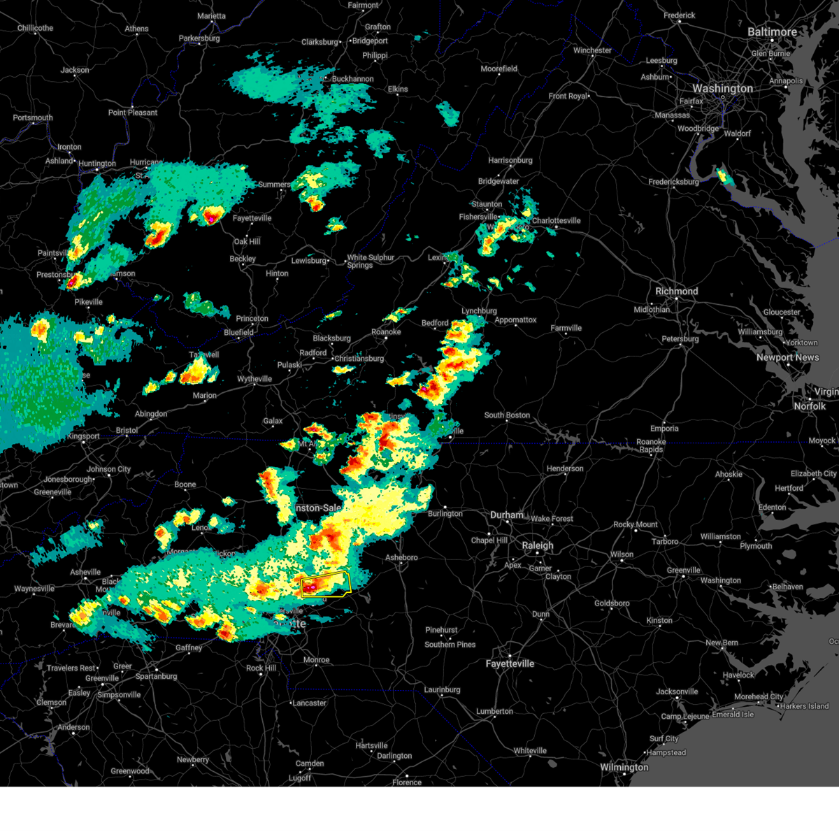
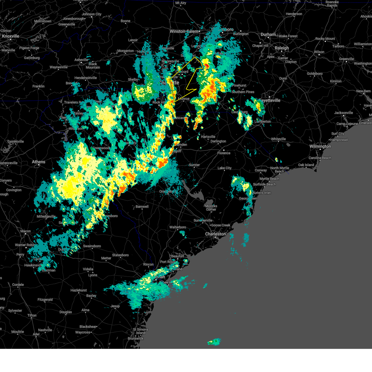
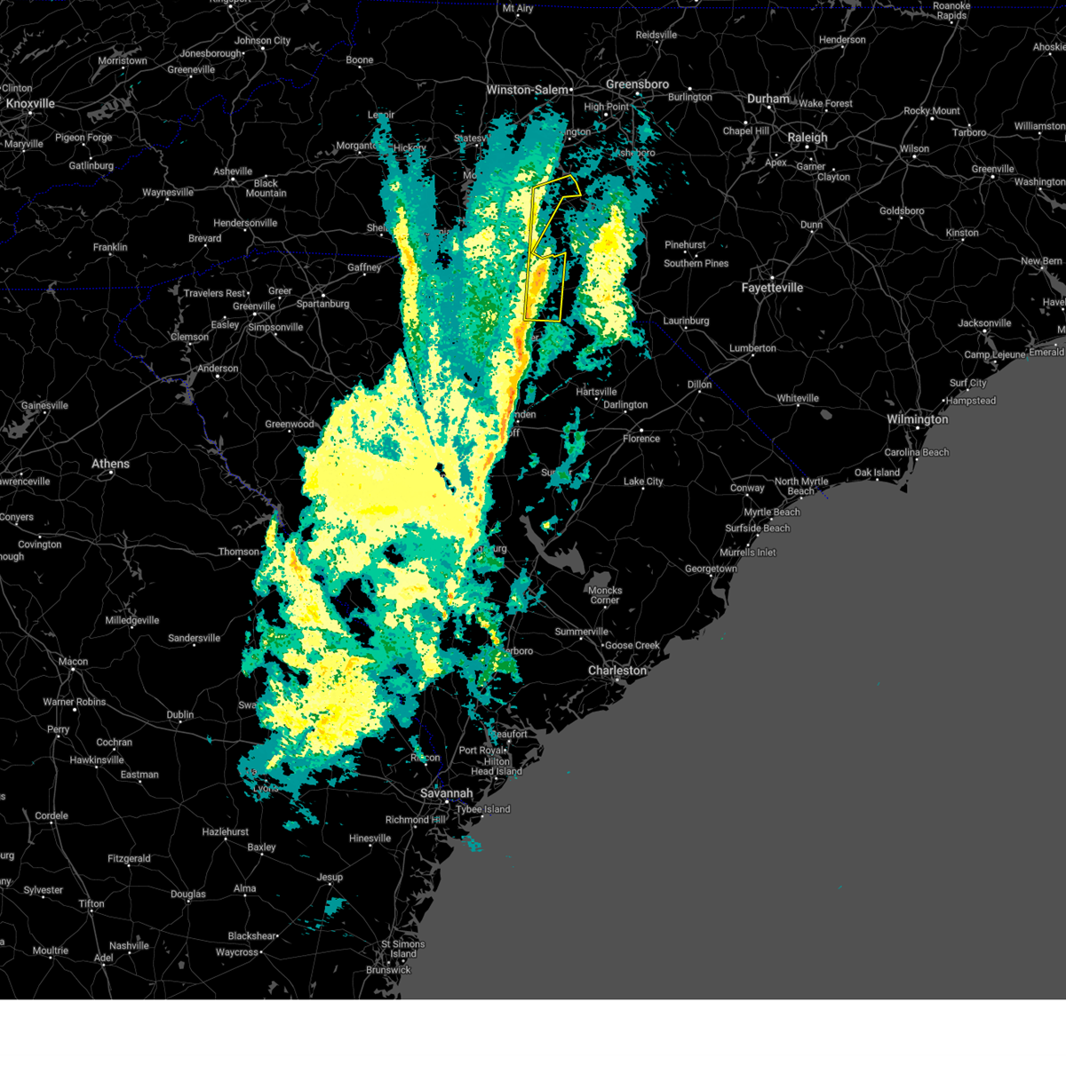
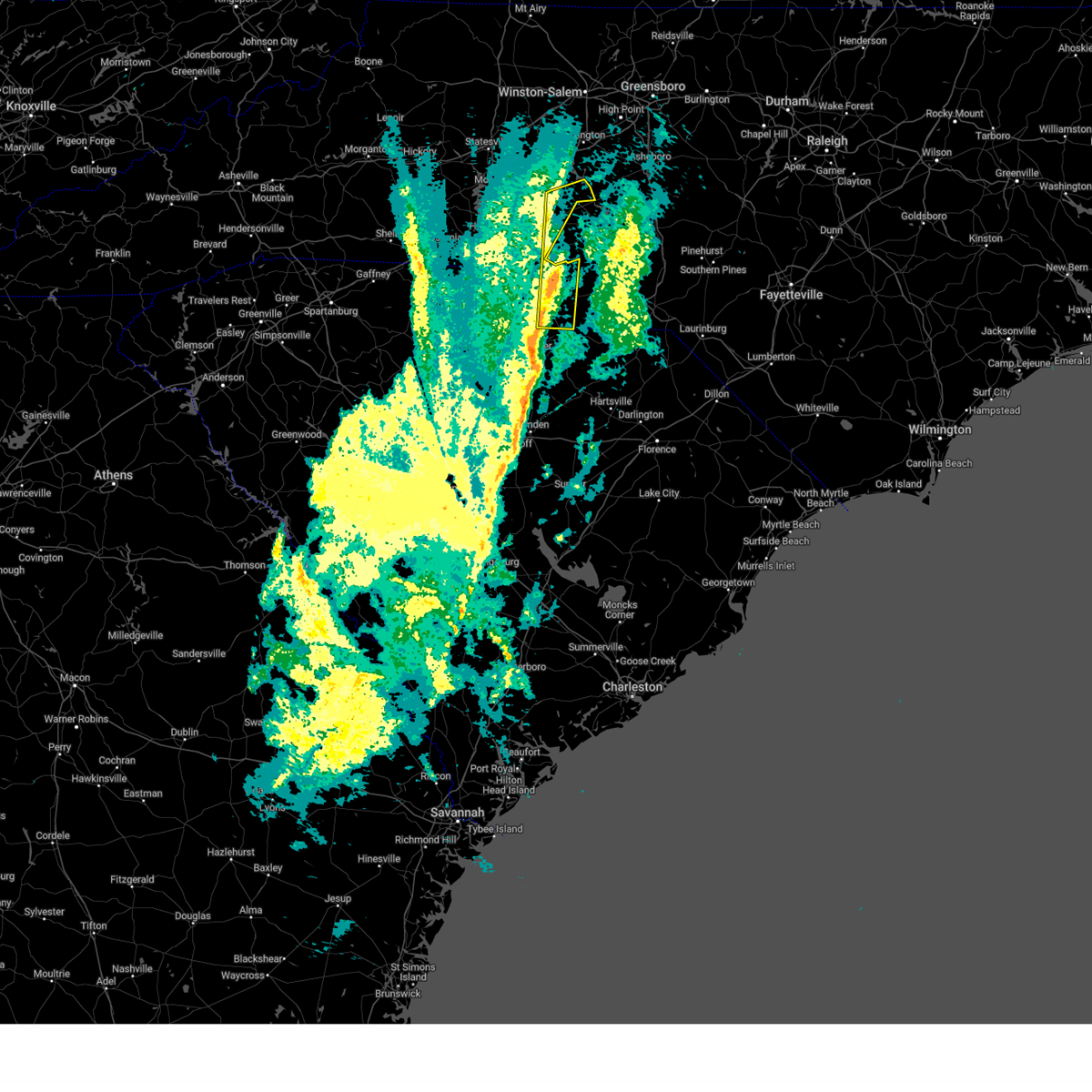
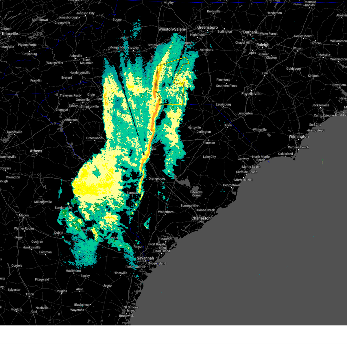
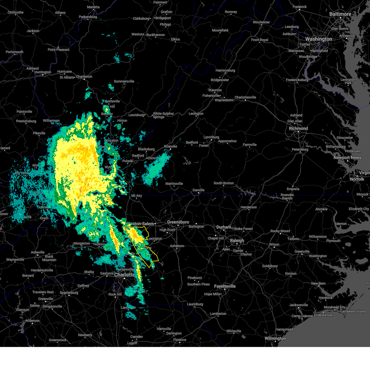
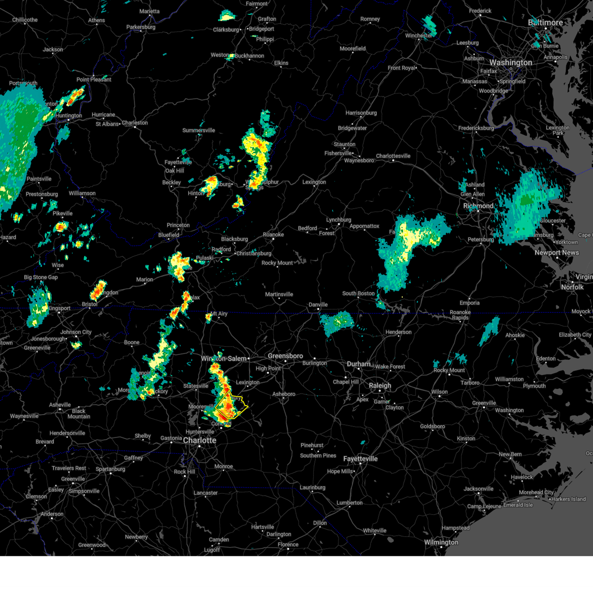
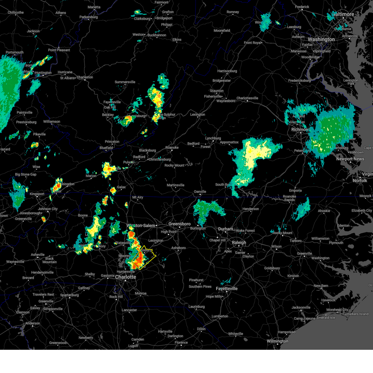
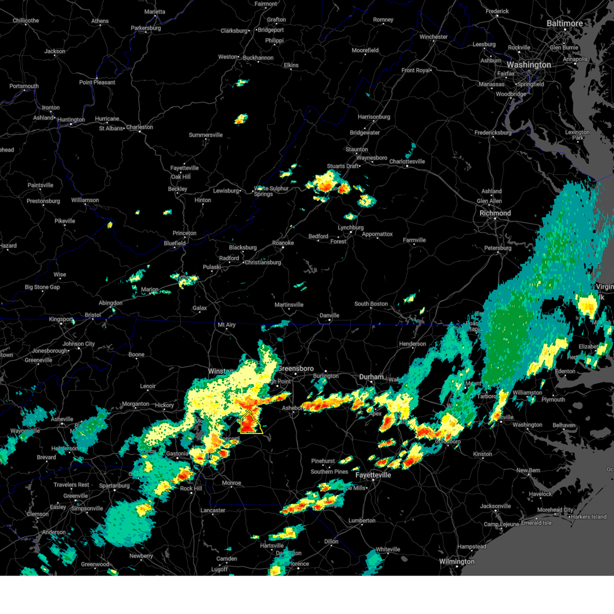
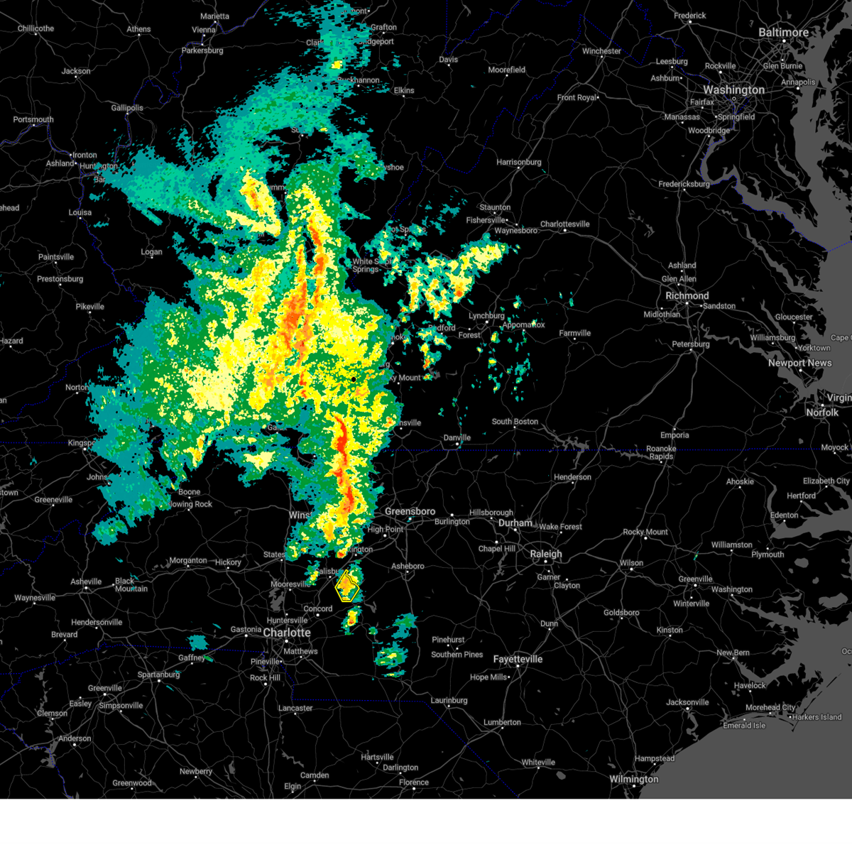
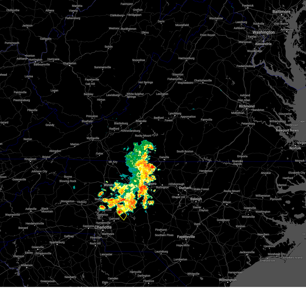
Hail Map for Rockwell, NC
The Rockwell, NC area has had 3 reports of on-the-ground hail by trained spotters, and has been under severe weather warnings 26 times during the past 12 months. Doppler radar has detected hail at or near Rockwell, NC on 41 occasions, including 4 occasions during the past year.
| Name: | Rockwell, NC |
| Where Located: | 33.3 miles NE of Charlotte, NC |
| Map: | Google Map for Rockwell, NC |
| Population: | 2108 |
| Housing Units: | 927 |
| More Info: | Search Google for Rockwell, NC |
0
The Top Recent Hail Date for Rockwell, NC is Thursday, May 8, 2025 (16th out of 41)

Hail and Wind Damage Spotted near Rockwell, NC
| Date / Time | Report Details |
|---|---|
| 5/8/2025 8:46 PM EDT | Multiple trees... snapped power pole and powerlines dow in rowan county NC, 7.2 miles ENE of Rockwell, NC |
| 5/8/2025 8:13 PM EDT | The storm which prompted the warning has weakened below severe limits, and has exited the warned area. therefore, the warning will be allowed to expire. a severe thunderstorm watch remains in effect until midnight edt for the piedmont of north carolina. |
| 5/8/2025 7:45 PM EDT | At 745 pm edt, a severe thunderstorm was located 8 miles east of kannapolis, or 4 miles south of faith, moving east at 10 mph (radar indicated). Hazards include 60 mph wind gusts and half dollar size hail. Minor hail damage to vehicles is expected. expect wind damage to trees and power lines. Locations impacted include, gold hill, faith, rockwell, granite quarry, china grove, and high rock lake. |
| 5/8/2025 7:14 PM EDT |
 Svrgsp the national weather service in greenville-spartanburg has issued a * severe thunderstorm warning for, northeastern cabarrus county in the piedmont of north carolina, southern rowan county in the piedmont of north carolina, * until 815 pm edt. * at 713 pm edt, a severe thunderstorm was located 4 miles northeast of kannapolis, or near china grove, moving east at 15 mph (radar indicated). Hazards include 60 mph wind gusts and quarter size hail. Minor hail damage to vehicles is expected. Expect wind damage to trees and power lines. Svrgsp the national weather service in greenville-spartanburg has issued a * severe thunderstorm warning for, northeastern cabarrus county in the piedmont of north carolina, southern rowan county in the piedmont of north carolina, * until 815 pm edt. * at 713 pm edt, a severe thunderstorm was located 4 miles northeast of kannapolis, or near china grove, moving east at 15 mph (radar indicated). Hazards include 60 mph wind gusts and quarter size hail. Minor hail damage to vehicles is expected. Expect wind damage to trees and power lines.
|
| 5/4/2025 1:43 AM EDT |
 The storms which prompted the warning have moved out of the area. therefore, the warning will be allowed to expire. to report severe weather to the national weather service greenville-spartanburg, call toll free, 1, 800, 2 6 7, 8 1 0 1, or post on our facebook page, or tweet it using hashtag nwsgsp. your message should describe the event and the specific location where it occurred. The storms which prompted the warning have moved out of the area. therefore, the warning will be allowed to expire. to report severe weather to the national weather service greenville-spartanburg, call toll free, 1, 800, 2 6 7, 8 1 0 1, or post on our facebook page, or tweet it using hashtag nwsgsp. your message should describe the event and the specific location where it occurred.
|
| 5/4/2025 1:19 AM EDT |
 the severe thunderstorm warning has been cancelled and is no longer in effect the severe thunderstorm warning has been cancelled and is no longer in effect
|
| 5/4/2025 1:19 AM EDT |
 At 119 am edt, severe thunderstorms were located along a line extending from near downtown concord to 14 miles north of monroe, moving northeast at 45 mph (radar indicated). Hazards include 60 mph wind gusts. Expect damage to trees and power lines. Locations impacted include, mt pleasant, west concord, gold hill, faith, rockwell, high rock lake, midland, high rock, downtown concord, and granite quarry. At 119 am edt, severe thunderstorms were located along a line extending from near downtown concord to 14 miles north of monroe, moving northeast at 45 mph (radar indicated). Hazards include 60 mph wind gusts. Expect damage to trees and power lines. Locations impacted include, mt pleasant, west concord, gold hill, faith, rockwell, high rock lake, midland, high rock, downtown concord, and granite quarry.
|
| 5/4/2025 1:05 AM EDT |
 Svrgsp the national weather service in greenville-spartanburg has issued a * severe thunderstorm warning for, northwestern cabarrus county in the piedmont of north carolina, southeastern davie county in the piedmont of north carolina, southeastern iredell county in the piedmont of north carolina, north central mecklenburg county in the piedmont of north carolina, rowan county in the piedmont of north carolina, * until 145 am edt. * at 105 am edt, severe thunderstorms were located along a line extending from 10 miles southeast of statesville to 5 miles east of huntersville, moving northeast at 35 mph (radar indicated). Hazards include 60 mph wind gusts. expect damage to trees and power lines Svrgsp the national weather service in greenville-spartanburg has issued a * severe thunderstorm warning for, northwestern cabarrus county in the piedmont of north carolina, southeastern davie county in the piedmont of north carolina, southeastern iredell county in the piedmont of north carolina, north central mecklenburg county in the piedmont of north carolina, rowan county in the piedmont of north carolina, * until 145 am edt. * at 105 am edt, severe thunderstorms were located along a line extending from 10 miles southeast of statesville to 5 miles east of huntersville, moving northeast at 35 mph (radar indicated). Hazards include 60 mph wind gusts. expect damage to trees and power lines
|
| 5/4/2025 1:00 AM EDT |
 Svrgsp the national weather service in greenville-spartanburg has issued a * severe thunderstorm warning for, cabarrus county in the piedmont of north carolina, southeastern mecklenburg county in the piedmont of north carolina, southeastern rowan county in the piedmont of north carolina, northern union county in the piedmont of north carolina, * until 145 am edt. * at 100 am edt, severe thunderstorms were located along a line extending from 8 miles northeast of uptown charlotte to 10 miles northwest of monroe, moving northeast at 45 mph (radar indicated). Hazards include 60 mph wind gusts. expect damage to trees and power lines Svrgsp the national weather service in greenville-spartanburg has issued a * severe thunderstorm warning for, cabarrus county in the piedmont of north carolina, southeastern mecklenburg county in the piedmont of north carolina, southeastern rowan county in the piedmont of north carolina, northern union county in the piedmont of north carolina, * until 145 am edt. * at 100 am edt, severe thunderstorms were located along a line extending from 8 miles northeast of uptown charlotte to 10 miles northwest of monroe, moving northeast at 45 mph (radar indicated). Hazards include 60 mph wind gusts. expect damage to trees and power lines
|
| 5/3/2025 3:15 PM EDT | Two trees down at old beatty ford rd and emmanuel church r in rowan county NC, 3.2 miles NNW of Rockwell, NC |
| 3/5/2025 8:46 AM EST |
 the severe thunderstorm warning has been cancelled and is no longer in effect the severe thunderstorm warning has been cancelled and is no longer in effect
|
| 3/5/2025 8:46 AM EST |
 At 846 am est, severe thunderstorms were located along a line extending from 4 miles southwest of downtown concord to 9 miles west of monroe, moving northeast at 45 mph (radar indicated). Hazards include 60 mph wind gusts. Expect damage to trees and power lines. Locations impacted include, marshville, mt pleasant, trinity, gold hill, monroe, rockwell, wingate, midland, new salem, and high rock. At 846 am est, severe thunderstorms were located along a line extending from 4 miles southwest of downtown concord to 9 miles west of monroe, moving northeast at 45 mph (radar indicated). Hazards include 60 mph wind gusts. Expect damage to trees and power lines. Locations impacted include, marshville, mt pleasant, trinity, gold hill, monroe, rockwell, wingate, midland, new salem, and high rock.
|
| 3/5/2025 8:08 AM EST |
 Svrgsp the national weather service in greenville-spartanburg has issued a * severe thunderstorm warning for, cabarrus county in the piedmont of north carolina, central mecklenburg county in the piedmont of north carolina, southeastern rowan county in the piedmont of north carolina, union county in the piedmont of north carolina, * until 900 am est. * at 808 am est, severe thunderstorms were located along a line extending from 3 miles east of huntersville to 10 miles southeast of rock hill, moving northeast at 45 mph (radar indicated). Hazards include 60 mph wind gusts. expect damage to trees and power lines Svrgsp the national weather service in greenville-spartanburg has issued a * severe thunderstorm warning for, cabarrus county in the piedmont of north carolina, central mecklenburg county in the piedmont of north carolina, southeastern rowan county in the piedmont of north carolina, union county in the piedmont of north carolina, * until 900 am est. * at 808 am est, severe thunderstorms were located along a line extending from 3 miles east of huntersville to 10 miles southeast of rock hill, moving northeast at 45 mph (radar indicated). Hazards include 60 mph wind gusts. expect damage to trees and power lines
|
| 3/5/2025 7:59 AM EST |
 Svrgsp the national weather service in greenville-spartanburg has issued a * severe thunderstorm warning for, davie county in the piedmont of north carolina, southeastern iredell county in the piedmont of north carolina, rowan county in the piedmont of north carolina, * until 830 am est. * at 758 am est, severe thunderstorms were located along a line extending from 3 miles north of mocksville to 9 miles northwest of kannapolis, moving northeast at 45 mph (radar indicated). Hazards include 60 mph wind gusts. expect damage to trees and power lines Svrgsp the national weather service in greenville-spartanburg has issued a * severe thunderstorm warning for, davie county in the piedmont of north carolina, southeastern iredell county in the piedmont of north carolina, rowan county in the piedmont of north carolina, * until 830 am est. * at 758 am est, severe thunderstorms were located along a line extending from 3 miles north of mocksville to 9 miles northwest of kannapolis, moving northeast at 45 mph (radar indicated). Hazards include 60 mph wind gusts. expect damage to trees and power lines
|
| 12/29/2024 9:50 AM EST |
 Svrgsp the national weather service in greenville-spartanburg has issued a * severe thunderstorm warning for, northeastern cabarrus county in the piedmont of north carolina, davie county in the piedmont of north carolina, northeastern iredell county in the piedmont of north carolina, rowan county in the piedmont of north carolina, * until 1045 am est. * at 950 am est, severe thunderstorms were located along a line extending from 9 miles southeast of wilkesboro to 7 miles southwest of salisbury to 14 miles southeast of downtown concord, moving northeast at 65 mph (radar indicated). Hazards include 60 mph wind gusts. expect damage to trees and power lines Svrgsp the national weather service in greenville-spartanburg has issued a * severe thunderstorm warning for, northeastern cabarrus county in the piedmont of north carolina, davie county in the piedmont of north carolina, northeastern iredell county in the piedmont of north carolina, rowan county in the piedmont of north carolina, * until 1045 am est. * at 950 am est, severe thunderstorms were located along a line extending from 9 miles southeast of wilkesboro to 7 miles southwest of salisbury to 14 miles southeast of downtown concord, moving northeast at 65 mph (radar indicated). Hazards include 60 mph wind gusts. expect damage to trees and power lines
|
| 9/25/2024 12:47 AM EDT |
 the severe thunderstorm warning has been cancelled and is no longer in effect the severe thunderstorm warning has been cancelled and is no longer in effect
|
| 9/25/2024 12:22 AM EDT |
 At 1221 am edt, a severe thunderstorm was located 8 miles east of kannapolis, or 5 miles southwest of rockwell, moving northeast at 25 mph (radar indicated). Hazards include 60 mph wind gusts. Expect damage to trees and power lines. Locations impacted include, kannapolis, downtown concord, china grove, landis, granite quarry, rockwell, mt pleasant, faith, high rock lake, and gold hill. At 1221 am edt, a severe thunderstorm was located 8 miles east of kannapolis, or 5 miles southwest of rockwell, moving northeast at 25 mph (radar indicated). Hazards include 60 mph wind gusts. Expect damage to trees and power lines. Locations impacted include, kannapolis, downtown concord, china grove, landis, granite quarry, rockwell, mt pleasant, faith, high rock lake, and gold hill.
|
| 9/25/2024 12:00 AM EDT |
 Svrgsp the national weather service in greenville-spartanburg has issued a * severe thunderstorm warning for, cabarrus county in the piedmont of north carolina, southeastern rowan county in the piedmont of north carolina, * until 100 am edt. * at 1200 am edt, a severe thunderstorm was located near downtown concord, moving northeast at 25 mph (radar indicated). Hazards include 60 mph wind gusts and penny size hail. expect damage to trees and power lines Svrgsp the national weather service in greenville-spartanburg has issued a * severe thunderstorm warning for, cabarrus county in the piedmont of north carolina, southeastern rowan county in the piedmont of north carolina, * until 100 am edt. * at 1200 am edt, a severe thunderstorm was located near downtown concord, moving northeast at 25 mph (radar indicated). Hazards include 60 mph wind gusts and penny size hail. expect damage to trees and power lines
|
| 8/18/2024 6:17 PM EDT | Svrgsp the national weather service in greenville-spartanburg has issued a * severe thunderstorm warning for, northeastern cabarrus county in the piedmont of north carolina, southeastern rowan county in the piedmont of north carolina, * until 645 pm edt. * at 617 pm edt, severe thunderstorms were located along a line extending from 12 miles northwest of badin lake to 11 miles northwest of albemarle, moving northeast at 15 mph (radar indicated). Hazards include 60 mph wind gusts and nickel size hail. expect damage to trees and power lines |
| 8/2/2024 9:42 PM EDT |
 the severe thunderstorm warning has been cancelled and is no longer in effect the severe thunderstorm warning has been cancelled and is no longer in effect
|
| 8/2/2024 9:42 PM EDT |
 At 942 pm edt, a severe thunderstorm was located 4 miles south of salisbury, or near faith, moving northeast at 20 mph (radar indicated). Hazards include 60 mph wind gusts. Expect damage to trees and power lines. Locations impacted include, salisbury, china grove, spencer, granite quarry, rockwell, faith, and high rock lake. At 942 pm edt, a severe thunderstorm was located 4 miles south of salisbury, or near faith, moving northeast at 20 mph (radar indicated). Hazards include 60 mph wind gusts. Expect damage to trees and power lines. Locations impacted include, salisbury, china grove, spencer, granite quarry, rockwell, faith, and high rock lake.
|
| 8/2/2024 9:35 PM EDT | Tree blown onto house on beatty ford roa in rowan county NC, 5.7 miles ENE of Rockwell, NC |
| 8/2/2024 9:19 PM EDT |
 Svrgsp the national weather service in greenville-spartanburg has issued a * severe thunderstorm warning for, north central cabarrus county in the piedmont of north carolina, southern rowan county in the piedmont of north carolina, * until 1000 pm edt. * at 919 pm edt, a severe thunderstorm was located near kannapolis, or near landis, moving northeast at 20 mph (radar indicated). Hazards include 60 mph wind gusts and penny size hail. expect damage to trees and power lines Svrgsp the national weather service in greenville-spartanburg has issued a * severe thunderstorm warning for, north central cabarrus county in the piedmont of north carolina, southern rowan county in the piedmont of north carolina, * until 1000 pm edt. * at 919 pm edt, a severe thunderstorm was located near kannapolis, or near landis, moving northeast at 20 mph (radar indicated). Hazards include 60 mph wind gusts and penny size hail. expect damage to trees and power lines
|
| 7/18/2024 5:15 PM EDT | Tree down on power line on morgan r in rowan county NC, 5 miles W of Rockwell, NC |
| 7/18/2024 5:15 PM EDT |
 Svrgsp the national weather service in greenville-spartanburg has issued a * severe thunderstorm warning for, southeastern rowan county in the piedmont of north carolina, * until 545 pm edt. * at 514 pm edt, a severe thunderstorm was located 10 miles southeast of salisbury, or near rockwell, moving east at 25 mph (radar indicated). Hazards include 60 mph wind gusts and penny size hail. expect damage to trees and power lines Svrgsp the national weather service in greenville-spartanburg has issued a * severe thunderstorm warning for, southeastern rowan county in the piedmont of north carolina, * until 545 pm edt. * at 514 pm edt, a severe thunderstorm was located 10 miles southeast of salisbury, or near rockwell, moving east at 25 mph (radar indicated). Hazards include 60 mph wind gusts and penny size hail. expect damage to trees and power lines
|
| 7/18/2024 5:02 PM EDT |
 At 502 pm edt, a severe thunderstorm was located 9 miles south of lexington, or near high rock lake, moving east at 35 mph (radar indicated). Hazards include 60 mph wind gusts and penny size hail. Expect damage to trees and power lines. Locations impacted include, salisbury, china grove, spencer, granite quarry, rockwell, cleveland, faith, mount ulla, gold hill, and piedmont research station. At 502 pm edt, a severe thunderstorm was located 9 miles south of lexington, or near high rock lake, moving east at 35 mph (radar indicated). Hazards include 60 mph wind gusts and penny size hail. Expect damage to trees and power lines. Locations impacted include, salisbury, china grove, spencer, granite quarry, rockwell, cleveland, faith, mount ulla, gold hill, and piedmont research station.
|
| 7/18/2024 5:02 PM EDT |
 the severe thunderstorm warning has been cancelled and is no longer in effect the severe thunderstorm warning has been cancelled and is no longer in effect
|
| 7/18/2024 4:14 PM EDT |
 Svrgsp the national weather service in greenville-spartanburg has issued a * severe thunderstorm warning for, southeastern iredell county in the piedmont of north carolina, rowan county in the piedmont of north carolina, * until 515 pm edt. * at 414 pm edt, a severe thunderstorm was located 11 miles southeast of statesville, or 6 miles northeast of mooresville, moving east at 35 mph (radar indicated). Hazards include 60 mph wind gusts and penny size hail. expect damage to trees and power lines Svrgsp the national weather service in greenville-spartanburg has issued a * severe thunderstorm warning for, southeastern iredell county in the piedmont of north carolina, rowan county in the piedmont of north carolina, * until 515 pm edt. * at 414 pm edt, a severe thunderstorm was located 11 miles southeast of statesville, or 6 miles northeast of mooresville, moving east at 35 mph (radar indicated). Hazards include 60 mph wind gusts and penny size hail. expect damage to trees and power lines
|
| 7/16/2024 3:20 PM EDT | Tree down on roy cline r in rowan county NC, 8 miles ENE of Rockwell, NC |
| 7/16/2024 3:06 PM EDT |
 At 305 pm edt, a severe thunderstorm was located 8 miles north of easley, or 6 miles northwest of berea, and is nearly stationary (radar indicated). Hazards include 60 mph wind gusts and quarter size hail. Minor hail damage to vehicles is expected. expect wind damage to trees and power lines. Locations impacted include, landis, granite quarry, rockwell, faith, gold hill, kannapolis, china grove, downtown concord, and salisbury. At 305 pm edt, a severe thunderstorm was located 8 miles north of easley, or 6 miles northwest of berea, and is nearly stationary (radar indicated). Hazards include 60 mph wind gusts and quarter size hail. Minor hail damage to vehicles is expected. expect wind damage to trees and power lines. Locations impacted include, landis, granite quarry, rockwell, faith, gold hill, kannapolis, china grove, downtown concord, and salisbury.
|
| 7/16/2024 2:50 PM EDT |
 Svrgsp the national weather service in greenville-spartanburg has issued a * severe thunderstorm warning for, northeastern cabarrus county in the piedmont of north carolina, south central rowan county in the piedmont of north carolina, * until 345 pm edt. * at 250 pm edt, a severe thunderstorm was located 7 miles east of kannapolis, or 5 miles south of faith, moving northeast at 10 mph (radar indicated). Hazards include 60 mph wind gusts. expect damage to trees and power lines Svrgsp the national weather service in greenville-spartanburg has issued a * severe thunderstorm warning for, northeastern cabarrus county in the piedmont of north carolina, south central rowan county in the piedmont of north carolina, * until 345 pm edt. * at 250 pm edt, a severe thunderstorm was located 7 miles east of kannapolis, or 5 miles south of faith, moving northeast at 10 mph (radar indicated). Hazards include 60 mph wind gusts. expect damage to trees and power lines
|
| 5/23/2024 7:17 PM EDT |
 Svrgsp the national weather service in greenville-spartanburg has issued a * severe thunderstorm warning for, northeastern cabarrus county in the piedmont of north carolina, south central rowan county in the piedmont of north carolina, * until 800 pm edt. * at 716 pm edt, a severe thunderstorm was located 7 miles northeast of downtown concord, or 4 miles northwest of mt pleasant, moving northeast at 15 mph (radar indicated). Hazards include 60 mph wind gusts and quarter size hail. Minor hail damage to vehicles is expected. Expect wind damage to trees and power lines. Svrgsp the national weather service in greenville-spartanburg has issued a * severe thunderstorm warning for, northeastern cabarrus county in the piedmont of north carolina, south central rowan county in the piedmont of north carolina, * until 800 pm edt. * at 716 pm edt, a severe thunderstorm was located 7 miles northeast of downtown concord, or 4 miles northwest of mt pleasant, moving northeast at 15 mph (radar indicated). Hazards include 60 mph wind gusts and quarter size hail. Minor hail damage to vehicles is expected. Expect wind damage to trees and power lines.
|
| 4/11/2024 8:24 PM EDT |
 the severe thunderstorm warning has been cancelled and is no longer in effect the severe thunderstorm warning has been cancelled and is no longer in effect
|
| 4/11/2024 8:24 PM EDT |
 At 824 pm edt, a severe thunderstorm was located 8 miles east of salisbury, or near high rock lake, moving northeast at 45 mph (radar indicated). Hazards include 60 mph wind gusts and nickel size hail. Expect damage to trees and power lines. Locations impacted include, high rock lake, gold hill, and rockwell. At 824 pm edt, a severe thunderstorm was located 8 miles east of salisbury, or near high rock lake, moving northeast at 45 mph (radar indicated). Hazards include 60 mph wind gusts and nickel size hail. Expect damage to trees and power lines. Locations impacted include, high rock lake, gold hill, and rockwell.
|
| 4/11/2024 8:01 PM EDT |
 Svrgsp the national weather service in greenville-spartanburg has issued a * severe thunderstorm warning for, northeastern cabarrus county in the piedmont of north carolina, southeastern rowan county in the piedmont of north carolina, * until 845 pm edt. * at 801 pm edt, a severe thunderstorm was located 5 miles northeast of downtown concord, or 4 miles northwest of mt pleasant, moving northeast at 45 mph (radar indicated). Hazards include 60 mph wind gusts and nickel size hail. expect damage to trees and power lines Svrgsp the national weather service in greenville-spartanburg has issued a * severe thunderstorm warning for, northeastern cabarrus county in the piedmont of north carolina, southeastern rowan county in the piedmont of north carolina, * until 845 pm edt. * at 801 pm edt, a severe thunderstorm was located 5 miles northeast of downtown concord, or 4 miles northwest of mt pleasant, moving northeast at 45 mph (radar indicated). Hazards include 60 mph wind gusts and nickel size hail. expect damage to trees and power lines
|
| 1/9/2024 1:51 PM EST |
 At 150 pm est, severe thunderstorms were located along a line extending from 9 miles north of lexington to 9 miles east of downtown concord, moving northeast at 80 mph (radar indicated). Hazards include 70 mph wind gusts. Expect considerable tree damage. damage is likely to mobile homes, roofs, and outbuildings. locations impacted include, downtown concord, east charlotte, mint hill, pineville, harrisburg, spencer, granite quarry, rockwell, mt pleasant, and faith. thunderstorm damage threat, considerable hail threat, radar indicated max hail size, <. 75 in wind threat, radar indicated max wind gust, 70 mph. At 150 pm est, severe thunderstorms were located along a line extending from 9 miles north of lexington to 9 miles east of downtown concord, moving northeast at 80 mph (radar indicated). Hazards include 70 mph wind gusts. Expect considerable tree damage. damage is likely to mobile homes, roofs, and outbuildings. locations impacted include, downtown concord, east charlotte, mint hill, pineville, harrisburg, spencer, granite quarry, rockwell, mt pleasant, and faith. thunderstorm damage threat, considerable hail threat, radar indicated max hail size, <. 75 in wind threat, radar indicated max wind gust, 70 mph.
|
| 1/9/2024 1:37 PM EST |
 At 137 pm est, severe thunderstorms were located along a line extending from 5 miles east of mocksville to 11 miles east of uptown charlotte, moving northeast at 65 mph (radar indicated). Hazards include 70 mph wind gusts. Expect considerable tree damage. damage is likely to mobile homes, roofs, and outbuildings. locations impacted include, kannapolis, downtown concord, salisbury, mocksville, east charlotte, west concord, mint hill, pineville, harrisburg, and china grove. thunderstorm damage threat, considerable hail threat, radar indicated max hail size, <. 75 in wind threat, radar indicated max wind gust, 70 mph. At 137 pm est, severe thunderstorms were located along a line extending from 5 miles east of mocksville to 11 miles east of uptown charlotte, moving northeast at 65 mph (radar indicated). Hazards include 70 mph wind gusts. Expect considerable tree damage. damage is likely to mobile homes, roofs, and outbuildings. locations impacted include, kannapolis, downtown concord, salisbury, mocksville, east charlotte, west concord, mint hill, pineville, harrisburg, and china grove. thunderstorm damage threat, considerable hail threat, radar indicated max hail size, <. 75 in wind threat, radar indicated max wind gust, 70 mph.
|
| 1/9/2024 1:28 PM EST |
 At 128 pm est, severe thunderstorms were located along a line extending from 7 miles northeast of mocksville to 7 miles southeast of uptown charlotte, moving northeast at 85 mph (radar indicated). Hazards include 60 mph wind gusts. Expect damage to trees and power lines. locations impacted include, kannapolis, downtown concord, salisbury, mocksville, northeast charlotte, east charlotte, west concord, mint hill, pineville, and harrisburg. hail threat, radar indicated max hail size, <. 75 in wind threat, radar indicated max wind gust, 60 mph. At 128 pm est, severe thunderstorms were located along a line extending from 7 miles northeast of mocksville to 7 miles southeast of uptown charlotte, moving northeast at 85 mph (radar indicated). Hazards include 60 mph wind gusts. Expect damage to trees and power lines. locations impacted include, kannapolis, downtown concord, salisbury, mocksville, northeast charlotte, east charlotte, west concord, mint hill, pineville, and harrisburg. hail threat, radar indicated max hail size, <. 75 in wind threat, radar indicated max wind gust, 60 mph.
|
| 1/9/2024 1:10 PM EST |
 At 110 pm est, severe thunderstorms were located along a line extending from 8 miles southeast of statesville to 3 miles southwest of rock hill, moving northeast at 85 mph (radar indicated). Hazards include 60 mph wind gusts. expect damage to trees and power lines At 110 pm est, severe thunderstorms were located along a line extending from 8 miles southeast of statesville to 3 miles southwest of rock hill, moving northeast at 85 mph (radar indicated). Hazards include 60 mph wind gusts. expect damage to trees and power lines
|
| 8/24/2023 8:01 PM EDT |
 At 801 pm edt, a severe thunderstorm was located 11 miles southeast of salisbury, or near rockwell, moving southeast at 15 mph (radar indicated). Hazards include 60 mph wind gusts and penny size hail. Expect damage to trees and power lines. locations impacted include, granite quarry, rockwell, faith and gold hill. hail threat, radar indicated max hail size, 0. 75 in wind threat, radar indicated max wind gust, 60 mph. At 801 pm edt, a severe thunderstorm was located 11 miles southeast of salisbury, or near rockwell, moving southeast at 15 mph (radar indicated). Hazards include 60 mph wind gusts and penny size hail. Expect damage to trees and power lines. locations impacted include, granite quarry, rockwell, faith and gold hill. hail threat, radar indicated max hail size, 0. 75 in wind threat, radar indicated max wind gust, 60 mph.
|
| 8/24/2023 7:33 PM EDT |
 At 733 pm edt, a severe thunderstorm was located 4 miles southeast of salisbury, or near granite quarry, moving southeast at 15 mph (radar indicated). Hazards include 60 mph wind gusts and nickel size hail. expect damage to trees and power lines At 733 pm edt, a severe thunderstorm was located 4 miles southeast of salisbury, or near granite quarry, moving southeast at 15 mph (radar indicated). Hazards include 60 mph wind gusts and nickel size hail. expect damage to trees and power lines
|
| 8/24/2023 6:47 PM EDT |
 At 647 pm edt, a severe thunderstorm was located near salisbury, moving southeast at 15 mph (radar indicated). Hazards include 60 mph wind gusts and quarter size hail. Minor hail damage to vehicles is expected. Expect wind damage to trees and power lines. At 647 pm edt, a severe thunderstorm was located near salisbury, moving southeast at 15 mph (radar indicated). Hazards include 60 mph wind gusts and quarter size hail. Minor hail damage to vehicles is expected. Expect wind damage to trees and power lines.
|
| 8/7/2023 5:43 PM EDT |
 At 542 pm edt, severe thunderstorms were located along a line extending from 10 miles southwest of winston-salem to 6 miles south of lexington to 10 miles west of albemarle, moving east at 45 mph (radar indicated). Hazards include 70 mph wind gusts and penny size hail. Expect considerable tree damage. damage is likely to mobile homes, roofs, and outbuildings. Locations impacted include, huntersville, kannapolis, downtown concord, salisbury, mocksville, northeast charlotte, west concord, harrisburg, china grove and spencer. At 542 pm edt, severe thunderstorms were located along a line extending from 10 miles southwest of winston-salem to 6 miles south of lexington to 10 miles west of albemarle, moving east at 45 mph (radar indicated). Hazards include 70 mph wind gusts and penny size hail. Expect considerable tree damage. damage is likely to mobile homes, roofs, and outbuildings. Locations impacted include, huntersville, kannapolis, downtown concord, salisbury, mocksville, northeast charlotte, west concord, harrisburg, china grove and spencer.
|
| 8/7/2023 5:20 PM EDT |
 At 519 pm edt, severe thunderstorms were located along a line extending from 8 miles south of yadkinville to 3 miles south of mocksville to 4 miles west of salisbury to 3 miles south of downtown concord, moving east at 45 mph (radar indicated). Hazards include 70 mph wind gusts and penny size hail. Expect considerable tree damage. Damage is likely to mobile homes, roofs, and outbuildings. At 519 pm edt, severe thunderstorms were located along a line extending from 8 miles south of yadkinville to 3 miles south of mocksville to 4 miles west of salisbury to 3 miles south of downtown concord, moving east at 45 mph (radar indicated). Hazards include 70 mph wind gusts and penny size hail. Expect considerable tree damage. Damage is likely to mobile homes, roofs, and outbuildings.
|
| 8/6/2023 4:35 PM EDT |
 At 434 pm edt, severe thunderstorms were located along a line extending from 9 miles south of lexington to 10 miles northwest of albemarle to 10 miles south of downtown concord, moving east at 15 mph (radar indicated). Hazards include 60 mph wind gusts. Expect damage to trees and power lines. locations impacted include, mt pleasant, midland, gold hill, high rock, high rock lake and rockwell. hail threat, radar indicated max hail size, <. 75 in wind threat, radar indicated max wind gust, 60 mph. At 434 pm edt, severe thunderstorms were located along a line extending from 9 miles south of lexington to 10 miles northwest of albemarle to 10 miles south of downtown concord, moving east at 15 mph (radar indicated). Hazards include 60 mph wind gusts. Expect damage to trees and power lines. locations impacted include, mt pleasant, midland, gold hill, high rock, high rock lake and rockwell. hail threat, radar indicated max hail size, <. 75 in wind threat, radar indicated max wind gust, 60 mph.
|
| 8/6/2023 4:24 PM EDT |
 At 424 pm edt, severe thunderstorms were located along a line extending from 7 miles east of salisbury to 12 miles northwest of albemarle to 10 miles south of downtown concord, moving east at 15 mph (radar indicated). Hazards include 60 mph wind gusts and penny size hail. Expect damage to trees and power lines. locations impacted include, east charlotte, granite quarry, rockwell, mt pleasant, faith, midland, gold hill, high rock, reedy creek park and high rock lake. hail threat, radar indicated max hail size, 0. 75 in wind threat, radar indicated max wind gust, 60 mph. At 424 pm edt, severe thunderstorms were located along a line extending from 7 miles east of salisbury to 12 miles northwest of albemarle to 10 miles south of downtown concord, moving east at 15 mph (radar indicated). Hazards include 60 mph wind gusts and penny size hail. Expect damage to trees and power lines. locations impacted include, east charlotte, granite quarry, rockwell, mt pleasant, faith, midland, gold hill, high rock, reedy creek park and high rock lake. hail threat, radar indicated max hail size, 0. 75 in wind threat, radar indicated max wind gust, 60 mph.
|
| 8/6/2023 4:10 PM EDT | Large tree on roadwa in rowan county NC, 0.3 miles NNE of Rockwell, NC |
| 8/6/2023 4:06 PM EDT |
 At 406 pm edt, severe thunderstorms were located along a line extending from 3 miles east of salisbury to 8 miles east of downtown concord to 10 miles east of uptown charlotte, moving east at 20 mph (radar indicated). Hazards include 60 mph wind gusts and penny size hail. expect damage to trees and power lines At 406 pm edt, severe thunderstorms were located along a line extending from 3 miles east of salisbury to 8 miles east of downtown concord to 10 miles east of uptown charlotte, moving east at 20 mph (radar indicated). Hazards include 60 mph wind gusts and penny size hail. expect damage to trees and power lines
|
| 6/26/2023 10:42 PM EDT | Social media report of trees down east of china grove near the cabarrus county line. time and location estimated by rada in rowan county NC, 7.2 miles ENE of Rockwell, NC |
| 6/26/2023 10:25 PM EDT |
 At 1025 pm edt, a severe thunderstorm was located near kannapolis, or near landis, moving southeast at 20 mph (radar indicated). Hazards include 60 mph wind gusts and quarter size hail. Minor hail damage to vehicles is expected. expect wind damage to trees and power lines. locations impacted include, china grove, landis, enochville, rockwell, faith, gold hill, granite quarry and kannapolis. hail threat, radar indicated max hail size, 1. 00 in wind threat, radar indicated max wind gust, 60 mph. At 1025 pm edt, a severe thunderstorm was located near kannapolis, or near landis, moving southeast at 20 mph (radar indicated). Hazards include 60 mph wind gusts and quarter size hail. Minor hail damage to vehicles is expected. expect wind damage to trees and power lines. locations impacted include, china grove, landis, enochville, rockwell, faith, gold hill, granite quarry and kannapolis. hail threat, radar indicated max hail size, 1. 00 in wind threat, radar indicated max wind gust, 60 mph.
|
| 6/26/2023 9:59 PM EDT |
 At 959 pm edt, a severe thunderstorm was located 9 miles northwest of kannapolis, or 5 miles east of mooresville, moving east at 30 mph (radar indicated). Hazards include 60 mph wind gusts and quarter size hail. Minor hail damage to vehicles is expected. Expect wind damage to trees and power lines. At 959 pm edt, a severe thunderstorm was located 9 miles northwest of kannapolis, or 5 miles east of mooresville, moving east at 30 mph (radar indicated). Hazards include 60 mph wind gusts and quarter size hail. Minor hail damage to vehicles is expected. Expect wind damage to trees and power lines.
|
| 6/26/2023 8:15 PM EDT |
 At 815 pm edt, severe thunderstorms were located along a line extending from 7 miles northwest of kannapolis to 5 miles southeast of lincolnton, moving east at 25 mph (radar indicated). Hazards include 60 mph wind gusts and quarter size hail. Minor hail damage to vehicles is expected. Expect wind damage to trees and power lines. At 815 pm edt, severe thunderstorms were located along a line extending from 7 miles northwest of kannapolis to 5 miles southeast of lincolnton, moving east at 25 mph (radar indicated). Hazards include 60 mph wind gusts and quarter size hail. Minor hail damage to vehicles is expected. Expect wind damage to trees and power lines.
|
| 6/26/2023 8:10 PM EDT |
 At 810 pm edt, a severe thunderstorm was located 6 miles west of salisbury, moving east at 25 mph (radar indicated). Hazards include 60 mph wind gusts and quarter size hail. Minor hail damage to vehicles is expected. Expect wind damage to trees and power lines. At 810 pm edt, a severe thunderstorm was located 6 miles west of salisbury, moving east at 25 mph (radar indicated). Hazards include 60 mph wind gusts and quarter size hail. Minor hail damage to vehicles is expected. Expect wind damage to trees and power lines.
|
| 6/19/2023 6:25 PM EDT |
 At 625 pm edt, a severe thunderstorm capable of producing a tornado was located 7 miles northwest of kannapolis, or 5 miles north of enochville, moving northeast at 15 mph (radar indicated rotation). Hazards include tornado. Flying debris will be dangerous to those caught without shelter. mobile homes will be damaged or destroyed. damage to roofs, windows, and vehicles will occur. tree damage is likely. this dangerous storm will be near, landis around 630 pm edt. china grove around 650 pm edt. granite quarry and faith around 720 pm edt. salisbury and spencer around 730 pm edt. Other locations impacted by this dangerous thunderstorm include mount ulla and piedmont research station. At 625 pm edt, a severe thunderstorm capable of producing a tornado was located 7 miles northwest of kannapolis, or 5 miles north of enochville, moving northeast at 15 mph (radar indicated rotation). Hazards include tornado. Flying debris will be dangerous to those caught without shelter. mobile homes will be damaged or destroyed. damage to roofs, windows, and vehicles will occur. tree damage is likely. this dangerous storm will be near, landis around 630 pm edt. china grove around 650 pm edt. granite quarry and faith around 720 pm edt. salisbury and spencer around 730 pm edt. Other locations impacted by this dangerous thunderstorm include mount ulla and piedmont research station.
|
| 3/3/2023 8:36 PM EST |
 At 836 pm est, severe thunderstorms were located along a line extending from 4 miles southwest of kannapolis to near indian land, moving northeast at 70 mph (radar indicated). Hazards include 60 mph wind gusts. Expect damage to trees and power lines. locations impacted include, uptown charlotte, kannapolis, downtown concord, south charlotte, northeast charlotte, east charlotte, west concord, matthews, mint hill and pineville. hail threat, radar indicated max hail size, <. 75 in wind threat, radar indicated max wind gust, 60 mph. At 836 pm est, severe thunderstorms were located along a line extending from 4 miles southwest of kannapolis to near indian land, moving northeast at 70 mph (radar indicated). Hazards include 60 mph wind gusts. Expect damage to trees and power lines. locations impacted include, uptown charlotte, kannapolis, downtown concord, south charlotte, northeast charlotte, east charlotte, west concord, matthews, mint hill and pineville. hail threat, radar indicated max hail size, <. 75 in wind threat, radar indicated max wind gust, 60 mph.
|
| 3/3/2023 8:25 PM EST |
 At 824 pm est, severe thunderstorms were located along a line extending from 7 miles northeast of huntersville to 8 miles northwest of indian land, moving northeast at 75 mph (radar indicated). Hazards include 60 mph wind gusts. Expect damage to trees and power lines. locations impacted include, uptown charlotte, huntersville, kannapolis, downtown concord, central charlotte, south charlotte, northeast charlotte, southwest charlotte, east charlotte and northwest charlotte. hail threat, radar indicated max hail size, <. 75 in wind threat, radar indicated max wind gust, 60 mph. At 824 pm est, severe thunderstorms were located along a line extending from 7 miles northeast of huntersville to 8 miles northwest of indian land, moving northeast at 75 mph (radar indicated). Hazards include 60 mph wind gusts. Expect damage to trees and power lines. locations impacted include, uptown charlotte, huntersville, kannapolis, downtown concord, central charlotte, south charlotte, northeast charlotte, southwest charlotte, east charlotte and northwest charlotte. hail threat, radar indicated max hail size, <. 75 in wind threat, radar indicated max wind gust, 60 mph.
|
| 3/3/2023 8:12 PM EST |
 At 812 pm est, severe thunderstorms were located along a line extending from 9 miles west of huntersville to near york, moving northeast at 75 mph (radar indicated). Hazards include 60 mph wind gusts. expect damage to trees and power lines At 812 pm est, severe thunderstorms were located along a line extending from 9 miles west of huntersville to near york, moving northeast at 75 mph (radar indicated). Hazards include 60 mph wind gusts. expect damage to trees and power lines
|
| 1/12/2023 7:24 PM EST |
 The severe thunderstorm warning for southeastern rowan county will expire at 730 pm est, the storms which prompted the warning have moved out of the area. therefore, the warning will be allowed to expire. however heavy rain is still possible with these thunderstorms. a tornado watch remains in effect until 1000 pm est for the piedmont of north carolina. The severe thunderstorm warning for southeastern rowan county will expire at 730 pm est, the storms which prompted the warning have moved out of the area. therefore, the warning will be allowed to expire. however heavy rain is still possible with these thunderstorms. a tornado watch remains in effect until 1000 pm est for the piedmont of north carolina.
|
| 1/12/2023 6:58 PM EST |
 At 658 pm est, severe thunderstorms were located along a line extending from 6 miles northeast of salisbury to 8 miles east of kannapolis, moving east at 50 mph (radar indicated). Hazards include 60 mph wind gusts and penny size hail. expect damage to trees and power lines At 658 pm est, severe thunderstorms were located along a line extending from 6 miles northeast of salisbury to 8 miles east of kannapolis, moving east at 50 mph (radar indicated). Hazards include 60 mph wind gusts and penny size hail. expect damage to trees and power lines
|
| 1/12/2023 6:18 PM EST |
 At 618 pm est, severe thunderstorms were located along a line extending from 13 miles east of taylorsville to 6 miles southwest of statesville to 13 miles northwest of huntersville, moving northeast at 65 mph (radar indicated). Hazards include 60 mph wind gusts and quarter size hail. Minor hail damage to vehicles is expected. Expect wind damage to trees and power lines. At 618 pm est, severe thunderstorms were located along a line extending from 13 miles east of taylorsville to 6 miles southwest of statesville to 13 miles northwest of huntersville, moving northeast at 65 mph (radar indicated). Hazards include 60 mph wind gusts and quarter size hail. Minor hail damage to vehicles is expected. Expect wind damage to trees and power lines.
|
| 7/23/2022 10:52 PM EDT |
 The severe thunderstorm warning for eastern catawba, davie, iredell and rowan counties will expire at 1100 pm edt, the storms which prompted the warning have weakened below severe limits, and no longer pose an immediate threat to life or property. therefore, the warning will be allowed to expire. however gusty winds to 35 mph are still possible with the lingering thunderstorm outflows. The severe thunderstorm warning for eastern catawba, davie, iredell and rowan counties will expire at 1100 pm edt, the storms which prompted the warning have weakened below severe limits, and no longer pose an immediate threat to life or property. therefore, the warning will be allowed to expire. however gusty winds to 35 mph are still possible with the lingering thunderstorm outflows.
|
| 7/23/2022 10:31 PM EDT |
 At 1031 pm edt, severe thunderstorms were located along a line extending from 7 miles northwest of lexington to 11 miles west of salisbury to 10 miles southwest of statesville, moving south at 30 mph (radar indicated). Hazards include 60 mph wind gusts. Expect damage to trees and power lines. locations impacted include, salisbury, statesville, mocksville, mooresville, china grove, spencer, landis, enochville, granite quarry and rockwell. hail threat, radar indicated max hail size, <. 75 in wind threat, radar indicated max wind gust, 60 mph. At 1031 pm edt, severe thunderstorms were located along a line extending from 7 miles northwest of lexington to 11 miles west of salisbury to 10 miles southwest of statesville, moving south at 30 mph (radar indicated). Hazards include 60 mph wind gusts. Expect damage to trees and power lines. locations impacted include, salisbury, statesville, mocksville, mooresville, china grove, spencer, landis, enochville, granite quarry and rockwell. hail threat, radar indicated max hail size, <. 75 in wind threat, radar indicated max wind gust, 60 mph.
|
| 7/23/2022 10:11 PM EDT |
 At 1011 pm edt, severe thunderstorms were located along a line extending from 10 miles southwest of winston-salem to 11 miles southwest of mocksville to 8 miles west of statesville, moving south at 35 mph (radar indicated). Hazards include 60 mph wind gusts and penny size hail. expect damage to trees and power lines At 1011 pm edt, severe thunderstorms were located along a line extending from 10 miles southwest of winston-salem to 11 miles southwest of mocksville to 8 miles west of statesville, moving south at 35 mph (radar indicated). Hazards include 60 mph wind gusts and penny size hail. expect damage to trees and power lines
|
| 7/23/2022 4:55 PM EDT |
 At 455 pm edt, a severe thunderstorm was located 5 miles northeast of kannapolis, or near china grove, and is nearly stationary (radar indicated). Hazards include 60 mph wind gusts and quarter size hail. Minor hail damage to vehicles is expected. Expect wind damage to trees and power lines. At 455 pm edt, a severe thunderstorm was located 5 miles northeast of kannapolis, or near china grove, and is nearly stationary (radar indicated). Hazards include 60 mph wind gusts and quarter size hail. Minor hail damage to vehicles is expected. Expect wind damage to trees and power lines.
|
| 7/16/2022 1:58 PM EDT |
 At 158 pm edt, a severe thunderstorm was located 9 miles southeast of salisbury, or near rockwell, moving southeast at 10 mph (radar indicated). Hazards include 60 mph wind gusts and penny size hail. Expect damage to trees and power lines. locations impacted include, granite quarry, rockwell, faith, gold hill, high rock, china grove, high rock lake and salisbury. hail threat, radar indicated max hail size, 0. 75 in wind threat, radar indicated max wind gust, 60 mph. At 158 pm edt, a severe thunderstorm was located 9 miles southeast of salisbury, or near rockwell, moving southeast at 10 mph (radar indicated). Hazards include 60 mph wind gusts and penny size hail. Expect damage to trees and power lines. locations impacted include, granite quarry, rockwell, faith, gold hill, high rock, china grove, high rock lake and salisbury. hail threat, radar indicated max hail size, 0. 75 in wind threat, radar indicated max wind gust, 60 mph.
|
| 7/16/2022 1:31 PM EDT |
 At 131 pm edt, a severe thunderstorm was located 4 miles southeast of salisbury, or over granite quarry, moving southeast at 10 mph (radar indicated). Hazards include 60 mph wind gusts and quarter size hail. Minor hail damage to vehicles is expected. Expect wind damage to trees and power lines. At 131 pm edt, a severe thunderstorm was located 4 miles southeast of salisbury, or over granite quarry, moving southeast at 10 mph (radar indicated). Hazards include 60 mph wind gusts and quarter size hail. Minor hail damage to vehicles is expected. Expect wind damage to trees and power lines.
|
| 7/5/2022 7:24 PM EDT |
 At 723 pm edt, severe thunderstorms were located along a line extending from 15 miles southwest of hickory to 5 miles northwest of salisbury, moving south at 15 mph (radar indicated). Hazards include 60 mph wind gusts and quarter size hail. Minor hail damage to vehicles is expected. Expect wind damage to trees and power lines. At 723 pm edt, severe thunderstorms were located along a line extending from 15 miles southwest of hickory to 5 miles northwest of salisbury, moving south at 15 mph (radar indicated). Hazards include 60 mph wind gusts and quarter size hail. Minor hail damage to vehicles is expected. Expect wind damage to trees and power lines.
|
| 6/17/2022 5:45 PM EDT | Tree fell on power lin in rowan county NC, 0.3 miles NNE of Rockwell, NC |
| 6/17/2022 5:40 PM EDT |
 At 540 pm edt, a severe thunderstorm was located 4 miles east of salisbury, or near spencer, moving southeast at 25 mph (radar indicated). Hazards include 60 mph wind gusts and quarter size hail. Minor hail damage to vehicles is expected. Expect wind damage to trees and power lines. At 540 pm edt, a severe thunderstorm was located 4 miles east of salisbury, or near spencer, moving southeast at 25 mph (radar indicated). Hazards include 60 mph wind gusts and quarter size hail. Minor hail damage to vehicles is expected. Expect wind damage to trees and power lines.
|
| 6/16/2022 3:57 PM EDT |
 The severe thunderstorm warning for southeastern rowan county will expire at 400 pm edt, the storm which prompted the warning has moved out of the area. therefore, the warning will be allowed to expire. a severe thunderstorm watch remains in effect until 900 pm edt for the piedmont of north carolina. remember, a severe thunderstorm warning still remains in effect for southern rowan county until 4:15 pm edt. The severe thunderstorm warning for southeastern rowan county will expire at 400 pm edt, the storm which prompted the warning has moved out of the area. therefore, the warning will be allowed to expire. a severe thunderstorm watch remains in effect until 900 pm edt for the piedmont of north carolina. remember, a severe thunderstorm warning still remains in effect for southern rowan county until 4:15 pm edt.
|
| 6/16/2022 3:14 PM EDT |
 At 314 pm edt, a severe thunderstorm was located 5 miles east of salisbury, or near spencer, and is nearly stationary (radar indicated). Hazards include 60 mph wind gusts and quarter size hail. Minor hail damage to vehicles is expected. Expect wind damage to trees and power lines. At 314 pm edt, a severe thunderstorm was located 5 miles east of salisbury, or near spencer, and is nearly stationary (radar indicated). Hazards include 60 mph wind gusts and quarter size hail. Minor hail damage to vehicles is expected. Expect wind damage to trees and power lines.
|
| 5/26/2022 9:41 PM EDT |
 The severe thunderstorm warning for cabarrus, davie, southeastern iredell, mecklenburg, rowan and northeastern york counties will expire at 945 pm edt, the storms which prompted the warning have weakened below severe limits, and no longer pose an immediate threat to life or property. therefore, the warning will be allowed to expire. a severe thunderstorm watch remains in effect until 1000 pm edt for the piedmont of north carolina, and upstate south carolina. The severe thunderstorm warning for cabarrus, davie, southeastern iredell, mecklenburg, rowan and northeastern york counties will expire at 945 pm edt, the storms which prompted the warning have weakened below severe limits, and no longer pose an immediate threat to life or property. therefore, the warning will be allowed to expire. a severe thunderstorm watch remains in effect until 1000 pm edt for the piedmont of north carolina, and upstate south carolina.
|
| 5/26/2022 9:17 PM EDT |
 At 916 pm edt, severe thunderstorms were located along a line extending from near east bend to near mocksville to 8 miles northwest of kannapolis to 10 miles northwest of indian land, moving northeast at 35 mph (radar indicated). Hazards include 60 mph wind gusts and quarter size hail. Minor hail damage to vehicles is expected. expect wind damage to trees and power lines. locations impacted include, uptown charlotte, huntersville, kannapolis, downtown concord, salisbury, mocksville, central charlotte, northeast charlotte, southwest charlotte and east charlotte. hail threat, radar indicated max hail size, 1. 00 in wind threat, radar indicated max wind gust, 60 mph. At 916 pm edt, severe thunderstorms were located along a line extending from near east bend to near mocksville to 8 miles northwest of kannapolis to 10 miles northwest of indian land, moving northeast at 35 mph (radar indicated). Hazards include 60 mph wind gusts and quarter size hail. Minor hail damage to vehicles is expected. expect wind damage to trees and power lines. locations impacted include, uptown charlotte, huntersville, kannapolis, downtown concord, salisbury, mocksville, central charlotte, northeast charlotte, southwest charlotte and east charlotte. hail threat, radar indicated max hail size, 1. 00 in wind threat, radar indicated max wind gust, 60 mph.
|
| 5/26/2022 8:45 PM EDT |
 At 845 pm edt, severe thunderstorms were located along a line extending from 6 miles south of yadkinville to 7 miles west of mocksville to 9 miles north of huntersville to 11 miles southwest of uptown charlotte, moving northeast at 30 mph (radar indicated). Hazards include 60 mph wind gusts and quarter size hail. Minor hail damage to vehicles is expected. Expect wind damage to trees and power lines. At 845 pm edt, severe thunderstorms were located along a line extending from 6 miles south of yadkinville to 7 miles west of mocksville to 9 miles north of huntersville to 11 miles southwest of uptown charlotte, moving northeast at 30 mph (radar indicated). Hazards include 60 mph wind gusts and quarter size hail. Minor hail damage to vehicles is expected. Expect wind damage to trees and power lines.
|
| 5/21/2022 4:00 PM EDT |
 At 400 pm edt, a severe thunderstorm was located near salisbury, or near faith, moving northeast at 20 mph (radar indicated). Hazards include 60 mph wind gusts and quarter size hail. Minor hail damage to vehicles is expected. expect wind damage to trees and power lines. locations impacted include, salisbury, china grove, spencer, landis, granite quarry, rockwell, faith, high rock lake, enochville and kannapolis. hail threat, radar indicated max hail size, 1. 00 in wind threat, radar indicated max wind gust, 60 mph. At 400 pm edt, a severe thunderstorm was located near salisbury, or near faith, moving northeast at 20 mph (radar indicated). Hazards include 60 mph wind gusts and quarter size hail. Minor hail damage to vehicles is expected. expect wind damage to trees and power lines. locations impacted include, salisbury, china grove, spencer, landis, granite quarry, rockwell, faith, high rock lake, enochville and kannapolis. hail threat, radar indicated max hail size, 1. 00 in wind threat, radar indicated max wind gust, 60 mph.
|
| 5/21/2022 3:47 PM EDT |
 At 347 pm edt, a severe thunderstorm was located 5 miles northeast of kannapolis, or near china grove, moving northeast at 20 mph (radar indicated). Hazards include 60 mph wind gusts and quarter size hail. Minor hail damage to vehicles is expected. Expect wind damage to trees and power lines. At 347 pm edt, a severe thunderstorm was located 5 miles northeast of kannapolis, or near china grove, moving northeast at 20 mph (radar indicated). Hazards include 60 mph wind gusts and quarter size hail. Minor hail damage to vehicles is expected. Expect wind damage to trees and power lines.
|
| 10/25/2021 8:10 PM EDT |
 The tornado warning for northeastern cabarrus and southeastern rowan counties will expire at 815 pm edt, the storm which prompted the warning has weakened below severe limits, and no longer appears capable of producing a tornado. therefore, the warning will be allowed to expire. however, gusty winds are still possible with this thunderstorm through 830 pm. The tornado warning for northeastern cabarrus and southeastern rowan counties will expire at 815 pm edt, the storm which prompted the warning has weakened below severe limits, and no longer appears capable of producing a tornado. therefore, the warning will be allowed to expire. however, gusty winds are still possible with this thunderstorm through 830 pm.
|
| 10/25/2021 8:00 PM EDT |
 At 759 pm edt, a severe thunderstorm capable of producing a tornado was located 8 miles east of kannapolis, or 5 miles southwest of rockwell, moving east at 35 mph (radar indicated rotation). Hazards include tornado. Flying debris will be dangerous to those caught without shelter. mobile homes will be damaged or destroyed. damage to roofs, windows, and vehicles will occur. tree damage is likely. this dangerous storm will be near, faith around 800 pm edt. rockwell around 810 pm edt. Other locations impacted by this tornadic thunderstorm include gold hill. At 759 pm edt, a severe thunderstorm capable of producing a tornado was located 8 miles east of kannapolis, or 5 miles southwest of rockwell, moving east at 35 mph (radar indicated rotation). Hazards include tornado. Flying debris will be dangerous to those caught without shelter. mobile homes will be damaged or destroyed. damage to roofs, windows, and vehicles will occur. tree damage is likely. this dangerous storm will be near, faith around 800 pm edt. rockwell around 810 pm edt. Other locations impacted by this tornadic thunderstorm include gold hill.
|
| 10/25/2021 7:48 PM EDT |
 At 748 pm edt, a severe thunderstorm capable of producing a tornado was located near kannapolis, moving east at 50 mph (radar indicated rotation). Hazards include tornado. Flying debris will be dangerous to those caught without shelter. mobile homes will be damaged or destroyed. damage to roofs, windows, and vehicles will occur. tree damage is likely. this dangerous storm will be near, rockwell and faith around 800 pm edt. Other locations impacted by this dangerous thunderstorm include gold hill. At 748 pm edt, a severe thunderstorm capable of producing a tornado was located near kannapolis, moving east at 50 mph (radar indicated rotation). Hazards include tornado. Flying debris will be dangerous to those caught without shelter. mobile homes will be damaged or destroyed. damage to roofs, windows, and vehicles will occur. tree damage is likely. this dangerous storm will be near, rockwell and faith around 800 pm edt. Other locations impacted by this dangerous thunderstorm include gold hill.
|
| 8/14/2021 12:53 AM EDT |
 At 1252 am edt, a severe thunderstorm was located 11 miles east of downtown concord, or near mt pleasant, moving northeast at 15 mph (radar indicated). Hazards include 60 mph wind gusts and quarter size hail. Minor hail damage to vehicles is expected. expect wind damage to trees and power lines. locations impacted include, rockwell, mt pleasant, high rock lake, gold hill, finger, faith, granite quarry, downtown concord and kannapolis. hail threat, radar indicated max hail size, 1. 00 in wind threat, radar indicated max wind gust, 60 mph. At 1252 am edt, a severe thunderstorm was located 11 miles east of downtown concord, or near mt pleasant, moving northeast at 15 mph (radar indicated). Hazards include 60 mph wind gusts and quarter size hail. Minor hail damage to vehicles is expected. expect wind damage to trees and power lines. locations impacted include, rockwell, mt pleasant, high rock lake, gold hill, finger, faith, granite quarry, downtown concord and kannapolis. hail threat, radar indicated max hail size, 1. 00 in wind threat, radar indicated max wind gust, 60 mph.
|
| 8/14/2021 12:33 AM EDT |
 At 1232 am edt, a severe thunderstorm was located 6 miles east of downtown concord, or near mt pleasant, moving east at 20 mph (radar indicated). Hazards include 60 mph wind gusts and quarter size hail. Minor hail damage to vehicles is expected. Expect wind damage to trees and power lines. At 1232 am edt, a severe thunderstorm was located 6 miles east of downtown concord, or near mt pleasant, moving east at 20 mph (radar indicated). Hazards include 60 mph wind gusts and quarter size hail. Minor hail damage to vehicles is expected. Expect wind damage to trees and power lines.
|
| 5/29/2021 3:53 PM EDT |
 At 353 pm edt, a severe thunderstorm was located near salisbury, or near granite quarry, moving northeast at 25 mph (radar indicated). Hazards include 60 mph wind gusts and half dollar size hail. Minor hail damage to vehicles is expected. Expect wind damage to trees and power lines. At 353 pm edt, a severe thunderstorm was located near salisbury, or near granite quarry, moving northeast at 25 mph (radar indicated). Hazards include 60 mph wind gusts and half dollar size hail. Minor hail damage to vehicles is expected. Expect wind damage to trees and power lines.
|
| 5/28/2021 5:03 PM EDT |
 At 502 pm edt, a severe thunderstorm was located 8 miles southeast of salisbury, or near rockwell, moving northeast at 55 mph (radar indicated). Hazards include 60 mph wind gusts. expect damage to trees and power lines At 502 pm edt, a severe thunderstorm was located 8 miles southeast of salisbury, or near rockwell, moving northeast at 55 mph (radar indicated). Hazards include 60 mph wind gusts. expect damage to trees and power lines
|
| 5/10/2021 8:05 PM EDT |
 The severe thunderstorm warning for southeastern rowan county will expire at 815 pm edt, the storm which prompted the warning has weakened below severe limits, and no longer poses an immediate threat to life or property. therefore the warning will be allowed to expire. however small hail and gusty winds are still possible with this thunderstorm. The severe thunderstorm warning for southeastern rowan county will expire at 815 pm edt, the storm which prompted the warning has weakened below severe limits, and no longer poses an immediate threat to life or property. therefore the warning will be allowed to expire. however small hail and gusty winds are still possible with this thunderstorm.
|
| 5/10/2021 7:49 PM EDT |
 At 748 pm edt, a severe thunderstorm was located 5 miles southeast of salisbury, or near granite quarry, moving east at 20 mph (radar indicated). Hazards include 60 mph wind gusts and quarter size hail. Minor hail damage to vehicles is expected. expect wind damage to trees and power lines. Locations impacted include, salisbury, spencer, granite quarry, rockwell, faith, high rock lake, gold hill and high rock. At 748 pm edt, a severe thunderstorm was located 5 miles southeast of salisbury, or near granite quarry, moving east at 20 mph (radar indicated). Hazards include 60 mph wind gusts and quarter size hail. Minor hail damage to vehicles is expected. expect wind damage to trees and power lines. Locations impacted include, salisbury, spencer, granite quarry, rockwell, faith, high rock lake, gold hill and high rock.
|
| 5/10/2021 7:23 PM EDT |
 At 723 pm edt, a severe thunderstorm was located near salisbury, moving east at 15 mph (radar indicated). Hazards include 60 mph wind gusts and quarter size hail. Minor hail damage to vehicles is expected. Expect wind damage to trees and power lines. At 723 pm edt, a severe thunderstorm was located near salisbury, moving east at 15 mph (radar indicated). Hazards include 60 mph wind gusts and quarter size hail. Minor hail damage to vehicles is expected. Expect wind damage to trees and power lines.
|
| 8/28/2020 6:39 PM EDT |
 At 639 pm edt, a severe thunderstorm was located 7 miles south of salisbury, or near faith, moving northeast at 35 mph (radar indicated). Hazards include 60 mph wind gusts. expect damage to trees and power lines At 639 pm edt, a severe thunderstorm was located 7 miles south of salisbury, or near faith, moving northeast at 35 mph (radar indicated). Hazards include 60 mph wind gusts. expect damage to trees and power lines
|
| 7/20/2020 6:47 PM EDT |
 At 645 pm edt, severe thunderstorms were located along a line extending from 7 miles south of salisbury to near downtown concord to 10 miles south of kannapolis, moving east at 10 mph (radar indicated). Hazards include 60 mph wind gusts and penny size hail. Expect damage to trees and power lines. Locations impacted include, kannapolis, downtown concord, west concord, harrisburg, china grove, rockwell, mt pleasant, faith, charlotte motor speedway and gold hill. At 645 pm edt, severe thunderstorms were located along a line extending from 7 miles south of salisbury to near downtown concord to 10 miles south of kannapolis, moving east at 10 mph (radar indicated). Hazards include 60 mph wind gusts and penny size hail. Expect damage to trees and power lines. Locations impacted include, kannapolis, downtown concord, west concord, harrisburg, china grove, rockwell, mt pleasant, faith, charlotte motor speedway and gold hill.
|
| 7/20/2020 6:28 PM EDT |
 At 627 pm edt, severe thunderstorms were located along a line extending from 5 miles northeast of kannapolis to near downtown concord to 7 miles southeast of huntersville, moving east at 10 mph (radar indicated). Hazards include 60 mph wind gusts and penny size hail. expect damage to trees and power lines At 627 pm edt, severe thunderstorms were located along a line extending from 5 miles northeast of kannapolis to near downtown concord to 7 miles southeast of huntersville, moving east at 10 mph (radar indicated). Hazards include 60 mph wind gusts and penny size hail. expect damage to trees and power lines
|
| 7/18/2020 6:26 PM EDT |
 The severe thunderstorm warning for cabarrus and southeastern rowan counties will expire at 630 pm edt, the storm which prompted the warning has moved out of the area. therefore the warning will be allowed to expire. however gusty winds and heavy rain are still possible with this thunderstorm. The severe thunderstorm warning for cabarrus and southeastern rowan counties will expire at 630 pm edt, the storm which prompted the warning has moved out of the area. therefore the warning will be allowed to expire. however gusty winds and heavy rain are still possible with this thunderstorm.
|
| 7/18/2020 5:38 PM EDT |
 At 538 pm edt, a severe thunderstorm was located 4 miles northeast of downtown concord, moving southeast at 10 mph (radar indicated). Hazards include 60 mph wind gusts and quarter size hail. Minor hail damage to vehicles is expected. Expect wind damage to trees and power lines. At 538 pm edt, a severe thunderstorm was located 4 miles northeast of downtown concord, moving southeast at 10 mph (radar indicated). Hazards include 60 mph wind gusts and quarter size hail. Minor hail damage to vehicles is expected. Expect wind damage to trees and power lines.
|
| 7/17/2020 7:22 PM EDT |
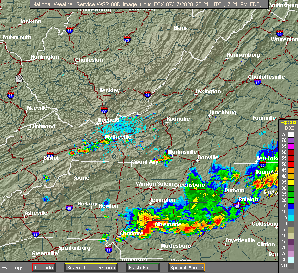 At 722 pm edt, a severe thunderstorm was located 9 miles northwest of albemarle, or 7 miles north of plyler, moving east at 5 mph (radar indicated). Hazards include 60 mph wind gusts and quarter size hail. Minor hail damage to vehicles is expected. expect wind damage to trees and power lines. Locations impacted include, gold hill, high rock lake and rockwell. At 722 pm edt, a severe thunderstorm was located 9 miles northwest of albemarle, or 7 miles north of plyler, moving east at 5 mph (radar indicated). Hazards include 60 mph wind gusts and quarter size hail. Minor hail damage to vehicles is expected. expect wind damage to trees and power lines. Locations impacted include, gold hill, high rock lake and rockwell.
|
| 7/17/2020 7:00 PM EDT |
 At 659 pm edt, a severe thunderstorm was located 11 miles northwest of albemarle, or 5 miles southeast of rockwell, moving east at 5 mph (radar indicated). Hazards include 60 mph wind gusts and quarter size hail. Minor hail damage to vehicles is expected. Expect wind damage to trees and power lines. At 659 pm edt, a severe thunderstorm was located 11 miles northwest of albemarle, or 5 miles southeast of rockwell, moving east at 5 mph (radar indicated). Hazards include 60 mph wind gusts and quarter size hail. Minor hail damage to vehicles is expected. Expect wind damage to trees and power lines.
|
| 7/17/2020 6:44 PM EDT |
 At 643 pm edt, a severe thunderstorm was located 8 miles south of salisbury, or near rockwell, moving east at 10 mph (radar indicated). Hazards include 60 mph wind gusts and quarter size hail. Minor hail damage to vehicles is expected. expect wind damage to trees and power lines. Locations impacted include, china grove, landis, enochville, granite quarry, faith and kannapolis. At 643 pm edt, a severe thunderstorm was located 8 miles south of salisbury, or near rockwell, moving east at 10 mph (radar indicated). Hazards include 60 mph wind gusts and quarter size hail. Minor hail damage to vehicles is expected. expect wind damage to trees and power lines. Locations impacted include, china grove, landis, enochville, granite quarry, faith and kannapolis.
|
| 7/17/2020 6:19 PM EDT |
 At 619 pm edt, a severe thunderstorm was located 6 miles northeast of kannapolis, or near china grove, moving east at 10 mph (radar indicated). Hazards include 60 mph wind gusts and quarter size hail. Minor hail damage to vehicles is expected. Expect wind damage to trees and power lines. At 619 pm edt, a severe thunderstorm was located 6 miles northeast of kannapolis, or near china grove, moving east at 10 mph (radar indicated). Hazards include 60 mph wind gusts and quarter size hail. Minor hail damage to vehicles is expected. Expect wind damage to trees and power lines.
|
| 7/10/2020 8:18 PM EDT |
 At 817 pm edt, a severe thunderstorm was located near salisbury, or near granite quarry, moving southeast at 25 mph (radar indicated). Hazards include 60 mph wind gusts and quarter size hail. Minor hail damage to vehicles is expected. expect wind damage to trees and power lines. Locations impacted include, salisbury, china grove, spencer, landis, granite quarry, rockwell, faith, high rock lake, gold hill and high rock. At 817 pm edt, a severe thunderstorm was located near salisbury, or near granite quarry, moving southeast at 25 mph (radar indicated). Hazards include 60 mph wind gusts and quarter size hail. Minor hail damage to vehicles is expected. expect wind damage to trees and power lines. Locations impacted include, salisbury, china grove, spencer, landis, granite quarry, rockwell, faith, high rock lake, gold hill and high rock.
|
| 7/10/2020 8:08 PM EDT |
 At 808 pm edt, a severe thunderstorm was located over salisbury, moving southeast at 25 mph (radar indicated). Hazards include 60 mph wind gusts and quarter size hail. Minor hail damage to vehicles is expected. Expect wind damage to trees and power lines. At 808 pm edt, a severe thunderstorm was located over salisbury, moving southeast at 25 mph (radar indicated). Hazards include 60 mph wind gusts and quarter size hail. Minor hail damage to vehicles is expected. Expect wind damage to trees and power lines.
|
| 6/22/2020 7:30 PM EDT |
 At 729 pm edt, severe thunderstorms were located along a line extending from 4 miles south of salisbury to 10 miles east of downtown concord to 14 miles north of monroe, moving east at 35 mph (radar indicated). Hazards include 60 mph wind gusts and penny size hail. Expect damage to trees and power lines. Locations impacted include, granite quarry, rockwell, mt pleasant, faith, midland, gold hill, high rock lake, china grove and downtown concord. At 729 pm edt, severe thunderstorms were located along a line extending from 4 miles south of salisbury to 10 miles east of downtown concord to 14 miles north of monroe, moving east at 35 mph (radar indicated). Hazards include 60 mph wind gusts and penny size hail. Expect damage to trees and power lines. Locations impacted include, granite quarry, rockwell, mt pleasant, faith, midland, gold hill, high rock lake, china grove and downtown concord.
|
| 6/22/2020 7:20 PM EDT |
 At 719 pm edt, severe thunderstorms were located along a line extending from 7 miles southwest of salisbury to 5 miles east of downtown concord to 14 miles east of uptown charlotte, moving east at 35 mph (radar indicated). Hazards include 60 mph wind gusts and penny size hail. Expect damage to trees and power lines. Locations impacted include, kannapolis, downtown concord, salisbury, west concord, mint hill, harrisburg, china grove, spencer, landis and enochville. At 719 pm edt, severe thunderstorms were located along a line extending from 7 miles southwest of salisbury to 5 miles east of downtown concord to 14 miles east of uptown charlotte, moving east at 35 mph (radar indicated). Hazards include 60 mph wind gusts and penny size hail. Expect damage to trees and power lines. Locations impacted include, kannapolis, downtown concord, salisbury, west concord, mint hill, harrisburg, china grove, spencer, landis and enochville.
|
| 6/22/2020 7:07 PM EDT |
 At 706 pm edt, severe thunderstorms were located along a line extending from 6 miles northwest of kannapolis to 3 miles southwest of downtown concord to 8 miles southeast of uptown charlotte, moving east at 35 mph (radar indicated). Hazards include 60 mph wind gusts and quarter size hail. Minor hail damage to vehicles is expected. expect wind damage to trees and power lines. Locations impacted include, kannapolis, downtown concord, salisbury, east charlotte, west concord, mint hill, harrisburg, china grove, spencer and landis. At 706 pm edt, severe thunderstorms were located along a line extending from 6 miles northwest of kannapolis to 3 miles southwest of downtown concord to 8 miles southeast of uptown charlotte, moving east at 35 mph (radar indicated). Hazards include 60 mph wind gusts and quarter size hail. Minor hail damage to vehicles is expected. expect wind damage to trees and power lines. Locations impacted include, kannapolis, downtown concord, salisbury, east charlotte, west concord, mint hill, harrisburg, china grove, spencer and landis.
|
| 6/22/2020 6:48 PM EDT |
 At 647 pm edt, severe thunderstorms were located along a line extending from 14 miles west of kannapolis to 5 miles south of huntersville to 6 miles southwest of uptown charlotte, moving east at 35 mph (radar indicated). Hazards include 60 mph wind gusts and quarter size hail. Minor hail damage to vehicles is expected. Expect wind damage to trees and power lines. At 647 pm edt, severe thunderstorms were located along a line extending from 14 miles west of kannapolis to 5 miles south of huntersville to 6 miles southwest of uptown charlotte, moving east at 35 mph (radar indicated). Hazards include 60 mph wind gusts and quarter size hail. Minor hail damage to vehicles is expected. Expect wind damage to trees and power lines.
|
| 5/28/2020 8:38 PM EDT |
 The severe thunderstorm warning for north central cabarrus and southwestern rowan counties will expire at 845 pm edt, the storm which prompted the warning has weakened below severe limits, and no longer poses an immediate threat to life or property. therefore the warning will be allowed to expire. however gusty winds and heavy rain are still possible with this thunderstorm. The severe thunderstorm warning for north central cabarrus and southwestern rowan counties will expire at 845 pm edt, the storm which prompted the warning has weakened below severe limits, and no longer poses an immediate threat to life or property. therefore the warning will be allowed to expire. however gusty winds and heavy rain are still possible with this thunderstorm.
|
| 5/28/2020 8:28 PM EDT |
 At 827 pm edt, a severe thunderstorm was located near kannapolis, moving north at 25 mph (radar indicated). Hazards include 60 mph wind gusts and quarter size hail. Minor hail damage to vehicles is expected. expect wind damage to trees and power lines. Locations impacted include, kannapolis, salisbury, china grove, landis, enochville, granite quarry, rockwell, faith, piedmont research station and downtown concord. At 827 pm edt, a severe thunderstorm was located near kannapolis, moving north at 25 mph (radar indicated). Hazards include 60 mph wind gusts and quarter size hail. Minor hail damage to vehicles is expected. expect wind damage to trees and power lines. Locations impacted include, kannapolis, salisbury, china grove, landis, enochville, granite quarry, rockwell, faith, piedmont research station and downtown concord.
|
| 5/28/2020 8:11 PM EDT |
 At 811 pm edt, a severe thunderstorm was located over downtown concord, moving north at 25 mph (radar indicated). Hazards include 60 mph wind gusts and quarter size hail. Minor hail damage to vehicles is expected. expect wind damage to trees and power lines. Locations impacted include, kannapolis, downtown concord, salisbury, west concord, china grove, landis, enochville, granite quarry, rockwell and mt pleasant. At 811 pm edt, a severe thunderstorm was located over downtown concord, moving north at 25 mph (radar indicated). Hazards include 60 mph wind gusts and quarter size hail. Minor hail damage to vehicles is expected. expect wind damage to trees and power lines. Locations impacted include, kannapolis, downtown concord, salisbury, west concord, china grove, landis, enochville, granite quarry, rockwell and mt pleasant.
|
| 5/28/2020 7:55 PM EDT |
 At 755 pm edt, a severe thunderstorm was located 5 miles south of downtown concord, or near harrisburg, moving north at 25 mph (radar indicated). Hazards include 60 mph wind gusts and quarter size hail. Minor hail damage to vehicles is expected. Expect wind damage to trees and power lines. At 755 pm edt, a severe thunderstorm was located 5 miles south of downtown concord, or near harrisburg, moving north at 25 mph (radar indicated). Hazards include 60 mph wind gusts and quarter size hail. Minor hail damage to vehicles is expected. Expect wind damage to trees and power lines.
|
| 4/25/2020 10:27 PM EDT |
 At 1026 pm edt, a severe thunderstorm was located 7 miles east of downtown concord, or near mt pleasant, moving east at 45 mph (radar indicated). Hazards include 60 mph wind gusts and quarter size hail. Minor hail damage to vehicles is expected. Expect wind damage to trees and power lines. At 1026 pm edt, a severe thunderstorm was located 7 miles east of downtown concord, or near mt pleasant, moving east at 45 mph (radar indicated). Hazards include 60 mph wind gusts and quarter size hail. Minor hail damage to vehicles is expected. Expect wind damage to trees and power lines.
|
| 4/13/2020 5:51 AM EDT |
 The severe thunderstorm warning for cabarrus, central davie, mecklenburg, rowan, union, chester and southeastern york counties will expire at 600 am edt, the storms which prompted the warning have moved out of the area. therefore the warning will be allowed to expire. a tornado watch remains in effect until 800 am edt for the piedmont of north carolina, and upstate south carolina. if you observed large hail or wind damage, please report it to the national weather service greenville-spartanburg by calling toll free, 1, 800, 2 6 7, 8 1 0 1, or by posting on our facebook page, or tweet it using hashtag nwsgsp. your message should describe the event and the specific location where it occurred. remember, a severe thunderstorm warning still remains in effect for central and eastern union county in north carolina until 630 am edt. The severe thunderstorm warning for cabarrus, central davie, mecklenburg, rowan, union, chester and southeastern york counties will expire at 600 am edt, the storms which prompted the warning have moved out of the area. therefore the warning will be allowed to expire. a tornado watch remains in effect until 800 am edt for the piedmont of north carolina, and upstate south carolina. if you observed large hail or wind damage, please report it to the national weather service greenville-spartanburg by calling toll free, 1, 800, 2 6 7, 8 1 0 1, or by posting on our facebook page, or tweet it using hashtag nwsgsp. your message should describe the event and the specific location where it occurred. remember, a severe thunderstorm warning still remains in effect for central and eastern union county in north carolina until 630 am edt.
|
| 4/13/2020 5:35 AM EDT | Trees and powerlines down along stokes ferry roa in rowan county NC, 4.2 miles WSW of Rockwell, NC |
| 4/13/2020 5:30 AM EDT | Broadcast media reported trees and power lines down at sides rd and upper palmer rd in rowan county NC, 0.6 miles SW of Rockwell, NC |
| 4/13/2020 5:10 AM EDT |
 At 509 am edt, severe thunderstorms were located along a line extending from 5 miles east of mocksville to 9 miles southeast of chester, moving northeast at 60 mph (radar indicated). Hazards include 60 mph wind gusts. expect damage to trees and power lines At 509 am edt, severe thunderstorms were located along a line extending from 5 miles east of mocksville to 9 miles southeast of chester, moving northeast at 60 mph (radar indicated). Hazards include 60 mph wind gusts. expect damage to trees and power lines
|
| 2/6/2020 12:32 PM EST | Em reported roof blown off a structure... with additional damage to homes and outbuildings along phaniels church rd. possible tornad in cabarrus county NC, 5.9 miles NE of Rockwell, NC |
| 2/6/2020 11:57 AM EST |
 At 1156 am est, a confirmed tornado was located 13 miles southeast of salisbury, or 4 miles southeast of rockwell, moving northeast at 35 mph (emergency management confirmed tornado). Hazards include damaging tornado. Flying debris will be dangerous to those caught without shelter. mobile homes will be damaged or destroyed. damage to roofs, windows, and vehicles will occur. tree damage is likely. Locations impacted include, high rock, gold hill and rockwell. At 1156 am est, a confirmed tornado was located 13 miles southeast of salisbury, or 4 miles southeast of rockwell, moving northeast at 35 mph (emergency management confirmed tornado). Hazards include damaging tornado. Flying debris will be dangerous to those caught without shelter. mobile homes will be damaged or destroyed. damage to roofs, windows, and vehicles will occur. tree damage is likely. Locations impacted include, high rock, gold hill and rockwell.
|
| 2/6/2020 11:53 AM EST |
 At 1153 am est, a severe thunderstorm capable of producing a tornado was located 12 miles southeast of salisbury, or near rockwell, moving east at 50 mph (radar indicated rotation). Hazards include tornado. Flying debris will be dangerous to those caught without shelter. mobile homes will be damaged or destroyed. damage to roofs, windows, and vehicles will occur. tree damage is likely. This dangerous storm will remain over mainly rural areas of northeastern cabarrus and southeastern rowan counties, including the following locations, gold hill. At 1153 am est, a severe thunderstorm capable of producing a tornado was located 12 miles southeast of salisbury, or near rockwell, moving east at 50 mph (radar indicated rotation). Hazards include tornado. Flying debris will be dangerous to those caught without shelter. mobile homes will be damaged or destroyed. damage to roofs, windows, and vehicles will occur. tree damage is likely. This dangerous storm will remain over mainly rural areas of northeastern cabarrus and southeastern rowan counties, including the following locations, gold hill.
|
| 2/6/2020 11:43 AM EST |
 At 1143 am est, a severe thunderstorm capable of producing a tornado was located near kannapolis, moving northeast at 35 mph (radar indicated rotation). Hazards include tornado. Flying debris will be dangerous to those caught without shelter. mobile homes will be damaged or destroyed. damage to roofs, windows, and vehicles will occur. tree damage is likely. this dangerous storm will be near, rockwell and faith around 1200 pm est. Other locations impacted by this dangerous thunderstorm include gold hill. At 1143 am est, a severe thunderstorm capable of producing a tornado was located near kannapolis, moving northeast at 35 mph (radar indicated rotation). Hazards include tornado. Flying debris will be dangerous to those caught without shelter. mobile homes will be damaged or destroyed. damage to roofs, windows, and vehicles will occur. tree damage is likely. this dangerous storm will be near, rockwell and faith around 1200 pm est. Other locations impacted by this dangerous thunderstorm include gold hill.
|
| 1/11/2020 10:39 PM EST | Tree on a house on red bird lan in rowan county NC, 0.3 miles NNE of Rockwell, NC |
| 1/11/2020 10:19 PM EST |
 At 1019 pm est, severe thunderstorms were located along a line extending from 11 miles west of winston-salem to 9 miles east of uptown charlotte, moving northeast at 40 mph (radar indicated). Hazards include 60 mph wind gusts. expect damage to trees and power lines At 1019 pm est, severe thunderstorms were located along a line extending from 11 miles west of winston-salem to 9 miles east of uptown charlotte, moving northeast at 40 mph (radar indicated). Hazards include 60 mph wind gusts. expect damage to trees and power lines
|
| 10/31/2019 6:17 PM EDT |
 At 616 pm edt, severe thunderstorms were located along a line extending from 5 miles southeast of downtown concord to 10 miles northeast of lancaster, moving northeast at 45 mph (radar indicated). Hazards include 60 mph wind gusts. Expect damage to trees and power lines. locations impacted include, monroe, unionville, wesley chapel, wingate, waxhaw, marshville, lake park, mineral springs, rockwell and hemby bridge. A tornado watch remains in effect until 1100 pm edt for the piedmont of north carolina. At 616 pm edt, severe thunderstorms were located along a line extending from 5 miles southeast of downtown concord to 10 miles northeast of lancaster, moving northeast at 45 mph (radar indicated). Hazards include 60 mph wind gusts. Expect damage to trees and power lines. locations impacted include, monroe, unionville, wesley chapel, wingate, waxhaw, marshville, lake park, mineral springs, rockwell and hemby bridge. A tornado watch remains in effect until 1100 pm edt for the piedmont of north carolina.
|
| 10/31/2019 5:53 PM EDT |
 At 553 pm edt, severe thunderstorms were located along a line extending from 6 miles southeast of uptown charlotte to 7 miles north of lancaster, moving northeast at 55 mph (radar indicated). Hazards include 60 mph wind gusts. expect damage to trees and power lines At 553 pm edt, severe thunderstorms were located along a line extending from 6 miles southeast of uptown charlotte to 7 miles north of lancaster, moving northeast at 55 mph (radar indicated). Hazards include 60 mph wind gusts. expect damage to trees and power lines
|
| 10/31/2019 5:35 PM EDT |
 At 534 pm edt, severe thunderstorms were located along a line extending from 6 miles south of mocksville to 8 miles northeast of uptown charlotte to 7 miles north of indian land, moving northeast at 50 mph (radar indicated). Hazards include 60 mph wind gusts. expect damage to trees and power lines At 534 pm edt, severe thunderstorms were located along a line extending from 6 miles south of mocksville to 8 miles northeast of uptown charlotte to 7 miles north of indian land, moving northeast at 50 mph (radar indicated). Hazards include 60 mph wind gusts. expect damage to trees and power lines
|
| 8/21/2019 6:13 PM EDT |
 At 612 pm edt, a severe thunderstorm was located 4 miles west of kannapolis, or near enochville, moving east at 20 mph (radar indicated). Hazards include 60 mph wind gusts. Expect damage to trees and power lines. Locations impacted include, kannapolis, concord, china grove, landis, enochville, rockwell, mt pleasant, gold hill, and coddle creek reservoir. At 612 pm edt, a severe thunderstorm was located 4 miles west of kannapolis, or near enochville, moving east at 20 mph (radar indicated). Hazards include 60 mph wind gusts. Expect damage to trees and power lines. Locations impacted include, kannapolis, concord, china grove, landis, enochville, rockwell, mt pleasant, gold hill, and coddle creek reservoir.
|
| 8/21/2019 5:47 PM EDT |
 At 546 pm edt, a severe thunderstorm was located 11 miles northwest of kannapolis, or near mooresville, moving east at 25 mph (radar indicated). Hazards include 60 mph wind gusts and penny size hail. expect damage to trees and power lines At 546 pm edt, a severe thunderstorm was located 11 miles northwest of kannapolis, or near mooresville, moving east at 25 mph (radar indicated). Hazards include 60 mph wind gusts and penny size hail. expect damage to trees and power lines
|
| 7/4/2019 2:43 PM EDT |
 At 242 pm edt, severe thunderstorms were located along a line extending from 13 miles northwest of badin lake to 11 miles south of salisbury, moving northeast at 10 mph (radar indicated). Hazards include 60 mph wind gusts and nickel size hail. Expect damage to trees and power lines. Locations impacted include, rockwell, gold hill, high rock, mt pleasant, concord and high rock lake. At 242 pm edt, severe thunderstorms were located along a line extending from 13 miles northwest of badin lake to 11 miles south of salisbury, moving northeast at 10 mph (radar indicated). Hazards include 60 mph wind gusts and nickel size hail. Expect damage to trees and power lines. Locations impacted include, rockwell, gold hill, high rock, mt pleasant, concord and high rock lake.
|
| 7/4/2019 2:27 PM EDT | 911 call center reported trees down on old beatty ford rd at intersections with rockwell rd and d earnhardt rd. time estimated by rada in rowan county NC, 2.4 miles NNW of Rockwell, NC |
| 7/4/2019 2:16 PM EDT |
 At 216 pm edt, severe thunderstorms were located along a line extending from 13 miles northwest of badin lake to 9 miles northeast of downtown concord, moving east at 20 mph (radar indicated). Hazards include 60 mph wind gusts and nickel size hail. expect damage to trees and power lines At 216 pm edt, severe thunderstorms were located along a line extending from 13 miles northwest of badin lake to 9 miles northeast of downtown concord, moving east at 20 mph (radar indicated). Hazards include 60 mph wind gusts and nickel size hail. expect damage to trees and power lines
|
| 6/24/2019 10:03 PM EDT |
 At 1003 pm edt, severe thunderstorms were located along a line extending from 12 miles southwest of winston-salem to 5 miles southeast of mocksville to 12 miles south of lexington to near downtown concord to 16 miles southwest of albemarle to 11 miles southwest of monroe to 13 miles south of lancaster, moving east at 40 mph (radar indicated). Hazards include 60 mph wind gusts. Expect damage to trees and power lines. Locations impacted include, rock hill, kannapolis, downtown concord, monroe, salisbury, mocksville, central charlotte, south charlotte, southwest charlotte and east charlotte. At 1003 pm edt, severe thunderstorms were located along a line extending from 12 miles southwest of winston-salem to 5 miles southeast of mocksville to 12 miles south of lexington to near downtown concord to 16 miles southwest of albemarle to 11 miles southwest of monroe to 13 miles south of lancaster, moving east at 40 mph (radar indicated). Hazards include 60 mph wind gusts. Expect damage to trees and power lines. Locations impacted include, rock hill, kannapolis, downtown concord, monroe, salisbury, mocksville, central charlotte, south charlotte, southwest charlotte and east charlotte.
|
| 6/24/2019 9:48 PM EDT |
 At 948 pm edt, severe thunderstorms were located along a line extending from 7 miles south of yadkinville to 7 miles southwest of mocksville to 4 miles east of salisbury to 6 miles east of huntersville to 14 miles north of monroe to 8 miles south of indian land to 14 miles southwest of lancaster, moving east at 25 mph (radar indicated). Hazards include 60 mph wind gusts. Expect damage to trees and power lines. Locations impacted include, rock hill, uptown charlotte, huntersville, kannapolis, downtown concord, monroe, salisbury, chester, mocksville and central charlotte. At 948 pm edt, severe thunderstorms were located along a line extending from 7 miles south of yadkinville to 7 miles southwest of mocksville to 4 miles east of salisbury to 6 miles east of huntersville to 14 miles north of monroe to 8 miles south of indian land to 14 miles southwest of lancaster, moving east at 25 mph (radar indicated). Hazards include 60 mph wind gusts. Expect damage to trees and power lines. Locations impacted include, rock hill, uptown charlotte, huntersville, kannapolis, downtown concord, monroe, salisbury, chester, mocksville and central charlotte.
|
| 6/24/2019 9:27 PM EDT |
 At 927 pm edt, severe thunderstorms were located along a line extending from 6 miles south of yadkinville to 4 miles north of statesville to 8 miles north of kannapolis to near huntersville to 7 miles northeast of indian land to 4 miles southwest of rock hill to 11 miles north of winnsboro, moving east at 40 mph (radar indicated). Hazards include 70 mph wind gusts. Expect considerable tree damage. Damage is likely to mobile homes, roofs, and outbuildings. At 927 pm edt, severe thunderstorms were located along a line extending from 6 miles south of yadkinville to 4 miles north of statesville to 8 miles north of kannapolis to near huntersville to 7 miles northeast of indian land to 4 miles southwest of rock hill to 11 miles north of winnsboro, moving east at 40 mph (radar indicated). Hazards include 70 mph wind gusts. Expect considerable tree damage. Damage is likely to mobile homes, roofs, and outbuildings.
|
| 6/20/2019 5:13 PM EDT |
 The severe thunderstorm warning for cabarrus, central mecklenburg and southeastern rowan counties will expire at 515 pm edt, the storms which prompted the warning have weakened below severe limits, and no longer pose an immediate threat to life or property. therefore the warning will be allowed to expire. however gusty winds and heavy rain are still possible with these thunderstorms. a severe thunderstorm watch remains in effect until 1000 pm edt for the piedmont of north carolina. if you observed large hail or wind damage, please report it to the national weather service greenville-spartanburg by calling toll free, 1, 800, 2 6 7, 8 1 0 1, or by posting on our facebook page, or tweet it using hashtag nwsgsp. your message should describe the event and the specific location where it occurred. The severe thunderstorm warning for cabarrus, central mecklenburg and southeastern rowan counties will expire at 515 pm edt, the storms which prompted the warning have weakened below severe limits, and no longer pose an immediate threat to life or property. therefore the warning will be allowed to expire. however gusty winds and heavy rain are still possible with these thunderstorms. a severe thunderstorm watch remains in effect until 1000 pm edt for the piedmont of north carolina. if you observed large hail or wind damage, please report it to the national weather service greenville-spartanburg by calling toll free, 1, 800, 2 6 7, 8 1 0 1, or by posting on our facebook page, or tweet it using hashtag nwsgsp. your message should describe the event and the specific location where it occurred.
|
| 6/20/2019 5:01 PM EDT |
 At 500 pm edt, severe thunderstorms were located along a line extending from 12 miles northwest of badin lake to 3 miles southwest of uptown charlotte, moving east at 40 mph (radar indicated). Hazards include 60 mph wind gusts. Expect damage to trees and power lines. Locations impacted include, uptown charlotte, downtown concord, central charlotte, east charlotte, harrisburg, rockwell, mt pleasant, freedom park, university city and reedy creek park. At 500 pm edt, severe thunderstorms were located along a line extending from 12 miles northwest of badin lake to 3 miles southwest of uptown charlotte, moving east at 40 mph (radar indicated). Hazards include 60 mph wind gusts. Expect damage to trees and power lines. Locations impacted include, uptown charlotte, downtown concord, central charlotte, east charlotte, harrisburg, rockwell, mt pleasant, freedom park, university city and reedy creek park.
|
| 6/20/2019 4:43 PM EDT |
 At 443 pm edt, severe thunderstorms were located along a line extending from 8 miles south of salisbury to 6 miles west of uptown charlotte, moving east at 40 mph (radar indicated). Hazards include 60 mph wind gusts. expect damage to trees and power lines At 443 pm edt, severe thunderstorms were located along a line extending from 8 miles south of salisbury to 6 miles west of uptown charlotte, moving east at 40 mph (radar indicated). Hazards include 60 mph wind gusts. expect damage to trees and power lines
|
| 6/20/2019 3:45 PM EDT |
 At 345 pm edt, a severe thunderstorm was located 7 miles southwest of salisbury, or near china grove, moving east at 35 mph (radar indicated). Hazards include 60 mph wind gusts and quarter size hail. Minor hail damage to vehicles is expected. Expect wind damage to trees and power lines. At 345 pm edt, a severe thunderstorm was located 7 miles southwest of salisbury, or near china grove, moving east at 35 mph (radar indicated). Hazards include 60 mph wind gusts and quarter size hail. Minor hail damage to vehicles is expected. Expect wind damage to trees and power lines.
|
| 5/31/2019 5:22 PM EDT |
 At 521 pm edt, a severe thunderstorm capable of producing a tornado was located near kannapolis, moving east at 35 mph (radar indicated rotation). Hazards include tornado. Flying debris will be dangerous to those caught without shelter. mobile homes will be damaged or destroyed. damage to roofs, windows, and vehicles will occur. tree damage is likely. this dangerous storm will be near, rockwell around 540 pm edt. Other locations impacted by this dangerous thunderstorm include gold hill. At 521 pm edt, a severe thunderstorm capable of producing a tornado was located near kannapolis, moving east at 35 mph (radar indicated rotation). Hazards include tornado. Flying debris will be dangerous to those caught without shelter. mobile homes will be damaged or destroyed. damage to roofs, windows, and vehicles will occur. tree damage is likely. this dangerous storm will be near, rockwell around 540 pm edt. Other locations impacted by this dangerous thunderstorm include gold hill.
|
| 5/4/2019 4:33 PM EDT |
 At 433 pm edt, a severe thunderstorm was located 10 miles northeast of downtown concord, or 5 miles north of mt pleasant, moving east at 25 mph (radar indicated). Hazards include golf ball size hail and 60 mph wind gusts. People and animals outdoors will be injured. expect hail damage to roofs, siding, windows, and vehicles. expect wind damage to trees and power lines. Locations impacted include, rockwell, mt pleasant and gold hill. At 433 pm edt, a severe thunderstorm was located 10 miles northeast of downtown concord, or 5 miles north of mt pleasant, moving east at 25 mph (radar indicated). Hazards include golf ball size hail and 60 mph wind gusts. People and animals outdoors will be injured. expect hail damage to roofs, siding, windows, and vehicles. expect wind damage to trees and power lines. Locations impacted include, rockwell, mt pleasant and gold hill.
|
| 5/4/2019 3:58 PM EDT |
 At 358 pm edt, a severe thunderstorm was located near kannapolis, or near coddle creek reservoir, moving east at 25 mph (radar indicated). Hazards include golf ball size hail and 60 mph wind gusts. People and animals outdoors will be injured. expect hail damage to roofs, siding, windows, and vehicles. expect wind damage to trees and power lines. Locations impacted include, kannapolis, downtown concord, landis, enochville, rockwell, mt pleasant, coddle creek reservoir, gold hill, faith and west concord. At 358 pm edt, a severe thunderstorm was located near kannapolis, or near coddle creek reservoir, moving east at 25 mph (radar indicated). Hazards include golf ball size hail and 60 mph wind gusts. People and animals outdoors will be injured. expect hail damage to roofs, siding, windows, and vehicles. expect wind damage to trees and power lines. Locations impacted include, kannapolis, downtown concord, landis, enochville, rockwell, mt pleasant, coddle creek reservoir, gold hill, faith and west concord.
|
| 5/4/2019 3:50 PM EDT |
 At 350 pm edt, a severe thunderstorm was located 6 miles west of kannapolis, or near coddle creek reservoir, moving east at 25 mph (radar indicated). Hazards include 60 mph wind gusts and half dollar size hail. Minor hail damage to vehicles is expected. Expect wind damage to trees and power lines. At 350 pm edt, a severe thunderstorm was located 6 miles west of kannapolis, or near coddle creek reservoir, moving east at 25 mph (radar indicated). Hazards include 60 mph wind gusts and half dollar size hail. Minor hail damage to vehicles is expected. Expect wind damage to trees and power lines.
|
| 4/8/2019 4:24 PM EDT |
 At 424 pm edt, a severe thunderstorm was located 7 miles northwest of kannapolis, or 4 miles northwest of enochville, moving northeast at 45 mph (radar indicated). Hazards include 60 mph wind gusts and quarter size hail. Minor hail damage to vehicles is expected. expect wind damage to trees and power lines. Locations impacted include, kannapolis, downtown concord, west concord, cornelius, mooresville, davidson, china grove, landis, enochville and rockwell. At 424 pm edt, a severe thunderstorm was located 7 miles northwest of kannapolis, or 4 miles northwest of enochville, moving northeast at 45 mph (radar indicated). Hazards include 60 mph wind gusts and quarter size hail. Minor hail damage to vehicles is expected. expect wind damage to trees and power lines. Locations impacted include, kannapolis, downtown concord, west concord, cornelius, mooresville, davidson, china grove, landis, enochville and rockwell.
|
| 4/8/2019 4:16 PM EDT |
 At 416 pm edt, a severe thunderstorm was located 5 miles northeast of huntersville, or near davidson, moving northeast at 45 mph (radar indicated). Hazards include 60 mph wind gusts and quarter size hail. Minor hail damage to vehicles is expected. expect wind damage to trees and power lines. Locations impacted include, huntersville, kannapolis, downtown concord, northeast charlotte, west concord, cornelius, mooresville, davidson, china grove and landis. At 416 pm edt, a severe thunderstorm was located 5 miles northeast of huntersville, or near davidson, moving northeast at 45 mph (radar indicated). Hazards include 60 mph wind gusts and quarter size hail. Minor hail damage to vehicles is expected. expect wind damage to trees and power lines. Locations impacted include, huntersville, kannapolis, downtown concord, northeast charlotte, west concord, cornelius, mooresville, davidson, china grove and landis.
|
| 4/8/2019 4:05 PM EDT |
 At 404 pm edt, a severe thunderstorm was located near huntersville, moving northeast at 45 mph (radar indicated). Hazards include 60 mph wind gusts and quarter size hail. Minor hail damage to vehicles is expected. Expect wind damage to trees and power lines. At 404 pm edt, a severe thunderstorm was located near huntersville, moving northeast at 45 mph (radar indicated). Hazards include 60 mph wind gusts and quarter size hail. Minor hail damage to vehicles is expected. Expect wind damage to trees and power lines.
|
| 9/27/2018 9:54 PM EDT | A couple of trees and powerlines down in rockwel in rowan county NC, 0.3 miles NNE of Rockwell, NC |
| 9/27/2018 9:50 PM EDT |
 At 949 pm edt, severe thunderstorms were located along a line extending from near salisbury to 9 miles southeast of downtown concord to 5 miles southwest of monroe, moving northeast at 45 mph (law enforcement reported widespread tree damage as these storms crossed the north carolina piedmont). Hazards include 60 mph wind gusts. Expect damage to trees and power lines. Locations impacted include, monroe, salisbury, unionville, wingate, spencer, marshville, granite quarry, rockwell, mt pleasant and faith. At 949 pm edt, severe thunderstorms were located along a line extending from near salisbury to 9 miles southeast of downtown concord to 5 miles southwest of monroe, moving northeast at 45 mph (law enforcement reported widespread tree damage as these storms crossed the north carolina piedmont). Hazards include 60 mph wind gusts. Expect damage to trees and power lines. Locations impacted include, monroe, salisbury, unionville, wingate, spencer, marshville, granite quarry, rockwell, mt pleasant and faith.
|
| 9/27/2018 9:27 PM EDT |
 At 925 pm edt, severe thunderstorms were located along a line extending from 9 miles north of kannapolis to 7 miles northwest of lancaster, moving east at 40 mph (law enforcement reported widespread wind damage as this line of storms moved through the western parts of the charlotte metropolitan area). Hazards include 60 mph wind gusts. expect damage to trees and power lines At 925 pm edt, severe thunderstorms were located along a line extending from 9 miles north of kannapolis to 7 miles northwest of lancaster, moving east at 40 mph (law enforcement reported widespread wind damage as this line of storms moved through the western parts of the charlotte metropolitan area). Hazards include 60 mph wind gusts. expect damage to trees and power lines
|
| 8/30/2018 10:45 PM EDT |
 At 1044 pm edt, a severe thunderstorm was located 6 miles north of salisbury, or 4 miles southeast of cooleemee, moving northeast at 15 mph. another strong thunderstorm was located near faith, also moving northeast at 10 mph (radar indicated). Hazards include 60 mph wind gusts and quarter size hail. Minor hail damage to vehicles is expected. expect wind damage to trees and power lines. Locations impacted include, salisbury, china grove, spencer, granite quarry, rockwell, cooleemee, cleveland, faith, gold hill and piedmont research station. At 1044 pm edt, a severe thunderstorm was located 6 miles north of salisbury, or 4 miles southeast of cooleemee, moving northeast at 15 mph. another strong thunderstorm was located near faith, also moving northeast at 10 mph (radar indicated). Hazards include 60 mph wind gusts and quarter size hail. Minor hail damage to vehicles is expected. expect wind damage to trees and power lines. Locations impacted include, salisbury, china grove, spencer, granite quarry, rockwell, cooleemee, cleveland, faith, gold hill and piedmont research station.
|
| 8/30/2018 10:30 PM EDT |
 At 1029 pm edt, a severe thunderstorm was located 4 miles northwest of salisbury, moving northeast at 10 mph. other thunderstorms within the warned area near rockwell may also become severe (radar indicated). Hazards include 60 mph wind gusts and quarter size hail. Minor hail damage to vehicles is expected. Expect wind damage to trees and power lines. At 1029 pm edt, a severe thunderstorm was located 4 miles northwest of salisbury, moving northeast at 10 mph. other thunderstorms within the warned area near rockwell may also become severe (radar indicated). Hazards include 60 mph wind gusts and quarter size hail. Minor hail damage to vehicles is expected. Expect wind damage to trees and power lines.
|
| 8/12/2018 6:44 PM EDT | At least 2 trees down and several large branches in and near rockwel in rowan county NC, 0.3 miles NNE of Rockwell, NC |
| 8/12/2018 6:41 PM EDT |
 At 641 pm edt, a severe thunderstorm was located 11 miles southeast of salisbury, or 4 miles east of rockwell, moving northeast at 25 mph (radar indicated). Hazards include 60 mph wind gusts and quarter size hail. Minor hail damage to vehicles is expected. Expect wind damage to trees and power lines. At 641 pm edt, a severe thunderstorm was located 11 miles southeast of salisbury, or 4 miles east of rockwell, moving northeast at 25 mph (radar indicated). Hazards include 60 mph wind gusts and quarter size hail. Minor hail damage to vehicles is expected. Expect wind damage to trees and power lines.
|
| 8/8/2018 6:57 PM EDT |
 A severe thunderstorm warning remains in effect until 715 pm edt for eastern cabarrus and southeastern rowan counties. At 656 pm edt, severe thunderstorms were located along a line extending from 4 miles east of salisbury to 11 miles northwest of albemarle to 15 miles southeast of downtown concord, moving east at 35 mph. A severe thunderstorm warning remains in effect until 715 pm edt for eastern cabarrus and southeastern rowan counties. At 656 pm edt, severe thunderstorms were located along a line extending from 4 miles east of salisbury to 11 miles northwest of albemarle to 15 miles southeast of downtown concord, moving east at 35 mph.
|
| 8/8/2018 6:30 PM EDT |
 At 629 pm edt, severe thunderstorms were located along a line extending from 12 miles southeast of statesville to 3 miles southwest of kannapolis to 6 miles east of uptown charlotte, moving east at 45 mph (radar indicated). Hazards include 60 mph wind gusts and penny size hail. expect damage to trees and power lines At 629 pm edt, severe thunderstorms were located along a line extending from 12 miles southeast of statesville to 3 miles southwest of kannapolis to 6 miles east of uptown charlotte, moving east at 45 mph (radar indicated). Hazards include 60 mph wind gusts and penny size hail. expect damage to trees and power lines
|
| 7/22/2018 7:44 PM EDT |
 At 744 pm edt, a severe thunderstorm was located 11 miles southeast of salisbury, or near rockwell, moving northeast at 20 mph (radar indicated). Hazards include 60 mph wind gusts and quarter size hail. Minor hail damage to vehicles is expected. expect wind damage to trees and power lines. Locations impacted include, rockwell and gold hill. At 744 pm edt, a severe thunderstorm was located 11 miles southeast of salisbury, or near rockwell, moving northeast at 20 mph (radar indicated). Hazards include 60 mph wind gusts and quarter size hail. Minor hail damage to vehicles is expected. expect wind damage to trees and power lines. Locations impacted include, rockwell and gold hill.
|
| 7/22/2018 7:30 PM EDT |
 At 730 pm edt, a severe thunderstorm was located near downtown concord, moving northeast at 15 mph (radar indicated). Hazards include 60 mph wind gusts and quarter size hail. Minor hail damage to vehicles is expected. expect wind damage to trees and power lines. Locations impacted include, kannapolis, downtown concord, china grove, landis, rockwell, mt pleasant, gold hill, faith and enochville. At 730 pm edt, a severe thunderstorm was located near downtown concord, moving northeast at 15 mph (radar indicated). Hazards include 60 mph wind gusts and quarter size hail. Minor hail damage to vehicles is expected. expect wind damage to trees and power lines. Locations impacted include, kannapolis, downtown concord, china grove, landis, rockwell, mt pleasant, gold hill, faith and enochville.
|
| 7/22/2018 7:25 PM EDT | 911 call center reported a tree and power lines down on a car on us hwy 52 in rockwell. time estimated from rada in rowan county NC, 0.3 miles NNE of Rockwell, NC |
| 7/22/2018 7:11 PM EDT |
 The national weather service in greenville-spartanburg has issued a * severe thunderstorm warning for. northern cabarrus county in the piedmont of north carolina. south central rowan county in the piedmont of north carolina. until 800 pm edt. At 711 pm edt, a severe thunderstorm was located near downtown. The national weather service in greenville-spartanburg has issued a * severe thunderstorm warning for. northern cabarrus county in the piedmont of north carolina. south central rowan county in the piedmont of north carolina. until 800 pm edt. At 711 pm edt, a severe thunderstorm was located near downtown.
|
| 6/25/2018 7:00 PM EDT |
 At 700 pm edt, severe thunderstorms were located along a line extending from 8 miles south of winston-salem to 5 miles southwest of kannapolis, moving east at 30 mph (radar indicated). Hazards include 60 mph wind gusts and quarter size hail. Minor hail damage to vehicles is expected. expect wind damage to trees and power lines. Locations impacted include, kannapolis, downtown concord, salisbury, mocksville, west concord, china grove, spencer, landis, enochville and granite quarry. At 700 pm edt, severe thunderstorms were located along a line extending from 8 miles south of winston-salem to 5 miles southwest of kannapolis, moving east at 30 mph (radar indicated). Hazards include 60 mph wind gusts and quarter size hail. Minor hail damage to vehicles is expected. expect wind damage to trees and power lines. Locations impacted include, kannapolis, downtown concord, salisbury, mocksville, west concord, china grove, spencer, landis, enochville and granite quarry.
|
| 6/25/2018 6:43 PM EDT |
 At 643 pm edt, severe thunderstorms were located along a line extending from 9 miles northeast of mocksville to 3 miles northeast of huntersville, moving east at 30 mph (radar indicated). Hazards include 60 mph wind gusts and quarter size hail. Minor hail damage to vehicles is expected. Expect wind damage to trees and power lines. At 643 pm edt, severe thunderstorms were located along a line extending from 9 miles northeast of mocksville to 3 miles northeast of huntersville, moving east at 30 mph (radar indicated). Hazards include 60 mph wind gusts and quarter size hail. Minor hail damage to vehicles is expected. Expect wind damage to trees and power lines.
|
| 6/11/2018 6:40 PM EDT |
 At 640 pm edt, a severe thunderstorm was located near salisbury, moving south at 25 mph (radar indicated). Hazards include 60 mph wind gusts and quarter size hail. Minor hail damage to vehicles is expected. expect wind damage to trees and power lines. Locations impacted include, salisbury, china grove, spencer, landis, enochville, granite quarry, rockwell, faith, piedmont research station and woodleaf. At 640 pm edt, a severe thunderstorm was located near salisbury, moving south at 25 mph (radar indicated). Hazards include 60 mph wind gusts and quarter size hail. Minor hail damage to vehicles is expected. expect wind damage to trees and power lines. Locations impacted include, salisbury, china grove, spencer, landis, enochville, granite quarry, rockwell, faith, piedmont research station and woodleaf.
|
| 6/11/2018 6:12 PM EDT |
 At 612 pm edt, a severe thunderstorm was located 7 miles south of mocksville, or near cooleemee, moving south at 25 mph (radar indicated). Hazards include 60 mph wind gusts and quarter size hail. Minor hail damage to vehicles is expected. Expect wind damage to trees and power lines. At 612 pm edt, a severe thunderstorm was located 7 miles south of mocksville, or near cooleemee, moving south at 25 mph (radar indicated). Hazards include 60 mph wind gusts and quarter size hail. Minor hail damage to vehicles is expected. Expect wind damage to trees and power lines.
|
| 6/3/2018 8:53 PM EDT |
 At 853 pm edt, a severe thunderstorm was located 12 miles east of downtown concord, or 4 miles northeast of mt pleasant, moving southeast at 30 mph (radar indicated). Hazards include 60 mph wind gusts and quarter size hail. Minor hail damage to vehicles is expected. expect wind damage to trees and power lines. Locations impacted include, kannapolis, downtown concord, salisbury, west concord, china grove, landis, enochville, granite quarry, rockwell and mt pleasant. At 853 pm edt, a severe thunderstorm was located 12 miles east of downtown concord, or 4 miles northeast of mt pleasant, moving southeast at 30 mph (radar indicated). Hazards include 60 mph wind gusts and quarter size hail. Minor hail damage to vehicles is expected. expect wind damage to trees and power lines. Locations impacted include, kannapolis, downtown concord, salisbury, west concord, china grove, landis, enochville, granite quarry, rockwell and mt pleasant.
|
| 6/3/2018 8:42 PM EDT | Report of trees down with one on a house on crestor rd in rockwel in rowan county NC, 1.8 miles E of Rockwell, NC |
| 6/3/2018 8:39 PM EDT |
 At 839 pm edt, a severe thunderstorm was located 7 miles south of salisbury, or near faith, moving southeast at 30 mph (radar indicated). Hazards include 60 mph wind gusts and quarter size hail. Minor hail damage to vehicles is expected. expect wind damage to trees and power lines. Locations impacted include, kannapolis, downtown concord, salisbury, west concord, mooresville, davidson, harrisburg, china grove, landis and enochville. At 839 pm edt, a severe thunderstorm was located 7 miles south of salisbury, or near faith, moving southeast at 30 mph (radar indicated). Hazards include 60 mph wind gusts and quarter size hail. Minor hail damage to vehicles is expected. expect wind damage to trees and power lines. Locations impacted include, kannapolis, downtown concord, salisbury, west concord, mooresville, davidson, harrisburg, china grove, landis and enochville.
|
| 6/3/2018 8:25 PM EDT |
 At 825 pm edt, a severe thunderstorm was located 12 miles southeast of statesville, or near mooresville, moving southeast at 25 mph (radar indicated). Hazards include 60 mph wind gusts and quarter size hail. Minor hail damage to vehicles is expected. Expect wind damage to trees and power lines. At 825 pm edt, a severe thunderstorm was located 12 miles southeast of statesville, or near mooresville, moving southeast at 25 mph (radar indicated). Hazards include 60 mph wind gusts and quarter size hail. Minor hail damage to vehicles is expected. Expect wind damage to trees and power lines.
|
| 6/2/2018 6:55 PM EDT |
 The severe thunderstorm warning for central rowan county will expire at 700 pm edt, the storm which prompted the warning has weakened below severe limits, and no longer poses an immediate threat to life or property. therefore the warning will be allowed to expire. however heavy rain and cloud to ground lightning are still possible with this thunderstorm. The severe thunderstorm warning for central rowan county will expire at 700 pm edt, the storm which prompted the warning has weakened below severe limits, and no longer poses an immediate threat to life or property. therefore the warning will be allowed to expire. however heavy rain and cloud to ground lightning are still possible with this thunderstorm.
|
| 6/2/2018 6:37 PM EDT |
 A severe thunderstorm warning remains in effect until 700 pm edt for central rowan county. at 636 pm edt, a severe thunderstorm was located near salisbury, moving southeast at 20 mph. hazard. 60 mph wind gusts and half dollar size hail. source. Radar indicated. A severe thunderstorm warning remains in effect until 700 pm edt for central rowan county. at 636 pm edt, a severe thunderstorm was located near salisbury, moving southeast at 20 mph. hazard. 60 mph wind gusts and half dollar size hail. source. Radar indicated.
|
| 6/2/2018 6:19 PM EDT |
 The national weather service in greenville-spartanburg has issued a * severe thunderstorm warning for. southwestern davie county in the piedmont of north carolina. central rowan county in the piedmont of north carolina. until 700 pm edt. At 619 pm edt, a severe thunderstorm was located near salisbury,. The national weather service in greenville-spartanburg has issued a * severe thunderstorm warning for. southwestern davie county in the piedmont of north carolina. central rowan county in the piedmont of north carolina. until 700 pm edt. At 619 pm edt, a severe thunderstorm was located near salisbury,.
|
| 5/10/2018 5:58 PM EDT |
 The severe thunderstorm warning for central davie, northeastern iredell and rowan counties will expire at 600 pm edt, the storm which prompted the warning has weakened below severe limits, and no longer poses an immediate threat to life or property. therefore the warning will be allowed to expire. however gusty winds and heavy rain are still possible with this thunderstorm. a severe thunderstorm watch remains in effect until 1000 pm edt for the piedmont of north carolina. The severe thunderstorm warning for central davie, northeastern iredell and rowan counties will expire at 600 pm edt, the storm which prompted the warning has weakened below severe limits, and no longer poses an immediate threat to life or property. therefore the warning will be allowed to expire. however gusty winds and heavy rain are still possible with this thunderstorm. a severe thunderstorm watch remains in effect until 1000 pm edt for the piedmont of north carolina.
|
| 5/10/2018 5:43 PM EDT |
 At 543 pm edt, a severe thunderstorm was located 6 miles northwest of salisbury, or near cooleemee, moving east at 30 mph (radar indicated). Hazards include 60 mph wind gusts and quarter size hail. Minor hail damage to vehicles is expected. expect wind damage to trees and power lines. Locations impacted include, salisbury, statesville, mocksville, spencer, granite quarry, rockwell, cooleemee, cleveland, faith and harmony. At 543 pm edt, a severe thunderstorm was located 6 miles northwest of salisbury, or near cooleemee, moving east at 30 mph (radar indicated). Hazards include 60 mph wind gusts and quarter size hail. Minor hail damage to vehicles is expected. expect wind damage to trees and power lines. Locations impacted include, salisbury, statesville, mocksville, spencer, granite quarry, rockwell, cooleemee, cleveland, faith and harmony.
|
| 5/10/2018 5:15 PM EDT |
 At 514 pm edt, a severe thunderstorm was located 4 miles east of statesville, moving east at 30 mph (radar indicated). Hazards include 60 mph wind gusts and quarter size hail. Minor hail damage to vehicles is expected. Expect wind damage to trees and power lines. At 514 pm edt, a severe thunderstorm was located 4 miles east of statesville, moving east at 30 mph (radar indicated). Hazards include 60 mph wind gusts and quarter size hail. Minor hail damage to vehicles is expected. Expect wind damage to trees and power lines.
|
| 4/15/2018 4:38 PM EDT |
 The severe thunderstorm warning for southeastern rowan county will expire at 445 pm edt, the storm which prompted the warning has moved out of the area. therefore the warning will be allowed to expire. a tornado watch remains in effect until 700 pm edt for the piedmont of north carolina. The severe thunderstorm warning for southeastern rowan county will expire at 445 pm edt, the storm which prompted the warning has moved out of the area. therefore the warning will be allowed to expire. a tornado watch remains in effect until 700 pm edt for the piedmont of north carolina.
|
| 4/15/2018 4:24 PM EDT |
 At 423 pm edt, a severe thunderstorm was located 4 miles southeast of salisbury, or near granite quarry, moving north at 50 mph (radar indicated). Hazards include 60 mph wind gusts and quarter size hail. Minor hail damage to vehicles is expected. expect wind damage to trees and power lines. locations impacted include, salisbury, china grove, spencer, granite quarry, rockwell, faith, high rock lake, gold hill and high rock. A tornado watch remains in effect until 700 pm edt for the piedmont of north carolina. At 423 pm edt, a severe thunderstorm was located 4 miles southeast of salisbury, or near granite quarry, moving north at 50 mph (radar indicated). Hazards include 60 mph wind gusts and quarter size hail. Minor hail damage to vehicles is expected. expect wind damage to trees and power lines. locations impacted include, salisbury, china grove, spencer, granite quarry, rockwell, faith, high rock lake, gold hill and high rock. A tornado watch remains in effect until 700 pm edt for the piedmont of north carolina.
|
| 4/15/2018 4:14 PM EDT |
 At 414 pm edt, a severe thunderstorm was located 9 miles south of salisbury, or near rockwell, moving northeast at 55 mph (radar indicated). Hazards include 60 mph wind gusts and quarter size hail. Minor hail damage to vehicles is expected. Expect wind damage to trees and power lines. At 414 pm edt, a severe thunderstorm was located 9 miles south of salisbury, or near rockwell, moving northeast at 55 mph (radar indicated). Hazards include 60 mph wind gusts and quarter size hail. Minor hail damage to vehicles is expected. Expect wind damage to trees and power lines.
|
| 4/15/2018 3:58 PM EDT |
 At 357 pm edt, severe thunderstorms were located along a line extending from 4 miles west of downtown concord to 11 miles west of albemarle, moving northeast at 55 mph (radar indicated). Hazards include 60 mph wind gusts and quarter size hail. Minor hail damage to vehicles is expected. expect wind damage to trees and power lines. locations impacted include, downtown concord, west concord, wingate, marshville, granite quarry and rockwell. A tornado watch remains in effect until 700 pm edt for the piedmont of north carolina. At 357 pm edt, severe thunderstorms were located along a line extending from 4 miles west of downtown concord to 11 miles west of albemarle, moving northeast at 55 mph (radar indicated). Hazards include 60 mph wind gusts and quarter size hail. Minor hail damage to vehicles is expected. expect wind damage to trees and power lines. locations impacted include, downtown concord, west concord, wingate, marshville, granite quarry and rockwell. A tornado watch remains in effect until 700 pm edt for the piedmont of north carolina.
|
| 4/15/2018 3:41 PM EDT |
 At 340 pm edt, severe thunderstorms were located along a line extending from 4 miles southeast of uptown charlotte to 17 miles south of downtown concord to 9 miles east of monroe, moving northeast at 55 mph (radar indicated). Hazards include 60 mph wind gusts and quarter size hail. Minor hail damage to vehicles is expected. Expect wind damage to trees and power lines. At 340 pm edt, severe thunderstorms were located along a line extending from 4 miles southeast of uptown charlotte to 17 miles south of downtown concord to 9 miles east of monroe, moving northeast at 55 mph (radar indicated). Hazards include 60 mph wind gusts and quarter size hail. Minor hail damage to vehicles is expected. Expect wind damage to trees and power lines.
|
| 10/23/2017 5:55 PM EDT |
 At 554 pm edt, severe thunderstorms were located along a line extending from 11 miles north of badin lake to 6 miles east of albemarle to 15 miles north of wadesboro, moving northeast at 40 mph (radar indicated). Hazards include 60 mph wind gusts. Expect damage to trees and power lines. locations impacted include, kannapolis, downtown concord, monroe, west concord, unionville, harrisburg, wesley chapel, wingate, waxhaw and lake park. A tornado watch remains in effect until 900 pm edt for the piedmont of north carolina. At 554 pm edt, severe thunderstorms were located along a line extending from 11 miles north of badin lake to 6 miles east of albemarle to 15 miles north of wadesboro, moving northeast at 40 mph (radar indicated). Hazards include 60 mph wind gusts. Expect damage to trees and power lines. locations impacted include, kannapolis, downtown concord, monroe, west concord, unionville, harrisburg, wesley chapel, wingate, waxhaw and lake park. A tornado watch remains in effect until 900 pm edt for the piedmont of north carolina.
|
| 10/23/2017 5:26 PM EDT |
 At 526 pm edt, severe thunderstorms were located along a line extending from 5 miles southeast of huntersville to 9 miles southeast of uptown charlotte to 13 miles east of rock hill, moving northeast at 40 mph (radar indicated). Hazards include 60 mph wind gusts. expect damage to trees and power lines At 526 pm edt, severe thunderstorms were located along a line extending from 5 miles southeast of huntersville to 9 miles southeast of uptown charlotte to 13 miles east of rock hill, moving northeast at 40 mph (radar indicated). Hazards include 60 mph wind gusts. expect damage to trees and power lines
|
| 9/1/2017 9:22 PM EDT |
 The severe thunderstorm warning for southeastern rowan county will expire at 930 pm edt, the storm which prompted the warning has weakened below severe limits, and no longer poses an immediate threat to life or property. therefore the warning will be allowed to expire. if you observed large hail or wind damage, please report it to the national weather service greenville-spartanburg by calling toll free, 1, 800, 2 6 7, 8 1 0 1, or by posting on our facebook page, or tweet it using hashtag nwsgsp. your message should describe the event and the specific location where it occurred. The severe thunderstorm warning for southeastern rowan county will expire at 930 pm edt, the storm which prompted the warning has weakened below severe limits, and no longer poses an immediate threat to life or property. therefore the warning will be allowed to expire. if you observed large hail or wind damage, please report it to the national weather service greenville-spartanburg by calling toll free, 1, 800, 2 6 7, 8 1 0 1, or by posting on our facebook page, or tweet it using hashtag nwsgsp. your message should describe the event and the specific location where it occurred.
|
| 9/1/2017 9:00 PM EDT |
 At 900 pm edt, a severe thunderstorm was located 8 miles south of salisbury, or near rockwell, moving northeast at 30 mph (law enforcement). Hazards include 60 mph wind gusts and nickel size hail. expect damage to trees and power lines At 900 pm edt, a severe thunderstorm was located 8 miles south of salisbury, or near rockwell, moving northeast at 30 mph (law enforcement). Hazards include 60 mph wind gusts and nickel size hail. expect damage to trees and power lines
|
| 9/1/2017 7:23 PM EDT |
 At 723 pm edt, a severe thunderstorm capable of producing a tornado was located near kannapolis, or near coddle creek reservoir, moving northeast at 45 mph (radar indicated rotation). Hazards include tornado. Flying debris will be dangerous to those caught without shelter. mobile homes will be damaged or destroyed. damage to roofs, windows, and vehicles will occur. tree damage is likely. this dangerous storm will be near, landis around 730 pm edt. Salisbury, faith, china grove, granite quarry and rockwell around 740 pm edt. At 723 pm edt, a severe thunderstorm capable of producing a tornado was located near kannapolis, or near coddle creek reservoir, moving northeast at 45 mph (radar indicated rotation). Hazards include tornado. Flying debris will be dangerous to those caught without shelter. mobile homes will be damaged or destroyed. damage to roofs, windows, and vehicles will occur. tree damage is likely. this dangerous storm will be near, landis around 730 pm edt. Salisbury, faith, china grove, granite quarry and rockwell around 740 pm edt.
|
| 9/1/2017 7:12 PM EDT |
 At 711 pm edt, a severe thunderstorm capable of producing a tornado was located near huntersville, moving northeast at 45 mph (radar indicated rotation). Hazards include tornado. Flying debris will be dangerous to those caught without shelter. mobile homes will be damaged or destroyed. damage to roofs, windows, and vehicles will occur. tree damage is likely. this dangerous storm will be near, coddle creek reservoir around 720 pm edt. kannapolis, enochville and landis around 730 pm edt. china grove, faith, granite quarry and rockwell around 740 pm edt. Other locations impacted by this dangerous thunderstorm include croft. At 711 pm edt, a severe thunderstorm capable of producing a tornado was located near huntersville, moving northeast at 45 mph (radar indicated rotation). Hazards include tornado. Flying debris will be dangerous to those caught without shelter. mobile homes will be damaged or destroyed. damage to roofs, windows, and vehicles will occur. tree damage is likely. this dangerous storm will be near, coddle creek reservoir around 720 pm edt. kannapolis, enochville and landis around 730 pm edt. china grove, faith, granite quarry and rockwell around 740 pm edt. Other locations impacted by this dangerous thunderstorm include croft.
|
| 9/1/2017 3:14 PM EDT |
 At 313 pm edt, a severe thunderstorm was located 5 miles east of salisbury, or near spencer, moving northeast at 55 mph (radar indicated). Hazards include 60 mph wind gusts and quarter size hail. Minor hail damage to vehicles is expected. expect wind damage to trees and power lines. locations impacted include, kannapolis, downtown concord, salisbury, west concord, harrisburg, china grove, spencer, landis, enochville and granite quarry. A tornado watch remains in effect until 1000 pm edt for the piedmont of north carolina. At 313 pm edt, a severe thunderstorm was located 5 miles east of salisbury, or near spencer, moving northeast at 55 mph (radar indicated). Hazards include 60 mph wind gusts and quarter size hail. Minor hail damage to vehicles is expected. expect wind damage to trees and power lines. locations impacted include, kannapolis, downtown concord, salisbury, west concord, harrisburg, china grove, spencer, landis, enochville and granite quarry. A tornado watch remains in effect until 1000 pm edt for the piedmont of north carolina.
|
| 9/1/2017 2:45 PM EDT |
 At 245 pm edt, a severe thunderstorm was located 7 miles southwest of downtown concord, or near charlotte motor speedway, moving northeast at 55 mph (radar indicated). Hazards include 60 mph wind gusts and quarter size hail. Minor hail damage to vehicles is expected. Expect wind damage to trees and power lines. At 245 pm edt, a severe thunderstorm was located 7 miles southwest of downtown concord, or near charlotte motor speedway, moving northeast at 55 mph (radar indicated). Hazards include 60 mph wind gusts and quarter size hail. Minor hail damage to vehicles is expected. Expect wind damage to trees and power lines.
|
| 7/28/2017 5:42 PM EDT |
 At 542 pm edt, severe thunderstorms were located along a line extending from 9 miles southeast of yadkinville to 9 miles west of lexington to 8 miles east of kannapolis, moving east at 25 mph (radar indicated). Hazards include 70 mph wind gusts. Expect considerable tree damage. damage is likely to mobile homes, roofs, and outbuildings. Locations impacted include, salisbury, mocksville, china grove, spencer, granite quarry, rockwell, bermuda run, cooleemee, faith and fork church. At 542 pm edt, severe thunderstorms were located along a line extending from 9 miles southeast of yadkinville to 9 miles west of lexington to 8 miles east of kannapolis, moving east at 25 mph (radar indicated). Hazards include 70 mph wind gusts. Expect considerable tree damage. damage is likely to mobile homes, roofs, and outbuildings. Locations impacted include, salisbury, mocksville, china grove, spencer, granite quarry, rockwell, bermuda run, cooleemee, faith and fork church.
|
| 7/28/2017 5:28 PM EDT |
 At 528 pm edt, severe thunderstorms were located along a line extending from 6 miles south of yadkinville to 7 miles south of mocksville to 3 miles east of kannapolis, moving east at 25 mph (radar indicated). Hazards include 70 mph wind gusts. Expect considerable tree damage. damage is likely to mobile homes, roofs, and outbuildings. Locations impacted include, salisbury, mocksville, china grove, spencer, landis, enochville, granite quarry, rockwell, bermuda run and cooleemee. At 528 pm edt, severe thunderstorms were located along a line extending from 6 miles south of yadkinville to 7 miles south of mocksville to 3 miles east of kannapolis, moving east at 25 mph (radar indicated). Hazards include 70 mph wind gusts. Expect considerable tree damage. damage is likely to mobile homes, roofs, and outbuildings. Locations impacted include, salisbury, mocksville, china grove, spencer, landis, enochville, granite quarry, rockwell, bermuda run and cooleemee.
|
| 7/28/2017 5:12 PM EDT |
 At 511 pm edt, severe thunderstorms were located along a line extending from 9 miles southwest of yadkinville to 9 miles southwest of mocksville to 3 miles west of kannapolis, moving east at 25 mph (radar indicated). Hazards include 70 mph wind gusts. Expect considerable tree damage. Damage is likely to mobile homes, roofs, and outbuildings. At 511 pm edt, severe thunderstorms were located along a line extending from 9 miles southwest of yadkinville to 9 miles southwest of mocksville to 3 miles west of kannapolis, moving east at 25 mph (radar indicated). Hazards include 70 mph wind gusts. Expect considerable tree damage. Damage is likely to mobile homes, roofs, and outbuildings.
|
| 7/6/2017 5:28 PM EDT |
 At 528 pm edt, a severe thunderstorm was located near huntersville, moving east at 25 mph (radar indicated). Hazards include 60 mph wind gusts and quarter size hail. Minor hail damage to vehicles is expected. Expect wind damage to trees and power lines. At 528 pm edt, a severe thunderstorm was located near huntersville, moving east at 25 mph (radar indicated). Hazards include 60 mph wind gusts and quarter size hail. Minor hail damage to vehicles is expected. Expect wind damage to trees and power lines.
|
| 6/13/2017 5:38 PM EDT |
 At 537 pm edt, a severe thunderstorm was located 12 miles northwest of albemarle, or 5 miles south of rockwell, moving southeast at 15 mph. another severe storm was located between concord and mount pleasant (radar indicated). Hazards include 60 mph wind gusts and quarter size hail. Minor hail damage to vehicles is expected. expect wind damage to trees and power lines. Locations impacted include, kannapolis, downtown concord, salisbury, china grove, spencer, landis, granite quarry, rockwell, mt pleasant and faith. At 537 pm edt, a severe thunderstorm was located 12 miles northwest of albemarle, or 5 miles south of rockwell, moving southeast at 15 mph. another severe storm was located between concord and mount pleasant (radar indicated). Hazards include 60 mph wind gusts and quarter size hail. Minor hail damage to vehicles is expected. expect wind damage to trees and power lines. Locations impacted include, kannapolis, downtown concord, salisbury, china grove, spencer, landis, granite quarry, rockwell, mt pleasant and faith.
|
| 6/13/2017 5:16 PM EDT |
 At 515 pm edt, a severe thunderstorm was located 8 miles northeast of downtown concord, or 4 miles north of mt pleasant, moving southeast at 10 mph. other storms will likely develop into eastern rowan county (radar indicated). Hazards include 60 mph wind gusts and quarter size hail. Minor hail damage to vehicles is expected. Expect wind damage to trees and power lines. At 515 pm edt, a severe thunderstorm was located 8 miles northeast of downtown concord, or 4 miles north of mt pleasant, moving southeast at 10 mph. other storms will likely develop into eastern rowan county (radar indicated). Hazards include 60 mph wind gusts and quarter size hail. Minor hail damage to vehicles is expected. Expect wind damage to trees and power lines.
|
| 5/28/2017 2:57 AM EDT |
 At 257 am edt, severe thunderstorms were located along a line extending from 10 miles northeast of mocksville to 8 miles south of salisbury to near downtown concord, moving east at 40 mph (radar indicated). Hazards include 60 mph wind gusts. Expect damage to trees and power lines. Locations impacted include, kannapolis, downtown concord, salisbury, mocksville, china grove, spencer, landis, granite quarry, rockwell and mt pleasant. At 257 am edt, severe thunderstorms were located along a line extending from 10 miles northeast of mocksville to 8 miles south of salisbury to near downtown concord, moving east at 40 mph (radar indicated). Hazards include 60 mph wind gusts. Expect damage to trees and power lines. Locations impacted include, kannapolis, downtown concord, salisbury, mocksville, china grove, spencer, landis, granite quarry, rockwell and mt pleasant.
|
| 5/28/2017 2:38 AM EDT |
 At 238 am edt, severe thunderstorms were located along a line extending from 6 miles south of yadkinville to 6 miles southwest of uptown charlotte, moving east at 40 mph (radar indicated). Hazards include 60 mph wind gusts. Expect damage to trees and power lines. Locations impacted include, kannapolis, downtown concord, salisbury, mocksville, west concord, harrisburg, china grove, spencer, landis and enochville. At 238 am edt, severe thunderstorms were located along a line extending from 6 miles south of yadkinville to 6 miles southwest of uptown charlotte, moving east at 40 mph (radar indicated). Hazards include 60 mph wind gusts. Expect damage to trees and power lines. Locations impacted include, kannapolis, downtown concord, salisbury, mocksville, west concord, harrisburg, china grove, spencer, landis and enochville.
|
| 5/28/2017 2:05 AM EDT |
 At 204 am edt, severe thunderstorms were located along a line extending from 10 miles southeast of wilkesboro to 9 miles southwest of gastonia, moving east at 40 mph (radar indicated). Hazards include 60 mph wind gusts. expect damage to trees and power lines At 204 am edt, severe thunderstorms were located along a line extending from 10 miles southeast of wilkesboro to 9 miles southwest of gastonia, moving east at 40 mph (radar indicated). Hazards include 60 mph wind gusts. expect damage to trees and power lines
|
| 3/21/2017 9:25 PM EDT |
 At 924 pm edt, a severe thunderstorm was located 5 miles southwest of salisbury, or 4 miles north of china grove, moving east at 35 mph (radar indicated). Hazards include 60 mph wind gusts and quarter size hail. Hail damage to vehicles is expected. expect wind damage to roofs, siding and trees. Locations impacted include, salisbury, china grove, spencer, landis, enochville, granite quarry, rockwell, faith, high rock lake and gold hill. At 924 pm edt, a severe thunderstorm was located 5 miles southwest of salisbury, or 4 miles north of china grove, moving east at 35 mph (radar indicated). Hazards include 60 mph wind gusts and quarter size hail. Hail damage to vehicles is expected. expect wind damage to roofs, siding and trees. Locations impacted include, salisbury, china grove, spencer, landis, enochville, granite quarry, rockwell, faith, high rock lake and gold hill.
|
| 3/21/2017 9:20 PM EDT | Quarter sized hail reported 0.3 miles NNE of Rockwell, NC, quarter size hail and a railing blown off a front porch in rockwell |
| 3/21/2017 9:13 PM EDT |
 At 913 pm edt, a severe thunderstorm was located 8 miles northwest of kannapolis, or 5 miles north of enochville, moving east at 30 mph (radar indicated). Hazards include 60 mph wind gusts and quarter size hail. Hail damage to vehicles is expected. Expect wind damage to roofs, siding and trees. At 913 pm edt, a severe thunderstorm was located 8 miles northwest of kannapolis, or 5 miles north of enochville, moving east at 30 mph (radar indicated). Hazards include 60 mph wind gusts and quarter size hail. Hail damage to vehicles is expected. Expect wind damage to roofs, siding and trees.
|
| 3/21/2017 9:07 PM EDT |
 At 907 pm edt, a severe thunderstorm was located 10 miles east of downtown concord, or 4 miles north of mt pleasant, moving east at 30 mph (radar indicated). Hazards include 60 mph wind gusts and quarter size hail. Hail damage to vehicles is expected. expect wind damage to roofs, siding and trees. Locations impacted include, kannapolis, landis, enochville, rockwell, mt pleasant, gold hill, china grove and downtown concord. At 907 pm edt, a severe thunderstorm was located 10 miles east of downtown concord, or 4 miles north of mt pleasant, moving east at 30 mph (radar indicated). Hazards include 60 mph wind gusts and quarter size hail. Hail damage to vehicles is expected. expect wind damage to roofs, siding and trees. Locations impacted include, kannapolis, landis, enochville, rockwell, mt pleasant, gold hill, china grove and downtown concord.
|
| 3/21/2017 8:39 PM EDT |
 At 839 pm edt, a severe thunderstorm was located near kannapolis, moving east at 30 mph (radar indicated). Hazards include 60 mph wind gusts and half dollar size hail. Hail damage to vehicles is expected. Expect wind damage to roofs, siding and trees. At 839 pm edt, a severe thunderstorm was located near kannapolis, moving east at 30 mph (radar indicated). Hazards include 60 mph wind gusts and half dollar size hail. Hail damage to vehicles is expected. Expect wind damage to roofs, siding and trees.
|
| 3/1/2017 6:56 PM EST |
 At 655 pm est, a severe thunderstorm was located near kannapolis, moving east at 55 mph (radar indicated). Hazards include 60 mph wind gusts and penny size hail. Expect damage to roofs. siding and trees. Locations impacted include, kannapolis, downtown concord, west concord, landis, enochville, rockwell, faith, gold hill, high rock and mt pleasant. At 655 pm est, a severe thunderstorm was located near kannapolis, moving east at 55 mph (radar indicated). Hazards include 60 mph wind gusts and penny size hail. Expect damage to roofs. siding and trees. Locations impacted include, kannapolis, downtown concord, west concord, landis, enochville, rockwell, faith, gold hill, high rock and mt pleasant.
|
| 3/1/2017 6:40 PM EST |
 At 639 pm est, a severe thunderstorm was located over huntersville, moving east at 55 mph (radar indicated). Hazards include 60 mph wind gusts and quarter size hail. Hail damage to vehicles is expected. expect wind damage to roofs, siding and trees. Locations impacted include, huntersville, kannapolis, downtown concord, west concord, cornelius, davidson, landis, enochville, rockwell and mt pleasant. At 639 pm est, a severe thunderstorm was located over huntersville, moving east at 55 mph (radar indicated). Hazards include 60 mph wind gusts and quarter size hail. Hail damage to vehicles is expected. expect wind damage to roofs, siding and trees. Locations impacted include, huntersville, kannapolis, downtown concord, west concord, cornelius, davidson, landis, enochville, rockwell and mt pleasant.
|
| 3/1/2017 6:19 PM EST |
 At 618 pm est, a severe thunderstorm was located 7 miles southeast of lincolnton, or near high shoals, moving east at 50 mph (public). Hazards include 60 mph wind gusts and quarter size hail. Hail damage to vehicles is expected. Expect wind damage to roofs, siding and trees. At 618 pm est, a severe thunderstorm was located 7 miles southeast of lincolnton, or near high shoals, moving east at 50 mph (public). Hazards include 60 mph wind gusts and quarter size hail. Hail damage to vehicles is expected. Expect wind damage to roofs, siding and trees.
|
| 11/30/2016 7:25 PM EST |
 The severe thunderstorm warning for rowan, union, eastern cabarrus and davie counties will expire at 730 pm est, the storms which prompted the warning have moved out of the area. therefore the warning will be allowed to expire. The severe thunderstorm warning for rowan, union, eastern cabarrus and davie counties will expire at 730 pm est, the storms which prompted the warning have moved out of the area. therefore the warning will be allowed to expire.
|
| 11/30/2016 7:11 PM EST |
 At 711 pm est, severe thunderstorms were located along a line extending from 9 miles northeast of mocksville to 9 miles southeast of monroe, moving northeast at 30 mph (radar indicated). Hazards include 60 mph wind gusts. Expect damage to roofs. siding and trees. Locations impacted include, monroe, salisbury, mocksville, unionville, wingate, spencer, marshville, granite quarry, rockwell and mt pleasant. At 711 pm est, severe thunderstorms were located along a line extending from 9 miles northeast of mocksville to 9 miles southeast of monroe, moving northeast at 30 mph (radar indicated). Hazards include 60 mph wind gusts. Expect damage to roofs. siding and trees. Locations impacted include, monroe, salisbury, mocksville, unionville, wingate, spencer, marshville, granite quarry, rockwell and mt pleasant.
|
| 11/30/2016 6:56 PM EST |
 At 656 pm est, severe thunderstorms were located along a line extending from 5 miles northeast of mocksville to 12 miles south of monroe, moving northeast at 60 mph (radar indicated). Hazards include 60 mph wind gusts. Expect damage to roofs. Siding and trees. At 656 pm est, severe thunderstorms were located along a line extending from 5 miles northeast of mocksville to 12 miles south of monroe, moving northeast at 60 mph (radar indicated). Hazards include 60 mph wind gusts. Expect damage to roofs. Siding and trees.
|
| 11/30/2016 6:40 PM EST |
 At 639 pm est, severe thunderstorms were located along a line extending from 9 miles southeast of yadkinville to 7 miles southeast of statesville to 10 miles north of huntersville to 10 miles southeast of uptown charlotte to 13 miles south of lancaster, moving east at 25 mph (radar indicated). Hazards include 60 mph wind gusts. Expect damage to roofs. siding and trees. Locations impacted include, uptown charlotte, huntersville, kannapolis, downtown concord, monroe, salisbury, statesville, mocksville, central charlotte and south charlotte. At 639 pm est, severe thunderstorms were located along a line extending from 9 miles southeast of yadkinville to 7 miles southeast of statesville to 10 miles north of huntersville to 10 miles southeast of uptown charlotte to 13 miles south of lancaster, moving east at 25 mph (radar indicated). Hazards include 60 mph wind gusts. Expect damage to roofs. siding and trees. Locations impacted include, uptown charlotte, huntersville, kannapolis, downtown concord, monroe, salisbury, statesville, mocksville, central charlotte and south charlotte.
|
| 11/30/2016 6:13 PM EST |
 At 613 pm est, severe thunderstorms were located along a line extending from 6 miles north of mocksville to 9 miles southwest of statesville to 10 miles northeast of lincolnton to 9 miles north of winnsboro, moving east at 35 mph (radar indicated). Hazards include 60 mph wind gusts. Expect damage to roofs. Siding and trees. At 613 pm est, severe thunderstorms were located along a line extending from 6 miles north of mocksville to 9 miles southwest of statesville to 10 miles northeast of lincolnton to 9 miles north of winnsboro, moving east at 35 mph (radar indicated). Hazards include 60 mph wind gusts. Expect damage to roofs. Siding and trees.
|
| 8/27/2016 2:58 PM EDT |
 At 257 pm edt, a severe thunderstorm was located 7 miles southwest of salisbury, or near china grove, moving west at 20 mph (radar indicated). Hazards include 60 mph wind gusts. Expect damage to roofs. Siding and trees. At 257 pm edt, a severe thunderstorm was located 7 miles southwest of salisbury, or near china grove, moving west at 20 mph (radar indicated). Hazards include 60 mph wind gusts. Expect damage to roofs. Siding and trees.
|
| 8/27/2016 2:55 PM EDT | Trained spotter reported a tree down on sides rd in rockwell in rowan county NC, 0.6 miles SW of Rockwell, NC |
| 7/11/2016 6:25 PM EDT |
 At 625 pm edt, severe thunderstorms were located along a line extending from 3 miles northeast of kannapolis to 9 miles east of downtown concord, moving east at 30 mph (radar indicated). Hazards include 60 mph wind gusts and penny size hail. Expect damage to roofs. Siding and trees. At 625 pm edt, severe thunderstorms were located along a line extending from 3 miles northeast of kannapolis to 9 miles east of downtown concord, moving east at 30 mph (radar indicated). Hazards include 60 mph wind gusts and penny size hail. Expect damage to roofs. Siding and trees.
|
| 7/8/2016 8:49 PM EDT |
 At 848 pm edt, severe thunderstorms were located along a line extending from 4 miles east of kannapolis to 5 miles east of uptown charlotte to 13 miles northeast of rock hill, moving east at 40 mph (radar indicated). Hazards include 60 mph wind gusts and quarter size hail. Hail damage to vehicles is expected. expect wind damage to roofs, siding and trees. Locations impacted include, uptown charlotte, huntersville, kannapolis, downtown concord, central charlotte, south charlotte, east charlotte, southwest charlotte, northeast charlotte and northwest charlotte. At 848 pm edt, severe thunderstorms were located along a line extending from 4 miles east of kannapolis to 5 miles east of uptown charlotte to 13 miles northeast of rock hill, moving east at 40 mph (radar indicated). Hazards include 60 mph wind gusts and quarter size hail. Hail damage to vehicles is expected. expect wind damage to roofs, siding and trees. Locations impacted include, uptown charlotte, huntersville, kannapolis, downtown concord, central charlotte, south charlotte, east charlotte, southwest charlotte, northeast charlotte and northwest charlotte.
|
| 7/8/2016 8:45 PM EDT | Trees down all across the southern end of rowan count in rowan county NC, 0.3 miles NNE of Rockwell, NC |
| 7/8/2016 8:30 PM EDT |
 At 829 pm edt, severe thunderstorms were located along a line extending from 9 miles west of kannapolis to 4 miles south of huntersville to 8 miles southeast of gastonia, moving east at 45 mph (radar indicated). Hazards include 60 mph wind gusts and quarter size hail. Hail damage to vehicles is expected. Expect wind damage to roofs, siding and trees. At 829 pm edt, severe thunderstorms were located along a line extending from 9 miles west of kannapolis to 4 miles south of huntersville to 8 miles southeast of gastonia, moving east at 45 mph (radar indicated). Hazards include 60 mph wind gusts and quarter size hail. Hail damage to vehicles is expected. Expect wind damage to roofs, siding and trees.
|
| 5/3/2016 7:42 PM EDT |
 At 742 pm edt, a severe thunderstorm was located 4 miles south of salisbury, or near faith, moving east at 40 mph (radar indicated). Hazards include 60 mph wind gusts and quarter size hail. Hail damage to vehicles is expected. Expect wind damage to roofs, siding and trees. At 742 pm edt, a severe thunderstorm was located 4 miles south of salisbury, or near faith, moving east at 40 mph (radar indicated). Hazards include 60 mph wind gusts and quarter size hail. Hail damage to vehicles is expected. Expect wind damage to roofs, siding and trees.
|
| 5/3/2016 7:28 PM EDT |
 At 728 pm edt, a severe thunderstorm was located 7 miles northwest of kannapolis, or 5 miles northwest of landis, moving east at 25 mph (radar indicated). Hazards include 60 mph wind gusts and quarter size hail. Hail damage to vehicles is expected. expect wind damage to roofs, siding and trees. Locations impacted include, salisbury, china grove, spencer, landis, enochville, granite quarry, rockwell, faith, mount ulla and piedmont research station. At 728 pm edt, a severe thunderstorm was located 7 miles northwest of kannapolis, or 5 miles northwest of landis, moving east at 25 mph (radar indicated). Hazards include 60 mph wind gusts and quarter size hail. Hail damage to vehicles is expected. expect wind damage to roofs, siding and trees. Locations impacted include, salisbury, china grove, spencer, landis, enochville, granite quarry, rockwell, faith, mount ulla and piedmont research station.
|
| 5/3/2016 7:07 PM EDT |
 At 707 pm edt, a severe thunderstorm was located 12 miles north of huntersville, or near mooresville, moving east at 25 mph (radar indicated. this storm has a history of producing quarter sized hail). Hazards include 60 mph wind gusts and quarter size hail. Hail damage to vehicles is expected. Expect wind damage to roofs, siding and trees. At 707 pm edt, a severe thunderstorm was located 12 miles north of huntersville, or near mooresville, moving east at 25 mph (radar indicated. this storm has a history of producing quarter sized hail). Hazards include 60 mph wind gusts and quarter size hail. Hail damage to vehicles is expected. Expect wind damage to roofs, siding and trees.
|
| 2/24/2016 1:35 PM EST |
 At 134 pm est, doppler radar indicated a line of severe thunderstorms with a history of producing damaging winds in excess of 60 mph, along with numerous downed trees. these storms were located along a line extending from 8 miles southwest of lexington to 9 miles south of salisbury to 10 miles northeast of lancaster, moving northeast at 50 mph. locations impacted include, kannapolis, downtown concord, monroe, salisbury, west concord, matthews, mint hill, indian trail, weddington and stallings. a tornado watch remains in effect until 700 pm est for central north carolina. At 134 pm est, doppler radar indicated a line of severe thunderstorms with a history of producing damaging winds in excess of 60 mph, along with numerous downed trees. these storms were located along a line extending from 8 miles southwest of lexington to 9 miles south of salisbury to 10 miles northeast of lancaster, moving northeast at 50 mph. locations impacted include, kannapolis, downtown concord, monroe, salisbury, west concord, matthews, mint hill, indian trail, weddington and stallings. a tornado watch remains in effect until 700 pm est for central north carolina.
|
| 2/24/2016 1:14 PM EST |
 At 113 pm est, doppler radar indicated a line of severe thunderstorms with a history of producing hurricane force winds in excess of 70 mph, along with numerous downed trees. these storms were located along a line extending from 8 miles northeast of mocksville to 5 miles southeast of salisbury to near downtown concord to 6 miles north of lancaster, and moving northeast at 80 mph. * locations in the warning include, kannapolis, downtown concord, monroe, salisbury, mocksville, west concord, matthews, mint hill, indian trail and weddington. At 113 pm est, doppler radar indicated a line of severe thunderstorms with a history of producing hurricane force winds in excess of 70 mph, along with numerous downed trees. these storms were located along a line extending from 8 miles northeast of mocksville to 5 miles southeast of salisbury to near downtown concord to 6 miles north of lancaster, and moving northeast at 80 mph. * locations in the warning include, kannapolis, downtown concord, monroe, salisbury, mocksville, west concord, matthews, mint hill, indian trail and weddington.
|
| 2/24/2016 1:03 PM EST |
 At 102 pm est, doppler radar indicated a line of severe thunderstorms with a history of producing hurricane force winds in excess of 70 mph, along with downing numerous trees. these storms were located along a line extending from 8 miles northeast of mocksville to 6 miles northeast of kannapolis to 11 miles east of rock hill, moving northeast at 85 mph. locations impacted include, uptown charlotte, huntersville, kannapolis, downtown concord, monroe, salisbury, mocksville, central charlotte, south charlotte and southwest charlotte. a tornado watch remains in effect until 700 pm est for central north carolina and central south carolina. At 102 pm est, doppler radar indicated a line of severe thunderstorms with a history of producing hurricane force winds in excess of 70 mph, along with downing numerous trees. these storms were located along a line extending from 8 miles northeast of mocksville to 6 miles northeast of kannapolis to 11 miles east of rock hill, moving northeast at 85 mph. locations impacted include, uptown charlotte, huntersville, kannapolis, downtown concord, monroe, salisbury, mocksville, central charlotte, south charlotte and southwest charlotte. a tornado watch remains in effect until 700 pm est for central north carolina and central south carolina.
|
| 2/24/2016 12:55 PM EST |
 At 1255 pm est, doppler radar indicated a line of severe thunderstorms capable of producing damaging winds in excess of 60 mph. these storms were located along a line extending from 4 miles southeast of mocksville to near downtown concord to 7 miles southeast of rock hill, moving northeast at 70 mph. locations impacted include, rock hill, uptown charlotte, huntersville, kannapolis, downtown concord, monroe, salisbury, york, chester and mocksville. a tornado watch remains in effect until 700 pm est for central north carolina and central south carolina. At 1255 pm est, doppler radar indicated a line of severe thunderstorms capable of producing damaging winds in excess of 60 mph. these storms were located along a line extending from 4 miles southeast of mocksville to near downtown concord to 7 miles southeast of rock hill, moving northeast at 70 mph. locations impacted include, rock hill, uptown charlotte, huntersville, kannapolis, downtown concord, monroe, salisbury, york, chester and mocksville. a tornado watch remains in effect until 700 pm est for central north carolina and central south carolina.
|
| 2/24/2016 12:13 PM EST |
 At 1212 pm est, doppler radar indicated a line of severe thunderstorms capable of producing damaging winds in excess of 60 mph. these storms were located along a line extending from 8 miles east of gastonia to 15 miles west of winnsboro, and moving northeast at 85 mph. * locations in the warning include, rock hill, uptown charlotte, huntersville, kannapolis, downtown concord, monroe, salisbury, york, chester and mocksville. At 1212 pm est, doppler radar indicated a line of severe thunderstorms capable of producing damaging winds in excess of 60 mph. these storms were located along a line extending from 8 miles east of gastonia to 15 miles west of winnsboro, and moving northeast at 85 mph. * locations in the warning include, rock hill, uptown charlotte, huntersville, kannapolis, downtown concord, monroe, salisbury, york, chester and mocksville.
|
| 9/10/2015 5:58 PM EDT |
 At 557 pm edt, doppler radar indicated a severe thunderstorm capable of producing quarter size hail and damaging winds in excess of 60 mph. this storm was located near kannapolis, moving east at 25 mph. another strong to severe thunderstorm will move across concord through 615 pm. locations impacted include, east concord, kannapolis, salisbury, china grove, spencer, landis, enochville, granite quarry, rockwell and faith. At 557 pm edt, doppler radar indicated a severe thunderstorm capable of producing quarter size hail and damaging winds in excess of 60 mph. this storm was located near kannapolis, moving east at 25 mph. another strong to severe thunderstorm will move across concord through 615 pm. locations impacted include, east concord, kannapolis, salisbury, china grove, spencer, landis, enochville, granite quarry, rockwell and faith.
|
| 9/10/2015 5:38 PM EDT |
 At 537 pm edt, doppler radar indicated a severe thunderstorm capable of producing quarter size hail and damaging winds in excess of 60 mph. this storm was located 5 miles west of kannapolis, or near enochville, and moving east at 25 mph. other strong to severe storms in rowan county will move east at 25 mph across the area near salisbury and spencer. * locations in the warning include, east concord, kannapolis, salisbury, cornelius, davidson, china grove, spencer, landis, enochville and granite quarry. At 537 pm edt, doppler radar indicated a severe thunderstorm capable of producing quarter size hail and damaging winds in excess of 60 mph. this storm was located 5 miles west of kannapolis, or near enochville, and moving east at 25 mph. other strong to severe storms in rowan county will move east at 25 mph across the area near salisbury and spencer. * locations in the warning include, east concord, kannapolis, salisbury, cornelius, davidson, china grove, spencer, landis, enochville and granite quarry.
|
| 9/4/2015 6:12 PM EDT |
 At 612 pm edt, doppler radar indicated a severe thunderstorm capable of producing quarter size hail and damaging winds in excess of 60 mph. this storm was located 7 miles east of kannapolis, or 6 miles southwest of rockwell, and moving southwest at 15 mph. * locations in the warning include, east concord, kannapolis, landis, enochville, mt pleasant, coddle creek reservoir, west concord and harrisburg. At 612 pm edt, doppler radar indicated a severe thunderstorm capable of producing quarter size hail and damaging winds in excess of 60 mph. this storm was located 7 miles east of kannapolis, or 6 miles southwest of rockwell, and moving southwest at 15 mph. * locations in the warning include, east concord, kannapolis, landis, enochville, mt pleasant, coddle creek reservoir, west concord and harrisburg.
|
| 8/19/2015 5:01 PM EDT |
 At 501 pm edt, doppler radar indicated a severe thunderstorm capable of producing quarter size hail and damaging winds in excess of 60 mph. this storm was located 4 miles east of east concord, moving northeast at 10 mph. locations impacted include, east concord, kannapolis, china grove, landis, granite quarry, rockwell, mt pleasant, faith, high rock lake and gold hill. At 501 pm edt, doppler radar indicated a severe thunderstorm capable of producing quarter size hail and damaging winds in excess of 60 mph. this storm was located 4 miles east of east concord, moving northeast at 10 mph. locations impacted include, east concord, kannapolis, china grove, landis, granite quarry, rockwell, mt pleasant, faith, high rock lake and gold hill.
|
| 8/19/2015 4:38 PM EDT |
 At 438 pm edt, doppler radar indicated a severe thunderstorm capable of producing quarter size hail and damaging winds in excess of 60 mph. this storm was located near east concord, moving northeast at 10 mph. locations impacted include, east concord, kannapolis, china grove, landis, enochville, granite quarry, rockwell, mount pleasant, faith and high rock lake. At 438 pm edt, doppler radar indicated a severe thunderstorm capable of producing quarter size hail and damaging winds in excess of 60 mph. this storm was located near east concord, moving northeast at 10 mph. locations impacted include, east concord, kannapolis, china grove, landis, enochville, granite quarry, rockwell, mount pleasant, faith and high rock lake.
|
| 8/19/2015 4:24 PM EDT |
 At 424 pm edt, doppler radar indicated a severe thunderstorm capable of producing quarter size hail and damaging winds in excess of 60 mph. this storm was located 8 miles east of kannapolis, or 4 miles southwest of rockwell, and moving east at 10 mph. * locations in the warning include, east concord, kannapolis, china grove, landis, enochville, granite quarry, rockwell, mt pleasant, faith and high rock lake. At 424 pm edt, doppler radar indicated a severe thunderstorm capable of producing quarter size hail and damaging winds in excess of 60 mph. this storm was located 8 miles east of kannapolis, or 4 miles southwest of rockwell, and moving east at 10 mph. * locations in the warning include, east concord, kannapolis, china grove, landis, enochville, granite quarry, rockwell, mt pleasant, faith and high rock lake.
|
| 7/13/2015 9:26 PM EDT |
 At 925 pm edt, doppler radar indicated a line of severe thunderstorms capable of producing damaging winds in excess of 60 mph. these storms were located along a line extending from 7 miles west of lexington to 12 miles northwest of badin lake to 7 miles southwest of albemarle, moving east at 20 mph. locations impacted include, spencer, rockwell, high rock lake, gold hill, high rock lake, granite quarry and salisbury. At 925 pm edt, doppler radar indicated a line of severe thunderstorms capable of producing damaging winds in excess of 60 mph. these storms were located along a line extending from 7 miles west of lexington to 12 miles northwest of badin lake to 7 miles southwest of albemarle, moving east at 20 mph. locations impacted include, spencer, rockwell, high rock lake, gold hill, high rock lake, granite quarry and salisbury.
|
| 7/13/2015 8:58 PM EDT |
 At 858 pm edt, doppler radar indicated a line of severe thunderstorms capable of producing damaging winds in excess of 60 mph. these storms were located along a line extending from 7 miles south of mocksville to 7 miles south of salisbury to 12 miles southeast of east concord, and moving east at 30 mph. At 858 pm edt, doppler radar indicated a line of severe thunderstorms capable of producing damaging winds in excess of 60 mph. these storms were located along a line extending from 7 miles south of mocksville to 7 miles south of salisbury to 12 miles southeast of east concord, and moving east at 30 mph.
|
| 6/19/2015 5:41 PM EDT | The severe thunderstorm warning for central rowan and eastern davie counties will expire at 545 pm edt, the storm which prompted the warning has moved out of the area. therefore the warning will be allowed to expire. however, a severe thunderstorm warning still remains in effect for southeastern rowan county for a different storm. |
| 6/19/2015 5:18 PM EDT |
 At 518 pm edt, doppler radar indicated a severe thunderstorm capable of producing quarter size hail and damaging winds in excess of 60 mph. this storm was located 6 miles east of mocksville, moving east at 35 mph. locations impacted include, salisbury, mocksville, spencer, granite quarry, rockwell, bermuda run, cooleemee, faith, high rock lake and gold hill. At 518 pm edt, doppler radar indicated a severe thunderstorm capable of producing quarter size hail and damaging winds in excess of 60 mph. this storm was located 6 miles east of mocksville, moving east at 35 mph. locations impacted include, salisbury, mocksville, spencer, granite quarry, rockwell, bermuda run, cooleemee, faith, high rock lake and gold hill.
|
| 6/19/2015 5:03 PM EDT |
 At 503 pm edt, doppler radar indicated a severe thunderstorm capable of producing quarter size hail and damaging winds in excess of 60 mph. this storm was located 4 miles southwest of mocksville, or near cooleemee, and moving east at 35 mph. At 503 pm edt, doppler radar indicated a severe thunderstorm capable of producing quarter size hail and damaging winds in excess of 60 mph. this storm was located 4 miles southwest of mocksville, or near cooleemee, and moving east at 35 mph.
|
| 4/20/2015 4:41 PM EDT | At 434 pm edt, national weather service doppler radar indicated a severe thunderstorm capable of producing quarter size hail. this storm was located near rockwell, or 11 miles northeast of concord, and moving east at 45 mph. * other locations in the warning include but are not limited to gold hill. |
| 4/20/2015 3:58 PM EDT | At 350 pm edt, national weather service doppler radar indicated a severe thunderstorm capable of producing quarter size hail. this storm was located near mount holly, or 12 miles northwest of center city charlo, and moving east at 45 mph. * other locations in the warning include but are not limited to huntersville, harrisburg, enochville, concord, kannapolis, landis, mount pleasant and rockwell. |
| 10/11/2014 3:42 PM EDT | Small storage building destroyed by high winds on west park drive. time determined from rada in rowan county NC, 0.3 miles NNE of Rockwell, NC |
| 5/10/2014 3:40 PM EDT | Tree down blocking upper palmer road and gold knob roa in rowan county NC, 0.3 miles NNE of Rockwell, NC |
| 6/10/2013 3:54 PM EDT | Newspaper in salisbury called to say trees down on flowering tree lane. at least 2 residents in the area had trees down from the stor in rowan county NC, 3.9 miles NE of Rockwell, NC |
| 6/12/2012 10:15 PM EDT | Two powerlines were brought down by fallen limbs between rockwell and gold hil in rowan county NC, 2.3 miles NW of Rockwell, NC |
| 6/1/2012 2:38 PM EDT | Two trees reported down with one tree causing damage to a hous in rowan county NC, 3.5 miles NNW of Rockwell, NC |
| 5/22/2012 7:10 PM EDT | Quarter sized hail reported 4.8 miles WSW of Rockwell, NC, dime to quarter sized hail reported by public ne of rockwell. |
| 3/24/2012 5:51 PM EDT | Quarter sized hail reported 0.7 miles ESE of Rockwell, NC |
| 1/1/0001 12:00 AM | Spotter reports powerlines and a tree down on west main stree in rowan county NC, 0.3 miles NNE of Rockwell, NC |
Hail Maps for Rockwell, NC


Connect with Interactive Hail Maps