

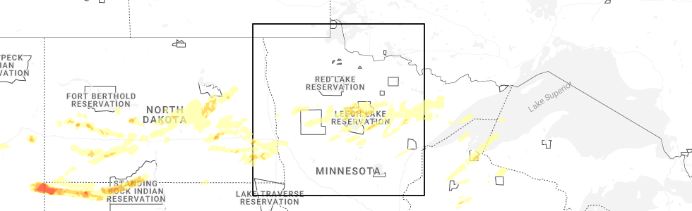
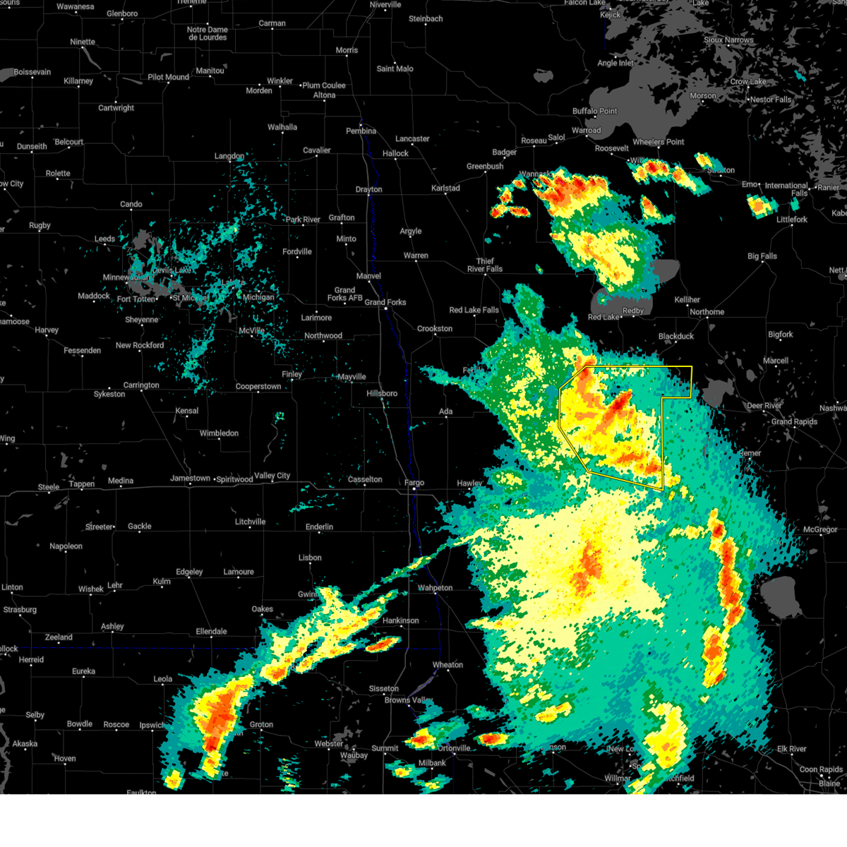
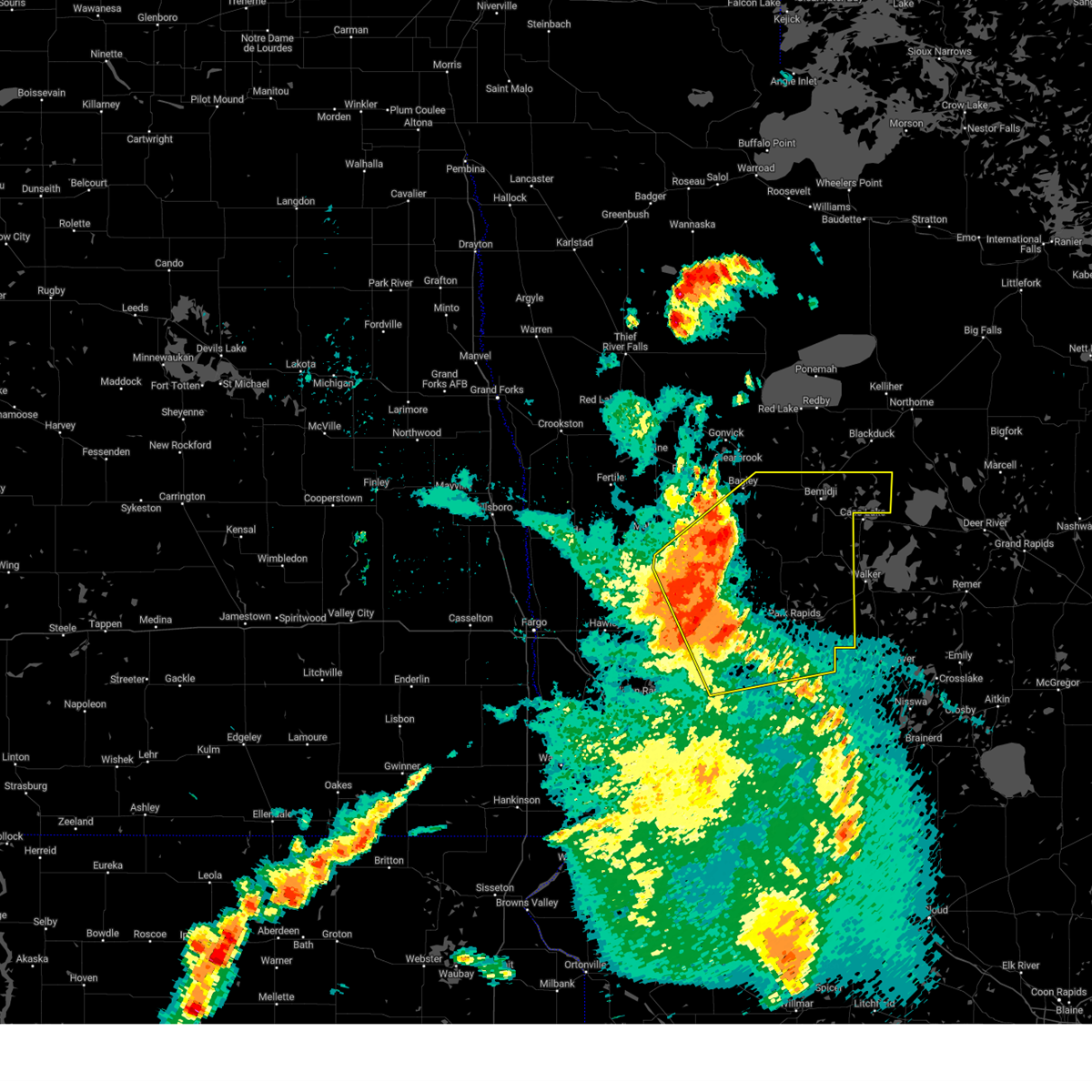
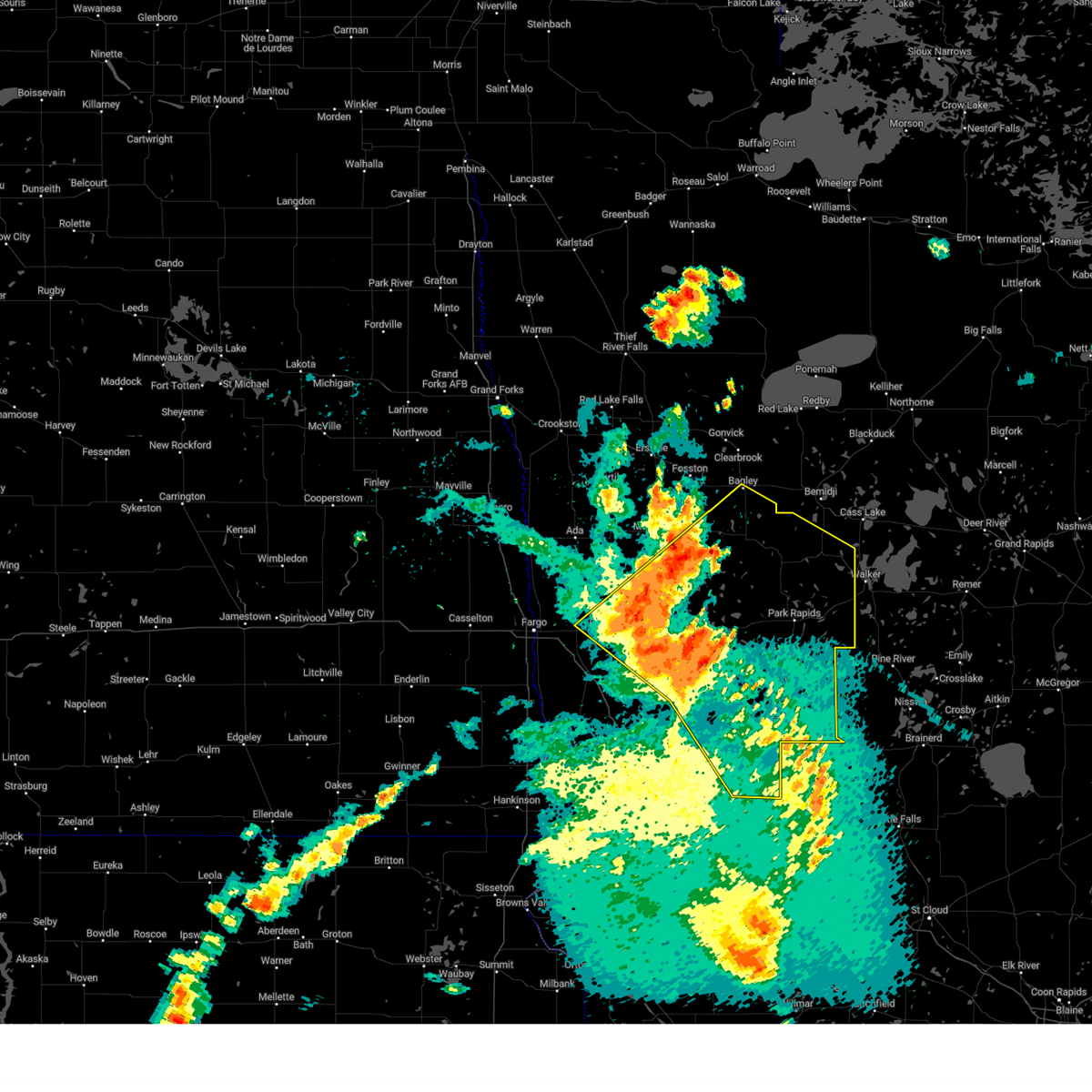
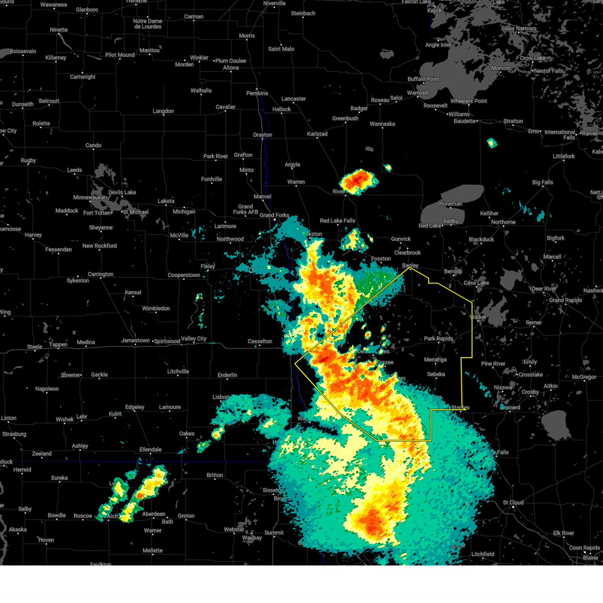
Hail Map for Roy Lake, MN
The Roy Lake, MN area has had 0 reports of on-the-ground hail by trained spotters, and has been under severe weather warnings 17 times during the past 12 months. Doppler radar has detected hail at or near Roy Lake, MN on 34 occasions, including 2 occasions during the past year.
| Name: | Roy Lake, MN |
| Where Located: | 32.9 miles WSW of Bemidji, MN |
| Map: | Google Map for Roy Lake, MN |
| Population: | 12 |
| Housing Units: | 48 |
| More Info: | Search Google for Roy Lake, MN |
3
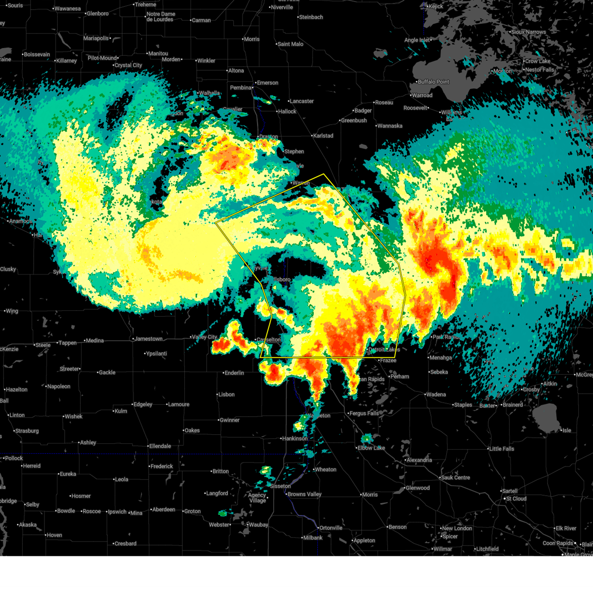
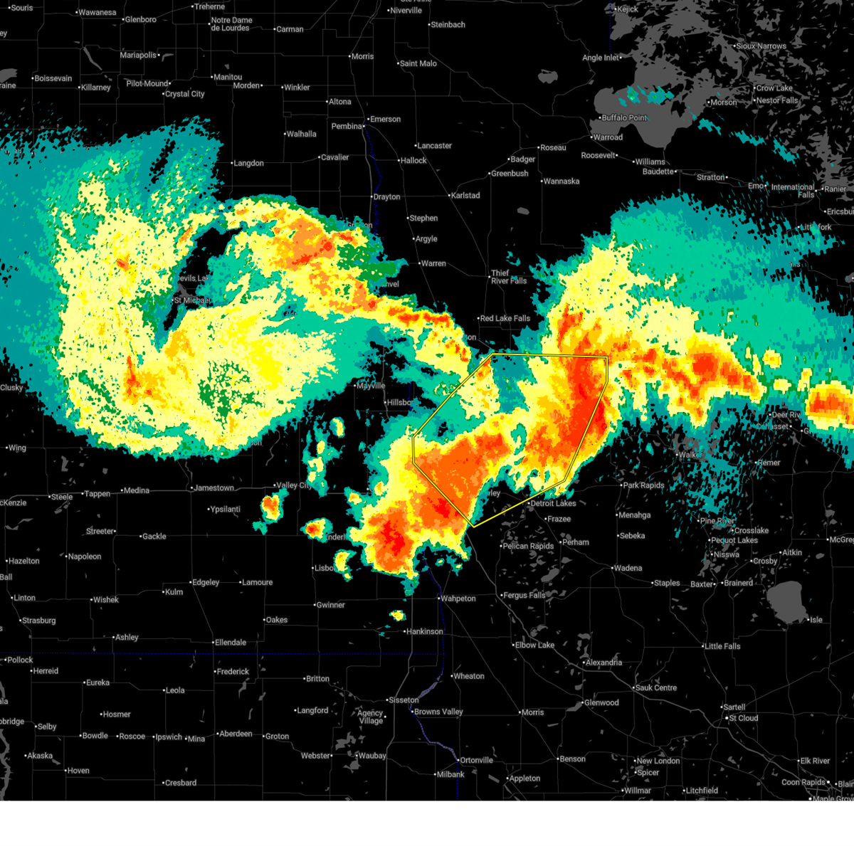
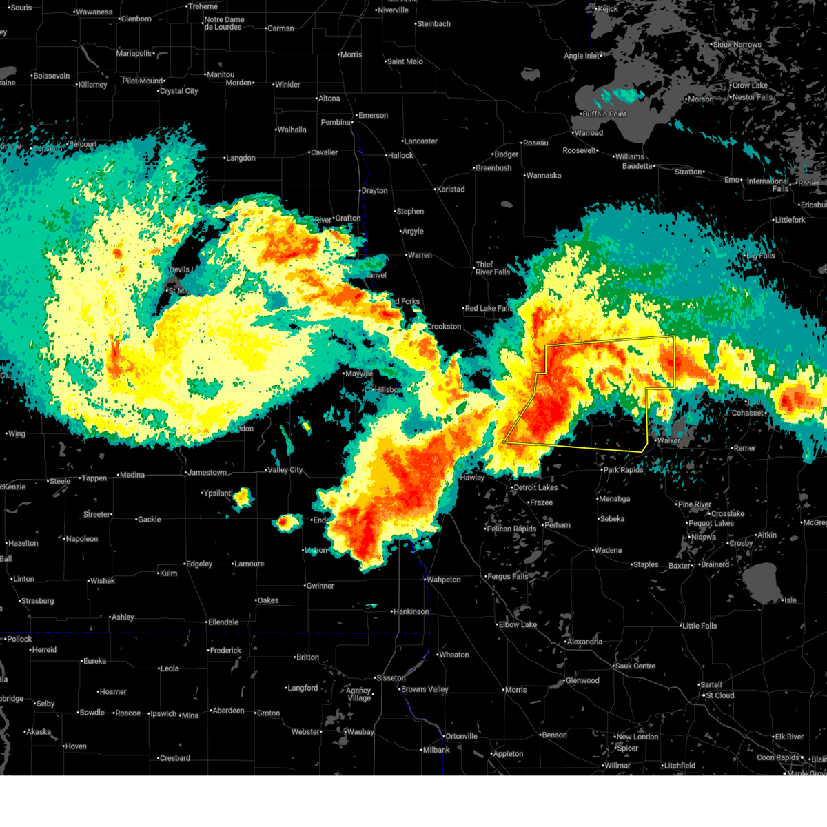
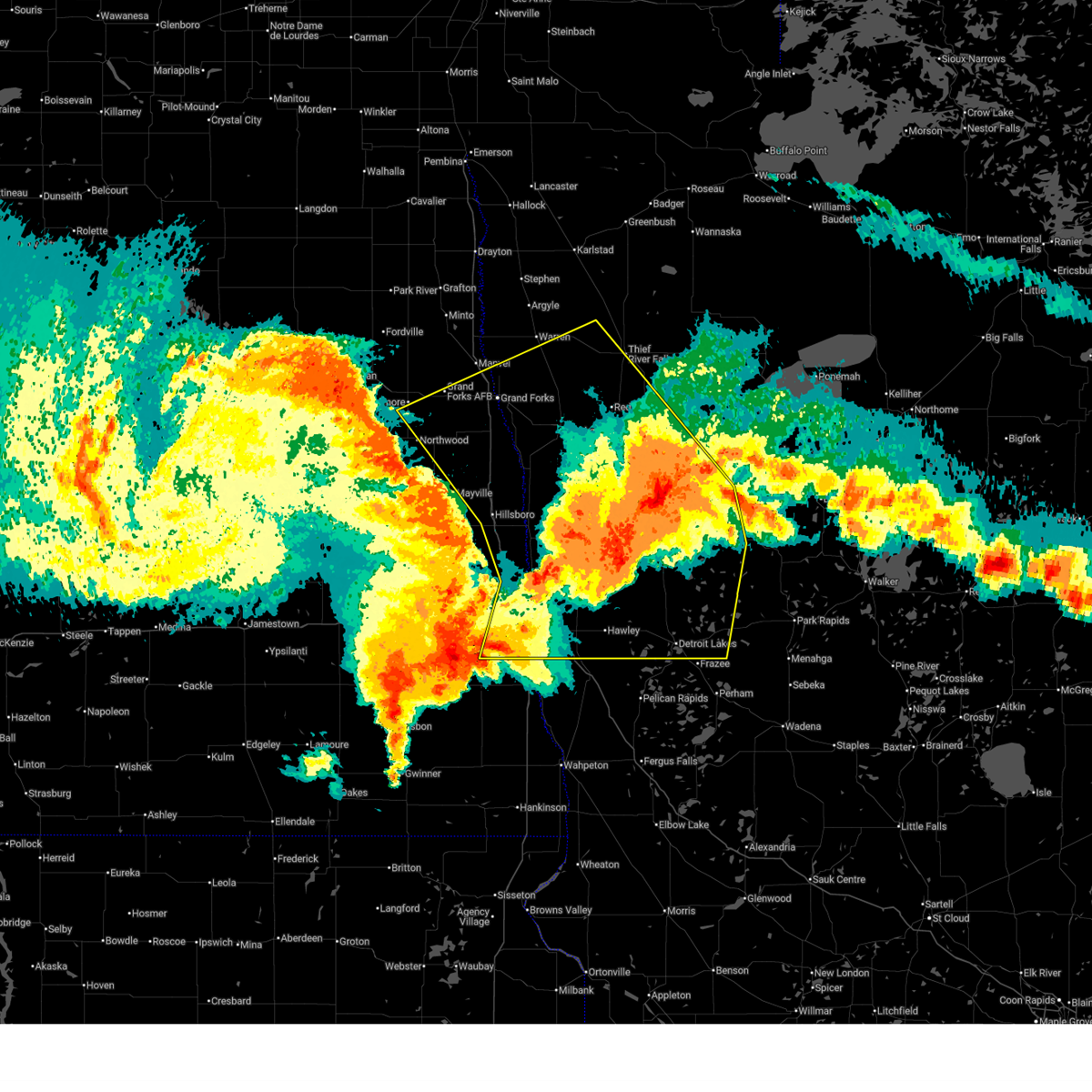
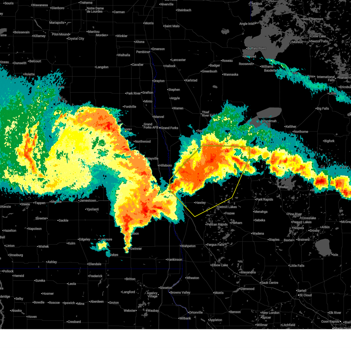
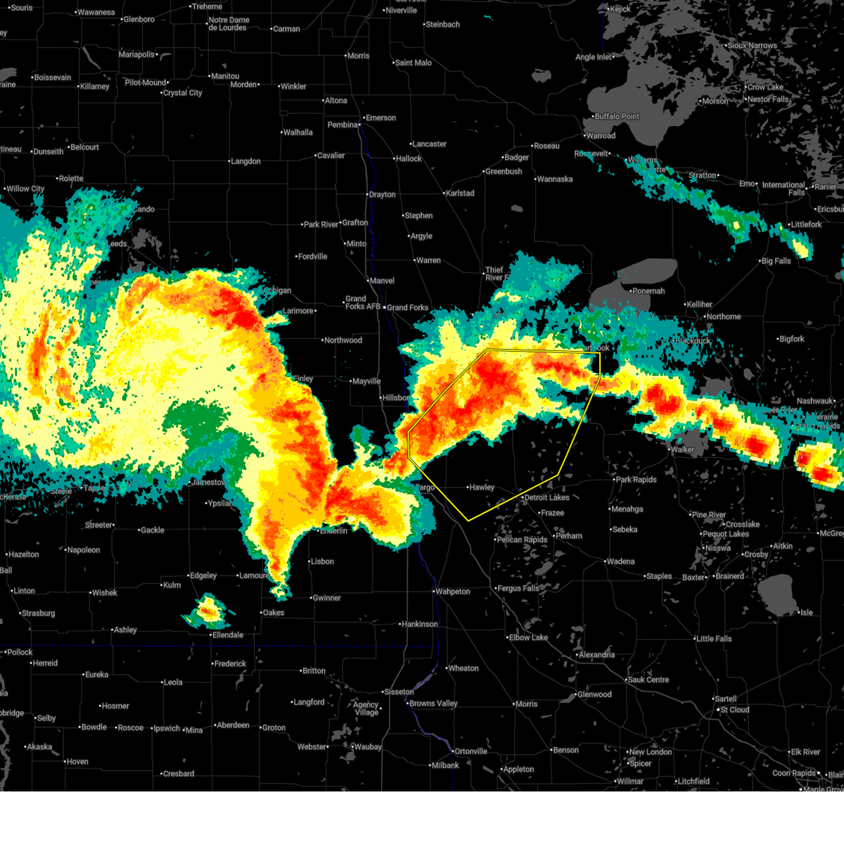
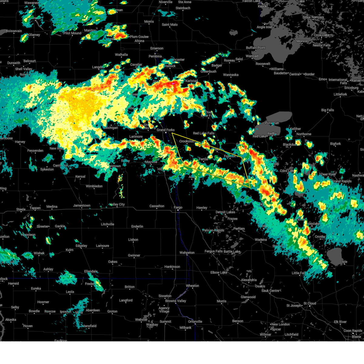
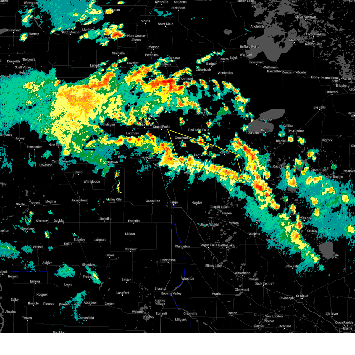
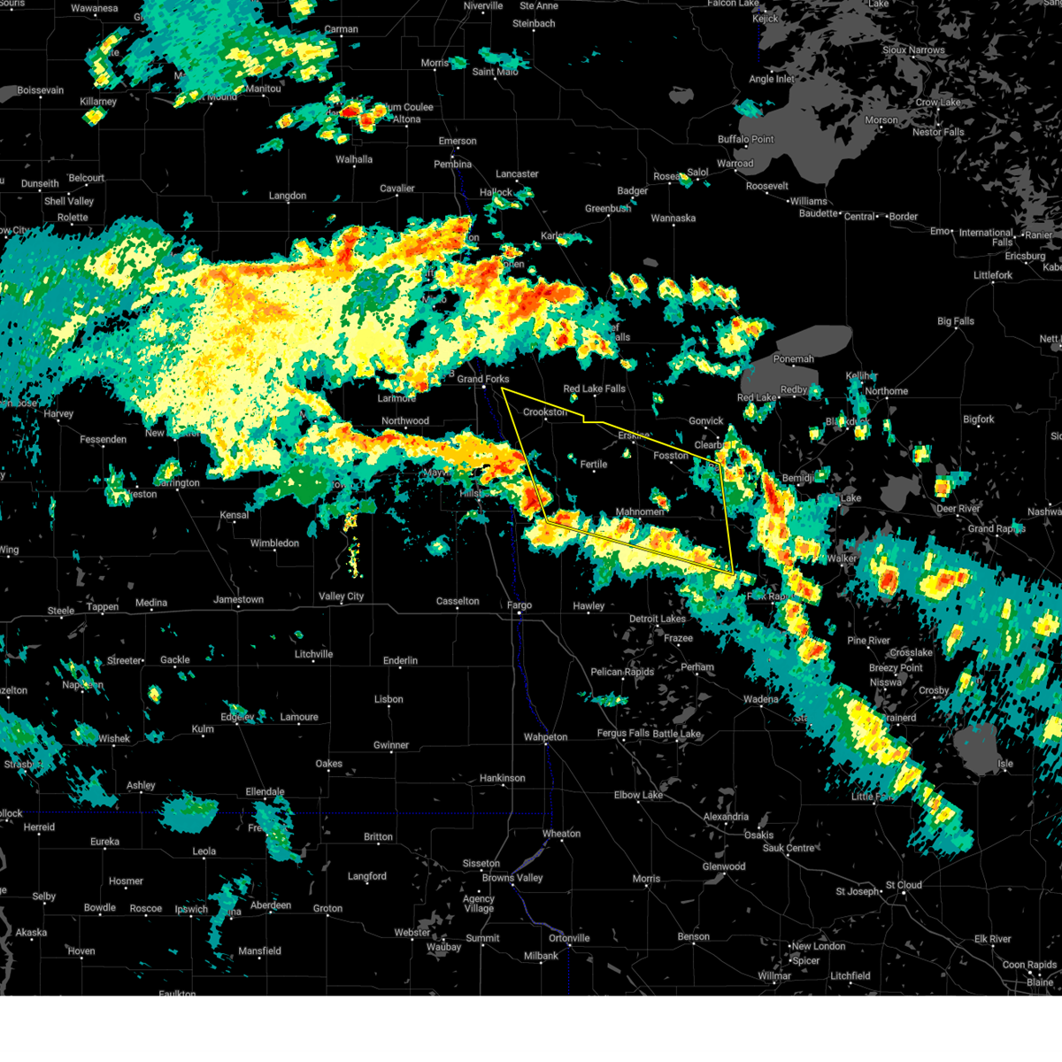
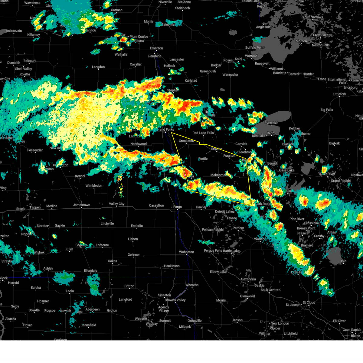
The Top Recent Hail Date for Roy Lake, MN is Friday, June 20, 2025 (12th out of 34)
Hail and Wind Damage Spotted near Roy Lake, MN
| Date / Time | Report Details |
|---|---|
| 6/21/2025 12:48 AM CDT |
 The storms which prompted the warning have weakened below severe limits, and have exited the warned area. therefore, the warning has been allowed to expire. however, gusty winds are still possible with these thunderstorms. there is another area of extremely strong winds that will likely move into the central red river valley. be prepared to shelter and prepare for these winds in the next hour or two. a tornado watch remains in effect until 300 am cdt for northwestern minnesota, and southeastern and northeastern north dakota. a severe thunderstorm watch remains in effect until 700 am cdt for northwestern minnesota. The storms which prompted the warning have weakened below severe limits, and have exited the warned area. therefore, the warning has been allowed to expire. however, gusty winds are still possible with these thunderstorms. there is another area of extremely strong winds that will likely move into the central red river valley. be prepared to shelter and prepare for these winds in the next hour or two. a tornado watch remains in effect until 300 am cdt for northwestern minnesota, and southeastern and northeastern north dakota. a severe thunderstorm watch remains in effect until 700 am cdt for northwestern minnesota.
|
| 6/21/2025 12:26 AM CDT |
 The storms which prompted the warning have moved out of the area. therefore, the warning will be allowed to expire. however, gusty winds are still possible with these thunderstorms. a tornado watch remains in effect until 300 am cdt for northwestern minnesota, and southeastern north dakota. a severe thunderstorm watch remains in effect until 700 am cdt for north central and northwestern minnesota. The storms which prompted the warning have moved out of the area. therefore, the warning will be allowed to expire. however, gusty winds are still possible with these thunderstorms. a tornado watch remains in effect until 300 am cdt for northwestern minnesota, and southeastern north dakota. a severe thunderstorm watch remains in effect until 700 am cdt for north central and northwestern minnesota.
|
| 6/21/2025 12:22 AM CDT |
 Svrfgf the national weather service in grand forks has issued a * severe thunderstorm warning for, hubbard county in north central minnesota, southeastern beltrami county in north central minnesota, eastern mahnomen county in northwestern minnesota, northeastern becker county in northwestern minnesota, clearwater county in northwestern minnesota, * until 100 am cdt. * at 1222 am cdt, severe thunderstorms were located along a line extending from near shevlin to near lake itasca to white earth nation, moving east at 70 mph (radar indicated). Hazards include 70 mph wind gusts. Expect considerable tree damage. damage is likely to mobile homes, roofs, and outbuildings. severe thunderstorms will be near, bad medicine lake, solway, and lake itasca around 1225 am cdt. bemidji, lake george, and wilton around 1230 am cdt. lavinia, kabekona, and rosby around 1235 am cdt. laporte, guthrie, and emmaville around 1240 am cdt. Benedict around 1245 am cdt. Svrfgf the national weather service in grand forks has issued a * severe thunderstorm warning for, hubbard county in north central minnesota, southeastern beltrami county in north central minnesota, eastern mahnomen county in northwestern minnesota, northeastern becker county in northwestern minnesota, clearwater county in northwestern minnesota, * until 100 am cdt. * at 1222 am cdt, severe thunderstorms were located along a line extending from near shevlin to near lake itasca to white earth nation, moving east at 70 mph (radar indicated). Hazards include 70 mph wind gusts. Expect considerable tree damage. damage is likely to mobile homes, roofs, and outbuildings. severe thunderstorms will be near, bad medicine lake, solway, and lake itasca around 1225 am cdt. bemidji, lake george, and wilton around 1230 am cdt. lavinia, kabekona, and rosby around 1235 am cdt. laporte, guthrie, and emmaville around 1240 am cdt. Benedict around 1245 am cdt.
|
| 6/20/2025 11:49 PM CDT |
 Svrfgf the national weather service in grand forks has issued a * severe thunderstorm warning for, south central marshall county in northwestern minnesota, red lake county in northwestern minnesota, clay county in northwestern minnesota, norman county in northwestern minnesota, polk county in northwestern minnesota, mahnomen county in northwestern minnesota, becker county in northwestern minnesota, western pennington county in northwestern minnesota, southwestern clearwater county in northwestern minnesota, southern grand forks county in northeastern north dakota, eastern cass county in southeastern north dakota, traill county in southeastern north dakota, * until 1245 am cdt. * at 1149 pm cdt, severe thunderstorms were located along a line extending from near kempton to near hillsboro to near gardner to near mapleton, moving east at 80 mph. these are destructive storms for eastern north dakota and northwest minnesota (public). Hazards include 80 mph wind gusts. Flying debris will be dangerous to those caught without shelter. mobile homes will be heavily damaged. expect considerable damage to roofs, windows, and vehicles. extensive tree damage and power outages are likely. severe thunderstorms will be near, fargo, west fargo, and hillsboro around 1150 pm cdt. moorhead, dilworth, and halstad around 1155 pm cdt. glyndon, thompson, and climax around 1200 am cdt. grand forks, east grand forks, and ada around 1205 am cdt. hawley, twin valley, and ulen around 1210 am cdt. other locations impacted by these severe thunderstorms include thief river falls airport, american crystal sugar, grand forks airport, moorhead airport, and west argusville. this includes the following highways, interstate 29 between mile markers 57 and 149. interstate 94 in north dakota between mile markers 337 and 15. Interstate 94 in minnesota between mile markers 337 and 15. Svrfgf the national weather service in grand forks has issued a * severe thunderstorm warning for, south central marshall county in northwestern minnesota, red lake county in northwestern minnesota, clay county in northwestern minnesota, norman county in northwestern minnesota, polk county in northwestern minnesota, mahnomen county in northwestern minnesota, becker county in northwestern minnesota, western pennington county in northwestern minnesota, southwestern clearwater county in northwestern minnesota, southern grand forks county in northeastern north dakota, eastern cass county in southeastern north dakota, traill county in southeastern north dakota, * until 1245 am cdt. * at 1149 pm cdt, severe thunderstorms were located along a line extending from near kempton to near hillsboro to near gardner to near mapleton, moving east at 80 mph. these are destructive storms for eastern north dakota and northwest minnesota (public). Hazards include 80 mph wind gusts. Flying debris will be dangerous to those caught without shelter. mobile homes will be heavily damaged. expect considerable damage to roofs, windows, and vehicles. extensive tree damage and power outages are likely. severe thunderstorms will be near, fargo, west fargo, and hillsboro around 1150 pm cdt. moorhead, dilworth, and halstad around 1155 pm cdt. glyndon, thompson, and climax around 1200 am cdt. grand forks, east grand forks, and ada around 1205 am cdt. hawley, twin valley, and ulen around 1210 am cdt. other locations impacted by these severe thunderstorms include thief river falls airport, american crystal sugar, grand forks airport, moorhead airport, and west argusville. this includes the following highways, interstate 29 between mile markers 57 and 149. interstate 94 in north dakota between mile markers 337 and 15. Interstate 94 in minnesota between mile markers 337 and 15.
|
| 6/20/2025 11:45 PM CDT |
 At 1144 pm cdt, severe thunderstorms were located along a line extending from white earth nation to near flom to near kragnes, moving southeast at 25 mph. weather sensor measured 81 mph near ada. these are destructive storms (radar indicated). Hazards include 80 mph wind gusts and quarter size hail. Flying debris will be dangerous to those caught without shelter. mobile homes will be heavily damaged. expect considerable damage to roofs, windows, and vehicles. extensive tree damage and power outages are likely. Locations impacted include, hawley, ada, fosston, glyndon, bagley, mahnomen, and fertile. At 1144 pm cdt, severe thunderstorms were located along a line extending from white earth nation to near flom to near kragnes, moving southeast at 25 mph. weather sensor measured 81 mph near ada. these are destructive storms (radar indicated). Hazards include 80 mph wind gusts and quarter size hail. Flying debris will be dangerous to those caught without shelter. mobile homes will be heavily damaged. expect considerable damage to roofs, windows, and vehicles. extensive tree damage and power outages are likely. Locations impacted include, hawley, ada, fosston, glyndon, bagley, mahnomen, and fertile.
|
| 6/20/2025 11:30 PM CDT |
 Svrfgf the national weather service in grand forks has issued a * severe thunderstorm warning for, clay county in northwestern minnesota, norman county in northwestern minnesota, southeastern polk county in northwestern minnesota, mahnomen county in northwestern minnesota, western becker county in northwestern minnesota, southern clearwater county in northwestern minnesota, * until 1230 am cdt. * at 1130 pm cdt, severe thunderstorms were located along a line extending from near winger to near twin valley to near kragnes, moving southeast at 25 mph (radar indicated). Hazards include 70 mph wind gusts and quarter size hail. Hail damage to vehicles is expected. expect considerable tree damage. Wind damage is also likely to mobile homes, roofs, and outbuildings. Svrfgf the national weather service in grand forks has issued a * severe thunderstorm warning for, clay county in northwestern minnesota, norman county in northwestern minnesota, southeastern polk county in northwestern minnesota, mahnomen county in northwestern minnesota, western becker county in northwestern minnesota, southern clearwater county in northwestern minnesota, * until 1230 am cdt. * at 1130 pm cdt, severe thunderstorms were located along a line extending from near winger to near twin valley to near kragnes, moving southeast at 25 mph (radar indicated). Hazards include 70 mph wind gusts and quarter size hail. Hail damage to vehicles is expected. expect considerable tree damage. Wind damage is also likely to mobile homes, roofs, and outbuildings.
|
| 5/15/2025 4:48 PM CDT |
 the severe thunderstorm warning has been cancelled and is no longer in effect the severe thunderstorm warning has been cancelled and is no longer in effect
|
| 5/15/2025 4:48 PM CDT |
 At 448 pm cdt, severe thunderstorms were located along a line extending from near greenview to white earth nation, moving northwest at 65 mph (radar indicated). Hazards include 60 mph wind gusts and penny size hail. Expect damage to roofs, siding, and trees. Locations impacted include, crookston, fosston, fertile, mcintosh, erskine, fisher, and island lake in mahnomen county. At 448 pm cdt, severe thunderstorms were located along a line extending from near greenview to white earth nation, moving northwest at 65 mph (radar indicated). Hazards include 60 mph wind gusts and penny size hail. Expect damage to roofs, siding, and trees. Locations impacted include, crookston, fosston, fertile, mcintosh, erskine, fisher, and island lake in mahnomen county.
|
| 5/15/2025 4:36 PM CDT |
 the severe thunderstorm warning has been cancelled and is no longer in effect the severe thunderstorm warning has been cancelled and is no longer in effect
|
| 5/15/2025 4:36 PM CDT |
 At 436 pm cdt, severe thunderstorms were located along a line extending from near beltrami to white earth nation, moving north at 55 mph (radar indicated). Hazards include 60 mph wind gusts and penny size hail. Expect damage to roofs, siding, and trees. Locations impacted include, crookston, ada, fosston, bagley, mahnomen, fertile, and twin valley. At 436 pm cdt, severe thunderstorms were located along a line extending from near beltrami to white earth nation, moving north at 55 mph (radar indicated). Hazards include 60 mph wind gusts and penny size hail. Expect damage to roofs, siding, and trees. Locations impacted include, crookston, ada, fosston, bagley, mahnomen, fertile, and twin valley.
|
| 5/15/2025 4:25 PM CDT |
 Svrfgf the national weather service in grand forks has issued a * severe thunderstorm warning for, northeastern clay county in northwestern minnesota, norman county in northwestern minnesota, southern polk county in northwestern minnesota, mahnomen county in northwestern minnesota, northern becker county in northwestern minnesota, southwestern clearwater county in northwestern minnesota, * until 515 pm cdt. * at 424 pm cdt, severe thunderstorms were located along a line extending from hadler to white earth nation, moving north at 55 mph (radar indicated). Hazards include 60 mph wind gusts and penny size hail. expect damage to roofs, siding, and trees Svrfgf the national weather service in grand forks has issued a * severe thunderstorm warning for, northeastern clay county in northwestern minnesota, norman county in northwestern minnesota, southern polk county in northwestern minnesota, mahnomen county in northwestern minnesota, northern becker county in northwestern minnesota, southwestern clearwater county in northwestern minnesota, * until 515 pm cdt. * at 424 pm cdt, severe thunderstorms were located along a line extending from hadler to white earth nation, moving north at 55 mph (radar indicated). Hazards include 60 mph wind gusts and penny size hail. expect damage to roofs, siding, and trees
|
| 7/31/2024 3:30 PM CDT |
 the severe thunderstorm warning has been cancelled and is no longer in effect the severe thunderstorm warning has been cancelled and is no longer in effect
|
| 7/31/2024 3:30 PM CDT |
 At 330 pm cdt, severe thunderstorms were located along a line extending from wilton to near nary to near chamberlain, moving east at 40 mph (radar indicated). Hazards include 60 mph wind gusts and nickel size hail. Expect damage to roofs, siding, and trees. Locations impacted include, bemidji, park rapids, bagley, bad medicine lake, akeley, nevis, and lake george. At 330 pm cdt, severe thunderstorms were located along a line extending from wilton to near nary to near chamberlain, moving east at 40 mph (radar indicated). Hazards include 60 mph wind gusts and nickel size hail. Expect damage to roofs, siding, and trees. Locations impacted include, bemidji, park rapids, bagley, bad medicine lake, akeley, nevis, and lake george.
|
| 7/31/2024 2:54 PM CDT |
 Svrfgf the national weather service in grand forks has issued a * severe thunderstorm warning for, northern wadena county in central minnesota, hubbard county in north central minnesota, northeastern otter tail county in west central minnesota, southeastern beltrami county in north central minnesota, southern mahnomen county in northwestern minnesota, becker county in northwestern minnesota, southern clearwater county in northwestern minnesota, * until 400 pm cdt. * at 253 pm cdt, severe thunderstorms were located along a line extending from white earth nation to near lake itasca to near menahga, moving east at 45 mph (radar indicated). Hazards include 60 mph wind gusts and nickel size hail. expect damage to roofs, siding, and trees Svrfgf the national weather service in grand forks has issued a * severe thunderstorm warning for, northern wadena county in central minnesota, hubbard county in north central minnesota, northeastern otter tail county in west central minnesota, southeastern beltrami county in north central minnesota, southern mahnomen county in northwestern minnesota, becker county in northwestern minnesota, southern clearwater county in northwestern minnesota, * until 400 pm cdt. * at 253 pm cdt, severe thunderstorms were located along a line extending from white earth nation to near lake itasca to near menahga, moving east at 45 mph (radar indicated). Hazards include 60 mph wind gusts and nickel size hail. expect damage to roofs, siding, and trees
|
| 7/31/2024 2:32 PM CDT |
 At 232 pm cdt, severe thunderstorms were located along a line extending from near hitterdal to near vergas to near rose city, moving northeast at 50 mph (radar indicated). Hazards include 60 mph wind gusts and nickel size hail. Expect damage to roofs, siding, and trees. Locations impacted include, detroit lakes, wadena, park rapids, perham, ottertail lake, hawley, and bagley. At 232 pm cdt, severe thunderstorms were located along a line extending from near hitterdal to near vergas to near rose city, moving northeast at 50 mph (radar indicated). Hazards include 60 mph wind gusts and nickel size hail. Expect damage to roofs, siding, and trees. Locations impacted include, detroit lakes, wadena, park rapids, perham, ottertail lake, hawley, and bagley.
|
| 7/31/2024 2:32 PM CDT |
 the severe thunderstorm warning has been cancelled and is no longer in effect the severe thunderstorm warning has been cancelled and is no longer in effect
|
| 7/31/2024 2:09 PM CDT |
 Svrfgf the national weather service in grand forks has issued a * severe thunderstorm warning for, southern clay county in northwestern minnesota, wadena county in central minnesota, hubbard county in north central minnesota, otter tail county in west central minnesota, northeastern wilkin county in west central minnesota, southern mahnomen county in northwestern minnesota, becker county in northwestern minnesota, southern clearwater county in northwestern minnesota, * until 300 pm cdt. * at 209 pm cdt, severe thunderstorms were located along a line extending from sabin to near maplewood state park to garfield, moving northeast at 50 mph (radar indicated). Hazards include 70 mph wind gusts and nickel size hail. Expect considerable tree damage. Damage is likely to mobile homes, roofs, and outbuildings. Svrfgf the national weather service in grand forks has issued a * severe thunderstorm warning for, southern clay county in northwestern minnesota, wadena county in central minnesota, hubbard county in north central minnesota, otter tail county in west central minnesota, northeastern wilkin county in west central minnesota, southern mahnomen county in northwestern minnesota, becker county in northwestern minnesota, southern clearwater county in northwestern minnesota, * until 300 pm cdt. * at 209 pm cdt, severe thunderstorms were located along a line extending from sabin to near maplewood state park to garfield, moving northeast at 50 mph (radar indicated). Hazards include 70 mph wind gusts and nickel size hail. Expect considerable tree damage. Damage is likely to mobile homes, roofs, and outbuildings.
|
| 6/28/2024 11:20 PM CDT |
 At 1120 pm cdt, a severe thunderstorm was located over solway, or 11 miles west of bemidji, moving east at 55 mph (radar indicated). Hazards include 60 mph wind gusts and quarter size hail. Hail damage to vehicles is expected. expect wind damage to roofs, siding, and trees. Locations impacted include, bemidji, bagley, clearbrook, lake george, wilton, shevlin, and lavinia. At 1120 pm cdt, a severe thunderstorm was located over solway, or 11 miles west of bemidji, moving east at 55 mph (radar indicated). Hazards include 60 mph wind gusts and quarter size hail. Hail damage to vehicles is expected. expect wind damage to roofs, siding, and trees. Locations impacted include, bemidji, bagley, clearbrook, lake george, wilton, shevlin, and lavinia.
|
| 6/28/2024 11:20 PM CDT |
 the severe thunderstorm warning has been cancelled and is no longer in effect the severe thunderstorm warning has been cancelled and is no longer in effect
|
| 6/28/2024 10:53 PM CDT |
 Svrfgf the national weather service in grand forks has issued a * severe thunderstorm warning for, northwestern hubbard county in north central minnesota, southeastern polk county in northwestern minnesota, south central beltrami county in north central minnesota, eastern mahnomen county in northwestern minnesota, clearwater county in northwestern minnesota, * until 1145 pm cdt. * at 1053 pm cdt, a severe thunderstorm was located over northern white earth nation, or 36 miles west of bemidji, moving east at 55 mph (radar indicated). Hazards include 60 mph wind gusts and quarter size hail. Hail damage to vehicles is expected. Expect wind damage to roofs, siding, and trees. Svrfgf the national weather service in grand forks has issued a * severe thunderstorm warning for, northwestern hubbard county in north central minnesota, southeastern polk county in northwestern minnesota, south central beltrami county in north central minnesota, eastern mahnomen county in northwestern minnesota, clearwater county in northwestern minnesota, * until 1145 pm cdt. * at 1053 pm cdt, a severe thunderstorm was located over northern white earth nation, or 36 miles west of bemidji, moving east at 55 mph (radar indicated). Hazards include 60 mph wind gusts and quarter size hail. Hail damage to vehicles is expected. Expect wind damage to roofs, siding, and trees.
|
| 6/28/2024 10:38 PM CDT |
 the severe thunderstorm warning has been cancelled and is no longer in effect the severe thunderstorm warning has been cancelled and is no longer in effect
|
| 6/28/2024 10:38 PM CDT |
 At 1037 pm cdt, severe thunderstorms were located along a line extending from winger to white earth nation, moving east at 50 mph (law enforcement). Hazards include two inch hail and 70 mph wind gusts. People and animals outdoors will be injured. expect hail damage to roofs, siding, windows, and vehicles. expect considerable tree damage. wind damage is also likely to mobile homes, roofs, and outbuildings. Locations impacted include, fosston, mahnomen, mcintosh, island lake in mahnomen county, naytahwaush, winger, and bejou. At 1037 pm cdt, severe thunderstorms were located along a line extending from winger to white earth nation, moving east at 50 mph (law enforcement). Hazards include two inch hail and 70 mph wind gusts. People and animals outdoors will be injured. expect hail damage to roofs, siding, windows, and vehicles. expect considerable tree damage. wind damage is also likely to mobile homes, roofs, and outbuildings. Locations impacted include, fosston, mahnomen, mcintosh, island lake in mahnomen county, naytahwaush, winger, and bejou.
|
| 6/28/2024 10:15 PM CDT |
 Svrfgf the national weather service in grand forks has issued a * severe thunderstorm warning for, eastern norman county in northwestern minnesota, southeastern polk county in northwestern minnesota, mahnomen county in northwestern minnesota, west central clearwater county in northwestern minnesota, * until 1100 pm cdt. * at 1014 pm cdt, severe thunderstorms were located along a line extending from near fertile to near twin valley, moving east at 50 mph (law enforcement). Hazards include two inch hail and 70 mph wind gusts. People and animals outdoors will be injured. expect hail damage to roofs, siding, windows, and vehicles. expect considerable tree damage. Wind damage is also likely to mobile homes, roofs, and outbuildings. Svrfgf the national weather service in grand forks has issued a * severe thunderstorm warning for, eastern norman county in northwestern minnesota, southeastern polk county in northwestern minnesota, mahnomen county in northwestern minnesota, west central clearwater county in northwestern minnesota, * until 1100 pm cdt. * at 1014 pm cdt, severe thunderstorms were located along a line extending from near fertile to near twin valley, moving east at 50 mph (law enforcement). Hazards include two inch hail and 70 mph wind gusts. People and animals outdoors will be injured. expect hail damage to roofs, siding, windows, and vehicles. expect considerable tree damage. Wind damage is also likely to mobile homes, roofs, and outbuildings.
|
| 6/18/2024 4:20 AM CDT |
 Svrfgf the national weather service in grand forks has issued a * severe thunderstorm warning for, east central clay county in northwestern minnesota, wadena county in central minnesota, hubbard county in north central minnesota, southeastern polk county in northwestern minnesota, northeastern otter tail county in west central minnesota, southern beltrami county in north central minnesota, mahnomen county in northwestern minnesota, becker county in northwestern minnesota, clearwater county in northwestern minnesota, * until 515 am cdt. * at 419 am cdt, severe thunderstorms were located along a line extending from red lake nation to white earth nation to near pelican rapids, moving east at 55 mph (radar indicated). Hazards include 70 mph wind gusts. Expect considerable tree damage. Damage is likely to mobile homes, roofs, and outbuildings. Svrfgf the national weather service in grand forks has issued a * severe thunderstorm warning for, east central clay county in northwestern minnesota, wadena county in central minnesota, hubbard county in north central minnesota, southeastern polk county in northwestern minnesota, northeastern otter tail county in west central minnesota, southern beltrami county in north central minnesota, mahnomen county in northwestern minnesota, becker county in northwestern minnesota, clearwater county in northwestern minnesota, * until 515 am cdt. * at 419 am cdt, severe thunderstorms were located along a line extending from red lake nation to white earth nation to near pelican rapids, moving east at 55 mph (radar indicated). Hazards include 70 mph wind gusts. Expect considerable tree damage. Damage is likely to mobile homes, roofs, and outbuildings.
|
| 6/18/2024 4:02 AM CDT |
 the severe thunderstorm warning has been cancelled and is no longer in effect the severe thunderstorm warning has been cancelled and is no longer in effect
|
| 6/18/2024 4:02 AM CDT |
 At 402 am cdt, severe thunderstorms were located along a line extending from near bagley to white earth nation to near pelican rapids, moving east at 45 mph (radar indicated). Hazards include 70 mph wind gusts. Expect considerable tree damage. damage is likely to mobile homes, roofs, and outbuildings. locations impacted include, eastern fargo, detroit lakes, moorhead, dilworth, barnesville, pelican rapids, and hawley. This includes interstate 94 in minnesota between mile markers 1 and 31. At 402 am cdt, severe thunderstorms were located along a line extending from near bagley to white earth nation to near pelican rapids, moving east at 45 mph (radar indicated). Hazards include 70 mph wind gusts. Expect considerable tree damage. damage is likely to mobile homes, roofs, and outbuildings. locations impacted include, eastern fargo, detroit lakes, moorhead, dilworth, barnesville, pelican rapids, and hawley. This includes interstate 94 in minnesota between mile markers 1 and 31.
|
| 6/18/2024 3:24 AM CDT |
 Svrfgf the national weather service in grand forks has issued a * severe thunderstorm warning for, clay county in northwestern minnesota, norman county in northwestern minnesota, southeastern polk county in northwestern minnesota, northwestern otter tail county in west central minnesota, northern wilkin county in west central minnesota, mahnomen county in northwestern minnesota, western becker county in northwestern minnesota, southern clearwater county in northwestern minnesota, eastern cass county in southeastern north dakota, * until 430 am cdt. * at 324 am cdt, severe thunderstorms were located along a line extending from erskine to near syre to comstock, moving east at 45 mph (radar indicated). Hazards include 70 mph wind gusts. Expect considerable tree damage. Damage is likely to mobile homes, roofs, and outbuildings. Svrfgf the national weather service in grand forks has issued a * severe thunderstorm warning for, clay county in northwestern minnesota, norman county in northwestern minnesota, southeastern polk county in northwestern minnesota, northwestern otter tail county in west central minnesota, northern wilkin county in west central minnesota, mahnomen county in northwestern minnesota, western becker county in northwestern minnesota, southern clearwater county in northwestern minnesota, eastern cass county in southeastern north dakota, * until 430 am cdt. * at 324 am cdt, severe thunderstorms were located along a line extending from erskine to near syre to comstock, moving east at 45 mph (radar indicated). Hazards include 70 mph wind gusts. Expect considerable tree damage. Damage is likely to mobile homes, roofs, and outbuildings.
|
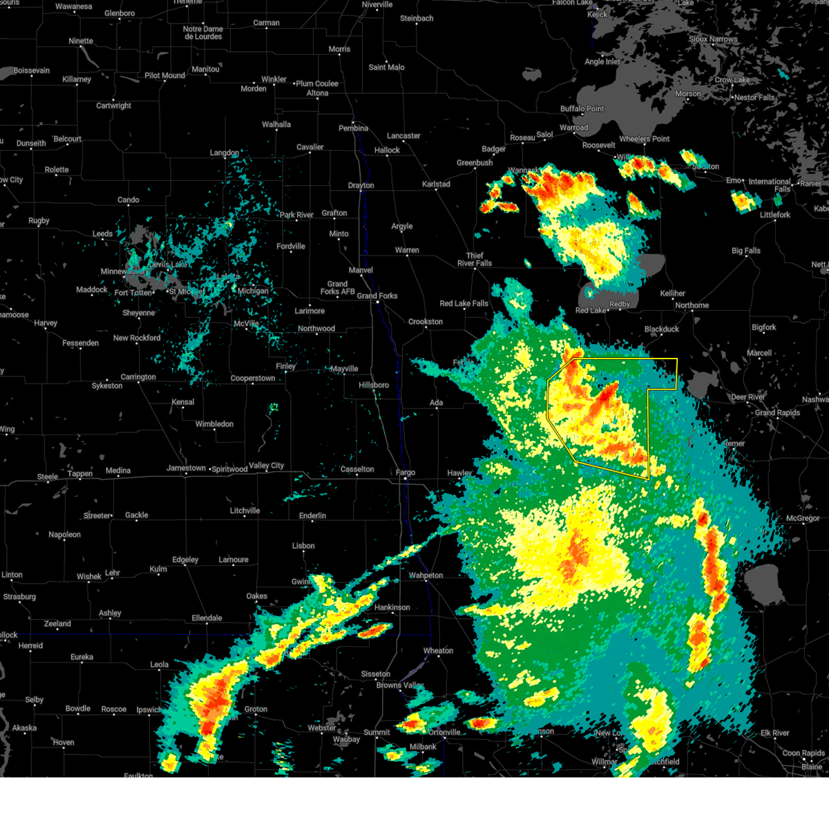
| 6/12/2024 4:29 PM CDT |
 At 428 pm cdt, a severe thunderstorm was located over southeastern white earth nation, or 29 miles northeast of detroit lakes, moving east at 45 mph (radar indicated). Hazards include two inch hail and 60 mph wind gusts. People and animals outdoors will be injured. expect hail damage to roofs, siding, windows, and vehicles. expect wind damage to roofs, siding, and trees. Locations impacted include, bad medicine lake, naytahwaush, tulaby lake, many point lake, roy lake, long lost lake, and lake itasca. At 428 pm cdt, a severe thunderstorm was located over southeastern white earth nation, or 29 miles northeast of detroit lakes, moving east at 45 mph (radar indicated). Hazards include two inch hail and 60 mph wind gusts. People and animals outdoors will be injured. expect hail damage to roofs, siding, windows, and vehicles. expect wind damage to roofs, siding, and trees. Locations impacted include, bad medicine lake, naytahwaush, tulaby lake, many point lake, roy lake, long lost lake, and lake itasca.
|
| 6/12/2024 4:05 PM CDT |
 Svrfgf the national weather service in grand forks has issued a * severe thunderstorm warning for, southern mahnomen county in northwestern minnesota, northern becker county in northwestern minnesota, southern clearwater county in northwestern minnesota, * until 500 pm cdt. * at 405 pm cdt, a severe thunderstorm was located over southwestern white earth nation, or 25 miles north of detroit lakes, moving east at 40 mph (radar indicated). Hazards include ping pong ball size hail and 60 mph wind gusts. People and animals outdoors will be injured. expect hail damage to roofs, siding, windows, and vehicles. Expect wind damage to roofs, siding, and trees. Svrfgf the national weather service in grand forks has issued a * severe thunderstorm warning for, southern mahnomen county in northwestern minnesota, northern becker county in northwestern minnesota, southern clearwater county in northwestern minnesota, * until 500 pm cdt. * at 405 pm cdt, a severe thunderstorm was located over southwestern white earth nation, or 25 miles north of detroit lakes, moving east at 40 mph (radar indicated). Hazards include ping pong ball size hail and 60 mph wind gusts. People and animals outdoors will be injured. expect hail damage to roofs, siding, windows, and vehicles. Expect wind damage to roofs, siding, and trees.
|
| 9/29/2023 9:18 AM CDT |
 At 918 am cdt, a severe thunderstorm was located near plantagenet lake, or 8 miles southwest of bemidji, moving northeast at 65 mph (radar indicated). Hazards include 60 mph wind gusts and quarter size hail. Hail damage to vehicles is expected. expect wind damage to roofs, siding, and trees. locations impacted include, bemidji, bagley, redby, blackduck, plantagenet lake, lake george and wilton. hail threat, observed max hail size, 1. 00 in wind threat, radar indicated max wind gust, 60 mph. At 918 am cdt, a severe thunderstorm was located near plantagenet lake, or 8 miles southwest of bemidji, moving northeast at 65 mph (radar indicated). Hazards include 60 mph wind gusts and quarter size hail. Hail damage to vehicles is expected. expect wind damage to roofs, siding, and trees. locations impacted include, bemidji, bagley, redby, blackduck, plantagenet lake, lake george and wilton. hail threat, observed max hail size, 1. 00 in wind threat, radar indicated max wind gust, 60 mph.
|
| 9/29/2023 9:00 AM CDT |
 At 858 am cdt, a severe thunderstorm was located over northern long lost lake, or 31 miles southwest of bemidji, moving northeast at 65 mph. at 855 am cdt, trained spotters reported quarter size hail near the highway intersection of highway 35 and 113 (trained weather spotters). Hazards include ping pong ball size hail and 60 mph wind gusts. People and animals outdoors will be injured. expect hail damage to roofs, siding, windows, and vehicles. expect wind damage to roofs, siding, and trees. locations impacted include, bemidji, bagley, redby, blackduck, plantagenet lake, bad medicine lake and lake george. hail threat, observed max hail size, 1. 50 in wind threat, radar indicated max wind gust, 60 mph. At 858 am cdt, a severe thunderstorm was located over northern long lost lake, or 31 miles southwest of bemidji, moving northeast at 65 mph. at 855 am cdt, trained spotters reported quarter size hail near the highway intersection of highway 35 and 113 (trained weather spotters). Hazards include ping pong ball size hail and 60 mph wind gusts. People and animals outdoors will be injured. expect hail damage to roofs, siding, windows, and vehicles. expect wind damage to roofs, siding, and trees. locations impacted include, bemidji, bagley, redby, blackduck, plantagenet lake, bad medicine lake and lake george. hail threat, observed max hail size, 1. 50 in wind threat, radar indicated max wind gust, 60 mph.
|
| 9/29/2023 8:54 AM CDT |
 At 854 am cdt, a severe thunderstorm was located near long lost lake, or 29 miles northeast of detroit lakes, moving northeast at 65 mph (radar indicated). Hazards include ping pong ball size hail and 60 mph wind gusts. People and animals outdoors will be injured. expect hail damage to roofs, siding, windows, and vehicles. Expect wind damage to roofs, siding, and trees. At 854 am cdt, a severe thunderstorm was located near long lost lake, or 29 miles northeast of detroit lakes, moving northeast at 65 mph (radar indicated). Hazards include ping pong ball size hail and 60 mph wind gusts. People and animals outdoors will be injured. expect hail damage to roofs, siding, windows, and vehicles. Expect wind damage to roofs, siding, and trees.
|
| 8/8/2023 3:55 PM CDT |
 At 355 pm cdt, a severe thunderstorm was located near island lake in mahnomen county, or 39 miles west of bemidji, moving east at 40 mph (radar indicated). Hazards include quarter size hail. Damage to vehicles is expected. locations impacted include, island lake in mahnomen county, rice lake, roy lake, beaulieu, pine bend, ebro and mahkonce. hail threat, radar indicated max hail size, 1. 00 in wind threat, radar indicated max wind gust, <50 mph. At 355 pm cdt, a severe thunderstorm was located near island lake in mahnomen county, or 39 miles west of bemidji, moving east at 40 mph (radar indicated). Hazards include quarter size hail. Damage to vehicles is expected. locations impacted include, island lake in mahnomen county, rice lake, roy lake, beaulieu, pine bend, ebro and mahkonce. hail threat, radar indicated max hail size, 1. 00 in wind threat, radar indicated max wind gust, <50 mph.
|
| 8/8/2023 3:38 PM CDT |
 At 338 pm cdt, a severe thunderstorm was located near bejou, or 40 miles north of detroit lakes, moving east at 40 mph (radar indicated). Hazards include quarter size hail. damage to vehicles is expected At 338 pm cdt, a severe thunderstorm was located near bejou, or 40 miles north of detroit lakes, moving east at 40 mph (radar indicated). Hazards include quarter size hail. damage to vehicles is expected
|
| 5/30/2023 5:51 PM CDT |
 At 550 pm cdt, severe thunderstorms were located along a line extending from near ebro to near naytahwaush, moving east at 20 mph (radar indicated). Hazards include 60 mph wind gusts and half dollar size hail. Hail damage to vehicles is expected. expect wind damage to roofs, siding, and trees. Locations impacted include, bagley, island lake in mahnomen county, naytahwaush, rice lake, roy lake, northern long lost lake and pine bend. At 550 pm cdt, severe thunderstorms were located along a line extending from near ebro to near naytahwaush, moving east at 20 mph (radar indicated). Hazards include 60 mph wind gusts and half dollar size hail. Hail damage to vehicles is expected. expect wind damage to roofs, siding, and trees. Locations impacted include, bagley, island lake in mahnomen county, naytahwaush, rice lake, roy lake, northern long lost lake and pine bend.
|
| 5/30/2023 5:47 PM CDT |
 At 546 pm cdt, severe thunderstorms were located along a line extending from near ebro to near naytahwaush, moving east at 20 mph (radar indicated). Hazards include 60 mph wind gusts and half dollar size hail. Hail damage to vehicles is expected. Expect wind damage to roofs, siding, and trees. At 546 pm cdt, severe thunderstorms were located along a line extending from near ebro to near naytahwaush, moving east at 20 mph (radar indicated). Hazards include 60 mph wind gusts and half dollar size hail. Hail damage to vehicles is expected. Expect wind damage to roofs, siding, and trees.
|
| 8/5/2022 8:55 PM CDT |
 At 855 pm cdt, a severe thunderstorm was located over upper rice lake, or 22 miles west of bemidji, moving east at 45 mph (radar indicated). Hazards include 60 mph wind gusts and quarter size hail. Hail damage to vehicles is expected. expect wind damage to roofs, siding, and trees. locations impacted include, bagley, rice lake, alida, zerkel, upper rice lake, lower rice lake and roy lake. hail threat, radar indicated max hail size, 1. 00 in wind threat, radar indicated max wind gust, 60 mph. At 855 pm cdt, a severe thunderstorm was located over upper rice lake, or 22 miles west of bemidji, moving east at 45 mph (radar indicated). Hazards include 60 mph wind gusts and quarter size hail. Hail damage to vehicles is expected. expect wind damage to roofs, siding, and trees. locations impacted include, bagley, rice lake, alida, zerkel, upper rice lake, lower rice lake and roy lake. hail threat, radar indicated max hail size, 1. 00 in wind threat, radar indicated max wind gust, 60 mph.
|
| 8/5/2022 8:43 PM CDT |
 At 843 pm cdt, a severe thunderstorm was located over northeastern white earth nation, or 31 miles west of bemidji, moving east at 45 mph (radar indicated). Hazards include 60 mph wind gusts and half dollar size hail. Hail damage to vehicles is expected. expect wind damage to roofs, siding, and trees. locations impacted include, rice lake, lower rice lake, zerkel, upper rice lake and alida. hail threat, radar indicated max hail size, 1. 25 in wind threat, radar indicated max wind gust, 60 mph. At 843 pm cdt, a severe thunderstorm was located over northeastern white earth nation, or 31 miles west of bemidji, moving east at 45 mph (radar indicated). Hazards include 60 mph wind gusts and half dollar size hail. Hail damage to vehicles is expected. expect wind damage to roofs, siding, and trees. locations impacted include, rice lake, lower rice lake, zerkel, upper rice lake and alida. hail threat, radar indicated max hail size, 1. 25 in wind threat, radar indicated max wind gust, 60 mph.
|
| 8/5/2022 8:19 PM CDT |
 At 818 pm cdt, a severe thunderstorm was located over western white earth nation, or 31 miles north of detroit lakes, moving northeast at 45 mph (radar indicated). Hazards include 60 mph wind gusts and half dollar size hail. Hail damage to vehicles is expected. expect wind damage to roofs, siding, and trees. this severe thunderstorm will be near, beaulieu around 830 pm cdt. naytahwaush around 835 pm cdt. other locations in the path of this severe thunderstorm include mahkonce, island lake in mahnomen county, roy lake, pine bend, lower rice lake, rice lake and ebro. hail threat, radar indicated max hail size, 1. 25 in wind threat, radar indicated max wind gust, 60 mph. At 818 pm cdt, a severe thunderstorm was located over western white earth nation, or 31 miles north of detroit lakes, moving northeast at 45 mph (radar indicated). Hazards include 60 mph wind gusts and half dollar size hail. Hail damage to vehicles is expected. expect wind damage to roofs, siding, and trees. this severe thunderstorm will be near, beaulieu around 830 pm cdt. naytahwaush around 835 pm cdt. other locations in the path of this severe thunderstorm include mahkonce, island lake in mahnomen county, roy lake, pine bend, lower rice lake, rice lake and ebro. hail threat, radar indicated max hail size, 1. 25 in wind threat, radar indicated max wind gust, 60 mph.
|
| 7/23/2022 2:13 AM CDT |
 At 210 am cdt, severe thunderstorms were located along a line extending from near espelie to gonvick to white earth nation, moving east at 55 mph (radar indicated). Hazards include 60 mph wind gusts and quarter size hail. Hail damage to vehicles is expected. expect wind damage to roofs, siding, and trees. locations impacted include, gonvick, clearbrook, berner, mahkonce, leonard, roy lake, long lost lake, lower rice lake, debs, zerkel and bad medicine lake. hail threat, radar indicated max hail size, 1. 00 in wind threat, radar indicated max wind gust, 60 mph. At 210 am cdt, severe thunderstorms were located along a line extending from near espelie to gonvick to white earth nation, moving east at 55 mph (radar indicated). Hazards include 60 mph wind gusts and quarter size hail. Hail damage to vehicles is expected. expect wind damage to roofs, siding, and trees. locations impacted include, gonvick, clearbrook, berner, mahkonce, leonard, roy lake, long lost lake, lower rice lake, debs, zerkel and bad medicine lake. hail threat, radar indicated max hail size, 1. 00 in wind threat, radar indicated max wind gust, 60 mph.
|
| 7/23/2022 1:40 AM CDT |
 At 139 am cdt, severe thunderstorms were located along a line extending from dakota junction to near mentor to near twin valley, moving east at 55 mph (radar indicated). Hazards include 70 mph wind gusts and quarter size hail. Hail damage to vehicles is expected. expect considerable tree damage. wind damage is also likely to mobile homes, roofs, and outbuildings. severe thunderstorms will be near, thief river falls, mentor and terrebonne around 140 am cdt. erskine and brooks around 145 am cdt. faith, mcintosh and oklee around 150 am cdt. mavie around 155 am cdt. Other locations in the path of these severe thunderstorms include goodridge, waubun and trail. At 139 am cdt, severe thunderstorms were located along a line extending from dakota junction to near mentor to near twin valley, moving east at 55 mph (radar indicated). Hazards include 70 mph wind gusts and quarter size hail. Hail damage to vehicles is expected. expect considerable tree damage. wind damage is also likely to mobile homes, roofs, and outbuildings. severe thunderstorms will be near, thief river falls, mentor and terrebonne around 140 am cdt. erskine and brooks around 145 am cdt. faith, mcintosh and oklee around 150 am cdt. mavie around 155 am cdt. Other locations in the path of these severe thunderstorms include goodridge, waubun and trail.
|
| 7/23/2022 1:18 AM CDT |
 At 117 am cdt, severe thunderstorms were located along a line extending from near hazel to maple bay to 7 miles southwest of hadler, moving east at 85 mph (radar indicated). Hazards include 70 mph wind gusts and quarter size hail. Hail damage to vehicles is expected. expect considerable tree damage. wind damage is also likely to mobile homes, roofs, and outbuildings. locations impacted include, mentor, maple bay, hazel, erskine, high landing, winger, mcintosh, twin valley, gary, red lake nation, olga, faith, weme, mahnomen and gonvick. This includes interstate 29 between mile markers 94 and 159. At 117 am cdt, severe thunderstorms were located along a line extending from near hazel to maple bay to 7 miles southwest of hadler, moving east at 85 mph (radar indicated). Hazards include 70 mph wind gusts and quarter size hail. Hail damage to vehicles is expected. expect considerable tree damage. wind damage is also likely to mobile homes, roofs, and outbuildings. locations impacted include, mentor, maple bay, hazel, erskine, high landing, winger, mcintosh, twin valley, gary, red lake nation, olga, faith, weme, mahnomen and gonvick. This includes interstate 29 between mile markers 94 and 159.
|
| 7/23/2022 12:43 AM CDT |
 At 1243 am cdt, severe thunderstorms were located along a line extending from 6 miles south of alvarado to near reynolds to 6 miles northeast of hope, moving east at 85 mph. these are destructive storms (radar indicated). Hazards include 80 mph wind gusts and quarter size hail. Flying debris will be dangerous to those caught without shelter. mobile homes will be heavily damaged. expect considerable damage to roofs, windows, and vehicles. extensive tree damage and power outages are likely. severe thunderstorms will be near, reynolds, buxton and thompson around 1245 am cdt. tabor, sherack and roseville around 1250 am cdt. eldred, angus and blanchard around 1255 am cdt. hillsboro around 100 am cdt. other locations in the path of these severe thunderstorms include harold, kelso and greenview. This includes interstate 29 between mile markers 94 and 159. At 1243 am cdt, severe thunderstorms were located along a line extending from 6 miles south of alvarado to near reynolds to 6 miles northeast of hope, moving east at 85 mph. these are destructive storms (radar indicated). Hazards include 80 mph wind gusts and quarter size hail. Flying debris will be dangerous to those caught without shelter. mobile homes will be heavily damaged. expect considerable damage to roofs, windows, and vehicles. extensive tree damage and power outages are likely. severe thunderstorms will be near, reynolds, buxton and thompson around 1245 am cdt. tabor, sherack and roseville around 1250 am cdt. eldred, angus and blanchard around 1255 am cdt. hillsboro around 100 am cdt. other locations in the path of these severe thunderstorms include harold, kelso and greenview. This includes interstate 29 between mile markers 94 and 159.
|
| 7/10/2022 10:06 AM CDT |
 At 1006 am cdt, severe thunderstorms were located along a line extending from wilton to near emmaville to near sebeka, moving east at 70 mph (radar indicated). Hazards include 70 mph wind gusts and quarter size hail. Hail damage to vehicles is expected. expect considerable tree damage. wind damage is also likely to mobile homes, roofs, and outbuildings. locations impacted include, bemidji, nevis, lavinia, rosby, oylen and nimrod. thunderstorm damage threat, considerable hail threat, radar indicated max hail size, 1. 00 in wind threat, radar indicated max wind gust, 70 mph. At 1006 am cdt, severe thunderstorms were located along a line extending from wilton to near emmaville to near sebeka, moving east at 70 mph (radar indicated). Hazards include 70 mph wind gusts and quarter size hail. Hail damage to vehicles is expected. expect considerable tree damage. wind damage is also likely to mobile homes, roofs, and outbuildings. locations impacted include, bemidji, nevis, lavinia, rosby, oylen and nimrod. thunderstorm damage threat, considerable hail threat, radar indicated max hail size, 1. 00 in wind threat, radar indicated max wind gust, 70 mph.
|
| 7/10/2022 9:32 AM CDT |
 At 932 am cdt, severe thunderstorms were located along a line extending from lengby to white earth nation to near big mcdonald lake, moving east at 55 mph (radar indicated). Hazards include 70 mph wind gusts and quarter size hail. Hail damage to vehicles is expected. expect considerable tree damage. wind damage is also likely to mobile homes, roofs, and outbuildings. severe thunderstorms will be near, many point lake and pine bend around 935 am cdt. ebro, pine point and ponsford around 940 am cdt. other locations in the path of these severe thunderstorms include bagley, perham, richville, two inlets and shevlin. thunderstorm damage threat, considerable hail threat, radar indicated max hail size, 1. 00 in wind threat, radar indicated max wind gust, 70 mph. At 932 am cdt, severe thunderstorms were located along a line extending from lengby to white earth nation to near big mcdonald lake, moving east at 55 mph (radar indicated). Hazards include 70 mph wind gusts and quarter size hail. Hail damage to vehicles is expected. expect considerable tree damage. wind damage is also likely to mobile homes, roofs, and outbuildings. severe thunderstorms will be near, many point lake and pine bend around 935 am cdt. ebro, pine point and ponsford around 940 am cdt. other locations in the path of these severe thunderstorms include bagley, perham, richville, two inlets and shevlin. thunderstorm damage threat, considerable hail threat, radar indicated max hail size, 1. 00 in wind threat, radar indicated max wind gust, 70 mph.
|
| 7/10/2022 9:24 AM CDT |
 At 924 am cdt, severe thunderstorms were located along a line extending from near fosston to white earth nation to lake lida, moving east at 55 mph (radar indicated). Hazards include 60 mph wind gusts and quarter size hail. Hail damage to vehicles is expected. expect wind damage to roofs, siding, and trees. severe thunderstorms will be near, lengby, many point lake and island lake in mahnomen county around 930 am cdt. ebro, dent and vergas around 935 am cdt. pine point, ponsford and richville around 940 am cdt. other locations in the path of these severe thunderstorms include bagley, perham, shevlin and two inlets. hail threat, radar indicated max hail size, 1. 00 in wind threat, radar indicated max wind gust, 60 mph. At 924 am cdt, severe thunderstorms were located along a line extending from near fosston to white earth nation to lake lida, moving east at 55 mph (radar indicated). Hazards include 60 mph wind gusts and quarter size hail. Hail damage to vehicles is expected. expect wind damage to roofs, siding, and trees. severe thunderstorms will be near, lengby, many point lake and island lake in mahnomen county around 930 am cdt. ebro, dent and vergas around 935 am cdt. pine point, ponsford and richville around 940 am cdt. other locations in the path of these severe thunderstorms include bagley, perham, shevlin and two inlets. hail threat, radar indicated max hail size, 1. 00 in wind threat, radar indicated max wind gust, 60 mph.
|
| 7/10/2022 9:17 AM CDT |
 At 916 am cdt, severe thunderstorms were located along a line extending from 6 miles east of winger to white earth nation to near pelican rapids, moving east at 55 mph (radar indicated). Hazards include 60 mph wind gusts and quarter size hail. Hail damage to vehicles is expected. expect wind damage to roofs, siding, and trees. locations impacted include, detroit lakes, pelican rapids, hawley, bagley, frazee, lake lida and mahnomen. this includes interstate 94 in minnesota between mile markers 27 and 35. hail threat, radar indicated max hail size, 1. 00 in wind threat, radar indicated max wind gust, 60 mph. At 916 am cdt, severe thunderstorms were located along a line extending from 6 miles east of winger to white earth nation to near pelican rapids, moving east at 55 mph (radar indicated). Hazards include 60 mph wind gusts and quarter size hail. Hail damage to vehicles is expected. expect wind damage to roofs, siding, and trees. locations impacted include, detroit lakes, pelican rapids, hawley, bagley, frazee, lake lida and mahnomen. this includes interstate 94 in minnesota between mile markers 27 and 35. hail threat, radar indicated max hail size, 1. 00 in wind threat, radar indicated max wind gust, 60 mph.
|
| 7/10/2022 9:06 AM CDT |
 At 905 am cdt, severe thunderstorms were located along a line extending from near rindal to 8 miles east of ulen to near barnesville, moving east at 55 mph (radar indicated). Hazards include 60 mph wind gusts and quarter size hail. Hail damage to vehicles is expected. expect wind damage to roofs, siding, and trees. locations impacted include, winger, white earth nation, bejou, callaway, ogema, dunvilla, pelican rapids, richwood, island lake in mahnomen county, lake lida, lengby, pine bend and tulaby lake. this includes interstate 94 in minnesota between mile markers 5 and 35. hail threat, radar indicated max hail size, 1. 00 in wind threat, radar indicated max wind gust, 60 mph. At 905 am cdt, severe thunderstorms were located along a line extending from near rindal to 8 miles east of ulen to near barnesville, moving east at 55 mph (radar indicated). Hazards include 60 mph wind gusts and quarter size hail. Hail damage to vehicles is expected. expect wind damage to roofs, siding, and trees. locations impacted include, winger, white earth nation, bejou, callaway, ogema, dunvilla, pelican rapids, richwood, island lake in mahnomen county, lake lida, lengby, pine bend and tulaby lake. this includes interstate 94 in minnesota between mile markers 5 and 35. hail threat, radar indicated max hail size, 1. 00 in wind threat, radar indicated max wind gust, 60 mph.
|
| 7/10/2022 8:33 AM CDT |
 At 833 am cdt, severe thunderstorms were located along a line extending from near shelly to near kragnes to near kindred, moving east at 55 mph (radar indicated). Hazards include 60 mph wind gusts and quarter size hail. Hail damage to vehicles is expected. expect wind damage to roofs, siding, and trees. severe thunderstorms will be near, lockhart and averill around 840 am cdt. comstock, wolverton and felton around 845 am cdt. other locations in the path of these severe thunderstorms include flaming, fertile, hitterdal, rindal, barnesville, ranum, white earth nation and lawndale. this includes the following highways, interstate 29 between mile markers 42 and 68. interstate 94 in north dakota between mile markers 348 and 352. interstate 94 in minnesota between mile markers 1 and 35. hail threat, radar indicated max hail size, 1. 00 in wind threat, radar indicated max wind gust, 60 mph. At 833 am cdt, severe thunderstorms were located along a line extending from near shelly to near kragnes to near kindred, moving east at 55 mph (radar indicated). Hazards include 60 mph wind gusts and quarter size hail. Hail damage to vehicles is expected. expect wind damage to roofs, siding, and trees. severe thunderstorms will be near, lockhart and averill around 840 am cdt. comstock, wolverton and felton around 845 am cdt. other locations in the path of these severe thunderstorms include flaming, fertile, hitterdal, rindal, barnesville, ranum, white earth nation and lawndale. this includes the following highways, interstate 29 between mile markers 42 and 68. interstate 94 in north dakota between mile markers 348 and 352. interstate 94 in minnesota between mile markers 1 and 35. hail threat, radar indicated max hail size, 1. 00 in wind threat, radar indicated max wind gust, 60 mph.
|
| 6/24/2022 10:16 PM CDT |
 At 1016 pm cdt, severe thunderstorms were located along a line extending from lower red lake to lavinia to near lake george, moving east at 35 mph (radar indicated). Hazards include 70 mph wind gusts and nickel size hail. Expect considerable tree damage. damage is likely to mobile homes, roofs, and outbuildings. Locations impacted include, turtle river, guthrie, pennington and shooks. At 1016 pm cdt, severe thunderstorms were located along a line extending from lower red lake to lavinia to near lake george, moving east at 35 mph (radar indicated). Hazards include 70 mph wind gusts and nickel size hail. Expect considerable tree damage. damage is likely to mobile homes, roofs, and outbuildings. Locations impacted include, turtle river, guthrie, pennington and shooks.
|
| 6/24/2022 9:38 PM CDT |
 At 938 pm cdt, severe thunderstorms were located along a line extending from lower red lake to shevlin to white earth nation, moving east at 35 mph (radar indicated). Hazards include 70 mph wind gusts and nickel size hail. Expect considerable tree damage. damage is likely to mobile homes, roofs, and outbuildings. severe thunderstorms will be near, shevlin and southern lower red lake around 940 pm cdt. zerkel around 945 pm cdt. solway, little rock and pinewood around 950 pm cdt. red lake around 955 pm cdt. Other locations in the path of these severe thunderstorms include wilton and lake itasca. At 938 pm cdt, severe thunderstorms were located along a line extending from lower red lake to shevlin to white earth nation, moving east at 35 mph (radar indicated). Hazards include 70 mph wind gusts and nickel size hail. Expect considerable tree damage. damage is likely to mobile homes, roofs, and outbuildings. severe thunderstorms will be near, shevlin and southern lower red lake around 940 pm cdt. zerkel around 945 pm cdt. solway, little rock and pinewood around 950 pm cdt. red lake around 955 pm cdt. Other locations in the path of these severe thunderstorms include wilton and lake itasca.
|
| 6/24/2022 9:16 PM CDT |
 At 915 pm cdt, severe thunderstorms were located along a line extending from 6 miles southwest of carmel to near clearbrook to white earth nation, moving east at 30 mph (radar indicated). Hazards include 70 mph wind gusts and quarter size hail. Hail damage to vehicles is expected. expect considerable tree damage. wind damage is also likely to mobile homes, roofs, and outbuildings. Locations impacted include, leonard, jelle, zerkel, fourtown, malcolm, thorhult, upper rice lake, debs and alida. At 915 pm cdt, severe thunderstorms were located along a line extending from 6 miles southwest of carmel to near clearbrook to white earth nation, moving east at 30 mph (radar indicated). Hazards include 70 mph wind gusts and quarter size hail. Hail damage to vehicles is expected. expect considerable tree damage. wind damage is also likely to mobile homes, roofs, and outbuildings. Locations impacted include, leonard, jelle, zerkel, fourtown, malcolm, thorhult, upper rice lake, debs and alida.
|
| 6/24/2022 9:15 PM CDT |
 At 915 pm cdt, a severe thunderstorm capable of producing a tornado was located over northwestern white earth nation, or 31 miles north of detroit lakes, moving east at 20 mph (radar indicated rotation). Hazards include tornado. Flying debris will be dangerous to those caught without shelter. mobile homes will be damaged or destroyed. damage to roofs, windows, and vehicles will occur. tree damage is likely. Locations impacted include, mahkonce, naytahwaush and roy lake. At 915 pm cdt, a severe thunderstorm capable of producing a tornado was located over northwestern white earth nation, or 31 miles north of detroit lakes, moving east at 20 mph (radar indicated rotation). Hazards include tornado. Flying debris will be dangerous to those caught without shelter. mobile homes will be damaged or destroyed. damage to roofs, windows, and vehicles will occur. tree damage is likely. Locations impacted include, mahkonce, naytahwaush and roy lake.
|
| 6/24/2022 9:00 PM CDT |
 At 900 pm cdt, a severe thunderstorm capable of producing a tornado was located over northwestern white earth nation, or 35 miles north of detroit lakes, moving east at 30 mph (radar indicated rotation). Hazards include tornado. Flying debris will be dangerous to those caught without shelter. mobile homes will be damaged or destroyed. damage to roofs, windows, and vehicles will occur. tree damage is likely. this dangerous storm will be near, beaulieu around 905 pm cdt. naytahwaush and island lake in mahnomen county around 920 pm cdt. Other locations in the path of this tornadic thunderstorm include mahkonce, pine bend and roy lake. At 900 pm cdt, a severe thunderstorm capable of producing a tornado was located over northwestern white earth nation, or 35 miles north of detroit lakes, moving east at 30 mph (radar indicated rotation). Hazards include tornado. Flying debris will be dangerous to those caught without shelter. mobile homes will be damaged or destroyed. damage to roofs, windows, and vehicles will occur. tree damage is likely. this dangerous storm will be near, beaulieu around 905 pm cdt. naytahwaush and island lake in mahnomen county around 920 pm cdt. Other locations in the path of this tornadic thunderstorm include mahkonce, pine bend and roy lake.
|
| 6/24/2022 8:54 PM CDT |
 At 854 pm cdt, severe thunderstorms were located along a line extending from gonvick to white earth nation, moving east at 40 mph (radar indicated). Hazards include 70 mph wind gusts and quarter size hail. Hail damage to vehicles is expected. expect considerable tree damage. wind damage is also likely to mobile homes, roofs, and outbuildings. Locations impacted include, gonvick, weme, clearbrook, pine bend, ebro and roy lake. At 854 pm cdt, severe thunderstorms were located along a line extending from gonvick to white earth nation, moving east at 40 mph (radar indicated). Hazards include 70 mph wind gusts and quarter size hail. Hail damage to vehicles is expected. expect considerable tree damage. wind damage is also likely to mobile homes, roofs, and outbuildings. Locations impacted include, gonvick, weme, clearbrook, pine bend, ebro and roy lake.
|
| 6/24/2022 8:43 PM CDT |
 At 842 pm cdt, severe thunderstorms were located along a line extending from 6 miles north of mavie to near trail to white earth nation, moving east at 30 mph (radar indicated). Hazards include 70 mph wind gusts and quarter size hail. Hail damage to vehicles is expected. expect considerable tree damage. wind damage is also likely to mobile homes, roofs, and outbuildings. severe thunderstorms will be near, trail, olga and beaulieu around 850 pm cdt. gully around 855 pm cdt. espelie and weme around 900 pm cdt. Other locations in the path of these severe thunderstorms include gonvick, island lake in mahnomen county, grygla, clearbrook, pine bend and mahkonce. At 842 pm cdt, severe thunderstorms were located along a line extending from 6 miles north of mavie to near trail to white earth nation, moving east at 30 mph (radar indicated). Hazards include 70 mph wind gusts and quarter size hail. Hail damage to vehicles is expected. expect considerable tree damage. wind damage is also likely to mobile homes, roofs, and outbuildings. severe thunderstorms will be near, trail, olga and beaulieu around 850 pm cdt. gully around 855 pm cdt. espelie and weme around 900 pm cdt. Other locations in the path of these severe thunderstorms include gonvick, island lake in mahnomen county, grygla, clearbrook, pine bend and mahkonce.
|
| 6/24/2022 8:10 PM CDT |
 At 810 pm cdt, severe thunderstorms were located along a line extending from near mentor to near flaming, moving east at 40 mph (radar indicated). Hazards include 70 mph wind gusts and quarter size hail. Hail damage to vehicles is expected. expect considerable tree damage. wind damage is also likely to mobile homes, roofs, and outbuildings. severe thunderstorms will be near, mentor around 815 pm cdt. erskine around 820 pm cdt. ranum and rindal around 825 pm cdt. northern white earth nation and mcintosh around 830 pm cdt. Other locations in the path of these severe thunderstorms include bejou and winger. At 810 pm cdt, severe thunderstorms were located along a line extending from near mentor to near flaming, moving east at 40 mph (radar indicated). Hazards include 70 mph wind gusts and quarter size hail. Hail damage to vehicles is expected. expect considerable tree damage. wind damage is also likely to mobile homes, roofs, and outbuildings. severe thunderstorms will be near, mentor around 815 pm cdt. erskine around 820 pm cdt. ranum and rindal around 825 pm cdt. northern white earth nation and mcintosh around 830 pm cdt. Other locations in the path of these severe thunderstorms include bejou and winger.
|
| 6/20/2022 8:15 PM CDT |
 At 815 pm cdt, severe thunderstorms were located along a line extending from red lake nation to near nary to menahga, moving northeast at 70 mph (radar indicated). Hazards include 70 mph wind gusts and quarter size hail. Hail damage to vehicles is expected. expect considerable tree damage. wind damage is also likely to mobile homes, roofs, and outbuildings. locations impacted include, rosby, nary, island lake in beltrami county, badoura, chamberlain and pennington. thunderstorm damage threat, considerable hail threat, radar indicated max hail size, 1. 00 in wind threat, radar indicated max wind gust, 70 mph. At 815 pm cdt, severe thunderstorms were located along a line extending from red lake nation to near nary to menahga, moving northeast at 70 mph (radar indicated). Hazards include 70 mph wind gusts and quarter size hail. Hail damage to vehicles is expected. expect considerable tree damage. wind damage is also likely to mobile homes, roofs, and outbuildings. locations impacted include, rosby, nary, island lake in beltrami county, badoura, chamberlain and pennington. thunderstorm damage threat, considerable hail threat, radar indicated max hail size, 1. 00 in wind threat, radar indicated max wind gust, 70 mph.
|
| 6/20/2022 7:52 PM CDT |
 At 751 pm cdt, severe thunderstorms were located along a line extending from weme to near long lost lake to perham, moving northeast at 70 mph (radar indicated). Hazards include 70 mph wind gusts and nickel size hail. Expect considerable tree damage. damage is likely to mobile homes, roofs, and outbuildings. severe thunderstorms will be near, weme and long lost lake around 755 pm cdt. lake itasca, clearbrook and new york mills around 800 pm cdt. hillview, butler and becida around 805 pm cdt. debs, midway and kabekona around 810 pm cdt. other locations in the path of these severe thunderstorms include menahga, nary and island lake in beltrami county. thunderstorm damage threat, considerable hail threat, radar indicated max hail size, 0. 88 in wind threat, radar indicated max wind gust, 70 mph. At 751 pm cdt, severe thunderstorms were located along a line extending from weme to near long lost lake to perham, moving northeast at 70 mph (radar indicated). Hazards include 70 mph wind gusts and nickel size hail. Expect considerable tree damage. damage is likely to mobile homes, roofs, and outbuildings. severe thunderstorms will be near, weme and long lost lake around 755 pm cdt. lake itasca, clearbrook and new york mills around 800 pm cdt. hillview, butler and becida around 805 pm cdt. debs, midway and kabekona around 810 pm cdt. other locations in the path of these severe thunderstorms include menahga, nary and island lake in beltrami county. thunderstorm damage threat, considerable hail threat, radar indicated max hail size, 0. 88 in wind threat, radar indicated max wind gust, 70 mph.
|
| 6/20/2022 7:41 PM CDT |
 At 740 pm cdt, severe thunderstorms were located along a line extending from 6 miles east of winger to white earth nation to near sebeka, moving east at 55 mph (law enforcement has reported a roof blown off near lake park minnesota). Hazards include 70 mph wind gusts and quarter size hail. Hail damage to vehicles is expected. expect considerable tree damage. wind damage is also likely to mobile homes, roofs, and outbuildings. these severe storms will be near, nimrod around 745 pm cdt. Other locations in the path of these severe thunderstorms include huntersville, long lost lake, bad medicine lake, ebro, weme, zerkel, lake itasca, bagley and clearbrook. At 740 pm cdt, severe thunderstorms were located along a line extending from 6 miles east of winger to white earth nation to near sebeka, moving east at 55 mph (law enforcement has reported a roof blown off near lake park minnesota). Hazards include 70 mph wind gusts and quarter size hail. Hail damage to vehicles is expected. expect considerable tree damage. wind damage is also likely to mobile homes, roofs, and outbuildings. these severe storms will be near, nimrod around 745 pm cdt. Other locations in the path of these severe thunderstorms include huntersville, long lost lake, bad medicine lake, ebro, weme, zerkel, lake itasca, bagley and clearbrook.
|
| 6/20/2022 7:29 PM CDT |
 At 729 pm cdt, severe thunderstorms were located along a line extending from white earth nation to white earth to near sebeka, moving east at 55 mph (radar indicated). Hazards include 70 mph wind gusts and quarter size hail. Hail damage to vehicles is expected. expect considerable tree damage. wind damage is also likely to mobile homes, roofs, and outbuildings. these severe storms will be near, white earth nation and hillview around 730 pm cdt. Other locations in the path of these severe thunderstorms include sebeka, menahga, tulaby lake, fosston, nimrod, lengby, long lost lake, bad medicine lake and weme. At 729 pm cdt, severe thunderstorms were located along a line extending from white earth nation to white earth to near sebeka, moving east at 55 mph (radar indicated). Hazards include 70 mph wind gusts and quarter size hail. Hail damage to vehicles is expected. expect considerable tree damage. wind damage is also likely to mobile homes, roofs, and outbuildings. these severe storms will be near, white earth nation and hillview around 730 pm cdt. Other locations in the path of these severe thunderstorms include sebeka, menahga, tulaby lake, fosston, nimrod, lengby, long lost lake, bad medicine lake and weme.
|
| 6/20/2022 7:10 PM CDT |
 At 709 pm cdt, severe thunderstorms were located along a line extending from near gary to hitterdal to near perham, moving east at 55 mph (radar indicated). Hazards include 70 mph wind gusts and quarter size hail. Hail damage to vehicles is expected. expect considerable tree damage. wind damage is also likely to mobile homes, roofs, and outbuildings. public these severe storms will be near, ranum around 720 pm cdt. Other locations in the path of these severe thunderstorms include callaway, westbury, faith, richwood, mahnomen, bejou, sebeka and beaulieu. At 709 pm cdt, severe thunderstorms were located along a line extending from near gary to hitterdal to near perham, moving east at 55 mph (radar indicated). Hazards include 70 mph wind gusts and quarter size hail. Hail damage to vehicles is expected. expect considerable tree damage. wind damage is also likely to mobile homes, roofs, and outbuildings. public these severe storms will be near, ranum around 720 pm cdt. Other locations in the path of these severe thunderstorms include callaway, westbury, faith, richwood, mahnomen, bejou, sebeka and beaulieu.
|
| 6/20/2022 7:04 PM CDT |
 At 703 pm cdt, severe thunderstorms were located along a line extending from near gary to near hitterdal to near perham, moving east at 55 mph (radar indicated). Hazards include 70 mph wind gusts and quarter size hail. Hail damage to vehicles is expected. expect considerable tree damage. wind damage is also likely to mobile homes, roofs, and outbuildings. severe thunderstorms will be near, perham and richville around 705 pm cdt. ranum, waukon and rindal around 715 pm cdt. white earth nation, ogema and hillview around 720 pm cdt. other locations in the path of these severe thunderstorms include sebeka, white earth, bejou and menahga. thunderstorm damage threat, considerable hail threat, radar indicated max hail size, 1. 00 in wind threat, radar indicated max wind gust, 70 mph. At 703 pm cdt, severe thunderstorms were located along a line extending from near gary to near hitterdal to near perham, moving east at 55 mph (radar indicated). Hazards include 70 mph wind gusts and quarter size hail. Hail damage to vehicles is expected. expect considerable tree damage. wind damage is also likely to mobile homes, roofs, and outbuildings. severe thunderstorms will be near, perham and richville around 705 pm cdt. ranum, waukon and rindal around 715 pm cdt. white earth nation, ogema and hillview around 720 pm cdt. other locations in the path of these severe thunderstorms include sebeka, white earth, bejou and menahga. thunderstorm damage threat, considerable hail threat, radar indicated max hail size, 1. 00 in wind threat, radar indicated max wind gust, 70 mph.
|
| 6/20/2022 5:25 PM CDT |
 At 525 pm cdt, a severe thunderstorm was located over northeastern white earth nation, or 31 miles west of bemidji, moving northeast at 20 mph (radar indicated). Hazards include 70 mph wind gusts and quarter size hail. Hail damage to vehicles is expected. expect considerable tree damage. wind damage is also likely to mobile homes, roofs, and outbuildings. this severe thunderstorm will be near, bagley around 545 pm cdt. other locations in the path of this severe thunderstorm include shevlin, leonard, solway and pinewood. thunderstorm damage threat, considerable hail threat, radar indicated max hail size, 1. 00 in wind threat, radar indicated max wind gust, 70 mph. At 525 pm cdt, a severe thunderstorm was located over northeastern white earth nation, or 31 miles west of bemidji, moving northeast at 20 mph (radar indicated). Hazards include 70 mph wind gusts and quarter size hail. Hail damage to vehicles is expected. expect considerable tree damage. wind damage is also likely to mobile homes, roofs, and outbuildings. this severe thunderstorm will be near, bagley around 545 pm cdt. other locations in the path of this severe thunderstorm include shevlin, leonard, solway and pinewood. thunderstorm damage threat, considerable hail threat, radar indicated max hail size, 1. 00 in wind threat, radar indicated max wind gust, 70 mph.
|
| 5/30/2022 5:33 PM CDT |
 At 533 pm cdt, severe thunderstorms were located along a line extending from white earth nation to esterdy, moving north at 50 mph (radar indicated). Hazards include 70 mph wind gusts and quarter size hail. Hail damage to vehicles is expected. expect considerable tree damage. Wind damage is also likely to mobile homes, roofs, and outbuildings. At 533 pm cdt, severe thunderstorms were located along a line extending from white earth nation to esterdy, moving north at 50 mph (radar indicated). Hazards include 70 mph wind gusts and quarter size hail. Hail damage to vehicles is expected. expect considerable tree damage. Wind damage is also likely to mobile homes, roofs, and outbuildings.
|
| 5/18/2022 3:27 PM CDT |
 At 326 pm cdt, a severe thunderstorm was located over northeastern white earth nation, or 33 miles west of bemidji, moving east at 60 mph. at 315 pm cdt, a wind gust to 59 mph was reported at fosston (radar indicated). Hazards include 60 mph wind gusts and quarter size hail. Hail damage to vehicles is expected. Expect wind damage to roofs, siding, and trees. At 326 pm cdt, a severe thunderstorm was located over northeastern white earth nation, or 33 miles west of bemidji, moving east at 60 mph. at 315 pm cdt, a wind gust to 59 mph was reported at fosston (radar indicated). Hazards include 60 mph wind gusts and quarter size hail. Hail damage to vehicles is expected. Expect wind damage to roofs, siding, and trees.
|
| 5/18/2022 3:27 PM CDT |
 At 327 pm cdt, a severe thunderstorm was located over northeastern white earth nation, or 32 miles west of bemidji, moving east at 60 mph (radar indicated). Hazards include 60 mph wind gusts and quarter size hail. Hail damage to vehicles is expected. Expect wind damage to roofs, siding, and trees. At 327 pm cdt, a severe thunderstorm was located over northeastern white earth nation, or 32 miles west of bemidji, moving east at 60 mph (radar indicated). Hazards include 60 mph wind gusts and quarter size hail. Hail damage to vehicles is expected. Expect wind damage to roofs, siding, and trees.
|
| 5/18/2022 3:21 PM CDT |
 At 321 pm cdt, a severe thunderstorm was located near zerkel, or 23 miles southwest of bemidji, moving east at 40 mph. 59 mph wind gust was observed at fosston at 3:15 cdt (radar indicated). Hazards include 60 mph wind gusts and quarter size hail. Hail damage to vehicles is expected. expect wind damage to roofs, siding, and trees. locations impacted include, fosston, bagley, mahnomen, mcintosh, bad medicine lake, island lake in mahnomen county and waubun. hail threat, radar indicated max hail size, 1. 00 in wind threat, observed max wind gust, 60 mph. At 321 pm cdt, a severe thunderstorm was located near zerkel, or 23 miles southwest of bemidji, moving east at 40 mph. 59 mph wind gust was observed at fosston at 3:15 cdt (radar indicated). Hazards include 60 mph wind gusts and quarter size hail. Hail damage to vehicles is expected. expect wind damage to roofs, siding, and trees. locations impacted include, fosston, bagley, mahnomen, mcintosh, bad medicine lake, island lake in mahnomen county and waubun. hail threat, radar indicated max hail size, 1. 00 in wind threat, observed max wind gust, 60 mph.
|
| 5/18/2022 2:49 PM CDT |
 At 248 pm cdt, a severe thunderstorm was located over northwestern white earth nation, or 37 miles north of detroit lakes, moving east at 40 mph (radar indicated). Hazards include 60 mph wind gusts and quarter size hail. Hail damage to vehicles is expected. Expect wind damage to roofs, siding, and trees. At 248 pm cdt, a severe thunderstorm was located over northwestern white earth nation, or 37 miles north of detroit lakes, moving east at 40 mph (radar indicated). Hazards include 60 mph wind gusts and quarter size hail. Hail damage to vehicles is expected. Expect wind damage to roofs, siding, and trees.
|
| 7/27/2021 12:13 AM CDT |
 At 1212 am cdt, a severe thunderstorm was located over northeastern white earth nation, or 33 miles west of bemidji, moving southeast at 25 mph (radar indicated). Hazards include quarter size hail. Damage to vehicles is expected. Locations impacted include, lower rice lake, zerkel, long lost lake and bad medicine lake. At 1212 am cdt, a severe thunderstorm was located over northeastern white earth nation, or 33 miles west of bemidji, moving southeast at 25 mph (radar indicated). Hazards include quarter size hail. Damage to vehicles is expected. Locations impacted include, lower rice lake, zerkel, long lost lake and bad medicine lake.
|
| 7/26/2021 11:52 PM CDT |
 At 1152 pm cdt, a severe thunderstorm was located over northern white earth nation, or 36 miles west of bemidji, moving southeast at 35 mph (radar indicated). Hazards include half dollar size hail. Damage to vehicles is expected. this severe thunderstorm will be near, pine bend around 1155 pm cdt. roy lake, mahkonce and rice lake around 1205 am cdt. lower rice lake and naytahwaush around 1210 am cdt. Other locations in the path of this severe thunderstorm include zerkel and long lost lake. At 1152 pm cdt, a severe thunderstorm was located over northern white earth nation, or 36 miles west of bemidji, moving southeast at 35 mph (radar indicated). Hazards include half dollar size hail. Damage to vehicles is expected. this severe thunderstorm will be near, pine bend around 1155 pm cdt. roy lake, mahkonce and rice lake around 1205 am cdt. lower rice lake and naytahwaush around 1210 am cdt. Other locations in the path of this severe thunderstorm include zerkel and long lost lake.
|
| 10/11/2020 8:06 PM CDT |
 At 805 pm cdt, a severe thunderstorm was located over lengby, or 34 miles west of bemidji, moving northeast at 35 mph (radar indicated). Hazards include 60 mph wind gusts. Expect damage to roofs, siding, and trees. Locations impacted include, bagley, island lake in mahnomen county, naytahwaush, gonvick, rice lake, lengby and roy lake. At 805 pm cdt, a severe thunderstorm was located over lengby, or 34 miles west of bemidji, moving northeast at 35 mph (radar indicated). Hazards include 60 mph wind gusts. Expect damage to roofs, siding, and trees. Locations impacted include, bagley, island lake in mahnomen county, naytahwaush, gonvick, rice lake, lengby and roy lake.
|
| 10/11/2020 7:40 PM CDT |
 At 740 pm cdt, a severe thunderstorm was located near beaulieu, or 37 miles north of detroit lakes, moving northeast at 35 mph (radar indicated. asos at mahnomen recorded a 58 mph wind gust). Hazards include 60 mph wind gusts. expect damage to roofs, siding, and trees At 740 pm cdt, a severe thunderstorm was located near beaulieu, or 37 miles north of detroit lakes, moving northeast at 35 mph (radar indicated. asos at mahnomen recorded a 58 mph wind gust). Hazards include 60 mph wind gusts. expect damage to roofs, siding, and trees
|
| 9/2/2020 10:13 PM CDT |
 At 1013 pm cdt, severe thunderstorms were located along a line extending from 7 miles west of little rock to 7 miles west of callaway, moving east at 55 mph (radar indicated). Hazards include 60 mph wind gusts and quarter size hail. Hail damage to vehicles is expected. expect wind damage to roofs, siding, and trees. Locations impacted include, fosston, bagley, mahnomen, clearbrook, island lake in mahnomen county, waubun and naytahwaush. At 1013 pm cdt, severe thunderstorms were located along a line extending from 7 miles west of little rock to 7 miles west of callaway, moving east at 55 mph (radar indicated). Hazards include 60 mph wind gusts and quarter size hail. Hail damage to vehicles is expected. expect wind damage to roofs, siding, and trees. Locations impacted include, fosston, bagley, mahnomen, clearbrook, island lake in mahnomen county, waubun and naytahwaush.
|
| 9/2/2020 9:50 PM CDT |
 At 950 pm cdt, severe thunderstorms were located along a line extending from near roland to near felton, moving east at 55 mph (radar indicated). Hazards include 60 mph wind gusts and nickel size hail. Expect damage to roofs, siding, and trees. Locations impacted include, fosston, bagley, mahnomen, twin valley, mcintosh, ulen and clearbrook. At 950 pm cdt, severe thunderstorms were located along a line extending from near roland to near felton, moving east at 55 mph (radar indicated). Hazards include 60 mph wind gusts and nickel size hail. Expect damage to roofs, siding, and trees. Locations impacted include, fosston, bagley, mahnomen, twin valley, mcintosh, ulen and clearbrook.
|
| 9/2/2020 9:30 PM CDT |
 At 930 pm cdt, severe thunderstorms were located along a line extending from near plummer to near georgetown, moving east at 55 mph (radar indicated). Hazards include 60 mph wind gusts. expect damage to roofs, siding, and trees At 930 pm cdt, severe thunderstorms were located along a line extending from near plummer to near georgetown, moving east at 55 mph (radar indicated). Hazards include 60 mph wind gusts. expect damage to roofs, siding, and trees
|
| 8/14/2020 10:55 AM CDT |
 At 1054 am cdt, severe thunderstorms were located along a line extending from near ebro to near zerkel to 6 miles north of height of land lake, moving east at 65 mph (radar indicated). Hazards include 60 mph wind gusts. Expect damage to roofs, siding, and trees. severe thunderstorms will be near, zerkel, bagley and lower rice lake around 1055 am cdt. upper rice lake around 1100 am cdt. pine point, ponsford and lake itasca around 1105 am cdt. solway, two inlets and becida around 1110 am cdt. wilton and lake george around 1115 am cdt. Other locations impacted by these severe thunderstorms include camp thunderbird east, camp thunderbird west and many point scout camp. At 1054 am cdt, severe thunderstorms were located along a line extending from near ebro to near zerkel to 6 miles north of height of land lake, moving east at 65 mph (radar indicated). Hazards include 60 mph wind gusts. Expect damage to roofs, siding, and trees. severe thunderstorms will be near, zerkel, bagley and lower rice lake around 1055 am cdt. upper rice lake around 1100 am cdt. pine point, ponsford and lake itasca around 1105 am cdt. solway, two inlets and becida around 1110 am cdt. wilton and lake george around 1115 am cdt. Other locations impacted by these severe thunderstorms include camp thunderbird east, camp thunderbird west and many point scout camp.
|
| 8/14/2020 10:45 AM CDT |
 At 1044 am cdt, severe thunderstorms were located along a line extending from island lake in mahnomen county to near tulaby lake to richwood to near cormorant, moving east at 55 mph (radar indicated). Hazards include 60 mph wind gusts and penny size hail. Expect damage to roofs, siding, and trees. these severe storms will be near, pine bend, island lake in mahnomen county and tulaby lake around 1050 am cdt. long lost lake and rice lake around 1055 am cdt. many point lake, bad medicine lake and detroit lakes around 1100 am cdt. frazee, pine point and ponsford around 1105 am cdt. itasca state park around 1110 am cdt. Other locations impacted by these severe thunderstorms include many point scout camp. At 1044 am cdt, severe thunderstorms were located along a line extending from island lake in mahnomen county to near tulaby lake to richwood to near cormorant, moving east at 55 mph (radar indicated). Hazards include 60 mph wind gusts and penny size hail. Expect damage to roofs, siding, and trees. these severe storms will be near, pine bend, island lake in mahnomen county and tulaby lake around 1050 am cdt. long lost lake and rice lake around 1055 am cdt. many point lake, bad medicine lake and detroit lakes around 1100 am cdt. frazee, pine point and ponsford around 1105 am cdt. itasca state park around 1110 am cdt. Other locations impacted by these severe thunderstorms include many point scout camp.
|
| 8/14/2020 10:30 AM CDT |
 At 1029 am cdt, severe thunderstorms were located along a line extending from near ranum to waubun to 7 miles north of lake park to near barnesville, moving east at 50 mph (radar indicated). Hazards include 60 mph wind gusts and penny size hail. Expect damage to roofs, siding, and trees. these severe storms will be near, bejou, waubun and white earth around 1035 am cdt. callaway and westbury around 1040 am cdt. richwood, cormorant and beaulieu around 1045 am cdt. island lake in mahnomen county, tulaby lake and dunvilla around 1050 am cdt. pine bend, shoreham and mahkonce around 1055 am cdt. other locations impacted by these severe thunderstorms include many point scout camp. This includes interstate 94 in minnesota between mile markers 8 and 27. At 1029 am cdt, severe thunderstorms were located along a line extending from near ranum to waubun to 7 miles north of lake park to near barnesville, moving east at 50 mph (radar indicated). Hazards include 60 mph wind gusts and penny size hail. Expect damage to roofs, siding, and trees. these severe storms will be near, bejou, waubun and white earth around 1035 am cdt. callaway and westbury around 1040 am cdt. richwood, cormorant and beaulieu around 1045 am cdt. island lake in mahnomen county, tulaby lake and dunvilla around 1050 am cdt. pine bend, shoreham and mahkonce around 1055 am cdt. other locations impacted by these severe thunderstorms include many point scout camp. This includes interstate 94 in minnesota between mile markers 8 and 27.
|
| 8/14/2020 10:14 AM CDT |
 At 1014 am cdt, severe thunderstorms were located along a line extending from 6 miles west of flaming to syre to near hitterdal to near baker, moving east at 55 mph (radar indicated). Hazards include 60 mph wind gusts and penny size hail. Expect damage to roofs, siding, and trees. severe thunderstorms will be near, syre, hawley and twin valley around 1015 am cdt. flaming, hitterdal and flom around 1020 am cdt. barnesville, lake park and faith around 1025 am cdt. waubun, ranum and waukon around 1030 am cdt. bejou, callaway and westbury around 1035 am cdt. other locations impacted by these severe thunderstorms include many point scout camp and moorhead airport. This includes interstate 94 in minnesota between mile markers 7 and 27. At 1014 am cdt, severe thunderstorms were located along a line extending from 6 miles west of flaming to syre to near hitterdal to near baker, moving east at 55 mph (radar indicated). Hazards include 60 mph wind gusts and penny size hail. Expect damage to roofs, siding, and trees. severe thunderstorms will be near, syre, hawley and twin valley around 1015 am cdt. flaming, hitterdal and flom around 1020 am cdt. barnesville, lake park and faith around 1025 am cdt. waubun, ranum and waukon around 1030 am cdt. bejou, callaway and westbury around 1035 am cdt. other locations impacted by these severe thunderstorms include many point scout camp and moorhead airport. This includes interstate 94 in minnesota between mile markers 7 and 27.
|
| 8/14/2020 12:00 AM CDT |
 At 1159 pm cdt, severe thunderstorms were located along a line extending from near tulaby lake to near detroit lakes, moving east at 25 mph (radar indicated). Hazards include 70 mph wind gusts and quarter size hail. Expect tree damage. wind damage is also likely to mobile homes, roofs, and outbuildings. Locations impacted include, detroit lakes, toad lake, plantagenet lake, bad medicine lake, naytahwaush, height of land lake and tulaby lake. At 1159 pm cdt, severe thunderstorms were located along a line extending from near tulaby lake to near detroit lakes, moving east at 25 mph (radar indicated). Hazards include 70 mph wind gusts and quarter size hail. Expect tree damage. wind damage is also likely to mobile homes, roofs, and outbuildings. Locations impacted include, detroit lakes, toad lake, plantagenet lake, bad medicine lake, naytahwaush, height of land lake and tulaby lake.
|
| 8/13/2020 11:33 PM CDT |
 At 1133 pm cdt, severe thunderstorms were located along a line extending from near waubun to near shoreham, moving east at 25 mph (radar indicated). Hazards include 60 mph wind gusts and quarter size hail. Hail damage to vehicles is expected. Expect wind damage to roofs, siding, and trees. At 1133 pm cdt, severe thunderstorms were located along a line extending from near waubun to near shoreham, moving east at 25 mph (radar indicated). Hazards include 60 mph wind gusts and quarter size hail. Hail damage to vehicles is expected. Expect wind damage to roofs, siding, and trees.
|
| 8/9/2020 5:26 PM CDT |
 The severe thunderstorm warning for hubbard, southeastern polk, southeastern beltrami, northeastern mahnomen, northeastern becker and clearwater counties will expire at 530 pm cdt, the storms which prompted the warning have weakened below severe limits, and no longer poses an immediate threat to life or property. therefore, the warning will be allowed to expire. however gusty winds are still possible with these thunderstorms. a severe thunderstorm watch remains in effect until 700 pm cdt for north central and northwestern minnesota. The severe thunderstorm warning for hubbard, southeastern polk, southeastern beltrami, northeastern mahnomen, northeastern becker and clearwater counties will expire at 530 pm cdt, the storms which prompted the warning have weakened below severe limits, and no longer poses an immediate threat to life or property. therefore, the warning will be allowed to expire. however gusty winds are still possible with these thunderstorms. a severe thunderstorm watch remains in effect until 700 pm cdt for north central and northwestern minnesota.
|
| 8/9/2020 5:16 PM CDT |
 At 516 pm cdt, severe thunderstorms were located along a line extending from near solway to near two inlets, moving east at 50 mph (trained weather spotters). Hazards include 70 mph wind gusts and penny size hail. Expect considerable tree damage. damage is likely to mobile homes, roofs, and outbuildings. these severe storms will be near, wilton around 520 pm cdt. emmaville, plantagenet lake and camp wilderness around 525 pm cdt. lavinia and lake bemidji state park around 530 pm cdt. rosby and nary around 535 pm cdt. akeley around 540 pm cdt. Other locations impacted by these severe thunderstorms include camp thunderbird east and camp thunderbird west. At 516 pm cdt, severe thunderstorms were located along a line extending from near solway to near two inlets, moving east at 50 mph (trained weather spotters). Hazards include 70 mph wind gusts and penny size hail. Expect considerable tree damage. damage is likely to mobile homes, roofs, and outbuildings. these severe storms will be near, wilton around 520 pm cdt. emmaville, plantagenet lake and camp wilderness around 525 pm cdt. lavinia and lake bemidji state park around 530 pm cdt. rosby and nary around 535 pm cdt. akeley around 540 pm cdt. Other locations impacted by these severe thunderstorms include camp thunderbird east and camp thunderbird west.
|
| 8/9/2020 4:55 PM CDT |
 At 454 pm cdt, severe thunderstorms were located along a line extending from near hines to near rosby to near lake george, moving east at 45 mph. there are additional storms that will move through this area capable of severe wind gusts (trained weather spotters reported trees blown over). Hazards include 70 mph wind gusts and penny size hail. Expect considerable tree damage. damage is likely to mobile homes, roofs, and outbuildings. these severe storms will be near, tenstrike around 455 pm cdt. blackduck and hines around 500 pm cdt. kabekona around 505 pm cdt. laporte around 510 pm cdt. benedict around 515 pm cdt. Other locations impacted by these severe thunderstorms include camp thunderbird east and camp thunderbird west. At 454 pm cdt, severe thunderstorms were located along a line extending from near hines to near rosby to near lake george, moving east at 45 mph. there are additional storms that will move through this area capable of severe wind gusts (trained weather spotters reported trees blown over). Hazards include 70 mph wind gusts and penny size hail. Expect considerable tree damage. damage is likely to mobile homes, roofs, and outbuildings. these severe storms will be near, tenstrike around 455 pm cdt. blackduck and hines around 500 pm cdt. kabekona around 505 pm cdt. laporte around 510 pm cdt. benedict around 515 pm cdt. Other locations impacted by these severe thunderstorms include camp thunderbird east and camp thunderbird west.
|
| 8/9/2020 4:38 PM CDT |
 At 435 pm cdt, severe thunderstorms were located along a line extending from near nebish to near plantagenet lake to itasca state park, moving southeast at 50 mph (trained weather spotters report mature trees blown down 4 miles south of solway). Hazards include 70 mph wind gusts and penny size hail. Expect considerable tree damage. damage is likely to mobile homes, roofs, and outbuildings. severe thunderstorms will be near, plantagenet lake and bemidji around 440 pm cdt. nary and rosby around 445 pm cdt. tenstrike, guthrie and lake george around 450 pm cdt. camp wilderness, emmaville and hines around 455 pm cdt. akeley around 510 pm cdt. other locations impacted by these severe thunderstorms include camp thunderbird east and camp thunderbird west. There will be an additional thunderstorm capable of winds up to 70 mph moving through the area. At 435 pm cdt, severe thunderstorms were located along a line extending from near nebish to near plantagenet lake to itasca state park, moving southeast at 50 mph (trained weather spotters report mature trees blown down 4 miles south of solway). Hazards include 70 mph wind gusts and penny size hail. Expect considerable tree damage. damage is likely to mobile homes, roofs, and outbuildings. severe thunderstorms will be near, plantagenet lake and bemidji around 440 pm cdt. nary and rosby around 445 pm cdt. tenstrike, guthrie and lake george around 450 pm cdt. camp wilderness, emmaville and hines around 455 pm cdt. akeley around 510 pm cdt. other locations impacted by these severe thunderstorms include camp thunderbird east and camp thunderbird west. There will be an additional thunderstorm capable of winds up to 70 mph moving through the area.
|
| 8/9/2020 4:10 PM CDT |
 At 409 pm cdt, severe thunderstorms were located along a line extending from near debs to near bagley to mahnomen, moving east at 40 mph (radar indicated). Hazards include 70 mph wind gusts and penny size hail. Expect considerable tree damage. damage is likely to mobile homes, roofs, and outbuildings. these severe storms will be near, bagley and rice lake around 415 pm cdt. debs, upper rice lake and shevlin around 420 pm cdt. alida around 425 pm cdt. mahkonce and solway around 430 pm cdt. puposky, naytahwaush and roy lake around 435 pm cdt. Other locations impacted by these severe thunderstorms include camp thunderbird east and camp thunderbird west. At 409 pm cdt, severe thunderstorms were located along a line extending from near debs to near bagley to mahnomen, moving east at 40 mph (radar indicated). Hazards include 70 mph wind gusts and penny size hail. Expect considerable tree damage. damage is likely to mobile homes, roofs, and outbuildings. these severe storms will be near, bagley and rice lake around 415 pm cdt. debs, upper rice lake and shevlin around 420 pm cdt. alida around 425 pm cdt. mahkonce and solway around 430 pm cdt. puposky, naytahwaush and roy lake around 435 pm cdt. Other locations impacted by these severe thunderstorms include camp thunderbird east and camp thunderbird west.
|
| 8/9/2020 3:41 PM CDT |
 At 340 pm cdt, severe thunderstorms were located along a line extending from 6 miles southeast of roland to near mcintosh to near flaming, moving east at 50 mph (radar indicated). Hazards include 70 mph wind gusts and penny size hail. Expect considerable tree damage. damage is likely to mobile homes, roofs, and outbuildings. severe thunderstorms will be near, fosston and gully around 345 pm cdt. berner and rindal around 350 pm cdt. lengby around 355 pm cdt. ebro, bejou and weme around 400 pm cdt. mahnomen around 405 pm cdt. Other locations impacted by these severe thunderstorms include camp thunderbird east and camp thunderbird west. At 340 pm cdt, severe thunderstorms were located along a line extending from 6 miles southeast of roland to near mcintosh to near flaming, moving east at 50 mph (radar indicated). Hazards include 70 mph wind gusts and penny size hail. Expect considerable tree damage. damage is likely to mobile homes, roofs, and outbuildings. severe thunderstorms will be near, fosston and gully around 345 pm cdt. berner and rindal around 350 pm cdt. lengby around 355 pm cdt. ebro, bejou and weme around 400 pm cdt. mahnomen around 405 pm cdt. Other locations impacted by these severe thunderstorms include camp thunderbird east and camp thunderbird west.
|
| 8/7/2020 5:30 PM CDT |
 At 529 pm cdt, severe thunderstorms were located along a line extending from near rice lake to near bad medicine lake, moving east at 35 mph (radar indicated). Hazards include 60 mph wind gusts and quarter size hail. Hail damage to vehicles is expected. expect wind damage to roofs, siding, and trees. severe thunderstorms will be near, zerkel around 535 pm cdt. upper rice lake around 545 pm cdt. alida, two inlets and itasca state park around 550 pm cdt. becida around 600 pm cdt. lake george and emmaville around 610 pm cdt. Other locations impacted by these severe thunderstorms include camp thunderbird east, camp thunderbird west and many point scout camp. At 529 pm cdt, severe thunderstorms were located along a line extending from near rice lake to near bad medicine lake, moving east at 35 mph (radar indicated). Hazards include 60 mph wind gusts and quarter size hail. Hail damage to vehicles is expected. expect wind damage to roofs, siding, and trees. severe thunderstorms will be near, zerkel around 535 pm cdt. upper rice lake around 545 pm cdt. alida, two inlets and itasca state park around 550 pm cdt. becida around 600 pm cdt. lake george and emmaville around 610 pm cdt. Other locations impacted by these severe thunderstorms include camp thunderbird east, camp thunderbird west and many point scout camp.
|
| 7/25/2020 3:13 AM CDT |
 At 312 am cdt, severe thunderstorms were located along a line extending from near tulaby lake to near pine point to near butler, moving east at 45 mph (radar indicated). Hazards include 70 mph wind gusts. Expect considerable tree damage. Damage is likely to mobile homes, roofs, and outbuildings. At 312 am cdt, severe thunderstorms were located along a line extending from near tulaby lake to near pine point to near butler, moving east at 45 mph (radar indicated). Hazards include 70 mph wind gusts. Expect considerable tree damage. Damage is likely to mobile homes, roofs, and outbuildings.
|
| 7/17/2020 6:19 PM CDT |
 At 618 pm cdt, severe thunderstorms were located along a line extending from 8 miles northeast of berner to near leonard to island lake in mahnomen county, moving southeast at 75 mph (radar indicated). Hazards include 70 mph wind gusts and quarter size hail. Hail damage to vehicles is expected. expect considerable tree damage. wind damage is also likely to mobile homes, roofs, and outbuildings. these severe storms will be near, leonard and bagley around 620 pm cdt. rice lake, southwestern lower red lake and shevlin around 625 pm cdt. zerkel, solway and island lake in beltrami county around 630 pm cdt. wilton, bemidji and alida around 635 pm cdt. lake itasca, itasca state park and nebish around 640 pm cdt. Other locations impacted by these severe thunderstorms include camp thunderbird east and camp thunderbird west. At 618 pm cdt, severe thunderstorms were located along a line extending from 8 miles northeast of berner to near leonard to island lake in mahnomen county, moving southeast at 75 mph (radar indicated). Hazards include 70 mph wind gusts and quarter size hail. Hail damage to vehicles is expected. expect considerable tree damage. wind damage is also likely to mobile homes, roofs, and outbuildings. these severe storms will be near, leonard and bagley around 620 pm cdt. rice lake, southwestern lower red lake and shevlin around 625 pm cdt. zerkel, solway and island lake in beltrami county around 630 pm cdt. wilton, bemidji and alida around 635 pm cdt. lake itasca, itasca state park and nebish around 640 pm cdt. Other locations impacted by these severe thunderstorms include camp thunderbird east and camp thunderbird west.
|
| 7/17/2020 5:54 PM CDT |
 At 553 pm cdt, severe thunderstorms were located along a line extending from rindal to near hadler to near hunter, moving southeast at 45 mph (radar indicated). Hazards include 70 mph wind gusts and quarter size hail. Hail damage to vehicles is expected. expect considerable tree damage. wind damage is also likely to mobile homes, roofs, and outbuildings. severe thunderstorms will be near, rindal and lockhart around 555 pm cdt. ranum, hadler and winger around 600 pm cdt. bejou, ada and waukon around 605 pm cdt. arthur around 610 pm cdt. mahnomen, borup and gardner around 615 pm cdt. other locations impacted by these severe thunderstorms include casselton airport, moorhead airport, west argusville and many point scout camp. this includes the following highways, interstate 29 between mile markers 54 and 101. interstate 94 in north dakota between mile markers 325 and 352. Interstate 94 in minnesota between mile markers 1 and 16. At 553 pm cdt, severe thunderstorms were located along a line extending from rindal to near hadler to near hunter, moving southeast at 45 mph (radar indicated). Hazards include 70 mph wind gusts and quarter size hail. Hail damage to vehicles is expected. expect considerable tree damage. wind damage is also likely to mobile homes, roofs, and outbuildings. severe thunderstorms will be near, rindal and lockhart around 555 pm cdt. ranum, hadler and winger around 600 pm cdt. bejou, ada and waukon around 605 pm cdt. arthur around 610 pm cdt. mahnomen, borup and gardner around 615 pm cdt. other locations impacted by these severe thunderstorms include casselton airport, moorhead airport, west argusville and many point scout camp. this includes the following highways, interstate 29 between mile markers 54 and 101. interstate 94 in north dakota between mile markers 325 and 352. Interstate 94 in minnesota between mile markers 1 and 16.
|
| 7/17/2020 5:47 PM CDT |
 At 546 pm cdt, severe thunderstorms were located along a line extending from near thief river falls to terrebonne to near melvin, moving southeast at 75 mph (radar indicated). Hazards include 70 mph wind gusts and quarter size hail. Hail damage to vehicles is expected. expect considerable tree damage. wind damage is also likely to mobile homes, roofs, and outbuildings. severe thunderstorms will be near, brooks, mavie and plummer around 550 pm cdt. high landing, oklee and mentor around 555 pm cdt. trail and roland around 600 pm cdt. olga, winger and gully around 605 pm cdt. weme, clearbrook and gonvick around 610 pm cdt. Other locations impacted by these severe thunderstorms include camp thunderbird east and camp thunderbird west. At 546 pm cdt, severe thunderstorms were located along a line extending from near thief river falls to terrebonne to near melvin, moving southeast at 75 mph (radar indicated). Hazards include 70 mph wind gusts and quarter size hail. Hail damage to vehicles is expected. expect considerable tree damage. wind damage is also likely to mobile homes, roofs, and outbuildings. severe thunderstorms will be near, brooks, mavie and plummer around 550 pm cdt. high landing, oklee and mentor around 555 pm cdt. trail and roland around 600 pm cdt. olga, winger and gully around 605 pm cdt. weme, clearbrook and gonvick around 610 pm cdt. Other locations impacted by these severe thunderstorms include camp thunderbird east and camp thunderbird west.
|
| 6/7/2020 11:50 PM CDT |
 At 1150 pm cdt, severe thunderstorms were located along a line extending from 7 miles northeast of thorhult to upper red lake to near redby, moving northeast at 65 mph (radar indicated). Hazards include 60 mph wind gusts. Expect damage to roofs, siding, and trees. these severe storms will be near, upper red lake around 1155 pm cdt. saum around 1200 am cdt. shooks and shotley around 1205 am cdt. kelliher, big bog state recreation area and waskish around 1210 am cdt. Other locations impacted by these severe thunderstorms include camp thunderbird east and camp thunderbird west. At 1150 pm cdt, severe thunderstorms were located along a line extending from 7 miles northeast of thorhult to upper red lake to near redby, moving northeast at 65 mph (radar indicated). Hazards include 60 mph wind gusts. Expect damage to roofs, siding, and trees. these severe storms will be near, upper red lake around 1155 pm cdt. saum around 1200 am cdt. shooks and shotley around 1205 am cdt. kelliher, big bog state recreation area and waskish around 1210 am cdt. Other locations impacted by these severe thunderstorms include camp thunderbird east and camp thunderbird west.
|
| 6/7/2020 11:15 PM CDT |
 At 1114 pm cdt, severe thunderstorms were located along a line extending from near goodridge to near fosston to 6 miles southwest of tulaby lake, moving northeast at 45 mph (radar indicated). Hazards include 60 mph wind gusts. Expect damage to roofs, siding, and trees. severe thunderstorms will be near, weme and naytahwaush around 1125 pm cdt. clearbrook and gonvick around 1130 pm cdt. long lost lake and bad medicine lake around 1135 pm cdt. leonard around 1140 pm cdt. zerkel around 1145 pm cdt. Other locations impacted by these severe thunderstorms include camp thunderbird east, camp thunderbird west and many point scout camp. At 1114 pm cdt, severe thunderstorms were located along a line extending from near goodridge to near fosston to 6 miles southwest of tulaby lake, moving northeast at 45 mph (radar indicated). Hazards include 60 mph wind gusts. Expect damage to roofs, siding, and trees. severe thunderstorms will be near, weme and naytahwaush around 1125 pm cdt. clearbrook and gonvick around 1130 pm cdt. long lost lake and bad medicine lake around 1135 pm cdt. leonard around 1140 pm cdt. zerkel around 1145 pm cdt. Other locations impacted by these severe thunderstorms include camp thunderbird east, camp thunderbird west and many point scout camp.
|
| 6/7/2020 11:08 PM CDT |
 At 1107 pm cdt, severe thunderstorms were located along a line extending from near roland to near lengby to near white earth, moving east at 35 mph (radar indicated). Hazards include 60 mph wind gusts. Expect damage to roofs, siding, and trees. these severe storms will be near, fosston and high landing around 1110 pm cdt. lengby, roland and island lake in mahnomen county around 1115 pm cdt. pine bend around 1120 pm cdt. ebro, tulaby lake and weme around 1125 pm cdt. many point lake around 1130 pm cdt. Other locations impacted by these severe thunderstorms include many point scout camp. At 1107 pm cdt, severe thunderstorms were located along a line extending from near roland to near lengby to near white earth, moving east at 35 mph (radar indicated). Hazards include 60 mph wind gusts. Expect damage to roofs, siding, and trees. these severe storms will be near, fosston and high landing around 1110 pm cdt. lengby, roland and island lake in mahnomen county around 1115 pm cdt. pine bend around 1120 pm cdt. ebro, tulaby lake and weme around 1125 pm cdt. many point lake around 1130 pm cdt. Other locations impacted by these severe thunderstorms include many point scout camp.
|
| 6/7/2020 10:55 PM CDT |
 At 1055 pm cdt, severe thunderstorms were located along a line extending from near roland to near fosston to near white earth, moving east at 40 mph (radar indicated). Hazards include 60 mph wind gusts. Expect damage to roofs, siding, and trees. these severe storms will be near, roland, island lake in mahnomen county and fosston around 1100 pm cdt. lengby and pine bend around 1105 pm cdt. ebro around 1110 pm cdt. tulaby lake around 1115 pm cdt. bagley and many point lake around 1120 pm cdt. other locations impacted by these severe thunderstorms include thief river falls airport and many point scout camp. This includes interstate 94 in minnesota between mile markers 11 and 24. At 1055 pm cdt, severe thunderstorms were located along a line extending from near roland to near fosston to near white earth, moving east at 40 mph (radar indicated). Hazards include 60 mph wind gusts. Expect damage to roofs, siding, and trees. these severe storms will be near, roland, island lake in mahnomen county and fosston around 1100 pm cdt. lengby and pine bend around 1105 pm cdt. ebro around 1110 pm cdt. tulaby lake around 1115 pm cdt. bagley and many point lake around 1120 pm cdt. other locations impacted by these severe thunderstorms include thief river falls airport and many point scout camp. This includes interstate 94 in minnesota between mile markers 11 and 24.
|
| 6/7/2020 10:14 PM CDT |
 At 1012 pm cdt, severe thunderstorms were located along a line extending from wylie to near fertile to near ulen, moving east at 40 mph (radar indicated). Hazards include 60 mph wind gusts and penny size hail. wind gusts of 58 mph were reported in crookston and wind gusts of 64 mph were reported in fargo. Expect damage to roofs, siding, and trees. severe thunderstorms will be near, rindal, ranum and red lake falls around 1020 pm cdt. st. hilaire around 1025 pm cdt. winger, hazel and bejou around 1030 pm cdt. plummer around 1035 pm cdt. ogema and callaway around 1045 pm cdt. other locations impacted by these severe thunderstorms include thief river falls airport and many point scout camp. This includes interstate 94 in minnesota between mile markers 11 and 24. At 1012 pm cdt, severe thunderstorms were located along a line extending from wylie to near fertile to near ulen, moving east at 40 mph (radar indicated). Hazards include 60 mph wind gusts and penny size hail. wind gusts of 58 mph were reported in crookston and wind gusts of 64 mph were reported in fargo. Expect damage to roofs, siding, and trees. severe thunderstorms will be near, rindal, ranum and red lake falls around 1020 pm cdt. st. hilaire around 1025 pm cdt. winger, hazel and bejou around 1030 pm cdt. plummer around 1035 pm cdt. ogema and callaway around 1045 pm cdt. other locations impacted by these severe thunderstorms include thief river falls airport and many point scout camp. This includes interstate 94 in minnesota between mile markers 11 and 24.
|
| 9/21/2019 7:07 PM CDT |
 At 706 pm cdt, a severe thunderstorm was located over zerkel, or 27 miles southwest of bemidji, moving east at 45 mph (radar indicated). Hazards include 60 mph wind gusts and quarter size hail. Hail damage to vehicles is expected. expect wind damage to roofs, siding, and trees. Locations impacted include, bemidji, plantagenet lake, lake george, wilton, shevlin, lavinia and turtle river. At 706 pm cdt, a severe thunderstorm was located over zerkel, or 27 miles southwest of bemidji, moving east at 45 mph (radar indicated). Hazards include 60 mph wind gusts and quarter size hail. Hail damage to vehicles is expected. expect wind damage to roofs, siding, and trees. Locations impacted include, bemidji, plantagenet lake, lake george, wilton, shevlin, lavinia and turtle river.
|
| 9/21/2019 6:53 PM CDT |
 At 653 pm cdt, a severe thunderstorm was located over naytahwaush, or 30 miles north of detroit lakes, moving east at 45 mph (radar indicated). Hazards include two inch hail and 70 mph wind gusts. People and animals outdoors will be injured. expect hail damage to roofs, siding, windows, and vehicles. expect considerable tree damage. Wind damage is also likely to mobile homes, roofs, and outbuildings. At 653 pm cdt, a severe thunderstorm was located over naytahwaush, or 30 miles north of detroit lakes, moving east at 45 mph (radar indicated). Hazards include two inch hail and 70 mph wind gusts. People and animals outdoors will be injured. expect hail damage to roofs, siding, windows, and vehicles. expect considerable tree damage. Wind damage is also likely to mobile homes, roofs, and outbuildings.
|
| 9/5/2019 4:10 AM CDT |
 At 410 am cdt, severe thunderstorms were located along a line extending from 6 miles west of debs to near ebro to near lengby, moving southeast at 50 mph (law enforcement). Hazards include 60 mph wind gusts. Expect damage to roofs, siding, and trees. severe thunderstorms will be near, bagley, debs and leonard around 415 am cdt. shevlin around 420 am cdt. pinewood and mahkonce around 425 am cdt. rice lake, alida and lower rice lake around 430 am cdt. zerkel and wilton around 435 am cdt. Other locations impacted by these severe thunderstorms include camp thunderbird east and camp thunderbird west. At 410 am cdt, severe thunderstorms were located along a line extending from 6 miles west of debs to near ebro to near lengby, moving southeast at 50 mph (law enforcement). Hazards include 60 mph wind gusts. Expect damage to roofs, siding, and trees. severe thunderstorms will be near, bagley, debs and leonard around 415 am cdt. shevlin around 420 am cdt. pinewood and mahkonce around 425 am cdt. rice lake, alida and lower rice lake around 430 am cdt. zerkel and wilton around 435 am cdt. Other locations impacted by these severe thunderstorms include camp thunderbird east and camp thunderbird west.
|
| 8/20/2019 5:32 AM CDT |
 At 531 am cdt, severe thunderstorms were located along a line extending from near perham to near park rapids to near lake george, moving east at 70 mph. these are very dangerous storms (radar indicated). Hazards include 80 mph wind gusts and quarter size hail. Flying debris will be dangerous to those caught without shelter. mobile homes will be heavily damaged. expect considerable damage to roofs, windows, and vehicles. extensive tree damage and power outages are likely. Locations impacted include, detroit lakes, wadena, park rapids, perham, frazee, menahga and new york mills. At 531 am cdt, severe thunderstorms were located along a line extending from near perham to near park rapids to near lake george, moving east at 70 mph. these are very dangerous storms (radar indicated). Hazards include 80 mph wind gusts and quarter size hail. Flying debris will be dangerous to those caught without shelter. mobile homes will be heavily damaged. expect considerable damage to roofs, windows, and vehicles. extensive tree damage and power outages are likely. Locations impacted include, detroit lakes, wadena, park rapids, perham, frazee, menahga and new york mills.
|
| 8/20/2019 5:13 AM CDT |
 The national weather service in grand forks has issued a * severe thunderstorm warning for. hubbard county in north central minnesota. wadena county in central minnesota. northeastern otter tail county in west central minnesota. Southeastern mahnomen county in northwestern minnesota. The national weather service in grand forks has issued a * severe thunderstorm warning for. hubbard county in north central minnesota. wadena county in central minnesota. northeastern otter tail county in west central minnesota. Southeastern mahnomen county in northwestern minnesota.
|
| 8/20/2019 5:08 AM CDT |
 At 507 am cdt, severe thunderstorms were located along a line extending from near ulen to near richwood to near tulaby lake, moving east at 35 mph. these are very dangerous storms (radar indicated). Hazards include 80 mph wind gusts and quarter size hail. Flying debris will be dangerous to those caught without shelter. mobile homes will be heavily damaged. expect considerable damage to roofs, windows, and vehicles. extensive tree damage and power outages are likely. Locations impacted include, ulen, waubun, naytahwaush, callaway, hitterdal, tulaby lake and ogema. At 507 am cdt, severe thunderstorms were located along a line extending from near ulen to near richwood to near tulaby lake, moving east at 35 mph. these are very dangerous storms (radar indicated). Hazards include 80 mph wind gusts and quarter size hail. Flying debris will be dangerous to those caught without shelter. mobile homes will be heavily damaged. expect considerable damage to roofs, windows, and vehicles. extensive tree damage and power outages are likely. Locations impacted include, ulen, waubun, naytahwaush, callaway, hitterdal, tulaby lake and ogema.
|
| 8/20/2019 4:56 AM CDT |
 A severe thunderstorm warning remains in effect until 530 am cdt for northeastern clay. southeastern norman. mahnomen. northwestern becker and southwestern clearwater counties. At 455 am cdt, severe thunderstorms were located along a line extending from near felton to near ogema to 6 miles east of waubun, moving east at 45 mph. A severe thunderstorm warning remains in effect until 530 am cdt for northeastern clay. southeastern norman. mahnomen. northwestern becker and southwestern clearwater counties. At 455 am cdt, severe thunderstorms were located along a line extending from near felton to near ogema to 6 miles east of waubun, moving east at 45 mph.
|
| 8/20/2019 4:43 AM CDT |
 At 442 am cdt, severe thunderstorms were located along a line extending from 6 miles west of borup to near syre to near waubun, moving east at 35 mph (radar indicated). Hazards include golf ball size hail and 60 mph wind gusts. People and animals outdoors will be injured. expect hail damage to roofs, siding, windows, and vehicles. expect wind damage to roofs, siding, and trees. Locations impacted include, ada, mahnomen, twin valley, ulen, waubun, naytahwaush and callaway. At 442 am cdt, severe thunderstorms were located along a line extending from 6 miles west of borup to near syre to near waubun, moving east at 35 mph (radar indicated). Hazards include golf ball size hail and 60 mph wind gusts. People and animals outdoors will be injured. expect hail damage to roofs, siding, windows, and vehicles. expect wind damage to roofs, siding, and trees. Locations impacted include, ada, mahnomen, twin valley, ulen, waubun, naytahwaush and callaway.
|
| 8/20/2019 4:25 AM CDT |
 At 425 am cdt, severe thunderstorms were located along a line extending from hendrum to near borup to near twin valley, moving east at 35 mph (radar indicated). Hazards include golf ball size hail and 60 mph wind gusts. People and animals outdoors will be injured. expect hail damage to roofs, siding, windows, and vehicles. Expect wind damage to roofs, siding, and trees. At 425 am cdt, severe thunderstorms were located along a line extending from hendrum to near borup to near twin valley, moving east at 35 mph (radar indicated). Hazards include golf ball size hail and 60 mph wind gusts. People and animals outdoors will be injured. expect hail damage to roofs, siding, windows, and vehicles. Expect wind damage to roofs, siding, and trees.
|
| 8/20/2019 4:25 AM CDT |
 The national weather service in grand forks has issued a * severe thunderstorm warning for. northeastern clay county in northwestern minnesota. norman county in northwestern minnesota. mahnomen county in northwestern minnesota. Northwestern becker county in northwestern minnesota. The national weather service in grand forks has issued a * severe thunderstorm warning for. northeastern clay county in northwestern minnesota. norman county in northwestern minnesota. mahnomen county in northwestern minnesota. Northwestern becker county in northwestern minnesota.
|
| 7/8/2019 9:59 PM CDT |
 At 958 pm cdt, severe thunderstorms were located along a line extending from near bagley to near roy lake to white earth, moving east at 45 mph (radar indicated). Hazards include 60 mph wind gusts. expect damage to roofs, siding, and trees At 958 pm cdt, severe thunderstorms were located along a line extending from near bagley to near roy lake to white earth, moving east at 45 mph (radar indicated). Hazards include 60 mph wind gusts. expect damage to roofs, siding, and trees
|
| 5/24/2019 7:58 PM CDT |
 At 756 pm cdt, a possible tornado was located near mahkonce, or 37 miles north of detroit lakes, moving east at 35 mph (law enforcement confirmed tornado). Hazards include tornado and quarter size hail. Expect damage to mobile homes, roofs, and vehicles. this tornado will be near, mahkonce around 800 pm cdt. pine bend, roy lake and island lake in mahnomen county around 805 pm cdt. northwestern lower rice lake around 810 pm cdt. Rice lake around 815 pm cdt. At 756 pm cdt, a possible tornado was located near mahkonce, or 37 miles north of detroit lakes, moving east at 35 mph (law enforcement confirmed tornado). Hazards include tornado and quarter size hail. Expect damage to mobile homes, roofs, and vehicles. this tornado will be near, mahkonce around 800 pm cdt. pine bend, roy lake and island lake in mahnomen county around 805 pm cdt. northwestern lower rice lake around 810 pm cdt. Rice lake around 815 pm cdt.
|
| 5/24/2019 7:44 PM CDT |
 At 744 pm cdt, a confirmed tornado was located near beaulieu, or 32 miles north of detroit lakes, moving east at 35 mph (law enforcement confirmed tornado). Hazards include tornado and ping pong ball size hail. Expect damage to mobile homes, roofs, and vehicles. the tornado will be near, beaulieu around 745 pm cdt. mahkonce and naytahwaush around 800 pm cdt. roy lake, pine bend and island lake in mahnomen county around 805 pm cdt. Rice lake and northwestern lower rice lake around 815 pm cdt. At 744 pm cdt, a confirmed tornado was located near beaulieu, or 32 miles north of detroit lakes, moving east at 35 mph (law enforcement confirmed tornado). Hazards include tornado and ping pong ball size hail. Expect damage to mobile homes, roofs, and vehicles. the tornado will be near, beaulieu around 745 pm cdt. mahkonce and naytahwaush around 800 pm cdt. roy lake, pine bend and island lake in mahnomen county around 805 pm cdt. Rice lake and northwestern lower rice lake around 815 pm cdt.
|
| 9/14/2018 8:58 PM CDT |
 At 857 pm cdt, a severe thunderstorm was located near naytahwaush, or 31 miles north of detroit lakes, moving east at 40 mph (radar indicated). Hazards include quarter size hail. Damage to vehicles is expected. this severe storm will be near, naytahwaush and mahkonce around 905 pm cdt. roy lake around 910 pm cdt. lower rice lake, long lost lake and rice lake around 915 pm cdt. zerkel around 920 pm cdt. Upper rice lake, lake itasca and alida around 930 pm cdt. At 857 pm cdt, a severe thunderstorm was located near naytahwaush, or 31 miles north of detroit lakes, moving east at 40 mph (radar indicated). Hazards include quarter size hail. Damage to vehicles is expected. this severe storm will be near, naytahwaush and mahkonce around 905 pm cdt. roy lake around 910 pm cdt. lower rice lake, long lost lake and rice lake around 915 pm cdt. zerkel around 920 pm cdt. Upper rice lake, lake itasca and alida around 930 pm cdt.
|
| 9/14/2018 8:43 PM CDT |
 At 842 pm cdt, a severe thunderstorm was located near waubun, or 28 miles north of detroit lakes, moving east at 40 mph (radar indicated). Hazards include quarter size hail. Damage to vehicles is expected. this severe thunderstorm will be near, beaulieu around 855 pm cdt. naytahwaush, mahkonce and tulaby lake around 905 pm cdt. roy lake around 910 pm cdt. rice lake around 915 pm cdt. Lower rice lake and long lost lake around 920 pm cdt. At 842 pm cdt, a severe thunderstorm was located near waubun, or 28 miles north of detroit lakes, moving east at 40 mph (radar indicated). Hazards include quarter size hail. Damage to vehicles is expected. this severe thunderstorm will be near, beaulieu around 855 pm cdt. naytahwaush, mahkonce and tulaby lake around 905 pm cdt. roy lake around 910 pm cdt. rice lake around 915 pm cdt. Lower rice lake and long lost lake around 920 pm cdt.
|
| 8/27/2018 10:05 PM CDT |
 At 1004 pm cdt, a severe thunderstorm was located 7 miles northeast of white earth, or 26 miles north of detroit lakes, moving east at 50 mph (radar indicated). Hazards include 60 mph wind gusts and quarter size hail. Hail damage to vehicles is expected. expect wind damage to roofs, siding, and trees. this severe storm will be near, tulaby lake around 1010 pm cdt. naytahwaush and mahkonce around 1015 pm cdt. roy lake around 1020 pm cdt. lower rice lake and long lost lake around 1025 pm cdt. zerkel, upper rice lake and lake itasca around 1030 pm cdt. Other locations impacted by this severe thunderstorm include northern many point scout camp. At 1004 pm cdt, a severe thunderstorm was located 7 miles northeast of white earth, or 26 miles north of detroit lakes, moving east at 50 mph (radar indicated). Hazards include 60 mph wind gusts and quarter size hail. Hail damage to vehicles is expected. expect wind damage to roofs, siding, and trees. this severe storm will be near, tulaby lake around 1010 pm cdt. naytahwaush and mahkonce around 1015 pm cdt. roy lake around 1020 pm cdt. lower rice lake and long lost lake around 1025 pm cdt. zerkel, upper rice lake and lake itasca around 1030 pm cdt. Other locations impacted by this severe thunderstorm include northern many point scout camp.
|
| 8/27/2018 9:47 PM CDT |
 At 946 pm cdt, a severe thunderstorm was located near flom, or 24 miles northwest of detroit lakes, moving east at 55 mph (radar indicated). Hazards include 60 mph wind gusts and quarter size hail. Hail damage to vehicles is expected. expect wind damage to roofs, siding, and trees. this severe thunderstorm will be near, waubun and ogema around 955 pm cdt. white earth around 1000 pm cdt. naytahwaush and tulaby lake around 1010 pm cdt. roy lake and mahkonce around 1015 pm cdt. lower rice lake and long lost lake around 1020 pm cdt. Other locations impacted by this severe thunderstorm include northern many point scout camp. At 946 pm cdt, a severe thunderstorm was located near flom, or 24 miles northwest of detroit lakes, moving east at 55 mph (radar indicated). Hazards include 60 mph wind gusts and quarter size hail. Hail damage to vehicles is expected. expect wind damage to roofs, siding, and trees. this severe thunderstorm will be near, waubun and ogema around 955 pm cdt. white earth around 1000 pm cdt. naytahwaush and tulaby lake around 1010 pm cdt. roy lake and mahkonce around 1015 pm cdt. lower rice lake and long lost lake around 1020 pm cdt. Other locations impacted by this severe thunderstorm include northern many point scout camp.
|
| 8/27/2018 1:14 AM CDT |
 At 113 am cdt, severe thunderstorms were located along a line extending from near leonard to near white earth, moving east at 35 mph (radar indicated). Hazards include 60 mph wind gusts and quarter size hail. Hail damage to vehicles is expected. expect wind damage to roofs, siding, and trees. Locations impacted include, bagley, bad medicine lake, naytahwaush, wilton, tulaby lake, shevlin and white earth. At 113 am cdt, severe thunderstorms were located along a line extending from near leonard to near white earth, moving east at 35 mph (radar indicated). Hazards include 60 mph wind gusts and quarter size hail. Hail damage to vehicles is expected. expect wind damage to roofs, siding, and trees. Locations impacted include, bagley, bad medicine lake, naytahwaush, wilton, tulaby lake, shevlin and white earth.
|
| 8/27/2018 12:53 AM CDT |
 At 1253 am cdt, severe thunderstorms were located along a line extending from near weme to near ogema, moving east at 35 mph (radar indicated). Hazards include 60 mph wind gusts and quarter size hail. Hail damage to vehicles is expected. expect wind damage to roofs, siding, and trees. severe thunderstorms will be near, lengby and ebro around 1255 am cdt. weme around 100 am cdt. bagley around 110 am cdt. leonard and shevlin around 120 am cdt. tulaby lake around 125 am cdt. Other locations impacted by these severe thunderstorms include many point scout camp. At 1253 am cdt, severe thunderstorms were located along a line extending from near weme to near ogema, moving east at 35 mph (radar indicated). Hazards include 60 mph wind gusts and quarter size hail. Hail damage to vehicles is expected. expect wind damage to roofs, siding, and trees. severe thunderstorms will be near, lengby and ebro around 1255 am cdt. weme around 100 am cdt. bagley around 110 am cdt. leonard and shevlin around 120 am cdt. tulaby lake around 125 am cdt. Other locations impacted by these severe thunderstorms include many point scout camp.
|
| 7/2/2018 11:33 PM CDT |
 At 1131 pm cdt, a severe thunderstorm was located near long lost lake, or 32 miles southwest of bemidji, moving east at 20 mph (radar indicated). Hazards include 60 mph wind gusts and quarter size hail. Hail damage to vehicles is expected. expect wind damage to roofs, siding, and trees. this severe storm will be near, long lost lake and southeastern lower rice lake around 1135 pm cdt. zerkel around 1145 pm cdt. Itasca state park and lake itasca around 1200 am cdt. At 1131 pm cdt, a severe thunderstorm was located near long lost lake, or 32 miles southwest of bemidji, moving east at 20 mph (radar indicated). Hazards include 60 mph wind gusts and quarter size hail. Hail damage to vehicles is expected. expect wind damage to roofs, siding, and trees. this severe storm will be near, long lost lake and southeastern lower rice lake around 1135 pm cdt. zerkel around 1145 pm cdt. Itasca state park and lake itasca around 1200 am cdt.
|
| 7/2/2018 11:05 PM CDT |
 At 1105 pm cdt, a severe thunderstorm was located near tulaby lake, or 28 miles north of detroit lakes, moving east at 20 mph (radar indicated). Hazards include 60 mph wind gusts and quarter size hail. Hail damage to vehicles is expected. expect wind damage to roofs, siding, and trees. this severe thunderstorm will be near, tulaby lake around 1110 pm cdt. naytahwaush around 1115 pm cdt. long lost lake, southern lower rice lake and bad medicine lake around 1135 pm cdt. zerkel around 1145 pm cdt. Itasca state park and lake itasca around 1200 am cdt. At 1105 pm cdt, a severe thunderstorm was located near tulaby lake, or 28 miles north of detroit lakes, moving east at 20 mph (radar indicated). Hazards include 60 mph wind gusts and quarter size hail. Hail damage to vehicles is expected. expect wind damage to roofs, siding, and trees. this severe thunderstorm will be near, tulaby lake around 1110 pm cdt. naytahwaush around 1115 pm cdt. long lost lake, southern lower rice lake and bad medicine lake around 1135 pm cdt. zerkel around 1145 pm cdt. Itasca state park and lake itasca around 1200 am cdt.
|
| 6/29/2018 5:19 AM CDT |
 At 441 am cdt, severe thunderstorms were located along a line extending from near fertile to near borup to near averill, moving east at 55 mph. these are very dangerous storms (public). Hazards include 80 mph wind gusts and penny size hail. Flying debris will be dangerous to those caught without shelter. mobile homes will be heavily damaged. expect considerable damage to roofs, windows, and vehicles. extensive tree damage and power outages are likely. severe thunderstorms will be near, flaming and twin valley around 445 am cdt. rindal, ranum and syre around 450 am cdt. flom and faith around 455 am cdt. hitterdal, bejou and mahnomen around 500 am cdt. waubun and ogema around 505 am cdt. other locations impacted by these severe thunderstorms include many point scout camp. This storm has a history of producing wind speeds in excess of 80 mph. At 441 am cdt, severe thunderstorms were located along a line extending from near fertile to near borup to near averill, moving east at 55 mph. these are very dangerous storms (public). Hazards include 80 mph wind gusts and penny size hail. Flying debris will be dangerous to those caught without shelter. mobile homes will be heavily damaged. expect considerable damage to roofs, windows, and vehicles. extensive tree damage and power outages are likely. severe thunderstorms will be near, flaming and twin valley around 445 am cdt. rindal, ranum and syre around 450 am cdt. flom and faith around 455 am cdt. hitterdal, bejou and mahnomen around 500 am cdt. waubun and ogema around 505 am cdt. other locations impacted by these severe thunderstorms include many point scout camp. This storm has a history of producing wind speeds in excess of 80 mph.
|
| 6/29/2018 4:42 AM CDT |
 At 441 am cdt, severe thunderstorms were located along a line extending from near fertile to near borup to near averill, moving east at 55 mph. these are very dangerous storms (public). Hazards include 80 mph wind gusts and penny size hail. Flying debris will be dangerous to those caught without shelter. mobile homes will be heavily damaged. expect considerable damage to roofs, windows, and vehicles. extensive tree damage and power outages are likely. severe thunderstorms will be near, flaming and twin valley around 445 am cdt. rindal, ranum and syre around 450 am cdt. flom and faith around 455 am cdt. hitterdal, bejou and mahnomen around 500 am cdt. waubun and ogema around 505 am cdt. other locations impacted by these severe thunderstorms include many point scout camp. This storm has a history of producing wind speeds in excess of 80 mph. At 441 am cdt, severe thunderstorms were located along a line extending from near fertile to near borup to near averill, moving east at 55 mph. these are very dangerous storms (public). Hazards include 80 mph wind gusts and penny size hail. Flying debris will be dangerous to those caught without shelter. mobile homes will be heavily damaged. expect considerable damage to roofs, windows, and vehicles. extensive tree damage and power outages are likely. severe thunderstorms will be near, flaming and twin valley around 445 am cdt. rindal, ranum and syre around 450 am cdt. flom and faith around 455 am cdt. hitterdal, bejou and mahnomen around 500 am cdt. waubun and ogema around 505 am cdt. other locations impacted by these severe thunderstorms include many point scout camp. This storm has a history of producing wind speeds in excess of 80 mph.
|
| 7/21/2017 5:33 PM CDT |
 At 531 pm cdt, severe thunderstorms were located along a line extending from nary to near long lost lake, moving east at 55 mph (radar indicated). Hazards include 70 mph wind gusts and quarter size hail. Hail damage to vehicles is expected. expect considerable tree damage. wind damage is also likely to mobile homes, roofs, and outbuildings. these severe storms will be near, nary, guthrie and rosby around 535 pm cdt. report from the bagley area had 2 inch hail with this storm. Other locations impacted by these severe thunderstorms include camp thunderbird east and camp thunderbird west. At 531 pm cdt, severe thunderstorms were located along a line extending from nary to near long lost lake, moving east at 55 mph (radar indicated). Hazards include 70 mph wind gusts and quarter size hail. Hail damage to vehicles is expected. expect considerable tree damage. wind damage is also likely to mobile homes, roofs, and outbuildings. these severe storms will be near, nary, guthrie and rosby around 535 pm cdt. report from the bagley area had 2 inch hail with this storm. Other locations impacted by these severe thunderstorms include camp thunderbird east and camp thunderbird west.
|
| 7/21/2017 5:13 PM CDT |
 At 512 pm cdt, a severe thunderstorm was located near alida, or 14 miles west of bemidji, moving east at 45 mph (radar indicated). Hazards include 70 mph wind gusts and quarter size hail. Hail damage to vehicles is expected. expect considerable tree damage. wind damage is also likely to mobile homes, roofs, and outbuildings. this severe storm will be near, becida around 520 pm cdt. plantagenet lake around 530 pm cdt. nary, rosby and kabekona around 535 pm cdt. guthrie around 540 pm cdt. laporte around 545 pm cdt. Other locations impacted by this severe thunderstorm include camp thunderbird east and camp thunderbird west. At 512 pm cdt, a severe thunderstorm was located near alida, or 14 miles west of bemidji, moving east at 45 mph (radar indicated). Hazards include 70 mph wind gusts and quarter size hail. Hail damage to vehicles is expected. expect considerable tree damage. wind damage is also likely to mobile homes, roofs, and outbuildings. this severe storm will be near, becida around 520 pm cdt. plantagenet lake around 530 pm cdt. nary, rosby and kabekona around 535 pm cdt. guthrie around 540 pm cdt. laporte around 545 pm cdt. Other locations impacted by this severe thunderstorm include camp thunderbird east and camp thunderbird west.
|
| 7/21/2017 4:51 PM CDT |
 At 450 pm cdt, a severe thunderstorm was located near ebro, or 27 miles west of bemidji, moving east at 45 mph (trained weather spotters). Hazards include 60 mph wind gusts and quarter size hail. Hail damage to vehicles is expected. expect wind damage to roofs, siding, and trees. this severe thunderstorm will be near, shevlin around 500 pm cdt. alida and upper rice lake around 505 pm cdt. solway around 510 pm cdt. becida around 520 pm cdt. bemidji and plantagenet lake around 525 pm cdt. Other locations impacted by this severe thunderstorm include camp thunderbird east and camp thunderbird west. At 450 pm cdt, a severe thunderstorm was located near ebro, or 27 miles west of bemidji, moving east at 45 mph (trained weather spotters). Hazards include 60 mph wind gusts and quarter size hail. Hail damage to vehicles is expected. expect wind damage to roofs, siding, and trees. this severe thunderstorm will be near, shevlin around 500 pm cdt. alida and upper rice lake around 505 pm cdt. solway around 510 pm cdt. becida around 520 pm cdt. bemidji and plantagenet lake around 525 pm cdt. Other locations impacted by this severe thunderstorm include camp thunderbird east and camp thunderbird west.
|
| 7/6/2017 2:53 AM CDT |
 At 252 am cdt, severe thunderstorms were located along a line extending from near ebro to near lake george, moving east at 55 mph (radar indicated). Hazards include quarter size hail. Damage to vehicles is expected. severe thunderstorms will be near, lake george around 255 am cdt. kabekona around 300 am cdt. laporte, shevlin and guthrie around 305 am cdt. benedict and solway around 310 am cdt. Becida around 315 am cdt. At 252 am cdt, severe thunderstorms were located along a line extending from near ebro to near lake george, moving east at 55 mph (radar indicated). Hazards include quarter size hail. Damage to vehicles is expected. severe thunderstorms will be near, lake george around 255 am cdt. kabekona around 300 am cdt. laporte, shevlin and guthrie around 305 am cdt. benedict and solway around 310 am cdt. Becida around 315 am cdt.
|
| 6/21/2017 7:39 PM CDT |
 At 738 pm cdt, a severe thunderstorm was located over upper rice lake, or 22 miles west of bemidji, moving east at 60 mph (radar indicated). Hazards include golf ball size hail and 70 mph wind gusts. People and animals outdoors will be injured. expect hail damage to roofs, siding, windows, and vehicles. expect considerable tree damage. wind damage is also likely to mobile homes, roofs, and outbuildings. this severe storm will be near, upper rice lake around 740 pm cdt. alida around 745 pm cdt. becida around 750 pm cdt. wilton around 755 pm cdt. Bemidji around 800 pm cdt. At 738 pm cdt, a severe thunderstorm was located over upper rice lake, or 22 miles west of bemidji, moving east at 60 mph (radar indicated). Hazards include golf ball size hail and 70 mph wind gusts. People and animals outdoors will be injured. expect hail damage to roofs, siding, windows, and vehicles. expect considerable tree damage. wind damage is also likely to mobile homes, roofs, and outbuildings. this severe storm will be near, upper rice lake around 740 pm cdt. alida around 745 pm cdt. becida around 750 pm cdt. wilton around 755 pm cdt. Bemidji around 800 pm cdt.
|
| 6/21/2017 7:23 PM CDT |
 At 723 pm cdt, a severe thunderstorm was located near mahkonce, or 35 miles north of detroit lakes, moving east at 50 mph (radar indicated). Hazards include 60 mph wind gusts and quarter size hail. Hail damage to vehicles is expected. expect wind damage to roofs, siding, and trees. this severe thunderstorm will be near, naytahwaush around 725 pm cdt. roy lake, mahkonce and pine bend around 730 pm cdt. rice lake and lower rice lake around 735 pm cdt. zerkel around 740 pm cdt. Upper rice lake around 745 pm cdt. At 723 pm cdt, a severe thunderstorm was located near mahkonce, or 35 miles north of detroit lakes, moving east at 50 mph (radar indicated). Hazards include 60 mph wind gusts and quarter size hail. Hail damage to vehicles is expected. expect wind damage to roofs, siding, and trees. this severe thunderstorm will be near, naytahwaush around 725 pm cdt. roy lake, mahkonce and pine bend around 730 pm cdt. rice lake and lower rice lake around 735 pm cdt. zerkel around 740 pm cdt. Upper rice lake around 745 pm cdt.
|
| 6/13/2017 3:26 PM CDT |
 At 325 pm cdt, a severe thunderstorm was located over pine bend, or 30 miles west of bemidji, moving northeast at 40 mph (radar indicated). Hazards include 60 mph wind gusts and quarter size hail. Hail damage to vehicles is expected. expect wind damage to roofs, siding, and trees. this severe storm will be near, bagley around 340 pm cdt. shevlin around 345 pm cdt. clearbrook around 350 pm cdt. leonard around 355 pm cdt. Debs around 400 pm cdt. At 325 pm cdt, a severe thunderstorm was located over pine bend, or 30 miles west of bemidji, moving northeast at 40 mph (radar indicated). Hazards include 60 mph wind gusts and quarter size hail. Hail damage to vehicles is expected. expect wind damage to roofs, siding, and trees. this severe storm will be near, bagley around 340 pm cdt. shevlin around 345 pm cdt. clearbrook around 350 pm cdt. leonard around 355 pm cdt. Debs around 400 pm cdt.
|
| 6/13/2017 3:06 PM CDT |
 At 305 pm cdt, a severe thunderstorm was located near beaulieu, or 34 miles north of detroit lakes, moving northeast at 40 mph (radar indicated). Hazards include 60 mph wind gusts and quarter size hail. Hail damage to vehicles is expected. expect wind damage to roofs, siding, and trees. this severe thunderstorm will be near, mahkonce and roy lake around 315 pm cdt. island lake in mahnomen county and pine bend around 320 pm cdt. rice lake and lengby around 325 pm cdt. ebro around 330 pm cdt. Bagley around 340 pm cdt. At 305 pm cdt, a severe thunderstorm was located near beaulieu, or 34 miles north of detroit lakes, moving northeast at 40 mph (radar indicated). Hazards include 60 mph wind gusts and quarter size hail. Hail damage to vehicles is expected. expect wind damage to roofs, siding, and trees. this severe thunderstorm will be near, mahkonce and roy lake around 315 pm cdt. island lake in mahnomen county and pine bend around 320 pm cdt. rice lake and lengby around 325 pm cdt. ebro around 330 pm cdt. Bagley around 340 pm cdt.
|
| 7/21/2016 12:31 AM CDT |
 At 1230 am cdt, severe thunderstorms were located along a line extending from near gonvick to near long lost lake to near richwood, moving southeast at 70 mph. these are very dangerous storms (radar indicated). Hazards include 80 mph wind gusts. Flying debris will be dangerous to those caught without shelter. mobile homes will be heavily damaged. expect considerable damage to roofs, windows, and vehicles. extensive tree damage and power outages are likely. these severe storms will be near, bad medicine lake, long lost lake and zerkel around 1235 am cdt. height of land lake, bagley and lake itasca around 1240 am cdt. toad lake, shevlin and pine point around 1245 am cdt. Wilton, snellman and wolf lake around 1250 am cdt. At 1230 am cdt, severe thunderstorms were located along a line extending from near gonvick to near long lost lake to near richwood, moving southeast at 70 mph. these are very dangerous storms (radar indicated). Hazards include 80 mph wind gusts. Flying debris will be dangerous to those caught without shelter. mobile homes will be heavily damaged. expect considerable damage to roofs, windows, and vehicles. extensive tree damage and power outages are likely. these severe storms will be near, bad medicine lake, long lost lake and zerkel around 1235 am cdt. height of land lake, bagley and lake itasca around 1240 am cdt. toad lake, shevlin and pine point around 1245 am cdt. Wilton, snellman and wolf lake around 1250 am cdt.
|
| 7/21/2016 12:16 AM CDT |
 At 1215 am cdt, severe thunderstorms were located along a line extending from near olga to flom, moving east at 60 mph. these are very dangerous storms (radar indicated. measured wind gust of 71 mph in mahnomen). Hazards include 80 mph wind gusts. Flying debris will be dangerous to those caught without shelter. mobile homes will be heavily damaged. expect considerable damage to roofs, windows, and vehicles. extensive tree damage and power outages are likely. these severe storms will be near, olga around 1220 am cdt. weme around 1225 am cdt. white earth, clearbrook and richwood around 1230 am cdt. bagley, tulaby lake and leonard around 1235 am cdt. Many point lake and shevlin around 1240 am cdt. At 1215 am cdt, severe thunderstorms were located along a line extending from near olga to flom, moving east at 60 mph. these are very dangerous storms (radar indicated. measured wind gust of 71 mph in mahnomen). Hazards include 80 mph wind gusts. Flying debris will be dangerous to those caught without shelter. mobile homes will be heavily damaged. expect considerable damage to roofs, windows, and vehicles. extensive tree damage and power outages are likely. these severe storms will be near, olga around 1220 am cdt. weme around 1225 am cdt. white earth, clearbrook and richwood around 1230 am cdt. bagley, tulaby lake and leonard around 1235 am cdt. Many point lake and shevlin around 1240 am cdt.
|
| 7/21/2016 12:10 AM CDT |
 At 1210 am cdt, severe thunderstorms were located along a line extending from 6 miles northeast of mcintosh to near syre, moving east at 60 mph (radar indicated). Hazards include 70 mph wind gusts. Expect considerable tree damage. damage is likely to mobile homes, roofs, and outbuildings. these severe storms will be near, waubun and olga around 1220 am cdt. ogema and weme around 1225 am cdt. white earth and clearbrook around 1230 am cdt. bagley and leonard around 1235 am cdt. Tulaby lake and shevlin around 1240 am cdt. At 1210 am cdt, severe thunderstorms were located along a line extending from 6 miles northeast of mcintosh to near syre, moving east at 60 mph (radar indicated). Hazards include 70 mph wind gusts. Expect considerable tree damage. damage is likely to mobile homes, roofs, and outbuildings. these severe storms will be near, waubun and olga around 1220 am cdt. ogema and weme around 1225 am cdt. white earth and clearbrook around 1230 am cdt. bagley and leonard around 1235 am cdt. Tulaby lake and shevlin around 1240 am cdt.
|
| 7/21/2016 12:03 AM CDT |
 At 1203 am cdt, severe thunderstorms were located along a line extending from 6 miles southwest of trail to near felton, moving east at 60 mph (radar indicated). Hazards include 60 mph wind gusts. Expect damage to roofs. siding. and trees. severe thunderstorms will be near, mcintosh around 1205 am cdt. olga and syre around 1210 am cdt. weme around 1215 am cdt. clearbrook around 1220 am cdt. Bagley around 1225 am cdt. At 1203 am cdt, severe thunderstorms were located along a line extending from 6 miles southwest of trail to near felton, moving east at 60 mph (radar indicated). Hazards include 60 mph wind gusts. Expect damage to roofs. siding. and trees. severe thunderstorms will be near, mcintosh around 1205 am cdt. olga and syre around 1210 am cdt. weme around 1215 am cdt. clearbrook around 1220 am cdt. Bagley around 1225 am cdt.
|
| 7/11/2016 2:38 AM CDT |
 At 238 am cdt, severe thunderstorms were located along a line extending from near gonvick to near becida, moving east at 55 mph (radar indicated). Hazards include 60 mph wind gusts. Expect damage to roofs. siding. and trees. these severe storms will be near, becida around 240 am cdt. leonard and nary around 250 am cdt. Rosby around 255 am cdt. At 238 am cdt, severe thunderstorms were located along a line extending from near gonvick to near becida, moving east at 55 mph (radar indicated). Hazards include 60 mph wind gusts. Expect damage to roofs. siding. and trees. these severe storms will be near, becida around 240 am cdt. leonard and nary around 250 am cdt. Rosby around 255 am cdt.
|
| 7/11/2016 2:01 AM CDT |
 At 201 am cdt, severe thunderstorms were located along a line extending from near erskine to 6 miles south of beaulieu, moving east at 50 mph (radar indicated). Hazards include 60 mph wind gusts. Expect damage to roofs. siding. and trees. severe thunderstorms will be near, beaulieu around 205 am cdt. mahkonce around 210 am cdt. fosston around 220 am cdt. island lake in mahnomen county and lengby around 225 am cdt. Ebro and pine bend around 230 am cdt. At 201 am cdt, severe thunderstorms were located along a line extending from near erskine to 6 miles south of beaulieu, moving east at 50 mph (radar indicated). Hazards include 60 mph wind gusts. Expect damage to roofs. siding. and trees. severe thunderstorms will be near, beaulieu around 205 am cdt. mahkonce around 210 am cdt. fosston around 220 am cdt. island lake in mahnomen county and lengby around 225 am cdt. Ebro and pine bend around 230 am cdt.
|
| 6/17/2016 9:51 AM CDT |
 At 951 am cdt, severe thunderstorms were located along a line extending from alida to amor, moving east at 50 mph (radar indicated). Hazards include 60 mph wind gusts and quarter size hail. Hail damage to vehicles is expected. expect wind damage to roofs, siding, and trees. severe thunderstorms will be near, alida and upper rice lake around 955 am cdt. becida around 1000 am cdt. new york mills, deer creek and rosby around 1015 am cdt. bluffton around 1020 am cdt. Wadena around 1025 am cdt. At 951 am cdt, severe thunderstorms were located along a line extending from alida to amor, moving east at 50 mph (radar indicated). Hazards include 60 mph wind gusts and quarter size hail. Hail damage to vehicles is expected. expect wind damage to roofs, siding, and trees. severe thunderstorms will be near, alida and upper rice lake around 955 am cdt. becida around 1000 am cdt. new york mills, deer creek and rosby around 1015 am cdt. bluffton around 1020 am cdt. Wadena around 1025 am cdt.
|
| 6/17/2016 9:28 AM CDT |
 At 927 am cdt, severe thunderstorms were located along a line extending from near berner to near bagley to lower rice lake, moving east at 35 mph (radar indicated). Hazards include 60 mph wind gusts and quarter size hail. Hail damage to vehicles is expected. expect wind damage to roofs, siding, and trees. these severe storms will be near, shevlin, upper rice lake and leonard around 940 am cdt. southern lower red lake and alida around 945 am cdt. pinewood, solway and debs around 950 am cdt. little rock around 955 am cdt. Red lake, wilton and becida around 1000 am cdt. At 927 am cdt, severe thunderstorms were located along a line extending from near berner to near bagley to lower rice lake, moving east at 35 mph (radar indicated). Hazards include 60 mph wind gusts and quarter size hail. Hail damage to vehicles is expected. expect wind damage to roofs, siding, and trees. these severe storms will be near, shevlin, upper rice lake and leonard around 940 am cdt. southern lower red lake and alida around 945 am cdt. pinewood, solway and debs around 950 am cdt. little rock around 955 am cdt. Red lake, wilton and becida around 1000 am cdt.
|
| 6/17/2016 9:05 AM CDT |
 At 904 am cdt, severe thunderstorms were located along a line extending from near trail to lengby to near beaulieu, moving east at 25 mph (radar indicated). Hazards include 60 mph wind gusts and quarter size hail. Hail damage to vehicles is expected. expect wind damage to roofs, siding, and trees. severe thunderstorms will be near, lengby, olga and pine bend around 910 am cdt. gully and ebro around 915 am cdt. gonvick, mahkonce and weme around 925 am cdt. bagley around 930 am cdt. Clearbrook and roy lake around 935 am cdt. At 904 am cdt, severe thunderstorms were located along a line extending from near trail to lengby to near beaulieu, moving east at 25 mph (radar indicated). Hazards include 60 mph wind gusts and quarter size hail. Hail damage to vehicles is expected. expect wind damage to roofs, siding, and trees. severe thunderstorms will be near, lengby, olga and pine bend around 910 am cdt. gully and ebro around 915 am cdt. gonvick, mahkonce and weme around 925 am cdt. bagley around 930 am cdt. Clearbrook and roy lake around 935 am cdt.
|
| 9/17/2015 4:44 AM CDT |
 At 444 am cdt, a severe thunderstorm was located over rice lake, or 31 miles west of bemidji, moving northeast at 40 mph (radar indicated). Hazards include quarter size hail. Damage to vehicles is expected. this severe thunderstorm will be near, rice lake and lower rice lake around 445 am cdt. Upper rice lake around 455 am cdt. At 444 am cdt, a severe thunderstorm was located over rice lake, or 31 miles west of bemidji, moving northeast at 40 mph (radar indicated). Hazards include quarter size hail. Damage to vehicles is expected. this severe thunderstorm will be near, rice lake and lower rice lake around 445 am cdt. Upper rice lake around 455 am cdt.
|
| 8/12/2015 11:10 PM CDT |
 At 1107 pm cdt, severe thunderstorms were located along a line extending from solway to near ebro to near beaulieu, moving south at 30 mph. in addition, a severe storm with over inch sized hail has developed out ahead of the line near lake itasca (radar indicated). Hazards include 70 mph wind gusts and half dollar size hail. Hail damage to vehicles is expected. expect considerable tree damage. wind damage is also likely to mobile homes, roofs and outbuildings. these severe storms will be near, rice lake around 1115 pm cdt. beaulieu, alida and upper rice lake around 1120 pm cdt. lower rice lake, roy lake and mahkonce around 1125 pm cdt. becida and zerkel around 1130 pm cdt. Waubun around 1135 pm cdt. At 1107 pm cdt, severe thunderstorms were located along a line extending from solway to near ebro to near beaulieu, moving south at 30 mph. in addition, a severe storm with over inch sized hail has developed out ahead of the line near lake itasca (radar indicated). Hazards include 70 mph wind gusts and half dollar size hail. Hail damage to vehicles is expected. expect considerable tree damage. wind damage is also likely to mobile homes, roofs and outbuildings. these severe storms will be near, rice lake around 1115 pm cdt. beaulieu, alida and upper rice lake around 1120 pm cdt. lower rice lake, roy lake and mahkonce around 1125 pm cdt. becida and zerkel around 1130 pm cdt. Waubun around 1135 pm cdt.
|
| 8/12/2015 10:42 PM CDT |
 At 1042 pm cdt, severe thunderstorms were located along a line extending from near pinewood to near bagley to near fosston, moving southeast at 35 mph (radar indicated). Hazards include 70 mph wind gusts and half dollar size hail. Hail damage to vehicles is expected. expect considerable tree damage. wind damage is also likely to mobile homes, roofs and outbuildings. severe thunderstorms will be near, leonard and ebro around 1045 pm cdt. bagley and pinewood around 1050 pm cdt. shevlin and solway around 1055 pm cdt. pine bend around 1100 pm cdt. Wilton and upper rice lake around 1105 pm cdt. At 1042 pm cdt, severe thunderstorms were located along a line extending from near pinewood to near bagley to near fosston, moving southeast at 35 mph (radar indicated). Hazards include 70 mph wind gusts and half dollar size hail. Hail damage to vehicles is expected. expect considerable tree damage. wind damage is also likely to mobile homes, roofs and outbuildings. severe thunderstorms will be near, leonard and ebro around 1045 pm cdt. bagley and pinewood around 1050 pm cdt. shevlin and solway around 1055 pm cdt. pine bend around 1100 pm cdt. Wilton and upper rice lake around 1105 pm cdt.
|
| 8/12/2015 5:46 PM CDT |
 At 545 pm cdt, a severe thunderstorm was located near bagley, or 21 miles west of bemidji, moving southeast at 35 mph (radar indicated). Hazards include 60 mph wind gusts and half dollar size hail. Hail damage to vehicles is expected. expect wind damage to roofs, siding and trees. this severe thunderstorm will be near, upper rice lake around 555 pm cdt. alida around 600 pm cdt. becida around 610 pm cdt. lake george around 630 pm cdt. Kabekona and guthrie around 635 pm cdt. At 545 pm cdt, a severe thunderstorm was located near bagley, or 21 miles west of bemidji, moving southeast at 35 mph (radar indicated). Hazards include 60 mph wind gusts and half dollar size hail. Hail damage to vehicles is expected. expect wind damage to roofs, siding and trees. this severe thunderstorm will be near, upper rice lake around 555 pm cdt. alida around 600 pm cdt. becida around 610 pm cdt. lake george around 630 pm cdt. Kabekona and guthrie around 635 pm cdt.
|
| 8/2/2015 6:36 AM CDT |
 The severe thunderstorm warning for northeastern norman, south central polk and mahnomen counties will expire at 645 am cdt, the storm which prompted the warning has weakened below severe limits, and no longer pose an immediate threat to life or property. therefore the warning will be allowed to expire. however there is a severe storm impact southeastern norman into southwestern mahnomen and parts of northern becker county and that warning will remain in place. The severe thunderstorm warning for northeastern norman, south central polk and mahnomen counties will expire at 645 am cdt, the storm which prompted the warning has weakened below severe limits, and no longer pose an immediate threat to life or property. therefore the warning will be allowed to expire. however there is a severe storm impact southeastern norman into southwestern mahnomen and parts of northern becker county and that warning will remain in place.
|
| 8/2/2015 6:01 AM CDT |
 At 601 am cdt, a severe thunderstorm was located over fertile, or 38 miles south of thief river falls, moving southeast at 50 mph (radar indicated). Hazards include ping pong ball size hail and 60 mph wind gusts. People and animals outdoors will be injured. expect hail damage to roofs, siding, windows and vehicles. expect wind damage to roofs, siding and trees. this severe thunderstorm will be near, rindal and ranum around 610 am cdt. winger around 615 am cdt. bejou around 620 am cdt. mahnomen around 625 am cdt. Island lake in mahnomen county and beaulieu around 635 am cdt. At 601 am cdt, a severe thunderstorm was located over fertile, or 38 miles south of thief river falls, moving southeast at 50 mph (radar indicated). Hazards include ping pong ball size hail and 60 mph wind gusts. People and animals outdoors will be injured. expect hail damage to roofs, siding, windows and vehicles. expect wind damage to roofs, siding and trees. this severe thunderstorm will be near, rindal and ranum around 610 am cdt. winger around 615 am cdt. bejou around 620 am cdt. mahnomen around 625 am cdt. Island lake in mahnomen county and beaulieu around 635 am cdt.
|
| 7/24/2015 1:55 AM CDT |
 At 153 am cdt, severe thunderstorms were located along a line extending from near puposky to near emmaville to near frazee, moving east at 45 mph (public). Hazards include 70 mph wind gusts and penny size hail. Expect considerable tree damage. damage is likely to mobile homes, roofs and outbuildings. power outages have been reported in lake park in becker county. these severe storms will be near, lake george, emmaville and puposky around 155 am cdt. turtle river, lavinia and nevis around 205 am cdt. tenstrike and butler around 210 am cdt. akeley, hillview, benedict, hines and midway around 215 am cdt. Sebeka, menahga and pennington around 225 am cdt. At 153 am cdt, severe thunderstorms were located along a line extending from near puposky to near emmaville to near frazee, moving east at 45 mph (public). Hazards include 70 mph wind gusts and penny size hail. Expect considerable tree damage. damage is likely to mobile homes, roofs and outbuildings. power outages have been reported in lake park in becker county. these severe storms will be near, lake george, emmaville and puposky around 155 am cdt. turtle river, lavinia and nevis around 205 am cdt. tenstrike and butler around 210 am cdt. akeley, hillview, benedict, hines and midway around 215 am cdt. Sebeka, menahga and pennington around 225 am cdt.
|
| 7/24/2015 1:24 AM CDT |
 At 123 am cdt, severe thunderstorms were located along a line extending from near leonard to near bad medicine lake to near cormorant, moving east at 55 mph (radar indicated). Hazards include 70 mph wind gusts and penny size hail. Expect considerable tree damage. damage is likely to mobile homes, roofs and outbuildings. severe thunderstorms will be near, bad medicine lake, clearbrook, many point lake, leonard and long lost lake around 125 am cdt. debs around 130 am cdt. detroit lakes, pinewood and two inlets around 135 am cdt. frazee, vergas and rochert around 140 am cdt. Lake george, height of land lake, puposky and nebish around 145 am cdt. At 123 am cdt, severe thunderstorms were located along a line extending from near leonard to near bad medicine lake to near cormorant, moving east at 55 mph (radar indicated). Hazards include 70 mph wind gusts and penny size hail. Expect considerable tree damage. damage is likely to mobile homes, roofs and outbuildings. severe thunderstorms will be near, bad medicine lake, clearbrook, many point lake, leonard and long lost lake around 125 am cdt. debs around 130 am cdt. detroit lakes, pinewood and two inlets around 135 am cdt. frazee, vergas and rochert around 140 am cdt. Lake george, height of land lake, puposky and nebish around 145 am cdt.
|
| 7/24/2015 1:17 AM CDT |
 At 116 am cdt, severe thunderstorms were located along a line extending from near gonvick to near naytahwaush to near rollag, moving east at 50 mph. these are very dangerous storms (radar indicated). Hazards include 80 mph wind gusts and penny size hail. Flying debris will be dangerous to those caught without shelter. mobile homes will be heavily damaged. expect considerable damage to roofs, windows and vehicles. extensive tree damage and power outages are likely. these severe storms will be near, clearbrook, naytahwaush, tulaby lake, gonvick, berner and roy lake around 120 am cdt. Detroit lakes, shoreham, bad medicine lake, long lost lake, leonard and zerkel around 130 am cdt. At 116 am cdt, severe thunderstorms were located along a line extending from near gonvick to near naytahwaush to near rollag, moving east at 50 mph. these are very dangerous storms (radar indicated). Hazards include 80 mph wind gusts and penny size hail. Flying debris will be dangerous to those caught without shelter. mobile homes will be heavily damaged. expect considerable damage to roofs, windows and vehicles. extensive tree damage and power outages are likely. these severe storms will be near, clearbrook, naytahwaush, tulaby lake, gonvick, berner and roy lake around 120 am cdt. Detroit lakes, shoreham, bad medicine lake, long lost lake, leonard and zerkel around 130 am cdt.
|
| 7/24/2015 1:05 AM CDT |
 At 104 am cdt, severe thunderstorms were located along a line extending from trail to near waubun to near muskoda, moving east at 55 mph. these are very dangerous storms (radar indicated). Hazards include 80 mph wind gusts and penny size hail. Flying debris will be dangerous to those caught without shelter. mobile homes will be heavily damaged. expect considerable damage to roofs, windows and vehicles. extensive tree damage and power outages are likely. these severe storms will be near, gully, trail, olga and beaulieu around 110 am cdt. gonvick and berner around 115 am cdt. naytahwaush, clearbrook, tulaby lake, lake park, mahkonce and roy lake around 120 am cdt. lower rice lake around 125 am cdt. Detroit lakes, shoreham, bad medicine lake, long lost lake, leonard and zerkel around 130 am cdt. At 104 am cdt, severe thunderstorms were located along a line extending from trail to near waubun to near muskoda, moving east at 55 mph. these are very dangerous storms (radar indicated). Hazards include 80 mph wind gusts and penny size hail. Flying debris will be dangerous to those caught without shelter. mobile homes will be heavily damaged. expect considerable damage to roofs, windows and vehicles. extensive tree damage and power outages are likely. these severe storms will be near, gully, trail, olga and beaulieu around 110 am cdt. gonvick and berner around 115 am cdt. naytahwaush, clearbrook, tulaby lake, lake park, mahkonce and roy lake around 120 am cdt. lower rice lake around 125 am cdt. Detroit lakes, shoreham, bad medicine lake, long lost lake, leonard and zerkel around 130 am cdt.
|
| 7/24/2015 12:34 AM CDT |
 At 1233 am cdt, severe thunderstorms were located along a line extending from gentilly to near ada to durbin, moving east at 50 mph. these are very dangerous storms (radar indicated). Hazards include 80 mph wind gusts and penny size hail. Flying debris will be dangerous to those caught without shelter. mobile homes will be heavily damaged. expect considerable damage to roofs, windows and vehicles. extensive tree damage and power outages are likely. severe thunderstorms will be near, ada, gentilly, huot and harold around 1235 am cdt. borup, marcoux and perault around 1240 am cdt. horace and dugdale around 1245 am cdt. frontier, twin valley, mentor, prairie rose, briarwood, syre, wild rice and terrebonne around 1250 am cdt. brooks, dilworth, erskine, moorhead and rustad around 1255 am cdt. Also includes interstate 29 between mile markers 56 and 76. At 1233 am cdt, severe thunderstorms were located along a line extending from gentilly to near ada to durbin, moving east at 50 mph. these are very dangerous storms (radar indicated). Hazards include 80 mph wind gusts and penny size hail. Flying debris will be dangerous to those caught without shelter. mobile homes will be heavily damaged. expect considerable damage to roofs, windows and vehicles. extensive tree damage and power outages are likely. severe thunderstorms will be near, ada, gentilly, huot and harold around 1235 am cdt. borup, marcoux and perault around 1240 am cdt. horace and dugdale around 1245 am cdt. frontier, twin valley, mentor, prairie rose, briarwood, syre, wild rice and terrebonne around 1250 am cdt. brooks, dilworth, erskine, moorhead and rustad around 1255 am cdt. Also includes interstate 29 between mile markers 56 and 76.
|
Hail Maps for Roy Lake, MN
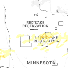


Connect with Interactive Hail Maps