

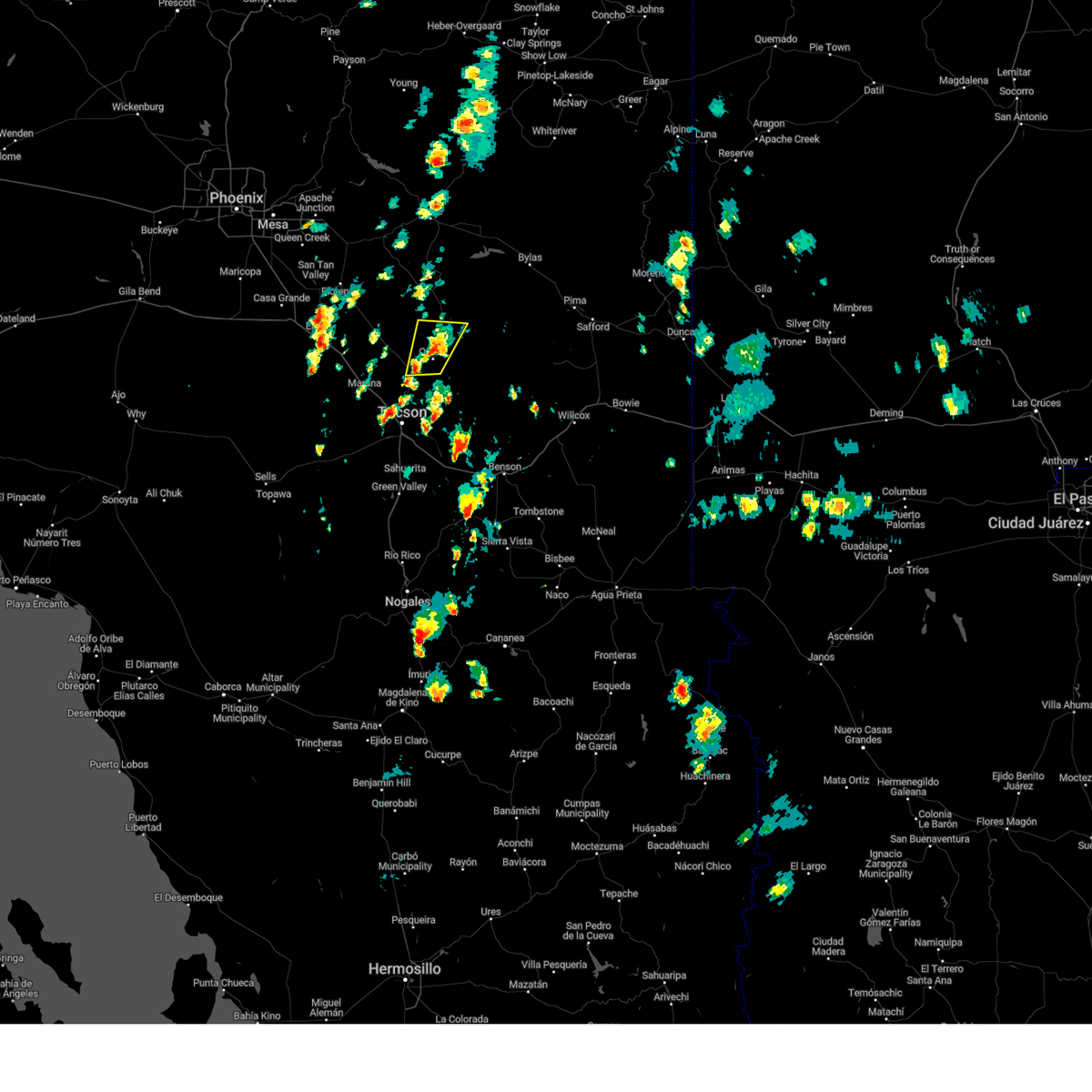
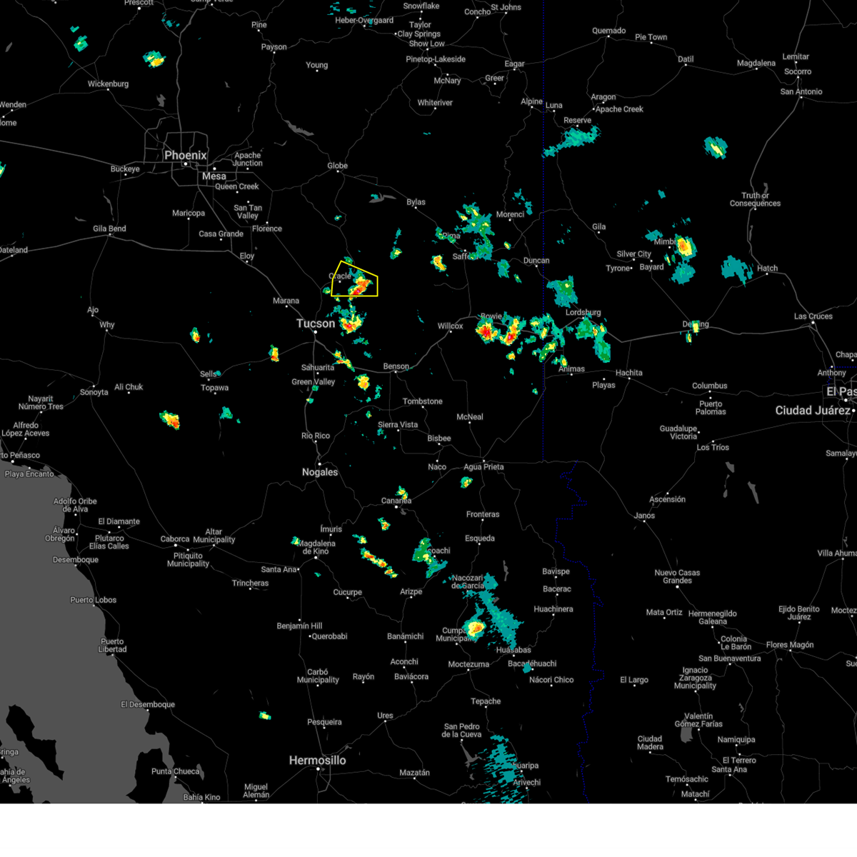
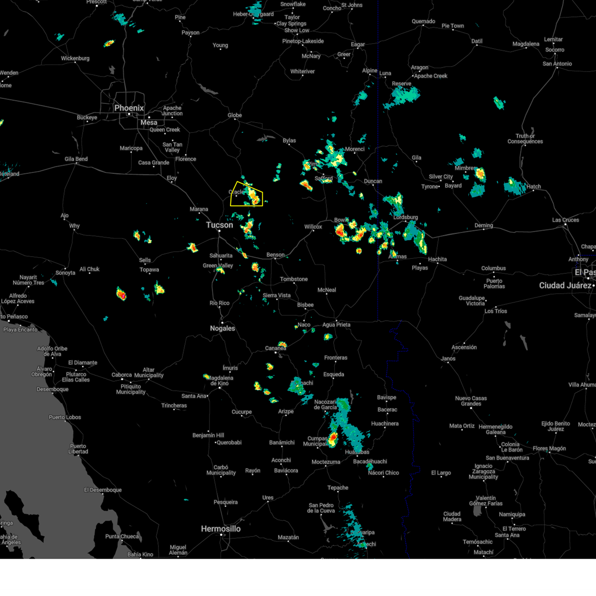
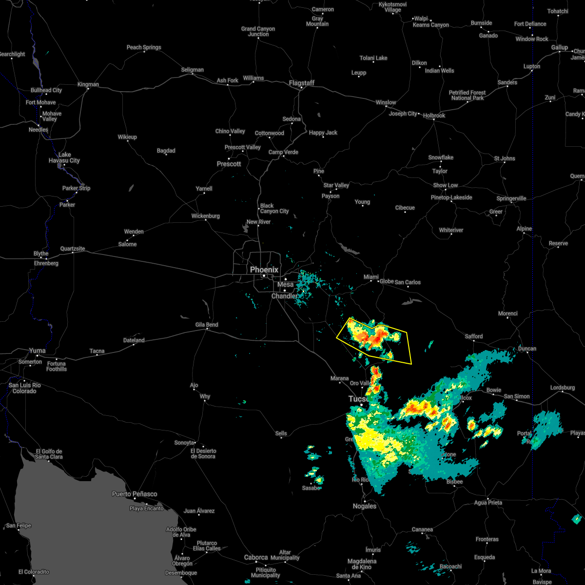
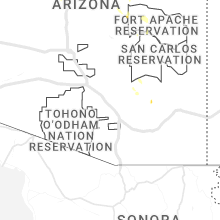
Hail Map for San Manuel, AZ
The San Manuel, AZ area has had 0 reports of on-the-ground hail by trained spotters, and has been under severe weather warnings 25 times during the past 12 months. Doppler radar has detected hail at or near San Manuel, AZ on 49 occasions, including 5 occasions during the past year.
| Name: | San Manuel, AZ |
| Where Located: | 33.3 miles NE of Tucson, AZ |
| Map: | Google Map for San Manuel, AZ |
| Population: | 3551 |
| Housing Units: | 1541 |
| More Info: | Search Google for San Manuel, AZ |
1
The Top Recent Hail Date for San Manuel, AZ is Friday, August 2, 2024 (10th out of 49)

Hail and Wind Damage Spotted near San Manuel, AZ
| Date / Time | Report Details |
|---|---|
| 8/23/2024 3:42 PM MST |
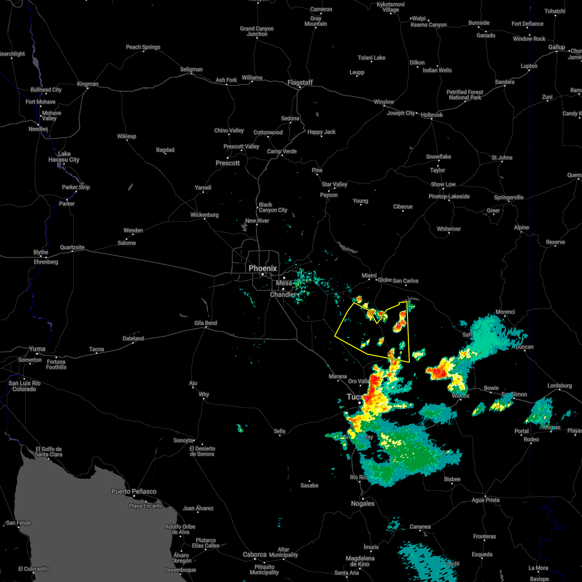
 Svrtwc the national weather service in tucson has issued a * severe thunderstorm warning for, southeastern pinal county in southeastern arizona, * until 430 pm mst. * at 342 pm mst, a severe thunderstorm was located over oracle, moving north at 10 mph (radar indicated). Hazards include 60 mph wind gusts and penny size hail. expect damage to roofs, siding, and trees Svrtwc the national weather service in tucson has issued a * severe thunderstorm warning for, southeastern pinal county in southeastern arizona, * until 430 pm mst. * at 342 pm mst, a severe thunderstorm was located over oracle, moving north at 10 mph (radar indicated). Hazards include 60 mph wind gusts and penny size hail. expect damage to roofs, siding, and trees
|
| 8/2/2024 5:40 PM MST |
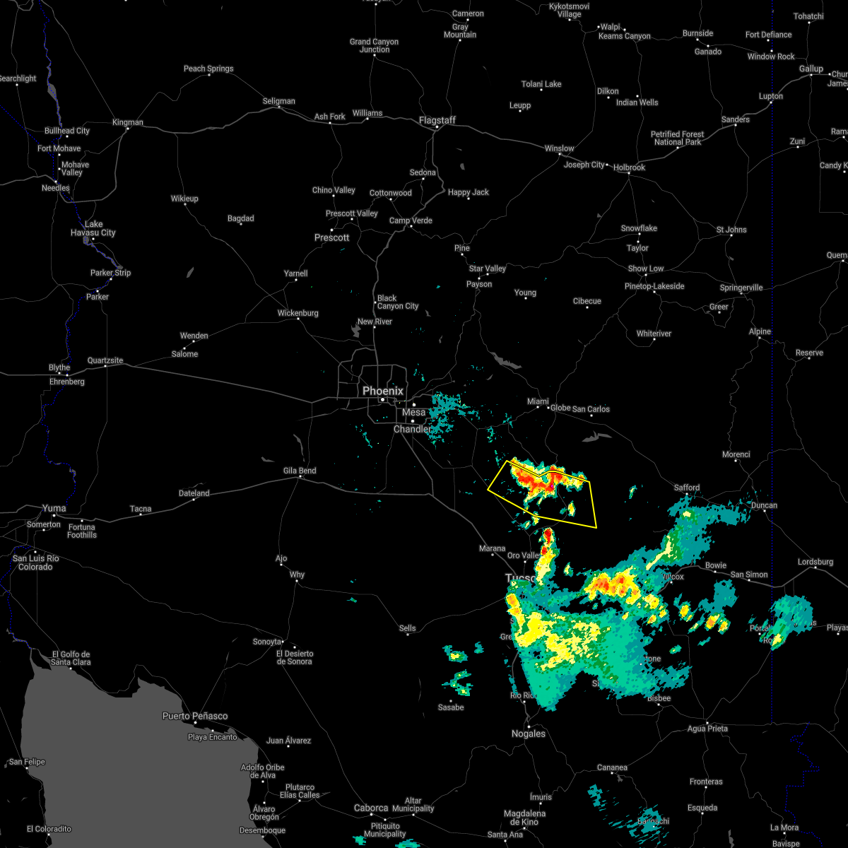
 At 540 pm mst, a severe thunderstorm was located near san manuel, or 7 miles southeast of oracle, moving west at 15 mph (radar indicated). Hazards include 60 mph wind gusts and quarter size hail. Hail damage to vehicles is expected. expect wind damage to roofs, siding, and trees. locations impacted include, oracle, mammoth, san manuel, and campo bonito. This includes route 77 between mile markers 99 and 114. At 540 pm mst, a severe thunderstorm was located near san manuel, or 7 miles southeast of oracle, moving west at 15 mph (radar indicated). Hazards include 60 mph wind gusts and quarter size hail. Hail damage to vehicles is expected. expect wind damage to roofs, siding, and trees. locations impacted include, oracle, mammoth, san manuel, and campo bonito. This includes route 77 between mile markers 99 and 114.
|
| 8/2/2024 5:28 PM MST |
 Svrtwc the national weather service in tucson has issued a * severe thunderstorm warning for, southeastern pinal county in southeastern arizona, * until 615 pm mst. * at 527 pm mst, a severe thunderstorm was located near san manuel, or 10 miles south of mammoth, moving west at 10 mph (radar indicated). Hazards include 60 mph wind gusts and quarter size hail. Hail damage to vehicles is expected. Expect wind damage to roofs, siding, and trees. Svrtwc the national weather service in tucson has issued a * severe thunderstorm warning for, southeastern pinal county in southeastern arizona, * until 615 pm mst. * at 527 pm mst, a severe thunderstorm was located near san manuel, or 10 miles south of mammoth, moving west at 10 mph (radar indicated). Hazards include 60 mph wind gusts and quarter size hail. Hail damage to vehicles is expected. Expect wind damage to roofs, siding, and trees.
|
| 7/25/2024 7:43 PM MST |
 The storm which prompted the warning has weakened below severe limits, and no longer poses an immediate threat to life or property. therefore, the warning will be allowed to expire. however, gusty winds and heavy rain are still possible with this thunderstorm. remember, a flash flood warning still remains in effect for tucson and surrounding areas of the metro this evening. The storm which prompted the warning has weakened below severe limits, and no longer poses an immediate threat to life or property. therefore, the warning will be allowed to expire. however, gusty winds and heavy rain are still possible with this thunderstorm. remember, a flash flood warning still remains in effect for tucson and surrounding areas of the metro this evening.
|
| 7/25/2024 7:32 PM MST |
 At 731 pm mst, a severe thunderstorm was located over catalina state park, or over oro valley, moving south at 15 mph (radar indicated). Hazards include 60 mph wind gusts. Expect damage to roofs, siding, and trees. locations impacted include, catalina, oro valley, marana, oracle, casas adobes, saddlebrooke, san manuel, saddlebrooke ranch, tortolita, mount lemmon/summerhaven, catalina state park, saguaro national park west, picture rocks, campo bonito, dove mountain, oracle junction, and biosphere 2. this includes the following highways, interstate 10 between mile markers 235 and 247. route 77 between mile markers 78 and 111. Route 79 between mile markers 92 and 106. At 731 pm mst, a severe thunderstorm was located over catalina state park, or over oro valley, moving south at 15 mph (radar indicated). Hazards include 60 mph wind gusts. Expect damage to roofs, siding, and trees. locations impacted include, catalina, oro valley, marana, oracle, casas adobes, saddlebrooke, san manuel, saddlebrooke ranch, tortolita, mount lemmon/summerhaven, catalina state park, saguaro national park west, picture rocks, campo bonito, dove mountain, oracle junction, and biosphere 2. this includes the following highways, interstate 10 between mile markers 235 and 247. route 77 between mile markers 78 and 111. Route 79 between mile markers 92 and 106.
|
| 7/25/2024 7:16 PM MST |
 Svrtwc the national weather service in tucson has issued a * severe thunderstorm warning for, northeastern pima county in southeastern arizona, southeastern pinal county in southeastern arizona, * until 745 pm mst. * at 716 pm mst, severe thunderstorms were located along a line extending from near san manuel to near saddlebrooke ranch to 6 miles east of pinal airpark, moving south at 20 mph (radar indicated). Hazards include 60 mph wind gusts. expect damage to roofs, siding, and trees Svrtwc the national weather service in tucson has issued a * severe thunderstorm warning for, northeastern pima county in southeastern arizona, southeastern pinal county in southeastern arizona, * until 745 pm mst. * at 716 pm mst, severe thunderstorms were located along a line extending from near san manuel to near saddlebrooke ranch to 6 miles east of pinal airpark, moving south at 20 mph (radar indicated). Hazards include 60 mph wind gusts. expect damage to roofs, siding, and trees
|
| 7/21/2024 4:26 PM MST |
 The storm which prompted the warning has weakened below severe limits, and no longer poses an immediate threat to life or property. therefore, the warning will be allowed to expire. a severe thunderstorm watch remains in effect until 800 pm mst for southeastern arizona. The storm which prompted the warning has weakened below severe limits, and no longer poses an immediate threat to life or property. therefore, the warning will be allowed to expire. a severe thunderstorm watch remains in effect until 800 pm mst for southeastern arizona.
|
| 7/21/2024 4:06 PM MST |
 At 406 pm mst, severe thunderstorms were located over mammoth, moving south at 15 mph (radar indicated). Hazards include 60 mph wind gusts and nickel size hail. Expect damage to roofs, siding, and trees. locations impacted include, oracle, mammoth, saddlebrooke, san manuel, saddlebrooke ranch, dudleyville, aravaipa canyon wilderness, campo bonito, and biosphere 2. This includes route 77 between mile markers 93 and 131. At 406 pm mst, severe thunderstorms were located over mammoth, moving south at 15 mph (radar indicated). Hazards include 60 mph wind gusts and nickel size hail. Expect damage to roofs, siding, and trees. locations impacted include, oracle, mammoth, saddlebrooke, san manuel, saddlebrooke ranch, dudleyville, aravaipa canyon wilderness, campo bonito, and biosphere 2. This includes route 77 between mile markers 93 and 131.
|
| 7/21/2024 3:48 PM MST |
 Svrtwc the national weather service in tucson has issued a * severe thunderstorm warning for, southeastern pinal county in southeastern arizona, * until 430 pm mst. * at 347 pm mst, severe thunderstorms were located near mammoth, moving south at 15 mph (radar indicated). Hazards include 60 mph wind gusts and nickel size hail. expect damage to roofs, siding, and trees Svrtwc the national weather service in tucson has issued a * severe thunderstorm warning for, southeastern pinal county in southeastern arizona, * until 430 pm mst. * at 347 pm mst, severe thunderstorms were located near mammoth, moving south at 15 mph (radar indicated). Hazards include 60 mph wind gusts and nickel size hail. expect damage to roofs, siding, and trees
|
| 7/18/2024 5:26 PM MST |
 The storm which prompted the warning in southeast pinal county has weakened below severe limits. therefore, the warning will be allowed to expire. however, heavy rain is still possible with this thunderstorm. The storm which prompted the warning in southeast pinal county has weakened below severe limits. therefore, the warning will be allowed to expire. however, heavy rain is still possible with this thunderstorm.
|
| 7/18/2024 4:44 PM MST |
 Svrtwc the national weather service in tucson has issued a * severe thunderstorm warning for, southeastern pinal county in southeastern arizona, * until 530 pm mst. * at 444 pm mst, a severe thunderstorm was located near mammoth, moving southwest at 5 to 10 mph (radar indicated). Hazards include 60 mph wind gusts. expect damage to roofs, siding, and trees Svrtwc the national weather service in tucson has issued a * severe thunderstorm warning for, southeastern pinal county in southeastern arizona, * until 530 pm mst. * at 444 pm mst, a severe thunderstorm was located near mammoth, moving southwest at 5 to 10 mph (radar indicated). Hazards include 60 mph wind gusts. expect damage to roofs, siding, and trees
|
| 7/17/2024 8:06 PM MST |
 The storm which prompted the warning has weakened below severe limits, and no longer poses an immediate threat to life or property. therefore, the warning will be allowed to expire. The storm which prompted the warning has weakened below severe limits, and no longer poses an immediate threat to life or property. therefore, the warning will be allowed to expire.
|
| 7/17/2024 7:40 PM MST |
 Svrtwc the national weather service in tucson has issued a * severe thunderstorm warning for, northeastern pima county in southeastern arizona, southeastern pinal county in southeastern arizona, * until 815 pm mst. * at 740 pm mst, a severe thunderstorm was located near san manuel, or 10 miles southeast of oracle, moving west at 10 mph (radar indicated). Hazards include 60 mph wind gusts and quarter size hail. Hail damage to vehicles is expected. Expect wind damage to roofs, siding, and trees. Svrtwc the national weather service in tucson has issued a * severe thunderstorm warning for, northeastern pima county in southeastern arizona, southeastern pinal county in southeastern arizona, * until 815 pm mst. * at 740 pm mst, a severe thunderstorm was located near san manuel, or 10 miles southeast of oracle, moving west at 10 mph (radar indicated). Hazards include 60 mph wind gusts and quarter size hail. Hail damage to vehicles is expected. Expect wind damage to roofs, siding, and trees.
|
| 7/17/2024 7:30 PM MST |
 At 730 pm mst, a severe thunderstorm was located 7 miles south of san manuel, or 12 miles southeast of oracle, moving west at 10 mph (radar indicated). Hazards include 60 mph wind gusts and quarter size hail. Hail damage to vehicles is expected. expect wind damage to roofs, siding, and trees. locations impacted include, san manuel, campo bonito, and redington. This includes route 77 between mile markers 108 and 113. At 730 pm mst, a severe thunderstorm was located 7 miles south of san manuel, or 12 miles southeast of oracle, moving west at 10 mph (radar indicated). Hazards include 60 mph wind gusts and quarter size hail. Hail damage to vehicles is expected. expect wind damage to roofs, siding, and trees. locations impacted include, san manuel, campo bonito, and redington. This includes route 77 between mile markers 108 and 113.
|
| 7/17/2024 7:10 PM MST |
 Svrtwc the national weather service in tucson has issued a * severe thunderstorm warning for, northeastern pima county in southeastern arizona, southwestern graham county in southeastern arizona, southeastern pinal county in southeastern arizona, * until 745 pm mst. * at 709 pm mst, a severe thunderstorm was located 9 miles southeast of san manuel, or 16 miles southeast of mammoth, moving west at 5 mph (radar indicated). Hazards include 60 mph wind gusts and nickel size hail. expect damage to roofs, siding, and trees Svrtwc the national weather service in tucson has issued a * severe thunderstorm warning for, northeastern pima county in southeastern arizona, southwestern graham county in southeastern arizona, southeastern pinal county in southeastern arizona, * until 745 pm mst. * at 709 pm mst, a severe thunderstorm was located 9 miles southeast of san manuel, or 16 miles southeast of mammoth, moving west at 5 mph (radar indicated). Hazards include 60 mph wind gusts and nickel size hail. expect damage to roofs, siding, and trees
|
| 7/14/2024 7:19 PM MST |
 the severe thunderstorm warning has been cancelled and is no longer in effect the severe thunderstorm warning has been cancelled and is no longer in effect
|
| 7/14/2024 6:49 PM MST |
 Svrtwc the national weather service in tucson has issued a * severe thunderstorm warning for, southeastern pinal county in southeastern arizona, * until 730 pm mst. * at 649 pm mst, a severe thunderstorm was located over oracle, moving northwest at 10 mph (radar indicated). Hazards include 60 mph wind gusts and penny size hail. expect damage to roofs, siding, and trees Svrtwc the national weather service in tucson has issued a * severe thunderstorm warning for, southeastern pinal county in southeastern arizona, * until 730 pm mst. * at 649 pm mst, a severe thunderstorm was located over oracle, moving northwest at 10 mph (radar indicated). Hazards include 60 mph wind gusts and penny size hail. expect damage to roofs, siding, and trees
|
| 7/14/2024 6:34 PM MST |
 At 634 pm mst, severe thunderstorms were located through northwest tucson along a line extending from near mount lemmon/summerhaven to tortolita to near tucson mountain park, moving northwest at 15 mph (radar indicated). Hazards include 80 mph wind gusts and quarter size hail. Flying debris will be dangerous to those caught without shelter. mobile homes will be heavily damaged. expect considerable damage to roofs, windows, and vehicles. extensive tree damage and power outages are likely. locations impacted include, tucson, catalina, oro valley, marana, casas adobes, drexel heights, flowing wells, saddlebrooke, south tucson, tortolita, san xavier community, mount lemmon/summerhaven, catalina state park, tucson estates, saguaro national park west, catalina foothills, tucson mountain park, valencia west, picture rocks, and campo bonito. this includes the following highways, interstate 10 between mile markers 237 and 261. interstate 19 between mile markers 61 and 63. route 77 between mile markers 70 and 90. Route 86 between mile markers 162 and 171. At 634 pm mst, severe thunderstorms were located through northwest tucson along a line extending from near mount lemmon/summerhaven to tortolita to near tucson mountain park, moving northwest at 15 mph (radar indicated). Hazards include 80 mph wind gusts and quarter size hail. Flying debris will be dangerous to those caught without shelter. mobile homes will be heavily damaged. expect considerable damage to roofs, windows, and vehicles. extensive tree damage and power outages are likely. locations impacted include, tucson, catalina, oro valley, marana, casas adobes, drexel heights, flowing wells, saddlebrooke, south tucson, tortolita, san xavier community, mount lemmon/summerhaven, catalina state park, tucson estates, saguaro national park west, catalina foothills, tucson mountain park, valencia west, picture rocks, and campo bonito. this includes the following highways, interstate 10 between mile markers 237 and 261. interstate 19 between mile markers 61 and 63. route 77 between mile markers 70 and 90. Route 86 between mile markers 162 and 171.
|
| 7/14/2024 6:16 PM MST |
 At 615 pm mst, severe thunderstorms were located along a line extending from near mount lemmon/summerhaven to oro valley to near tucson mountain park, moving northwest at 15 mph (radar indicated). Hazards include 75 mph wind gusts and quarter size hail. Hail damage to vehicles is expected. expect considerable tree damage. wind damage is also likely to mobile homes, roofs, and outbuildings. locations impacted include, tucson, catalina, oro valley, marana, casas adobes, drexel heights, flowing wells, tanque verde, saddlebrooke, south tucson, pascua pueblo yaqui reservation, tortolita, san xavier community, mount lemmon/summerhaven, sabino canyon recreation area, tucson estates, saguaro national park west, valencia west, and catalina state park. this includes the following highways, interstate 10 between mile markers 237 and 266. interstate 19 between mile markers 57 and 63. route 77 between mile markers 70 and 90. Route 86 between mile markers 160 and 171. At 615 pm mst, severe thunderstorms were located along a line extending from near mount lemmon/summerhaven to oro valley to near tucson mountain park, moving northwest at 15 mph (radar indicated). Hazards include 75 mph wind gusts and quarter size hail. Hail damage to vehicles is expected. expect considerable tree damage. wind damage is also likely to mobile homes, roofs, and outbuildings. locations impacted include, tucson, catalina, oro valley, marana, casas adobes, drexel heights, flowing wells, tanque verde, saddlebrooke, south tucson, pascua pueblo yaqui reservation, tortolita, san xavier community, mount lemmon/summerhaven, sabino canyon recreation area, tucson estates, saguaro national park west, valencia west, and catalina state park. this includes the following highways, interstate 10 between mile markers 237 and 266. interstate 19 between mile markers 57 and 63. route 77 between mile markers 70 and 90. Route 86 between mile markers 160 and 171.
|
| 7/14/2024 6:16 PM MST |
 the severe thunderstorm warning has been cancelled and is no longer in effect the severe thunderstorm warning has been cancelled and is no longer in effect
|
| 7/14/2024 5:49 PM MST |
 At 548 pm mst, severe thunderstorms were located across tucson along a line extending from 7 miles east of mount lemmon/summerhaven to near catalina foothills to drexel heights, moving northwest at 20 mph (radar indicated). Hazards include 70 mph wind gusts and penny size hail. Expect considerable tree damage. damage is likely to mobile homes, roofs, and outbuildings. locations impacted include, tucson, catalina, oro valley, marana, davis-monthan air force base, casas adobes, drexel heights, flowing wells, tanque verde, saddlebrooke, south tucson, pascua pueblo yaqui reservation, tortolita, san xavier community, mount lemmon/summerhaven, sabino canyon recreation area, summit, tucson estates, saguaro national park west, and valencia west. this includes the following highways, interstate 10 between mile markers 237 and 271. interstate 19 between mile markers 52 and 63. route 77 between mile markers 70 and 90. Route 86 between mile markers 157 and 171. At 548 pm mst, severe thunderstorms were located across tucson along a line extending from 7 miles east of mount lemmon/summerhaven to near catalina foothills to drexel heights, moving northwest at 20 mph (radar indicated). Hazards include 70 mph wind gusts and penny size hail. Expect considerable tree damage. damage is likely to mobile homes, roofs, and outbuildings. locations impacted include, tucson, catalina, oro valley, marana, davis-monthan air force base, casas adobes, drexel heights, flowing wells, tanque verde, saddlebrooke, south tucson, pascua pueblo yaqui reservation, tortolita, san xavier community, mount lemmon/summerhaven, sabino canyon recreation area, summit, tucson estates, saguaro national park west, and valencia west. this includes the following highways, interstate 10 between mile markers 237 and 271. interstate 19 between mile markers 52 and 63. route 77 between mile markers 70 and 90. Route 86 between mile markers 157 and 171.
|
| 7/14/2024 5:39 PM MST |
 Svrtwc the national weather service in tucson has issued a * severe thunderstorm warning for, northeastern pima county in southeastern arizona, northwestern cochise county in southeastern arizona, southeastern pinal county in southeastern arizona, * until 645 pm mst. * at 538 pm mst, severe thunderstorms were located along a line extending from 13 miles east of mount lemmon/summerhaven to sabino canyon recreation area to near tucson international airport, moving northwest at 10 mph (radar indicated). Hazards include 60 mph wind gusts and penny size hail. expect damage to roofs, siding, and trees Svrtwc the national weather service in tucson has issued a * severe thunderstorm warning for, northeastern pima county in southeastern arizona, northwestern cochise county in southeastern arizona, southeastern pinal county in southeastern arizona, * until 645 pm mst. * at 538 pm mst, severe thunderstorms were located along a line extending from 13 miles east of mount lemmon/summerhaven to sabino canyon recreation area to near tucson international airport, moving northwest at 10 mph (radar indicated). Hazards include 60 mph wind gusts and penny size hail. expect damage to roofs, siding, and trees
|
| 7/11/2024 5:22 PM MST |
 The storm which prompted the warning has weakened below severe limits, and has exited the warned area. therefore, the warning will be allowed to expire. remember, a severe thunderstorm warning still remains in effect for pima county until 6:00 pm mst. The storm which prompted the warning has weakened below severe limits, and has exited the warned area. therefore, the warning will be allowed to expire. remember, a severe thunderstorm warning still remains in effect for pima county until 6:00 pm mst.
|
| 7/11/2024 5:15 PM MST | Mesonet station ke77 san manuel airpor in pinal county AZ, 1.6 miles SSE of San Manuel, AZ |
| 7/11/2024 4:56 PM MST |
 At 456 pm mst, a severe thunderstorm was located 18 miles southeast of coolidge airport, or 20 miles southeast of florence, moving southwest at 25 mph (radar indicated). Hazards include 60 mph wind gusts and quarter size hail. Hail damage to vehicles is expected. expect wind damage to roofs, siding, and trees. locations impacted include, catalina, oro valley, oracle, mammoth, saddlebrooke, saddlebrooke ranch, campo bonito, oracle junction, and biosphere 2. this includes the following highways, route 77 between mile markers 84 and 111. Route 79 between mile markers 92 and 109. At 456 pm mst, a severe thunderstorm was located 18 miles southeast of coolidge airport, or 20 miles southeast of florence, moving southwest at 25 mph (radar indicated). Hazards include 60 mph wind gusts and quarter size hail. Hail damage to vehicles is expected. expect wind damage to roofs, siding, and trees. locations impacted include, catalina, oro valley, oracle, mammoth, saddlebrooke, saddlebrooke ranch, campo bonito, oracle junction, and biosphere 2. this includes the following highways, route 77 between mile markers 84 and 111. Route 79 between mile markers 92 and 109.
|
| 7/11/2024 4:39 PM MST |
 Svrtwc the national weather service in tucson has issued a * severe thunderstorm warning for, northeastern pima county in southeastern arizona, eastern pinal county in southeastern arizona, * until 530 pm mst. * at 438 pm mst, a severe thunderstorm was located 14 miles southwest of kearny, or 17 miles southwest of hayden, moving southwest at 25 mph (radar indicated). Hazards include 60 mph wind gusts and quarter size hail. Hail damage to vehicles is expected. Expect wind damage to roofs, siding, and trees. Svrtwc the national weather service in tucson has issued a * severe thunderstorm warning for, northeastern pima county in southeastern arizona, eastern pinal county in southeastern arizona, * until 530 pm mst. * at 438 pm mst, a severe thunderstorm was located 14 miles southwest of kearny, or 17 miles southwest of hayden, moving southwest at 25 mph (radar indicated). Hazards include 60 mph wind gusts and quarter size hail. Hail damage to vehicles is expected. Expect wind damage to roofs, siding, and trees.
|
| 8/21/2023 3:48 PM MST |
 At 347 pm mst, a severe thunderstorm was located over oracle, moving northwest at 25 mph (radar indicated). Hazards include 60 mph wind gusts and quarter size hail. Hail damage to vehicles is expected. expect wind damage to roofs, siding, and trees. locations impacted include, oracle, mammoth, saddlebrooke, san manuel, campo bonito and biosphere 2. hail threat, radar indicated max hail size, 1. 00 in wind threat, radar indicated max wind gust, 60 mph. At 347 pm mst, a severe thunderstorm was located over oracle, moving northwest at 25 mph (radar indicated). Hazards include 60 mph wind gusts and quarter size hail. Hail damage to vehicles is expected. expect wind damage to roofs, siding, and trees. locations impacted include, oracle, mammoth, saddlebrooke, san manuel, campo bonito and biosphere 2. hail threat, radar indicated max hail size, 1. 00 in wind threat, radar indicated max wind gust, 60 mph.
|
| 8/21/2023 3:29 PM MST |
 At 328 pm mst, a severe thunderstorm was located 7 miles south of san manuel, or 11 miles southeast of oracle, moving northwest at 25 mph (radar indicated). Hazards include 60 mph wind gusts and quarter size hail. Hail damage to vehicles is expected. Expect wind damage to roofs, siding, and trees. At 328 pm mst, a severe thunderstorm was located 7 miles south of san manuel, or 11 miles southeast of oracle, moving northwest at 25 mph (radar indicated). Hazards include 60 mph wind gusts and quarter size hail. Hail damage to vehicles is expected. Expect wind damage to roofs, siding, and trees.
|
| 7/31/2023 4:49 PM MST |
 At 448 pm mst, a severe thunderstorm was located near mammoth, moving northwest at 10 mph (radar indicated). Hazards include 60 mph wind gusts and quarter size hail. Hail damage to vehicles is expected. Expect wind damage to roofs, siding, and trees. At 448 pm mst, a severe thunderstorm was located near mammoth, moving northwest at 10 mph (radar indicated). Hazards include 60 mph wind gusts and quarter size hail. Hail damage to vehicles is expected. Expect wind damage to roofs, siding, and trees.
|
| 7/28/2023 4:55 PM MST |
 At 454 pm mst, the leading edge of a cluster of severe thunderstorms extended from 9 miles east of mount lemmon/summerhaven to 11 miles east of saguaro national park east, moving southwest at 10 mph (radar indicated). Hazards include 60 mph wind gusts and quarter size hail. Hail damage to vehicles is expected. expect wind damage to roofs, siding, and trees. was located along a line locations impacted include, oracle, tanque verde, san manuel, mount lemmon/summerhaven, saguaro national park east, campo bonito, redington and cascabel. hail threat, radar indicated max hail size, 1. 00 in wind threat, radar indicated max wind gust, 60 mph. At 454 pm mst, the leading edge of a cluster of severe thunderstorms extended from 9 miles east of mount lemmon/summerhaven to 11 miles east of saguaro national park east, moving southwest at 10 mph (radar indicated). Hazards include 60 mph wind gusts and quarter size hail. Hail damage to vehicles is expected. expect wind damage to roofs, siding, and trees. was located along a line locations impacted include, oracle, tanque verde, san manuel, mount lemmon/summerhaven, saguaro national park east, campo bonito, redington and cascabel. hail threat, radar indicated max hail size, 1. 00 in wind threat, radar indicated max wind gust, 60 mph.
|
| 7/28/2023 4:26 PM MST |
 At 426 pm mst, severe thunderstorms were located along a line extending from 14 miles east of san manuel to 18 miles east of saguaro national park east, moving west at 10 mph (radar indicated). Hazards include 60 mph wind gusts and quarter size hail. Hail damage to vehicles is expected. Expect wind damage to roofs, siding, and trees. At 426 pm mst, severe thunderstorms were located along a line extending from 14 miles east of san manuel to 18 miles east of saguaro national park east, moving west at 10 mph (radar indicated). Hazards include 60 mph wind gusts and quarter size hail. Hail damage to vehicles is expected. Expect wind damage to roofs, siding, and trees.
|
| 7/17/2023 6:21 PM MST |
 The severe thunderstorm warning for southeastern pinal county will expire at 630 pm mst, the severe thunderstorm which prompted the warning has weakened. therefore, the warning will be allowed to expire. however gusty winds and heavy rain are still possible with this thunderstorm. The severe thunderstorm warning for southeastern pinal county will expire at 630 pm mst, the severe thunderstorm which prompted the warning has weakened. therefore, the warning will be allowed to expire. however gusty winds and heavy rain are still possible with this thunderstorm.
|
| 7/17/2023 5:43 PM MST |
 At 542 pm mst, a severe thunderstorm was located over mammoth, moving northwest at 15 mph (radar indicated). Hazards include 60 mph wind gusts and quarter size hail. Hail damage to vehicles is expected. Expect wind damage to roofs, siding, and trees. At 542 pm mst, a severe thunderstorm was located over mammoth, moving northwest at 15 mph (radar indicated). Hazards include 60 mph wind gusts and quarter size hail. Hail damage to vehicles is expected. Expect wind damage to roofs, siding, and trees.
|
| 9/21/2022 4:50 PM MST |
 At 450 pm mst, a severe thunderstorm was located over oracle, moving north at 25 mph (radar indicated). Hazards include 60 mph wind gusts and quarter size hail. Hail damage to vehicles is expected. Expect wind damage to roofs, siding, and trees. At 450 pm mst, a severe thunderstorm was located over oracle, moving north at 25 mph (radar indicated). Hazards include 60 mph wind gusts and quarter size hail. Hail damage to vehicles is expected. Expect wind damage to roofs, siding, and trees.
|
| 8/23/2022 5:51 PM MST | The severe thunderstorm warning for northeastern pima and southeastern pinal counties will expire at 600 pm mst, the storm which prompted the warning has weakened below severe limits, and no longer poses an immediate threat to life or property. therefore, the warning will be allowed to expire. |
| 8/23/2022 5:10 PM MST | At 510 pm mst, a severe thunderstorm was located over san manuel, or 8 miles east of oracle, moving southwest at 5 mph (radar indicated). Hazards include 60 mph wind gusts and quarter size hail. Hail damage to vehicles is expected. Expect wind damage to roofs, siding, and trees. |
| 8/8/2022 9:52 PM MST |
 At 951 pm mst, a severe thunderstorm was located near san manuel, or 8 miles southeast of mammoth, moving west at 10 mph (radar indicated). Hazards include 60 mph wind gusts and quarter size hail. Hail damage to vehicles is expected. Expect wind damage to roofs, siding, and trees. At 951 pm mst, a severe thunderstorm was located near san manuel, or 8 miles southeast of mammoth, moving west at 10 mph (radar indicated). Hazards include 60 mph wind gusts and quarter size hail. Hail damage to vehicles is expected. Expect wind damage to roofs, siding, and trees.
|
| 7/24/2022 3:59 AM MST |
 At 358 am mst, a severe thunderstorm was located near to south of hayden, moving northwest at 20 mph (radar indicated). Hazards include 70 mph wind gusts and quarter size hail. Hail damage to vehicles is expected. expect considerable tree damage. wind damage is also likely to mobile homes, roofs, and outbuildings. locations impacted include, oracle, mammoth, san manuel, kearny, dudleyville, aravaipa canyon wilderness, cactus forest and kelvin. thunderstorm damage threat, considerable hail threat, radar indicated max hail size, 1. 00 in wind threat, radar indicated max wind gust, 70 mph. At 358 am mst, a severe thunderstorm was located near to south of hayden, moving northwest at 20 mph (radar indicated). Hazards include 70 mph wind gusts and quarter size hail. Hail damage to vehicles is expected. expect considerable tree damage. wind damage is also likely to mobile homes, roofs, and outbuildings. locations impacted include, oracle, mammoth, san manuel, kearny, dudleyville, aravaipa canyon wilderness, cactus forest and kelvin. thunderstorm damage threat, considerable hail threat, radar indicated max hail size, 1. 00 in wind threat, radar indicated max wind gust, 70 mph.
|
| 7/24/2022 3:42 AM MST |
 At 341 am mst, a severe thunderstorm was located near and north of dudleyville, or near winkelman, moving northwest at 25 mph (radar indicated). Hazards include 60 mph wind gusts and quarter size hail. Hail damage to vehicles is expected. Expect wind damage to roofs, siding, and trees. At 341 am mst, a severe thunderstorm was located near and north of dudleyville, or near winkelman, moving northwest at 25 mph (radar indicated). Hazards include 60 mph wind gusts and quarter size hail. Hail damage to vehicles is expected. Expect wind damage to roofs, siding, and trees.
|
| 7/17/2022 6:43 PM MST |
 The severe thunderstorm warning for northeastern pima and southeastern pinal counties will expire at 645 pm mst, the storm which prompted the warning has weakened below severe limits, and no longer poses an immediate threat to life or property. therefore, the warning will be allowed to expire. The severe thunderstorm warning for northeastern pima and southeastern pinal counties will expire at 645 pm mst, the storm which prompted the warning has weakened below severe limits, and no longer poses an immediate threat to life or property. therefore, the warning will be allowed to expire.
|
| 7/17/2022 6:29 PM MST |
 At 629 pm mst, a severe thunderstorm was located near saddlebrooke, or near oracle, moving northwest at 15 mph (radar indicated). Hazards include 60 mph wind gusts and quarter size hail. Hail damage to vehicles is expected. expect wind damage to roofs, siding, and trees. locations impacted include, catalina, oracle, saddlebrooke, mount lemmon/summerhaven, campo bonito, oracle junction and biosphere 2. hail threat, radar indicated max hail size, 1. 00 in wind threat, radar indicated max wind gust, 60 mph. At 629 pm mst, a severe thunderstorm was located near saddlebrooke, or near oracle, moving northwest at 15 mph (radar indicated). Hazards include 60 mph wind gusts and quarter size hail. Hail damage to vehicles is expected. expect wind damage to roofs, siding, and trees. locations impacted include, catalina, oracle, saddlebrooke, mount lemmon/summerhaven, campo bonito, oracle junction and biosphere 2. hail threat, radar indicated max hail size, 1. 00 in wind threat, radar indicated max wind gust, 60 mph.
|
| 7/17/2022 5:56 PM MST |
 At 556 pm mst, a severe thunderstorm was located near mount lemmon/summerhaven, or 9 miles southeast of oracle, moving northwest at 15 mph (radar indicated). Hazards include 60 mph wind gusts and quarter size hail. Hail damage to vehicles is expected. Expect wind damage to roofs, siding, and trees. At 556 pm mst, a severe thunderstorm was located near mount lemmon/summerhaven, or 9 miles southeast of oracle, moving northwest at 15 mph (radar indicated). Hazards include 60 mph wind gusts and quarter size hail. Hail damage to vehicles is expected. Expect wind damage to roofs, siding, and trees.
|
| 7/16/2022 6:27 PM MST |
 The severe thunderstorm warning for western graham and southeastern pinal counties will expire at 630 pm mst, the storm which prompted the warning has weakened below severe limits, and no longer poses an immediate threat to life or property. therefore, the warning will be allowed to expire. however gusty winds are still possible with this thunderstorm. The severe thunderstorm warning for western graham and southeastern pinal counties will expire at 630 pm mst, the storm which prompted the warning has weakened below severe limits, and no longer poses an immediate threat to life or property. therefore, the warning will be allowed to expire. however gusty winds are still possible with this thunderstorm.
|
| 7/16/2022 6:06 PM MST |
 At 605 pm mst, a severe thunderstorm was located near mammoth, moving west at 15 mph (radar indicated). Hazards include 60 mph wind gusts and quarter size hail. Hail damage to vehicles is expected. expect wind damage to roofs, siding, and trees. locations impacted include, oracle, mammoth, san manuel, dudleyville and aravaipa canyon wilderness. hail threat, radar indicated max hail size, 1. 00 in wind threat, radar indicated max wind gust, 60 mph. At 605 pm mst, a severe thunderstorm was located near mammoth, moving west at 15 mph (radar indicated). Hazards include 60 mph wind gusts and quarter size hail. Hail damage to vehicles is expected. expect wind damage to roofs, siding, and trees. locations impacted include, oracle, mammoth, san manuel, dudleyville and aravaipa canyon wilderness. hail threat, radar indicated max hail size, 1. 00 in wind threat, radar indicated max wind gust, 60 mph.
|
| 7/16/2022 5:38 PM MST |
 At 538 pm mst, a severe thunderstorm was located 10 miles east of mammoth, moving west at 15 mph (radar indicated). Hazards include 60 mph wind gusts and quarter size hail. Hail damage to vehicles is expected. Expect wind damage to roofs, siding, and trees. At 538 pm mst, a severe thunderstorm was located 10 miles east of mammoth, moving west at 15 mph (radar indicated). Hazards include 60 mph wind gusts and quarter size hail. Hail damage to vehicles is expected. Expect wind damage to roofs, siding, and trees.
|
| 9/5/2021 5:58 PM MST |
 At 558 pm mst, severe thunderstorms were located along a line extending from 6 miles southeast of dudleyville to 10 miles north of oracle to 17 miles north of saddlebrooke to 18 miles southwest of kearny, moving southwest at 25 mph (radar indicated). Hazards include 60 mph wind gusts. expect damage to roofs, siding, and trees At 558 pm mst, severe thunderstorms were located along a line extending from 6 miles southeast of dudleyville to 10 miles north of oracle to 17 miles north of saddlebrooke to 18 miles southwest of kearny, moving southwest at 25 mph (radar indicated). Hazards include 60 mph wind gusts. expect damage to roofs, siding, and trees
|
| 9/5/2021 5:55 PM MST |
 The severe thunderstorm warning for western graham and east central pinal counties will expire at 600 pm mst, the storms which prompted the warning have moved out of the area. therefore, the warning will be allowed to expire. however gusty winds and heavy rain are still possible with these thunderstorms. to report severe weather, contact your nearest law enforcement agency. they will relay your report to the national weather service tucson. The severe thunderstorm warning for western graham and east central pinal counties will expire at 600 pm mst, the storms which prompted the warning have moved out of the area. therefore, the warning will be allowed to expire. however gusty winds and heavy rain are still possible with these thunderstorms. to report severe weather, contact your nearest law enforcement agency. they will relay your report to the national weather service tucson.
|
| 9/5/2021 5:48 PM MST |
 At 547 pm mst, severe thunderstorms were located along a line extending from near aravaipa canyon wilderness to 7 miles south of dudleyville to 15 miles southwest of winkelman to 13 miles southwest of kearny, moving south at 20 mph (radar indicated). Hazards include 60 mph wind gusts and quarter size hail. Hail damage to vehicles is expected. expect wind damage to roofs, siding, and trees. locations impacted include, mammoth, dudleyville and aravaipa canyon wilderness. hail threat, radar indicated max hail size, 1. 00 in wind threat, radar indicated max wind gust, 60 mph. At 547 pm mst, severe thunderstorms were located along a line extending from near aravaipa canyon wilderness to 7 miles south of dudleyville to 15 miles southwest of winkelman to 13 miles southwest of kearny, moving south at 20 mph (radar indicated). Hazards include 60 mph wind gusts and quarter size hail. Hail damage to vehicles is expected. expect wind damage to roofs, siding, and trees. locations impacted include, mammoth, dudleyville and aravaipa canyon wilderness. hail threat, radar indicated max hail size, 1. 00 in wind threat, radar indicated max wind gust, 60 mph.
|
| 9/5/2021 5:01 PM MST |
 At 501 pm mst, severe thunderstorms were located along a line extending from near aravaipa canyon wilderness to near dudleyville to near kearny to 13 miles southeast of superior, moving south at 20 mph (radar indicated). Hazards include 60 mph wind gusts and quarter size hail. Hail damage to vehicles is expected. Expect wind damage to roofs, siding, and trees. At 501 pm mst, severe thunderstorms were located along a line extending from near aravaipa canyon wilderness to near dudleyville to near kearny to 13 miles southeast of superior, moving south at 20 mph (radar indicated). Hazards include 60 mph wind gusts and quarter size hail. Hail damage to vehicles is expected. Expect wind damage to roofs, siding, and trees.
|
| 8/28/2021 5:57 PM MST |
 The severe thunderstorm warning for northeastern pima and southeastern pinal counties will expire at 600 pm mst, the storms which prompted the warning have weakened below severe limits, and no longer pose an immediate threat to life or property. therefore, the warning will be allowed to expire. however gusty winds and heavy rain are still possible with these thunderstorms. a flash flood warning remains in effect for much of the region. The severe thunderstorm warning for northeastern pima and southeastern pinal counties will expire at 600 pm mst, the storms which prompted the warning have weakened below severe limits, and no longer pose an immediate threat to life or property. therefore, the warning will be allowed to expire. however gusty winds and heavy rain are still possible with these thunderstorms. a flash flood warning remains in effect for much of the region.
|
| 8/28/2021 5:27 PM MST |
 At 525 pm mst, severe thunderstorms were located along a line extending from 6 miles north of saddlebrooke to near casas adobes, moving west at 15 mph (radar indicated). Hazards include 60 mph wind gusts and penny size hail. Expect damage to roofs, siding, and trees. locations impacted include, marana, flowing wells, saddlebrooke, avra valley, tortolita, saguaro national park west, picture rocks, red rock, dove mountain hail threat, radar indicated max hail size, 0. 75 in wind threat, radar indicated max wind gust, 60 mph. At 525 pm mst, severe thunderstorms were located along a line extending from 6 miles north of saddlebrooke to near casas adobes, moving west at 15 mph (radar indicated). Hazards include 60 mph wind gusts and penny size hail. Expect damage to roofs, siding, and trees. locations impacted include, marana, flowing wells, saddlebrooke, avra valley, tortolita, saguaro national park west, picture rocks, red rock, dove mountain hail threat, radar indicated max hail size, 0. 75 in wind threat, radar indicated max wind gust, 60 mph.
|
| 8/28/2021 4:58 PM MST |
 At 457 pm mst, severe thunderstorms were located along a line extending from oracle to near flowing wells, moving west at 15 mph (radar indicated). Hazards include 60 mph wind gusts and penny size hail. expect damage to roofs, siding, and trees At 457 pm mst, severe thunderstorms were located along a line extending from oracle to near flowing wells, moving west at 15 mph (radar indicated). Hazards include 60 mph wind gusts and penny size hail. expect damage to roofs, siding, and trees
|
| 8/16/2021 10:41 PM MST |
 At 1039 pm mst, several severe thunderstorms were impacting mammoth, san manuel and oracle. additional storms were impacting kearny and kelvin. movement of storms is generally to the south at 15 mph (radar indicated). Hazards include 60 mph wind gusts and quarter size hail. Hail damage to vehicles is expected. expect wind damage to roofs, siding, and trees. locations impacted include, oracle, mammoth, saddlebrooke, san manuel, kearny, dudleyville, aravaipa canyon wilderness, cactus forest, campo bonito, kelvin, oracle junction, biosphere 2 and san carlos reservoir. hail threat, radar indicated max hail size, 1. 00 in wind threat, radar indicated max wind gust, 60 mph. At 1039 pm mst, several severe thunderstorms were impacting mammoth, san manuel and oracle. additional storms were impacting kearny and kelvin. movement of storms is generally to the south at 15 mph (radar indicated). Hazards include 60 mph wind gusts and quarter size hail. Hail damage to vehicles is expected. expect wind damage to roofs, siding, and trees. locations impacted include, oracle, mammoth, saddlebrooke, san manuel, kearny, dudleyville, aravaipa canyon wilderness, cactus forest, campo bonito, kelvin, oracle junction, biosphere 2 and san carlos reservoir. hail threat, radar indicated max hail size, 1. 00 in wind threat, radar indicated max wind gust, 60 mph.
|
| 8/16/2021 10:24 PM MST |
 At 1023 pm mst, a several severe thunderstorms across eastern pinal county. one was located near mammoth while another one was approaching kearny. these storms were movint to the south around 10 to 15 mph (radar indicated). Hazards include 60 mph wind gusts. expect damage to roofs, siding, and trees At 1023 pm mst, a several severe thunderstorms across eastern pinal county. one was located near mammoth while another one was approaching kearny. these storms were movint to the south around 10 to 15 mph (radar indicated). Hazards include 60 mph wind gusts. expect damage to roofs, siding, and trees
|
| 8/16/2021 1:09 PM MST |
 The severe thunderstorm warning for southeastern pinal county will expire at 115 pm mst, the storm which prompted the warning has moved out of the area. therefore, the warning will be allowed to expire. however heavy rain is still possible with this thunderstorm. The severe thunderstorm warning for southeastern pinal county will expire at 115 pm mst, the storm which prompted the warning has moved out of the area. therefore, the warning will be allowed to expire. however heavy rain is still possible with this thunderstorm.
|
| 8/16/2021 12:38 PM MST |
 At 1237 pm mst, a severe thunderstorm was located over oracle, moving south at 5 mph (radar indicated). Hazards include 60 mph wind gusts and quarter size hail. Hail damage to vehicles is expected. expect wind damage to roofs, siding, and trees. locations impacted include, oracle, saddlebrooke, campo bonito, biosphere 2 and oracle junction. hail threat, radar indicated max hail size, 1. 00 in wind threat, radar indicated max wind gust, 60 mph. At 1237 pm mst, a severe thunderstorm was located over oracle, moving south at 5 mph (radar indicated). Hazards include 60 mph wind gusts and quarter size hail. Hail damage to vehicles is expected. expect wind damage to roofs, siding, and trees. locations impacted include, oracle, saddlebrooke, campo bonito, biosphere 2 and oracle junction. hail threat, radar indicated max hail size, 1. 00 in wind threat, radar indicated max wind gust, 60 mph.
|
| 8/16/2021 12:20 PM MST |
 At 1219 pm mst, a severe thunderstorm was located over oracle, moving south at 5 mph (radar indicated). Hazards include 60 mph wind gusts and quarter size hail. Hail damage to vehicles is expected. Expect wind damage to roofs, siding, and trees. At 1219 pm mst, a severe thunderstorm was located over oracle, moving south at 5 mph (radar indicated). Hazards include 60 mph wind gusts and quarter size hail. Hail damage to vehicles is expected. Expect wind damage to roofs, siding, and trees.
|
| 7/20/2021 8:54 PM MST |
 The severe thunderstorm warning for southeastern pinal county will expire at 900 pm mst, the storm which prompted the warning near oracle has weakened below severe limits, and no longer poses an immediate threat to life or property. therefore, the warning will be allowed to expire. however heavy rain is still possible with this thunderstorm. The severe thunderstorm warning for southeastern pinal county will expire at 900 pm mst, the storm which prompted the warning near oracle has weakened below severe limits, and no longer poses an immediate threat to life or property. therefore, the warning will be allowed to expire. however heavy rain is still possible with this thunderstorm.
|
| 7/20/2021 8:21 PM MST |
 At 821 pm mst, a severe thunderstorm was located between oracle and campo bonito, moving west at 15 mph (radar indicated). Hazards include 60 mph wind gusts and penny size hail. Expect damage to roofs, siding, and trees. locations impacted include, oracle, saddlebrooke, san manuel, campo bonito, biosphere 2 and oracle junction. this includes the following highways, route 77 between mile markers 89 and 112. Route 79 near mile marker 92. At 821 pm mst, a severe thunderstorm was located between oracle and campo bonito, moving west at 15 mph (radar indicated). Hazards include 60 mph wind gusts and penny size hail. Expect damage to roofs, siding, and trees. locations impacted include, oracle, saddlebrooke, san manuel, campo bonito, biosphere 2 and oracle junction. this includes the following highways, route 77 between mile markers 89 and 112. Route 79 near mile marker 92.
|
| 7/20/2021 8:02 PM MST |
 At 801 pm mst, a severe thunderstorm was located near oracle, moving west at 15 mph (radar indicated). Hazards include 60 mph wind gusts and penny size hail. expect damage to roofs, siding, and trees At 801 pm mst, a severe thunderstorm was located near oracle, moving west at 15 mph (radar indicated). Hazards include 60 mph wind gusts and penny size hail. expect damage to roofs, siding, and trees
|
| 7/13/2021 5:19 PM MST |
 At 517 pm mst, a severe thunderstorm located just west of oracle was moving toward oracle junction at 10 mph (radar indicated). Hazards include the storm is weakening a bit however 60 mph wind gusts are still likely. Expect damage to roofs, siding, and trees. locations impacted include, oracle, saddlebrooke, campo bonito and biosphere 2. This includes route 77 between mile markers 92 and 110. At 517 pm mst, a severe thunderstorm located just west of oracle was moving toward oracle junction at 10 mph (radar indicated). Hazards include the storm is weakening a bit however 60 mph wind gusts are still likely. Expect damage to roofs, siding, and trees. locations impacted include, oracle, saddlebrooke, campo bonito and biosphere 2. This includes route 77 between mile markers 92 and 110.
|
| 7/13/2021 4:58 PM MST |
 At 457 pm mst, a severe thunderstorm was located over oracle, moving west at 10 mph (radar indicated). Hazards include 60 mph wind gusts and penny size hail. expect damage to roofs, siding, and trees At 457 pm mst, a severe thunderstorm was located over oracle, moving west at 10 mph (radar indicated). Hazards include 60 mph wind gusts and penny size hail. expect damage to roofs, siding, and trees
|
| 7/9/2021 4:58 PM MST |
 At 457 pm mst, a severe thunderstorm was located 11 miles east of san manuel, or 12 miles southeast of mammoth, moving west at 20 mph (radar indicated). Hazards include 60 mph wind gusts and quarter size hail. Hail damage to vehicles is expected. Expect wind damage to roofs, siding, and trees. At 457 pm mst, a severe thunderstorm was located 11 miles east of san manuel, or 12 miles southeast of mammoth, moving west at 20 mph (radar indicated). Hazards include 60 mph wind gusts and quarter size hail. Hail damage to vehicles is expected. Expect wind damage to roofs, siding, and trees.
|
| 7/2/2021 2:36 PM MST |
 At 236 pm mst, a severe thunderstorm was located over oracle, moving west at 10 mph (radar indicated). Hazards include 60 mph wind gusts and penny size hail. expect damage to roofs, siding, and trees At 236 pm mst, a severe thunderstorm was located over oracle, moving west at 10 mph (radar indicated). Hazards include 60 mph wind gusts and penny size hail. expect damage to roofs, siding, and trees
|
| 11/29/2019 7:30 AM MST |
 At 729 am mst, severe thunderstorms were located along a line extending from 9 miles east of aravaipa canyon wilderness to near green valley, including the tucson metro area, moving east at 35 mph (radar indicated). Hazards include 60 mph wind gusts. expect damage to roofs, siding, and trees At 729 am mst, severe thunderstorms were located along a line extending from 9 miles east of aravaipa canyon wilderness to near green valley, including the tucson metro area, moving east at 35 mph (radar indicated). Hazards include 60 mph wind gusts. expect damage to roofs, siding, and trees
|
| 11/29/2019 6:58 AM MST |
 At 656 am mst, a line of scattered showers and thunderstorms extended across portions of the area, moving east at 40 mph (radar indicated). Hazards include 60 mph wind gusts. expect damage to roofs, siding, and trees At 656 am mst, a line of scattered showers and thunderstorms extended across portions of the area, moving east at 40 mph (radar indicated). Hazards include 60 mph wind gusts. expect damage to roofs, siding, and trees
|
| 9/16/2019 4:52 PM MST |
 At 451 pm mst, a severe thunderstorm was located near san manuel, or 8 miles east of oracle, and is nearly stationary (radar indicated). Hazards include 60 mph wind gusts and penny size hail. Expect damage to roofs, siding, and trees. locations impacted include, oracle, mammoth, san manuel and campo bonito. This includes route 77 between mile markers 101 and 114. At 451 pm mst, a severe thunderstorm was located near san manuel, or 8 miles east of oracle, and is nearly stationary (radar indicated). Hazards include 60 mph wind gusts and penny size hail. Expect damage to roofs, siding, and trees. locations impacted include, oracle, mammoth, san manuel and campo bonito. This includes route 77 between mile markers 101 and 114.
|
| 9/16/2019 4:29 PM MST |
 The national weather service in tucson has issued a * severe thunderstorm warning for. northeastern pima county in southeastern arizona. southeastern pinal county in southeastern arizona. until 515 pm mst. At 429 pm mst, a severe thunderstorm was located near san manuel,. The national weather service in tucson has issued a * severe thunderstorm warning for. northeastern pima county in southeastern arizona. southeastern pinal county in southeastern arizona. until 515 pm mst. At 429 pm mst, a severe thunderstorm was located near san manuel,.
|
| 7/24/2019 7:43 PM MST |
 The severe thunderstorm warning for northeastern pima and southeastern pinal counties will expire at 745 pm mst, the storm which prompted the warning has weakened below severe limits, and no longer poses an immediate threat to life or property. therefore, the warning will be allowed to expire. however gusty winds and heavy rain are still possible with this thunderstorm. The severe thunderstorm warning for northeastern pima and southeastern pinal counties will expire at 745 pm mst, the storm which prompted the warning has weakened below severe limits, and no longer poses an immediate threat to life or property. therefore, the warning will be allowed to expire. however gusty winds and heavy rain are still possible with this thunderstorm.
|
| 7/24/2019 7:24 PM MST |
 At 723 pm mst, a severe thunderstorm was located near san manuel, or about 12 miles southeast of oracle, moving northwest at 15 mph (radar indicated). Hazards include 60 mph wind gusts and penny size hail. Expect damage to roofs, siding, and trees. locations impacted include, oracle, mammoth, san manuel, campo bonito and biosphere 2. This includes route 77 between mile markers 101 and 114. At 723 pm mst, a severe thunderstorm was located near san manuel, or about 12 miles southeast of oracle, moving northwest at 15 mph (radar indicated). Hazards include 60 mph wind gusts and penny size hail. Expect damage to roofs, siding, and trees. locations impacted include, oracle, mammoth, san manuel, campo bonito and biosphere 2. This includes route 77 between mile markers 101 and 114.
|
| 7/24/2019 7:02 PM MST |
 At 701 pm mst, a severe thunderstorm was located 11 miles southeast of san manuel, moving northwest at 15 mph (radar indicated). Hazards include 60 mph wind gusts and quarter size hail. Hail damage to vehicles is expected. Expect wind damage to roofs, siding, and trees. At 701 pm mst, a severe thunderstorm was located 11 miles southeast of san manuel, moving northwest at 15 mph (radar indicated). Hazards include 60 mph wind gusts and quarter size hail. Hail damage to vehicles is expected. Expect wind damage to roofs, siding, and trees.
|
| 7/22/2019 7:13 PM MST |
 The severe thunderstorm warning for southeastern pinal county will expire at 715 pm mst, the storm which prompted the warning has weakened below severe limits, and no longer poses an immediate threat to life or property. therefore, the warning will be allowed to expire. however gusty winds and heavy rain are still possible with this thunderstorm. a severe thunderstorm watch remains in effect until 1100 pm mst for southeastern arizona. The severe thunderstorm warning for southeastern pinal county will expire at 715 pm mst, the storm which prompted the warning has weakened below severe limits, and no longer poses an immediate threat to life or property. therefore, the warning will be allowed to expire. however gusty winds and heavy rain are still possible with this thunderstorm. a severe thunderstorm watch remains in effect until 1100 pm mst for southeastern arizona.
|
| 7/22/2019 6:44 PM MST |
 At 643 pm mst, a severe thunderstorm was located near oracle, moving west at 15 mph (radar indicated). Hazards include 60 mph wind gusts and penny size hail. expect damage to roofs, siding, and trees At 643 pm mst, a severe thunderstorm was located near oracle, moving west at 15 mph (radar indicated). Hazards include 60 mph wind gusts and penny size hail. expect damage to roofs, siding, and trees
|
| 8/12/2018 5:58 PM MST |
 At 557 pm mst, a severe thunderstorm was located near oracle, or 17 miles northeast of oro valley, moving southwest at 20 mph (radar indicated). Hazards include 60 mph wind gusts and quarter size hail. Hail damage to vehicles is expected. Expect wind damage to roofs, siding, and trees. At 557 pm mst, a severe thunderstorm was located near oracle, or 17 miles northeast of oro valley, moving southwest at 20 mph (radar indicated). Hazards include 60 mph wind gusts and quarter size hail. Hail damage to vehicles is expected. Expect wind damage to roofs, siding, and trees.
|
| 8/10/2018 6:22 PM MST |
 The severe thunderstorm warning for southeastern pinal county will expire at 630 pm mst, the storm which prompted the warning has weakened below severe limits, and has exited the warned area. therefore, the warning will be allowed to expire. however heavy rain is still possible and an urban and small stream advisory remains in effect. The severe thunderstorm warning for southeastern pinal county will expire at 630 pm mst, the storm which prompted the warning has weakened below severe limits, and has exited the warned area. therefore, the warning will be allowed to expire. however heavy rain is still possible and an urban and small stream advisory remains in effect.
|
| 8/10/2018 5:58 PM MST |
 At 538 pm mst, a severe thunderstorm was located near san manuel, or 20 miles northeast of oro valley, moving southwest at 10 mph (radar indicated). Hazards include 60 mph wind gusts and quarter size hail. Hail damage to vehicles is expected. Expect wind damage to roofs, siding, and trees. At 538 pm mst, a severe thunderstorm was located near san manuel, or 20 miles northeast of oro valley, moving southwest at 10 mph (radar indicated). Hazards include 60 mph wind gusts and quarter size hail. Hail damage to vehicles is expected. Expect wind damage to roofs, siding, and trees.
|
| 8/10/2018 5:38 PM MST |
 At 538 pm mst, a severe thunderstorm was located near san manuel, or 20 miles northeast of oro valley, moving southwest at 10 mph (radar indicated). Hazards include 60 mph wind gusts and quarter size hail. Hail damage to vehicles is expected. Expect wind damage to roofs, siding, and trees. At 538 pm mst, a severe thunderstorm was located near san manuel, or 20 miles northeast of oro valley, moving southwest at 10 mph (radar indicated). Hazards include 60 mph wind gusts and quarter size hail. Hail damage to vehicles is expected. Expect wind damage to roofs, siding, and trees.
|
| 8/7/2018 5:19 PM MST |
 At 517 pm mst, a severe and long-lived thunderstorm was located near san manuel, or 20 miles northeast of oro valley, moving northwest at 15 mph (radar indicated). Hazards include 60 mph wind gusts and quarter size hail. Hail damage to vehicles is expected. expect wind damage to roofs, siding, and trees. locations impacted include, san manuel, oracle, campo bonito, mount lemmon/summerhaven and catalina. This includes route 77 between mile markers 106 and 110. At 517 pm mst, a severe and long-lived thunderstorm was located near san manuel, or 20 miles northeast of oro valley, moving northwest at 15 mph (radar indicated). Hazards include 60 mph wind gusts and quarter size hail. Hail damage to vehicles is expected. expect wind damage to roofs, siding, and trees. locations impacted include, san manuel, oracle, campo bonito, mount lemmon/summerhaven and catalina. This includes route 77 between mile markers 106 and 110.
|
| 8/7/2018 4:48 PM MST |
 At 448 pm mst, doppler radar indicated a severe thunderstorm capable of producing quarter size hail and damaging winds in excess of 60 mph. this storm was located near san manuel, or 19 miles northeast of oro valley, and moving northwest at 10 mph. At 448 pm mst, doppler radar indicated a severe thunderstorm capable of producing quarter size hail and damaging winds in excess of 60 mph. this storm was located near san manuel, or 19 miles northeast of oro valley, and moving northwest at 10 mph.
|
| 7/28/2018 8:22 PM MST |
 The severe thunderstorm warning for southeastern pinal county will expire at 830 pm mst, the storm which prompted the warning has weakened below severe limits. therefore, the warning will be allowed to expire. however small hail, gusty winds and heavy rain are still possible with this thunderstorm. The severe thunderstorm warning for southeastern pinal county will expire at 830 pm mst, the storm which prompted the warning has weakened below severe limits. therefore, the warning will be allowed to expire. however small hail, gusty winds and heavy rain are still possible with this thunderstorm.
|
| 7/28/2018 7:57 PM MST |
 At 756 pm mst, a severe thunderstorm was located over san manuel, moving south at 15 mph (radar indicated). Hazards include 60 mph wind gusts and quarter size hail. Hail damage to vehicles is expected. Expect wind damage to roofs, siding, and trees. At 756 pm mst, a severe thunderstorm was located over san manuel, moving south at 15 mph (radar indicated). Hazards include 60 mph wind gusts and quarter size hail. Hail damage to vehicles is expected. Expect wind damage to roofs, siding, and trees.
|
| 7/28/2018 7:50 PM MST | Trained spotter reported at least pea size hail... estimated 50-60 mph wind gusts with several fences blown down and tree damag in pinal county AZ, 0.5 miles NNW of San Manuel, AZ |
| 7/28/2018 7:41 PM MST |
 At 725 pm mst, a severe thunderstorm was located over mammoth, or 22 miles southeast of winkelman, moving south at 15 mph (radar indicated). Hazards include 60 mph wind gusts and nickel size hail. expect damage to roofs, siding, and trees At 725 pm mst, a severe thunderstorm was located over mammoth, or 22 miles southeast of winkelman, moving south at 15 mph (radar indicated). Hazards include 60 mph wind gusts and nickel size hail. expect damage to roofs, siding, and trees
|
| 7/28/2018 7:26 PM MST |
 The national weather service in tucson has issued a * severe thunderstorm warning for. southeastern pinal county in southeastern arizona. until 800 pm mst. At 725 pm mst, a severe thunderstorm was located over mammoth, or 22 miles southeast of winkelman, moving south at 15 mph. The national weather service in tucson has issued a * severe thunderstorm warning for. southeastern pinal county in southeastern arizona. until 800 pm mst. At 725 pm mst, a severe thunderstorm was located over mammoth, or 22 miles southeast of winkelman, moving south at 15 mph.
|
| 7/17/2017 3:33 PM MST |
 At 331 pm mst, a severe thunderstorm was located near mammoth, just northeast of oracle, moving northwest at 25 mph (radar indicated). Hazards include 65 mph wind gusts and penny size hail, along with torrential rainfall. Expect damage to roofs, siding, and trees. Locations impacted include, mammoth, san manuel, oracle, campo bonito, aravaipa creek preserve and dudleyville. At 331 pm mst, a severe thunderstorm was located near mammoth, just northeast of oracle, moving northwest at 25 mph (radar indicated). Hazards include 65 mph wind gusts and penny size hail, along with torrential rainfall. Expect damage to roofs, siding, and trees. Locations impacted include, mammoth, san manuel, oracle, campo bonito, aravaipa creek preserve and dudleyville.
|
| 7/17/2017 3:09 PM MST |
 The national weather service in tucson has issued a * severe thunderstorm warning for. northeastern pima county in southeastern arizona. southeastern pinal county in southeastern arizona. Until 400 pm mst * at 308 pm mst, a severe thunderstorm was located over oracle, or 19. The national weather service in tucson has issued a * severe thunderstorm warning for. northeastern pima county in southeastern arizona. southeastern pinal county in southeastern arizona. Until 400 pm mst * at 308 pm mst, a severe thunderstorm was located over oracle, or 19.
|
| 7/9/2017 4:42 PM MST |
 At 419 pm mst, a severe thunderstorm was located 7 miles northeast of san manuel, or 26 miles southeast of winkelman, moving northwest at 15 mph (radar indicated). Hazards include 60 mph wind gusts and quarter size hail. Hail damage to vehicles is expected. Expect wind damage to roofs, siding, and trees. At 419 pm mst, a severe thunderstorm was located 7 miles northeast of san manuel, or 26 miles southeast of winkelman, moving northwest at 15 mph (radar indicated). Hazards include 60 mph wind gusts and quarter size hail. Hail damage to vehicles is expected. Expect wind damage to roofs, siding, and trees.
|
| 7/9/2017 4:20 PM MST |
 At 419 pm mst, a severe thunderstorm was located 7 miles northeast of san manuel, or 26 miles southeast of winkelman, moving northwest at 15 mph (radar indicated). Hazards include 60 mph wind gusts and quarter size hail. Hail damage to vehicles is expected. Expect wind damage to roofs, siding, and trees. At 419 pm mst, a severe thunderstorm was located 7 miles northeast of san manuel, or 26 miles southeast of winkelman, moving northwest at 15 mph (radar indicated). Hazards include 60 mph wind gusts and quarter size hail. Hail damage to vehicles is expected. Expect wind damage to roofs, siding, and trees.
|
| 9/12/2016 5:25 PM MST |
 At 524 pm mst, doppler radar indicated a severe thunderstorm capable of producing large damaging hail up to golf ball size and destructive winds in excess of 70 mph. this storm was located over oracle, or 17 miles northeast of oro valley, and moving east at 25 to 30 mph. At 524 pm mst, doppler radar indicated a severe thunderstorm capable of producing large damaging hail up to golf ball size and destructive winds in excess of 70 mph. this storm was located over oracle, or 17 miles northeast of oro valley, and moving east at 25 to 30 mph.
|
| 7/29/2016 4:52 PM MST |
 At 450 pm mst, doppler radar indicated a line of severe thunderstorms capable of producing quarter size hail and damaging winds in excess of 60 mph. these storms will move into extreme eastern pima county on the eastern side of the santa catalina and rincon mountains at 10 to 15 mph. locations impacted include, mammoth, san manuel, redington, klondyke, muleshoe ranch preserve and cascabel. At 450 pm mst, doppler radar indicated a line of severe thunderstorms capable of producing quarter size hail and damaging winds in excess of 60 mph. these storms will move into extreme eastern pima county on the eastern side of the santa catalina and rincon mountains at 10 to 15 mph. locations impacted include, mammoth, san manuel, redington, klondyke, muleshoe ranch preserve and cascabel.
|
| 7/29/2016 4:17 PM MST |
 At 416 pm mst, doppler radar indicated a severe thunderstorm capable of producing quarter size hail and damaging winds in excess of 60 mph. this storm was located 20 miles east of tanque verde, or 32 miles west of willcox, and moving west at 10 to 15 mph. At 416 pm mst, doppler radar indicated a severe thunderstorm capable of producing quarter size hail and damaging winds in excess of 60 mph. this storm was located 20 miles east of tanque verde, or 32 miles west of willcox, and moving west at 10 to 15 mph.
|
| 7/27/2016 6:20 PM MST |
 At 613 pm mst, doppler radar indicated an area of severe thunderstorms capable of producing damaging winds in excess of 60 mph. these storms were immediately north and east of tucson, moving southwest at 20 mph. a very strong outflow will precede these storms with areas of blowing dust. locations impacted include, tucson, oro valley, marana, flowing wells, tanque verde, casas adobes, tortolita, catalina foothills, mount lemmon/summerhaven, rita ranch, vail, davis-monthan air force base and sabino canyon. At 613 pm mst, doppler radar indicated an area of severe thunderstorms capable of producing damaging winds in excess of 60 mph. these storms were immediately north and east of tucson, moving southwest at 20 mph. a very strong outflow will precede these storms with areas of blowing dust. locations impacted include, tucson, oro valley, marana, flowing wells, tanque verde, casas adobes, tortolita, catalina foothills, mount lemmon/summerhaven, rita ranch, vail, davis-monthan air force base and sabino canyon.
|
| 7/27/2016 6:00 PM MST |
 At 557 pm mst, doppler radar indicated a line of severe thunderstorms capable of producing damaging winds in excess of 60 mph. these storms were located just north and northeast of tucson from near oracle through the tanque verde area and the rincons, and moving southwest at 20 mph. At 557 pm mst, doppler radar indicated a line of severe thunderstorms capable of producing damaging winds in excess of 60 mph. these storms were located just north and northeast of tucson from near oracle through the tanque verde area and the rincons, and moving southwest at 20 mph.
|
| 7/21/2016 3:03 PM MST |
 At 302 pm mst, doppler radar indicated a severe thunderstorm capable of producing damaging winds in excess of 60 mph. this storm was located over san manuel, or 21 miles northeast of oro valley, and moving north at 10 mph. At 302 pm mst, doppler radar indicated a severe thunderstorm capable of producing damaging winds in excess of 60 mph. this storm was located over san manuel, or 21 miles northeast of oro valley, and moving north at 10 mph.
|
| 9/22/2015 11:45 AM MST |
 At 1143 am mst, doppler radar indicated a severe thunderstorm capable of producing damaging winds in excess of 60 mph. this storm was located about 5 miles east of oracle junction, moving east at 30 mph. locations impacted include, oracle, san manuel, campo bonito and biosphere 2. At 1143 am mst, doppler radar indicated a severe thunderstorm capable of producing damaging winds in excess of 60 mph. this storm was located about 5 miles east of oracle junction, moving east at 30 mph. locations impacted include, oracle, san manuel, campo bonito and biosphere 2.
|
| 9/22/2015 11:20 AM MST |
 At 1119 am mst, doppler radar indicated a severe thunderstorm capable of producing damaging winds in excess of 60 mph. this storm was located about 5 miles west of saddlebrooke, and moving east at 30 mph. At 1119 am mst, doppler radar indicated a severe thunderstorm capable of producing damaging winds in excess of 60 mph. this storm was located about 5 miles west of saddlebrooke, and moving east at 30 mph.
|
| 8/23/2015 6:25 PM MST |
 The severe thunderstorm warning for east central pinal county will expire at 630 pm mst, the storm which prompted the warning now near mammoth has weakened below severe limits, and no longer poses an immediate threat. therefore the warning will be allowed to expire. wind gusts to 40 mph and locally heavy rain will still be possible in the area. The severe thunderstorm warning for east central pinal county will expire at 630 pm mst, the storm which prompted the warning now near mammoth has weakened below severe limits, and no longer poses an immediate threat. therefore the warning will be allowed to expire. wind gusts to 40 mph and locally heavy rain will still be possible in the area.
|
| 8/23/2015 6:00 PM MST |
 At 559 pm mst, doppler radar indicated a severe thunderstorm capable of producing large hail and damaging winds in excess of 60 mph. this storm was located near aravaipa creek preserve, along highway 77 between dudleyville and mammoth and moving southwest at 10 mph. At 559 pm mst, doppler radar indicated a severe thunderstorm capable of producing large hail and damaging winds in excess of 60 mph. this storm was located near aravaipa creek preserve, along highway 77 between dudleyville and mammoth and moving southwest at 10 mph.
|
| 8/7/2015 11:27 AM MST |
 At 1125 am mst, doppler radar indicated a severe thunderstorm capable of producing half dollar size hail and damaging winds in excess of 60 mph. this storm was located just northeast of mount lemmon/summerhaven. this storm was nearly stationary. locations impacted include, oracle, san manuel and campo bonito. At 1125 am mst, doppler radar indicated a severe thunderstorm capable of producing half dollar size hail and damaging winds in excess of 60 mph. this storm was located just northeast of mount lemmon/summerhaven. this storm was nearly stationary. locations impacted include, oracle, san manuel and campo bonito.
|
| 8/7/2015 11:05 AM MST |
 At 1104 am mst, doppler radar indicated a severe thunderstorm capable of producing quarter size hail and damaging winds in excess of 60 mph. this storm was located just on the north side of mount lemmon. this storm was nearly stationary but will likely drift slowly to the north. At 1104 am mst, doppler radar indicated a severe thunderstorm capable of producing quarter size hail and damaging winds in excess of 60 mph. this storm was located just on the north side of mount lemmon. this storm was nearly stationary but will likely drift slowly to the north.
|
| 6/30/2015 4:53 PM MST |
 At 453 pm mst, doppler radar indicated a severe thunderstorm capable of producing quarter size hail and damaging winds in excess of 60 mph. this storm was located over mammoth, moving west at 10 mph. locations impacted include, mammoth, oracle, san manuel, campo bonito and biosphere 2. At 453 pm mst, doppler radar indicated a severe thunderstorm capable of producing quarter size hail and damaging winds in excess of 60 mph. this storm was located over mammoth, moving west at 10 mph. locations impacted include, mammoth, oracle, san manuel, campo bonito and biosphere 2.
|
| 6/30/2015 4:38 PM MST |
 At 437 pm mst, doppler radar indicated a severe thunderstorm capable of producing quarter size hail and damaging winds in excess of 60 mph. this storm was located over mammoth, and moving west at 15 mph. At 437 pm mst, doppler radar indicated a severe thunderstorm capable of producing quarter size hail and damaging winds in excess of 60 mph. this storm was located over mammoth, and moving west at 15 mph.
|
Hail Maps for San Manuel, AZ


Connect with Interactive Hail Maps