

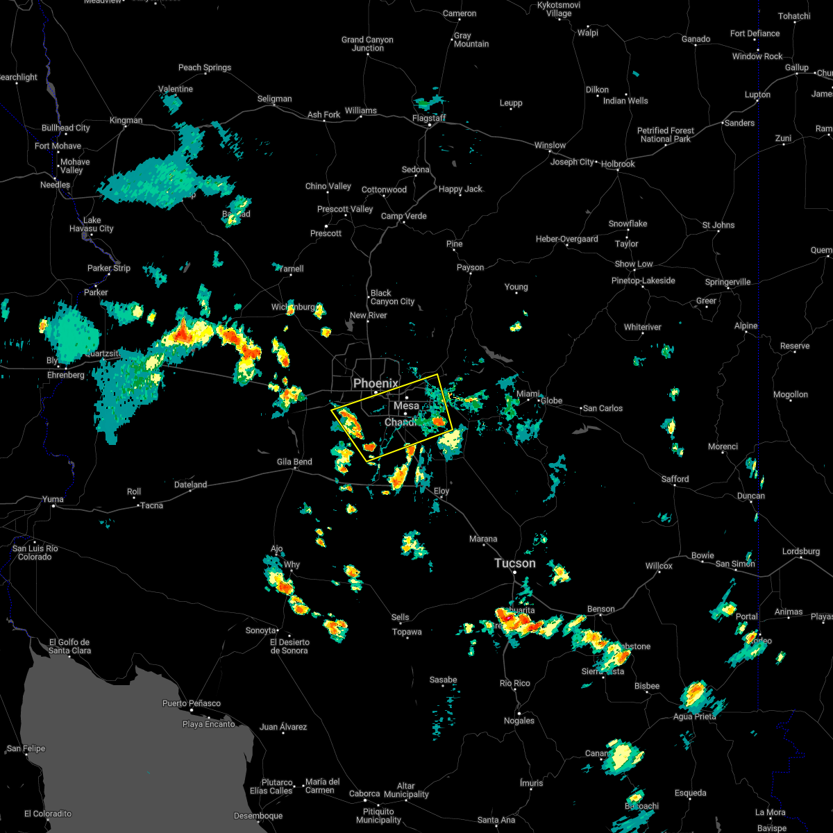
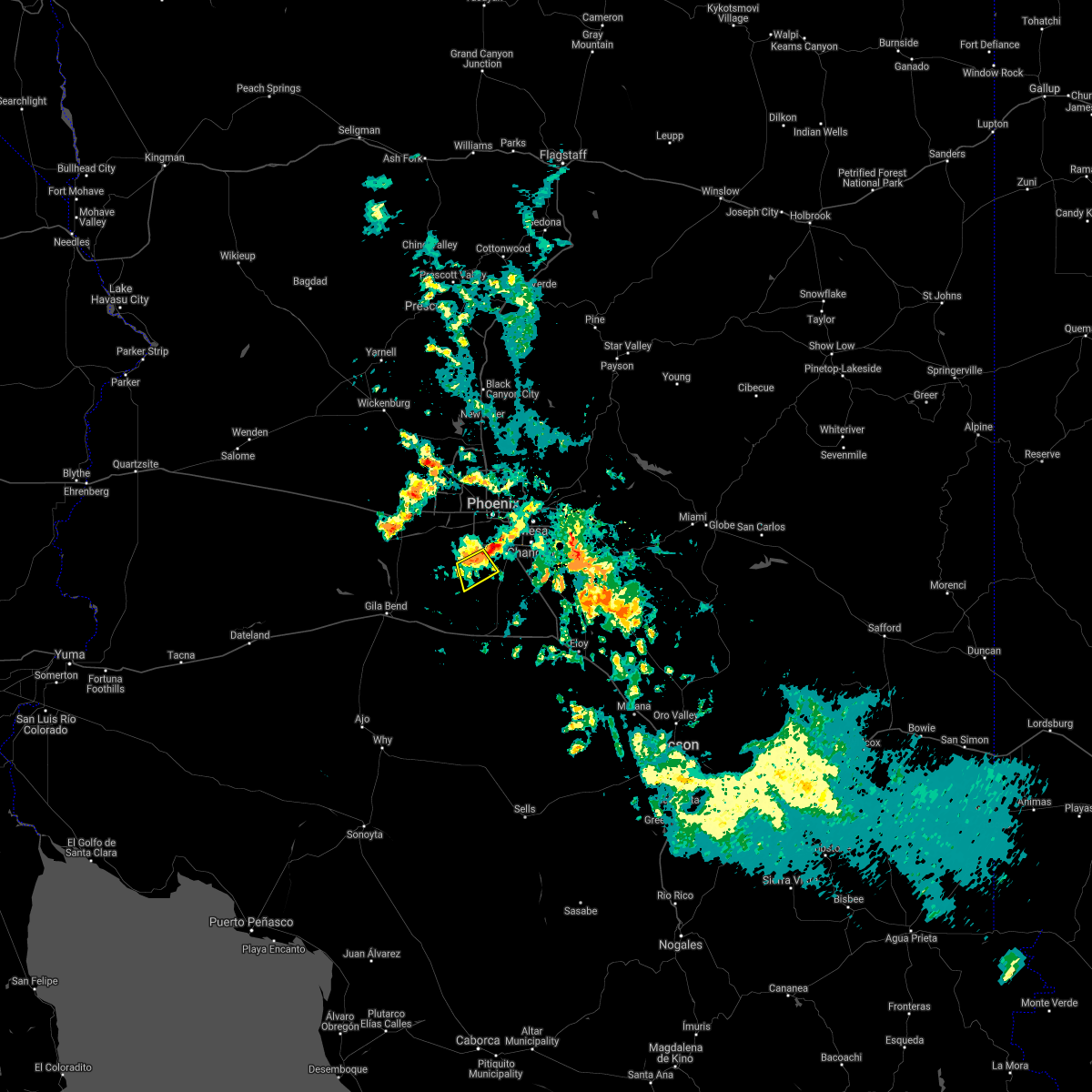
Hail Map for Santa Cruz, AZ
The Santa Cruz, AZ area has had 0 reports of on-the-ground hail by trained spotters, and has been under severe weather warnings 3 times during the past 12 months. Doppler radar has detected hail at or near Santa Cruz, AZ on 13 occasions, including 1 occasion during the past year.
| Name: | Santa Cruz, AZ |
| Where Located: | 15.4 miles SSW of Phoenix, AZ |
| Map: | Google Map for Santa Cruz, AZ |
| Population: | 37 |
| Housing Units: | 13 |
| More Info: | Search Google for Santa Cruz, AZ |
0
The Top Recent Hail Date for Santa Cruz, AZ is Sunday, July 21, 2024 (13th out of 13)

Hail and Wind Damage Spotted near Santa Cruz, AZ
| Date / Time | Report Details |
|---|---|
| 7/24/2024 10:13 PM MST |
 The storm which prompted the warning has weakened below severe limits, and no longer poses an immediate threat to life or property. therefore, the warning will be allowed to expire. however, gusty winds and heavy rain are still possible with this thunderstorm. The storm which prompted the warning has weakened below severe limits, and no longer poses an immediate threat to life or property. therefore, the warning will be allowed to expire. however, gusty winds and heavy rain are still possible with this thunderstorm.
|
| 7/24/2024 10:01 PM MST |
 At 1001 pm mst, a severe thunderstorm was located near estrella mountain park, or near avondale, moving south at 10 mph (radar indicated). Hazards include 60 mph wind gusts and penny size hail. Expect damage to roofs, siding, and trees. Locations impacted include, avondale, phoenix international raceway, and komatke. At 1001 pm mst, a severe thunderstorm was located near estrella mountain park, or near avondale, moving south at 10 mph (radar indicated). Hazards include 60 mph wind gusts and penny size hail. Expect damage to roofs, siding, and trees. Locations impacted include, avondale, phoenix international raceway, and komatke.
|
| 7/24/2024 9:27 PM MST |
 Svrpsr the national weather service in phoenix has issued a * severe thunderstorm warning for, maricopa county in south central arizona, pinal county in southeastern arizona, * until 1015 pm mst. * at 927 pm mst, a severe thunderstorm was located near tolleson, moving south at 15 mph (radar indicated). Hazards include 60 mph wind gusts and penny size hail. expect damage to roofs, siding, and trees Svrpsr the national weather service in phoenix has issued a * severe thunderstorm warning for, maricopa county in south central arizona, pinal county in southeastern arizona, * until 1015 pm mst. * at 927 pm mst, a severe thunderstorm was located near tolleson, moving south at 15 mph (radar indicated). Hazards include 60 mph wind gusts and penny size hail. expect damage to roofs, siding, and trees
|
| 7/14/2024 11:02 PM MST |
 Svrpsr the national weather service in phoenix has issued a * severe thunderstorm warning for, maricopa county in south central arizona, pinal county in southeastern arizona, * until 1145 pm mst. * at 1102 pm mst, a severe thunderstorm was located 9 miles southeast of estrella mountain park, or 11 miles southeast of avondale, moving northwest at 5 mph (radar indicated). Hazards include 60 mph wind gusts and penny size hail. expect damage to roofs, siding, and trees Svrpsr the national weather service in phoenix has issued a * severe thunderstorm warning for, maricopa county in south central arizona, pinal county in southeastern arizona, * until 1145 pm mst. * at 1102 pm mst, a severe thunderstorm was located 9 miles southeast of estrella mountain park, or 11 miles southeast of avondale, moving northwest at 5 mph (radar indicated). Hazards include 60 mph wind gusts and penny size hail. expect damage to roofs, siding, and trees
|
| 8/31/2023 9:42 PM MST |
 The severe thunderstorm warning for maricopa and pinal counties will expire at 945 pm mst, the storm which prompted the warning has weakened below severe limits, and no longer poses an immediate threat to life or property. therefore, the warning will be allowed to expire. The severe thunderstorm warning for maricopa and pinal counties will expire at 945 pm mst, the storm which prompted the warning has weakened below severe limits, and no longer poses an immediate threat to life or property. therefore, the warning will be allowed to expire.
|
| 8/31/2023 9:41 PM MST |
 The severe thunderstorm warning for maricopa and pinal counties will expire at 945 pm mst, the storm which prompted the warning has weakened below severe limits, and no longer poses an immediate threat to life or property. therefore, the warning will be allowed to expire. The severe thunderstorm warning for maricopa and pinal counties will expire at 945 pm mst, the storm which prompted the warning has weakened below severe limits, and no longer poses an immediate threat to life or property. therefore, the warning will be allowed to expire.
|
| 8/31/2023 8:47 PM MST |
 At 846 pm mst, a severe thunderstorm was located near sun lakes, moving northwest at 30 mph (radar indicated). Hazards include 70 mph wind gusts. Expect considerable tree damage. Damage is likely to mobile homes, roofs, and outbuildings. At 846 pm mst, a severe thunderstorm was located near sun lakes, moving northwest at 30 mph (radar indicated). Hazards include 70 mph wind gusts. Expect considerable tree damage. Damage is likely to mobile homes, roofs, and outbuildings.
|
| 8/31/2023 8:36 PM MST |
 At 835 pm mst, a severe thunderstorm was located over laveen, moving northwest at 5 mph (radar indicated). Hazards include 60 mph wind gusts. expect damage to roofs, siding, and trees At 835 pm mst, a severe thunderstorm was located over laveen, moving northwest at 5 mph (radar indicated). Hazards include 60 mph wind gusts. expect damage to roofs, siding, and trees
|
| 10/15/2022 1:39 PM MST |
 At 139 pm mst, severe thunderstorms were located along a line extending from phoenix to near tolleson to 7 miles south of estrella mountain park, moving northwest at 40 mph (radar indicated). Hazards include 60 mph wind gusts. Expect damage to roofs, siding, and trees. locations impacted include, phoenix, glendale, peoria, surprise, avondale, goodyear, buckeye, el mirage, tolleson, youngtown, sun city west, waddell, laveen, cashion and sun city. this includes the following highways, az interstate 10 between mile markers 115 and 152. az interstate 17 between mile markers 195 and 210. az route 51 near mile marker 1. hail threat, radar indicated max hail size, <. 75 in wind threat, radar indicated max wind gust, 60 mph. At 139 pm mst, severe thunderstorms were located along a line extending from phoenix to near tolleson to 7 miles south of estrella mountain park, moving northwest at 40 mph (radar indicated). Hazards include 60 mph wind gusts. Expect damage to roofs, siding, and trees. locations impacted include, phoenix, glendale, peoria, surprise, avondale, goodyear, buckeye, el mirage, tolleson, youngtown, sun city west, waddell, laveen, cashion and sun city. this includes the following highways, az interstate 10 between mile markers 115 and 152. az interstate 17 between mile markers 195 and 210. az route 51 near mile marker 1. hail threat, radar indicated max hail size, <. 75 in wind threat, radar indicated max wind gust, 60 mph.
|
| 10/15/2022 1:27 PM MST |
 At 126 pm mst, severe thunderstorms were located along a line extending from downtown phoenix to near south mountain park to 8 miles east of estrella, moving northwest at 25 mph (radar indicated). Hazards include 60 mph wind gusts. blowing dust with visibility as low as one mile. expect damage to roofs, siding, and trees At 126 pm mst, severe thunderstorms were located along a line extending from downtown phoenix to near south mountain park to 8 miles east of estrella, moving northwest at 25 mph (radar indicated). Hazards include 60 mph wind gusts. blowing dust with visibility as low as one mile. expect damage to roofs, siding, and trees
|
| 9/11/2022 8:11 PM MST |
 At 811 pm mst, a severe thunderstorm was located near bapchule, or near sun lakes, moving north at 15 mph (radar indicated). Hazards include 60 mph wind gusts and quarter size hail. Hail damage to vehicles is expected. Expect wind damage to roofs, siding, and trees. At 811 pm mst, a severe thunderstorm was located near bapchule, or near sun lakes, moving north at 15 mph (radar indicated). Hazards include 60 mph wind gusts and quarter size hail. Hail damage to vehicles is expected. Expect wind damage to roofs, siding, and trees.
|
| 8/21/2022 6:54 PM MST | The severe thunderstorm warning for maricopa and pinal counties will expire at 700 pm mst, the storms which prompted the warning have weakened below severe limits, and no longer pose an immediate threat to life or property. therefore, the warning will be allowed to expire. however gusty winds and heavy rain are still possible with these thunderstorms. |
| 8/21/2022 6:07 PM MST | At 607 pm mst, severe thunderstorms were located along a line extending from paradise valley to granite reef dam, moving south at 30 mph (radar indicated). Hazards include 60 mph wind gusts. expect damage to roofs, siding, and trees |
| 8/20/2022 9:54 PM MST |
 The severe thunderstorm warning for maricopa and pinal counties will expire at 1000 pm mst, the storms which prompted the warning have weakened below severe limits, and no longer pose an immediate threat to life or property. therefore, the warning will be allowed to expire. however gusty winds and heavy rain are still possible with these thunderstorms. The severe thunderstorm warning for maricopa and pinal counties will expire at 1000 pm mst, the storms which prompted the warning have weakened below severe limits, and no longer pose an immediate threat to life or property. therefore, the warning will be allowed to expire. however gusty winds and heavy rain are still possible with these thunderstorms.
|
| 8/20/2022 9:43 PM MST |
 At 942 pm mst, severe thunderstorms were located along a line extending from painted rock dam to 6 miles south of estrella mountain park to laveen, moving south at 30 mph (radar indicated). Hazards include 60 mph wind gusts. Expect damage to roofs, siding, and trees. locations impacted include, phoenix, chandler, glendale, tempe, avondale, goodyear, buckeye, tolleson, laveen, cashion, litchfield park, palo verde, south phoenix, liberty and arizona state fairgrounds. this includes the following highways, az interstate 10 between mile markers 101 and 153, and between mile markers 157 and 162. az interstate 17 between mile markers 195 and 206. az route 51 between mile markers 1 and 5. hail threat, radar indicated max hail size, <. 75 in wind threat, radar indicated max wind gust, 60 mph. At 942 pm mst, severe thunderstorms were located along a line extending from painted rock dam to 6 miles south of estrella mountain park to laveen, moving south at 30 mph (radar indicated). Hazards include 60 mph wind gusts. Expect damage to roofs, siding, and trees. locations impacted include, phoenix, chandler, glendale, tempe, avondale, goodyear, buckeye, tolleson, laveen, cashion, litchfield park, palo verde, south phoenix, liberty and arizona state fairgrounds. this includes the following highways, az interstate 10 between mile markers 101 and 153, and between mile markers 157 and 162. az interstate 17 between mile markers 195 and 206. az route 51 between mile markers 1 and 5. hail threat, radar indicated max hail size, <. 75 in wind threat, radar indicated max wind gust, 60 mph.
|
| 8/20/2022 9:14 PM MST |
 At 913 pm mst, severe thunderstorms were located along a line extending from 6 miles northwest of buckeye to tolleson to near scottsdale airport, moving south at 15 mph (radar indicated). Hazards include 60 mph wind gusts. expect damage to roofs, siding, and trees At 913 pm mst, severe thunderstorms were located along a line extending from 6 miles northwest of buckeye to tolleson to near scottsdale airport, moving south at 15 mph (radar indicated). Hazards include 60 mph wind gusts. expect damage to roofs, siding, and trees
|
| 8/14/2022 4:43 PM MST |
 At 442 pm mst, a severe thunderstorm was located near estrella mountain park, or 11 miles southeast of avondale, moving northeast at 10 mph (radar indicated). Hazards include 60 mph wind gusts and quarter size hail. Hail damage to vehicles is expected. Expect wind damage to roofs, siding, and trees. At 442 pm mst, a severe thunderstorm was located near estrella mountain park, or 11 miles southeast of avondale, moving northeast at 10 mph (radar indicated). Hazards include 60 mph wind gusts and quarter size hail. Hail damage to vehicles is expected. Expect wind damage to roofs, siding, and trees.
|
| 8/14/2022 4:28 PM MST |
 At 428 pm mst, a severe thunderstorm was located 9 miles south of estrella mountain ranch, or 14 miles southeast of buckeye, and is nearly stationary (radar indicated). Hazards include 60 mph wind gusts and penny size hail. Expect damage to roofs, siding, and trees. locations impacted include, phoenix, avondale, goodyear, buckeye, tolleson, cashion, estrella, litchfield park, palo verde, perryville, liberty, phoenix international raceway, estrella sailport, sonoran national monument and estrella mountain park. this includes the following highways, az interstate 10 between mile markers 111 and 138. az route 101 between mile markers 2 and 3. az route 238 between mile markers 12 and 39. hail threat, radar indicated max hail size, 0. 75 in wind threat, radar indicated max wind gust, 60 mph. At 428 pm mst, a severe thunderstorm was located 9 miles south of estrella mountain ranch, or 14 miles southeast of buckeye, and is nearly stationary (radar indicated). Hazards include 60 mph wind gusts and penny size hail. Expect damage to roofs, siding, and trees. locations impacted include, phoenix, avondale, goodyear, buckeye, tolleson, cashion, estrella, litchfield park, palo verde, perryville, liberty, phoenix international raceway, estrella sailport, sonoran national monument and estrella mountain park. this includes the following highways, az interstate 10 between mile markers 111 and 138. az route 101 between mile markers 2 and 3. az route 238 between mile markers 12 and 39. hail threat, radar indicated max hail size, 0. 75 in wind threat, radar indicated max wind gust, 60 mph.
|
| 8/14/2022 4:13 PM MST |
 At 413 pm mst, a severe thunderstorm was located 9 miles south of estrella mountain ranch, or 14 miles southeast of buckeye, and is nearly stationary (radar indicated). Hazards include 60 mph wind gusts and penny size hail. expect damage to roofs, siding, and trees At 413 pm mst, a severe thunderstorm was located 9 miles south of estrella mountain ranch, or 14 miles southeast of buckeye, and is nearly stationary (radar indicated). Hazards include 60 mph wind gusts and penny size hail. expect damage to roofs, siding, and trees
|
| 7/30/2022 5:02 PM MST |
 At 501 pm mst, severe thunderstorms were located along a line extending from queen creek to near estrella sailport, moving northwest at 15 mph (radar indicated). Hazards include 60 mph wind gusts. expect damage to roofs, siding, and trees At 501 pm mst, severe thunderstorms were located along a line extending from queen creek to near estrella sailport, moving northwest at 15 mph (radar indicated). Hazards include 60 mph wind gusts. expect damage to roofs, siding, and trees
|
| 6/26/2022 5:29 PM MST |
 At 528 pm mst, a severe thunderstorm was located over laveen, moving northeast at 5 mph (radar indicated). Hazards include 60 mph wind gusts. Expect damage to roofs, siding, and trees. locations impacted include, phoenix, glendale, scottsdale, tempe, avondale, goodyear, paradise valley, tolleson, laveen, cashion, papago park, piestewa peak park, south phoenix, arizona state fairgrounds and south mountain park. this includes the following highways, az interstate 10 between mile markers 130 and 160. az interstate 17 between mile markers 195 and 207. az route 51 between mile markers 1 and 6. hail threat, radar indicated max hail size, <. 75 in wind threat, radar indicated max wind gust, 60 mph. At 528 pm mst, a severe thunderstorm was located over laveen, moving northeast at 5 mph (radar indicated). Hazards include 60 mph wind gusts. Expect damage to roofs, siding, and trees. locations impacted include, phoenix, glendale, scottsdale, tempe, avondale, goodyear, paradise valley, tolleson, laveen, cashion, papago park, piestewa peak park, south phoenix, arizona state fairgrounds and south mountain park. this includes the following highways, az interstate 10 between mile markers 130 and 160. az interstate 17 between mile markers 195 and 207. az route 51 between mile markers 1 and 6. hail threat, radar indicated max hail size, <. 75 in wind threat, radar indicated max wind gust, 60 mph.
|
| 6/26/2022 4:53 PM MST |
 At 453 pm mst, a severe thunderstorm was located over arizona state fairgrounds, or near laveen, and is nearly stationary (radar indicated). Hazards include 60 mph wind gusts. expect damage to roofs, siding, and trees At 453 pm mst, a severe thunderstorm was located over arizona state fairgrounds, or near laveen, and is nearly stationary (radar indicated). Hazards include 60 mph wind gusts. expect damage to roofs, siding, and trees
|
| 6/23/2022 4:33 PM MST |
 At 432 pm mst, a severe thunderstorm was located near south mountain park, or near laveen, moving northeast at 15 mph (radar indicated). Hazards include 60 mph wind gusts. expect damage to roofs, siding, and trees At 432 pm mst, a severe thunderstorm was located near south mountain park, or near laveen, moving northeast at 15 mph (radar indicated). Hazards include 60 mph wind gusts. expect damage to roofs, siding, and trees
|
| 10/5/2021 5:49 PM MST |
 At 549 pm mst, a severe thunderstorm was located near south mountain park, or 7 miles south of laveen, moving east at 30 mph (radar indicated). Hazards include 60 mph wind gusts and half dollar size hail. Hail damage to vehicles is expected. expect wind damage to roofs, siding, and trees. locations impacted include, phoenix, chandler, south mountain park, south phoenix and komatke. this includes the following highways, az interstate 10 between mile markers 159 and 162. az route 202 between mile markers 53 and 55. hail threat, radar indicated max hail size, 1. 25 in wind threat, radar indicated max wind gust, 60 mph. At 549 pm mst, a severe thunderstorm was located near south mountain park, or 7 miles south of laveen, moving east at 30 mph (radar indicated). Hazards include 60 mph wind gusts and half dollar size hail. Hail damage to vehicles is expected. expect wind damage to roofs, siding, and trees. locations impacted include, phoenix, chandler, south mountain park, south phoenix and komatke. this includes the following highways, az interstate 10 between mile markers 159 and 162. az route 202 between mile markers 53 and 55. hail threat, radar indicated max hail size, 1. 25 in wind threat, radar indicated max wind gust, 60 mph.
|
| 10/5/2021 5:38 PM MST |
 At 538 pm mst, a severe thunderstorm was located 7 miles southwest of south mountain park, or 10 miles south of laveen, moving northeast at 30 mph (radar indicated). Hazards include ping pong ball size hail and 60 mph wind gusts. People and animals outdoors will be injured. expect hail damage to roofs, siding, windows, and vehicles. expect wind damage to roofs, siding, and trees. locations impacted include, phoenix, chandler, avondale, sun lakes, south mountain park, south phoenix, firebird lake and komatke. this includes the following highways, az interstate 10 between mile markers 159 and 168. az route 202 between mile markers 53 and 55. Az route 347 between mile markers 184 and 189. At 538 pm mst, a severe thunderstorm was located 7 miles southwest of south mountain park, or 10 miles south of laveen, moving northeast at 30 mph (radar indicated). Hazards include ping pong ball size hail and 60 mph wind gusts. People and animals outdoors will be injured. expect hail damage to roofs, siding, windows, and vehicles. expect wind damage to roofs, siding, and trees. locations impacted include, phoenix, chandler, avondale, sun lakes, south mountain park, south phoenix, firebird lake and komatke. this includes the following highways, az interstate 10 between mile markers 159 and 168. az route 202 between mile markers 53 and 55. Az route 347 between mile markers 184 and 189.
|
| 10/5/2021 5:19 PM MST |
 At 518 pm mst, a severe thunderstorm was located 10 miles south of estrella mountain park, or 16 miles south of avondale, moving east at 35 mph (radar indicated). Hazards include two inch hail and 60 mph wind gusts. People and animals outdoors will be injured. expect hail damage to roofs, siding, windows, and vehicles. Expect wind damage to roofs, siding, and trees. At 518 pm mst, a severe thunderstorm was located 10 miles south of estrella mountain park, or 16 miles south of avondale, moving east at 35 mph (radar indicated). Hazards include two inch hail and 60 mph wind gusts. People and animals outdoors will be injured. expect hail damage to roofs, siding, windows, and vehicles. Expect wind damage to roofs, siding, and trees.
|
| 8/16/2021 11:41 PM MST |
 At 1140 pm mst, severe thunderstorms were located along a line extending from near white tank mountain park to near palo verde to 10 miles northeast of cotton center to near estrella to 11 miles west of chui-chu, moving southwest at 35 mph (radar indicated). Hazards include 70 mph wind gusts and nickel size hail. Expect considerable tree damage. Damage is likely to mobile homes, roofs, and outbuildings. At 1140 pm mst, severe thunderstorms were located along a line extending from near white tank mountain park to near palo verde to 10 miles northeast of cotton center to near estrella to 11 miles west of chui-chu, moving southwest at 35 mph (radar indicated). Hazards include 70 mph wind gusts and nickel size hail. Expect considerable tree damage. Damage is likely to mobile homes, roofs, and outbuildings.
|
| 8/16/2021 11:33 PM MST |
 At 1133 pm mst, severe thunderstorms were located along a line extending from near white tank mountain park to near liberty to 9 miles south of estrella mountain ranch to 7 miles west of estrella sailport to 8 miles northwest of chui-chu, moving southwest at 35 mph (radar indicated). Hazards include 70 mph wind gusts and nickel size hail. Expect considerable tree damage. damage is likely to mobile homes, roofs, and outbuildings. locations impacted include, phoenix, mesa, chandler, glendale, scottsdale, gilbert, tempe, peoria, surprise, avondale, goodyear, buckeye, casa grande, el mirage and paradise valley. this includes the following highways, az interstate 10 between mile markers 117 and 204. az interstate 17 between mile markers 195 and 219. az interstate 8 between mile markers 146 and 178. thunderstorm damage threat, considerable hail threat, radar indicated max hail size, 0. 88 in wind threat, radar indicated max wind gust, 70 mph. At 1133 pm mst, severe thunderstorms were located along a line extending from near white tank mountain park to near liberty to 9 miles south of estrella mountain ranch to 7 miles west of estrella sailport to 8 miles northwest of chui-chu, moving southwest at 35 mph (radar indicated). Hazards include 70 mph wind gusts and nickel size hail. Expect considerable tree damage. damage is likely to mobile homes, roofs, and outbuildings. locations impacted include, phoenix, mesa, chandler, glendale, scottsdale, gilbert, tempe, peoria, surprise, avondale, goodyear, buckeye, casa grande, el mirage and paradise valley. this includes the following highways, az interstate 10 between mile markers 117 and 204. az interstate 17 between mile markers 195 and 219. az interstate 8 between mile markers 146 and 178. thunderstorm damage threat, considerable hail threat, radar indicated max hail size, 0. 88 in wind threat, radar indicated max wind gust, 70 mph.
|
| 8/16/2021 10:54 PM MST |
 At 1054 pm mst, severe thunderstorms were located along a line extending from near deer valley airport to arizona state fairgrounds to south phoenix to 6 miles east of bapchule, moving southwest at 30 mph. these are destructive storms for phoenix metro area (radar indicated). Hazards include 80 mph wind gusts and quarter size hail. Flying debris will be dangerous to those caught without shelter. mobile homes will be heavily damaged. expect considerable damage to roofs, windows, and vehicles. Extensive tree damage and power outages are likely. At 1054 pm mst, severe thunderstorms were located along a line extending from near deer valley airport to arizona state fairgrounds to south phoenix to 6 miles east of bapchule, moving southwest at 30 mph. these are destructive storms for phoenix metro area (radar indicated). Hazards include 80 mph wind gusts and quarter size hail. Flying debris will be dangerous to those caught without shelter. mobile homes will be heavily damaged. expect considerable damage to roofs, windows, and vehicles. Extensive tree damage and power outages are likely.
|
| 8/13/2021 10:16 PM MST |
 At 1016 pm mst, a severe thunderstorm was located over metro center mall, or near glendale, moving west at 20 mph (radar indicated). Hazards include 60 mph wind gusts and nickel size hail. expect damage to roofs, siding, and trees At 1016 pm mst, a severe thunderstorm was located over metro center mall, or near glendale, moving west at 20 mph (radar indicated). Hazards include 60 mph wind gusts and nickel size hail. expect damage to roofs, siding, and trees
|
| 7/10/2021 8:41 PM MST |
 At 840 pm mst, the leading edge of very strong outflow winds from thunderstorms was located along a line extending from 7 miles west of south mountain park to 11 miles southeast of estrella mountain park to near estrella sailport to 11 miles east of freeman, moving west at 40 mph (radar indicated). Hazards include 70 mph wind gusts and penny size hail. Expect considerable tree damage. damage is likely to mobile homes, roofs, and outbuildings. locations impacted include, phoenix, mesa, chandler, glendale, scottsdale, gilbert, tempe, avondale, goodyear, buckeye, casa grande, apache junction, paradise valley, coolidge and tolleson. this includes the following highways, az interstate 10 between mile markers 121 and 199. az interstate 17 between mile markers 195 and 209. Az interstate 8 between mile markers 135 and 178. At 840 pm mst, the leading edge of very strong outflow winds from thunderstorms was located along a line extending from 7 miles west of south mountain park to 11 miles southeast of estrella mountain park to near estrella sailport to 11 miles east of freeman, moving west at 40 mph (radar indicated). Hazards include 70 mph wind gusts and penny size hail. Expect considerable tree damage. damage is likely to mobile homes, roofs, and outbuildings. locations impacted include, phoenix, mesa, chandler, glendale, scottsdale, gilbert, tempe, avondale, goodyear, buckeye, casa grande, apache junction, paradise valley, coolidge and tolleson. this includes the following highways, az interstate 10 between mile markers 121 and 199. az interstate 17 between mile markers 195 and 209. Az interstate 8 between mile markers 135 and 178.
|
| 7/10/2021 8:16 PM MST |
 At 816 pm mst, severe thunderstorms were located along a line extending from falcon field airport to queen creek to blackwater, moving west at 20 mph (radar indicated). Hazards include 60 mph wind gusts and penny size hail. expect damage to roofs, siding, and trees At 816 pm mst, severe thunderstorms were located along a line extending from falcon field airport to queen creek to blackwater, moving west at 20 mph (radar indicated). Hazards include 60 mph wind gusts and penny size hail. expect damage to roofs, siding, and trees
|
| 7/10/2021 7:45 PM MST |
 At 744 pm mst, severe thunderstorms were located along a line extending from downtown peoria to fiesta mall to near san tan mountain park, moving southwest at 40 mph (radar indicated). Hazards include 70 mph wind gusts and nickel size hail. Expect considerable tree damage. Damage is likely to mobile homes, roofs, and outbuildings. At 744 pm mst, severe thunderstorms were located along a line extending from downtown peoria to fiesta mall to near san tan mountain park, moving southwest at 40 mph (radar indicated). Hazards include 70 mph wind gusts and nickel size hail. Expect considerable tree damage. Damage is likely to mobile homes, roofs, and outbuildings.
|
| 7/9/2021 10:44 PM MST |
 At 1044 pm mst, severe thunderstorms were located along a line extending from 8 miles south of south mountain park to near maricopa to 11 miles west of casa grande, moving west at 55 mph (radar indicated). Hazards include 60 mph wind gusts. expect damage to roofs, siding, and trees At 1044 pm mst, severe thunderstorms were located along a line extending from 8 miles south of south mountain park to near maricopa to 11 miles west of casa grande, moving west at 55 mph (radar indicated). Hazards include 60 mph wind gusts. expect damage to roofs, siding, and trees
|
| 7/9/2021 10:36 PM MST |
 At 1036 pm mst, severe thunderstorms were located along a line extending from 6 miles southwest of chandler fashion center mall to near maricopa to near casa grande, moving west at 55 mph (radar indicated). Hazards include 70 mph wind gusts. Expect considerable tree damage. damage is likely to mobile homes, roofs, and outbuildings. locations impacted include, phoenix, mesa, chandler, gilbert, tempe, casa grande, apache junction, florence, coolidge, gold canyon, sun lakes, east mesa, maricopa, queen creek and south phoenix. this includes the following highways, az interstate 10 between mile markers 154 and 197. az interstate 8 between mile markers 156 and 176. Us highway 60 between mile markers 173 and 207. At 1036 pm mst, severe thunderstorms were located along a line extending from 6 miles southwest of chandler fashion center mall to near maricopa to near casa grande, moving west at 55 mph (radar indicated). Hazards include 70 mph wind gusts. Expect considerable tree damage. damage is likely to mobile homes, roofs, and outbuildings. locations impacted include, phoenix, mesa, chandler, gilbert, tempe, casa grande, apache junction, florence, coolidge, gold canyon, sun lakes, east mesa, maricopa, queen creek and south phoenix. this includes the following highways, az interstate 10 between mile markers 154 and 197. az interstate 8 between mile markers 156 and 176. Us highway 60 between mile markers 173 and 207.
|
| 7/9/2021 10:30 PM MST |
 At 1030 pm mst, severe thunderstorms were located along a line extending from near falcon field airport to near chandler fashion center mall to sun lakes, moving west at 40 mph (radar indicated). Hazards include 70 mph wind gusts. Expect considerable tree damage. Damage is likely to mobile homes, roofs, and outbuildings. At 1030 pm mst, severe thunderstorms were located along a line extending from near falcon field airport to near chandler fashion center mall to sun lakes, moving west at 40 mph (radar indicated). Hazards include 70 mph wind gusts. Expect considerable tree damage. Damage is likely to mobile homes, roofs, and outbuildings.
|
| 7/9/2021 10:06 PM MST |
 At 1006 pm mst, severe thunderstorms were located along a line extending from near apache junction to near san tan valley to near florence, moving west at 55 mph (radar indicated). Hazards include 70 mph wind gusts and nickel size hail. Expect considerable tree damage. Damage is likely to mobile homes, roofs, and outbuildings. At 1006 pm mst, severe thunderstorms were located along a line extending from near apache junction to near san tan valley to near florence, moving west at 55 mph (radar indicated). Hazards include 70 mph wind gusts and nickel size hail. Expect considerable tree damage. Damage is likely to mobile homes, roofs, and outbuildings.
|
| 8/20/2020 8:36 PM MST |
 At 836 pm mst, a severe thunderstorm was located over estrella sailport, or 17 miles southwest of sun lakes, moving south at 15 mph (radar indicated). Hazards include 60 mph wind gusts and quarter size hail. Hail damage to vehicles is expected. expect wind damage to roofs, siding, and trees. This severe thunderstorm will remain over mainly rural areas of maricopa and pinal counties. At 836 pm mst, a severe thunderstorm was located over estrella sailport, or 17 miles southwest of sun lakes, moving south at 15 mph (radar indicated). Hazards include 60 mph wind gusts and quarter size hail. Hail damage to vehicles is expected. expect wind damage to roofs, siding, and trees. This severe thunderstorm will remain over mainly rural areas of maricopa and pinal counties.
|
| 8/20/2020 8:11 PM MST |
 At 811 pm mst, a severe thunderstorm was located near estrella sailport, or 16 miles south of laveen, moving south at 15 mph (radar indicated). Hazards include 60 mph wind gusts and quarter size hail. Hail damage to vehicles is expected. Expect wind damage to roofs, siding, and trees. At 811 pm mst, a severe thunderstorm was located near estrella sailport, or 16 miles south of laveen, moving south at 15 mph (radar indicated). Hazards include 60 mph wind gusts and quarter size hail. Hail damage to vehicles is expected. Expect wind damage to roofs, siding, and trees.
|
| 8/17/2020 7:57 PM MST |
 At 757 pm mst, a severe thunderstorm was located 7 miles west of bapchule, or 8 miles southwest of sun lakes, moving west at 30 mph (radar indicated). Hazards include 60 mph wind gusts. expect damage to roofs, siding, and trees At 757 pm mst, a severe thunderstorm was located 7 miles west of bapchule, or 8 miles southwest of sun lakes, moving west at 30 mph (radar indicated). Hazards include 60 mph wind gusts. expect damage to roofs, siding, and trees
|
| 8/17/2020 7:50 PM MST |
 At 749 pm mst, a severe thunderstorm was located over laveen, moving west at 30 mph (radar indicated). Hazards include 60 mph wind gusts. Expect damage to roofs, siding, and trees. locations impacted include, phoenix, mesa, chandler, glendale, scottsdale, gilbert, tempe, paradise valley, laveen, tempe marketplace, papago park, piestewa peak park, salt river indian community, north mountain park and south phoenix. this includes the following highways, az interstate 10 between mile markers 137 and 164. az interstate 17 between mile markers 195 and 211. Az route 51 between mile markers 1 and 10. At 749 pm mst, a severe thunderstorm was located over laveen, moving west at 30 mph (radar indicated). Hazards include 60 mph wind gusts. Expect damage to roofs, siding, and trees. locations impacted include, phoenix, mesa, chandler, glendale, scottsdale, gilbert, tempe, paradise valley, laveen, tempe marketplace, papago park, piestewa peak park, salt river indian community, north mountain park and south phoenix. this includes the following highways, az interstate 10 between mile markers 137 and 164. az interstate 17 between mile markers 195 and 211. Az route 51 between mile markers 1 and 10.
|
| 8/17/2020 7:40 PM MST |
 At 739 pm mst, severe winds associated with a thunderstorm were located over sky harbor airport, or near laveen, moving west at 30 mph (radar indicated). Hazards include 60 mph wind gusts. expect damage to roofs, siding, and trees At 739 pm mst, severe winds associated with a thunderstorm were located over sky harbor airport, or near laveen, moving west at 30 mph (radar indicated). Hazards include 60 mph wind gusts. expect damage to roofs, siding, and trees
|
| 11/29/2019 3:45 AM MST |
 At 345 am mst, severe thunderstorms were located along a line extending from arrowhead mall to near phoenix international raceway to 10 miles northwest of estrella sailport, moving northeast at 50 mph (radar indicated). Hazards include 60 mph wind gusts. expect damage to roofs, siding, and trees At 345 am mst, severe thunderstorms were located along a line extending from arrowhead mall to near phoenix international raceway to 10 miles northwest of estrella sailport, moving northeast at 50 mph (radar indicated). Hazards include 60 mph wind gusts. expect damage to roofs, siding, and trees
|
| 9/14/2019 4:59 PM MST |
 A severe thunderstorm warning remains in effect until 530 pm mst for maricopa and pinal counties. at 459 pm mst, a severe thunderstorm was located near maricopa, or 19 miles southwest of sun lakes, moving west at 15 mph. hazard. 60 mph wind gusts. source. Radar indicated. A severe thunderstorm warning remains in effect until 530 pm mst for maricopa and pinal counties. at 459 pm mst, a severe thunderstorm was located near maricopa, or 19 miles southwest of sun lakes, moving west at 15 mph. hazard. 60 mph wind gusts. source. Radar indicated.
|
| 9/14/2019 4:50 PM MST |
 At 449 pm mst, a severe thunderstorm was located near maricopa, or 17 miles southwest of sun lakes, moving west at 15 mph (radar indicated). Hazards include 60 mph wind gusts. expect damage to roofs, siding, and trees At 449 pm mst, a severe thunderstorm was located near maricopa, or 17 miles southwest of sun lakes, moving west at 15 mph (radar indicated). Hazards include 60 mph wind gusts. expect damage to roofs, siding, and trees
|
| 8/23/2018 5:54 PM MST |
 At 553 pm mst, a severe thunderstorm was located 7 miles southeast of phoenix international raceway, or 10 miles southwest of laveen, and is nearly stationary (radar indicated). Hazards include 60 mph wind gusts and penny size hail. Expect damage to roofs, siding, and trees. Locations impacted include, phoenix, avondale, goodyear, south mountain park, phoenix international raceway, estrella mountain park and komatke. At 553 pm mst, a severe thunderstorm was located 7 miles southeast of phoenix international raceway, or 10 miles southwest of laveen, and is nearly stationary (radar indicated). Hazards include 60 mph wind gusts and penny size hail. Expect damage to roofs, siding, and trees. Locations impacted include, phoenix, avondale, goodyear, south mountain park, phoenix international raceway, estrella mountain park and komatke.
|
| 8/23/2018 5:30 PM MST |
 At 530 pm mst, a severe thunderstorm was located 7 miles southeast of phoenix international raceway, or 10 miles southwest of laveen, and is nearly stationary (radar indicated). Hazards include 60 mph wind gusts and penny size hail. expect damage to roofs, siding, and trees At 530 pm mst, a severe thunderstorm was located 7 miles southeast of phoenix international raceway, or 10 miles southwest of laveen, and is nearly stationary (radar indicated). Hazards include 60 mph wind gusts and penny size hail. expect damage to roofs, siding, and trees
|
| 8/10/2018 11:21 PM MST |
 At 1121 pm mst, a severe thunderstorm was located over laveen, moving west at 35 mph (radar indicated). Hazards include 60 mph wind gusts. Expect damage to roofs, siding, and trees. locations impacted include, phoenix, glendale, tempe, avondale, goodyear, tolleson, laveen, cashion, litchfield park, glendale sports complex, arizona mills mall, luke afb, south phoenix, arizona state fairgrounds and south mountain park. this includes the following highways, az interstate 10 between mile markers 124 and 159. az interstate 17 between mile markers 195 and 210. Az route 51 between mile markers 1 and 4. At 1121 pm mst, a severe thunderstorm was located over laveen, moving west at 35 mph (radar indicated). Hazards include 60 mph wind gusts. Expect damage to roofs, siding, and trees. locations impacted include, phoenix, glendale, tempe, avondale, goodyear, tolleson, laveen, cashion, litchfield park, glendale sports complex, arizona mills mall, luke afb, south phoenix, arizona state fairgrounds and south mountain park. this includes the following highways, az interstate 10 between mile markers 124 and 159. az interstate 17 between mile markers 195 and 210. Az route 51 between mile markers 1 and 4.
|
| 8/10/2018 11:02 PM MST |
 At 1101 pm mst, severe thunderstorms were located along a line extending from near metro center to near tempe, moving southwest at 25 mph (radar indicated). Hazards include 60 mph wind gusts. expect damage to roofs, siding, and trees At 1101 pm mst, severe thunderstorms were located along a line extending from near metro center to near tempe, moving southwest at 25 mph (radar indicated). Hazards include 60 mph wind gusts. expect damage to roofs, siding, and trees
|
| 8/2/2018 6:59 PM MST |
 At 659 pm mst, severe thunderstorms were located along a line extending from near palo verde to 7 miles southwest of south mountain park, moving northeast at 15 mph (radar indicated). Hazards include 60 mph wind gusts and penny size hail. Expect damage to roofs, siding, and trees. locations impacted include, avondale, goodyear, buckeye, palo verde, perryville, liberty, phoenix international raceway, estrella mountain park, estrella mountain ranch, hassayampa, rainbow valley, komatke and arlington. this includes the following highways, az interstate 10 between mile markers 111 and 119. Az route 85 between mile markers 140 and 154. At 659 pm mst, severe thunderstorms were located along a line extending from near palo verde to 7 miles southwest of south mountain park, moving northeast at 15 mph (radar indicated). Hazards include 60 mph wind gusts and penny size hail. Expect damage to roofs, siding, and trees. locations impacted include, avondale, goodyear, buckeye, palo verde, perryville, liberty, phoenix international raceway, estrella mountain park, estrella mountain ranch, hassayampa, rainbow valley, komatke and arlington. this includes the following highways, az interstate 10 between mile markers 111 and 119. Az route 85 between mile markers 140 and 154.
|
| 8/2/2018 6:42 PM MST |
 At 642 pm mst, severe thunderstorms were located along a line extending from near painted rock dam to 9 miles southeast of estrella mountain park, moving northeast at 15 mph (radar indicated). Hazards include 60 mph wind gusts and penny size hail. expect damage to roofs, siding, and trees At 642 pm mst, severe thunderstorms were located along a line extending from near painted rock dam to 9 miles southeast of estrella mountain park, moving northeast at 15 mph (radar indicated). Hazards include 60 mph wind gusts and penny size hail. expect damage to roofs, siding, and trees
|
| 8/2/2018 6:12 PM MST |
 At 612 pm mst, severe thunderstorms were located along a line extending from near liberty to 6 miles northwest of estrella sailport, moving northeast at 10 mph (radar indicated). Hazards include 60 mph wind gusts and penny size hail. expect damage to roofs, siding, and trees At 612 pm mst, severe thunderstorms were located along a line extending from near liberty to 6 miles northwest of estrella sailport, moving northeast at 10 mph (radar indicated). Hazards include 60 mph wind gusts and penny size hail. expect damage to roofs, siding, and trees
|
| 7/9/2018 4:44 PM MST |
 At 443 pm mst, a severe thunderstorm was located near south mountain park, or 7 miles south of laveen, moving west at 10 mph (radar indicated). Hazards include 60 mph wind gusts and penny size hail. expect damage to roofs, siding, and trees At 443 pm mst, a severe thunderstorm was located near south mountain park, or 7 miles south of laveen, moving west at 10 mph (radar indicated). Hazards include 60 mph wind gusts and penny size hail. expect damage to roofs, siding, and trees
|
| 7/29/2016 8:57 PM MST | The severe thunderstorm warning for central maricopa and northwestern pinal counties will expire at 900 pm mst. the storm which prompted the warning has moved out of the area. therefore the warning will be allowed to expire. however heavy rain is still possible with this thunderstorm. to report severe weather. Contact your nearest law enforcement. |
| 7/29/2016 8:46 PM MST |
 At 846 pm mst, doppler radar indicated a severe thunderstorm capable of producing damaging winds in excess of 60 mph. this storm was located 9 miles south of estrella mountain park, or 15 miles south of avondale, moving southwest at 40 mph. penny size hail and heavy rainfall may also accompany the damaging winds. locations impacted include, phoenix, chandler, tempe, avondale, goodyear, tolleson, laveen, sky harbor airport, arizona state university, south mountain park, south phoenix, downtown phoenix, salt river indian community, arizona mills mall, arizona state fairgrounds, tempe marketplace, papago park, guadalupe, rainbow valley and komatke. At 846 pm mst, doppler radar indicated a severe thunderstorm capable of producing damaging winds in excess of 60 mph. this storm was located 9 miles south of estrella mountain park, or 15 miles south of avondale, moving southwest at 40 mph. penny size hail and heavy rainfall may also accompany the damaging winds. locations impacted include, phoenix, chandler, tempe, avondale, goodyear, tolleson, laveen, sky harbor airport, arizona state university, south mountain park, south phoenix, downtown phoenix, salt river indian community, arizona mills mall, arizona state fairgrounds, tempe marketplace, papago park, guadalupe, rainbow valley and komatke.
|
| 7/29/2016 8:29 PM MST |
 At 829 pm mst, doppler radar indicated a severe thunderstorm capable of producing damaging winds in excess of 60 mph. this storm was located near south mountain park, or 7 miles south of laveen, and moving southwest at 40 mph. penny size hail may also accompany the damaging winds. At 829 pm mst, doppler radar indicated a severe thunderstorm capable of producing damaging winds in excess of 60 mph. this storm was located near south mountain park, or 7 miles south of laveen, and moving southwest at 40 mph. penny size hail may also accompany the damaging winds.
|
| 7/1/2016 6:31 PM MST |
 At 631 pm mst, doppler radar indicated a line of severe thunderstorms capable of producing damaging winds in excess of 60 mph. these storms were located along a line extending from goodyear to 10 miles northwest of gila bend auxiliary field, and moving southeast at 15 mph. penny size hail may also accompany the damaging winds. At 631 pm mst, doppler radar indicated a line of severe thunderstorms capable of producing damaging winds in excess of 60 mph. these storms were located along a line extending from goodyear to 10 miles northwest of gila bend auxiliary field, and moving southeast at 15 mph. penny size hail may also accompany the damaging winds.
|
| 10/16/2015 1:45 PM MST |
 At 145 pm mst, doppler radar indicated a severe thunderstorm capable of producing damaging winds in excess of 60 mph. this storm was located near maricopa, or 10 miles southwest of sun lakes, and moving northeast at 50 mph. At 145 pm mst, doppler radar indicated a severe thunderstorm capable of producing damaging winds in excess of 60 mph. this storm was located near maricopa, or 10 miles southwest of sun lakes, and moving northeast at 50 mph.
|
| 8/11/2015 9:41 PM MST |
 At 940 pm mst, doppler radar indicated severe thunderstorms with a broad outflow boundary of 40 to 60 mph winds moving across the phoenix area from the south. damaging winds are possible along with torrential rainfall. At 940 pm mst, doppler radar indicated severe thunderstorms with a broad outflow boundary of 40 to 60 mph winds moving across the phoenix area from the south. damaging winds are possible along with torrential rainfall.
|
Hail Maps for Santa Cruz, AZ


Connect with Interactive Hail Maps