

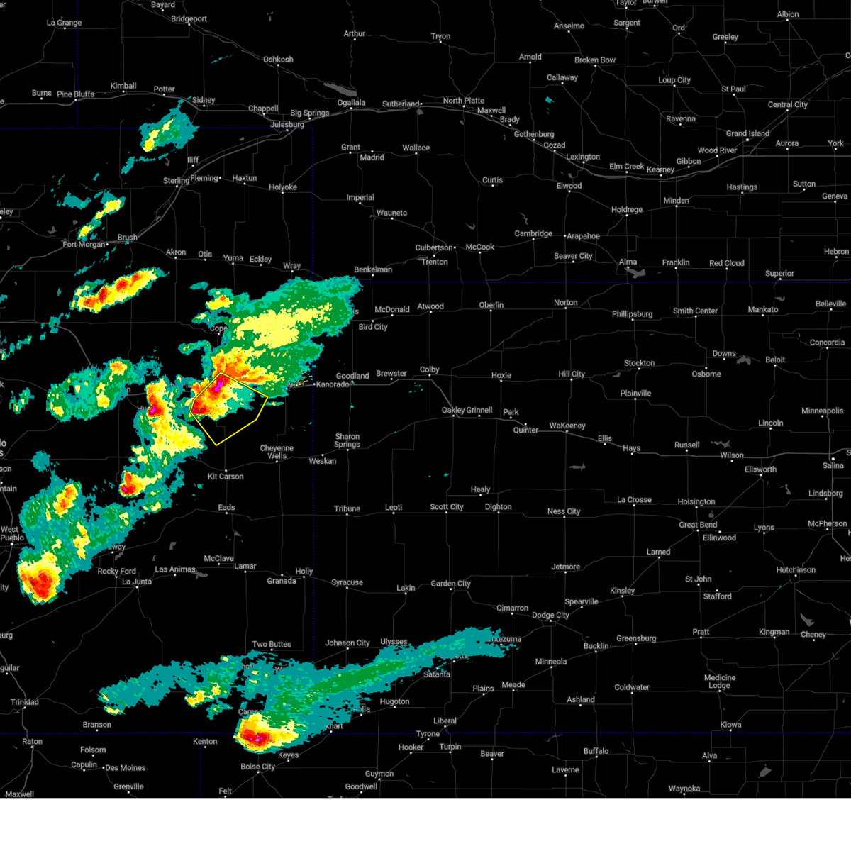
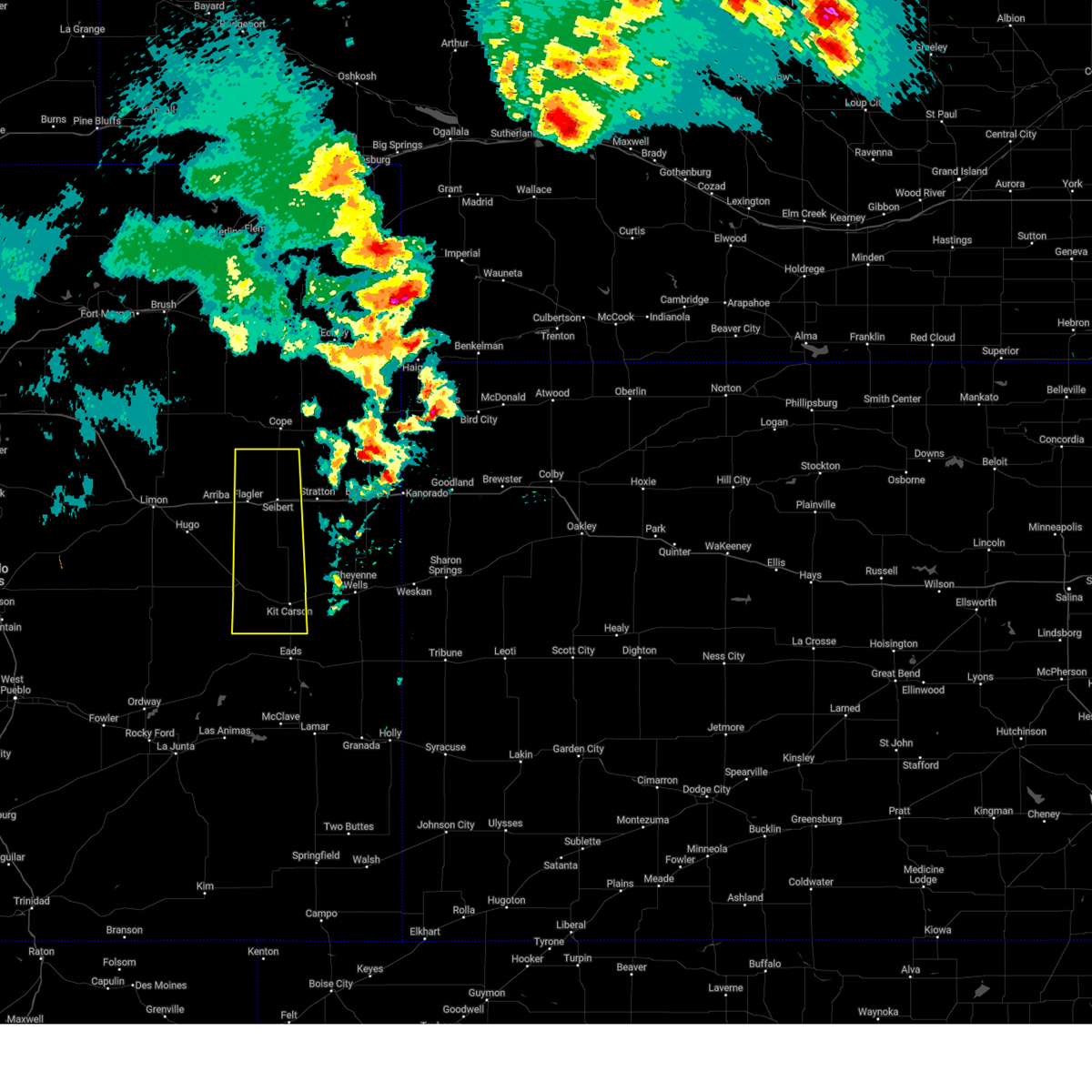
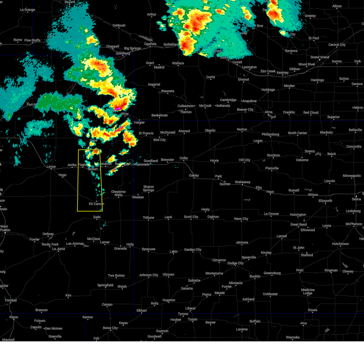
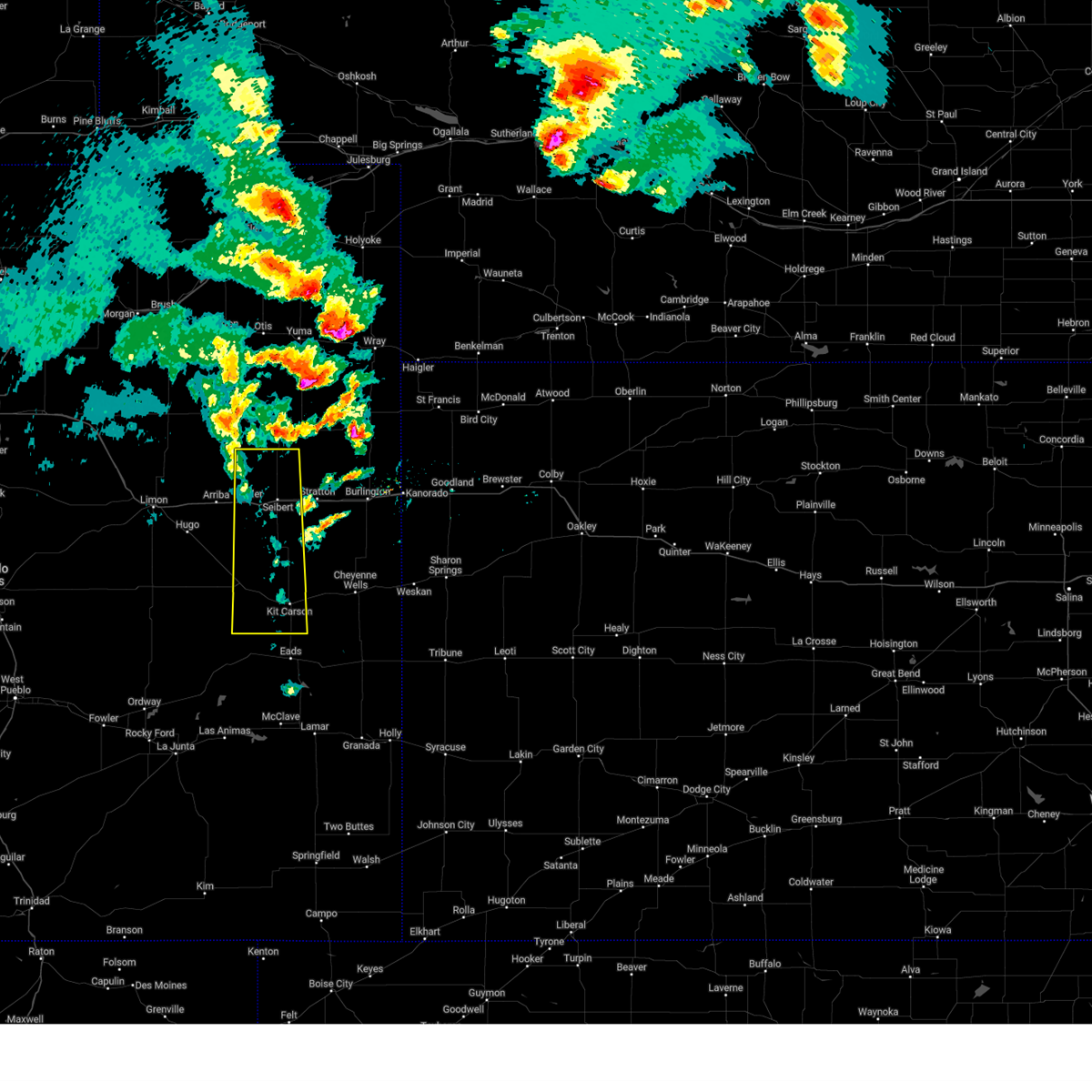
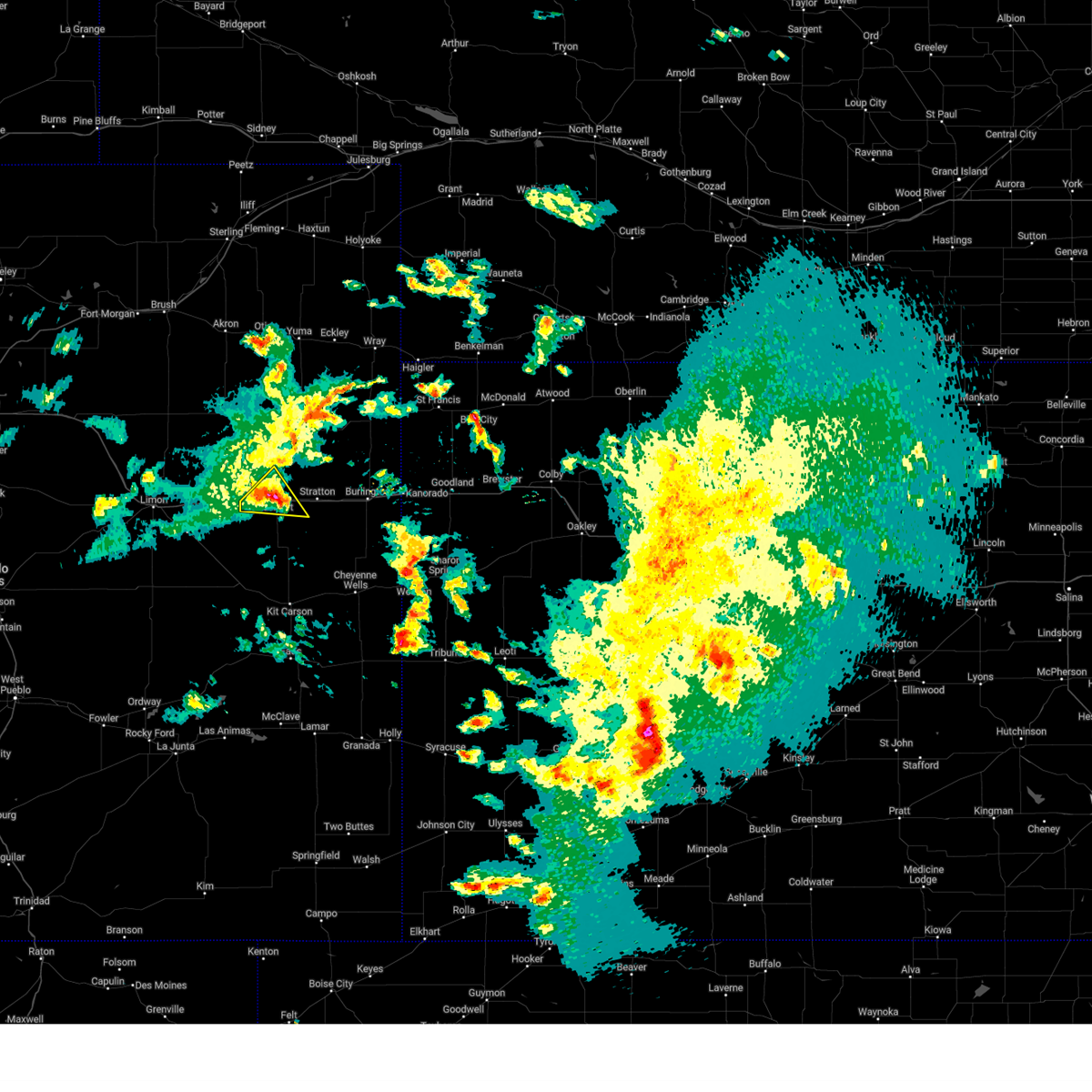
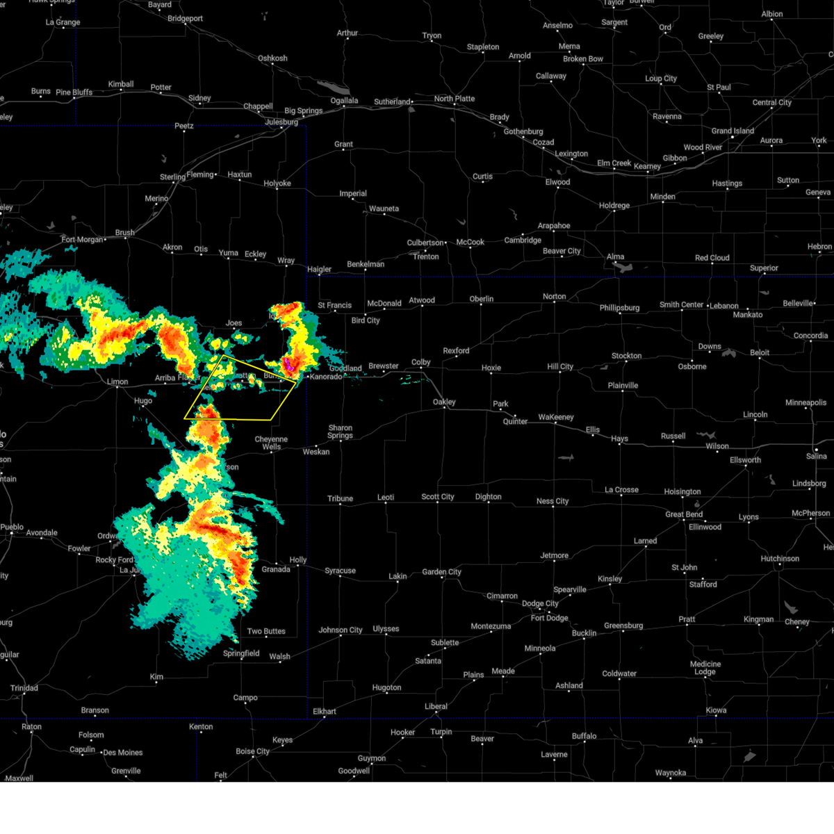
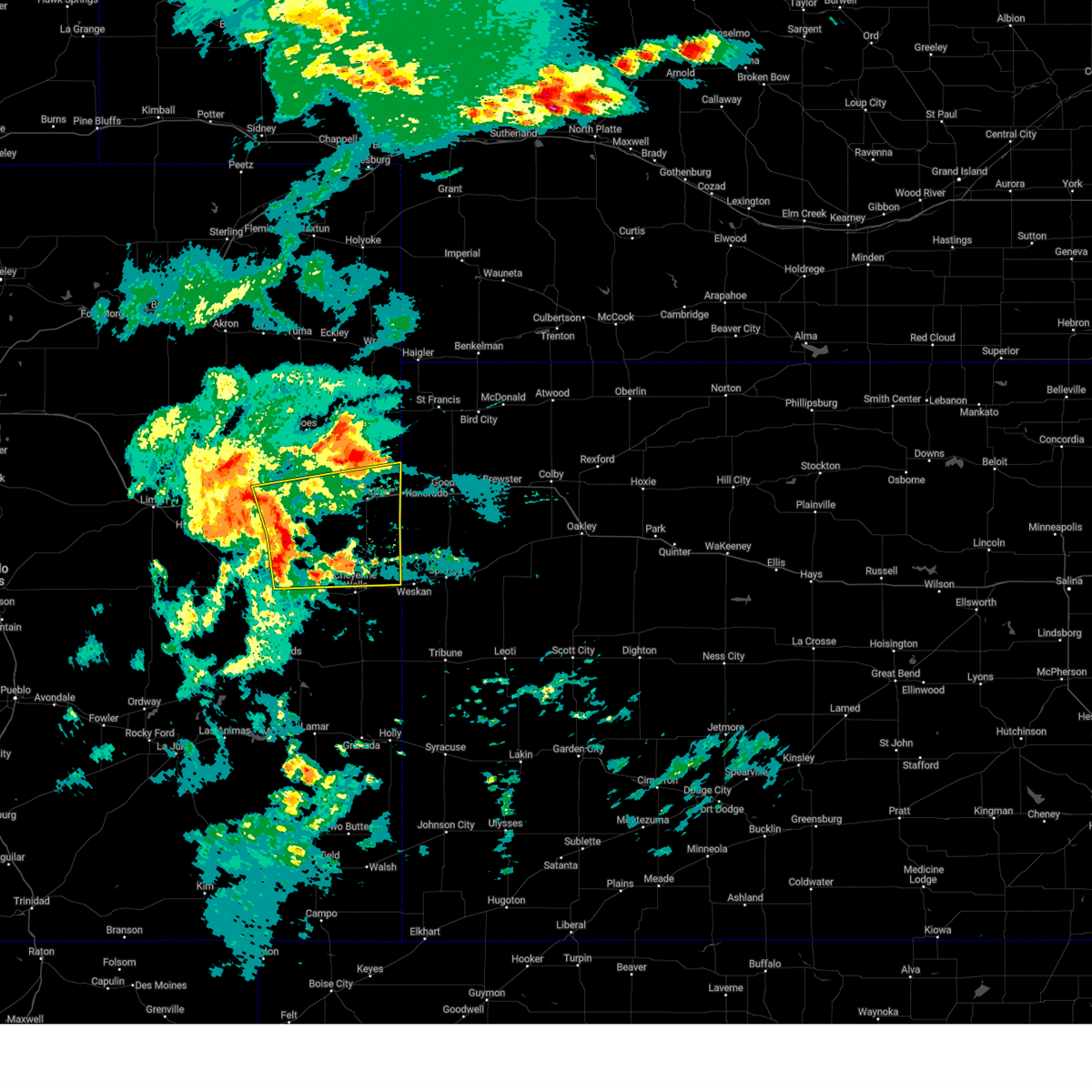
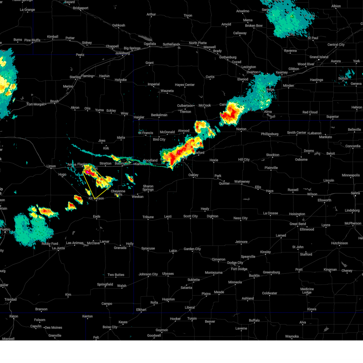
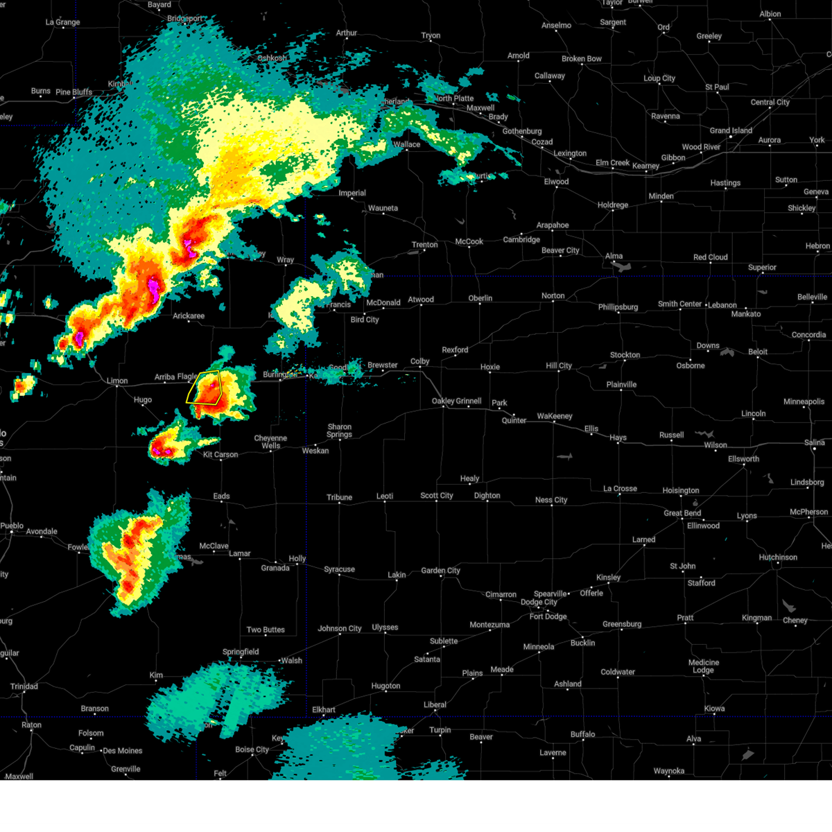
Hail Map for Seibert, CO
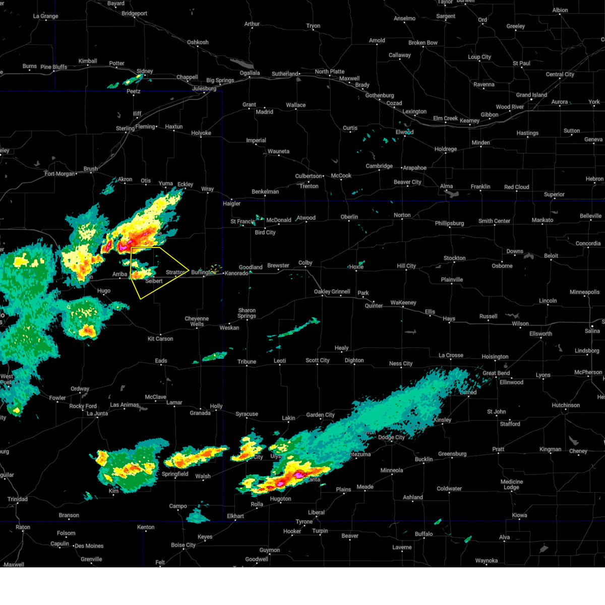
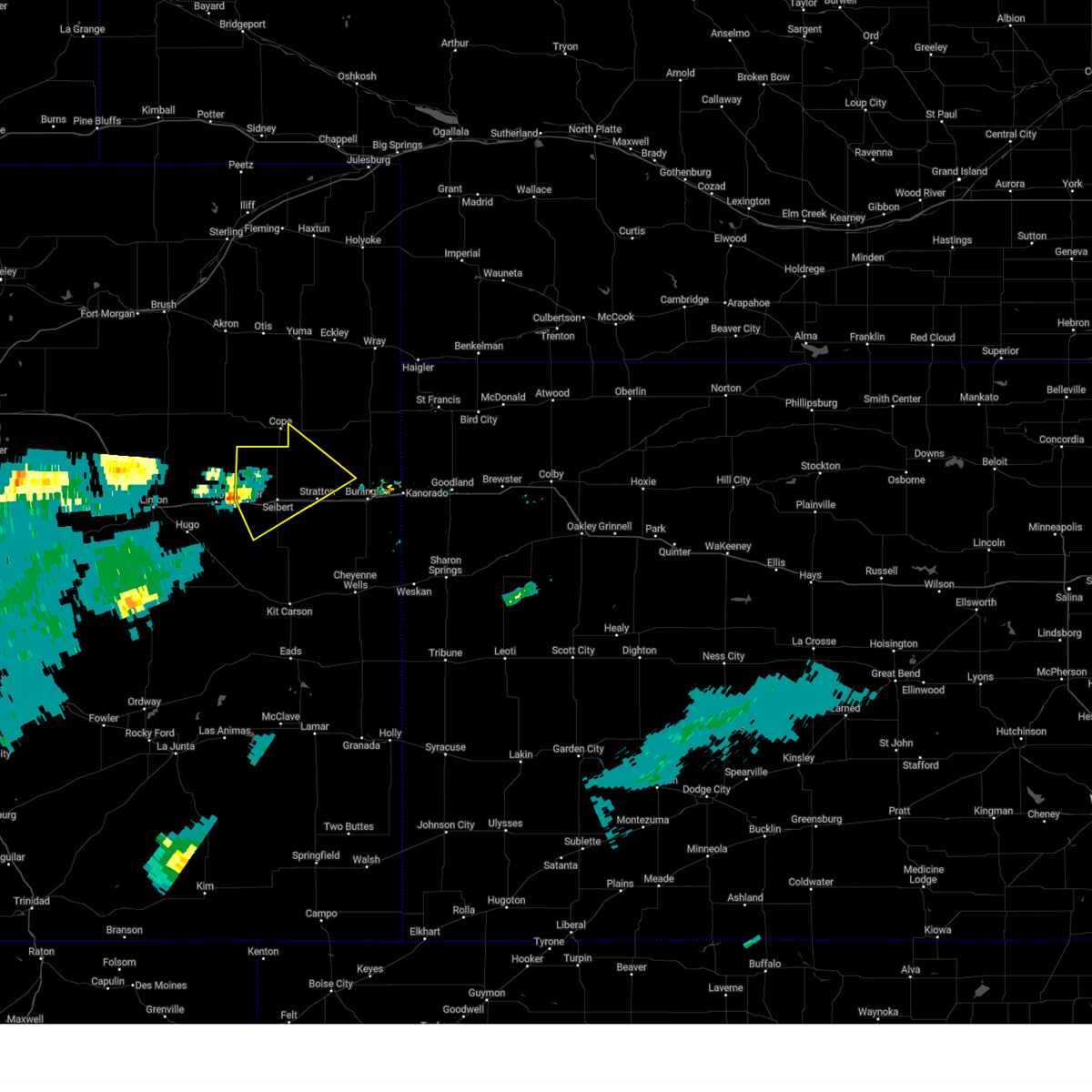
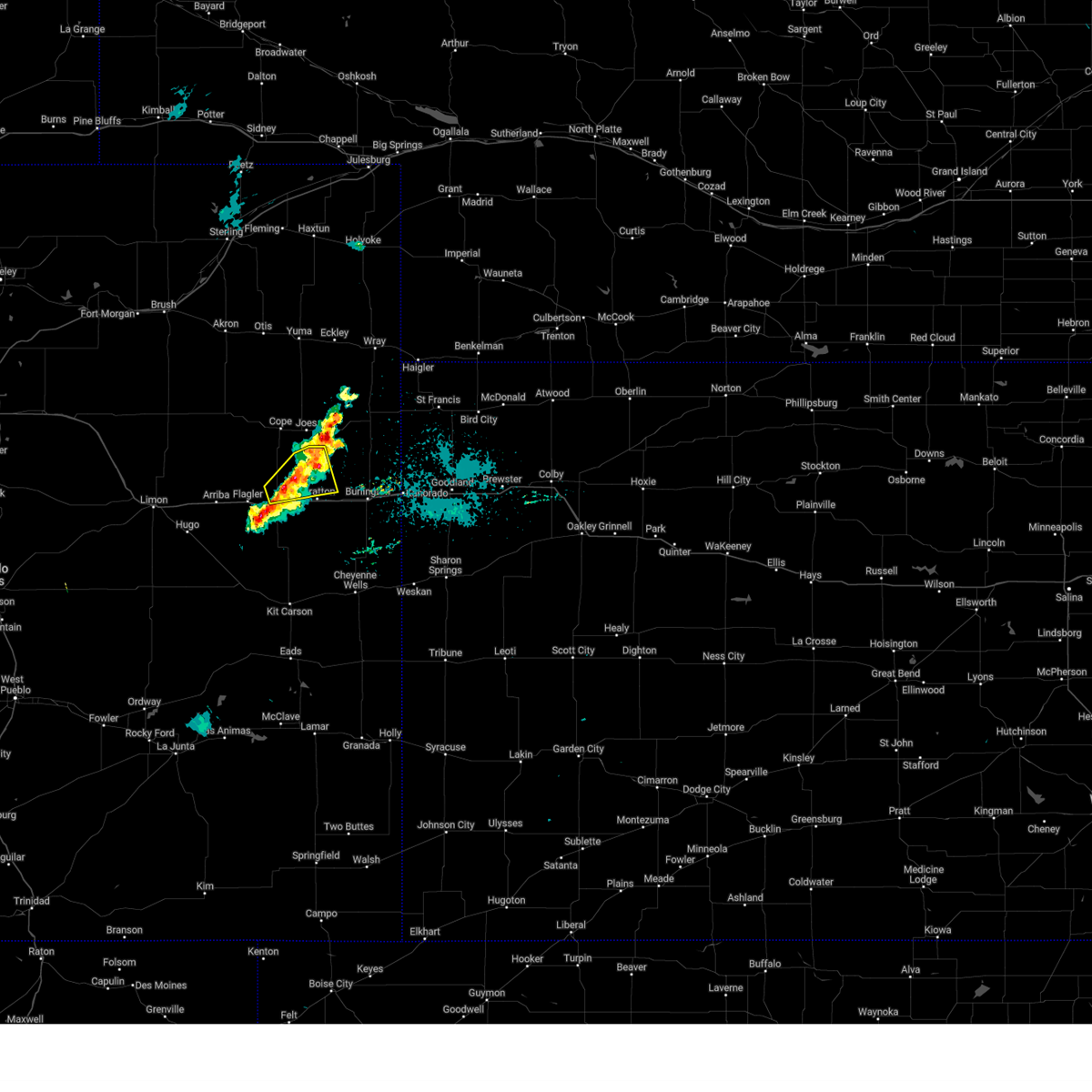
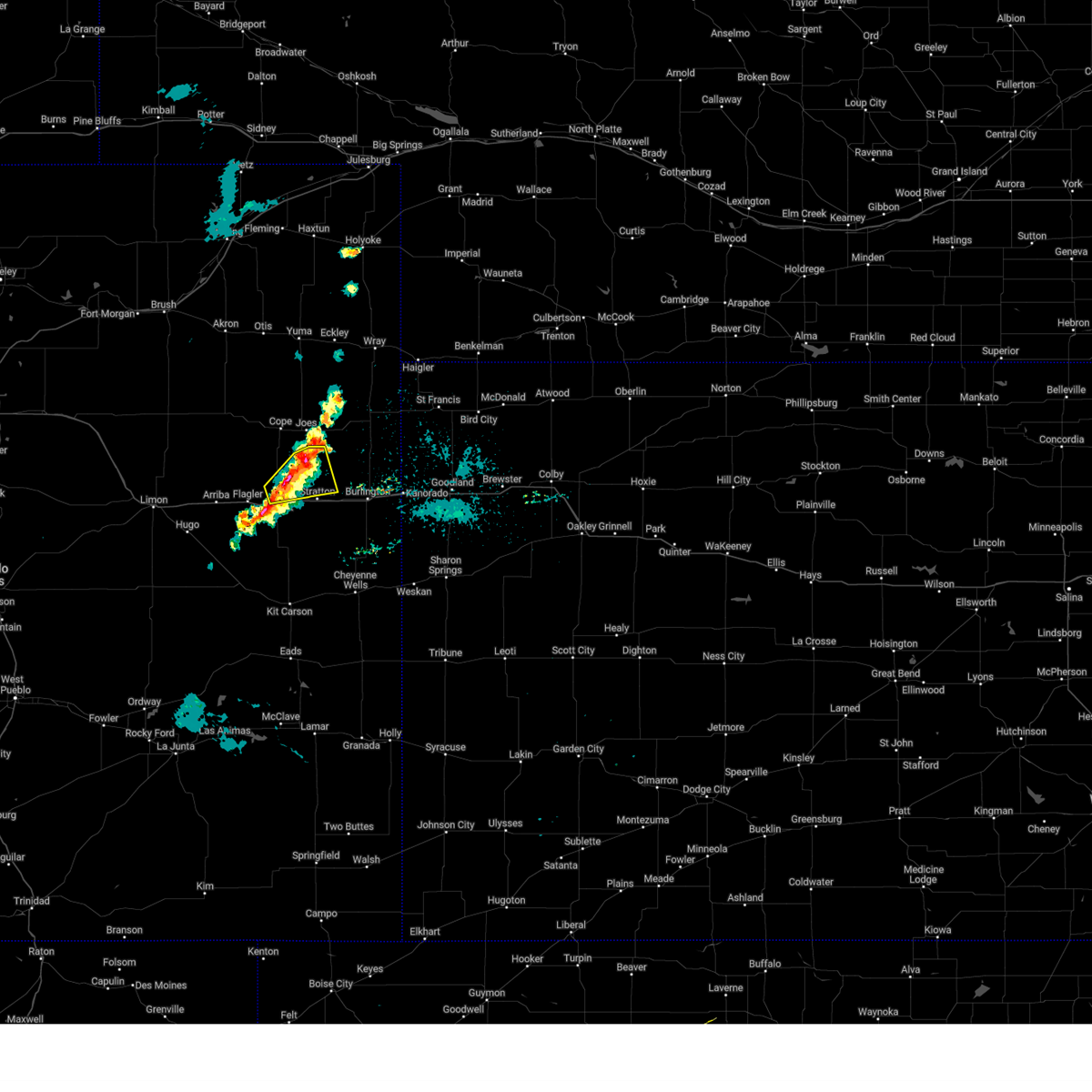
The Seibert, CO area has had 35 reports of on-the-ground hail by trained spotters, and has been under severe weather warnings 36 times during the past 12 months. Doppler radar has detected hail at or near Seibert, CO on 117 occasions, including 7 occasions during the past year.
| Name: | Seibert, CO |
| Where Located: | 57.2 miles S of Yuma, CO |
| Map: | Google Map for Seibert, CO |
| Population: | 181 |
| Housing Units: | 118 |
| More Info: | Search Google for Seibert, CO |
1
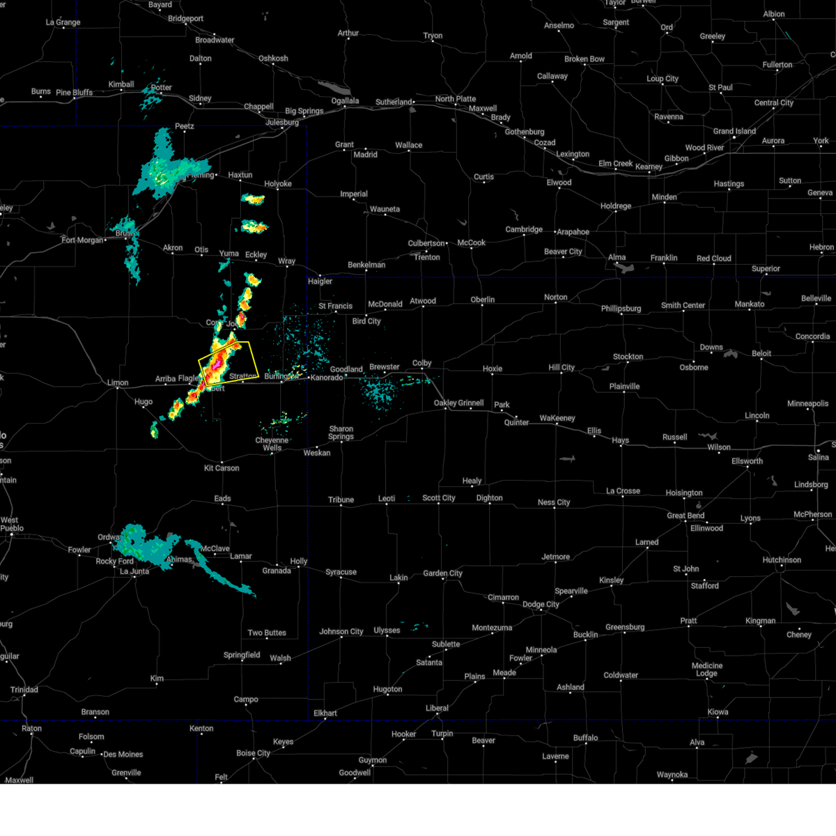
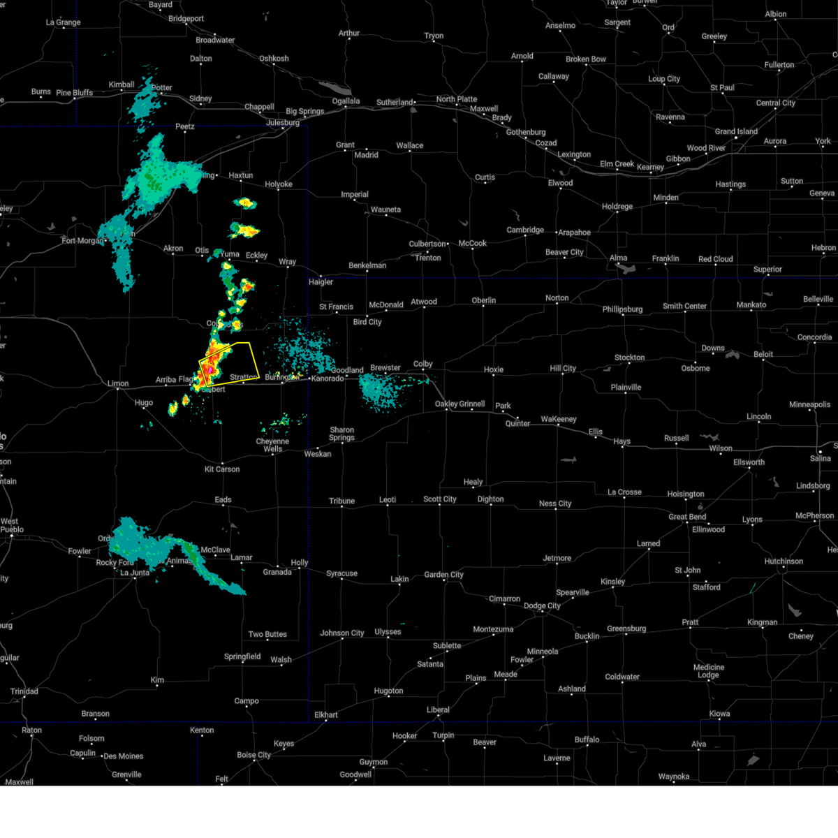
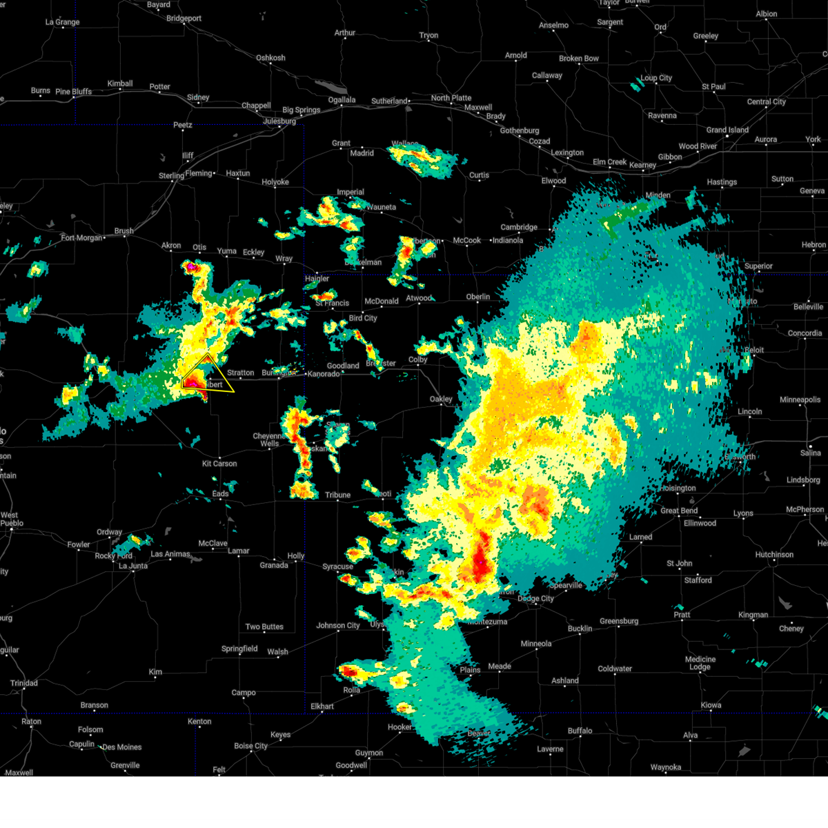
The Top Recent Hail Date for Seibert, CO is Sunday, July 7, 2024 (7th out of 117)

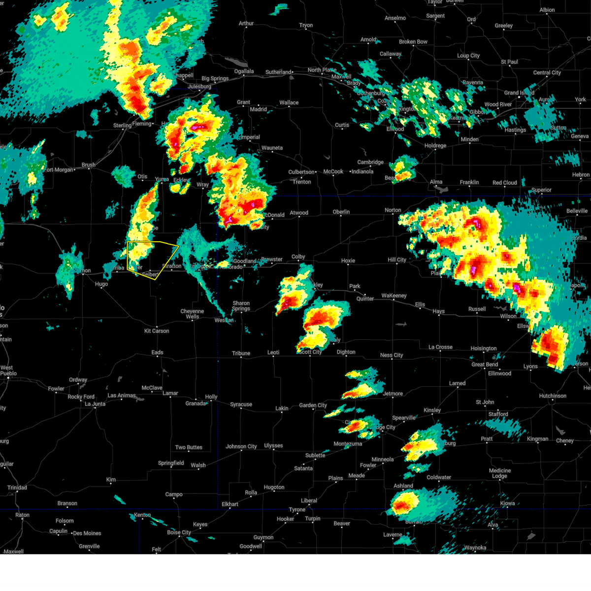
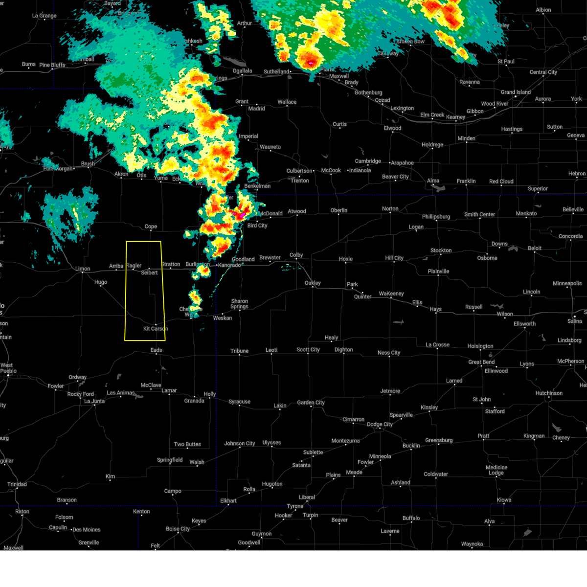
Hail and Wind Damage Spotted near Seibert, CO
| Date / Time | Report Details |
|---|---|
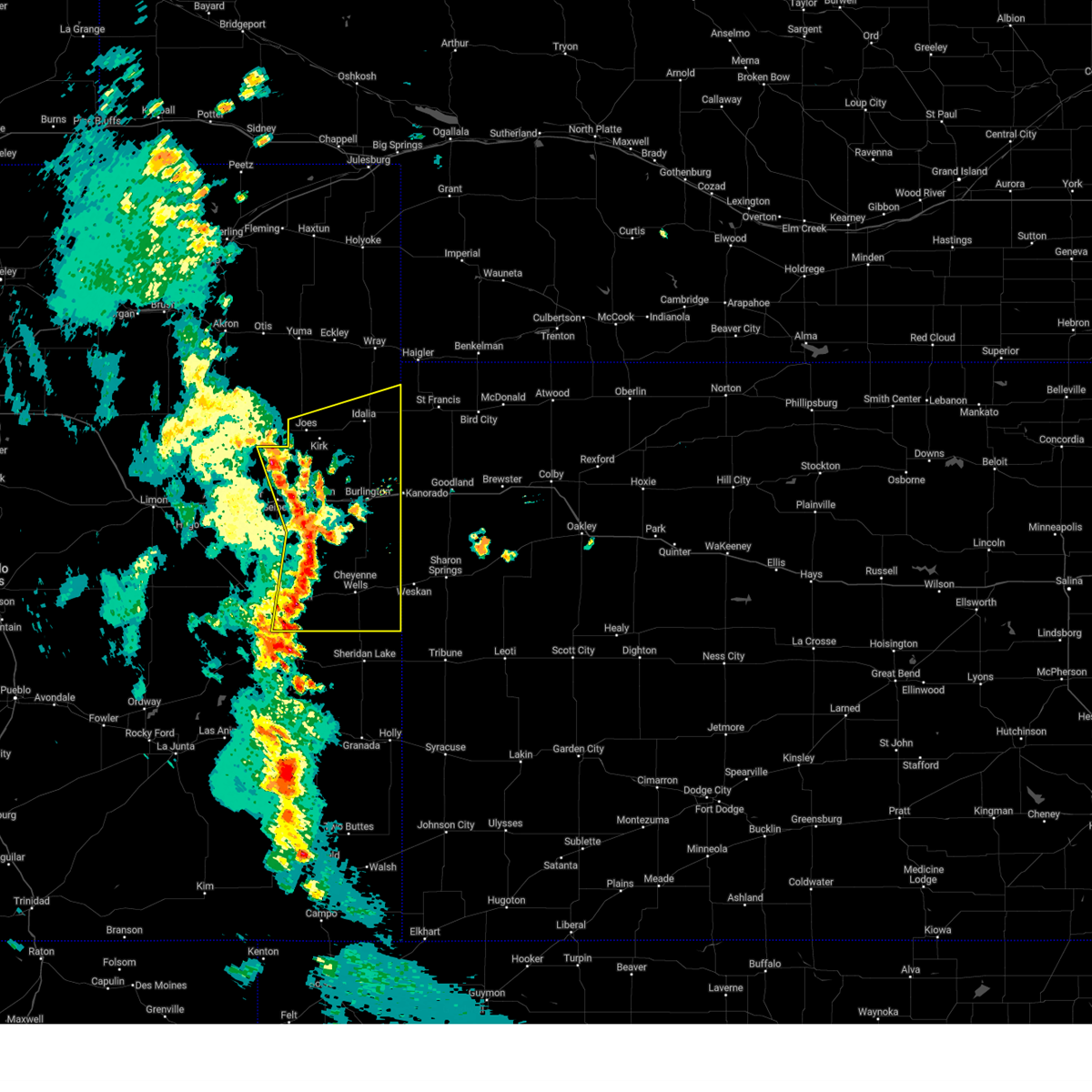
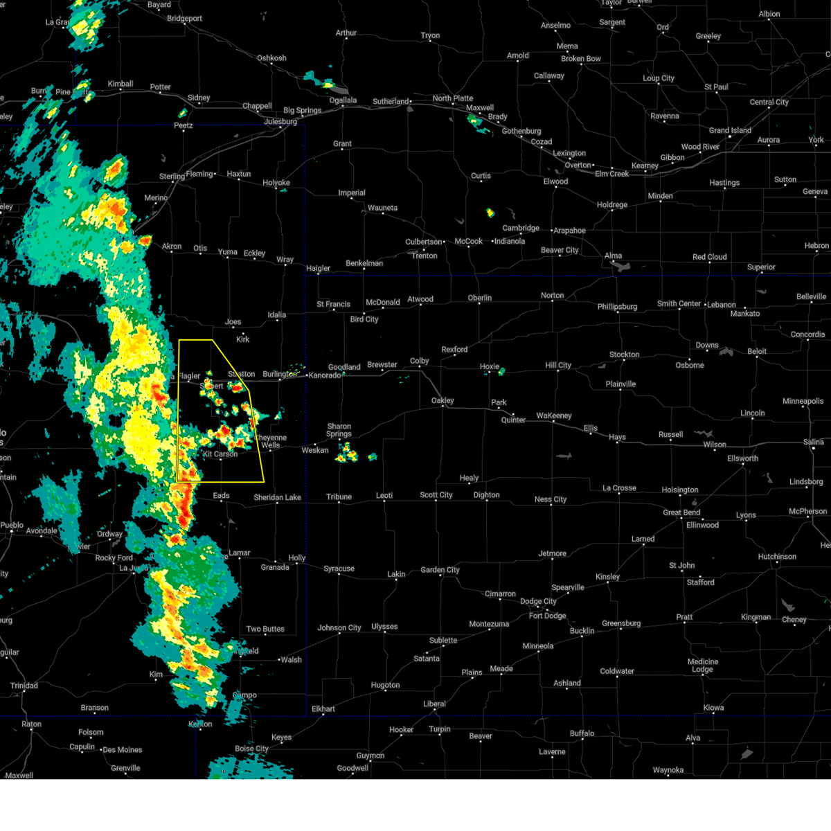
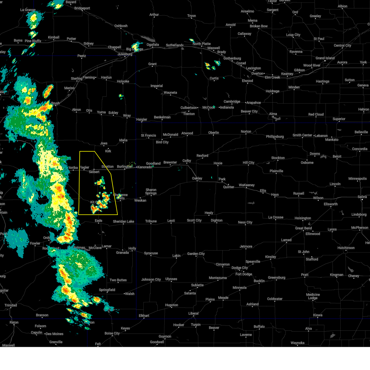
| 6/16/2025 4:30 PM MDT | Svrgld the national weather service in goodland has issued a * severe thunderstorm warning for, north central cheyenne county in east central colorado, western kit carson county in east central colorado, * until 515 pm mdt. * at 430 pm mdt, a severe thunderstorm was located 13 miles south of seibert, moving northeast at 25 mph (radar indicated). Hazards include 60 mph wind gusts and quarter size hail. Hail damage to vehicles is expected. Expect wind damage to roofs, siding, and trees. |
| 6/6/2025 5:10 PM MDT |
 Svrgld the national weather service in goodland has issued a * severe thunderstorm warning for, north central cheyenne county in east central colorado, southwestern kit carson county in east central colorado, * until 600 pm mdt. * at 510 pm mdt, severe thunderstorms were located along a line extending from 4 miles northwest of vona to near seibert to 10 miles south of flagler, moving southeast at 25 mph (public report of hail up to 1 inch northwest of seibert at 4:55 pm mt). Hazards include ping pong ball size hail and 60 mph wind gusts. People and animals outdoors will be injured. expect hail damage to roofs, siding, windows, and vehicles. expect wind damage to roofs, siding, and trees. severe thunderstorms will be near, vona around 515 pm mdt. stratton around 525 pm mdt. This includes interstate 70 in colorado between mile markers 398 and 424. Svrgld the national weather service in goodland has issued a * severe thunderstorm warning for, north central cheyenne county in east central colorado, southwestern kit carson county in east central colorado, * until 600 pm mdt. * at 510 pm mdt, severe thunderstorms were located along a line extending from 4 miles northwest of vona to near seibert to 10 miles south of flagler, moving southeast at 25 mph (public report of hail up to 1 inch northwest of seibert at 4:55 pm mt). Hazards include ping pong ball size hail and 60 mph wind gusts. People and animals outdoors will be injured. expect hail damage to roofs, siding, windows, and vehicles. expect wind damage to roofs, siding, and trees. severe thunderstorms will be near, vona around 515 pm mdt. stratton around 525 pm mdt. This includes interstate 70 in colorado between mile markers 398 and 424.
|
| 6/6/2025 4:57 PM MDT |
 At 456 pm mdt, a severe thunderstorm was located near seibert, moving southeast at 25 mph (public report of hail up to 1 inch northwest of seibert at 4:55 pm mt). Hazards include 60 mph wind gusts and half dollar size hail. Hail damage to vehicles is expected. expect wind damage to roofs, siding, and trees. this severe storm will be near, seibert around 500 pm mdt. This includes interstate 70 in colorado between mile markers 396 and 416. At 456 pm mdt, a severe thunderstorm was located near seibert, moving southeast at 25 mph (public report of hail up to 1 inch northwest of seibert at 4:55 pm mt). Hazards include 60 mph wind gusts and half dollar size hail. Hail damage to vehicles is expected. expect wind damage to roofs, siding, and trees. this severe storm will be near, seibert around 500 pm mdt. This includes interstate 70 in colorado between mile markers 396 and 416.
|
| 6/6/2025 4:48 PM MDT |
 Svrgld the national weather service in goodland has issued a * severe thunderstorm warning for, northwestern kit carson county in east central colorado, * until 515 pm mdt. * at 447 pm mdt, a severe thunderstorm was located 8 miles northeast of flagler, moving southeast at 20 mph (radar indicated). Hazards include 60 mph wind gusts and half dollar size hail. Hail damage to vehicles is expected. expect wind damage to roofs, siding, and trees. this severe thunderstorm will be near, seibert around 500 pm mdt. This includes interstate 70 in colorado between mile markers 396 and 416. Svrgld the national weather service in goodland has issued a * severe thunderstorm warning for, northwestern kit carson county in east central colorado, * until 515 pm mdt. * at 447 pm mdt, a severe thunderstorm was located 8 miles northeast of flagler, moving southeast at 20 mph (radar indicated). Hazards include 60 mph wind gusts and half dollar size hail. Hail damage to vehicles is expected. expect wind damage to roofs, siding, and trees. this severe thunderstorm will be near, seibert around 500 pm mdt. This includes interstate 70 in colorado between mile markers 396 and 416.
|
| 6/5/2025 5:53 PM MDT | Golf Ball sized hail reported 1.9 miles N of Seibert, CO, hail was accumulating and about 3-4 inches deep. |
| 6/5/2025 5:53 PM MDT | Storm damage reported in kit carson county CO, 1.9 miles N of Seibert, CO |
| 6/5/2025 5:43 PM MDT | The severe thunderstorm warning that was previously in effect has been reissued for kit carson county until 7 pm mt. please refer to that bulletin for the latest severe weather information. a severe thunderstorm watch remains in effect until 800 pm mdt for east central colorado. to report severe weather, contact your nearest law enforcement agency. they will relay your report to the national weather service goodland. remember, a severe thunderstorm warning still remains in effect for kit carson county until 7 pm mt. |
| 6/5/2025 5:42 PM MDT | Svrgld the national weather service in goodland has issued a * severe thunderstorm warning for, southwestern kit carson county in east central colorado, * until 700 pm mdt. * at 540 pm mdt, a severe thunderstorm was located 8 miles north of seibert, moving southeast at 25 mph (trained weather spotters reported accumulating 1.5 inch hail at 5:40 pm mt about 10 northwest of seibert). Hazards include golf ball size hail and 60 mph wind gusts. People and animals outdoors will be injured. expect hail damage to roofs, siding, windows, and vehicles. expect wind damage to roofs, siding, and trees. this severe thunderstorm will be near, seibert around 555 pm mdt. vona around 600 pm mdt. This includes interstate 70 in colorado between mile markers 399 and 425. |
| 6/5/2025 5:38 PM MDT | Ping Pong Ball sized hail reported 9.4 miles SSE of Seibert, CO, chaser reported accumulating ping pong ball sized hail near the intersection of county roads dd and 11. |
| 6/5/2025 5:20 PM MDT |
 At 519 pm mdt, a severe thunderstorm was located 11 miles north of flagler, moving southeast at 25 mph (radar indicated). Hazards include 60 mph wind gusts and half dollar size hail. Hail damage to vehicles is expected. expect wind damage to roofs, siding, and trees. locations impacted include, stratton, flagler, seibert, and vona. This includes interstate 70 in colorado between mile markers 396 and 419. At 519 pm mdt, a severe thunderstorm was located 11 miles north of flagler, moving southeast at 25 mph (radar indicated). Hazards include 60 mph wind gusts and half dollar size hail. Hail damage to vehicles is expected. expect wind damage to roofs, siding, and trees. locations impacted include, stratton, flagler, seibert, and vona. This includes interstate 70 in colorado between mile markers 396 and 419.
|
| 6/5/2025 5:04 PM MDT |
 At 504 pm mdt, a severe thunderstorm was located 8 miles southeast of thurman, or 15 miles north of flagler, moving southeast at 20 mph (radar indicated). Hazards include ping pong ball size hail and 60 mph wind gusts. People and animals outdoors will be injured. expect hail damage to roofs, siding, windows, and vehicles. expect wind damage to roofs, siding, and trees. locations impacted include, stratton, flagler, seibert, and vona. This includes interstate 70 in colorado between mile markers 392 and 419. At 504 pm mdt, a severe thunderstorm was located 8 miles southeast of thurman, or 15 miles north of flagler, moving southeast at 20 mph (radar indicated). Hazards include ping pong ball size hail and 60 mph wind gusts. People and animals outdoors will be injured. expect hail damage to roofs, siding, windows, and vehicles. expect wind damage to roofs, siding, and trees. locations impacted include, stratton, flagler, seibert, and vona. This includes interstate 70 in colorado between mile markers 392 and 419.
|
| 6/5/2025 5:04 PM MDT |
 the severe thunderstorm warning has been cancelled and is no longer in effect the severe thunderstorm warning has been cancelled and is no longer in effect
|
| 6/5/2025 4:43 PM MDT |
 Svrgld the national weather service in goodland has issued a * severe thunderstorm warning for, southwestern yuma county in northeastern colorado, western kit carson county in east central colorado, * until 545 pm mdt. * at 442 pm mdt, severe thunderstorms were located along a line extending from 4 miles southeast of arickaree school to 3 miles south of thurman, moving southeast at 35 mph (radar indicated). Hazards include two inch hail and 60 mph wind gusts. People and animals outdoors will be injured. expect hail damage to roofs, siding, windows, and vehicles. Expect wind damage to roofs, siding, and trees. Svrgld the national weather service in goodland has issued a * severe thunderstorm warning for, southwestern yuma county in northeastern colorado, western kit carson county in east central colorado, * until 545 pm mdt. * at 442 pm mdt, severe thunderstorms were located along a line extending from 4 miles southeast of arickaree school to 3 miles south of thurman, moving southeast at 35 mph (radar indicated). Hazards include two inch hail and 60 mph wind gusts. People and animals outdoors will be injured. expect hail damage to roofs, siding, windows, and vehicles. Expect wind damage to roofs, siding, and trees.
|
| 6/1/2025 9:21 PM MDT |
 The storm which prompted the warning has weakened below severe limits, and no longer poses an immediate threat to life or property. therefore, the warning will be allowed to expire. however, small hail and heavy rain are still possible with this thunderstorm. to report severe weather, contact your nearest law enforcement agency. they will relay your report to the national weather service goodland. The storm which prompted the warning has weakened below severe limits, and no longer poses an immediate threat to life or property. therefore, the warning will be allowed to expire. however, small hail and heavy rain are still possible with this thunderstorm. to report severe weather, contact your nearest law enforcement agency. they will relay your report to the national weather service goodland.
|
| 6/1/2025 9:09 PM MDT |
 At 909 pm mdt, a severe thunderstorm was located 7 miles north of vona, or 9 miles northeast of seibert, moving northeast at 20 mph (radar indicated). Hazards include 60 mph wind gusts and quarter size hail. accumulating hail may accompany this storm. Hail damage to vehicles is expected. expect wind damage to roofs, siding, and trees. Locations impacted include, seibert and vona. At 909 pm mdt, a severe thunderstorm was located 7 miles north of vona, or 9 miles northeast of seibert, moving northeast at 20 mph (radar indicated). Hazards include 60 mph wind gusts and quarter size hail. accumulating hail may accompany this storm. Hail damage to vehicles is expected. expect wind damage to roofs, siding, and trees. Locations impacted include, seibert and vona.
|
| 6/1/2025 8:51 PM MDT |
 At 850 pm mdt, a severe thunderstorm was located 8 miles north of vona, or 9 miles north of seibert, moving east at 25 mph (radar indicated). Hazards include 60 mph wind gusts and quarter size hail. accumulating hail may be accompanying this storm. Hail damage to vehicles is expected. expect wind damage to roofs, siding, and trees. Locations impacted include, seibert and vona. At 850 pm mdt, a severe thunderstorm was located 8 miles north of vona, or 9 miles north of seibert, moving east at 25 mph (radar indicated). Hazards include 60 mph wind gusts and quarter size hail. accumulating hail may be accompanying this storm. Hail damage to vehicles is expected. expect wind damage to roofs, siding, and trees. Locations impacted include, seibert and vona.
|
| 6/1/2025 8:42 PM MDT |
 Svrgld the national weather service in goodland has issued a * severe thunderstorm warning for, northwestern kit carson county in east central colorado, * until 930 pm mdt. * at 840 pm mdt, a severe thunderstorm was located 6 miles north of seibert, moving east at 25 mph (radar indicated). Hazards include 60 mph wind gusts and quarter size hail. accumulating hail may accompany this storm. Hail damage to vehicles is expected. expect wind damage to roofs, siding, and trees. This severe thunderstorm will remain over mainly rural areas of northwestern kit carson county. Svrgld the national weather service in goodland has issued a * severe thunderstorm warning for, northwestern kit carson county in east central colorado, * until 930 pm mdt. * at 840 pm mdt, a severe thunderstorm was located 6 miles north of seibert, moving east at 25 mph (radar indicated). Hazards include 60 mph wind gusts and quarter size hail. accumulating hail may accompany this storm. Hail damage to vehicles is expected. expect wind damage to roofs, siding, and trees. This severe thunderstorm will remain over mainly rural areas of northwestern kit carson county.
|
| 5/18/2025 4:56 PM MDT |
 the severe thunderstorm warning has been cancelled and is no longer in effect the severe thunderstorm warning has been cancelled and is no longer in effect
|
| 5/18/2025 4:45 PM MDT | Svrgld the national weather service in goodland has issued a * severe thunderstorm warning for, northwestern kit carson county in east central colorado, * until 515 pm mdt. * at 445 pm mdt, a severe thunderstorm was located 7 miles north of seibert, moving northeast at 20 mph (radar indicated). Hazards include 60 mph wind gusts. Expect damage to roofs, siding, and trees. this severe thunderstorm will remain over mainly rural areas of northwestern kit carson county. This includes interstate 70 in colorado between mile markers 399 and 412. |
| 5/14/2025 7:10 PM MDT |
 The storms which prompted the warning have weakened below severe limits, and no longer pose an immediate threat to life or property. therefore, the warning will be allowed to expire. however, gusty winds are still possible with these thunderstorms. The storms which prompted the warning have weakened below severe limits, and no longer pose an immediate threat to life or property. therefore, the warning will be allowed to expire. however, gusty winds are still possible with these thunderstorms.
|
| 5/14/2025 6:55 PM MDT |
 At 654 pm mdt, severe thunderstorms were located along a line extending from near kit carson to 12 miles southeast of boyero, moving south at 60 mph (report of 64 mph wind gust 7 nw of flagler). Hazards include 60 mph wind gusts. Expect damage to roofs, siding, and trees. these severe thunderstorms will remain over mainly rural areas of western cheyenne and western kit carson counties in east central colorado, including the following locations, wild horse and aroya. This includes interstate 70 in colorado between mile markers 390 and 413. At 654 pm mdt, severe thunderstorms were located along a line extending from near kit carson to 12 miles southeast of boyero, moving south at 60 mph (report of 64 mph wind gust 7 nw of flagler). Hazards include 60 mph wind gusts. Expect damage to roofs, siding, and trees. these severe thunderstorms will remain over mainly rural areas of western cheyenne and western kit carson counties in east central colorado, including the following locations, wild horse and aroya. This includes interstate 70 in colorado between mile markers 390 and 413.
|
| 5/14/2025 6:24 PM MDT |
 At 623 pm mdt, severe thunderstorms were located along a line extending from 3 miles southwest of vona to 4 miles southwest of flagler, moving south at 60 mph (at 6:15 pm mt, a 61 mph wind gust was reported by a mesonet site in flagler). Hazards include 60 mph wind gusts. Expect damage to roofs, siding, and trees. these severe storms will be near, kit carson around 710 pm mdt. other locations impacted by these severe thunderstorms include wild horse and aroya. This includes interstate 70 in colorado between mile markers 390 and 413. At 623 pm mdt, severe thunderstorms were located along a line extending from 3 miles southwest of vona to 4 miles southwest of flagler, moving south at 60 mph (at 6:15 pm mt, a 61 mph wind gust was reported by a mesonet site in flagler). Hazards include 60 mph wind gusts. Expect damage to roofs, siding, and trees. these severe storms will be near, kit carson around 710 pm mdt. other locations impacted by these severe thunderstorms include wild horse and aroya. This includes interstate 70 in colorado between mile markers 390 and 413.
|
| 5/14/2025 6:10 PM MDT |
 Svrgld the national weather service in goodland has issued a * severe thunderstorm warning for, western cheyenne county in east central colorado, western kit carson county in east central colorado, * until 715 pm mdt. * at 609 pm mdt, severe thunderstorms were located along a line extending from 4 miles northeast of seibert to 5 miles northwest of flagler, moving south at 60 mph (radar indicated). Hazards include 60 mph wind gusts. Expect damage to roofs, siding, and trees. severe thunderstorms will be near, seibert around 615 pm mdt. other locations in the path of these severe thunderstorms include kit carson. This includes interstate 70 in colorado between mile markers 390 and 413. Svrgld the national weather service in goodland has issued a * severe thunderstorm warning for, western cheyenne county in east central colorado, western kit carson county in east central colorado, * until 715 pm mdt. * at 609 pm mdt, severe thunderstorms were located along a line extending from 4 miles northeast of seibert to 5 miles northwest of flagler, moving south at 60 mph (radar indicated). Hazards include 60 mph wind gusts. Expect damage to roofs, siding, and trees. severe thunderstorms will be near, seibert around 615 pm mdt. other locations in the path of these severe thunderstorms include kit carson. This includes interstate 70 in colorado between mile markers 390 and 413.
|
| 4/23/2025 9:24 PM MDT |
 The storm which prompted the warning has weakened below severe limits, and no longer poses an immediate threat to life or property. therefore, the warning will be allowed to expire. however, small hail, gusty winds and heavy rain are still possible with this thunderstorm. a severe thunderstorm watch remains in effect until 1000 pm mdt for east central colorado. to report severe weather, contact your nearest law enforcement agency. they will relay your report to the national weather service goodland. The storm which prompted the warning has weakened below severe limits, and no longer poses an immediate threat to life or property. therefore, the warning will be allowed to expire. however, small hail, gusty winds and heavy rain are still possible with this thunderstorm. a severe thunderstorm watch remains in effect until 1000 pm mdt for east central colorado. to report severe weather, contact your nearest law enforcement agency. they will relay your report to the national weather service goodland.
|
| 4/23/2025 9:05 PM MDT |
 Svrgld the national weather service in goodland has issued a * severe thunderstorm warning for, northwestern kit carson county in east central colorado, * until 930 pm mdt. * at 905 pm mdt, a severe thunderstorm was located 4 miles southeast of flagler, moving northeast at 30 mph (radar indicated). Hazards include 60 mph wind gusts and quarter size hail. Hail damage to vehicles is expected. expect wind damage to roofs, siding, and trees. this severe thunderstorm will be near, seibert around 910 pm mdt. This includes interstate 70 in colorado between mile markers 392 and 413. Svrgld the national weather service in goodland has issued a * severe thunderstorm warning for, northwestern kit carson county in east central colorado, * until 930 pm mdt. * at 905 pm mdt, a severe thunderstorm was located 4 miles southeast of flagler, moving northeast at 30 mph (radar indicated). Hazards include 60 mph wind gusts and quarter size hail. Hail damage to vehicles is expected. expect wind damage to roofs, siding, and trees. this severe thunderstorm will be near, seibert around 910 pm mdt. This includes interstate 70 in colorado between mile markers 392 and 413.
|
| 9/17/2024 5:22 PM MDT |
 Svrgld the national weather service in goodland has issued a * severe thunderstorm warning for, cheyenne county in east central colorado, southern yuma county in northeastern colorado, kit carson county in east central colorado, * until 545 pm mdt. * at 521 pm mdt, severe thunderstorms were located along a line extending from 12 miles south of cope to 7 miles south of stratton to 12 miles northwest of cheyenne wells, moving northeast at 55 mph (radar indicated). Hazards include 60 mph wind gusts and nickel size hail. Expect damage to roofs, siding, and trees. severe thunderstorms will be near, stratton around 525 pm mdt. bethune around 530 pm mdt. burlington around 540 pm mdt. other locations impacted by these severe thunderstorms include joes, hale, firstview, kirk, arapahoe, and idalia. this includes the following highways, interstate 70 in colorado between mile markers 405 and 450. Highway 385 between mile markers 136 and 226. Svrgld the national weather service in goodland has issued a * severe thunderstorm warning for, cheyenne county in east central colorado, southern yuma county in northeastern colorado, kit carson county in east central colorado, * until 545 pm mdt. * at 521 pm mdt, severe thunderstorms were located along a line extending from 12 miles south of cope to 7 miles south of stratton to 12 miles northwest of cheyenne wells, moving northeast at 55 mph (radar indicated). Hazards include 60 mph wind gusts and nickel size hail. Expect damage to roofs, siding, and trees. severe thunderstorms will be near, stratton around 525 pm mdt. bethune around 530 pm mdt. burlington around 540 pm mdt. other locations impacted by these severe thunderstorms include joes, hale, firstview, kirk, arapahoe, and idalia. this includes the following highways, interstate 70 in colorado between mile markers 405 and 450. Highway 385 between mile markers 136 and 226.
|
| 9/17/2024 4:59 PM MDT |
 At 459 pm mdt, severe thunderstorms were located along a line extending from near arriba to 11 miles east of boyero to 4 miles east of haswell, moving northeast at 50 mph (radar indicated). Hazards include 60 mph wind gusts and nickel size hail. Expect damage to roofs, siding, and trees. these severe storms will be near, flagler around 510 pm mdt. kit carson around 515 pm mdt. seibert around 520 pm mdt. vona around 530 pm mdt. stratton around 535 pm mdt. other locations impacted by these severe thunderstorms include wild horse, firstview, and aroya. This includes interstate 70 in colorado between mile markers 390 and 420. At 459 pm mdt, severe thunderstorms were located along a line extending from near arriba to 11 miles east of boyero to 4 miles east of haswell, moving northeast at 50 mph (radar indicated). Hazards include 60 mph wind gusts and nickel size hail. Expect damage to roofs, siding, and trees. these severe storms will be near, flagler around 510 pm mdt. kit carson around 515 pm mdt. seibert around 520 pm mdt. vona around 530 pm mdt. stratton around 535 pm mdt. other locations impacted by these severe thunderstorms include wild horse, firstview, and aroya. This includes interstate 70 in colorado between mile markers 390 and 420.
|
| 9/17/2024 4:34 PM MDT |
 Svrgld the national weather service in goodland has issued a * severe thunderstorm warning for, cheyenne county in east central colorado, western kit carson county in east central colorado, * until 530 pm mdt. * at 434 pm mdt, severe thunderstorms were located along a line extending from 3 miles north of limon to 6 miles east of karval to 5 miles west of blue lake, moving northeast at 45 mph (radar indicated). Hazards include 60 mph wind gusts. Expect damage to roofs, siding, and trees. severe thunderstorms will be near, flagler around 510 pm mdt. kit carson around 520 pm mdt. other locations impacted by these severe thunderstorms include wild horse, firstview, and aroya. This includes interstate 70 in colorado between mile markers 390 and 420. Svrgld the national weather service in goodland has issued a * severe thunderstorm warning for, cheyenne county in east central colorado, western kit carson county in east central colorado, * until 530 pm mdt. * at 434 pm mdt, severe thunderstorms were located along a line extending from 3 miles north of limon to 6 miles east of karval to 5 miles west of blue lake, moving northeast at 45 mph (radar indicated). Hazards include 60 mph wind gusts. Expect damage to roofs, siding, and trees. severe thunderstorms will be near, flagler around 510 pm mdt. kit carson around 520 pm mdt. other locations impacted by these severe thunderstorms include wild horse, firstview, and aroya. This includes interstate 70 in colorado between mile markers 390 and 420.
|
| 8/22/2024 6:13 PM MDT |
 Svrgld the national weather service in goodland has issued a * severe thunderstorm warning for, kit carson county in east central colorado, * until 645 pm mdt. * at 613 pm mdt, a severe thunderstorm was located 16 miles south of seibert, moving northeast at 50 mph (radar indicated). Hazards include 60 mph wind gusts. Expect damage to roofs, siding, and trees. this severe thunderstorm will be near, stratton around 630 pm mdt. this includes the following highways, interstate 70 in colorado between mile markers 402 and 441. Highway 385 between mile markers 176 and 189. Svrgld the national weather service in goodland has issued a * severe thunderstorm warning for, kit carson county in east central colorado, * until 645 pm mdt. * at 613 pm mdt, a severe thunderstorm was located 16 miles south of seibert, moving northeast at 50 mph (radar indicated). Hazards include 60 mph wind gusts. Expect damage to roofs, siding, and trees. this severe thunderstorm will be near, stratton around 630 pm mdt. this includes the following highways, interstate 70 in colorado between mile markers 402 and 441. Highway 385 between mile markers 176 and 189.
|
| 8/7/2024 7:26 PM MDT |
 Svrgld the national weather service in goodland has issued a * severe thunderstorm warning for, northeastern cheyenne county in east central colorado, kit carson county in east central colorado, * until 900 pm mdt. * at 726 pm mdt, severe thunderstorms were located along a line extending from 6 miles northeast of flagler to 11 miles south of vona to 11 miles north of kit carson, moving east at 25 mph (radar indicated). Hazards include 60 mph wind gusts and nickel size hail. Expect damage to roofs, siding, and trees. severe thunderstorms will be near, seibert around 730 pm mdt. vona around 735 pm mdt. other locations in the path of these severe thunderstorms include stratton, bethune and burlington. this includes the following highways, interstate 70 in colorado between mile markers 399 and 449. Highway 385 between mile markers 154 and 199. Svrgld the national weather service in goodland has issued a * severe thunderstorm warning for, northeastern cheyenne county in east central colorado, kit carson county in east central colorado, * until 900 pm mdt. * at 726 pm mdt, severe thunderstorms were located along a line extending from 6 miles northeast of flagler to 11 miles south of vona to 11 miles north of kit carson, moving east at 25 mph (radar indicated). Hazards include 60 mph wind gusts and nickel size hail. Expect damage to roofs, siding, and trees. severe thunderstorms will be near, seibert around 730 pm mdt. vona around 735 pm mdt. other locations in the path of these severe thunderstorms include stratton, bethune and burlington. this includes the following highways, interstate 70 in colorado between mile markers 399 and 449. Highway 385 between mile markers 154 and 199.
|
| 7/19/2024 3:08 PM MDT |
 Svrgld the national weather service in goodland has issued a * severe thunderstorm warning for, north central cheyenne county in east central colorado, southwestern kit carson county in east central colorado, * until 415 pm mdt. * at 307 pm mdt, a severe thunderstorm was located 8 miles southwest of seibert, moving southeast at 30 mph (radar indicated). Hazards include 60 mph wind gusts and quarter size hail. Hail damage to vehicles is expected. expect wind damage to roofs, siding, and trees. accumlating hail may be possible with these storms. this severe thunderstorm will remain over mainly rural areas of north central cheyenne and southwestern kit carson counties in east central colorado. This includes interstate 70 in colorado between mile markers 401 and 406. Svrgld the national weather service in goodland has issued a * severe thunderstorm warning for, north central cheyenne county in east central colorado, southwestern kit carson county in east central colorado, * until 415 pm mdt. * at 307 pm mdt, a severe thunderstorm was located 8 miles southwest of seibert, moving southeast at 30 mph (radar indicated). Hazards include 60 mph wind gusts and quarter size hail. Hail damage to vehicles is expected. expect wind damage to roofs, siding, and trees. accumlating hail may be possible with these storms. this severe thunderstorm will remain over mainly rural areas of north central cheyenne and southwestern kit carson counties in east central colorado. This includes interstate 70 in colorado between mile markers 401 and 406.
|
| 7/7/2024 5:28 PM MDT |
 At 527 pm mdt, a severe thunderstorm was located 5 miles southwest of stratton, moving southeast at 40 mph (radar indicated). Hazards include ping pong ball size hail and 60 mph wind gusts. People and animals outdoors will be injured. expect hail damage to roofs, siding, windows, and vehicles. expect wind damage to roofs, siding, and trees. this severe thunderstorm will remain over mainly rural areas of south central kit carson county. This includes interstate 70 in colorado between mile markers 405 and 426. At 527 pm mdt, a severe thunderstorm was located 5 miles southwest of stratton, moving southeast at 40 mph (radar indicated). Hazards include ping pong ball size hail and 60 mph wind gusts. People and animals outdoors will be injured. expect hail damage to roofs, siding, windows, and vehicles. expect wind damage to roofs, siding, and trees. this severe thunderstorm will remain over mainly rural areas of south central kit carson county. This includes interstate 70 in colorado between mile markers 405 and 426.
|
| 7/7/2024 5:22 PM MDT | At 522 pm mdt, a severe thunderstorm was located near vona, or 6 miles west of stratton, moving southeast at 40 mph (radar indicated). Hazards include ping pong ball size hail and 60 mph wind gusts. People and animals outdoors will be injured. expect hail damage to roofs, siding, windows, and vehicles. expect wind damage to roofs, siding, and trees. this severe thunderstorm will remain over mainly rural areas of south central kit carson county. This includes interstate 70 in colorado between mile markers 405 and 426. |
| 7/7/2024 5:14 PM MDT | Ping Pong Ball sized hail reported 4.5 miles W of Seibert, CO, exact location on i-70 (39.2943... -102.7903) and time taken from dash cam. ping pong sized hail damaged car (shattered windshield... numerous dents). |
| 7/7/2024 5:13 PM MDT | Golf Ball sized hail reported 0.5 miles NNW of Seibert, CO, pea to golf ball hail was ongoing... but slowing down over the location after a duration of 5 minutes as of 5:17 pm. |
| 7/7/2024 5:12 PM MDT |
 Svrgld the national weather service in goodland has issued a * severe thunderstorm warning for, central kit carson county in east central colorado, * until 545 pm mdt. * at 512 pm mdt, a severe thunderstorm was located 4 miles north of seibert, moving southeast at 40 mph (radar indicated). Hazards include 60 mph wind gusts and half dollar size hail. Hail damage to vehicles is expected. expect wind damage to roofs, siding, and trees. this severe thunderstorm will be near, seibert and vona around 515 pm mdt. This includes interstate 70 in colorado between mile markers 403 and 426. Svrgld the national weather service in goodland has issued a * severe thunderstorm warning for, central kit carson county in east central colorado, * until 545 pm mdt. * at 512 pm mdt, a severe thunderstorm was located 4 miles north of seibert, moving southeast at 40 mph (radar indicated). Hazards include 60 mph wind gusts and half dollar size hail. Hail damage to vehicles is expected. expect wind damage to roofs, siding, and trees. this severe thunderstorm will be near, seibert and vona around 515 pm mdt. This includes interstate 70 in colorado between mile markers 403 and 426.
|
| 7/7/2024 5:05 PM MDT | Ping Pong Ball sized hail reported 3.5 miles SE of Seibert, CO, estimating ping pong ball size hail and around 50 mph winds at location of cr y and 13. |
| 7/7/2024 5:00 PM MDT |
 At 500 pm mdt, a severe thunderstorm was located 8 miles northwest of seibert, moving southeast at 30 mph (radar indicated). Hazards include ping pong ball size hail and 60 mph wind gusts. People and animals outdoors will be injured. expect hail damage to roofs, siding, windows, and vehicles. expect wind damage to roofs, siding, and trees. locations impacted include, seibert and vona. This includes interstate 70 in colorado between mile markers 400 and 417. At 500 pm mdt, a severe thunderstorm was located 8 miles northwest of seibert, moving southeast at 30 mph (radar indicated). Hazards include ping pong ball size hail and 60 mph wind gusts. People and animals outdoors will be injured. expect hail damage to roofs, siding, windows, and vehicles. expect wind damage to roofs, siding, and trees. locations impacted include, seibert and vona. This includes interstate 70 in colorado between mile markers 400 and 417.
|
| 7/7/2024 4:46 PM MDT |
 At 445 pm mdt, a severe thunderstorm was located 12 miles north of flagler, moving southeast at 30 mph (radar indicated). Hazards include 60 mph wind gusts and quarter size hail. Hail damage to vehicles is expected. expect wind damage to roofs, siding, and trees. locations impacted include, flagler, seibert, and vona. This includes interstate 70 in colorado between mile markers 397 and 417. At 445 pm mdt, a severe thunderstorm was located 12 miles north of flagler, moving southeast at 30 mph (radar indicated). Hazards include 60 mph wind gusts and quarter size hail. Hail damage to vehicles is expected. expect wind damage to roofs, siding, and trees. locations impacted include, flagler, seibert, and vona. This includes interstate 70 in colorado between mile markers 397 and 417.
|
| 7/7/2024 4:36 PM MDT |
 At 435 pm mdt, a severe thunderstorm was located 7 miles southeast of thurman, or 15 miles north of flagler, moving southeast at 30 mph (radar indicated). Hazards include 60 mph wind gusts and half dollar size hail. Hail damage to vehicles is expected. expect wind damage to roofs, siding, and trees. locations impacted include, flagler, seibert, and vona. This includes interstate 70 in colorado between mile markers 397 and 417. At 435 pm mdt, a severe thunderstorm was located 7 miles southeast of thurman, or 15 miles north of flagler, moving southeast at 30 mph (radar indicated). Hazards include 60 mph wind gusts and half dollar size hail. Hail damage to vehicles is expected. expect wind damage to roofs, siding, and trees. locations impacted include, flagler, seibert, and vona. This includes interstate 70 in colorado between mile markers 397 and 417.
|
| 7/7/2024 4:27 PM MDT |
 At 426 pm mdt, a severe thunderstorm was located near thurman, or 19 miles north of flagler, moving southeast at 30 mph (radar indicated). Hazards include ping pong ball size hail and 60 mph wind gusts. People and animals outdoors will be injured. expect hail damage to roofs, siding, windows, and vehicles. expect wind damage to roofs, siding, and trees. locations impacted include, flagler, seibert, and vona. This includes interstate 70 in colorado between mile markers 397 and 417. At 426 pm mdt, a severe thunderstorm was located near thurman, or 19 miles north of flagler, moving southeast at 30 mph (radar indicated). Hazards include ping pong ball size hail and 60 mph wind gusts. People and animals outdoors will be injured. expect hail damage to roofs, siding, windows, and vehicles. expect wind damage to roofs, siding, and trees. locations impacted include, flagler, seibert, and vona. This includes interstate 70 in colorado between mile markers 397 and 417.
|
| 7/7/2024 4:15 PM MDT |
 Svrgld the national weather service in goodland has issued a * severe thunderstorm warning for, western kit carson county in east central colorado, * until 515 pm mdt. * at 414 pm mdt, a severe thunderstorm was located near thurman, or 25 miles north of flagler, moving southeast at 40 mph (radar indicated). Hazards include ping pong ball size hail and 60 mph wind gusts. People and animals outdoors will be injured. expect hail damage to roofs, siding, windows, and vehicles. Expect wind damage to roofs, siding, and trees. Svrgld the national weather service in goodland has issued a * severe thunderstorm warning for, western kit carson county in east central colorado, * until 515 pm mdt. * at 414 pm mdt, a severe thunderstorm was located near thurman, or 25 miles north of flagler, moving southeast at 40 mph (radar indicated). Hazards include ping pong ball size hail and 60 mph wind gusts. People and animals outdoors will be injured. expect hail damage to roofs, siding, windows, and vehicles. Expect wind damage to roofs, siding, and trees.
|
| 6/8/2024 6:17 PM MDT |
 the severe thunderstorm warning has been cancelled and is no longer in effect the severe thunderstorm warning has been cancelled and is no longer in effect
|
| 6/8/2024 6:17 PM MDT |
 At 617 pm mdt, a severe thunderstorm was located 6 miles north of stratton, moving southeast at 40 mph (radar indicated). Hazards include 60 mph wind gusts and quarter size hail. Hail damage to vehicles is expected. expect wind damage to roofs, siding, and trees. this severe storm will be near, bethune around 625 pm mdt. this includes the following highways, interstate 70 in colorado between mile markers 401 and 435. Highway 385 between mile markers 190 and 205, and near mile marker 211. At 617 pm mdt, a severe thunderstorm was located 6 miles north of stratton, moving southeast at 40 mph (radar indicated). Hazards include 60 mph wind gusts and quarter size hail. Hail damage to vehicles is expected. expect wind damage to roofs, siding, and trees. this severe storm will be near, bethune around 625 pm mdt. this includes the following highways, interstate 70 in colorado between mile markers 401 and 435. Highway 385 between mile markers 190 and 205, and near mile marker 211.
|
| 6/8/2024 5:54 PM MDT | Kcovona2 reported a 59 mph gus in kit carson county CO, 17.5 miles S of Seibert, CO |
| 6/8/2024 5:54 PM MDT |
 Svrgld the national weather service in goodland has issued a * severe thunderstorm warning for, southwestern yuma county in northeastern colorado, kit carson county in east central colorado, * until 700 pm mdt. * at 554 pm mdt, a severe thunderstorm was located 9 miles south of cope, or 17 miles north of seibert, moving southeast at 35 mph (radar indicated). Hazards include golf ball size hail and 60 mph wind gusts. People and animals outdoors will be injured. expect hail damage to roofs, siding, windows, and vehicles. expect wind damage to roofs, siding, and trees. this severe thunderstorm will be near, bethune around 630 pm mdt. burlington around 640 pm mdt. other locations impacted by this severe thunderstorm include joes and kirk. this includes the following highways, interstate 70 in colorado between mile markers 394 and 435. Highway 385 between mile markers 189 and 205, and near mile marker 211. Svrgld the national weather service in goodland has issued a * severe thunderstorm warning for, southwestern yuma county in northeastern colorado, kit carson county in east central colorado, * until 700 pm mdt. * at 554 pm mdt, a severe thunderstorm was located 9 miles south of cope, or 17 miles north of seibert, moving southeast at 35 mph (radar indicated). Hazards include golf ball size hail and 60 mph wind gusts. People and animals outdoors will be injured. expect hail damage to roofs, siding, windows, and vehicles. expect wind damage to roofs, siding, and trees. this severe thunderstorm will be near, bethune around 630 pm mdt. burlington around 640 pm mdt. other locations impacted by this severe thunderstorm include joes and kirk. this includes the following highways, interstate 70 in colorado between mile markers 394 and 435. Highway 385 between mile markers 189 and 205, and near mile marker 211.
|
| 6/8/2024 4:49 PM MDT |
 At 448 pm mdt, a severe thunderstorm was located 5 miles west of seibert, moving east at 15 mph (public). Hazards include golf ball size hail and 60 mph wind gusts. People and animals outdoors will be injured. expect hail damage to roofs, siding, windows, and vehicles. expect wind damage to roofs, siding, and trees. this severe storm will be near, seibert around 455 pm mdt. This includes interstate 70 in colorado between mile markers 397 and 409. At 448 pm mdt, a severe thunderstorm was located 5 miles west of seibert, moving east at 15 mph (public). Hazards include golf ball size hail and 60 mph wind gusts. People and animals outdoors will be injured. expect hail damage to roofs, siding, windows, and vehicles. expect wind damage to roofs, siding, and trees. this severe storm will be near, seibert around 455 pm mdt. This includes interstate 70 in colorado between mile markers 397 and 409.
|
| 6/8/2024 4:42 PM MDT | Baseball sized hail reported 8 miles NNE of Seibert, CO, spotter report of baseball sized hail 3w of hwy 52. |
| 6/8/2024 4:28 PM MDT |
 At 428 pm mdt, a severe thunderstorm was located over flagler, moving east at 15 mph (public). Hazards include golf ball size hail and 60 mph wind gusts. People and animals outdoors will be injured. expect hail damage to roofs, siding, windows, and vehicles. expect wind damage to roofs, siding, and trees. this severe storm will be near, seibert around 455 pm mdt. This includes interstate 70 in colorado between mile markers 390 and 409. At 428 pm mdt, a severe thunderstorm was located over flagler, moving east at 15 mph (public). Hazards include golf ball size hail and 60 mph wind gusts. People and animals outdoors will be injured. expect hail damage to roofs, siding, windows, and vehicles. expect wind damage to roofs, siding, and trees. this severe storm will be near, seibert around 455 pm mdt. This includes interstate 70 in colorado between mile markers 390 and 409.
|
| 6/8/2024 4:23 PM MDT |
 At 423 pm mdt, a severe thunderstorm was located over flagler, moving east at 15 mph (radar indicated). Hazards include golf ball size hail and 60 mph wind gusts. People and animals outdoors will be injured. expect hail damage to roofs, siding, windows, and vehicles. expect wind damage to roofs, siding, and trees. this severe storm will be near, seibert around 455 pm mdt. This includes interstate 70 in colorado between mile markers 390 and 410. At 423 pm mdt, a severe thunderstorm was located over flagler, moving east at 15 mph (radar indicated). Hazards include golf ball size hail and 60 mph wind gusts. People and animals outdoors will be injured. expect hail damage to roofs, siding, windows, and vehicles. expect wind damage to roofs, siding, and trees. this severe storm will be near, seibert around 455 pm mdt. This includes interstate 70 in colorado between mile markers 390 and 410.
|
| 6/8/2024 4:12 PM MDT |
 Svrgld the national weather service in goodland has issued a * severe thunderstorm warning for, western kit carson county in east central colorado, * until 515 pm mdt. * at 412 pm mdt, a severe thunderstorm was located near flagler, moving east at 15 mph (radar indicated). Hazards include 60 mph wind gusts and half dollar size hail. Hail damage to vehicles is expected. expect wind damage to roofs, siding, and trees. this severe thunderstorm will be near, flagler around 415 pm mdt. other locations in the path of this severe thunderstorm include seibert. This includes interstate 70 in colorado between mile markers 390 and 410. Svrgld the national weather service in goodland has issued a * severe thunderstorm warning for, western kit carson county in east central colorado, * until 515 pm mdt. * at 412 pm mdt, a severe thunderstorm was located near flagler, moving east at 15 mph (radar indicated). Hazards include 60 mph wind gusts and half dollar size hail. Hail damage to vehicles is expected. expect wind damage to roofs, siding, and trees. this severe thunderstorm will be near, flagler around 415 pm mdt. other locations in the path of this severe thunderstorm include seibert. This includes interstate 70 in colorado between mile markers 390 and 410.
|
| 6/8/2024 3:42 PM MDT |
 At 342 pm mdt, severe thunderstorms were located along a line extending from 11 miles east of thurman to 6 miles southeast of arriba, moving east at 30 mph (radar indicated). Hazards include ping pong ball size hail and 60 mph wind gusts. People and animals outdoors will be injured. expect hail damage to roofs, siding, windows, and vehicles. expect wind damage to roofs, siding, and trees. these severe storms will be near, flagler around 350 pm mdt. seibert around 400 pm mdt. vona around 415 pm mdt. This includes interstate 70 in colorado between mile markers 391 and 424. At 342 pm mdt, severe thunderstorms were located along a line extending from 11 miles east of thurman to 6 miles southeast of arriba, moving east at 30 mph (radar indicated). Hazards include ping pong ball size hail and 60 mph wind gusts. People and animals outdoors will be injured. expect hail damage to roofs, siding, windows, and vehicles. expect wind damage to roofs, siding, and trees. these severe storms will be near, flagler around 350 pm mdt. seibert around 400 pm mdt. vona around 415 pm mdt. This includes interstate 70 in colorado between mile markers 391 and 424.
|
| 6/8/2024 3:28 PM MDT |
 Svrgld the national weather service in goodland has issued a * severe thunderstorm warning for, western kit carson county in east central colorado, * until 415 pm mdt. * at 328 pm mdt, severe thunderstorms were located along a line extending from 4 miles southeast of thurman to 4 miles southwest of arriba, moving east at 30 mph (radar indicated). Hazards include 60 mph wind gusts and half dollar size hail. Hail damage to vehicles is expected. expect wind damage to roofs, siding, and trees. severe thunderstorms will be near, flagler around 340 pm mdt. other locations in the path of these severe thunderstorms include seibert. This includes interstate 70 in colorado between mile markers 391 and 425. Svrgld the national weather service in goodland has issued a * severe thunderstorm warning for, western kit carson county in east central colorado, * until 415 pm mdt. * at 328 pm mdt, severe thunderstorms were located along a line extending from 4 miles southeast of thurman to 4 miles southwest of arriba, moving east at 30 mph (radar indicated). Hazards include 60 mph wind gusts and half dollar size hail. Hail damage to vehicles is expected. expect wind damage to roofs, siding, and trees. severe thunderstorms will be near, flagler around 340 pm mdt. other locations in the path of these severe thunderstorms include seibert. This includes interstate 70 in colorado between mile markers 391 and 425.
|
| 5/28/2024 6:18 PM MDT |
 At 616 pm mdt, a severe thunderstorm was located near flagler, moving northeast at 5 mph (public. at 6 pm mdt, quarter size hail was reported in flagler). Hazards include 60 mph wind gusts and quarter size hail. Hail damage to vehicles is expected. expect wind damage to roofs, siding, and trees. this severe thunderstorm will remain over mainly rural areas of northwestern kit carson county. This includes interstate 70 in colorado between mile markers 394 and 409. At 616 pm mdt, a severe thunderstorm was located near flagler, moving northeast at 5 mph (public. at 6 pm mdt, quarter size hail was reported in flagler). Hazards include 60 mph wind gusts and quarter size hail. Hail damage to vehicles is expected. expect wind damage to roofs, siding, and trees. this severe thunderstorm will remain over mainly rural areas of northwestern kit carson county. This includes interstate 70 in colorado between mile markers 394 and 409.
|
| 5/28/2024 5:51 PM MDT |
 At 550 pm mdt, a severe thunderstorm was located near flagler, moving northeast at 15 mph (radar indicated). Hazards include two inch hail and 60 mph wind gusts. People and animals outdoors will be injured. expect hail damage to roofs, siding, windows, and vehicles. expect wind damage to roofs, siding, and trees. this severe storm will be near, flagler around 555 pm mdt. This includes interstate 70 in colorado between mile markers 391 and 409. At 550 pm mdt, a severe thunderstorm was located near flagler, moving northeast at 15 mph (radar indicated). Hazards include two inch hail and 60 mph wind gusts. People and animals outdoors will be injured. expect hail damage to roofs, siding, windows, and vehicles. expect wind damage to roofs, siding, and trees. this severe storm will be near, flagler around 555 pm mdt. This includes interstate 70 in colorado between mile markers 391 and 409.
|
| 5/28/2024 5:45 PM MDT |
 Svrgld the national weather service in goodland has issued a * severe thunderstorm warning for, northwestern kit carson county in east central colorado, * until 630 pm mdt. * at 545 pm mdt, a severe thunderstorm was located near flagler, moving northeast at 15 mph (radar indicated). Hazards include ping pong ball size hail and 60 mph wind gusts. People and animals outdoors will be injured. expect hail damage to roofs, siding, windows, and vehicles. expect wind damage to roofs, siding, and trees. this severe thunderstorm will be near, flagler around 550 pm mdt. This includes interstate 70 in colorado between mile markers 391 and 409. Svrgld the national weather service in goodland has issued a * severe thunderstorm warning for, northwestern kit carson county in east central colorado, * until 630 pm mdt. * at 545 pm mdt, a severe thunderstorm was located near flagler, moving northeast at 15 mph (radar indicated). Hazards include ping pong ball size hail and 60 mph wind gusts. People and animals outdoors will be injured. expect hail damage to roofs, siding, windows, and vehicles. expect wind damage to roofs, siding, and trees. this severe thunderstorm will be near, flagler around 550 pm mdt. This includes interstate 70 in colorado between mile markers 391 and 409.
|
| 5/3/2024 7:42 PM MDT |
 The storms which prompted the warning have weakened below severe limits, and have exited the warned area. therefore, the warning will be allowed to expire. however, gusty winds are still possible with these thunderstorms. a severe thunderstorm watch remains in effect until 1000 pm mdt/1100 pm cdt/ for east central colorado, and west central kansas. a severe thunderstorm watch also remains in effect until 1100 pm mdt/midnight cdt/ for east central colorado, and northwestern kansas. The storms which prompted the warning have weakened below severe limits, and have exited the warned area. therefore, the warning will be allowed to expire. however, gusty winds are still possible with these thunderstorms. a severe thunderstorm watch remains in effect until 1000 pm mdt/1100 pm cdt/ for east central colorado, and west central kansas. a severe thunderstorm watch also remains in effect until 1100 pm mdt/midnight cdt/ for east central colorado, and northwestern kansas.
|
| 5/3/2024 7:12 PM MDT |
 At 712 pm mdt/812 pm cdt/, severe thunderstorms were located along a line extending from near brewster to 13 miles south of goodland to 8 miles north of cheyenne wells to 6 miles west of kit carson, moving east at 40 mph (radar indicated). Hazards include 60 mph wind gusts and quarter size hail. Hail damage to vehicles is expected. expect wind damage to roofs, siding, and trees. these severe storms will be near, brewster around 815 pm cdt. kit carson around 715 pm mdt. levant around 820 pm cdt. cheyenne wells around 725 pm mdt. colby around 830 pm cdt. gem around 845 pm cdt. other locations impacted by these severe thunderstorms include edson, firstview, wild horse, arapahoe, halford, and aroya. this includes the following highways, interstate 70 in kansas between mile markers 0 and 61. interstate 70 in colorado between mile markers 391 and 450. Highway 385 between mile markers 144 and 198. At 712 pm mdt/812 pm cdt/, severe thunderstorms were located along a line extending from near brewster to 13 miles south of goodland to 8 miles north of cheyenne wells to 6 miles west of kit carson, moving east at 40 mph (radar indicated). Hazards include 60 mph wind gusts and quarter size hail. Hail damage to vehicles is expected. expect wind damage to roofs, siding, and trees. these severe storms will be near, brewster around 815 pm cdt. kit carson around 715 pm mdt. levant around 820 pm cdt. cheyenne wells around 725 pm mdt. colby around 830 pm cdt. gem around 845 pm cdt. other locations impacted by these severe thunderstorms include edson, firstview, wild horse, arapahoe, halford, and aroya. this includes the following highways, interstate 70 in kansas between mile markers 0 and 61. interstate 70 in colorado between mile markers 391 and 450. Highway 385 between mile markers 144 and 198.
|
| 5/3/2024 6:57 PM MDT |
 At 656 pm mdt/756 pm cdt/, severe thunderstorms were located along a line extending from 11 miles north of brewster to 4 miles south of goodland to 15 miles south of burlington to 11 miles northwest of kit carson, moving east at 40 mph (radar indicated). Hazards include 70 mph wind gusts and quarter size hail. Hail damage to vehicles is expected. expect considerable tree damage. wind damage is also likely to mobile homes, roofs, and outbuildings. these severe storms will be near, brewster around 800 pm cdt. levant around 815 pm cdt. colby around 825 pm cdt. gem around 835 pm cdt. rexford around 840 pm cdt. other locations impacted by these severe thunderstorms include edson, firstview, wild horse, arapahoe, halford, and aroya. this includes the following highways, interstate 70 in kansas between mile markers 0 and 61. interstate 70 in colorado between mile markers 391 and 450. Highway 385 between mile markers 144 and 198. At 656 pm mdt/756 pm cdt/, severe thunderstorms were located along a line extending from 11 miles north of brewster to 4 miles south of goodland to 15 miles south of burlington to 11 miles northwest of kit carson, moving east at 40 mph (radar indicated). Hazards include 70 mph wind gusts and quarter size hail. Hail damage to vehicles is expected. expect considerable tree damage. wind damage is also likely to mobile homes, roofs, and outbuildings. these severe storms will be near, brewster around 800 pm cdt. levant around 815 pm cdt. colby around 825 pm cdt. gem around 835 pm cdt. rexford around 840 pm cdt. other locations impacted by these severe thunderstorms include edson, firstview, wild horse, arapahoe, halford, and aroya. this includes the following highways, interstate 70 in kansas between mile markers 0 and 61. interstate 70 in colorado between mile markers 391 and 450. Highway 385 between mile markers 144 and 198.
|
| 5/3/2024 6:38 PM MDT |
 Svrgld the national weather service in goodland has issued a * severe thunderstorm warning for, cheyenne county in east central colorado, kit carson county in east central colorado, northern wallace county in west central kansas, thomas county in northwestern kansas, sherman county in northwestern kansas, * until 745 pm mdt/845 pm cdt/. * at 638 pm mdt/738 pm cdt/, severe thunderstorms were located along a line extending from 8 miles southeast of mcdonald to 7 miles north of goodland to 4 miles south of burlington to 15 miles south of seibert, moving south at 40 mph (radar indicated). Hazards include 70 mph wind gusts and nickel size hail. Expect considerable tree damage. damage is likely to mobile homes, roofs, and outbuildings. severe thunderstorms will be near, goodland and ruleton around 645 pm mdt. other locations in the path of these severe thunderstorms include brewster, kit carson and cheyenne wells. this includes the following highways, interstate 70 in kansas between mile markers 0 and 61. interstate 70 in colorado between mile markers 391 and 450. Highway 385 between mile markers 144 and 198. Svrgld the national weather service in goodland has issued a * severe thunderstorm warning for, cheyenne county in east central colorado, kit carson county in east central colorado, northern wallace county in west central kansas, thomas county in northwestern kansas, sherman county in northwestern kansas, * until 745 pm mdt/845 pm cdt/. * at 638 pm mdt/738 pm cdt/, severe thunderstorms were located along a line extending from 8 miles southeast of mcdonald to 7 miles north of goodland to 4 miles south of burlington to 15 miles south of seibert, moving south at 40 mph (radar indicated). Hazards include 70 mph wind gusts and nickel size hail. Expect considerable tree damage. damage is likely to mobile homes, roofs, and outbuildings. severe thunderstorms will be near, goodland and ruleton around 645 pm mdt. other locations in the path of these severe thunderstorms include brewster, kit carson and cheyenne wells. this includes the following highways, interstate 70 in kansas between mile markers 0 and 61. interstate 70 in colorado between mile markers 391 and 450. Highway 385 between mile markers 144 and 198.
|
| 8/3/2023 7:56 PM MDT | Storm damage reported in kit carson county CO, 0.2 miles SW of Seibert, CO |
| 8/3/2023 7:38 PM MDT |
 The severe thunderstorm warning for west central kit carson county will expire at 745 pm mdt, the storm which prompted the warning has weakened below severe limits, and no longer poses an immediate threat to life or property. therefore, the warning will be allowed to expire. however heavy rain is still possible with this thunderstorm. a severe thunderstorm watch remains in effect until 900 pm mdt for east central colorado. The severe thunderstorm warning for west central kit carson county will expire at 745 pm mdt, the storm which prompted the warning has weakened below severe limits, and no longer poses an immediate threat to life or property. therefore, the warning will be allowed to expire. however heavy rain is still possible with this thunderstorm. a severe thunderstorm watch remains in effect until 900 pm mdt for east central colorado.
|
| 8/3/2023 7:16 PM MDT |
 At 715 pm mdt, a severe thunderstorm was located over flagler, moving east at 15 mph (radar indicated). Hazards include 60 mph wind gusts and quarter size hail. Hail damage to vehicles is expected. expect wind damage to roofs, siding, and trees. locations impacted include, seibert. this includes interstate 70 in colorado between mile markers 390 and 406. hail threat, radar indicated max hail size, 1. 00 in wind threat, radar indicated max wind gust, 60 mph. At 715 pm mdt, a severe thunderstorm was located over flagler, moving east at 15 mph (radar indicated). Hazards include 60 mph wind gusts and quarter size hail. Hail damage to vehicles is expected. expect wind damage to roofs, siding, and trees. locations impacted include, seibert. this includes interstate 70 in colorado between mile markers 390 and 406. hail threat, radar indicated max hail size, 1. 00 in wind threat, radar indicated max wind gust, 60 mph.
|
| 8/3/2023 7:02 PM MDT |
 At 702 pm mdt, a severe thunderstorm was located near flagler, moving east at 20 mph (radar indicated). Hazards include 60 mph wind gusts and quarter size hail. Hail damage to vehicles is expected. expect wind damage to roofs, siding, and trees. this severe thunderstorm will be near, flagler around 715 pm mdt. other locations in the path of this severe thunderstorm include seibert. this includes interstate 70 in colorado between mile markers 390 and 406. hail threat, radar indicated max hail size, 1. 00 in wind threat, radar indicated max wind gust, 60 mph. At 702 pm mdt, a severe thunderstorm was located near flagler, moving east at 20 mph (radar indicated). Hazards include 60 mph wind gusts and quarter size hail. Hail damage to vehicles is expected. expect wind damage to roofs, siding, and trees. this severe thunderstorm will be near, flagler around 715 pm mdt. other locations in the path of this severe thunderstorm include seibert. this includes interstate 70 in colorado between mile markers 390 and 406. hail threat, radar indicated max hail size, 1. 00 in wind threat, radar indicated max wind gust, 60 mph.
|
| 7/26/2023 6:51 PM MDT |
 At 650 pm mdt/750 pm cdt/, severe thunderstorms were located along a line extending from 10 miles northwest of haigler to 9 miles northwest of bonny reservoir to near vona, moving southeast at 45 mph (public. at 643 pm mdt, a 64 mph wind gust was reported 5 miles north northwest of heartstrong). Hazards include 70 mph wind gusts and quarter size hail. Hail damage to vehicles is expected. expect considerable tree damage. wind damage is also likely to mobile homes, roofs, and outbuildings. severe thunderstorms will be near, haigler around 700 pm mdt. bonny reservoir around 705 pm mdt. other locations impacted by these severe thunderstorms include joes, hale, abarr, beecher island, kirk, heartstrong and alvin. this includes the following highways, interstate 70 in colorado between mile markers 403 and 410. highway 385 between mile markers 191 and 263. thunderstorm damage threat, considerable hail threat, radar indicated max hail size, 1. 00 in wind threat, observed max wind gust, 70 mph. At 650 pm mdt/750 pm cdt/, severe thunderstorms were located along a line extending from 10 miles northwest of haigler to 9 miles northwest of bonny reservoir to near vona, moving southeast at 45 mph (public. at 643 pm mdt, a 64 mph wind gust was reported 5 miles north northwest of heartstrong). Hazards include 70 mph wind gusts and quarter size hail. Hail damage to vehicles is expected. expect considerable tree damage. wind damage is also likely to mobile homes, roofs, and outbuildings. severe thunderstorms will be near, haigler around 700 pm mdt. bonny reservoir around 705 pm mdt. other locations impacted by these severe thunderstorms include joes, hale, abarr, beecher island, kirk, heartstrong and alvin. this includes the following highways, interstate 70 in colorado between mile markers 403 and 410. highway 385 between mile markers 191 and 263. thunderstorm damage threat, considerable hail threat, radar indicated max hail size, 1. 00 in wind threat, observed max wind gust, 70 mph.
|
| 7/20/2023 7:07 PM MDT |
 At 706 pm mdt, a severe thunderstorm was located 15 miles east of boyero, or 20 miles south of flagler, moving south at 35 mph (radar indicated). Hazards include 60 mph wind gusts and quarter size hail. Hail damage to vehicles is expected. expect wind damage to roofs, siding, and trees. locations impacted include, flagler, seibert and aroya. this includes interstate 70 in colorado between mile markers 391 and 409. hail threat, radar indicated max hail size, 1. 00 in wind threat, radar indicated max wind gust, 60 mph. At 706 pm mdt, a severe thunderstorm was located 15 miles east of boyero, or 20 miles south of flagler, moving south at 35 mph (radar indicated). Hazards include 60 mph wind gusts and quarter size hail. Hail damage to vehicles is expected. expect wind damage to roofs, siding, and trees. locations impacted include, flagler, seibert and aroya. this includes interstate 70 in colorado between mile markers 391 and 409. hail threat, radar indicated max hail size, 1. 00 in wind threat, radar indicated max wind gust, 60 mph.
|
| 7/20/2023 6:59 PM MDT |
 At 658 pm mdt, a severe thunderstorm was located 14 miles northeast of boyero, or 16 miles south of flagler, moving south at 40 mph (radar indicated). Hazards include 60 mph wind gusts and quarter size hail. Hail damage to vehicles is expected. expect wind damage to roofs, siding, and trees. this severe thunderstorm will remain over mainly rural areas of northwestern cheyenne and southwestern kit carson counties in east central colorado, including the following locations, aroya. this includes interstate 70 in colorado between mile markers 391 and 409. hail threat, radar indicated max hail size, 1. 00 in wind threat, radar indicated max wind gust, 60 mph. At 658 pm mdt, a severe thunderstorm was located 14 miles northeast of boyero, or 16 miles south of flagler, moving south at 40 mph (radar indicated). Hazards include 60 mph wind gusts and quarter size hail. Hail damage to vehicles is expected. expect wind damage to roofs, siding, and trees. this severe thunderstorm will remain over mainly rural areas of northwestern cheyenne and southwestern kit carson counties in east central colorado, including the following locations, aroya. this includes interstate 70 in colorado between mile markers 391 and 409. hail threat, radar indicated max hail size, 1. 00 in wind threat, radar indicated max wind gust, 60 mph.
|
| 7/20/2023 6:53 PM MDT |
 At 652 pm mdt, a severe thunderstorm was located 12 miles south of flagler, moving south at 35 mph (radar indicated). Hazards include 60 mph wind gusts and quarter size hail. Hail damage to vehicles is expected. expect wind damage to roofs, siding, and trees. this severe thunderstorm will remain over mainly rural areas of northwestern cheyenne and western kit carson counties in east central colorado, including the following locations, aroya. this includes interstate 70 in colorado between mile markers 391 and 409. hail threat, radar indicated max hail size, 1. 00 in wind threat, radar indicated max wind gust, 60 mph. At 652 pm mdt, a severe thunderstorm was located 12 miles south of flagler, moving south at 35 mph (radar indicated). Hazards include 60 mph wind gusts and quarter size hail. Hail damage to vehicles is expected. expect wind damage to roofs, siding, and trees. this severe thunderstorm will remain over mainly rural areas of northwestern cheyenne and western kit carson counties in east central colorado, including the following locations, aroya. this includes interstate 70 in colorado between mile markers 391 and 409. hail threat, radar indicated max hail size, 1. 00 in wind threat, radar indicated max wind gust, 60 mph.
|
| 7/20/2023 6:48 PM MDT |
 At 647 pm mdt, a severe thunderstorm was located 8 miles southwest of flagler, moving south at 30 mph (radar indicated). Hazards include 60 mph wind gusts and half dollar size hail. Hail damage to vehicles is expected. expect wind damage to roofs, siding, and trees. this severe thunderstorm will remain over mainly rural areas of northwestern cheyenne and western kit carson counties in east central colorado, including the following locations, aroya. this includes interstate 70 in colorado between mile markers 391 and 409. hail threat, radar indicated max hail size, 1. 25 in wind threat, radar indicated max wind gust, 60 mph. At 647 pm mdt, a severe thunderstorm was located 8 miles southwest of flagler, moving south at 30 mph (radar indicated). Hazards include 60 mph wind gusts and half dollar size hail. Hail damage to vehicles is expected. expect wind damage to roofs, siding, and trees. this severe thunderstorm will remain over mainly rural areas of northwestern cheyenne and western kit carson counties in east central colorado, including the following locations, aroya. this includes interstate 70 in colorado between mile markers 391 and 409. hail threat, radar indicated max hail size, 1. 25 in wind threat, radar indicated max wind gust, 60 mph.
|
| 7/20/2023 6:43 PM MDT |
 At 643 pm mdt, a severe thunderstorm was located 6 miles southwest of flagler, moving south at 35 mph (radar indicated). Hazards include 60 mph wind gusts and half dollar size hail. Hail damage to vehicles is expected. expect wind damage to roofs, siding, and trees. this severe thunderstorm will remain over mainly rural areas of northwestern cheyenne and western kit carson counties in east central colorado, including the following locations, aroya. this includes interstate 70 in colorado between mile markers 391 and 409. hail threat, radar indicated max hail size, 1. 25 in wind threat, radar indicated max wind gust, 60 mph. At 643 pm mdt, a severe thunderstorm was located 6 miles southwest of flagler, moving south at 35 mph (radar indicated). Hazards include 60 mph wind gusts and half dollar size hail. Hail damage to vehicles is expected. expect wind damage to roofs, siding, and trees. this severe thunderstorm will remain over mainly rural areas of northwestern cheyenne and western kit carson counties in east central colorado, including the following locations, aroya. this includes interstate 70 in colorado between mile markers 391 and 409. hail threat, radar indicated max hail size, 1. 25 in wind threat, radar indicated max wind gust, 60 mph.
|
| 7/20/2023 6:33 PM MDT |
 At 633 pm mdt, a severe thunderstorm was located 5 miles northeast of arriba, or 7 miles west of flagler, moving southeast at 30 mph (radar indicated). Hazards include half dollar size hail. Damage to vehicles is expected. this severe thunderstorm will be near, flagler around 640 pm mdt. this includes interstate 70 in colorado between mile markers 391 and 409. hail threat, radar indicated max hail size, 1. 25 in wind threat, radar indicated max wind gust, <50 mph. At 633 pm mdt, a severe thunderstorm was located 5 miles northeast of arriba, or 7 miles west of flagler, moving southeast at 30 mph (radar indicated). Hazards include half dollar size hail. Damage to vehicles is expected. this severe thunderstorm will be near, flagler around 640 pm mdt. this includes interstate 70 in colorado between mile markers 391 and 409. hail threat, radar indicated max hail size, 1. 25 in wind threat, radar indicated max wind gust, <50 mph.
|
| 7/13/2023 2:11 PM MDT |
 At 211 pm mdt, a severe thunderstorm was located 4 miles southeast of seibert, moving south at 25 mph (radar indicated). Hazards include ping pong ball size hail and 60 mph wind gusts. People and animals outdoors will be injured. expect hail damage to roofs, siding, windows, and vehicles. expect wind damage to roofs, siding, and trees. locations impacted include, seibert and vona. this includes interstate 70 in colorado between mile markers 403 and 413. hail threat, radar indicated max hail size, 1. 50 in wind threat, radar indicated max wind gust, 60 mph. At 211 pm mdt, a severe thunderstorm was located 4 miles southeast of seibert, moving south at 25 mph (radar indicated). Hazards include ping pong ball size hail and 60 mph wind gusts. People and animals outdoors will be injured. expect hail damage to roofs, siding, windows, and vehicles. expect wind damage to roofs, siding, and trees. locations impacted include, seibert and vona. this includes interstate 70 in colorado between mile markers 403 and 413. hail threat, radar indicated max hail size, 1. 50 in wind threat, radar indicated max wind gust, 60 mph.
|
| 7/13/2023 1:50 PM MDT | Golf Ball sized hail reported 7.1 miles S of Seibert, CO, public reported a lot of golf ball sized hail and not has heavy rain. |
| 7/13/2023 1:50 PM MDT |
 At 149 pm mdt, a severe thunderstorm was located 6 miles north of seibert, moving south at 5 mph. this is a destructive storm for seibert and vona areas (trained weather spotters north of seibert). Hazards include baseball size hail and 60 mph wind gusts. People and animals outdoors will be severely injured. Expect shattered windows, extensive damage to roofs, siding, and vehicles. At 149 pm mdt, a severe thunderstorm was located 6 miles north of seibert, moving south at 5 mph. this is a destructive storm for seibert and vona areas (trained weather spotters north of seibert). Hazards include baseball size hail and 60 mph wind gusts. People and animals outdoors will be severely injured. Expect shattered windows, extensive damage to roofs, siding, and vehicles.
|
| 7/13/2023 1:41 PM MDT |
 At 140 pm mdt, severe thunderstorms were located along a line extending from 11 miles north of flagler to 7 miles north of stratton, moving south at 10 mph (radar indicated). Hazards include tennis ball size hail and 60 mph wind gusts. People and animals outdoors will be injured. expect hail damage to roofs, siding, windows, and vehicles. expect wind damage to roofs, siding, and trees. locations impacted include, stratton, flagler, seibert and vona. this includes interstate 70 in colorado between mile markers 392 and 426. thunderstorm damage threat, considerable hail threat, radar indicated max hail size, 2. 50 in wind threat, radar indicated max wind gust, 60 mph. At 140 pm mdt, severe thunderstorms were located along a line extending from 11 miles north of flagler to 7 miles north of stratton, moving south at 10 mph (radar indicated). Hazards include tennis ball size hail and 60 mph wind gusts. People and animals outdoors will be injured. expect hail damage to roofs, siding, windows, and vehicles. expect wind damage to roofs, siding, and trees. locations impacted include, stratton, flagler, seibert and vona. this includes interstate 70 in colorado between mile markers 392 and 426. thunderstorm damage threat, considerable hail threat, radar indicated max hail size, 2. 50 in wind threat, radar indicated max wind gust, 60 mph.
|
| 7/13/2023 1:39 PM MDT | Baseball sized hail reported 11.9 miles S of Seibert, CO, public report of 1/4 to 3/4 inch average sized hail that began about 30-45 minutes ago. at the time of the report... a few baseball sized stones were falling. |
| 7/13/2023 1:17 PM MDT |
 At 116 pm mdt, severe thunderstorms were located along a line extending from 11 miles southeast of thurman to 11 miles north of stratton, moving south at 10 mph (radar indicated). Hazards include two inch hail and 60 mph wind gusts. People and animals outdoors will be injured. expect hail damage to roofs, siding, windows, and vehicles. Expect wind damage to roofs, siding, and trees. At 116 pm mdt, severe thunderstorms were located along a line extending from 11 miles southeast of thurman to 11 miles north of stratton, moving south at 10 mph (radar indicated). Hazards include two inch hail and 60 mph wind gusts. People and animals outdoors will be injured. expect hail damage to roofs, siding, windows, and vehicles. Expect wind damage to roofs, siding, and trees.
|
| 6/30/2023 2:12 PM MDT |
 At 212 pm mdt, a severe squall line capable of producing both tornadoes and extensive straight line wind damage was located along a line extending from 11 miles southeast of cope to 10 miles northeast of seibert to 3 miles west of vona, moving southeast at 30 mph (radar indicated rotation). Hazards include tornado and two inch hail. Flying debris will be dangerous to those caught without shelter. mobile homes will be damaged or destroyed. damage to roofs, windows, and vehicles will occur. tree damage is likely. locations impacted include, vona and stratton. This includes interstate 70 in colorado between mile markers 402 and 425. At 212 pm mdt, a severe squall line capable of producing both tornadoes and extensive straight line wind damage was located along a line extending from 11 miles southeast of cope to 10 miles northeast of seibert to 3 miles west of vona, moving southeast at 30 mph (radar indicated rotation). Hazards include tornado and two inch hail. Flying debris will be dangerous to those caught without shelter. mobile homes will be damaged or destroyed. damage to roofs, windows, and vehicles will occur. tree damage is likely. locations impacted include, vona and stratton. This includes interstate 70 in colorado between mile markers 402 and 425.
|
| 6/30/2023 1:58 PM MDT |
 At 158 pm mdt, severe thunderstorms capable of producing both tornadoes and extensive straight line wind damage were located along a line extending from 8 miles south of cope to 11 miles north of vona to 3 miles north of seibert, moving east at 35 mph (radar indicated rotation). Hazards include tornado and tennis ball size hail. Flying debris will be dangerous to those caught without shelter. mobile homes will be damaged or destroyed. damage to roofs, windows, and vehicles will occur. tree damage is likely. these dangerous storms will be near, vona around 210 pm mdt. other locations in the path of these tornadic storms include stratton. This includes interstate 70 in colorado between mile markers 402 and 425. At 158 pm mdt, severe thunderstorms capable of producing both tornadoes and extensive straight line wind damage were located along a line extending from 8 miles south of cope to 11 miles north of vona to 3 miles north of seibert, moving east at 35 mph (radar indicated rotation). Hazards include tornado and tennis ball size hail. Flying debris will be dangerous to those caught without shelter. mobile homes will be damaged or destroyed. damage to roofs, windows, and vehicles will occur. tree damage is likely. these dangerous storms will be near, vona around 210 pm mdt. other locations in the path of these tornadic storms include stratton. This includes interstate 70 in colorado between mile markers 402 and 425.
|
| 6/21/2023 6:06 PM MDT |
 At 606 pm mdt, a severe thunderstorm was located 6 miles southeast of flagler, moving north at 10 mph (radar indicated). Hazards include 60 mph wind gusts and quarter size hail. Hail damage to vehicles is expected. expect wind damage to roofs, siding, and trees. locations impacted include, flagler and seibert. This includes interstate 70 in colorado between mile markers 392 and 407. At 606 pm mdt, a severe thunderstorm was located 6 miles southeast of flagler, moving north at 10 mph (radar indicated). Hazards include 60 mph wind gusts and quarter size hail. Hail damage to vehicles is expected. expect wind damage to roofs, siding, and trees. locations impacted include, flagler and seibert. This includes interstate 70 in colorado between mile markers 392 and 407.
|
| 6/21/2023 6:00 PM MDT |
 At 559 pm mdt, a severe thunderstorm was located near flagler, moving north at 25 mph (radar indicated). Hazards include 60 mph wind gusts and half dollar size hail. Hail damage to vehicles is expected. expect wind damage to roofs, siding, and trees. locations impacted include, flagler and seibert. This includes interstate 70 in colorado between mile markers 392 and 407. At 559 pm mdt, a severe thunderstorm was located near flagler, moving north at 25 mph (radar indicated). Hazards include 60 mph wind gusts and half dollar size hail. Hail damage to vehicles is expected. expect wind damage to roofs, siding, and trees. locations impacted include, flagler and seibert. This includes interstate 70 in colorado between mile markers 392 and 407.
|
| 6/21/2023 5:55 PM MDT |
 At 554 pm mdt, a severe thunderstorm was located 5 miles southeast of flagler, moving northwest at 5 mph (radar indicated). Hazards include 60 mph wind gusts and half dollar size hail. Hail damage to vehicles is expected. expect wind damage to roofs, siding, and trees. locations impacted include, flagler and seibert. this includes interstate 70 in colorado between mile markers 392 and 407. hail threat, radar indicated max hail size, 1. 25 in wind threat, radar indicated max wind gust, 60 mph. At 554 pm mdt, a severe thunderstorm was located 5 miles southeast of flagler, moving northwest at 5 mph (radar indicated). Hazards include 60 mph wind gusts and half dollar size hail. Hail damage to vehicles is expected. expect wind damage to roofs, siding, and trees. locations impacted include, flagler and seibert. this includes interstate 70 in colorado between mile markers 392 and 407. hail threat, radar indicated max hail size, 1. 25 in wind threat, radar indicated max wind gust, 60 mph.
|
| 6/21/2023 5:45 PM MDT | Quarter sized hail reported 7 miles NE of Seibert, CO |
| 6/21/2023 5:40 PM MDT |
 At 539 pm mdt, a severe thunderstorm was located 7 miles southeast of flagler, moving northwest at 5 mph (radar indicated). Hazards include golf ball size hail and 60 mph wind gusts. People and animals outdoors will be injured. expect hail damage to roofs, siding, windows, and vehicles. Expect wind damage to roofs, siding, and trees. At 539 pm mdt, a severe thunderstorm was located 7 miles southeast of flagler, moving northwest at 5 mph (radar indicated). Hazards include golf ball size hail and 60 mph wind gusts. People and animals outdoors will be injured. expect hail damage to roofs, siding, windows, and vehicles. Expect wind damage to roofs, siding, and trees.
|
| 6/16/2023 5:54 PM MDT | Golf Ball sized hail reported 6.1 miles N of Seibert, CO, trained spotter reports hail up to golf ball size. time estimated. |
| 6/16/2023 5:01 PM MDT |
 At 501 pm mdt, a severe thunderstorm was located 8 miles south of flagler, moving east at 20 mph (radar indicated). Hazards include half dollar size hail. Damage to vehicles is expected. locations impacted include, flagler and seibert. this includes interstate 70 in colorado between mile markers 391 and 408. hail threat, radar indicated max hail size, 1. 25 in wind threat, radar indicated max wind gust, <50 mph. At 501 pm mdt, a severe thunderstorm was located 8 miles south of flagler, moving east at 20 mph (radar indicated). Hazards include half dollar size hail. Damage to vehicles is expected. locations impacted include, flagler and seibert. this includes interstate 70 in colorado between mile markers 391 and 408. hail threat, radar indicated max hail size, 1. 25 in wind threat, radar indicated max wind gust, <50 mph.
|
| 6/16/2023 4:41 PM MDT |
 At 440 pm mdt, a severe thunderstorm was located 6 miles southeast of arriba, or 8 miles southwest of flagler, moving east at 30 mph (trained weather spotters). Hazards include two inch hail. People and animals outdoors will be injured. expect damage to roofs, siding, windows, and vehicles. locations impacted include, flagler and seibert. this includes interstate 70 in colorado between mile markers 391 and 408. thunderstorm damage threat, considerable hail threat, observed max hail size, 2. 00 in wind threat, radar indicated max wind gust, <50 mph. At 440 pm mdt, a severe thunderstorm was located 6 miles southeast of arriba, or 8 miles southwest of flagler, moving east at 30 mph (trained weather spotters). Hazards include two inch hail. People and animals outdoors will be injured. expect damage to roofs, siding, windows, and vehicles. locations impacted include, flagler and seibert. this includes interstate 70 in colorado between mile markers 391 and 408. thunderstorm damage threat, considerable hail threat, observed max hail size, 2. 00 in wind threat, radar indicated max wind gust, <50 mph.
|
| 6/16/2023 4:21 PM MDT |
 At 420 pm mdt, a severe thunderstorm was located 6 miles southwest of arriba, or 17 miles west of flagler, moving east at 20 mph (trained weather spotters). Hazards include two inch hail. People and animals outdoors will be injured. Expect damage to roofs, siding, windows, and vehicles. At 420 pm mdt, a severe thunderstorm was located 6 miles southwest of arriba, or 17 miles west of flagler, moving east at 20 mph (trained weather spotters). Hazards include two inch hail. People and animals outdoors will be injured. Expect damage to roofs, siding, windows, and vehicles.
|
| 5/10/2023 5:55 PM MDT |
 At 555 pm mdt, severe thunderstorms were located along a line extending from 4 miles south of seibert to 10 miles south of bethune, moving north at 45 mph (radar indicated). Hazards include 65 mph wind gusts and penny size hail. Expect damage to roofs, siding, and trees. severe thunderstorms will be near, seibert around 600 pm mdt. vona around 605 pm mdt. burlington and bethune around 610 pm mdt. this includes the following highways, interstate 70 in colorado between mile markers 391 and 445. highway 385 between mile markers 173 and 206, and near mile marker 211. hail threat, radar indicated max hail size, 0. 75 in wind threat, radar indicated max wind gust, 60 mph. At 555 pm mdt, severe thunderstorms were located along a line extending from 4 miles south of seibert to 10 miles south of bethune, moving north at 45 mph (radar indicated). Hazards include 65 mph wind gusts and penny size hail. Expect damage to roofs, siding, and trees. severe thunderstorms will be near, seibert around 600 pm mdt. vona around 605 pm mdt. burlington and bethune around 610 pm mdt. this includes the following highways, interstate 70 in colorado between mile markers 391 and 445. highway 385 between mile markers 173 and 206, and near mile marker 211. hail threat, radar indicated max hail size, 0. 75 in wind threat, radar indicated max wind gust, 60 mph.
|
| 8/31/2022 2:21 PM MDT | Quarter sized hail reported 13.4 miles S of Seibert, CO, spotter report of hail pea to quarter size. |
| 7/26/2022 4:43 PM MDT |
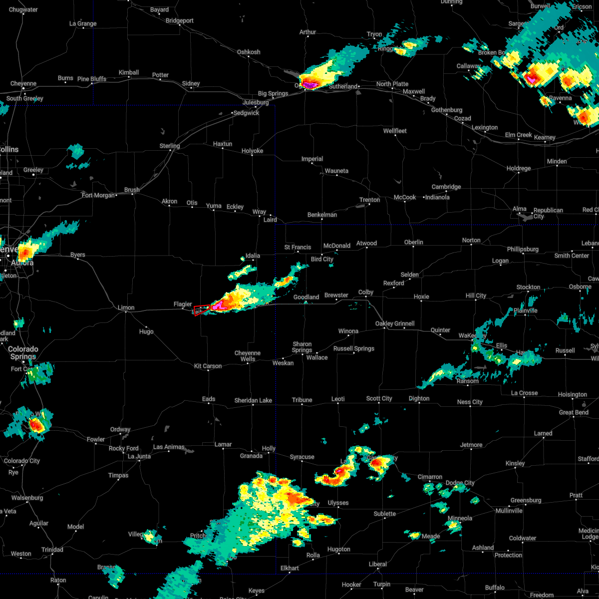 At 443 pm mdt, a severe thunderstorm capable of producing a tornado was located near seibert, moving west at 10 mph (radar indicated rotation). Hazards include tornado and quarter size hail. Flying debris will be dangerous to those caught without shelter. mobile homes will be damaged or destroyed. damage to roofs, windows, and vehicles will occur. tree damage is likely. locations impacted include, seibert. This includes interstate 70 in colorado between mile markers 402 and 410. At 443 pm mdt, a severe thunderstorm capable of producing a tornado was located near seibert, moving west at 10 mph (radar indicated rotation). Hazards include tornado and quarter size hail. Flying debris will be dangerous to those caught without shelter. mobile homes will be damaged or destroyed. damage to roofs, windows, and vehicles will occur. tree damage is likely. locations impacted include, seibert. This includes interstate 70 in colorado between mile markers 402 and 410.
|
| 7/26/2022 4:38 PM MDT |
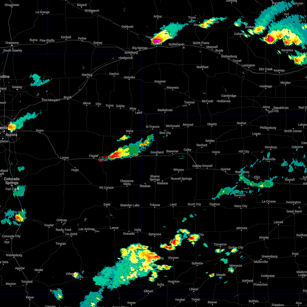 At 438 pm mdt, a confirmed tornado was located near vona, or 4 miles east of seibert, moving west at 10 mph (emergency management confirmed tornado). Hazards include damaging tornado and quarter size hail. Flying debris will be dangerous to those caught without shelter. mobile homes will be damaged or destroyed. damage to roofs, windows, and vehicles will occur. Tree damage is likely. At 438 pm mdt, a confirmed tornado was located near vona, or 4 miles east of seibert, moving west at 10 mph (emergency management confirmed tornado). Hazards include damaging tornado and quarter size hail. Flying debris will be dangerous to those caught without shelter. mobile homes will be damaged or destroyed. damage to roofs, windows, and vehicles will occur. Tree damage is likely.
|
| 7/15/2022 7:20 PM MDT |
 At 720 pm mdt, a severe thunderstorm was located near seibert, moving northeast at 15 mph (radar indicated). Hazards include 60 mph wind gusts and nickel size hail. Expect damage to roofs, siding, and trees. locations impacted include, seibert and vona. this includes interstate 70 in colorado between mile markers 402 and 417. hail threat, radar indicated max hail size, 0. 88 in wind threat, radar indicated max wind gust, 60 mph. At 720 pm mdt, a severe thunderstorm was located near seibert, moving northeast at 15 mph (radar indicated). Hazards include 60 mph wind gusts and nickel size hail. Expect damage to roofs, siding, and trees. locations impacted include, seibert and vona. this includes interstate 70 in colorado between mile markers 402 and 417. hail threat, radar indicated max hail size, 0. 88 in wind threat, radar indicated max wind gust, 60 mph.
|
| 7/15/2022 7:03 PM MDT |
 At 703 pm mdt, a severe thunderstorm was located 5 miles south of seibert, moving northeast at 15 mph (radar indicated). Hazards include 60 mph wind gusts and nickel size hail. Expect damage to roofs, siding, and trees. locations impacted include, stratton, seibert and vona. this includes interstate 70 in colorado between mile markers 401 and 419. hail threat, radar indicated max hail size, 0. 88 in wind threat, radar indicated max wind gust, 60 mph. At 703 pm mdt, a severe thunderstorm was located 5 miles south of seibert, moving northeast at 15 mph (radar indicated). Hazards include 60 mph wind gusts and nickel size hail. Expect damage to roofs, siding, and trees. locations impacted include, stratton, seibert and vona. this includes interstate 70 in colorado between mile markers 401 and 419. hail threat, radar indicated max hail size, 0. 88 in wind threat, radar indicated max wind gust, 60 mph.
|
| 7/15/2022 6:46 PM MDT |
 At 645 pm mdt, a severe thunderstorm was located 8 miles southwest of seibert, moving northeast at 15 mph (radar indicated). Hazards include 60 mph wind gusts and nickel size hail. expect damage to roofs, siding, and trees At 645 pm mdt, a severe thunderstorm was located 8 miles southwest of seibert, moving northeast at 15 mph (radar indicated). Hazards include 60 mph wind gusts and nickel size hail. expect damage to roofs, siding, and trees
|
| 6/3/2022 4:42 PM MDT |
 At 441 pm mdt, severe thunderstorms were located along a line extending from 5 miles south of vona to 8 miles northwest of haswell, moving east at 30 mph (radar indicated). Hazards include 60 mph wind gusts and quarter size hail. Hail damage to vehicles is expected. expect wind damage to roofs, siding, and trees. locations impacted include, stratton, seibert, bethune, kit carson, vona, wild horse and aroya. this includes interstate 70 in colorado between mile markers 396 and 431. hail threat, radar indicated max hail size, 1. 00 in wind threat, radar indicated max wind gust, 60 mph. At 441 pm mdt, severe thunderstorms were located along a line extending from 5 miles south of vona to 8 miles northwest of haswell, moving east at 30 mph (radar indicated). Hazards include 60 mph wind gusts and quarter size hail. Hail damage to vehicles is expected. expect wind damage to roofs, siding, and trees. locations impacted include, stratton, seibert, bethune, kit carson, vona, wild horse and aroya. this includes interstate 70 in colorado between mile markers 396 and 431. hail threat, radar indicated max hail size, 1. 00 in wind threat, radar indicated max wind gust, 60 mph.
|
| 6/3/2022 4:34 PM MDT |
 At 434 pm mdt, severe thunderstorms were located along a line extending from 5 miles south of vona to 10 miles northwest of haswell, moving east at 30 mph (radar indicated). Hazards include 60 mph wind gusts and quarter size hail. Hail damage to vehicles is expected. expect wind damage to roofs, siding, and trees. locations impacted include, stratton, flagler, seibert, bethune, kit carson, vona and wild horse. this includes interstate 70 in colorado between mile markers 393 and 431. hail threat, radar indicated max hail size, 1. 00 in wind threat, radar indicated max wind gust, 60 mph. At 434 pm mdt, severe thunderstorms were located along a line extending from 5 miles south of vona to 10 miles northwest of haswell, moving east at 30 mph (radar indicated). Hazards include 60 mph wind gusts and quarter size hail. Hail damage to vehicles is expected. expect wind damage to roofs, siding, and trees. locations impacted include, stratton, flagler, seibert, bethune, kit carson, vona and wild horse. this includes interstate 70 in colorado between mile markers 393 and 431. hail threat, radar indicated max hail size, 1. 00 in wind threat, radar indicated max wind gust, 60 mph.
|
| 6/3/2022 4:22 PM MDT |
 At 422 pm mdt, severe thunderstorms were located along a line extending from 5 miles south of seibert to 5 miles southeast of wild horse point, moving east at 30 mph (radar indicated). Hazards include 60 mph wind gusts and quarter size hail. Hail damage to vehicles is expected. expect wind damage to roofs, siding, and trees. locations impacted include, stratton, flagler, seibert, bethune, kit carson, vona and wild horse. this includes interstate 70 in colorado between mile markers 391 and 431. hail threat, radar indicated max hail size, 1. 00 in wind threat, radar indicated max wind gust, 60 mph. At 422 pm mdt, severe thunderstorms were located along a line extending from 5 miles south of seibert to 5 miles southeast of wild horse point, moving east at 30 mph (radar indicated). Hazards include 60 mph wind gusts and quarter size hail. Hail damage to vehicles is expected. expect wind damage to roofs, siding, and trees. locations impacted include, stratton, flagler, seibert, bethune, kit carson, vona and wild horse. this includes interstate 70 in colorado between mile markers 391 and 431. hail threat, radar indicated max hail size, 1. 00 in wind threat, radar indicated max wind gust, 60 mph.
|
| 6/3/2022 4:11 PM MDT |
 At 410 pm mdt, severe thunderstorms were located along a line extending from 7 miles southeast of flagler to 3 miles south of wild horse point, moving east at 30 mph (radar indicated). Hazards include 60 mph wind gusts and quarter size hail. Hail damage to vehicles is expected. expect wind damage to roofs, siding, and trees. locations impacted include, seibert, vona, stratton and bethune. this includes interstate 70 in colorado between mile markers 391 and 431. hail threat, radar indicated max hail size, 1. 00 in wind threat, radar indicated max wind gust, 60 mph. At 410 pm mdt, severe thunderstorms were located along a line extending from 7 miles southeast of flagler to 3 miles south of wild horse point, moving east at 30 mph (radar indicated). Hazards include 60 mph wind gusts and quarter size hail. Hail damage to vehicles is expected. expect wind damage to roofs, siding, and trees. locations impacted include, seibert, vona, stratton and bethune. this includes interstate 70 in colorado between mile markers 391 and 431. hail threat, radar indicated max hail size, 1. 00 in wind threat, radar indicated max wind gust, 60 mph.
|
| 6/3/2022 3:54 PM MDT |
 At 353 pm mdt, severe thunderstorms were located along a line extending from 6 miles south of flagler to 8 miles southwest of wild horse point, moving east at 30 mph (radar indicated). Hazards include 60 mph wind gusts and quarter size hail. Hail damage to vehicles is expected. expect wind damage to roofs, siding, and trees. severe thunderstorms will be near, flagler around 400 pm mdt. other locations in the path of these severe thunderstorms include seibert, vona, stratton and bethune. this includes interstate 70 in colorado between mile markers 391 and 431. hail threat, radar indicated max hail size, 1. 00 in wind threat, radar indicated max wind gust, 60 mph. At 353 pm mdt, severe thunderstorms were located along a line extending from 6 miles south of flagler to 8 miles southwest of wild horse point, moving east at 30 mph (radar indicated). Hazards include 60 mph wind gusts and quarter size hail. Hail damage to vehicles is expected. expect wind damage to roofs, siding, and trees. severe thunderstorms will be near, flagler around 400 pm mdt. other locations in the path of these severe thunderstorms include seibert, vona, stratton and bethune. this includes interstate 70 in colorado between mile markers 391 and 431. hail threat, radar indicated max hail size, 1. 00 in wind threat, radar indicated max wind gust, 60 mph.
|
| 9/12/2021 5:30 PM MDT |
 At 529 pm mdt, a severe thunderstorm was located 9 miles north of vona, or 10 miles northwest of stratton, moving east at 30 mph (radar indicated). Hazards include 60 mph wind gusts. Expect damage to roofs, siding, and trees. locations impacted include, stratton, seibert, bethune and vona. this includes interstate 70 in colorado between mile markers 405 and 433. hail threat, radar indicated max hail size, <. 75 in wind threat, observed max wind gust, 60 mph. At 529 pm mdt, a severe thunderstorm was located 9 miles north of vona, or 10 miles northwest of stratton, moving east at 30 mph (radar indicated). Hazards include 60 mph wind gusts. Expect damage to roofs, siding, and trees. locations impacted include, stratton, seibert, bethune and vona. this includes interstate 70 in colorado between mile markers 405 and 433. hail threat, radar indicated max hail size, <. 75 in wind threat, observed max wind gust, 60 mph.
|
| 9/12/2021 5:17 PM MDT |
 At 517 pm mdt, a severe thunderstorm was located 9 miles north of seibert, moving east at 30 mph (radar indicated). Hazards include 60 mph wind gusts. Expect damage to roofs, siding, and trees. locations impacted include, stratton, seibert, bethune and vona. this includes interstate 70 in colorado between mile markers 398 and 433. hail threat, radar indicated max hail size, <. 75 in wind threat, observed max wind gust, 60 mph. At 517 pm mdt, a severe thunderstorm was located 9 miles north of seibert, moving east at 30 mph (radar indicated). Hazards include 60 mph wind gusts. Expect damage to roofs, siding, and trees. locations impacted include, stratton, seibert, bethune and vona. this includes interstate 70 in colorado between mile markers 398 and 433. hail threat, radar indicated max hail size, <. 75 in wind threat, observed max wind gust, 60 mph.
|
| 9/12/2021 5:06 PM MDT |
 At 505 pm mdt, a severe thunderstorm was located 10 miles northwest of seibert, moving east at 30 mph (public. a personal weather station in flagler, colorado recorded a 59 mph wind gust). Hazards include 60 mph wind gusts. Expect damage to roofs, siding, and trees. this severe thunderstorm will remain over mainly rural areas of northwestern kit carson county. this includes interstate 70 in colorado between mile markers 398 and 433. hail threat, radar indicated max hail size, <. 75 in wind threat, observed max wind gust, 60 mph. At 505 pm mdt, a severe thunderstorm was located 10 miles northwest of seibert, moving east at 30 mph (public. a personal weather station in flagler, colorado recorded a 59 mph wind gust). Hazards include 60 mph wind gusts. Expect damage to roofs, siding, and trees. this severe thunderstorm will remain over mainly rural areas of northwestern kit carson county. this includes interstate 70 in colorado between mile markers 398 and 433. hail threat, radar indicated max hail size, <. 75 in wind threat, observed max wind gust, 60 mph.
|
| 8/26/2021 4:25 PM MDT |
 At 424 pm mdt, a severe thunderstorm was located near vona, or 4 miles east of seibert, moving northeast at 10 mph (radar indicated). Hazards include 60 mph wind gusts and penny size hail. Expect damage to roofs, siding, and trees. locations impacted include, stratton, seibert and vona. this includes interstate 70 in colorado between mile markers 398 and 426. hail threat, radar indicated max hail size, 0. 75 in wind threat, radar indicated max wind gust, 60 mph. At 424 pm mdt, a severe thunderstorm was located near vona, or 4 miles east of seibert, moving northeast at 10 mph (radar indicated). Hazards include 60 mph wind gusts and penny size hail. Expect damage to roofs, siding, and trees. locations impacted include, stratton, seibert and vona. this includes interstate 70 in colorado between mile markers 398 and 426. hail threat, radar indicated max hail size, 0. 75 in wind threat, radar indicated max wind gust, 60 mph.
|
| 8/26/2021 4:09 PM MDT | Quarter sized hail reported 0.2 miles SW of Seibert, CO, delayed report via social media of pea to quarter size hail with 2.25 inches of rain. time estimated based on radar. |
| 8/26/2021 4:07 PM MDT |
 At 406 pm mdt, a severe thunderstorm was located over seibert, moving north at 10 mph (radar indicated). Hazards include 60 mph wind gusts and penny size hail. Expect damage to roofs, siding, and trees. locations impacted include, stratton, flagler, seibert and vona. this includes interstate 70 in colorado between mile markers 391 and 421. hail threat, radar indicated max hail size, 0. 75 in wind threat, radar indicated max wind gust, 60 mph. At 406 pm mdt, a severe thunderstorm was located over seibert, moving north at 10 mph (radar indicated). Hazards include 60 mph wind gusts and penny size hail. Expect damage to roofs, siding, and trees. locations impacted include, stratton, flagler, seibert and vona. this includes interstate 70 in colorado between mile markers 391 and 421. hail threat, radar indicated max hail size, 0. 75 in wind threat, radar indicated max wind gust, 60 mph.
|
| 8/26/2021 4:05 PM MDT |
 At 404 pm mdt, a severe thunderstorm was located near seibert, moving north at 10 mph (radar indicated). Hazards include 60 mph wind gusts and penny size hail. Expect damage to roofs, siding, and trees. this severe thunderstorm will remain over mainly rural areas of western kit carson county. this includes interstate 70 in colorado between mile markers 391 and 425. hail threat, radar indicated max hail size, 0. 75 in wind threat, radar indicated max wind gust, 60 mph. At 404 pm mdt, a severe thunderstorm was located near seibert, moving north at 10 mph (radar indicated). Hazards include 60 mph wind gusts and penny size hail. Expect damage to roofs, siding, and trees. this severe thunderstorm will remain over mainly rural areas of western kit carson county. this includes interstate 70 in colorado between mile markers 391 and 425. hail threat, radar indicated max hail size, 0. 75 in wind threat, radar indicated max wind gust, 60 mph.
|
| 8/26/2021 3:41 PM MDT |
 At 340 pm mdt, a severe thunderstorm was located 12 miles south of flagler, moving northeast at 10 mph (radar indicated). Hazards include 60 mph wind gusts and penny size hail. Expect damage to roofs, siding, and trees. locations impacted include, stratton, flagler, seibert, vona and aroya. this includes interstate 70 in colorado between mile markers 390 and 421. hail threat, radar indicated max hail size, 0. 75 in wind threat, radar indicated max wind gust, 60 mph. At 340 pm mdt, a severe thunderstorm was located 12 miles south of flagler, moving northeast at 10 mph (radar indicated). Hazards include 60 mph wind gusts and penny size hail. Expect damage to roofs, siding, and trees. locations impacted include, stratton, flagler, seibert, vona and aroya. this includes interstate 70 in colorado between mile markers 390 and 421. hail threat, radar indicated max hail size, 0. 75 in wind threat, radar indicated max wind gust, 60 mph.
|
| 8/26/2021 3:34 PM MDT |
 At 334 pm mdt, a severe thunderstorm was located 14 miles northeast of boyero, or 16 miles south of flagler, moving northeast at 10 mph (radar indicated). Hazards include 60 mph wind gusts and penny size hail. Expect damage to roofs, siding, and trees. locations impacted include, stratton, flagler, seibert, vona, wild horse and aroya. this includes interstate 70 in colorado between mile markers 390 and 421. hail threat, radar indicated max hail size, 0. 75 in wind threat, radar indicated max wind gust, 60 mph. At 334 pm mdt, a severe thunderstorm was located 14 miles northeast of boyero, or 16 miles south of flagler, moving northeast at 10 mph (radar indicated). Hazards include 60 mph wind gusts and penny size hail. Expect damage to roofs, siding, and trees. locations impacted include, stratton, flagler, seibert, vona, wild horse and aroya. this includes interstate 70 in colorado between mile markers 390 and 421. hail threat, radar indicated max hail size, 0. 75 in wind threat, radar indicated max wind gust, 60 mph.
|
| 8/26/2021 3:23 PM MDT |
 At 323 pm mdt, a severe thunderstorm was located 9 miles northeast of boyero, or 20 miles south of flagler, moving northeast at 5 mph (radar indicated). Hazards include 60 mph wind gusts and nickel size hail. Expect damage to roofs, siding, and trees. locations impacted include, stratton, flagler, seibert, vona, wild horse and aroya. this includes interstate 70 in colorado between mile markers 390 and 421. hail threat, radar indicated max hail size, 0. 88 in wind threat, radar indicated max wind gust, 60 mph. At 323 pm mdt, a severe thunderstorm was located 9 miles northeast of boyero, or 20 miles south of flagler, moving northeast at 5 mph (radar indicated). Hazards include 60 mph wind gusts and nickel size hail. Expect damage to roofs, siding, and trees. locations impacted include, stratton, flagler, seibert, vona, wild horse and aroya. this includes interstate 70 in colorado between mile markers 390 and 421. hail threat, radar indicated max hail size, 0. 88 in wind threat, radar indicated max wind gust, 60 mph.
|
| 8/26/2021 3:12 PM MDT |
 At 312 pm mdt, a severe thunderstorm was located 7 miles east of boyero, or 23 miles south of flagler, moving east at 5 mph (radar indicated). Hazards include 60 mph wind gusts and penny size hail. Expect damage to roofs, siding, and trees. this severe thunderstorm will remain over mainly rural areas of northwestern cheyenne and southwestern kit carson counties in east central colorado, including the following locations, wild horse and aroya. this includes interstate 70 in colorado between mile markers 390 and 421. hail threat, radar indicated max hail size, 0. 75 in wind threat, radar indicated max wind gust, 60 mph. At 312 pm mdt, a severe thunderstorm was located 7 miles east of boyero, or 23 miles south of flagler, moving east at 5 mph (radar indicated). Hazards include 60 mph wind gusts and penny size hail. Expect damage to roofs, siding, and trees. this severe thunderstorm will remain over mainly rural areas of northwestern cheyenne and southwestern kit carson counties in east central colorado, including the following locations, wild horse and aroya. this includes interstate 70 in colorado between mile markers 390 and 421. hail threat, radar indicated max hail size, 0. 75 in wind threat, radar indicated max wind gust, 60 mph.
|
| 6/24/2021 4:37 PM MDT |
 The severe thunderstorm warning for northwestern kit carson county will expire at 445 pm mdt, the storm which prompted the warning has weakened below severe limits, and no longer poses an immediate threat to life or property. therefore, the warning will be allowed to expire. however gusty winds are still possible with this thunderstorm. a severe thunderstorm watch remains in effect until 1000 pm mdt for northeastern and east central colorado. The severe thunderstorm warning for northwestern kit carson county will expire at 445 pm mdt, the storm which prompted the warning has weakened below severe limits, and no longer poses an immediate threat to life or property. therefore, the warning will be allowed to expire. however gusty winds are still possible with this thunderstorm. a severe thunderstorm watch remains in effect until 1000 pm mdt for northeastern and east central colorado.
|
| 6/24/2021 4:32 PM MDT |
 At 432 pm mdt, a severe thunderstorm was located 9 miles north of flagler, moving east at 15 mph (radar indicated). Hazards include 60 mph wind gusts and quarter size hail. Hail damage to vehicles is expected. expect wind damage to roofs, siding, and trees. locations impacted include, flagler and seibert. This includes interstate 70 in colorado between mile markers 400 and 410. At 432 pm mdt, a severe thunderstorm was located 9 miles north of flagler, moving east at 15 mph (radar indicated). Hazards include 60 mph wind gusts and quarter size hail. Hail damage to vehicles is expected. expect wind damage to roofs, siding, and trees. locations impacted include, flagler and seibert. This includes interstate 70 in colorado between mile markers 400 and 410.
|
| 6/24/2021 4:15 PM MDT |
 At 415 pm mdt, a severe thunderstorm was located 9 miles northeast of flagler, moving east at 30 mph (radar indicated). Hazards include 60 mph wind gusts and quarter size hail. Hail damage to vehicles is expected. expect wind damage to roofs, siding, and trees. locations impacted include, flagler and seibert. This includes interstate 70 in colorado between mile markers 400 and 410. At 415 pm mdt, a severe thunderstorm was located 9 miles northeast of flagler, moving east at 30 mph (radar indicated). Hazards include 60 mph wind gusts and quarter size hail. Hail damage to vehicles is expected. expect wind damage to roofs, siding, and trees. locations impacted include, flagler and seibert. This includes interstate 70 in colorado between mile markers 400 and 410.
|
| 6/24/2021 4:00 PM MDT |
 At 359 pm mdt, a severe thunderstorm was located 8 miles northwest of flagler, moving east at 30 mph (radar indicated). Hazards include 60 mph wind gusts and quarter size hail. Hail damage to vehicles is expected. expect wind damage to roofs, siding, and trees. locations impacted include, flagler and seibert. This includes interstate 70 in colorado between mile markers 400 and 410. At 359 pm mdt, a severe thunderstorm was located 8 miles northwest of flagler, moving east at 30 mph (radar indicated). Hazards include 60 mph wind gusts and quarter size hail. Hail damage to vehicles is expected. expect wind damage to roofs, siding, and trees. locations impacted include, flagler and seibert. This includes interstate 70 in colorado between mile markers 400 and 410.
|
| 6/24/2021 3:45 PM MDT |
 At 344 pm mdt, a severe thunderstorm was located 8 miles north of arriba, or 12 miles northwest of flagler, moving east at 25 mph (radar indicated). Hazards include 60 mph wind gusts and quarter size hail. Hail damage to vehicles is expected. Expect wind damage to roofs, siding, and trees. At 344 pm mdt, a severe thunderstorm was located 8 miles north of arriba, or 12 miles northwest of flagler, moving east at 25 mph (radar indicated). Hazards include 60 mph wind gusts and quarter size hail. Hail damage to vehicles is expected. Expect wind damage to roofs, siding, and trees.
|
| 6/19/2021 5:14 PM MDT |
 At 514 pm mdt, severe thunderstorms were located along a line extending from 15 miles east of cope to 3 miles southwest of stratton to 13 miles east of boyero, moving east at 40 mph (radar indicated). Hazards include 70 mph wind gusts and penny size hail. Expect considerable tree damage. damage is likely to mobile homes, roofs, and outbuildings. severe thunderstorms will be near, stratton around 520 pm mdt. bethune around 530 pm mdt. other locations in the path of these severe thunderstorms include burlington. people attending parmer park should seek safe shelter immediately! this includes the following highways, interstate 70 in colorado between mile markers 401 and 450. Highway 385 between mile markers 174 and 206, and near mile marker 211. At 514 pm mdt, severe thunderstorms were located along a line extending from 15 miles east of cope to 3 miles southwest of stratton to 13 miles east of boyero, moving east at 40 mph (radar indicated). Hazards include 70 mph wind gusts and penny size hail. Expect considerable tree damage. damage is likely to mobile homes, roofs, and outbuildings. severe thunderstorms will be near, stratton around 520 pm mdt. bethune around 530 pm mdt. other locations in the path of these severe thunderstorms include burlington. people attending parmer park should seek safe shelter immediately! this includes the following highways, interstate 70 in colorado between mile markers 401 and 450. Highway 385 between mile markers 174 and 206, and near mile marker 211.
|
| 6/19/2021 4:57 PM MDT |
 At 457 pm mdt, severe thunderstorms were located along a line extending from 10 miles southeast of cope to 6 miles north of vona to 3 miles south of seibert, moving east at 45 mph (radar indicated). Hazards include 70 mph wind gusts and quarter size hail. Hail damage to vehicles is expected. expect considerable tree damage. wind damage is also likely to mobile homes, roofs, and outbuildings. locations impacted include, stratton, flagler, seibert, vona, joes and kirk. This includes interstate 70 in colorado between mile markers 391 and 420. At 457 pm mdt, severe thunderstorms were located along a line extending from 10 miles southeast of cope to 6 miles north of vona to 3 miles south of seibert, moving east at 45 mph (radar indicated). Hazards include 70 mph wind gusts and quarter size hail. Hail damage to vehicles is expected. expect considerable tree damage. wind damage is also likely to mobile homes, roofs, and outbuildings. locations impacted include, stratton, flagler, seibert, vona, joes and kirk. This includes interstate 70 in colorado between mile markers 391 and 420.
|
| 6/19/2021 4:28 PM MDT |
 At 428 pm mdt, severe thunderstorms were located along a line extending from 9 miles east of thurman to 6 miles northwest of flagler to 5 miles southeast of arriba, moving east at 45 mph (radar indicated). Hazards include 70 mph wind gusts and quarter size hail. Hail damage to vehicles is expected. expect considerable tree damage. Wind damage is also likely to mobile homes, roofs, and outbuildings. At 428 pm mdt, severe thunderstorms were located along a line extending from 9 miles east of thurman to 6 miles northwest of flagler to 5 miles southeast of arriba, moving east at 45 mph (radar indicated). Hazards include 70 mph wind gusts and quarter size hail. Hail damage to vehicles is expected. expect considerable tree damage. Wind damage is also likely to mobile homes, roofs, and outbuildings.
|
| 5/29/2021 6:36 PM MDT |
 At 636 pm mdt, a severe thunderstorm was located over seibert, moving northeast at 10 mph (trained weather spotters in seibert report quarter sized hail). Hazards include quarter size hail. Damage to vehicles is expected. locations impacted include, vona. People attending hi- plains school should seek safe shelter immediately! this includes interstate 70 in colorado between mile markers 405 and 419. At 636 pm mdt, a severe thunderstorm was located over seibert, moving northeast at 10 mph (trained weather spotters in seibert report quarter sized hail). Hazards include quarter size hail. Damage to vehicles is expected. locations impacted include, vona. People attending hi- plains school should seek safe shelter immediately! this includes interstate 70 in colorado between mile markers 405 and 419.
|
| 5/29/2021 6:28 PM MDT |
 At 628 pm mdt, a severe thunderstorm was located near seibert, moving northeast at 10 mph (trained weather spotter reported nickel to quarter sized hail in seibert). Hazards include quarter size hail. Damage to vehicles is expected. this severe storm will be near, seibert around 635 pm mdt. other locations in the path of this severe thunderstorm include vona. People attending hi- plains school should seek safe shelter immediately! this includes interstate 70 in colorado between mile markers 397 and 419. At 628 pm mdt, a severe thunderstorm was located near seibert, moving northeast at 10 mph (trained weather spotter reported nickel to quarter sized hail in seibert). Hazards include quarter size hail. Damage to vehicles is expected. this severe storm will be near, seibert around 635 pm mdt. other locations in the path of this severe thunderstorm include vona. People attending hi- plains school should seek safe shelter immediately! this includes interstate 70 in colorado between mile markers 397 and 419.
|
| 5/29/2021 6:26 PM MDT | Quarter sized hail reported 0.2 miles SW of Seibert, CO, hail ranging from pea to quarter in size with most being near nickle in size. |
| 5/29/2021 6:22 PM MDT | Golf Ball sized hail reported 0.2 miles SW of Seibert, CO, sheriff reported hail ranging from quarter to golf ball near seibert. time estimated from radar. |
| 5/29/2021 6:16 PM MDT |
 At 616 pm mdt, a severe thunderstorm was located 4 miles south of seibert, moving northeast at 10 mph (radar indicated). Hazards include quarter size hail. Damage to vehicles is expected. this severe thunderstorm will be near, seibert around 635 pm mdt. other locations in the path of this severe thunderstorm include vona. People attending hi- plains school should seek safe shelter immediately! this includes interstate 70 in colorado between mile markers 397 and 419. At 616 pm mdt, a severe thunderstorm was located 4 miles south of seibert, moving northeast at 10 mph (radar indicated). Hazards include quarter size hail. Damage to vehicles is expected. this severe thunderstorm will be near, seibert around 635 pm mdt. other locations in the path of this severe thunderstorm include vona. People attending hi- plains school should seek safe shelter immediately! this includes interstate 70 in colorado between mile markers 397 and 419.
|
| 5/23/2021 5:59 PM MDT |
 The national weather service in goodland has issued a * severe thunderstorm warning for. northwestern cheyenne county in east central colorado. southwestern kit carson county in east central colorado. until 700 pm mdt. At 559 pm mdt, a severe thunderstorm was located 17 miles south of. The national weather service in goodland has issued a * severe thunderstorm warning for. northwestern cheyenne county in east central colorado. southwestern kit carson county in east central colorado. until 700 pm mdt. At 559 pm mdt, a severe thunderstorm was located 17 miles south of.
|
| 5/23/2021 5:01 PM MDT |
 At 500 pm mdt, a severe thunderstorm was located 13 miles northeast of boyero, or 17 miles south of flagler, moving north at 55 mph (radar indicated). Hazards include 60 mph wind gusts and quarter size hail. Hail damage to vehicles is expected. expect wind damage to roofs, siding, and trees. this severe thunderstorm will be near, flagler around 520 pm mdt. other locations in the path of this severe thunderstorm include seibert. people attending flagler school should seek safe shelter immediately! this includes interstate 70 in colorado between mile markers 394 and 411. A tornado watch remains in effect until 800 pm mdt for east central colorado. At 500 pm mdt, a severe thunderstorm was located 13 miles northeast of boyero, or 17 miles south of flagler, moving north at 55 mph (radar indicated). Hazards include 60 mph wind gusts and quarter size hail. Hail damage to vehicles is expected. expect wind damage to roofs, siding, and trees. this severe thunderstorm will be near, flagler around 520 pm mdt. other locations in the path of this severe thunderstorm include seibert. people attending flagler school should seek safe shelter immediately! this includes interstate 70 in colorado between mile markers 394 and 411. A tornado watch remains in effect until 800 pm mdt for east central colorado.
|
| 5/16/2021 6:16 PM MDT |
 At 616 pm mdt, severe thunderstorms were located along a line extending from 8 miles southwest of flagler to 4 miles southeast of stratton, and are nearly stationary (radar indicated). Hazards include 60 mph wind gusts and half dollar size hail. Hail damage to vehicles is expected. expect wind damage to roofs, siding, and trees. locations impacted include, stratton, flagler, seibert and vona. People attending flagler school should seek safe shelter immediately! this includes interstate 70 in colorado between mile markers 391 and 424. At 616 pm mdt, severe thunderstorms were located along a line extending from 8 miles southwest of flagler to 4 miles southeast of stratton, and are nearly stationary (radar indicated). Hazards include 60 mph wind gusts and half dollar size hail. Hail damage to vehicles is expected. expect wind damage to roofs, siding, and trees. locations impacted include, stratton, flagler, seibert and vona. People attending flagler school should seek safe shelter immediately! this includes interstate 70 in colorado between mile markers 391 and 424.
|
| 5/16/2021 5:58 PM MDT |
 At 558 pm mdt, severe thunderstorms were located along a line extending from 8 miles southwest of flagler to 3 miles southeast of stratton, and are nearly stationary (radar indicated). Hazards include 60 mph wind gusts and half dollar size hail. Hail damage to vehicles is expected. expect wind damage to roofs, siding, and trees. these severe thunderstorms will remain over mainly rural areas of northwestern cheyenne and southwestern kit carson counties in east central colorado. This includes interstate 70 in colorado between mile markers 391 and 424. At 558 pm mdt, severe thunderstorms were located along a line extending from 8 miles southwest of flagler to 3 miles southeast of stratton, and are nearly stationary (radar indicated). Hazards include 60 mph wind gusts and half dollar size hail. Hail damage to vehicles is expected. expect wind damage to roofs, siding, and trees. these severe thunderstorms will remain over mainly rural areas of northwestern cheyenne and southwestern kit carson counties in east central colorado. This includes interstate 70 in colorado between mile markers 391 and 424.
|
| 5/16/2021 5:40 PM MDT |
 At 539 pm mdt, a severe thunderstorm was located 4 miles southeast of flagler, and is nearly stationary (radar indicated). Hazards include 60 mph wind gusts and half dollar size hail. Hail damage to vehicles is expected. expect wind damage to roofs, siding, and trees. locations impacted include, flagler and seibert. This includes interstate 70 in colorado between mile markers 391 and 405. At 539 pm mdt, a severe thunderstorm was located 4 miles southeast of flagler, and is nearly stationary (radar indicated). Hazards include 60 mph wind gusts and half dollar size hail. Hail damage to vehicles is expected. expect wind damage to roofs, siding, and trees. locations impacted include, flagler and seibert. This includes interstate 70 in colorado between mile markers 391 and 405.
|
| 5/16/2021 5:25 PM MDT |
 At 525 pm mdt, a severe thunderstorm was located near flagler, and is nearly stationary (radar indicated). Hazards include 60 mph wind gusts and half dollar size hail. Hail damage to vehicles is expected. expect wind damage to roofs, siding, and trees. this severe thunderstorm will remain over mainly rural areas of southwestern kit carson county. This includes interstate 70 in colorado between mile markers 391 and 405. At 525 pm mdt, a severe thunderstorm was located near flagler, and is nearly stationary (radar indicated). Hazards include 60 mph wind gusts and half dollar size hail. Hail damage to vehicles is expected. expect wind damage to roofs, siding, and trees. this severe thunderstorm will remain over mainly rural areas of southwestern kit carson county. This includes interstate 70 in colorado between mile markers 391 and 405.
|
| 5/14/2021 4:33 PM MDT |
 At 433 pm mdt, a severe thunderstorm was located 4 miles west of flagler, moving east at 25 mph (trained weather spotters). Hazards include 60 mph wind gusts and quarter size hail. Hail damage to vehicles is expected. expect wind damage to roofs, siding, and trees. this severe thunderstorm will be near, flagler around 445 pm mdt. other locations in the path of this severe thunderstorm include seibert and vona. This includes interstate 70 in colorado between mile markers 391 and 413. At 433 pm mdt, a severe thunderstorm was located 4 miles west of flagler, moving east at 25 mph (trained weather spotters). Hazards include 60 mph wind gusts and quarter size hail. Hail damage to vehicles is expected. expect wind damage to roofs, siding, and trees. this severe thunderstorm will be near, flagler around 445 pm mdt. other locations in the path of this severe thunderstorm include seibert and vona. This includes interstate 70 in colorado between mile markers 391 and 413.
|
| 8/16/2020 6:54 PM CDT |
 At 552 pm mdt/652 pm cdt/, severe thunderstorms were located along a line extending from 15 miles southwest of eckley to 3 miles north of bonny reservoir to 6 miles north of goodland to near brewster to 7 miles east of menlo to 3 miles southwest of hill city, moving south at 20 mph (these storms have a history of producing wind gusts up to 70 mph. an automated weather observation site in st. francis reported a 67 mph wind gust at 535 pm mdt). Hazards include quarter size hail and 70 mph wind gusts. People and animals outdoors will be injured. expect hail damage to roofs, siding, windows, and vehicles. expect considerable tree damage. wind damage is also likely to mobile homes, roofs, and outbuildings. locations impacted include, colby, goodland, burlington, yuma, wray, oberlin and hill city. this includes the following highways, interstate 70 in kansas between mile markers 0 and 74. interstate 70 in colorado between mile markers 391 and 450. Highway 385 between mile markers 170 and 269. At 552 pm mdt/652 pm cdt/, severe thunderstorms were located along a line extending from 15 miles southwest of eckley to 3 miles north of bonny reservoir to 6 miles north of goodland to near brewster to 7 miles east of menlo to 3 miles southwest of hill city, moving south at 20 mph (these storms have a history of producing wind gusts up to 70 mph. an automated weather observation site in st. francis reported a 67 mph wind gust at 535 pm mdt). Hazards include quarter size hail and 70 mph wind gusts. People and animals outdoors will be injured. expect hail damage to roofs, siding, windows, and vehicles. expect considerable tree damage. wind damage is also likely to mobile homes, roofs, and outbuildings. locations impacted include, colby, goodland, burlington, yuma, wray, oberlin and hill city. this includes the following highways, interstate 70 in kansas between mile markers 0 and 74. interstate 70 in colorado between mile markers 391 and 450. Highway 385 between mile markers 170 and 269.
|
| 8/16/2020 6:43 PM CDT |
 At 540 pm mdt/640 pm cdt/, severe thunderstorms were located along a line extending from 8 miles south of yuma to 10 miles north of bonny reservoir to 14 miles north of goodland to 9 miles north of brewster to 6 miles southeast of rexford to 6 miles northwest of hill city, moving south at 20 to 30 mph. the strongest storm within the line was progressing southward from cheyenne county, kansas into sherman county, kansas (these storms have a history of producing quarter to golf ball size hail and wind gusts up to 65 mph). Hazards include quarter to golf ball size hail and 70 mph wind gusts. People and animals outdoors will be injured. expect hail damage to roofs, siding, windows, and vehicles. expect considerable tree damage. wind damage is also likely to mobile homes, roofs, and outbuildings. locations impacted include, colby, goodland, burlington, yuma, norton, wray and oberlin. this includes the following highways, interstate 70 in kansas between mile markers 0 and 74. interstate 70 in colorado between mile markers 391 and 450. Highway 385 between mile markers 170 and 269. At 540 pm mdt/640 pm cdt/, severe thunderstorms were located along a line extending from 8 miles south of yuma to 10 miles north of bonny reservoir to 14 miles north of goodland to 9 miles north of brewster to 6 miles southeast of rexford to 6 miles northwest of hill city, moving south at 20 to 30 mph. the strongest storm within the line was progressing southward from cheyenne county, kansas into sherman county, kansas (these storms have a history of producing quarter to golf ball size hail and wind gusts up to 65 mph). Hazards include quarter to golf ball size hail and 70 mph wind gusts. People and animals outdoors will be injured. expect hail damage to roofs, siding, windows, and vehicles. expect considerable tree damage. wind damage is also likely to mobile homes, roofs, and outbuildings. locations impacted include, colby, goodland, burlington, yuma, norton, wray and oberlin. this includes the following highways, interstate 70 in kansas between mile markers 0 and 74. interstate 70 in colorado between mile markers 391 and 450. Highway 385 between mile markers 170 and 269.
|
| 8/16/2020 6:28 PM CDT |
 At 523 pm mdt/623 pm cdt/, severe thunderstorms were located along a line extending from 8 miles southwest of eckley to 12 miles south of bird city to 9 miles southeast of lenora, moving south at 25 mph. the strongest storm within the line was located in southern cheyenne county kansas, moving southward into sherman county, kansas (these storms have a history of producing quarter to golf ball size hail and wind gusts up to 65 mph). Hazards include quarter to golf ball size hail and 70 mph wind gusts. People and animals outdoors will be injured. expect hail damage to roofs, siding, windows, and vehicles. expect considerable tree damage. wind damage is also likely to mobile homes, roofs, and outbuildings. locations impacted include, colby, goodland, burlington, yuma, norton, wray and oberlin. this includes the following highways, interstate 70 in kansas between mile markers 0 and 74. interstate 70 in colorado between mile markers 391 and 450. Highway 385 between mile markers 170 and 269. At 523 pm mdt/623 pm cdt/, severe thunderstorms were located along a line extending from 8 miles southwest of eckley to 12 miles south of bird city to 9 miles southeast of lenora, moving south at 25 mph. the strongest storm within the line was located in southern cheyenne county kansas, moving southward into sherman county, kansas (these storms have a history of producing quarter to golf ball size hail and wind gusts up to 65 mph). Hazards include quarter to golf ball size hail and 70 mph wind gusts. People and animals outdoors will be injured. expect hail damage to roofs, siding, windows, and vehicles. expect considerable tree damage. wind damage is also likely to mobile homes, roofs, and outbuildings. locations impacted include, colby, goodland, burlington, yuma, norton, wray and oberlin. this includes the following highways, interstate 70 in kansas between mile markers 0 and 74. interstate 70 in colorado between mile markers 391 and 450. Highway 385 between mile markers 170 and 269.
|
| 8/16/2020 6:11 PM CDT |
 At 507 pm mdt/607 pm cdt/, severe thunderstorms were located along a line extending from 7 miles southeast of yuma to 11 miles south of bird city to 3 miles southwest of edmond, moving south at 15 mph. the strongest storm within the line was located in central cheyenne county, kansas moving south toward sherman county, kansas (these storms have a history of producing quarter to golf ball size hail and wind gusts up to 65 mph). Hazards include quarter to golf ball size hail and 70 mph wind gusts. People and animals outdoors will be injured. expect hail damage to roofs, siding, windows, and vehicles. expect considerable tree damage. wind damage is also likely to mobile homes, roofs, and outbuildings. locations impacted include, colby, goodland, burlington, yuma, norton, wray and oberlin. this includes the following highways, interstate 70 in kansas between mile markers 0 and 74. interstate 70 in colorado between mile markers 391 and 450. Highway 385 between mile markers 170 and 269. At 507 pm mdt/607 pm cdt/, severe thunderstorms were located along a line extending from 7 miles southeast of yuma to 11 miles south of bird city to 3 miles southwest of edmond, moving south at 15 mph. the strongest storm within the line was located in central cheyenne county, kansas moving south toward sherman county, kansas (these storms have a history of producing quarter to golf ball size hail and wind gusts up to 65 mph). Hazards include quarter to golf ball size hail and 70 mph wind gusts. People and animals outdoors will be injured. expect hail damage to roofs, siding, windows, and vehicles. expect considerable tree damage. wind damage is also likely to mobile homes, roofs, and outbuildings. locations impacted include, colby, goodland, burlington, yuma, norton, wray and oberlin. this includes the following highways, interstate 70 in kansas between mile markers 0 and 74. interstate 70 in colorado between mile markers 391 and 450. Highway 385 between mile markers 170 and 269.
|
| 8/16/2020 5:54 PM CDT |
 At 453 pm mdt/553 pm cdt/, severe thunderstorms were located along a line extending from 9 miles east of bonny reservoir to 6 miles west of logan, moving south at 15 mph (radar indicated). Hazards include two inch hail and 70 mph wind gusts. People and animals outdoors will be injured. expect hail damage to roofs, siding, windows, and vehicles. expect considerable tree damage. Wind damage is also likely to mobile homes, roofs, and outbuildings. At 453 pm mdt/553 pm cdt/, severe thunderstorms were located along a line extending from 9 miles east of bonny reservoir to 6 miles west of logan, moving south at 15 mph (radar indicated). Hazards include two inch hail and 70 mph wind gusts. People and animals outdoors will be injured. expect hail damage to roofs, siding, windows, and vehicles. expect considerable tree damage. Wind damage is also likely to mobile homes, roofs, and outbuildings.
|
| 8/15/2020 7:07 PM MDT |
 At 707 pm mdt, severe thunderstorms were located along a line extending from 12 miles southeast of thurman to 10 miles northeast of seibert to near vona, moving east at 20 mph (radar indicated). Hazards include 60 mph wind gusts and half dollar size hail. Hail damage to vehicles is expected. expect wind damage to roofs, siding, and trees. locations impacted include, stratton, seibert and vona. This includes interstate 70 in colorado near mile marker 413, and between mile markers 415 and 420. At 707 pm mdt, severe thunderstorms were located along a line extending from 12 miles southeast of thurman to 10 miles northeast of seibert to near vona, moving east at 20 mph (radar indicated). Hazards include 60 mph wind gusts and half dollar size hail. Hail damage to vehicles is expected. expect wind damage to roofs, siding, and trees. locations impacted include, stratton, seibert and vona. This includes interstate 70 in colorado near mile marker 413, and between mile markers 415 and 420.
|
| 8/15/2020 6:43 PM MDT |
 At 643 pm mdt, severe thunderstorms were located along a line extending from 9 miles southeast of thurman to 9 miles northwest of vona to 3 miles south of seibert, moving east at 20 mph (radar indicated). Hazards include golf ball size hail and 60 mph wind gusts. People and animals outdoors will be injured. expect hail damage to roofs, siding, windows, and vehicles. Expect wind damage to roofs, siding, and trees. At 643 pm mdt, severe thunderstorms were located along a line extending from 9 miles southeast of thurman to 9 miles northwest of vona to 3 miles south of seibert, moving east at 20 mph (radar indicated). Hazards include golf ball size hail and 60 mph wind gusts. People and animals outdoors will be injured. expect hail damage to roofs, siding, windows, and vehicles. Expect wind damage to roofs, siding, and trees.
|
| 8/15/2020 6:34 PM MDT | Quarter sized hail reported 4.1 miles SSE of Seibert, CO, pea to quarter size hail reported lasting about 10 min. |
| 8/15/2020 6:24 PM MDT |
 At 619 pm mdt, a severe thunderstorm was located near flagler, moving east at 30 mph (trained weather spotters. at 610 pm mdt, a trained weather spotter reported golf ball size hail just east of the lincoln and kit carson county line). Hazards include golf ball size hail and 60 mph wind gusts. People and animals outdoors will be injured. expect hail damage to roofs, siding, windows, and vehicles. expect wind damage to roofs, siding, and trees. locations impacted include, flagler and seibert. This includes interstate 70 in colorado between mile markers 391 and 411. At 619 pm mdt, a severe thunderstorm was located near flagler, moving east at 30 mph (trained weather spotters. at 610 pm mdt, a trained weather spotter reported golf ball size hail just east of the lincoln and kit carson county line). Hazards include golf ball size hail and 60 mph wind gusts. People and animals outdoors will be injured. expect hail damage to roofs, siding, windows, and vehicles. expect wind damage to roofs, siding, and trees. locations impacted include, flagler and seibert. This includes interstate 70 in colorado between mile markers 391 and 411.
|
| 8/15/2020 6:04 PM MDT |
 At 604 pm mdt, a severe thunderstorm was located 4 miles west of flagler, moving east at 30 mph (radar indicated). Hazards include 60 mph wind gusts and quarter size hail. Hail damage to vehicles is expected. Expect wind damage to roofs, siding, and trees. At 604 pm mdt, a severe thunderstorm was located 4 miles west of flagler, moving east at 30 mph (radar indicated). Hazards include 60 mph wind gusts and quarter size hail. Hail damage to vehicles is expected. Expect wind damage to roofs, siding, and trees.
|
| 7/20/2020 3:14 PM MDT | Quarter sized hail reported 0.2 miles SW of Seibert, CO |
| 7/13/2020 5:29 PM MDT |
 At 529 pm mdt, severe thunderstorms were located along a line extending from 14 miles north of stratton to 3 miles northeast of seibert, moving southeast at 25 mph (radar indicated). Hazards include 60 mph wind gusts and quarter size hail. Hail damage to vehicles is expected. Expect wind damage to roofs, siding, and trees. At 529 pm mdt, severe thunderstorms were located along a line extending from 14 miles north of stratton to 3 miles northeast of seibert, moving southeast at 25 mph (radar indicated). Hazards include 60 mph wind gusts and quarter size hail. Hail damage to vehicles is expected. Expect wind damage to roofs, siding, and trees.
|
| 7/3/2020 7:55 PM MDT |
 The severe thunderstorm warning for northwestern kit carson county will expire at 800 pm mdt, the storms which prompted the warning have weakened below severe limits, and no longer pose an immediate threat to life or property. therefore, the warning will be allowed to expire. however gusty winds are still possible with these thunderstorms. The severe thunderstorm warning for northwestern kit carson county will expire at 800 pm mdt, the storms which prompted the warning have weakened below severe limits, and no longer pose an immediate threat to life or property. therefore, the warning will be allowed to expire. however gusty winds are still possible with these thunderstorms.
|
| 7/3/2020 7:28 PM MDT |
 At 728 pm mdt, severe thunderstorms were located along a line extending from 3 miles west of flagler to 6 miles southeast of thurman, moving east at 25 mph (radar indicated). Hazards include 60 mph wind gusts and quarter size hail. Hail damage to vehicles is expected. expect wind damage to roofs, siding, and trees. locations impacted include, flagler. This includes interstate 70 in colorado between mile markers 391 and 405. At 728 pm mdt, severe thunderstorms were located along a line extending from 3 miles west of flagler to 6 miles southeast of thurman, moving east at 25 mph (radar indicated). Hazards include 60 mph wind gusts and quarter size hail. Hail damage to vehicles is expected. expect wind damage to roofs, siding, and trees. locations impacted include, flagler. This includes interstate 70 in colorado between mile markers 391 and 405.
|
| 7/3/2020 7:11 PM MDT |
 At 711 pm mdt, a severe thunderstorm was located 11 miles north of flagler, moving north at 30 mph (radar indicated). Hazards include 60 mph wind gusts and quarter size hail. Hail damage to vehicles is expected. expect wind damage to roofs, siding, and trees. locations impacted include, flagler. This includes interstate 70 in colorado between mile markers 391 and 405. At 711 pm mdt, a severe thunderstorm was located 11 miles north of flagler, moving north at 30 mph (radar indicated). Hazards include 60 mph wind gusts and quarter size hail. Hail damage to vehicles is expected. expect wind damage to roofs, siding, and trees. locations impacted include, flagler. This includes interstate 70 in colorado between mile markers 391 and 405.
|
| 7/3/2020 6:56 PM MDT |
 At 656 pm mdt, a severe thunderstorm was located over flagler, moving northwest at 20 mph (radar indicated). Hazards include 60 mph wind gusts and quarter size hail. Hail damage to vehicles is expected. Expect wind damage to roofs, siding, and trees. At 656 pm mdt, a severe thunderstorm was located over flagler, moving northwest at 20 mph (radar indicated). Hazards include 60 mph wind gusts and quarter size hail. Hail damage to vehicles is expected. Expect wind damage to roofs, siding, and trees.
|
| 6/6/2020 6:58 PM MDT |
 At 658 pm mdt/758 pm cdt/, severe thunderstorms were located along a line extending from 6 miles southeast of paoli to 3 miles north of eckley to 14 miles northeast of cope to 3 miles north of seibert, moving east at 35 mph (radar indicated). Hazards include 60 mph wind gusts. expect damage to roofs, siding, and trees At 658 pm mdt/758 pm cdt/, severe thunderstorms were located along a line extending from 6 miles southeast of paoli to 3 miles north of eckley to 14 miles northeast of cope to 3 miles north of seibert, moving east at 35 mph (radar indicated). Hazards include 60 mph wind gusts. expect damage to roofs, siding, and trees
|
| 6/6/2020 6:58 PM MDT |
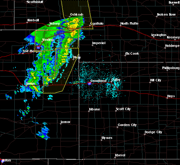 At 658 pm mdt/758 pm cdt/, severe thunderstorms were located along a line extending from 6 miles southeast of paoli to 3 miles north of eckley to 14 miles northeast of cope to 3 miles north of seibert, moving east at 35 mph (radar indicated). Hazards include 60 mph wind gusts. expect damage to roofs, siding, and trees At 658 pm mdt/758 pm cdt/, severe thunderstorms were located along a line extending from 6 miles southeast of paoli to 3 miles north of eckley to 14 miles northeast of cope to 3 miles north of seibert, moving east at 35 mph (radar indicated). Hazards include 60 mph wind gusts. expect damage to roofs, siding, and trees
|
| 6/6/2020 6:44 PM MDT |
 At 643 pm mdt, severe thunderstorms were located along a line extending from 5 miles east of oshkosh to near sixteen-mile corner to near eckley to 13 miles south of seibert, moving northeast at 55 mph (radar indicated). Hazards include 70 mph wind gusts. Expect considerable tree damage. damage is likely to mobile homes, roofs, and outbuildings. locations impacted include, yuma, wray, stratton, flagler, seibert, eckley and vona. this includes the following highways, interstate 70 in colorado between mile markers 391 and 426. Highway 385 between mile markers 225 and 269. At 643 pm mdt, severe thunderstorms were located along a line extending from 5 miles east of oshkosh to near sixteen-mile corner to near eckley to 13 miles south of seibert, moving northeast at 55 mph (radar indicated). Hazards include 70 mph wind gusts. Expect considerable tree damage. damage is likely to mobile homes, roofs, and outbuildings. locations impacted include, yuma, wray, stratton, flagler, seibert, eckley and vona. this includes the following highways, interstate 70 in colorado between mile markers 391 and 426. Highway 385 between mile markers 225 and 269.
|
| 6/6/2020 6:15 PM MDT |
 At 615 pm mdt, severe thunderstorms were located along a line extending from 8 miles north of lodgepole to 4 miles northwest of highland center to 12 miles south of otis to 4 miles northwest of boyero, moving northeast at 55 mph (radar indicated). Hazards include 70 mph wind gusts. Expect considerable tree damage. Damage is likely to mobile homes, roofs, and outbuildings. At 615 pm mdt, severe thunderstorms were located along a line extending from 8 miles north of lodgepole to 4 miles northwest of highland center to 12 miles south of otis to 4 miles northwest of boyero, moving northeast at 55 mph (radar indicated). Hazards include 70 mph wind gusts. Expect considerable tree damage. Damage is likely to mobile homes, roofs, and outbuildings.
|
| 6/3/2020 1:54 PM MDT |
 At 153 pm mdt, a severe thunderstorm was located over stratton, moving east at 15 mph (radar indicated). Hazards include 60 mph wind gusts and penny size hail. Expect damage to roofs, siding, and trees. locations impacted include, stratton, seibert, bethune and vona. This includes interstate 70 in colorado between mile markers 405 and 430. At 153 pm mdt, a severe thunderstorm was located over stratton, moving east at 15 mph (radar indicated). Hazards include 60 mph wind gusts and penny size hail. Expect damage to roofs, siding, and trees. locations impacted include, stratton, seibert, bethune and vona. This includes interstate 70 in colorado between mile markers 405 and 430.
|
| 6/3/2020 1:31 PM MDT |
 At 131 pm mdt, a severe thunderstorm was located near vona, or 6 miles east of seibert, moving east at 15 mph (radar indicated). Hazards include 60 mph wind gusts and quarter size hail. Hail damage to vehicles is expected. Expect wind damage to roofs, siding, and trees. At 131 pm mdt, a severe thunderstorm was located near vona, or 6 miles east of seibert, moving east at 15 mph (radar indicated). Hazards include 60 mph wind gusts and quarter size hail. Hail damage to vehicles is expected. Expect wind damage to roofs, siding, and trees.
|
| 5/3/2020 9:56 PM MDT |
 At 956 pm mdt, a severe thunderstorm was located near seibert, moving east at 20 mph (radar indicated). Hazards include 60 mph wind gusts and quarter size hail. Hail damage to vehicles is expected. expect wind damage to roofs, siding, and trees. locations impacted include, stratton, seibert and vona. This includes interstate 70 in colorado between mile markers 404 and 425. At 956 pm mdt, a severe thunderstorm was located near seibert, moving east at 20 mph (radar indicated). Hazards include 60 mph wind gusts and quarter size hail. Hail damage to vehicles is expected. expect wind damage to roofs, siding, and trees. locations impacted include, stratton, seibert and vona. This includes interstate 70 in colorado between mile markers 404 and 425.
|
| 5/3/2020 9:45 PM MDT |
 At 945 pm mdt, a severe thunderstorm was located over seibert, moving east at 20 mph (radar indicated). Hazards include 60 mph wind gusts and quarter size hail. Hail damage to vehicles is expected. Expect wind damage to roofs, siding, and trees. At 945 pm mdt, a severe thunderstorm was located over seibert, moving east at 20 mph (radar indicated). Hazards include 60 mph wind gusts and quarter size hail. Hail damage to vehicles is expected. Expect wind damage to roofs, siding, and trees.
|
| 5/3/2020 9:33 PM MDT |
 At 933 pm mdt, a severe thunderstorm was located near flagler, moving east at 25 mph (radar indicated). Hazards include 60 mph wind gusts and quarter size hail. Hail damage to vehicles is expected. expect wind damage to roofs, siding, and trees. locations impacted include, flagler and seibert. This includes interstate 70 in colorado between mile markers 394 and 408. At 933 pm mdt, a severe thunderstorm was located near flagler, moving east at 25 mph (radar indicated). Hazards include 60 mph wind gusts and quarter size hail. Hail damage to vehicles is expected. expect wind damage to roofs, siding, and trees. locations impacted include, flagler and seibert. This includes interstate 70 in colorado between mile markers 394 and 408.
|
| 5/3/2020 9:05 PM MDT |
 At 905 pm mdt, a severe thunderstorm was located over arriba, or 9 miles west of flagler, moving east at 25 mph (radar indicated). Hazards include 60 mph wind gusts and quarter size hail. Hail damage to vehicles is expected. Expect wind damage to roofs, siding, and trees. At 905 pm mdt, a severe thunderstorm was located over arriba, or 9 miles west of flagler, moving east at 25 mph (radar indicated). Hazards include 60 mph wind gusts and quarter size hail. Hail damage to vehicles is expected. Expect wind damage to roofs, siding, and trees.
|
| 8/11/2019 5:48 PM MDT |
 At 548 pm mdt, severe thunderstorms were located along a line extending from 10 miles northwest of flagler to 5 miles east of arriba to 12 miles east of hugo, moving northeast at 25 mph (radar indicated). Hazards include golf ball size hail and 70 mph wind gusts. People and animals outdoors will be injured. expect hail damage to roofs, siding, windows, and vehicles. expect considerable tree damage. Wind damage is also likely to mobile homes, roofs, and outbuildings. At 548 pm mdt, severe thunderstorms were located along a line extending from 10 miles northwest of flagler to 5 miles east of arriba to 12 miles east of hugo, moving northeast at 25 mph (radar indicated). Hazards include golf ball size hail and 70 mph wind gusts. People and animals outdoors will be injured. expect hail damage to roofs, siding, windows, and vehicles. expect considerable tree damage. Wind damage is also likely to mobile homes, roofs, and outbuildings.
|
| 7/29/2019 4:05 PM MDT |
 At 403 pm mdt, a severe thunderstorm was located 9 miles north of stratton, and is nearly stationary. this storm has a history of producing ping pong ball to golf ball size hail (public). Hazards include golf ball size hail and 60 mph wind gusts. People and animals outdoors will be injured. expect hail damage to roofs, siding, windows, and vehicles. expect wind damage to roofs, siding, and trees. locations impacted include, stratton, seibert and vona. This includes interstate 70 in colorado between mile markers 405 and 428. At 403 pm mdt, a severe thunderstorm was located 9 miles north of stratton, and is nearly stationary. this storm has a history of producing ping pong ball to golf ball size hail (public). Hazards include golf ball size hail and 60 mph wind gusts. People and animals outdoors will be injured. expect hail damage to roofs, siding, windows, and vehicles. expect wind damage to roofs, siding, and trees. locations impacted include, stratton, seibert and vona. This includes interstate 70 in colorado between mile markers 405 and 428.
|
| 7/29/2019 3:57 PM MDT |
 At 356 pm mdt, a severe thunderstorm was located 10 miles north of stratton, moving south at 15 mph (radar indicated). Hazards include 60 mph wind gusts and half dollar size hail. Hail damage to vehicles is expected. Expect wind damage to roofs, siding, and trees. At 356 pm mdt, a severe thunderstorm was located 10 miles north of stratton, moving south at 15 mph (radar indicated). Hazards include 60 mph wind gusts and half dollar size hail. Hail damage to vehicles is expected. Expect wind damage to roofs, siding, and trees.
|
| 6/8/2019 7:58 PM MDT |
 At 758 pm mdt, a severe thunderstorm was located 7 miles south of flagler, moving southeast at 30 mph (radar indicated). Hazards include 60 mph wind gusts and quarter size hail. Hail damage to vehicles is expected. expect wind damage to roofs, siding, and trees. locations impacted include, flagler and seibert. This includes interstate 70 in colorado between mile markers 391 and 408. At 758 pm mdt, a severe thunderstorm was located 7 miles south of flagler, moving southeast at 30 mph (radar indicated). Hazards include 60 mph wind gusts and quarter size hail. Hail damage to vehicles is expected. expect wind damage to roofs, siding, and trees. locations impacted include, flagler and seibert. This includes interstate 70 in colorado between mile markers 391 and 408.
|
| 6/8/2019 7:37 PM MDT |
 At 737 pm mdt, a severe thunderstorm was located 4 miles southeast of arriba, or 8 miles southwest of flagler, moving southeast at 30 mph (radar indicated). Hazards include 60 mph wind gusts and quarter size hail. Hail damage to vehicles is expected. Expect wind damage to roofs, siding, and trees. At 737 pm mdt, a severe thunderstorm was located 4 miles southeast of arriba, or 8 miles southwest of flagler, moving southeast at 30 mph (radar indicated). Hazards include 60 mph wind gusts and quarter size hail. Hail damage to vehicles is expected. Expect wind damage to roofs, siding, and trees.
|
| 6/2/2019 6:55 PM MDT |
 The tornado warning for northwestern kit carson county will expire at 700 pm mdt, the storm which prompted the warning has weakened below severe limits, and no longer appears capable of producing a tornado. therefore, the warning will be allowed to expire. however gusty winds are still possible with this thunderstorm. The tornado warning for northwestern kit carson county will expire at 700 pm mdt, the storm which prompted the warning has weakened below severe limits, and no longer appears capable of producing a tornado. therefore, the warning will be allowed to expire. however gusty winds are still possible with this thunderstorm.
|
| 6/2/2019 6:43 PM MDT |
 At 643 pm mdt, a severe thunderstorm capable of producing a tornado was located 5 miles northwest of seibert, moving northeast at 30 mph (radar indicated rotation). Hazards include tornado and quarter size hail. Flying debris will be dangerous to those caught without shelter. mobile homes will be damaged or destroyed. damage to roofs, windows, and vehicles will occur. tree damage is likely. Locations impacted include, seibert and vona. At 643 pm mdt, a severe thunderstorm capable of producing a tornado was located 5 miles northwest of seibert, moving northeast at 30 mph (radar indicated rotation). Hazards include tornado and quarter size hail. Flying debris will be dangerous to those caught without shelter. mobile homes will be damaged or destroyed. damage to roofs, windows, and vehicles will occur. tree damage is likely. Locations impacted include, seibert and vona.
|
| 6/2/2019 6:31 PM MDT |
 At 631 pm mdt, a severe thunderstorm capable of producing a tornado was located 5 miles southeast of flagler, moving east at 30 mph (radar indicated rotation). Hazards include tornado and quarter size hail. Flying debris will be dangerous to those caught without shelter. mobile homes will be damaged or destroyed. damage to roofs, windows, and vehicles will occur. Tree damage is likely. At 631 pm mdt, a severe thunderstorm capable of producing a tornado was located 5 miles southeast of flagler, moving east at 30 mph (radar indicated rotation). Hazards include tornado and quarter size hail. Flying debris will be dangerous to those caught without shelter. mobile homes will be damaged or destroyed. damage to roofs, windows, and vehicles will occur. Tree damage is likely.
|
| 5/26/2019 6:59 PM MDT |
 At 658 pm mdt, a severe thunderstorm was located 6 miles northwest of seibert, moving east at 50 mph (radar indicated). Hazards include 60 mph wind gusts and nickel size hail. expect damage to roofs, siding, and trees At 658 pm mdt, a severe thunderstorm was located 6 miles northwest of seibert, moving east at 50 mph (radar indicated). Hazards include 60 mph wind gusts and nickel size hail. expect damage to roofs, siding, and trees
|
| 4/21/2019 6:48 PM MDT | Semi trailer blown onto side on i-7 in kit carson county CO, 4.3 miles ENE of Seibert, CO |
| 4/21/2019 6:44 PM MDT | Sustained wind speed was 58 mph at the time of the peak wind gust. severe winds lasted until :54 afte in kit carson county CO, 0.2 miles SW of Seibert, CO |
| 8/7/2018 7:33 PM MDT |
 At 733 pm mdt, a severe thunderstorm was located 8 miles southeast of flagler, moving south at 30 mph (radar indicated). Hazards include 60 mph wind gusts and half dollar size hail. Hail damage to vehicles is expected. expect wind damage to roofs, siding, and trees. locations impacted include, flagler and seibert. This includes interstate 70 in colorado between mile markers 391 and 409. At 733 pm mdt, a severe thunderstorm was located 8 miles southeast of flagler, moving south at 30 mph (radar indicated). Hazards include 60 mph wind gusts and half dollar size hail. Hail damage to vehicles is expected. expect wind damage to roofs, siding, and trees. locations impacted include, flagler and seibert. This includes interstate 70 in colorado between mile markers 391 and 409.
|
| 8/7/2018 7:32 PM MDT | Quarter sized hail reported 6.6 miles NE of Seibert, CO |
| 8/7/2018 7:14 PM MDT |
 At 713 pm mdt, a severe thunderstorm was located 4 miles northeast of flagler, moving south at 20 mph (radar indicated). Hazards include 60 mph wind gusts and half dollar size hail. Hail damage to vehicles is expected. Expect wind damage to roofs, siding, and trees. At 713 pm mdt, a severe thunderstorm was located 4 miles northeast of flagler, moving south at 20 mph (radar indicated). Hazards include 60 mph wind gusts and half dollar size hail. Hail damage to vehicles is expected. Expect wind damage to roofs, siding, and trees.
|
| 8/7/2018 6:51 PM MDT |
 At 650 pm mdt, a severe thunderstorm was located 10 miles north of flagler, moving south at 10 mph (radar indicated). Hazards include golf ball size hail and 60 mph wind gusts. People and animals outdoors will be injured. expect hail damage to roofs, siding, windows, and vehicles. expect wind damage to roofs, siding, and trees. locations impacted include, flagler and seibert. This includes interstate 70 in colorado between mile markers 405 and 409. At 650 pm mdt, a severe thunderstorm was located 10 miles north of flagler, moving south at 10 mph (radar indicated). Hazards include golf ball size hail and 60 mph wind gusts. People and animals outdoors will be injured. expect hail damage to roofs, siding, windows, and vehicles. expect wind damage to roofs, siding, and trees. locations impacted include, flagler and seibert. This includes interstate 70 in colorado between mile markers 405 and 409.
|
| 8/7/2018 6:28 PM MDT |
 At 628 pm mdt, a severe thunderstorm was located 12 miles southeast of thurman, or 13 miles north of flagler, moving south at 10 mph (radar indicated). Hazards include two inch hail and 60 mph wind gusts. People and animals outdoors will be injured. expect hail damage to roofs, siding, windows, and vehicles. Expect wind damage to roofs, siding, and trees. At 628 pm mdt, a severe thunderstorm was located 12 miles southeast of thurman, or 13 miles north of flagler, moving south at 10 mph (radar indicated). Hazards include two inch hail and 60 mph wind gusts. People and animals outdoors will be injured. expect hail damage to roofs, siding, windows, and vehicles. Expect wind damage to roofs, siding, and trees.
|
| 8/7/2018 5:58 PM MDT |
 At 557 pm mdt, a severe thunderstorm was located 11 miles southeast of thurman, or 14 miles north of flagler, moving south at 15 mph (radar indicated). Hazards include two inch hail and 60 mph wind gusts. People and animals outdoors will be injured. expect hail damage to roofs, siding, windows, and vehicles. expect wind damage to roofs, siding, and trees. locations impacted include, flagler, seibert and vona. This includes interstate 70 in colorado between mile markers 391 and 417. At 557 pm mdt, a severe thunderstorm was located 11 miles southeast of thurman, or 14 miles north of flagler, moving south at 15 mph (radar indicated). Hazards include two inch hail and 60 mph wind gusts. People and animals outdoors will be injured. expect hail damage to roofs, siding, windows, and vehicles. expect wind damage to roofs, siding, and trees. locations impacted include, flagler, seibert and vona. This includes interstate 70 in colorado between mile markers 391 and 417.
|
| 8/7/2018 5:45 PM MDT |
 At 545 pm mdt, a severe thunderstorm was located 10 miles east of thurman, or 17 miles north of flagler, moving south at 15 mph (radar indicated). Hazards include ping pong ball size hail and 60 mph wind gusts. People and animals outdoors will be injured. expect hail damage to roofs, siding, windows, and vehicles. Expect wind damage to roofs, siding, and trees. At 545 pm mdt, a severe thunderstorm was located 10 miles east of thurman, or 17 miles north of flagler, moving south at 15 mph (radar indicated). Hazards include ping pong ball size hail and 60 mph wind gusts. People and animals outdoors will be injured. expect hail damage to roofs, siding, windows, and vehicles. Expect wind damage to roofs, siding, and trees.
|
| 7/29/2018 6:47 PM MDT |
 At 642 pm mdt, a severe thunderstorm was located 18 miles east of boyero, or 19 miles south of flagler, moving south at 40 mph. this is a very dangerous storm (law enforcement). Hazards include 80 mph wind gusts and baseball size hail. Flying debris will be dangerous to those caught without shelter. mobile homes will be heavily damaged. expect considerable damage to roofs, windows, and vehicles. extensive tree damage and power outages are likely. locations impacted include, stratton, seibert, vona, wild horse and aroya. this includes the following highways, interstate 70 in colorado between mile markers 403 and 423. highway 385 between mile markers 162 and 167. A tornado watch remains in effect until 900 pm mdt for east central colorado. At 642 pm mdt, a severe thunderstorm was located 18 miles east of boyero, or 19 miles south of flagler, moving south at 40 mph. this is a very dangerous storm (law enforcement). Hazards include 80 mph wind gusts and baseball size hail. Flying debris will be dangerous to those caught without shelter. mobile homes will be heavily damaged. expect considerable damage to roofs, windows, and vehicles. extensive tree damage and power outages are likely. locations impacted include, stratton, seibert, vona, wild horse and aroya. this includes the following highways, interstate 70 in colorado between mile markers 403 and 423. highway 385 between mile markers 162 and 167. A tornado watch remains in effect until 900 pm mdt for east central colorado.
|
| 7/29/2018 6:16 PM MDT |
 At 616 pm mdt, a severe thunderstorm was located near flagler, moving south at 40 mph. this is a very dangerous storm (law enforcement and public). Hazards include 80 mph wind gusts and baseball size hail. Flying debris will be dangerous to those caught without shelter. mobile homes will be heavily damaged. expect considerable damage to roofs, windows, and vehicles. extensive tree damage and power outages are likely. locations impacted include, stratton, flagler, seibert, vona, wild horse and aroya. this includes the following highways, interstate 70 in colorado between mile markers 391 and 423. highway 385 between mile markers 162 and 167. A tornado watch remains in effect until 900 pm mdt for east central colorado. At 616 pm mdt, a severe thunderstorm was located near flagler, moving south at 40 mph. this is a very dangerous storm (law enforcement and public). Hazards include 80 mph wind gusts and baseball size hail. Flying debris will be dangerous to those caught without shelter. mobile homes will be heavily damaged. expect considerable damage to roofs, windows, and vehicles. extensive tree damage and power outages are likely. locations impacted include, stratton, flagler, seibert, vona, wild horse and aroya. this includes the following highways, interstate 70 in colorado between mile markers 391 and 423. highway 385 between mile markers 162 and 167. A tornado watch remains in effect until 900 pm mdt for east central colorado.
|
| 7/29/2018 6:15 PM MDT | Hen Egg sized hail reported 0.2 miles SW of Seibert, CO, hail was atleast 2 inch in diameter. |
| 7/29/2018 6:15 PM MDT | Significant damage to homes and vehicles was done by not only by the wind but hail. specifics are not available at this tim in kit carson county CO, 0.2 miles SW of Seibert, CO |
| 7/29/2018 6:13 PM MDT |
 At 613 pm mdt, a severe thunderstorm was located over flagler, moving south at 40 mph. this is a very dangerous storm (radar indicated). Hazards include 80 mph wind gusts and two inch hail. Flying debris will be dangerous to those caught without shelter. mobile homes will be heavily damaged. expect considerable damage to roofs, windows, and vehicles. Extensive tree damage and power outages are likely. At 613 pm mdt, a severe thunderstorm was located over flagler, moving south at 40 mph. this is a very dangerous storm (radar indicated). Hazards include 80 mph wind gusts and two inch hail. Flying debris will be dangerous to those caught without shelter. mobile homes will be heavily damaged. expect considerable damage to roofs, windows, and vehicles. Extensive tree damage and power outages are likely.
|
| 7/29/2018 6:11 PM MDT |
 The tornado warning for western kit carson county will expire at 615 pm mdt, the tornado threat has diminished and the tornado warning has been cancelled. however, large hail and damaging winds remain likely and a severe thunderstorm warning remains in effect for the area. a tornado watch remains in effect until 900 pm mdt for northeastern and east central colorado. The tornado warning for western kit carson county will expire at 615 pm mdt, the tornado threat has diminished and the tornado warning has been cancelled. however, large hail and damaging winds remain likely and a severe thunderstorm warning remains in effect for the area. a tornado watch remains in effect until 900 pm mdt for northeastern and east central colorado.
|
| 7/29/2018 5:40 PM MDT |
 At 539 pm mdt, a severe thunderstorm capable of producing a tornado was located 8 miles east of thurman, or 22 miles north of flagler, moving south at 50 mph. storm has a history of producing tornadoes (radar indicated rotation). Hazards include tornado and hail up to two inches in diameter. Flying debris will be dangerous to those caught without shelter. mobile homes will be damaged or destroyed. damage to roofs, windows, and vehicles will occur. Tree damage is likely. At 539 pm mdt, a severe thunderstorm capable of producing a tornado was located 8 miles east of thurman, or 22 miles north of flagler, moving south at 50 mph. storm has a history of producing tornadoes (radar indicated rotation). Hazards include tornado and hail up to two inches in diameter. Flying debris will be dangerous to those caught without shelter. mobile homes will be damaged or destroyed. damage to roofs, windows, and vehicles will occur. Tree damage is likely.
|
| 7/28/2018 5:36 PM MDT |
 At 536 pm mdt, a severe thunderstorm was located near flagler, moving east at 40 mph (radar indicated). Hazards include 70 mph wind gusts and quarter size hail. Hail damage to vehicles is expected. expect considerable tree damage. Wind damage is also likely to mobile homes, roofs, and outbuildings. At 536 pm mdt, a severe thunderstorm was located near flagler, moving east at 40 mph (radar indicated). Hazards include 70 mph wind gusts and quarter size hail. Hail damage to vehicles is expected. expect considerable tree damage. Wind damage is also likely to mobile homes, roofs, and outbuildings.
|
| 7/27/2018 6:03 PM MDT |
 At 603 pm mdt/703 pm cdt/, severe thunderstorms were located along a line extending from 6 miles east of st. francis to 12 miles northwest of kit carson, moving southeast at 25 mph (radar indicated). Hazards include 70 mph wind gusts and ping pong ball size hail. People and animals outdoors will be injured. expect hail damage to roofs, siding, windows, and vehicles. expect considerable tree damage. Wind damage is also likely to mobile homes, roofs, and outbuildings. At 603 pm mdt/703 pm cdt/, severe thunderstorms were located along a line extending from 6 miles east of st. francis to 12 miles northwest of kit carson, moving southeast at 25 mph (radar indicated). Hazards include 70 mph wind gusts and ping pong ball size hail. People and animals outdoors will be injured. expect hail damage to roofs, siding, windows, and vehicles. expect considerable tree damage. Wind damage is also likely to mobile homes, roofs, and outbuildings.
|
| 7/27/2018 5:55 PM MDT |
 At 555 pm mdt, severe thunderstorms were located along a line extending from 6 miles north of bonny reservoir to 12 miles west of cheyenne wells, moving southeast at 40 mph (radar indicated). Hazards include two inch hail and 70 mph wind gusts. People and animals outdoors will be injured. expect hail damage to roofs, siding, windows, and vehicles. expect considerable tree damage. wind damage is also likely to mobile homes, roofs, and outbuildings. locations impacted include, stratton, flagler, seibert, bethune, vona, joes and kirk. this includes the following highways, interstate 70 in colorado between mile markers 393 and 435. highway 385 between mile markers 202 and 220. A tornado watch remains in effect until 900 pm mdt for northeastern and east central colorado. At 555 pm mdt, severe thunderstorms were located along a line extending from 6 miles north of bonny reservoir to 12 miles west of cheyenne wells, moving southeast at 40 mph (radar indicated). Hazards include two inch hail and 70 mph wind gusts. People and animals outdoors will be injured. expect hail damage to roofs, siding, windows, and vehicles. expect considerable tree damage. wind damage is also likely to mobile homes, roofs, and outbuildings. locations impacted include, stratton, flagler, seibert, bethune, vona, joes and kirk. this includes the following highways, interstate 70 in colorado between mile markers 393 and 435. highway 385 between mile markers 202 and 220. A tornado watch remains in effect until 900 pm mdt for northeastern and east central colorado.
|
| 7/27/2018 5:36 PM MDT |
 At 535 pm mdt, severe thunderstorms were located along a line extending from 18 miles northwest of bonny reservoir to 13 miles north of kit carson, moving southeast at 40 mph (radar indicated). Hazards include two inch hail and 70 mph wind gusts. People and animals outdoors will be injured. expect hail damage to roofs, siding, windows, and vehicles. expect considerable tree damage. wind damage is also likely to mobile homes, roofs, and outbuildings. locations impacted include, burlington, stratton, flagler, seibert, bethune, vona and joes. this includes the following highways, interstate 70 in colorado between mile markers 391 and 435. highway 385 between mile markers 196 and 227. A tornado watch remains in effect until 900 pm mdt for northeastern and east central colorado. At 535 pm mdt, severe thunderstorms were located along a line extending from 18 miles northwest of bonny reservoir to 13 miles north of kit carson, moving southeast at 40 mph (radar indicated). Hazards include two inch hail and 70 mph wind gusts. People and animals outdoors will be injured. expect hail damage to roofs, siding, windows, and vehicles. expect considerable tree damage. wind damage is also likely to mobile homes, roofs, and outbuildings. locations impacted include, burlington, stratton, flagler, seibert, bethune, vona and joes. this includes the following highways, interstate 70 in colorado between mile markers 391 and 435. highway 385 between mile markers 196 and 227. A tornado watch remains in effect until 900 pm mdt for northeastern and east central colorado.
|
| 7/27/2018 5:21 PM MDT |
 At 521 pm mdt, severe thunderstorms were located along a line extending from 18 miles south of eckley to 18 miles east of boyero, moving southeast at 40 mph (radar indicated). Hazards include 70 mph wind gusts and ping pong ball size hail. People and animals outdoors will be injured. expect hail damage to roofs, siding, windows, and vehicles. expect considerable tree damage. Wind damage is also likely to mobile homes, roofs, and outbuildings. At 521 pm mdt, severe thunderstorms were located along a line extending from 18 miles south of eckley to 18 miles east of boyero, moving southeast at 40 mph (radar indicated). Hazards include 70 mph wind gusts and ping pong ball size hail. People and animals outdoors will be injured. expect hail damage to roofs, siding, windows, and vehicles. expect considerable tree damage. Wind damage is also likely to mobile homes, roofs, and outbuildings.
|
| 7/27/2018 4:57 PM MDT |
 At 457 pm mdt, a severe thunderstorm was located 4 miles west of seibert, moving south at 20 mph (radar indicated). Hazards include 70 mph wind gusts and half dollar size hail. Hail damage to vehicles is expected. expect considerable tree damage. wind damage is also likely to mobile homes, roofs, and outbuildings. locations impacted include, flagler, seibert and vona. this includes interstate 70 in colorado between mile markers 390 and 412. A tornado watch remains in effect until 900 pm mdt for northeastern and east central colorado. At 457 pm mdt, a severe thunderstorm was located 4 miles west of seibert, moving south at 20 mph (radar indicated). Hazards include 70 mph wind gusts and half dollar size hail. Hail damage to vehicles is expected. expect considerable tree damage. wind damage is also likely to mobile homes, roofs, and outbuildings. locations impacted include, flagler, seibert and vona. this includes interstate 70 in colorado between mile markers 390 and 412. A tornado watch remains in effect until 900 pm mdt for northeastern and east central colorado.
|
| 7/27/2018 4:28 PM MDT |
 At 428 pm mdt, a severe thunderstorm was located 11 miles north of flagler, moving south at 20 mph (radar indicated). Hazards include 70 mph wind gusts and half dollar size hail. Hail damage to vehicles is expected. expect considerable tree damage. Wind damage is also likely to mobile homes, roofs, and outbuildings. At 428 pm mdt, a severe thunderstorm was located 11 miles north of flagler, moving south at 20 mph (radar indicated). Hazards include 70 mph wind gusts and half dollar size hail. Hail damage to vehicles is expected. expect considerable tree damage. Wind damage is also likely to mobile homes, roofs, and outbuildings.
|
| 7/26/2018 4:46 PM MDT |
 At 446 pm mdt, a severe thunderstorm was located 8 miles south of vona, or 8 miles southeast of seibert, moving southeast at 25 mph (radar indicated). Hazards include ping pong ball size hail and 60 mph wind gusts. People and animals outdoors will be injured. expect hail damage to roofs, siding, windows, and vehicles. expect wind damage to roofs, siding, and trees. locations impacted include, seibert and vona. This includes interstate 70 in colorado between mile markers 403 and 412. At 446 pm mdt, a severe thunderstorm was located 8 miles south of vona, or 8 miles southeast of seibert, moving southeast at 25 mph (radar indicated). Hazards include ping pong ball size hail and 60 mph wind gusts. People and animals outdoors will be injured. expect hail damage to roofs, siding, windows, and vehicles. expect wind damage to roofs, siding, and trees. locations impacted include, seibert and vona. This includes interstate 70 in colorado between mile markers 403 and 412.
|
| 7/26/2018 4:37 PM MDT |
 At 437 pm mdt, a severe thunderstorm was located 4 miles southeast of seibert, moving south at 25 mph (radar indicated). Hazards include ping pong ball size hail and 60 mph wind gusts. People and animals outdoors will be injured. expect hail damage to roofs, siding, windows, and vehicles. Expect wind damage to roofs, siding, and trees. At 437 pm mdt, a severe thunderstorm was located 4 miles southeast of seibert, moving south at 25 mph (radar indicated). Hazards include ping pong ball size hail and 60 mph wind gusts. People and animals outdoors will be injured. expect hail damage to roofs, siding, windows, and vehicles. Expect wind damage to roofs, siding, and trees.
|
| 7/26/2018 4:30 PM MDT | Quarter sized hail reported 0.2 miles SW of Seibert, CO, quarter-sized hail reported via image on twitter. |
| 7/21/2018 7:41 PM MDT |
 The severe thunderstorm warning for western cheyenne and southwestern kit carson counties in east central colorado will expire at 745 pm mdt, the storms which prompted the warning have weakened below severe limits, and no longer pose an immediate threat to life or property. therefore, the warning will be allowed to expire. however gusty winds are still possible with these thunderstorms. The severe thunderstorm warning for western cheyenne and southwestern kit carson counties in east central colorado will expire at 745 pm mdt, the storms which prompted the warning have weakened below severe limits, and no longer pose an immediate threat to life or property. therefore, the warning will be allowed to expire. however gusty winds are still possible with these thunderstorms.
|
| 7/21/2018 7:25 PM MDT |
 At 725 pm mdt, severe thunderstorms were located along a line extending from 3 miles east of arriba to 14 miles south of boyero, moving east at 45 mph (trained weather spotters). Hazards include 60 mph wind gusts. Expect damage to roofs, siding, and trees. locations impacted include, flagler, seibert, kit carson, vona, wild horse and aroya. This includes interstate 70 in colorado between mile markers 390 and 412. At 725 pm mdt, severe thunderstorms were located along a line extending from 3 miles east of arriba to 14 miles south of boyero, moving east at 45 mph (trained weather spotters). Hazards include 60 mph wind gusts. Expect damage to roofs, siding, and trees. locations impacted include, flagler, seibert, kit carson, vona, wild horse and aroya. This includes interstate 70 in colorado between mile markers 390 and 412.
|
| 7/21/2018 6:54 PM MDT |
 At 653 pm mdt, severe thunderstorms were located along a line extending from 4 miles east of limon to wild horse point, moving east at 55 mph (trained weather spotters). Hazards include 60 mph wind gusts. expect damage to roofs, siding, and trees At 653 pm mdt, severe thunderstorms were located along a line extending from 4 miles east of limon to wild horse point, moving east at 55 mph (trained weather spotters). Hazards include 60 mph wind gusts. expect damage to roofs, siding, and trees
|
| 6/24/2018 4:20 PM MDT |
 At 420 pm mdt, a severe thunderstorm was located 4 miles southeast of bethune, or 7 miles southwest of burlington, moving east at 55 mph (radar indicated). Hazards include 60 mph wind gusts and quarter size hail. the hail is accumulating up to a few inches on the interstate and has a history of causing traffic accidents. Hail damage to vehicles is expected. expect wind damage to roofs, siding, and trees. locations impacted include, goodland, burlington, stratton, seibert, kanorado, ruleton and bethune. this includes the following highways, interstate 70 in kansas between mile markers 0 and 19. interstate 70 in colorado between mile markers 399 and 450. Highway 385 between mile markers 176 and 201. At 420 pm mdt, a severe thunderstorm was located 4 miles southeast of bethune, or 7 miles southwest of burlington, moving east at 55 mph (radar indicated). Hazards include 60 mph wind gusts and quarter size hail. the hail is accumulating up to a few inches on the interstate and has a history of causing traffic accidents. Hail damage to vehicles is expected. expect wind damage to roofs, siding, and trees. locations impacted include, goodland, burlington, stratton, seibert, kanorado, ruleton and bethune. this includes the following highways, interstate 70 in kansas between mile markers 0 and 19. interstate 70 in colorado between mile markers 399 and 450. Highway 385 between mile markers 176 and 201.
|
| 6/24/2018 4:14 PM MDT |
 At 413 pm mdt, a severe thunderstorm was located 5 miles southwest of bethune, or 6 miles southeast of stratton, moving east at 55 mph (radar indicated). Hazards include golf ball size hail and 60 mph wind gusts. People and animals outdoors will be injured. expect hail damage to roofs, siding, windows, and vehicles. Expect wind damage to roofs, siding, and trees. At 413 pm mdt, a severe thunderstorm was located 5 miles southwest of bethune, or 6 miles southeast of stratton, moving east at 55 mph (radar indicated). Hazards include golf ball size hail and 60 mph wind gusts. People and animals outdoors will be injured. expect hail damage to roofs, siding, windows, and vehicles. Expect wind damage to roofs, siding, and trees.
|
| 6/24/2018 3:53 PM MDT |
 At 353 pm mdt, severe thunderstorms were located along a line extending from 11 miles southeast of cope to 3 miles southwest of vona to 12 miles northeast of boyero, moving east at 35 mph (radar indicated). Hazards include two inch hail and 60 mph wind gusts. People and animals outdoors will be injured. expect hail damage to roofs, siding, windows, and vehicles. expect wind damage to roofs, siding, and trees. locations impacted include, stratton, seibert, bonny reservoir, bethune, vona and hale. this includes the following highways, interstate 70 in colorado between mile markers 395 and 433. Highway 385 between mile markers 195 and 211. At 353 pm mdt, severe thunderstorms were located along a line extending from 11 miles southeast of cope to 3 miles southwest of vona to 12 miles northeast of boyero, moving east at 35 mph (radar indicated). Hazards include two inch hail and 60 mph wind gusts. People and animals outdoors will be injured. expect hail damage to roofs, siding, windows, and vehicles. expect wind damage to roofs, siding, and trees. locations impacted include, stratton, seibert, bonny reservoir, bethune, vona and hale. this includes the following highways, interstate 70 in colorado between mile markers 395 and 433. Highway 385 between mile markers 195 and 211.
|
| 6/24/2018 3:48 PM MDT |
 At 348 pm mdt, severe thunderstorms were located along a line extending from 12 miles southeast of cope to 3 miles south of vona to 13 miles northeast of boyero, moving east at 35 mph (radar indicated). Hazards include 60 mph wind gusts and half dollar size hail. Hail damage to vehicles is expected. expect wind damage to roofs, siding, and trees. locations impacted include, stratton, seibert, bonny reservoir, bethune, vona and hale. this includes the following highways, interstate 70 in colorado between mile markers 395 and 433. Highway 385 between mile markers 195 and 211. At 348 pm mdt, severe thunderstorms were located along a line extending from 12 miles southeast of cope to 3 miles south of vona to 13 miles northeast of boyero, moving east at 35 mph (radar indicated). Hazards include 60 mph wind gusts and half dollar size hail. Hail damage to vehicles is expected. expect wind damage to roofs, siding, and trees. locations impacted include, stratton, seibert, bonny reservoir, bethune, vona and hale. this includes the following highways, interstate 70 in colorado between mile markers 395 and 433. Highway 385 between mile markers 195 and 211.
|
| 6/24/2018 3:36 PM MDT |
 At 336 pm mdt, severe thunderstorms were located along a line extending from 8 miles south of cope to 4 miles southeast of flagler to 7 miles north of boyero, moving east at 35 mph (radar indicated). Hazards include 60 mph wind gusts and half dollar size hail. Hail damage to vehicles is expected. Expect wind damage to roofs, siding, and trees. At 336 pm mdt, severe thunderstorms were located along a line extending from 8 miles south of cope to 4 miles southeast of flagler to 7 miles north of boyero, moving east at 35 mph (radar indicated). Hazards include 60 mph wind gusts and half dollar size hail. Hail damage to vehicles is expected. Expect wind damage to roofs, siding, and trees.
|
| 6/19/2018 5:57 PM MDT |
 At 557 pm mdt, a severe thunderstorm was located near seibert, moving east at 30 mph (radar indicated). Hazards include 60 mph wind gusts and quarter size hail. Hail damage to vehicles is expected. Expect wind damage to roofs, siding, and trees. At 557 pm mdt, a severe thunderstorm was located near seibert, moving east at 30 mph (radar indicated). Hazards include 60 mph wind gusts and quarter size hail. Hail damage to vehicles is expected. Expect wind damage to roofs, siding, and trees.
|
| 6/19/2018 5:46 PM MDT |
 At 546 pm mdt, a severe thunderstorm was located 6 miles southeast of flagler, moving east at 30 mph (radar indicated). Hazards include 70 mph wind gusts and half dollar size hail. Hail damage to vehicles is expected. expect considerable tree damage. wind damage is also likely to mobile homes, roofs, and outbuildings. locations impacted include, flagler, seibert and vona. this includes interstate 70 in colorado between mile markers 391 and 413. A tornado watch remains in effect until 700 pm mdt for east central colorado. At 546 pm mdt, a severe thunderstorm was located 6 miles southeast of flagler, moving east at 30 mph (radar indicated). Hazards include 70 mph wind gusts and half dollar size hail. Hail damage to vehicles is expected. expect considerable tree damage. wind damage is also likely to mobile homes, roofs, and outbuildings. locations impacted include, flagler, seibert and vona. this includes interstate 70 in colorado between mile markers 391 and 413. A tornado watch remains in effect until 700 pm mdt for east central colorado.
|
| 6/19/2018 5:30 PM MDT |
 At 529 pm mdt, a severe thunderstorm capable of producing a tornado was located 5 miles southeast of arriba, or 7 miles southwest of flagler, moving southeast at 45 mph (radar indicated rotation). Hazards include tornado and hail up to two inches in diameter. Flying debris will be dangerous to those caught without shelter. mobile homes will be damaged or destroyed. damage to roofs, windows, and vehicles will occur. Tree damage is likely. At 529 pm mdt, a severe thunderstorm capable of producing a tornado was located 5 miles southeast of arriba, or 7 miles southwest of flagler, moving southeast at 45 mph (radar indicated rotation). Hazards include tornado and hail up to two inches in diameter. Flying debris will be dangerous to those caught without shelter. mobile homes will be damaged or destroyed. damage to roofs, windows, and vehicles will occur. Tree damage is likely.
|
| 6/19/2018 5:23 PM MDT |
 At 523 pm mdt, a severe thunderstorm was located 6 miles southeast of arriba, or 6 miles southwest of flagler, moving east at 50 mph (radar indicated). Hazards include tennis ball size hail and 70 mph wind gusts. People and animals outdoors will be injured. expect hail damage to roofs, siding, windows, and vehicles. expect considerable tree damage. Wind damage is also likely to mobile homes, roofs, and outbuildings. At 523 pm mdt, a severe thunderstorm was located 6 miles southeast of arriba, or 6 miles southwest of flagler, moving east at 50 mph (radar indicated). Hazards include tennis ball size hail and 70 mph wind gusts. People and animals outdoors will be injured. expect hail damage to roofs, siding, windows, and vehicles. expect considerable tree damage. Wind damage is also likely to mobile homes, roofs, and outbuildings.
|
| 6/19/2018 4:46 PM MDT |
 At 446 pm mdt, severe thunderstorms were located along a line extending from 11 miles south of yuma to 6 miles south of cope to 10 miles southeast of thurman, moving east at 35 mph (radar indicated). Hazards include tennis ball size hail and 70 mph wind gusts. People and animals outdoors will be injured. expect hail damage to roofs, siding, windows, and vehicles. expect considerable tree damage. wind damage is also likely to mobile homes, roofs, and outbuildings. locations impacted include, stratton, flagler, seibert, vona, joes, abarr and kirk. A tornado watch remains in effect until 700 pm mdt for northeastern and east central colorado. At 446 pm mdt, severe thunderstorms were located along a line extending from 11 miles south of yuma to 6 miles south of cope to 10 miles southeast of thurman, moving east at 35 mph (radar indicated). Hazards include tennis ball size hail and 70 mph wind gusts. People and animals outdoors will be injured. expect hail damage to roofs, siding, windows, and vehicles. expect considerable tree damage. wind damage is also likely to mobile homes, roofs, and outbuildings. locations impacted include, stratton, flagler, seibert, vona, joes, abarr and kirk. A tornado watch remains in effect until 700 pm mdt for northeastern and east central colorado.
|
| 6/19/2018 4:32 PM MDT |
 At 432 pm mdt, severe thunderstorms were located along a line extending from 10 miles southwest of yuma to 8 miles south of arickaree school to 6 miles south of thurman, moving east at 35 mph (radar indicated). Hazards include golf ball size hail and 70 mph wind gusts. People and animals outdoors will be injured. expect hail damage to roofs, siding, windows, and vehicles. expect considerable tree damage. wind damage is also likely to mobile homes, roofs, and outbuildings. locations impacted include, stratton, flagler, seibert, vona, joes, abarr and kirk. this includes interstate 70 in colorado between mile markers 400 and 417. A tornado watch remains in effect until 700 pm mdt for northeastern and east central colorado. At 432 pm mdt, severe thunderstorms were located along a line extending from 10 miles southwest of yuma to 8 miles south of arickaree school to 6 miles south of thurman, moving east at 35 mph (radar indicated). Hazards include golf ball size hail and 70 mph wind gusts. People and animals outdoors will be injured. expect hail damage to roofs, siding, windows, and vehicles. expect considerable tree damage. wind damage is also likely to mobile homes, roofs, and outbuildings. locations impacted include, stratton, flagler, seibert, vona, joes, abarr and kirk. this includes interstate 70 in colorado between mile markers 400 and 417. A tornado watch remains in effect until 700 pm mdt for northeastern and east central colorado.
|
| 6/19/2018 4:21 PM MDT |
 At 421 pm mdt, severe thunderstorms were located along a line extending from 8 miles south of otis to 6 miles northeast of thurman to 13 miles south of lindon, moving east at 35 mph (radar indicated). Hazards include 70 mph wind gusts and ping pong ball size hail. People and animals outdoors will be injured. expect hail damage to roofs, siding, windows, and vehicles. expect considerable tree damage. Wind damage is also likely to mobile homes, roofs, and outbuildings. At 421 pm mdt, severe thunderstorms were located along a line extending from 8 miles south of otis to 6 miles northeast of thurman to 13 miles south of lindon, moving east at 35 mph (radar indicated). Hazards include 70 mph wind gusts and ping pong ball size hail. People and animals outdoors will be injured. expect hail damage to roofs, siding, windows, and vehicles. expect considerable tree damage. Wind damage is also likely to mobile homes, roofs, and outbuildings.
|
| 6/8/2018 4:59 PM MDT |
 At 458 pm mdt, a severe thunderstorm was located 4 miles southwest of seibert, moving east at 15 mph (radar indicated). Hazards include 60 mph wind gusts and quarter size hail. Hail damage to vehicles is expected. expect wind damage to roofs, siding, and trees. locations impacted include, flagler and seibert. This includes interstate 70 in colorado between mile markers 391 and 407. At 458 pm mdt, a severe thunderstorm was located 4 miles southwest of seibert, moving east at 15 mph (radar indicated). Hazards include 60 mph wind gusts and quarter size hail. Hail damage to vehicles is expected. expect wind damage to roofs, siding, and trees. locations impacted include, flagler and seibert. This includes interstate 70 in colorado between mile markers 391 and 407.
|
| 6/8/2018 4:52 PM MDT |
 At 451 pm mdt, a severe thunderstorm was located near flagler, moving east at 15 mph (radar indicated). Hazards include 60 mph wind gusts and quarter size hail. Hail damage to vehicles is expected. expect wind damage to roofs, siding, and trees. locations impacted include, flagler and seibert. This includes interstate 70 in colorado between mile markers 391 and 407. At 451 pm mdt, a severe thunderstorm was located near flagler, moving east at 15 mph (radar indicated). Hazards include 60 mph wind gusts and quarter size hail. Hail damage to vehicles is expected. expect wind damage to roofs, siding, and trees. locations impacted include, flagler and seibert. This includes interstate 70 in colorado between mile markers 391 and 407.
|
| 6/8/2018 4:41 PM MDT |
 At 441 pm mdt, a severe thunderstorm was located near flagler, moving east at 20 mph (radar indicated). Hazards include 60 mph wind gusts and quarter size hail. Hail damage to vehicles is expected. expect wind damage to roofs, siding, and trees. locations impacted include, flagler and seibert. This includes interstate 70 in colorado between mile markers 391 and 407. At 441 pm mdt, a severe thunderstorm was located near flagler, moving east at 20 mph (radar indicated). Hazards include 60 mph wind gusts and quarter size hail. Hail damage to vehicles is expected. expect wind damage to roofs, siding, and trees. locations impacted include, flagler and seibert. This includes interstate 70 in colorado between mile markers 391 and 407.
|
| 6/8/2018 4:29 PM MDT |
 At 429 pm mdt, a severe thunderstorm was located near flagler, moving east at 20 mph (radar indicated). Hazards include 60 mph wind gusts and quarter size hail. Hail damage to vehicles is expected. Expect wind damage to roofs, siding, and trees. At 429 pm mdt, a severe thunderstorm was located near flagler, moving east at 20 mph (radar indicated). Hazards include 60 mph wind gusts and quarter size hail. Hail damage to vehicles is expected. Expect wind damage to roofs, siding, and trees.
|
| 5/28/2018 5:59 PM MDT |
 At 559 pm mdt, a severe thunderstorm capable of producing a tornado was located 8 miles north of vona, or 9 miles northeast of seibert, moving east at 20 mph (radar indicated rotation). Hazards include tornado and two inch hail. Flying debris will be dangerous to those caught without shelter. mobile homes will be damaged or destroyed. damage to roofs, windows, and vehicles will occur. tree damage is likely. locations impacted include, stratton, seibert and vona. This includes interstate 70 in colorado between mile markers 402 and 419. At 559 pm mdt, a severe thunderstorm capable of producing a tornado was located 8 miles north of vona, or 9 miles northeast of seibert, moving east at 20 mph (radar indicated rotation). Hazards include tornado and two inch hail. Flying debris will be dangerous to those caught without shelter. mobile homes will be damaged or destroyed. damage to roofs, windows, and vehicles will occur. tree damage is likely. locations impacted include, stratton, seibert and vona. This includes interstate 70 in colorado between mile markers 402 and 419.
|
| 5/28/2018 5:50 PM MDT |
 At 550 pm mdt, a severe thunderstorm capable of producing a tornado was located 4 miles north of seibert, moving southeast at 25 mph (radar indicated rotation). Hazards include tornado and hail up to two inches in diameter. Flying debris will be dangerous to those caught without shelter. mobile homes will be damaged or destroyed. damage to roofs, windows, and vehicles will occur. Tree damage is likely. At 550 pm mdt, a severe thunderstorm capable of producing a tornado was located 4 miles north of seibert, moving southeast at 25 mph (radar indicated rotation). Hazards include tornado and hail up to two inches in diameter. Flying debris will be dangerous to those caught without shelter. mobile homes will be damaged or destroyed. damage to roofs, windows, and vehicles will occur. Tree damage is likely.
|
| 5/28/2018 5:46 PM MDT |
 At 546 pm mdt, severe thunderstorms were located along a line extending from 6 miles southeast of cope to near seibert, moving east at 50 mph (radar indicated). Hazards include 70 mph wind gusts and ping pong ball size hail. People and animals outdoors will be injured. expect hail damage to roofs, siding, windows, and vehicles. expect considerable tree damage. Wind damage is also likely to mobile homes, roofs, and outbuildings. At 546 pm mdt, severe thunderstorms were located along a line extending from 6 miles southeast of cope to near seibert, moving east at 50 mph (radar indicated). Hazards include 70 mph wind gusts and ping pong ball size hail. People and animals outdoors will be injured. expect hail damage to roofs, siding, windows, and vehicles. expect considerable tree damage. Wind damage is also likely to mobile homes, roofs, and outbuildings.
|
| 5/27/2018 6:58 PM MDT |
 At 657 pm mdt, a severe thunderstorm was located 4 miles northwest of vona, or 6 miles northeast of seibert, moving northeast at 40 mph (radar indicated). Hazards include golf ball size hail and 60 mph wind gusts. People and animals outdoors will be injured. expect hail damage to roofs, siding, windows, and vehicles. expect wind damage to roofs, siding, and trees. locations impacted include, seibert and vona. This includes interstate 70 in colorado between mile markers 403 and 414. At 657 pm mdt, a severe thunderstorm was located 4 miles northwest of vona, or 6 miles northeast of seibert, moving northeast at 40 mph (radar indicated). Hazards include golf ball size hail and 60 mph wind gusts. People and animals outdoors will be injured. expect hail damage to roofs, siding, windows, and vehicles. expect wind damage to roofs, siding, and trees. locations impacted include, seibert and vona. This includes interstate 70 in colorado between mile markers 403 and 414.
|
| 5/27/2018 6:47 PM MDT |
 At 647 pm mdt, a severe thunderstorm was located near seibert, moving north at 45 mph (radar indicated). Hazards include 60 mph wind gusts and quarter size hail. Hail damage to vehicles is expected. Expect wind damage to roofs, siding, and trees. At 647 pm mdt, a severe thunderstorm was located near seibert, moving north at 45 mph (radar indicated). Hazards include 60 mph wind gusts and quarter size hail. Hail damage to vehicles is expected. Expect wind damage to roofs, siding, and trees.
|
| 5/14/2018 4:35 PM MDT |
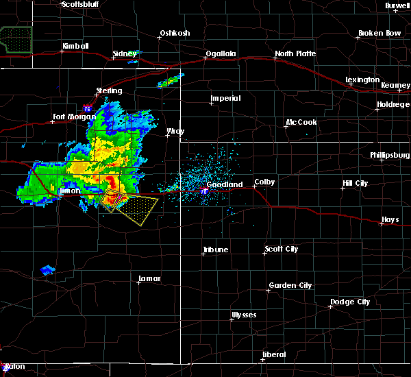 At 434 pm mdt, a severe thunderstorm was located 6 miles south of seibert, moving southeast at 35 mph (radar indicated). Hazards include golf ball size hail and 60 mph wind gusts. People and animals outdoors will be injured. expect hail damage to roofs, siding, windows, and vehicles. Expect wind damage to roofs, siding, and trees. At 434 pm mdt, a severe thunderstorm was located 6 miles south of seibert, moving southeast at 35 mph (radar indicated). Hazards include golf ball size hail and 60 mph wind gusts. People and animals outdoors will be injured. expect hail damage to roofs, siding, windows, and vehicles. Expect wind damage to roofs, siding, and trees.
|
| 5/14/2018 4:26 PM MDT |
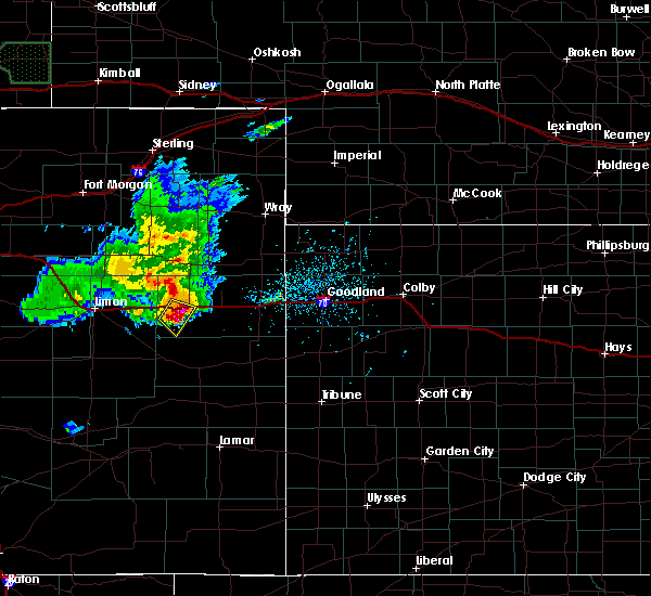 At 425 pm mdt, a severe thunderstorm was located 5 miles southeast of flagler, moving east at 35 mph (trained weather spotters reported golf ball sized hail in flagler with this storm). Hazards include golf ball size hail and 60 mph wind gusts. People and animals outdoors will be injured. expect hail damage to roofs, siding, windows, and vehicles. expect wind damage to roofs, siding, and trees. locations impacted include, seibert. This includes interstate 70 in colorado between mile markers 395 and 408. At 425 pm mdt, a severe thunderstorm was located 5 miles southeast of flagler, moving east at 35 mph (trained weather spotters reported golf ball sized hail in flagler with this storm). Hazards include golf ball size hail and 60 mph wind gusts. People and animals outdoors will be injured. expect hail damage to roofs, siding, windows, and vehicles. expect wind damage to roofs, siding, and trees. locations impacted include, seibert. This includes interstate 70 in colorado between mile markers 395 and 408.
|
| 5/14/2018 4:14 PM MDT |
 At 414 pm mdt, a severe thunderstorm was located over flagler, moving southeast at 30 mph (radar indicated). Hazards include 60 mph wind gusts and quarter size hail. Hail damage to vehicles is expected. expect wind damage to roofs, siding, and trees. locations impacted include, flagler and seibert. This includes interstate 70 in colorado between mile markers 391 and 408. At 414 pm mdt, a severe thunderstorm was located over flagler, moving southeast at 30 mph (radar indicated). Hazards include 60 mph wind gusts and quarter size hail. Hail damage to vehicles is expected. expect wind damage to roofs, siding, and trees. locations impacted include, flagler and seibert. This includes interstate 70 in colorado between mile markers 391 and 408.
|
| 5/14/2018 3:58 PM MDT |
 At 357 pm mdt, a severe thunderstorm was located near arriba, or 10 miles west of flagler, moving southeast at 30 mph (radar indicated). Hazards include 60 mph wind gusts and quarter size hail. Hail damage to vehicles is expected. Expect wind damage to roofs, siding, and trees. At 357 pm mdt, a severe thunderstorm was located near arriba, or 10 miles west of flagler, moving southeast at 30 mph (radar indicated). Hazards include 60 mph wind gusts and quarter size hail. Hail damage to vehicles is expected. Expect wind damage to roofs, siding, and trees.
|
| 8/14/2017 9:33 PM MDT |
 At 933 pm mdt, a severe thunderstorm was located over vona, or 6 miles west of stratton, moving south at 5 mph (radar indicated). Hazards include 60 mph wind gusts and half dollar size hail. Hail damage to vehicles is expected. expect wind damage to roofs, siding, and trees. locations impacted include, stratton, seibert and vona. This includes interstate 70 in colorado between mile markers 398 and 420. At 933 pm mdt, a severe thunderstorm was located over vona, or 6 miles west of stratton, moving south at 5 mph (radar indicated). Hazards include 60 mph wind gusts and half dollar size hail. Hail damage to vehicles is expected. expect wind damage to roofs, siding, and trees. locations impacted include, stratton, seibert and vona. This includes interstate 70 in colorado between mile markers 398 and 420.
|
| 8/14/2017 9:03 PM MDT |
 At 903 pm mdt, a severe thunderstorm was located over vona, or 6 miles east of seibert, moving southwest at 15 mph (radar indicated). Hazards include 60 mph wind gusts and quarter size hail. Hail damage to vehicles is expected. expect wind damage to roofs, siding, and trees. locations impacted include, stratton, flagler, seibert and vona. This includes interstate 70 in colorado between mile markers 395 and 420. At 903 pm mdt, a severe thunderstorm was located over vona, or 6 miles east of seibert, moving southwest at 15 mph (radar indicated). Hazards include 60 mph wind gusts and quarter size hail. Hail damage to vehicles is expected. expect wind damage to roofs, siding, and trees. locations impacted include, stratton, flagler, seibert and vona. This includes interstate 70 in colorado between mile markers 395 and 420.
|
| 8/14/2017 8:54 PM MDT |
 At 853 pm mdt, a severe thunderstorm was located near vona, or 5 miles east of seibert, moving southwest at 25 mph (radar indicated). Hazards include ping pong ball size hail and 60 mph wind gusts. People and animals outdoors will be injured. expect hail damage to roofs, siding, windows, and vehicles. Expect wind damage to roofs, siding, and trees. At 853 pm mdt, a severe thunderstorm was located near vona, or 5 miles east of seibert, moving southwest at 25 mph (radar indicated). Hazards include ping pong ball size hail and 60 mph wind gusts. People and animals outdoors will be injured. expect hail damage to roofs, siding, windows, and vehicles. Expect wind damage to roofs, siding, and trees.
|
| 8/2/2017 5:25 PM MDT |
 The severe thunderstorm warning for northwestern kit carson county will expire at 530 pm mdt, the storm which prompted the warning has weakened below severe limits, and no longer poses an immediate threat to life or property. therefore the warning will be allowed to expire. however gusty winds and heavy rain are still possible with this thunderstorm. a severe thunderstorm watch remains in effect until 900 pm mdt for east central colorado. to report severe weather, contact your nearest law enforcement agency. they will relay your report to the national weather service goodland. The severe thunderstorm warning for northwestern kit carson county will expire at 530 pm mdt, the storm which prompted the warning has weakened below severe limits, and no longer poses an immediate threat to life or property. therefore the warning will be allowed to expire. however gusty winds and heavy rain are still possible with this thunderstorm. a severe thunderstorm watch remains in effect until 900 pm mdt for east central colorado. to report severe weather, contact your nearest law enforcement agency. they will relay your report to the national weather service goodland.
|
| 8/2/2017 5:15 PM MDT |
 At 515 pm mdt, a severe thunderstorm was located over seibert, moving south at 25 mph (radar indicated). Hazards include 60 mph wind gusts and half dollar size hail. Hail damage to vehicles is expected. expect wind damage to roofs, siding, and trees. locations impacted include, seibert and vona. This includes interstate 70 in colorado between mile markers 400 and 417. At 515 pm mdt, a severe thunderstorm was located over seibert, moving south at 25 mph (radar indicated). Hazards include 60 mph wind gusts and half dollar size hail. Hail damage to vehicles is expected. expect wind damage to roofs, siding, and trees. locations impacted include, seibert and vona. This includes interstate 70 in colorado between mile markers 400 and 417.
|
| 8/2/2017 5:00 PM MDT |
 At 500 pm mdt, a severe thunderstorm was located 5 miles north of seibert, moving south at 20 mph (radar indicated). Hazards include ping pong ball size hail and 60 mph wind gusts. People and animals outdoors will be injured. expect hail damage to roofs, siding, windows, and vehicles. expect wind damage to roofs, siding, and trees. locations impacted include, seibert and vona. This includes interstate 70 in colorado between mile markers 400 and 417. At 500 pm mdt, a severe thunderstorm was located 5 miles north of seibert, moving south at 20 mph (radar indicated). Hazards include ping pong ball size hail and 60 mph wind gusts. People and animals outdoors will be injured. expect hail damage to roofs, siding, windows, and vehicles. expect wind damage to roofs, siding, and trees. locations impacted include, seibert and vona. This includes interstate 70 in colorado between mile markers 400 and 417.
|
| 8/2/2017 4:42 PM MDT |
 At 442 pm mdt, a severe thunderstorm was located 12 miles north of seibert, moving south at 25 mph (radar indicated). Hazards include golf ball size hail and 60 mph wind gusts. People and animals outdoors will be injured. expect hail damage to roofs, siding, windows, and vehicles. Expect wind damage to roofs, siding, and trees. At 442 pm mdt, a severe thunderstorm was located 12 miles north of seibert, moving south at 25 mph (radar indicated). Hazards include golf ball size hail and 60 mph wind gusts. People and animals outdoors will be injured. expect hail damage to roofs, siding, windows, and vehicles. Expect wind damage to roofs, siding, and trees.
|
| 7/12/2017 5:32 PM MDT |
 At 532 pm mdt, a severe thunderstorm was located 6 miles south of vona, or 7 miles southeast of seibert, moving east at 5 mph (radar indicated). Hazards include 60 mph wind gusts and quarter size hail. Hail damage to vehicles is expected. Expect wind damage to roofs, siding, and trees. At 532 pm mdt, a severe thunderstorm was located 6 miles south of vona, or 7 miles southeast of seibert, moving east at 5 mph (radar indicated). Hazards include 60 mph wind gusts and quarter size hail. Hail damage to vehicles is expected. Expect wind damage to roofs, siding, and trees.
|
| 6/26/2017 1:24 PM MDT |
 The national weather service in goodland has issued a * severe thunderstorm warning for. northwestern cheyenne county in east central colorado. southwestern kit carson county in east central colorado. Until 230 pm mdt * at 123 pm mdt, a severe thunderstorm was located 5 miles south of. The national weather service in goodland has issued a * severe thunderstorm warning for. northwestern cheyenne county in east central colorado. southwestern kit carson county in east central colorado. Until 230 pm mdt * at 123 pm mdt, a severe thunderstorm was located 5 miles south of.
|
| 9/2/2016 4:46 PM MDT |
 At 446 pm mdt, severe thunderstorms were located along a line extending from near stratton to 4 miles southwest of vona, moving east at 20 mph (radar indicated). Hazards include 60 mph wind gusts and nickel size hail. Expect damage to roofs. siding. and trees. locations impacted include, stratton, seibert, bethune and vona. this includes the following highways, interstate 70 in colorado between mile markers 399 and 430. Highway 385 between mile markers 195 and 198. At 446 pm mdt, severe thunderstorms were located along a line extending from near stratton to 4 miles southwest of vona, moving east at 20 mph (radar indicated). Hazards include 60 mph wind gusts and nickel size hail. Expect damage to roofs. siding. and trees. locations impacted include, stratton, seibert, bethune and vona. this includes the following highways, interstate 70 in colorado between mile markers 399 and 430. Highway 385 between mile markers 195 and 198.
|
| 9/2/2016 4:27 PM MDT |
 At 427 pm mdt, severe thunderstorms were located along a line extending from 6 miles north of vona to near seibert, moving east at 25 mph (radar indicated). Hazards include 60 mph wind gusts and quarter size hail. Hail damage to vehicles is expected. Expect wind damage to roofs, siding, and trees. At 427 pm mdt, severe thunderstorms were located along a line extending from 6 miles north of vona to near seibert, moving east at 25 mph (radar indicated). Hazards include 60 mph wind gusts and quarter size hail. Hail damage to vehicles is expected. Expect wind damage to roofs, siding, and trees.
|
| 9/2/2016 4:16 PM MDT |
 At 416 pm mdt, a severe thunderstorm was located near seibert, moving east at 20 mph (radar indicated). Hazards include 60 mph wind gusts and quarter size hail. Hail damage to vehicles is expected. expect wind damage to roofs, siding, and trees. locations impacted include, seibert and vona. This includes interstate 70 in colorado between mile markers 404 and 411. At 416 pm mdt, a severe thunderstorm was located near seibert, moving east at 20 mph (radar indicated). Hazards include 60 mph wind gusts and quarter size hail. Hail damage to vehicles is expected. expect wind damage to roofs, siding, and trees. locations impacted include, seibert and vona. This includes interstate 70 in colorado between mile markers 404 and 411.
|
| 9/2/2016 4:01 PM MDT |
 At 401 pm mdt, a severe thunderstorm was located 6 miles north of seibert, moving east at 20 mph (radar indicated). Hazards include 60 mph wind gusts and quarter size hail. Hail damage to vehicles is expected. expect wind damage to roofs, siding, and trees. locations impacted include, flagler, seibert and vona. This includes interstate 70 in colorado between mile markers 406 and 411. At 401 pm mdt, a severe thunderstorm was located 6 miles north of seibert, moving east at 20 mph (radar indicated). Hazards include 60 mph wind gusts and quarter size hail. Hail damage to vehicles is expected. expect wind damage to roofs, siding, and trees. locations impacted include, flagler, seibert and vona. This includes interstate 70 in colorado between mile markers 406 and 411.
|
| 9/2/2016 3:46 PM MDT |
 At 346 pm mdt, a severe thunderstorm was located 7 miles northeast of flagler, moving east at 15 mph (radar indicated). Hazards include 60 mph wind gusts and quarter size hail. Hail damage to vehicles is expected. Expect wind damage to roofs, siding, and trees. At 346 pm mdt, a severe thunderstorm was located 7 miles northeast of flagler, moving east at 15 mph (radar indicated). Hazards include 60 mph wind gusts and quarter size hail. Hail damage to vehicles is expected. Expect wind damage to roofs, siding, and trees.
|
| 8/19/2016 6:47 PM MDT |
 At 647 pm mdt, severe thunderstorms were located along a line extending from 3 miles southwest of flagler to 14 miles southeast of arriba to 7 miles west of boyero, moving southeast at 30 mph (radar indicated). Hazards include 60 mph wind gusts and quarter size hail. Hail damage to vehicles is expected. expect wind damage to roofs, siding, and trees. locations impacted include, flagler and seibert. This includes interstate 70 in colorado between mile markers 391 and 407. At 647 pm mdt, severe thunderstorms were located along a line extending from 3 miles southwest of flagler to 14 miles southeast of arriba to 7 miles west of boyero, moving southeast at 30 mph (radar indicated). Hazards include 60 mph wind gusts and quarter size hail. Hail damage to vehicles is expected. expect wind damage to roofs, siding, and trees. locations impacted include, flagler and seibert. This includes interstate 70 in colorado between mile markers 391 and 407.
|
| 8/19/2016 6:28 PM MDT |
 At 627 pm mdt, severe thunderstorms were located along a line extending from 4 miles northeast of arriba to 14 miles southwest of flagler to 6 miles south of hugo, moving southeast at 25 mph (radar indicated). Hazards include 60 mph wind gusts and quarter size hail. Hail damage to vehicles is expected. Expect wind damage to roofs, siding, and trees. At 627 pm mdt, severe thunderstorms were located along a line extending from 4 miles northeast of arriba to 14 miles southwest of flagler to 6 miles south of hugo, moving southeast at 25 mph (radar indicated). Hazards include 60 mph wind gusts and quarter size hail. Hail damage to vehicles is expected. Expect wind damage to roofs, siding, and trees.
|
| 7/14/2016 6:29 PM MDT |
 At 628 pm mdt, a severe thunderstorm was located near vona, or 4 miles west of stratton, moving east at 35 mph (radar indicated). Hazards include ping pong ball size hail and 60 mph wind gusts. the public reported quarter size hail in seibert. People and animals outdoors will be injured. expect hail damage to roofs, siding, windows, and vehicles. expect wind damage to roofs, siding, and trees. locations impacted include, stratton, seibert and vona. This includes interstate 70 in colorado between mile markers 406 and 427. At 628 pm mdt, a severe thunderstorm was located near vona, or 4 miles west of stratton, moving east at 35 mph (radar indicated). Hazards include ping pong ball size hail and 60 mph wind gusts. the public reported quarter size hail in seibert. People and animals outdoors will be injured. expect hail damage to roofs, siding, windows, and vehicles. expect wind damage to roofs, siding, and trees. locations impacted include, stratton, seibert and vona. This includes interstate 70 in colorado between mile markers 406 and 427.
|
| 7/14/2016 6:14 PM MDT |
 At 614 pm mdt, a severe thunderstorm was located near seibert, moving east at 30 mph (radar indicated). Hazards include tennis ball size hail and 60 mph wind gusts. People and animals outdoors will be injured. expect hail damage to roofs, siding, windows, and vehicles. expect wind damage to roofs, siding, and trees. locations impacted include, stratton, seibert and vona. This includes interstate 70 in colorado between mile markers 403 and 427. At 614 pm mdt, a severe thunderstorm was located near seibert, moving east at 30 mph (radar indicated). Hazards include tennis ball size hail and 60 mph wind gusts. People and animals outdoors will be injured. expect hail damage to roofs, siding, windows, and vehicles. expect wind damage to roofs, siding, and trees. locations impacted include, stratton, seibert and vona. This includes interstate 70 in colorado between mile markers 403 and 427.
|
| 7/14/2016 6:11 PM MDT | Quarter sized hail reported 0.2 miles SW of Seibert, CO, on i70 between mile markers 405 and 410. |
| 7/14/2016 6:10 PM MDT | Golf Ball sized hail reported 3.3 miles N of Seibert, CO, time estimated by radar. |
| 7/14/2016 6:08 PM MDT |
 At 608 pm mdt, a severe thunderstorm was located over seibert, moving east at 35 mph (radar indicated). Hazards include tennis ball size hail and 60 mph wind gusts. People and animals outdoors will be injured. expect hail damage to roofs, siding, windows, and vehicles. Expect wind damage to roofs, siding, and trees. At 608 pm mdt, a severe thunderstorm was located over seibert, moving east at 35 mph (radar indicated). Hazards include tennis ball size hail and 60 mph wind gusts. People and animals outdoors will be injured. expect hail damage to roofs, siding, windows, and vehicles. Expect wind damage to roofs, siding, and trees.
|
| 7/14/2016 6:02 PM MDT |
 At 602 pm mdt, a severe thunderstorm was located 4 miles west of seibert, moving northeast at 30 mph (radar indicated). Hazards include tennis ball size hail and 60 mph wind gusts. People and animals outdoors will be injured. expect hail damage to roofs, siding, windows, and vehicles. expect wind damage to roofs, siding, and trees. locations impacted include, flagler and seibert. This includes interstate 70 in colorado between mile markers 392 and 405. At 602 pm mdt, a severe thunderstorm was located 4 miles west of seibert, moving northeast at 30 mph (radar indicated). Hazards include tennis ball size hail and 60 mph wind gusts. People and animals outdoors will be injured. expect hail damage to roofs, siding, windows, and vehicles. expect wind damage to roofs, siding, and trees. locations impacted include, flagler and seibert. This includes interstate 70 in colorado between mile markers 392 and 405.
|
| 7/14/2016 5:57 PM MDT |
 At 556 pm mdt, a severe thunderstorm was located near flagler, moving northeast at 30 mph (trained weather spotters). Hazards include golf ball size hail and 60 mph wind gusts. People and animals outdoors will be injured. expect hail damage to roofs, siding, windows, and vehicles. expect wind damage to roofs, siding, and trees. locations impacted include, flagler and seibert. This includes interstate 70 in colorado between mile markers 392 and 405. At 556 pm mdt, a severe thunderstorm was located near flagler, moving northeast at 30 mph (trained weather spotters). Hazards include golf ball size hail and 60 mph wind gusts. People and animals outdoors will be injured. expect hail damage to roofs, siding, windows, and vehicles. expect wind damage to roofs, siding, and trees. locations impacted include, flagler and seibert. This includes interstate 70 in colorado between mile markers 392 and 405.
|
| 7/14/2016 5:40 PM MDT |
 At 540 pm mdt, a severe thunderstorm was located near flagler, moving northeast at 30 mph (radar indicated). Hazards include 60 mph wind gusts and quarter size hail. Hail damage to vehicles is expected. Expect wind damage to roofs, siding, and trees. At 540 pm mdt, a severe thunderstorm was located near flagler, moving northeast at 30 mph (radar indicated). Hazards include 60 mph wind gusts and quarter size hail. Hail damage to vehicles is expected. Expect wind damage to roofs, siding, and trees.
|
| 7/7/2016 11:22 PM MDT |
 At 1122 pm mdt, a severe thunderstorm was located over seibert, moving northeast at 30 mph (radar indicated). Hazards include 60 mph wind gusts and quarter size hail. Hail damage to vehicles is expected. expect wind damage to roofs, siding, and trees. locations impacted include, seibert and vona. This includes interstate 70 in colorado between mile markers 399 and 419. At 1122 pm mdt, a severe thunderstorm was located over seibert, moving northeast at 30 mph (radar indicated). Hazards include 60 mph wind gusts and quarter size hail. Hail damage to vehicles is expected. expect wind damage to roofs, siding, and trees. locations impacted include, seibert and vona. This includes interstate 70 in colorado between mile markers 399 and 419.
|
| 7/7/2016 11:09 PM MDT |
 At 1109 pm mdt, a severe thunderstorm was located 4 miles west of seibert, moving northeast at 25 mph (radar indicated). Hazards include 60 mph wind gusts and quarter size hail. Hail damage to vehicles is expected. Expect wind damage to roofs, siding, and trees. At 1109 pm mdt, a severe thunderstorm was located 4 miles west of seibert, moving northeast at 25 mph (radar indicated). Hazards include 60 mph wind gusts and quarter size hail. Hail damage to vehicles is expected. Expect wind damage to roofs, siding, and trees.
|
| 6/29/2016 7:37 PM MDT |
 At 736 pm mdt, severe thunderstorms were located along a line extending from 9 miles south of bonny reservoir to near vona, moving southeast at 25 mph (radar indicated). Hazards include ping pong ball size hail and 60 mph wind gusts. People and animals outdoors will be injured. expect hail damage to roofs, siding, windows, and vehicles. expect wind damage to roofs, siding, and trees. locations impacted include, stratton, seibert and vona. this includes the following highways, interstate 70 in colorado between mile markers 406 and 425. Highway 385 between mile markers 193 and 212. At 736 pm mdt, severe thunderstorms were located along a line extending from 9 miles south of bonny reservoir to near vona, moving southeast at 25 mph (radar indicated). Hazards include ping pong ball size hail and 60 mph wind gusts. People and animals outdoors will be injured. expect hail damage to roofs, siding, windows, and vehicles. expect wind damage to roofs, siding, and trees. locations impacted include, stratton, seibert and vona. this includes the following highways, interstate 70 in colorado between mile markers 406 and 425. Highway 385 between mile markers 193 and 212.
|
| 6/29/2016 7:24 PM MDT |
 At 724 pm mdt, severe thunderstorms were located along a line extending from 5 miles southwest of bonny reservoir to 6 miles north of vona, moving southeast at 25 mph (radar indicated). Hazards include ping pong ball size hail and 60 mph wind gusts. People and animals outdoors will be injured. expect hail damage to roofs, siding, windows, and vehicles. expect wind damage to roofs, siding, and trees. locations impacted include, stratton, seibert, vona and kirk. this includes the following highways, interstate 70 in colorado between mile markers 406 and 425. Highway 385 between mile markers 193 and 212. At 724 pm mdt, severe thunderstorms were located along a line extending from 5 miles southwest of bonny reservoir to 6 miles north of vona, moving southeast at 25 mph (radar indicated). Hazards include ping pong ball size hail and 60 mph wind gusts. People and animals outdoors will be injured. expect hail damage to roofs, siding, windows, and vehicles. expect wind damage to roofs, siding, and trees. locations impacted include, stratton, seibert, vona and kirk. this includes the following highways, interstate 70 in colorado between mile markers 406 and 425. Highway 385 between mile markers 193 and 212.
|
| 6/29/2016 7:10 PM MDT |
 At 710 pm mdt, severe thunderstorms were located along a line extending from 5 miles west of bonny reservoir to 11 miles north of seibert, moving south at 25 mph (radar indicated). Hazards include ping pong ball size hail and 60 mph wind gusts. People and animals outdoors will be injured. expect hail damage to roofs, siding, windows, and vehicles. Expect wind damage to roofs, siding, and trees. At 710 pm mdt, severe thunderstorms were located along a line extending from 5 miles west of bonny reservoir to 11 miles north of seibert, moving south at 25 mph (radar indicated). Hazards include ping pong ball size hail and 60 mph wind gusts. People and animals outdoors will be injured. expect hail damage to roofs, siding, windows, and vehicles. Expect wind damage to roofs, siding, and trees.
|
| 6/28/2016 11:42 PM MDT |
 At 1141 pm mdt, a severe thunderstorm was located 6 miles northwest of stratton, moving east southeast at 30 mph (radar indicated). Hazards include 60 mph wind gusts and quarter size hail. Hail damage to vehicles is expected. expect wind damage to roofs, siding, and trees. locations impacted include, stratton, seibert and vona. This includes interstate 70 in colorado between mile markers 406 and 422. At 1141 pm mdt, a severe thunderstorm was located 6 miles northwest of stratton, moving east southeast at 30 mph (radar indicated). Hazards include 60 mph wind gusts and quarter size hail. Hail damage to vehicles is expected. expect wind damage to roofs, siding, and trees. locations impacted include, stratton, seibert and vona. This includes interstate 70 in colorado between mile markers 406 and 422.
|
| 6/28/2016 11:31 PM MDT |
 At 1131 pm mdt, a severe thunderstorm was located 6 miles north of vona, or 8 miles northeast of seibert, moving east at 30 mph (radar indicated). Hazards include 60 mph wind gusts and quarter size hail. Hail damage to vehicles is expected. expect wind damage to roofs, siding, and trees. locations impacted include, stratton, seibert and vona. This includes interstate 70 in colorado between mile markers 405 and 422. At 1131 pm mdt, a severe thunderstorm was located 6 miles north of vona, or 8 miles northeast of seibert, moving east at 30 mph (radar indicated). Hazards include 60 mph wind gusts and quarter size hail. Hail damage to vehicles is expected. expect wind damage to roofs, siding, and trees. locations impacted include, stratton, seibert and vona. This includes interstate 70 in colorado between mile markers 405 and 422.
|
| 6/28/2016 11:16 PM MDT |
 At 1116 pm mdt, a severe thunderstorm was located 9 miles north of seibert, moving east at 25 mph (radar indicated). Hazards include 60 mph wind gusts and quarter size hail. Hail damage to vehicles is expected. Expect wind damage to roofs, siding, and trees. At 1116 pm mdt, a severe thunderstorm was located 9 miles north of seibert, moving east at 25 mph (radar indicated). Hazards include 60 mph wind gusts and quarter size hail. Hail damage to vehicles is expected. Expect wind damage to roofs, siding, and trees.
|
| 6/28/2016 10:01 PM MDT |
 At 1001 pm mdt, a severe thunderstorm was located near stratton, moving southeast at 35 mph (radar indicated). Hazards include 70 mph wind gusts and quarter size hail. Hail damage to vehicles is expected. expect considerable tree damage. Wind damage is also likely to mobile homes, roofs, and outbuildings. At 1001 pm mdt, a severe thunderstorm was located near stratton, moving southeast at 35 mph (radar indicated). Hazards include 70 mph wind gusts and quarter size hail. Hail damage to vehicles is expected. expect considerable tree damage. Wind damage is also likely to mobile homes, roofs, and outbuildings.
|
| 6/28/2016 9:30 PM MDT |
 At 930 pm mdt/1030 pm cdt/, severe thunderstorms were located along a line extending from 8 miles northwest of bonny reservoir to 5 miles southwest of seibert, moving south at 20 mph. these are very dangerous storms (radar indicated). Hazards include 80 mph wind gusts and golf ball size hail. Flying debris will be dangerous to those caught without shelter. mobile homes will be heavily damaged. expect considerable damage to roofs, windows, and vehicles. extensive tree damage and power outages are likely. locations impacted include, burlington, stratton, seibert, bonny reservoir, bethune, vona and idalia. this includes the following highways, interstate 70 in colorado between mile markers 396 and 442. Highway 385 between mile markers 185 and 222. At 930 pm mdt/1030 pm cdt/, severe thunderstorms were located along a line extending from 8 miles northwest of bonny reservoir to 5 miles southwest of seibert, moving south at 20 mph. these are very dangerous storms (radar indicated). Hazards include 80 mph wind gusts and golf ball size hail. Flying debris will be dangerous to those caught without shelter. mobile homes will be heavily damaged. expect considerable damage to roofs, windows, and vehicles. extensive tree damage and power outages are likely. locations impacted include, burlington, stratton, seibert, bonny reservoir, bethune, vona and idalia. this includes the following highways, interstate 70 in colorado between mile markers 396 and 442. Highway 385 between mile markers 185 and 222.
|
| 6/28/2016 9:15 PM MDT |
 At 915 pm mdt/1015 pm cdt/, severe thunderstorms were located along a line extending from 12 miles northwest of bonny reservoir to 6 miles northeast of flagler, moving south at 20 mph. these are very dangerous storms (radar indicated). Hazards include 80 mph wind gusts and golf ball size hail. Flying debris will be dangerous to those caught without shelter. mobile homes will be heavily damaged. expect considerable damage to roofs, windows, and vehicles. Extensive tree damage and power outages are likely. At 915 pm mdt/1015 pm cdt/, severe thunderstorms were located along a line extending from 12 miles northwest of bonny reservoir to 6 miles northeast of flagler, moving south at 20 mph. these are very dangerous storms (radar indicated). Hazards include 80 mph wind gusts and golf ball size hail. Flying debris will be dangerous to those caught without shelter. mobile homes will be heavily damaged. expect considerable damage to roofs, windows, and vehicles. Extensive tree damage and power outages are likely.
|
| 6/28/2016 9:00 PM MDT |
 At 900 pm mdt, severe thunderstorms were located along a line extending from 11 miles south of wray to 8 miles south of cope to 4 miles northeast of arriba, moving southeast at 30 mph. these are very dangerous storms (radar indicated). Hazards include 80 mph wind gusts and ping pong ball size hail. Flying debris will be dangerous to those caught without shelter. mobile homes will be heavily damaged. expect considerable damage to roofs, windows, and vehicles. extensive tree damage and power outages are likely. locations impacted include, flagler, seibert, vernon, heartstrong, idalia, kirk and abarr. this includes the following highways, interstate 70 in colorado between mile markers 390 and 404. Highway 385 between mile markers 215 and 237. At 900 pm mdt, severe thunderstorms were located along a line extending from 11 miles south of wray to 8 miles south of cope to 4 miles northeast of arriba, moving southeast at 30 mph. these are very dangerous storms (radar indicated). Hazards include 80 mph wind gusts and ping pong ball size hail. Flying debris will be dangerous to those caught without shelter. mobile homes will be heavily damaged. expect considerable damage to roofs, windows, and vehicles. extensive tree damage and power outages are likely. locations impacted include, flagler, seibert, vernon, heartstrong, idalia, kirk and abarr. this includes the following highways, interstate 70 in colorado between mile markers 390 and 404. Highway 385 between mile markers 215 and 237.
|
| 6/28/2016 8:42 PM MDT |
 At 841 pm mdt, severe thunderstorms were located along a line extending from 5 miles southwest of wray to 6 miles south of arickaree school to 11 miles north of arriba, moving southeast at 30 mph (radar indicated). Hazards include 70 mph wind gusts and half dollar size hail. Hail damage to vehicles is expected. expect considerable tree damage. Wind damage is also likely to mobile homes, roofs, and outbuildings. At 841 pm mdt, severe thunderstorms were located along a line extending from 5 miles southwest of wray to 6 miles south of arickaree school to 11 miles north of arriba, moving southeast at 30 mph (radar indicated). Hazards include 70 mph wind gusts and half dollar size hail. Hail damage to vehicles is expected. expect considerable tree damage. Wind damage is also likely to mobile homes, roofs, and outbuildings.
|
| 6/27/2016 2:45 PM MDT |
 At 245 pm mdt, a severe thunderstorm was located 5 miles southeast of vona, or 6 miles southwest of stratton, moving southeast at 20 mph (radar indicated). Hazards include 60 mph wind gusts and quarter size hail. Hail damage to vehicles is expected. expect wind damage to roofs, siding, and trees. locations impacted include, stratton, seibert and vona. This includes interstate 70 in colorado between mile markers 405 and 421. At 245 pm mdt, a severe thunderstorm was located 5 miles southeast of vona, or 6 miles southwest of stratton, moving southeast at 20 mph (radar indicated). Hazards include 60 mph wind gusts and quarter size hail. Hail damage to vehicles is expected. expect wind damage to roofs, siding, and trees. locations impacted include, stratton, seibert and vona. This includes interstate 70 in colorado between mile markers 405 and 421.
|
| 6/27/2016 2:27 PM MDT |
 At 227 pm mdt, a severe thunderstorm was located near vona, or 4 miles east of seibert, moving south at 10 mph (radar indicated). Hazards include 60 mph wind gusts and quarter size hail. Hail damage to vehicles is expected. Expect wind damage to roofs, siding, and trees. At 227 pm mdt, a severe thunderstorm was located near vona, or 4 miles east of seibert, moving south at 10 mph (radar indicated). Hazards include 60 mph wind gusts and quarter size hail. Hail damage to vehicles is expected. Expect wind damage to roofs, siding, and trees.
|
| 5/27/2016 1:38 PM MDT |
 At 138 pm mdt, a severe thunderstorm was located near seibert, moving southwest at 15 mph (radar indicated). Hazards include 60 mph wind gusts and quarter size hail. Hail damage to vehicles is expected. expect wind damage to roofs, siding, and trees. locations impacted include, seibert. This includes interstate 70 in colorado near mile marker 405. At 138 pm mdt, a severe thunderstorm was located near seibert, moving southwest at 15 mph (radar indicated). Hazards include 60 mph wind gusts and quarter size hail. Hail damage to vehicles is expected. expect wind damage to roofs, siding, and trees. locations impacted include, seibert. This includes interstate 70 in colorado near mile marker 405.
|
| 5/27/2016 1:25 PM MDT |
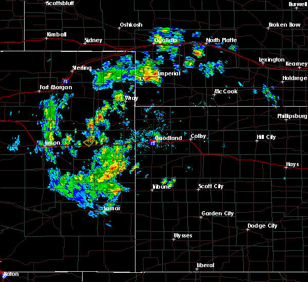 At 125 pm mdt, a severe thunderstorm was located 5 miles north of seibert, moving southwest at 15 mph (radar indicated). Hazards include 60 mph wind gusts and quarter size hail. Hail damage to vehicles is expected. Expect wind damage to roofs, siding, and trees. At 125 pm mdt, a severe thunderstorm was located 5 miles north of seibert, moving southwest at 15 mph (radar indicated). Hazards include 60 mph wind gusts and quarter size hail. Hail damage to vehicles is expected. Expect wind damage to roofs, siding, and trees.
|
| 5/26/2016 5:12 PM MDT |
 At 512 pm mdt, severe thunderstorms were located along a line extending from 10 miles east of thurman to 12 miles northeast of boyero, moving east at 25 mph (radar indicated). Hazards include 60 mph wind gusts and quarter size hail. Hail damage to vehicles is expected. Expect wind damage to roofs, siding, and trees. At 512 pm mdt, severe thunderstorms were located along a line extending from 10 miles east of thurman to 12 miles northeast of boyero, moving east at 25 mph (radar indicated). Hazards include 60 mph wind gusts and quarter size hail. Hail damage to vehicles is expected. Expect wind damage to roofs, siding, and trees.
|
| 5/7/2016 2:45 PM MDT | Quarter sized hail reported 11.2 miles S of Seibert, CO, lasted 15 minutes. hail started out as pea size. |
| 5/7/2016 2:45 PM MDT | Wind was strong enough to blow a person over. occurred same time as quarter size hail and lasted for 15 minute in kit carson county CO, 11.2 miles S of Seibert, CO |
| 5/7/2016 2:39 PM MDT |
 At 239 pm mdt, a severe thunderstorm was located near seibert, moving north at 35 mph (radar indicated). Hazards include two inch hail and 60 mph wind gusts. People and animals outdoors will be injured. expect hail damage to roofs, siding, windows, and vehicles. Expect wind damage to roofs, siding, and trees. At 239 pm mdt, a severe thunderstorm was located near seibert, moving north at 35 mph (radar indicated). Hazards include two inch hail and 60 mph wind gusts. People and animals outdoors will be injured. expect hail damage to roofs, siding, windows, and vehicles. Expect wind damage to roofs, siding, and trees.
|
| 5/7/2016 2:36 PM MDT |
 At 236 pm mdt, a severe thunderstorm was located near seibert, moving north at 30 mph (radar indicated). Hazards include golf ball size hail and 60 mph wind gusts. People and animals outdoors will be injured. expect hail damage to roofs, siding, windows, and vehicles. expect wind damage to roofs, siding, and trees. locations impacted include, seibert. this includes interstate 70 in colorado between mile markers 399 and 407. A tornado watch remains in effect until 700 pm mdt for east central colorado. At 236 pm mdt, a severe thunderstorm was located near seibert, moving north at 30 mph (radar indicated). Hazards include golf ball size hail and 60 mph wind gusts. People and animals outdoors will be injured. expect hail damage to roofs, siding, windows, and vehicles. expect wind damage to roofs, siding, and trees. locations impacted include, seibert. this includes interstate 70 in colorado between mile markers 399 and 407. A tornado watch remains in effect until 700 pm mdt for east central colorado.
|
| 5/7/2016 2:28 PM MDT |
 At 228 pm mdt, a severe thunderstorm was located near seibert, moving north at 40 mph (radar indicated). Hazards include golf ball size hail and 60 mph wind gusts. People and animals outdoors will be injured. expect hail damage to roofs, siding, windows, and vehicles. expect wind damage to roofs, siding, and trees. locations impacted include, flagler and seibert. this includes interstate 70 in colorado between mile markers 393 and 408. A tornado watch remains in effect until 700 pm mdt for east central colorado. At 228 pm mdt, a severe thunderstorm was located near seibert, moving north at 40 mph (radar indicated). Hazards include golf ball size hail and 60 mph wind gusts. People and animals outdoors will be injured. expect hail damage to roofs, siding, windows, and vehicles. expect wind damage to roofs, siding, and trees. locations impacted include, flagler and seibert. this includes interstate 70 in colorado between mile markers 393 and 408. A tornado watch remains in effect until 700 pm mdt for east central colorado.
|
| 5/7/2016 2:10 PM MDT |
 At 209 pm mdt, a severe thunderstorm was located 14 miles south of flagler, moving north at 50 mph (radar indicated). Hazards include golf ball size hail and 60 mph wind gusts. People and animals outdoors will be injured. expect hail damage to roofs, siding, windows, and vehicles. expect wind damage to roofs, siding, and trees. locations impacted include, flagler and seibert. this includes interstate 70 in colorado between mile markers 391 and 410. A tornado watch remains in effect until 700 pm mdt for east central colorado. At 209 pm mdt, a severe thunderstorm was located 14 miles south of flagler, moving north at 50 mph (radar indicated). Hazards include golf ball size hail and 60 mph wind gusts. People and animals outdoors will be injured. expect hail damage to roofs, siding, windows, and vehicles. expect wind damage to roofs, siding, and trees. locations impacted include, flagler and seibert. this includes interstate 70 in colorado between mile markers 391 and 410. A tornado watch remains in effect until 700 pm mdt for east central colorado.
|
| 5/7/2016 2:04 PM MDT |
 At 204 pm mdt, a severe thunderstorm was located 16 miles south of flagler, moving north at 55 mph (radar indicated). Hazards include 60 mph wind gusts and half dollar size hail. Hail damage to vehicles is expected. expect wind damage to roofs, siding, and trees. locations impacted include, flagler and seibert. this includes interstate 70 in colorado between mile markers 391 and 410. A tornado watch remains in effect until 700 pm mdt for east central colorado. At 204 pm mdt, a severe thunderstorm was located 16 miles south of flagler, moving north at 55 mph (radar indicated). Hazards include 60 mph wind gusts and half dollar size hail. Hail damage to vehicles is expected. expect wind damage to roofs, siding, and trees. locations impacted include, flagler and seibert. this includes interstate 70 in colorado between mile markers 391 and 410. A tornado watch remains in effect until 700 pm mdt for east central colorado.
|
| 5/7/2016 1:57 PM MDT |
 At 157 pm mdt, a severe thunderstorm was located 13 miles east of boyero, or 22 miles south of flagler, moving north at 55 mph (radar indicated). Hazards include 60 mph wind gusts and half dollar size hail. Hail damage to vehicles is expected. Expect wind damage to roofs, siding, and trees. At 157 pm mdt, a severe thunderstorm was located 13 miles east of boyero, or 22 miles south of flagler, moving north at 55 mph (radar indicated). Hazards include 60 mph wind gusts and half dollar size hail. Hail damage to vehicles is expected. Expect wind damage to roofs, siding, and trees.
|
| 8/17/2015 5:55 PM MDT |
 At 554 pm mdt, severe thunderstorms were located along a line extending from near seibert to 13 miles southeast of boyero to 6 miles southeast of karval, moving east at 20 mph (radar indicated). Hazards include 70 mph wind gusts and penny size hail. Expect considerable tree damage. damage is likely to mobile homes, roofs and outbuildings. locations impacted include, flagler, seibert, kit carson, aroya and wild horse. this includes interstate 70 in colorado between mile markers 390 and 409. A tornado watch remains in effect until 1100 pm mdt for northeastern colorado. At 554 pm mdt, severe thunderstorms were located along a line extending from near seibert to 13 miles southeast of boyero to 6 miles southeast of karval, moving east at 20 mph (radar indicated). Hazards include 70 mph wind gusts and penny size hail. Expect considerable tree damage. damage is likely to mobile homes, roofs and outbuildings. locations impacted include, flagler, seibert, kit carson, aroya and wild horse. this includes interstate 70 in colorado between mile markers 390 and 409. A tornado watch remains in effect until 1100 pm mdt for northeastern colorado.
|
| 8/17/2015 5:42 PM MDT |
 At 542 pm mdt, severe thunderstorms were located along a line extending from 10 miles north of flagler to 3 miles south of karval, moving east at 35 mph (wind speeds measured at the limon airport). Hazards include 60 mph wind gusts and nickel size hail. Expect damage to roofs. siding and trees. locations impacted include, flagler, seibert, kit carson, aroya and wild horse. this includes interstate 70 in colorado between mile markers 390 and 409. A tornado watch remains in effect until 1100 pm mdt for northeastern colorado. At 542 pm mdt, severe thunderstorms were located along a line extending from 10 miles north of flagler to 3 miles south of karval, moving east at 35 mph (wind speeds measured at the limon airport). Hazards include 60 mph wind gusts and nickel size hail. Expect damage to roofs. siding and trees. locations impacted include, flagler, seibert, kit carson, aroya and wild horse. this includes interstate 70 in colorado between mile markers 390 and 409. A tornado watch remains in effect until 1100 pm mdt for northeastern colorado.
|
| 8/17/2015 5:29 PM MDT |
 At 528 pm mdt, severe thunderstorms were located along a line extending from 11 miles north of flagler to karval, moving east at 35 mph (wind speed measured at the limon airport). Hazards include 60 mph wind gusts and quarter size hail. Hail damage to vehicles is expected. expect wind damage to roofs, siding and trees. locations impacted include, flagler, seibert, kit carson, aroya and wild horse. this includes interstate 70 in colorado between mile markers 390 and 409. A tornado watch remains in effect until 1100 pm mdt for northeastern colorado. At 528 pm mdt, severe thunderstorms were located along a line extending from 11 miles north of flagler to karval, moving east at 35 mph (wind speed measured at the limon airport). Hazards include 60 mph wind gusts and quarter size hail. Hail damage to vehicles is expected. expect wind damage to roofs, siding and trees. locations impacted include, flagler, seibert, kit carson, aroya and wild horse. this includes interstate 70 in colorado between mile markers 390 and 409. A tornado watch remains in effect until 1100 pm mdt for northeastern colorado.
|
| 8/17/2015 5:12 PM MDT |
 At 511 pm mdt, severe thunderstorms were located along a line extending from 10 miles southwest of thurman to 5 miles north of forder, moving east at 35 mph (wind speeds measured at the limon airport). Hazards include 60 mph wind gusts and half dollar size hail. Hail damage to vehicles is expected. Expect wind damage to roofs, siding and trees. At 511 pm mdt, severe thunderstorms were located along a line extending from 10 miles southwest of thurman to 5 miles north of forder, moving east at 35 mph (wind speeds measured at the limon airport). Hazards include 60 mph wind gusts and half dollar size hail. Hail damage to vehicles is expected. Expect wind damage to roofs, siding and trees.
|
| 7/30/2015 8:04 PM MDT |
 At 803 pm mdt, a severe thunderstorm was located 15 miles south of stratton, moving south at 15 mph (trained weather spotters in stratton). Hazards include 60 mph wind gusts. Expect damage to roofs. siding and trees. locations impacted include, stratton, seibert, bethune and vona. this includes the following highways, interstate 70 in colorado between mile markers 406 and 435. Highway 385 between mile markers 155 and 175. At 803 pm mdt, a severe thunderstorm was located 15 miles south of stratton, moving south at 15 mph (trained weather spotters in stratton). Hazards include 60 mph wind gusts. Expect damage to roofs. siding and trees. locations impacted include, stratton, seibert, bethune and vona. this includes the following highways, interstate 70 in colorado between mile markers 406 and 435. Highway 385 between mile markers 155 and 175.
|
| 7/30/2015 7:47 PM MDT |
 At 747 pm mdt, a severe thunderstorm was located 12 miles south of stratton, moving south at 25 mph (trained weather spotters in stratton). Hazards include 60 mph wind gusts. Expect damage to roofs. siding and trees. locations impacted include, burlington, stratton, seibert, bethune and vona. this includes the following highways, interstate 70 in colorado between mile markers 406 and 437. Highway 385 between mile markers 155 and 188. At 747 pm mdt, a severe thunderstorm was located 12 miles south of stratton, moving south at 25 mph (trained weather spotters in stratton). Hazards include 60 mph wind gusts. Expect damage to roofs. siding and trees. locations impacted include, burlington, stratton, seibert, bethune and vona. this includes the following highways, interstate 70 in colorado between mile markers 406 and 437. Highway 385 between mile markers 155 and 188.
|
| 7/30/2015 7:32 PM MDT |
 At 732 pm mdt, a severe thunderstorm was located near stratton, moving south at 15 mph (trained weather spotters in stratton reported wind gusts). Hazards include 60 mph wind gusts and nickel size hail. Expect damage to roofs. Siding and trees. At 732 pm mdt, a severe thunderstorm was located near stratton, moving south at 15 mph (trained weather spotters in stratton reported wind gusts). Hazards include 60 mph wind gusts and nickel size hail. Expect damage to roofs. Siding and trees.
|
| 7/26/2015 4:22 PM MDT | Quarter sized hail reported 3.8 miles NW of Seibert, CO, a few quarter sized hail... along with marble and nickel hail. |
| 7/19/2015 2:59 PM MDT |
 At 259 pm mdt, a severe thunderstorm was located 10 miles south of seibert, moving east at 10 mph (radar indicated). Hazards include ping pong ball size hail and 60 mph wind gusts. People and animals outdoors will be injured. expect hail damage to roofs, siding, windows and vehicles. expect wind damage to roofs, siding and trees. locations impacted include, seibert and vona. This includes interstate 70 in colorado between mile markers 399 and 416. At 259 pm mdt, a severe thunderstorm was located 10 miles south of seibert, moving east at 10 mph (radar indicated). Hazards include ping pong ball size hail and 60 mph wind gusts. People and animals outdoors will be injured. expect hail damage to roofs, siding, windows and vehicles. expect wind damage to roofs, siding and trees. locations impacted include, seibert and vona. This includes interstate 70 in colorado between mile markers 399 and 416.
|
| 7/19/2015 2:48 PM MDT |
 At 248 pm mdt, a severe thunderstorm was located 10 miles south of seibert, moving northeast at 15 mph (radar indicated). Hazards include 60 mph wind gusts and half dollar size hail. Hail damage to vehicles is expected. Expect wind damage to roofs, siding and trees. At 248 pm mdt, a severe thunderstorm was located 10 miles south of seibert, moving northeast at 15 mph (radar indicated). Hazards include 60 mph wind gusts and half dollar size hail. Hail damage to vehicles is expected. Expect wind damage to roofs, siding and trees.
|
| 7/19/2015 2:47 PM MDT | Power lines down with standing water in fields. time estimated by rada in kit carson county CO, 10.2 miles N of Seibert, CO |
| 6/11/2015 7:30 PM MDT |
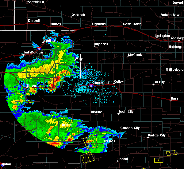 At 730 pm mdt, severe thunderstorms were located along a line extending from 12 miles north of vona to 6 miles southwest of seibert, moving southeast at 20 mph (radar indicated). Hazards include 60 mph wind gusts and quarter size hail. Hail damage to vehicles is expected. expect wind damage to roofs, siding and trees. locations impacted include, seibert. This includes interstate 70 in colorado between mile markers 398 and 409. At 730 pm mdt, severe thunderstorms were located along a line extending from 12 miles north of vona to 6 miles southwest of seibert, moving southeast at 20 mph (radar indicated). Hazards include 60 mph wind gusts and quarter size hail. Hail damage to vehicles is expected. expect wind damage to roofs, siding and trees. locations impacted include, seibert. This includes interstate 70 in colorado between mile markers 398 and 409.
|
| 6/11/2015 7:04 PM MDT |
 At 703 pm mdt, severe thunderstorms were located along a line extending from 9 miles southeast of thurman to near flagler, moving southeast at 15 mph (radar indicated). Hazards include 60 mph wind gusts and quarter size hail. Hail damage to vehicles is expected. Expect wind damage to roofs, siding and trees. At 703 pm mdt, severe thunderstorms were located along a line extending from 9 miles southeast of thurman to near flagler, moving southeast at 15 mph (radar indicated). Hazards include 60 mph wind gusts and quarter size hail. Hail damage to vehicles is expected. Expect wind damage to roofs, siding and trees.
|
| 6/5/2015 5:09 PM MDT | Hen Egg sized hail reported 13.6 miles SSW of Seibert, CO, average size of the hail was nickel. |
| 6/5/2015 4:44 PM MDT | At 444 pm mdt, a severe thunderstorm capable of producing a tornado was located 5 miles north of seibert, moving north at 15 mph (radar indicated rotation). Hazards include tornado and hail up to two inches in diameter. Flying debris will be dangerous to those caught without shelter. mobile homes will be damaged or destroyed. damage to roofs, windows and vehicles will occur. Tree damage is likely. |
| 5/28/2015 2:59 PM MDT | At 259 pm mdt, a severe thunderstorm was located near vona, or 6 miles northeast of seibert, moving east at 15 mph (radar indicated). Hazards include 60 mph wind gusts and quarter size hail. Hail damage to vehicles is expected. Expect wind damage to roofs, siding and trees. |
| 6/25/2014 8:11 PM MDT | Half Dollar sized hail reported 13.6 miles SSW of Seibert, CO, damaged shingles. broken car windows. 0.45 inches of rainfall in 6 minutes. |
| 6/25/2014 7:59 PM MDT | Quarter sized hail reported 17.5 miles S of Seibert, CO |
| 5/20/2014 8:39 PM MDT | Quarter sized hail reported 13.6 miles SSW of Seibert, CO, 1.00 inch hail lasted for 5 minutes and damaged shingles. |
| 5/20/2014 8:34 PM MDT | Ping Pong Ball sized hail reported 11.9 miles S of Seibert, CO, quarter size to 1.50 inch diameter hail near mile marker 53 e of highway 59 |
| 5/20/2014 8:27 PM MDT | Hen Egg sized hail reported 0.2 miles SW of Seibert, CO |
| 5/20/2014 7:55 PM MDT | Golf Ball sized hail reported 2.2 miles S of Seibert, CO |
| 6/15/2013 6:11 PM MDT | Storm damage reported in kit carson county CO, 0.2 miles SW of Seibert, CO |
| 5/29/2013 2:46 PM MDT | Half Dollar sized hail reported 0.2 miles SW of Seibert, CO, spotter found hail slightly larger than quarters on his deck when he came home. time is estimated by radar. |
| 9/26/2012 6:20 PM MDT | Quarter sized hail reported 2.3 miles W of Seibert, CO, hail up to 2 inches deep on highway 24 |
| 6/15/2012 6:37 PM MDT | Ping Pong Ball sized hail reported 0.2 miles SW of Seibert, CO, near mile marker 400 along i-70. |
| 1/1/0001 12:00 AM | Sustained wind of 40 mp in kit carson county CO, 0.2 miles SW of Seibert, CO |
| 1/1/0001 12:00 AM | Half Dollar sized hail reported 8.8 miles N of Seibert, CO |
| 1/1/0001 12:00 AM | Quarter sized hail reported 8.8 miles N of Seibert, CO |
| 1/1/0001 12:00 AM | Storm damage reported in kit carson county CO, 4.7 miles SE of Seibert, CO |
| 1/1/0001 12:00 AM | Storm damage reported in kit carson county CO, 0.2 miles SW of Seibert, CO |
| 1/1/0001 12:00 AM | Storm damage reported in kit carson county CO, 9.8 miles S of Seibert, CO |
Hail Maps for Seibert, CO
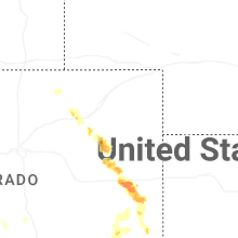
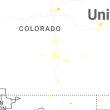
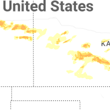
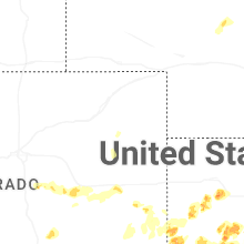


Connect with Interactive Hail Maps