

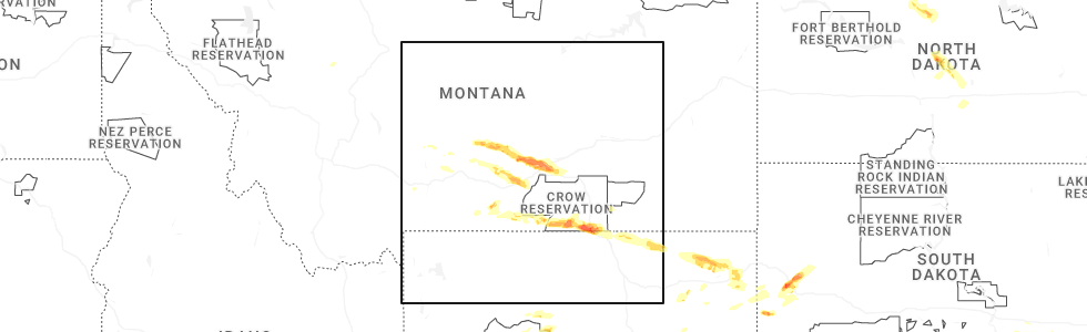
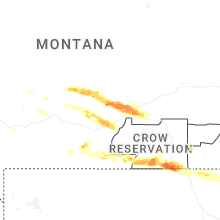
Hail Map for Shawmut, MT
The Shawmut, MT area has had 7 reports of on-the-ground hail by trained spotters, and has been under severe weather warnings 4 times during the past 12 months. Doppler radar has detected hail at or near Shawmut, MT on 33 occasions, including 2 occasions during the past year.
| Name: | Shawmut, MT |
| Where Located: | 62.1 miles NW of Billings, MT |
| Map: | Google Map for Shawmut, MT |
| Population: | 42 |
| Housing Units: | 34 |
| More Info: | Search Google for Shawmut, MT |
0
The Top Recent Hail Date for Shawmut, MT is Monday, June 16, 2025 (31st out of 33)
Hail and Wind Damage Spotted near Shawmut, MT
| Date / Time | Report Details |
|---|---|
| 6/16/2025 3:18 PM MDT | At 318 pm mdt, a severe thunderstorm was located 7 miles south of deadmans basin reservoir, or 24 miles southeast of harlowton, moving east at 25 mph (radar indicated). Hazards include 60 mph wind gusts and half dollar size hail. Hail damage to vehicles is expected. expect wind damage to roofs, siding, and trees. Locations impacted include, ryegate and deadmans basin reservoir. |
| 6/16/2025 3:02 PM MDT |
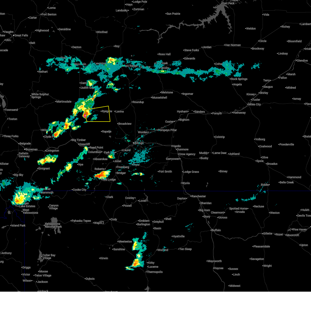 Svrbyz the national weather service in billings has issued a * severe thunderstorm warning for, southwestern golden valley county in central montana, southeastern wheatland county in central montana, * until 345 pm mdt. * at 302 pm mdt, a severe thunderstorm was located 10 miles southwest of deadmans basin reservoir, or 20 miles southeast of harlowton, moving east at 25 mph (radar indicated). Hazards include 60 mph wind gusts and quarter size hail. Hail damage to vehicles is expected. Expect wind damage to roofs, siding, and trees. Svrbyz the national weather service in billings has issued a * severe thunderstorm warning for, southwestern golden valley county in central montana, southeastern wheatland county in central montana, * until 345 pm mdt. * at 302 pm mdt, a severe thunderstorm was located 10 miles southwest of deadmans basin reservoir, or 20 miles southeast of harlowton, moving east at 25 mph (radar indicated). Hazards include 60 mph wind gusts and quarter size hail. Hail damage to vehicles is expected. Expect wind damage to roofs, siding, and trees.
|
| 6/13/2025 3:44 PM MDT |
 At 344 pm mdt, a severe thunderstorm was located over deadmans basin reservoir, or 21 miles east of harlowton, moving east at 30 mph (radar indicated). Hazards include two inch hail and 70 mph wind gusts. People and animals outdoors will be injured. expect hail damage to roofs, siding, windows, and vehicles. expect considerable tree damage. wind damage is also likely to mobile homes, roofs, and outbuildings. Locations impacted include, ryegate, deadmans basin reservoir and franklin. At 344 pm mdt, a severe thunderstorm was located over deadmans basin reservoir, or 21 miles east of harlowton, moving east at 30 mph (radar indicated). Hazards include two inch hail and 70 mph wind gusts. People and animals outdoors will be injured. expect hail damage to roofs, siding, windows, and vehicles. expect considerable tree damage. wind damage is also likely to mobile homes, roofs, and outbuildings. Locations impacted include, ryegate, deadmans basin reservoir and franklin.
|
| 6/13/2025 3:08 PM MDT |
 Svrbyz the national weather service in billings has issued a * severe thunderstorm warning for, southwestern golden valley county in central montana, southeastern wheatland county in central montana, * until 415 pm mdt. * at 308 pm mdt, a severe thunderstorm was located near harlowton, moving east at 30 mph (radar indicated). Hazards include tennis ball size hail and 70 mph wind gusts. People and animals outdoors will be injured. expect hail damage to roofs, siding, windows, and vehicles. expect considerable tree damage. Wind damage is also likely to mobile homes, roofs, and outbuildings. Svrbyz the national weather service in billings has issued a * severe thunderstorm warning for, southwestern golden valley county in central montana, southeastern wheatland county in central montana, * until 415 pm mdt. * at 308 pm mdt, a severe thunderstorm was located near harlowton, moving east at 30 mph (radar indicated). Hazards include tennis ball size hail and 70 mph wind gusts. People and animals outdoors will be injured. expect hail damage to roofs, siding, windows, and vehicles. expect considerable tree damage. Wind damage is also likely to mobile homes, roofs, and outbuildings.
|
| 6/30/2024 5:42 PM MDT |
 The storm which prompted the warning has weakened below severe limits, and no longer poses an immediate threat to life or property. therefore, the warning will be allowed to expire. a severe thunderstorm watch remains in effect until 800 pm mdt for central montana. The storm which prompted the warning has weakened below severe limits, and no longer poses an immediate threat to life or property. therefore, the warning will be allowed to expire. a severe thunderstorm watch remains in effect until 800 pm mdt for central montana.
|
| 6/30/2024 5:31 PM MDT |
 At 530 pm mdt, a severe thunderstorm was located 13 miles south of harlowton, moving northeast at 60 mph (radar indicated). Hazards include 60 mph wind gusts and nickel size hail. Expect damage to roofs, siding, and trees. Locations impacted include, harlowton, deadmans basin reservoir, and shawmut. At 530 pm mdt, a severe thunderstorm was located 13 miles south of harlowton, moving northeast at 60 mph (radar indicated). Hazards include 60 mph wind gusts and nickel size hail. Expect damage to roofs, siding, and trees. Locations impacted include, harlowton, deadmans basin reservoir, and shawmut.
|
| 6/30/2024 5:16 PM MDT |
 Svrbyz the national weather service in billings has issued a * severe thunderstorm warning for, southeastern wheatland county in central montana, west central golden valley county in central montana, north central sweet grass county in south central montana, * until 545 pm mdt. * at 515 pm mdt, a severe thunderstorm was located 18 miles north of big timber, moving northeast at 60 mph (radar indicated). Hazards include 60 mph wind gusts and quarter size hail. Hail damage to vehicles is expected. Expect wind damage to roofs, siding, and trees. Svrbyz the national weather service in billings has issued a * severe thunderstorm warning for, southeastern wheatland county in central montana, west central golden valley county in central montana, north central sweet grass county in south central montana, * until 545 pm mdt. * at 515 pm mdt, a severe thunderstorm was located 18 miles north of big timber, moving northeast at 60 mph (radar indicated). Hazards include 60 mph wind gusts and quarter size hail. Hail damage to vehicles is expected. Expect wind damage to roofs, siding, and trees.
|
| 7/15/2022 2:06 PM MDT |
 The severe thunderstorm warning for eastern wheatland county will expire at 215 pm mdt, the storm which prompted the warning has weakened below severe limits, and no longer poses an immediate threat to life or property. therefore, the warning will be allowed to expire. a severe thunderstorm watch remains in effect until 700 pm mdt for central montana. The severe thunderstorm warning for eastern wheatland county will expire at 215 pm mdt, the storm which prompted the warning has weakened below severe limits, and no longer poses an immediate threat to life or property. therefore, the warning will be allowed to expire. a severe thunderstorm watch remains in effect until 700 pm mdt for central montana.
|
| 7/15/2022 1:45 PM MDT |
 At 144 pm mdt, a severe thunderstorm was located 8 miles south of harlowton, moving northeast at 45 mph (trained weather spotters). Hazards include 60 mph wind gusts. Expect damage to roofs, siding, and trees. locations impacted include, harlowton, deadmans basin reservoir and shawmut. hail threat, radar indicated max hail size, <. 75 in wind threat, observed max wind gust, 60 mph. At 144 pm mdt, a severe thunderstorm was located 8 miles south of harlowton, moving northeast at 45 mph (trained weather spotters). Hazards include 60 mph wind gusts. Expect damage to roofs, siding, and trees. locations impacted include, harlowton, deadmans basin reservoir and shawmut. hail threat, radar indicated max hail size, <. 75 in wind threat, observed max wind gust, 60 mph.
|
| 7/15/2022 1:17 PM MDT |
 At 116 pm mdt, a severe thunderstorm was located 12 miles west of harlowton, moving northeast at 35 mph (trained weather spotters). Hazards include 60 mph wind gusts. expect damage to roofs, siding, and trees At 116 pm mdt, a severe thunderstorm was located 12 miles west of harlowton, moving northeast at 35 mph (trained weather spotters). Hazards include 60 mph wind gusts. expect damage to roofs, siding, and trees
|
| 7/9/2022 6:26 PM MDT |
 At 625 pm mdt, severe thunderstorms were located along a line extending from 18 miles south of moore to 7 miles east of harlowton, moving east at 35 mph (radar indicated). Hazards include ping pong ball size hail and 60 mph wind gusts. People and animals outdoors will be injured. expect hail and wind damage to roofs, siding, windows, and vehicles. severe thunderstorms will be near, deadmans basin reservoir around 645 pm mdt. other locations impacted by these severe thunderstorms include franklin, judith gap and shawmut. this replaces the warning previously in effect for this area. hail threat, radar indicated max hail size, 1. 50 in wind threat, radar indicated max wind gust, 60 mph. At 625 pm mdt, severe thunderstorms were located along a line extending from 18 miles south of moore to 7 miles east of harlowton, moving east at 35 mph (radar indicated). Hazards include ping pong ball size hail and 60 mph wind gusts. People and animals outdoors will be injured. expect hail and wind damage to roofs, siding, windows, and vehicles. severe thunderstorms will be near, deadmans basin reservoir around 645 pm mdt. other locations impacted by these severe thunderstorms include franklin, judith gap and shawmut. this replaces the warning previously in effect for this area. hail threat, radar indicated max hail size, 1. 50 in wind threat, radar indicated max wind gust, 60 mph.
|
| 7/9/2022 6:18 PM MDT |
 At 617 pm mdt, a severe thunderstorm was located over harlowton, moving northeast at 30 mph (radar indicated). Hazards include golf ball size hail and 60 mph wind gusts. People and animals outdoors will be injured. expect hail and wind damage to roofs, siding, windows, and vehicles. This severe thunderstorm will remain over mainly rural areas of eastern wheatland county, including the following locations, shawmut. At 617 pm mdt, a severe thunderstorm was located over harlowton, moving northeast at 30 mph (radar indicated). Hazards include golf ball size hail and 60 mph wind gusts. People and animals outdoors will be injured. expect hail and wind damage to roofs, siding, windows, and vehicles. This severe thunderstorm will remain over mainly rural areas of eastern wheatland county, including the following locations, shawmut.
|
| 7/9/2022 6:03 PM MDT |
 At 602 pm mdt, a severe thunderstorm was located near harlowton, moving northeast at 35 mph (radar indicated). Hazards include golf ball size hail and 60 mph wind gusts. People and animals outdoors will be injured. expect hail and wind damage to roofs, siding, windows, and vehicles. this severe storm will be near, harlowton around 615 pm mdt. Other locations impacted by this severe thunderstorm include shawmut. At 602 pm mdt, a severe thunderstorm was located near harlowton, moving northeast at 35 mph (radar indicated). Hazards include golf ball size hail and 60 mph wind gusts. People and animals outdoors will be injured. expect hail and wind damage to roofs, siding, windows, and vehicles. this severe storm will be near, harlowton around 615 pm mdt. Other locations impacted by this severe thunderstorm include shawmut.
|
| 7/9/2022 5:52 PM MDT |
 At 551 pm mdt, a severe thunderstorm was located 11 miles southwest of harlowton, moving northeast at 40 mph (radar indicated). Hazards include 60 mph wind gusts and half dollar size hail. Hail damage to vehicles is expected. expect wind damage to roofs, siding, and trees. this severe thunderstorm will be near, harlowton around 610 pm mdt. other locations impacted by this severe thunderstorm include shawmut and twodot. hail threat, radar indicated max hail size, 1. 25 in wind threat, radar indicated max wind gust, 60 mph. At 551 pm mdt, a severe thunderstorm was located 11 miles southwest of harlowton, moving northeast at 40 mph (radar indicated). Hazards include 60 mph wind gusts and half dollar size hail. Hail damage to vehicles is expected. expect wind damage to roofs, siding, and trees. this severe thunderstorm will be near, harlowton around 610 pm mdt. other locations impacted by this severe thunderstorm include shawmut and twodot. hail threat, radar indicated max hail size, 1. 25 in wind threat, radar indicated max wind gust, 60 mph.
|
| 7/7/2022 5:27 PM MDT |
 At 527 pm mdt, a severe thunderstorm was located 10 miles south of deadmans basin reservoir, or 23 miles southeast of harlowton, moving east at 10 mph (radar indicated). Hazards include 60 mph wind gusts and quarter size hail. Hail damage to vehicles is expected. expect wind damage to roofs, siding, and trees. locations impacted include, ryegate, deadmans basin reservoir, franklin and shawmut. hail threat, radar indicated max hail size, 1. 00 in wind threat, radar indicated max wind gust, 60 mph. At 527 pm mdt, a severe thunderstorm was located 10 miles south of deadmans basin reservoir, or 23 miles southeast of harlowton, moving east at 10 mph (radar indicated). Hazards include 60 mph wind gusts and quarter size hail. Hail damage to vehicles is expected. expect wind damage to roofs, siding, and trees. locations impacted include, ryegate, deadmans basin reservoir, franklin and shawmut. hail threat, radar indicated max hail size, 1. 00 in wind threat, radar indicated max wind gust, 60 mph.
|
| 7/7/2022 5:18 PM MDT | Quarter sized hail reported 12.3 miles NE of Shawmut, MT |
| 7/7/2022 5:05 PM MDT |
 At 505 pm mdt, a severe thunderstorm was located 12 miles southwest of deadmans basin reservoir, or 22 miles southeast of harlowton, moving east at 10 mph (radar indicated). Hazards include 60 mph wind gusts and quarter size hail. Hail damage to vehicles is expected. Expect wind damage to roofs, siding, and trees. At 505 pm mdt, a severe thunderstorm was located 12 miles southwest of deadmans basin reservoir, or 22 miles southeast of harlowton, moving east at 10 mph (radar indicated). Hazards include 60 mph wind gusts and quarter size hail. Hail damage to vehicles is expected. Expect wind damage to roofs, siding, and trees.
|
| 7/4/2022 7:13 PM MDT |
 At 711 pm mdt, a severe thunderstorm was located over harlowton, moving northeast at 30 mph. additional severe storms were located over far northeast wheatland county, moving northeast at 25 mph (radar indicated). Hazards include ping pong ball size hail and 60 mph wind gusts. People and animals outdoors will be injured. expect hail damage to roofs, siding, windows, and vehicles. expect wind damage to roofs, siding, and trees. this severe thunderstorm will remain over mainly rural areas of eastern wheatland and north central golden valley counties. this replaces the previous warning for this area. hail threat, observed max hail size, 1. 50 in wind threat, radar indicated max wind gust, 60 mph. At 711 pm mdt, a severe thunderstorm was located over harlowton, moving northeast at 30 mph. additional severe storms were located over far northeast wheatland county, moving northeast at 25 mph (radar indicated). Hazards include ping pong ball size hail and 60 mph wind gusts. People and animals outdoors will be injured. expect hail damage to roofs, siding, windows, and vehicles. expect wind damage to roofs, siding, and trees. this severe thunderstorm will remain over mainly rural areas of eastern wheatland and north central golden valley counties. this replaces the previous warning for this area. hail threat, observed max hail size, 1. 50 in wind threat, radar indicated max wind gust, 60 mph.
|
| 7/4/2022 6:52 PM MDT |
 At 652 pm mdt, a severe thunderstorm was located near harlowton, moving northeast at 30 mph (radar indicated). Hazards include 60 mph wind gusts and half dollar size hail. Hail damage to vehicles is expected. expect wind damage to roofs, siding, and trees. this severe thunderstorm will be near, harlowton around 705 pm mdt. hail threat, radar indicated max hail size, 1. 25 in wind threat, radar indicated max wind gust, 60 mph. At 652 pm mdt, a severe thunderstorm was located near harlowton, moving northeast at 30 mph (radar indicated). Hazards include 60 mph wind gusts and half dollar size hail. Hail damage to vehicles is expected. expect wind damage to roofs, siding, and trees. this severe thunderstorm will be near, harlowton around 705 pm mdt. hail threat, radar indicated max hail size, 1. 25 in wind threat, radar indicated max wind gust, 60 mph.
|
| 9/3/2021 4:25 PM MDT |
 At 425 pm mdt, a severe thunderstorm was located near deadmans basin reservoir, or 21 miles east of harlowton, moving southeast at 20 mph (radar indicated). Hazards include 60 mph wind gusts and quarter size hail. Hail damage to vehicles is expected. expect wind damage to roofs, siding, and trees. locations impacted include, ryegate, deadmans basin reservoir, franklin and shawmut. hail threat, radar indicated max hail size, 1. 00 in wind threat, radar indicated max wind gust, 60 mph. At 425 pm mdt, a severe thunderstorm was located near deadmans basin reservoir, or 21 miles east of harlowton, moving southeast at 20 mph (radar indicated). Hazards include 60 mph wind gusts and quarter size hail. Hail damage to vehicles is expected. expect wind damage to roofs, siding, and trees. locations impacted include, ryegate, deadmans basin reservoir, franklin and shawmut. hail threat, radar indicated max hail size, 1. 00 in wind threat, radar indicated max wind gust, 60 mph.
|
| 9/3/2021 4:05 PM MDT |
 At 404 pm mdt, a severe thunderstorm was located 8 miles northwest of deadmans basin reservoir, or 16 miles east of harlowton, moving southeast at 20 mph (radar indicated). Hazards include 60 mph wind gusts and quarter size hail. Hail damage to vehicles is expected. Expect wind damage to roofs, siding, and trees. At 404 pm mdt, a severe thunderstorm was located 8 miles northwest of deadmans basin reservoir, or 16 miles east of harlowton, moving southeast at 20 mph (radar indicated). Hazards include 60 mph wind gusts and quarter size hail. Hail damage to vehicles is expected. Expect wind damage to roofs, siding, and trees.
|
| 7/7/2021 6:14 PM MDT |
 At 612 pm mdt, severe thunderstorms were located along a line extending from 9 miles northeast of harlowton to 15 miles south of deadmans basin reservoir to 15 miles northwest of columbus to 11 miles southwest of absarokee, moving east at 50 mph (radar indicated). Hazards include 60 mph wind gusts. penny size hail is possible with strongest storms along the line. Expect damage to roofs, siding, and trees. this storm has a history of producing 60 mph wind gusts. Locations impacted include, columbus, harlowton, ryegate, deadmans basin reservoir, absarokee, franklin, reed point, halfbreed lake wildlife, fishtail, shawmut, hailstone wildlife refuge, dean, cooney reservoir state park, nye, roscoe and rapelje. At 612 pm mdt, severe thunderstorms were located along a line extending from 9 miles northeast of harlowton to 15 miles south of deadmans basin reservoir to 15 miles northwest of columbus to 11 miles southwest of absarokee, moving east at 50 mph (radar indicated). Hazards include 60 mph wind gusts. penny size hail is possible with strongest storms along the line. Expect damage to roofs, siding, and trees. this storm has a history of producing 60 mph wind gusts. Locations impacted include, columbus, harlowton, ryegate, deadmans basin reservoir, absarokee, franklin, reed point, halfbreed lake wildlife, fishtail, shawmut, hailstone wildlife refuge, dean, cooney reservoir state park, nye, roscoe and rapelje.
|
| 7/7/2021 5:49 PM MDT |
 At 546 pm mdt, severe thunderstorms were located along a line extending from 17 miles west of harlowton to 6 miles southeast of big timber to 25 miles north of cooke city, moving east at 40 mph (radar indicated. at 540pm a gust of 60 mph was reported at the big timber airport). Hazards include 60 mph wind gusts. quarter size hail is possible with the stronger storms along the line. Hail damage to vehicles is expected. Expect wind damage to roofs, siding, and trees. At 546 pm mdt, severe thunderstorms were located along a line extending from 17 miles west of harlowton to 6 miles southeast of big timber to 25 miles north of cooke city, moving east at 40 mph (radar indicated. at 540pm a gust of 60 mph was reported at the big timber airport). Hazards include 60 mph wind gusts. quarter size hail is possible with the stronger storms along the line. Hail damage to vehicles is expected. Expect wind damage to roofs, siding, and trees.
|
| 6/5/2021 12:07 AM MDT |
 The severe thunderstorm warning for east central wheatland county will expire at 1215 am mdt, the storm which prompted the warning has weakened below severe limits, and no longer poses an immediate threat to life or property. therefore, the warning will be allowed to expire. The severe thunderstorm warning for east central wheatland county will expire at 1215 am mdt, the storm which prompted the warning has weakened below severe limits, and no longer poses an immediate threat to life or property. therefore, the warning will be allowed to expire.
|
| 6/4/2021 11:55 PM MDT |
 At 1155 pm mdt, a severe thunderstorm was located 9 miles northwest of deadmans basin reservoir, or 15 miles east of harlowton, moving northeast at 35 mph (radar indicated). Hazards include 60 mph wind gusts and nickel size hail. Expect damage to roofs, siding, and trees. This severe thunderstorm will remain over mainly rural areas of east central wheatland county. At 1155 pm mdt, a severe thunderstorm was located 9 miles northwest of deadmans basin reservoir, or 15 miles east of harlowton, moving northeast at 35 mph (radar indicated). Hazards include 60 mph wind gusts and nickel size hail. Expect damage to roofs, siding, and trees. This severe thunderstorm will remain over mainly rural areas of east central wheatland county.
|
| 6/4/2021 11:41 PM MDT |
 At 1141 pm mdt, a severe thunderstorm was located 7 miles east of harlowton, moving northeast at 35 mph (radar indicated). Hazards include 60 mph wind gusts and nickel size hail. expect damage to roofs, siding, and trees At 1141 pm mdt, a severe thunderstorm was located 7 miles east of harlowton, moving northeast at 35 mph (radar indicated). Hazards include 60 mph wind gusts and nickel size hail. expect damage to roofs, siding, and trees
|
| 8/25/2020 7:15 PM MDT | Storm damage reported in wheatland county MT, 5.2 miles W of Shawmut, MT |
| 7/23/2020 5:42 PM MDT |
 At 523 pm mdt, severe thunderstorms were located along a line extending from 8 miles northeast of ryegate to 6 miles west of joliet, moving east at 50 mph (radar indicated). Hazards include 60 mph wind gusts. a wind gust of 61 mph was reported at the big timber airport at 4:40 pm mdt. Expect damage to roofs, siding, and trees. Locations impacted include, columbus, bridger, joliet, fromberg, ryegate, deadmans basin reservoir, absarokee, lavina, franklin, reed point, halfbreed lake wildlife, edgar, fishtail, boyd, shawmut, hailstone wildlife refuge, roberts, molt, cooney reservoir state park and park city. At 523 pm mdt, severe thunderstorms were located along a line extending from 8 miles northeast of ryegate to 6 miles west of joliet, moving east at 50 mph (radar indicated). Hazards include 60 mph wind gusts. a wind gust of 61 mph was reported at the big timber airport at 4:40 pm mdt. Expect damage to roofs, siding, and trees. Locations impacted include, columbus, bridger, joliet, fromberg, ryegate, deadmans basin reservoir, absarokee, lavina, franklin, reed point, halfbreed lake wildlife, edgar, fishtail, boyd, shawmut, hailstone wildlife refuge, roberts, molt, cooney reservoir state park and park city.
|
| 7/23/2020 5:24 PM MDT |
 At 523 pm mdt, severe thunderstorms were located along a line extending from 8 miles northeast of ryegate to 6 miles west of joliet, moving east at 50 mph (radar indicated). Hazards include 60 mph wind gusts. a wind gust of 61 mph was reported at the big timber airport at 4:40 pm mdt. Expect damage to roofs, siding, and trees. Locations impacted include, columbus, bridger, joliet, fromberg, ryegate, deadmans basin reservoir, absarokee, lavina, franklin, reed point, halfbreed lake wildlife, edgar, fishtail, boyd, shawmut, hailstone wildlife refuge, roberts, molt, cooney reservoir state park and park city. At 523 pm mdt, severe thunderstorms were located along a line extending from 8 miles northeast of ryegate to 6 miles west of joliet, moving east at 50 mph (radar indicated). Hazards include 60 mph wind gusts. a wind gust of 61 mph was reported at the big timber airport at 4:40 pm mdt. Expect damage to roofs, siding, and trees. Locations impacted include, columbus, bridger, joliet, fromberg, ryegate, deadmans basin reservoir, absarokee, lavina, franklin, reed point, halfbreed lake wildlife, edgar, fishtail, boyd, shawmut, hailstone wildlife refuge, roberts, molt, cooney reservoir state park and park city.
|
| 7/23/2020 5:10 PM MDT |
 At 508 pm mdt, severe thunderstorms were located along a line extending from near deadmans basin reservoir to near absarokee, moving east at 50 mph (radar indicated. a wind gust of 61 mph was reported at the big timber airport at 4:40 pm mdt). Hazards include 60 mph wind gusts. expect damage to roofs, siding, and trees At 508 pm mdt, severe thunderstorms were located along a line extending from near deadmans basin reservoir to near absarokee, moving east at 50 mph (radar indicated. a wind gust of 61 mph was reported at the big timber airport at 4:40 pm mdt). Hazards include 60 mph wind gusts. expect damage to roofs, siding, and trees
|
| 5/19/2020 8:21 PM MDT |
 The severe thunderstorm warning for southeastern wheatland county will expire at 830 pm mdt, the storm which prompted the warning has moved out of the area. therefore, the warning will be allowed to expire. a severe thunderstorm watch remains in effect until 1000 pm mdt for central montana. The severe thunderstorm warning for southeastern wheatland county will expire at 830 pm mdt, the storm which prompted the warning has moved out of the area. therefore, the warning will be allowed to expire. a severe thunderstorm watch remains in effect until 1000 pm mdt for central montana.
|
| 5/19/2020 7:52 PM MDT |
 At 751 pm mdt, a severe thunderstorm was located near deadmans basin reservoir, or 16 miles east of harlowton, moving northeast at 25 mph (radar indicated). Hazards include ping pong ball size hail. People and animals outdoors will be injured. expect damage to roofs, siding, windows, and vehicles. Locations impacted include, deadmans basin reservoir and shawmut. At 751 pm mdt, a severe thunderstorm was located near deadmans basin reservoir, or 16 miles east of harlowton, moving northeast at 25 mph (radar indicated). Hazards include ping pong ball size hail. People and animals outdoors will be injured. expect damage to roofs, siding, windows, and vehicles. Locations impacted include, deadmans basin reservoir and shawmut.
|
| 5/19/2020 7:24 PM MDT |
 At 723 pm mdt, a severe thunderstorm was located 11 miles southwest of deadmans basin reservoir, or 14 miles southeast of harlowton, moving northeast at 25 mph (radar indicated). Hazards include half dollar size hail. damage to vehicles is expected At 723 pm mdt, a severe thunderstorm was located 11 miles southwest of deadmans basin reservoir, or 14 miles southeast of harlowton, moving northeast at 25 mph (radar indicated). Hazards include half dollar size hail. damage to vehicles is expected
|
| 8/11/2019 4:45 PM MDT | Ping Pong Ball sized hail reported 0.5 miles SSE of Shawmut, MT, social media photo. |
| 8/11/2019 4:27 PM MDT |
 At 424 pm mdt, a severe thunderstorm was located 11 miles southeast of harlowton, moving northeast at 40 mph (radar indicated). Hazards include 60 mph wind gusts and quarter size hail. Hail damage to vehicles is expected. Expect wind damage to roofs, siding, and trees. At 424 pm mdt, a severe thunderstorm was located 11 miles southeast of harlowton, moving northeast at 40 mph (radar indicated). Hazards include 60 mph wind gusts and quarter size hail. Hail damage to vehicles is expected. Expect wind damage to roofs, siding, and trees.
|
| 8/11/2019 3:41 PM MDT |
 At 341 pm mdt, a severe thunderstorm was located 9 miles east of harlowton, moving northeast at 35 mph (radar indicated). Hazards include 60 mph wind gusts and quarter size hail. Hail damage to vehicles is expected. Expect wind damage to roofs, siding, and trees. At 341 pm mdt, a severe thunderstorm was located 9 miles east of harlowton, moving northeast at 35 mph (radar indicated). Hazards include 60 mph wind gusts and quarter size hail. Hail damage to vehicles is expected. Expect wind damage to roofs, siding, and trees.
|
| 8/11/2019 3:23 PM MDT |
 At 321 pm mdt, a severe thunderstorm was located 12 miles south of harlowton, moving northeast at 40 mph (trained weather spotters reported quarter size hail in melville). Hazards include 60 mph wind gusts and quarter size hail. Hail damage to vehicles is expected. expect wind damage to roofs, siding, and trees. Locations impacted include, harlowton, melville and shawmut. At 321 pm mdt, a severe thunderstorm was located 12 miles south of harlowton, moving northeast at 40 mph (trained weather spotters reported quarter size hail in melville). Hazards include 60 mph wind gusts and quarter size hail. Hail damage to vehicles is expected. expect wind damage to roofs, siding, and trees. Locations impacted include, harlowton, melville and shawmut.
|
| 8/11/2019 3:07 PM MDT |
 At 306 pm mdt, a severe thunderstorm was located 18 miles south of harlowton, moving northeast at 40 mph (trained weather spotters reported quarter size hail near melville). Hazards include 60 mph wind gusts and quarter size hail. Hail damage to vehicles is expected. expect wind damage to roofs, siding, and trees. Locations impacted include, harlowton, melville and shawmut. At 306 pm mdt, a severe thunderstorm was located 18 miles south of harlowton, moving northeast at 40 mph (trained weather spotters reported quarter size hail near melville). Hazards include 60 mph wind gusts and quarter size hail. Hail damage to vehicles is expected. expect wind damage to roofs, siding, and trees. Locations impacted include, harlowton, melville and shawmut.
|
| 8/11/2019 2:55 PM MDT |
 At 255 pm mdt, a severe thunderstorm was located 18 miles north of big timber, moving northeast at 40 mph (radar indicated). Hazards include 60 mph wind gusts and quarter size hail. Hail damage to vehicles is expected. Expect wind damage to roofs, siding, and trees. At 255 pm mdt, a severe thunderstorm was located 18 miles north of big timber, moving northeast at 40 mph (radar indicated). Hazards include 60 mph wind gusts and quarter size hail. Hail damage to vehicles is expected. Expect wind damage to roofs, siding, and trees.
|
| 8/10/2019 8:55 PM MDT |
 At 855 pm mdt, severe thunderstorms were located along a line extending from 20 miles south of hobson to 13 miles southwest of harlowton, moving east at 25 mph (radar indicated). Hazards include 60 mph wind gusts and half dollar size hail. Hail damage to vehicles is expected. Expect wind damage to roofs, siding, and trees. At 855 pm mdt, severe thunderstorms were located along a line extending from 20 miles south of hobson to 13 miles southwest of harlowton, moving east at 25 mph (radar indicated). Hazards include 60 mph wind gusts and half dollar size hail. Hail damage to vehicles is expected. Expect wind damage to roofs, siding, and trees.
|
| 8/10/2019 5:25 PM MDT |
 The severe thunderstorm warning for southeastern wheatland and southwestern golden valley counties will expire at 530 pm mdt, the storm which prompted the warning has weakened below severe limits, and no longer poses an immediate threat to life or property. therefore, the warning will be allowed to expire. however small hail is still possible with this thunderstorm. a severe thunderstorm watch remains in effect until 1000 pm mdt for central and south central montana. The severe thunderstorm warning for southeastern wheatland and southwestern golden valley counties will expire at 530 pm mdt, the storm which prompted the warning has weakened below severe limits, and no longer poses an immediate threat to life or property. therefore, the warning will be allowed to expire. however small hail is still possible with this thunderstorm. a severe thunderstorm watch remains in effect until 1000 pm mdt for central and south central montana.
|
| 8/10/2019 5:06 PM MDT |
 At 506 pm mdt, a severe thunderstorm was located 13 miles southwest of deadmans basin reservoir, or 21 miles southeast of harlowton, moving east at 15 mph (radar indicated). Hazards include 60 mph wind gusts and quarter size hail. Hail damage to vehicles is expected. expect wind damage to roofs, siding, and trees. Locations impacted include, shawmut. At 506 pm mdt, a severe thunderstorm was located 13 miles southwest of deadmans basin reservoir, or 21 miles southeast of harlowton, moving east at 15 mph (radar indicated). Hazards include 60 mph wind gusts and quarter size hail. Hail damage to vehicles is expected. expect wind damage to roofs, siding, and trees. Locations impacted include, shawmut.
|
| 8/10/2019 4:49 PM MDT |
 At 448 pm mdt, a severe thunderstorm was located 17 miles southwest of deadmans basin reservoir, or 20 miles south of harlowton, moving east at 20 mph (radar indicated. spotters reported quarter size hail 10 miles east of melville). Hazards include 60 mph wind gusts and quarter size hail. Hail damage to vehicles is expected. Expect wind damage to roofs, siding, and trees. At 448 pm mdt, a severe thunderstorm was located 17 miles southwest of deadmans basin reservoir, or 20 miles south of harlowton, moving east at 20 mph (radar indicated. spotters reported quarter size hail 10 miles east of melville). Hazards include 60 mph wind gusts and quarter size hail. Hail damage to vehicles is expected. Expect wind damage to roofs, siding, and trees.
|
| 8/10/2019 4:43 PM MDT | Quarter sized hail reported 17.3 miles NE of Shawmut, MT, hail went from pea to quarter sized |
| 7/14/2019 5:59 PM MDT |
 At 558 pm mdt, a severe thunderstorm was located 11 miles north of big timber, moving northeast at 45 mph (radar indicated). Hazards include 70 mph wind gusts and quarter size hail. Hail damage to vehicles is expected. expect considerable tree damage. Wind damage is also likely to mobile homes, roofs, and outbuildings. At 558 pm mdt, a severe thunderstorm was located 11 miles north of big timber, moving northeast at 45 mph (radar indicated). Hazards include 70 mph wind gusts and quarter size hail. Hail damage to vehicles is expected. expect considerable tree damage. Wind damage is also likely to mobile homes, roofs, and outbuildings.
|
| 7/14/2019 5:42 PM MDT |
 At 541 pm mdt, a severe thunderstorm was located 7 miles north of harlowton, moving east at 45 mph (radar indicated). Hazards include 70 mph wind gusts and half dollar size hail. Hail damage to vehicles is expected. expect considerable tree damage. Wind damage is also likely to mobile homes, roofs, and outbuildings. At 541 pm mdt, a severe thunderstorm was located 7 miles north of harlowton, moving east at 45 mph (radar indicated). Hazards include 70 mph wind gusts and half dollar size hail. Hail damage to vehicles is expected. expect considerable tree damage. Wind damage is also likely to mobile homes, roofs, and outbuildings.
|
| 7/11/2019 8:36 PM MDT |
 At 836 pm mdt, a severe thunderstorm was located 9 miles west of deadmans basin reservoir, or 14 miles southeast of harlowton, moving east at 30 mph (radar indicated). Hazards include 60 mph wind gusts and quarter size hail. Hail damage to vehicles is expected. expect wind damage to roofs, siding, and trees. Locations impacted include, deadmans basin reservoir and shawmut. At 836 pm mdt, a severe thunderstorm was located 9 miles west of deadmans basin reservoir, or 14 miles southeast of harlowton, moving east at 30 mph (radar indicated). Hazards include 60 mph wind gusts and quarter size hail. Hail damage to vehicles is expected. expect wind damage to roofs, siding, and trees. Locations impacted include, deadmans basin reservoir and shawmut.
|
| 7/11/2019 8:18 PM MDT |
 At 817 pm mdt, a severe thunderstorm was located 11 miles south of harlowton, moving northeast at 25 mph (radar indicated). Hazards include 60 mph wind gusts and quarter size hail. Hail damage to vehicles is expected. Expect wind damage to roofs, siding, and trees. At 817 pm mdt, a severe thunderstorm was located 11 miles south of harlowton, moving northeast at 25 mph (radar indicated). Hazards include 60 mph wind gusts and quarter size hail. Hail damage to vehicles is expected. Expect wind damage to roofs, siding, and trees.
|
| 7/11/2019 5:27 PM MDT |
 At 527 pm mdt, a severe thunderstorm was located 7 miles southwest of deadmans basin reservoir, or 20 miles southeast of harlowton, moving northeast at 25 mph (radar indicated). Hazards include 60 mph wind gusts and half dollar size hail. Hail damage to vehicles is expected. Expect wind damage to roofs, siding, and trees. At 527 pm mdt, a severe thunderstorm was located 7 miles southwest of deadmans basin reservoir, or 20 miles southeast of harlowton, moving northeast at 25 mph (radar indicated). Hazards include 60 mph wind gusts and half dollar size hail. Hail damage to vehicles is expected. Expect wind damage to roofs, siding, and trees.
|
| 7/10/2018 3:05 PM MDT |
 At 305 pm mdt, a severe thunderstorm was located 9 miles east of harlowton, moving northeast at 30 mph (radar indicated). Hazards include 60 mph wind gusts and quarter size hail. Hail damage to vehicles is expected. Expect wind damage to roofs, siding, and trees. At 305 pm mdt, a severe thunderstorm was located 9 miles east of harlowton, moving northeast at 30 mph (radar indicated). Hazards include 60 mph wind gusts and quarter size hail. Hail damage to vehicles is expected. Expect wind damage to roofs, siding, and trees.
|
| 5/31/2018 4:00 PM MDT |
 At 355 pm mdt, a severe thunderstorm was located near deadmans basin reservoir, or 21 miles east of harlowton, moving east at 20 mph. another strong to severe storm was located just southeast of harlowton (a spotter reported quarter size hail one mile north of shawmut. accumulating small hail was also occurring). Hazards include 60 mph wind gusts and up to half dollar size hail, along with very heavy rain. localized flash flooding is possible due to the heavy rainfall. Hail damage to vehicles and crops is possible. expect wind damage to roofs, siding, and trees. Locations impacted include, deadmans basin reservoir, franklin and shawmut. At 355 pm mdt, a severe thunderstorm was located near deadmans basin reservoir, or 21 miles east of harlowton, moving east at 20 mph. another strong to severe storm was located just southeast of harlowton (a spotter reported quarter size hail one mile north of shawmut. accumulating small hail was also occurring). Hazards include 60 mph wind gusts and up to half dollar size hail, along with very heavy rain. localized flash flooding is possible due to the heavy rainfall. Hail damage to vehicles and crops is possible. expect wind damage to roofs, siding, and trees. Locations impacted include, deadmans basin reservoir, franklin and shawmut.
|
| 5/31/2018 3:58 PM MDT | Quarter sized hail reported 1.3 miles SSE of Shawmut, MT, pea size hail on highway 1 inch deep |
| 5/31/2018 3:44 PM MDT |
 At 341 pm mdt, a severe thunderstorm was located near deadmans basin reservoir, or just west of shawmut, moving east at 20 mph. another storm was strengthening just southeast of harlowton (radar indicated). Hazards include ping pong ball size hail and 60 mph wind gusts, along with very heavy rainfall. localized flash flooding is possible. People and animals outdoors may be injured. Expect hail damage to roofs, siding, windows, and vehicles. At 341 pm mdt, a severe thunderstorm was located near deadmans basin reservoir, or just west of shawmut, moving east at 20 mph. another storm was strengthening just southeast of harlowton (radar indicated). Hazards include ping pong ball size hail and 60 mph wind gusts, along with very heavy rainfall. localized flash flooding is possible. People and animals outdoors may be injured. Expect hail damage to roofs, siding, windows, and vehicles.
|
| 5/31/2018 3:26 PM MDT |
 At 323 pm mdt, a severe thunderstorm was located near deadmans basin reservoir, or along highway 12 just west of shawmut, moving northeast at 15 mph (radar indicated). Hazards include ping pong ball size hail and 60 mph wind gusts, along with very heavy rainfall. localized flash flooding is possible. People and animals outdoors may be injured. hail damage to roofs, siding, windows, and vehicles is possible. Locations impacted include, deadmans basin reservoir, franklin and shawmut. At 323 pm mdt, a severe thunderstorm was located near deadmans basin reservoir, or along highway 12 just west of shawmut, moving northeast at 15 mph (radar indicated). Hazards include ping pong ball size hail and 60 mph wind gusts, along with very heavy rainfall. localized flash flooding is possible. People and animals outdoors may be injured. hail damage to roofs, siding, windows, and vehicles is possible. Locations impacted include, deadmans basin reservoir, franklin and shawmut.
|
| 5/31/2018 3:11 PM MDT |
 At 308 pm mdt, a severe thunderstorm was located 8 miles west of deadmans basin reservoir, or 12 miles southeast of harlowton, moving east at 15 mph (radar indicated). Hazards include 60 mph wind gusts and half dollar size hail, along with very heavy rainfall. Hail damage to vehicles is possible. Expect wind damage to roofs, siding, and trees. At 308 pm mdt, a severe thunderstorm was located 8 miles west of deadmans basin reservoir, or 12 miles southeast of harlowton, moving east at 15 mph (radar indicated). Hazards include 60 mph wind gusts and half dollar size hail, along with very heavy rainfall. Hail damage to vehicles is possible. Expect wind damage to roofs, siding, and trees.
|
| 5/26/2018 7:56 PM MDT |
 At 756 pm mdt, a severe thunderstorm was located 9 miles south of deadmans basin reservoir, or 25 miles southeast of harlowton, moving southeast at 40 mph (radar indicated). Hazards include 60 mph wind gusts and quarter size hail. Hail damage to vehicles is expected. expect wind damage to roofs, siding, and trees. Locations impacted include, deadmans basin reservoir and shawmut. At 756 pm mdt, a severe thunderstorm was located 9 miles south of deadmans basin reservoir, or 25 miles southeast of harlowton, moving southeast at 40 mph (radar indicated). Hazards include 60 mph wind gusts and quarter size hail. Hail damage to vehicles is expected. expect wind damage to roofs, siding, and trees. Locations impacted include, deadmans basin reservoir and shawmut.
|
| 5/26/2018 7:29 PM MDT |
 At 726 pm mdt, severe thunderstorms were located along a line extending from 24 miles north of ryegate to 12 miles southwest of deadmans basin reservoir, moving north at 5 mph (radar indicated). Hazards include 60 mph wind gusts and quarter size hail with torrential rainfall. Hail damage to vehicles is expected. expect wind damage to roofs, siding, and trees. Torrential rainfall is expected to cause flooding along portions of mudd creek and fish creek. At 726 pm mdt, severe thunderstorms were located along a line extending from 24 miles north of ryegate to 12 miles southwest of deadmans basin reservoir, moving north at 5 mph (radar indicated). Hazards include 60 mph wind gusts and quarter size hail with torrential rainfall. Hail damage to vehicles is expected. expect wind damage to roofs, siding, and trees. Torrential rainfall is expected to cause flooding along portions of mudd creek and fish creek.
|
| 7/15/2016 7:45 PM MDT |
 At 744 pm mdt, a severe thunderstorm was located near ryegate, or 28 miles east of harlowton, moving east at 30 mph (radar indicated). Hazards include 60 mph wind gusts and quarter size hail. Hail damage to vehicles is expected. expect wind damage to roofs, siding, and trees. Locations impacted include, ryegate and franklin. At 744 pm mdt, a severe thunderstorm was located near ryegate, or 28 miles east of harlowton, moving east at 30 mph (radar indicated). Hazards include 60 mph wind gusts and quarter size hail. Hail damage to vehicles is expected. expect wind damage to roofs, siding, and trees. Locations impacted include, ryegate and franklin.
|
| 7/15/2016 7:14 PM MDT |
 At 713 pm mdt, a severe thunderstorm was located 12 miles east of harlowton, moving southeast at 30 mph (radar indicated). Hazards include 60 mph wind gusts and quarter size hail. Hail damage to vehicles is expected. Expect wind damage to roofs, siding, and trees. At 713 pm mdt, a severe thunderstorm was located 12 miles east of harlowton, moving southeast at 30 mph (radar indicated). Hazards include 60 mph wind gusts and quarter size hail. Hail damage to vehicles is expected. Expect wind damage to roofs, siding, and trees.
|
| 6/7/2016 6:58 PM MDT | The severe thunderstorm warning for northern stillwater, southwestern golden valley and southeastern wheatland counties will expire at 700 pm mdt, the storms which prompted the warning have weakened below severe limits, and no longer pose an immediate threat to life or property. therefore the warning will be allowed to expire. however small hail and gusty winds are still possible with these thunderstorms. |
| 6/7/2016 6:46 PM MDT |
 At 646 pm mdt, severe thunderstorms were located along a line extending from 11 miles east of harlowton to 16 miles southwest of ryegate, moving northeast at 5 mph (radar indicated). Hazards include 60 mph wind gusts and quarter size hail. Hail damage to vehicles is expected. expect wind damage to roofs, siding, and trees. Locations impacted include, shawmut. At 646 pm mdt, severe thunderstorms were located along a line extending from 11 miles east of harlowton to 16 miles southwest of ryegate, moving northeast at 5 mph (radar indicated). Hazards include 60 mph wind gusts and quarter size hail. Hail damage to vehicles is expected. expect wind damage to roofs, siding, and trees. Locations impacted include, shawmut.
|
| 6/7/2016 6:18 PM MDT |
 At 617 pm mdt, severe thunderstorms were located along a line extending from 11 miles east of harlowton to 19 miles southwest of ryegate, moving northeast at 5 mph (radar indicated). Hazards include 60 mph wind gusts and quarter size hail. Hail damage to vehicles is expected. Expect wind damage to roofs, siding, and trees. At 617 pm mdt, severe thunderstorms were located along a line extending from 11 miles east of harlowton to 19 miles southwest of ryegate, moving northeast at 5 mph (radar indicated). Hazards include 60 mph wind gusts and quarter size hail. Hail damage to vehicles is expected. Expect wind damage to roofs, siding, and trees.
|
| 6/16/2015 4:10 PM MDT |
 The severe thunderstorm warning for northeastern sweet grass, southwestern golden valley and southeastern wheatland counties will expire at 415 pm mdt, the severe thunderstorm which prompted the warning has moved out of the warned area. therefore the warning will be allowed to expire. The severe thunderstorm warning for northeastern sweet grass, southwestern golden valley and southeastern wheatland counties will expire at 415 pm mdt, the severe thunderstorm which prompted the warning has moved out of the warned area. therefore the warning will be allowed to expire.
|
| 6/16/2015 3:42 PM MDT |
 At 341 pm mdt, a severe thunderstorm was located 14 miles southeast of harlowton, moving southeast at 25 mph (radar indicated). Hazards include 60 mph wind gusts and quarter size hail. Hail damage to vehicles is expected. expect wind damage to roofs, siding and trees. Locations impacted include, shawmut. At 341 pm mdt, a severe thunderstorm was located 14 miles southeast of harlowton, moving southeast at 25 mph (radar indicated). Hazards include 60 mph wind gusts and quarter size hail. Hail damage to vehicles is expected. expect wind damage to roofs, siding and trees. Locations impacted include, shawmut.
|
| 6/16/2015 3:20 PM MDT |
 At 318 pm mdt, a severe thunderstorm was located 10 miles south of harlowton, moving southeast at 25 mph (radar indicated). Hazards include 60 mph wind gusts and quarter size hail. Hail damage to vehicles is expected. Expect wind damage to roofs, siding and trees. At 318 pm mdt, a severe thunderstorm was located 10 miles south of harlowton, moving southeast at 25 mph (radar indicated). Hazards include 60 mph wind gusts and quarter size hail. Hail damage to vehicles is expected. Expect wind damage to roofs, siding and trees.
|
| 6/1/2015 6:29 PM MDT | At 626 pm mdt, a severe thunderstorm was located just west of harlowton, moving northeast at 30 mph (trained weather spotters). Hazards include 70 mph wind gusts have been reported near two dot with considerable small hail. damaging wind and hail are likely. Wind damage is likely to mobile homes. roofs and outbuildings. Hail is also likely. |
| 7/8/2013 3:23 PM MDT | Golf Ball sized hail reported 12.3 miles NE of Shawmut, MT |
| 1/1/0001 12:00 AM | Quarter sized hail reported 16.5 miles NE of Shawmut, MT |
| 1/1/0001 12:00 AM | Quarter sized hail reported 11.7 miles NE of Shawmut, MT |
Hail Maps for Shawmut, MT


Connect with Interactive Hail Maps