

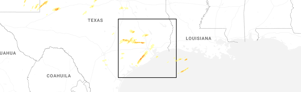
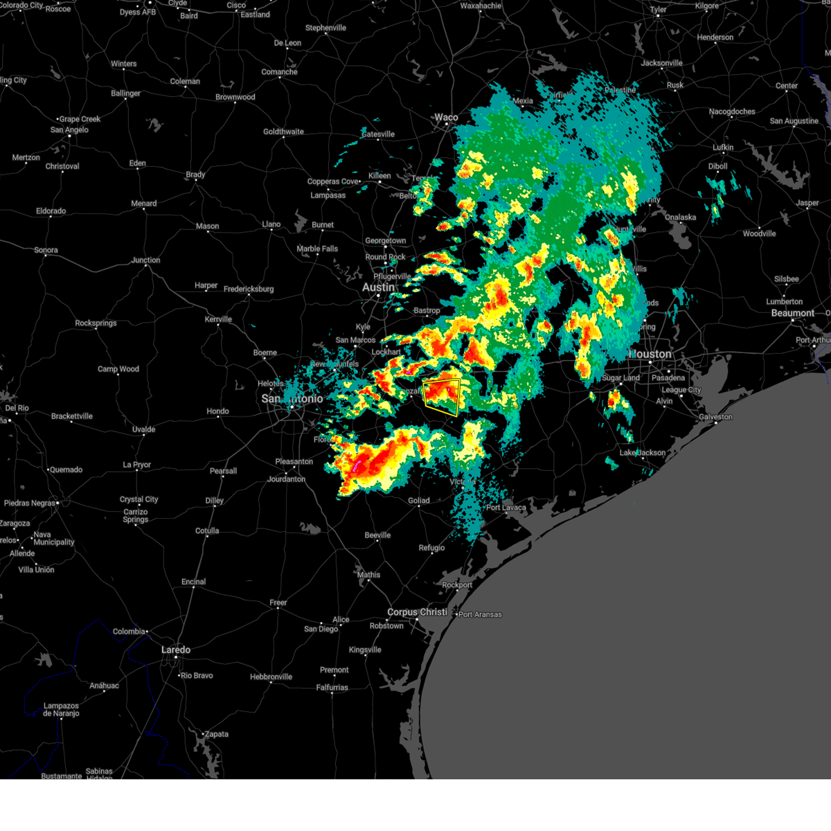
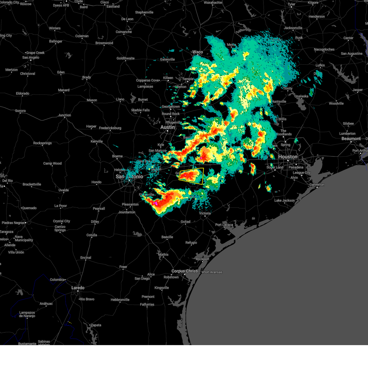
Hail Map for Shiner, TX
The Shiner, TX area has had 3 reports of on-the-ground hail by trained spotters, and has been under severe weather warnings 5 times during the past 12 months. Doppler radar has detected hail at or near Shiner, TX on 41 occasions, including 5 occasions during the past year.
| Name: | Shiner, TX |
| Where Located: | 79.5 miles E of San Antonio, TX |
| Map: | Google Map for Shiner, TX |
| Population: | 2069 |
| Housing Units: | 1025 |
| More Info: | Search Google for Shiner, TX |
3
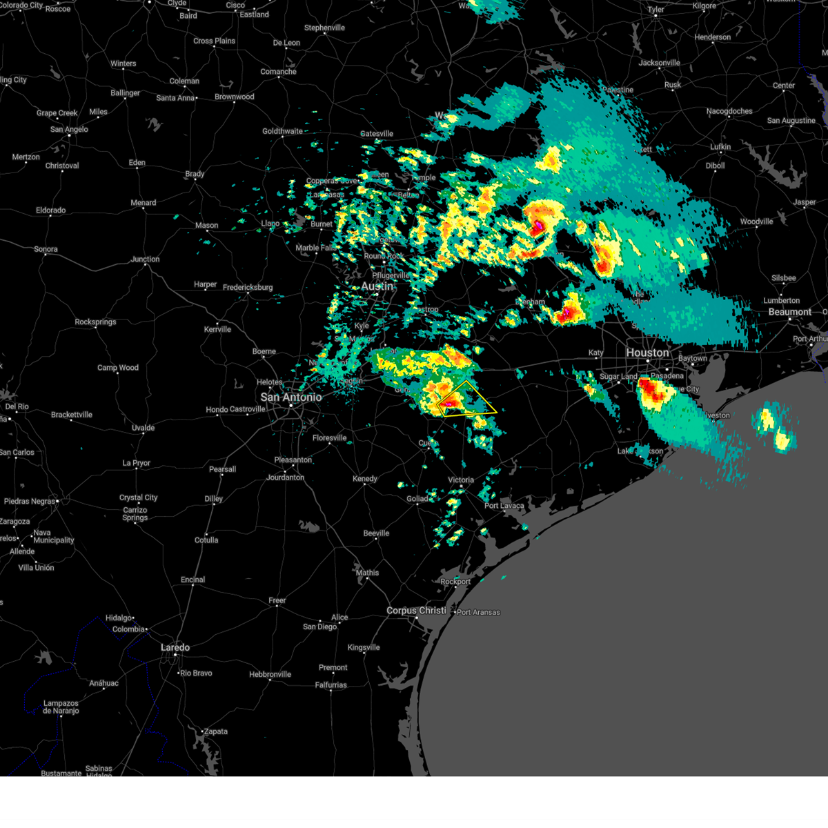
The Top Recent Hail Date for Shiner, TX is Monday, May 5, 2025 (5th out of 41)
Hail and Wind Damage Spotted near Shiner, TX
| Date / Time | Report Details |
|---|---|
| 5/5/2025 5:03 PM CDT |
 Svrewx the national weather service in austin san antonio has issued a * severe thunderstorm warning for, northern lavaca county in south central texas, * until 600 pm cdt. * at 502 pm cdt, a severe thunderstorm was located near shiner, moving northeast at 10 mph (radar indicated). Hazards include 60 mph wind gusts and half dollar size hail. Hail damage to vehicles is expected. Expect wind damage to roofs, siding, and trees. Svrewx the national weather service in austin san antonio has issued a * severe thunderstorm warning for, northern lavaca county in south central texas, * until 600 pm cdt. * at 502 pm cdt, a severe thunderstorm was located near shiner, moving northeast at 10 mph (radar indicated). Hazards include 60 mph wind gusts and half dollar size hail. Hail damage to vehicles is expected. Expect wind damage to roofs, siding, and trees.
|
| 12/24/2024 11:21 PM CST |
 At 1121 pm cst, a severe thunderstorm was located over moulton, moving east at 15 mph (radar indicated). Hazards include 60 mph wind gusts and quarter size hail. Hail damage to vehicles is expected. expect wind damage to roofs, siding, and trees. Locations impacted include, shiner, moulton, komensky, henkhaus, witting, mount olive, and wied. At 1121 pm cst, a severe thunderstorm was located over moulton, moving east at 15 mph (radar indicated). Hazards include 60 mph wind gusts and quarter size hail. Hail damage to vehicles is expected. expect wind damage to roofs, siding, and trees. Locations impacted include, shiner, moulton, komensky, henkhaus, witting, mount olive, and wied.
|
| 12/24/2024 11:21 PM CST |
 the severe thunderstorm warning has been cancelled and is no longer in effect the severe thunderstorm warning has been cancelled and is no longer in effect
|
| 12/24/2024 11:04 PM CST |
 At 1104 pm cst, a severe thunderstorm was located near moulton, moving east at 20 mph (radar indicated). Hazards include 60 mph wind gusts and quarter size hail. Hail damage to vehicles is expected. expect wind damage to roofs, siding, and trees. Locations impacted include, shiner, moulton, komensky, henkhaus, witting, little new york, mount olive, wied, nickle, and dilworth. At 1104 pm cst, a severe thunderstorm was located near moulton, moving east at 20 mph (radar indicated). Hazards include 60 mph wind gusts and quarter size hail. Hail damage to vehicles is expected. expect wind damage to roofs, siding, and trees. Locations impacted include, shiner, moulton, komensky, henkhaus, witting, little new york, mount olive, wied, nickle, and dilworth.
|
| 12/24/2024 10:28 PM CST |
 Svrewx the national weather service in austin san antonio has issued a * severe thunderstorm warning for, east central gonzales county in south central texas, northwestern lavaca county in south central texas, * until 1130 pm cst. * at 1028 pm cst, a severe thunderstorm was located near gonzales, moving east at 15 mph (radar indicated). Hazards include ping pong ball size hail and 60 mph wind gusts. People and animals outdoors will be injured. expect hail damage to roofs, siding, windows, and vehicles. Expect wind damage to roofs, siding, and trees. Svrewx the national weather service in austin san antonio has issued a * severe thunderstorm warning for, east central gonzales county in south central texas, northwestern lavaca county in south central texas, * until 1130 pm cst. * at 1028 pm cst, a severe thunderstorm was located near gonzales, moving east at 15 mph (radar indicated). Hazards include ping pong ball size hail and 60 mph wind gusts. People and animals outdoors will be injured. expect hail damage to roofs, siding, windows, and vehicles. Expect wind damage to roofs, siding, and trees.
|
| 5/28/2024 1:13 PM CDT |
 the severe thunderstorm warning has been cancelled and is no longer in effect the severe thunderstorm warning has been cancelled and is no longer in effect
|
| 5/28/2024 12:52 PM CDT |
 Svrewx the national weather service in austin san antonio has issued a * severe thunderstorm warning for, east central gonzales county in south central texas, northwestern lavaca county in south central texas, * until 130 pm cdt. * at 1252 pm cdt, a severe thunderstorm was located near moulton, moving south at 15 mph (radar indicated). Hazards include 60 mph wind gusts and quarter size hail. Hail damage to vehicles is expected. Expect wind damage to roofs, siding, and trees. Svrewx the national weather service in austin san antonio has issued a * severe thunderstorm warning for, east central gonzales county in south central texas, northwestern lavaca county in south central texas, * until 130 pm cdt. * at 1252 pm cdt, a severe thunderstorm was located near moulton, moving south at 15 mph (radar indicated). Hazards include 60 mph wind gusts and quarter size hail. Hail damage to vehicles is expected. Expect wind damage to roofs, siding, and trees.
|
| 5/13/2024 1:49 PM CDT |
 Svrewx the national weather service in austin san antonio has issued a * severe thunderstorm warning for, northeastern dewitt county in south central texas, east central gonzales county in south central texas, southeastern fayette county in south central texas, lavaca county in south central texas, * until 230 pm cdt. * at 149 pm cdt, severe thunderstorms were located along a line extending from near moulton to near shiner to near yoakum, moving east at 45 mph (radar indicated). Hazards include 60 mph wind gusts and penny size hail. expect damage to roofs, siding, and trees Svrewx the national weather service in austin san antonio has issued a * severe thunderstorm warning for, northeastern dewitt county in south central texas, east central gonzales county in south central texas, southeastern fayette county in south central texas, lavaca county in south central texas, * until 230 pm cdt. * at 149 pm cdt, severe thunderstorms were located along a line extending from near moulton to near shiner to near yoakum, moving east at 45 mph (radar indicated). Hazards include 60 mph wind gusts and penny size hail. expect damage to roofs, siding, and trees
|
| 5/13/2024 1:32 PM CDT |
 At 131 pm cdt, severe thunderstorms were located along a line extending from gonzales to near hochheim to near westhoff, moving east at 55 mph (trained weather spotters). Hazards include 70 mph wind gusts and penny size hail. Expect considerable tree damage. damage is likely to mobile homes, roofs, and outbuildings. Locations impacted include, cuero, gonzales, yoakum, shiner, hochheim, cheapside, westhoff, henkhaus, edgar, terryville, oak forest, glaze city, sweet home, cost, dilworth, dreyer, witting, hamon, mount olive, and wied. At 131 pm cdt, severe thunderstorms were located along a line extending from gonzales to near hochheim to near westhoff, moving east at 55 mph (trained weather spotters). Hazards include 70 mph wind gusts and penny size hail. Expect considerable tree damage. damage is likely to mobile homes, roofs, and outbuildings. Locations impacted include, cuero, gonzales, yoakum, shiner, hochheim, cheapside, westhoff, henkhaus, edgar, terryville, oak forest, glaze city, sweet home, cost, dilworth, dreyer, witting, hamon, mount olive, and wied.
|
| 5/13/2024 1:15 PM CDT |
 the severe thunderstorm warning has been cancelled and is no longer in effect the severe thunderstorm warning has been cancelled and is no longer in effect
|
| 5/13/2024 1:15 PM CDT |
 At 114 pm cdt, severe thunderstorms were located along a line extending from 12 miles southwest of gonzales to near smiley, moving east at 45 mph (emergency management. at 1:10 pm, trees were reported down between nixon and smiley). Hazards include 70 mph wind gusts and penny size hail. Expect considerable tree damage. damage is likely to mobile homes, roofs, and outbuildings. Locations impacted include, cuero, gonzales, yoakum, shiner, nixon, smiley, cheapside, hochheim, westhoff, leesville, henkhaus, edgar, terryville, oak forest, cost, dilworth, monthalia, sample, glaze city, and wrightsboro. At 114 pm cdt, severe thunderstorms were located along a line extending from 12 miles southwest of gonzales to near smiley, moving east at 45 mph (emergency management. at 1:10 pm, trees were reported down between nixon and smiley). Hazards include 70 mph wind gusts and penny size hail. Expect considerable tree damage. damage is likely to mobile homes, roofs, and outbuildings. Locations impacted include, cuero, gonzales, yoakum, shiner, nixon, smiley, cheapside, hochheim, westhoff, leesville, henkhaus, edgar, terryville, oak forest, cost, dilworth, monthalia, sample, glaze city, and wrightsboro.
|
| 5/13/2024 12:59 PM CDT |
 Svrewx the national weather service in austin san antonio has issued a * severe thunderstorm warning for, central dewitt county in south central texas, southeastern guadalupe county in south central texas, northeastern karnes county in south central texas, gonzales county in south central texas, western lavaca county in south central texas, northeastern wilson county in south central texas, * until 200 pm cdt. * at 1258 pm cdt, severe thunderstorms were located along a line extending from 10 miles northwest of smiley to near nixon, moving east at 45 mph (radar indicated). Hazards include 60 mph wind gusts and penny size hail. expect damage to roofs, siding, and trees Svrewx the national weather service in austin san antonio has issued a * severe thunderstorm warning for, central dewitt county in south central texas, southeastern guadalupe county in south central texas, northeastern karnes county in south central texas, gonzales county in south central texas, western lavaca county in south central texas, northeastern wilson county in south central texas, * until 200 pm cdt. * at 1258 pm cdt, severe thunderstorms were located along a line extending from 10 miles northwest of smiley to near nixon, moving east at 45 mph (radar indicated). Hazards include 60 mph wind gusts and penny size hail. expect damage to roofs, siding, and trees
|
| 5/9/2024 10:07 PM CDT |
 The storm which prompted the warning has weakened below severe limits, and no longer poses an immediate threat to life or property. therefore, the warning will be allowed to expire. however small hail, gusty winds and heavy rain are still possible with this thunderstorm. a severe thunderstorm watch remains in effect until midnight cdt for south central texas. The storm which prompted the warning has weakened below severe limits, and no longer poses an immediate threat to life or property. therefore, the warning will be allowed to expire. however small hail, gusty winds and heavy rain are still possible with this thunderstorm. a severe thunderstorm watch remains in effect until midnight cdt for south central texas.
|
| 5/9/2024 9:51 PM CDT |
 At 950 pm cdt, a severe thunderstorm was located near moulton, moving southeast at 40 mph (radar indicated). Hazards include two inch hail and 60 mph wind gusts. People and animals outdoors will be injured. expect hail damage to roofs, siding, windows, and vehicles. expect wind damage to roofs, siding, and trees. Locations impacted include, yoakum, hallettsville, shiner, moulton, waelder, sublime, hochheim, komensky, worthing, henkhaus, dilworth, thompsonville, moravia, glaze city, newtonville, breslau, mont, nickle, dreyer, and witting. At 950 pm cdt, a severe thunderstorm was located near moulton, moving southeast at 40 mph (radar indicated). Hazards include two inch hail and 60 mph wind gusts. People and animals outdoors will be injured. expect hail damage to roofs, siding, windows, and vehicles. expect wind damage to roofs, siding, and trees. Locations impacted include, yoakum, hallettsville, shiner, moulton, waelder, sublime, hochheim, komensky, worthing, henkhaus, dilworth, thompsonville, moravia, glaze city, newtonville, breslau, mont, nickle, dreyer, and witting.
|
| 5/9/2024 9:51 PM CDT |
 the severe thunderstorm warning has been cancelled and is no longer in effect the severe thunderstorm warning has been cancelled and is no longer in effect
|
| 5/9/2024 9:46 PM CDT |
 the severe thunderstorm warning has been cancelled and is no longer in effect the severe thunderstorm warning has been cancelled and is no longer in effect
|
| 5/9/2024 9:46 PM CDT |
 At 945 pm cdt, a severe thunderstorm was located near waelder, or near moulton, moving southeast at 45 mph (radar indicated). Hazards include two inch hail and 60 mph wind gusts. People and animals outdoors will be injured. expect hail damage to roofs, siding, windows, and vehicles. expect wind damage to roofs, siding, and trees. Locations impacted include, gonzales, yoakum, hallettsville, shiner, stockdale, moulton, kosciusko, nixon, waelder, smiley, pandora, gillett, sublime, cheapside, hochheim, westhoff, palmeto state park, komensky, worthing, and leesville. At 945 pm cdt, a severe thunderstorm was located near waelder, or near moulton, moving southeast at 45 mph (radar indicated). Hazards include two inch hail and 60 mph wind gusts. People and animals outdoors will be injured. expect hail damage to roofs, siding, windows, and vehicles. expect wind damage to roofs, siding, and trees. Locations impacted include, gonzales, yoakum, hallettsville, shiner, stockdale, moulton, kosciusko, nixon, waelder, smiley, pandora, gillett, sublime, cheapside, hochheim, westhoff, palmeto state park, komensky, worthing, and leesville.
|
| 5/9/2024 9:38 PM CDT |
 At 937 pm cdt, a severe thunderstorm was located near waelder, or 11 miles northeast of gonzales, moving southeast at 35 mph (radar indicated). Hazards include two inch hail and 60 mph wind gusts. People and animals outdoors will be injured. expect hail damage to roofs, siding, windows, and vehicles. expect wind damage to roofs, siding, and trees. Locations impacted include, gonzales, yoakum, luling, hallettsville, shiner, stockdale, moulton, kosciusko, nixon, waelder, smiley, sublime, cheapside, hochheim, palmeto state park, pandora, gillett, westhoff, brownsboro, and komensky. At 937 pm cdt, a severe thunderstorm was located near waelder, or 11 miles northeast of gonzales, moving southeast at 35 mph (radar indicated). Hazards include two inch hail and 60 mph wind gusts. People and animals outdoors will be injured. expect hail damage to roofs, siding, windows, and vehicles. expect wind damage to roofs, siding, and trees. Locations impacted include, gonzales, yoakum, luling, hallettsville, shiner, stockdale, moulton, kosciusko, nixon, waelder, smiley, sublime, cheapside, hochheim, palmeto state park, pandora, gillett, westhoff, brownsboro, and komensky.
|
| 5/9/2024 9:38 PM CDT |
 the severe thunderstorm warning has been cancelled and is no longer in effect the severe thunderstorm warning has been cancelled and is no longer in effect
|
| 5/9/2024 9:11 PM CDT |
 Svrewx the national weather service in austin san antonio has issued a * severe thunderstorm warning for, southern caldwell county in south central texas, northwestern dewitt county in south central texas, southeastern guadalupe county in south central texas, northeastern karnes county in south central texas, gonzales county in south central texas, northwestern lavaca county in south central texas, northeastern wilson county in south central texas, * until 1015 pm cdt. * at 911 pm cdt, a severe thunderstorm was located near luling, moving southeast at 40 mph (radar indicated). Hazards include two inch hail and 60 mph wind gusts. People and animals outdoors will be injured. expect hail damage to roofs, siding, windows, and vehicles. Expect wind damage to roofs, siding, and trees. Svrewx the national weather service in austin san antonio has issued a * severe thunderstorm warning for, southern caldwell county in south central texas, northwestern dewitt county in south central texas, southeastern guadalupe county in south central texas, northeastern karnes county in south central texas, gonzales county in south central texas, northwestern lavaca county in south central texas, northeastern wilson county in south central texas, * until 1015 pm cdt. * at 911 pm cdt, a severe thunderstorm was located near luling, moving southeast at 40 mph (radar indicated). Hazards include two inch hail and 60 mph wind gusts. People and animals outdoors will be injured. expect hail damage to roofs, siding, windows, and vehicles. Expect wind damage to roofs, siding, and trees.
|
| 3/15/2024 3:33 PM CDT |
 At 333 pm cdt, a severe thunderstorm was located near shiner, moving east at 20 mph (radar indicated). Hazards include golf ball size hail and 60 mph wind gusts. People and animals outdoors will be injured. expect hail damage to roofs, siding, windows, and vehicles. expect wind damage to roofs, siding, and trees. Locations impacted include, shiner, wied, breslau, witting, and mount olive. At 333 pm cdt, a severe thunderstorm was located near shiner, moving east at 20 mph (radar indicated). Hazards include golf ball size hail and 60 mph wind gusts. People and animals outdoors will be injured. expect hail damage to roofs, siding, windows, and vehicles. expect wind damage to roofs, siding, and trees. Locations impacted include, shiner, wied, breslau, witting, and mount olive.
|
| 3/15/2024 3:19 PM CDT |
 At 318 pm cdt, a severe thunderstorm was located over shiner, moving east at 20 mph (radar indicated). Hazards include 60 mph wind gusts and quarter size hail. Hail damage to vehicles is expected. expect wind damage to roofs, siding, and trees. Locations impacted include, shiner, moulton, komensky, henkhaus, witting, moravia, mount olive, wied, and breslau. At 318 pm cdt, a severe thunderstorm was located over shiner, moving east at 20 mph (radar indicated). Hazards include 60 mph wind gusts and quarter size hail. Hail damage to vehicles is expected. expect wind damage to roofs, siding, and trees. Locations impacted include, shiner, moulton, komensky, henkhaus, witting, moravia, mount olive, wied, and breslau.
|
| 3/15/2024 3:19 PM CDT |
 the severe thunderstorm warning has been cancelled and is no longer in effect the severe thunderstorm warning has been cancelled and is no longer in effect
|
| 3/15/2024 2:59 PM CDT |
 Svrewx the national weather service in austin san antonio has issued a * severe thunderstorm warning for, east central gonzales county in south central texas, northwestern lavaca county in south central texas, * until 400 pm cdt. * at 259 pm cdt, a severe thunderstorm was located near shiner, moving northeast at 20 mph (radar indicated). Hazards include 60 mph wind gusts and quarter size hail. Hail damage to vehicles is expected. Expect wind damage to roofs, siding, and trees. Svrewx the national weather service in austin san antonio has issued a * severe thunderstorm warning for, east central gonzales county in south central texas, northwestern lavaca county in south central texas, * until 400 pm cdt. * at 259 pm cdt, a severe thunderstorm was located near shiner, moving northeast at 20 mph (radar indicated). Hazards include 60 mph wind gusts and quarter size hail. Hail damage to vehicles is expected. Expect wind damage to roofs, siding, and trees.
|
| 6/21/2023 9:44 PM CDT |
 At 944 pm cdt, severe thunderstorms were located along a line extending from near ezzell to near weesatche, moving southeast at 35 mph (radar indicated). Hazards include 60 mph wind gusts. expect damage to roofs, siding, and trees At 944 pm cdt, severe thunderstorms were located along a line extending from near ezzell to near weesatche, moving southeast at 35 mph (radar indicated). Hazards include 60 mph wind gusts. expect damage to roofs, siding, and trees
|
| 6/21/2023 9:31 PM CDT |
 At 930 pm cdt, severe thunderstorms were located along a line extending from near moulton to near yoakum to near yorktown, moving southeast at 30 mph (radar indicated). Hazards include 60 mph wind gusts. Expect damage to roofs, siding, and trees. locations impacted include, cuero, gonzales, yoakum, hallettsville, yorktown, shiner, moulton, smiley, sublime, cheapside, ezzell, hochheim, westhoff, komensky, worthing, henkhaus, edgar, terryville, dilworth and vienna. hail threat, radar indicated max hail size, <. 75 in wind threat, radar indicated max wind gust, 60 mph. At 930 pm cdt, severe thunderstorms were located along a line extending from near moulton to near yoakum to near yorktown, moving southeast at 30 mph (radar indicated). Hazards include 60 mph wind gusts. Expect damage to roofs, siding, and trees. locations impacted include, cuero, gonzales, yoakum, hallettsville, yorktown, shiner, moulton, smiley, sublime, cheapside, ezzell, hochheim, westhoff, komensky, worthing, henkhaus, edgar, terryville, dilworth and vienna. hail threat, radar indicated max hail size, <. 75 in wind threat, radar indicated max wind gust, 60 mph.
|
| 6/21/2023 9:02 PM CDT |
 At 902 pm cdt, severe thunderstorms were located along a line extending from near cistern to near flatonia to near nixon, moving southeast at 25 mph (radar indicated). Hazards include 60 mph wind gusts and quarter size hail. Hail damage to vehicles is expected. Expect wind damage to roofs, siding, and trees. At 902 pm cdt, severe thunderstorms were located along a line extending from near cistern to near flatonia to near nixon, moving southeast at 25 mph (radar indicated). Hazards include 60 mph wind gusts and quarter size hail. Hail damage to vehicles is expected. Expect wind damage to roofs, siding, and trees.
|
| 4/28/2023 8:23 PM CDT |
 At 823 pm cdt, severe thunderstorms were located along a line extending from 7 miles southeast of sublime to near thomaston to 6 miles west of weesatche, moving southeast at 40 mph (radar indicated). Hazards include 60 mph wind gusts and quarter size hail. Hail damage to vehicles is expected. expect wind damage to roofs, siding, and trees. locations impacted include, cuero, yoakum, hallettsville, yorktown, shiner, nordheim, sublime, thomaston, ezzell, hochheim, speaks, westhoff, worthing, cotton patch, edgar, terryville, meyersville, vienna, koerth and gruenau. hail threat, radar indicated max hail size, 1. 00 in wind threat, radar indicated max wind gust, 60 mph. At 823 pm cdt, severe thunderstorms were located along a line extending from 7 miles southeast of sublime to near thomaston to 6 miles west of weesatche, moving southeast at 40 mph (radar indicated). Hazards include 60 mph wind gusts and quarter size hail. Hail damage to vehicles is expected. expect wind damage to roofs, siding, and trees. locations impacted include, cuero, yoakum, hallettsville, yorktown, shiner, nordheim, sublime, thomaston, ezzell, hochheim, speaks, westhoff, worthing, cotton patch, edgar, terryville, meyersville, vienna, koerth and gruenau. hail threat, radar indicated max hail size, 1. 00 in wind threat, radar indicated max wind gust, 60 mph.
|
| 4/28/2023 8:13 PM CDT |
 At 812 pm cdt, severe thunderstorms were located along a line extending from near sublime to 7 miles southeast of kenedy, moving southeast at 35 mph (radar indicated). Hazards include 60 mph wind gusts and quarter size hail. Hail damage to vehicles is expected. expect wind damage to roofs, siding, and trees. locations impacted include, cuero, yoakum, kenedy, karnes city, hallettsville, yorktown, shiner, moulton, runge, nordheim, sublime, cheapside, thomaston, ezzell, hochheim, speaks, westhoff, komensky, worthing and henkhaus. hail threat, radar indicated max hail size, 1. 00 in wind threat, radar indicated max wind gust, 60 mph. At 812 pm cdt, severe thunderstorms were located along a line extending from near sublime to 7 miles southeast of kenedy, moving southeast at 35 mph (radar indicated). Hazards include 60 mph wind gusts and quarter size hail. Hail damage to vehicles is expected. expect wind damage to roofs, siding, and trees. locations impacted include, cuero, yoakum, kenedy, karnes city, hallettsville, yorktown, shiner, moulton, runge, nordheim, sublime, cheapside, thomaston, ezzell, hochheim, speaks, westhoff, komensky, worthing and henkhaus. hail threat, radar indicated max hail size, 1. 00 in wind threat, radar indicated max wind gust, 60 mph.
|
| 4/28/2023 7:54 PM CDT |
 At 753 pm cdt, severe thunderstorms were located along a line extending from near schulenburg to karnes city, moving southeast at 35 mph (radar indicated). Hazards include 60 mph wind gusts and quarter size hail. Hail damage to vehicles is expected. Expect wind damage to roofs, siding, and trees. At 753 pm cdt, severe thunderstorms were located along a line extending from near schulenburg to karnes city, moving southeast at 35 mph (radar indicated). Hazards include 60 mph wind gusts and quarter size hail. Hail damage to vehicles is expected. Expect wind damage to roofs, siding, and trees.
|
| 4/21/2023 2:16 AM CDT |
 At 216 am cdt, severe thunderstorms were located along a line extending from near schulenburg to near ezzell to near cuero, moving east at 45 mph (radar indicated). Hazards include golf ball size hail and 70 mph wind gusts. People and animals outdoors will be injured. expect hail damage to roofs, siding, windows, and vehicles. expect considerable tree damage. wind damage is also likely to mobile homes, roofs, and outbuildings. locations impacted include, cuero, yoakum, hallettsville, shiner, moulton, ezzell, sublime, speaks, komensky, worthing, henkhaus, koerth, moravia, terryville, breslau, mont, sweet home, witting, vsetin and mount olive. thunderstorm damage threat, considerable hail threat, radar indicated max hail size, 1. 75 in wind threat, radar indicated max wind gust, 70 mph. At 216 am cdt, severe thunderstorms were located along a line extending from near schulenburg to near ezzell to near cuero, moving east at 45 mph (radar indicated). Hazards include golf ball size hail and 70 mph wind gusts. People and animals outdoors will be injured. expect hail damage to roofs, siding, windows, and vehicles. expect considerable tree damage. wind damage is also likely to mobile homes, roofs, and outbuildings. locations impacted include, cuero, yoakum, hallettsville, shiner, moulton, ezzell, sublime, speaks, komensky, worthing, henkhaus, koerth, moravia, terryville, breslau, mont, sweet home, witting, vsetin and mount olive. thunderstorm damage threat, considerable hail threat, radar indicated max hail size, 1. 75 in wind threat, radar indicated max wind gust, 70 mph.
|
| 4/21/2023 1:51 AM CDT |
 At 151 am cdt, severe thunderstorms were located along a line extending from near muldoon to yoakum to cheapside, moving east at 35 mph (radar indicated). Hazards include golf ball size hail and 70 mph wind gusts. People and animals outdoors will be injured. expect hail damage to roofs, siding, windows, and vehicles. expect considerable tree damage. wind damage is also likely to mobile homes, roofs, and outbuildings. locations impacted include, cuero, yoakum, hallettsville, shiner, moulton, sublime, ezzell, hochheim, speaks, westhoff, thomaston, komensky, worthing, henkhaus, edgar, terryville, vienna, koerth, moravia and breslau. thunderstorm damage threat, considerable hail threat, radar indicated max hail size, 1. 75 in wind threat, radar indicated max wind gust, 70 mph. At 151 am cdt, severe thunderstorms were located along a line extending from near muldoon to yoakum to cheapside, moving east at 35 mph (radar indicated). Hazards include golf ball size hail and 70 mph wind gusts. People and animals outdoors will be injured. expect hail damage to roofs, siding, windows, and vehicles. expect considerable tree damage. wind damage is also likely to mobile homes, roofs, and outbuildings. locations impacted include, cuero, yoakum, hallettsville, shiner, moulton, sublime, ezzell, hochheim, speaks, westhoff, thomaston, komensky, worthing, henkhaus, edgar, terryville, vienna, koerth, moravia and breslau. thunderstorm damage threat, considerable hail threat, radar indicated max hail size, 1. 75 in wind threat, radar indicated max wind gust, 70 mph.
|
| 4/21/2023 1:40 AM CDT |
 At 140 am cdt, severe thunderstorms were located along a line extending from near waelder to near shiner to near smiley, moving east at 30 mph (radar indicated). Hazards include 60 mph wind gusts and half dollar size hail. Hail damage to vehicles is expected. Expect wind damage to roofs, siding, and trees. At 140 am cdt, severe thunderstorms were located along a line extending from near waelder to near shiner to near smiley, moving east at 30 mph (radar indicated). Hazards include 60 mph wind gusts and half dollar size hail. Hail damage to vehicles is expected. Expect wind damage to roofs, siding, and trees.
|
| 4/21/2023 1:24 AM CDT |
 At 124 am cdt, severe thunderstorms were located along a line extending from 6 miles south of waelder to near shiner to near smiley, moving east at 30 mph (radar indicated). Hazards include 60 mph wind gusts and half dollar size hail. Hail damage to vehicles is expected. expect wind damage to roofs, siding, and trees. locations impacted include, cuero, gonzales, yoakum, hallettsville, shiner, moulton, nixon, smiley, cheapside, hochheim, westhoff, komensky, worthing, leesville, henkhaus, edgar, cost, dilworth, monthalia and koerth. hail threat, radar indicated max hail size, 1. 25 in wind threat, radar indicated max wind gust, 60 mph. At 124 am cdt, severe thunderstorms were located along a line extending from 6 miles south of waelder to near shiner to near smiley, moving east at 30 mph (radar indicated). Hazards include 60 mph wind gusts and half dollar size hail. Hail damage to vehicles is expected. expect wind damage to roofs, siding, and trees. locations impacted include, cuero, gonzales, yoakum, hallettsville, shiner, moulton, nixon, smiley, cheapside, hochheim, westhoff, komensky, worthing, leesville, henkhaus, edgar, cost, dilworth, monthalia and koerth. hail threat, radar indicated max hail size, 1. 25 in wind threat, radar indicated max wind gust, 60 mph.
|
| 4/21/2023 1:02 AM CDT |
 At 102 am cdt, severe thunderstorms were located along a line extending from 8 miles west of waelder to near gonzales to nixon, moving east at 20 mph (radar indicated). Hazards include golf ball size hail and 60 mph wind gusts. People and animals outdoors will be injured. expect hail damage to roofs, siding, windows, and vehicles. expect wind damage to roofs, siding, and trees. locations impacted include, cuero, gonzales, yoakum, hallettsville, shiner, moulton, nixon, smiley, cheapside, hochheim, westhoff, komensky, worthing, leesville, henkhaus, edgar, cost, dilworth, monthalia and koerth. thunderstorm damage threat, considerable hail threat, radar indicated max hail size, 1. 75 in wind threat, radar indicated max wind gust, 60 mph. At 102 am cdt, severe thunderstorms were located along a line extending from 8 miles west of waelder to near gonzales to nixon, moving east at 20 mph (radar indicated). Hazards include golf ball size hail and 60 mph wind gusts. People and animals outdoors will be injured. expect hail damage to roofs, siding, windows, and vehicles. expect wind damage to roofs, siding, and trees. locations impacted include, cuero, gonzales, yoakum, hallettsville, shiner, moulton, nixon, smiley, cheapside, hochheim, westhoff, komensky, worthing, leesville, henkhaus, edgar, cost, dilworth, monthalia and koerth. thunderstorm damage threat, considerable hail threat, radar indicated max hail size, 1. 75 in wind threat, radar indicated max wind gust, 60 mph.
|
| 4/21/2023 12:43 AM CDT |
 At 1242 am cdt, severe thunderstorms were located along a line extending from near luling to near gonzales to 6 miles north of nixon, moving east at 30 mph (radar indicated). Hazards include two inch hail and 60 mph wind gusts. People and animals outdoors will be injured. expect hail damage to roofs, siding, windows, and vehicles. Expect wind damage to roofs, siding, and trees. At 1242 am cdt, severe thunderstorms were located along a line extending from near luling to near gonzales to 6 miles north of nixon, moving east at 30 mph (radar indicated). Hazards include two inch hail and 60 mph wind gusts. People and animals outdoors will be injured. expect hail damage to roofs, siding, windows, and vehicles. Expect wind damage to roofs, siding, and trees.
|
| 4/15/2023 8:26 PM CDT |
 The severe thunderstorm warning for northeastern dewitt and southwestern lavaca counties will expire at 830 pm cdt, the storm which prompted the warning has weakened below severe limits, and no longer poses an immediate threat to life or property. therefore, the warning will be allowed to expire. a severe thunderstorm watch remains in effect until midnight cdt for south central texas. The severe thunderstorm warning for northeastern dewitt and southwestern lavaca counties will expire at 830 pm cdt, the storm which prompted the warning has weakened below severe limits, and no longer poses an immediate threat to life or property. therefore, the warning will be allowed to expire. a severe thunderstorm watch remains in effect until midnight cdt for south central texas.
|
| 4/15/2023 8:08 PM CDT |
 At 808 pm cdt, a severe thunderstorm was located near shiner, moving southeast at 20 mph (radar indicated). Hazards include 60 mph wind gusts and quarter size hail. Hail damage to vehicles is expected. expect wind damage to roofs, siding, and trees. this severe storm will be near, yoakum around 820 pm cdt. other locations impacted by this severe thunderstorm include worthing, koerth, terryville, mount olive, wied, mont, sweet home and hope. hail threat, radar indicated max hail size, 1. 00 in wind threat, radar indicated max wind gust, 60 mph. At 808 pm cdt, a severe thunderstorm was located near shiner, moving southeast at 20 mph (radar indicated). Hazards include 60 mph wind gusts and quarter size hail. Hail damage to vehicles is expected. expect wind damage to roofs, siding, and trees. this severe storm will be near, yoakum around 820 pm cdt. other locations impacted by this severe thunderstorm include worthing, koerth, terryville, mount olive, wied, mont, sweet home and hope. hail threat, radar indicated max hail size, 1. 00 in wind threat, radar indicated max wind gust, 60 mph.
|
| 4/15/2023 7:57 PM CDT |
 At 757 pm cdt, severe thunderstorms were located along a line extending from 7 miles southeast of schulenburg to shiner to 7 miles southeast of gonzales, moving southeast at 25 mph (radar indicated). Hazards include 60 mph wind gusts and quarter size hail. Hail damage to vehicles is expected. expect wind damage to roofs, siding, and trees. these severe storms will be near, sublime around 815 pm cdt. yoakum and hochheim around 820 pm cdt. other locations impacted by these severe thunderstorms include worthing, henkhaus, koerth, edgar, moravia, terryville, glaze city, breslau, mont and sweet home. hail threat, radar indicated max hail size, 1. 00 in wind threat, radar indicated max wind gust, 60 mph. At 757 pm cdt, severe thunderstorms were located along a line extending from 7 miles southeast of schulenburg to shiner to 7 miles southeast of gonzales, moving southeast at 25 mph (radar indicated). Hazards include 60 mph wind gusts and quarter size hail. Hail damage to vehicles is expected. expect wind damage to roofs, siding, and trees. these severe storms will be near, sublime around 815 pm cdt. yoakum and hochheim around 820 pm cdt. other locations impacted by these severe thunderstorms include worthing, henkhaus, koerth, edgar, moravia, terryville, glaze city, breslau, mont and sweet home. hail threat, radar indicated max hail size, 1. 00 in wind threat, radar indicated max wind gust, 60 mph.
|
| 4/15/2023 7:41 PM CDT | Golf Ball sized hail reported 8.3 miles S of Shiner, TX, hail up to golfball size near the lavaca/gonzalez line on fm 532. |
| 4/15/2023 7:30 PM CDT |
 At 730 pm cdt, severe thunderstorms were located along a line extending from near fayetteville to near flatonia to near gonzales, moving southeast at 20 mph (radar indicated). Hazards include 60 mph wind gusts and quarter size hail. Hail damage to vehicles is expected. expect wind damage to roofs, siding, and trees. severe thunderstorms will be near, moulton around 740 pm cdt. hallettsville around 815 pm cdt. hochheim around 820 pm cdt. yoakum and ezzell around 830 pm cdt. other locations impacted by these severe thunderstorms include komensky, worthing, swiss alp, henkhaus, edgar, dubina, terryville, engle, dilworth and ammannsville. hail threat, observed max hail size, 1. 00 in wind threat, radar indicated max wind gust, 60 mph. At 730 pm cdt, severe thunderstorms were located along a line extending from near fayetteville to near flatonia to near gonzales, moving southeast at 20 mph (radar indicated). Hazards include 60 mph wind gusts and quarter size hail. Hail damage to vehicles is expected. expect wind damage to roofs, siding, and trees. severe thunderstorms will be near, moulton around 740 pm cdt. hallettsville around 815 pm cdt. hochheim around 820 pm cdt. yoakum and ezzell around 830 pm cdt. other locations impacted by these severe thunderstorms include komensky, worthing, swiss alp, henkhaus, edgar, dubina, terryville, engle, dilworth and ammannsville. hail threat, observed max hail size, 1. 00 in wind threat, radar indicated max wind gust, 60 mph.
|
| 4/5/2023 10:14 PM CDT |
 At 1014 pm cdt, a severe thunderstorm was located near hochheim, or near yoakum, moving northeast at 40 mph (radar indicated). Hazards include quarter size hail. Damage to vehicles is expected. locations impacted include, yoakum, hallettsville, shiner, komensky, worthing, henkhaus, moravia, breslau, mont, sweet home, witting, vsetin, mount olive and wied. hail threat, radar indicated max hail size, 1. 00 in wind threat, radar indicated max wind gust, <50 mph. At 1014 pm cdt, a severe thunderstorm was located near hochheim, or near yoakum, moving northeast at 40 mph (radar indicated). Hazards include quarter size hail. Damage to vehicles is expected. locations impacted include, yoakum, hallettsville, shiner, komensky, worthing, henkhaus, moravia, breslau, mont, sweet home, witting, vsetin, mount olive and wied. hail threat, radar indicated max hail size, 1. 00 in wind threat, radar indicated max wind gust, <50 mph.
|
| 4/5/2023 10:00 PM CDT |
 At 1000 pm cdt, a severe thunderstorm was located near hochheim, or 10 miles west of yoakum, moving northeast at 40 mph (radar indicated). Hazards include quarter size hail. damage to vehicles is expected At 1000 pm cdt, a severe thunderstorm was located near hochheim, or 10 miles west of yoakum, moving northeast at 40 mph (radar indicated). Hazards include quarter size hail. damage to vehicles is expected
|
| 3/2/2023 9:08 PM CST |
 At 907 pm cst, severe thunderstorms were located along a line extending from 10 miles west of waelder to near palmeto state park to 7 miles southeast of gonzales, moving east at 70 mph (radar indicated). Hazards include 60 mph wind gusts and penny size hail. Expect damage to roofs, siding, and trees. locations impacted include, gonzales, hallettsville, shiner, flatonia, moulton, waelder, cistern, palmeto state park, komensky, worthing, henkhaus, cost, dilworth, thompsonville, glaze city, newtonville, elm grove, breslau, nickle and mont. hail threat, radar indicated max hail size, 0. 75 in wind threat, radar indicated max wind gust, 60 mph. At 907 pm cst, severe thunderstorms were located along a line extending from 10 miles west of waelder to near palmeto state park to 7 miles southeast of gonzales, moving east at 70 mph (radar indicated). Hazards include 60 mph wind gusts and penny size hail. Expect damage to roofs, siding, and trees. locations impacted include, gonzales, hallettsville, shiner, flatonia, moulton, waelder, cistern, palmeto state park, komensky, worthing, henkhaus, cost, dilworth, thompsonville, glaze city, newtonville, elm grove, breslau, nickle and mont. hail threat, radar indicated max hail size, 0. 75 in wind threat, radar indicated max wind gust, 60 mph.
|
| 3/2/2023 8:53 PM CST |
 At 853 pm cst, severe thunderstorms were located along a line extending from luling to 6 miles southeast of kingsbury to 10 miles north of smiley, moving east at 60 mph (radar indicated). Hazards include 60 mph wind gusts and quarter size hail. Hail damage to vehicles is expected. Expect wind damage to roofs, siding, and trees. At 853 pm cst, severe thunderstorms were located along a line extending from luling to 6 miles southeast of kingsbury to 10 miles north of smiley, moving east at 60 mph (radar indicated). Hazards include 60 mph wind gusts and quarter size hail. Hail damage to vehicles is expected. Expect wind damage to roofs, siding, and trees.
|
| 5/25/2022 1:40 AM CDT |
 The severe thunderstorm warning for dewitt, southern karnes, frio, southern atascosa and lavaca counties will expire at 145 am cdt, the storms which prompted the warning have weakened below severe limits, and have exited the warned area. therefore, the warning will be allowed to expire. however gusty winds and heavy rain are still possible with these thunderstorms. a severe thunderstorm watch remains in effect until 300 am cdt for south central texas. a severe thunderstorm watch also remains in effect until 500 am cdt for south central texas. The severe thunderstorm warning for dewitt, southern karnes, frio, southern atascosa and lavaca counties will expire at 145 am cdt, the storms which prompted the warning have weakened below severe limits, and have exited the warned area. therefore, the warning will be allowed to expire. however gusty winds and heavy rain are still possible with these thunderstorms. a severe thunderstorm watch remains in effect until 300 am cdt for south central texas. a severe thunderstorm watch also remains in effect until 500 am cdt for south central texas.
|
| 5/25/2022 1:22 AM CDT |
 At 121 am cdt, severe thunderstorms were located along a line extending from near shiner to near cuero to near runge to near campbellton to 7 miles southeast of derby, moving south at 50 mph (radar indicated). Hazards include 60 mph wind gusts and penny size hail. Expect damage to roofs, siding, and trees. locations impacted include, pearsall, cuero, yoakum, jourdanton, dilley, kenedy, karnes city, hallettsville, yorktown, shiner, charlotte, moulton, christine, campbellton, runge, north pearsall, nordheim, goldfinch, sublime and bluff. hail threat, radar indicated max hail size, 0. 75 in wind threat, radar indicated max wind gust, 60 mph. At 121 am cdt, severe thunderstorms were located along a line extending from near shiner to near cuero to near runge to near campbellton to 7 miles southeast of derby, moving south at 50 mph (radar indicated). Hazards include 60 mph wind gusts and penny size hail. Expect damage to roofs, siding, and trees. locations impacted include, pearsall, cuero, yoakum, jourdanton, dilley, kenedy, karnes city, hallettsville, yorktown, shiner, charlotte, moulton, christine, campbellton, runge, north pearsall, nordheim, goldfinch, sublime and bluff. hail threat, radar indicated max hail size, 0. 75 in wind threat, radar indicated max wind gust, 60 mph.
|
| 5/25/2022 12:55 AM CDT |
 At 1254 am cdt, severe thunderstorms were located along a line extending from 7 miles northeast of gonzales to 8 miles southwest of poth to near pearsall, moving southeast at 45 mph (radar indicated). Hazards include 60 mph wind gusts. Expect damage to roofs, siding, and trees. locations impacted include, pleasanton, pearsall, cuero, gonzales, floresville, yoakum, jourdanton, dilley, poteet, kenedy, karnes city, hallettsville, poth, yorktown, shiner, charlotte, stockdale, moulton, christine and kosciusko. hail threat, radar indicated max hail size, <. 75 in wind threat, radar indicated max wind gust, 60 mph. At 1254 am cdt, severe thunderstorms were located along a line extending from 7 miles northeast of gonzales to 8 miles southwest of poth to near pearsall, moving southeast at 45 mph (radar indicated). Hazards include 60 mph wind gusts. Expect damage to roofs, siding, and trees. locations impacted include, pleasanton, pearsall, cuero, gonzales, floresville, yoakum, jourdanton, dilley, poteet, kenedy, karnes city, hallettsville, poth, yorktown, shiner, charlotte, stockdale, moulton, christine and kosciusko. hail threat, radar indicated max hail size, <. 75 in wind threat, radar indicated max wind gust, 60 mph.
|
| 5/25/2022 12:37 AM CDT |
 At 1237 am cdt, severe thunderstorms were located along a line extending from 6 miles southwest of waelder to 7 miles west of floresville to near bluff, moving southeast at 45 mph (radar indicated). Hazards include 60 mph wind gusts. expect damage to roofs, siding, and trees At 1237 am cdt, severe thunderstorms were located along a line extending from 6 miles southwest of waelder to 7 miles west of floresville to near bluff, moving southeast at 45 mph (radar indicated). Hazards include 60 mph wind gusts. expect damage to roofs, siding, and trees
|
| 10/14/2021 3:30 AM CDT |
 At 329 am cdt, a severe thunderstorm capable of producing a tornado was located near shiner, moving northeast at 30 mph (radar indicated rotation). Hazards include tornado. Flying debris will be dangerous to those caught without shelter. mobile homes will be damaged or destroyed. damage to roofs, windows, and vehicles will occur. tree damage is likely. Locations impacted include, shiner, moulton, henkhaus, witting, little new york, nickle and dilworth. At 329 am cdt, a severe thunderstorm capable of producing a tornado was located near shiner, moving northeast at 30 mph (radar indicated rotation). Hazards include tornado. Flying debris will be dangerous to those caught without shelter. mobile homes will be damaged or destroyed. damage to roofs, windows, and vehicles will occur. tree damage is likely. Locations impacted include, shiner, moulton, henkhaus, witting, little new york, nickle and dilworth.
|
| 10/14/2021 3:19 AM CDT |
 At 319 am cdt, a severe thunderstorm capable of producing a tornado was located 7 miles east of gonzales, moving northeast at 30 mph (radar indicated rotation). Hazards include tornado. Flying debris will be dangerous to those caught without shelter. mobile homes will be damaged or destroyed. damage to roofs, windows, and vehicles will occur. Tree damage is likely. At 319 am cdt, a severe thunderstorm capable of producing a tornado was located 7 miles east of gonzales, moving northeast at 30 mph (radar indicated rotation). Hazards include tornado. Flying debris will be dangerous to those caught without shelter. mobile homes will be damaged or destroyed. damage to roofs, windows, and vehicles will occur. Tree damage is likely.
|
| 10/14/2021 3:12 AM CDT |
 The tornado warning for east central gonzales and northwestern lavaca counties will expire at 315 am cdt, the storm which prompted the warning has weakened below severe limits, and no longer appears capable of producing a tornado. therefore, the warning will be allowed to expire. however heavy rain is still possible with this thunderstorm. to report severe weather, contact your nearest law enforcement agency. they will relay your report to the national weather service austin san antonio. The tornado warning for east central gonzales and northwestern lavaca counties will expire at 315 am cdt, the storm which prompted the warning has weakened below severe limits, and no longer appears capable of producing a tornado. therefore, the warning will be allowed to expire. however heavy rain is still possible with this thunderstorm. to report severe weather, contact your nearest law enforcement agency. they will relay your report to the national weather service austin san antonio.
|
| 10/14/2021 3:00 AM CDT |
 At 300 am cdt, a severe thunderstorm capable of producing a tornado was located 7 miles southeast of gonzales, moving northeast at 35 mph (radar indicated rotation). Hazards include tornado. Flying debris will be dangerous to those caught without shelter. mobile homes will be damaged or destroyed. damage to roofs, windows, and vehicles will occur. tree damage is likely. Locations impacted include, gonzales, shiner, moulton, henkhaus, glaze city, nickle, wrightsboro, cost, dilworth, dreyer, little new york, mount olive, and hamon. At 300 am cdt, a severe thunderstorm capable of producing a tornado was located 7 miles southeast of gonzales, moving northeast at 35 mph (radar indicated rotation). Hazards include tornado. Flying debris will be dangerous to those caught without shelter. mobile homes will be damaged or destroyed. damage to roofs, windows, and vehicles will occur. tree damage is likely. Locations impacted include, gonzales, shiner, moulton, henkhaus, glaze city, nickle, wrightsboro, cost, dilworth, dreyer, little new york, mount olive, and hamon.
|
| 10/14/2021 2:48 AM CDT |
 At 248 am cdt, a severe thunderstorm capable of producing a tornado was located 8 miles northwest of cheapside, or 8 miles south of gonzales, moving northeast at 35 mph (radar indicated rotation). Hazards include tornado. Flying debris will be dangerous to those caught without shelter. mobile homes will be damaged or destroyed. damage to roofs, windows, and vehicles will occur. Tree damage is likely. At 248 am cdt, a severe thunderstorm capable of producing a tornado was located 8 miles northwest of cheapside, or 8 miles south of gonzales, moving northeast at 35 mph (radar indicated rotation). Hazards include tornado. Flying debris will be dangerous to those caught without shelter. mobile homes will be damaged or destroyed. damage to roofs, windows, and vehicles will occur. Tree damage is likely.
|
| 5/28/2021 10:23 PM CDT |
 At 1022 pm cdt, severe thunderstorms were located along a line extending from near zorn to 8 miles southeast of seguin to near kosciusko to near pleasanton, moving east at 45 mph (radar indicated). Hazards include 60 mph wind gusts. expect damage to roofs, siding, and trees At 1022 pm cdt, severe thunderstorms were located along a line extending from near zorn to 8 miles southeast of seguin to near kosciusko to near pleasanton, moving east at 45 mph (radar indicated). Hazards include 60 mph wind gusts. expect damage to roofs, siding, and trees
|
| 5/18/2021 6:39 PM CDT |
 At 639 pm cdt, a severe thunderstorm capable of producing a tornado was located over shiner, moving northeast at 15 mph (radar indicated rotation). Hazards include tornado. Flying debris will be dangerous to those caught without shelter. mobile homes will be damaged or destroyed. damage to roofs, windows, and vehicles will occur. Tree damage is likely. At 639 pm cdt, a severe thunderstorm capable of producing a tornado was located over shiner, moving northeast at 15 mph (radar indicated rotation). Hazards include tornado. Flying debris will be dangerous to those caught without shelter. mobile homes will be damaged or destroyed. damage to roofs, windows, and vehicles will occur. Tree damage is likely.
|
| 5/27/2020 9:56 PM CDT |
 At 956 pm cdt, a severe thunderstorm was located near hochheim, or near yoakum, moving southeast at 35 mph (radar indicated). Hazards include 60 mph wind gusts and quarter size hail. Hail damage to vehicles is expected. Expect wind damage to roofs, siding, and trees. At 956 pm cdt, a severe thunderstorm was located near hochheim, or near yoakum, moving southeast at 35 mph (radar indicated). Hazards include 60 mph wind gusts and quarter size hail. Hail damage to vehicles is expected. Expect wind damage to roofs, siding, and trees.
|
| 5/27/2020 9:27 PM CDT |
 At 926 pm cdt, a severe thunderstorm was located 8 miles west of moulton, moving southeast at 35 mph (radar indicated). Hazards include 60 mph wind gusts and quarter size hail. Hail damage to vehicles is expected. expect wind damage to roofs, siding, and trees. Locations impacted include, gonzales, yoakum, shiner, flatonia, moulton, waelder, cistern, hochheim, komensky, worthing, henkhaus, dilworth, thompsonville, moravia, newtonville, glaze city, elm grove, breslau, nickle, and mont. At 926 pm cdt, a severe thunderstorm was located 8 miles west of moulton, moving southeast at 35 mph (radar indicated). Hazards include 60 mph wind gusts and quarter size hail. Hail damage to vehicles is expected. expect wind damage to roofs, siding, and trees. Locations impacted include, gonzales, yoakum, shiner, flatonia, moulton, waelder, cistern, hochheim, komensky, worthing, henkhaus, dilworth, thompsonville, moravia, newtonville, glaze city, elm grove, breslau, nickle, and mont.
|
| 5/27/2020 8:56 PM CDT |
 At 856 pm cdt, a severe thunderstorm was located 8 miles east of luling, moving southeast at 35 mph (radar indicated). Hazards include 60 mph wind gusts and quarter size hail. Hail damage to vehicles is expected. Expect wind damage to roofs, siding, and trees. At 856 pm cdt, a severe thunderstorm was located 8 miles east of luling, moving southeast at 35 mph (radar indicated). Hazards include 60 mph wind gusts and quarter size hail. Hail damage to vehicles is expected. Expect wind damage to roofs, siding, and trees.
|
| 5/25/2020 11:58 PM CDT |
 At 1157 pm cdt, severe thunderstorms were located along a line extending from near gonzales to near westhoff, moving east at 50 mph (radar indicated). Hazards include quarter size hail. Damage to vehicles is expected. Locations impacted include, cuero, gonzales, yoakum, schulenburg, hallettsville, shiner, flatonia, moulton, smiley, cheapside, hochheim, westhoff, komensky, worthing, edgar, henkhaus, oak forest, terryville, engle and cost. At 1157 pm cdt, severe thunderstorms were located along a line extending from near gonzales to near westhoff, moving east at 50 mph (radar indicated). Hazards include quarter size hail. Damage to vehicles is expected. Locations impacted include, cuero, gonzales, yoakum, schulenburg, hallettsville, shiner, flatonia, moulton, smiley, cheapside, hochheim, westhoff, komensky, worthing, edgar, henkhaus, oak forest, terryville, engle and cost.
|
| 5/25/2020 11:36 PM CDT |
 At 1136 pm cdt, severe thunderstorms were located along a line extending from 6 miles southwest of palmeto state park to near gillett, moving east at 50 mph (radar indicated). Hazards include quarter size hail. damage to vehicles is expected At 1136 pm cdt, severe thunderstorms were located along a line extending from 6 miles southwest of palmeto state park to near gillett, moving east at 50 mph (radar indicated). Hazards include quarter size hail. damage to vehicles is expected
|
| 5/25/2020 12:12 AM CDT |
 The severe thunderstorm warning for northeastern gonzales, southwestern fayette and northwestern lavaca counties will expire at 1215 am cdt, the storm which prompted the warning has weakened below severe limits, and no longer poses an immediate threat to life or property. therefore, the warning will be allowed to expire. a severe thunderstorm watch remains in effect until 400 am cdt for south central texas. The severe thunderstorm warning for northeastern gonzales, southwestern fayette and northwestern lavaca counties will expire at 1215 am cdt, the storm which prompted the warning has weakened below severe limits, and no longer poses an immediate threat to life or property. therefore, the warning will be allowed to expire. a severe thunderstorm watch remains in effect until 400 am cdt for south central texas.
|
| 5/25/2020 12:01 AM CDT |
 At 1201 am cdt, a severe thunderstorm was located near flatonia, moving northeast at 35 mph (radar indicated). Hazards include 60 mph wind gusts. Expect damage to roofs, siding, and trees. Locations impacted include, gonzales, shiner, flatonia, moulton, waelder, cistern, komensky, henkhaus, newtonville, glaze city, elm grove, nickle, dilworth, floy, little new york, thompsonville, colony and witting. At 1201 am cdt, a severe thunderstorm was located near flatonia, moving northeast at 35 mph (radar indicated). Hazards include 60 mph wind gusts. Expect damage to roofs, siding, and trees. Locations impacted include, gonzales, shiner, flatonia, moulton, waelder, cistern, komensky, henkhaus, newtonville, glaze city, elm grove, nickle, dilworth, floy, little new york, thompsonville, colony and witting.
|
| 5/24/2020 11:34 PM CDT |
 At 1134 pm cdt, a severe thunderstorm was located near cuero, moving northeast at 40 mph (radar indicated). Hazards include 60 mph wind gusts. Expect damage to roofs, siding, and trees. Locations impacted include, cuero, yoakum, shiner, cheapside, westhoff, hochheim, dreyer, edgar, sample and concrete. At 1134 pm cdt, a severe thunderstorm was located near cuero, moving northeast at 40 mph (radar indicated). Hazards include 60 mph wind gusts. Expect damage to roofs, siding, and trees. Locations impacted include, cuero, yoakum, shiner, cheapside, westhoff, hochheim, dreyer, edgar, sample and concrete.
|
| 5/24/2020 11:28 PM CDT |
 At 1128 pm cdt, a severe thunderstorm was located near gonzales, moving northeast at 35 mph (radar indicated). Hazards include 60 mph wind gusts. expect damage to roofs, siding, and trees At 1128 pm cdt, a severe thunderstorm was located near gonzales, moving northeast at 35 mph (radar indicated). Hazards include 60 mph wind gusts. expect damage to roofs, siding, and trees
|
| 5/24/2020 11:12 PM CDT |
 At 1111 pm cdt, a severe thunderstorm was located near yorktown, moving east at 40 mph (radar indicated). Hazards include 60 mph wind gusts. expect damage to roofs, siding, and trees At 1111 pm cdt, a severe thunderstorm was located near yorktown, moving east at 40 mph (radar indicated). Hazards include 60 mph wind gusts. expect damage to roofs, siding, and trees
|
| 5/16/2020 1:27 AM CDT |
 The severe thunderstorm warning for northeastern dewitt, central gonzales and western lavaca counties will expire at 130 am cdt, the storm which prompted the warning has moved out of the area. therefore, the warning will be allowed to expire. a severe thunderstorm watch remains in effect until 400 am cdt for south central texas. The severe thunderstorm warning for northeastern dewitt, central gonzales and western lavaca counties will expire at 130 am cdt, the storm which prompted the warning has moved out of the area. therefore, the warning will be allowed to expire. a severe thunderstorm watch remains in effect until 400 am cdt for south central texas.
|
| 5/16/2020 12:48 AM CDT |
 At 1248 am cdt, a severe thunderstorm was located near cheapside, or 13 miles south of gonzales, moving east at 40 mph (radar indicated). Hazards include 60 mph wind gusts and nickel size hail. Expect damage to roofs, siding, and trees. Locations impacted include, gonzales, yoakum, hallettsville, shiner, moulton, cheapside, hochheim, westhoff, komensky, worthing, edgar, henkhaus, terryville, cost, dilworth, koerth, sample, glaze city, breslau, and nickle. At 1248 am cdt, a severe thunderstorm was located near cheapside, or 13 miles south of gonzales, moving east at 40 mph (radar indicated). Hazards include 60 mph wind gusts and nickel size hail. Expect damage to roofs, siding, and trees. Locations impacted include, gonzales, yoakum, hallettsville, shiner, moulton, cheapside, hochheim, westhoff, komensky, worthing, edgar, henkhaus, terryville, cost, dilworth, koerth, sample, glaze city, breslau, and nickle.
|
| 5/16/2020 12:27 AM CDT |
 At 1227 am cdt, a severe thunderstorm was located near smiley, or 14 miles southwest of gonzales, moving east at 40 mph (radar indicated). Hazards include 60 mph wind gusts and nickel size hail. expect damage to roofs, siding, and trees At 1227 am cdt, a severe thunderstorm was located near smiley, or 14 miles southwest of gonzales, moving east at 40 mph (radar indicated). Hazards include 60 mph wind gusts and nickel size hail. expect damage to roofs, siding, and trees
|
| 1/10/2020 9:01 PM CST |
 At 900 pm cst, severe thunderstorms were located along a line extending from near rockdale to near westhoff, moving east at 50 mph (radar indicated). Hazards include 60 mph wind gusts. expect damage to roofs, siding, and trees At 900 pm cst, severe thunderstorms were located along a line extending from near rockdale to near westhoff, moving east at 50 mph (radar indicated). Hazards include 60 mph wind gusts. expect damage to roofs, siding, and trees
|
| 9/19/2019 7:30 PM CDT |
 At 730 pm cdt, a severe thunderstorm was located 8 miles west of moulton, moving southeast at 5 mph (radar indicated). Hazards include 60 mph wind gusts. expect damage to roofs, siding, and trees At 730 pm cdt, a severe thunderstorm was located 8 miles west of moulton, moving southeast at 5 mph (radar indicated). Hazards include 60 mph wind gusts. expect damage to roofs, siding, and trees
|
| 6/17/2019 2:56 AM CDT |
 At 255 am cdt, severe thunderstorms were located along a line extending from near muldoon to 6 miles west of hallettsville to 8 miles southwest of ezzell to near fordtran to mission valley, moving east at 40 mph (radar indicated). Hazards include 60 mph wind gusts. expect damage to roofs, siding, and trees At 255 am cdt, severe thunderstorms were located along a line extending from near muldoon to 6 miles west of hallettsville to 8 miles southwest of ezzell to near fordtran to mission valley, moving east at 40 mph (radar indicated). Hazards include 60 mph wind gusts. expect damage to roofs, siding, and trees
|
| 6/17/2019 2:45 AM CDT |
 At 245 am cdt, severe thunderstorms were located along a line extending from near moulton to near shiner to near yoakum to near thomaston to near mission valley to weesatche, moving east at 35 mph (radar indicated). Hazards include 60 mph wind gusts. Expect damage to roofs, siding, and trees. Locations impacted include, cuero, yoakum, hallettsville, shiner, moulton, sublime, thomaston, ezzell, hochheim, speaks, komensky, worthing, henkhaus, edgar, terryville, meyersville, dilworth, vienna, koerth and moravia. At 245 am cdt, severe thunderstorms were located along a line extending from near moulton to near shiner to near yoakum to near thomaston to near mission valley to weesatche, moving east at 35 mph (radar indicated). Hazards include 60 mph wind gusts. Expect damage to roofs, siding, and trees. Locations impacted include, cuero, yoakum, hallettsville, shiner, moulton, sublime, thomaston, ezzell, hochheim, speaks, komensky, worthing, henkhaus, edgar, terryville, meyersville, dilworth, vienna, koerth and moravia.
|
| 6/17/2019 2:27 AM CDT |
 At 226 am cdt, severe thunderstorms were located along a line extending from 6 miles north of gonzales to near hochheim to near cuero to yorktown to near nordheim, moving southeast at 45 mph (radar indicated). Hazards include 60 mph wind gusts. Expect damage to roofs, siding, and trees. Locations impacted include, cuero, gonzales, yoakum, hallettsville, yorktown, shiner, moulton, nordheim, sublime, cheapside, hochheim, palmeto state park, thomaston, ezzell, speaks, westhoff, komensky, henkhaus, cotton patch and meyersville. At 226 am cdt, severe thunderstorms were located along a line extending from 6 miles north of gonzales to near hochheim to near cuero to yorktown to near nordheim, moving southeast at 45 mph (radar indicated). Hazards include 60 mph wind gusts. Expect damage to roofs, siding, and trees. Locations impacted include, cuero, gonzales, yoakum, hallettsville, yorktown, shiner, moulton, nordheim, sublime, cheapside, hochheim, palmeto state park, thomaston, ezzell, speaks, westhoff, komensky, henkhaus, cotton patch and meyersville.
|
| 6/17/2019 2:07 AM CDT |
 At 205 am cdt, severe thunderstorms were located along a line extending from palmeto state park to 8 miles northeast of smiley to near westhoff to 6 miles southeast of gillett to near cestohowa, moving southeast at 40 mph (radar indicated). Hazards include 60 mph wind gusts. expect damage to roofs, siding, and trees At 205 am cdt, severe thunderstorms were located along a line extending from palmeto state park to 8 miles northeast of smiley to near westhoff to 6 miles southeast of gillett to near cestohowa, moving southeast at 40 mph (radar indicated). Hazards include 60 mph wind gusts. expect damage to roofs, siding, and trees
|
| 6/9/2019 9:53 PM CDT |
 The severe thunderstorm warning for central dewitt, southeastern gonzales and northwestern lavaca counties will expire at 1000 pm cdt, the storm which prompted the warning has weakened below severe limits, and no longer poses an immediate threat to life or property. therefore, the warning will be allowed to expire. a severe thunderstorm watch remains in effect until 1000 pm cdt for south central texas. The severe thunderstorm warning for central dewitt, southeastern gonzales and northwestern lavaca counties will expire at 1000 pm cdt, the storm which prompted the warning has weakened below severe limits, and no longer poses an immediate threat to life or property. therefore, the warning will be allowed to expire. a severe thunderstorm watch remains in effect until 1000 pm cdt for south central texas.
|
| 6/9/2019 9:32 PM CDT |
 At 932 pm cdt, a severe thunderstorm was located over cheapside, or 13 miles northwest of cuero, moving southeast at 30 mph (radar indicated). Hazards include 60 mph wind gusts and quarter size hail. Hail damage to vehicles is expected. expect wind damage to roofs, siding, and trees. Locations impacted include, cuero, yoakum, hallettsville, yorktown, shiner, smiley, cheapside, hochheim, westhoff, worthing, henkhaus, edgar, dilworth, gruenau, sample, glaze city, wrightsboro, mont, sweet home and dreyer. At 932 pm cdt, a severe thunderstorm was located over cheapside, or 13 miles northwest of cuero, moving southeast at 30 mph (radar indicated). Hazards include 60 mph wind gusts and quarter size hail. Hail damage to vehicles is expected. expect wind damage to roofs, siding, and trees. Locations impacted include, cuero, yoakum, hallettsville, yorktown, shiner, smiley, cheapside, hochheim, westhoff, worthing, henkhaus, edgar, dilworth, gruenau, sample, glaze city, wrightsboro, mont, sweet home and dreyer.
|
| 6/9/2019 9:24 PM CDT |
 At 923 pm cdt, a severe thunderstorm was located 7 miles southwest of gonzales, moving southeast at 20 mph (radar indicated). Hazards include 60 mph wind gusts and quarter size hail. Hail damage to vehicles is expected. expect wind damage to roofs, siding, and trees. Locations impacted include, cuero, gonzales, yoakum, hallettsville, yorktown, shiner, moulton, smiley, cheapside, hochheim, palmeto state park, westhoff, worthing, henkhaus, edgar, oak forest, cost, dilworth, ottine and monthalia. At 923 pm cdt, a severe thunderstorm was located 7 miles southwest of gonzales, moving southeast at 20 mph (radar indicated). Hazards include 60 mph wind gusts and quarter size hail. Hail damage to vehicles is expected. expect wind damage to roofs, siding, and trees. Locations impacted include, cuero, gonzales, yoakum, hallettsville, yorktown, shiner, moulton, smiley, cheapside, hochheim, palmeto state park, westhoff, worthing, henkhaus, edgar, oak forest, cost, dilworth, ottine and monthalia.
|
| 6/9/2019 9:03 PM CDT |
 At 903 pm cdt, a severe thunderstorm was located near palmeto state park, or near gonzales, moving southeast at 20 mph (radar indicated). Hazards include 60 mph wind gusts and quarter size hail. Hail damage to vehicles is expected. Expect wind damage to roofs, siding, and trees. At 903 pm cdt, a severe thunderstorm was located near palmeto state park, or near gonzales, moving southeast at 20 mph (radar indicated). Hazards include 60 mph wind gusts and quarter size hail. Hail damage to vehicles is expected. Expect wind damage to roofs, siding, and trees.
|
| 6/6/2019 6:26 PM CDT |
 At 626 pm cdt, a severe thunderstorm was located near yoakum, moving southeast at 30 mph (radar indicated). Hazards include 60 mph wind gusts and quarter size hail. Hail damage to vehicles is expected. expect wind damage to roofs, siding, and trees. Locations impacted include, yoakum, shiner, hochheim, dreyer, glaze city, mount olive, edgar and concrete. At 626 pm cdt, a severe thunderstorm was located near yoakum, moving southeast at 30 mph (radar indicated). Hazards include 60 mph wind gusts and quarter size hail. Hail damage to vehicles is expected. expect wind damage to roofs, siding, and trees. Locations impacted include, yoakum, shiner, hochheim, dreyer, glaze city, mount olive, edgar and concrete.
|
| 6/6/2019 6:22 PM CDT |
 At 622 pm cdt, a severe thunderstorm was located near yoakum, moving southeast at 20 mph (radar indicated). Hazards include 60 mph wind gusts and half dollar size hail. Hail damage to vehicles is expected. Expect wind damage to roofs, siding, and trees. At 622 pm cdt, a severe thunderstorm was located near yoakum, moving southeast at 20 mph (radar indicated). Hazards include 60 mph wind gusts and half dollar size hail. Hail damage to vehicles is expected. Expect wind damage to roofs, siding, and trees.
|
| 6/6/2019 5:42 PM CDT |
 The national weather service in austin san antonio has issued a * severe thunderstorm warning for. north central dewitt county in south central texas. central gonzales county in south central texas. west central lavaca county in south central texas. Until 645 pm cdt. The national weather service in austin san antonio has issued a * severe thunderstorm warning for. north central dewitt county in south central texas. central gonzales county in south central texas. west central lavaca county in south central texas. Until 645 pm cdt.
|
| 5/9/2019 8:25 PM CDT |
 At 825 pm cdt, severe thunderstorms were located along a line extending from near yoakum to 10 miles northwest of fordtran to 7 miles west of cuero to near weser, moving northeast at 15 mph (radar indicated). Hazards include ping pong ball size hail and 60 mph wind gusts. People and animals outdoors will be injured. expect hail damage to roofs, siding, windows, and vehicles. expect wind damage to roofs, siding, and trees. Locations impacted include, cuero, yoakum, hallettsville, yorktown, sublime, thomaston, ezzell, hochheim, speaks, westhoff, worthing, edgar, terryville, meyersville, vienna, koerth, gruenau, breslau, mont and sweet home. At 825 pm cdt, severe thunderstorms were located along a line extending from near yoakum to 10 miles northwest of fordtran to 7 miles west of cuero to near weser, moving northeast at 15 mph (radar indicated). Hazards include ping pong ball size hail and 60 mph wind gusts. People and animals outdoors will be injured. expect hail damage to roofs, siding, windows, and vehicles. expect wind damage to roofs, siding, and trees. Locations impacted include, cuero, yoakum, hallettsville, yorktown, sublime, thomaston, ezzell, hochheim, speaks, westhoff, worthing, edgar, terryville, meyersville, vienna, koerth, gruenau, breslau, mont and sweet home.
|
| 5/9/2019 8:07 PM CDT |
 At 807 pm cdt, severe thunderstorms were located along a line extending from near hochheim to 7 miles northeast of cuero to near yorktown, moving northeast at 25 mph (radar indicated). Hazards include ping pong ball size hail and 60 mph wind gusts. People and animals outdoors will be injured. expect hail damage to roofs, siding, windows, and vehicles. Expect wind damage to roofs, siding, and trees. At 807 pm cdt, severe thunderstorms were located along a line extending from near hochheim to 7 miles northeast of cuero to near yorktown, moving northeast at 25 mph (radar indicated). Hazards include ping pong ball size hail and 60 mph wind gusts. People and animals outdoors will be injured. expect hail damage to roofs, siding, windows, and vehicles. Expect wind damage to roofs, siding, and trees.
|
| 5/3/2019 10:31 PM CDT |
 At 1031 pm cdt, severe thunderstorms were located along a line extending from near hallettsville to 7 miles southwest of ezzell to near thomaston to weesatche, moving southeast at 35 mph (radar indicated). Hazards include 60 mph wind gusts. Expect damage to roofs, siding, and trees. Locations impacted include, cuero, yoakum, hallettsville, yorktown, shiner, moulton, nordheim, sublime, thomaston, ezzell, hochheim, speaks, westhoff, komensky, worthing, henkhaus, cotton patch, edgar, terryville and meyersville. At 1031 pm cdt, severe thunderstorms were located along a line extending from near hallettsville to 7 miles southwest of ezzell to near thomaston to weesatche, moving southeast at 35 mph (radar indicated). Hazards include 60 mph wind gusts. Expect damage to roofs, siding, and trees. Locations impacted include, cuero, yoakum, hallettsville, yorktown, shiner, moulton, nordheim, sublime, thomaston, ezzell, hochheim, speaks, westhoff, komensky, worthing, henkhaus, cotton patch, edgar, terryville and meyersville.
|
| 5/3/2019 10:17 PM CDT |
 At 1017 pm cdt, severe thunderstorms were located along a line extending from 7 miles northwest of hallettsville to near yoakum to near cuero to near weesatche, moving southeast at 25 mph (radar indicated). Hazards include 60 mph wind gusts. Expect damage to roofs, siding, and trees. Locations impacted include, cuero, yoakum, hallettsville, yorktown, shiner, moulton, nordheim, sublime, thomaston, ezzell, hochheim, speaks, westhoff, komensky, worthing, henkhaus, cotton patch, edgar, terryville and meyersville. At 1017 pm cdt, severe thunderstorms were located along a line extending from 7 miles northwest of hallettsville to near yoakum to near cuero to near weesatche, moving southeast at 25 mph (radar indicated). Hazards include 60 mph wind gusts. Expect damage to roofs, siding, and trees. Locations impacted include, cuero, yoakum, hallettsville, yorktown, shiner, moulton, nordheim, sublime, thomaston, ezzell, hochheim, speaks, westhoff, komensky, worthing, henkhaus, cotton patch, edgar, terryville and meyersville.
|
| 5/3/2019 9:49 PM CDT |
 At 948 pm cdt, severe thunderstorms were located along a line extending from near moulton to near hochheim to westhoff to 7 miles north of runge, moving southeast at 35 mph (radar indicated). Hazards include 60 mph wind gusts and penny size hail. expect damage to roofs, siding, and trees At 948 pm cdt, severe thunderstorms were located along a line extending from near moulton to near hochheim to westhoff to 7 miles north of runge, moving southeast at 35 mph (radar indicated). Hazards include 60 mph wind gusts and penny size hail. expect damage to roofs, siding, and trees
|
| 5/3/2019 9:31 PM CDT |
 At 931 pm cdt, severe thunderstorms were located along a line extending from near waelder to 6 miles southeast of gonzales to near gillett, moving southeast at 45 mph (radar indicated). Hazards include 60 mph wind gusts and penny size hail. Expect damage to roofs, siding, and trees. Locations impacted include, gonzales, shiner, moulton, nixon, waelder, smiley, pandora, gillett, cheapside, hochheim, westhoff, komensky, henkhaus, oak forest, cost, dilworth, thompsonville, ecleto, monthalia and gruenau. At 931 pm cdt, severe thunderstorms were located along a line extending from near waelder to 6 miles southeast of gonzales to near gillett, moving southeast at 45 mph (radar indicated). Hazards include 60 mph wind gusts and penny size hail. Expect damage to roofs, siding, and trees. Locations impacted include, gonzales, shiner, moulton, nixon, waelder, smiley, pandora, gillett, cheapside, hochheim, westhoff, komensky, henkhaus, oak forest, cost, dilworth, thompsonville, ecleto, monthalia and gruenau.
|
| 5/3/2019 9:18 PM CDT |
 At 917 pm cdt, severe thunderstorms were located along a line extending from 7 miles west of waelder to near gonzales to near stockdale, moving southeast at 45 mph (radar indicated). Hazards include 60 mph wind gusts and penny size hail. Expect damage to roofs, siding, and trees. Locations impacted include, gonzales, luling, shiner, stockdale, moulton, nixon, waelder, smiley, pandora, gillett, cheapside, sutherland springs, hochheim, palmeto state park, westhoff, komensky, leesville, henkhaus, oak forest and belmont. At 917 pm cdt, severe thunderstorms were located along a line extending from 7 miles west of waelder to near gonzales to near stockdale, moving southeast at 45 mph (radar indicated). Hazards include 60 mph wind gusts and penny size hail. Expect damage to roofs, siding, and trees. Locations impacted include, gonzales, luling, shiner, stockdale, moulton, nixon, waelder, smiley, pandora, gillett, cheapside, sutherland springs, hochheim, palmeto state park, westhoff, komensky, leesville, henkhaus, oak forest and belmont.
|
| 5/3/2019 8:54 PM CDT |
 The national weather service in austin san antonio has issued a * severe thunderstorm warning for. southeastern caldwell county in south central texas. central dewitt county in south central texas. southeastern guadalupe county in south central texas. Northeastern karnes county in south central texas. The national weather service in austin san antonio has issued a * severe thunderstorm warning for. southeastern caldwell county in south central texas. central dewitt county in south central texas. southeastern guadalupe county in south central texas. Northeastern karnes county in south central texas.
|
| 5/3/2019 9:14 AM CDT |
 At 913 am cdt, a severe thunderstorm was located near moulton, moving northeast at 20 mph (radar indicated). Hazards include 60 mph wind gusts and quarter size hail. Hail damage to vehicles is expected. Expect wind damage to roofs, siding, and trees. At 913 am cdt, a severe thunderstorm was located near moulton, moving northeast at 20 mph (radar indicated). Hazards include 60 mph wind gusts and quarter size hail. Hail damage to vehicles is expected. Expect wind damage to roofs, siding, and trees.
|
| 4/24/2019 10:35 AM CDT |
 At 1035 am cdt, a severe thunderstorm was located near gonzales, moving northeast at 30 mph (radar indicated). Hazards include 60 mph wind gusts and quarter size hail. Hail damage to vehicles is expected. expect wind damage to roofs, siding, and trees. Locations impacted include, gonzales, luling, hallettsville, shiner, flatonia, moulton, waelder, palmeto state park, komensky, delhi, henkhaus, oak forest, cost, mcneil, dilworth, thompsonville, ottine, monthalia, string prairie and glaze city. At 1035 am cdt, a severe thunderstorm was located near gonzales, moving northeast at 30 mph (radar indicated). Hazards include 60 mph wind gusts and quarter size hail. Hail damage to vehicles is expected. expect wind damage to roofs, siding, and trees. Locations impacted include, gonzales, luling, hallettsville, shiner, flatonia, moulton, waelder, palmeto state park, komensky, delhi, henkhaus, oak forest, cost, mcneil, dilworth, thompsonville, ottine, monthalia, string prairie and glaze city.
|
| 4/24/2019 10:10 AM CDT |
 At 1010 am cdt, a severe thunderstorm was located 9 miles north of smiley, or 13 miles southwest of gonzales, moving northeast at 30 mph (radar indicated). Hazards include 60 mph wind gusts and quarter size hail. Hail damage to vehicles is expected. Expect wind damage to roofs, siding, and trees. At 1010 am cdt, a severe thunderstorm was located 9 miles north of smiley, or 13 miles southwest of gonzales, moving northeast at 30 mph (radar indicated). Hazards include 60 mph wind gusts and quarter size hail. Hail damage to vehicles is expected. Expect wind damage to roofs, siding, and trees.
|
| 3/18/2018 6:58 PM CDT |
 The severe thunderstorm warning for northeastern gonzales, south central fayette and northwestern lavaca counties will expire at 700 pm cdt, the storm which prompted the warning has weakened below severe limits, and no longer poses an immediate threat to life or property. therefore the warning will be allowed to expire. however small hail is still possible with this thunderstorm. a severe thunderstorm watch remains in effect until 1100 pm cdt for south central texas. The severe thunderstorm warning for northeastern gonzales, south central fayette and northwestern lavaca counties will expire at 700 pm cdt, the storm which prompted the warning has weakened below severe limits, and no longer poses an immediate threat to life or property. therefore the warning will be allowed to expire. however small hail is still possible with this thunderstorm. a severe thunderstorm watch remains in effect until 1100 pm cdt for south central texas.
|
| 3/18/2018 6:38 PM CDT |
 At 637 pm cdt, a severe thunderstorm was located 8 miles west of moulton, moving east at 25 mph (trained weather spotters. at 6:25 pm one inch hail was reported in gonzales). Hazards include 60 mph wind gusts and half dollar size hail. Hail damage to vehicles is expected. expect wind damage to roofs, siding, and trees. Locations impacted include, gonzales, shiner, flatonia, moulton, komensky, henkhaus, witting, little new york, newtonville, breslau, nickle and dilworth. At 637 pm cdt, a severe thunderstorm was located 8 miles west of moulton, moving east at 25 mph (trained weather spotters. at 6:25 pm one inch hail was reported in gonzales). Hazards include 60 mph wind gusts and half dollar size hail. Hail damage to vehicles is expected. expect wind damage to roofs, siding, and trees. Locations impacted include, gonzales, shiner, flatonia, moulton, komensky, henkhaus, witting, little new york, newtonville, breslau, nickle and dilworth.
|
| 3/18/2018 6:18 PM CDT |
 At 618 pm cdt, a severe thunderstorm was located over gonzales, moving east at 25 mph (radar indicated). Hazards include 60 mph wind gusts and half dollar size hail. Hail damage to vehicles is expected. Expect wind damage to roofs, siding, and trees. At 618 pm cdt, a severe thunderstorm was located over gonzales, moving east at 25 mph (radar indicated). Hazards include 60 mph wind gusts and half dollar size hail. Hail damage to vehicles is expected. Expect wind damage to roofs, siding, and trees.
|
| 6/4/2017 6:38 PM CDT |
 At 619 pm cdt, severe thunderstorms were located along a line extending from near shiner to 7 miles south of yoakum to 6 miles south of cuero, moving east at 25 mph (radar indicated). Hazards include 60 mph wind gusts and quarter size hail. Hail damage to vehicles is expected. expect wind damage to roofs, siding, and trees. Locations impacted include, yoakum, hallettsville, shiner, moulton, ezzell, komensky, worthing, henkhaus, koerth, edgar, moravia, terryville, breslau, mont, sweet home, witting, vsetin, mount olive, wied and hope. At 619 pm cdt, severe thunderstorms were located along a line extending from near shiner to 7 miles south of yoakum to 6 miles south of cuero, moving east at 25 mph (radar indicated). Hazards include 60 mph wind gusts and quarter size hail. Hail damage to vehicles is expected. expect wind damage to roofs, siding, and trees. Locations impacted include, yoakum, hallettsville, shiner, moulton, ezzell, komensky, worthing, henkhaus, koerth, edgar, moravia, terryville, breslau, mont, sweet home, witting, vsetin, mount olive, wied and hope.
|
| 6/4/2017 6:21 PM CDT |
 At 619 pm cdt, severe thunderstorms were located along a line extending from near shiner to 7 miles south of yoakum to 6 miles south of cuero, moving east at 25 mph (radar indicated). Hazards include 60 mph wind gusts and quarter size hail. Hail damage to vehicles is expected. expect wind damage to roofs, siding, and trees. Locations impacted include, yoakum, hallettsville, shiner, moulton, ezzell, komensky, worthing, henkhaus, koerth, edgar, moravia, terryville, breslau, mont, sweet home, witting, vsetin, mount olive, wied and hope. At 619 pm cdt, severe thunderstorms were located along a line extending from near shiner to 7 miles south of yoakum to 6 miles south of cuero, moving east at 25 mph (radar indicated). Hazards include 60 mph wind gusts and quarter size hail. Hail damage to vehicles is expected. expect wind damage to roofs, siding, and trees. Locations impacted include, yoakum, hallettsville, shiner, moulton, ezzell, komensky, worthing, henkhaus, koerth, edgar, moravia, terryville, breslau, mont, sweet home, witting, vsetin, mount olive, wied and hope.
|
| 6/4/2017 6:04 PM CDT |
 At 541 pm cdt, severe thunderstorms were located along a line extending from near flatonia to near cheapside, moving southeast at 25 mph (radar indicated). Hazards include 60 mph wind gusts and quarter size hail. Hail damage to vehicles is expected. Expect wind damage to roofs, siding, and trees. At 541 pm cdt, severe thunderstorms were located along a line extending from near flatonia to near cheapside, moving southeast at 25 mph (radar indicated). Hazards include 60 mph wind gusts and quarter size hail. Hail damage to vehicles is expected. Expect wind damage to roofs, siding, and trees.
|
| 6/4/2017 5:41 PM CDT |
 At 541 pm cdt, severe thunderstorms were located along a line extending from near flatonia to near cheapside, moving southeast at 25 mph (radar indicated). Hazards include 60 mph wind gusts and quarter size hail. Hail damage to vehicles is expected. Expect wind damage to roofs, siding, and trees. At 541 pm cdt, severe thunderstorms were located along a line extending from near flatonia to near cheapside, moving southeast at 25 mph (radar indicated). Hazards include 60 mph wind gusts and quarter size hail. Hail damage to vehicles is expected. Expect wind damage to roofs, siding, and trees.
|
| 5/30/2016 9:12 AM CDT |
 At 911 am cdt, severe thunderstorms were located along a line extending from near yoakum to near fordtran to thomaston, moving east at 40 mph (radar indicated). Hazards include 60 mph wind gusts. Expect damage to roofs. siding. And trees. At 911 am cdt, severe thunderstorms were located along a line extending from near yoakum to near fordtran to thomaston, moving east at 40 mph (radar indicated). Hazards include 60 mph wind gusts. Expect damage to roofs. siding. And trees.
|
| 4/12/2016 11:35 PM CDT |
 At 1135 pm cdt, severe thunderstorms were located along a line extending from circle d-kc estates to near muldoon to near flatonia to near shiner, moving east at 60 mph (radar indicated). Hazards include 60 mph wind gusts and quarter size hail. Hail damage to vehicles is expected. expect wind damage to roofs, siding, and trees. Locations impacted include, bastrop, la grange, smithville, schulenburg, hallettsville, shiner, flatonia, moulton, waelder, rosanky, paige, muldoon, circle d-kc estate, cistern, circle d-kc estates, camp swift, wyldwood, upton, moravia and komensky. At 1135 pm cdt, severe thunderstorms were located along a line extending from circle d-kc estates to near muldoon to near flatonia to near shiner, moving east at 60 mph (radar indicated). Hazards include 60 mph wind gusts and quarter size hail. Hail damage to vehicles is expected. expect wind damage to roofs, siding, and trees. Locations impacted include, bastrop, la grange, smithville, schulenburg, hallettsville, shiner, flatonia, moulton, waelder, rosanky, paige, muldoon, circle d-kc estate, cistern, circle d-kc estates, camp swift, wyldwood, upton, moravia and komensky.
|
| 4/12/2016 11:25 PM CDT |
 At 1124 pm cdt, a severe thunderstorm was located near hochheim, or 11 miles southeast of gonzales, moving east at 35 mph (radar indicated). Hazards include golf ball size hail and 60 mph wind gusts. People and animals outdoors will be injured. expect hail damage to roofs, siding, windows, and vehicles. Expect wind damage to roofs, siding, and trees. At 1124 pm cdt, a severe thunderstorm was located near hochheim, or 11 miles southeast of gonzales, moving east at 35 mph (radar indicated). Hazards include golf ball size hail and 60 mph wind gusts. People and animals outdoors will be injured. expect hail damage to roofs, siding, windows, and vehicles. Expect wind damage to roofs, siding, and trees.
|
| 4/12/2016 10:57 PM CDT |
 At 1056 pm cdt, severe thunderstorms were located along a line extending from near austin bergstrom int ap to 12 miles east of lockhart to palmeto, moving east at 40 mph (radar indicated). Hazards include 60 mph wind gusts and quarter size hail. Hail damage to vehicles is expected. Expect wind damage to roofs, siding, and trees. At 1056 pm cdt, severe thunderstorms were located along a line extending from near austin bergstrom int ap to 12 miles east of lockhart to palmeto, moving east at 40 mph (radar indicated). Hazards include 60 mph wind gusts and quarter size hail. Hail damage to vehicles is expected. Expect wind damage to roofs, siding, and trees.
|
| 11/17/2015 5:44 AM CST |
 At 544 am cst, severe thunderstorms were located along a line extending from near moulton to near yoakum, moving northeast at 60 mph (radar indicated). Hazards include 60 mph wind gusts. Expect damage to roofs. Siding and trees. At 544 am cst, severe thunderstorms were located along a line extending from near moulton to near yoakum, moving northeast at 60 mph (radar indicated). Hazards include 60 mph wind gusts. Expect damage to roofs. Siding and trees.
|
| 5/25/2015 9:27 PM CDT | At 926 pm cdt, severe thunderstorms were located along a line extending from 12 miles east of sublime to near ezzell to 7 miles west of cuero, moving east at 20 mph (radar indicated). Hazards include 60 mph wind gusts and quarter size hail. Hail damage to vehicles is expected. Expect wind damage to roofs, siding and trees. |
| 5/25/2015 9:15 PM CDT | At 914 pm cdt, severe thunderstorms were located along a line extending from near sublime to 6 miles west of ezzell to near yorktown, moving southeast at 10 mph (radar indicated). Hazards include 60 mph wind gusts and quarter size hail. Hail damage to vehicles is expected. expect wind damage to roofs, siding and trees. locations impacted include, cuero, yoakum, hallettsville, yorktown, shiner, moulton, thomaston, cheapside, ezzell, hochheim, sublime, speaks, westhoff, sweet home, henkhaus, dreyer, moravia, koerth, concrete and mont. a tornado watch remains in effect until 1000 pm cdt for south central texas. A tornado watch also remains in effect until 200 am cdt for south central texas. |
| 5/25/2015 8:46 PM CDT | At 846 pm cdt, severe thunderstorms were located along a line extending from near schulenburg to 6 miles northwest of ezzell to 9 miles northwest of yorktown, moving east at 30 mph (radar indicated). Hazards include ping pong ball size hail and 60 mph wind gusts. People and animals outdoors will be injured. expect hail damage to roofs, siding, windows and vehicles. expect wind damage to roofs, siding and trees. locations impacted include, cuero, yoakum, hallettsville, yorktown, shiner, moulton, thomaston, cheapside, ezzell, hochheim, sublime, speaks, westhoff, sweet home, henkhaus, dreyer, moravia, koerth, concrete and mont. a tornado watch remains in effect until 1000 pm cdt for south central texas. A tornado watch also remains in effect until 200 am cdt for south central texas. |
| 5/25/2015 8:35 PM CDT | At 835 pm cdt, severe thunderstorms were located along a line extending from near schulenburg to 7 miles northwest of ezzell to 7 miles south of westhoff, moving east at 30 mph (radar indicated). Hazards include 60 mph wind gusts and penny size hail. Expect damage to roofs. Siding and trees. |
| 5/25/2015 8:04 PM CDT | At 803 pm cdt, severe thunderstorms were located along a line extending from near moulton to 7 miles south of smiley, moving east at 15 mph (radar indicated). Hazards include 60 mph wind gusts and nickel size hail. Expect damage to roofs. siding and trees. locations impacted include, shiner, moulton, nixon, smiley, cheapside, hochheim, westhoff, wrightsboro, henkhaus, mount olive, breslau, little new york, sample, dreyer, dilworth, moravia, nickle, new davy, hamon and glaze city. a tornado watch remains in effect until 1000 pm cdt for south central texas. A tornado watch also remains in effect until 200 am cdt for south central texas. |
| 5/25/2015 7:30 PM CDT | At 729 pm cdt, severe thunderstorms were located along a line extending from near fayetteville to near nixon, moving east at 10 mph (radar indicated). Hazards include 60 mph wind gusts and penny size hail. Expect damage to roofs. Siding and trees. |
| 5/25/2015 6:48 PM CDT | At 648 pm cdt, severe thunderstorms were located along a line extending from 8 miles southwest of rosanky to 6 miles northeast of gonzales to 11 miles north of smiley, moving east at 50 mph (radar indicated). Hazards include 70 mph wind gusts. Expect considerable tree damage. Damage is likely to mobile homes, roofs and outbuildings. |
| 4/17/2015 5:56 PM CDT | At 556 pm cdt, severe thunderstorms were located along a line extending from 6 miles northwest of sublime to 6 miles east of speaks to edna, moving east at 40 mph (radar indicated). Hazards include 60 mph wind gusts and penny size hail. Expect damage to roofs. siding and trees. locations impacted include, hallettsville, shiner, moulton, ezzell, sublime, speaks, sweet home, worthing, henkhaus, mount olive, breslau, moravia, koerth, mont, vsetin, komensky, hope, wied, vienna and witting. 0. 75in. |
| 4/17/2015 5:43 PM CDT | At 542 pm cdt, severe thunderstorms were located along a line extending from 6 miles northwest of hallettsville to near speaks to near inez, moving east at 45 mph (radar indicated). Hazards include 60 mph wind gusts and penny size hail. Expect damage to roofs. siding and trees. locations impacted include, yoakum, hallettsville, shiner, moulton, ezzell, sublime, speaks, sweet home, worthing, henkhaus, mount olive, breslau, moravia, koerth, mont, vsetin, komensky, hope, wied and vienna. 0. 75in. |
| 4/17/2015 5:16 PM CDT | At 515 pm cdt, severe thunderstorms were located along a line extending from 6 miles southeast of gonzales to 6 miles northwest of fordtran to nursery, moving east at 40 mph. an isolated severe thunderstorm was 10 miles southwest of speaks, moving northeast at 30 mph (radar indicated). Hazards include 60 mph wind gusts and quarter size hail. Hail damage to vehicles is expected. expect wind damage to roofs, siding and trees. locations impacted include, gonzales, cuero, yoakum, hallettsville, shiner, moulton, thomaston, cheapside, ezzell, hochheim, sublime, speaks, sweet home, henkhaus, dreyer, moravia, koerth, concrete, mont and terryville. 1. 00in. |
| 4/17/2015 5:05 PM CDT | At 504 pm cdt, severe thunderstorms were located along a line extending from 7 miles north of cheapside to 6 miles southeast of hochheim to 6 miles north of thomaston to near mission valley to 6 miles south of ander, moving east at 45 mph (radar indicated). Hazards include 60 mph wind gusts and penny size hail. Expect damage to roofs. siding and trees. locations impacted include, gonzales, cuero, yoakum, kenedy, yorktown, shiner, moulton, runge, smiley, nordheim, thomaston, cheapside, ezzell, hochheim, westhoff, sweet home, wrightsboro, henkhaus, dreyer and cotton patch. 0. 75in. |
| 4/17/2015 4:46 PM CDT | At 445 pm cdt, severe thunderstorms were located along a line extending from 7 miles north of smiley to near westhoff to 7 miles west of cuero to near weesatche to near charco, moving east at 45 mph (radar indicated). Hazards include 60 mph wind gusts and penny size hail. Expect damage to roofs. siding and trees. locations impacted include, gonzales, cuero, yoakum, kenedy, karnes city, yorktown, shiner, moulton, nixon, runge, smiley, nordheim, thomaston, gillett, hochheim, pandora, cheapside, ezzell, westhoff and sweet home. 0. 75in. |
| 4/17/2015 4:20 PM CDT | At 419 pm cdt, severe thunderstorms were located along a line extending from near stockdale to gillett to 7 miles northwest of nordheim to near runge to near tulsita, moving east at 45 mph (radar indicated). Hazards include 60 mph wind gusts and penny size hail. Expect damage to roofs. Siding and trees. |
| 8/11/2014 7:00 PM CDT | Several residents reported trees blocking roads in shiner in lavaca county TX, 0.9 miles NNW of Shiner, TX |
| 4/14/2014 12:25 PM CDT | Quarter sized hail reported 0.9 miles NNW of Shiner, TX |
| 4/14/2014 11:55 AM CDT | Quarter sized hail reported 0.9 miles NNW of Shiner, TX |
| 9/29/2012 5:45 PM CDT | Damage to railroad arm guard... boat flipped off trailer... several trees down... carport and metal skirting around home damaged in lavaca county TX, 1 miles W of Shiner, TX |
Hail Maps for Shiner, TX


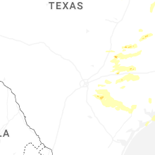


Connect with Interactive Hail Maps