

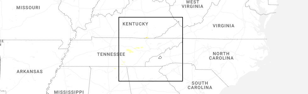
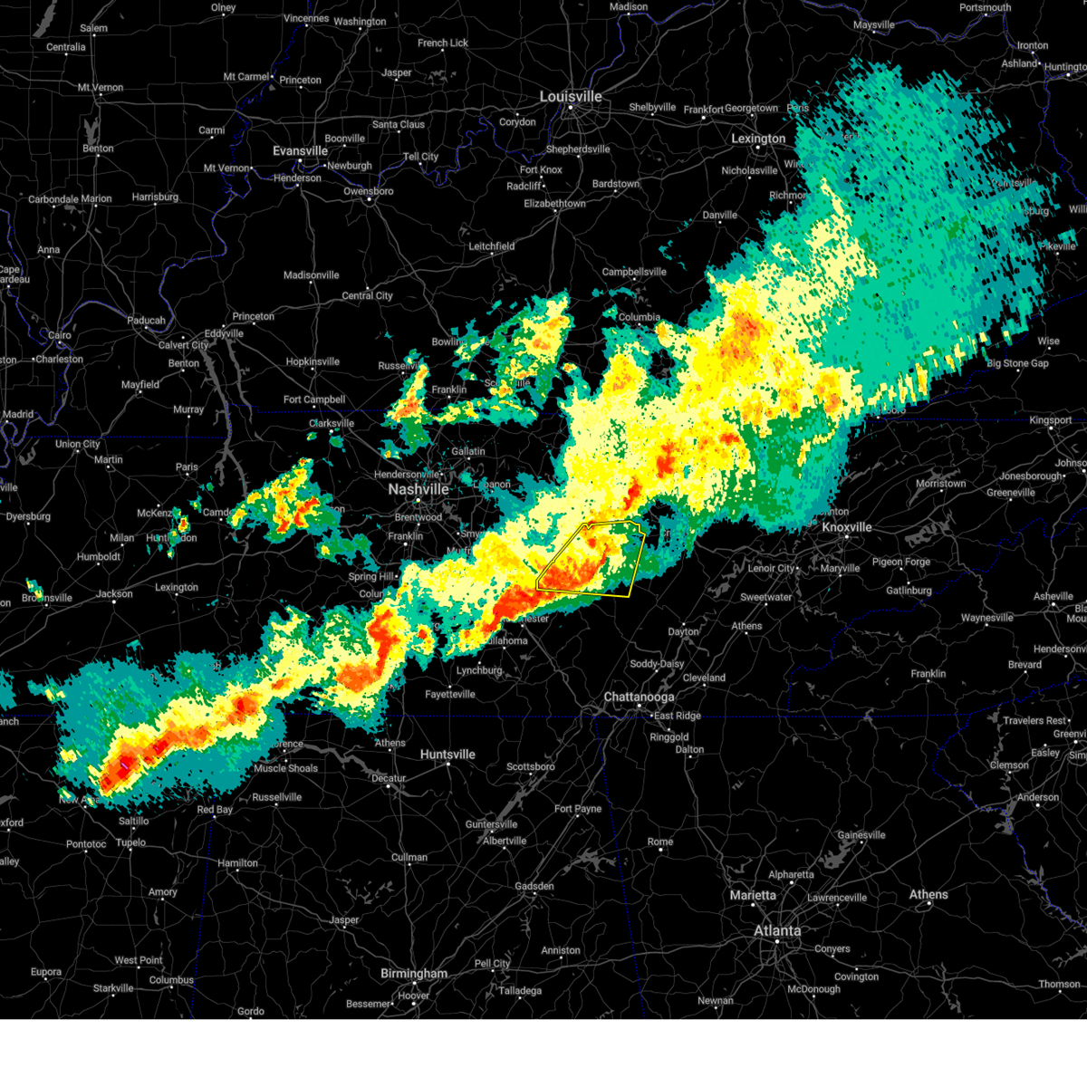
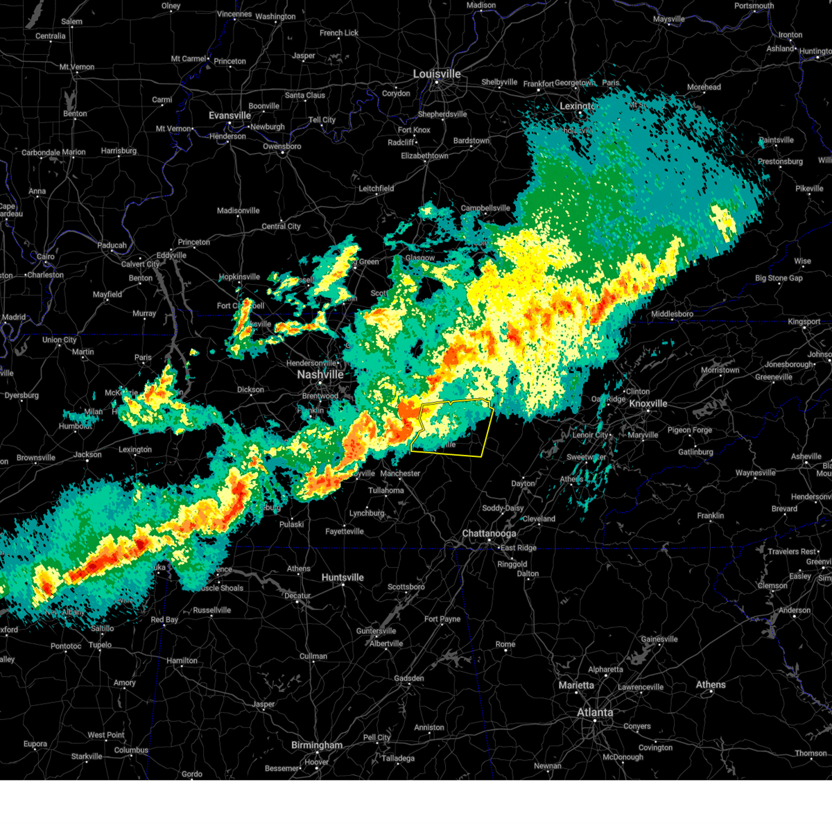
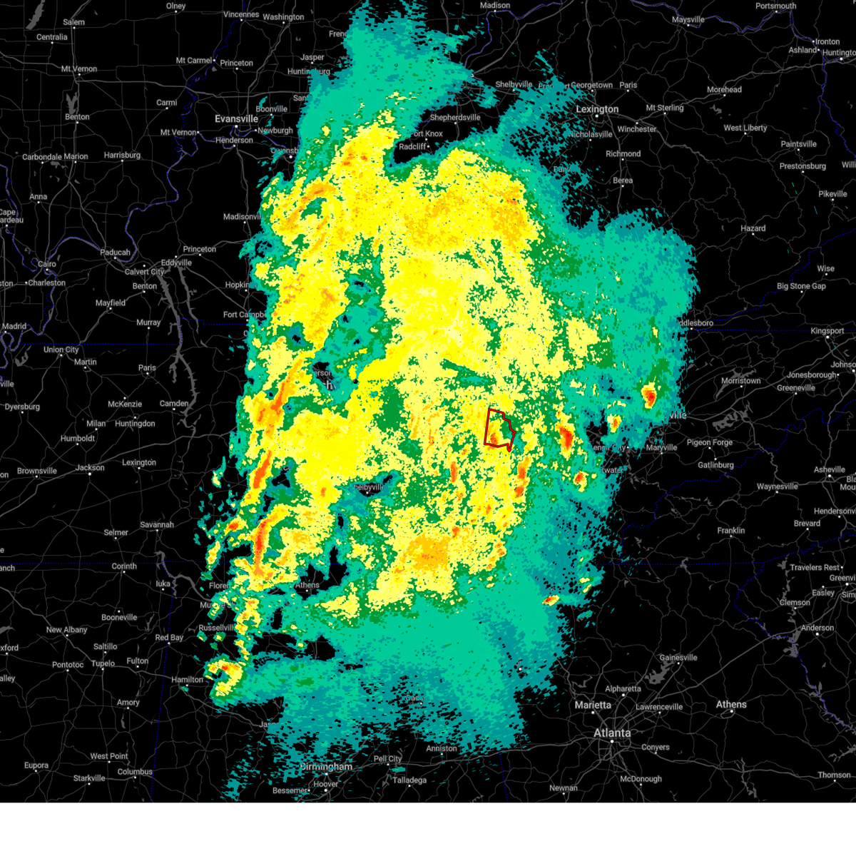
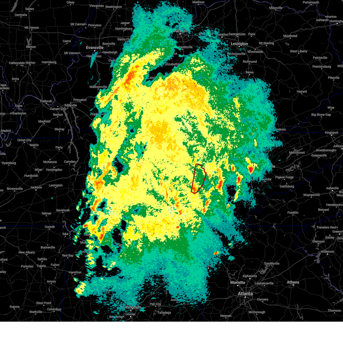
Hail Map for Sparta, TN
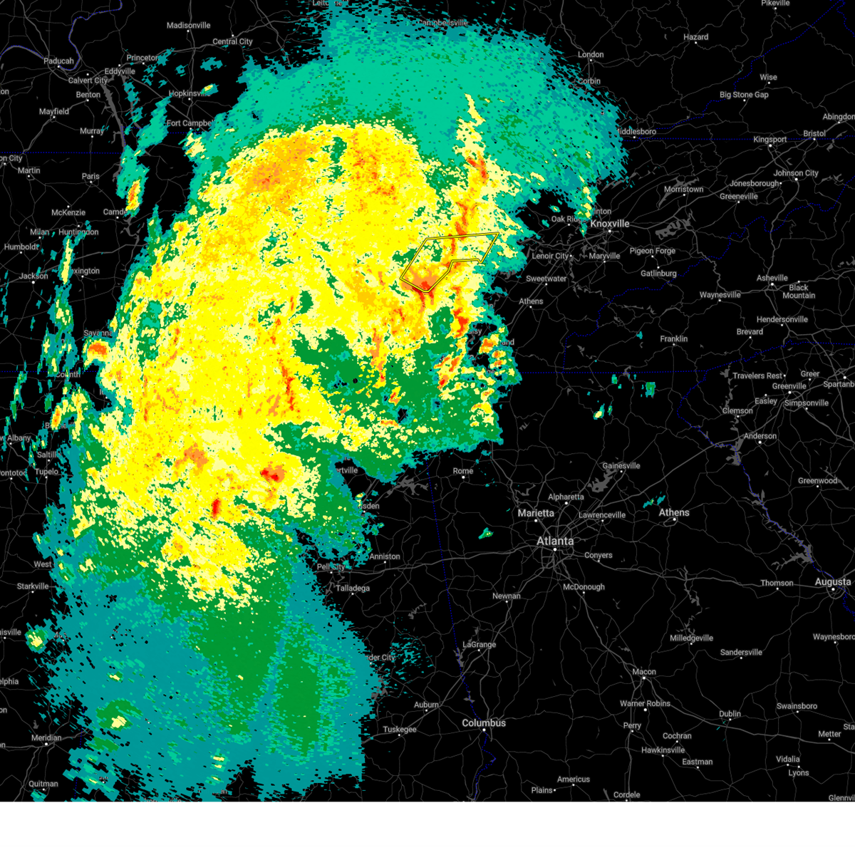
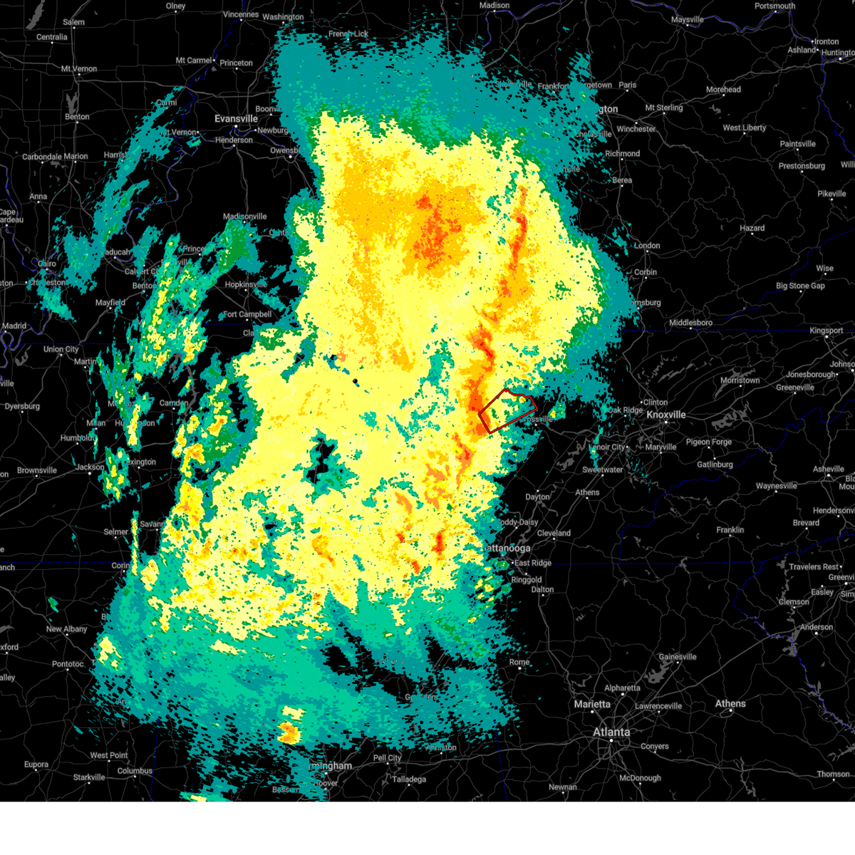
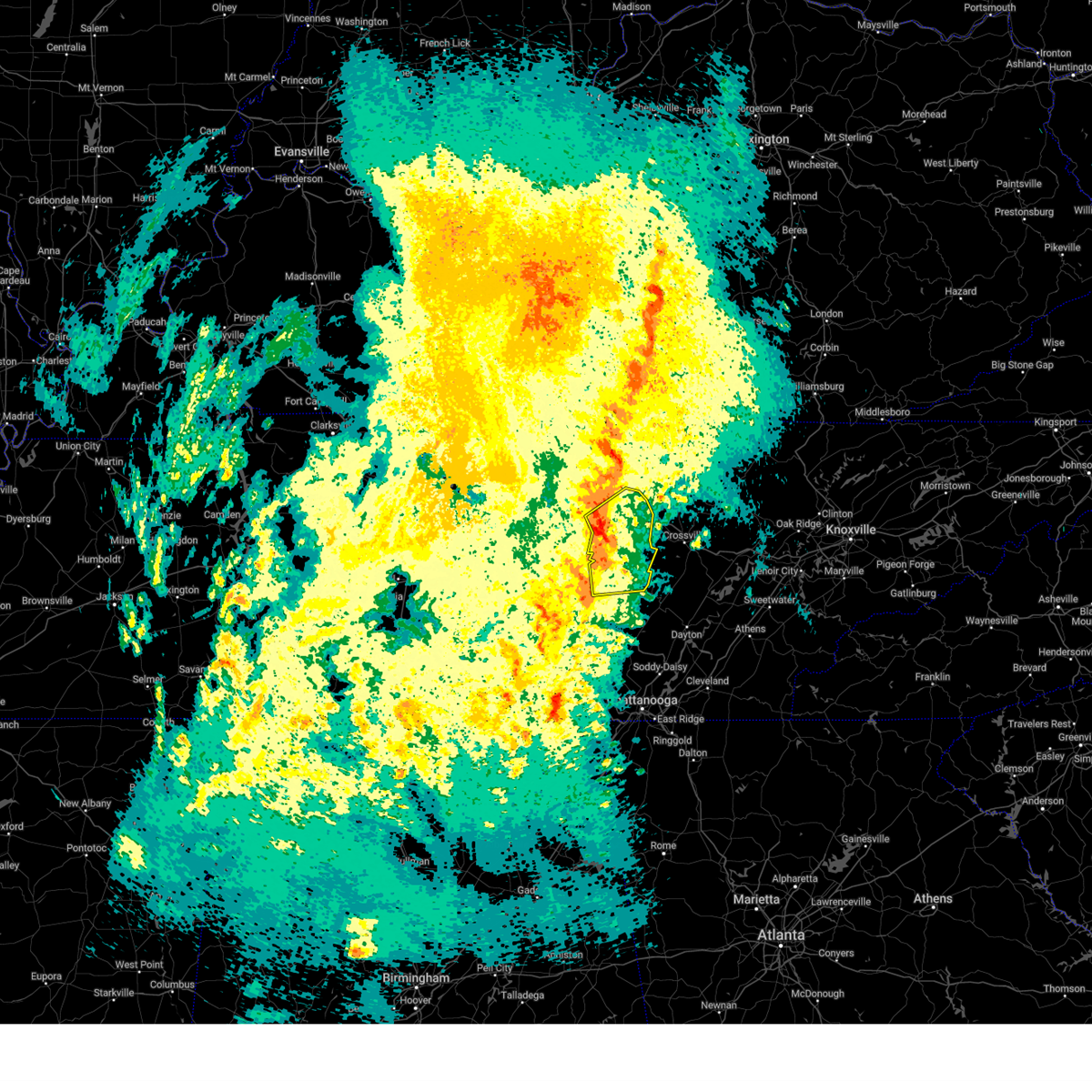
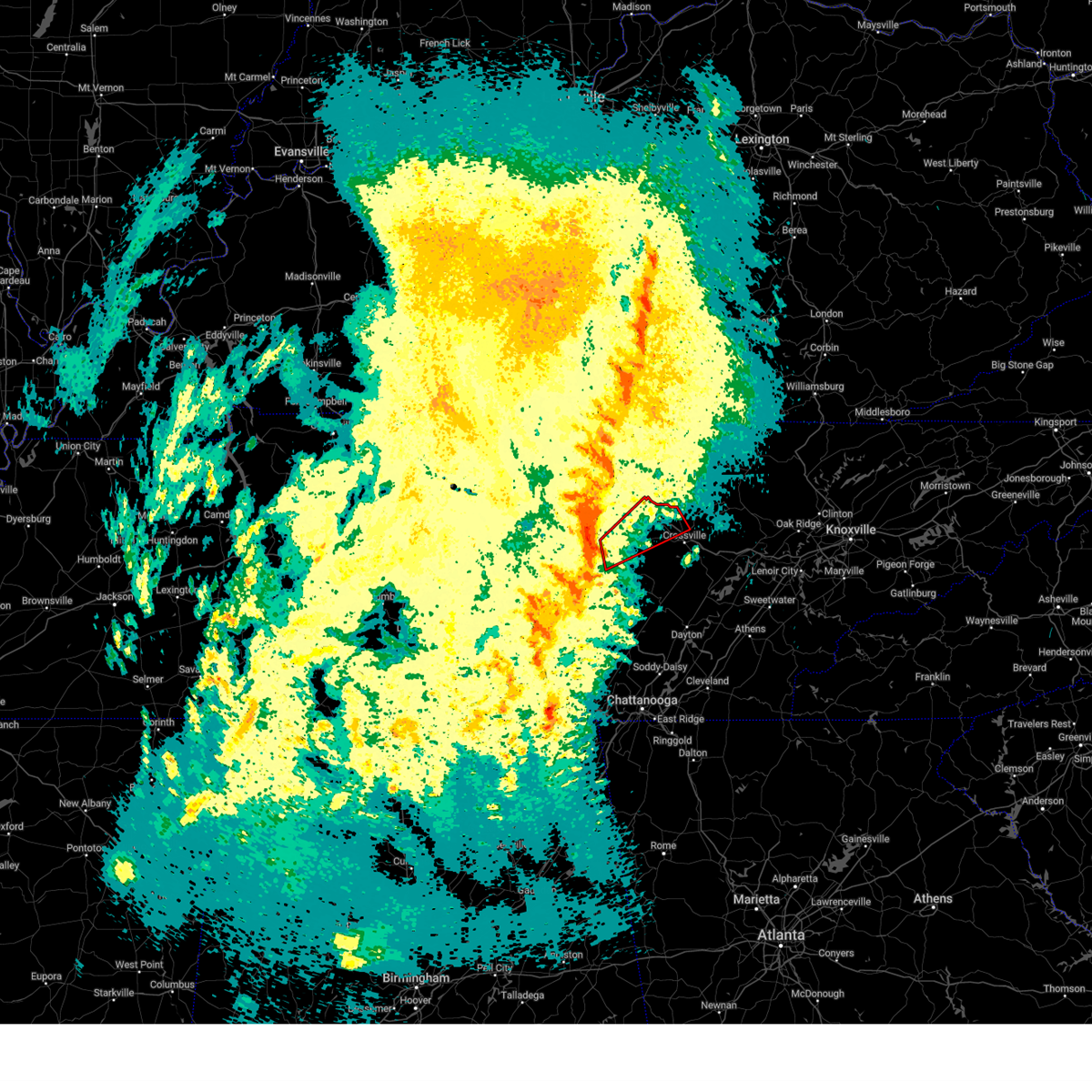
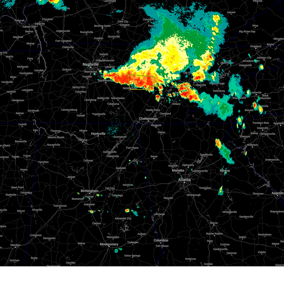
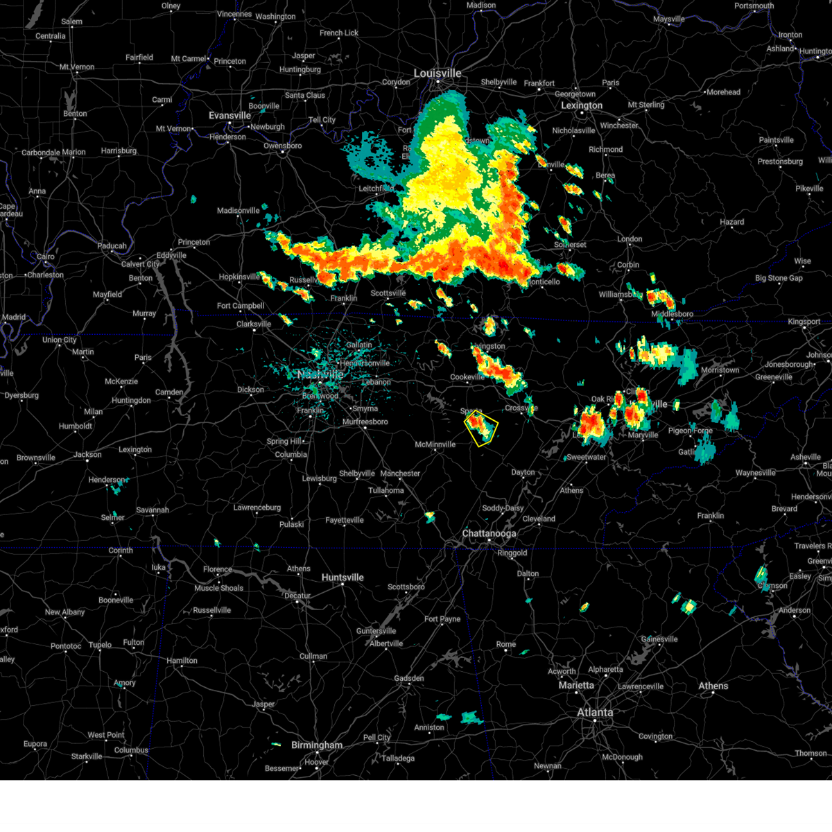
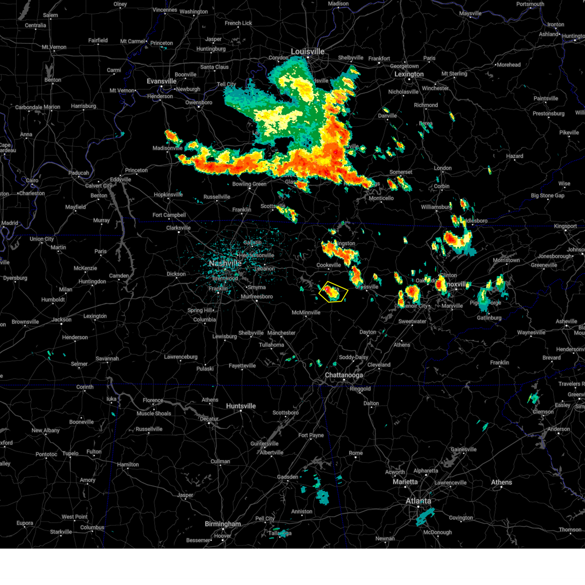
The Sparta, TN area has had 16 reports of on-the-ground hail by trained spotters, and has been under severe weather warnings 29 times during the past 12 months. Doppler radar has detected hail at or near Sparta, TN on 61 occasions, including 7 occasions during the past year.
| Name: | Sparta, TN |
| Where Located: | 62 miles N of Chattanooga, TN |
| Map: | Google Map for Sparta, TN |
| Population: | 4925 |
| Housing Units: | 2293 |
| More Info: | Search Google for Sparta, TN |
4
The Top Recent Hail Date for Sparta, TN is Sunday, October 13, 2024 (6th out of 61)
Hail and Wind Damage Spotted near Sparta, TN
| Date / Time | Report Details |
|---|---|
| 5/20/2025 8:28 PM EDT |
 Svrohx the national weather service in nashville has issued a * severe thunderstorm warning for, overton county in middle tennessee, south central pickett county in middle tennessee, cumberland county in middle tennessee, southeastern jackson county in middle tennessee, northern white county in middle tennessee, putnam county in middle tennessee, fentress county in middle tennessee, * until 830 pm cdt. * at 728 pm cdt, severe thunderstorms were located along a line extending from gainesboro to baxter, moving east at 55 mph (radar indicated). Hazards include 65 mph wind gusts and quarter size hail. Hail damage to vehicles is expected. Expect wind damage to roofs, siding, and trees. Svrohx the national weather service in nashville has issued a * severe thunderstorm warning for, overton county in middle tennessee, south central pickett county in middle tennessee, cumberland county in middle tennessee, southeastern jackson county in middle tennessee, northern white county in middle tennessee, putnam county in middle tennessee, fentress county in middle tennessee, * until 830 pm cdt. * at 728 pm cdt, severe thunderstorms were located along a line extending from gainesboro to baxter, moving east at 55 mph (radar indicated). Hazards include 65 mph wind gusts and quarter size hail. Hail damage to vehicles is expected. Expect wind damage to roofs, siding, and trees.
|
| 4/10/2025 6:45 PM CDT |
 the severe thunderstorm warning has been cancelled and is no longer in effect the severe thunderstorm warning has been cancelled and is no longer in effect
|
| 4/10/2025 6:38 PM CDT | the severe thunderstorm warning has been cancelled and is no longer in effect |
| 4/10/2025 6:38 PM CDT | At 638 pm cdt, severe thunderstorms were located along a line extending from 8 miles east of carthage to near smithville, moving east at 40 mph (radar indicated). Hazards include 60 mph wind gusts. Expect damage to roofs, siding, and trees. locations impacted include, sparta, hamptons crossroads, bakers crossroads, smithville, baxter, virgin falls state natural area, burgess falls state park, center hill lake, doyle, monterey, edgar evins state park, cookeville, and algood. This includes interstate 40 between mile markers 267 and 301. |
| 4/10/2025 6:27 PM CDT |
 Svrohx the national weather service in nashville has issued a * severe thunderstorm warning for, southeastern smith county in middle tennessee, de kalb county in middle tennessee, white county in middle tennessee, putnam county in middle tennessee, northeastern cannon county in middle tennessee, * until 715 pm cdt. * at 627 pm cdt, severe thunderstorms were located along a line extending from carthage to 8 miles northeast of woodbury, moving east at 40 mph (radar indicated). Hazards include 60 mph wind gusts. expect damage to roofs, siding, and trees Svrohx the national weather service in nashville has issued a * severe thunderstorm warning for, southeastern smith county in middle tennessee, de kalb county in middle tennessee, white county in middle tennessee, putnam county in middle tennessee, northeastern cannon county in middle tennessee, * until 715 pm cdt. * at 627 pm cdt, severe thunderstorms were located along a line extending from carthage to 8 miles northeast of woodbury, moving east at 40 mph (radar indicated). Hazards include 60 mph wind gusts. expect damage to roofs, siding, and trees
|
| 3/31/2025 1:48 AM CDT |
 the severe thunderstorm warning has been cancelled and is no longer in effect the severe thunderstorm warning has been cancelled and is no longer in effect
|
| 3/31/2025 1:48 AM CDT |
 At 148 am cdt, a severe thunderstorm was located 9 miles northeast of spencer, moving east at 40 mph (radar indicated). Hazards include 60 mph wind gusts and penny size hail. Expect damage to roofs, siding, and trees. Locations impacted include, sparta, rock island state park, spencer, mcminnville, doyle, and fall creek falls state park. At 148 am cdt, a severe thunderstorm was located 9 miles northeast of spencer, moving east at 40 mph (radar indicated). Hazards include 60 mph wind gusts and penny size hail. Expect damage to roofs, siding, and trees. Locations impacted include, sparta, rock island state park, spencer, mcminnville, doyle, and fall creek falls state park.
|
| 3/31/2025 1:34 AM CDT |
 At 134 am cdt, a severe thunderstorm was located near sparta, moving east at 40 mph (radar indicated). Hazards include 60 mph wind gusts and penny size hail. Expect damage to roofs, siding, and trees. Locations impacted include, sparta, bakers crossroads, mcminnville, doyle, centertown, rock island state park, spencer, and fall creek falls state park. At 134 am cdt, a severe thunderstorm was located near sparta, moving east at 40 mph (radar indicated). Hazards include 60 mph wind gusts and penny size hail. Expect damage to roofs, siding, and trees. Locations impacted include, sparta, bakers crossroads, mcminnville, doyle, centertown, rock island state park, spencer, and fall creek falls state park.
|
| 3/31/2025 12:58 AM CDT |
 Svrohx the national weather service in nashville has issued a * severe thunderstorm warning for, southeastern de kalb county in middle tennessee, northwestern van buren county in middle tennessee, northern warren county in middle tennessee, white county in middle tennessee, * until 200 am cdt. * at 1258 am cdt, a severe thunderstorm was located 8 miles east of woodbury, moving east at 40 mph (radar indicated). Hazards include 60 mph wind gusts and quarter size hail. Hail damage to vehicles is expected. Expect wind damage to roofs, siding, and trees. Svrohx the national weather service in nashville has issued a * severe thunderstorm warning for, southeastern de kalb county in middle tennessee, northwestern van buren county in middle tennessee, northern warren county in middle tennessee, white county in middle tennessee, * until 200 am cdt. * at 1258 am cdt, a severe thunderstorm was located 8 miles east of woodbury, moving east at 40 mph (radar indicated). Hazards include 60 mph wind gusts and quarter size hail. Hail damage to vehicles is expected. Expect wind damage to roofs, siding, and trees.
|
| 3/15/2025 7:36 PM CDT |
 At 736 pm cdt, a severe thunderstorm capable of producing a tornado was located 7 miles southeast of sparta, moving north at 50 mph (radar indicated rotation). Hazards include tornado. Flying debris will be dangerous to those caught without shelter. mobile homes will be damaged or destroyed. damage to roofs, windows, and vehicles will occur. tree damage is likely. This tornadic thunderstorm will remain over mainly rural areas of eastern white county, including the following locations, virgin falls state natural area. At 736 pm cdt, a severe thunderstorm capable of producing a tornado was located 7 miles southeast of sparta, moving north at 50 mph (radar indicated rotation). Hazards include tornado. Flying debris will be dangerous to those caught without shelter. mobile homes will be damaged or destroyed. damage to roofs, windows, and vehicles will occur. tree damage is likely. This tornadic thunderstorm will remain over mainly rural areas of eastern white county, including the following locations, virgin falls state natural area.
|
| 3/15/2025 7:36 PM CDT |
 the tornado warning has been cancelled and is no longer in effect the tornado warning has been cancelled and is no longer in effect
|
| 3/15/2025 7:25 PM CDT | At 725 pm cdt, a severe thunderstorm capable of producing a tornado was located over spencer, moving north at 50 mph (radar indicated rotation). Hazards include tornado. Flying debris will be dangerous to those caught without shelter. mobile homes will be damaged or destroyed. damage to roofs, windows, and vehicles will occur. tree damage is likely. this dangerous storm will be near, spencer around 730 pm cdt. Other locations impacted by this tornadic thunderstorm include virgin falls state natural area and fall creek falls state park. |
| 3/15/2025 7:16 PM CDT |
 Torohx the national weather service in nashville has issued a * tornado warning for, van buren county in middle tennessee, eastern white county in middle tennessee, * until 745 pm cdt. * at 716 pm cdt, a severe thunderstorm capable of producing a tornado was located 8 miles south of spencer, moving north at 50 mph (radar indicated rotation). Hazards include tornado. Flying debris will be dangerous to those caught without shelter. mobile homes will be damaged or destroyed. damage to roofs, windows, and vehicles will occur. tree damage is likely. this dangerous storm will be near, spencer around 720 pm cdt. Other locations impacted by this tornadic thunderstorm include virgin falls state natural area and fall creek falls state park. Torohx the national weather service in nashville has issued a * tornado warning for, van buren county in middle tennessee, eastern white county in middle tennessee, * until 745 pm cdt. * at 716 pm cdt, a severe thunderstorm capable of producing a tornado was located 8 miles south of spencer, moving north at 50 mph (radar indicated rotation). Hazards include tornado. Flying debris will be dangerous to those caught without shelter. mobile homes will be damaged or destroyed. damage to roofs, windows, and vehicles will occur. tree damage is likely. this dangerous storm will be near, spencer around 720 pm cdt. Other locations impacted by this tornadic thunderstorm include virgin falls state natural area and fall creek falls state park.
|
| 3/15/2025 5:29 PM CDT |
 Svrohx the national weather service in nashville has issued a * severe thunderstorm warning for, southwestern cumberland county in middle tennessee, van buren county in middle tennessee, east central warren county in middle tennessee, southeastern white county in middle tennessee, * until 615 pm cdt. * at 528 pm cdt, a severe thunderstorm was located 8 miles south of spencer, moving northeast at 45 mph (radar indicated). Hazards include 60 mph wind gusts and quarter size hail. Hail damage to vehicles is expected. Expect wind damage to roofs, siding, and trees. Svrohx the national weather service in nashville has issued a * severe thunderstorm warning for, southwestern cumberland county in middle tennessee, van buren county in middle tennessee, east central warren county in middle tennessee, southeastern white county in middle tennessee, * until 615 pm cdt. * at 528 pm cdt, a severe thunderstorm was located 8 miles south of spencer, moving northeast at 45 mph (radar indicated). Hazards include 60 mph wind gusts and quarter size hail. Hail damage to vehicles is expected. Expect wind damage to roofs, siding, and trees.
|
| 3/15/2025 5:01 PM CDT | the tornado warning has been cancelled and is no longer in effect |
| 3/15/2025 4:46 PM CDT |
 At 446 pm cdt, a severe thunderstorm capable of producing a tornado was located 7 miles northeast of sparta, moving northeast at 45 mph (radar indicated rotation). Hazards include tornado. Flying debris will be dangerous to those caught without shelter. mobile homes will be damaged or destroyed. damage to roofs, windows, and vehicles will occur. tree damage is likely. this dangerous storm will be near, monterey around 455 pm cdt. other locations impacted by this tornadic thunderstorm include pleasant hill. This includes interstate 40 between mile markers 296 and 314. At 446 pm cdt, a severe thunderstorm capable of producing a tornado was located 7 miles northeast of sparta, moving northeast at 45 mph (radar indicated rotation). Hazards include tornado. Flying debris will be dangerous to those caught without shelter. mobile homes will be damaged or destroyed. damage to roofs, windows, and vehicles will occur. tree damage is likely. this dangerous storm will be near, monterey around 455 pm cdt. other locations impacted by this tornadic thunderstorm include pleasant hill. This includes interstate 40 between mile markers 296 and 314.
|
| 3/15/2025 4:41 PM CDT |
 At 441 pm cdt, severe thunderstorms were located along a line extending from near algood to near sparta to spencer, moving northeast at 50 mph (radar indicated). Hazards include 60 mph wind gusts and penny size hail. Expect damage to roofs, siding, and trees. locations impacted include, sparta, hamptons crossroads, bakers crossroads, doyle, algood, virgin falls state natural area, burgess falls state park, rock island state park, spencer, monterey, cookeville, and fall creek falls state park. This includes interstate 40 between mile markers 282 and 303. At 441 pm cdt, severe thunderstorms were located along a line extending from near algood to near sparta to spencer, moving northeast at 50 mph (radar indicated). Hazards include 60 mph wind gusts and penny size hail. Expect damage to roofs, siding, and trees. locations impacted include, sparta, hamptons crossroads, bakers crossroads, doyle, algood, virgin falls state natural area, burgess falls state park, rock island state park, spencer, monterey, cookeville, and fall creek falls state park. This includes interstate 40 between mile markers 282 and 303.
|
| 3/15/2025 4:41 PM CDT |
 the severe thunderstorm warning has been cancelled and is no longer in effect the severe thunderstorm warning has been cancelled and is no longer in effect
|
| 3/15/2025 4:34 PM CDT |
 the tornado warning has been cancelled and is no longer in effect the tornado warning has been cancelled and is no longer in effect
|
| 3/15/2025 4:34 PM CDT |
 At 433 pm cdt, a severe thunderstorm capable of producing a tornado was located over sparta, moving northeast at 50 mph (radar indicated rotation). Hazards include tornado. Flying debris will be dangerous to those caught without shelter. mobile homes will be damaged or destroyed. damage to roofs, windows, and vehicles will occur. tree damage is likely. this dangerous storm will be near, sparta around 440 pm cdt. Other locations impacted by this tornadic thunderstorm include doyle. At 433 pm cdt, a severe thunderstorm capable of producing a tornado was located over sparta, moving northeast at 50 mph (radar indicated rotation). Hazards include tornado. Flying debris will be dangerous to those caught without shelter. mobile homes will be damaged or destroyed. damage to roofs, windows, and vehicles will occur. tree damage is likely. this dangerous storm will be near, sparta around 440 pm cdt. Other locations impacted by this tornadic thunderstorm include doyle.
|
| 3/15/2025 4:32 PM CDT |
 Torohx the national weather service in nashville has issued a * tornado warning for, northwestern cumberland county in middle tennessee, central white county in middle tennessee, southeastern putnam county in middle tennessee, * until 530 pm cdt. * at 432 pm cdt, a severe thunderstorm capable of producing a tornado was located near sparta, moving northeast at 45 mph (radar indicated rotation). Hazards include tornado. Flying debris will be dangerous to those caught without shelter. mobile homes will be damaged or destroyed. damage to roofs, windows, and vehicles will occur. tree damage is likely. this dangerous storm will be near, sparta around 440 pm cdt. monterey around 500 pm cdt. other locations impacted by this tornadic thunderstorm include doyle and pleasant hill. This includes interstate 40 between mile markers 296 and 317. Torohx the national weather service in nashville has issued a * tornado warning for, northwestern cumberland county in middle tennessee, central white county in middle tennessee, southeastern putnam county in middle tennessee, * until 530 pm cdt. * at 432 pm cdt, a severe thunderstorm capable of producing a tornado was located near sparta, moving northeast at 45 mph (radar indicated rotation). Hazards include tornado. Flying debris will be dangerous to those caught without shelter. mobile homes will be damaged or destroyed. damage to roofs, windows, and vehicles will occur. tree damage is likely. this dangerous storm will be near, sparta around 440 pm cdt. monterey around 500 pm cdt. other locations impacted by this tornadic thunderstorm include doyle and pleasant hill. This includes interstate 40 between mile markers 296 and 317.
|
| 3/15/2025 4:18 PM CDT | Svrohx the national weather service in nashville has issued a * severe thunderstorm warning for, eastern de kalb county in middle tennessee, northern van buren county in middle tennessee, northeastern warren county in middle tennessee, white county in middle tennessee, putnam county in middle tennessee, * until 500 pm cdt. * at 418 pm cdt, severe thunderstorms were located along a line extending from 7 miles southeast of gordonsville to 9 miles southeast of smithville to near mcminnville, moving east at 75 mph (radar indicated). Hazards include 60 mph wind gusts and penny size hail. expect damage to roofs, siding, and trees |
| 3/15/2025 4:16 PM CDT | At 416 pm cdt, a severe thunderstorm capable of producing a tornado was located 7 miles north of mcminnville, moving east at 40 mph (radar indicated rotation). Hazards include tornado. Flying debris will be dangerous to those caught without shelter. mobile homes will be damaged or destroyed. damage to roofs, windows, and vehicles will occur. tree damage is likely. this dangerous storm will be near, sparta around 435 pm cdt. Other locations impacted by this tornadic thunderstorm include doyle and rock island state park. |
| 3/15/2025 4:05 PM CDT | Torohx the national weather service in nashville has issued a * tornado warning for, southeastern de kalb county in middle tennessee, northwestern van buren county in middle tennessee, warren county in middle tennessee, southwestern white county in middle tennessee, * until 445 pm cdt. * at 405 pm cdt, a severe thunderstorm capable of producing a tornado was located near mcminnville, moving east at 50 mph (radar indicated rotation). Hazards include tornado. Flying debris will be dangerous to those caught without shelter. mobile homes will be damaged or destroyed. damage to roofs, windows, and vehicles will occur. tree damage is likely. this dangerous storm will be near, spencer around 425 pm cdt. Other locations impacted by this tornadic thunderstorm include rock island state park, morrison, doyle, and centertown. |
| 7/30/2024 4:22 PM CDT | Water over the road in spart in white county TN, 0.5 miles NW of Sparta, TN |
| 7/30/2024 4:16 PM CDT |
 the severe thunderstorm warning has been cancelled and is no longer in effect the severe thunderstorm warning has been cancelled and is no longer in effect
|
| 7/30/2024 4:16 PM CDT |
 At 415 pm cdt, severe thunderstorms were located along a line extending from pikeville to near mcminnville, moving south at 40 mph (radar indicated). Hazards include 60 mph wind gusts and quarter size hail. Hail damage to vehicles is expected. expect wind damage to roofs, siding, and trees. Locations impacted include, mcminnville, sparta, smithville, spencer, doyle, indian rock lake, virgin falls state natural area, rock island state park, and fall creek falls state park. At 415 pm cdt, severe thunderstorms were located along a line extending from pikeville to near mcminnville, moving south at 40 mph (radar indicated). Hazards include 60 mph wind gusts and quarter size hail. Hail damage to vehicles is expected. expect wind damage to roofs, siding, and trees. Locations impacted include, mcminnville, sparta, smithville, spencer, doyle, indian rock lake, virgin falls state natural area, rock island state park, and fall creek falls state park.
|
| 7/30/2024 3:54 PM CDT | Tree down at the intersection of n spring st and wright r in white county TN, 0.4 miles SW of Sparta, TN |
| 7/30/2024 3:44 PM CDT | Svrohx the national weather service in nashville has issued a * severe thunderstorm warning for, southwestern cumberland county in middle tennessee, southeastern smith county in middle tennessee, eastern de kalb county in middle tennessee, northern van buren county in middle tennessee, northeastern warren county in middle tennessee, white county in middle tennessee, putnam county in middle tennessee, * until 430 pm cdt. * at 344 pm cdt, severe thunderstorms were located along a line extending from monterey to near smithville, moving southeast at 50 mph (radar indicated). Hazards include 60 mph wind gusts and quarter size hail. Hail damage to vehicles is expected. Expect wind damage to roofs, siding, and trees. |
| 7/30/2024 2:11 PM CDT |
 Svrohx the national weather service in nashville has issued a * severe thunderstorm warning for, northeastern van buren county in middle tennessee, southeastern white county in middle tennessee, * until 230 pm cdt. * at 211 pm cdt, a severe thunderstorm was located near sparta, moving southeast at 15 mph (radar indicated). Hazards include 60 mph wind gusts. expect damage to roofs, siding, and trees Svrohx the national weather service in nashville has issued a * severe thunderstorm warning for, northeastern van buren county in middle tennessee, southeastern white county in middle tennessee, * until 230 pm cdt. * at 211 pm cdt, a severe thunderstorm was located near sparta, moving southeast at 15 mph (radar indicated). Hazards include 60 mph wind gusts. expect damage to roofs, siding, and trees
|
| 7/30/2024 1:58 PM CDT | Tree down... street floodin in white county TN, 0.5 miles NNE of Sparta, TN |
| 7/30/2024 1:54 PM CDT | Report from mping: 1-inch tree limbs broken; shingles blown of in white county TN, 2.7 miles ESE of Sparta, TN |
| 7/30/2024 1:47 PM CDT |
 Svrohx the national weather service in nashville has issued a * severe thunderstorm warning for, central white county in middle tennessee, * until 215 pm cdt. * at 147 pm cdt, a severe thunderstorm was located over sparta, moving southeast at 20 mph (radar indicated). Hazards include 60 mph wind gusts. expect damage to roofs, siding, and trees Svrohx the national weather service in nashville has issued a * severe thunderstorm warning for, central white county in middle tennessee, * until 215 pm cdt. * at 147 pm cdt, a severe thunderstorm was located over sparta, moving southeast at 20 mph (radar indicated). Hazards include 60 mph wind gusts. expect damage to roofs, siding, and trees
|
| 5/27/2024 1:26 AM CDT | Tree down near old smithville hwy n and oaklawn cemetery r in white county TN, 0.5 miles NW of Sparta, TN |
| 5/23/2024 5:18 PM CDT | Several trees uprooted and some treetops snapped off. also minor structural damag in white county TN, 11.9 miles WNW of Sparta, TN |
| 5/22/2024 7:08 PM CDT |
 The storm which prompted the warning has weakened below severe limits, and no longer poses an immediate threat to life or property. therefore, the warning will be allowed to expire. however, gusty winds are still possible with this thunderstorm. a severe thunderstorm watch remains in effect until 1000 pm cdt for middle tennessee. The storm which prompted the warning has weakened below severe limits, and no longer poses an immediate threat to life or property. therefore, the warning will be allowed to expire. however, gusty winds are still possible with this thunderstorm. a severe thunderstorm watch remains in effect until 1000 pm cdt for middle tennessee.
|
| 5/22/2024 6:54 PM CDT |
 At 653 pm cdt, a severe thunderstorm was located 8 miles south of monterey, or 12 miles northwest of crossville, moving east at 60 mph (radar indicated). Hazards include 60 mph wind gusts. Expect damage to roofs, siding, and trees. locations impacted include, crossville, sparta, fairfield glade, monterey, crab orchard, pleasant hill, lake tansi, cumberland mountain state park, slate springs, and virgin falls state natural area. This includes interstate 40 between mile markers 293 and 331. At 653 pm cdt, a severe thunderstorm was located 8 miles south of monterey, or 12 miles northwest of crossville, moving east at 60 mph (radar indicated). Hazards include 60 mph wind gusts. Expect damage to roofs, siding, and trees. locations impacted include, crossville, sparta, fairfield glade, monterey, crab orchard, pleasant hill, lake tansi, cumberland mountain state park, slate springs, and virgin falls state natural area. This includes interstate 40 between mile markers 293 and 331.
|
| 5/22/2024 6:44 PM CDT |
 At 644 pm cdt, a severe thunderstorm was located near sparta, moving east at 55 mph (radar indicated). Hazards include 60 mph wind gusts. Expect damage to roofs, siding, and trees. locations impacted include, cookeville, crossville, sparta, fairfield glade, monterey, crab orchard, pleasant hill, doyle, hamptons crossroads, cumberland mountain state park, slate springs, bakers crossroads, virgin falls state natural area, burgess falls state park, and lake tansi. This includes interstate 40 between mile markers 286 and 331. At 644 pm cdt, a severe thunderstorm was located near sparta, moving east at 55 mph (radar indicated). Hazards include 60 mph wind gusts. Expect damage to roofs, siding, and trees. locations impacted include, cookeville, crossville, sparta, fairfield glade, monterey, crab orchard, pleasant hill, doyle, hamptons crossroads, cumberland mountain state park, slate springs, bakers crossroads, virgin falls state natural area, burgess falls state park, and lake tansi. This includes interstate 40 between mile markers 286 and 331.
|
| 5/22/2024 6:44 PM CDT |
 the severe thunderstorm warning has been cancelled and is no longer in effect the severe thunderstorm warning has been cancelled and is no longer in effect
|
| 5/22/2024 6:29 PM CDT |
 Svrohx the national weather service in nashville has issued a * severe thunderstorm warning for, southeastern overton county in middle tennessee, cumberland county in middle tennessee, eastern de kalb county in middle tennessee, white county in middle tennessee, southern putnam county in middle tennessee, * until 715 pm cdt. * at 629 pm cdt, a severe thunderstorm was located 7 miles west of sparta, moving east at 55 mph (radar indicated). Hazards include 60 mph wind gusts. expect damage to roofs, siding, and trees Svrohx the national weather service in nashville has issued a * severe thunderstorm warning for, southeastern overton county in middle tennessee, cumberland county in middle tennessee, eastern de kalb county in middle tennessee, white county in middle tennessee, southern putnam county in middle tennessee, * until 715 pm cdt. * at 629 pm cdt, a severe thunderstorm was located 7 miles west of sparta, moving east at 55 mph (radar indicated). Hazards include 60 mph wind gusts. expect damage to roofs, siding, and trees
|
| 5/8/2024 7:41 PM CDT |
 Svrohx the national weather service in nashville has issued a * severe thunderstorm warning for, southern overton county in middle tennessee, northern cumberland county in middle tennessee, northeastern white county in middle tennessee, eastern putnam county in middle tennessee, southwestern fentress county in middle tennessee, * until 815 pm cdt. * at 741 pm cdt, a severe thunderstorm was located near monterey, or 10 miles east of cookeville, moving east at 45 mph (radar indicated). Hazards include 60 mph wind gusts and nickel size hail. expect damage to roofs, siding, and trees Svrohx the national weather service in nashville has issued a * severe thunderstorm warning for, southern overton county in middle tennessee, northern cumberland county in middle tennessee, northeastern white county in middle tennessee, eastern putnam county in middle tennessee, southwestern fentress county in middle tennessee, * until 815 pm cdt. * at 741 pm cdt, a severe thunderstorm was located near monterey, or 10 miles east of cookeville, moving east at 45 mph (radar indicated). Hazards include 60 mph wind gusts and nickel size hail. expect damage to roofs, siding, and trees
|
| 5/8/2024 7:36 PM CDT |
 At 736 pm cdt, a severe thunderstorm was located near sparta, moving east at 30 mph (emergency management). Hazards include 60 mph wind gusts and nickel size hail. Expect damage to roofs, siding, and trees. locations impacted include, cookeville, sparta, algood, monterey, baxter, hamptons crossroads, bakers crossroads, and burgess falls state park. This includes interstate 40 between mile markers 280 and 303. At 736 pm cdt, a severe thunderstorm was located near sparta, moving east at 30 mph (emergency management). Hazards include 60 mph wind gusts and nickel size hail. Expect damage to roofs, siding, and trees. locations impacted include, cookeville, sparta, algood, monterey, baxter, hamptons crossroads, bakers crossroads, and burgess falls state park. This includes interstate 40 between mile markers 280 and 303.
|
| 5/8/2024 7:36 PM CDT |
 the severe thunderstorm warning has been cancelled and is no longer in effect the severe thunderstorm warning has been cancelled and is no longer in effect
|
| 5/8/2024 7:30 PM CDT |
 At 730 pm cdt, a severe thunderstorm was located 7 miles north of sparta, moving east at 30 mph (emergency management). Hazards include 60 mph wind gusts and quarter size hail. Hail damage to vehicles is expected. expect wind damage to roofs, siding, and trees. locations impacted include, cookeville, sparta, algood, monterey, baxter, doyle, hamptons crossroads, bakers crossroads, and burgess falls state park. This includes interstate 40 between mile markers 279 and 303. At 730 pm cdt, a severe thunderstorm was located 7 miles north of sparta, moving east at 30 mph (emergency management). Hazards include 60 mph wind gusts and quarter size hail. Hail damage to vehicles is expected. expect wind damage to roofs, siding, and trees. locations impacted include, cookeville, sparta, algood, monterey, baxter, doyle, hamptons crossroads, bakers crossroads, and burgess falls state park. This includes interstate 40 between mile markers 279 and 303.
|
| 5/8/2024 7:24 PM CDT |
 At 724 pm cdt, a severe thunderstorm was located 7 miles south of cookeville, moving east at 30 mph (emergency management). Hazards include 60 mph wind gusts and quarter size hail. Hail damage to vehicles is expected. expect wind damage to roofs, siding, and trees. locations impacted include, cookeville, sparta, smithville, algood, monterey, baxter, doyle, hamptons crossroads, bakers crossroads, and burgess falls state park. This includes interstate 40 between mile markers 270 and 303. At 724 pm cdt, a severe thunderstorm was located 7 miles south of cookeville, moving east at 30 mph (emergency management). Hazards include 60 mph wind gusts and quarter size hail. Hail damage to vehicles is expected. expect wind damage to roofs, siding, and trees. locations impacted include, cookeville, sparta, smithville, algood, monterey, baxter, doyle, hamptons crossroads, bakers crossroads, and burgess falls state park. This includes interstate 40 between mile markers 270 and 303.
|
| 5/8/2024 7:15 PM CDT |
 At 714 pm cdt, a severe thunderstorm was located 9 miles west of sparta, moving southeast at 35 mph (radar indicated). Hazards include 60 mph wind gusts and quarter size hail. Hail damage to vehicles is expected. expect wind damage to roofs, siding, and trees. locations impacted include, sparta, smithville, center hill lake, hamptons crossroads, bakers crossroads, burgess falls state park, rock island state park, and edgar evins state park. This includes interstate 40 between mile markers 267 and 278. At 714 pm cdt, a severe thunderstorm was located 9 miles west of sparta, moving southeast at 35 mph (radar indicated). Hazards include 60 mph wind gusts and quarter size hail. Hail damage to vehicles is expected. expect wind damage to roofs, siding, and trees. locations impacted include, sparta, smithville, center hill lake, hamptons crossroads, bakers crossroads, burgess falls state park, rock island state park, and edgar evins state park. This includes interstate 40 between mile markers 267 and 278.
|
| 5/8/2024 7:15 PM CDT |
 the severe thunderstorm warning has been cancelled and is no longer in effect the severe thunderstorm warning has been cancelled and is no longer in effect
|
| 5/8/2024 7:13 PM CDT |
 Svrohx the national weather service in nashville has issued a * severe thunderstorm warning for, northeastern de kalb county in middle tennessee, white county in middle tennessee, putnam county in middle tennessee, * until 800 pm cdt. * at 713 pm cdt, a severe thunderstorm was located near baxter, or 9 miles southwest of cookeville, moving east at 30 mph (radar indicated). Hazards include 60 mph wind gusts and quarter size hail. Hail damage to vehicles is expected. Expect wind damage to roofs, siding, and trees. Svrohx the national weather service in nashville has issued a * severe thunderstorm warning for, northeastern de kalb county in middle tennessee, white county in middle tennessee, putnam county in middle tennessee, * until 800 pm cdt. * at 713 pm cdt, a severe thunderstorm was located near baxter, or 9 miles southwest of cookeville, moving east at 30 mph (radar indicated). Hazards include 60 mph wind gusts and quarter size hail. Hail damage to vehicles is expected. Expect wind damage to roofs, siding, and trees.
|
| 5/8/2024 6:50 PM CDT |
 Svrohx the national weather service in nashville has issued a * severe thunderstorm warning for, southeastern smith county in middle tennessee, de kalb county in middle tennessee, northeastern warren county in middle tennessee, east central wilson county in middle tennessee, western white county in middle tennessee, southwestern putnam county in middle tennessee, * until 730 pm cdt. * at 649 pm cdt, a severe thunderstorm was located near gordonsville, or 9 miles north of smithville, moving southeast at 35 mph (radar indicated). Hazards include 60 mph wind gusts and quarter size hail. Hail damage to vehicles is expected. Expect wind damage to roofs, siding, and trees. Svrohx the national weather service in nashville has issued a * severe thunderstorm warning for, southeastern smith county in middle tennessee, de kalb county in middle tennessee, northeastern warren county in middle tennessee, east central wilson county in middle tennessee, western white county in middle tennessee, southwestern putnam county in middle tennessee, * until 730 pm cdt. * at 649 pm cdt, a severe thunderstorm was located near gordonsville, or 9 miles north of smithville, moving southeast at 35 mph (radar indicated). Hazards include 60 mph wind gusts and quarter size hail. Hail damage to vehicles is expected. Expect wind damage to roofs, siding, and trees.
|
| 5/6/2024 6:12 PM CDT |
 The storm which prompted the warning has weakened below severe limits, and no longer poses an immediate threat to life or property. therefore, the warning will be allowed to expire. however, small hail, gusty winds and heavy rain are still possible with this thunderstorm. The storm which prompted the warning has weakened below severe limits, and no longer poses an immediate threat to life or property. therefore, the warning will be allowed to expire. however, small hail, gusty winds and heavy rain are still possible with this thunderstorm.
|
| 5/6/2024 5:46 PM CDT |
 At 546 pm cdt, a severe thunderstorm was located 11 miles northeast of spencer, moving east at 40 mph (radar indicated). Hazards include 60 mph wind gusts and nickel size hail. Expect damage to roofs, siding, and trees. locations impacted include, crossville, sparta, spencer, crab orchard, pleasant hill, doyle, lake tansi, cumberland mountain state park, fall creek falls state park, indian rock lake, and virgin falls state natural area. This includes interstate 40 between mile markers 327 and 338. At 546 pm cdt, a severe thunderstorm was located 11 miles northeast of spencer, moving east at 40 mph (radar indicated). Hazards include 60 mph wind gusts and nickel size hail. Expect damage to roofs, siding, and trees. locations impacted include, crossville, sparta, spencer, crab orchard, pleasant hill, doyle, lake tansi, cumberland mountain state park, fall creek falls state park, indian rock lake, and virgin falls state natural area. This includes interstate 40 between mile markers 327 and 338.
|
| 5/6/2024 5:30 PM CDT | Large trees down on hickory valley road just south of panther drive in spart in white county TN, 2.5 miles N of Sparta, TN |
| 5/6/2024 5:26 PM CDT |
 Svrohx the national weather service in nashville has issued a * severe thunderstorm warning for, southern cumberland county in middle tennessee, northern van buren county in middle tennessee, white county in middle tennessee, * until 615 pm cdt. * at 526 pm cdt, a severe thunderstorm was located over sparta, moving east at 30 mph (radar indicated). Hazards include 60 mph wind gusts and nickel size hail. expect damage to roofs, siding, and trees Svrohx the national weather service in nashville has issued a * severe thunderstorm warning for, southern cumberland county in middle tennessee, northern van buren county in middle tennessee, white county in middle tennessee, * until 615 pm cdt. * at 526 pm cdt, a severe thunderstorm was located over sparta, moving east at 30 mph (radar indicated). Hazards include 60 mph wind gusts and nickel size hail. expect damage to roofs, siding, and trees
|
| 5/6/2024 5:25 PM CDT | Quarter sized hail reported 2 miles ENE of Sparta, TN, tspotter photo of quarter size hail on honeysuckle ln southwest of sparta. |
| 5/6/2024 5:17 PM CDT |
 At 517 pm cdt, a severe thunderstorm was located near sparta, moving east at 30 mph (radar indicated). Hazards include 60 mph wind gusts and nickel size hail. Expect damage to roofs, siding, and trees. locations impacted include, crossville, sparta, spencer, pleasant hill, doyle, hamptons crossroads, bakers crossroads, virgin falls state natural area, rock island state park, and fall creek falls state park. This includes interstate 40 between mile markers 312 and 317. At 517 pm cdt, a severe thunderstorm was located near sparta, moving east at 30 mph (radar indicated). Hazards include 60 mph wind gusts and nickel size hail. Expect damage to roofs, siding, and trees. locations impacted include, crossville, sparta, spencer, pleasant hill, doyle, hamptons crossroads, bakers crossroads, virgin falls state natural area, rock island state park, and fall creek falls state park. This includes interstate 40 between mile markers 312 and 317.
|
| 5/6/2024 5:17 PM CDT |
 the severe thunderstorm warning has been cancelled and is no longer in effect the severe thunderstorm warning has been cancelled and is no longer in effect
|
| 5/6/2024 5:11 PM CDT |
 the tornado warning has been cancelled and is no longer in effect the tornado warning has been cancelled and is no longer in effect
|
| 5/6/2024 4:57 PM CDT |
 Torohx the national weather service in nashville has issued a * tornado warning for, central white county in middle tennessee, * until 530 pm cdt. * at 457 pm cdt, a severe thunderstorm capable of producing a tornado was located 7 miles west of sparta, moving east at 20 mph (radar indicated rotation). Hazards include tornado and quarter size hail. Flying debris will be dangerous to those caught without shelter. mobile homes will be damaged or destroyed. damage to roofs, windows, and vehicles will occur. tree damage is likely. this dangerous storm will be near, sparta around 505 pm cdt. Other locations impacted by this tornadic thunderstorm include doyle. Torohx the national weather service in nashville has issued a * tornado warning for, central white county in middle tennessee, * until 530 pm cdt. * at 457 pm cdt, a severe thunderstorm capable of producing a tornado was located 7 miles west of sparta, moving east at 20 mph (radar indicated rotation). Hazards include tornado and quarter size hail. Flying debris will be dangerous to those caught without shelter. mobile homes will be damaged or destroyed. damage to roofs, windows, and vehicles will occur. tree damage is likely. this dangerous storm will be near, sparta around 505 pm cdt. Other locations impacted by this tornadic thunderstorm include doyle.
|
| 5/6/2024 4:51 PM CDT |
 Svrohx the national weather service in nashville has issued a * severe thunderstorm warning for, west central cumberland county in middle tennessee, eastern de kalb county in middle tennessee, northern van buren county in middle tennessee, northeastern warren county in middle tennessee, white county in middle tennessee, southern putnam county in middle tennessee, * until 530 pm cdt. * at 451 pm cdt, a severe thunderstorm was located 7 miles west of sparta, moving east at 35 mph (radar indicated). Hazards include 60 mph wind gusts and quarter size hail. Hail damage to vehicles is expected. Expect wind damage to roofs, siding, and trees. Svrohx the national weather service in nashville has issued a * severe thunderstorm warning for, west central cumberland county in middle tennessee, eastern de kalb county in middle tennessee, northern van buren county in middle tennessee, northeastern warren county in middle tennessee, white county in middle tennessee, southern putnam county in middle tennessee, * until 530 pm cdt. * at 451 pm cdt, a severe thunderstorm was located 7 miles west of sparta, moving east at 35 mph (radar indicated). Hazards include 60 mph wind gusts and quarter size hail. Hail damage to vehicles is expected. Expect wind damage to roofs, siding, and trees.
|
| 8/12/2023 1:25 PM CDT | Trees and power lines down across east and southeast white count in white county TN, 6.5 miles W of Sparta, TN |
| 8/12/2023 1:24 PM CDT |
 At 123 pm cdt, severe thunderstorms were located along a line extending from algood to sparta to spencer, moving east at 55 mph (radar indicated). Hazards include 60 mph wind gusts. expect damage to roofs, siding, and trees At 123 pm cdt, severe thunderstorms were located along a line extending from algood to sparta to spencer, moving east at 55 mph (radar indicated). Hazards include 60 mph wind gusts. expect damage to roofs, siding, and trees
|
| 8/12/2023 1:12 PM CDT |
 At 112 pm cdt, severe thunderstorms were located along a line extending from dodsons branch to sparta to mcminnville, moving east at 55 mph (radar indicated). Hazards include 60 mph wind gusts. Expect damage to roofs, siding, and trees. locations impacted include, cookeville, sparta, spencer, algood, monterey, baxter, doyle, hamptons crossroads, bakers crossroads, virgin falls state natural area, burgess falls state park, rock island state park, rickman, fall creek falls state park and cummins falls state park. this includes interstate 40 between mile markers 279 and 303. hail threat, radar indicated max hail size, <. 75 in wind threat, radar indicated max wind gust, 60 mph. At 112 pm cdt, severe thunderstorms were located along a line extending from dodsons branch to sparta to mcminnville, moving east at 55 mph (radar indicated). Hazards include 60 mph wind gusts. Expect damage to roofs, siding, and trees. locations impacted include, cookeville, sparta, spencer, algood, monterey, baxter, doyle, hamptons crossroads, bakers crossroads, virgin falls state natural area, burgess falls state park, rock island state park, rickman, fall creek falls state park and cummins falls state park. this includes interstate 40 between mile markers 279 and 303. hail threat, radar indicated max hail size, <. 75 in wind threat, radar indicated max wind gust, 60 mph.
|
| 8/12/2023 12:58 PM CDT |
 At 1257 pm cdt, severe thunderstorms were located along a line extending from carthage to baxter to near mcminnville, moving east at 50 mph (radar indicated). Hazards include 70 mph wind gusts. Expect considerable tree damage. Damage is likely to mobile homes, roofs, and outbuildings. At 1257 pm cdt, severe thunderstorms were located along a line extending from carthage to baxter to near mcminnville, moving east at 50 mph (radar indicated). Hazards include 70 mph wind gusts. Expect considerable tree damage. Damage is likely to mobile homes, roofs, and outbuildings.
|
| 8/7/2023 12:26 PM CDT |
 At 1226 pm cdt, a severe thunderstorm was located near spencer, moving east at 55 mph (radar indicated). Hazards include 70 mph wind gusts and penny size hail. Expect considerable tree damage. Damage is likely to mobile homes, roofs, and outbuildings. At 1226 pm cdt, a severe thunderstorm was located near spencer, moving east at 55 mph (radar indicated). Hazards include 70 mph wind gusts and penny size hail. Expect considerable tree damage. Damage is likely to mobile homes, roofs, and outbuildings.
|
| 8/7/2023 12:17 PM CDT |
 At 1217 pm cdt, a severe thunderstorm was located 9 miles northwest of spencer, moving east at 55 mph (radar indicated). Hazards include 70 mph wind gusts and penny size hail. Expect considerable tree damage. damage is likely to mobile homes, roofs, and outbuildings. locations impacted include, sparta, spencer, doyle, virgin falls state natural area, rock island state park and fall creek falls state park. thunderstorm damage threat, considerable hail threat, radar indicated max hail size, 0. 75 in wind threat, radar indicated max wind gust, 70 mph. At 1217 pm cdt, a severe thunderstorm was located 9 miles northwest of spencer, moving east at 55 mph (radar indicated). Hazards include 70 mph wind gusts and penny size hail. Expect considerable tree damage. damage is likely to mobile homes, roofs, and outbuildings. locations impacted include, sparta, spencer, doyle, virgin falls state natural area, rock island state park and fall creek falls state park. thunderstorm damage threat, considerable hail threat, radar indicated max hail size, 0. 75 in wind threat, radar indicated max wind gust, 70 mph.
|
| 8/7/2023 12:04 PM CDT |
 At 1204 pm cdt, a severe thunderstorm was located 8 miles north of mcminnville, moving east at 55 mph (radar indicated). Hazards include 70 mph wind gusts and penny size hail. Expect considerable tree damage. damage is likely to mobile homes, roofs, and outbuildings. locations impacted include, sparta, smithville, spencer, doyle, centertown, virgin falls state natural area, rock island state park and fall creek falls state park. thunderstorm damage threat, considerable hail threat, radar indicated max hail size, 0. 75 in wind threat, radar indicated max wind gust, 70 mph. At 1204 pm cdt, a severe thunderstorm was located 8 miles north of mcminnville, moving east at 55 mph (radar indicated). Hazards include 70 mph wind gusts and penny size hail. Expect considerable tree damage. damage is likely to mobile homes, roofs, and outbuildings. locations impacted include, sparta, smithville, spencer, doyle, centertown, virgin falls state natural area, rock island state park and fall creek falls state park. thunderstorm damage threat, considerable hail threat, radar indicated max hail size, 0. 75 in wind threat, radar indicated max wind gust, 70 mph.
|
| 8/7/2023 12:02 PM CDT | Several trees down at skyline dr. and redbud trai in white county TN, 0.5 miles NW of Sparta, TN |
| 8/7/2023 11:54 AM CDT |
 At 1154 am cdt, a severe thunderstorm was located near woodbury, moving east at 55 mph (radar indicated). Hazards include 70 mph wind gusts and penny size hail. Expect considerable tree damage. Damage is likely to mobile homes, roofs, and outbuildings. At 1154 am cdt, a severe thunderstorm was located near woodbury, moving east at 55 mph (radar indicated). Hazards include 70 mph wind gusts and penny size hail. Expect considerable tree damage. Damage is likely to mobile homes, roofs, and outbuildings.
|
| 7/20/2023 2:17 PM CDT |
 At 217 pm cdt, severe thunderstorms were located along a line extending from 6 miles northwest of spencer to 9 miles northeast of manchester, moving southeast at 45 mph (radar indicated). Hazards include 60 mph wind gusts and nickel size hail. Expect damage to roofs, siding, and trees. locations impacted include, mcminnville, manchester, sparta, spencer, gruetli-laager, tracy city, monteagle, altamont, coalmont, morrison, palmer, doyle, beersheba springs, centertown, viola, virgin falls state natural area, rock island state park, summitville, fall creek falls state park and hillsboro. hail threat, radar indicated max hail size, 0. 88 in wind threat, radar indicated max wind gust, 60 mph. At 217 pm cdt, severe thunderstorms were located along a line extending from 6 miles northwest of spencer to 9 miles northeast of manchester, moving southeast at 45 mph (radar indicated). Hazards include 60 mph wind gusts and nickel size hail. Expect damage to roofs, siding, and trees. locations impacted include, mcminnville, manchester, sparta, spencer, gruetli-laager, tracy city, monteagle, altamont, coalmont, morrison, palmer, doyle, beersheba springs, centertown, viola, virgin falls state natural area, rock island state park, summitville, fall creek falls state park and hillsboro. hail threat, radar indicated max hail size, 0. 88 in wind threat, radar indicated max wind gust, 60 mph.
|
| 7/20/2023 2:11 PM CDT |
 At 211 pm cdt, severe thunderstorms were located along a line extending from 9 miles northwest of spencer to 9 miles northeast of manchester, moving southeast at 45 mph (radar indicated). Hazards include 70 mph wind gusts and quarter size hail. Hail damage to vehicles is expected. expect considerable tree damage. Wind damage is also likely to mobile homes, roofs, and outbuildings. At 211 pm cdt, severe thunderstorms were located along a line extending from 9 miles northwest of spencer to 9 miles northeast of manchester, moving southeast at 45 mph (radar indicated). Hazards include 70 mph wind gusts and quarter size hail. Hail damage to vehicles is expected. expect considerable tree damage. Wind damage is also likely to mobile homes, roofs, and outbuildings.
|
| 7/20/2023 2:03 PM CDT |
 At 202 pm cdt, severe thunderstorms were located along a line extending from 8 miles southeast of smithville to 9 miles south of woodbury, moving southeast at 45 mph (radar indicated). Hazards include 70 mph wind gusts and nickel size hail. Expect considerable tree damage. damage is likely to mobile homes, roofs, and outbuildings. locations impacted include, mcminnville, sparta, smithville, woodbury, morrison, doyle, centertown, viola, bakers crossroads, bradyville, rock island state park and summitville. thunderstorm damage threat, considerable hail threat, radar indicated max hail size, 0. 88 in wind threat, radar indicated max wind gust, 70 mph. At 202 pm cdt, severe thunderstorms were located along a line extending from 8 miles southeast of smithville to 9 miles south of woodbury, moving southeast at 45 mph (radar indicated). Hazards include 70 mph wind gusts and nickel size hail. Expect considerable tree damage. damage is likely to mobile homes, roofs, and outbuildings. locations impacted include, mcminnville, sparta, smithville, woodbury, morrison, doyle, centertown, viola, bakers crossroads, bradyville, rock island state park and summitville. thunderstorm damage threat, considerable hail threat, radar indicated max hail size, 0. 88 in wind threat, radar indicated max wind gust, 70 mph.
|
| 7/20/2023 1:50 PM CDT |
 At 149 pm cdt, severe thunderstorms were located along a line extending from 8 miles southeast of gordonsville to near woodbury, moving southeast at 50 mph (radar indicated). Hazards include 70 mph wind gusts and nickel size hail. Expect considerable tree damage. damage is likely to mobile homes, roofs, and outbuildings. locations impacted include, mcminnville, sparta, smithville, woodbury, alexandria, morrison, doyle, dowelltown, liberty, auburntown, centertown, viola, bakers crossroads, burgess falls state park, rock island state park, summitville, center hill lake, bradyville and edgar evans state park. this includes interstate 40 between mile markers 267 and 276. thunderstorm damage threat, considerable hail threat, radar indicated max hail size, 0. 88 in wind threat, radar indicated max wind gust, 70 mph. At 149 pm cdt, severe thunderstorms were located along a line extending from 8 miles southeast of gordonsville to near woodbury, moving southeast at 50 mph (radar indicated). Hazards include 70 mph wind gusts and nickel size hail. Expect considerable tree damage. damage is likely to mobile homes, roofs, and outbuildings. locations impacted include, mcminnville, sparta, smithville, woodbury, alexandria, morrison, doyle, dowelltown, liberty, auburntown, centertown, viola, bakers crossroads, burgess falls state park, rock island state park, summitville, center hill lake, bradyville and edgar evans state park. this includes interstate 40 between mile markers 267 and 276. thunderstorm damage threat, considerable hail threat, radar indicated max hail size, 0. 88 in wind threat, radar indicated max wind gust, 70 mph.
|
| 7/20/2023 1:35 PM CDT |
 At 134 pm cdt, severe thunderstorms were located along a line extending from near gordonsville to near murfreesboro, moving southeast at 50 mph (radar indicated). Hazards include 70 mph wind gusts and nickel size hail. Expect considerable tree damage. Damage is likely to mobile homes, roofs, and outbuildings. At 134 pm cdt, severe thunderstorms were located along a line extending from near gordonsville to near murfreesboro, moving southeast at 50 mph (radar indicated). Hazards include 70 mph wind gusts and nickel size hail. Expect considerable tree damage. Damage is likely to mobile homes, roofs, and outbuildings.
|
| 7/18/2023 5:38 PM CDT |
 The severe thunderstorm warning for de kalb, central coffee, van buren, warren, northwestern grundy, white, putnam and cannon counties will expire at 545 pm cdt, the storms which prompted the warning have weakened below severe limits, and no longer pose an immediate threat to life or property. therefore, the warning will be allowed to expire. however gusty winds and heavy rain are still possible with these thunderstorms. a severe thunderstorm watch remains in effect until 800 pm cdt for middle tennessee. The severe thunderstorm warning for de kalb, central coffee, van buren, warren, northwestern grundy, white, putnam and cannon counties will expire at 545 pm cdt, the storms which prompted the warning have weakened below severe limits, and no longer pose an immediate threat to life or property. therefore, the warning will be allowed to expire. however gusty winds and heavy rain are still possible with these thunderstorms. a severe thunderstorm watch remains in effect until 800 pm cdt for middle tennessee.
|
| 7/18/2023 5:27 PM CDT |
 At 526 pm cdt, severe thunderstorms were located along a line extending from 6 miles southwest of baxter to near smithville to 12 miles north of manchester, moving east at 50 mph (radar indicated). Hazards include 60 mph wind gusts and penny size hail. Expect damage to roofs, siding, and trees. locations impacted include, cookeville, mcminnville, manchester, sparta, smithville, woodbury, spencer, algood, monterey, gruetli-laager, baxter, altamont, alexandria, coalmont, morrison, doyle, beersheba springs, dowelltown, liberty and auburntown. this includes the following highways, interstate 40 between mile markers 268 and 305. interstate 24 between mile markers 97 and 113. hail threat, radar indicated max hail size, 0. 75 in wind threat, radar indicated max wind gust, 60 mph. At 526 pm cdt, severe thunderstorms were located along a line extending from 6 miles southwest of baxter to near smithville to 12 miles north of manchester, moving east at 50 mph (radar indicated). Hazards include 60 mph wind gusts and penny size hail. Expect damage to roofs, siding, and trees. locations impacted include, cookeville, mcminnville, manchester, sparta, smithville, woodbury, spencer, algood, monterey, gruetli-laager, baxter, altamont, alexandria, coalmont, morrison, doyle, beersheba springs, dowelltown, liberty and auburntown. this includes the following highways, interstate 40 between mile markers 268 and 305. interstate 24 between mile markers 97 and 113. hail threat, radar indicated max hail size, 0. 75 in wind threat, radar indicated max wind gust, 60 mph.
|
| 7/18/2023 5:15 PM CDT |
 At 515 pm cdt, severe thunderstorms were located along a line extending from near gordonsville to 7 miles north of woodbury to 12 miles southeast of murfreesboro, moving southeast at 40 mph (radar indicated). Hazards include 60 mph wind gusts and penny size hail. Expect damage to roofs, siding, and trees. locations impacted include, murfreesboro, cookeville, mcminnville, manchester, sparta, smithville, woodbury, spencer, algood, monterey, gruetli-laager, watertown, baxter, gordonsville, hickman, south carthage, altamont, alexandria, coalmont and morrison. this includes the following highways, interstate 40 between mile markers 247 and 305. interstate 24 between mile markers 81 and 113. hail threat, radar indicated max hail size, 0. 75 in wind threat, radar indicated max wind gust, 60 mph. At 515 pm cdt, severe thunderstorms were located along a line extending from near gordonsville to 7 miles north of woodbury to 12 miles southeast of murfreesboro, moving southeast at 40 mph (radar indicated). Hazards include 60 mph wind gusts and penny size hail. Expect damage to roofs, siding, and trees. locations impacted include, murfreesboro, cookeville, mcminnville, manchester, sparta, smithville, woodbury, spencer, algood, monterey, gruetli-laager, watertown, baxter, gordonsville, hickman, south carthage, altamont, alexandria, coalmont and morrison. this includes the following highways, interstate 40 between mile markers 247 and 305. interstate 24 between mile markers 81 and 113. hail threat, radar indicated max hail size, 0. 75 in wind threat, radar indicated max wind gust, 60 mph.
|
| 7/18/2023 5:00 PM CDT |
 At 459 pm cdt, severe thunderstorms were located along a line extending from near gordonsville to 7 miles east of watertown to 10 miles south of murfreesboro, moving east at 50 mph (radar indicated). Hazards include 60 mph wind gusts and penny size hail. expect damage to roofs, siding, and trees At 459 pm cdt, severe thunderstorms were located along a line extending from near gordonsville to 7 miles east of watertown to 10 miles south of murfreesboro, moving east at 50 mph (radar indicated). Hazards include 60 mph wind gusts and penny size hail. expect damage to roofs, siding, and trees
|
| 7/1/2023 2:53 PM CDT |
 At 253 pm cdt, severe thunderstorms were located along a line extending from near gainesboro to 9 miles northwest of algood to near cookeville to 8 miles southwest of sparta, moving east at 45 mph (radar indicated). Hazards include 60 mph wind gusts. Expect damage to roofs, siding, and trees. locations impacted include, cookeville, sparta, gainesboro, algood, baxter, doyle, hamptons crossroads, bakers crossroads, burgess falls state park and cummins falls state park. this includes interstate 40 between mile markers 280 and 294. hail threat, radar indicated max hail size, <. 75 in wind threat, radar indicated max wind gust, 60 mph. At 253 pm cdt, severe thunderstorms were located along a line extending from near gainesboro to 9 miles northwest of algood to near cookeville to 8 miles southwest of sparta, moving east at 45 mph (radar indicated). Hazards include 60 mph wind gusts. Expect damage to roofs, siding, and trees. locations impacted include, cookeville, sparta, gainesboro, algood, baxter, doyle, hamptons crossroads, bakers crossroads, burgess falls state park and cummins falls state park. this includes interstate 40 between mile markers 280 and 294. hail threat, radar indicated max hail size, <. 75 in wind threat, radar indicated max wind gust, 60 mph.
|
| 7/1/2023 2:51 PM CDT |
 At 250 pm cdt, severe thunderstorms were located along a line extending from 7 miles southwest of livingston to near algood to sparta, moving east at 45 mph (radar indicated). Hazards include 60 mph wind gusts. expect damage to roofs, siding, and trees At 250 pm cdt, severe thunderstorms were located along a line extending from 7 miles southwest of livingston to near algood to sparta, moving east at 45 mph (radar indicated). Hazards include 60 mph wind gusts. expect damage to roofs, siding, and trees
|
| 7/1/2023 2:42 PM CDT |
 At 241 pm cdt, severe thunderstorms were located along a line extending from 7 miles southeast of red boiling springs to near gainesboro to near baxter to 10 miles southeast of smithville, moving east at 45 mph (radar indicated). Hazards include 60 mph wind gusts. Expect damage to roofs, siding, and trees. locations impacted include, cookeville, sparta, smithville, gainesboro, algood, baxter, doyle, hamptons crossroads, bakers crossroads, whitleyville, burgess falls state park, center hill lake, granville, edgar evans state park and cummins falls state park. this includes interstate 40 between mile markers 265 and 294. hail threat, radar indicated max hail size, <. 75 in wind threat, radar indicated max wind gust, 60 mph. At 241 pm cdt, severe thunderstorms were located along a line extending from 7 miles southeast of red boiling springs to near gainesboro to near baxter to 10 miles southeast of smithville, moving east at 45 mph (radar indicated). Hazards include 60 mph wind gusts. Expect damage to roofs, siding, and trees. locations impacted include, cookeville, sparta, smithville, gainesboro, algood, baxter, doyle, hamptons crossroads, bakers crossroads, whitleyville, burgess falls state park, center hill lake, granville, edgar evans state park and cummins falls state park. this includes interstate 40 between mile markers 265 and 294. hail threat, radar indicated max hail size, <. 75 in wind threat, radar indicated max wind gust, 60 mph.
|
| 7/1/2023 2:28 PM CDT |
 At 227 pm cdt, severe thunderstorms were located along a line extending from 6 miles southwest of red boiling springs to 8 miles northeast of carthage to 6 miles west of baxter to 8 miles south of smithville, moving east at 45 mph (radar indicated). Hazards include 70 mph wind gusts. Expect considerable tree damage. damage is likely to mobile homes, roofs, and outbuildings. locations impacted include, cookeville, sparta, smithville, lafayette, carthage, gainesboro, algood, baxter, gordonsville, hickman, south carthage, doyle, dowelltown, liberty, hamptons crossroads, bakers crossroads, whitleyville, burgess falls state park, pleasant shade and center hill lake. this includes interstate 40 between mile markers 258 and 294. thunderstorm damage threat, considerable hail threat, radar indicated max hail size, <. 75 in wind threat, observed max wind gust, 70 mph. At 227 pm cdt, severe thunderstorms were located along a line extending from 6 miles southwest of red boiling springs to 8 miles northeast of carthage to 6 miles west of baxter to 8 miles south of smithville, moving east at 45 mph (radar indicated). Hazards include 70 mph wind gusts. Expect considerable tree damage. damage is likely to mobile homes, roofs, and outbuildings. locations impacted include, cookeville, sparta, smithville, lafayette, carthage, gainesboro, algood, baxter, gordonsville, hickman, south carthage, doyle, dowelltown, liberty, hamptons crossroads, bakers crossroads, whitleyville, burgess falls state park, pleasant shade and center hill lake. this includes interstate 40 between mile markers 258 and 294. thunderstorm damage threat, considerable hail threat, radar indicated max hail size, <. 75 in wind threat, observed max wind gust, 70 mph.
|
| 7/1/2023 2:15 PM CDT |
 At 214 pm cdt, severe thunderstorms were located along a line extending from near hartsville to near carthage to near gordonsville to near woodbury, moving east at 45 mph (emergency management). Hazards include 70 mph wind gusts. Expect considerable tree damage. Damage is likely to mobile homes, roofs, and outbuildings. At 214 pm cdt, severe thunderstorms were located along a line extending from near hartsville to near carthage to near gordonsville to near woodbury, moving east at 45 mph (emergency management). Hazards include 70 mph wind gusts. Expect considerable tree damage. Damage is likely to mobile homes, roofs, and outbuildings.
|
| 4/1/2023 2:35 AM CDT | Power lines... utility poles... and trees down near milk plant road. multiple other trees down across western and northern white count in white county TN, 6.5 miles SSE of Sparta, TN |
| 3/3/2023 12:50 PM CST |
 At 1249 pm cst, severe thunderstorms were located along a line extending from near livingston to near monterey to 7 miles northeast of sparta, moving northeast at 85 mph (radar indicated). Hazards include 70 mph wind gusts. Expect considerable tree damage. damage is likely to mobile homes, roofs, and outbuildings. locations impacted include, cookeville, crossville, sparta, jamestown, algood, monterey, allardt, pleasant hill, doyle, grimsley, hamptons crossroads, bakers crossroads, slate springs, virgin falls state natural area, burgess falls state park, rock island state park, rickman, clarkrange and crawford. this includes interstate 40 between mile markers 282 and 321. thunderstorm damage threat, considerable hail threat, radar indicated max hail size, <. 75 in wind threat, radar indicated max wind gust, 70 mph. At 1249 pm cst, severe thunderstorms were located along a line extending from near livingston to near monterey to 7 miles northeast of sparta, moving northeast at 85 mph (radar indicated). Hazards include 70 mph wind gusts. Expect considerable tree damage. damage is likely to mobile homes, roofs, and outbuildings. locations impacted include, cookeville, crossville, sparta, jamestown, algood, monterey, allardt, pleasant hill, doyle, grimsley, hamptons crossroads, bakers crossroads, slate springs, virgin falls state natural area, burgess falls state park, rock island state park, rickman, clarkrange and crawford. this includes interstate 40 between mile markers 282 and 321. thunderstorm damage threat, considerable hail threat, radar indicated max hail size, <. 75 in wind threat, radar indicated max wind gust, 70 mph.
|
| 3/3/2023 12:36 PM CST |
 At 1235 pm cst, severe thunderstorms were located along a line extending from near baxter to 9 miles northwest of sparta to 9 miles southeast of smithville, moving northeast at 80 mph (radar indicated). Hazards include 70 mph wind gusts. Expect considerable tree damage. damage is likely to mobile homes, roofs, and outbuildings. locations impacted include, cookeville, crossville, sparta, jamestown, algood, monterey, baxter, allardt, pleasant hill, doyle, grimsley, hamptons crossroads, bakers crossroads, slate springs, virgin falls state natural area, burgess falls state park, rock island state park, rickman, clarkrange and crawford. this includes interstate 40 between mile markers 272 and 321. thunderstorm damage threat, considerable hail threat, radar indicated max hail size, <. 75 in wind threat, radar indicated max wind gust, 70 mph. At 1235 pm cst, severe thunderstorms were located along a line extending from near baxter to 9 miles northwest of sparta to 9 miles southeast of smithville, moving northeast at 80 mph (radar indicated). Hazards include 70 mph wind gusts. Expect considerable tree damage. damage is likely to mobile homes, roofs, and outbuildings. locations impacted include, cookeville, crossville, sparta, jamestown, algood, monterey, baxter, allardt, pleasant hill, doyle, grimsley, hamptons crossroads, bakers crossroads, slate springs, virgin falls state natural area, burgess falls state park, rock island state park, rickman, clarkrange and crawford. this includes interstate 40 between mile markers 272 and 321. thunderstorm damage threat, considerable hail threat, radar indicated max hail size, <. 75 in wind threat, radar indicated max wind gust, 70 mph.
|
| 3/3/2023 12:24 PM CST |
 At 1224 pm cst, severe thunderstorms were located along a line extending from 10 miles southeast of gordonsville to 6 miles southeast of smithville to near mcminnville, moving northeast at 85 mph (radar indicated). Hazards include 70 mph wind gusts. Expect considerable tree damage. Damage is likely to mobile homes, roofs, and outbuildings. At 1224 pm cst, severe thunderstorms were located along a line extending from 10 miles southeast of gordonsville to 6 miles southeast of smithville to near mcminnville, moving northeast at 85 mph (radar indicated). Hazards include 70 mph wind gusts. Expect considerable tree damage. Damage is likely to mobile homes, roofs, and outbuildings.
|
| 2/16/2023 6:37 PM CST |
 The severe thunderstorm warning for northwestern cumberland, northeastern white and southeastern putnam counties will expire at 645 pm cst, the storm which prompted the warning has weakened below severe limits, and has exited the warned area. therefore, the warning will be allowed to expire. a tornado watch remains in effect until 700 pm cst for middle tennessee. The severe thunderstorm warning for northwestern cumberland, northeastern white and southeastern putnam counties will expire at 645 pm cst, the storm which prompted the warning has weakened below severe limits, and has exited the warned area. therefore, the warning will be allowed to expire. a tornado watch remains in effect until 700 pm cst for middle tennessee.
|
| 2/16/2023 6:19 PM CST | Trees down on mack floyd roa in white county TN, 7.4 miles SW of Sparta, TN |
| 2/16/2023 6:17 PM CST | Quarter sized hail reported 6.4 miles WSW of Sparta, TN, quarter size hail fell in bon air. |
| 2/16/2023 6:16 PM CST |
 At 616 pm cst, a severe thunderstorm was located near sparta, moving east at 35 mph (radar indicated). Hazards include 60 mph wind gusts. expect damage to roofs, siding, and trees At 616 pm cst, a severe thunderstorm was located near sparta, moving east at 35 mph (radar indicated). Hazards include 60 mph wind gusts. expect damage to roofs, siding, and trees
|
| 2/16/2023 6:10 PM CST | A tree was blown down on monterey highway near yankeetown churc in white county TN, 5.2 miles SW of Sparta, TN |
| 2/16/2023 6:02 PM CST |
 At 602 pm cst, a severe thunderstorm was located 7 miles northeast of mcminnville, moving east at 30 mph (radar indicated). Hazards include 60 mph wind gusts and nickel size hail. Expect damage to roofs, siding, and trees. locations impacted include, spencer, doyle and rock island state park. hail threat, radar indicated max hail size, 0. 88 in wind threat, radar indicated max wind gust, 60 mph. At 602 pm cst, a severe thunderstorm was located 7 miles northeast of mcminnville, moving east at 30 mph (radar indicated). Hazards include 60 mph wind gusts and nickel size hail. Expect damage to roofs, siding, and trees. locations impacted include, spencer, doyle and rock island state park. hail threat, radar indicated max hail size, 0. 88 in wind threat, radar indicated max wind gust, 60 mph.
|
| 2/16/2023 5:54 PM CST |
 At 553 pm cst, a severe thunderstorm was located near mcminnville, moving east at 30 mph (radar indicated). Hazards include 60 mph wind gusts and nickel size hail. expect damage to roofs, siding, and trees At 553 pm cst, a severe thunderstorm was located near mcminnville, moving east at 30 mph (radar indicated). Hazards include 60 mph wind gusts and nickel size hail. expect damage to roofs, siding, and trees
|
| 1/3/2023 12:09 PM CST |
 At 1208 pm cst, a severe thunderstorm was located near monterey, or 14 miles northeast of sparta, moving northeast at 50 mph (radar indicated). Hazards include 60 mph wind gusts. expect damage to roofs, siding, and trees At 1208 pm cst, a severe thunderstorm was located near monterey, or 14 miles northeast of sparta, moving northeast at 50 mph (radar indicated). Hazards include 60 mph wind gusts. expect damage to roofs, siding, and trees
|
| 1/3/2023 11:48 AM CST |
 At 1147 am cst, a severe thunderstorm was located 7 miles northwest of sparta, moving northeast at 55 mph (radar indicated). Hazards include 60 mph wind gusts. Expect damage to roofs, siding, and trees. locations impacted include, cookeville, mcminnville, sparta, smithville, spencer, algood, monterey, baxter, pleasant hill, doyle, hamptons crossroads, bakers crossroads, virgin falls state natural area, burgess falls state park, rock island state park, indian rock lake and fall creek falls state park. this includes interstate 40 between mile markers 273 and 300. hail threat, radar indicated max hail size, <. 75 in wind threat, radar indicated max wind gust, 60 mph. At 1147 am cst, a severe thunderstorm was located 7 miles northwest of sparta, moving northeast at 55 mph (radar indicated). Hazards include 60 mph wind gusts. Expect damage to roofs, siding, and trees. locations impacted include, cookeville, mcminnville, sparta, smithville, spencer, algood, monterey, baxter, pleasant hill, doyle, hamptons crossroads, bakers crossroads, virgin falls state natural area, burgess falls state park, rock island state park, indian rock lake and fall creek falls state park. this includes interstate 40 between mile markers 273 and 300. hail threat, radar indicated max hail size, <. 75 in wind threat, radar indicated max wind gust, 60 mph.
|
| 1/3/2023 11:32 AM CST |
 At 1132 am cst, a severe thunderstorm was located near smithville, moving northeast at 40 mph (radar indicated). Hazards include 60 mph wind gusts. expect damage to roofs, siding, and trees At 1132 am cst, a severe thunderstorm was located near smithville, moving northeast at 40 mph (radar indicated). Hazards include 60 mph wind gusts. expect damage to roofs, siding, and trees
|
| 7/28/2022 5:39 PM CDT |
 The severe thunderstorm warning for southeastern de kalb, northeastern warren and western white counties will expire at 545 pm cdt, the storms which prompted the warning have weakened below severe limits, and no longer pose an immediate threat to life or property. therefore, the warning will be allowed to expire. The severe thunderstorm warning for southeastern de kalb, northeastern warren and western white counties will expire at 545 pm cdt, the storms which prompted the warning have weakened below severe limits, and no longer pose an immediate threat to life or property. therefore, the warning will be allowed to expire.
|
| 7/28/2022 5:21 PM CDT |
 At 521 pm cdt, severe thunderstorms were located along a line extending from 7 miles southeast of smithville to near mcminnville, moving northeast at 30 mph (radar indicated). Hazards include 60 mph wind gusts and quarter size hail. Hail damage to vehicles is expected. expect wind damage to roofs, siding, and trees. locations impacted include, mcminnville, sparta, doyle, bakers crossroads and rock island state park. hail threat, radar indicated max hail size, 1. 00 in wind threat, radar indicated max wind gust, 60 mph. At 521 pm cdt, severe thunderstorms were located along a line extending from 7 miles southeast of smithville to near mcminnville, moving northeast at 30 mph (radar indicated). Hazards include 60 mph wind gusts and quarter size hail. Hail damage to vehicles is expected. expect wind damage to roofs, siding, and trees. locations impacted include, mcminnville, sparta, doyle, bakers crossroads and rock island state park. hail threat, radar indicated max hail size, 1. 00 in wind threat, radar indicated max wind gust, 60 mph.
|
| 7/28/2022 5:10 PM CDT |
 At 510 pm cdt, severe thunderstorms were located along a line extending from 7 miles south of smithville to near mcminnville, moving northeast at 30 mph (radar indicated). Hazards include 60 mph wind gusts. expect damage to roofs, siding, and trees At 510 pm cdt, severe thunderstorms were located along a line extending from 7 miles south of smithville to near mcminnville, moving northeast at 30 mph (radar indicated). Hazards include 60 mph wind gusts. expect damage to roofs, siding, and trees
|
| 7/21/2022 4:34 AM CDT |
 At 433 am cdt, severe thunderstorms were located along a line extending from near fairfield glade to mcminnville, moving southeast at 20 mph (radar indicated). Hazards include 60 mph wind gusts. Expect damage to roofs, siding, and trees. locations impacted include, crossville, sparta, spencer, fairfield glade, crab orchard, pleasant hill, doyle, cumberland mountain state park, virgin falls state natural area, rock island state park, lake tansi, fall creek falls state park and indian rock lake. this includes interstate 40 between mile markers 317 and 340. hail threat, radar indicated max hail size, <. 75 in wind threat, radar indicated max wind gust, 60 mph. At 433 am cdt, severe thunderstorms were located along a line extending from near fairfield glade to mcminnville, moving southeast at 20 mph (radar indicated). Hazards include 60 mph wind gusts. Expect damage to roofs, siding, and trees. locations impacted include, crossville, sparta, spencer, fairfield glade, crab orchard, pleasant hill, doyle, cumberland mountain state park, virgin falls state natural area, rock island state park, lake tansi, fall creek falls state park and indian rock lake. this includes interstate 40 between mile markers 317 and 340. hail threat, radar indicated max hail size, <. 75 in wind threat, radar indicated max wind gust, 60 mph.
|
| 7/21/2022 4:08 AM CDT |
 At 407 am cdt, severe thunderstorms were located along a line extending from near fairfield glade to 7 miles southeast of smithville, moving east at 35 mph (radar indicated). Hazards include 60 mph wind gusts. expect damage to roofs, siding, and trees At 407 am cdt, severe thunderstorms were located along a line extending from near fairfield glade to 7 miles southeast of smithville, moving east at 35 mph (radar indicated). Hazards include 60 mph wind gusts. expect damage to roofs, siding, and trees
|
| 7/21/2022 3:59 AM CDT |
 At 358 am cdt, severe thunderstorms were located along a line extending from 8 miles east of monterey to near sparta, moving east at 35 mph (radar indicated). Hazards include 60 mph wind gusts. Expect damage to roofs, siding, and trees. locations impacted include, cookeville, sparta, smithville, algood, monterey, baxter, pleasant hill, dowelltown, grimsley, hamptons crossroads, bakers crossroads, burgess falls state park, rickman, clarkrange, crawford and edgar evans state park. this includes interstate 40 between mile markers 270 and 315. hail threat, radar indicated max hail size, <. 75 in wind threat, radar indicated max wind gust, 60 mph. At 358 am cdt, severe thunderstorms were located along a line extending from 8 miles east of monterey to near sparta, moving east at 35 mph (radar indicated). Hazards include 60 mph wind gusts. Expect damage to roofs, siding, and trees. locations impacted include, cookeville, sparta, smithville, algood, monterey, baxter, pleasant hill, dowelltown, grimsley, hamptons crossroads, bakers crossroads, burgess falls state park, rickman, clarkrange, crawford and edgar evans state park. this includes interstate 40 between mile markers 270 and 315. hail threat, radar indicated max hail size, <. 75 in wind threat, radar indicated max wind gust, 60 mph.
|
| 7/21/2022 3:30 AM CDT |
 At 330 am cdt, severe thunderstorms were located along a line extending from near algood to 6 miles north of smithville, moving east at 35 mph (radar indicated). Hazards include 60 mph wind gusts. expect damage to roofs, siding, and trees At 330 am cdt, severe thunderstorms were located along a line extending from near algood to 6 miles north of smithville, moving east at 35 mph (radar indicated). Hazards include 60 mph wind gusts. expect damage to roofs, siding, and trees
|
| 7/21/2022 3:29 AM CDT |
 At 329 am cdt, a severe thunderstorm was located 7 miles southwest of baxter, or 9 miles northeast of smithville, moving east at 40 mph (radar indicated). Hazards include 70 mph wind gusts and penny size hail. Expect considerable tree damage. damage is likely to mobile homes, roofs, and outbuildings. locations impacted include, cookeville, sparta, algood, baxter, center hill lake, hamptons crossroads, bakers crossroads, burgess falls state park and edgar evans state park. this includes interstate 40 between mile markers 268 and 292. thunderstorm damage threat, considerable hail threat, radar indicated max hail size, 0. 75 in wind threat, radar indicated max wind gust, 70 mph. At 329 am cdt, a severe thunderstorm was located 7 miles southwest of baxter, or 9 miles northeast of smithville, moving east at 40 mph (radar indicated). Hazards include 70 mph wind gusts and penny size hail. Expect considerable tree damage. damage is likely to mobile homes, roofs, and outbuildings. locations impacted include, cookeville, sparta, algood, baxter, center hill lake, hamptons crossroads, bakers crossroads, burgess falls state park and edgar evans state park. this includes interstate 40 between mile markers 268 and 292. thunderstorm damage threat, considerable hail threat, radar indicated max hail size, 0. 75 in wind threat, radar indicated max wind gust, 70 mph.
|
| 7/21/2022 3:06 AM CDT |
 At 306 am cdt, a severe thunderstorm was located near gordonsville, or 10 miles south of carthage, moving east at 40 mph (radar indicated). Hazards include 70 mph wind gusts and penny size hail. Expect considerable tree damage. Damage is likely to mobile homes, roofs, and outbuildings. At 306 am cdt, a severe thunderstorm was located near gordonsville, or 10 miles south of carthage, moving east at 40 mph (radar indicated). Hazards include 70 mph wind gusts and penny size hail. Expect considerable tree damage. Damage is likely to mobile homes, roofs, and outbuildings.
|
| 7/8/2022 4:18 PM CDT | Trees reported down around sparta. turntable rd @ white county middle school... and breeding driv in white county TN, 0.4 miles SW of Sparta, TN |
| 7/8/2022 3:47 PM CDT |
 At 346 pm cdt, a severe thunderstorm was located near smithville, moving east at 15 mph (radar indicated). Hazards include 60 mph wind gusts and penny size hail. expect damage to roofs, siding, and trees At 346 pm cdt, a severe thunderstorm was located near smithville, moving east at 15 mph (radar indicated). Hazards include 60 mph wind gusts and penny size hail. expect damage to roofs, siding, and trees
|
| 7/7/2022 4:10 PM CDT | White county ema reported downed power lines in the sparta city limit that resulted in power outages. sparta fd was responding. report relayed via newstalk941.co in white county TN, 1 miles WNW of Sparta, TN |
| 7/7/2022 3:31 PM CDT |
 At 331 pm cdt, severe thunderstorms were located along a line extending from 7 miles southwest of livingston to cookeville to 9 miles east of smithville, moving east at 25 mph (radar indicated). Hazards include 60 mph wind gusts and penny size hail. Expect damage to roofs, siding, and trees. locations impacted include, cookeville, sparta, livingston, gainesboro, algood, baxter, doyle, hamptons crossroads, bakers crossroads, burgess falls state park, rickman and cummins falls state park. this includes interstate 40 between mile markers 273 and 299. hail threat, radar indicated max hail size, 0. 75 in wind threat, radar indicated max wind gust, 60 mph. At 331 pm cdt, severe thunderstorms were located along a line extending from 7 miles southwest of livingston to cookeville to 9 miles east of smithville, moving east at 25 mph (radar indicated). Hazards include 60 mph wind gusts and penny size hail. Expect damage to roofs, siding, and trees. locations impacted include, cookeville, sparta, livingston, gainesboro, algood, baxter, doyle, hamptons crossroads, bakers crossroads, burgess falls state park, rickman and cummins falls state park. this includes interstate 40 between mile markers 273 and 299. hail threat, radar indicated max hail size, 0. 75 in wind threat, radar indicated max wind gust, 60 mph.
|
| 7/7/2022 3:30 PM CDT | Corrects previous tstm wnd dmg report from 1 se sparta. white county ema reported downed power lines in the sparta city limit that resulted in power outages. sparta fd in white county TN, 1 miles WNW of Sparta, TN |
| 7/7/2022 3:10 PM CDT |
 At 310 pm cdt, severe thunderstorms were located along a line extending from near gainesboro to near smithville, moving east at 20 mph (radar indicated). Hazards include 60 mph wind gusts and penny size hail. expect damage to roofs, siding, and trees At 310 pm cdt, severe thunderstorms were located along a line extending from near gainesboro to near smithville, moving east at 20 mph (radar indicated). Hazards include 60 mph wind gusts and penny size hail. expect damage to roofs, siding, and trees
|
| 5/5/2022 6:50 PM CDT | Quarter sized hail reported 8.2 miles W of Sparta, TN, facebook report and photos showed hail up to slightly larger than quarter size broke windows... siding and lights on a home on lovejoy road. |
| 5/5/2022 6:49 PM CDT | Golf Ball sized hail reported 8.2 miles W of Sparta, TN, ping pong to golfball size hail damaged two vehicles on lovejoy road. |
| 5/5/2022 6:48 PM CDT | Ping Pong Ball sized hail reported 7.1 miles W of Sparta, TN, photos showed hail up to ping pong ball size fell in the bondecroft community. many leaves and limbs knocked off trees from the hail. |
| 5/5/2022 6:48 PM CDT | Quarter sized hail reported 7.1 miles W of Sparta, TN, quarter size hail reported on camp belle air road on bon air mountain. |
| 5/5/2022 6:46 PM CDT | Facebook photos showed trees were uprooted and a shed was destroyed on old bon air roa in white county TN, 6.2 miles WNW of Sparta, TN |
| 5/5/2022 6:45 PM CDT | Numerous trees and power lines down across white count in white county TN, 5.4 miles W of Sparta, TN |
| 5/5/2022 6:26 PM CDT | Trees down near the wil-mar market on smithville highway and on old smithville highway nort in white county TN, 5.5 miles ESE of Sparta, TN |
| 5/5/2022 6:25 PM CDT | Trees were blown down on cash dollar cove road at jared road as well as on will thompson roa in white county TN, 5.4 miles ENE of Sparta, TN |
| 4/13/2022 9:14 PM CDT |
 At 914 pm cdt, severe thunderstorms were located along a line extending from near monterey to gruetli-laager, moving east at 65 mph (radar indicated). Hazards include 60 mph wind gusts. Expect damage to roofs, siding, and trees. locations impacted include, crossville, sparta, spencer, fairfield glade, gruetli-laager, tracy city, monteagle, altamont, coalmont, palmer, pleasant hill, doyle, beersheba springs, cumberland mountain state park, virgin falls state natural area, lake tansi, fall creek falls state park, indian rock lake and fiery gizzard state park. this includes the following highways, interstate 40 between mile markers 320 and 326. interstate 24 between mile markers 134 and 136. hail threat, radar indicated max hail size, <. 75 in wind threat, radar indicated max wind gust, 60 mph. At 914 pm cdt, severe thunderstorms were located along a line extending from near monterey to gruetli-laager, moving east at 65 mph (radar indicated). Hazards include 60 mph wind gusts. Expect damage to roofs, siding, and trees. locations impacted include, crossville, sparta, spencer, fairfield glade, gruetli-laager, tracy city, monteagle, altamont, coalmont, palmer, pleasant hill, doyle, beersheba springs, cumberland mountain state park, virgin falls state natural area, lake tansi, fall creek falls state park, indian rock lake and fiery gizzard state park. this includes the following highways, interstate 40 between mile markers 320 and 326. interstate 24 between mile markers 134 and 136. hail threat, radar indicated max hail size, <. 75 in wind threat, radar indicated max wind gust, 60 mph.
|
| 4/13/2022 9:09 PM CDT | Traffic light blown down at turn table rd and spring s in white county TN, 0.4 miles SW of Sparta, TN |
| 4/13/2022 8:55 PM CDT |
 At 855 pm cdt, severe thunderstorms were located along a line extending from 6 miles south of baxter to 9 miles southeast of manchester, moving east at 65 mph (radar indicated). Hazards include 70 mph wind gusts. Expect considerable tree damage. Damage is likely to mobile homes, roofs, and outbuildings. At 855 pm cdt, severe thunderstorms were located along a line extending from 6 miles south of baxter to 9 miles southeast of manchester, moving east at 65 mph (radar indicated). Hazards include 70 mph wind gusts. Expect considerable tree damage. Damage is likely to mobile homes, roofs, and outbuildings.
|
| 4/13/2022 8:50 PM CDT |
 At 850 pm cdt, severe thunderstorms were located along a line extending from 6 miles north of gainesboro to 6 miles north of baxter to 8 miles northeast of smithville, moving east at 60 mph (radar indicated). Hazards include 70 mph wind gusts. Expect considerable tree damage. damage is likely to mobile homes, roofs, and outbuildings. locations impacted include, cookeville, sparta, smithville, livingston, gainesboro, algood, baxter, gordonsville, dowelltown, liberty, hamptons crossroads, bakers crossroads, whitleyville, burgess falls state park, rickman, center hill lake, granville, edgar evans state park, cummins falls state park and standing stone state park. this includes interstate 40 between mile markers 261 and 296. thunderstorm damage threat, considerable hail threat, radar indicated max hail size, <. 75 in wind threat, radar indicated max wind gust, 70 mph. At 850 pm cdt, severe thunderstorms were located along a line extending from 6 miles north of gainesboro to 6 miles north of baxter to 8 miles northeast of smithville, moving east at 60 mph (radar indicated). Hazards include 70 mph wind gusts. Expect considerable tree damage. damage is likely to mobile homes, roofs, and outbuildings. locations impacted include, cookeville, sparta, smithville, livingston, gainesboro, algood, baxter, gordonsville, dowelltown, liberty, hamptons crossroads, bakers crossroads, whitleyville, burgess falls state park, rickman, center hill lake, granville, edgar evans state park, cummins falls state park and standing stone state park. this includes interstate 40 between mile markers 261 and 296. thunderstorm damage threat, considerable hail threat, radar indicated max hail size, <. 75 in wind threat, radar indicated max wind gust, 70 mph.
|
| 4/13/2022 8:47 PM CDT |
 At 847 pm cdt, severe thunderstorms were located along a line extending from near smithville to 8 miles southeast of woodbury to near estill springs, moving east at 55 mph (radar indicated). Hazards include 70 mph wind gusts. Expect considerable tree damage. damage is likely to mobile homes, roofs, and outbuildings. locations impacted include, mcminnville, manchester, sparta, smithville, woodbury, spencer, tullahoma, gruetli-laager, tracy city, monteagle, altamont, coalmont, morrison, doyle, beersheba springs, liberty, centertown, viola, rock island state park and summitville. this includes interstate 24 between mile markers 104 and 134. thunderstorm damage threat, considerable hail threat, radar indicated max hail size, <. 75 in wind threat, radar indicated max wind gust, 70 mph. At 847 pm cdt, severe thunderstorms were located along a line extending from near smithville to 8 miles southeast of woodbury to near estill springs, moving east at 55 mph (radar indicated). Hazards include 70 mph wind gusts. Expect considerable tree damage. damage is likely to mobile homes, roofs, and outbuildings. locations impacted include, mcminnville, manchester, sparta, smithville, woodbury, spencer, tullahoma, gruetli-laager, tracy city, monteagle, altamont, coalmont, morrison, doyle, beersheba springs, liberty, centertown, viola, rock island state park and summitville. this includes interstate 24 between mile markers 104 and 134. thunderstorm damage threat, considerable hail threat, radar indicated max hail size, <. 75 in wind threat, radar indicated max wind gust, 70 mph.
|
| 4/13/2022 8:27 PM CDT |
 At 826 pm cdt, severe thunderstorms were located along a line extending from 8 miles southwest of watertown to 11 miles southeast of murfreesboro to near lynchburg, moving east at 55 mph (radar indicated). Hazards include 70 mph wind gusts. Expect considerable tree damage. Damage is likely to mobile homes, roofs, and outbuildings. At 826 pm cdt, severe thunderstorms were located along a line extending from 8 miles southwest of watertown to 11 miles southeast of murfreesboro to near lynchburg, moving east at 55 mph (radar indicated). Hazards include 70 mph wind gusts. Expect considerable tree damage. Damage is likely to mobile homes, roofs, and outbuildings.
|
| 4/13/2022 8:24 PM CDT |
 At 824 pm cdt, severe thunderstorms were located along a line extending from 6 miles east of hartsville to 6 miles west of gordonsville to 8 miles south of watertown, moving east at 65 mph (radar indicated). Hazards include 70 mph wind gusts. Expect considerable tree damage. Damage is likely to mobile homes, roofs, and outbuildings. At 824 pm cdt, severe thunderstorms were located along a line extending from 6 miles east of hartsville to 6 miles west of gordonsville to 8 miles south of watertown, moving east at 65 mph (radar indicated). Hazards include 70 mph wind gusts. Expect considerable tree damage. Damage is likely to mobile homes, roofs, and outbuildings.
|
| 1/1/2022 6:00 PM CST |
 At 600 pm cst, severe thunderstorms were located along a line extending from 6 miles southwest of sparta to 10 miles north of gruetli-laager, moving east at 45 mph (radar indicated). Hazards include 60 mph wind gusts. expect damage to roofs, siding, and trees At 600 pm cst, severe thunderstorms were located along a line extending from 6 miles southwest of sparta to 10 miles north of gruetli-laager, moving east at 45 mph (radar indicated). Hazards include 60 mph wind gusts. expect damage to roofs, siding, and trees
|
| 6/21/2021 5:45 PM CDT |
 At 544 pm cdt, a severe thunderstorm was located 9 miles northeast of spencer, moving east at 40 mph (radar indicated). Hazards include 60 mph wind gusts. Expect damage to roofs, siding, and trees. Locations impacted include, spencer, pleasant hill, doyle, virgin falls state natural area, fall creek falls state park and indian rock lake. At 544 pm cdt, a severe thunderstorm was located 9 miles northeast of spencer, moving east at 40 mph (radar indicated). Hazards include 60 mph wind gusts. Expect damage to roofs, siding, and trees. Locations impacted include, spencer, pleasant hill, doyle, virgin falls state natural area, fall creek falls state park and indian rock lake.
|
| 6/21/2021 5:22 PM CDT |
 At 522 pm cdt, a severe thunderstorm was located 9 miles northwest of spencer, moving east at 40 mph (radar indicated). Hazards include 60 mph wind gusts. expect damage to roofs, siding, and trees At 522 pm cdt, a severe thunderstorm was located 9 miles northwest of spencer, moving east at 40 mph (radar indicated). Hazards include 60 mph wind gusts. expect damage to roofs, siding, and trees
|
| 6/3/2021 5:20 AM CDT |
 At 520 am cdt, a severe thunderstorm was located near monterey, or 7 miles east of cookeville, moving northeast at 55 mph (radar indicated). Hazards include 60 mph wind gusts. Expect damage to roofs, siding, and trees. locations impacted include, cookeville, sparta, algood, baxter, hamptons crossroads, bakers crossroads and burgess falls state park. This includes interstate 40 between mile markers 280 and 299. At 520 am cdt, a severe thunderstorm was located near monterey, or 7 miles east of cookeville, moving northeast at 55 mph (radar indicated). Hazards include 60 mph wind gusts. Expect damage to roofs, siding, and trees. locations impacted include, cookeville, sparta, algood, baxter, hamptons crossroads, bakers crossroads and burgess falls state park. This includes interstate 40 between mile markers 280 and 299.
|
| 6/3/2021 4:58 AM CDT |
 At 457 am cdt, a severe thunderstorm was located 7 miles east of smithville, moving northeast at 55 mph (radar indicated). Hazards include 60 mph wind gusts. expect damage to roofs, siding, and trees At 457 am cdt, a severe thunderstorm was located 7 miles east of smithville, moving northeast at 55 mph (radar indicated). Hazards include 60 mph wind gusts. expect damage to roofs, siding, and trees
|
| 5/4/2021 8:07 AM CDT |
 At 807 am cdt, a severe thunderstorm capable of producing a tornado was located over sparta, moving east at 55 mph (radar indicated rotation). Hazards include tornado. Flying debris will be dangerous to those caught without shelter. mobile homes will be damaged or destroyed. damage to roofs, windows, and vehicles will occur. tree damage is likely. this dangerous storm will be near, crossville around 830 am cdt. Other locations impacted by this tornadic thunderstorm include virgin falls state natural area, lake tansi, doyle and pleasant hill. At 807 am cdt, a severe thunderstorm capable of producing a tornado was located over sparta, moving east at 55 mph (radar indicated rotation). Hazards include tornado. Flying debris will be dangerous to those caught without shelter. mobile homes will be damaged or destroyed. damage to roofs, windows, and vehicles will occur. tree damage is likely. this dangerous storm will be near, crossville around 830 am cdt. Other locations impacted by this tornadic thunderstorm include virgin falls state natural area, lake tansi, doyle and pleasant hill.
|
| 5/4/2021 7:53 AM CDT |
 At 753 am cdt, severe thunderstorms were located along a line extending from 6 miles southeast of smithville to near tullahoma, moving east at 50 mph (radar indicated). Hazards include 60 mph wind gusts. expect damage to roofs, siding, and trees At 753 am cdt, severe thunderstorms were located along a line extending from 6 miles southeast of smithville to near tullahoma, moving east at 50 mph (radar indicated). Hazards include 60 mph wind gusts. expect damage to roofs, siding, and trees
|
| 5/4/2021 7:48 AM CDT |
 At 747 am cdt, a severe thunderstorm capable of producing a tornado was located near smithville, moving east at 35 mph (radar indicated rotation). Hazards include tornado. Flying debris will be dangerous to those caught without shelter. mobile homes will be damaged or destroyed. damage to roofs, windows, and vehicles will occur. tree damage is likely. this dangerous storm will be near, sparta around 815 am cdt. Other locations impacted by this tornadic thunderstorm include burgess falls state park, hamptons crossroads, bakers crossroads and doyle. At 747 am cdt, a severe thunderstorm capable of producing a tornado was located near smithville, moving east at 35 mph (radar indicated rotation). Hazards include tornado. Flying debris will be dangerous to those caught without shelter. mobile homes will be damaged or destroyed. damage to roofs, windows, and vehicles will occur. tree damage is likely. this dangerous storm will be near, sparta around 815 am cdt. Other locations impacted by this tornadic thunderstorm include burgess falls state park, hamptons crossroads, bakers crossroads and doyle.
|
| 5/4/2021 7:29 AM CDT |
 At 729 am cdt, severe thunderstorms were located along a line extending from 8 miles south of tompkinsville to near smithville, moving east at 75 mph (radar indicated). Hazards include 60 mph wind gusts. expect damage to roofs, siding, and trees At 729 am cdt, severe thunderstorms were located along a line extending from 8 miles south of tompkinsville to near smithville, moving east at 75 mph (radar indicated). Hazards include 60 mph wind gusts. expect damage to roofs, siding, and trees
|
| 8/28/2020 6:54 PM CDT | Large tree limbs down on old railroad grade road in white county TN, 9.9 miles W of Sparta, TN |
| 8/10/2020 4:08 PM CDT |
 At 408 pm cdt, a severe thunderstorm was located over baxter, or 9 miles west of cookeville, moving southeast at 35 mph (radar indicated). Hazards include 60 mph wind gusts. expect damage to roofs, siding, and trees At 408 pm cdt, a severe thunderstorm was located over baxter, or 9 miles west of cookeville, moving southeast at 35 mph (radar indicated). Hazards include 60 mph wind gusts. expect damage to roofs, siding, and trees
|
| 7/31/2020 2:43 PM CDT | Trees down along milligan road in white county TN, 3.9 miles SW of Sparta, TN |
| 7/31/2020 2:38 PM CDT |
 At 238 pm cdt, a severe thunderstorm was located near cookeville, moving east at 40 mph (radar indicated). Hazards include 60 mph wind gusts. Expect damage to roofs, siding, and trees. locations impacted include, cookeville, sparta, algood, hamptons crossroads and bakers crossroads. This includes interstate 40 between mile markers 282 and 297. At 238 pm cdt, a severe thunderstorm was located near cookeville, moving east at 40 mph (radar indicated). Hazards include 60 mph wind gusts. Expect damage to roofs, siding, and trees. locations impacted include, cookeville, sparta, algood, hamptons crossroads and bakers crossroads. This includes interstate 40 between mile markers 282 and 297.
|
| 7/31/2020 2:18 PM CDT |
 At 218 pm cdt, a severe thunderstorm was located 7 miles northeast of smithville, moving east at 40 mph (emergency management reported trees down in portions of de kalb county). Hazards include 60 mph wind gusts. expect damage to roofs, siding, and trees At 218 pm cdt, a severe thunderstorm was located 7 miles northeast of smithville, moving east at 40 mph (emergency management reported trees down in portions of de kalb county). Hazards include 60 mph wind gusts. expect damage to roofs, siding, and trees
|
| 5/3/2020 5:53 PM CDT |
 At 553 pm cdt, severe thunderstorms were located along a line extending from near algood to 8 miles south of spencer, moving east at 60 mph (radar indicated). Hazards include 60 mph wind gusts. expect damage to roofs, siding, and trees At 553 pm cdt, severe thunderstorms were located along a line extending from near algood to 8 miles south of spencer, moving east at 60 mph (radar indicated). Hazards include 60 mph wind gusts. expect damage to roofs, siding, and trees
|
| 5/3/2020 5:37 PM CDT |
 At 536 pm cdt, severe thunderstorms were located along a line extending from 7 miles southwest of baxter to mcminnville, moving east at 60 mph (radar indicated). Hazards include 70 mph wind gusts. Expect considerable tree damage. damage is likely to mobile homes, roofs, and outbuildings. Locations impacted include, mcminnville, sparta, smithville, spencer, morrison, doyle, dowelltown, centertown, bakers crossroads, rock island state park and fall creek falls state park. At 536 pm cdt, severe thunderstorms were located along a line extending from 7 miles southwest of baxter to mcminnville, moving east at 60 mph (radar indicated). Hazards include 70 mph wind gusts. Expect considerable tree damage. damage is likely to mobile homes, roofs, and outbuildings. Locations impacted include, mcminnville, sparta, smithville, spencer, morrison, doyle, dowelltown, centertown, bakers crossroads, rock island state park and fall creek falls state park.
|
| 5/3/2020 5:18 PM CDT |
 At 517 pm cdt, severe thunderstorms were located along a line extending from 7 miles east of watertown to 8 miles south of woodbury, moving east at 60 mph (radar indicated). Hazards include 70 mph wind gusts. Expect considerable tree damage. Damage is likely to mobile homes, roofs, and outbuildings. At 517 pm cdt, severe thunderstorms were located along a line extending from 7 miles east of watertown to 8 miles south of woodbury, moving east at 60 mph (radar indicated). Hazards include 70 mph wind gusts. Expect considerable tree damage. Damage is likely to mobile homes, roofs, and outbuildings.
|
| 3/29/2020 2:43 AM CDT |
 The severe thunderstorm warning for van buren, southeastern warren, white and southeastern putnam counties will expire at 245 am cdt, the storms which prompted the warning have moved out of the area. therefore, the warning will be allowed to expire. a tornado watch remains in effect until 400 am cdt for middle tennessee. The severe thunderstorm warning for van buren, southeastern warren, white and southeastern putnam counties will expire at 245 am cdt, the storms which prompted the warning have moved out of the area. therefore, the warning will be allowed to expire. a tornado watch remains in effect until 400 am cdt for middle tennessee.
|
| 3/29/2020 2:42 AM CDT |
 The tornado warning for west central cumberland, central white and southeastern putnam counties will expire at 245 am cdt, the tornado threat has diminished and the tornado warning has been cancelled. however, large hail and damaging winds remain likely and a severe thunderstorm warning remains in effect for the area. a tornado watch remains in effect until 400 am cdt for middle tennessee. The tornado warning for west central cumberland, central white and southeastern putnam counties will expire at 245 am cdt, the tornado threat has diminished and the tornado warning has been cancelled. however, large hail and damaging winds remain likely and a severe thunderstorm warning remains in effect for the area. a tornado watch remains in effect until 400 am cdt for middle tennessee.
|
| 3/29/2020 2:33 AM CDT |
 At 232 am cdt, severe thunderstorms were located along a line extending from 8 miles southwest of monterey to 7 miles southeast of sparta to near spencer, moving east at 80 mph (radar indicated). Hazards include 75 mph wind gusts and nickel size hail. Expect considerable tree damage. damage is likely to mobile homes, roofs, and outbuildings. locations impacted include, sparta, spencer, monterey, doyle, hamptons crossroads, bakers crossroads, virgin falls state natural area and burgess falls state park. This includes interstate 40 between mile markers 298 and 304. At 232 am cdt, severe thunderstorms were located along a line extending from 8 miles southwest of monterey to 7 miles southeast of sparta to near spencer, moving east at 80 mph (radar indicated). Hazards include 75 mph wind gusts and nickel size hail. Expect considerable tree damage. damage is likely to mobile homes, roofs, and outbuildings. locations impacted include, sparta, spencer, monterey, doyle, hamptons crossroads, bakers crossroads, virgin falls state natural area and burgess falls state park. This includes interstate 40 between mile markers 298 and 304.
|
| 3/29/2020 2:30 AM CDT | Reports of trees down and roofs blown off of homes near bon air... doyle... and spart in white county TN, 0.5 miles NW of Sparta, TN |
| 3/29/2020 2:30 AM CDT | Trees down and power outages reported near ridgewood dr in north spart in white county TN, 3.3 miles SSE of Sparta, TN |
| 3/29/2020 2:29 AM CDT |
 At 228 am cdt, a severe thunderstorm capable of producing a tornado was located over sparta, moving northeast at 80 mph (radar indicated rotation). Hazards include tornado. Flying debris will be dangerous to those caught without shelter. mobile homes will be damaged or destroyed. damage to roofs, windows, and vehicles will occur. tree damage is likely. this tornadic thunderstorm will remain over mainly rural areas of west central cumberland, central white and southeastern putnam counties, including the following locations, pleasant hill. This includes interstate 40 between mile markers 305 and 310. At 228 am cdt, a severe thunderstorm capable of producing a tornado was located over sparta, moving northeast at 80 mph (radar indicated rotation). Hazards include tornado. Flying debris will be dangerous to those caught without shelter. mobile homes will be damaged or destroyed. damage to roofs, windows, and vehicles will occur. tree damage is likely. this tornadic thunderstorm will remain over mainly rural areas of west central cumberland, central white and southeastern putnam counties, including the following locations, pleasant hill. This includes interstate 40 between mile markers 305 and 310.
|
| 3/29/2020 2:20 AM CDT |
 At 219 am cdt, severe thunderstorms were located along a line extending from 9 miles northwest of sparta to 9 miles west of spencer to 6 miles southeast of mcminnville, moving northeast at 85 mph (radar indicated). Hazards include 75 mph wind gusts and nickel size hail. Expect considerable tree damage. damage is likely to mobile homes, roofs, and outbuildings. locations impacted include, mcminnville, sparta, smithville, spencer, monterey, doyle, hamptons crossroads, bakers crossroads, virgin falls state natural area, burgess falls state park and rock island state park. This includes interstate 40 between mile markers 296 and 304. At 219 am cdt, severe thunderstorms were located along a line extending from 9 miles northwest of sparta to 9 miles west of spencer to 6 miles southeast of mcminnville, moving northeast at 85 mph (radar indicated). Hazards include 75 mph wind gusts and nickel size hail. Expect considerable tree damage. damage is likely to mobile homes, roofs, and outbuildings. locations impacted include, mcminnville, sparta, smithville, spencer, monterey, doyle, hamptons crossroads, bakers crossroads, virgin falls state natural area, burgess falls state park and rock island state park. This includes interstate 40 between mile markers 296 and 304.
|
| 3/29/2020 2:03 AM CDT |
 At 203 am cdt, severe thunderstorms were located along a line extending from 8 miles east of woodbury to near manchester, moving east at 80 mph (radar indicated). Hazards include 70 mph wind gusts and nickel size hail. Expect considerable tree damage. Damage is likely to mobile homes, roofs, and outbuildings. At 203 am cdt, severe thunderstorms were located along a line extending from 8 miles east of woodbury to near manchester, moving east at 80 mph (radar indicated). Hazards include 70 mph wind gusts and nickel size hail. Expect considerable tree damage. Damage is likely to mobile homes, roofs, and outbuildings.
|
| 2/12/2020 7:09 PM CST | Report of roof blown off of a home and multiple trees down on the east side of white county. numerous power outage in white county TN, 3.3 miles NNE of Sparta, TN |
| 2/5/2020 8:02 PM CST |
 At 801 pm cst, a severe thunderstorm was located near sparta, moving east at 55 mph (radar indicated). Hazards include 60 mph wind gusts. Expect damage to roofs, siding, and trees. locations impacted include, cookeville, sparta, algood, monterey, pleasant hill, doyle, hamptons crossroads, bakers crossroads, indian rock lake, virgin falls state natural area and burgess falls state park. This includes interstate 40 between mile markers 281 and 305. At 801 pm cst, a severe thunderstorm was located near sparta, moving east at 55 mph (radar indicated). Hazards include 60 mph wind gusts. Expect damage to roofs, siding, and trees. locations impacted include, cookeville, sparta, algood, monterey, pleasant hill, doyle, hamptons crossroads, bakers crossroads, indian rock lake, virgin falls state natural area and burgess falls state park. This includes interstate 40 between mile markers 281 and 305.
|
| 2/5/2020 7:55 PM CST | Numerous trees down on hensley chapel road...parker road...and crossvine road in white county TN, 2.8 miles NNE of Sparta, TN |
| 2/5/2020 7:32 PM CST |
 At 732 pm cst, a severe thunderstorm was located 7 miles south of smithville, moving east at 50 mph (radar indicated). Hazards include 60 mph wind gusts. expect damage to roofs, siding, and trees At 732 pm cst, a severe thunderstorm was located 7 miles south of smithville, moving east at 50 mph (radar indicated). Hazards include 60 mph wind gusts. expect damage to roofs, siding, and trees
|
| 7/19/2019 3:18 PM CDT |
 At 318 pm cdt, a severe thunderstorm was located 9 miles northeast of spencer, moving northwest at 10 mph (radar indicated). Hazards include 60 mph wind gusts. expect damage to roofs, siding, and trees At 318 pm cdt, a severe thunderstorm was located 9 miles northeast of spencer, moving northwest at 10 mph (radar indicated). Hazards include 60 mph wind gusts. expect damage to roofs, siding, and trees
|
| 7/13/2019 8:59 PM CDT | Large tree branches blocking judge austin road just west of spart in white county TN, 2 miles ENE of Sparta, TN |
| 7/13/2019 8:37 PM CDT |
 At 836 pm cdt, a severe thunderstorm was located over sparta, moving west at 30 mph (radar indicated). Hazards include 60 mph wind gusts. expect damage to roofs, siding, and trees At 836 pm cdt, a severe thunderstorm was located over sparta, moving west at 30 mph (radar indicated). Hazards include 60 mph wind gusts. expect damage to roofs, siding, and trees
|
| 6/21/2019 9:43 PM CDT |
 At 920 pm cdt, severe thunderstorms were located along a line extending from 6 miles south of monterey to near sparta to 8 miles west of spencer, moving east at 40 mph (radar indicated). Hazards include 70 mph wind gusts. Expect considerable tree damage. Damage is likely to mobile homes, roofs, and outbuildings. At 920 pm cdt, severe thunderstorms were located along a line extending from 6 miles south of monterey to near sparta to 8 miles west of spencer, moving east at 40 mph (radar indicated). Hazards include 70 mph wind gusts. Expect considerable tree damage. Damage is likely to mobile homes, roofs, and outbuildings.
|
| 6/21/2019 9:30 PM CDT | Trees down county wid in white county TN, 0.5 miles NW of Sparta, TN |
| 6/21/2019 9:20 PM CDT |
 At 920 pm cdt, severe thunderstorms were located along a line extending from 6 miles south of monterey to near sparta to 8 miles west of spencer, moving east at 40 mph (radar indicated). Hazards include 70 mph wind gusts. Expect considerable tree damage. Damage is likely to mobile homes, roofs, and outbuildings. At 920 pm cdt, severe thunderstorms were located along a line extending from 6 miles south of monterey to near sparta to 8 miles west of spencer, moving east at 40 mph (radar indicated). Hazards include 70 mph wind gusts. Expect considerable tree damage. Damage is likely to mobile homes, roofs, and outbuildings.
|
| 6/21/2019 9:01 PM CDT |
 At 900 pm cdt, severe thunderstorms were located along a line extending from baxter to smithville to 6 miles southeast of woodbury, moving east at 50 mph (radar indicated). Hazards include 70 mph wind gusts and quarter size hail. Hail damage to vehicles is expected. expect considerable tree damage. wind damage is also likely to mobile homes, roofs, and outbuildings. locations impacted include, cookeville, mcminnville, sparta, smithville, woodbury, baxter, alexandria, doyle, dowelltown, liberty, auburntown, centertown, hamptons crossroads, bakers crossroads, burgess falls state park, rock island state park, center hill lake, edgar evans state park, milton and readyville. This includes interstate 40 between mile markers 267 and 300. At 900 pm cdt, severe thunderstorms were located along a line extending from baxter to smithville to 6 miles southeast of woodbury, moving east at 50 mph (radar indicated). Hazards include 70 mph wind gusts and quarter size hail. Hail damage to vehicles is expected. expect considerable tree damage. wind damage is also likely to mobile homes, roofs, and outbuildings. locations impacted include, cookeville, mcminnville, sparta, smithville, woodbury, baxter, alexandria, doyle, dowelltown, liberty, auburntown, centertown, hamptons crossroads, bakers crossroads, burgess falls state park, rock island state park, center hill lake, edgar evans state park, milton and readyville. This includes interstate 40 between mile markers 267 and 300.
|
| 6/21/2019 8:38 PM CDT |
 At 838 pm cdt, severe thunderstorms were located along a line extending from gordonsville to 7 miles south of watertown to near murfreesboro, moving east at 50 mph (radar indicated). Hazards include 70 mph wind gusts and quarter size hail. Hail damage to vehicles is expected. expect considerable tree damage. Wind damage is also likely to mobile homes, roofs, and outbuildings. At 838 pm cdt, severe thunderstorms were located along a line extending from gordonsville to 7 miles south of watertown to near murfreesboro, moving east at 50 mph (radar indicated). Hazards include 70 mph wind gusts and quarter size hail. Hail damage to vehicles is expected. expect considerable tree damage. Wind damage is also likely to mobile homes, roofs, and outbuildings.
|
| 6/19/2019 9:36 PM CDT | Trees down on gaines st in white county TN, 1.8 miles NW of Sparta, TN |
| 6/19/2019 9:35 PM CDT | Trees down on west bronson st and country club road in sparta in white county TN, 0.5 miles NW of Sparta, TN |
| 4/7/2019 5:31 PM CDT |
 At 530 pm cdt, a severe thunderstorm was located 7 miles west of sparta, moving northeast at 40 mph (radar indicated). Hazards include 60 mph wind gusts and quarter size hail. Hail damage to vehicles is expected. expect wind damage to roofs, siding, and trees. Locations impacted include, sparta and doyle. At 530 pm cdt, a severe thunderstorm was located 7 miles west of sparta, moving northeast at 40 mph (radar indicated). Hazards include 60 mph wind gusts and quarter size hail. Hail damage to vehicles is expected. expect wind damage to roofs, siding, and trees. Locations impacted include, sparta and doyle.
|
| 4/7/2019 5:13 PM CDT |
 At 513 pm cdt, a severe thunderstorm was located 8 miles north of mcminnville, moving northeast at 40 mph (radar indicated). Hazards include 60 mph wind gusts and quarter size hail. Hail damage to vehicles is expected. Expect wind damage to roofs, siding, and trees. At 513 pm cdt, a severe thunderstorm was located 8 miles north of mcminnville, moving northeast at 40 mph (radar indicated). Hazards include 60 mph wind gusts and quarter size hail. Hail damage to vehicles is expected. Expect wind damage to roofs, siding, and trees.
|
| 7/21/2018 5:31 AM CDT |
 At 530 am cdt, a severe thunderstorm was located near spencer, moving southeast at 50 mph (radar indicated. at 520 am cdt, golf ball size hail was reported with this storm in de kalb county). Hazards include ping pong ball size hail and 60 mph wind gusts. People and animals outdoors will be injured. expect hail damage to roofs, siding, windows, and vehicles. Expect wind damage to roofs, siding, and trees. At 530 am cdt, a severe thunderstorm was located near spencer, moving southeast at 50 mph (radar indicated. at 520 am cdt, golf ball size hail was reported with this storm in de kalb county). Hazards include ping pong ball size hail and 60 mph wind gusts. People and animals outdoors will be injured. expect hail damage to roofs, siding, windows, and vehicles. Expect wind damage to roofs, siding, and trees.
|
| 7/21/2018 5:26 AM CDT |
 At 525 am cdt, a severe thunderstorm was located near doyle, moving southeast at 55 mph (radar indicated). Hazards include ping pong ball size hail and 60 mph wind gusts. People and animals outdoors will be injured. expect hail damage to roofs, siding, windows, and vehicles. expect wind damage to roofs, siding, and trees. Locations impacted include, sparta, spencer, doyle, virgin falls state natural area and fall creek falls state park. At 525 am cdt, a severe thunderstorm was located near doyle, moving southeast at 55 mph (radar indicated). Hazards include ping pong ball size hail and 60 mph wind gusts. People and animals outdoors will be injured. expect hail damage to roofs, siding, windows, and vehicles. expect wind damage to roofs, siding, and trees. Locations impacted include, sparta, spencer, doyle, virgin falls state natural area and fall creek falls state park.
|
| 7/21/2018 5:16 AM CDT | Golf Ball sized hail reported 9.8 miles E of Sparta, TN, twitter report of pea to golfball size hail on the de kalb/white county line |
| 7/21/2018 5:15 AM CDT | Golf Ball sized hail reported 11.5 miles E of Sparta, TN, twitter report of hail up to golf ball size in eastern de kalb county |
| 7/21/2018 5:09 AM CDT |
 At 508 am cdt, a severe thunderstorm was located near smithville, moving southeast at 50 mph (radar indicated). Hazards include golf ball size hail and 60 mph wind gusts. People and animals outdoors will be injured. expect hail damage to roofs, siding, windows, and vehicles. expect wind damage to roofs, siding, and trees. locations impacted include, sparta, smithville, spencer, doyle, dowelltown, center hill lake, bakers crossroads, virgin falls state natural area, edgar evans state park and fall creek falls state park. This includes interstate 40 between mile markers 271 and 273. At 508 am cdt, a severe thunderstorm was located near smithville, moving southeast at 50 mph (radar indicated). Hazards include golf ball size hail and 60 mph wind gusts. People and animals outdoors will be injured. expect hail damage to roofs, siding, windows, and vehicles. expect wind damage to roofs, siding, and trees. locations impacted include, sparta, smithville, spencer, doyle, dowelltown, center hill lake, bakers crossroads, virgin falls state natural area, edgar evans state park and fall creek falls state park. This includes interstate 40 between mile markers 271 and 273.
|
| 7/21/2018 5:04 AM CDT |
 At 504 am cdt, a severe thunderstorm was located near smithville, moving southeast at 50 mph (radar indicated). Hazards include 60 mph wind gusts and quarter size hail. Hail damage to vehicles is expected. Expect wind damage to roofs, siding, and trees. At 504 am cdt, a severe thunderstorm was located near smithville, moving southeast at 50 mph (radar indicated). Hazards include 60 mph wind gusts and quarter size hail. Hail damage to vehicles is expected. Expect wind damage to roofs, siding, and trees.
|
| 7/20/2018 9:44 PM CDT |
 At 944 pm cdt, a severe thunderstorm was located near sparta, moving southeast at 35 mph (radar indicated). Hazards include 60 mph wind gusts and half dollar size hail. Hail damage to vehicles is expected. Expect wind damage to roofs, siding, and trees. At 944 pm cdt, a severe thunderstorm was located near sparta, moving southeast at 35 mph (radar indicated). Hazards include 60 mph wind gusts and half dollar size hail. Hail damage to vehicles is expected. Expect wind damage to roofs, siding, and trees.
|
| 7/20/2018 9:00 PM CDT |
 At 900 pm cdt, a severe thunderstorm capable of producing a tornado was located 8 miles south of monterey, or 12 miles northeast of sparta, moving east at 35 mph (radar indicated rotation). Hazards include tornado and quarter size hail. Flying debris will be dangerous to those caught without shelter. mobile homes will be damaged or destroyed. damage to roofs, windows, and vehicles will occur. tree damage is likely. this dangerous storm will be near, crossville around 915 pm cdt. other locations impacted by this tornadic thunderstorm include lake tansi, cumberland mountain state park, slate springs and pleasant hill. This includes interstate 40 between mile markers 291 and 292, near mile marker 296, and between mile markers 304 and 321. At 900 pm cdt, a severe thunderstorm capable of producing a tornado was located 8 miles south of monterey, or 12 miles northeast of sparta, moving east at 35 mph (radar indicated rotation). Hazards include tornado and quarter size hail. Flying debris will be dangerous to those caught without shelter. mobile homes will be damaged or destroyed. damage to roofs, windows, and vehicles will occur. tree damage is likely. this dangerous storm will be near, crossville around 915 pm cdt. other locations impacted by this tornadic thunderstorm include lake tansi, cumberland mountain state park, slate springs and pleasant hill. This includes interstate 40 between mile markers 291 and 292, near mile marker 296, and between mile markers 304 and 321.
|
| 7/20/2018 8:47 PM CDT |
 At 847 pm cdt, a severe thunderstorm capable of producing a tornado was located 8 miles northeast of sparta, moving east at 35 mph (radar indicated rotation). Hazards include tornado and quarter size hail. Flying debris will be dangerous to those caught without shelter. mobile homes will be damaged or destroyed. damage to roofs, windows, and vehicles will occur. tree damage is likely. this dangerous storm will be near, crossville around 915 pm cdt. other locations impacted by this tornadic thunderstorm include lake tansi, cumberland mountain state park, slate springs and pleasant hill. This includes interstate 40 between mile markers 291 and 292, near mile marker 296, and between mile markers 304 and 321. At 847 pm cdt, a severe thunderstorm capable of producing a tornado was located 8 miles northeast of sparta, moving east at 35 mph (radar indicated rotation). Hazards include tornado and quarter size hail. Flying debris will be dangerous to those caught without shelter. mobile homes will be damaged or destroyed. damage to roofs, windows, and vehicles will occur. tree damage is likely. this dangerous storm will be near, crossville around 915 pm cdt. other locations impacted by this tornadic thunderstorm include lake tansi, cumberland mountain state park, slate springs and pleasant hill. This includes interstate 40 between mile markers 291 and 292, near mile marker 296, and between mile markers 304 and 321.
|
| 7/6/2018 1:15 PM CDT | Facebook photos showed a cedar tree was snapped and large tree branches were blown down on knowles street in sparta in white county TN, 1.1 miles NNW of Sparta, TN |
| 6/27/2018 5:13 PM CDT |
 At 513 pm cdt, a severe thunderstorm was located 7 miles northeast of mcminnville, moving east at 20 mph (radar indicated). Hazards include quarter size hail. damage to vehicles is expected At 513 pm cdt, a severe thunderstorm was located 7 miles northeast of mcminnville, moving east at 20 mph (radar indicated). Hazards include quarter size hail. damage to vehicles is expected
|
| 5/31/2018 10:16 AM CDT |
 At 1016 am cdt, severe thunderstorms were located along a line extending from near baxter to near sparta, moving east at 25 mph (radar indicated). Hazards include 60 mph wind gusts and quarter size hail. Hail damage to vehicles is expected. Expect wind damage to roofs, siding, and trees. At 1016 am cdt, severe thunderstorms were located along a line extending from near baxter to near sparta, moving east at 25 mph (radar indicated). Hazards include 60 mph wind gusts and quarter size hail. Hail damage to vehicles is expected. Expect wind damage to roofs, siding, and trees.
|
| 4/3/2018 10:54 PM CDT |
 At 1054 pm cdt, a severe thunderstorm was located near sparta, moving northeast at 50 mph (radar indicated). Hazards include 60 mph wind gusts and quarter size hail. Hail damage to vehicles is expected. expect wind damage to roofs, siding, and trees. Locations impacted include, sparta, spencer, doyle, virgin falls state natural area and fall creek falls state park. At 1054 pm cdt, a severe thunderstorm was located near sparta, moving northeast at 50 mph (radar indicated). Hazards include 60 mph wind gusts and quarter size hail. Hail damage to vehicles is expected. expect wind damage to roofs, siding, and trees. Locations impacted include, sparta, spencer, doyle, virgin falls state natural area and fall creek falls state park.
|
| 4/3/2018 10:28 PM CDT |
 At 1027 pm cdt, a severe thunderstorm was located near mcminnville, moving northeast at 50 mph (radar indicated). Hazards include 60 mph wind gusts and quarter size hail. Hail damage to vehicles is expected. Expect wind damage to roofs, siding, and trees. At 1027 pm cdt, a severe thunderstorm was located near mcminnville, moving northeast at 50 mph (radar indicated). Hazards include 60 mph wind gusts and quarter size hail. Hail damage to vehicles is expected. Expect wind damage to roofs, siding, and trees.
|
| 11/18/2017 6:21 PM CST |
 The severe thunderstorm warning for central overton, western pickett, western white and central putnam counties will expire at 630 pm cst, the storms which prompted the warning have moved out of the area. therefore the warning will be allowed to expire. however gusty winds are still possible with these thunderstorms. a severe thunderstorm watch remains in effect until 700 pm cst for middle tennessee. The severe thunderstorm warning for central overton, western pickett, western white and central putnam counties will expire at 630 pm cst, the storms which prompted the warning have moved out of the area. therefore the warning will be allowed to expire. however gusty winds are still possible with these thunderstorms. a severe thunderstorm watch remains in effect until 700 pm cst for middle tennessee.
|
| 11/18/2017 6:12 PM CST |
 At 611 pm cst, severe thunderstorms were located along a line extending from byrdstown to near sparta, moving east at 60 mph (radar indicated). Hazards include 60 mph wind gusts. Expect damage to roofs, siding, and trees. Locations impacted include, cookeville, sparta, livingston, byrdstown, algood, doyle, hamptons crossroads, bakers crossroads and rickman. At 611 pm cst, severe thunderstorms were located along a line extending from byrdstown to near sparta, moving east at 60 mph (radar indicated). Hazards include 60 mph wind gusts. Expect damage to roofs, siding, and trees. Locations impacted include, cookeville, sparta, livingston, byrdstown, algood, doyle, hamptons crossroads, bakers crossroads and rickman.
|
| 11/18/2017 5:44 PM CST |
 At 544 pm cst, severe thunderstorms were located along a line extending from near celina to 6 miles northwest of smithville, moving east at 45 mph (radar indicated). Hazards include 70 mph wind gusts. Expect considerable tree damage. Damage is likely to mobile homes, roofs, and outbuildings. At 544 pm cst, severe thunderstorms were located along a line extending from near celina to 6 miles northwest of smithville, moving east at 45 mph (radar indicated). Hazards include 70 mph wind gusts. Expect considerable tree damage. Damage is likely to mobile homes, roofs, and outbuildings.
|
| 5/27/2017 9:05 PM CDT |
 The severe thunderstorm warning for cumberland, southeastern de kalb, van buren, warren, white, south central putnam and southeastern cannon counties will expire at 915 pm cdt, the storms which prompted the warning have moved out of the area. therefore the warning will be allowed to expire. a severe thunderstorm watch remains in effect until midnight cdt for middle tennessee. to report severe weather, contact your nearest law enforcement agency. they will relay your report to the national weather service nashville. The severe thunderstorm warning for cumberland, southeastern de kalb, van buren, warren, white, south central putnam and southeastern cannon counties will expire at 915 pm cdt, the storms which prompted the warning have moved out of the area. therefore the warning will be allowed to expire. a severe thunderstorm watch remains in effect until midnight cdt for middle tennessee. to report severe weather, contact your nearest law enforcement agency. they will relay your report to the national weather service nashville.
|
| 5/27/2017 8:31 PM CDT |
 At 831 pm cdt, severe thunderstorms were located along a line extending from sparta to spencer to mcminnville, moving east at 50 mph. these are very dangerous storms (radar indicated). Hazards include 80 mph wind gusts and quarter size hail. Flying debris will be dangerous to those caught without shelter. mobile homes will be heavily damaged. expect considerable damage to roofs, windows, and vehicles. extensive tree damage and power outages are likely. Locations impacted include, mcminnville, crossville, sparta, spencer, fairfield glade, crab orchard, pleasant hill, doyle, centertown, hamptons crossroads, cumberland mountain state park, bakers crossroads, virgin falls state natural area, rock island state park, lake tansi, indian rock lake and fall creek falls state park. At 831 pm cdt, severe thunderstorms were located along a line extending from sparta to spencer to mcminnville, moving east at 50 mph. these are very dangerous storms (radar indicated). Hazards include 80 mph wind gusts and quarter size hail. Flying debris will be dangerous to those caught without shelter. mobile homes will be heavily damaged. expect considerable damage to roofs, windows, and vehicles. extensive tree damage and power outages are likely. Locations impacted include, mcminnville, crossville, sparta, spencer, fairfield glade, crab orchard, pleasant hill, doyle, centertown, hamptons crossroads, cumberland mountain state park, bakers crossroads, virgin falls state natural area, rock island state park, lake tansi, indian rock lake and fall creek falls state park.
|
| 5/27/2017 8:27 PM CDT |
 At 826 pm cdt, a severe thunderstorm capable of producing a tornado was located near doyle, moving southeast at 50 mph (radar indicated rotation). Hazards include tornado and quarter size hail. Flying debris will be dangerous to those caught without shelter. mobile homes will be damaged or destroyed. damage to roofs, windows, and vehicles will occur. tree damage is likely. this dangerous storm will be near, doyle around 830 pm cdt. Other locations impacted by this tornadic thunderstorm include virgin falls state natural area, doyle and fall creek falls state park. At 826 pm cdt, a severe thunderstorm capable of producing a tornado was located near doyle, moving southeast at 50 mph (radar indicated rotation). Hazards include tornado and quarter size hail. Flying debris will be dangerous to those caught without shelter. mobile homes will be damaged or destroyed. damage to roofs, windows, and vehicles will occur. tree damage is likely. this dangerous storm will be near, doyle around 830 pm cdt. Other locations impacted by this tornadic thunderstorm include virgin falls state natural area, doyle and fall creek falls state park.
|
| 5/27/2017 8:26 PM CDT | A building lost its roof on north spring stree in white county TN, 0.5 miles NW of Sparta, TN |
| 5/27/2017 8:21 PM CDT | Trees down on franks ferry roa in white county TN, 5.7 miles NE of Sparta, TN |
| 5/27/2017 8:09 PM CDT |
 At 808 pm cdt, severe thunderstorms were located along a line extending from near baxter to smithville to christiana, moving east at 50 mph (radar indicated). Hazards include 70 mph wind gusts and quarter size hail. Hail damage to vehicles is expected. expect considerable tree damage. Wind damage is also likely to mobile homes, roofs, and outbuildings. At 808 pm cdt, severe thunderstorms were located along a line extending from near baxter to smithville to christiana, moving east at 50 mph (radar indicated). Hazards include 70 mph wind gusts and quarter size hail. Hail damage to vehicles is expected. expect considerable tree damage. Wind damage is also likely to mobile homes, roofs, and outbuildings.
|
| 5/27/2017 5:08 PM CDT |
 At 508 pm cdt, a severe thunderstorm capable of producing a tornado was located 7 miles north of sparta, moving east at 30 mph (radar indicated rotation). Hazards include tornado and quarter size hail. Flying debris will be dangerous to those caught without shelter. mobile homes will be damaged or destroyed. damage to roofs, windows, and vehicles will occur. Tree damage is likely. At 508 pm cdt, a severe thunderstorm capable of producing a tornado was located 7 miles north of sparta, moving east at 30 mph (radar indicated rotation). Hazards include tornado and quarter size hail. Flying debris will be dangerous to those caught without shelter. mobile homes will be damaged or destroyed. damage to roofs, windows, and vehicles will occur. Tree damage is likely.
|
| 5/27/2017 4:42 PM CDT |
 At 442 pm cdt, a severe thunderstorm capable of producing a tornado was located near baxter, or 10 miles southwest of cookeville, moving east at 25 mph (radar indicated rotation). Hazards include tornado and quarter size hail. Flying debris will be dangerous to those caught without shelter. mobile homes will be damaged or destroyed. damage to roofs, windows, and vehicles will occur. Tree damage is likely. At 442 pm cdt, a severe thunderstorm capable of producing a tornado was located near baxter, or 10 miles southwest of cookeville, moving east at 25 mph (radar indicated rotation). Hazards include tornado and quarter size hail. Flying debris will be dangerous to those caught without shelter. mobile homes will be damaged or destroyed. damage to roofs, windows, and vehicles will occur. Tree damage is likely.
|
| 4/30/2017 5:15 PM CDT | Tree fell on a carport in sparta in white county TN, 0.5 miles NW of Sparta, TN |
| 4/29/2017 6:51 PM CDT |
 At 650 pm cdt, a severe thunderstorm was located 12 miles north of dunlap, moving north at 40 mph (radar indicated). Hazards include 60 mph wind gusts and quarter size hail. Hail damage to vehicles is expected. Expect wind damage to roofs, siding, and trees. At 650 pm cdt, a severe thunderstorm was located 12 miles north of dunlap, moving north at 40 mph (radar indicated). Hazards include 60 mph wind gusts and quarter size hail. Hail damage to vehicles is expected. Expect wind damage to roofs, siding, and trees.
|
| 3/21/2017 6:14 PM CDT |
 At 614 pm cdt, a severe thunderstorm was located 9 miles northwest of pikeville, moving east at 50 mph (radar indicated). Hazards include 60 mph wind gusts and penny size hail. expect damage to roofs, siding, and trees At 614 pm cdt, a severe thunderstorm was located 9 miles northwest of pikeville, moving east at 50 mph (radar indicated). Hazards include 60 mph wind gusts and penny size hail. expect damage to roofs, siding, and trees
|
| 3/21/2017 5:51 PM CDT |
 At 551 pm cdt, a severe thunderstorm was located 8 miles southeast of spencer, moving east at 55 mph (radar indicated). Hazards include 70 mph wind gusts and nickel size hail. Expect considerable tree damage. damage is likely to mobile homes, roofs, and outbuildings. Locations impacted include, mcminnville, sparta, smithville, spencer, altamont, doyle, beersheba springs, virgin falls state natural area, rock island state park and fall creek falls state park. At 551 pm cdt, a severe thunderstorm was located 8 miles southeast of spencer, moving east at 55 mph (radar indicated). Hazards include 70 mph wind gusts and nickel size hail. Expect considerable tree damage. damage is likely to mobile homes, roofs, and outbuildings. Locations impacted include, mcminnville, sparta, smithville, spencer, altamont, doyle, beersheba springs, virgin falls state natural area, rock island state park and fall creek falls state park.
|
| 3/21/2017 5:29 PM CDT |
 At 528 pm cdt, a severe thunderstorm was located over mcminnville, moving east at 55 mph (radar indicated). Hazards include 70 mph wind gusts and quarter size hail. Hail damage to vehicles is expected. expect considerable tree damage. Wind damage is also likely to mobile homes, roofs, and outbuildings. At 528 pm cdt, a severe thunderstorm was located over mcminnville, moving east at 55 mph (radar indicated). Hazards include 70 mph wind gusts and quarter size hail. Hail damage to vehicles is expected. expect considerable tree damage. Wind damage is also likely to mobile homes, roofs, and outbuildings.
|
| 3/10/2017 12:25 AM CST |
 At 1225 am cst, a severe thunderstorm was located near spencer, moving east at 55 mph (radar indicated). Hazards include 60 mph wind gusts. expect damage to roofs, siding, and trees At 1225 am cst, a severe thunderstorm was located near spencer, moving east at 55 mph (radar indicated). Hazards include 60 mph wind gusts. expect damage to roofs, siding, and trees
|
| 3/1/2017 8:35 AM CST |
 At 835 am cst, severe thunderstorms were located along a line extending from sunnybrook to 7 miles southeast of sparta, moving east at 75 mph (radar indicated). Hazards include 70 mph wind gusts and penny size hail. Expect considerable tree damage. damage is likely to mobile homes, roofs, and outbuildings. locations impacted include, cookeville, crossville, sparta, livingston, jamestown, byrdstown, algood, monterey, allardt, pleasant hill, doyle, grimsley, hamptons crossroads, bakers crossroads, virgin falls state natural area, rickman, pall mall, indian rock lake, clarkrange and crawford. A tornado watch remains in effect until 1000 am cst for middle tennessee. At 835 am cst, severe thunderstorms were located along a line extending from sunnybrook to 7 miles southeast of sparta, moving east at 75 mph (radar indicated). Hazards include 70 mph wind gusts and penny size hail. Expect considerable tree damage. damage is likely to mobile homes, roofs, and outbuildings. locations impacted include, cookeville, crossville, sparta, livingston, jamestown, byrdstown, algood, monterey, allardt, pleasant hill, doyle, grimsley, hamptons crossroads, bakers crossroads, virgin falls state natural area, rickman, pall mall, indian rock lake, clarkrange and crawford. A tornado watch remains in effect until 1000 am cst for middle tennessee.
|
| 3/1/2017 8:22 AM CST |
 At 821 am cst, severe thunderstorms were located along a line extending from 8 miles south of burkesville to sparta, moving east at 75 mph (radar indicated). Hazards include 70 mph wind gusts and penny size hail. Expect considerable tree damage. damage is likely to mobile homes, roofs, and outbuildings. locations impacted include, cookeville, sparta, smithville, celina, gainesboro, algood, baxter, hamptons crossroads, bakers crossroads, moss, burgess falls state park, edgar evans state park and standing stone state park. A tornado watch remains in effect until 1000 am cst for middle tennessee. At 821 am cst, severe thunderstorms were located along a line extending from 8 miles south of burkesville to sparta, moving east at 75 mph (radar indicated). Hazards include 70 mph wind gusts and penny size hail. Expect considerable tree damage. damage is likely to mobile homes, roofs, and outbuildings. locations impacted include, cookeville, sparta, smithville, celina, gainesboro, algood, baxter, hamptons crossroads, bakers crossroads, moss, burgess falls state park, edgar evans state park and standing stone state park. A tornado watch remains in effect until 1000 am cst for middle tennessee.
|
| 3/1/2017 8:20 AM CST |
 At 820 am cst, severe thunderstorms were located along a line extending from 9 miles west of byrdstown to 11 miles southeast of smithville, moving east at 65 mph (radar indicated). Hazards include 70 mph wind gusts and penny size hail. Expect considerable tree damage. Damage is likely to mobile homes, roofs, and outbuildings. At 820 am cst, severe thunderstorms were located along a line extending from 9 miles west of byrdstown to 11 miles southeast of smithville, moving east at 65 mph (radar indicated). Hazards include 70 mph wind gusts and penny size hail. Expect considerable tree damage. Damage is likely to mobile homes, roofs, and outbuildings.
|
| 3/1/2017 7:58 AM CST |
 At 758 am cst, severe thunderstorms were located along a line extending from 6 miles north of red boiling springs to 8 miles southwest of smithville, moving east at 75 mph (radar indicated). Hazards include 70 mph wind gusts and penny size hail. Expect considerable tree damage. Damage is likely to mobile homes, roofs, and outbuildings. At 758 am cst, severe thunderstorms were located along a line extending from 6 miles north of red boiling springs to 8 miles southwest of smithville, moving east at 75 mph (radar indicated). Hazards include 70 mph wind gusts and penny size hail. Expect considerable tree damage. Damage is likely to mobile homes, roofs, and outbuildings.
|
| 12/18/2016 2:02 AM CST |
 At 201 am cst, a severe thunderstorm was located 7 miles northwest of spencer, moving northeast at 65 mph (radar indicated). Hazards include 60 mph wind gusts. Expect damage to roofs, siding, and trees. Locations impacted include, sparta, spencer, doyle and fall creek falls state park. At 201 am cst, a severe thunderstorm was located 7 miles northwest of spencer, moving northeast at 65 mph (radar indicated). Hazards include 60 mph wind gusts. Expect damage to roofs, siding, and trees. Locations impacted include, sparta, spencer, doyle and fall creek falls state park.
|
| 12/18/2016 1:52 AM CST |
 At 151 am cst, a severe thunderstorm was located near mcminnville, moving northeast at 75 mph (radar indicated). Hazards include 60 mph wind gusts. Expect damage to roofs, siding, and trees. Locations impacted include, mcminnville, sparta, spencer, doyle, centertown, rock island state park and fall creek falls state park. At 151 am cst, a severe thunderstorm was located near mcminnville, moving northeast at 75 mph (radar indicated). Hazards include 60 mph wind gusts. Expect damage to roofs, siding, and trees. Locations impacted include, mcminnville, sparta, spencer, doyle, centertown, rock island state park and fall creek falls state park.
|
| 12/18/2016 1:42 AM CST |
 At 142 am cst, a severe thunderstorm was located 8 miles west of mcminnville, moving northeast at 65 mph (radar indicated). Hazards include 60 mph wind gusts. expect damage to roofs, siding, and trees At 142 am cst, a severe thunderstorm was located 8 miles west of mcminnville, moving northeast at 65 mph (radar indicated). Hazards include 60 mph wind gusts. expect damage to roofs, siding, and trees
|
| 8/18/2016 7:19 AM CDT |
 At 718 am cdt, a severe thunderstorm was located 12 miles northeast of spencer, moving east at 45 mph (radar indicated). Hazards include 60 mph wind gusts. Expect damage to roofs. siding. and trees. Locations impacted include, sparta, spencer, doyle, virgin falls state natural area and fall creek falls state park. At 718 am cdt, a severe thunderstorm was located 12 miles northeast of spencer, moving east at 45 mph (radar indicated). Hazards include 60 mph wind gusts. Expect damage to roofs. siding. and trees. Locations impacted include, sparta, spencer, doyle, virgin falls state natural area and fall creek falls state park.
|
| 7/8/2016 10:33 PM CDT |
 At 1032 pm cdt, severe thunderstorms were located along a line extending from monterey to sparta, moving east at 40 mph (radar indicated). Hazards include 60 mph wind gusts and penny size hail. Expect damage to roofs. siding. and trees. Locations impacted include, cookeville, crossville, sparta, fairfield glade, algood, monterey, pleasant hill, slate springs, virgin falls state natural area, burgess falls state park, hamptons crossroads, lake tansi, cumberland mountain state park, bakers crossroads and indian rock lake. At 1032 pm cdt, severe thunderstorms were located along a line extending from monterey to sparta, moving east at 40 mph (radar indicated). Hazards include 60 mph wind gusts and penny size hail. Expect damage to roofs. siding. and trees. Locations impacted include, cookeville, crossville, sparta, fairfield glade, algood, monterey, pleasant hill, slate springs, virgin falls state natural area, burgess falls state park, hamptons crossroads, lake tansi, cumberland mountain state park, bakers crossroads and indian rock lake.
|
| 7/8/2016 9:53 PM CDT |
 At 952 pm cdt, severe thunderstorms were located along a line extending from near baxter to near smithville, moving east at 45 mph (radar indicated). Hazards include 60 mph wind gusts and penny size hail. Expect damage to roofs. siding. And trees. At 952 pm cdt, severe thunderstorms were located along a line extending from near baxter to near smithville, moving east at 45 mph (radar indicated). Hazards include 60 mph wind gusts and penny size hail. Expect damage to roofs. siding. And trees.
|
| 7/8/2016 5:46 PM CDT |
 At 545 pm cdt, severe thunderstorms were located along a line extending from 7 miles northwest of rockwood to sparta, moving southeast at 25 mph (radar indicated). Hazards include 60 mph wind gusts and quarter size hail. Hail damage to vehicles is expected. expect wind damage to roofs, siding, and trees. Locations impacted include, crossville, sparta, fairfield glade, crab orchard, pleasant hill, doyle, lake tansi, virgin falls state natural area, cumberland mountain state park, bakers crossroads and hamptons crossroads. At 545 pm cdt, severe thunderstorms were located along a line extending from 7 miles northwest of rockwood to sparta, moving southeast at 25 mph (radar indicated). Hazards include 60 mph wind gusts and quarter size hail. Hail damage to vehicles is expected. expect wind damage to roofs, siding, and trees. Locations impacted include, crossville, sparta, fairfield glade, crab orchard, pleasant hill, doyle, lake tansi, virgin falls state natural area, cumberland mountain state park, bakers crossroads and hamptons crossroads.
|
| 7/8/2016 5:27 PM CDT |
 At 526 pm cdt, severe thunderstorms were located along a line extending from near fairfield glade to 8 miles northwest of sparta, moving east at 30 mph (radar indicated). Hazards include 60 mph wind gusts and quarter size hail. Hail damage to vehicles is expected. Expect wind damage to roofs, siding, and trees. At 526 pm cdt, severe thunderstorms were located along a line extending from near fairfield glade to 8 miles northwest of sparta, moving east at 30 mph (radar indicated). Hazards include 60 mph wind gusts and quarter size hail. Hail damage to vehicles is expected. Expect wind damage to roofs, siding, and trees.
|
| 7/8/2016 5:16 PM CDT |
 At 516 pm cdt, severe thunderstorms were located along a line extending from near fairfield glade to near baxter, moving southeast at 40 mph (radar indicated). Hazards include 60 mph wind gusts and quarter size hail. Hail damage to vehicles is expected. expect wind damage to roofs, siding, and trees. Locations impacted include, cookeville, crossville, sparta, fairfield glade, monterey, crab orchard, pleasant hill, doyle, slate springs, virgin falls state natural area, burgess falls state park, hamptons crossroads, lake tansi, cumberland mountain state park and bakers crossroads. At 516 pm cdt, severe thunderstorms were located along a line extending from near fairfield glade to near baxter, moving southeast at 40 mph (radar indicated). Hazards include 60 mph wind gusts and quarter size hail. Hail damage to vehicles is expected. expect wind damage to roofs, siding, and trees. Locations impacted include, cookeville, crossville, sparta, fairfield glade, monterey, crab orchard, pleasant hill, doyle, slate springs, virgin falls state natural area, burgess falls state park, hamptons crossroads, lake tansi, cumberland mountain state park and bakers crossroads.
|
| 7/8/2016 5:04 PM CDT |
 At 502 pm cdt, severe thunderstorms were located along a line extending from 13 miles northeast of monterey to near baxter, moving east at 35 mph (public. at 500 pm cdt...quarter size hail was reported in cookeville). Hazards include 60 mph wind gusts and quarter size hail. Hail damage to vehicles is expected. expect wind damage to roofs, siding, and trees. Locations impacted include, cookeville, crossville, sparta, fairfield glade, algood, monterey, baxter, crab orchard, pleasant hill, doyle, slate springs, virgin falls state natural area, burgess falls state park, hamptons crossroads, lake tansi, cumberland mountain state park, bakers crossroads and clarkrange. At 502 pm cdt, severe thunderstorms were located along a line extending from 13 miles northeast of monterey to near baxter, moving east at 35 mph (public. at 500 pm cdt...quarter size hail was reported in cookeville). Hazards include 60 mph wind gusts and quarter size hail. Hail damage to vehicles is expected. expect wind damage to roofs, siding, and trees. Locations impacted include, cookeville, crossville, sparta, fairfield glade, algood, monterey, baxter, crab orchard, pleasant hill, doyle, slate springs, virgin falls state natural area, burgess falls state park, hamptons crossroads, lake tansi, cumberland mountain state park, bakers crossroads and clarkrange.
|
| 7/8/2016 4:56 PM CDT |
 At 455 pm cdt, severe thunderstorms were located along a line extending from 12 miles northeast of monterey to near baxter, moving east at 35 mph (radar indicated). Hazards include 60 mph wind gusts and quarter size hail. Hail damage to vehicles is expected. Expect wind damage to roofs, siding, and trees. At 455 pm cdt, severe thunderstorms were located along a line extending from 12 miles northeast of monterey to near baxter, moving east at 35 mph (radar indicated). Hazards include 60 mph wind gusts and quarter size hail. Hail damage to vehicles is expected. Expect wind damage to roofs, siding, and trees.
|
| 7/7/2016 4:44 PM CDT |
 At 444 pm cdt, severe thunderstorms were located along a line extending from 10 miles north of fairfield glade to near spencer, moving east at 40 mph (radar indicated). Hazards include 60 mph wind gusts. Expect damage to roofs. siding. And trees. At 444 pm cdt, severe thunderstorms were located along a line extending from 10 miles north of fairfield glade to near spencer, moving east at 40 mph (radar indicated). Hazards include 60 mph wind gusts. Expect damage to roofs. siding. And trees.
|
| 7/7/2016 4:39 PM CDT | Several trees down around sparta in white county TN, 0.5 miles NW of Sparta, TN |
| 7/7/2016 4:37 PM CDT | Several trees down along old kentucky highway south through white county in white county TN, 3.6 miles E of Sparta, TN |
| 7/7/2016 4:34 PM CDT |
 At 433 pm cdt, a severe thunderstorm was located near sparta, moving southeast at 45 mph (radar indicated). Hazards include 60 mph wind gusts and penny size hail. Expect damage to roofs. siding. and trees. locations impacted include, cookeville, sparta, smithville, spencer, baxter, doyle, virgin falls state natural area, edgar evans state park, burgess falls state park, hamptons crossroads, center hill lake, bakers crossroads and fall creek falls s. P At 433 pm cdt, a severe thunderstorm was located near sparta, moving southeast at 45 mph (radar indicated). Hazards include 60 mph wind gusts and penny size hail. Expect damage to roofs. siding. and trees. locations impacted include, cookeville, sparta, smithville, spencer, baxter, doyle, virgin falls state natural area, edgar evans state park, burgess falls state park, hamptons crossroads, center hill lake, bakers crossroads and fall creek falls s. P
|
| 7/7/2016 4:14 PM CDT |
 At 413 pm cdt, a severe thunderstorm was located near baxter, or 7 miles southwest of cookeville, moving southeast at 60 mph (radar indicated). Hazards include 60 mph wind gusts and penny size hail. Expect damage to roofs. siding. And trees. At 413 pm cdt, a severe thunderstorm was located near baxter, or 7 miles southwest of cookeville, moving southeast at 60 mph (radar indicated). Hazards include 60 mph wind gusts and penny size hail. Expect damage to roofs. siding. And trees.
|
| 7/7/2016 3:32 AM CDT |
 At 332 am cdt, severe thunderstorms were located along a line extending from near algood to near sparta to 7 miles southeast of smithville, moving southeast at 50 mph (radar indicated). Hazards include 60 mph wind gusts. Expect damage to roofs. siding. and trees. Locations impacted include, cookeville, sparta, algood, monterey, doyle, rock island state park, bakers crossroads and hamptons crossroads. At 332 am cdt, severe thunderstorms were located along a line extending from near algood to near sparta to 7 miles southeast of smithville, moving southeast at 50 mph (radar indicated). Hazards include 60 mph wind gusts. Expect damage to roofs. siding. and trees. Locations impacted include, cookeville, sparta, algood, monterey, doyle, rock island state park, bakers crossroads and hamptons crossroads.
|
| 7/7/2016 3:18 AM CDT |
 At 317 am cdt, severe thunderstorms were located along a line extending from 6 miles southeast of gainesboro to 7 miles southwest of baxter to 6 miles west of smithville, moving southeast at 50 mph (radar indicated). Hazards include 60 mph wind gusts. Expect damage to roofs. siding. And trees. At 317 am cdt, severe thunderstorms were located along a line extending from 6 miles southeast of gainesboro to 7 miles southwest of baxter to 6 miles west of smithville, moving southeast at 50 mph (radar indicated). Hazards include 60 mph wind gusts. Expect damage to roofs. siding. And trees.
|
| 7/6/2016 4:19 PM CDT |
 At 419 pm cdt, a severe thunderstorm was located near cookeville, moving northeast at 45 mph (radar indicated). Hazards include 60 mph wind gusts and quarter size hail. Hail damage to vehicles is expected. Expect wind damage to roofs, siding, and trees. At 419 pm cdt, a severe thunderstorm was located near cookeville, moving northeast at 45 mph (radar indicated). Hazards include 60 mph wind gusts and quarter size hail. Hail damage to vehicles is expected. Expect wind damage to roofs, siding, and trees.
|
| 7/3/2016 3:15 PM CDT | Trees down in three seperate places across the county. one on allen drive... two on webbs camp road... and another two 70 sout in white county TN, 0.5 miles NW of Sparta, TN |
| 6/16/2016 11:51 PM CDT |
 The severe thunderstorm warning for northern white, eastern de kalb, putnam and southern jackson counties will expire at midnight cdt, the storm which prompted the warning has weakened below severe limits, and no longer poses an immediate threat to life or property. therefore the warning will be allowed to expire. however gusty winds are still possible with this thunderstorm. The severe thunderstorm warning for northern white, eastern de kalb, putnam and southern jackson counties will expire at midnight cdt, the storm which prompted the warning has weakened below severe limits, and no longer poses an immediate threat to life or property. therefore the warning will be allowed to expire. however gusty winds are still possible with this thunderstorm.
|
| 6/16/2016 11:37 PM CDT |
 At 1137 pm cdt, a severe thunderstorm was located over baxter, or 7 miles west of cookeville, moving southeast at 30 mph (radar indicated). Hazards include 60 mph wind gusts. Expect damage to roofs. siding. and trees. Locations impacted include, cookeville, sparta, gainesboro, algood, baxter, granville, burgess falls state park, bakers crossroads and hamptons crossroads. At 1137 pm cdt, a severe thunderstorm was located over baxter, or 7 miles west of cookeville, moving southeast at 30 mph (radar indicated). Hazards include 60 mph wind gusts. Expect damage to roofs. siding. and trees. Locations impacted include, cookeville, sparta, gainesboro, algood, baxter, granville, burgess falls state park, bakers crossroads and hamptons crossroads.
|
| 6/16/2016 11:19 PM CDT |
 At 1119 pm cdt, a severe thunderstorm was located near baxter, or 8 miles south of gainesboro, moving southeast at 35 mph (radar indicated). Hazards include 60 mph wind gusts. Expect damage to roofs. siding. And trees. At 1119 pm cdt, a severe thunderstorm was located near baxter, or 8 miles south of gainesboro, moving southeast at 35 mph (radar indicated). Hazards include 60 mph wind gusts. Expect damage to roofs. siding. And trees.
|
| 6/15/2016 5:43 PM CDT | Several trees...power lines...and telephone wires down throughout the county in white county TN, 0.5 miles NW of Sparta, TN |
| 6/15/2016 5:41 PM CDT |
 At 541 pm cdt, severe thunderstorms were located along a line extending from algood to sparta to mcminnville, moving east at 30 mph (radar indicated). Hazards include 60 mph wind gusts. Expect damage to roofs. siding. and trees. locations impacted include, cookeville, mcminnville, sparta, spencer, algood, monterey, doyle, virgin falls state natural area, rock island state park, burgess falls state park, hamptons crossroads, bakers crossroads and fall creek falls s. P At 541 pm cdt, severe thunderstorms were located along a line extending from algood to sparta to mcminnville, moving east at 30 mph (radar indicated). Hazards include 60 mph wind gusts. Expect damage to roofs. siding. and trees. locations impacted include, cookeville, mcminnville, sparta, spencer, algood, monterey, doyle, virgin falls state natural area, rock island state park, burgess falls state park, hamptons crossroads, bakers crossroads and fall creek falls s. P
|
| 6/15/2016 5:29 PM CDT |
 At 529 pm cdt, severe thunderstorms were located along a line extending from near algood to near sparta to near mcminnville, moving east at 40 mph (radar indicated). Hazards include 60 mph wind gusts. Expect damage to roofs. siding. And trees. At 529 pm cdt, severe thunderstorms were located along a line extending from near algood to near sparta to near mcminnville, moving east at 40 mph (radar indicated). Hazards include 60 mph wind gusts. Expect damage to roofs. siding. And trees.
|
| 6/15/2016 5:01 PM CDT |
 At 501 pm cdt, severe thunderstorms were located along a line extending from 8 miles west of baxter to 10 miles southeast of watertown, moving southeast at 50 mph (radar indicated). Hazards include 60 mph wind gusts. Expect damage to roofs. siding. And trees. At 501 pm cdt, severe thunderstorms were located along a line extending from 8 miles west of baxter to 10 miles southeast of watertown, moving southeast at 50 mph (radar indicated). Hazards include 60 mph wind gusts. Expect damage to roofs. siding. And trees.
|
| 12/23/2015 11:26 PM CST | The severe thunderstorm warning for southwestern overton, central putnam and northern white counties will expire at 1130 pm cst, the storm which prompted the warning has weakened below severe limits and exited the warned area. therefore the warning will be allowed to expire. a tornado watch remains in effect until 400 am cst for central tennessee. |
| 12/23/2015 11:11 PM CST | At 1111 pm cst, a severe thunderstorm was located near cookeville, moving northeast at 60 mph (radar indicated). Hazards include 60 mph wind gusts. Expect damage to roofs. siding and trees. locations impacted include, cookeville, sparta, algood, monterey, baxter, burgess falls state park, bakers crossroads and hamptons crossroads. A tornado watch remains in effect until 400 am cst for central tennessee. |
| 12/23/2015 11:01 PM CST | At 1100 pm cst, a severe thunderstorm was located 9 miles south of baxter, or 10 miles northeast of smithville, moving northeast at 60 mph (radar indicated). Hazards include 60 mph wind gusts and quarter size hail. Hail damage to vehicles is expected. Expect wind damage to roofs, siding and trees. |
| 7/14/2015 4:07 PM CDT | Numerous reports of multiple trees down in the west end of white county in white county TN, 8.1 miles ESE of Sparta, TN |
| 7/14/2015 4:01 PM CDT | Trees down on power lines blocking road on will thompson road in white county TN, 7 miles E of Sparta, TN |
| 7/14/2015 3:41 PM CDT |
 At 340 pm cdt, a severe thunderstorm was located 10 miles southwest of sparta, moving southeast at 50 mph (radar indicated). Hazards include 70 mph wind gusts and quarter size hail. Hail damage to vehicles is expected. expect considerable tree damage. wind damage is also likely to mobile homes, roofs and outbuildings. this severe thunderstorm will be near, spencer around 350 pm cdt. other locations impacted by this severe thunderstorm include rock island state park, fall creek falls state park, virgin falls state natural area, doyle and fall creek falls s. P At 340 pm cdt, a severe thunderstorm was located 10 miles southwest of sparta, moving southeast at 50 mph (radar indicated). Hazards include 70 mph wind gusts and quarter size hail. Hail damage to vehicles is expected. expect considerable tree damage. wind damage is also likely to mobile homes, roofs and outbuildings. this severe thunderstorm will be near, spencer around 350 pm cdt. other locations impacted by this severe thunderstorm include rock island state park, fall creek falls state park, virgin falls state natural area, doyle and fall creek falls s. P
|
| 7/14/2015 3:38 PM CDT |
 At 337 pm cdt, a severe thunderstorm was located 11 miles southwest of sparta, moving southeast at 50 mph (radar indicated). Hazards include 70 mph wind gusts and quarter size hail. Hail damage to vehicles is expected. expect considerable tree damage. wind damage is also likely to mobile homes, roofs and outbuildings. Locations impacted include, mcminnville, sparta, smithville, dowelltown, liberty and rock island state park. At 337 pm cdt, a severe thunderstorm was located 11 miles southwest of sparta, moving southeast at 50 mph (radar indicated). Hazards include 70 mph wind gusts and quarter size hail. Hail damage to vehicles is expected. expect considerable tree damage. wind damage is also likely to mobile homes, roofs and outbuildings. Locations impacted include, mcminnville, sparta, smithville, dowelltown, liberty and rock island state park.
|
| 7/14/2015 3:18 PM CDT |
 At 317 pm cdt, a severe thunderstorm was located near smithville, moving southeast at 50 mph (radar indicated). Hazards include 70 mph wind gusts and quarter size hail. Hail damage to vehicles is expected. expect considerable tree damage. wind damage is also likely to mobile homes, roofs and outbuildings. This severe thunderstorm will remain over mainly rural areas of northern warren, northeastern cannon, de kalb and southwestern white counties, including the following locations, rock island state park, liberty and dowelltown. At 317 pm cdt, a severe thunderstorm was located near smithville, moving southeast at 50 mph (radar indicated). Hazards include 70 mph wind gusts and quarter size hail. Hail damage to vehicles is expected. expect considerable tree damage. wind damage is also likely to mobile homes, roofs and outbuildings. This severe thunderstorm will remain over mainly rural areas of northern warren, northeastern cannon, de kalb and southwestern white counties, including the following locations, rock island state park, liberty and dowelltown.
|
| 6/23/2015 8:44 PM CDT |
 At 843 pm cdt, a severe thunderstorm was located near sparta, moving southeast at 35 mph (radar indicated). Hazards include 60 mph wind gusts and quarter size hail. Hail damage to vehicles is expected. expect wind damage to roofs, siding and trees. this severe storm will be near, sparta around 850 pm cdt. Other locations impacted by this severe thunderstorm include bakers crossroads and doyle. At 843 pm cdt, a severe thunderstorm was located near sparta, moving southeast at 35 mph (radar indicated). Hazards include 60 mph wind gusts and quarter size hail. Hail damage to vehicles is expected. expect wind damage to roofs, siding and trees. this severe storm will be near, sparta around 850 pm cdt. Other locations impacted by this severe thunderstorm include bakers crossroads and doyle.
|
| 6/23/2015 8:27 PM CDT |
 At 826 pm cdt, a severe thunderstorm was located 9 miles west of sparta, moving east at 35 mph (radar indicated). Hazards include 60 mph wind gusts and quarter size hail. Hail damage to vehicles is expected. expect wind damage to roofs, siding and trees. this severe thunderstorm will be near, sparta around 840 pm cdt. Other locations impacted by this severe thunderstorm include bakers crossroads and doyle. At 826 pm cdt, a severe thunderstorm was located 9 miles west of sparta, moving east at 35 mph (radar indicated). Hazards include 60 mph wind gusts and quarter size hail. Hail damage to vehicles is expected. expect wind damage to roofs, siding and trees. this severe thunderstorm will be near, sparta around 840 pm cdt. Other locations impacted by this severe thunderstorm include bakers crossroads and doyle.
|
| 6/8/2015 2:05 PM CDT |
 At 204 pm cdt, a severe thunderstorm was located near burgess falls state park, and moving east at 30 mph (radar indicated). Hazards include 60 mph wind gusts and nickel size hail. Expect damage to roofs. siding and trees. The severe thunderstorm will affect mainly rural areas of central putnam and northern white counties, including the following locations, hamptons crossroads. At 204 pm cdt, a severe thunderstorm was located near burgess falls state park, and moving east at 30 mph (radar indicated). Hazards include 60 mph wind gusts and nickel size hail. Expect damage to roofs. siding and trees. The severe thunderstorm will affect mainly rural areas of central putnam and northern white counties, including the following locations, hamptons crossroads.
|
| 6/8/2015 1:55 PM CDT |
 At 154 pm cdt, a severe thunderstorm was located near burgess falls state park, and moving east at 30 mph (radar indicated). Hazards include 60 mph wind gusts and nickel size hail. Expect damage to roofs. siding and trees. the severe thunderstorm will be near, burgess falls state park around 200 pm cdt. Other locations in the warning include bakers crossroads and hamptons crossroads. At 154 pm cdt, a severe thunderstorm was located near burgess falls state park, and moving east at 30 mph (radar indicated). Hazards include 60 mph wind gusts and nickel size hail. Expect damage to roofs. siding and trees. the severe thunderstorm will be near, burgess falls state park around 200 pm cdt. Other locations in the warning include bakers crossroads and hamptons crossroads.
|
| 6/8/2015 1:47 PM CDT |
 At 145 pm cdt, a severe thunderstorm was located 5 miles northeast of smithville, and moving east at 30 mph (radar indicated). Hazards include 60 mph wind gusts and nickel size hail. Expect damage to roofs. siding and trees. the severe thunderstorm will be near, burgess falls state park around 200 pm cdt. Other locations in the warning include bakers crossroads and hamptons crossroads. At 145 pm cdt, a severe thunderstorm was located 5 miles northeast of smithville, and moving east at 30 mph (radar indicated). Hazards include 60 mph wind gusts and nickel size hail. Expect damage to roofs. siding and trees. the severe thunderstorm will be near, burgess falls state park around 200 pm cdt. Other locations in the warning include bakers crossroads and hamptons crossroads.
|
| 4/3/2015 6:28 PM CDT | A severe thunderstorm warning remains in effect for southeastern de kalb. southern white. northeastern warren and northwestern van buren counties until 645 pm cdt. at 625 pm cdt. a severe thunderstorm was located 8 miles west of sparta. and moving east at 50 mph. hazard. 60 mph wind gusts and quarter size hail. |
| 4/3/2015 6:02 PM CDT | The national weather service in nashville has issued a * severe thunderstorm warning for. northeastern cannon county in middle tennessee. de kalb county in middle tennessee. northwestern van buren county in middle tennessee. Northeastern warren county in middle tennessee. |
| 4/3/2015 5:58 PM CDT | The national weather service in nashville has issued a * severe thunderstorm warning for. southwestern jackson county in middle tennessee. putnam county in middle tennessee. southeastern smith county in middle tennessee. Northern white county in middle tennessee. |
| 10/6/2014 7:46 PM CDT | Quarter sized hail reported 0.8 miles ESE of Sparta, TN, quarter size hail reported at oakwood street and monterey hwy in sparta tn |
| 8/20/2014 3:15 PM CDT | Tree down on blackburn mountain road in white county TN, 7 miles NNW of Sparta, TN |
| 8/20/2014 2:57 PM CDT | Emergency management reports mulitiple trees down countywide including on old kentucky road at smithville highway and on blackburn mountain roa in white county TN, 0.5 miles NW of Sparta, TN |
| 7/27/2014 10:45 PM CDT | Trees down across crossville highway in white county TN, 7.1 miles W of Sparta, TN |
| 7/27/2014 10:30 PM CDT | A few trees blown down across white county in white county TN, 0.5 miles NW of Sparta, TN |
| 7/27/2014 10:20 PM CDT | Trees down across the 2600 block of oak grove road in white county TN, 7.5 miles E of Sparta, TN |
| 7/14/2014 6:27 PM CDT | Several trees down on north spring street in sparta in white county TN, 1 miles SSW of Sparta, TN |
| 6/10/2014 3:06 PM CDT | Multiple trees down in white county TN, 6.1 miles SW of Sparta, TN |
| 6/10/2014 2:54 PM CDT | Tree down along fanchers mill r in white county TN, 5.3 miles ESE of Sparta, TN |
| 4/28/2014 12:43 PM CDT | Several trees were blown down in pleasant grov in cumberland county TN, 15.6 miles W of Sparta, TN |
| 4/28/2014 12:25 PM CDT | Quarter sized hail reported 0.5 miles NW of Sparta, TN, reported in sparta. |
| 2/20/2014 10:55 PM CST | Tree down on crossville highway in white county TN, 1 miles WNW of Sparta, TN |
| 6/13/2013 2:12 PM CDT | Trees reported down across the road near the intersection of hwy 111 and hwy 70 in sparta in white county TN, 0.5 miles NW of Sparta, TN |
| 5/21/2013 2:22 PM CDT | Wind in excess of 60 mph 3.2 miles nw of sparta airport with tree limbs down in roadwa in white county TN, 3 miles SE of Sparta, TN |
| 8/9/2012 11:50 AM CDT | Some power lines and some trees blown down across the count in white county TN, 0.5 miles NW of Sparta, TN |
| 7/5/2012 5:45 PM CDT | Trees dow in white county TN, 2 miles WNW of Sparta, TN |
| 3/31/2012 2:11 PM CDT | Golf Ball sized hail reported 3.2 miles W of Sparta, TN |
| 1/1/0001 12:00 AM | Spotter in sparta reported large tree limbs broken off by high wind in white county TN, 0.5 miles NW of Sparta, TN |
| 1/1/0001 12:00 AM | Several trees reported down in the bon air communit in white county TN, 5.9 miles W of Sparta, TN |
| 6/19/2011 9:00 PM CDT | Hen Egg sized hail reported 0.5 miles NW of Sparta, TN |
| 6/19/2011 8:15 PM CDT | Golf Ball sized hail reported 9.2 miles WSW of Sparta, TN, golfball hail reported by public in de rossett in white county. |
| 6/19/2011 7:55 PM CDT | Half Dollar sized hail reported 0.5 miles NW of Sparta, TN |
| 1/1/0001 12:00 AM | Ping Pong Ball sized hail reported 5.2 miles SW of Sparta, TN, public rpt of broken car windows |
| 1/1/0001 12:00 AM | Ping Pong Ball sized hail reported 5.2 miles SW of Sparta, TN, public rpt of broken car windows |
Hail Maps for Sparta, TN
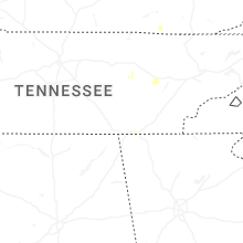

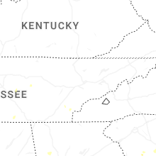
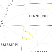
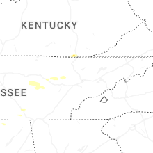


Connect with Interactive Hail Maps