

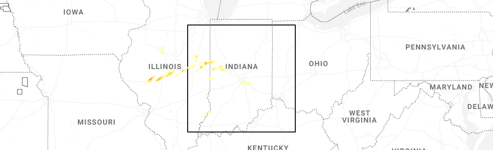
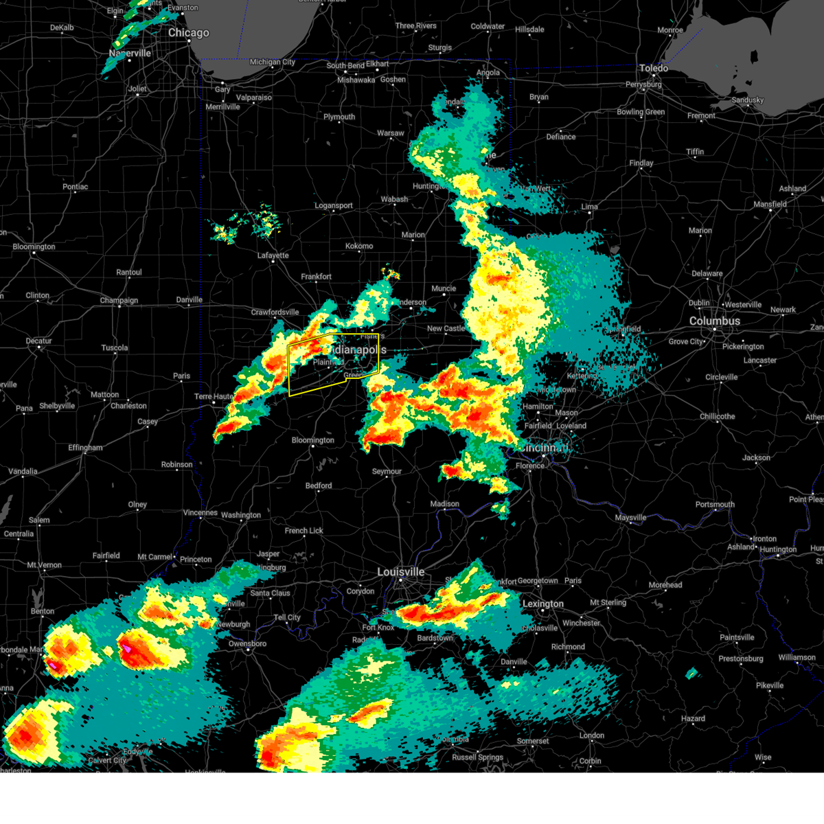
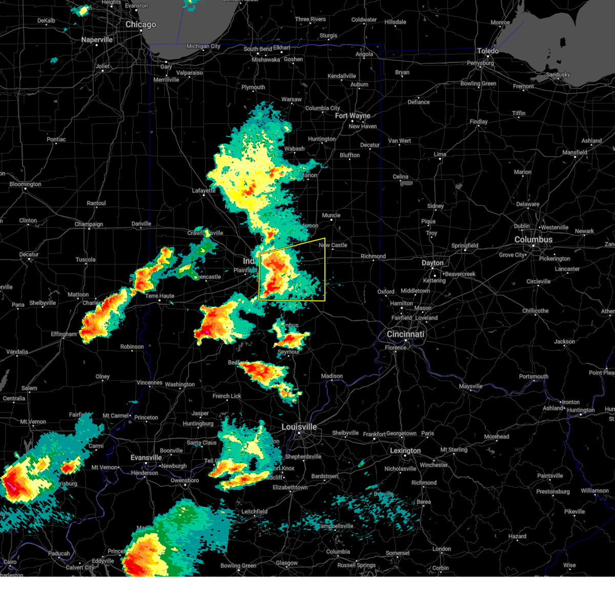
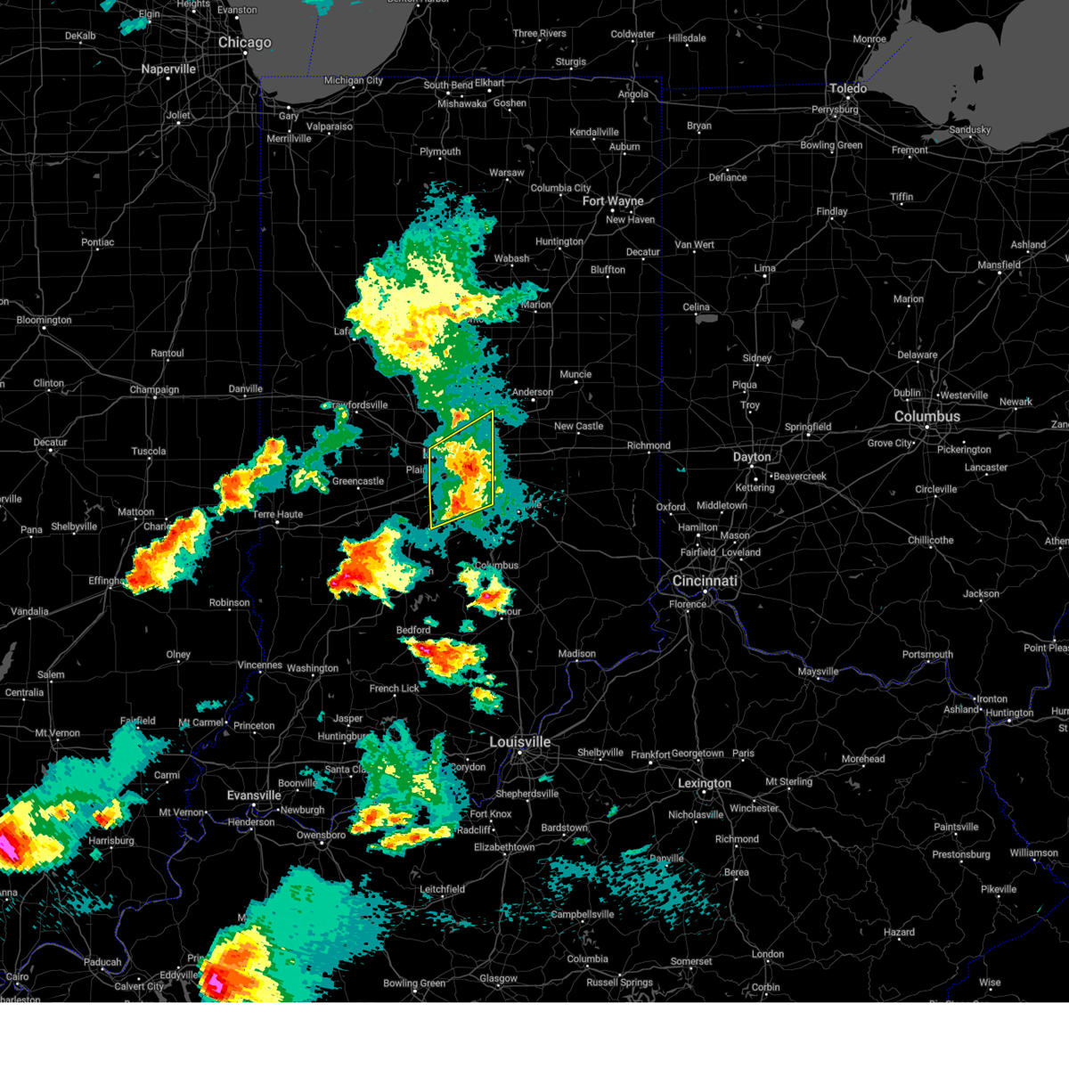
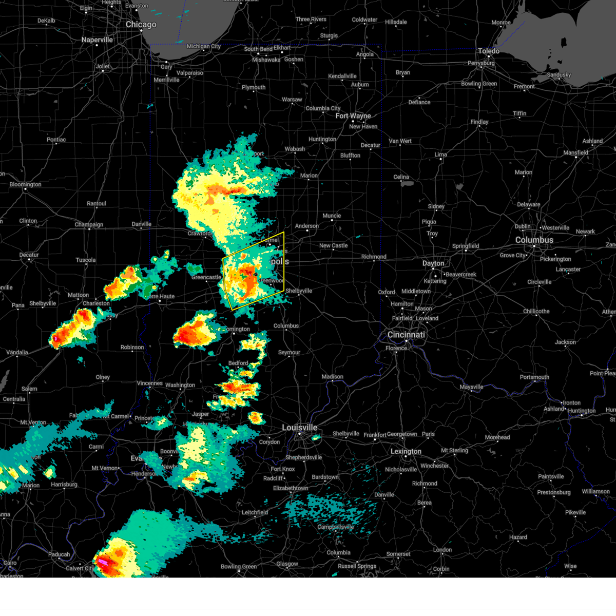
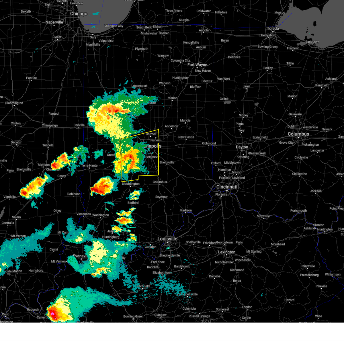
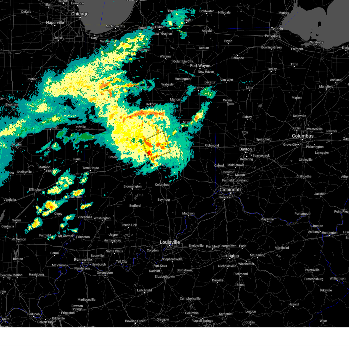
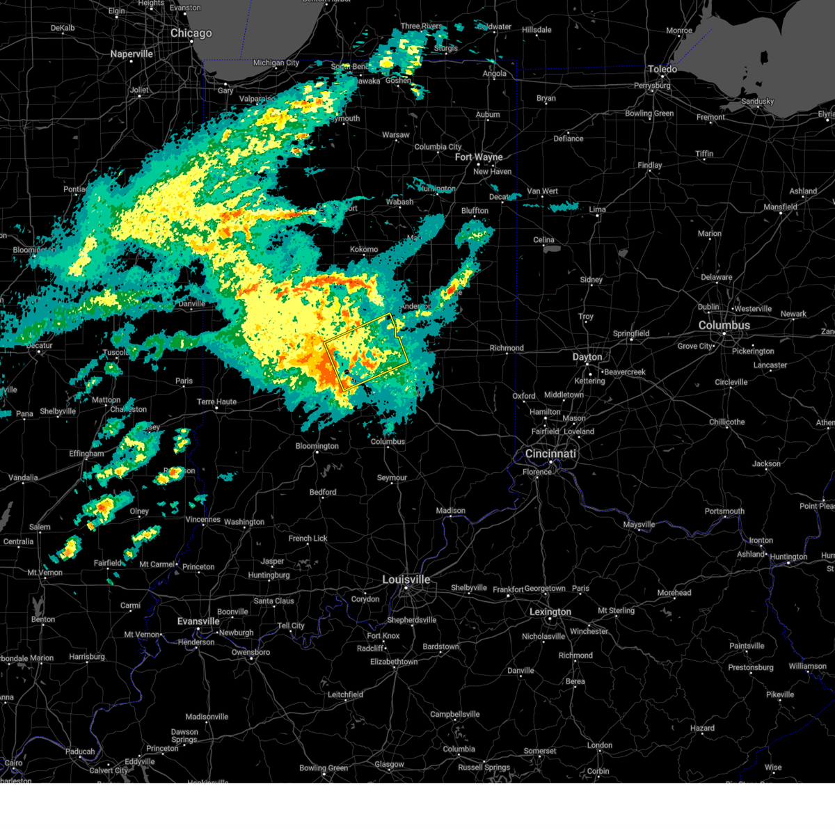
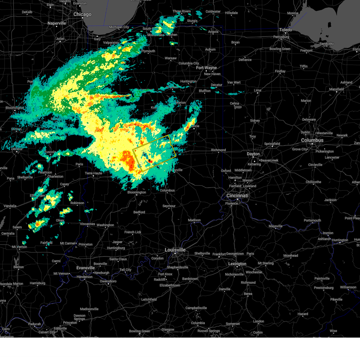
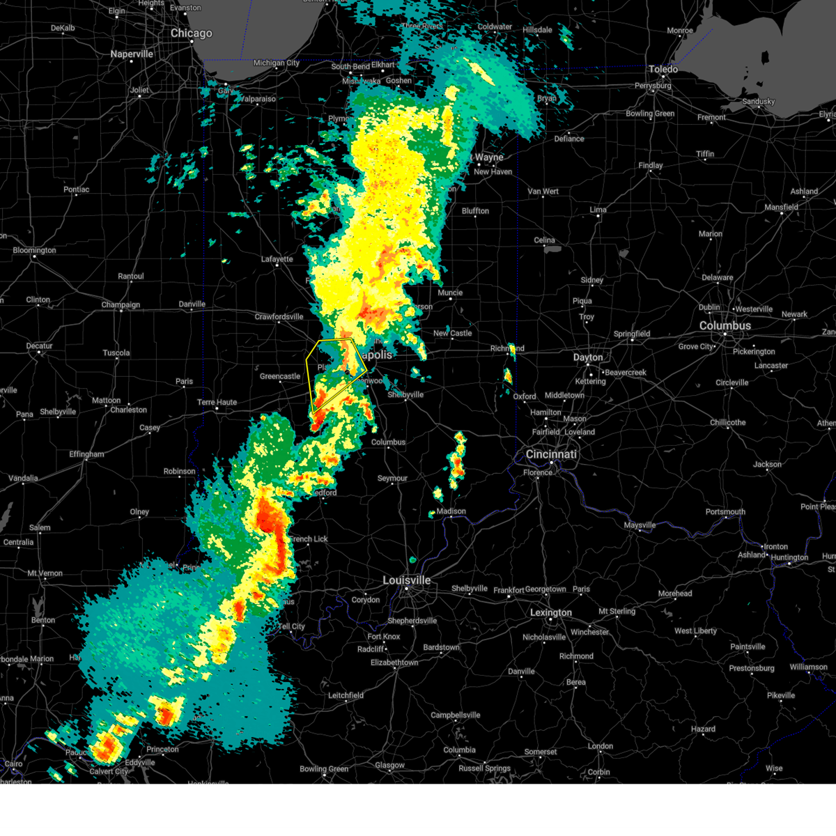
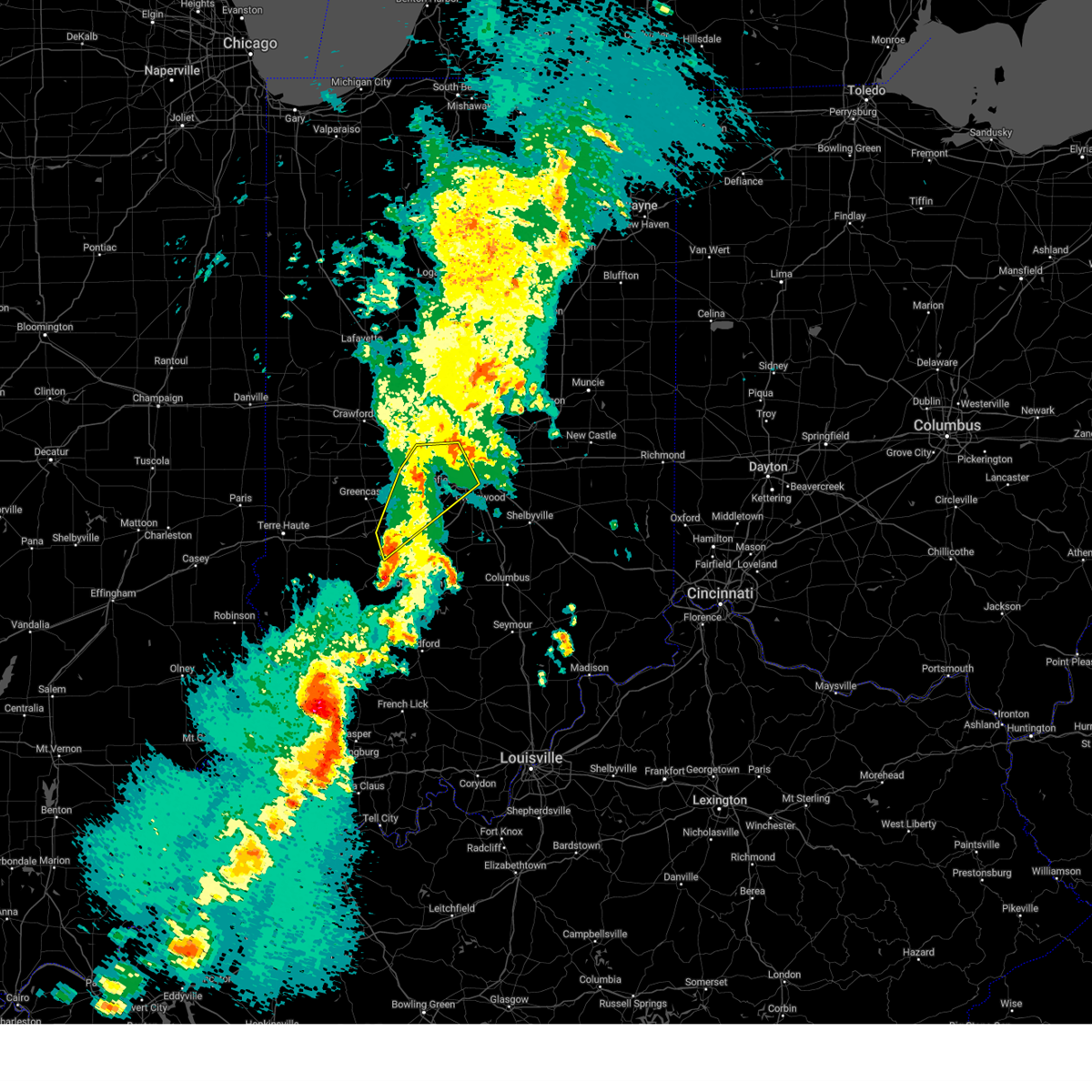
Hail Map for Speedway, IN
The Speedway, IN area has had 0 reports of on-the-ground hail by trained spotters, and has been under severe weather warnings 35 times during the past 12 months. Doppler radar has detected hail at or near Speedway, IN on 61 occasions, including 1 occasion during the past year.
| Name: | Speedway, IN |
| Where Located: | 5.7 miles WNW of Indianapolis, IN |
| Map: | Google Map for Speedway, IN |
| Population: | 11812 |
| Housing Units: | 6709 |
| More Info: | Search Google for Speedway, IN |
0
The Top Recent Hail Date for Speedway, IN is Tuesday, May 20, 2025 (61st out of 61)
Hail and Wind Damage Spotted near Speedway, IN
| Date / Time | Report Details |
|---|---|
| 6/18/2025 4:47 PM EDT | At 446 pm edt, severe thunderstorms were located along a line extending from tipton to near lawrence, moving northeast at 65 mph (radar indicated). Hazards include 70 mph wind gusts and nickel size hail. Expect considerable tree damage. damage is likely to mobile homes, roofs, and outbuildings. locations impacted include, indianapolis, anderson, kokomo, carmel, fishers, noblesville, lawrence, greenfield, beech grove, zionsville, speedway, elwood, alexandria, tipton, southport, windfall, westfield, cumberland, cicero, and mccordsville. this includes the following highways, interstate 65 between mile markers 103 and 130. interstate 69 between mile markers 200 and 228. interstate 70 between mile markers 71 and 110. Interstate 74 between mile markers 70 and 98. |
| 6/18/2025 4:47 PM EDT | the severe thunderstorm warning has been cancelled and is no longer in effect |
| 6/18/2025 4:35 PM EDT |
 At 434 pm edt, severe thunderstorms were located along a line extending from 6 miles southeast of frankfort to near plainfield, moving east at 55 mph (radar indicated). Hazards include 70 mph wind gusts and penny size hail. Expect considerable tree damage. damage is likely to mobile homes, roofs, and outbuildings. locations impacted include, indianapolis, plainfield, brownsburg, zionsville, martinsville, speedway, mooresville, danville, avon, pittsboro, whitestown, brooklyn, clermont, monrovia, morgantown, clayton, paragon, stinesville, bethany, and indianapolis int'l airport. this includes the following highways, interstate 65 between mile markers 121 and 134. interstate 70 between mile markers 53 and 74. Interstate 74 between mile markers 59 and 73. At 434 pm edt, severe thunderstorms were located along a line extending from 6 miles southeast of frankfort to near plainfield, moving east at 55 mph (radar indicated). Hazards include 70 mph wind gusts and penny size hail. Expect considerable tree damage. damage is likely to mobile homes, roofs, and outbuildings. locations impacted include, indianapolis, plainfield, brownsburg, zionsville, martinsville, speedway, mooresville, danville, avon, pittsboro, whitestown, brooklyn, clermont, monrovia, morgantown, clayton, paragon, stinesville, bethany, and indianapolis int'l airport. this includes the following highways, interstate 65 between mile markers 121 and 134. interstate 70 between mile markers 53 and 74. Interstate 74 between mile markers 59 and 73.
|
| 6/18/2025 4:35 PM EDT |
 the severe thunderstorm warning has been cancelled and is no longer in effect the severe thunderstorm warning has been cancelled and is no longer in effect
|
| 6/18/2025 4:22 PM EDT | Svrind the national weather service in indianapolis has issued a * severe thunderstorm warning for, madison county in central indiana, hancock county in central indiana, northeastern morgan county in central indiana, southeastern clinton county in central indiana, eastern howard county in central indiana, eastern hendricks county in central indiana, marion county in central indiana, boone county in central indiana, hamilton county in central indiana, tipton county in central indiana, * until 500 pm edt. * at 421 pm edt, severe thunderstorms were located along a line extending from near lebanon to near mooresville, moving northeast at 65 mph (radar indicated). Hazards include 70 mph wind gusts and nickel size hail. Expect considerable tree damage. Damage is likely to mobile homes, roofs, and outbuildings. |
| 6/18/2025 4:19 PM EDT | Svrind the national weather service in indianapolis has issued a * severe thunderstorm warning for, west central hancock county in central indiana, north central morgan county in central indiana, southeastern hendricks county in central indiana, marion county in central indiana, south central hamilton county in central indiana, * until 500 pm edt. * at 419 pm edt, a severe thunderstorm was located 9 miles south of danville, or 24 miles southwest of indianapolis, moving northeast at 60 mph. this is a destructive storm for indianapolis, plainfield, and speedway (radar indicated). Hazards include 80 mph wind gusts. Flying debris will be dangerous to those caught without shelter. mobile homes will be heavily damaged. expect considerable damage to roofs, windows, and vehicles. Extensive tree damage and power outages are likely. |
| 6/18/2025 3:53 PM EDT | Svrind the national weather service in indianapolis has issued a * severe thunderstorm warning for, northwestern monroe county in south central indiana, morgan county in central indiana, northwestern brown county in south central indiana, hendricks county in central indiana, northeastern owen county in west central indiana, western marion county in central indiana, southern boone county in central indiana, southeastern montgomery county in west central indiana, putnam county in west central indiana, * until 445 pm edt. * at 353 pm edt, severe thunderstorms were located along a line extending from 9 miles south of crawfordsville to 12 miles northwest of spencer, moving northeast at 55 mph (radar indicated). Hazards include 70 mph wind gusts and penny size hail. Expect considerable tree damage. Damage is likely to mobile homes, roofs, and outbuildings. |
| 5/16/2025 8:45 PM EDT |
 At 845 pm edt, severe thunderstorms were located along a line extending from 11 miles southeast of greencastle to near plainfield, moving east at 30 mph (radar indicated). Hazards include 60 mph wind gusts and nickel size hail. Expect damage to roofs, siding, and trees. Locations impacted include, indianapolis, greenwood, lawrence, plainfield, beech grove, speedway, mooresville, southport, cumberland, warren park, monrovia, homecroft, monument circle, belle union, indianapolis int'l airport, little point, and camby. At 845 pm edt, severe thunderstorms were located along a line extending from 11 miles southeast of greencastle to near plainfield, moving east at 30 mph (radar indicated). Hazards include 60 mph wind gusts and nickel size hail. Expect damage to roofs, siding, and trees. Locations impacted include, indianapolis, greenwood, lawrence, plainfield, beech grove, speedway, mooresville, southport, cumberland, warren park, monrovia, homecroft, monument circle, belle union, indianapolis int'l airport, little point, and camby.
|
| 5/16/2025 8:34 PM EDT | At 834 pm edt, a severe thunderstorm was located near plainfield, or 11 miles west of indianapolis, moving east at 40 mph (radar indicated). Hazards include 60 mph wind gusts and nickel size hail. Expect damage to roofs, siding, and trees. Locations impacted include, indianapolis, greenwood, lawrence, plainfield, beech grove, speedway, mooresville, danville, southport, avon, cumberland, warren park, clermont, monrovia, clayton, homecroft, rocky ripple, stilesville, wynnedale, and spring hill. |
| 5/16/2025 8:10 PM EDT |
 Svrind the national weather service in indianapolis has issued a * severe thunderstorm warning for, northern morgan county in central indiana, hendricks county in central indiana, marion county in central indiana, eastern putnam county in west central indiana, * until 900 pm edt. * at 809 pm edt, a severe thunderstorm was located over danville, or 21 miles west of indianapolis, moving east at 50 mph (radar indicated). Hazards include 60 mph wind gusts and quarter size hail. Hail damage to vehicles is expected. Expect wind damage to roofs, siding, and trees. Svrind the national weather service in indianapolis has issued a * severe thunderstorm warning for, northern morgan county in central indiana, hendricks county in central indiana, marion county in central indiana, eastern putnam county in west central indiana, * until 900 pm edt. * at 809 pm edt, a severe thunderstorm was located over danville, or 21 miles west of indianapolis, moving east at 50 mph (radar indicated). Hazards include 60 mph wind gusts and quarter size hail. Hail damage to vehicles is expected. Expect wind damage to roofs, siding, and trees.
|
| 5/16/2025 7:07 PM EDT |
 Svrind the national weather service in indianapolis has issued a * severe thunderstorm warning for, southern madison county in central indiana, hancock county in central indiana, shelby county in central indiana, western rush county in central indiana, northern johnson county in central indiana, western henry county in east central indiana, marion county in central indiana, southeastern hamilton county in central indiana, * until 745 pm edt. * at 707 pm edt, severe thunderstorms were located along a line extending from near indianapolis to near franklin, moving east at 50 mph (radar indicated). Hazards include 70 mph wind gusts. Expect considerable tree damage. Damage is likely to mobile homes, roofs, and outbuildings. Svrind the national weather service in indianapolis has issued a * severe thunderstorm warning for, southern madison county in central indiana, hancock county in central indiana, shelby county in central indiana, western rush county in central indiana, northern johnson county in central indiana, western henry county in east central indiana, marion county in central indiana, southeastern hamilton county in central indiana, * until 745 pm edt. * at 707 pm edt, severe thunderstorms were located along a line extending from near indianapolis to near franklin, moving east at 50 mph (radar indicated). Hazards include 70 mph wind gusts. Expect considerable tree damage. Damage is likely to mobile homes, roofs, and outbuildings.
|
| 5/16/2025 7:03 PM EDT |
 the severe thunderstorm warning has been cancelled and is no longer in effect the severe thunderstorm warning has been cancelled and is no longer in effect
|
| 5/16/2025 7:03 PM EDT |
 At 702 pm edt, severe thunderstorms were located along a line extending from near carmel to greenwood, moving northeast at 50 mph. these are destructive storms for warren park, beach grove and southport (radar indicated). Hazards include 80 mph wind gusts and penny size hail. Flying debris will be dangerous to those caught without shelter. mobile homes will be heavily damaged. expect considerable damage to roofs, windows, and vehicles. extensive tree damage and power outages are likely. locations impacted include, indianapolis, carmel, fishers, noblesville, greenwood, lawrence, plainfield, franklin, brownsburg, beech grove, speedway, mooresville, southport, avon, new whiteland, cumberland, whiteland, bargersville, meridian hills, and brooklyn. this includes the following highways, interstate 65 between mile markers 94 and 125. interstate 69 between mile markers 200 and 208. interstate 70 between mile markers 66 and 93. Interstate 74 between mile markers 67 and 100. At 702 pm edt, severe thunderstorms were located along a line extending from near carmel to greenwood, moving northeast at 50 mph. these are destructive storms for warren park, beach grove and southport (radar indicated). Hazards include 80 mph wind gusts and penny size hail. Flying debris will be dangerous to those caught without shelter. mobile homes will be heavily damaged. expect considerable damage to roofs, windows, and vehicles. extensive tree damage and power outages are likely. locations impacted include, indianapolis, carmel, fishers, noblesville, greenwood, lawrence, plainfield, franklin, brownsburg, beech grove, speedway, mooresville, southport, avon, new whiteland, cumberland, whiteland, bargersville, meridian hills, and brooklyn. this includes the following highways, interstate 65 between mile markers 94 and 125. interstate 69 between mile markers 200 and 208. interstate 70 between mile markers 66 and 93. Interstate 74 between mile markers 67 and 100.
|
| 5/16/2025 6:56 PM EDT | At 655 pm edt, severe thunderstorms were located along a line extending from near speedway to 7 miles southwest of greenwood, moving northeast at 50 mph. these are destructive storms for indianapolis, southport, speedway and clermont (74 mph wind recorded on the kind asos). Hazards include 80 mph wind gusts and penny size hail. Flying debris will be dangerous to those caught without shelter. mobile homes will be heavily damaged. expect considerable damage to roofs, windows, and vehicles. extensive tree damage and power outages are likely. locations impacted include, indianapolis, carmel, fishers, noblesville, greenwood, lawrence, plainfield, franklin, brownsburg, beech grove, zionsville, martinsville, speedway, mooresville, danville, southport, westfield, avon, new whiteland, and cumberland. this includes the following highways, interstate 65 between mile markers 94 and 130. interstate 69 between mile markers 200 and 208. interstate 70 between mile markers 55 and 93. Interstate 74 between mile markers 58 and 100. |
| 5/16/2025 6:51 PM EDT |
 the severe thunderstorm warning has been cancelled and is no longer in effect the severe thunderstorm warning has been cancelled and is no longer in effect
|
| 5/16/2025 6:51 PM EDT |
 At 651 pm edt, severe thunderstorms were located along a line extending from near speedway to 8 miles southeast of mooresville, moving east at 50 mph (radar indicated). Hazards include 70 mph wind gusts and quarter size hail. Hail damage to vehicles is expected. expect considerable tree damage. wind damage is also likely to mobile homes, roofs, and outbuildings. locations impacted include, indianapolis, carmel, fishers, noblesville, greenwood, lawrence, plainfield, franklin, brownsburg, beech grove, zionsville, martinsville, speedway, mooresville, danville, southport, westfield, avon, new whiteland, and cumberland. this includes the following highways, interstate 65 between mile markers 94 and 130. interstate 69 between mile markers 200 and 208. interstate 70 between mile markers 50 and 93. Interstate 74 between mile markers 58 and 100. At 651 pm edt, severe thunderstorms were located along a line extending from near speedway to 8 miles southeast of mooresville, moving east at 50 mph (radar indicated). Hazards include 70 mph wind gusts and quarter size hail. Hail damage to vehicles is expected. expect considerable tree damage. wind damage is also likely to mobile homes, roofs, and outbuildings. locations impacted include, indianapolis, carmel, fishers, noblesville, greenwood, lawrence, plainfield, franklin, brownsburg, beech grove, zionsville, martinsville, speedway, mooresville, danville, southport, westfield, avon, new whiteland, and cumberland. this includes the following highways, interstate 65 between mile markers 94 and 130. interstate 69 between mile markers 200 and 208. interstate 70 between mile markers 50 and 93. Interstate 74 between mile markers 58 and 100.
|
| 5/16/2025 6:41 PM EDT |
 At 641 pm edt, severe thunderstorms were located along a line extending from near brownsburg to near martinsville, moving northeast at 60 mph (radar indicated). Hazards include 70 mph wind gusts and quarter size hail. Hail damage to vehicles is expected. expect considerable tree damage. wind damage is also likely to mobile homes, roofs, and outbuildings. locations impacted include, indianapolis, carmel, fishers, noblesville, greenwood, lawrence, plainfield, franklin, brownsburg, beech grove, zionsville, martinsville, speedway, mooresville, danville, southport, westfield, avon, new whiteland, and cumberland. this includes the following highways, interstate 65 between mile markers 84 and 135. interstate 69 between mile markers 200 and 208. interstate 70 between mile markers 45 and 93. Interstate 74 between mile markers 51 and 100. At 641 pm edt, severe thunderstorms were located along a line extending from near brownsburg to near martinsville, moving northeast at 60 mph (radar indicated). Hazards include 70 mph wind gusts and quarter size hail. Hail damage to vehicles is expected. expect considerable tree damage. wind damage is also likely to mobile homes, roofs, and outbuildings. locations impacted include, indianapolis, carmel, fishers, noblesville, greenwood, lawrence, plainfield, franklin, brownsburg, beech grove, zionsville, martinsville, speedway, mooresville, danville, southport, westfield, avon, new whiteland, and cumberland. this includes the following highways, interstate 65 between mile markers 84 and 135. interstate 69 between mile markers 200 and 208. interstate 70 between mile markers 45 and 93. Interstate 74 between mile markers 51 and 100.
|
| 5/16/2025 6:20 PM EDT | Svrind the national weather service in indianapolis has issued a * severe thunderstorm warning for, northern monroe county in south central indiana, morgan county in central indiana, johnson county in central indiana, hendricks county in central indiana, northeastern owen county in west central indiana, marion county in central indiana, southern boone county in central indiana, southern hamilton county in central indiana, southeastern montgomery county in west central indiana, eastern putnam county in west central indiana, * until 715 pm edt. * at 620 pm edt, severe thunderstorms were located along a line extending from near greencastle to near spencer, moving northeast at 50 mph (radar indicated). Hazards include 60 mph wind gusts and quarter size hail. Hail damage to vehicles is expected. Expect wind damage to roofs, siding, and trees. |
| 4/19/2025 5:42 AM EDT |
 At 542 am edt, severe thunderstorms were located along a line extending from zionsville to southport, moving northeast at 65 mph (radar indicated). Hazards include 70 mph wind gusts. Expect considerable tree damage. damage is likely to mobile homes, roofs, and outbuildings. locations impacted include, geist reservoir, monument circle, castleton, carmel, crows nest, southport, spring hill, fortville, fishers, warren park, wynnedale, williams creek, zionsville, mccordsville, indiana state fairgrounds, broad ripple, beech grove, noblesville, homecroft, and meridian hills. this includes the following highways, interstate 65 between mile markers 104 and 128. interstate 69 between mile markers 200 and 213. interstate 70 between mile markers 76 and 103. Interstate 74 between mile markers 93 and 97. At 542 am edt, severe thunderstorms were located along a line extending from zionsville to southport, moving northeast at 65 mph (radar indicated). Hazards include 70 mph wind gusts. Expect considerable tree damage. damage is likely to mobile homes, roofs, and outbuildings. locations impacted include, geist reservoir, monument circle, castleton, carmel, crows nest, southport, spring hill, fortville, fishers, warren park, wynnedale, williams creek, zionsville, mccordsville, indiana state fairgrounds, broad ripple, beech grove, noblesville, homecroft, and meridian hills. this includes the following highways, interstate 65 between mile markers 104 and 128. interstate 69 between mile markers 200 and 213. interstate 70 between mile markers 76 and 103. Interstate 74 between mile markers 93 and 97.
|
| 4/19/2025 5:42 AM EDT |
 the severe thunderstorm warning has been cancelled and is no longer in effect the severe thunderstorm warning has been cancelled and is no longer in effect
|
| 4/19/2025 5:34 AM EDT |
 At 533 am edt, severe thunderstorms were located along a line extending from near brownsburg to near mooresville, moving northeast at 65 mph (radar indicated). Hazards include 70 mph wind gusts. Expect considerable tree damage. damage is likely to mobile homes, roofs, and outbuildings. locations impacted include, geist reservoir, monument circle, castleton, carmel, crows nest, southport, spring hill, fortville, fishers, warren park, wynnedale, williams creek, new palestine, zionsville, indianapolis int'l airport, mccordsville, indiana state fairgrounds, camby, broad ripple, and beech grove. this includes the following highways, interstate 65 between mile markers 103 and 129. interstate 69 between mile markers 200 and 213. interstate 70 between mile markers 68 and 103. Interstate 74 between mile markers 62 and 98. At 533 am edt, severe thunderstorms were located along a line extending from near brownsburg to near mooresville, moving northeast at 65 mph (radar indicated). Hazards include 70 mph wind gusts. Expect considerable tree damage. damage is likely to mobile homes, roofs, and outbuildings. locations impacted include, geist reservoir, monument circle, castleton, carmel, crows nest, southport, spring hill, fortville, fishers, warren park, wynnedale, williams creek, new palestine, zionsville, indianapolis int'l airport, mccordsville, indiana state fairgrounds, camby, broad ripple, and beech grove. this includes the following highways, interstate 65 between mile markers 103 and 129. interstate 69 between mile markers 200 and 213. interstate 70 between mile markers 68 and 103. Interstate 74 between mile markers 62 and 98.
|
| 4/19/2025 5:23 AM EDT |
 Svrind the national weather service in indianapolis has issued a * severe thunderstorm warning for, western hancock county in central indiana, northeastern morgan county in central indiana, northwestern johnson county in central indiana, eastern hendricks county in central indiana, marion county in central indiana, southeastern boone county in central indiana, southern hamilton county in central indiana, * until 600 am edt. * at 522 am edt, severe thunderstorms were located along a line extending from 9 miles northwest of danville to 7 miles southwest of mooresville, moving northeast at 65 mph (radar indicated). Hazards include 60 mph wind gusts. expect damage to roofs, siding, and trees Svrind the national weather service in indianapolis has issued a * severe thunderstorm warning for, western hancock county in central indiana, northeastern morgan county in central indiana, northwestern johnson county in central indiana, eastern hendricks county in central indiana, marion county in central indiana, southeastern boone county in central indiana, southern hamilton county in central indiana, * until 600 am edt. * at 522 am edt, severe thunderstorms were located along a line extending from 9 miles northwest of danville to 7 miles southwest of mooresville, moving northeast at 65 mph (radar indicated). Hazards include 60 mph wind gusts. expect damage to roofs, siding, and trees
|
| 4/4/2025 9:31 PM EDT |
 At 930 pm edt, a severe thunderstorm was located near plainfield, or 15 miles southwest of indianapolis, moving northeast at 40 mph (radar indicated). Hazards include 60 mph wind gusts and penny size hail. Expect damage to roofs, siding, and trees. locations impacted include, homecroft, southport, plainfield, eagle creek reservoir, mooresville, avon, clayton, lake hart, indianapolis int'l airport, speedway, camby, clermont, monrovia, greenwood, and indianapolis. this includes the following highways, interstate 70 between mile markers 59 and 78. Interstate 74 between mile markers 70 and 73. At 930 pm edt, a severe thunderstorm was located near plainfield, or 15 miles southwest of indianapolis, moving northeast at 40 mph (radar indicated). Hazards include 60 mph wind gusts and penny size hail. Expect damage to roofs, siding, and trees. locations impacted include, homecroft, southport, plainfield, eagle creek reservoir, mooresville, avon, clayton, lake hart, indianapolis int'l airport, speedway, camby, clermont, monrovia, greenwood, and indianapolis. this includes the following highways, interstate 70 between mile markers 59 and 78. Interstate 74 between mile markers 70 and 73.
|
| 4/4/2025 9:17 PM EDT | Svrind the national weather service in indianapolis has issued a * severe thunderstorm warning for, northern morgan county in central indiana, northwestern johnson county in central indiana, southern hendricks county in central indiana, southwestern marion county in central indiana, * until 945 pm edt. * at 916 pm edt, a severe thunderstorm was located 9 miles south of danville, or 24 miles southwest of indianapolis, moving northeast at 40 mph (radar indicated). Hazards include 60 mph wind gusts and penny size hail. expect damage to roofs, siding, and trees |
| 4/2/2025 9:18 PM EDT | Svrind the national weather service in indianapolis has issued a * severe thunderstorm warning for, southern madison county in central indiana, northern shelby county in central indiana, hancock county in central indiana, southwestern delaware county in east central indiana, northwestern rush county in central indiana, eastern hendricks county in central indiana, western henry county in east central indiana, marion county in central indiana, southeastern boone county in central indiana, southern hamilton county in central indiana, * until 1000 pm edt. * at 917 pm edt, severe thunderstorms were located along a line extending from near brownsburg to near speedway to near plainfield, moving east at 60 mph. these are destructive storms for indianapolis (radar indicated). Hazards include 80 mph wind gusts and penny size hail. Flying debris will be dangerous to those caught without shelter. mobile homes will be heavily damaged. expect considerable damage to roofs, windows, and vehicles. Extensive tree damage and power outages are likely. |
| 4/2/2025 9:09 PM EDT |
 Torind the national weather service in indianapolis has issued a * tornado warning for, northeastern hendricks county in central indiana, northwestern marion county in central indiana, southeastern boone county in central indiana, * until 930 pm edt. * at 909 pm edt, a severe thunderstorm capable of producing a tornado was located near brownsburg, or 16 miles west of indianapolis, moving northeast at 65 mph (radar indicated rotation). Hazards include tornado. Flying debris will be dangerous to those caught without shelter. mobile homes will be damaged or destroyed. damage to roofs, windows, and vehicles will occur. Tree damage is likely. Torind the national weather service in indianapolis has issued a * tornado warning for, northeastern hendricks county in central indiana, northwestern marion county in central indiana, southeastern boone county in central indiana, * until 930 pm edt. * at 909 pm edt, a severe thunderstorm capable of producing a tornado was located near brownsburg, or 16 miles west of indianapolis, moving northeast at 65 mph (radar indicated rotation). Hazards include tornado. Flying debris will be dangerous to those caught without shelter. mobile homes will be damaged or destroyed. damage to roofs, windows, and vehicles will occur. Tree damage is likely.
|
| 4/2/2025 9:03 PM EDT | Svrind the national weather service in indianapolis has issued a * severe thunderstorm warning for, northern morgan county in central indiana, hendricks county in central indiana, western marion county in central indiana, eastern putnam county in west central indiana, * until 930 pm edt. * at 902 pm edt, a severe thunderstorm was located near danville, or 22 miles west of indianapolis, moving northeast at 65 mph. this is a destructive storm for hendricks, northern morgan and western marion counties (radar indicated). Hazards include 80 mph wind gusts. Flying debris will be dangerous to those caught without shelter. mobile homes will be heavily damaged. expect considerable damage to roofs, windows, and vehicles. Extensive tree damage and power outages are likely. |
| 3/15/2025 4:56 AM EDT |
 At 455 am edt, severe thunderstorms were located along a line extending from near speedway to 8 miles southeast of mooresville, moving northeast at 55 mph (radar indicated). Hazards include 60 mph wind gusts. Expect damage to roofs, siding, and trees. locations impacted include, monument circle, geist reservoir, castleton, crows nest, southport, spring hill, warren park, williams creek, new whiteland, wynnedale, new palestine, indianapolis int'l airport, mccordsville, indiana state fairgrounds, broad ripple, beech grove, homecroft, greenwood, meridian hills, and lawrence. this includes the following highways, interstate 65 between mile markers 95 and 122. interstate 69 between mile markers 200 and 202. interstate 70 between mile markers 71 and 97. Interstate 74 between mile markers 73 and 106. At 455 am edt, severe thunderstorms were located along a line extending from near speedway to 8 miles southeast of mooresville, moving northeast at 55 mph (radar indicated). Hazards include 60 mph wind gusts. Expect damage to roofs, siding, and trees. locations impacted include, monument circle, geist reservoir, castleton, crows nest, southport, spring hill, warren park, williams creek, new whiteland, wynnedale, new palestine, indianapolis int'l airport, mccordsville, indiana state fairgrounds, broad ripple, beech grove, homecroft, greenwood, meridian hills, and lawrence. this includes the following highways, interstate 65 between mile markers 95 and 122. interstate 69 between mile markers 200 and 202. interstate 70 between mile markers 71 and 97. Interstate 74 between mile markers 73 and 106.
|
| 3/15/2025 4:56 AM EDT |
 the severe thunderstorm warning has been cancelled and is no longer in effect the severe thunderstorm warning has been cancelled and is no longer in effect
|
| 3/15/2025 4:47 AM EDT | Svrind the national weather service in indianapolis has issued a * severe thunderstorm warning for, northwestern shelby county in central indiana, western hancock county in central indiana, eastern morgan county in central indiana, northern johnson county in central indiana, southeastern hendricks county in central indiana, marion county in central indiana, * until 515 am edt. * at 446 am edt, severe thunderstorms were located along a line extending from near plainfield to martinsville, moving northeast at 55 mph (radar indicated). Hazards include 60 mph wind gusts. expect damage to roofs, siding, and trees |
| 3/15/2025 4:33 AM EDT |
 the severe thunderstorm warning has been cancelled and is no longer in effect the severe thunderstorm warning has been cancelled and is no longer in effect
|
| 3/15/2025 4:33 AM EDT |
 At 433 am edt, severe thunderstorms were located along a line extending from 6 miles north of brownsburg to near plainfield, moving northeast at 70 mph (radar indicated). Hazards include 60 mph wind gusts. Expect damage to roofs, siding, and trees. locations impacted include, monument circle, pittsboro, amo, spring hill, plainfield, lizton, eagle creek reservoir, mooresville, wynnedale, avon, brownsburg, clayton, lake hart, danville, indianapolis int'l airport, monrovia, camby, speedway, clermont, and indianapolis. this includes the following highways, interstate 65 between mile markers 108 and 111, between mile markers 113 and 114, and between mile markers 116 and 128. interstate 70 between mile markers 53 and 80. Interstate 74 between mile markers 57 and 73. At 433 am edt, severe thunderstorms were located along a line extending from 6 miles north of brownsburg to near plainfield, moving northeast at 70 mph (radar indicated). Hazards include 60 mph wind gusts. Expect damage to roofs, siding, and trees. locations impacted include, monument circle, pittsboro, amo, spring hill, plainfield, lizton, eagle creek reservoir, mooresville, wynnedale, avon, brownsburg, clayton, lake hart, danville, indianapolis int'l airport, monrovia, camby, speedway, clermont, and indianapolis. this includes the following highways, interstate 65 between mile markers 108 and 111, between mile markers 113 and 114, and between mile markers 116 and 128. interstate 70 between mile markers 53 and 80. Interstate 74 between mile markers 57 and 73.
|
| 3/15/2025 4:24 AM EDT |
 At 423 am edt, severe thunderstorms were located along a line extending from 6 miles north of danville to near mooresville, moving northeast at 70 mph (radar indicated). Hazards include 60 mph wind gusts. Expect damage to roofs, siding, and trees. locations impacted include, stilesville, monument circle, pittsboro, quincy, spring hill, plainfield, lizton, mooresville, wynnedale, indianapolis int'l airport, eminence, camby, devore, amo, eagle creek reservoir, coatesville, avon, brownsburg, belle union, and clayton. this includes the following highways, interstate 65 between mile markers 108 and 111, between mile markers 113 and 114, and between mile markers 116 and 128. interstate 70 between mile markers 44 and 80. Interstate 74 between mile markers 57 and 73. At 423 am edt, severe thunderstorms were located along a line extending from 6 miles north of danville to near mooresville, moving northeast at 70 mph (radar indicated). Hazards include 60 mph wind gusts. Expect damage to roofs, siding, and trees. locations impacted include, stilesville, monument circle, pittsboro, quincy, spring hill, plainfield, lizton, mooresville, wynnedale, indianapolis int'l airport, eminence, camby, devore, amo, eagle creek reservoir, coatesville, avon, brownsburg, belle union, and clayton. this includes the following highways, interstate 65 between mile markers 108 and 111, between mile markers 113 and 114, and between mile markers 116 and 128. interstate 70 between mile markers 44 and 80. Interstate 74 between mile markers 57 and 73.
|
| 3/15/2025 4:08 AM EDT | Svrind the national weather service in indianapolis has issued a * severe thunderstorm warning for, northern morgan county in central indiana, hendricks county in central indiana, northeastern owen county in west central indiana, western marion county in central indiana, eastern putnam county in west central indiana, * until 445 am edt. * at 408 am edt, severe thunderstorms were located along a line extending from near greencastle to 11 miles north of spencer, moving northeast at 70 mph (radar indicated). Hazards include 60 mph wind gusts. expect damage to roofs, siding, and trees |
| 7/16/2024 1:06 AM EDT |
 Svrind the national weather service in indianapolis has issued a * severe thunderstorm warning for, southwestern madison county in central indiana, northern shelby county in central indiana, hancock county in central indiana, northwestern rush county in central indiana, northeastern morgan county in central indiana, johnson county in central indiana, north central brown county in south central indiana, southeastern hendricks county in central indiana, southwestern henry county in east central indiana, marion county in central indiana, southern hamilton county in central indiana, * until 130 am edt. * at 105 am edt, severe thunderstorms were located along a line extending from 7 miles east of fishers to near indianapolis to 11 miles northwest of martinsville, moving southeast at 45 mph (radar indicated). Hazards include 60 mph wind gusts. expect damage to roofs, siding, and trees Svrind the national weather service in indianapolis has issued a * severe thunderstorm warning for, southwestern madison county in central indiana, northern shelby county in central indiana, hancock county in central indiana, northwestern rush county in central indiana, northeastern morgan county in central indiana, johnson county in central indiana, north central brown county in south central indiana, southeastern hendricks county in central indiana, southwestern henry county in east central indiana, marion county in central indiana, southern hamilton county in central indiana, * until 130 am edt. * at 105 am edt, severe thunderstorms were located along a line extending from 7 miles east of fishers to near indianapolis to 11 miles northwest of martinsville, moving southeast at 45 mph (radar indicated). Hazards include 60 mph wind gusts. expect damage to roofs, siding, and trees
|
| 6/29/2024 4:15 PM EDT |
 At 415 pm edt, severe thunderstorms were located along a line extending from near indianapolis to near southport to 7 miles south of mooresville, moving east at 40 mph (radar indicated). Hazards include 60 mph wind gusts and penny size hail. Expect damage to roofs, siding, and trees. locations impacted include, indianapolis, shelbyville, carmel, greenwood, lawrence, plainfield, franklin, brownsburg, greenfield, beech grove, speedway, mooresville, danville, southport, avon, new whiteland, cumberland, mccordsville, whiteland, and bargersville. this includes the following highways, interstate 65 between mile markers 84 and 128. interstate 69 between mile markers 200 and 202. interstate 70 between mile markers 50 and 110. Interstate 74 between mile markers 64 and 113. At 415 pm edt, severe thunderstorms were located along a line extending from near indianapolis to near southport to 7 miles south of mooresville, moving east at 40 mph (radar indicated). Hazards include 60 mph wind gusts and penny size hail. Expect damage to roofs, siding, and trees. locations impacted include, indianapolis, shelbyville, carmel, greenwood, lawrence, plainfield, franklin, brownsburg, greenfield, beech grove, speedway, mooresville, danville, southport, avon, new whiteland, cumberland, mccordsville, whiteland, and bargersville. this includes the following highways, interstate 65 between mile markers 84 and 128. interstate 69 between mile markers 200 and 202. interstate 70 between mile markers 50 and 110. Interstate 74 between mile markers 64 and 113.
|
| 6/29/2024 4:03 PM EDT |
 the severe thunderstorm warning has been cancelled and is no longer in effect the severe thunderstorm warning has been cancelled and is no longer in effect
|
| 6/29/2024 4:03 PM EDT |
 At 403 pm edt, severe thunderstorms were located along a line extending from near speedway to plainfield to 9 miles west of mooresville, moving east at 35 mph (radar indicated). Hazards include 70 mph wind gusts and penny size hail. Expect considerable tree damage. damage is likely to mobile homes, roofs, and outbuildings. locations impacted include, indianapolis, plainfield, brownsburg, speedway, mooresville, danville, avon, pittsboro, meridian hills, clermont, monrovia, clayton, rocky ripple, fillmore, coatesville, lizton, williams creek, amo, stilesville, and wynnedale. this includes the following highways, interstate 65 between mile markers 117 and 128. interstate 70 between mile markers 52 and 77. Interstate 74 between mile markers 56 and 73. At 403 pm edt, severe thunderstorms were located along a line extending from near speedway to plainfield to 9 miles west of mooresville, moving east at 35 mph (radar indicated). Hazards include 70 mph wind gusts and penny size hail. Expect considerable tree damage. damage is likely to mobile homes, roofs, and outbuildings. locations impacted include, indianapolis, plainfield, brownsburg, speedway, mooresville, danville, avon, pittsboro, meridian hills, clermont, monrovia, clayton, rocky ripple, fillmore, coatesville, lizton, williams creek, amo, stilesville, and wynnedale. this includes the following highways, interstate 65 between mile markers 117 and 128. interstate 70 between mile markers 52 and 77. Interstate 74 between mile markers 56 and 73.
|
| 6/29/2024 3:59 PM EDT |
 Svrind the national weather service in indianapolis has issued a * severe thunderstorm warning for, northern shelby county in central indiana, hancock county in central indiana, northern morgan county in central indiana, johnson county in central indiana, eastern hendricks county in central indiana, marion county in central indiana, * until 445 pm edt. * at 358 pm edt, severe thunderstorms were located along a line extending from near zionsville to plainfield to 9 miles west of mooresville, moving east at 45 mph (radar indicated). Hazards include 70 mph wind gusts and penny size hail. Expect considerable tree damage. Damage is likely to mobile homes, roofs, and outbuildings. Svrind the national weather service in indianapolis has issued a * severe thunderstorm warning for, northern shelby county in central indiana, hancock county in central indiana, northern morgan county in central indiana, johnson county in central indiana, eastern hendricks county in central indiana, marion county in central indiana, * until 445 pm edt. * at 358 pm edt, severe thunderstorms were located along a line extending from near zionsville to plainfield to 9 miles west of mooresville, moving east at 45 mph (radar indicated). Hazards include 70 mph wind gusts and penny size hail. Expect considerable tree damage. Damage is likely to mobile homes, roofs, and outbuildings.
|
| 6/29/2024 3:26 PM EDT |
 Svrind the national weather service in indianapolis has issued a * severe thunderstorm warning for, northwestern morgan county in central indiana, hendricks county in central indiana, western marion county in central indiana, southwestern boone county in central indiana, southeastern montgomery county in west central indiana, northern putnam county in west central indiana, * until 415 pm edt. * at 325 pm edt, severe thunderstorms were located along a line extending from 13 miles southwest of lebanon to 12 miles west of danville to near greencastle, moving east at 35 mph. this storm has a history of producing winds as high as 68 mph (radar indicated). Hazards include 70 mph wind gusts and penny size hail. Expect considerable tree damage. Damage is likely to mobile homes, roofs, and outbuildings. Svrind the national weather service in indianapolis has issued a * severe thunderstorm warning for, northwestern morgan county in central indiana, hendricks county in central indiana, western marion county in central indiana, southwestern boone county in central indiana, southeastern montgomery county in west central indiana, northern putnam county in west central indiana, * until 415 pm edt. * at 325 pm edt, severe thunderstorms were located along a line extending from 13 miles southwest of lebanon to 12 miles west of danville to near greencastle, moving east at 35 mph. this storm has a history of producing winds as high as 68 mph (radar indicated). Hazards include 70 mph wind gusts and penny size hail. Expect considerable tree damage. Damage is likely to mobile homes, roofs, and outbuildings.
|
| 5/26/2024 12:52 PM EDT |
 At 1252 pm edt, a severe thunderstorm was located near indianapolis, moving northeast at 45 mph (radar indicated). Hazards include 60 mph wind gusts. Expect damage to roofs, siding, and trees. Locations impacted include, indianapolis, carmel, fishers, noblesville, lawrence, beech grove, speedway, southport, westfield, cumberland, fortville, meridian hills, warren park, clermont, homecroft, rocky ripple, williams creek, wynnedale, spring hill, and crows nest. At 1252 pm edt, a severe thunderstorm was located near indianapolis, moving northeast at 45 mph (radar indicated). Hazards include 60 mph wind gusts. Expect damage to roofs, siding, and trees. Locations impacted include, indianapolis, carmel, fishers, noblesville, lawrence, beech grove, speedway, southport, westfield, cumberland, fortville, meridian hills, warren park, clermont, homecroft, rocky ripple, williams creek, wynnedale, spring hill, and crows nest.
|
| 5/26/2024 12:52 PM EDT |
 the severe thunderstorm warning has been cancelled and is no longer in effect the severe thunderstorm warning has been cancelled and is no longer in effect
|
| 5/26/2024 12:45 PM EDT |
 Svrind the national weather service in indianapolis has issued a * severe thunderstorm warning for, east central hendricks county in central indiana, marion county in central indiana, southeastern hamilton county in central indiana, * until 115 pm edt. * at 1245 pm edt, a severe thunderstorm was located over indianapolis, moving northeast at 45 mph (radar indicated). Hazards include 60 mph wind gusts. expect damage to roofs, siding, and trees Svrind the national weather service in indianapolis has issued a * severe thunderstorm warning for, east central hendricks county in central indiana, marion county in central indiana, southeastern hamilton county in central indiana, * until 115 pm edt. * at 1245 pm edt, a severe thunderstorm was located over indianapolis, moving northeast at 45 mph (radar indicated). Hazards include 60 mph wind gusts. expect damage to roofs, siding, and trees
|
| 3/14/2024 9:09 PM EDT |
 the severe thunderstorm warning has been cancelled and is no longer in effect the severe thunderstorm warning has been cancelled and is no longer in effect
|
| 3/14/2024 9:01 PM EDT |
 At 901 pm edt, a severe thunderstorm was located over southport, or 8 miles southeast of indianapolis, moving east at 60 mph (radar indicated). Hazards include 60 mph wind gusts. Expect damage to roofs, siding, and trees. locations impacted include, indianapolis, greenwood, lawrence, plainfield, beech grove, speedway, southport, cumberland, warren park, homecroft, monument circle, indianapolis int'l airport, and camby. this includes the following highways, interstate 65 between mile markers 101 and 115. interstate 70 between mile markers 69 and 93. Interstate 74 between mile markers 93 and 100. At 901 pm edt, a severe thunderstorm was located over southport, or 8 miles southeast of indianapolis, moving east at 60 mph (radar indicated). Hazards include 60 mph wind gusts. Expect damage to roofs, siding, and trees. locations impacted include, indianapolis, greenwood, lawrence, plainfield, beech grove, speedway, southport, cumberland, warren park, homecroft, monument circle, indianapolis int'l airport, and camby. this includes the following highways, interstate 65 between mile markers 101 and 115. interstate 70 between mile markers 69 and 93. Interstate 74 between mile markers 93 and 100.
|
| 3/14/2024 9:01 PM EDT |
 the severe thunderstorm warning has been cancelled and is no longer in effect the severe thunderstorm warning has been cancelled and is no longer in effect
|
| 3/14/2024 8:42 PM EDT |
 Svrind the national weather service in indianapolis has issued a * severe thunderstorm warning for, northeastern morgan county in central indiana, southeastern hendricks county in central indiana, marion county in central indiana, * until 930 pm edt. * at 842 pm edt, a severe thunderstorm was located near mooresville, or 19 miles southwest of indianapolis, moving east at 55 mph (radar indicated). Hazards include 60 mph wind gusts and penny size hail. expect damage to roofs, siding, and trees Svrind the national weather service in indianapolis has issued a * severe thunderstorm warning for, northeastern morgan county in central indiana, southeastern hendricks county in central indiana, marion county in central indiana, * until 930 pm edt. * at 842 pm edt, a severe thunderstorm was located near mooresville, or 19 miles southwest of indianapolis, moving east at 55 mph (radar indicated). Hazards include 60 mph wind gusts and penny size hail. expect damage to roofs, siding, and trees
|
| 3/14/2024 12:12 PM EDT |
 the severe thunderstorm warning has been cancelled and is no longer in effect the severe thunderstorm warning has been cancelled and is no longer in effect
|
| 3/14/2024 12:12 PM EDT |
 At 1212 pm edt, a severe thunderstorm was located over indianapolis, moving northeast at 65 mph (radar indicated). Hazards include 60 mph wind gusts and quarter size hail. Hail damage to vehicles is expected. expect wind damage to roofs, siding, and trees. locations impacted include, indianapolis, fishers, lawrence, beech grove, speedway, southport, cumberland, mccordsville, new palestine, warren park, homecroft, rocky ripple, wynnedale, spring hill, crows nest, geist reservoir, monument circle, castleton, indianapolis int'l airport, and indiana state fairgrounds. this includes the following highways, interstate 65 between mile markers 102 and 118. interstate 69 between mile markers 200 and 208. interstate 70 between mile markers 72 and 97. Interstate 74 between mile markers 93 and 100. At 1212 pm edt, a severe thunderstorm was located over indianapolis, moving northeast at 65 mph (radar indicated). Hazards include 60 mph wind gusts and quarter size hail. Hail damage to vehicles is expected. expect wind damage to roofs, siding, and trees. locations impacted include, indianapolis, fishers, lawrence, beech grove, speedway, southport, cumberland, mccordsville, new palestine, warren park, homecroft, rocky ripple, wynnedale, spring hill, crows nest, geist reservoir, monument circle, castleton, indianapolis int'l airport, and indiana state fairgrounds. this includes the following highways, interstate 65 between mile markers 102 and 118. interstate 69 between mile markers 200 and 208. interstate 70 between mile markers 72 and 97. Interstate 74 between mile markers 93 and 100.
|
| 3/14/2024 12:06 PM EDT |
 Svrind the national weather service in indianapolis has issued a * severe thunderstorm warning for, northwestern shelby county in central indiana, southwestern hancock county in central indiana, northeastern morgan county in central indiana, east central hendricks county in central indiana, marion county in central indiana, south central hamilton county in central indiana, * until 1230 pm edt. * at 1206 pm edt, a severe thunderstorm was located near plainfield, or 8 miles southwest of indianapolis, moving northeast at 95 mph (radar indicated). Hazards include 60 mph wind gusts and quarter size hail. Hail damage to vehicles is expected. Expect wind damage to roofs, siding, and trees. Svrind the national weather service in indianapolis has issued a * severe thunderstorm warning for, northwestern shelby county in central indiana, southwestern hancock county in central indiana, northeastern morgan county in central indiana, east central hendricks county in central indiana, marion county in central indiana, south central hamilton county in central indiana, * until 1230 pm edt. * at 1206 pm edt, a severe thunderstorm was located near plainfield, or 8 miles southwest of indianapolis, moving northeast at 95 mph (radar indicated). Hazards include 60 mph wind gusts and quarter size hail. Hail damage to vehicles is expected. Expect wind damage to roofs, siding, and trees.
|
| 2/28/2024 2:19 AM EST |
 At 218 am est, severe thunderstorms were located along a line extending from near indianapolis to near mooresville, moving east at 55 mph (radar indicated). Hazards include 60 mph wind gusts and quarter size hail. Hail damage to vehicles is expected. expect wind damage to roofs, siding, and trees. Locations impacted include, indianapolis, carmel, fishers, greenwood, lawrence, plainfield, franklin, beech grove, martinsville, speedway, mooresville, southport, avon, new whiteland, cumberland, whiteland, bargersville, meridian hills, brooklyn, and warren park. At 218 am est, severe thunderstorms were located along a line extending from near indianapolis to near mooresville, moving east at 55 mph (radar indicated). Hazards include 60 mph wind gusts and quarter size hail. Hail damage to vehicles is expected. expect wind damage to roofs, siding, and trees. Locations impacted include, indianapolis, carmel, fishers, greenwood, lawrence, plainfield, franklin, beech grove, martinsville, speedway, mooresville, southport, avon, new whiteland, cumberland, whiteland, bargersville, meridian hills, brooklyn, and warren park.
|
| 2/28/2024 2:10 AM EST |
 At 209 am est, severe thunderstorms were located along a line extending from near speedway to near mooresville, moving east at 55 mph (radar indicated). Hazards include 60 mph wind gusts and quarter size hail. Hail damage to vehicles is expected. expect wind damage to roofs, siding, and trees. Locations impacted include, indianapolis, carmel, fishers, greenwood, lawrence, plainfield, franklin, brownsburg, beech grove, martinsville, speedway, mooresville, danville, southport, avon, new whiteland, cumberland, whiteland, bargersville, and pittsboro. At 209 am est, severe thunderstorms were located along a line extending from near speedway to near mooresville, moving east at 55 mph (radar indicated). Hazards include 60 mph wind gusts and quarter size hail. Hail damage to vehicles is expected. expect wind damage to roofs, siding, and trees. Locations impacted include, indianapolis, carmel, fishers, greenwood, lawrence, plainfield, franklin, brownsburg, beech grove, martinsville, speedway, mooresville, danville, southport, avon, new whiteland, cumberland, whiteland, bargersville, and pittsboro.
|
| 2/28/2024 1:52 AM EST |
 Svrind the national weather service in indianapolis has issued a * severe thunderstorm warning for, morgan county in central indiana, northern johnson county in central indiana, hendricks county in central indiana, northeastern owen county in west central indiana, marion county in central indiana, eastern putnam county in west central indiana, * until 230 am est. * at 151 am est, severe thunderstorms were located along a line extending from near danville to 10 miles southeast of greencastle, moving east at 55 mph (radar indicated). Hazards include 60 mph wind gusts and quarter size hail. Hail damage to vehicles is expected. expect wind damage to roofs, siding, and trees. severe thunderstorms will be near, danville, clayton, amo, stilesville, belle union, eminence, and little point around 155 am est. plainfield, brownsburg, avon, and monrovia around 200 am est. indianapolis, speedway, mooresville, clermont, and lake hart around 205 am est. wynnedale, spring hill, indianapolis int'l airport, eagle creek reservoir, and camby around 210 am est. other locations in the path of these severe thunderstorms include meridian hills, rocky ripple, crows nest, north crows nest, broad ripple, indiana state fairgrounds, monument circle, greenwood, lawrence, beech grove, southport, warren park, homecroft, williams creek and castleton. this includes the following highways, interstate 65 between mile markers 92 and 126. interstate 69 between mile markers 200 and 202. interstate 70 between mile markers 40 and 93. Interstate 74 between mile markers 64 and 100. Svrind the national weather service in indianapolis has issued a * severe thunderstorm warning for, morgan county in central indiana, northern johnson county in central indiana, hendricks county in central indiana, northeastern owen county in west central indiana, marion county in central indiana, eastern putnam county in west central indiana, * until 230 am est. * at 151 am est, severe thunderstorms were located along a line extending from near danville to 10 miles southeast of greencastle, moving east at 55 mph (radar indicated). Hazards include 60 mph wind gusts and quarter size hail. Hail damage to vehicles is expected. expect wind damage to roofs, siding, and trees. severe thunderstorms will be near, danville, clayton, amo, stilesville, belle union, eminence, and little point around 155 am est. plainfield, brownsburg, avon, and monrovia around 200 am est. indianapolis, speedway, mooresville, clermont, and lake hart around 205 am est. wynnedale, spring hill, indianapolis int'l airport, eagle creek reservoir, and camby around 210 am est. other locations in the path of these severe thunderstorms include meridian hills, rocky ripple, crows nest, north crows nest, broad ripple, indiana state fairgrounds, monument circle, greenwood, lawrence, beech grove, southport, warren park, homecroft, williams creek and castleton. this includes the following highways, interstate 65 between mile markers 92 and 126. interstate 69 between mile markers 200 and 202. interstate 70 between mile markers 40 and 93. Interstate 74 between mile markers 64 and 100.
|
| 7/17/2023 6:34 PM EDT |
 At 634 pm edt, a severe thunderstorm was located near plainfield, or 9 miles southwest of indianapolis, moving east at 30 mph (radar indicated). Hazards include 60 mph wind gusts and half dollar size hail. Hail damage to vehicles is expected. expect wind damage to roofs, siding, and trees. locations impacted include, monument circle, beech grove and warren park. this includes the following highways, interstate 65 between mile markers 107 and 118. interstate 70 between mile markers 64 and 91. interstate 74 near mile marker 73. hail threat, radar indicated max hail size, 1. 25 in wind threat, radar indicated max wind gust, 60 mph. At 634 pm edt, a severe thunderstorm was located near plainfield, or 9 miles southwest of indianapolis, moving east at 30 mph (radar indicated). Hazards include 60 mph wind gusts and half dollar size hail. Hail damage to vehicles is expected. expect wind damage to roofs, siding, and trees. locations impacted include, monument circle, beech grove and warren park. this includes the following highways, interstate 65 between mile markers 107 and 118. interstate 70 between mile markers 64 and 91. interstate 74 near mile marker 73. hail threat, radar indicated max hail size, 1. 25 in wind threat, radar indicated max wind gust, 60 mph.
|
| 7/17/2023 6:33 PM EDT |
 At 633 pm edt, severe thunderstorms were located along a line extending from near lawrence to near indianapolis to near plainfield, moving southeast at 25 mph (radar indicated). Hazards include 60 mph wind gusts and half dollar size hail. Hail damage to vehicles is expected. expect wind damage to roofs, siding, and trees. severe thunderstorms will be near, beech grove, warren park and homecroft around 640 pm edt. southport and new palestine around 645 pm edt. greenwood around 650 pm edt. other locations in the path of these severe thunderstorms include new whiteland, whiteland and waverly. this includes the following highways, interstate 65 between mile markers 95 and 114. interstate 70 between mile markers 60 and 90. interstate 74 between mile markers 93 and 105. hail threat, radar indicated max hail size, 1. 25 in wind threat, radar indicated max wind gust, 60 mph. At 633 pm edt, severe thunderstorms were located along a line extending from near lawrence to near indianapolis to near plainfield, moving southeast at 25 mph (radar indicated). Hazards include 60 mph wind gusts and half dollar size hail. Hail damage to vehicles is expected. expect wind damage to roofs, siding, and trees. severe thunderstorms will be near, beech grove, warren park and homecroft around 640 pm edt. southport and new palestine around 645 pm edt. greenwood around 650 pm edt. other locations in the path of these severe thunderstorms include new whiteland, whiteland and waverly. this includes the following highways, interstate 65 between mile markers 95 and 114. interstate 70 between mile markers 60 and 90. interstate 74 between mile markers 93 and 105. hail threat, radar indicated max hail size, 1. 25 in wind threat, radar indicated max wind gust, 60 mph.
|
| 7/17/2023 6:16 PM EDT |
 At 611 pm edt, a severe thunderstorm was located over danville, or 17 miles west of indianapolis, moving southeast at 30 mph (radar indicated). Hazards include 60 mph wind gusts and half dollar size hail. Hail damage to vehicles is expected. expect wind damage to roofs, siding, and trees. this severe thunderstorm will be near, avon around 615 pm edt. clermont around 620 pm edt. plainfield around 625 pm edt. indianapolis int`l airport around 630 pm edt. other locations in the path of this severe thunderstorm include mooresville and camby. this includes the following highways, interstate 65 between mile markers 107 and 126. interstate 70 between mile markers 64 and 91. interstate 74 between mile markers 64 and 73. hail threat, radar indicated max hail size, 1. 25 in wind threat, radar indicated max wind gust, 60 mph. At 611 pm edt, a severe thunderstorm was located over danville, or 17 miles west of indianapolis, moving southeast at 30 mph (radar indicated). Hazards include 60 mph wind gusts and half dollar size hail. Hail damage to vehicles is expected. expect wind damage to roofs, siding, and trees. this severe thunderstorm will be near, avon around 615 pm edt. clermont around 620 pm edt. plainfield around 625 pm edt. indianapolis int`l airport around 630 pm edt. other locations in the path of this severe thunderstorm include mooresville and camby. this includes the following highways, interstate 65 between mile markers 107 and 126. interstate 70 between mile markers 64 and 91. interstate 74 between mile markers 64 and 73. hail threat, radar indicated max hail size, 1. 25 in wind threat, radar indicated max wind gust, 60 mph.
|
| 7/17/2023 6:11 PM EDT |
 At 611 pm edt, a severe thunderstorm was located over danville, or 17 miles west of indianapolis, moving southeast at 30 mph (radar indicated). Hazards include 60 mph wind gusts and half dollar size hail. Hail damage to vehicles is expected. expect wind damage to roofs, siding, and trees. this severe thunderstorm will be near, avon around 615 pm edt. clermont around 620 pm edt. plainfield around 625 pm edt. indianapolis int`l airport around 630 pm edt. other locations in the path of this severe thunderstorm include mooresville and camby. this includes the following highways, interstate 65 between mile markers 107 and 126. interstate 70 between mile markers 64 and 91. interstate 74 between mile markers 64 and 73. hail threat, radar indicated max hail size, 1. 25 in wind threat, radar indicated max wind gust, 60 mph. At 611 pm edt, a severe thunderstorm was located over danville, or 17 miles west of indianapolis, moving southeast at 30 mph (radar indicated). Hazards include 60 mph wind gusts and half dollar size hail. Hail damage to vehicles is expected. expect wind damage to roofs, siding, and trees. this severe thunderstorm will be near, avon around 615 pm edt. clermont around 620 pm edt. plainfield around 625 pm edt. indianapolis int`l airport around 630 pm edt. other locations in the path of this severe thunderstorm include mooresville and camby. this includes the following highways, interstate 65 between mile markers 107 and 126. interstate 70 between mile markers 64 and 91. interstate 74 between mile markers 64 and 73. hail threat, radar indicated max hail size, 1. 25 in wind threat, radar indicated max wind gust, 60 mph.
|
| 7/16/2023 7:41 PM EDT |
 At 741 pm edt, a severe thunderstorm was located over danville, or 17 miles west of indianapolis, moving east at 35 mph (radar indicated). Hazards include 60 mph wind gusts. Expect damage to roofs, siding, and trees. this severe thunderstorm will be near, brownsburg around 745 pm edt. avon around 750 pm edt. plainfield and clermont around 755 pm edt. speedway and indianapolis int`l airport around 800 pm edt. this includes the following highways, interstate 70 between mile markers 69 and 78. interstate 74 near mile marker 73. hail threat, radar indicated max hail size, <. 75 in wind threat, radar indicated max wind gust, 60 mph. At 741 pm edt, a severe thunderstorm was located over danville, or 17 miles west of indianapolis, moving east at 35 mph (radar indicated). Hazards include 60 mph wind gusts. Expect damage to roofs, siding, and trees. this severe thunderstorm will be near, brownsburg around 745 pm edt. avon around 750 pm edt. plainfield and clermont around 755 pm edt. speedway and indianapolis int`l airport around 800 pm edt. this includes the following highways, interstate 70 between mile markers 69 and 78. interstate 74 near mile marker 73. hail threat, radar indicated max hail size, <. 75 in wind threat, radar indicated max wind gust, 60 mph.
|
| 7/16/2023 6:26 PM EDT |
 At 626 pm edt, a severe thunderstorm was located near brownsburg, or 17 miles northwest of indianapolis, moving east at 25 mph (radar indicated). Hazards include 60 mph wind gusts and penny size hail. Expect damage to roofs, siding, and trees. this severe thunderstorm will be near, zionsville around 640 pm edt. eagle creek reservoir around 645 pm edt. this includes interstate 65 between mile markers 121 and 135. hail threat, radar indicated max hail size, 0. 75 in wind threat, radar indicated max wind gust, 60 mph. At 626 pm edt, a severe thunderstorm was located near brownsburg, or 17 miles northwest of indianapolis, moving east at 25 mph (radar indicated). Hazards include 60 mph wind gusts and penny size hail. Expect damage to roofs, siding, and trees. this severe thunderstorm will be near, zionsville around 640 pm edt. eagle creek reservoir around 645 pm edt. this includes interstate 65 between mile markers 121 and 135. hail threat, radar indicated max hail size, 0. 75 in wind threat, radar indicated max wind gust, 60 mph.
|
| 7/2/2023 3:51 PM EDT |
 At 351 pm edt, severe thunderstorms were located along a line extending from near speedway to near southport to 7 miles west of greenwood, moving northeast at 35 mph (radar indicated). Hazards include 60 mph wind gusts and nickel size hail. Expect damage to roofs, siding, and trees. severe thunderstorms will be near, homecroft, rocky ripple, wynnedale, spring hill, crows nest, north crows nest and indiana state fairgrounds around 355 pm edt. beech grove, meridian hills, broad ripple and monument circle around 400 pm edt. greenwood, southport, warren park and castleton around 405 pm edt. geist reservoir around 410 pm edt. other locations in the path of these severe thunderstorms include indianapolis, fishers, lawrence, cumberland, mccordsville, fortville, new palestine and spring lake. this includes the following highways, interstate 65 between mile markers 98 and 120. interstate 69 between mile markers 200 and 202. interstate 70 between mile markers 72 and 99. interstate 74 between mile markers 73 and 103. hail threat, radar indicated max hail size, 0. 88 in wind threat, radar indicated max wind gust, 60 mph. At 351 pm edt, severe thunderstorms were located along a line extending from near speedway to near southport to 7 miles west of greenwood, moving northeast at 35 mph (radar indicated). Hazards include 60 mph wind gusts and nickel size hail. Expect damage to roofs, siding, and trees. severe thunderstorms will be near, homecroft, rocky ripple, wynnedale, spring hill, crows nest, north crows nest and indiana state fairgrounds around 355 pm edt. beech grove, meridian hills, broad ripple and monument circle around 400 pm edt. greenwood, southport, warren park and castleton around 405 pm edt. geist reservoir around 410 pm edt. other locations in the path of these severe thunderstorms include indianapolis, fishers, lawrence, cumberland, mccordsville, fortville, new palestine and spring lake. this includes the following highways, interstate 65 between mile markers 98 and 120. interstate 69 between mile markers 200 and 202. interstate 70 between mile markers 72 and 99. interstate 74 between mile markers 73 and 103. hail threat, radar indicated max hail size, 0. 88 in wind threat, radar indicated max wind gust, 60 mph.
|
| 6/29/2023 3:27 PM EDT |
 At 327 pm edt, severe thunderstorms were located along a line extending from 6 miles west of lebanon to spencer, moving east at 70 mph (radar indicated). Hazards include 70 mph wind gusts. Expect considerable tree damage. damage is likely to mobile homes, roofs, and outbuildings. severe thunderstorms will be near, zionsville and eagle creek reservoir around 340 pm edt. wynnedale, spring hill and helmsburg around 345 pm edt. other locations in the path of these severe thunderstorms include carmel, nashville, meridian hills, rocky ripple, williams creek, crows nest, north crows nest, castleton, broad ripple, indiana state fairgrounds, indianapolis, fishers, lawrence, mccordsville, warren park, geist reservoir, gnaw bone, cumberland, fortville, spring lake, greenfield and elizabethtown. this includes the following highways, interstate 65 between mile markers 65 and 127. interstate 69 between mile markers 200 and 210. interstate 70 between mile markers 68 and 111. interstate 74 between mile markers 70 and 117. thunderstorm damage threat, considerable hail threat, radar indicated max hail size, <. 75 in wind threat, radar indicated max wind gust, 70 mph. At 327 pm edt, severe thunderstorms were located along a line extending from 6 miles west of lebanon to spencer, moving east at 70 mph (radar indicated). Hazards include 70 mph wind gusts. Expect considerable tree damage. damage is likely to mobile homes, roofs, and outbuildings. severe thunderstorms will be near, zionsville and eagle creek reservoir around 340 pm edt. wynnedale, spring hill and helmsburg around 345 pm edt. other locations in the path of these severe thunderstorms include carmel, nashville, meridian hills, rocky ripple, williams creek, crows nest, north crows nest, castleton, broad ripple, indiana state fairgrounds, indianapolis, fishers, lawrence, mccordsville, warren park, geist reservoir, gnaw bone, cumberland, fortville, spring lake, greenfield and elizabethtown. this includes the following highways, interstate 65 between mile markers 65 and 127. interstate 69 between mile markers 200 and 210. interstate 70 between mile markers 68 and 111. interstate 74 between mile markers 70 and 117. thunderstorm damage threat, considerable hail threat, radar indicated max hail size, <. 75 in wind threat, radar indicated max wind gust, 70 mph.
|
| 6/25/2023 4:01 PM EDT |
 At 400 pm edt, a severe thunderstorm was located near speedway, or near indianapolis, moving east at 40 mph (radar indicated). Hazards include 60 mph wind gusts and quarter size hail. Hail damage to vehicles is expected. expect wind damage to roofs, siding, and trees. this severe thunderstorm will be near, broad ripple around 405 pm edt. warren park and castleton around 410 pm edt. geist reservoir around 415 pm edt. indianapolis, lawrence, cumberland and mccordsville around 420 pm edt. other locations in the path of this severe thunderstorm include fortville, spring lake, ingalls, greenfield, markleville and wilkinson. this includes the following highways, interstate 65 between mile markers 111 and 123. interstate 69 between mile markers 200 and 205. interstate 70 between mile markers 83 and 112. interstate 74 near mile marker 73. hail threat, radar indicated max hail size, 1. 00 in wind threat, radar indicated max wind gust, 60 mph. At 400 pm edt, a severe thunderstorm was located near speedway, or near indianapolis, moving east at 40 mph (radar indicated). Hazards include 60 mph wind gusts and quarter size hail. Hail damage to vehicles is expected. expect wind damage to roofs, siding, and trees. this severe thunderstorm will be near, broad ripple around 405 pm edt. warren park and castleton around 410 pm edt. geist reservoir around 415 pm edt. indianapolis, lawrence, cumberland and mccordsville around 420 pm edt. other locations in the path of this severe thunderstorm include fortville, spring lake, ingalls, greenfield, markleville and wilkinson. this includes the following highways, interstate 65 between mile markers 111 and 123. interstate 69 between mile markers 200 and 205. interstate 70 between mile markers 83 and 112. interstate 74 near mile marker 73. hail threat, radar indicated max hail size, 1. 00 in wind threat, radar indicated max wind gust, 60 mph.
|
| 6/25/2023 4:00 PM EDT |
 At 359 pm edt, a severe thunderstorm was located near plainfield, or 11 miles southwest of indianapolis, moving east at 35 mph (radar indicated). Hazards include 70 mph wind gusts and half dollar size hail. Hail damage to vehicles is expected. expect considerable tree damage. wind damage is also likely to mobile homes, roofs, and outbuildings. locations impacted include, homecroft, monument circle and greenwood. this includes the following highways, interstate 65 between mile markers 110 and 113. interstate 70 between mile markers 62 and 83. thunderstorm damage threat, considerable hail threat, radar indicated max hail size, 1. 25 in wind threat, radar indicated max wind gust, 70 mph. At 359 pm edt, a severe thunderstorm was located near plainfield, or 11 miles southwest of indianapolis, moving east at 35 mph (radar indicated). Hazards include 70 mph wind gusts and half dollar size hail. Hail damage to vehicles is expected. expect considerable tree damage. wind damage is also likely to mobile homes, roofs, and outbuildings. locations impacted include, homecroft, monument circle and greenwood. this includes the following highways, interstate 65 between mile markers 110 and 113. interstate 70 between mile markers 62 and 83. thunderstorm damage threat, considerable hail threat, radar indicated max hail size, 1. 25 in wind threat, radar indicated max wind gust, 70 mph.
|
| 6/25/2023 3:37 PM EDT |
 At 337 pm edt, a severe thunderstorm was located near danville, or 22 miles west of indianapolis, moving east at 35 mph (radar indicated). Hazards include 60 mph wind gusts and half dollar size hail. Hail damage to vehicles is expected. expect wind damage to roofs, siding, and trees. this severe thunderstorm will be near, danville and clayton around 340 pm edt. avon around 350 pm edt. plainfield and mooresville around 355 pm edt. other locations in the path of this severe thunderstorm include camby, indianapolis int`l airport, greenwood, homecroft and monument circle. this includes the following highways, interstate 65 between mile markers 110 and 113. interstate 70 between mile markers 58 and 83. hail threat, radar indicated max hail size, 1. 25 in wind threat, radar indicated max wind gust, 60 mph. At 337 pm edt, a severe thunderstorm was located near danville, or 22 miles west of indianapolis, moving east at 35 mph (radar indicated). Hazards include 60 mph wind gusts and half dollar size hail. Hail damage to vehicles is expected. expect wind damage to roofs, siding, and trees. this severe thunderstorm will be near, danville and clayton around 340 pm edt. avon around 350 pm edt. plainfield and mooresville around 355 pm edt. other locations in the path of this severe thunderstorm include camby, indianapolis int`l airport, greenwood, homecroft and monument circle. this includes the following highways, interstate 65 between mile markers 110 and 113. interstate 70 between mile markers 58 and 83. hail threat, radar indicated max hail size, 1. 25 in wind threat, radar indicated max wind gust, 60 mph.
|
| 4/5/2023 9:03 AM EDT |
 At 902 am edt, a severe thunderstorm was located near southport, or near indianapolis, moving northeast at 85 mph (radar indicated). Hazards include 60 mph wind gusts. Expect damage to roofs, siding, and trees. this includes the following highways, interstate 65 between mile markers 99 and 119. interstate 69 between mile markers 200 and 208. interstate 70 between mile markers 69 and 106. interstate 74 between mile markers 93 and 99. hail threat, radar indicated max hail size, <. 75 in wind threat, radar indicated max wind gust, 60 mph. At 902 am edt, a severe thunderstorm was located near southport, or near indianapolis, moving northeast at 85 mph (radar indicated). Hazards include 60 mph wind gusts. Expect damage to roofs, siding, and trees. this includes the following highways, interstate 65 between mile markers 99 and 119. interstate 69 between mile markers 200 and 208. interstate 70 between mile markers 69 and 106. interstate 74 between mile markers 93 and 99. hail threat, radar indicated max hail size, <. 75 in wind threat, radar indicated max wind gust, 60 mph.
|
| 4/5/2023 8:53 AM EDT |
 At 852 am edt, a severe thunderstorm was located near mooresville, or 19 miles southwest of indianapolis, moving northeast at 75 mph (radar indicated). Hazards include 60 mph wind gusts. Expect damage to roofs, siding, and trees. other locations in the path of this severe thunderstorm include indianapolis, lawrence, cumberland, mccordsville, geist reservoir and castleton. this includes the following highways, interstate 65 between mile markers 99 and 120. interstate 69 between mile markers 200 and 208. interstate 70 between mile markers 62 and 106. interstate 74 between mile markers 93 and 99. hail threat, radar indicated max hail size, <. 75 in wind threat, radar indicated max wind gust, 60 mph. At 852 am edt, a severe thunderstorm was located near mooresville, or 19 miles southwest of indianapolis, moving northeast at 75 mph (radar indicated). Hazards include 60 mph wind gusts. Expect damage to roofs, siding, and trees. other locations in the path of this severe thunderstorm include indianapolis, lawrence, cumberland, mccordsville, geist reservoir and castleton. this includes the following highways, interstate 65 between mile markers 99 and 120. interstate 69 between mile markers 200 and 208. interstate 70 between mile markers 62 and 106. interstate 74 between mile markers 93 and 99. hail threat, radar indicated max hail size, <. 75 in wind threat, radar indicated max wind gust, 60 mph.
|
| 8/1/2022 9:04 AM EDT |
 At 904 am edt, a severe thunderstorm was located over carmel, or 15 miles north of indianapolis, moving east at 50 mph (radar indicated). Hazards include 60 mph wind gusts and nickel size hail. Expect damage to roofs, siding, and trees. this severe storm will be near, fishers and geist reservoir around 910 am edt. lawrence around 915 am edt. this includes the following highways, interstate 65 between mile markers 84 and 128. interstate 69 between mile markers 200 and 211. interstate 70 between mile markers 67 and 93. Interstate 74 between mile markers 70 and 100. At 904 am edt, a severe thunderstorm was located over carmel, or 15 miles north of indianapolis, moving east at 50 mph (radar indicated). Hazards include 60 mph wind gusts and nickel size hail. Expect damage to roofs, siding, and trees. this severe storm will be near, fishers and geist reservoir around 910 am edt. lawrence around 915 am edt. this includes the following highways, interstate 65 between mile markers 84 and 128. interstate 69 between mile markers 200 and 211. interstate 70 between mile markers 67 and 93. Interstate 74 between mile markers 70 and 100.
|
| 8/1/2022 8:55 AM EDT |
 At 854 am edt, a severe thunderstorm was located near zionsville, or 16 miles north of indianapolis, moving east at 50 mph (radar indicated). Hazards include 60 mph wind gusts and nickel size hail. Expect damage to roofs, siding, and trees. this severe storm will be near, meridian hills and williams creek around 900 am edt. carmel and westfield around 905 am edt. other locations in the path of this severe thunderstorm include fishers, noblesville, geist reservoir, castleton, indianapolis and lawrence. this includes the following highways, interstate 65 between mile markers 84 and 136. interstate 69 between mile markers 200 and 211. interstate 70 between mile markers 61 and 93. Interstate 74 between mile markers 63 and 100. At 854 am edt, a severe thunderstorm was located near zionsville, or 16 miles north of indianapolis, moving east at 50 mph (radar indicated). Hazards include 60 mph wind gusts and nickel size hail. Expect damage to roofs, siding, and trees. this severe storm will be near, meridian hills and williams creek around 900 am edt. carmel and westfield around 905 am edt. other locations in the path of this severe thunderstorm include fishers, noblesville, geist reservoir, castleton, indianapolis and lawrence. this includes the following highways, interstate 65 between mile markers 84 and 136. interstate 69 between mile markers 200 and 211. interstate 70 between mile markers 61 and 93. Interstate 74 between mile markers 63 and 100.
|
| 8/1/2022 8:45 AM EDT |
 At 844 am edt, a severe thunderstorm was located near lebanon, or 19 miles south of frankfort, moving east at 50 mph (radar indicated). Hazards include 60 mph wind gusts and nickel size hail. Expect damage to roofs, siding, and trees. this severe storm will be near, zionsville around 850 am edt. other locations in the path of this severe thunderstorm include carmel, westfield, meridian hills, williams creek, noblesville, castleton, indianapolis, fishers, geist reservoir and lawrence. this includes the following highways, interstate 65 between mile markers 84 and 147. interstate 69 between mile markers 200 and 211. interstate 70 between mile markers 57 and 93. Interstate 74 between mile markers 59 and 100. At 844 am edt, a severe thunderstorm was located near lebanon, or 19 miles south of frankfort, moving east at 50 mph (radar indicated). Hazards include 60 mph wind gusts and nickel size hail. Expect damage to roofs, siding, and trees. this severe storm will be near, zionsville around 850 am edt. other locations in the path of this severe thunderstorm include carmel, westfield, meridian hills, williams creek, noblesville, castleton, indianapolis, fishers, geist reservoir and lawrence. this includes the following highways, interstate 65 between mile markers 84 and 147. interstate 69 between mile markers 200 and 211. interstate 70 between mile markers 57 and 93. Interstate 74 between mile markers 59 and 100.
|
| 8/1/2022 8:35 AM EDT |
 At 834 am edt, a severe thunderstorm was located near brownsburg, or 18 miles west of indianapolis, moving east at 60 mph (radar indicated). Hazards include 60 mph wind gusts and nickel size hail. Expect damage to roofs, siding, and trees. this severe thunderstorm will be near, avon around 840 am edt. plainfield, speedway, clermont, eagle creek reservoir and indianapolis int`l airport around 845 am edt. meridian hills, rocky ripple, williams creek, wynnedale, spring hill, crows nest and north crows nest around 850 am edt. other locations in the path of this severe thunderstorm include beech grove, monument circle, indiana state fairgrounds, broad ripple, warren park and cumberland. this includes the following highways, interstate 65 between mile markers 84 and 147. interstate 69 between mile markers 200 and 211. interstate 70 between mile markers 57 and 93. interstate 74 between mile markers 59 and 100. hail threat, radar indicated max hail size, 0. 88 in wind threat, radar indicated max wind gust, 60 mph. At 834 am edt, a severe thunderstorm was located near brownsburg, or 18 miles west of indianapolis, moving east at 60 mph (radar indicated). Hazards include 60 mph wind gusts and nickel size hail. Expect damage to roofs, siding, and trees. this severe thunderstorm will be near, avon around 840 am edt. plainfield, speedway, clermont, eagle creek reservoir and indianapolis int`l airport around 845 am edt. meridian hills, rocky ripple, williams creek, wynnedale, spring hill, crows nest and north crows nest around 850 am edt. other locations in the path of this severe thunderstorm include beech grove, monument circle, indiana state fairgrounds, broad ripple, warren park and cumberland. this includes the following highways, interstate 65 between mile markers 84 and 147. interstate 69 between mile markers 200 and 211. interstate 70 between mile markers 57 and 93. interstate 74 between mile markers 59 and 100. hail threat, radar indicated max hail size, 0. 88 in wind threat, radar indicated max wind gust, 60 mph.
|
| 4/11/2022 11:03 AM EDT |
 At 1102 am edt, severe thunderstorms were located along a line extending from near speedway to near indianapolis to greenwood, moving northeast at 50 mph (radar indicated). Hazards include 60 mph wind gusts. a 59 mph wind gust was measured at indianapolis airport as these storms moved through. Expect damage to roofs, siding, and trees. these severe storms will be near, warren park around 1110 am edt. lawrence, cumberland and geist reservoir around 1115 am edt. other locations in the path of these severe thunderstorms include indianapolis, carmel, mccordsville, new palestine, castleton, fortville, spring lake, fishers, noblesville, greenfield, ingalls and pendleton. hail threat, radar indicated max hail size, <. 75 in wind threat, radar indicated max wind gust, 60 mph. At 1102 am edt, severe thunderstorms were located along a line extending from near speedway to near indianapolis to greenwood, moving northeast at 50 mph (radar indicated). Hazards include 60 mph wind gusts. a 59 mph wind gust was measured at indianapolis airport as these storms moved through. Expect damage to roofs, siding, and trees. these severe storms will be near, warren park around 1110 am edt. lawrence, cumberland and geist reservoir around 1115 am edt. other locations in the path of these severe thunderstorms include indianapolis, carmel, mccordsville, new palestine, castleton, fortville, spring lake, fishers, noblesville, greenfield, ingalls and pendleton. hail threat, radar indicated max hail size, <. 75 in wind threat, radar indicated max wind gust, 60 mph.
|
| 4/11/2022 10:55 AM EDT |
 At 1054 am edt, a severe thunderstorm was located near southport, or near indianapolis, moving northeast at 40 mph (radar indicated). Hazards include 60 mph wind gusts. Expect damage to roofs, siding, and trees. this severe thunderstorm will be near, southport and monument circle around 1100 am edt. beech grove, rocky ripple, wynnedale, spring hill and indiana state fairgrounds around 1105 am edt. warren park and broad ripple around 1110 am edt. other locations in the path of this severe thunderstorm include castleton, cumberland, new palestine, geist reservoir, indianapolis, lawrence, mccordsville, spring lake, greenfield, fortville and ingalls. hail threat, radar indicated max hail size, <. 75 in wind threat, radar indicated max wind gust, 60 mph. At 1054 am edt, a severe thunderstorm was located near southport, or near indianapolis, moving northeast at 40 mph (radar indicated). Hazards include 60 mph wind gusts. Expect damage to roofs, siding, and trees. this severe thunderstorm will be near, southport and monument circle around 1100 am edt. beech grove, rocky ripple, wynnedale, spring hill and indiana state fairgrounds around 1105 am edt. warren park and broad ripple around 1110 am edt. other locations in the path of this severe thunderstorm include castleton, cumberland, new palestine, geist reservoir, indianapolis, lawrence, mccordsville, spring lake, greenfield, fortville and ingalls. hail threat, radar indicated max hail size, <. 75 in wind threat, radar indicated max wind gust, 60 mph.
|
| 3/25/2022 9:02 PM EDT |
 At 901 pm edt, a severe thunderstorm was located near speedway, or near indianapolis, moving east at 50 mph (radar indicated). Hazards include 60 mph wind gusts. Expect damage to roofs, siding, and trees. this severe storm will be near, monument circle around 905 pm edt. beech grove, southport, warren park and homecroft around 910 pm edt. other locations in the path of this severe thunderstorm include greenwood and whiteland. this includes the following highways, interstate 65 between mile markers 91 and 127. interstate 70 between mile markers 63 and 87. interstate 74 between mile markers 68 and 100. hail threat, radar indicated max hail size, <. 75 in wind threat, observed max wind gust, 60 mph. At 901 pm edt, a severe thunderstorm was located near speedway, or near indianapolis, moving east at 50 mph (radar indicated). Hazards include 60 mph wind gusts. Expect damage to roofs, siding, and trees. this severe storm will be near, monument circle around 905 pm edt. beech grove, southport, warren park and homecroft around 910 pm edt. other locations in the path of this severe thunderstorm include greenwood and whiteland. this includes the following highways, interstate 65 between mile markers 91 and 127. interstate 70 between mile markers 63 and 87. interstate 74 between mile markers 68 and 100. hail threat, radar indicated max hail size, <. 75 in wind threat, observed max wind gust, 60 mph.
|
| 3/25/2022 8:51 PM EDT |
 At 851 pm edt, a severe thunderstorm was located near plainfield, or 13 miles west of indianapolis, moving east at 50 mph (radar indicated). Hazards include 60 mph wind gusts. Expect damage to roofs, siding, and trees. this severe thunderstorm will be near, mooresville, clermont and eagle creek reservoir around 855 pm edt. speedway, indianapolis int`l airport and camby around 900 pm edt. monument circle around 905 pm edt. beech grove, southport, warren park and homecroft around 910 pm edt. other locations in the path of this severe thunderstorm include greenwood and whiteland. this includes the following highways, interstate 65 between mile markers 91 and 127. interstate 70 between mile markers 63 and 87. interstate 74 between mile markers 63 and 100. hail threat, radar indicated max hail size, <. 75 in wind threat, radar indicated max wind gust, 60 mph. At 851 pm edt, a severe thunderstorm was located near plainfield, or 13 miles west of indianapolis, moving east at 50 mph (radar indicated). Hazards include 60 mph wind gusts. Expect damage to roofs, siding, and trees. this severe thunderstorm will be near, mooresville, clermont and eagle creek reservoir around 855 pm edt. speedway, indianapolis int`l airport and camby around 900 pm edt. monument circle around 905 pm edt. beech grove, southport, warren park and homecroft around 910 pm edt. other locations in the path of this severe thunderstorm include greenwood and whiteland. this includes the following highways, interstate 65 between mile markers 91 and 127. interstate 70 between mile markers 63 and 87. interstate 74 between mile markers 63 and 100. hail threat, radar indicated max hail size, <. 75 in wind threat, radar indicated max wind gust, 60 mph.
|
| 7/15/2021 6:18 PM EDT |
 At 616 pm edt, a severe thunderstorm was located near indianapolis, moving northeast at 30 mph (radar indicated). Hazards include 60 mph wind gusts. Expect damage to roofs, siding, and trees. this severe thunderstorm will be near, southport and homecroft around 620 pm edt. beech grove, wynnedale, spring hill and monument circle around 625 pm edt. rocky ripple and indiana state fairgrounds around 630 pm edt. warren park, crows nest, north crows nest and broad ripple around 635 pm edt. other locations in the path of this severe thunderstorm include indianapolis, lawrence, cumberland, geist reservoir and castleton. this includes the following highways, interstate 65 between mile markers 91 and 126. interstate 69 between mile markers 200 and 202. interstate 70 between mile markers 75 and 93. Interstate 74 between mile markers 73 and 100. At 616 pm edt, a severe thunderstorm was located near indianapolis, moving northeast at 30 mph (radar indicated). Hazards include 60 mph wind gusts. Expect damage to roofs, siding, and trees. this severe thunderstorm will be near, southport and homecroft around 620 pm edt. beech grove, wynnedale, spring hill and monument circle around 625 pm edt. rocky ripple and indiana state fairgrounds around 630 pm edt. warren park, crows nest, north crows nest and broad ripple around 635 pm edt. other locations in the path of this severe thunderstorm include indianapolis, lawrence, cumberland, geist reservoir and castleton. this includes the following highways, interstate 65 between mile markers 91 and 126. interstate 69 between mile markers 200 and 202. interstate 70 between mile markers 75 and 93. Interstate 74 between mile markers 73 and 100.
|
| 7/15/2021 5:40 PM EDT |
 At 540 pm edt, a severe thunderstorm was located 8 miles west of mooresville, or 23 miles southwest of indianapolis, moving northeast at 45 mph (radar indicated). Hazards include 60 mph wind gusts. Expect damage to roofs, siding, and trees. this severe thunderstorm will be near, mooresville around 550 pm edt. plainfield, avon and camby around 555 pm edt. indianapolis int`l airport around 600 pm edt. other locations in the path of this severe thunderstorm include speedway, southport, clermont, homecroft, beech grove, wynnedale, spring hill, monument circle, meridian hills, warren park, rocky ripple, williams creek, crows nest, north crows nest, indiana state fairgrounds, broad ripple and castleton. this includes the following highways, interstate 65 between mile markers 101 and 121. interstate 69 between mile markers 200 and 202. interstate 70 between mile markers 53 and 89. Interstate 74 between mile markers 72 and 94. At 540 pm edt, a severe thunderstorm was located 8 miles west of mooresville, or 23 miles southwest of indianapolis, moving northeast at 45 mph (radar indicated). Hazards include 60 mph wind gusts. Expect damage to roofs, siding, and trees. this severe thunderstorm will be near, mooresville around 550 pm edt. plainfield, avon and camby around 555 pm edt. indianapolis int`l airport around 600 pm edt. other locations in the path of this severe thunderstorm include speedway, southport, clermont, homecroft, beech grove, wynnedale, spring hill, monument circle, meridian hills, warren park, rocky ripple, williams creek, crows nest, north crows nest, indiana state fairgrounds, broad ripple and castleton. this includes the following highways, interstate 65 between mile markers 101 and 121. interstate 69 between mile markers 200 and 202. interstate 70 between mile markers 53 and 89. Interstate 74 between mile markers 72 and 94.
|
| 6/27/2021 9:41 PM EDT |
 The severe thunderstorm warning for northwestern marion county will expire at 945 pm edt, the storm which prompted the warning has weakened below severe limits, and has exited the warned area. therefore, the warning will be allowed to expire. The severe thunderstorm warning for northwestern marion county will expire at 945 pm edt, the storm which prompted the warning has weakened below severe limits, and has exited the warned area. therefore, the warning will be allowed to expire.
|
| 6/27/2021 9:29 PM EDT |
 At 929 pm edt, a severe thunderstorm was located near speedway, or near indianapolis, moving northeast at 35 mph (radar indicated). Hazards include 60 mph wind gusts. Expect damage to roofs, siding, and trees. this severe storm will be near, williams creek around 935 pm edt. this includes the following highways, interstate 65 between mile markers 112 and 124. interstate 70 between mile markers 83 and 85. Interstate 74 between mile markers 70 and 73. At 929 pm edt, a severe thunderstorm was located near speedway, or near indianapolis, moving northeast at 35 mph (radar indicated). Hazards include 60 mph wind gusts. Expect damage to roofs, siding, and trees. this severe storm will be near, williams creek around 935 pm edt. this includes the following highways, interstate 65 between mile markers 112 and 124. interstate 70 between mile markers 83 and 85. Interstate 74 between mile markers 70 and 73.
|
| 6/27/2021 9:15 PM EDT |
 At 914 pm edt, a severe thunderstorm was located near speedway, or 7 miles west of indianapolis, moving northeast at 30 mph (radar indicated). Hazards include 60 mph wind gusts. Expect damage to roofs, siding, and trees. this severe thunderstorm will be near, speedway, monument circle and eagle creek reservoir around 925 pm edt. wynnedale and spring hill around 930 pm edt. other locations in the path of this severe thunderstorm include warren park, rocky ripple, crows nest, north crows nest, indiana state fairgrounds, meridian hills, williams creek and broad ripple. this includes the following highways, interstate 65 between mile markers 106 and 124. interstate 70 between mile markers 70 and 93. Interstate 74 between mile markers 70 and 73. At 914 pm edt, a severe thunderstorm was located near speedway, or 7 miles west of indianapolis, moving northeast at 30 mph (radar indicated). Hazards include 60 mph wind gusts. Expect damage to roofs, siding, and trees. this severe thunderstorm will be near, speedway, monument circle and eagle creek reservoir around 925 pm edt. wynnedale and spring hill around 930 pm edt. other locations in the path of this severe thunderstorm include warren park, rocky ripple, crows nest, north crows nest, indiana state fairgrounds, meridian hills, williams creek and broad ripple. this includes the following highways, interstate 65 between mile markers 106 and 124. interstate 70 between mile markers 70 and 93. Interstate 74 between mile markers 70 and 73.
|
| 8/10/2020 7:46 PM EDT |
 At 746 pm edt, a severe thunderstorm was located over greenfield, or 17 miles east of indianapolis, moving east at 50 mph (radar indicated). Hazards include 60 mph wind gusts. Expect damage to roofs, siding, and trees. locations impacted include, indianapolis, carmel, fishers, lawrence, greenfield, beech grove, speedway, cumberland, mccordsville, pendleton, fortville, ingalls, new palestine, meridian hills, warren park, rocky ripple, markleville, wilkinson, williams creek and wynnedale. this includes the following highways, interstate 65 between mile markers 107 and 120. interstate 69 between mile markers 200 and 210. interstate 70 between mile markers 74 and 112. Interstate 74 between mile markers 73 and 96. At 746 pm edt, a severe thunderstorm was located over greenfield, or 17 miles east of indianapolis, moving east at 50 mph (radar indicated). Hazards include 60 mph wind gusts. Expect damage to roofs, siding, and trees. locations impacted include, indianapolis, carmel, fishers, lawrence, greenfield, beech grove, speedway, cumberland, mccordsville, pendleton, fortville, ingalls, new palestine, meridian hills, warren park, rocky ripple, markleville, wilkinson, williams creek and wynnedale. this includes the following highways, interstate 65 between mile markers 107 and 120. interstate 69 between mile markers 200 and 210. interstate 70 between mile markers 74 and 112. Interstate 74 between mile markers 73 and 96.
|
| 8/10/2020 7:36 PM EDT |
 At 735 pm edt, a severe thunderstorm was located near lawrence, or 10 miles east of indianapolis, moving east at 90 mph (radar indicated). Hazards include 70 mph wind gusts. Expect considerable tree damage. Damage is likely to mobile homes, roofs, and outbuildings. At 735 pm edt, a severe thunderstorm was located near lawrence, or 10 miles east of indianapolis, moving east at 90 mph (radar indicated). Hazards include 70 mph wind gusts. Expect considerable tree damage. Damage is likely to mobile homes, roofs, and outbuildings.
|
| 8/10/2020 7:15 PM EDT |
 At 715 pm edt, a severe thunderstorm was located 9 miles north of zionsville, or 18 miles southeast of frankfort, moving east at 15 mph (radar indicated). Hazards include 70 mph wind gusts. Expect considerable tree damage. damage is likely to mobile homes, roofs, and outbuildings. locations impacted include, indianapolis, carmel, fishers, noblesville, lawrence, plainfield, brownsburg, lebanon, beech grove, zionsville, speedway, danville, westfield, avon, cicero, pittsboro, whitestown, sheridan, arcadia and meridian hills. this includes the following highways, interstate 65 between mile markers 107 and 138. interstate 69 between mile markers 200 and 209. interstate 70 between mile markers 73 and 91. Interstate 74 between mile markers 59 and 94. At 715 pm edt, a severe thunderstorm was located 9 miles north of zionsville, or 18 miles southeast of frankfort, moving east at 15 mph (radar indicated). Hazards include 70 mph wind gusts. Expect considerable tree damage. damage is likely to mobile homes, roofs, and outbuildings. locations impacted include, indianapolis, carmel, fishers, noblesville, lawrence, plainfield, brownsburg, lebanon, beech grove, zionsville, speedway, danville, westfield, avon, cicero, pittsboro, whitestown, sheridan, arcadia and meridian hills. this includes the following highways, interstate 65 between mile markers 107 and 138. interstate 69 between mile markers 200 and 209. interstate 70 between mile markers 73 and 91. Interstate 74 between mile markers 59 and 94.
|
| 8/10/2020 7:04 PM EDT |
 At 703 pm edt, a severe thunderstorm was located 7 miles northeast of lebanon, or 15 miles southeast of frankfort, moving east at 45 mph (radar indicated). Hazards include 70 mph wind gusts. Expect considerable tree damage. Damage is likely to mobile homes, roofs, and outbuildings. At 703 pm edt, a severe thunderstorm was located 7 miles northeast of lebanon, or 15 miles southeast of frankfort, moving east at 45 mph (radar indicated). Hazards include 70 mph wind gusts. Expect considerable tree damage. Damage is likely to mobile homes, roofs, and outbuildings.
|
| 7/27/2020 4:02 PM EDT |
 At 402 pm edt, a severe thunderstorm was located near lawrence, or near indianapolis, moving east at 40 mph (radar indicated). Hazards include 60 mph wind gusts. Expect damage to roofs, siding, and trees. locations impacted include, indianapolis, carmel, fishers, lawrence, beech grove, speedway, cumberland, mccordsville, fortville, new palestine, meridian hills, warren park, rocky ripple, williams creek, wynnedale, spring lake, spring hill, crows nest, north crows nest and geist reservoir. this includes the following highways, interstate 65 between mile markers 106 and 121. interstate 69 between mile markers 200 and 213. interstate 70 between mile markers 74 and 99. Interstate 74 between mile markers 93 and 96. At 402 pm edt, a severe thunderstorm was located near lawrence, or near indianapolis, moving east at 40 mph (radar indicated). Hazards include 60 mph wind gusts. Expect damage to roofs, siding, and trees. locations impacted include, indianapolis, carmel, fishers, lawrence, beech grove, speedway, cumberland, mccordsville, fortville, new palestine, meridian hills, warren park, rocky ripple, williams creek, wynnedale, spring lake, spring hill, crows nest, north crows nest and geist reservoir. this includes the following highways, interstate 65 between mile markers 106 and 121. interstate 69 between mile markers 200 and 213. interstate 70 between mile markers 74 and 99. Interstate 74 between mile markers 93 and 96.
|
| 7/27/2020 3:54 PM EDT |
 At 354 pm edt, a severe thunderstorm was located over indianapolis, moving east at 50 mph (radar indicated). Hazards include 60 mph wind gusts. expect damage to roofs, siding, and trees At 354 pm edt, a severe thunderstorm was located over indianapolis, moving east at 50 mph (radar indicated). Hazards include 60 mph wind gusts. expect damage to roofs, siding, and trees
|
| 7/11/2020 4:47 PM EDT |
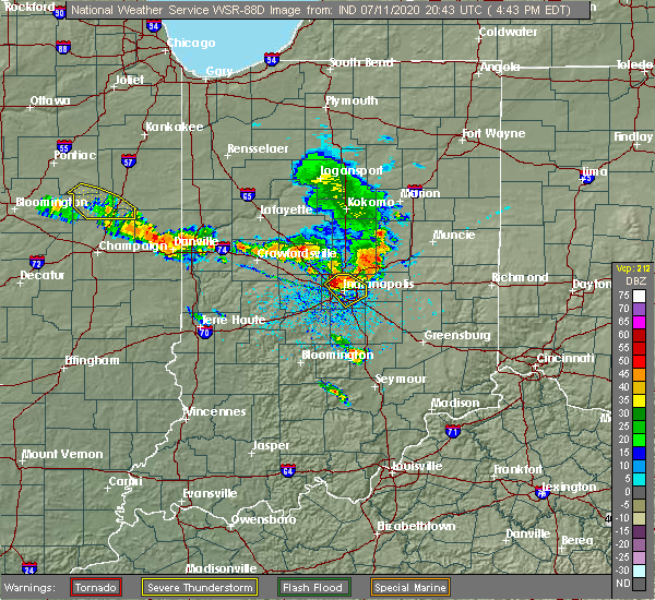 At 446 pm edt, a severe thunderstorm was located near indianapolis, moving southeast at 50 mph (radar indicated). Hazards include 60 mph wind gusts and penny size hail. Expect damage to roofs, siding, and trees. locations impacted include, indianapolis, lawrence, beech grove, speedway, southport, cumberland, meridian hills, warren park, homecroft, rocky ripple, williams creek, wynnedale, spring hill, crows nest, north crows nest, monument circle, indiana state fairgrounds and broad ripple. this includes the following highways, interstate 65 between mile markers 104 and 122. interstate 69 near mile marker 200. interstate 70 between mile markers 78 and 93. Interstate 74 between mile markers 93 and 95. At 446 pm edt, a severe thunderstorm was located near indianapolis, moving southeast at 50 mph (radar indicated). Hazards include 60 mph wind gusts and penny size hail. Expect damage to roofs, siding, and trees. locations impacted include, indianapolis, lawrence, beech grove, speedway, southport, cumberland, meridian hills, warren park, homecroft, rocky ripple, williams creek, wynnedale, spring hill, crows nest, north crows nest, monument circle, indiana state fairgrounds and broad ripple. this includes the following highways, interstate 65 between mile markers 104 and 122. interstate 69 near mile marker 200. interstate 70 between mile markers 78 and 93. Interstate 74 between mile markers 93 and 95.
|
| 7/11/2020 4:41 PM EDT |
 At 441 pm edt, a severe thunderstorm was located near speedway, or near indianapolis, moving southeast at 50 mph (radar indicated). Hazards include 60 mph wind gusts and penny size hail. expect damage to roofs, siding, and trees At 441 pm edt, a severe thunderstorm was located near speedway, or near indianapolis, moving southeast at 50 mph (radar indicated). Hazards include 60 mph wind gusts and penny size hail. expect damage to roofs, siding, and trees
|
| 5/23/2020 2:06 PM EDT |
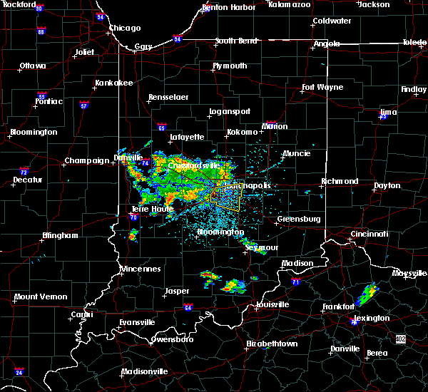 At 205 pm edt, a severe thunderstorm was located near speedway, or 8 miles southwest of indianapolis, moving east at 20 mph (radar indicated). Hazards include 60 mph wind gusts. expect damage to roofs, siding, and trees At 205 pm edt, a severe thunderstorm was located near speedway, or 8 miles southwest of indianapolis, moving east at 20 mph (radar indicated). Hazards include 60 mph wind gusts. expect damage to roofs, siding, and trees
|
| 4/8/2020 8:51 PM EDT |
 At 850 pm edt, a severe thunderstorm was located over greenwood, or 10 miles south of indianapolis, moving east at 70 mph (radar indicated). Hazards include 70 mph wind gusts and quarter size hail. Hail damage to vehicles is expected. expect considerable tree damage. wind damage is also likely to mobile homes, roofs, and outbuildings. locations impacted include, indianapolis, columbus, shelbyville, greenwood, plainfield, franklin, brownsburg, beech grove, martinsville, speedway, mooresville, danville, southport, avon, new whiteland, cumberland, edinburgh, whiteland, bargersville and new palestine. this includes the following highways, interstate 65 between mile markers 72 and 121. interstate 70 between mile markers 49 and 86. Interstate 74 between mile markers 66 and 113. At 850 pm edt, a severe thunderstorm was located over greenwood, or 10 miles south of indianapolis, moving east at 70 mph (radar indicated). Hazards include 70 mph wind gusts and quarter size hail. Hail damage to vehicles is expected. expect considerable tree damage. wind damage is also likely to mobile homes, roofs, and outbuildings. locations impacted include, indianapolis, columbus, shelbyville, greenwood, plainfield, franklin, brownsburg, beech grove, martinsville, speedway, mooresville, danville, southport, avon, new whiteland, cumberland, edinburgh, whiteland, bargersville and new palestine. this includes the following highways, interstate 65 between mile markers 72 and 121. interstate 70 between mile markers 49 and 86. Interstate 74 between mile markers 66 and 113.
|
| 4/8/2020 8:27 PM EDT |
 At 827 pm edt, a severe thunderstorm was located near danville, or 25 miles southeast of crawfordsville, moving east at 70 mph (radar indicated). Hazards include 70 mph wind gusts and quarter size hail. Hail damage to vehicles is expected. expect considerable tree damage. Wind damage is also likely to mobile homes, roofs, and outbuildings. At 827 pm edt, a severe thunderstorm was located near danville, or 25 miles southeast of crawfordsville, moving east at 70 mph (radar indicated). Hazards include 70 mph wind gusts and quarter size hail. Hail damage to vehicles is expected. expect considerable tree damage. Wind damage is also likely to mobile homes, roofs, and outbuildings.
|
| 3/28/2020 10:25 PM EDT |
 The severe thunderstorm warning for northern marion, southeastern boone and southwestern hamilton counties will expire at 1030 pm edt, the storm which prompted the warning has moved out of the area. therefore, the warning will be allowed to expire. The severe thunderstorm warning for northern marion, southeastern boone and southwestern hamilton counties will expire at 1030 pm edt, the storm which prompted the warning has moved out of the area. therefore, the warning will be allowed to expire.
|
| 3/28/2020 10:09 PM EDT |
 At 1009 pm edt, a severe thunderstorm was located over carmel, or 12 miles north of indianapolis, moving northeast at 45 mph (radar indicated). Hazards include 60 mph wind gusts and quarter size hail. Hail damage to vehicles is expected. expect wind damage to roofs, siding, and trees. locations impacted include, indianapolis, carmel, lawrence, zionsville, speedway, meridian hills, clermont, rocky ripple, williams creek, wynnedale, spring hill, crows nest, north crows nest, castleton, monument circle, eagle creek reservoir, indianapolis int`l airport, indiana state fairgrounds and broad ripple. this includes the following highways, interstate 65 between mile markers 110 and 127. interstate 69 between mile markers 200 and 201. interstate 70 between mile markers 70 and 88. Interstate 74 between mile markers 71 and 73. At 1009 pm edt, a severe thunderstorm was located over carmel, or 12 miles north of indianapolis, moving northeast at 45 mph (radar indicated). Hazards include 60 mph wind gusts and quarter size hail. Hail damage to vehicles is expected. expect wind damage to roofs, siding, and trees. locations impacted include, indianapolis, carmel, lawrence, zionsville, speedway, meridian hills, clermont, rocky ripple, williams creek, wynnedale, spring hill, crows nest, north crows nest, castleton, monument circle, eagle creek reservoir, indianapolis int`l airport, indiana state fairgrounds and broad ripple. this includes the following highways, interstate 65 between mile markers 110 and 127. interstate 69 between mile markers 200 and 201. interstate 70 between mile markers 70 and 88. Interstate 74 between mile markers 71 and 73.
|
| 3/28/2020 9:58 PM EDT |
 At 958 pm edt, a severe thunderstorm was located near zionsville, or 9 miles northwest of indianapolis, moving northeast at 50 mph (radar indicated). Hazards include 60 mph wind gusts and quarter size hail. Hail damage to vehicles is expected. expect wind damage to roofs, siding, and trees. locations impacted include, indianapolis, carmel, lawrence, plainfield, brownsburg, zionsville, speedway, danville, avon, pittsboro, whitestown, meridian hills, clermont, clayton, rocky ripple, williams creek, wynnedale, spring hill, crows nest and north crows nest. this includes the following highways, interstate 65 between mile markers 110 and 132. interstate 69 between mile markers 200 and 201. interstate 70 between mile markers 62 and 88. Interstate 74 between mile markers 61 and 73. At 958 pm edt, a severe thunderstorm was located near zionsville, or 9 miles northwest of indianapolis, moving northeast at 50 mph (radar indicated). Hazards include 60 mph wind gusts and quarter size hail. Hail damage to vehicles is expected. expect wind damage to roofs, siding, and trees. locations impacted include, indianapolis, carmel, lawrence, plainfield, brownsburg, zionsville, speedway, danville, avon, pittsboro, whitestown, meridian hills, clermont, clayton, rocky ripple, williams creek, wynnedale, spring hill, crows nest and north crows nest. this includes the following highways, interstate 65 between mile markers 110 and 132. interstate 69 between mile markers 200 and 201. interstate 70 between mile markers 62 and 88. Interstate 74 between mile markers 61 and 73.
|
| 3/28/2020 9:42 PM EDT |
 At 942 pm edt, a severe thunderstorm was located near brownsburg, or 15 miles west of indianapolis, moving northeast at 50 mph (radar indicated). Hazards include 60 mph wind gusts and quarter size hail. Hail damage to vehicles is expected. Expect wind damage to roofs, siding, and trees. At 942 pm edt, a severe thunderstorm was located near brownsburg, or 15 miles west of indianapolis, moving northeast at 50 mph (radar indicated). Hazards include 60 mph wind gusts and quarter size hail. Hail damage to vehicles is expected. Expect wind damage to roofs, siding, and trees.
|
| 8/20/2019 2:58 PM EDT |
 The national weather service in indianapolis has issued a * severe thunderstorm warning for. shelby county in central indiana. southern hancock county in central indiana. eastern morgan county in central indiana. Northern brown county in south central indiana. The national weather service in indianapolis has issued a * severe thunderstorm warning for. shelby county in central indiana. southern hancock county in central indiana. eastern morgan county in central indiana. Northern brown county in south central indiana.
|
| 8/20/2019 2:46 PM EDT |
 At 223 pm edt, a severe thunderstorm was located near brownsburg, or 18 miles northwest of indianapolis, moving east at 40 mph (radar indicated). Hazards include 60 mph wind gusts and penny size hail. expect damage to roofs, siding, and trees At 223 pm edt, a severe thunderstorm was located near brownsburg, or 18 miles northwest of indianapolis, moving east at 40 mph (radar indicated). Hazards include 60 mph wind gusts and penny size hail. expect damage to roofs, siding, and trees
|
| 8/20/2019 2:23 PM EDT |
 At 223 pm edt, a severe thunderstorm was located near brownsburg, or 18 miles northwest of indianapolis, moving east at 40 mph (radar indicated). Hazards include 60 mph wind gusts and penny size hail. expect damage to roofs, siding, and trees At 223 pm edt, a severe thunderstorm was located near brownsburg, or 18 miles northwest of indianapolis, moving east at 40 mph (radar indicated). Hazards include 60 mph wind gusts and penny size hail. expect damage to roofs, siding, and trees
|
| 8/18/2019 7:52 PM EDT |
 At 751 pm edt, severe thunderstorms were located along a line extending from 8 miles west of anderson to near lawrence to 13 miles northwest of martinsville, moving east at 35 mph (radar indicated). Hazards include 60 mph wind gusts and quarter size hail. Hail damage to vehicles is expected. expect wind damage to roofs, siding, and trees. locations impacted include, indianapolis, anderson, carmel, fishers, noblesville, greenwood, lawrence, plainfield, greenfield, beech grove, speedway, greencastle, mooresville, danville, southport, westfield, avon, cumberland, cicero and mccordsville. those attending outdoor events across the indianapolis metro area are in the path of these storms and should prepare for dangerous weather conditions. seek shelter now! this includes the following highways, interstate 65 between mile markers 100 and 119. interstate 69 between mile markers 200 and 228. interstate 70 between mile markers 46 and 107. Interstate 74 between mile markers 72 and 100. At 751 pm edt, severe thunderstorms were located along a line extending from 8 miles west of anderson to near lawrence to 13 miles northwest of martinsville, moving east at 35 mph (radar indicated). Hazards include 60 mph wind gusts and quarter size hail. Hail damage to vehicles is expected. expect wind damage to roofs, siding, and trees. locations impacted include, indianapolis, anderson, carmel, fishers, noblesville, greenwood, lawrence, plainfield, greenfield, beech grove, speedway, greencastle, mooresville, danville, southport, westfield, avon, cumberland, cicero and mccordsville. those attending outdoor events across the indianapolis metro area are in the path of these storms and should prepare for dangerous weather conditions. seek shelter now! this includes the following highways, interstate 65 between mile markers 100 and 119. interstate 69 between mile markers 200 and 228. interstate 70 between mile markers 46 and 107. Interstate 74 between mile markers 72 and 100.
|
| 8/18/2019 7:24 PM EDT |
 At 722 pm edt, severe thunderstorms were located along a line extending from 6 miles northwest of noblesville to speedway to 9 miles east of brazil, moving east at 35 mph (radar indicated). Hazards include 60 mph wind gusts and quarter size hail. Hail damage to vehicles is expected. Expect wind damage to roofs, siding, and trees. At 722 pm edt, severe thunderstorms were located along a line extending from 6 miles northwest of noblesville to speedway to 9 miles east of brazil, moving east at 35 mph (radar indicated). Hazards include 60 mph wind gusts and quarter size hail. Hail damage to vehicles is expected. Expect wind damage to roofs, siding, and trees.
|
| 8/18/2019 7:10 PM EDT |
 At 708 pm edt, severe thunderstorms were located along a line extending from 13 miles northeast of lebanon to near brownsburg to near danville to 6 miles east of greencastle, moving east at 35 mph (radar indicated). Hazards include 60 mph wind gusts and quarter size hail. Hail damage to vehicles is expected. expect wind damage to roofs, siding, and trees. locations impacted include, indianapolis, carmel, fishers, noblesville, lawrence, plainfield, brownsburg, lebanon, beech grove, zionsville, speedway, greencastle, danville, rockville, westfield, avon, cicero, mccordsville, pittsboro and whitestown. those attending outdoor events in the indianapolis metro area are in the path of these storms and should prepare for dangerous weather conditions. seek shelter now! this includes the following highways, interstate 65 between mile markers 108 and 150. interstate 69 between mile markers 200 and 210. interstate 70 between mile markers 63 and 92. Interstate 74 between mile markers 42 and 73. At 708 pm edt, severe thunderstorms were located along a line extending from 13 miles northeast of lebanon to near brownsburg to near danville to 6 miles east of greencastle, moving east at 35 mph (radar indicated). Hazards include 60 mph wind gusts and quarter size hail. Hail damage to vehicles is expected. expect wind damage to roofs, siding, and trees. locations impacted include, indianapolis, carmel, fishers, noblesville, lawrence, plainfield, brownsburg, lebanon, beech grove, zionsville, speedway, greencastle, danville, rockville, westfield, avon, cicero, mccordsville, pittsboro and whitestown. those attending outdoor events in the indianapolis metro area are in the path of these storms and should prepare for dangerous weather conditions. seek shelter now! this includes the following highways, interstate 65 between mile markers 108 and 150. interstate 69 between mile markers 200 and 210. interstate 70 between mile markers 63 and 92. Interstate 74 between mile markers 42 and 73.
|
| 8/18/2019 6:55 PM EDT |
 At 655 pm edt, severe thunderstorms were located along a line extending from 9 miles southeast of frankfort to 6 miles northwest of brownsburg to near danville to greencastle, moving east at 40 mph (radar indicated). Hazards include 70 mph wind gusts and quarter size hail. Hail damage to vehicles is expected. expect considerable tree damage. wind damage is also likely to mobile homes, roofs, and outbuildings. locations impacted include, indianapolis, crawfordsville, carmel, fishers, noblesville, lawrence, plainfield, brownsburg, lebanon, beech grove, zionsville, speedway, greencastle, danville, clinton, rockville, westfield, avon, cicero and mccordsville. those attending outdoor events in the indianapolis metro area are in the path of these storms and should prepare for imminent dangerous weather conditions. seek shelter now! this includes the following highways, interstate 65 between mile markers 108 and 150. interstate 69 between mile markers 200 and 210. interstate 70 between mile markers 63 and 92. Interstate 74 between mile markers 32 and 73. At 655 pm edt, severe thunderstorms were located along a line extending from 9 miles southeast of frankfort to 6 miles northwest of brownsburg to near danville to greencastle, moving east at 40 mph (radar indicated). Hazards include 70 mph wind gusts and quarter size hail. Hail damage to vehicles is expected. expect considerable tree damage. wind damage is also likely to mobile homes, roofs, and outbuildings. locations impacted include, indianapolis, crawfordsville, carmel, fishers, noblesville, lawrence, plainfield, brownsburg, lebanon, beech grove, zionsville, speedway, greencastle, danville, clinton, rockville, westfield, avon, cicero and mccordsville. those attending outdoor events in the indianapolis metro area are in the path of these storms and should prepare for imminent dangerous weather conditions. seek shelter now! this includes the following highways, interstate 65 between mile markers 108 and 150. interstate 69 between mile markers 200 and 210. interstate 70 between mile markers 63 and 92. Interstate 74 between mile markers 32 and 73.
|
| 8/18/2019 6:35 PM EDT |
 At 634 pm edt, severe thunderstorms were located along a line extending from 10 miles northwest of lebanon to 12 miles southeast of crawfordsville to 6 miles southeast of rockville, moving east at 35 mph (radar indicated). Hazards include 70 mph wind gusts and quarter size hail. Hail damage to vehicles is expected. expect considerable tree damage. wind damage is also likely to mobile homes, roofs, and outbuildings. locations impacted include, indianapolis, crawfordsville, carmel, fishers, noblesville, lawrence, plainfield, brownsburg, lebanon, beech grove, zionsville, speedway, greencastle, danville, clinton, rockville, westfield, avon, cicero and mccordsville. those attending outdoor events in the indianapolis metro area are in the path of these storms and should prepare for imminent dangerous weather conditions. seek shelter now! this includes the following highways, interstate 65 between mile markers 108 and 150. interstate 69 between mile markers 200 and 210. interstate 70 between mile markers 63 and 92. Interstate 74 between mile markers 32 and 73. At 634 pm edt, severe thunderstorms were located along a line extending from 10 miles northwest of lebanon to 12 miles southeast of crawfordsville to 6 miles southeast of rockville, moving east at 35 mph (radar indicated). Hazards include 70 mph wind gusts and quarter size hail. Hail damage to vehicles is expected. expect considerable tree damage. wind damage is also likely to mobile homes, roofs, and outbuildings. locations impacted include, indianapolis, crawfordsville, carmel, fishers, noblesville, lawrence, plainfield, brownsburg, lebanon, beech grove, zionsville, speedway, greencastle, danville, clinton, rockville, westfield, avon, cicero and mccordsville. those attending outdoor events in the indianapolis metro area are in the path of these storms and should prepare for imminent dangerous weather conditions. seek shelter now! this includes the following highways, interstate 65 between mile markers 108 and 150. interstate 69 between mile markers 200 and 210. interstate 70 between mile markers 63 and 92. Interstate 74 between mile markers 32 and 73.
|
| 8/18/2019 6:13 PM EDT |
 At 612 pm edt, severe thunderstorms were located along a line extending from 7 miles north of crawfordsville to 15 miles northeast of rockville to near clinton, moving east at 35 mph. these are very dangerous storms (radar indicated). Hazards include 80 mph wind gusts and quarter size hail. Flying debris will be dangerous to those caught without shelter. mobile homes will be heavily damaged. expect considerable damage to roofs, windows, and vehicles. Extensive tree damage and power outages are likely. At 612 pm edt, severe thunderstorms were located along a line extending from 7 miles north of crawfordsville to 15 miles northeast of rockville to near clinton, moving east at 35 mph. these are very dangerous storms (radar indicated). Hazards include 80 mph wind gusts and quarter size hail. Flying debris will be dangerous to those caught without shelter. mobile homes will be heavily damaged. expect considerable damage to roofs, windows, and vehicles. Extensive tree damage and power outages are likely.
|
| 7/21/2019 5:44 PM EDT |
 At 543 pm edt, a severe thunderstorm was located near brownsburg, or 20 miles northwest of indianapolis, moving southeast at 35 mph (radar indicated). Hazards include 60 mph wind gusts. expect damage to roofs, siding, and trees At 543 pm edt, a severe thunderstorm was located near brownsburg, or 20 miles northwest of indianapolis, moving southeast at 35 mph (radar indicated). Hazards include 60 mph wind gusts. expect damage to roofs, siding, and trees
|
| 6/23/2019 3:44 PM EDT |
 A severe thunderstorm warning remains in effect until 415 pm edt for northwestern shelby. western hancock. northeastern johnson. marion and south central hamilton counties. at 343 pm edt, a severe thunderstorm was located over southport, or 7 miles south of indianapolis, moving northeast at 45 mph. The indianapolis airport had a measured gust of 49 mph with a spotter. A severe thunderstorm warning remains in effect until 415 pm edt for northwestern shelby. western hancock. northeastern johnson. marion and south central hamilton counties. at 343 pm edt, a severe thunderstorm was located over southport, or 7 miles south of indianapolis, moving northeast at 45 mph. The indianapolis airport had a measured gust of 49 mph with a spotter.
|
| 6/23/2019 3:26 PM EDT |
 At 325 pm edt, a severe thunderstorm was located near mooresville, or 18 miles southwest of indianapolis, moving northeast at 45 mph (radar indicated). Hazards include 60 mph wind gusts. expect damage to roofs, siding, and trees At 325 pm edt, a severe thunderstorm was located near mooresville, or 18 miles southwest of indianapolis, moving northeast at 45 mph (radar indicated). Hazards include 60 mph wind gusts. expect damage to roofs, siding, and trees
|
| 6/23/2019 3:16 PM EDT |
 At 316 pm edt, severe thunderstorms were located along a line extending from 13 miles northwest of danville to mooresville to 6 miles north of nashville, moving northeast at 60 mph (law enforcement). Hazards include 60 mph wind gusts. Expect damage to roofs, siding, and trees. locations impacted include, indianapolis, carmel, greenwood, lawrence, plainfield, franklin, brownsburg, beech grove, zionsville, martinsville, speedway, mooresville, danville, southport, avon, new whiteland, whiteland, bargersville, pittsboro and whitestown. this includes the following highways, interstate 65 between mile markers 84 and 137. interstate 70 between mile markers 48 and 90. Interstate 74 between mile markers 56 and 98. At 316 pm edt, severe thunderstorms were located along a line extending from 13 miles northwest of danville to mooresville to 6 miles north of nashville, moving northeast at 60 mph (law enforcement). Hazards include 60 mph wind gusts. Expect damage to roofs, siding, and trees. locations impacted include, indianapolis, carmel, greenwood, lawrence, plainfield, franklin, brownsburg, beech grove, zionsville, martinsville, speedway, mooresville, danville, southport, avon, new whiteland, whiteland, bargersville, pittsboro and whitestown. this includes the following highways, interstate 65 between mile markers 84 and 137. interstate 70 between mile markers 48 and 90. Interstate 74 between mile markers 56 and 98.
|
| 6/23/2019 2:52 PM EDT |
 At 252 pm edt, severe thunderstorms were located along a line extending from 9 miles northeast of brazil to 7 miles northeast of spencer to 7 miles south of bloomington, moving northeast at 60 mph. this storm has a history of producing significant tree damage (law enforcement). Hazards include 60 mph wind gusts. expect damage to roofs, siding, and trees At 252 pm edt, severe thunderstorms were located along a line extending from 9 miles northeast of brazil to 7 miles northeast of spencer to 7 miles south of bloomington, moving northeast at 60 mph. this storm has a history of producing significant tree damage (law enforcement). Hazards include 60 mph wind gusts. expect damage to roofs, siding, and trees
|
| 6/15/2019 7:08 PM EDT |
 At 643 pm edt, a severe thunderstorm was located near mooresville, or 20 miles southwest of indianapolis, moving east at 35 mph (radar indicated). Hazards include 60 mph wind gusts. expect damage to roofs, siding, and trees At 643 pm edt, a severe thunderstorm was located near mooresville, or 20 miles southwest of indianapolis, moving east at 35 mph (radar indicated). Hazards include 60 mph wind gusts. expect damage to roofs, siding, and trees
|
| 6/15/2019 6:44 PM EDT |
 At 643 pm edt, a severe thunderstorm was located near mooresville, or 20 miles southwest of indianapolis, moving east at 35 mph (radar indicated). Hazards include 60 mph wind gusts. expect damage to roofs, siding, and trees At 643 pm edt, a severe thunderstorm was located near mooresville, or 20 miles southwest of indianapolis, moving east at 35 mph (radar indicated). Hazards include 60 mph wind gusts. expect damage to roofs, siding, and trees
|
| 5/23/2019 6:06 AM EDT |
 The severe thunderstorm warning for northwestern shelby, hancock, northern morgan, johnson and marion counties will expire at 615 am edt, the storms which prompted the warning have weakened below severe limits, and have exited the warned area. therefore, the warning will be allowed to expire. however gusty winds and heavy rain are still possible with these thunderstorms. a severe thunderstorm watch remains in effect until 1000 am edt for central and east central indiana. to report severe weather, contact your nearest law enforcement agency. they will relay your report to the national weather service indianapolis. The severe thunderstorm warning for northwestern shelby, hancock, northern morgan, johnson and marion counties will expire at 615 am edt, the storms which prompted the warning have weakened below severe limits, and have exited the warned area. therefore, the warning will be allowed to expire. however gusty winds and heavy rain are still possible with these thunderstorms. a severe thunderstorm watch remains in effect until 1000 am edt for central and east central indiana. to report severe weather, contact your nearest law enforcement agency. they will relay your report to the national weather service indianapolis.
|
| 5/23/2019 5:43 AM EDT |
 At 542 am edt, severe thunderstorms were located along a line extending from 10 miles north of greenfield to near martinsville, moving east at 45 mph (radar indicated). Hazards include 60 mph wind gusts. Expect damage to roofs, siding, and trees. locations impacted include, indianapolis, shelbyville, greenwood, lawrence, plainfield, franklin, greenfield, beech grove, speedway, mooresville, southport, new whiteland, cumberland, mccordsville, whiteland, bargersville, new palestine, brooklyn, warren park and morristown. this includes the following highways, interstate 65 between mile markers 88 and 115. interstate 70 between mile markers 69 and 112. Interstate 74 between mile markers 93 and 110. At 542 am edt, severe thunderstorms were located along a line extending from 10 miles north of greenfield to near martinsville, moving east at 45 mph (radar indicated). Hazards include 60 mph wind gusts. Expect damage to roofs, siding, and trees. locations impacted include, indianapolis, shelbyville, greenwood, lawrence, plainfield, franklin, greenfield, beech grove, speedway, mooresville, southport, new whiteland, cumberland, mccordsville, whiteland, bargersville, new palestine, brooklyn, warren park and morristown. this includes the following highways, interstate 65 between mile markers 88 and 115. interstate 70 between mile markers 69 and 112. Interstate 74 between mile markers 93 and 110.
|
| 5/23/2019 5:27 AM EDT |
 At 526 am edt, severe thunderstorms were located along a line extending from near fishers to 8 miles west of martinsville, moving east at 45 mph. a 58 mph gust was measured at indianapolis international airport at 526 am (radar indicated). Hazards include 60 mph wind gusts. Expect damage to roofs, siding, and trees. locations impacted include, indianapolis, shelbyville, greenwood, lawrence, plainfield, franklin, greenfield, beech grove, speedway, mooresville, southport, avon, new whiteland, cumberland, mccordsville, whiteland, bargersville, new palestine, meridian hills and brooklyn. this includes the following highways, interstate 65 between mile markers 88 and 121. interstate 69 between mile markers 200 and 202. interstate 70 between mile markers 54 and 112. Interstate 74 between mile markers 73 and 110. At 526 am edt, severe thunderstorms were located along a line extending from near fishers to 8 miles west of martinsville, moving east at 45 mph. a 58 mph gust was measured at indianapolis international airport at 526 am (radar indicated). Hazards include 60 mph wind gusts. Expect damage to roofs, siding, and trees. locations impacted include, indianapolis, shelbyville, greenwood, lawrence, plainfield, franklin, greenfield, beech grove, speedway, mooresville, southport, avon, new whiteland, cumberland, mccordsville, whiteland, bargersville, new palestine, meridian hills and brooklyn. this includes the following highways, interstate 65 between mile markers 88 and 121. interstate 69 between mile markers 200 and 202. interstate 70 between mile markers 54 and 112. Interstate 74 between mile markers 73 and 110.
|
| 5/23/2019 5:08 AM EDT |
 At 507 am edt, severe thunderstorms were located along a line extending from near zionsville to 11 miles north of spencer, moving east at 45 mph. this line has weakened since 430 am but is still capable of producing damaging winds (radar indicated). Hazards include 60 mph wind gusts. expect damage to roofs, siding, and trees At 507 am edt, severe thunderstorms were located along a line extending from near zionsville to 11 miles north of spencer, moving east at 45 mph. this line has weakened since 430 am but is still capable of producing damaging winds (radar indicated). Hazards include 60 mph wind gusts. expect damage to roofs, siding, and trees
|
| 5/23/2019 4:56 AM EDT |
 At 456 am edt, severe thunderstorms were located along a line extending from near brownsburg to 8 miles southwest of danville to 8 miles southwest of greencastle, moving east at 55 mph (radar indicated). Hazards include 60 mph wind gusts and penny size hail. Expect damage to roofs, siding, and trees. locations impacted include, indianapolis, plainfield, brownsburg, speedway, greencastle, mooresville, danville, avon, pittsboro, cloverdale, meridian hills, clermont, monrovia, clayton, rocky ripple, fillmore, coatesville, williams creek, amo and stilesville. this includes the following highways, interstate 65 between mile markers 111 and 127. interstate 70 between mile markers 24 and 84. Interstate 74 between mile markers 59 and 73. At 456 am edt, severe thunderstorms were located along a line extending from near brownsburg to 8 miles southwest of danville to 8 miles southwest of greencastle, moving east at 55 mph (radar indicated). Hazards include 60 mph wind gusts and penny size hail. Expect damage to roofs, siding, and trees. locations impacted include, indianapolis, plainfield, brownsburg, speedway, greencastle, mooresville, danville, avon, pittsboro, cloverdale, meridian hills, clermont, monrovia, clayton, rocky ripple, fillmore, coatesville, williams creek, amo and stilesville. this includes the following highways, interstate 65 between mile markers 111 and 127. interstate 70 between mile markers 24 and 84. Interstate 74 between mile markers 59 and 73.
|
| 5/23/2019 4:44 AM EDT |
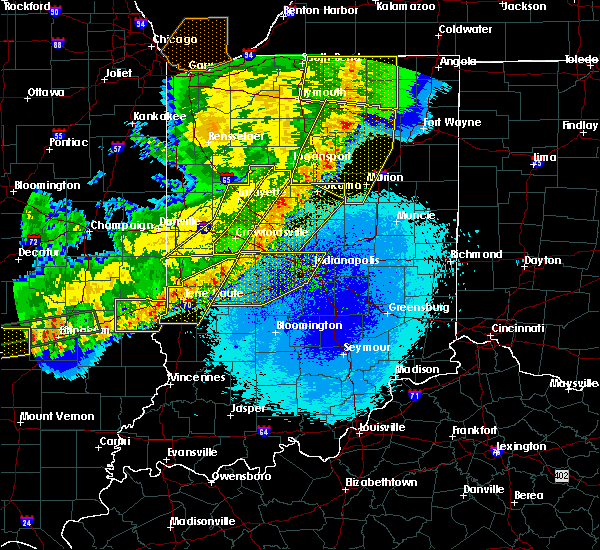 At 443 am edt, severe thunderstorms were located along a line extending from 11 miles northwest of danville to greencastle to brazil, moving east at 55 mph (radar indicated). Hazards include 70 mph wind gusts and penny size hail. Expect considerable tree damage. damage is likely to mobile homes, roofs, and outbuildings. locations impacted include, indianapolis, plainfield, brownsburg, speedway, greencastle, mooresville, danville, avon, pittsboro, cloverdale, meridian hills, clermont, monrovia, clayton, bainbridge, harmony, rocky ripple, fillmore, coatesville and north salem. this includes the following highways, interstate 65 between mile markers 111 and 127. interstate 70 between mile markers 23 and 84. Interstate 74 between mile markers 55 and 73. At 443 am edt, severe thunderstorms were located along a line extending from 11 miles northwest of danville to greencastle to brazil, moving east at 55 mph (radar indicated). Hazards include 70 mph wind gusts and penny size hail. Expect considerable tree damage. damage is likely to mobile homes, roofs, and outbuildings. locations impacted include, indianapolis, plainfield, brownsburg, speedway, greencastle, mooresville, danville, avon, pittsboro, cloverdale, meridian hills, clermont, monrovia, clayton, bainbridge, harmony, rocky ripple, fillmore, coatesville and north salem. this includes the following highways, interstate 65 between mile markers 111 and 127. interstate 70 between mile markers 23 and 84. Interstate 74 between mile markers 55 and 73.
|
| 5/23/2019 4:17 AM EDT |
 At 416 am edt, severe thunderstorms were located along a line extending from 12 miles northeast of rockville to 8 miles northwest of brazil to near dennison, moving east at 55 mph (radar indicated). Hazards include 70 mph wind gusts and penny size hail. Expect considerable tree damage. Damage is likely to mobile homes, roofs, and outbuildings. At 416 am edt, severe thunderstorms were located along a line extending from 12 miles northeast of rockville to 8 miles northwest of brazil to near dennison, moving east at 55 mph (radar indicated). Hazards include 70 mph wind gusts and penny size hail. Expect considerable tree damage. Damage is likely to mobile homes, roofs, and outbuildings.
|
| 5/19/2019 6:56 PM EDT |
 The severe thunderstorm warning for northwestern shelby, western hancock, northeastern morgan, northern johnson, eastern hendricks, marion, southeastern boone and southern hamilton counties will expire at 700 pm edt, the storm which prompted the warning has moved out of the area. therefore, the warning will be allowed to expire. however gusty winds are still possible with this thunderstorm. a severe thunderstorm watch remains in effect until 1000 pm edt for central indiana. The severe thunderstorm warning for northwestern shelby, western hancock, northeastern morgan, northern johnson, eastern hendricks, marion, southeastern boone and southern hamilton counties will expire at 700 pm edt, the storm which prompted the warning has moved out of the area. therefore, the warning will be allowed to expire. however gusty winds are still possible with this thunderstorm. a severe thunderstorm watch remains in effect until 1000 pm edt for central indiana.
|
| 5/19/2019 6:54 PM EDT |
 At 654 pm edt, severe thunderstorms were located along a line extending from near noblesville to near speedway, moving east at 55 mph (radar indicated). Hazards include 60 mph wind gusts. expect damage to roofs, siding, and trees At 654 pm edt, severe thunderstorms were located along a line extending from near noblesville to near speedway, moving east at 55 mph (radar indicated). Hazards include 60 mph wind gusts. expect damage to roofs, siding, and trees
|
| 5/19/2019 6:36 PM EDT |
 At 635 pm edt, a severe thunderstorm was located near brownsburg, or 13 miles northwest of indianapolis, moving east at 45 mph. this storm has produced weak rotation north of brownsburg (radar indicated). Hazards include 60 mph wind gusts. expect damage to roofs, siding, and trees At 635 pm edt, a severe thunderstorm was located near brownsburg, or 13 miles northwest of indianapolis, moving east at 45 mph. this storm has produced weak rotation north of brownsburg (radar indicated). Hazards include 60 mph wind gusts. expect damage to roofs, siding, and trees
|
| 5/16/2019 5:48 PM EDT |
 At 548 pm edt, severe thunderstorms were located along a line extending from greenwood to near martinsville, moving southeast at 55 mph (radar indicated). Hazards include 60 mph wind gusts. Expect damage to roofs, siding, and trees. locations impacted include, indianapolis, shelbyville, greenwood, plainfield, franklin, brownsburg, beech grove, speedway, mooresville, danville, southport, avon, new whiteland, whiteland, bargersville, brooklyn, clermont, trafalgar, monrovia and morgantown. this includes the following highways, interstate 65 between mile markers 86 and 111. interstate 70 between mile markers 55 and 80. Interstate 74 between mile markers 67 and 73, and between mile markers 100 and 115. At 548 pm edt, severe thunderstorms were located along a line extending from greenwood to near martinsville, moving southeast at 55 mph (radar indicated). Hazards include 60 mph wind gusts. Expect damage to roofs, siding, and trees. locations impacted include, indianapolis, shelbyville, greenwood, plainfield, franklin, brownsburg, beech grove, speedway, mooresville, danville, southport, avon, new whiteland, whiteland, bargersville, brooklyn, clermont, trafalgar, monrovia and morgantown. this includes the following highways, interstate 65 between mile markers 86 and 111. interstate 70 between mile markers 55 and 80. Interstate 74 between mile markers 67 and 73, and between mile markers 100 and 115.
|
| 5/16/2019 5:42 PM EDT |
 The severe thunderstorm warning for hancock, marion and west central henry counties will expire at 545 pm edt, the storms which prompted the warning have moved out of the area. therefore, the warning will be allowed to expire. however gusty winds are still possible with these thunderstorms. this storm will continue to produce severe winds places downstream. a severe thunderstorm watch remains in effect until 900 pm edt for central indiana. The severe thunderstorm warning for hancock, marion and west central henry counties will expire at 545 pm edt, the storms which prompted the warning have moved out of the area. therefore, the warning will be allowed to expire. however gusty winds are still possible with these thunderstorms. this storm will continue to produce severe winds places downstream. a severe thunderstorm watch remains in effect until 900 pm edt for central indiana.
|
| 5/16/2019 5:36 PM EDT |
 At 535 pm edt, severe thunderstorms were located along a line extending from 6 miles northwest of greenfield to indianapolis, moving southeast at 55 mph. Hazards include 60 mph wind gusts. source..law enforcement. Expect damage to roofs, siding, and trees. locations impacted include, indianapolis, lawrence, greenfield, beech grove, speedway, cumberland, mccordsville, fortville, new palestine, warren park, shirley, kennard, wilkinson, spring lake, greensboro, geist reservoir, monument circle and indiana state fairgrounds. this includes the following highways, interstate 65 between mile markers 103 and 117. interstate 69 near mile marker 200. interstate 70 between mile markers 75 and 117. Interstate 74 between mile markers 93 and 100. At 535 pm edt, severe thunderstorms were located along a line extending from 6 miles northwest of greenfield to indianapolis, moving southeast at 55 mph. Hazards include 60 mph wind gusts. source..law enforcement. Expect damage to roofs, siding, and trees. locations impacted include, indianapolis, lawrence, greenfield, beech grove, speedway, cumberland, mccordsville, fortville, new palestine, warren park, shirley, kennard, wilkinson, spring lake, greensboro, geist reservoir, monument circle and indiana state fairgrounds. this includes the following highways, interstate 65 between mile markers 103 and 117. interstate 69 near mile marker 200. interstate 70 between mile markers 75 and 117. Interstate 74 between mile markers 93 and 100.
|
| 5/16/2019 5:30 PM EDT |
 At 530 pm edt, severe thunderstorms were located along a line extending from brownsburg to 8 miles west of danville, moving southeast at 65 mph (radar indicated). Hazards include 60 mph wind gusts. expect damage to roofs, siding, and trees At 530 pm edt, severe thunderstorms were located along a line extending from brownsburg to 8 miles west of danville, moving southeast at 65 mph (radar indicated). Hazards include 60 mph wind gusts. expect damage to roofs, siding, and trees
|
| 5/16/2019 5:15 PM EDT |
 At 514 pm edt, severe thunderstorms were located along a line extending from carmel to near brownsburg, moving southeast at 55 mph. this storm has a history of producing 55 mph winds (radar indicated). Hazards include 60 mph wind gusts. expect damage to roofs, siding, and trees At 514 pm edt, severe thunderstorms were located along a line extending from carmel to near brownsburg, moving southeast at 55 mph. this storm has a history of producing 55 mph winds (radar indicated). Hazards include 60 mph wind gusts. expect damage to roofs, siding, and trees
|
| 8/7/2018 1:10 AM EDT |
 At 109 am edt, severe thunderstorms were located along a line extending from zionsville to near plainfield, moving east at 35 mph (radar indicated). Hazards include 60 mph wind gusts and nickel size hail. Expect damage to roofs, siding, and trees. locations impacted include, indianapolis, carmel, fishers, lawrence, plainfield, brownsburg, beech grove, zionsville, speedway, danville, southport, westfield, avon, cumberland, mccordsville, whitestown, meridian hills, warren park, clermont and homecroft. this includes the following highways, interstate 65 between mile markers 102 and 131. interstate 69 between mile markers 200 and 207. interstate 70 between mile markers 69 and 93. Interstate 74 between mile markers 65 and 99. At 109 am edt, severe thunderstorms were located along a line extending from zionsville to near plainfield, moving east at 35 mph (radar indicated). Hazards include 60 mph wind gusts and nickel size hail. Expect damage to roofs, siding, and trees. locations impacted include, indianapolis, carmel, fishers, lawrence, plainfield, brownsburg, beech grove, zionsville, speedway, danville, southport, westfield, avon, cumberland, mccordsville, whitestown, meridian hills, warren park, clermont and homecroft. this includes the following highways, interstate 65 between mile markers 102 and 131. interstate 69 between mile markers 200 and 207. interstate 70 between mile markers 69 and 93. Interstate 74 between mile markers 65 and 99.
|
| 8/7/2018 12:52 AM EDT |
 At 1252 am edt, severe thunderstorms were located along a line extending from 6 miles southeast of lebanon to near danville, moving east at 35 mph (radar indicated). Hazards include 70 mph wind gusts and nickel size hail. Expect considerable tree damage. damage is likely to mobile homes, roofs, and outbuildings. locations impacted include, indianapolis, carmel, fishers, lawrence, plainfield, brownsburg, lebanon, beech grove, zionsville, speedway, danville, southport, avon, cumberland, mccordsville, pittsboro, whitestown, meridian hills, warren park and clermont. this includes the following highways, interstate 65 between mile markers 102 and 139. interstate 69 between mile markers 200 and 207. interstate 70 between mile markers 68 and 93. Interstate 74 between mile markers 60 and 99. At 1252 am edt, severe thunderstorms were located along a line extending from 6 miles southeast of lebanon to near danville, moving east at 35 mph (radar indicated). Hazards include 70 mph wind gusts and nickel size hail. Expect considerable tree damage. damage is likely to mobile homes, roofs, and outbuildings. locations impacted include, indianapolis, carmel, fishers, lawrence, plainfield, brownsburg, lebanon, beech grove, zionsville, speedway, danville, southport, avon, cumberland, mccordsville, pittsboro, whitestown, meridian hills, warren park and clermont. this includes the following highways, interstate 65 between mile markers 102 and 139. interstate 69 between mile markers 200 and 207. interstate 70 between mile markers 68 and 93. Interstate 74 between mile markers 60 and 99.
|
| 8/7/2018 12:34 AM EDT |
 At 1234 am edt, severe thunderstorms were located along a line extending from 6 miles southwest of lebanon to 6 miles northwest of danville, moving east at 35 mph (radar indicated). Hazards include 60 mph wind gusts and nickel size hail. expect damage to roofs, siding, and trees At 1234 am edt, severe thunderstorms were located along a line extending from 6 miles southwest of lebanon to 6 miles northwest of danville, moving east at 35 mph (radar indicated). Hazards include 60 mph wind gusts and nickel size hail. expect damage to roofs, siding, and trees
|
| 6/10/2018 5:35 PM EDT |
 At 534 pm edt, severe thunderstorms were located along a line extending from near beech grove to 9 miles east of martinsville to 10 miles west of nashville to near bloomington, moving east at 45 mph (radar indicated). Hazards include 60 mph wind gusts. Expect damage to roofs, siding, and trees. locations impacted include, indianapolis, bloomington, greenwood, lawrence, franklin, beech grove, speedway, southport, ellettsville, new whiteland, cumberland, edinburgh, whiteland, bargersville, warren park, princes lakes, trafalgar, morgantown, homecroft and geist reservoir. this includes the following highways, interstate 65 between mile markers 84 and 117. interstate 70 between mile markers 70 and 93. Interstate 74 between mile markers 93 and 100. At 534 pm edt, severe thunderstorms were located along a line extending from near beech grove to 9 miles east of martinsville to 10 miles west of nashville to near bloomington, moving east at 45 mph (radar indicated). Hazards include 60 mph wind gusts. Expect damage to roofs, siding, and trees. locations impacted include, indianapolis, bloomington, greenwood, lawrence, franklin, beech grove, speedway, southport, ellettsville, new whiteland, cumberland, edinburgh, whiteland, bargersville, warren park, princes lakes, trafalgar, morgantown, homecroft and geist reservoir. this includes the following highways, interstate 65 between mile markers 84 and 117. interstate 70 between mile markers 70 and 93. Interstate 74 between mile markers 93 and 100.
|
| 6/10/2018 5:23 PM EDT |
 At 522 pm edt, severe thunderstorms were located along a line extending from near speedway to near martinsville to 9 miles north of bloomington to 7 miles south of spencer, moving east at 45 mph (radar indicated). Hazards include 60 mph wind gusts. expect damage to roofs, siding, and trees At 522 pm edt, severe thunderstorms were located along a line extending from near speedway to near martinsville to 9 miles north of bloomington to 7 miles south of spencer, moving east at 45 mph (radar indicated). Hazards include 60 mph wind gusts. expect damage to roofs, siding, and trees
|
| 4/3/2018 8:36 PM EDT |
 At 828 pm edt, a severe thunderstorm was located near speedway, or 7 miles southwest of indianapolis, moving northeast at 60 mph (radar indicated). Hazards include 60 mph wind gusts. expect damage to roofs, siding, and trees At 828 pm edt, a severe thunderstorm was located near speedway, or 7 miles southwest of indianapolis, moving northeast at 60 mph (radar indicated). Hazards include 60 mph wind gusts. expect damage to roofs, siding, and trees
|
| 4/3/2018 8:28 PM EDT |
 At 828 pm edt, a severe thunderstorm was located near speedway, or 7 miles southwest of indianapolis, moving northeast at 60 mph (radar indicated). Hazards include 60 mph wind gusts. expect damage to roofs, siding, and trees At 828 pm edt, a severe thunderstorm was located near speedway, or 7 miles southwest of indianapolis, moving northeast at 60 mph (radar indicated). Hazards include 60 mph wind gusts. expect damage to roofs, siding, and trees
|
| 4/3/2018 12:11 PM EDT |
 The severe thunderstorm warning for west central hancock and marion counties will expire at 1215 pm edt, the severe thunderstorm which prompted the warning has weakened. moved out of the warned area. therefore, the warning will be allowed to expire. however small hail is still possible with this thunderstorm. The severe thunderstorm warning for west central hancock and marion counties will expire at 1215 pm edt, the severe thunderstorm which prompted the warning has weakened. moved out of the warned area. therefore, the warning will be allowed to expire. however small hail is still possible with this thunderstorm.
|
| 4/3/2018 12:05 PM EDT |
 At 1205 pm edt, a severe thunderstorm was located near lawrence, or 15 miles southwest of anderson, moving northeast at 60 mph. this storm has history of producing nickel and quarter sized hail (trained weather spotters). Hazards include 60 mph wind gusts and half dollar size hail. Hail damage to vehicles is expected. expect wind damage to roofs, siding, and trees. locations impacted include, indianapolis, carmel, fishers, lawrence, beech grove, speedway, cumberland, mccordsville, meridian hills, warren park, clermont, rocky ripple, williams creek, wynnedale, spring hill, crows nest, north crows nest, geist reservoir, monument circle and castleton. this includes the following highways, interstate 65 between mile markers 106 and 122. interstate 69 between mile markers 200 and 202. interstate 70 between mile markers 74 and 101. Interstate 74 between mile markers 70 and 94. At 1205 pm edt, a severe thunderstorm was located near lawrence, or 15 miles southwest of anderson, moving northeast at 60 mph. this storm has history of producing nickel and quarter sized hail (trained weather spotters). Hazards include 60 mph wind gusts and half dollar size hail. Hail damage to vehicles is expected. expect wind damage to roofs, siding, and trees. locations impacted include, indianapolis, carmel, fishers, lawrence, beech grove, speedway, cumberland, mccordsville, meridian hills, warren park, clermont, rocky ripple, williams creek, wynnedale, spring hill, crows nest, north crows nest, geist reservoir, monument circle and castleton. this includes the following highways, interstate 65 between mile markers 106 and 122. interstate 69 between mile markers 200 and 202. interstate 70 between mile markers 74 and 101. Interstate 74 between mile markers 70 and 94.
|
| 4/3/2018 11:53 AM EDT |
 At 1152 am edt, a severe thunderstorm was located near indianapolis, moving northeast at 60 mph. multiple reports of nickel sized hail (trained weather spotters). Hazards include 60 mph wind gusts and half dollar size hail. Hail damage to vehicles is expected. expect wind damage to roofs, siding, and trees. locations impacted include, indianapolis, carmel, fishers, lawrence, plainfield, beech grove, speedway, danville, avon, cumberland, mccordsville, meridian hills, warren park, clermont, clayton, rocky ripple, williams creek, wynnedale, spring hill and crows nest. this includes the following highways, interstate 65 between mile markers 106 and 122. interstate 69 between mile markers 200 and 202. interstate 70 between mile markers 64 and 101. Interstate 74 between mile markers 70 and 94. At 1152 am edt, a severe thunderstorm was located near indianapolis, moving northeast at 60 mph. multiple reports of nickel sized hail (trained weather spotters). Hazards include 60 mph wind gusts and half dollar size hail. Hail damage to vehicles is expected. expect wind damage to roofs, siding, and trees. locations impacted include, indianapolis, carmel, fishers, lawrence, plainfield, beech grove, speedway, danville, avon, cumberland, mccordsville, meridian hills, warren park, clermont, clayton, rocky ripple, williams creek, wynnedale, spring hill and crows nest. this includes the following highways, interstate 65 between mile markers 106 and 122. interstate 69 between mile markers 200 and 202. interstate 70 between mile markers 64 and 101. Interstate 74 between mile markers 70 and 94.
|
| 4/3/2018 11:42 AM EDT |
 A severe thunderstorm warning remains in effect until 1215 pm edt for west central hancock. northwestern morgan. southern hendricks and marion counties. at 1142 am edt, a severe thunderstorm was located near speedway, or near indianapolis, moving northeast at 60 mph. This storm has produced hail as large as nickels. A severe thunderstorm warning remains in effect until 1215 pm edt for west central hancock. northwestern morgan. southern hendricks and marion counties. at 1142 am edt, a severe thunderstorm was located near speedway, or near indianapolis, moving northeast at 60 mph. This storm has produced hail as large as nickels.
|
| 4/3/2018 11:31 AM EDT |
 At 1130 am edt, a severe thunderstorm was located near mooresville, or 18 miles southwest of indianapolis, moving northeast at 60 mph (radar indicated). Hazards include 60 mph wind gusts and half dollar size hail. Hail damage to vehicles is expected. Expect wind damage to roofs, siding, and trees. At 1130 am edt, a severe thunderstorm was located near mooresville, or 18 miles southwest of indianapolis, moving northeast at 60 mph (radar indicated). Hazards include 60 mph wind gusts and half dollar size hail. Hail damage to vehicles is expected. Expect wind damage to roofs, siding, and trees.
|
| 7/23/2017 3:26 PM EDT |
 The severe thunderstorm warning for east central hendricks and southwestern marion counties will expire at 330 pm edt, the storm which prompted the warning has weakened below severe limits, and no longer poses an immediate threat to life or property. therefore the warning will be allowed to expire. however gusty winds and heavy rain are still possible with this thunderstorm. The severe thunderstorm warning for east central hendricks and southwestern marion counties will expire at 330 pm edt, the storm which prompted the warning has weakened below severe limits, and no longer poses an immediate threat to life or property. therefore the warning will be allowed to expire. however gusty winds and heavy rain are still possible with this thunderstorm.
|
| 7/23/2017 3:15 PM EDT |
 At 315 pm edt, a severe thunderstorm was located near speedway, or 9 miles west of indianapolis, moving southeast at 20 mph (radar indicated). Hazards include 60 mph wind gusts. Expect damage to roofs, siding, and trees. locations impacted include, indianapolis, plainfield, brownsburg, beech grove, speedway, avon, clermont, indianapolis int`l airport, monument circle and eagle creek reservoir. those attending the brickyard 400 are in the path of this storm and should prepare for imminent dangerous weather conditions. seek shelter now! this includes the following highways, interstate 65 between mile markers 106 and 114. interstate 70 between mile markers 70 and 83. Interstate 74 between mile markers 69 and 73. At 315 pm edt, a severe thunderstorm was located near speedway, or 9 miles west of indianapolis, moving southeast at 20 mph (radar indicated). Hazards include 60 mph wind gusts. Expect damage to roofs, siding, and trees. locations impacted include, indianapolis, plainfield, brownsburg, beech grove, speedway, avon, clermont, indianapolis int`l airport, monument circle and eagle creek reservoir. those attending the brickyard 400 are in the path of this storm and should prepare for imminent dangerous weather conditions. seek shelter now! this includes the following highways, interstate 65 between mile markers 106 and 114. interstate 70 between mile markers 70 and 83. Interstate 74 between mile markers 69 and 73.
|
| 7/23/2017 3:08 PM EDT |
 At 307 pm edt, a severe thunderstorm was located near speedway, or 8 miles west of indianapolis, moving southeast at 40 mph (radar indicated). Hazards include 60 mph wind gusts. Expect damage to roofs, siding, and trees. locations impacted include, indianapolis, plainfield, brownsburg, beech grove, speedway, avon, pittsboro, clermont, indianapolis int`l airport, monument circle and eagle creek reservoir. those attending the brickyard 400 are in the path of this storm and should prepare for imminent dangerous weather conditions. seek shelter now! this includes the following highways, interstate 65 between mile markers 106 and 114. interstate 70 between mile markers 70 and 83. Interstate 74 between mile markers 63 and 73. At 307 pm edt, a severe thunderstorm was located near speedway, or 8 miles west of indianapolis, moving southeast at 40 mph (radar indicated). Hazards include 60 mph wind gusts. Expect damage to roofs, siding, and trees. locations impacted include, indianapolis, plainfield, brownsburg, beech grove, speedway, avon, pittsboro, clermont, indianapolis int`l airport, monument circle and eagle creek reservoir. those attending the brickyard 400 are in the path of this storm and should prepare for imminent dangerous weather conditions. seek shelter now! this includes the following highways, interstate 65 between mile markers 106 and 114. interstate 70 between mile markers 70 and 83. Interstate 74 between mile markers 63 and 73.
|
| 7/23/2017 2:56 PM EDT |
 At 256 pm edt, a severe thunderstorm was located over brownsburg, or 14 miles west of indianapolis, moving southeast at 40 mph (radar indicated). Hazards include 60 mph wind gusts. expect damage to roofs, siding, and trees At 256 pm edt, a severe thunderstorm was located over brownsburg, or 14 miles west of indianapolis, moving southeast at 40 mph (radar indicated). Hazards include 60 mph wind gusts. expect damage to roofs, siding, and trees
|
| 7/11/2017 12:56 PM EDT |
 The severe thunderstorm warning for northeastern morgan, northern johnson, eastern hendricks, marion, eastern boone and hamilton counties will expire at 100 pm edt, the storms which prompted the warning have weakened below severe limits, and have exited the warned area. therefore the warning will be allowed to expire. however gusty winds are still possible with these thunderstorms. The severe thunderstorm warning for northeastern morgan, northern johnson, eastern hendricks, marion, eastern boone and hamilton counties will expire at 100 pm edt, the storms which prompted the warning have weakened below severe limits, and have exited the warned area. therefore the warning will be allowed to expire. however gusty winds are still possible with these thunderstorms.
|
| 7/11/2017 12:40 PM EDT |
 At 1240 pm edt, severe thunderstorms were located along a line extending from 8 miles north of zionsville to near mooresville, moving east at 65 mph (radar indicated). Hazards include 60 mph wind gusts and penny size hail. Expect damage to roofs, siding, and trees. locations impacted include, indianapolis, carmel, fishers, noblesville, greenwood, lawrence, plainfield, brownsburg, lebanon, beech grove, zionsville, speedway, mooresville, danville, southport, westfield, avon, new whiteland, cumberland and cicero. this includes the following highways, interstate 65 between mile markers 94 and 138. interstate 69 between mile markers 200 and 210. interstate 70 between mile markers 57 and 93. Interstate 74 between mile markers 59 and 100. At 1240 pm edt, severe thunderstorms were located along a line extending from 8 miles north of zionsville to near mooresville, moving east at 65 mph (radar indicated). Hazards include 60 mph wind gusts and penny size hail. Expect damage to roofs, siding, and trees. locations impacted include, indianapolis, carmel, fishers, noblesville, greenwood, lawrence, plainfield, brownsburg, lebanon, beech grove, zionsville, speedway, mooresville, danville, southport, westfield, avon, new whiteland, cumberland and cicero. this includes the following highways, interstate 65 between mile markers 94 and 138. interstate 69 between mile markers 200 and 210. interstate 70 between mile markers 57 and 93. Interstate 74 between mile markers 59 and 100.
|
| 7/11/2017 12:31 PM EDT |
 At 1231 pm edt, severe thunderstorms were located along a line extending from near lebanon to 7 miles west of mooresville, moving east at 50 mph (radar indicated). Hazards include 60 mph wind gusts and penny size hail. expect damage to roofs, siding, and trees At 1231 pm edt, severe thunderstorms were located along a line extending from near lebanon to 7 miles west of mooresville, moving east at 50 mph (radar indicated). Hazards include 60 mph wind gusts and penny size hail. expect damage to roofs, siding, and trees
|
| 7/7/2017 5:41 PM EDT |
 At 541 pm edt, severe thunderstorms were located along a line extending from near speedway to 10 miles northwest of greencastle, moving southeast at 40 mph (radar indicated). Hazards include 60 mph wind gusts and quarter size hail. Hail damage to vehicles is expected. expect wind damage to roofs, siding, and trees. locations impacted include, indianapolis, plainfield, brownsburg, beech grove, speedway, greencastle, mooresville, danville, rockville, southport, avon, pittsboro, clermont, monrovia, clayton, roachdale, bainbridge, homecroft, fillmore and coatesville. this includes the following highways, interstate 65 between mile markers 102 and 114, and between mile markers 116 and 127. interstate 70 between mile markers 50 and 83. Interstate 74 between mile markers 55 and 73. At 541 pm edt, severe thunderstorms were located along a line extending from near speedway to 10 miles northwest of greencastle, moving southeast at 40 mph (radar indicated). Hazards include 60 mph wind gusts and quarter size hail. Hail damage to vehicles is expected. expect wind damage to roofs, siding, and trees. locations impacted include, indianapolis, plainfield, brownsburg, beech grove, speedway, greencastle, mooresville, danville, rockville, southport, avon, pittsboro, clermont, monrovia, clayton, roachdale, bainbridge, homecroft, fillmore and coatesville. this includes the following highways, interstate 65 between mile markers 102 and 114, and between mile markers 116 and 127. interstate 70 between mile markers 50 and 83. Interstate 74 between mile markers 55 and 73.
|
| 7/7/2017 5:29 PM EDT |
 At 529 pm edt, severe thunderstorms were located along a line extending from near brownsburg to 7 miles east of rockville, moving southeast at 40 mph (radar indicated). Hazards include 60 mph wind gusts and quarter size hail. Hail damage to vehicles is expected. Expect wind damage to roofs, siding, and trees. At 529 pm edt, severe thunderstorms were located along a line extending from near brownsburg to 7 miles east of rockville, moving southeast at 40 mph (radar indicated). Hazards include 60 mph wind gusts and quarter size hail. Hail damage to vehicles is expected. Expect wind damage to roofs, siding, and trees.
|
| 7/7/2017 4:24 PM EDT |
 The severe thunderstorm warning for east central hendricks and southwestern marion counties will expire at 430 pm edt, the storm which prompted the warning has weakened below severe limits, and has exited the warned area. therefore, the warning will be allowed to expire. a severe thunderstorm watch remains in effect until 900 pm edt for central indiana. The severe thunderstorm warning for east central hendricks and southwestern marion counties will expire at 430 pm edt, the storm which prompted the warning has weakened below severe limits, and has exited the warned area. therefore, the warning will be allowed to expire. a severe thunderstorm watch remains in effect until 900 pm edt for central indiana.
|
| 7/7/2017 4:13 PM EDT |
 A severe thunderstorm warning remains in effect until 430 pm edt for east central hendricks and southwestern marion counties. at 413 pm edt, a severe thunderstorm was located near speedway, or 9 miles west of indianapolis, moving southeast at 30 mph. hazard. 60 mph wind gusts and quarter size hail. source. Radar indicated. A severe thunderstorm warning remains in effect until 430 pm edt for east central hendricks and southwestern marion counties. at 413 pm edt, a severe thunderstorm was located near speedway, or 9 miles west of indianapolis, moving southeast at 30 mph. hazard. 60 mph wind gusts and quarter size hail. source. Radar indicated.
|
| 7/7/2017 3:57 PM EDT |
 At 340 pm edt, a severe thunderstorm was located 9 miles northwest of danville, or 19 miles southeast of crawfordsville, moving southeast at 30 mph (radar indicated). Hazards include 60 mph wind gusts and quarter size hail. Hail damage to vehicles is expected. Expect wind damage to roofs, siding, and trees. At 340 pm edt, a severe thunderstorm was located 9 miles northwest of danville, or 19 miles southeast of crawfordsville, moving southeast at 30 mph (radar indicated). Hazards include 60 mph wind gusts and quarter size hail. Hail damage to vehicles is expected. Expect wind damage to roofs, siding, and trees.
|
| 7/7/2017 3:40 PM EDT |
 At 340 pm edt, a severe thunderstorm was located 9 miles northwest of danville, or 19 miles southeast of crawfordsville, moving southeast at 30 mph (radar indicated). Hazards include 60 mph wind gusts and quarter size hail. Hail damage to vehicles is expected. Expect wind damage to roofs, siding, and trees. At 340 pm edt, a severe thunderstorm was located 9 miles northwest of danville, or 19 miles southeast of crawfordsville, moving southeast at 30 mph (radar indicated). Hazards include 60 mph wind gusts and quarter size hail. Hail damage to vehicles is expected. Expect wind damage to roofs, siding, and trees.
|
| 6/30/2017 4:17 PM EDT |
 At 417 pm edt, a severe thunderstorm was located near speedway, or near indianapolis, moving northeast at 30 mph (radar indicated). Hazards include 60 mph wind gusts. Expect damage to roofs, siding, and trees. locations impacted include, indianapolis, carmel, fishers, lawrence, plainfield, beech grove, speedway, southport, avon, cumberland, meridian hills, warren park, clermont, homecroft, rocky ripple, williams creek, wynnedale, spring hill, crows nest and north crows nest. this includes the following highways, interstate 65 between mile markers 104 and 122. interstate 69 between mile markers 200 and 202. interstate 70 between mile markers 64 and 93. Interstate 74 between mile markers 71 and 96. At 417 pm edt, a severe thunderstorm was located near speedway, or near indianapolis, moving northeast at 30 mph (radar indicated). Hazards include 60 mph wind gusts. Expect damage to roofs, siding, and trees. locations impacted include, indianapolis, carmel, fishers, lawrence, plainfield, beech grove, speedway, southport, avon, cumberland, meridian hills, warren park, clermont, homecroft, rocky ripple, williams creek, wynnedale, spring hill, crows nest and north crows nest. this includes the following highways, interstate 65 between mile markers 104 and 122. interstate 69 between mile markers 200 and 202. interstate 70 between mile markers 64 and 93. Interstate 74 between mile markers 71 and 96.
|
| 6/30/2017 4:06 PM EDT |
 At 405 pm edt, a severe thunderstorm was located over plainfield, or 13 miles southwest of indianapolis, moving northeast at 30 mph (radar indicated). Hazards include 60 mph wind gusts. expect damage to roofs, siding, and trees At 405 pm edt, a severe thunderstorm was located over plainfield, or 13 miles southwest of indianapolis, moving northeast at 30 mph (radar indicated). Hazards include 60 mph wind gusts. expect damage to roofs, siding, and trees
|
| 6/30/2017 12:06 PM EDT |
 At 405 pm edt, a severe thunderstorm was located over plainfield, or 13 miles southwest of indianapolis, moving northeast at 30 mph (radar indicated). Hazards include 60 mph wind gusts. expect damage to roofs, siding, and trees At 405 pm edt, a severe thunderstorm was located over plainfield, or 13 miles southwest of indianapolis, moving northeast at 30 mph (radar indicated). Hazards include 60 mph wind gusts. expect damage to roofs, siding, and trees
|
| 5/28/2017 6:08 PM EDT |
 At 607 pm edt, a severe thunderstorm was located near southport, or near indianapolis, moving east at 35 mph (radar indicated). Hazards include 60 mph wind gusts. expect damage to roofs, siding, and trees At 607 pm edt, a severe thunderstorm was located near southport, or near indianapolis, moving east at 35 mph (radar indicated). Hazards include 60 mph wind gusts. expect damage to roofs, siding, and trees
|
| 5/26/2017 9:06 PM EDT |
 At 906 pm edt, a severe thunderstorm was located near speedway, or 9 miles west of indianapolis, moving southeast at 40 mph (trained weather spotters). Hazards include 70 mph wind gusts. Expect considerable tree damage. damage is likely to mobile homes, roofs, and outbuildings. locations impacted include, indianapolis, plainfield, beech grove, speedway, danville, southport, avon, cumberland, warren park, clermont, homecroft, wynnedale, spring hill, monument circle, indianapolis int`l airport and camby. this includes the following highways, interstate 65 between mile markers 101 and 121. interstate 70 between mile markers 65 and 90. Interstate 74 between mile markers 72 and 100. At 906 pm edt, a severe thunderstorm was located near speedway, or 9 miles west of indianapolis, moving southeast at 40 mph (trained weather spotters). Hazards include 70 mph wind gusts. Expect considerable tree damage. damage is likely to mobile homes, roofs, and outbuildings. locations impacted include, indianapolis, plainfield, beech grove, speedway, danville, southport, avon, cumberland, warren park, clermont, homecroft, wynnedale, spring hill, monument circle, indianapolis int`l airport and camby. this includes the following highways, interstate 65 between mile markers 101 and 121. interstate 70 between mile markers 65 and 90. Interstate 74 between mile markers 72 and 100.
|
| 5/26/2017 8:53 PM EDT |
 At 853 pm edt, a severe thunderstorm was located near brownsburg, or 13 miles west of indianapolis, moving southeast at 45 mph (trained weather spotters). Hazards include 70 mph wind gusts. Expect considerable tree damage. damage is likely to mobile homes, roofs, and outbuildings. locations impacted include, indianapolis, plainfield, brownsburg, beech grove, speedway, danville, southport, avon, cumberland, pittsboro, warren park, clermont, homecroft, wynnedale, spring hill, monument circle, eagle creek reservoir, indianapolis int`l airport, indiana state fairgrounds and camby. this includes the following highways, interstate 65 between mile markers 101 and 122. interstate 70 between mile markers 65 and 91. Interstate 74 between mile markers 64 and 100. At 853 pm edt, a severe thunderstorm was located near brownsburg, or 13 miles west of indianapolis, moving southeast at 45 mph (trained weather spotters). Hazards include 70 mph wind gusts. Expect considerable tree damage. damage is likely to mobile homes, roofs, and outbuildings. locations impacted include, indianapolis, plainfield, brownsburg, beech grove, speedway, danville, southport, avon, cumberland, pittsboro, warren park, clermont, homecroft, wynnedale, spring hill, monument circle, eagle creek reservoir, indianapolis int`l airport, indiana state fairgrounds and camby. this includes the following highways, interstate 65 between mile markers 101 and 122. interstate 70 between mile markers 65 and 91. Interstate 74 between mile markers 64 and 100.
|
| 5/26/2017 8:38 PM EDT |
 At 838 pm edt, a severe thunderstorm was located 7 miles north of danville, or 20 miles southeast of crawfordsville, moving southeast at 40 mph (trained weather spotters). Hazards include 70 mph wind gusts. Expect considerable tree damage. Damage is likely to mobile homes, roofs, and outbuildings. At 838 pm edt, a severe thunderstorm was located 7 miles north of danville, or 20 miles southeast of crawfordsville, moving southeast at 40 mph (trained weather spotters). Hazards include 70 mph wind gusts. Expect considerable tree damage. Damage is likely to mobile homes, roofs, and outbuildings.
|
| 4/26/2017 7:25 PM EDT |
 At 725 pm edt, a severe thunderstorm was located over brownsburg, or 16 miles west of indianapolis, moving northeast at 50 mph (trained weather spotters). Hazards include 70 mph wind gusts and quarter size hail. Hail damage to vehicles is expected. expect considerable tree damage. Wind damage is also likely to mobile homes, roofs, and outbuildings. At 725 pm edt, a severe thunderstorm was located over brownsburg, or 16 miles west of indianapolis, moving northeast at 50 mph (trained weather spotters). Hazards include 70 mph wind gusts and quarter size hail. Hail damage to vehicles is expected. expect considerable tree damage. Wind damage is also likely to mobile homes, roofs, and outbuildings.
|
| 3/30/2017 6:42 PM EDT |
 At 641 pm edt, a severe thunderstorm was located over indianapolis, moving northeast at 50 mph (radar indicated). Hazards include 60 mph wind gusts. Expect damage to roofs, siding, and trees. locations impacted include, indianapolis, carmel, fishers, greenwood, lawrence, beech grove, speedway, southport, cumberland, meridian hills, warren park, clermont, homecroft, rocky ripple, williams creek, wynnedale, spring hill, crows nest, north crows nest and monument circle. this includes the following highways, interstate 65 between mile markers 101 and 123. interstate 69 between mile markers 200 and 203. interstate 70 between mile markers 70 and 92. interstate 74 between mile markers 71 and 100. A tornado watch remains in effect until 1000 pm edt for central indiana. At 641 pm edt, a severe thunderstorm was located over indianapolis, moving northeast at 50 mph (radar indicated). Hazards include 60 mph wind gusts. Expect damage to roofs, siding, and trees. locations impacted include, indianapolis, carmel, fishers, greenwood, lawrence, beech grove, speedway, southport, cumberland, meridian hills, warren park, clermont, homecroft, rocky ripple, williams creek, wynnedale, spring hill, crows nest, north crows nest and monument circle. this includes the following highways, interstate 65 between mile markers 101 and 123. interstate 69 between mile markers 200 and 203. interstate 70 between mile markers 70 and 92. interstate 74 between mile markers 71 and 100. A tornado watch remains in effect until 1000 pm edt for central indiana.
|
| 3/30/2017 6:26 PM EDT |
 At 625 pm edt, a severe thunderstorm was located over plainfield, or 13 miles west of indianapolis, moving northeast at 50 mph (radar indicated). Hazards include 70 mph wind gusts. Expect considerable tree damage. damage is likely to mobile homes, roofs, and outbuildings. locations impacted include, indianapolis, carmel, fishers, greenwood, lawrence, plainfield, brownsburg, beech grove, speedway, danville, southport, avon, cumberland, meridian hills, warren park, clermont, homecroft, rocky ripple, williams creek and wynnedale. this includes the following highways, interstate 65 between mile markers 101 and 124. interstate 69 between mile markers 200 and 203. interstate 70 between mile markers 62 and 92. interstate 74 between mile markers 68 and 100. A tornado watch remains in effect until 1000 pm edt for central indiana. At 625 pm edt, a severe thunderstorm was located over plainfield, or 13 miles west of indianapolis, moving northeast at 50 mph (radar indicated). Hazards include 70 mph wind gusts. Expect considerable tree damage. damage is likely to mobile homes, roofs, and outbuildings. locations impacted include, indianapolis, carmel, fishers, greenwood, lawrence, plainfield, brownsburg, beech grove, speedway, danville, southport, avon, cumberland, meridian hills, warren park, clermont, homecroft, rocky ripple, williams creek and wynnedale. this includes the following highways, interstate 65 between mile markers 101 and 124. interstate 69 between mile markers 200 and 203. interstate 70 between mile markers 62 and 92. interstate 74 between mile markers 68 and 100. A tornado watch remains in effect until 1000 pm edt for central indiana.
|
| 3/30/2017 6:08 PM EDT |
 At 607 pm edt, a severe thunderstorm was located 11 miles east of greencastle, or 28 miles southwest of indianapolis, moving northeast at 50 mph (radar indicated). Hazards include 70 mph wind gusts. Expect considerable tree damage. Damage is likely to mobile homes, roofs, and outbuildings. At 607 pm edt, a severe thunderstorm was located 11 miles east of greencastle, or 28 miles southwest of indianapolis, moving northeast at 50 mph (radar indicated). Hazards include 70 mph wind gusts. Expect considerable tree damage. Damage is likely to mobile homes, roofs, and outbuildings.
|
| 1/10/2017 7:40 PM EST |
 At 740 pm est, severe thunderstorms were located along a line extending from lawrence to 6 miles north of martinsville, moving southeast at 50 mph (trained weather spotters). Hazards include 60 mph wind gusts. expect damage to roofs, siding, and trees At 740 pm est, severe thunderstorms were located along a line extending from lawrence to 6 miles north of martinsville, moving southeast at 50 mph (trained weather spotters). Hazards include 60 mph wind gusts. expect damage to roofs, siding, and trees
|
| 11/18/2016 6:05 PM EST |
 At 605 pm est, severe thunderstorms were located along a line extending from 7 miles north of noblesville to near mooresville, moving northeast at 35 mph (radar indicated). Hazards include 70 mph wind gusts. Expect considerable tree damage. damage is likely to mobile homes, roofs, and outbuildings. locations impacted include, indianapolis, carmel, fishers, noblesville, greenwood, lawrence, plainfield, brownsburg, beech grove, zionsville, speedway, southport, westfield, avon, cumberland, cicero, mccordsville, sheridan, new palestine and arcadia. this includes the following highways, interstate 65 between mile markers 99 and 130. interstate 69 between mile markers 200 and 213. interstate 70 between mile markers 62 and 97. Interstate 74 between mile markers 67 and 100. At 605 pm est, severe thunderstorms were located along a line extending from 7 miles north of noblesville to near mooresville, moving northeast at 35 mph (radar indicated). Hazards include 70 mph wind gusts. Expect considerable tree damage. damage is likely to mobile homes, roofs, and outbuildings. locations impacted include, indianapolis, carmel, fishers, noblesville, greenwood, lawrence, plainfield, brownsburg, beech grove, zionsville, speedway, southport, westfield, avon, cumberland, cicero, mccordsville, sheridan, new palestine and arcadia. this includes the following highways, interstate 65 between mile markers 99 and 130. interstate 69 between mile markers 200 and 213. interstate 70 between mile markers 62 and 97. Interstate 74 between mile markers 67 and 100.
|
| 11/18/2016 5:41 PM EST |
 At 541 pm est, severe thunderstorms were located along a line extending from near lebanon to 7 miles west of mooresville, moving east at 60 mph (radar indicated). Hazards include 70 mph wind gusts. Expect considerable tree damage. Damage is likely to mobile homes, roofs, and outbuildings. At 541 pm est, severe thunderstorms were located along a line extending from near lebanon to 7 miles west of mooresville, moving east at 60 mph (radar indicated). Hazards include 70 mph wind gusts. Expect considerable tree damage. Damage is likely to mobile homes, roofs, and outbuildings.
|
| 8/24/2016 5:15 PM EDT |
 At 514 pm edt, a severe thunderstorm capable of producing a tornado was located near speedway, or 8 miles northwest of indianapolis, moving east at 25 mph (radar indicated rotation). Hazards include tornado. Flying debris will be dangerous to those caught without shelter. mobile homes will be damaged or destroyed. damage to roofs, windows, and vehicles will occur. tree damage is likely. this dangerous storm will be near, meridian hills, rocky ripple, williams creek, wynnedale, spring hill, crows nest and north crows nest around 525 pm edt. indiana state fairgrounds and broad ripple around 530 pm edt. warren park and castleton around 540 pm edt. lawrence around 545 pm edt. this includes the following highways, interstate 65 between mile markers 112 and 125. interstate 69 near mile marker 200. interstate 70 between mile markers 83 and 90. Interstate 74 between mile markers 71 and 73. At 514 pm edt, a severe thunderstorm capable of producing a tornado was located near speedway, or 8 miles northwest of indianapolis, moving east at 25 mph (radar indicated rotation). Hazards include tornado. Flying debris will be dangerous to those caught without shelter. mobile homes will be damaged or destroyed. damage to roofs, windows, and vehicles will occur. tree damage is likely. this dangerous storm will be near, meridian hills, rocky ripple, williams creek, wynnedale, spring hill, crows nest and north crows nest around 525 pm edt. indiana state fairgrounds and broad ripple around 530 pm edt. warren park and castleton around 540 pm edt. lawrence around 545 pm edt. this includes the following highways, interstate 65 between mile markers 112 and 125. interstate 69 near mile marker 200. interstate 70 between mile markers 83 and 90. Interstate 74 between mile markers 71 and 73.
|
| 8/24/2016 4:25 PM EDT |
 At 423 pm edt, a confirmed large and extremely dangerous tornado was located near indianapolis, moving east at 20 mph. this is a particularly dangerous situation. take cover now! (law enforcement confirmed tornado. at 422 pm a tornado was reported east northeast of downtown indianapolis on interstate 70). Hazards include damaging tornado. You are in a life-threatening situation. flying debris may be deadly to those caught without shelter. mobile homes will be destroyed. considerable damage to homes, businesses, and vehicles is likely and complete destruction is possible. the tornado will be near, lawrence and cumberland around 445 pm edt. this includes the following highways, interstate 65 between mile markers 110 and 118. interstate 69 between mile markers 200 and 202. interstate 70 between mile markers 78 and 98. Interstate 74 near mile marker 94. At 423 pm edt, a confirmed large and extremely dangerous tornado was located near indianapolis, moving east at 20 mph. this is a particularly dangerous situation. take cover now! (law enforcement confirmed tornado. at 422 pm a tornado was reported east northeast of downtown indianapolis on interstate 70). Hazards include damaging tornado. You are in a life-threatening situation. flying debris may be deadly to those caught without shelter. mobile homes will be destroyed. considerable damage to homes, businesses, and vehicles is likely and complete destruction is possible. the tornado will be near, lawrence and cumberland around 445 pm edt. this includes the following highways, interstate 65 between mile markers 110 and 118. interstate 69 between mile markers 200 and 202. interstate 70 between mile markers 78 and 98. Interstate 74 near mile marker 94.
|
| 8/24/2016 4:19 PM EDT |
 At 419 pm edt, a confirmed large and extremely dangerous tornado was located over indianapolis, moving east at 20 mph. this is a particularly dangerous situation. take cover now! (law enforcement confirmed tornado). Hazards include damaging tornado. You are in a life-threatening situation. flying debris may be deadly to those caught without shelter. mobile homes will be destroyed. considerable damage to homes, businesses, and vehicles is likely and complete destruction is possible. the tornado will be near, warren park around 430 pm edt. lawrence and cumberland around 445 pm edt. this includes the following highways, interstate 65 between mile markers 110 and 119. interstate 69 between mile markers 200 and 202. interstate 70 between mile markers 78 and 98. Interstate 74 near mile marker 94. At 419 pm edt, a confirmed large and extremely dangerous tornado was located over indianapolis, moving east at 20 mph. this is a particularly dangerous situation. take cover now! (law enforcement confirmed tornado). Hazards include damaging tornado. You are in a life-threatening situation. flying debris may be deadly to those caught without shelter. mobile homes will be destroyed. considerable damage to homes, businesses, and vehicles is likely and complete destruction is possible. the tornado will be near, warren park around 430 pm edt. lawrence and cumberland around 445 pm edt. this includes the following highways, interstate 65 between mile markers 110 and 119. interstate 69 between mile markers 200 and 202. interstate 70 between mile markers 78 and 98. Interstate 74 near mile marker 94.
|
| 8/24/2016 4:15 PM EDT |
 At 414 pm edt, a severe thunderstorm capable of producing a tornado was located near indianapolis, moving east at 20 mph (weather spotters reported a funnel cloud). Hazards include tornado and quarter size hail. Flying debris will be dangerous to those caught without shelter. mobile homes will be damaged or destroyed. damage to roofs, windows, and vehicles will occur. tree damage is likely. this dangerous storm will be near, castleton around 425 pm edt. warren park around 430 pm edt. geist reservoir around 435 pm edt. lawrence and mccordsville around 440 pm edt. cumberland around 445 pm edt. this includes the following highways, interstate 65 between mile markers 110 and 120. interstate 69 between mile markers 200 and 202. interstate 70 between mile markers 78 and 98. Interstate 74 mile marker 73 and near mile marker 94. At 414 pm edt, a severe thunderstorm capable of producing a tornado was located near indianapolis, moving east at 20 mph (weather spotters reported a funnel cloud). Hazards include tornado and quarter size hail. Flying debris will be dangerous to those caught without shelter. mobile homes will be damaged or destroyed. damage to roofs, windows, and vehicles will occur. tree damage is likely. this dangerous storm will be near, castleton around 425 pm edt. warren park around 430 pm edt. geist reservoir around 435 pm edt. lawrence and mccordsville around 440 pm edt. cumberland around 445 pm edt. this includes the following highways, interstate 65 between mile markers 110 and 120. interstate 69 between mile markers 200 and 202. interstate 70 between mile markers 78 and 98. Interstate 74 mile marker 73 and near mile marker 94.
|
| 8/24/2016 4:09 PM EDT |
 At 409 pm edt, a severe thunderstorm capable of producing a tornado was located over indianapolis, moving east at 25 mph (weather spotters reported a funnel cloud). Hazards include tornado and quarter size hail. Flying debris will be dangerous to those caught without shelter. mobile homes will be damaged or destroyed. damage to roofs, windows, and vehicles will occur. tree damage is likely. this dangerous storm will be near, warren park around 425 pm edt. cumberland around 435 pm edt. this includes the following highways, interstate 65 between mile markers 110 and 122. interstate 69 between mile markers 200 and 204. interstate 70 between mile markers 78 and 98. Interstate 74 between mile markers 72 and 73, and near mile marker 94. At 409 pm edt, a severe thunderstorm capable of producing a tornado was located over indianapolis, moving east at 25 mph (weather spotters reported a funnel cloud). Hazards include tornado and quarter size hail. Flying debris will be dangerous to those caught without shelter. mobile homes will be damaged or destroyed. damage to roofs, windows, and vehicles will occur. tree damage is likely. this dangerous storm will be near, warren park around 425 pm edt. cumberland around 435 pm edt. this includes the following highways, interstate 65 between mile markers 110 and 122. interstate 69 between mile markers 200 and 204. interstate 70 between mile markers 78 and 98. Interstate 74 between mile markers 72 and 73, and near mile marker 94.
|
| 8/24/2016 3:54 PM EDT |
 At 354 pm edt, a severe thunderstorm capable of producing a tornado was located near speedway, or 7 miles northwest of indianapolis, moving east at 20 mph (weather spotters reported funnel cloud). Hazards include tornado and quarter size hail. Flying debris will be dangerous to those caught without shelter. mobile homes will be damaged or destroyed. damage to roofs, windows, and vehicles will occur. tree damage is likely. this dangerous storm will be near, wynnedale and spring hill around 405 pm edt. meridian hills, rocky ripple, williams creek, crows nest, north crows nest and monument circle around 410 pm edt. indiana state fairgrounds and broad ripple around 415 pm edt. warren park and castleton around 425 pm edt. geist reservoir around 435 pm edt. indianapolis, lawrence, cumberland and mccordsville around 445 pm edt. this includes the following highways, interstate 65 between mile markers 110 and 126. interstate 69 between mile markers 200 and 204. interstate 70 between mile markers 78 and 98. Interstate 74 between mile markers 71 and 73, and near mile marker 94. At 354 pm edt, a severe thunderstorm capable of producing a tornado was located near speedway, or 7 miles northwest of indianapolis, moving east at 20 mph (weather spotters reported funnel cloud). Hazards include tornado and quarter size hail. Flying debris will be dangerous to those caught without shelter. mobile homes will be damaged or destroyed. damage to roofs, windows, and vehicles will occur. tree damage is likely. this dangerous storm will be near, wynnedale and spring hill around 405 pm edt. meridian hills, rocky ripple, williams creek, crows nest, north crows nest and monument circle around 410 pm edt. indiana state fairgrounds and broad ripple around 415 pm edt. warren park and castleton around 425 pm edt. geist reservoir around 435 pm edt. indianapolis, lawrence, cumberland and mccordsville around 445 pm edt. this includes the following highways, interstate 65 between mile markers 110 and 126. interstate 69 between mile markers 200 and 204. interstate 70 between mile markers 78 and 98. Interstate 74 between mile markers 71 and 73, and near mile marker 94.
|
| 8/24/2016 3:51 PM EDT |
 At 350 pm edt, a severe thunderstorm capable of producing a tornado was located near speedway, or 8 miles northwest of indianapolis, moving east at 20 mph (weather spotters reported a funnel cloud). Hazards include tornado and quarter size hail. Flying debris will be dangerous to those caught without shelter. mobile homes will be damaged or destroyed. damage to roofs, windows, and vehicles will occur. tree damage is likely. this dangerous storm will be near, speedway around 355 pm edt. meridian hills, rocky ripple, williams creek, wynnedale, spring hill, crows nest, north crows nest and indiana state fairgrounds around 400 pm edt. this includes the following highways, interstate 65 between mile markers 115 and 130. Interstate 74 between mile markers 63 and 73. At 350 pm edt, a severe thunderstorm capable of producing a tornado was located near speedway, or 8 miles northwest of indianapolis, moving east at 20 mph (weather spotters reported a funnel cloud). Hazards include tornado and quarter size hail. Flying debris will be dangerous to those caught without shelter. mobile homes will be damaged or destroyed. damage to roofs, windows, and vehicles will occur. tree damage is likely. this dangerous storm will be near, speedway around 355 pm edt. meridian hills, rocky ripple, williams creek, wynnedale, spring hill, crows nest, north crows nest and indiana state fairgrounds around 400 pm edt. this includes the following highways, interstate 65 between mile markers 115 and 130. Interstate 74 between mile markers 63 and 73.
|
| 8/24/2016 3:36 PM EDT |
 At 336 pm edt, a severe thunderstorm capable of producing a tornado was located over brownsburg, or 14 miles west of indianapolis, moving east at 30 mph (radar indicated rotation). Hazards include tornado and quarter size hail. Flying debris will be dangerous to those caught without shelter. mobile homes will be damaged or destroyed. damage to roofs, windows, and vehicles will occur. tree damage is likely. this dangerous storm will be near, clermont and eagle creek reservoir around 345 pm edt. zionsville and speedway around 350 pm edt. meridian hills, rocky ripple, williams creek, wynnedale, spring hill, crows nest, north crows nest and indiana state fairgrounds around 400 pm edt. this includes the following highways, interstate 65 between mile markers 115 and 130. Interstate 74 between mile markers 60 and 73. At 336 pm edt, a severe thunderstorm capable of producing a tornado was located over brownsburg, or 14 miles west of indianapolis, moving east at 30 mph (radar indicated rotation). Hazards include tornado and quarter size hail. Flying debris will be dangerous to those caught without shelter. mobile homes will be damaged or destroyed. damage to roofs, windows, and vehicles will occur. tree damage is likely. this dangerous storm will be near, clermont and eagle creek reservoir around 345 pm edt. zionsville and speedway around 350 pm edt. meridian hills, rocky ripple, williams creek, wynnedale, spring hill, crows nest, north crows nest and indiana state fairgrounds around 400 pm edt. this includes the following highways, interstate 65 between mile markers 115 and 130. Interstate 74 between mile markers 60 and 73.
|
| 8/24/2016 3:25 PM EDT |
 At 325 pm edt, a severe thunderstorm capable of producing a tornado was located near danville, or 20 miles west of indianapolis, moving east at 40 mph (radar indicated rotation). Hazards include tornado and quarter size hail. Flying debris will be dangerous to those caught without shelter. mobile homes will be damaged or destroyed. damage to roofs, windows, and vehicles will occur. tree damage is likely. this dangerous storm will be near, brownsburg around 330 pm edt. clermont and eagle creek reservoir around 340 pm edt. zionsville and speedway around 345 pm edt. wynnedale and spring hill around 350 pm edt. meridian hills, rocky ripple, williams creek, crows nest, north crows nest and indiana state fairgrounds around 355 pm edt. carmel around 400 pm edt. this includes the following highways, interstate 65 between mile markers 115 and 130. Interstate 74 between mile markers 56 and 73. At 325 pm edt, a severe thunderstorm capable of producing a tornado was located near danville, or 20 miles west of indianapolis, moving east at 40 mph (radar indicated rotation). Hazards include tornado and quarter size hail. Flying debris will be dangerous to those caught without shelter. mobile homes will be damaged or destroyed. damage to roofs, windows, and vehicles will occur. tree damage is likely. this dangerous storm will be near, brownsburg around 330 pm edt. clermont and eagle creek reservoir around 340 pm edt. zionsville and speedway around 345 pm edt. wynnedale and spring hill around 350 pm edt. meridian hills, rocky ripple, williams creek, crows nest, north crows nest and indiana state fairgrounds around 355 pm edt. carmel around 400 pm edt. this includes the following highways, interstate 65 between mile markers 115 and 130. Interstate 74 between mile markers 56 and 73.
|
| 8/15/2016 5:53 PM EDT |
 At 552 pm edt, a confirmed tornado was located over danville, or 17 miles west of indianapolis, moving northeast at 25 mph (public confirmed tornado). Hazards include damaging tornado. Flying debris will be dangerous to those caught without shelter. mobile homes will be damaged or destroyed. damage to roofs, windows, and vehicles will occur. tree damage is likely. this tornado will be near, pittsboro around 605 pm edt. brownsburg and clermont around 610 pm edt. speedway and eagle creek reservoir around 615 pm edt. this includes the following highways, interstate 65 between mile markers 118 and 136. Interstate 74 between mile markers 61 and 73. At 552 pm edt, a confirmed tornado was located over danville, or 17 miles west of indianapolis, moving northeast at 25 mph (public confirmed tornado). Hazards include damaging tornado. Flying debris will be dangerous to those caught without shelter. mobile homes will be damaged or destroyed. damage to roofs, windows, and vehicles will occur. tree damage is likely. this tornado will be near, pittsboro around 605 pm edt. brownsburg and clermont around 610 pm edt. speedway and eagle creek reservoir around 615 pm edt. this includes the following highways, interstate 65 between mile markers 118 and 136. Interstate 74 between mile markers 61 and 73.
|
| 8/15/2016 5:44 PM EDT |
 At 543 pm edt, a confirmed tornado was located over danville, or 20 miles west of indianapolis, moving northeast at 25 mph (public confirmed tornado). Hazards include damaging tornado. Flying debris will be dangerous to those caught without shelter. mobile homes will be damaged or destroyed. damage to roofs, windows, and vehicles will occur. tree damage is likely. the tornado will be near, plainfield and avon around 600 pm edt. pittsboro around 605 pm edt. brownsburg around 610 pm edt. speedway, clermont and eagle creek reservoir around 615 pm edt. this includes the following highways, interstate 65 between mile markers 117 and 136. interstate 70 near mile marker 59. Interstate 74 between mile markers 59 and 73. At 543 pm edt, a confirmed tornado was located over danville, or 20 miles west of indianapolis, moving northeast at 25 mph (public confirmed tornado). Hazards include damaging tornado. Flying debris will be dangerous to those caught without shelter. mobile homes will be damaged or destroyed. damage to roofs, windows, and vehicles will occur. tree damage is likely. the tornado will be near, plainfield and avon around 600 pm edt. pittsboro around 605 pm edt. brownsburg around 610 pm edt. speedway, clermont and eagle creek reservoir around 615 pm edt. this includes the following highways, interstate 65 between mile markers 117 and 136. interstate 70 near mile marker 59. Interstate 74 between mile markers 59 and 73.
|
| 7/13/2016 8:43 PM EDT |
 The severe thunderstorm warning for northern brown, johnson, eastern morgan and marion counties will expire at 845 pm edt, the storm which prompted the warning has weakened below severe limits, and no longer poses an immediate threat to life or property. therefore, the warning will be allowed to expire. a severe thunderstorm watch remains in effect until 100 am edt for south central and central indiana. to report severe weather, contact your nearest law enforcement agency. they will relay your report to the national weather service indianapolis. The severe thunderstorm warning for northern brown, johnson, eastern morgan and marion counties will expire at 845 pm edt, the storm which prompted the warning has weakened below severe limits, and no longer poses an immediate threat to life or property. therefore, the warning will be allowed to expire. a severe thunderstorm watch remains in effect until 100 am edt for south central and central indiana. to report severe weather, contact your nearest law enforcement agency. they will relay your report to the national weather service indianapolis.
|
| 7/13/2016 8:36 PM EDT |
 At 836 pm edt, a severe thunderstorm was located near greenwood, or 16 miles south of indianapolis, moving east at 45 mph (radar indicated). Hazards include 60 mph wind gusts. Expect damage to roofs. siding. and trees. locations impacted include, indianapolis, greenwood, lawrence, franklin, beech grove, speedway, southport, new whiteland, cumberland, edinburgh, whiteland, bargersville, warren park, princes lakes, trafalgar, morgantown, homecroft, indiana state fairgrounds, camby and mahalasville. this includes the following highways, interstate 65 between mile markers 86 and 117. interstate 70 between mile markers 70 and 93. Interstate 74 between mile markers 93 and 99. At 836 pm edt, a severe thunderstorm was located near greenwood, or 16 miles south of indianapolis, moving east at 45 mph (radar indicated). Hazards include 60 mph wind gusts. Expect damage to roofs. siding. and trees. locations impacted include, indianapolis, greenwood, lawrence, franklin, beech grove, speedway, southport, new whiteland, cumberland, edinburgh, whiteland, bargersville, warren park, princes lakes, trafalgar, morgantown, homecroft, indiana state fairgrounds, camby and mahalasville. this includes the following highways, interstate 65 between mile markers 86 and 117. interstate 70 between mile markers 70 and 93. Interstate 74 between mile markers 93 and 99.
|
| 7/13/2016 8:27 PM EDT |
 At 827 pm edt, a severe thunderstorm was located 7 miles southeast of mooresville, or 19 miles southwest of indianapolis, moving east at 55 mph (radar indicated). Hazards include 60 mph wind gusts. Expect damage to roofs. siding. and trees. locations impacted include, indianapolis, bloomington, greenwood, lawrence, plainfield, franklin, beech grove, martinsville, speedway, mooresville, southport, avon, ellettsville, new whiteland, cumberland, edinburgh, whiteland, bargersville, brooklyn and warren park. this includes the following highways, interstate 65 between mile markers 86 and 118. interstate 70 between mile markers 63 and 93. Interstate 74 between mile markers 93 and 99. At 827 pm edt, a severe thunderstorm was located 7 miles southeast of mooresville, or 19 miles southwest of indianapolis, moving east at 55 mph (radar indicated). Hazards include 60 mph wind gusts. Expect damage to roofs. siding. and trees. locations impacted include, indianapolis, bloomington, greenwood, lawrence, plainfield, franklin, beech grove, martinsville, speedway, mooresville, southport, avon, ellettsville, new whiteland, cumberland, edinburgh, whiteland, bargersville, brooklyn and warren park. this includes the following highways, interstate 65 between mile markers 86 and 118. interstate 70 between mile markers 63 and 93. Interstate 74 between mile markers 93 and 99.
|
| 7/13/2016 8:18 PM EDT |
 At 817 pm edt, a severe thunderstorm was located near martinsville, or 22 miles north of bloomington, moving northeast at 50 mph (radar indicated). Hazards include 60 mph wind gusts. Expect damage to roofs. siding. and trees. locations impacted include, indianapolis, bloomington, greenwood, lawrence, plainfield, franklin, beech grove, martinsville, speedway, mooresville, southport, avon, ellettsville, new whiteland, cumberland, edinburgh, whiteland, bargersville, brooklyn and warren park. this includes the following highways, interstate 65 between mile markers 86 and 118. interstate 70 between mile markers 57 and 93. Interstate 74 between mile markers 93 and 99. At 817 pm edt, a severe thunderstorm was located near martinsville, or 22 miles north of bloomington, moving northeast at 50 mph (radar indicated). Hazards include 60 mph wind gusts. Expect damage to roofs. siding. and trees. locations impacted include, indianapolis, bloomington, greenwood, lawrence, plainfield, franklin, beech grove, martinsville, speedway, mooresville, southport, avon, ellettsville, new whiteland, cumberland, edinburgh, whiteland, bargersville, brooklyn and warren park. this includes the following highways, interstate 65 between mile markers 86 and 118. interstate 70 between mile markers 57 and 93. Interstate 74 between mile markers 93 and 99.
|
| 7/13/2016 8:01 PM EDT |
 At 800 pm edt, a severe thunderstorms was located 10 miles west of martinsville, or 18 miles north of bloomington, moving northeast at 55 mph (radar indicated). Hazards include 60 mph wind gusts. Expect damage to roofs. siding. And trees. At 800 pm edt, a severe thunderstorms was located 10 miles west of martinsville, or 18 miles north of bloomington, moving northeast at 55 mph (radar indicated). Hazards include 60 mph wind gusts. Expect damage to roofs. siding. And trees.
|
| 7/13/2016 6:56 PM EDT |
 At 655 pm edt, a severe thunderstorm was located over southport, or 7 miles south of indianapolis, moving northeast at 50 mph (radar indicated. at 644 pm...indianapolis international airport reported a 61 mph wind gust). Hazards include 60 mph wind gusts and quarter size hail. Hail damage to vehicles is expected. Expect wind damage to roofs, siding, and trees. At 655 pm edt, a severe thunderstorm was located over southport, or 7 miles south of indianapolis, moving northeast at 50 mph (radar indicated. at 644 pm...indianapolis international airport reported a 61 mph wind gust). Hazards include 60 mph wind gusts and quarter size hail. Hail damage to vehicles is expected. Expect wind damage to roofs, siding, and trees.
|
| 7/13/2016 6:45 PM EDT |
 At 644 pm edt, a severe thunderstorm was located near speedway, or near indianapolis, moving northeast at 45 mph (trained weather spotters. at 644 pm...indianapolis international airport reported a wind gust of 61 mph). Hazards include 60 mph wind gusts and penny size hail. Expect damage to roofs. siding. and trees. locations impacted include, indianapolis, fishers, greenwood, lawrence, plainfield, beech grove, speedway, mooresville, danville, southport, avon, cumberland, mccordsville, new palestine, meridian hills, warren park, clermont, homecroft, rocky ripple and williams creek. this includes the following highways, interstate 65 between mile markers 100 and 121. interstate 69 between mile markers 200 and 202. interstate 70 between mile markers 63 and 97. Interstate 74 between mile markers 71 and 103. At 644 pm edt, a severe thunderstorm was located near speedway, or near indianapolis, moving northeast at 45 mph (trained weather spotters. at 644 pm...indianapolis international airport reported a wind gust of 61 mph). Hazards include 60 mph wind gusts and penny size hail. Expect damage to roofs. siding. and trees. locations impacted include, indianapolis, fishers, greenwood, lawrence, plainfield, beech grove, speedway, mooresville, danville, southport, avon, cumberland, mccordsville, new palestine, meridian hills, warren park, clermont, homecroft, rocky ripple and williams creek. this includes the following highways, interstate 65 between mile markers 100 and 121. interstate 69 between mile markers 200 and 202. interstate 70 between mile markers 63 and 97. Interstate 74 between mile markers 71 and 103.
|
| 7/13/2016 6:36 PM EDT |
 At 636 pm edt, a severe thunderstorm was located over plainfield, or 12 miles southwest of indianapolis, moving northeast at 30 mph (radar indicated). Hazards include 60 mph wind gusts and penny size hail. Expect damage to roofs. siding. and trees. locations impacted include, indianapolis, fishers, greenwood, lawrence, plainfield, beech grove, speedway, mooresville, danville, southport, avon, cumberland, mccordsville, new palestine, meridian hills, warren park, clermont, homecroft, rocky ripple and williams creek. this includes the following highways, interstate 65 between mile markers 100 and 121. interstate 69 between mile markers 200 and 202. interstate 70 between mile markers 63 and 97. Interstate 74 between mile markers 71 and 103. At 636 pm edt, a severe thunderstorm was located over plainfield, or 12 miles southwest of indianapolis, moving northeast at 30 mph (radar indicated). Hazards include 60 mph wind gusts and penny size hail. Expect damage to roofs. siding. and trees. locations impacted include, indianapolis, fishers, greenwood, lawrence, plainfield, beech grove, speedway, mooresville, danville, southport, avon, cumberland, mccordsville, new palestine, meridian hills, warren park, clermont, homecroft, rocky ripple and williams creek. this includes the following highways, interstate 65 between mile markers 100 and 121. interstate 69 between mile markers 200 and 202. interstate 70 between mile markers 63 and 97. Interstate 74 between mile markers 71 and 103.
|
| 7/13/2016 6:26 PM EDT |
 At 626 pm edt, a severe thunderstorm was located over plainfield, or 12 miles southwest of indianapolis, moving northeast at 45 mph (radar indicated). Hazards include 60 mph wind gusts and quarter size hail. Hail damage to vehicles is expected. Expect wind damage to roofs, siding, and trees. At 626 pm edt, a severe thunderstorm was located over plainfield, or 12 miles southwest of indianapolis, moving northeast at 45 mph (radar indicated). Hazards include 60 mph wind gusts and quarter size hail. Hail damage to vehicles is expected. Expect wind damage to roofs, siding, and trees.
|
| 7/13/2016 6:20 PM EDT |
 At 619 pm edt, a severe thunderstorm was located 7 miles west of mooresville, or 21 miles southwest of indianapolis, moving nrotheast at 40 mph (radar indicated). Hazards include 60 mph wind gusts and quarter size hail. Hail damage to vehicles is expected. expect wind damage to roofs, siding, and trees. locations impacted include, indianapolis, plainfield, brownsburg, speedway, mooresville, danville, avon, pittsboro, clermont, monrovia, clayton, coatesville, amo, stilesville, indianapolis int`l airport, camby, little point and eagle creek reservoir. this includes the following highways, interstate 65 between mile markers 121 and 127. interstate 70 between mile markers 50 and 78. Interstate 74 between mile markers 62 and 73. At 619 pm edt, a severe thunderstorm was located 7 miles west of mooresville, or 21 miles southwest of indianapolis, moving nrotheast at 40 mph (radar indicated). Hazards include 60 mph wind gusts and quarter size hail. Hail damage to vehicles is expected. expect wind damage to roofs, siding, and trees. locations impacted include, indianapolis, plainfield, brownsburg, speedway, mooresville, danville, avon, pittsboro, clermont, monrovia, clayton, coatesville, amo, stilesville, indianapolis int`l airport, camby, little point and eagle creek reservoir. this includes the following highways, interstate 65 between mile markers 121 and 127. interstate 70 between mile markers 50 and 78. Interstate 74 between mile markers 62 and 73.
|
| 7/13/2016 6:06 PM EDT |
 At 606 pm edt, a severe thunderstorm was located 10 miles east of greencastle, or 28 miles southwest of indianapolis, moving east at 50 mph (radar indicated). Hazards include 60 mph wind gusts and quarter size hail. Hail damage to vehicles is expected. expect wind damage to roofs, siding, and trees. locations impacted include, indianapolis, plainfield, brownsburg, speedway, greencastle, mooresville, danville, avon, pittsboro, cloverdale, clermont, monrovia, clayton, fillmore, coatesville, amo, stilesville, indianapolis int`l airport, belle union and eminence. this includes the following highways, interstate 65 between mile markers 121 and 127. interstate 70 between mile markers 42 and 78. Interstate 74 between mile markers 62 and 73. At 606 pm edt, a severe thunderstorm was located 10 miles east of greencastle, or 28 miles southwest of indianapolis, moving east at 50 mph (radar indicated). Hazards include 60 mph wind gusts and quarter size hail. Hail damage to vehicles is expected. expect wind damage to roofs, siding, and trees. locations impacted include, indianapolis, plainfield, brownsburg, speedway, greencastle, mooresville, danville, avon, pittsboro, cloverdale, clermont, monrovia, clayton, fillmore, coatesville, amo, stilesville, indianapolis int`l airport, belle union and eminence. this includes the following highways, interstate 65 between mile markers 121 and 127. interstate 70 between mile markers 42 and 78. Interstate 74 between mile markers 62 and 73.
|
| 7/13/2016 6:01 PM EDT |
 At 601 pm edt, a severe thunderstorm was located 7 miles east of greencastle, or 28 miles south of crawfordsville, moving northeast at 45 mph (radar indicated). Hazards include 60 mph wind gusts and quarter size hail. Hail damage to vehicles is expected. Expect wind damage to roofs, siding, and trees. At 601 pm edt, a severe thunderstorm was located 7 miles east of greencastle, or 28 miles south of crawfordsville, moving northeast at 45 mph (radar indicated). Hazards include 60 mph wind gusts and quarter size hail. Hail damage to vehicles is expected. Expect wind damage to roofs, siding, and trees.
|
| 7/13/2016 5:02 PM EDT |
 At 502 pm edt, severe thunderstorms were located along a line extending from 9 miles east of frankfort to 11 miles north of greencastle, moving northwest at 30 mph (radar indicated). Hazards include 60 mph wind gusts and nickel size hail. Expect damage to roofs. siding. and trees. locations impacted include, indianapolis, carmel, fishers, noblesville, lawrence, plainfield, brownsburg, beech grove, zionsville, speedway, danville, westfield, avon, cumberland, pittsboro, meridian hills, warren park, clermont, homecroft and rocky ripple. this includes the following highways, interstate 65 between mile markers 104 and 131. interstate 69 between mile markers 200 and 210. interstate 70 between mile markers 69 and 93. Interstate 74 between mile markers 57 and 99. At 502 pm edt, severe thunderstorms were located along a line extending from 9 miles east of frankfort to 11 miles north of greencastle, moving northwest at 30 mph (radar indicated). Hazards include 60 mph wind gusts and nickel size hail. Expect damage to roofs. siding. and trees. locations impacted include, indianapolis, carmel, fishers, noblesville, lawrence, plainfield, brownsburg, beech grove, zionsville, speedway, danville, westfield, avon, cumberland, pittsboro, meridian hills, warren park, clermont, homecroft and rocky ripple. this includes the following highways, interstate 65 between mile markers 104 and 131. interstate 69 between mile markers 200 and 210. interstate 70 between mile markers 69 and 93. Interstate 74 between mile markers 57 and 99.
|
| 7/13/2016 4:54 PM EDT |
 At 453 pm edt, severe thunderstorms were located along a line extending from 10 miles east of frankfort to 8 miles north of greencastle, moving east at 30 mph (radar indicated). Hazards include 60 mph wind gusts and nickel size hail. Expect damage to roofs. siding. and trees. locations impacted include, indianapolis, carmel, fishers, noblesville, lawrence, plainfield, brownsburg, beech grove, zionsville, speedway, danville, westfield, avon, cumberland, pittsboro, whitestown, meridian hills, warren park, clermont and clayton. this includes the following highways, interstate 65 between mile markers 104 and 135. interstate 69 between mile markers 200 and 210. interstate 70 between mile markers 69 and 93. Interstate 74 between mile markers 54 and 99. At 453 pm edt, severe thunderstorms were located along a line extending from 10 miles east of frankfort to 8 miles north of greencastle, moving east at 30 mph (radar indicated). Hazards include 60 mph wind gusts and nickel size hail. Expect damage to roofs. siding. and trees. locations impacted include, indianapolis, carmel, fishers, noblesville, lawrence, plainfield, brownsburg, beech grove, zionsville, speedway, danville, westfield, avon, cumberland, pittsboro, whitestown, meridian hills, warren park, clermont and clayton. this includes the following highways, interstate 65 between mile markers 104 and 135. interstate 69 between mile markers 200 and 210. interstate 70 between mile markers 69 and 93. Interstate 74 between mile markers 54 and 99.
|
| 7/13/2016 4:42 PM EDT |
 At 442 pm edt, severe thunderstorms were located along a line extending from 12 miles west of tipton to near greencastle, moving east at 30 mph (radar indicated). Hazards include 60 mph wind gusts and nickel size hail. Expect damage to roofs. siding. And trees. At 442 pm edt, severe thunderstorms were located along a line extending from 12 miles west of tipton to near greencastle, moving east at 30 mph (radar indicated). Hazards include 60 mph wind gusts and nickel size hail. Expect damage to roofs. siding. And trees.
|
| 6/15/2016 5:09 PM EDT |
 At 508 pm edt, severe thunderstorms were located along a line extending from 10 miles northeast of shelbyville to near mooresville, moving southeast at 40 mph (radar indicated). Hazards include 60 mph wind gusts. Expect damage to roofs. siding. and trees. locations impacted include, indianapolis, shelbyville, greenwood, lawrence, franklin, greenfield, beech grove, speedway, southport, new whiteland, cumberland, mccordsville, whiteland, bargersville, new palestine, meridian hills, warren park, clermont, geneva and morristown. this includes the following highways, interstate 65 between mile markers 81 and 126. interstate 69 between mile markers 200 and 202. interstate 70 between mile markers 71 and 102. Interstate 74 between mile markers 71 and 129. At 508 pm edt, severe thunderstorms were located along a line extending from 10 miles northeast of shelbyville to near mooresville, moving southeast at 40 mph (radar indicated). Hazards include 60 mph wind gusts. Expect damage to roofs. siding. and trees. locations impacted include, indianapolis, shelbyville, greenwood, lawrence, franklin, greenfield, beech grove, speedway, southport, new whiteland, cumberland, mccordsville, whiteland, bargersville, new palestine, meridian hills, warren park, clermont, geneva and morristown. this includes the following highways, interstate 65 between mile markers 81 and 126. interstate 69 between mile markers 200 and 202. interstate 70 between mile markers 71 and 102. Interstate 74 between mile markers 71 and 129.
|
| 6/15/2016 5:02 PM EDT |
 At 501 pm edt, severe thunderstorms were located along a line extending from 7 miles southeast of greenfield to near plainfield, moving southeast at 40 mph (radar indicated). Hazards include 70 mph wind gusts. Expect considerable tree damage. damage is likely to mobile homes, roofs, and outbuildings. locations impacted include, indianapolis, shelbyville, greenwood, lawrence, plainfield, franklin, brownsburg, greenfield, beech grove, speedway, mooresville, southport, adams, avon, new whiteland, cumberland, mccordsville, edinburgh, whiteland and bargersville. this includes the following highways, interstate 65 between mile markers 81 and 127. interstate 69 between mile markers 200 and 202. interstate 70 between mile markers 65 and 102. Interstate 74 between mile markers 66 and 129. At 501 pm edt, severe thunderstorms were located along a line extending from 7 miles southeast of greenfield to near plainfield, moving southeast at 40 mph (radar indicated). Hazards include 70 mph wind gusts. Expect considerable tree damage. damage is likely to mobile homes, roofs, and outbuildings. locations impacted include, indianapolis, shelbyville, greenwood, lawrence, plainfield, franklin, brownsburg, greenfield, beech grove, speedway, mooresville, southport, adams, avon, new whiteland, cumberland, mccordsville, edinburgh, whiteland and bargersville. this includes the following highways, interstate 65 between mile markers 81 and 127. interstate 69 between mile markers 200 and 202. interstate 70 between mile markers 65 and 102. Interstate 74 between mile markers 66 and 129.
|
| 6/15/2016 4:45 PM EDT |
 At 445 pm edt, severe thunderstorms were located along a line extending from near lawrence to near brownsburg, moving southeast at 40 mph (radar indicated). Hazards include 70 mph wind gusts. Expect considerable tree damage. Damage is likely to mobile homes, roofs, and outbuildings. At 445 pm edt, severe thunderstorms were located along a line extending from near lawrence to near brownsburg, moving southeast at 40 mph (radar indicated). Hazards include 70 mph wind gusts. Expect considerable tree damage. Damage is likely to mobile homes, roofs, and outbuildings.
|
| 5/11/2016 8:48 PM EDT |
 At 846 pm edt, a severe thunderstorm was located near speedway, or near indianapolis, moving east at 30 mph (radar indicated). Hazards include 60 mph wind gusts. Expect damage to roofs. siding. and trees. locations impacted include, indianapolis, lawrence, beech grove, speedway, cumberland, meridian hills, warren park, clermont, rocky ripple, williams creek, wynnedale, spring hill, crows nest, north crows nest, monument circle, indiana state fairgrounds, castleton and eagle creek reservoir. this includes the following highways, interstate 65 between mile markers 109 and 125. interstate 69 between mile markers 200 and 202. interstate 70 between mile markers 77 and 93. Interstate 74 between mile markers 70 and 97. At 846 pm edt, a severe thunderstorm was located near speedway, or near indianapolis, moving east at 30 mph (radar indicated). Hazards include 60 mph wind gusts. Expect damage to roofs. siding. and trees. locations impacted include, indianapolis, lawrence, beech grove, speedway, cumberland, meridian hills, warren park, clermont, rocky ripple, williams creek, wynnedale, spring hill, crows nest, north crows nest, monument circle, indiana state fairgrounds, castleton and eagle creek reservoir. this includes the following highways, interstate 65 between mile markers 109 and 125. interstate 69 between mile markers 200 and 202. interstate 70 between mile markers 77 and 93. Interstate 74 between mile markers 70 and 97.
|
| 5/11/2016 8:30 PM EDT |
 At 829 pm edt, a severe thunderstorm was located over brownsburg, or 12 miles northwest of indianapolis, moving east at 30 mph (radar indicated). Hazards include 60 mph wind gusts. Expect damage to roofs. siding. And trees. At 829 pm edt, a severe thunderstorm was located over brownsburg, or 12 miles northwest of indianapolis, moving east at 30 mph (radar indicated). Hazards include 60 mph wind gusts. Expect damage to roofs. siding. And trees.
|
| 5/1/2016 9:55 PM EDT |
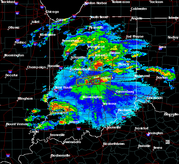 The tornado warning for southeastern marion county will expire at 1000 pm edt, the tornado threat has diminished and the tornado warning has been cancelled. however, large hail and damaging winds remain likely and a severe thunderstorm warning remains in effect for the area. however small hail and gusty winds are still possible with this thunderstorm. a severe thunderstorm watch remains in effect until midnight edt for central indiana. remember, a severe thunderstorm warning still remains in effect for southeastern portions of marion county until 1030 pm edt. The tornado warning for southeastern marion county will expire at 1000 pm edt, the tornado threat has diminished and the tornado warning has been cancelled. however, large hail and damaging winds remain likely and a severe thunderstorm warning remains in effect for the area. however small hail and gusty winds are still possible with this thunderstorm. a severe thunderstorm watch remains in effect until midnight edt for central indiana. remember, a severe thunderstorm warning still remains in effect for southeastern portions of marion county until 1030 pm edt.
|
| 5/1/2016 9:52 PM EDT |
 The severe thunderstorm warning for marion and hendricks counties will expire at 1000 pm edt, the storm which prompted the warning has moved out of the area. therefore the warning will be allowed to expire. a severe thunderstorm watch remains in effect until midnight edt for west central indiana. remember, a severe thunderstorm warning still remains in effect for southeastern marion county until 1030 pm edt. The severe thunderstorm warning for marion and hendricks counties will expire at 1000 pm edt, the storm which prompted the warning has moved out of the area. therefore the warning will be allowed to expire. a severe thunderstorm watch remains in effect until midnight edt for west central indiana. remember, a severe thunderstorm warning still remains in effect for southeastern marion county until 1030 pm edt.
|
| 5/1/2016 9:38 PM EDT |
 At 937 pm edt, a severe thunderstorm capable of producing a tornado was located over beech grove, or near indianapolis, moving east at 40 mph (radar indicated rotation). Hazards include tornado and quarter size hail. Flying debris will be dangerous to those caught without shelter. mobile homes will be damaged or destroyed. damage to roofs, windows, and vehicles will occur. tree damage is likely. this dangerous storm will be near, cumberland around 955 pm edt. this includes the following highways, interstate 65 between mile markers 102 and 113. interstate 70 between mile markers 76 and 84, and between mile markers 86 and 93. Interstate 74 between mile markers 93 and 100. At 937 pm edt, a severe thunderstorm capable of producing a tornado was located over beech grove, or near indianapolis, moving east at 40 mph (radar indicated rotation). Hazards include tornado and quarter size hail. Flying debris will be dangerous to those caught without shelter. mobile homes will be damaged or destroyed. damage to roofs, windows, and vehicles will occur. tree damage is likely. this dangerous storm will be near, cumberland around 955 pm edt. this includes the following highways, interstate 65 between mile markers 102 and 113. interstate 70 between mile markers 76 and 84, and between mile markers 86 and 93. Interstate 74 between mile markers 93 and 100.
|
| 5/1/2016 9:32 PM EDT |
 At 931 pm edt, a severe thunderstorm capable of producing a tornado was located near southport, or near indianapolis, moving east at 40 mph (radar indicated rotation). Hazards include tornado and quarter size hail. Flying debris will be dangerous to those caught without shelter. mobile homes will be damaged or destroyed. damage to roofs, windows, and vehicles will occur. tree damage is likely. this dangerous storm will be near, homecroft and monument circle around 935 pm edt. beech grove and southport around 940 pm edt. warren park around 945 pm edt. cumberland around 955 pm edt. this includes the following highways, interstate 65 between mile markers 102 and 114. interstate 70 between mile markers 70 and 93. Interstate 74 between mile markers 93 and 100. At 931 pm edt, a severe thunderstorm capable of producing a tornado was located near southport, or near indianapolis, moving east at 40 mph (radar indicated rotation). Hazards include tornado and quarter size hail. Flying debris will be dangerous to those caught without shelter. mobile homes will be damaged or destroyed. damage to roofs, windows, and vehicles will occur. tree damage is likely. this dangerous storm will be near, homecroft and monument circle around 935 pm edt. beech grove and southport around 940 pm edt. warren park around 945 pm edt. cumberland around 955 pm edt. this includes the following highways, interstate 65 between mile markers 102 and 114. interstate 70 between mile markers 70 and 93. Interstate 74 between mile markers 93 and 100.
|
| 5/1/2016 9:24 PM EDT |
 At 924 pm edt, a severe thunderstorm capable of producing a tornado was located near plainfield, or 10 miles southwest of indianapolis, moving east at 40 mph (radar indicated rotation). Hazards include tornado and ping pong ball size hail. Flying debris will be dangerous to those caught without shelter. mobile homes will be damaged or destroyed. damage to roofs, windows, and vehicles will occur. tree damage is likely. this dangerous storm will be near, homecroft and monument circle around 935 pm edt. beech grove and southport around 940 pm edt. warren park around 945 pm edt. cumberland around 955 pm edt. this includes the following highways, interstate 65 between mile markers 101 and 114. interstate 70 between mile markers 65 and 93. Interstate 74 between mile markers 93 and 100. At 924 pm edt, a severe thunderstorm capable of producing a tornado was located near plainfield, or 10 miles southwest of indianapolis, moving east at 40 mph (radar indicated rotation). Hazards include tornado and ping pong ball size hail. Flying debris will be dangerous to those caught without shelter. mobile homes will be damaged or destroyed. damage to roofs, windows, and vehicles will occur. tree damage is likely. this dangerous storm will be near, homecroft and monument circle around 935 pm edt. beech grove and southport around 940 pm edt. warren park around 945 pm edt. cumberland around 955 pm edt. this includes the following highways, interstate 65 between mile markers 101 and 114. interstate 70 between mile markers 65 and 93. Interstate 74 between mile markers 93 and 100.
|
| 5/1/2016 9:14 PM EDT |
 At 914 pm edt, a severe thunderstorm capable of producing a tornado was located over plainfield, or 16 miles southwest of indianapolis, moving east at 40 mph (radar indicated rotation). Hazards include tornado and ping pong ball size hail. Flying debris will be dangerous to those caught without shelter. mobile homes will be damaged or destroyed. damage to roofs, windows, and vehicles will occur. tree damage is likely. this dangerous storm will be near, camby around 920 pm edt. indianapolis int`l airport around 925 pm edt. homecroft and monument circle around 935 pm edt. beech grove and southport around 940 pm edt. warren park around 945 pm edt. cumberland around 955 pm edt. this includes the following highways, interstate 65 between mile markers 101 and 114. interstate 70 between mile markers 62 and 93. Interstate 74 between mile markers 93 and 100. At 914 pm edt, a severe thunderstorm capable of producing a tornado was located over plainfield, or 16 miles southwest of indianapolis, moving east at 40 mph (radar indicated rotation). Hazards include tornado and ping pong ball size hail. Flying debris will be dangerous to those caught without shelter. mobile homes will be damaged or destroyed. damage to roofs, windows, and vehicles will occur. tree damage is likely. this dangerous storm will be near, camby around 920 pm edt. indianapolis int`l airport around 925 pm edt. homecroft and monument circle around 935 pm edt. beech grove and southport around 940 pm edt. warren park around 945 pm edt. cumberland around 955 pm edt. this includes the following highways, interstate 65 between mile markers 101 and 114. interstate 70 between mile markers 62 and 93. Interstate 74 between mile markers 93 and 100.
|
| 5/1/2016 8:56 PM EDT |
 At 856 pm edt, a severe thunderstorm was located 7 miles southwest of danville, or 25 miles west of indianapolis, moving east at 40 mph (trained weather spotters). Hazards include two inch hail. People and animals outdoors will be injured. Expect damage to roofs, siding, windows, and vehicles. At 856 pm edt, a severe thunderstorm was located 7 miles southwest of danville, or 25 miles west of indianapolis, moving east at 40 mph (trained weather spotters). Hazards include two inch hail. People and animals outdoors will be injured. Expect damage to roofs, siding, windows, and vehicles.
|
| 3/27/2016 8:25 PM EDT |
 At 824 pm edt, a severe thunderstorm was located near southport, or near indianapolis, moving northeast at 40 mph (trained weather spotters). Hazards include half dollar size hail. Damage to vehicles is expected. locations impacted include, indianapolis, carmel, fishers, greenwood, lawrence, beech grove, speedway, southport, cumberland, meridian hills, warren park, homecroft, rocky ripple, williams creek, wynnedale, spring hill, crows nest, north crows nest, monument circle and indiana state fairgrounds. this includes the following highways, interstate 65 between mile markers 103 and 119. interstate 69 between mile markers 200 and 202. interstate 70 between mile markers 76 and 93. Interstate 74 between mile markers 93 and 96. At 824 pm edt, a severe thunderstorm was located near southport, or near indianapolis, moving northeast at 40 mph (trained weather spotters). Hazards include half dollar size hail. Damage to vehicles is expected. locations impacted include, indianapolis, carmel, fishers, greenwood, lawrence, beech grove, speedway, southport, cumberland, meridian hills, warren park, homecroft, rocky ripple, williams creek, wynnedale, spring hill, crows nest, north crows nest, monument circle and indiana state fairgrounds. this includes the following highways, interstate 65 between mile markers 103 and 119. interstate 69 between mile markers 200 and 202. interstate 70 between mile markers 76 and 93. Interstate 74 between mile markers 93 and 96.
|
| 3/27/2016 8:08 PM EDT |
 At 807 pm edt, a severe thunderstorm was located over mooresville, or 17 miles southwest of indianapolis, moving northeast at 40 mph (trained weather spotters). Hazards include ping pong ball size hail. People and animals outdoors will be injured. Expect damage to roofs, siding, windows, and vehicles. At 807 pm edt, a severe thunderstorm was located over mooresville, or 17 miles southwest of indianapolis, moving northeast at 40 mph (trained weather spotters). Hazards include ping pong ball size hail. People and animals outdoors will be injured. Expect damage to roofs, siding, windows, and vehicles.
|
| 12/23/2015 3:42 PM EST | At 342 pm est, severe thunderstorms were located along a line extending from near zionsville to near speedway to near southport, moving northeast at 65 mph (radar indicated). Hazards include 60 mph wind gusts. Expect damage to roofs. siding and trees. locations impacted include, indianapolis, carmel, fishers, noblesville, lawrence, plainfield, brownsburg, greenfield, beech grove, zionsville, speedway, southport, westfield, avon, cumberland, cicero, mccordsville, fortville, pittsboro and new palestine. this includes the following highways, interstate 65 between mile markers 101 and 131. interstate 69 between mile markers 200 and 213. interstate 70 between mile markers 70 and 108. interstate 74 between mile markers 62 and 100. A tornado watch remains in effect until 900 pm est for central indiana. |
| 12/23/2015 3:21 PM EST | At 320 pm est, severe thunderstorms were located along a line extending from 14 miles west of brownsburg to 8 miles south of danville, moving northeast at 65 mph (radar indicated). Hazards include 60 mph wind gusts. Expect damage to roofs. Siding and trees. |
| 7/17/2015 6:17 PM EDT |
 At 617 pm edt, a severe thunderstorm was located over plainfield, or 14 miles southwest of indianapolis, moving southeast at 35 mph (radar indicated). Hazards include 60 mph wind gusts and nickel size hail. Expect damage to roofs. siding and trees. locations impacted include, indianapolis, greenwood, plainfield, brownsburg, beech grove, speedway, mooresville, danville, southport, avon, pittsboro, brooklyn, clermont, monrovia, homecroft, bethany, monument circle, indianapolis int`l airport, camby and lake hart. this includes the following highways, interstate 65 between mile markers 101 and 111, near mile marker 114, and between mile markers 118 and 127. interstate 70 between mile markers 60 and 80. Interstate 74 between mile markers 62 and 73. At 617 pm edt, a severe thunderstorm was located over plainfield, or 14 miles southwest of indianapolis, moving southeast at 35 mph (radar indicated). Hazards include 60 mph wind gusts and nickel size hail. Expect damage to roofs. siding and trees. locations impacted include, indianapolis, greenwood, plainfield, brownsburg, beech grove, speedway, mooresville, danville, southport, avon, pittsboro, brooklyn, clermont, monrovia, homecroft, bethany, monument circle, indianapolis int`l airport, camby and lake hart. this includes the following highways, interstate 65 between mile markers 101 and 111, near mile marker 114, and between mile markers 118 and 127. interstate 70 between mile markers 60 and 80. Interstate 74 between mile markers 62 and 73.
|
| 7/17/2015 5:58 PM EDT |
 At 557 pm edt, a severe thunderstorm was located near brownsburg, or 15 miles west of indianapolis, moving south at 35 mph (radar indicated). Hazards include 60 mph wind gusts and nickel size hail. Expect damage to roofs. Siding and trees. At 557 pm edt, a severe thunderstorm was located near brownsburg, or 15 miles west of indianapolis, moving south at 35 mph (radar indicated). Hazards include 60 mph wind gusts and nickel size hail. Expect damage to roofs. Siding and trees.
|
| 7/14/2015 2:20 AM EDT | Street flooding one foot deepat winston and 22nd street. utility lines down on 22nd and fisher blocking roa in marion county IN, 0.1 miles NW of Speedway, IN |
| 7/14/2015 2:14 AM EDT |
 At 211 am edt, a severe thunderstorm was located near indianapolis, and moving north at 10 mph (radar indicated). Hazards include 60 mph wind gusts. Expect damage to roofs. Siding and trees. At 211 am edt, a severe thunderstorm was located near indianapolis, and moving north at 10 mph (radar indicated). Hazards include 60 mph wind gusts. Expect damage to roofs. Siding and trees.
|
| 7/14/2015 2:04 AM EDT | Numerous trees down shortly before and after this time...several on vehicles. significant tree damage reported at crawfordsville and lynhurst. damage also at gerrard an in marion county IN, 0.1 miles NW of Speedway, IN |
| 7/14/2015 1:10 AM EDT | Multiple reports of tree limbs down around speedway. time estimated from rada in marion county IN, 0.1 miles NW of Speedway, IN |
| 7/13/2015 11:39 PM EDT |
 At 1135 pm edt, a severe thunderstorm was located over north central indianapolis, and moving east at 30 mph (radar indicated). Hazards include 60 mph wind gusts and quarter size hail. Hail damage to vehicles is expected. expect wind damage to roofs, siding and trees. locations impacted include, this includes interstate 65 between mile markers 111 and 124. this includes interstate 69 between mile markers 200 and 201. This includes interstate 70 between mile markers 83 and 90. At 1135 pm edt, a severe thunderstorm was located over north central indianapolis, and moving east at 30 mph (radar indicated). Hazards include 60 mph wind gusts and quarter size hail. Hail damage to vehicles is expected. expect wind damage to roofs, siding and trees. locations impacted include, this includes interstate 65 between mile markers 111 and 124. this includes interstate 69 between mile markers 200 and 201. This includes interstate 70 between mile markers 83 and 90.
|
| 7/13/2015 11:27 PM EDT |
 At 1125 pm edt, a severe thunderstorm was located near indianapolis, and moving east at 30 mph (radar indicated). Hazards include 60 mph wind gusts and quarter size hail. Hail damage to vehicles is expected. Expect wind damage to roofs, siding and trees. At 1125 pm edt, a severe thunderstorm was located near indianapolis, and moving east at 30 mph (radar indicated). Hazards include 60 mph wind gusts and quarter size hail. Hail damage to vehicles is expected. Expect wind damage to roofs, siding and trees.
|
| 7/13/2015 9:38 PM EDT |
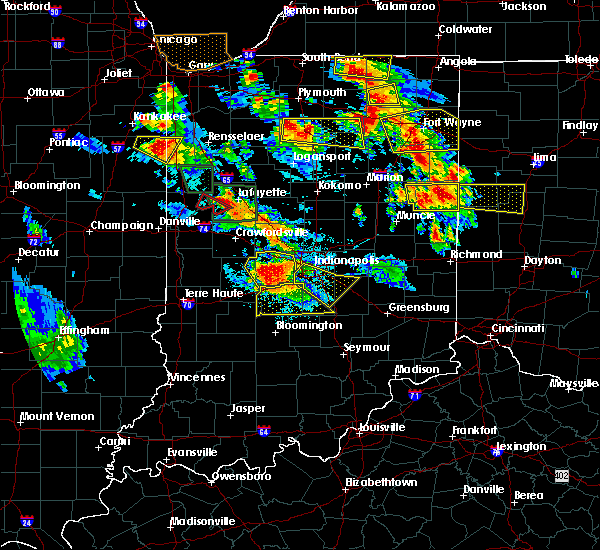 At 934 pm edt, a severe thunderstorm was located 5 miles south of speedway, and moving southeast at 25 mph (radar indicated). Hazards include 70 mph wind gusts and half dollar size hail. Hail damage to vehicles is expected. expect considerable tree damage. Wind damage is also likely to mobile homes, roofs and outbuildings. At 934 pm edt, a severe thunderstorm was located 5 miles south of speedway, and moving southeast at 25 mph (radar indicated). Hazards include 70 mph wind gusts and half dollar size hail. Hail damage to vehicles is expected. expect considerable tree damage. Wind damage is also likely to mobile homes, roofs and outbuildings.
|
| 7/13/2015 12:08 PM EDT |
 At 1204 pm edt, severe thunderstorms were located along a line extending from 6 miles southwest of greenfield to 6 miles south of greenwood to 7 miles south of mooresville, and moving southeast at 45 mph (radar indicated). Hazards include 70 mph wind gusts and penny size hail. Expect considerable tree damage. damage is likely to mobile homes, roofs and outbuildings. locations impacted include, shelbyville, martinsville, franklin, morristown, fairland, boggstown, trafalgar, mahalasville, morgantown, princes lakes, marietta, edinburgh, waldron, flat rock and geneva. this includes interstate 65 between mile markers 80 and 122. this includes interstate 70 between mile markers 55 and 110. This includes interstate 74 between mile markers 68 and 122. At 1204 pm edt, severe thunderstorms were located along a line extending from 6 miles southwest of greenfield to 6 miles south of greenwood to 7 miles south of mooresville, and moving southeast at 45 mph (radar indicated). Hazards include 70 mph wind gusts and penny size hail. Expect considerable tree damage. damage is likely to mobile homes, roofs and outbuildings. locations impacted include, shelbyville, martinsville, franklin, morristown, fairland, boggstown, trafalgar, mahalasville, morgantown, princes lakes, marietta, edinburgh, waldron, flat rock and geneva. this includes interstate 65 between mile markers 80 and 122. this includes interstate 70 between mile markers 55 and 110. This includes interstate 74 between mile markers 68 and 122.
|
| 7/13/2015 11:50 AM EDT |
 At 1148 am edt, severe thunderstorms were located along a line extending from fishers to speedway to danville, and moving southeast at 35 mph (radar indicated). Hazards include 70 mph wind gusts and penny size hail. Expect considerable tree damage. Damage is likely to mobile homes, roofs and outbuildings. At 1148 am edt, severe thunderstorms were located along a line extending from fishers to speedway to danville, and moving southeast at 35 mph (radar indicated). Hazards include 70 mph wind gusts and penny size hail. Expect considerable tree damage. Damage is likely to mobile homes, roofs and outbuildings.
|
| 7/13/2015 11:48 AM EDT |
 At 1146 am edt, severe thunderstorms were located along a line extending from lawrence to speedway to 9 miles east of greencastle, and moving southeast at 45 mph (radar indicated. 61 mph wind was reported at eagle creek airpark). Hazards include 70 mph wind gusts and penny size hail. Expect considerable tree damage. damage is likely to mobile homes, roofs and outbuildings. locations impacted include, beech grove, southport, stilesville, warren park, camby and homecroft. this includes interstate 65 between mile markers 102 and 135. this includes interstate 69 between mile markers 200 and 209. this includes interstate 70 between mile markers 62 and 93. This includes interstate 74 between mile markers 50 and 100. At 1146 am edt, severe thunderstorms were located along a line extending from lawrence to speedway to 9 miles east of greencastle, and moving southeast at 45 mph (radar indicated. 61 mph wind was reported at eagle creek airpark). Hazards include 70 mph wind gusts and penny size hail. Expect considerable tree damage. damage is likely to mobile homes, roofs and outbuildings. locations impacted include, beech grove, southport, stilesville, warren park, camby and homecroft. this includes interstate 65 between mile markers 102 and 135. this includes interstate 69 between mile markers 200 and 209. this includes interstate 70 between mile markers 62 and 93. This includes interstate 74 between mile markers 50 and 100.
|
| 7/13/2015 11:39 AM EDT |
 At 1137 am edt, severe thunderstorms were located along a line extending from fishers to speedway to 10 miles west of danville, and moving southeast at 45 mph (radar indicated. 65 mph wind was reported near noblesville. 60 mph wind was reported near brownsburg). Hazards include 70 mph wind gusts and penny size hail. Expect considerable tree damage. damage is likely to mobile homes, roofs and outbuildings. locations impacted include, indianapolis, danville, speedway, greencastle, lawrence, plainfield, beech grove, southport, castleton, wynnedale, spring hill, rocky ripple, crows nest, broad ripple, avon, geist reservoir, indiana state fairgrounds, fillmore, coatesville and amo. this includes interstate 65 between mile markers 102 and 144. this includes interstate 69 between mile markers 200 and 209. this includes interstate 70 between mile markers 62 and 93. This includes interstate 74 between mile markers 37 and 100. At 1137 am edt, severe thunderstorms were located along a line extending from fishers to speedway to 10 miles west of danville, and moving southeast at 45 mph (radar indicated. 65 mph wind was reported near noblesville. 60 mph wind was reported near brownsburg). Hazards include 70 mph wind gusts and penny size hail. Expect considerable tree damage. damage is likely to mobile homes, roofs and outbuildings. locations impacted include, indianapolis, danville, speedway, greencastle, lawrence, plainfield, beech grove, southport, castleton, wynnedale, spring hill, rocky ripple, crows nest, broad ripple, avon, geist reservoir, indiana state fairgrounds, fillmore, coatesville and amo. this includes interstate 65 between mile markers 102 and 144. this includes interstate 69 between mile markers 200 and 209. this includes interstate 70 between mile markers 62 and 93. This includes interstate 74 between mile markers 37 and 100.
|
| 7/13/2015 11:30 AM EDT |
 At 1126 am edt, severe thunderstorms were located along a line extending from noblesville to zionsville to 13 miles southeast of crawfordsville, and moving southeast at 45 mph (radar indicated). Hazards include 70 mph wind gusts and penny size hail. Expect considerable tree damage. damage is likely to mobile homes, roofs and outbuildings. locations impacted include, indianapolis, brownsburg, carmel, fishers, danville, speedway, greencastle, lawrence, plainfield, beech grove, southport, pittsboro, carpentersville, bainbridge, eagle creek reservoir, meridian hills, williams creek, groveland, rocky ripple and clermont. this includes interstate 65 between mile markers 101 and 148. this includes interstate 69 between mile markers 200 and 209. this includes interstate 70 between mile markers 62 and 93. This includes interstate 74 between mile markers 24 and 100. At 1126 am edt, severe thunderstorms were located along a line extending from noblesville to zionsville to 13 miles southeast of crawfordsville, and moving southeast at 45 mph (radar indicated). Hazards include 70 mph wind gusts and penny size hail. Expect considerable tree damage. damage is likely to mobile homes, roofs and outbuildings. locations impacted include, indianapolis, brownsburg, carmel, fishers, danville, speedway, greencastle, lawrence, plainfield, beech grove, southport, pittsboro, carpentersville, bainbridge, eagle creek reservoir, meridian hills, williams creek, groveland, rocky ripple and clermont. this includes interstate 65 between mile markers 101 and 148. this includes interstate 69 between mile markers 200 and 209. this includes interstate 70 between mile markers 62 and 93. This includes interstate 74 between mile markers 24 and 100.
|
| 7/13/2015 11:11 AM EDT |
 At 1108 am edt, severe thunderstorms were located along a line extending from 7 miles west of tipton to lebanon to crawfordsville, and moving southeast at 45 mph (radar indicated). Hazards include 60 mph wind gusts and penny size hail. Expect damage to roofs. Siding and trees. At 1108 am edt, severe thunderstorms were located along a line extending from 7 miles west of tipton to lebanon to crawfordsville, and moving southeast at 45 mph (radar indicated). Hazards include 60 mph wind gusts and penny size hail. Expect damage to roofs. Siding and trees.
|
| 6/21/2015 1:54 AM EDT |
 At 151 am edt, severe thunderstorms were located along a line extending from 11 miles north of danville to 11 miles southeast of greencastle, and moving southeast at 35 mph (radar indicated). Hazards include 60 mph wind gusts. Expect damage to roofs. Siding and trees. At 151 am edt, severe thunderstorms were located along a line extending from 11 miles north of danville to 11 miles southeast of greencastle, and moving southeast at 35 mph (radar indicated). Hazards include 60 mph wind gusts. Expect damage to roofs. Siding and trees.
|
| 6/12/2015 5:35 PM EDT |
 At 532 pm edt, a severe thunderstorm was located near mooresville, and moving northeast at 35 mph (radar indicated). Hazards include 60 mph wind gusts. Expect damage to roofs. Siding and trees. At 532 pm edt, a severe thunderstorm was located near mooresville, and moving northeast at 35 mph (radar indicated). Hazards include 60 mph wind gusts. Expect damage to roofs. Siding and trees.
|
| 6/8/2015 10:17 PM EDT | At 1013 pm edt, a severe thunderstorm was located 7 miles west of southport, and moving southeast at 35 mph (radar indicated). Hazards include quarter size hail. Damage to vehicles is expected. locations impacted include, beech grove, southport, greenwood, franklin, homecroft, bargersville, new whiteland and whiteland. this includes interstate 65 between mile markers 87 and 111. this includes interstate 70 between mile markers 62 and 80. This includes interstate 74 between mile markers 93 and 100. |
| 6/8/2015 9:56 PM EDT | At 954 pm edt, a severe thunderstorm was located near plainfield, and moving southeast at 35 mph (radar indicated). Hazards include quarter size hail. damage to vehicles is expected |
| 5/30/2015 1:55 PM EDT | The severe thunderstorm warning for southern hamilton and northern marion counties will expire at 200 pm edt, the storm which prompted the warning has weakened below severe limits, and no longer poses an immediate threat to life or property. however, gusty winds and heavy rain are still possible with this thunderstorm. |
| 5/30/2015 1:45 PM EDT | At 143 pm edt, a severe thunderstorm was located near lawrence, and moving northeast at 35 mph (radar indicated). Hazards include 60 mph wind gusts. Expect damage to roofs. siding and trees. locations impacted include, carmel, fishers and geist reservoir. this includes interstate 65 between mile markers 114 and 121. This includes interstate 69 between mile markers 200 and 210. |
| 5/30/2015 1:36 PM EDT | At 133 pm edt, a severe thunderstorm was located near indianapolis, and moving northeast at 35 mph (trained weather spotters. the wind sensor at the indianapolis international airport measured a gust of 58 mph at 126 pm edt). Hazards include 60 mph wind gusts. Expect damage to roofs. siding and trees. locations impacted include, carmel, fishers, north crows nest, broad ripple, meridian hills, williams creek, castleton and geist reservoir. this includes interstate 65 between mile markers 111 and 121. this includes interstate 69 between mile markers 200 and 210. This includes interstate 70 between mile markers 71 and 85. |
| 5/30/2015 1:22 PM EDT | At 120 pm edt, a severe thunderstorm was located near speedway, and moving northeast at 35 mph (radar indicated). Hazards include 60 mph wind gusts. Expect damage to roofs. Siding and trees. |
| 4/8/2015 8:57 AM EDT | A severe thunderstorm warning remains in effect for southeastern hamilton. hancock. southern hendricks. southwestern henry. johnson. marion. morgan. southeastern putnam. northern rush and shelby counties until 915 am edt. at 855 am edt. Severe thunderstorms were located along a line extending from lawrence to 8 miles east of beech grove to greenwood. |
| 4/8/2015 8:39 AM EDT | The national weather service in indianapolis has issued a * severe thunderstorm warning for. southeastern hamilton county in central indiana. hancock county in central indiana. southern hendricks county in central indiana. Southwestern henry county in east central indiana. |
| 4/8/2015 8:25 AM EDT | A severe thunderstorm warning remains in effect for north central clay. southern hendricks. southwestern marion. northern morgan. southeastern parke and central putnam counties until 845 am edt. at 823 am edt. a severe thunderstorm was located 10 miles southeast of rockville. and moving east at 40 mph. hazard. Quarter size hail. |
| 4/8/2015 8:22 AM EDT | A severe thunderstorm warning remains in effect for southeastern boone. hamilton. northwestern hancock. hendricks. southwestern madison. northern marion. northeastern putnam and south central tipton counties until 845 am edt. at 820 am edt. a severe thunderstorm was located near brownsburg. And moving east at 40 mph. |
| 4/8/2015 8:15 AM EDT | The national weather service in indianapolis has issued a * severe thunderstorm warning for. north central clay county in west central indiana. southern hendricks county in central indiana. southwestern marion county in central indiana. Northern morgan county in central indiana. |
| 4/8/2015 8:06 AM EDT | The national weather service in indianapolis has issued a * severe thunderstorm warning for. southeastern boone county in central indiana. hamilton county in central indiana. northwestern hancock county in central indiana. Hendricks county in central indiana. |
| 10/31/2013 9:54 PM EDT | Indot weather station repor in marion county IN, 0.8 miles SE of Speedway, IN |
| 1/1/0001 12:00 AM | Reported by long-time television weather spotter. a large 100-year old tree was blown down. power is out in neighborhoo in marion county IN, 0.1 miles NW of Speedway, IN |
| 1/1/0001 12:00 AM | A large 100-year old tree was blown down and power knocked out from a measured 70 mph wind gust. reported by long-time television weather spotte in marion county IN, 0.1 miles NW of Speedway, IN |
Hail Maps for Speedway, IN


Connect with Interactive Hail Maps