

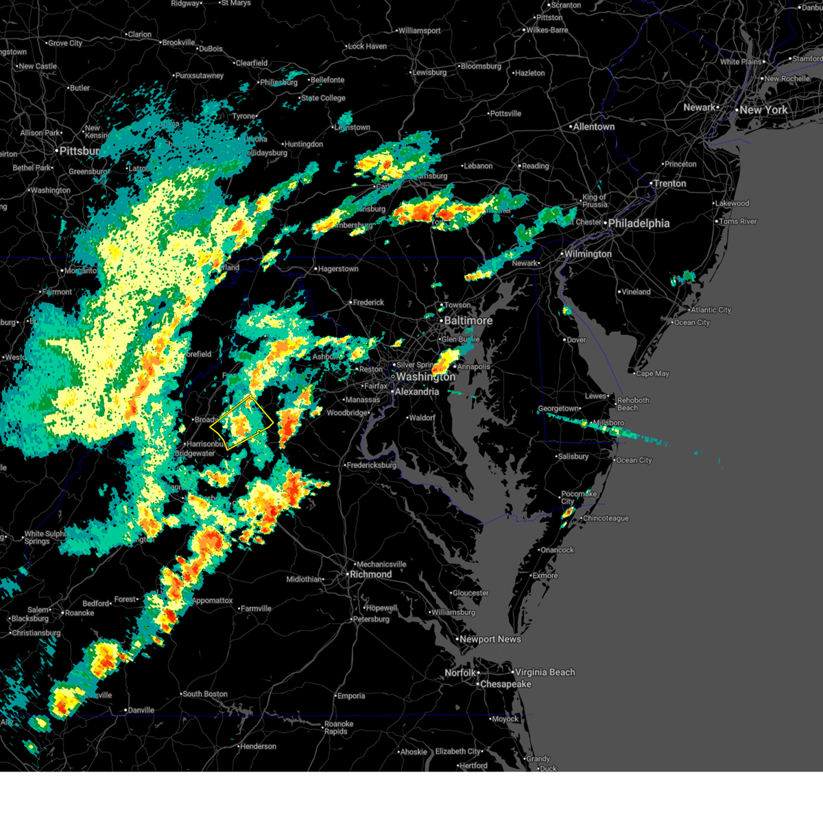
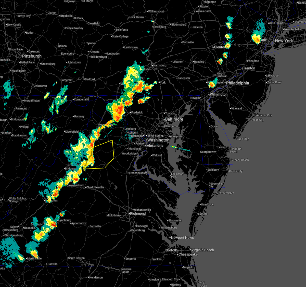
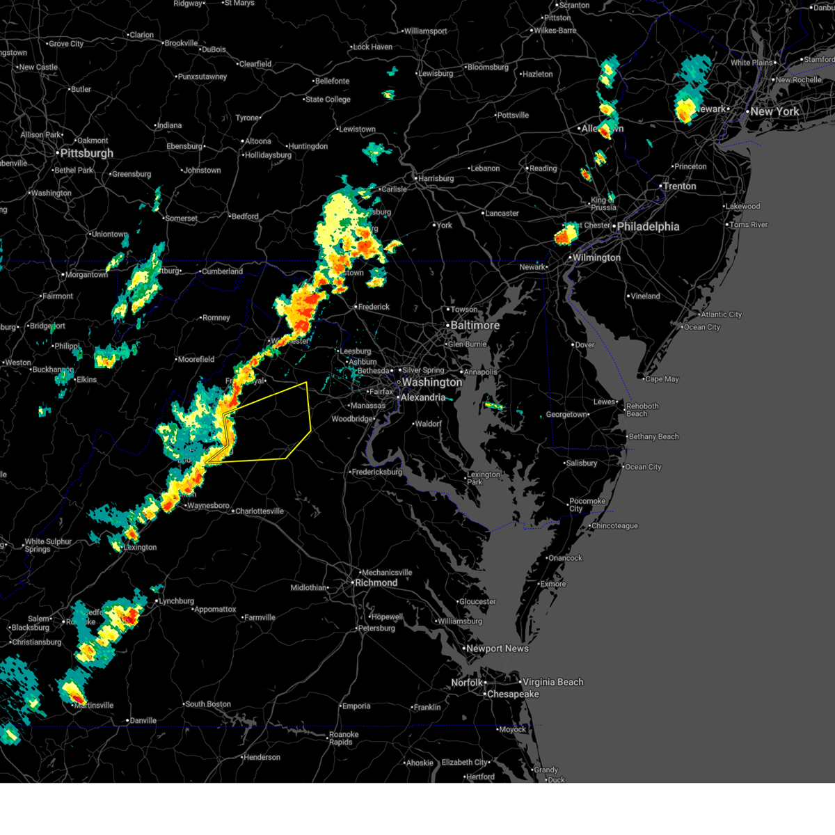
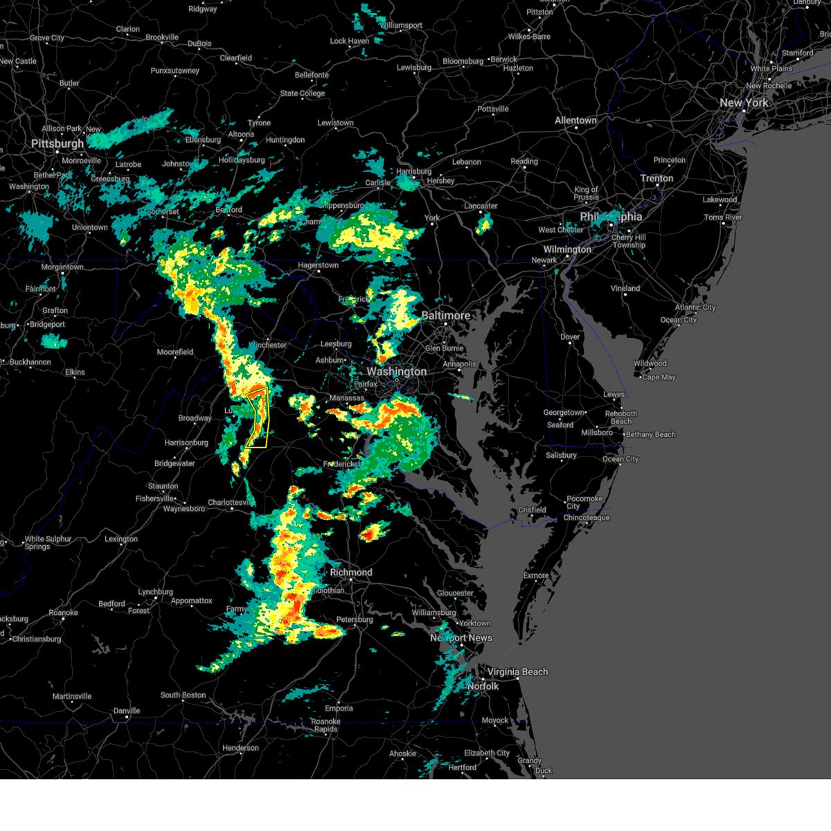
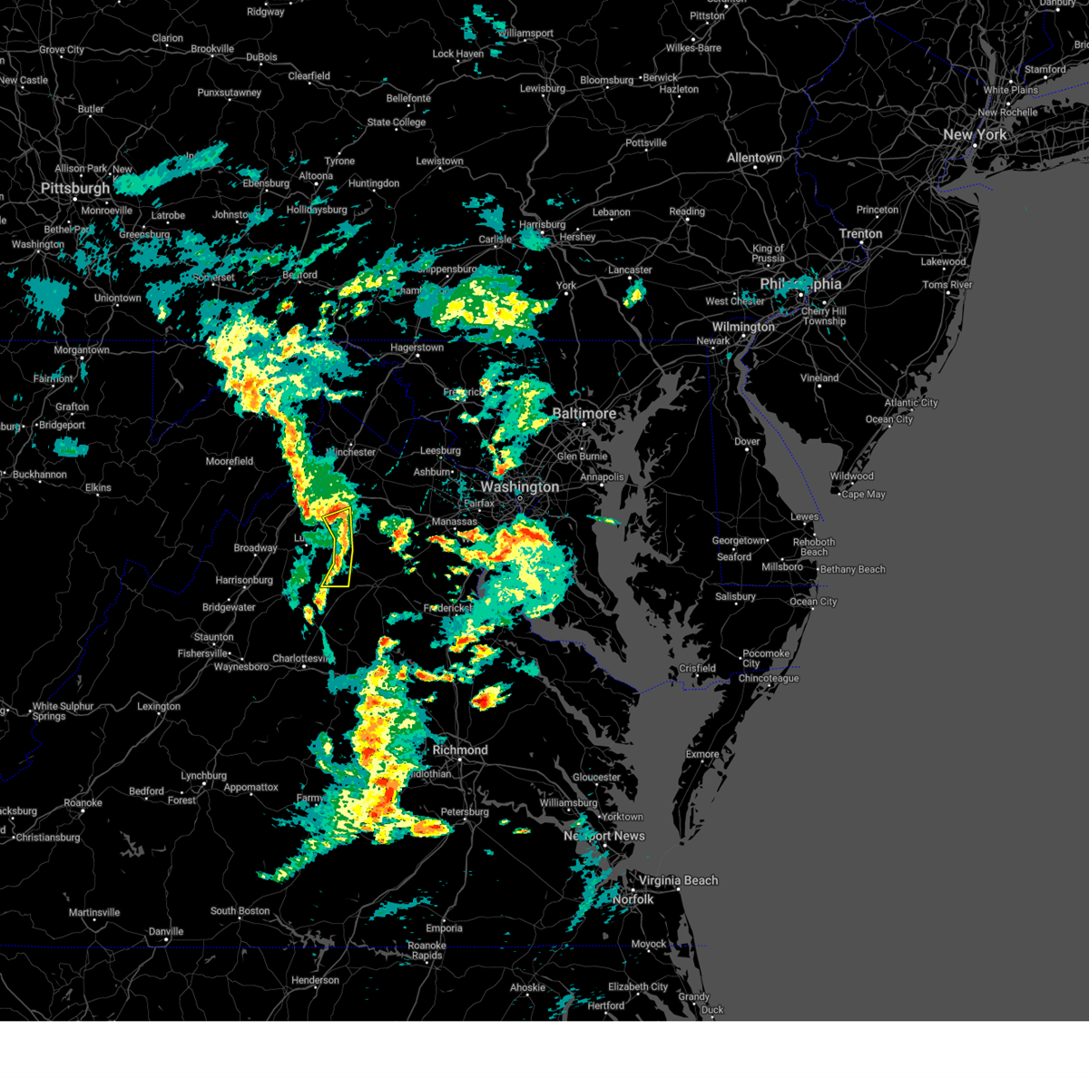
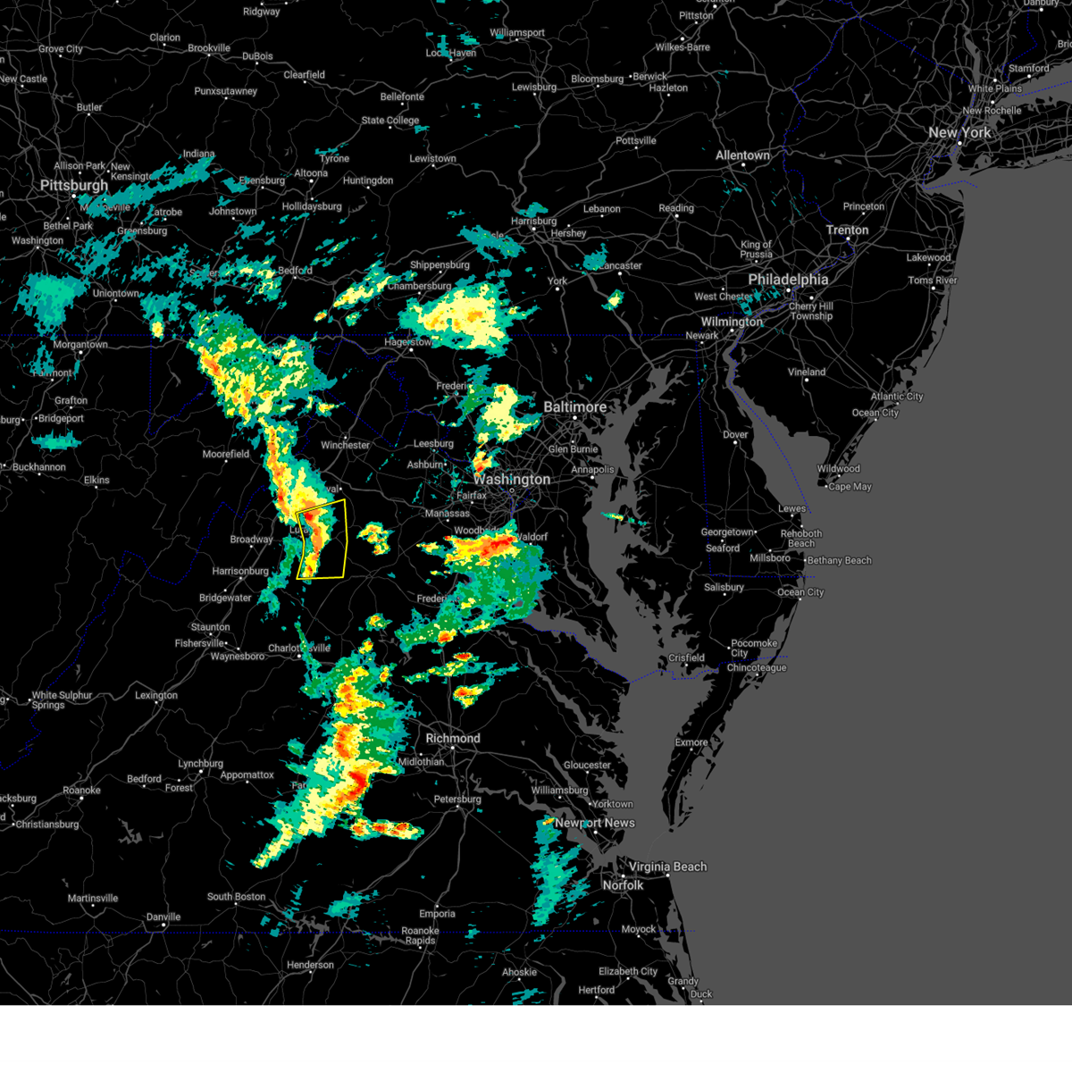
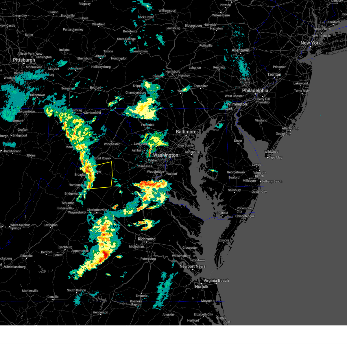
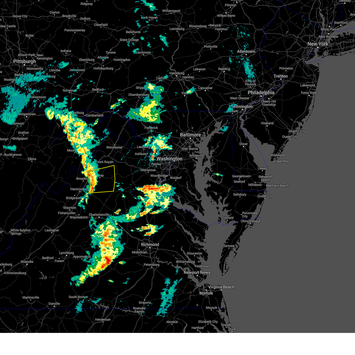
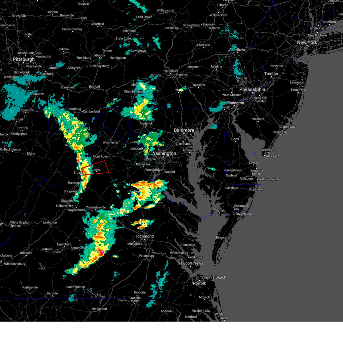
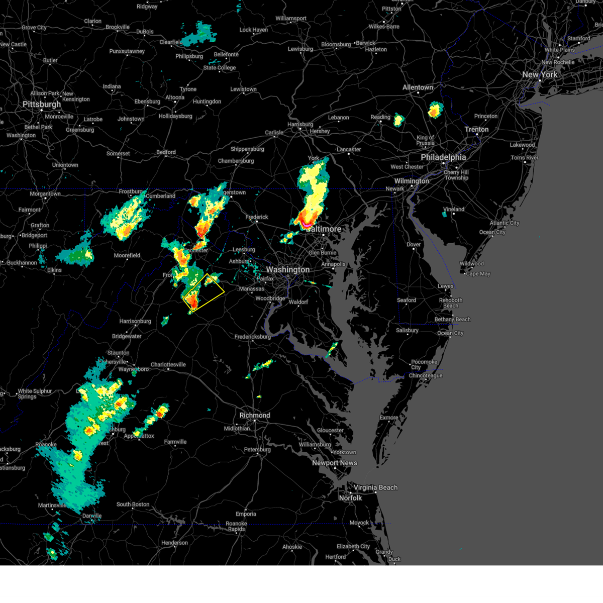
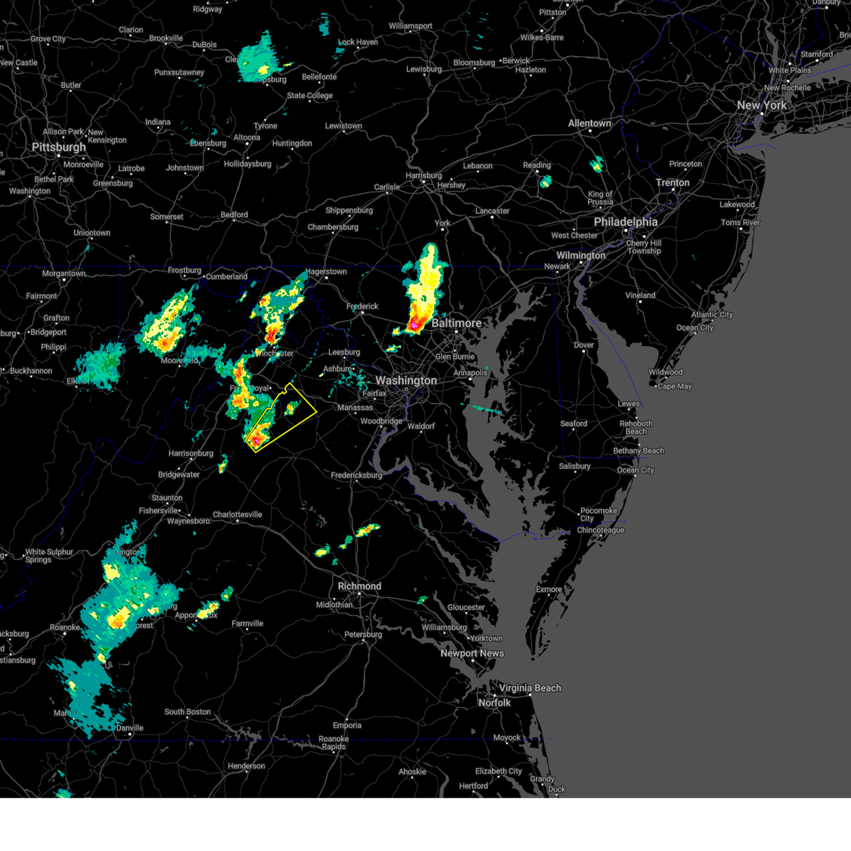
Hail Map for Sperryville, VA
The Sperryville, VA area has had 1 report of on-the-ground hail by trained spotters, and has been under severe weather warnings 15 times during the past 12 months. Doppler radar has detected hail at or near Sperryville, VA on 20 occasions.
| Name: | Sperryville, VA |
| Where Located: | 85.6 miles NNW of Richmond, VA |
| Map: | Google Map for Sperryville, VA |
| Population: | 342 |
| Housing Units: | 179 |
| More Info: | Search Google for Sperryville, VA |
0
The Top Recent Hail Date for Sperryville, VA is Friday, September 8, 2023 (16th out of 20)

Hail and Wind Damage Spotted near Sperryville, VA
| Date / Time | Report Details |
|---|---|
| 7/9/2025 4:41 PM EDT |
 the severe thunderstorm warning has been cancelled and is no longer in effect the severe thunderstorm warning has been cancelled and is no longer in effect
|
| 7/9/2025 4:21 PM EDT | Svrlwx the national weather service in sterling virginia has issued a * severe thunderstorm warning for, northwestern madison county in northwestern virginia, southeastern rockingham county in western virginia, central page county in northwestern virginia, southwestern rappahannock county in northwestern virginia, north central greene county in central virginia, * until 500 pm edt. * at 421 pm edt, severe thunderstorms were located along a line extending from 7 miles north of shenandoah to stanley to big meadows, moving northeast at 35 mph (radar indicated). Hazards include 60 mph wind gusts. Damaging winds will cause some trees and large branches to fall. this could injure those outdoors, as well as damage homes and vehicles. roadways may become blocked by downed trees. localized power outages are possible. Unsecured light objects may become projectiles. |
| 6/19/2025 3:00 PM EDT |
 At 300 pm edt, severe thunderstorms were located along a line extending from near sperryville to 10 miles east of big meadows to 6 miles northwest of madison to near afton, moving east at 45 mph (radar indicated). Hazards include 60 mph wind gusts. Damaging winds will cause some trees and large branches to fall. this could injure those outdoors, as well as damage homes and vehicles. roadways may become blocked by downed trees. localized power outages are possible. unsecured light objects may become projectiles. Locations impacted include, culpeper, warrenton, madison, sperryville, hume, big meadows, marshall, brightwood, opal, flint hill, washington, castleton, catalpa, brandy station, hackleys crossroads, haywood, amissville, jeffersonton, cresthill, and syria. At 300 pm edt, severe thunderstorms were located along a line extending from near sperryville to 10 miles east of big meadows to 6 miles northwest of madison to near afton, moving east at 45 mph (radar indicated). Hazards include 60 mph wind gusts. Damaging winds will cause some trees and large branches to fall. this could injure those outdoors, as well as damage homes and vehicles. roadways may become blocked by downed trees. localized power outages are possible. unsecured light objects may become projectiles. Locations impacted include, culpeper, warrenton, madison, sperryville, hume, big meadows, marshall, brightwood, opal, flint hill, washington, castleton, catalpa, brandy station, hackleys crossroads, haywood, amissville, jeffersonton, cresthill, and syria.
|
| 6/19/2025 3:00 PM EDT |
 the severe thunderstorm warning has been cancelled and is no longer in effect the severe thunderstorm warning has been cancelled and is no longer in effect
|
| 6/19/2025 2:43 PM EDT |
 Svrlwx the national weather service in sterling virginia has issued a * severe thunderstorm warning for, madison county in northwestern virginia, east central rockingham county in western virginia, south central warren county in northwestern virginia, central page county in northwestern virginia, rappahannock county in northwestern virginia, north central greene county in central virginia, western fauquier county in northern virginia, western culpeper county in northern virginia, * until 330 pm edt. * at 243 pm edt, severe thunderstorms were located along a line extending from luray to near big meadows to 8 miles southeast of shenandoah to near stuarts draft, moving east at 45 mph (radar indicated). Hazards include 60 mph wind gusts. Damaging winds will cause some trees and large branches to fall. this could injure those outdoors, as well as damage homes and vehicles. roadways may become blocked by downed trees. localized power outages are possible. Unsecured light objects may become projectiles. Svrlwx the national weather service in sterling virginia has issued a * severe thunderstorm warning for, madison county in northwestern virginia, east central rockingham county in western virginia, south central warren county in northwestern virginia, central page county in northwestern virginia, rappahannock county in northwestern virginia, north central greene county in central virginia, western fauquier county in northern virginia, western culpeper county in northern virginia, * until 330 pm edt. * at 243 pm edt, severe thunderstorms were located along a line extending from luray to near big meadows to 8 miles southeast of shenandoah to near stuarts draft, moving east at 45 mph (radar indicated). Hazards include 60 mph wind gusts. Damaging winds will cause some trees and large branches to fall. this could injure those outdoors, as well as damage homes and vehicles. roadways may become blocked by downed trees. localized power outages are possible. Unsecured light objects may become projectiles.
|
| 5/30/2025 6:28 PM EDT |
 the severe thunderstorm warning has been cancelled and is no longer in effect the severe thunderstorm warning has been cancelled and is no longer in effect
|
| 5/30/2025 6:28 PM EDT |
 At 627 pm edt, severe thunderstorms were located along a line extending from 9 miles southwest of front royal to sperryville to 7 miles north of madison, moving east at 35 mph (radar indicated). Hazards include 60 mph wind gusts. Damaging winds will cause some trees and large branches to fall. this could injure those outdoors, as well as damage homes and vehicles. roadways may become blocked by downed trees. localized power outages are possible. unsecured light objects may become projectiles. Locations impacted include, criglersville, slate mills, etlan, nethers, woodville, haywood, fourway, syria, washington, five forks, banco, browntown, and sperryville. At 627 pm edt, severe thunderstorms were located along a line extending from 9 miles southwest of front royal to sperryville to 7 miles north of madison, moving east at 35 mph (radar indicated). Hazards include 60 mph wind gusts. Damaging winds will cause some trees and large branches to fall. this could injure those outdoors, as well as damage homes and vehicles. roadways may become blocked by downed trees. localized power outages are possible. unsecured light objects may become projectiles. Locations impacted include, criglersville, slate mills, etlan, nethers, woodville, haywood, fourway, syria, washington, five forks, banco, browntown, and sperryville.
|
| 5/30/2025 6:22 PM EDT | Tree down around jenkins lane & f.t. valley road in rappahannock county VA, 1.1 miles N of Sperryville, VA |
| 5/30/2025 6:13 PM EDT |
 the severe thunderstorm warning has been cancelled and is no longer in effect the severe thunderstorm warning has been cancelled and is no longer in effect
|
| 5/30/2025 6:13 PM EDT |
 At 612 pm edt, severe thunderstorms were located along a line extending from 7 miles north of luray to near big meadows, moving east at 45 mph (radar indicated). Hazards include 60 mph wind gusts and quarter size hail. Damaging winds will cause some trees and large branches to fall. this could injure those outdoors, as well as damage homes and vehicles. roadways may become blocked by downed trees. localized power outages are possible. unsecured light objects may become projectiles. Locations impacted include, kimball, criglersville, compton, slate mills, ida, etlan, nethers, woodville, haywood, fourway, syria, washington, fairview, big meadows, five forks, banco, panorama, browntown, skyland, and sperryville. At 612 pm edt, severe thunderstorms were located along a line extending from 7 miles north of luray to near big meadows, moving east at 45 mph (radar indicated). Hazards include 60 mph wind gusts and quarter size hail. Damaging winds will cause some trees and large branches to fall. this could injure those outdoors, as well as damage homes and vehicles. roadways may become blocked by downed trees. localized power outages are possible. unsecured light objects may become projectiles. Locations impacted include, kimball, criglersville, compton, slate mills, ida, etlan, nethers, woodville, haywood, fourway, syria, washington, fairview, big meadows, five forks, banco, panorama, browntown, skyland, and sperryville.
|
| 5/30/2025 6:03 PM EDT |
 At 603 pm edt, severe thunderstorms were located along a line extending from near mount jackson to stanley to near shenandoah, moving east at 35 mph (radar indicated). Hazards include 60 mph wind gusts and quarter size hail. Damaging winds will cause some trees and large branches to fall. this could injure those outdoors, as well as damage homes and vehicles. roadways may become blocked by downed trees. localized power outages are possible. unsecured light objects may become projectiles. Locations impacted include, alma, newport, honeyville, ingham, kings crossing, luray, leaksville, ida, hamburg, haywood, syria, washington, fairview, saint davids church, glen echo, bentonville, stanley, banco, rileyville, and kimball. At 603 pm edt, severe thunderstorms were located along a line extending from near mount jackson to stanley to near shenandoah, moving east at 35 mph (radar indicated). Hazards include 60 mph wind gusts and quarter size hail. Damaging winds will cause some trees and large branches to fall. this could injure those outdoors, as well as damage homes and vehicles. roadways may become blocked by downed trees. localized power outages are possible. unsecured light objects may become projectiles. Locations impacted include, alma, newport, honeyville, ingham, kings crossing, luray, leaksville, ida, hamburg, haywood, syria, washington, fairview, saint davids church, glen echo, bentonville, stanley, banco, rileyville, and kimball.
|
| 5/30/2025 5:55 PM EDT |
 Svrlwx the national weather service in sterling virginia has issued a * severe thunderstorm warning for, northwestern madison county in northwestern virginia, southeastern shenandoah county in northwestern virginia, east central rockingham county in western virginia, southwestern warren county in northwestern virginia, page county in northwestern virginia, western rappahannock county in northwestern virginia, northern greene county in central virginia, west central culpeper county in northern virginia, * until 645 pm edt. * at 555 pm edt, severe thunderstorms were located along a line extending from mount jackson to near shenandoah to near massanutten, moving east at 35 mph (radar indicated). Hazards include 60 mph wind gusts. Damaging winds will cause some trees and large branches to fall. this could injure those outdoors, as well as damage homes and vehicles. roadways may become blocked by downed trees. localized power outages are possible. Unsecured light objects may become projectiles. Svrlwx the national weather service in sterling virginia has issued a * severe thunderstorm warning for, northwestern madison county in northwestern virginia, southeastern shenandoah county in northwestern virginia, east central rockingham county in western virginia, southwestern warren county in northwestern virginia, page county in northwestern virginia, western rappahannock county in northwestern virginia, northern greene county in central virginia, west central culpeper county in northern virginia, * until 645 pm edt. * at 555 pm edt, severe thunderstorms were located along a line extending from mount jackson to near shenandoah to near massanutten, moving east at 35 mph (radar indicated). Hazards include 60 mph wind gusts. Damaging winds will cause some trees and large branches to fall. this could injure those outdoors, as well as damage homes and vehicles. roadways may become blocked by downed trees. localized power outages are possible. Unsecured light objects may become projectiles.
|
| 5/30/2025 5:50 PM EDT |
 Torlwx the national weather service in sterling virginia has issued a * tornado warning for, southern shenandoah county in northwestern virginia, central rockingham county in western virginia, southwestern warren county in northwestern virginia, northern page county in northwestern virginia, west central rappahannock county in northwestern virginia, * until 630 pm edt. * at 549 pm edt, a severe thunderstorm capable of producing a tornado was located near mount jackson, or 16 miles southwest of woodstock, moving east at 40 mph (radar indicated rotation). Hazards include tornado. For those in the direct path of a tornado touchdown, flying debris will be dangerous to those caught without shelter. damage to roofs, siding, and windows may occur. mobile homes may be damaged or destroyed. tree damage is likely. this dangerous storm will be near, luray and mount jackson around 555 pm edt. sperryville around 615 pm edt. Other locations impacted by this tornadic thunderstorm include kimball, kings crossing, compton, shenandoah caverns, leaksville, hamburg, fourway, quicksburg, fairview, and bentonville. Torlwx the national weather service in sterling virginia has issued a * tornado warning for, southern shenandoah county in northwestern virginia, central rockingham county in western virginia, southwestern warren county in northwestern virginia, northern page county in northwestern virginia, west central rappahannock county in northwestern virginia, * until 630 pm edt. * at 549 pm edt, a severe thunderstorm capable of producing a tornado was located near mount jackson, or 16 miles southwest of woodstock, moving east at 40 mph (radar indicated rotation). Hazards include tornado. For those in the direct path of a tornado touchdown, flying debris will be dangerous to those caught without shelter. damage to roofs, siding, and windows may occur. mobile homes may be damaged or destroyed. tree damage is likely. this dangerous storm will be near, luray and mount jackson around 555 pm edt. sperryville around 615 pm edt. Other locations impacted by this tornadic thunderstorm include kimball, kings crossing, compton, shenandoah caverns, leaksville, hamburg, fourway, quicksburg, fairview, and bentonville.
|
| 5/3/2025 4:42 PM EDT |
 At 440 pm edt, a severe thunderstorm was located near sperryville, or 16 miles northwest of culpeper, moving northeast at 35 mph (radar indicated). Hazards include 60 mph wind gusts and quarter size hail. Damaging winds will cause some trees and large branches to fall. this could injure those outdoors, as well as damage homes and vehicles. roadways may become blocked by downed trees. localized power outages are possible. unsecured light objects may become projectiles. Locations impacted include, huntly, hume, hackleys crossroads, woodville, amissville, flint hill, cresthill, orlean, washington, five forks, rock mills, markham, ada, sperryville, castleton, and viewtown. At 440 pm edt, a severe thunderstorm was located near sperryville, or 16 miles northwest of culpeper, moving northeast at 35 mph (radar indicated). Hazards include 60 mph wind gusts and quarter size hail. Damaging winds will cause some trees and large branches to fall. this could injure those outdoors, as well as damage homes and vehicles. roadways may become blocked by downed trees. localized power outages are possible. unsecured light objects may become projectiles. Locations impacted include, huntly, hume, hackleys crossroads, woodville, amissville, flint hill, cresthill, orlean, washington, five forks, rock mills, markham, ada, sperryville, castleton, and viewtown.
|
| 5/3/2025 4:42 PM EDT |
 the severe thunderstorm warning has been cancelled and is no longer in effect the severe thunderstorm warning has been cancelled and is no longer in effect
|
| 5/3/2025 4:26 PM EDT |
 Svrlwx the national weather service in sterling virginia has issued a * severe thunderstorm warning for, northwestern madison county in northwestern virginia, east central page county in northwestern virginia, rappahannock county in northwestern virginia, northwestern fauquier county in northern virginia, northern culpeper county in northern virginia, * until 515 pm edt. * at 426 pm edt, a severe thunderstorm was located near sperryville, or 14 miles north of madison, moving northeast at 35 mph (radar indicated). Hazards include 60 mph wind gusts and quarter size hail. Damaging winds will cause some trees and large branches to fall. this could injure those outdoors, as well as damage homes and vehicles. roadways may become blocked by downed trees. localized power outages are possible. Unsecured light objects may become projectiles. Svrlwx the national weather service in sterling virginia has issued a * severe thunderstorm warning for, northwestern madison county in northwestern virginia, east central page county in northwestern virginia, rappahannock county in northwestern virginia, northwestern fauquier county in northern virginia, northern culpeper county in northern virginia, * until 515 pm edt. * at 426 pm edt, a severe thunderstorm was located near sperryville, or 14 miles north of madison, moving northeast at 35 mph (radar indicated). Hazards include 60 mph wind gusts and quarter size hail. Damaging winds will cause some trees and large branches to fall. this could injure those outdoors, as well as damage homes and vehicles. roadways may become blocked by downed trees. localized power outages are possible. Unsecured light objects may become projectiles.
|
| 8/3/2024 4:39 PM EDT | Trees down along lee highway in sperryville in rappahannock county VA, 0.2 miles S of Sperryville, VA |
| 7/17/2024 4:21 PM EDT | Three reports of trees down in rappahannock count in rappahannock county VA, 4.2 miles NW of Sperryville, VA |
| 7/15/2024 4:33 PM EDT | Rappahannock 911 center reported a few trees down in the southern part of county... along sperryville pike and f t valley roa in rappahannock county VA, 7.4 miles N of Sperryville, VA |
| 6/26/2024 8:39 PM EDT |
 Svrlwx the national weather service in sterling virginia has issued a * severe thunderstorm warning for, madison county in northwestern virginia, southwestern orange county in central virginia, east central rockingham county in western virginia, southern page county in northwestern virginia, northeastern albemarle county in central virginia, southwestern rappahannock county in northwestern virginia, greene county in central virginia, western culpeper county in northern virginia, * until 915 pm edt. * at 839 pm edt, severe thunderstorms were located along a line extending from near luray to near madison to 9 miles northwest of boswells tavern, moving northeast at 45 mph (radar indicated). Hazards include 60 mph wind gusts. Damaging winds will cause some trees and large branches to fall. this could injure those outdoors, as well as damage homes and vehicles. roadways may become blocked by downed trees. localized power outages are possible. Unsecured light objects may become projectiles. Svrlwx the national weather service in sterling virginia has issued a * severe thunderstorm warning for, madison county in northwestern virginia, southwestern orange county in central virginia, east central rockingham county in western virginia, southern page county in northwestern virginia, northeastern albemarle county in central virginia, southwestern rappahannock county in northwestern virginia, greene county in central virginia, western culpeper county in northern virginia, * until 915 pm edt. * at 839 pm edt, severe thunderstorms were located along a line extending from near luray to near madison to 9 miles northwest of boswells tavern, moving northeast at 45 mph (radar indicated). Hazards include 60 mph wind gusts. Damaging winds will cause some trees and large branches to fall. this could injure those outdoors, as well as damage homes and vehicles. roadways may become blocked by downed trees. localized power outages are possible. Unsecured light objects may become projectiles.
|
| 5/26/2024 9:30 PM EDT | Multiple reports of trees down throughout rappahannock count in rappahannock county VA, 4.2 miles NW of Sperryville, VA |
| 5/26/2024 9:05 PM EDT |
 Svrlwx the national weather service in sterling virginia has issued a * severe thunderstorm warning for, northwestern washington county in north central maryland, northeastern allegany county in western maryland, southwestern stafford county in northern virginia, southwestern loudoun county in northern virginia, northeastern shenandoah county in northwestern virginia, frederick county in northwestern virginia, orange county in central virginia, the city of fredericksburg in central virginia, rappahannock county in northwestern virginia, central fauquier county in northern virginia, culpeper county in northern virginia, central madison county in northwestern virginia, warren county in northwestern virginia, western clarke county in northwestern virginia, northeastern page county in northwestern virginia, the city of winchester in northwestern virginia, spotsylvania county in central virginia, west central jefferson county in the panhandle of west virginia, morgan county in the panhandle of west virginia, northeastern mineral county in eastern west virginia, northeastern hardy county in eastern west virginia, western berkeley county in the panhandle of west virginia, hampshire county in eastern west virginia, * until 1000 pm edt. * at 905 pm edt, severe thunderstorms were located along a line extending from near la vale to 6 miles south of romney to 6 miles north of basye-bryce mountain to near mount jackson to 6 miles north of boswells tavern, moving east at 35 mph (radar indicated). Hazards include 60 mph wind gusts. Damaging winds will cause some trees and large branches to fall. this could injure those outdoors, as well as damage homes and vehicles. roadways may become blocked by downed trees. localized power outages are possible. Unsecured light objects may become projectiles. Svrlwx the national weather service in sterling virginia has issued a * severe thunderstorm warning for, northwestern washington county in north central maryland, northeastern allegany county in western maryland, southwestern stafford county in northern virginia, southwestern loudoun county in northern virginia, northeastern shenandoah county in northwestern virginia, frederick county in northwestern virginia, orange county in central virginia, the city of fredericksburg in central virginia, rappahannock county in northwestern virginia, central fauquier county in northern virginia, culpeper county in northern virginia, central madison county in northwestern virginia, warren county in northwestern virginia, western clarke county in northwestern virginia, northeastern page county in northwestern virginia, the city of winchester in northwestern virginia, spotsylvania county in central virginia, west central jefferson county in the panhandle of west virginia, morgan county in the panhandle of west virginia, northeastern mineral county in eastern west virginia, northeastern hardy county in eastern west virginia, western berkeley county in the panhandle of west virginia, hampshire county in eastern west virginia, * until 1000 pm edt. * at 905 pm edt, severe thunderstorms were located along a line extending from near la vale to 6 miles south of romney to 6 miles north of basye-bryce mountain to near mount jackson to 6 miles north of boswells tavern, moving east at 35 mph (radar indicated). Hazards include 60 mph wind gusts. Damaging winds will cause some trees and large branches to fall. this could injure those outdoors, as well as damage homes and vehicles. roadways may become blocked by downed trees. localized power outages are possible. Unsecured light objects may become projectiles.
|
| 8/7/2023 4:43 PM EDT |
 At 443 pm edt, severe thunderstorms were located along a line extending from near hume to 8 miles northwest of culpeper, moving east at 35 mph (radar indicated). Hazards include 60 mph wind gusts and quarter size hail. Damaging winds will cause some trees and large branches to fall. this could injure those outdoors, as well as damage homes and vehicles. roadways may become blocked by downed trees. localized power outages are possible. Unsecured light objects may become projectiles. At 443 pm edt, severe thunderstorms were located along a line extending from near hume to 8 miles northwest of culpeper, moving east at 35 mph (radar indicated). Hazards include 60 mph wind gusts and quarter size hail. Damaging winds will cause some trees and large branches to fall. this could injure those outdoors, as well as damage homes and vehicles. roadways may become blocked by downed trees. localized power outages are possible. Unsecured light objects may become projectiles.
|
| 8/7/2023 4:37 PM EDT | Tree down near the intersection of sperryville pike and yancy road in rappahannock county VA, 4.2 miles NW of Sperryville, VA |
| 8/7/2023 4:31 PM EDT |
 At 431 pm edt, a severe thunderstorm was located near sperryville, or 14 miles north of madison, moving east at 50 mph (radar indicated). Hazards include 60 mph wind gusts. Damaging winds will cause some trees and large branches to fall. this could injure those outdoors, as well as damage homes and vehicles. roadways may become blocked by downed trees. localized power outages are possible. unsecured light objects may become projectiles. locations impacted include, stanley, sperryville, big meadows, washington, alma, castleton, honeyville, slate mills, ida, etlan, nethers, woodville, five forks, panorama, rock mills, pine grove, skyland and boston. hail threat, radar indicated max hail size, <. 75 in wind threat, radar indicated max wind gust, 60 mph. At 431 pm edt, a severe thunderstorm was located near sperryville, or 14 miles north of madison, moving east at 50 mph (radar indicated). Hazards include 60 mph wind gusts. Damaging winds will cause some trees and large branches to fall. this could injure those outdoors, as well as damage homes and vehicles. roadways may become blocked by downed trees. localized power outages are possible. unsecured light objects may become projectiles. locations impacted include, stanley, sperryville, big meadows, washington, alma, castleton, honeyville, slate mills, ida, etlan, nethers, woodville, five forks, panorama, rock mills, pine grove, skyland and boston. hail threat, radar indicated max hail size, <. 75 in wind threat, radar indicated max wind gust, 60 mph.
|
| 8/7/2023 4:18 PM EDT |
 At 417 pm edt, a severe thunderstorm was located over stanley, or 17 miles northwest of madison, moving east at 50 mph. this is a destructive storm for stanley, ida, skyland, sperryville, and woodville (radar indicated). Hazards include 80 mph wind gusts. Expect considerable damage to trees and power lines. your life is at significant risk if outdoors. In addition to some trees falling into homes, wind damage is possible to roofs, sheds, open garages, and mobile homes. At 417 pm edt, a severe thunderstorm was located over stanley, or 17 miles northwest of madison, moving east at 50 mph. this is a destructive storm for stanley, ida, skyland, sperryville, and woodville (radar indicated). Hazards include 80 mph wind gusts. Expect considerable damage to trees and power lines. your life is at significant risk if outdoors. In addition to some trees falling into homes, wind damage is possible to roofs, sheds, open garages, and mobile homes.
|
| 7/28/2023 6:10 PM EDT | Numerous trees blew down along us-522 sperryville pike... including at least one onto a ca in rappahannock county VA, 2.9 miles NW of Sperryville, VA |
| 7/28/2023 6:10 PM EDT |
 At 610 pm edt, a severe thunderstorm was located 8 miles east of sperryville, or 11 miles north of culpeper, moving east at 15 mph (radar indicated). Hazards include 60 mph wind gusts and quarter size hail. Damaging winds will cause some trees and large branches to fall. this could injure those outdoors, as well as damage homes and vehicles. roadways may become blocked by downed trees. localized power outages are possible. Unsecured light objects may become projectiles. At 610 pm edt, a severe thunderstorm was located 8 miles east of sperryville, or 11 miles north of culpeper, moving east at 15 mph (radar indicated). Hazards include 60 mph wind gusts and quarter size hail. Damaging winds will cause some trees and large branches to fall. this could injure those outdoors, as well as damage homes and vehicles. roadways may become blocked by downed trees. localized power outages are possible. Unsecured light objects may become projectiles.
|
| 7/28/2023 5:49 PM EDT | Multiple trees down on rudasill mill roa in rappahannock county VA, 3.8 miles WNW of Sperryville, VA |
| 7/28/2023 5:46 PM EDT |
 At 546 pm edt, a severe thunderstorm was located near sperryville, or 13 miles northwest of culpeper, moving east at 10 mph (radar indicated). Hazards include 60 mph wind gusts and quarter size hail. Damaging winds will cause some trees and large branches to fall. this could injure those outdoors, as well as damage homes and vehicles. roadways may become blocked by downed trees. localized power outages are possible. Unsecured light objects may become projectiles. At 546 pm edt, a severe thunderstorm was located near sperryville, or 13 miles northwest of culpeper, moving east at 10 mph (radar indicated). Hazards include 60 mph wind gusts and quarter size hail. Damaging winds will cause some trees and large branches to fall. this could injure those outdoors, as well as damage homes and vehicles. roadways may become blocked by downed trees. localized power outages are possible. Unsecured light objects may become projectiles.
|
| 7/28/2023 5:35 PM EDT |
 At 535 pm edt, a severe thunderstorm was located near sperryville, or 14 miles northwest of culpeper, moving northeast at 5 mph (radar indicated). Hazards include 60 mph wind gusts and quarter size hail. Damaging winds will cause some trees and large branches to fall. this could injure those outdoors, as well as damage homes and vehicles. roadways may become blocked by downed trees. localized power outages are possible. unsecured light objects may become projectiles. locations impacted include, sperryville, washington, castleton, five forks, rock mills, viewtown and woodville. hail threat, radar indicated max hail size, 1. 00 in wind threat, radar indicated max wind gust, 60 mph. At 535 pm edt, a severe thunderstorm was located near sperryville, or 14 miles northwest of culpeper, moving northeast at 5 mph (radar indicated). Hazards include 60 mph wind gusts and quarter size hail. Damaging winds will cause some trees and large branches to fall. this could injure those outdoors, as well as damage homes and vehicles. roadways may become blocked by downed trees. localized power outages are possible. unsecured light objects may become projectiles. locations impacted include, sperryville, washington, castleton, five forks, rock mills, viewtown and woodville. hail threat, radar indicated max hail size, 1. 00 in wind threat, radar indicated max wind gust, 60 mph.
|
| 7/28/2023 5:19 PM EDT |
 At 519 pm edt, a severe thunderstorm was located over sperryville, or 15 miles northwest of culpeper, moving northeast at 10 mph (radar indicated). Hazards include 60 mph wind gusts and quarter size hail. Damaging winds will cause some trees and large branches to fall. this could injure those outdoors, as well as damage homes and vehicles. roadways may become blocked by downed trees. localized power outages are possible. Unsecured light objects may become projectiles. At 519 pm edt, a severe thunderstorm was located over sperryville, or 15 miles northwest of culpeper, moving northeast at 10 mph (radar indicated). Hazards include 60 mph wind gusts and quarter size hail. Damaging winds will cause some trees and large branches to fall. this could injure those outdoors, as well as damage homes and vehicles. roadways may become blocked by downed trees. localized power outages are possible. Unsecured light objects may become projectiles.
|
| 7/25/2023 6:58 PM EDT |
 At 658 pm edt, a severe thunderstorm was located 9 miles east of sperryville, or 11 miles north of culpeper, moving east at 20 mph (radar indicated). Hazards include 60 mph wind gusts and quarter size hail. Damaging winds will cause some trees and large branches to fall. this could injure those outdoors, as well as damage homes and vehicles. roadways may become blocked by downed trees. localized power outages are possible. unsecured light objects may become projectiles. locations impacted include, culpeper, sperryville, castleton, five forks, catalpa, rock mills, viewtown, cardova, rixeyville, woodville and amissville. hail threat, radar indicated max hail size, 1. 00 in wind threat, radar indicated max wind gust, 60 mph. At 658 pm edt, a severe thunderstorm was located 9 miles east of sperryville, or 11 miles north of culpeper, moving east at 20 mph (radar indicated). Hazards include 60 mph wind gusts and quarter size hail. Damaging winds will cause some trees and large branches to fall. this could injure those outdoors, as well as damage homes and vehicles. roadways may become blocked by downed trees. localized power outages are possible. unsecured light objects may become projectiles. locations impacted include, culpeper, sperryville, castleton, five forks, catalpa, rock mills, viewtown, cardova, rixeyville, woodville and amissville. hail threat, radar indicated max hail size, 1. 00 in wind threat, radar indicated max wind gust, 60 mph.
|
| 7/25/2023 6:34 PM EDT |
 At 634 pm edt, a severe thunderstorm was located over sperryville, or 17 miles south of front royal, moving east at 20 mph (radar indicated). Hazards include 60 mph wind gusts and quarter size hail. Damaging winds will cause some trees and large branches to fall. this could injure those outdoors, as well as damage homes and vehicles. roadways may become blocked by downed trees. localized power outages are possible. Unsecured light objects may become projectiles. At 634 pm edt, a severe thunderstorm was located over sperryville, or 17 miles south of front royal, moving east at 20 mph (radar indicated). Hazards include 60 mph wind gusts and quarter size hail. Damaging winds will cause some trees and large branches to fall. this could injure those outdoors, as well as damage homes and vehicles. roadways may become blocked by downed trees. localized power outages are possible. Unsecured light objects may become projectiles.
|
| 7/25/2023 6:31 PM EDT | Tree down on the 60 block of atkins road in rappahannock county VA, 0.6 miles ESE of Sperryville, VA |
| 6/19/2023 6:06 PM EDT |
 At 606 pm edt, a severe thunderstorm was located near sperryville, or 11 miles northwest of culpeper, moving north at 25 mph (radar indicated). Hazards include 60 mph wind gusts and quarter size hail. Damaging winds will cause some trees and large branches to fall. this could injure those outdoors, as well as damage homes and vehicles. roadways may become blocked by downed trees. localized power outages are possible. unsecured light objects may become projectiles. locations impacted include, culpeper, sperryville, flint hill, washington, castleton, catalpa, slate mills, viewtown, hackleys crossroads, woodville, amissville, jeffersonton, five forks, rock mills, cardova, reva, rixeyville and boston. hail threat, radar indicated max hail size, 1. 00 in wind threat, radar indicated max wind gust, 60 mph. At 606 pm edt, a severe thunderstorm was located near sperryville, or 11 miles northwest of culpeper, moving north at 25 mph (radar indicated). Hazards include 60 mph wind gusts and quarter size hail. Damaging winds will cause some trees and large branches to fall. this could injure those outdoors, as well as damage homes and vehicles. roadways may become blocked by downed trees. localized power outages are possible. unsecured light objects may become projectiles. locations impacted include, culpeper, sperryville, flint hill, washington, castleton, catalpa, slate mills, viewtown, hackleys crossroads, woodville, amissville, jeffersonton, five forks, rock mills, cardova, reva, rixeyville and boston. hail threat, radar indicated max hail size, 1. 00 in wind threat, radar indicated max wind gust, 60 mph.
|
| 6/19/2023 5:56 PM EDT |
 At 555 pm edt, a severe thunderstorm was located 9 miles northwest of culpeper, moving north at 25 mph (radar indicated). Hazards include 60 mph wind gusts and quarter size hail. Damaging winds will cause some trees and large branches to fall. this could injure those outdoors, as well as damage homes and vehicles. roadways may become blocked by downed trees. localized power outages are possible. unsecured light objects may become projectiles. Locations impacted include, culpeper, sperryville, flint hill, washington, castleton, catalpa, slate mills, viewtown, etlan, hackleys crossroads, woodville, amissville, jeffersonton, five forks, rock mills, cardova, reva, rixeyville, leon and boston. At 555 pm edt, a severe thunderstorm was located 9 miles northwest of culpeper, moving north at 25 mph (radar indicated). Hazards include 60 mph wind gusts and quarter size hail. Damaging winds will cause some trees and large branches to fall. this could injure those outdoors, as well as damage homes and vehicles. roadways may become blocked by downed trees. localized power outages are possible. unsecured light objects may become projectiles. Locations impacted include, culpeper, sperryville, flint hill, washington, castleton, catalpa, slate mills, viewtown, etlan, hackleys crossroads, woodville, amissville, jeffersonton, five forks, rock mills, cardova, reva, rixeyville, leon and boston.
|
| 6/19/2023 5:47 PM EDT |
 At 546 pm edt, a severe thunderstorm was located 8 miles northeast of madison, moving north at 25 mph (radar indicated). Hazards include 60 mph wind gusts and quarter size hail. Damaging winds will cause some trees and large branches to fall. this could injure those outdoors, as well as damage homes and vehicles. roadways may become blocked by downed trees. localized power outages are possible. Unsecured light objects may become projectiles. At 546 pm edt, a severe thunderstorm was located 8 miles northeast of madison, moving north at 25 mph (radar indicated). Hazards include 60 mph wind gusts and quarter size hail. Damaging winds will cause some trees and large branches to fall. this could injure those outdoors, as well as damage homes and vehicles. roadways may become blocked by downed trees. localized power outages are possible. Unsecured light objects may become projectiles.
|
| 8/4/2022 8:08 PM EDT |
 At 807 pm edt, severe thunderstorms were located along a line extending from near front royal to 10 miles southwest of hume to near sperryville, moving northeast at 25 mph (radar indicated). Hazards include 60 mph wind gusts. Damaging winds will cause some trees and large branches to fall. this could injure those outdoors, as well as damage homes and vehicles. roadways may become blocked by downed trees. localized power outages are possible. Unsecured light objects may become projectiles. At 807 pm edt, severe thunderstorms were located along a line extending from near front royal to 10 miles southwest of hume to near sperryville, moving northeast at 25 mph (radar indicated). Hazards include 60 mph wind gusts. Damaging winds will cause some trees and large branches to fall. this could injure those outdoors, as well as damage homes and vehicles. roadways may become blocked by downed trees. localized power outages are possible. Unsecured light objects may become projectiles.
|
| 8/4/2022 8:03 PM EDT | Numerous trees blew down around five forks. five trees blew down near the intersection of five forks road and rudasill mill road/hunters road. three trees blew down in in rappahannock county VA, 3.3 miles W of Sperryville, VA |
| 7/12/2022 6:53 PM EDT |
 At 653 pm edt, a severe thunderstorm was located near sperryville, or 18 miles north of madison, moving east at 40 mph (radar indicated). Hazards include 60 mph wind gusts and quarter size hail. Damaging winds will cause some trees and large branches to fall. this could injure those outdoors, as well as damage homes and vehicles. roadways may become blocked by downed trees. localized power outages are possible. Unsecured light objects may become projectiles. At 653 pm edt, a severe thunderstorm was located near sperryville, or 18 miles north of madison, moving east at 40 mph (radar indicated). Hazards include 60 mph wind gusts and quarter size hail. Damaging winds will cause some trees and large branches to fall. this could injure those outdoors, as well as damage homes and vehicles. roadways may become blocked by downed trees. localized power outages are possible. Unsecured light objects may become projectiles.
|
| 7/12/2022 5:33 PM EDT |
 At 533 pm edt, a severe thunderstorm was located near sperryville, or 12 miles south of front royal, moving east at 45 mph (radar indicated). Hazards include 60 mph wind gusts and quarter size hail. Damaging winds will cause some trees and large branches to fall. this could injure those outdoors, as well as damage homes and vehicles. roadways may become blocked by downed trees. localized power outages are possible. unsecured light objects may become projectiles. locations impacted include, warrenton, sperryville, hume, marshall, chester gap, opal, flint hill, washington, huntly, hackleys crossroads, amissville, jeffersonton, cresthill, turnbull, glen echo, bentonville, meadowville, rock mills, rileyville and kimball. hail threat, radar indicated max hail size, 1. 00 in wind threat, radar indicated max wind gust, 60 mph. At 533 pm edt, a severe thunderstorm was located near sperryville, or 12 miles south of front royal, moving east at 45 mph (radar indicated). Hazards include 60 mph wind gusts and quarter size hail. Damaging winds will cause some trees and large branches to fall. this could injure those outdoors, as well as damage homes and vehicles. roadways may become blocked by downed trees. localized power outages are possible. unsecured light objects may become projectiles. locations impacted include, warrenton, sperryville, hume, marshall, chester gap, opal, flint hill, washington, huntly, hackleys crossroads, amissville, jeffersonton, cresthill, turnbull, glen echo, bentonville, meadowville, rock mills, rileyville and kimball. hail threat, radar indicated max hail size, 1. 00 in wind threat, radar indicated max wind gust, 60 mph.
|
| 7/12/2022 5:16 PM EDT |
 At 516 pm edt, a severe thunderstorm was located near luray, or 10 miles southeast of woodstock, moving east at 45 mph (radar indicated). Hazards include 60 mph wind gusts and quarter size hail. Damaging winds will cause some trees and large branches to fall. this could injure those outdoors, as well as damage homes and vehicles. roadways may become blocked by downed trees. localized power outages are possible. Unsecured light objects may become projectiles. At 516 pm edt, a severe thunderstorm was located near luray, or 10 miles southeast of woodstock, moving east at 45 mph (radar indicated). Hazards include 60 mph wind gusts and quarter size hail. Damaging winds will cause some trees and large branches to fall. this could injure those outdoors, as well as damage homes and vehicles. roadways may become blocked by downed trees. localized power outages are possible. Unsecured light objects may become projectiles.
|
| 6/22/2022 5:09 PM EDT |
 The severe thunderstorm warning for south central warren, northeastern page, rappahannock and west central fauquier counties will expire at 515 pm edt, the storm which prompted the warning has moved out of the area. therefore, the warning will be allowed to expire. however gusty winds are still possible with this thunderstorm. a severe thunderstorm watch remains in effect until 900 pm edt for northern and northwestern virginia. a new severe thunderstorm warning is in effect for portions of rappahannock county until 600 pm edt. The severe thunderstorm warning for south central warren, northeastern page, rappahannock and west central fauquier counties will expire at 515 pm edt, the storm which prompted the warning has moved out of the area. therefore, the warning will be allowed to expire. however gusty winds are still possible with this thunderstorm. a severe thunderstorm watch remains in effect until 900 pm edt for northern and northwestern virginia. a new severe thunderstorm warning is in effect for portions of rappahannock county until 600 pm edt.
|
| 6/22/2022 4:59 PM EDT | Numerous trees down around sperryvill in rappahannock county VA, 1.4 miles SE of Sperryville, VA |
| 6/22/2022 4:52 PM EDT | Numerous trees reported down in castleto in rappahannock county VA, 7.3 miles WNW of Sperryville, VA |
| 6/22/2022 4:41 PM EDT |
 At 440 pm edt, a severe thunderstorm was located near hume, or 12 miles southeast of front royal, moving southwest at 45 mph (radar indicated). Hazards include 60 mph wind gusts and quarter size hail. Damaging winds will cause some trees and large branches to fall. this could injure those outdoors, as well as damage homes and vehicles. roadways may become blocked by downed trees. localized power outages are possible. Unsecured light objects may become projectiles. At 440 pm edt, a severe thunderstorm was located near hume, or 12 miles southeast of front royal, moving southwest at 45 mph (radar indicated). Hazards include 60 mph wind gusts and quarter size hail. Damaging winds will cause some trees and large branches to fall. this could injure those outdoors, as well as damage homes and vehicles. roadways may become blocked by downed trees. localized power outages are possible. Unsecured light objects may become projectiles.
|
| 6/17/2022 4:58 PM EDT | Tree down in the 400 block of woodward r in rappahannock county VA, 2.1 miles NNE of Sperryville, VA |
| 6/17/2022 4:54 PM EDT |
 At 453 pm edt, a severe thunderstorm was located near sperryville, or 16 miles south of front royal, moving east at 35 mph (radar indicated). Hazards include 60 mph wind gusts. Damaging winds will cause some trees and large branches to fall. this could injure those outdoors, as well as damage homes and vehicles. roadways may become blocked by downed trees. localized power outages are possible. unsecured light objects may become projectiles. locations impacted include, sperryville, washington, castleton, five forks, rock mills, cardova, viewtown, woodville, amissville, fourway and boston. hail threat, radar indicated max hail size, <. 75 in wind threat, radar indicated max wind gust, 60 mph. At 453 pm edt, a severe thunderstorm was located near sperryville, or 16 miles south of front royal, moving east at 35 mph (radar indicated). Hazards include 60 mph wind gusts. Damaging winds will cause some trees and large branches to fall. this could injure those outdoors, as well as damage homes and vehicles. roadways may become blocked by downed trees. localized power outages are possible. unsecured light objects may become projectiles. locations impacted include, sperryville, washington, castleton, five forks, rock mills, cardova, viewtown, woodville, amissville, fourway and boston. hail threat, radar indicated max hail size, <. 75 in wind threat, radar indicated max wind gust, 60 mph.
|
| 6/17/2022 4:40 PM EDT |
 At 440 pm edt, a severe thunderstorm was located near luray, or 11 miles southeast of woodstock, moving east at 35 mph (radar indicated). Hazards include 60 mph wind gusts. Damaging winds will cause some trees and large branches to fall. this could injure those outdoors, as well as damage homes and vehicles. roadways may become blocked by downed trees. localized power outages are possible. Unsecured light objects may become projectiles. At 440 pm edt, a severe thunderstorm was located near luray, or 11 miles southeast of woodstock, moving east at 35 mph (radar indicated). Hazards include 60 mph wind gusts. Damaging winds will cause some trees and large branches to fall. this could injure those outdoors, as well as damage homes and vehicles. roadways may become blocked by downed trees. localized power outages are possible. Unsecured light objects may become projectiles.
|
| 6/16/2022 4:44 PM EDT |
 At 444 pm edt, a severe thunderstorm was located over sperryville, or 16 miles north of madison, moving east at 20 mph (radar indicated). Hazards include 60 mph wind gusts and quarter size hail. Damaging winds will cause some trees and large branches to fall. this could injure those outdoors, as well as damage homes and vehicles. roadways may become blocked by downed trees. localized power outages are possible. unsecured light objects may become projectiles. locations impacted include, sperryville, castleton, five forks, rock mills, cardova, viewtown, nethers, woodville, skyland, amissville and boston. hail threat, radar indicated max hail size, 1. 00 in wind threat, radar indicated max wind gust, 60 mph. At 444 pm edt, a severe thunderstorm was located over sperryville, or 16 miles north of madison, moving east at 20 mph (radar indicated). Hazards include 60 mph wind gusts and quarter size hail. Damaging winds will cause some trees and large branches to fall. this could injure those outdoors, as well as damage homes and vehicles. roadways may become blocked by downed trees. localized power outages are possible. unsecured light objects may become projectiles. locations impacted include, sperryville, castleton, five forks, rock mills, cardova, viewtown, nethers, woodville, skyland, amissville and boston. hail threat, radar indicated max hail size, 1. 00 in wind threat, radar indicated max wind gust, 60 mph.
|
| 6/16/2022 4:30 PM EDT |
 At 430 pm edt, a severe thunderstorm was located near luray, or 18 miles north of madison, moving east at 20 mph (radar indicated). Hazards include 60 mph wind gusts and quarter size hail. Damaging winds will cause some trees and large branches to fall. this could injure those outdoors, as well as damage homes and vehicles. roadways may become blocked by downed trees. localized power outages are possible. Unsecured light objects may become projectiles. At 430 pm edt, a severe thunderstorm was located near luray, or 18 miles north of madison, moving east at 20 mph (radar indicated). Hazards include 60 mph wind gusts and quarter size hail. Damaging winds will cause some trees and large branches to fall. this could injure those outdoors, as well as damage homes and vehicles. roadways may become blocked by downed trees. localized power outages are possible. Unsecured light objects may become projectiles.
|
| 6/9/2022 1:14 AM EDT |
 At 114 am edt, severe thunderstorms were located along a line extending from near sperryville to near crimora, moving east at 50 mph (radar indicated). Hazards include 60 mph wind gusts. Damaging winds will cause some trees and large branches to fall. this could injure those outdoors, as well as damage homes and vehicles. roadways may become blocked by downed trees. localized power outages are possible. Unsecured light objects may become projectiles. At 114 am edt, severe thunderstorms were located along a line extending from near sperryville to near crimora, moving east at 50 mph (radar indicated). Hazards include 60 mph wind gusts. Damaging winds will cause some trees and large branches to fall. this could injure those outdoors, as well as damage homes and vehicles. roadways may become blocked by downed trees. localized power outages are possible. Unsecured light objects may become projectiles.
|
| 6/9/2022 12:52 AM EDT |
 At 1252 am edt, a severe thunderstorm was located over luray, or 14 miles southeast of woodstock, moving northeast at 35 mph (radar indicated). Hazards include 60 mph wind gusts and nickel size hail. Damaging winds will cause some trees and large branches to fall. this could injure those outdoors, as well as damage homes and vehicles. roadways may become blocked by downed trees. localized power outages are possible. unsecured light objects may become projectiles. Locations impacted include, luray, sperryville, fairview, kimball, five forks, compton, panorama, skyland, fourway and rileyville. At 1252 am edt, a severe thunderstorm was located over luray, or 14 miles southeast of woodstock, moving northeast at 35 mph (radar indicated). Hazards include 60 mph wind gusts and nickel size hail. Damaging winds will cause some trees and large branches to fall. this could injure those outdoors, as well as damage homes and vehicles. roadways may become blocked by downed trees. localized power outages are possible. unsecured light objects may become projectiles. Locations impacted include, luray, sperryville, fairview, kimball, five forks, compton, panorama, skyland, fourway and rileyville.
|
| 6/9/2022 12:33 AM EDT |
 At 1232 am edt, a severe thunderstorm was located near stanley, or 19 miles northeast of harrisonburg, moving northeast at 35 mph (radar indicated). Hazards include 60 mph wind gusts and quarter size hail. Damaging winds will cause some trees and large branches to fall. this could injure those outdoors, as well as damage homes and vehicles. roadways may become blocked by downed trees. localized power outages are possible. Unsecured light objects may become projectiles. At 1232 am edt, a severe thunderstorm was located near stanley, or 19 miles northeast of harrisonburg, moving northeast at 35 mph (radar indicated). Hazards include 60 mph wind gusts and quarter size hail. Damaging winds will cause some trees and large branches to fall. this could injure those outdoors, as well as damage homes and vehicles. roadways may become blocked by downed trees. localized power outages are possible. Unsecured light objects may become projectiles.
|
| 6/2/2022 2:43 PM EDT | Tree down on the 700 block of rudasill mill road in rappahannock county VA, 3.3 miles W of Sperryville, VA |
| 6/2/2022 2:34 PM EDT | Tree down on the 300 block of fletchers mill road in rappahannock county VA, 1.2 miles WNW of Sperryville, VA |
| 8/28/2021 6:59 PM EDT | Tree down on castleton view road near county road 61 in rappahannock county VA, 7.3 miles WNW of Sperryville, VA |
| 8/28/2021 6:24 PM EDT |
 At 624 pm edt, a severe thunderstorm was located near sperryville, or 14 miles south of front royal, moving southeast at 10 mph (radar indicated). Hazards include 60 mph wind gusts and quarter size hail. Damaging winds will cause some trees and large branches to fall. this could injure those outdoors, as well as damage homes and vehicles. roadways may become blocked by downed trees. localized power outages are possible. Unsecured light objects may become projectiles. At 624 pm edt, a severe thunderstorm was located near sperryville, or 14 miles south of front royal, moving southeast at 10 mph (radar indicated). Hazards include 60 mph wind gusts and quarter size hail. Damaging winds will cause some trees and large branches to fall. this could injure those outdoors, as well as damage homes and vehicles. roadways may become blocked by downed trees. localized power outages are possible. Unsecured light objects may become projectiles.
|
| 8/10/2021 7:38 PM EDT | Large tree limbs blown down between sperryville and washingto in rappahannock county VA, 3.4 miles WSW of Sperryville, VA |
| 8/10/2021 5:00 PM EDT | About a dozen trees blew down along va-231 f t valley road and nethers roa in rappahannock county VA, 7.4 miles N of Sperryville, VA |
| 8/10/2021 4:52 PM EDT |
 At 452 pm edt, severe thunderstorms were located along a line extending from 8 miles south of front royal to near sperryville, moving east at 15 mph (radar indicated). Hazards include 60 mph wind gusts. Damaging winds will cause some trees and large branches to fall. this could injure those outdoors, as well as damage homes and vehicles. roadways may become blocked by downed trees. localized power outages are possible. unsecured light objects may become projectiles. locations impacted include, sperryville, hume, chester gap, flint hill, washington, castleton, huntly, slate mills, etlan, nethers, woodville, hackleys crossroads, cresthill, five forks, rock mills, reva and boston. hail threat, radar indicated max hail size, <. 75 in wind threat, radar indicated max wind gust, 60 mph. At 452 pm edt, severe thunderstorms were located along a line extending from 8 miles south of front royal to near sperryville, moving east at 15 mph (radar indicated). Hazards include 60 mph wind gusts. Damaging winds will cause some trees and large branches to fall. this could injure those outdoors, as well as damage homes and vehicles. roadways may become blocked by downed trees. localized power outages are possible. unsecured light objects may become projectiles. locations impacted include, sperryville, hume, chester gap, flint hill, washington, castleton, huntly, slate mills, etlan, nethers, woodville, hackleys crossroads, cresthill, five forks, rock mills, reva and boston. hail threat, radar indicated max hail size, <. 75 in wind threat, radar indicated max wind gust, 60 mph.
|
| 8/10/2021 4:42 PM EDT |
 At 441 pm edt, severe thunderstorms were located along a line extending from 8 miles south of front royal to near sperryville, moving east at 15 mph (radar indicated). Hazards include 60 mph wind gusts. Damaging winds will cause some trees and large branches to fall. this could injure those outdoors, as well as damage homes and vehicles. roadways may become blocked by downed trees. localized power outages are possible. Unsecured light objects may become projectiles. At 441 pm edt, severe thunderstorms were located along a line extending from 8 miles south of front royal to near sperryville, moving east at 15 mph (radar indicated). Hazards include 60 mph wind gusts. Damaging winds will cause some trees and large branches to fall. this could injure those outdoors, as well as damage homes and vehicles. roadways may become blocked by downed trees. localized power outages are possible. Unsecured light objects may become projectiles.
|
| 8/10/2021 2:43 PM EDT | Large tree limbs blown down between sperryville and washingto in rappahannock county VA, 3.4 miles WSW of Sperryville, VA |
| 8/10/2021 2:30 PM EDT |
 At 230 pm edt, a severe thunderstorm was developing near sperryville, or 16 miles south of front royal, moving east at 15 mph (radar indicated). Hazards include 60 mph wind gusts. Damaging winds will cause some trees and large branches to fall. this could injure those outdoors, as well as damage homes and vehicles. roadways may become blocked by downed trees. localized power outages are possible. Unsecured light objects may become projectiles. At 230 pm edt, a severe thunderstorm was developing near sperryville, or 16 miles south of front royal, moving east at 15 mph (radar indicated). Hazards include 60 mph wind gusts. Damaging winds will cause some trees and large branches to fall. this could injure those outdoors, as well as damage homes and vehicles. roadways may become blocked by downed trees. localized power outages are possible. Unsecured light objects may become projectiles.
|
| 7/15/2021 5:59 PM EDT |
 At 559 pm edt, a severe thunderstorm was located 7 miles northwest of sperryville, or 13 miles southeast of woodstock, moving northeast at 15 mph (radar indicated). Hazards include 60 mph wind gusts and quarter size hail. Damaging winds will cause some trees and large branches to fall. this could injure those outdoors, as well as damage homes and vehicles. roadways may become blocked by downed trees. localized power outages are possible. Unsecured light objects may become projectiles. At 559 pm edt, a severe thunderstorm was located 7 miles northwest of sperryville, or 13 miles southeast of woodstock, moving northeast at 15 mph (radar indicated). Hazards include 60 mph wind gusts and quarter size hail. Damaging winds will cause some trees and large branches to fall. this could injure those outdoors, as well as damage homes and vehicles. roadways may become blocked by downed trees. localized power outages are possible. Unsecured light objects may become projectiles.
|
| 5/4/2021 3:27 PM EDT | Multiple branches down on hopewell lan in rappahannock county VA, 0.2 miles S of Sperryville, VA |
| 8/25/2020 7:20 PM EDT |
 The severe thunderstorm warning for west central fauquier and rappahannock counties will expire at 730 pm edt, the storms which prompted the warning have moved out of the area. therefore, the warning will be allowed to expire. a severe thunderstorm watch remains in effect until 1100 pm edt for northern and northwestern virginia. to report severe weather, contact your nearest law enforcement agency. they will relay your report to the national weather service sterling virginia. The severe thunderstorm warning for west central fauquier and rappahannock counties will expire at 730 pm edt, the storms which prompted the warning have moved out of the area. therefore, the warning will be allowed to expire. a severe thunderstorm watch remains in effect until 1100 pm edt for northern and northwestern virginia. to report severe weather, contact your nearest law enforcement agency. they will relay your report to the national weather service sterling virginia.
|
| 8/25/2020 7:13 PM EDT |
 At 713 pm edt, severe thunderstorms were located along a line extending from the plains to 8 miles north of sperryville, moving east at 25 mph (radar indicated). Hazards include 60 mph wind gusts. Damaging winds will cause some trees and large branches to fall. this could injure those outdoors, as well as damage homes and vehicles. roadways may become blocked by downed trees. localized power outages are possible. unsecured light objects may become projectiles. Locations impacted include, sperryville, flint hill, washington, castleton, five forks, rock mills, slate mills, viewtown, hackleys crossroads, woodville, amissville and cresthill. At 713 pm edt, severe thunderstorms were located along a line extending from the plains to 8 miles north of sperryville, moving east at 25 mph (radar indicated). Hazards include 60 mph wind gusts. Damaging winds will cause some trees and large branches to fall. this could injure those outdoors, as well as damage homes and vehicles. roadways may become blocked by downed trees. localized power outages are possible. unsecured light objects may become projectiles. Locations impacted include, sperryville, flint hill, washington, castleton, five forks, rock mills, slate mills, viewtown, hackleys crossroads, woodville, amissville and cresthill.
|
| 8/25/2020 7:12 PM EDT | Multiple reports of trees and wires down in woodvill in rappahannock county VA, 4.2 miles NW of Sperryville, VA |
| 8/25/2020 7:02 PM EDT |
 At 702 pm edt, severe thunderstorms were located along a line extending from near the plains to 8 miles southwest of front royal, moving southeast at 25 mph (radar indicated). Hazards include 60 mph wind gusts. Damaging winds will cause some trees and large branches to fall. this could injure those outdoors, as well as damage homes and vehicles. roadways may become blocked by downed trees. localized power outages are possible. unsecured light objects may become projectiles. Locations impacted include, sperryville, chester gap, flint hill, washington, castleton, huntly, slate mills, viewtown, hackleys crossroads, woodville, amissville, fourway, cresthill, five forks and rock mills. At 702 pm edt, severe thunderstorms were located along a line extending from near the plains to 8 miles southwest of front royal, moving southeast at 25 mph (radar indicated). Hazards include 60 mph wind gusts. Damaging winds will cause some trees and large branches to fall. this could injure those outdoors, as well as damage homes and vehicles. roadways may become blocked by downed trees. localized power outages are possible. unsecured light objects may become projectiles. Locations impacted include, sperryville, chester gap, flint hill, washington, castleton, huntly, slate mills, viewtown, hackleys crossroads, woodville, amissville, fourway, cresthill, five forks and rock mills.
|
| 8/25/2020 6:42 PM EDT |
 At 642 pm edt, severe thunderstorms were located along a line extending from near delaplane to 7 miles south of strasburg, moving southeast at 25 mph (radar indicated). Hazards include 60 mph wind gusts. Damaging winds will cause some trees and large branches to fall. this could injure those outdoors, as well as damage homes and vehicles. roadways may become blocked by downed trees. localized power outages are possible. Unsecured light objects may become projectiles. At 642 pm edt, severe thunderstorms were located along a line extending from near delaplane to 7 miles south of strasburg, moving southeast at 25 mph (radar indicated). Hazards include 60 mph wind gusts. Damaging winds will cause some trees and large branches to fall. this could injure those outdoors, as well as damage homes and vehicles. roadways may become blocked by downed trees. localized power outages are possible. Unsecured light objects may become projectiles.
|
| 7/30/2020 5:39 PM EDT |
 At 539 pm edt, a severe thunderstorm was located over luray, or 17 miles south of woodstock, moving northeast at 20 mph (radar indicated). Hazards include 60 mph wind gusts. Damaging winds will cause some trees and large branches to fall. this could injure those outdoors, as well as damage homes and vehicles. roadways may become blocked by downed trees. localized power outages are possible. unsecured light objects may become projectiles. Locations impacted include, luray, sperryville, fairview, kimball, compton, panorama, ida, skyland and rileyville. At 539 pm edt, a severe thunderstorm was located over luray, or 17 miles south of woodstock, moving northeast at 20 mph (radar indicated). Hazards include 60 mph wind gusts. Damaging winds will cause some trees and large branches to fall. this could injure those outdoors, as well as damage homes and vehicles. roadways may become blocked by downed trees. localized power outages are possible. unsecured light objects may become projectiles. Locations impacted include, luray, sperryville, fairview, kimball, compton, panorama, ida, skyland and rileyville.
|
| 7/30/2020 5:25 PM EDT |
 At 525 pm edt, a severe thunderstorm was located over stanley, or 19 miles northwest of madison, moving northeast at 20 mph (radar indicated). Hazards include 60 mph wind gusts. Damaging winds will cause some trees and large branches to fall. this could injure those outdoors, as well as damage homes and vehicles. roadways may become blocked by downed trees. localized power outages are possible. Unsecured light objects may become projectiles. At 525 pm edt, a severe thunderstorm was located over stanley, or 19 miles northwest of madison, moving northeast at 20 mph (radar indicated). Hazards include 60 mph wind gusts. Damaging winds will cause some trees and large branches to fall. this could injure those outdoors, as well as damage homes and vehicles. roadways may become blocked by downed trees. localized power outages are possible. Unsecured light objects may become projectiles.
|
| 7/22/2020 2:35 PM EDT |
 At 235 pm edt, severe thunderstorms were located along a line extending from 9 miles east of sperryville to 6 miles southwest of culpeper to near orange, moving east at 25 mph (radar indicated). Hazards include 60 mph wind gusts. Damaging winds will cause some trees and large branches to fall. this could injure those outdoors, as well as damage homes and vehicles. roadways may become blocked by downed trees. localized power outages are possible. Unsecured light objects may become projectiles. At 235 pm edt, severe thunderstorms were located along a line extending from 9 miles east of sperryville to 6 miles southwest of culpeper to near orange, moving east at 25 mph (radar indicated). Hazards include 60 mph wind gusts. Damaging winds will cause some trees and large branches to fall. this could injure those outdoors, as well as damage homes and vehicles. roadways may become blocked by downed trees. localized power outages are possible. Unsecured light objects may become projectiles.
|
| 7/22/2020 2:17 PM EDT |
 At 217 pm edt, a severe thunderstorm was located over sperryville, or 17 miles northwest of culpeper, moving northeast at 35 mph (radar indicated). Hazards include 60 mph wind gusts. Damaging winds will cause some trees and large branches to fall. this could injure those outdoors, as well as damage homes and vehicles. roadways may become blocked by downed trees. localized power outages are possible. unsecured light objects may become projectiles. Locations impacted include, sperryville, flint hill, washington, five forks, rock mills, viewtown, hackleys crossroads, woodville and amissville. At 217 pm edt, a severe thunderstorm was located over sperryville, or 17 miles northwest of culpeper, moving northeast at 35 mph (radar indicated). Hazards include 60 mph wind gusts. Damaging winds will cause some trees and large branches to fall. this could injure those outdoors, as well as damage homes and vehicles. roadways may become blocked by downed trees. localized power outages are possible. unsecured light objects may become projectiles. Locations impacted include, sperryville, flint hill, washington, five forks, rock mills, viewtown, hackleys crossroads, woodville and amissville.
|
| 7/22/2020 1:44 PM EDT |
 At 144 pm edt, a severe thunderstorm was located over sperryville, or 16 miles northwest of culpeper, moving northeast at 10 mph (radar indicated). Hazards include 60 mph wind gusts and quarter size hail. Damaging winds will cause some trees and large branches to fall. this could injure those outdoors, as well as damage homes and vehicles. roadways may become blocked by downed trees. localized power outages are possible. Unsecured light objects may become projectiles. At 144 pm edt, a severe thunderstorm was located over sperryville, or 16 miles northwest of culpeper, moving northeast at 10 mph (radar indicated). Hazards include 60 mph wind gusts and quarter size hail. Damaging winds will cause some trees and large branches to fall. this could injure those outdoors, as well as damage homes and vehicles. roadways may become blocked by downed trees. localized power outages are possible. Unsecured light objects may become projectiles.
|
| 7/20/2020 4:58 PM EDT |
 At 457 pm edt, a cluster of severe thunderstorms was located along a line extending from 8 miles northwest of culpeper to 7 miles north of madison to near big meadows, moving southeast at 10 mph (radar indicated). Hazards include isolated damaging wind gusts up to 60 mph. Damaging winds will cause some trees and large branches to fall. this could injure those outdoors, as well as damage homes and vehicles. roadways may become blocked by downed trees. localized power outages are possible. unsecured light objects may become projectiles. Locations impacted include, culpeper, madison, sperryville, big meadows, brightwood, castleton, catalpa, ida, haywood, syria, banco, rock mills, cardova, reva, leon, boston, criglersville, slate mills, viewtown and etlan. At 457 pm edt, a cluster of severe thunderstorms was located along a line extending from 8 miles northwest of culpeper to 7 miles north of madison to near big meadows, moving southeast at 10 mph (radar indicated). Hazards include isolated damaging wind gusts up to 60 mph. Damaging winds will cause some trees and large branches to fall. this could injure those outdoors, as well as damage homes and vehicles. roadways may become blocked by downed trees. localized power outages are possible. unsecured light objects may become projectiles. Locations impacted include, culpeper, madison, sperryville, big meadows, brightwood, castleton, catalpa, ida, haywood, syria, banco, rock mills, cardova, reva, leon, boston, criglersville, slate mills, viewtown and etlan.
|
| 7/20/2020 4:48 PM EDT |
 At 448 pm edt, a severe thunderstorm was located 9 miles south of sperryville, or 10 miles west of culpeper, moving east at 15 mph (radar indicated). Hazards include 60 mph wind gusts. Damaging winds will cause some trees and large branches to fall. this could injure those outdoors, as well as damage homes and vehicles. roadways may become blocked by downed trees. localized power outages are possible. Unsecured light objects may become projectiles. At 448 pm edt, a severe thunderstorm was located 9 miles south of sperryville, or 10 miles west of culpeper, moving east at 15 mph (radar indicated). Hazards include 60 mph wind gusts. Damaging winds will cause some trees and large branches to fall. this could injure those outdoors, as well as damage homes and vehicles. roadways may become blocked by downed trees. localized power outages are possible. Unsecured light objects may become projectiles.
|
| 7/5/2020 3:40 PM EDT |
 At 340 pm edt, a severe thunderstorm was located near luray, or 12 miles southeast of woodstock, moving northeast at 10 mph (radar indicated). Hazards include 60 mph wind gusts and quarter size hail. Damaging winds will cause some trees and large branches to fall. this could injure those outdoors, as well as damage homes and vehicles. roadways may become blocked by downed trees. localized power outages are possible. Unsecured light objects may become projectiles. At 340 pm edt, a severe thunderstorm was located near luray, or 12 miles southeast of woodstock, moving northeast at 10 mph (radar indicated). Hazards include 60 mph wind gusts and quarter size hail. Damaging winds will cause some trees and large branches to fall. this could injure those outdoors, as well as damage homes and vehicles. roadways may become blocked by downed trees. localized power outages are possible. Unsecured light objects may become projectiles.
|
| 7/5/2020 3:37 PM EDT |
 The severe thunderstorm warning for northwestern madison, central page, southwestern rappahannock and western culpeper counties will expire at 345 pm edt, the storm which prompted the warning has weakened below severe limits, and no longer poses an immediate threat to life or property. therefore, the warning will be allowed to expire. The severe thunderstorm warning for northwestern madison, central page, southwestern rappahannock and western culpeper counties will expire at 345 pm edt, the storm which prompted the warning has weakened below severe limits, and no longer poses an immediate threat to life or property. therefore, the warning will be allowed to expire.
|
| 7/5/2020 3:01 PM EDT |
 At 301 pm edt, a severe thunderstorm was located near big meadows, or 16 miles northwest of madison, moving east at 5 mph (radar indicated). Hazards include 60 mph wind gusts and quarter size hail. Damaging winds will cause some trees and large branches to fall. this could injure those outdoors, as well as damage homes and vehicles. roadways may become blocked by downed trees. localized power outages are possible. Unsecured light objects may become projectiles. At 301 pm edt, a severe thunderstorm was located near big meadows, or 16 miles northwest of madison, moving east at 5 mph (radar indicated). Hazards include 60 mph wind gusts and quarter size hail. Damaging winds will cause some trees and large branches to fall. this could injure those outdoors, as well as damage homes and vehicles. roadways may become blocked by downed trees. localized power outages are possible. Unsecured light objects may become projectiles.
|
| 6/4/2020 6:20 PM EDT |
 The severe thunderstorm warning for northern madison, southern warren, east central page and west central rappahannock counties will expire at 630 pm edt, the storm which prompted the warning has weakened below severe limits, and no longer poses an immediate threat to life or property. therefore, the warning will be allowed to expire. however gusty winds are still possible with this thunderstorm. a severe thunderstorm watch remains in effect until 1000 pm edt for northwestern virginia. The severe thunderstorm warning for northern madison, southern warren, east central page and west central rappahannock counties will expire at 630 pm edt, the storm which prompted the warning has weakened below severe limits, and no longer poses an immediate threat to life or property. therefore, the warning will be allowed to expire. however gusty winds are still possible with this thunderstorm. a severe thunderstorm watch remains in effect until 1000 pm edt for northwestern virginia.
|
| 6/4/2020 6:07 PM EDT |
 At 607 pm edt, a severe thunderstorm was located over sperryville, or 19 miles south of front royal, moving northeast at 35 mph (radar indicated). Hazards include 60 mph wind gusts. Damaging winds will cause some trees and large branches to fall. this could injure those outdoors, as well as damage homes and vehicles. roadways may become blocked by downed trees. localized power outages are possible. unsecured light objects may become projectiles. Locations impacted include, sperryville, panorama and fourway. At 607 pm edt, a severe thunderstorm was located over sperryville, or 19 miles south of front royal, moving northeast at 35 mph (radar indicated). Hazards include 60 mph wind gusts. Damaging winds will cause some trees and large branches to fall. this could injure those outdoors, as well as damage homes and vehicles. roadways may become blocked by downed trees. localized power outages are possible. unsecured light objects may become projectiles. Locations impacted include, sperryville, panorama and fourway.
|
| 6/4/2020 5:45 PM EDT |
 At 544 pm edt, a severe thunderstorm was located near sperryville, or 15 miles south of front royal, moving east at 25 mph (radar indicated). Hazards include 60 mph wind gusts. Damaging winds will cause some trees and large branches to fall. this could injure those outdoors, as well as damage homes and vehicles. roadways may become blocked by downed trees. localized power outages are possible. Unsecured light objects may become projectiles. At 544 pm edt, a severe thunderstorm was located near sperryville, or 15 miles south of front royal, moving east at 25 mph (radar indicated). Hazards include 60 mph wind gusts. Damaging winds will cause some trees and large branches to fall. this could injure those outdoors, as well as damage homes and vehicles. roadways may become blocked by downed trees. localized power outages are possible. Unsecured light objects may become projectiles.
|
| 9/28/2019 4:48 PM EDT |
 At 448 pm edt, a severe thunderstorm was located near sperryville, or 14 miles northwest of culpeper, moving east at 25 mph (radar indicated). Hazards include 60 mph wind gusts and quarter size hail. Damaging winds will cause some trees and large branches to fall. this could injure those outdoors, as well as damage homes and vehicles. roadways may become blocked by downed trees. localized power outages are possible. Unsecured light objects may become projectiles. At 448 pm edt, a severe thunderstorm was located near sperryville, or 14 miles northwest of culpeper, moving east at 25 mph (radar indicated). Hazards include 60 mph wind gusts and quarter size hail. Damaging winds will cause some trees and large branches to fall. this could injure those outdoors, as well as damage homes and vehicles. roadways may become blocked by downed trees. localized power outages are possible. Unsecured light objects may become projectiles.
|
| 9/28/2019 4:42 PM EDT | Downed tree near the 200 block of castleton ford rd in rappahannock county VA, 8.1 miles WNW of Sperryville, VA |
| 9/28/2019 4:34 PM EDT | Downed trees near the 1200 block of lee hwy... and between lee hwy and rt 231 in rappahannock county VA, 0.2 miles S of Sperryville, VA |
| 9/11/2019 8:08 PM EDT |
 The severe thunderstorm warning for south central warren, central fauquier, rappahannock and northwestern culpeper counties will expire at 815 pm edt, the storm which prompted the warning has weakened below severe limits, and no longer poses an immediate threat to life or property. therefore, the warning will be allowed to expire. The severe thunderstorm warning for south central warren, central fauquier, rappahannock and northwestern culpeper counties will expire at 815 pm edt, the storm which prompted the warning has weakened below severe limits, and no longer poses an immediate threat to life or property. therefore, the warning will be allowed to expire.
|
| 9/11/2019 7:48 PM EDT |
 At 747 pm edt, a severe thunderstorm was located near sperryville, or 14 miles south of front royal, moving southeast at 10 mph (radar indicated). Hazards include 60 mph wind gusts and quarter size hail. Damaging winds will cause some trees and large branches to fall. this could injure those outdoors, as well as damage homes and vehicles. roadways may become blocked by downed trees. localized power outages are possible. unsecured light objects may become projectiles. Locations impacted include, warrenton, sperryville, flint hill, washington, castleton, viewtown, hackleys crossroads, woodville, amissville, jeffersonton, cresthill, orlean, turnbull, five forks, rock mills and rixeyville. At 747 pm edt, a severe thunderstorm was located near sperryville, or 14 miles south of front royal, moving southeast at 10 mph (radar indicated). Hazards include 60 mph wind gusts and quarter size hail. Damaging winds will cause some trees and large branches to fall. this could injure those outdoors, as well as damage homes and vehicles. roadways may become blocked by downed trees. localized power outages are possible. unsecured light objects may become projectiles. Locations impacted include, warrenton, sperryville, flint hill, washington, castleton, viewtown, hackleys crossroads, woodville, amissville, jeffersonton, cresthill, orlean, turnbull, five forks, rock mills and rixeyville.
|
| 9/11/2019 7:29 PM EDT |
 At 729 pm edt, a severe thunderstorm was located 7 miles north of sperryville, or 11 miles south of front royal, moving southeast at 10 mph (radar indicated). Hazards include 60 mph wind gusts and quarter size hail. Damaging winds will cause some trees and large branches to fall. this could injure those outdoors, as well as damage homes and vehicles. roadways may become blocked by downed trees. localized power outages are possible. Unsecured light objects may become projectiles. At 729 pm edt, a severe thunderstorm was located 7 miles north of sperryville, or 11 miles south of front royal, moving southeast at 10 mph (radar indicated). Hazards include 60 mph wind gusts and quarter size hail. Damaging winds will cause some trees and large branches to fall. this could injure those outdoors, as well as damage homes and vehicles. roadways may become blocked by downed trees. localized power outages are possible. Unsecured light objects may become projectiles.
|
| 9/11/2019 4:31 PM EDT |
 At 431 pm edt, severe thunderstorms were located along a line extending from near the plains to near warrenton to near sperryville, moving southeast at 15 mph (radar indicated). Hazards include 60 mph wind gusts and quarter size hail. Damaging winds will cause some trees and large branches to fall. this could injure those outdoors, as well as damage homes and vehicles. roadways may become blocked by downed trees. localized power outages are possible. unsecured light objects may become projectiles. Locations impacted include, culpeper, warrenton, linton hall, bealeton, haymarket, sperryville, the plains, gainesville, new baltimore, marshall, opal, midland, castleton, catalpa, broken hill, hackleys crossroads, amissville, casanova, jeffersonton and cresthill. At 431 pm edt, severe thunderstorms were located along a line extending from near the plains to near warrenton to near sperryville, moving southeast at 15 mph (radar indicated). Hazards include 60 mph wind gusts and quarter size hail. Damaging winds will cause some trees and large branches to fall. this could injure those outdoors, as well as damage homes and vehicles. roadways may become blocked by downed trees. localized power outages are possible. unsecured light objects may become projectiles. Locations impacted include, culpeper, warrenton, linton hall, bealeton, haymarket, sperryville, the plains, gainesville, new baltimore, marshall, opal, midland, castleton, catalpa, broken hill, hackleys crossroads, amissville, casanova, jeffersonton and cresthill.
|
| 9/11/2019 4:15 PM EDT |
 At 415 pm edt, severe thunderstorms were located along a line extending from near the plains to near hume to near sperryville, moving southeast at 25 mph (radar indicated). Hazards include 60 mph wind gusts and quarter size hail. Damaging winds will cause some trees and large branches to fall. this could injure those outdoors, as well as damage homes and vehicles. roadways may become blocked by downed trees. localized power outages are possible. unsecured light objects may become projectiles. Locations impacted include, warrenton, haymarket, sperryville, the plains, hume, gainesville, new baltimore, marshall, opal, flint hill, washington, castleton, catalpa, broken hill, hackleys crossroads, amissville, jeffersonton, cresthill, turnbull and meadowville. At 415 pm edt, severe thunderstorms were located along a line extending from near the plains to near hume to near sperryville, moving southeast at 25 mph (radar indicated). Hazards include 60 mph wind gusts and quarter size hail. Damaging winds will cause some trees and large branches to fall. this could injure those outdoors, as well as damage homes and vehicles. roadways may become blocked by downed trees. localized power outages are possible. unsecured light objects may become projectiles. Locations impacted include, warrenton, haymarket, sperryville, the plains, hume, gainesville, new baltimore, marshall, opal, flint hill, washington, castleton, catalpa, broken hill, hackleys crossroads, amissville, jeffersonton, cresthill, turnbull and meadowville.
|
| 9/11/2019 4:11 PM EDT |
 At 410 pm edt, severe thunderstorms were located along a line extending from near delaplane to near hume to near sperryville, moving southeast at 15 mph (radar indicated). Hazards include 60 mph wind gusts and quarter size hail. Damaging winds will cause some trees and large branches to fall. this could injure those outdoors, as well as damage homes and vehicles. roadways may become blocked by downed trees. localized power outages are possible. Unsecured light objects may become projectiles. At 410 pm edt, severe thunderstorms were located along a line extending from near delaplane to near hume to near sperryville, moving southeast at 15 mph (radar indicated). Hazards include 60 mph wind gusts and quarter size hail. Damaging winds will cause some trees and large branches to fall. this could injure those outdoors, as well as damage homes and vehicles. roadways may become blocked by downed trees. localized power outages are possible. Unsecured light objects may become projectiles.
|
| 9/11/2019 3:48 PM EDT |
 At 347 pm edt, a severe thunderstorm was located 8 miles south of front royal, moving east at 20 mph (radar indicated). Hazards include 60 mph wind gusts and quarter size hail. Damaging winds will cause some trees and large branches to fall. this could injure those outdoors, as well as damage homes and vehicles. roadways may become blocked by downed trees. localized power outages are possible. unsecured light objects may become projectiles. Locations impacted include, front royal, sperryville, chester gap, karo, glen echo, arco, bentonville, compton, browntown, fourway and riverside. At 347 pm edt, a severe thunderstorm was located 8 miles south of front royal, moving east at 20 mph (radar indicated). Hazards include 60 mph wind gusts and quarter size hail. Damaging winds will cause some trees and large branches to fall. this could injure those outdoors, as well as damage homes and vehicles. roadways may become blocked by downed trees. localized power outages are possible. unsecured light objects may become projectiles. Locations impacted include, front royal, sperryville, chester gap, karo, glen echo, arco, bentonville, compton, browntown, fourway and riverside.
|
| 9/11/2019 3:46 PM EDT |
 At 346 pm edt, severe thunderstorms were located along a line extending from near linden to 7 miles south of front royal to 7 miles northeast of luray, moving southeast at 25 mph (radar indicated). Hazards include 60 mph wind gusts and quarter size hail. Damaging winds will cause some trees and large branches to fall. this could injure those outdoors, as well as damage homes and vehicles. roadways may become blocked by downed trees. localized power outages are possible. Unsecured light objects may become projectiles. At 346 pm edt, severe thunderstorms were located along a line extending from near linden to 7 miles south of front royal to 7 miles northeast of luray, moving southeast at 25 mph (radar indicated). Hazards include 60 mph wind gusts and quarter size hail. Damaging winds will cause some trees and large branches to fall. this could injure those outdoors, as well as damage homes and vehicles. roadways may become blocked by downed trees. localized power outages are possible. Unsecured light objects may become projectiles.
|
| 9/11/2019 3:31 PM EDT |
 At 331 pm edt, a severe thunderstorm was located near mount jackson, or 11 miles south of woodstock, moving southeast at 20 mph (radar indicated). Hazards include 60 mph wind gusts and quarter size hail. Damaging winds will cause some trees and large branches to fall. this could injure those outdoors, as well as damage homes and vehicles. roadways may become blocked by downed trees. localized power outages are possible. Unsecured light objects may become projectiles. At 331 pm edt, a severe thunderstorm was located near mount jackson, or 11 miles south of woodstock, moving southeast at 20 mph (radar indicated). Hazards include 60 mph wind gusts and quarter size hail. Damaging winds will cause some trees and large branches to fall. this could injure those outdoors, as well as damage homes and vehicles. roadways may become blocked by downed trees. localized power outages are possible. Unsecured light objects may become projectiles.
|
| 9/11/2019 3:26 PM EDT |
 The national weather service in sterling virginia has issued a * severe thunderstorm warning for. east central shenandoah county in northwestern virginia. southwestern warren county in northwestern virginia. northeastern page county in northwestern virginia. Northwestern rappahannock county in northwestern virginia. The national weather service in sterling virginia has issued a * severe thunderstorm warning for. east central shenandoah county in northwestern virginia. southwestern warren county in northwestern virginia. northeastern page county in northwestern virginia. Northwestern rappahannock county in northwestern virginia.
|
| 8/15/2019 6:58 PM EDT |
 The severe thunderstorm warning for north central madison, east central page and southwestern rappahannock counties will expire at 700 pm edt, the storm which prompted the warning has weakened below severe limits, and no longer poses an immediate threat to life or property. therefore, the warning will be allowed to expire. however heavy rain is still possible with this thunderstorm. another severe thunderstorm warning is in effect for a different storm in southern page county until 745 pm. to report severe weather, contact your nearest law enforcement agency. they will relay your report to the national weather service sterling virginia. The severe thunderstorm warning for north central madison, east central page and southwestern rappahannock counties will expire at 700 pm edt, the storm which prompted the warning has weakened below severe limits, and no longer poses an immediate threat to life or property. therefore, the warning will be allowed to expire. however heavy rain is still possible with this thunderstorm. another severe thunderstorm warning is in effect for a different storm in southern page county until 745 pm. to report severe weather, contact your nearest law enforcement agency. they will relay your report to the national weather service sterling virginia.
|
| 8/15/2019 6:43 PM EDT |
 A severe thunderstorm warning remains in effect until 700 pm edt for north central madison. east central page and southwestern rappahannock counties. at 643 pm edt, a severe thunderstorm was located near kimball, or 17 miles southeast of woodstock, moving east at 20 mph. hazard. 60 mph wind gusts. A severe thunderstorm warning remains in effect until 700 pm edt for north central madison. east central page and southwestern rappahannock counties. at 643 pm edt, a severe thunderstorm was located near kimball, or 17 miles southeast of woodstock, moving east at 20 mph. hazard. 60 mph wind gusts.
|
| 8/15/2019 6:21 PM EDT |
 The national weather service in sterling virginia has issued a * severe thunderstorm warning for. northwestern madison county in northwestern virginia. northeastern page county in northwestern virginia. southwestern rappahannock county in northwestern virginia. Until 700 pm edt. The national weather service in sterling virginia has issued a * severe thunderstorm warning for. northwestern madison county in northwestern virginia. northeastern page county in northwestern virginia. southwestern rappahannock county in northwestern virginia. Until 700 pm edt.
|
| 8/15/2019 2:57 AM EDT |
 The national weather service in sterling virginia has issued a * severe thunderstorm warning for. central madison county in northwestern virginia. southern rappahannock county in northwestern virginia. northwestern culpeper county in northern virginia. Until 345 am edt. The national weather service in sterling virginia has issued a * severe thunderstorm warning for. central madison county in northwestern virginia. southern rappahannock county in northwestern virginia. northwestern culpeper county in northern virginia. Until 345 am edt.
|
| 7/11/2019 4:20 PM EDT |
 The national weather service in sterling virginia has issued a * severe thunderstorm warning for. central fauquier county in northern virginia. rappahannock county in northwestern virginia. northwestern culpeper county in northern virginia. Until 500 pm edt. The national weather service in sterling virginia has issued a * severe thunderstorm warning for. central fauquier county in northern virginia. rappahannock county in northwestern virginia. northwestern culpeper county in northern virginia. Until 500 pm edt.
|
| 6/28/2019 6:10 PM EDT | Trees down along f.t. valley roa in rappahannock county VA, 3.2 miles N of Sperryville, VA |
| 6/28/2019 6:07 PM EDT |
 At 607 pm edt, severe thunderstorms were located along a line extending from near hume to 7 miles east of big meadows, moving east at 15 mph (trained weather spotters). Hazards include 60 mph wind gusts. Damaging winds will cause some trees and large branches to fall. this could injure those outdoors, as well as damage homes and vehicles. roadways may become blocked by downed trees. localized power outages are possible. unsecured light objects may become projectiles. Locations impacted include, sperryville, hume, chester gap, flint hill, washington, castleton, huntly, slate mills, viewtown, etlan, hackleys crossroads, nethers, woodville, amissville, fourway, cresthill, orlean, five forks, rock mills and boston. At 607 pm edt, severe thunderstorms were located along a line extending from near hume to 7 miles east of big meadows, moving east at 15 mph (trained weather spotters). Hazards include 60 mph wind gusts. Damaging winds will cause some trees and large branches to fall. this could injure those outdoors, as well as damage homes and vehicles. roadways may become blocked by downed trees. localized power outages are possible. unsecured light objects may become projectiles. Locations impacted include, sperryville, hume, chester gap, flint hill, washington, castleton, huntly, slate mills, viewtown, etlan, hackleys crossroads, nethers, woodville, amissville, fourway, cresthill, orlean, five forks, rock mills and boston.
|
| 6/28/2019 5:41 PM EDT |
 At 540 pm edt, severe thunderstorms with a history of producing wind damage were located along a line extending from near front royal to near luray, moving east at 15 mph (trained weather spotters and doppler radar). Hazards include 60 mph wind gusts. Damaging winds will cause some trees and large branches to fall. this could injure those outdoors, as well as damage homes and vehicles. roadways may become blocked by downed trees. localized power outages are possible. Unsecured light objects may become projectiles. At 540 pm edt, severe thunderstorms with a history of producing wind damage were located along a line extending from near front royal to near luray, moving east at 15 mph (trained weather spotters and doppler radar). Hazards include 60 mph wind gusts. Damaging winds will cause some trees and large branches to fall. this could injure those outdoors, as well as damage homes and vehicles. roadways may become blocked by downed trees. localized power outages are possible. Unsecured light objects may become projectiles.
|
| 6/27/2019 9:05 PM EDT |
 The severe thunderstorm warning for west central rappahannock county will expire at 915 pm edt, the storm which prompted the warning has weakened below severe limits, and no longer poses an immediate threat to life or property. therefore, the warning will be allowed to expire. however small hail and gusty winds are still possible with this thunderstorm. The severe thunderstorm warning for west central rappahannock county will expire at 915 pm edt, the storm which prompted the warning has weakened below severe limits, and no longer poses an immediate threat to life or property. therefore, the warning will be allowed to expire. however small hail and gusty winds are still possible with this thunderstorm.
|
| 6/27/2019 8:54 PM EDT |
 At 854 pm edt, a severe thunderstorm was located near sperryville, or 14 miles south of front royal, moving south at 10 mph (radar indicated). Hazards include 60 mph wind gusts and quarter size hail. Damaging winds will cause some trees and large branches to fall. this could injure those outdoors, as well as damage homes and vehicles. roadways may become blocked by downed trees. localized power outages are possible. unsecured light objects may become projectiles. Locations impacted include, sperryville, washington, fourway, rock mills and five forks. At 854 pm edt, a severe thunderstorm was located near sperryville, or 14 miles south of front royal, moving south at 10 mph (radar indicated). Hazards include 60 mph wind gusts and quarter size hail. Damaging winds will cause some trees and large branches to fall. this could injure those outdoors, as well as damage homes and vehicles. roadways may become blocked by downed trees. localized power outages are possible. unsecured light objects may become projectiles. Locations impacted include, sperryville, washington, fourway, rock mills and five forks.
|
| 6/27/2019 8:30 PM EDT |
 At 830 pm edt, a severe thunderstorm was located 8 miles north of sperryville, or 10 miles south of front royal, moving south at 10 mph (radar indicated). Hazards include 60 mph wind gusts and quarter size hail. Damaging winds will cause some trees and large branches to fall. this could injure those outdoors, as well as damage homes and vehicles. roadways may become blocked by downed trees. localized power outages are possible. Unsecured light objects may become projectiles. At 830 pm edt, a severe thunderstorm was located 8 miles north of sperryville, or 10 miles south of front royal, moving south at 10 mph (radar indicated). Hazards include 60 mph wind gusts and quarter size hail. Damaging winds will cause some trees and large branches to fall. this could injure those outdoors, as well as damage homes and vehicles. roadways may become blocked by downed trees. localized power outages are possible. Unsecured light objects may become projectiles.
|
| 5/23/2019 2:42 PM EDT |
 At 241 pm edt, severe thunderstorms were located along a line extending from shenandoah to near luray, moving east at 35 mph (radar indicated). Hazards include 60 mph wind gusts. Damaging winds will cause some trees and large branches to fall. this could injure those outdoors, as well as damage homes and vehicles. roadways may become blocked by downed trees. localized power outages are possible. Unsecured light objects may become projectiles. At 241 pm edt, severe thunderstorms were located along a line extending from shenandoah to near luray, moving east at 35 mph (radar indicated). Hazards include 60 mph wind gusts. Damaging winds will cause some trees and large branches to fall. this could injure those outdoors, as well as damage homes and vehicles. roadways may become blocked by downed trees. localized power outages are possible. Unsecured light objects may become projectiles.
|
| 5/14/2018 6:05 PM EDT |
 At 605 pm edt, severe thunderstorms were located along a line extending from oatlands to 8 miles north of madison, moving southeast at 40 mph (radar indicated). Hazards include 60 mph wind gusts and quarter size hail. Damaging winds will cause some trees and large branches to fall. this could injure those outdoors, as well as damage homes and vehicles. roadways may become blocked by downed trees. localized power outages are possible. unsecured light objects may become projectiles. Locations impacted include, culpeper, warrenton, haymarket, middleburg, sperryville, the plains, hume, delaplane, gainesville, new baltimore, marshall, chester gap, flint hill, washington, castleton, catharpin, huntly, woolsey, hackleys crossroads and cresthill. At 605 pm edt, severe thunderstorms were located along a line extending from oatlands to 8 miles north of madison, moving southeast at 40 mph (radar indicated). Hazards include 60 mph wind gusts and quarter size hail. Damaging winds will cause some trees and large branches to fall. this could injure those outdoors, as well as damage homes and vehicles. roadways may become blocked by downed trees. localized power outages are possible. unsecured light objects may become projectiles. Locations impacted include, culpeper, warrenton, haymarket, middleburg, sperryville, the plains, hume, delaplane, gainesville, new baltimore, marshall, chester gap, flint hill, washington, castleton, catharpin, huntly, woolsey, hackleys crossroads and cresthill.
|
| 5/14/2018 5:35 PM EDT |
 At 535 pm edt, severe thunderstorms were located along a line extending from near berryville to near luray, moving southeast at 40 mph (radar indicated). Hazards include 70 mph wind gusts and quarter size hail. Damaging winds will cause some trees and large branches to fall. this could injure those outdoors, as well as damage homes and vehicles. roadways may become blocked by downed trees. localized power outages are possible. Unsecured light objects may become projectiles. At 535 pm edt, severe thunderstorms were located along a line extending from near berryville to near luray, moving southeast at 40 mph (radar indicated). Hazards include 70 mph wind gusts and quarter size hail. Damaging winds will cause some trees and large branches to fall. this could injure those outdoors, as well as damage homes and vehicles. roadways may become blocked by downed trees. localized power outages are possible. Unsecured light objects may become projectiles.
|
| 5/14/2018 5:03 PM EDT |
 At 503 pm edt, a severe thunderstorm was located near sperryville, or 17 miles south of front royal, moving east at 15 mph (radar indicated). Hazards include 60 mph wind gusts and quarter size hail. Damaging winds will cause some trees and large branches to fall. this could injure those outdoors, as well as damage homes and vehicles. roadways may become blocked by downed trees. localized power outages are possible. unsecured light objects may become projectiles. Locations impacted include, luray, sperryville, flint hill, washington, kimball, castleton, leaksville, ida, hamburg, woodville, fourway, fairview, five forks, panorama, rock mills and skyland. At 503 pm edt, a severe thunderstorm was located near sperryville, or 17 miles south of front royal, moving east at 15 mph (radar indicated). Hazards include 60 mph wind gusts and quarter size hail. Damaging winds will cause some trees and large branches to fall. this could injure those outdoors, as well as damage homes and vehicles. roadways may become blocked by downed trees. localized power outages are possible. unsecured light objects may become projectiles. Locations impacted include, luray, sperryville, flint hill, washington, kimball, castleton, leaksville, ida, hamburg, woodville, fourway, fairview, five forks, panorama, rock mills and skyland.
|
| 5/14/2018 4:38 PM EDT |
 At 438 pm edt, a severe thunderstorm was located over luray, or 15 miles southeast of woodstock, moving east at 15 mph (radar indicated). Hazards include 60 mph wind gusts and quarter size hail. Damaging winds will cause some trees and large branches to fall. this could injure those outdoors, as well as damage homes and vehicles. roadways may become blocked by downed trees. localized power outages are possible. Unsecured light objects may become projectiles. At 438 pm edt, a severe thunderstorm was located over luray, or 15 miles southeast of woodstock, moving east at 15 mph (radar indicated). Hazards include 60 mph wind gusts and quarter size hail. Damaging winds will cause some trees and large branches to fall. this could injure those outdoors, as well as damage homes and vehicles. roadways may become blocked by downed trees. localized power outages are possible. Unsecured light objects may become projectiles.
|
| 5/13/2018 5:50 PM EDT |
 At 550 pm edt, a severe thunderstorm was located near sperryville, or 14 miles northwest of culpeper, moving east at 20 mph (radar indicated). Hazards include quarter size hail. some hail damage to agriculture is expected At 550 pm edt, a severe thunderstorm was located near sperryville, or 14 miles northwest of culpeper, moving east at 20 mph (radar indicated). Hazards include quarter size hail. some hail damage to agriculture is expected
|
| 5/10/2018 5:48 PM EDT |
 At 547 pm edt, severe thunderstorms were located along a line extending from 8 miles northeast of front royal to near linden to 10 miles north of sperryville, moving east at 40 mph (radar indicated). Hazards include 60 mph wind gusts. Damaging winds will cause some trees and large branches to fall. this could injure those outdoors, as well as damage homes and vehicles. roadways may become blocked by downed trees. localized power outages are possible. Unsecured light objects may become projectiles. At 547 pm edt, severe thunderstorms were located along a line extending from 8 miles northeast of front royal to near linden to 10 miles north of sperryville, moving east at 40 mph (radar indicated). Hazards include 60 mph wind gusts. Damaging winds will cause some trees and large branches to fall. this could injure those outdoors, as well as damage homes and vehicles. roadways may become blocked by downed trees. localized power outages are possible. Unsecured light objects may become projectiles.
|
| 5/10/2018 2:33 PM EDT |
 At 233 pm edt, a severe thunderstorm was located near sperryville, or 16 miles south of front royal, moving east at 35 mph (radar indicated). Hazards include 60 mph wind gusts. Damaging winds will cause some trees and large branches to fall. this could injure those outdoors, as well as damage homes and vehicles. roadways may become blocked by downed trees. localized power outages are possible. Unsecured light objects may become projectiles. At 233 pm edt, a severe thunderstorm was located near sperryville, or 16 miles south of front royal, moving east at 35 mph (radar indicated). Hazards include 60 mph wind gusts. Damaging winds will cause some trees and large branches to fall. this could injure those outdoors, as well as damage homes and vehicles. roadways may become blocked by downed trees. localized power outages are possible. Unsecured light objects may become projectiles.
|
| 5/25/2017 5:20 PM EDT |
 The severe thunderstorm warning for south central warren, northeastern page and northwestern rappahannock counties will expire at 530 pm edt, the storm which prompted the warning has weakened below severe limits, and no longer pose an immediate threat to life or property. therefore the warning will be allowed to expire. however small hail, gusty winds and heavy rain are still possible with this thunderstorm. The severe thunderstorm warning for south central warren, northeastern page and northwestern rappahannock counties will expire at 530 pm edt, the storm which prompted the warning has weakened below severe limits, and no longer pose an immediate threat to life or property. therefore the warning will be allowed to expire. however small hail, gusty winds and heavy rain are still possible with this thunderstorm.
|
| 5/25/2017 5:13 PM EDT |
 At 513 pm edt, a severe thunderstorm was located 8 miles northwest of sperryville, or 12 miles southeast of woodstock, moving northeast at 15 mph (radar indicated). Hazards include 60 mph wind gusts and quarter size hail. Damaging winds will cause some trees and large branches to fall. this could injure those outdoors, as well as damage homes and vehicles. roadways may become blocked by downed trees. localized power outages are possible. unsecured light objects may become projectiles. Locations impacted include, luray, sperryville, flint hill, washington, fairview, kimball, glen echo, arco, panorama, hamburg, browntown and fourway. At 513 pm edt, a severe thunderstorm was located 8 miles northwest of sperryville, or 12 miles southeast of woodstock, moving northeast at 15 mph (radar indicated). Hazards include 60 mph wind gusts and quarter size hail. Damaging winds will cause some trees and large branches to fall. this could injure those outdoors, as well as damage homes and vehicles. roadways may become blocked by downed trees. localized power outages are possible. unsecured light objects may become projectiles. Locations impacted include, luray, sperryville, flint hill, washington, fairview, kimball, glen echo, arco, panorama, hamburg, browntown and fourway.
|
| 5/25/2017 4:45 PM EDT |
 At 445 pm edt, a severe thunderstorm was located near luray, or 11 miles south of woodstock, moving northeast at 15 mph (radar indicated). Hazards include 60 mph wind gusts and quarter size hail. Damaging winds will cause some trees and large branches to fall. this could injure those outdoors, as well as damage homes and vehicles. roadways may become blocked by downed trees. localized power outages are possible. Unsecured light objects may become projectiles. At 445 pm edt, a severe thunderstorm was located near luray, or 11 miles south of woodstock, moving northeast at 15 mph (radar indicated). Hazards include 60 mph wind gusts and quarter size hail. Damaging winds will cause some trees and large branches to fall. this could injure those outdoors, as well as damage homes and vehicles. roadways may become blocked by downed trees. localized power outages are possible. Unsecured light objects may become projectiles.
|
| 3/1/2017 12:47 PM EST |
 At 1247 pm est, severe thunderstorms were located along a line extending from 6 miles northwest of delaplane to madison, moving east at 55 mph (radar indicated). Hazards include 60 mph wind gusts. Damaging winds will cause some trees and large branches to fall. this could injure those outdoors, as well as damage homes and vehicles. roadways may become blocked by downed trees. localized power outages are possible. unsecured light objects may become projectiles. Locations impacted include, leesburg, culpeper, broadlands, lansdowne, brambleton, warrenton, orange, madison, ashburn, linton hall, bealeton, haymarket, middleburg, stanardsville, sperryville, arcola, the plains, delaplane, linden and hume. At 1247 pm est, severe thunderstorms were located along a line extending from 6 miles northwest of delaplane to madison, moving east at 55 mph (radar indicated). Hazards include 60 mph wind gusts. Damaging winds will cause some trees and large branches to fall. this could injure those outdoors, as well as damage homes and vehicles. roadways may become blocked by downed trees. localized power outages are possible. unsecured light objects may become projectiles. Locations impacted include, leesburg, culpeper, broadlands, lansdowne, brambleton, warrenton, orange, madison, ashburn, linton hall, bealeton, haymarket, middleburg, stanardsville, sperryville, arcola, the plains, delaplane, linden and hume.
|
| 3/1/2017 12:26 PM EST |
 At 1226 pm est, severe thunderstorms were located along a line extending from near strasburg to 8 miles southeast of massanutten, moving east at 55 mph (radar indicated). Hazards include 60 mph wind gusts. Damaging winds will cause some trees and large branches to fall. this could injure those outdoors, as well as damage homes and vehicles. roadways may become blocked by downed trees. localized power outages are possible. Unsecured light objects may become projectiles. At 1226 pm est, severe thunderstorms were located along a line extending from near strasburg to 8 miles southeast of massanutten, moving east at 55 mph (radar indicated). Hazards include 60 mph wind gusts. Damaging winds will cause some trees and large branches to fall. this could injure those outdoors, as well as damage homes and vehicles. roadways may become blocked by downed trees. localized power outages are possible. Unsecured light objects may become projectiles.
|
| 8/17/2016 7:55 PM EDT |
 The severe thunderstorm warning for southwestern rappahannock and south central warren counties will expire at 800 pm edt, the storm which prompted the warning has moved out of the area. therefore the warning will be allowed to expire. however gusty winds are still possible with this thunderstorm. The severe thunderstorm warning for southwestern rappahannock and south central warren counties will expire at 800 pm edt, the storm which prompted the warning has moved out of the area. therefore the warning will be allowed to expire. however gusty winds are still possible with this thunderstorm.
|
| 8/17/2016 7:52 PM EDT |
 At 752 pm edt, a severe thunderstorm was located near sperryville, or 15 miles south of front royal, moving east at 35 mph (trained weather spotters). Hazards include 70 mph wind gusts. Damaging winds will cause some trees and large branches to fall. this could injure those outdoors, as well as damage homes and vehicles. roadways may become blocked by downed trees. localized power outages are possible. unsecured light objects may become projectiles. Locations impacted include, sperryville, browntown, woodville and five forks. At 752 pm edt, a severe thunderstorm was located near sperryville, or 15 miles south of front royal, moving east at 35 mph (trained weather spotters). Hazards include 70 mph wind gusts. Damaging winds will cause some trees and large branches to fall. this could injure those outdoors, as well as damage homes and vehicles. roadways may become blocked by downed trees. localized power outages are possible. unsecured light objects may become projectiles. Locations impacted include, sperryville, browntown, woodville and five forks.
|
| 8/17/2016 7:33 PM EDT |
 At 733 pm edt, a severe thunderstorm was located near luray, or 16 miles southeast of woodstock, moving east at 35 mph. this storm has a history of producing wind damage (trained weather spotters and emergency management). Hazards include 70 mph wind gusts. Damaging winds will cause some trees and large branches to fall. this could injure those outdoors, as well as damage homes and vehicles. roadways may become blocked by downed trees. localized power outages are possible. unsecured light objects may become projectiles. Locations impacted include, luray, sperryville, big meadows, kimball, browntown, ida, nethers, compton, skyland, fourway, rileyville, woodville, five forks, fairview, panorama and pine grove. At 733 pm edt, a severe thunderstorm was located near luray, or 16 miles southeast of woodstock, moving east at 35 mph. this storm has a history of producing wind damage (trained weather spotters and emergency management). Hazards include 70 mph wind gusts. Damaging winds will cause some trees and large branches to fall. this could injure those outdoors, as well as damage homes and vehicles. roadways may become blocked by downed trees. localized power outages are possible. unsecured light objects may become projectiles. Locations impacted include, luray, sperryville, big meadows, kimball, browntown, ida, nethers, compton, skyland, fourway, rileyville, woodville, five forks, fairview, panorama and pine grove.
|
| 8/17/2016 7:28 PM EDT |
 At 727 pm edt, a severe thunderstorm was located over luray, or 16 miles south of woodstock, moving east at 35 mph. trained spotters have reported a downed tree near luray with this storm (radar indicated). Hazards include 70 mph wind gusts. Damaging winds will cause some trees and large branches to fall. this could injure those outdoors, as well as damage homes and vehicles. roadways may become blocked by downed trees. localized power outages are possible. unsecured light objects may become projectiles. Locations impacted include, luray, stanley, sperryville, big meadows, kimball, browntown, leaksville, ida, nethers, compton, pine grove, hamburg, skyland, fourway, rileyville, woodville, five forks, fairview, panorama and alma. At 727 pm edt, a severe thunderstorm was located over luray, or 16 miles south of woodstock, moving east at 35 mph. trained spotters have reported a downed tree near luray with this storm (radar indicated). Hazards include 70 mph wind gusts. Damaging winds will cause some trees and large branches to fall. this could injure those outdoors, as well as damage homes and vehicles. roadways may become blocked by downed trees. localized power outages are possible. unsecured light objects may become projectiles. Locations impacted include, luray, stanley, sperryville, big meadows, kimball, browntown, leaksville, ida, nethers, compton, pine grove, hamburg, skyland, fourway, rileyville, woodville, five forks, fairview, panorama and alma.
|
| 8/17/2016 7:11 PM EDT |
 At 711 pm edt, a severe thunderstorm was located near stanley, or 18 miles northeast of harrisonburg, moving east at 35 mph (radar indicated). Hazards include 60 mph wind gusts. Damaging winds will cause some trees and large branches to fall. this could injure those outdoors, as well as damage homes and vehicles. roadways may become blocked by downed trees. localized power outages are possible. Unsecured light objects may become projectiles. At 711 pm edt, a severe thunderstorm was located near stanley, or 18 miles northeast of harrisonburg, moving east at 35 mph (radar indicated). Hazards include 60 mph wind gusts. Damaging winds will cause some trees and large branches to fall. this could injure those outdoors, as well as damage homes and vehicles. roadways may become blocked by downed trees. localized power outages are possible. Unsecured light objects may become projectiles.
|
| 7/18/2016 3:18 PM EDT | Tree down in roadway on castle mountain roa in rappahannock county VA, 8.8 miles WNW of Sperryville, VA |
| 7/18/2016 3:14 PM EDT |
 At 314 pm edt, severe thunderstorms were located along a line extending from near hume to 6 miles southeast of sperryville to near big meadows, moving east at 35 mph (trained weather spotters). Hazards include 60 mph wind gusts and quarter size hail. Damaging winds will cause some trees and large branches to fall. this could injure those outdoors, as well as damage homes and vehicles. roadways may become blocked by downed trees. localized power outages are possible. unsecured light objects may become projectiles. Locations impacted include, warrenton, sperryville, hume, marshall, brightwood, flint hill, washington, amissville, viewtown, etlan, syria, slate mills, boston, haywood, reva, orlean, cardova, hackleys crossroads, woodville and five forks. At 314 pm edt, severe thunderstorms were located along a line extending from near hume to 6 miles southeast of sperryville to near big meadows, moving east at 35 mph (trained weather spotters). Hazards include 60 mph wind gusts and quarter size hail. Damaging winds will cause some trees and large branches to fall. this could injure those outdoors, as well as damage homes and vehicles. roadways may become blocked by downed trees. localized power outages are possible. unsecured light objects may become projectiles. Locations impacted include, warrenton, sperryville, hume, marshall, brightwood, flint hill, washington, amissville, viewtown, etlan, syria, slate mills, boston, haywood, reva, orlean, cardova, hackleys crossroads, woodville and five forks.
|
| 7/18/2016 3:07 PM EDT |
 At 307 pm edt, severe thunderstorms were located along a line extending from linden to near sperryville to near big meadows, moving southeast at 30 mph (radar indicated). Hazards include 60 mph wind gusts. Damaging winds will cause some trees and large branches to fall. this could injure those outdoors, as well as damage homes and vehicles. roadways may become blocked by downed trees. localized power outages are possible. Unsecured light objects may become projectiles. At 307 pm edt, severe thunderstorms were located along a line extending from linden to near sperryville to near big meadows, moving southeast at 30 mph (radar indicated). Hazards include 60 mph wind gusts. Damaging winds will cause some trees and large branches to fall. this could injure those outdoors, as well as damage homes and vehicles. roadways may become blocked by downed trees. localized power outages are possible. Unsecured light objects may become projectiles.
|
| 7/18/2016 2:56 PM EDT |
 At 255 pm edt, severe thunderstorms were located along a line extending from near front royal to 7 miles northwest of sperryville to near shenandoah, moving east at 35 mph (trained weather spotters). Hazards include 60 mph wind gusts. Damaging winds will cause some trees and large branches to fall. this could injure those outdoors, as well as damage homes and vehicles. roadways may become blocked by downed trees. localized power outages are possible. unsecured light objects may become projectiles. Locations impacted include, front royal, luray, shenandoah, stanley, sperryville, hume, big meadows, delaplane, linden, elkton, chester gap, flint hill, washington, kimball, browntown, jollett, markham, ida, glen echo and riverside. At 255 pm edt, severe thunderstorms were located along a line extending from near front royal to 7 miles northwest of sperryville to near shenandoah, moving east at 35 mph (trained weather spotters). Hazards include 60 mph wind gusts. Damaging winds will cause some trees and large branches to fall. this could injure those outdoors, as well as damage homes and vehicles. roadways may become blocked by downed trees. localized power outages are possible. unsecured light objects may become projectiles. Locations impacted include, front royal, luray, shenandoah, stanley, sperryville, hume, big meadows, delaplane, linden, elkton, chester gap, flint hill, washington, kimball, browntown, jollett, markham, ida, glen echo and riverside.
|
| 7/18/2016 2:31 PM EDT |
 At 231 pm edt, severe thunderstorms were located along a line extending from near strasburg to 7 miles southwest of broadway, moving east at 30 mph (radar indicated). Hazards include 60 mph wind gusts. Damaging winds will cause some trees and large branches to fall. this could injure those outdoors, as well as damage homes and vehicles. roadways may become blocked by downed trees. localized power outages are possible. Unsecured light objects may become projectiles. At 231 pm edt, severe thunderstorms were located along a line extending from near strasburg to 7 miles southwest of broadway, moving east at 30 mph (radar indicated). Hazards include 60 mph wind gusts. Damaging winds will cause some trees and large branches to fall. this could injure those outdoors, as well as damage homes and vehicles. roadways may become blocked by downed trees. localized power outages are possible. Unsecured light objects may become projectiles.
|
| 6/21/2016 4:37 PM EDT |
 At 437 pm edt, a severe thunderstorm was located near stanley, or 21 miles northwest of madison, moving southeast at 30 mph (radar indicated). Hazards include 60 mph wind gusts. Damaging winds will cause some trees and large branches to fall. this could injure those outdoors, as well as damage homes and vehicles. roadways may become blocked by downed trees. localized power outages are possible. unsecured light objects may become projectiles. Locations impacted include, luray, stanley, sperryville, big meadows, kimball, leaksville, ida, nethers, pine grove, etlan, syria, hamburg, skyland, honeyville, newport, fairview, panorama and alma. At 437 pm edt, a severe thunderstorm was located near stanley, or 21 miles northwest of madison, moving southeast at 30 mph (radar indicated). Hazards include 60 mph wind gusts. Damaging winds will cause some trees and large branches to fall. this could injure those outdoors, as well as damage homes and vehicles. roadways may become blocked by downed trees. localized power outages are possible. unsecured light objects may become projectiles. Locations impacted include, luray, stanley, sperryville, big meadows, kimball, leaksville, ida, nethers, pine grove, etlan, syria, hamburg, skyland, honeyville, newport, fairview, panorama and alma.
|
| 6/21/2016 4:23 PM EDT |
 At 422 pm edt, a severe thunderstorm was located near mount jackson, or 20 miles northeast of harrisonburg, moving southeast at 30 mph (radar indicated). Hazards include 60 mph wind gusts and half dollar size hail. Damaging winds will cause some trees and large branches to fall. this could injure those outdoors, as well as damage homes and vehicles. roadways may become blocked by downed trees. localized power outages are possible. Unsecured light objects may become projectiles. At 422 pm edt, a severe thunderstorm was located near mount jackson, or 20 miles northeast of harrisonburg, moving southeast at 30 mph (radar indicated). Hazards include 60 mph wind gusts and half dollar size hail. Damaging winds will cause some trees and large branches to fall. this could injure those outdoors, as well as damage homes and vehicles. roadways may become blocked by downed trees. localized power outages are possible. Unsecured light objects may become projectiles.
|
| 6/16/2016 8:02 PM EDT |
 At 801 pm edt, severe thunderstorms were located along a line extending from near round hill to near the plains and marshall to near sperryville, moving east at 45 mph (radar indicated). Hazards include 60 mph wind gusts. Damaging winds will cause some trees and large branches to fall. this could injure those outdoors, as well as damage homes and vehicles. roadways may become blocked by downed trees. localized power outages are possible. unsecured light objects may become projectiles. Locations impacted include, leesburg, south riding, culpeper, brambleton, warrenton, charles town, linton hall, purcellville, ranson, bealeton, haymarket, middleburg, round hill, sperryville, arcola, the plains, hume, delaplane, bluemont and oatlands. At 801 pm edt, severe thunderstorms were located along a line extending from near round hill to near the plains and marshall to near sperryville, moving east at 45 mph (radar indicated). Hazards include 60 mph wind gusts. Damaging winds will cause some trees and large branches to fall. this could injure those outdoors, as well as damage homes and vehicles. roadways may become blocked by downed trees. localized power outages are possible. unsecured light objects may become projectiles. Locations impacted include, leesburg, south riding, culpeper, brambleton, warrenton, charles town, linton hall, purcellville, ranson, bealeton, haymarket, middleburg, round hill, sperryville, arcola, the plains, hume, delaplane, bluemont and oatlands.
|
| 6/16/2016 7:39 PM EDT |
 At 739 pm edt, severe thunderstorms were located along a line extending from near charles town to near linden to 7 miles south of front royal to stanley, moving east at 50 mph (radar indicated). Hazards include 60 mph wind gusts and quarter size hail. Damaging winds will cause some trees and large branches to fall. this could injure those outdoors, as well as damage homes and vehicles. roadways may become blocked by downed trees. localized power outages are possible. Unsecured light objects may become projectiles. At 739 pm edt, severe thunderstorms were located along a line extending from near charles town to near linden to 7 miles south of front royal to stanley, moving east at 50 mph (radar indicated). Hazards include 60 mph wind gusts and quarter size hail. Damaging winds will cause some trees and large branches to fall. this could injure those outdoors, as well as damage homes and vehicles. roadways may become blocked by downed trees. localized power outages are possible. Unsecured light objects may become projectiles.
|
| 6/23/2015 6:46 PM EDT |
 At 645 pm edt, doppler radar indicated a line of severe thunderstorms capable of producing quarter size hail and damaging winds in excess of 60 mph. these storms were located along a line extending from near arcola to near luray, and moving southeast at 40 mph. At 645 pm edt, doppler radar indicated a line of severe thunderstorms capable of producing quarter size hail and damaging winds in excess of 60 mph. these storms were located along a line extending from near arcola to near luray, and moving southeast at 40 mph.
|
| 6/8/2015 3:35 PM EDT |
 At 334 pm edt, doppler radar indicated a severe thunderstorm capable of producing damaging winds in excess of 60 mph. this storm was located 7 miles east of big meadows, or 13 miles north of madison, moving east at 30 mph. locations impacted include, culpeper, amissville, viewtown, nethers, etlan, rock mills, syria, slate mills, boston, reva, catalpa, hackleys crossroads, cardova, castleton, woodville and five forks. a tornado watch remains in effect until 800 pm edt for northwestern virginia. At 334 pm edt, doppler radar indicated a severe thunderstorm capable of producing damaging winds in excess of 60 mph. this storm was located 7 miles east of big meadows, or 13 miles north of madison, moving east at 30 mph. locations impacted include, culpeper, amissville, viewtown, nethers, etlan, rock mills, syria, slate mills, boston, reva, catalpa, hackleys crossroads, cardova, castleton, woodville and five forks. a tornado watch remains in effect until 800 pm edt for northwestern virginia.
|
| 6/8/2015 3:13 PM EDT |
 At 312 pm edt, doppler radar indicated a severe thunderstorm capable of producing damaging winds in excess of 60 mph. this storm was located near big meadows, or 16 miles northwest of madison, and moving east at 30 mph. At 312 pm edt, doppler radar indicated a severe thunderstorm capable of producing damaging winds in excess of 60 mph. this storm was located near big meadows, or 16 miles northwest of madison, and moving east at 30 mph.
|
| 7/14/2014 3:11 PM EDT | Tree down on rudasill mill rd near shady l in rappahannock county VA, 3.4 miles WSW of Sperryville, VA |
| 7/2/2014 7:21 PM EDT | Trees down on wires. power outag in rappahannock county VA, 8 miles NW of Sperryville, VA |
| 7/2/2014 6:41 PM EDT | Tree down on sperryville pik in rappahannock county VA, 1.2 miles WNW of Sperryville, VA |
| 7/2/2014 6:32 PM EDT | Quarter sized hail reported 1.4 miles SE of Sperryville, VA |
| 7/2/2014 6:32 PM EDT | Trees and wires down in rappahannock county VA, 1.6 miles S of Sperryville, VA |
| 7/19/2013 5:55 PM EDT | Tree down at rudasill mills rd and sperryville pik in rappahannock county VA, 4.2 miles NW of Sperryville, VA |
| 7/8/2012 4:32 PM EDT | Tree blocking route 231 near the madison county lin in rappahannock county VA, 7.3 miles N of Sperryville, VA |
| 6/29/2012 9:42 PM EDT | Trees down in rappahannock county VA, 0.2 miles S of Sperryville, VA |
Hail Maps for Sperryville, VA


Connect with Interactive Hail Maps