

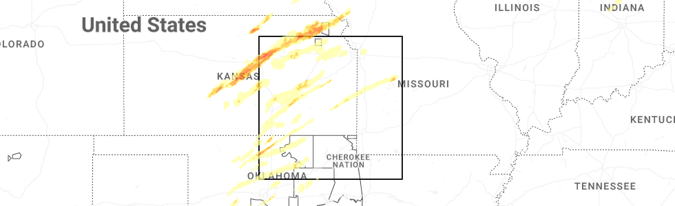
Hail Map for Stotesbury, MO
The Stotesbury, MO area has had 0 reports of on-the-ground hail by trained spotters, and has been under severe weather warnings 20 times during the past 12 months. Doppler radar has detected hail at or near Stotesbury, MO on 57 occasions, including 1 occasion during the past year.
| Name: | Stotesbury, MO |
| Where Located: | 52.6 miles ENE of Chanute, KS |
| Map: | Google Map for Stotesbury, MO |
| Population: | 18 |
| Housing Units: | 12 |
| More Info: | Search Google for Stotesbury, MO |
0
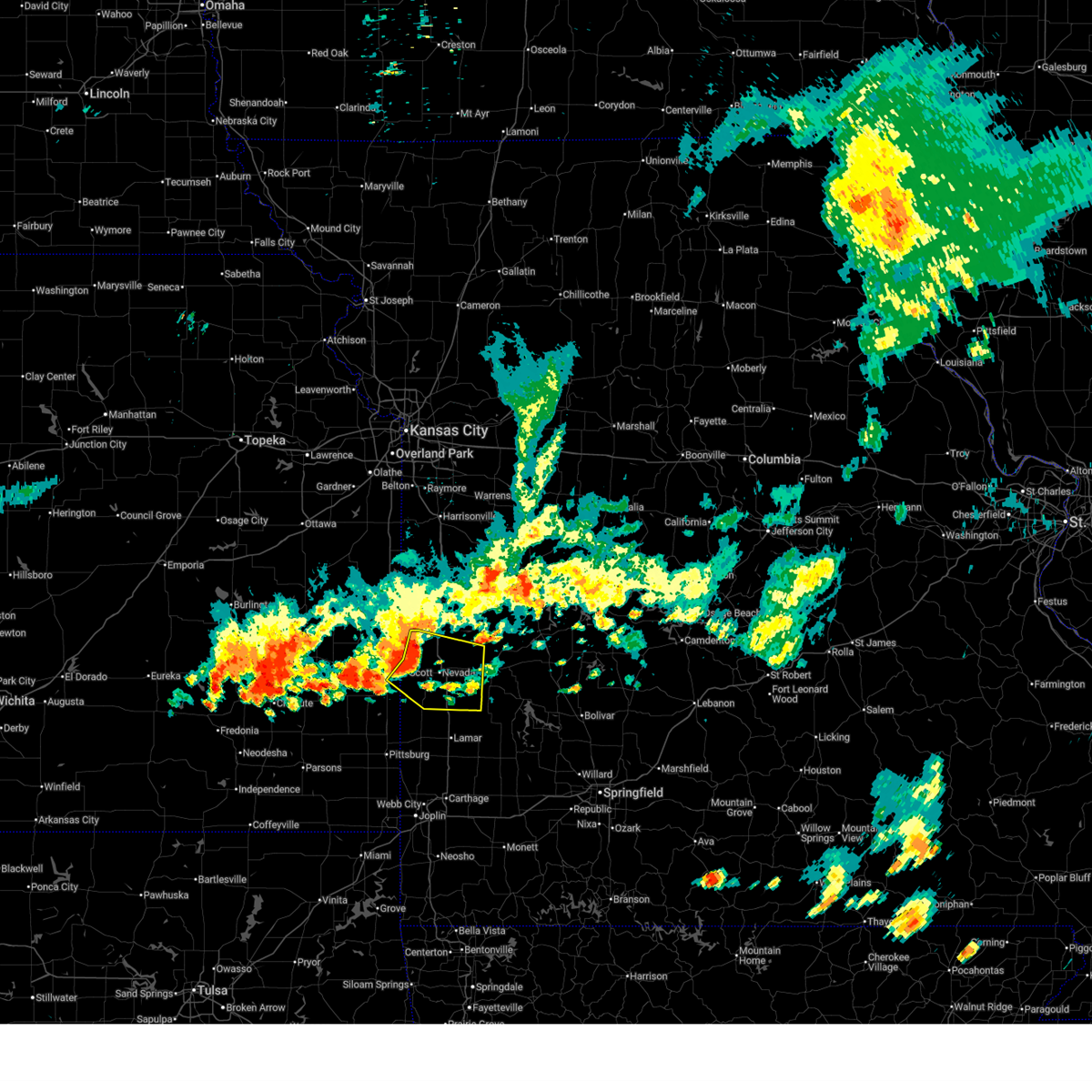
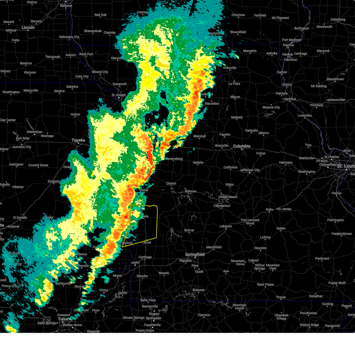
The Top Recent Hail Date for Stotesbury, MO is Tuesday, April 1, 2025 (34th out of 57)
Hail and Wind Damage Spotted near Stotesbury, MO
| Date / Time | Report Details |
|---|---|
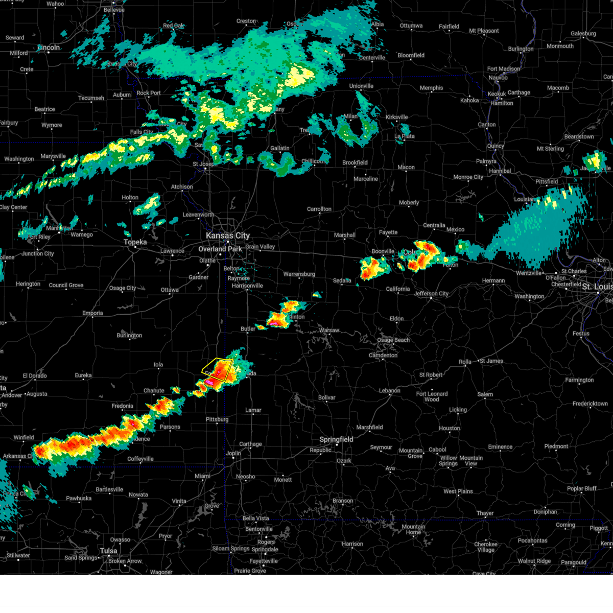
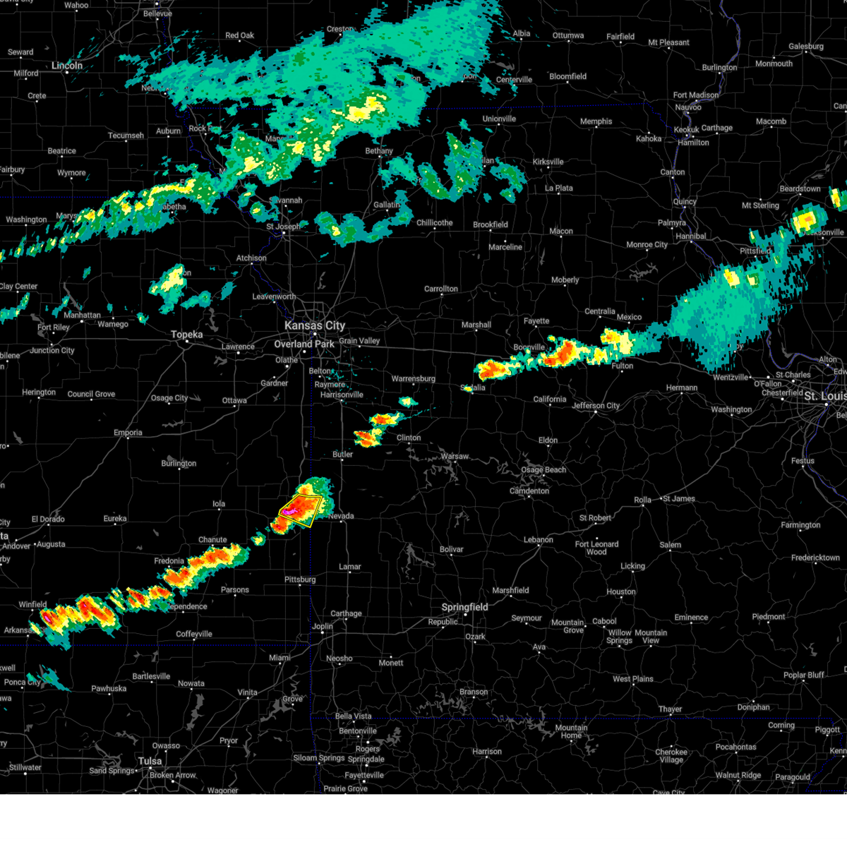
| 6/29/2025 2:30 PM CDT |
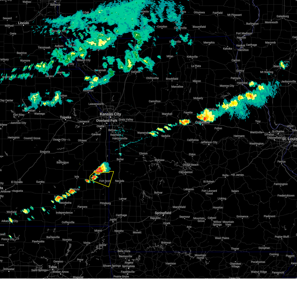
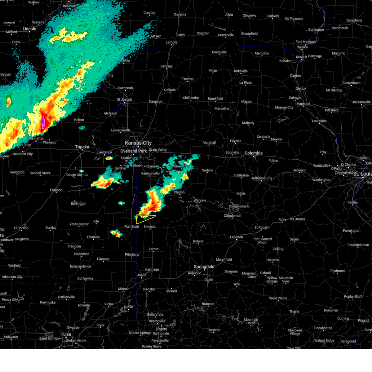
 Svrsgf the national weather service in springfield has issued a * severe thunderstorm warning for, east central bourbon county in southeastern kansas, vernon county in west central missouri, * until 315 pm cdt. * at 229 pm cdt, severe thunderstorms were located along a line extending from 10 miles southwest of rich hill to 6 miles west of nevada to near fort scott, moving southeast at 30 mph (radar indicated). Hazards include 60 mph wind gusts and penny size hail. expect damage to roofs, siding, and trees Svrsgf the national weather service in springfield has issued a * severe thunderstorm warning for, east central bourbon county in southeastern kansas, vernon county in west central missouri, * until 315 pm cdt. * at 229 pm cdt, severe thunderstorms were located along a line extending from 10 miles southwest of rich hill to 6 miles west of nevada to near fort scott, moving southeast at 30 mph (radar indicated). Hazards include 60 mph wind gusts and penny size hail. expect damage to roofs, siding, and trees
|
| 6/8/2025 3:27 PM CDT |
 The storm which prompted the warning has moved out of the area. therefore, the warning will be allowed to expire. a severe thunderstorm watch remains in effect until 1000 pm cdt for southeastern kansas, and west central missouri. to report severe weather, contact your nearest law enforcement agency. they will relay your report to the national weather service springfield. remember, a severe thunderstorm warning still remains in effect for southeastern bourbon county. The storm which prompted the warning has moved out of the area. therefore, the warning will be allowed to expire. a severe thunderstorm watch remains in effect until 1000 pm cdt for southeastern kansas, and west central missouri. to report severe weather, contact your nearest law enforcement agency. they will relay your report to the national weather service springfield. remember, a severe thunderstorm warning still remains in effect for southeastern bourbon county.
|
| 6/8/2025 3:11 PM CDT |
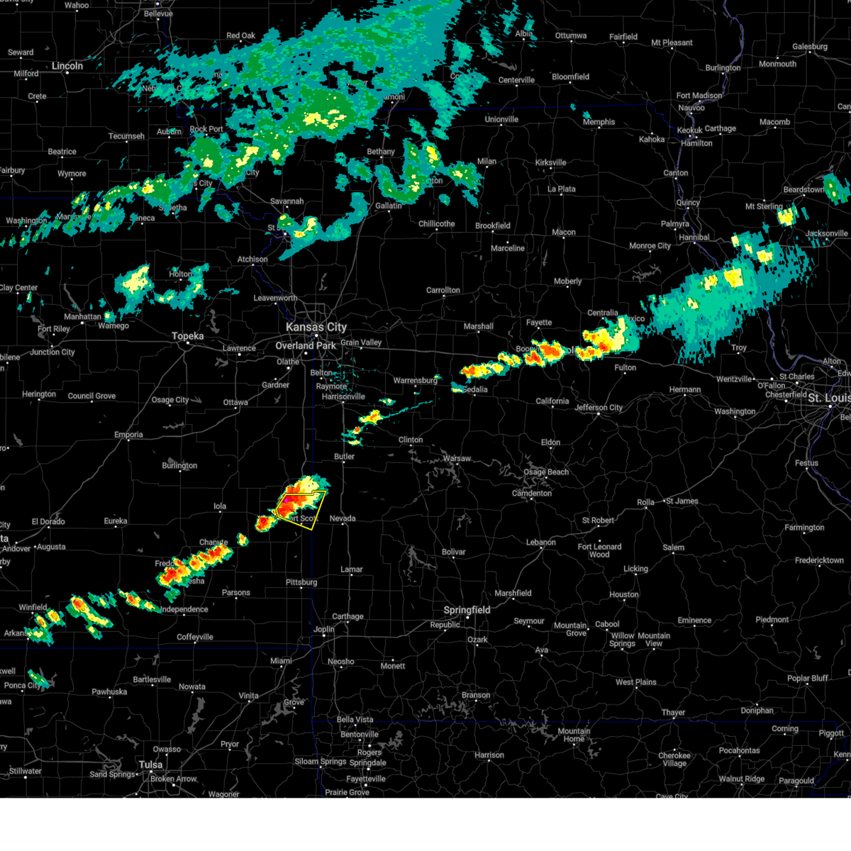
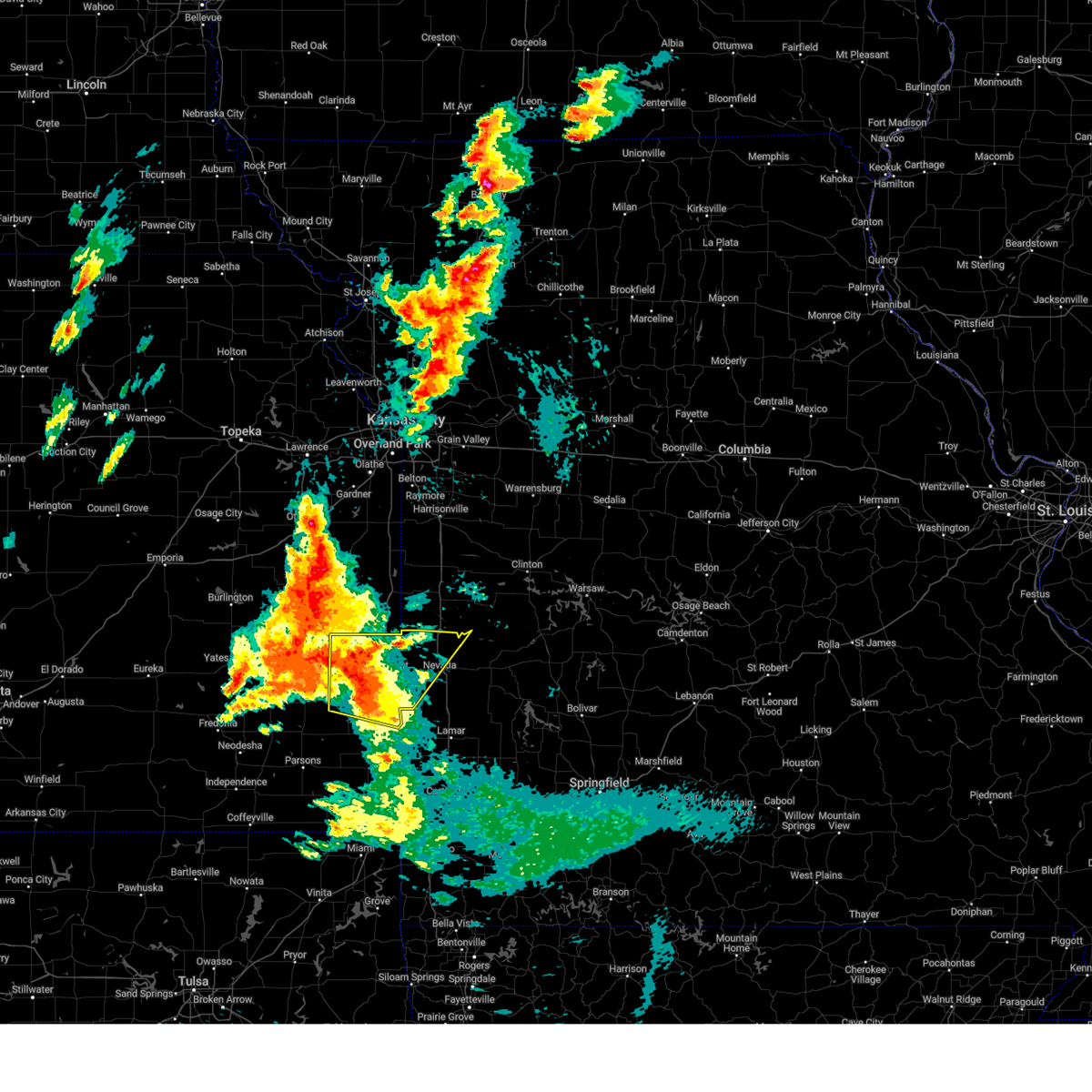
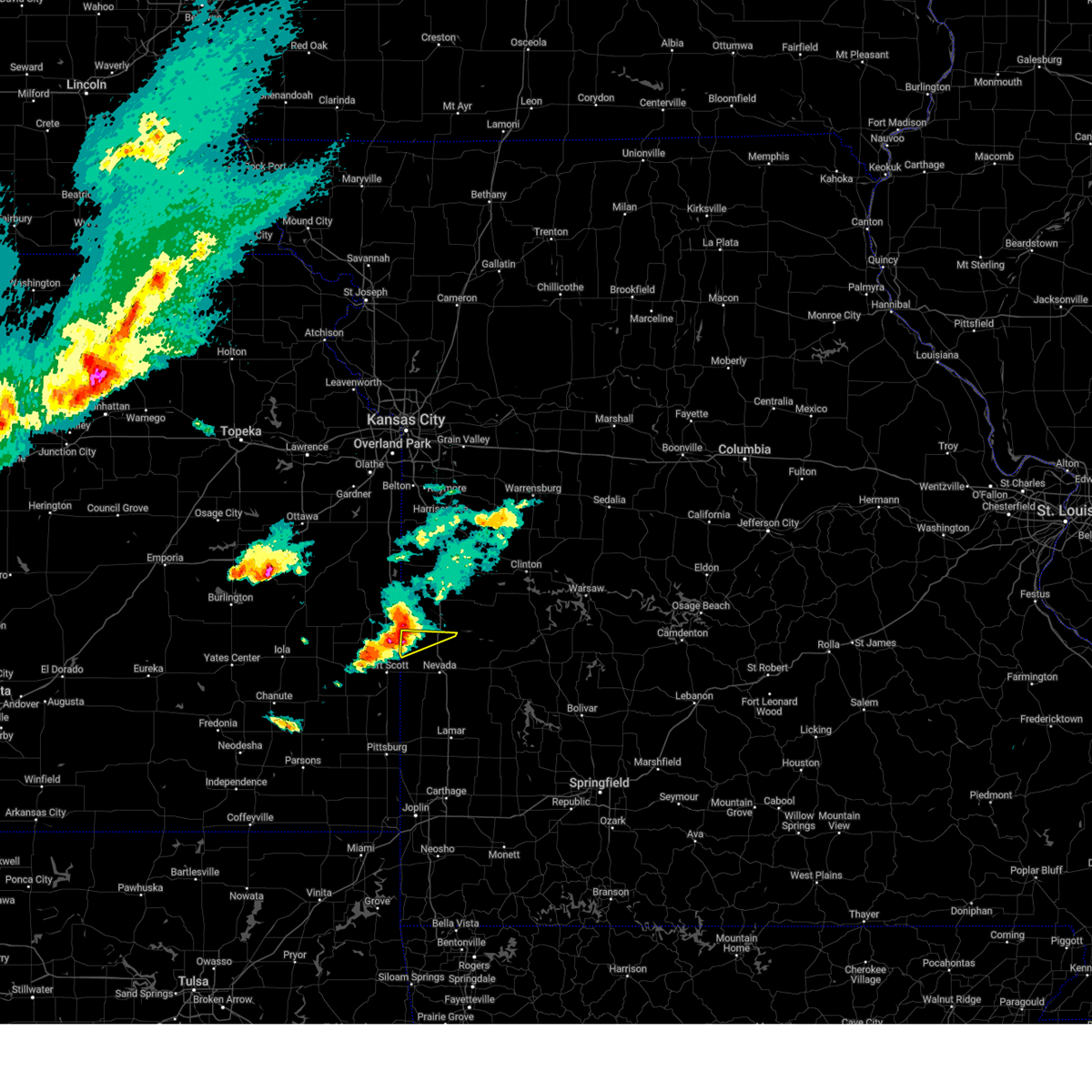
 At 311 pm cdt, a severe thunderstorm was located near redfield, or 7 miles northwest of fort scott, moving southeast at 20 mph (radar indicated). Hazards include tennis ball size hail and 60 mph wind gusts. People and animals outdoors will be injured. expect hail damage to roofs, siding, windows, and vehicles. expect wind damage to roofs, siding, and trees. Locations impacted include, fort scott, fulton, stotesbury, devon, and hammond. At 311 pm cdt, a severe thunderstorm was located near redfield, or 7 miles northwest of fort scott, moving southeast at 20 mph (radar indicated). Hazards include tennis ball size hail and 60 mph wind gusts. People and animals outdoors will be injured. expect hail damage to roofs, siding, windows, and vehicles. expect wind damage to roofs, siding, and trees. Locations impacted include, fort scott, fulton, stotesbury, devon, and hammond.
|
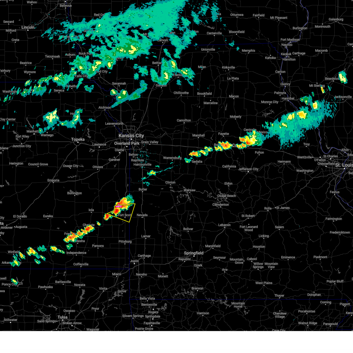
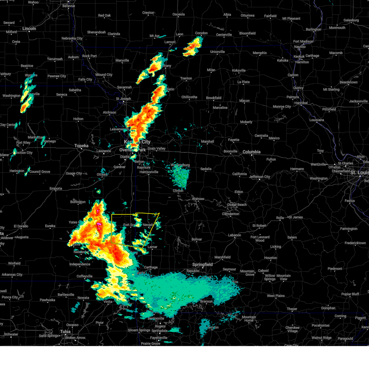
| 6/8/2025 2:55 PM CDT |
 At 255 pm cdt, a severe thunderstorm was located near fulton, or 9 miles south of mound city, moving southeast at 20 mph (radar indicated). Hazards include two inch hail and 60 mph wind gusts. People and animals outdoors will be injured. expect hail damage to roofs, siding, windows, and vehicles. expect wind damage to roofs, siding, and trees. Locations impacted include, fort scott, fulton, stotesbury, devon, harding, and hammond. At 255 pm cdt, a severe thunderstorm was located near fulton, or 9 miles south of mound city, moving southeast at 20 mph (radar indicated). Hazards include two inch hail and 60 mph wind gusts. People and animals outdoors will be injured. expect hail damage to roofs, siding, windows, and vehicles. expect wind damage to roofs, siding, and trees. Locations impacted include, fort scott, fulton, stotesbury, devon, harding, and hammond.
|
| 6/8/2025 2:50 PM CDT |
 At 250 pm cdt, a severe thunderstorm was located 7 miles west of fulton, or 8 miles south of mound city, moving southeast at 20 mph (radar indicated). Hazards include ping pong ball size hail and 60 mph wind gusts. People and animals outdoors will be injured. expect hail damage to roofs, siding, windows, and vehicles. expect wind damage to roofs, siding, and trees. Locations impacted include, fort scott, marmaton, bronson, fulton, redfield, richards, mapleton, stotesbury, hammond, devon, and harding. At 250 pm cdt, a severe thunderstorm was located 7 miles west of fulton, or 8 miles south of mound city, moving southeast at 20 mph (radar indicated). Hazards include ping pong ball size hail and 60 mph wind gusts. People and animals outdoors will be injured. expect hail damage to roofs, siding, windows, and vehicles. expect wind damage to roofs, siding, and trees. Locations impacted include, fort scott, marmaton, bronson, fulton, redfield, richards, mapleton, stotesbury, hammond, devon, and harding.
|
| 6/8/2025 2:39 PM CDT |
 Svrsgf the national weather service in springfield has issued a * severe thunderstorm warning for, northern bourbon county in southeastern kansas, northwestern vernon county in west central missouri, * until 330 pm cdt. * at 239 pm cdt, a severe thunderstorm was located near mound city, moving southeast at 20 mph (radar indicated). Hazards include 60 mph wind gusts and quarter size hail. Hail damage to vehicles is expected. Expect wind damage to roofs, siding, and trees. Svrsgf the national weather service in springfield has issued a * severe thunderstorm warning for, northern bourbon county in southeastern kansas, northwestern vernon county in west central missouri, * until 330 pm cdt. * at 239 pm cdt, a severe thunderstorm was located near mound city, moving southeast at 20 mph (radar indicated). Hazards include 60 mph wind gusts and quarter size hail. Hail damage to vehicles is expected. Expect wind damage to roofs, siding, and trees.
|
| 5/19/2025 5:59 PM CDT |
 Svrsgf the national weather service in springfield has issued a * severe thunderstorm warning for, eastern bourbon county in southeastern kansas, northwestern barton county in southwestern missouri, northwestern cedar county in southwestern missouri, st. clair county in west central missouri, vernon county in west central missouri, * until 645 pm cdt. * at 558 pm cdt, a severe thunderstorm was located over nevada, moving northeast at 30 mph (radar indicated). Hazards include 60 mph wind gusts and quarter size hail. Hail damage to vehicles is expected. Expect wind damage to roofs, siding, and trees. Svrsgf the national weather service in springfield has issued a * severe thunderstorm warning for, eastern bourbon county in southeastern kansas, northwestern barton county in southwestern missouri, northwestern cedar county in southwestern missouri, st. clair county in west central missouri, vernon county in west central missouri, * until 645 pm cdt. * at 558 pm cdt, a severe thunderstorm was located over nevada, moving northeast at 30 mph (radar indicated). Hazards include 60 mph wind gusts and quarter size hail. Hail damage to vehicles is expected. Expect wind damage to roofs, siding, and trees.
|
| 5/19/2025 3:36 PM CDT | The storm which prompted the warning has weakened below severe limits, and has exited the warned area. therefore, the warning will be allowed to expire. a tornado watch remains in effect until 900 pm cdt for southeastern kansas, and southwestern and west central missouri. |
| 5/19/2025 3:22 PM CDT |
 the severe thunderstorm warning has been cancelled and is no longer in effect the severe thunderstorm warning has been cancelled and is no longer in effect
|
| 5/19/2025 3:22 PM CDT |
 At 321 pm cdt, a severe thunderstorm was located over redfield, or 8 miles west of fort scott, moving north at 55 mph (radar indicated). Hazards include 60 mph wind gusts and quarter size hail. Hail damage to vehicles is expected. expect wind damage to roofs, siding, and trees. locations impacted include, nevada, fort scott, marmaton, mulberry, bronson, arcadia, uniontown, fulton, redfield, hepler, moundville, richards, mapleton, deerfield, metz, stotesbury, harding, petersburg, farlington, and porterville. This includes interstate 49 between mile markers 92 and 107. At 321 pm cdt, a severe thunderstorm was located over redfield, or 8 miles west of fort scott, moving north at 55 mph (radar indicated). Hazards include 60 mph wind gusts and quarter size hail. Hail damage to vehicles is expected. expect wind damage to roofs, siding, and trees. locations impacted include, nevada, fort scott, marmaton, mulberry, bronson, arcadia, uniontown, fulton, redfield, hepler, moundville, richards, mapleton, deerfield, metz, stotesbury, harding, petersburg, farlington, and porterville. This includes interstate 49 between mile markers 92 and 107.
|
| 5/19/2025 3:00 PM CDT |
 Svrsgf the national weather service in springfield has issued a * severe thunderstorm warning for, bourbon county in southeastern kansas, northern crawford county in southeastern kansas, northwestern barton county in southwestern missouri, vernon county in west central missouri, * until 345 pm cdt. * at 300 pm cdt, a severe thunderstorm was located near hepler, or 9 miles northwest of girard, moving northeast at 55 mph (radar indicated). Hazards include 70 mph wind gusts and ping pong ball size hail. People and animals outdoors will be injured. expect hail damage to roofs, siding, windows, and vehicles. expect considerable tree damage. Wind damage is also likely to mobile homes, roofs, and outbuildings. Svrsgf the national weather service in springfield has issued a * severe thunderstorm warning for, bourbon county in southeastern kansas, northern crawford county in southeastern kansas, northwestern barton county in southwestern missouri, vernon county in west central missouri, * until 345 pm cdt. * at 300 pm cdt, a severe thunderstorm was located near hepler, or 9 miles northwest of girard, moving northeast at 55 mph (radar indicated). Hazards include 70 mph wind gusts and ping pong ball size hail. People and animals outdoors will be injured. expect hail damage to roofs, siding, windows, and vehicles. expect considerable tree damage. Wind damage is also likely to mobile homes, roofs, and outbuildings.
|
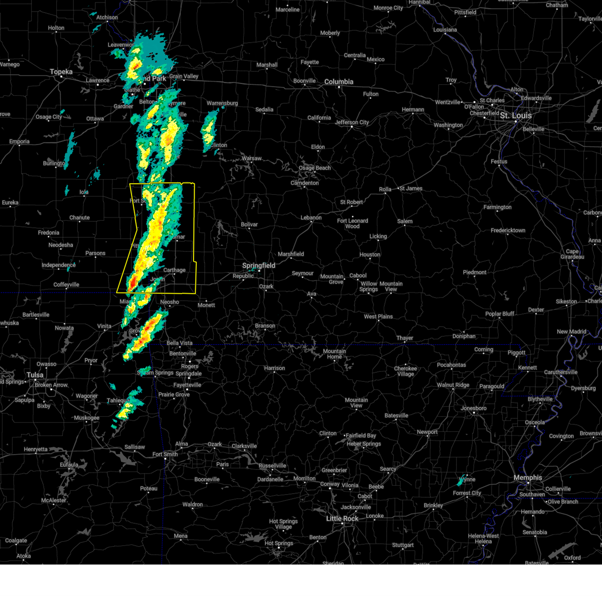
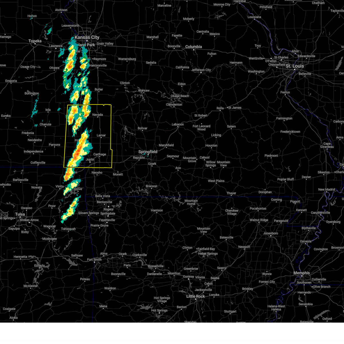
| 4/2/2025 7:34 AM CDT |
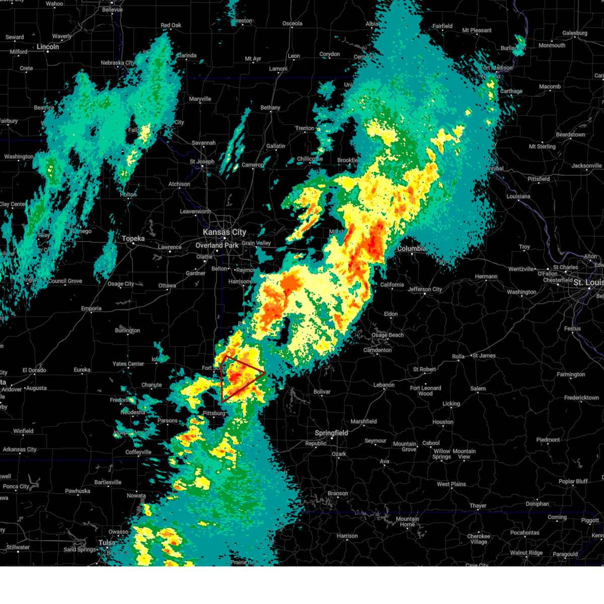 At 734 am cdt, a confirmed tornado was located near nevada, moving northeast at 65 mph (radar confirmed tornado). Hazards include damaging tornado and quarter size hail. Flying debris will be dangerous to those caught without shelter. mobile homes will be damaged or destroyed. damage to roofs, windows, and vehicles will occur. tree damage is likely. locations impacted include, moundville, richards, milo, oskaloosa, deerfield, stotesbury, bronaugh, nevada, and hannon. This includes interstate 49 between mile markers 82 and 97. At 734 am cdt, a confirmed tornado was located near nevada, moving northeast at 65 mph (radar confirmed tornado). Hazards include damaging tornado and quarter size hail. Flying debris will be dangerous to those caught without shelter. mobile homes will be damaged or destroyed. damage to roofs, windows, and vehicles will occur. tree damage is likely. locations impacted include, moundville, richards, milo, oskaloosa, deerfield, stotesbury, bronaugh, nevada, and hannon. This includes interstate 49 between mile markers 82 and 97.
|
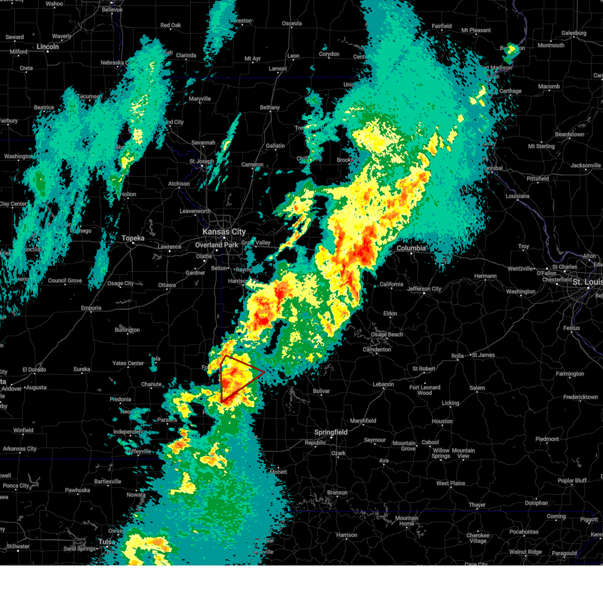
| 4/2/2025 7:26 AM CDT |
 At 725 am cdt, a severe thunderstorm capable of producing a tornado was located near arcadia, or 10 miles southeast of fort scott, moving northeast at 65 mph (weather spotters reported a funnel cloud north of arma at 723 am). Hazards include tornado and quarter size hail. Flying debris will be dangerous to those caught without shelter. mobile homes will be damaged or destroyed. damage to roofs, windows, and vehicles will occur. tree damage is likely. locations impacted include, moundville, richards, milo, oskaloosa, deerfield, stotesbury, bronaugh, nevada, and hannon. This includes interstate 49 between mile markers 82 and 97. At 725 am cdt, a severe thunderstorm capable of producing a tornado was located near arcadia, or 10 miles southeast of fort scott, moving northeast at 65 mph (weather spotters reported a funnel cloud north of arma at 723 am). Hazards include tornado and quarter size hail. Flying debris will be dangerous to those caught without shelter. mobile homes will be damaged or destroyed. damage to roofs, windows, and vehicles will occur. tree damage is likely. locations impacted include, moundville, richards, milo, oskaloosa, deerfield, stotesbury, bronaugh, nevada, and hannon. This includes interstate 49 between mile markers 82 and 97.
|
| 4/2/2025 7:26 AM CDT |
 the tornado warning has been cancelled and is no longer in effect the tornado warning has been cancelled and is no longer in effect
|
| 4/2/2025 7:16 AM CDT | Torsgf the national weather service in springfield has issued a * tornado warning for, southeastern bourbon county in southeastern kansas, northeastern crawford county in southeastern kansas, northwestern barton county in southwestern missouri, vernon county in west central missouri, * until 745 am cdt. * at 716 am cdt, a severe thunderstorm capable of producing a tornado was located near arma, or 10 miles northeast of girard, moving northeast at 60 mph (radar indicated rotation). Hazards include tornado and quarter size hail. Flying debris will be dangerous to those caught without shelter. mobile homes will be damaged or destroyed. damage to roofs, windows, and vehicles will occur. Tree damage is likely. |
| 4/1/2025 10:49 PM CDT |
 the severe thunderstorm warning has been cancelled and is no longer in effect the severe thunderstorm warning has been cancelled and is no longer in effect
|
| 4/1/2025 10:30 PM CDT |
 Svrsgf the national weather service in springfield has issued a * severe thunderstorm warning for, northwestern vernon county in west central missouri, * until 1100 pm cdt. * at 1030 pm cdt, a severe thunderstorm was located near hume, or near rich hill, moving northeast at 50 mph (radar indicated). Hazards include quarter size hail. damage to vehicles is expected Svrsgf the national weather service in springfield has issued a * severe thunderstorm warning for, northwestern vernon county in west central missouri, * until 1100 pm cdt. * at 1030 pm cdt, a severe thunderstorm was located near hume, or near rich hill, moving northeast at 50 mph (radar indicated). Hazards include quarter size hail. damage to vehicles is expected
|
| 3/14/2025 3:09 PM CDT |
 At 305 pm cdt, a severe thunderstorm was located over liberal, or 12 miles northeast of pittsburg, moving northeast at 70 mph (radar indicated. at 245 pm, emergency management reported 4 inch tree limbs down in cherokee county. a 62 mph gust was measured in crestline, kansas). Hazards include 70 mph wind gusts and penny size hail. Expect considerable tree damage. damage is likely to mobile homes, roofs, and outbuildings. locations impacted include, franklin, fidelity, frontenac, sarcoxie, richards, metz, milo, iron gates, boston, mulberry, cherokee, roseland, nashville, brooklyn heights, kenoma, lone oak, arcadia, reeds, hammond, and avilla. this includes the following highways, interstate 44 between mile markers 0 and 32. Interstate 49 between mile markers 32 and 106. At 305 pm cdt, a severe thunderstorm was located over liberal, or 12 miles northeast of pittsburg, moving northeast at 70 mph (radar indicated. at 245 pm, emergency management reported 4 inch tree limbs down in cherokee county. a 62 mph gust was measured in crestline, kansas). Hazards include 70 mph wind gusts and penny size hail. Expect considerable tree damage. damage is likely to mobile homes, roofs, and outbuildings. locations impacted include, franklin, fidelity, frontenac, sarcoxie, richards, metz, milo, iron gates, boston, mulberry, cherokee, roseland, nashville, brooklyn heights, kenoma, lone oak, arcadia, reeds, hammond, and avilla. this includes the following highways, interstate 44 between mile markers 0 and 32. Interstate 49 between mile markers 32 and 106.
|
| 3/14/2025 2:47 PM CDT |
 Svrsgf the national weather service in springfield has issued a * severe thunderstorm warning for, bourbon county in southeastern kansas, cherokee county in southeastern kansas, crawford county in southeastern kansas, barton county in southwestern missouri, northern newton county in southwestern missouri, vernon county in west central missouri, jasper county in southwestern missouri, * until 345 pm cdt. * at 246 pm cdt, a severe thunderstorm was located near weir, or 7 miles northeast of columbus, moving northeast at 70 mph (radar indicated. emergency manager reported 4 inch tree limbs down in cherokee county). Hazards include 70 mph wind gusts and penny size hail. Expect considerable tree damage. Damage is likely to mobile homes, roofs, and outbuildings. Svrsgf the national weather service in springfield has issued a * severe thunderstorm warning for, bourbon county in southeastern kansas, cherokee county in southeastern kansas, crawford county in southeastern kansas, barton county in southwestern missouri, northern newton county in southwestern missouri, vernon county in west central missouri, jasper county in southwestern missouri, * until 345 pm cdt. * at 246 pm cdt, a severe thunderstorm was located near weir, or 7 miles northeast of columbus, moving northeast at 70 mph (radar indicated. emergency manager reported 4 inch tree limbs down in cherokee county). Hazards include 70 mph wind gusts and penny size hail. Expect considerable tree damage. Damage is likely to mobile homes, roofs, and outbuildings.
|
| 10/30/2024 9:00 PM CDT |
 Svrsgf the national weather service in springfield has issued a * severe thunderstorm warning for, eastern crawford county in southeastern kansas, northern barton county in southwestern missouri, vernon county in west central missouri, * until 945 pm cdt. * at 859 pm cdt, severe thunderstorms were located along a line extending from near hume to 6 miles southeast of fort scott to near cherokee, moving east at 55 mph (radar indicated). Hazards include 60 mph wind gusts and penny size hail. expect damage to roofs, siding, and trees Svrsgf the national weather service in springfield has issued a * severe thunderstorm warning for, eastern crawford county in southeastern kansas, northern barton county in southwestern missouri, vernon county in west central missouri, * until 945 pm cdt. * at 859 pm cdt, severe thunderstorms were located along a line extending from near hume to 6 miles southeast of fort scott to near cherokee, moving east at 55 mph (radar indicated). Hazards include 60 mph wind gusts and penny size hail. expect damage to roofs, siding, and trees
|
| 6/26/2024 4:31 AM CDT |
 Svrsgf the national weather service in springfield has issued a * severe thunderstorm warning for, bourbon county in southeastern kansas, crawford county in southeastern kansas, southwestern hickory county in central missouri, barton county in southwestern missouri, southwestern dallas county in southwestern missouri, cedar county in southwestern missouri, polk county in southwestern missouri, southern st. clair county in west central missouri, vernon county in west central missouri, northern dade county in southwestern missouri, * until 515 am cdt. * at 431 am cdt, severe thunderstorms were located along a line extending from near weaubleau to near el dorado springs to near bronson, moving southeast at 40 mph (radar indicated). Hazards include 60 mph wind gusts and penny size hail. expect damage to roofs, siding, and trees Svrsgf the national weather service in springfield has issued a * severe thunderstorm warning for, bourbon county in southeastern kansas, crawford county in southeastern kansas, southwestern hickory county in central missouri, barton county in southwestern missouri, southwestern dallas county in southwestern missouri, cedar county in southwestern missouri, polk county in southwestern missouri, southern st. clair county in west central missouri, vernon county in west central missouri, northern dade county in southwestern missouri, * until 515 am cdt. * at 431 am cdt, severe thunderstorms were located along a line extending from near weaubleau to near el dorado springs to near bronson, moving southeast at 40 mph (radar indicated). Hazards include 60 mph wind gusts and penny size hail. expect damage to roofs, siding, and trees
|
| 5/26/2024 3:24 PM CDT |
 Svrsgf the national weather service in springfield has issued a * severe thunderstorm warning for, northeastern bourbon county in southeastern kansas, northern vernon county in west central missouri, * until 415 pm cdt. * at 324 pm cdt, a severe thunderstorm was located near prescott, or near mound city, moving east at 40 mph (radar indicated). Hazards include ping pong ball size hail and 60 mph wind gusts. People and animals outdoors will be injured. expect hail damage to roofs, siding, windows, and vehicles. Expect wind damage to roofs, siding, and trees. Svrsgf the national weather service in springfield has issued a * severe thunderstorm warning for, northeastern bourbon county in southeastern kansas, northern vernon county in west central missouri, * until 415 pm cdt. * at 324 pm cdt, a severe thunderstorm was located near prescott, or near mound city, moving east at 40 mph (radar indicated). Hazards include ping pong ball size hail and 60 mph wind gusts. People and animals outdoors will be injured. expect hail damage to roofs, siding, windows, and vehicles. Expect wind damage to roofs, siding, and trees.
|
| 5/21/2024 5:02 PM CDT |
 the severe thunderstorm warning has been cancelled and is no longer in effect the severe thunderstorm warning has been cancelled and is no longer in effect
|
| 5/21/2024 5:02 PM CDT |
 At 501 pm cdt, a severe thunderstorm was located over rich hill, moving northeast at 50 mph (radar indicated). Hazards include 60 mph wind gusts and half dollar size hail. Hail damage to vehicles is expected. expect wind damage to roofs, siding, and trees. locations impacted include, walker, schell city, richards, metz, harwood, stotesbury, and horton. This includes interstate 49 between mile markers 95 and 107. At 501 pm cdt, a severe thunderstorm was located over rich hill, moving northeast at 50 mph (radar indicated). Hazards include 60 mph wind gusts and half dollar size hail. Hail damage to vehicles is expected. expect wind damage to roofs, siding, and trees. locations impacted include, walker, schell city, richards, metz, harwood, stotesbury, and horton. This includes interstate 49 between mile markers 95 and 107.
|
| 5/21/2024 4:47 PM CDT |
 At 447 pm cdt, a severe thunderstorm was located near hume, or 11 miles southwest of rich hill, moving east at 60 mph (radar indicated). Hazards include ping pong ball size hail and 60 mph wind gusts. People and animals outdoors will be injured. expect hail damage to roofs, siding, windows, and vehicles. expect wind damage to roofs, siding, and trees. locations impacted include, walker, schell city, fulton, richards, metz, harwood, stotesbury, hammond, and horton. This includes interstate 49 between mile markers 95 and 107. At 447 pm cdt, a severe thunderstorm was located near hume, or 11 miles southwest of rich hill, moving east at 60 mph (radar indicated). Hazards include ping pong ball size hail and 60 mph wind gusts. People and animals outdoors will be injured. expect hail damage to roofs, siding, windows, and vehicles. expect wind damage to roofs, siding, and trees. locations impacted include, walker, schell city, fulton, richards, metz, harwood, stotesbury, hammond, and horton. This includes interstate 49 between mile markers 95 and 107.
|
| 5/21/2024 4:21 PM CDT |
 Svrsgf the national weather service in springfield has issued a * severe thunderstorm warning for, northeastern bourbon county in southeastern kansas, northern vernon county in west central missouri, * until 515 pm cdt. * at 421 pm cdt, a severe thunderstorm was located 8 miles north of redfield, or 11 miles south of mound city, moving northeast at 50 mph (radar indicated). Hazards include 60 mph wind gusts and quarter size hail. Hail damage to vehicles is expected. Expect wind damage to roofs, siding, and trees. Svrsgf the national weather service in springfield has issued a * severe thunderstorm warning for, northeastern bourbon county in southeastern kansas, northern vernon county in west central missouri, * until 515 pm cdt. * at 421 pm cdt, a severe thunderstorm was located 8 miles north of redfield, or 11 miles south of mound city, moving northeast at 50 mph (radar indicated). Hazards include 60 mph wind gusts and quarter size hail. Hail damage to vehicles is expected. Expect wind damage to roofs, siding, and trees.
|
| 4/27/2024 10:10 PM CDT |
 At 1010 pm cdt, a severe thunderstorm was located 7 miles southwest of nevada, moving east at 40 mph (radar indicated). Hazards include 60 mph wind gusts and quarter size hail. Hail damage to vehicles is expected. expect wind damage to roofs, siding, and trees. locations impacted include, truman lake, nevada, el dorado springs, appleton city, osceola, lowry city, sheldon, montevallo, walker, schell city, bronaugh, collins, moundville, roscoe, richards, milo, deerfield, vista, metz, and harwood. This includes interstate 49 between mile markers 77 and 106. At 1010 pm cdt, a severe thunderstorm was located 7 miles southwest of nevada, moving east at 40 mph (radar indicated). Hazards include 60 mph wind gusts and quarter size hail. Hail damage to vehicles is expected. expect wind damage to roofs, siding, and trees. locations impacted include, truman lake, nevada, el dorado springs, appleton city, osceola, lowry city, sheldon, montevallo, walker, schell city, bronaugh, collins, moundville, roscoe, richards, milo, deerfield, vista, metz, and harwood. This includes interstate 49 between mile markers 77 and 106.
|
| 4/27/2024 10:10 PM CDT |
 the severe thunderstorm warning has been cancelled and is no longer in effect the severe thunderstorm warning has been cancelled and is no longer in effect
|
| 4/27/2024 9:50 PM CDT |
 Svrsgf the national weather service in springfield has issued a * severe thunderstorm warning for, northwestern barton county in southwestern missouri, northern cedar county in southwestern missouri, st. clair county in west central missouri, vernon county in west central missouri, * until 1045 pm cdt. * at 949 pm cdt, a severe thunderstorm was located near el dorado springs, moving east at 30 mph (radar indicated). Hazards include 60 mph wind gusts and quarter size hail. Hail damage to vehicles is expected. Expect wind damage to roofs, siding, and trees. Svrsgf the national weather service in springfield has issued a * severe thunderstorm warning for, northwestern barton county in southwestern missouri, northern cedar county in southwestern missouri, st. clair county in west central missouri, vernon county in west central missouri, * until 1045 pm cdt. * at 949 pm cdt, a severe thunderstorm was located near el dorado springs, moving east at 30 mph (radar indicated). Hazards include 60 mph wind gusts and quarter size hail. Hail damage to vehicles is expected. Expect wind damage to roofs, siding, and trees.
|
| 4/27/2024 9:28 PM CDT |
 The storm which prompted the warning has weakened below severe limits, and no longer poses an immediate threat to life or property. therefore, the warning will be allowed to expire. however, small hail and gusty winds are still possible with this thunderstorm. a tornado watch remains in effect until midnight cdt for southeastern kansas, and west central missouri. The storm which prompted the warning has weakened below severe limits, and no longer poses an immediate threat to life or property. therefore, the warning will be allowed to expire. however, small hail and gusty winds are still possible with this thunderstorm. a tornado watch remains in effect until midnight cdt for southeastern kansas, and west central missouri.
|
| 4/27/2024 8:55 PM CDT |
 At 855 pm cdt, a severe thunderstorm was located near fort scott, moving east at 30 mph (radar indicated). Hazards include 60 mph wind gusts and half dollar size hail. Hail damage to vehicles is expected. expect wind damage to roofs, siding, and trees. locations impacted include, nevada, fort scott, marmaton, walnut, redfield, hepler, moundville, richards, deerfield, metz, stotesbury, horton, pawnee station, hiattville, petersburg, farlington, hammond, brazilton, devon, and garland. This includes interstate 49 between mile markers 92 and 105. At 855 pm cdt, a severe thunderstorm was located near fort scott, moving east at 30 mph (radar indicated). Hazards include 60 mph wind gusts and half dollar size hail. Hail damage to vehicles is expected. expect wind damage to roofs, siding, and trees. locations impacted include, nevada, fort scott, marmaton, walnut, redfield, hepler, moundville, richards, deerfield, metz, stotesbury, horton, pawnee station, hiattville, petersburg, farlington, hammond, brazilton, devon, and garland. This includes interstate 49 between mile markers 92 and 105.
|
| 4/27/2024 8:40 PM CDT |
 Svrsgf the national weather service in springfield has issued a * severe thunderstorm warning for, bourbon county in southeastern kansas, northern crawford county in southeastern kansas, western vernon county in west central missouri, * until 930 pm cdt. * at 840 pm cdt, a severe thunderstorm was located over fort scott, moving east at 30 mph (radar indicated). Hazards include 60 mph wind gusts and quarter size hail. Hail damage to vehicles is expected. Expect wind damage to roofs, siding, and trees. Svrsgf the national weather service in springfield has issued a * severe thunderstorm warning for, bourbon county in southeastern kansas, northern crawford county in southeastern kansas, western vernon county in west central missouri, * until 930 pm cdt. * at 840 pm cdt, a severe thunderstorm was located over fort scott, moving east at 30 mph (radar indicated). Hazards include 60 mph wind gusts and quarter size hail. Hail damage to vehicles is expected. Expect wind damage to roofs, siding, and trees.
|
| 4/27/2024 8:24 PM CDT |
 The storm which prompted the warning has weakened below severe limits, and no longer poses an immediate threat to life or property. therefore, the warning will be allowed to expire. however, gusty winds and heavy rain are still possible with this thunderstorm. a tornado watch remains in effect until midnight cdt for southeastern kansas, and west central missouri. The storm which prompted the warning has weakened below severe limits, and no longer poses an immediate threat to life or property. therefore, the warning will be allowed to expire. however, gusty winds and heavy rain are still possible with this thunderstorm. a tornado watch remains in effect until midnight cdt for southeastern kansas, and west central missouri.
|
| 4/27/2024 8:13 PM CDT |
 At 813 pm cdt, a severe thunderstorm was located over fort scott, moving northeast at 50 mph (radar indicated). Hazards include 60 mph wind gusts and quarter size hail. Hail damage to vehicles is expected. expect wind damage to roofs, siding, and trees. Locations impacted include, fort scott, marmaton, walnut, fulton, redfield, hepler, richards, deerfield, metz, stotesbury, pawnee station, hiattville, petersburg, farlington, hammond, devon, garland, and porterville. At 813 pm cdt, a severe thunderstorm was located over fort scott, moving northeast at 50 mph (radar indicated). Hazards include 60 mph wind gusts and quarter size hail. Hail damage to vehicles is expected. expect wind damage to roofs, siding, and trees. Locations impacted include, fort scott, marmaton, walnut, fulton, redfield, hepler, richards, deerfield, metz, stotesbury, pawnee station, hiattville, petersburg, farlington, hammond, devon, garland, and porterville.
|
| 4/27/2024 7:58 PM CDT |
 Svrsgf the national weather service in springfield has issued a * severe thunderstorm warning for, bourbon county in southeastern kansas, northern crawford county in southeastern kansas, northwestern vernon county in west central missouri, * until 830 pm cdt. * at 758 pm cdt, a severe thunderstorm was located near redfield, or 12 miles west of fort scott, moving northeast at 50 mph (radar indicated). Hazards include 60 mph wind gusts and half dollar size hail. Hail damage to vehicles is expected. Expect wind damage to roofs, siding, and trees. Svrsgf the national weather service in springfield has issued a * severe thunderstorm warning for, bourbon county in southeastern kansas, northern crawford county in southeastern kansas, northwestern vernon county in west central missouri, * until 830 pm cdt. * at 758 pm cdt, a severe thunderstorm was located near redfield, or 12 miles west of fort scott, moving northeast at 50 mph (radar indicated). Hazards include 60 mph wind gusts and half dollar size hail. Hail damage to vehicles is expected. Expect wind damage to roofs, siding, and trees.
|
| 4/26/2024 6:28 PM CDT |
 The storm which prompted the warning has moved out of the area. therefore, the warning will be allowed to expire. a tornado watch remains in effect until 900 pm cdt for west central missouri. The storm which prompted the warning has moved out of the area. therefore, the warning will be allowed to expire. a tornado watch remains in effect until 900 pm cdt for west central missouri.
|
| 4/26/2024 6:10 PM CDT |
 the tornado warning has been cancelled and is no longer in effect the tornado warning has been cancelled and is no longer in effect
|
| 4/26/2024 6:10 PM CDT |
 At 609 pm cdt, a severe thunderstorm capable of producing a tornado was located 7 miles southeast of hume, or 9 miles southwest of rich hill, moving east at 35 mph. this storm has a history of producing tornadoes and ping pong ball sized hail (radar indicated rotation). Hazards include tornado and ping pong ball size hail. Flying debris will be dangerous to those caught without shelter. mobile homes will be damaged or destroyed. damage to roofs, windows, and vehicles will occur. tree damage is likely. locations impacted include, schell city, richards, metz, harwood, stotesbury, and horton. This includes interstate 49 between mile markers 96 and 107. At 609 pm cdt, a severe thunderstorm capable of producing a tornado was located 7 miles southeast of hume, or 9 miles southwest of rich hill, moving east at 35 mph. this storm has a history of producing tornadoes and ping pong ball sized hail (radar indicated rotation). Hazards include tornado and ping pong ball size hail. Flying debris will be dangerous to those caught without shelter. mobile homes will be damaged or destroyed. damage to roofs, windows, and vehicles will occur. tree damage is likely. locations impacted include, schell city, richards, metz, harwood, stotesbury, and horton. This includes interstate 49 between mile markers 96 and 107.
|
| 4/26/2024 6:00 PM CDT |
 At 559 pm cdt, a severe thunderstorm capable of producing a tornado was located near fulton, or 10 miles northeast of fort scott, moving east at 30 mph. this storm has a history of producing tornadoes and ping pong ball sized hail (radar indicated rotation). Hazards include tornado and ping pong ball size hail. Flying debris will be dangerous to those caught without shelter. mobile homes will be damaged or destroyed. damage to roofs, windows, and vehicles will occur. tree damage is likely. locations impacted include, walker, schell city, fulton, richards, metz, harwood, stotesbury, hammond, and horton. This includes interstate 49 between mile markers 95 and 107. At 559 pm cdt, a severe thunderstorm capable of producing a tornado was located near fulton, or 10 miles northeast of fort scott, moving east at 30 mph. this storm has a history of producing tornadoes and ping pong ball sized hail (radar indicated rotation). Hazards include tornado and ping pong ball size hail. Flying debris will be dangerous to those caught without shelter. mobile homes will be damaged or destroyed. damage to roofs, windows, and vehicles will occur. tree damage is likely. locations impacted include, walker, schell city, fulton, richards, metz, harwood, stotesbury, hammond, and horton. This includes interstate 49 between mile markers 95 and 107.
|
| 4/26/2024 5:52 PM CDT |
 Torsgf the national weather service in springfield has issued a * tornado warning for, northeastern bourbon county in southeastern kansas, northern vernon county in west central missouri, * until 630 pm cdt. * at 551 pm cdt, a severe thunderstorm capable of producing a tornado was located near fulton, or 7 miles north of fort scott, moving east at 30 mph. this storm has a history of producing tornadoes and ping pong ball sized hail. this replaces the previously issued tornado warning for bourbon county (radar indicated rotation). Hazards include tornado and ping pong ball size hail. Flying debris will be dangerous to those caught without shelter. mobile homes will be damaged or destroyed. damage to roofs, windows, and vehicles will occur. Tree damage is likely. Torsgf the national weather service in springfield has issued a * tornado warning for, northeastern bourbon county in southeastern kansas, northern vernon county in west central missouri, * until 630 pm cdt. * at 551 pm cdt, a severe thunderstorm capable of producing a tornado was located near fulton, or 7 miles north of fort scott, moving east at 30 mph. this storm has a history of producing tornadoes and ping pong ball sized hail. this replaces the previously issued tornado warning for bourbon county (radar indicated rotation). Hazards include tornado and ping pong ball size hail. Flying debris will be dangerous to those caught without shelter. mobile homes will be damaged or destroyed. damage to roofs, windows, and vehicles will occur. Tree damage is likely.
|
| 4/25/2024 4:55 PM CDT |
 The severe thunderstorm which prompted the warning has weakened. therefore, the warning will be allowed to expire. The severe thunderstorm which prompted the warning has weakened. therefore, the warning will be allowed to expire.
|
| 4/25/2024 4:42 PM CDT |
 At 441 pm cdt, a severe thunderstorm was located near hume, or 12 miles southeast of pleasanton, moving east at 25 mph (radar indicated). Hazards include 60 mph wind gusts and quarter size hail. Hail damage to vehicles is expected. expect wind damage to roofs, siding, and trees. locations impacted include, nevada, fort scott, fulton, moundville, richards, deerfield, metz, stotesbury, hammond, horton, and devon. This includes interstate 49 between mile markers 98 and 106. At 441 pm cdt, a severe thunderstorm was located near hume, or 12 miles southeast of pleasanton, moving east at 25 mph (radar indicated). Hazards include 60 mph wind gusts and quarter size hail. Hail damage to vehicles is expected. expect wind damage to roofs, siding, and trees. locations impacted include, nevada, fort scott, fulton, moundville, richards, deerfield, metz, stotesbury, hammond, horton, and devon. This includes interstate 49 between mile markers 98 and 106.
|
| 4/25/2024 4:18 PM CDT |
 Svrsgf the national weather service in springfield has issued a * severe thunderstorm warning for, northern bourbon county in southeastern kansas, northwestern vernon county in west central missouri, * until 500 pm cdt. * at 417 pm cdt, a severe thunderstorm was located near fulton, or 8 miles south of mound city, moving east at 25 mph (radar indicated). Hazards include 60 mph wind gusts and quarter size hail. Hail damage to vehicles is expected. Expect wind damage to roofs, siding, and trees. Svrsgf the national weather service in springfield has issued a * severe thunderstorm warning for, northern bourbon county in southeastern kansas, northwestern vernon county in west central missouri, * until 500 pm cdt. * at 417 pm cdt, a severe thunderstorm was located near fulton, or 8 miles south of mound city, moving east at 25 mph (radar indicated). Hazards include 60 mph wind gusts and quarter size hail. Hail damage to vehicles is expected. Expect wind damage to roofs, siding, and trees.
|
| 9/23/2023 10:01 PM CDT |
 At 1001 pm cdt, severe thunderstorms were located along a line extending from 6 miles northwest of nevada to near hepler, moving southeast at 30 mph (radar indicated). Hazards include 60 mph wind gusts and quarter size hail. Hail damage to vehicles is expected. expect wind damage to roofs, siding, and trees. locations impacted include, nevada, fort scott, marmaton, uniontown, walker, redfield, richards, deerfield, metz, stotesbury, horton, pawnee station, hiattville, petersburg, hammond, devon, garland and porterville. this includes interstate 49 between mile markers 91 and 103. hail threat, radar indicated max hail size, 1. 00 in wind threat, radar indicated max wind gust, 60 mph. At 1001 pm cdt, severe thunderstorms were located along a line extending from 6 miles northwest of nevada to near hepler, moving southeast at 30 mph (radar indicated). Hazards include 60 mph wind gusts and quarter size hail. Hail damage to vehicles is expected. expect wind damage to roofs, siding, and trees. locations impacted include, nevada, fort scott, marmaton, uniontown, walker, redfield, richards, deerfield, metz, stotesbury, horton, pawnee station, hiattville, petersburg, hammond, devon, garland and porterville. this includes interstate 49 between mile markers 91 and 103. hail threat, radar indicated max hail size, 1. 00 in wind threat, radar indicated max wind gust, 60 mph.
|
| 9/23/2023 9:51 PM CDT |
 At 951 pm cdt, severe thunderstorms were located along a line extending from 11 miles south of hume to near hepler, moving southeast at 30 mph (radar indicated). Hazards include 60 mph wind gusts and half dollar size hail. Hail damage to vehicles is expected. expect wind damage to roofs, siding, and trees. locations impacted include, nevada, fort scott, marmaton, uniontown, walker, redfield, richards, deerfield, metz, stotesbury, horton, pawnee station, hiattville, petersburg, hammond, devon, garland and porterville. this includes interstate 49 between mile markers 91 and 103. hail threat, radar indicated max hail size, 1. 25 in wind threat, radar indicated max wind gust, 60 mph. At 951 pm cdt, severe thunderstorms were located along a line extending from 11 miles south of hume to near hepler, moving southeast at 30 mph (radar indicated). Hazards include 60 mph wind gusts and half dollar size hail. Hail damage to vehicles is expected. expect wind damage to roofs, siding, and trees. locations impacted include, nevada, fort scott, marmaton, uniontown, walker, redfield, richards, deerfield, metz, stotesbury, horton, pawnee station, hiattville, petersburg, hammond, devon, garland and porterville. this includes interstate 49 between mile markers 91 and 103. hail threat, radar indicated max hail size, 1. 25 in wind threat, radar indicated max wind gust, 60 mph.
|
| 9/23/2023 9:28 PM CDT |
 At 928 pm cdt, severe thunderstorms were located along a line extending from fulton to 8 miles south of bronson, moving southeast at 30 mph (radar indicated). Hazards include 60 mph wind gusts and half dollar size hail. Hail damage to vehicles is expected. Expect wind damage to roofs, siding, and trees. At 928 pm cdt, severe thunderstorms were located along a line extending from fulton to 8 miles south of bronson, moving southeast at 30 mph (radar indicated). Hazards include 60 mph wind gusts and half dollar size hail. Hail damage to vehicles is expected. Expect wind damage to roofs, siding, and trees.
|
| 7/30/2023 9:52 PM CDT |
 The severe thunderstorm warning for bourbon, northern crawford, northern barton and vernon counties will expire at 1000 pm cdt, the storm which prompted the warning has moved out of the area. therefore, the warning will be allowed to expire. however gusty winds are still possible with this thunderstorm. a severe thunderstorm watch remains in effect until 100 am cdt for southeastern kansas, and southwestern and west central missouri. to report severe weather, contact your nearest law enforcement agency. they will relay your report to the national weather service springfield. The severe thunderstorm warning for bourbon, northern crawford, northern barton and vernon counties will expire at 1000 pm cdt, the storm which prompted the warning has moved out of the area. therefore, the warning will be allowed to expire. however gusty winds are still possible with this thunderstorm. a severe thunderstorm watch remains in effect until 100 am cdt for southeastern kansas, and southwestern and west central missouri. to report severe weather, contact your nearest law enforcement agency. they will relay your report to the national weather service springfield.
|
| 7/30/2023 9:44 PM CDT |
 At 943 pm cdt, a severe thunderstorm was located near schell city, or near el dorado springs, moving southeast at 55 mph (law enforcement). Hazards include 70 mph wind gusts. Expect considerable tree damage. damage is likely to mobile homes, roofs, and outbuildings. locations impacted include, nevada, fort scott, marmaton, sheldon, bronson, montevallo, arcadia, uniontown, walker, schell city, bronaugh, fulton, redfield, hepler, moundville, richards, milo, mapleton, deerfield and metz. this includes interstate 49 between mile markers 75 and 107. thunderstorm damage threat, considerable hail threat, radar indicated max hail size, <. 75 in wind threat, observed max wind gust, 70 mph. At 943 pm cdt, a severe thunderstorm was located near schell city, or near el dorado springs, moving southeast at 55 mph (law enforcement). Hazards include 70 mph wind gusts. Expect considerable tree damage. damage is likely to mobile homes, roofs, and outbuildings. locations impacted include, nevada, fort scott, marmaton, sheldon, bronson, montevallo, arcadia, uniontown, walker, schell city, bronaugh, fulton, redfield, hepler, moundville, richards, milo, mapleton, deerfield and metz. this includes interstate 49 between mile markers 75 and 107. thunderstorm damage threat, considerable hail threat, radar indicated max hail size, <. 75 in wind threat, observed max wind gust, 70 mph.
|
| 7/30/2023 8:59 PM CDT |
 At 859 pm cdt, a severe thunderstorm was located over pleasanton, moving southeast at 55 mph (trained weather spotters). Hazards include 70 mph wind gusts. Expect considerable tree damage. Damage is likely to mobile homes, roofs, and outbuildings. At 859 pm cdt, a severe thunderstorm was located over pleasanton, moving southeast at 55 mph (trained weather spotters). Hazards include 70 mph wind gusts. Expect considerable tree damage. Damage is likely to mobile homes, roofs, and outbuildings.
|
| 7/14/2023 7:04 PM CDT |
 At 704 pm cdt, severe thunderstorms were located along a line extending from near nevada to 6 miles east of lamar to 8 miles east of carthage to near diamond, moving southeast at 60 mph (trained weather spotters). Hazards include 70 mph wind gusts and quarter size hail. Hail damage to vehicles is expected. expect considerable tree damage. wind damage is also likely to mobile homes, roofs, and outbuildings. locations impacted include, southeastern joplin, carthage, webb city, nevada, lamar, carterville, duquesne, sarcoxie, duenweg, jasper, diamond, golden city, leawood, silver creek, sheldon, shoal creek drive, montevallo, saginaw, carytown and walker. this includes the following highways, interstate 44 between mile markers 5 and 32. interstate 49 between mile markers 31 and 103. thunderstorm damage threat, considerable hail threat, radar indicated max hail size, 1. 00 in wind threat, observed max wind gust, 70 mph. At 704 pm cdt, severe thunderstorms were located along a line extending from near nevada to 6 miles east of lamar to 8 miles east of carthage to near diamond, moving southeast at 60 mph (trained weather spotters). Hazards include 70 mph wind gusts and quarter size hail. Hail damage to vehicles is expected. expect considerable tree damage. wind damage is also likely to mobile homes, roofs, and outbuildings. locations impacted include, southeastern joplin, carthage, webb city, nevada, lamar, carterville, duquesne, sarcoxie, duenweg, jasper, diamond, golden city, leawood, silver creek, sheldon, shoal creek drive, montevallo, saginaw, carytown and walker. this includes the following highways, interstate 44 between mile markers 5 and 32. interstate 49 between mile markers 31 and 103. thunderstorm damage threat, considerable hail threat, radar indicated max hail size, 1. 00 in wind threat, observed max wind gust, 70 mph.
|
| 7/14/2023 6:51 PM CDT |
 At 650 pm cdt, severe thunderstorms were located along a line extending from 9 miles east of fort scott to 6 miles southwest of sheldon to near alba to near webb city, moving southeast at 60 mph (trained weather spotters). Hazards include 70 mph wind gusts and quarter size hail. Hail damage to vehicles is expected. expect considerable tree damage. wind damage is also likely to mobile homes, roofs, and outbuildings. locations impacted include, joplin, carthage, webb city, prairie state park, nevada, fort scott, carl junction, lamar, galena, oronogo, carterville, duquesne, sarcoxie, duenweg, jasper, diamond, golden city, liberal, loma linda and airport drive. this includes the following highways, interstate 44 between mile markers 0 and 32. interstate 49 between mile markers 30 and 104. thunderstorm damage threat, considerable hail threat, radar indicated max hail size, 1. 00 in wind threat, observed max wind gust, 70 mph. At 650 pm cdt, severe thunderstorms were located along a line extending from 9 miles east of fort scott to 6 miles southwest of sheldon to near alba to near webb city, moving southeast at 60 mph (trained weather spotters). Hazards include 70 mph wind gusts and quarter size hail. Hail damage to vehicles is expected. expect considerable tree damage. wind damage is also likely to mobile homes, roofs, and outbuildings. locations impacted include, joplin, carthage, webb city, prairie state park, nevada, fort scott, carl junction, lamar, galena, oronogo, carterville, duquesne, sarcoxie, duenweg, jasper, diamond, golden city, liberal, loma linda and airport drive. this includes the following highways, interstate 44 between mile markers 0 and 32. interstate 49 between mile markers 30 and 104. thunderstorm damage threat, considerable hail threat, radar indicated max hail size, 1. 00 in wind threat, observed max wind gust, 70 mph.
|
| 7/14/2023 6:42 PM CDT |
 At 641 pm cdt, severe thunderstorms were located along a line extending from 6 miles southeast of fulton to 6 miles north of liberal to 7 miles north of purcell to near carl junction, moving east at 40 mph (trained weather spotters). Hazards include 70 mph wind gusts and quarter size hail. Hail damage to vehicles is expected. expect considerable tree damage. wind damage is also likely to mobile homes, roofs, and outbuildings. locations impacted include, joplin, carthage, webb city, prairie state park, nevada, fort scott, carl junction, lamar, galena, oronogo, carterville, duquesne, sarcoxie, duenweg, jasper, diamond, golden city, liberal, loma linda and airport drive. this includes the following highways, interstate 44 between mile markers 0 and 32. interstate 49 between mile markers 30 and 104. thunderstorm damage threat, considerable hail threat, radar indicated max hail size, 1. 00 in wind threat, observed max wind gust, 70 mph. At 641 pm cdt, severe thunderstorms were located along a line extending from 6 miles southeast of fulton to 6 miles north of liberal to 7 miles north of purcell to near carl junction, moving east at 40 mph (trained weather spotters). Hazards include 70 mph wind gusts and quarter size hail. Hail damage to vehicles is expected. expect considerable tree damage. wind damage is also likely to mobile homes, roofs, and outbuildings. locations impacted include, joplin, carthage, webb city, prairie state park, nevada, fort scott, carl junction, lamar, galena, oronogo, carterville, duquesne, sarcoxie, duenweg, jasper, diamond, golden city, liberal, loma linda and airport drive. this includes the following highways, interstate 44 between mile markers 0 and 32. interstate 49 between mile markers 30 and 104. thunderstorm damage threat, considerable hail threat, radar indicated max hail size, 1. 00 in wind threat, observed max wind gust, 70 mph.
|
| 7/14/2023 6:27 PM CDT |
 At 625 pm cdt, severe thunderstorms were located along a line extending from 6 miles south of fulton to 6 miles north of arcadia to near mindenmines to near weir, moving southeast at 55 mph (trained weather spotters). Hazards include 70 mph wind gusts and quarter size hail. Hail damage to vehicles is expected. expect considerable tree damage. Wind damage is also likely to mobile homes, roofs, and outbuildings. At 625 pm cdt, severe thunderstorms were located along a line extending from 6 miles south of fulton to 6 miles north of arcadia to near mindenmines to near weir, moving southeast at 55 mph (trained weather spotters). Hazards include 70 mph wind gusts and quarter size hail. Hail damage to vehicles is expected. expect considerable tree damage. Wind damage is also likely to mobile homes, roofs, and outbuildings.
|
| 7/14/2023 5:42 PM CDT |
 At 541 pm cdt, severe thunderstorms were located along a line extending from near colony to near la harpe to 11 miles northwest of walnut to near erie, moving east at 45 mph. these are destructive storms for bourbon and crawford counties in kansas (radar indicated). Hazards include 80 mph wind gusts and quarter size hail. Flying debris will be dangerous to those caught without shelter. mobile homes will be heavily damaged. expect considerable damage to roofs, windows, and vehicles. Extensive tree damage and power outages are likely. At 541 pm cdt, severe thunderstorms were located along a line extending from near colony to near la harpe to 11 miles northwest of walnut to near erie, moving east at 45 mph. these are destructive storms for bourbon and crawford counties in kansas (radar indicated). Hazards include 80 mph wind gusts and quarter size hail. Flying debris will be dangerous to those caught without shelter. mobile homes will be heavily damaged. expect considerable damage to roofs, windows, and vehicles. Extensive tree damage and power outages are likely.
|
| 5/9/2023 6:27 PM CDT |
 At 627 pm cdt, severe thunderstorms were located along a line extending from near butler to nevada to near arcadia to near mccune, moving southeast at 45 mph (radar indicated). Hazards include 60 mph wind gusts and quarter size hail. Hail damage to vehicles is expected. expect wind damage to roofs, siding, and trees. locations impacted include, pittsburg, prairie state park, nevada, fort scott, frontenac, girard, arma, liberal, cherokee, sheldon, mulberry, chicopee, mccune, nashville, mindenmines, franklin, arcadia, walker, schell city and bronaugh. this includes interstate 49 between mile markers 69 and 107. hail threat, radar indicated max hail size, 1. 00 in wind threat, radar indicated max wind gust, 60 mph. At 627 pm cdt, severe thunderstorms were located along a line extending from near butler to nevada to near arcadia to near mccune, moving southeast at 45 mph (radar indicated). Hazards include 60 mph wind gusts and quarter size hail. Hail damage to vehicles is expected. expect wind damage to roofs, siding, and trees. locations impacted include, pittsburg, prairie state park, nevada, fort scott, frontenac, girard, arma, liberal, cherokee, sheldon, mulberry, chicopee, mccune, nashville, mindenmines, franklin, arcadia, walker, schell city and bronaugh. this includes interstate 49 between mile markers 69 and 107. hail threat, radar indicated max hail size, 1. 00 in wind threat, radar indicated max wind gust, 60 mph.
|
| 5/9/2023 6:10 PM CDT |
 At 609 pm cdt, severe thunderstorms were located along a line extending from near butler to 9 miles northwest of nevada to 7 miles west of arcadia to near st. paul, moving southeast at 50 mph. uniontown, kansas mesonet gusted to 61 mph at 550 pm cdt (radar indicated). Hazards include 60 mph wind gusts and quarter size hail. Hail damage to vehicles is expected. expect wind damage to roofs, siding, and trees. locations impacted include, pittsburg, prairie state park, nevada, fort scott, frontenac, girard, arma, marmaton, liberal, cherokee, sheldon, mulberry, chicopee, mccune, nashville, mindenmines, franklin, bronson, arcadia and uniontown. this includes interstate 49 between mile markers 69 and 107. hail threat, radar indicated max hail size, 1. 00 in wind threat, radar indicated max wind gust, 60 mph. At 609 pm cdt, severe thunderstorms were located along a line extending from near butler to 9 miles northwest of nevada to 7 miles west of arcadia to near st. paul, moving southeast at 50 mph. uniontown, kansas mesonet gusted to 61 mph at 550 pm cdt (radar indicated). Hazards include 60 mph wind gusts and quarter size hail. Hail damage to vehicles is expected. expect wind damage to roofs, siding, and trees. locations impacted include, pittsburg, prairie state park, nevada, fort scott, frontenac, girard, arma, marmaton, liberal, cherokee, sheldon, mulberry, chicopee, mccune, nashville, mindenmines, franklin, bronson, arcadia and uniontown. this includes interstate 49 between mile markers 69 and 107. hail threat, radar indicated max hail size, 1. 00 in wind threat, radar indicated max wind gust, 60 mph.
|
| 5/9/2023 5:59 PM CDT |
 At 559 pm cdt, severe thunderstorms were located along a line extending from 8 miles east of linn valley to 6 miles southeast of fulton to 6 miles northeast of hepler to erie, moving southeast at 50 mph (radar indicated). Hazards include 60 mph wind gusts and quarter size hail. Hail damage to vehicles is expected. Expect wind damage to roofs, siding, and trees. At 559 pm cdt, severe thunderstorms were located along a line extending from 8 miles east of linn valley to 6 miles southeast of fulton to 6 miles northeast of hepler to erie, moving southeast at 50 mph (radar indicated). Hazards include 60 mph wind gusts and quarter size hail. Hail damage to vehicles is expected. Expect wind damage to roofs, siding, and trees.
|
| 5/8/2023 6:45 PM CDT |
 At 645 pm cdt, a severe thunderstorm was located near hume, or 11 miles southeast of pleasanton, moving southeast at 15 mph (radar indicated). Hazards include ping pong ball size hail and 60 mph wind gusts. People and animals outdoors will be injured. expect hail damage to roofs, siding, windows, and vehicles. Expect wind damage to roofs, siding, and trees. At 645 pm cdt, a severe thunderstorm was located near hume, or 11 miles southeast of pleasanton, moving southeast at 15 mph (radar indicated). Hazards include ping pong ball size hail and 60 mph wind gusts. People and animals outdoors will be injured. expect hail damage to roofs, siding, windows, and vehicles. Expect wind damage to roofs, siding, and trees.
|
| 4/5/2023 2:02 AM CDT |
 At 201 am cdt, severe thunderstorms were located along a line extending from hume to 8 miles east of fort scott, moving east at 55 mph (radar indicated). Hazards include 60 mph wind gusts and quarter size hail. Hail damage to vehicles is expected. expect wind damage to roofs, siding, and trees. locations impacted include, nevada, walker, moundville, richards, deerfield, metz, stotesbury and horton. this includes interstate 49 between mile markers 85 and 107. hail threat, radar indicated max hail size, 1. 00 in wind threat, radar indicated max wind gust, 60 mph. At 201 am cdt, severe thunderstorms were located along a line extending from hume to 8 miles east of fort scott, moving east at 55 mph (radar indicated). Hazards include 60 mph wind gusts and quarter size hail. Hail damage to vehicles is expected. expect wind damage to roofs, siding, and trees. locations impacted include, nevada, walker, moundville, richards, deerfield, metz, stotesbury and horton. this includes interstate 49 between mile markers 85 and 107. hail threat, radar indicated max hail size, 1. 00 in wind threat, radar indicated max wind gust, 60 mph.
|
| 4/5/2023 1:34 AM CDT |
 At 134 am cdt, severe thunderstorms were located along a line extending from near bronson to near hepler, moving northeast at 60 mph (radar indicated). Hazards include 60 mph wind gusts and quarter size hail. Hail damage to vehicles is expected. Expect wind damage to roofs, siding, and trees. At 134 am cdt, severe thunderstorms were located along a line extending from near bronson to near hepler, moving northeast at 60 mph (radar indicated). Hazards include 60 mph wind gusts and quarter size hail. Hail damage to vehicles is expected. Expect wind damage to roofs, siding, and trees.
|
| 8/3/2022 5:41 PM CDT |
 At 541 pm cdt, a severe thunderstorm was located 7 miles northeast of fort scott, moving east at 30 mph (radar indicated). Hazards include 60 mph wind gusts and quarter size hail. Hail damage to vehicles is expected. Expect wind damage to roofs, siding, and trees. At 541 pm cdt, a severe thunderstorm was located 7 miles northeast of fort scott, moving east at 30 mph (radar indicated). Hazards include 60 mph wind gusts and quarter size hail. Hail damage to vehicles is expected. Expect wind damage to roofs, siding, and trees.
|
| 6/6/2022 1:24 AM CDT |
 At 122 am cdt, a severe thunderstorm was located 3 miles west of fort scott, moving east at 35 mph (radar indicated). Hazards include 60 mph wind gusts and quarter size hail. Hail damage to vehicles is expected. Expect wind damage to roofs, siding, and trees. At 122 am cdt, a severe thunderstorm was located 3 miles west of fort scott, moving east at 35 mph (radar indicated). Hazards include 60 mph wind gusts and quarter size hail. Hail damage to vehicles is expected. Expect wind damage to roofs, siding, and trees.
|
| 4/21/2022 2:39 PM CDT |
 At 239 pm cdt, a severe thunderstorm was located near fort scott, moving northeast at 30 mph (radar indicated). Hazards include 60 mph wind gusts and half dollar size hail. Hail damage to vehicles is expected. Expect wind damage to roofs, siding, and trees. At 239 pm cdt, a severe thunderstorm was located near fort scott, moving northeast at 30 mph (radar indicated). Hazards include 60 mph wind gusts and half dollar size hail. Hail damage to vehicles is expected. Expect wind damage to roofs, siding, and trees.
|
| 4/21/2022 2:19 PM CDT |
 At 218 pm cdt, a severe thunderstorm was located near sheldon, or 8 miles south of nevada, moving northeast at 30 mph (radar indicated). Hazards include 60 mph wind gusts and half dollar size hail. Hail damage to vehicles is expected. expect wind damage to roofs, siding, and trees. locations impacted include, nevada, sheldon, montevallo, walker, bronaugh, moundville, richards, milo, deerfield, metz, stotesbury, horton, verdella, this includes interstate 49 between mile markers 76 and 107. hail threat, radar indicated max hail size, 1. 25 in wind threat, radar indicated max wind gust, 60 mph. At 218 pm cdt, a severe thunderstorm was located near sheldon, or 8 miles south of nevada, moving northeast at 30 mph (radar indicated). Hazards include 60 mph wind gusts and half dollar size hail. Hail damage to vehicles is expected. expect wind damage to roofs, siding, and trees. locations impacted include, nevada, sheldon, montevallo, walker, bronaugh, moundville, richards, milo, deerfield, metz, stotesbury, horton, verdella, this includes interstate 49 between mile markers 76 and 107. hail threat, radar indicated max hail size, 1. 25 in wind threat, radar indicated max wind gust, 60 mph.
|
| 4/21/2022 2:08 PM CDT |
 At 208 pm cdt, a severe thunderstorm was located 7 miles northwest of sheldon, or 10 miles southwest of nevada, moving northeast at 30 mph (radar indicated). Hazards include 60 mph wind gusts and half dollar size hail. Hail damage to vehicles is expected. Expect wind damage to roofs, siding, and trees. At 208 pm cdt, a severe thunderstorm was located 7 miles northwest of sheldon, or 10 miles southwest of nevada, moving northeast at 30 mph (radar indicated). Hazards include 60 mph wind gusts and half dollar size hail. Hail damage to vehicles is expected. Expect wind damage to roofs, siding, and trees.
|
| 10/13/2021 8:01 AM CDT |
 At 801 am cdt, severe thunderstorms were located along a line extending from near hume to near arma, moving northeast at 50 mph (radar indicated). Hazards include 60 mph wind gusts and penny size hail. Expect damage to roofs, siding, and trees. locations impacted include, nevada, fort scott, girard, arma, arcadia, walker, schell city, bronaugh, moundville, richards, milo, deerfield, metz, harwood, stotesbury, horton, oskaloosa, pawnee station, hammond, polk, this includes interstate 49 between mile markers 80 and 107. hail threat, radar indicated max hail size, 0. 75 in wind threat, radar indicated max wind gust, 60 mph. At 801 am cdt, severe thunderstorms were located along a line extending from near hume to near arma, moving northeast at 50 mph (radar indicated). Hazards include 60 mph wind gusts and penny size hail. Expect damage to roofs, siding, and trees. locations impacted include, nevada, fort scott, girard, arma, arcadia, walker, schell city, bronaugh, moundville, richards, milo, deerfield, metz, harwood, stotesbury, horton, oskaloosa, pawnee station, hammond, polk, this includes interstate 49 between mile markers 80 and 107. hail threat, radar indicated max hail size, 0. 75 in wind threat, radar indicated max wind gust, 60 mph.
|
| 10/13/2021 7:44 AM CDT |
 At 744 am cdt, severe thunderstorms were located along a line extending from 6 miles northeast of redfield to 6 miles west of girard, moving northeast at 85 mph (radar indicated). Hazards include 60 mph wind gusts and penny size hail. expect damage to roofs, siding, and trees At 744 am cdt, severe thunderstorms were located along a line extending from 6 miles northeast of redfield to 6 miles west of girard, moving northeast at 85 mph (radar indicated). Hazards include 60 mph wind gusts and penny size hail. expect damage to roofs, siding, and trees
|
| 6/4/2020 3:21 AM CDT |
 At 321 am cdt, severe thunderstorms were located along a line extending from near clinton to near hume to near la harpe, moving southeast at 45 mph (radar indicated). Hazards include 60 mph wind gusts and quarter size hail. Hail damage to vehicles is expected. Expect wind damage to roofs, siding, and trees. At 321 am cdt, severe thunderstorms were located along a line extending from near clinton to near hume to near la harpe, moving southeast at 45 mph (radar indicated). Hazards include 60 mph wind gusts and quarter size hail. Hail damage to vehicles is expected. Expect wind damage to roofs, siding, and trees.
|
| 5/4/2020 10:04 AM CDT |
 At 1004 am cdt, a severe thunderstorm was located 8 miles northeast of arcadia, or 11 miles southwest of nevada, moving east at 45 mph. another storm was located just west of hammond (radar indicated). Hazards include golf ball size hail. People and animals outdoors will be injured. Expect damage to roofs, siding, windows, and vehicles. At 1004 am cdt, a severe thunderstorm was located 8 miles northeast of arcadia, or 11 miles southwest of nevada, moving east at 45 mph. another storm was located just west of hammond (radar indicated). Hazards include golf ball size hail. People and animals outdoors will be injured. Expect damage to roofs, siding, windows, and vehicles.
|
| 5/3/2020 9:20 AM CDT |
 At 920 am cdt, severe thunderstorms were located along a line extending from 8 miles south of rich hill to 7 miles west of sheldon to near weir, moving east at 45 mph (trained weather spotters). Hazards include tennis ball size hail and 70 mph wind gusts. People and animals outdoors will be injured. expect hail damage to roofs, siding, windows, and vehicles. expect considerable tree damage. wind damage is also likely to mobile homes, roofs, and outbuildings. Locations impacted include, prairie state park, nevada, lamar, golden city, liberal, sheldon, mulberry, nashville, mindenmines, montevallo, walker, schell city, bronaugh, lamar heights, moundville, richards, milo, deerfield, irwin, burgess, this includes interstate 49 between mile markers 57 and 107. At 920 am cdt, severe thunderstorms were located along a line extending from 8 miles south of rich hill to 7 miles west of sheldon to near weir, moving east at 45 mph (trained weather spotters). Hazards include tennis ball size hail and 70 mph wind gusts. People and animals outdoors will be injured. expect hail damage to roofs, siding, windows, and vehicles. expect considerable tree damage. wind damage is also likely to mobile homes, roofs, and outbuildings. Locations impacted include, prairie state park, nevada, lamar, golden city, liberal, sheldon, mulberry, nashville, mindenmines, montevallo, walker, schell city, bronaugh, lamar heights, moundville, richards, milo, deerfield, irwin, burgess, this includes interstate 49 between mile markers 57 and 107.
|
| 5/3/2020 8:53 AM CDT |
 At 852 am cdt, severe thunderstorms were located along a line extending from fulton to 8 miles south of fort scott to mccune, moving east at 45 mph (trained weather spotters). Hazards include 70 mph wind gusts and quarter size hail has been reported with these storms. Hail damage to vehicles is expected. expect considerable tree damage. Wind damage is also likely to mobile homes, roofs, and outbuildings. At 852 am cdt, severe thunderstorms were located along a line extending from fulton to 8 miles south of fort scott to mccune, moving east at 45 mph (trained weather spotters). Hazards include 70 mph wind gusts and quarter size hail has been reported with these storms. Hail damage to vehicles is expected. expect considerable tree damage. Wind damage is also likely to mobile homes, roofs, and outbuildings.
|
| 4/12/2020 11:40 AM CDT |
 At 1139 am cdt, a severe thunderstorm was located near fort scott, moving northeast at 30 mph (radar indicated). Hazards include 60 mph wind gusts and quarter size hail. Hail damage to vehicles is expected. expect wind damage to roofs, siding, and trees. Locations impacted include, nevada, fort scott, richards, deerfield, stotesbury, hammond, garland, this includes interstate 49 between mile markers 93 and 95. At 1139 am cdt, a severe thunderstorm was located near fort scott, moving northeast at 30 mph (radar indicated). Hazards include 60 mph wind gusts and quarter size hail. Hail damage to vehicles is expected. expect wind damage to roofs, siding, and trees. Locations impacted include, nevada, fort scott, richards, deerfield, stotesbury, hammond, garland, this includes interstate 49 between mile markers 93 and 95.
|
| 4/12/2020 11:21 AM CDT |
 At 1120 am cdt, a severe thunderstorm was located 9 miles northwest of arcadia, or 9 miles south of fort scott, moving northeast at 30 mph (radar indicated). Hazards include 60 mph wind gusts and quarter size hail. Hail damage to vehicles is expected. Expect wind damage to roofs, siding, and trees. At 1120 am cdt, a severe thunderstorm was located 9 miles northwest of arcadia, or 9 miles south of fort scott, moving northeast at 30 mph (radar indicated). Hazards include 60 mph wind gusts and quarter size hail. Hail damage to vehicles is expected. Expect wind damage to roofs, siding, and trees.
|
| 8/30/2019 3:56 AM CDT |
 The severe thunderstorm warning for vernon county will expire at 400 am cdt, the storm which prompted the warning has weakened below severe limits, and no longer poses an immediate threat to life or property. therefore, the warning will be allowed to expire. however gusty winds are still possible with this thunderstorm. The severe thunderstorm warning for vernon county will expire at 400 am cdt, the storm which prompted the warning has weakened below severe limits, and no longer poses an immediate threat to life or property. therefore, the warning will be allowed to expire. however gusty winds are still possible with this thunderstorm.
|
| 8/30/2019 3:22 AM CDT |
 At 322 am cdt, a severe thunderstorm was located near fort scott, moving east at 40 mph (radar indicated). Hazards include 60 mph wind gusts and penny size hail. expect damage to roofs, siding, and trees At 322 am cdt, a severe thunderstorm was located near fort scott, moving east at 40 mph (radar indicated). Hazards include 60 mph wind gusts and penny size hail. expect damage to roofs, siding, and trees
|
| 8/26/2019 12:19 PM CDT |
 At 1218 pm cdt, severe thunderstorms were located along a line extending from 8 miles east of adrian to near butler to near prescott, moving southeast at 25 mph (radar indicated). Hazards include 60 mph wind gusts. expect damage to roofs, siding, and trees At 1218 pm cdt, severe thunderstorms were located along a line extending from 8 miles east of adrian to near butler to near prescott, moving southeast at 25 mph (radar indicated). Hazards include 60 mph wind gusts. expect damage to roofs, siding, and trees
|
| 8/16/2019 1:51 AM CDT |
 At 151 am cdt, severe thunderstorms were located along a line extending from near nevada to near arcadia to near hepler, moving east at 45 mph (radar indicated). Hazards include 70 mph wind gusts and half dollar size hail. Hail damage to vehicles is expected. expect considerable tree damage. Wind damage is also likely to mobile homes, roofs, and outbuildings. At 151 am cdt, severe thunderstorms were located along a line extending from near nevada to near arcadia to near hepler, moving east at 45 mph (radar indicated). Hazards include 70 mph wind gusts and half dollar size hail. Hail damage to vehicles is expected. expect considerable tree damage. Wind damage is also likely to mobile homes, roofs, and outbuildings.
|
| 8/16/2019 1:33 AM CDT |
 At 133 am cdt, severe thunderstorms were located along a line extending from 6 miles southeast of appleton city to near el dorado springs to nevada to 8 miles southwest of uniontown, moving southeast at 50 mph. these are very dangerous storms (radar indicated). Hazards include 80 mph wind gusts and half dollar size hail. Flying debris will be dangerous to those caught without shelter. mobile homes will be heavily damaged. expect considerable damage to roofs, windows, and vehicles. extensive tree damage and power outages are likely. Locations impacted include, nevada, fort scott, el dorado springs, appleton city, osceola, marmaton, sheldon, bronson, montevallo, uniontown, walker, schell city, bronaugh, fulton, redfield, moundville, roscoe, richards, milo, mapleton, this includes interstate 49 between mile markers 77 and 107. At 133 am cdt, severe thunderstorms were located along a line extending from 6 miles southeast of appleton city to near el dorado springs to nevada to 8 miles southwest of uniontown, moving southeast at 50 mph. these are very dangerous storms (radar indicated). Hazards include 80 mph wind gusts and half dollar size hail. Flying debris will be dangerous to those caught without shelter. mobile homes will be heavily damaged. expect considerable damage to roofs, windows, and vehicles. extensive tree damage and power outages are likely. Locations impacted include, nevada, fort scott, el dorado springs, appleton city, osceola, marmaton, sheldon, bronson, montevallo, uniontown, walker, schell city, bronaugh, fulton, redfield, moundville, roscoe, richards, milo, mapleton, this includes interstate 49 between mile markers 77 and 107.
|
| 8/16/2019 1:07 AM CDT |
 At 106 am cdt, severe thunderstorms were located along a line extending from near butler to near rich hill to near fulton to near redfield, moving southeast at 45 mph. these are very dangerous storms (radar indicated). Hazards include 80 mph wind gusts and half dollar size hail. Flying debris will be dangerous to those caught without shelter. mobile homes will be heavily damaged. expect considerable damage to roofs, windows, and vehicles. Extensive tree damage and power outages are likely. At 106 am cdt, severe thunderstorms were located along a line extending from near butler to near rich hill to near fulton to near redfield, moving southeast at 45 mph. these are very dangerous storms (radar indicated). Hazards include 80 mph wind gusts and half dollar size hail. Flying debris will be dangerous to those caught without shelter. mobile homes will be heavily damaged. expect considerable damage to roofs, windows, and vehicles. Extensive tree damage and power outages are likely.
|
| 8/16/2019 12:37 AM CDT |
 The national weather service in springfield has issued a * severe thunderstorm warning for. bourbon county in southeastern kansas. northern crawford county in southeastern kansas. northwestern vernon county in west central missouri. Until 115 am cdt. The national weather service in springfield has issued a * severe thunderstorm warning for. bourbon county in southeastern kansas. northern crawford county in southeastern kansas. northwestern vernon county in west central missouri. Until 115 am cdt.
|
| 8/13/2019 12:23 AM CDT |
 At 1223 am cdt, a severe thunderstorm was located near nevada, moving east at 35 mph (radar indicated). Hazards include 60 mph wind gusts and nickel size hail. expect damage to roofs, siding, and trees At 1223 am cdt, a severe thunderstorm was located near nevada, moving east at 35 mph (radar indicated). Hazards include 60 mph wind gusts and nickel size hail. expect damage to roofs, siding, and trees
|
| 6/23/2019 8:21 AM CDT |
 At 820 am cdt, severe thunderstorms were located along a line extending from 8 miles southwest of rich hill to near sheldon to mindenmines, moving east at 55 mph (radar indicated). Hazards include 60 mph wind gusts. Expect damage to roofs, siding, and trees. Locations impacted include, prairie state park, nevada, lamar, golden city, liberal, sheldon, nashville, mindenmines, montevallo, walker, schell city, bronaugh, lamar heights, moundville, milo, deerfield, irwin, metz, harwood, milford, this includes interstate 49 between mile markers 57 and 107. At 820 am cdt, severe thunderstorms were located along a line extending from 8 miles southwest of rich hill to near sheldon to mindenmines, moving east at 55 mph (radar indicated). Hazards include 60 mph wind gusts. Expect damage to roofs, siding, and trees. Locations impacted include, prairie state park, nevada, lamar, golden city, liberal, sheldon, nashville, mindenmines, montevallo, walker, schell city, bronaugh, lamar heights, moundville, milo, deerfield, irwin, metz, harwood, milford, this includes interstate 49 between mile markers 57 and 107.
|
| 6/23/2019 7:46 AM CDT |
 At 746 am cdt, severe thunderstorms were located along a line extending from 7 miles south of blue mound to near hepler to near st. paul, moving east at 55 mph (radar indicated). Hazards include 60 mph wind gusts. expect damage to roofs, siding, and trees At 746 am cdt, severe thunderstorms were located along a line extending from 7 miles south of blue mound to near hepler to near st. paul, moving east at 55 mph (radar indicated). Hazards include 60 mph wind gusts. expect damage to roofs, siding, and trees
|
| 6/21/2019 12:33 PM CDT |
 At 1219 pm cdt, severe thunderstorms were located along a line extending from near warsaw to 9 miles southwest of osceola to near arcadia, moving east at 35 mph (radar indicated). Hazards include 60 mph wind gusts and penny size hail. Expect damage to roofs, siding, and trees. Locations impacted include, pomme de terre lake, truman lake, stockton lake, prairie state park, pomme de terre state park, stockton state park, nevada, fort scott, lamar, el dorado springs, frontenac, girard, stockton, arma, pittsburg, appleton city, humansville, osceola, marmaton, liberal, this includes interstate 49 between mile markers 67 and 107. At 1219 pm cdt, severe thunderstorms were located along a line extending from near warsaw to 9 miles southwest of osceola to near arcadia, moving east at 35 mph (radar indicated). Hazards include 60 mph wind gusts and penny size hail. Expect damage to roofs, siding, and trees. Locations impacted include, pomme de terre lake, truman lake, stockton lake, prairie state park, pomme de terre state park, stockton state park, nevada, fort scott, lamar, el dorado springs, frontenac, girard, stockton, arma, pittsburg, appleton city, humansville, osceola, marmaton, liberal, this includes interstate 49 between mile markers 67 and 107.
|
| 6/21/2019 12:20 PM CDT |
 At 1219 pm cdt, severe thunderstorms were located along a line extending from near warsaw to 9 miles southwest of osceola to near arcadia, moving east at 35 mph (radar indicated). Hazards include 60 mph wind gusts and penny size hail. Expect damage to roofs, siding, and trees. Locations impacted include, pomme de terre lake, truman lake, stockton lake, prairie state park, pomme de terre state park, stockton state park, nevada, fort scott, lamar, el dorado springs, frontenac, girard, stockton, arma, pittsburg, appleton city, humansville, osceola, marmaton, liberal, this includes interstate 49 between mile markers 67 and 107. At 1219 pm cdt, severe thunderstorms were located along a line extending from near warsaw to 9 miles southwest of osceola to near arcadia, moving east at 35 mph (radar indicated). Hazards include 60 mph wind gusts and penny size hail. Expect damage to roofs, siding, and trees. Locations impacted include, pomme de terre lake, truman lake, stockton lake, prairie state park, pomme de terre state park, stockton state park, nevada, fort scott, lamar, el dorado springs, frontenac, girard, stockton, arma, pittsburg, appleton city, humansville, osceola, marmaton, liberal, this includes interstate 49 between mile markers 67 and 107.
|
| 6/21/2019 11:56 AM CDT |
 At 1154 am cdt, severe thunderstorms were located along a line extending from near deepwater to near schell city to near redfield, moving east at 35 mph (radar indicated). Hazards include 60 mph wind gusts and penny size hail. expect damage to roofs, siding, and trees At 1154 am cdt, severe thunderstorms were located along a line extending from near deepwater to near schell city to near redfield, moving east at 35 mph (radar indicated). Hazards include 60 mph wind gusts and penny size hail. expect damage to roofs, siding, and trees
|
| 6/21/2019 11:38 AM CDT |
 At 1138 am cdt, severe thunderstorms were located along a line extending from near clinton to 7 miles east of rich hill to near bronson, moving east at 35 mph (radar indicated). Hazards include 60 mph wind gusts and penny size hail. Expect damage to roofs, siding, and trees. Locations impacted include, truman lake, nevada, fort scott, el dorado springs, appleton city, marmaton, lowry city, bronson, uniontown, walker, schell city, fulton, redfield, moundville, roscoe, richards, mapleton, deerfield, metz, harwood, this includes interstate 49 between mile markers 87 and 107. At 1138 am cdt, severe thunderstorms were located along a line extending from near clinton to 7 miles east of rich hill to near bronson, moving east at 35 mph (radar indicated). Hazards include 60 mph wind gusts and penny size hail. Expect damage to roofs, siding, and trees. Locations impacted include, truman lake, nevada, fort scott, el dorado springs, appleton city, marmaton, lowry city, bronson, uniontown, walker, schell city, fulton, redfield, moundville, roscoe, richards, mapleton, deerfield, metz, harwood, this includes interstate 49 between mile markers 87 and 107.
|
| 6/21/2019 11:05 AM CDT |
 At 1104 am cdt, severe thunderstorms were located along a line extending from near archie to near hume to 6 miles southeast of kincaid, moving east at 35 mph (radar indicated). Hazards include 60 mph wind gusts. expect damage to roofs, siding, and trees At 1104 am cdt, severe thunderstorms were located along a line extending from near archie to near hume to 6 miles southeast of kincaid, moving east at 35 mph (radar indicated). Hazards include 60 mph wind gusts. expect damage to roofs, siding, and trees
|
| 6/1/2019 5:38 PM CDT |
 At 538 pm cdt, severe thunderstorms were located along a line extending from near butler to near rich hill to near fulton to kincaid, moving southeast at 30 mph (radar indicated). Hazards include golf ball size hail and 70 mph wind gusts. People and animals outdoors will be injured. expect hail damage to roofs, siding, windows, and vehicles. expect considerable tree damage. wind damage is also likely to mobile homes, roofs, and outbuildings. Locations impacted include, nevada, fort scott, marmaton, uniontown, walker, schell city, fulton, redfield, moundville, richards, mapleton, deerfield, metz, harwood, stotesbury, horton, harding, hammond, devon, xenia, this includes interstate 49 between mile markers 85 and 107. At 538 pm cdt, severe thunderstorms were located along a line extending from near butler to near rich hill to near fulton to kincaid, moving southeast at 30 mph (radar indicated). Hazards include golf ball size hail and 70 mph wind gusts. People and animals outdoors will be injured. expect hail damage to roofs, siding, windows, and vehicles. expect considerable tree damage. wind damage is also likely to mobile homes, roofs, and outbuildings. Locations impacted include, nevada, fort scott, marmaton, uniontown, walker, schell city, fulton, redfield, moundville, richards, mapleton, deerfield, metz, harwood, stotesbury, horton, harding, hammond, devon, xenia, this includes interstate 49 between mile markers 85 and 107.
|
| 6/1/2019 5:12 PM CDT |
 At 511 pm cdt, severe thunderstorms were located along a line extending from 10 miles southwest of adrian to 7 miles north of hume to near mound city to near kincaid, moving southeast at 35 mph (radar indicated). Hazards include golf ball size hail and 70 mph wind gusts. People and animals outdoors will be injured. expect hail damage to roofs, siding, windows, and vehicles. expect considerable tree damage. Wind damage is also likely to mobile homes, roofs, and outbuildings. At 511 pm cdt, severe thunderstorms were located along a line extending from 10 miles southwest of adrian to 7 miles north of hume to near mound city to near kincaid, moving southeast at 35 mph (radar indicated). Hazards include golf ball size hail and 70 mph wind gusts. People and animals outdoors will be injured. expect hail damage to roofs, siding, windows, and vehicles. expect considerable tree damage. Wind damage is also likely to mobile homes, roofs, and outbuildings.
|
| 5/22/2019 7:24 PM CDT |
 At 724 pm cdt, a severe thunderstorm was located near fort scott, moving east at 35 mph (radar indicated). Hazards include two inch hail and 60 mph wind gusts. People and animals outdoors will be injured. expect hail damage to roofs, siding, windows, and vehicles. Expect wind damage to roofs, siding, and trees. At 724 pm cdt, a severe thunderstorm was located near fort scott, moving east at 35 mph (radar indicated). Hazards include two inch hail and 60 mph wind gusts. People and animals outdoors will be injured. expect hail damage to roofs, siding, windows, and vehicles. Expect wind damage to roofs, siding, and trees.
|
| 5/20/2019 9:11 PM CDT |
 The severe thunderstorm warning for barton and vernon counties will expire at 915 pm cdt, the storms which prompted the warning have moved out of the warned area. therefore, the warning will be allowed to expire. a tornado watch remains in effect until 100 am cdt for southeastern kansas, and southwestern missouri. The severe thunderstorm warning for barton and vernon counties will expire at 915 pm cdt, the storms which prompted the warning have moved out of the warned area. therefore, the warning will be allowed to expire. a tornado watch remains in effect until 100 am cdt for southeastern kansas, and southwestern missouri.
|
| 5/20/2019 8:47 PM CDT |
 At 847 pm cdt, severe thunderstorms were located along a line extending from near rich hill to near nevada to near sheldon to near jasper, moving east at 40 mph (trained weather spotters). Hazards include 60 mph wind gusts and quarter size hail. Hail damage to vehicles is expected. expect wind damage to roofs, siding, and trees. Locations impacted include, prairie state park, nevada, lamar, golden city, liberal, sheldon, nashville, mindenmines, montevallo, walker, schell city, bronaugh, lamar heights, moundville, milo, deerfield, irwin, metz, harwood, milford, this includes interstate 49 between mile markers 57 and 104. At 847 pm cdt, severe thunderstorms were located along a line extending from near rich hill to near nevada to near sheldon to near jasper, moving east at 40 mph (trained weather spotters). Hazards include 60 mph wind gusts and quarter size hail. Hail damage to vehicles is expected. expect wind damage to roofs, siding, and trees. Locations impacted include, prairie state park, nevada, lamar, golden city, liberal, sheldon, nashville, mindenmines, montevallo, walker, schell city, bronaugh, lamar heights, moundville, milo, deerfield, irwin, metz, harwood, milford, this includes interstate 49 between mile markers 57 and 104.
|
| 5/20/2019 8:36 PM CDT |
 At 835 pm cdt, severe thunderstorms were located along a line extending from near hume to 7 miles west of sheldon to 7 miles southeast of liberal, moving east at 40 mph (trained weather spotters. estimated 60 mph winds have been reported over western barton county). Hazards include 60 mph wind gusts. Expect damage to roofs, siding, and trees. Locations impacted include, prairie state park, nevada, lamar, golden city, liberal, sheldon, mulberry, nashville, mindenmines, montevallo, arcadia, walker, schell city, bronaugh, lamar heights, moundville, richards, milo, deerfield, irwin, this includes interstate 49 between mile markers 57 and 107. At 835 pm cdt, severe thunderstorms were located along a line extending from near hume to 7 miles west of sheldon to 7 miles southeast of liberal, moving east at 40 mph (trained weather spotters. estimated 60 mph winds have been reported over western barton county). Hazards include 60 mph wind gusts. Expect damage to roofs, siding, and trees. Locations impacted include, prairie state park, nevada, lamar, golden city, liberal, sheldon, mulberry, nashville, mindenmines, montevallo, arcadia, walker, schell city, bronaugh, lamar heights, moundville, richards, milo, deerfield, irwin, this includes interstate 49 between mile markers 57 and 107.
|
| 5/20/2019 8:15 PM CDT |
 At 814 pm cdt, severe thunderstorms were located along a line extending from fulton to near arcadia to near pittsburg, moving east at 40 mph (radar indicated). Hazards include 60 mph wind gusts. expect damage to roofs, siding, and trees At 814 pm cdt, severe thunderstorms were located along a line extending from fulton to near arcadia to near pittsburg, moving east at 40 mph (radar indicated). Hazards include 60 mph wind gusts. expect damage to roofs, siding, and trees
|
| 5/18/2019 2:25 PM CDT |
 At 224 pm cdt, severe thunderstorms were located along a line extending from 10 miles southeast of hume to near nevada to near sheldon to near carthage to near goodman, moving northeast at 40 mph (radar indicated). Hazards include 60 mph wind gusts and quarter size hail. Hail damage to vehicles is expected. expect wind damage to roofs, siding, and trees. locations impacted include, eastern joplin, carthage, neosho, webb city, big sugar creek state park, prairie state park, roaring river state park, monett, nevada, lamar, el dorado springs, cassville, oronogo, granby, anderson, carterville, duquesne, sarcoxie, pierce city, goodman, this includes the following highways, interstate 44 between mile markers 11 and 42. Interstate 49 between mile markers 1 and 30, and between mile markers 32 and 105. At 224 pm cdt, severe thunderstorms were located along a line extending from 10 miles southeast of hume to near nevada to near sheldon to near carthage to near goodman, moving northeast at 40 mph (radar indicated). Hazards include 60 mph wind gusts and quarter size hail. Hail damage to vehicles is expected. expect wind damage to roofs, siding, and trees. locations impacted include, eastern joplin, carthage, neosho, webb city, big sugar creek state park, prairie state park, roaring river state park, monett, nevada, lamar, el dorado springs, cassville, oronogo, granby, anderson, carterville, duquesne, sarcoxie, pierce city, goodman, this includes the following highways, interstate 44 between mile markers 11 and 42. Interstate 49 between mile markers 1 and 30, and between mile markers 32 and 105.
|
| 5/18/2019 2:11 PM CDT |
 A severe thunderstorm warning remains in effect until 300 pm cdt for northeastern bourbon. barton. newton. western cedar. mcdonald. western barry. western lawrence. vernon. jasper and western dade counties. At 210 pm cdt, severe thunderstorms were located along a line extending from near fulton to 8 miles northeast of arcadia to near. A severe thunderstorm warning remains in effect until 300 pm cdt for northeastern bourbon. barton. newton. western cedar. mcdonald. western barry. western lawrence. vernon. jasper and western dade counties. At 210 pm cdt, severe thunderstorms were located along a line extending from near fulton to 8 miles northeast of arcadia to near.
|
| 5/18/2019 2:11 PM CDT |
 At 210 pm cdt, severe thunderstorms were located along a line extending from near fulton to 8 miles northeast of arcadia to near sheldon to near carthage to near pineville, moving northeast at 45 mph (radar indicated). Hazards include 60 mph wind gusts and quarter size hail. Hail damage to vehicles is expected. expect wind damage to roofs, siding, and trees. locations impacted include, joplin, carthage, neosho, webb city, big sugar creek state park, prairie state park, roaring river state park, monett, nevada, carl junction, lamar, el dorado springs, cassville, oronogo, granby, anderson, carterville, noel, duquesne, sarcoxie, this includes the following highways, interstate 44 between mile markers 5 and 42. Interstate 49 between mile markers 1 and 105. At 210 pm cdt, severe thunderstorms were located along a line extending from near fulton to 8 miles northeast of arcadia to near sheldon to near carthage to near pineville, moving northeast at 45 mph (radar indicated). Hazards include 60 mph wind gusts and quarter size hail. Hail damage to vehicles is expected. expect wind damage to roofs, siding, and trees. locations impacted include, joplin, carthage, neosho, webb city, big sugar creek state park, prairie state park, roaring river state park, monett, nevada, carl junction, lamar, el dorado springs, cassville, oronogo, granby, anderson, carterville, noel, duquesne, sarcoxie, this includes the following highways, interstate 44 between mile markers 5 and 42. Interstate 49 between mile markers 1 and 105.
|
| 5/18/2019 1:55 PM CDT |
 The national weather service in springfield has issued a * severe thunderstorm warning for. bourbon county in southeastern kansas. northeastern crawford county in southeastern kansas. barton county in southwestern missouri. Newton county in southwestern missouri. The national weather service in springfield has issued a * severe thunderstorm warning for. bourbon county in southeastern kansas. northeastern crawford county in southeastern kansas. barton county in southwestern missouri. Newton county in southwestern missouri.
|
| 5/18/2019 1:55 PM CDT |
 At 154 pm cdt, severe thunderstorms were located along a line extending from near redfield to near arcadia to near mindenmines to joplin to near noel, moving northeast at 40 mph (radar indicated). Hazards include 60 mph wind gusts and quarter size hail. Hail damage to vehicles is expected. Expect wind damage to roofs, siding, and trees. At 154 pm cdt, severe thunderstorms were located along a line extending from near redfield to near arcadia to near mindenmines to joplin to near noel, moving northeast at 40 mph (radar indicated). Hazards include 60 mph wind gusts and quarter size hail. Hail damage to vehicles is expected. Expect wind damage to roofs, siding, and trees.
|
| 5/6/2019 10:12 PM CDT |
 At 1011 pm cdt, severe thunderstorms were located along a line extending from appleton city to near nevada, moving southeast at 30 mph (law enforcement). Hazards include 70 mph wind gusts and quarter size hail. Hail damage to vehicles is expected. expect considerable tree damage. wind damage is also likely to mobile homes, roofs, and outbuildings. Locations impacted include, nevada, appleton city, schell city, metz, harwood, stotesbury, horton, johnson city, this includes interstate 49 between mile markers 92 and 107. At 1011 pm cdt, severe thunderstorms were located along a line extending from appleton city to near nevada, moving southeast at 30 mph (law enforcement). Hazards include 70 mph wind gusts and quarter size hail. Hail damage to vehicles is expected. expect considerable tree damage. wind damage is also likely to mobile homes, roofs, and outbuildings. Locations impacted include, nevada, appleton city, schell city, metz, harwood, stotesbury, horton, johnson city, this includes interstate 49 between mile markers 92 and 107.
|
| 5/6/2019 9:48 PM CDT |
 At 948 pm cdt, severe thunderstorms were located along a line extending from 7 miles southeast of butler to near hume, moving east at 25 mph (radar indicated). Hazards include 60 mph wind gusts and quarter size hail. Hail damage to vehicles is expected. Expect wind damage to roofs, siding, and trees. At 948 pm cdt, severe thunderstorms were located along a line extending from 7 miles southeast of butler to near hume, moving east at 25 mph (radar indicated). Hazards include 60 mph wind gusts and quarter size hail. Hail damage to vehicles is expected. Expect wind damage to roofs, siding, and trees.
|
| 5/1/2019 11:21 PM CDT |
 At 1121 pm cdt, a severe thunderstorm was located 7 miles south of hume, or 12 miles northeast of fort scott, moving east at 20 mph (radar indicated). Hazards include 60 mph wind gusts and half dollar size hail. Hail damage to vehicles is expected. expect wind damage to roofs, siding, and trees. Locations impacted include, metz, stotesbury,. At 1121 pm cdt, a severe thunderstorm was located 7 miles south of hume, or 12 miles northeast of fort scott, moving east at 20 mph (radar indicated). Hazards include 60 mph wind gusts and half dollar size hail. Hail damage to vehicles is expected. expect wind damage to roofs, siding, and trees. Locations impacted include, metz, stotesbury,.
|
| 5/1/2019 11:02 PM CDT |
 At 1102 pm cdt, a severe thunderstorm was located near fulton, or 8 miles north of fort scott, moving northeast at 20 mph (radar indicated). Hazards include 60 mph wind gusts and quarter size hail. Hail damage to vehicles is expected. Expect wind damage to roofs, siding, and trees. At 1102 pm cdt, a severe thunderstorm was located near fulton, or 8 miles north of fort scott, moving northeast at 20 mph (radar indicated). Hazards include 60 mph wind gusts and quarter size hail. Hail damage to vehicles is expected. Expect wind damage to roofs, siding, and trees.
|
| 4/29/2019 4:55 AM CDT |
 The severe thunderstorm warning for vernon county will expire at 500 am cdt, the storms which prompted the warning have weakened below severe limits, and no longer pose an immediate threat to life or property. therefore, the warning will be allowed to expire. The severe thunderstorm warning for vernon county will expire at 500 am cdt, the storms which prompted the warning have weakened below severe limits, and no longer pose an immediate threat to life or property. therefore, the warning will be allowed to expire.
|
| 4/29/2019 4:41 AM CDT |
 At 440 am cdt, severe thunderstorms were located along a line extending from 6 miles northeast of schell city to 9 miles east of arcadia, moving east at 60 mph (radar indicated). Hazards include 60 mph wind gusts and nickel size hail. Expect damage to roofs, siding, and trees. Locations impacted include, nevada, sheldon, montevallo, walker, schell city, bronaugh, moundville, richards, milo, deerfield, metz, harwood, stotesbury, horton, this includes interstate 49 between mile markers 77 and 107. At 440 am cdt, severe thunderstorms were located along a line extending from 6 miles northeast of schell city to 9 miles east of arcadia, moving east at 60 mph (radar indicated). Hazards include 60 mph wind gusts and nickel size hail. Expect damage to roofs, siding, and trees. Locations impacted include, nevada, sheldon, montevallo, walker, schell city, bronaugh, moundville, richards, milo, deerfield, metz, harwood, stotesbury, horton, this includes interstate 49 between mile markers 77 and 107.
|
| 4/29/2019 4:17 AM CDT |
 At 417 am cdt, severe thunderstorms were located along a line extending from near hume to near hepler, moving east at 60 mph (radar indicated). Hazards include 60 mph wind gusts and nickel size hail. expect damage to roofs, siding, and trees At 417 am cdt, severe thunderstorms were located along a line extending from near hume to near hepler, moving east at 60 mph (radar indicated). Hazards include 60 mph wind gusts and nickel size hail. expect damage to roofs, siding, and trees
|
| 12/1/2018 12:05 AM CST |
 At 1203 am cst, severe thunderstorms were located along a line extending from near hume to near sheldon to near lamar to near carthage, moving east at 40 mph (law enforcement. these storms have a history of producing wind damage across extreme southeastern kansas). Hazards include 60 mph wind gusts and penny size hail. Expect damage to roofs, siding, and trees. locations impacted include, northern joplin, carthage, webb city, prairie state park, nevada, lamar, oronogo, carterville, jasper, golden city, liberal, alba, sheldon, purcell, nashville, montevallo, carytown, walker, schell city, bronaugh, this includes interstate 49 between mile markers 42 and 107. A tornado watch remains in effect until 500 am cst for southwestern and west central missouri. At 1203 am cst, severe thunderstorms were located along a line extending from near hume to near sheldon to near lamar to near carthage, moving east at 40 mph (law enforcement. these storms have a history of producing wind damage across extreme southeastern kansas). Hazards include 60 mph wind gusts and penny size hail. Expect damage to roofs, siding, and trees. locations impacted include, northern joplin, carthage, webb city, prairie state park, nevada, lamar, oronogo, carterville, jasper, golden city, liberal, alba, sheldon, purcell, nashville, montevallo, carytown, walker, schell city, bronaugh, this includes interstate 49 between mile markers 42 and 107. A tornado watch remains in effect until 500 am cst for southwestern and west central missouri.
|
| 11/30/2018 11:40 PM CST |
 At 1138 pm cst, severe thunderstorms were located along a line extending from 7 miles southeast of blue mound to near arcadia to near mindenmines to galena, moving northeast at 55 mph (radar indicated. at 1131 pm damage was reported to a grain bin and a home near girard ks). Hazards include 70 mph wind gusts and quarter size hail. Hail damage to vehicles is expected. expect considerable tree damage. Wind damage is also likely to mobile homes, roofs, and outbuildings. At 1138 pm cst, severe thunderstorms were located along a line extending from 7 miles southeast of blue mound to near arcadia to near mindenmines to galena, moving northeast at 55 mph (radar indicated. at 1131 pm damage was reported to a grain bin and a home near girard ks). Hazards include 70 mph wind gusts and quarter size hail. Hail damage to vehicles is expected. expect considerable tree damage. Wind damage is also likely to mobile homes, roofs, and outbuildings.
|
| 8/30/2018 8:15 AM CDT |
 At 813 am cdt, a severe thunderstorm was located near redfield, or near fort scott, moving east at 25 mph. this storm is diminishing in intensity and the warning will likely be cancelled early (radar indicated). Hazards include 60 mph wind gusts and penny size hail. Expect damage to roofs, siding, and trees. Locations impacted include, fort scott, marmaton, bronson, uniontown, fulton, redfield, richards, deerfield, stotesbury, harding, petersburg, hammond, devon,. At 813 am cdt, a severe thunderstorm was located near redfield, or near fort scott, moving east at 25 mph. this storm is diminishing in intensity and the warning will likely be cancelled early (radar indicated). Hazards include 60 mph wind gusts and penny size hail. Expect damage to roofs, siding, and trees. Locations impacted include, fort scott, marmaton, bronson, uniontown, fulton, redfield, richards, deerfield, stotesbury, harding, petersburg, hammond, devon,.
|
| 8/30/2018 7:54 AM CDT |
 At 754 am cdt, a severe thunderstorm was located over uniontown, or 13 miles west of fort scott, moving east at 25 mph (radar indicated). Hazards include ping pong ball size hail and 60 mph wind gusts. People and animals outdoors will be injured. expect hail damage to roofs, siding, windows, and vehicles. Expect wind damage to roofs, siding, and trees. At 754 am cdt, a severe thunderstorm was located over uniontown, or 13 miles west of fort scott, moving east at 25 mph (radar indicated). Hazards include ping pong ball size hail and 60 mph wind gusts. People and animals outdoors will be injured. expect hail damage to roofs, siding, windows, and vehicles. Expect wind damage to roofs, siding, and trees.
|
| 8/16/2018 7:18 PM CDT |
 At 717 pm cdt, severe thunderstorms were located along a line extending from 7 miles south of hume to 8 miles west of nevada to 7 miles west of sheldon, moving east at 35 mph (radar indicated). Hazards include these storms have produced quarter size hail and 60 mph near fort scott. Hail damage to vehicles is expected. expect wind damage to roofs, siding, and trees. Locations impacted include, nevada, fort scott, marmaton, bronaugh, redfield, moundville, richards, deerfield, metz, stotesbury, horton, pawnee station, hiattville, hammond, garland, this includes interstate 49 between mile markers 92 and 106. At 717 pm cdt, severe thunderstorms were located along a line extending from 7 miles south of hume to 8 miles west of nevada to 7 miles west of sheldon, moving east at 35 mph (radar indicated). Hazards include these storms have produced quarter size hail and 60 mph near fort scott. Hail damage to vehicles is expected. expect wind damage to roofs, siding, and trees. Locations impacted include, nevada, fort scott, marmaton, bronaugh, redfield, moundville, richards, deerfield, metz, stotesbury, horton, pawnee station, hiattville, hammond, garland, this includes interstate 49 between mile markers 92 and 106.
|
| 8/16/2018 7:06 PM CDT |
 At 704 pm cdt, severe thunderstorms were located along a line extending from 10 miles south of hume to fort scott to 7 miles west of arcadia, moving southeast at 20 mph (trained weather spotters). Hazards include 59 mph winds 3 miles north of fort scott at 658 pm. Hail damage to vehicles is expected. expect wind damage to roofs, siding, and trees. Locations impacted include, nevada, fort scott, marmaton, bronson, uniontown, bronaugh, fulton, redfield, moundville, richards, mapleton, deerfield, metz, stotesbury, horton, harding, pawnee station, hiattville, petersburg, hammond, this includes interstate 49 between mile markers 92 and 106. At 704 pm cdt, severe thunderstorms were located along a line extending from 10 miles south of hume to fort scott to 7 miles west of arcadia, moving southeast at 20 mph (trained weather spotters). Hazards include 59 mph winds 3 miles north of fort scott at 658 pm. Hail damage to vehicles is expected. expect wind damage to roofs, siding, and trees. Locations impacted include, nevada, fort scott, marmaton, bronson, uniontown, bronaugh, fulton, redfield, moundville, richards, mapleton, deerfield, metz, stotesbury, horton, harding, pawnee station, hiattville, petersburg, hammond, this includes interstate 49 between mile markers 92 and 106.
|
| 8/16/2018 6:58 PM CDT |
 At 658 pm cdt, severe thunderstorms were located along a line extending from 9 miles south of hume to fort scott to 9 miles west of arcadia, moving southeast at 30 mph (radar indicated). Hazards include 60 mph wind gusts and quarter size hail. Hail damage to vehicles is expected. expect wind damage to roofs, siding, and trees. Locations impacted include, nevada, fort scott, marmaton, bronson, uniontown, bronaugh, fulton, redfield, moundville, richards, mapleton, deerfield, metz, stotesbury, horton, harding, pawnee station, hiattville, petersburg, hammond, this includes interstate 49 between mile markers 92 and 106. At 658 pm cdt, severe thunderstorms were located along a line extending from 9 miles south of hume to fort scott to 9 miles west of arcadia, moving southeast at 30 mph (radar indicated). Hazards include 60 mph wind gusts and quarter size hail. Hail damage to vehicles is expected. expect wind damage to roofs, siding, and trees. Locations impacted include, nevada, fort scott, marmaton, bronson, uniontown, bronaugh, fulton, redfield, moundville, richards, mapleton, deerfield, metz, stotesbury, horton, harding, pawnee station, hiattville, petersburg, hammond, this includes interstate 49 between mile markers 92 and 106.
|
| 8/16/2018 6:44 PM CDT |
 At 644 pm cdt, severe thunderstorms were located along a line extending from near hume to near redfield to 9 miles south of moran, moving southeast at 20 mph (radar indicated). Hazards include 60 mph wind gusts and quarter size hail. Hail damage to vehicles is expected. Expect wind damage to roofs, siding, and trees. At 644 pm cdt, severe thunderstorms were located along a line extending from near hume to near redfield to 9 miles south of moran, moving southeast at 20 mph (radar indicated). Hazards include 60 mph wind gusts and quarter size hail. Hail damage to vehicles is expected. Expect wind damage to roofs, siding, and trees.
|
| 6/12/2018 2:56 AM CDT |
 The severe thunderstorm warning for vernon county will expire at 300 am cdt, the storms which prompted the warning have weakened below severe limits, and no longer pose an immediate threat to life or property. therefore the warning will be allowed to expire. however gusty winds and heavy rain are still possible with these thunderstorms. to report severe weather, contact your nearest law enforcement agency. they will relay your report to the national weather service springfield. The severe thunderstorm warning for vernon county will expire at 300 am cdt, the storms which prompted the warning have weakened below severe limits, and no longer pose an immediate threat to life or property. therefore the warning will be allowed to expire. however gusty winds and heavy rain are still possible with these thunderstorms. to report severe weather, contact your nearest law enforcement agency. they will relay your report to the national weather service springfield.
|
| 6/12/2018 2:34 AM CDT |
 At 233 am cdt, severe thunderstorms were located along a line extending from near el dorado springs to 6 miles east of fort scott, moving southeast at 30 mph (radar indicated). Hazards include 60 mph wind gusts and penny size hail. Expect damage to roofs, siding, and trees. Locations impacted include, nevada, sheldon, montevallo, walker, schell city, bronaugh, moundville, richards, milo, deerfield, metz, harwood, stotesbury, horton, this includes interstate 49 between mile markers 77 and 107. At 233 am cdt, severe thunderstorms were located along a line extending from near el dorado springs to 6 miles east of fort scott, moving southeast at 30 mph (radar indicated). Hazards include 60 mph wind gusts and penny size hail. Expect damage to roofs, siding, and trees. Locations impacted include, nevada, sheldon, montevallo, walker, schell city, bronaugh, moundville, richards, milo, deerfield, metz, harwood, stotesbury, horton, this includes interstate 49 between mile markers 77 and 107.
|
| 6/12/2018 1:53 AM CDT |
 At 153 am cdt, severe thunderstorms were located along a line extending from 6 miles northwest of appleton city to hume, moving southeast at 40 mph (radar indicated). Hazards include 60 mph wind gusts and nickel size hail. expect damage to roofs, siding, and trees At 153 am cdt, severe thunderstorms were located along a line extending from 6 miles northwest of appleton city to hume, moving southeast at 40 mph (radar indicated). Hazards include 60 mph wind gusts and nickel size hail. expect damage to roofs, siding, and trees
|
| 10/21/2017 10:34 PM CDT |
 At 1033 pm cdt, severe thunderstorms were located along a line extending from near rich hill to near nevada, moving east at 45 mph (law enforcement. recently...60 to 70 mph winds were reported in northern vernon county). Hazards include 60 mph wind gusts and penny size hail. expect damage to roofs, siding, and trees At 1033 pm cdt, severe thunderstorms were located along a line extending from near rich hill to near nevada, moving east at 45 mph (law enforcement. recently...60 to 70 mph winds were reported in northern vernon county). Hazards include 60 mph wind gusts and penny size hail. expect damage to roofs, siding, and trees
|
| 10/14/2017 7:56 PM CDT |
 The severe thunderstorm warning for bourbon and northwestern vernon counties will expire at 800 pm cdt, the storms which prompted the warning have weakened below severe limits, and no longer pose an immediate threat to life or property. therefore the warning will be allowed to expire. however gusty winds are still possible with these thunderstorms. a severe thunderstorm watch remains in effect until midnight cdt for southeastern kansas, and west central missouri. The severe thunderstorm warning for bourbon and northwestern vernon counties will expire at 800 pm cdt, the storms which prompted the warning have weakened below severe limits, and no longer pose an immediate threat to life or property. therefore the warning will be allowed to expire. however gusty winds are still possible with these thunderstorms. a severe thunderstorm watch remains in effect until midnight cdt for southeastern kansas, and west central missouri.
|
| 10/14/2017 7:36 PM CDT |
 At 735 pm cdt, severe thunderstorms were located along a line extending from near fulton to near hepler, moving east at 40 mph (radar indicated). Hazards include 70 mph wind gusts and quarter size hail. Hail damage to vehicles is expected. expect considerable tree damage. wind damage is also likely to mobile homes, roofs, and outbuildings. Locations impacted include, fort scott, marmaton, bronson, uniontown, fulton, redfield, richards, mapleton, deerfield, metz, stotesbury, harding, hiattville, petersburg, hammond, devon, porterville, xenia,. At 735 pm cdt, severe thunderstorms were located along a line extending from near fulton to near hepler, moving east at 40 mph (radar indicated). Hazards include 70 mph wind gusts and quarter size hail. Hail damage to vehicles is expected. expect considerable tree damage. wind damage is also likely to mobile homes, roofs, and outbuildings. Locations impacted include, fort scott, marmaton, bronson, uniontown, fulton, redfield, richards, mapleton, deerfield, metz, stotesbury, harding, hiattville, petersburg, hammond, devon, porterville, xenia,.
|
| 10/14/2017 7:13 PM CDT |
 At 713 pm cdt, a severe thunderstorm was located near moran, or 7 miles northeast of la harpe, moving east at 55 mph (radar indicated). Hazards include 70 mph wind gusts and quarter size hail. Hail damage to vehicles is expected. expect considerable tree damage. Wind damage is also likely to mobile homes, roofs, and outbuildings. At 713 pm cdt, a severe thunderstorm was located near moran, or 7 miles northeast of la harpe, moving east at 55 mph (radar indicated). Hazards include 70 mph wind gusts and quarter size hail. Hail damage to vehicles is expected. expect considerable tree damage. Wind damage is also likely to mobile homes, roofs, and outbuildings.
|
| 10/14/2017 7:13 PM CDT |
 The national weather service in springfield has issued a * severe thunderstorm warning for. bourbon county in southeastern kansas. northwestern vernon county in west central missouri. Until 800 pm cdt * at 713 pm cdt, a severe thunderstorm was located near moran, or 7. The national weather service in springfield has issued a * severe thunderstorm warning for. bourbon county in southeastern kansas. northwestern vernon county in west central missouri. Until 800 pm cdt * at 713 pm cdt, a severe thunderstorm was located near moran, or 7.
|
| 8/18/2017 3:52 PM CDT |
 At 352 pm cdt, a severe thunderstorm was located 8 miles northeast of fort scott, moving east at 10 mph (radar indicated). Hazards include 60 mph wind gusts and quarter size hail. Hail damage to vehicles is expected. expect wind damage to roofs, siding, and trees. Locations impacted include, nevada, richards, deerfield, metz, stotesbury, horton,. At 352 pm cdt, a severe thunderstorm was located 8 miles northeast of fort scott, moving east at 10 mph (radar indicated). Hazards include 60 mph wind gusts and quarter size hail. Hail damage to vehicles is expected. expect wind damage to roofs, siding, and trees. Locations impacted include, nevada, richards, deerfield, metz, stotesbury, horton,.
|
| 8/18/2017 3:32 PM CDT |
 At 332 pm cdt, a severe thunderstorm was located near fort scott, moving east at 10 mph (radar indicated). Hazards include 60 mph wind gusts and quarter size hail. Hail damage to vehicles is expected. Expect wind damage to roofs, siding, and trees. At 332 pm cdt, a severe thunderstorm was located near fort scott, moving east at 10 mph (radar indicated). Hazards include 60 mph wind gusts and quarter size hail. Hail damage to vehicles is expected. Expect wind damage to roofs, siding, and trees.
|
| 6/29/2017 10:31 PM CDT |
 At 331 am cdt, severe thunderstorms were located along a line extending from 7 miles west of butler to 8 miles northwest of nevada to near arma, moving east at 40 mph (radar indicated). Hazards include 60 mph wind gusts. Expect damage to roofs, siding, and trees. Locations impacted include, prairie state park, nevada, lamar, golden city, liberal, sheldon, mulberry, nashville, mindenmines, montevallo, walker, schell city, bronaugh, lamar heights, moundville, richards, milo, deerfield, irwin, burgess,. At 331 am cdt, severe thunderstorms were located along a line extending from 7 miles west of butler to 8 miles northwest of nevada to near arma, moving east at 40 mph (radar indicated). Hazards include 60 mph wind gusts. Expect damage to roofs, siding, and trees. Locations impacted include, prairie state park, nevada, lamar, golden city, liberal, sheldon, mulberry, nashville, mindenmines, montevallo, walker, schell city, bronaugh, lamar heights, moundville, richards, milo, deerfield, irwin, burgess,.
|
| 6/29/2017 10:16 PM CDT |
 At 316 am cdt, severe thunderstorms were located along a line extending from near pleasanton to near fort scott to near hepler, moving east at 40 mph (radar indicated). Hazards include 60 mph wind gusts. expect damage to roofs, siding, and trees At 316 am cdt, severe thunderstorms were located along a line extending from near pleasanton to near fort scott to near hepler, moving east at 40 mph (radar indicated). Hazards include 60 mph wind gusts. expect damage to roofs, siding, and trees
|
| 6/17/2017 11:16 PM CDT |
 At 1115 pm cdt, severe thunderstorms were located along a line extending from 6 miles west of schell city to near nevada to 7 miles southeast of fort scott, moving east at 40 mph (radar indicated). Hazards include 60 mph wind gusts. Expect damage to roofs, siding, and trees. Locations impacted include, nevada, walker, schell city, bronaugh, moundville, richards, milo, deerfield, metz, harwood, stotesbury, horton,. At 1115 pm cdt, severe thunderstorms were located along a line extending from 6 miles west of schell city to near nevada to 7 miles southeast of fort scott, moving east at 40 mph (radar indicated). Hazards include 60 mph wind gusts. Expect damage to roofs, siding, and trees. Locations impacted include, nevada, walker, schell city, bronaugh, moundville, richards, milo, deerfield, metz, harwood, stotesbury, horton,.
|
| 6/17/2017 10:39 PM CDT |
 At 1039 pm cdt, severe thunderstorms were located along a line extending from pleasanton to near uniontown, moving east at 35 mph (radar indicated). Hazards include 60 mph wind gusts and penny size hail. expect damage to roofs, siding, and trees At 1039 pm cdt, severe thunderstorms were located along a line extending from pleasanton to near uniontown, moving east at 35 mph (radar indicated). Hazards include 60 mph wind gusts and penny size hail. expect damage to roofs, siding, and trees
|
| 6/17/2017 3:28 AM CDT |
 At 328 am cdt, severe thunderstorms were located along a line extending from schell city to near nevada to 12 miles northeast of arcadia to near fort scott, moving southeast at 40 mph (radar indicated). Hazards include 60 mph wind gusts. Expect damage to roofs, siding, and trees. Locations impacted include, nevada, fort scott, walker, schell city, fulton, moundville, richards, milo, deerfield, metz, harwood, stotesbury, horton, hammond, garland,. At 328 am cdt, severe thunderstorms were located along a line extending from schell city to near nevada to 12 miles northeast of arcadia to near fort scott, moving southeast at 40 mph (radar indicated). Hazards include 60 mph wind gusts. Expect damage to roofs, siding, and trees. Locations impacted include, nevada, fort scott, walker, schell city, fulton, moundville, richards, milo, deerfield, metz, harwood, stotesbury, horton, hammond, garland,.
|
| 6/17/2017 3:26 AM CDT |
 At 326 am cdt, a severe thunderstorm was located near nevada, moving southeast at 65 mph (radar indicated). Hazards include 60 mph wind gusts. expect damage to roofs, siding, and trees At 326 am cdt, a severe thunderstorm was located near nevada, moving southeast at 65 mph (radar indicated). Hazards include 60 mph wind gusts. expect damage to roofs, siding, and trees
|
| 6/17/2017 3:18 AM CDT |
 At 318 am cdt, severe thunderstorms were located along a line extending from near schell city to 6 miles northwest of nevada to 6 miles east of fort scott to near redfield, moving southeast at 70 mph (radar indicated). Hazards include 60 mph wind gusts. Expect damage to roofs, siding, and trees. Locations impacted include, nevada, fort scott, appleton city, marmaton, walker, schell city, fulton, redfield, moundville, richards, milo, mapleton, deerfield, metz, harwood, stotesbury, horton, harding, hammond, johnson city,. At 318 am cdt, severe thunderstorms were located along a line extending from near schell city to 6 miles northwest of nevada to 6 miles east of fort scott to near redfield, moving southeast at 70 mph (radar indicated). Hazards include 60 mph wind gusts. Expect damage to roofs, siding, and trees. Locations impacted include, nevada, fort scott, appleton city, marmaton, walker, schell city, fulton, redfield, moundville, richards, milo, mapleton, deerfield, metz, harwood, stotesbury, horton, harding, hammond, johnson city,.
|
| 6/17/2017 2:55 AM CDT |
 At 255 am cdt, severe thunderstorms were located along a line extending from 8 miles east of linn valley to near pleasanton to 7 miles west of fulton to kincaid, moving southeast at 40 mph (radar indicated). Hazards include 60 mph wind gusts and quarter size hail. Hail damage to vehicles is expected. Expect wind damage to roofs, siding, and trees. At 255 am cdt, severe thunderstorms were located along a line extending from 8 miles east of linn valley to near pleasanton to 7 miles west of fulton to kincaid, moving southeast at 40 mph (radar indicated). Hazards include 60 mph wind gusts and quarter size hail. Hail damage to vehicles is expected. Expect wind damage to roofs, siding, and trees.
|
| 5/31/2017 3:16 PM CDT |
 At 315 pm cdt, severe thunderstorms were located along a line extending from 6 miles southwest of clinton to near schell city to walker to near fort scott, moving southeast at 35 mph (radar indicated). Hazards include golf ball size hail and 70 mph wind gusts. People and animals outdoors will be injured. expect hail damage to roofs, siding, windows, and vehicles. expect considerable tree damage. wind damage is also likely to mobile homes, roofs, and outbuildings. Locations impacted include, truman lake, nevada, fort scott, el dorado springs, appleton city, osceola, lowry city, walker, schell city, fulton, collins, roscoe, richards, mapleton, deerfield, vista, metz, harwood, gerster, stotesbury,. At 315 pm cdt, severe thunderstorms were located along a line extending from 6 miles southwest of clinton to near schell city to walker to near fort scott, moving southeast at 35 mph (radar indicated). Hazards include golf ball size hail and 70 mph wind gusts. People and animals outdoors will be injured. expect hail damage to roofs, siding, windows, and vehicles. expect considerable tree damage. wind damage is also likely to mobile homes, roofs, and outbuildings. Locations impacted include, truman lake, nevada, fort scott, el dorado springs, appleton city, osceola, lowry city, walker, schell city, fulton, collins, roscoe, richards, mapleton, deerfield, vista, metz, harwood, gerster, stotesbury,.
|
| 5/31/2017 2:59 PM CDT |
 At 258 pm cdt, severe thunderstorms were located along a line extending from 6 miles northwest of montrose to near schell city to near fort scott, moving southeast at 35 mph (public reported 60 mph winds in rich hill). Hazards include golf ball size hail and 70 mph wind gusts. People and animals outdoors will be injured. expect hail damage to roofs, siding, windows, and vehicles. expect wind damage to roofs, siding, and trees. Locations impacted include, truman lake, nevada, fort scott, el dorado springs, appleton city, osceola, lowry city, walker, schell city, fulton, collins, roscoe, richards, mapleton, deerfield, vista, metz, harwood, gerster, stotesbury,. At 258 pm cdt, severe thunderstorms were located along a line extending from 6 miles northwest of montrose to near schell city to near fort scott, moving southeast at 35 mph (public reported 60 mph winds in rich hill). Hazards include golf ball size hail and 70 mph wind gusts. People and animals outdoors will be injured. expect hail damage to roofs, siding, windows, and vehicles. expect wind damage to roofs, siding, and trees. Locations impacted include, truman lake, nevada, fort scott, el dorado springs, appleton city, osceola, lowry city, walker, schell city, fulton, collins, roscoe, richards, mapleton, deerfield, vista, metz, harwood, gerster, stotesbury,.
|
| 5/31/2017 2:44 PM CDT |
 At 243 pm cdt, severe thunderstorms were located along a line extending from 7 miles east of adrian to near butler to 6 miles west of fulton, moving east at 30 mph (radar indicated). Hazards include golf ball size hail and 70 mph wind gusts. People and animals outdoors will be injured. expect hail damage to roofs, siding, windows, and vehicles. expect considerable tree damage. Wind damage is also likely to mobile homes, roofs, and outbuildings. At 243 pm cdt, severe thunderstorms were located along a line extending from 7 miles east of adrian to near butler to 6 miles west of fulton, moving east at 30 mph (radar indicated). Hazards include golf ball size hail and 70 mph wind gusts. People and animals outdoors will be injured. expect hail damage to roofs, siding, windows, and vehicles. expect considerable tree damage. Wind damage is also likely to mobile homes, roofs, and outbuildings.
|
| 5/30/2017 10:19 PM CDT |
 At 1019 pm cdt, a severe thunderstorm was located 7 miles north of nevada, moving southeast at 40 mph (radar indicated). Hazards include quarter size hail. damage to vehicles is expected At 1019 pm cdt, a severe thunderstorm was located 7 miles north of nevada, moving southeast at 40 mph (radar indicated). Hazards include quarter size hail. damage to vehicles is expected
|
| 5/19/2017 12:10 AM CDT |
 At 1210 am cdt, severe thunderstorms were located along a line extending from 9 miles east of fort scott to nevada to 8 miles northeast of sheldon, moving northeast at 20 mph (radar indicated). Hazards include 60 mph wind gusts. Expect damage to roofs, siding, and trees. Locations impacted include, nevada, walker, schell city, moundville, richards, milo, deerfield, metz, harwood, stotesbury, horton,. At 1210 am cdt, severe thunderstorms were located along a line extending from 9 miles east of fort scott to nevada to 8 miles northeast of sheldon, moving northeast at 20 mph (radar indicated). Hazards include 60 mph wind gusts. Expect damage to roofs, siding, and trees. Locations impacted include, nevada, walker, schell city, moundville, richards, milo, deerfield, metz, harwood, stotesbury, horton,.
|
| 5/18/2017 11:44 PM CDT |
 At 1144 pm cdt, severe thunderstorms were located along a line extending from near arcadia to 6 miles east of liberal to jasper, moving northeast at 50 mph (radar indicated). Hazards include 60 mph wind gusts. expect damage to roofs, siding, and trees At 1144 pm cdt, severe thunderstorms were located along a line extending from near arcadia to 6 miles east of liberal to jasper, moving northeast at 50 mph (radar indicated). Hazards include 60 mph wind gusts. expect damage to roofs, siding, and trees
|
| 4/29/2017 9:19 PM CDT |
 At 919 pm cdt, severe thunderstorms were located along a line extending from fort scott to 14 miles southeast of fulton to near nevada to 6 miles west of sheldon, moving north at 50 mph (radar indicated). Hazards include 60 mph wind gusts. Expect damage to roofs, siding, and trees. Locations impacted include, nevada, fort scott, marmaton, walker, bronaugh, fulton, moundville, richards, milo, deerfield, metz, stotesbury, horton, pawnee station, hiattville, hammond, garland,. At 919 pm cdt, severe thunderstorms were located along a line extending from fort scott to 14 miles southeast of fulton to near nevada to 6 miles west of sheldon, moving north at 50 mph (radar indicated). Hazards include 60 mph wind gusts. Expect damage to roofs, siding, and trees. Locations impacted include, nevada, fort scott, marmaton, walker, bronaugh, fulton, moundville, richards, milo, deerfield, metz, stotesbury, horton, pawnee station, hiattville, hammond, garland,.
|
| 4/29/2017 8:53 PM CDT |
 At 853 pm cdt, severe thunderstorms were located along a line extending from near hepler to 7 miles northeast of girard to arma to near frontenac, moving north at 40 mph (radar indicated). Hazards include 60 mph wind gusts. expect damage to roofs, siding, and trees At 853 pm cdt, severe thunderstorms were located along a line extending from near hepler to 7 miles northeast of girard to arma to near frontenac, moving north at 40 mph (radar indicated). Hazards include 60 mph wind gusts. expect damage to roofs, siding, and trees
|
| 3/9/2017 11:58 AM CST |
 At 1158 am cst, a severe thunderstorm was located 7 miles west of nevada, moving east at 40 mph (radar indicated). Hazards include 60 mph wind gusts and half dollar size hail. Hail damage to vehicles is expected. expect wind damage to roofs, siding, and trees. Locations impacted include, nevada, montevallo, walker, schell city, richards, milo, deerfield, metz, harwood, stotesbury, horton,. At 1158 am cst, a severe thunderstorm was located 7 miles west of nevada, moving east at 40 mph (radar indicated). Hazards include 60 mph wind gusts and half dollar size hail. Hail damage to vehicles is expected. expect wind damage to roofs, siding, and trees. Locations impacted include, nevada, montevallo, walker, schell city, richards, milo, deerfield, metz, harwood, stotesbury, horton,.
|
| 3/9/2017 11:25 AM CST |
 At 1125 am cst, a severe thunderstorm was located near redfield, or 8 miles northwest of fort scott, moving east at 40 mph (law enforcement). Hazards include ping pong ball size hail and 60 mph wind gusts. People and animals outdoors will be injured. expect hail damage to roofs, siding, windows, and vehicles. Expect wind damage to roofs, siding, and trees. At 1125 am cst, a severe thunderstorm was located near redfield, or 8 miles northwest of fort scott, moving east at 40 mph (law enforcement). Hazards include ping pong ball size hail and 60 mph wind gusts. People and animals outdoors will be injured. expect hail damage to roofs, siding, windows, and vehicles. Expect wind damage to roofs, siding, and trees.
|
| 3/6/2017 9:16 PM CST |
 At 915 pm cst, a severe thunderstorm was located 7 miles southwest of rich hill, moving east at 35 mph (radar indicated). Hazards include 70 mph wind gusts and quarter size hail. Hail damage to vehicles is expected. expect considerable tree damage. wind damage is also likely to mobile homes, roofs, and outbuildings. Locations impacted include, schell city, richards, metz, stotesbury, horton, a tornado watch remains in effect until 300 am cst for west central missouri. At 915 pm cst, a severe thunderstorm was located 7 miles southwest of rich hill, moving east at 35 mph (radar indicated). Hazards include 70 mph wind gusts and quarter size hail. Hail damage to vehicles is expected. expect considerable tree damage. wind damage is also likely to mobile homes, roofs, and outbuildings. Locations impacted include, schell city, richards, metz, stotesbury, horton, a tornado watch remains in effect until 300 am cst for west central missouri.
|
| 3/6/2017 8:51 PM CST |
 At 851 pm cst, a severe thunderstorm was located over fulton, or 10 miles north of fort scott, moving east at 35 mph (radar indicated). Hazards include 60 mph wind gusts and quarter size hail. Hail damage to vehicles is expected. Expect wind damage to roofs, siding, and trees. At 851 pm cst, a severe thunderstorm was located over fulton, or 10 miles north of fort scott, moving east at 35 mph (radar indicated). Hazards include 60 mph wind gusts and quarter size hail. Hail damage to vehicles is expected. Expect wind damage to roofs, siding, and trees.
|
| 7/13/2016 11:46 AM CDT |
 At 1146 am cdt, severe thunderstorms were located along a line extending from 6 miles southwest of rich hill to 8 miles southwest of nevada, moving east at 45 mph (radar indicated). Hazards include 60 mph wind gusts and quarter size hail. Hail damage to vehicles is expected. expect wind damage to roofs, siding, and trees. Locations impacted include, nevada, sheldon, montevallo, walker, schell city, bronaugh, moundville, richards, milo, deerfield, metz, harwood, stotesbury, horton,. At 1146 am cdt, severe thunderstorms were located along a line extending from 6 miles southwest of rich hill to 8 miles southwest of nevada, moving east at 45 mph (radar indicated). Hazards include 60 mph wind gusts and quarter size hail. Hail damage to vehicles is expected. expect wind damage to roofs, siding, and trees. Locations impacted include, nevada, sheldon, montevallo, walker, schell city, bronaugh, moundville, richards, milo, deerfield, metz, harwood, stotesbury, horton,.
|
| 7/13/2016 11:30 AM CDT |
 At 1130 am cdt, severe thunderstorms were located along a line extending from near fulton to 7 miles north of arcadia, moving east at 50 mph (radar indicated). Hazards include 60 mph wind gusts and quarter size hail. Hail damage to vehicles is expected. Expect wind damage to roofs, siding, and trees. At 1130 am cdt, severe thunderstorms were located along a line extending from near fulton to 7 miles north of arcadia, moving east at 50 mph (radar indicated). Hazards include 60 mph wind gusts and quarter size hail. Hail damage to vehicles is expected. Expect wind damage to roofs, siding, and trees.
|
| 7/7/2016 11:40 PM CDT |
 At 1140 pm cdt, severe thunderstorms were located along a line extending from 8 miles east of fulton to 8 miles west of nevada to arcadia, moving east at 30 mph (law enforcement). Hazards include 60 mph wind gusts and nickel size hail. Expect damage to roofs. siding. And trees. At 1140 pm cdt, severe thunderstorms were located along a line extending from 8 miles east of fulton to 8 miles west of nevada to arcadia, moving east at 30 mph (law enforcement). Hazards include 60 mph wind gusts and nickel size hail. Expect damage to roofs. siding. And trees.
|
| 7/7/2016 11:24 PM CDT |
 At 1124 pm cdt, severe thunderstorms were located along a line extending from near fulton to 7 miles northwest of arcadia, moving east at 45 mph (radar indicated). Hazards include 60 mph wind gusts and nickel size hail. Expect damage to roofs. siding. And trees. At 1124 pm cdt, severe thunderstorms were located along a line extending from near fulton to 7 miles northwest of arcadia, moving east at 45 mph (radar indicated). Hazards include 60 mph wind gusts and nickel size hail. Expect damage to roofs. siding. And trees.
|
| 7/7/2016 7:50 AM CDT |
 The severe thunderstorm warning for cedar, vernon, northern polk and western hickory counties will expire at 800 am cdt, the storms which prompted the warning have weakened below severe limits, and no longer pose an immediate threat to life or property. therefore the warning will be allowed to expire. however heavy rain is still possible with these thunderstorms. a severe thunderstorm watch remains in effect until 100 pm cdt for southwestern missouri. The severe thunderstorm warning for cedar, vernon, northern polk and western hickory counties will expire at 800 am cdt, the storms which prompted the warning have weakened below severe limits, and no longer pose an immediate threat to life or property. therefore the warning will be allowed to expire. however heavy rain is still possible with these thunderstorms. a severe thunderstorm watch remains in effect until 100 pm cdt for southwestern missouri.
|
| 7/7/2016 7:00 AM CDT |
 At 659 am cdt, severe thunderstorms were located along a line extending from 6 miles north of wheatland to 7 miles southwest of osceola to near hume, moving southeast at 25 mph (radar indicated). Hazards include 60 mph wind gusts. Expect damage to roofs. siding. And trees. At 659 am cdt, severe thunderstorms were located along a line extending from 6 miles north of wheatland to 7 miles southwest of osceola to near hume, moving southeast at 25 mph (radar indicated). Hazards include 60 mph wind gusts. Expect damage to roofs. siding. And trees.
|
| 6/23/2016 7:54 PM CDT |
 At 754 pm cdt, a severe thunderstorm was located 9 miles southwest of nevada, moving northeast at 20 mph (radar indicated). Hazards include 60 mph wind gusts. Expect damage to roofs. siding. and trees. Locations impacted include, nevada, sheldon, bronaugh, moundville, richards, milo, deerfield, stotesbury,. At 754 pm cdt, a severe thunderstorm was located 9 miles southwest of nevada, moving northeast at 20 mph (radar indicated). Hazards include 60 mph wind gusts. Expect damage to roofs. siding. and trees. Locations impacted include, nevada, sheldon, bronaugh, moundville, richards, milo, deerfield, stotesbury,.
|
| 6/23/2016 7:27 PM CDT |
 At 727 pm cdt, a severe thunderstorm was located near arcadia, or 9 miles south of fort scott, moving northeast at 20 mph (radar indicated). Hazards include 60 mph wind gusts. Expect damage to roofs. siding. And trees. At 727 pm cdt, a severe thunderstorm was located near arcadia, or 9 miles south of fort scott, moving northeast at 20 mph (radar indicated). Hazards include 60 mph wind gusts. Expect damage to roofs. siding. And trees.
|
| 5/11/2016 2:44 AM CDT |
 At 244 am cdt, severe thunderstorms were located along a line extending from 9 miles north of uniontown to near fort scott to near lamar, moving northeast at 25 mph (radar indicated). Hazards include 60 mph wind gusts and quarter size hail. Hail damage to vehicles is expected. Expect wind damage to roofs, siding, and trees. At 244 am cdt, severe thunderstorms were located along a line extending from 9 miles north of uniontown to near fort scott to near lamar, moving northeast at 25 mph (radar indicated). Hazards include 60 mph wind gusts and quarter size hail. Hail damage to vehicles is expected. Expect wind damage to roofs, siding, and trees.
|
| 4/27/2016 12:34 AM CDT |
 At 1233 am cdt, severe thunderstorms were located along a line extending from 8 miles east of pleasanton to 7 miles southwest of rich hill to near nevada, moving northeast at 60 mph (radar indicated). Hazards include 70 mph wind gusts and quarter size hail. Hail damage to vehicles is expected. expect considerable tree damage. wind damage is also likely to mobile homes, roofs, and outbuildings. Locations impacted include, prairie state park, nevada, liberal, sheldon, mindenmines, montevallo, walker, schell city, bronaugh, moundville, richards, milo, deerfield, irwin, metz, harwood, milford, stotesbury, oskaloosa, iantha,. At 1233 am cdt, severe thunderstorms were located along a line extending from 8 miles east of pleasanton to 7 miles southwest of rich hill to near nevada, moving northeast at 60 mph (radar indicated). Hazards include 70 mph wind gusts and quarter size hail. Hail damage to vehicles is expected. expect considerable tree damage. wind damage is also likely to mobile homes, roofs, and outbuildings. Locations impacted include, prairie state park, nevada, liberal, sheldon, mindenmines, montevallo, walker, schell city, bronaugh, moundville, richards, milo, deerfield, irwin, metz, harwood, milford, stotesbury, oskaloosa, iantha,.
|
| 4/27/2016 12:04 AM CDT |
 At 1203 am cdt, severe thunderstorms were located along a line extending from near redfield to near arcadia to arma, moving northeast at 55 mph (radar indicated). Hazards include 70 mph wind gusts and quarter size hail. Hail damage to vehicles is expected. expect considerable tree damage. Wind damage is also likely to mobile homes, roofs, and outbuildings. At 1203 am cdt, severe thunderstorms were located along a line extending from near redfield to near arcadia to arma, moving northeast at 55 mph (radar indicated). Hazards include 70 mph wind gusts and quarter size hail. Hail damage to vehicles is expected. expect considerable tree damage. Wind damage is also likely to mobile homes, roofs, and outbuildings.
|
| 8/8/2015 8:05 AM CDT |
 The national weather service in springfield has issued a * severe thunderstorm warning for. vernon county in west central missouri. until 900 am cdt * at 805 am cdt. severe thunderstorms were located along a line extending from butler to 6 miles east of fort scott. Moving. The national weather service in springfield has issued a * severe thunderstorm warning for. vernon county in west central missouri. until 900 am cdt * at 805 am cdt. severe thunderstorms were located along a line extending from butler to 6 miles east of fort scott. Moving.
|
| 7/2/2015 12:43 AM CDT |
 At 1240 am cdt, severe thunderstorms were located along a line extending from 8 miles southeast of walker to 8 miles west of nevada to 6 miles northeast of redfield, and moving south southeast at 25 mph (radar indicated). Hazards include 60 mph wind gusts and quarter size hail. Hail damage to vehicles is expected. Expect wind damage to roofs, siding and trees. At 1240 am cdt, severe thunderstorms were located along a line extending from 8 miles southeast of walker to 8 miles west of nevada to 6 miles northeast of redfield, and moving south southeast at 25 mph (radar indicated). Hazards include 60 mph wind gusts and quarter size hail. Hail damage to vehicles is expected. Expect wind damage to roofs, siding and trees.
|
| 7/2/2015 12:23 AM CDT |
 At 1222 am cdt, severe thunderstorms were located along a line extending from 10 miles southeast of walker to fulton, and moving south southeast at 25 mph (radar indicated). Hazards include 60 mph wind gusts and quarter size hail. Hail damage to vehicles is expected. expect wind damage to roofs, siding and trees. locations impacted include, fort scott, fulton, nevada, schell city and walker. A severe thunderstorm watch remains in effect until 400 am cdt thursday morning for southeast kansas and southwestern missouri. At 1222 am cdt, severe thunderstorms were located along a line extending from 10 miles southeast of walker to fulton, and moving south southeast at 25 mph (radar indicated). Hazards include 60 mph wind gusts and quarter size hail. Hail damage to vehicles is expected. expect wind damage to roofs, siding and trees. locations impacted include, fort scott, fulton, nevada, schell city and walker. A severe thunderstorm watch remains in effect until 400 am cdt thursday morning for southeast kansas and southwestern missouri.
|
| 7/1/2015 11:40 PM CDT |
 At 1137 pm cdt, severe thunderstorms were located along a line extending from 9 miles northwest of schell city to 17 miles northwest of fulton, and moving south southeast at 25 mph (radar indicated). Hazards include 60 mph wind gusts and quarter size hail. Hail damage to vehicles is expected. Expect wind damage to roofs, siding and trees. At 1137 pm cdt, severe thunderstorms were located along a line extending from 9 miles northwest of schell city to 17 miles northwest of fulton, and moving south southeast at 25 mph (radar indicated). Hazards include 60 mph wind gusts and quarter size hail. Hail damage to vehicles is expected. Expect wind damage to roofs, siding and trees.
|
| 5/17/2015 12:21 AM CDT | At 1218 am cdt, severe thunderstorms were located along a line extending from 34 miles northeast of fort scott to 6 miles southeast of baxter springs, and moving east at 45 mph (radar indicated). Hazards include 60 mph wind gusts. Expect damage to roofs. siding and trees. locations impacted include, arcadia, arma, baxter springs, carona, cherokee, columbus, englevale, fort scott, frontenac, galena, girard, mindenmines, mulberry, pittsburg, scammon, treece, weir and west mineral. this warning also includes prairie state park. a tornado watch remains in effect until 500 am cdt sunday morning for southeast kansas and southwestern missouri. 75in. |
| 5/17/2015 12:21 AM CDT | At 1218 am cdt, severe thunderstorms were located along a line extending from 34 miles northeast of fort scott to 6 miles southeast of baxter springs, and moving east at 45 mph (radar indicated). Hazards include 60 mph wind gusts. Expect damage to roofs. siding and trees. locations impacted include, arcadia, arma, baxter springs, carona, cherokee, columbus, englevale, fort scott, frontenac, galena, girard, mindenmines, mulberry, pittsburg, scammon, treece, weir and west mineral. this warning also includes prairie state park. a tornado watch remains in effect until 500 am cdt sunday morning for southeast kansas and southwestern missouri. 75in. |
| 5/17/2015 12:06 AM CDT | At 1205 am cdt, severe thunderstorms were located along a line extending from 19 miles east of fulton to treece, and moving east at 45 mph (radar indicated). Hazards include 60 mph wind gusts. Expect damage to roofs. siding and trees. locations impacted include, arcadia, arma, baxter springs, carona, cherokee, columbus, englevale, fort scott, frontenac, fulton, galena, girard, hepler, mccune, mindenmines, mulberry, pittsburg, redfield, scammon, treece, weir and west mineral. this warning also includes prairie state park. a tornado watch remains in effect until 500 am cdt sunday morning for southeast kansas and southwestern missouri. Possible. |
| 5/17/2015 12:06 AM CDT | At 1205 am cdt, severe thunderstorms were located along a line extending from 19 miles east of fulton to treece, and moving east at 45 mph (radar indicated). Hazards include 60 mph wind gusts. Expect damage to roofs. siding and trees. locations impacted include, arcadia, arma, baxter springs, carona, cherokee, columbus, englevale, fort scott, frontenac, fulton, galena, girard, hepler, mccune, mindenmines, mulberry, pittsburg, redfield, scammon, treece, weir and west mineral. this warning also includes prairie state park. a tornado watch remains in effect until 500 am cdt sunday morning for southeast kansas and southwestern missouri. Possible. |
| 5/16/2015 11:43 PM CDT | At 1140 pm cdt, severe thunderstorms were located along a line extending from fulton to 18 miles southwest of treece, and moving east at 45 mph (radar indicated). Hazards include 60 mph wind gusts. Expect damage to roofs. siding and trees. locations impacted include, arcadia, arma, baxter springs, carona, cherokee, columbus, englevale, fort scott, frontenac, fulton, galena, girard, hepler, mccune, mindenmines, mulberry, pittsburg, redfield, scammon, treece, uniontown, walnut, weir and west mineral. this warning also includes prairie state park. a tornado watch remains in effect until 500 am cdt sunday morning for southeast kansas and southwestern missouri. Possible. |
| 5/16/2015 11:43 PM CDT | At 1140 pm cdt, severe thunderstorms were located along a line extending from fulton to 18 miles southwest of treece, and moving east at 45 mph (radar indicated). Hazards include 60 mph wind gusts. Expect damage to roofs. siding and trees. locations impacted include, arcadia, arma, baxter springs, carona, cherokee, columbus, englevale, fort scott, frontenac, fulton, galena, girard, hepler, mccune, mindenmines, mulberry, pittsburg, redfield, scammon, treece, uniontown, walnut, weir and west mineral. this warning also includes prairie state park. a tornado watch remains in effect until 500 am cdt sunday morning for southeast kansas and southwestern missouri. Possible. |
| 5/16/2015 11:35 PM CDT | At 1133 pm cdt, severe thunderstorms were located along a line extending from fulton to 22 miles west of treece, and moving east at 45 mph (radar indicated). Hazards include 60 mph wind gusts. Expect damage to roofs. Siding and trees. |
| 5/16/2015 11:35 PM CDT | At 1133 pm cdt, severe thunderstorms were located along a line extending from fulton to 22 miles west of treece, and moving east at 45 mph (radar indicated). Hazards include 60 mph wind gusts. Expect damage to roofs. Siding and trees. |
| 4/8/2015 4:05 PM CDT | The national weather service in springfield has issued a * severe thunderstorm warning for. northern vernon county in west central missouri. until 500 pm cdt * at 404 pm cdt. a severe thunderstorm was located 26 miles west of nevada. And moving northeast at 40 mph. |
| 4/8/2015 6:15 AM CDT | The national weather service in springfield has issued a * severe thunderstorm warning for. southeastern bourbon county in southeast kansas. vernon county in west central missouri. until 715 am cdt * at 614 am cdt. A severe thunderstorm was located 7 miles southwest. |
| 4/8/2015 6:15 AM CDT | The national weather service in springfield has issued a * severe thunderstorm warning for. southeastern bourbon county in southeast kansas. vernon county in west central missouri. until 715 am cdt * at 614 am cdt. A severe thunderstorm was located 7 miles southwest. |
| 3/24/2015 4:21 PM CDT | A severe thunderstorm warning remains in effect for western vernon county until 445 pm cdt. at 420 pm cdt. a severe thunderstorm was located 12 miles southwest of nevada. and moving northeast at 50 mph. hazard. 60 mph wind gusts and quarter size hail. source. Radar indicated. |
| 3/24/2015 4:07 PM CDT | A severe thunderstorm warning remains in effect for western vernon and eastern bourbon counties until 445 pm cdt. at 405 pm cdt. a severe thunderstorm was located 5 miles northwest of fort scott. and moving northeast at 45 mph. a second severe thunderstrorm was located east of pawnee station. hazard. 60 mph wind gusts and half dollar size hail. |
| 3/24/2015 4:07 PM CDT | A severe thunderstorm warning remains in effect for western vernon and eastern bourbon counties until 445 pm cdt. at 405 pm cdt. a severe thunderstorm was located 5 miles northwest of fort scott. and moving northeast at 45 mph. a second severe thunderstrorm was located east of pawnee station. hazard. 60 mph wind gusts and half dollar size hail. |
| 3/24/2015 4:00 PM CDT | The national weather service in springfield has issued a * severe thunderstorm warning for. bourbon county in southeast kansas. western vernon county in west central missouri. until 445 pm cdt * at 357 pm cdt. A severe thunderstorm was located near. |
| 3/24/2015 4:00 PM CDT | The national weather service in springfield has issued a * severe thunderstorm warning for. bourbon county in southeast kansas. western vernon county in west central missouri. until 445 pm cdt * at 357 pm cdt. A severe thunderstorm was located near. |
Hail Maps for Stotesbury, MO
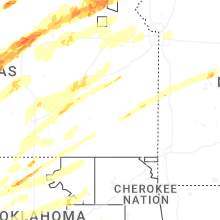


Connect with Interactive Hail Maps