

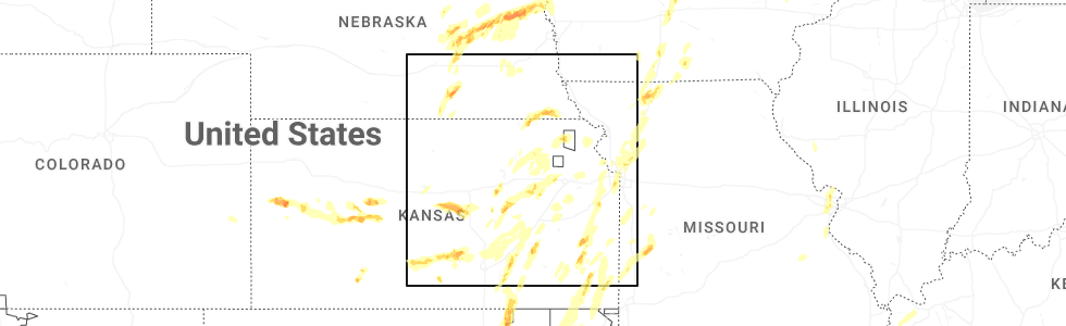
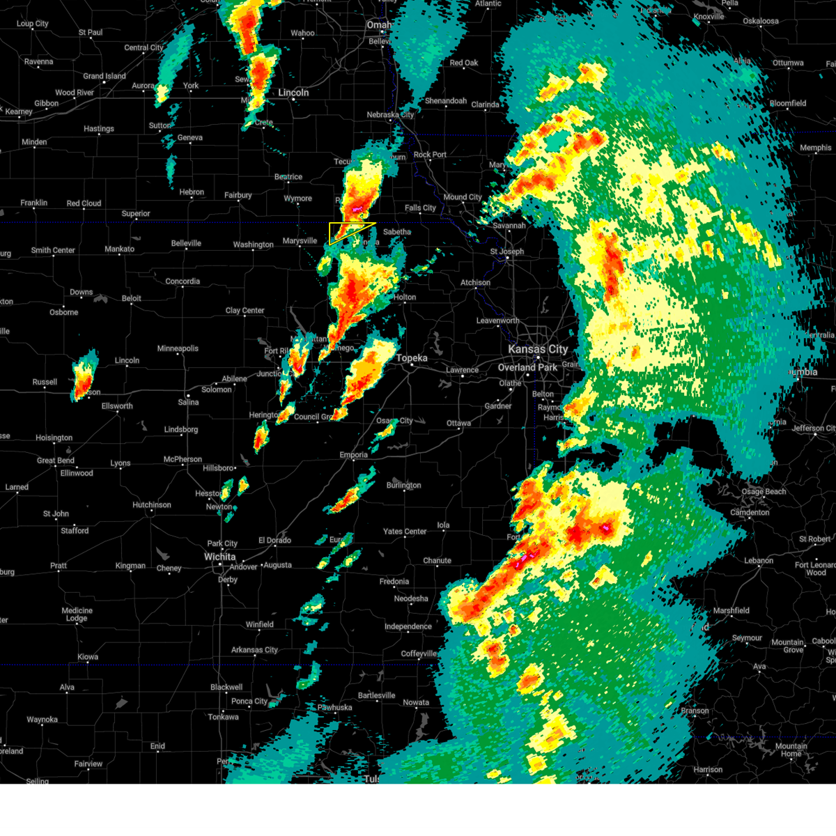
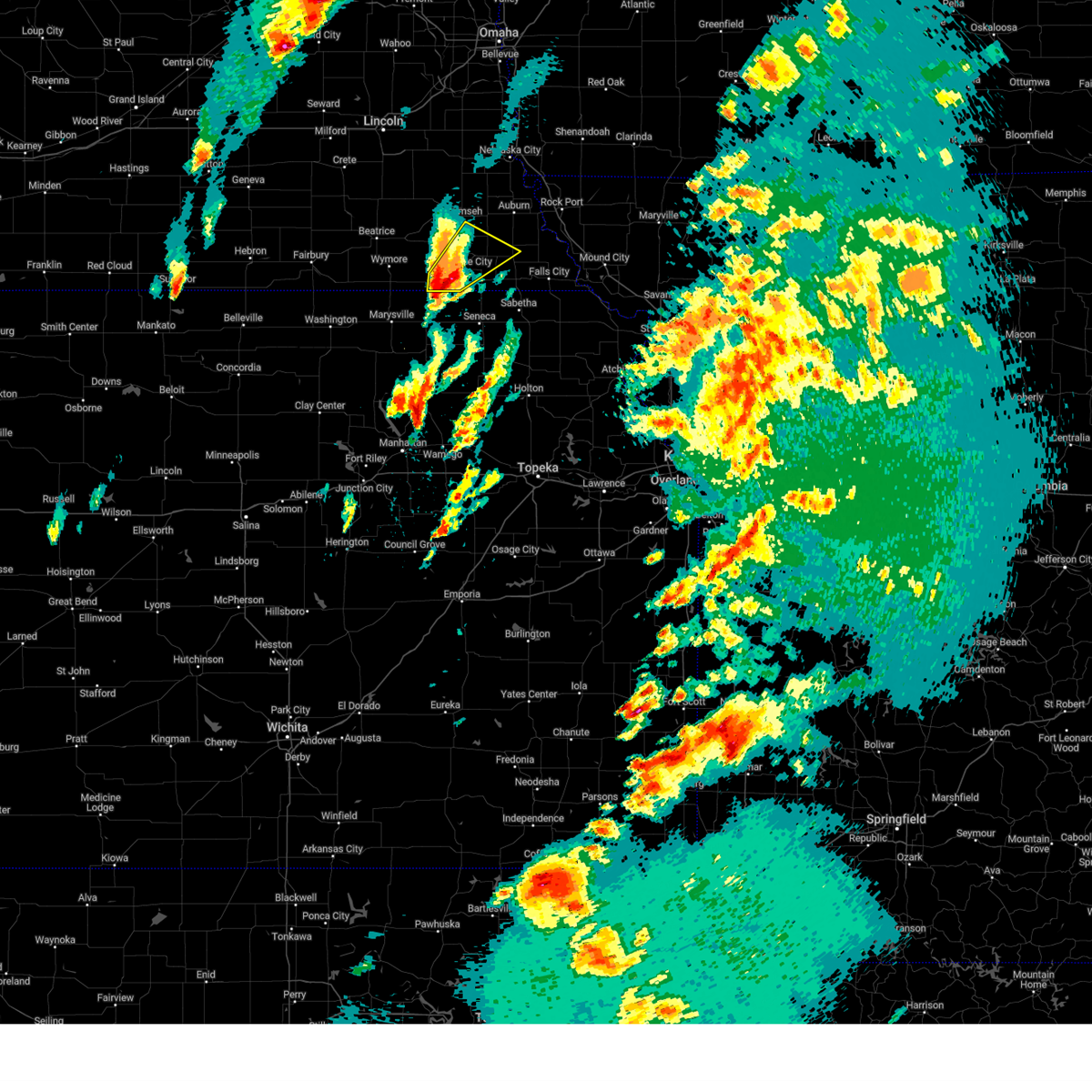
Hail Map for Summerfield, NE
The Summerfield, NE area has had 5 reports of on-the-ground hail by trained spotters, and has been under severe weather warnings 26 times during the past 12 months. Doppler radar has detected hail at or near Summerfield, NE on 82 occasions, including 4 occasions during the past year.
| Name: | Summerfield, NE |
| Where Located: | 57.6 miles NNE of Manhattan, KS |
| Map: | Google Map for Summerfield, NE |
| Population: | 156 |
| Housing Units: | 107 |
| More Info: | Search Google for Summerfield, NE |
2
The Top Recent Hail Date for Summerfield, NE is Monday, May 19, 2025 (9th out of 82)
Hail and Wind Damage Spotted near Summerfield, NE
| Date / Time | Report Details |
|---|---|
| 5/19/2025 5:37 PM CDT |
 The storm which prompted the warning has weakened below severe limits, and no longer poses an immediate threat to life or property. therefore, the warning will be allowed to expire. a tornado watch remains in effect until 900 pm cdt for northeastern kansas. The storm which prompted the warning has weakened below severe limits, and no longer poses an immediate threat to life or property. therefore, the warning will be allowed to expire. a tornado watch remains in effect until 900 pm cdt for northeastern kansas.
|
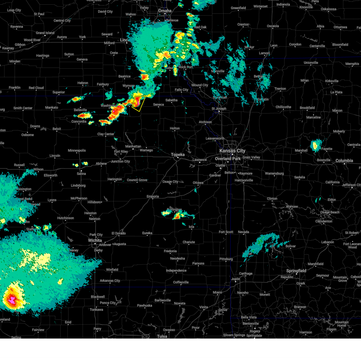
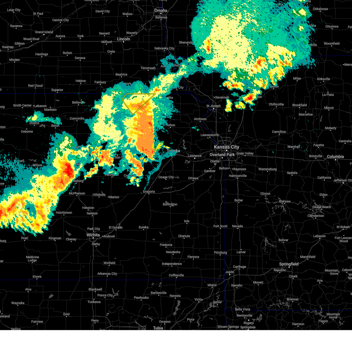
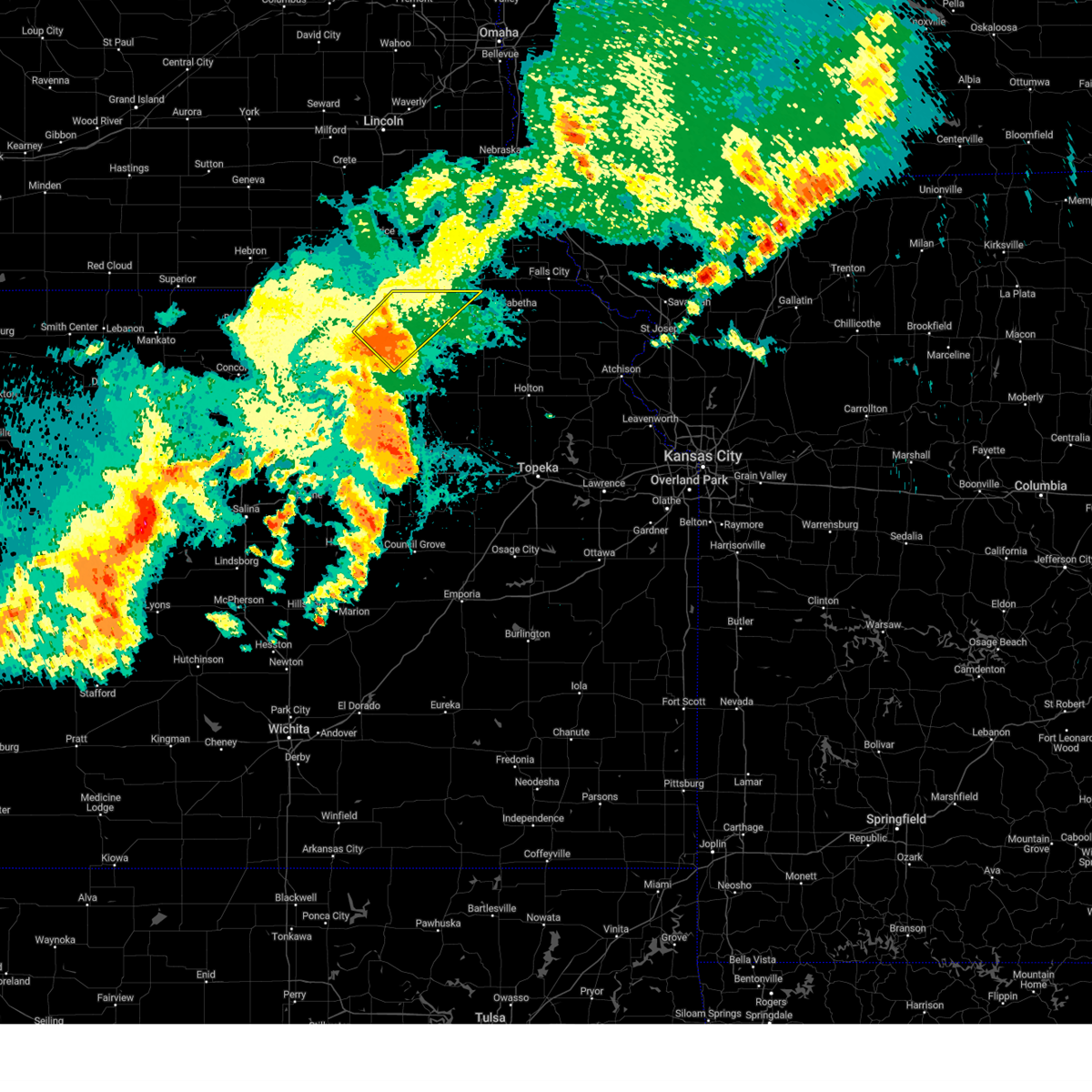
| 5/19/2025 5:19 PM CDT | At 518 pm cdt, a severe thunderstorm was located near table rock, or 3 miles north of pawnee city, moving northeast at 30 mph (public reported hail up to ping pong ball sized near summerfield). Hazards include ping pong ball size hail and 60 mph wind gusts. People and animals outdoors will be injured. expect hail damage to roofs, siding, windows, and vehicles. expect wind damage to roofs, siding, and trees. Locations impacted include, table rock. |
| 5/19/2025 5:19 PM CDT | the severe thunderstorm warning has been cancelled and is no longer in effect |
| 5/19/2025 5:15 PM CDT | Svrtop the national weather service in topeka has issued a * severe thunderstorm warning for, northwestern nemaha county in northeastern kansas, northeastern marshall county in northeastern kansas, * until 545 pm cdt. * at 514 pm cdt, a severe thunderstorm was located 7 miles north of axtell, moving northeast at 20 mph (radar indicated). Hazards include 60 mph wind gusts and half dollar size hail. Hail damage to vehicles is expected. Expect wind damage to roofs, siding, and trees. |
| 5/19/2025 5:04 PM CDT |
 At 503 pm cdt, a severe thunderstorm was located 5 miles southwest of pawnee city, moving northeast at 30 mph (public reported hail up to ping pong ball sized near summerfield). Hazards include ping pong ball size hail and 60 mph wind gusts. People and animals outdoors will be injured. expect hail damage to roofs, siding, windows, and vehicles. expect wind damage to roofs, siding, and trees. this severe storm will be near, pawnee city around 510 pm cdt. Table rock around 515 pm cdt. At 503 pm cdt, a severe thunderstorm was located 5 miles southwest of pawnee city, moving northeast at 30 mph (public reported hail up to ping pong ball sized near summerfield). Hazards include ping pong ball size hail and 60 mph wind gusts. People and animals outdoors will be injured. expect hail damage to roofs, siding, windows, and vehicles. expect wind damage to roofs, siding, and trees. this severe storm will be near, pawnee city around 510 pm cdt. Table rock around 515 pm cdt.
|
| 5/19/2025 5:01 PM CDT |
 At 501 pm cdt, a severe thunderstorm was located over summerfield, moving northeast at 20 mph (public). Hazards include 60 mph wind gusts and half dollar size hail. Hail damage to vehicles is expected. expect wind damage to roofs, siding, and trees. Locations impacted include, summerfield. At 501 pm cdt, a severe thunderstorm was located over summerfield, moving northeast at 20 mph (public). Hazards include 60 mph wind gusts and half dollar size hail. Hail damage to vehicles is expected. expect wind damage to roofs, siding, and trees. Locations impacted include, summerfield.
|
| 5/19/2025 4:56 PM CDT |
 Svroax the national weather service in omaha has issued a * severe thunderstorm warning for, southeastern johnson county in southeastern nebraska, southwestern nemaha county in southeastern nebraska, northwestern richardson county in southeastern nebraska, pawnee county in southeastern nebraska, * until 545 pm cdt. * at 456 pm cdt, a severe thunderstorm was located 3 miles northeast of summerfield, or 9 miles southwest of pawnee city, moving northeast at 30 mph (public reported hail up to ping pong ball sized near summerfield). Hazards include golf ball size hail and 60 mph wind gusts. People and animals outdoors will be injured. expect hail damage to roofs, siding, windows, and vehicles. expect wind damage to roofs, siding, and trees. this severe thunderstorm will be near, pawnee city around 505 pm cdt. Table rock around 515 pm cdt. Svroax the national weather service in omaha has issued a * severe thunderstorm warning for, southeastern johnson county in southeastern nebraska, southwestern nemaha county in southeastern nebraska, northwestern richardson county in southeastern nebraska, pawnee county in southeastern nebraska, * until 545 pm cdt. * at 456 pm cdt, a severe thunderstorm was located 3 miles northeast of summerfield, or 9 miles southwest of pawnee city, moving northeast at 30 mph (public reported hail up to ping pong ball sized near summerfield). Hazards include golf ball size hail and 60 mph wind gusts. People and animals outdoors will be injured. expect hail damage to roofs, siding, windows, and vehicles. expect wind damage to roofs, siding, and trees. this severe thunderstorm will be near, pawnee city around 505 pm cdt. Table rock around 515 pm cdt.
|
| 5/19/2025 4:53 PM CDT | Svrtop the national weather service in topeka has issued a * severe thunderstorm warning for, northeastern marshall county in northeastern kansas, * until 515 pm cdt. * at 453 pm cdt, a severe thunderstorm was located over summerfield, moving northeast at 20 mph (public. at 453 pm, ping pong sized hail was reported in summerfield). Hazards include golf ball size hail and 60 mph wind gusts. People and animals outdoors will be injured. expect hail damage to roofs, siding, windows, and vehicles. Expect wind damage to roofs, siding, and trees. |
| 5/19/2025 4:51 PM CDT | Ping Pong Ball sized hail reported 0.2 miles SSE of Summerfield, NE |
| 5/19/2025 4:45 PM CDT | The storm which prompted the warning has moved out of the area. therefore, the warning will be allowed to expire. a tornado watch remains in effect until 900 pm cdt for northeastern kansas. remember, a severe thunderstorm warning still remains in effect for northwest marshall county. |
| 5/19/2025 4:43 PM CDT | At 443 pm cdt, a severe thunderstorm was located over burchard, or 9 miles west of pawnee city, moving northeast at 35 mph (radar indicated). Hazards include golf ball size hail and 60 mph wind gusts. People and animals outdoors will be injured. expect hail damage to roofs, siding, windows, and vehicles. expect wind damage to roofs, siding, and trees. Locations impacted include, elk creek. |
| 5/19/2025 4:41 PM CDT | Svrtop the national weather service in topeka has issued a * severe thunderstorm warning for, northeastern marshall county in northeastern kansas, * until 500 pm cdt. * at 441 pm cdt, a severe thunderstorm was located 4 miles southwest of summerfield, moving northeast at 30 mph (radar indicated). Hazards include golf ball size hail and 60 mph wind gusts. People and animals outdoors will be injured. expect hail damage to roofs, siding, windows, and vehicles. Expect wind damage to roofs, siding, and trees. |
| 5/19/2025 4:31 PM CDT | At 431 pm cdt, a severe thunderstorm was located 4 miles east of liberty, or 13 miles west of pawnee city, moving northeast at 35 mph (radar indicated). Hazards include ping pong ball size hail and 60 mph wind gusts. People and animals outdoors will be injured. expect hail damage to roofs, siding, windows, and vehicles. expect wind damage to roofs, siding, and trees. this severe storm will be near, burchard around 435 pm cdt. Other locations in the path of this severe thunderstorm include elk creek. |
| 5/19/2025 4:29 PM CDT | At 429 pm cdt, a severe thunderstorm was located 5 miles east of oketo, moving northeast at 30 mph (radar indicated). Hazards include ping pong ball size hail and 60 mph wind gusts. People and animals outdoors will be injured. expect hail damage to roofs, siding, windows, and vehicles. expect wind damage to roofs, siding, and trees. Locations impacted include, marysville, beattie, summerfield, and oketo. |
| 5/19/2025 4:22 PM CDT | Svroax the national weather service in omaha has issued a * severe thunderstorm warning for, southern johnson county in southeastern nebraska, southwestern nemaha county in southeastern nebraska, northwestern richardson county in southeastern nebraska, pawnee county in southeastern nebraska, southeastern gage county in southeastern nebraska, * until 500 pm cdt. * at 422 pm cdt, a severe thunderstorm was located 5 miles west of summerfield, or 13 miles northeast of marysville, moving northeast at 35 mph (radar indicated). Hazards include 60 mph wind gusts and half dollar size hail. Hail damage to vehicles is expected. expect wind damage to roofs, siding, and trees. This severe thunderstorm will be near, burchard around 435 pm cdt. |
| 5/19/2025 4:18 PM CDT | At 418 pm cdt, a severe thunderstorm was located 4 miles northeast of marysville, moving northeast at 30 mph (radar indicated). Hazards include 60 mph wind gusts and half dollar size hail. Hail damage to vehicles is expected. expect wind damage to roofs, siding, and trees. Locations impacted include, marysville, beattie, summerfield, and oketo. |
| 5/19/2025 4:10 PM CDT | Svrtop the national weather service in topeka has issued a * severe thunderstorm warning for, northern marshall county in northeastern kansas, * until 445 pm cdt. * at 410 pm cdt, a severe thunderstorm was located near marysville, moving northeast at 30 mph (radar indicated). Hazards include 60 mph wind gusts and half dollar size hail. Hail damage to vehicles is expected. Expect wind damage to roofs, siding, and trees. |
| 4/24/2025 7:56 PM CDT |
 At 756 pm cdt, a severe thunderstorm was located 4 miles west of beattie, moving southeast at 20 mph (radar indicated). Hazards include 60 mph wind gusts and quarter size hail. Hail damage to vehicles is expected. expect wind damage to roofs, siding, and trees. Locations impacted include, beattie and summerfield. At 756 pm cdt, a severe thunderstorm was located 4 miles west of beattie, moving southeast at 20 mph (radar indicated). Hazards include 60 mph wind gusts and quarter size hail. Hail damage to vehicles is expected. expect wind damage to roofs, siding, and trees. Locations impacted include, beattie and summerfield.
|
| 4/24/2025 7:36 PM CDT |
 Svrtop the national weather service in topeka has issued a * severe thunderstorm warning for, northwestern marshall county in northeastern kansas, * until 815 pm cdt. * at 736 pm cdt, a severe thunderstorm was located near oketo, moving southeast at 20 mph (radar indicated). Hazards include 60 mph wind gusts and quarter size hail. Hail damage to vehicles is expected. Expect wind damage to roofs, siding, and trees. Svrtop the national weather service in topeka has issued a * severe thunderstorm warning for, northwestern marshall county in northeastern kansas, * until 815 pm cdt. * at 736 pm cdt, a severe thunderstorm was located near oketo, moving southeast at 20 mph (radar indicated). Hazards include 60 mph wind gusts and quarter size hail. Hail damage to vehicles is expected. Expect wind damage to roofs, siding, and trees.
|
| 3/14/2025 4:19 PM CDT |
 the severe thunderstorm warning has been cancelled and is no longer in effect the severe thunderstorm warning has been cancelled and is no longer in effect
|
| 3/14/2025 4:11 PM CDT |
 At 410 pm cdt, severe thunderstorms were located along a line extending from 5 miles southeast of alexandria to 3 miles northeast of burchard, moving east at 30 mph (public. at 4:05 pm, a 66 mph wind gust was reported 2 miles east of pymouth). Hazards include 70 mph wind gusts and nickel size hail. Expect considerable tree damage. damage is likely to mobile homes, roofs, and outbuildings. Locations impacted include, crab orchard, swanton, endicott, wymore, alexandria state recreation area, homestead national historical park, harbine, liberty, daykin, ellis, holmesville, diller, crystal springs campground, buckley creek recreational area, jansen, lewiston, odell, gladstone, vesta, and barneston. At 410 pm cdt, severe thunderstorms were located along a line extending from 5 miles southeast of alexandria to 3 miles northeast of burchard, moving east at 30 mph (public. at 4:05 pm, a 66 mph wind gust was reported 2 miles east of pymouth). Hazards include 70 mph wind gusts and nickel size hail. Expect considerable tree damage. damage is likely to mobile homes, roofs, and outbuildings. Locations impacted include, crab orchard, swanton, endicott, wymore, alexandria state recreation area, homestead national historical park, harbine, liberty, daykin, ellis, holmesville, diller, crystal springs campground, buckley creek recreational area, jansen, lewiston, odell, gladstone, vesta, and barneston.
|
| 3/14/2025 3:55 PM CDT |
 Svroax the national weather service in omaha has issued a * severe thunderstorm warning for, southwestern johnson county in southeastern nebraska, jefferson county in southeastern nebraska, southern saline county in southeastern nebraska, western pawnee county in southeastern nebraska, gage county in southeastern nebraska, * until 445 pm cdt. * at 355 pm cdt, severe thunderstorms were located along a line extending from near reynolds to 4 miles north of summerfield, moving north at 40 mph (radar indicated). Hazards include 70 mph wind gusts and nickel size hail. Expect considerable tree damage. Damage is likely to mobile homes, roofs, and outbuildings. Svroax the national weather service in omaha has issued a * severe thunderstorm warning for, southwestern johnson county in southeastern nebraska, jefferson county in southeastern nebraska, southern saline county in southeastern nebraska, western pawnee county in southeastern nebraska, gage county in southeastern nebraska, * until 445 pm cdt. * at 355 pm cdt, severe thunderstorms were located along a line extending from near reynolds to 4 miles north of summerfield, moving north at 40 mph (radar indicated). Hazards include 70 mph wind gusts and nickel size hail. Expect considerable tree damage. Damage is likely to mobile homes, roofs, and outbuildings.
|
| 7/31/2024 9:11 PM CDT |
 The storm which prompted the warning has weakened below severe limits, and no longer poses an immediate threat to life or property. therefore, the warning will be allowed to expire. however, gusty winds are still possible with this thunderstorm. a severe thunderstorm watch remains in effect until 1000 pm cdt for northeastern kansas. a severe thunderstorm watch also remains in effect until 100 am cdt for northeastern kansas. The storm which prompted the warning has weakened below severe limits, and no longer poses an immediate threat to life or property. therefore, the warning will be allowed to expire. however, gusty winds are still possible with this thunderstorm. a severe thunderstorm watch remains in effect until 1000 pm cdt for northeastern kansas. a severe thunderstorm watch also remains in effect until 100 am cdt for northeastern kansas.
|
| 7/31/2024 8:56 PM CDT | At 856 pm cdt, a severe thunderstorm was located over beattie, moving northeast at 35 mph (radar indicated). Hazards include 60 mph wind gusts and penny size hail. Expect damage to roofs, siding, and trees. Locations impacted include, marysville, axtell, beattie, summerfield, and oketo. |
| 7/31/2024 8:56 PM CDT | the severe thunderstorm warning has been cancelled and is no longer in effect |
| 7/31/2024 8:42 PM CDT |
 At 841 pm cdt, a severe thunderstorm was located near marysville, moving northeast at 35 mph (public. public has reported strong wind gusts and some tree damage near blue rapids). Hazards include 60 mph wind gusts and penny size hail. Expect damage to roofs, siding, and trees. Locations impacted include, marysville, blue rapids, waterville, axtell, beattie, summerfield, and oketo. At 841 pm cdt, a severe thunderstorm was located near marysville, moving northeast at 35 mph (public. public has reported strong wind gusts and some tree damage near blue rapids). Hazards include 60 mph wind gusts and penny size hail. Expect damage to roofs, siding, and trees. Locations impacted include, marysville, blue rapids, waterville, axtell, beattie, summerfield, and oketo.
|
| 7/31/2024 8:37 PM CDT |
 Svrtop the national weather service in topeka has issued a * severe thunderstorm warning for, northwestern nemaha county in northeastern kansas, east central washington county in north central kansas, marshall county in northeastern kansas, * until 915 pm cdt. * at 837 pm cdt, a severe thunderstorm was located 5 miles north of waterville, moving northeast at 55 mph (radar indicated). Hazards include 60 mph wind gusts and penny size hail. expect damage to roofs, siding, and trees Svrtop the national weather service in topeka has issued a * severe thunderstorm warning for, northwestern nemaha county in northeastern kansas, east central washington county in north central kansas, marshall county in northeastern kansas, * until 915 pm cdt. * at 837 pm cdt, a severe thunderstorm was located 5 miles north of waterville, moving northeast at 55 mph (radar indicated). Hazards include 60 mph wind gusts and penny size hail. expect damage to roofs, siding, and trees
|
| 7/6/2024 7:50 PM CDT |
 The storm which prompted the warning has weakened below severe limits, and no longer poses an immediate threat to life or property. therefore, the warning will be allowed to expire. however, gusty winds and heavy rain are still possible with this thunderstorm. a severe thunderstorm watch remains in effect until midnight cdt for southeastern nebraska. The storm which prompted the warning has weakened below severe limits, and no longer poses an immediate threat to life or property. therefore, the warning will be allowed to expire. however, gusty winds and heavy rain are still possible with this thunderstorm. a severe thunderstorm watch remains in effect until midnight cdt for southeastern nebraska.
|
| 7/6/2024 7:25 PM CDT |
 Svroax the national weather service in omaha has issued a * severe thunderstorm warning for, pawnee county in southeastern nebraska, southeastern gage county in southeastern nebraska, * until 800 pm cdt. * at 725 pm cdt, a severe thunderstorm was located over liberty, or 17 miles southeast of beatrice, moving east at 40 mph (radar indicated). Hazards include 60 mph wind gusts. expect damage to roofs, siding, and trees Svroax the national weather service in omaha has issued a * severe thunderstorm warning for, pawnee county in southeastern nebraska, southeastern gage county in southeastern nebraska, * until 800 pm cdt. * at 725 pm cdt, a severe thunderstorm was located over liberty, or 17 miles southeast of beatrice, moving east at 40 mph (radar indicated). Hazards include 60 mph wind gusts. expect damage to roofs, siding, and trees
|
| 6/26/2024 2:45 AM CDT |
 The storms which prompted the warning have moved out of the area. therefore, the warning has been allowed to expire. a severe thunderstorm watch remains in effect until 700 am cdt for southeastern nebraska. The storms which prompted the warning have moved out of the area. therefore, the warning has been allowed to expire. a severe thunderstorm watch remains in effect until 700 am cdt for southeastern nebraska.
|
| 6/26/2024 2:29 AM CDT |
 Svroax the national weather service in omaha has issued a * severe thunderstorm warning for, southwestern richardson county in southeastern nebraska, southern pawnee county in southeastern nebraska, * until 245 am cdt. * at 228 am cdt, severe thunderstorms were located along a line extending from 3 miles south of salem to 3 miles east of summerfield, moving south at 40 mph (radar indicated). Hazards include 60 mph wind gusts. expect damage to roofs, siding, and trees Svroax the national weather service in omaha has issued a * severe thunderstorm warning for, southwestern richardson county in southeastern nebraska, southern pawnee county in southeastern nebraska, * until 245 am cdt. * at 228 am cdt, severe thunderstorms were located along a line extending from 3 miles south of salem to 3 miles east of summerfield, moving south at 40 mph (radar indicated). Hazards include 60 mph wind gusts. expect damage to roofs, siding, and trees
|
| 6/26/2024 2:19 AM CDT |
 At 218 am cdt, severe thunderstorms were located along a line extending from 6 miles northeast of bern to 7 miles northeast of glasco, moving southeast at 40 mph (radar indicated). Hazards include 60 mph wind gusts and nickel size hail. Expect damage to roofs, siding, and trees. Locations impacted include, concordia, marysville, washington, blue rapids, frankfort, clyde, hanover, waterville, clifton, linn, axtell, greenleaf, jamestown, beattie, barnes, summerfield, cuba, morrowville, norway, and vermillion. At 218 am cdt, severe thunderstorms were located along a line extending from 6 miles northeast of bern to 7 miles northeast of glasco, moving southeast at 40 mph (radar indicated). Hazards include 60 mph wind gusts and nickel size hail. Expect damage to roofs, siding, and trees. Locations impacted include, concordia, marysville, washington, blue rapids, frankfort, clyde, hanover, waterville, clifton, linn, axtell, greenleaf, jamestown, beattie, barnes, summerfield, cuba, morrowville, norway, and vermillion.
|
| 6/26/2024 2:17 AM CDT |
 At 216 am cdt, severe thunderstorms were located along a line extending from 3 miles northeast of dawson to 3 miles south of burchard, moving south at 40 mph (radar indicated). Hazards include 60 mph wind gusts. Expect damage to roofs, siding, and trees. Locations impacted include, falls city, pawnee city, humboldt, table rock, rulo, verdon, summerfield, stella, shubert, du bois, dawson, salem, burchard, steinauer, preston, barada, sac and fox nation reservation, indian cave state park, the highway 75 and 8 junction, and kirkmans cove recreation area. At 216 am cdt, severe thunderstorms were located along a line extending from 3 miles northeast of dawson to 3 miles south of burchard, moving south at 40 mph (radar indicated). Hazards include 60 mph wind gusts. Expect damage to roofs, siding, and trees. Locations impacted include, falls city, pawnee city, humboldt, table rock, rulo, verdon, summerfield, stella, shubert, du bois, dawson, salem, burchard, steinauer, preston, barada, sac and fox nation reservation, indian cave state park, the highway 75 and 8 junction, and kirkmans cove recreation area.
|
| 6/26/2024 2:17 AM CDT |
 the severe thunderstorm warning has been cancelled and is no longer in effect the severe thunderstorm warning has been cancelled and is no longer in effect
|
| 6/26/2024 2:15 AM CDT |
 Svrtop the national weather service in topeka has issued a * severe thunderstorm warning for, northwestern riley county in northeastern kansas, northwestern ottawa county in north central kansas, northern pottawatomie county in northeastern kansas, nemaha county in northeastern kansas, western brown county in northeastern kansas, southern washington county in north central kansas, northern clay county in north central kansas, cloud county in north central kansas, marshall county in northeastern kansas, * until 300 am cdt. * at 214 am cdt, severe thunderstorms were located along a line extending from near pawnee city to 4 miles north of waterville to 5 miles southwest of concordia, moving southeast at 40 mph (radar indicated). Hazards include 60 mph wind gusts and nickel size hail. expect damage to roofs, siding, and trees Svrtop the national weather service in topeka has issued a * severe thunderstorm warning for, northwestern riley county in northeastern kansas, northwestern ottawa county in north central kansas, northern pottawatomie county in northeastern kansas, nemaha county in northeastern kansas, western brown county in northeastern kansas, southern washington county in north central kansas, northern clay county in north central kansas, cloud county in north central kansas, marshall county in northeastern kansas, * until 300 am cdt. * at 214 am cdt, severe thunderstorms were located along a line extending from near pawnee city to 4 miles north of waterville to 5 miles southwest of concordia, moving southeast at 40 mph (radar indicated). Hazards include 60 mph wind gusts and nickel size hail. expect damage to roofs, siding, and trees
|
| 6/26/2024 2:07 AM CDT |
 At 207 am cdt, severe thunderstorms were located along a line extending from 3 miles northwest of stella to 2 miles north of burchard, moving south at 40 mph (radar indicated). Hazards include 70 mph wind gusts. Expect considerable tree damage. damage is likely to mobile homes, roofs, and outbuildings. Locations impacted include, falls city, auburn, tecumseh, pawnee city, humboldt, peru, johnson, table rock, rulo, verdon, summerfield, stella, shubert, nemaha, du bois, dawson, brownville, salem, elk creek, and burchard. At 207 am cdt, severe thunderstorms were located along a line extending from 3 miles northwest of stella to 2 miles north of burchard, moving south at 40 mph (radar indicated). Hazards include 70 mph wind gusts. Expect considerable tree damage. damage is likely to mobile homes, roofs, and outbuildings. Locations impacted include, falls city, auburn, tecumseh, pawnee city, humboldt, peru, johnson, table rock, rulo, verdon, summerfield, stella, shubert, nemaha, du bois, dawson, brownville, salem, elk creek, and burchard.
|
| 6/26/2024 1:58 AM CDT |
 At 158 am cdt, severe thunderstorms were located along a line extending from 4 miles south of auburn to near lewiston, moving south at 40 mph (radar indicated). Hazards include 70 mph wind gusts. Expect considerable tree damage. damage is likely to mobile homes, roofs, and outbuildings. Locations impacted include, falls city, auburn, tecumseh, pawnee city, humboldt, peru, sterling, johnson, cook, table rock, rulo, verdon, summerfield, stella, shubert, nemaha, du bois, dawson, brownville, and salem. At 158 am cdt, severe thunderstorms were located along a line extending from 4 miles south of auburn to near lewiston, moving south at 40 mph (radar indicated). Hazards include 70 mph wind gusts. Expect considerable tree damage. damage is likely to mobile homes, roofs, and outbuildings. Locations impacted include, falls city, auburn, tecumseh, pawnee city, humboldt, peru, sterling, johnson, cook, table rock, rulo, verdon, summerfield, stella, shubert, nemaha, du bois, dawson, brownville, and salem.
|
| 6/26/2024 1:58 AM CDT |
 the severe thunderstorm warning has been cancelled and is no longer in effect the severe thunderstorm warning has been cancelled and is no longer in effect
|
| 6/26/2024 1:48 AM CDT |
 Svrtop the national weather service in topeka has issued a * severe thunderstorm warning for, republic county in north central kansas, washington county in north central kansas, northern cloud county in north central kansas, marshall county in northeastern kansas, * until 230 am cdt. * at 148 am cdt, severe thunderstorms were located along a line extending from near johnson to near courtland, moving southeast at 35 mph (radar indicated). Hazards include 60 mph wind gusts and nickel size hail. expect damage to roofs, siding, and trees Svrtop the national weather service in topeka has issued a * severe thunderstorm warning for, republic county in north central kansas, washington county in north central kansas, northern cloud county in north central kansas, marshall county in northeastern kansas, * until 230 am cdt. * at 148 am cdt, severe thunderstorms were located along a line extending from near johnson to near courtland, moving southeast at 35 mph (radar indicated). Hazards include 60 mph wind gusts and nickel size hail. expect damage to roofs, siding, and trees
|
| 6/26/2024 1:31 AM CDT |
 Svroax the national weather service in omaha has issued a * severe thunderstorm warning for, johnson county in southeastern nebraska, nemaha county in southeastern nebraska, southern otoe county in southeastern nebraska, richardson county in southeastern nebraska, pawnee county in southeastern nebraska, * until 230 am cdt. * at 131 am cdt, severe thunderstorms were located along a line extending from 3 miles northeast of talmage to near adams, moving south at 40 mph (radar indicated). Hazards include 60 mph wind gusts. expect damage to roofs, siding, and trees Svroax the national weather service in omaha has issued a * severe thunderstorm warning for, johnson county in southeastern nebraska, nemaha county in southeastern nebraska, southern otoe county in southeastern nebraska, richardson county in southeastern nebraska, pawnee county in southeastern nebraska, * until 230 am cdt. * at 131 am cdt, severe thunderstorms were located along a line extending from 3 miles northeast of talmage to near adams, moving south at 40 mph (radar indicated). Hazards include 60 mph wind gusts. expect damage to roofs, siding, and trees
|
| 6/15/2024 6:58 PM CDT |
 At 658 pm cdt, severe thunderstorms were located along a line extending from pawnee city to near bern to 3 miles northwest of soldier, moving northeast at 45 mph (radar indicated). Hazards include 60 mph wind gusts and nickel size hail. Expect damage to roofs, siding, and trees. Locations impacted include, seneca, onaga, centralia, axtell, beattie, bern, corning, summerfield, soldier, havensville, goff, vermillion, oneida, and baileyville. At 658 pm cdt, severe thunderstorms were located along a line extending from pawnee city to near bern to 3 miles northwest of soldier, moving northeast at 45 mph (radar indicated). Hazards include 60 mph wind gusts and nickel size hail. Expect damage to roofs, siding, and trees. Locations impacted include, seneca, onaga, centralia, axtell, beattie, bern, corning, summerfield, soldier, havensville, goff, vermillion, oneida, and baileyville.
|
| 6/15/2024 6:42 PM CDT |
 At 639 pm cdt, severe thunderstorms were located along a line extending from 4 miles southwest of burchard to 3 miles south of baileyville to 5 miles south of onaga, moving northeast at 45 mph (trained weather spotters. spotters reported 60 mph winds 3 miles northwest of vermillion at 630 pm). Hazards include 60 mph wind gusts and nickel size hail. Expect damage to roofs, siding, and trees. Locations impacted include, seneca, frankfort, onaga, centralia, axtell, beattie, bern, corning, summerfield, soldier, havensville, goff, vermillion, wheaton, oneida, baileyville, and lillis. At 639 pm cdt, severe thunderstorms were located along a line extending from 4 miles southwest of burchard to 3 miles south of baileyville to 5 miles south of onaga, moving northeast at 45 mph (trained weather spotters. spotters reported 60 mph winds 3 miles northwest of vermillion at 630 pm). Hazards include 60 mph wind gusts and nickel size hail. Expect damage to roofs, siding, and trees. Locations impacted include, seneca, frankfort, onaga, centralia, axtell, beattie, bern, corning, summerfield, soldier, havensville, goff, vermillion, wheaton, oneida, baileyville, and lillis.
|
| 6/15/2024 6:24 PM CDT |
 Svrtop the national weather service in topeka has issued a * severe thunderstorm warning for, eastern pottawatomie county in northeastern kansas, nemaha county in northeastern kansas, northwestern jackson county in northeastern kansas, marshall county in northeastern kansas, * until 715 pm cdt. * at 623 pm cdt, severe thunderstorms were located along a line extending from 3 miles east of oketo to 4 miles northwest of lillis to 3 miles northwest of louisville, moving northeast at 45 mph (radar indicated). Hazards include 60 mph wind gusts and nickel size hail. expect damage to roofs, siding, and trees Svrtop the national weather service in topeka has issued a * severe thunderstorm warning for, eastern pottawatomie county in northeastern kansas, nemaha county in northeastern kansas, northwestern jackson county in northeastern kansas, marshall county in northeastern kansas, * until 715 pm cdt. * at 623 pm cdt, severe thunderstorms were located along a line extending from 3 miles east of oketo to 4 miles northwest of lillis to 3 miles northwest of louisville, moving northeast at 45 mph (radar indicated). Hazards include 60 mph wind gusts and nickel size hail. expect damage to roofs, siding, and trees
|
| 5/25/2024 10:08 PM CDT |
 At 1008 pm cdt, a severe thunderstorm was located near axtell, moving east at 30 mph (radar indicated). Hazards include 60 mph wind gusts and quarter size hail. Hail damage to vehicles is expected. expect wind damage to roofs, siding, and trees. Locations impacted include, seneca, centralia, axtell, beattie, summerfield, and baileyville. At 1008 pm cdt, a severe thunderstorm was located near axtell, moving east at 30 mph (radar indicated). Hazards include 60 mph wind gusts and quarter size hail. Hail damage to vehicles is expected. expect wind damage to roofs, siding, and trees. Locations impacted include, seneca, centralia, axtell, beattie, summerfield, and baileyville.
|
| 5/25/2024 10:08 PM CDT |
 Svroax the national weather service in omaha has issued a * severe thunderstorm warning for, southwestern richardson county in southeastern nebraska, southern pawnee county in southeastern nebraska, * until 1100 pm cdt. * at 1008 pm cdt, a severe thunderstorm was located 5 miles south of liberty, or 14 miles northeast of marysville, moving east at 20 mph (radar indicated). Hazards include 60 mph wind gusts. expect damage to roofs, siding, and trees Svroax the national weather service in omaha has issued a * severe thunderstorm warning for, southwestern richardson county in southeastern nebraska, southern pawnee county in southeastern nebraska, * until 1100 pm cdt. * at 1008 pm cdt, a severe thunderstorm was located 5 miles south of liberty, or 14 miles northeast of marysville, moving east at 20 mph (radar indicated). Hazards include 60 mph wind gusts. expect damage to roofs, siding, and trees
|
| 5/25/2024 9:52 PM CDT |
 Svrtop the national weather service in topeka has issued a * severe thunderstorm warning for, northwestern nemaha county in northeastern kansas, northeastern marshall county in northeastern kansas, * until 1030 pm cdt. * at 951 pm cdt, a severe thunderstorm was located near beattie, moving east at 40 mph (trained weather spotters). Hazards include 60 mph wind gusts and quarter size hail. Hail damage to vehicles is expected. Expect wind damage to roofs, siding, and trees. Svrtop the national weather service in topeka has issued a * severe thunderstorm warning for, northwestern nemaha county in northeastern kansas, northeastern marshall county in northeastern kansas, * until 1030 pm cdt. * at 951 pm cdt, a severe thunderstorm was located near beattie, moving east at 40 mph (trained weather spotters). Hazards include 60 mph wind gusts and quarter size hail. Hail damage to vehicles is expected. Expect wind damage to roofs, siding, and trees.
|
| 5/24/2024 2:58 AM CDT |
 the severe thunderstorm warning has been cancelled and is no longer in effect the severe thunderstorm warning has been cancelled and is no longer in effect
|
| 5/24/2024 2:58 AM CDT |
 At 258 am cdt, severe thunderstorms were located along a line extending from 4 miles northeast of dunbar to near johnson to 4 miles east of summerfield, moving east at 60 mph (radar indicated). Hazards include 70 mph wind gusts and quarter size hail. Hail damage to vehicles is expected. expect considerable tree damage. wind damage is also likely to mobile homes, roofs, and outbuildings. Locations impacted include, nebraska city, auburn, tecumseh, pawnee city, syracuse, hamburg, humboldt, peru, farragut, johnson, cook, unadilla, riverton, table rock, talmage, dunbar, verdon, summerfield, stella, and shubert. At 258 am cdt, severe thunderstorms were located along a line extending from 4 miles northeast of dunbar to near johnson to 4 miles east of summerfield, moving east at 60 mph (radar indicated). Hazards include 70 mph wind gusts and quarter size hail. Hail damage to vehicles is expected. expect considerable tree damage. wind damage is also likely to mobile homes, roofs, and outbuildings. Locations impacted include, nebraska city, auburn, tecumseh, pawnee city, syracuse, hamburg, humboldt, peru, farragut, johnson, cook, unadilla, riverton, table rock, talmage, dunbar, verdon, summerfield, stella, and shubert.
|
| 5/24/2024 2:49 AM CDT |
 At 249 am cdt, severe thunderstorms were located along a line extending from 4 miles northeast of syracuse to near tecumseh to 3 miles west of summerfield, moving east at 60 mph (radar indicated). Hazards include 70 mph wind gusts and quarter size hail. Hail damage to vehicles is expected. expect considerable tree damage. wind damage is also likely to mobile homes, roofs, and outbuildings. Locations impacted include, nebraska city, auburn, tecumseh, pawnee city, syracuse, wymore, hamburg, humboldt, peru, bennet, adams, palmyra, farragut, sterling, blue springs, johnson, cook, unadilla, riverton, and table rock. At 249 am cdt, severe thunderstorms were located along a line extending from 4 miles northeast of syracuse to near tecumseh to 3 miles west of summerfield, moving east at 60 mph (radar indicated). Hazards include 70 mph wind gusts and quarter size hail. Hail damage to vehicles is expected. expect considerable tree damage. wind damage is also likely to mobile homes, roofs, and outbuildings. Locations impacted include, nebraska city, auburn, tecumseh, pawnee city, syracuse, wymore, hamburg, humboldt, peru, bennet, adams, palmyra, farragut, sterling, blue springs, johnson, cook, unadilla, riverton, and table rock.
|
| 4/26/2024 3:29 PM CDT |
 Svrtop the national weather service in topeka has issued a * severe thunderstorm warning for, northwestern nemaha county in northeastern kansas, eastern marshall county in northeastern kansas, * until 415 pm cdt. * at 328 pm cdt, severe thunderstorms were located along a line extending from 4 miles southeast of summerfield to near frankfort to 6 miles west of lillis, moving northeast at 55 mph (radar indicated). Hazards include golf ball size hail and 60 mph wind gusts. People and animals outdoors will be injured. expect hail damage to roofs, siding, windows, and vehicles. Expect wind damage to roofs, siding, and trees. Svrtop the national weather service in topeka has issued a * severe thunderstorm warning for, northwestern nemaha county in northeastern kansas, eastern marshall county in northeastern kansas, * until 415 pm cdt. * at 328 pm cdt, severe thunderstorms were located along a line extending from 4 miles southeast of summerfield to near frankfort to 6 miles west of lillis, moving northeast at 55 mph (radar indicated). Hazards include golf ball size hail and 60 mph wind gusts. People and animals outdoors will be injured. expect hail damage to roofs, siding, windows, and vehicles. Expect wind damage to roofs, siding, and trees.
|
| 4/23/2024 12:41 AM CDT |
 The storm which prompted the warning has weakened below severe limits, and no longer poses an immediate threat to life or property. therefore, the warning will be allowed to expire. The storm which prompted the warning has weakened below severe limits, and no longer poses an immediate threat to life or property. therefore, the warning will be allowed to expire.
|
| 4/23/2024 12:29 AM CDT |
 At 1228 am cdt, a severe thunderstorm was located 3 miles northeast of holmesville, or 7 miles east of beatrice, moving east at 50 mph (radar indicated). Hazards include quarter size hail. Damage to vehicles is expected. Locations impacted include, beatrice, wymore, blue springs, summerfield, filley, burchard, liberty, lewiston, virginia, holmesville, steinauer, homestead national historical park, ellis, rockford state recreation area, and rockford. At 1228 am cdt, a severe thunderstorm was located 3 miles northeast of holmesville, or 7 miles east of beatrice, moving east at 50 mph (radar indicated). Hazards include quarter size hail. Damage to vehicles is expected. Locations impacted include, beatrice, wymore, blue springs, summerfield, filley, burchard, liberty, lewiston, virginia, holmesville, steinauer, homestead national historical park, ellis, rockford state recreation area, and rockford.
|
| 4/23/2024 12:09 AM CDT |
 At 1208 am cdt, a severe thunderstorm was located 4 miles east of holmesville, or 10 miles southeast of beatrice, moving east at 45 mph. another severe thunderstorm located east of plymouth is currently moving east into the warning area (radar indicated). Hazards include quarter size hail. Damage to vehicles is expected. Locations impacted include, beatrice, wymore, blue springs, summerfield, filley, burchard, liberty, lewiston, virginia, holmesville, steinauer, homestead national historical park, ellis, rockford state recreation area, and rockford. At 1208 am cdt, a severe thunderstorm was located 4 miles east of holmesville, or 10 miles southeast of beatrice, moving east at 45 mph. another severe thunderstorm located east of plymouth is currently moving east into the warning area (radar indicated). Hazards include quarter size hail. Damage to vehicles is expected. Locations impacted include, beatrice, wymore, blue springs, summerfield, filley, burchard, liberty, lewiston, virginia, holmesville, steinauer, homestead national historical park, ellis, rockford state recreation area, and rockford.
|
| 4/22/2024 11:54 PM CDT |
 Svroax the national weather service in omaha has issued a * severe thunderstorm warning for, western pawnee county in southeastern nebraska, central gage county in southeastern nebraska, * until 1245 am cdt. * at 1154 pm cdt, a severe thunderstorm was located near beatrice, moving east at 45 mph (radar indicated). Hazards include quarter size hail. damage to vehicles is expected Svroax the national weather service in omaha has issued a * severe thunderstorm warning for, western pawnee county in southeastern nebraska, central gage county in southeastern nebraska, * until 1245 am cdt. * at 1154 pm cdt, a severe thunderstorm was located near beatrice, moving east at 45 mph (radar indicated). Hazards include quarter size hail. damage to vehicles is expected
|
| 3/13/2024 9:06 PM CDT |
 The storms which prompted the warning have weakened below severe limits, and no longer pose an immediate threat to life or property. therefore, the warning will be allowed to expire. however, small hail and heavy rain are still possible with these thunderstorms. a severe thunderstorm watch remains in effect until midnight cdt for northeastern kansas. The storms which prompted the warning have weakened below severe limits, and no longer pose an immediate threat to life or property. therefore, the warning will be allowed to expire. however, small hail and heavy rain are still possible with these thunderstorms. a severe thunderstorm watch remains in effect until midnight cdt for northeastern kansas.
|
| 3/13/2024 9:02 PM CDT |
 At 902 pm cdt, severe thunderstorms were located along a line extending from near marysville to near baileyville, moving north at 40 mph (radar indicated). Hazards include 60 mph wind gusts and half dollar size hail. Hail damage to vehicles is expected. expect wind damage to roofs, siding, and trees. Locations impacted include, marysville, seneca, blue rapids, frankfort, waterville, centralia, axtell, beattie, bern, corning, summerfield, vermillion, oneida, oketo, and baileyville. At 902 pm cdt, severe thunderstorms were located along a line extending from near marysville to near baileyville, moving north at 40 mph (radar indicated). Hazards include 60 mph wind gusts and half dollar size hail. Hail damage to vehicles is expected. expect wind damage to roofs, siding, and trees. Locations impacted include, marysville, seneca, blue rapids, frankfort, waterville, centralia, axtell, beattie, bern, corning, summerfield, vermillion, oneida, oketo, and baileyville.
|
| 3/13/2024 8:53 PM CDT |
 At 853 pm cdt, severe thunderstorms were located along a line extending from 3 miles south of marysville to 3 miles south of baileyville, moving north at 40 mph (radar indicated). Hazards include golf ball size hail and 60 mph wind gusts. People and animals outdoors will be injured. expect hail damage to roofs, siding, windows, and vehicles. expect wind damage to roofs, siding, and trees. Locations impacted include, marysville, seneca, blue rapids, frankfort, waterville, centralia, axtell, beattie, bern, corning, summerfield, vermillion, oneida, oketo, and baileyville. At 853 pm cdt, severe thunderstorms were located along a line extending from 3 miles south of marysville to 3 miles south of baileyville, moving north at 40 mph (radar indicated). Hazards include golf ball size hail and 60 mph wind gusts. People and animals outdoors will be injured. expect hail damage to roofs, siding, windows, and vehicles. expect wind damage to roofs, siding, and trees. Locations impacted include, marysville, seneca, blue rapids, frankfort, waterville, centralia, axtell, beattie, bern, corning, summerfield, vermillion, oneida, oketo, and baileyville.
|
| 3/13/2024 8:36 PM CDT |
 Svrtop the national weather service in topeka has issued a * severe thunderstorm warning for, nemaha county in northeastern kansas, marshall county in northeastern kansas, * until 915 pm cdt. * at 835 pm cdt, severe thunderstorms were located along a line extending from near marysville to 3 miles east of lillis, moving north at 45 mph (radar indicated). Hazards include golf ball size hail and 60 mph wind gusts. People and animals outdoors will be injured. expect hail damage to roofs, siding, windows, and vehicles. Expect wind damage to roofs, siding, and trees. Svrtop the national weather service in topeka has issued a * severe thunderstorm warning for, nemaha county in northeastern kansas, marshall county in northeastern kansas, * until 915 pm cdt. * at 835 pm cdt, severe thunderstorms were located along a line extending from near marysville to 3 miles east of lillis, moving north at 45 mph (radar indicated). Hazards include golf ball size hail and 60 mph wind gusts. People and animals outdoors will be injured. expect hail damage to roofs, siding, windows, and vehicles. Expect wind damage to roofs, siding, and trees.
|
| 8/11/2023 2:08 PM CDT |
 At 207 pm cdt, a severe thunderstorm was located 4 miles south of pawnee city, moving east at 35 mph (radar indicated). Hazards include 60 mph wind gusts and half dollar size hail. Hail damage to vehicles is expected. expect wind damage to roofs, siding, and trees. locations impacted include, pawnee city, humboldt, summerfield, and du bois. hail threat, observed max hail size, 1. 25 in wind threat, radar indicated max wind gust, 60 mph. At 207 pm cdt, a severe thunderstorm was located 4 miles south of pawnee city, moving east at 35 mph (radar indicated). Hazards include 60 mph wind gusts and half dollar size hail. Hail damage to vehicles is expected. expect wind damage to roofs, siding, and trees. locations impacted include, pawnee city, humboldt, summerfield, and du bois. hail threat, observed max hail size, 1. 25 in wind threat, radar indicated max wind gust, 60 mph.
|
| 8/11/2023 2:00 PM CDT |
 At 200 pm cdt, a severe thunderstorm was located 5 miles southwest of pawnee city, moving east at 35 mph (radar indicated). Hazards include golf ball size hail and 60 mph wind gusts. People and animals outdoors will be injured. expect hail damage to roofs, siding, windows, and vehicles. expect wind damage to roofs, siding, and trees. locations impacted include, pawnee city, humboldt, table rock, summerfield, du bois, burchard, steinauer, and kirkmans cove recreation area. thunderstorm damage threat, considerable hail threat, observed max hail size, 1. 75 in wind threat, radar indicated max wind gust, 60 mph. At 200 pm cdt, a severe thunderstorm was located 5 miles southwest of pawnee city, moving east at 35 mph (radar indicated). Hazards include golf ball size hail and 60 mph wind gusts. People and animals outdoors will be injured. expect hail damage to roofs, siding, windows, and vehicles. expect wind damage to roofs, siding, and trees. locations impacted include, pawnee city, humboldt, table rock, summerfield, du bois, burchard, steinauer, and kirkmans cove recreation area. thunderstorm damage threat, considerable hail threat, observed max hail size, 1. 75 in wind threat, radar indicated max wind gust, 60 mph.
|
| 8/11/2023 1:55 PM CDT |
 At 154 pm cdt, a severe thunderstorm was located 5 miles northeast of summerfield, moving southeast at 45 mph (radar indicated). Hazards include ping pong ball size hail and 60 mph wind gusts. People and animals outdoors will be injured. expect hail damage to roofs, siding, windows, and vehicles. Expect wind damage to roofs, siding, and trees. At 154 pm cdt, a severe thunderstorm was located 5 miles northeast of summerfield, moving southeast at 45 mph (radar indicated). Hazards include ping pong ball size hail and 60 mph wind gusts. People and animals outdoors will be injured. expect hail damage to roofs, siding, windows, and vehicles. Expect wind damage to roofs, siding, and trees.
|
| 8/11/2023 1:47 PM CDT |
 At 147 pm cdt, a severe thunderstorm was located over burchard, or 11 miles west of pawnee city, moving east at 35 mph (radar indicated). Hazards include golf ball size hail and 60 mph wind gusts. People and animals outdoors will be injured. expect hail damage to roofs, siding, windows, and vehicles. Expect wind damage to roofs, siding, and trees. At 147 pm cdt, a severe thunderstorm was located over burchard, or 11 miles west of pawnee city, moving east at 35 mph (radar indicated). Hazards include golf ball size hail and 60 mph wind gusts. People and animals outdoors will be injured. expect hail damage to roofs, siding, windows, and vehicles. Expect wind damage to roofs, siding, and trees.
|
| 8/5/2023 11:41 PM CDT |
 At 1140 pm cdt, severe thunderstorms were located along a line extending from near oketo to 3 miles northeast of tuttle creek lake, moving east at 45 mph (radar indicated). Hazards include 60 mph wind gusts and penny size hail. expect damage to roofs, siding, and trees At 1140 pm cdt, severe thunderstorms were located along a line extending from near oketo to 3 miles northeast of tuttle creek lake, moving east at 45 mph (radar indicated). Hazards include 60 mph wind gusts and penny size hail. expect damage to roofs, siding, and trees
|
| 7/29/2023 9:09 AM CDT |
 The severe thunderstorm warning for northwestern nemaha and marshall counties will expire at 915 am cdt, the storms which prompted the warning have weakened below severe limits, and no longer pose an immediate threat to life or property. therefore, the warning will be allowed to expire. however gusty winds and heavy rain are still possible with these thunderstorms. a severe thunderstorm watch remains in effect until 200 pm cdt for northeastern kansas. The severe thunderstorm warning for northwestern nemaha and marshall counties will expire at 915 am cdt, the storms which prompted the warning have weakened below severe limits, and no longer pose an immediate threat to life or property. therefore, the warning will be allowed to expire. however gusty winds and heavy rain are still possible with these thunderstorms. a severe thunderstorm watch remains in effect until 200 pm cdt for northeastern kansas.
|
| 7/29/2023 9:04 AM CDT |
 At 902 am cdt, severe thunderstorms were located along a line extending from near humboldt to 5 miles west of bern to near beattie, moving east at 55 mph (trained weather spotter 5 miles east-northeast of oketo at 840 am cdt). Hazards include 60 mph wind gusts. Expect damage to roofs, siding, and trees. locations impacted include, marysville, frankfort, axtell, beattie, summerfield, vermillion, oketo, baileyville and bremen. hail threat, radar indicated max hail size, <. 75 in wind threat, radar indicated max wind gust, 60 mph. At 902 am cdt, severe thunderstorms were located along a line extending from near humboldt to 5 miles west of bern to near beattie, moving east at 55 mph (trained weather spotter 5 miles east-northeast of oketo at 840 am cdt). Hazards include 60 mph wind gusts. Expect damage to roofs, siding, and trees. locations impacted include, marysville, frankfort, axtell, beattie, summerfield, vermillion, oketo, baileyville and bremen. hail threat, radar indicated max hail size, <. 75 in wind threat, radar indicated max wind gust, 60 mph.
|
| 7/29/2023 8:52 AM CDT |
 At 851 am cdt, severe thunderstorms were located along a line extending from 3 miles west of table rock to 5 miles north of axtell to near marysville, moving east at 50 mph (radar indicated). Hazards include 60 mph wind gusts and penny size hail. Expect damage to roofs, siding, and trees. locations impacted include, marysville, frankfort, axtell, beattie, summerfield, vermillion, oketo, baileyville and bremen. hail threat, radar indicated max hail size, 0. 75 in wind threat, radar indicated max wind gust, 60 mph. At 851 am cdt, severe thunderstorms were located along a line extending from 3 miles west of table rock to 5 miles north of axtell to near marysville, moving east at 50 mph (radar indicated). Hazards include 60 mph wind gusts and penny size hail. Expect damage to roofs, siding, and trees. locations impacted include, marysville, frankfort, axtell, beattie, summerfield, vermillion, oketo, baileyville and bremen. hail threat, radar indicated max hail size, 0. 75 in wind threat, radar indicated max wind gust, 60 mph.
|
| 7/29/2023 8:51 AM CDT |
 At 851 am cdt, severe thunderstorms were located along a line extending from 4 miles northeast of roca to 2 miles southwest of unadilla to 2 miles east of tecumseh to 4 miles northeast of summerfield, moving east at 45 mph (radar indicated). Hazards include 70 mph wind gusts and nickel size hail. Expect considerable tree damage. damage is likely to mobile homes, roofs, and outbuildings. locations impacted include, lincoln, waverly, hickman, eagle, bennet, firth, adams, greenwood, palmyra, sterling, malcolm, panama, roca, hallam, pleasant dale, douglas, raymond, sprague, burchard, and liberty. thunderstorm damage threat, considerable hail threat, radar indicated max hail size, 0. 88 in wind threat, observed max wind gust, 70 mph. At 851 am cdt, severe thunderstorms were located along a line extending from 4 miles northeast of roca to 2 miles southwest of unadilla to 2 miles east of tecumseh to 4 miles northeast of summerfield, moving east at 45 mph (radar indicated). Hazards include 70 mph wind gusts and nickel size hail. Expect considerable tree damage. damage is likely to mobile homes, roofs, and outbuildings. locations impacted include, lincoln, waverly, hickman, eagle, bennet, firth, adams, greenwood, palmyra, sterling, malcolm, panama, roca, hallam, pleasant dale, douglas, raymond, sprague, burchard, and liberty. thunderstorm damage threat, considerable hail threat, radar indicated max hail size, 0. 88 in wind threat, observed max wind gust, 70 mph.
|
| 7/29/2023 8:33 AM CDT |
 At 831 am cdt, severe thunderstorms were located along a line extending from 7 miles east of blue springs to 3 miles southwest of hanover, moving east-southeast at 45 mph (radar indicated). Hazards include 60 mph wind gusts and penny size hail. expect damage to roofs, siding, and trees At 831 am cdt, severe thunderstorms were located along a line extending from 7 miles east of blue springs to 3 miles southwest of hanover, moving east-southeast at 45 mph (radar indicated). Hazards include 60 mph wind gusts and penny size hail. expect damage to roofs, siding, and trees
|
| 7/29/2023 8:30 AM CDT |
 At 830 am cdt, severe thunderstorms were located along a line extending from 2 miles southeast of pleasant dale to near panama to 2 miles northwest of barneston, moving east at 45 mph (radar indicated). Hazards include 70 mph wind gusts and nickel size hail. Expect considerable tree damage. damage is likely to mobile homes, roofs, and outbuildings. locations impacted include, lincoln, beatrice, tecumseh, crete, waverly, wilber, hickman, wymore, eagle, bennet, firth, adams, greenwood, palmyra, de witt, cortland, sterling, plymouth, malcolm, and blue springs. thunderstorm damage threat, considerable hail threat, radar indicated max hail size, 0. 88 in wind threat, observed max wind gust, 70 mph. At 830 am cdt, severe thunderstorms were located along a line extending from 2 miles southeast of pleasant dale to near panama to 2 miles northwest of barneston, moving east at 45 mph (radar indicated). Hazards include 70 mph wind gusts and nickel size hail. Expect considerable tree damage. damage is likely to mobile homes, roofs, and outbuildings. locations impacted include, lincoln, beatrice, tecumseh, crete, waverly, wilber, hickman, wymore, eagle, bennet, firth, adams, greenwood, palmyra, de witt, cortland, sterling, plymouth, malcolm, and blue springs. thunderstorm damage threat, considerable hail threat, radar indicated max hail size, 0. 88 in wind threat, observed max wind gust, 70 mph.
|
| 7/29/2023 8:23 AM CDT |
 At 823 am cdt, severe thunderstorms were located along a line extending from 3 miles north of pleasant dale to 4 miles southwest of adams to 3 miles northwest of odell, moving east at 45 mph (weather instrument measurement). Hazards include 70 mph wind gusts and quarter size hail. Hail damage to vehicles is expected. expect considerable tree damage. wind damage is also likely to mobile homes, roofs, and outbuildings. locations impacted include, lincoln, beatrice, tecumseh, crete, waverly, wilber, hickman, wymore, eagle, bennet, firth, adams, greenwood, palmyra, de witt, cortland, sterling, plymouth, malcolm, and blue springs. thunderstorm damage threat, considerable hail threat, radar indicated max hail size, 1. 00 in wind threat, observed max wind gust, 70 mph. At 823 am cdt, severe thunderstorms were located along a line extending from 3 miles north of pleasant dale to 4 miles southwest of adams to 3 miles northwest of odell, moving east at 45 mph (weather instrument measurement). Hazards include 70 mph wind gusts and quarter size hail. Hail damage to vehicles is expected. expect considerable tree damage. wind damage is also likely to mobile homes, roofs, and outbuildings. locations impacted include, lincoln, beatrice, tecumseh, crete, waverly, wilber, hickman, wymore, eagle, bennet, firth, adams, greenwood, palmyra, de witt, cortland, sterling, plymouth, malcolm, and blue springs. thunderstorm damage threat, considerable hail threat, radar indicated max hail size, 1. 00 in wind threat, observed max wind gust, 70 mph.
|
| 7/29/2023 8:09 AM CDT |
 At 809 am cdt, severe thunderstorms were located along a line extending from 4 miles south of seward to 4 miles northwest of pickrell to 2 miles east of endicott, moving east at 50 mph (public). Hazards include 70 mph wind gusts and quarter size hail. Hail damage to vehicles is expected. expect considerable tree damage. wind damage is also likely to mobile homes, roofs, and outbuildings. locations impacted include, lincoln, beatrice, tecumseh, crete, waverly, wilber, hickman, wymore, eagle, bennet, firth, adams, greenwood, palmyra, de witt, cortland, sterling, plymouth, malcolm, and blue springs. thunderstorm damage threat, considerable hail threat, radar indicated max hail size, 1. 00 in wind threat, observed max wind gust, 70 mph. At 809 am cdt, severe thunderstorms were located along a line extending from 4 miles south of seward to 4 miles northwest of pickrell to 2 miles east of endicott, moving east at 50 mph (public). Hazards include 70 mph wind gusts and quarter size hail. Hail damage to vehicles is expected. expect considerable tree damage. wind damage is also likely to mobile homes, roofs, and outbuildings. locations impacted include, lincoln, beatrice, tecumseh, crete, waverly, wilber, hickman, wymore, eagle, bennet, firth, adams, greenwood, palmyra, de witt, cortland, sterling, plymouth, malcolm, and blue springs. thunderstorm damage threat, considerable hail threat, radar indicated max hail size, 1. 00 in wind threat, observed max wind gust, 70 mph.
|
| 7/29/2023 7:53 AM CDT |
 At 752 am cdt, severe thunderstorms were located along a line extending from 3 miles east of utica to 2 miles southeast of swanton to 3 miles northeast of reynolds, moving east at 45 mph (radar indicated). Hazards include 70 mph wind gusts and penny size hail. Expect considerable tree damage. Damage is likely to mobile homes, roofs, and outbuildings. At 752 am cdt, severe thunderstorms were located along a line extending from 3 miles east of utica to 2 miles southeast of swanton to 3 miles northeast of reynolds, moving east at 45 mph (radar indicated). Hazards include 70 mph wind gusts and penny size hail. Expect considerable tree damage. Damage is likely to mobile homes, roofs, and outbuildings.
|
| 7/4/2023 10:22 PM CDT |
 At 1022 pm cdt, severe thunderstorms were located along a line extending from 4 miles east of reserve to 4 miles northeast of circleville to near louisville, moving east at 55 mph (radar indicated). Hazards include 70 mph wind gusts and penny size hail. Expect considerable tree damage. Damage is likely to mobile homes, roofs, and outbuildings. At 1022 pm cdt, severe thunderstorms were located along a line extending from 4 miles east of reserve to 4 miles northeast of circleville to near louisville, moving east at 55 mph (radar indicated). Hazards include 70 mph wind gusts and penny size hail. Expect considerable tree damage. Damage is likely to mobile homes, roofs, and outbuildings.
|
| 7/4/2023 8:54 PM CDT |
 At 854 pm cdt, severe thunderstorms were located along a line extending from near shubert to 6 miles northeast of axtell to 3 miles northeast of bremen, moving southeast at 40 mph (radar indicated). Hazards include 60 mph wind gusts. Expect damage to roofs, siding, and trees. locations impacted include, marysville, sabetha, seneca, axtell, beattie, bern, summerfield, oneida, oketo, baileyville and woodlawn. hail threat, radar indicated max hail size, <. 75 in wind threat, radar indicated max wind gust, 60 mph. At 854 pm cdt, severe thunderstorms were located along a line extending from near shubert to 6 miles northeast of axtell to 3 miles northeast of bremen, moving southeast at 40 mph (radar indicated). Hazards include 60 mph wind gusts. Expect damage to roofs, siding, and trees. locations impacted include, marysville, sabetha, seneca, axtell, beattie, bern, summerfield, oneida, oketo, baileyville and woodlawn. hail threat, radar indicated max hail size, <. 75 in wind threat, radar indicated max wind gust, 60 mph.
|
| 7/4/2023 8:48 PM CDT |
 At 848 pm cdt, severe thunderstorms were located along a line extending from 4 miles west of hamburg to 4 miles west of stella to 3 miles east of pawnee city to 2 miles northeast of barneston, moving southeast at 35 mph (radar indicated). Hazards include 60 mph wind gusts and penny size hail. Expect damage to roofs, siding, and trees. these severe storms will be near, humboldt, peru and stella around 855 pm cdt. other locations in the path of these severe thunderstorms include shubert, du bois, dawson and verdon. hail threat, radar indicated max hail size, 0. 75 in wind threat, radar indicated max wind gust, 60 mph. At 848 pm cdt, severe thunderstorms were located along a line extending from 4 miles west of hamburg to 4 miles west of stella to 3 miles east of pawnee city to 2 miles northeast of barneston, moving southeast at 35 mph (radar indicated). Hazards include 60 mph wind gusts and penny size hail. Expect damage to roofs, siding, and trees. these severe storms will be near, humboldt, peru and stella around 855 pm cdt. other locations in the path of these severe thunderstorms include shubert, du bois, dawson and verdon. hail threat, radar indicated max hail size, 0. 75 in wind threat, radar indicated max wind gust, 60 mph.
|
| 7/4/2023 8:37 PM CDT |
 At 837 pm cdt, severe thunderstorms were located along a line extending from 2 miles southeast of nebraska city to 7 miles north of humboldt to 4 miles northwest of pawnee city to 2 miles east of wymore, moving southeast at 35 mph (radar indicated). Hazards include 60 mph wind gusts and penny size hail. Expect damage to roofs, siding, and trees. these severe storms will be near, pawnee city, humboldt and table rock around 845 pm cdt. other locations in the path of these severe thunderstorms include peru, stella, dawson, shubert, du bois, verdon and summerfield. hail threat, radar indicated max hail size, 0. 75 in wind threat, radar indicated max wind gust, 60 mph. At 837 pm cdt, severe thunderstorms were located along a line extending from 2 miles southeast of nebraska city to 7 miles north of humboldt to 4 miles northwest of pawnee city to 2 miles east of wymore, moving southeast at 35 mph (radar indicated). Hazards include 60 mph wind gusts and penny size hail. Expect damage to roofs, siding, and trees. these severe storms will be near, pawnee city, humboldt and table rock around 845 pm cdt. other locations in the path of these severe thunderstorms include peru, stella, dawson, shubert, du bois, verdon and summerfield. hail threat, radar indicated max hail size, 0. 75 in wind threat, radar indicated max wind gust, 60 mph.
|
| 7/4/2023 8:29 PM CDT |
 At 829 pm cdt, severe thunderstorms were located along a line extending from auburn to 9 miles north of summerfield to diller, moving southeast at 40 mph (mesonet). Hazards include 60 mph wind gusts. expect damage to roofs, siding, and trees At 829 pm cdt, severe thunderstorms were located along a line extending from auburn to 9 miles north of summerfield to diller, moving southeast at 40 mph (mesonet). Hazards include 60 mph wind gusts. expect damage to roofs, siding, and trees
|
| 7/4/2023 8:27 PM CDT |
 At 826 pm cdt, severe thunderstorms were located along a line extending from 3 miles northwest of nebraska city to 4 miles northeast of elk creek to 5 miles northeast of burchard to 2 miles northwest of blue springs, moving southeast at 35 mph (radar indicated). Hazards include 60 mph wind gusts and penny size hail. Expect damage to roofs, siding, and trees. severe thunderstorms will be near, johnson and elk creek around 830 pm cdt. table rock around 840 pm cdt. pawnee city, humboldt and barneston around 845 pm cdt. other locations in the path of these severe thunderstorms include liberty, peru, stella, du bois, dawson, shubert, verdon and summerfield. hail threat, radar indicated max hail size, 0. 75 in wind threat, radar indicated max wind gust, 60 mph. At 826 pm cdt, severe thunderstorms were located along a line extending from 3 miles northwest of nebraska city to 4 miles northeast of elk creek to 5 miles northeast of burchard to 2 miles northwest of blue springs, moving southeast at 35 mph (radar indicated). Hazards include 60 mph wind gusts and penny size hail. Expect damage to roofs, siding, and trees. severe thunderstorms will be near, johnson and elk creek around 830 pm cdt. table rock around 840 pm cdt. pawnee city, humboldt and barneston around 845 pm cdt. other locations in the path of these severe thunderstorms include liberty, peru, stella, du bois, dawson, shubert, verdon and summerfield. hail threat, radar indicated max hail size, 0. 75 in wind threat, radar indicated max wind gust, 60 mph.
|
| 6/5/2023 2:40 PM CDT |
 The severe thunderstorm warning for northeastern marshall county will expire at 245 pm cdt, the storm which prompted the warning has weakened below severe limits, and no longer poses an immediate threat to life or property. therefore, the warning will be allowed to expire. however gusty winds and heavy rain are still ongoing with this thunderstorm. The severe thunderstorm warning for northeastern marshall county will expire at 245 pm cdt, the storm which prompted the warning has weakened below severe limits, and no longer poses an immediate threat to life or property. therefore, the warning will be allowed to expire. however gusty winds and heavy rain are still ongoing with this thunderstorm.
|
| 6/5/2023 2:29 PM CDT |
 At 229 pm cdt, a severe thunderstorm was located 5 miles northeast of beattie, moving northwest at 15 mph (radar indicated). Hazards include 60 mph wind gusts and penny size hail. Expect damage to roofs, siding, and trees. locations impacted include, axtell, beattie and summerfield. hail threat, radar indicated max hail size, 0. 75 in wind threat, radar indicated max wind gust, 60 mph. At 229 pm cdt, a severe thunderstorm was located 5 miles northeast of beattie, moving northwest at 15 mph (radar indicated). Hazards include 60 mph wind gusts and penny size hail. Expect damage to roofs, siding, and trees. locations impacted include, axtell, beattie and summerfield. hail threat, radar indicated max hail size, 0. 75 in wind threat, radar indicated max wind gust, 60 mph.
|
| 6/5/2023 2:13 PM CDT |
 At 212 pm cdt, a severe thunderstorm was located near axtell, moving northwest at 15 mph (radar indicated). Hazards include 60 mph wind gusts and quarter size hail. Hail damage to vehicles is expected. Expect wind damage to roofs, siding, and trees. At 212 pm cdt, a severe thunderstorm was located near axtell, moving northwest at 15 mph (radar indicated). Hazards include 60 mph wind gusts and quarter size hail. Hail damage to vehicles is expected. Expect wind damage to roofs, siding, and trees.
|
| 5/7/2023 11:21 PM CDT |
 At 1120 pm cdt, severe thunderstorms were located along a line extending from near firth to 5 miles east of crab orchard to 4 miles northwest of pawnee city, moving east at 40 mph (emergency management). Hazards include 70 mph wind gusts and quarter size hail. Hail damage to vehicles is expected. expect considerable tree damage. wind damage is also likely to mobile homes, roofs, and outbuildings. locations impacted include, pawnee city, tecumseh, table rock, du bois, elk creek and sterling. thunderstorm damage threat, considerable hail threat, radar indicated max hail size, 1. 00 in wind threat, observed max wind gust, 70 mph. At 1120 pm cdt, severe thunderstorms were located along a line extending from near firth to 5 miles east of crab orchard to 4 miles northwest of pawnee city, moving east at 40 mph (emergency management). Hazards include 70 mph wind gusts and quarter size hail. Hail damage to vehicles is expected. expect considerable tree damage. wind damage is also likely to mobile homes, roofs, and outbuildings. locations impacted include, pawnee city, tecumseh, table rock, du bois, elk creek and sterling. thunderstorm damage threat, considerable hail threat, radar indicated max hail size, 1. 00 in wind threat, observed max wind gust, 70 mph.
|
| 5/7/2023 10:54 PM CDT |
 At 1053 pm cdt, severe thunderstorms were located along a line extending from 2 miles west of clatonia to 4 miles north of holmesville to 2 miles southwest of liberty, moving east at 40 mph (radar indicated). Hazards include 70 mph wind gusts and quarter size hail. Hail damage to vehicles is expected. expect considerable tree damage. wind damage is also likely to mobile homes, roofs, and outbuildings. severe thunderstorms will be near, liberty around 1100 pm cdt. summerfield, filley and virginia around 1105 pm cdt. burchard and lewiston around 1110 pm cdt. other locations in the path of these severe thunderstorms include crab orchard, firth, pawnee city, adams, tecumseh, table rock and elk creek. thunderstorm damage threat, considerable hail threat, radar indicated max hail size, 1. 00 in wind threat, observed max wind gust, 70 mph. At 1053 pm cdt, severe thunderstorms were located along a line extending from 2 miles west of clatonia to 4 miles north of holmesville to 2 miles southwest of liberty, moving east at 40 mph (radar indicated). Hazards include 70 mph wind gusts and quarter size hail. Hail damage to vehicles is expected. expect considerable tree damage. wind damage is also likely to mobile homes, roofs, and outbuildings. severe thunderstorms will be near, liberty around 1100 pm cdt. summerfield, filley and virginia around 1105 pm cdt. burchard and lewiston around 1110 pm cdt. other locations in the path of these severe thunderstorms include crab orchard, firth, pawnee city, adams, tecumseh, table rock and elk creek. thunderstorm damage threat, considerable hail threat, radar indicated max hail size, 1. 00 in wind threat, observed max wind gust, 70 mph.
|
| 5/7/2023 10:15 PM CDT |
 At 1015 pm cdt, severe thunderstorms were located along a line extending from 6 miles west of bern to 4 miles west of lillis, moving east at 50 mph (radar indicated). Hazards include 60 mph wind gusts and half dollar size hail. Hail damage to vehicles is expected. expect wind damage to roofs, siding, and trees. locations impacted include, marysville, seneca, blue rapids, frankfort, waterville, centralia, axtell, beattie, corning, summerfield, vermillion, oketo, baileyville and lillis. hail threat, radar indicated max hail size, 1. 25 in wind threat, radar indicated max wind gust, 60 mph. At 1015 pm cdt, severe thunderstorms were located along a line extending from 6 miles west of bern to 4 miles west of lillis, moving east at 50 mph (radar indicated). Hazards include 60 mph wind gusts and half dollar size hail. Hail damage to vehicles is expected. expect wind damage to roofs, siding, and trees. locations impacted include, marysville, seneca, blue rapids, frankfort, waterville, centralia, axtell, beattie, corning, summerfield, vermillion, oketo, baileyville and lillis. hail threat, radar indicated max hail size, 1. 25 in wind threat, radar indicated max wind gust, 60 mph.
|
| 5/7/2023 9:34 PM CDT |
 At 934 pm cdt, severe thunderstorms were located along a line extending from 4 miles southeast of oketo to 6 miles southwest of frankfort, moving east at 45 mph (radar indicated). Hazards include 60 mph wind gusts and half dollar size hail. Hail damage to vehicles is expected. Expect wind damage to roofs, siding, and trees. At 934 pm cdt, severe thunderstorms were located along a line extending from 4 miles southeast of oketo to 6 miles southwest of frankfort, moving east at 45 mph (radar indicated). Hazards include 60 mph wind gusts and half dollar size hail. Hail damage to vehicles is expected. Expect wind damage to roofs, siding, and trees.
|
| 5/7/2023 9:30 PM CDT |
 At 930 pm cdt, a severe thunderstorm was located 3 miles southeast of pawnee city, moving east at 30 mph (radar indicated). Hazards include 60 mph wind gusts and quarter size hail. Hail damage to vehicles is expected. expect wind damage to roofs, siding, and trees. locations impacted include, pawnee city, wymore, table rock, summerfield, du bois, barneston, burchard and liberty. hail threat, radar indicated max hail size, 1. 00 in wind threat, radar indicated max wind gust, 60 mph. At 930 pm cdt, a severe thunderstorm was located 3 miles southeast of pawnee city, moving east at 30 mph (radar indicated). Hazards include 60 mph wind gusts and quarter size hail. Hail damage to vehicles is expected. expect wind damage to roofs, siding, and trees. locations impacted include, pawnee city, wymore, table rock, summerfield, du bois, barneston, burchard and liberty. hail threat, radar indicated max hail size, 1. 00 in wind threat, radar indicated max wind gust, 60 mph.
|
| 5/7/2023 9:15 PM CDT |
 At 915 pm cdt, a severe thunderstorm was located 6 miles northeast of summerfield, or 7 miles west of pawnee city, moving east at 40 mph (radar indicated). Hazards include 60 mph wind gusts and quarter size hail. Hail damage to vehicles is expected. expect wind damage to roofs, siding, and trees. locations impacted include, pawnee city, table rock and du bois. hail threat, radar indicated max hail size, 1. 00 in wind threat, radar indicated max wind gust, 60 mph. At 915 pm cdt, a severe thunderstorm was located 6 miles northeast of summerfield, or 7 miles west of pawnee city, moving east at 40 mph (radar indicated). Hazards include 60 mph wind gusts and quarter size hail. Hail damage to vehicles is expected. expect wind damage to roofs, siding, and trees. locations impacted include, pawnee city, table rock and du bois. hail threat, radar indicated max hail size, 1. 00 in wind threat, radar indicated max wind gust, 60 mph.
|
| 5/7/2023 9:14 PM CDT |
 At 914 pm cdt, a severe thunderstorm was located 4 miles southwest of summerfield, moving northeast at 40 mph (trained weather spotters). Hazards include golf ball size hail and 60 mph wind gusts. People and animals outdoors will be injured. expect hail damage to roofs, siding, windows, and vehicles. Expect wind damage to roofs, siding, and trees. At 914 pm cdt, a severe thunderstorm was located 4 miles southwest of summerfield, moving northeast at 40 mph (trained weather spotters). Hazards include golf ball size hail and 60 mph wind gusts. People and animals outdoors will be injured. expect hail damage to roofs, siding, windows, and vehicles. Expect wind damage to roofs, siding, and trees.
|
| 5/7/2023 9:06 PM CDT |
 At 906 pm cdt, a severe thunderstorm was located 5 miles southeast of oketo, moving northeast at 35 mph (trained weather spotters). Hazards include two inch hail and 60 mph wind gusts. People and animals outdoors will be injured. expect hail damage to roofs, siding, windows, and vehicles. expect wind damage to roofs, siding, and trees. locations impacted include, marysville, axtell, beattie and summerfield. thunderstorm damage threat, considerable hail threat, observed max hail size, 2. 00 in wind threat, radar indicated max wind gust, 60 mph. At 906 pm cdt, a severe thunderstorm was located 5 miles southeast of oketo, moving northeast at 35 mph (trained weather spotters). Hazards include two inch hail and 60 mph wind gusts. People and animals outdoors will be injured. expect hail damage to roofs, siding, windows, and vehicles. expect wind damage to roofs, siding, and trees. locations impacted include, marysville, axtell, beattie and summerfield. thunderstorm damage threat, considerable hail threat, observed max hail size, 2. 00 in wind threat, radar indicated max wind gust, 60 mph.
|
| 5/7/2023 8:58 PM CDT |
 At 858 pm cdt, a severe thunderstorm was located near liberty, or 16 miles northeast of marysville, moving east at 35 mph (radar indicated). Hazards include 60 mph wind gusts and quarter size hail. Hail damage to vehicles is expected. expect wind damage to roofs, siding, and trees. this severe thunderstorm will be near, summerfield and burchard around 910 pm cdt. other locations in the path of this severe thunderstorm include pawnee city, table rock and du bois. hail threat, radar indicated max hail size, 1. 00 in wind threat, radar indicated max wind gust, 60 mph. At 858 pm cdt, a severe thunderstorm was located near liberty, or 16 miles northeast of marysville, moving east at 35 mph (radar indicated). Hazards include 60 mph wind gusts and quarter size hail. Hail damage to vehicles is expected. expect wind damage to roofs, siding, and trees. this severe thunderstorm will be near, summerfield and burchard around 910 pm cdt. other locations in the path of this severe thunderstorm include pawnee city, table rock and du bois. hail threat, radar indicated max hail size, 1. 00 in wind threat, radar indicated max wind gust, 60 mph.
|
| 5/7/2023 8:54 PM CDT |
 At 853 pm cdt, a severe thunderstorm was located over marysville, moving east at 30 mph (radar indicated). Hazards include ping pong ball size hail and 60 mph wind gusts. People and animals outdoors will be injured. expect hail damage to roofs, siding, windows, and vehicles. expect wind damage to roofs, siding, and trees. locations impacted include, marysville, axtell, beattie, summerfield and oketo. hail threat, radar indicated max hail size, 1. 50 in wind threat, radar indicated max wind gust, 60 mph. At 853 pm cdt, a severe thunderstorm was located over marysville, moving east at 30 mph (radar indicated). Hazards include ping pong ball size hail and 60 mph wind gusts. People and animals outdoors will be injured. expect hail damage to roofs, siding, windows, and vehicles. expect wind damage to roofs, siding, and trees. locations impacted include, marysville, axtell, beattie, summerfield and oketo. hail threat, radar indicated max hail size, 1. 50 in wind threat, radar indicated max wind gust, 60 mph.
|
| 5/7/2023 8:26 PM CDT |
 At 826 pm cdt, a severe thunderstorm was located near barnes, moving east at 30 mph (trained weather spotters). Hazards include ping pong ball size hail and 60 mph wind gusts. People and animals outdoors will be injured. expect hail damage to roofs, siding, windows, and vehicles. Expect wind damage to roofs, siding, and trees. At 826 pm cdt, a severe thunderstorm was located near barnes, moving east at 30 mph (trained weather spotters). Hazards include ping pong ball size hail and 60 mph wind gusts. People and animals outdoors will be injured. expect hail damage to roofs, siding, windows, and vehicles. Expect wind damage to roofs, siding, and trees.
|
| 4/20/2023 3:20 AM CDT |
 At 319 am cdt, severe thunderstorms were located along a line extending from 6 miles east of summerfield to 5 miles east of lillis to near wamego, moving east at 55 mph (trained weather spotters). Hazards include 70 mph wind gusts and quarter size hail. Hail damage to vehicles is expected. expect considerable tree damage. wind damage is also likely to mobile homes, roofs, and outbuildings. locations impacted include, manhattan, wamego, seneca, westmoreland, blaine, frankfort, onaga, st. George, centralia, axtell, belvue, beattie, emmett, louisville, bern, corning, summerfield, soldier, havensville and goff. At 319 am cdt, severe thunderstorms were located along a line extending from 6 miles east of summerfield to 5 miles east of lillis to near wamego, moving east at 55 mph (trained weather spotters). Hazards include 70 mph wind gusts and quarter size hail. Hail damage to vehicles is expected. expect considerable tree damage. wind damage is also likely to mobile homes, roofs, and outbuildings. locations impacted include, manhattan, wamego, seneca, westmoreland, blaine, frankfort, onaga, st. George, centralia, axtell, belvue, beattie, emmett, louisville, bern, corning, summerfield, soldier, havensville and goff.
|
| 4/20/2023 3:13 AM CDT |
 At 312 am cdt, a severe thunderstorm was located over liberty, or 17 miles west of pawnee city, moving east at 45 mph (radar indicated). Hazards include 60 mph wind gusts and penny size hail. Expect damage to roofs, siding, and trees. locations impacted include, summerfield and burchard. hail threat, radar indicated max hail size, 0. 75 in wind threat, radar indicated max wind gust, 60 mph. At 312 am cdt, a severe thunderstorm was located over liberty, or 17 miles west of pawnee city, moving east at 45 mph (radar indicated). Hazards include 60 mph wind gusts and penny size hail. Expect damage to roofs, siding, and trees. locations impacted include, summerfield and burchard. hail threat, radar indicated max hail size, 0. 75 in wind threat, radar indicated max wind gust, 60 mph.
|
| 4/20/2023 3:12 AM CDT |
 At 311 am cdt, severe thunderstorms were located along a line extending from near summerfield to near lillis to near st. george, moving east at 50 mph (trained weather spotters reported 60 to 70 mph winds in riley and nemaha counties). Hazards include 70 mph wind gusts and quarter size hail. Hail damage to vehicles is expected. expect considerable tree damage. wind damage is also likely to mobile homes, roofs, and outbuildings. locations impacted include, manhattan, junction city, wamego, marysville, seneca, blue rapids, westmoreland, blaine, ogden, riley, frankfort, onaga, waterville, st. George, centralia, axtell, olsburg, belvue, beattie and emmett. At 311 am cdt, severe thunderstorms were located along a line extending from near summerfield to near lillis to near st. george, moving east at 50 mph (trained weather spotters reported 60 to 70 mph winds in riley and nemaha counties). Hazards include 70 mph wind gusts and quarter size hail. Hail damage to vehicles is expected. expect considerable tree damage. wind damage is also likely to mobile homes, roofs, and outbuildings. locations impacted include, manhattan, junction city, wamego, marysville, seneca, blue rapids, westmoreland, blaine, ogden, riley, frankfort, onaga, waterville, st. George, centralia, axtell, olsburg, belvue, beattie and emmett.
|
| 4/20/2023 3:01 AM CDT |
 At 301 am cdt, severe thunderstorms were located along a line extending from 6 miles east of oketo to 6 miles northwest of blaine to manhattan, moving east at 55 mph (radar indicated). Hazards include 70 mph wind gusts and quarter size hail. Hail damage to vehicles is expected. expect considerable tree damage. Wind damage is also likely to mobile homes, roofs, and outbuildings. At 301 am cdt, severe thunderstorms were located along a line extending from 6 miles east of oketo to 6 miles northwest of blaine to manhattan, moving east at 55 mph (radar indicated). Hazards include 70 mph wind gusts and quarter size hail. Hail damage to vehicles is expected. expect considerable tree damage. Wind damage is also likely to mobile homes, roofs, and outbuildings.
|
| 4/20/2023 2:57 AM CDT |
 At 257 am cdt, a severe thunderstorm was located 3 miles east of odell, or 14 miles north of marysville, moving east at 40 mph (radar indicated). Hazards include 60 mph wind gusts and penny size hail. Expect damage to roofs, siding, and trees. this severe thunderstorm will be near, wymore and blue springs around 305 am cdt. barneston around 310 am cdt. other locations in the path of this severe thunderstorm include liberty, burchard and lewiston. hail threat, radar indicated max hail size, 0. 75 in wind threat, radar indicated max wind gust, 60 mph. At 257 am cdt, a severe thunderstorm was located 3 miles east of odell, or 14 miles north of marysville, moving east at 40 mph (radar indicated). Hazards include 60 mph wind gusts and penny size hail. Expect damage to roofs, siding, and trees. this severe thunderstorm will be near, wymore and blue springs around 305 am cdt. barneston around 310 am cdt. other locations in the path of this severe thunderstorm include liberty, burchard and lewiston. hail threat, radar indicated max hail size, 0. 75 in wind threat, radar indicated max wind gust, 60 mph.
|
| 4/20/2023 2:03 AM CDT |
 At 203 am cdt, a severe thunderstorm was located over blue rapids, moving northeast at 60 mph (radar indicated). Hazards include 60 mph wind gusts and quarter size hail. Hail damage to vehicles is expected. Expect wind damage to roofs, siding, and trees. At 203 am cdt, a severe thunderstorm was located over blue rapids, moving northeast at 60 mph (radar indicated). Hazards include 60 mph wind gusts and quarter size hail. Hail damage to vehicles is expected. Expect wind damage to roofs, siding, and trees.
|
| 4/19/2023 8:32 PM CDT |
 At 832 pm cdt, a severe thunderstorm was located 5 miles northwest of frankfort, moving northeast at 35 mph (radar indicated). Hazards include 60 mph wind gusts and quarter size hail. Hail damage to vehicles is expected. Expect wind damage to roofs, siding, and trees. At 832 pm cdt, a severe thunderstorm was located 5 miles northwest of frankfort, moving northeast at 35 mph (radar indicated). Hazards include 60 mph wind gusts and quarter size hail. Hail damage to vehicles is expected. Expect wind damage to roofs, siding, and trees.
|
| 4/19/2023 6:57 PM CDT |
 At 657 pm cdt, severe thunderstorms were located along a line extending from 4 miles west of pawnee city to near table rock to 4 miles northeast of humboldt, moving northeast at 50 mph (radar indicated). Hazards include ping pong ball size hail and 60 mph wind gusts. People and animals outdoors will be injured. expect hail damage to roofs, siding, windows, and vehicles. expect wind damage to roofs, siding, and trees. severe thunderstorms will be near, stella around 705 pm cdt. nemaha and elk creek around 715 pm cdt. hail threat, radar indicated max hail size, 1. 50 in wind threat, radar indicated max wind gust, 60 mph. At 657 pm cdt, severe thunderstorms were located along a line extending from 4 miles west of pawnee city to near table rock to 4 miles northeast of humboldt, moving northeast at 50 mph (radar indicated). Hazards include ping pong ball size hail and 60 mph wind gusts. People and animals outdoors will be injured. expect hail damage to roofs, siding, windows, and vehicles. expect wind damage to roofs, siding, and trees. severe thunderstorms will be near, stella around 705 pm cdt. nemaha and elk creek around 715 pm cdt. hail threat, radar indicated max hail size, 1. 50 in wind threat, radar indicated max wind gust, 60 mph.
|
| 4/19/2023 6:37 PM CDT |
 At 636 pm cdt, a severe thunderstorm was located 7 miles southeast of marysville, moving northeast at 30 mph (trained weather spotters. at 625 pm cdt, ping pong size hail was reported in blue rapids). Hazards include ping pong ball size hail and 60 mph wind gusts. People and animals outdoors will be injured. expect hail damage to roofs, siding, windows, and vehicles. expect wind damage to roofs, siding, and trees. locations impacted include, marysville, blue rapids, frankfort, waterville, beattie, summerfield and oketo. hail threat, observed max hail size, 1. 50 in wind threat, radar indicated max wind gust, 60 mph. At 636 pm cdt, a severe thunderstorm was located 7 miles southeast of marysville, moving northeast at 30 mph (trained weather spotters. at 625 pm cdt, ping pong size hail was reported in blue rapids). Hazards include ping pong ball size hail and 60 mph wind gusts. People and animals outdoors will be injured. expect hail damage to roofs, siding, windows, and vehicles. expect wind damage to roofs, siding, and trees. locations impacted include, marysville, blue rapids, frankfort, waterville, beattie, summerfield and oketo. hail threat, observed max hail size, 1. 50 in wind threat, radar indicated max wind gust, 60 mph.
|
| 4/19/2023 6:29 PM CDT |
 At 629 pm cdt, a severe thunderstorm was located 4 miles west of pawnee city, moving northeast at 35 mph (trained weather spotters. these storms have a history of producing ping pong ball sized hail in summerfield). Hazards include golf ball size hail and 60 mph wind gusts. People and animals outdoors will be injured. expect hail damage to roofs, siding, windows, and vehicles. expect wind damage to roofs, siding, and trees. this severe thunderstorm will be near, pawnee city around 635 pm cdt. table rock around 645 pm cdt. thunderstorm damage threat, considerable hail threat, observed max hail size, 1. 75 in wind threat, radar indicated max wind gust, 60 mph. At 629 pm cdt, a severe thunderstorm was located 4 miles west of pawnee city, moving northeast at 35 mph (trained weather spotters. these storms have a history of producing ping pong ball sized hail in summerfield). Hazards include golf ball size hail and 60 mph wind gusts. People and animals outdoors will be injured. expect hail damage to roofs, siding, windows, and vehicles. expect wind damage to roofs, siding, and trees. this severe thunderstorm will be near, pawnee city around 635 pm cdt. table rock around 645 pm cdt. thunderstorm damage threat, considerable hail threat, observed max hail size, 1. 75 in wind threat, radar indicated max wind gust, 60 mph.
|
| 4/19/2023 6:27 PM CDT | Ping Pong Ball sized hail reported 0.2 miles SSE of Summerfield, NE, photo on social media. |
| 4/19/2023 6:19 PM CDT |
 At 618 pm cdt, a severe thunderstorm was located near blue rapids, moving northeast at 35 mph (radar indicated). Hazards include ping pong ball size hail and 60 mph wind gusts. People and animals outdoors will be injured. expect hail damage to roofs, siding, windows, and vehicles. Expect wind damage to roofs, siding, and trees. At 618 pm cdt, a severe thunderstorm was located near blue rapids, moving northeast at 35 mph (radar indicated). Hazards include ping pong ball size hail and 60 mph wind gusts. People and animals outdoors will be injured. expect hail damage to roofs, siding, windows, and vehicles. Expect wind damage to roofs, siding, and trees.
|
| 4/19/2023 5:51 PM CDT |
 At 550 pm cdt, a severe thunderstorm was located 7 miles southwest of beattie, moving northeast at 30 mph (radar indicated. a trained spotter reported half-dollar size hail 5 miles east of marysville). Hazards include golf ball size hail and 60 mph wind gusts. People and animals outdoors will be injured. expect hail damage to roofs, siding, windows, and vehicles. Expect wind damage to roofs, siding, and trees. At 550 pm cdt, a severe thunderstorm was located 7 miles southwest of beattie, moving northeast at 30 mph (radar indicated. a trained spotter reported half-dollar size hail 5 miles east of marysville). Hazards include golf ball size hail and 60 mph wind gusts. People and animals outdoors will be injured. expect hail damage to roofs, siding, windows, and vehicles. Expect wind damage to roofs, siding, and trees.
|
| 4/19/2023 5:30 PM CDT |
 At 530 pm cdt, a severe thunderstorm was located over blue rapids, moving northeast at 50 mph (radar indicated). Hazards include 60 mph wind gusts and half dollar size hail. Hail damage to vehicles is expected. Expect wind damage to roofs, siding, and trees. At 530 pm cdt, a severe thunderstorm was located over blue rapids, moving northeast at 50 mph (radar indicated). Hazards include 60 mph wind gusts and half dollar size hail. Hail damage to vehicles is expected. Expect wind damage to roofs, siding, and trees.
|
| 4/14/2023 7:31 PM CDT |
 At 731 pm cdt, severe thunderstorms were located along a line extending from 4 miles north of syracuse to 4 miles west of johnson to 6 miles east of summerfield, moving northeast at 25 mph (public. at 723 pm, half dollar sized hail was reported 6 miles south of burchard). Hazards include 60 mph wind gusts and half dollar size hail. Hail damage to vehicles is expected. expect wind damage to roofs, siding, and trees. locations impacted include, syracuse, johnson, cook, unadilla, dunbar, talmage, brock, lorton, table rock and elk creek. hail threat, observed max hail size, 1. 25 in wind threat, radar indicated max wind gust, 60 mph. At 731 pm cdt, severe thunderstorms were located along a line extending from 4 miles north of syracuse to 4 miles west of johnson to 6 miles east of summerfield, moving northeast at 25 mph (public. at 723 pm, half dollar sized hail was reported 6 miles south of burchard). Hazards include 60 mph wind gusts and half dollar size hail. Hail damage to vehicles is expected. expect wind damage to roofs, siding, and trees. locations impacted include, syracuse, johnson, cook, unadilla, dunbar, talmage, brock, lorton, table rock and elk creek. hail threat, observed max hail size, 1. 25 in wind threat, radar indicated max wind gust, 60 mph.
|
| 4/14/2023 7:10 PM CDT |
 At 709 pm cdt, severe thunderstorms were located along a line extending from 5 miles northwest of cook to 2 miles north of tecumseh to 5 miles west of pawnee city, moving north at 40 mph (public. at 707 pm, quarter sized hail was reported 6 miles south of burchard). Hazards include 60 mph wind gusts and quarter size hail. Hail damage to vehicles is expected. expect wind damage to roofs, siding, and trees. these severe storms will be near, cook around 720 pm cdt. syracuse, unadilla and table rock around 725 pm cdt. other locations in the path of these severe thunderstorms include elk creek, lorton, tecumseh, dunbar, johnson, talmage and brock. hail threat, observed max hail size, 1. 00 in wind threat, radar indicated max wind gust, 60 mph. At 709 pm cdt, severe thunderstorms were located along a line extending from 5 miles northwest of cook to 2 miles north of tecumseh to 5 miles west of pawnee city, moving north at 40 mph (public. at 707 pm, quarter sized hail was reported 6 miles south of burchard). Hazards include 60 mph wind gusts and quarter size hail. Hail damage to vehicles is expected. expect wind damage to roofs, siding, and trees. these severe storms will be near, cook around 720 pm cdt. syracuse, unadilla and table rock around 725 pm cdt. other locations in the path of these severe thunderstorms include elk creek, lorton, tecumseh, dunbar, johnson, talmage and brock. hail threat, observed max hail size, 1. 00 in wind threat, radar indicated max wind gust, 60 mph.
|
| 4/14/2023 7:05 PM CDT |
 At 704 pm cdt, severe thunderstorms were located along a line extending from 5 miles west of cook to near tecumseh to 5 miles northeast of summerfield, moving northeast at 40 mph (radar indicated). Hazards include 60 mph wind gusts and quarter size hail. Hail damage to vehicles is expected. expect wind damage to roofs, siding, and trees. severe thunderstorms will be near, tecumseh around 710 pm cdt. cook and unadilla around 720 pm cdt. other locations in the path of these severe thunderstorms include syracuse, table rock, elk creek, lorton, dunbar, johnson, brock and talmage. hail threat, radar indicated max hail size, 1. 00 in wind threat, radar indicated max wind gust, 60 mph. At 704 pm cdt, severe thunderstorms were located along a line extending from 5 miles west of cook to near tecumseh to 5 miles northeast of summerfield, moving northeast at 40 mph (radar indicated). Hazards include 60 mph wind gusts and quarter size hail. Hail damage to vehicles is expected. expect wind damage to roofs, siding, and trees. severe thunderstorms will be near, tecumseh around 710 pm cdt. cook and unadilla around 720 pm cdt. other locations in the path of these severe thunderstorms include syracuse, table rock, elk creek, lorton, dunbar, johnson, brock and talmage. hail threat, radar indicated max hail size, 1. 00 in wind threat, radar indicated max wind gust, 60 mph.
|
| 10/12/2022 12:09 AM CDT |
 The severe thunderstorm warning for johnson, western nemaha, south central otoe and pawnee counties will expire at 1215 am cdt, the storms which prompted the warning have weakened below severe limits, and no longer pose an immediate threat to life or property. therefore, the warning will be allowed to expire. however gusty winds up to 55 mph and heavy rain are still possible with these thunderstorms. The severe thunderstorm warning for johnson, western nemaha, south central otoe and pawnee counties will expire at 1215 am cdt, the storms which prompted the warning have weakened below severe limits, and no longer pose an immediate threat to life or property. therefore, the warning will be allowed to expire. however gusty winds up to 55 mph and heavy rain are still possible with these thunderstorms.
|
| 10/12/2022 12:03 AM CDT |
 At 1203 am cdt, severe thunderstorms were located along a line extending from near nebraska city to 4 miles south of burchard, moving east at 35 mph (trained weather spotters). Hazards include 60 mph wind gusts. Expect damage to roofs, siding, and trees. locations impacted include, tecumseh, pawnee city, sterling, johnson, cook, table rock, talmage, summerfield, du bois, elk creek, burchard, lewiston, lorton, crab orchard, steinauer, st mary, the highway 62 and 105 junction and vesta. hail threat, radar indicated max hail size, <. 75 in wind threat, radar indicated max wind gust, 60 mph. At 1203 am cdt, severe thunderstorms were located along a line extending from near nebraska city to 4 miles south of burchard, moving east at 35 mph (trained weather spotters). Hazards include 60 mph wind gusts. Expect damage to roofs, siding, and trees. locations impacted include, tecumseh, pawnee city, sterling, johnson, cook, table rock, talmage, summerfield, du bois, elk creek, burchard, lewiston, lorton, crab orchard, steinauer, st mary, the highway 62 and 105 junction and vesta. hail threat, radar indicated max hail size, <. 75 in wind threat, radar indicated max wind gust, 60 mph.
|
| 10/11/2022 11:50 PM CDT |
 At 1150 pm cdt, severe thunderstorms were located along a line extending from 4 miles northeast of dunbar to near liberty, moving east at 35 mph (trained weather spotters). Hazards include 70 mph wind gusts. Expect considerable tree damage. damage is likely to mobile homes, roofs, and outbuildings. locations impacted include, tecumseh, pawnee city, syracuse, sterling, johnson, cook, unadilla, table rock, talmage, dunbar, douglas, summerfield, du bois, elk creek, burchard, lewiston, lorton, crab orchard, otoe and steinauer. thunderstorm damage threat, considerable hail threat, radar indicated max hail size, <. 75 in wind threat, radar indicated max wind gust, 70 mph. At 1150 pm cdt, severe thunderstorms were located along a line extending from 4 miles northeast of dunbar to near liberty, moving east at 35 mph (trained weather spotters). Hazards include 70 mph wind gusts. Expect considerable tree damage. damage is likely to mobile homes, roofs, and outbuildings. locations impacted include, tecumseh, pawnee city, syracuse, sterling, johnson, cook, unadilla, table rock, talmage, dunbar, douglas, summerfield, du bois, elk creek, burchard, lewiston, lorton, crab orchard, otoe and steinauer. thunderstorm damage threat, considerable hail threat, radar indicated max hail size, <. 75 in wind threat, radar indicated max wind gust, 70 mph.
|
| 10/11/2022 11:39 PM CDT |
 At 1138 pm cdt, severe thunderstorms were located along a line extending from 4 miles northwest of dunbar to 4 miles east of wymore, moving east at 35 mph (trained weather spotters). Hazards include 70 mph wind gusts and penny size hail. Expect considerable tree damage. damage is likely to mobile homes, roofs, and outbuildings. locations impacted include, dunbar, burchard, summerfield, pawnee city and du bois. thunderstorm damage threat, considerable hail threat, radar indicated max hail size, 0. 75 in wind threat, radar indicated max wind gust, 70 mph. At 1138 pm cdt, severe thunderstorms were located along a line extending from 4 miles northwest of dunbar to 4 miles east of wymore, moving east at 35 mph (trained weather spotters). Hazards include 70 mph wind gusts and penny size hail. Expect considerable tree damage. damage is likely to mobile homes, roofs, and outbuildings. locations impacted include, dunbar, burchard, summerfield, pawnee city and du bois. thunderstorm damage threat, considerable hail threat, radar indicated max hail size, 0. 75 in wind threat, radar indicated max wind gust, 70 mph.
|
| 10/11/2022 11:09 PM CDT |
 At 1109 pm cdt, severe thunderstorms were located along a line extending from 2 miles northwest of palmyra to 3 miles northwest of beatrice, moving east at 35 mph (radar indicated). Hazards include 70 mph wind gusts and penny size hail. Expect considerable tree damage. damage is likely to mobile homes, roofs, and outbuildings. severe thunderstorms will be near, palmyra around 1115 pm cdt. unadilla around 1125 pm cdt. other locations in the path of these severe thunderstorms include syracuse, crab orchard, dunbar, lewiston, lorton, burchard, pawnee city, table rock and elk creek. thunderstorm damage threat, considerable hail threat, radar indicated max hail size, 0. 75 in wind threat, radar indicated max wind gust, 70 mph. At 1109 pm cdt, severe thunderstorms were located along a line extending from 2 miles northwest of palmyra to 3 miles northwest of beatrice, moving east at 35 mph (radar indicated). Hazards include 70 mph wind gusts and penny size hail. Expect considerable tree damage. damage is likely to mobile homes, roofs, and outbuildings. severe thunderstorms will be near, palmyra around 1115 pm cdt. unadilla around 1125 pm cdt. other locations in the path of these severe thunderstorms include syracuse, crab orchard, dunbar, lewiston, lorton, burchard, pawnee city, table rock and elk creek. thunderstorm damage threat, considerable hail threat, radar indicated max hail size, 0. 75 in wind threat, radar indicated max wind gust, 70 mph.
|
| 6/12/2022 8:45 AM CDT |
 At 845 am cdt, a severe thunderstorm was located near axtell, moving east at 45 mph (radar indicated). Hazards include 60 mph wind gusts and half dollar size hail. Hail damage to vehicles is expected. expect wind damage to roofs, siding, and trees. locations impacted include, seneca, axtell, beattie, bern, summerfield and baileyville. hail threat, radar indicated max hail size, 1. 25 in wind threat, radar indicated max wind gust, 60 mph. At 845 am cdt, a severe thunderstorm was located near axtell, moving east at 45 mph (radar indicated). Hazards include 60 mph wind gusts and half dollar size hail. Hail damage to vehicles is expected. expect wind damage to roofs, siding, and trees. locations impacted include, seneca, axtell, beattie, bern, summerfield and baileyville. hail threat, radar indicated max hail size, 1. 25 in wind threat, radar indicated max wind gust, 60 mph.
|
| 6/12/2022 8:40 AM CDT |
 At 840 am cdt, a severe thunderstorm was located 4 miles south of summerfield, moving east at 45 mph (radar indicated). Hazards include 60 mph wind gusts and penny size hail. expect damage to roofs, siding, and trees At 840 am cdt, a severe thunderstorm was located 4 miles south of summerfield, moving east at 45 mph (radar indicated). Hazards include 60 mph wind gusts and penny size hail. expect damage to roofs, siding, and trees
|
| 6/12/2022 8:30 AM CDT |
 At 830 am cdt, a severe thunderstorm was located 5 miles east of oketo, moving east at 50 mph (radar indicated). Hazards include 60 mph wind gusts and nickel size hail. Expect damage to roofs, siding, and trees. locations impacted include, summerfield and oketo. hail threat, radar indicated max hail size, 0. 88 in wind threat, radar indicated max wind gust, 60 mph. At 830 am cdt, a severe thunderstorm was located 5 miles east of oketo, moving east at 50 mph (radar indicated). Hazards include 60 mph wind gusts and nickel size hail. Expect damage to roofs, siding, and trees. locations impacted include, summerfield and oketo. hail threat, radar indicated max hail size, 0. 88 in wind threat, radar indicated max wind gust, 60 mph.
|
| 6/12/2022 8:14 AM CDT |
 At 814 am cdt, a severe thunderstorm was located 3 miles northwest of barneston, or 14 miles southeast of beatrice, moving east at 50 mph (radar indicated). Hazards include 60 mph wind gusts and penny size hail. Expect damage to roofs, siding, and trees. locations impacted include, beatrice, pawnee city, wymore, blue springs, odell, table rock, summerfield, du bois, barneston, burchard, liberty, holmesville, steinauer and rockford state recreation area. hail threat, radar indicated max hail size, 0. 75 in wind threat, radar indicated max wind gust, 60 mph. At 814 am cdt, a severe thunderstorm was located 3 miles northwest of barneston, or 14 miles southeast of beatrice, moving east at 50 mph (radar indicated). Hazards include 60 mph wind gusts and penny size hail. Expect damage to roofs, siding, and trees. locations impacted include, beatrice, pawnee city, wymore, blue springs, odell, table rock, summerfield, du bois, barneston, burchard, liberty, holmesville, steinauer and rockford state recreation area. hail threat, radar indicated max hail size, 0. 75 in wind threat, radar indicated max wind gust, 60 mph.
|
| 6/12/2022 8:12 AM CDT |
 At 812 am cdt, a severe thunderstorm was located near wymore, moving east at 45 mph (radar indicated). Hazards include 60 mph wind gusts and quarter size hail. Hail damage to vehicles is expected. Expect wind damage to roofs, siding, and trees. At 812 am cdt, a severe thunderstorm was located near wymore, moving east at 45 mph (radar indicated). Hazards include 60 mph wind gusts and quarter size hail. Hail damage to vehicles is expected. Expect wind damage to roofs, siding, and trees.
|
| 6/12/2022 7:55 AM CDT |
 At 755 am cdt, a severe thunderstorm was located 3 miles east of diller, or 13 miles southwest of beatrice, moving east at 40 mph (emergency management). Hazards include 60 mph wind gusts and nickel size hail. expect damage to roofs, siding, and trees At 755 am cdt, a severe thunderstorm was located 3 miles east of diller, or 13 miles southwest of beatrice, moving east at 40 mph (emergency management). Hazards include 60 mph wind gusts and nickel size hail. expect damage to roofs, siding, and trees
|
| 6/11/2022 5:26 PM CDT |
 At 525 pm cdt, a confirmed tornado was located over wymore, or 12 miles southeast of beatrice, moving southeast at 20 mph (law enforcement confirmed a tornado on the ground just south of wymore at around 520 pm cdt). Hazards include damaging tornado and golf ball size hail. Flying debris will be dangerous to those caught without shelter. mobile homes will be damaged or destroyed. damage to roofs, windows, and vehicles will occur. tree damage is likely. Locations impacted include, barneston, liberty and summerfield. At 525 pm cdt, a confirmed tornado was located over wymore, or 12 miles southeast of beatrice, moving southeast at 20 mph (law enforcement confirmed a tornado on the ground just south of wymore at around 520 pm cdt). Hazards include damaging tornado and golf ball size hail. Flying debris will be dangerous to those caught without shelter. mobile homes will be damaged or destroyed. damage to roofs, windows, and vehicles will occur. tree damage is likely. Locations impacted include, barneston, liberty and summerfield.
|
| 6/11/2022 5:09 PM CDT |
 At 508 pm cdt, a severe thunderstorm capable of producing a tornado was located 4 miles south of beatrice, moving southeast at 35 mph (radar indicated rotation). Hazards include tornado and hail up to two inches in diameter. Flying debris will be dangerous to those caught without shelter. mobile homes will be damaged or destroyed. damage to roofs, windows, and vehicles will occur. tree damage is likely. this dangerous storm will be near, holmesville around 515 pm cdt. wymore and blue springs around 520 pm cdt. odell around 525 pm cdt. Other locations in the path of this tornadic thunderstorm include barneston. At 508 pm cdt, a severe thunderstorm capable of producing a tornado was located 4 miles south of beatrice, moving southeast at 35 mph (radar indicated rotation). Hazards include tornado and hail up to two inches in diameter. Flying debris will be dangerous to those caught without shelter. mobile homes will be damaged or destroyed. damage to roofs, windows, and vehicles will occur. tree damage is likely. this dangerous storm will be near, holmesville around 515 pm cdt. wymore and blue springs around 520 pm cdt. odell around 525 pm cdt. Other locations in the path of this tornadic thunderstorm include barneston.
|
| 6/11/2022 5:09 PM CDT |
 At 509 pm cdt, a severe thunderstorm was located 6 miles east of wymore, moving southeast at 20 mph (radar indicated). Hazards include two inch hail and 60 mph wind gusts. People and animals outdoors will be injured. expect hail damage to roofs, siding, windows, and vehicles. Expect wind damage to roofs, siding, and trees. At 509 pm cdt, a severe thunderstorm was located 6 miles east of wymore, moving southeast at 20 mph (radar indicated). Hazards include two inch hail and 60 mph wind gusts. People and animals outdoors will be injured. expect hail damage to roofs, siding, windows, and vehicles. Expect wind damage to roofs, siding, and trees.
|
| 6/7/2022 11:48 PM CDT |
 At 1147 pm cdt, severe thunderstorms were located along a line extending from 4 miles northeast of seneca to near goff to 5 miles northeast of emmett, moving east at 70 mph (emergency management reports 60 mph winds near corning). Hazards include 70 mph wind gusts. Expect considerable tree damage. damage is likely to mobile homes, roofs, and outbuildings. locations impacted include, sabetha, seneca, westmoreland, onaga, centralia, axtell, wetmore, circleville, bern, corning, summerfield, soldier, havensville, goff, vermillion, wheaton, oneida, baileyville, lillis and woodlawn. thunderstorm damage threat, considerable hail threat, radar indicated max hail size, <. 75 in wind threat, observed max wind gust, 70 mph. At 1147 pm cdt, severe thunderstorms were located along a line extending from 4 miles northeast of seneca to near goff to 5 miles northeast of emmett, moving east at 70 mph (emergency management reports 60 mph winds near corning). Hazards include 70 mph wind gusts. Expect considerable tree damage. damage is likely to mobile homes, roofs, and outbuildings. locations impacted include, sabetha, seneca, westmoreland, onaga, centralia, axtell, wetmore, circleville, bern, corning, summerfield, soldier, havensville, goff, vermillion, wheaton, oneida, baileyville, lillis and woodlawn. thunderstorm damage threat, considerable hail threat, radar indicated max hail size, <. 75 in wind threat, observed max wind gust, 70 mph.
|
| 6/7/2022 11:42 PM CDT |
 At 1142 pm cdt, severe thunderstorms were located along a line extending from 3 miles northwest of seneca to near corning to 3 miles north of emmett, moving east at 65 mph (radar indicated). Hazards include 70 mph wind gusts. Expect considerable tree damage. damage is likely to mobile homes, roofs, and outbuildings. locations impacted include, sabetha, seneca, westmoreland, blaine, onaga, centralia, axtell, wetmore, circleville, bern, corning, summerfield, soldier, havensville, goff, vermillion, wheaton, oneida, baileyville and lillis. thunderstorm damage threat, considerable hail threat, radar indicated max hail size, <. 75 in wind threat, radar indicated max wind gust, 70 mph. At 1142 pm cdt, severe thunderstorms were located along a line extending from 3 miles northwest of seneca to near corning to 3 miles north of emmett, moving east at 65 mph (radar indicated). Hazards include 70 mph wind gusts. Expect considerable tree damage. damage is likely to mobile homes, roofs, and outbuildings. locations impacted include, sabetha, seneca, westmoreland, blaine, onaga, centralia, axtell, wetmore, circleville, bern, corning, summerfield, soldier, havensville, goff, vermillion, wheaton, oneida, baileyville and lillis. thunderstorm damage threat, considerable hail threat, radar indicated max hail size, <. 75 in wind threat, radar indicated max wind gust, 70 mph.
|
| 6/7/2022 11:30 PM CDT |
 At 1130 pm cdt, severe thunderstorms were located along a line extending from 4 miles north of baileyville to near vermillion to near westmoreland, moving east at 60 mph (radar indicated). Hazards include 70 mph wind gusts and penny size hail. Expect considerable tree damage. damage is likely to mobile homes, roofs, and outbuildings. locations impacted include, sabetha, seneca, westmoreland, blaine, frankfort, onaga, centralia, axtell, wetmore, olsburg, beattie, circleville, bern, corning, summerfield, soldier, havensville, goff, vermillion and wheaton. thunderstorm damage threat, considerable hail threat, radar indicated max hail size, 0. 75 in wind threat, observed max wind gust, 70 mph. At 1130 pm cdt, severe thunderstorms were located along a line extending from 4 miles north of baileyville to near vermillion to near westmoreland, moving east at 60 mph (radar indicated). Hazards include 70 mph wind gusts and penny size hail. Expect considerable tree damage. damage is likely to mobile homes, roofs, and outbuildings. locations impacted include, sabetha, seneca, westmoreland, blaine, frankfort, onaga, centralia, axtell, wetmore, olsburg, beattie, circleville, bern, corning, summerfield, soldier, havensville, goff, vermillion and wheaton. thunderstorm damage threat, considerable hail threat, radar indicated max hail size, 0. 75 in wind threat, observed max wind gust, 70 mph.
|
| 6/7/2022 11:15 PM CDT |
 At 1114 pm cdt, severe thunderstorms were located along a line extending from 5 miles north of beattie to near frankfort to 3 miles southwest of olsburg, moving east at 60 mph. these are destructive storms for marshall county (emergency management reported 65 mph winds near blue rapids). Hazards include 80 mph wind gusts and nickel size hail. Flying debris will be dangerous to those caught without shelter. mobile homes will be heavily damaged. expect considerable damage to roofs, windows, and vehicles. Extensive tree damage and power outages are likely. At 1114 pm cdt, severe thunderstorms were located along a line extending from 5 miles north of beattie to near frankfort to 3 miles southwest of olsburg, moving east at 60 mph. these are destructive storms for marshall county (emergency management reported 65 mph winds near blue rapids). Hazards include 80 mph wind gusts and nickel size hail. Flying debris will be dangerous to those caught without shelter. mobile homes will be heavily damaged. expect considerable damage to roofs, windows, and vehicles. Extensive tree damage and power outages are likely.
|
| 6/7/2022 10:34 PM CDT |
 At 1033 pm cdt, a severe thunderstorm was located 5 miles east of blue springs, or 12 miles southeast of beatrice, moving southeast at 35 mph (trained weather spotters). Hazards include 60 mph wind gusts and penny size hail. Expect damage to roofs, siding, and trees. locations impacted include, barneston, liberty, burchard and summerfield. hail threat, radar indicated max hail size, 0. 75 in wind threat, radar indicated max wind gust, 60 mph. At 1033 pm cdt, a severe thunderstorm was located 5 miles east of blue springs, or 12 miles southeast of beatrice, moving southeast at 35 mph (trained weather spotters). Hazards include 60 mph wind gusts and penny size hail. Expect damage to roofs, siding, and trees. locations impacted include, barneston, liberty, burchard and summerfield. hail threat, radar indicated max hail size, 0. 75 in wind threat, radar indicated max wind gust, 60 mph.
|
| 6/7/2022 10:15 PM CDT |
 At 1014 pm cdt, a severe thunderstorm was located 3 miles northwest of holmesville, or 3 miles southeast of beatrice, moving southeast at 40 mph (trained weather spotters). Hazards include ping pong ball size hail and 60 mph wind gusts. People and animals outdoors will be injured. expect hail damage to roofs, siding, windows, and vehicles. expect wind damage to roofs, siding, and trees. this severe storm will be near, wymore, blue springs and virginia around 1025 pm cdt. other locations in the path of this severe thunderstorm include barneston, burchard, liberty and summerfield. hail threat, radar indicated max hail size, 1. 50 in wind threat, radar indicated max wind gust, 60 mph. At 1014 pm cdt, a severe thunderstorm was located 3 miles northwest of holmesville, or 3 miles southeast of beatrice, moving southeast at 40 mph (trained weather spotters). Hazards include ping pong ball size hail and 60 mph wind gusts. People and animals outdoors will be injured. expect hail damage to roofs, siding, windows, and vehicles. expect wind damage to roofs, siding, and trees. this severe storm will be near, wymore, blue springs and virginia around 1025 pm cdt. other locations in the path of this severe thunderstorm include barneston, burchard, liberty and summerfield. hail threat, radar indicated max hail size, 1. 50 in wind threat, radar indicated max wind gust, 60 mph.
|
| 6/7/2022 10:08 PM CDT |
 At 1008 pm cdt, a severe thunderstorm was located over beatrice, moving southeast at 40 mph (radar indicated). Hazards include 60 mph wind gusts and quarter size hail. Hail damage to vehicles is expected. expect wind damage to roofs, siding, and trees. this severe thunderstorm will be near, holmesville around 1015 pm cdt. wymore around 1020 pm cdt. blue springs and virginia around 1025 pm cdt. other locations in the path of this severe thunderstorm include barneston, liberty and summerfield. hail threat, radar indicated max hail size, 1. 00 in wind threat, radar indicated max wind gust, 60 mph. At 1008 pm cdt, a severe thunderstorm was located over beatrice, moving southeast at 40 mph (radar indicated). Hazards include 60 mph wind gusts and quarter size hail. Hail damage to vehicles is expected. expect wind damage to roofs, siding, and trees. this severe thunderstorm will be near, holmesville around 1015 pm cdt. wymore around 1020 pm cdt. blue springs and virginia around 1025 pm cdt. other locations in the path of this severe thunderstorm include barneston, liberty and summerfield. hail threat, radar indicated max hail size, 1. 00 in wind threat, radar indicated max wind gust, 60 mph.
|
| 5/30/2022 9:27 PM CDT |
 The severe thunderstorm warning for southeastern johnson, western pawnee and southeastern gage counties will expire at 930 pm cdt, the storms which prompted the warning have weakened below severe limits, and no longer pose an immediate threat to life or property. therefore, the warning will be allowed to expire. however small hail and gusty winds are still possible with these thunderstorms. a tornado watch remains in effect until 100 am cdt for southeastern nebraska. The severe thunderstorm warning for southeastern johnson, western pawnee and southeastern gage counties will expire at 930 pm cdt, the storms which prompted the warning have weakened below severe limits, and no longer pose an immediate threat to life or property. therefore, the warning will be allowed to expire. however small hail and gusty winds are still possible with these thunderstorms. a tornado watch remains in effect until 100 am cdt for southeastern nebraska.
|
| 5/30/2022 9:13 PM CDT |
 At 913 pm cdt, severe thunderstorms were located along a line extending from 2 miles northwest of tecumseh to 3 miles southeast of barneston, moving east at 20 mph (radar indicated). Hazards include 60 mph wind gusts and quarter size hail. Hail damage to vehicles is expected. expect wind damage to roofs, siding, and trees. locations impacted include, tecumseh, summerfield, barneston, burchard, liberty, lewiston, steinauer and vesta. hail threat, radar indicated max hail size, 1. 00 in wind threat, radar indicated max wind gust, 60 mph. At 913 pm cdt, severe thunderstorms were located along a line extending from 2 miles northwest of tecumseh to 3 miles southeast of barneston, moving east at 20 mph (radar indicated). Hazards include 60 mph wind gusts and quarter size hail. Hail damage to vehicles is expected. expect wind damage to roofs, siding, and trees. locations impacted include, tecumseh, summerfield, barneston, burchard, liberty, lewiston, steinauer and vesta. hail threat, radar indicated max hail size, 1. 00 in wind threat, radar indicated max wind gust, 60 mph.
|
| 5/30/2022 8:59 PM CDT |
 At 859 pm cdt, severe thunderstorms were located along a line extending from 5 miles west of tecumseh to 3 miles southwest of barneston, moving east at 30 mph (radar indicated). Hazards include 60 mph wind gusts and half dollar size hail. Hail damage to vehicles is expected. expect wind damage to roofs, siding, and trees. locations impacted include, tecumseh and summerfield. hail threat, radar indicated max hail size, 1. 25 in wind threat, radar indicated max wind gust, 60 mph. At 859 pm cdt, severe thunderstorms were located along a line extending from 5 miles west of tecumseh to 3 miles southwest of barneston, moving east at 30 mph (radar indicated). Hazards include 60 mph wind gusts and half dollar size hail. Hail damage to vehicles is expected. expect wind damage to roofs, siding, and trees. locations impacted include, tecumseh and summerfield. hail threat, radar indicated max hail size, 1. 25 in wind threat, radar indicated max wind gust, 60 mph.
|
| 5/30/2022 8:49 PM CDT |
 At 849 pm cdt, severe thunderstorms were located along a line extending from crab orchard to 5 miles northwest of oketo, moving east at 20 mph (radar indicated). Hazards include 60 mph wind gusts and quarter size hail. Hail damage to vehicles is expected. expect wind damage to roofs, siding, and trees. severe thunderstorms will be near, lewiston, virginia and crab orchard around 855 pm cdt. other locations in the path of these severe thunderstorms include liberty, tecumseh and summerfield. hail threat, radar indicated max hail size, 1. 00 in wind threat, radar indicated max wind gust, 60 mph. At 849 pm cdt, severe thunderstorms were located along a line extending from crab orchard to 5 miles northwest of oketo, moving east at 20 mph (radar indicated). Hazards include 60 mph wind gusts and quarter size hail. Hail damage to vehicles is expected. expect wind damage to roofs, siding, and trees. severe thunderstorms will be near, lewiston, virginia and crab orchard around 855 pm cdt. other locations in the path of these severe thunderstorms include liberty, tecumseh and summerfield. hail threat, radar indicated max hail size, 1. 00 in wind threat, radar indicated max wind gust, 60 mph.
|
| 4/29/2022 7:38 PM CDT |
 At 738 pm cdt, a severe thunderstorm was located 7 miles east of wymore, or 16 miles southeast of beatrice, moving northeast at 35 mph (trained weather spotters. at 735 pm, 70 mph winds and quarter sized hail were reported in wymore). Hazards include 70 mph wind gusts and half dollar size hail. Hail damage to vehicles is expected. expect considerable tree damage. wind damage is also likely to mobile homes, roofs, and outbuildings. this severe thunderstorm will remain over mainly rural areas of southwestern johnson, western pawnee and southeastern gage counties, including the following locations, liberty, barneston, burchard, virginia, rockford state recreation area and lewiston. thunderstorm damage threat, considerable hail threat, observed max hail size, 1. 25 in wind threat, observed max wind gust, 70 mph. At 738 pm cdt, a severe thunderstorm was located 7 miles east of wymore, or 16 miles southeast of beatrice, moving northeast at 35 mph (trained weather spotters. at 735 pm, 70 mph winds and quarter sized hail were reported in wymore). Hazards include 70 mph wind gusts and half dollar size hail. Hail damage to vehicles is expected. expect considerable tree damage. wind damage is also likely to mobile homes, roofs, and outbuildings. this severe thunderstorm will remain over mainly rural areas of southwestern johnson, western pawnee and southeastern gage counties, including the following locations, liberty, barneston, burchard, virginia, rockford state recreation area and lewiston. thunderstorm damage threat, considerable hail threat, observed max hail size, 1. 25 in wind threat, observed max wind gust, 70 mph.
|
| 4/29/2022 7:34 PM CDT |
 At 734 pm cdt, a severe thunderstorm was located 6 miles southeast of wymore, or 16 miles north of marysville, moving northeast at 35 mph (radar indicated). Hazards include 60 mph wind gusts and half dollar size hail. Hail damage to vehicles is expected. expect wind damage to roofs, siding, and trees. this severe thunderstorm will remain over mainly rural areas of southwestern johnson, western pawnee and southeastern gage counties, including the following locations, liberty, barneston, burchard, virginia, rockford state recreation area and lewiston. hail threat, radar indicated max hail size, 1. 25 in wind threat, radar indicated max wind gust, 60 mph. At 734 pm cdt, a severe thunderstorm was located 6 miles southeast of wymore, or 16 miles north of marysville, moving northeast at 35 mph (radar indicated). Hazards include 60 mph wind gusts and half dollar size hail. Hail damage to vehicles is expected. expect wind damage to roofs, siding, and trees. this severe thunderstorm will remain over mainly rural areas of southwestern johnson, western pawnee and southeastern gage counties, including the following locations, liberty, barneston, burchard, virginia, rockford state recreation area and lewiston. hail threat, radar indicated max hail size, 1. 25 in wind threat, radar indicated max wind gust, 60 mph.
|
| 4/12/2022 9:56 PM CDT |
 At 955 pm cdt, severe thunderstorms were located along a line extending from 4 miles southeast of hamburg to 7 miles northwest of bern, moving east at 40 mph (radar indicated). Hazards include 70 mph wind gusts and penny size hail. Expect considerable tree damage. damage is likely to mobile homes, roofs, and outbuildings. these severe thunderstorms will remain over mainly rural areas of southeastern johnson, nemaha, southeastern otoe, western richardson and pawnee counties, including the following locations, dawson, brownville state recreation area, du bois, 7 miles south of auburn, nemaha, brownville, the highway 75 and 8 junction, 8 miles south of johnson, elk creek and camp cornhusker. thunderstorm damage threat, considerable hail threat, radar indicated max hail size, 0. 75 in wind threat, radar indicated max wind gust, 70 mph. At 955 pm cdt, severe thunderstorms were located along a line extending from 4 miles southeast of hamburg to 7 miles northwest of bern, moving east at 40 mph (radar indicated). Hazards include 70 mph wind gusts and penny size hail. Expect considerable tree damage. damage is likely to mobile homes, roofs, and outbuildings. these severe thunderstorms will remain over mainly rural areas of southeastern johnson, nemaha, southeastern otoe, western richardson and pawnee counties, including the following locations, dawson, brownville state recreation area, du bois, 7 miles south of auburn, nemaha, brownville, the highway 75 and 8 junction, 8 miles south of johnson, elk creek and camp cornhusker. thunderstorm damage threat, considerable hail threat, radar indicated max hail size, 0. 75 in wind threat, radar indicated max wind gust, 70 mph.
|
| 4/12/2022 9:41 PM CDT |
 At 941 pm cdt, severe thunderstorms were located along a line extending from 3 miles southeast of summerfield to 7 miles southeast of blue rapids, moving east at 35 mph (radar indicated). Hazards include 60 mph wind gusts and quarter size hail. Hail damage to vehicles is expected. expect wind damage to roofs, siding, and trees. locations impacted include, marysville, seneca, blue rapids, frankfort, axtell, beattie, summerfield, vermillion, baileyville and lillis. hail threat, radar indicated max hail size, 1. 00 in wind threat, radar indicated max wind gust, 60 mph. At 941 pm cdt, severe thunderstorms were located along a line extending from 3 miles southeast of summerfield to 7 miles southeast of blue rapids, moving east at 35 mph (radar indicated). Hazards include 60 mph wind gusts and quarter size hail. Hail damage to vehicles is expected. expect wind damage to roofs, siding, and trees. locations impacted include, marysville, seneca, blue rapids, frankfort, axtell, beattie, summerfield, vermillion, baileyville and lillis. hail threat, radar indicated max hail size, 1. 00 in wind threat, radar indicated max wind gust, 60 mph.
|
| 4/12/2022 9:28 PM CDT |
 At 928 pm cdt, severe thunderstorms were located along a line extending from 5 miles northwest of peru to near summerfield, moving east at 40 mph (radar indicated). Hazards include 60 mph wind gusts. Expect damage to roofs, siding, and trees. severe thunderstorms will be near, peru around 935 pm cdt. hail threat, radar indicated max hail size, <. 75 in wind threat, radar indicated max wind gust, 60 mph. At 928 pm cdt, severe thunderstorms were located along a line extending from 5 miles northwest of peru to near summerfield, moving east at 40 mph (radar indicated). Hazards include 60 mph wind gusts. Expect damage to roofs, siding, and trees. severe thunderstorms will be near, peru around 935 pm cdt. hail threat, radar indicated max hail size, <. 75 in wind threat, radar indicated max wind gust, 60 mph.
|
| 4/12/2022 9:26 PM CDT |
 At 926 pm cdt, severe thunderstorms were located along a line extending from 4 miles southwest of summerfield to 5 miles south of blue rapids, moving east at 40 mph (radar indicated). Hazards include golf ball size hail and 60 mph wind gusts. People and animals outdoors will be injured. expect hail damage to roofs, siding, windows, and vehicles. Expect wind damage to roofs, siding, and trees. At 926 pm cdt, severe thunderstorms were located along a line extending from 4 miles southwest of summerfield to 5 miles south of blue rapids, moving east at 40 mph (radar indicated). Hazards include golf ball size hail and 60 mph wind gusts. People and animals outdoors will be injured. expect hail damage to roofs, siding, windows, and vehicles. Expect wind damage to roofs, siding, and trees.
|
| 4/12/2022 9:09 PM CDT |
 At 909 pm cdt, severe thunderstorms were located along a line extending from 4 miles west of sidney to near johnson to 5 miles west of summerfield, moving east at 35 mph (radar indicated). Hazards include 60 mph wind gusts and penny size hail. Expect damage to roofs, siding, and trees. locations impacted include, johnson, auburn, riverton and peru. hail threat, radar indicated max hail size, 0. 75 in wind threat, radar indicated max wind gust, 60 mph. At 909 pm cdt, severe thunderstorms were located along a line extending from 4 miles west of sidney to near johnson to 5 miles west of summerfield, moving east at 35 mph (radar indicated). Hazards include 60 mph wind gusts and penny size hail. Expect damage to roofs, siding, and trees. locations impacted include, johnson, auburn, riverton and peru. hail threat, radar indicated max hail size, 0. 75 in wind threat, radar indicated max wind gust, 60 mph.
|
| 4/12/2022 8:43 PM CDT |
 At 842 pm cdt, severe thunderstorms were located along a line extending from 5 miles south of avoca to near tecumseh to 4 miles northwest of oketo, moving east at 40 mph (radar indicated). Hazards include 60 mph wind gusts and quarter size hail. Hail damage to vehicles is expected. expect wind damage to roofs, siding, and trees. severe thunderstorms will be near, tecumseh around 845 pm cdt. cook around 850 pm cdt. nebraska city around 855 pm cdt. johnson around 900 pm cdt. other locations in the path of these severe thunderstorms include summerfield, auburn, hamburg, pawnee city, peru and riverton. this includes interstate 29 between mile markers 1 and 10. hail threat, radar indicated max hail size, 1. 00 in wind threat, radar indicated max wind gust, 60 mph. At 842 pm cdt, severe thunderstorms were located along a line extending from 5 miles south of avoca to near tecumseh to 4 miles northwest of oketo, moving east at 40 mph (radar indicated). Hazards include 60 mph wind gusts and quarter size hail. Hail damage to vehicles is expected. expect wind damage to roofs, siding, and trees. severe thunderstorms will be near, tecumseh around 845 pm cdt. cook around 850 pm cdt. nebraska city around 855 pm cdt. johnson around 900 pm cdt. other locations in the path of these severe thunderstorms include summerfield, auburn, hamburg, pawnee city, peru and riverton. this includes interstate 29 between mile markers 1 and 10. hail threat, radar indicated max hail size, 1. 00 in wind threat, radar indicated max wind gust, 60 mph.
|
| 12/15/2021 3:19 PM CST |
 At 318 pm cst, severe thunderstorms were located along a line extending from near odell to chapman, moving east at 55 mph. these are destructive storms for the warned area (radar indicated). Hazards include 80 mph wind gusts and nickel size hail. Flying debris will be dangerous to those caught without shelter. mobile homes will be heavily damaged. expect considerable damage to roofs, windows, and vehicles. Extensive tree damage and power outages are likely. At 318 pm cst, severe thunderstorms were located along a line extending from near odell to chapman, moving east at 55 mph. these are destructive storms for the warned area (radar indicated). Hazards include 80 mph wind gusts and nickel size hail. Flying debris will be dangerous to those caught without shelter. mobile homes will be heavily damaged. expect considerable damage to roofs, windows, and vehicles. Extensive tree damage and power outages are likely.
|
| 8/31/2021 7:30 AM CDT |
 At 730 am cdt, a severe thunderstorm was located 4 miles northeast of diller, moving southeast at 35 mph (radar indicated). Hazards include 60 mph wind gusts. expect damage to roofs, siding, and trees At 730 am cdt, a severe thunderstorm was located 4 miles northeast of diller, moving southeast at 35 mph (radar indicated). Hazards include 60 mph wind gusts. expect damage to roofs, siding, and trees
|
| 8/20/2021 7:41 PM CDT |
 The severe thunderstorm warning for johnson, nemaha, western richardson, pawnee and southeastern gage counties will expire at 745 pm cdt, the storms which prompted the warning have moved out of the area. therefore, the warning will be allowed to expire. a severe thunderstorm watch remains in effect until 1100 pm cdt for southeastern nebraska. remember, a severe thunderstorm warning still remains in effect for portions of nemaha, pawnee, and richardson counties until 8:30 pm cdt. The severe thunderstorm warning for johnson, nemaha, western richardson, pawnee and southeastern gage counties will expire at 745 pm cdt, the storms which prompted the warning have moved out of the area. therefore, the warning will be allowed to expire. a severe thunderstorm watch remains in effect until 1100 pm cdt for southeastern nebraska. remember, a severe thunderstorm warning still remains in effect for portions of nemaha, pawnee, and richardson counties until 8:30 pm cdt.
|
| 8/20/2021 7:13 PM CDT |
 At 713 pm cdt, severe thunderstorms were located along a line extending from 4 miles west of cook to 5 miles north of table rock to near summerfield, moving east at 45 mph (trained weather spotters. at 705 pm, weather spotters reported trees down 3 miles southeast of sterling). Hazards include 70 mph wind gusts. Expect considerable tree damage. damage is likely to mobile homes, roofs, and outbuildings. severe thunderstorms will be near, table rock around 720 pm cdt. humboldt around 725 pm cdt. johnson around 730 pm cdt. other locations in the path of these severe thunderstorms include auburn and stella. people attending johnson county fairgrounds should seek safe shelter immediately! thunderstorm damage threat, considerable hail threat, radar indicated max hail size, <. 75 in wind threat, observed max wind gust, 70 mph. At 713 pm cdt, severe thunderstorms were located along a line extending from 4 miles west of cook to 5 miles north of table rock to near summerfield, moving east at 45 mph (trained weather spotters. at 705 pm, weather spotters reported trees down 3 miles southeast of sterling). Hazards include 70 mph wind gusts. Expect considerable tree damage. damage is likely to mobile homes, roofs, and outbuildings. severe thunderstorms will be near, table rock around 720 pm cdt. humboldt around 725 pm cdt. johnson around 730 pm cdt. other locations in the path of these severe thunderstorms include auburn and stella. people attending johnson county fairgrounds should seek safe shelter immediately! thunderstorm damage threat, considerable hail threat, radar indicated max hail size, <. 75 in wind threat, observed max wind gust, 70 mph.
|
| 8/7/2021 10:23 PM CDT |
 The severe thunderstorm warning for north central riley, northwestern pottawatomie and marshall counties will expire at 1030 pm cdt, the storms which prompted the warning have weakened below severe limits, and no longer pose an immediate threat to life or property. therefore, the warning will be allowed to expire. however gusty winds are still possible with these thunderstorms. a severe thunderstorm watch remains in effect until 100 am cdt for north central and northeastern kansas. The severe thunderstorm warning for north central riley, northwestern pottawatomie and marshall counties will expire at 1030 pm cdt, the storms which prompted the warning have weakened below severe limits, and no longer pose an immediate threat to life or property. therefore, the warning will be allowed to expire. however gusty winds are still possible with these thunderstorms. a severe thunderstorm watch remains in effect until 100 am cdt for north central and northeastern kansas.
|
| 8/7/2021 10:13 PM CDT |
 At 1012 pm cdt, severe thunderstorms were located along a line extending from 9 miles east of pickrell to 6 miles east of oketo, moving east at 30 mph (radar indicated). Hazards include 60 mph wind gusts and nickel size hail. Expect damage to roofs, siding, and trees. these severe storms will be near, summerfield around 1025 pm cdt. other locations impacted by these severe thunderstorms include rockford state recreation area, lewiston, filley, liberty, barneston, burchard and virginia. hail threat, radar indicated max hail size, 0. 88 in wind threat, radar indicated max wind gust, 60 mph. At 1012 pm cdt, severe thunderstorms were located along a line extending from 9 miles east of pickrell to 6 miles east of oketo, moving east at 30 mph (radar indicated). Hazards include 60 mph wind gusts and nickel size hail. Expect damage to roofs, siding, and trees. these severe storms will be near, summerfield around 1025 pm cdt. other locations impacted by these severe thunderstorms include rockford state recreation area, lewiston, filley, liberty, barneston, burchard and virginia. hail threat, radar indicated max hail size, 0. 88 in wind threat, radar indicated max wind gust, 60 mph.
|
| 8/7/2021 10:08 PM CDT |
 At 1007 pm cdt, severe thunderstorms were located along a line extending from 5 miles northeast of oketo to olsburg, moving east at 45 mph (radar indicated). Hazards include 60 mph wind gusts. Expect damage to roofs, siding, and trees. locations impacted include, marysville, blue rapids, westmoreland, blaine, frankfort, waterville, axtell, olsburg, beattie, randolph, summerfield, vermillion, wheaton, oketo, lillis and bremen. hail threat, radar indicated max hail size, <. 75 in wind threat, radar indicated max wind gust, 60 mph. At 1007 pm cdt, severe thunderstorms were located along a line extending from 5 miles northeast of oketo to olsburg, moving east at 45 mph (radar indicated). Hazards include 60 mph wind gusts. Expect damage to roofs, siding, and trees. locations impacted include, marysville, blue rapids, westmoreland, blaine, frankfort, waterville, axtell, olsburg, beattie, randolph, summerfield, vermillion, wheaton, oketo, lillis and bremen. hail threat, radar indicated max hail size, <. 75 in wind threat, radar indicated max wind gust, 60 mph.
|
| 8/7/2021 9:49 PM CDT |
 At 948 pm cdt, severe thunderstorms were located along a line extending from 7 miles southwest of plymouth to near odell to 5 miles north of waterville, moving east at 35 mph (radar indicated). Hazards include 60 mph wind gusts and nickel size hail. Expect damage to roofs, siding, and trees. severe thunderstorms will be near, wymore around 1000 pm cdt. blue springs around 1005 pm cdt. beatrice around 1020 pm cdt. other locations impacted by these severe thunderstorms include rock creek station state historical park, cub creek recreational area, harbine, liberty, steele city, jansen, rockford state recreation area, lewiston, filley and barneston. hail threat, radar indicated max hail size, 0. 88 in wind threat, radar indicated max wind gust, 60 mph. At 948 pm cdt, severe thunderstorms were located along a line extending from 7 miles southwest of plymouth to near odell to 5 miles north of waterville, moving east at 35 mph (radar indicated). Hazards include 60 mph wind gusts and nickel size hail. Expect damage to roofs, siding, and trees. severe thunderstorms will be near, wymore around 1000 pm cdt. blue springs around 1005 pm cdt. beatrice around 1020 pm cdt. other locations impacted by these severe thunderstorms include rock creek station state historical park, cub creek recreational area, harbine, liberty, steele city, jansen, rockford state recreation area, lewiston, filley and barneston. hail threat, radar indicated max hail size, 0. 88 in wind threat, radar indicated max wind gust, 60 mph.
|
| 8/7/2021 9:41 PM CDT |
 At 940 pm cdt, severe thunderstorms were located along a line extending from 5 miles east of hollenberg to 4 miles southeast of green, moving east at 45 mph (radar indicated). Hazards include 60 mph wind gusts. expect damage to roofs, siding, and trees At 940 pm cdt, severe thunderstorms were located along a line extending from 5 miles east of hollenberg to 4 miles southeast of green, moving east at 45 mph (radar indicated). Hazards include 60 mph wind gusts. expect damage to roofs, siding, and trees
|
| 7/10/2021 12:40 AM CDT |
 At 1240 am cdt, severe thunderstorms were located along a line extending from 8 miles east of blue springs to 6 miles north of waterville to 4 miles east of aurora, moving east at 55 mph (radar indicated). Hazards include 70 mph wind gusts. Expect considerable tree damage. damage is likely to mobile homes, roofs, and outbuildings. Locations impacted include, clay center, marysville, blue rapids, blaine, riley, frankfort, waterville, clifton, leonardville, axtell, olsburg, beattie, morganville, randolph, barnes, summerfield, green, vermillion, oketo and vining. At 1240 am cdt, severe thunderstorms were located along a line extending from 8 miles east of blue springs to 6 miles north of waterville to 4 miles east of aurora, moving east at 55 mph (radar indicated). Hazards include 70 mph wind gusts. Expect considerable tree damage. damage is likely to mobile homes, roofs, and outbuildings. Locations impacted include, clay center, marysville, blue rapids, blaine, riley, frankfort, waterville, clifton, leonardville, axtell, olsburg, beattie, morganville, randolph, barnes, summerfield, green, vermillion, oketo and vining.
|
| 7/10/2021 12:35 AM CDT |
 At 1235 am cdt, severe thunderstorms were located along a line extending from 11 miles east of pickrell to oketo, moving east at 60 mph (radar indicated). Hazards include 70 mph wind gusts and penny size hail. Expect considerable tree damage. damage is likely to mobile homes, roofs, and outbuildings. Locations impacted include, beatrice, wymore, pawnee city, blue springs, odell, table rock, summerfield, filley, barneston, elk creek, burchard, liberty, steinauer, lewiston, virginia, crab orchard and rockford state recreation area. At 1235 am cdt, severe thunderstorms were located along a line extending from 11 miles east of pickrell to oketo, moving east at 60 mph (radar indicated). Hazards include 70 mph wind gusts and penny size hail. Expect considerable tree damage. damage is likely to mobile homes, roofs, and outbuildings. Locations impacted include, beatrice, wymore, pawnee city, blue springs, odell, table rock, summerfield, filley, barneston, elk creek, burchard, liberty, steinauer, lewiston, virginia, crab orchard and rockford state recreation area.
|
| 7/10/2021 12:34 AM CDT |
 At 1233 am cdt, severe thunderstorms were located along a line extending from near blue springs to 5 miles north of barnes to near aurora, moving east at 55 mph (radar indicated). Hazards include 60 mph wind gusts. expect damage to roofs, siding, and trees At 1233 am cdt, severe thunderstorms were located along a line extending from near blue springs to 5 miles north of barnes to near aurora, moving east at 55 mph (radar indicated). Hazards include 60 mph wind gusts. expect damage to roofs, siding, and trees
|
| 7/10/2021 12:11 AM CDT |
 At 1210 am cdt, severe thunderstorms were located along a line extending from 5 miles northwest of beatrice to 4 miles east of hollenberg, moving east at 75 mph (radar indicated). Hazards include 70 mph wind gusts and penny size hail. Expect considerable tree damage. Damage is likely to mobile homes, roofs, and outbuildings. At 1210 am cdt, severe thunderstorms were located along a line extending from 5 miles northwest of beatrice to 4 miles east of hollenberg, moving east at 75 mph (radar indicated). Hazards include 70 mph wind gusts and penny size hail. Expect considerable tree damage. Damage is likely to mobile homes, roofs, and outbuildings.
|
| 6/24/2021 7:34 PM CDT |
 At 733 pm cdt, a severe thunderstorm was located 5 miles north of axtell, moving east at 40 mph (radar indicated). Hazards include 70 mph wind gusts and half dollar size hail. Hail damage to vehicles is expected. expect considerable tree damage. wind damage is also likely to mobile homes, roofs, and outbuildings. Locations impacted include, axtell, beattie, summerfield and baileyville. At 733 pm cdt, a severe thunderstorm was located 5 miles north of axtell, moving east at 40 mph (radar indicated). Hazards include 70 mph wind gusts and half dollar size hail. Hail damage to vehicles is expected. expect considerable tree damage. wind damage is also likely to mobile homes, roofs, and outbuildings. Locations impacted include, axtell, beattie, summerfield and baileyville.
|
| 6/24/2021 7:17 PM CDT |
 At 716 pm cdt, a severe thunderstorm was located 4 miles northwest of beattie, moving east at 45 mph (radar indicated). Hazards include 60 mph wind gusts and half dollar size hail. Hail damage to vehicles is expected. Expect wind damage to roofs, siding, and trees. At 716 pm cdt, a severe thunderstorm was located 4 miles northwest of beattie, moving east at 45 mph (radar indicated). Hazards include 60 mph wind gusts and half dollar size hail. Hail damage to vehicles is expected. Expect wind damage to roofs, siding, and trees.
|
| 6/24/2021 6:26 PM CDT |
 At 626 pm cdt, a severe thunderstorm capable of producing a tornado was located 4 miles south of summerfield, moving east at 30 mph (radar indicated rotation). Hazards include tornado and hail up to two inches in diameter. Flying debris will be dangerous to those caught without shelter. mobile homes will be damaged or destroyed. damage to roofs, windows, and vehicles will occur. tree damage is likely. This tornadic thunderstorm will remain over mainly rural areas of northwestern nemaha and northeastern marshall counties. At 626 pm cdt, a severe thunderstorm capable of producing a tornado was located 4 miles south of summerfield, moving east at 30 mph (radar indicated rotation). Hazards include tornado and hail up to two inches in diameter. Flying debris will be dangerous to those caught without shelter. mobile homes will be damaged or destroyed. damage to roofs, windows, and vehicles will occur. tree damage is likely. This tornadic thunderstorm will remain over mainly rural areas of northwestern nemaha and northeastern marshall counties.
|
| 6/24/2021 6:17 PM CDT |
 At 617 pm cdt, a severe thunderstorm capable of producing a tornado was located 5 miles north of beattie, moving east at 20 mph (radar indicated rotation). Hazards include tornado and golf ball size hail. Flying debris will be dangerous to those caught without shelter. mobile homes will be damaged or destroyed. damage to roofs, windows, and vehicles will occur. tree damage is likely. Locations impacted include, summerfield. At 617 pm cdt, a severe thunderstorm capable of producing a tornado was located 5 miles north of beattie, moving east at 20 mph (radar indicated rotation). Hazards include tornado and golf ball size hail. Flying debris will be dangerous to those caught without shelter. mobile homes will be damaged or destroyed. damage to roofs, windows, and vehicles will occur. tree damage is likely. Locations impacted include, summerfield.
|
| 6/24/2021 6:07 PM CDT |
 At 607 pm cdt, a severe thunderstorm capable of producing a tornado was located 4 miles southeast of oketo, moving east at 20 mph (radar indicated rotation). Hazards include tornado and ping pong ball size hail. Flying debris will be dangerous to those caught without shelter. mobile homes will be damaged or destroyed. damage to roofs, windows, and vehicles will occur. tree damage is likely. This dangerous storm will be near, summerfield around 630 pm cdt. At 607 pm cdt, a severe thunderstorm capable of producing a tornado was located 4 miles southeast of oketo, moving east at 20 mph (radar indicated rotation). Hazards include tornado and ping pong ball size hail. Flying debris will be dangerous to those caught without shelter. mobile homes will be damaged or destroyed. damage to roofs, windows, and vehicles will occur. tree damage is likely. This dangerous storm will be near, summerfield around 630 pm cdt.
|
| 5/8/2021 8:20 PM CDT |
 At 820 pm cdt, a severe thunderstorm was located over marysville, moving northeast at 35 mph (emergency management. at 8:18pm, quarter sized hail was reported south of marysville). Hazards include quarter size hail. Damage to vehicles is expected. Locations impacted include, marysville, summerfield and oketo. At 820 pm cdt, a severe thunderstorm was located over marysville, moving northeast at 35 mph (emergency management. at 8:18pm, quarter sized hail was reported south of marysville). Hazards include quarter size hail. Damage to vehicles is expected. Locations impacted include, marysville, summerfield and oketo.
|
| 5/8/2021 8:03 PM CDT |
 At 803 pm cdt, a severe thunderstorm was located near waterville, moving northeast at 35 mph (radar indicated). Hazards include quarter size hail. damage to vehicles is expected At 803 pm cdt, a severe thunderstorm was located near waterville, moving northeast at 35 mph (radar indicated). Hazards include quarter size hail. damage to vehicles is expected
|
| 10/11/2020 11:06 PM CDT |
 At 1106 pm cdt, severe thunderstorms were located along a line extending from 4 miles northeast of peru to near bern, moving east at 50 mph (radar indicated). Hazards include 60 mph wind gusts. Expect damage to roofs, siding, and trees. Locations impacted include, falls city, auburn, tecumseh, pawnee city, humboldt, peru, johnson, cook, table rock, talmage, verdon, summerfield, stella, shubert, rulo, nemaha, du bois, dawson, brownville and salem. At 1106 pm cdt, severe thunderstorms were located along a line extending from 4 miles northeast of peru to near bern, moving east at 50 mph (radar indicated). Hazards include 60 mph wind gusts. Expect damage to roofs, siding, and trees. Locations impacted include, falls city, auburn, tecumseh, pawnee city, humboldt, peru, johnson, cook, table rock, talmage, verdon, summerfield, stella, shubert, rulo, nemaha, du bois, dawson, brownville and salem.
|
| 10/11/2020 10:45 PM CDT |
 At 1045 pm cdt, severe thunderstorms were located along a line extending from near talmage to near summerfield, moving east at 50 mph (radar indicated). Hazards include 60 mph wind gusts. expect damage to roofs, siding, and trees At 1045 pm cdt, severe thunderstorms were located along a line extending from near talmage to near summerfield, moving east at 50 mph (radar indicated). Hazards include 60 mph wind gusts. expect damage to roofs, siding, and trees
|
| 10/11/2020 10:15 PM CDT |
 At 1015 pm cdt, severe thunderstorms were located along a line extending from near springfield to 4 miles north of sterling to near oketo, moving east at 50 mph (radar indicated). Hazards include 65 mph wind gusts. expect damage to roofs, siding, and trees At 1015 pm cdt, severe thunderstorms were located along a line extending from near springfield to 4 miles north of sterling to near oketo, moving east at 50 mph (radar indicated). Hazards include 65 mph wind gusts. expect damage to roofs, siding, and trees
|
| 7/26/2020 5:42 PM CDT |
 The severe thunderstorm warning for southwestern pawnee and southeastern gage counties will expire at 545 pm cdt, the severe thunderstorm which prompted the warning has weakened slightly. therefore, the warning will be allowed to expire. however hail up to dime size, gusty winds and heavy rain will still possible with this thunderstorm through 6 pm. The severe thunderstorm warning for southwestern pawnee and southeastern gage counties will expire at 545 pm cdt, the severe thunderstorm which prompted the warning has weakened slightly. therefore, the warning will be allowed to expire. however hail up to dime size, gusty winds and heavy rain will still possible with this thunderstorm through 6 pm.
|
| 7/26/2020 5:35 PM CDT |
 At 534 pm cdt, a severe thunderstorm was located 6 miles southeast of wymore, or 14 miles north of marysville, moving south at 10 mph. the storm that originally prompted the warning had moved south into kansas (radar indicated). Hazards include 60 mph wind gusts and quarter size hail. Hail damage to vehicles is expected. expect wind damage to roofs, siding, and trees. Locations impacted include, wymore, blue springs, summerfield, barneston, burchard and liberty. At 534 pm cdt, a severe thunderstorm was located 6 miles southeast of wymore, or 14 miles north of marysville, moving south at 10 mph. the storm that originally prompted the warning had moved south into kansas (radar indicated). Hazards include 60 mph wind gusts and quarter size hail. Hail damage to vehicles is expected. expect wind damage to roofs, siding, and trees. Locations impacted include, wymore, blue springs, summerfield, barneston, burchard and liberty.
|
| 7/26/2020 5:28 PM CDT |
 At 528 pm cdt, a severe thunderstorm was located 5 miles northwest of oketo, or 12 miles north of marysville, moving to the southeast at 15 mph. a second strong to severe storm was located just north of barneston (radar indicated). Hazards include 60 mph wind gusts and quarter size hail. Hail damage to vehicles is expected. expect wind damage to roofs, siding, and trees. Locations impacted include, wymore, blue springs, summerfield, barneston, burchard and liberty. At 528 pm cdt, a severe thunderstorm was located 5 miles northwest of oketo, or 12 miles north of marysville, moving to the southeast at 15 mph. a second strong to severe storm was located just north of barneston (radar indicated). Hazards include 60 mph wind gusts and quarter size hail. Hail damage to vehicles is expected. expect wind damage to roofs, siding, and trees. Locations impacted include, wymore, blue springs, summerfield, barneston, burchard and liberty.
|
| 7/26/2020 5:22 PM CDT |
 At 521 pm cdt, a severe thunderstorm was located 5 miles south of wymore, or 13 miles north of marysville, moving southeast at 15 mph (radar indicated). Hazards include 60 mph wind gusts and quarter size hail. Hail damage to vehicles is expected. Expect wind damage to roofs, siding, and trees. At 521 pm cdt, a severe thunderstorm was located 5 miles south of wymore, or 13 miles north of marysville, moving southeast at 15 mph (radar indicated). Hazards include 60 mph wind gusts and quarter size hail. Hail damage to vehicles is expected. Expect wind damage to roofs, siding, and trees.
|
| 7/9/2020 2:12 AM CDT |
 The severe thunderstorm warning for johnson, nemaha, richardson and pawnee counties will expire at 215 am cdt, the storms which prompted the warning continue to move east and a new warning has been issued. a severe thunderstorm watch remains in effect until 500 am cdt for southeastern nebraska. The severe thunderstorm warning for johnson, nemaha, richardson and pawnee counties will expire at 215 am cdt, the storms which prompted the warning continue to move east and a new warning has been issued. a severe thunderstorm watch remains in effect until 500 am cdt for southeastern nebraska.
|
| 7/9/2020 1:54 AM CDT |
 At 153 am cdt, the leading edge of a line of severe thunderstorms was located from 6 miles east of talmage to 7 miles south of pawnee city, moving east at 50 mph. storms also extended back to the west with areas of heavy rain (radar indicated). Hazards include 60 mph wind gusts. Expect damage to roofs, siding, and trees. Locations impacted include, falls city, auburn, tecumseh, pawnee city, humboldt, peru, johnson, cook, table rock, verdon, summerfield, stella, shubert, rulo, nemaha, du bois, dawson, brownville, salem and brock. At 153 am cdt, the leading edge of a line of severe thunderstorms was located from 6 miles east of talmage to 7 miles south of pawnee city, moving east at 50 mph. storms also extended back to the west with areas of heavy rain (radar indicated). Hazards include 60 mph wind gusts. Expect damage to roofs, siding, and trees. Locations impacted include, falls city, auburn, tecumseh, pawnee city, humboldt, peru, johnson, cook, table rock, verdon, summerfield, stella, shubert, rulo, nemaha, du bois, dawson, brownville, salem and brock.
|
| 7/9/2020 1:43 AM CDT |
 At 143 am cdt, severe thunderstorms were located along a line extending from talmage to summerfield, moving east at 45 mph (radar indicated). Hazards include 65 mph wind gusts. Expect damage to roofs, siding, and trees. Locations impacted include, falls city, auburn, tecumseh, pawnee city, humboldt, peru, sterling, johnson, cook, table rock, verdon, summerfield, stella, shubert, rulo, nemaha, du bois, dawson, brownville and salem. At 143 am cdt, severe thunderstorms were located along a line extending from talmage to summerfield, moving east at 45 mph (radar indicated). Hazards include 65 mph wind gusts. Expect damage to roofs, siding, and trees. Locations impacted include, falls city, auburn, tecumseh, pawnee city, humboldt, peru, sterling, johnson, cook, table rock, verdon, summerfield, stella, shubert, rulo, nemaha, du bois, dawson, brownville and salem.
|
| 7/9/2020 1:42 AM CDT |
 At 141 am cdt, severe thunderstorms were located along a line extending from near axtell to 5 miles east of olsburg to near longford, moving east at 50 mph (automated weather station in marysville at 135 am cdt). Hazards include 70 mph wind gusts and penny size hail. Expect considerable tree damage. damage is likely to mobile homes, roofs, and outbuildings. Locations impacted include, marysville, minneapolis, blue rapids, wakefield, riley, frankfort, waterville, bennington, milford, leonardville, axtell, tescott, olsburg, beattie, randolph, summerfield, green, culver, wells and manchester. At 141 am cdt, severe thunderstorms were located along a line extending from near axtell to 5 miles east of olsburg to near longford, moving east at 50 mph (automated weather station in marysville at 135 am cdt). Hazards include 70 mph wind gusts and penny size hail. Expect considerable tree damage. damage is likely to mobile homes, roofs, and outbuildings. Locations impacted include, marysville, minneapolis, blue rapids, wakefield, riley, frankfort, waterville, bennington, milford, leonardville, axtell, tescott, olsburg, beattie, randolph, summerfield, green, culver, wells and manchester.
|
| 7/9/2020 1:35 AM CDT |
 At 117 am cdt, severe thunderstorms were located along a line extending from near sterling to near oketo, moving east at 50 mph (radar indicated). Hazards include 75 mph wind gusts. Expect considerable tree damage. Damage is likely to mobile homes, roofs, and outbuildings. At 117 am cdt, severe thunderstorms were located along a line extending from near sterling to near oketo, moving east at 50 mph (radar indicated). Hazards include 75 mph wind gusts. Expect considerable tree damage. Damage is likely to mobile homes, roofs, and outbuildings.
|
| 7/9/2020 1:18 AM CDT |
 At 117 am cdt, severe thunderstorms were located along a line extending from near sterling to near oketo, moving east at 50 mph (radar indicated). Hazards include 75 mph wind gusts. Expect considerable tree damage. Damage is likely to mobile homes, roofs, and outbuildings. At 117 am cdt, severe thunderstorms were located along a line extending from near sterling to near oketo, moving east at 50 mph (radar indicated). Hazards include 75 mph wind gusts. Expect considerable tree damage. Damage is likely to mobile homes, roofs, and outbuildings.
|
| 7/9/2020 1:07 AM CDT |
 At 107 am cdt, severe thunderstorms were located along a line extending from 5 miles southeast of odell to 4 miles north of green to 4 miles northeast of ada, moving east at 50 mph (radar indicated). Hazards include 60 mph wind gusts and penny size hail. expect damage to roofs, siding, and trees At 107 am cdt, severe thunderstorms were located along a line extending from 5 miles southeast of odell to 4 miles north of green to 4 miles northeast of ada, moving east at 50 mph (radar indicated). Hazards include 60 mph wind gusts and penny size hail. expect damage to roofs, siding, and trees
|
| 6/28/2020 4:07 AM CDT |
 The severe thunderstorm warning for southeastern lancaster, johnson, southwestern nemaha, southwestern otoe, pawnee and eastern gage counties will expire at 415 am cdt, the storms which prompted the warning have moved out of the area. therefore, the warning will be allowed to expire. however gusty winds are still possible with these thunderstorms. The severe thunderstorm warning for southeastern lancaster, johnson, southwestern nemaha, southwestern otoe, pawnee and eastern gage counties will expire at 415 am cdt, the storms which prompted the warning have moved out of the area. therefore, the warning will be allowed to expire. however gusty winds are still possible with these thunderstorms.
|
| 6/28/2020 3:39 AM CDT |
 At 338 am cdt, severe thunderstorms were located along a line extending from syracuse to 4 miles northwest of johnson to 6 miles northeast of summerfield, moving east at 50 mph (radar indicated). Hazards include 60 mph wind gusts and nickel size hail. Expect damage to roofs, siding, and trees. Locations impacted include, tecumseh, pawnee city, sterling, cook, table rock, panama, douglas, summerfield, adams, du bois, filley, barneston, elk creek, burchard, liberty, steinauer, lewiston, virginia, burr and crab orchard. At 338 am cdt, severe thunderstorms were located along a line extending from syracuse to 4 miles northwest of johnson to 6 miles northeast of summerfield, moving east at 50 mph (radar indicated). Hazards include 60 mph wind gusts and nickel size hail. Expect damage to roofs, siding, and trees. Locations impacted include, tecumseh, pawnee city, sterling, cook, table rock, panama, douglas, summerfield, adams, du bois, filley, barneston, elk creek, burchard, liberty, steinauer, lewiston, virginia, burr and crab orchard.
|
| 6/28/2020 3:27 AM CDT |
 At 326 am cdt, severe thunderstorms were located along a line extending from near douglas to 5 miles west of tecumseh to 5 miles west of summerfield, moving east at 50 mph. the main area that could see hail is around filley. strong winds are expected in much of the warned area (radar indicated). Hazards include 60 mph wind gusts and quarter size hail. Hail damage to vehicles is expected. expect wind damage to roofs, siding, and trees. Locations impacted include, tecumseh, pawnee city, sterling, cook, table rock, panama, talmage, douglas, summerfield, adams, du bois, filley, barneston, elk creek, burchard, liberty, steinauer, lewiston, virginia and burr. At 326 am cdt, severe thunderstorms were located along a line extending from near douglas to 5 miles west of tecumseh to 5 miles west of summerfield, moving east at 50 mph. the main area that could see hail is around filley. strong winds are expected in much of the warned area (radar indicated). Hazards include 60 mph wind gusts and quarter size hail. Hail damage to vehicles is expected. expect wind damage to roofs, siding, and trees. Locations impacted include, tecumseh, pawnee city, sterling, cook, table rock, panama, talmage, douglas, summerfield, adams, du bois, filley, barneston, elk creek, burchard, liberty, steinauer, lewiston, virginia and burr.
|
| 6/28/2020 3:18 AM CDT |
 At 318 am cdt, severe thunderstorms were located along a line extending from near hickman to 8 miles southwest of sterling to near oketo, moving east at 35 mph (radar indicated). Hazards include 60 mph wind gusts and quarter size hail. Hail damage to vehicles is expected. Expect wind damage to roofs, siding, and trees. At 318 am cdt, severe thunderstorms were located along a line extending from near hickman to 8 miles southwest of sterling to near oketo, moving east at 35 mph (radar indicated). Hazards include 60 mph wind gusts and quarter size hail. Hail damage to vehicles is expected. Expect wind damage to roofs, siding, and trees.
|
| 6/22/2020 6:35 PM CDT |
 The severe thunderstorm warning for southern johnson, northwestern richardson, pawnee and northeastern gage counties will expire at 645 pm cdt, the storm which prompted the warning has weakened below severe limits, and no longer poses an immediate threat to life or property. therefore, the warning will be allowed to expire. however gusty winds are still possible with this thunderstorm. The severe thunderstorm warning for southern johnson, northwestern richardson, pawnee and northeastern gage counties will expire at 645 pm cdt, the storm which prompted the warning has weakened below severe limits, and no longer poses an immediate threat to life or property. therefore, the warning will be allowed to expire. however gusty winds are still possible with this thunderstorm.
|
| 6/22/2020 6:15 PM CDT |
 At 615 pm cdt, a severe thunderstorm was located 8 miles south of sterling, or 17 miles east of beatrice, moving southeast at 50 mph (radar indicated). Hazards include 60 mph wind gusts and penny size hail. expect damage to roofs, siding, and trees At 615 pm cdt, a severe thunderstorm was located 8 miles south of sterling, or 17 miles east of beatrice, moving southeast at 50 mph (radar indicated). Hazards include 60 mph wind gusts and penny size hail. expect damage to roofs, siding, and trees
|
| 6/18/2020 8:41 PM CDT |
 At 841 pm cdt, severe thunderstorms were located along a line extending from 5 miles southwest of axtell to 3 miles south of frankfort to 8 miles southeast of blue rapids, moving southeast at 25 mph (trained weather spotters). Hazards include 60 mph wind gusts and nickel size hail. Expect damage to roofs, siding, and trees. Locations impacted include, blue rapids, frankfort, axtell, beattie and summerfield. At 841 pm cdt, severe thunderstorms were located along a line extending from 5 miles southwest of axtell to 3 miles south of frankfort to 8 miles southeast of blue rapids, moving southeast at 25 mph (trained weather spotters). Hazards include 60 mph wind gusts and nickel size hail. Expect damage to roofs, siding, and trees. Locations impacted include, blue rapids, frankfort, axtell, beattie and summerfield.
|
| 6/18/2020 8:22 PM CDT |
 At 821 pm cdt, severe thunderstorms were located along a line extending from near beattie to 6 miles northeast of blue rapids to 3 miles southeast of waterville, moving southeast at 25 mph (trained weather spotters). Hazards include 60 mph wind gusts and nickel size hail. at 815 pm 61 mph winds were measured at the marysville airport. Expect damage to roofs, siding, and trees. Locations impacted include, blue rapids, frankfort, axtell, beattie and summerfield. At 821 pm cdt, severe thunderstorms were located along a line extending from near beattie to 6 miles northeast of blue rapids to 3 miles southeast of waterville, moving southeast at 25 mph (trained weather spotters). Hazards include 60 mph wind gusts and nickel size hail. at 815 pm 61 mph winds were measured at the marysville airport. Expect damage to roofs, siding, and trees. Locations impacted include, blue rapids, frankfort, axtell, beattie and summerfield.
|
| 6/18/2020 8:16 PM CDT |
 At 815 pm cdt, severe thunderstorms were located along a line extending from 4 miles southeast of oketo to 4 miles south of marysville to near waterville, moving southeast at 25 mph (law enforcement). Hazards include 60 mph wind gusts and nickel size hail. at 814 pm law enforcement reported 56 mph winds 3 miles east of marysville. Expect damage to roofs, siding, and trees. Locations impacted include, blue rapids, frankfort, axtell, beattie and summerfield. At 815 pm cdt, severe thunderstorms were located along a line extending from 4 miles southeast of oketo to 4 miles south of marysville to near waterville, moving southeast at 25 mph (law enforcement). Hazards include 60 mph wind gusts and nickel size hail. at 814 pm law enforcement reported 56 mph winds 3 miles east of marysville. Expect damage to roofs, siding, and trees. Locations impacted include, blue rapids, frankfort, axtell, beattie and summerfield.
|
| 6/18/2020 8:06 PM CDT |
 At 806 pm cdt, severe thunderstorms were located along a line extending from near oketo to 3 miles southwest of marysville to near barnes, moving southeast at 20 mph (radar indicated). Hazards include 60 mph wind gusts and nickel size hail. expect damage to roofs, siding, and trees At 806 pm cdt, severe thunderstorms were located along a line extending from near oketo to 3 miles southwest of marysville to near barnes, moving southeast at 20 mph (radar indicated). Hazards include 60 mph wind gusts and nickel size hail. expect damage to roofs, siding, and trees
|
| 6/18/2020 7:56 PM CDT |
 The severe thunderstorm warning for johnson, western pawnee and southeastern gage counties will expire at 800 pm cdt, the storms which prompted the warning have weakened below severe limits, and no longer pose an immediate threat to life or property. therefore, the warning will be allowed to expire. however gusty winds and heavy rain are still possible with these thunderstorms. The severe thunderstorm warning for johnson, western pawnee and southeastern gage counties will expire at 800 pm cdt, the storms which prompted the warning have weakened below severe limits, and no longer pose an immediate threat to life or property. therefore, the warning will be allowed to expire. however gusty winds and heavy rain are still possible with these thunderstorms.
|
| 6/18/2020 7:35 PM CDT |
 At 735 pm cdt, severe thunderstorms were located along a line extending from cook to near oketo, moving east at 25 mph (radar indicated). Hazards include 60 mph wind gusts and quarter size hail. Hail damage to vehicles is expected. expect wind damage to roofs, siding, and trees. Locations impacted include, tecumseh, wymore, sterling, blue springs, cook, odell, summerfield, filley, barneston, burchard, liberty, steinauer, lewiston, virginia, crab orchard and rockford state recreation area. At 735 pm cdt, severe thunderstorms were located along a line extending from cook to near oketo, moving east at 25 mph (radar indicated). Hazards include 60 mph wind gusts and quarter size hail. Hail damage to vehicles is expected. expect wind damage to roofs, siding, and trees. Locations impacted include, tecumseh, wymore, sterling, blue springs, cook, odell, summerfield, filley, barneston, burchard, liberty, steinauer, lewiston, virginia, crab orchard and rockford state recreation area.
|
| 6/18/2020 7:13 PM CDT |
 At 713 pm cdt, severe thunderstorms were located along a line extending from near sterling to 4 miles south of wymore, moving east at 25 mph (radar indicated). Hazards include 60 mph wind gusts and quarter size hail. Hail damage to vehicles is expected. Expect wind damage to roofs, siding, and trees. At 713 pm cdt, severe thunderstorms were located along a line extending from near sterling to 4 miles south of wymore, moving east at 25 mph (radar indicated). Hazards include 60 mph wind gusts and quarter size hail. Hail damage to vehicles is expected. Expect wind damage to roofs, siding, and trees.
|
| 6/9/2020 7:09 PM CDT |
 The severe thunderstorm warning for northwestern nemaha and northeastern marshall counties will expire at 715 pm cdt, the storm which prompted the warning has moved out of the area. therefore, the warning will be allowed to expire. a tornado watch remains in effect until 1000 pm cdt for northeastern kansas. The severe thunderstorm warning for northwestern nemaha and northeastern marshall counties will expire at 715 pm cdt, the storm which prompted the warning has moved out of the area. therefore, the warning will be allowed to expire. a tornado watch remains in effect until 1000 pm cdt for northeastern kansas.
|
| 6/9/2020 6:58 PM CDT |
 At 658 pm cdt, a severe thunderstorm was located 5 miles northeast of axtell, moving north at 25 mph (radar indicated). Hazards include 60 mph wind gusts and quarter size hail. Hail damage to vehicles is expected. Expect wind damage to roofs, siding, and trees. At 658 pm cdt, a severe thunderstorm was located 5 miles northeast of axtell, moving north at 25 mph (radar indicated). Hazards include 60 mph wind gusts and quarter size hail. Hail damage to vehicles is expected. Expect wind damage to roofs, siding, and trees.
|
| 6/9/2020 6:42 PM CDT |
 At 642 pm cdt, a severe thunderstorm was located 6 miles east of summerfield, or 13 miles northwest of seneca, moving north at 35 mph (radar indicated). Hazards include ping pong ball size hail and 60 mph wind gusts. People and animals outdoors will be injured. expect hail damage to roofs, siding, windows, and vehicles. Expect wind damage to roofs, siding, and trees. At 642 pm cdt, a severe thunderstorm was located 6 miles east of summerfield, or 13 miles northwest of seneca, moving north at 35 mph (radar indicated). Hazards include ping pong ball size hail and 60 mph wind gusts. People and animals outdoors will be injured. expect hail damage to roofs, siding, windows, and vehicles. Expect wind damage to roofs, siding, and trees.
|
| 6/9/2020 6:04 PM CDT |
 At 604 pm cdt, a severe thunderstorm was located 5 miles southwest of axtell, moving north at 50 mph (radar indicated). Hazards include 60 mph wind gusts and quarter size hail. Hail damage to vehicles is expected. expect wind damage to roofs, siding, and trees. Locations impacted include, frankfort, axtell, beattie, summerfield, vermillion and baileyville. At 604 pm cdt, a severe thunderstorm was located 5 miles southwest of axtell, moving north at 50 mph (radar indicated). Hazards include 60 mph wind gusts and quarter size hail. Hail damage to vehicles is expected. expect wind damage to roofs, siding, and trees. Locations impacted include, frankfort, axtell, beattie, summerfield, vermillion and baileyville.
|
| 6/9/2020 5:47 PM CDT |
 At 546 pm cdt, a severe thunderstorm was located over lillis, moving north at 45 mph (radar indicated). Hazards include 60 mph wind gusts and half dollar size hail. Hail damage to vehicles is expected. Expect wind damage to roofs, siding, and trees. At 546 pm cdt, a severe thunderstorm was located over lillis, moving north at 45 mph (radar indicated). Hazards include 60 mph wind gusts and half dollar size hail. Hail damage to vehicles is expected. Expect wind damage to roofs, siding, and trees.
|
| 6/3/2020 11:58 PM CDT |
 At 1158 pm cdt, severe thunderstorms were located along a line extending from 6 miles north of bern to 5 miles southeast of blue rapids to near wells, moving east at 60 mph (radar indicated). Hazards include 70 mph wind gusts and nickel size hail. Expect considerable tree damage. Damage is likely to mobile homes, roofs, and outbuildings. At 1158 pm cdt, severe thunderstorms were located along a line extending from 6 miles north of bern to 5 miles southeast of blue rapids to near wells, moving east at 60 mph (radar indicated). Hazards include 70 mph wind gusts and nickel size hail. Expect considerable tree damage. Damage is likely to mobile homes, roofs, and outbuildings.
|
| 5/22/2020 5:18 PM CDT |
 At 517 pm cdt, a second thunderstorm capable of producing a tornado was located 4 miles southeast of summerfield, moving north at 20 mph (radar indicated rotation). Hazards include tornado. Expect damage to mobile homes, roofs, and vehicles. Locations impacted include, summerfield. At 517 pm cdt, a second thunderstorm capable of producing a tornado was located 4 miles southeast of summerfield, moving north at 20 mph (radar indicated rotation). Hazards include tornado. Expect damage to mobile homes, roofs, and vehicles. Locations impacted include, summerfield.
|
| 5/22/2020 5:12 PM CDT |
 At 511 pm cdt, a severe thunderstorm capable of producing a tornado was located over summerfield, moving north at 20 mph (radar indicated rotation). Hazards include tornado. Expect damage to mobile homes, roofs, and vehicles. Locations impacted include, summerfield. At 511 pm cdt, a severe thunderstorm capable of producing a tornado was located over summerfield, moving north at 20 mph (radar indicated rotation). Hazards include tornado. Expect damage to mobile homes, roofs, and vehicles. Locations impacted include, summerfield.
|
| 5/22/2020 4:58 PM CDT |
 At 458 pm cdt, a severe thunderstorm capable of producing a tornado was located 4 miles south of summerfield, moving north at 20 mph (radar indicated rotation). Hazards include tornado. expect damage to mobile homes, roofs, and vehicles At 458 pm cdt, a severe thunderstorm capable of producing a tornado was located 4 miles south of summerfield, moving north at 20 mph (radar indicated rotation). Hazards include tornado. expect damage to mobile homes, roofs, and vehicles
|
| 10/1/2019 4:54 PM CDT |
 At 453 pm cdt, a severe thunderstorm capable of producing a tornado was located near summerfield, or 16 miles northwest of seneca, moving northeast at 50 mph (radar indicated rotation). Hazards include tornado and quarter size hail. Flying debris will be dangerous to those caught without shelter. mobile homes will be damaged or destroyed. damage to roofs, windows, and vehicles will occur. tree damage is likely. this dangerous storm will be near, pawnee city around 505 pm cdt. table rock around 510 pm cdt. Other locations impacted by this tornadic thunderstorm include du bois. At 453 pm cdt, a severe thunderstorm capable of producing a tornado was located near summerfield, or 16 miles northwest of seneca, moving northeast at 50 mph (radar indicated rotation). Hazards include tornado and quarter size hail. Flying debris will be dangerous to those caught without shelter. mobile homes will be damaged or destroyed. damage to roofs, windows, and vehicles will occur. tree damage is likely. this dangerous storm will be near, pawnee city around 505 pm cdt. table rock around 510 pm cdt. Other locations impacted by this tornadic thunderstorm include du bois.
|
| 10/1/2019 4:47 PM CDT |
 At 447 pm cdt, a severe thunderstorm was located 4 miles south of summerfield, moving northeast at 55 mph (radar indicated). Hazards include 60 mph wind gusts and penny size hail. expect damage to roofs, siding, and trees At 447 pm cdt, a severe thunderstorm was located 4 miles south of summerfield, moving northeast at 55 mph (radar indicated). Hazards include 60 mph wind gusts and penny size hail. expect damage to roofs, siding, and trees
|
| 9/21/2019 9:27 PM CDT |
 At 927 pm cdt, severe thunderstorms were located along a line extending from 4 miles southwest of wymore to near bremen to 4 miles southwest of washington, moving northeast at 35 mph (radar indicated). Hazards include 60 mph wind gusts and penny size hail. expect damage to roofs, siding, and trees At 927 pm cdt, severe thunderstorms were located along a line extending from 4 miles southwest of wymore to near bremen to 4 miles southwest of washington, moving northeast at 35 mph (radar indicated). Hazards include 60 mph wind gusts and penny size hail. expect damage to roofs, siding, and trees
|
| 8/26/2019 9:05 AM CDT |
 At 904 am cdt, a severe thunderstorm was located 5 miles southwest of marysville, moving southeast at 40 mph (trained weather spotters reported golf ball size hail in the town of diller in nebraska at 831 am cdt). Hazards include golf ball size hail and 60 mph wind gusts. People and animals outdoors will be injured. expect hail damage to roofs, siding, windows, and vehicles. expect wind damage to roofs, siding, and trees. Locations impacted include, marysville, blue rapids, waterville, beattie, summerfield and oketo. At 904 am cdt, a severe thunderstorm was located 5 miles southwest of marysville, moving southeast at 40 mph (trained weather spotters reported golf ball size hail in the town of diller in nebraska at 831 am cdt). Hazards include golf ball size hail and 60 mph wind gusts. People and animals outdoors will be injured. expect hail damage to roofs, siding, windows, and vehicles. expect wind damage to roofs, siding, and trees. Locations impacted include, marysville, blue rapids, waterville, beattie, summerfield and oketo.
|
| 8/26/2019 8:56 AM CDT |
 At 855 am cdt, a severe thunderstorm was located near marysville, moving southeast at 40 mph (trained weather spotters reported golf ball size hail in the town of diller in nebraska at 831 am cdt). Hazards include two inch hail and 60 mph wind gusts. People and animals outdoors will be injured. expect hail damage to roofs, siding, windows, and vehicles. expect wind damage to roofs, siding, and trees. this severe storm will be near, marysville around 900 am cdt. Blue rapids around 910 am cdt. At 855 am cdt, a severe thunderstorm was located near marysville, moving southeast at 40 mph (trained weather spotters reported golf ball size hail in the town of diller in nebraska at 831 am cdt). Hazards include two inch hail and 60 mph wind gusts. People and animals outdoors will be injured. expect hail damage to roofs, siding, windows, and vehicles. expect wind damage to roofs, siding, and trees. this severe storm will be near, marysville around 900 am cdt. Blue rapids around 910 am cdt.
|
| 8/26/2019 8:35 AM CDT |
 At 834 am cdt, a severe thunderstorm was located 4 miles northeast of hollenberg, moving southeast at 40 mph (spotter reported golf ball size hail in the town of diller in nebraska at 831 am cdt). Hazards include two inch hail and 60 mph wind gusts. People and animals outdoors will be injured. expect hail damage to roofs, siding, windows, and vehicles. expect wind damage to roofs, siding, and trees. Locations impacted include, marysville, blue rapids, hanover, waterville, beattie, summerfield, oketo, hollenberg and bremen. At 834 am cdt, a severe thunderstorm was located 4 miles northeast of hollenberg, moving southeast at 40 mph (spotter reported golf ball size hail in the town of diller in nebraska at 831 am cdt). Hazards include two inch hail and 60 mph wind gusts. People and animals outdoors will be injured. expect hail damage to roofs, siding, windows, and vehicles. expect wind damage to roofs, siding, and trees. Locations impacted include, marysville, blue rapids, hanover, waterville, beattie, summerfield, oketo, hollenberg and bremen.
|
| 8/26/2019 8:19 AM CDT |
 The national weather service in topeka has issued a * severe thunderstorm warning for. northeastern washington county in north central kansas. northwestern marshall county in northeastern kansas. until 915 am cdt. At 818 am cdt, a severe thunderstorm was located 5 miles west of. The national weather service in topeka has issued a * severe thunderstorm warning for. northeastern washington county in north central kansas. northwestern marshall county in northeastern kansas. until 915 am cdt. At 818 am cdt, a severe thunderstorm was located 5 miles west of.
|
| 8/12/2019 2:37 AM CDT |
 The severe thunderstorm warning for northwestern riley, northwestern pottawatomie and marshall counties will expire at 245 am cdt, the storms which prompted the warning have weakened below severe limits, and no longer pose an immediate threat to life or property. therefore, the warning will be allowed to expire. however gusty winds are still possible with these thunderstorms. a severe thunderstorm watch remains in effect until 500 am cdt for northeastern kansas. The severe thunderstorm warning for northwestern riley, northwestern pottawatomie and marshall counties will expire at 245 am cdt, the storms which prompted the warning have weakened below severe limits, and no longer pose an immediate threat to life or property. therefore, the warning will be allowed to expire. however gusty winds are still possible with these thunderstorms. a severe thunderstorm watch remains in effect until 500 am cdt for northeastern kansas.
|
| 8/12/2019 2:26 AM CDT |
 At 225 am cdt, severe thunderstorms were located along a line extending from 3 miles north of oketo to 6 miles east of blue rapids to 3 miles south of randolph, moving east at 50 mph (radar indicated). Hazards include 60 mph wind gusts. Expect damage to roofs, siding, and trees. Locations impacted include, marysville, blue rapids, westmoreland, blaine, frankfort, axtell, olsburg, beattie, randolph, summerfield, vermillion, wheaton, oketo, lillis and tuttle creek lake. At 225 am cdt, severe thunderstorms were located along a line extending from 3 miles north of oketo to 6 miles east of blue rapids to 3 miles south of randolph, moving east at 50 mph (radar indicated). Hazards include 60 mph wind gusts. Expect damage to roofs, siding, and trees. Locations impacted include, marysville, blue rapids, westmoreland, blaine, frankfort, axtell, olsburg, beattie, randolph, summerfield, vermillion, wheaton, oketo, lillis and tuttle creek lake.
|
| 8/12/2019 2:08 AM CDT |
 At 206 am cdt, severe thunderstorms were located along a line extending from 5 miles southwest of odell to 3 miles southeast of barnes to 4 miles east of clay center, moving east at 50 mph (radar indicated. surface wind gusts reported so far have been around 40 to 50 mph). Hazards include 60 mph wind gusts. expect damage to roofs, siding, and trees At 206 am cdt, severe thunderstorms were located along a line extending from 5 miles southwest of odell to 3 miles southeast of barnes to 4 miles east of clay center, moving east at 50 mph (radar indicated. surface wind gusts reported so far have been around 40 to 50 mph). Hazards include 60 mph wind gusts. expect damage to roofs, siding, and trees
|
| 6/21/2019 7:41 AM CDT |
 At 740 am cdt, a severe thunderstorm was located 6 miles northwest of auburn, or 27 miles west of tarkio, moving east at 70 mph (radar indicated). Hazards include 60 mph wind gusts. expect damage to roofs, siding, and trees At 740 am cdt, a severe thunderstorm was located 6 miles northwest of auburn, or 27 miles west of tarkio, moving east at 70 mph (radar indicated). Hazards include 60 mph wind gusts. expect damage to roofs, siding, and trees
|
| 6/21/2019 7:26 AM CDT |
 At 725 am cdt, a severe thunderstorm was located 5 miles southwest of cook, or 29 miles northeast of beatrice, moving east at 50 mph (trained weather spotter reported limbs and a large tree down across the road in sterling, nebraska at 720 am). Hazards include 60 mph wind gusts. Expect damage to roofs, siding, and trees. Locations impacted include, auburn, tecumseh, pawnee city, humboldt, sterling, johnson, cook, table rock, talmage, douglas, summerfield, lorton, du bois, barneston, brock, elk creek, burchard, liberty, steinauer and lewiston. At 725 am cdt, a severe thunderstorm was located 5 miles southwest of cook, or 29 miles northeast of beatrice, moving east at 50 mph (trained weather spotter reported limbs and a large tree down across the road in sterling, nebraska at 720 am). Hazards include 60 mph wind gusts. Expect damage to roofs, siding, and trees. Locations impacted include, auburn, tecumseh, pawnee city, humboldt, sterling, johnson, cook, table rock, talmage, douglas, summerfield, lorton, du bois, barneston, brock, elk creek, burchard, liberty, steinauer and lewiston.
|
| 6/21/2019 7:20 AM CDT |
 At 720 am cdt, a severe thunderstorm was located near sterling, or 25 miles northeast of beatrice, moving east at 50 mph (radar indicated). Hazards include 60 mph wind gusts. expect damage to roofs, siding, and trees At 720 am cdt, a severe thunderstorm was located near sterling, or 25 miles northeast of beatrice, moving east at 50 mph (radar indicated). Hazards include 60 mph wind gusts. expect damage to roofs, siding, and trees
|
| 5/28/2019 9:23 PM CDT |
 The severe thunderstorm warning for eastern marshall county will expire at 930 pm cdt, the storms which prompted the warning have moved out of the area. therefore, the warning will be allowed to expire. however small hail, gusty winds and heavy rain are still possible with these thunderstorms. a severe thunderstorm watch remains in effect until 1000 pm cdt for northeastern kansas. The severe thunderstorm warning for eastern marshall county will expire at 930 pm cdt, the storms which prompted the warning have moved out of the area. therefore, the warning will be allowed to expire. however small hail, gusty winds and heavy rain are still possible with these thunderstorms. a severe thunderstorm watch remains in effect until 1000 pm cdt for northeastern kansas.
|
| 5/28/2019 9:09 PM CDT |
 At 909 pm cdt, severe thunderstorms were located along a line extending from near pawnee city to near baileyville to near lillis, moving northeast at 45 mph (radar indicated). Hazards include 70 mph wind gusts and quarter size hail. Hail damage to vehicles is expected. expect considerable tree damage. wind damage is also likely to mobile homes, roofs, and outbuildings. Locations impacted include, frankfort, axtell, beattie, summerfield, vermillion and lillis. At 909 pm cdt, severe thunderstorms were located along a line extending from near pawnee city to near baileyville to near lillis, moving northeast at 45 mph (radar indicated). Hazards include 70 mph wind gusts and quarter size hail. Hail damage to vehicles is expected. expect considerable tree damage. wind damage is also likely to mobile homes, roofs, and outbuildings. Locations impacted include, frankfort, axtell, beattie, summerfield, vermillion and lillis.
|
| 5/28/2019 9:02 PM CDT |
 At 901 pm cdt, severe thunderstorms were located along a line extending from 4 miles north of summerfield to 3 miles west of axtell to 8 miles north of olsburg, moving northeast at 45 mph (emergency management. at 859 pm 60 mph winds were reported on highway 36 near axtell). Hazards include 70 mph wind gusts and quarter size hail. Hail damage to vehicles is expected. expect considerable tree damage. wind damage is also likely to mobile homes, roofs, and outbuildings. Locations impacted include, frankfort, axtell, beattie, summerfield, vermillion and lillis. At 901 pm cdt, severe thunderstorms were located along a line extending from 4 miles north of summerfield to 3 miles west of axtell to 8 miles north of olsburg, moving northeast at 45 mph (emergency management. at 859 pm 60 mph winds were reported on highway 36 near axtell). Hazards include 70 mph wind gusts and quarter size hail. Hail damage to vehicles is expected. expect considerable tree damage. wind damage is also likely to mobile homes, roofs, and outbuildings. Locations impacted include, frankfort, axtell, beattie, summerfield, vermillion and lillis.
|
| 5/28/2019 8:54 PM CDT |
 At 854 pm cdt, severe thunderstorms were located along a line extending from 3 miles northwest of summerfield to near beattie to 8 miles southeast of blue rapids, moving northeast at 45 mph (radar indicated). Hazards include 70 mph wind gusts and quarter size hail. Hail damage to vehicles is expected. expect considerable tree damage. wind damage is also likely to mobile homes, roofs, and outbuildings. Locations impacted include, frankfort, axtell, beattie, summerfield, vermillion and lillis. At 854 pm cdt, severe thunderstorms were located along a line extending from 3 miles northwest of summerfield to near beattie to 8 miles southeast of blue rapids, moving northeast at 45 mph (radar indicated). Hazards include 70 mph wind gusts and quarter size hail. Hail damage to vehicles is expected. expect considerable tree damage. wind damage is also likely to mobile homes, roofs, and outbuildings. Locations impacted include, frankfort, axtell, beattie, summerfield, vermillion and lillis.
|
| 5/28/2019 8:50 PM CDT |
 At 849 pm cdt, severe thunderstorms were located along a line extending from 6 miles west of summerfield to 4 miles southwest of beattie to 8 miles southeast of blue rapids, moving northeast at 40 mph (radar indicated). Hazards include 70 mph wind gusts and ping pong ball size hail. People and animals outdoors will be injured. expect hail damage to roofs, siding, windows, and vehicles. expect considerable tree damage. wind damage is also likely to mobile homes, roofs, and outbuildings. Locations impacted include, marysville, blue rapids, frankfort, axtell, beattie, summerfield, vermillion, oketo and lillis. At 849 pm cdt, severe thunderstorms were located along a line extending from 6 miles west of summerfield to 4 miles southwest of beattie to 8 miles southeast of blue rapids, moving northeast at 40 mph (radar indicated). Hazards include 70 mph wind gusts and ping pong ball size hail. People and animals outdoors will be injured. expect hail damage to roofs, siding, windows, and vehicles. expect considerable tree damage. wind damage is also likely to mobile homes, roofs, and outbuildings. Locations impacted include, marysville, blue rapids, frankfort, axtell, beattie, summerfield, vermillion, oketo and lillis.
|
| 5/28/2019 8:44 PM CDT |
 At 844 pm cdt, severe thunderstorms were located along a line extending from 7 miles east of blue springs to 5 miles northwest of beattie to 6 miles north of olsburg, moving east at 40 mph (radar indicated). Hazards include two inch hail and 70 mph wind gusts. People and animals outdoors will be injured. expect hail damage to roofs, siding, windows, and vehicles. expect considerable tree damage. wind damage is also likely to mobile homes, roofs, and outbuildings. Locations impacted include, marysville, blue rapids, frankfort, axtell, beattie, randolph, summerfield, vermillion, oketo and lillis. At 844 pm cdt, severe thunderstorms were located along a line extending from 7 miles east of blue springs to 5 miles northwest of beattie to 6 miles north of olsburg, moving east at 40 mph (radar indicated). Hazards include two inch hail and 70 mph wind gusts. People and animals outdoors will be injured. expect hail damage to roofs, siding, windows, and vehicles. expect considerable tree damage. wind damage is also likely to mobile homes, roofs, and outbuildings. Locations impacted include, marysville, blue rapids, frankfort, axtell, beattie, randolph, summerfield, vermillion, oketo and lillis.
|
| 5/28/2019 8:39 PM CDT |
 At 839 pm cdt, severe thunderstorms were located along a line extending from 5 miles east of blue springs to 5 miles southeast of oketo to 5 miles north of olsburg, moving east at 40 mph (radar indicated). Hazards include 70 mph wind gusts and ping pong ball size hail. People and animals outdoors will be injured. expect hail damage to roofs, siding, windows, and vehicles. expect considerable tree damage. wind damage is also likely to mobile homes, roofs, and outbuildings. Locations impacted include, marysville, blue rapids, frankfort, axtell, beattie, randolph, summerfield, vermillion, oketo and lillis. At 839 pm cdt, severe thunderstorms were located along a line extending from 5 miles east of blue springs to 5 miles southeast of oketo to 5 miles north of olsburg, moving east at 40 mph (radar indicated). Hazards include 70 mph wind gusts and ping pong ball size hail. People and animals outdoors will be injured. expect hail damage to roofs, siding, windows, and vehicles. expect considerable tree damage. wind damage is also likely to mobile homes, roofs, and outbuildings. Locations impacted include, marysville, blue rapids, frankfort, axtell, beattie, randolph, summerfield, vermillion, oketo and lillis.
|
| 5/28/2019 8:34 PM CDT |
 At 832 pm cdt, a severe thunderstorm was located over wymore, or 11 miles southeast of beatrice, moving east at 40 mph (radar indicated. this storm has a history of producing large hail). Hazards include 60 mph wind gusts and quarter size hail. Hail damage to vehicles is expected. Expect wind damage to roofs, siding, and trees. At 832 pm cdt, a severe thunderstorm was located over wymore, or 11 miles southeast of beatrice, moving east at 40 mph (radar indicated. this storm has a history of producing large hail). Hazards include 60 mph wind gusts and quarter size hail. Hail damage to vehicles is expected. Expect wind damage to roofs, siding, and trees.
|
| 5/28/2019 8:25 PM CDT |
 At 825 pm cdt, severe thunderstorms were located along a line extending from 4 miles southwest of wymore to 4 miles west of marysville to 4 miles northwest of randolph, moving northeast at 45 mph (radar indicated). Hazards include golf ball size hail and 60 mph wind gusts. People and animals outdoors will be injured. expect hail damage to roofs, siding, windows, and vehicles. Expect wind damage to roofs, siding, and trees. At 825 pm cdt, severe thunderstorms were located along a line extending from 4 miles southwest of wymore to 4 miles west of marysville to 4 miles northwest of randolph, moving northeast at 45 mph (radar indicated). Hazards include golf ball size hail and 60 mph wind gusts. People and animals outdoors will be injured. expect hail damage to roofs, siding, windows, and vehicles. Expect wind damage to roofs, siding, and trees.
|
| 5/27/2019 3:22 AM CDT |
 The severe thunderstorm warning for southwestern nemaha and marshall counties will expire at 330 am cdt, the storms which prompted the warning have moved out of the area. therefore, the warning will be allowed to expire. however gusty winds are still possible with these thunderstorms. a severe thunderstorm watch remains in effect until 500 am cdt for northeastern kansas. a severe thunderstorm watch also remains in effect until 800 am cdt for northeastern kansas. The severe thunderstorm warning for southwestern nemaha and marshall counties will expire at 330 am cdt, the storms which prompted the warning have moved out of the area. therefore, the warning will be allowed to expire. however gusty winds are still possible with these thunderstorms. a severe thunderstorm watch remains in effect until 500 am cdt for northeastern kansas. a severe thunderstorm watch also remains in effect until 800 am cdt for northeastern kansas.
|
| 5/27/2019 2:32 AM CDT |
 At 231 am cdt, severe thunderstorms were located along a line extending from 4 miles northeast of mahaska to 3 miles southeast of randolph to 11 miles east of el dorado, moving east at 50 mph (radar indicated). Hazards include 70 mph wind gusts and penny size hail. Expect considerable tree damage. Damage is likely to mobile homes, roofs, and outbuildings. At 231 am cdt, severe thunderstorms were located along a line extending from 4 miles northeast of mahaska to 3 miles southeast of randolph to 11 miles east of el dorado, moving east at 50 mph (radar indicated). Hazards include 70 mph wind gusts and penny size hail. Expect considerable tree damage. Damage is likely to mobile homes, roofs, and outbuildings.
|
| 5/24/2019 4:04 AM CDT |
 At 404 am cdt, a severe thunderstorm was located 4 miles east of beattie, moving east at 40 mph (radar indicated). Hazards include 60 mph wind gusts and quarter size hail. Hail damage to vehicles is expected. Expect wind damage to roofs, siding, and trees. At 404 am cdt, a severe thunderstorm was located 4 miles east of beattie, moving east at 40 mph (radar indicated). Hazards include 60 mph wind gusts and quarter size hail. Hail damage to vehicles is expected. Expect wind damage to roofs, siding, and trees.
|
| 5/23/2019 9:22 PM CDT |
 At 921 pm cdt, a severe thunderstorm was located 8 miles north of summerfield, or 23 miles southeast of beatrice, moving northeast at 40 mph. another severe thunderstorm was located near liberty, also moving northeast at 40 mph (radar indicated). Hazards include quarter size hail. Damage to vehicles is expected. Locations impacted include, pawnee city, table rock, summerfield, barneston, burchard, liberty, steinauer, lewiston and virginia. At 921 pm cdt, a severe thunderstorm was located 8 miles north of summerfield, or 23 miles southeast of beatrice, moving northeast at 40 mph. another severe thunderstorm was located near liberty, also moving northeast at 40 mph (radar indicated). Hazards include quarter size hail. Damage to vehicles is expected. Locations impacted include, pawnee city, table rock, summerfield, barneston, burchard, liberty, steinauer, lewiston and virginia.
|
| 5/23/2019 9:11 PM CDT |
 At 910 pm cdt, a severe thunderstorm was located near summerfield, or 17 miles northeast of marysville, moving northeast at 45 mph (radar indicated). Hazards include quarter size hail. damage to vehicles is expected At 910 pm cdt, a severe thunderstorm was located near summerfield, or 17 miles northeast of marysville, moving northeast at 45 mph (radar indicated). Hazards include quarter size hail. damage to vehicles is expected
|
| 3/28/2019 10:26 AM CDT |
 At 1025 am cdt, a severe thunderstorm was located 8 miles east of wymore, or 17 miles southeast of beatrice, moving east at 30 mph (radar indicated). Hazards include half dollar size hail. damage to vehicles is expected At 1025 am cdt, a severe thunderstorm was located 8 miles east of wymore, or 17 miles southeast of beatrice, moving east at 30 mph (radar indicated). Hazards include half dollar size hail. damage to vehicles is expected
|
| 9/20/2018 9:05 PM CDT |
 The severe thunderstorm warning for northwestern riley, northwestern pottawatomie, western nemaha, eastern washington, northeastern clay and marshall counties will expire at 915 pm cdt, the storms which prompted the warning have weakened below severe limits, and no longer pose an immediate threat to life or property. therefore, the warning will be allowed to expire. however gusty winds are still possible with these thunderstorms. a severe thunderstorm watch remains in effect until 1100 pm cdt for north central and northeastern kansas. The severe thunderstorm warning for northwestern riley, northwestern pottawatomie, western nemaha, eastern washington, northeastern clay and marshall counties will expire at 915 pm cdt, the storms which prompted the warning have weakened below severe limits, and no longer pose an immediate threat to life or property. therefore, the warning will be allowed to expire. however gusty winds are still possible with these thunderstorms. a severe thunderstorm watch remains in effect until 1100 pm cdt for north central and northeastern kansas.
|
| 9/20/2018 8:48 PM CDT |
 At 837 pm cdt, severe thunderstorms were located along a line extending from near summerfield to near olsburg, moving east at 45 mph (radar indicated). Hazards include 60 mph wind gusts. Expect damage to roofs, siding, and trees. Locations impacted include, marysville, seneca, blue rapids, westmoreland, blaine, frankfort, hanover, waterville, centralia, axtell, olsburg, beattie, randolph, barnes, summerfield, green, vermillion, wheaton, oketo and baileyville. At 837 pm cdt, severe thunderstorms were located along a line extending from near summerfield to near olsburg, moving east at 45 mph (radar indicated). Hazards include 60 mph wind gusts. Expect damage to roofs, siding, and trees. Locations impacted include, marysville, seneca, blue rapids, westmoreland, blaine, frankfort, hanover, waterville, centralia, axtell, olsburg, beattie, randolph, barnes, summerfield, green, vermillion, wheaton, oketo and baileyville.
|
| 9/20/2018 8:37 PM CDT |
 At 837 pm cdt, severe thunderstorms were located along a line extending from near summerfield to near olsburg, moving east at 45 mph (radar indicated). Hazards include 60 mph wind gusts. Expect damage to roofs, siding, and trees. Locations impacted include, marysville, seneca, blue rapids, westmoreland, blaine, frankfort, hanover, waterville, centralia, axtell, olsburg, beattie, randolph, barnes, summerfield, green, vermillion, wheaton, oketo and baileyville. At 837 pm cdt, severe thunderstorms were located along a line extending from near summerfield to near olsburg, moving east at 45 mph (radar indicated). Hazards include 60 mph wind gusts. Expect damage to roofs, siding, and trees. Locations impacted include, marysville, seneca, blue rapids, westmoreland, blaine, frankfort, hanover, waterville, centralia, axtell, olsburg, beattie, randolph, barnes, summerfield, green, vermillion, wheaton, oketo and baileyville.
|
| 9/20/2018 8:24 PM CDT |
 The national weather service in omaha has issued a * severe thunderstorm warning for. western fremont county in southwestern iowa. western mills county in southwestern iowa. sarpy county in east central nebraska. Eastern johnson county in southeastern nebraska. The national weather service in omaha has issued a * severe thunderstorm warning for. western fremont county in southwestern iowa. western mills county in southwestern iowa. sarpy county in east central nebraska. Eastern johnson county in southeastern nebraska.
|
| 9/20/2018 8:12 PM CDT |
 The national weather service in topeka has issued a * severe thunderstorm warning for. northwestern riley county in northeastern kansas. northwestern pottawatomie county in northeastern kansas. western nemaha county in northeastern kansas. Eastern washington county in north central kansas. The national weather service in topeka has issued a * severe thunderstorm warning for. northwestern riley county in northeastern kansas. northwestern pottawatomie county in northeastern kansas. western nemaha county in northeastern kansas. Eastern washington county in north central kansas.
|
| 6/30/2018 8:48 PM CDT |
 At 848 pm cdt, a severe thunderstorm was located near bremen, moving northeast at 40 mph (radar indicated). Hazards include 60 mph wind gusts and half dollar size hail. Hail damage to vehicles is expected. Expect wind damage to roofs, siding, and trees. At 848 pm cdt, a severe thunderstorm was located near bremen, moving northeast at 40 mph (radar indicated). Hazards include 60 mph wind gusts and half dollar size hail. Hail damage to vehicles is expected. Expect wind damage to roofs, siding, and trees.
|
| 6/30/2018 5:53 PM CDT |
 The severe thunderstorm warning for pawnee county will expire at 600 pm cdt, the storm which prompted the warning has weakened below severe limits, and no longer poses an immediate threat to life or property. therefore, the warning will be allowed to expire. however gusty winds and heavy rain are still possible with this thunderstorm. a severe thunderstorm watch remains in effect until 900 pm cdt for southeastern nebraska. The severe thunderstorm warning for pawnee county will expire at 600 pm cdt, the storm which prompted the warning has weakened below severe limits, and no longer poses an immediate threat to life or property. therefore, the warning will be allowed to expire. however gusty winds and heavy rain are still possible with this thunderstorm. a severe thunderstorm watch remains in effect until 900 pm cdt for southeastern nebraska.
|
| 6/30/2018 5:30 PM CDT | 3-4 power poles down and a roof blown off of a structur in marshall county KS, 0.2 miles SSE of Summerfield, NE |
| 6/30/2018 5:30 PM CDT | Porch and part of a roof was blown off a hom in marshall county KS, 0.5 miles NNE of Summerfield, NE |
| 6/30/2018 5:27 PM CDT |
 At 526 pm cdt, severe thunderstorms were located along a line extending from 3 miles south of summerfield to 3 miles northwest of centralia, moving north at 30 mph (radar indicated). Hazards include 60 mph wind gusts. expect damage to roofs, siding, and trees At 526 pm cdt, severe thunderstorms were located along a line extending from 3 miles south of summerfield to 3 miles northwest of centralia, moving north at 30 mph (radar indicated). Hazards include 60 mph wind gusts. expect damage to roofs, siding, and trees
|
| 6/30/2018 5:21 PM CDT |
 At 521 pm cdt, a severe thunderstorm was located 4 miles northwest of axtell, or 15 miles west of seneca, moving northeast at 25 mph (radar indicated). Hazards include 60 mph wind gusts and quarter size hail. Hail damage to vehicles is expected. Expect wind damage to roofs, siding, and trees. At 521 pm cdt, a severe thunderstorm was located 4 miles northwest of axtell, or 15 miles west of seneca, moving northeast at 25 mph (radar indicated). Hazards include 60 mph wind gusts and quarter size hail. Hail damage to vehicles is expected. Expect wind damage to roofs, siding, and trees.
|
| 6/18/2018 5:26 PM CDT |
 At 525 pm cdt, a severe thunderstorm was located 4 miles northeast of summerfield, or 19 miles northwest of seneca, moving east at 15 mph (radar indicated). Hazards include 60 mph wind gusts and penny size hail. Expect damage to roofs, siding, and trees. Locations impacted include, pawnee city, table rock, summerfield, du bois, burchard, liberty and steinauer. At 525 pm cdt, a severe thunderstorm was located 4 miles northeast of summerfield, or 19 miles northwest of seneca, moving east at 15 mph (radar indicated). Hazards include 60 mph wind gusts and penny size hail. Expect damage to roofs, siding, and trees. Locations impacted include, pawnee city, table rock, summerfield, du bois, burchard, liberty and steinauer.
|
| 6/18/2018 5:14 PM CDT |
 At 514 pm cdt, severe thunderstorms were located along a line extending from 3 miles east of summerfield to 3 miles north of frankfort to 6 miles north of randolph, moving northeast at 25 mph (radar indicated). Hazards include 60 mph wind gusts. Expect damage to roofs, siding, and trees. Locations impacted include, marysville, blue rapids, frankfort, waterville, axtell, beattie, summerfield and oketo. At 514 pm cdt, severe thunderstorms were located along a line extending from 3 miles east of summerfield to 3 miles north of frankfort to 6 miles north of randolph, moving northeast at 25 mph (radar indicated). Hazards include 60 mph wind gusts. Expect damage to roofs, siding, and trees. Locations impacted include, marysville, blue rapids, frankfort, waterville, axtell, beattie, summerfield and oketo.
|
| 6/18/2018 5:13 PM CDT |
 At 513 pm cdt, a severe thunderstorm was located near summerfield, or 20 miles northwest of seneca, moving east at 25 mph. the storm has temporarily weakened, but could strengthen again (radar indicated). Hazards include 60 mph wind gusts and nickel size hail. Expect damage to roofs, siding, and trees. Locations impacted include, pawnee city, table rock, summerfield, du bois, burchard, liberty and steinauer. At 513 pm cdt, a severe thunderstorm was located near summerfield, or 20 miles northwest of seneca, moving east at 25 mph. the storm has temporarily weakened, but could strengthen again (radar indicated). Hazards include 60 mph wind gusts and nickel size hail. Expect damage to roofs, siding, and trees. Locations impacted include, pawnee city, table rock, summerfield, du bois, burchard, liberty and steinauer.
|
| 6/18/2018 5:04 PM CDT |
 At 504 pm cdt, severe thunderstorms were located along a line extending from near summerfield to 4 miles northwest of frankfort to 6 miles north of randolph, moving northeast at 25 mph (radar indicated). Hazards include 60 mph wind gusts. Expect damage to roofs, siding, and trees. Locations impacted include, marysville, blue rapids, frankfort, waterville, axtell, beattie, summerfield and oketo. At 504 pm cdt, severe thunderstorms were located along a line extending from near summerfield to 4 miles northwest of frankfort to 6 miles north of randolph, moving northeast at 25 mph (radar indicated). Hazards include 60 mph wind gusts. Expect damage to roofs, siding, and trees. Locations impacted include, marysville, blue rapids, frankfort, waterville, axtell, beattie, summerfield and oketo.
|
| 6/18/2018 5:00 PM CDT |
 At 453 pm cdt, a severe thunderstorm was located 6 miles west of summerfield, or 13 miles northeast of marysville, moving east at 20 mph (radar indicated). Hazards include 60 mph wind gusts and nickel size hail. expect damage to roofs, siding, and trees At 453 pm cdt, a severe thunderstorm was located 6 miles west of summerfield, or 13 miles northeast of marysville, moving east at 20 mph (radar indicated). Hazards include 60 mph wind gusts and nickel size hail. expect damage to roofs, siding, and trees
|
| 6/18/2018 4:54 PM CDT |
 At 453 pm cdt, a severe thunderstorm was located 6 miles west of summerfield, or 13 miles northeast of marysville, moving east at 20 mph (radar indicated). Hazards include 60 mph wind gusts and nickel size hail. expect damage to roofs, siding, and trees At 453 pm cdt, a severe thunderstorm was located 6 miles west of summerfield, or 13 miles northeast of marysville, moving east at 20 mph (radar indicated). Hazards include 60 mph wind gusts and nickel size hail. expect damage to roofs, siding, and trees
|
| 6/18/2018 4:43 PM CDT |
 At 443 pm cdt, severe thunderstorms were located along a line extending from 4 miles northeast of oketo to 4 miles east of blue rapids to 5 miles northwest of randolph, moving east at 30 mph (radar indicated). Hazards include 60 mph wind gusts. Expect damage to roofs, siding, and trees. Locations impacted include, marysville, blue rapids, frankfort, waterville, axtell, beattie, summerfield and oketo. At 443 pm cdt, severe thunderstorms were located along a line extending from 4 miles northeast of oketo to 4 miles east of blue rapids to 5 miles northwest of randolph, moving east at 30 mph (radar indicated). Hazards include 60 mph wind gusts. Expect damage to roofs, siding, and trees. Locations impacted include, marysville, blue rapids, frankfort, waterville, axtell, beattie, summerfield and oketo.
|
| 6/18/2018 4:25 PM CDT |
 At 425 pm cdt, severe thunderstorms were located along a line extending from 5 miles northwest of oketo to waterville to 4 miles north of green, moving northeast at 30 mph (radar indicated). Hazards include 60 mph wind gusts. expect damage to roofs, siding, and trees At 425 pm cdt, severe thunderstorms were located along a line extending from 5 miles northwest of oketo to waterville to 4 miles north of green, moving northeast at 30 mph (radar indicated). Hazards include 60 mph wind gusts. expect damage to roofs, siding, and trees
|
| 6/11/2018 8:46 PM CDT |
 At 846 pm cdt, severe thunderstorms were located along a line extending from near verdon to 4 miles northwest of vermillion, moving east at 15 mph (radar indicated). Hazards include tennis ball size hail and 70 mph wind gusts. People and animals outdoors will be injured. expect hail damage to roofs, siding, windows, and vehicles. expect considerable tree damage. wind damage is also likely to mobile homes, roofs, and outbuildings. Locations impacted include, seneca, centralia, axtell, beattie, bern, summerfield, vermillion, oneida and baileyville. At 846 pm cdt, severe thunderstorms were located along a line extending from near verdon to 4 miles northwest of vermillion, moving east at 15 mph (radar indicated). Hazards include tennis ball size hail and 70 mph wind gusts. People and animals outdoors will be injured. expect hail damage to roofs, siding, windows, and vehicles. expect considerable tree damage. wind damage is also likely to mobile homes, roofs, and outbuildings. Locations impacted include, seneca, centralia, axtell, beattie, bern, summerfield, vermillion, oneida and baileyville.
|
| 6/11/2018 8:30 PM CDT |
 At 830 pm cdt, severe thunderstorms were located along a line extending from 3 miles southwest of stella to 5 miles north of frankfort, moving east at 15 mph. these are very dangerous storms (radar indicated). Hazards include baseball size hail and 70 mph wind gusts. People and animals outdoors will be severely injured. expect shattered windows, extensive damage to roofs, siding, and vehicles. Locations impacted include, seneca, centralia, axtell, beattie, bern, summerfield, vermillion, oneida and baileyville. At 830 pm cdt, severe thunderstorms were located along a line extending from 3 miles southwest of stella to 5 miles north of frankfort, moving east at 15 mph. these are very dangerous storms (radar indicated). Hazards include baseball size hail and 70 mph wind gusts. People and animals outdoors will be severely injured. expect shattered windows, extensive damage to roofs, siding, and vehicles. Locations impacted include, seneca, centralia, axtell, beattie, bern, summerfield, vermillion, oneida and baileyville.
|
| 6/11/2018 8:18 PM CDT |
 At 817 pm cdt, severe thunderstorms were located along a line extending from 4 miles northeast of humboldt to 4 miles northeast of frankfort, moving southeast at 15 mph. these are very dangerous storms (radar indicated). Hazards include baseball size hail and 60 mph wind gusts. People and animals outdoors will be severely injured. expect shattered windows, extensive damage to roofs, siding, and vehicles. Locations impacted include, seneca, centralia, axtell, beattie, bern, summerfield, vermillion, oneida and baileyville. At 817 pm cdt, severe thunderstorms were located along a line extending from 4 miles northeast of humboldt to 4 miles northeast of frankfort, moving southeast at 15 mph. these are very dangerous storms (radar indicated). Hazards include baseball size hail and 60 mph wind gusts. People and animals outdoors will be severely injured. expect shattered windows, extensive damage to roofs, siding, and vehicles. Locations impacted include, seneca, centralia, axtell, beattie, bern, summerfield, vermillion, oneida and baileyville.
|
| 6/11/2018 8:01 PM CDT |
 At 759 pm cdt, severe thunderstorms were located along a line extending from 3 miles east of peru to 5 miles northwest of frankfort, moving east at 20 mph (radar indicated. this storm has a history of producing baseball size hail in johnson county near cook at 745 pm cdt). Hazards include two inch hail and 60 mph wind gusts. People and animals outdoors will be injured. expect hail damage to roofs, siding, windows, and vehicles. Expect wind damage to roofs, siding, and trees. At 759 pm cdt, severe thunderstorms were located along a line extending from 3 miles east of peru to 5 miles northwest of frankfort, moving east at 20 mph (radar indicated. this storm has a history of producing baseball size hail in johnson county near cook at 745 pm cdt). Hazards include two inch hail and 60 mph wind gusts. People and animals outdoors will be injured. expect hail damage to roofs, siding, windows, and vehicles. Expect wind damage to roofs, siding, and trees.
|
| 5/2/2018 6:11 PM CDT |
 At 611 pm cdt, a severe thunderstorm was located over summerfield, or 18 miles northeast of marysville, moving northeast at 40 mph (radar indicated). Hazards include 70 mph wind gusts. Expect considerable tree damage. Damage is likely to mobile homes, roofs, and outbuildings. At 611 pm cdt, a severe thunderstorm was located over summerfield, or 18 miles northeast of marysville, moving northeast at 40 mph (radar indicated). Hazards include 70 mph wind gusts. Expect considerable tree damage. Damage is likely to mobile homes, roofs, and outbuildings.
|
| 10/6/2017 5:51 PM CDT |
 The severe thunderstorm warning for northwestern nemaha and northeastern marshall counties will expire at 600 pm cdt, the storm which prompted the warning has weakened below severe limits, and no longer poses an immediate threat to life or property. therefore the warning will be allowed to expire. a severe thunderstorm watch remains in effect until 1100 pm cdt for northeastern kansas. The severe thunderstorm warning for northwestern nemaha and northeastern marshall counties will expire at 600 pm cdt, the storm which prompted the warning has weakened below severe limits, and no longer poses an immediate threat to life or property. therefore the warning will be allowed to expire. a severe thunderstorm watch remains in effect until 1100 pm cdt for northeastern kansas.
|
| 10/6/2017 5:46 PM CDT |
 At 546 pm cdt, a severe thunderstorm was located 5 miles southwest of pawnee city, or 18 miles northwest of seneca, moving northeast at 45 mph (radar indicated). Hazards include 60 mph wind gusts and quarter size hail. Hail damage to vehicles is expected. expect wind damage to roofs, siding, and trees. locations impacted include, pawnee city, humboldt, table rock, summerfield, du bois, dawson and 8 miles south of johnson. This includes highway 75 in nebraska near mile marker 10. At 546 pm cdt, a severe thunderstorm was located 5 miles southwest of pawnee city, or 18 miles northwest of seneca, moving northeast at 45 mph (radar indicated). Hazards include 60 mph wind gusts and quarter size hail. Hail damage to vehicles is expected. expect wind damage to roofs, siding, and trees. locations impacted include, pawnee city, humboldt, table rock, summerfield, du bois, dawson and 8 miles south of johnson. This includes highway 75 in nebraska near mile marker 10.
|
| 10/6/2017 5:37 PM CDT |
 At 537 pm cdt, a severe thunderstorm was located over summerfield, or 19 miles northwest of seneca, moving northeast at 40 mph (radar indicated). Hazards include quarter size hail. damage to vehicles is expected At 537 pm cdt, a severe thunderstorm was located over summerfield, or 19 miles northwest of seneca, moving northeast at 40 mph (radar indicated). Hazards include quarter size hail. damage to vehicles is expected
|
| 10/6/2017 5:35 PM CDT |
 At 534 pm cdt, a severe thunderstorm was located near summerfield, moving northeast at 30 mph (radar indicated). Hazards include 60 mph wind gusts and quarter size hail. Hail damage to vehicles is expected. Expect wind damage to roofs, siding, and trees. At 534 pm cdt, a severe thunderstorm was located near summerfield, moving northeast at 30 mph (radar indicated). Hazards include 60 mph wind gusts and quarter size hail. Hail damage to vehicles is expected. Expect wind damage to roofs, siding, and trees.
|
| 6/16/2017 9:57 PM CDT |
 The national weather service in omaha has issued a * tornado warning for. southwestern pawnee county in southeastern nebraska. southeastern gage county in southeastern nebraska. Until 1030 pm cdt * at 956 pm cdt, a severe thunderstorm capable of producing a tornado. The national weather service in omaha has issued a * tornado warning for. southwestern pawnee county in southeastern nebraska. southeastern gage county in southeastern nebraska. Until 1030 pm cdt * at 956 pm cdt, a severe thunderstorm capable of producing a tornado.
|
| 4/9/2017 10:30 PM CDT |
 At 1030 pm cdt, a severe thunderstorm was located near summerfield, or 15 miles northeast of marysville, moving northeast at 35 mph (radar indicated). Hazards include quarter size hail. damage to vehicles is expected At 1030 pm cdt, a severe thunderstorm was located near summerfield, or 15 miles northeast of marysville, moving northeast at 35 mph (radar indicated). Hazards include quarter size hail. damage to vehicles is expected
|
| 3/6/2017 4:59 PM CST |
 At 457 pm cst, severe thunderstorms were located along a line extending from 4 miles southwest of summerfield to 7 miles southeast of blue rapids, moving northeast at 60 mph (trained weather spotters have reported nickel size hail and small limbs down with this storm). Hazards include 60 mph wind gusts and quarter size hail. Hail damage to vehicles is expected. expect wind damage to roofs, siding, and trees. Locations impacted include, blue rapids, frankfort, axtell, beattie, summerfield and vermillion. At 457 pm cst, severe thunderstorms were located along a line extending from 4 miles southwest of summerfield to 7 miles southeast of blue rapids, moving northeast at 60 mph (trained weather spotters have reported nickel size hail and small limbs down with this storm). Hazards include 60 mph wind gusts and quarter size hail. Hail damage to vehicles is expected. expect wind damage to roofs, siding, and trees. Locations impacted include, blue rapids, frankfort, axtell, beattie, summerfield and vermillion.
|
| 3/6/2017 4:44 PM CST |
 At 443 pm cst, severe thunderstorms were located along a line extending from 3 miles east of marysville to 8 miles north of randolph, moving northeast at 50 mph (radar indicated). Hazards include ping pong ball size hail and 60 mph wind gusts. People and animals outdoors will be injured. expect hail damage to roofs, siding, windows, and vehicles. expect wind damage to roofs, siding, and trees. Locations impacted include, marysville, blue rapids, frankfort, waterville, axtell, beattie, summerfield and vermillion. At 443 pm cst, severe thunderstorms were located along a line extending from 3 miles east of marysville to 8 miles north of randolph, moving northeast at 50 mph (radar indicated). Hazards include ping pong ball size hail and 60 mph wind gusts. People and animals outdoors will be injured. expect hail damage to roofs, siding, windows, and vehicles. expect wind damage to roofs, siding, and trees. Locations impacted include, marysville, blue rapids, frankfort, waterville, axtell, beattie, summerfield and vermillion.
|
| 3/6/2017 4:36 PM CST |
 At 436 pm cst, a severe thunderstorm was located near waterville, moving northeast at 60 mph (radar indicated). Hazards include 60 mph wind gusts and quarter size hail. Hail damage to vehicles is expected. Expect wind damage to roofs, siding, and trees. At 436 pm cst, a severe thunderstorm was located near waterville, moving northeast at 60 mph (radar indicated). Hazards include 60 mph wind gusts and quarter size hail. Hail damage to vehicles is expected. Expect wind damage to roofs, siding, and trees.
|
| 8/24/2016 5:54 PM CDT |
 The severe thunderstorm warning for northwestern nemaha and northeastern marshall counties will expire at 600 pm cdt, the storm which prompted the warning has weakened below severe limits, and no longer pose an immediate threat to life or property. therefore the warning will be allowed to expire. however gusty winds of 40 to 50 mph and heavy rain are still possible with this thunderstorm. a severe thunderstorm watch remains in effect until 1100 pm cdt for northeastern kansas. The severe thunderstorm warning for northwestern nemaha and northeastern marshall counties will expire at 600 pm cdt, the storm which prompted the warning has weakened below severe limits, and no longer pose an immediate threat to life or property. therefore the warning will be allowed to expire. however gusty winds of 40 to 50 mph and heavy rain are still possible with this thunderstorm. a severe thunderstorm watch remains in effect until 1100 pm cdt for northeastern kansas.
|
| 8/24/2016 5:48 PM CDT |
 At 548 pm cdt, a severe thunderstorm was located 4 miles southwest of summerfield, moving east at 35 mph (radar indicated). Hazards include 60 mph wind gusts and quarter size hail. Hail damage to vehicles is expected. expect wind damage to roofs, siding, and trees. This severe storm will be near, summerfield around 555 pm cdt. At 548 pm cdt, a severe thunderstorm was located 4 miles southwest of summerfield, moving east at 35 mph (radar indicated). Hazards include 60 mph wind gusts and quarter size hail. Hail damage to vehicles is expected. expect wind damage to roofs, siding, and trees. This severe storm will be near, summerfield around 555 pm cdt.
|
| 8/24/2016 5:35 PM CDT |
 At 534 pm cdt, a severe thunderstorm was located over oketo, moving east at 35 mph (radar indicated). Hazards include 60 mph wind gusts and half dollar size hail. Hail damage to vehicles is expected. expect wind damage to roofs, siding, and trees. this severe storm will be near, beattie around 550 pm cdt. Summerfield around 555 pm cdt. At 534 pm cdt, a severe thunderstorm was located over oketo, moving east at 35 mph (radar indicated). Hazards include 60 mph wind gusts and half dollar size hail. Hail damage to vehicles is expected. expect wind damage to roofs, siding, and trees. this severe storm will be near, beattie around 550 pm cdt. Summerfield around 555 pm cdt.
|
| 8/24/2016 5:25 PM CDT |
 At 524 pm cdt, a severe thunderstorm was located 4 miles east of bremen, moving east at 35 mph (trained weather spotters). Hazards include golf ball size hail and 60 mph wind gusts. People and animals outdoors will be injured. expect hail damage to roofs, siding, windows, and vehicles. expect wind damage to roofs, siding, and trees. this severe storm will be near, oketo around 535 pm cdt. beattie around 550 pm cdt. Axtell and summerfield around 600 pm cdt. At 524 pm cdt, a severe thunderstorm was located 4 miles east of bremen, moving east at 35 mph (trained weather spotters). Hazards include golf ball size hail and 60 mph wind gusts. People and animals outdoors will be injured. expect hail damage to roofs, siding, windows, and vehicles. expect wind damage to roofs, siding, and trees. this severe storm will be near, oketo around 535 pm cdt. beattie around 550 pm cdt. Axtell and summerfield around 600 pm cdt.
|
| 8/24/2016 5:16 PM CDT |
 At 515 pm cdt, a severe thunderstorm was located over bremen, moving east at 35 mph (trained weather spotters. at 510 pm...spotters reported hail up to the size of golfballs and 60 mph winds 1 miles east of hanover). Hazards include ping pong ball size hail and 60 mph wind gusts. People and animals outdoors will be injured. expect hail damage to roofs, siding, windows, and vehicles. expect wind damage to roofs, siding, and trees. this severe thunderstorm will be near, marysville around 530 pm cdt. oketo around 535 pm cdt. beattie around 550 pm cdt. Axtell, summerfield and summerfield around 600 pm cdt. At 515 pm cdt, a severe thunderstorm was located over bremen, moving east at 35 mph (trained weather spotters. at 510 pm...spotters reported hail up to the size of golfballs and 60 mph winds 1 miles east of hanover). Hazards include ping pong ball size hail and 60 mph wind gusts. People and animals outdoors will be injured. expect hail damage to roofs, siding, windows, and vehicles. expect wind damage to roofs, siding, and trees. this severe thunderstorm will be near, marysville around 530 pm cdt. oketo around 535 pm cdt. beattie around 550 pm cdt. Axtell, summerfield and summerfield around 600 pm cdt.
|
| 7/13/2016 9:14 AM CDT |
 At 913 am cdt, severe thunderstorms were located along a line extending from 6 miles west of bern to near centralia, moving northeast at 65 mph (radar indicated). Hazards include 60 mph wind gusts and nickel size hail. Expect damage to roofs. siding. and trees. Locations impacted include, sabetha, seneca, axtell, bern, summerfield, oneida and baileyville. At 913 am cdt, severe thunderstorms were located along a line extending from 6 miles west of bern to near centralia, moving northeast at 65 mph (radar indicated). Hazards include 60 mph wind gusts and nickel size hail. Expect damage to roofs. siding. and trees. Locations impacted include, sabetha, seneca, axtell, bern, summerfield, oneida and baileyville.
|
| 7/13/2016 9:02 AM CDT |
 At 901 am cdt, severe thunderstorms were located along a line extending from 6 miles west of bern to near lillis, moving northeast at 50 mph (radar indicated). Hazards include 60 mph wind gusts and nickel size hail. Expect damage to roofs. siding. and trees. Locations impacted include, sabetha, seneca, frankfort, centralia, axtell, bern, corning, summerfield, vermillion, oneida, lillis and baileyville. At 901 am cdt, severe thunderstorms were located along a line extending from 6 miles west of bern to near lillis, moving northeast at 50 mph (radar indicated). Hazards include 60 mph wind gusts and nickel size hail. Expect damage to roofs. siding. and trees. Locations impacted include, sabetha, seneca, frankfort, centralia, axtell, bern, corning, summerfield, vermillion, oneida, lillis and baileyville.
|
| 7/13/2016 8:48 AM CDT |
 At 847 am cdt, severe thunderstorms were located along a line extending from axtell to 6 miles northwest of blaine, moving northeast at 50 mph (radar indicated). Hazards include 60 mph wind gusts and quarter size hail. Hail damage to vehicles is expected. Expect wind damage to roofs, siding, and trees. At 847 am cdt, severe thunderstorms were located along a line extending from axtell to 6 miles northwest of blaine, moving northeast at 50 mph (radar indicated). Hazards include 60 mph wind gusts and quarter size hail. Hail damage to vehicles is expected. Expect wind damage to roofs, siding, and trees.
|
| 7/7/2016 2:52 AM CDT |
 At 252 am cdt, a severe thunderstorm was located near table rock, or 23 miles northwest of sabetha, moving east at 45 mph (radar indicated). Hazards include 60 mph wind gusts and quarter size hail. Hail damage to vehicles is expected. Expect wind damage to roofs, siding and trees. At 252 am cdt, a severe thunderstorm was located near table rock, or 23 miles northwest of sabetha, moving east at 45 mph (radar indicated). Hazards include 60 mph wind gusts and quarter size hail. Hail damage to vehicles is expected. Expect wind damage to roofs, siding and trees.
|
| 4/26/2016 5:37 AM CDT |
 At 536 am cdt, a severe thunderstorm was located near summerfield, moving east at 15 mph (radar indicated). Hazards include ping pong ball size hail and 60 mph wind gusts. People and animals outdoors will be injured. expect hail damage to roofs, siding, windows, and vehicles. expect wind damage to roofs, siding, and trees. Locations impacted include, beattie and summerfield. At 536 am cdt, a severe thunderstorm was located near summerfield, moving east at 15 mph (radar indicated). Hazards include ping pong ball size hail and 60 mph wind gusts. People and animals outdoors will be injured. expect hail damage to roofs, siding, windows, and vehicles. expect wind damage to roofs, siding, and trees. Locations impacted include, beattie and summerfield.
|
| 4/26/2016 5:12 AM CDT |
 At 511 am cdt, a severe thunderstorm was located near beattie, moving northeast at 15 mph. this is a very dangerous storm (radar indicated). Hazards include baseball size hail and 60 mph wind gusts. People and animals outdoors will be severely injured. Expect shattered windows, extensive damage to roofs, siding, and vehicles. At 511 am cdt, a severe thunderstorm was located near beattie, moving northeast at 15 mph. this is a very dangerous storm (radar indicated). Hazards include baseball size hail and 60 mph wind gusts. People and animals outdoors will be severely injured. Expect shattered windows, extensive damage to roofs, siding, and vehicles.
|
| 4/26/2016 4:48 AM CDT |
 At 448 am cdt, a severe thunderstorm was located near oketo, moving northeast at 30 mph (trained weather spotters). Hazards include golf ball size hail. People and animals outdoors will be injured. expect damage to roofs, siding, windows, and vehicles. Locations impacted include, marysville, summerfield and oketo. At 448 am cdt, a severe thunderstorm was located near oketo, moving northeast at 30 mph (trained weather spotters). Hazards include golf ball size hail. People and animals outdoors will be injured. expect damage to roofs, siding, windows, and vehicles. Locations impacted include, marysville, summerfield and oketo.
|
| 4/26/2016 4:37 AM CDT |
 At 435 am cdt, a severe thunderstorm was located over marysville, moving northeast at 25 mph (the public). Hazards include tennis ball size hail. People and animals outdoors will be injured. expect damage to roofs, siding, windows, and vehicles. Locations impacted include, marysville, summerfield and oketo. At 435 am cdt, a severe thunderstorm was located over marysville, moving northeast at 25 mph (the public). Hazards include tennis ball size hail. People and animals outdoors will be injured. expect damage to roofs, siding, windows, and vehicles. Locations impacted include, marysville, summerfield and oketo.
|
| 4/26/2016 4:24 AM CDT |
 At 423 am cdt, a severe thunderstorm was located near marysville, moving northeast at 30 mph (radar indicated). Hazards include two inch hail. People and animals outdoors will be injured. expect damage to roofs, siding, windows, and vehicles. Locations impacted include, marysville, summerfield, oketo and bremen. At 423 am cdt, a severe thunderstorm was located near marysville, moving northeast at 30 mph (radar indicated). Hazards include two inch hail. People and animals outdoors will be injured. expect damage to roofs, siding, windows, and vehicles. Locations impacted include, marysville, summerfield, oketo and bremen.
|
| 4/26/2016 4:16 AM CDT |
 At 415 am cdt, a severe thunderstorm was located near waterville, moving northeast at 30 mph (radar indicated). Hazards include ping pong ball size hail. People and animals outdoors will be injured. Expect damage to roofs, siding, windows, and vehicles. At 415 am cdt, a severe thunderstorm was located near waterville, moving northeast at 30 mph (radar indicated). Hazards include ping pong ball size hail. People and animals outdoors will be injured. Expect damage to roofs, siding, windows, and vehicles.
|
| 9/17/2015 6:42 PM CDT |
 At 641 pm cdt, a severe thunderstorm was located near marysville, moving east at 35 mph. a second severe thunderstorm was 4 miles north of bettie, .moving east at 35 mph (radar indicated). Hazards include 60 mph wind gusts and half dollar size hail. Hail damage to vehicles is expected. expect wind damage to roofs, siding and trees. Locations impacted include, marysville, seneca, axtell, beattie, bern, summerfield and baileyville. At 641 pm cdt, a severe thunderstorm was located near marysville, moving east at 35 mph. a second severe thunderstorm was 4 miles north of bettie, .moving east at 35 mph (radar indicated). Hazards include 60 mph wind gusts and half dollar size hail. Hail damage to vehicles is expected. expect wind damage to roofs, siding and trees. Locations impacted include, marysville, seneca, axtell, beattie, bern, summerfield and baileyville.
|
| 9/17/2015 6:36 PM CDT |
 At 636 pm cdt, a severe thunderstorm was located over marysville, moving east at 35 mph (radar indicated). Hazards include 60 mph wind gusts and quarter size hail. Hail damage to vehicles is expected. Expect wind damage to roofs, siding and trees. At 636 pm cdt, a severe thunderstorm was located over marysville, moving east at 35 mph (radar indicated). Hazards include 60 mph wind gusts and quarter size hail. Hail damage to vehicles is expected. Expect wind damage to roofs, siding and trees.
|
| 9/10/2015 1:54 AM CDT |
 The severe thunderstorm warning for southeastern gage and southern pawnee counties will expire at 200 am cdt, the storm which prompted the warning has weakened below severe limits, and no longer poses an immediate threat to life or property. therefore the warning will be allowed to expire. however gusty winds and heavy rain are still possible with this thunderstorm. The severe thunderstorm warning for southeastern gage and southern pawnee counties will expire at 200 am cdt, the storm which prompted the warning has weakened below severe limits, and no longer poses an immediate threat to life or property. therefore the warning will be allowed to expire. however gusty winds and heavy rain are still possible with this thunderstorm.
|
| 9/10/2015 1:45 AM CDT |
 At 145 am cdt, a severe thunderstorm was located over summerfield, moving east at 35 mph (radar indicated). Hazards include 60 mph wind gusts and quarter size hail. Hail damage to vehicles is expected. expect wind damage to roofs, siding and trees. Locations impacted include, axtell, summerfield and baileyville. At 145 am cdt, a severe thunderstorm was located over summerfield, moving east at 35 mph (radar indicated). Hazards include 60 mph wind gusts and quarter size hail. Hail damage to vehicles is expected. expect wind damage to roofs, siding and trees. Locations impacted include, axtell, summerfield and baileyville.
|
| 9/10/2015 1:42 AM CDT |
 At 142 am cdt, a severe thunderstorm was located over summerfield, or 18 miles northeast of marysville, moving east at 35 mph (radar indicated). Hazards include 60 mph wind gusts and quarter size hail. Hail damage to vehicles is expected. expect wind damage to roofs, siding and trees. Locations impacted include, summerfield and liberty. At 142 am cdt, a severe thunderstorm was located over summerfield, or 18 miles northeast of marysville, moving east at 35 mph (radar indicated). Hazards include 60 mph wind gusts and quarter size hail. Hail damage to vehicles is expected. expect wind damage to roofs, siding and trees. Locations impacted include, summerfield and liberty.
|
| 9/10/2015 1:31 AM CDT |
 At 131 am cdt, a severe thunderstorm was located 6 miles west of summerfield, or 15 miles northeast of marysville, moving east at 35 mph. this is a very dangerous storm (emergency management). Hazards include 80 mph wind gusts and quarter size hail. Flying debris will be dangerous to those caught without shelter. mobile homes will be heavily damaged. expect considerable damage to roofs, windows and vehicles. extensive tree damage and power outages are likely. locations impacted include, wymore, pawnee city, summerfield, barneston, burchard and liberty. This includes highway 77 in nebraska between milemarkers 1 and 7. At 131 am cdt, a severe thunderstorm was located 6 miles west of summerfield, or 15 miles northeast of marysville, moving east at 35 mph. this is a very dangerous storm (emergency management). Hazards include 80 mph wind gusts and quarter size hail. Flying debris will be dangerous to those caught without shelter. mobile homes will be heavily damaged. expect considerable damage to roofs, windows and vehicles. extensive tree damage and power outages are likely. locations impacted include, wymore, pawnee city, summerfield, barneston, burchard and liberty. This includes highway 77 in nebraska between milemarkers 1 and 7.
|
| 9/10/2015 1:30 AM CDT |
 At 130 am cdt, a severe thunderstorm was located near summerfield, moving east at 35 mph (radar indicated). Hazards include 60 mph wind gusts and quarter size hail. Hail damage to vehicles is expected. Expect wind damage to roofs, siding and trees. At 130 am cdt, a severe thunderstorm was located near summerfield, moving east at 35 mph (radar indicated). Hazards include 60 mph wind gusts and quarter size hail. Hail damage to vehicles is expected. Expect wind damage to roofs, siding and trees.
|
| 9/10/2015 1:27 AM CDT |
 At 126 am cdt, a severe thunderstorm was located 6 miles northeast of oketo, or 14 miles northeast of marysville, moving east at 35 mph (radar indicated). Hazards include 60 mph wind gusts and quarter size hail. Hail damage to vehicles is expected. Expect wind damage to roofs, siding and trees. At 126 am cdt, a severe thunderstorm was located 6 miles northeast of oketo, or 14 miles northeast of marysville, moving east at 35 mph (radar indicated). Hazards include 60 mph wind gusts and quarter size hail. Hail damage to vehicles is expected. Expect wind damage to roofs, siding and trees.
|
| 9/7/2015 5:13 PM CDT |
 At 512 pm cdt, a severe thunderstorm was located near summerfield, or 19 miles northwest of seneca, moving east at 30 mph (trained weather spotters). Hazards include 60 mph wind gusts. Expect damage to roofs. siding and trees. the storm has shown a weakening trend over the last several minutes. Locations impacted include, pawnee city, table rock, summerfield, du bois, burchard, steinauer and lewiston. At 512 pm cdt, a severe thunderstorm was located near summerfield, or 19 miles northwest of seneca, moving east at 30 mph (trained weather spotters). Hazards include 60 mph wind gusts. Expect damage to roofs. siding and trees. the storm has shown a weakening trend over the last several minutes. Locations impacted include, pawnee city, table rock, summerfield, du bois, burchard, steinauer and lewiston.
|
| 9/7/2015 5:08 PM CDT |
 The tornado warning for northeastern marshall county will expire at 515 pm cdt, the storm which prompted the warning has weakened below severe limits, and no longer appears capable of producing a tornado. therefore the warning will be allowed to expire. however gusty winds, small hail and heavy rain are still possible with this thunderstorm. a severe thunderstorm watch remains in effect until 900 pm cdt for northeastern kansas. The tornado warning for northeastern marshall county will expire at 515 pm cdt, the storm which prompted the warning has weakened below severe limits, and no longer appears capable of producing a tornado. therefore the warning will be allowed to expire. however gusty winds, small hail and heavy rain are still possible with this thunderstorm. a severe thunderstorm watch remains in effect until 900 pm cdt for northeastern kansas.
|
| 9/7/2015 5:03 PM CDT |
 At 503 pm cdt, a severe thunderstorm was located near summerfield, or 21 miles northeast of marysville, moving east at 30 mph (trained weather spotters). Hazards include 60 mph wind gusts and quarter size hail. Hail damage to vehicles is expected. expect wind damage to roofs, siding and trees. Locations impacted include, pawnee city, table rock, summerfield, du bois, barneston, burchard, liberty, steinauer, lewiston and virginia. At 503 pm cdt, a severe thunderstorm was located near summerfield, or 21 miles northeast of marysville, moving east at 30 mph (trained weather spotters). Hazards include 60 mph wind gusts and quarter size hail. Hail damage to vehicles is expected. expect wind damage to roofs, siding and trees. Locations impacted include, pawnee city, table rock, summerfield, du bois, barneston, burchard, liberty, steinauer, lewiston and virginia.
|
| 9/7/2015 5:02 PM CDT | Storm damage reported in marshall county KS, 1.9 miles N of Summerfield, NE |
| 9/7/2015 5:00 PM CDT |
 At 500 pm cdt, a severe thunderstorm capable of producing a tornado was located near summerfield, moving east at 40 mph (radar indicated rotation). Hazards include tornado and two inch hail. Flying debris will be dangerous to those caught without shelter. mobile homes will be damaged or destroyed. damage to roofs, windows and vehicles will occur. tree damage is likely. This dangerous storm will be near, axtell around 505 pm cdt. At 500 pm cdt, a severe thunderstorm capable of producing a tornado was located near summerfield, moving east at 40 mph (radar indicated rotation). Hazards include tornado and two inch hail. Flying debris will be dangerous to those caught without shelter. mobile homes will be damaged or destroyed. damage to roofs, windows and vehicles will occur. tree damage is likely. This dangerous storm will be near, axtell around 505 pm cdt.
|
| 9/7/2015 4:49 PM CDT |
 At 449 pm cdt, a severe thunderstorm capable of producing a tornado was located near summerfield, moving east at 30 mph (radar indicated rotation. at 447 pm cdt...emergency manager reported large trees down in oketo). Hazards include tornado and golf ball size hail. Flying debris will be dangerous to those caught without shelter. mobile homes will be damaged or destroyed. damage to roofs, windows and vehicles will occur. tree damage is likely. this dangerous storm will be near, summerfield and summerfield around 500 pm cdt. Axtell around 510 pm cdt. At 449 pm cdt, a severe thunderstorm capable of producing a tornado was located near summerfield, moving east at 30 mph (radar indicated rotation. at 447 pm cdt...emergency manager reported large trees down in oketo). Hazards include tornado and golf ball size hail. Flying debris will be dangerous to those caught without shelter. mobile homes will be damaged or destroyed. damage to roofs, windows and vehicles will occur. tree damage is likely. this dangerous storm will be near, summerfield and summerfield around 500 pm cdt. Axtell around 510 pm cdt.
|
| 9/7/2015 4:45 PM CDT |
 At 444 pm cdt, a severe thunderstorm was located near wymore, or 15 miles southeast of beatrice, moving east at 30 mph (trained weather spotters). Hazards include two inch hail and 70 mph wind gusts. People and animals outdoors will be injured. expect hail damage to roofs, siding, windows and vehicles. expect considerable tree damage. Wind damage is also likely to mobile homes, roofs and outbuildings. At 444 pm cdt, a severe thunderstorm was located near wymore, or 15 miles southeast of beatrice, moving east at 30 mph (trained weather spotters). Hazards include two inch hail and 70 mph wind gusts. People and animals outdoors will be injured. expect hail damage to roofs, siding, windows and vehicles. expect considerable tree damage. Wind damage is also likely to mobile homes, roofs and outbuildings.
|
| 9/7/2015 4:44 PM CDT |
 At 442 pm cdt, a severe thunderstorm capable of producing a tornado was located near oketo, moving east at 30 mph (radar indicated rotation). Hazards include tornado and ping pong ball size hail. Flying debris will be dangerous to those caught without shelter. mobile homes will be damaged or destroyed. damage to roofs, windows and vehicles will occur. tree damage is likely. this storm has had a history of producing tornadoes. this dangerous storm will be near, beattie around 455 pm cdt. summerfield and summerfield around 500 pm cdt. Axtell around 515 pm cdt. At 442 pm cdt, a severe thunderstorm capable of producing a tornado was located near oketo, moving east at 30 mph (radar indicated rotation). Hazards include tornado and ping pong ball size hail. Flying debris will be dangerous to those caught without shelter. mobile homes will be damaged or destroyed. damage to roofs, windows and vehicles will occur. tree damage is likely. this storm has had a history of producing tornadoes. this dangerous storm will be near, beattie around 455 pm cdt. summerfield and summerfield around 500 pm cdt. Axtell around 515 pm cdt.
|
| 7/6/2015 1:36 PM CDT |
 At 135 pm cdt, a severe thunderstorm was located over pawnee city, or 18 miles north of seneca, moving east at 40 mph (radar indicated). Hazards include 60 mph wind gusts. Expect damage to roofs. siding and trees. Locations impacted include, pawnee city, humboldt, table rock, summerfield, du bois, burchard, steinauer and camp cornhusker. At 135 pm cdt, a severe thunderstorm was located over pawnee city, or 18 miles north of seneca, moving east at 40 mph (radar indicated). Hazards include 60 mph wind gusts. Expect damage to roofs. siding and trees. Locations impacted include, pawnee city, humboldt, table rock, summerfield, du bois, burchard, steinauer and camp cornhusker.
|
| 7/6/2015 1:28 PM CDT |
 At 127 pm cdt, a severe thunderstorm was located near pawnee city, or 18 miles northwest of seneca, moving east at 40 mph (radar indicated). Hazards include 60 mph wind gusts. Expect damage to roofs. siding and trees. Locations impacted include, pawnee city, humboldt, table rock, summerfield, du bois, burchard, steinauer and camp cornhusker. At 127 pm cdt, a severe thunderstorm was located near pawnee city, or 18 miles northwest of seneca, moving east at 40 mph (radar indicated). Hazards include 60 mph wind gusts. Expect damage to roofs. siding and trees. Locations impacted include, pawnee city, humboldt, table rock, summerfield, du bois, burchard, steinauer and camp cornhusker.
|
| 7/6/2015 1:21 PM CDT |
 At 121 pm cdt, a severe thunderstorm was located near summerfield, or 21 miles northwest of seneca, moving east at 40 mph (radar indicated). Hazards include 60 mph wind gusts. Expect damage to roofs. Siding and trees. At 121 pm cdt, a severe thunderstorm was located near summerfield, or 21 miles northwest of seneca, moving east at 40 mph (radar indicated). Hazards include 60 mph wind gusts. Expect damage to roofs. Siding and trees.
|
| 6/23/2015 2:01 PM CDT |
 At 201 pm cdt, a severe thunderstorm was located near beattie, moving east at 35 mph (radar indicated). Hazards include 60 mph wind gusts and quarter size hail. Hail damage to vehicles is expected. Expect wind damage to roofs, siding and trees. At 201 pm cdt, a severe thunderstorm was located near beattie, moving east at 35 mph (radar indicated). Hazards include 60 mph wind gusts and quarter size hail. Hail damage to vehicles is expected. Expect wind damage to roofs, siding and trees.
|
| 6/23/2015 10:35 AM CDT |
 At 1035 am cdt, a severe thunderstorm was located near pawnee city, or 15 miles north of seneca, moving east at 40 mph (radar indicated). Hazards include quarter size hail. Damage to vehicles is expected. Locations impacted include, pawnee city, summerfield and du bois. At 1035 am cdt, a severe thunderstorm was located near pawnee city, or 15 miles north of seneca, moving east at 40 mph (radar indicated). Hazards include quarter size hail. Damage to vehicles is expected. Locations impacted include, pawnee city, summerfield and du bois.
|
| 6/23/2015 10:26 AM CDT |
 At 1025 am cdt, a severe thunderstorm was located over summerfield, or 19 miles northwest of seneca, moving east at 40 mph (radar indicated). Hazards include quarter size hail. damage to vehicles is expected At 1025 am cdt, a severe thunderstorm was located over summerfield, or 19 miles northwest of seneca, moving east at 40 mph (radar indicated). Hazards include quarter size hail. damage to vehicles is expected
|
| 6/21/2015 11:39 AM CDT |
 At 1137 am cdt, a severe thunderstorm was located 5 miles east of marysville, and moving east at 30 mph (trained weather spotters. at 1137 am cdt...trained spotters reported quarter size hail 2 miles northwest of marysville). Hazards include 60 mph wind gusts and quarter size hail. Hail damage to vehicles is expected. expect wind damage to roofs, siding and trees. Locations impacted include, marysville, summerfield, beattie, frankfort, axtell and vermillion. At 1137 am cdt, a severe thunderstorm was located 5 miles east of marysville, and moving east at 30 mph (trained weather spotters. at 1137 am cdt...trained spotters reported quarter size hail 2 miles northwest of marysville). Hazards include 60 mph wind gusts and quarter size hail. Hail damage to vehicles is expected. expect wind damage to roofs, siding and trees. Locations impacted include, marysville, summerfield, beattie, frankfort, axtell and vermillion.
|
| 6/21/2015 11:25 AM CDT |
 At 1124 am cdt, a severe thunderstorm was located near marysville, and moving east at 30 mph (trained weather spotters. at 1120 am cdt...trained spotters reported quarter size hail 2 miles west of oketo). Hazards include golf ball size hail and 60 mph wind gusts. People and animals outdoors will be injured. expect hail damage to roofs, siding, windows and vehicles. Expect wind damage to roofs, siding and trees. At 1124 am cdt, a severe thunderstorm was located near marysville, and moving east at 30 mph (trained weather spotters. at 1120 am cdt...trained spotters reported quarter size hail 2 miles west of oketo). Hazards include golf ball size hail and 60 mph wind gusts. People and animals outdoors will be injured. expect hail damage to roofs, siding, windows and vehicles. Expect wind damage to roofs, siding and trees.
|
| 6/4/2015 10:36 PM CDT | The severe thunderstorm warning for southeastern gage and southwestern pawnee counties will expire at 1045 pm cdt, the storm which prompted the warning has weakened below severe limits. therefore the warning will be allowed to expire. however small hail and heavy rain are still possible with this thunderstorm. |
| 6/4/2015 10:28 PM CDT | At 1027 pm cdt, a severe thunderstorm was located 7 miles northeast of oketo, or 16 miles northeast of marysville, and is nearly stationary (radar indicated). Hazards include half dollar size hail. Damage to vehicles is expected. Locations impacted include, summerfield, barneston and liberty. |
| 6/4/2015 10:18 PM CDT | At 1018 pm cdt, a severe thunderstorm was located 7 miles north of oketo, or 16 miles north of marysville, moving east at 15 mph (radar indicated). Hazards include half dollar size hail. damage to vehicles is expected |
| 6/4/2014 1:09 AM CDT | Quarter sized hail reported 0.2 miles SSE of Summerfield, NE |
| 5/15/2013 7:55 PM CDT | Quarter sized hail reported 4.4 miles E of Summerfield, NE, located on the state line |
| 4/14/2012 3:35 PM CDT | Ping Pong Ball sized hail reported 0.5 miles NNE of Summerfield, NE |
Hail Maps for Summerfield, NE


Connect with Interactive Hail Maps