

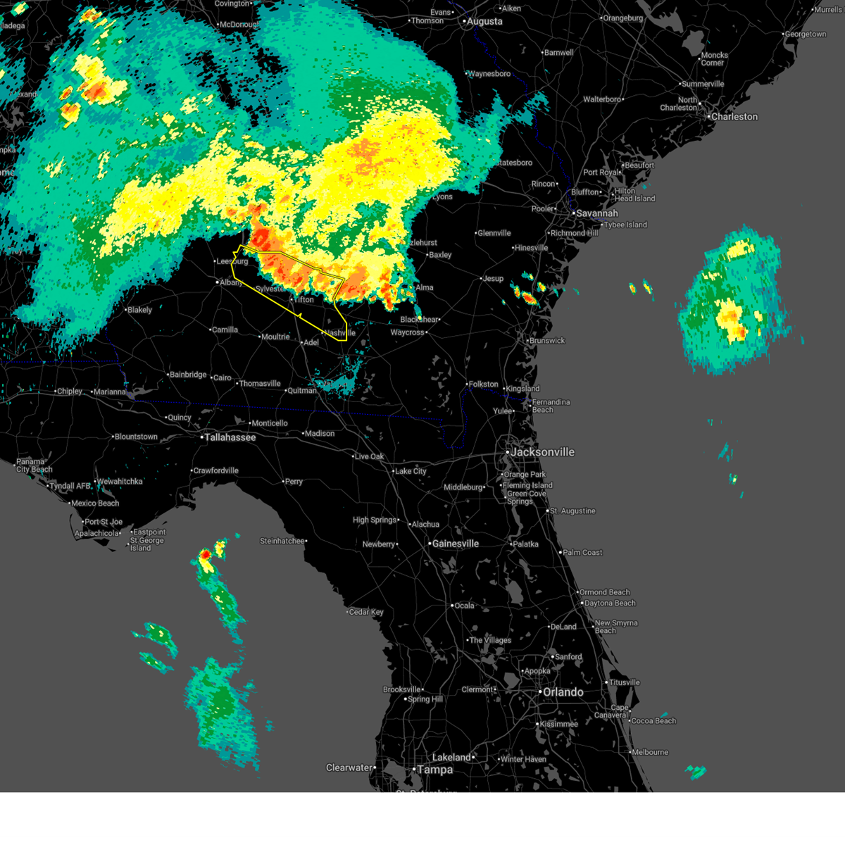
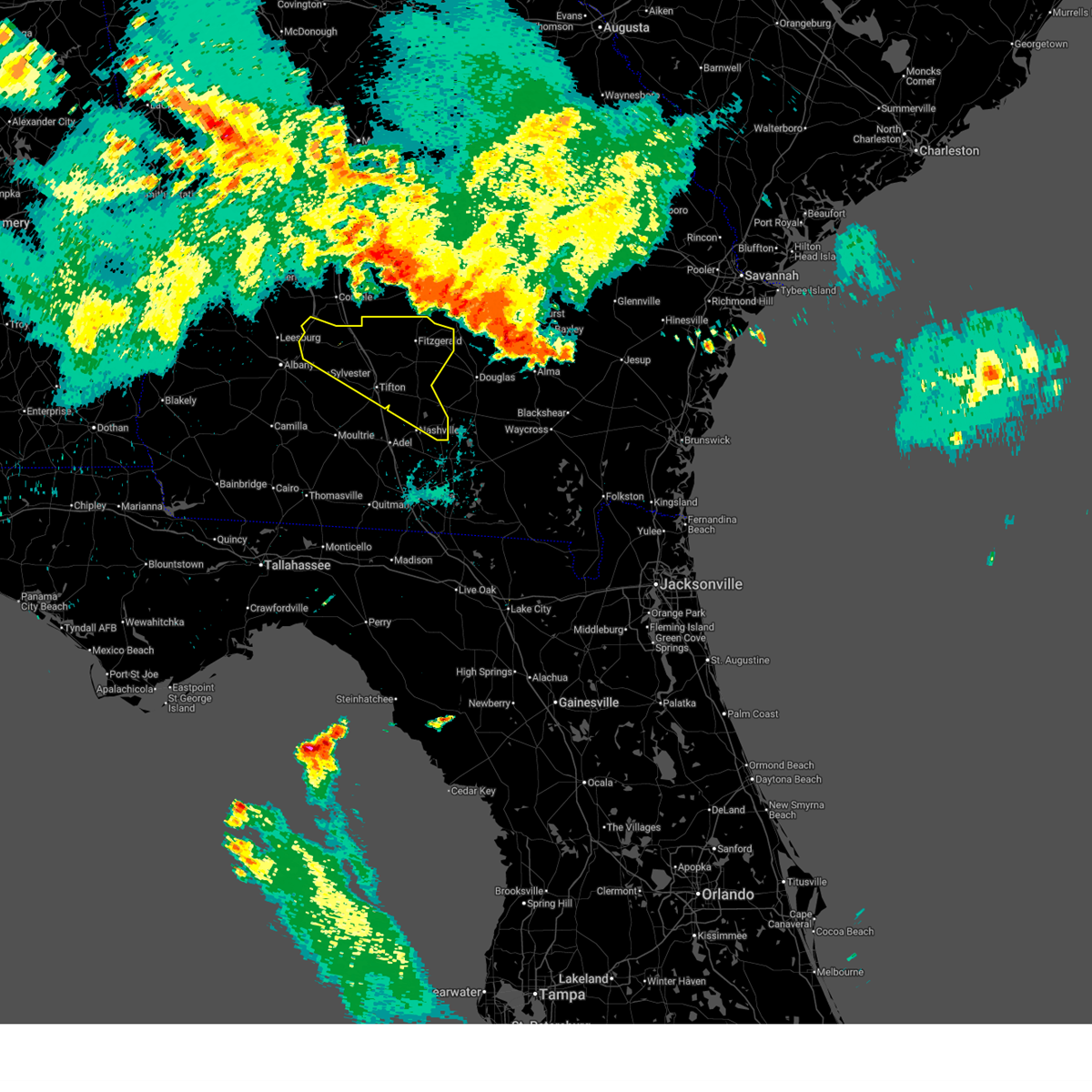
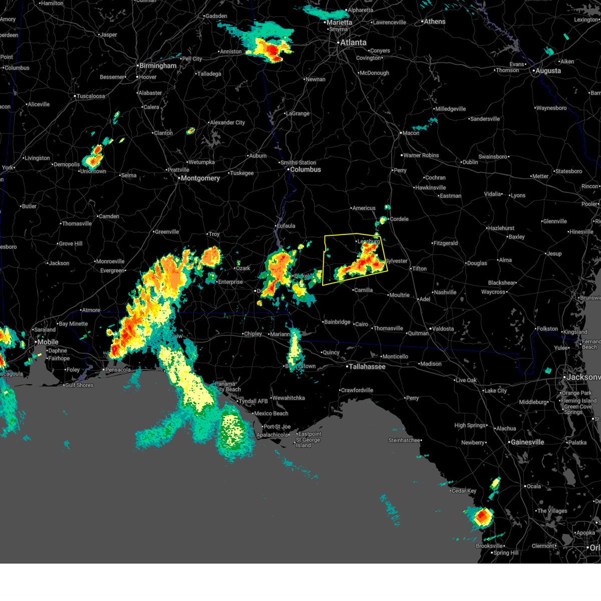
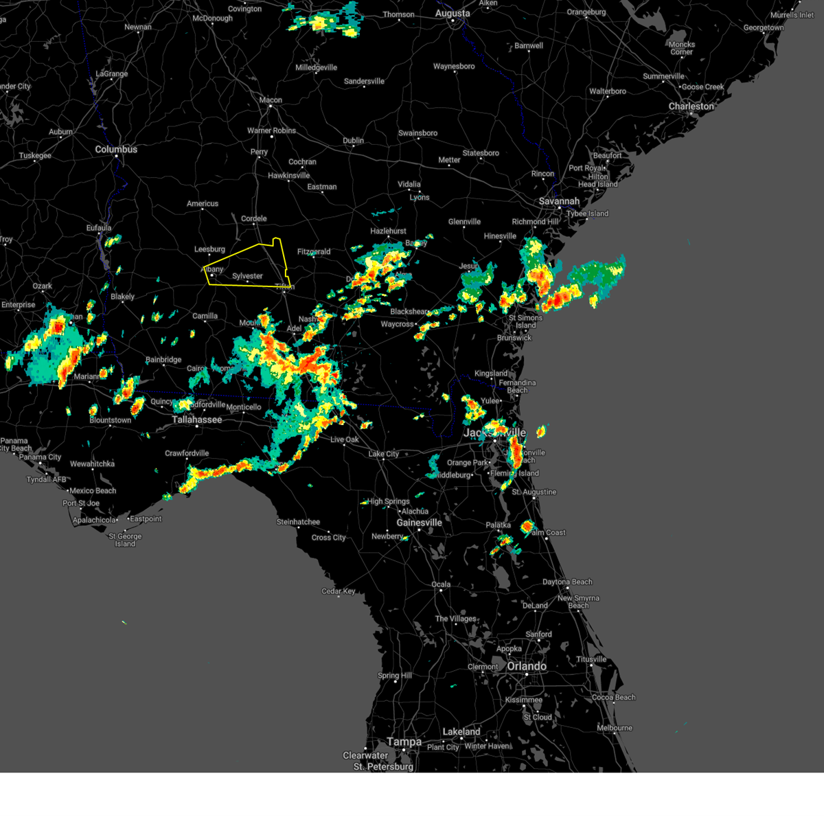
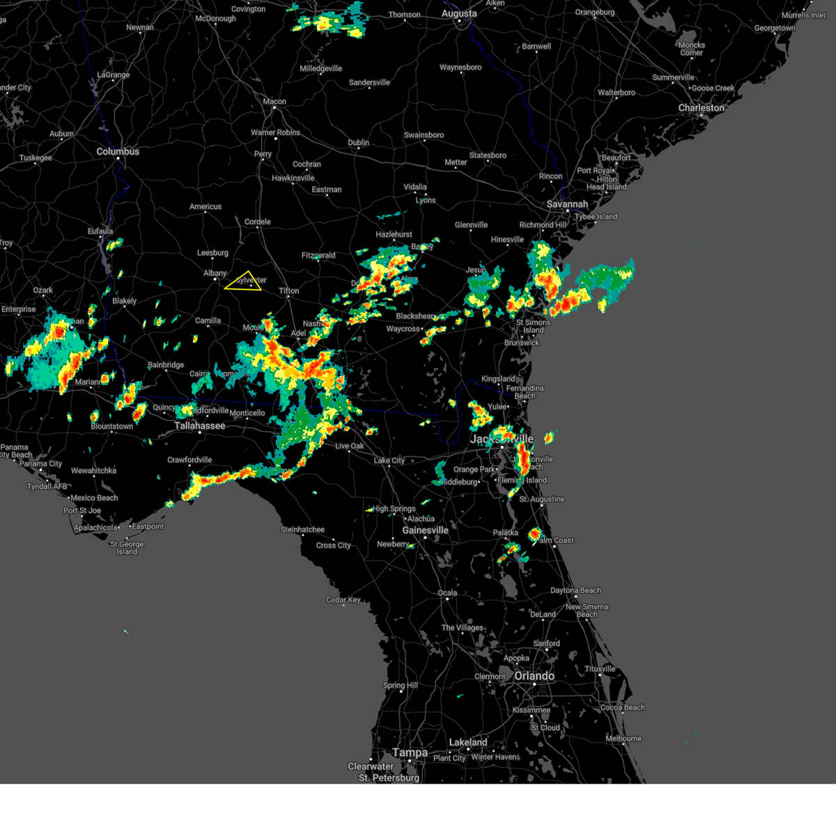
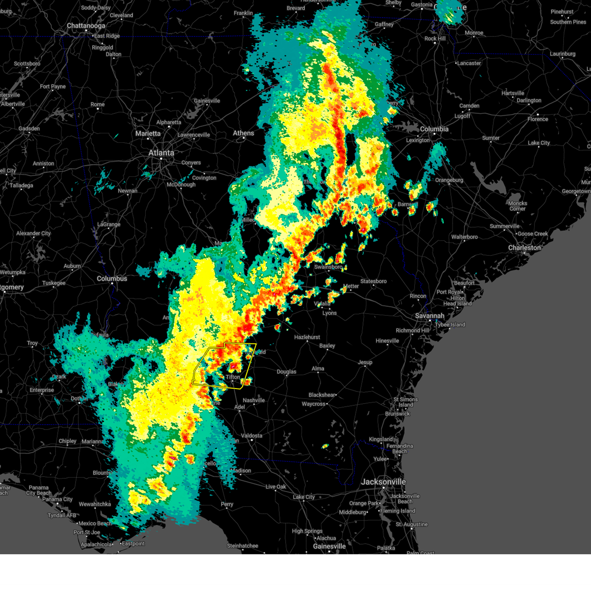
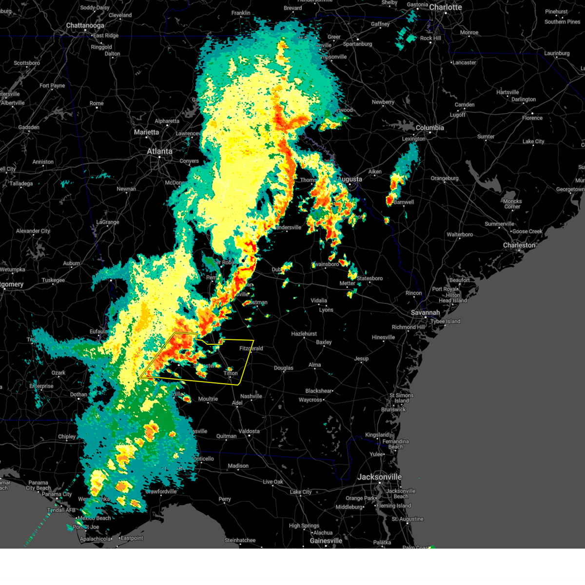
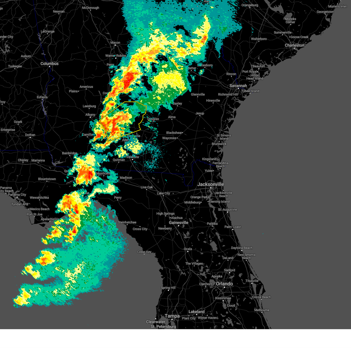
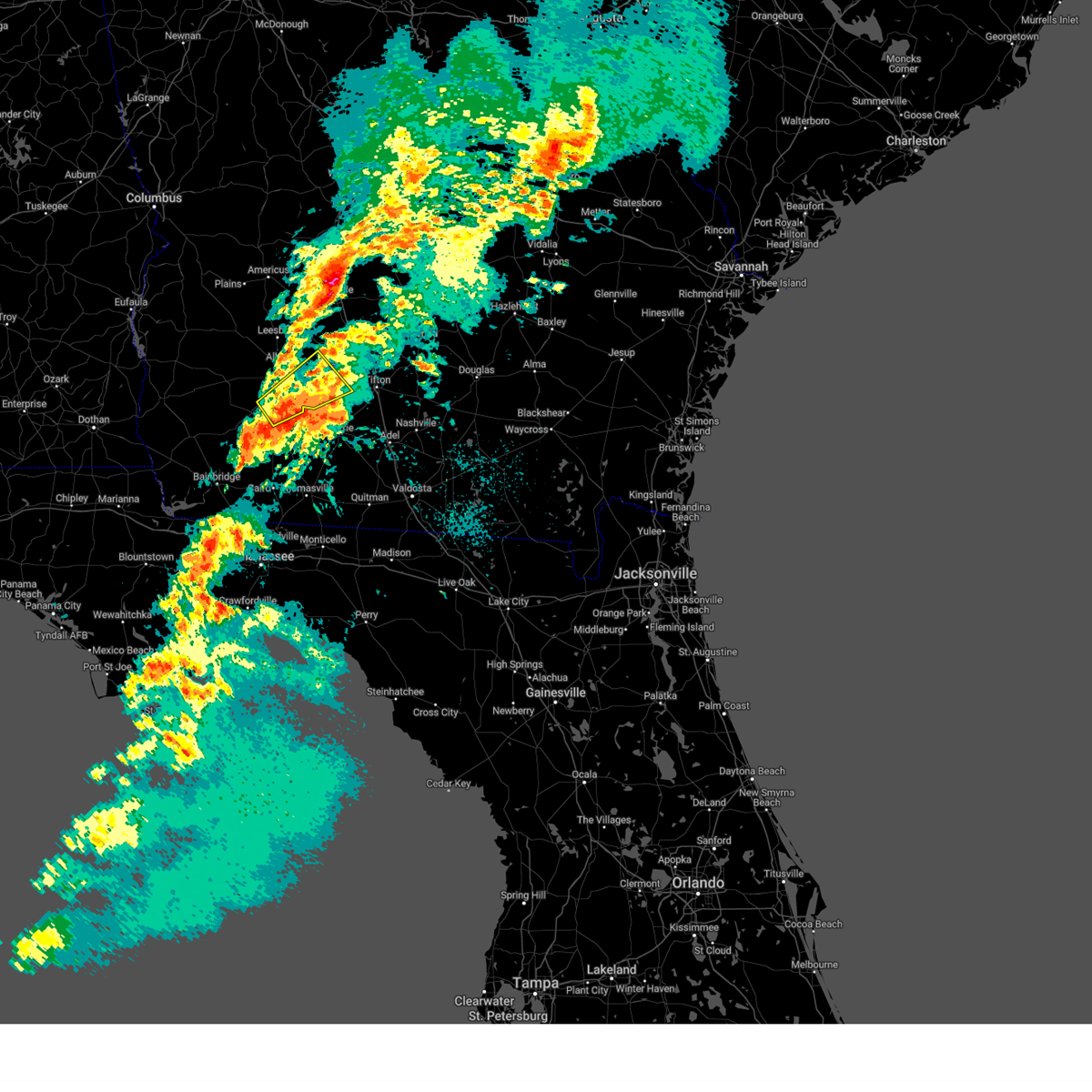
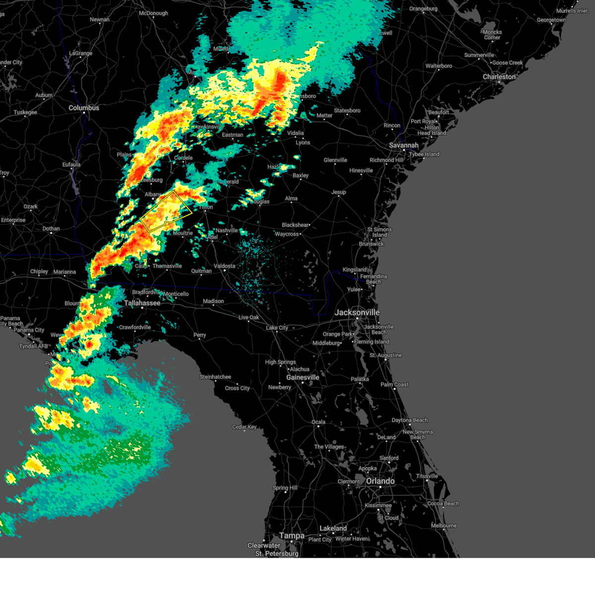
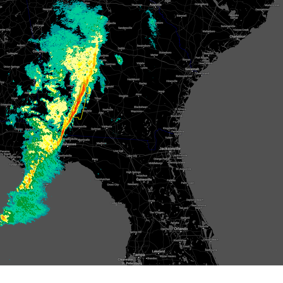
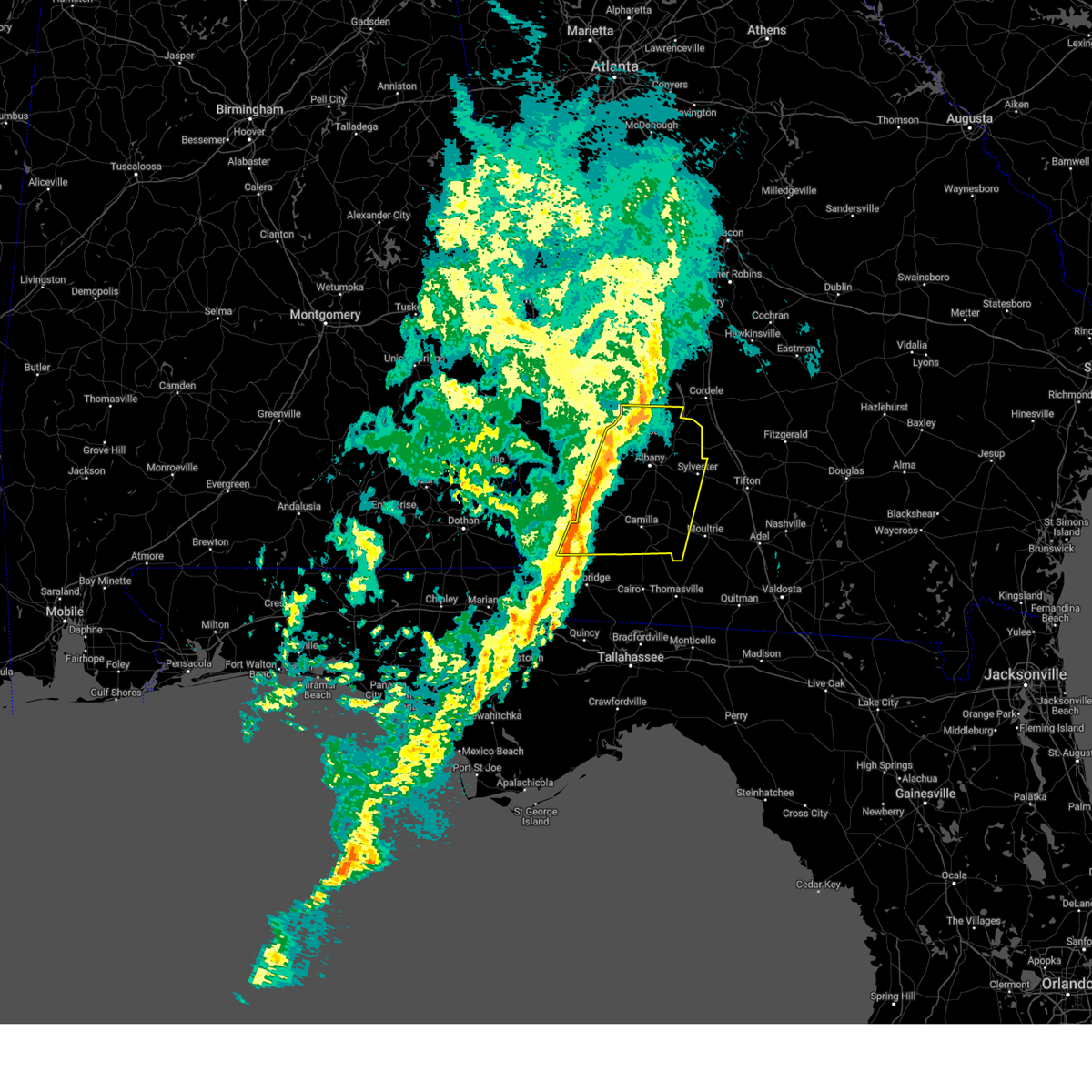
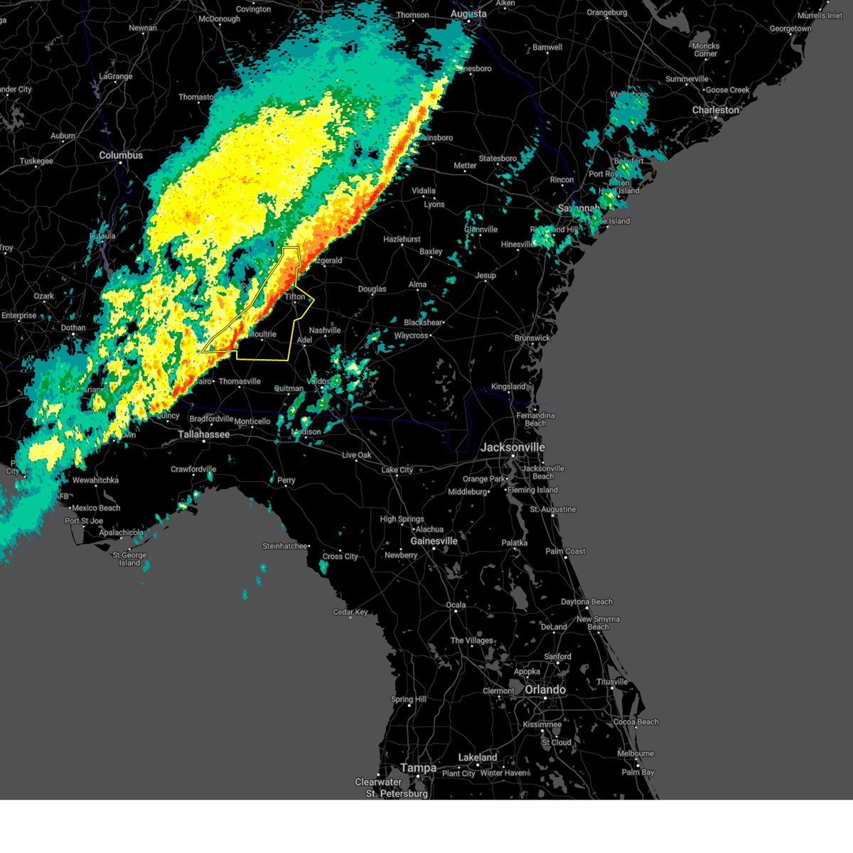
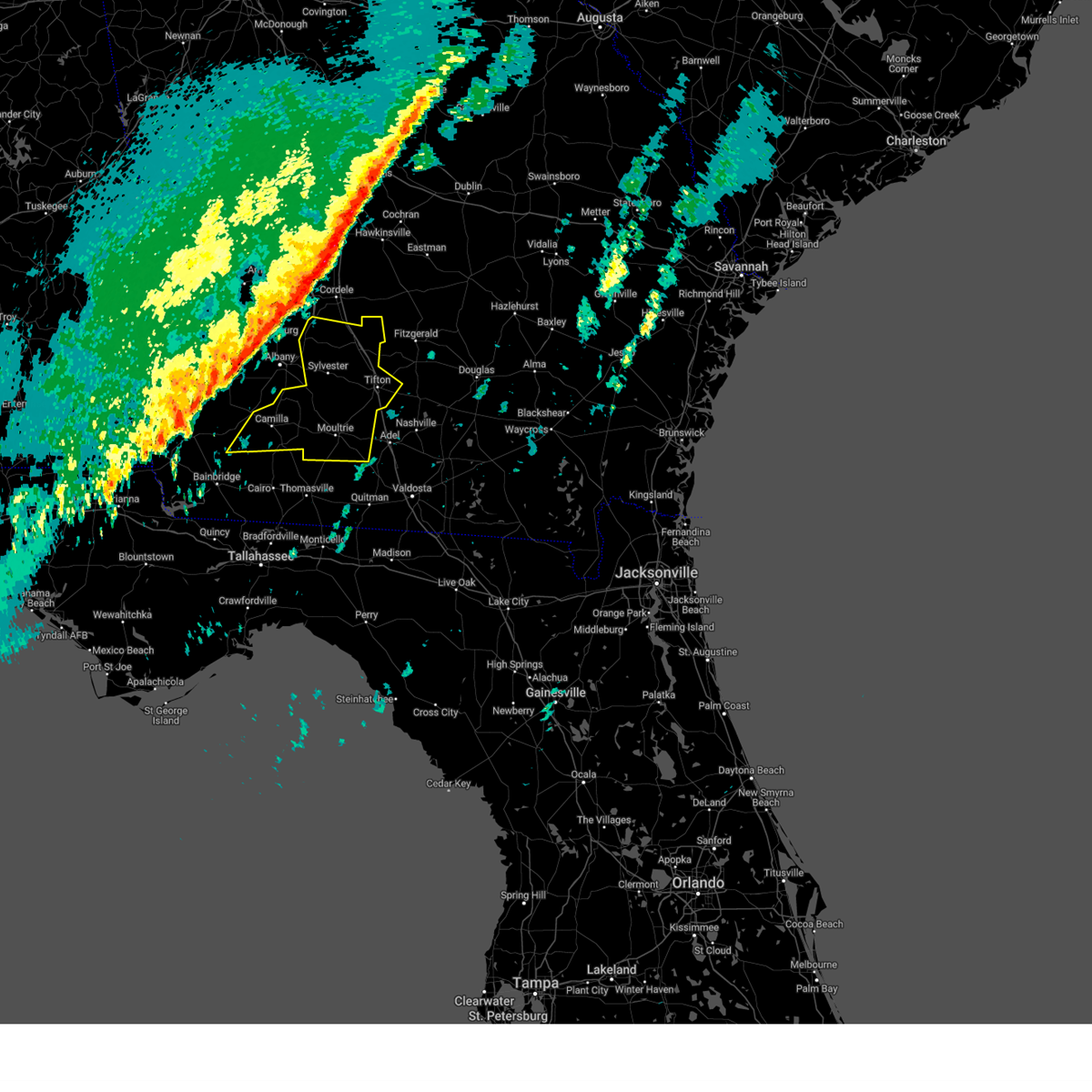
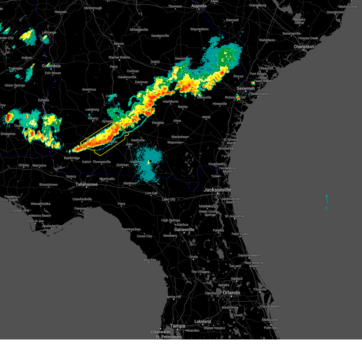
Hail Map for Sylvester, GA
The Sylvester, GA area has had 4 reports of on-the-ground hail by trained spotters, and has been under severe weather warnings 32 times during the past 12 months. Doppler radar has detected hail at or near Sylvester, GA on 58 occasions, including 2 occasions during the past year.
| Name: | Sylvester, GA |
| Where Located: | 58.1 miles W of Douglas, GA |
| Map: | Google Map for Sylvester, GA |
| Population: | 6188 |
| Housing Units: | 2541 |
| More Info: | Search Google for Sylvester, GA |
0
The Top Recent Hail Date for Sylvester, GA is Wednesday, June 25, 2025 (44th out of 58)

Hail and Wind Damage Spotted near Sylvester, GA
| Date / Time | Report Details |
|---|---|
| 6/26/2025 2:37 AM EDT |
 The storms which prompted the warning have weakened below severe limits, and no longer pose an immediate threat to life or property. therefore, the warning will be allowed to expire. however, gusty winds are still possible with these thunderstorms. a severe thunderstorm watch remains in effect until 400 am edt for south central and southwestern georgia. to report severe weather, contact your nearest law enforcement agency. they will relay your report to the national weather service tallahassee. The storms which prompted the warning have weakened below severe limits, and no longer pose an immediate threat to life or property. therefore, the warning will be allowed to expire. however, gusty winds are still possible with these thunderstorms. a severe thunderstorm watch remains in effect until 400 am edt for south central and southwestern georgia. to report severe weather, contact your nearest law enforcement agency. they will relay your report to the national weather service tallahassee.
|
| 6/26/2025 2:32 AM EDT |
 the severe thunderstorm warning has been cancelled and is no longer in effect the severe thunderstorm warning has been cancelled and is no longer in effect
|
| 6/26/2025 2:32 AM EDT |
 At 232 am edt, severe thunderstorms were located along a line extending from 7 miles south of de soto to near willacoochee, moving southwest at 35 mph (radar indicated). Hazards include 60 mph wind gusts and penny size hail. Expect damage to roofs, siding, and trees. Locations impacted include, sylvester, tifton, ashburn, ocilla, nashville, enigma, poulan, ty ty, alapaha, mystic, unionville, phillipsburg, worth, terrell, sycamore, sumner, warwick, eldorado, gladys, and sylvester airport. At 232 am edt, severe thunderstorms were located along a line extending from 7 miles south of de soto to near willacoochee, moving southwest at 35 mph (radar indicated). Hazards include 60 mph wind gusts and penny size hail. Expect damage to roofs, siding, and trees. Locations impacted include, sylvester, tifton, ashburn, ocilla, nashville, enigma, poulan, ty ty, alapaha, mystic, unionville, phillipsburg, worth, terrell, sycamore, sumner, warwick, eldorado, gladys, and sylvester airport.
|
| 6/26/2025 1:36 AM EDT |
 Svrtae the national weather service in tallahassee has issued a * severe thunderstorm warning for, irwin county in south central georgia, berrien county in south central georgia, turner county in south central georgia, tift county in south central georgia, ben hill county in south central georgia, central worth county in south central georgia, * until 245 am edt. * at 136 am edt, severe thunderstorms were located along a line extending from 6 miles east of pinehurst to 8 miles northwest of alma, moving southwest at 35 mph (radar indicated). Hazards include 60 mph wind gusts and penny size hail. expect damage to roofs, siding, and trees Svrtae the national weather service in tallahassee has issued a * severe thunderstorm warning for, irwin county in south central georgia, berrien county in south central georgia, turner county in south central georgia, tift county in south central georgia, ben hill county in south central georgia, central worth county in south central georgia, * until 245 am edt. * at 136 am edt, severe thunderstorms were located along a line extending from 6 miles east of pinehurst to 8 miles northwest of alma, moving southwest at 35 mph (radar indicated). Hazards include 60 mph wind gusts and penny size hail. expect damage to roofs, siding, and trees
|
| 6/25/2025 8:53 PM EDT |
 Svrtae the national weather service in tallahassee has issued a * severe thunderstorm warning for, dougherty county in southwestern georgia, northeastern mitchell county in southwestern georgia, southern lee county in southwestern georgia, northern baker county in southwestern georgia, eastern calhoun county in southwestern georgia, southern terrell county in southwestern georgia, western worth county in south central georgia, * until 1015 pm edt. * at 853 pm edt, a severe thunderstorm was located over marine corps logistics base, or near putney, moving west at 20 mph (radar indicated). Hazards include 60 mph wind gusts and quarter size hail. Hail damage to vehicles is expected. Expect wind damage to roofs, siding, and trees. Svrtae the national weather service in tallahassee has issued a * severe thunderstorm warning for, dougherty county in southwestern georgia, northeastern mitchell county in southwestern georgia, southern lee county in southwestern georgia, northern baker county in southwestern georgia, eastern calhoun county in southwestern georgia, southern terrell county in southwestern georgia, western worth county in south central georgia, * until 1015 pm edt. * at 853 pm edt, a severe thunderstorm was located over marine corps logistics base, or near putney, moving west at 20 mph (radar indicated). Hazards include 60 mph wind gusts and quarter size hail. Hail damage to vehicles is expected. Expect wind damage to roofs, siding, and trees.
|
| 6/9/2025 3:56 PM EDT |
 The storm which prompted the warning has weakened below severe limits, and no longer poses an immediate threat to life or property. therefore, the warning will be allowed to expire. however, gusty winds to 40 mph and heavy rain are still possible with this thunderstorm. The storm which prompted the warning has weakened below severe limits, and no longer poses an immediate threat to life or property. therefore, the warning will be allowed to expire. however, gusty winds to 40 mph and heavy rain are still possible with this thunderstorm.
|
| 6/9/2025 3:55 PM EDT |
 The storm which prompted the warning has weakened below severe limits, and has exited the warned area. therefore, the warning will be allowed to expire. The storm which prompted the warning has weakened below severe limits, and has exited the warned area. therefore, the warning will be allowed to expire.
|
| 6/9/2025 3:43 PM EDT |
 At 343 pm edt, a severe thunderstorm was located 7 miles north of doerun, or 8 miles southwest of sylvester, moving northeast at 35 mph (radar indicated). Hazards include 60 mph wind gusts. Expect damage to roofs, siding, and trees. Locations impacted include, sylvester, poulan, marine corps logistics base, red rock, acree, gammage, sylvester airport, and isabella. At 343 pm edt, a severe thunderstorm was located 7 miles north of doerun, or 8 miles southwest of sylvester, moving northeast at 35 mph (radar indicated). Hazards include 60 mph wind gusts. Expect damage to roofs, siding, and trees. Locations impacted include, sylvester, poulan, marine corps logistics base, red rock, acree, gammage, sylvester airport, and isabella.
|
| 6/9/2025 3:43 PM EDT |
 the severe thunderstorm warning has been cancelled and is no longer in effect the severe thunderstorm warning has been cancelled and is no longer in effect
|
| 6/9/2025 3:38 PM EDT | The worth county 911 call center reported a tree down along douthit road. timing estimated by rada in worth county GA, 5.6 miles N of Sylvester, GA |
| 6/9/2025 3:28 PM EDT | The worth county 911 call center reported a tree down along woodcrest road. timing estimated by rada in worth county GA, 7.1 miles ESE of Sylvester, GA |
| 6/9/2025 3:24 PM EDT |
 At 324 pm edt, a severe thunderstorm was located near baconton, or 9 miles south of putney, moving east at 35 mph (radar indicated). Hazards include 60 mph wind gusts. Expect damage to roofs, siding, and trees. Locations impacted include, sylvester, putney, baconton, poulan, doerun, marine corps logistics base, sale city, bridgeboro, minton, flint, scooterville, sylvester airport, anderson city, tempy, parkerville, red rock, acree, lester, sigsbee, and pritchetts. At 324 pm edt, a severe thunderstorm was located near baconton, or 9 miles south of putney, moving east at 35 mph (radar indicated). Hazards include 60 mph wind gusts. Expect damage to roofs, siding, and trees. Locations impacted include, sylvester, putney, baconton, poulan, doerun, marine corps logistics base, sale city, bridgeboro, minton, flint, scooterville, sylvester airport, anderson city, tempy, parkerville, red rock, acree, lester, sigsbee, and pritchetts.
|
| 6/9/2025 3:20 PM EDT |
 Svrtae the national weather service in tallahassee has issued a * severe thunderstorm warning for, turner county in south central georgia, northeastern dougherty county in southwestern georgia, south central lee county in southwestern georgia, northwestern tift county in south central georgia, central worth county in south central georgia, * until 400 pm edt. * at 320 pm edt, a severe thunderstorm was located near marine corps logistics base, or 8 miles east of albany, moving east at 45 mph (radar indicated). Hazards include 60 mph wind gusts and penny size hail. expect damage to roofs, siding, and trees Svrtae the national weather service in tallahassee has issued a * severe thunderstorm warning for, turner county in south central georgia, northeastern dougherty county in southwestern georgia, south central lee county in southwestern georgia, northwestern tift county in south central georgia, central worth county in south central georgia, * until 400 pm edt. * at 320 pm edt, a severe thunderstorm was located near marine corps logistics base, or 8 miles east of albany, moving east at 45 mph (radar indicated). Hazards include 60 mph wind gusts and penny size hail. expect damage to roofs, siding, and trees
|
| 6/9/2025 3:09 PM EDT |
 Svrtae the national weather service in tallahassee has issued a * severe thunderstorm warning for, southeastern dougherty county in southwestern georgia, eastern mitchell county in southwestern georgia, northeastern baker county in southwestern georgia, northwestern colquitt county in south central georgia, southern worth county in south central georgia, * until 400 pm edt. * at 309 pm edt, a severe thunderstorm was located near camilla, moving northeast at 35 mph (radar indicated). Hazards include 60 mph wind gusts and penny size hail. expect damage to roofs, siding, and trees Svrtae the national weather service in tallahassee has issued a * severe thunderstorm warning for, southeastern dougherty county in southwestern georgia, eastern mitchell county in southwestern georgia, northeastern baker county in southwestern georgia, northwestern colquitt county in south central georgia, southern worth county in south central georgia, * until 400 pm edt. * at 309 pm edt, a severe thunderstorm was located near camilla, moving northeast at 35 mph (radar indicated). Hazards include 60 mph wind gusts and penny size hail. expect damage to roofs, siding, and trees
|
| 3/31/2025 3:35 PM EDT |
 the severe thunderstorm warning has been cancelled and is no longer in effect the severe thunderstorm warning has been cancelled and is no longer in effect
|
| 3/31/2025 3:35 PM EDT |
 At 335 pm edt, severe thunderstorms were located along a line extending from 7 miles south of pitts to near ashburn to near poulan, moving east at 55 mph (radar indicated). Hazards include 60 mph wind gusts and quarter size hail. Hail damage to vehicles is expected. expect wind damage to roofs, siding, and trees. Locations impacted include, mystic, sylvester, amboy, rebecca, sylvester airport, tempy, parkerville, harding, waterloo, pinetta, tifton, inaha, worth, red rock, terrell, irwinville, sumner, ty ty, crestwood, and hobby. At 335 pm edt, severe thunderstorms were located along a line extending from 7 miles south of pitts to near ashburn to near poulan, moving east at 55 mph (radar indicated). Hazards include 60 mph wind gusts and quarter size hail. Hail damage to vehicles is expected. expect wind damage to roofs, siding, and trees. Locations impacted include, mystic, sylvester, amboy, rebecca, sylvester airport, tempy, parkerville, harding, waterloo, pinetta, tifton, inaha, worth, red rock, terrell, irwinville, sumner, ty ty, crestwood, and hobby.
|
| 3/31/2025 2:54 PM EDT |
 Svrtae the national weather service in tallahassee has issued a * severe thunderstorm warning for, western irwin county in south central georgia, turner county in south central georgia, dougherty county in southwestern georgia, northeastern mitchell county in southwestern georgia, lee county in southwestern georgia, northeastern baker county in southwestern georgia, eastern calhoun county in southwestern georgia, tift county in south central georgia, southeastern terrell county in southwestern georgia, western ben hill county in south central georgia, worth county in south central georgia, * until 400 pm edt. * at 254 pm edt, severe thunderstorms were located along a line extending from 6 miles southeast of smithville to 9 miles west of albany to near leary, moving east at 45 mph (radar indicated). Hazards include 60 mph wind gusts. expect damage to roofs, siding, and trees Svrtae the national weather service in tallahassee has issued a * severe thunderstorm warning for, western irwin county in south central georgia, turner county in south central georgia, dougherty county in southwestern georgia, northeastern mitchell county in southwestern georgia, lee county in southwestern georgia, northeastern baker county in southwestern georgia, eastern calhoun county in southwestern georgia, tift county in south central georgia, southeastern terrell county in southwestern georgia, western ben hill county in south central georgia, worth county in south central georgia, * until 400 pm edt. * at 254 pm edt, severe thunderstorms were located along a line extending from 6 miles southeast of smithville to 9 miles west of albany to near leary, moving east at 45 mph (radar indicated). Hazards include 60 mph wind gusts. expect damage to roofs, siding, and trees
|
| 3/16/2025 7:01 AM EDT |
 Svrtae the national weather service in tallahassee has issued a * severe thunderstorm warning for, northwestern cook county in south central georgia, irwin county in south central georgia, northern berrien county in south central georgia, central turner county in south central georgia, northeastern colquitt county in south central georgia, tift county in south central georgia, ben hill county in south central georgia, southern worth county in south central georgia, * until 800 am edt. * at 701 am edt, severe thunderstorms were located along a line extending from near ty ty to near omega to near norman park, moving northeast at 55 mph (radar indicated). Hazards include 60 mph wind gusts and quarter size hail. Hail damage to vehicles is expected. Expect wind damage to roofs, siding, and trees. Svrtae the national weather service in tallahassee has issued a * severe thunderstorm warning for, northwestern cook county in south central georgia, irwin county in south central georgia, northern berrien county in south central georgia, central turner county in south central georgia, northeastern colquitt county in south central georgia, tift county in south central georgia, ben hill county in south central georgia, southern worth county in south central georgia, * until 800 am edt. * at 701 am edt, severe thunderstorms were located along a line extending from near ty ty to near omega to near norman park, moving northeast at 55 mph (radar indicated). Hazards include 60 mph wind gusts and quarter size hail. Hail damage to vehicles is expected. Expect wind damage to roofs, siding, and trees.
|
| 3/16/2025 6:26 AM EDT |
 The storm which prompted the warning has moved out of the area. therefore, the warning will be allowed to expire. however, gusty winds are still possible with this thunderstorm. a tornado watch remains in effect until 1000 am edt for south central and southwestern georgia. The storm which prompted the warning has moved out of the area. therefore, the warning will be allowed to expire. however, gusty winds are still possible with this thunderstorm. a tornado watch remains in effect until 1000 am edt for south central and southwestern georgia.
|
| 3/16/2025 5:48 AM EDT |
 Svrtae the national weather service in tallahassee has issued a * severe thunderstorm warning for, southeastern dougherty county in southwestern georgia, northeastern mitchell county in southwestern georgia, northeastern baker county in southwestern georgia, southern worth county in south central georgia, * until 630 am edt. * at 547 am edt, a severe thunderstorm was located over baconton, or 8 miles east of newton, moving northeast at 40 mph (radar indicated). Hazards include 60 mph wind gusts and quarter size hail. Hail damage to vehicles is expected. Expect wind damage to roofs, siding, and trees. Svrtae the national weather service in tallahassee has issued a * severe thunderstorm warning for, southeastern dougherty county in southwestern georgia, northeastern mitchell county in southwestern georgia, northeastern baker county in southwestern georgia, southern worth county in south central georgia, * until 630 am edt. * at 547 am edt, a severe thunderstorm was located over baconton, or 8 miles east of newton, moving northeast at 40 mph (radar indicated). Hazards include 60 mph wind gusts and quarter size hail. Hail damage to vehicles is expected. Expect wind damage to roofs, siding, and trees.
|
| 3/5/2025 4:05 AM EST |
 the severe thunderstorm warning has been cancelled and is no longer in effect the severe thunderstorm warning has been cancelled and is no longer in effect
|
| 3/5/2025 4:05 AM EST |
 At 405 am est, severe thunderstorms were located along a line extending from near cordele to pelham, moving east at 40 mph (radar indicated). Hazards include 60 mph wind gusts. Expect damage to roofs, siding, and trees. Locations impacted include, bridgeboro, sylvester, sylvester airport, anderson city, parkerville, cotton, red rock, lester, pritchetts, poplar arbor church, crestwood, shingler, greenough, gordy, doerun, livingston, ticknor, minnesota, laney, and freeman. At 405 am est, severe thunderstorms were located along a line extending from near cordele to pelham, moving east at 40 mph (radar indicated). Hazards include 60 mph wind gusts. Expect damage to roofs, siding, and trees. Locations impacted include, bridgeboro, sylvester, sylvester airport, anderson city, parkerville, cotton, red rock, lester, pritchetts, poplar arbor church, crestwood, shingler, greenough, gordy, doerun, livingston, ticknor, minnesota, laney, and freeman.
|
| 3/5/2025 4:03 AM EST |
 Svrtae the national weather service in tallahassee has issued a * severe thunderstorm warning for, cook county in south central georgia, irwin county in south central georgia, berrien county in south central georgia, turner county in south central georgia, colquitt county in south central georgia, tift county in south central georgia, ben hill county in south central georgia, eastern worth county in south central georgia, * until 530 am est. * at 403 am est, severe thunderstorms were located along a line extending from 7 miles west of arabi to pelham, moving east at 35 mph (radar indicated). Hazards include 60 mph wind gusts. expect damage to roofs, siding, and trees Svrtae the national weather service in tallahassee has issued a * severe thunderstorm warning for, cook county in south central georgia, irwin county in south central georgia, berrien county in south central georgia, turner county in south central georgia, colquitt county in south central georgia, tift county in south central georgia, ben hill county in south central georgia, eastern worth county in south central georgia, * until 530 am est. * at 403 am est, severe thunderstorms were located along a line extending from 7 miles west of arabi to pelham, moving east at 35 mph (radar indicated). Hazards include 60 mph wind gusts. expect damage to roofs, siding, and trees
|
| 3/5/2025 3:52 AM EST |
 At 352 am est, severe thunderstorms were located along a line extending from 6 miles southwest of cordele to 8 miles west of pelham, moving east at 40 mph (radar indicated). Hazards include 60 mph wind gusts. Expect damage to roofs, siding, and trees. Locations impacted include, bridgeboro, warwick, sylvester, flint, stocks, radium springs, sylvester airport, anderson city, parkerville, cotton, red rock, acree, lester, pritchetts, poplar arbor church, crestwood, shingler, williamsburg, branchville, and greenough. At 352 am est, severe thunderstorms were located along a line extending from 6 miles southwest of cordele to 8 miles west of pelham, moving east at 40 mph (radar indicated). Hazards include 60 mph wind gusts. Expect damage to roofs, siding, and trees. Locations impacted include, bridgeboro, warwick, sylvester, flint, stocks, radium springs, sylvester airport, anderson city, parkerville, cotton, red rock, acree, lester, pritchetts, poplar arbor church, crestwood, shingler, williamsburg, branchville, and greenough.
|
| 3/5/2025 3:34 AM EST |
 At 334 am est, severe thunderstorms were located along a line extending from near de soto to 13 miles northeast of west bainbridge, moving east at 35 mph (radar indicated). Hazards include 60 mph wind gusts. Expect damage to roofs, siding, and trees. Locations impacted include, stocks, radium springs, sylvester airport, anderson city, parkerville, lester, pritchetts, crestwood, greenough, albany, hopeful, hoggard mill, walker, ticknor, pecan city, laney, newton, gammage, mitchell co a/p, and baconton. At 334 am est, severe thunderstorms were located along a line extending from near de soto to 13 miles northeast of west bainbridge, moving east at 35 mph (radar indicated). Hazards include 60 mph wind gusts. Expect damage to roofs, siding, and trees. Locations impacted include, stocks, radium springs, sylvester airport, anderson city, parkerville, lester, pritchetts, crestwood, greenough, albany, hopeful, hoggard mill, walker, ticknor, pecan city, laney, newton, gammage, mitchell co a/p, and baconton.
|
| 3/5/2025 3:34 AM EST |
 the severe thunderstorm warning has been cancelled and is no longer in effect the severe thunderstorm warning has been cancelled and is no longer in effect
|
| 3/5/2025 3:14 AM EST |
 At 314 am est, severe thunderstorms were located along a line extending from near smithville to 6 miles southeast of colquitt, moving east at 40 mph (radar indicated). Hazards include 60 mph wind gusts. Expect damage to roofs, siding, and trees. Locations impacted include, iveys mill, stocks, radium springs, smithville, sylvester airport, anderson city, parkerville, dawson municipal a/p, lester, pritchetts, crestwood, neyami, greenough, chickasawhatchee, bellview, albany, vada, hopeful, hoggard mill, and walker. At 314 am est, severe thunderstorms were located along a line extending from near smithville to 6 miles southeast of colquitt, moving east at 40 mph (radar indicated). Hazards include 60 mph wind gusts. Expect damage to roofs, siding, and trees. Locations impacted include, iveys mill, stocks, radium springs, smithville, sylvester airport, anderson city, parkerville, dawson municipal a/p, lester, pritchetts, crestwood, neyami, greenough, chickasawhatchee, bellview, albany, vada, hopeful, hoggard mill, and walker.
|
| 3/5/2025 3:14 AM EST |
 the severe thunderstorm warning has been cancelled and is no longer in effect the severe thunderstorm warning has been cancelled and is no longer in effect
|
| 3/5/2025 2:53 AM EST |
 Svrtae the national weather service in tallahassee has issued a * severe thunderstorm warning for, miller county in southwestern georgia, dougherty county in southwestern georgia, southeastern randolph county in southwestern georgia, mitchell county in southwestern georgia, lee county in southwestern georgia, baker county in southwestern georgia, calhoun county in southwestern georgia, eastern early county in southwestern georgia, western colquitt county in south central georgia, terrell county in southwestern georgia, worth county in south central georgia, * until 430 am est. * at 253 am est, severe thunderstorms were located along a line extending from 8 miles north of dawson to near donalsonville, moving east at 40 mph (radar indicated). Hazards include 60 mph wind gusts. expect damage to roofs, siding, and trees Svrtae the national weather service in tallahassee has issued a * severe thunderstorm warning for, miller county in southwestern georgia, dougherty county in southwestern georgia, southeastern randolph county in southwestern georgia, mitchell county in southwestern georgia, lee county in southwestern georgia, baker county in southwestern georgia, calhoun county in southwestern georgia, eastern early county in southwestern georgia, western colquitt county in south central georgia, terrell county in southwestern georgia, worth county in south central georgia, * until 430 am est. * at 253 am est, severe thunderstorms were located along a line extending from 8 miles north of dawson to near donalsonville, moving east at 40 mph (radar indicated). Hazards include 60 mph wind gusts. expect damage to roofs, siding, and trees
|
| 2/16/2025 7:21 AM EST |
 At 721 am est, severe thunderstorms were located along a line extending from 8 miles northwest of fitzgerald to 8 miles north of cairo, moving east at 40 mph (radar indicated). Hazards include 60 mph wind gusts. Expect damage to roofs, siding, and trees. Locations impacted include, tifton, moultrie, ashburn, pelham, camilla, sylvester, omega, norman park, poulan, doerun, ty ty, phillipsburg, unionville, riverside, terrell, schley, sycamore, berlin, funston, and sumner. At 721 am est, severe thunderstorms were located along a line extending from 8 miles northwest of fitzgerald to 8 miles north of cairo, moving east at 40 mph (radar indicated). Hazards include 60 mph wind gusts. Expect damage to roofs, siding, and trees. Locations impacted include, tifton, moultrie, ashburn, pelham, camilla, sylvester, omega, norman park, poulan, doerun, ty ty, phillipsburg, unionville, riverside, terrell, schley, sycamore, berlin, funston, and sumner.
|
| 2/16/2025 7:05 AM EST | Worth county 911 reports a tree down on 112 n just south of sylvester city limit in worth county GA, 1.5 miles NNE of Sylvester, GA |
| 2/16/2025 6:17 AM EST |
 Svrtae the national weather service in tallahassee has issued a * severe thunderstorm warning for, turner county in south central georgia, mitchell county in southwestern georgia, colquitt county in south central georgia, tift county in south central georgia, worth county in south central georgia, * until 745 am est. * at 616 am est, severe thunderstorms were located along a line extending from near leslie to 7 miles northwest of donalsonville, moving east at 45 mph (radar indicated). Hazards include 60 mph wind gusts. expect damage to roofs, siding, and trees Svrtae the national weather service in tallahassee has issued a * severe thunderstorm warning for, turner county in south central georgia, mitchell county in southwestern georgia, colquitt county in south central georgia, tift county in south central georgia, worth county in south central georgia, * until 745 am est. * at 616 am est, severe thunderstorms were located along a line extending from near leslie to 7 miles northwest of donalsonville, moving east at 45 mph (radar indicated). Hazards include 60 mph wind gusts. expect damage to roofs, siding, and trees
|
| 8/18/2024 9:14 PM EDT |
 the severe thunderstorm warning has been cancelled and is no longer in effect the severe thunderstorm warning has been cancelled and is no longer in effect
|
| 8/18/2024 9:14 PM EDT |
 At 914 pm edt, severe thunderstorms were located along a line extending from near ty ty to camilla, moving east at 30 mph (radar indicated). Hazards include 60 mph wind gusts. Expect damage to roofs, siding, and trees. Locations impacted include, moultrie, sylvester, pelham, camilla, tifton, omega, norman park, poulan, doerun, ty ty, riverside, schley, funston, sumner, sale city, minton, scooterville, anderson city, parkerville, and lester. At 914 pm edt, severe thunderstorms were located along a line extending from near ty ty to camilla, moving east at 30 mph (radar indicated). Hazards include 60 mph wind gusts. Expect damage to roofs, siding, and trees. Locations impacted include, moultrie, sylvester, pelham, camilla, tifton, omega, norman park, poulan, doerun, ty ty, riverside, schley, funston, sumner, sale city, minton, scooterville, anderson city, parkerville, and lester.
|
| 8/18/2024 8:56 PM EDT |
 Svrtae the national weather service in tallahassee has issued a * severe thunderstorm warning for, southeastern dougherty county in southwestern georgia, mitchell county in southwestern georgia, central baker county in southwestern georgia, northwestern thomas county in south central georgia, colquitt county in south central georgia, southwestern tift county in south central georgia, southern worth county in south central georgia, * until 1000 pm edt. * at 856 pm edt, severe thunderstorms were located along a line extending from near poulan to 6 miles south of newton, moving east at 25 mph (radar indicated). Hazards include 60 mph wind gusts. expect damage to roofs, siding, and trees Svrtae the national weather service in tallahassee has issued a * severe thunderstorm warning for, southeastern dougherty county in southwestern georgia, mitchell county in southwestern georgia, central baker county in southwestern georgia, northwestern thomas county in south central georgia, colquitt county in south central georgia, southwestern tift county in south central georgia, southern worth county in south central georgia, * until 1000 pm edt. * at 856 pm edt, severe thunderstorms were located along a line extending from near poulan to 6 miles south of newton, moving east at 25 mph (radar indicated). Hazards include 60 mph wind gusts. expect damage to roofs, siding, and trees
|
| 5/27/2024 6:04 PM EDT |
 Svrtae the national weather service in tallahassee has issued a * severe thunderstorm warning for, southern irwin county in south central georgia, northeastern berrien county in south central georgia, southern turner county in south central georgia, northern tift county in south central georgia, northeastern worth county in south central georgia, * until 730 pm edt. * at 603 pm edt, a severe thunderstorm was located 7 miles south of ashburn, moving east at 35 mph (radar indicated). Hazards include 60 mph wind gusts and quarter size hail. Hail damage to vehicles is expected. Expect wind damage to roofs, siding, and trees. Svrtae the national weather service in tallahassee has issued a * severe thunderstorm warning for, southern irwin county in south central georgia, northeastern berrien county in south central georgia, southern turner county in south central georgia, northern tift county in south central georgia, northeastern worth county in south central georgia, * until 730 pm edt. * at 603 pm edt, a severe thunderstorm was located 7 miles south of ashburn, moving east at 35 mph (radar indicated). Hazards include 60 mph wind gusts and quarter size hail. Hail damage to vehicles is expected. Expect wind damage to roofs, siding, and trees.
|
| 5/17/2024 7:05 PM EDT | Trees limbs blocking the road along thornhill road and sr25 in worth county GA, 5.3 miles NW of Sylvester, GA |
| 5/17/2024 7:02 PM EDT |
 Svrtae the national weather service in tallahassee has issued a * severe thunderstorm warning for, cook county in south central georgia, northeastern decatur county in southwestern georgia, northern grady county in southwestern georgia, southern irwin county in south central georgia, berrien county in south central georgia, southern mitchell county in southwestern georgia, northern thomas county in south central georgia, northwestern brooks county in south central georgia, colquitt county in south central georgia, tift county in south central georgia, southeastern worth county in south central georgia, * until 830 pm edt. * at 702 pm edt, severe thunderstorms were located along a line extending from near tifton to near ty ty to 7 miles northwest of norman park to near doerun to 9 miles northwest of riverside to 6 miles east of camilla to pelham to 12 miles northeast of bainbridge, moving east at 25 mph (radar indicated). Hazards include 60 mph wind gusts and penny size hail. expect damage to roofs, siding, and trees Svrtae the national weather service in tallahassee has issued a * severe thunderstorm warning for, cook county in south central georgia, northeastern decatur county in southwestern georgia, northern grady county in southwestern georgia, southern irwin county in south central georgia, berrien county in south central georgia, southern mitchell county in southwestern georgia, northern thomas county in south central georgia, northwestern brooks county in south central georgia, colquitt county in south central georgia, tift county in south central georgia, southeastern worth county in south central georgia, * until 830 pm edt. * at 702 pm edt, severe thunderstorms were located along a line extending from near tifton to near ty ty to 7 miles northwest of norman park to near doerun to 9 miles northwest of riverside to 6 miles east of camilla to pelham to 12 miles northeast of bainbridge, moving east at 25 mph (radar indicated). Hazards include 60 mph wind gusts and penny size hail. expect damage to roofs, siding, and trees
|
| 5/17/2024 6:52 PM EDT |
 the severe thunderstorm warning has been cancelled and is no longer in effect the severe thunderstorm warning has been cancelled and is no longer in effect
|
| 5/17/2024 6:52 PM EDT |
 At 652 pm edt, a severe thunderstorm was located over camilla, moving east at 25 mph (radar indicated). Hazards include 60 mph wind gusts and penny size hail. Expect damage to roofs, siding, and trees. Locations impacted include, newton, pelham, camilla, baconton, doerun, funston, sale city, bridgeboro, flint, parkerville, cotton, lester, pritchetts, poplar arbor church, crestwood, branchville, greenough, gordy, hopeful, and livingston. At 652 pm edt, a severe thunderstorm was located over camilla, moving east at 25 mph (radar indicated). Hazards include 60 mph wind gusts and penny size hail. Expect damage to roofs, siding, and trees. Locations impacted include, newton, pelham, camilla, baconton, doerun, funston, sale city, bridgeboro, flint, parkerville, cotton, lester, pritchetts, poplar arbor church, crestwood, branchville, greenough, gordy, hopeful, and livingston.
|
| 5/17/2024 6:20 PM EDT |
 Svrtae the national weather service in tallahassee has issued a * severe thunderstorm warning for, southeastern dougherty county in southwestern georgia, mitchell county in southwestern georgia, baker county in southwestern georgia, western colquitt county in south central georgia, southwestern worth county in south central georgia, * until 730 pm edt. * at 620 pm edt, a severe thunderstorm was located 7 miles southwest of newton, moving east at 25 mph (radar indicated). Hazards include 60 mph wind gusts and penny size hail. expect damage to roofs, siding, and trees Svrtae the national weather service in tallahassee has issued a * severe thunderstorm warning for, southeastern dougherty county in southwestern georgia, mitchell county in southwestern georgia, baker county in southwestern georgia, western colquitt county in south central georgia, southwestern worth county in south central georgia, * until 730 pm edt. * at 620 pm edt, a severe thunderstorm was located 7 miles southwest of newton, moving east at 25 mph (radar indicated). Hazards include 60 mph wind gusts and penny size hail. expect damage to roofs, siding, and trees
|
| 5/17/2024 6:19 PM EDT |
 Svrtae the national weather service in tallahassee has issued a * severe thunderstorm warning for, southeastern dougherty county in southwestern georgia, mitchell county in southwestern georgia, baker county in southwestern georgia, western colquitt county in south central georgia, southwestern worth county in south central georgia, * until 730 pm edt. * at 619 pm edt, a severe thunderstorm was located near newton, moving east at 25 mph (radar indicated). Hazards include 60 mph wind gusts and penny size hail. expect damage to roofs, siding, and trees Svrtae the national weather service in tallahassee has issued a * severe thunderstorm warning for, southeastern dougherty county in southwestern georgia, mitchell county in southwestern georgia, baker county in southwestern georgia, western colquitt county in south central georgia, southwestern worth county in south central georgia, * until 730 pm edt. * at 619 pm edt, a severe thunderstorm was located near newton, moving east at 25 mph (radar indicated). Hazards include 60 mph wind gusts and penny size hail. expect damage to roofs, siding, and trees
|
| 4/3/2024 6:53 AM EDT |
 the severe thunderstorm warning has been cancelled and is no longer in effect the severe thunderstorm warning has been cancelled and is no longer in effect
|
| 4/3/2024 6:53 AM EDT |
 At 653 am edt, severe thunderstorms were located along a line extending from 7 miles north of tifton to near pelham, moving east at 40 mph (radar indicated). Hazards include 60 mph wind gusts. Expect damage to roofs, siding, and trees. Locations impacted include, tifton, moultrie, sylvester, pelham, camilla, omega, norman park, poulan, doerun, ty ty, phillipsburg, unionville, riverside, schley, berlin, funston, sumner, sale city, ellenton, and reed bingham state park. At 653 am edt, severe thunderstorms were located along a line extending from 7 miles north of tifton to near pelham, moving east at 40 mph (radar indicated). Hazards include 60 mph wind gusts. Expect damage to roofs, siding, and trees. Locations impacted include, tifton, moultrie, sylvester, pelham, camilla, omega, norman park, poulan, doerun, ty ty, phillipsburg, unionville, riverside, schley, berlin, funston, sumner, sale city, ellenton, and reed bingham state park.
|
| 4/3/2024 6:20 AM EDT |
 Svrtae the national weather service in tallahassee has issued a * severe thunderstorm warning for, southeastern dougherty county in southwestern georgia, mitchell county in southwestern georgia, colquitt county in south central georgia, tift county in south central georgia, worth county in south central georgia, * until 745 am edt. * at 620 am edt, severe thunderstorms were located along a line extending from near putney to 13 miles south of newton, moving east at 35 mph (radar indicated). Hazards include 60 mph wind gusts. expect damage to roofs, siding, and trees Svrtae the national weather service in tallahassee has issued a * severe thunderstorm warning for, southeastern dougherty county in southwestern georgia, mitchell county in southwestern georgia, colquitt county in south central georgia, tift county in south central georgia, worth county in south central georgia, * until 745 am edt. * at 620 am edt, severe thunderstorms were located along a line extending from near putney to 13 miles south of newton, moving east at 35 mph (radar indicated). Hazards include 60 mph wind gusts. expect damage to roofs, siding, and trees
|
| 3/27/2024 5:22 AM EDT |
 Svrtae the national weather service in tallahassee has issued a * severe thunderstorm warning for, northwestern irwin county in south central georgia, turner county in south central georgia, northwestern tift county in south central georgia, northwestern ben hill county in south central georgia, central worth county in south central georgia, * until 600 am edt. * at 521 am edt, a severe thunderstorm was located over sylvester, moving northeast at 60 mph (radar indicated). Hazards include quarter size hail. damage to vehicles is expected Svrtae the national weather service in tallahassee has issued a * severe thunderstorm warning for, northwestern irwin county in south central georgia, turner county in south central georgia, northwestern tift county in south central georgia, northwestern ben hill county in south central georgia, central worth county in south central georgia, * until 600 am edt. * at 521 am edt, a severe thunderstorm was located over sylvester, moving northeast at 60 mph (radar indicated). Hazards include quarter size hail. damage to vehicles is expected
|
| 3/27/2024 4:21 AM EDT |
 The storms which prompted the warning have moved out of the area. therefore, the warning will be allowed to expire. however, large hail is still possible with these thunderstorms in worth county. The storms which prompted the warning have moved out of the area. therefore, the warning will be allowed to expire. however, large hail is still possible with these thunderstorms in worth county.
|
| 3/27/2024 4:17 AM EDT |
 Svrtae the national weather service in tallahassee has issued a * severe thunderstorm warning for, northwestern irwin county in south central georgia, turner county in south central georgia, northwestern tift county in south central georgia, northwestern ben hill county in south central georgia, east central worth county in south central georgia, * until 500 am edt. * at 417 am edt, a severe thunderstorm was located near poulan, or near sylvester, moving northeast at 55 mph (radar indicated). Hazards include ping pong ball size hail and 60 mph wind gusts. People and animals outdoors will be injured. expect hail damage to roofs, siding, windows, and vehicles. Expect wind damage to roofs, siding, and trees. Svrtae the national weather service in tallahassee has issued a * severe thunderstorm warning for, northwestern irwin county in south central georgia, turner county in south central georgia, northwestern tift county in south central georgia, northwestern ben hill county in south central georgia, east central worth county in south central georgia, * until 500 am edt. * at 417 am edt, a severe thunderstorm was located near poulan, or near sylvester, moving northeast at 55 mph (radar indicated). Hazards include ping pong ball size hail and 60 mph wind gusts. People and animals outdoors will be injured. expect hail damage to roofs, siding, windows, and vehicles. Expect wind damage to roofs, siding, and trees.
|
| 3/27/2024 4:08 AM EDT |
 At 407 am edt, severe thunderstorms were located along a line extending from near doerun to near norman park, moving northeast at 50 mph (radar indicated). Hazards include 60 mph wind gusts and quarter size hail. Hail damage to vehicles is expected. expect wind damage to roofs, siding, and trees. Locations impacted include, sylvester, tifton, omega, norman park, poulan, doerun, ty ty, phillipsburg, sumner, bridgeboro, minton, scooterville, sylvester airport, anderson city, tempy, parkerville, pritchetts, crestwood, hillsdale, and gordy. At 407 am edt, severe thunderstorms were located along a line extending from near doerun to near norman park, moving northeast at 50 mph (radar indicated). Hazards include 60 mph wind gusts and quarter size hail. Hail damage to vehicles is expected. expect wind damage to roofs, siding, and trees. Locations impacted include, sylvester, tifton, omega, norman park, poulan, doerun, ty ty, phillipsburg, sumner, bridgeboro, minton, scooterville, sylvester airport, anderson city, tempy, parkerville, pritchetts, crestwood, hillsdale, and gordy.
|
| 3/27/2024 4:08 AM EDT |
 the severe thunderstorm warning has been cancelled and is no longer in effect the severe thunderstorm warning has been cancelled and is no longer in effect
|
| 3/27/2024 3:52 AM EDT |
 At 352 am edt, severe thunderstorms were located along a line extending from 8 miles southwest of doerun to near riverside, moving northeast at 50 mph (radar indicated). Hazards include 60 mph wind gusts and half dollar size hail. Hail damage to vehicles is expected. expect wind damage to roofs, siding, and trees. Locations impacted include, sylvester, moultrie, tifton, omega, norman park, poulan, doerun, ty ty, phillipsburg, riverside, schley, funston, sumner, sale city, bridgeboro, minton, scooterville, sylvester airport, anderson city, and tempy. At 352 am edt, severe thunderstorms were located along a line extending from 8 miles southwest of doerun to near riverside, moving northeast at 50 mph (radar indicated). Hazards include 60 mph wind gusts and half dollar size hail. Hail damage to vehicles is expected. expect wind damage to roofs, siding, and trees. Locations impacted include, sylvester, moultrie, tifton, omega, norman park, poulan, doerun, ty ty, phillipsburg, riverside, schley, funston, sumner, sale city, bridgeboro, minton, scooterville, sylvester airport, anderson city, and tempy.
|
| 3/27/2024 3:41 AM EDT |
 Svrtae the national weather service in tallahassee has issued a * severe thunderstorm warning for, eastern mitchell county in southwestern georgia, western colquitt county in south central georgia, southwestern tift county in south central georgia, southern worth county in south central georgia, * until 430 am edt. * at 341 am edt, severe thunderstorms were located along a line extending from near pelham to near coolidge, moving northeast at 50 mph (radar indicated). Hazards include 60 mph wind gusts and quarter size hail. Hail damage to vehicles is expected. Expect wind damage to roofs, siding, and trees. Svrtae the national weather service in tallahassee has issued a * severe thunderstorm warning for, eastern mitchell county in southwestern georgia, western colquitt county in south central georgia, southwestern tift county in south central georgia, southern worth county in south central georgia, * until 430 am edt. * at 341 am edt, severe thunderstorms were located along a line extending from near pelham to near coolidge, moving northeast at 50 mph (radar indicated). Hazards include 60 mph wind gusts and quarter size hail. Hail damage to vehicles is expected. Expect wind damage to roofs, siding, and trees.
|
| 1/12/2024 5:31 PM EST |
 At 530 pm est, a severe thunderstorm was located near ty ty, or 9 miles east of sylvester, moving northeast at 70 mph (radar indicated). Hazards include 60 mph wind gusts and penny size hail. expect damage to roofs, siding, and trees At 530 pm est, a severe thunderstorm was located near ty ty, or 9 miles east of sylvester, moving northeast at 70 mph (radar indicated). Hazards include 60 mph wind gusts and penny size hail. expect damage to roofs, siding, and trees
|
| 1/9/2024 11:05 AM EST | Powerlines down in sylvester at west crockett st and south livingston s in worth county GA, 0.7 miles SSE of Sylvester, GA |
| 1/9/2024 11:05 AM EST |
 At 1105 am est, severe thunderstorms were located along a line extending from near arabi to 8 miles northeast of ochlocknee, moving east at 45 mph (radar indicated). Hazards include 70 mph wind gusts. Expect considerable tree damage. Damage is likely to mobile homes, roofs, and outbuildings. At 1105 am est, severe thunderstorms were located along a line extending from near arabi to 8 miles northeast of ochlocknee, moving east at 45 mph (radar indicated). Hazards include 70 mph wind gusts. Expect considerable tree damage. Damage is likely to mobile homes, roofs, and outbuildings.
|
| 1/9/2024 10:46 AM EST |
 At 1046 am est, a severe thunderstorm capable of producing a tornado was located near marine corps logistics base, or 10 miles east of albany, moving northeast at 50 mph (radar indicated rotation). Hazards include tornado. Flying debris will be dangerous to those caught without shelter. mobile homes will be damaged or destroyed. damage to roofs, windows, and vehicles will occur. tree damage is likely. This tornadic thunderstorm will remain over mainly rural areas of northeastern dougherty and northwestern worth counties, including the following locations, sylvester airport, red rock, shingler, acree, isabella, and doles. At 1046 am est, a severe thunderstorm capable of producing a tornado was located near marine corps logistics base, or 10 miles east of albany, moving northeast at 50 mph (radar indicated rotation). Hazards include tornado. Flying debris will be dangerous to those caught without shelter. mobile homes will be damaged or destroyed. damage to roofs, windows, and vehicles will occur. tree damage is likely. This tornadic thunderstorm will remain over mainly rural areas of northeastern dougherty and northwestern worth counties, including the following locations, sylvester airport, red rock, shingler, acree, isabella, and doles.
|
| 1/9/2024 10:35 AM EST |
 At 1035 am est, a severe thunderstorm capable of producing a tornado was located over east albany, or over albany, moving northeast at 50 mph (radar indicated rotation). Hazards include tornado. Flying debris will be dangerous to those caught without shelter. mobile homes will be damaged or destroyed. damage to roofs, windows, and vehicles will occur. tree damage is likely. this dangerous storm will be near, albany, turner city, and marine corps logistics base around 1040 am est. Other locations impacted by this tornadic thunderstorm include red rock, acree, radium springs, sylvester airport, shingler, south albany, williamsburg, isabella, southwest ga regional a/p, and pecan city. At 1035 am est, a severe thunderstorm capable of producing a tornado was located over east albany, or over albany, moving northeast at 50 mph (radar indicated rotation). Hazards include tornado. Flying debris will be dangerous to those caught without shelter. mobile homes will be damaged or destroyed. damage to roofs, windows, and vehicles will occur. tree damage is likely. this dangerous storm will be near, albany, turner city, and marine corps logistics base around 1040 am est. Other locations impacted by this tornadic thunderstorm include red rock, acree, radium springs, sylvester airport, shingler, south albany, williamsburg, isabella, southwest ga regional a/p, and pecan city.
|
| 1/9/2024 9:50 AM EST |
 At 949 am est, severe thunderstorms were located along a line extending from 6 miles south of weston to 6 miles southwest of colquitt, moving east at 50 mph (radar indicated). Hazards include 70 mph wind gusts. Expect considerable tree damage. Damage is likely to mobile homes, roofs, and outbuildings. At 949 am est, severe thunderstorms were located along a line extending from 6 miles south of weston to 6 miles southwest of colquitt, moving east at 50 mph (radar indicated). Hazards include 70 mph wind gusts. Expect considerable tree damage. Damage is likely to mobile homes, roofs, and outbuildings.
|
| 8/8/2023 6:03 PM EDT |
 At 602 pm edt, a severe thunderstorm was located over unionville, or over tifton, moving east at 45 mph (trained weather spotters. a spotter measured a wind gust of 70 mph just north of tifton). Hazards include 70 mph wind gusts. Expect considerable tree damage. damage is likely to mobile homes, roofs, and outbuildings. locations impacted include, sylvester, tifton, omega, poulan, ty ty, unionville, phillipsburg, marine corps logistics base, terrell, sumner, bridgeboro, minton, eldorado, scooterville, sylvester airport, anderson city, tempy, parkerville, harding and red rock. thunderstorm damage threat, considerable hail threat, radar indicated max hail size, <. 75 in wind threat, radar indicated max wind gust, 70 mph. At 602 pm edt, a severe thunderstorm was located over unionville, or over tifton, moving east at 45 mph (trained weather spotters. a spotter measured a wind gust of 70 mph just north of tifton). Hazards include 70 mph wind gusts. Expect considerable tree damage. damage is likely to mobile homes, roofs, and outbuildings. locations impacted include, sylvester, tifton, omega, poulan, ty ty, unionville, phillipsburg, marine corps logistics base, terrell, sumner, bridgeboro, minton, eldorado, scooterville, sylvester airport, anderson city, tempy, parkerville, harding and red rock. thunderstorm damage threat, considerable hail threat, radar indicated max hail size, <. 75 in wind threat, radar indicated max wind gust, 70 mph.
|
| 8/8/2023 5:50 PM EDT | Numerous trees down countywid in worth county GA, 0.4 miles ENE of Sylvester, GA |
| 8/8/2023 5:28 PM EDT |
 At 528 pm edt, a severe thunderstorm was located near albany, moving east at 25 mph (radar indicated). Hazards include 60 mph wind gusts. expect damage to roofs, siding, and trees At 528 pm edt, a severe thunderstorm was located near albany, moving east at 25 mph (radar indicated). Hazards include 60 mph wind gusts. expect damage to roofs, siding, and trees
|
| 8/6/2023 10:35 PM EDT |
 At 1035 pm edt, severe thunderstorms were located along a line extending from poulan to 10 miles west of riverside, moving east at 25 mph (radar indicated). Hazards include 60 mph wind gusts. Expect damage to roofs, siding, and trees. locations impacted include, sylvester, tifton, moultrie, omega, norman park, poulan, doerun, ty ty, unionville, phillipsburg, riverside, schley, berlin, funston, sumner, ellenton, reed bingham state park, minton, scooterville and anderson city. hail threat, radar indicated max hail size, <. 75 in wind threat, radar indicated max wind gust, 60 mph. At 1035 pm edt, severe thunderstorms were located along a line extending from poulan to 10 miles west of riverside, moving east at 25 mph (radar indicated). Hazards include 60 mph wind gusts. Expect damage to roofs, siding, and trees. locations impacted include, sylvester, tifton, moultrie, omega, norman park, poulan, doerun, ty ty, unionville, phillipsburg, riverside, schley, berlin, funston, sumner, ellenton, reed bingham state park, minton, scooterville and anderson city. hail threat, radar indicated max hail size, <. 75 in wind threat, radar indicated max wind gust, 60 mph.
|
| 8/6/2023 10:27 PM EDT |
 At 1027 pm edt, severe thunderstorms were located along a line extending from near ashburn to near camilla, moving east at 30 mph (radar indicated). Hazards include 60 mph wind gusts. Expect damage to roofs, siding, and trees. locations impacted include, tifton, moultrie, ashburn, sylvester, omega, norman park, poulan, doerun, ty ty, phillipsburg, unionville, riverside, terrell, schley, sycamore, berlin, funston, sumner, ellenton and reed bingham state park. hail threat, radar indicated max hail size, <. 75 in wind threat, radar indicated max wind gust, 60 mph. At 1027 pm edt, severe thunderstorms were located along a line extending from near ashburn to near camilla, moving east at 30 mph (radar indicated). Hazards include 60 mph wind gusts. Expect damage to roofs, siding, and trees. locations impacted include, tifton, moultrie, ashburn, sylvester, omega, norman park, poulan, doerun, ty ty, phillipsburg, unionville, riverside, terrell, schley, sycamore, berlin, funston, sumner, ellenton and reed bingham state park. hail threat, radar indicated max hail size, <. 75 in wind threat, radar indicated max wind gust, 60 mph.
|
| 8/6/2023 9:51 PM EDT |
 At 951 pm edt, severe thunderstorms were located along a line extending from 8 miles northeast of leesburg to 8 miles west of newton, moving east at 40 mph (radar indicated). Hazards include 60 mph wind gusts. expect damage to roofs, siding, and trees At 951 pm edt, severe thunderstorms were located along a line extending from 8 miles northeast of leesburg to 8 miles west of newton, moving east at 40 mph (radar indicated). Hazards include 60 mph wind gusts. expect damage to roofs, siding, and trees
|
| 8/6/2023 6:11 PM EDT |
 The severe thunderstorm warning for dougherty, southwestern turner, southeastern lee and worth counties will expire at 615 pm edt, the storm which prompted the warning has weakened below severe limits, and no longer poses an immediate threat to life or property. therefore, the warning will be allowed to expire. to report severe weather, contact your nearest law enforcement agency. they will relay your report to the national weather service tallahassee. The severe thunderstorm warning for dougherty, southwestern turner, southeastern lee and worth counties will expire at 615 pm edt, the storm which prompted the warning has weakened below severe limits, and no longer poses an immediate threat to life or property. therefore, the warning will be allowed to expire. to report severe weather, contact your nearest law enforcement agency. they will relay your report to the national weather service tallahassee.
|
| 8/6/2023 5:35 PM EDT |
 At 534 pm edt, a severe thunderstorm was located near albany, moving east at 15 mph (radar indicated). Hazards include 60 mph wind gusts. expect damage to roofs, siding, and trees At 534 pm edt, a severe thunderstorm was located near albany, moving east at 15 mph (radar indicated). Hazards include 60 mph wind gusts. expect damage to roofs, siding, and trees
|
| 7/22/2023 2:10 PM EDT |
 The severe thunderstorm warning for northwestern cook, irwin, northern berrien, southeastern dougherty, northeastern mitchell, northeastern baker, northern colquitt, tift and southern worth counties will expire at 215 pm edt, the storms which prompted the warning have moved out of the area. therefore, the warning will be allowed to expire. however gusty winds and heavy rain are still possible with these thunderstorms. a severe thunderstorm watch remains in effect until 800 pm edt for south central and southwestern georgia. remember, a severe thunderstorm warning still remains in effect for central and southern berrien, cook, colquitt, and southeast mitchell counties. The severe thunderstorm warning for northwestern cook, irwin, northern berrien, southeastern dougherty, northeastern mitchell, northeastern baker, northern colquitt, tift and southern worth counties will expire at 215 pm edt, the storms which prompted the warning have moved out of the area. therefore, the warning will be allowed to expire. however gusty winds and heavy rain are still possible with these thunderstorms. a severe thunderstorm watch remains in effect until 800 pm edt for south central and southwestern georgia. remember, a severe thunderstorm warning still remains in effect for central and southern berrien, cook, colquitt, and southeast mitchell counties.
|
| 7/22/2023 1:54 PM EDT |
 At 154 pm edt, severe thunderstorms were located along a line extending from near ambrose to near doerun, moving east at 35 mph (radar indicated). Hazards include 60 mph wind gusts and penny size hail. Expect damage to roofs, siding, and trees. locations impacted include, tifton, ocilla, camilla, moultrie, sylvester, enigma, omega, norman park, baconton, lenox, doerun, ty ty, alapaha, phillipsburg, unionville, poulan, schley, funston, sumner and sale city. hail threat, radar indicated max hail size, 0. 75 in wind threat, radar indicated max wind gust, 60 mph. At 154 pm edt, severe thunderstorms were located along a line extending from near ambrose to near doerun, moving east at 35 mph (radar indicated). Hazards include 60 mph wind gusts and penny size hail. Expect damage to roofs, siding, and trees. locations impacted include, tifton, ocilla, camilla, moultrie, sylvester, enigma, omega, norman park, baconton, lenox, doerun, ty ty, alapaha, phillipsburg, unionville, poulan, schley, funston, sumner and sale city. hail threat, radar indicated max hail size, 0. 75 in wind threat, radar indicated max wind gust, 60 mph.
|
| 7/22/2023 1:18 PM EDT |
 At 118 pm edt, severe thunderstorms were located along a line extending from mystic to near baconton, moving east at 35 mph (radar indicated). Hazards include 60 mph wind gusts and penny size hail. expect damage to roofs, siding, and trees At 118 pm edt, severe thunderstorms were located along a line extending from mystic to near baconton, moving east at 35 mph (radar indicated). Hazards include 60 mph wind gusts and penny size hail. expect damage to roofs, siding, and trees
|
| 7/22/2023 1:11 PM EDT |
 At 111 pm edt, severe thunderstorms were located along a line extending from 7 miles east of marine corps logistics base to near baconton to 10 miles south of leary to 8 miles south of arlington, moving southeast at 20 mph (radar indicated). Hazards include 60 mph wind gusts and penny size hail. Expect damage to roofs, siding, and trees. locations impacted include, colquitt, newton, albany, ashburn, sylvester, pelham, putney, camilla, tifton, baconton, poulan, doerun, ty ty, east albany, marine corps logistics base, turner city, walker, douglasville, terrell and sycamore. hail threat, radar indicated max hail size, 0. 75 in wind threat, radar indicated max wind gust, 60 mph. At 111 pm edt, severe thunderstorms were located along a line extending from 7 miles east of marine corps logistics base to near baconton to 10 miles south of leary to 8 miles south of arlington, moving southeast at 20 mph (radar indicated). Hazards include 60 mph wind gusts and penny size hail. Expect damage to roofs, siding, and trees. locations impacted include, colquitt, newton, albany, ashburn, sylvester, pelham, putney, camilla, tifton, baconton, poulan, doerun, ty ty, east albany, marine corps logistics base, turner city, walker, douglasville, terrell and sycamore. hail threat, radar indicated max hail size, 0. 75 in wind threat, radar indicated max wind gust, 60 mph.
|
| 7/22/2023 12:52 PM EDT |
 At 1252 pm edt, severe thunderstorms were located along a line extending from 7 miles northeast of marine corps logistics base to 8 miles northwest of baconton to 7 miles south of leary to 7 miles southwest of arlington, moving southeast at 20 mph (radar indicated). Hazards include 60 mph wind gusts and penny size hail. expect damage to roofs, siding, and trees At 1252 pm edt, severe thunderstorms were located along a line extending from 7 miles northeast of marine corps logistics base to 8 miles northwest of baconton to 7 miles south of leary to 7 miles southwest of arlington, moving southeast at 20 mph (radar indicated). Hazards include 60 mph wind gusts and penny size hail. expect damage to roofs, siding, and trees
|
| 7/22/2023 12:27 AM EDT |
 The severe thunderstorm warning for northeastern colquitt, tift and southeastern worth counties will expire at 1230 am edt, the storms which prompted the warning have moved out of the area. therefore, the warning will be allowed to expire. however gusty winds are still possible with these thunderstorms. The severe thunderstorm warning for northeastern colquitt, tift and southeastern worth counties will expire at 1230 am edt, the storms which prompted the warning have moved out of the area. therefore, the warning will be allowed to expire. however gusty winds are still possible with these thunderstorms.
|
| 7/21/2023 11:40 PM EDT |
 At 1140 pm edt, severe thunderstorms were located along a line extending from near poulan to 6 miles northeast of doerun, moving southeast at 25 mph (radar indicated). Hazards include 60 mph wind gusts. expect damage to roofs, siding, and trees At 1140 pm edt, severe thunderstorms were located along a line extending from near poulan to 6 miles northeast of doerun, moving southeast at 25 mph (radar indicated). Hazards include 60 mph wind gusts. expect damage to roofs, siding, and trees
|
| 7/15/2023 8:35 PM EDT |
 The severe thunderstorm warning for north central colquitt, tift and southeastern worth counties will expire at 845 pm edt, the storm which prompted the warning has weakened below severe limits, and no longer poses an immediate threat to life or property. therefore, the warning will be allowed to expire. to report severe weather, contact your nearest law enforcement agency. they will relay your report to the national weather service tallahassee. The severe thunderstorm warning for north central colquitt, tift and southeastern worth counties will expire at 845 pm edt, the storm which prompted the warning has weakened below severe limits, and no longer poses an immediate threat to life or property. therefore, the warning will be allowed to expire. to report severe weather, contact your nearest law enforcement agency. they will relay your report to the national weather service tallahassee.
|
| 7/15/2023 8:16 PM EDT |
 At 816 pm edt, a severe thunderstorm was located near ty ty, or 8 miles southeast of sylvester, moving southeast at 30 mph (radar indicated). Hazards include 60 mph wind gusts. Expect damage to roofs, siding, and trees. locations impacted include, sylvester, tifton, omega, norman park, poulan, ty ty, phillipsburg, unionville, sumner, minton, hillsdale, chula, scooterville, anderson city, tempy, powelltown, tift airport, crosland and sunsweet. hail threat, radar indicated max hail size, <. 75 in wind threat, radar indicated max wind gust, 60 mph. At 816 pm edt, a severe thunderstorm was located near ty ty, or 8 miles southeast of sylvester, moving southeast at 30 mph (radar indicated). Hazards include 60 mph wind gusts. Expect damage to roofs, siding, and trees. locations impacted include, sylvester, tifton, omega, norman park, poulan, ty ty, phillipsburg, unionville, sumner, minton, hillsdale, chula, scooterville, anderson city, tempy, powelltown, tift airport, crosland and sunsweet. hail threat, radar indicated max hail size, <. 75 in wind threat, radar indicated max wind gust, 60 mph.
|
| 7/15/2023 8:11 PM EDT | Tree down along highway 33 south heading towards horse cree in worth county GA, 8.3 miles N of Sylvester, GA |
| 7/15/2023 8:04 PM EDT |
 At 804 pm edt, a severe thunderstorm was located over sylvester, moving southeast at 30 mph (radar indicated). Hazards include 60 mph wind gusts. expect damage to roofs, siding, and trees At 804 pm edt, a severe thunderstorm was located over sylvester, moving southeast at 30 mph (radar indicated). Hazards include 60 mph wind gusts. expect damage to roofs, siding, and trees
|
| 7/2/2023 8:41 PM EDT |
 The severe thunderstorm warning for northeastern dougherty, western turner, eastern lee and northern worth counties will expire at 845 pm edt, the storm which prompted the warning has weakened below severe limits, and no longer poses an immediate threat to life or property. therefore, the warning will be allowed to expire. however gusty winds are still possible with this thunderstorm. to report severe weather, contact your nearest law enforcement agency. they will relay your report to the national weather service tallahassee. The severe thunderstorm warning for northeastern dougherty, western turner, eastern lee and northern worth counties will expire at 845 pm edt, the storm which prompted the warning has weakened below severe limits, and no longer poses an immediate threat to life or property. therefore, the warning will be allowed to expire. however gusty winds are still possible with this thunderstorm. to report severe weather, contact your nearest law enforcement agency. they will relay your report to the national weather service tallahassee.
|
| 7/2/2023 7:37 PM EDT | Worth county 911 reported a tree down in the medders/meadowood are in worth county GA, 8.2 miles S of Sylvester, GA |
| 7/2/2023 7:24 PM EDT |
 At 724 pm edt, a severe thunderstorm was located near marine corps logistics base, or 8 miles northwest of sylvester, moving north at 10 mph (radar indicated). Hazards include 60 mph wind gusts. expect damage to roofs, siding, and trees At 724 pm edt, a severe thunderstorm was located near marine corps logistics base, or 8 miles northwest of sylvester, moving north at 10 mph (radar indicated). Hazards include 60 mph wind gusts. expect damage to roofs, siding, and trees
|
| 7/1/2023 10:32 PM EDT |
 At 1032 pm edt, a severe thunderstorm was located near ty ty, or 7 miles northwest of tifton, moving south at 15 mph (radar indicated). Hazards include 60 mph wind gusts. Expect damage to roofs, siding, and trees. locations impacted include, sylvester, tifton, ashburn, omega, poulan, ty ty, unionville, phillipsburg, terrell, sycamore, sumner, minton, eldorado, scooterville, anderson city, tempy, harding, waterloo, inaha and irwinville. hail threat, radar indicated max hail size, <. 75 in wind threat, radar indicated max wind gust, 60 mph. At 1032 pm edt, a severe thunderstorm was located near ty ty, or 7 miles northwest of tifton, moving south at 15 mph (radar indicated). Hazards include 60 mph wind gusts. Expect damage to roofs, siding, and trees. locations impacted include, sylvester, tifton, ashburn, omega, poulan, ty ty, unionville, phillipsburg, terrell, sycamore, sumner, minton, eldorado, scooterville, anderson city, tempy, harding, waterloo, inaha and irwinville. hail threat, radar indicated max hail size, <. 75 in wind threat, radar indicated max wind gust, 60 mph.
|
| 7/1/2023 10:10 PM EDT |
 At 1010 pm edt, a severe thunderstorm was located 7 miles southeast of ashburn, moving south at 15 mph (radar indicated). Hazards include 60 mph wind gusts. expect damage to roofs, siding, and trees At 1010 pm edt, a severe thunderstorm was located 7 miles southeast of ashburn, moving south at 15 mph (radar indicated). Hazards include 60 mph wind gusts. expect damage to roofs, siding, and trees
|
| 6/19/2023 9:11 AM EDT |
 At 911 am edt, severe thunderstorms were located along a line extending from near riverside to 7 miles southwest of thomasville to 8 miles northeast of havana, moving southeast at 45 mph (radar indicated). Hazards include 60 mph wind gusts. expect damage to roofs, siding, and trees At 911 am edt, severe thunderstorms were located along a line extending from near riverside to 7 miles southwest of thomasville to 8 miles northeast of havana, moving southeast at 45 mph (radar indicated). Hazards include 60 mph wind gusts. expect damage to roofs, siding, and trees
|
| 6/19/2023 8:39 AM EDT |
 At 837 am edt, severe thunderstorms were located along a line extending from 11 miles southwest of arabi to putney to near newton to 16 miles west of camilla, moving east at 45 mph (radar indicated). Hazards include 60 mph wind gusts. Expect damage to roofs, siding, and trees. locations impacted include, newton, albany, sylvester, leesburg, putney, baconton, poulan, doerun, east albany, marine corps logistics base, turner city, walker, worth, terrell, sumner, warwick, minton, stocks, radium springs and sylvester airport. hail threat, radar indicated max hail size, <. 75 in wind threat, radar indicated max wind gust, 60 mph. At 837 am edt, severe thunderstorms were located along a line extending from 11 miles southwest of arabi to putney to near newton to 16 miles west of camilla, moving east at 45 mph (radar indicated). Hazards include 60 mph wind gusts. Expect damage to roofs, siding, and trees. locations impacted include, newton, albany, sylvester, leesburg, putney, baconton, poulan, doerun, east albany, marine corps logistics base, turner city, walker, worth, terrell, sumner, warwick, minton, stocks, radium springs and sylvester airport. hail threat, radar indicated max hail size, <. 75 in wind threat, radar indicated max wind gust, 60 mph.
|
| 6/19/2023 8:00 AM EDT | At 759 am edt, severe thunderstorms were located along a line extending from near dawson to 6 miles southwest of leary to 7 miles southwest of arlington to 7 miles northwest of donalsonville, moving east at 45 mph (radar indicated). Hazards include 60 mph wind gusts. expect damage to roofs, siding, and trees |
| 6/14/2023 6:21 PM EDT |
 At 621 pm edt/521 pm cdt/, severe thunderstorms were located along a line extending from near texasville to marine corps logistics base, moving southeast at 50 mph (radar indicated). Hazards include 60 mph wind gusts. expect damage to roofs, siding, and trees At 621 pm edt/521 pm cdt/, severe thunderstorms were located along a line extending from near texasville to marine corps logistics base, moving southeast at 50 mph (radar indicated). Hazards include 60 mph wind gusts. expect damage to roofs, siding, and trees
|
| 6/14/2023 5:28 PM EDT |
 At 528 pm edt, a severe thunderstorm capable of producing a tornado was located 7 miles southwest of ty ty, or 9 miles southeast of sylvester, moving east at 40 mph (radar indicated rotation). Hazards include tornado and ping pong ball size hail. Flying debris will be dangerous to those caught without shelter. mobile homes will be damaged or destroyed. damage to roofs, windows, and vehicles will occur. tree damage is likely. This tornadic thunderstorm will remain over mainly rural areas of southeastern worth county, including the following locations, anderson city, minton, tempy, powelltown and scooterville. At 528 pm edt, a severe thunderstorm capable of producing a tornado was located 7 miles southwest of ty ty, or 9 miles southeast of sylvester, moving east at 40 mph (radar indicated rotation). Hazards include tornado and ping pong ball size hail. Flying debris will be dangerous to those caught without shelter. mobile homes will be damaged or destroyed. damage to roofs, windows, and vehicles will occur. tree damage is likely. This tornadic thunderstorm will remain over mainly rural areas of southeastern worth county, including the following locations, anderson city, minton, tempy, powelltown and scooterville.
|
| 6/14/2023 4:56 PM EDT |
 At 455 pm edt, a severe thunderstorm capable of producing a tornado was located over putney, moving east at 40 mph (radar indicated rotation). Hazards include tornado and ping pong ball size hail. Flying debris will be dangerous to those caught without shelter. mobile homes will be damaged or destroyed. damage to roofs, windows, and vehicles will occur. tree damage is likely. this dangerous storm will be near, sylvester around 520 pm edt. poulan and poulan around 525 pm edt. Other locations impacted by this tornadic thunderstorm include bridgeboro, minton, scooterville, radium springs, sylvester airport, anderson city, south albany, tempy, southwest ga regional a/p and parkerville. At 455 pm edt, a severe thunderstorm capable of producing a tornado was located over putney, moving east at 40 mph (radar indicated rotation). Hazards include tornado and ping pong ball size hail. Flying debris will be dangerous to those caught without shelter. mobile homes will be damaged or destroyed. damage to roofs, windows, and vehicles will occur. tree damage is likely. this dangerous storm will be near, sylvester around 520 pm edt. poulan and poulan around 525 pm edt. Other locations impacted by this tornadic thunderstorm include bridgeboro, minton, scooterville, radium springs, sylvester airport, anderson city, south albany, tempy, southwest ga regional a/p and parkerville.
|
| 6/14/2023 3:51 PM EDT |
 At 351 pm edt, a severe thunderstorm capable of producing a tornado was located near sylvester, moving east at 35 mph (radar indicated rotation). Hazards include tornado and quarter size hail. Flying debris will be dangerous to those caught without shelter. mobile homes will be damaged or destroyed. damage to roofs, windows, and vehicles will occur. tree damage is likely. this dangerous storm will be near, sylvester, poulan and poulan around 400 pm edt. Other locations impacted by this tornadic thunderstorm include gordy, terrell, gammage, sumner, sylvester airport, shingler, isabella and alfords. At 351 pm edt, a severe thunderstorm capable of producing a tornado was located near sylvester, moving east at 35 mph (radar indicated rotation). Hazards include tornado and quarter size hail. Flying debris will be dangerous to those caught without shelter. mobile homes will be damaged or destroyed. damage to roofs, windows, and vehicles will occur. tree damage is likely. this dangerous storm will be near, sylvester, poulan and poulan around 400 pm edt. Other locations impacted by this tornadic thunderstorm include gordy, terrell, gammage, sumner, sylvester airport, shingler, isabella and alfords.
|
| 6/14/2023 3:37 PM EDT |
 At 337 pm edt, a severe thunderstorm capable of producing a tornado was located near putney, moving east at 35 mph (radar indicated rotation). Hazards include tornado. Flying debris will be dangerous to those caught without shelter. mobile homes will be damaged or destroyed. damage to roofs, windows, and vehicles will occur. tree damage is likely. this dangerous storm will be near, sylvester, poulan and poulan around 400 pm edt. Other locations impacted by this tornadic thunderstorm include gordy, livingston, sylvester airport, tempy, parkerville, powelltown, acree, terrell, gammage and sumner. At 337 pm edt, a severe thunderstorm capable of producing a tornado was located near putney, moving east at 35 mph (radar indicated rotation). Hazards include tornado. Flying debris will be dangerous to those caught without shelter. mobile homes will be damaged or destroyed. damage to roofs, windows, and vehicles will occur. tree damage is likely. this dangerous storm will be near, sylvester, poulan and poulan around 400 pm edt. Other locations impacted by this tornadic thunderstorm include gordy, livingston, sylvester airport, tempy, parkerville, powelltown, acree, terrell, gammage and sumner.
|
| 6/13/2023 4:55 PM EDT |
 At 455 pm edt, severe thunderstorms were located along a line extending from near arabi to near sylvester, moving east at 35 mph (radar indicated). Hazards include 60 mph wind gusts. expect damage to roofs, siding, and trees At 455 pm edt, severe thunderstorms were located along a line extending from near arabi to near sylvester, moving east at 35 mph (radar indicated). Hazards include 60 mph wind gusts. expect damage to roofs, siding, and trees
|
| 6/13/2023 4:34 PM EDT |
 At 434 pm edt, severe thunderstorms were located along a line extending from near putney to near pelham, moving east at 45 mph (radar indicated). Hazards include 60 mph wind gusts. expect damage to roofs, siding, and trees At 434 pm edt, severe thunderstorms were located along a line extending from near putney to near pelham, moving east at 45 mph (radar indicated). Hazards include 60 mph wind gusts. expect damage to roofs, siding, and trees
|
| 6/13/2023 4:21 PM EDT |
 At 421 pm edt, a severe thunderstorm was located near leesburg, moving east at 45 mph (law enforcement. numerous trees have been blown down in randolph county). Hazards include 70 mph wind gusts and quarter size hail. Hail damage to vehicles is expected. expect considerable tree damage. wind damage is also likely to mobile homes, roofs, and outbuildings. locations impacted include, fitzgerald, sylvester, ashburn, ocilla, tifton, poulan, mystic, worth, terrell, sycamore, sumner, warwick, rebecca, amboy, osierfield, sylvester airport, harding, waterloo, pinetta and inaha. thunderstorm damage threat, considerable hail threat, radar indicated max hail size, 1. 00 in wind threat, observed max wind gust, 70 mph. At 421 pm edt, a severe thunderstorm was located near leesburg, moving east at 45 mph (law enforcement. numerous trees have been blown down in randolph county). Hazards include 70 mph wind gusts and quarter size hail. Hail damage to vehicles is expected. expect considerable tree damage. wind damage is also likely to mobile homes, roofs, and outbuildings. locations impacted include, fitzgerald, sylvester, ashburn, ocilla, tifton, poulan, mystic, worth, terrell, sycamore, sumner, warwick, rebecca, amboy, osierfield, sylvester airport, harding, waterloo, pinetta and inaha. thunderstorm damage threat, considerable hail threat, radar indicated max hail size, 1. 00 in wind threat, observed max wind gust, 70 mph.
|
| 6/13/2023 3:30 PM EDT |
 At 329 pm edt, a severe thunderstorm was located near marine corps logistics base, or 8 miles east of albany, moving east at 30 mph (radar indicated). Hazards include 60 mph wind gusts and quarter size hail. Hail damage to vehicles is expected. Expect wind damage to roofs, siding, and trees. At 329 pm edt, a severe thunderstorm was located near marine corps logistics base, or 8 miles east of albany, moving east at 30 mph (radar indicated). Hazards include 60 mph wind gusts and quarter size hail. Hail damage to vehicles is expected. Expect wind damage to roofs, siding, and trees.
|
| 6/12/2023 6:20 PM EDT | 911 dispatch reported powerlines down on front street in sylveste in worth county GA, 0.3 miles WNW of Sylvester, GA |
| 6/12/2023 6:15 PM EDT |
 At 615 pm edt, a severe thunderstorm was located near sylvester, moving east at 30 mph (radar indicated). Hazards include 60 mph wind gusts and penny size hail. expect damage to roofs, siding, and trees At 615 pm edt, a severe thunderstorm was located near sylvester, moving east at 30 mph (radar indicated). Hazards include 60 mph wind gusts and penny size hail. expect damage to roofs, siding, and trees
|
| 6/12/2023 5:43 AM EDT |
 At 542 am edt, severe thunderstorms were located along a line extending from 8 miles south of rochelle to near ashburn to near poulan to 6 miles north of doerun, moving southeast at 35 mph (radar indicated). Hazards include 60 mph wind gusts. expect damage to roofs, siding, and trees At 542 am edt, severe thunderstorms were located along a line extending from 8 miles south of rochelle to near ashburn to near poulan to 6 miles north of doerun, moving southeast at 35 mph (radar indicated). Hazards include 60 mph wind gusts. expect damage to roofs, siding, and trees
|
| 6/12/2023 5:41 AM EDT | Worth co 911 reports a power line down on pearson rd near woodcrest r in worth county GA, 7.8 miles SE of Sylvester, GA |
| 6/12/2023 5:30 AM EDT |
 At 529 am edt, severe thunderstorms were located along a line extending from 6 miles southwest of pitts to near ashburn to near poulan to putney, moving east at 45 mph (radar indicated). Hazards include 60 mph wind gusts. Expect damage to roofs, siding, and trees. locations impacted include, sylvester, putney, ashburn, albany, poulan, east albany, marine corps logistics base, turner city, worth, terrell, sycamore, sumner, rebecca, stocks, radium springs, amboy, sylvester airport, inaha, red rock and acree. hail threat, radar indicated max hail size, <. 75 in wind threat, radar indicated max wind gust, 60 mph. At 529 am edt, severe thunderstorms were located along a line extending from 6 miles southwest of pitts to near ashburn to near poulan to putney, moving east at 45 mph (radar indicated). Hazards include 60 mph wind gusts. Expect damage to roofs, siding, and trees. locations impacted include, sylvester, putney, ashburn, albany, poulan, east albany, marine corps logistics base, turner city, worth, terrell, sycamore, sumner, rebecca, stocks, radium springs, amboy, sylvester airport, inaha, red rock and acree. hail threat, radar indicated max hail size, <. 75 in wind threat, radar indicated max wind gust, 60 mph.
|
| 6/12/2023 5:15 AM EDT |
 At 514 am edt, severe thunderstorms were located along a line extending from near cordele to 12 miles north of sylvester to near marine corps logistics base to 7 miles southwest of albany, moving east at 45 mph (radar indicated). Hazards include 60 mph wind gusts. expect damage to roofs, siding, and trees At 514 am edt, severe thunderstorms were located along a line extending from near cordele to 12 miles north of sylvester to near marine corps logistics base to 7 miles southwest of albany, moving east at 45 mph (radar indicated). Hazards include 60 mph wind gusts. expect damage to roofs, siding, and trees
|
| 3/17/2023 8:13 PM EDT | Report of a roof blown off in sylveste in worth county GA, 0.4 miles ENE of Sylvester, GA |
| 3/17/2023 7:54 PM EDT |
 At 754 pm edt, severe thunderstorms were located along a line extending from near turner city to near putney to near baconton to near newton, moving east at 45 mph (radar indicated). Hazards include 60 mph wind gusts. Expect damage to roofs, siding, and trees. locations impacted include, newton, sylvester, albany, putney, baconton, poulan, east albany, marine corps logistics base, turner city, terrell, sumner, bridgeboro, minton, flint, radium springs, lockett crossing, sylvester airport, anderson city, south albany and tempy. hail threat, radar indicated max hail size, <. 75 in wind threat, radar indicated max wind gust, 60 mph. At 754 pm edt, severe thunderstorms were located along a line extending from near turner city to near putney to near baconton to near newton, moving east at 45 mph (radar indicated). Hazards include 60 mph wind gusts. Expect damage to roofs, siding, and trees. locations impacted include, newton, sylvester, albany, putney, baconton, poulan, east albany, marine corps logistics base, turner city, terrell, sumner, bridgeboro, minton, flint, radium springs, lockett crossing, sylvester airport, anderson city, south albany and tempy. hail threat, radar indicated max hail size, <. 75 in wind threat, radar indicated max wind gust, 60 mph.
|
| 3/17/2023 7:36 PM EDT |
 At 736 pm edt, doppler radar indicated a line of severe thunderstorms capable of producing damaging winds in excess of 60 mph. these storms were located along a line extending from 9 miles west of albany to 9 miles northwest of baconton to near newton to 15 miles south of leary, and moving east at 45 mph. At 736 pm edt, doppler radar indicated a line of severe thunderstorms capable of producing damaging winds in excess of 60 mph. these storms were located along a line extending from 9 miles west of albany to 9 miles northwest of baconton to near newton to 15 miles south of leary, and moving east at 45 mph.
|
| 1/25/2023 9:51 AM EST |
 At 951 am est, a severe thunderstorm was located near sylvester, moving northeast at 50 mph (radar indicated). Hazards include 60 mph wind gusts. Expect damage to roofs, siding, and trees. Locations impacted include, sylvester, ashburn, poulan, marine corps logistics base, worth, terrell, sycamore, sumner, rebecca, amboy, sylvester airport, red rock, crestwood, hobby, turner co airport, shingler, gordy, sibley, coverdale and gammage. At 951 am est, a severe thunderstorm was located near sylvester, moving northeast at 50 mph (radar indicated). Hazards include 60 mph wind gusts. Expect damage to roofs, siding, and trees. Locations impacted include, sylvester, ashburn, poulan, marine corps logistics base, worth, terrell, sycamore, sumner, rebecca, amboy, sylvester airport, red rock, crestwood, hobby, turner co airport, shingler, gordy, sibley, coverdale and gammage.
|
| 1/25/2023 9:30 AM EST |
 At 930 am est, a severe thunderstorm was located near baconton, or near putney, moving northeast at 50 mph (radar indicated). Hazards include 60 mph wind gusts. expect damage to roofs, siding, and trees At 930 am est, a severe thunderstorm was located near baconton, or near putney, moving northeast at 50 mph (radar indicated). Hazards include 60 mph wind gusts. expect damage to roofs, siding, and trees
|
| 1/12/2023 8:19 PM EST |
 At 818 pm est, severe thunderstorms were located along a line extending from sylvester to 13 miles southwest of donalsonville, moving east at 30 mph (radar indicated). Hazards include 60 mph wind gusts and quarter size hail. Hail damage to vehicles is expected. expect wind damage to roofs, siding, and trees. Locations impacted include, newton, sylvester, pelham, putney, camilla, baconton, poulan, doerun, ty ty, marine corps logistics base, schley, funston, sumner, sale city, minton, scooterville, sylvester airport, anderson city, parkerville and harrells still. At 818 pm est, severe thunderstorms were located along a line extending from sylvester to 13 miles southwest of donalsonville, moving east at 30 mph (radar indicated). Hazards include 60 mph wind gusts and quarter size hail. Hail damage to vehicles is expected. expect wind damage to roofs, siding, and trees. Locations impacted include, newton, sylvester, pelham, putney, camilla, baconton, poulan, doerun, ty ty, marine corps logistics base, schley, funston, sumner, sale city, minton, scooterville, sylvester airport, anderson city, parkerville and harrells still.
|
| 1/12/2023 8:14 PM EST | Large oak tree partially in the roadway on highway 33. time estimated by rada in worth county GA, 5.6 miles N of Sylvester, GA |
| 1/12/2023 7:54 PM EST |
 At 753 pm est/653 pm cst/, severe thunderstorms were located along a line extending from near marine corps logistics base to 9 miles south of cottonwood, moving east at 25 mph (radar indicated). Hazards include 60 mph wind gusts and quarter size hail. Hail damage to vehicles is expected. Expect wind damage to roofs, siding, and trees. At 753 pm est/653 pm cst/, severe thunderstorms were located along a line extending from near marine corps logistics base to 9 miles south of cottonwood, moving east at 25 mph (radar indicated). Hazards include 60 mph wind gusts and quarter size hail. Hail damage to vehicles is expected. Expect wind damage to roofs, siding, and trees.
|
| 1/4/2023 10:33 AM EST |
 At 1033 am est, a severe thunderstorm capable of producing a tornado was located near camilla, moving northeast at 50 mph (radar indicated rotation). Hazards include tornado. Flying debris will be dangerous to those caught without shelter. mobile homes will be damaged or destroyed. damage to roofs, windows, and vehicles will occur. tree damage is likely. this dangerous storm will be near, doerun around 1050 am est. Other locations impacted by this tornadic thunderstorm include bridgeboro, minton, gordy, flint, livingston, anderson city, ticknor, tempy, minnesota and parkerville. At 1033 am est, a severe thunderstorm capable of producing a tornado was located near camilla, moving northeast at 50 mph (radar indicated rotation). Hazards include tornado. Flying debris will be dangerous to those caught without shelter. mobile homes will be damaged or destroyed. damage to roofs, windows, and vehicles will occur. tree damage is likely. this dangerous storm will be near, doerun around 1050 am est. Other locations impacted by this tornadic thunderstorm include bridgeboro, minton, gordy, flint, livingston, anderson city, ticknor, tempy, minnesota and parkerville.
|
| 12/15/2022 5:34 AM EST |
 At 534 am est, a severe thunderstorm capable of producing a tornado was located near doerun, or 11 miles south of sylvester, moving northeast at 35 mph (radar indicated rotation). Hazards include tornado. Flying debris will be dangerous to those caught without shelter. mobile homes will be damaged or destroyed. damage to roofs, windows, and vehicles will occur. tree damage is likely. this dangerous storm will be near, poulan and poulan around 555 am est. Other locations impacted by this tornadic thunderstorm include anderson city, minton, tempy, powelltown, pritchetts and scooterville. At 534 am est, a severe thunderstorm capable of producing a tornado was located near doerun, or 11 miles south of sylvester, moving northeast at 35 mph (radar indicated rotation). Hazards include tornado. Flying debris will be dangerous to those caught without shelter. mobile homes will be damaged or destroyed. damage to roofs, windows, and vehicles will occur. tree damage is likely. this dangerous storm will be near, poulan and poulan around 555 am est. Other locations impacted by this tornadic thunderstorm include anderson city, minton, tempy, powelltown, pritchetts and scooterville.
|
| 12/15/2022 5:27 AM EST |
 At 527 am est, a severe thunderstorm capable of producing a tornado was located over doerun, or 13 miles northwest of moultrie, moving northeast at 35 mph (radar indicated rotation). Hazards include tornado. Flying debris will be dangerous to those caught without shelter. mobile homes will be damaged or destroyed. damage to roofs, windows, and vehicles will occur. tree damage is likely. this dangerous storm will be near, poulan and poulan around 555 am est. Other locations impacted by this tornadic thunderstorm include minton, pritchetts, scooterville, anderson city, ticknor, tempy, minnesota and powelltown. At 527 am est, a severe thunderstorm capable of producing a tornado was located over doerun, or 13 miles northwest of moultrie, moving northeast at 35 mph (radar indicated rotation). Hazards include tornado. Flying debris will be dangerous to those caught without shelter. mobile homes will be damaged or destroyed. damage to roofs, windows, and vehicles will occur. tree damage is likely. this dangerous storm will be near, poulan and poulan around 555 am est. Other locations impacted by this tornadic thunderstorm include minton, pritchetts, scooterville, anderson city, ticknor, tempy, minnesota and powelltown.
|
| 6/14/2022 4:06 PM EDT |
 At 406 pm edt, severe thunderstorms were located along a line extending from 8 miles northeast of turner city to 6 miles northeast of nashville, moving south at 10 mph (radar indicated). Hazards include 60 mph wind gusts. Expect damage to roofs, siding, and trees. locations impacted include, sylvester, nashville, tifton, omega, norman park, lenox, poulan, doerun, ty ty, sumner, bridgeboro, minton, eldorado, scooterville, massee, sylvester airport, anderson city, flat ford, tempy and parkerville. hail threat, radar indicated max hail size, <. 75 in wind threat, radar indicated max wind gust, 60 mph. At 406 pm edt, severe thunderstorms were located along a line extending from 8 miles northeast of turner city to 6 miles northeast of nashville, moving south at 10 mph (radar indicated). Hazards include 60 mph wind gusts. Expect damage to roofs, siding, and trees. locations impacted include, sylvester, nashville, tifton, omega, norman park, lenox, poulan, doerun, ty ty, sumner, bridgeboro, minton, eldorado, scooterville, massee, sylvester airport, anderson city, flat ford, tempy and parkerville. hail threat, radar indicated max hail size, <. 75 in wind threat, radar indicated max wind gust, 60 mph.
|
| 6/14/2022 3:45 PM EDT | Worth county dispatch reported a down tree on nutt r in worth county GA, 5.3 miles NE of Sylvester, GA |
| 6/14/2022 3:45 PM EDT | Worth county dispatch reported a down tree on york r in worth county GA, 5.9 miles NE of Sylvester, GA |
| 6/14/2022 3:40 PM EDT | Worth county law enforcement reported a down tree on sing r in worth county GA, 3.4 miles E of Sylvester, GA |
| 6/14/2022 3:30 PM EDT |
 At 330 pm edt, severe thunderstorms were located along a line extending from 10 miles east of leesburg to near alapaha, moving south at 10 mph (radar indicated). Hazards include 60 mph wind gusts. Expect damage to roofs, siding, and trees. locations impacted include, tifton, nashville, sylvester, enigma, omega, norman park, lenox, poulan, doerun, ty ty, alapaha, phillipsburg, unionville, terrell, sycamore, sumner, minton, scooterville, sylvester airport and anderson city. hail threat, radar indicated max hail size, <. 75 in wind threat, radar indicated max wind gust, 60 mph. At 330 pm edt, severe thunderstorms were located along a line extending from 10 miles east of leesburg to near alapaha, moving south at 10 mph (radar indicated). Hazards include 60 mph wind gusts. Expect damage to roofs, siding, and trees. locations impacted include, tifton, nashville, sylvester, enigma, omega, norman park, lenox, poulan, doerun, ty ty, alapaha, phillipsburg, unionville, terrell, sycamore, sumner, minton, scooterville, sylvester airport and anderson city. hail threat, radar indicated max hail size, <. 75 in wind threat, radar indicated max wind gust, 60 mph.
|
| 6/14/2022 3:09 PM EDT |
 At 309 pm edt, severe thunderstorms were located along a line extending from 12 miles east of leesburg to near alapaha, moving south at 10 mph (radar indicated). Hazards include 60 mph wind gusts. expect damage to roofs, siding, and trees At 309 pm edt, severe thunderstorms were located along a line extending from 12 miles east of leesburg to near alapaha, moving south at 10 mph (radar indicated). Hazards include 60 mph wind gusts. expect damage to roofs, siding, and trees
|
| 5/24/2022 4:49 PM EDT |
 At 448 pm edt, a severe thunderstorm was located near ty ty, or 9 miles east of sylvester, moving north at 25 mph (radar indicated). Hazards include 60 mph wind gusts and quarter size hail. Hail damage to vehicles is expected. expect wind damage to roofs, siding, and trees. locations impacted include, sylvester, tifton, omega, poulan, ty ty, phillipsburg, unionville, terrell, sumner, hillsdale, eldorado, chula, scooterville, inaha, tift airport, coverdale, fender, shingler and sunsweet. hail threat, radar indicated max hail size, 1. 00 in wind threat, radar indicated max wind gust, 60 mph. At 448 pm edt, a severe thunderstorm was located near ty ty, or 9 miles east of sylvester, moving north at 25 mph (radar indicated). Hazards include 60 mph wind gusts and quarter size hail. Hail damage to vehicles is expected. expect wind damage to roofs, siding, and trees. locations impacted include, sylvester, tifton, omega, poulan, ty ty, phillipsburg, unionville, terrell, sumner, hillsdale, eldorado, chula, scooterville, inaha, tift airport, coverdale, fender, shingler and sunsweet. hail threat, radar indicated max hail size, 1. 00 in wind threat, radar indicated max wind gust, 60 mph.
|
| 5/24/2022 4:30 PM EDT |
 At 430 pm edt, a severe thunderstorm was located near omega, or 7 miles southwest of tifton, moving north at 20 mph (radar indicated). Hazards include 60 mph wind gusts and quarter size hail. Hail damage to vehicles is expected. Expect wind damage to roofs, siding, and trees. At 430 pm edt, a severe thunderstorm was located near omega, or 7 miles southwest of tifton, moving north at 20 mph (radar indicated). Hazards include 60 mph wind gusts and quarter size hail. Hail damage to vehicles is expected. Expect wind damage to roofs, siding, and trees.
|
| 5/24/2022 4:15 PM EDT | Tree down over highway... about midway up hwy 31 in worth county GA, 9.8 miles SSE of Sylvester, GA |
| 5/24/2022 3:56 PM EDT |
 At 355 pm edt, a severe thunderstorm was located 7 miles north of doerun, or 7 miles southwest of sylvester, moving northwest at 20 mph (radar indicated. at 347 pm edt, penny sized hail and damage to tree limbs were reported 2 miles north- northwest of anderson city). Hazards include 60 mph wind gusts and penny size hail. expect damage to roofs, siding, and trees At 355 pm edt, a severe thunderstorm was located 7 miles north of doerun, or 7 miles southwest of sylvester, moving northwest at 20 mph (radar indicated. at 347 pm edt, penny sized hail and damage to tree limbs were reported 2 miles north- northwest of anderson city). Hazards include 60 mph wind gusts and penny size hail. expect damage to roofs, siding, and trees
|
| 5/24/2022 3:55 PM EDT | Law enforcement reports a tree over a roadway at the south end of worth county. location approximat in worth county GA, 8.3 miles N of Sylvester, GA |
| 5/24/2022 3:26 PM EDT |
 At 326 pm edt, a severe thunderstorm was located near doerun, or 11 miles north of moultrie, moving northwest at 25 mph (radar indicated). Hazards include 60 mph wind gusts and penny size hail. expect damage to roofs, siding, and trees At 326 pm edt, a severe thunderstorm was located near doerun, or 11 miles north of moultrie, moving northwest at 25 mph (radar indicated). Hazards include 60 mph wind gusts and penny size hail. expect damage to roofs, siding, and trees
|
| 4/6/2022 3:58 PM EDT |
 At 357 pm edt, a severe thunderstorm was located over east albany, or over albany, moving northeast at 45 mph (radar indicated). Hazards include 60 mph wind gusts and quarter size hail. Hail damage to vehicles is expected. expect wind damage to roofs, siding, and trees. locations impacted include, sylvester, albany, putney, leesburg, poulan, east albany, marine corps logistics base, turner city, sumner, warwick, stocks, radium springs, forrester, lockett crossing, sylvester airport, south albany, southwest ga regional a/p, palmyra, red rock and acree. hail threat, radar indicated max hail size, 1. 00 in wind threat, radar indicated max wind gust, 60 mph. At 357 pm edt, a severe thunderstorm was located over east albany, or over albany, moving northeast at 45 mph (radar indicated). Hazards include 60 mph wind gusts and quarter size hail. Hail damage to vehicles is expected. expect wind damage to roofs, siding, and trees. locations impacted include, sylvester, albany, putney, leesburg, poulan, east albany, marine corps logistics base, turner city, sumner, warwick, stocks, radium springs, forrester, lockett crossing, sylvester airport, south albany, southwest ga regional a/p, palmyra, red rock and acree. hail threat, radar indicated max hail size, 1. 00 in wind threat, radar indicated max wind gust, 60 mph.
|
| 4/6/2022 3:46 PM EDT |
 At 345 pm edt, a severe thunderstorm was located 8 miles southwest of albany, moving northeast at 45 mph (radar indicated). Hazards include 60 mph wind gusts and quarter size hail. Hail damage to vehicles is expected. Expect wind damage to roofs, siding, and trees. At 345 pm edt, a severe thunderstorm was located 8 miles southwest of albany, moving northeast at 45 mph (radar indicated). Hazards include 60 mph wind gusts and quarter size hail. Hail damage to vehicles is expected. Expect wind damage to roofs, siding, and trees.
|
| 4/5/2022 4:36 PM EDT |
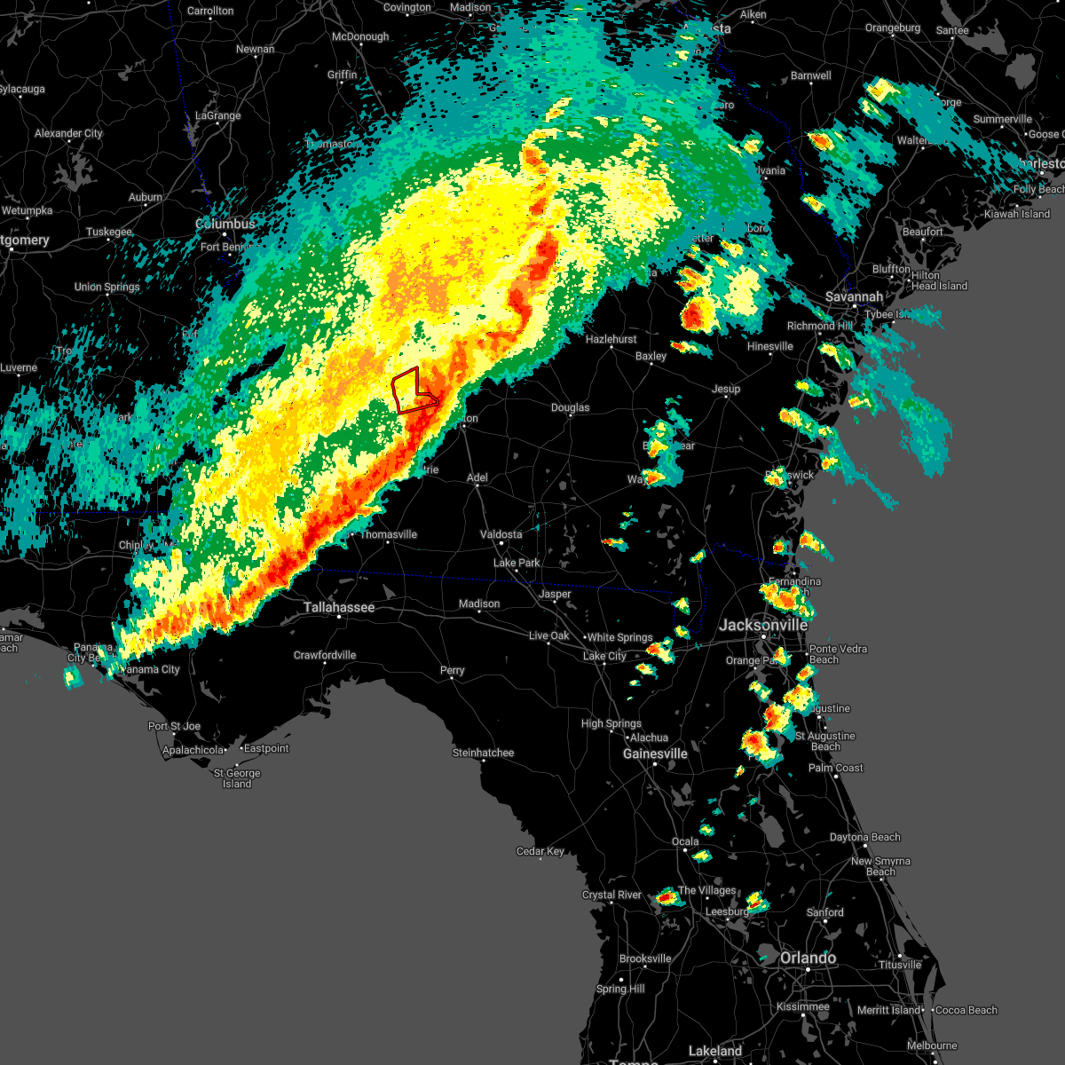 The tornado warning for central worth county will expire at 445 pm edt, the storm which prompted the warning has moved out of the area. therefore, the warning will be allowed to expire. a tornado watch remains in effect until 700 pm edt for south central georgia. The tornado warning for central worth county will expire at 445 pm edt, the storm which prompted the warning has moved out of the area. therefore, the warning will be allowed to expire. a tornado watch remains in effect until 700 pm edt for south central georgia.
|
| 4/5/2022 4:31 PM EDT |
 At 431 pm edt, severe thunderstorms were located along a line extending from near abbeville to near ty ty, moving east at 50 mph (radar indicated). Hazards include 70 mph wind gusts. Expect considerable tree damage. damage is likely to mobile homes, roofs, and outbuildings. Locations impacted include, sylvester, ashburn, fitzgerald, poulan, ty ty, marine corps logistics base, worth, terrell, sycamore, sumner, rebecca, amboy, sylvester airport, tempy, parkerville, waterloo, inaha, red rock, acree and crestwood. At 431 pm edt, severe thunderstorms were located along a line extending from near abbeville to near ty ty, moving east at 50 mph (radar indicated). Hazards include 70 mph wind gusts. Expect considerable tree damage. damage is likely to mobile homes, roofs, and outbuildings. Locations impacted include, sylvester, ashburn, fitzgerald, poulan, ty ty, marine corps logistics base, worth, terrell, sycamore, sumner, rebecca, amboy, sylvester airport, tempy, parkerville, waterloo, inaha, red rock, acree and crestwood.
|
| 4/5/2022 4:28 PM EDT |
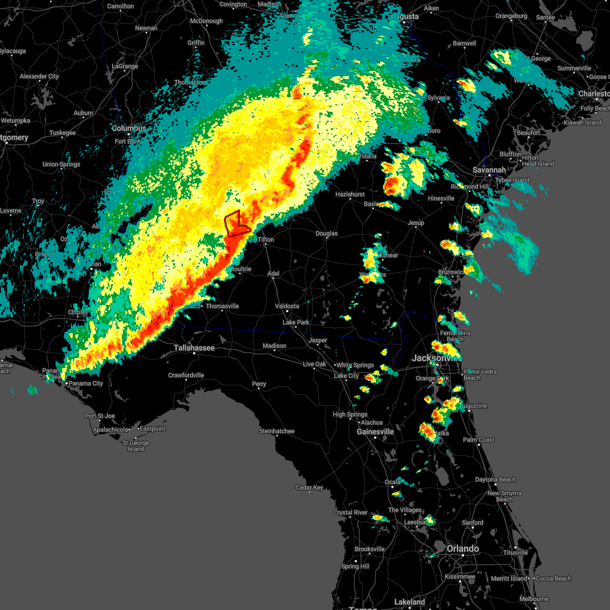 At 428 pm edt, a severe thunderstorm capable of producing a tornado was located near sylvester, moving northeast at 60 mph (radar indicated rotation). Hazards include tornado. Flying debris will be dangerous to those caught without shelter. mobile homes will be damaged or destroyed. damage to roofs, windows, and vehicles will occur. tree damage is likely. This tornadic thunderstorm will remain over mainly rural areas of central worth county, including the following locations, sylvester airport, shingler, isabella, terrell, doles and gammage. At 428 pm edt, a severe thunderstorm capable of producing a tornado was located near sylvester, moving northeast at 60 mph (radar indicated rotation). Hazards include tornado. Flying debris will be dangerous to those caught without shelter. mobile homes will be damaged or destroyed. damage to roofs, windows, and vehicles will occur. tree damage is likely. This tornadic thunderstorm will remain over mainly rural areas of central worth county, including the following locations, sylvester airport, shingler, isabella, terrell, doles and gammage.
|
| 4/5/2022 4:04 PM EDT |
 At 403 pm edt, a severe thunderstorm capable of producing a tornado was located near marine corps logistics base, or 11 miles east of albany, moving east at 60 mph (radar indicated rotation). Hazards include tornado. Flying debris will be dangerous to those caught without shelter. mobile homes will be damaged or destroyed. damage to roofs, windows, and vehicles will occur. tree damage is likely. this dangerous storm will be near, sylvester around 410 pm edt. Other locations impacted by this tornadic thunderstorm include red rock, acree, terrell, gammage, sylvester airport, shingler, isabella and doles. At 403 pm edt, a severe thunderstorm capable of producing a tornado was located near marine corps logistics base, or 11 miles east of albany, moving east at 60 mph (radar indicated rotation). Hazards include tornado. Flying debris will be dangerous to those caught without shelter. mobile homes will be damaged or destroyed. damage to roofs, windows, and vehicles will occur. tree damage is likely. this dangerous storm will be near, sylvester around 410 pm edt. Other locations impacted by this tornadic thunderstorm include red rock, acree, terrell, gammage, sylvester airport, shingler, isabella and doles.
|
| 4/5/2022 3:46 PM EDT |
 At 346 pm edt, severe thunderstorms were located along a line extending from 7 miles southwest of cordele to 8 miles northwest of baconton, moving east at 50 mph (radar indicated). Hazards include 70 mph wind gusts. Expect considerable tree damage. Damage is likely to mobile homes, roofs, and outbuildings. At 346 pm edt, severe thunderstorms were located along a line extending from 7 miles southwest of cordele to 8 miles northwest of baconton, moving east at 50 mph (radar indicated). Hazards include 70 mph wind gusts. Expect considerable tree damage. Damage is likely to mobile homes, roofs, and outbuildings.
|
| 3/18/2022 3:23 PM EDT |
 At 323 pm edt, severe thunderstorms were located along a line extending from 7 miles northeast of poulan to near ochlocknee, moving east at 45 mph (radar indicated). Hazards include 60 mph wind gusts. Expect damage to roofs, siding, and trees. Locations impacted include, sylvester, moultrie, poulan, doerun, ochlocknee, terrell, schley, funston, sumner, sale city, minton, capel, sylvester airport, anderson city, tempy, parkerville, cotton, inaha, chastain and red rock. At 323 pm edt, severe thunderstorms were located along a line extending from 7 miles northeast of poulan to near ochlocknee, moving east at 45 mph (radar indicated). Hazards include 60 mph wind gusts. Expect damage to roofs, siding, and trees. Locations impacted include, sylvester, moultrie, poulan, doerun, ochlocknee, terrell, schley, funston, sumner, sale city, minton, capel, sylvester airport, anderson city, tempy, parkerville, cotton, inaha, chastain and red rock.
|
| 3/18/2022 3:07 PM EDT |
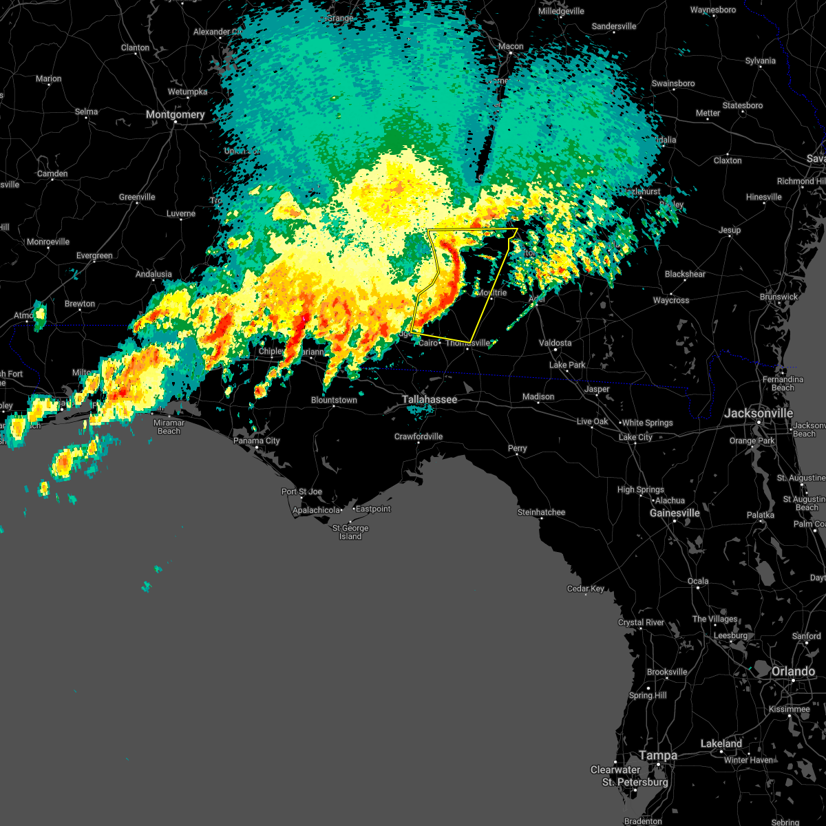 At 306 pm edt, severe thunderstorms were located along a line extending from marine corps logistics base to 8 miles north of whigham, moving east at 30 mph (radar indicated). Hazards include 60 mph wind gusts. Expect damage to roofs, siding, and trees. Locations impacted include, albany, sylvester, pelham, putney, camilla, moultrie, baconton, poulan, doerun, ochlocknee, east albany, marine corps logistics base, turner city, terrell, schley, funston, sumner, sale city, minton and capel. At 306 pm edt, severe thunderstorms were located along a line extending from marine corps logistics base to 8 miles north of whigham, moving east at 30 mph (radar indicated). Hazards include 60 mph wind gusts. Expect damage to roofs, siding, and trees. Locations impacted include, albany, sylvester, pelham, putney, camilla, moultrie, baconton, poulan, doerun, ochlocknee, east albany, marine corps logistics base, turner city, terrell, schley, funston, sumner, sale city, minton and capel.
|
| 3/18/2022 2:37 PM EDT |
 At 236 pm edt, severe thunderstorms were located along a line extending from 10 miles west of albany to 9 miles north of west bainbridge, moving northeast at 40 mph (radar indicated). Hazards include 60 mph wind gusts. expect damage to roofs, siding, and trees At 236 pm edt, severe thunderstorms were located along a line extending from 10 miles west of albany to 9 miles north of west bainbridge, moving northeast at 40 mph (radar indicated). Hazards include 60 mph wind gusts. expect damage to roofs, siding, and trees
|
| 1/2/2022 4:43 PM EST |
 At 443 pm est, severe thunderstorms were located along a line extending from 6 miles southwest of cordele to 7 miles southeast of marine corps logistics base, moving east at 45 mph (radar indicated). Hazards include 60 mph wind gusts. Expect damage to roofs, siding, and trees. locations impacted include, fitzgerald, sylvester, putney, ashburn, poulan, marine corps logistics base, worth, terrell, sycamore, sumner, warwick, rebecca, amboy, sylvester airport, waterloo, inaha, red rock, acree, irwinville and crestwood. hail threat, radar indicated max hail size, <. 75 in wind threat, radar indicated max wind gust, 60 mph. At 443 pm est, severe thunderstorms were located along a line extending from 6 miles southwest of cordele to 7 miles southeast of marine corps logistics base, moving east at 45 mph (radar indicated). Hazards include 60 mph wind gusts. Expect damage to roofs, siding, and trees. locations impacted include, fitzgerald, sylvester, putney, ashburn, poulan, marine corps logistics base, worth, terrell, sycamore, sumner, warwick, rebecca, amboy, sylvester airport, waterloo, inaha, red rock, acree, irwinville and crestwood. hail threat, radar indicated max hail size, <. 75 in wind threat, radar indicated max wind gust, 60 mph.
|
| 1/2/2022 4:27 PM EST |
 At 427 pm est, severe thunderstorms were located along a line extending from 6 miles southeast of desoto to putney, moving northeast at 55 mph (radar indicated). Hazards include 60 mph wind gusts. expect damage to roofs, siding, and trees At 427 pm est, severe thunderstorms were located along a line extending from 6 miles southeast of desoto to putney, moving northeast at 55 mph (radar indicated). Hazards include 60 mph wind gusts. expect damage to roofs, siding, and trees
|
| 1/2/2022 3:37 PM EST |
 At 336 pm est, a severe thunderstorm capable of producing a tornado was located over east albany, or near albany, moving northeast at 45 mph (radar indicated rotation). Hazards include tornado. Flying debris will be dangerous to those caught without shelter. mobile homes will be damaged or destroyed. damage to roofs, windows, and vehicles will occur. tree damage is likely. this dangerous storm will be near, marine corps logistics base around 345 pm est. ashburn around 415 pm est. Other locations impacted by this tornadic thunderstorm include stocks, radium springs, amboy, rebecca, sylvester airport, south albany, pecan city, sibley, worth and red rock. At 336 pm est, a severe thunderstorm capable of producing a tornado was located over east albany, or near albany, moving northeast at 45 mph (radar indicated rotation). Hazards include tornado. Flying debris will be dangerous to those caught without shelter. mobile homes will be damaged or destroyed. damage to roofs, windows, and vehicles will occur. tree damage is likely. this dangerous storm will be near, marine corps logistics base around 345 pm est. ashburn around 415 pm est. Other locations impacted by this tornadic thunderstorm include stocks, radium springs, amboy, rebecca, sylvester airport, south albany, pecan city, sibley, worth and red rock.
|
| 1/2/2022 3:32 PM EST |
 At 332 pm est, a severe thunderstorm was located near putney, moving northeast at 35 mph (radar indicated). Hazards include 60 mph wind gusts. expect damage to roofs, siding, and trees At 332 pm est, a severe thunderstorm was located near putney, moving northeast at 35 mph (radar indicated). Hazards include 60 mph wind gusts. expect damage to roofs, siding, and trees
|
| 9/1/2021 7:27 PM EDT |
 The severe thunderstorm warning for northwestern cook, eastern dougherty, northeastern mitchell, northeastern baker, colquitt, southwestern tift and southern worth counties will expire at 730 pm edt, the storms which prompted the warning have weakened below severe limits, and no longer pose an immediate threat to life or property. therefore, the warning will be allowed to expire. however gusty winds are still possible with these thunderstorms. to report severe weather, contact your nearest law enforcement agency. they will relay your report to the national weather service tallahassee. The severe thunderstorm warning for northwestern cook, eastern dougherty, northeastern mitchell, northeastern baker, colquitt, southwestern tift and southern worth counties will expire at 730 pm edt, the storms which prompted the warning have weakened below severe limits, and no longer pose an immediate threat to life or property. therefore, the warning will be allowed to expire. however gusty winds are still possible with these thunderstorms. to report severe weather, contact your nearest law enforcement agency. they will relay your report to the national weather service tallahassee.
|
| 9/1/2021 6:46 PM EDT |
 At 646 pm edt, severe thunderstorms were located along a line extending from near east albany to 6 miles north of doerun to near ty ty, moving southeast at 20 mph (radar indicated). Hazards include 60 mph wind gusts. expect damage to roofs, siding, and trees At 646 pm edt, severe thunderstorms were located along a line extending from near east albany to 6 miles north of doerun to near ty ty, moving southeast at 20 mph (radar indicated). Hazards include 60 mph wind gusts. expect damage to roofs, siding, and trees
|
| 6/29/2021 6:35 PM EDT |
 The severe thunderstorm warning for northwestern grady, mitchell, northwestern colquitt and southwestern worth counties will expire at 645 pm edt, the storms which prompted the warning have moved out of the area. therefore, the warning will be allowed to expire. to report severe weather, contact your nearest law enforcement agency. they will relay your report to the national weather service tallahassee. The severe thunderstorm warning for northwestern grady, mitchell, northwestern colquitt and southwestern worth counties will expire at 645 pm edt, the storms which prompted the warning have moved out of the area. therefore, the warning will be allowed to expire. to report severe weather, contact your nearest law enforcement agency. they will relay your report to the national weather service tallahassee.
|
| 6/29/2021 6:30 PM EDT |
 At 630 pm edt, severe thunderstorms were located along a line extending from 7 miles south of pitts to 6 miles southwest of sylvester, moving northwest at 25 mph (radar indicated). Hazards include 60 mph wind gusts. Expect damage to roofs, siding, and trees. Locations impacted include, sylvester, ashburn, poulan, worth, terrell, warwick, gordy, amboy, sylvester airport, sibley, red rock, coverdale, gammage, hobby, turner co airport, shingler, isabella, dakota, doles and oakfield. At 630 pm edt, severe thunderstorms were located along a line extending from 7 miles south of pitts to 6 miles southwest of sylvester, moving northwest at 25 mph (radar indicated). Hazards include 60 mph wind gusts. Expect damage to roofs, siding, and trees. Locations impacted include, sylvester, ashburn, poulan, worth, terrell, warwick, gordy, amboy, sylvester airport, sibley, red rock, coverdale, gammage, hobby, turner co airport, shingler, isabella, dakota, doles and oakfield.
|
| 6/29/2021 6:09 PM EDT |
 At 609 pm edt, severe thunderstorms were located along a line extending from 6 miles southwest of sylvester to 6 miles east of bainbridge, moving north at 40 mph (radar indicated). Hazards include 60 mph wind gusts. Expect damage to roofs, siding, and trees. Locations impacted include, newton, pelham, camilla, sylvester, baconton, doerun, whigham, sale city, bridgeboro, minton, flint, sylvester airport, anderson city, tempy, parkerville, cotton, harrells still, lester, peoples still and pritchetts. At 609 pm edt, severe thunderstorms were located along a line extending from 6 miles southwest of sylvester to 6 miles east of bainbridge, moving north at 40 mph (radar indicated). Hazards include 60 mph wind gusts. Expect damage to roofs, siding, and trees. Locations impacted include, newton, pelham, camilla, sylvester, baconton, doerun, whigham, sale city, bridgeboro, minton, flint, sylvester airport, anderson city, tempy, parkerville, cotton, harrells still, lester, peoples still and pritchetts.
|
| 6/29/2021 5:54 PM EDT |
 At 554 pm edt, severe thunderstorms were located along a line extending from 9 miles north of fitzgerald to 8 miles northwest of norman park, moving north at 45 mph (radar indicated). Hazards include 60 mph wind gusts. expect damage to roofs, siding, and trees At 554 pm edt, severe thunderstorms were located along a line extending from 9 miles north of fitzgerald to 8 miles northwest of norman park, moving north at 45 mph (radar indicated). Hazards include 60 mph wind gusts. expect damage to roofs, siding, and trees
|
| 6/29/2021 5:44 PM EDT |
 At 544 pm edt, severe thunderstorms were located along a line extending from 6 miles northwest of norman park to near whigham, moving northwest at 35 mph (radar indicated). Hazards include 60 mph wind gusts. expect damage to roofs, siding, and trees At 544 pm edt, severe thunderstorms were located along a line extending from 6 miles northwest of norman park to near whigham, moving northwest at 35 mph (radar indicated). Hazards include 60 mph wind gusts. expect damage to roofs, siding, and trees
|
| 6/12/2021 7:04 PM EDT |
 At 704 pm edt, severe thunderstorms were located along a line extending from 7 miles northwest of ambrose to 10 miles northwest of sylvester, moving southeast at 25 mph (radar indicated). Hazards include 60 mph wind gusts and penny size hail. Expect damage to roofs, siding, and trees. Locations impacted include, tifton, ashburn, ocilla, fitzgerald, sylvester, enigma, omega, poulan, ty ty, alapaha, phillipsburg, mystic, unionville, worth, terrell, sycamore, sumner, minton, scooterville and osierfield. At 704 pm edt, severe thunderstorms were located along a line extending from 7 miles northwest of ambrose to 10 miles northwest of sylvester, moving southeast at 25 mph (radar indicated). Hazards include 60 mph wind gusts and penny size hail. Expect damage to roofs, siding, and trees. Locations impacted include, tifton, ashburn, ocilla, fitzgerald, sylvester, enigma, omega, poulan, ty ty, alapaha, phillipsburg, mystic, unionville, worth, terrell, sycamore, sumner, minton, scooterville and osierfield.
|
| 6/12/2021 6:50 PM EDT |
 At 650 pm edt, severe thunderstorms were located along a line extending from 6 miles northeast of fitzgerald to 6 miles northeast of marine corps logistics base, moving southeast at 30 mph (radar indicated). Hazards include 60 mph wind gusts and penny size hail. expect damage to roofs, siding, and trees At 650 pm edt, severe thunderstorms were located along a line extending from 6 miles northeast of fitzgerald to 6 miles northeast of marine corps logistics base, moving southeast at 30 mph (radar indicated). Hazards include 60 mph wind gusts and penny size hail. expect damage to roofs, siding, and trees
|
| 5/12/2021 12:05 PM EDT |
 The severe thunderstorm warning for northeastern thomas, northwestern brooks, central colquitt and southern worth counties will expire at 1215 pm edt, the storms which prompted the warning have moved out of the area. therefore, the warning will be allowed to expire. a severe thunderstorm watch remains in effect until 200 pm edt for south central georgia. to report severe weather, contact your nearest law enforcement agency. they will relay your report to the national weather service tallahassee. The severe thunderstorm warning for northeastern thomas, northwestern brooks, central colquitt and southern worth counties will expire at 1215 pm edt, the storms which prompted the warning have moved out of the area. therefore, the warning will be allowed to expire. a severe thunderstorm watch remains in effect until 200 pm edt for south central georgia. to report severe weather, contact your nearest law enforcement agency. they will relay your report to the national weather service tallahassee.
|
| 5/12/2021 11:55 AM EDT | Tree down on a power line near e welch st and martin luther king jr d in worth county GA, 0.8 miles NNW of Sylvester, GA |
| 5/12/2021 11:53 AM EDT |
 At 1153 am edt, severe thunderstorms were located along a line extending from sylvester to near pavo, moving northeast at 40 mph (radar indicated). Hazards include 60 mph wind gusts. Expect damage to roofs, siding, and trees. Locations impacted include, sylvester, moultrie, norman park, poulan, pavo, coolidge, riverside, berlin, sumner, minton, scooterville, sylvester airport, anderson city, enon, tempy, south moultrie, merrillville, moultrie municipal a/p, shingler and murphy. At 1153 am edt, severe thunderstorms were located along a line extending from sylvester to near pavo, moving northeast at 40 mph (radar indicated). Hazards include 60 mph wind gusts. Expect damage to roofs, siding, and trees. Locations impacted include, sylvester, moultrie, norman park, poulan, pavo, coolidge, riverside, berlin, sumner, minton, scooterville, sylvester airport, anderson city, enon, tempy, south moultrie, merrillville, moultrie municipal a/p, shingler and murphy.
|
| 5/12/2021 11:40 AM EDT |
 At 1140 am edt, severe thunderstorms were located along a line extending from 6 miles southeast of marine corps logistics base to coolidge, moving east at 40 mph (radar indicated). Hazards include 60 mph wind gusts. Expect damage to roofs, siding, and trees. Locations impacted include, sylvester, moultrie, norman park, poulan, doerun, pavo, coolidge, riverside, schley, berlin, funston, sumner, bridgeboro, minton, scooterville, sylvester airport, anderson city, enon, tempy and parkerville. At 1140 am edt, severe thunderstorms were located along a line extending from 6 miles southeast of marine corps logistics base to coolidge, moving east at 40 mph (radar indicated). Hazards include 60 mph wind gusts. Expect damage to roofs, siding, and trees. Locations impacted include, sylvester, moultrie, norman park, poulan, doerun, pavo, coolidge, riverside, schley, berlin, funston, sumner, bridgeboro, minton, scooterville, sylvester airport, anderson city, enon, tempy and parkerville.
|
| 5/12/2021 11:28 AM EDT |
 At 1128 am edt, severe thunderstorms were located along a line extending from putney to near ochlocknee, moving northeast at 40 mph (radar indicated). Hazards include 60 mph wind gusts. Expect damage to roofs, siding, and trees. Locations impacted include, moultrie, sylvester, pelham, putney, camilla, norman park, baconton, poulan, doerun, ochlocknee, pavo, coolidge, riverside, schley, berlin, funston, sumner, sale city, minton and scooterville. At 1128 am edt, severe thunderstorms were located along a line extending from putney to near ochlocknee, moving northeast at 40 mph (radar indicated). Hazards include 60 mph wind gusts. Expect damage to roofs, siding, and trees. Locations impacted include, moultrie, sylvester, pelham, putney, camilla, norman park, baconton, poulan, doerun, ochlocknee, pavo, coolidge, riverside, schley, berlin, funston, sumner, sale city, minton and scooterville.
|
| 5/12/2021 11:06 AM EDT |
 At 1106 am edt, severe thunderstorms were located along a line extending from 6 miles north of newton to near cairo, moving northeast at 40 mph (radar indicated). Hazards include 60 mph wind gusts. expect damage to roofs, siding, and trees At 1106 am edt, severe thunderstorms were located along a line extending from 6 miles north of newton to near cairo, moving northeast at 40 mph (radar indicated). Hazards include 60 mph wind gusts. expect damage to roofs, siding, and trees
|
| 5/4/2021 10:46 PM EDT |
 At 1046 pm edt, severe thunderstorms were located along a line extending from 6 miles south of abbeville to near pelham, moving east at 55 mph (radar indicated). Hazards include 60 mph wind gusts. Expect damage to roofs, siding, and trees. Locations impacted include, tifton, ashburn, ocilla, fitzgerald, sylvester, enigma, omega, poulan, ty ty, alapaha, phillipsburg, mystic, unionville, terrell, sycamore, sumner, rebecca, minton, scooterville and osierfield. At 1046 pm edt, severe thunderstorms were located along a line extending from 6 miles south of abbeville to near pelham, moving east at 55 mph (radar indicated). Hazards include 60 mph wind gusts. Expect damage to roofs, siding, and trees. Locations impacted include, tifton, ashburn, ocilla, fitzgerald, sylvester, enigma, omega, poulan, ty ty, alapaha, phillipsburg, mystic, unionville, terrell, sycamore, sumner, rebecca, minton, scooterville and osierfield.
|
| 5/4/2021 10:30 PM EDT | Powerlines dow in worth county GA, 0.4 miles ENE of Sylvester, GA |
| 5/4/2021 10:30 PM EDT | Powerlines dow in worth county GA, 0.4 miles ENE of Sylvester, GA |
| 5/4/2021 10:07 PM EDT |
 At 1007 pm edt, severe thunderstorms were located along a line extending from 8 miles east of desoto to 10 miles east of leary, moving east at 65 mph (radar indicated). Hazards include 60 mph wind gusts. expect damage to roofs, siding, and trees At 1007 pm edt, severe thunderstorms were located along a line extending from 8 miles east of desoto to 10 miles east of leary, moving east at 65 mph (radar indicated). Hazards include 60 mph wind gusts. expect damage to roofs, siding, and trees
|
| 4/24/2021 8:30 PM EDT |
 At 830 pm edt, a severe thunderstorm was located 7 miles east of leary, or 11 miles east of morgan, moving east at 55 mph (radar indicated). Hazards include 60 mph wind gusts. expect damage to roofs, siding, and trees At 830 pm edt, a severe thunderstorm was located 7 miles east of leary, or 11 miles east of morgan, moving east at 55 mph (radar indicated). Hazards include 60 mph wind gusts. expect damage to roofs, siding, and trees
|
| 4/24/2021 4:58 PM EDT |
 At 457 pm edt, severe thunderstorms were located along a line extending from near albany to near newton to near colquitt, moving east at 50 mph (radar indicated). Hazards include 60 mph wind gusts and quarter size hail. Hail damage to vehicles is expected. Expect wind damage to roofs, siding, and trees. At 457 pm edt, severe thunderstorms were located along a line extending from near albany to near newton to near colquitt, moving east at 50 mph (radar indicated). Hazards include 60 mph wind gusts and quarter size hail. Hail damage to vehicles is expected. Expect wind damage to roofs, siding, and trees.
|
| 4/24/2021 10:21 AM EDT |
 At 1021 am edt, severe thunderstorms were located along a line extending from 6 miles northeast of ashburn to near omega to 7 miles north of pavo, moving east at 60 mph (radar indicated). Hazards include 60 mph wind gusts and quarter size hail. Hail damage to vehicles is expected. expect wind damage to roofs, siding, and trees. Locations impacted include, moultrie, sylvester, norman park, poulan, doerun, riverside, terrell, schley, funston, sumner, minton, scooterville, anderson city, tempy, south moultrie, sigsbee, moultrie municipal a/p, poplar arbor church, hobby and shingler. At 1021 am edt, severe thunderstorms were located along a line extending from 6 miles northeast of ashburn to near omega to 7 miles north of pavo, moving east at 60 mph (radar indicated). Hazards include 60 mph wind gusts and quarter size hail. Hail damage to vehicles is expected. expect wind damage to roofs, siding, and trees. Locations impacted include, moultrie, sylvester, norman park, poulan, doerun, riverside, terrell, schley, funston, sumner, minton, scooterville, anderson city, tempy, south moultrie, sigsbee, moultrie municipal a/p, poplar arbor church, hobby and shingler.
|
| 4/24/2021 9:46 AM EDT |
 At 945 am edt, severe thunderstorms were located along a line extending from near leesburg to near baconton to 9 miles west of pelham, moving east at 60 mph (radar indicated). Hazards include golf ball size hail and 70 mph wind gusts. People and animals outdoors will be injured. expect hail damage to roofs, siding, windows, and vehicles. expect considerable tree damage. wind damage is also likely to mobile homes, roofs, and outbuildings. Locations impacted include, newton, albany, moultrie, sylvester, leesburg, pelham, putney, camilla, ashburn, norman park, baconton, poulan, doerun, east albany, marine corps logistics base, turner city, riverside, worth, terrell and schley. At 945 am edt, severe thunderstorms were located along a line extending from near leesburg to near baconton to 9 miles west of pelham, moving east at 60 mph (radar indicated). Hazards include golf ball size hail and 70 mph wind gusts. People and animals outdoors will be injured. expect hail damage to roofs, siding, windows, and vehicles. expect considerable tree damage. wind damage is also likely to mobile homes, roofs, and outbuildings. Locations impacted include, newton, albany, moultrie, sylvester, leesburg, pelham, putney, camilla, ashburn, norman park, baconton, poulan, doerun, east albany, marine corps logistics base, turner city, riverside, worth, terrell and schley.
|
| 4/24/2021 9:28 AM EDT |
 At 928 am edt, severe thunderstorms were located along a line extending from dawson to near newton to 9 miles southeast of colquitt, moving east at 60 mph (radar indicated). Hazards include 70 mph wind gusts. Expect considerable tree damage. Damage is likely to mobile homes, roofs, and outbuildings. At 928 am edt, severe thunderstorms were located along a line extending from dawson to near newton to 9 miles southeast of colquitt, moving east at 60 mph (radar indicated). Hazards include 70 mph wind gusts. Expect considerable tree damage. Damage is likely to mobile homes, roofs, and outbuildings.
|
| 9/16/2020 5:17 PM EDT |
 At 517 pm edt, a severe thunderstorm capable of producing a tornado was located near sylvester, moving north at 25 mph (radar indicated rotation). Hazards include tornado. Flying debris will be dangerous to those caught without shelter. mobile homes will be damaged or destroyed. damage to roofs, windows, and vehicles will occur. tree damage is likely. This tornadic thunderstorm will remain over mainly rural areas of northwestern worth county, including the following locations, red rock, warwick, gammage, sylvester airport, isabella, doles, oakfield and acree. At 517 pm edt, a severe thunderstorm capable of producing a tornado was located near sylvester, moving north at 25 mph (radar indicated rotation). Hazards include tornado. Flying debris will be dangerous to those caught without shelter. mobile homes will be damaged or destroyed. damage to roofs, windows, and vehicles will occur. tree damage is likely. This tornadic thunderstorm will remain over mainly rural areas of northwestern worth county, including the following locations, red rock, warwick, gammage, sylvester airport, isabella, doles, oakfield and acree.
|
| 8/18/2020 9:53 PM EDT |
 At 953 pm edt, severe thunderstorms were located along a line extending from 8 miles west of albany to 7 miles southeast of putney, moving east at 5 mph (radar indicated). Hazards include 60 mph wind gusts and penny size hail. expect damage to roofs, siding, and trees At 953 pm edt, severe thunderstorms were located along a line extending from 8 miles west of albany to 7 miles southeast of putney, moving east at 5 mph (radar indicated). Hazards include 60 mph wind gusts and penny size hail. expect damage to roofs, siding, and trees
|
| 8/18/2020 9:16 PM EDT |
 At 916 pm edt, a severe thunderstorm was located over east albany, or near albany, moving southeast at 10 mph (radar indicated). Hazards include 60 mph wind gusts and penny size hail. expect damage to roofs, siding, and trees At 916 pm edt, a severe thunderstorm was located over east albany, or near albany, moving southeast at 10 mph (radar indicated). Hazards include 60 mph wind gusts and penny size hail. expect damage to roofs, siding, and trees
|
| 6/24/2020 3:09 PM EDT |
 At 309 pm edt, a severe thunderstorm was located 8 miles southwest of albany, moving east at 40 mph (radar indicated). Hazards include 60 mph wind gusts and penny size hail. expect damage to roofs, siding, and trees At 309 pm edt, a severe thunderstorm was located 8 miles southwest of albany, moving east at 40 mph (radar indicated). Hazards include 60 mph wind gusts and penny size hail. expect damage to roofs, siding, and trees
|
| 6/22/2020 7:21 PM EDT |
 The severe thunderstorm warning for eastern dougherty, northeastern mitchell, lee, northeastern baker and worth counties will expire at 730 pm edt, the storms which prompted the warning have weakened below severe limits, and no longer pose an immediate threat to life or property. therefore, the warning will be allowed to expire. to report severe weather, contact your nearest law enforcement agency. they will relay your report to the national weather service tallahassee. The severe thunderstorm warning for eastern dougherty, northeastern mitchell, lee, northeastern baker and worth counties will expire at 730 pm edt, the storms which prompted the warning have weakened below severe limits, and no longer pose an immediate threat to life or property. therefore, the warning will be allowed to expire. to report severe weather, contact your nearest law enforcement agency. they will relay your report to the national weather service tallahassee.
|
| 6/22/2020 6:48 PM EDT |
 At 647 pm edt, severe thunderstorms were located along a line extending from near leesburg to near putney, moving northeast at 35 mph (radar indicated). Hazards include 60 mph wind gusts. Expect damage to roofs, siding, and trees. Locations impacted include, sylvester, leesburg, albany, putney, baconton, poulan, east albany, marine corps logistics base, turner city, warwick, chokee, stocks, radium springs, forrester, sylvester airport, south albany, southwest ga regional a/p, parkerville, palmyra and red rock. At 647 pm edt, severe thunderstorms were located along a line extending from near leesburg to near putney, moving northeast at 35 mph (radar indicated). Hazards include 60 mph wind gusts. Expect damage to roofs, siding, and trees. Locations impacted include, sylvester, leesburg, albany, putney, baconton, poulan, east albany, marine corps logistics base, turner city, warwick, chokee, stocks, radium springs, forrester, sylvester airport, south albany, southwest ga regional a/p, parkerville, palmyra and red rock.
|
| 6/22/2020 6:24 PM EDT |
 At 624 pm edt, severe thunderstorms were located along a line extending from 8 miles southeast of dawson to newton, moving northeast at 35 mph (radar indicated). Hazards include 60 mph wind gusts. expect damage to roofs, siding, and trees At 624 pm edt, severe thunderstorms were located along a line extending from 8 miles southeast of dawson to newton, moving northeast at 35 mph (radar indicated). Hazards include 60 mph wind gusts. expect damage to roofs, siding, and trees
|
| 4/20/2020 2:28 AM EDT |
 At 228 am edt, severe thunderstorms were located along a line extending from near cordele to 7 miles northeast of doerun to 6 miles west of riverside, moving east at 50 mph (radar indicated). Hazards include 70 mph wind gusts and quarter size hail. Hail damage to vehicles is expected. expect considerable tree damage. wind damage is also likely to mobile homes, roofs, and outbuildings. Locations impacted include, newton, tifton, albany, putney, ashburn, sylvester, leesburg, camilla, moultrie, sparks, omega, norman park, baconton, lenox, poulan, doerun, ty ty, phillipsburg, unionville and east albany. At 228 am edt, severe thunderstorms were located along a line extending from near cordele to 7 miles northeast of doerun to 6 miles west of riverside, moving east at 50 mph (radar indicated). Hazards include 70 mph wind gusts and quarter size hail. Hail damage to vehicles is expected. expect considerable tree damage. wind damage is also likely to mobile homes, roofs, and outbuildings. Locations impacted include, newton, tifton, albany, putney, ashburn, sylvester, leesburg, camilla, moultrie, sparks, omega, norman park, baconton, lenox, poulan, doerun, ty ty, phillipsburg, unionville and east albany.
|
| 4/20/2020 2:17 AM EDT | Major home damage with entrapment on york roa in worth county GA, 6 miles NNE of Sylvester, GA |
| 4/20/2020 2:14 AM EDT |
 At 214 am edt, severe thunderstorms were located along a line extending from 6 miles east of desoto to 6 miles northwest of doerun to 7 miles east of camilla, moving east at 50 mph (radar indicated). Hazards include 70 mph wind gusts. Expect considerable tree damage. damage is likely to mobile homes, roofs, and outbuildings. Locations impacted include, newton, tifton, albany, putney, ashburn, sylvester, leesburg, camilla, moultrie, sparks, omega, norman park, baconton, lenox, poulan, doerun, ty ty, phillipsburg, unionville and east albany. At 214 am edt, severe thunderstorms were located along a line extending from 6 miles east of desoto to 6 miles northwest of doerun to 7 miles east of camilla, moving east at 50 mph (radar indicated). Hazards include 70 mph wind gusts. Expect considerable tree damage. damage is likely to mobile homes, roofs, and outbuildings. Locations impacted include, newton, tifton, albany, putney, ashburn, sylvester, leesburg, camilla, moultrie, sparks, omega, norman park, baconton, lenox, poulan, doerun, ty ty, phillipsburg, unionville and east albany.
|
| 4/20/2020 1:38 AM EDT |
 At 138 am edt, severe thunderstorms were located along a line extending from near plains to 8 miles east of leary to 7 miles west of newton, moving east at 50 mph (radar indicated). Hazards include 70 mph wind gusts. Expect considerable tree damage. Damage is likely to mobile homes, roofs, and outbuildings. At 138 am edt, severe thunderstorms were located along a line extending from near plains to 8 miles east of leary to 7 miles west of newton, moving east at 50 mph (radar indicated). Hazards include 70 mph wind gusts. Expect considerable tree damage. Damage is likely to mobile homes, roofs, and outbuildings.
|
| 4/13/2020 5:27 AM EDT |
 At 526 am edt, a severe thunderstorm was located over sylvester, moving east at 50 mph (radar indicated). Hazards include 70 mph wind gusts. Expect considerable tree damage. damage is likely to mobile homes, roofs, and outbuildings. Locations impacted include, sylvester, ashburn, poulan, worth, terrell, sycamore, sumner, warwick, rebecca, bridgeboro, minton, scooterville, amboy, sylvester airport, anderson city, tempy, parkerville, inaha, red rock and pritchetts. At 526 am edt, a severe thunderstorm was located over sylvester, moving east at 50 mph (radar indicated). Hazards include 70 mph wind gusts. Expect considerable tree damage. damage is likely to mobile homes, roofs, and outbuildings. Locations impacted include, sylvester, ashburn, poulan, worth, terrell, sycamore, sumner, warwick, rebecca, bridgeboro, minton, scooterville, amboy, sylvester airport, anderson city, tempy, parkerville, inaha, red rock and pritchetts.
|
| 4/13/2020 5:25 AM EDT | Public reports trees down and blocking the road at hwy 256 and seabrook driv in worth county GA, 2 miles NW of Sylvester, GA |
| 4/13/2020 5:25 AM EDT | Trees down blocking the road at jewel crowe road and blue springs roa in worth county GA, 6.7 miles SSE of Sylvester, GA |
| 4/13/2020 5:23 AM EDT |
 At 523 am edt, a severe thunderstorm capable of producing a tornado was located near doerun, or 10 miles south of sylvester, moving east at 55 mph (radar indicated rotation). Hazards include tornado. Flying debris will be dangerous to those caught without shelter. mobile homes will be damaged or destroyed. damage to roofs, windows, and vehicles will occur. tree damage is likely. Locations impacted include, sylvester, poulan, sumner, bridgeboro, minton, gordy, scooterville, livingston, anderson city, tempy, parkerville, powelltown, pritchetts, crestwood and alfords. At 523 am edt, a severe thunderstorm capable of producing a tornado was located near doerun, or 10 miles south of sylvester, moving east at 55 mph (radar indicated rotation). Hazards include tornado. Flying debris will be dangerous to those caught without shelter. mobile homes will be damaged or destroyed. damage to roofs, windows, and vehicles will occur. tree damage is likely. Locations impacted include, sylvester, poulan, sumner, bridgeboro, minton, gordy, scooterville, livingston, anderson city, tempy, parkerville, powelltown, pritchetts, crestwood and alfords.
|
| 4/13/2020 5:14 AM EDT | Numerous trees down in the 3800 block of us-82 east of sylvester. one home with roof damage in the are in worth county GA, 6.4 miles ESE of Sylvester, GA |
| 4/13/2020 5:08 AM EDT |
 At 507 am edt, a severe thunderstorm capable of producing a tornado was located over baconton, or 8 miles south of putney, moving east at 55 mph (radar indicated rotation). Hazards include tornado. Flying debris will be dangerous to those caught without shelter. mobile homes will be damaged or destroyed. damage to roofs, windows, and vehicles will occur. tree damage is likely. This tornadic thunderstorm will remain over mainly rural areas of northeastern mitchell and southern worth counties, including the following locations, bridgeboro, minton, gordy, flint, scooterville, livingston, anderson city, tempy, parkerville and powelltown. At 507 am edt, a severe thunderstorm capable of producing a tornado was located over baconton, or 8 miles south of putney, moving east at 55 mph (radar indicated rotation). Hazards include tornado. Flying debris will be dangerous to those caught without shelter. mobile homes will be damaged or destroyed. damage to roofs, windows, and vehicles will occur. tree damage is likely. This tornadic thunderstorm will remain over mainly rural areas of northeastern mitchell and southern worth counties, including the following locations, bridgeboro, minton, gordy, flint, scooterville, livingston, anderson city, tempy, parkerville and powelltown.
|
| 4/13/2020 4:21 AM EDT |
 At 421 am edt, a severe thunderstorm was located over leesburg, moving east at 65 mph (radar indicated). Hazards include 60 mph wind gusts. expect damage to roofs, siding, and trees At 421 am edt, a severe thunderstorm was located over leesburg, moving east at 65 mph (radar indicated). Hazards include 60 mph wind gusts. expect damage to roofs, siding, and trees
|
| 3/31/2020 2:20 PM EDT |
 At 219 pm edt, severe thunderstorms were located along a line extending from 6 miles southeast of pineview to 6 miles northwest of doerun to 10 miles southwest of newton, moving east at 70 mph (radar indicated). Hazards include 60 mph wind gusts. Expect damage to roofs, siding, and trees. Locations impacted include, newton, bainbridge, cairo, pelham, putney, camilla, sylvester, albany, baconton, doerun, whigham, west bainbridge, east albany, marine corps logistics base, turner city, attapulgus, warwick, sale city, climax and brinson. At 219 pm edt, severe thunderstorms were located along a line extending from 6 miles southeast of pineview to 6 miles northwest of doerun to 10 miles southwest of newton, moving east at 70 mph (radar indicated). Hazards include 60 mph wind gusts. Expect damage to roofs, siding, and trees. Locations impacted include, newton, bainbridge, cairo, pelham, putney, camilla, sylvester, albany, baconton, doerun, whigham, west bainbridge, east albany, marine corps logistics base, turner city, attapulgus, warwick, sale city, climax and brinson.
|
| 3/31/2020 2:09 PM EDT |
 At 209 pm edt, a severe thunderstorm was located near doerun, or 7 miles northwest of moultrie, moving northeast at 45 mph (radar indicated). Hazards include 60 mph wind gusts. expect damage to roofs, siding, and trees At 209 pm edt, a severe thunderstorm was located near doerun, or 7 miles northwest of moultrie, moving northeast at 45 mph (radar indicated). Hazards include 60 mph wind gusts. expect damage to roofs, siding, and trees
|
| 3/31/2020 1:43 PM EDT |
 At 143 pm edt, severe thunderstorms were located along a line extending from leslie to 7 miles north of colquitt to 10 miles southeast of ashford, moving east at 70 mph (radar indicated). Hazards include 60 mph wind gusts. expect damage to roofs, siding, and trees At 143 pm edt, severe thunderstorms were located along a line extending from leslie to 7 miles north of colquitt to 10 miles southeast of ashford, moving east at 70 mph (radar indicated). Hazards include 60 mph wind gusts. expect damage to roofs, siding, and trees
|
| 3/4/2020 10:08 AM EST |
 At 1008 am est, a severe thunderstorm was located near marine corps logistics base, or 9 miles east of albany, moving east at 55 mph (radar indicated). Hazards include 60 mph wind gusts. expect damage to roofs, siding, and trees At 1008 am est, a severe thunderstorm was located near marine corps logistics base, or 9 miles east of albany, moving east at 55 mph (radar indicated). Hazards include 60 mph wind gusts. expect damage to roofs, siding, and trees
|
| 12/17/2019 11:09 AM EST |
 At 1109 am est, a severe thunderstorm was located near poulan, or near sylvester, moving east at 35 mph (radar indicated). Hazards include 60 mph wind gusts. expect damage to roofs, siding, and trees At 1109 am est, a severe thunderstorm was located near poulan, or near sylvester, moving east at 35 mph (radar indicated). Hazards include 60 mph wind gusts. expect damage to roofs, siding, and trees
|
| 12/17/2019 10:48 AM EST |
 At 1047 am est, a severe thunderstorm was located near sylvester, moving east at 40 mph (radar indicated). Hazards include 60 mph wind gusts and penny size hail. Expect damage to roofs, siding, and trees. Locations impacted include, sylvester, poulan, sumner, bridgeboro, gordy, scooterville, livingston, sylvester airport, anderson city, tempy, parkerville, powelltown, pritchetts, gammage, crestwood, shingler, isabella and alfords. At 1047 am est, a severe thunderstorm was located near sylvester, moving east at 40 mph (radar indicated). Hazards include 60 mph wind gusts and penny size hail. Expect damage to roofs, siding, and trees. Locations impacted include, sylvester, poulan, sumner, bridgeboro, gordy, scooterville, livingston, sylvester airport, anderson city, tempy, parkerville, powelltown, pritchetts, gammage, crestwood, shingler, isabella and alfords.
|
| 12/17/2019 10:26 AM EST |
 At 1025 am est, a severe thunderstorm was located near baconton, or near putney, moving east at 40 mph (radar indicated). Hazards include 60 mph wind gusts and penny size hail. expect damage to roofs, siding, and trees At 1025 am est, a severe thunderstorm was located near baconton, or near putney, moving east at 40 mph (radar indicated). Hazards include 60 mph wind gusts and penny size hail. expect damage to roofs, siding, and trees
|
| 7/19/2019 5:54 PM EDT |
 The severe thunderstorm warning for irwin, turner, northern tift, ben hill and central worth counties will expire at 600 pm edt, the storms which prompted the warning have weakened below severe limits, and no longer pose an immediate threat to life or property. therefore, the warning will be allowed to expire. however heavy rain and flooding are still possible with these thunderstorms. to report severe weather, contact your nearest law enforcement agency. they will relay your report to the national weather service tallahassee. The severe thunderstorm warning for irwin, turner, northern tift, ben hill and central worth counties will expire at 600 pm edt, the storms which prompted the warning have weakened below severe limits, and no longer pose an immediate threat to life or property. therefore, the warning will be allowed to expire. however heavy rain and flooding are still possible with these thunderstorms. to report severe weather, contact your nearest law enforcement agency. they will relay your report to the national weather service tallahassee.
|
| 7/19/2019 5:06 PM EDT |
 The national weather service in tallahassee has issued a * severe thunderstorm warning for. irwin county in south central georgia. turner county in south central georgia. northern tift county in south central georgia. Ben hill county in south central georgia. The national weather service in tallahassee has issued a * severe thunderstorm warning for. irwin county in south central georgia. turner county in south central georgia. northern tift county in south central georgia. Ben hill county in south central georgia.
|
| 6/20/2019 7:00 PM EDT |
 At 700 pm edt, severe thunderstorms were located along a line extending from 6 miles southwest of ambrose to near doerun, moving southeast at 30 mph (radar indicated). Hazards include 60 mph wind gusts. Expect damage to roofs, siding, and trees. Locations impacted include, tifton, nashville, sylvester, moultrie, ocilla, adel, sparks, enigma, omega, norman park, lenox, poulan, doerun, ty ty, alapaha, phillipsburg, unionville, riverside, schley and funston. At 700 pm edt, severe thunderstorms were located along a line extending from 6 miles southwest of ambrose to near doerun, moving southeast at 30 mph (radar indicated). Hazards include 60 mph wind gusts. Expect damage to roofs, siding, and trees. Locations impacted include, tifton, nashville, sylvester, moultrie, ocilla, adel, sparks, enigma, omega, norman park, lenox, poulan, doerun, ty ty, alapaha, phillipsburg, unionville, riverside, schley and funston.
|
| 6/20/2019 6:50 PM EDT |
 At 650 pm edt, severe thunderstorms were located along a line extending from near ambrose to 7 miles north of doerun, moving southeast at 25 mph (radar indicated). Hazards include 60 mph wind gusts. Expect damage to roofs, siding, and trees. Locations impacted include, tifton, nashville, ocilla, sylvester, moultrie, fitzgerald, adel, sparks, enigma, omega, norman park, lenox, poulan, doerun, ty ty, alapaha, phillipsburg, mystic, unionville and riverside. At 650 pm edt, severe thunderstorms were located along a line extending from near ambrose to 7 miles north of doerun, moving southeast at 25 mph (radar indicated). Hazards include 60 mph wind gusts. Expect damage to roofs, siding, and trees. Locations impacted include, tifton, nashville, ocilla, sylvester, moultrie, fitzgerald, adel, sparks, enigma, omega, norman park, lenox, poulan, doerun, ty ty, alapaha, phillipsburg, mystic, unionville and riverside.
|
| 6/20/2019 6:30 PM EDT | Part of a tree blocking half of the south bound lane on highway 82 wes in worth county GA, 4.7 miles ESE of Sylvester, GA |
| 6/20/2019 6:20 PM EDT |
 At 619 pm edt, severe thunderstorms were located along a line extending from 8 miles northeast of fitzgerald to 6 miles east of marine corps logistics base, moving east at 35 mph (radar indicated). Hazards include 60 mph wind gusts. expect damage to roofs, siding, and trees At 619 pm edt, severe thunderstorms were located along a line extending from 8 miles northeast of fitzgerald to 6 miles east of marine corps logistics base, moving east at 35 mph (radar indicated). Hazards include 60 mph wind gusts. expect damage to roofs, siding, and trees
|
| 6/20/2019 6:15 PM EDT | Tree down on highway 313 at medder in worth county GA, 9.1 miles SSE of Sylvester, GA |
| 6/20/2019 6:06 PM EDT |
 At 606 pm edt, severe thunderstorms were located along a line extending from 9 miles south of abbeville to 10 miles west of arabi, moving east at 45 mph (radar indicated). Hazards include 60 mph wind gusts and penny size hail. Expect damage to roofs, siding, and trees. Locations impacted include, fitzgerald, sylvester, ashburn, ocilla, poulan, ty ty, mystic, worth, terrell, sycamore, sumner, rebecca, amboy, osierfield, sylvester airport, tempy, harding, waterloo, pinetta and inaha. At 606 pm edt, severe thunderstorms were located along a line extending from 9 miles south of abbeville to 10 miles west of arabi, moving east at 45 mph (radar indicated). Hazards include 60 mph wind gusts and penny size hail. Expect damage to roofs, siding, and trees. Locations impacted include, fitzgerald, sylvester, ashburn, ocilla, poulan, ty ty, mystic, worth, terrell, sycamore, sumner, rebecca, amboy, osierfield, sylvester airport, tempy, harding, waterloo, pinetta and inaha.
|
| 6/20/2019 5:45 PM EDT |
 At 545 pm edt, severe thunderstorms were located along a line extending from pitts to near leslie, moving east at 40 mph (radar indicated). Hazards include 60 mph wind gusts and penny size hail. expect damage to roofs, siding, and trees At 545 pm edt, severe thunderstorms were located along a line extending from pitts to near leslie, moving east at 40 mph (radar indicated). Hazards include 60 mph wind gusts and penny size hail. expect damage to roofs, siding, and trees
|
| 5/12/2019 1:15 PM EDT |
 At 115 pm edt, severe thunderstorms were located along a line extending from near albany to 6 miles southeast of baconton to near cairo, moving east at 45 mph (radar indicated). Hazards include 60 mph wind gusts and penny size hail. expect damage to roofs, siding, and trees At 115 pm edt, severe thunderstorms were located along a line extending from near albany to 6 miles southeast of baconton to near cairo, moving east at 45 mph (radar indicated). Hazards include 60 mph wind gusts and penny size hail. expect damage to roofs, siding, and trees
|
| 5/11/2019 3:52 PM EDT |
 The severe thunderstorm warning for eastern dougherty, northeastern mitchell, southeastern lee, northeastern baker and southern worth counties will expire at 400 pm edt, the storm which prompted the warning has weakened below severe limits, and has exited the warned area. therefore, the warning will be allowed to expire. The severe thunderstorm warning for eastern dougherty, northeastern mitchell, southeastern lee, northeastern baker and southern worth counties will expire at 400 pm edt, the storm which prompted the warning has weakened below severe limits, and has exited the warned area. therefore, the warning will be allowed to expire.
|
| 5/11/2019 3:35 PM EDT | Trees down... including one on a power line in sylveste in worth county GA, 1.3 miles SSE of Sylvester, GA |
| 5/11/2019 3:22 PM EDT |
 At 322 pm edt, a severe thunderstorm was located over baconton, or 7 miles southwest of putney, moving northeast at 45 mph (radar indicated). Hazards include 60 mph wind gusts and penny size hail. expect damage to roofs, siding, and trees At 322 pm edt, a severe thunderstorm was located over baconton, or 7 miles southwest of putney, moving northeast at 45 mph (radar indicated). Hazards include 60 mph wind gusts and penny size hail. expect damage to roofs, siding, and trees
|
| 4/19/2019 10:10 AM EDT |
 At 1010 am edt, a severe thunderstorm was located over poulan, or near sylvester, moving northeast at 65 mph (radar indicated). Hazards include 60 mph wind gusts. expect damage to roofs, siding, and trees At 1010 am edt, a severe thunderstorm was located over poulan, or near sylvester, moving northeast at 65 mph (radar indicated). Hazards include 60 mph wind gusts. expect damage to roofs, siding, and trees
|
| 4/19/2019 10:05 AM EDT | Tree down blocking one lane of traffic on douthit rd just east of hwy 33 in worth county GA, 5.6 miles N of Sylvester, GA |
| 4/19/2019 9:03 AM EDT |
 At 903 am edt, severe thunderstorms were located along a line extending from near arabi to near riverside, moving northeast at 60 mph (radar indicated). Hazards include 60 mph wind gusts. Expect damage to roofs, siding, and trees. locations impacted include, moultrie, ashburn, sylvester, putney, albany, norman park, baconton, poulan, doerun, ty ty, east albany, marine corps logistics base, turner city, riverside, worth, terrell, schley, sycamore, funston and sumner. A tornado watch remains in effect until 1100 am edt for south central and southwestern georgia. At 903 am edt, severe thunderstorms were located along a line extending from near arabi to near riverside, moving northeast at 60 mph (radar indicated). Hazards include 60 mph wind gusts. Expect damage to roofs, siding, and trees. locations impacted include, moultrie, ashburn, sylvester, putney, albany, norman park, baconton, poulan, doerun, ty ty, east albany, marine corps logistics base, turner city, riverside, worth, terrell, schley, sycamore, funston and sumner. A tornado watch remains in effect until 1100 am edt for south central and southwestern georgia.
|
| 4/19/2019 8:55 AM EDT | Report of a tree down on 112 in worth county GA, 1.6 miles SE of Sylvester, GA |
| 4/19/2019 8:37 AM EDT |
 At 837 am edt, severe thunderstorms were located along a line extending from near marine corps logistics base to near thomasville, moving northeast at 60 mph (radar indicated). Hazards include 60 mph wind gusts. expect damage to roofs, siding, and trees At 837 am edt, severe thunderstorms were located along a line extending from near marine corps logistics base to near thomasville, moving northeast at 60 mph (radar indicated). Hazards include 60 mph wind gusts. expect damage to roofs, siding, and trees
|
| 4/14/2019 12:57 PM EDT |
 At 1257 pm edt, severe thunderstorms were located along a line extending from near desoto to 8 miles west of arabi to 7 miles northeast of marine corps logistics base to near newton, moving northeast at 50 mph (radar indicated). Hazards include 60 mph wind gusts. expect damage to roofs, siding, and trees At 1257 pm edt, severe thunderstorms were located along a line extending from near desoto to 8 miles west of arabi to 7 miles northeast of marine corps logistics base to near newton, moving northeast at 50 mph (radar indicated). Hazards include 60 mph wind gusts. expect damage to roofs, siding, and trees
|
| 4/14/2019 12:52 PM EDT |
 At 1252 pm edt, severe thunderstorms were located along a line extending from near lilly to 7 miles west of cordele to 8 miles east of leesburg, moving northeast at 80 mph (radar indicated). Hazards include 60 mph wind gusts. Expect damage to roofs, siding, and trees. locations impacted include, newton, albany, ashburn, sylvester, leesburg, putney, camilla, baconton, poulan, doerun, east albany, marine corps logistics base, turner city, walker, terrell, warwick, sale city, stocks, radium springs and sylvester airport. A tornado watch remains in effect until 400 pm edt for south central and southwestern georgia. At 1252 pm edt, severe thunderstorms were located along a line extending from near lilly to 7 miles west of cordele to 8 miles east of leesburg, moving northeast at 80 mph (radar indicated). Hazards include 60 mph wind gusts. Expect damage to roofs, siding, and trees. locations impacted include, newton, albany, ashburn, sylvester, leesburg, putney, camilla, baconton, poulan, doerun, east albany, marine corps logistics base, turner city, walker, terrell, warwick, sale city, stocks, radium springs and sylvester airport. A tornado watch remains in effect until 400 pm edt for south central and southwestern georgia.
|
| 4/14/2019 12:22 PM EDT |
 At 1222 pm edt, severe thunderstorms were located along a line extending from 6 miles west of leesburg to 10 miles northwest of baconton to 6 miles west of newton, moving northeast at 80 mph (radar indicated). Hazards include 60 mph wind gusts. expect damage to roofs, siding, and trees At 1222 pm edt, severe thunderstorms were located along a line extending from 6 miles west of leesburg to 10 miles northwest of baconton to 6 miles west of newton, moving northeast at 80 mph (radar indicated). Hazards include 60 mph wind gusts. expect damage to roofs, siding, and trees
|
| 3/11/2019 6:21 PM EDT |
 At 620 pm edt, a severe thunderstorm was located over sylvester, moving east at 25 mph (radar indicated). Hazards include 60 mph wind gusts. Expect damage to roofs, siding, and trees. Locations impacted include, sylvester, ashburn, poulan, terrell, sycamore, sumner, gordy, scooterville, sylvester airport, tempy, inaha, coverdale, gammage, hobby, turner co airport, shingler and isabella. At 620 pm edt, a severe thunderstorm was located over sylvester, moving east at 25 mph (radar indicated). Hazards include 60 mph wind gusts. Expect damage to roofs, siding, and trees. Locations impacted include, sylvester, ashburn, poulan, terrell, sycamore, sumner, gordy, scooterville, sylvester airport, tempy, inaha, coverdale, gammage, hobby, turner co airport, shingler and isabella.
|
| 3/11/2019 6:13 PM EDT |
 At 613 pm edt, a severe thunderstorm was located over sylvester, moving east at 25 mph (radar indicated). Hazards include 60 mph wind gusts. Expect damage to roofs, siding, and trees. Locations impacted include, sylvester, ashburn, poulan, marine corps logistics base, terrell, sycamore, sumner, gordy, scooterville, sylvester airport, tempy, inaha, red rock, acree, coverdale, gammage, hobby, turner co airport, shingler and isabella. At 613 pm edt, a severe thunderstorm was located over sylvester, moving east at 25 mph (radar indicated). Hazards include 60 mph wind gusts. Expect damage to roofs, siding, and trees. Locations impacted include, sylvester, ashburn, poulan, marine corps logistics base, terrell, sycamore, sumner, gordy, scooterville, sylvester airport, tempy, inaha, red rock, acree, coverdale, gammage, hobby, turner co airport, shingler and isabella.
|
| 3/11/2019 6:03 PM EDT | Tree down on a power lin in worth county GA, 5.1 miles E of Sylvester, GA |
| 3/11/2019 6:01 PM EDT |
 At 601 pm edt, a severe thunderstorm was located near marine corps logistics base, or 7 miles northwest of sylvester, moving east at 30 mph (radar indicated). Hazards include 60 mph wind gusts. Expect damage to roofs, siding, and trees. Locations impacted include, sylvester, ashburn, albany, poulan, marine corps logistics base, terrell, sycamore, sumner, gordy, scooterville, sylvester airport, tempy, inaha, red rock, acree, coverdale, gammage, hobby, turner co airport and shingler. At 601 pm edt, a severe thunderstorm was located near marine corps logistics base, or 7 miles northwest of sylvester, moving east at 30 mph (radar indicated). Hazards include 60 mph wind gusts. Expect damage to roofs, siding, and trees. Locations impacted include, sylvester, ashburn, albany, poulan, marine corps logistics base, terrell, sycamore, sumner, gordy, scooterville, sylvester airport, tempy, inaha, red rock, acree, coverdale, gammage, hobby, turner co airport and shingler.
|
| 3/11/2019 5:41 PM EDT |
 At 541 pm edt, a severe thunderstorm was located near turner city, or near leesburg, moving east at 25 mph (radar indicated). Hazards include 60 mph wind gusts. expect damage to roofs, siding, and trees At 541 pm edt, a severe thunderstorm was located near turner city, or near leesburg, moving east at 25 mph (radar indicated). Hazards include 60 mph wind gusts. expect damage to roofs, siding, and trees
|
| 3/3/2019 2:24 PM EST |
 At 224 pm est, a severe thunderstorm capable of producing a tornado was located near sylvester, moving northeast at 45 mph (radar indicated rotation). Hazards include tornado. Flying debris will be dangerous to those caught without shelter. mobile homes will be damaged or destroyed. damage to roofs, windows, and vehicles will occur. tree damage is likely. this dangerous storm will be near, ashburn around 250 pm est. Other locations impacted by this tornadic thunderstorm include red rock, coverdale, terrell, gammage, sylvester airport, hobby, shingler, isabella, doles and sycamore. At 224 pm est, a severe thunderstorm capable of producing a tornado was located near sylvester, moving northeast at 45 mph (radar indicated rotation). Hazards include tornado. Flying debris will be dangerous to those caught without shelter. mobile homes will be damaged or destroyed. damage to roofs, windows, and vehicles will occur. tree damage is likely. this dangerous storm will be near, ashburn around 250 pm est. Other locations impacted by this tornadic thunderstorm include red rock, coverdale, terrell, gammage, sylvester airport, hobby, shingler, isabella, doles and sycamore.
|
| 12/2/2018 9:40 AM EST | Light pole blew down on meadows road and damaged a ca in worth county GA, 8.9 miles NNW of Sylvester, GA |
| 12/2/2018 9:40 AM EST |
 At 940 am est, a severe thunderstorm was located over poulan, or over sylvester, moving northeast at 60 mph (radar indicated). Hazards include 60 mph wind gusts. Expect damage to roofs, siding, and trees. locations impacted include, sylvester, ashburn, poulan, ty ty, marine corps logistics base, worth, terrell, sycamore, sumner, bridgeboro, minton, amboy, sylvester airport, anderson city, tempy, parkerville, inaha, red rock, pritchetts and crestwood. A tornado watch remains in effect until 1100 am est for south central and southwestern georgia. At 940 am est, a severe thunderstorm was located over poulan, or over sylvester, moving northeast at 60 mph (radar indicated). Hazards include 60 mph wind gusts. Expect damage to roofs, siding, and trees. locations impacted include, sylvester, ashburn, poulan, ty ty, marine corps logistics base, worth, terrell, sycamore, sumner, bridgeboro, minton, amboy, sylvester airport, anderson city, tempy, parkerville, inaha, red rock, pritchetts and crestwood. A tornado watch remains in effect until 1100 am est for south central and southwestern georgia.
|
| 12/2/2018 9:27 AM EST |
 At 927 am est, doppler radar indicated a severe thunderstorm capable of producing damaging winds in excess of 60 mph. this storm was located near putney, and moving northeast at 60 mph. At 927 am est, doppler radar indicated a severe thunderstorm capable of producing damaging winds in excess of 60 mph. this storm was located near putney, and moving northeast at 60 mph.
|
| 12/2/2018 5:29 AM EST |
 At 529 am est, a severe thunderstorm was located near sylvester, moving east at 45 mph (radar indicated). Hazards include 60 mph wind gusts. Expect damage to roofs, siding, and trees. locations impacted include, sylvester, poulan, marine corps logistics base, terrell, sumner, gordy, sylvester airport, red rock, acree, coverdale, gammage, crestwood, hobby, shingler, isabella, alfords and doles. A tornado watch remains in effect until 1100 am est for south central and southwestern georgia. At 529 am est, a severe thunderstorm was located near sylvester, moving east at 45 mph (radar indicated). Hazards include 60 mph wind gusts. Expect damage to roofs, siding, and trees. locations impacted include, sylvester, poulan, marine corps logistics base, terrell, sumner, gordy, sylvester airport, red rock, acree, coverdale, gammage, crestwood, hobby, shingler, isabella, alfords and doles. A tornado watch remains in effect until 1100 am est for south central and southwestern georgia.
|
| 12/2/2018 5:08 AM EST |
 At 507 am est, a severe thunderstorm was located near putney, moving east at 45 mph (radar indicated). Hazards include 60 mph wind gusts. expect damage to roofs, siding, and trees At 507 am est, a severe thunderstorm was located near putney, moving east at 45 mph (radar indicated). Hazards include 60 mph wind gusts. expect damage to roofs, siding, and trees
|
| 12/2/2018 2:16 AM EST |
 At 216 am est, a severe thunderstorm capable of producing a tornado was located over marine corps logistics base, or near putney, moving east at 40 mph (radar indicated rotation). Hazards include tornado. Flying debris will be dangerous to those caught without shelter. mobile homes will be damaged or destroyed. damage to roofs, windows, and vehicles will occur. tree damage is likely. this dangerous storm will be near, sylvester around 240 am est. poulan and poulan around 245 am est. Other locations impacted by this tornadic thunderstorm include red rock, acree, radium springs, gammage, sylvester airport, shingler, isabella and pecan city. At 216 am est, a severe thunderstorm capable of producing a tornado was located over marine corps logistics base, or near putney, moving east at 40 mph (radar indicated rotation). Hazards include tornado. Flying debris will be dangerous to those caught without shelter. mobile homes will be damaged or destroyed. damage to roofs, windows, and vehicles will occur. tree damage is likely. this dangerous storm will be near, sylvester around 240 am est. poulan and poulan around 245 am est. Other locations impacted by this tornadic thunderstorm include red rock, acree, radium springs, gammage, sylvester airport, shingler, isabella and pecan city.
|
| 12/2/2018 2:01 AM EST |
 At 200 am est, a severe thunderstorm was located near albany, moving east at 40 mph (radar indicated). Hazards include 60 mph wind gusts. expect damage to roofs, siding, and trees At 200 am est, a severe thunderstorm was located near albany, moving east at 40 mph (radar indicated). Hazards include 60 mph wind gusts. expect damage to roofs, siding, and trees
|
| 8/31/2018 6:19 PM EDT |
 At 619 pm edt, a severe thunderstorm was located near marine corps logistics base, or near putney, moving northwest at 25 mph (radar indicated). Hazards include 60 mph wind gusts. Expect damage to roofs, siding, and trees. Locations impacted include, sylvester, albany, putney, baconton, east albany, marine corps logistics base, turner city, poulan, bridgeboro, stocks, radium springs, sylvester airport, south albany, southwest ga regional a/p, parkerville, red rock, acree, lester, crestwood and shingler. At 619 pm edt, a severe thunderstorm was located near marine corps logistics base, or near putney, moving northwest at 25 mph (radar indicated). Hazards include 60 mph wind gusts. Expect damage to roofs, siding, and trees. Locations impacted include, sylvester, albany, putney, baconton, east albany, marine corps logistics base, turner city, poulan, bridgeboro, stocks, radium springs, sylvester airport, south albany, southwest ga regional a/p, parkerville, red rock, acree, lester, crestwood and shingler.
|
| 8/31/2018 5:59 PM EDT |
 The national weather service in tallahassee has issued a * severe thunderstorm warning for. eastern dougherty county in southwestern georgia. northeastern mitchell county in southwestern georgia. south central lee county in southwestern georgia. Worth county in south central georgia. The national weather service in tallahassee has issued a * severe thunderstorm warning for. eastern dougherty county in southwestern georgia. northeastern mitchell county in southwestern georgia. south central lee county in southwestern georgia. Worth county in south central georgia.
|
| 8/10/2018 8:10 PM EDT | Multiple trees and a power line down reported at tempy... g in worth county GA, 5.6 miles N of Sylvester, GA |
| 8/10/2018 7:55 PM EDT |
 At 755 pm edt, severe thunderstorms were located along a line extending from 9 miles south of rochelle to near poulan, moving east at 25 mph (radar indicated). Hazards include 60 mph wind gusts. Expect damage to roofs, siding, and trees. Locations impacted include, fitzgerald, sylvester, tifton, ashburn, poulan, ty ty, mystic, unionville, phillipsburg, terrell, sycamore, sumner, rebecca, amboy, sylvester airport, tempy, parkerville, harding, waterloo and pinetta. At 755 pm edt, severe thunderstorms were located along a line extending from 9 miles south of rochelle to near poulan, moving east at 25 mph (radar indicated). Hazards include 60 mph wind gusts. Expect damage to roofs, siding, and trees. Locations impacted include, fitzgerald, sylvester, tifton, ashburn, poulan, ty ty, mystic, unionville, phillipsburg, terrell, sycamore, sumner, rebecca, amboy, sylvester airport, tempy, parkerville, harding, waterloo and pinetta.
|
| 8/10/2018 7:23 PM EDT |
 At 723 pm edt, severe thunderstorms were located along a line extending from near arabi to near marine corps logistics base, moving east at 25 mph (radar indicated). Hazards include 60 mph wind gusts. expect damage to roofs, siding, and trees At 723 pm edt, severe thunderstorms were located along a line extending from near arabi to near marine corps logistics base, moving east at 25 mph (radar indicated). Hazards include 60 mph wind gusts. expect damage to roofs, siding, and trees
|
| 8/6/2018 7:10 PM EDT |
 At 709 pm edt, a severe thunderstorm was located near marine corps logistics base, or 8 miles west of sylvester, moving southwest at 10 mph (radar indicated). Hazards include 60 mph wind gusts. expect damage to roofs, siding, and trees At 709 pm edt, a severe thunderstorm was located near marine corps logistics base, or 8 miles west of sylvester, moving southwest at 10 mph (radar indicated). Hazards include 60 mph wind gusts. expect damage to roofs, siding, and trees
|
| 8/6/2018 6:45 PM EDT | Tree down on old sr5 in worth county GA, 4.1 miles ESE of Sylvester, GA |
| 8/6/2018 6:35 PM EDT |
 The severe thunderstorm warning for west central irwin, turner, tift and worth counties will expire at 645 pm edt, the storm which prompted the warning has weakened below severe limits, and no longer poses an immediate threat to life or property. therefore, the warning will be allowed to expire. to report severe weather, contact your nearest law enforcement agency. they will relay your report to the national weather service tallahassee. The severe thunderstorm warning for west central irwin, turner, tift and worth counties will expire at 645 pm edt, the storm which prompted the warning has weakened below severe limits, and no longer poses an immediate threat to life or property. therefore, the warning will be allowed to expire. to report severe weather, contact your nearest law enforcement agency. they will relay your report to the national weather service tallahassee.
|
| 8/6/2018 6:00 PM EDT |
 At 600 pm edt, a severe thunderstorm was located near ashburn, moving southwest at 10 mph (radar indicated). Hazards include 60 mph wind gusts. expect damage to roofs, siding, and trees At 600 pm edt, a severe thunderstorm was located near ashburn, moving southwest at 10 mph (radar indicated). Hazards include 60 mph wind gusts. expect damage to roofs, siding, and trees
|
| 7/22/2018 5:28 PM EDT |
 At 527 pm edt, doppler radar indicated a severe thunderstorm capable of producing quarter size hail and damaging winds in excess of 60 mph. this storm was located near putney, and moving east at 40 mph. At 527 pm edt, doppler radar indicated a severe thunderstorm capable of producing quarter size hail and damaging winds in excess of 60 mph. this storm was located near putney, and moving east at 40 mph.
|
| 7/21/2018 11:47 AM EDT |
 At 1146 am edt, a severe thunderstorm was located near putney, moving south at 35 mph (radar indicated). Hazards include 60 mph wind gusts and quarter size hail. Hail damage to vehicles is expected. expect wind damage to roofs, siding, and trees. Locations impacted include, putney, albany, sylvester, east albany, marine corps logistics base, turner city, gordy, radium springs, lockett crossing, sylvester airport, south albany, tempy, southwest ga regional a/p, parkerville, palmyra, pecan city, red rock, acree, gammage and crestwood. At 1146 am edt, a severe thunderstorm was located near putney, moving south at 35 mph (radar indicated). Hazards include 60 mph wind gusts and quarter size hail. Hail damage to vehicles is expected. expect wind damage to roofs, siding, and trees. Locations impacted include, putney, albany, sylvester, east albany, marine corps logistics base, turner city, gordy, radium springs, lockett crossing, sylvester airport, south albany, tempy, southwest ga regional a/p, parkerville, palmyra, pecan city, red rock, acree, gammage and crestwood.
|
| 7/21/2018 10:55 AM EDT |
 At 1054 am edt, a severe thunderstorm was located over smithville, or 10 miles north of leesburg, moving south at 35 mph (radar indicated). Hazards include 60 mph wind gusts and quarter size hail. Hail damage to vehicles is expected. Expect wind damage to roofs, siding, and trees. At 1054 am edt, a severe thunderstorm was located over smithville, or 10 miles north of leesburg, moving south at 35 mph (radar indicated). Hazards include 60 mph wind gusts and quarter size hail. Hail damage to vehicles is expected. Expect wind damage to roofs, siding, and trees.
|
| 7/16/2017 2:14 PM EDT |
 At 214 pm edt, a severe thunderstorm was located near albany, moving north at 20 mph (radar indicated). Hazards include 60 mph wind gusts. expect damage to roofs, siding, and trees At 214 pm edt, a severe thunderstorm was located near albany, moving north at 20 mph (radar indicated). Hazards include 60 mph wind gusts. expect damage to roofs, siding, and trees
|
| 7/15/2017 4:57 PM EDT |
 At 457 pm edt, severe thunderstorms were located along a line extending from near marine corps logistics base to near ashburn, moving northeast at 15 mph (radar indicated). Hazards include 60 mph wind gusts. Expect damage to roofs, siding, and trees. Locations impacted include, ashburn, sylvester, marine corps logistics base, worth, terrell, sycamore, warwick, rebecca, amboy, sylvester airport, sibley, inaha, red rock, acree, coverdale, gammage, hobby, turner co airport, shingler and isabella. At 457 pm edt, severe thunderstorms were located along a line extending from near marine corps logistics base to near ashburn, moving northeast at 15 mph (radar indicated). Hazards include 60 mph wind gusts. Expect damage to roofs, siding, and trees. Locations impacted include, ashburn, sylvester, marine corps logistics base, worth, terrell, sycamore, warwick, rebecca, amboy, sylvester airport, sibley, inaha, red rock, acree, coverdale, gammage, hobby, turner co airport, shingler and isabella.
|
| 7/15/2017 4:42 PM EDT |
 At 441 pm edt, severe thunderstorms were located along a line extending from near marine corps logistics base to 7 miles north of ty ty, moving northeast at 10 mph (radar indicated). Hazards include 60 mph wind gusts. expect damage to roofs, siding, and trees At 441 pm edt, severe thunderstorms were located along a line extending from near marine corps logistics base to 7 miles north of ty ty, moving northeast at 10 mph (radar indicated). Hazards include 60 mph wind gusts. expect damage to roofs, siding, and trees
|
| 7/15/2017 4:19 PM EDT |
 At 419 pm edt, a severe thunderstorm was located near sylvester, moving north at 20 mph (radar indicated). Hazards include 60 mph wind gusts and quarter size hail. Hail damage to vehicles is expected. Expect wind damage to roofs, siding, and trees. At 419 pm edt, a severe thunderstorm was located near sylvester, moving north at 20 mph (radar indicated). Hazards include 60 mph wind gusts and quarter size hail. Hail damage to vehicles is expected. Expect wind damage to roofs, siding, and trees.
|
| 7/13/2017 6:42 PM EDT |
 At 641 pm edt, severe thunderstorms were located along a line extending from 6 miles south of sylvester to near doerun, moving northwest at 35 mph (radar indicated). Hazards include 60 mph wind gusts. expect damage to roofs, siding, and trees At 641 pm edt, severe thunderstorms were located along a line extending from 6 miles south of sylvester to near doerun, moving northwest at 35 mph (radar indicated). Hazards include 60 mph wind gusts. expect damage to roofs, siding, and trees
|
| 4/3/2017 2:15 PM EDT | Trees down in the gordy area in worth county GA, 4.4 miles NE of Sylvester, GA |
| 4/3/2017 2:13 PM EDT |
 At 212 pm edt, severe thunderstorms were located along a line extending from near cordele to near doerun, moving east at 40 mph (radar indicated). Hazards include 60 mph wind gusts. Expect damage to roofs, siding, and trees. Locations impacted include, sylvester, ashburn, tifton, poulan, ty ty, marine corps logistics base, worth, terrell, sycamore, sumner, warwick, bridgeboro, amboy, sylvester airport, tempy, parkerville, inaha, red rock, pritchetts and crestwood. At 212 pm edt, severe thunderstorms were located along a line extending from near cordele to near doerun, moving east at 40 mph (radar indicated). Hazards include 60 mph wind gusts. Expect damage to roofs, siding, and trees. Locations impacted include, sylvester, ashburn, tifton, poulan, ty ty, marine corps logistics base, worth, terrell, sycamore, sumner, warwick, bridgeboro, amboy, sylvester airport, tempy, parkerville, inaha, red rock, pritchetts and crestwood.
|
| 4/3/2017 2:10 PM EDT | Trees down in the silver lake circle area in worth county GA, 3 miles ESE of Sylvester, GA |
| 4/3/2017 2:08 PM EDT | Trees down along findley road in worth county GA, 3.9 miles E of Sylvester, GA |
| 4/3/2017 2:08 PM EDT | Trees down along old sr50 in worth county GA, 4.7 miles ESE of Sylvester, GA |
| 4/3/2017 2:06 PM EDT | Reports of power lines and trees down across worth county. reports of trees down on home in worth county GA, 0.4 miles ENE of Sylvester, GA |
| 4/3/2017 2:05 PM EDT | Trees down in the woodcrest area in worth county GA, 7 miles E of Sylvester, GA |
| 4/3/2017 2:05 PM EDT | Trees down along mossy oaks road in worth county GA, 8.5 miles ESE of Sylvester, GA |
| 4/3/2017 1:54 PM EDT |
 At 153 pm edt, severe thunderstorms were located along a line extending from near desoto to 6 miles southeast of baconton, moving northeast at 45 mph (radar indicated). Hazards include 60 mph wind gusts. expect damage to roofs, siding, and trees At 153 pm edt, severe thunderstorms were located along a line extending from near desoto to 6 miles southeast of baconton, moving northeast at 45 mph (radar indicated). Hazards include 60 mph wind gusts. expect damage to roofs, siding, and trees
|
| 4/3/2017 1:22 PM EDT |
 At 121 pm edt, severe thunderstorms were located along a line extending from 10 miles southeast of dawson to 8 miles southwest of newton, moving northeast at 50 mph (radar indicated). Hazards include 60 mph wind gusts. expect damage to roofs, siding, and trees At 121 pm edt, severe thunderstorms were located along a line extending from 10 miles southeast of dawson to 8 miles southwest of newton, moving northeast at 50 mph (radar indicated). Hazards include 60 mph wind gusts. expect damage to roofs, siding, and trees
|
| 1/22/2017 4:05 PM EST |
 The tornado warning for southwestern worth and southeastern dougherty counties will expire at 415 pm est, the storm which prompted the warning has weakened below severe limits, and no longer appears capable of producing a tornado. therefore the warning will be allowed to expire. a tornado watch remains in effect until 800 pm est for south central georgia. The tornado warning for southwestern worth and southeastern dougherty counties will expire at 415 pm est, the storm which prompted the warning has weakened below severe limits, and no longer appears capable of producing a tornado. therefore the warning will be allowed to expire. a tornado watch remains in effect until 800 pm est for south central georgia.
|
| 1/22/2017 4:00 PM EST | Possible tornado- widespread damage between hwy 82 and hwy 32. trees on houses... in houses... and over roads. power outages in sylvester. no injuries or fatalitie in worth county GA, 3.9 miles ESE of Sylvester, GA |
| 1/22/2017 3:54 PM EST |
 At 354 pm est, a severe thunderstorm capable of producing a tornado was located 7 miles southeast of putney, moving northeast at 50 mph (radar indicated rotation). Hazards include tornado. Flying debris will be dangerous to those caught without shelter. mobile homes will be damaged or destroyed. damage to roofs, windows, and vehicles will occur. tree damage is likely. this dangerous storm will be near, sylvester, poulan and poulan around 410 pm est. Other locations impacted by this tornadic thunderstorm include parkerville, isabella, crestwood, sylvester airport, gammage, alfords, red rock and gordy. At 354 pm est, a severe thunderstorm capable of producing a tornado was located 7 miles southeast of putney, moving northeast at 50 mph (radar indicated rotation). Hazards include tornado. Flying debris will be dangerous to those caught without shelter. mobile homes will be damaged or destroyed. damage to roofs, windows, and vehicles will occur. tree damage is likely. this dangerous storm will be near, sylvester, poulan and poulan around 410 pm est. Other locations impacted by this tornadic thunderstorm include parkerville, isabella, crestwood, sylvester airport, gammage, alfords, red rock and gordy.
|
| 1/22/2017 3:42 PM EST |
 At 342 pm est, a severe thunderstorm capable of producing a tornado was located near baconton, or 7 miles northeast of camilla, moving northeast at 50 mph (radar indicated rotation). Hazards include tornado. Flying debris will be dangerous to those caught without shelter. mobile homes will be damaged or destroyed. damage to roofs, windows, and vehicles will occur. tree damage is likely. this dangerous storm will be near, marine corps logistics base around 405 pm est. sylvester, poulan and poulan around 410 pm est. Other locations impacted by this tornadic thunderstorm include bridgeboro, greenough, freeman, isabella, crestwood, sylvester airport, gammage, red rock, lester and livingston. At 342 pm est, a severe thunderstorm capable of producing a tornado was located near baconton, or 7 miles northeast of camilla, moving northeast at 50 mph (radar indicated rotation). Hazards include tornado. Flying debris will be dangerous to those caught without shelter. mobile homes will be damaged or destroyed. damage to roofs, windows, and vehicles will occur. tree damage is likely. this dangerous storm will be near, marine corps logistics base around 405 pm est. sylvester, poulan and poulan around 410 pm est. Other locations impacted by this tornadic thunderstorm include bridgeboro, greenough, freeman, isabella, crestwood, sylvester airport, gammage, red rock, lester and livingston.
|
| 1/22/2017 4:28 AM EST | Trees down north henderson street in sylvester in worth county GA, 0.4 miles ENE of Sylvester, GA |
| 1/22/2017 4:24 AM EST |
 At 424 am est, doppler radar indicated a severe thunderstorm capable of producing quarter size hail and destructive winds in excess of 70 mph. this storm was located near sylvester, and moving east at 60 mph. At 424 am est, doppler radar indicated a severe thunderstorm capable of producing quarter size hail and destructive winds in excess of 70 mph. this storm was located near sylvester, and moving east at 60 mph.
|
| 1/22/2017 4:17 AM EST |
 At 417 am est, a severe thunderstorm was located over sylvester, moving east at 60 mph (radar indicated). Hazards include 60 mph wind gusts and quarter size hail. Hail damage to vehicles is expected. expect wind damage to roofs, siding, and trees. locations impacted include, sylvester, albany, poulan, marine corps logistics base, sumner, bridgeboro, isabella, crestwood, sylvester airport, gammage, red rock, lester, livingston, acree, gordy, pecan city, shingler, tempy, parkerville and pritchetts. A tornado watch remains in effect until 1000 am est for south central and southwestern georgia. At 417 am est, a severe thunderstorm was located over sylvester, moving east at 60 mph (radar indicated). Hazards include 60 mph wind gusts and quarter size hail. Hail damage to vehicles is expected. expect wind damage to roofs, siding, and trees. locations impacted include, sylvester, albany, poulan, marine corps logistics base, sumner, bridgeboro, isabella, crestwood, sylvester airport, gammage, red rock, lester, livingston, acree, gordy, pecan city, shingler, tempy, parkerville and pritchetts. A tornado watch remains in effect until 1000 am est for south central and southwestern georgia.
|
| 1/22/2017 4:04 AM EST |
 At 403 am est, a severe thunderstorm was located over putney, moving east at 60 mph (radar indicated). Hazards include 60 mph wind gusts and penny size hail. Expect damage to roofs, siding, and trees. locations impacted include, putney, sylvester, albany, baconton, poulan, marine corps logistics base, east albany, walker, sumner, isabella, crestwood, sylvester airport, lester, livingston, acree, pecan city, southwest ga regional a/p, tempy, anderson city and red store crossroads. A tornado watch remains in effect until 1000 am est for south central and southwestern georgia. At 403 am est, a severe thunderstorm was located over putney, moving east at 60 mph (radar indicated). Hazards include 60 mph wind gusts and penny size hail. Expect damage to roofs, siding, and trees. locations impacted include, putney, sylvester, albany, baconton, poulan, marine corps logistics base, east albany, walker, sumner, isabella, crestwood, sylvester airport, lester, livingston, acree, pecan city, southwest ga regional a/p, tempy, anderson city and red store crossroads. A tornado watch remains in effect until 1000 am est for south central and southwestern georgia.
|
| 1/22/2017 3:44 AM EST |
 At 344 am est, a severe thunderstorm was located 7 miles north of newton, moving east at 60 mph (radar indicated). Hazards include 60 mph wind gusts and penny size hail. expect damage to roofs, siding, and trees At 344 am est, a severe thunderstorm was located 7 miles north of newton, moving east at 60 mph (radar indicated). Hazards include 60 mph wind gusts and penny size hail. expect damage to roofs, siding, and trees
|
| 1/22/2017 2:39 AM EST |
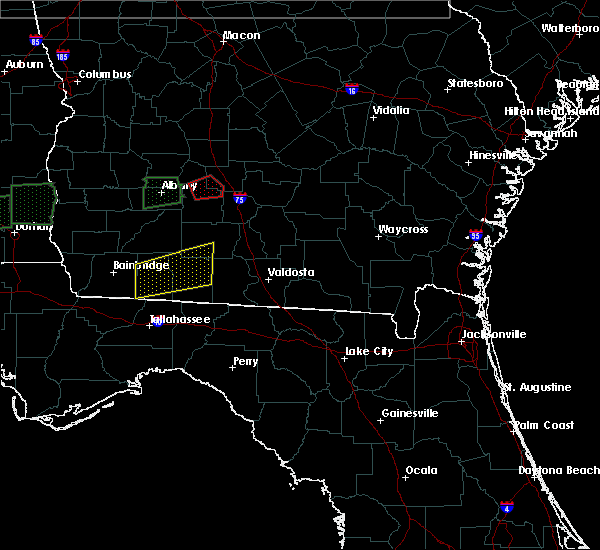 At 239 am est, a severe thunderstorm capable of producing a tornado was located near sylvester, moving east at 60 mph (radar indicated rotation). Hazards include tornado and half dollar size hail. Flying debris will be dangerous to those caught without shelter. mobile homes will be damaged or destroyed. damage to roofs, windows, and vehicles will occur. tree damage is likely. This tornadic thunderstorm will remain over mainly rural areas of southwestern turner and central worth counties, including the following locations: shingler, hobby, isabella, sylvester airport, gammage, coverdale and terrell. At 239 am est, a severe thunderstorm capable of producing a tornado was located near sylvester, moving east at 60 mph (radar indicated rotation). Hazards include tornado and half dollar size hail. Flying debris will be dangerous to those caught without shelter. mobile homes will be damaged or destroyed. damage to roofs, windows, and vehicles will occur. tree damage is likely. This tornadic thunderstorm will remain over mainly rural areas of southwestern turner and central worth counties, including the following locations: shingler, hobby, isabella, sylvester airport, gammage, coverdale and terrell.
|
| 1/22/2017 2:35 AM EST | Reports of trees down on houses in sylvester in worth county GA, 0.4 miles ENE of Sylvester, GA |
| 1/22/2017 2:34 AM EST |
 At 234 am est, a severe thunderstorm capable of producing a tornado was located near sylvester, moving east at 60 mph (radar indicated rotation). Hazards include tornado and half dollar size hail. Flying debris will be dangerous to those caught without shelter. mobile homes will be damaged or destroyed. damage to roofs, windows, and vehicles will occur. tree damage is likely. this dangerous storm will be near, poulan and poulan around 240 am est. Other locations impacted by this tornadic thunderstorm include shingler, hobby, isabella, crestwood, sylvester airport, gammage, coverdale, sumner, terrell and red rock. At 234 am est, a severe thunderstorm capable of producing a tornado was located near sylvester, moving east at 60 mph (radar indicated rotation). Hazards include tornado and half dollar size hail. Flying debris will be dangerous to those caught without shelter. mobile homes will be damaged or destroyed. damage to roofs, windows, and vehicles will occur. tree damage is likely. this dangerous storm will be near, poulan and poulan around 240 am est. Other locations impacted by this tornadic thunderstorm include shingler, hobby, isabella, crestwood, sylvester airport, gammage, coverdale, sumner, terrell and red rock.
|
| 1/22/2017 2:27 AM EST |
 At 227 am est, a severe thunderstorm capable of producing a tornado was located over marine corps logistics base, or near putney, moving east at 60 mph (radar indicated rotation). Hazards include tornado and half dollar size hail. Flying debris will be dangerous to those caught without shelter. mobile homes will be damaged or destroyed. damage to roofs, windows, and vehicles will occur. tree damage is likely. this dangerous storm will be near, sylvester, poulan and poulan around 240 am est. Other locations impacted by this tornadic thunderstorm include shingler, hobby, isabella, crestwood, sylvester airport, gammage, coverdale, sumner, terrell and red rock. At 227 am est, a severe thunderstorm capable of producing a tornado was located over marine corps logistics base, or near putney, moving east at 60 mph (radar indicated rotation). Hazards include tornado and half dollar size hail. Flying debris will be dangerous to those caught without shelter. mobile homes will be damaged or destroyed. damage to roofs, windows, and vehicles will occur. tree damage is likely. this dangerous storm will be near, sylvester, poulan and poulan around 240 am est. Other locations impacted by this tornadic thunderstorm include shingler, hobby, isabella, crestwood, sylvester airport, gammage, coverdale, sumner, terrell and red rock.
|
| 1/22/2017 2:21 AM EST |
 At 221 am est, a severe thunderstorm capable of producing a tornado was located over marine corps logistics base, or 7 miles northeast of putney, moving east at 65 mph (radar indicated rotation). Hazards include tornado and half dollar size hail. Flying debris will be dangerous to those caught without shelter. mobile homes will be damaged or destroyed. damage to roofs, windows, and vehicles will occur. tree damage is likely. This tornadic thunderstorm will remain over mainly rural areas of south central lee, west central worth and eastern dougherty counties, including the following locations: crestwood, sylvester airport, gammage, red rock, acree, gordy, pecan city, palmyra, radium springs and southwest ga regional a/p. At 221 am est, a severe thunderstorm capable of producing a tornado was located over marine corps logistics base, or 7 miles northeast of putney, moving east at 65 mph (radar indicated rotation). Hazards include tornado and half dollar size hail. Flying debris will be dangerous to those caught without shelter. mobile homes will be damaged or destroyed. damage to roofs, windows, and vehicles will occur. tree damage is likely. This tornadic thunderstorm will remain over mainly rural areas of south central lee, west central worth and eastern dougherty counties, including the following locations: crestwood, sylvester airport, gammage, red rock, acree, gordy, pecan city, palmyra, radium springs and southwest ga regional a/p.
|
| 1/22/2017 2:14 AM EST |
 At 214 am est, a severe thunderstorm capable of producing a tornado was located near east albany, or near albany, moving east at 60 mph (radar indicated rotation). Hazards include tornado and half dollar size hail. Flying debris will be dangerous to those caught without shelter. mobile homes will be damaged or destroyed. damage to roofs, windows, and vehicles will occur. tree damage is likely. this dangerous storm will be near, marine corps logistics base around 225 am est. Other locations impacted by this tornadic thunderstorm include crestwood, sylvester airport, gammage, red rock, acree, gordy, walker, pecan city, palmyra and radium springs. At 214 am est, a severe thunderstorm capable of producing a tornado was located near east albany, or near albany, moving east at 60 mph (radar indicated rotation). Hazards include tornado and half dollar size hail. Flying debris will be dangerous to those caught without shelter. mobile homes will be damaged or destroyed. damage to roofs, windows, and vehicles will occur. tree damage is likely. this dangerous storm will be near, marine corps logistics base around 225 am est. Other locations impacted by this tornadic thunderstorm include crestwood, sylvester airport, gammage, red rock, acree, gordy, walker, pecan city, palmyra and radium springs.
|
| 1/22/2017 2:06 AM EST |
 At 205 am est, a severe thunderstorm capable of producing a tornado was located 10 miles east of leary, or 11 miles southwest of albany, moving east at 60 mph (radar indicated rotation). Hazards include tornado and half dollar size hail. Flying debris will be dangerous to those caught without shelter. mobile homes will be damaged or destroyed. damage to roofs, windows, and vehicles will occur. tree damage is likely. this dangerous storm will be near, putney, east albany and turner city around 220 am est. albany and marine corps logistics base around 225 am est. Other locations impacted by this tornadic thunderstorm include crestwood, sylvester airport, gammage, red rock, acree, gordy, walker, pecan city, palmyra and radium springs. At 205 am est, a severe thunderstorm capable of producing a tornado was located 10 miles east of leary, or 11 miles southwest of albany, moving east at 60 mph (radar indicated rotation). Hazards include tornado and half dollar size hail. Flying debris will be dangerous to those caught without shelter. mobile homes will be damaged or destroyed. damage to roofs, windows, and vehicles will occur. tree damage is likely. this dangerous storm will be near, putney, east albany and turner city around 220 am est. albany and marine corps logistics base around 225 am est. Other locations impacted by this tornadic thunderstorm include crestwood, sylvester airport, gammage, red rock, acree, gordy, walker, pecan city, palmyra and radium springs.
|
| 1/22/2017 2:02 AM EST |
 At 202 am est, a severe thunderstorm capable of producing a tornado was located 8 miles east of leary, or 12 miles north of newton, moving east at 65 mph (radar indicated rotation). Hazards include tornado and half dollar size hail. Flying debris will be dangerous to those caught without shelter. mobile homes will be damaged or destroyed. damage to roofs, windows, and vehicles will occur. tree damage is likely. this dangerous storm will be near, putney and east albany around 215 am est. albany and turner city around 220 am est. marine corps logistics base around 225 am est. Other locations impacted by this tornadic thunderstorm include crestwood, sylvester airport, gammage, red rock, acree, gordy, walker, pecan city, palmyra and radium springs. At 202 am est, a severe thunderstorm capable of producing a tornado was located 8 miles east of leary, or 12 miles north of newton, moving east at 65 mph (radar indicated rotation). Hazards include tornado and half dollar size hail. Flying debris will be dangerous to those caught without shelter. mobile homes will be damaged or destroyed. damage to roofs, windows, and vehicles will occur. tree damage is likely. this dangerous storm will be near, putney and east albany around 215 am est. albany and turner city around 220 am est. marine corps logistics base around 225 am est. Other locations impacted by this tornadic thunderstorm include crestwood, sylvester airport, gammage, red rock, acree, gordy, walker, pecan city, palmyra and radium springs.
|
| 1/22/2017 1:04 AM EST |
 At 103 am est, a severe thunderstorm was located near ashburn, moving east at 45 mph (radar indicated). Hazards include 60 mph wind gusts and quarter size hail. Hail damage to vehicles is expected. Expect wind damage to roofs, siding, and trees. At 103 am est, a severe thunderstorm was located near ashburn, moving east at 45 mph (radar indicated). Hazards include 60 mph wind gusts and quarter size hail. Hail damage to vehicles is expected. Expect wind damage to roofs, siding, and trees.
|
| 1/22/2017 12:10 AM EST |
 At 1210 am est, doppler radar indicated a line of severe thunderstorms capable of producing quarter size hail and damaging winds in excess of 60 mph. these storms were located along a line extending from 6 miles south of shellman to 6 miles east of arlington, and moving east at 50 mph. At 1210 am est, doppler radar indicated a line of severe thunderstorms capable of producing quarter size hail and damaging winds in excess of 60 mph. these storms were located along a line extending from 6 miles south of shellman to 6 miles east of arlington, and moving east at 50 mph.
|
| 1/21/2017 11:28 PM EST |
 At 1127 pm est, a severe thunderstorm was located over poulan, or near sylvester, moving northeast at 45 mph (radar indicated). Hazards include ping pong ball size hail and 60 mph wind gusts. People and animals outdoors will be injured. expect hail damage to roofs, siding, windows, and vehicles. Expect wind damage to roofs, siding, and trees. At 1127 pm est, a severe thunderstorm was located over poulan, or near sylvester, moving northeast at 45 mph (radar indicated). Hazards include ping pong ball size hail and 60 mph wind gusts. People and animals outdoors will be injured. expect hail damage to roofs, siding, windows, and vehicles. Expect wind damage to roofs, siding, and trees.
|
| 1/21/2017 11:16 PM EST |
 At 1115 pm est, a severe thunderstorm was located near sylvester, moving northeast at 45 mph (radar indicated). Hazards include two inch hail and 60 mph wind gusts. People and animals outdoors will be injured. expect hail damage to roofs, siding, windows, and vehicles. expect wind damage to roofs, siding, and trees. locations impacted include, sylvester, poulan, ty ty, terrell, sumner, bridgeboro, isabella, crestwood, sylvester airport, gammage, livingston, gordy, shingler, tempy, parkerville, hobby, pritchetts, anderson city, coverdale and alfords. A tornado watch remains in effect until 400 am est for south central and southwestern georgia. At 1115 pm est, a severe thunderstorm was located near sylvester, moving northeast at 45 mph (radar indicated). Hazards include two inch hail and 60 mph wind gusts. People and animals outdoors will be injured. expect hail damage to roofs, siding, windows, and vehicles. expect wind damage to roofs, siding, and trees. locations impacted include, sylvester, poulan, ty ty, terrell, sumner, bridgeboro, isabella, crestwood, sylvester airport, gammage, livingston, gordy, shingler, tempy, parkerville, hobby, pritchetts, anderson city, coverdale and alfords. A tornado watch remains in effect until 400 am est for south central and southwestern georgia.
|
| 1/21/2017 11:04 PM EST |
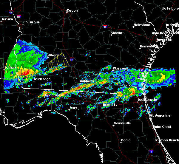 At 1104 pm est, a severe thunderstorm was located near putney, moving northeast at 45 mph (radar indicated). Hazards include two inch hail and 60 mph wind gusts. People and animals outdoors will be injured. expect hail damage to roofs, siding, windows, and vehicles. expect wind damage to roofs, siding, and trees. locations impacted include, sylvester, omega, poulan, doerun, ty ty, terrell, sumner, sale city, isabella, crestwood, sylvester airport, ticknor, lester, livingston, tempy, anderson city, coverdale, powelltown, minnesota and bridgeboro. A tornado watch remains in effect until 400 am est for south central and southwestern georgia. At 1104 pm est, a severe thunderstorm was located near putney, moving northeast at 45 mph (radar indicated). Hazards include two inch hail and 60 mph wind gusts. People and animals outdoors will be injured. expect hail damage to roofs, siding, windows, and vehicles. expect wind damage to roofs, siding, and trees. locations impacted include, sylvester, omega, poulan, doerun, ty ty, terrell, sumner, sale city, isabella, crestwood, sylvester airport, ticknor, lester, livingston, tempy, anderson city, coverdale, powelltown, minnesota and bridgeboro. A tornado watch remains in effect until 400 am est for south central and southwestern georgia.
|
| 1/21/2017 10:58 PM EST |
 At 1057 pm est, a severe thunderstorm was located near baconton, or near putney, moving northeast at 45 mph (radar indicated). Hazards include two inch hail and 60 mph wind gusts. People and animals outdoors will be injured. expect hail damage to roofs, siding, windows, and vehicles. Expect wind damage to roofs, siding, and trees. At 1057 pm est, a severe thunderstorm was located near baconton, or near putney, moving northeast at 45 mph (radar indicated). Hazards include two inch hail and 60 mph wind gusts. People and animals outdoors will be injured. expect hail damage to roofs, siding, windows, and vehicles. Expect wind damage to roofs, siding, and trees.
|
| 1/21/2017 1:02 PM EST | Tree down on hwy 33 south of hwy 3 in worth county GA, 9.6 miles S of Sylvester, GA |
| 1/21/2017 1:00 PM EST | Several trees down near porters corner r in worth county GA, 6.8 miles E of Sylvester, GA |
| 1/21/2017 12:50 PM EST | Several trees down near porters corner r in worth county GA, 6.8 miles E of Sylvester, GA |
| 1/21/2017 12:47 PM EST |
 At 1247 pm est, a severe thunderstorm was located near albany, moving east at 55 mph (radar indicated). Hazards include 60 mph wind gusts. expect damage to roofs, siding, and trees At 1247 pm est, a severe thunderstorm was located near albany, moving east at 55 mph (radar indicated). Hazards include 60 mph wind gusts. expect damage to roofs, siding, and trees
|
| 1/2/2017 10:35 PM EST | Numerous trees and power lines down in worth county in worth county GA, 0.4 miles ENE of Sylvester, GA |
| 1/2/2017 10:20 PM EST | Three trees down on house in sylveste in worth county GA, 2.8 miles SSE of Sylvester, GA |
| 1/2/2017 10:09 PM EST |
 At 1008 pm est, severe thunderstorms were located along a line extending from near leesburg to 10 miles southwest of thomasville, moving east at 50 mph (radar indicated). Hazards include 70 mph wind gusts. Expect considerable tree damage. Damage is likely to mobile homes, roofs, and outbuildings. At 1008 pm est, severe thunderstorms were located along a line extending from near leesburg to 10 miles southwest of thomasville, moving east at 50 mph (radar indicated). Hazards include 70 mph wind gusts. Expect considerable tree damage. Damage is likely to mobile homes, roofs, and outbuildings.
|
| 8/13/2016 7:25 PM EDT | Tree down on evergreen road in worth county GA, 3.8 miles NNE of Sylvester, GA |
| 8/13/2016 7:05 PM EDT |
 At 704 pm edt, severe thunderstorms were located along a line extending from near doerun to near omega, moving north at 20 mph (radar indicated). Hazards include 60 mph wind gusts. Expect damage to roofs. siding. And trees. At 704 pm edt, severe thunderstorms were located along a line extending from near doerun to near omega, moving north at 20 mph (radar indicated). Hazards include 60 mph wind gusts. Expect damage to roofs. siding. And trees.
|
| 7/30/2016 8:19 PM EDT |
 At 819 pm edt, a severe thunderstorm was located over poulan, or near sylvester, moving northeast at 5 mph (radar indicated). Hazards include 60 mph wind gusts. Expect damage to roofs. siding. and trees. Locations impacted include, sylvester, poulan, ty ty, terrell, sumner, isabella, sylvester airport, gammage, gordy, shingler, tempy, hobby, coverdale and powelltown. At 819 pm edt, a severe thunderstorm was located over poulan, or near sylvester, moving northeast at 5 mph (radar indicated). Hazards include 60 mph wind gusts. Expect damage to roofs. siding. and trees. Locations impacted include, sylvester, poulan, ty ty, terrell, sumner, isabella, sylvester airport, gammage, gordy, shingler, tempy, hobby, coverdale and powelltown.
|
| 7/30/2016 7:53 PM EDT |
 At 753 pm edt, a severe thunderstorm was located over poulan, or over sylvester, moving northeast at 5 mph (radar indicated). Hazards include 60 mph wind gusts and nickel size hail. Expect damage to roofs. siding. And trees. At 753 pm edt, a severe thunderstorm was located over poulan, or over sylvester, moving northeast at 5 mph (radar indicated). Hazards include 60 mph wind gusts and nickel size hail. Expect damage to roofs. siding. And trees.
|
| 7/21/2016 2:40 PM EDT | Trees down near sylveste in worth county GA, 0.4 miles ENE of Sylvester, GA |
| 7/21/2016 2:20 PM EDT |
 At 220 pm edt, a severe thunderstorm was located over poulan, or near sylvester, moving southeast at 10 mph (radar indicated). Hazards include 60 mph wind gusts. Expect damage to roofs. siding. and trees. Locations impacted include, sylvester, poulan, marine corps logistics base, terrell, sumner, bridgeboro, isabella, crestwood, sylvester airport, gammage, scooterville, red rock, livingston, gordy, minton, shingler, tempy, parkerville, pritchetts and anderson city. At 220 pm edt, a severe thunderstorm was located over poulan, or near sylvester, moving southeast at 10 mph (radar indicated). Hazards include 60 mph wind gusts. Expect damage to roofs. siding. and trees. Locations impacted include, sylvester, poulan, marine corps logistics base, terrell, sumner, bridgeboro, isabella, crestwood, sylvester airport, gammage, scooterville, red rock, livingston, gordy, minton, shingler, tempy, parkerville, pritchetts and anderson city.
|
| 7/21/2016 2:05 PM EDT |
 At 205 pm edt, a severe thunderstorm was located over sylvester, moving east at 10 mph (radar indicated). Hazards include 60 mph wind gusts. Expect damage to roofs. siding. And trees. At 205 pm edt, a severe thunderstorm was located over sylvester, moving east at 10 mph (radar indicated). Hazards include 60 mph wind gusts. Expect damage to roofs. siding. And trees.
|
| 7/15/2016 4:06 PM EDT |
 The severe thunderstorm warning for central worth county will expire at 415 pm edt, the storm which prompted the warning has weakened below severe limits, and no longer pose an immediate threat to life or property. therefore, the warning will be allowed to expire. to report severe weather, contact your nearest law enforcement agency. they will relay your report to the national weather service tallahassee. The severe thunderstorm warning for central worth county will expire at 415 pm edt, the storm which prompted the warning has weakened below severe limits, and no longer pose an immediate threat to life or property. therefore, the warning will be allowed to expire. to report severe weather, contact your nearest law enforcement agency. they will relay your report to the national weather service tallahassee.
|
| 7/15/2016 3:54 PM EDT |
 At 354 pm edt, a severe thunderstorm was located near sylvester, moving northeast at 35 mph (radar indicated). Hazards include 60 mph wind gusts. Expect damage to roofs. siding. And trees. At 354 pm edt, a severe thunderstorm was located near sylvester, moving northeast at 35 mph (radar indicated). Hazards include 60 mph wind gusts. Expect damage to roofs. siding. And trees.
|
| 7/6/2016 5:00 PM EDT | Trees and a power line down within sylvester in worth county GA, 0.4 miles ENE of Sylvester, GA |
| 7/6/2016 4:53 PM EDT |
 At 453 pm edt, severe thunderstorms were located along a line extending from 6 miles north of sylvester to near doerun, moving east at 20 mph (radar indicated). Hazards include 60 mph wind gusts. Expect damage to roofs. siding. And trees. At 453 pm edt, severe thunderstorms were located along a line extending from 6 miles north of sylvester to near doerun, moving east at 20 mph (radar indicated). Hazards include 60 mph wind gusts. Expect damage to roofs. siding. And trees.
|
| 6/25/2016 6:23 PM EDT | Trees and powerlines down along with minor damage to homes and sheds near hilltop road and green valley roa in worth county GA, 8.3 miles S of Sylvester, GA |
| 5/3/2016 5:01 PM EDT |
 At 501 pm edt, a severe thunderstorm was located over poulan, or near sylvester, moving northeast at 25 mph (radar indicated). Hazards include ping pong ball size hail and 60 mph wind gusts. People and animals outdoors will be injured. expect hail damage to roofs, siding, windows, and vehicles. Expect wind damage to roofs, siding, and trees. At 501 pm edt, a severe thunderstorm was located over poulan, or near sylvester, moving northeast at 25 mph (radar indicated). Hazards include ping pong ball size hail and 60 mph wind gusts. People and animals outdoors will be injured. expect hail damage to roofs, siding, windows, and vehicles. Expect wind damage to roofs, siding, and trees.
|
| 2/24/2016 3:05 AM EST |
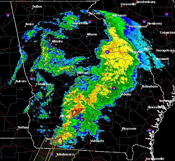 At 305 am est, severe thunderstorms were located along a line extending from near rochelle to 6 miles east of baconton, moving east at 50 mph (radar indicated). Hazards include 60 mph wind gusts. Expect damage to roofs. siding and trees. locations impacted include, ashburn, worth, terrell, sibley, isabella, sylvester airport, red rock, doles, dakota, shingler, hobby, amboy, five points and coverdale. A tornado watch remains in effect until 600 am est for southwestern georgia. At 305 am est, severe thunderstorms were located along a line extending from near rochelle to 6 miles east of baconton, moving east at 50 mph (radar indicated). Hazards include 60 mph wind gusts. Expect damage to roofs. siding and trees. locations impacted include, ashburn, worth, terrell, sibley, isabella, sylvester airport, red rock, doles, dakota, shingler, hobby, amboy, five points and coverdale. A tornado watch remains in effect until 600 am est for southwestern georgia.
|
| 2/24/2016 2:52 AM EST |
 At 251 am est, severe thunderstorms were located along a line extending from near pitts to near baconton, moving east at 50 mph (radar indicated). Hazards include 60 mph wind gusts. Expect damage to roofs. siding and trees. locations impacted include, ashburn, putney, sylvester, albany, marine corps logistics base, east albany, turner city, poulan, worth, terrell, warwick, isabella, crestwood, sylvester airport, dakota, acree, pecan city, amboy, coverdale and sibley. A tornado watch remains in effect until 600 am est for southwestern georgia. At 251 am est, severe thunderstorms were located along a line extending from near pitts to near baconton, moving east at 50 mph (radar indicated). Hazards include 60 mph wind gusts. Expect damage to roofs. siding and trees. locations impacted include, ashburn, putney, sylvester, albany, marine corps logistics base, east albany, turner city, poulan, worth, terrell, warwick, isabella, crestwood, sylvester airport, dakota, acree, pecan city, amboy, coverdale and sibley. A tornado watch remains in effect until 600 am est for southwestern georgia.
|
| 2/24/2016 2:39 AM EST |
 At 239 am est, severe thunderstorms were located along a line extending from near arabi to newton, moving northeast at 45 mph (radar indicated). Hazards include 60 mph wind gusts. Expect damage to roofs. siding and trees. locations impacted include, newton, albany, ashburn, putney, sylvester, baconton, marine corps logistics base, east albany, turner city, poulan, worth, terrell, warwick, isabella, crestwood, sylvester airport, dakota, lester, livingston and acree. A tornado watch remains in effect until 600 am est for southwestern georgia. At 239 am est, severe thunderstorms were located along a line extending from near arabi to newton, moving northeast at 45 mph (radar indicated). Hazards include 60 mph wind gusts. Expect damage to roofs. siding and trees. locations impacted include, newton, albany, ashburn, putney, sylvester, baconton, marine corps logistics base, east albany, turner city, poulan, worth, terrell, warwick, isabella, crestwood, sylvester airport, dakota, lester, livingston and acree. A tornado watch remains in effect until 600 am est for southwestern georgia.
|
| 2/24/2016 2:12 AM EST |
 At 212 am est, severe thunderstorms were located along a line extending from near arabi to near newton, moving east at 50 mph (radar indicated). Hazards include 60 mph wind gusts. Expect damage to roofs. Siding and trees. At 212 am est, severe thunderstorms were located along a line extending from near arabi to near newton, moving east at 50 mph (radar indicated). Hazards include 60 mph wind gusts. Expect damage to roofs. Siding and trees.
|
| 2/24/2016 1:56 AM EST |
 At 155 am est, severe thunderstorms were located along a line extending from 6 miles east of arabi to near ty ty to 6 miles south of doerun, moving east at 45 mph (radar indicated). Hazards include 70 mph wind gusts and penny size hail. Expect considerable tree damage. damage is likely to mobile homes, roofs and outbuildings. locations impacted include, newton, putney, albany, sylvester, leesburg, baconton, marine corps logistics base, turner city, east albany, walker, warwick, forrester, sylvester airport, livingston, pecan city, palmyra, red store crossroads, elmodel wma, pretoria and philema. A tornado watch remains in effect until 400 am est for southwestern georgia. At 155 am est, severe thunderstorms were located along a line extending from 6 miles east of arabi to near ty ty to 6 miles south of doerun, moving east at 45 mph (radar indicated). Hazards include 70 mph wind gusts and penny size hail. Expect considerable tree damage. damage is likely to mobile homes, roofs and outbuildings. locations impacted include, newton, putney, albany, sylvester, leesburg, baconton, marine corps logistics base, turner city, east albany, walker, warwick, forrester, sylvester airport, livingston, pecan city, palmyra, red store crossroads, elmodel wma, pretoria and philema. A tornado watch remains in effect until 400 am est for southwestern georgia.
|
| 2/24/2016 1:10 AM EST |
 At 109 am est, severe thunderstorms were located along a line extending from near smithville to 6 miles southwest of albany to 9 miles west of newton, moving east at 45 mph (radar indicated). Hazards include 70 mph wind gusts and penny size hail. Expect considerable tree damage. Damage is likely to mobile homes, roofs and outbuildings. At 109 am est, severe thunderstorms were located along a line extending from near smithville to 6 miles southwest of albany to 9 miles west of newton, moving east at 45 mph (radar indicated). Hazards include 70 mph wind gusts and penny size hail. Expect considerable tree damage. Damage is likely to mobile homes, roofs and outbuildings.
|
| 11/1/2015 7:00 PM EDT |
 At 559 pm est, a severe thunderstorm was located near sylvester, moving northeast at 30 mph (radar indicated). Hazards include 60 mph wind gusts. Expect damage to roofs. siding and trees. Locations impacted include, sylvester, poulan, marine corps logistics base, sumner, bridgeboro, freeman, isabella, crestwood, sylvester airport, gammage, red rock, doles, lester, livingston, acree, gordy, shingler, tempy, parkerville and alfords. At 559 pm est, a severe thunderstorm was located near sylvester, moving northeast at 30 mph (radar indicated). Hazards include 60 mph wind gusts. Expect damage to roofs. siding and trees. Locations impacted include, sylvester, poulan, marine corps logistics base, sumner, bridgeboro, freeman, isabella, crestwood, sylvester airport, gammage, red rock, doles, lester, livingston, acree, gordy, shingler, tempy, parkerville and alfords.
|
| 11/1/2015 6:25 PM EDT |
 At 525 pm est, a severe thunderstorm was located over putney, moving northeast at 30 mph (radar indicated). Hazards include 60 mph wind gusts. Expect damage to roofs. Siding and trees. At 525 pm est, a severe thunderstorm was located over putney, moving northeast at 30 mph (radar indicated). Hazards include 60 mph wind gusts. Expect damage to roofs. Siding and trees.
|
| 7/31/2015 6:18 PM EDT |
 At 616 pm edt, doppler radar indicated a line of severe thunderstorms capable of producing damaging winds up to 60 mph. these storms were located along a line extending from 6 miles southwest of cordele to near arabi to near pitts, and moving south at 30 mph. At 616 pm edt, doppler radar indicated a line of severe thunderstorms capable of producing damaging winds up to 60 mph. these storms were located along a line extending from 6 miles southwest of cordele to near arabi to near pitts, and moving south at 30 mph.
|
| 7/22/2015 4:25 PM EDT | Power line down near the intersection of spring flats road and greenleaf roa in worth county GA, 6.4 miles ENE of Sylvester, GA |
| 7/21/2015 5:09 PM EDT |
 At 508 pm edt, the national weather service has detected a severe thunderstorm capable of producing damaging winds in excess of 60 mph. this storm was located near leary, or 10 miles east of morgan, and moving east at 35 mph. At 508 pm edt, the national weather service has detected a severe thunderstorm capable of producing damaging winds in excess of 60 mph. this storm was located near leary, or 10 miles east of morgan, and moving east at 35 mph.
|
| 7/19/2015 7:17 PM EDT |
 At 717 pm edt, the national weather service has detected a severe thunderstorm capable of producing damaging winds in excess of 60 mph. this storm was located near poulan, or near sylvester, and moving east at 15 mph. At 717 pm edt, the national weather service has detected a severe thunderstorm capable of producing damaging winds in excess of 60 mph. this storm was located near poulan, or near sylvester, and moving east at 15 mph.
|
| 7/15/2015 5:24 PM EDT |
 At 523 pm edt, doppler radar indicated a line of severe thunderstorms capable of producing damaging winds in excess of 60 mph. these storms were located along a line extending from near leary to 6 miles south of ashburn, moving southeast at 30 mph. locations impacted include, morgan, putney, albany, ashburn, sylvester, edison, arlington, poulan, leary, marine corps logistics base, turner city, east albany, walker, worth, terrell, sycamore, sumner, rebecca, cordrays mill and oak hill. At 523 pm edt, doppler radar indicated a line of severe thunderstorms capable of producing damaging winds in excess of 60 mph. these storms were located along a line extending from near leary to 6 miles south of ashburn, moving southeast at 30 mph. locations impacted include, morgan, putney, albany, ashburn, sylvester, edison, arlington, poulan, leary, marine corps logistics base, turner city, east albany, walker, worth, terrell, sycamore, sumner, rebecca, cordrays mill and oak hill.
|
| 7/15/2015 5:20 PM EDT |
 At 520 pm edt, the national weather service has detected a line of severe thunderstorms capable of producing damaging winds in excess of 60 mph. these storms were located along a line extending from 6 miles southeast of marine corps logistics base to 8 miles southeast of ashburn, and moving southeast at 45 mph. At 520 pm edt, the national weather service has detected a line of severe thunderstorms capable of producing damaging winds in excess of 60 mph. these storms were located along a line extending from 6 miles southeast of marine corps logistics base to 8 miles southeast of ashburn, and moving southeast at 45 mph.
|
| 7/15/2015 4:58 PM EDT |
 At 458 pm edt, the national weather service has detected a line of severe thunderstorms capable of producing damaging winds in excess of 60 mph. these storms were located along a line extending from near edison to near arabi, and moving southeast at 25 mph. At 458 pm edt, the national weather service has detected a line of severe thunderstorms capable of producing damaging winds in excess of 60 mph. these storms were located along a line extending from near edison to near arabi, and moving southeast at 25 mph.
|
| 7/5/2015 11:31 AM EDT |
 At 1130 am edt, doppler radar indicated a line of severe thunderstorms capable of producing damaging winds in excess of 60 mph. these storms were located along a line extending from near turner city to near bainbridge, moving east at 30 mph. locations impacted include, newton, camilla, putney, bainbridge, cairo, albany, sylvester, pelham, leesburg, baconton, whigham, marine corps logistics base, west bainbridge, turner city, east albany, walker, sale city, forrester, sylvester airport and vada. At 1130 am edt, doppler radar indicated a line of severe thunderstorms capable of producing damaging winds in excess of 60 mph. these storms were located along a line extending from near turner city to near bainbridge, moving east at 30 mph. locations impacted include, newton, camilla, putney, bainbridge, cairo, albany, sylvester, pelham, leesburg, baconton, whigham, marine corps logistics base, west bainbridge, turner city, east albany, walker, sale city, forrester, sylvester airport and vada.
|
| 7/5/2015 10:54 AM EDT |
 At 1053 am edt, the national weather service has detected a line of severe thunderstorms capable of producing damaging winds in excess of 60 mph. these storms were located along a line extending from near leesburg to near donalsonville, and moving east at 40 mph. At 1053 am edt, the national weather service has detected a line of severe thunderstorms capable of producing damaging winds in excess of 60 mph. these storms were located along a line extending from near leesburg to near donalsonville, and moving east at 40 mph.
|
| 7/4/2015 2:33 PM EDT |
 At 233 pm edt, doppler radar indicated a line of severe thunderstorms capable of producing damaging winds in excess of 60 mph. these storms were located along a line extending from 7 miles north of doerun to near pavo, moving east at 35 mph. a wind gust of 53 mph was measured at the mitchell county airport at 204 pm edt. locations impacted include, moultrie, sylvester, omega, norman park, poulan, doerun, ty ty, pavo, coolidge, riverside, terrell, schley, berlin, funston, sumner, ellenton, south moultrie, new elm, ticknor and livingston. At 233 pm edt, doppler radar indicated a line of severe thunderstorms capable of producing damaging winds in excess of 60 mph. these storms were located along a line extending from 7 miles north of doerun to near pavo, moving east at 35 mph. a wind gust of 53 mph was measured at the mitchell county airport at 204 pm edt. locations impacted include, moultrie, sylvester, omega, norman park, poulan, doerun, ty ty, pavo, coolidge, riverside, terrell, schley, berlin, funston, sumner, ellenton, south moultrie, new elm, ticknor and livingston.
|
| 7/4/2015 2:13 PM EDT |
 At 213 pm edt, the national weather service has detected a line of severe thunderstorms capable of producing damaging winds in excess of 60 mph. these storms were located along a line extending from near baconton to 6 miles southeast of ochlocknee, and moving northeast at 40 mph. At 213 pm edt, the national weather service has detected a line of severe thunderstorms capable of producing damaging winds in excess of 60 mph. these storms were located along a line extending from near baconton to 6 miles southeast of ochlocknee, and moving northeast at 40 mph.
|
| 7/4/2015 1:52 PM EDT |
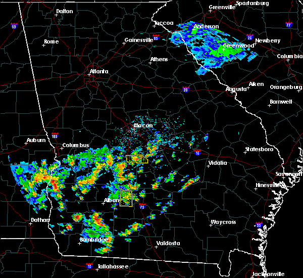 The severe thunderstorm warning for western turner and central worth counties will expire at 200 pm edt, the storm which prompted the warning has weakened below severe limits, and no longer poses an immediate threat to life or property. therefore the warning will be allowed to expire. to report severe weather, contact your nearest law enforcement agency. they will relay your report to the national weather service tallahassee. The severe thunderstorm warning for western turner and central worth counties will expire at 200 pm edt, the storm which prompted the warning has weakened below severe limits, and no longer poses an immediate threat to life or property. therefore the warning will be allowed to expire. to report severe weather, contact your nearest law enforcement agency. they will relay your report to the national weather service tallahassee.
|
| 7/4/2015 1:45 PM EDT |
 At 145 pm edt, doppler radar indicated a severe thunderstorm capable of producing damaging winds in excess of 60 mph. this storm was located 8 miles west of ashburn, moving east at 30 mph. locations impacted include, sylvester, terrell, shingler, sibley, hobby, isabella, five points, coverdale and dakota. At 145 pm edt, doppler radar indicated a severe thunderstorm capable of producing damaging winds in excess of 60 mph. this storm was located 8 miles west of ashburn, moving east at 30 mph. locations impacted include, sylvester, terrell, shingler, sibley, hobby, isabella, five points, coverdale and dakota.
|
| 7/4/2015 1:33 PM EDT |
 At 133 pm edt, doppler radar indicated a line of severe thunderstorms capable of producing damaging winds in excess of 60 mph. these storms were located along a line extending from 11 miles southeast of desoto to near sylvester, moving east at 30 mph. locations impacted include, sylvester, poulan, terrell, sumner, warwick, sibley, isabella, crestwood, sylvester airport, gammage, oakfield, red rock, doles, dakota, gordy, shingler, hobby, five points and coverdale. At 133 pm edt, doppler radar indicated a line of severe thunderstorms capable of producing damaging winds in excess of 60 mph. these storms were located along a line extending from 11 miles southeast of desoto to near sylvester, moving east at 30 mph. locations impacted include, sylvester, poulan, terrell, sumner, warwick, sibley, isabella, crestwood, sylvester airport, gammage, oakfield, red rock, doles, dakota, gordy, shingler, hobby, five points and coverdale.
|
| 7/4/2015 1:19 PM EDT |
 At 119 pm edt, doppler radar indicated a line of severe thunderstorms capable of producing damaging winds in excess of 60 mph. these storms were located along a line extending from near desoto to 6 miles southeast of marine corps logistics base, moving east at 30 mph. locations impacted include, sylvester, poulan, terrell, sumner, warwick, sibley, isabella, crestwood, chokee, sylvester airport, gammage, oakfield, red rock, doles, dakota, gordy, shingler, hobby, five points and coverdale. At 119 pm edt, doppler radar indicated a line of severe thunderstorms capable of producing damaging winds in excess of 60 mph. these storms were located along a line extending from near desoto to 6 miles southeast of marine corps logistics base, moving east at 30 mph. locations impacted include, sylvester, poulan, terrell, sumner, warwick, sibley, isabella, crestwood, chokee, sylvester airport, gammage, oakfield, red rock, doles, dakota, gordy, shingler, hobby, five points and coverdale.
|
| 7/4/2015 1:05 PM EDT |
 At 105 pm edt, doppler radar indicated a line of severe thunderstorms capable of producing damaging winds in excess of 60 mph. these storms were located along a line extending from near leslie to putney, moving east at 30 mph. locations impacted include, putney, sylvester, leesburg, albany, poulan, marine corps logistics base, east albany, turner city, terrell, sumner, warwick, forrester, isabella, crestwood, sylvester airport, starksville, dakota, mossy dell, acree and pecan city. At 105 pm edt, doppler radar indicated a line of severe thunderstorms capable of producing damaging winds in excess of 60 mph. these storms were located along a line extending from near leslie to putney, moving east at 30 mph. locations impacted include, putney, sylvester, leesburg, albany, poulan, marine corps logistics base, east albany, turner city, terrell, sumner, warwick, forrester, isabella, crestwood, sylvester airport, starksville, dakota, mossy dell, acree and pecan city.
|
| 7/4/2015 12:52 PM EDT |
 At 1252 pm edt, the national weather service has detected a line of severe thunderstorms capable of producing damaging winds in excess of 60 mph. these storms were located along a line extending from near smithville to near baconton, and moving east at 30 mph. At 1252 pm edt, the national weather service has detected a line of severe thunderstorms capable of producing damaging winds in excess of 60 mph. these storms were located along a line extending from near smithville to near baconton, and moving east at 30 mph.
|
| 7/2/2015 4:13 PM EDT | Numerous trees down across the county including on some home in worth county GA, 0.4 miles ENE of Sylvester, GA |
| 7/2/2015 3:58 PM EDT |
 At 358 pm edt, doppler radar indicated a line of severe thunderstorms capable of producing damaging winds in excess of 60 mph. these storms were located along a line extending from 12 miles southwest of arabi to near sylvester, moving east at 45 mph. locations impacted include, tifton, ashburn, sylvester, poulan, ty ty, unionville, phillipsburg, worth, terrell, sycamore, sumner, warwick, rebecca, isabella, crestwood, sylvester airport, dakota, inaha, tempy and amboy. At 358 pm edt, doppler radar indicated a line of severe thunderstorms capable of producing damaging winds in excess of 60 mph. these storms were located along a line extending from 12 miles southwest of arabi to near sylvester, moving east at 45 mph. locations impacted include, tifton, ashburn, sylvester, poulan, ty ty, unionville, phillipsburg, worth, terrell, sycamore, sumner, warwick, rebecca, isabella, crestwood, sylvester airport, dakota, inaha, tempy and amboy.
|
| 7/2/2015 3:38 PM EDT |
 At 337 pm edt, doppler radar indicated a line of severe thunderstorms capable of producing damaging winds in excess of 60 mph. these storms were located along a line extending from 8 miles north of doerun to 9 miles south of thomasville, moving east at 30 mph. some trees have been reported down in mitchell county. locations impacted include, thomasville, putney, moultrie, camilla, boston, baconton, doerun, ochlocknee, pavo, coolidge, riverside, schley, funston, sale city, cotton, south moultrie, quality, new elm, ticknor and livingston. At 337 pm edt, doppler radar indicated a line of severe thunderstorms capable of producing damaging winds in excess of 60 mph. these storms were located along a line extending from 8 miles north of doerun to 9 miles south of thomasville, moving east at 30 mph. some trees have been reported down in mitchell county. locations impacted include, thomasville, putney, moultrie, camilla, boston, baconton, doerun, ochlocknee, pavo, coolidge, riverside, schley, funston, sale city, cotton, south moultrie, quality, new elm, ticknor and livingston.
|
| 7/2/2015 3:28 PM EDT |
 At 328 pm edt, the national weather service has detected a line of severe thunderstorms capable of producing damaging winds in excess of 60 mph. these storms were located along a line extending from near leesburg to 7 miles southwest of albany, and moving east at 50 mph. At 328 pm edt, the national weather service has detected a line of severe thunderstorms capable of producing damaging winds in excess of 60 mph. these storms were located along a line extending from near leesburg to 7 miles southwest of albany, and moving east at 50 mph.
|
| 7/2/2015 3:07 PM EDT |
 At 307 pm edt, the national weather service has detected a line of severe thunderstorms capable of producing damaging winds in excess of 60 mph. these storms were located along a line extending from near baconton to 10 miles northeast of havana, and moving east at 30 mph. At 307 pm edt, the national weather service has detected a line of severe thunderstorms capable of producing damaging winds in excess of 60 mph. these storms were located along a line extending from near baconton to 10 miles northeast of havana, and moving east at 30 mph.
|
| 6/30/2015 4:58 PM EDT |
 At 458 pm edt, doppler radar indicated a severe thunderstorm capable of producing damaging winds in excess of 60 mph. this storm was located near poulan, or near sylvester, moving east at 35 mph. locations impacted include, tifton, sylvester, poulan, ty ty, unionville, mystic, phillipsburg, terrell, sycamore, sumner, isabella, sylvester airport, pinetta, inaha, coverdale, harding, tift airport, vanceville, gammage and hillsdale. At 458 pm edt, doppler radar indicated a severe thunderstorm capable of producing damaging winds in excess of 60 mph. this storm was located near poulan, or near sylvester, moving east at 35 mph. locations impacted include, tifton, sylvester, poulan, ty ty, unionville, mystic, phillipsburg, terrell, sycamore, sumner, isabella, sylvester airport, pinetta, inaha, coverdale, harding, tift airport, vanceville, gammage and hillsdale.
|
| 6/30/2015 4:52 PM EDT | Tree down on highway 112 in worth county GA, 4.3 miles SW of Sylvester, GA |
| 6/30/2015 4:42 PM EDT |
 At 442 pm edt, the national weather service has detected a severe thunderstorm capable of producing damaging winds in excess of 60 mph. this storm was located near sylvester, and moving east at 35 mph. At 442 pm edt, the national weather service has detected a severe thunderstorm capable of producing damaging winds in excess of 60 mph. this storm was located near sylvester, and moving east at 35 mph.
|
| 6/30/2015 2:54 PM EDT |
 At 254 pm edt, the national weather service has detected a severe thunderstorm capable of producing damaging winds in excess of 60 mph. this storm was located near poulan, or 7 miles northeast of sylvester, and moving southeast at 35 mph. At 254 pm edt, the national weather service has detected a severe thunderstorm capable of producing damaging winds in excess of 60 mph. this storm was located near poulan, or 7 miles northeast of sylvester, and moving southeast at 35 mph.
|
| 6/30/2015 2:41 PM EDT |
 At 241 pm edt, doppler radar indicated a severe thunderstorm capable of producing damaging winds in excess of 60 mph. this storm was located 11 miles north of sylvester, moving east at 35 mph. locations impacted include, tifton, ashburn, sylvester, poulan, ty ty, phillipsburg, unionville, marine corps logistics base, worth, terrell, sycamore, sumner, warwick, rebecca, sylvester airport, arp, livingston, tempy, coverdale and powelltown. At 241 pm edt, doppler radar indicated a severe thunderstorm capable of producing damaging winds in excess of 60 mph. this storm was located 11 miles north of sylvester, moving east at 35 mph. locations impacted include, tifton, ashburn, sylvester, poulan, ty ty, phillipsburg, unionville, marine corps logistics base, worth, terrell, sycamore, sumner, warwick, rebecca, sylvester airport, arp, livingston, tempy, coverdale and powelltown.
|
| 6/30/2015 2:07 PM EDT |
 At 207 pm edt, the national weather service has detected a line of severe thunderstorms capable of producing damaging winds in excess of 60 mph. these storms were located along a line extending from 9 miles southeast of desoto to near putney, and moving east at 30 mph. At 207 pm edt, the national weather service has detected a line of severe thunderstorms capable of producing damaging winds in excess of 60 mph. these storms were located along a line extending from 9 miles southeast of desoto to near putney, and moving east at 30 mph.
|
| 6/23/2015 4:10 PM EDT |
 At 410 pm edt, doppler radar indicated a severe thunderstorm capable of producing damaging winds in excess of 60 mph. this storm was located near poulan, or 7 miles southeast of sylvester, moving southeast at 15 mph. locations impacted include, sylvester, poulan, terrell, sumner, bridgeboro, isabella, crestwood, sylvester airport, gammage, scooterville, livingston, gordy, minton, shingler, tempy, parkerville, pritchetts, anderson city, alfords and powelltown. At 410 pm edt, doppler radar indicated a severe thunderstorm capable of producing damaging winds in excess of 60 mph. this storm was located near poulan, or 7 miles southeast of sylvester, moving southeast at 15 mph. locations impacted include, sylvester, poulan, terrell, sumner, bridgeboro, isabella, crestwood, sylvester airport, gammage, scooterville, livingston, gordy, minton, shingler, tempy, parkerville, pritchetts, anderson city, alfords and powelltown.
|
| 6/23/2015 3:57 PM EDT | Tree down on bridgeboro-anderson city rd 1 mi e of hwy 13 in worth county GA, 7.7 miles N of Sylvester, GA |
| 6/23/2015 3:38 PM EDT |
 At 338 pm edt, the national weather service has detected a severe thunderstorm capable of producing damaging winds in excess of 60 mph. this storm was located over poulan, or over sylvester, and moving southeast at 40 mph. At 338 pm edt, the national weather service has detected a severe thunderstorm capable of producing damaging winds in excess of 60 mph. this storm was located over poulan, or over sylvester, and moving southeast at 40 mph.
|
| 6/18/2015 6:58 PM EDT | At 658 pm edt, doppler radar indicated a severe thunderstorm capable of producing damaging winds in excess of 60 mph. this storm was located over poulan, or over sylvester, moving north at 10 mph. locations impacted include, sylvester, poulan, terrell, sumner, shingler, tempy, isabella, sylvester airport, gammage, red rock and gordy. |
| 6/18/2015 6:42 PM EDT | At 642 pm edt, the national weather service has detected a severe thunderstorm capable of producing damaging winds in excess of 60 mph. this storm was located near poulan, or near sylvester, and moving northeast at 10 mph. |
| 6/17/2015 7:45 PM EDT | Many trees and power lines down across the count in worth county GA, 0.4 miles ENE of Sylvester, GA |
| 6/17/2015 7:45 PM EDT |
 At 744 pm edt, doppler radar indicated a line of severe thunderstorms capable of producing damaging winds in excess of 60 mph. these storms were located along a line extending from ashburn to 6 miles east of baconton, moving west at 5 mph. locations impacted include, albany, putney, sylvester, poulan, marine corps logistics base, east albany, turner city, terrell, sumner, isabella, crestwood, sylvester airport, lester, livingston, acree, pecan city, southwest ga regional a/p, bridgeboro, gammage and red rock. At 744 pm edt, doppler radar indicated a line of severe thunderstorms capable of producing damaging winds in excess of 60 mph. these storms were located along a line extending from ashburn to 6 miles east of baconton, moving west at 5 mph. locations impacted include, albany, putney, sylvester, poulan, marine corps logistics base, east albany, turner city, terrell, sumner, isabella, crestwood, sylvester airport, lester, livingston, acree, pecan city, southwest ga regional a/p, bridgeboro, gammage and red rock.
|
| 6/17/2015 7:36 PM EDT |
 At 735 pm edt, doppler radar indicated a line of severe thunderstorms capable of producing damaging winds in excess of 60 mph. these storms were located along a line extending from ashburn to 7 miles east of baconton, moving west at 15 mph. locations impacted include, albany, ashburn, putney, sylvester, poulan, marine corps logistics base, east albany, turner city, worth, terrell, sycamore, sumner, isabella, crestwood, sylvester airport, dakota, livingston, acree, pecan city and southwest ga regional a/p. At 735 pm edt, doppler radar indicated a line of severe thunderstorms capable of producing damaging winds in excess of 60 mph. these storms were located along a line extending from ashburn to 7 miles east of baconton, moving west at 15 mph. locations impacted include, albany, ashburn, putney, sylvester, poulan, marine corps logistics base, east albany, turner city, worth, terrell, sycamore, sumner, isabella, crestwood, sylvester airport, dakota, livingston, acree, pecan city and southwest ga regional a/p.
|
| 6/17/2015 7:10 PM EDT |
 At 710 pm edt, the national weather service has detected a line of severe thunderstorms capable of producing damaging winds in excess of 60 mph. these storms were located along a line extending from 7 miles south of rochelle to near doerun, and moving west at 5 mph. there are reports of at least 7 trees down in turner county. At 710 pm edt, the national weather service has detected a line of severe thunderstorms capable of producing damaging winds in excess of 60 mph. these storms were located along a line extending from 7 miles south of rochelle to near doerun, and moving west at 5 mph. there are reports of at least 7 trees down in turner county.
|
| 5/31/2015 4:37 PM EDT | At 437 pm edt, the national weather service has detected a severe thunderstorm capable of producing damaging winds in excess of 60 mph. this storm was located near turner city, or near albany, and moving north at 20 mph. |
| 4/25/2015 7:57 PM EDT | At 756 pm edt, national weather service doppler radar indicated a line of severe thunderstorms capable of producing destructive winds in excess of 70 mph. these storms were located along a line extending from near fitzgerald to near doerun, moving east at 50 mph. locations impacted include, fitzgerald, ocilla, moultrie, tifton, sylvester, omega, norman park, poulan, doerun, ty ty, riverside, phillipsburg, unionville, mystic, schley, sycamore, funston, sumner, ellenton and south moultrie. |
| 4/25/2015 7:42 PM EDT | At 741 pm edt, national weather service doppler radar indicated a line of severe thunderstorms capable of producing destructive winds in excess of 70 mph. these storms were located along a line extending from 7 miles west of fitzgerald to 8 miles southeast of baconton, moving east at 50 mph. locations impacted include, newton, ocilla, tifton, ashburn, sylvester, fitzgerald, putney, moultrie, camilla, albany, omega, norman park, baconton, poulan, doerun, ty ty, phillipsburg, mystic, marine corps logistics base and riverside. |
| 4/25/2015 7:14 PM EDT | At 714 pm edt, the national weather service has detected a line of severe thunderstorms capable of producing destructive winds in excess of 70 mph. these storms were located along a line extending from near arabi to near newton, and moving east at 50 mph. |
| 4/25/2015 6:48 PM EDT | At 647 pm edt, the national weather service has detected a line of severe thunderstorms capable of producing quarter size hail and damaging winds in excess of 60 mph. these storms were located along a line extending from leslie to near leary, and moving east at 40 mph. |
| 4/19/2015 12:55 PM EDT | Several large trees toppled in sylvester. one large tree fell into a house causing damage. time is estimated from radar. relayed by walb-t in worth county GA, 0.4 miles ENE of Sylvester, GA |
| 6/21/2014 5:57 PM EDT | Quarter sized hail reported 3.9 miles ESE of Sylvester, GA, quarter sized hail in sylvester |
| 2/21/2014 8:15 AM EST | Southwest path of uprooted trees form evergreen rd. to liberty hill. possible tornad in worth county GA, 3.9 miles ESE of Sylvester, GA |
| 8/30/2013 7:00 PM EDT | Multiple power lines and trees down at multiple locations. there were also power outages reporte in worth county GA, 0.4 miles ENE of Sylvester, GA |
| 8/16/2012 6:23 PM EDT | Some trees and power lines down in sylvester...as well as along highway 33 north of tow in worth county GA, 0.4 miles ENE of Sylvester, GA |
| 7/29/2012 3:25 PM EDT | Small tree down on old state route 50 west of sylveste in worth county GA, 3.4 miles E of Sylvester, GA |
| 7/17/2012 12:15 PM EDT | Quarter sized hail reported 5.7 miles SW of Sylvester, GA, law enforcement reports quarter inch hail |
| 7/1/2012 10:15 PM EDT | Numerous trees and power lines down across the count in worth county GA, 0.4 miles ENE of Sylvester, GA |
| 3/14/2012 6:47 PM EDT | Quarter sized hail reported 4.7 miles ENE of Sylvester, GA, mostly pea to dime size hail with a few hail stones around quarter size. along spring flats road in western worth county. |
| 1/1/0001 12:00 AM | Multiple trees reported dow in worth county GA, 3.9 miles ESE of Sylvester, GA |
| 1/1/0001 12:00 AM | Multiple trees down in worth county GA, 3.9 miles ESE of Sylvester, GA |
| 1/1/0001 12:00 AM | Quarter sized hail reported 2.8 miles SSE of Sylvester, GA, hail up to quarter size reported in the isabella area |
Hail Maps for Sylvester, GA


Connect with Interactive Hail Maps