

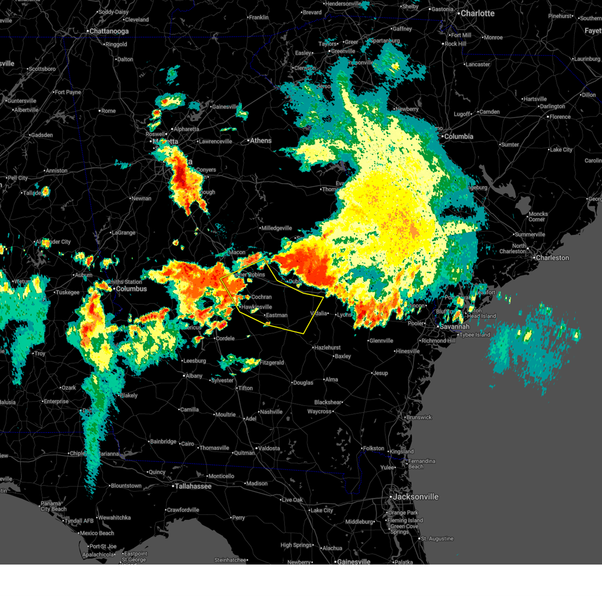
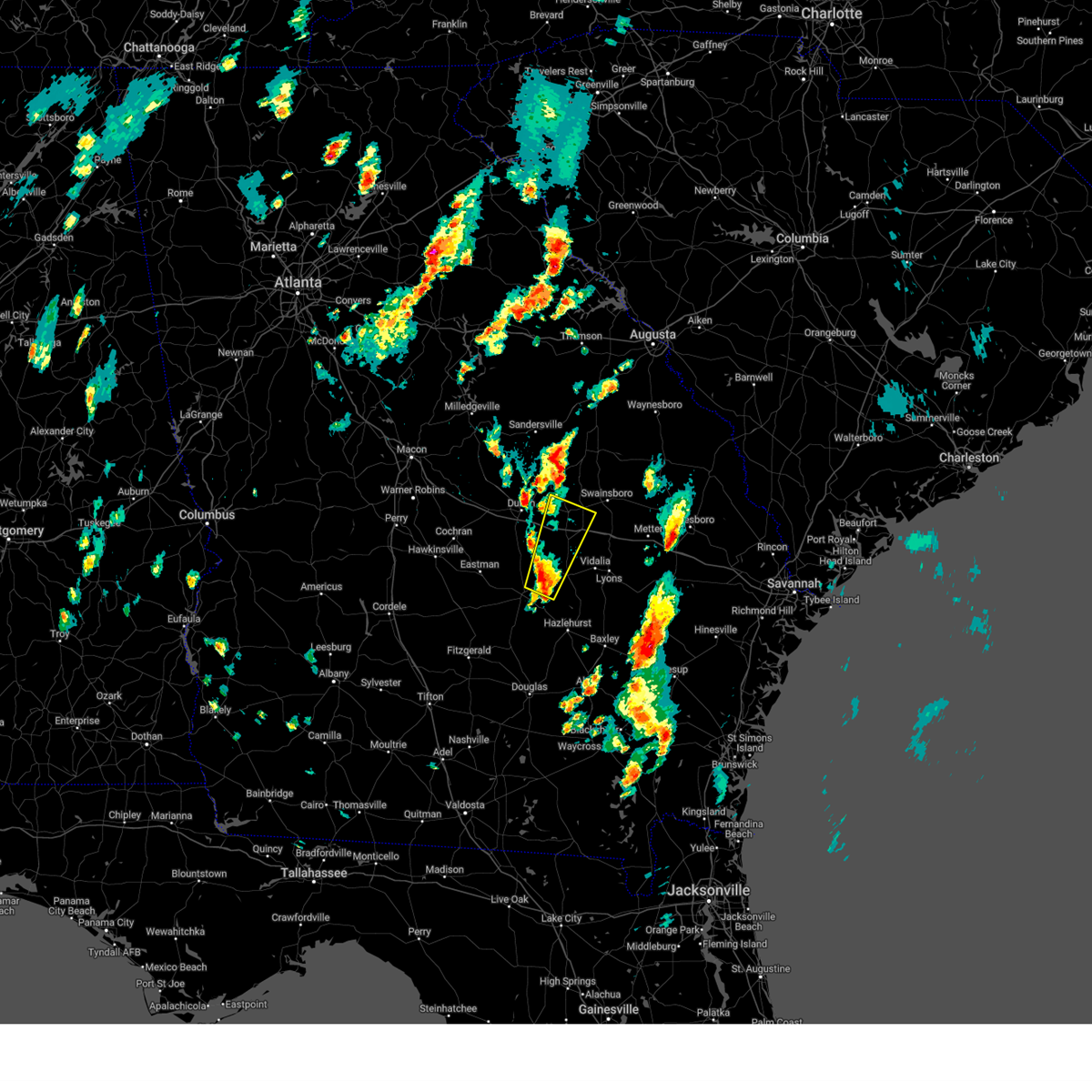
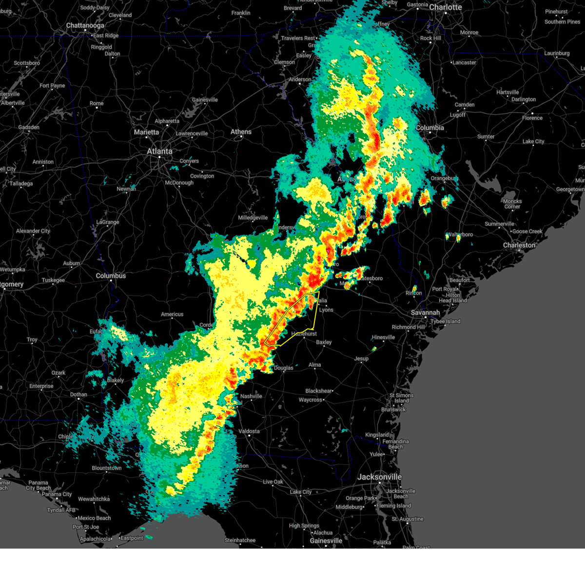
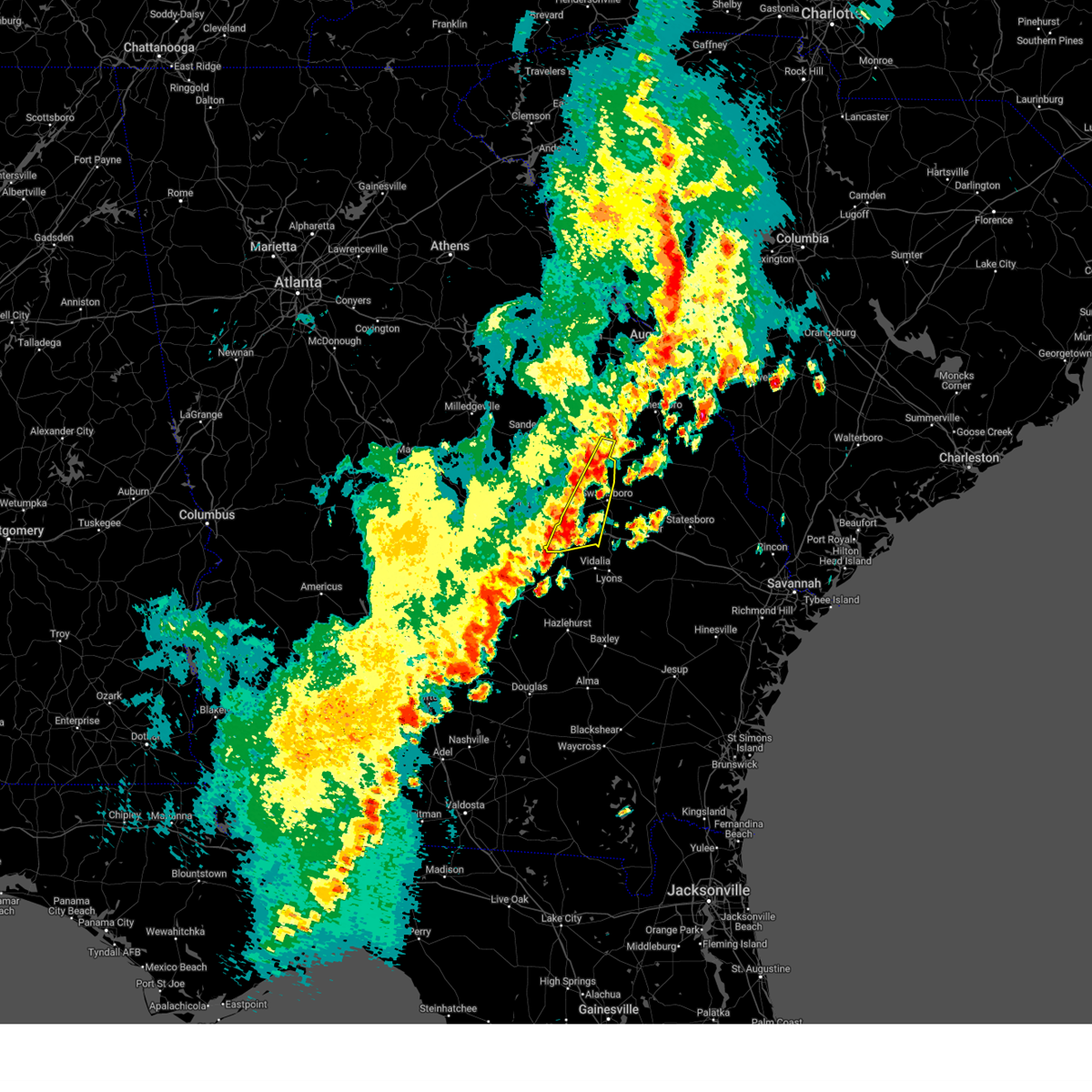
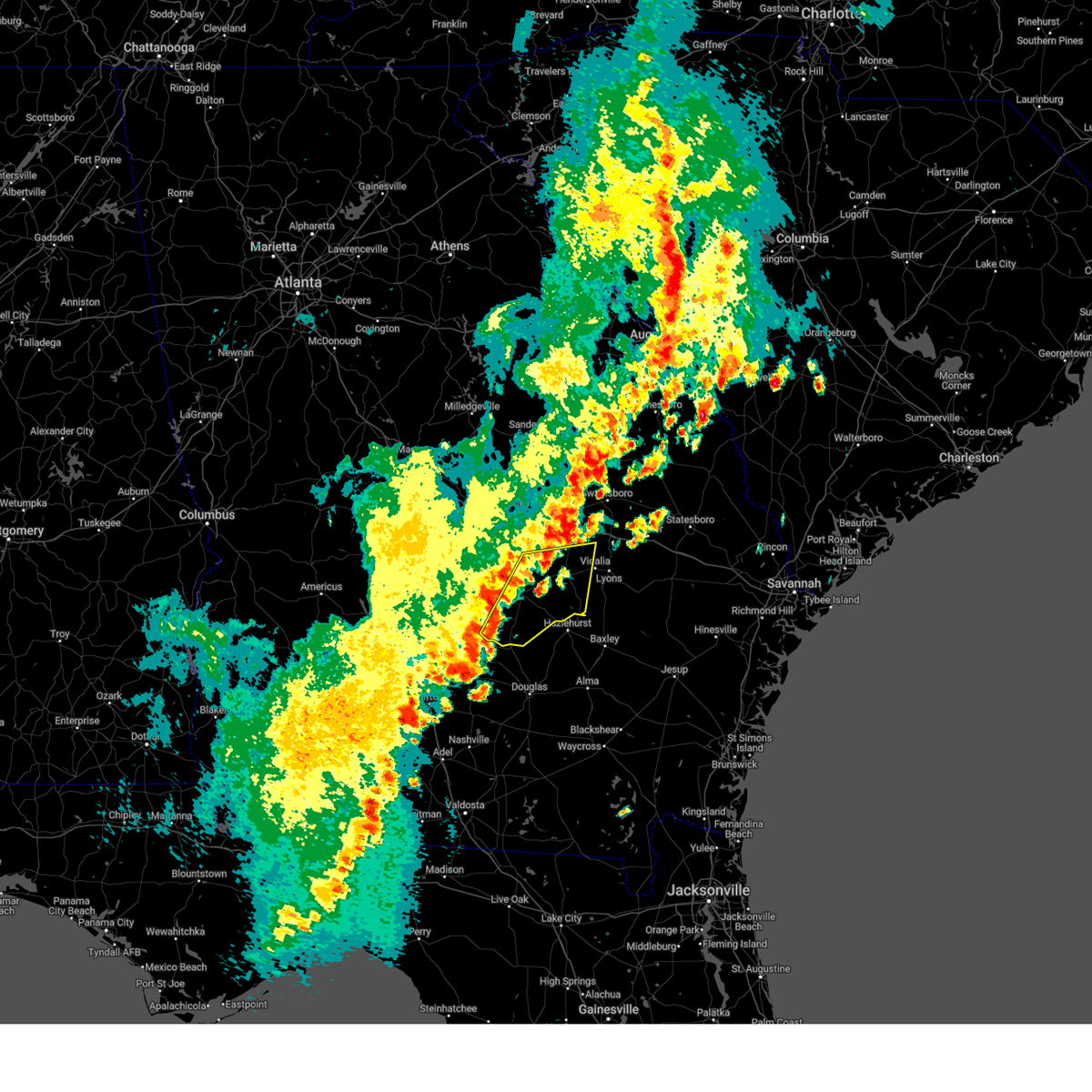
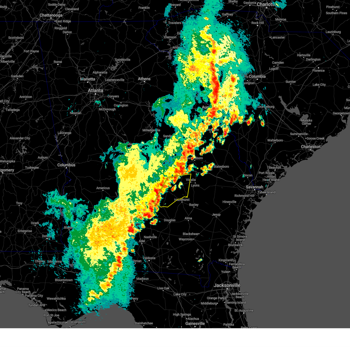
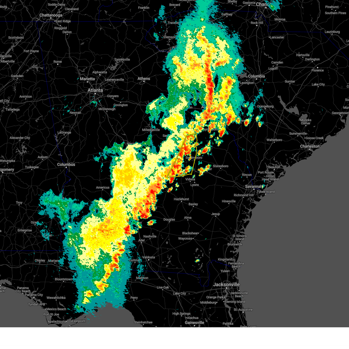
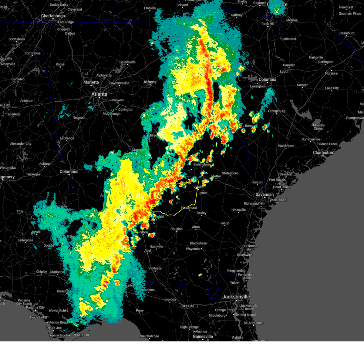
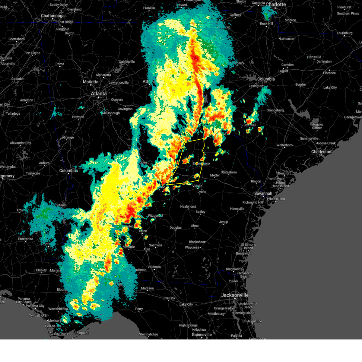
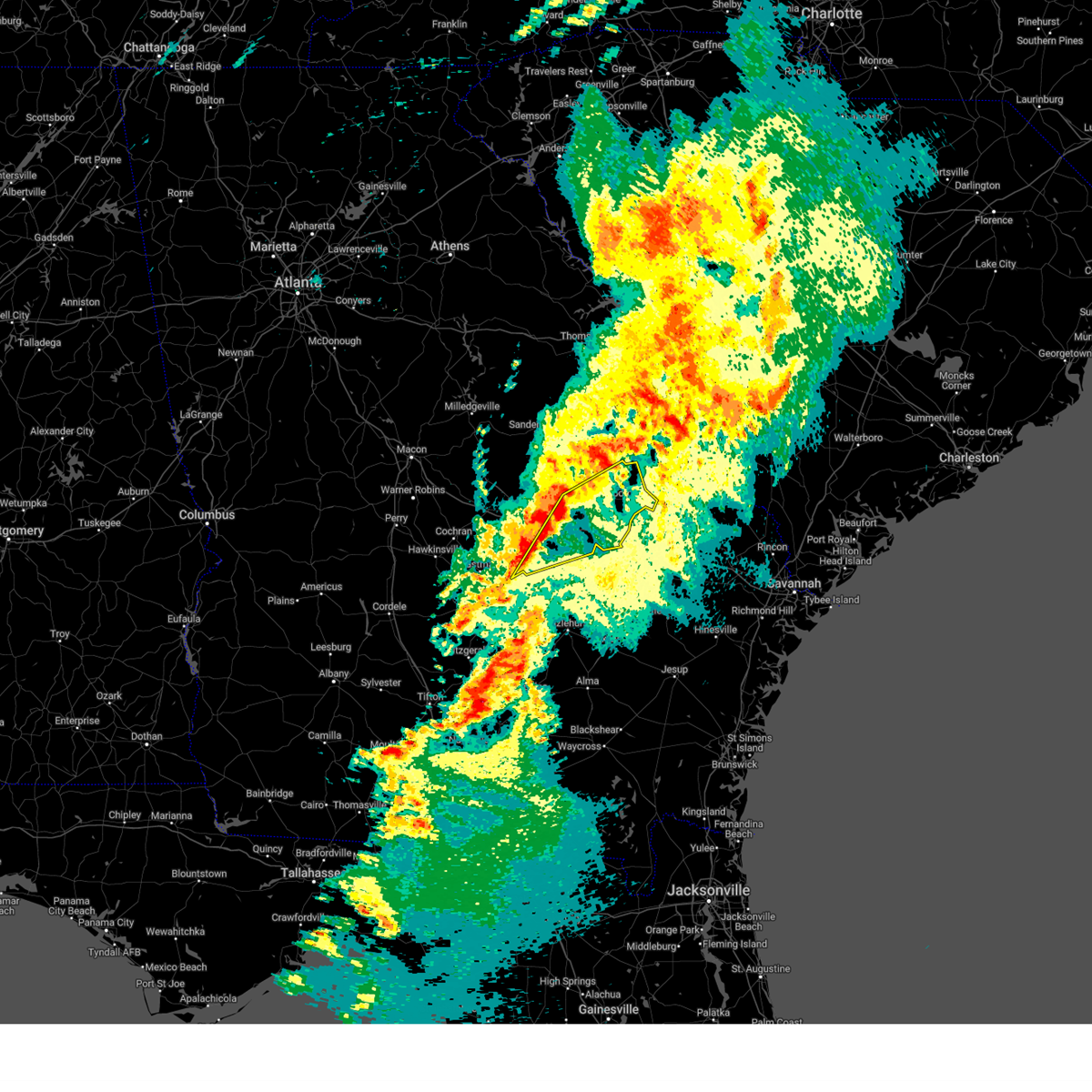
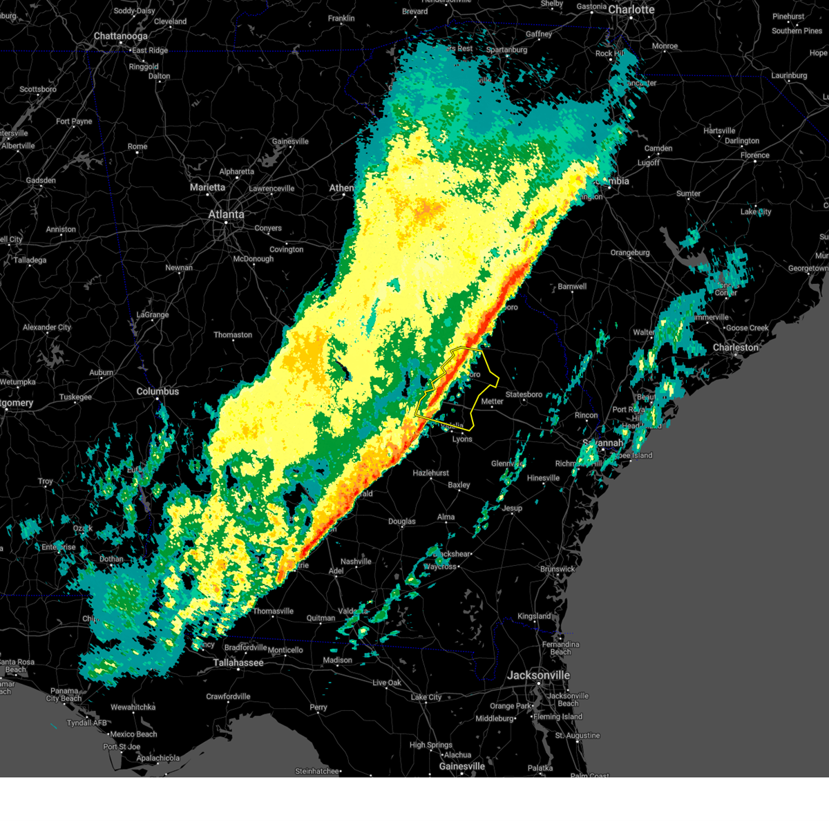
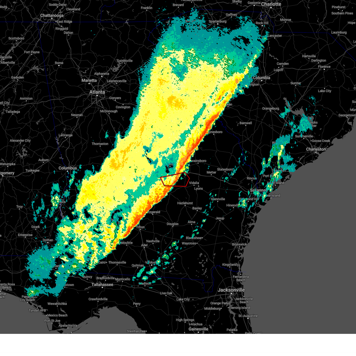
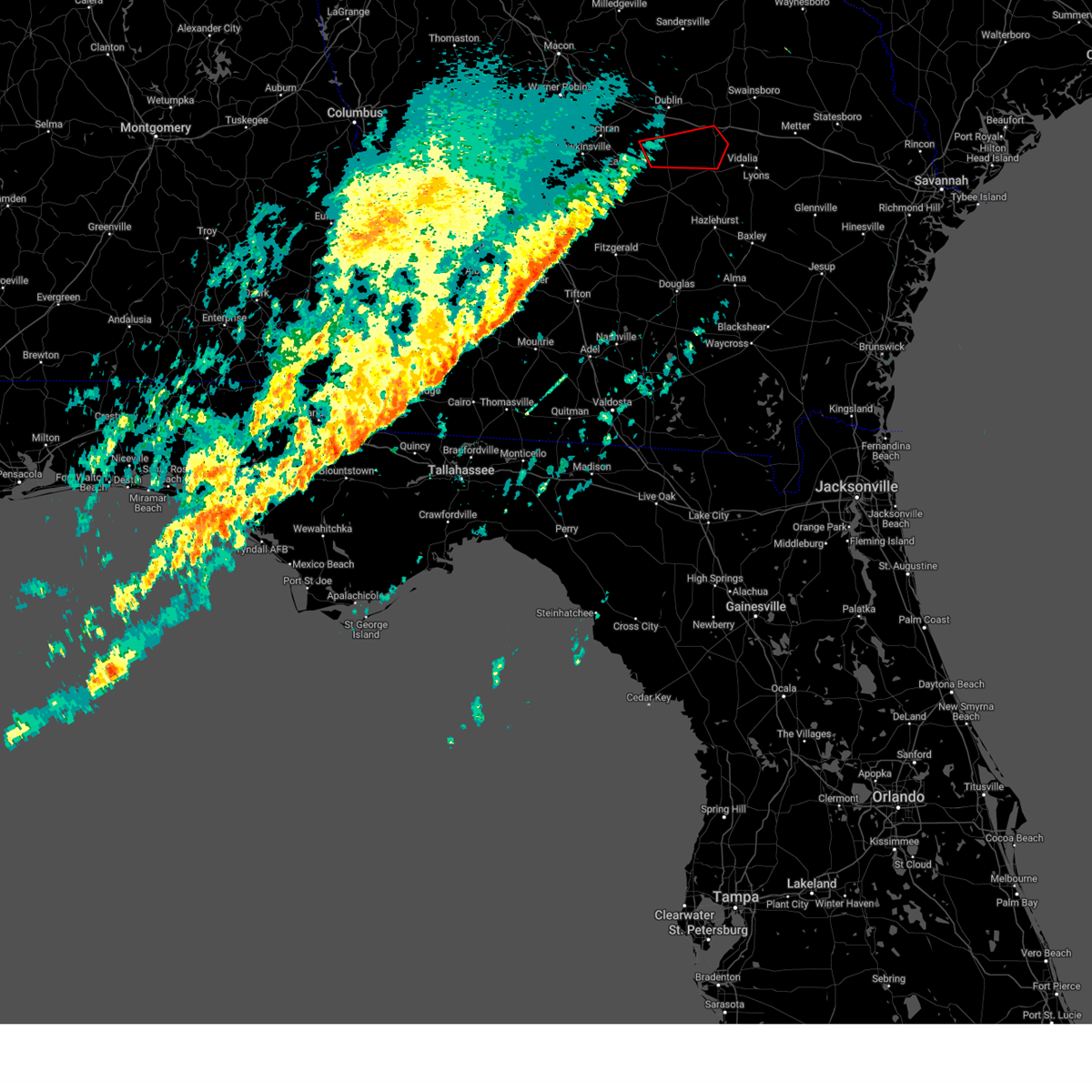
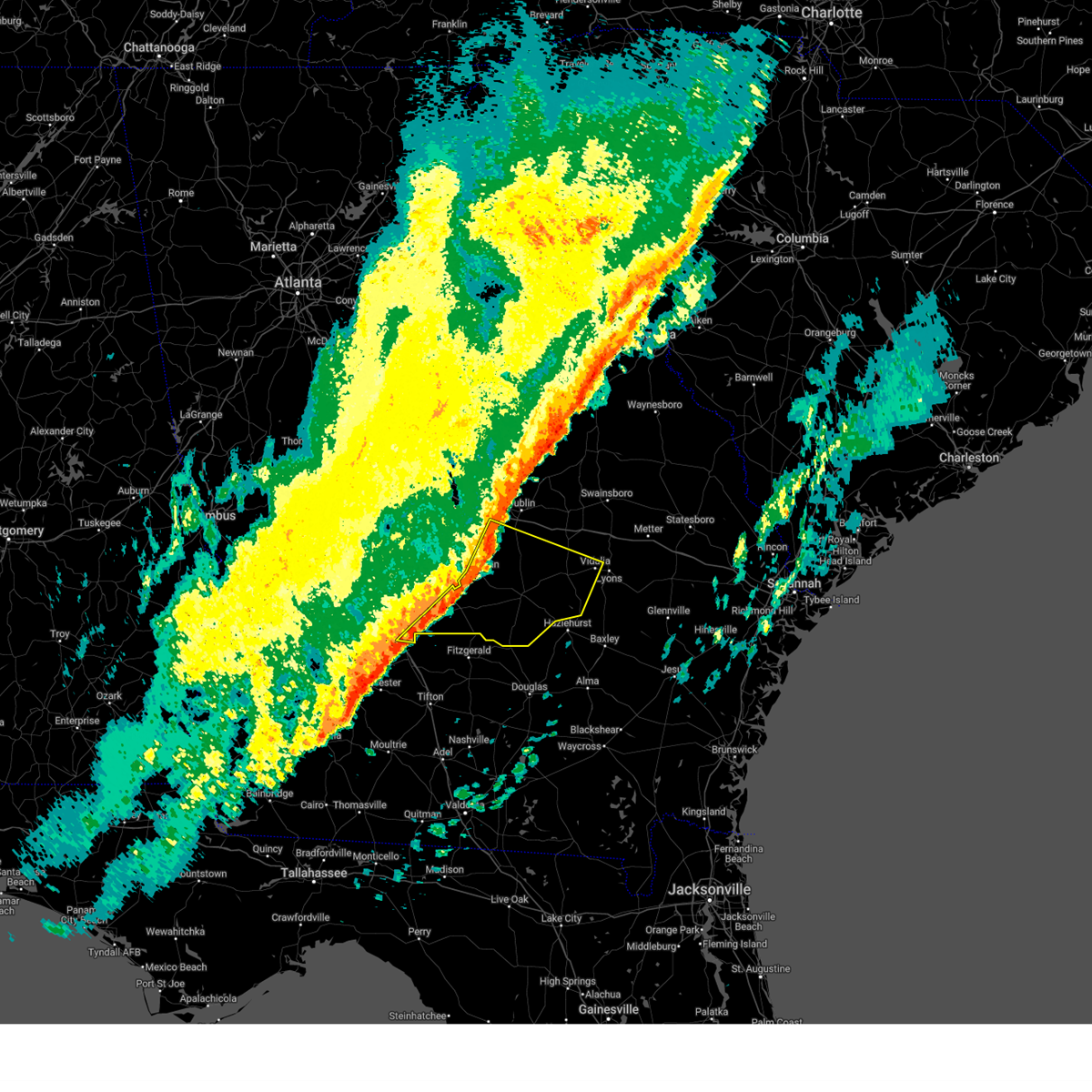
Hail Map for Tarrytown, GA
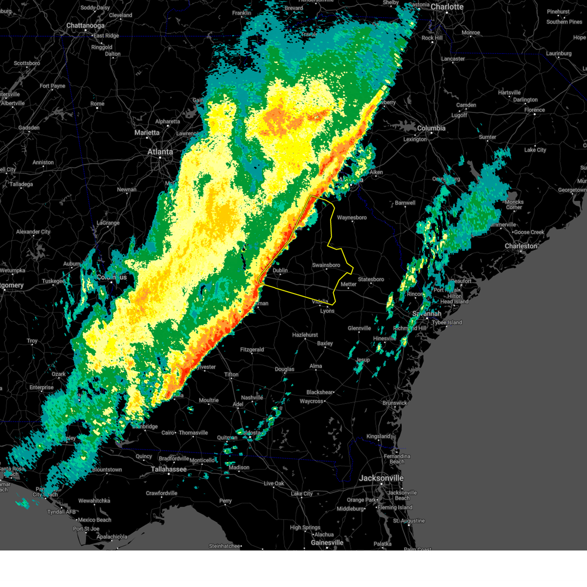
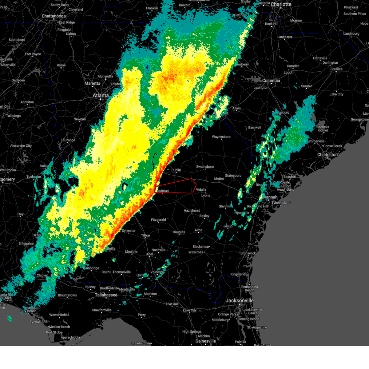
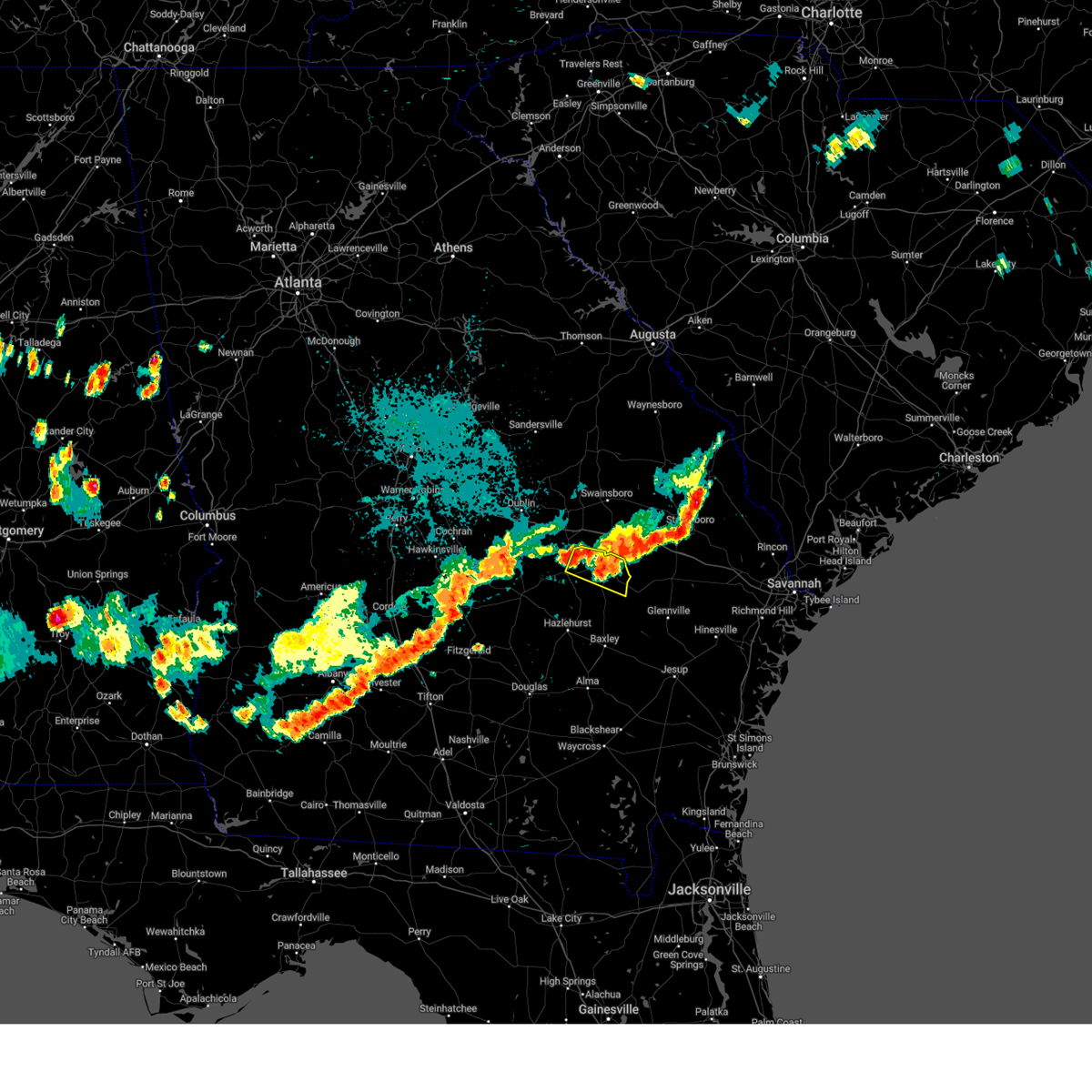
The Tarrytown, GA area has had 0 reports of on-the-ground hail by trained spotters, and has been under severe weather warnings 32 times during the past 12 months. Doppler radar has detected hail at or near Tarrytown, GA on 51 occasions, including 3 occasions during the past year.
| Name: | Tarrytown, GA |
| Where Located: | 58.6 miles NNE of Douglas, GA |
| Map: | Google Map for Tarrytown, GA |
| Population: | 87 |
| Housing Units: | 48 |
| More Info: | Search Google for Tarrytown, GA |
0
The Top Recent Hail Date for Tarrytown, GA is Thursday, July 10, 2025 (48th out of 51)

Hail and Wind Damage Spotted near Tarrytown, GA
| Date / Time | Report Details |
|---|---|
| 6/26/2025 12:32 AM EDT |
 Svrffc the national weather service in peachtree city has issued a * severe thunderstorm warning for, southwestern wilkinson county in central georgia, laurens county in central georgia, dodge county in central georgia, central pulaski county in central georgia, southern twiggs county in central georgia, north central telfair county in central georgia, southwestern treutlen county in east central georgia, bleckley county in central georgia, eastern houston county in central georgia, wheeler county in central georgia, northwestern montgomery county in central georgia, * until 130 am edt. * at 1232 am edt, severe thunderstorms were located along a line extending from near danville to near dudley to near lowery to near zaidee, moving southwest at 30 mph (radar indicated). Hazards include 60 mph wind gusts and quarter size hail. Hail damage to vehicles is expected. Expect wind damage to roofs, siding, and trees. Svrffc the national weather service in peachtree city has issued a * severe thunderstorm warning for, southwestern wilkinson county in central georgia, laurens county in central georgia, dodge county in central georgia, central pulaski county in central georgia, southern twiggs county in central georgia, north central telfair county in central georgia, southwestern treutlen county in east central georgia, bleckley county in central georgia, eastern houston county in central georgia, wheeler county in central georgia, northwestern montgomery county in central georgia, * until 130 am edt. * at 1232 am edt, severe thunderstorms were located along a line extending from near danville to near dudley to near lowery to near zaidee, moving southwest at 30 mph (radar indicated). Hazards include 60 mph wind gusts and quarter size hail. Hail damage to vehicles is expected. Expect wind damage to roofs, siding, and trees.
|
| 5/12/2025 7:12 PM EDT |
 The storm which prompted the warning has weakened below severe limits, and no longer poses an immediate threat to life or property. therefore, the warning will be allowed to expire. however, heavy rain is still possible with this thunderstorm. to report severe weather, contact your nearest law enforcement agency. they will relay your report to the national weather service peachtree city. The storm which prompted the warning has weakened below severe limits, and no longer poses an immediate threat to life or property. therefore, the warning will be allowed to expire. however, heavy rain is still possible with this thunderstorm. to report severe weather, contact your nearest law enforcement agency. they will relay your report to the national weather service peachtree city.
|
| 5/12/2025 6:55 PM EDT |
 the severe thunderstorm warning has been cancelled and is no longer in effect the severe thunderstorm warning has been cancelled and is no longer in effect
|
| 5/12/2025 6:55 PM EDT |
 At 655 pm edt, a severe thunderstorm was located over lothair, or near soperton, moving north at 35 mph (radar indicated). Hazards include 60 mph wind gusts. Expect damage to roofs, siding, and trees. Locations impacted include, alamo, mount vernon, glenwood, tarrytown, and landsburg. At 655 pm edt, a severe thunderstorm was located over lothair, or near soperton, moving north at 35 mph (radar indicated). Hazards include 60 mph wind gusts. Expect damage to roofs, siding, and trees. Locations impacted include, alamo, mount vernon, glenwood, tarrytown, and landsburg.
|
| 5/12/2025 6:50 PM EDT |
 the severe thunderstorm warning has been cancelled and is no longer in effect the severe thunderstorm warning has been cancelled and is no longer in effect
|
| 5/12/2025 6:50 PM EDT |
 At 649 pm edt, a severe thunderstorm was located over barnhill, or 7 miles southwest of soperton, moving north at 35 mph (radar indicated). Hazards include 60 mph wind gusts. Expect damage to roofs, siding, and trees. Locations impacted include, soperton, alamo, mount vernon, glenwood, adrian, tarrytown, lothair, covena, landsburg, orland, orianna, norristown, barnhill, norristown junction, blackville, zaidee, gillis springs, and scott. At 649 pm edt, a severe thunderstorm was located over barnhill, or 7 miles southwest of soperton, moving north at 35 mph (radar indicated). Hazards include 60 mph wind gusts. Expect damage to roofs, siding, and trees. Locations impacted include, soperton, alamo, mount vernon, glenwood, adrian, tarrytown, lothair, covena, landsburg, orland, orianna, norristown, barnhill, norristown junction, blackville, zaidee, gillis springs, and scott.
|
| 5/12/2025 6:28 PM EDT |
 Svrffc the national weather service in peachtree city has issued a * severe thunderstorm warning for, southeastern laurens county in central georgia, west central emanuel county in east central georgia, treutlen county in east central georgia, south central johnson county in east central georgia, central wheeler county in central georgia, northwestern montgomery county in central georgia, * until 715 pm edt. * at 628 pm edt, a severe thunderstorm was located over alamo, moving north at 35 mph (radar indicated). Hazards include 60 mph wind gusts and quarter size hail. Hail damage to vehicles is expected. Expect wind damage to roofs, siding, and trees. Svrffc the national weather service in peachtree city has issued a * severe thunderstorm warning for, southeastern laurens county in central georgia, west central emanuel county in east central georgia, treutlen county in east central georgia, south central johnson county in east central georgia, central wheeler county in central georgia, northwestern montgomery county in central georgia, * until 715 pm edt. * at 628 pm edt, a severe thunderstorm was located over alamo, moving north at 35 mph (radar indicated). Hazards include 60 mph wind gusts and quarter size hail. Hail damage to vehicles is expected. Expect wind damage to roofs, siding, and trees.
|
| 3/31/2025 4:10 PM EDT |
 At 409 pm edt, severe thunderstorms were located along a line extending from near mount vernon to 6 miles northeast of horse creek wma, moving east at 40 mph (radar indicated). Hazards include 60 mph wind gusts. Expect damage to roofs, siding, and trees. Locations impacted include, horse creek wma, spring hill, higgston, landsburg, glenwood, scotland, tarrytown, lumber city, kibbee, uvalda, towns, mount vernon, alston, jordan, charlotteville, jacksonville, ailey, alamo, workmore, and mcrae. At 409 pm edt, severe thunderstorms were located along a line extending from near mount vernon to 6 miles northeast of horse creek wma, moving east at 40 mph (radar indicated). Hazards include 60 mph wind gusts. Expect damage to roofs, siding, and trees. Locations impacted include, horse creek wma, spring hill, higgston, landsburg, glenwood, scotland, tarrytown, lumber city, kibbee, uvalda, towns, mount vernon, alston, jordan, charlotteville, jacksonville, ailey, alamo, workmore, and mcrae.
|
| 3/31/2025 4:10 PM EDT |
 the severe thunderstorm warning has been cancelled and is no longer in effect the severe thunderstorm warning has been cancelled and is no longer in effect
|
| 3/31/2025 4:02 PM EDT |
 At 402 pm edt, severe thunderstorms were located along a line extending from vidette to dellwood to soperton, moving east at 40 mph (radar indicated). Hazards include 60 mph wind gusts. Expect damage to roofs, siding, and trees. Locations impacted include, lothair, covena, adrian, modoc, orland, soperton, blundale, swainsboro, orianna, kite, norristown, barnhill, norristown junction, dellwood, meeks, blackville, wadley, zaidee, gillis springs, and nunez. At 402 pm edt, severe thunderstorms were located along a line extending from vidette to dellwood to soperton, moving east at 40 mph (radar indicated). Hazards include 60 mph wind gusts. Expect damage to roofs, siding, and trees. Locations impacted include, lothair, covena, adrian, modoc, orland, soperton, blundale, swainsboro, orianna, kite, norristown, barnhill, norristown junction, dellwood, meeks, blackville, wadley, zaidee, gillis springs, and nunez.
|
| 3/31/2025 4:02 PM EDT |
 the severe thunderstorm warning has been cancelled and is no longer in effect the severe thunderstorm warning has been cancelled and is no longer in effect
|
| 3/31/2025 3:59 PM EDT |
 At 358 pm edt, severe thunderstorms were located along a line extending from alamo to near jacksonville, moving east at 45 mph (radar indicated). Hazards include 60 mph wind gusts. Expect damage to roofs, siding, and trees. Locations impacted include, horse creek wma, spring hill, cedar grove, scotland, barnhill, uvalda, towns, china hill, mount vernon, helena, alston, jordan, jacksonville, ailey, alamo, higgston, landsburg, glenwood, tarrytown, and mcrae. At 358 pm edt, severe thunderstorms were located along a line extending from alamo to near jacksonville, moving east at 45 mph (radar indicated). Hazards include 60 mph wind gusts. Expect damage to roofs, siding, and trees. Locations impacted include, horse creek wma, spring hill, cedar grove, scotland, barnhill, uvalda, towns, china hill, mount vernon, helena, alston, jordan, jacksonville, ailey, alamo, higgston, landsburg, glenwood, tarrytown, and mcrae.
|
| 3/31/2025 3:59 PM EDT |
 the severe thunderstorm warning has been cancelled and is no longer in effect the severe thunderstorm warning has been cancelled and is no longer in effect
|
| 3/31/2025 3:51 PM EDT |
 At 350 pm edt, severe thunderstorms were located along a line extending from louisville to near kite to near barnhill, moving east at 40 mph (radar indicated). Hazards include 60 mph wind gusts. Expect damage to roofs, siding, and trees. Locations impacted include, lothair, covena, adrian, modoc, louisville, rockledge, kite, norristown, barnhill, minter, moxley, dellwood, wadley, zaidee, gillis springs, bartow, orland, soperton, blundale, and swainsboro. At 350 pm edt, severe thunderstorms were located along a line extending from louisville to near kite to near barnhill, moving east at 40 mph (radar indicated). Hazards include 60 mph wind gusts. Expect damage to roofs, siding, and trees. Locations impacted include, lothair, covena, adrian, modoc, louisville, rockledge, kite, norristown, barnhill, minter, moxley, dellwood, wadley, zaidee, gillis springs, bartow, orland, soperton, blundale, and swainsboro.
|
| 3/31/2025 3:39 PM EDT |
 Svrffc the national weather service in peachtree city has issued a * severe thunderstorm warning for, southeastern laurens county in central georgia, southeastern dodge county in central georgia, telfair county in central georgia, southern treutlen county in east central georgia, southeastern wilcox county in central georgia, wheeler county in central georgia, montgomery county in central georgia, * until 430 pm edt. * at 338 pm edt, severe thunderstorms were located along a line extending from chauncey to bowens mill, moving east at 45 mph (radar indicated). Hazards include 60 mph wind gusts. expect damage to roofs, siding, and trees Svrffc the national weather service in peachtree city has issued a * severe thunderstorm warning for, southeastern laurens county in central georgia, southeastern dodge county in central georgia, telfair county in central georgia, southern treutlen county in east central georgia, southeastern wilcox county in central georgia, wheeler county in central georgia, montgomery county in central georgia, * until 430 pm edt. * at 338 pm edt, severe thunderstorms were located along a line extending from chauncey to bowens mill, moving east at 45 mph (radar indicated). Hazards include 60 mph wind gusts. expect damage to roofs, siding, and trees
|
| 3/31/2025 3:26 PM EDT |
 Svrffc the national weather service in peachtree city has issued a * severe thunderstorm warning for, northeastern laurens county in central georgia, western emanuel county in east central georgia, treutlen county in east central georgia, southeastern washington county in east central georgia, johnson county in east central georgia, southeastern jefferson county in east central georgia, * until 415 pm edt. * at 326 pm edt, severe thunderstorms were located along a line extending from near davisboro to lovett to near cadwell, moving east at 40 mph (radar indicated). Hazards include 60 mph wind gusts. expect damage to roofs, siding, and trees Svrffc the national weather service in peachtree city has issued a * severe thunderstorm warning for, northeastern laurens county in central georgia, western emanuel county in east central georgia, treutlen county in east central georgia, southeastern washington county in east central georgia, johnson county in east central georgia, southeastern jefferson county in east central georgia, * until 415 pm edt. * at 326 pm edt, severe thunderstorms were located along a line extending from near davisboro to lovett to near cadwell, moving east at 40 mph (radar indicated). Hazards include 60 mph wind gusts. expect damage to roofs, siding, and trees
|
| 3/16/2025 7:47 AM EDT |
 Svrffc the national weather service in peachtree city has issued a * severe thunderstorm warning for, southeastern laurens county in central georgia, emanuel county in east central georgia, treutlen county in east central georgia, southeastern johnson county in east central georgia, northwestern wheeler county in central georgia, northern montgomery county in central georgia, * until 830 am edt. * at 746 am edt, severe thunderstorms were located along a line extending from near meeks to near cedar grove, moving northeast at 45 mph (radar indicated). Hazards include 60 mph wind gusts. expect damage to roofs, siding, and trees Svrffc the national weather service in peachtree city has issued a * severe thunderstorm warning for, southeastern laurens county in central georgia, emanuel county in east central georgia, treutlen county in east central georgia, southeastern johnson county in east central georgia, northwestern wheeler county in central georgia, northern montgomery county in central georgia, * until 830 am edt. * at 746 am edt, severe thunderstorms were located along a line extending from near meeks to near cedar grove, moving northeast at 45 mph (radar indicated). Hazards include 60 mph wind gusts. expect damage to roofs, siding, and trees
|
| 3/16/2025 7:47 AM EDT |
 The storm which prompted the warning has moved out of the area. therefore, the warning has been allowed to expire. a tornado watch remains in effect until 1000 am edt for central and east central georgia. The storm which prompted the warning has moved out of the area. therefore, the warning has been allowed to expire. a tornado watch remains in effect until 1000 am edt for central and east central georgia.
|
| 3/16/2025 7:24 AM EDT |
 At 724 am edt, a severe thunderstorm was located near rentz, or 9 miles south of dublin, moving east at 60 mph (radar indicated). Hazards include 60 mph wind gusts. Expect damage to roofs, siding, and trees. Locations impacted include, eastman, lothair, plainfield, adrian, cedar grove, dublin, rockledge, barnhill, union, minter, lovett, harlow, dexter, godwinsville, brewton, zaidee, orland, tarrytown, soperton, and orianna. At 724 am edt, a severe thunderstorm was located near rentz, or 9 miles south of dublin, moving east at 60 mph (radar indicated). Hazards include 60 mph wind gusts. Expect damage to roofs, siding, and trees. Locations impacted include, eastman, lothair, plainfield, adrian, cedar grove, dublin, rockledge, barnhill, union, minter, lovett, harlow, dexter, godwinsville, brewton, zaidee, orland, tarrytown, soperton, and orianna.
|
| 3/16/2025 7:24 AM EDT |
 the severe thunderstorm warning has been cancelled and is no longer in effect the severe thunderstorm warning has been cancelled and is no longer in effect
|
| 3/16/2025 7:04 AM EDT |
 Svrffc the national weather service in peachtree city has issued a * severe thunderstorm warning for, laurens county in central georgia, dodge county in central georgia, west central emanuel county in east central georgia, treutlen county in east central georgia, southeastern bleckley county in central georgia, southeastern johnson county in east central georgia, northwestern wheeler county in central georgia, northwestern montgomery county in central georgia, * until 745 am edt. * at 704 am edt, a severe thunderstorm was located over gresston, or near eastman, moving northeast at 60 mph (radar indicated). Hazards include 60 mph wind gusts and penny size hail. expect damage to roofs, siding, and trees Svrffc the national weather service in peachtree city has issued a * severe thunderstorm warning for, laurens county in central georgia, dodge county in central georgia, west central emanuel county in east central georgia, treutlen county in east central georgia, southeastern bleckley county in central georgia, southeastern johnson county in east central georgia, northwestern wheeler county in central georgia, northwestern montgomery county in central georgia, * until 745 am edt. * at 704 am edt, a severe thunderstorm was located over gresston, or near eastman, moving northeast at 60 mph (radar indicated). Hazards include 60 mph wind gusts and penny size hail. expect damage to roofs, siding, and trees
|
| 2/16/2025 7:37 AM EST |
 At 736 am est, severe thunderstorms were located along a line extending from near landsburg to towns to ocilla, moving southeast at 45 mph (radar indicated). Hazards include 60 mph wind gusts. Expect damage to roofs, siding, and trees. Locations impacted include, mcrae, alamo, mount vernon, vidalia, helena, lumber city, glenwood, milan, uvalda, ailey, scotland, higgston, alston, jacksonville, tarrytown, towns, horse creek wma, spring hill, barnhill, and china hill. At 736 am est, severe thunderstorms were located along a line extending from near landsburg to towns to ocilla, moving southeast at 45 mph (radar indicated). Hazards include 60 mph wind gusts. Expect damage to roofs, siding, and trees. Locations impacted include, mcrae, alamo, mount vernon, vidalia, helena, lumber city, glenwood, milan, uvalda, ailey, scotland, higgston, alston, jacksonville, tarrytown, towns, horse creek wma, spring hill, barnhill, and china hill.
|
| 2/16/2025 7:37 AM EST |
 the severe thunderstorm warning has been cancelled and is no longer in effect the severe thunderstorm warning has been cancelled and is no longer in effect
|
| 2/16/2025 7:35 AM EST |
 the severe thunderstorm warning has been cancelled and is no longer in effect the severe thunderstorm warning has been cancelled and is no longer in effect
|
| 2/16/2025 7:35 AM EST |
 At 735 am est, severe thunderstorms were located along a line extending from near shell bluff landing to rogers to near gillis springs, moving east at 60 mph (radar indicated). Hazards include 60 mph wind gusts. Expect damage to roofs, siding, and trees. Locations impacted include, swainsboro, soperton, twin city, adrian, stillmore, oak park, midville, garfield, summertown, nunez, tarrytown, lothair, covena, modoc, canoochee, norristown, barnhill, dellwood, zaidee, and george l smith state park. At 735 am est, severe thunderstorms were located along a line extending from near shell bluff landing to rogers to near gillis springs, moving east at 60 mph (radar indicated). Hazards include 60 mph wind gusts. Expect damage to roofs, siding, and trees. Locations impacted include, swainsboro, soperton, twin city, adrian, stillmore, oak park, midville, garfield, summertown, nunez, tarrytown, lothair, covena, modoc, canoochee, norristown, barnhill, dellwood, zaidee, and george l smith state park.
|
| 2/16/2025 7:24 AM EST |
 The tornado threat has diminished and the tornado warning has been cancelled. however, damaging winds remain likely and a severe thunderstorm warning remains in effect for the area. a tornado watch remains in effect until 900 am est for central and east central georgia. The tornado threat has diminished and the tornado warning has been cancelled. however, damaging winds remain likely and a severe thunderstorm warning remains in effect for the area. a tornado watch remains in effect until 900 am est for central and east central georgia.
|
| 2/16/2025 7:06 AM EST |
 At 706 am est, a severe thunderstorm capable of producing a tornado was located near cedar grove, or 14 miles northwest of alamo, moving east at 65 mph (radar indicated rotation). Hazards include tornado. Flying debris will be dangerous to those caught without shelter. mobile homes will be damaged or destroyed. damage to roofs, windows, and vehicles will occur. tree damage is likely. Locations impacted include, soperton, mount vernon, cadwell, tarrytown, lothair, landsburg, cedar grove, lowery, and barnhill. At 706 am est, a severe thunderstorm capable of producing a tornado was located near cedar grove, or 14 miles northwest of alamo, moving east at 65 mph (radar indicated rotation). Hazards include tornado. Flying debris will be dangerous to those caught without shelter. mobile homes will be damaged or destroyed. damage to roofs, windows, and vehicles will occur. tree damage is likely. Locations impacted include, soperton, mount vernon, cadwell, tarrytown, lothair, landsburg, cedar grove, lowery, and barnhill.
|
| 2/16/2025 7:06 AM EST |
 the tornado warning has been cancelled and is no longer in effect the tornado warning has been cancelled and is no longer in effect
|
| 2/16/2025 6:57 AM EST |
 Svrffc the national weather service in peachtree city has issued a * severe thunderstorm warning for, southern laurens county in central georgia, northwestern toombs county in southeastern georgia, dodge county in central georgia, telfair county in central georgia, southwestern treutlen county in east central georgia, wilcox county in central georgia, wheeler county in central georgia, southeastern crisp county in central georgia, montgomery county in central georgia, * until 800 am est. * at 657 am est, severe thunderstorms were located along a line extending from dexter to near eastman to dakota, moving southeast at 45 mph (radar indicated). Hazards include 60 mph wind gusts. expect damage to roofs, siding, and trees Svrffc the national weather service in peachtree city has issued a * severe thunderstorm warning for, southern laurens county in central georgia, northwestern toombs county in southeastern georgia, dodge county in central georgia, telfair county in central georgia, southwestern treutlen county in east central georgia, wilcox county in central georgia, wheeler county in central georgia, southeastern crisp county in central georgia, montgomery county in central georgia, * until 800 am est. * at 657 am est, severe thunderstorms were located along a line extending from dexter to near eastman to dakota, moving southeast at 45 mph (radar indicated). Hazards include 60 mph wind gusts. expect damage to roofs, siding, and trees
|
| 2/16/2025 6:54 AM EST |
 Svrffc the national weather service in peachtree city has issued a * severe thunderstorm warning for, laurens county in central georgia, northern toombs county in southeastern georgia, emanuel county in east central georgia, southeastern warren county in east central georgia, treutlen county in east central georgia, central glascock county in east central georgia, southeastern washington county in east central georgia, johnson county in east central georgia, jefferson county in east central georgia, northeastern montgomery county in central georgia, * until 800 am est. * at 654 am est, severe thunderstorms were located along a line extending from near autney to near harrison to near rebie, moving east at 60 mph (radar indicated). Hazards include 60 mph wind gusts. expect damage to roofs, siding, and trees Svrffc the national weather service in peachtree city has issued a * severe thunderstorm warning for, laurens county in central georgia, northern toombs county in southeastern georgia, emanuel county in east central georgia, southeastern warren county in east central georgia, treutlen county in east central georgia, central glascock county in east central georgia, southeastern washington county in east central georgia, johnson county in east central georgia, jefferson county in east central georgia, northeastern montgomery county in central georgia, * until 800 am est. * at 654 am est, severe thunderstorms were located along a line extending from near autney to near harrison to near rebie, moving east at 60 mph (radar indicated). Hazards include 60 mph wind gusts. expect damage to roofs, siding, and trees
|
| 2/16/2025 6:47 AM EST |
 Torffc the national weather service in peachtree city has issued a * tornado warning for, southern laurens county in central georgia, northwestern dodge county in central georgia, southwestern treutlen county in east central georgia, northeastern wheeler county in central georgia, northwestern montgomery county in central georgia, * until 730 am est. * at 647 am est, a severe thunderstorm capable of producing a tornado was located over gresston, or near eastman, moving east at 65 mph (radar indicated rotation). Hazards include tornado. Flying debris will be dangerous to those caught without shelter. mobile homes will be damaged or destroyed. damage to roofs, windows, and vehicles will occur. Tree damage is likely. Torffc the national weather service in peachtree city has issued a * tornado warning for, southern laurens county in central georgia, northwestern dodge county in central georgia, southwestern treutlen county in east central georgia, northeastern wheeler county in central georgia, northwestern montgomery county in central georgia, * until 730 am est. * at 647 am est, a severe thunderstorm capable of producing a tornado was located over gresston, or near eastman, moving east at 65 mph (radar indicated rotation). Hazards include tornado. Flying debris will be dangerous to those caught without shelter. mobile homes will be damaged or destroyed. damage to roofs, windows, and vehicles will occur. Tree damage is likely.
|
| 8/18/2024 8:43 PM EDT |
 Svrffc the national weather service in peachtree city has issued a * severe thunderstorm warning for, central toombs county in southeastern georgia, northern montgomery county in central georgia, * until 915 pm edt. * at 843 pm edt, a severe thunderstorm was located near kibbee, or near mount vernon, moving east at 25 mph (radar indicated). Hazards include 60 mph wind gusts. expect damage to roofs, siding, and trees Svrffc the national weather service in peachtree city has issued a * severe thunderstorm warning for, central toombs county in southeastern georgia, northern montgomery county in central georgia, * until 915 pm edt. * at 843 pm edt, a severe thunderstorm was located near kibbee, or near mount vernon, moving east at 25 mph (radar indicated). Hazards include 60 mph wind gusts. expect damage to roofs, siding, and trees
|
| 6/10/2024 5:17 PM EDT |
 the severe thunderstorm warning has been cancelled and is no longer in effect the severe thunderstorm warning has been cancelled and is no longer in effect
|
| 6/10/2024 5:17 PM EDT |
 At 517 pm edt, a severe thunderstorm was located over barnhill, or near soperton, moving northeast at 35 mph (radar indicated). Hazards include 60 mph wind gusts and quarter size hail. Hail damage to vehicles is expected. expect wind damage to roofs, siding, and trees. Locations impacted include, soperton, mount vernon, glenwood, ailey, higgston, tarrytown, lothair, landsburg, barnhill, and kibbee. At 517 pm edt, a severe thunderstorm was located over barnhill, or near soperton, moving northeast at 35 mph (radar indicated). Hazards include 60 mph wind gusts and quarter size hail. Hail damage to vehicles is expected. expect wind damage to roofs, siding, and trees. Locations impacted include, soperton, mount vernon, glenwood, ailey, higgston, tarrytown, lothair, landsburg, barnhill, and kibbee.
|
| 6/10/2024 5:00 PM EDT |
 Svrffc the national weather service in peachtree city has issued a * severe thunderstorm warning for, southeastern laurens county in central georgia, western treutlen county in east central georgia, northern wheeler county in central georgia, northern montgomery county in central georgia, * until 530 pm edt. * at 500 pm edt, a severe thunderstorm was located near cedar grove, or 7 miles north of alamo, moving northeast at 35 mph (radar indicated). Hazards include 60 mph wind gusts and quarter size hail. Hail damage to vehicles is expected. Expect wind damage to roofs, siding, and trees. Svrffc the national weather service in peachtree city has issued a * severe thunderstorm warning for, southeastern laurens county in central georgia, western treutlen county in east central georgia, northern wheeler county in central georgia, northern montgomery county in central georgia, * until 530 pm edt. * at 500 pm edt, a severe thunderstorm was located near cedar grove, or 7 miles north of alamo, moving northeast at 35 mph (radar indicated). Hazards include 60 mph wind gusts and quarter size hail. Hail damage to vehicles is expected. Expect wind damage to roofs, siding, and trees.
|
| 5/25/2024 3:16 PM EDT |
 The storm which prompted the warning has weakened below severe limits, and no longer poses an immediate threat to life or property. therefore, the warning will be allowed to expire. however, small hail, gusty winds and heavy rain are still possible with this thunderstorm. a severe thunderstorm watch remains in effect until 800 pm edt for central, southeastern and east central georgia. to report severe weather, contact your nearest law enforcement agency. they will relay your report to the national weather service peachtree city. The storm which prompted the warning has weakened below severe limits, and no longer poses an immediate threat to life or property. therefore, the warning will be allowed to expire. however, small hail, gusty winds and heavy rain are still possible with this thunderstorm. a severe thunderstorm watch remains in effect until 800 pm edt for central, southeastern and east central georgia. to report severe weather, contact your nearest law enforcement agency. they will relay your report to the national weather service peachtree city.
|
| 5/25/2024 2:34 PM EDT |
 Svrffc the national weather service in peachtree city has issued a * severe thunderstorm warning for, northwestern toombs county in southeastern georgia, southwestern treutlen county in east central georgia, northeastern wheeler county in central georgia, montgomery county in central georgia, * until 315 pm edt. * at 233 pm edt, a severe thunderstorm was located near barnhill, or 7 miles northwest of mount vernon, moving southeast at 15 mph (radar indicated). Hazards include 60 mph wind gusts and quarter size hail. Hail damage to vehicles is expected. Expect wind damage to roofs, siding, and trees. Svrffc the national weather service in peachtree city has issued a * severe thunderstorm warning for, northwestern toombs county in southeastern georgia, southwestern treutlen county in east central georgia, northeastern wheeler county in central georgia, montgomery county in central georgia, * until 315 pm edt. * at 233 pm edt, a severe thunderstorm was located near barnhill, or 7 miles northwest of mount vernon, moving southeast at 15 mph (radar indicated). Hazards include 60 mph wind gusts and quarter size hail. Hail damage to vehicles is expected. Expect wind damage to roofs, siding, and trees.
|
| 1/9/2024 12:38 PM EST |
 At 1237 pm est, severe thunderstorms were located along a line extending from near blackville to 6 miles southwest of lumber city, moving northeast at 45 mph (radar indicated). Hazards include 60 mph wind gusts. expect damage to roofs, siding, and trees At 1237 pm est, severe thunderstorms were located along a line extending from near blackville to 6 miles southwest of lumber city, moving northeast at 45 mph (radar indicated). Hazards include 60 mph wind gusts. expect damage to roofs, siding, and trees
|
| 1/9/2024 12:38 PM EST |
 At 1237 pm est, severe thunderstorms were located along a line extending from near scott to near orland to near landsburg, moving east at 35 mph (radar indicated). Hazards include 60 mph wind gusts. Expect damage to roofs, siding, and trees. Locations impacted include, swainsboro, soperton, vidalia, adrian, oak park, higgston, nunez, tarrytown, lothair, covena, landsburg, orland, orianna, norristown, barnhill, kibbee, norristown junction, blackville, zaidee, and gillis springs. At 1237 pm est, severe thunderstorms were located along a line extending from near scott to near orland to near landsburg, moving east at 35 mph (radar indicated). Hazards include 60 mph wind gusts. Expect damage to roofs, siding, and trees. Locations impacted include, swainsboro, soperton, vidalia, adrian, oak park, higgston, nunez, tarrytown, lothair, covena, landsburg, orland, orianna, norristown, barnhill, kibbee, norristown junction, blackville, zaidee, and gillis springs.
|
| 1/9/2024 12:10 PM EST |
 At 1209 pm est, severe thunderstorms were located along a line extending from near east dublin to near cedar grove, moving east at 45 mph (radar indicated). Hazards include 60 mph wind gusts. expect damage to roofs, siding, and trees At 1209 pm est, severe thunderstorms were located along a line extending from near east dublin to near cedar grove, moving east at 45 mph (radar indicated). Hazards include 60 mph wind gusts. expect damage to roofs, siding, and trees
|
| 9/17/2023 2:22 PM EDT |
 At 222 pm edt, a severe thunderstorm was located over higgston, or near mount vernon, moving east at 30 mph (radar indicated). Hazards include 60 mph wind gusts and nickel size hail. expect damage to roofs, siding, and trees At 222 pm edt, a severe thunderstorm was located over higgston, or near mount vernon, moving east at 30 mph (radar indicated). Hazards include 60 mph wind gusts and nickel size hail. expect damage to roofs, siding, and trees
|
| 9/7/2023 5:37 PM EDT |
 The severe thunderstorm warning for southeastern laurens, treutlen, northern wheeler and montgomery counties will expire at 545 pm edt, the storm which prompted the warning has weakened below severe limits, and no longer poses an immediate threat to life or property. therefore, the warning will be allowed to expire. The severe thunderstorm warning for southeastern laurens, treutlen, northern wheeler and montgomery counties will expire at 545 pm edt, the storm which prompted the warning has weakened below severe limits, and no longer poses an immediate threat to life or property. therefore, the warning will be allowed to expire.
|
| 9/7/2023 5:07 PM EDT |
 At 506 pm edt, a severe thunderstorm was located near lowery, or 10 miles southwest of soperton, moving east at 25 mph (radar indicated). Hazards include 60 mph wind gusts and penny size hail. expect damage to roofs, siding, and trees At 506 pm edt, a severe thunderstorm was located near lowery, or 10 miles southwest of soperton, moving east at 25 mph (radar indicated). Hazards include 60 mph wind gusts and penny size hail. expect damage to roofs, siding, and trees
|
| 8/8/2023 6:44 PM EDT |
 At 644 pm edt, severe thunderstorms were located along a line extending from near scott to near lothair to near landsburg, moving east at 50 mph (radar indicated). Hazards include 60 mph wind gusts and quarter size hail. Hail damage to vehicles is expected. Expect wind damage to roofs, siding, and trees. At 644 pm edt, severe thunderstorms were located along a line extending from near scott to near lothair to near landsburg, moving east at 50 mph (radar indicated). Hazards include 60 mph wind gusts and quarter size hail. Hail damage to vehicles is expected. Expect wind damage to roofs, siding, and trees.
|
| 8/6/2023 6:20 PM EDT |
 The severe thunderstorm warning for east central laurens, southwestern emanuel, treutlen, southern johnson and northern montgomery counties will expire at 630 pm edt, the storm which prompted the warning has weakened below severe limits, and has exited the warned area. therefore, the warning will be allowed to expire. a severe thunderstorm watch remains in effect until 900 pm edt for central and east central georgia. The severe thunderstorm warning for east central laurens, southwestern emanuel, treutlen, southern johnson and northern montgomery counties will expire at 630 pm edt, the storm which prompted the warning has weakened below severe limits, and has exited the warned area. therefore, the warning will be allowed to expire. a severe thunderstorm watch remains in effect until 900 pm edt for central and east central georgia.
|
| 8/6/2023 5:40 PM EDT |
 At 540 pm edt, a severe thunderstorm was located over minter, or 11 miles northwest of soperton, moving east at 20 mph (radar indicated). Hazards include 60 mph wind gusts and quarter size hail. Hail damage to vehicles is expected. Expect wind damage to roofs, siding, and trees. At 540 pm edt, a severe thunderstorm was located over minter, or 11 miles northwest of soperton, moving east at 20 mph (radar indicated). Hazards include 60 mph wind gusts and quarter size hail. Hail damage to vehicles is expected. Expect wind damage to roofs, siding, and trees.
|
| 8/3/2023 8:50 PM EDT |
 At 849 pm edt, severe thunderstorms were located along a line extending from near norristown junction to near gillis springs to near kibbee to near landsburg, moving east at 45 mph (radar indicated). Hazards include 60 mph wind gusts. Expect damage to roofs, siding, and trees. locations impacted include, swainsboro, soperton, twin city, adrian, stillmore, oak park, nunez, tarrytown, lothair, covena, modoc, orland, orianna, norristown, kibbee, norristown junction, dellwood, meeks, lexsy, and blackville. hail threat, radar indicated max hail size, <. 75 in wind threat, radar indicated max wind gust, 60 mph. At 849 pm edt, severe thunderstorms were located along a line extending from near norristown junction to near gillis springs to near kibbee to near landsburg, moving east at 45 mph (radar indicated). Hazards include 60 mph wind gusts. Expect damage to roofs, siding, and trees. locations impacted include, swainsboro, soperton, twin city, adrian, stillmore, oak park, nunez, tarrytown, lothair, covena, modoc, orland, orianna, norristown, kibbee, norristown junction, dellwood, meeks, lexsy, and blackville. hail threat, radar indicated max hail size, <. 75 in wind threat, radar indicated max wind gust, 60 mph.
|
| 8/3/2023 8:25 PM EDT |
 At 825 pm edt, severe thunderstorms were located along a line extending from near spann to orianna to near lowery to near eastman, moving southeast at 40 mph (radar indicated). Hazards include 60 mph wind gusts. expect damage to roofs, siding, and trees At 825 pm edt, severe thunderstorms were located along a line extending from near spann to orianna to near lowery to near eastman, moving southeast at 40 mph (radar indicated). Hazards include 60 mph wind gusts. expect damage to roofs, siding, and trees
|
| 7/30/2023 6:28 PM EDT |
 At 627 pm edt, a severe thunderstorm was located over swainsboro, moving east at 20 mph (radar indicated). Hazards include 60 mph wind gusts and quarter size hail. Hail damage to vehicles is expected. expect wind damage to roofs, siding, and trees. locations impacted include, swainsboro, twin city, stillmore, oak park, nunez, tarrytown, covena, modoc, norristown, norristown junction, dellwood, lexsy, zaidee, george l smith state park, and gillis springs. hail threat, radar indicated max hail size, 1. 00 in wind threat, radar indicated max wind gust, 60 mph. At 627 pm edt, a severe thunderstorm was located over swainsboro, moving east at 20 mph (radar indicated). Hazards include 60 mph wind gusts and quarter size hail. Hail damage to vehicles is expected. expect wind damage to roofs, siding, and trees. locations impacted include, swainsboro, twin city, stillmore, oak park, nunez, tarrytown, covena, modoc, norristown, norristown junction, dellwood, lexsy, zaidee, george l smith state park, and gillis springs. hail threat, radar indicated max hail size, 1. 00 in wind threat, radar indicated max wind gust, 60 mph.
|
| 7/30/2023 6:10 PM EDT |
 At 609 pm edt, a severe thunderstorm was located near ailey, or near mount vernon, moving east at 25 mph (radar indicated). Hazards include 60 mph wind gusts and quarter size hail. Hail damage to vehicles is expected. Expect wind damage to roofs, siding, and trees. At 609 pm edt, a severe thunderstorm was located near ailey, or near mount vernon, moving east at 25 mph (radar indicated). Hazards include 60 mph wind gusts and quarter size hail. Hail damage to vehicles is expected. Expect wind damage to roofs, siding, and trees.
|
| 7/30/2023 5:54 PM EDT |
 At 554 pm edt, a severe thunderstorm was located over meeks, or 11 miles southeast of wrightsville, moving east at 20 mph (radar indicated). Hazards include 60 mph wind gusts and quarter size hail. Hail damage to vehicles is expected. Expect wind damage to roofs, siding, and trees. At 554 pm edt, a severe thunderstorm was located over meeks, or 11 miles southeast of wrightsville, moving east at 20 mph (radar indicated). Hazards include 60 mph wind gusts and quarter size hail. Hail damage to vehicles is expected. Expect wind damage to roofs, siding, and trees.
|
| 7/30/2023 5:47 PM EDT |
 At 547 pm edt, a severe thunderstorm was located near landsburg, or near alamo, moving east at 20 mph (radar indicated). Hazards include 60 mph wind gusts and quarter size hail. Hail damage to vehicles is expected. Expect wind damage to roofs, siding, and trees. At 547 pm edt, a severe thunderstorm was located near landsburg, or near alamo, moving east at 20 mph (radar indicated). Hazards include 60 mph wind gusts and quarter size hail. Hail damage to vehicles is expected. Expect wind damage to roofs, siding, and trees.
|
| 7/21/2023 10:51 PM EDT |
 At 1050 pm edt, severe thunderstorms were located along a line extending from lexsy to near oak park to near zaidee, moving southeast at 50 mph (radar indicated). Hazards include 60 mph wind gusts and quarter size hail. Hail damage to vehicles is expected. expect wind damage to roofs, siding, and trees. locations impacted include, swainsboro, soperton, twin city, adrian, stillmore, oak park, nunez, tarrytown, lothair, covena, orianna, norristown, barnhill, kibbee, norristown junction, lexsy, blackville, zaidee and gillis springs. hail threat, radar indicated max hail size, 1. 00 in wind threat, radar indicated max wind gust, 60 mph. At 1050 pm edt, severe thunderstorms were located along a line extending from lexsy to near oak park to near zaidee, moving southeast at 50 mph (radar indicated). Hazards include 60 mph wind gusts and quarter size hail. Hail damage to vehicles is expected. expect wind damage to roofs, siding, and trees. locations impacted include, swainsboro, soperton, twin city, adrian, stillmore, oak park, nunez, tarrytown, lothair, covena, orianna, norristown, barnhill, kibbee, norristown junction, lexsy, blackville, zaidee and gillis springs. hail threat, radar indicated max hail size, 1. 00 in wind threat, radar indicated max wind gust, 60 mph.
|
| 7/21/2023 10:29 PM EDT |
 At 1029 pm edt, severe thunderstorms were located along a line extending from meeks to orianna to near minter, moving southeast at 50 mph (radar indicated). Hazards include 60 mph wind gusts and quarter size hail. Hail damage to vehicles is expected. Expect wind damage to roofs, siding, and trees. At 1029 pm edt, severe thunderstorms were located along a line extending from meeks to orianna to near minter, moving southeast at 50 mph (radar indicated). Hazards include 60 mph wind gusts and quarter size hail. Hail damage to vehicles is expected. Expect wind damage to roofs, siding, and trees.
|
| 6/20/2023 3:17 PM EDT |
 At 317 pm edt, a severe thunderstorm was located near lowery, or 11 miles west of soperton, moving east at 20 mph (radar indicated). Hazards include 60 mph wind gusts and quarter size hail. Hail damage to vehicles is expected. Expect wind damage to roofs, siding, and trees. At 317 pm edt, a severe thunderstorm was located near lowery, or 11 miles west of soperton, moving east at 20 mph (radar indicated). Hazards include 60 mph wind gusts and quarter size hail. Hail damage to vehicles is expected. Expect wind damage to roofs, siding, and trees.
|
| 6/14/2023 5:03 PM EDT |
 At 502 pm edt, a severe thunderstorm was located near landsburg, or 9 miles north of alamo, moving east at 35 mph (radar indicated). Hazards include 60 mph wind gusts and penny size hail. Expect damage to roofs, siding, and trees. locations impacted include, mount vernon, glenwood, ailey, tarrytown, landsburg, barnhill and kibbee. hail threat, radar indicated max hail size, 0. 75 in wind threat, radar indicated max wind gust, 60 mph. At 502 pm edt, a severe thunderstorm was located near landsburg, or 9 miles north of alamo, moving east at 35 mph (radar indicated). Hazards include 60 mph wind gusts and penny size hail. Expect damage to roofs, siding, and trees. locations impacted include, mount vernon, glenwood, ailey, tarrytown, landsburg, barnhill and kibbee. hail threat, radar indicated max hail size, 0. 75 in wind threat, radar indicated max wind gust, 60 mph.
|
| 6/14/2023 4:47 PM EDT |
 At 446 pm edt, a severe thunderstorm was located over cedar grove, or 11 miles northwest of alamo, moving east at 35 mph (radar indicated). Hazards include 60 mph wind gusts and penny size hail. expect damage to roofs, siding, and trees At 446 pm edt, a severe thunderstorm was located over cedar grove, or 11 miles northwest of alamo, moving east at 35 mph (radar indicated). Hazards include 60 mph wind gusts and penny size hail. expect damage to roofs, siding, and trees
|
| 6/14/2023 9:33 AM EDT |
 At 932 am edt, severe thunderstorms were located along a line extending from near tarrytown to mount vernon to near jordan, moving east at 50 mph (radar indicated). Hazards include 60 mph wind gusts. Expect damage to roofs, siding, and trees. locations impacted include, soperton, mount vernon, vidalia, glenwood, uvalda, ailey, higgston, alston, tarrytown, lothair, landsburg, barnhill, kibbee, jordan, charlotteville and zaidee. hail threat, radar indicated max hail size, <. 75 in wind threat, radar indicated max wind gust, 60 mph. At 932 am edt, severe thunderstorms were located along a line extending from near tarrytown to mount vernon to near jordan, moving east at 50 mph (radar indicated). Hazards include 60 mph wind gusts. Expect damage to roofs, siding, and trees. locations impacted include, soperton, mount vernon, vidalia, glenwood, uvalda, ailey, higgston, alston, tarrytown, lothair, landsburg, barnhill, kibbee, jordan, charlotteville and zaidee. hail threat, radar indicated max hail size, <. 75 in wind threat, radar indicated max wind gust, 60 mph.
|
| 6/14/2023 9:15 AM EDT |
 At 915 am edt, severe thunderstorms were located along a line extending from near lowery to near cedar grove to near little ocmulgee state park, moving east at 50 mph (radar indicated). Hazards include 60 mph wind gusts. expect damage to roofs, siding, and trees At 915 am edt, severe thunderstorms were located along a line extending from near lowery to near cedar grove to near little ocmulgee state park, moving east at 50 mph (radar indicated). Hazards include 60 mph wind gusts. expect damage to roofs, siding, and trees
|
| 6/12/2023 6:04 PM EDT |
 At 604 pm edt, a severe thunderstorm was located near lothair, or near soperton, moving east at 35 mph (radar indicated). Hazards include 60 mph wind gusts and quarter size hail. Hail damage to vehicles is expected. Expect wind damage to roofs, siding, and trees. At 604 pm edt, a severe thunderstorm was located near lothair, or near soperton, moving east at 35 mph (radar indicated). Hazards include 60 mph wind gusts and quarter size hail. Hail damage to vehicles is expected. Expect wind damage to roofs, siding, and trees.
|
| 3/25/2023 5:58 PM EDT |
 At 557 pm edt, a severe thunderstorm was located over kibbee, or near mount vernon, moving east at 40 mph (radar indicated). Hazards include 60 mph wind gusts and penny size hail. Expect damage to roofs, siding, and trees. locations impacted include, lyons, vidalia, higgston, tarrytown, kibbee and normantown. hail threat, radar indicated max hail size, 0. 75 in wind threat, radar indicated max wind gust, 60 mph. At 557 pm edt, a severe thunderstorm was located over kibbee, or near mount vernon, moving east at 40 mph (radar indicated). Hazards include 60 mph wind gusts and penny size hail. Expect damage to roofs, siding, and trees. locations impacted include, lyons, vidalia, higgston, tarrytown, kibbee and normantown. hail threat, radar indicated max hail size, 0. 75 in wind threat, radar indicated max wind gust, 60 mph.
|
| 3/25/2023 5:38 PM EDT |
 At 537 pm edt, a severe thunderstorm was located near lowery, or 8 miles north of alamo, moving east at 40 mph (radar indicated). Hazards include ping pong ball size hail and 60 mph wind gusts. People and animals outdoors will be injured. expect hail damage to roofs, siding, windows, and vehicles. Expect wind damage to roofs, siding, and trees. At 537 pm edt, a severe thunderstorm was located near lowery, or 8 miles north of alamo, moving east at 40 mph (radar indicated). Hazards include ping pong ball size hail and 60 mph wind gusts. People and animals outdoors will be injured. expect hail damage to roofs, siding, windows, and vehicles. Expect wind damage to roofs, siding, and trees.
|
| 3/25/2023 5:26 PM EDT |
 The severe thunderstorm warning for northwestern toombs, south central emanuel, treutlen and northern montgomery counties will expire at 530 pm edt, the storm which prompted the warning has moved out of the area. therefore, the warning will be allowed to expire. a severe thunderstorm watch remains in effect until 700 pm edt for central, southeastern and east central georgia. The severe thunderstorm warning for northwestern toombs, south central emanuel, treutlen and northern montgomery counties will expire at 530 pm edt, the storm which prompted the warning has moved out of the area. therefore, the warning will be allowed to expire. a severe thunderstorm watch remains in effect until 700 pm edt for central, southeastern and east central georgia.
|
| 3/25/2023 4:53 PM EDT |
 At 453 pm edt, a severe thunderstorm was located over lothair, or near soperton, moving east at 35 mph (radar indicated). Hazards include golf ball size hail and 60 mph wind gusts. People and animals outdoors will be injured. expect hail damage to roofs, siding, windows, and vehicles. expect wind damage to roofs, siding, and trees. locations impacted include, soperton, vidalia, oak park, higgston, tarrytown, lothair, barnhill, zaidee, kibbee and normantown. thunderstorm damage threat, considerable hail threat, radar indicated max hail size, 1. 75 in wind threat, radar indicated max wind gust, 60 mph. At 453 pm edt, a severe thunderstorm was located over lothair, or near soperton, moving east at 35 mph (radar indicated). Hazards include golf ball size hail and 60 mph wind gusts. People and animals outdoors will be injured. expect hail damage to roofs, siding, windows, and vehicles. expect wind damage to roofs, siding, and trees. locations impacted include, soperton, vidalia, oak park, higgston, tarrytown, lothair, barnhill, zaidee, kibbee and normantown. thunderstorm damage threat, considerable hail threat, radar indicated max hail size, 1. 75 in wind threat, radar indicated max wind gust, 60 mph.
|
| 3/25/2023 4:40 PM EDT |
 At 440 pm edt, a severe thunderstorm was located near lowery, or 10 miles west of soperton, moving east at 35 mph (radar indicated). Hazards include golf ball size hail and 60 mph wind gusts. People and animals outdoors will be injured. expect hail damage to roofs, siding, windows, and vehicles. Expect wind damage to roofs, siding, and trees. At 440 pm edt, a severe thunderstorm was located near lowery, or 10 miles west of soperton, moving east at 35 mph (radar indicated). Hazards include golf ball size hail and 60 mph wind gusts. People and animals outdoors will be injured. expect hail damage to roofs, siding, windows, and vehicles. Expect wind damage to roofs, siding, and trees.
|
| 1/12/2023 8:36 PM EST |
 The severe thunderstorm warning for toombs, south central emanuel, southern treutlen, eastern wheeler and montgomery counties will expire at 845 pm est, the storms which prompted the warning have weakened below severe limits, and no longer pose an immediate threat to life or property. therefore, the warning will be allowed to expire. a tornado watch remains in effect until 900 pm est for central, southeastern and east central georgia. The severe thunderstorm warning for toombs, south central emanuel, southern treutlen, eastern wheeler and montgomery counties will expire at 845 pm est, the storms which prompted the warning have weakened below severe limits, and no longer pose an immediate threat to life or property. therefore, the warning will be allowed to expire. a tornado watch remains in effect until 900 pm est for central, southeastern and east central georgia.
|
| 1/12/2023 7:57 PM EST |
 At 757 pm est, severe thunderstorms were located along a line extending from near soperton to near higgston to near alston to spring hill, moving east at 55 mph (radar indicated). Hazards include 60 mph wind gusts. expect damage to roofs, siding, and trees At 757 pm est, severe thunderstorms were located along a line extending from near soperton to near higgston to near alston to spring hill, moving east at 55 mph (radar indicated). Hazards include 60 mph wind gusts. expect damage to roofs, siding, and trees
|
| 1/12/2023 7:42 PM EST |
 At 742 pm est, a severe thunderstorm capable of producing a tornado was located over alamo, moving east at 50 mph (radar indicated rotation). Hazards include tornado and half dollar size hail. Flying debris will be dangerous to those caught without shelter. mobile homes will be damaged or destroyed. damage to roofs, windows, and vehicles will occur. tree damage is likely. Locations impacted include, alamo, mount vernon, glenwood, ailey, higgston, tarrytown, landsburg and kibbee. At 742 pm est, a severe thunderstorm capable of producing a tornado was located over alamo, moving east at 50 mph (radar indicated rotation). Hazards include tornado and half dollar size hail. Flying debris will be dangerous to those caught without shelter. mobile homes will be damaged or destroyed. damage to roofs, windows, and vehicles will occur. tree damage is likely. Locations impacted include, alamo, mount vernon, glenwood, ailey, higgston, tarrytown, landsburg and kibbee.
|
| 1/12/2023 7:29 PM EST |
 At 728 pm est, a severe thunderstorm capable of producing a tornado was located over achord, or near mcrae, moving east at 50 mph (radar indicated rotation). Hazards include tornado and half dollar size hail. Flying debris will be dangerous to those caught without shelter. mobile homes will be damaged or destroyed. damage to roofs, windows, and vehicles will occur. Tree damage is likely. At 728 pm est, a severe thunderstorm capable of producing a tornado was located over achord, or near mcrae, moving east at 50 mph (radar indicated rotation). Hazards include tornado and half dollar size hail. Flying debris will be dangerous to those caught without shelter. mobile homes will be damaged or destroyed. damage to roofs, windows, and vehicles will occur. Tree damage is likely.
|
| 8/19/2022 4:05 PM EDT |
 At 405 pm edt, severe thunderstorms were located along a line extending from meeks to near minter, moving east at 25 mph (radar indicated). Hazards include 60 mph wind gusts. expect damage to roofs, siding, and trees At 405 pm edt, severe thunderstorms were located along a line extending from meeks to near minter, moving east at 25 mph (radar indicated). Hazards include 60 mph wind gusts. expect damage to roofs, siding, and trees
|
| 7/7/2022 2:24 PM EDT | 4 trees down in the vicinity of phillips street and warnock pond rd in montgomery county GA, 0.1 miles S of Tarrytown, GA |
| 6/17/2022 9:08 PM EDT |
 At 908 pm edt, a severe thunderstorm was located over adrian, or 12 miles north of soperton, moving southeast at 30 mph (radar indicated). Hazards include 60 mph wind gusts. expect damage to roofs, siding, and trees At 908 pm edt, a severe thunderstorm was located over adrian, or 12 miles north of soperton, moving southeast at 30 mph (radar indicated). Hazards include 60 mph wind gusts. expect damage to roofs, siding, and trees
|
| 6/17/2022 7:44 PM EDT |
 At 744 pm edt, a severe thunderstorm was located near lowery, or 10 miles west of soperton, moving south at 15 mph (radar indicated). Hazards include 60 mph wind gusts and nickel size hail. Expect damage to roofs, siding, and trees. locations impacted include, soperton, alamo, mount vernon, glenwood, ailey, tarrytown, lothair, landsburg, orland, rockledge, barnhill, kibbee and lowery. hail threat, radar indicated max hail size, 0. 88 in wind threat, radar indicated max wind gust, 60 mph. At 744 pm edt, a severe thunderstorm was located near lowery, or 10 miles west of soperton, moving south at 15 mph (radar indicated). Hazards include 60 mph wind gusts and nickel size hail. Expect damage to roofs, siding, and trees. locations impacted include, soperton, alamo, mount vernon, glenwood, ailey, tarrytown, lothair, landsburg, orland, rockledge, barnhill, kibbee and lowery. hail threat, radar indicated max hail size, 0. 88 in wind threat, radar indicated max wind gust, 60 mph.
|
| 6/17/2022 7:28 PM EDT |
 At 728 pm edt, a severe thunderstorm was located over lowery, or 9 miles west of soperton, moving southeast at 20 mph (radar indicated). Hazards include 60 mph wind gusts and quarter size hail. Hail damage to vehicles is expected. Expect wind damage to roofs, siding, and trees. At 728 pm edt, a severe thunderstorm was located over lowery, or 9 miles west of soperton, moving southeast at 20 mph (radar indicated). Hazards include 60 mph wind gusts and quarter size hail. Hail damage to vehicles is expected. Expect wind damage to roofs, siding, and trees.
|
| 6/15/2022 5:31 PM EDT |
 At 531 pm edt, a severe thunderstorm was located over soperton, moving west at 15 mph (radar indicated). Hazards include 60 mph wind gusts and quarter size hail. Hail damage to vehicles is expected. Expect wind damage to roofs, siding, and trees. At 531 pm edt, a severe thunderstorm was located over soperton, moving west at 15 mph (radar indicated). Hazards include 60 mph wind gusts and quarter size hail. Hail damage to vehicles is expected. Expect wind damage to roofs, siding, and trees.
|
| 5/30/2022 1:46 PM EDT |
 At 146 pm edt, a severe thunderstorm was located over landsburg, or near mount vernon, moving northwest at 15 mph (radar indicated). Hazards include 60 mph wind gusts and quarter size hail. Hail damage to vehicles is expected. Expect wind damage to roofs, siding, and trees. At 146 pm edt, a severe thunderstorm was located over landsburg, or near mount vernon, moving northwest at 15 mph (radar indicated). Hazards include 60 mph wind gusts and quarter size hail. Hail damage to vehicles is expected. Expect wind damage to roofs, siding, and trees.
|
| 5/6/2022 3:06 PM EDT |
 At 306 pm edt, a severe thunderstorm was located over mount vernon, moving northeast at 40 mph (radar indicated). Hazards include 60 mph wind gusts and quarter size hail. Hail damage to vehicles is expected. Expect wind damage to roofs, siding, and trees. At 306 pm edt, a severe thunderstorm was located over mount vernon, moving northeast at 40 mph (radar indicated). Hazards include 60 mph wind gusts and quarter size hail. Hail damage to vehicles is expected. Expect wind damage to roofs, siding, and trees.
|
| 4/6/2022 8:12 PM EDT |
 At 811 pm edt, severe thunderstorms were located along a line extending from near spann to near cedar grove to near jay bird springs, moving east at 65 mph (radar indicated). Hazards include 60 mph wind gusts. expect damage to roofs, siding, and trees At 811 pm edt, severe thunderstorms were located along a line extending from near spann to near cedar grove to near jay bird springs, moving east at 65 mph (radar indicated). Hazards include 60 mph wind gusts. expect damage to roofs, siding, and trees
|
| 4/5/2022 5:18 PM EDT |
 At 518 pm edt, severe thunderstorms were located along a line extending from near waynesboro to near canoochee to near higgston, moving northeast at 75 mph (radar indicated). Hazards include 60 mph wind gusts and penny size hail. Expect damage to roofs, siding, and trees. locations impacted include, swainsboro, mcrae, lyons, soperton, mount vernon, wrightsville, vidalia, wadley, twin city, glenwood, adrian, stillmore, oak park, ailey, scotland, higgston, garfield, santa claus, summertown and alston. hail threat, radar indicated max hail size, 0. 75 in wind threat, radar indicated max wind gust, 60 mph. At 518 pm edt, severe thunderstorms were located along a line extending from near waynesboro to near canoochee to near higgston, moving northeast at 75 mph (radar indicated). Hazards include 60 mph wind gusts and penny size hail. Expect damage to roofs, siding, and trees. locations impacted include, swainsboro, mcrae, lyons, soperton, mount vernon, wrightsville, vidalia, wadley, twin city, glenwood, adrian, stillmore, oak park, ailey, scotland, higgston, garfield, santa claus, summertown and alston. hail threat, radar indicated max hail size, 0. 75 in wind threat, radar indicated max wind gust, 60 mph.
|
| 4/5/2022 4:47 PM EDT |
 At 446 pm edt, severe thunderstorms were located along a line extending from donovan to lowery to near china hill, moving northeast at 60 mph (radar indicated). Hazards include 60 mph wind gusts and penny size hail. expect damage to roofs, siding, and trees At 446 pm edt, severe thunderstorms were located along a line extending from donovan to lowery to near china hill, moving northeast at 60 mph (radar indicated). Hazards include 60 mph wind gusts and penny size hail. expect damage to roofs, siding, and trees
|
| 12/30/2021 7:42 PM EST |
 At 742 pm est, a severe thunderstorm was located over tarrytown, or near soperton, moving east at 30 mph (radar indicated). Hazards include 60 mph wind gusts. expect damage to roofs, siding, and trees At 742 pm est, a severe thunderstorm was located over tarrytown, or near soperton, moving east at 30 mph (radar indicated). Hazards include 60 mph wind gusts. expect damage to roofs, siding, and trees
|
| 8/12/2020 4:12 PM EDT |
 The severe thunderstorm warning for southeastern laurens, southwestern treutlen, northeastern wheeler and northwestern montgomery counties will expire at 415 pm edt, the storm which prompted the warning has weakened below severe limits, and no longer poses an immediate threat to life or property. therefore, the warning will be allowed to expire. The severe thunderstorm warning for southeastern laurens, southwestern treutlen, northeastern wheeler and northwestern montgomery counties will expire at 415 pm edt, the storm which prompted the warning has weakened below severe limits, and no longer poses an immediate threat to life or property. therefore, the warning will be allowed to expire.
|
| 8/12/2020 3:52 PM EDT |
 At 352 pm edt, a severe thunderstorm was located over barnhill, or near soperton, and is nearly stationary (radar indicated). Hazards include 60 mph wind gusts. Expect damage to roofs, siding, and trees. Locations impacted include, soperton, mount vernon, glenwood, ailey, tarrytown, lothair, landsburg, lowery, barnhill and kibbee. At 352 pm edt, a severe thunderstorm was located over barnhill, or near soperton, and is nearly stationary (radar indicated). Hazards include 60 mph wind gusts. Expect damage to roofs, siding, and trees. Locations impacted include, soperton, mount vernon, glenwood, ailey, tarrytown, lothair, landsburg, lowery, barnhill and kibbee.
|
| 8/12/2020 3:34 PM EDT |
 At 334 pm edt, a severe thunderstorm was located over barnhill, or near soperton, and is nearly stationary (radar indicated). Hazards include 60 mph wind gusts and nickel size hail. expect damage to roofs, siding, and trees At 334 pm edt, a severe thunderstorm was located over barnhill, or near soperton, and is nearly stationary (radar indicated). Hazards include 60 mph wind gusts and nickel size hail. expect damage to roofs, siding, and trees
|
| 4/23/2020 11:18 AM EDT |
 At 1117 am edt, severe thunderstorms were located along a line extending from plainfield to near pitts, moving east at 55 mph (radar indicated). Hazards include 60 mph wind gusts and penny size hail. expect damage to roofs, siding, and trees At 1117 am edt, severe thunderstorms were located along a line extending from plainfield to near pitts, moving east at 55 mph (radar indicated). Hazards include 60 mph wind gusts and penny size hail. expect damage to roofs, siding, and trees
|
| 4/19/2020 12:22 PM EDT |
 At 1222 pm edt, a severe thunderstorm was located near lowery, or 10 miles north of alamo, moving east at 60 mph (radar indicated). Hazards include 60 mph wind gusts and quarter size hail. Hail damage to vehicles is expected. expect wind damage to roofs, siding, and trees. Locations impacted include, soperton, alamo, mount vernon, glenwood, ailey, tarrytown, lothair, landsburg, orland, rockledge, barnhill, kibbee and lowery. At 1222 pm edt, a severe thunderstorm was located near lowery, or 10 miles north of alamo, moving east at 60 mph (radar indicated). Hazards include 60 mph wind gusts and quarter size hail. Hail damage to vehicles is expected. expect wind damage to roofs, siding, and trees. Locations impacted include, soperton, alamo, mount vernon, glenwood, ailey, tarrytown, lothair, landsburg, orland, rockledge, barnhill, kibbee and lowery.
|
| 4/19/2020 12:06 PM EDT |
 At 1206 pm edt, a severe thunderstorm was located near plainfield, or 9 miles northeast of eastman, moving east at 55 mph (radar indicated). Hazards include 60 mph wind gusts and quarter size hail. Hail damage to vehicles is expected. Expect wind damage to roofs, siding, and trees. At 1206 pm edt, a severe thunderstorm was located near plainfield, or 9 miles northeast of eastman, moving east at 55 mph (radar indicated). Hazards include 60 mph wind gusts and quarter size hail. Hail damage to vehicles is expected. Expect wind damage to roofs, siding, and trees.
|
| 4/13/2020 5:13 AM EDT |
 At 512 am edt, severe thunderstorms were located along a line extending from near stillmore to near lumber city, moving east at 45 mph (radar indicated). Hazards include 60 mph wind gusts. Expect damage to roofs, siding, and trees. Locations impacted include, mcrae, eastman, abbeville, alamo, mount vernon, helena, rochelle, glenwood, milan, ailey, rhine, scotland, chauncey, pitts, tarrytown, union, towns, spring hill, seville and ocmulgee banks. At 512 am edt, severe thunderstorms were located along a line extending from near stillmore to near lumber city, moving east at 45 mph (radar indicated). Hazards include 60 mph wind gusts. Expect damage to roofs, siding, and trees. Locations impacted include, mcrae, eastman, abbeville, alamo, mount vernon, helena, rochelle, glenwood, milan, ailey, rhine, scotland, chauncey, pitts, tarrytown, union, towns, spring hill, seville and ocmulgee banks.
|
| 4/13/2020 5:01 AM EDT |
 At 500 am edt, severe thunderstorms were located along a line extending from nunez to near workmore, moving east at 45 mph (radar indicated). Hazards include 60 mph wind gusts. Expect damage to roofs, siding, and trees. Locations impacted include, cordele, mcrae, eastman, soperton, abbeville, alamo, mount vernon, helena, rochelle, glenwood, milan, arabi, ailey, rhine, scotland, chauncey, pitts, tarrytown, union and towns. At 500 am edt, severe thunderstorms were located along a line extending from nunez to near workmore, moving east at 45 mph (radar indicated). Hazards include 60 mph wind gusts. Expect damage to roofs, siding, and trees. Locations impacted include, cordele, mcrae, eastman, soperton, abbeville, alamo, mount vernon, helena, rochelle, glenwood, milan, arabi, ailey, rhine, scotland, chauncey, pitts, tarrytown, union and towns.
|
| 4/13/2020 4:58 AM EDT |
 At 458 am edt, severe thunderstorms were located along a line extending from gillis springs to mcrae, moving east at 40 mph (radar indicated). Hazards include 60 mph wind gusts. expect damage to roofs, siding, and trees At 458 am edt, severe thunderstorms were located along a line extending from gillis springs to mcrae, moving east at 40 mph (radar indicated). Hazards include 60 mph wind gusts. expect damage to roofs, siding, and trees
|
| 4/13/2020 4:38 AM EDT |
 At 438 am edt, severe thunderstorms were located along a line extending from orianna to near bowens mill, moving east at 45 mph (radar indicated). Hazards include 60 mph wind gusts. Expect damage to roofs, siding, and trees. Locations impacted include, dublin, cordele, mcrae, eastman, soperton, abbeville, alamo, mount vernon, helena, rochelle, glenwood, milan, arabi, cadwell, ailey, rhine, scotland, chauncey, pitts and rentz. At 438 am edt, severe thunderstorms were located along a line extending from orianna to near bowens mill, moving east at 45 mph (radar indicated). Hazards include 60 mph wind gusts. Expect damage to roofs, siding, and trees. Locations impacted include, dublin, cordele, mcrae, eastman, soperton, abbeville, alamo, mount vernon, helena, rochelle, glenwood, milan, arabi, cadwell, ailey, rhine, scotland, chauncey, pitts and rentz.
|
| 4/13/2020 4:17 AM EDT |
 At 416 am edt, severe thunderstorms were located along a line extending from near dublin to near owensboro, moving east at 45 mph (radar indicated). Hazards include 60 mph wind gusts. expect damage to roofs, siding, and trees At 416 am edt, severe thunderstorms were located along a line extending from near dublin to near owensboro, moving east at 45 mph (radar indicated). Hazards include 60 mph wind gusts. expect damage to roofs, siding, and trees
|
| 6/22/2019 10:04 PM EDT |
 At 1004 pm edt, severe thunderstorms were located along a line extending from blackville to near alamo, moving southeast at 40 mph (radar indicated). Hazards include 70 mph wind gusts and quarter size hail. Hail damage to vehicles is expected. expect considerable tree damage. wind damage is also likely to mobile homes, roofs, and outbuildings. Locations impacted include, soperton, alamo, mount vernon, glenwood, adrian, ailey, tarrytown, lothair, landsburg, cedar grove, orland, rockledge, orianna, norristown, barnhill, kibbee, norristown junction, blackville, zaidee and gillis springs. At 1004 pm edt, severe thunderstorms were located along a line extending from blackville to near alamo, moving southeast at 40 mph (radar indicated). Hazards include 70 mph wind gusts and quarter size hail. Hail damage to vehicles is expected. expect considerable tree damage. wind damage is also likely to mobile homes, roofs, and outbuildings. Locations impacted include, soperton, alamo, mount vernon, glenwood, adrian, ailey, tarrytown, lothair, landsburg, cedar grove, orland, rockledge, orianna, norristown, barnhill, kibbee, norristown junction, blackville, zaidee and gillis springs.
|
| 6/22/2019 9:51 PM EDT |
 At 951 pm edt, severe thunderstorms were located along a line extending from near brewton to cedar grove, moving southeast at 25 mph (radar indicated). Hazards include 70 mph wind gusts and quarter size hail. Hail damage to vehicles is expected. expect considerable tree damage. wind damage is also likely to mobile homes, roofs, and outbuildings. Locations impacted include, soperton, alamo, mount vernon, east dublin, glenwood, adrian, ailey, tarrytown, lothair, cedar grove, rockledge, norristown, barnhill, minter, brewton, zaidee, gillis springs, landsburg, orland and orianna. At 951 pm edt, severe thunderstorms were located along a line extending from near brewton to cedar grove, moving southeast at 25 mph (radar indicated). Hazards include 70 mph wind gusts and quarter size hail. Hail damage to vehicles is expected. expect considerable tree damage. wind damage is also likely to mobile homes, roofs, and outbuildings. Locations impacted include, soperton, alamo, mount vernon, east dublin, glenwood, adrian, ailey, tarrytown, lothair, cedar grove, rockledge, norristown, barnhill, minter, brewton, zaidee, gillis springs, landsburg, orland and orianna.
|
| 6/22/2019 9:38 PM EDT |
 At 938 pm edt, severe thunderstorms were located along a line extending from near brewton to near cadwell, moving east at 25 mph (radar indicated). Hazards include 60 mph wind gusts. expect damage to roofs, siding, and trees At 938 pm edt, severe thunderstorms were located along a line extending from near brewton to near cadwell, moving east at 25 mph (radar indicated). Hazards include 60 mph wind gusts. expect damage to roofs, siding, and trees
|
| 6/22/2019 1:57 PM EDT |
 At 156 pm edt, a severe thunderstorm was located over lothair, or near soperton, moving east at 20 mph (radar indicated). Hazards include 60 mph wind gusts and quarter size hail. Hail damage to vehicles is expected. Expect wind damage to roofs, siding, and trees. At 156 pm edt, a severe thunderstorm was located over lothair, or near soperton, moving east at 20 mph (radar indicated). Hazards include 60 mph wind gusts and quarter size hail. Hail damage to vehicles is expected. Expect wind damage to roofs, siding, and trees.
|
| 6/20/2019 6:43 PM EDT |
 At 643 pm edt, a severe thunderstorm was located over alston, or 9 miles southeast of mount vernon, moving east at 45 mph (radar indicated). Hazards include 60 mph wind gusts. Expect damage to roofs, siding, and trees. Locations impacted include, mcrae, lyons, alamo, mount vernon, vidalia, lumber city, glenwood, uvalda, stillmore, oak park, ailey, scotland, higgston, santa claus, alston, jacksonville, tarrytown, towns, ohoopee and horse creek wma. At 643 pm edt, a severe thunderstorm was located over alston, or 9 miles southeast of mount vernon, moving east at 45 mph (radar indicated). Hazards include 60 mph wind gusts. Expect damage to roofs, siding, and trees. Locations impacted include, mcrae, lyons, alamo, mount vernon, vidalia, lumber city, glenwood, uvalda, stillmore, oak park, ailey, scotland, higgston, santa claus, alston, jacksonville, tarrytown, towns, ohoopee and horse creek wma.
|
| 6/20/2019 6:36 PM EDT |
 At 636 pm edt, a severe thunderstorm was located near mount vernon, moving east at 45 mph (radar indicated). Hazards include 60 mph wind gusts. Expect damage to roofs, siding, and trees. Locations impacted include, mcrae, lyons, soperton, alamo, mount vernon, vidalia, helena, lumber city, glenwood, uvalda, stillmore, oak park, ailey, scotland, higgston, santa claus, alston, jacksonville, tarrytown and towns. At 636 pm edt, a severe thunderstorm was located near mount vernon, moving east at 45 mph (radar indicated). Hazards include 60 mph wind gusts. Expect damage to roofs, siding, and trees. Locations impacted include, mcrae, lyons, soperton, alamo, mount vernon, vidalia, helena, lumber city, glenwood, uvalda, stillmore, oak park, ailey, scotland, higgston, santa claus, alston, jacksonville, tarrytown and towns.
|
| 6/20/2019 6:17 PM EDT |
 At 616 pm edt, a severe thunderstorm was located near alamo, moving east at 45 mph (radar indicated). Hazards include 60 mph wind gusts. expect damage to roofs, siding, and trees At 616 pm edt, a severe thunderstorm was located near alamo, moving east at 45 mph (radar indicated). Hazards include 60 mph wind gusts. expect damage to roofs, siding, and trees
|
| 6/4/2019 2:19 PM EDT |
 At 202 pm edt, a severe thunderstorm was located over tarrytown, or near soperton, moving southeast at 10 mph (radar indicated). Hazards include 60 mph wind gusts and quarter size hail. Hail damage to vehicles is possible. Expect wind damage to roofs, siding, and trees. At 202 pm edt, a severe thunderstorm was located over tarrytown, or near soperton, moving southeast at 10 mph (radar indicated). Hazards include 60 mph wind gusts and quarter size hail. Hail damage to vehicles is possible. Expect wind damage to roofs, siding, and trees.
|
| 6/4/2019 2:03 PM EDT |
 At 202 pm edt, a severe thunderstorm was located over tarrytown, or near soperton, moving southeast at 10 mph (radar indicated). Hazards include 60 mph wind gusts and quarter size hail. Hail damage to vehicles is possible. Expect wind damage to roofs, siding, and trees. At 202 pm edt, a severe thunderstorm was located over tarrytown, or near soperton, moving southeast at 10 mph (radar indicated). Hazards include 60 mph wind gusts and quarter size hail. Hail damage to vehicles is possible. Expect wind damage to roofs, siding, and trees.
|
| 5/11/2019 5:41 PM EDT |
 The severe thunderstorm warning for southwestern emanuel, treutlen and southeastern johnson counties will expire at 545 pm edt, the storm which prompted the warning has weakened below severe limits, and no longer poses an immediate threat to life or property. therefore, the warning will be allowed to expire. however gusty winds and heavy rain are still possible with this thunderstorm. a severe thunderstorm watch remains in effect until 800 pm edt for central and east central georgia. The severe thunderstorm warning for southwestern emanuel, treutlen and southeastern johnson counties will expire at 545 pm edt, the storm which prompted the warning has weakened below severe limits, and no longer poses an immediate threat to life or property. therefore, the warning will be allowed to expire. however gusty winds and heavy rain are still possible with this thunderstorm. a severe thunderstorm watch remains in effect until 800 pm edt for central and east central georgia.
|
| 5/11/2019 5:22 PM EDT |
 At 522 pm edt, a severe thunderstorm was located near soperton, moving northeast at 25 mph (radar indicated). Hazards include 60 mph wind gusts and quarter size hail. Hail damage to vehicles is expected. Expect wind damage to roofs, siding, and trees. At 522 pm edt, a severe thunderstorm was located near soperton, moving northeast at 25 mph (radar indicated). Hazards include 60 mph wind gusts and quarter size hail. Hail damage to vehicles is expected. Expect wind damage to roofs, siding, and trees.
|
| 5/5/2019 12:08 AM EDT |
 At 1207 am edt, a severe thunderstorm was located over vidalia, or near lyons, moving east at 35 mph (radar indicated). Hazards include 60 mph wind gusts. expect damage to roofs, siding, and trees At 1207 am edt, a severe thunderstorm was located over vidalia, or near lyons, moving east at 35 mph (radar indicated). Hazards include 60 mph wind gusts. expect damage to roofs, siding, and trees
|
| 3/3/2019 2:38 PM EST |
 At 237 pm est, a severe thunderstorm was located near soperton, moving northeast at 35 mph (radar indicated). Hazards include 60 mph wind gusts and quarter size hail. Hail damage to vehicles is expected. Expect wind damage to roofs, siding, and trees. At 237 pm est, a severe thunderstorm was located near soperton, moving northeast at 35 mph (radar indicated). Hazards include 60 mph wind gusts and quarter size hail. Hail damage to vehicles is expected. Expect wind damage to roofs, siding, and trees.
|
| 8/6/2018 5:26 PM EDT |
 The severe thunderstorm warning for northeastern wheeler and montgomery counties will expire at 530 pm edt, the storm which prompted the warning has moved out of the area. therefore, the warning will be allowed to expire. however heavy rain is still possible with this thunderstorm. to report severe weather, contact your nearest law enforcement agency. they will relay your report to the national weather service peachtree city. The severe thunderstorm warning for northeastern wheeler and montgomery counties will expire at 530 pm edt, the storm which prompted the warning has moved out of the area. therefore, the warning will be allowed to expire. however heavy rain is still possible with this thunderstorm. to report severe weather, contact your nearest law enforcement agency. they will relay your report to the national weather service peachtree city.
|
| 8/6/2018 4:38 PM EDT |
 At 438 pm edt, a severe thunderstorm was located over kibbee, or near mount vernon, moving south at 15 mph (radar indicated). Hazards include 60 mph wind gusts and quarter size hail. Hail damage to vehicles is expected. Expect wind damage to roofs, siding, and trees. At 438 pm edt, a severe thunderstorm was located over kibbee, or near mount vernon, moving south at 15 mph (radar indicated). Hazards include 60 mph wind gusts and quarter size hail. Hail damage to vehicles is expected. Expect wind damage to roofs, siding, and trees.
|
| 4/23/2018 6:51 PM EDT |
 At 651 pm edt, a severe thunderstorm was located near glenwood, or near alamo, moving northeast at 20 mph (radar indicated). Hazards include 60 mph wind gusts and nickel size hail. expect damage to roofs, siding, and trees At 651 pm edt, a severe thunderstorm was located near glenwood, or near alamo, moving northeast at 20 mph (radar indicated). Hazards include 60 mph wind gusts and nickel size hail. expect damage to roofs, siding, and trees
|
| 4/15/2018 11:46 AM EDT |
 At 1146 am edt, severe thunderstorms were located along a line extending from near jordan to near uvalda to near alston to mcnatt falls to near pine grove, moving northeast at 50 mph (radar indicated). Hazards include 60 mph wind gusts. Expect damage to roofs, siding, and trees. locations impacted include, lyons, mount vernon, vidalia, uvalda, ailey, higgston, santa claus, alston, tarrytown, center, mcnatt falls, kibbee, south thompson, grays landing, rock springs, cedar crossing, charlotteville and normantown. A tornado watch remains in effect until 600 pm edt for central, southeastern and east central georgia. At 1146 am edt, severe thunderstorms were located along a line extending from near jordan to near uvalda to near alston to mcnatt falls to near pine grove, moving northeast at 50 mph (radar indicated). Hazards include 60 mph wind gusts. Expect damage to roofs, siding, and trees. locations impacted include, lyons, mount vernon, vidalia, uvalda, ailey, higgston, santa claus, alston, tarrytown, center, mcnatt falls, kibbee, south thompson, grays landing, rock springs, cedar crossing, charlotteville and normantown. A tornado watch remains in effect until 600 pm edt for central, southeastern and east central georgia.
|
| 4/15/2018 11:35 AM EDT |
 At 1134 am edt, severe thunderstorms were located along a line extending from near lumber city to near jordan to near charlotteville to near hazlehurst to 6 miles south of graham, moving northeast at 50 mph (radar indicated). Hazards include 60 mph wind gusts. Expect damage to roofs, siding, and trees. locations impacted include, lyons, alamo, mount vernon, vidalia, glenwood, uvalda, ailey, scotland, higgston, santa claus, alston, tarrytown, center, spring hill, landsburg, mcnatt falls, kibbee, south thompson, grays landing and rock springs. A tornado watch remains in effect until 600 pm edt for central, southeastern and east central georgia. At 1134 am edt, severe thunderstorms were located along a line extending from near lumber city to near jordan to near charlotteville to near hazlehurst to 6 miles south of graham, moving northeast at 50 mph (radar indicated). Hazards include 60 mph wind gusts. Expect damage to roofs, siding, and trees. locations impacted include, lyons, alamo, mount vernon, vidalia, glenwood, uvalda, ailey, scotland, higgston, santa claus, alston, tarrytown, center, spring hill, landsburg, mcnatt falls, kibbee, south thompson, grays landing and rock springs. A tornado watch remains in effect until 600 pm edt for central, southeastern and east central georgia.
|
| 4/15/2018 11:18 AM EDT |
 At 1117 am edt, severe thunderstorms were located along a line extending from near horse creek wma to near snipesville to denton to near nicholls, moving northeast at 50 mph (radar indicated). Hazards include 60 mph wind gusts. expect damage to roofs, siding, and trees At 1117 am edt, severe thunderstorms were located along a line extending from near horse creek wma to near snipesville to denton to near nicholls, moving northeast at 50 mph (radar indicated). Hazards include 60 mph wind gusts. expect damage to roofs, siding, and trees
|
| 7/15/2017 4:55 PM EDT |
 At 455 pm edt, a severe thunderstorm was located over glenwood, or near mount vernon, moving southeast at 10 mph (radar indicated). Hazards include 60 mph wind gusts and quarter size hail. Hail damage to vehicles is expected. Expect wind damage to roofs, siding, and trees. At 455 pm edt, a severe thunderstorm was located over glenwood, or near mount vernon, moving southeast at 10 mph (radar indicated). Hazards include 60 mph wind gusts and quarter size hail. Hail damage to vehicles is expected. Expect wind damage to roofs, siding, and trees.
|
| 6/17/2017 7:32 PM EDT |
 At 731 pm edt, a severe thunderstorm was located near barnhill, or near soperton, moving northeast at 20 mph (radar indicated). Hazards include 60 mph wind gusts and quarter size hail. Hail damage to vehicles is expected. Expect wind damage to roofs, siding, and trees. At 731 pm edt, a severe thunderstorm was located near barnhill, or near soperton, moving northeast at 20 mph (radar indicated). Hazards include 60 mph wind gusts and quarter size hail. Hail damage to vehicles is expected. Expect wind damage to roofs, siding, and trees.
|
| 4/5/2017 4:20 PM EDT |
 At 419 pm edt, a severe thunderstorm capable of producing a tornado was located over zaidee, or near soperton, moving east at 35 mph (radar indicated rotation). Hazards include tornado and quarter size hail. Flying debris will be dangerous to those caught without shelter. mobile homes will be damaged or destroyed. damage to roofs, windows, and vehicles will occur. tree damage is likely. Locations impacted include, soperton, tarrytown, orianna, blackville, zaidee, gillis springs and lothair. At 419 pm edt, a severe thunderstorm capable of producing a tornado was located over zaidee, or near soperton, moving east at 35 mph (radar indicated rotation). Hazards include tornado and quarter size hail. Flying debris will be dangerous to those caught without shelter. mobile homes will be damaged or destroyed. damage to roofs, windows, and vehicles will occur. tree damage is likely. Locations impacted include, soperton, tarrytown, orianna, blackville, zaidee, gillis springs and lothair.
|
| 4/5/2017 4:15 PM EDT |
 At 415 pm edt, severe thunderstorms were located along a line extending from near scott to near gillis springs to near mount vernon, moving east at 45 mph (radar indicated). Hazards include 60 mph wind gusts and quarter size hail. Hail damage to vehicles is expected. Expect wind damage to roofs, siding, and trees. At 415 pm edt, severe thunderstorms were located along a line extending from near scott to near gillis springs to near mount vernon, moving east at 45 mph (radar indicated). Hazards include 60 mph wind gusts and quarter size hail. Hail damage to vehicles is expected. Expect wind damage to roofs, siding, and trees.
|
| 4/5/2017 3:49 PM EDT |
 At 349 pm edt, a confirmed tornado was located over lowery, or 13 miles south of dublin, moving east at 35 mph (radar confirmed tornado). Hazards include damaging tornado and quarter size hail. Flying debris will be dangerous to those caught without shelter. mobile homes will be damaged or destroyed. damage to roofs, windows, and vehicles will occur. tree damage is likely. Locations impacted include, soperton, tarrytown, lothair, orland, rockledge, orianna, lowery, blackville, barnhill, zaidee and gillis springs. At 349 pm edt, a confirmed tornado was located over lowery, or 13 miles south of dublin, moving east at 35 mph (radar confirmed tornado). Hazards include damaging tornado and quarter size hail. Flying debris will be dangerous to those caught without shelter. mobile homes will be damaged or destroyed. damage to roofs, windows, and vehicles will occur. tree damage is likely. Locations impacted include, soperton, tarrytown, lothair, orland, rockledge, orianna, lowery, blackville, barnhill, zaidee and gillis springs.
|
| 4/5/2017 3:43 PM EDT |
 At 342 pm edt, a severe thunderstorm capable of producing a tornado was located near rentz, or 13 miles south of dublin, moving east at 35 mph (radar indicated rotation). Hazards include tornado and quarter size hail. Flying debris will be dangerous to those caught without shelter. mobile homes will be damaged or destroyed. damage to roofs, windows, and vehicles will occur. Tree damage is likely. At 342 pm edt, a severe thunderstorm capable of producing a tornado was located near rentz, or 13 miles south of dublin, moving east at 35 mph (radar indicated rotation). Hazards include tornado and quarter size hail. Flying debris will be dangerous to those caught without shelter. mobile homes will be damaged or destroyed. damage to roofs, windows, and vehicles will occur. Tree damage is likely.
|
| 4/3/2017 3:51 PM EDT |
 The severe thunderstorm warning for southeastern laurens, southeastern dodge, northern toombs, central telfair, southern treutlen, wheeler and montgomery counties will expire at 400 pm edt, the storm which prompted the warning has moved out of the area. therefore the warning will be allowed to expire. however gusty winds and heavy rain are still possible with this thunderstorm. a tornado watch remains in effect until 900 pm edt for central, southeastern and east central georgia. The severe thunderstorm warning for southeastern laurens, southeastern dodge, northern toombs, central telfair, southern treutlen, wheeler and montgomery counties will expire at 400 pm edt, the storm which prompted the warning has moved out of the area. therefore the warning will be allowed to expire. however gusty winds and heavy rain are still possible with this thunderstorm. a tornado watch remains in effect until 900 pm edt for central, southeastern and east central georgia.
|
| 4/3/2017 3:49 PM EDT |
 At 349 pm edt, a severe thunderstorm was located over normantown, or 9 miles northwest of lyons, moving northeast at 70 mph (radar indicated). Hazards include 60 mph wind gusts and nickel size hail. expect damage to roofs, siding, and trees At 349 pm edt, a severe thunderstorm was located over normantown, or 9 miles northwest of lyons, moving northeast at 70 mph (radar indicated). Hazards include 60 mph wind gusts and nickel size hail. expect damage to roofs, siding, and trees
|
| 4/3/2017 3:10 PM EDT |
 At 310 pm edt, a severe thunderstorm was located over milan, or 9 miles west of mcrae, moving northeast at 55 mph (radar indicated). Hazards include 60 mph wind gusts and quarter size hail. Hail damage to vehicles is expected. Expect wind damage to roofs, siding, and trees. At 310 pm edt, a severe thunderstorm was located over milan, or 9 miles west of mcrae, moving northeast at 55 mph (radar indicated). Hazards include 60 mph wind gusts and quarter size hail. Hail damage to vehicles is expected. Expect wind damage to roofs, siding, and trees.
|
| 1/21/2017 2:12 PM EST |
 At 211 pm est, severe thunderstorms extended from herndon to near garfield to near oak park to near uvalda to near horse creek, moving east at 45 mph (radar indicated). Hazards include 60 mph wind gusts. expect damage to roofs, siding, and trees At 211 pm est, severe thunderstorms extended from herndon to near garfield to near oak park to near uvalda to near horse creek, moving east at 45 mph (radar indicated). Hazards include 60 mph wind gusts. expect damage to roofs, siding, and trees
|
| 1/21/2017 1:31 PM EST |
 At 130 pm est, severe thunderstorms were located extending from near lowery to near jay bird springs to near bowens mill, moving east at 50 mph (radar indicated). Hazards include 60 mph wind gusts. expect damage to roofs, siding, and trees At 130 pm est, severe thunderstorms were located extending from near lowery to near jay bird springs to near bowens mill, moving east at 50 mph (radar indicated). Hazards include 60 mph wind gusts. expect damage to roofs, siding, and trees
|
| 1/3/2017 12:36 AM EST | Several reports of trees down on the west side and north side of the county. details still coming in in montgomery county GA, 2.3 miles NNW of Tarrytown, GA |
| 1/3/2017 12:30 AM EST |
 At 1229 am est, a severe thunderstorm was located near landsburg, or near mount vernon, moving northeast at 45 mph (radar indicated). Hazards include 70 mph wind gusts. Expect considerable tree damage. Damage is likely to mobile homes, roofs, and outbuildings. At 1229 am est, a severe thunderstorm was located near landsburg, or near mount vernon, moving northeast at 45 mph (radar indicated). Hazards include 70 mph wind gusts. Expect considerable tree damage. Damage is likely to mobile homes, roofs, and outbuildings.
|
| 6/17/2016 6:01 PM EDT |
 At 600 pm edt, a severe thunderstorm was located over lyons, moving southeast at 45 mph (radar indicated). Hazards include 60 mph wind gusts and quarter size hail. Hail damage to vehicles is expected. expect wind damage to roofs, siding, and trees. Other locations in the warning include but are not limited to lyons, vidalia, stillmore, oak park, higgston, santa claus, tarrytown, ponderosa, ohoopee, normantown, kibbee and new branch. At 600 pm edt, a severe thunderstorm was located over lyons, moving southeast at 45 mph (radar indicated). Hazards include 60 mph wind gusts and quarter size hail. Hail damage to vehicles is expected. expect wind damage to roofs, siding, and trees. Other locations in the warning include but are not limited to lyons, vidalia, stillmore, oak park, higgston, santa claus, tarrytown, ponderosa, ohoopee, normantown, kibbee and new branch.
|
| 6/17/2016 5:29 PM EDT |
 At 529 pm edt, a severe thunderstorm was located 7 miles west of soperton, moving southeast at 45 mph (radar indicated). Hazards include 60 mph wind gusts and quarter size hail. Hail damage to vehicles is expected. expect wind damage to roofs, siding, and trees. Other locations in the warning include but are not limited to lyons, soperton, vidalia, stillmore, oak park, higgston, santa claus, tarrytown, gillis springs, barnhill, ponderosa, normantown, lothair, orland, orianna, zaidee, ohoopee, blackville, kibbee and new branch. At 529 pm edt, a severe thunderstorm was located 7 miles west of soperton, moving southeast at 45 mph (radar indicated). Hazards include 60 mph wind gusts and quarter size hail. Hail damage to vehicles is expected. expect wind damage to roofs, siding, and trees. Other locations in the warning include but are not limited to lyons, soperton, vidalia, stillmore, oak park, higgston, santa claus, tarrytown, gillis springs, barnhill, ponderosa, normantown, lothair, orland, orianna, zaidee, ohoopee, blackville, kibbee and new branch.
|
| 4/25/2015 7:55 PM EDT | At 755 pm edt, a severe thunderstorm was located near tarrytown, or 7 miles southeast of soperton, moving east at 50 mph (radar indicated). Hazards include 70 mph wind gusts and penny size hail. Expect considerable tree damage. damage is likely to mobile homes, roofs and outbuildings. other locations in the warning include but are not limited to lyons, soperton, vidalia, stillmore, oak park, ailey, higgston, santa claus, nunez, tarrytown, gillis springs, barnhill, ponderosa, normantown, lothair, orland, zaidee, ohoopee, lexsy and kibbee. 0. 75in. |
| 4/25/2015 7:45 PM EDT | At 745 pm edt, a severe thunderstorm was located over soperton, moving east at 40 mph (radar indicated). Hazards include 60 mph wind gusts and penny size hail. Expect damage to roofs. siding and trees. other locations in the warning include but are not limited to swainsboro, lyons, soperton, vidalia, adrian, oak park, nunez, tarrytown, gillis springs, covena, barnhill, normantown, lothair, orland, orianna, zaidee, blackville, lexsy, kibbee and norristown. 0. 75in. |
| 4/25/2015 7:08 PM EDT | At 707 pm edt, a severe thunderstorm was located near soperton, moving east at 50 mph (radar indicated). Hazards include 60 mph wind gusts and quarter size hail. Hail damage to vehicles is expected. expect wind damage to roofs, siding and trees. other locations in the warning include but are not limited to swainsboro, lyons, soperton, vidalia, adrian, oak park, nunez, tarrytown, modoc, gillis springs, covena, meeks, barnhill, normantown, norristown junction, lothair, dellwood, orland, orianna and zaidee. 1. 00in. |
| 4/25/2015 6:38 PM EDT | At 638 pm edt, a severe thunderstorm was located near dublin, moving east at 60 mph (trained weather spotters). Hazards include golf ball size hail and 75 mph wind gusts. People and animals outdoors will be injured. expect hail damage to roofs, siding, windows and vehicles. expect considerable tree damage. wind damage is also likely to mobile homes, roofs and outbuildings. other locations in the warning include but are not limited to dublin, soperton, wrightsville, east dublin, adrian, dexter, dudley, cadwell, rentz, montrose, tuckers crossroad, meeks, rockledge, barnhill, chappells mill, spann, orland, blackville, nicklesville and scott. 1. 75in. |
| 4/25/2015 6:33 PM EDT | At 632 pm edt, a severe thunderstorm was located near dublin, moving east at 60 mph (radar indicated). Hazards include 60 mph wind gusts and half dollar size hail. Hail damage to vehicles is expected. expect wind damage to roofs, siding and trees. other locations in the warning include but are not limited to dublin, soperton, wrightsville, east dublin, adrian, dexter, dudley, cadwell, rentz, montrose, tuckers crossroad, meeks, rockledge, barnhill, chappells mill, spann, orland, blackville, nicklesville and scott. 1. 25in. |
| 1/1/0001 12:00 AM | Treutlen county emergency management reports straight line wind damage to a house between soperton and mount vernon in treutlen count in treutlen county GA, 1.8 miles E of Tarrytown, GA |
Hail Maps for Tarrytown, GA
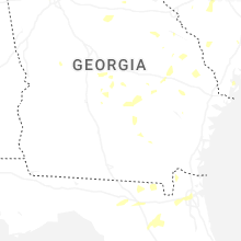


Connect with Interactive Hail Maps