

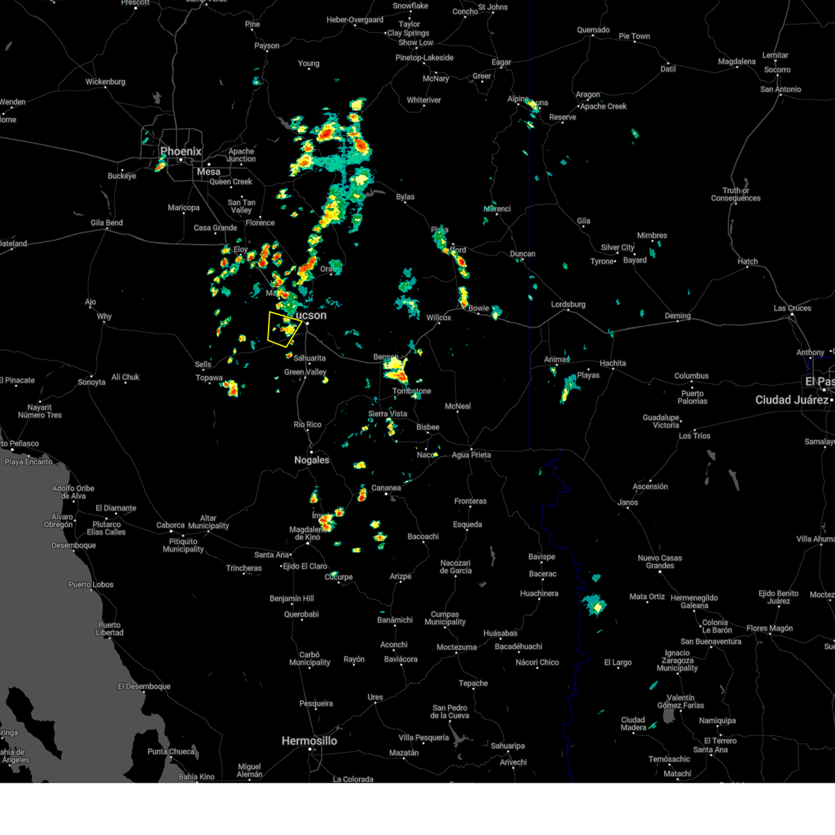
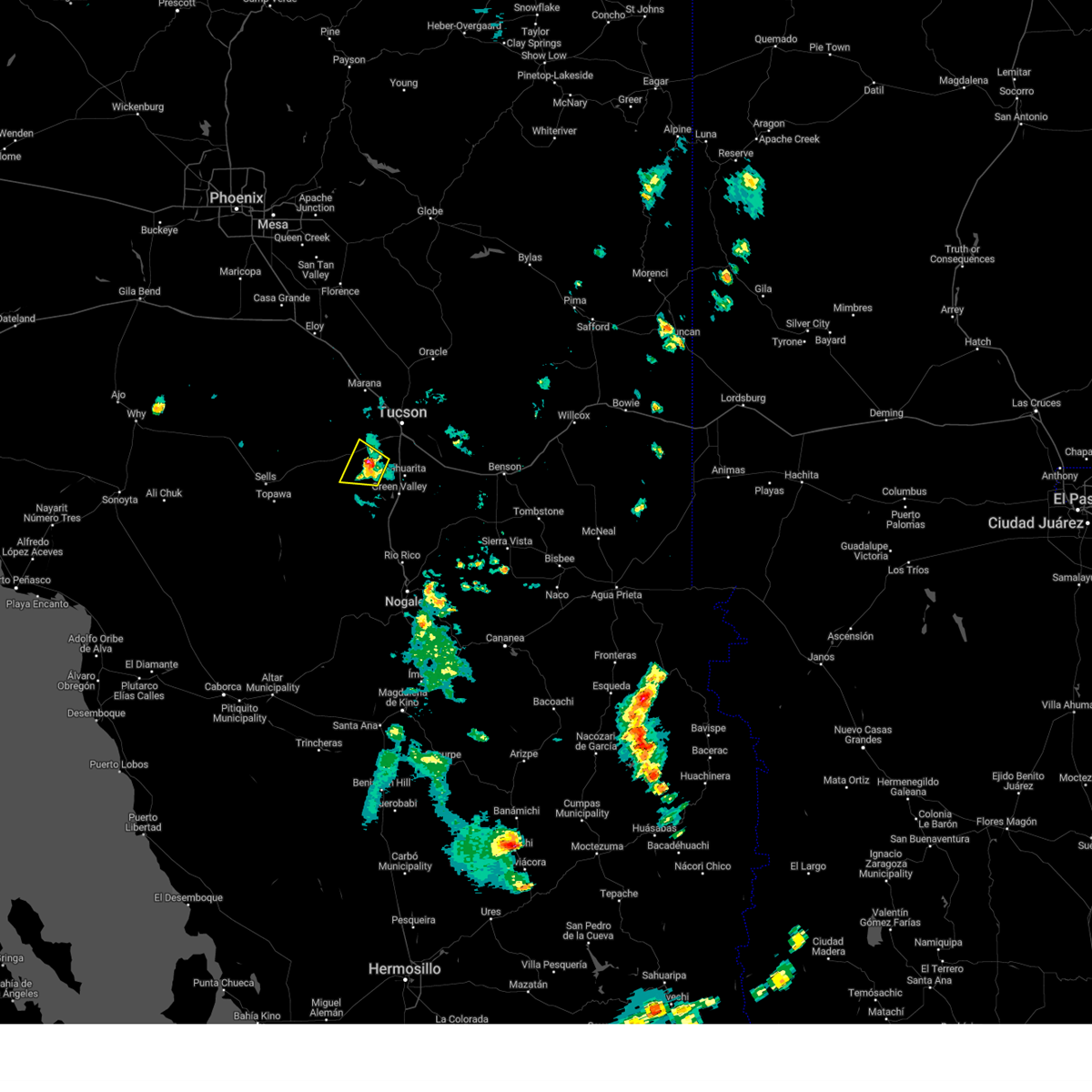
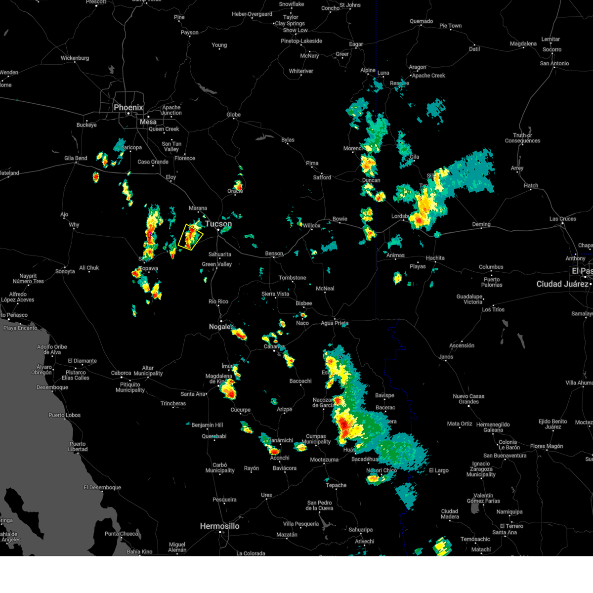
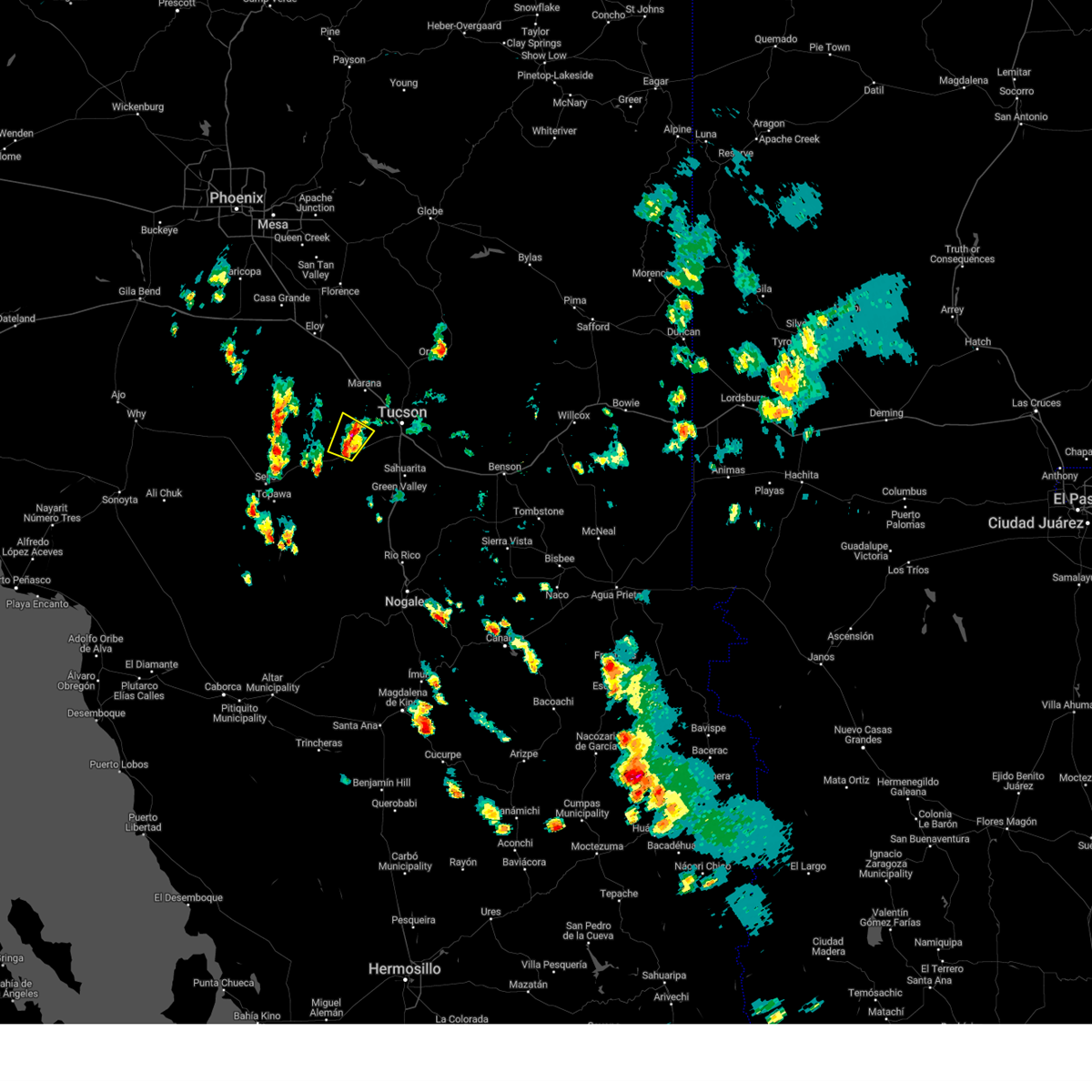
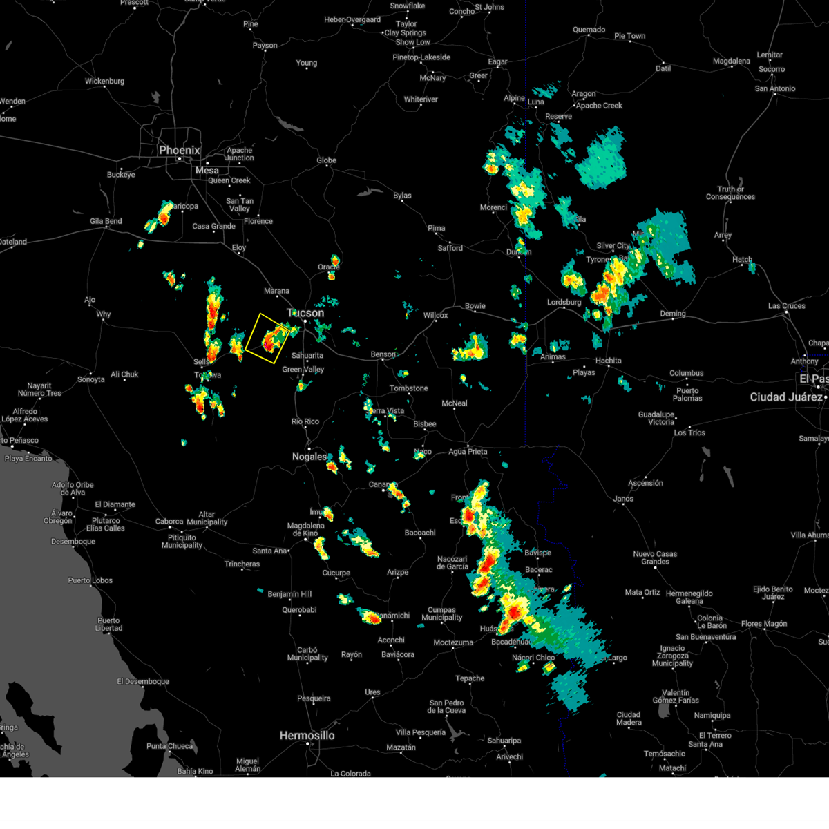
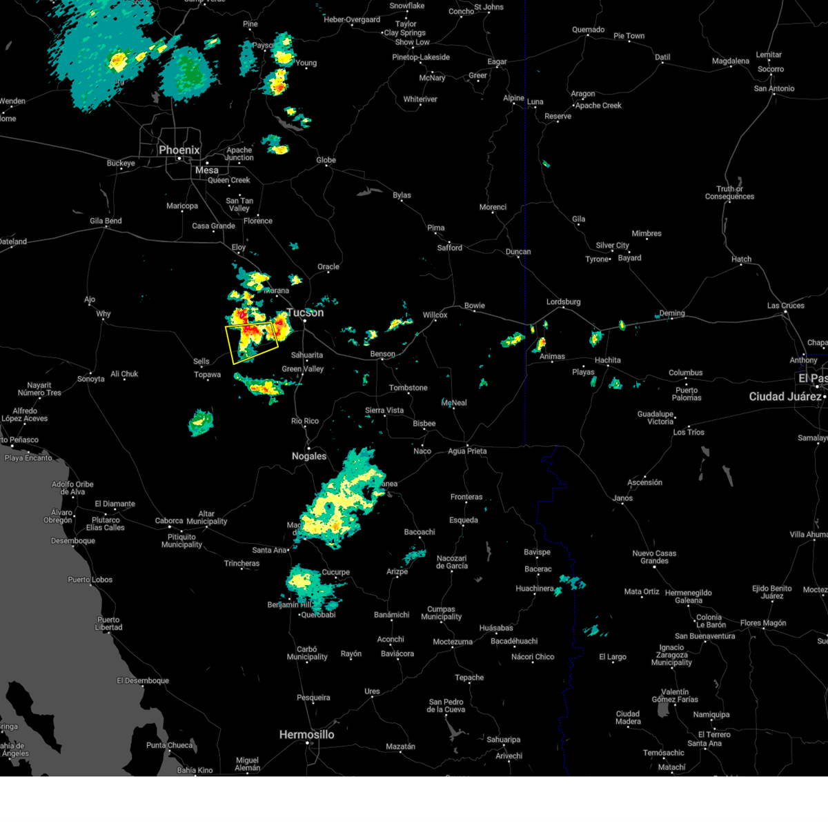
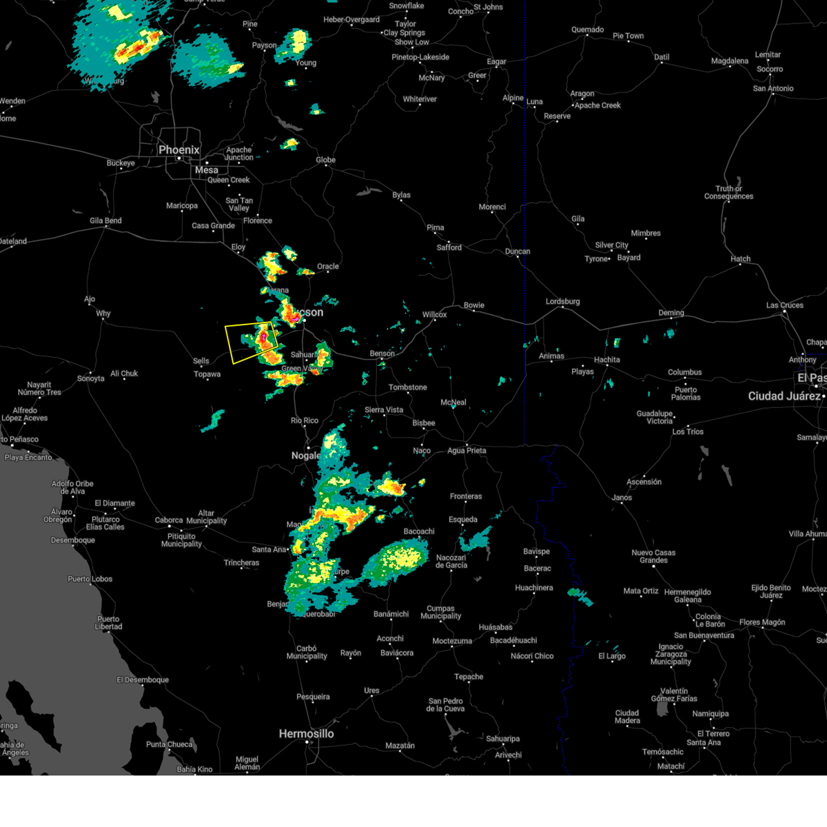
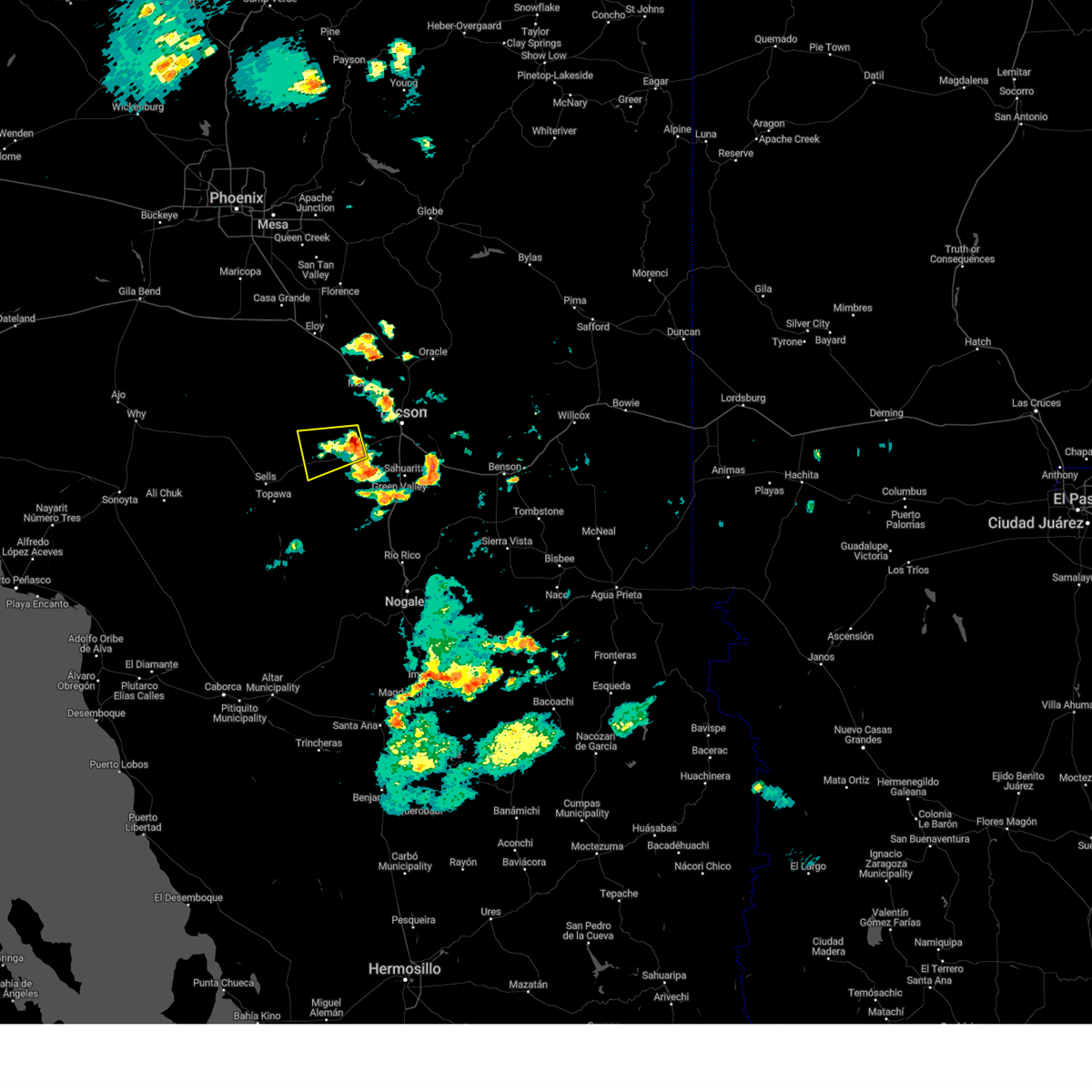
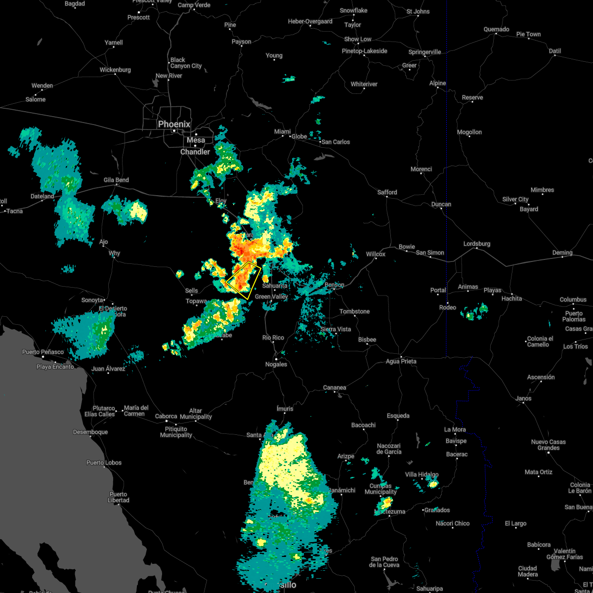
Hail Map for Three Points, AZ
The Three Points, AZ area has had 1 report of on-the-ground hail by trained spotters, and has been under severe weather warnings 30 times during the past 12 months. Doppler radar has detected hail at or near Three Points, AZ on 63 occasions, including 6 occasions during the past year.
| Name: | Three Points, AZ |
| Where Located: | 22.6 miles WSW of Tucson, AZ |
| Map: | Google Map for Three Points, AZ |
| Population: | 5581 |
| Housing Units: | 2487 |
| More Info: | Search Google for Three Points, AZ |
1
The Top Recent Hail Date for Three Points, AZ is Tuesday, August 6, 2024 (12th out of 63)

Hail and Wind Damage Spotted near Three Points, AZ
| Date / Time | Report Details |
|---|---|
| 8/22/2024 2:50 PM MST |
 The storm which prompted the warning has weakened below severe limits, and no longer poses an immediate threat to life or property. therefore, the warning will be allowed to expire. however, heavy rain is still possible with this thunderstorm. The storm which prompted the warning has weakened below severe limits, and no longer poses an immediate threat to life or property. therefore, the warning will be allowed to expire. however, heavy rain is still possible with this thunderstorm.
|
| 8/22/2024 2:35 PM MST |
 At 235 pm mst, a severe thunderstorm was located over valencia west, or 15 miles west of tucson, moving northeast at 5 mph (radar indicated). Hazards include 60 mph wind gusts and nickel size hail. Expect damage to roofs, siding, and trees. locations impacted include, tucson, three points, saguaro national park west, tucson mountain park, tucson estates, valencia west, picture rocks, and ryan airfield. This includes route 86 between mile markers 156 and 164. At 235 pm mst, a severe thunderstorm was located over valencia west, or 15 miles west of tucson, moving northeast at 5 mph (radar indicated). Hazards include 60 mph wind gusts and nickel size hail. Expect damage to roofs, siding, and trees. locations impacted include, tucson, three points, saguaro national park west, tucson mountain park, tucson estates, valencia west, picture rocks, and ryan airfield. This includes route 86 between mile markers 156 and 164.
|
| 8/22/2024 2:10 PM MST |
 Svrtwc the national weather service in tucson has issued a * severe thunderstorm warning for, northeastern pima county in southeastern arizona, * until 300 pm mst. * at 210 pm mst, a severe thunderstorm was located near tucson estates, or 17 miles south of marana, moving north at 10 mph (radar indicated). Hazards include 60 mph wind gusts and nickel size hail. expect damage to roofs, siding, and trees Svrtwc the national weather service in tucson has issued a * severe thunderstorm warning for, northeastern pima county in southeastern arizona, * until 300 pm mst. * at 210 pm mst, a severe thunderstorm was located near tucson estates, or 17 miles south of marana, moving north at 10 mph (radar indicated). Hazards include 60 mph wind gusts and nickel size hail. expect damage to roofs, siding, and trees
|
| 8/19/2024 6:35 PM MST |
 the severe thunderstorm warning has been cancelled and is no longer in effect the severe thunderstorm warning has been cancelled and is no longer in effect
|
| 8/19/2024 6:14 PM MST |
 Svrtwc the national weather service in tucson has issued a * severe thunderstorm warning for, east central pima county in southeastern arizona, * until 700 pm mst. * at 614 pm mst, a severe thunderstorm was located near three points, or 15 miles northwest of sahuarita, moving northwest at 5 mph (radar indicated). Hazards include 60 mph wind gusts and quarter size hail. Hail damage to vehicles is expected. Expect wind damage to roofs, siding, and trees. Svrtwc the national weather service in tucson has issued a * severe thunderstorm warning for, east central pima county in southeastern arizona, * until 700 pm mst. * at 614 pm mst, a severe thunderstorm was located near three points, or 15 miles northwest of sahuarita, moving northwest at 5 mph (radar indicated). Hazards include 60 mph wind gusts and quarter size hail. Hail damage to vehicles is expected. Expect wind damage to roofs, siding, and trees.
|
| 8/17/2024 4:35 PM MST |
 The storm which prompted the warning has weakened below severe limits, and no longer poses an immediate threat to life or property. therefore, the warning will be allowed to expire. The storm which prompted the warning has weakened below severe limits, and no longer poses an immediate threat to life or property. therefore, the warning will be allowed to expire.
|
| 8/17/2024 4:23 PM MST |
 At 423 pm mst, a severe thunderstorm was located near three points, or 23 miles southwest of marana, moving north at 10 mph (radar indicated). Hazards include 60 mph wind gusts and nickel size hail. Expect damage to roofs, siding, and trees. locations impacted include, three points, tucson estates, and tucson mountain park. this includes the following highways, route 86 between mile markers 147 and 154. Route 286 between mile markers 44 and 45. At 423 pm mst, a severe thunderstorm was located near three points, or 23 miles southwest of marana, moving north at 10 mph (radar indicated). Hazards include 60 mph wind gusts and nickel size hail. Expect damage to roofs, siding, and trees. locations impacted include, three points, tucson estates, and tucson mountain park. this includes the following highways, route 86 between mile markers 147 and 154. Route 286 between mile markers 44 and 45.
|
| 8/17/2024 3:59 PM MST |
 Svrtwc the national weather service in tucson has issued a * severe thunderstorm warning for, north central pima county in southeastern arizona, * until 445 pm mst. * at 358 pm mst, a severe thunderstorm was located over three points, or 22 miles northwest of sahuarita, moving west at 10 mph (radar indicated). Hazards include 60 mph wind gusts and quarter size hail. Hail damage to vehicles is expected. Expect wind damage to roofs, siding, and trees. Svrtwc the national weather service in tucson has issued a * severe thunderstorm warning for, north central pima county in southeastern arizona, * until 445 pm mst. * at 358 pm mst, a severe thunderstorm was located over three points, or 22 miles northwest of sahuarita, moving west at 10 mph (radar indicated). Hazards include 60 mph wind gusts and quarter size hail. Hail damage to vehicles is expected. Expect wind damage to roofs, siding, and trees.
|
| 8/6/2024 5:26 PM MST |
 The storm which prompted the warning has weakened below severe limits, and no longer poses an immediate threat to life or property. therefore, the warning will be allowed to expire. however, gusty winds are still possible with this thunderstorm. The storm which prompted the warning has weakened below severe limits, and no longer poses an immediate threat to life or property. therefore, the warning will be allowed to expire. however, gusty winds are still possible with this thunderstorm.
|
| 8/6/2024 5:02 PM MST |
 At 502 pm mst, a severe thunderstorm was located 11 miles northwest of three points, or 19 miles southwest of marana, moving southwest at 20 mph (radar indicated). Hazards include 60 mph wind gusts and quarter size hail. Hail damage to vehicles is expected. expect wind damage to roofs, siding, and trees. locations impacted include, three points, kitt peak, san pedro, and pan tak. this includes the following highways, route 86 between mile markers 132 and 156. Route 286 between mile markers 41 and 45. At 502 pm mst, a severe thunderstorm was located 11 miles northwest of three points, or 19 miles southwest of marana, moving southwest at 20 mph (radar indicated). Hazards include 60 mph wind gusts and quarter size hail. Hail damage to vehicles is expected. expect wind damage to roofs, siding, and trees. locations impacted include, three points, kitt peak, san pedro, and pan tak. this includes the following highways, route 86 between mile markers 132 and 156. Route 286 between mile markers 41 and 45.
|
| 8/6/2024 4:47 PM MST |
 Svrtwc the national weather service in tucson has issued a * severe thunderstorm warning for, central pima county in southeastern arizona, * until 530 pm mst. * at 447 pm mst, a severe thunderstorm was located near three points, or 21 miles southwest of marana, moving west at 15 mph (radar indicated). Hazards include 60 mph wind gusts and quarter size hail. Hail damage to vehicles is expected. Expect wind damage to roofs, siding, and trees. Svrtwc the national weather service in tucson has issued a * severe thunderstorm warning for, central pima county in southeastern arizona, * until 530 pm mst. * at 447 pm mst, a severe thunderstorm was located near three points, or 21 miles southwest of marana, moving west at 15 mph (radar indicated). Hazards include 60 mph wind gusts and quarter size hail. Hail damage to vehicles is expected. Expect wind damage to roofs, siding, and trees.
|
| 7/25/2024 7:08 PM MST |
 The storm which prompted the warning has weakened below severe limits, and no longer poses an immediate threat to life or property. therefore, the warning will be allowed to expire. however, gusty winds and heavy rain are still possible with this thunderstorm. a flash flood warning remains in effect for the green valley and sahuarita areas. The storm which prompted the warning has weakened below severe limits, and no longer poses an immediate threat to life or property. therefore, the warning will be allowed to expire. however, gusty winds and heavy rain are still possible with this thunderstorm. a flash flood warning remains in effect for the green valley and sahuarita areas.
|
| 7/25/2024 6:37 PM MST |
 At 637 pm mst, a severe thunderstorm was located near green valley, moving southwest at 15 mph (radar indicated). Hazards include 60 mph wind gusts and penny size hail. Expect damage to roofs, siding, and trees. locations impacted include, tucson, sahuarita, green valley, drexel heights, corona de tucson, three points, pascua pueblo yaqui reservation, east sahuarita, san xavier community, summit, tucson international airport, valencia west, rita ranch, san xavier mission, and arivaca junction. this includes the following highways, interstate 10 between mile markers 269 and 273. interstate 19 between mile markers 31 and 57. Route 86 between mile markers 152 and 157. At 637 pm mst, a severe thunderstorm was located near green valley, moving southwest at 15 mph (radar indicated). Hazards include 60 mph wind gusts and penny size hail. Expect damage to roofs, siding, and trees. locations impacted include, tucson, sahuarita, green valley, drexel heights, corona de tucson, three points, pascua pueblo yaqui reservation, east sahuarita, san xavier community, summit, tucson international airport, valencia west, rita ranch, san xavier mission, and arivaca junction. this includes the following highways, interstate 10 between mile markers 269 and 273. interstate 19 between mile markers 31 and 57. Route 86 between mile markers 152 and 157.
|
| 7/25/2024 6:10 PM MST |
 Svrtwc the national weather service in tucson has issued a * severe thunderstorm warning for, east central pima county in southeastern arizona, * until 715 pm mst. * at 610 pm mst, a severe thunderstorm was located over sahuarita, moving southwest at 15 mph (radar indicated). Hazards include 60 mph wind gusts and quarter size hail. Hail damage to vehicles is expected. Expect wind damage to roofs, siding, and trees. Svrtwc the national weather service in tucson has issued a * severe thunderstorm warning for, east central pima county in southeastern arizona, * until 715 pm mst. * at 610 pm mst, a severe thunderstorm was located over sahuarita, moving southwest at 15 mph (radar indicated). Hazards include 60 mph wind gusts and quarter size hail. Hail damage to vehicles is expected. Expect wind damage to roofs, siding, and trees.
|
| 7/25/2024 4:53 PM MST |
 The storm which prompted the warning has weakened below severe limits, and no longer poses an immediate threat to life or property. therefore, the warning will be allowed to expire. however, gusty winds are still possible with this thunderstorm. to report severe weather, contact your nearest law enforcement agency. they will relay your report to the national weather service tucson. The storm which prompted the warning has weakened below severe limits, and no longer poses an immediate threat to life or property. therefore, the warning will be allowed to expire. however, gusty winds are still possible with this thunderstorm. to report severe weather, contact your nearest law enforcement agency. they will relay your report to the national weather service tucson.
|
| 7/25/2024 4:40 PM MST |
 At 439 pm mst, a severe thunderstorm was located 9 miles southwest of three points, or 25 miles northwest of green valley, moving southwest at 5 mph (radar indicated). Hazards include 60 mph wind gusts and quarter size hail. Hail damage to vehicles is expected. expect wind damage to roofs, siding, and trees. locations impacted include, three points and pan tak. this includes the following highways, route 86 between mile markers 141 and 146. Route 286 between mile markers 31 and 41. At 439 pm mst, a severe thunderstorm was located 9 miles southwest of three points, or 25 miles northwest of green valley, moving southwest at 5 mph (radar indicated). Hazards include 60 mph wind gusts and quarter size hail. Hail damage to vehicles is expected. expect wind damage to roofs, siding, and trees. locations impacted include, three points and pan tak. this includes the following highways, route 86 between mile markers 141 and 146. Route 286 between mile markers 31 and 41.
|
| 7/25/2024 4:22 PM MST |
 Svrtwc the national weather service in tucson has issued a * severe thunderstorm warning for, central pima county in southeastern arizona, * until 500 pm mst. * at 422 pm mst, a severe thunderstorm was located 7 miles southwest of three points, or 24 miles northwest of green valley, moving southwest at 5 mph (radar indicated). Hazards include 60 mph wind gusts and quarter size hail. Hail damage to vehicles is expected. Expect wind damage to roofs, siding, and trees. Svrtwc the national weather service in tucson has issued a * severe thunderstorm warning for, central pima county in southeastern arizona, * until 500 pm mst. * at 422 pm mst, a severe thunderstorm was located 7 miles southwest of three points, or 24 miles northwest of green valley, moving southwest at 5 mph (radar indicated). Hazards include 60 mph wind gusts and quarter size hail. Hail damage to vehicles is expected. Expect wind damage to roofs, siding, and trees.
|
| 7/24/2024 2:45 PM MST |
 At 245 pm mst, a severe thunderstorm was located 11 miles northeast of san isidro, or 22 miles northeast of sells, moving southwest at 20 mph (radar indicated). Hazards include 60 mph wind gusts and quarter size hail. Hail damage to vehicles is expected. expect wind damage to roofs, siding, and trees. locations impacted include, three points, san isidro, saguaro national park west, tucson estates, tucson mountain park, san pedro, south comobabi, santa rosa ranch, and pan tak. this includes the following highways, route 86 between mile markers 126 and 154. Route 286 between mile markers 37 and 45. At 245 pm mst, a severe thunderstorm was located 11 miles northeast of san isidro, or 22 miles northeast of sells, moving southwest at 20 mph (radar indicated). Hazards include 60 mph wind gusts and quarter size hail. Hail damage to vehicles is expected. expect wind damage to roofs, siding, and trees. locations impacted include, three points, san isidro, saguaro national park west, tucson estates, tucson mountain park, san pedro, south comobabi, santa rosa ranch, and pan tak. this includes the following highways, route 86 between mile markers 126 and 154. Route 286 between mile markers 37 and 45.
|
| 7/24/2024 2:43 PM MST |
 At 242 pm mst, a severe thunderstorm was located near kitt peak, or 20 miles northeast of sells, moving southwest at 20 mph (radar indicated). Hazards include 60 mph wind gusts and penny size hail. Expect damage to roofs, siding, and trees. locations impacted include, three points, san isidro, saguaro national park west, tucson estates, tucson mountain park, san pedro, south comobabi, santa rosa ranch, and pan tak. this includes the following highways, route 86 between mile markers 126 and 154. Route 286 between mile markers 37 and 45. At 242 pm mst, a severe thunderstorm was located near kitt peak, or 20 miles northeast of sells, moving southwest at 20 mph (radar indicated). Hazards include 60 mph wind gusts and penny size hail. Expect damage to roofs, siding, and trees. locations impacted include, three points, san isidro, saguaro national park west, tucson estates, tucson mountain park, san pedro, south comobabi, santa rosa ranch, and pan tak. this includes the following highways, route 86 between mile markers 126 and 154. Route 286 between mile markers 37 and 45.
|
| 7/24/2024 2:10 PM MST |
 Svrtwc the national weather service in tucson has issued a * severe thunderstorm warning for, north central pima county in southeastern arizona, * until 300 pm mst. * at 210 pm mst, a severe thunderstorm was located 13 miles northwest of three points, or 25 miles southwest of marana, moving southwest at 20 mph (radar indicated). Hazards include 60 mph wind gusts and penny size hail. expect damage to roofs, siding, and trees Svrtwc the national weather service in tucson has issued a * severe thunderstorm warning for, north central pima county in southeastern arizona, * until 300 pm mst. * at 210 pm mst, a severe thunderstorm was located 13 miles northwest of three points, or 25 miles southwest of marana, moving southwest at 20 mph (radar indicated). Hazards include 60 mph wind gusts and penny size hail. expect damage to roofs, siding, and trees
|
| 7/21/2024 6:27 PM MST |
 The storm which prompted the warning near and north of three points has weakened below severe limits. therefore, the warning will be allowed to expire. however, gusty winds and heavy rain are still possible with this thunderstorm. a flash flood warning remains in effect until 915 pm mst. The storm which prompted the warning near and north of three points has weakened below severe limits. therefore, the warning will be allowed to expire. however, gusty winds and heavy rain are still possible with this thunderstorm. a flash flood warning remains in effect until 915 pm mst.
|
| 7/21/2024 6:05 PM MST |
 At 602 pm mst, an area of severe thunderstorms was located near and between picture rocks and three points west of tucson. storm movement was to the south at about 10 mph (radar indicated). Hazards include 60 mph wind gusts and penny size hail. Expect damage to roofs, siding, and trees. locations impacted include, three points, kitt peak, tucson estates, valencia west, saguaro national park west, tucson mountain park, picture rocks, san pedro, pan tak, and ryan airfield. this includes the following highways, route 86 between mile markers 136 and 162. Route 286 between mile markers 34 and 45. At 602 pm mst, an area of severe thunderstorms was located near and between picture rocks and three points west of tucson. storm movement was to the south at about 10 mph (radar indicated). Hazards include 60 mph wind gusts and penny size hail. Expect damage to roofs, siding, and trees. locations impacted include, three points, kitt peak, tucson estates, valencia west, saguaro national park west, tucson mountain park, picture rocks, san pedro, pan tak, and ryan airfield. this includes the following highways, route 86 between mile markers 136 and 162. Route 286 between mile markers 34 and 45.
|
| 7/21/2024 5:44 PM MST |
 Svrtwc the national weather service in tucson has issued a * severe thunderstorm warning for, northeastern pima county in southeastern arizona, * until 630 pm mst. * at 543 pm mst, a severe thunderstorm was located near three points, or q5 miles west of tucson, moving south at 10 mph (radar indicated). Hazards include 60 mph wind gusts and penny size hail. expect damage to roofs, siding, and trees Svrtwc the national weather service in tucson has issued a * severe thunderstorm warning for, northeastern pima county in southeastern arizona, * until 630 pm mst. * at 543 pm mst, a severe thunderstorm was located near three points, or q5 miles west of tucson, moving south at 10 mph (radar indicated). Hazards include 60 mph wind gusts and penny size hail. expect damage to roofs, siding, and trees
|
| 7/20/2024 6:35 PM MST |
 The storm which prompted the warning has weakened below severe limits, and no longer poses an immediate threat to life or property. therefore, the warning will be allowed to expire. The storm which prompted the warning has weakened below severe limits, and no longer poses an immediate threat to life or property. therefore, the warning will be allowed to expire.
|
| 7/20/2024 5:57 PM MST |
 Svrtwc the national weather service in tucson has issued a * severe thunderstorm warning for, central pima county in southeastern arizona, * until 645 pm mst. * at 557 pm mst, a severe thunderstorm was located near three points, or 21 miles northwest of green valley, and is nearly stationary (radar indicated). Hazards include 60 mph wind gusts and penny size hail. expect damage to roofs, siding, and trees Svrtwc the national weather service in tucson has issued a * severe thunderstorm warning for, central pima county in southeastern arizona, * until 645 pm mst. * at 557 pm mst, a severe thunderstorm was located near three points, or 21 miles northwest of green valley, and is nearly stationary (radar indicated). Hazards include 60 mph wind gusts and penny size hail. expect damage to roofs, siding, and trees
|
| 7/14/2024 5:49 PM MST |
 At 548 pm mst, severe thunderstorms were located across tucson along a line extending from 7 miles east of mount lemmon/summerhaven to near catalina foothills to drexel heights, moving northwest at 20 mph (radar indicated). Hazards include 70 mph wind gusts and penny size hail. Expect considerable tree damage. damage is likely to mobile homes, roofs, and outbuildings. locations impacted include, tucson, catalina, oro valley, marana, davis-monthan air force base, casas adobes, drexel heights, flowing wells, tanque verde, saddlebrooke, south tucson, pascua pueblo yaqui reservation, tortolita, san xavier community, mount lemmon/summerhaven, sabino canyon recreation area, summit, tucson estates, saguaro national park west, and valencia west. this includes the following highways, interstate 10 between mile markers 237 and 271. interstate 19 between mile markers 52 and 63. route 77 between mile markers 70 and 90. Route 86 between mile markers 157 and 171. At 548 pm mst, severe thunderstorms were located across tucson along a line extending from 7 miles east of mount lemmon/summerhaven to near catalina foothills to drexel heights, moving northwest at 20 mph (radar indicated). Hazards include 70 mph wind gusts and penny size hail. Expect considerable tree damage. damage is likely to mobile homes, roofs, and outbuildings. locations impacted include, tucson, catalina, oro valley, marana, davis-monthan air force base, casas adobes, drexel heights, flowing wells, tanque verde, saddlebrooke, south tucson, pascua pueblo yaqui reservation, tortolita, san xavier community, mount lemmon/summerhaven, sabino canyon recreation area, summit, tucson estates, saguaro national park west, and valencia west. this includes the following highways, interstate 10 between mile markers 237 and 271. interstate 19 between mile markers 52 and 63. route 77 between mile markers 70 and 90. Route 86 between mile markers 157 and 171.
|
| 7/14/2024 5:39 PM MST |
 Svrtwc the national weather service in tucson has issued a * severe thunderstorm warning for, northeastern pima county in southeastern arizona, northwestern cochise county in southeastern arizona, southeastern pinal county in southeastern arizona, * until 645 pm mst. * at 538 pm mst, severe thunderstorms were located along a line extending from 13 miles east of mount lemmon/summerhaven to sabino canyon recreation area to near tucson international airport, moving northwest at 10 mph (radar indicated). Hazards include 60 mph wind gusts and penny size hail. expect damage to roofs, siding, and trees Svrtwc the national weather service in tucson has issued a * severe thunderstorm warning for, northeastern pima county in southeastern arizona, northwestern cochise county in southeastern arizona, southeastern pinal county in southeastern arizona, * until 645 pm mst. * at 538 pm mst, severe thunderstorms were located along a line extending from 13 miles east of mount lemmon/summerhaven to sabino canyon recreation area to near tucson international airport, moving northwest at 10 mph (radar indicated). Hazards include 60 mph wind gusts and penny size hail. expect damage to roofs, siding, and trees
|
| 7/11/2024 7:03 PM MST |
 the severe thunderstorm warning has been cancelled and is no longer in effect the severe thunderstorm warning has been cancelled and is no longer in effect
|
| 7/11/2024 6:42 PM MST |
 At 641 pm mst, severe thunderstorms were located along a line extending from 7 miles north of kitt peak to 15 miles southwest of three points to 7 miles southwest of arivaca, moving west at 15 mph (radar indicated). Hazards include 60 mph wind gusts. Expect damage to roofs, siding, and trees. locations impacted include, sells, three points, arivaca, topawa, san isidro, kitt peak, ali chukson, fresnal, san pedro, sasabe, south comobabi, fresnal canyon, artesia, pan tak, and ali molina. this includes the following highways, route 86 between mile markers 114 and 147. Route 286 between mile markers 1 and 42. At 641 pm mst, severe thunderstorms were located along a line extending from 7 miles north of kitt peak to 15 miles southwest of three points to 7 miles southwest of arivaca, moving west at 15 mph (radar indicated). Hazards include 60 mph wind gusts. Expect damage to roofs, siding, and trees. locations impacted include, sells, three points, arivaca, topawa, san isidro, kitt peak, ali chukson, fresnal, san pedro, sasabe, south comobabi, fresnal canyon, artesia, pan tak, and ali molina. this includes the following highways, route 86 between mile markers 114 and 147. Route 286 between mile markers 1 and 42.
|
| 7/11/2024 6:12 PM MST |
 Svrtwc the national weather service in tucson has issued a * severe thunderstorm warning for, south central pima county in southeastern arizona, western santa cruz county in southeastern arizona, * until 715 pm mst. * at 611 pm mst, severe thunderstorms were located along a line extending from 10 miles west of three points to 14 miles west of green valley to near arivaca, moving west at 10 mph (radar indicated). Hazards include 60 mph wind gusts and blowing dust. expect damage to roofs, siding, and trees Svrtwc the national weather service in tucson has issued a * severe thunderstorm warning for, south central pima county in southeastern arizona, western santa cruz county in southeastern arizona, * until 715 pm mst. * at 611 pm mst, severe thunderstorms were located along a line extending from 10 miles west of three points to 14 miles west of green valley to near arivaca, moving west at 10 mph (radar indicated). Hazards include 60 mph wind gusts and blowing dust. expect damage to roofs, siding, and trees
|
| 6/28/2024 3:44 PM MST |
 At 344 pm mst, a severe thunderstorm was located over tucson mountain park, or 11 miles west of tucson, moving northeast at 10 mph (radar indicated). Hazards include 60 mph wind gusts. Expect damage to roofs, siding, and trees. locations impacted include, tucson, marana, davis-monthan air force base, casas adobes, drexel heights, flowing wells, south tucson, three points, pascua pueblo yaqui reservation, tortolita, san xavier community, tucson estates, valencia west, tucson mountain park, saguaro national park west, tucson international airport, catalina foothills, san xavier mission, and ryan airfield. this includes the following highways, interstate 10 between mile markers 247 and 265. interstate 19 between mile markers 57 and 63. route 77 between mile markers 70 and 73. Route 86 between mile markers 153 and 171. At 344 pm mst, a severe thunderstorm was located over tucson mountain park, or 11 miles west of tucson, moving northeast at 10 mph (radar indicated). Hazards include 60 mph wind gusts. Expect damage to roofs, siding, and trees. locations impacted include, tucson, marana, davis-monthan air force base, casas adobes, drexel heights, flowing wells, south tucson, three points, pascua pueblo yaqui reservation, tortolita, san xavier community, tucson estates, valencia west, tucson mountain park, saguaro national park west, tucson international airport, catalina foothills, san xavier mission, and ryan airfield. this includes the following highways, interstate 10 between mile markers 247 and 265. interstate 19 between mile markers 57 and 63. route 77 between mile markers 70 and 73. Route 86 between mile markers 153 and 171.
|
| 6/28/2024 3:26 PM MST |
 Svrtwc the national weather service in tucson has issued a * severe thunderstorm warning for, northeastern pima county in southeastern arizona, * until 415 pm mst. * at 326 pm mst, a severe thunderstorm was located over tucson estates, or 14 miles west of tucson, moving northeast at 10 mph (radar indicated). Hazards include 60 mph wind gusts. expect damage to roofs, siding, and trees Svrtwc the national weather service in tucson has issued a * severe thunderstorm warning for, northeastern pima county in southeastern arizona, * until 415 pm mst. * at 326 pm mst, a severe thunderstorm was located over tucson estates, or 14 miles west of tucson, moving northeast at 10 mph (radar indicated). Hazards include 60 mph wind gusts. expect damage to roofs, siding, and trees
|
| 9/12/2023 7:29 PM MST |
 At 728 pm mst, a severe thunderstorm was located 9 miles east of kitt peak, or 25 miles west of green valley, moving northeast at 15 mph (radar indicated). Hazards include 60 mph wind gusts and quarter size hail. Hail damage to vehicles is expected. Expect wind damage to roofs, siding, and trees. At 728 pm mst, a severe thunderstorm was located 9 miles east of kitt peak, or 25 miles west of green valley, moving northeast at 15 mph (radar indicated). Hazards include 60 mph wind gusts and quarter size hail. Hail damage to vehicles is expected. Expect wind damage to roofs, siding, and trees.
|
| 8/21/2023 7:50 PM MST |
 The severe thunderstorm warning for northeastern pima county will expire at 800 pm mst, the storms which prompted the warning are now moving out of the area. therefore, the warning will be allowed to expire. The severe thunderstorm warning for northeastern pima county will expire at 800 pm mst, the storms which prompted the warning are now moving out of the area. therefore, the warning will be allowed to expire.
|
| 8/21/2023 7:25 PM MST |
 At 723 pm mst, severe thunderstorms were located near the tucson estates area moving northwest at 30 mph (radar indicated). Hazards include 60 mph wind gusts and penny size hail. Expect damage to roofs, siding, and trees. locations impacted include, west tucson, oro valley, marana, casas adobes, drexel heights, flowing wells, three points, pascua pueblo yaqui reservation, tortolita, tucson estates, saguaro national park west, valencia west, picture rocks, san xavier mission and ryan airfield. hail threat, radar indicated max hail size, 0. 75 in wind threat, observed max wind gust, 60 mph. At 723 pm mst, severe thunderstorms were located near the tucson estates area moving northwest at 30 mph (radar indicated). Hazards include 60 mph wind gusts and penny size hail. Expect damage to roofs, siding, and trees. locations impacted include, west tucson, oro valley, marana, casas adobes, drexel heights, flowing wells, three points, pascua pueblo yaqui reservation, tortolita, tucson estates, saguaro national park west, valencia west, picture rocks, san xavier mission and ryan airfield. hail threat, radar indicated max hail size, 0. 75 in wind threat, observed max wind gust, 60 mph.
|
| 8/21/2023 6:57 PM MST |
 At 655 pm mst, severe thunderstorms were located along a line extending from near vail to near summit to near green valley, moving northwest at 30 mph (radar indicated). Hazards include 70 mph wind gusts and penny size hail. radar is indicating 70 plus mph winds just above the surface northwest of the corona de tucson area. Expect considerable tree damage. Damage is likely to mobile homes, roofs, and outbuildings. At 655 pm mst, severe thunderstorms were located along a line extending from near vail to near summit to near green valley, moving northwest at 30 mph (radar indicated). Hazards include 70 mph wind gusts and penny size hail. radar is indicating 70 plus mph winds just above the surface northwest of the corona de tucson area. Expect considerable tree damage. Damage is likely to mobile homes, roofs, and outbuildings.
|
| 8/21/2023 2:43 PM MST |
 At 242 pm mst, a severe thunderstorm was located over san xavier community, or 8 miles southwest of tucson, moving north at 15 mph (radar indicated). Hazards include 60 mph wind gusts and quarter size hail. Hail damage to vehicles is expected. Expect wind damage to roofs, siding, and trees. At 242 pm mst, a severe thunderstorm was located over san xavier community, or 8 miles southwest of tucson, moving north at 15 mph (radar indicated). Hazards include 60 mph wind gusts and quarter size hail. Hail damage to vehicles is expected. Expect wind damage to roofs, siding, and trees.
|
| 8/21/2023 2:26 PM MST |
 At 225 pm mst, a severe thunderstorm was located near summit, or near sahuarita, moving northwest at 20 mph (radar indicated). Hazards include 60 mph wind gusts and quarter size hail. Hail damage to vehicles is expected. expect wind damage to roofs, siding, and trees. locations impacted include, tucson, sahuarita, drexel heights, south tucson, pascua pueblo yaqui reservation, east sahuarita, summit, valencia west, tucson international airport, tucson estates and san xavier mission. hail threat, radar indicated max hail size, 1. 00 in wind threat, radar indicated max wind gust, 60 mph. At 225 pm mst, a severe thunderstorm was located near summit, or near sahuarita, moving northwest at 20 mph (radar indicated). Hazards include 60 mph wind gusts and quarter size hail. Hail damage to vehicles is expected. expect wind damage to roofs, siding, and trees. locations impacted include, tucson, sahuarita, drexel heights, south tucson, pascua pueblo yaqui reservation, east sahuarita, summit, valencia west, tucson international airport, tucson estates and san xavier mission. hail threat, radar indicated max hail size, 1. 00 in wind threat, radar indicated max wind gust, 60 mph.
|
| 8/21/2023 2:07 PM MST |
 At 207 pm mst, a severe thunderstorm was located over east sahuarita, or near sahuarita, moving northwest at 25 mph (radar indicated). Hazards include 60 mph wind gusts and quarter size hail. Hail damage to vehicles is expected. Expect wind damage to roofs, siding, and trees. At 207 pm mst, a severe thunderstorm was located over east sahuarita, or near sahuarita, moving northwest at 25 mph (radar indicated). Hazards include 60 mph wind gusts and quarter size hail. Hail damage to vehicles is expected. Expect wind damage to roofs, siding, and trees.
|
| 8/17/2023 2:55 PM MST |
 At 255 pm mst, a severe thunderstorm was located over tucson estates, or 14 miles south of marana, moving northwest at 10 mph (radar indicated). Hazards include 60 mph wind gusts and quarter size hail. Hail damage to vehicles is expected. Expect wind damage to roofs, siding, and trees. At 255 pm mst, a severe thunderstorm was located over tucson estates, or 14 miles south of marana, moving northwest at 10 mph (radar indicated). Hazards include 60 mph wind gusts and quarter size hail. Hail damage to vehicles is expected. Expect wind damage to roofs, siding, and trees.
|
| 8/8/2023 2:27 PM MST |
 The severe thunderstorm warning for northeastern pima county will expire at 230 pm mst, the storm which prompted the warning has weakened below severe limits, and no longer poses an immediate threat to life or property. therefore, the warning will be allowed to expire. however small hail and gusty winds are still possible with this thunderstorm. The severe thunderstorm warning for northeastern pima county will expire at 230 pm mst, the storm which prompted the warning has weakened below severe limits, and no longer poses an immediate threat to life or property. therefore, the warning will be allowed to expire. however small hail and gusty winds are still possible with this thunderstorm.
|
| 8/8/2023 2:01 PM MST |
 At 201 pm mst, a severe thunderstorm was located near valencia west, or 14 miles northwest of sahuarita, moving northeast at 10 mph (radar indicated). Hazards include 60 mph wind gusts and quarter size hail. Hail damage to vehicles is expected. expect wind damage to roofs, siding, and trees. locations impacted include, tucson, sahuarita, drexel heights, flowing wells, south tucson, three points, pascua pueblo yaqui reservation, east sahuarita, summit, tucson estates, valencia west, tucson international airport, san xavier mission and ryan airfield. hail threat, radar indicated max hail size, 1. 00 in wind threat, radar indicated max wind gust, 60 mph. At 201 pm mst, a severe thunderstorm was located near valencia west, or 14 miles northwest of sahuarita, moving northeast at 10 mph (radar indicated). Hazards include 60 mph wind gusts and quarter size hail. Hail damage to vehicles is expected. expect wind damage to roofs, siding, and trees. locations impacted include, tucson, sahuarita, drexel heights, flowing wells, south tucson, three points, pascua pueblo yaqui reservation, east sahuarita, summit, tucson estates, valencia west, tucson international airport, san xavier mission and ryan airfield. hail threat, radar indicated max hail size, 1. 00 in wind threat, radar indicated max wind gust, 60 mph.
|
| 8/8/2023 1:44 PM MST |
 At 144 pm mst, a severe thunderstorm was located 8 miles east of three points, or 11 miles northwest of sahuarita, moving northeast at 15 mph (radar indicated). Hazards include 60 mph wind gusts and quarter size hail. Hail damage to vehicles is expected. Expect wind damage to roofs, siding, and trees. At 144 pm mst, a severe thunderstorm was located 8 miles east of three points, or 11 miles northwest of sahuarita, moving northeast at 15 mph (radar indicated). Hazards include 60 mph wind gusts and quarter size hail. Hail damage to vehicles is expected. Expect wind damage to roofs, siding, and trees.
|
| 8/7/2023 4:29 PM MST |
 At 428 pm mst, a severe thunderstorm was located 9 miles southeast of three points, or 10 miles northwest of sahuarita, moving northeast at 10 mph (radar indicated). Hazards include 60 mph wind gusts and penny size hail. expect damage to roofs, siding, and trees At 428 pm mst, a severe thunderstorm was located 9 miles southeast of three points, or 10 miles northwest of sahuarita, moving northeast at 10 mph (radar indicated). Hazards include 60 mph wind gusts and penny size hail. expect damage to roofs, siding, and trees
|
| 7/31/2023 7:12 PM MST |
 At 710 pm mst, a line of severe thunderstorms from dove mmountain to almost three points continued to move to the northwest at 15 mph with damaging winds, frequent lightning and very heavy rains the major threats (radar indicated). Hazards include 60 mph wind gusts and penny size hail. Expect damage to roofs, siding, and trees. locations impacted include, tucson, catalina, oro valley, marana, casas adobes, drexel heights, flowing wells, saddlebrooke, three points, avra valley, pascua pueblo yaqui reservation, tortolita, tucson estates, saguaro national park west, valencia west, catalina foothills, picture rocks, dove mountain, san xavier mission and oracle junction. hail threat, radar indicated max hail size, 0. 75 in wind threat, radar indicated max wind gust, 60 mph. At 710 pm mst, a line of severe thunderstorms from dove mmountain to almost three points continued to move to the northwest at 15 mph with damaging winds, frequent lightning and very heavy rains the major threats (radar indicated). Hazards include 60 mph wind gusts and penny size hail. Expect damage to roofs, siding, and trees. locations impacted include, tucson, catalina, oro valley, marana, casas adobes, drexel heights, flowing wells, saddlebrooke, three points, avra valley, pascua pueblo yaqui reservation, tortolita, tucson estates, saguaro national park west, valencia west, catalina foothills, picture rocks, dove mountain, san xavier mission and oracle junction. hail threat, radar indicated max hail size, 0. 75 in wind threat, radar indicated max wind gust, 60 mph.
|
| 7/31/2023 6:41 PM MST |
 At 641 pm mst, severe thunderstorms were located along a line extending from near saddlebrooke to flowing wells to 7 miles south of pascua pueblo yaqui reservation, moving northwest at 15 mph (radar indicated). Hazards include 60 mph wind gusts and penny size hail. expect damage to roofs, siding, and trees At 641 pm mst, severe thunderstorms were located along a line extending from near saddlebrooke to flowing wells to 7 miles south of pascua pueblo yaqui reservation, moving northwest at 15 mph (radar indicated). Hazards include 60 mph wind gusts and penny size hail. expect damage to roofs, siding, and trees
|
| 7/31/2023 6:05 PM MST |
 At 604 pm mst, a severe thunderstorm was located over drexel heights, or 7 miles west of tucson, moving northwest at 20 mph (radar indicated). Hazards include 60 mph wind gusts and quarter size hail. Hail damage to vehicles is expected. Expect wind damage to roofs, siding, and trees. At 604 pm mst, a severe thunderstorm was located over drexel heights, or 7 miles west of tucson, moving northwest at 20 mph (radar indicated). Hazards include 60 mph wind gusts and quarter size hail. Hail damage to vehicles is expected. Expect wind damage to roofs, siding, and trees.
|
| 7/30/2023 9:11 PM MST |
 The severe thunderstorm warning for northeastern pima county will expire at 915 pm mst, the storm which prompted the warning has weakened below severe limits, and no longer poses an immediate threat to life or property. therefore, the warning will be allowed to expire. however gusty winds and heavy rain are still possible with this thunderstorm. The severe thunderstorm warning for northeastern pima county will expire at 915 pm mst, the storm which prompted the warning has weakened below severe limits, and no longer poses an immediate threat to life or property. therefore, the warning will be allowed to expire. however gusty winds and heavy rain are still possible with this thunderstorm.
|
| 7/30/2023 8:34 PM MST |
 At 833 pm mst, a severe thunderstorm was located just east of three points, or 18 miles northwest of sahuarita, moving west at 25 mph (radar indicated). Hazards include 60 mph wind gusts and nickel size hail. expect damage to roofs, siding, and trees At 833 pm mst, a severe thunderstorm was located just east of three points, or 18 miles northwest of sahuarita, moving west at 25 mph (radar indicated). Hazards include 60 mph wind gusts and nickel size hail. expect damage to roofs, siding, and trees
|
| 7/27/2023 9:02 PM MST |
 At 901 pm mst, a severe thunderstorm was located 11 miles south of corona de tucson, or 13 miles east of green valley, moving west at 20 mph (radar indicated). Hazards include 60 mph wind gusts. expect damage to roofs, siding, and trees At 901 pm mst, a severe thunderstorm was located 11 miles south of corona de tucson, or 13 miles east of green valley, moving west at 20 mph (radar indicated). Hazards include 60 mph wind gusts. expect damage to roofs, siding, and trees
|
| 7/26/2023 7:56 PM MST |
 At 755 pm mst, a severe thunderstorm was located 16 miles northeast of san isidro, or 26 miles northeast of sells, moving west at 20 mph (radar indicated). Hazards include 70 mph wind gusts and quarter size hail. Hail damage to vehicles is expected. expect considerable tree damage. wind damage is also likely to mobile homes, roofs, and outbuildings. locations impacted include, three points, san isidro, kitt peak, tucson estates, picture rocks, san pedro, queens well, santa rosa ranch and pan tak. thunderstorm damage threat, considerable hail threat, radar indicated max hail size, 1. 00 in wind threat, radar indicated max wind gust, 70 mph. At 755 pm mst, a severe thunderstorm was located 16 miles northeast of san isidro, or 26 miles northeast of sells, moving west at 20 mph (radar indicated). Hazards include 70 mph wind gusts and quarter size hail. Hail damage to vehicles is expected. expect considerable tree damage. wind damage is also likely to mobile homes, roofs, and outbuildings. locations impacted include, three points, san isidro, kitt peak, tucson estates, picture rocks, san pedro, queens well, santa rosa ranch and pan tak. thunderstorm damage threat, considerable hail threat, radar indicated max hail size, 1. 00 in wind threat, radar indicated max wind gust, 70 mph.
|
| 7/26/2023 7:21 PM MST |
 At 720 pm mst, a severe thunderstorm was located 7 miles northwest of three points, or 20 miles southwest of marana, moving west at 15 mph (radar indicated). Hazards include 60 mph wind gusts and quarter size hail. Hail damage to vehicles is expected. Expect wind damage to roofs, siding, and trees. At 720 pm mst, a severe thunderstorm was located 7 miles northwest of three points, or 20 miles southwest of marana, moving west at 15 mph (radar indicated). Hazards include 60 mph wind gusts and quarter size hail. Hail damage to vehicles is expected. Expect wind damage to roofs, siding, and trees.
|
| 7/23/2023 8:09 PM MST |
 The severe thunderstorm warning for northeastern pima county will expire at 815 pm mst, the storm which prompted the warning has weakened below severe limits, and no longer poses an immediate threat to life or property. therefore, the warning will be allowed to expire. however gusty winds are still possible with this thunderstorm. The severe thunderstorm warning for northeastern pima county will expire at 815 pm mst, the storm which prompted the warning has weakened below severe limits, and no longer poses an immediate threat to life or property. therefore, the warning will be allowed to expire. however gusty winds are still possible with this thunderstorm.
|
| 7/23/2023 7:42 PM MST |
 At 742 pm mst, a severe thunderstorm was located over pascua pueblo yaqui reservation, or 12 miles southwest of tucson, moving west at 10 mph (radar indicated). Hazards include 60 mph wind gusts and blowing dust. Expect damage to roofs, siding, and trees. locations impacted include, tucson, sahuarita, drexel heights, three points, pascua pueblo yaqui reservation, valencia west, tucson estates, saguaro national park west, summit, san xavier mission and ryan airfield. hail threat, radar indicated max hail size, <. 75 in wind threat, radar indicated max wind gust, 60 mph. At 742 pm mst, a severe thunderstorm was located over pascua pueblo yaqui reservation, or 12 miles southwest of tucson, moving west at 10 mph (radar indicated). Hazards include 60 mph wind gusts and blowing dust. Expect damage to roofs, siding, and trees. locations impacted include, tucson, sahuarita, drexel heights, three points, pascua pueblo yaqui reservation, valencia west, tucson estates, saguaro national park west, summit, san xavier mission and ryan airfield. hail threat, radar indicated max hail size, <. 75 in wind threat, radar indicated max wind gust, 60 mph.
|
| 7/23/2023 7:31 PM MST |
 At 731 pm mst, a severe thunderstorm was located over pascua pueblo yaqui reservation, or 10 miles southwest of tucson, moving west at 10 mph (radar indicated). Hazards include 60 mph wind gusts. expect damage to roofs, siding, and trees At 731 pm mst, a severe thunderstorm was located over pascua pueblo yaqui reservation, or 10 miles southwest of tucson, moving west at 10 mph (radar indicated). Hazards include 60 mph wind gusts. expect damage to roofs, siding, and trees
|
| 7/19/2023 5:27 PM MST |
 The severe thunderstorm warning for northeastern pima county will expire at 530 pm mst, the storm which prompted the warning has weakened below severe limits. therefore, the warning will be allowed to expire. The severe thunderstorm warning for northeastern pima county will expire at 530 pm mst, the storm which prompted the warning has weakened below severe limits. therefore, the warning will be allowed to expire.
|
| 7/19/2023 5:02 PM MST |
 At 501 pm mst, a severe thunderstorm was located near ryan field and tucson estates, or 10 miles west of tucson, moving northwest at 15 mph (radar indicated). Hazards include 60 mph wind gusts and penny size hail. Expect damage to roofs, siding, and trees. locations impacted include, drexel heights, three points, pascua pueblo yaqui reservation, saguaro national park west, valencia west, summit, tucson estates, san xavier mission and ryan airfield. hail threat, radar indicated max hail size, 0. 75 in wind threat, radar indicated max wind gust, 60 mph. At 501 pm mst, a severe thunderstorm was located near ryan field and tucson estates, or 10 miles west of tucson, moving northwest at 15 mph (radar indicated). Hazards include 60 mph wind gusts and penny size hail. Expect damage to roofs, siding, and trees. locations impacted include, drexel heights, three points, pascua pueblo yaqui reservation, saguaro national park west, valencia west, summit, tucson estates, san xavier mission and ryan airfield. hail threat, radar indicated max hail size, 0. 75 in wind threat, radar indicated max wind gust, 60 mph.
|
| 7/19/2023 4:36 PM MST |
 At 435 pm mst, a severe thunderstorm was located near sahuarita, moving northwest at 15 mph (radar indicated). Hazards include 60 mph wind gusts and penny size hail. expect damage to roofs, siding, and trees At 435 pm mst, a severe thunderstorm was located near sahuarita, moving northwest at 15 mph (radar indicated). Hazards include 60 mph wind gusts and penny size hail. expect damage to roofs, siding, and trees
|
| 7/17/2023 3:07 PM MST |
 At 307 pm mst, severe thunderstorms were located along a line extending from 9 miles southwest of green valley to 7 miles southwest of arivaca, moving northwest at 20 mph (radar indicated). Hazards include 60 mph wind gusts and penny size hail. Expect damage to roofs, siding, and trees. locations impacted include, three points, arivaca, amado, sasabe, arivaca lake and arivaca junction. hail threat, radar indicated max hail size, 0. 75 in wind threat, radar indicated max wind gust, 60 mph. At 307 pm mst, severe thunderstorms were located along a line extending from 9 miles southwest of green valley to 7 miles southwest of arivaca, moving northwest at 20 mph (radar indicated). Hazards include 60 mph wind gusts and penny size hail. Expect damage to roofs, siding, and trees. locations impacted include, three points, arivaca, amado, sasabe, arivaca lake and arivaca junction. hail threat, radar indicated max hail size, 0. 75 in wind threat, radar indicated max wind gust, 60 mph.
|
| 7/17/2023 2:52 PM MST |
 At 251 pm mst, severe thunderstorms were located along a line extending from 7 miles northwest of tubac to 7 miles south of arivaca, moving northwest at 15 to 20 mph (radar indicated). Hazards include 60 mph wind gusts and penny size hail. expect damage to roofs, siding, and trees At 251 pm mst, severe thunderstorms were located along a line extending from 7 miles northwest of tubac to 7 miles south of arivaca, moving northwest at 15 to 20 mph (radar indicated). Hazards include 60 mph wind gusts and penny size hail. expect damage to roofs, siding, and trees
|
| 9/22/2022 6:27 PM MST |
 The severe thunderstorm warning for eastern pima county will expire at 630 pm mst, the storm which prompted the warning has weakened below severe limits. therefore, the warning will be allowed to expire. however heavy rain is still possible with this thunderstorm, and a flash flood warning remains in effect until 8:15 pm mst. The severe thunderstorm warning for eastern pima county will expire at 630 pm mst, the storm which prompted the warning has weakened below severe limits. therefore, the warning will be allowed to expire. however heavy rain is still possible with this thunderstorm, and a flash flood warning remains in effect until 8:15 pm mst.
|
| 9/22/2022 6:04 PM MST |
 At 604 pm mst, a severe thunderstorm was located over three points, or 19 miles northwest of sahuarita, moving north at 10 mph (radar indicated). Hazards include 60 mph wind gusts and penny size hail. expect damage to roofs, siding, and trees At 604 pm mst, a severe thunderstorm was located over three points, or 19 miles northwest of sahuarita, moving north at 10 mph (radar indicated). Hazards include 60 mph wind gusts and penny size hail. expect damage to roofs, siding, and trees
|
| 9/12/2022 1:28 PM MST |
 At 127 pm mst, a severe thunderstorm was located over pascua pueblo yaqui reservation, or 13 miles northwest of sahuarita, moving north at 10 mph (radar indicated). Hazards include 60 mph wind gusts and quarter size hail. Hail damage to vehicles is expected. Expect wind damage to roofs, siding, and trees. At 127 pm mst, a severe thunderstorm was located over pascua pueblo yaqui reservation, or 13 miles northwest of sahuarita, moving north at 10 mph (radar indicated). Hazards include 60 mph wind gusts and quarter size hail. Hail damage to vehicles is expected. Expect wind damage to roofs, siding, and trees.
|
| 9/12/2022 12:49 PM MST |
 At 1248 pm mst, an area of severe thunderstorms was located near green valley, moving north at 15 mph, with another just east of three points (radar indicated). Hazards include 60 mph wind gusts and quarter size hail. Hail damage to vehicles is expected. Expect wind damage to roofs, siding, and trees. At 1248 pm mst, an area of severe thunderstorms was located near green valley, moving north at 15 mph, with another just east of three points (radar indicated). Hazards include 60 mph wind gusts and quarter size hail. Hail damage to vehicles is expected. Expect wind damage to roofs, siding, and trees.
|
| 9/11/2022 7:40 PM MST |
 The severe thunderstorm warning for central pima county will expire at 745 pm mst, the storm which prompted the warning has weakened below severe limits, and no longer poses an immediate threat to life or property. therefore, the warning will be allowed to expire. however gusty winds and heavy rain are still possible with this thunderstorm. The severe thunderstorm warning for central pima county will expire at 745 pm mst, the storm which prompted the warning has weakened below severe limits, and no longer poses an immediate threat to life or property. therefore, the warning will be allowed to expire. however gusty winds and heavy rain are still possible with this thunderstorm.
|
| 9/11/2022 7:01 PM MST |
 At 701 pm mst, a severe thunderstorm was located near three points, or 18 miles northwest of green valley, moving northwest at 10 mph (radar indicated). Hazards include 60 mph wind gusts and quarter size hail. Hail damage to vehicles is expected. Expect wind damage to roofs, siding, and trees. At 701 pm mst, a severe thunderstorm was located near three points, or 18 miles northwest of green valley, moving northwest at 10 mph (radar indicated). Hazards include 60 mph wind gusts and quarter size hail. Hail damage to vehicles is expected. Expect wind damage to roofs, siding, and trees.
|
| 9/11/2022 6:57 PM MST |
 The severe thunderstorm warning for east central pima county will expire at 700 pm mst, the storm which prompted the warning has moved out of the area. therefore, the warning will be allowed to expire. however gusty winds are still possible with this thunderstorm. The severe thunderstorm warning for east central pima county will expire at 700 pm mst, the storm which prompted the warning has moved out of the area. therefore, the warning will be allowed to expire. however gusty winds are still possible with this thunderstorm.
|
| 9/11/2022 6:09 PM MST |
 At 609 pm mst, a severe thunderstorm was located 9 miles west of green valley, and is nearly stationary (radar indicated). Hazards include 60 mph wind gusts and quarter size hail. Hail damage to vehicles is expected. Expect wind damage to roofs, siding, and trees. At 609 pm mst, a severe thunderstorm was located 9 miles west of green valley, and is nearly stationary (radar indicated). Hazards include 60 mph wind gusts and quarter size hail. Hail damage to vehicles is expected. Expect wind damage to roofs, siding, and trees.
|
| 8/17/2022 7:52 PM MST |
 The severe thunderstorm warning for central pima county will expire at 800 pm mst, the storm which prompted the warning has weakened below severe limits, and no longer poses an immediate threat to life or property. therefore, the warning will be allowed to expire. however small hail, gusty winds and heavy rain are still possible with this thunderstorm. The severe thunderstorm warning for central pima county will expire at 800 pm mst, the storm which prompted the warning has weakened below severe limits, and no longer poses an immediate threat to life or property. therefore, the warning will be allowed to expire. however small hail, gusty winds and heavy rain are still possible with this thunderstorm.
|
| 8/17/2022 7:17 PM MST |
 At 717 pm mst, a severe thunderstorm was located over three points, or 20 miles northwest of sahuarita, moving southwest at 15 mph (radar indicated). Hazards include 60 mph wind gusts and quarter size hail. Hail damage to vehicles is expected. Expect wind damage to roofs, siding, and trees. At 717 pm mst, a severe thunderstorm was located over three points, or 20 miles northwest of sahuarita, moving southwest at 15 mph (radar indicated). Hazards include 60 mph wind gusts and quarter size hail. Hail damage to vehicles is expected. Expect wind damage to roofs, siding, and trees.
|
| 8/12/2022 12:16 PM MST |
 At 1216 pm mst, a severe thunderstorm was located 7 miles southwest of three points, or 24 miles northwest of green valley, moving west at 15 mph (radar indicated). Hazards include 60 mph wind gusts and quarter size hail. Hail damage to vehicles is expected. expect wind damage to roofs, siding, and trees. locations impacted include, three points. hail threat, radar indicated max hail size, 1. 00 in wind threat, radar indicated max wind gust, 60 mph. At 1216 pm mst, a severe thunderstorm was located 7 miles southwest of three points, or 24 miles northwest of green valley, moving west at 15 mph (radar indicated). Hazards include 60 mph wind gusts and quarter size hail. Hail damage to vehicles is expected. expect wind damage to roofs, siding, and trees. locations impacted include, three points. hail threat, radar indicated max hail size, 1. 00 in wind threat, radar indicated max wind gust, 60 mph.
|
| 8/12/2022 11:53 AM MST |
 At 1153 am mst, a severe thunderstorm was located near three points, or 19 miles northwest of green valley, moving west at 15 mph (radar indicated). Hazards include 60 mph wind gusts and quarter size hail. Hail damage to vehicles is expected. Expect wind damage to roofs, siding, and trees. At 1153 am mst, a severe thunderstorm was located near three points, or 19 miles northwest of green valley, moving west at 15 mph (radar indicated). Hazards include 60 mph wind gusts and quarter size hail. Hail damage to vehicles is expected. Expect wind damage to roofs, siding, and trees.
|
| 8/6/2022 9:54 PM MST |
 The severe thunderstorm warning for eastern pima and northeastern santa cruz counties will expire at 1000 pm mst, the storm which prompted the warning has weakened below severe limits, and no longer poses an immediate threat to life or property. therefore, the warning will be allowed to expire. however gusty winds and heavy rain are still possible with this thunderstorm. The severe thunderstorm warning for eastern pima and northeastern santa cruz counties will expire at 1000 pm mst, the storm which prompted the warning has weakened below severe limits, and no longer poses an immediate threat to life or property. therefore, the warning will be allowed to expire. however gusty winds and heavy rain are still possible with this thunderstorm.
|
| 8/6/2022 9:33 PM MST |
 At 932 pm mst, a cluster of severe thunderstorms was located across the tucson metro area extending from green valley northward to tucson, moving west at 30 mph (radar indicated). Hazards include 60 mph wind gusts. Expect damage to roofs, siding, and trees. locations impacted include, tucson, sahuarita, green valley, davis-monthan air force base, casas adobes, drexel heights, flowing wells, tanque verde, vail, south tucson, three points, pascua pueblo yaqui reservation, east sahuarita, sonoita, elgin, sabino canyon recreation area, summit, tucson estates, saguaro national park west and valencia west. hail threat, radar indicated max hail size, <. 75 in wind threat, radar indicated max wind gust, 60 mph. At 932 pm mst, a cluster of severe thunderstorms was located across the tucson metro area extending from green valley northward to tucson, moving west at 30 mph (radar indicated). Hazards include 60 mph wind gusts. Expect damage to roofs, siding, and trees. locations impacted include, tucson, sahuarita, green valley, davis-monthan air force base, casas adobes, drexel heights, flowing wells, tanque verde, vail, south tucson, three points, pascua pueblo yaqui reservation, east sahuarita, sonoita, elgin, sabino canyon recreation area, summit, tucson estates, saguaro national park west and valencia west. hail threat, radar indicated max hail size, <. 75 in wind threat, radar indicated max wind gust, 60 mph.
|
| 8/6/2022 9:09 PM MST |
 At 908 pm mst, a severe thunderstorm was located near east sahuarita, or 7 miles east of sahuarita, moving west at 40 mph (radar indicated). Hazards include 60 mph wind gusts and penny size hail. expect damage to roofs, siding, and trees At 908 pm mst, a severe thunderstorm was located near east sahuarita, or 7 miles east of sahuarita, moving west at 40 mph (radar indicated). Hazards include 60 mph wind gusts and penny size hail. expect damage to roofs, siding, and trees
|
| 7/31/2022 5:25 PM MST |
 The severe thunderstorm warning for northeastern pima county will expire at 530 pm mst, the storm which prompted the warning by ryan field and three points has moved out of the area. therefore, the warning will be allowed to expire. however gusty winds and heavy rain are still possible with this thunderstorm. another severe thunderstorm is located across tucson. to report severe weather, contact your nearest law enforcement agency. they will relay your report to the national weather service tucson. The severe thunderstorm warning for northeastern pima county will expire at 530 pm mst, the storm which prompted the warning by ryan field and three points has moved out of the area. therefore, the warning will be allowed to expire. however gusty winds and heavy rain are still possible with this thunderstorm. another severe thunderstorm is located across tucson. to report severe weather, contact your nearest law enforcement agency. they will relay your report to the national weather service tucson.
|
| 7/31/2022 5:03 PM MST |
 At 502 pm mst, a severe thunderstorm was located over pascua pueblo yaqui reservation, or 13 miles northwest of sahuarita, moving north at 20 mph (radar indicated). Hazards include 70 mph wind gusts and ping pong ball size hail. People and animals outdoors will be injured. expect hail damage to roofs, siding, windows, and vehicles. expect considerable tree damage. wind damage is also likely to mobile homes, roofs, and outbuildings. Locations impacted include, three points, pascua pueblo yaqui reservation, valencia west, tucson estates, saguaro national park west, picture rocks, san pedro and ryan airfield. At 502 pm mst, a severe thunderstorm was located over pascua pueblo yaqui reservation, or 13 miles northwest of sahuarita, moving north at 20 mph (radar indicated). Hazards include 70 mph wind gusts and ping pong ball size hail. People and animals outdoors will be injured. expect hail damage to roofs, siding, windows, and vehicles. expect considerable tree damage. wind damage is also likely to mobile homes, roofs, and outbuildings. Locations impacted include, three points, pascua pueblo yaqui reservation, valencia west, tucson estates, saguaro national park west, picture rocks, san pedro and ryan airfield.
|
| 7/31/2022 4:52 PM MST |
 At 452 pm mst, a severe thunderstorm was located near three points, or 14 miles northwest of sahuarita, moving northwest at 25 mph (radar indicated). Hazards include 60 mph wind gusts and quarter size hail. Hail damage to vehicles is expected. Expect wind damage to roofs, siding, and trees. At 452 pm mst, a severe thunderstorm was located near three points, or 14 miles northwest of sahuarita, moving northwest at 25 mph (radar indicated). Hazards include 60 mph wind gusts and quarter size hail. Hail damage to vehicles is expected. Expect wind damage to roofs, siding, and trees.
|
| 7/23/2022 3:00 AM MST |
 At 300 am mst, a severe thunderstorm was located over three points, or 22 miles northwest of sahuarita, moving west at 5 mph (radar indicated). Hazards include 60 mph wind gusts and quarter size hail. Hail damage to vehicles is expected. expect wind damage to roofs, siding, and trees. locations impacted include, three points, valencia west, tucson estates, san pedro and ryan airfield. hail threat, radar indicated max hail size, 1. 00 in wind threat, radar indicated max wind gust, 60 mph. At 300 am mst, a severe thunderstorm was located over three points, or 22 miles northwest of sahuarita, moving west at 5 mph (radar indicated). Hazards include 60 mph wind gusts and quarter size hail. Hail damage to vehicles is expected. expect wind damage to roofs, siding, and trees. locations impacted include, three points, valencia west, tucson estates, san pedro and ryan airfield. hail threat, radar indicated max hail size, 1. 00 in wind threat, radar indicated max wind gust, 60 mph.
|
| 7/23/2022 2:44 AM MST |
 At 243 am mst, a severe thunderstorm was located over three points, or 20 miles northwest of sahuarita, moving west at 5 mph (radar indicated). Hazards include 60 mph wind gusts and quarter size hail. Hail damage to vehicles is expected. Expect wind damage to roofs, siding, and trees. At 243 am mst, a severe thunderstorm was located over three points, or 20 miles northwest of sahuarita, moving west at 5 mph (radar indicated). Hazards include 60 mph wind gusts and quarter size hail. Hail damage to vehicles is expected. Expect wind damage to roofs, siding, and trees.
|
| 7/16/2022 6:34 PM MST |
 At 634 pm mst, a severe thunderstorm was located 13 miles northwest of three points, or 26 miles southwest of marana, moving west at 25 mph (radar indicated). Hazards include 60 mph wind gusts and quarter size hail. Hail damage to vehicles is expected. expect wind damage to roofs, siding, and trees. locations impacted include, three points and san pedro. hail threat, radar indicated max hail size, 1. 00 in wind threat, radar indicated max wind gust, 60 mph. At 634 pm mst, a severe thunderstorm was located 13 miles northwest of three points, or 26 miles southwest of marana, moving west at 25 mph (radar indicated). Hazards include 60 mph wind gusts and quarter size hail. Hail damage to vehicles is expected. expect wind damage to roofs, siding, and trees. locations impacted include, three points and san pedro. hail threat, radar indicated max hail size, 1. 00 in wind threat, radar indicated max wind gust, 60 mph.
|
| 7/16/2022 6:04 PM MST |
 At 604 pm mst, a severe thunderstorm was located over three points, or 21 miles northwest of sahuarita, moving west at 20 mph (radar indicated). Hazards include 60 mph wind gusts and quarter size hail. Hail damage to vehicles is expected. Expect wind damage to roofs, siding, and trees. At 604 pm mst, a severe thunderstorm was located over three points, or 21 miles northwest of sahuarita, moving west at 20 mph (radar indicated). Hazards include 60 mph wind gusts and quarter size hail. Hail damage to vehicles is expected. Expect wind damage to roofs, siding, and trees.
|
| 7/4/2022 2:21 PM MST |
 The severe thunderstorm warning for east central pima county will expire at 230 pm mst, the storm which prompted the warning has weakened below severe limits, and no longer poses an immediate threat to life or property. therefore, the warning will be allowed to expire. however gusty winds and heavy rain are still possible with this thunderstorm. to report severe weather, contact your nearest law enforcement agency. they will relay your report to the national weather service tucson. The severe thunderstorm warning for east central pima county will expire at 230 pm mst, the storm which prompted the warning has weakened below severe limits, and no longer poses an immediate threat to life or property. therefore, the warning will be allowed to expire. however gusty winds and heavy rain are still possible with this thunderstorm. to report severe weather, contact your nearest law enforcement agency. they will relay your report to the national weather service tucson.
|
| 7/4/2022 1:53 PM MST |
 At 152 pm mst, a severe thunderstorm was located 10 miles west of green valley, moving north at 10 mph (radar indicated). Hazards include 70 mph wind gusts and quarter size hail. Hail damage to vehicles is expected. expect considerable tree damage. Wind damage is also likely to mobile homes, roofs, and outbuildings. At 152 pm mst, a severe thunderstorm was located 10 miles west of green valley, moving north at 10 mph (radar indicated). Hazards include 70 mph wind gusts and quarter size hail. Hail damage to vehicles is expected. expect considerable tree damage. Wind damage is also likely to mobile homes, roofs, and outbuildings.
|
| 9/30/2021 12:13 AM MST |
 At 1212 am mst, a severe thunderstorm was located near kitt peak, or 16 miles east of sells, moving east at 15 mph (radar indicated). Hazards include 60 mph wind gusts and quarter size hail. Hail damage to vehicles is expected. Expect wind damage to roofs, siding, and trees. At 1212 am mst, a severe thunderstorm was located near kitt peak, or 16 miles east of sells, moving east at 15 mph (radar indicated). Hazards include 60 mph wind gusts and quarter size hail. Hail damage to vehicles is expected. Expect wind damage to roofs, siding, and trees.
|
| 9/5/2021 5:07 PM MST |
 The severe thunderstorm warning for east central pima county will expire at 515 pm mst, the storm which prompted the warning southeast of three points has weakened below severe limits. therefore, the warning will be allowed to expire. however heavy rain is still possible with this thunderstorm. The severe thunderstorm warning for east central pima county will expire at 515 pm mst, the storm which prompted the warning southeast of three points has weakened below severe limits. therefore, the warning will be allowed to expire. however heavy rain is still possible with this thunderstorm.
|
| 9/5/2021 4:49 PM MST |
 At 448 pm mst, a severe thunderstorm was located 7 miles south of three points, or 15 miles northwest of green valley, moving west at 15 mph (radar indicated). Hazards include 60 mph wind gusts. Expect damage to roofs, siding, and trees. locations impacted include, three points, pascua pueblo yaqui reservation. hail threat, radar indicated max hail size, <. 75 in wind threat, radar indicated max wind gust, 60 mph. At 448 pm mst, a severe thunderstorm was located 7 miles south of three points, or 15 miles northwest of green valley, moving west at 15 mph (radar indicated). Hazards include 60 mph wind gusts. Expect damage to roofs, siding, and trees. locations impacted include, three points, pascua pueblo yaqui reservation. hail threat, radar indicated max hail size, <. 75 in wind threat, radar indicated max wind gust, 60 mph.
|
| 9/5/2021 4:16 PM MST |
 At 415 pm mst, a severe thunderstorm was located 7 miles southwest of pascua pueblo yaqui reservation, or 11 miles northwest of sahuarita, moving west at 15 mph (radar indicated). Hazards include 70 mph wind gusts and penny size hail. Expect considerable tree damage. Damage is likely to mobile homes, roofs, and outbuildings. At 415 pm mst, a severe thunderstorm was located 7 miles southwest of pascua pueblo yaqui reservation, or 11 miles northwest of sahuarita, moving west at 15 mph (radar indicated). Hazards include 70 mph wind gusts and penny size hail. Expect considerable tree damage. Damage is likely to mobile homes, roofs, and outbuildings.
|
| 8/30/2021 5:14 PM MST |
 At 513 pm mst, a severe thunderstorm was located near three points, and is nearly stationary (radar indicated). Hazards include 60 mph wind gusts and penny size hail. Expect damage to roofs, siding, and trees. locations impacted include, three points. hail threat, radar indicated max hail size, 0. 75 in wind threat, radar indicated max wind gust, 60 mph. At 513 pm mst, a severe thunderstorm was located near three points, and is nearly stationary (radar indicated). Hazards include 60 mph wind gusts and penny size hail. Expect damage to roofs, siding, and trees. locations impacted include, three points. hail threat, radar indicated max hail size, 0. 75 in wind threat, radar indicated max wind gust, 60 mph.
|
| 8/30/2021 4:50 PM MST |
 At 449 pm mst, a severe thunderstorm was located over three points, and is nearly stationary (radar indicated). Hazards include 60 mph wind gusts and penny size hail. expect damage to roofs, siding, and trees At 449 pm mst, a severe thunderstorm was located over three points, and is nearly stationary (radar indicated). Hazards include 60 mph wind gusts and penny size hail. expect damage to roofs, siding, and trees
|
| 8/17/2021 12:54 AM MST |
 The severe thunderstorm warning for central pima county will expire at 100 am mst, the storm which prompted the warning has weakened below severe limits, and no longer poses an immediate threat to life or property. therefore, the warning will be allowed to expire. however gusty winds and brief heavy rain are still possible with this thunderstorm. a severe thunderstorm watch remains in effect until 200 am mst for southeastern arizona. The severe thunderstorm warning for central pima county will expire at 100 am mst, the storm which prompted the warning has weakened below severe limits, and no longer poses an immediate threat to life or property. therefore, the warning will be allowed to expire. however gusty winds and brief heavy rain are still possible with this thunderstorm. a severe thunderstorm watch remains in effect until 200 am mst for southeastern arizona.
|
| 8/17/2021 12:41 AM MST |
 At 1240 am mst, a severe thunderstorm was located near valencia west, or 16 miles northwest of sahuarita, and is nearly stationary (radar indicated). Hazards include 60 mph wind gusts and quarter size hail. Hail damage to vehicles is expected. expect wind damage to roofs, siding, and trees. locations impacted include, three points, tucson estates and ryan airfield. hail threat, radar indicated max hail size, 1. 00 in wind threat, radar indicated max wind gust, 60 mph. At 1240 am mst, a severe thunderstorm was located near valencia west, or 16 miles northwest of sahuarita, and is nearly stationary (radar indicated). Hazards include 60 mph wind gusts and quarter size hail. Hail damage to vehicles is expected. expect wind damage to roofs, siding, and trees. locations impacted include, three points, tucson estates and ryan airfield. hail threat, radar indicated max hail size, 1. 00 in wind threat, radar indicated max wind gust, 60 mph.
|
| 8/17/2021 12:11 AM MST |
 At 1210 am mst, a severe thunderstorm was located near valencia west and is nearly stationary (radar indicated). Hazards include 60 mph wind gusts and quarter size hail. Hail damage to vehicles is expected. Expect wind damage to roofs, siding, and trees. At 1210 am mst, a severe thunderstorm was located near valencia west and is nearly stationary (radar indicated). Hazards include 60 mph wind gusts and quarter size hail. Hail damage to vehicles is expected. Expect wind damage to roofs, siding, and trees.
|
| 7/23/2021 12:20 AM MST |
 At 1217 am mst, an area of severe thunderstorms with extremely heavy rainfall was located near northwest tucson and marana, moving northwest at 15 mph (radar indicated). Hazards include 60 mph wind gusts, torrential downpours. Expect damage to roofs, siding, and trees. locations impacted include, northwest tucson, catalina, oro valley, marana, sahuarita, casas adobes, drexel heights, flowing wells, three points, avra valley, tortolita, east sahuarita, sabino canyon recreation area, summit and tucson estates. this includes the following highways, interstate 10 between mile markers 233 and 280. interstate 19 between mile markers 45 and 63. route 77 between mile markers 70 and 86. route 86 between mile markers 150 and 171. Route 286 between mile markers 44 and 45. At 1217 am mst, an area of severe thunderstorms with extremely heavy rainfall was located near northwest tucson and marana, moving northwest at 15 mph (radar indicated). Hazards include 60 mph wind gusts, torrential downpours. Expect damage to roofs, siding, and trees. locations impacted include, northwest tucson, catalina, oro valley, marana, sahuarita, casas adobes, drexel heights, flowing wells, three points, avra valley, tortolita, east sahuarita, sabino canyon recreation area, summit and tucson estates. this includes the following highways, interstate 10 between mile markers 233 and 280. interstate 19 between mile markers 45 and 63. route 77 between mile markers 70 and 86. route 86 between mile markers 150 and 171. Route 286 between mile markers 44 and 45.
|
| 7/22/2021 11:45 PM MST |
 At 1144 pm mst, an area of severe thunderstorms was located over tucson, moving northwest at 15 mph (radar indicated). Hazards include 60 mph wind gusts. expect damage to roofs, siding, and trees At 1144 pm mst, an area of severe thunderstorms was located over tucson, moving northwest at 15 mph (radar indicated). Hazards include 60 mph wind gusts. expect damage to roofs, siding, and trees
|
| 7/22/2021 2:51 PM MST |
 At 251 pm mst, a severe thunderstorm was located 9 miles north of three points, or 18 miles southwest of marana, moving north at 10 mph (radar indicated). Hazards include 60 mph wind gusts and quarter size hail. Hail damage to vehicles is expected. Expect wind damage to roofs, siding, and trees. At 251 pm mst, a severe thunderstorm was located 9 miles north of three points, or 18 miles southwest of marana, moving north at 10 mph (radar indicated). Hazards include 60 mph wind gusts and quarter size hail. Hail damage to vehicles is expected. Expect wind damage to roofs, siding, and trees.
|
| 7/22/2021 2:07 PM MST |
 The severe thunderstorm warning for central pima county will expire at 215 pm mst, the storm which prompted the warning has weakened below severe limits, and no longer poses an immediate threat to life or property. therefore, the warning will be allowed to expire. The severe thunderstorm warning for central pima county will expire at 215 pm mst, the storm which prompted the warning has weakened below severe limits, and no longer poses an immediate threat to life or property. therefore, the warning will be allowed to expire.
|
| 7/22/2021 1:53 PM MST |
 At 153 pm mst, a severe thunderstorm was located near three points, or 17 miles northwest of green valley, moving west at 20 mph (radar indicated). Hazards include 60 mph wind gusts and quarter size hail. Hail damage to vehicles is expected. expect wind damage to roofs, siding, and trees. locations impacted include, three points. this includes the following highways, route 86 between mile markers 140 and 152. Route 286 between mile markers 33 and 45. At 153 pm mst, a severe thunderstorm was located near three points, or 17 miles northwest of green valley, moving west at 20 mph (radar indicated). Hazards include 60 mph wind gusts and quarter size hail. Hail damage to vehicles is expected. expect wind damage to roofs, siding, and trees. locations impacted include, three points. this includes the following highways, route 86 between mile markers 140 and 152. Route 286 between mile markers 33 and 45.
|
| 7/22/2021 1:37 PM MST |
 At 136 pm mst, a severe thunderstorm was located 7 miles southeast of three points, or 14 miles northwest of green valley, moving west at 20 mph (radar indicated). Hazards include 60 mph wind gusts and quarter size hail. Hail damage to vehicles is expected. Expect wind damage to roofs, siding, and trees. At 136 pm mst, a severe thunderstorm was located 7 miles southeast of three points, or 14 miles northwest of green valley, moving west at 20 mph (radar indicated). Hazards include 60 mph wind gusts and quarter size hail. Hail damage to vehicles is expected. Expect wind damage to roofs, siding, and trees.
|
| 7/10/2021 8:41 PM MST |
 The severe thunderstorm warning for central pima county will expire at 845 pm mst, the storm which prompted the warning has weakened below severe limits, and no longer poses an immediate threat to life or property. therefore, the warning will be allowed to expire. a severe thunderstorm watch remains in effect until midnight mst for southeastern arizona. The severe thunderstorm warning for central pima county will expire at 845 pm mst, the storm which prompted the warning has weakened below severe limits, and no longer poses an immediate threat to life or property. therefore, the warning will be allowed to expire. a severe thunderstorm watch remains in effect until midnight mst for southeastern arizona.
|
| 7/10/2021 8:06 PM MST |
 At 806 pm mst, a severe thunderstorm was located near three points, or 23 miles southwest of marana, moving west at 25 mph (radar indicated). Hazards include 60 mph wind gusts and quarter size hail. Hail damage to vehicles is expected. Expect wind damage to roofs, siding, and trees. At 806 pm mst, a severe thunderstorm was located near three points, or 23 miles southwest of marana, moving west at 25 mph (radar indicated). Hazards include 60 mph wind gusts and quarter size hail. Hail damage to vehicles is expected. Expect wind damage to roofs, siding, and trees.
|
| 8/16/2020 5:40 PM MST |
 The severe thunderstorm warning for north central pima county will expire at 545 pm mst, the storm which prompted the warning has weakened below severe limits, and no longer poses an immediate threat to life or property. therefore, the warning will be allowed to expire. however gusty winds and heavy rain are still possible with this thunderstorm. The severe thunderstorm warning for north central pima county will expire at 545 pm mst, the storm which prompted the warning has weakened below severe limits, and no longer poses an immediate threat to life or property. therefore, the warning will be allowed to expire. however gusty winds and heavy rain are still possible with this thunderstorm.
|
| 8/16/2020 5:28 PM MST |
 At 528 pm mst, a severe thunderstorm was located 8 miles west of tucson estates, or 17 miles southwest of marana, moving southwest at 5 mph (radar indicated). Hazards include 60 mph wind gusts and quarter size hail. blowing dust with less than one quarter of a mile visibility. Hail damage to vehicles is expected. expect wind damage to roofs, siding, and trees. locations impacted include, marana, three points, avra valley, saguaro national park west, tucson estates, picture rocks, san pedro, pan tak and silver bell. this includes the following highways, interstate 10 between mile markers 238 and 243. route 86 between mile markers 132 and 153. Route 286 between mile markers 42 and 45. At 528 pm mst, a severe thunderstorm was located 8 miles west of tucson estates, or 17 miles southwest of marana, moving southwest at 5 mph (radar indicated). Hazards include 60 mph wind gusts and quarter size hail. blowing dust with less than one quarter of a mile visibility. Hail damage to vehicles is expected. expect wind damage to roofs, siding, and trees. locations impacted include, marana, three points, avra valley, saguaro national park west, tucson estates, picture rocks, san pedro, pan tak and silver bell. this includes the following highways, interstate 10 between mile markers 238 and 243. route 86 between mile markers 132 and 153. Route 286 between mile markers 42 and 45.
|
| 8/16/2020 5:06 PM MST |
 At 505 pm mst, a severe thunderstorm was located 8 miles west of saguaro national park west, or 13 miles southwest of marana, moving west at 20 mph (radar indicated). Hazards include 60 mph wind gusts and quarter size hail. blowing dust with less than one quarter of a mile visibility possible. Hail damage to vehicles is expected. Expect wind damage to roofs, siding, and trees. At 505 pm mst, a severe thunderstorm was located 8 miles west of saguaro national park west, or 13 miles southwest of marana, moving west at 20 mph (radar indicated). Hazards include 60 mph wind gusts and quarter size hail. blowing dust with less than one quarter of a mile visibility possible. Hail damage to vehicles is expected. Expect wind damage to roofs, siding, and trees.
|
| 11/29/2019 6:19 AM MST |
 At 617 am mst, a line of scattered showers and thunderstorms was located 13 miles west of avra valley, or 22 miles west of marana, moving east at 30 mph (radar indicated). Hazards include 60 mph wind gusts. expect damage to roofs, siding, and trees At 617 am mst, a line of scattered showers and thunderstorms was located 13 miles west of avra valley, or 22 miles west of marana, moving east at 30 mph (radar indicated). Hazards include 60 mph wind gusts. expect damage to roofs, siding, and trees
|
| 9/1/2019 1:56 PM MST |
 At 156 pm mst, a severe thunderstorm was located 7 miles west of three points moving west at 15 mph (radar indicated). Hazards include 60 mph wind gusts and quarter size hail. Hail damage to vehicles is expected. Expect wind damage to roofs, siding, and trees. At 156 pm mst, a severe thunderstorm was located 7 miles west of three points moving west at 15 mph (radar indicated). Hazards include 60 mph wind gusts and quarter size hail. Hail damage to vehicles is expected. Expect wind damage to roofs, siding, and trees.
|
| 8/28/2019 6:25 PM MST |
 The severe thunderstorm warning for northeastern pima county will expire at 630 pm mst, the storm which prompted the warning has weakened below severe limits, and has exited the warned area. therefore, the warning will be allowed to expire. The severe thunderstorm warning for northeastern pima county will expire at 630 pm mst, the storm which prompted the warning has weakened below severe limits, and has exited the warned area. therefore, the warning will be allowed to expire.
|
| 8/28/2019 6:05 PM MST |
 At 604 pm mst, a severe thunderstorm was located near tucson estates, moving southwest at 5 mph (radar indicated). Hazards include 60 mph wind gusts and penny size hail. Expect damage to roofs, siding, and trees. locations impacted include, drexel heights, three points, pascua pueblo yaqui reservation, saguaro national park west, valencia west, tucson estates, picture rocks and ryan airfield. This includes route 86 between mile markers 152 and 165. At 604 pm mst, a severe thunderstorm was located near tucson estates, moving southwest at 5 mph (radar indicated). Hazards include 60 mph wind gusts and penny size hail. Expect damage to roofs, siding, and trees. locations impacted include, drexel heights, three points, pascua pueblo yaqui reservation, saguaro national park west, valencia west, tucson estates, picture rocks and ryan airfield. This includes route 86 between mile markers 152 and 165.
|
| 8/28/2019 5:44 PM MST |
 At 544 pm mst, a severe thunderstorm was located near tucson estates, or 14 miles west of tucson, moving southwest at 5 mph (radar indicated). Hazards include 60 mph wind gusts and penny size hail. expect damage to roofs, siding, and trees At 544 pm mst, a severe thunderstorm was located near tucson estates, or 14 miles west of tucson, moving southwest at 5 mph (radar indicated). Hazards include 60 mph wind gusts and penny size hail. expect damage to roofs, siding, and trees
|
| 8/28/2019 5:36 PM MST |
 The severe thunderstorm warning for central pima county will expire at 545 pm mst, the storm which prompted the warning has weakened below severe limits, and no longer poses an immediate threat to life or property. therefore, the warning will be allowed to expire. The severe thunderstorm warning for central pima county will expire at 545 pm mst, the storm which prompted the warning has weakened below severe limits, and no longer poses an immediate threat to life or property. therefore, the warning will be allowed to expire.
|
| 8/28/2019 5:16 PM MST |
 At 515 pm mst, a severe thunderstorm was located 13 miles southeast of kitt peak, or 24 miles west of green valley, and is nearly stationary (radar indicated). Hazards include 60 mph wind gusts and penny size hail. Expect damage to roofs, siding, and trees. locations impacted include, three points and san pedro. this includes the following highways, route 86 between mile markers 139 and 155. Route 286 between mile markers 16 and 45. At 515 pm mst, a severe thunderstorm was located 13 miles southeast of kitt peak, or 24 miles west of green valley, and is nearly stationary (radar indicated). Hazards include 60 mph wind gusts and penny size hail. Expect damage to roofs, siding, and trees. locations impacted include, three points and san pedro. this includes the following highways, route 86 between mile markers 139 and 155. Route 286 between mile markers 16 and 45.
|
| 8/28/2019 5:02 PM MST |
 At 501 pm mst, severe thunderstorms were located along a line extending from near davis-monthan air force base to near east sahuarita, moving west at 20 mph (radar indicated). Hazards include 60 mph wind gusts and penny size hail. Expect damage to roofs, siding, and trees. locations impacted include, tucson, sahuarita, green valley, davis-monthan air force base, drexel heights, flowing wells, tanque verde, south tucson, three points, pascua pueblo yaqui reservation, east sahuarita, summit, tucson estates, saguaro national park west, corona de tucson, valencia west, tucson international airport, catalina foothills, rita ranch and picture rocks. this includes the following highways, interstate 10 between mile markers 253 and 278. interstate 19 between mile markers 34 and 63. route 77 between mile markers 70 and 71. Route 86 between mile markers 155 and 171. At 501 pm mst, severe thunderstorms were located along a line extending from near davis-monthan air force base to near east sahuarita, moving west at 20 mph (radar indicated). Hazards include 60 mph wind gusts and penny size hail. Expect damage to roofs, siding, and trees. locations impacted include, tucson, sahuarita, green valley, davis-monthan air force base, drexel heights, flowing wells, tanque verde, south tucson, three points, pascua pueblo yaqui reservation, east sahuarita, summit, tucson estates, saguaro national park west, corona de tucson, valencia west, tucson international airport, catalina foothills, rita ranch and picture rocks. this includes the following highways, interstate 10 between mile markers 253 and 278. interstate 19 between mile markers 34 and 63. route 77 between mile markers 70 and 71. Route 86 between mile markers 155 and 171.
|
| 8/28/2019 4:51 PM MST |
 At 450 pm mst, a severe thunderstorm was located 14 miles southeast of kitt peak, or 22 miles west of green valley, and is nearly stationary (radar indicated). Hazards include 60 mph wind gusts and penny size hail. expect damage to roofs, siding, and trees At 450 pm mst, a severe thunderstorm was located 14 miles southeast of kitt peak, or 22 miles west of green valley, and is nearly stationary (radar indicated). Hazards include 60 mph wind gusts and penny size hail. expect damage to roofs, siding, and trees
|
| 8/28/2019 4:40 PM MST |
 At 440 pm mst, severe thunderstorms were located along a line extending from near davis-monthan air force base to near corona de tucson, moving west at 20 mph (radar indicated). Hazards include 60 mph wind gusts and quarter size hail. Hail damage to vehicles is expected. Expect wind damage to roofs, siding, and trees. At 440 pm mst, severe thunderstorms were located along a line extending from near davis-monthan air force base to near corona de tucson, moving west at 20 mph (radar indicated). Hazards include 60 mph wind gusts and quarter size hail. Hail damage to vehicles is expected. Expect wind damage to roofs, siding, and trees.
|
| 5/11/2019 8:25 PM MST |
 The severe thunderstorm warning for northeastern pima county will expire at 830 pm mst, the storm which prompted the warning has weakened below severe limits, and no longer poses an immediate threat to life or property. therefore, the warning will be allowed to expire. however gusty winds and heavy rain are still expected with this thunderstorm as it drifts to the west. The severe thunderstorm warning for northeastern pima county will expire at 830 pm mst, the storm which prompted the warning has weakened below severe limits, and no longer poses an immediate threat to life or property. therefore, the warning will be allowed to expire. however gusty winds and heavy rain are still expected with this thunderstorm as it drifts to the west.
|
| 5/11/2019 8:12 PM MST |
 At 808 pm mst, a severe thunderstorm located near saguaro national park west, or 7 miles southeast of marana, moving west-northwest at 15 mph (radar indicates the storm is moving to the west-northwest over drexel heights and the tucson heights area. strong gusts to 60 mph will proceed the storm. less of a threat exists for the oro valley area at this time). Hazards include 60 mph wind gusts. Expect damage to roofs, siding, and trees. locations impacted include, tucson, catalina, oro valley, marana, davis-monthan air force base, casas adobes, drexel heights, flowing wells, south tucson, three points, avra valley, pascua pueblo yaqui reservation, tortolita, summit, catalina state park, tucson estates, saguaro national park west, catalina foothills, valencia west and tucson international airport. this includes the following highways, interstate 10 between mile markers 233 and 268. interstate 19 between mile markers 51 and 63. route 77 between mile markers 70 and 85. Route 86 between mile markers 154 and 171. At 808 pm mst, a severe thunderstorm located near saguaro national park west, or 7 miles southeast of marana, moving west-northwest at 15 mph (radar indicates the storm is moving to the west-northwest over drexel heights and the tucson heights area. strong gusts to 60 mph will proceed the storm. less of a threat exists for the oro valley area at this time). Hazards include 60 mph wind gusts. Expect damage to roofs, siding, and trees. locations impacted include, tucson, catalina, oro valley, marana, davis-monthan air force base, casas adobes, drexel heights, flowing wells, south tucson, three points, avra valley, pascua pueblo yaqui reservation, tortolita, summit, catalina state park, tucson estates, saguaro national park west, catalina foothills, valencia west and tucson international airport. this includes the following highways, interstate 10 between mile markers 233 and 268. interstate 19 between mile markers 51 and 63. route 77 between mile markers 70 and 85. Route 86 between mile markers 154 and 171.
|
| 5/11/2019 7:45 PM MST |
 At 743 pm mst, a severe thunderstorm was located over drexel heights, or near tucson, moving northwest at 25 mph (radar and observation indicated). Hazards include 60 mph wind gusts. winds gusts to 53 mph at afb dm and 56 mph at tucson airport. strong damaging gusts will continue to move northwest. expect damage to roofs, siding, and trees At 743 pm mst, a severe thunderstorm was located over drexel heights, or near tucson, moving northwest at 25 mph (radar and observation indicated). Hazards include 60 mph wind gusts. winds gusts to 53 mph at afb dm and 56 mph at tucson airport. strong damaging gusts will continue to move northwest. expect damage to roofs, siding, and trees
|
| 10/23/2018 2:57 PM MST |
 The severe thunderstorm warning for central pima county will expire at 300 pm mst, the storm which prompted the warning has weakened below severe limits, and no longer poses an immediate threat to life or property. therefore, the warning will be allowed to expire. The severe thunderstorm warning for central pima county will expire at 300 pm mst, the storm which prompted the warning has weakened below severe limits, and no longer poses an immediate threat to life or property. therefore, the warning will be allowed to expire.
|
| 10/23/2018 2:39 PM MST |
 At 238 pm mst, a severe thunderstorm was located near kitt peak, or 18 miles east of sells, moving north at 20 mph (radar indicated). Hazards include quarter size hail. Damage to vehicles is expected. locations impacted include, kitt peak, pan tak and san pedro. this includes the following highways, route 86 between mile markers 128 and 147. Route 286 between mile markers 25 and 26, and between mile markers 35 and 36. At 238 pm mst, a severe thunderstorm was located near kitt peak, or 18 miles east of sells, moving north at 20 mph (radar indicated). Hazards include quarter size hail. Damage to vehicles is expected. locations impacted include, kitt peak, pan tak and san pedro. this includes the following highways, route 86 between mile markers 128 and 147. Route 286 between mile markers 25 and 26, and between mile markers 35 and 36.
|
| 10/23/2018 2:20 PM MST |
 At 219 pm mst, a severe thunderstorm was located 10 miles south of kitt peak, or 19 miles east of sells, moving north at 20 mph (radar indicated). Hazards include 60 mph wind gusts and quarter size hail. Hail damage to vehicles is expected. Expect wind damage to roofs, siding, and trees. At 219 pm mst, a severe thunderstorm was located 10 miles south of kitt peak, or 19 miles east of sells, moving north at 20 mph (radar indicated). Hazards include 60 mph wind gusts and quarter size hail. Hail damage to vehicles is expected. Expect wind damage to roofs, siding, and trees.
|
| 10/23/2018 1:22 PM MST |
 At 122 pm mst, a severe thunderstorm was located 11 miles northwest of three points, or 18 miles southwest of marana, moving north at 20 mph (radar indicated). Hazards include 60 mph wind gusts and quarter size hail. Hail damage to vehicles is expected. expect wind damage to roofs, siding, and trees. locations impacted include, marana, three points, valencia west, tucson estates, avra valley, saguaro national park west, picture rocks, ryan field, pan tak and san pedro. this includes the following highways, route 86 between mile markers 134 and 161. Route 286 between mile markers 42 and 45. At 122 pm mst, a severe thunderstorm was located 11 miles northwest of three points, or 18 miles southwest of marana, moving north at 20 mph (radar indicated). Hazards include 60 mph wind gusts and quarter size hail. Hail damage to vehicles is expected. expect wind damage to roofs, siding, and trees. locations impacted include, marana, three points, valencia west, tucson estates, avra valley, saguaro national park west, picture rocks, ryan field, pan tak and san pedro. this includes the following highways, route 86 between mile markers 134 and 161. Route 286 between mile markers 42 and 45.
|
| 10/23/2018 12:55 PM MST |
 At 1255 pm mst, a severe thunderstorm was located near three points, or 25 miles northwest of green valley, moving north at 20 mph (radar indicated). Hazards include 60 mph wind gusts and half dollar size hail. Hail damage to vehicles is expected. Expect wind damage to roofs, siding, and trees. At 1255 pm mst, a severe thunderstorm was located near three points, or 25 miles northwest of green valley, moving north at 20 mph (radar indicated). Hazards include 60 mph wind gusts and half dollar size hail. Hail damage to vehicles is expected. Expect wind damage to roofs, siding, and trees.
|
| 10/23/2018 12:43 PM MST |
 At 1243 pm mst, a severe thunderstorm was located near three points, or 20 miles south of marana, moving north at 20 mph (radar indicated). Hazards include ping pong ball size hail. People and animals outdoors will be injured. expect damage to roofs, siding, windows, and vehicles. locations impacted include, tucson, marana, green valley, sahuarita, east sahuarita, flowing wells, drexel heights, summit, tucson estates, three points, valencia west, casas adobes, avra valley, south tucson, ryan field, saguaro national park west, san xavier mission, picture rocks, tucson international airport and catalina foothills. this includes the following highways, interstate 10 between mile markers 248 and 263. interstate 19 between mile markers 38 and 63. route 77 between mile markers 70 and 75. route 86 between mile markers 145 and 171. Route 286 between mile markers 26 and 45. At 1243 pm mst, a severe thunderstorm was located near three points, or 20 miles south of marana, moving north at 20 mph (radar indicated). Hazards include ping pong ball size hail. People and animals outdoors will be injured. expect damage to roofs, siding, windows, and vehicles. locations impacted include, tucson, marana, green valley, sahuarita, east sahuarita, flowing wells, drexel heights, summit, tucson estates, three points, valencia west, casas adobes, avra valley, south tucson, ryan field, saguaro national park west, san xavier mission, picture rocks, tucson international airport and catalina foothills. this includes the following highways, interstate 10 between mile markers 248 and 263. interstate 19 between mile markers 38 and 63. route 77 between mile markers 70 and 75. route 86 between mile markers 145 and 171. Route 286 between mile markers 26 and 45.
|
| 10/23/2018 12:26 PM MST |
 At 1225 pm mst, a severe thunderstorm was located near tucson estates, or 14 miles west of tucson, moving north at 30 mph (radar indicated). Hazards include quarter size hail. Damage to vehicles is expected. locations impacted include, tucson, marana, green valley, sahuarita, east sahuarita, flowing wells, drexel heights, summit, tucson estates, three points, valencia west, casas adobes, avra valley, south tucson, ryan field, saguaro national park west, san xavier mission, picture rocks, tucson international airport and catalina foothills. this includes the following highways, interstate 10 between mile markers 248 and 263. interstate 19 between mile markers 38 and 63. route 77 between mile markers 70 and 75. route 86 between mile markers 145 and 171. Route 286 between mile markers 26 and 45. At 1225 pm mst, a severe thunderstorm was located near tucson estates, or 14 miles west of tucson, moving north at 30 mph (radar indicated). Hazards include quarter size hail. Damage to vehicles is expected. locations impacted include, tucson, marana, green valley, sahuarita, east sahuarita, flowing wells, drexel heights, summit, tucson estates, three points, valencia west, casas adobes, avra valley, south tucson, ryan field, saguaro national park west, san xavier mission, picture rocks, tucson international airport and catalina foothills. this includes the following highways, interstate 10 between mile markers 248 and 263. interstate 19 between mile markers 38 and 63. route 77 between mile markers 70 and 75. route 86 between mile markers 145 and 171. Route 286 between mile markers 26 and 45.
|
| 10/23/2018 11:56 AM MST |
 At 1155 am mst, a severe thunderstorm was located 10 miles northwest of green valley, moving north at 30 mph (radar indicated). Hazards include ping pong ball size hail and 60 mph wind gusts. People and animals outdoors will be injured. expect hail damage to roofs, siding, windows, and vehicles. Expect wind damage to roofs, siding, and trees. At 1155 am mst, a severe thunderstorm was located 10 miles northwest of green valley, moving north at 30 mph (radar indicated). Hazards include ping pong ball size hail and 60 mph wind gusts. People and animals outdoors will be injured. expect hail damage to roofs, siding, windows, and vehicles. Expect wind damage to roofs, siding, and trees.
|
| 10/21/2018 3:22 PM MST |
 The severe thunderstorm warning for northeastern pima county will expire at 330 pm mst, most of the storms which prompted the warning have weakened below severe limits, and no longer pose an immediate threat to life or property. thus, this warning will be allowed to expire. the strongest storm near sahuarita remains under a severe thunderstorm warning until 400 pm mst. gusty winds and heavy rain are still possible with these thunderstorms. The severe thunderstorm warning for northeastern pima county will expire at 330 pm mst, most of the storms which prompted the warning have weakened below severe limits, and no longer pose an immediate threat to life or property. thus, this warning will be allowed to expire. the strongest storm near sahuarita remains under a severe thunderstorm warning until 400 pm mst. gusty winds and heavy rain are still possible with these thunderstorms.
|
| 10/21/2018 3:01 PM MST |
 At 301 pm mst, severe thunderstorms were located along a line extending from 15 miles south of avra valley to 6 miles north of three points to 6 miles south of valencia west to near green valley, moving northeast at 20 mph (trained weather spotters). Hazards include 60 mph wind gusts and quarter size hail. Hail damage to vehicles is expected. expect wind damage to roofs, siding, and trees. locations impacted include, tucson, oro valley, marana, green valley, sahuarita, tortolita, summit, tucson estates, avra valley, drexel-alvernon, valencia west, east sahuarita, flowing wells, littletown, drexel heights, three points, casas adobes, south tucson, ryan field and dove mountain. this includes the following highways, interstate 10 between mile markers 235 and 276. interstate 19 between mile markers 40 and 63. route 77 between mile markers 70 and 78. route 86 between mile markers 148 and 171. Route 286 between mile markers 44 and 45. At 301 pm mst, severe thunderstorms were located along a line extending from 15 miles south of avra valley to 6 miles north of three points to 6 miles south of valencia west to near green valley, moving northeast at 20 mph (trained weather spotters). Hazards include 60 mph wind gusts and quarter size hail. Hail damage to vehicles is expected. expect wind damage to roofs, siding, and trees. locations impacted include, tucson, oro valley, marana, green valley, sahuarita, tortolita, summit, tucson estates, avra valley, drexel-alvernon, valencia west, east sahuarita, flowing wells, littletown, drexel heights, three points, casas adobes, south tucson, ryan field and dove mountain. this includes the following highways, interstate 10 between mile markers 235 and 276. interstate 19 between mile markers 40 and 63. route 77 between mile markers 70 and 78. route 86 between mile markers 148 and 171. Route 286 between mile markers 44 and 45.
|
| 10/21/2018 2:44 PM MST |
 At 243 pm mst, severe thunderstorms were located along a line extending from 17 miles west of tucson estates to near three points to 8 miles southwest of valencia west to near green valley, moving northeast at 25 mph. the strongest part of the storm is just west of sahuarita and likely producing damaging hail up to two inches in diameter (radar indicated). Hazards include two inch hail and 60 mph wind gusts. People and animals outdoors will be injured. expect hail damage to roofs, siding, windows, and vehicles. expect wind damage to roofs, siding, and trees. locations impacted include, tucson, oro valley, marana, green valley, sahuarita, tortolita, summit, tucson estates, avra valley, drexel-alvernon, valencia west, east sahuarita, flowing wells, littletown, drexel heights, three points, casas adobes, south tucson, ryan field and dove mountain. this includes the following highways, interstate 10 between mile markers 235 and 276. interstate 19 between mile markers 40 and 63. route 77 between mile markers 70 and 78. route 86 between mile markers 144 and 171. Route 286 between mile markers 40 and 45. At 243 pm mst, severe thunderstorms were located along a line extending from 17 miles west of tucson estates to near three points to 8 miles southwest of valencia west to near green valley, moving northeast at 25 mph. the strongest part of the storm is just west of sahuarita and likely producing damaging hail up to two inches in diameter (radar indicated). Hazards include two inch hail and 60 mph wind gusts. People and animals outdoors will be injured. expect hail damage to roofs, siding, windows, and vehicles. expect wind damage to roofs, siding, and trees. locations impacted include, tucson, oro valley, marana, green valley, sahuarita, tortolita, summit, tucson estates, avra valley, drexel-alvernon, valencia west, east sahuarita, flowing wells, littletown, drexel heights, three points, casas adobes, south tucson, ryan field and dove mountain. this includes the following highways, interstate 10 between mile markers 235 and 276. interstate 19 between mile markers 40 and 63. route 77 between mile markers 70 and 78. route 86 between mile markers 144 and 171. Route 286 between mile markers 40 and 45.
|
| 10/21/2018 2:43 PM MST | Quarter sized hail reported 2.7 miles NW of Three Points, AZ, spotter reported one inch hail near three points. |
| 10/21/2018 2:30 PM MST |
 At 230 pm mst, severe thunderstorms were located along a line extending from 14 miles north of kitt peak to 6 miles south of three points to 10 miles southwest of green valley, moving northeast at 20 mph (radar indicated). Hazards include 60 mph wind gusts and quarter size hail. Hail damage to vehicles is expected. Expect wind damage to roofs, siding, and trees. At 230 pm mst, severe thunderstorms were located along a line extending from 14 miles north of kitt peak to 6 miles south of three points to 10 miles southwest of green valley, moving northeast at 20 mph (radar indicated). Hazards include 60 mph wind gusts and quarter size hail. Hail damage to vehicles is expected. Expect wind damage to roofs, siding, and trees.
|
| 8/20/2018 7:22 PM MST |
 The severe thunderstorm warning for eastern pima county will expire at 730 pm mst, the storm which prompted the warning has weakened below severe limits, and no longer poses an immediate threat to life or property. therefore, the warning will be allowed to expire. however heavy rain is still possible with this thunderstorm. The severe thunderstorm warning for eastern pima county will expire at 730 pm mst, the storm which prompted the warning has weakened below severe limits, and no longer poses an immediate threat to life or property. therefore, the warning will be allowed to expire. however heavy rain is still possible with this thunderstorm.
|
| 8/20/2018 6:56 PM MST |
 The severe thunderstorm warning for central pima county will expire at 700 pm mst, the storms which prompted the warning have moved out of the area. therefore, the warning will be allowed to expire. however gusty winds are still possible with these thunderstorms. The severe thunderstorm warning for central pima county will expire at 700 pm mst, the storms which prompted the warning have moved out of the area. therefore, the warning will be allowed to expire. however gusty winds are still possible with these thunderstorms.
|
| 8/20/2018 6:55 PM MST |
 At 655 pm mst, a severe thunderstorm was located over valencia west, or 12 miles southwest of tucson, moving northwest at 10 mph (radar indicated). Hazards include 60 mph wind gusts and quarter size hail. Hail damage to vehicles is expected. expect wind damage to roofs, siding, and trees. locations impacted include, tucson, three points, drexel heights, valencia west, tucson estates, ryan field and san xavier mission. this includes the following highways, route 86 between mile markers 151 and 171. Route 286 near mile marker 45. At 655 pm mst, a severe thunderstorm was located over valencia west, or 12 miles southwest of tucson, moving northwest at 10 mph (radar indicated). Hazards include 60 mph wind gusts and quarter size hail. Hail damage to vehicles is expected. expect wind damage to roofs, siding, and trees. locations impacted include, tucson, three points, drexel heights, valencia west, tucson estates, ryan field and san xavier mission. this includes the following highways, route 86 between mile markers 151 and 171. Route 286 near mile marker 45.
|
| 8/20/2018 6:31 PM MST |
 At 631 pm mst, a severe thunderstorm was located near drexel heights, or 11 miles southwest of tucson, and is nearly stationary (radar indicated). Hazards include 60 mph wind gusts and quarter size hail. Hail damage to vehicles is expected. Expect wind damage to roofs, siding, and trees. At 631 pm mst, a severe thunderstorm was located near drexel heights, or 11 miles southwest of tucson, and is nearly stationary (radar indicated). Hazards include 60 mph wind gusts and quarter size hail. Hail damage to vehicles is expected. Expect wind damage to roofs, siding, and trees.
|
| 8/20/2018 6:17 PM MST |
 At 617 pm mst, severe thunderstorms were located along a line extending from 9 miles southwest of three points to 10 miles southeast of sells, moving north at 10 mph (radar indicated). Hazards include 60 mph wind gusts and quarter size hail. Hail damage to vehicles is expected. expect wind damage to roofs, siding, and trees. locations impacted include, sells, kitt peak, three points, topawa, south komelik, little tucson, artesa, fresnal canyon, san isidro, pan tak and san pedro. this includes the following highways, route 86 between mile markers 109 and 150. Route 286 between mile markers 31 and 44. At 617 pm mst, severe thunderstorms were located along a line extending from 9 miles southwest of three points to 10 miles southeast of sells, moving north at 10 mph (radar indicated). Hazards include 60 mph wind gusts and quarter size hail. Hail damage to vehicles is expected. expect wind damage to roofs, siding, and trees. locations impacted include, sells, kitt peak, three points, topawa, south komelik, little tucson, artesa, fresnal canyon, san isidro, pan tak and san pedro. this includes the following highways, route 86 between mile markers 109 and 150. Route 286 between mile markers 31 and 44.
|
| 8/20/2018 5:57 PM MST |
 At 557 pm mst, severe thunderstorms were located along a line extending from 11 miles east of kitt peak to 14 miles southeast of sells, moving west at 15 mph (radar indicated). Hazards include 60 mph wind gusts and quarter size hail. Hail damage to vehicles is expected. Expect wind damage to roofs, siding, and trees. At 557 pm mst, severe thunderstorms were located along a line extending from 11 miles east of kitt peak to 14 miles southeast of sells, moving west at 15 mph (radar indicated). Hazards include 60 mph wind gusts and quarter size hail. Hail damage to vehicles is expected. Expect wind damage to roofs, siding, and trees.
|
| 8/1/2018 8:34 PM MST |
 At 833 pm mst, severe thunderstorms were located along a line extending from near tortolita to near tucson estates to drexel heights, moving west and northwest at 5 mph (radar indicated). Hazards include 60 mph wind gusts and penny size hail, along with heavy rain. Expect damage to roofs, siding, and trees. locations impacted include, west tucson, oro valley, marana, flowing wells, drexel heights, tucson estates, valencia west, casas adobes, avra valley, tortolita, summit, ryan field, saguaro national park west, picture rocks. this includes the following highways, interstate 10 between mile markers 239 and 255. interstate 19 between mile markers 52 and 58. route 77 between mile markers 73 and 78. Route 86 between mile markers 153 and 169. At 833 pm mst, severe thunderstorms were located along a line extending from near tortolita to near tucson estates to drexel heights, moving west and northwest at 5 mph (radar indicated). Hazards include 60 mph wind gusts and penny size hail, along with heavy rain. Expect damage to roofs, siding, and trees. locations impacted include, west tucson, oro valley, marana, flowing wells, drexel heights, tucson estates, valencia west, casas adobes, avra valley, tortolita, summit, ryan field, saguaro national park west, picture rocks. this includes the following highways, interstate 10 between mile markers 239 and 255. interstate 19 between mile markers 52 and 58. route 77 between mile markers 73 and 78. Route 86 between mile markers 153 and 169.
|
| 8/1/2018 8:14 PM MST |
 At 812 pm mst, severe thunderstorms were located along a line extending from near casas adobes to near tucson estates to near drexel heights, moving west at 5 mph (radar indicated). Hazards include 60 mph wind gusts and penny size hail, along with heavy rain. expect damage to roofs, siding, and trees At 812 pm mst, severe thunderstorms were located along a line extending from near casas adobes to near tucson estates to near drexel heights, moving west at 5 mph (radar indicated). Hazards include 60 mph wind gusts and penny size hail, along with heavy rain. expect damage to roofs, siding, and trees
|
| 7/17/2018 8:53 PM MST |
 At 853 pm mst, a severe thunderstorm was located near three points, or 22 miles southwest of marana, moving northwest at 15 mph (radar indicated). Hazards include 60 mph wind gusts. Expect damage to roofs, siding, and trees. locations impacted include, three points, tucson estates and san pedro. this includes the following highways, route 86 between mile markers 142 and 159. Route 286 between mile markers 39 and 45. At 853 pm mst, a severe thunderstorm was located near three points, or 22 miles southwest of marana, moving northwest at 15 mph (radar indicated). Hazards include 60 mph wind gusts. Expect damage to roofs, siding, and trees. locations impacted include, three points, tucson estates and san pedro. this includes the following highways, route 86 between mile markers 142 and 159. Route 286 between mile markers 39 and 45.
|
| 7/17/2018 8:40 PM MST |
 At 839 pm mst, a severe thunderstorm was located over three points, or 23 miles southwest of tucson, moving northwest at 15 mph (radar indicated). Hazards include 60 mph wind gusts and quarter size hail. Hail damage to vehicles is expected. Expect wind damage to roofs, siding, and trees. At 839 pm mst, a severe thunderstorm was located over three points, or 23 miles southwest of tucson, moving northwest at 15 mph (radar indicated). Hazards include 60 mph wind gusts and quarter size hail. Hail damage to vehicles is expected. Expect wind damage to roofs, siding, and trees.
|
| 7/9/2018 3:31 PM MST |
 At 330 pm mst, a severe thunderstorm was located 8 miles northwest of three points, or 21 miles southwest of marana, moving west at 15 mph (radar indicated). Hazards include 60 mph wind gusts and quarter size hail. Hail damage to vehicles is expected. expect wind damage to roofs, siding, and trees. locations impacted include, three points, valencia west, tucson estates, ryan field and san pedro. this includes the following highways, route 86 between mile markers 146 and 160. Route 286 between mile markers 44 and 45. At 330 pm mst, a severe thunderstorm was located 8 miles northwest of three points, or 21 miles southwest of marana, moving west at 15 mph (radar indicated). Hazards include 60 mph wind gusts and quarter size hail. Hail damage to vehicles is expected. expect wind damage to roofs, siding, and trees. locations impacted include, three points, valencia west, tucson estates, ryan field and san pedro. this includes the following highways, route 86 between mile markers 146 and 160. Route 286 between mile markers 44 and 45.
|
| 7/9/2018 3:14 PM MST |
 At 313 pm mst, a severe thunderstorm was located near three points, or 19 miles southwest of marana, moving west at 15 mph (radar indicated). Hazards include 60 mph wind gusts and quarter size hail. Hail damage to vehicles is expected. Expect wind damage to roofs, siding, and trees. At 313 pm mst, a severe thunderstorm was located near three points, or 19 miles southwest of marana, moving west at 15 mph (radar indicated). Hazards include 60 mph wind gusts and quarter size hail. Hail damage to vehicles is expected. Expect wind damage to roofs, siding, and trees.
|
| 8/23/2017 4:40 PM MST |
 The severe thunderstorm warning for northeastern pima county will expire at 445 pm mst, the storm which prompted the warning continues to weaken below severe limits, and no longer poses an immediate threat to life or property. therefore the warning will be allowed to expire at 445 pm mst. The severe thunderstorm warning for northeastern pima county will expire at 445 pm mst, the storm which prompted the warning continues to weaken below severe limits, and no longer poses an immediate threat to life or property. therefore the warning will be allowed to expire at 445 pm mst.
|
| 8/23/2017 4:23 PM MST |
 At 421 pm mst, a severe thunderstorm was located 5 miles east of saguaro national park west, or 10 miles south of marana, moving north at 20 mph (radar indicated). Hazards include 60 mph wind gusts. Expect damage to roofs, siding, and trees. Locations impacted include, valencia west, tucson estates, three points, drexel heights, saguaro national park west, ryan field and picture rocks. At 421 pm mst, a severe thunderstorm was located 5 miles east of saguaro national park west, or 10 miles south of marana, moving north at 20 mph (radar indicated). Hazards include 60 mph wind gusts. Expect damage to roofs, siding, and trees. Locations impacted include, valencia west, tucson estates, three points, drexel heights, saguaro national park west, ryan field and picture rocks.
|
| 8/23/2017 4:02 PM MST |
 At 401 pm mst, a severe thunderstorm was located near tucson estates, or 11 miles south of marana, moving north at 20 mph (radar indicated). Hazards include 60 mph wind gusts and quarter size hail. Hail damage to vehicles is expected. Expect wind damage to roofs, siding, and trees. At 401 pm mst, a severe thunderstorm was located near tucson estates, or 11 miles south of marana, moving north at 20 mph (radar indicated). Hazards include 60 mph wind gusts and quarter size hail. Hail damage to vehicles is expected. Expect wind damage to roofs, siding, and trees.
|
| 7/23/2017 3:14 PM MST |
 At 314 pm mst, a severe thunderstorm was located over valencia west, or 10 miles southwest of tucson, moving west at 15 mph (radar indicated). Hazards include 60 mph wind gusts. Expect damage to roofs, siding, and trees. Locations impacted include, tucson, drexel heights, valencia west, tucson estates, three points, summit, south tucson, san xavier mission and ryan field. At 314 pm mst, a severe thunderstorm was located over valencia west, or 10 miles southwest of tucson, moving west at 15 mph (radar indicated). Hazards include 60 mph wind gusts. Expect damage to roofs, siding, and trees. Locations impacted include, tucson, drexel heights, valencia west, tucson estates, three points, summit, south tucson, san xavier mission and ryan field.
|
| 7/23/2017 3:01 PM MST |
 At 301 pm mst, a severe thunderstorm was located near drexel heights, or 10 miles southwest of tucson, moving west at 20 mph (radar indicated). Hazards include 60 mph wind gusts and quarter size hail. Hail damage to vehicles is expected. Expect wind damage to roofs, siding, and trees. At 301 pm mst, a severe thunderstorm was located near drexel heights, or 10 miles southwest of tucson, moving west at 20 mph (radar indicated). Hazards include 60 mph wind gusts and quarter size hail. Hail damage to vehicles is expected. Expect wind damage to roofs, siding, and trees.
|
| 7/29/2016 7:13 PM MST |
 The severe thunderstorm warning for northeastern pima county will expire at 715 pm mst, the storms which prompted the warning have weakened below severe limits and exited the warned area to the west. therefore the warning will be allowed to expire. however gusty winds and heavy rain are still possible with these thunderstorms. The severe thunderstorm warning for northeastern pima county will expire at 715 pm mst, the storms which prompted the warning have weakened below severe limits and exited the warned area to the west. therefore the warning will be allowed to expire. however gusty winds and heavy rain are still possible with these thunderstorms.
|
| 7/29/2016 6:01 PM MST |
 At 559 pm mst, doppler radar indicated a severe thunderstorm capable of producing quarter size hail and damaging winds in excess of 60 mph. this storm was located over tanque verde, or 12 miles east of tucson, and moving west at 15 mph. in addition to the strong and gusty winds and hail, expect blowing dust to accompany this storm as well. motorists should travel with caution if encountering reduced visibilities due to blowing dust. At 559 pm mst, doppler radar indicated a severe thunderstorm capable of producing quarter size hail and damaging winds in excess of 60 mph. this storm was located over tanque verde, or 12 miles east of tucson, and moving west at 15 mph. in addition to the strong and gusty winds and hail, expect blowing dust to accompany this storm as well. motorists should travel with caution if encountering reduced visibilities due to blowing dust.
|
| 7/26/2016 7:56 PM MST |
 At 754 pm mst, doppler radar indicated a severe thunderstorm capable of producing damaging winds in excess of 60 mph. this storm was located near sahuarita, or 5 miles north of green valley, moving west at 5 to 10 mph. locations impacted include, tucson, green valley, sahuarita, drexel heights, valencia west, three points, ryan field, and san xavier mission. At 754 pm mst, doppler radar indicated a severe thunderstorm capable of producing damaging winds in excess of 60 mph. this storm was located near sahuarita, or 5 miles north of green valley, moving west at 5 to 10 mph. locations impacted include, tucson, green valley, sahuarita, drexel heights, valencia west, three points, ryan field, and san xavier mission.
|
| 7/26/2016 7:34 PM MST |
 At 733 pm mst, doppler radar indicated a severe thunderstorm capable of producing damaging winds in excess of 60 mph. this storm was located near sahuarita, or 12 miles north of green valley, and moving west at 10 mph. At 733 pm mst, doppler radar indicated a severe thunderstorm capable of producing damaging winds in excess of 60 mph. this storm was located near sahuarita, or 12 miles north of green valley, and moving west at 10 mph.
|
| 6/29/2016 3:26 PM MST | The severe thunderstorm warning for eastern pima county will expire at 330 pm mst, the storm which prompted the warning has weakened below severe limits, and no longer poses a threat. therefore the warning will be allowed to expire. |
| 6/29/2016 3:12 PM MST |
 At 310 pm mst, doppler radar indicated a severe thunderstorm capable of producing quarter size hail and damaging winds in excess of 60 mph. this storm was located near valencia west, or 15 miles west of tucson, moving west at 10 mph. locations impacted include, tucson estates, valencia west, three points and ryan field. At 310 pm mst, doppler radar indicated a severe thunderstorm capable of producing quarter size hail and damaging winds in excess of 60 mph. this storm was located near valencia west, or 15 miles west of tucson, moving west at 10 mph. locations impacted include, tucson estates, valencia west, three points and ryan field.
|
| 6/29/2016 2:50 PM MST |
 At 249 pm mst, doppler radar indicated a severe thunderstorm capable of producing quarter size hail and damaging winds in excess of 60 mph. this storm was located over valencia west, or 12 miles southwest of tucson, as well as near ryan field, and moving west at 10 mph. At 249 pm mst, doppler radar indicated a severe thunderstorm capable of producing quarter size hail and damaging winds in excess of 60 mph. this storm was located over valencia west, or 12 miles southwest of tucson, as well as near ryan field, and moving west at 10 mph.
|
| 8/20/2015 4:57 PM MST |
 At 456 pm mst, doppler radar indicated a severe thunderstorm capable of producing quarter size hail and damaging winds in excess of 60 mph. this storm was located near san pedro, and moving south at 10 mph. in addition, these strong winds will be capable of producing areas of blowing dust. At 456 pm mst, doppler radar indicated a severe thunderstorm capable of producing quarter size hail and damaging winds in excess of 60 mph. this storm was located near san pedro, and moving south at 10 mph. in addition, these strong winds will be capable of producing areas of blowing dust.
|
| 8/20/2015 4:49 PM MST |
 At 448 pm mst, doppler radar indicated a severe thunderstorm capable of producing quarter size hail and damaging winds in excess of 60 mph. this storm was located 7 miles north of three points, moving southeast at 5 mph. in addition, the strong winds may produce areas of blowing dust. locations impacted include, three points, valencia west, tucson estates and ryan field. At 448 pm mst, doppler radar indicated a severe thunderstorm capable of producing quarter size hail and damaging winds in excess of 60 mph. this storm was located 7 miles north of three points, moving southeast at 5 mph. in addition, the strong winds may produce areas of blowing dust. locations impacted include, three points, valencia west, tucson estates and ryan field.
|
| 8/20/2015 4:14 PM MST |
 At 413 pm mst, doppler radar indicated a severe thunderstorm capable of producing quarter size hail and damaging winds in excess of 60 mph. this storm was located 9 miles northwest of three points, and moving southeast at 5 mph. in addition, these strong winds may produce areas of blowing dust. At 413 pm mst, doppler radar indicated a severe thunderstorm capable of producing quarter size hail and damaging winds in excess of 60 mph. this storm was located 9 miles northwest of three points, and moving southeast at 5 mph. in addition, these strong winds may produce areas of blowing dust.
|
| 6/30/2015 9:10 PM MST |
 At 908 pm mst, doppler radar indicated a severe thunderstorm capable of producing quarter size hail and damaging winds in excess of 60 mph. this storm was located over arivaca junction, and moving west at 30 mph. this storm has a history of producing large hail and strong winds. At 908 pm mst, doppler radar indicated a severe thunderstorm capable of producing quarter size hail and damaging winds in excess of 60 mph. this storm was located over arivaca junction, and moving west at 30 mph. this storm has a history of producing large hail and strong winds.
|
| 6/30/2015 7:27 PM MST |
 At 727 pm mst, doppler radar indicated a severe thunderstorm capable of producing quarter size hail and damaging winds in excess of 60 mph. this storm was located near green valley, and moving west at 30 mph. At 727 pm mst, doppler radar indicated a severe thunderstorm capable of producing quarter size hail and damaging winds in excess of 60 mph. this storm was located near green valley, and moving west at 30 mph.
|
| 6/30/2015 5:54 PM MST |
 At 553 pm mst, doppler radar indicated a severe thunderstorm capable of producing large damaging hail up to golf ball size and damaging winds in excess of 60 mph. this storm was located over valencia west, and moving southwest at 25 mph. this storm has a history of producing damaging hail as large as golf balls. take cover. At 553 pm mst, doppler radar indicated a severe thunderstorm capable of producing large damaging hail up to golf ball size and damaging winds in excess of 60 mph. this storm was located over valencia west, and moving southwest at 25 mph. this storm has a history of producing damaging hail as large as golf balls. take cover.
|
| 6/30/2015 5:30 PM MST |
 At 528 pm mst, reports of one inch hail of occurred near campbell and roger. doppler radar incicates this storm will continue to produce large hail and possibly strong winds to 60 mph. locations impacted include, tucson, oro valley, marana, tucson estates, flowing wells, tortolita, casas adobes, drexel heights, valencia west, drexel-alvernon, three points, avra valley, south tucson, ryan field, catalina foothills, picture rocks, san xavier mission, catalina state park, davis-monthan air force base and saguaro national park west. At 528 pm mst, reports of one inch hail of occurred near campbell and roger. doppler radar incicates this storm will continue to produce large hail and possibly strong winds to 60 mph. locations impacted include, tucson, oro valley, marana, tucson estates, flowing wells, tortolita, casas adobes, drexel heights, valencia west, drexel-alvernon, three points, avra valley, south tucson, ryan field, catalina foothills, picture rocks, san xavier mission, catalina state park, davis-monthan air force base and saguaro national park west.
|
| 6/30/2015 5:19 PM MST |
 At 518 pm mst, doppler radar indicated a severe thunderstorm capable of producing quarter size hail and damaging winds in excess of 60 mph. this storm was located over flowing wells, and moving southwest at 25 mph. At 518 pm mst, doppler radar indicated a severe thunderstorm capable of producing quarter size hail and damaging winds in excess of 60 mph. this storm was located over flowing wells, and moving southwest at 25 mph.
|
| 6/29/2015 4:53 PM MST |
 The severe thunderstorm warning for northeastern pima county will expire at 500 pm mst, the storm which prompted the warning has weakened below severe limits, and no longer poses an immediate threat to life or property. therefore the warning will be allowed to expire. The severe thunderstorm warning for northeastern pima county will expire at 500 pm mst, the storm which prompted the warning has weakened below severe limits, and no longer poses an immediate threat to life or property. therefore the warning will be allowed to expire.
|
| 6/29/2015 4:16 PM MST |
 At 412 pm mst, the public reported a severe thunderstorm producing large damaging hail up to golf ball size and damaging winds in excess of 60 mph. this storm was located just west of sahuarita, and moving northwest at 15 mph. At 412 pm mst, the public reported a severe thunderstorm producing large damaging hail up to golf ball size and damaging winds in excess of 60 mph. this storm was located just west of sahuarita, and moving northwest at 15 mph.
|
| 6/29/2015 3:54 PM MST |
 At 352 pm mst, doppler radar continued to indicated a severe thunderstorm capable of producing quarter size hail, heavy rain and damaging winds in excess of 60 mph. this storm was located 9 miles south of valencia west, moving northwest at 15 mph. locations impacted include, green valley, sahuarita, three points, valencia west, east sahuarita, summit, tucson estates and ryan field. At 352 pm mst, doppler radar continued to indicated a severe thunderstorm capable of producing quarter size hail, heavy rain and damaging winds in excess of 60 mph. this storm was located 9 miles south of valencia west, moving northwest at 15 mph. locations impacted include, green valley, sahuarita, three points, valencia west, east sahuarita, summit, tucson estates and ryan field.
|
| 6/29/2015 3:30 PM MST |
 At 328 pm mst, doppler radar indicated a severe thunderstorm capable of producing quarter size hail, heavy rain and damaging winds in excess of 60 mph. this storm was located near sahuarita, and moving northwest at 10 mph. At 328 pm mst, doppler radar indicated a severe thunderstorm capable of producing quarter size hail, heavy rain and damaging winds in excess of 60 mph. this storm was located near sahuarita, and moving northwest at 10 mph.
|
| 6/30/2013 8:20 PM MST | 20 foot flag pole down in pima county AZ, 1.6 miles SW of Three Points, AZ |
| 8/6/2012 5:18 PM MST | Roof damage in diamond bell ranch...numerous sheds damaged...8 inch brick wall on ca in pima county AZ, 3.9 miles N of Three Points, AZ |
Hail Maps for Three Points, AZ


Connect with Interactive Hail Maps