

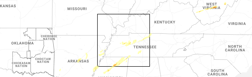
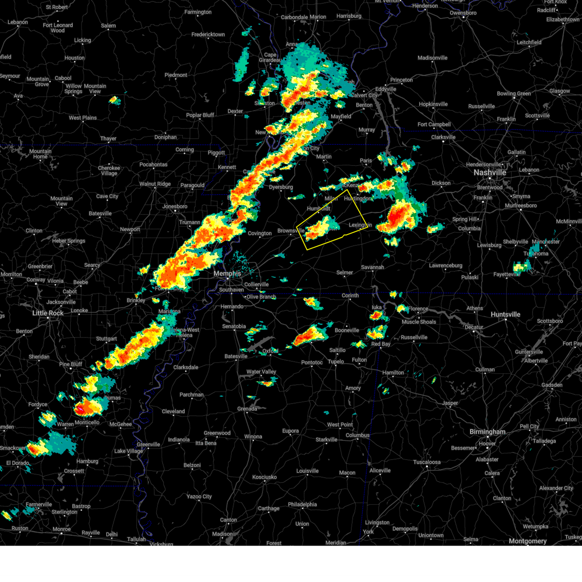
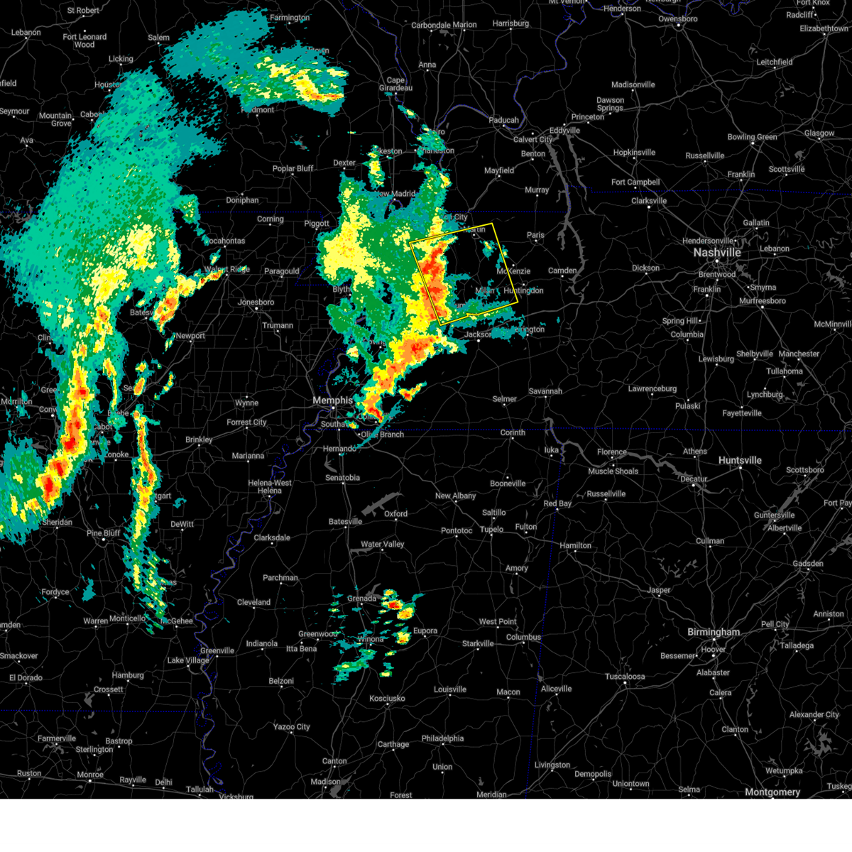
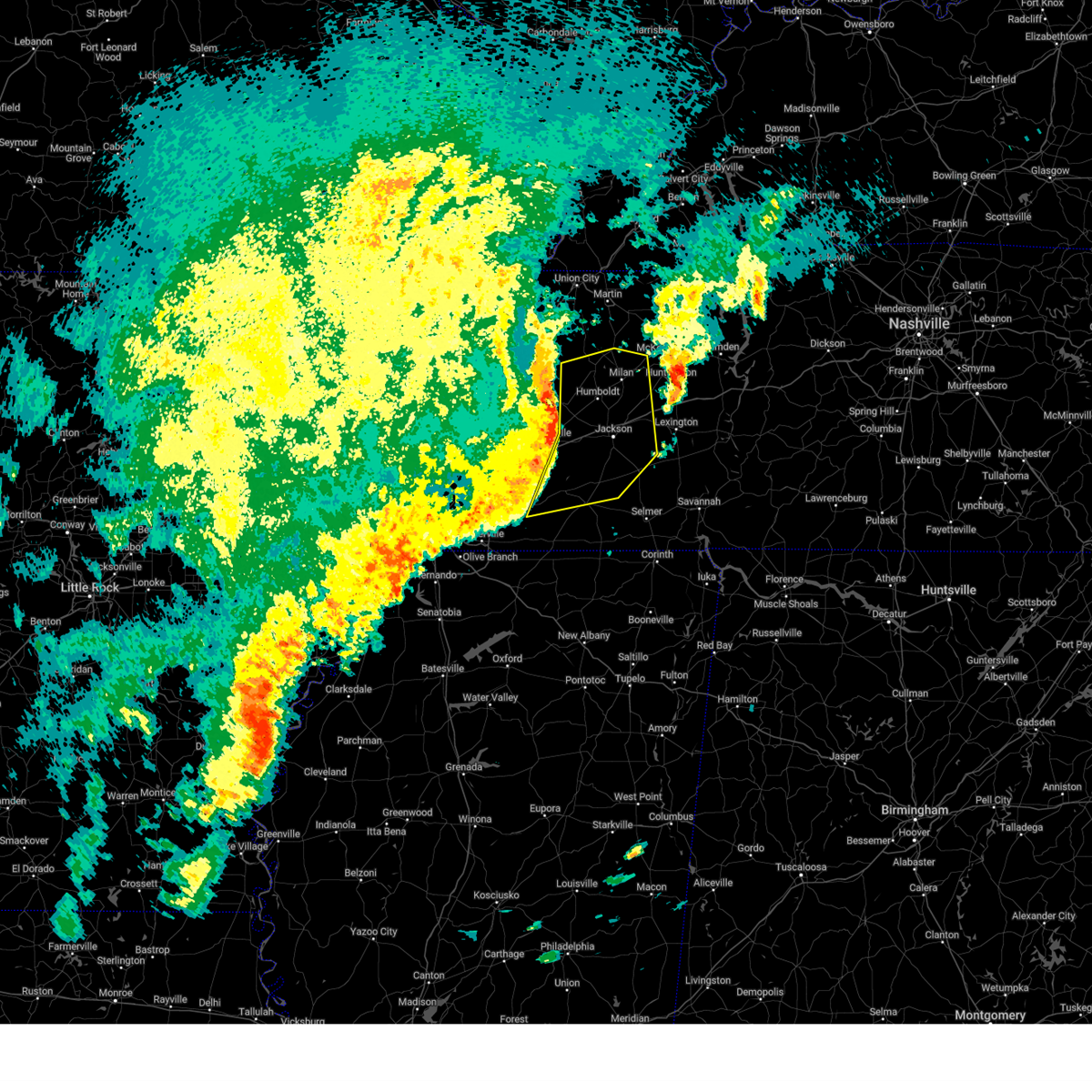
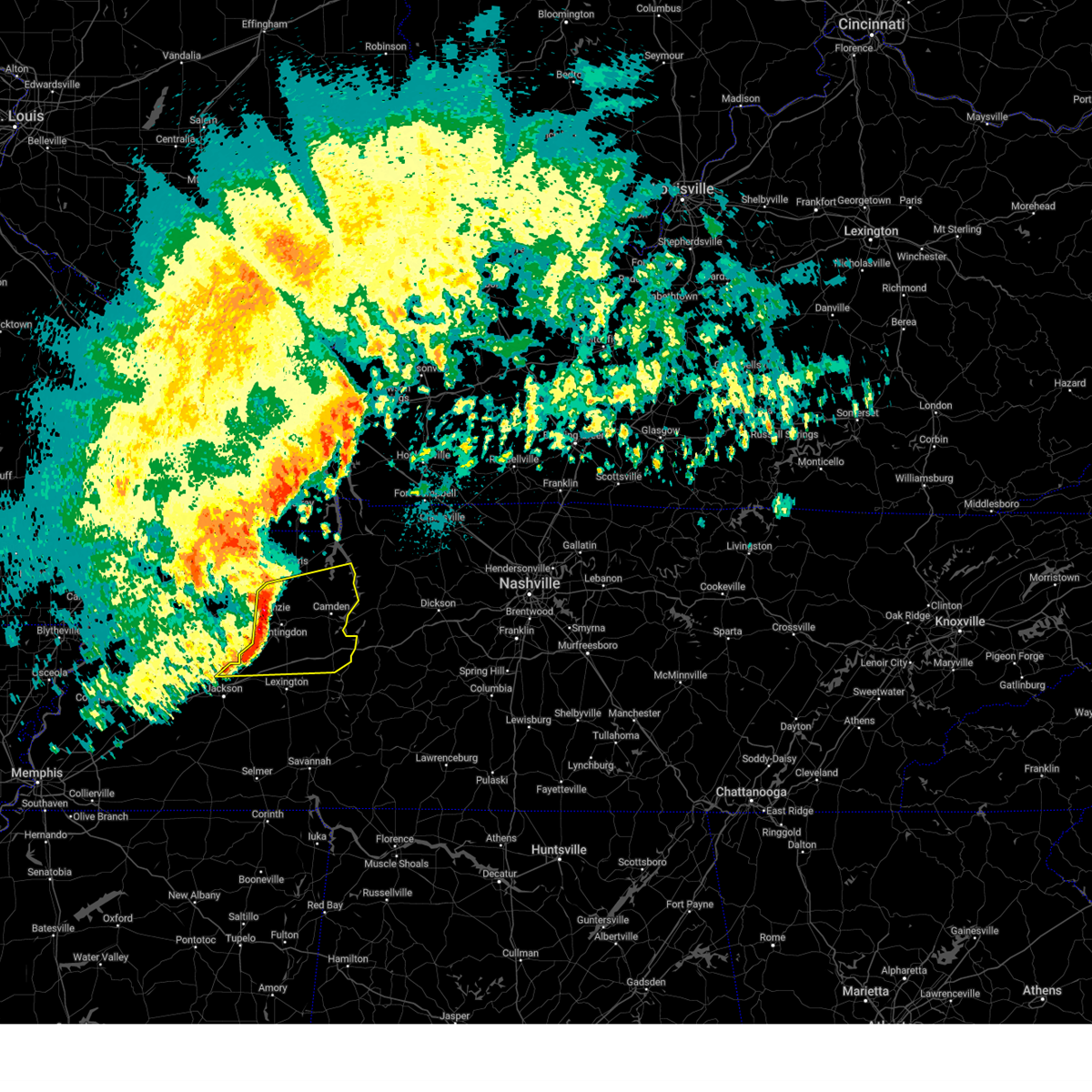
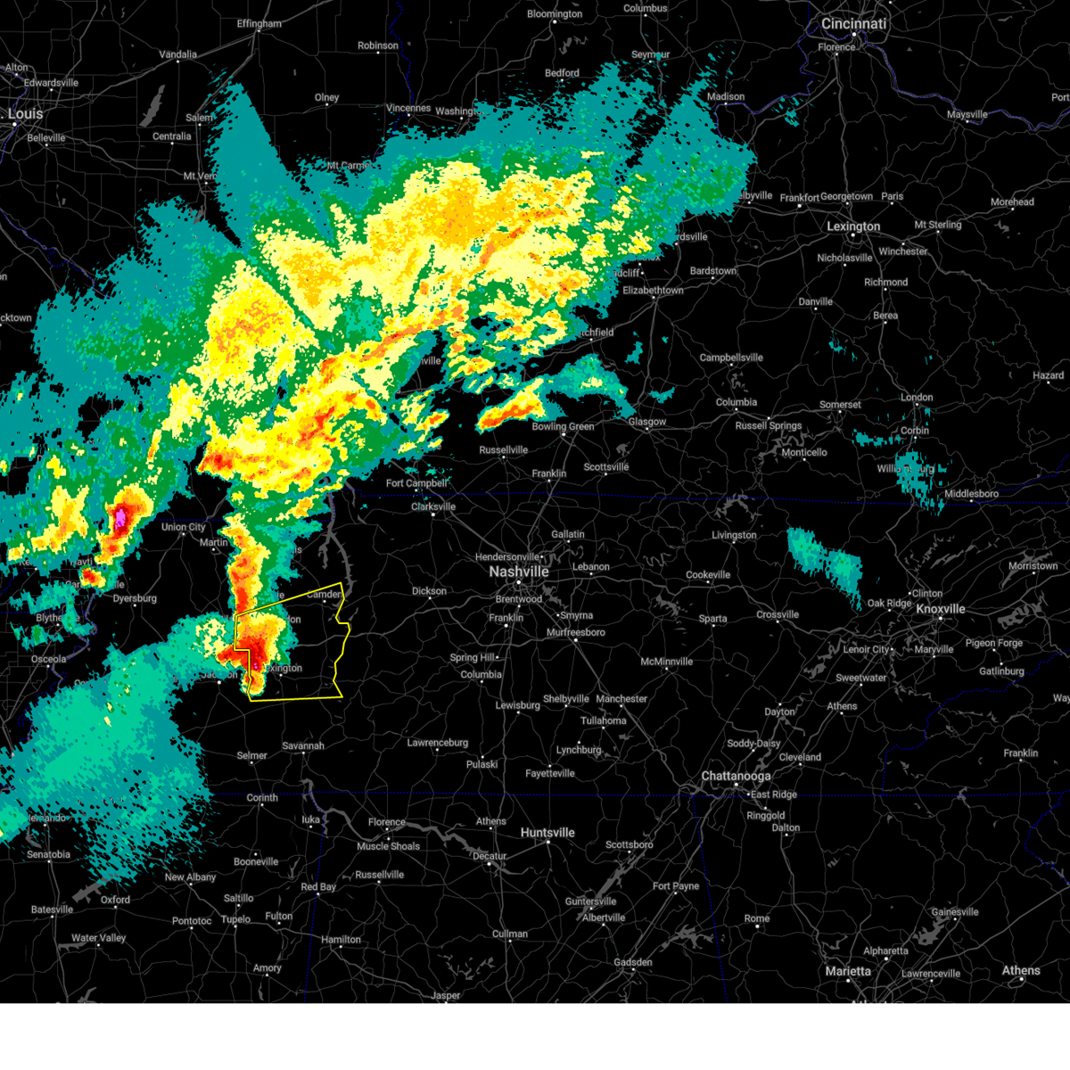
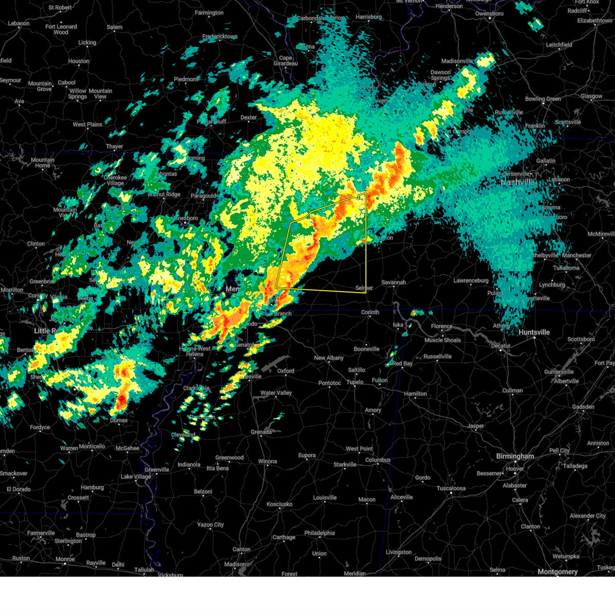
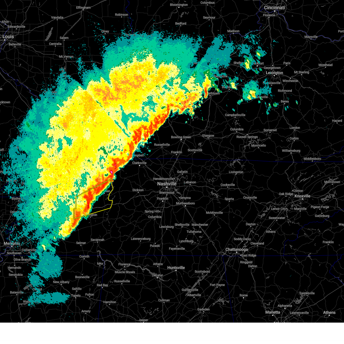
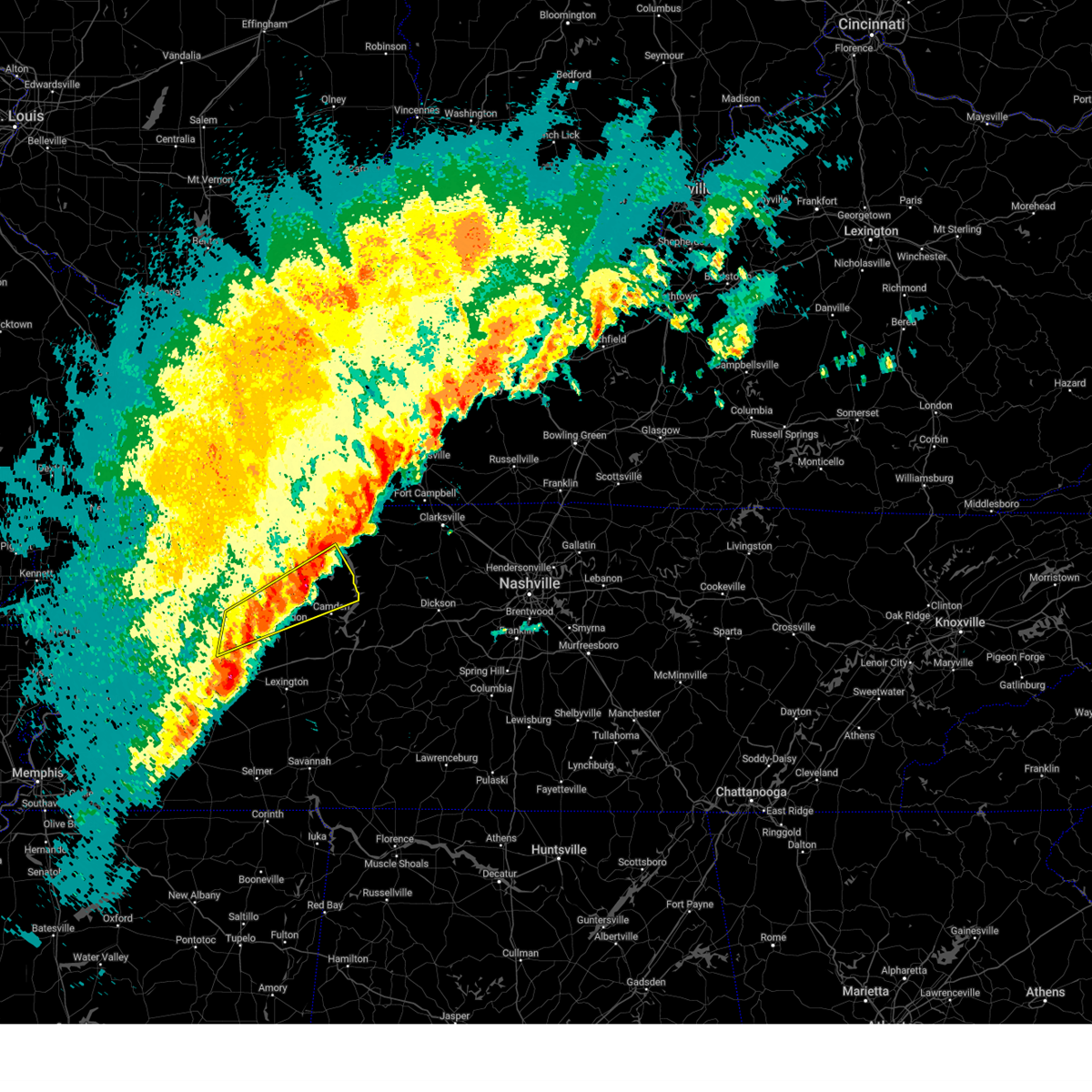
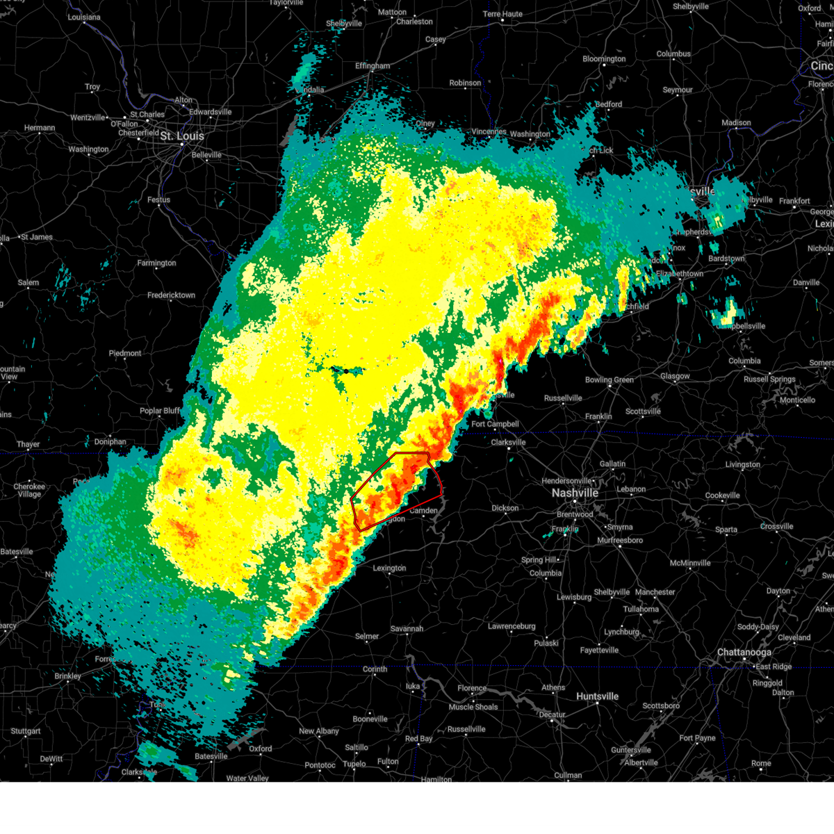
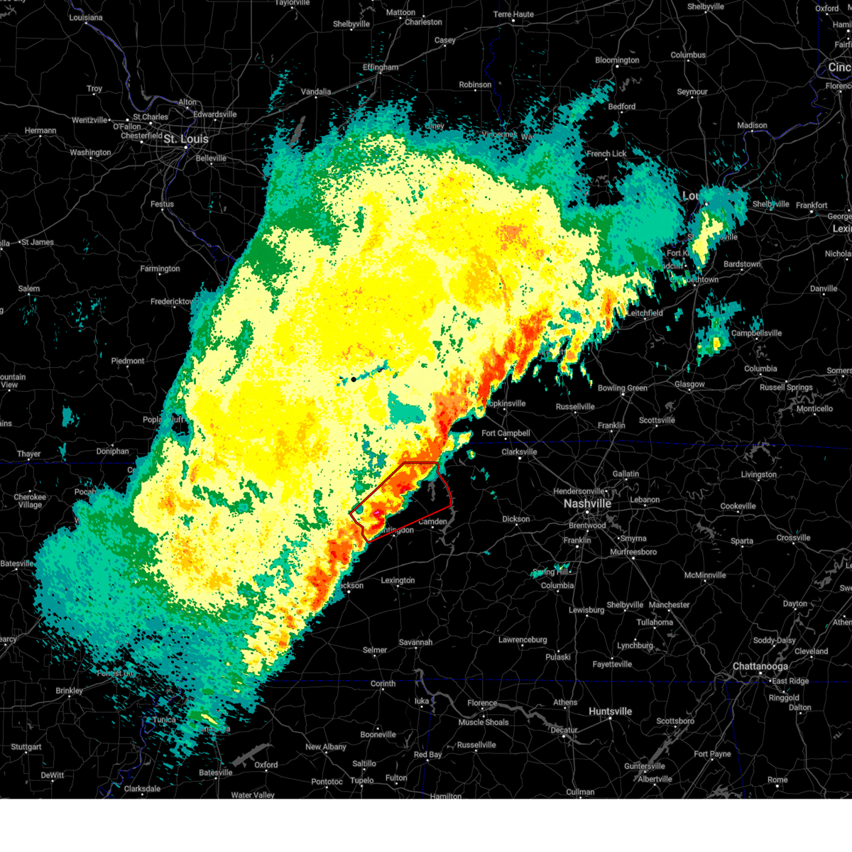
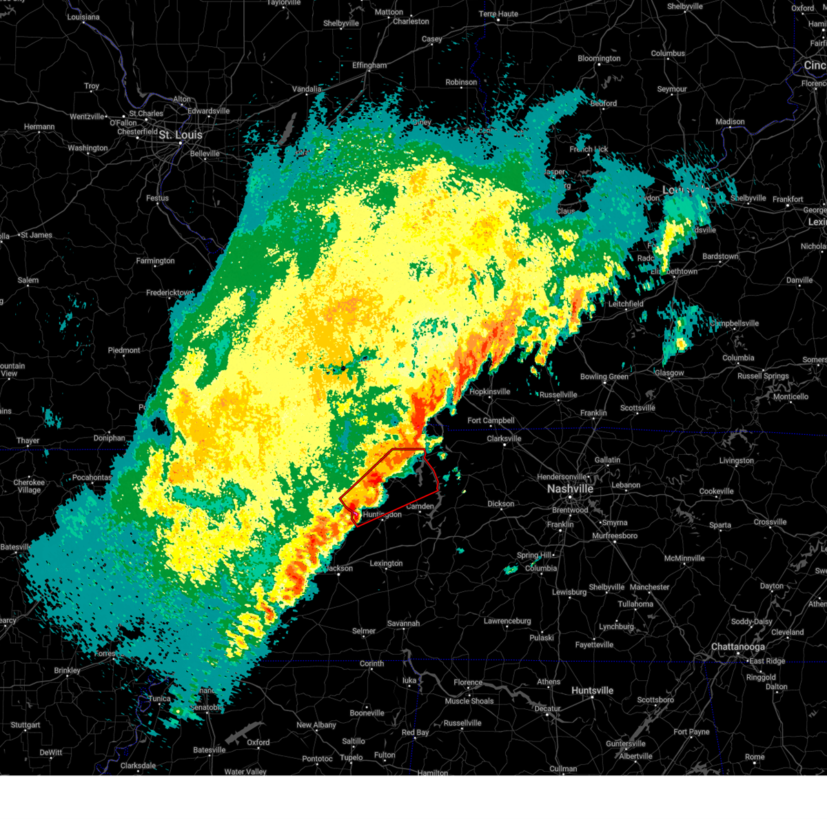
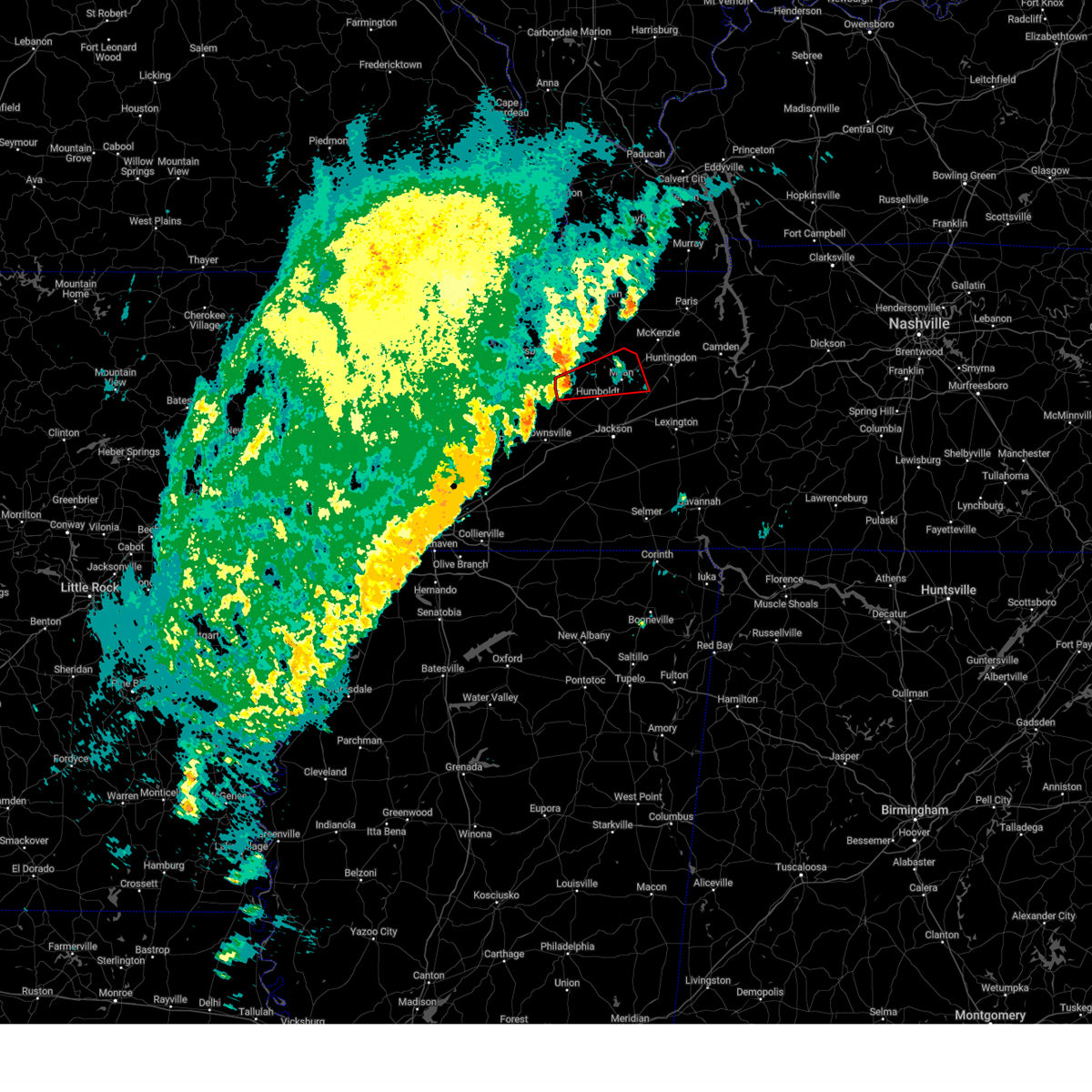
Hail Map for Trezevant, TN
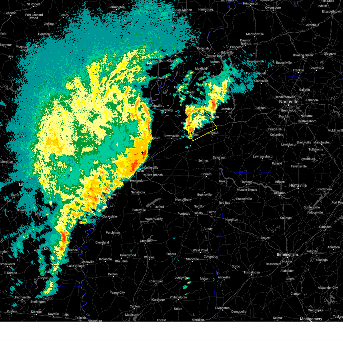
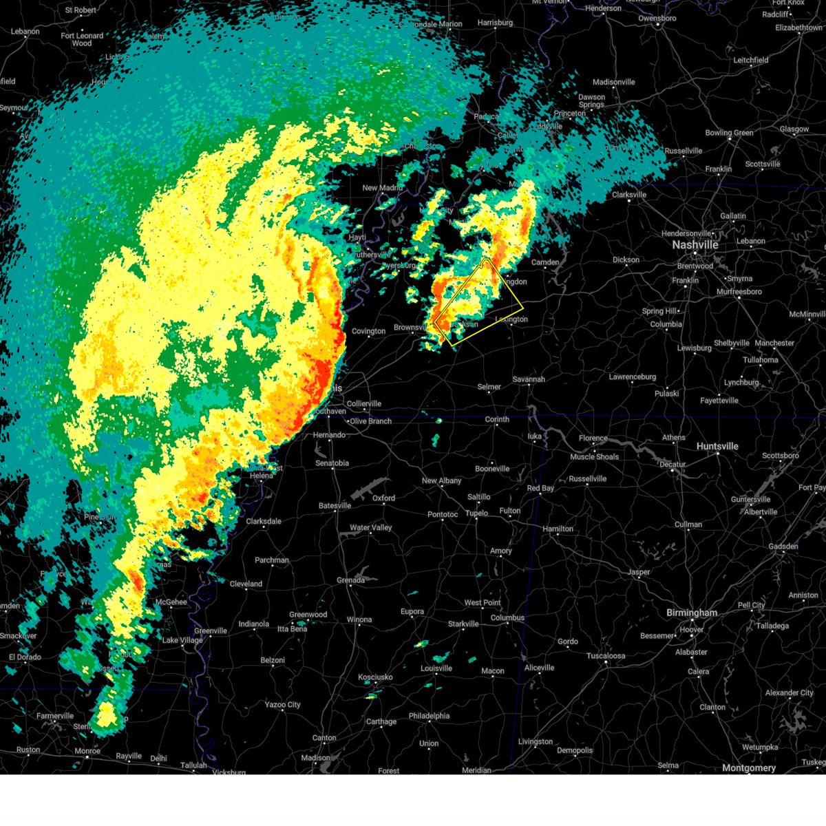
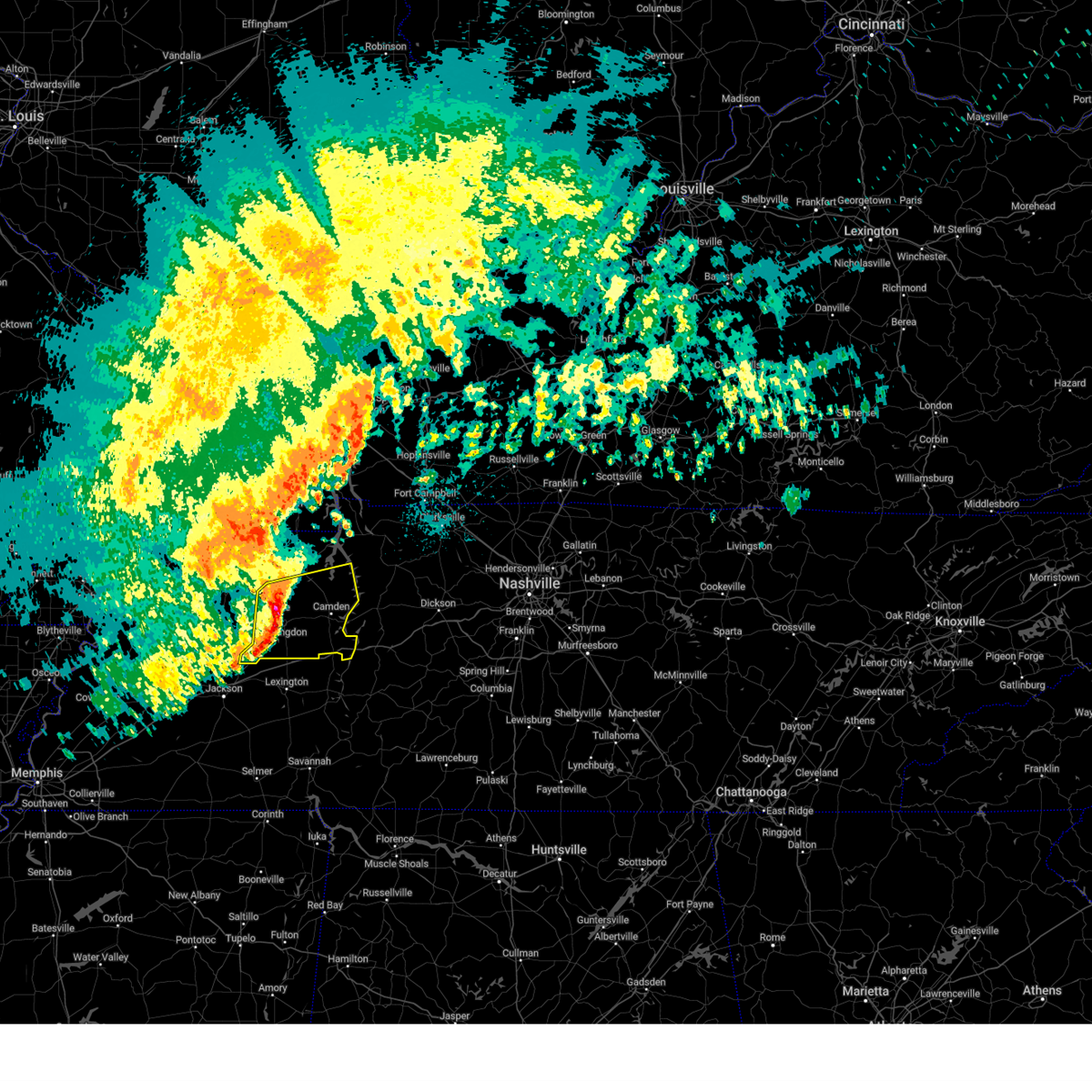
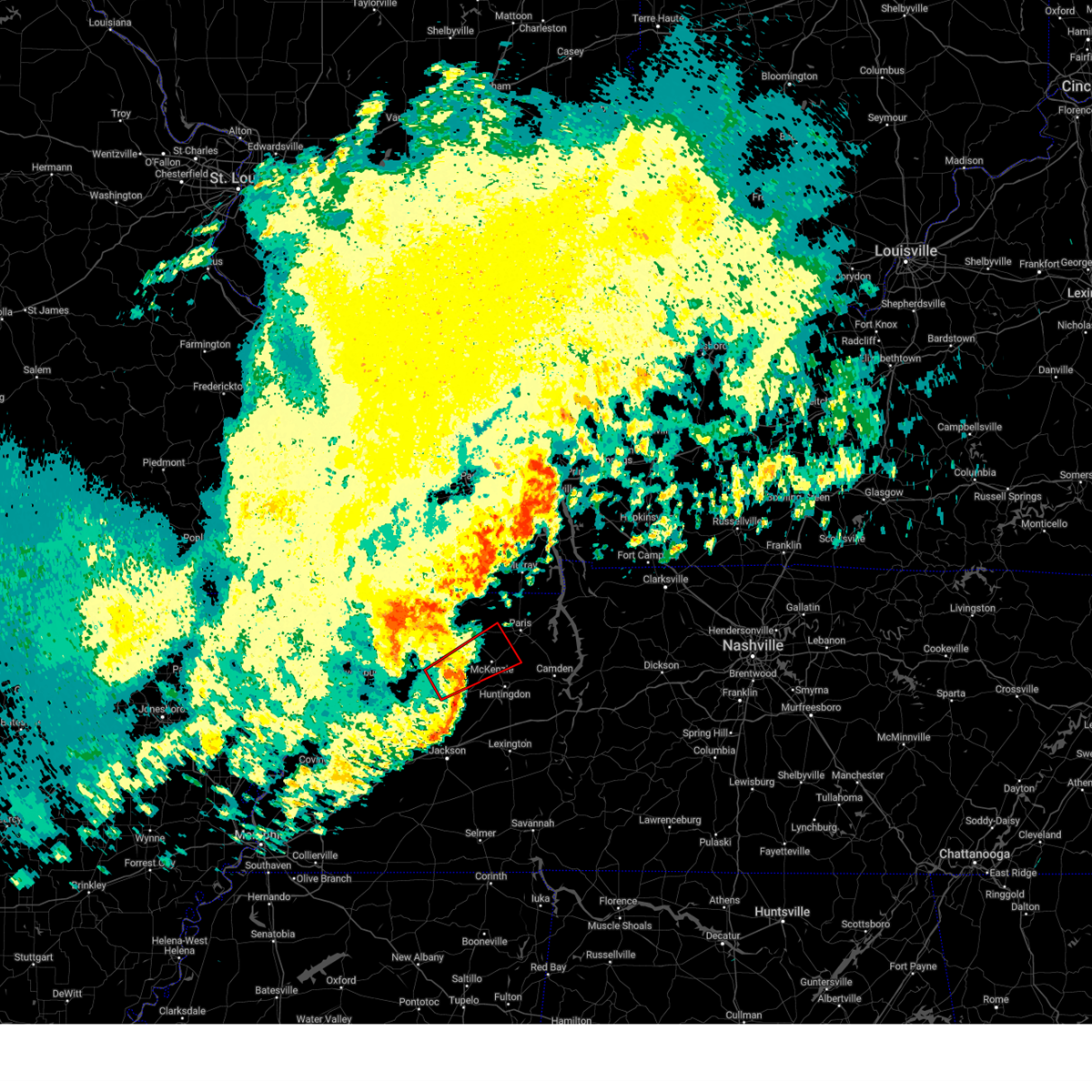
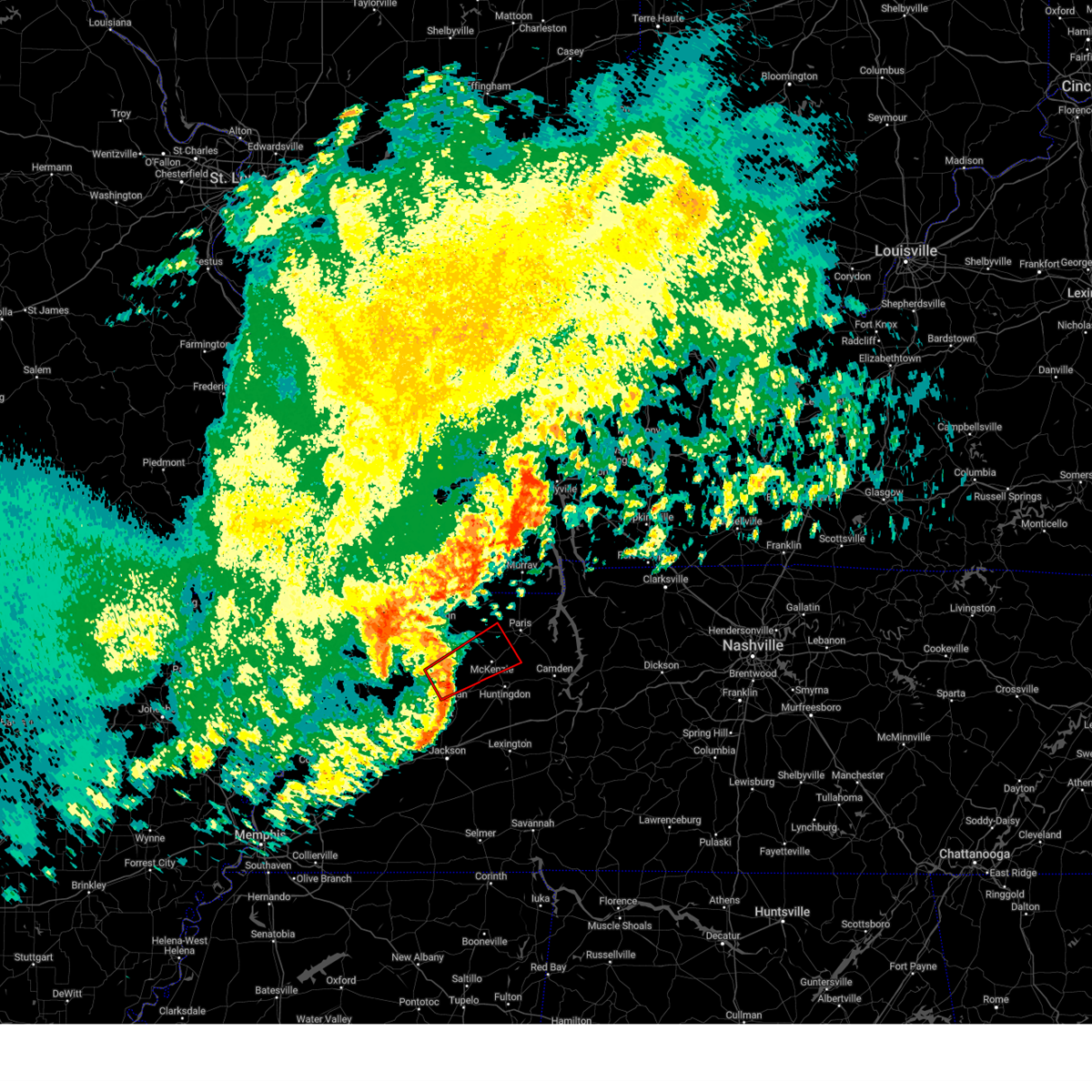
The Trezevant, TN area has had 1 report of on-the-ground hail by trained spotters, and has been under severe weather warnings 72 times during the past 12 months. Doppler radar has detected hail at or near Trezevant, TN on 60 occasions, including 6 occasions during the past year.
| Name: | Trezevant, TN |
| Where Located: | 10.3 miles SSW of Mc Kenzie, TN |
| Map: | Google Map for Trezevant, TN |
| Population: | 859 |
| Housing Units: | 420 |
| More Info: | Search Google for Trezevant, TN |
2
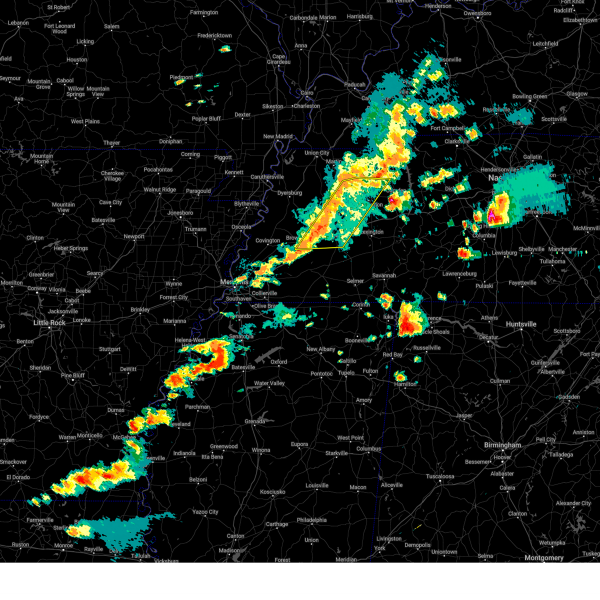
The Top Recent Hail Date for Trezevant, TN is Saturday, April 5, 2025 (10th out of 60)
Hail and Wind Damage Spotted near Trezevant, TN
| Date / Time | Report Details |
|---|---|
| 5/20/2025 4:53 PM CDT | Svrmeg the national weather service in memphis has issued a * severe thunderstorm warning for, henderson county in west tennessee, benton county in west tennessee, carroll county in west tennessee, madison county in west tennessee, southern henry county in west tennessee, northern chester county in west tennessee, northern decatur county in west tennessee, * until 545 pm cdt. * at 452 pm cdt, severe thunderstorms were located along a line extending from near mckenzie to near blue goose to near mercer, moving east at 40 mph (radar indicated). Hazards include 70 mph wind gusts and quarter size hail. Hail damage to vehicles is expected. expect considerable tree damage. Wind damage is also likely to mobile homes, roofs, and outbuildings. |
| 5/20/2025 4:37 PM CDT |
 At 436 pm cdt, severe thunderstorms were located along a line extending from 8 miles east of bradford to fairview to near mercer, moving east at 55 mph (radar indicated). Hazards include 70 mph wind gusts and quarter size hail. Hail damage to vehicles is expected. expect considerable tree damage. wind damage is also likely to mobile homes, roofs, and outbuildings. Locations impacted include, hickory flat, tuckers corner, neely, bradford, atwood, huntersville, brownsville, humboldt, cades, jackson, westover, ledbetter, madison hall, fairview, medina, leach, mason grove, mckenzie, tate, and palmer shelter. At 436 pm cdt, severe thunderstorms were located along a line extending from 8 miles east of bradford to fairview to near mercer, moving east at 55 mph (radar indicated). Hazards include 70 mph wind gusts and quarter size hail. Hail damage to vehicles is expected. expect considerable tree damage. wind damage is also likely to mobile homes, roofs, and outbuildings. Locations impacted include, hickory flat, tuckers corner, neely, bradford, atwood, huntersville, brownsville, humboldt, cades, jackson, westover, ledbetter, madison hall, fairview, medina, leach, mason grove, mckenzie, tate, and palmer shelter.
|
| 5/20/2025 4:16 PM CDT |
 Svrmeg the national weather service in memphis has issued a * severe thunderstorm warning for, southeastern crockett county in west tennessee, southern weakley county in west tennessee, northwestern henderson county in west tennessee, gibson county in west tennessee, carroll county in west tennessee, central haywood county in west tennessee, madison county in west tennessee, southwestern henry county in west tennessee, * until 500 pm cdt. * at 416 pm cdt, severe thunderstorms were located along a line extending from near dresden to near belle eagle, moving east at 40 mph (radar indicated). Hazards include 60 mph wind gusts and quarter size hail. Hail damage to vehicles is expected. Expect wind damage to roofs, siding, and trees. Svrmeg the national weather service in memphis has issued a * severe thunderstorm warning for, southeastern crockett county in west tennessee, southern weakley county in west tennessee, northwestern henderson county in west tennessee, gibson county in west tennessee, carroll county in west tennessee, central haywood county in west tennessee, madison county in west tennessee, southwestern henry county in west tennessee, * until 500 pm cdt. * at 416 pm cdt, severe thunderstorms were located along a line extending from near dresden to near belle eagle, moving east at 40 mph (radar indicated). Hazards include 60 mph wind gusts and quarter size hail. Hail damage to vehicles is expected. Expect wind damage to roofs, siding, and trees.
|
| 5/20/2025 3:26 PM CDT |
 the severe thunderstorm warning has been cancelled and is no longer in effect the severe thunderstorm warning has been cancelled and is no longer in effect
|
| 5/20/2025 3:26 PM CDT |
 At 326 pm cdt, a severe thunderstorm was located near jackson, moving northeast at 40 mph (radar indicated). Hazards include 60 mph wind gusts and quarter size hail. Hail damage to vehicles is expected. expect wind damage to roofs, siding, and trees. Locations impacted include, howley, three way, hickory flat, bemis, cedar grove, beech bluff, jackson, westover, lexington, union cross, juno, fairview, gilmore, medina, maple grove, leach, blue goose, sitka, timberlake, and east union. At 326 pm cdt, a severe thunderstorm was located near jackson, moving northeast at 40 mph (radar indicated). Hazards include 60 mph wind gusts and quarter size hail. Hail damage to vehicles is expected. expect wind damage to roofs, siding, and trees. Locations impacted include, howley, three way, hickory flat, bemis, cedar grove, beech bluff, jackson, westover, lexington, union cross, juno, fairview, gilmore, medina, maple grove, leach, blue goose, sitka, timberlake, and east union.
|
| 5/20/2025 3:12 PM CDT | At 311 pm cdt, a severe thunderstorm was located near jackson, moving northeast at 40 mph (radar indicated). Hazards include 60 mph wind gusts and quarter size hail. Hail damage to vehicles is expected. expect wind damage to roofs, siding, and trees. Locations impacted include, hickory flat, neely, atwood, huntersville, humboldt, jackson, westover, ledbetter, madison hall, lexington, fairview, medina, leach, mason grove, blue goose, fruitvale, trezevant, roberts, mclemoresville, and scott hill. |
| 5/20/2025 3:12 PM CDT | the severe thunderstorm warning has been cancelled and is no longer in effect |
| 5/20/2025 3:04 PM CDT |
 Svrmeg the national weather service in memphis has issued a * severe thunderstorm warning for, southeastern crockett county in west tennessee, northwestern henderson county in west tennessee, southeastern gibson county in west tennessee, southwestern carroll county in west tennessee, east central haywood county in west tennessee, madison county in west tennessee, * until 345 pm cdt. * at 304 pm cdt, a severe thunderstorm was located 7 miles north of mercer, or 10 miles southwest of jackson, moving northeast at 40 mph (radar indicated). Hazards include 60 mph wind gusts and quarter size hail. Hail damage to vehicles is expected. Expect wind damage to roofs, siding, and trees. Svrmeg the national weather service in memphis has issued a * severe thunderstorm warning for, southeastern crockett county in west tennessee, northwestern henderson county in west tennessee, southeastern gibson county in west tennessee, southwestern carroll county in west tennessee, east central haywood county in west tennessee, madison county in west tennessee, * until 345 pm cdt. * at 304 pm cdt, a severe thunderstorm was located 7 miles north of mercer, or 10 miles southwest of jackson, moving northeast at 40 mph (radar indicated). Hazards include 60 mph wind gusts and quarter size hail. Hail damage to vehicles is expected. Expect wind damage to roofs, siding, and trees.
|
| 5/17/2025 12:20 AM CDT |
 The storm which prompted the warning has weakened below severe limits, and no longer poses an immediate threat to life or property. therefore, the warning will be allowed to expire. a tornado watch remains in effect until 200 am cdt for west tennessee. The storm which prompted the warning has weakened below severe limits, and no longer poses an immediate threat to life or property. therefore, the warning will be allowed to expire. a tornado watch remains in effect until 200 am cdt for west tennessee.
|
| 5/17/2025 12:05 AM CDT | the severe thunderstorm warning has been cancelled and is no longer in effect |
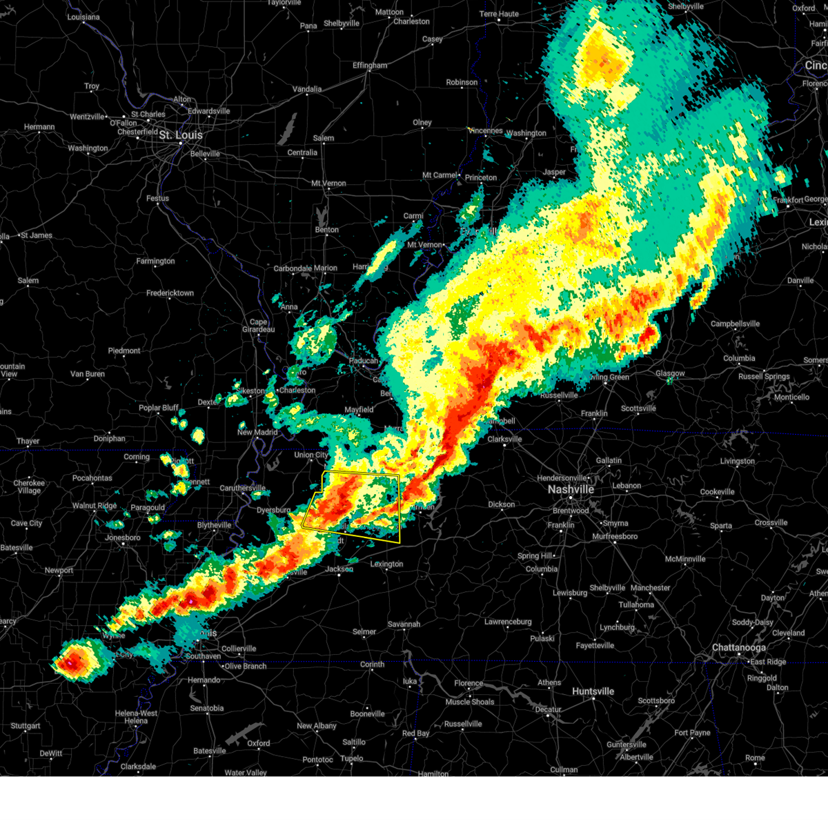
| 5/17/2025 12:05 AM CDT | At 1205 am cdt, a severe thunderstorm was located near eaton, or 8 miles west of trenton, moving east at 50 mph (radar indicated). Hazards include 60 mph wind gusts and quarter size hail. Hail damage to vehicles is expected. expect wind damage to roofs, siding, and trees. Locations impacted include, tuckers corner, dyer, grizzard, bradford, atwood, good luck, cades, central, currie, staffords store, vaughns grove, mckenzie, barrons corner, gann, georgetown, wingo, laneview, jarrell, new zion, and trezevant. |
| 5/16/2025 11:52 PM CDT |
 At 1152 pm cdt, a severe thunderstorm was located near dyersburg, moving east at 40 mph (radar indicated). Hazards include 60 mph wind gusts and quarter size hail. Hail damage to vehicles is expected. expect wind damage to roofs, siding, and trees. Locations impacted include, tuckers corner, dyer, grizzard, bradford, atwood, lapata, cades, bonicord, central, rutherford, rohoboth, currie, mckenzie, gann, georgetown, edgewood, laneview, trezevant, parker, and tatumville. At 1152 pm cdt, a severe thunderstorm was located near dyersburg, moving east at 40 mph (radar indicated). Hazards include 60 mph wind gusts and quarter size hail. Hail damage to vehicles is expected. expect wind damage to roofs, siding, and trees. Locations impacted include, tuckers corner, dyer, grizzard, bradford, atwood, lapata, cades, bonicord, central, rutherford, rohoboth, currie, mckenzie, gann, georgetown, edgewood, laneview, trezevant, parker, and tatumville.
|
| 5/16/2025 11:35 PM CDT | Svrmeg the national weather service in memphis has issued a * severe thunderstorm warning for, northern crockett county in west tennessee, southern weakley county in west tennessee, southeastern dyer county in west tennessee, central gibson county in west tennessee, northwestern carroll county in west tennessee, * until 1230 am cdt. * at 1135 pm cdt, a severe thunderstorm was located near eaton, or 11 miles east of dyersburg, moving east at 40 mph (radar indicated). Hazards include 60 mph wind gusts and quarter size hail. Hail damage to vehicles is expected. Expect wind damage to roofs, siding, and trees. |
| 5/2/2025 9:56 AM CDT |
 At 955 am cdt, a severe thunderstorm was located near dyer, or near trenton, moving east at 50 mph (radar indicated). Hazards include 60 mph wind gusts and quarter size hail. Hail damage to vehicles is expected. expect wind damage to roofs, siding, and trees. Locations impacted include, tuckers corner, dyer, grizzard, bradford, atwood, gibson wells, cades, ledbetter, ralston, rutherford, currie, pisgah, brazil, gann, georgetown, laneview, kenton, trezevant, fruitland, and moffatt. At 955 am cdt, a severe thunderstorm was located near dyer, or near trenton, moving east at 50 mph (radar indicated). Hazards include 60 mph wind gusts and quarter size hail. Hail damage to vehicles is expected. expect wind damage to roofs, siding, and trees. Locations impacted include, tuckers corner, dyer, grizzard, bradford, atwood, gibson wells, cades, ledbetter, ralston, rutherford, currie, pisgah, brazil, gann, georgetown, laneview, kenton, trezevant, fruitland, and moffatt.
|
| 5/2/2025 9:56 AM CDT |
 the severe thunderstorm warning has been cancelled and is no longer in effect the severe thunderstorm warning has been cancelled and is no longer in effect
|
| 5/2/2025 9:38 AM CDT |
 Svrmeg the national weather service in memphis has issued a * severe thunderstorm warning for, central crockett county in west tennessee, central weakley county in west tennessee, northeastern dyer county in west tennessee, gibson county in west tennessee, southern obion county in west tennessee, western carroll county in west tennessee, * until 1030 am cdt. * at 938 am cdt, a severe thunderstorm was located over eaton, or 11 miles west of trenton, moving northeast at 40 mph (radar indicated). Hazards include 60 mph wind gusts and quarter size hail. Hail damage to vehicles is expected. Expect wind damage to roofs, siding, and trees. Svrmeg the national weather service in memphis has issued a * severe thunderstorm warning for, central crockett county in west tennessee, central weakley county in west tennessee, northeastern dyer county in west tennessee, gibson county in west tennessee, southern obion county in west tennessee, western carroll county in west tennessee, * until 1030 am cdt. * at 938 am cdt, a severe thunderstorm was located over eaton, or 11 miles west of trenton, moving northeast at 40 mph (radar indicated). Hazards include 60 mph wind gusts and quarter size hail. Hail damage to vehicles is expected. Expect wind damage to roofs, siding, and trees.
|
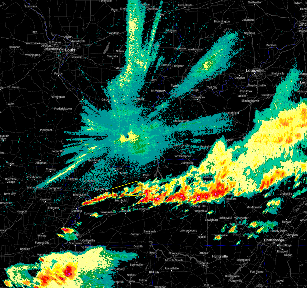
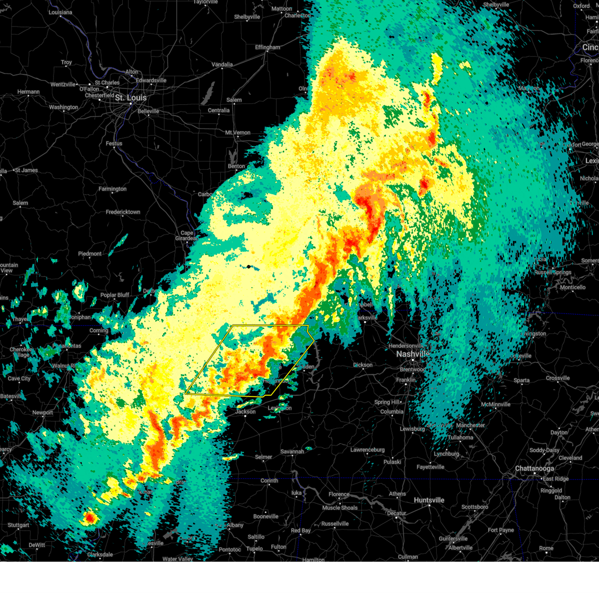
| 4/5/2025 3:20 PM CDT |
 At 320 pm cdt, severe thunderstorms were located along a line extending from mckenzie to near parkers crossroads to near lexington, moving east at 60 mph (radar indicated). Hazards include 60 mph wind gusts and quarter size hail. Hail damage to vehicles is expected. expect wind damage to roofs, siding, and trees. Locations impacted include, hickory flat, dollar, old springville, lexington, bruceton, holladay, leach, blue goose, porter court, mckenzie, tate, palmer shelter, hinson springs, buena vista, hollow rock, camden, haigler ridge, clarksburg, trezevant, and vale. At 320 pm cdt, severe thunderstorms were located along a line extending from mckenzie to near parkers crossroads to near lexington, moving east at 60 mph (radar indicated). Hazards include 60 mph wind gusts and quarter size hail. Hail damage to vehicles is expected. expect wind damage to roofs, siding, and trees. Locations impacted include, hickory flat, dollar, old springville, lexington, bruceton, holladay, leach, blue goose, porter court, mckenzie, tate, palmer shelter, hinson springs, buena vista, hollow rock, camden, haigler ridge, clarksburg, trezevant, and vale.
|
| 4/5/2025 3:20 PM CDT |
 the severe thunderstorm warning has been cancelled and is no longer in effect the severe thunderstorm warning has been cancelled and is no longer in effect
|
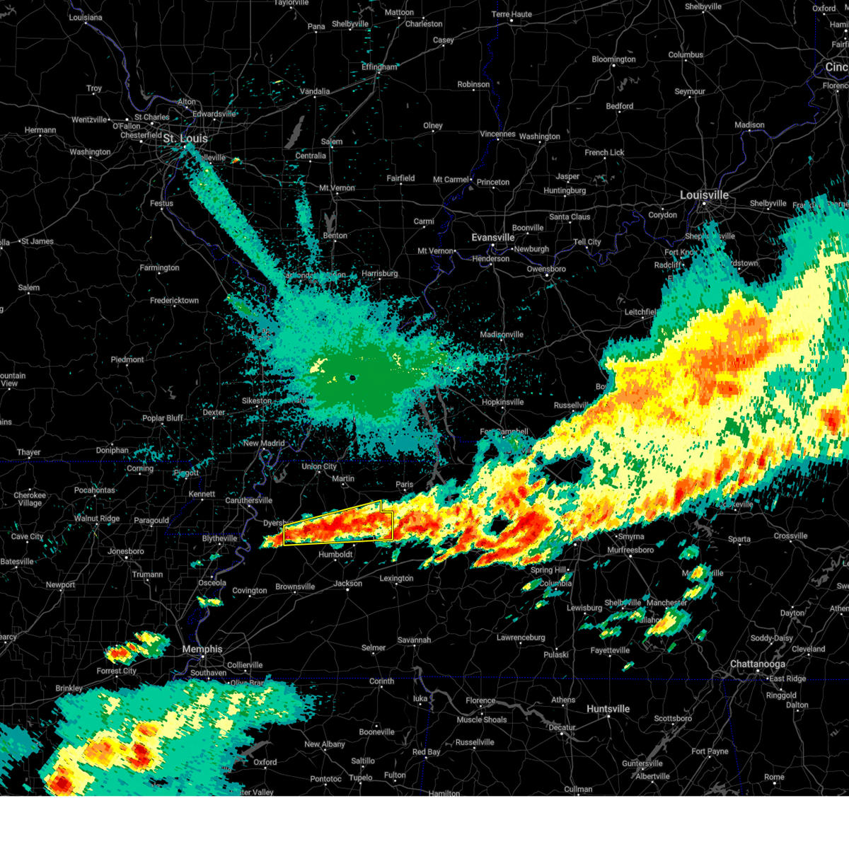
| 4/5/2025 3:09 PM CDT | At 309 pm cdt, severe thunderstorms were located along a line extending from 7 miles south of gleason to 6 miles northwest of bargerton to near mifflin, moving east at 60 mph (radar indicated). Hazards include 60 mph wind gusts and quarter size hail. Hail damage to vehicles is expected. expect wind damage to roofs, siding, and trees. Locations impacted include, hickory flat, dollar, bradford, atwood, cades, old springville, ledbetter, lexington, bruceton, holladay, leach, blue goose, porter court, mckenzie, tate, palmer shelter, hinson springs, gann, buena vista, and hollow rock. |
| 4/5/2025 3:07 PM CDT |
 the severe thunderstorm warning has been cancelled and is no longer in effect the severe thunderstorm warning has been cancelled and is no longer in effect
|
| 4/5/2025 3:07 PM CDT |
 At 306 pm cdt, severe thunderstorms were located along a line extending from near atwood to 9 miles northwest of bargerton to near mifflin, moving northeast at 60 mph (radar indicated). Hazards include 60 mph wind gusts and quarter size hail. Hail damage to vehicles is expected. expect wind damage to roofs, siding, and trees. Locations impacted include, hickory flat, claybrook, atwood, west, trezevant, cedar grove, cades, beech bluff, ledbetter, russell crossroads, lavinia, milan, maple grove, blue goose, sitka, holly leaf, whitthorne, gann, east union, and white fern. At 306 pm cdt, severe thunderstorms were located along a line extending from near atwood to 9 miles northwest of bargerton to near mifflin, moving northeast at 60 mph (radar indicated). Hazards include 60 mph wind gusts and quarter size hail. Hail damage to vehicles is expected. expect wind damage to roofs, siding, and trees. Locations impacted include, hickory flat, claybrook, atwood, west, trezevant, cedar grove, cades, beech bluff, ledbetter, russell crossroads, lavinia, milan, maple grove, blue goose, sitka, holly leaf, whitthorne, gann, east union, and white fern.
|
| 4/5/2025 3:02 PM CDT | Svrmeg the national weather service in memphis has issued a * severe thunderstorm warning for, southeastern weakley county in west tennessee, henderson county in west tennessee, southeastern gibson county in west tennessee, benton county in west tennessee, carroll county in west tennessee, northeastern madison county in west tennessee, southeastern henry county in west tennessee, northern decatur county in west tennessee, * until 400 pm cdt. * at 302 pm cdt, severe thunderstorms were located along a line extending from near bradford to 7 miles northwest of blue goose to 6 miles southeast of bemis, moving east at 60 mph (radar indicated). Hazards include 60 mph wind gusts and quarter size hail. Hail damage to vehicles is expected. Expect wind damage to roofs, siding, and trees. |
| 4/5/2025 2:59 PM CDT |
 the severe thunderstorm warning has been cancelled and is no longer in effect the severe thunderstorm warning has been cancelled and is no longer in effect
|
| 4/5/2025 2:59 PM CDT |
 At 259 pm cdt, severe thunderstorms were located along a line extending from near bradford to near jackson to near cloverport, moving east at 50 mph (radar indicated). Hazards include 60 mph wind gusts and quarter size hail. Hail damage to vehicles is expected. expect wind damage to roofs, siding, and trees. Locations impacted include, hickory flat, tuckers corner, neely, pinson, grizzard, bradford, atwood, gibson wells, huntersville, humboldt, cades, jackson, westover, ledbetter, madison hall, uptonville, fairview, medina, mason grove, and blue goose. At 259 pm cdt, severe thunderstorms were located along a line extending from near bradford to near jackson to near cloverport, moving east at 50 mph (radar indicated). Hazards include 60 mph wind gusts and quarter size hail. Hail damage to vehicles is expected. expect wind damage to roofs, siding, and trees. Locations impacted include, hickory flat, tuckers corner, neely, pinson, grizzard, bradford, atwood, gibson wells, huntersville, humboldt, cades, jackson, westover, ledbetter, madison hall, uptonville, fairview, medina, mason grove, and blue goose.
|
| 4/5/2025 2:49 PM CDT |
 At 248 pm cdt, severe thunderstorms were located along a line extending from near dyer to 7 miles west of bemis to 6 miles southwest of whiteville, moving east at 50 mph (radar indicated). Hazards include 60 mph wind gusts and quarter size hail. Hail damage to vehicles is expected. expect wind damage to roofs, siding, and trees. Locations impacted include, tuckers corner, neely, grizzard, bradford, atwood, huntersville, cades, westover, madison hall, uptonville, silerton, gann, georgetown, pinson mounds state archaeological park, laneview, laconia, hillville, trezevant, fruitland, and deanburg. At 248 pm cdt, severe thunderstorms were located along a line extending from near dyer to 7 miles west of bemis to 6 miles southwest of whiteville, moving east at 50 mph (radar indicated). Hazards include 60 mph wind gusts and quarter size hail. Hail damage to vehicles is expected. expect wind damage to roofs, siding, and trees. Locations impacted include, tuckers corner, neely, grizzard, bradford, atwood, huntersville, cades, westover, madison hall, uptonville, silerton, gann, georgetown, pinson mounds state archaeological park, laneview, laconia, hillville, trezevant, fruitland, and deanburg.
|
| 4/5/2025 2:32 PM CDT | Svrmeg the national weather service in memphis has issued a * severe thunderstorm warning for, crockett county in west tennessee, northwestern henderson county in west tennessee, gibson county in west tennessee, fayette county in west tennessee, hardeman county in west tennessee, southwestern carroll county in west tennessee, eastern haywood county in west tennessee, madison county in west tennessee, chester county in west tennessee, * until 315 pm cdt. * at 232 pm cdt, severe thunderstorms were located along a line extending from 6 miles east of chestnut bluff to near hillville to 9 miles southwest of somerville, moving east at 45 mph (radar indicated). Hazards include 60 mph wind gusts and quarter size hail. Hail damage to vehicles is expected. Expect wind damage to roofs, siding, and trees. |
| 4/5/2025 2:18 PM CDT |
 the severe thunderstorm warning has been cancelled and is no longer in effect the severe thunderstorm warning has been cancelled and is no longer in effect
|
| 4/5/2025 2:05 PM CDT |
 At 204 pm cdt, a severe thunderstorm was located near fairview, or 7 miles northeast of jackson, moving northeast at 55 mph (radar indicated). Hazards include 60 mph wind gusts and nickel size hail. Expect damage to roofs, siding, and trees. Locations impacted include, howley, three way, hickory flat, atwood, cedar grove, jackson, ledbetter, union cross, juno, fairview, gilmore, medina, leach, blue goose, sitka, tate, east union, wingo, parker's cross roads, and jarrell. At 204 pm cdt, a severe thunderstorm was located near fairview, or 7 miles northeast of jackson, moving northeast at 55 mph (radar indicated). Hazards include 60 mph wind gusts and nickel size hail. Expect damage to roofs, siding, and trees. Locations impacted include, howley, three way, hickory flat, atwood, cedar grove, jackson, ledbetter, union cross, juno, fairview, gilmore, medina, leach, blue goose, sitka, tate, east union, wingo, parker's cross roads, and jarrell.
|
| 4/5/2025 2:05 PM CDT |
 the severe thunderstorm warning has been cancelled and is no longer in effect the severe thunderstorm warning has been cancelled and is no longer in effect
|
| 4/5/2025 1:54 PM CDT |
 Svrmeg the national weather service in memphis has issued a * severe thunderstorm warning for, southeastern crockett county in west tennessee, northwestern henderson county in west tennessee, southeastern gibson county in west tennessee, western carroll county in west tennessee, madison county in west tennessee, * until 245 pm cdt. * at 153 pm cdt, a severe thunderstorm was located near jackson, moving northeast at 55 mph (radar indicated). Hazards include 60 mph wind gusts and nickel size hail. expect damage to roofs, siding, and trees Svrmeg the national weather service in memphis has issued a * severe thunderstorm warning for, southeastern crockett county in west tennessee, northwestern henderson county in west tennessee, southeastern gibson county in west tennessee, western carroll county in west tennessee, madison county in west tennessee, * until 245 pm cdt. * at 153 pm cdt, a severe thunderstorm was located near jackson, moving northeast at 55 mph (radar indicated). Hazards include 60 mph wind gusts and nickel size hail. expect damage to roofs, siding, and trees
|
| 4/5/2025 4:58 AM CDT |
 At 458 am cdt, severe thunderstorms were located along a line extending from near mckenzie to 8 miles southwest of huntingdon to 7 miles east of fairview, moving east at 35 mph (radar indicated). Hazards include 60 mph wind gusts and quarter size hail. Hail damage to vehicles is expected. expect wind damage to roofs, siding, and trees. Locations impacted include, howley, hickory flat, hillard, mansfield, nathan bedford forrest state park, dollar, old springville, bruceton, holladay, leach, mckenzie, tate, palmer shelter, routon, ephesus, henry, buena vista, wingo, westport, and hollow rock. At 458 am cdt, severe thunderstorms were located along a line extending from near mckenzie to 8 miles southwest of huntingdon to 7 miles east of fairview, moving east at 35 mph (radar indicated). Hazards include 60 mph wind gusts and quarter size hail. Hail damage to vehicles is expected. expect wind damage to roofs, siding, and trees. Locations impacted include, howley, hickory flat, hillard, mansfield, nathan bedford forrest state park, dollar, old springville, bruceton, holladay, leach, mckenzie, tate, palmer shelter, routon, ephesus, henry, buena vista, wingo, westport, and hollow rock.
|
| 4/5/2025 4:58 AM CDT |
 the severe thunderstorm warning has been cancelled and is no longer in effect the severe thunderstorm warning has been cancelled and is no longer in effect
|
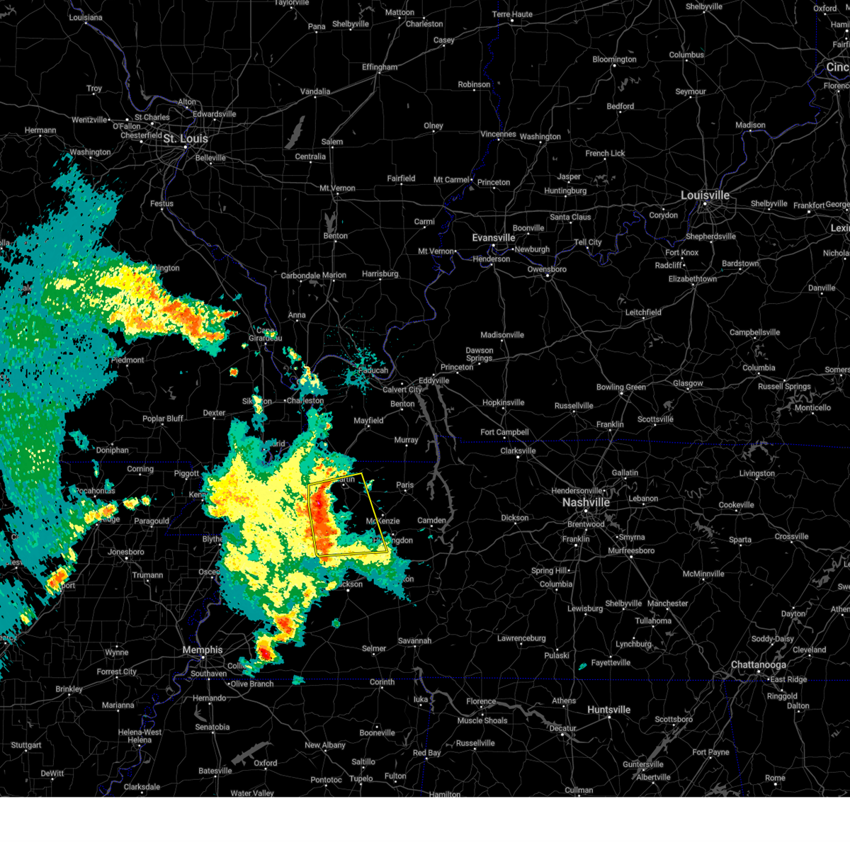
| 4/5/2025 4:49 AM CDT |
 Svrmeg the national weather service in memphis has issued a * severe thunderstorm warning for, southeastern weakley county in west tennessee, northern henderson county in west tennessee, benton county in west tennessee, carroll county in west tennessee, northeastern madison county in west tennessee, southern henry county in west tennessee, northeastern decatur county in west tennessee, * until 530 am cdt. * at 448 am cdt, severe thunderstorms were located along a line extending from mckenzie to 8 miles southeast of atwood to near fairview, moving east at 35 mph (radar indicated). Hazards include 60 mph wind gusts and quarter size hail. Hail damage to vehicles is expected. Expect wind damage to roofs, siding, and trees. Svrmeg the national weather service in memphis has issued a * severe thunderstorm warning for, southeastern weakley county in west tennessee, northern henderson county in west tennessee, benton county in west tennessee, carroll county in west tennessee, northeastern madison county in west tennessee, southern henry county in west tennessee, northeastern decatur county in west tennessee, * until 530 am cdt. * at 448 am cdt, severe thunderstorms were located along a line extending from mckenzie to 8 miles southeast of atwood to near fairview, moving east at 35 mph (radar indicated). Hazards include 60 mph wind gusts and quarter size hail. Hail damage to vehicles is expected. Expect wind damage to roofs, siding, and trees.
|
| 4/5/2025 4:36 AM CDT |
 the tornado warning has been cancelled and is no longer in effect the tornado warning has been cancelled and is no longer in effect
|
| 4/5/2025 4:27 AM CDT |
 Tormeg the national weather service in memphis has issued a * tornado warning for, southeastern weakley county in west tennessee, northeastern gibson county in west tennessee, northwestern carroll county in west tennessee, southwestern henry county in west tennessee, * until 515 am cdt. * at 427 am cdt, a severe thunderstorm capable of producing a tornado was located over bradford, or 8 miles northeast of trenton, moving northeast at 35 mph (radar indicated rotation). Hazards include tornado. Flying debris will be dangerous to those caught without shelter. mobile homes will be damaged or destroyed. damage to roofs, windows, and vehicles will occur. Tree damage is likely. Tormeg the national weather service in memphis has issued a * tornado warning for, southeastern weakley county in west tennessee, northeastern gibson county in west tennessee, northwestern carroll county in west tennessee, southwestern henry county in west tennessee, * until 515 am cdt. * at 427 am cdt, a severe thunderstorm capable of producing a tornado was located over bradford, or 8 miles northeast of trenton, moving northeast at 35 mph (radar indicated rotation). Hazards include tornado. Flying debris will be dangerous to those caught without shelter. mobile homes will be damaged or destroyed. damage to roofs, windows, and vehicles will occur. Tree damage is likely.
|
| 4/3/2025 9:05 PM CDT |
 the severe thunderstorm warning has been cancelled and is no longer in effect the severe thunderstorm warning has been cancelled and is no longer in effect
|
| 4/3/2025 9:05 PM CDT |
 At 904 pm cdt, a severe thunderstorm was located over parkers crossroads, or 8 miles north of lexington, moving east at 60 mph (radar indicated). Hazards include two inch hail and 70 mph wind gusts. People and animals outdoors will be injured. expect hail damage to roofs, siding, windows, and vehicles. expect considerable tree damage. wind damage is also likely to mobile homes, roofs, and outbuildings. Locations impacted include, hickory flat, dollar, atwood, lexington, rock hill, bruceton, holladay, leach, middle fork, blue goose, decaturville, tate, palmer shelter, hinson springs, buena vista, hollow rock, camden, clarksburg, perryville, and huron. At 904 pm cdt, a severe thunderstorm was located over parkers crossroads, or 8 miles north of lexington, moving east at 60 mph (radar indicated). Hazards include two inch hail and 70 mph wind gusts. People and animals outdoors will be injured. expect hail damage to roofs, siding, windows, and vehicles. expect considerable tree damage. wind damage is also likely to mobile homes, roofs, and outbuildings. Locations impacted include, hickory flat, dollar, atwood, lexington, rock hill, bruceton, holladay, leach, middle fork, blue goose, decaturville, tate, palmer shelter, hinson springs, buena vista, hollow rock, camden, clarksburg, perryville, and huron.
|
| 4/3/2025 8:59 PM CDT |
 At 859 pm cdt, a severe thunderstorm was located near parkers crossroads, or 9 miles northwest of natchez trace state park, moving northeast at 75 mph (radar indicated). Hazards include two inch hail and 70 mph wind gusts. People and animals outdoors will be injured. expect hail damage to roofs, siding, windows, and vehicles. expect considerable tree damage. wind damage is also likely to mobile homes, roofs, and outbuildings. Locations impacted include, hickory flat, dollar, atwood, jackson, ledbetter, madison hall, lexington, rock hill, bruceton, holladay, medina, leach, middle fork, blue goose, decaturville, tate, palmer shelter, hinson springs, buena vista, and hollow rock. At 859 pm cdt, a severe thunderstorm was located near parkers crossroads, or 9 miles northwest of natchez trace state park, moving northeast at 75 mph (radar indicated). Hazards include two inch hail and 70 mph wind gusts. People and animals outdoors will be injured. expect hail damage to roofs, siding, windows, and vehicles. expect considerable tree damage. wind damage is also likely to mobile homes, roofs, and outbuildings. Locations impacted include, hickory flat, dollar, atwood, jackson, ledbetter, madison hall, lexington, rock hill, bruceton, holladay, medina, leach, middle fork, blue goose, decaturville, tate, palmer shelter, hinson springs, buena vista, and hollow rock.
|
| 4/2/2025 11:24 PM CDT | The storms which prompted the warning have moved out of the area. therefore, the warning will be allowed to expire. however, gusty winds are still possible with these thunderstorms. a tornado watch remains in effect until midnight cdt for west tennessee. |
| 4/2/2025 11:08 PM CDT | At 1107 pm cdt, severe thunderstorms were located along a line extending from paris to 6 miles southwest of huntingdon, moving northeast at 45 mph (radar indicated). Hazards include 70 mph wind gusts and quarter size hail. Hail damage to vehicles is expected. expect considerable tree damage. wind damage is also likely to mobile homes, roofs, and outbuildings. Locations impacted include, paris, huntingdon, dollar, atwood, old springville, ledbetter, como, bruceton, leach, porter court, mckenzie, tate, palmer shelter, pine hill, gann, buena vista, hollow rock, camden, haigler ridge, clarksburg, trezevant, and vale. |
| 4/2/2025 11:06 PM CDT | Svrmeg the national weather service in memphis has issued a * severe thunderstorm warning for, henderson county in west tennessee, southeastern gibson county in west tennessee, northeastern fayette county in west tennessee, hardeman county in west tennessee, benton county in west tennessee, mcnairy county in west tennessee, carroll county in west tennessee, hardin county in west tennessee, southeastern haywood county in west tennessee, madison county in west tennessee, chester county in west tennessee, decatur county in west tennessee, * until 1145 pm cdt. * at 1105 pm cdt, a severe thunderstorm was located 7 miles northwest of parkers crossroads, or 11 miles southwest of huntingdon, moving east at 65 mph. this is a destructive storm for humbolt, jackson, and henderson (radar indicated). Hazards include 80 mph wind gusts and quarter size hail. Flying debris will be dangerous to those caught without shelter. mobile homes will be heavily damaged. expect considerable damage to roofs, windows, and vehicles. Extensive tree damage and power outages are likely. |
| 4/2/2025 10:39 PM CDT | Svrmeg the national weather service in memphis has issued a * severe thunderstorm warning for, weakley county in west tennessee, central gibson county in west tennessee, benton county in west tennessee, carroll county in west tennessee, henry county in west tennessee, * until 1130 pm cdt. * at 1038 pm cdt, severe thunderstorms were located along a line extending from 10 miles south of wranglers campground to near bradford, moving northeast at 50 mph (radar indicated). Hazards include 60 mph wind gusts and quarter size hail. Hail damage to vehicles is expected. Expect wind damage to roofs, siding, and trees. |
| 4/2/2025 10:31 PM CDT |
 At 1030 pm cdt, a severe thunderstorm was located near bells, or 10 miles northeast of brownsville, moving northeast at 55 mph. this is a destructive storm for holly grove, mercer, and whiteville (radar indicated). Hazards include 80 mph wind gusts and quarter size hail. Flying debris will be dangerous to those caught without shelter. mobile homes will be heavily damaged. expect considerable damage to roofs, windows, and vehicles. extensive tree damage and power outages are likely. Locations impacted include, tuckers corner, neely, yum yum, selmer, atwood, stanton, huntersville, masseyville, belmont, cades, christmasville, westover, madison hall, uptonville, silerton, maury junction, gann, georgetown, pinson mounds state archaeological park, and laneview. At 1030 pm cdt, a severe thunderstorm was located near bells, or 10 miles northeast of brownsville, moving northeast at 55 mph. this is a destructive storm for holly grove, mercer, and whiteville (radar indicated). Hazards include 80 mph wind gusts and quarter size hail. Flying debris will be dangerous to those caught without shelter. mobile homes will be heavily damaged. expect considerable damage to roofs, windows, and vehicles. extensive tree damage and power outages are likely. Locations impacted include, tuckers corner, neely, yum yum, selmer, atwood, stanton, huntersville, masseyville, belmont, cades, christmasville, westover, madison hall, uptonville, silerton, maury junction, gann, georgetown, pinson mounds state archaeological park, and laneview.
|
| 4/2/2025 10:29 PM CDT |
 Svrmeg the national weather service in memphis has issued a * severe thunderstorm warning for, crockett county in west tennessee, southeastern tipton county in west tennessee, northwestern henderson county in west tennessee, southern gibson county in west tennessee, northern fayette county in west tennessee, northern hardeman county in west tennessee, northwestern mcnairy county in west tennessee, southeastern lauderdale county in west tennessee, western carroll county in west tennessee, haywood county in west tennessee, madison county in west tennessee, chester county in west tennessee, * until 1115 pm cdt. * at 1027 pm cdt, a severe thunderstorm was located near belle eagle, or 8 miles northeast of brownsville, moving northeast at 55 mph. this is a destructive storm for holly grove, mercer, and whiteville (radar indicated). Hazards include 80 mph wind gusts and quarter size hail. Flying debris will be dangerous to those caught without shelter. mobile homes will be heavily damaged. expect considerable damage to roofs, windows, and vehicles. Extensive tree damage and power outages are likely. Svrmeg the national weather service in memphis has issued a * severe thunderstorm warning for, crockett county in west tennessee, southeastern tipton county in west tennessee, northwestern henderson county in west tennessee, southern gibson county in west tennessee, northern fayette county in west tennessee, northern hardeman county in west tennessee, northwestern mcnairy county in west tennessee, southeastern lauderdale county in west tennessee, western carroll county in west tennessee, haywood county in west tennessee, madison county in west tennessee, chester county in west tennessee, * until 1115 pm cdt. * at 1027 pm cdt, a severe thunderstorm was located near belle eagle, or 8 miles northeast of brownsville, moving northeast at 55 mph. this is a destructive storm for holly grove, mercer, and whiteville (radar indicated). Hazards include 80 mph wind gusts and quarter size hail. Flying debris will be dangerous to those caught without shelter. mobile homes will be heavily damaged. expect considerable damage to roofs, windows, and vehicles. Extensive tree damage and power outages are likely.
|
| 4/2/2025 10:15 PM CDT | the severe thunderstorm warning has been cancelled and is no longer in effect |
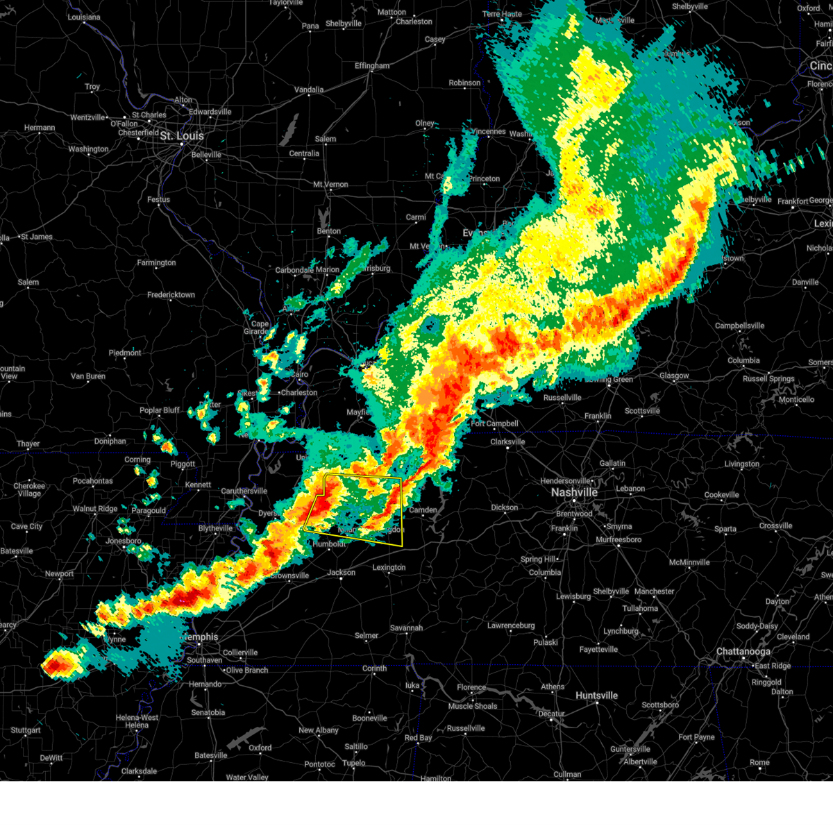
| 4/2/2025 10:15 PM CDT | At 1015 pm cdt, severe thunderstorms were located along a line extending from 7 miles northwest of paris landing state park to humboldt, moving northeast at 50 mph (radar indicated). Hazards include 60 mph wind gusts and quarter size hail. Hail damage to vehicles is expected. expect wind damage to roofs, siding, and trees. Locations impacted include, tuckers corner, dyer, grizzard, bradford, atwood, jones mill, cades, como, ralston, leach, currie, mckenzie, maury junction, pine hill, gann, georgetown, laneview, ore springs, trezevant, and fruitland. |
| 4/2/2025 9:56 PM CDT |
 At 956 pm cdt, severe thunderstorms were located along a line extending from 8 miles south of murray to alamo, moving northeast at 50 mph (radar indicated). Hazards include 60 mph wind gusts and quarter size hail. Hail damage to vehicles is expected. expect wind damage to roofs, siding, and trees. Locations impacted include, tuckers corner, dyer, grizzard, south fulton, bradford, newbern, atwood, fowlkes, jones mill, lapata, cades, bonicord, como, ralston, shaffner, rohoboth, leach, terrell, currie, and mckenzie. At 956 pm cdt, severe thunderstorms were located along a line extending from 8 miles south of murray to alamo, moving northeast at 50 mph (radar indicated). Hazards include 60 mph wind gusts and quarter size hail. Hail damage to vehicles is expected. expect wind damage to roofs, siding, and trees. Locations impacted include, tuckers corner, dyer, grizzard, south fulton, bradford, newbern, atwood, fowlkes, jones mill, lapata, cades, bonicord, como, ralston, shaffner, rohoboth, leach, terrell, currie, and mckenzie.
|
| 4/2/2025 9:50 PM CDT | Svrmeg the national weather service in memphis has issued a * severe thunderstorm warning for, central crockett county in west tennessee, weakley county in west tennessee, eastern dyer county in west tennessee, gibson county in west tennessee, northwestern benton county in west tennessee, eastern obion county in west tennessee, northeastern lauderdale county in west tennessee, carroll county in west tennessee, henry county in west tennessee, * until 1045 pm cdt. * at 950 pm cdt, severe thunderstorms were located along a line extending from 8 miles northeast of cottage grove to near alamo, moving northeast at 50 mph (radar indicated). Hazards include 60 mph wind gusts and quarter size hail. Hail damage to vehicles is expected. Expect wind damage to roofs, siding, and trees. |
| 4/2/2025 7:11 PM CDT | The storm which prompted the warning has weakened below severe limits. therefore, the warning will be allowed to expire. a tornado watch remains in effect until midnight cdt for west tennessee. |
| 4/2/2025 6:44 PM CDT | the severe thunderstorm warning has been cancelled and is no longer in effect |
| 4/2/2025 6:44 PM CDT | At 643 pm cdt, a severe thunderstorm was located near blue goose, or 8 miles east of jackson, moving northeast at 50 mph (radar indicated). Hazards include 60 mph wind gusts and quarter size hail. Hail damage to vehicles is expected. expect wind damage to roofs, siding, and trees. Locations impacted include, hickory flat, jackson, lexington, rock hill, leach, middle fork, blue goose, hinson springs, pinson mounds state archaeological park, huron, warrens bluff, mifflin, mclemoresville, scott hill, sand ridge, five points, bargerton, wildersville, white fern, and shady hill. |
| 4/2/2025 6:11 PM CDT | Svrmeg the national weather service in memphis has issued a * severe thunderstorm warning for, henderson county in west tennessee, southeastern gibson county in west tennessee, northern hardeman county in west tennessee, western carroll county in west tennessee, southeastern haywood county in west tennessee, madison county in west tennessee, chester county in west tennessee, * until 715 pm cdt. * at 611 pm cdt, a severe thunderstorm was located near cloverport, or near bolivar, moving northeast at 50 mph (radar indicated). Hazards include 60 mph wind gusts and quarter size hail. Hail damage to vehicles is expected. Expect wind damage to roofs, siding, and trees. |
| 4/2/2025 5:06 PM CDT | At 506 pm cdt, a severe thunderstorm capable of producing a tornado was located near blue goose, or 11 miles northeast of jackson, moving northeast at 50 mph (radar indicated rotation). Hazards include tornado and ping pong ball size hail. Flying debris will be dangerous to those caught without shelter. mobile homes will be damaged or destroyed. damage to roofs, windows, and vehicles will occur. tree damage is likely. Locations impacted include, hickory flat, dollar, atwood, ledbetter, fairview, bruceton, holladay, medina, leach, blue goose, mckenzie, tate, palmer shelter, buena vista, hollow rock, clarksburg, trezevant, vale, natchez trace state park, and mclemoresville. |
| 4/2/2025 4:54 PM CDT | Tormeg the national weather service in memphis has issued a * tornado warning for, northern henderson county in west tennessee, southeastern gibson county in west tennessee, southern benton county in west tennessee, carroll county in west tennessee, northern madison county in west tennessee, southwestern henry county in west tennessee, * until 600 pm cdt. * at 454 pm cdt, a severe thunderstorm capable of producing a tornado was located over jackson, moving northeast at 50 mph (radar indicated rotation). Hazards include tornado and ping pong ball size hail. Flying debris will be dangerous to those caught without shelter. mobile homes will be damaged or destroyed. damage to roofs, windows, and vehicles will occur. Tree damage is likely. |
| 3/30/2025 9:29 PM CDT | At 928 pm cdt, a severe thunderstorm was located near huntingdon, moving east at 45 mph (radar indicated). Hazards include 60 mph wind gusts and quarter size hail. Hail damage to vehicles is expected. expect wind damage to roofs, siding, and trees. Locations impacted include, howley, hillard, sandhill, atwood, cades, ledbetter, como, leach, staffords store, porter court, mckenzie, tate, palmer shelter, gann, routon, ephesus, henry, wingo, westport, and ore springs. |
| 3/30/2025 9:11 PM CDT |
 At 911 pm cdt, a severe thunderstorm was located 7 miles east of bradford, or 10 miles west of mckenzie, moving east at 45 mph (radar indicated). Hazards include 60 mph wind gusts and quarter size hail. Hail damage to vehicles is expected. expect wind damage to roofs, siding, and trees. Locations impacted include, tuckers corner, dyer, grizzard, bradford, atwood, cades, central, ledbetter, como, ralston, rutherford, leach, currie, porter court, mckenzie, tate, palmer shelter, gann, georgetown, and laneview. At 911 pm cdt, a severe thunderstorm was located 7 miles east of bradford, or 10 miles west of mckenzie, moving east at 45 mph (radar indicated). Hazards include 60 mph wind gusts and quarter size hail. Hail damage to vehicles is expected. expect wind damage to roofs, siding, and trees. Locations impacted include, tuckers corner, dyer, grizzard, bradford, atwood, cades, central, ledbetter, como, ralston, rutherford, leach, currie, porter court, mckenzie, tate, palmer shelter, gann, georgetown, and laneview.
|
| 3/30/2025 9:01 PM CDT |
 Svrmeg the national weather service in memphis has issued a * severe thunderstorm warning for, weakley county in west tennessee, central gibson county in west tennessee, carroll county in west tennessee, southwestern henry county in west tennessee, * until 945 pm cdt. * at 901 pm cdt, a severe thunderstorm was located over bradford, or 10 miles northeast of trenton, moving east at 45 mph (radar indicated). Hazards include 60 mph wind gusts and quarter size hail. Hail damage to vehicles is expected. Expect wind damage to roofs, siding, and trees. Svrmeg the national weather service in memphis has issued a * severe thunderstorm warning for, weakley county in west tennessee, central gibson county in west tennessee, carroll county in west tennessee, southwestern henry county in west tennessee, * until 945 pm cdt. * at 901 pm cdt, a severe thunderstorm was located over bradford, or 10 miles northeast of trenton, moving east at 45 mph (radar indicated). Hazards include 60 mph wind gusts and quarter size hail. Hail damage to vehicles is expected. Expect wind damage to roofs, siding, and trees.
|
| 2/15/2025 8:23 PM CST |
 At 822 pm cst, a severe thunderstorm was located near huntingdon, moving northeast at 65 mph (radar indicated). Hazards include 60 mph wind gusts and penny size hail. Expect damage to roofs, siding, and trees. locations impacted include, lexington, huntingdon, camden, natchez trace state park, natchez trace state forest, new johnsonville, bruceton, atwood, blue goose, vale, bargerton, wildersville, parkers crossroads, trezevant, hollow rock, big sandy, clarksburg, mclemoresville, hickory flat, and dollar. This includes interstate 40 in tennessee between mile markers 88 and 135. At 822 pm cst, a severe thunderstorm was located near huntingdon, moving northeast at 65 mph (radar indicated). Hazards include 60 mph wind gusts and penny size hail. Expect damage to roofs, siding, and trees. locations impacted include, lexington, huntingdon, camden, natchez trace state park, natchez trace state forest, new johnsonville, bruceton, atwood, blue goose, vale, bargerton, wildersville, parkers crossroads, trezevant, hollow rock, big sandy, clarksburg, mclemoresville, hickory flat, and dollar. This includes interstate 40 in tennessee between mile markers 88 and 135.
|
| 2/15/2025 8:08 PM CST |
 Svrmeg the national weather service in memphis has issued a * severe thunderstorm warning for, northern henderson county in west tennessee, benton county in west tennessee, carroll county in west tennessee, northeastern madison county in west tennessee, southeastern henry county in west tennessee, northeastern decatur county in west tennessee, * until 900 pm cst. * at 808 pm cst, a severe thunderstorm was located 7 miles northwest of bargerton, or 11 miles southeast of milan, moving northeast at 75 mph (radar indicated). Hazards include ping pong ball size hail and 60 mph wind gusts. People and animals outdoors will be injured. expect hail damage to roofs, siding, windows, and vehicles. Expect wind damage to roofs, siding, and trees. Svrmeg the national weather service in memphis has issued a * severe thunderstorm warning for, northern henderson county in west tennessee, benton county in west tennessee, carroll county in west tennessee, northeastern madison county in west tennessee, southeastern henry county in west tennessee, northeastern decatur county in west tennessee, * until 900 pm cst. * at 808 pm cst, a severe thunderstorm was located 7 miles northwest of bargerton, or 11 miles southeast of milan, moving northeast at 75 mph (radar indicated). Hazards include ping pong ball size hail and 60 mph wind gusts. People and animals outdoors will be injured. expect hail damage to roofs, siding, windows, and vehicles. Expect wind damage to roofs, siding, and trees.
|
| 2/15/2025 7:58 PM CST |
 At 758 pm cst, a severe thunderstorm was located near vale, or 8 miles southeast of paris, moving east at 60 mph (radar indicated). Hazards include 60 mph wind gusts and half dollar size hail. Hail damage to vehicles is expected. expect wind damage to roofs, siding, and trees. Locations impacted include, paris, milan, mckenzie, huntingdon, camden, bruceton, atwood, routon, vale, springville, trezevant, hollow rock, big sandy, henry, gibson, mclemoresville, mansfield, cades, old springville, and ledbetter. At 758 pm cst, a severe thunderstorm was located near vale, or 8 miles southeast of paris, moving east at 60 mph (radar indicated). Hazards include 60 mph wind gusts and half dollar size hail. Hail damage to vehicles is expected. expect wind damage to roofs, siding, and trees. Locations impacted include, paris, milan, mckenzie, huntingdon, camden, bruceton, atwood, routon, vale, springville, trezevant, hollow rock, big sandy, henry, gibson, mclemoresville, mansfield, cades, old springville, and ledbetter.
|
| 2/15/2025 7:57 PM CST |
 At 757 pm cst, a severe thunderstorm capable of producing a tornado was located near paris landing state park, moving northeast at 50 mph (radar indicated rotation). Hazards include tornado and ping pong ball size hail. Flying debris will be dangerous to those caught without shelter. mobile homes will be damaged or destroyed. damage to roofs, windows, and vehicles will occur. tree damage is likely. Locations impacted include, paris, mckenzie, huntingdon, paris landing state park, dresden, gleason, atwood, cottage grove, routon, vale, springville, trezevant, puryear, big sandy, henry, mclemoresville, sandhill, mansfield, old springville, and como. At 757 pm cst, a severe thunderstorm capable of producing a tornado was located near paris landing state park, moving northeast at 50 mph (radar indicated rotation). Hazards include tornado and ping pong ball size hail. Flying debris will be dangerous to those caught without shelter. mobile homes will be damaged or destroyed. damage to roofs, windows, and vehicles will occur. tree damage is likely. Locations impacted include, paris, mckenzie, huntingdon, paris landing state park, dresden, gleason, atwood, cottage grove, routon, vale, springville, trezevant, puryear, big sandy, henry, mclemoresville, sandhill, mansfield, old springville, and como.
|
| 2/15/2025 7:42 PM CST |
 At 742 pm cst, a severe thunderstorm capable of producing a tornado was located over paris, moving northeast at 55 mph (radar indicated rotation). Hazards include tornado and ping pong ball size hail. Flying debris will be dangerous to those caught without shelter. mobile homes will be damaged or destroyed. damage to roofs, windows, and vehicles will occur. tree damage is likely. Locations impacted include, paris, mckenzie, huntingdon, paris landing state park, dresden, greenfield, gleason, atwood, cottage grove, routon, vale, springville, trezevant, puryear, big sandy, henry, mclemoresville, sandhill, mansfield, and old springville. At 742 pm cst, a severe thunderstorm capable of producing a tornado was located over paris, moving northeast at 55 mph (radar indicated rotation). Hazards include tornado and ping pong ball size hail. Flying debris will be dangerous to those caught without shelter. mobile homes will be damaged or destroyed. damage to roofs, windows, and vehicles will occur. tree damage is likely. Locations impacted include, paris, mckenzie, huntingdon, paris landing state park, dresden, greenfield, gleason, atwood, cottage grove, routon, vale, springville, trezevant, puryear, big sandy, henry, mclemoresville, sandhill, mansfield, and old springville.
|
| 2/15/2025 7:38 PM CST |
 Tormeg the national weather service in memphis has issued a * tornado warning for, southeastern weakley county in west tennessee, northern benton county in west tennessee, northern carroll county in west tennessee, henry county in west tennessee, * until 830 pm cst. * at 738 pm cst, a severe thunderstorm capable of producing a tornado was located over routon, or near paris, moving northeast at 55 mph (radar indicated rotation). Hazards include tornado and quarter size hail. Flying debris will be dangerous to those caught without shelter. mobile homes will be damaged or destroyed. damage to roofs, windows, and vehicles will occur. Tree damage is likely. Tormeg the national weather service in memphis has issued a * tornado warning for, southeastern weakley county in west tennessee, northern benton county in west tennessee, northern carroll county in west tennessee, henry county in west tennessee, * until 830 pm cst. * at 738 pm cst, a severe thunderstorm capable of producing a tornado was located over routon, or near paris, moving northeast at 55 mph (radar indicated rotation). Hazards include tornado and quarter size hail. Flying debris will be dangerous to those caught without shelter. mobile homes will be damaged or destroyed. damage to roofs, windows, and vehicles will occur. Tree damage is likely.
|
| 2/15/2025 7:32 PM CST |
 At 732 pm cst, a severe thunderstorm capable of producing a tornado was located near routon, or 8 miles north of mckenzie, moving northeast at 60 mph (radar indicated rotation). Hazards include tornado and quarter size hail. Flying debris will be dangerous to those caught without shelter. mobile homes will be damaged or destroyed. damage to roofs, windows, and vehicles will occur. tree damage is likely. Locations impacted include, paris, mckenzie, dresden, greenfield, gleason, bradford, routon, vale, springville, trezevant, big sandy, henry, sandhill, mansfield, old springville, como, staffords store, sunnyside, porter court, and gann. At 732 pm cst, a severe thunderstorm capable of producing a tornado was located near routon, or 8 miles north of mckenzie, moving northeast at 60 mph (radar indicated rotation). Hazards include tornado and quarter size hail. Flying debris will be dangerous to those caught without shelter. mobile homes will be damaged or destroyed. damage to roofs, windows, and vehicles will occur. tree damage is likely. Locations impacted include, paris, mckenzie, dresden, greenfield, gleason, bradford, routon, vale, springville, trezevant, big sandy, henry, sandhill, mansfield, old springville, como, staffords store, sunnyside, porter court, and gann.
|
| 2/15/2025 7:23 PM CST |
 Svrmeg the national weather service in memphis has issued a * severe thunderstorm warning for, southeastern weakley county in west tennessee, southeastern gibson county in west tennessee, northern benton county in west tennessee, northern carroll county in west tennessee, southern henry county in west tennessee, * until 815 pm cst. * at 723 pm cst, a severe thunderstorm was located near milan, moving northeast at 65 mph (radar indicated). Hazards include 60 mph wind gusts and half dollar size hail. Hail damage to vehicles is expected. Expect wind damage to roofs, siding, and trees. Svrmeg the national weather service in memphis has issued a * severe thunderstorm warning for, southeastern weakley county in west tennessee, southeastern gibson county in west tennessee, northern benton county in west tennessee, northern carroll county in west tennessee, southern henry county in west tennessee, * until 815 pm cst. * at 723 pm cst, a severe thunderstorm was located near milan, moving northeast at 65 mph (radar indicated). Hazards include 60 mph wind gusts and half dollar size hail. Hail damage to vehicles is expected. Expect wind damage to roofs, siding, and trees.
|
| 2/15/2025 7:21 PM CST |
 The tornadic thunderstorm which prompted the warning has moved out of the warned area. therefore, the warning will be allowed to expire. however, small hail is still possible with this thunderstorm. a tornado watch remains in effect until 1000 pm cst for west tennessee. remember, a tornado warning still remains in effect for northern gibson and carrol counties. The tornadic thunderstorm which prompted the warning has moved out of the warned area. therefore, the warning will be allowed to expire. however, small hail is still possible with this thunderstorm. a tornado watch remains in effect until 1000 pm cst for west tennessee. remember, a tornado warning still remains in effect for northern gibson and carrol counties.
|
| 2/15/2025 7:11 PM CST | At 711 pm cst, a severe thunderstorm capable of producing a tornado was located 8 miles northwest of humboldt, moving northeast at 70 mph (radar indicated rotation). Hazards include tornado and ping pong ball size hail. Flying debris will be dangerous to those caught without shelter. mobile homes will be damaged or destroyed. damage to roofs, windows, and vehicles will occur. tree damage is likely. Locations impacted include, humboldt, milan, trenton, bradford, atwood, medina, trezevant, gibson, tuckers corner, quincy, gibson wells, cades, new enterprise, ledbetter, sitka, brazil, vaughns grove, gann, coxville, and georgetown. |
| 2/15/2025 7:02 PM CST |
 Tormeg the national weather service in memphis has issued a * tornado warning for, southern weakley county in west tennessee, central gibson county in west tennessee, northern benton county in west tennessee, northern carroll county in west tennessee, henry county in west tennessee, * until 745 pm cst. * at 702 pm cst, a severe thunderstorm capable of producing a tornado was located near dyer, or near trenton, moving east at 65 mph (radar indicated rotation). Hazards include tornado and quarter size hail. Flying debris will be dangerous to those caught without shelter. mobile homes will be damaged or destroyed. damage to roofs, windows, and vehicles will occur. Tree damage is likely. Tormeg the national weather service in memphis has issued a * tornado warning for, southern weakley county in west tennessee, central gibson county in west tennessee, northern benton county in west tennessee, northern carroll county in west tennessee, henry county in west tennessee, * until 745 pm cst. * at 702 pm cst, a severe thunderstorm capable of producing a tornado was located near dyer, or near trenton, moving east at 65 mph (radar indicated rotation). Hazards include tornado and quarter size hail. Flying debris will be dangerous to those caught without shelter. mobile homes will be damaged or destroyed. damage to roofs, windows, and vehicles will occur. Tree damage is likely.
|
| 2/15/2025 6:52 PM CST |
 At 652 pm cst, a severe thunderstorm capable of producing a tornado was located near eaton, or 8 miles southwest of trenton, moving east at 65 mph (radar indicated rotation). Hazards include tornado and ping pong ball size hail. Flying debris will be dangerous to those caught without shelter. mobile homes will be damaged or destroyed. damage to roofs, windows, and vehicles will occur. tree damage is likely. Locations impacted include, humboldt, milan, trenton, bradford, atwood, medina, trezevant, gibson, tuckers corner, quincy, gibson wells, cades, new enterprise, ledbetter, sitka, brazil, vaughns grove, gann, coxville, and georgetown. At 652 pm cst, a severe thunderstorm capable of producing a tornado was located near eaton, or 8 miles southwest of trenton, moving east at 65 mph (radar indicated rotation). Hazards include tornado and ping pong ball size hail. Flying debris will be dangerous to those caught without shelter. mobile homes will be damaged or destroyed. damage to roofs, windows, and vehicles will occur. tree damage is likely. Locations impacted include, humboldt, milan, trenton, bradford, atwood, medina, trezevant, gibson, tuckers corner, quincy, gibson wells, cades, new enterprise, ledbetter, sitka, brazil, vaughns grove, gann, coxville, and georgetown.
|
| 2/15/2025 6:46 PM CST |
 the tornado warning has been cancelled and is no longer in effect the tornado warning has been cancelled and is no longer in effect
|
| 2/15/2025 6:46 PM CST |
 At 646 pm cst, a severe thunderstorm capable of producing a tornado was located near alamo, or 16 miles north of brownsville, moving east at 55 mph (radar indicated rotation). Hazards include tornado and quarter size hail. Flying debris will be dangerous to those caught without shelter. mobile homes will be damaged or destroyed. damage to roofs, windows, and vehicles will occur. tree damage is likely. Locations impacted include, humboldt, milan, trenton, alamo, bradford, atwood, chestnut bluff, medina, trezevant, maury city, friendship, gibson, tuckers corner, quincy, gibson wells, cades, new enterprise, ledbetter, sitka, and brazil. At 646 pm cst, a severe thunderstorm capable of producing a tornado was located near alamo, or 16 miles north of brownsville, moving east at 55 mph (radar indicated rotation). Hazards include tornado and quarter size hail. Flying debris will be dangerous to those caught without shelter. mobile homes will be damaged or destroyed. damage to roofs, windows, and vehicles will occur. tree damage is likely. Locations impacted include, humboldt, milan, trenton, alamo, bradford, atwood, chestnut bluff, medina, trezevant, maury city, friendship, gibson, tuckers corner, quincy, gibson wells, cades, new enterprise, ledbetter, sitka, and brazil.
|
| 2/15/2025 6:39 PM CST |
 Tormeg the national weather service in memphis has issued a * tornado warning for, crockett county in west tennessee, southern gibson county in west tennessee, east central lauderdale county in west tennessee, southwestern carroll county in west tennessee, north central haywood county in west tennessee, * until 730 pm cst. * at 639 pm cst, a severe thunderstorm capable of producing a tornado was located near forked deer, or 12 miles east of ripley, moving east at 55 mph (radar indicated rotation). Hazards include tornado and quarter size hail. Flying debris will be dangerous to those caught without shelter. mobile homes will be damaged or destroyed. damage to roofs, windows, and vehicles will occur. Tree damage is likely. Tormeg the national weather service in memphis has issued a * tornado warning for, crockett county in west tennessee, southern gibson county in west tennessee, east central lauderdale county in west tennessee, southwestern carroll county in west tennessee, north central haywood county in west tennessee, * until 730 pm cst. * at 639 pm cst, a severe thunderstorm capable of producing a tornado was located near forked deer, or 12 miles east of ripley, moving east at 55 mph (radar indicated rotation). Hazards include tornado and quarter size hail. Flying debris will be dangerous to those caught without shelter. mobile homes will be damaged or destroyed. damage to roofs, windows, and vehicles will occur. Tree damage is likely.
|
| 6/9/2024 1:57 AM CDT |
 At 157 am cdt, severe thunderstorms were located along a line extending from near gleason to near huntingdon to near parkers crossroads, moving east at 50 mph (radar indicated). Hazards include 60 mph wind gusts and penny size hail. Expect damage to roofs, siding, and trees. Locations impacted include, paris, mckenzie, huntingdon, dresden, bruceton, gleason, atwood, routon, vale, trezevant, hollow rock, henry, clarksburg, mclemoresville, howley, hickory flat, hillard, sandhill, mansfield, and dollar. At 157 am cdt, severe thunderstorms were located along a line extending from near gleason to near huntingdon to near parkers crossroads, moving east at 50 mph (radar indicated). Hazards include 60 mph wind gusts and penny size hail. Expect damage to roofs, siding, and trees. Locations impacted include, paris, mckenzie, huntingdon, dresden, bruceton, gleason, atwood, routon, vale, trezevant, hollow rock, henry, clarksburg, mclemoresville, howley, hickory flat, hillard, sandhill, mansfield, and dollar.
|
| 6/9/2024 1:57 AM CDT |
 the severe thunderstorm warning has been cancelled and is no longer in effect the severe thunderstorm warning has been cancelled and is no longer in effect
|
| 6/9/2024 1:45 AM CDT |
 At 144 am cdt, severe thunderstorms were located along a line extending from near dresden to near atwood to 8 miles northwest of blue goose, moving east at 50 mph (radar indicated). Hazards include 60 mph wind gusts and penny size hail. Expect damage to roofs, siding, and trees. Locations impacted include, paris, humboldt, milan, mckenzie, trenton, huntingdon, dresden, greenfield, bruceton, gleason, bradford, sharon, atwood, vale, routon, medina, trezevant, hollow rock, henry, and gibson. At 144 am cdt, severe thunderstorms were located along a line extending from near dresden to near atwood to 8 miles northwest of blue goose, moving east at 50 mph (radar indicated). Hazards include 60 mph wind gusts and penny size hail. Expect damage to roofs, siding, and trees. Locations impacted include, paris, humboldt, milan, mckenzie, trenton, huntingdon, dresden, greenfield, bruceton, gleason, bradford, sharon, atwood, vale, routon, medina, trezevant, hollow rock, henry, and gibson.
|
| 6/9/2024 1:45 AM CDT |
 the severe thunderstorm warning has been cancelled and is no longer in effect the severe thunderstorm warning has been cancelled and is no longer in effect
|
| 6/9/2024 1:28 AM CDT |
 Svrmeg the national weather service in memphis has issued a * severe thunderstorm warning for, weakley county in west tennessee, gibson county in west tennessee, eastern obion county in west tennessee, carroll county in west tennessee, western henry county in west tennessee, * until 215 am cdt. * at 128 am cdt, severe thunderstorms were located along a line extending from near union city to near bradford to near humboldt, moving east at 55 mph (radar indicated). Hazards include 60 mph wind gusts and nickel size hail. expect damage to roofs, siding, and trees Svrmeg the national weather service in memphis has issued a * severe thunderstorm warning for, weakley county in west tennessee, gibson county in west tennessee, eastern obion county in west tennessee, carroll county in west tennessee, western henry county in west tennessee, * until 215 am cdt. * at 128 am cdt, severe thunderstorms were located along a line extending from near union city to near bradford to near humboldt, moving east at 55 mph (radar indicated). Hazards include 60 mph wind gusts and nickel size hail. expect damage to roofs, siding, and trees
|
| 5/27/2024 1:13 AM CDT |
 the severe thunderstorm warning has been cancelled and is no longer in effect the severe thunderstorm warning has been cancelled and is no longer in effect
|
| 5/27/2024 1:13 AM CDT |
 At 113 am cdt, a severe thunderstorm was located near wildersville, or near natchez trace state park, moving east at 60 mph (radar indicated). Hazards include 70 mph wind gusts and nickel size hail. Expect considerable tree damage. damage is likely to mobile homes, roofs, and outbuildings. Locations impacted include, jackson, humboldt, milan, lexington, huntingdon, camden, natchez trace state park, natchez trace state forest, fairview, parsons, new johnsonville, three way, bruceton, atwood, decaturville, sardis, reagan, bargerton, blue goose, and vale. At 113 am cdt, a severe thunderstorm was located near wildersville, or near natchez trace state park, moving east at 60 mph (radar indicated). Hazards include 70 mph wind gusts and nickel size hail. Expect considerable tree damage. damage is likely to mobile homes, roofs, and outbuildings. Locations impacted include, jackson, humboldt, milan, lexington, huntingdon, camden, natchez trace state park, natchez trace state forest, fairview, parsons, new johnsonville, three way, bruceton, atwood, decaturville, sardis, reagan, bargerton, blue goose, and vale.
|
| 5/27/2024 12:53 AM CDT |
 Svrmeg the national weather service in memphis has issued a * severe thunderstorm warning for, southeastern crockett county in west tennessee, henderson county in west tennessee, southeastern gibson county in west tennessee, benton county in west tennessee, carroll county in west tennessee, east central haywood county in west tennessee, madison county in west tennessee, northeastern chester county in west tennessee, decatur county in west tennessee, * until 145 am cdt. * at 1253 am cdt, a severe thunderstorm was located 8 miles south of milan, moving east at 60 mph (radar indicated). Hazards include 70 mph wind gusts and nickel size hail. Expect considerable tree damage. Damage is likely to mobile homes, roofs, and outbuildings. Svrmeg the national weather service in memphis has issued a * severe thunderstorm warning for, southeastern crockett county in west tennessee, henderson county in west tennessee, southeastern gibson county in west tennessee, benton county in west tennessee, carroll county in west tennessee, east central haywood county in west tennessee, madison county in west tennessee, northeastern chester county in west tennessee, decatur county in west tennessee, * until 145 am cdt. * at 1253 am cdt, a severe thunderstorm was located 8 miles south of milan, moving east at 60 mph (radar indicated). Hazards include 70 mph wind gusts and nickel size hail. Expect considerable tree damage. Damage is likely to mobile homes, roofs, and outbuildings.
|
| 5/27/2024 12:07 AM CDT |
 The storms which prompted the warning have weakened below severe limits, and no longer pose an immediate threat to life or property. therefore, the warning will be allowed to expire. however, gusty winds are still possible with these thunderstorms. a tornado watch remains in effect until 500 am cdt for west tennessee. a tornado watch also remains in effect until 400 am cdt for west tennessee. The storms which prompted the warning have weakened below severe limits, and no longer pose an immediate threat to life or property. therefore, the warning will be allowed to expire. however, gusty winds are still possible with these thunderstorms. a tornado watch remains in effect until 500 am cdt for west tennessee. a tornado watch also remains in effect until 400 am cdt for west tennessee.
|
| 5/26/2024 11:55 PM CDT |
 At 1155 pm cdt, severe thunderstorms were located along a line extending from near tennessee ridge to near huntingdon to near dyersburg, moving southeast at 25 mph (radar indicated). Hazards include 60 mph wind gusts and nickel size hail. Expect damage to roofs, siding, and trees. Locations impacted include, dyersburg, martin, union city, paris, milan, mckenzie, trenton, huntingdon, camden, fulton, paris landing state park, reelfoot lake state park, tiptonville, newbern, dresden, south fulton, dyer, greenfield, new johnsonville, and ridgely. At 1155 pm cdt, severe thunderstorms were located along a line extending from near tennessee ridge to near huntingdon to near dyersburg, moving southeast at 25 mph (radar indicated). Hazards include 60 mph wind gusts and nickel size hail. Expect damage to roofs, siding, and trees. Locations impacted include, dyersburg, martin, union city, paris, milan, mckenzie, trenton, huntingdon, camden, fulton, paris landing state park, reelfoot lake state park, tiptonville, newbern, dresden, south fulton, dyer, greenfield, new johnsonville, and ridgely.
|
| 5/26/2024 11:30 PM CDT |
 Svrmeg the national weather service in memphis has issued a * severe thunderstorm warning for, weakley county in west tennessee, northeastern dyer county in west tennessee, gibson county in west tennessee, benton county in west tennessee, obion county in west tennessee, carroll county in west tennessee, henry county in west tennessee, northeastern decatur county in west tennessee, lake county in west tennessee, * until 1215 am cdt. * at 1130 pm cdt, severe thunderstorms were located along a line extending from near paris landing state park to near huntingdon to cottonwood grove, moving southeast at 25 mph (radar indicated). Hazards include 60 mph wind gusts and nickel size hail. expect damage to roofs, siding, and trees Svrmeg the national weather service in memphis has issued a * severe thunderstorm warning for, weakley county in west tennessee, northeastern dyer county in west tennessee, gibson county in west tennessee, benton county in west tennessee, obion county in west tennessee, carroll county in west tennessee, henry county in west tennessee, northeastern decatur county in west tennessee, lake county in west tennessee, * until 1215 am cdt. * at 1130 pm cdt, severe thunderstorms were located along a line extending from near paris landing state park to near huntingdon to cottonwood grove, moving southeast at 25 mph (radar indicated). Hazards include 60 mph wind gusts and nickel size hail. expect damage to roofs, siding, and trees
|
| 5/22/2024 3:59 PM CDT |
 The storms which prompted the warning have weakened below severe limits, and no longer pose an immediate threat to life or property. therefore, the warning will be allowed to expire. however, gusty winds are still possible with these thunderstorms. a severe thunderstorm watch remains in effect until 700 pm cdt for west tennessee. The storms which prompted the warning have weakened below severe limits, and no longer pose an immediate threat to life or property. therefore, the warning will be allowed to expire. however, gusty winds are still possible with these thunderstorms. a severe thunderstorm watch remains in effect until 700 pm cdt for west tennessee.
|
| 5/22/2024 3:41 PM CDT |
 the severe thunderstorm warning has been cancelled and is no longer in effect the severe thunderstorm warning has been cancelled and is no longer in effect
|
| 5/22/2024 3:41 PM CDT |
 At 340 pm cdt, severe thunderstorms were located along a line extending from near atwood to 10 miles northeast of milan to 6 miles south of huntingdon, moving east at 60 mph (radar indicated). Hazards include 60 mph wind gusts and penny size hail. Expect damage to roofs, siding, and trees. Locations impacted include, milan, mckenzie, huntingdon, greenfield, gleason, bradford, atwood, routon, medina, trezevant, henry, mclemoresville, howley, hillard, sandhill, cades, ledbetter, leach, staffords store, and sitka. At 340 pm cdt, severe thunderstorms were located along a line extending from near atwood to 10 miles northeast of milan to 6 miles south of huntingdon, moving east at 60 mph (radar indicated). Hazards include 60 mph wind gusts and penny size hail. Expect damage to roofs, siding, and trees. Locations impacted include, milan, mckenzie, huntingdon, greenfield, gleason, bradford, atwood, routon, medina, trezevant, henry, mclemoresville, howley, hillard, sandhill, cades, ledbetter, leach, staffords store, and sitka.
|
| 5/22/2024 3:28 PM CDT |
 At 328 pm cdt, severe thunderstorms were located along a line extending from near kenton to bradford to near milan, moving east at 60 mph (radar indicated). Hazards include 60 mph wind gusts and penny size hail. Expect damage to roofs, siding, and trees. Locations impacted include, martin, union city, humboldt, milan, mckenzie, trenton, huntingdon, fulton, dresden, south fulton, dyer, greenfield, gleason, troy, kenton, rutherford, obion, bradford, sharon, and atwood. At 328 pm cdt, severe thunderstorms were located along a line extending from near kenton to bradford to near milan, moving east at 60 mph (radar indicated). Hazards include 60 mph wind gusts and penny size hail. Expect damage to roofs, siding, and trees. Locations impacted include, martin, union city, humboldt, milan, mckenzie, trenton, huntingdon, fulton, dresden, south fulton, dyer, greenfield, gleason, troy, kenton, rutherford, obion, bradford, sharon, and atwood.
|
| 5/22/2024 3:28 PM CDT |
 the severe thunderstorm warning has been cancelled and is no longer in effect the severe thunderstorm warning has been cancelled and is no longer in effect
|
| 5/22/2024 3:09 PM CDT |
 Svrmeg the national weather service in memphis has issued a * severe thunderstorm warning for, eastern crockett county in west tennessee, weakley county in west tennessee, northeastern dyer county in west tennessee, gibson county in west tennessee, eastern obion county in west tennessee, carroll county in west tennessee, north central madison county in west tennessee, southwestern henry county in west tennessee, * until 400 pm cdt. * at 308 pm cdt, severe thunderstorms were located along a line extending from near newbern to near trenton to three way, moving northeast at 45 mph (radar indicated). Hazards include 60 mph wind gusts and penny size hail. expect damage to roofs, siding, and trees Svrmeg the national weather service in memphis has issued a * severe thunderstorm warning for, eastern crockett county in west tennessee, weakley county in west tennessee, northeastern dyer county in west tennessee, gibson county in west tennessee, eastern obion county in west tennessee, carroll county in west tennessee, north central madison county in west tennessee, southwestern henry county in west tennessee, * until 400 pm cdt. * at 308 pm cdt, severe thunderstorms were located along a line extending from near newbern to near trenton to three way, moving northeast at 45 mph (radar indicated). Hazards include 60 mph wind gusts and penny size hail. expect damage to roofs, siding, and trees
|
| 5/9/2024 1:16 AM CDT |
 At 115 am cdt, a severe thunderstorm was located over huntingdon, moving east at 30 mph (radar indicated). Hazards include 60 mph wind gusts and quarter size hail. Hail damage to vehicles is expected. expect wind damage to roofs, siding, and trees. Locations impacted include, paris, humboldt, milan, mckenzie, huntingdon, camden, bruceton, atwood, vale, springville, routon, medina, trezevant, hollow rock, big sandy, henry, gibson, clarksburg, mclemoresville, and dollar. At 115 am cdt, a severe thunderstorm was located over huntingdon, moving east at 30 mph (radar indicated). Hazards include 60 mph wind gusts and quarter size hail. Hail damage to vehicles is expected. expect wind damage to roofs, siding, and trees. Locations impacted include, paris, humboldt, milan, mckenzie, huntingdon, camden, bruceton, atwood, vale, springville, routon, medina, trezevant, hollow rock, big sandy, henry, gibson, clarksburg, mclemoresville, and dollar.
|
| 5/9/2024 1:16 AM CDT |
 the severe thunderstorm warning has been cancelled and is no longer in effect the severe thunderstorm warning has been cancelled and is no longer in effect
|
| 5/9/2024 1:05 AM CDT |
 At 104 am cdt, a severe thunderstorm was located near huntingdon, moving east at 30 mph (radar indicated). Hazards include 60 mph wind gusts and quarter size hail. Hail damage to vehicles is expected. expect wind damage to roofs, siding, and trees. Locations impacted include, paris, humboldt, milan, mckenzie, huntingdon, camden, bruceton, gleason, bradford, atwood, vale, springville, routon, medina, trezevant, hollow rock, big sandy, henry, gibson, and clarksburg. At 104 am cdt, a severe thunderstorm was located near huntingdon, moving east at 30 mph (radar indicated). Hazards include 60 mph wind gusts and quarter size hail. Hail damage to vehicles is expected. expect wind damage to roofs, siding, and trees. Locations impacted include, paris, humboldt, milan, mckenzie, huntingdon, camden, bruceton, gleason, bradford, atwood, vale, springville, routon, medina, trezevant, hollow rock, big sandy, henry, gibson, and clarksburg.
|
| 5/9/2024 12:54 AM CDT |
 Svrmeg the national weather service in memphis has issued a * severe thunderstorm warning for, southeastern weakley county in west tennessee, eastern gibson county in west tennessee, benton county in west tennessee, carroll county in west tennessee, southern henry county in west tennessee, * until 145 am cdt. * at 1253 am cdt, a severe thunderstorm was located near atwood, or 7 miles southwest of mckenzie, moving east at 30 mph (radar indicated). Hazards include 60 mph wind gusts and quarter size hail. Hail damage to vehicles is expected. Expect wind damage to roofs, siding, and trees. Svrmeg the national weather service in memphis has issued a * severe thunderstorm warning for, southeastern weakley county in west tennessee, eastern gibson county in west tennessee, benton county in west tennessee, carroll county in west tennessee, southern henry county in west tennessee, * until 145 am cdt. * at 1253 am cdt, a severe thunderstorm was located near atwood, or 7 miles southwest of mckenzie, moving east at 30 mph (radar indicated). Hazards include 60 mph wind gusts and quarter size hail. Hail damage to vehicles is expected. Expect wind damage to roofs, siding, and trees.
|
| 4/7/2024 11:22 PM CDT |
 At 1121 pm cdt, a severe thunderstorm was located near gleason, or near mckenzie, moving northeast at 45 mph (radar indicated). Hazards include quarter size hail. Damage to vehicles is expected. Locations impacted include, paris, mckenzie, dresden, greenfield, gleason, cottage grove, routon, springville, trezevant, puryear, henry, sandhill, mansfield, jones mill, old springville, crossland, como, staffords store, sunnyside, and whitlock. At 1121 pm cdt, a severe thunderstorm was located near gleason, or near mckenzie, moving northeast at 45 mph (radar indicated). Hazards include quarter size hail. Damage to vehicles is expected. Locations impacted include, paris, mckenzie, dresden, greenfield, gleason, cottage grove, routon, springville, trezevant, puryear, henry, sandhill, mansfield, jones mill, old springville, crossland, como, staffords store, sunnyside, and whitlock.
|
| 4/7/2024 11:22 PM CDT |
 the severe thunderstorm warning has been cancelled and is no longer in effect the severe thunderstorm warning has been cancelled and is no longer in effect
|
| 4/7/2024 11:07 PM CDT |
 Svrmeg the national weather service in memphis has issued a * severe thunderstorm warning for, southeastern weakley county in west tennessee, northeastern gibson county in west tennessee, northwestern carroll county in west tennessee, henry county in west tennessee, * until 1145 pm cdt. * at 1106 pm cdt, a severe thunderstorm was located near bradford, or 11 miles north of milan, moving northeast at 45 mph (radar indicated). Hazards include quarter size hail. damage to vehicles is expected Svrmeg the national weather service in memphis has issued a * severe thunderstorm warning for, southeastern weakley county in west tennessee, northeastern gibson county in west tennessee, northwestern carroll county in west tennessee, henry county in west tennessee, * until 1145 pm cdt. * at 1106 pm cdt, a severe thunderstorm was located near bradford, or 11 miles north of milan, moving northeast at 45 mph (radar indicated). Hazards include quarter size hail. damage to vehicles is expected
|
| 4/2/2024 9:42 AM CDT |
 the tornado warning has been cancelled and is no longer in effect the tornado warning has been cancelled and is no longer in effect
|
| 4/2/2024 9:30 AM CDT |
 the tornado warning has been cancelled and is no longer in effect the tornado warning has been cancelled and is no longer in effect
|
| 4/2/2024 9:30 AM CDT |
 At 929 am cdt, a severe thunderstorm capable of producing a tornado was located near milan, moving northeast at 35 mph (radar indicated rotation). Hazards include tornado. Flying debris will be dangerous to those caught without shelter. mobile homes will be damaged or destroyed. damage to roofs, windows, and vehicles will occur. tree damage is likely. Locations impacted include, milan, mckenzie, huntingdon, atwood, trezevant, mclemoresville, hillard, jarrell, new zion, ledbetter, hico, leach, hinkledale, tate, holly leaf, palmer shelter, gann, and wingo. At 929 am cdt, a severe thunderstorm capable of producing a tornado was located near milan, moving northeast at 35 mph (radar indicated rotation). Hazards include tornado. Flying debris will be dangerous to those caught without shelter. mobile homes will be damaged or destroyed. damage to roofs, windows, and vehicles will occur. tree damage is likely. Locations impacted include, milan, mckenzie, huntingdon, atwood, trezevant, mclemoresville, hillard, jarrell, new zion, ledbetter, hico, leach, hinkledale, tate, holly leaf, palmer shelter, gann, and wingo.
|
| 4/2/2024 9:14 AM CDT |
 Tormeg the national weather service in memphis has issued a * tornado warning for, northwestern henderson county in west tennessee, southeastern gibson county in west tennessee, carroll county in west tennessee, * until 1000 am cdt. * at 914 am cdt, a severe thunderstorm capable of producing a tornado was located near trenton, moving east at 40 mph (radar indicated rotation). Hazards include tornado. Flying debris will be dangerous to those caught without shelter. mobile homes will be damaged or destroyed. damage to roofs, windows, and vehicles will occur. Tree damage is likely. Tormeg the national weather service in memphis has issued a * tornado warning for, northwestern henderson county in west tennessee, southeastern gibson county in west tennessee, carroll county in west tennessee, * until 1000 am cdt. * at 914 am cdt, a severe thunderstorm capable of producing a tornado was located near trenton, moving east at 40 mph (radar indicated rotation). Hazards include tornado. Flying debris will be dangerous to those caught without shelter. mobile homes will be damaged or destroyed. damage to roofs, windows, and vehicles will occur. Tree damage is likely.
|
| 12/9/2023 2:07 PM CST |
 At 206 pm cst, a severe thunderstorm was located over milan, moving northeast at 50 mph (radar indicated). Hazards include 60 mph wind gusts and quarter size hail. Hail damage to vehicles is expected. expect wind damage to roofs, siding, and trees. locations impacted include, jackson, humboldt, milan, mckenzie, huntingdon, fairview, three way, atwood, carroll, medina, trezevant, gibson, clarksburg, mclemoresville, howley, hickory flat, hillard, dollar, cades, and new enterprise. hail threat, radar indicated max hail size, 1. 00 in wind threat, radar indicated max wind gust, 60 mph. At 206 pm cst, a severe thunderstorm was located over milan, moving northeast at 50 mph (radar indicated). Hazards include 60 mph wind gusts and quarter size hail. Hail damage to vehicles is expected. expect wind damage to roofs, siding, and trees. locations impacted include, jackson, humboldt, milan, mckenzie, huntingdon, fairview, three way, atwood, carroll, medina, trezevant, gibson, clarksburg, mclemoresville, howley, hickory flat, hillard, dollar, cades, and new enterprise. hail threat, radar indicated max hail size, 1. 00 in wind threat, radar indicated max wind gust, 60 mph.
|
| 12/9/2023 1:53 PM CST |
 At 152 pm cst, a severe thunderstorm was located over humboldt, moving northeast at 50 mph (radar indicated). Hazards include 60 mph wind gusts and quarter size hail. Hail damage to vehicles is expected. Expect wind damage to roofs, siding, and trees. At 152 pm cst, a severe thunderstorm was located over humboldt, moving northeast at 50 mph (radar indicated). Hazards include 60 mph wind gusts and quarter size hail. Hail damage to vehicles is expected. Expect wind damage to roofs, siding, and trees.
|
| 12/9/2023 1:53 PM CST |
 The severe thunderstorm warning for southeastern weakley, southeastern gibson and northwestern carroll counties will expire at 200 pm cst, the severe thunderstorm which prompted the warning will be allowed to expire. a tornado watch remains in effect until 700 pm cst for west tennessee. remember, a severe thunderstorm warning still remains in effect for carroll and benton counties. The severe thunderstorm warning for southeastern weakley, southeastern gibson and northwestern carroll counties will expire at 200 pm cst, the severe thunderstorm which prompted the warning will be allowed to expire. a tornado watch remains in effect until 700 pm cst for west tennessee. remember, a severe thunderstorm warning still remains in effect for carroll and benton counties.
|
| 12/9/2023 1:40 PM CST |
 At 140 pm cst, a severe thunderstorm capable of producing a tornado was located near atwood, or 7 miles east of milan, moving east at 40 mph (radar indicated rotation). Hazards include tornado and half dollar size hail. Flying debris will be dangerous to those caught without shelter. mobile homes will be damaged or destroyed. damage to roofs, windows, and vehicles will occur. tree damage is likely. Locations impacted include, huntingdon, bruceton, atwood, trezevant, hollow rock, clarksburg, mclemoresville, howley, westport, hickory flat, hillard, new zion, dollar, jumbo, lavinia, scott hill, leach, tate, garretsburg, and palmer shelter. At 140 pm cst, a severe thunderstorm capable of producing a tornado was located near atwood, or 7 miles east of milan, moving east at 40 mph (radar indicated rotation). Hazards include tornado and half dollar size hail. Flying debris will be dangerous to those caught without shelter. mobile homes will be damaged or destroyed. damage to roofs, windows, and vehicles will occur. tree damage is likely. Locations impacted include, huntingdon, bruceton, atwood, trezevant, hollow rock, clarksburg, mclemoresville, howley, westport, hickory flat, hillard, new zion, dollar, jumbo, lavinia, scott hill, leach, tate, garretsburg, and palmer shelter.
|
| 12/9/2023 1:34 PM CST |
 At 133 pm cst, a severe thunderstorm was located over atwood, or near milan, moving east at 45 mph (public. at 1:32 pm, golf ball sized hail was reported in milan). Hazards include golf ball size hail and 60 mph wind gusts. People and animals outdoors will be injured. expect hail damage to roofs, siding, windows, and vehicles. expect wind damage to roofs, siding, and trees. Locations impacted include, milan, mckenzie, huntingdon, gleason, bradford, atwood, trezevant, mclemoresville, tuckers corner, jarrell, new zion, cades, ledbetter, hico, skullbone, hinkledale, crowley store, staffords store, pillowville, and vaughns grove. At 133 pm cst, a severe thunderstorm was located over atwood, or near milan, moving east at 45 mph (public. at 1:32 pm, golf ball sized hail was reported in milan). Hazards include golf ball size hail and 60 mph wind gusts. People and animals outdoors will be injured. expect hail damage to roofs, siding, windows, and vehicles. expect wind damage to roofs, siding, and trees. Locations impacted include, milan, mckenzie, huntingdon, gleason, bradford, atwood, trezevant, mclemoresville, tuckers corner, jarrell, new zion, cades, ledbetter, hico, skullbone, hinkledale, crowley store, staffords store, pillowville, and vaughns grove.
|
| 12/9/2023 1:30 PM CST |
 At 130 pm cst, a severe thunderstorm capable of producing a tornado was located over milan, moving east at 40 mph (radar indicated rotation). Hazards include tornado and half dollar size hail. Flying debris will be dangerous to those caught without shelter. mobile homes will be damaged or destroyed. damage to roofs, windows, and vehicles will occur. Tree damage is likely. At 130 pm cst, a severe thunderstorm capable of producing a tornado was located over milan, moving east at 40 mph (radar indicated rotation). Hazards include tornado and half dollar size hail. Flying debris will be dangerous to those caught without shelter. mobile homes will be damaged or destroyed. damage to roofs, windows, and vehicles will occur. Tree damage is likely.
|
| 12/9/2023 1:24 PM CST |
 At 124 pm cst, a severe thunderstorm was located near milan, moving east at 45 mph (radar indicated). Hazards include golf ball size hail and 60 mph wind gusts. People and animals outdoors will be injured. expect hail damage to roofs, siding, windows, and vehicles. expect wind damage to roofs, siding, and trees. Locations impacted include, humboldt, milan, mckenzie, trenton, huntingdon, gleason, bradford, atwood, trezevant, gibson, mclemoresville, tuckers corner, cades, new enterprise, ledbetter, staffords store, vaughns grove, gann, georgetown, and wingo. At 124 pm cst, a severe thunderstorm was located near milan, moving east at 45 mph (radar indicated). Hazards include golf ball size hail and 60 mph wind gusts. People and animals outdoors will be injured. expect hail damage to roofs, siding, windows, and vehicles. expect wind damage to roofs, siding, and trees. Locations impacted include, humboldt, milan, mckenzie, trenton, huntingdon, gleason, bradford, atwood, trezevant, gibson, mclemoresville, tuckers corner, cades, new enterprise, ledbetter, staffords store, vaughns grove, gann, georgetown, and wingo.
|
| 12/9/2023 1:10 PM CST |
 At 109 pm cst, a severe thunderstorm was located 7 miles northwest of humboldt, moving east at 45 mph (radar indicated). Hazards include 60 mph wind gusts and nickel size hail. expect damage to roofs, siding, and trees At 109 pm cst, a severe thunderstorm was located 7 miles northwest of humboldt, moving east at 45 mph (radar indicated). Hazards include 60 mph wind gusts and nickel size hail. expect damage to roofs, siding, and trees
|
| 7/18/2023 3:12 PM CDT |
 At 311 pm cdt, severe thunderstorms were located along a line extending from near new johnsonville to 7 miles northeast of natchez trace state park to bargerton, moving southeast at 55 mph (radar indicated). Hazards include 70 mph wind gusts. Expect considerable tree damage. damage is likely to mobile homes, roofs, and outbuildings. locations impacted include, milan, lexington, henderson, mckenzie, huntingdon, camden, natchez trace state park, natchez trace state forest, parsons, new johnsonville, bruceton, atwood, decaturville, reagan, blue goose, vale, mifflin, bargerton, wildersville and jacks creek. thunderstorm damage threat, considerable hail threat, radar indicated max hail size, <. 75 in wind threat, radar indicated max wind gust, 70 mph. At 311 pm cdt, severe thunderstorms were located along a line extending from near new johnsonville to 7 miles northeast of natchez trace state park to bargerton, moving southeast at 55 mph (radar indicated). Hazards include 70 mph wind gusts. Expect considerable tree damage. damage is likely to mobile homes, roofs, and outbuildings. locations impacted include, milan, lexington, henderson, mckenzie, huntingdon, camden, natchez trace state park, natchez trace state forest, parsons, new johnsonville, bruceton, atwood, decaturville, reagan, blue goose, vale, mifflin, bargerton, wildersville and jacks creek. thunderstorm damage threat, considerable hail threat, radar indicated max hail size, <. 75 in wind threat, radar indicated max wind gust, 70 mph.
|
| 7/18/2023 3:02 PM CDT |
 At 301 pm cdt, severe thunderstorms were located along a line extending from 6 miles west of waverly to near parkers crossroads to near fairview, moving southeast at 50 mph (trained weather spotters. at 300 pm cdt, trained spotters reported numerous trees down across carroll county). Hazards include 70 mph wind gusts. Expect considerable tree damage. damage is likely to mobile homes, roofs, and outbuildings. locations impacted include, jackson, humboldt, milan, lexington, henderson, mckenzie, trenton, huntingdon, camden, natchez trace state park, chickasaw state park, natchez trace state forest, fairview, alamo, bells, parsons, new johnsonville, three way, bruceton and bradford. thunderstorm damage threat, considerable hail threat, radar indicated max hail size, <. 75 in wind threat, observed max wind gust, 70 mph. At 301 pm cdt, severe thunderstorms were located along a line extending from 6 miles west of waverly to near parkers crossroads to near fairview, moving southeast at 50 mph (trained weather spotters. at 300 pm cdt, trained spotters reported numerous trees down across carroll county). Hazards include 70 mph wind gusts. Expect considerable tree damage. damage is likely to mobile homes, roofs, and outbuildings. locations impacted include, jackson, humboldt, milan, lexington, henderson, mckenzie, trenton, huntingdon, camden, natchez trace state park, chickasaw state park, natchez trace state forest, fairview, alamo, bells, parsons, new johnsonville, three way, bruceton and bradford. thunderstorm damage threat, considerable hail threat, radar indicated max hail size, <. 75 in wind threat, observed max wind gust, 70 mph.
|
| 7/18/2023 3:00 PM CDT |
 At 258 pm cdt, severe thunderstorms were located along a line extending from 6 miles northwest of waverly to near parkers crossroads, moving southeast at 45 mph (trained weather spotters. at 242 pm cdt, trained spotters measured 63 mph wind gusts in big sandy and numerous trees were down across carroll county). Hazards include 70 mph wind gusts. Expect considerable tree damage. damage is likely to mobile homes, roofs, and outbuildings. locations impacted include, mckenzie, huntingdon, camden, bruceton, atwood, vale, springville, trezevant, hollow rock, big sandy, mclemoresville, howley, hillard, mansfield, old springville, leach, tate, palmer shelter, ephesus and buena vista. thunderstorm damage threat, considerable hail threat, radar indicated max hail size, <. 75 in wind threat, observed max wind gust, 70 mph. At 258 pm cdt, severe thunderstorms were located along a line extending from 6 miles northwest of waverly to near parkers crossroads, moving southeast at 45 mph (trained weather spotters. at 242 pm cdt, trained spotters measured 63 mph wind gusts in big sandy and numerous trees were down across carroll county). Hazards include 70 mph wind gusts. Expect considerable tree damage. damage is likely to mobile homes, roofs, and outbuildings. locations impacted include, mckenzie, huntingdon, camden, bruceton, atwood, vale, springville, trezevant, hollow rock, big sandy, mclemoresville, howley, hillard, mansfield, old springville, leach, tate, palmer shelter, ephesus and buena vista. thunderstorm damage threat, considerable hail threat, radar indicated max hail size, <. 75 in wind threat, observed max wind gust, 70 mph.
|
| 7/18/2023 2:52 PM CDT |
 At 252 pm cdt, severe thunderstorms were located along a line extending from near camden to 9 miles southwest of huntingdon to near adair, moving southeast at 50 mph (trained weather spotters). Hazards include 60 mph wind gusts and penny size hail. expect damage to roofs, siding, and trees At 252 pm cdt, severe thunderstorms were located along a line extending from near camden to 9 miles southwest of huntingdon to near adair, moving southeast at 50 mph (trained weather spotters). Hazards include 60 mph wind gusts and penny size hail. expect damage to roofs, siding, and trees
|
| 7/18/2023 2:49 PM CDT |
 At 248 pm cdt, severe thunderstorms were located along a line extending from 10 miles east of springville to near atwood, moving southeast at 40 mph (trained weather spotters. at 242 pm cdt...a trained spotter reported a 63 mph wind gust at big sandy). Hazards include 60 mph wind gusts. Expect damage to roofs, siding, and trees. locations impacted include, paris, mckenzie, huntingdon, camden, dresden, new johnsonville, bruceton, gleason, atwood, vale, springville, routon, trezevant, hollow rock, big sandy, henry, mclemoresville, old springville, como and leach. hail threat, radar indicated max hail size, <. 75 in wind threat, observed max wind gust, 60 mph. At 248 pm cdt, severe thunderstorms were located along a line extending from 10 miles east of springville to near atwood, moving southeast at 40 mph (trained weather spotters. at 242 pm cdt...a trained spotter reported a 63 mph wind gust at big sandy). Hazards include 60 mph wind gusts. Expect damage to roofs, siding, and trees. locations impacted include, paris, mckenzie, huntingdon, camden, dresden, new johnsonville, bruceton, gleason, atwood, vale, springville, routon, trezevant, hollow rock, big sandy, henry, mclemoresville, old springville, como and leach. hail threat, radar indicated max hail size, <. 75 in wind threat, observed max wind gust, 60 mph.
|
| 7/18/2023 2:36 PM CDT |
 At 236 pm cdt, severe thunderstorms were located along a line extending from 6 miles south of gleason to near trenton to near dyersburg, moving southeast at 40 mph (public. at 221 pm cdt, the public reported a tree down on two vehicles in dyersburg). Hazards include 60 mph wind gusts. Expect damage to roofs, siding, and trees. locations impacted include, dyersburg, martin, humboldt, milan, mckenzie, trenton, huntingdon, newbern, alamo, dyer, greenfield, kenton, rutherford, bradford, sharon, atwood, miston, eaton, medina and trezevant. hail threat, radar indicated max hail size, <. 75 in wind threat, observed max wind gust, 60 mph. At 236 pm cdt, severe thunderstorms were located along a line extending from 6 miles south of gleason to near trenton to near dyersburg, moving southeast at 40 mph (public. at 221 pm cdt, the public reported a tree down on two vehicles in dyersburg). Hazards include 60 mph wind gusts. Expect damage to roofs, siding, and trees. locations impacted include, dyersburg, martin, humboldt, milan, mckenzie, trenton, huntingdon, newbern, alamo, dyer, greenfield, kenton, rutherford, bradford, sharon, atwood, miston, eaton, medina and trezevant. hail threat, radar indicated max hail size, <. 75 in wind threat, observed max wind gust, 60 mph.
|
| 7/18/2023 2:24 PM CDT |
 At 223 pm cdt, severe thunderstorms were located along a line extending from 7 miles southeast of paris landing state park to near dresden, moving southeast at 45 mph (radar indicated). Hazards include 60 mph wind gusts and penny size hail. expect damage to roofs, siding, and trees At 223 pm cdt, severe thunderstorms were located along a line extending from 7 miles southeast of paris landing state park to near dresden, moving southeast at 45 mph (radar indicated). Hazards include 60 mph wind gusts and penny size hail. expect damage to roofs, siding, and trees
|
| 7/18/2023 2:18 PM CDT |
 At 217 pm cdt, severe thunderstorms were located along a line extending from near martin to near rutherford to bradleytown, moving southeast at 40 mph (radar indicated). Hazards include 60 mph wind gusts and penny size hail. expect damage to roofs, siding, and trees At 217 pm cdt, severe thunderstorms were located along a line extending from near martin to near rutherford to bradleytown, moving southeast at 40 mph (radar indicated). Hazards include 60 mph wind gusts and penny size hail. expect damage to roofs, siding, and trees
|
| 5/15/2023 6:45 PM CDT |
 At 644 pm cdt, a severe thunderstorm was located near trenton, moving southeast at 15 mph (radar indicated). Hazards include 60 mph wind gusts and quarter size hail. Hail damage to vehicles is expected. expect wind damage to roofs, siding, and trees. locations impacted include, milan, bradford, atwood, medina, gibson, mclemoresville, tuckers corner, west, cades, new enterprise, ledbetter, lavinia, sitka, vaughns grove, whitthorne, gann, goat city and moores chapel. hail threat, observed max hail size, 1. 00 in wind threat, radar indicated max wind gust, 60 mph. At 644 pm cdt, a severe thunderstorm was located near trenton, moving southeast at 15 mph (radar indicated). Hazards include 60 mph wind gusts and quarter size hail. Hail damage to vehicles is expected. expect wind damage to roofs, siding, and trees. locations impacted include, milan, bradford, atwood, medina, gibson, mclemoresville, tuckers corner, west, cades, new enterprise, ledbetter, lavinia, sitka, vaughns grove, whitthorne, gann, goat city and moores chapel. hail threat, observed max hail size, 1. 00 in wind threat, radar indicated max wind gust, 60 mph.
|
| 5/15/2023 6:29 PM CDT |
 At 629 pm cdt, a severe thunderstorm was located over trenton, moving southeast at 15 mph (radar indicated). Hazards include 60 mph wind gusts and quarter size hail. Hail damage to vehicles is expected. Expect wind damage to roofs, siding, and trees. At 629 pm cdt, a severe thunderstorm was located over trenton, moving southeast at 15 mph (radar indicated). Hazards include 60 mph wind gusts and quarter size hail. Hail damage to vehicles is expected. Expect wind damage to roofs, siding, and trees.
|
| 5/21/2022 8:54 PM CDT |
 The severe thunderstorm warning for central crockett, weakley, gibson, southeastern obion, northwestern carroll and west central henry counties will expire at 900 pm cdt, the storms which prompted the warning have weakened. therefore, the warning will be allowed to expire. however gusty winds are still possible with these thunderstorms. a severe thunderstorm watch remains in effect until 1000 pm cdt for west tennessee. The severe thunderstorm warning for central crockett, weakley, gibson, southeastern obion, northwestern carroll and west central henry counties will expire at 900 pm cdt, the storms which prompted the warning have weakened. therefore, the warning will be allowed to expire. however gusty winds are still possible with these thunderstorms. a severe thunderstorm watch remains in effect until 1000 pm cdt for west tennessee.
|
| 5/21/2022 8:36 PM CDT |
 At 836 pm cdt, severe thunderstorms were located along a line extending from near union city to near rutherford to near alamo, moving east at 55 mph (radar indicated). Hazards include 60 mph wind gusts and quarter size hail. Hail damage to vehicles is expected. expect wind damage to roofs, siding, and trees. locations impacted include, martin, humboldt, milan, mckenzie, trenton, dresden, alamo, dyer, greenfield, gleason, troy, kenton, rutherford, bradford, sharon, atwood, latham, palmersville, eaton and medina. hail threat, radar indicated max hail size, 1. 00 in wind threat, radar indicated max wind gust, 60 mph. At 836 pm cdt, severe thunderstorms were located along a line extending from near union city to near rutherford to near alamo, moving east at 55 mph (radar indicated). Hazards include 60 mph wind gusts and quarter size hail. Hail damage to vehicles is expected. expect wind damage to roofs, siding, and trees. locations impacted include, martin, humboldt, milan, mckenzie, trenton, dresden, alamo, dyer, greenfield, gleason, troy, kenton, rutherford, bradford, sharon, atwood, latham, palmersville, eaton and medina. hail threat, radar indicated max hail size, 1. 00 in wind threat, radar indicated max wind gust, 60 mph.
|
| 5/21/2022 8:19 PM CDT |
 At 819 pm cdt, severe thunderstorms were located along a line extending from near cloverdale to near eaton to near forked deer, moving east at 55 mph (radar indicated). Hazards include 60 mph wind gusts and quarter size hail. Hail damage to vehicles is expected. Expect wind damage to roofs, siding, and trees. At 819 pm cdt, severe thunderstorms were located along a line extending from near cloverdale to near eaton to near forked deer, moving east at 55 mph (radar indicated). Hazards include 60 mph wind gusts and quarter size hail. Hail damage to vehicles is expected. Expect wind damage to roofs, siding, and trees.
|
| 4/13/2022 4:53 PM CDT |
 At 452 pm cdt, a severe thunderstorm was located near milan, moving northeast at 60 mph (radar indicated). Hazards include 60 mph wind gusts. Expect damage to roofs, siding, and trees. locations impacted include, jackson, brownsville, humboldt, milan, lexington, mckenzie, trenton, huntingdon, fairview, alamo, bells, three way, bradford, atwood, blue goose, bargerton, bemis, belle eagle, holly grove and adair. hail threat, radar indicated max hail size, <. 75 in wind threat, radar indicated max wind gust, 60 mph. At 452 pm cdt, a severe thunderstorm was located near milan, moving northeast at 60 mph (radar indicated). Hazards include 60 mph wind gusts. Expect damage to roofs, siding, and trees. locations impacted include, jackson, brownsville, humboldt, milan, lexington, mckenzie, trenton, huntingdon, fairview, alamo, bells, three way, bradford, atwood, blue goose, bargerton, bemis, belle eagle, holly grove and adair. hail threat, radar indicated max hail size, <. 75 in wind threat, radar indicated max wind gust, 60 mph.
|
| 4/13/2022 4:24 PM CDT |
 At 423 pm cdt, a severe thunderstorm was located near bells, or 10 miles northeast of brownsville, moving northeast at 60 mph (radar indicated). Hazards include 60 mph wind gusts. expect damage to roofs, siding, and trees At 423 pm cdt, a severe thunderstorm was located near bells, or 10 miles northeast of brownsville, moving northeast at 60 mph (radar indicated). Hazards include 60 mph wind gusts. expect damage to roofs, siding, and trees
|
| 2/17/2022 1:27 PM CST |
 At 126 pm cst, a severe thunderstorm was located near brownsville, moving northeast at 80 mph (radar indicated). Hazards include 60 mph wind gusts. expect damage to roofs, siding, and trees At 126 pm cst, a severe thunderstorm was located near brownsville, moving northeast at 80 mph (radar indicated). Hazards include 60 mph wind gusts. expect damage to roofs, siding, and trees
|
| 7/31/2021 10:59 PM CDT |
 At 1059 pm cdt, a severe thunderstorm was located over natchez trace state forest, moving east at 55 mph (radar indicated). Hazards include 70 mph wind gusts. Expect considerable tree damage. damage is likely to mobile homes, roofs, and outbuildings. Locations impacted include, lexington, huntingdon, camden, natchez trace state park, natchez trace state forest, parsons, new johnsonville, bruceton, atwood, decaturville, blue goose, bargerton, wildersville, parkers crossroads, darden, carroll, trezevant, hollow rock, clarksburg and mclemoresville. At 1059 pm cdt, a severe thunderstorm was located over natchez trace state forest, moving east at 55 mph (radar indicated). Hazards include 70 mph wind gusts. Expect considerable tree damage. damage is likely to mobile homes, roofs, and outbuildings. Locations impacted include, lexington, huntingdon, camden, natchez trace state park, natchez trace state forest, parsons, new johnsonville, bruceton, atwood, decaturville, blue goose, bargerton, wildersville, parkers crossroads, darden, carroll, trezevant, hollow rock, clarksburg and mclemoresville.
|
| 7/31/2021 10:37 PM CDT |
 At 1037 pm cdt, a severe thunderstorm was located 7 miles southeast of milan, moving east at 55 mph (radar indicated). Hazards include 70 mph wind gusts. Expect considerable tree damage. damage is likely to mobile homes, roofs, and outbuildings. Locations impacted include, jackson, humboldt, milan, lexington, trenton, huntingdon, camden, natchez trace state park, natchez trace state forest, fairview, parsons, new johnsonville, three way, bruceton, atwood, decaturville, blue goose, bargerton, wildersville and parkers crossroads. At 1037 pm cdt, a severe thunderstorm was located 7 miles southeast of milan, moving east at 55 mph (radar indicated). Hazards include 70 mph wind gusts. Expect considerable tree damage. damage is likely to mobile homes, roofs, and outbuildings. Locations impacted include, jackson, humboldt, milan, lexington, trenton, huntingdon, camden, natchez trace state park, natchez trace state forest, fairview, parsons, new johnsonville, three way, bruceton, atwood, decaturville, blue goose, bargerton, wildersville and parkers crossroads.
|
| 7/31/2021 10:31 PM CDT |
 At 1031 pm cdt, a severe thunderstorm was located near milan, moving east at 55 mph (radar indicated). Hazards include 60 mph wind gusts. expect damage to roofs, siding, and trees At 1031 pm cdt, a severe thunderstorm was located near milan, moving east at 55 mph (radar indicated). Hazards include 60 mph wind gusts. expect damage to roofs, siding, and trees
|
| 7/8/2021 11:19 PM CDT |
 At 1119 pm cdt, a severe thunderstorm was located near atwood, or 9 miles west of huntingdon, moving east at 15 mph (radar indicated). Hazards include 60 mph wind gusts. Expect damage to roofs, siding, and trees. Locations impacted include, mckenzie, huntingdon, bruceton, atwood, vale, trezevant, hollow rock, clarksburg, mclemoresville, howley, hillard, dollar, leach, tate, palmer shelter, ephesus, buena vista, wingo, westport and jarrell. At 1119 pm cdt, a severe thunderstorm was located near atwood, or 9 miles west of huntingdon, moving east at 15 mph (radar indicated). Hazards include 60 mph wind gusts. Expect damage to roofs, siding, and trees. Locations impacted include, mckenzie, huntingdon, bruceton, atwood, vale, trezevant, hollow rock, clarksburg, mclemoresville, howley, hillard, dollar, leach, tate, palmer shelter, ephesus, buena vista, wingo, westport and jarrell.
|
| 7/8/2021 10:56 PM CDT |
 At 1056 pm cdt, a severe thunderstorm was located over atwood, or 7 miles northeast of milan, moving east at 20 mph (radar indicated). Hazards include 60 mph wind gusts and quarter size hail. Hail damage to vehicles is expected. Expect wind damage to roofs, siding, and trees. At 1056 pm cdt, a severe thunderstorm was located over atwood, or 7 miles northeast of milan, moving east at 20 mph (radar indicated). Hazards include 60 mph wind gusts and quarter size hail. Hail damage to vehicles is expected. Expect wind damage to roofs, siding, and trees.
|
| 5/4/2021 4:18 AM CDT |
 At 418 am cdt, severe thunderstorms were located along a line extending from 7 miles south of murray to near huntingdon, moving east at 55 mph (radar indicated). Hazards include 60 mph wind gusts. expect damage to roofs, siding, and trees At 418 am cdt, severe thunderstorms were located along a line extending from 7 miles south of murray to near huntingdon, moving east at 55 mph (radar indicated). Hazards include 60 mph wind gusts. expect damage to roofs, siding, and trees
|
| 3/27/2021 9:58 PM CDT |
 At 957 pm cdt, severe thunderstorms were located along a line extending from 7 miles north of atwood to near jackson to near whiteville, moving east at 40 mph (radar indicated). Hazards include 60 mph wind gusts. expect damage to roofs, siding, and trees At 957 pm cdt, severe thunderstorms were located along a line extending from 7 miles north of atwood to near jackson to near whiteville, moving east at 40 mph (radar indicated). Hazards include 60 mph wind gusts. expect damage to roofs, siding, and trees
|
| 6/4/2020 6:25 PM CDT |
 At 624 pm cdt, doppler radar indicated a severe thunderstorm producing a tornado was located near atwood, or 8 miles east of milan, moving east at 30 mph (radar indicated rotation). Hazards include tornado. Flying debris will be dangerous to those caught without shelter. mobile homes will be damaged or destroyed. damage to roofs, windows, and vehicles will occur. tree damage is likely. Locations impacted include, atwood, parkers crossroads, wildersville, clarksburg, mclemoresville, howley, westport, hillard, parker`s cross roads, dollar, jumbo, scott hill, leach, tate, palmer shelter, yuma and whitthorne. At 624 pm cdt, doppler radar indicated a severe thunderstorm producing a tornado was located near atwood, or 8 miles east of milan, moving east at 30 mph (radar indicated rotation). Hazards include tornado. Flying debris will be dangerous to those caught without shelter. mobile homes will be damaged or destroyed. damage to roofs, windows, and vehicles will occur. tree damage is likely. Locations impacted include, atwood, parkers crossroads, wildersville, clarksburg, mclemoresville, howley, westport, hillard, parker`s cross roads, dollar, jumbo, scott hill, leach, tate, palmer shelter, yuma and whitthorne.
|
| 6/4/2020 6:14 PM CDT |
 At 613 pm cdt, doppler radar indicated a severe thunderstorm producing a tornado was located over atwood, or near milan, moving east at 30 mph (radar indicated rotation). Hazards include tornado. Flying debris will be dangerous to those caught without shelter. mobile homes will be damaged or destroyed. damage to roofs, windows, and vehicles will occur. Tree damage is likely. At 613 pm cdt, doppler radar indicated a severe thunderstorm producing a tornado was located over atwood, or near milan, moving east at 30 mph (radar indicated rotation). Hazards include tornado. Flying debris will be dangerous to those caught without shelter. mobile homes will be damaged or destroyed. damage to roofs, windows, and vehicles will occur. Tree damage is likely.
|
| 5/4/2020 7:01 PM CDT |
 At 701 pm cdt, a severe thunderstorm was located near atwood, or 7 miles east of milan, moving east at 55 mph (radar indicated). Hazards include 60 mph wind gusts. expect damage to roofs, siding, and trees At 701 pm cdt, a severe thunderstorm was located near atwood, or 7 miles east of milan, moving east at 55 mph (radar indicated). Hazards include 60 mph wind gusts. expect damage to roofs, siding, and trees
|
| 5/3/2020 3:56 PM CDT |
 The severe thunderstorm warning for southeastern crockett, henderson, southeastern gibson, northern fayette, northern hardeman, southern benton, carroll, southern haywood, madison and chester counties will expire at 400 pm cdt, the storms which prompted the warning have moved out of the area. therefore, the warning will be allowed to expire. however gusty winds and heavy rain are still possible with severe thunderstorms from northeastern hardeman to decatur county. a severe thunderstorm watch remains in effect until 600 pm cdt for western tennessee. The severe thunderstorm warning for southeastern crockett, henderson, southeastern gibson, northern fayette, northern hardeman, southern benton, carroll, southern haywood, madison and chester counties will expire at 400 pm cdt, the storms which prompted the warning have moved out of the area. therefore, the warning will be allowed to expire. however gusty winds and heavy rain are still possible with severe thunderstorms from northeastern hardeman to decatur county. a severe thunderstorm watch remains in effect until 600 pm cdt for western tennessee.
|
| 5/3/2020 3:23 PM CDT |
 At 323 pm cdt, severe thunderstorms were located along a line extending from near huntingdon to 7 miles east of jackson to 6 miles north of somerville, moving east at 55 mph (radar indicated). Hazards include 70 mph wind gusts and nickel size hail. Expect considerable tree damage. damage is likely to mobile homes, roofs, and outbuildings. Locations impacted include, jackson, brownsville, humboldt, milan, lexington, henderson, bolivar, huntingdon, camden, natchez trace state park, chickasaw state park, natchez trace state forest, chickasaw state forest, fairview, whiteville, three way, bruceton, atwood, silerton and masseyville. At 323 pm cdt, severe thunderstorms were located along a line extending from near huntingdon to 7 miles east of jackson to 6 miles north of somerville, moving east at 55 mph (radar indicated). Hazards include 70 mph wind gusts and nickel size hail. Expect considerable tree damage. damage is likely to mobile homes, roofs, and outbuildings. Locations impacted include, jackson, brownsville, humboldt, milan, lexington, henderson, bolivar, huntingdon, camden, natchez trace state park, chickasaw state park, natchez trace state forest, chickasaw state forest, fairview, whiteville, three way, bruceton, atwood, silerton and masseyville.
|
| 5/3/2020 3:19 PM CDT |
 A severe thunderstorm warning remains in effect until 330 pm cdt for benton. northern carroll and henry counties. at 317 pm cdt, severe thunderstorms were located along a line extending from 7 miles northeast of paris to near vale to near atwood, moving east at 60 mph. hazard. 70 mph wind gusts and penny size hail. A severe thunderstorm warning remains in effect until 330 pm cdt for benton. northern carroll and henry counties. at 317 pm cdt, severe thunderstorms were located along a line extending from 7 miles northeast of paris to near vale to near atwood, moving east at 60 mph. hazard. 70 mph wind gusts and penny size hail.
|
| 5/3/2020 3:10 PM CDT |
 At 310 pm cdt, severe thunderstorms were located along a line extending from near huntingdon to near adair to 6 miles northeast of arlington, moving east at 55 mph (radar indicated). Hazards include 70 mph wind gusts and quarter size hail. Hail damage to vehicles is expected. expect considerable tree damage. Wind damage is also likely to mobile homes, roofs, and outbuildings. At 310 pm cdt, severe thunderstorms were located along a line extending from near huntingdon to near adair to 6 miles northeast of arlington, moving east at 55 mph (radar indicated). Hazards include 70 mph wind gusts and quarter size hail. Hail damage to vehicles is expected. expect considerable tree damage. Wind damage is also likely to mobile homes, roofs, and outbuildings.
|
| 5/3/2020 3:09 PM CDT |
 At 309 pm cdt, severe thunderstorms were located along a line extending from near paris to near routon to near milan, moving east at 60 mph (radar indicated). Hazards include 70 mph wind gusts and nickel size hail. Expect considerable tree damage. damage is likely to mobile homes, roofs, and outbuildings. Locations impacted include, paris, mckenzie, huntingdon, camden, paris landing state park, dresden, new johnsonville, bruceton, gleason, bradford, atwood, cottage grove, vale, springville, routon, trezevant, hollow rock, puryear, big sandy and henry. At 309 pm cdt, severe thunderstorms were located along a line extending from near paris to near routon to near milan, moving east at 60 mph (radar indicated). Hazards include 70 mph wind gusts and nickel size hail. Expect considerable tree damage. damage is likely to mobile homes, roofs, and outbuildings. Locations impacted include, paris, mckenzie, huntingdon, camden, paris landing state park, dresden, new johnsonville, bruceton, gleason, bradford, atwood, cottage grove, vale, springville, routon, trezevant, hollow rock, puryear, big sandy and henry.
|
| 5/3/2020 3:03 PM CDT |
 At 302 pm cdt, severe thunderstorms were located along a line extending from near cottage grove to near mckenzie to near milan, moving east at 60 mph (radar indicated). Hazards include 70 mph wind gusts. Expect considerable tree damage. damage is likely to mobile homes, roofs, and outbuildings. Locations impacted include, paris, mckenzie, huntingdon, camden, paris landing state park, dresden, dyer, greenfield, new johnsonville, bruceton, gleason, bradford, sharon, atwood, cottage grove, vale, springville, routon, palmersville and trezevant. At 302 pm cdt, severe thunderstorms were located along a line extending from near cottage grove to near mckenzie to near milan, moving east at 60 mph (radar indicated). Hazards include 70 mph wind gusts. Expect considerable tree damage. damage is likely to mobile homes, roofs, and outbuildings. Locations impacted include, paris, mckenzie, huntingdon, camden, paris landing state park, dresden, dyer, greenfield, new johnsonville, bruceton, gleason, bradford, sharon, atwood, cottage grove, vale, springville, routon, palmersville and trezevant.
|
| 5/3/2020 2:38 PM CDT |
 At 238 pm cdt, severe thunderstorms were located along a line extending from near south fulton to near martin to near newbern, moving east at 65 mph (radar indicated). Hazards include 70 mph wind gusts and quarter size hail. Hail damage to vehicles is expected. expect considerable tree damage. Wind damage is also likely to mobile homes, roofs, and outbuildings. At 238 pm cdt, severe thunderstorms were located along a line extending from near south fulton to near martin to near newbern, moving east at 65 mph (radar indicated). Hazards include 70 mph wind gusts and quarter size hail. Hail damage to vehicles is expected. expect considerable tree damage. Wind damage is also likely to mobile homes, roofs, and outbuildings.
|
| 3/28/2020 9:30 PM CDT |
 At 930 pm cdt, severe thunderstorms were located along a line extending from near atwood to near bargerton to mifflin, moving northeast at 55 mph (radar indicated). Hazards include 60 mph wind gusts. Expect damage to roofs, siding, and trees. Locations impacted include, lexington, henderson, huntingdon, atwood, blue goose, parkers crossroads, mifflin, bargerton, wildersville, trezevant, clarksburg, mclemoresville, howley, hickory flat, hillard, pinson, cedar grove, beech bluff, madison hall and union cross. At 930 pm cdt, severe thunderstorms were located along a line extending from near atwood to near bargerton to mifflin, moving northeast at 55 mph (radar indicated). Hazards include 60 mph wind gusts. Expect damage to roofs, siding, and trees. Locations impacted include, lexington, henderson, huntingdon, atwood, blue goose, parkers crossroads, mifflin, bargerton, wildersville, trezevant, clarksburg, mclemoresville, howley, hickory flat, hillard, pinson, cedar grove, beech bluff, madison hall and union cross.
|
| 3/28/2020 9:14 PM CDT |
 At 913 pm cdt, severe thunderstorms were located along a line extending from near milan to near jackson to chickasaw state park, moving northeast at 55 mph (radar indicated). Hazards include 60 mph wind gusts. Expect damage to roofs, siding, and trees. Locations impacted include, jackson, humboldt, milan, lexington, henderson, huntingdon, fairview, three way, atwood, blue goose, mifflin, bargerton, wildersville, bemis, parkers crossroads, adair, carroll, medina, trezevant and gadsden. At 913 pm cdt, severe thunderstorms were located along a line extending from near milan to near jackson to chickasaw state park, moving northeast at 55 mph (radar indicated). Hazards include 60 mph wind gusts. Expect damage to roofs, siding, and trees. Locations impacted include, jackson, humboldt, milan, lexington, henderson, huntingdon, fairview, three way, atwood, blue goose, mifflin, bargerton, wildersville, bemis, parkers crossroads, adair, carroll, medina, trezevant and gadsden.
|
| 3/28/2020 9:07 PM CDT |
 At 906 pm cdt, severe thunderstorms were located along a line extending from near adair to near cloverport, moving northeast at 55 mph (radar indicated). Hazards include 60 mph wind gusts. expect damage to roofs, siding, and trees At 906 pm cdt, severe thunderstorms were located along a line extending from near adair to near cloverport, moving northeast at 55 mph (radar indicated). Hazards include 60 mph wind gusts. expect damage to roofs, siding, and trees
|
| 6/21/2019 6:41 PM CDT | Report of trees down on atwood st. trezevant... tn 38258 in carroll county TN, 0.5 miles ESE of Trezevant, TN |
| 6/21/2019 6:25 PM CDT |
 At 624 pm cdt, severe thunderstorms were located along a line extending from 6 miles west of paris landing state park to unionville, moving southeast at 35 mph (radar indicated). Hazards include 60 mph wind gusts. expect damage to roofs, siding, and trees At 624 pm cdt, severe thunderstorms were located along a line extending from 6 miles west of paris landing state park to unionville, moving southeast at 35 mph (radar indicated). Hazards include 60 mph wind gusts. expect damage to roofs, siding, and trees
|
| 6/20/2019 12:41 AM CDT |
 At 1240 am cdt, severe thunderstorms were located along a line extending from forked deer to near whiteville, moving northeast at 50 mph (trained weather spotters). Hazards include 70 mph wind gusts. Expect considerable tree damage. Damage is likely to mobile homes, roofs, and outbuildings. At 1240 am cdt, severe thunderstorms were located along a line extending from forked deer to near whiteville, moving northeast at 50 mph (trained weather spotters). Hazards include 70 mph wind gusts. Expect considerable tree damage. Damage is likely to mobile homes, roofs, and outbuildings.
|
| 6/17/2019 4:46 PM CDT |
 At 446 pm cdt, a severe thunderstorm was located 8 miles southeast of milan, moving northeast at 40 mph (radar indicated). Hazards include 60 mph wind gusts and quarter size hail. Hail damage to vehicles is expected. Expect wind damage to roofs, siding, and trees. At 446 pm cdt, a severe thunderstorm was located 8 miles southeast of milan, moving northeast at 40 mph (radar indicated). Hazards include 60 mph wind gusts and quarter size hail. Hail damage to vehicles is expected. Expect wind damage to roofs, siding, and trees.
|
| 7/5/2018 8:21 PM CDT |
 At 821 pm cdt, a severe thunderstorm was located near mckenzie, moving southwest at 20 mph (radar indicated). Hazards include 60 mph wind gusts and quarter size hail. Hail damage to vehicles is expected. expect wind damage to roofs, siding, and trees. Locations impacted include, mckenzie, huntingdon, atwood, trezevant, mclemoresville, lavinia, jarrell, new zion, hinkledale, whitthorne, hico and wingo. At 821 pm cdt, a severe thunderstorm was located near mckenzie, moving southwest at 20 mph (radar indicated). Hazards include 60 mph wind gusts and quarter size hail. Hail damage to vehicles is expected. expect wind damage to roofs, siding, and trees. Locations impacted include, mckenzie, huntingdon, atwood, trezevant, mclemoresville, lavinia, jarrell, new zion, hinkledale, whitthorne, hico and wingo.
|
| 7/5/2018 8:04 PM CDT |
 At 804 pm cdt, a severe thunderstorm was located over mckenzie, moving southwest at 25 mph (radar indicated). Hazards include 60 mph wind gusts and quarter size hail. Hail damage to vehicles is expected. Expect wind damage to roofs, siding, and trees. At 804 pm cdt, a severe thunderstorm was located over mckenzie, moving southwest at 25 mph (radar indicated). Hazards include 60 mph wind gusts and quarter size hail. Hail damage to vehicles is expected. Expect wind damage to roofs, siding, and trees.
|
| 6/28/2018 10:17 PM CDT |
 At 1015 pm cdt, severe thunderstorms were located along a line extending from 11 miles northeast of chestnut bluff to 7 miles northeast of parsons, moving south at 40 mph (public). Hazards include 60 mph wind gusts. Expect damage to roofs, siding, and trees. Locations impacted include, jackson, humboldt, milan, lexington, mckenzie, trenton, huntingdon, camden, natchez trace state park, natchez trace state forest, fairview, alamo, bells, parsons, dyer, new johnsonville, three way, bruceton, kenton and rutherford. At 1015 pm cdt, severe thunderstorms were located along a line extending from 11 miles northeast of chestnut bluff to 7 miles northeast of parsons, moving south at 40 mph (public). Hazards include 60 mph wind gusts. Expect damage to roofs, siding, and trees. Locations impacted include, jackson, humboldt, milan, lexington, mckenzie, trenton, huntingdon, camden, natchez trace state park, natchez trace state forest, fairview, alamo, bells, parsons, dyer, new johnsonville, three way, bruceton, kenton and rutherford.
|
| 6/28/2018 9:55 PM CDT |
 At 954 pm cdt, severe thunderstorms were located along a line extending from 6 miles southwest of kenton to 6 miles south of new johnsonville, moving south at 40 mph (public). Hazards include 60 mph wind gusts. expect damage to roofs, siding, and trees At 954 pm cdt, severe thunderstorms were located along a line extending from 6 miles southwest of kenton to 6 miles south of new johnsonville, moving south at 40 mph (public). Hazards include 60 mph wind gusts. expect damage to roofs, siding, and trees
|
| 6/28/2018 9:38 PM CDT |
 At 938 pm cdt, a severe thunderstorm was located near bruceton, or near huntingdon, moving south at 60 mph (public). Hazards include 70 mph wind gusts. Expect considerable tree damage. wind damage is also likely to mobile homes, roofs, and outbuildings. Locations impacted include, humboldt, milan, mckenzie, trenton, huntingdon, camden, dyer, greenfield, bruceton, gleason, kenton, rutherford, bradford, atwood, vale, springville, routon, medina, trezevant and hollow rock. At 938 pm cdt, a severe thunderstorm was located near bruceton, or near huntingdon, moving south at 60 mph (public). Hazards include 70 mph wind gusts. Expect considerable tree damage. wind damage is also likely to mobile homes, roofs, and outbuildings. Locations impacted include, humboldt, milan, mckenzie, trenton, huntingdon, camden, dyer, greenfield, bruceton, gleason, kenton, rutherford, bradford, atwood, vale, springville, routon, medina, trezevant and hollow rock.
|
| 6/28/2018 9:11 PM CDT |
 At 911 pm cdt, a severe thunderstorm was located near paris, moving south at 60 mph (radar indicated). Hazards include 70 mph wind gusts and quarter size hail. Hail damage to vehicles is expected. expect considerable tree damage. Wind damage is also likely to mobile homes, roofs, and outbuildings. At 911 pm cdt, a severe thunderstorm was located near paris, moving south at 60 mph (radar indicated). Hazards include 70 mph wind gusts and quarter size hail. Hail damage to vehicles is expected. expect considerable tree damage. Wind damage is also likely to mobile homes, roofs, and outbuildings.
|
| 6/28/2018 12:05 PM CDT |
 At 1205 pm cdt, a severe thunderstorm was located near huntingdon, moving southeast at 25 mph (radar indicated). Hazards include 60 mph wind gusts. Hail damage to vehicles is expected. expect wind damage to roofs, siding, and trees. Locations impacted include, lexington, mckenzie, huntingdon, natchez trace state park, natchez trace state forest, atwood, blue goose, parkers crossroads, bargerton, wildersville, trezevant, clarksburg, mclemoresville, howley, hickory flat, hillard, cedar grove, union cross, juno and leach. At 1205 pm cdt, a severe thunderstorm was located near huntingdon, moving southeast at 25 mph (radar indicated). Hazards include 60 mph wind gusts. Hail damage to vehicles is expected. expect wind damage to roofs, siding, and trees. Locations impacted include, lexington, mckenzie, huntingdon, natchez trace state park, natchez trace state forest, atwood, blue goose, parkers crossroads, bargerton, wildersville, trezevant, clarksburg, mclemoresville, howley, hickory flat, hillard, cedar grove, union cross, juno and leach.
|
| 6/28/2018 11:58 AM CDT |
 At 1158 am cdt, a severe thunderstorm was located near huntingdon, moving southeast at 30 mph (radar indicated). Hazards include 60 mph wind gusts and quarter size hail. Hail damage to vehicles is expected. Expect wind damage to roofs, siding, and trees. At 1158 am cdt, a severe thunderstorm was located near huntingdon, moving southeast at 30 mph (radar indicated). Hazards include 60 mph wind gusts and quarter size hail. Hail damage to vehicles is expected. Expect wind damage to roofs, siding, and trees.
|
| 6/1/2018 1:38 AM CDT |
 At 138 am cdt, a severe thunderstorm was located near atwood, or 9 miles west of huntingdon, moving east at 70 mph (radar indicated). Hazards include 60 mph wind gusts and quarter size hail. Hail damage to vehicles is expected. Expect wind damage to roofs, siding, and trees. At 138 am cdt, a severe thunderstorm was located near atwood, or 9 miles west of huntingdon, moving east at 70 mph (radar indicated). Hazards include 60 mph wind gusts and quarter size hail. Hail damage to vehicles is expected. Expect wind damage to roofs, siding, and trees.
|
| 6/1/2018 1:00 AM CDT |
 At 100 am cdt, a severe thunderstorm was located near huntingdon, moving east at 40 mph (radar indicated). Hazards include 60 mph wind gusts. expect damage to roofs, siding, and trees At 100 am cdt, a severe thunderstorm was located near huntingdon, moving east at 40 mph (radar indicated). Hazards include 60 mph wind gusts. expect damage to roofs, siding, and trees
|
| 6/1/2018 12:27 AM CDT |
 At 1227 am cdt, a severe thunderstorm was located 8 miles southwest of dyer, or 11 miles west of trenton, moving east at 40 mph (radar indicated). Hazards include 60 mph wind gusts and quarter size hail. Hail damage to vehicles is expected. expect wind damage to roofs, siding, and trees. Locations impacted include, dyersburg, humboldt, milan, mckenzie, trenton, newbern, dyer, greenfield, kenton, rutherford, bradford, atwood, bradleytown, unionville, miston, medina, trezevant, friendship, trimble and gibson. At 1227 am cdt, a severe thunderstorm was located 8 miles southwest of dyer, or 11 miles west of trenton, moving east at 40 mph (radar indicated). Hazards include 60 mph wind gusts and quarter size hail. Hail damage to vehicles is expected. expect wind damage to roofs, siding, and trees. Locations impacted include, dyersburg, humboldt, milan, mckenzie, trenton, newbern, dyer, greenfield, kenton, rutherford, bradford, atwood, bradleytown, unionville, miston, medina, trezevant, friendship, trimble and gibson.
|
| 6/1/2018 12:17 AM CDT |
 At 1216 am cdt, a severe thunderstorm was located near gleason, or near mckenzie, moving southeast at 25 mph (radar indicated). Hazards include 60 mph wind gusts and quarter size hail. Hail damage to vehicles is expected. Expect wind damage to roofs, siding, and trees. At 1216 am cdt, a severe thunderstorm was located near gleason, or near mckenzie, moving southeast at 25 mph (radar indicated). Hazards include 60 mph wind gusts and quarter size hail. Hail damage to vehicles is expected. Expect wind damage to roofs, siding, and trees.
|
| 6/1/2018 12:16 AM CDT |
 At 1216 am cdt, a severe thunderstorm was located near gleason, or near mckenzie, moving southeast at 25 mph (radar indicated). Hazards include 60 mph wind gusts and quarter size hail. Hail damage to vehicles is expected. Expect wind damage to roofs, siding, and trees. At 1216 am cdt, a severe thunderstorm was located near gleason, or near mckenzie, moving southeast at 25 mph (radar indicated). Hazards include 60 mph wind gusts and quarter size hail. Hail damage to vehicles is expected. Expect wind damage to roofs, siding, and trees.
|
| 6/1/2018 12:01 AM CDT |
 The national weather service in memphis has issued a * severe thunderstorm warning for. northern crockett county in northwestern tennessee. southern weakley county in northwestern tennessee. dyer county in northwestern tennessee. Gibson county in northwestern tennessee. The national weather service in memphis has issued a * severe thunderstorm warning for. northern crockett county in northwestern tennessee. southern weakley county in northwestern tennessee. dyer county in northwestern tennessee. Gibson county in northwestern tennessee.
|
| 5/19/2018 4:37 PM CDT |
 At 437 pm cdt, a severe thunderstorm was located near paris, moving east at 25 mph (radar indicated). Hazards include 60 mph wind gusts and quarter size hail. Hail damage to vehicles is expected. Expect wind damage to roofs, siding, and trees. At 437 pm cdt, a severe thunderstorm was located near paris, moving east at 25 mph (radar indicated). Hazards include 60 mph wind gusts and quarter size hail. Hail damage to vehicles is expected. Expect wind damage to roofs, siding, and trees.
|
| 3/24/2018 8:30 PM CDT |
 At 830 pm cdt, a severe thunderstorm was located 7 miles southwest of huntingdon, moving southeast at 30 mph (radar indicated). Hazards include 60 mph wind gusts. Expect damage to roofs, siding, and trees. Locations impacted include, huntingdon, atwood, parkers crossroads, bargerton, trezevant, clarksburg, mclemoresville, howley, westport, hickory flat, hillard, parker`s cross roads, new zion, jumbo, mount gilead, union cross, scott hill, leach, tate and palmer shelter. At 830 pm cdt, a severe thunderstorm was located 7 miles southwest of huntingdon, moving southeast at 30 mph (radar indicated). Hazards include 60 mph wind gusts. Expect damage to roofs, siding, and trees. Locations impacted include, huntingdon, atwood, parkers crossroads, bargerton, trezevant, clarksburg, mclemoresville, howley, westport, hickory flat, hillard, parker`s cross roads, new zion, jumbo, mount gilead, union cross, scott hill, leach, tate and palmer shelter.
|
| 3/24/2018 8:14 PM CDT |
 At 813 pm cdt, a severe thunderstorm was located near atwood, or 10 miles west of huntingdon, moving southeast at 30 mph (radar indicated). Hazards include 60 mph wind gusts. Expect damage to roofs, siding, and trees. Locations impacted include, huntingdon, atwood, parkers crossroads, bargerton, trezevant, clarksburg, mclemoresville, howley, hickory flat, hillard, union cross, leach, tate, palmer shelter, gann, wingo, westport, parker`s cross roads, jarrell and new zion. At 813 pm cdt, a severe thunderstorm was located near atwood, or 10 miles west of huntingdon, moving southeast at 30 mph (radar indicated). Hazards include 60 mph wind gusts. Expect damage to roofs, siding, and trees. Locations impacted include, huntingdon, atwood, parkers crossroads, bargerton, trezevant, clarksburg, mclemoresville, howley, hickory flat, hillard, union cross, leach, tate, palmer shelter, gann, wingo, westport, parker`s cross roads, jarrell and new zion.
|
| 3/24/2018 8:00 PM CDT |
 At 800 pm cdt, a severe thunderstorm was located near atwood, or 10 miles north of milan, moving southeast at 35 mph (radar indicated). Hazards include 60 mph wind gusts. expect damage to roofs, siding, and trees At 800 pm cdt, a severe thunderstorm was located near atwood, or 10 miles north of milan, moving southeast at 35 mph (radar indicated). Hazards include 60 mph wind gusts. expect damage to roofs, siding, and trees
|
| 2/24/2018 7:49 PM CST |
 At 748 pm cst, a confirmed tornado was located near gleason, or 11 miles north of mckenzie, moving northeast at 50 mph (radar confirmed tornado). Hazards include damaging tornado. Flying debris will be dangerous to those caught without shelter. mobile homes will be damaged or destroyed. damage to roofs, windows, and vehicles will occur. tree damage is likely. Locations impacted include, paris, mckenzie, paris landing state park, dresden, gleason, cottage grove, routon, palmersville, springville, trezevant, puryear, big sandy, henry, sandhill, mansfield, jones mill, old springville, crossland, como and sunnyside. At 748 pm cst, a confirmed tornado was located near gleason, or 11 miles north of mckenzie, moving northeast at 50 mph (radar confirmed tornado). Hazards include damaging tornado. Flying debris will be dangerous to those caught without shelter. mobile homes will be damaged or destroyed. damage to roofs, windows, and vehicles will occur. tree damage is likely. Locations impacted include, paris, mckenzie, paris landing state park, dresden, gleason, cottage grove, routon, palmersville, springville, trezevant, puryear, big sandy, henry, sandhill, mansfield, jones mill, old springville, crossland, como and sunnyside.
|
| 2/24/2018 7:43 PM CST |
 At 743 pm cst, a severe thunderstorm producing a tornado was located near gleason, or 11 miles north of mckenzie, moving northeast at 55 mph (radar indicated rotation). Hazards include tornado. Flying debris will be dangerous to those caught without shelter. mobile homes will be damaged or destroyed. damage to roofs, windows, and vehicles will occur. Tree damage is likely. At 743 pm cst, a severe thunderstorm producing a tornado was located near gleason, or 11 miles north of mckenzie, moving northeast at 55 mph (radar indicated rotation). Hazards include tornado. Flying debris will be dangerous to those caught without shelter. mobile homes will be damaged or destroyed. damage to roofs, windows, and vehicles will occur. Tree damage is likely.
|
| 2/24/2018 7:37 PM CST |
 At 736 pm cst, a severe thunderstorm producing a tornado was located near bradford, or 10 miles west of mckenzie, moving east at 55 mph (radar indicated rotation). Hazards include tornado. Flying debris will be dangerous to those caught without shelter. mobile homes will be damaged or destroyed. damage to roofs, windows, and vehicles will occur. tree damage is likely. Locations impacted include, mckenzie, dresden, greenfield, gleason, bradford, atwood, trezevant, mclemoresville, sandhill, ore springs, jarrell, cades, kimery, skullbone, hinkledale, crowley store, staffords store, pillowville, holly leaf and gann. At 736 pm cst, a severe thunderstorm producing a tornado was located near bradford, or 10 miles west of mckenzie, moving east at 55 mph (radar indicated rotation). Hazards include tornado. Flying debris will be dangerous to those caught without shelter. mobile homes will be damaged or destroyed. damage to roofs, windows, and vehicles will occur. tree damage is likely. Locations impacted include, mckenzie, dresden, greenfield, gleason, bradford, atwood, trezevant, mclemoresville, sandhill, ore springs, jarrell, cades, kimery, skullbone, hinkledale, crowley store, staffords store, pillowville, holly leaf and gann.
|
| 2/24/2018 7:27 PM CST |
 At 727 pm cst, severe thunderstorms were located along a line extending from near palmersville to near adair, moving east at 55 mph (radar indicated). Hazards include 60 mph wind gusts. expect damage to roofs, siding, and trees At 727 pm cst, severe thunderstorms were located along a line extending from near palmersville to near adair, moving east at 55 mph (radar indicated). Hazards include 60 mph wind gusts. expect damage to roofs, siding, and trees
|
| 2/24/2018 7:24 PM CST |
 At 724 pm cst, a confirmed tornado was located near bradford, or near trenton, moving east at 55 mph (radar confirmed tornado). Hazards include damaging tornado. Flying debris will be dangerous to those caught without shelter. mobile homes will be damaged or destroyed. damage to roofs, windows, and vehicles will occur. tree damage is likely. Locations impacted include, mckenzie, trenton, dresden, dyer, greenfield, gleason, rutherford, bradford, atwood, trezevant, mclemoresville, sandhill, tuckers corner, grizzard, good luck, cades, currie, staffords store, vaughns grove and barrons corner. At 724 pm cst, a confirmed tornado was located near bradford, or near trenton, moving east at 55 mph (radar confirmed tornado). Hazards include damaging tornado. Flying debris will be dangerous to those caught without shelter. mobile homes will be damaged or destroyed. damage to roofs, windows, and vehicles will occur. tree damage is likely. Locations impacted include, mckenzie, trenton, dresden, dyer, greenfield, gleason, rutherford, bradford, atwood, trezevant, mclemoresville, sandhill, tuckers corner, grizzard, good luck, cades, currie, staffords store, vaughns grove and barrons corner.
|
| 2/24/2018 7:20 PM CST |
 At 720 pm cst, a severe thunderstorm producing a tornado was located near trenton, moving east at 55 mph (radar indicated rotation). Hazards include tornado. Flying debris will be dangerous to those caught without shelter. mobile homes will be damaged or destroyed. damage to roofs, windows, and vehicles will occur. Tree damage is likely. At 720 pm cst, a severe thunderstorm producing a tornado was located near trenton, moving east at 55 mph (radar indicated rotation). Hazards include tornado. Flying debris will be dangerous to those caught without shelter. mobile homes will be damaged or destroyed. damage to roofs, windows, and vehicles will occur. Tree damage is likely.
|
| 5/27/2017 10:40 PM CDT |
 At 1040 pm cdt, a severe thunderstorm was located near ripley, moving southeast at 100 mph. this is a very dangerous storm (radar indicated). Hazards include 80 mph wind gusts and quarter size hail. Flying debris will be dangerous to those caught without shelter. mobile homes will be heavily damaged. expect considerable damage to roofs, windows, and vehicles. extensive tree damage and power outages are likely. locations impacted include, jackson, dyersburg, brownsville, humboldt, ripley, milan, trenton, fairview, alamo, bells, dyer, halls, three way, bradford, atwood, hillville, chestnut bluff, bradleytown, unionville and mercer. a tornado watch remains in effect until 200 am cdt for eastern arkansas. A tornado watch also remains in effect until 500 am cdt for western tennessee. At 1040 pm cdt, a severe thunderstorm was located near ripley, moving southeast at 100 mph. this is a very dangerous storm (radar indicated). Hazards include 80 mph wind gusts and quarter size hail. Flying debris will be dangerous to those caught without shelter. mobile homes will be heavily damaged. expect considerable damage to roofs, windows, and vehicles. extensive tree damage and power outages are likely. locations impacted include, jackson, dyersburg, brownsville, humboldt, ripley, milan, trenton, fairview, alamo, bells, dyer, halls, three way, bradford, atwood, hillville, chestnut bluff, bradleytown, unionville and mercer. a tornado watch remains in effect until 200 am cdt for eastern arkansas. A tornado watch also remains in effect until 500 am cdt for western tennessee.
|
| 5/27/2017 7:49 PM CDT |
 At 748 pm cdt, severe thunderstorms were located along a line extending from near waverly to 7 miles southwest of new johnsonville to near atwood, moving southeast at 60 mph (radar indicated). Hazards include 70 mph wind gusts and quarter size hail. Hail damage to vehicles is expected. expect considerable tree damage. wind damage is also likely to mobile homes, roofs, and outbuildings. Locations impacted include, huntingdon, camden, new johnsonville, bruceton, atwood, vale, trezevant, hollow rock, clarksburg, mclemoresville, howley, hickory flat, hillard, dollar, holladay, leach, sugar tree, tate, palmer shelter and buena vista. At 748 pm cdt, severe thunderstorms were located along a line extending from near waverly to 7 miles southwest of new johnsonville to near atwood, moving southeast at 60 mph (radar indicated). Hazards include 70 mph wind gusts and quarter size hail. Hail damage to vehicles is expected. expect considerable tree damage. wind damage is also likely to mobile homes, roofs, and outbuildings. Locations impacted include, huntingdon, camden, new johnsonville, bruceton, atwood, vale, trezevant, hollow rock, clarksburg, mclemoresville, howley, hickory flat, hillard, dollar, holladay, leach, sugar tree, tate, palmer shelter and buena vista.
|
| 5/27/2017 7:18 PM CDT |
 At 718 pm cdt, severe thunderstorms were located along a line extending from 11 miles south of canton to near mckenzie to near newbern, moving southeast at 40 mph (radar indicated). Hazards include 70 mph wind gusts and quarter size hail. Hail damage to vehicles is expected. expect considerable tree damage. Wind damage is also likely to mobile homes, roofs, and outbuildings. At 718 pm cdt, severe thunderstorms were located along a line extending from 11 miles south of canton to near mckenzie to near newbern, moving southeast at 40 mph (radar indicated). Hazards include 70 mph wind gusts and quarter size hail. Hail damage to vehicles is expected. expect considerable tree damage. Wind damage is also likely to mobile homes, roofs, and outbuildings.
|
| 4/17/2017 2:25 PM CDT |
 The severe thunderstorm warning for carroll county will expire at 230 pm cdt, the storm which prompted the warning has weakened below severe limits, and no longer pose an immediate threat to life or property. therefore, the warning will be allowed to expire. The severe thunderstorm warning for carroll county will expire at 230 pm cdt, the storm which prompted the warning has weakened below severe limits, and no longer pose an immediate threat to life or property. therefore, the warning will be allowed to expire.
|
| 4/17/2017 2:10 PM CDT |
 At 210 pm cdt, a severe thunderstorm was located near huntingdon, moving east at 30 mph (radar indicated). Hazards include 60 mph wind gusts and quarter size hail. Hail damage to vehicles is expected. expect wind damage to roofs, siding, and trees. Locations impacted include, huntingdon, bruceton, atwood, vale, trezevant, hollow rock, clarksburg, mclemoresville, howley, hillard, dollar, leach, tate, palmer shelter, buena vista, wingo, westport, jarrell, new zion and hico. At 210 pm cdt, a severe thunderstorm was located near huntingdon, moving east at 30 mph (radar indicated). Hazards include 60 mph wind gusts and quarter size hail. Hail damage to vehicles is expected. expect wind damage to roofs, siding, and trees. Locations impacted include, huntingdon, bruceton, atwood, vale, trezevant, hollow rock, clarksburg, mclemoresville, howley, hillard, dollar, leach, tate, palmer shelter, buena vista, wingo, westport, jarrell, new zion and hico.
|
| 4/17/2017 1:56 PM CDT |
 At 156 pm cdt, a severe thunderstorm was located near atwood, or 9 miles west of huntingdon, moving east at 25 mph (radar indicated). Hazards include 60 mph wind gusts and quarter size hail. Hail damage to vehicles is expected. Expect wind damage to roofs, siding, and trees. At 156 pm cdt, a severe thunderstorm was located near atwood, or 9 miles west of huntingdon, moving east at 25 mph (radar indicated). Hazards include 60 mph wind gusts and quarter size hail. Hail damage to vehicles is expected. Expect wind damage to roofs, siding, and trees.
|
| 3/27/2017 3:05 PM CDT |
 At 305 pm cdt, a severe thunderstorm was located near alamo, or 11 miles southwest of trenton, moving east at 50 mph (radar indicated). Hazards include quarter size hail. damage to vehicles is expected At 305 pm cdt, a severe thunderstorm was located near alamo, or 11 miles southwest of trenton, moving east at 50 mph (radar indicated). Hazards include quarter size hail. damage to vehicles is expected
|
| 3/21/2017 3:03 PM CDT | Golf Ball sized hail reported 0.1 miles SW of Trezevant, TN, golf ball size hail in trezevant |
| 3/9/2017 9:29 PM CST |
 At 928 pm cst, severe thunderstorms were located along a line extending from 6 miles northeast of gleason to near bradford to 9 miles north of alamo, moving southeast at 50 mph. brief tornadoes will be possible within the fast moving line of storms (radar indicated). Hazards include 60 mph wind gusts and quarter size hail. Hail damage to vehicles is expected. Expect wind damage to roofs, siding, and trees. At 928 pm cst, severe thunderstorms were located along a line extending from 6 miles northeast of gleason to near bradford to 9 miles north of alamo, moving southeast at 50 mph. brief tornadoes will be possible within the fast moving line of storms (radar indicated). Hazards include 60 mph wind gusts and quarter size hail. Hail damage to vehicles is expected. Expect wind damage to roofs, siding, and trees.
|
| 3/1/2017 5:07 AM CST |
 At 507 am cst, severe thunderstorms were located along a line extending from near south fulton to near humboldt to 9 miles west of dancyville, moving east at 85 mph (radar indicated). Hazards include 70 mph wind gusts. Expect considerable tree damage. Damage is likely to mobile homes, roofs, and outbuildings. At 507 am cst, severe thunderstorms were located along a line extending from near south fulton to near humboldt to 9 miles west of dancyville, moving east at 85 mph (radar indicated). Hazards include 70 mph wind gusts. Expect considerable tree damage. Damage is likely to mobile homes, roofs, and outbuildings.
|
| 12/17/2016 7:28 PM CST |
 At 727 pm cst, a severe thunderstorm was located near routon, or near mckenzie, moving northeast at 70 mph (radar indicated). Hazards include 60 mph wind gusts. Expect damage to roofs, siding, and trees. locations impacted include, paris, mckenzie, huntingdon, camden, paris landing state park, bruceton, atwood, cottage grove, springville, vale, routon, trezevant, hollow rock, puryear, big sandy, henry, mclemoresville, new zion, whitlock and india. A tornado watch remains in effect until 900 pm cst for western and west tennessee. At 727 pm cst, a severe thunderstorm was located near routon, or near mckenzie, moving northeast at 70 mph (radar indicated). Hazards include 60 mph wind gusts. Expect damage to roofs, siding, and trees. locations impacted include, paris, mckenzie, huntingdon, camden, paris landing state park, bruceton, atwood, cottage grove, springville, vale, routon, trezevant, hollow rock, puryear, big sandy, henry, mclemoresville, new zion, whitlock and india. A tornado watch remains in effect until 900 pm cst for western and west tennessee.
|
| 12/17/2016 7:07 PM CST |
 At 707 pm cst, a severe thunderstorm was located over bradford, or 8 miles northeast of trenton, moving northeast at 60 mph (radar indicated). Hazards include 60 mph wind gusts. expect damage to roofs, siding, and trees At 707 pm cst, a severe thunderstorm was located over bradford, or 8 miles northeast of trenton, moving northeast at 60 mph (radar indicated). Hazards include 60 mph wind gusts. expect damage to roofs, siding, and trees
|
| 3/27/2016 4:05 PM CDT |
 At 404 pm cdt, a severe thunderstorm was located over atwood, or near milan, moving northeast at 50 mph (radar indicated). Hazards include 60 mph wind gusts and quarter size hail. Hail damage to vehicles is expected. Expect wind damage to roofs, siding, and trees. At 404 pm cdt, a severe thunderstorm was located over atwood, or near milan, moving northeast at 50 mph (radar indicated). Hazards include 60 mph wind gusts and quarter size hail. Hail damage to vehicles is expected. Expect wind damage to roofs, siding, and trees.
|
| 12/23/2015 5:09 PM CST | At 507 pm cst, a severe thunderstorm was located 8 miles northwest of bargerton, or 11 miles southeast of milan, moving northeast at 65 mph (radar indicated). Hazards include 60 mph wind gusts and nickel size hail. Expect damage to roofs. siding and trees. this severe thunderstorm will remain over mainly rural areas of southwestern carroll, northwestern henderson, southeastern gibson and madison counties, including the following locations, youngs crossing, sand ridge, union cross, west, timberlake, maple grove, windy city, gilmore, medina and mount gilead. A tornado watch remains in effect until 800 pm cst for western tennessee. |
| 12/23/2015 4:33 PM CST | The national weather service in memphis has issued a * severe thunderstorm warning for. southeastern crockett county in west tennessee. southwestern carroll county in west tennessee. southeastern haywood county in west tennessee. Northwestern henderson county in west tennessee. |
| 8/10/2015 4:50 AM CDT |
 The severe thunderstorm warning for henry, western carroll, weakley, eastern obion and central gibson counties will expire at 500 am cdt, the storm which prompted the warning has weakened below severe limits, and no longer poses an immediate threat to life or property. therefore the warning will be allowed to expire. however gusty winds are still possible with this thunderstorm. The severe thunderstorm warning for henry, western carroll, weakley, eastern obion and central gibson counties will expire at 500 am cdt, the storm which prompted the warning has weakened below severe limits, and no longer poses an immediate threat to life or property. therefore the warning will be allowed to expire. however gusty winds are still possible with this thunderstorm.
|
| 8/10/2015 4:14 AM CDT |
 At 413 am cdt, a severe thunderstorm was located over martin, moving southeast at 40 mph (radar indicated). Hazards include 60 mph wind gusts. Expect damage to roofs. Siding and trees. At 413 am cdt, a severe thunderstorm was located over martin, moving southeast at 40 mph (radar indicated). Hazards include 60 mph wind gusts. Expect damage to roofs. Siding and trees.
|
| 7/7/2015 4:30 PM CDT | Viewer photo relayed to office shows a tree on a hous in carroll county TN, 0.1 miles SW of Trezevant, TN |
| 5/30/2015 3:00 PM CDT | At 259 pm cdt, a severe thunderstorm was located over mckenzie, and is nearly stationary (radar indicated). Hazards include 60 mph wind gusts and penny size hail. Expect damage to roofs. siding and trees. Locations impacted include, humboldt, milan, mckenzie, huntingdon, atwood, medina, trezevant, gibson, clarksburg, mclemoresville, leach, new zion, gann, crowley store, west, hillard, holly leaf, palmer shelter, wingo and sitka. |
| 5/30/2015 2:50 PM CDT | At 249 pm cdt, a severe thunderstorm was located near atwood, or 7 miles southwest of mckenzie, moving northeast at 45 mph (radar indicated). Hazards include 60 mph wind gusts and penny size hail. Expect damage to roofs. siding and trees. Locations impacted include, jackson, humboldt, milan, mckenzie, huntingdon, fairview, three way, atwood, bargerton, blue goose, adair, carroll, medina, trezevant, gibson, clarksburg, mclemoresville, youngs crossing, gann and union cross. |
| 5/30/2015 2:25 PM CDT | At 225 pm cdt, a severe thunderstorm was located near humboldt, moving northeast at 45 mph (radar indicated). Hazards include 60 mph wind gusts and penny size hail. Expect damage to roofs. Siding and trees. |
| 5/30/2015 1:44 PM CDT | At 144 pm cdt, a severe thunderstorm was located over trenton, moving northeast at 60 mph (radar indicated). Hazards include 60 mph wind gusts. Expect damage to roofs. Siding and trees. |
Hail Maps for Trezevant, TN
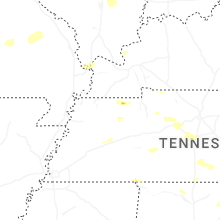

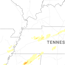


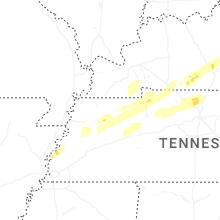


Connect with Interactive Hail Maps