

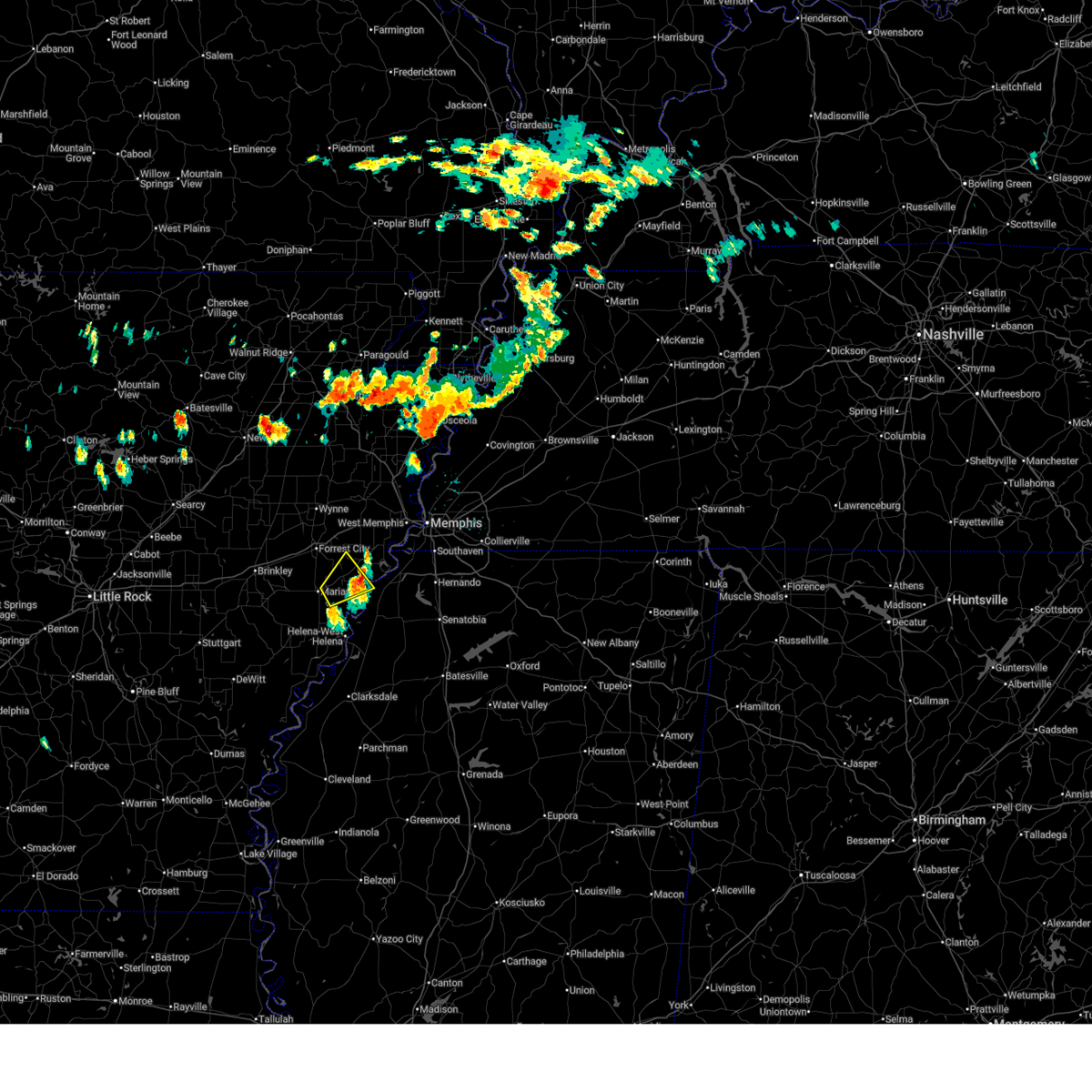
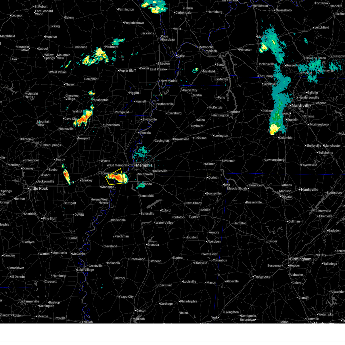
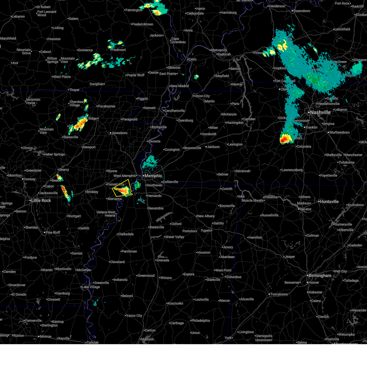
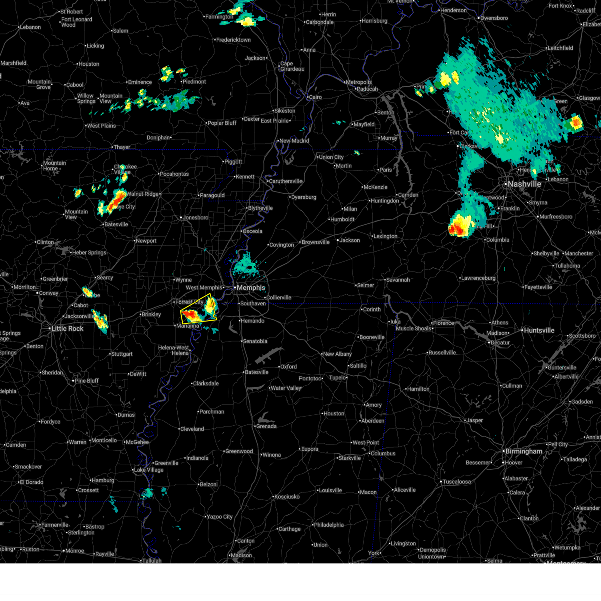
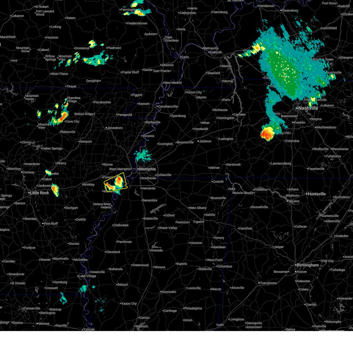
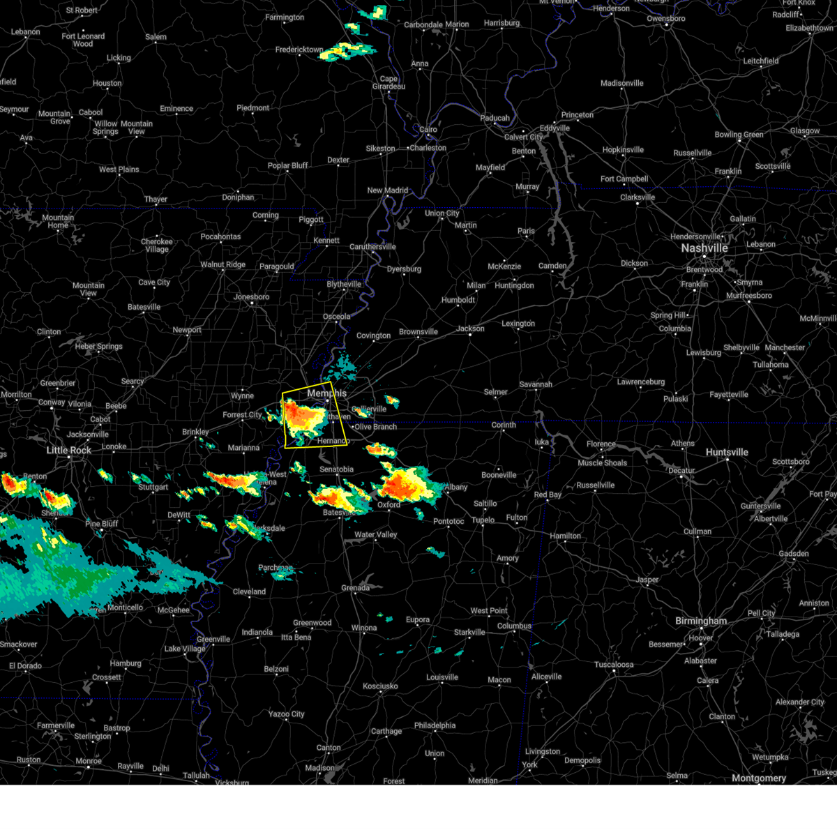
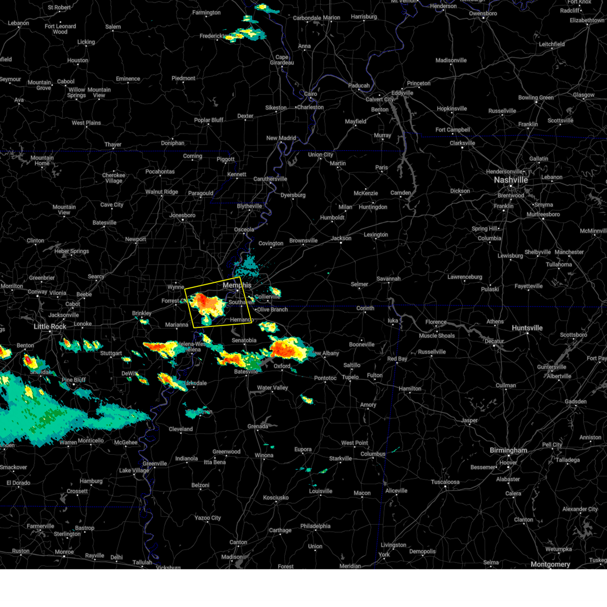
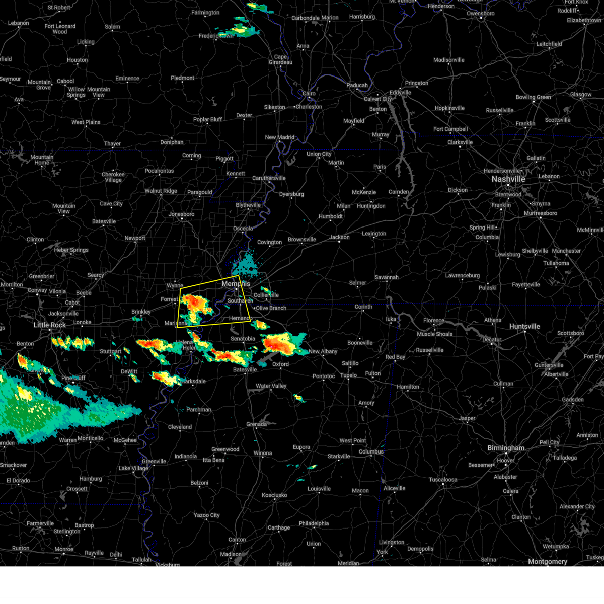
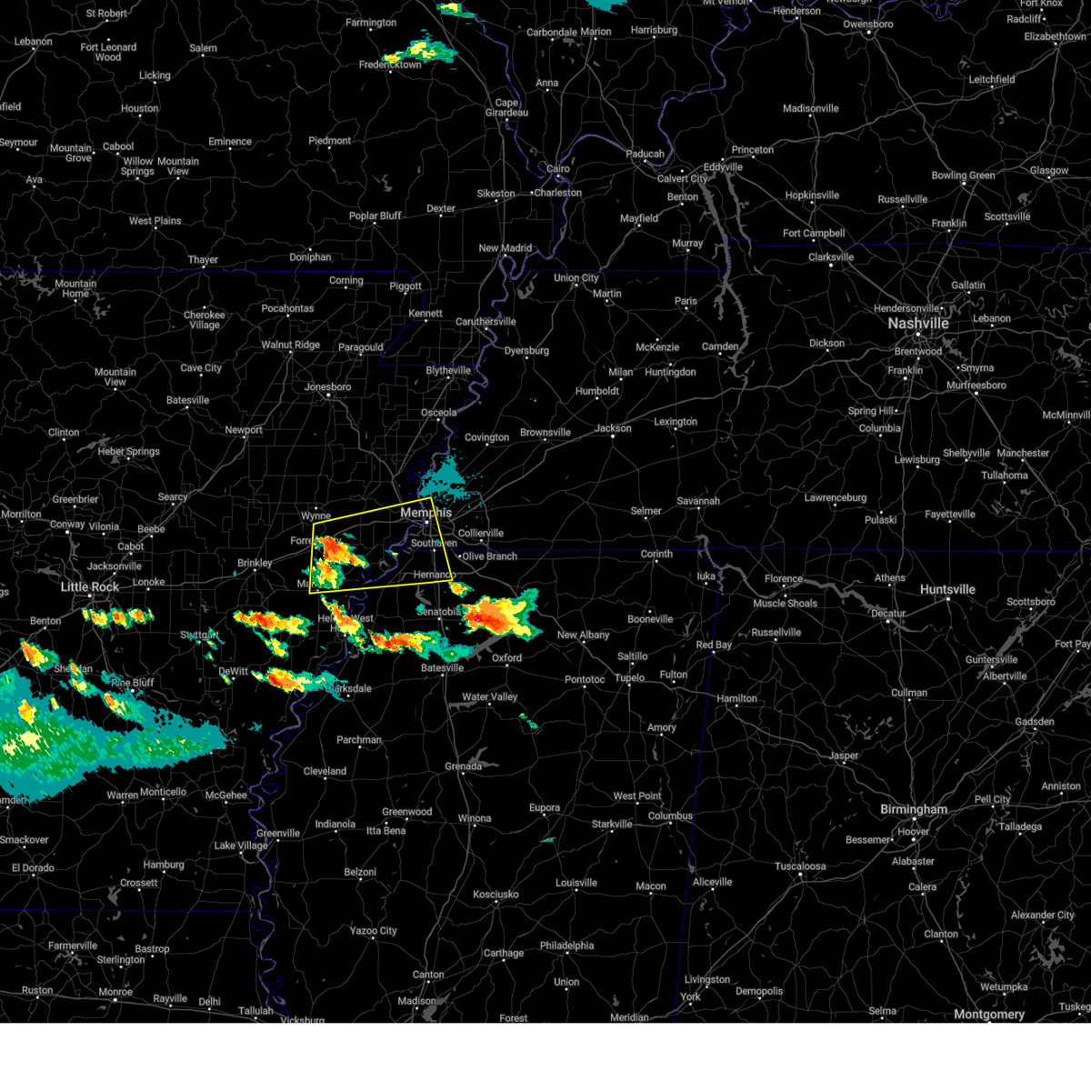
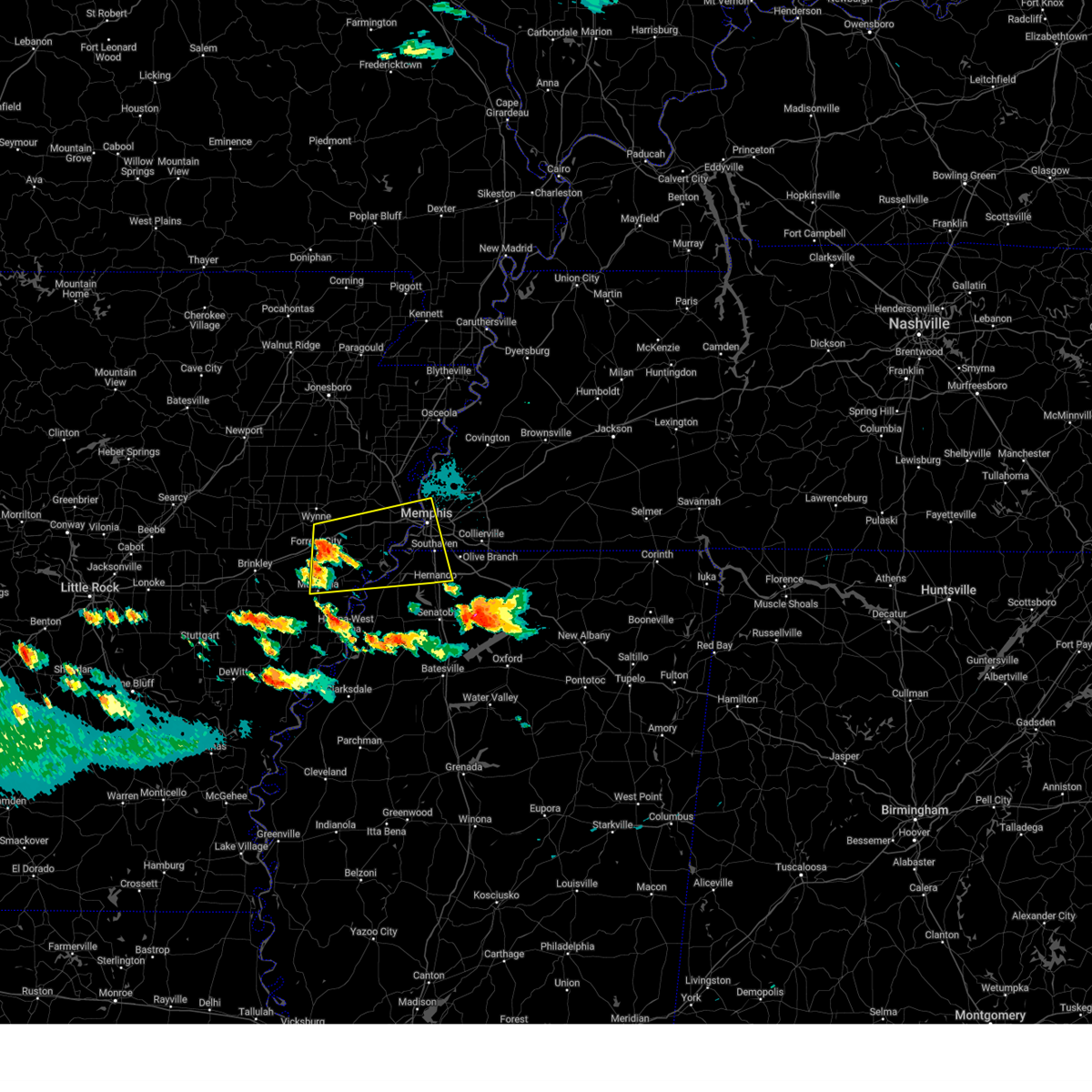
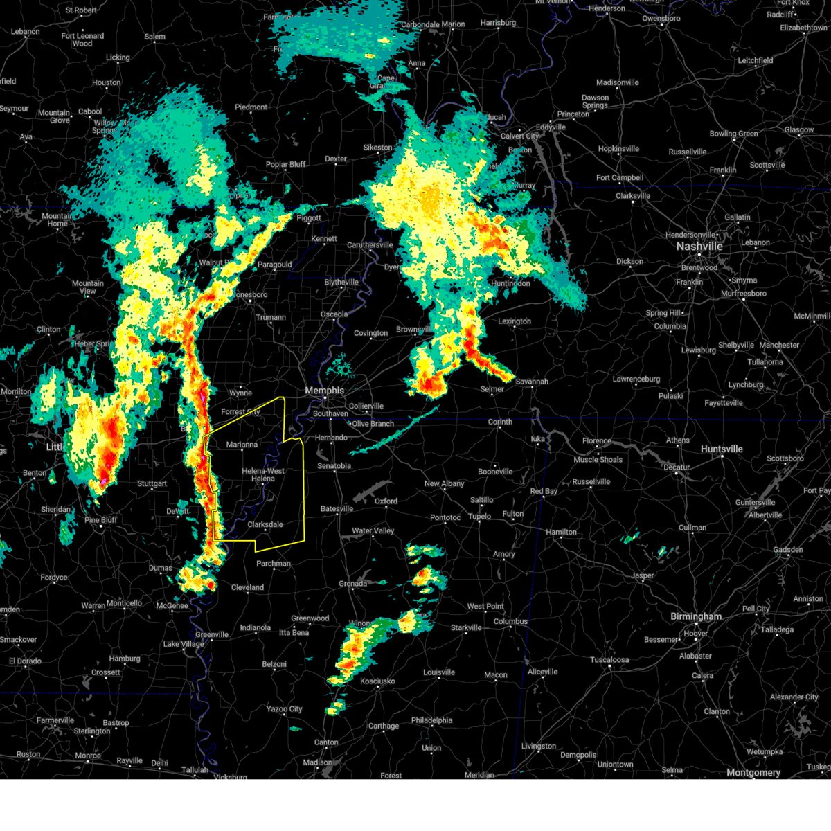
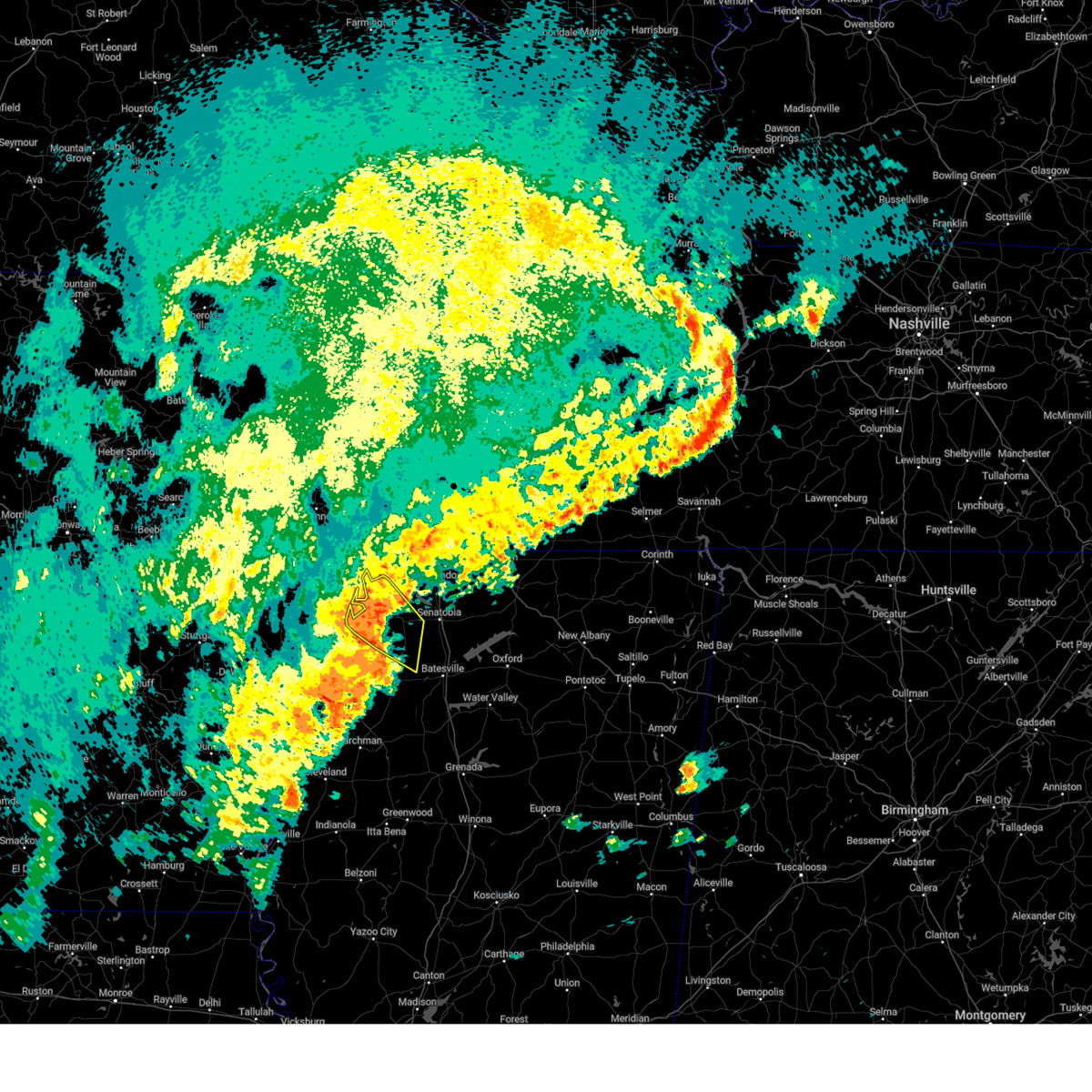
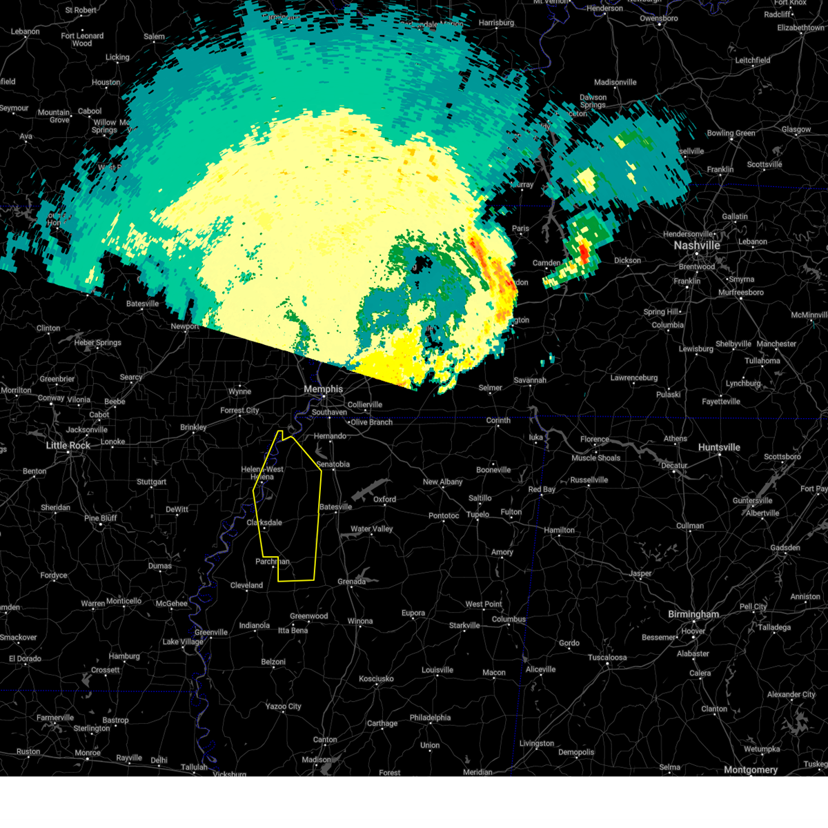
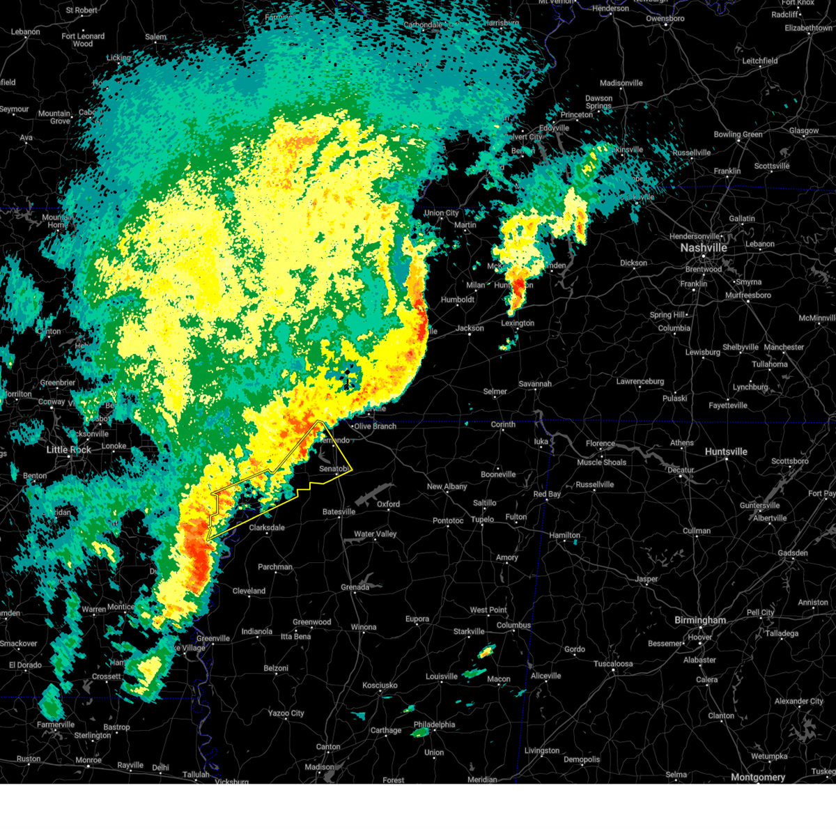
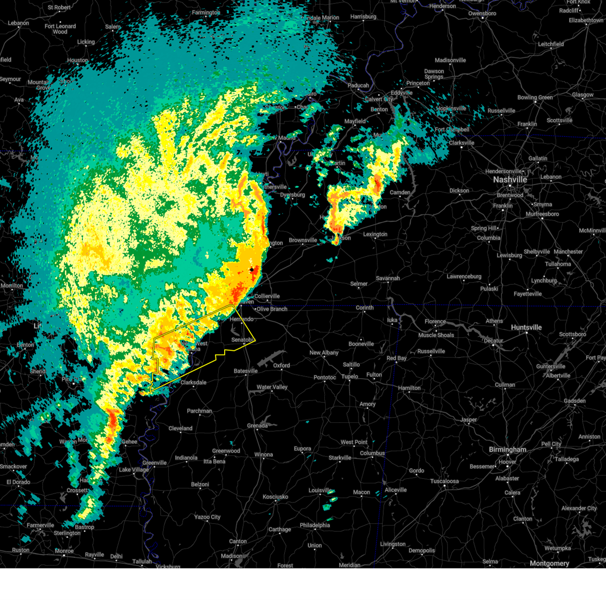
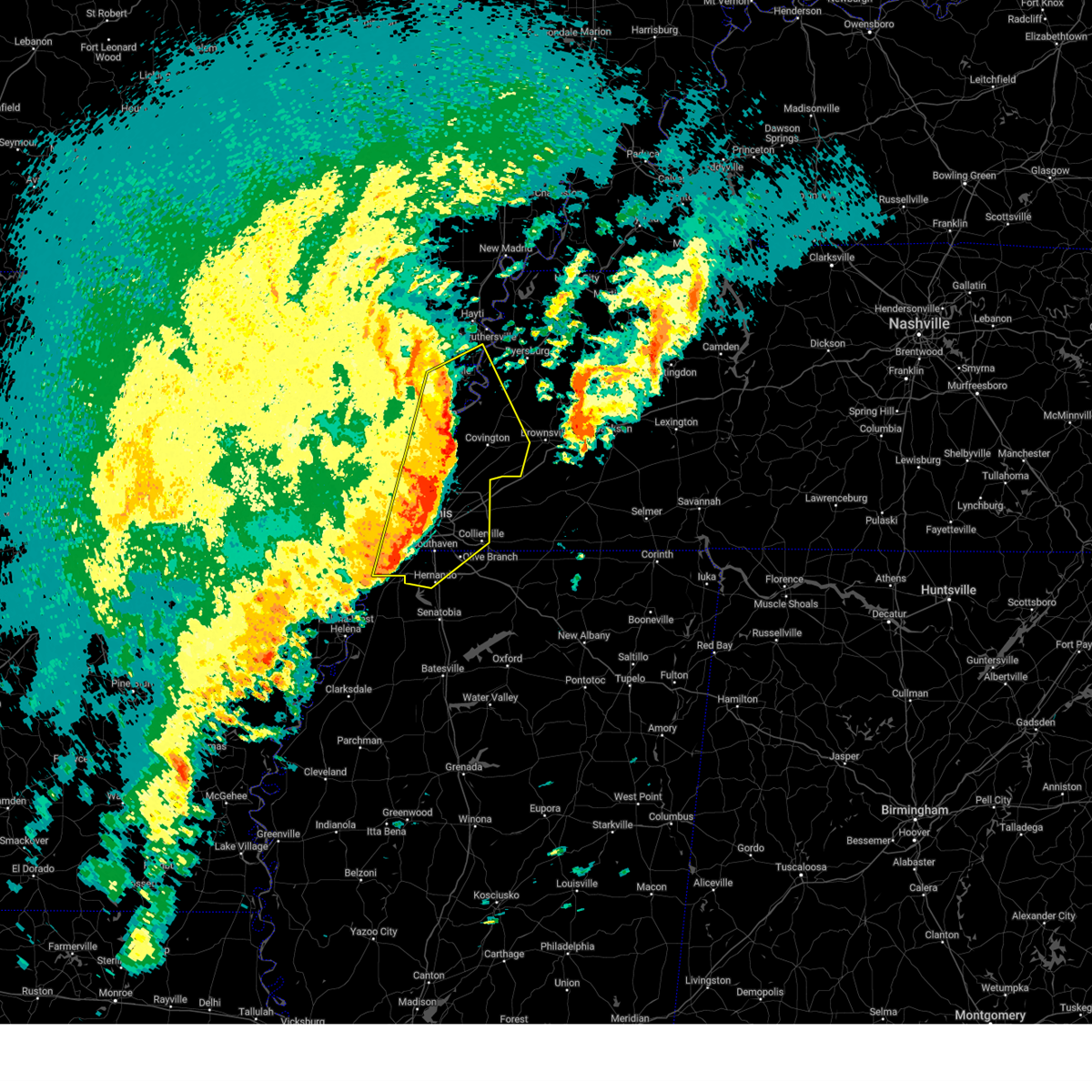
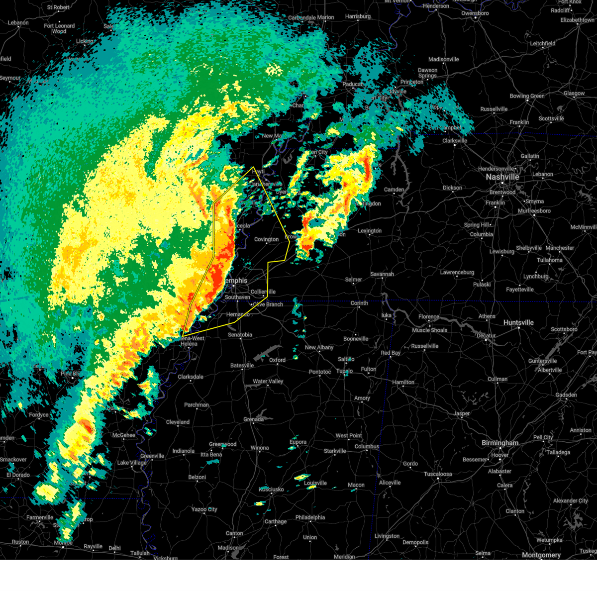
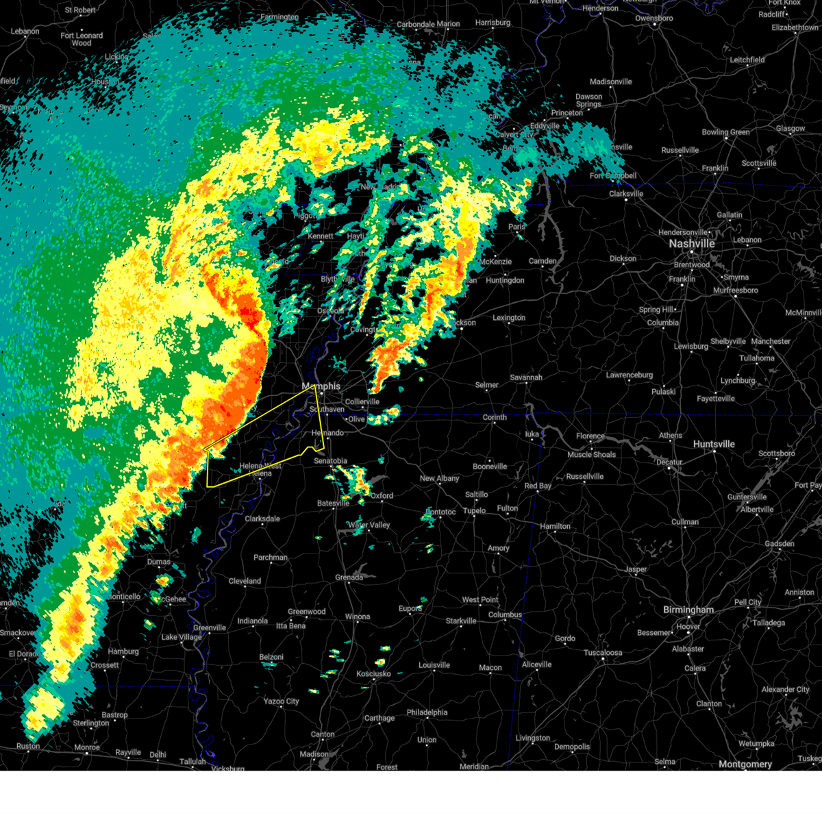
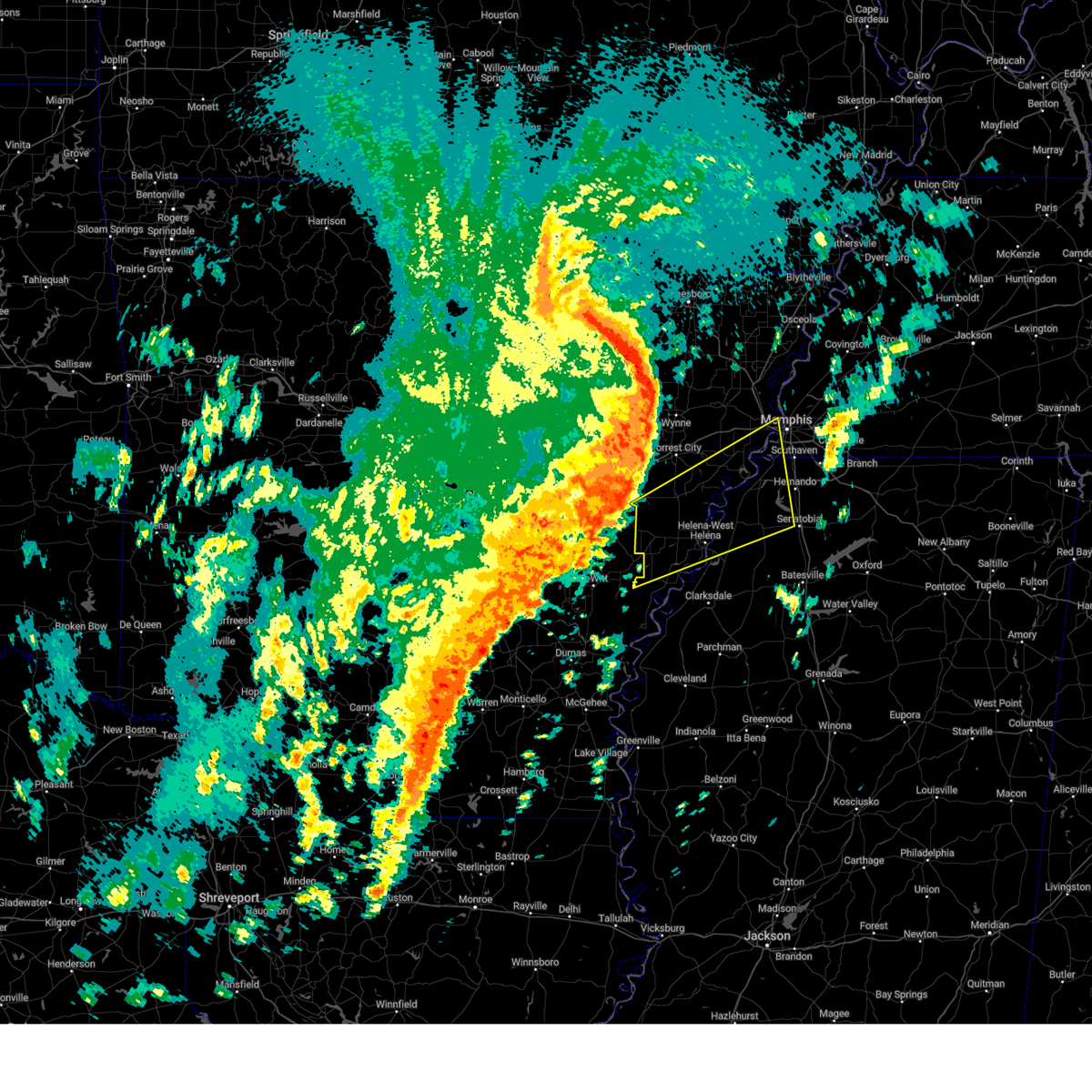
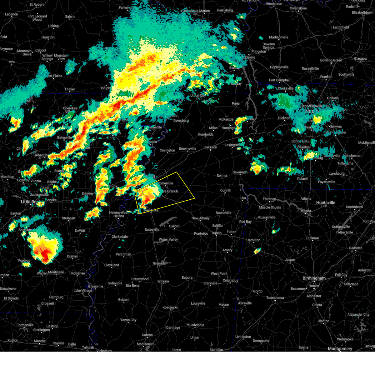
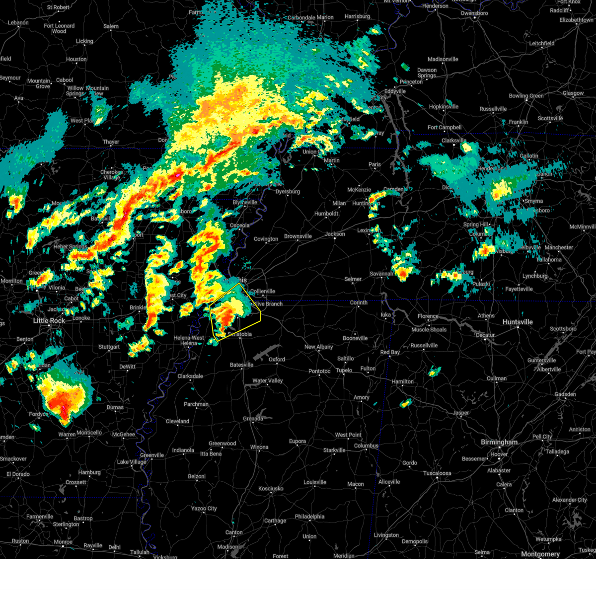
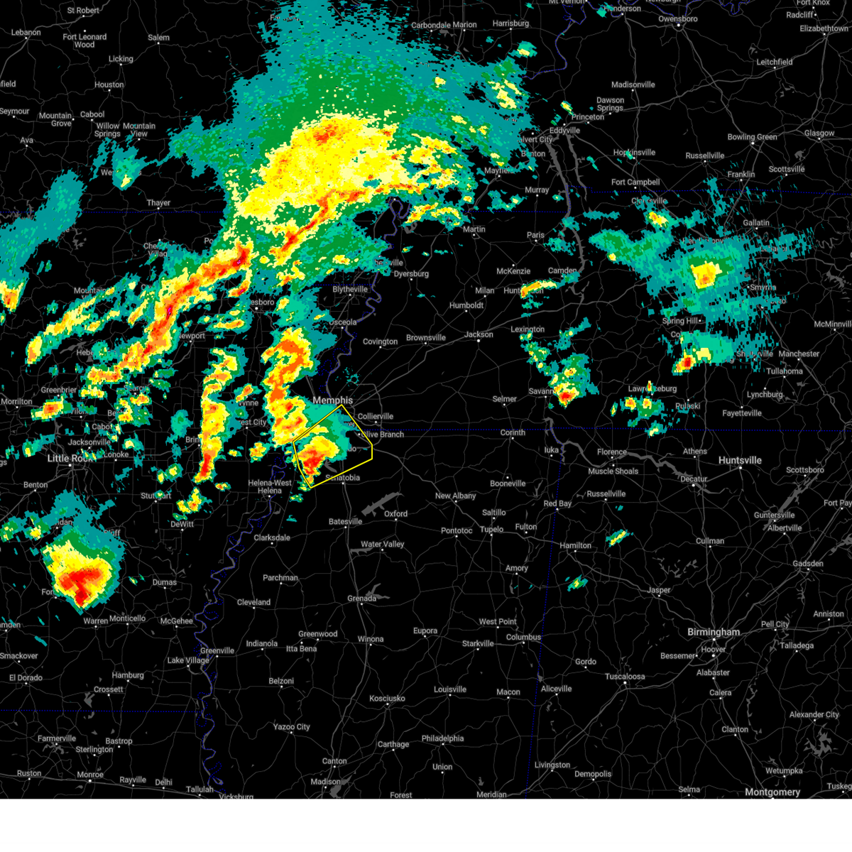
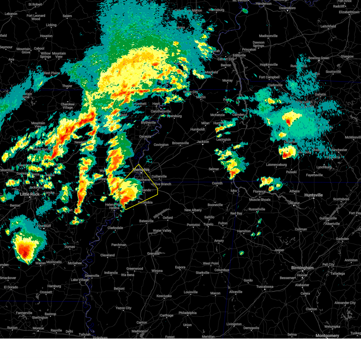
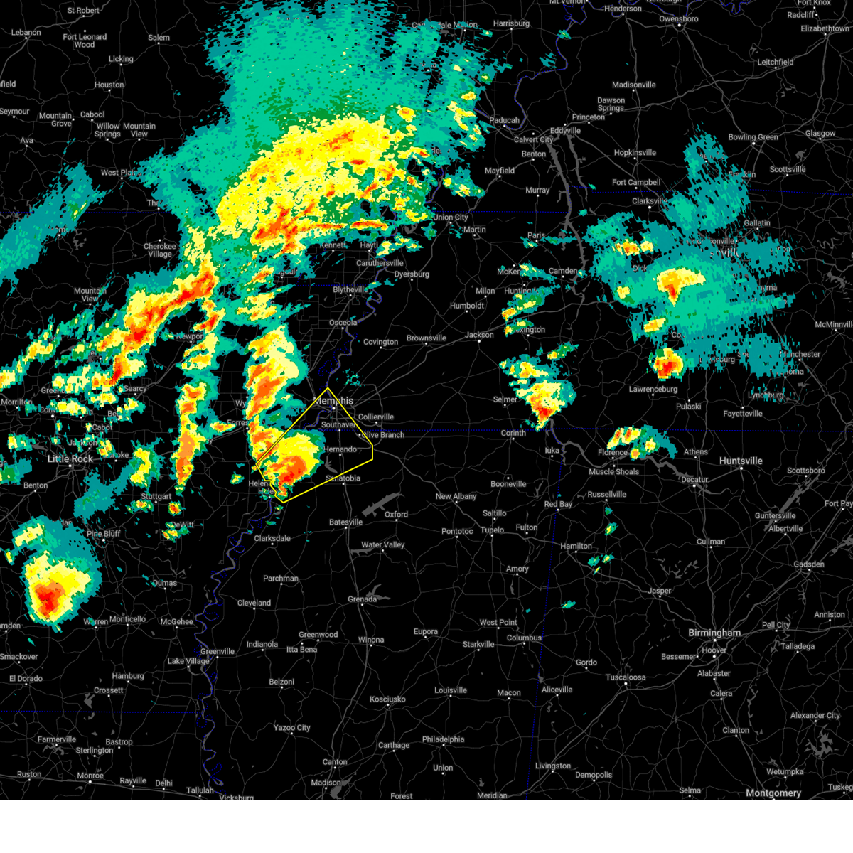
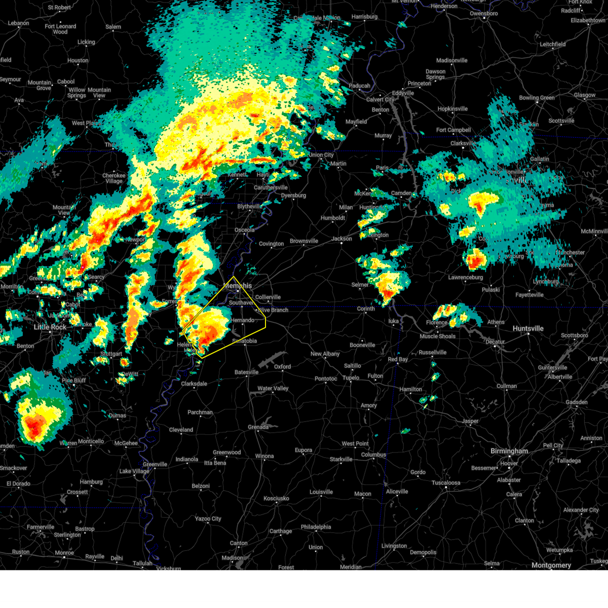
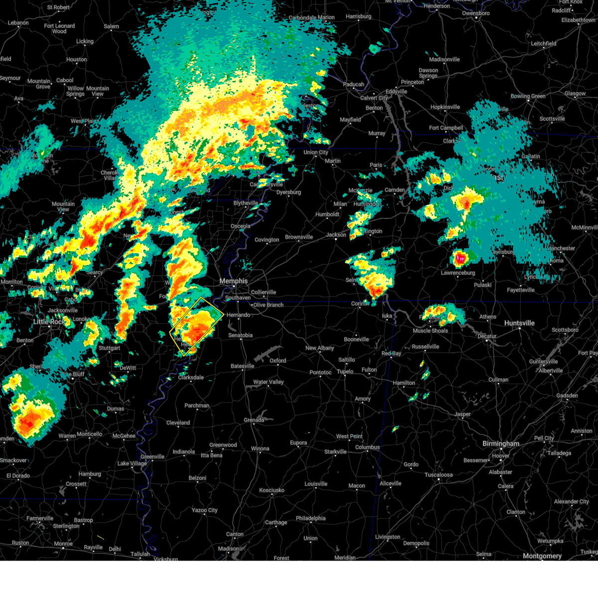
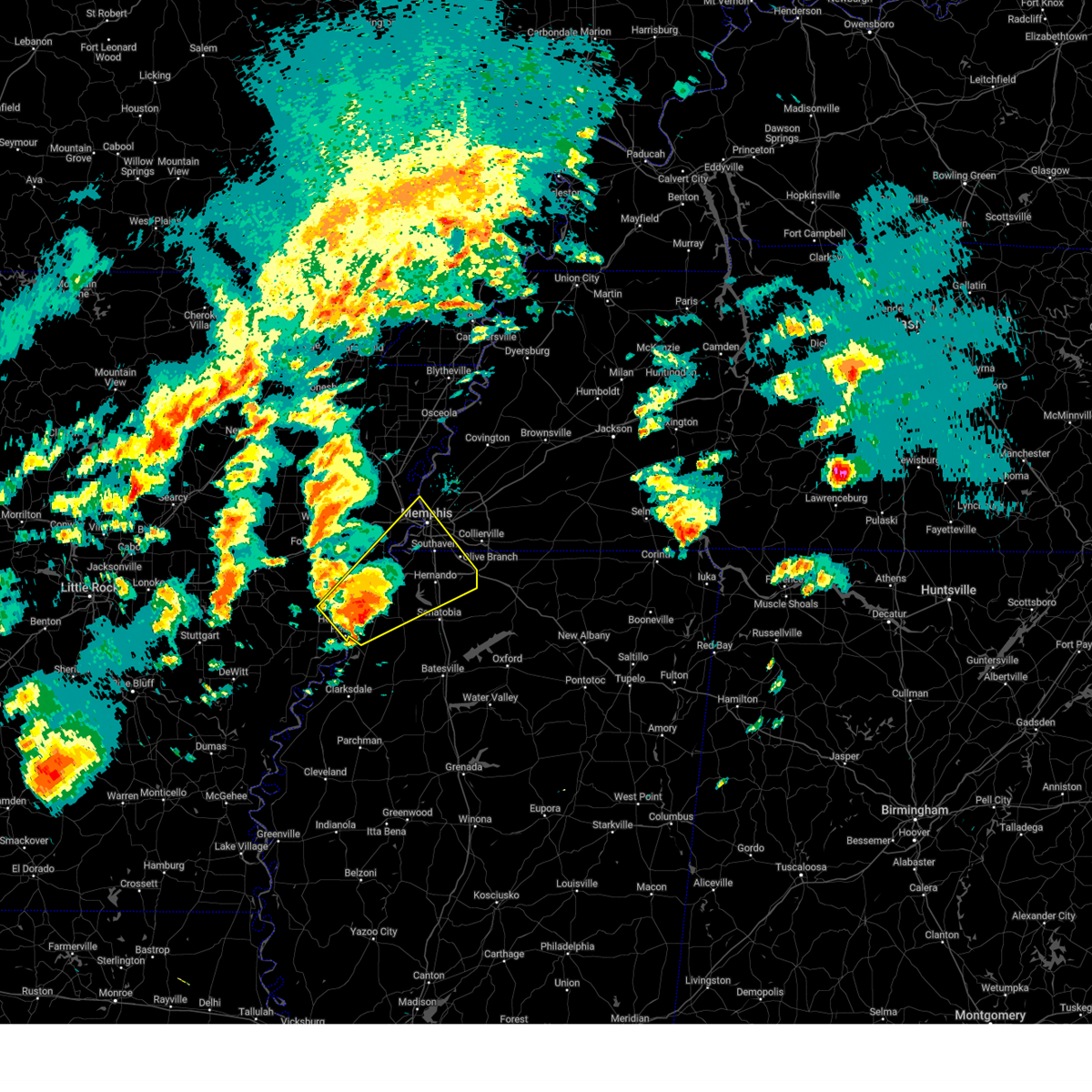
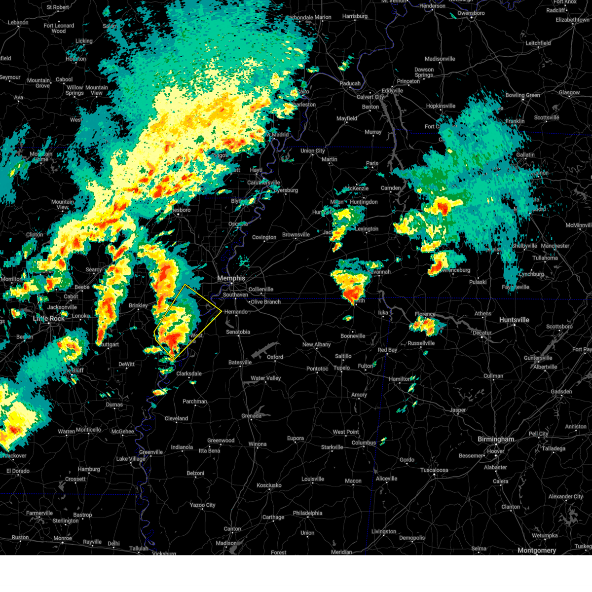
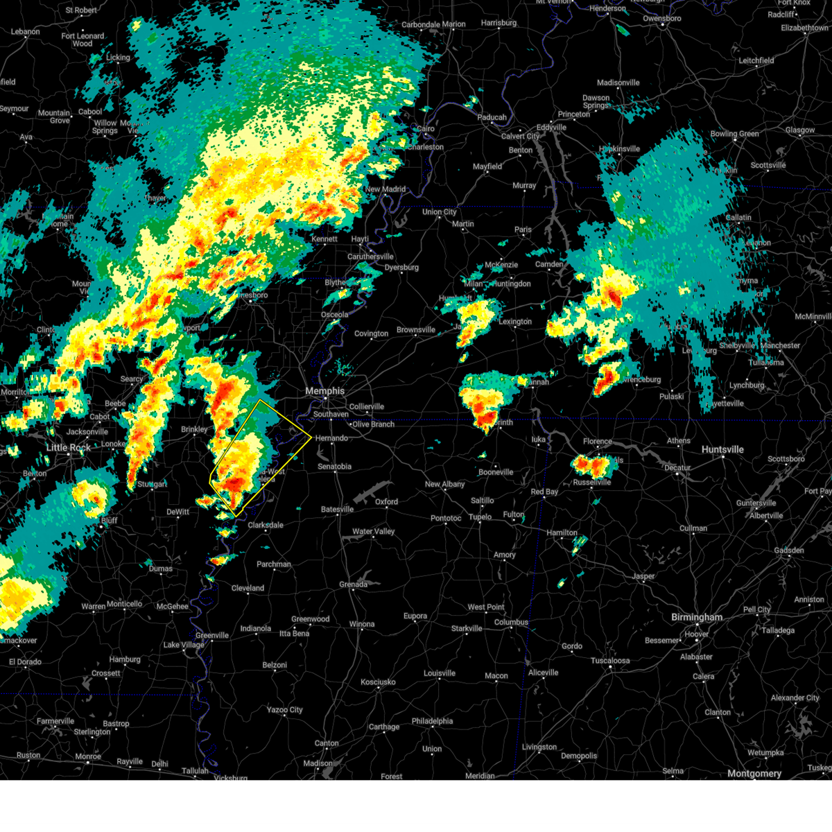
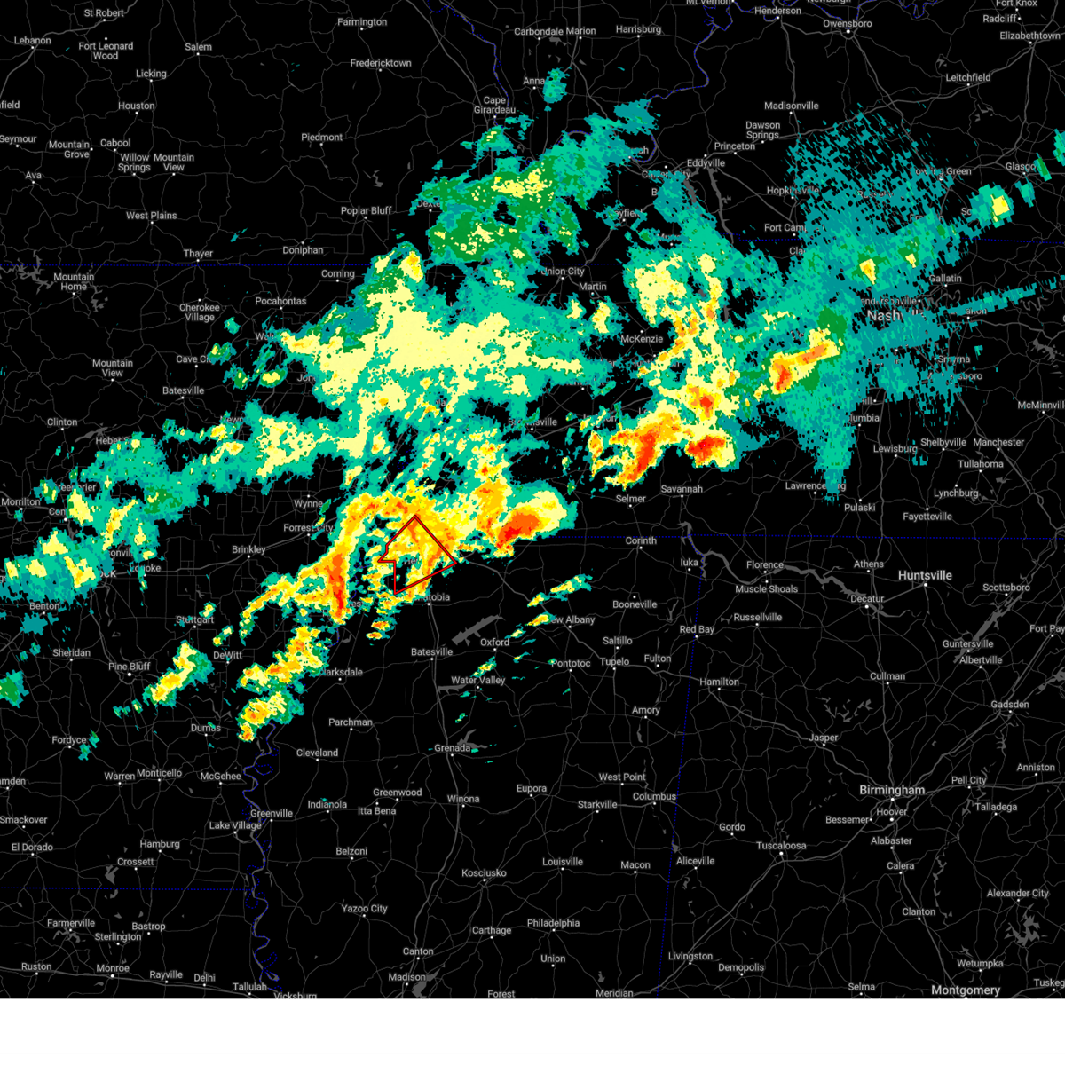
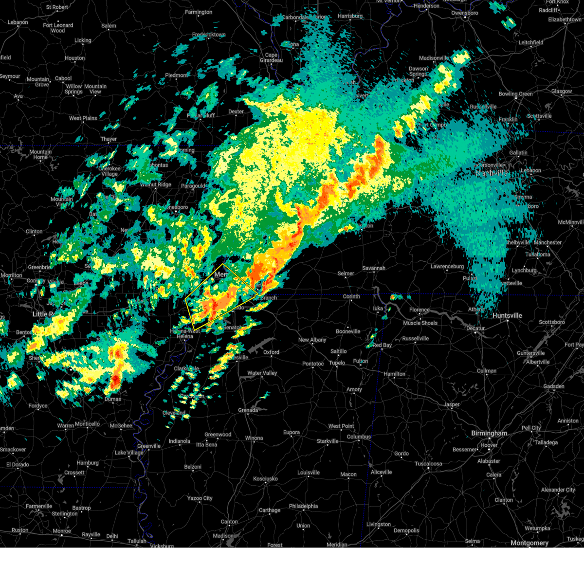
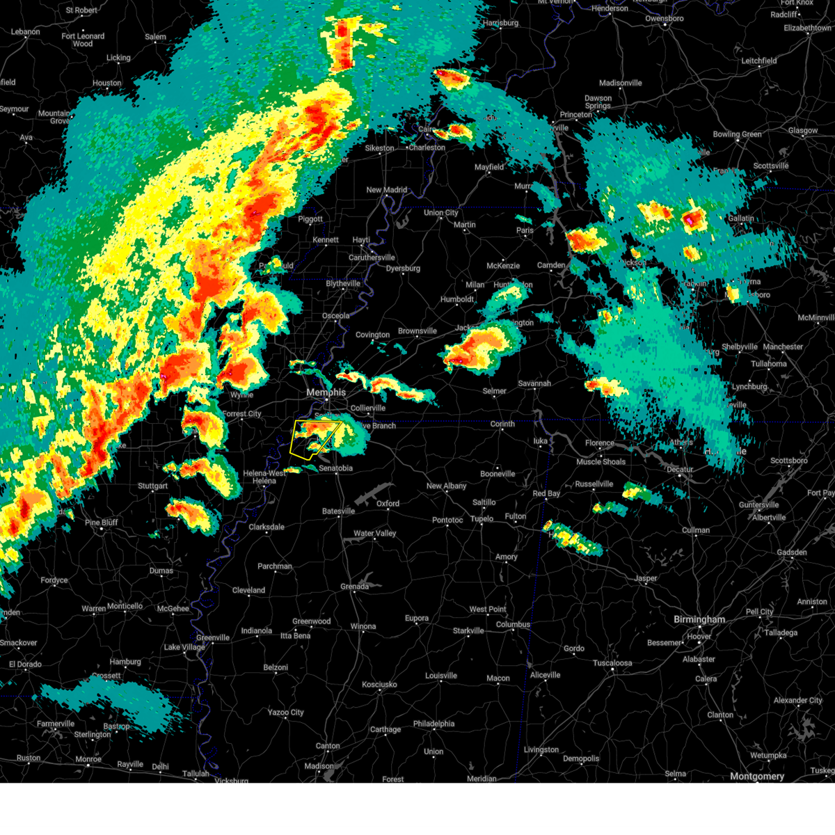
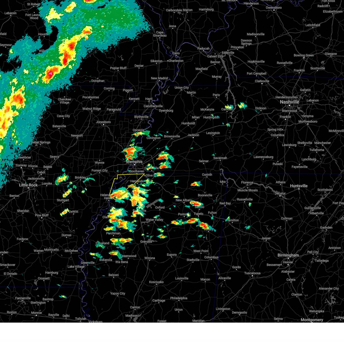
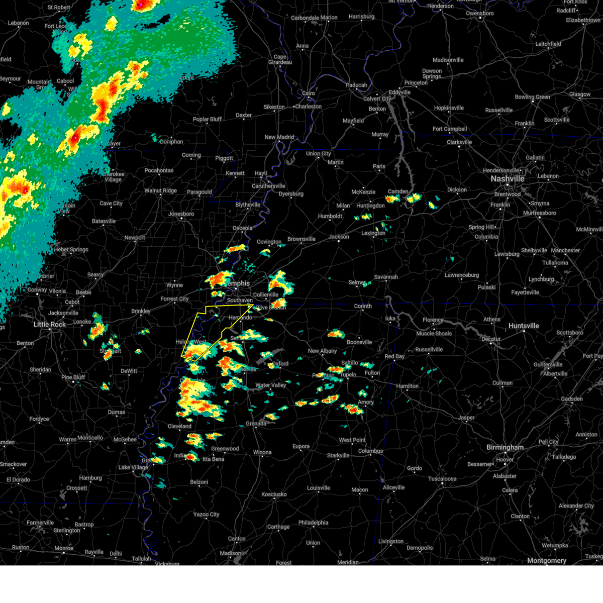
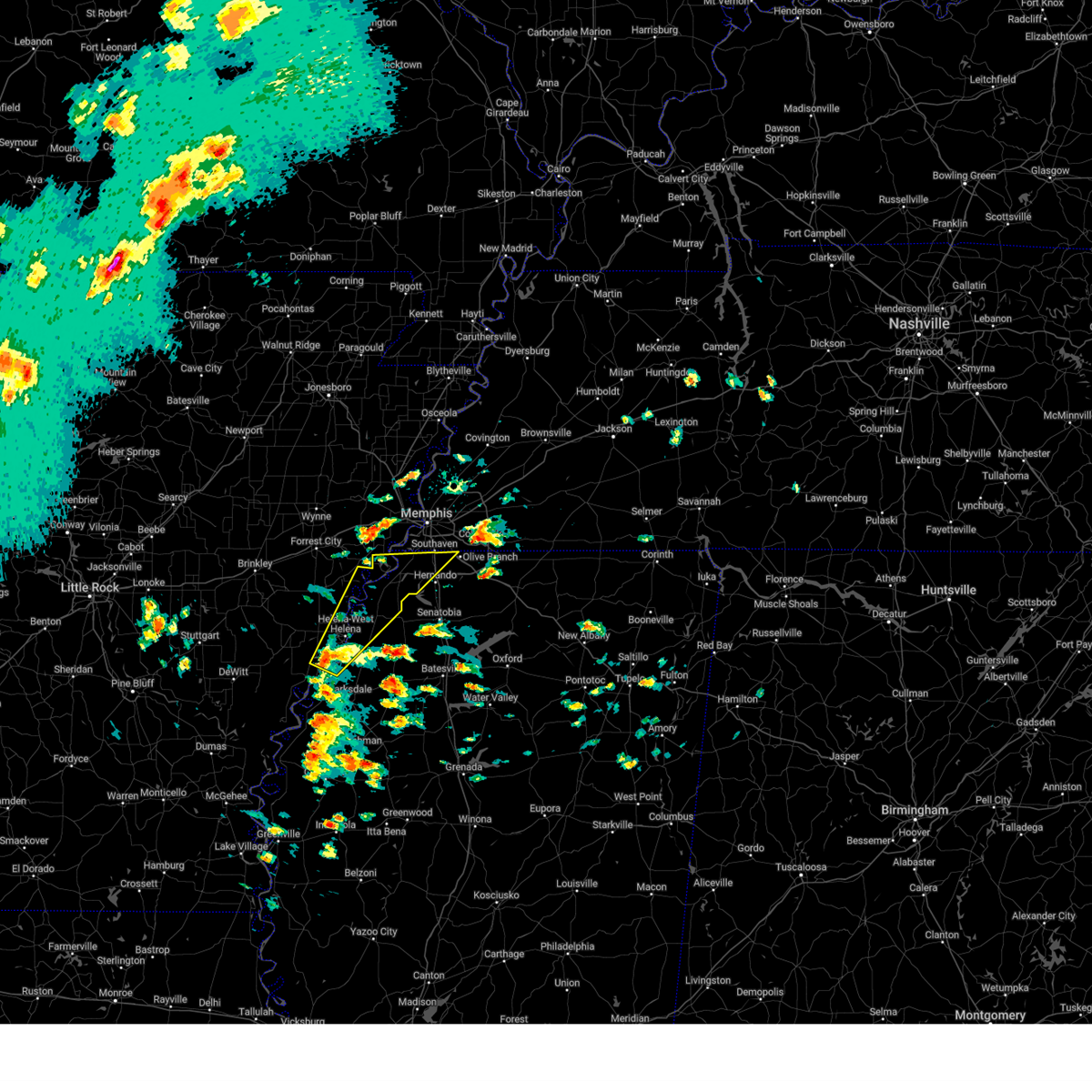
Hail Map for Tunica Resorts, MS
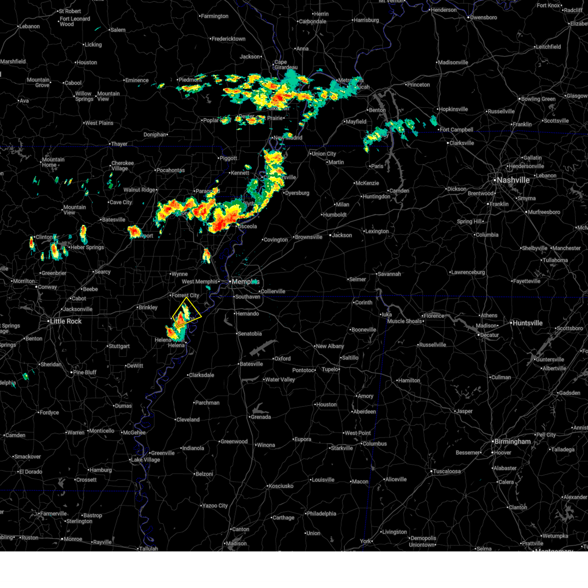
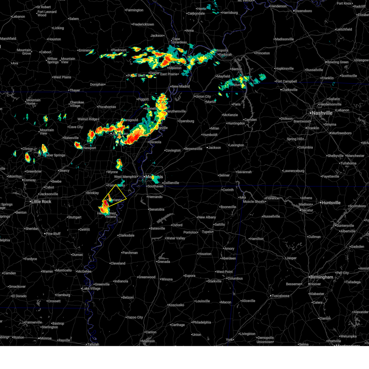
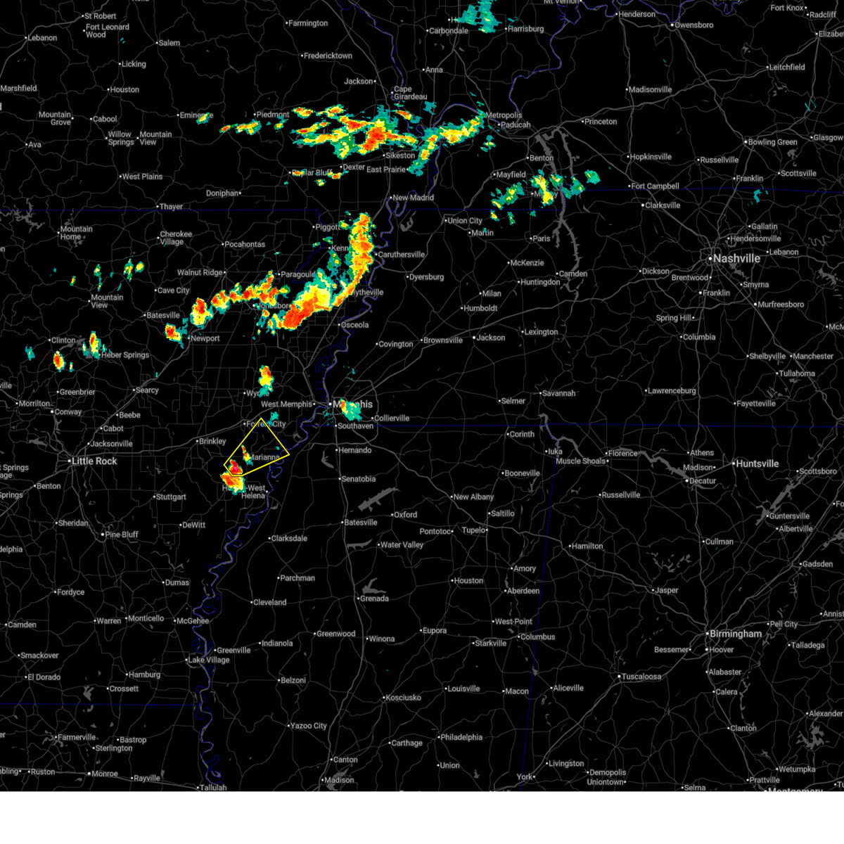
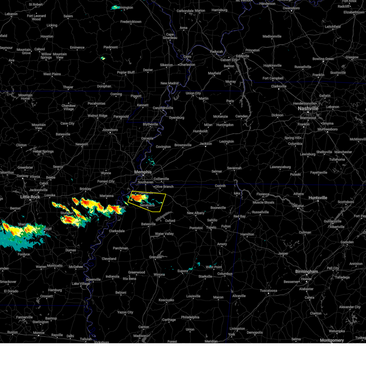
The Tunica Resorts, MS area has had 3 reports of on-the-ground hail by trained spotters, and has been under severe weather warnings 118 times during the past 12 months. Doppler radar has detected hail at or near Tunica Resorts, MS on 75 occasions, including 8 occasions during the past year.
| Name: | Tunica Resorts, MS |
| Where Located: | 27 miles SW of Memphis, TN |
| Map: | Google Map for Tunica Resorts, MS |
| Population: | 1910 |
| Housing Units: | 1054 |
| More Info: | Search Google for Tunica Resorts, MS |
5
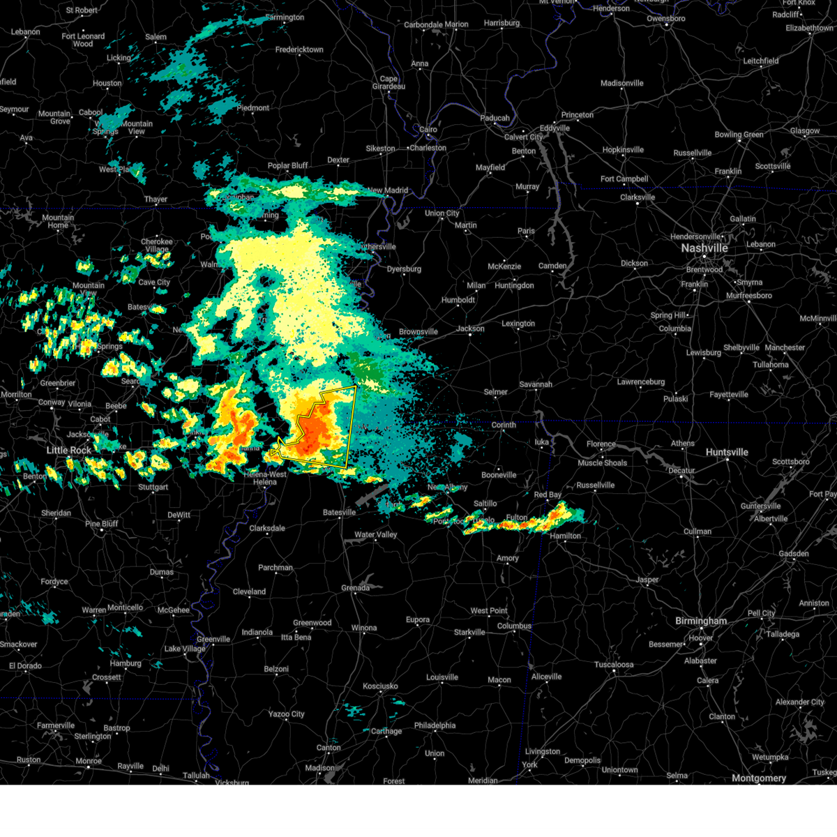
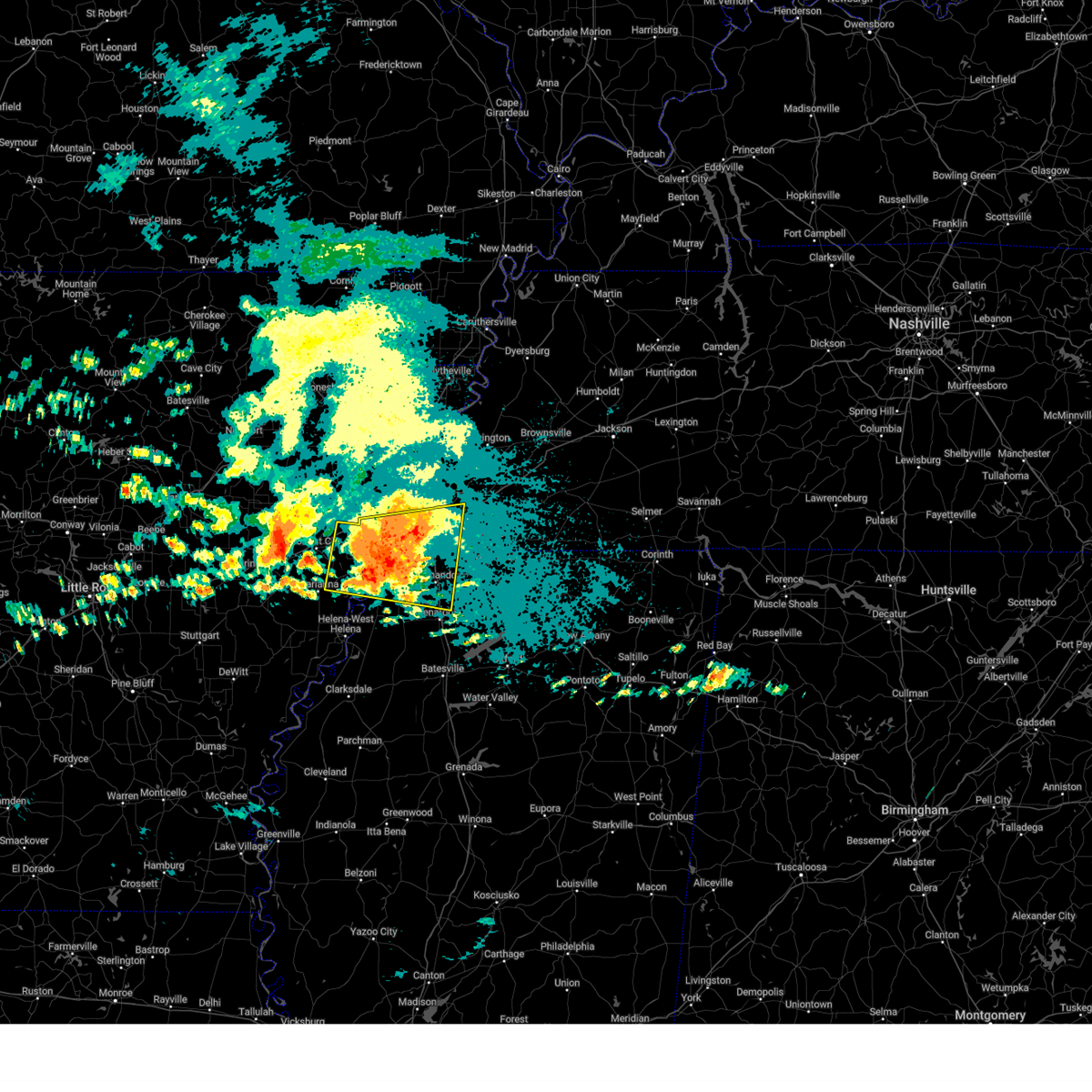
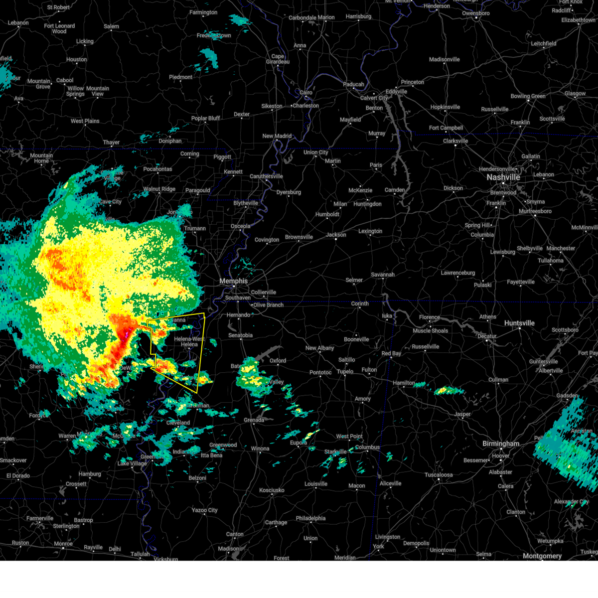
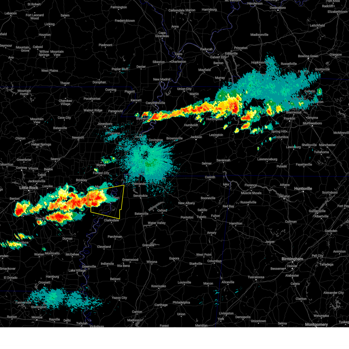
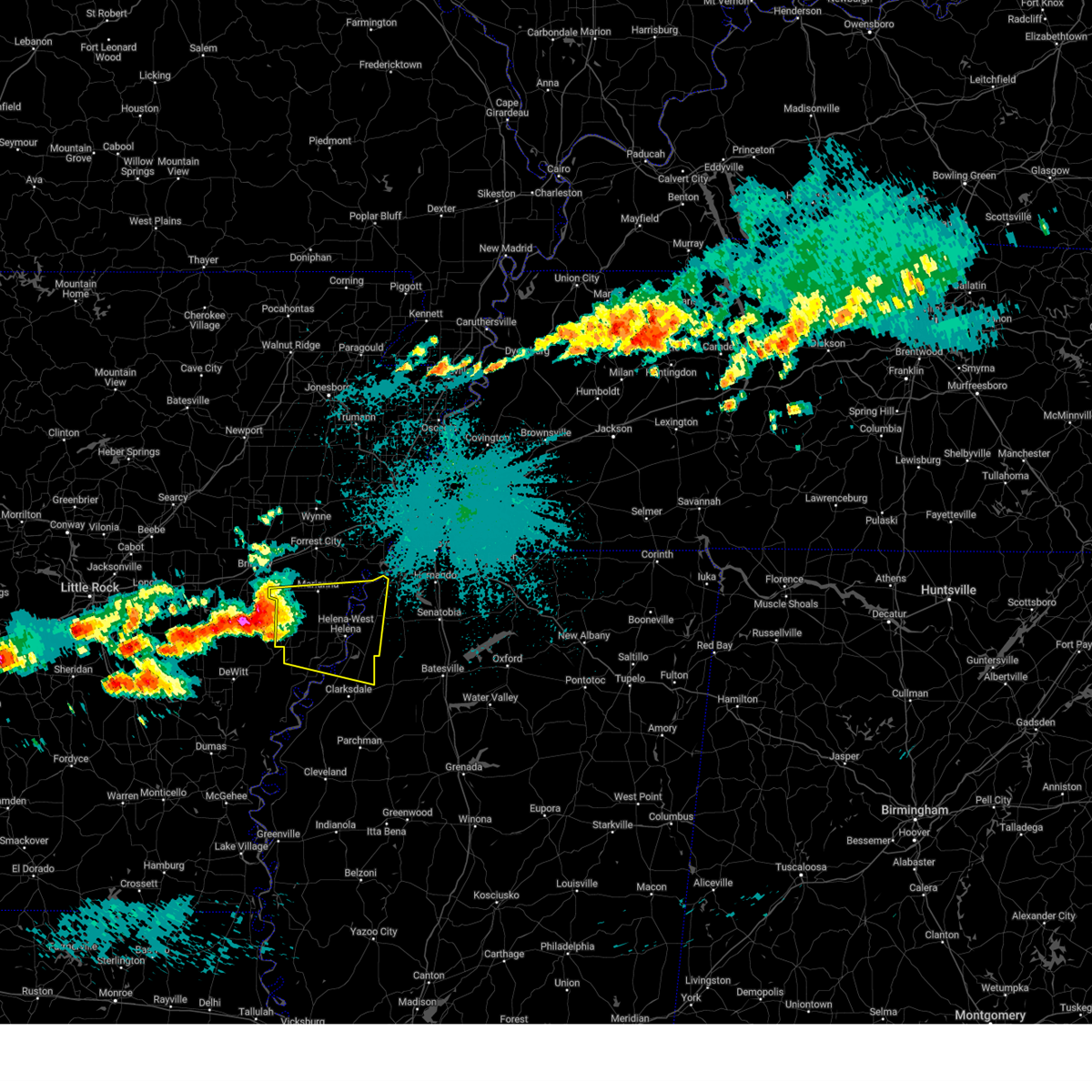
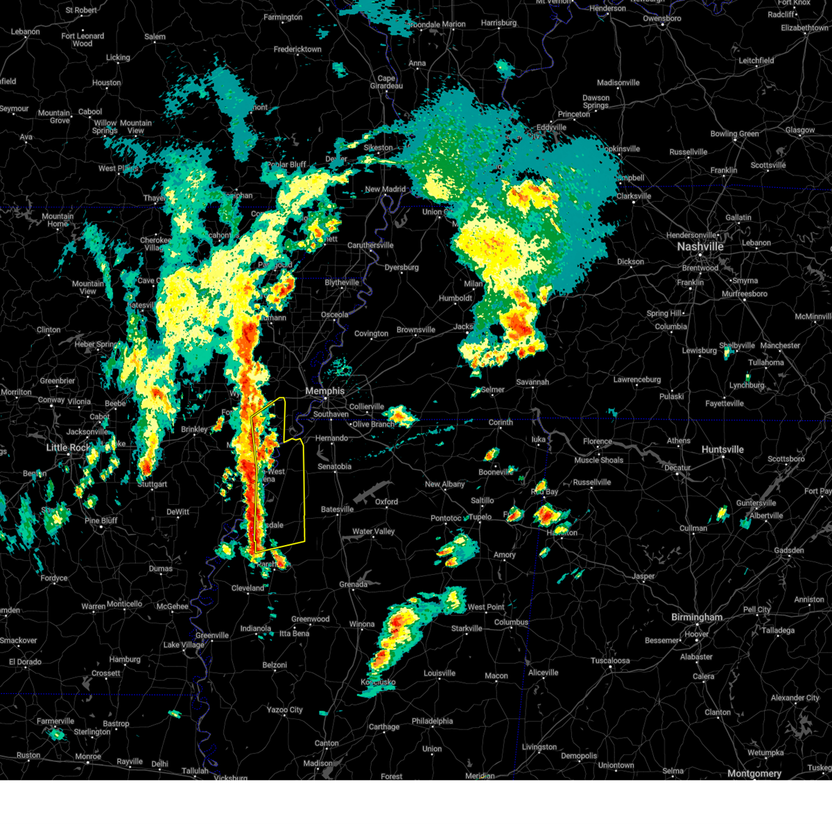
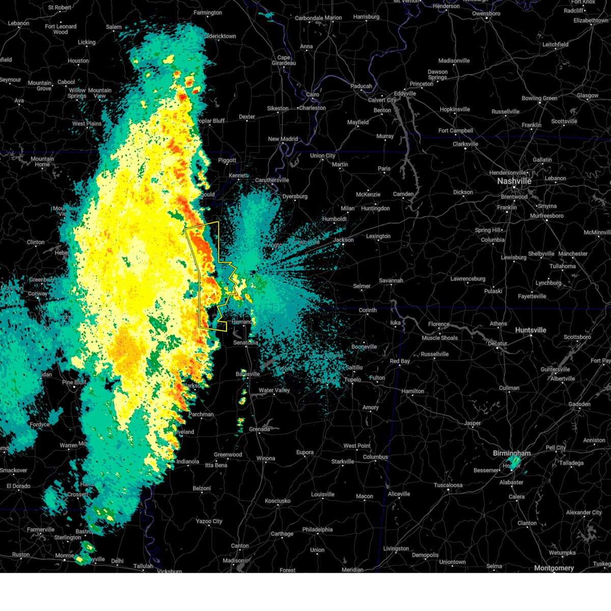
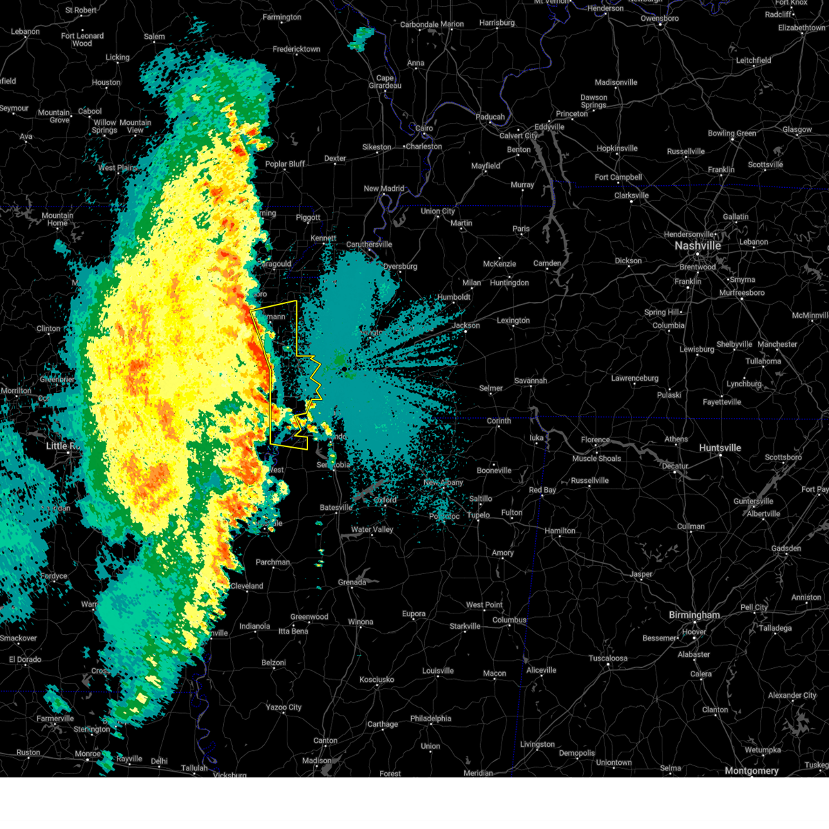
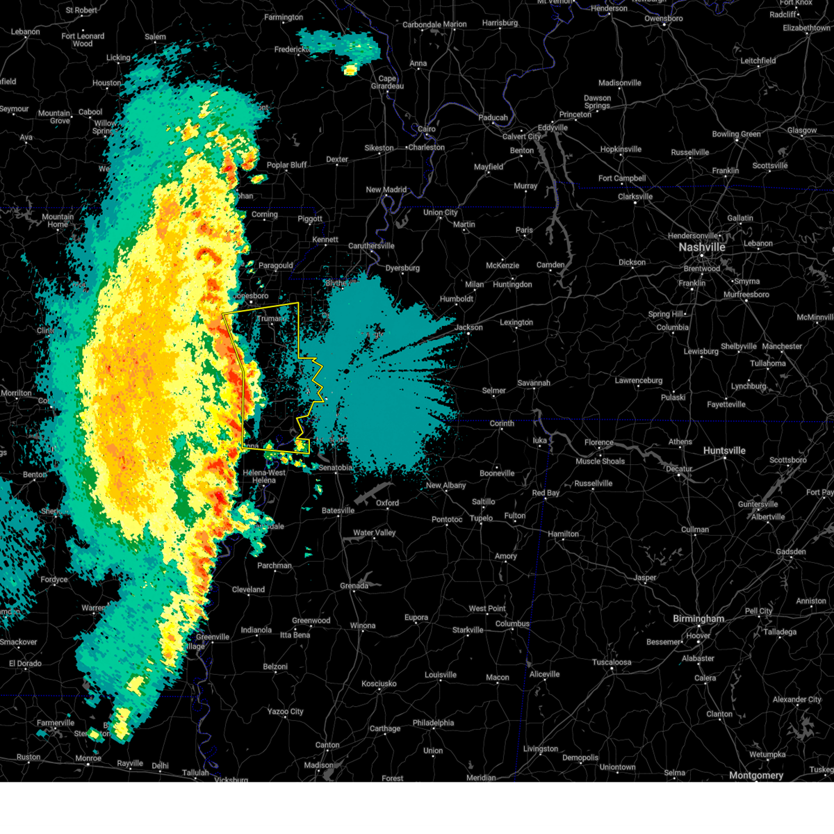
The Top Recent Hail Date for Tunica Resorts, MS is Wednesday, April 2, 2025 (1st out of 75)

Hail and Wind Damage Spotted near Tunica Resorts, MS
| Date / Time | Report Details |
|---|---|
| 6/18/2025 11:30 PM CDT |
 The storm which prompted the warning has weakened below severe limits, and no longer poses an immediate threat to life or property. therefore, the warning will be allowed to expire. The storm which prompted the warning has weakened below severe limits, and no longer poses an immediate threat to life or property. therefore, the warning will be allowed to expire.
|
| 6/18/2025 11:12 PM CDT |
 At 1112 pm cdt, a severe thunderstorm was located near brickeys, or near marianna, moving northeast at 35 mph (radar indicated). Hazards include 60 mph wind gusts and quarter size hail. Hail damage to vehicles is expected. expect wind damage to roofs, siding, and trees. Locations impacted include, brickeys, rawlinson, jeffersonville, raggio, cody, gassett, kokomo, haleside, mud lake, dansby, soudan, peters, council, diamond woods, ball point, whitehall, tongin, and mississippi river state park. At 1112 pm cdt, a severe thunderstorm was located near brickeys, or near marianna, moving northeast at 35 mph (radar indicated). Hazards include 60 mph wind gusts and quarter size hail. Hail damage to vehicles is expected. expect wind damage to roofs, siding, and trees. Locations impacted include, brickeys, rawlinson, jeffersonville, raggio, cody, gassett, kokomo, haleside, mud lake, dansby, soudan, peters, council, diamond woods, ball point, whitehall, tongin, and mississippi river state park.
|
| 6/18/2025 11:01 PM CDT |
 At 1101 pm cdt, a severe thunderstorm was located over marianna, moving east at 35 mph (radar indicated). Hazards include 60 mph wind gusts and quarter size hail. Hail damage to vehicles is expected. expect wind damage to roofs, siding, and trees. Locations impacted include, marianna, brickeys, rawlinson, jeffersonville, raggio, cody, gassett, kokomo, haleside, mud lake, dansby, soudan, peters, burnt cane, council, felton, diamond woods, ball point, whitehall, and scott valley. At 1101 pm cdt, a severe thunderstorm was located over marianna, moving east at 35 mph (radar indicated). Hazards include 60 mph wind gusts and quarter size hail. Hail damage to vehicles is expected. expect wind damage to roofs, siding, and trees. Locations impacted include, marianna, brickeys, rawlinson, jeffersonville, raggio, cody, gassett, kokomo, haleside, mud lake, dansby, soudan, peters, burnt cane, council, felton, diamond woods, ball point, whitehall, and scott valley.
|
| 6/18/2025 10:52 PM CDT |
 Svrmeg the national weather service in memphis has issued a * severe thunderstorm warning for, central lee county in eastern arkansas, southeastern st. francis county in eastern arkansas, northwestern tunica county in northwestern mississippi, * until 1130 pm cdt. * at 1051 pm cdt, a severe thunderstorm was located over aubrey, or 7 miles southwest of marianna, moving northeast at 35 mph (radar indicated). Hazards include 60 mph wind gusts and quarter size hail. Hail damage to vehicles is expected. Expect wind damage to roofs, siding, and trees. Svrmeg the national weather service in memphis has issued a * severe thunderstorm warning for, central lee county in eastern arkansas, southeastern st. francis county in eastern arkansas, northwestern tunica county in northwestern mississippi, * until 1130 pm cdt. * at 1051 pm cdt, a severe thunderstorm was located over aubrey, or 7 miles southwest of marianna, moving northeast at 35 mph (radar indicated). Hazards include 60 mph wind gusts and quarter size hail. Hail damage to vehicles is expected. Expect wind damage to roofs, siding, and trees.
|
| 6/18/2025 9:24 PM CDT |
 The storm which prompted the warning has moved out of the area. therefore, the warning will be allowed to expire. remember, a severe thunderstorm warning still remains in effect for lee, crittenden, and saint francis counties. The storm which prompted the warning has moved out of the area. therefore, the warning will be allowed to expire. remember, a severe thunderstorm warning still remains in effect for lee, crittenden, and saint francis counties.
|
| 6/18/2025 9:09 PM CDT |
 At 908 pm cdt, a severe thunderstorm was located near hughes, moving northeast at 20 mph (radar indicated). Hazards include 60 mph wind gusts and quarter size hail. Hail damage to vehicles is expected. expect wind damage to roofs, siding, and trees. Locations impacted include, hughes, horseshoe lake, anthonyville, simsboro, brickeys, rawlinson, gassett, chatfield, clack, kokomo, kate, penjur, mud lake, council, greasy corner, seyppel, beck, bruins, democrat, and north hughes. At 908 pm cdt, a severe thunderstorm was located near hughes, moving northeast at 20 mph (radar indicated). Hazards include 60 mph wind gusts and quarter size hail. Hail damage to vehicles is expected. expect wind damage to roofs, siding, and trees. Locations impacted include, hughes, horseshoe lake, anthonyville, simsboro, brickeys, rawlinson, gassett, chatfield, clack, kokomo, kate, penjur, mud lake, council, greasy corner, seyppel, beck, bruins, democrat, and north hughes.
|
| 6/18/2025 9:00 PM CDT |
 At 859 pm cdt, a severe thunderstorm was located over brickeys, or 7 miles southwest of hughes, moving east at 25 mph (radar indicated). Hazards include 60 mph wind gusts and quarter size hail. Hail damage to vehicles is expected. expect wind damage to roofs, siding, and trees. Locations impacted include, hughes, horseshoe lake, anthonyville, simsboro, brickeys, cody, clack, kokomo, kate, mud lake, soudan, peters, council, beck, bruins, democrat, north hughes, ball point, shannondale, and tongin. At 859 pm cdt, a severe thunderstorm was located over brickeys, or 7 miles southwest of hughes, moving east at 25 mph (radar indicated). Hazards include 60 mph wind gusts and quarter size hail. Hail damage to vehicles is expected. expect wind damage to roofs, siding, and trees. Locations impacted include, hughes, horseshoe lake, anthonyville, simsboro, brickeys, cody, clack, kokomo, kate, mud lake, soudan, peters, council, beck, bruins, democrat, north hughes, ball point, shannondale, and tongin.
|
| 6/18/2025 8:42 PM CDT |
 Svrmeg the national weather service in memphis has issued a * severe thunderstorm warning for, northeastern lee county in eastern arkansas, southeastern st. francis county in eastern arkansas, southwestern crittenden county in eastern arkansas, northwestern tunica county in northwestern mississippi, * until 930 pm cdt. * at 842 pm cdt, a severe thunderstorm was located near brickeys, or 10 miles southwest of hughes, moving east at 25 mph (radar indicated). Hazards include 60 mph wind gusts and quarter size hail. Hail damage to vehicles is expected. Expect wind damage to roofs, siding, and trees. Svrmeg the national weather service in memphis has issued a * severe thunderstorm warning for, northeastern lee county in eastern arkansas, southeastern st. francis county in eastern arkansas, southwestern crittenden county in eastern arkansas, northwestern tunica county in northwestern mississippi, * until 930 pm cdt. * at 842 pm cdt, a severe thunderstorm was located near brickeys, or 10 miles southwest of hughes, moving east at 25 mph (radar indicated). Hazards include 60 mph wind gusts and quarter size hail. Hail damage to vehicles is expected. Expect wind damage to roofs, siding, and trees.
|
| 6/7/2025 9:27 PM CDT |
 At 927 pm cdt, a severe thunderstorm was located near edmondson, or near west memphis, moving east at 45 mph (radar indicated). Hazards include 60 mph wind gusts and half dollar size hail. Hail damage to vehicles is expected. expect wind damage to roofs, siding, and trees. Locations impacted include, southaven, west memphis, horn lake, hernando, marion, t o fuller state park, memphis, walls, crawfordsville, edmondson, horseshoe lake, sunset, anthonyville, jennette, lake cormorant, southwest memphis, eudora, simsboro, whitehaven, and midtown memphis. At 927 pm cdt, a severe thunderstorm was located near edmondson, or near west memphis, moving east at 45 mph (radar indicated). Hazards include 60 mph wind gusts and half dollar size hail. Hail damage to vehicles is expected. expect wind damage to roofs, siding, and trees. Locations impacted include, southaven, west memphis, horn lake, hernando, marion, t o fuller state park, memphis, walls, crawfordsville, edmondson, horseshoe lake, sunset, anthonyville, jennette, lake cormorant, southwest memphis, eudora, simsboro, whitehaven, and midtown memphis.
|
| 6/7/2025 9:27 PM CDT |
 the severe thunderstorm warning has been cancelled and is no longer in effect the severe thunderstorm warning has been cancelled and is no longer in effect
|
| 6/7/2025 9:16 PM CDT |
 At 916 pm cdt, a severe thunderstorm was located over simsboro, or 7 miles northeast of hughes, moving east at 40 mph (radar indicated). Hazards include golf ball size hail and 60 mph wind gusts. People and animals outdoors will be injured. expect hail damage to roofs, siding, windows, and vehicles. expect wind damage to roofs, siding, and trees. Locations impacted include, southaven, west memphis, horn lake, hernando, marion, hughes, t o fuller state park, memphis, walls, crawfordsville, edmondson, horseshoe lake, sunset, anthonyville, jennette, lake cormorant, southwest memphis, simsboro, brickeys, and whitehaven. At 916 pm cdt, a severe thunderstorm was located over simsboro, or 7 miles northeast of hughes, moving east at 40 mph (radar indicated). Hazards include golf ball size hail and 60 mph wind gusts. People and animals outdoors will be injured. expect hail damage to roofs, siding, windows, and vehicles. expect wind damage to roofs, siding, and trees. Locations impacted include, southaven, west memphis, horn lake, hernando, marion, hughes, t o fuller state park, memphis, walls, crawfordsville, edmondson, horseshoe lake, sunset, anthonyville, jennette, lake cormorant, southwest memphis, simsboro, brickeys, and whitehaven.
|
| 6/7/2025 9:05 PM CDT |
 At 905 pm cdt, a severe thunderstorm was located over new home, or near hughes, moving east at 35 mph (radar indicated). Hazards include ping pong ball size hail and 60 mph wind gusts. People and animals outdoors will be injured. expect hail damage to roofs, siding, windows, and vehicles. expect wind damage to roofs, siding, and trees. Locations impacted include, southaven, west memphis, horn lake, hernando, marion, marianna, hughes, madison, t o fuller state park, memphis, walls, crawfordsville, edmondson, horseshoe lake, widener, sunset, anthonyville, jennette, lake cormorant, and southwest memphis. At 905 pm cdt, a severe thunderstorm was located over new home, or near hughes, moving east at 35 mph (radar indicated). Hazards include ping pong ball size hail and 60 mph wind gusts. People and animals outdoors will be injured. expect hail damage to roofs, siding, windows, and vehicles. expect wind damage to roofs, siding, and trees. Locations impacted include, southaven, west memphis, horn lake, hernando, marion, marianna, hughes, madison, t o fuller state park, memphis, walls, crawfordsville, edmondson, horseshoe lake, widener, sunset, anthonyville, jennette, lake cormorant, and southwest memphis.
|
| 6/7/2025 9:01 PM CDT |
 At 901 pm cdt, a severe thunderstorm was located near new home, or near madison, moving east at 35 mph (radar indicated). Hazards include 60 mph wind gusts and quarter size hail. Hail damage to vehicles is expected. expect wind damage to roofs, siding, and trees. Locations impacted include, southaven, west memphis, horn lake, forrest city, hernando, marion, marianna, hughes, madison, t o fuller state park, memphis, walls, caldwell, crawfordsville, edmondson, horseshoe lake, widener, sunset, anthonyville, and haynes. At 901 pm cdt, a severe thunderstorm was located near new home, or near madison, moving east at 35 mph (radar indicated). Hazards include 60 mph wind gusts and quarter size hail. Hail damage to vehicles is expected. expect wind damage to roofs, siding, and trees. Locations impacted include, southaven, west memphis, horn lake, forrest city, hernando, marion, marianna, hughes, madison, t o fuller state park, memphis, walls, caldwell, crawfordsville, edmondson, horseshoe lake, widener, sunset, anthonyville, and haynes.
|
| 6/7/2025 8:55 PM CDT |
 Svrmeg the national weather service in memphis has issued a * severe thunderstorm warning for, northeastern lee county in eastern arkansas, eastern st. francis county in eastern arkansas, central crittenden county in eastern arkansas, southeastern cross county in eastern arkansas, northwestern desoto county in northwestern mississippi, northern tunica county in northwestern mississippi, southwestern shelby county in west tennessee, * until 945 pm cdt. * at 855 pm cdt, a severe thunderstorm was located over widener, or near madison, moving east at 35 mph (radar indicated). Hazards include 60 mph wind gusts and quarter size hail. Hail damage to vehicles is expected. Expect wind damage to roofs, siding, and trees. Svrmeg the national weather service in memphis has issued a * severe thunderstorm warning for, northeastern lee county in eastern arkansas, eastern st. francis county in eastern arkansas, central crittenden county in eastern arkansas, southeastern cross county in eastern arkansas, northwestern desoto county in northwestern mississippi, northern tunica county in northwestern mississippi, southwestern shelby county in west tennessee, * until 945 pm cdt. * at 855 pm cdt, a severe thunderstorm was located over widener, or near madison, moving east at 35 mph (radar indicated). Hazards include 60 mph wind gusts and quarter size hail. Hail damage to vehicles is expected. Expect wind damage to roofs, siding, and trees.
|
| 6/7/2025 7:52 PM CDT |
 Svrmeg the national weather service in memphis has issued a * severe thunderstorm warning for, southern desoto county in northwestern mississippi, west central marshall county in northwestern mississippi, northeastern tunica county in northwestern mississippi, tate county in northwestern mississippi, * until 845 pm cdt. * at 752 pm cdt, a severe thunderstorm was located over phillipp, or 12 miles west of hernando, moving east at 25 mph (radar indicated). Hazards include 60 mph wind gusts and quarter size hail. Hail damage to vehicles is expected. Expect wind damage to roofs, siding, and trees. Svrmeg the national weather service in memphis has issued a * severe thunderstorm warning for, southern desoto county in northwestern mississippi, west central marshall county in northwestern mississippi, northeastern tunica county in northwestern mississippi, tate county in northwestern mississippi, * until 845 pm cdt. * at 752 pm cdt, a severe thunderstorm was located over phillipp, or 12 miles west of hernando, moving east at 25 mph (radar indicated). Hazards include 60 mph wind gusts and quarter size hail. Hail damage to vehicles is expected. Expect wind damage to roofs, siding, and trees.
|
| 5/18/2025 10:11 PM CDT |
 the severe thunderstorm warning has been cancelled and is no longer in effect the severe thunderstorm warning has been cancelled and is no longer in effect
|
| 5/18/2025 10:11 PM CDT |
 At 1011 pm cdt, a severe thunderstorm was located over eudora, or 7 miles west of hernando, moving east at 35 mph (radar indicated). Hazards include 70 mph wind gusts and half dollar size hail. Hail damage to vehicles is expected. expect considerable tree damage. wind damage is also likely to mobile homes, roofs, and outbuildings. Locations impacted include, clack, trinity, lake cormorant, southwest memphis, horn lake, commerce, ellendale, bright, presidents island, eudora, t o fuller state park, glover, coldwater, memphis, robinson gin, elmore park, alden, twin lakes, whitehaven, and southaven. At 1011 pm cdt, a severe thunderstorm was located over eudora, or 7 miles west of hernando, moving east at 35 mph (radar indicated). Hazards include 70 mph wind gusts and half dollar size hail. Hail damage to vehicles is expected. expect considerable tree damage. wind damage is also likely to mobile homes, roofs, and outbuildings. Locations impacted include, clack, trinity, lake cormorant, southwest memphis, horn lake, commerce, ellendale, bright, presidents island, eudora, t o fuller state park, glover, coldwater, memphis, robinson gin, elmore park, alden, twin lakes, whitehaven, and southaven.
|
| 5/18/2025 10:02 PM CDT |
 At 1001 pm cdt, a severe thunderstorm was located over walls, or 7 miles west of horn lake, moving east at 50 mph (radar indicated). Hazards include ping pong ball size hail and 60 mph wind gusts. People and animals outdoors will be injured. expect hail damage to roofs, siding, windows, and vehicles. expect wind damage to roofs, siding, and trees. Locations impacted include, cody, lake cormorant, southwest memphis, browns, horn lake, commerce, louise, bright, edmondson, round pond, presidents island, beck, simsboro, glover, brickeys, ball point, whitehall, tongin, elmore park, and alden. At 1001 pm cdt, a severe thunderstorm was located over walls, or 7 miles west of horn lake, moving east at 50 mph (radar indicated). Hazards include ping pong ball size hail and 60 mph wind gusts. People and animals outdoors will be injured. expect hail damage to roofs, siding, windows, and vehicles. expect wind damage to roofs, siding, and trees. Locations impacted include, cody, lake cormorant, southwest memphis, browns, horn lake, commerce, louise, bright, edmondson, round pond, presidents island, beck, simsboro, glover, brickeys, ball point, whitehall, tongin, elmore park, and alden.
|
| 5/18/2025 9:36 PM CDT | Svrmeg the national weather service in memphis has issued a * severe thunderstorm warning for, northeastern lee county in eastern arkansas, eastern st. francis county in eastern arkansas, southern crittenden county in eastern arkansas, desoto county in northwestern mississippi, northern tunica county in northwestern mississippi, northwestern tate county in northwestern mississippi, southwestern shelby county in west tennessee, * until 1030 pm cdt. * at 936 pm cdt, a severe thunderstorm was located over simsboro, or 8 miles northeast of hughes, moving east at 30 mph (radar indicated). Hazards include golf ball size hail and 60 mph wind gusts. People and animals outdoors will be injured. expect hail damage to roofs, siding, windows, and vehicles. Expect wind damage to roofs, siding, and trees. |
| 5/18/2025 8:00 AM CDT |
 Svrmeg the national weather service in memphis has issued a * severe thunderstorm warning for, lee county in eastern arkansas, phillips county in eastern arkansas, central coahoma county in northwestern mississippi, western tunica county in northwestern mississippi, * until 900 am cdt. * at 759 am cdt, a severe thunderstorm was located near holly grove, or 8 miles south of clarendon, moving east at 45 mph (radar indicated). Hazards include 60 mph wind gusts and quarter size hail. Hail damage to vehicles is expected. Expect wind damage to roofs, siding, and trees. Svrmeg the national weather service in memphis has issued a * severe thunderstorm warning for, lee county in eastern arkansas, phillips county in eastern arkansas, central coahoma county in northwestern mississippi, western tunica county in northwestern mississippi, * until 900 am cdt. * at 759 am cdt, a severe thunderstorm was located near holly grove, or 8 miles south of clarendon, moving east at 45 mph (radar indicated). Hazards include 60 mph wind gusts and quarter size hail. Hail damage to vehicles is expected. Expect wind damage to roofs, siding, and trees.
|
| 5/16/2025 11:19 PM CDT |
 At 1119 pm cdt, a severe thunderstorm was located near marvell, moving east at 35 mph (radar indicated). Hazards include ping pong ball size hail and 60 mph wind gusts. People and animals outdoors will be injured. expect hail damage to roofs, siding, windows, and vehicles. expect wind damage to roofs, siding, and trees. Locations impacted include, tunica, coahoma, rudyard, moon, helena-west helena, preston place, haleside, quarles, commerce, austin, westover, vineyard, jonestown, dubbs, matagorda, whitehall, poplar grove, huma, mississippi river state park, and north tunica. At 1119 pm cdt, a severe thunderstorm was located near marvell, moving east at 35 mph (radar indicated). Hazards include ping pong ball size hail and 60 mph wind gusts. People and animals outdoors will be injured. expect hail damage to roofs, siding, windows, and vehicles. expect wind damage to roofs, siding, and trees. Locations impacted include, tunica, coahoma, rudyard, moon, helena-west helena, preston place, haleside, quarles, commerce, austin, westover, vineyard, jonestown, dubbs, matagorda, whitehall, poplar grove, huma, mississippi river state park, and north tunica.
|
| 5/16/2025 10:57 PM CDT |
 Svrmeg the national weather service in memphis has issued a * severe thunderstorm warning for, southern lee county in eastern arkansas, phillips county in eastern arkansas, northeastern coahoma county in northwestern mississippi, central tunica county in northwestern mississippi, * until midnight cdt. * at 1057 pm cdt, a severe thunderstorm was located near holly grove, or 10 miles southeast of clarendon, moving east at 50 mph (radar indicated). Hazards include ping pong ball size hail and 60 mph wind gusts. People and animals outdoors will be injured. expect hail damage to roofs, siding, windows, and vehicles. Expect wind damage to roofs, siding, and trees. Svrmeg the national weather service in memphis has issued a * severe thunderstorm warning for, southern lee county in eastern arkansas, phillips county in eastern arkansas, northeastern coahoma county in northwestern mississippi, central tunica county in northwestern mississippi, * until midnight cdt. * at 1057 pm cdt, a severe thunderstorm was located near holly grove, or 10 miles southeast of clarendon, moving east at 50 mph (radar indicated). Hazards include ping pong ball size hail and 60 mph wind gusts. People and animals outdoors will be injured. expect hail damage to roofs, siding, windows, and vehicles. Expect wind damage to roofs, siding, and trees.
|
| 5/2/2025 11:53 AM CDT |
 At 1153 am cdt, severe thunderstorms were located along a line extending from near joiner to hernando to near crowder, moving east at 45 mph (radar indicated). Hazards include 60 mph wind gusts and quarter size hail. Hail damage to vehicles is expected. expect wind damage to roofs, siding, and trees. Locations impacted include, three forks, charleston, horn lake, louise, austin, bright, falcon, edmondson, strayhorn, prichard, presidents island, beck, dubbs, glover, locke, arlington, elmore park, alden, dooley, and north tunica. At 1153 am cdt, severe thunderstorms were located along a line extending from near joiner to hernando to near crowder, moving east at 45 mph (radar indicated). Hazards include 60 mph wind gusts and quarter size hail. Hail damage to vehicles is expected. expect wind damage to roofs, siding, and trees. Locations impacted include, three forks, charleston, horn lake, louise, austin, bright, falcon, edmondson, strayhorn, prichard, presidents island, beck, dubbs, glover, locke, arlington, elmore park, alden, dooley, and north tunica.
|
| 5/2/2025 11:53 AM CDT |
 the severe thunderstorm warning has been cancelled and is no longer in effect the severe thunderstorm warning has been cancelled and is no longer in effect
|
| 5/2/2025 11:26 AM CDT |
 Svrmeg the national weather service in memphis has issued a * severe thunderstorm warning for, northeastern st. francis county in eastern arkansas, crittenden county in eastern arkansas, northeastern cross county in eastern arkansas, desoto county in northwestern mississippi, northwestern yalobusha county in northwestern mississippi, eastern coahoma county in northwestern mississippi, tunica county in northwestern mississippi, tate county in northwestern mississippi, northern tallahatchie county in northwestern mississippi, quitman county in northwestern mississippi, panola county in northwestern mississippi, shelby county in west tennessee, * until 1230 pm cdt. * at 1126 am cdt, severe thunderstorms were located along a line extending from near tyronza to robinsonville to dublin, moving east at 45 mph (radar indicated). Hazards include 60 mph wind gusts and quarter size hail. Hail damage to vehicles is expected. Expect wind damage to roofs, siding, and trees. Svrmeg the national weather service in memphis has issued a * severe thunderstorm warning for, northeastern st. francis county in eastern arkansas, crittenden county in eastern arkansas, northeastern cross county in eastern arkansas, desoto county in northwestern mississippi, northwestern yalobusha county in northwestern mississippi, eastern coahoma county in northwestern mississippi, tunica county in northwestern mississippi, tate county in northwestern mississippi, northern tallahatchie county in northwestern mississippi, quitman county in northwestern mississippi, panola county in northwestern mississippi, shelby county in west tennessee, * until 1230 pm cdt. * at 1126 am cdt, severe thunderstorms were located along a line extending from near tyronza to robinsonville to dublin, moving east at 45 mph (radar indicated). Hazards include 60 mph wind gusts and quarter size hail. Hail damage to vehicles is expected. Expect wind damage to roofs, siding, and trees.
|
| 5/2/2025 11:11 AM CDT |
 At 1111 am cdt, severe thunderstorms were located along a line extending from near widener to near st francis national park to near clarksdale, moving northeast at 40 mph (radar indicated). Hazards include 60 mph wind gusts and quarter size hail. Hail damage to vehicles is expected. expect wind damage to roofs, siding, and trees. Locations impacted include, mattson, cody, tunica, hughes, clack, coahoma, gerlach mill, belen, rudyard, moon, helena-west helena, preston place, haleside, dublin, quarles, commerce, denton, austin, falcon, and soudan. At 1111 am cdt, severe thunderstorms were located along a line extending from near widener to near st francis national park to near clarksdale, moving northeast at 40 mph (radar indicated). Hazards include 60 mph wind gusts and quarter size hail. Hail damage to vehicles is expected. expect wind damage to roofs, siding, and trees. Locations impacted include, mattson, cody, tunica, hughes, clack, coahoma, gerlach mill, belen, rudyard, moon, helena-west helena, preston place, haleside, dublin, quarles, commerce, denton, austin, falcon, and soudan.
|
| 5/2/2025 10:30 AM CDT |
 Svrmeg the national weather service in memphis has issued a * severe thunderstorm warning for, lee county in eastern arkansas, eastern st. francis county in eastern arkansas, phillips county in eastern arkansas, coahoma county in northwestern mississippi, tunica county in northwestern mississippi, quitman county in northwestern mississippi, * until 1130 am cdt. * at 1030 am cdt, severe thunderstorms were located along a line extending from garret grove to near watkins corner to near crumrod, moving northeast at 30 mph (radar indicated). Hazards include 60 mph wind gusts and quarter size hail. Hail damage to vehicles is expected. Expect wind damage to roofs, siding, and trees. Svrmeg the national weather service in memphis has issued a * severe thunderstorm warning for, lee county in eastern arkansas, eastern st. francis county in eastern arkansas, phillips county in eastern arkansas, coahoma county in northwestern mississippi, tunica county in northwestern mississippi, quitman county in northwestern mississippi, * until 1130 am cdt. * at 1030 am cdt, severe thunderstorms were located along a line extending from garret grove to near watkins corner to near crumrod, moving northeast at 30 mph (radar indicated). Hazards include 60 mph wind gusts and quarter size hail. Hail damage to vehicles is expected. Expect wind damage to roofs, siding, and trees.
|
| 4/30/2025 9:09 PM CDT |
 The storms which prompted the warning have moved out of the warned area. therefore, the warning will be allowed to expire. a severe thunderstorm watch remains in effect until 1100 pm cdt for eastern arkansas, northwestern mississippi, and west tennessee. The storms which prompted the warning have moved out of the warned area. therefore, the warning will be allowed to expire. a severe thunderstorm watch remains in effect until 1100 pm cdt for eastern arkansas, northwestern mississippi, and west tennessee.
|
| 4/30/2025 8:56 PM CDT |
 At 855 pm cdt, severe thunderstorms were located along a line extending from near bay to near earle to near hughes, moving east at 30 mph (public). Hazards include 60 mph wind gusts and penny size hail. Expect damage to roofs, siding, and trees. Locations impacted include, three forks, payneway, browns, commerce, louise, menesha, gum point, edmondson, st clair, beck, simsboro, promised land, alto, judd hill, bunney, julius, lost lake, galilee, mccormick, and wilbeth. At 855 pm cdt, severe thunderstorms were located along a line extending from near bay to near earle to near hughes, moving east at 30 mph (public). Hazards include 60 mph wind gusts and penny size hail. Expect damage to roofs, siding, and trees. Locations impacted include, three forks, payneway, browns, commerce, louise, menesha, gum point, edmondson, st clair, beck, simsboro, promised land, alto, judd hill, bunney, julius, lost lake, galilee, mccormick, and wilbeth.
|
| 4/30/2025 8:33 PM CDT |
 Svrmeg the national weather service in memphis has issued a * severe thunderstorm warning for, northeastern lee county in eastern arkansas, southern craighead county in eastern arkansas, eastern st. francis county in eastern arkansas, poinsett county in eastern arkansas, crittenden county in eastern arkansas, eastern cross county in eastern arkansas, northern tunica county in northwestern mississippi, * until 915 pm cdt. * at 833 pm cdt, severe thunderstorms were located along a line extending from near weiner to near vanndale to near haynes, moving east at 40 mph (public). Hazards include 60 mph wind gusts and penny size hail. expect damage to roofs, siding, and trees Svrmeg the national weather service in memphis has issued a * severe thunderstorm warning for, northeastern lee county in eastern arkansas, southern craighead county in eastern arkansas, eastern st. francis county in eastern arkansas, poinsett county in eastern arkansas, crittenden county in eastern arkansas, eastern cross county in eastern arkansas, northern tunica county in northwestern mississippi, * until 915 pm cdt. * at 833 pm cdt, severe thunderstorms were located along a line extending from near weiner to near vanndale to near haynes, moving east at 40 mph (public). Hazards include 60 mph wind gusts and penny size hail. expect damage to roofs, siding, and trees
|
| 4/5/2025 3:56 PM CDT |
 the severe thunderstorm warning has been cancelled and is no longer in effect the severe thunderstorm warning has been cancelled and is no longer in effect
|
| 4/5/2025 3:50 PM CDT |
 the severe thunderstorm warning has been cancelled and is no longer in effect the severe thunderstorm warning has been cancelled and is no longer in effect
|
| 4/5/2025 3:50 PM CDT |
 At 350 pm cdt, a severe thunderstorm was located near north tunica, or 19 miles northeast of st francis national park, moving northeast at 50 mph (radar indicated). Hazards include 60 mph wind gusts and nickel size hail. Expect damage to roofs, siding, and trees. Locations impacted include, tunica, askew, gerlach mill, buxton, savage, commerce, austin, crenshaw, strayhorn, prichard, sarah, dubbs, cypress corner, bowdre, dooley, maud, north tunica, fox island, dundee, and longtown. At 350 pm cdt, a severe thunderstorm was located near north tunica, or 19 miles northeast of st francis national park, moving northeast at 50 mph (radar indicated). Hazards include 60 mph wind gusts and nickel size hail. Expect damage to roofs, siding, and trees. Locations impacted include, tunica, askew, gerlach mill, buxton, savage, commerce, austin, crenshaw, strayhorn, prichard, sarah, dubbs, cypress corner, bowdre, dooley, maud, north tunica, fox island, dundee, and longtown.
|
| 4/5/2025 3:49 PM CDT | At 349 pm cdt, a severe thunderstorm was located near tunica, or 17 miles northeast of st francis national park, moving northeast at 50 mph (radar indicated). Hazards include 60 mph wind gusts and nickel size hail. Expect damage to roofs, siding, and trees. Locations impacted include, tunica, askew, gerlach mill, mims, buxton, savage, commerce, austin, falcon, darling, peters, crenshaw, strayhorn, prichard, pleasant grove, sarah, dubbs, diamond woods, cypress corner, and bowdre. |
| 4/5/2025 3:49 PM CDT | the severe thunderstorm warning has been cancelled and is no longer in effect |
| 4/5/2025 3:30 PM CDT |
 Svrmeg the national weather service in memphis has issued a * severe thunderstorm warning for, southeastern lee county in eastern arkansas, northeastern phillips county in eastern arkansas, coahoma county in northwestern mississippi, tunica county in northwestern mississippi, southwestern tate county in northwestern mississippi, northwestern tallahatchie county in northwestern mississippi, quitman county in northwestern mississippi, western panola county in northwestern mississippi, * until 430 pm cdt. * at 330 pm cdt, a severe thunderstorm was located near dundee, or 7 miles east of helena-west helena, moving northeast at 50 mph (radar indicated). Hazards include 60 mph wind gusts and quarter size hail. Hail damage to vehicles is expected. Expect wind damage to roofs, siding, and trees. Svrmeg the national weather service in memphis has issued a * severe thunderstorm warning for, southeastern lee county in eastern arkansas, northeastern phillips county in eastern arkansas, coahoma county in northwestern mississippi, tunica county in northwestern mississippi, southwestern tate county in northwestern mississippi, northwestern tallahatchie county in northwestern mississippi, quitman county in northwestern mississippi, western panola county in northwestern mississippi, * until 430 pm cdt. * at 330 pm cdt, a severe thunderstorm was located near dundee, or 7 miles east of helena-west helena, moving northeast at 50 mph (radar indicated). Hazards include 60 mph wind gusts and quarter size hail. Hail damage to vehicles is expected. Expect wind damage to roofs, siding, and trees.
|
| 4/5/2025 2:43 PM CDT |
 The storm which prompted the warning has moved out of the area. therefore, the warning will be allowed to expire. a tornado watch remains in effect until 700 pm cdt for eastern arkansas, northwestern mississippi, and west tennessee. remember, a severe thunderstorm warning still remains in effect for phillips, coahoma, and tunica counties. The storm which prompted the warning has moved out of the area. therefore, the warning will be allowed to expire. a tornado watch remains in effect until 700 pm cdt for eastern arkansas, northwestern mississippi, and west tennessee. remember, a severe thunderstorm warning still remains in effect for phillips, coahoma, and tunica counties.
|
| 4/5/2025 2:33 PM CDT | At 233 pm cdt, a severe thunderstorm was located near watkins corner, or 8 miles northwest of elaine, moving east at 40 mph (radar indicated). Hazards include 60 mph wind gusts and quarter size hail. Hail damage to vehicles is expected. expect wind damage to roofs, siding, and trees. Locations impacted include, tunica, gerlach mill, trinity, lake cormorant, moon, helena-west helena, savage, preston place, quarles, senatobia, austin, hoop spur, westover, strayhorn, prichard, eudora, dubbs, glover, coldwater, and bluff. |
| 4/5/2025 2:33 PM CDT | the severe thunderstorm warning has been cancelled and is no longer in effect |
| 4/5/2025 2:07 PM CDT |
 At 207 pm cdt, a severe thunderstorm was located over rondo, or 8 miles northeast of marvell, moving east at 50 mph (radar indicated). Hazards include 60 mph wind gusts and quarter size hail. Hail damage to vehicles is expected. expect wind damage to roofs, siding, and trees. Locations impacted include, lake cormorant, moon, savage, haleside, commerce, senatobia, austin, hoop spur, westover, strayhorn, prichard, dubbs, glover, whitehall, poplar grove, dooley, north tunica, clayton, hollywood, and lost lake. At 207 pm cdt, a severe thunderstorm was located over rondo, or 8 miles northeast of marvell, moving east at 50 mph (radar indicated). Hazards include 60 mph wind gusts and quarter size hail. Hail damage to vehicles is expected. expect wind damage to roofs, siding, and trees. Locations impacted include, lake cormorant, moon, savage, haleside, commerce, senatobia, austin, hoop spur, westover, strayhorn, prichard, dubbs, glover, whitehall, poplar grove, dooley, north tunica, clayton, hollywood, and lost lake.
|
| 4/5/2025 2:07 PM CDT |
 the severe thunderstorm warning has been cancelled and is no longer in effect the severe thunderstorm warning has been cancelled and is no longer in effect
|
| 4/5/2025 1:52 PM CDT |
 Svrmeg the national weather service in memphis has issued a * severe thunderstorm warning for, lee county in eastern arkansas, southeastern st. francis county in eastern arkansas, phillips county in eastern arkansas, southwestern crittenden county in eastern arkansas, western desoto county in northwestern mississippi, northern coahoma county in northwestern mississippi, tunica county in northwestern mississippi, western tate county in northwestern mississippi, southwestern shelby county in west tennessee, * until 245 pm cdt. * at 152 pm cdt, a severe thunderstorm was located near palmer, or near marvell, moving northeast at 60 mph (radar indicated). Hazards include 60 mph wind gusts and quarter size hail. Hail damage to vehicles is expected. Expect wind damage to roofs, siding, and trees. Svrmeg the national weather service in memphis has issued a * severe thunderstorm warning for, lee county in eastern arkansas, southeastern st. francis county in eastern arkansas, phillips county in eastern arkansas, southwestern crittenden county in eastern arkansas, western desoto county in northwestern mississippi, northern coahoma county in northwestern mississippi, tunica county in northwestern mississippi, western tate county in northwestern mississippi, southwestern shelby county in west tennessee, * until 245 pm cdt. * at 152 pm cdt, a severe thunderstorm was located near palmer, or near marvell, moving northeast at 60 mph (radar indicated). Hazards include 60 mph wind gusts and quarter size hail. Hail damage to vehicles is expected. Expect wind damage to roofs, siding, and trees.
|
| 4/5/2025 1:51 PM CDT |
 At 151 pm cdt, severe thunderstorms were located along a line extending from near blytheville to near fort pillow state park to near eudora, moving east at 50 mph (radar indicated). Hazards include 70 mph wind gusts and quarter size hail. Hail damage to vehicles is expected. expect considerable tree damage. wind damage is also likely to mobile homes, roofs, and outbuildings. Locations impacted include, burlison, calumet, horn lake, louise, covington, edmondson, osceola, presidents island, glover, locke, arlington, elmore park, alden, durhamville, gilestown, clopton, lightfoot, arp, norfolk, and wapanocca national wildlife refuge. At 151 pm cdt, severe thunderstorms were located along a line extending from near blytheville to near fort pillow state park to near eudora, moving east at 50 mph (radar indicated). Hazards include 70 mph wind gusts and quarter size hail. Hail damage to vehicles is expected. expect considerable tree damage. wind damage is also likely to mobile homes, roofs, and outbuildings. Locations impacted include, burlison, calumet, horn lake, louise, covington, edmondson, osceola, presidents island, glover, locke, arlington, elmore park, alden, durhamville, gilestown, clopton, lightfoot, arp, norfolk, and wapanocca national wildlife refuge.
|
| 4/5/2025 1:51 PM CDT |
 the severe thunderstorm warning has been cancelled and is no longer in effect the severe thunderstorm warning has been cancelled and is no longer in effect
|
| 4/5/2025 1:38 PM CDT |
 the severe thunderstorm warning has been cancelled and is no longer in effect the severe thunderstorm warning has been cancelled and is no longer in effect
|
| 4/5/2025 1:38 PM CDT |
 At 138 pm cdt, severe thunderstorms were located along a line extending from near hornersville to near wilson to near horseshoe lake, moving east at 50 mph (radar indicated). Hazards include 70 mph wind gusts and quarter size hail. Hail damage to vehicles is expected. expect considerable tree damage. wind damage is also likely to mobile homes, roofs, and outbuildings. Locations impacted include, burlison, calumet, new survey, horn lake, louise, gobler, covington, edmondson, osceola, presidents island, beck, glover, locke, arlington, elmore park, alden, milligan ridge, roseland, julius, and steele. At 138 pm cdt, severe thunderstorms were located along a line extending from near hornersville to near wilson to near horseshoe lake, moving east at 50 mph (radar indicated). Hazards include 70 mph wind gusts and quarter size hail. Hail damage to vehicles is expected. expect considerable tree damage. wind damage is also likely to mobile homes, roofs, and outbuildings. Locations impacted include, burlison, calumet, new survey, horn lake, louise, gobler, covington, edmondson, osceola, presidents island, beck, glover, locke, arlington, elmore park, alden, milligan ridge, roseland, julius, and steele.
|
| 4/5/2025 1:29 PM CDT | At 129 pm cdt, severe thunderstorms were located along a line extending from leachville to marie to near hughes, moving east at 50 mph. these are destructive storms for the memphis metro area (radar indicated). Hazards include 80 mph wind gusts and quarter size hail. Flying debris will be dangerous to those caught without shelter. mobile homes will be heavily damaged. expect considerable damage to roofs, windows, and vehicles. extensive tree damage and power outages are likely. Locations impacted include, cody, burlison, paulding, scobeville, calumet, new survey, horn lake, haleside, louise, gobler, covington, edmondson, osceola, presidents island, beck, glover, locke, ball point, arlington, and tongin. |
| 4/5/2025 1:29 PM CDT | the severe thunderstorm warning has been cancelled and is no longer in effect |
| 4/5/2025 1:21 PM CDT |
 Svrmeg the national weather service in memphis has issued a * severe thunderstorm warning for, eastern craighead county in eastern arkansas, eastern st. francis county in eastern arkansas, mississippi county in eastern arkansas, crittenden county in eastern arkansas, southeastern clay county in eastern arkansas, greene county in eastern arkansas, eastern lee county in eastern arkansas, eastern poinsett county in eastern arkansas, northern phillips county in eastern arkansas, desoto county in northwestern mississippi, northwestern tate county in northwestern mississippi, northern tunica county in northwestern mississippi, dunklin county in southeastern missouri, pemiscot county in southeastern missouri, lauderdale county in west tennessee, southwestern haywood county in west tennessee, shelby county in west tennessee, tipton county in west tennessee, southwestern dyer county in west tennessee, * until 215 pm cdt. * at 120 pm cdt, severe thunderstorms were located along a line extending from evening star to joiner to near hughes to near marvell, moving east at 55 mph. this storm system is moving over areas already impacted earlier in the week. these are destructive storms for shelby, mississippi, and desoto (radar indicated). Hazards include 80 mph wind gusts and quarter size hail. Flying debris will be dangerous to those caught without shelter. mobile homes will be heavily damaged. expect considerable damage to roofs, windows, and vehicles. Extensive tree damage and power outages are likely. Svrmeg the national weather service in memphis has issued a * severe thunderstorm warning for, eastern craighead county in eastern arkansas, eastern st. francis county in eastern arkansas, mississippi county in eastern arkansas, crittenden county in eastern arkansas, southeastern clay county in eastern arkansas, greene county in eastern arkansas, eastern lee county in eastern arkansas, eastern poinsett county in eastern arkansas, northern phillips county in eastern arkansas, desoto county in northwestern mississippi, northwestern tate county in northwestern mississippi, northern tunica county in northwestern mississippi, dunklin county in southeastern missouri, pemiscot county in southeastern missouri, lauderdale county in west tennessee, southwestern haywood county in west tennessee, shelby county in west tennessee, tipton county in west tennessee, southwestern dyer county in west tennessee, * until 215 pm cdt. * at 120 pm cdt, severe thunderstorms were located along a line extending from evening star to joiner to near hughes to near marvell, moving east at 55 mph. this storm system is moving over areas already impacted earlier in the week. these are destructive storms for shelby, mississippi, and desoto (radar indicated). Hazards include 80 mph wind gusts and quarter size hail. Flying debris will be dangerous to those caught without shelter. mobile homes will be heavily damaged. expect considerable damage to roofs, windows, and vehicles. Extensive tree damage and power outages are likely.
|
| 4/5/2025 1:12 PM CDT |
 the severe thunderstorm warning has been cancelled and is no longer in effect the severe thunderstorm warning has been cancelled and is no longer in effect
|
| 4/5/2025 1:12 PM CDT |
 At 112 pm cdt, a severe thunderstorm was located over horseshoe lake, or 10 miles southeast of hughes, moving northeast at 80 mph (radar indicated). Hazards include 60 mph wind gusts and penny size hail. Expect damage to roofs, siding, and trees. Locations impacted include, cody, lake cormorant, haleside, commerce, louise, austin, edmondson, presidents island, beck, simsboro, glover, brickeys, ball point, whitehall, tongin, poplar grove, north tunica, hollywood, lost lake, and thomasville. At 112 pm cdt, a severe thunderstorm was located over horseshoe lake, or 10 miles southeast of hughes, moving northeast at 80 mph (radar indicated). Hazards include 60 mph wind gusts and penny size hail. Expect damage to roofs, siding, and trees. Locations impacted include, cody, lake cormorant, haleside, commerce, louise, austin, edmondson, presidents island, beck, simsboro, glover, brickeys, ball point, whitehall, tongin, poplar grove, north tunica, hollywood, lost lake, and thomasville.
|
| 4/5/2025 12:36 PM CDT |
 Svrmeg the national weather service in memphis has issued a * severe thunderstorm warning for, lee county in eastern arkansas, southeastern st. francis county in eastern arkansas, phillips county in eastern arkansas, southern crittenden county in eastern arkansas, western desoto county in northwestern mississippi, northern coahoma county in northwestern mississippi, tunica county in northwestern mississippi, western tate county in northwestern mississippi, southwestern shelby county in west tennessee, * until 130 pm cdt. * at 1236 pm cdt, a severe thunderstorm was located over palmer, or 9 miles northwest of marvell, moving northeast at 80 mph (radar indicated). Hazards include 60 mph wind gusts and quarter size hail. Hail damage to vehicles is expected. Expect wind damage to roofs, siding, and trees. Svrmeg the national weather service in memphis has issued a * severe thunderstorm warning for, lee county in eastern arkansas, southeastern st. francis county in eastern arkansas, phillips county in eastern arkansas, southern crittenden county in eastern arkansas, western desoto county in northwestern mississippi, northern coahoma county in northwestern mississippi, tunica county in northwestern mississippi, western tate county in northwestern mississippi, southwestern shelby county in west tennessee, * until 130 pm cdt. * at 1236 pm cdt, a severe thunderstorm was located over palmer, or 9 miles northwest of marvell, moving northeast at 80 mph (radar indicated). Hazards include 60 mph wind gusts and quarter size hail. Hail damage to vehicles is expected. Expect wind damage to roofs, siding, and trees.
|
| 4/3/2025 6:52 PM CDT |
 Svrmeg the national weather service in memphis has issued a * severe thunderstorm warning for, desoto county in northwestern mississippi, northern marshall county in northwestern mississippi, northeastern tunica county in northwestern mississippi, northern tate county in northwestern mississippi, northwestern benton county in northeastern mississippi, southwestern fayette county in west tennessee, southeastern shelby county in west tennessee, * until 730 pm cdt. * at 651 pm cdt, a severe thunderstorm was located over hernando, moving northeast at 55 mph (radar indicated). Hazards include 60 mph wind gusts and quarter size hail. Hail damage to vehicles is expected. Expect wind damage to roofs, siding, and trees. Svrmeg the national weather service in memphis has issued a * severe thunderstorm warning for, desoto county in northwestern mississippi, northern marshall county in northwestern mississippi, northeastern tunica county in northwestern mississippi, northern tate county in northwestern mississippi, northwestern benton county in northeastern mississippi, southwestern fayette county in west tennessee, southeastern shelby county in west tennessee, * until 730 pm cdt. * at 651 pm cdt, a severe thunderstorm was located over hernando, moving northeast at 55 mph (radar indicated). Hazards include 60 mph wind gusts and quarter size hail. Hail damage to vehicles is expected. Expect wind damage to roofs, siding, and trees.
|
| 4/3/2025 6:46 PM CDT |
 At 646 pm cdt, a severe thunderstorm was located near eudora, or 7 miles southwest of hernando, moving northeast at 55 mph (radar indicated). Hazards include ping pong ball size hail and 60 mph wind gusts. People and animals outdoors will be injured. expect hail damage to roofs, siding, windows, and vehicles. expect wind damage to roofs, siding, and trees. Locations impacted include, clack, trinity, lake cormorant, southwest memphis, savage, horn lake, bright, strayhorn, prichard, eudora, t o fuller state park, glover, memphis, robinson gin, alden, lurline, fairhaven, dooley, twin lakes, and lewisburg. At 646 pm cdt, a severe thunderstorm was located near eudora, or 7 miles southwest of hernando, moving northeast at 55 mph (radar indicated). Hazards include ping pong ball size hail and 60 mph wind gusts. People and animals outdoors will be injured. expect hail damage to roofs, siding, windows, and vehicles. expect wind damage to roofs, siding, and trees. Locations impacted include, clack, trinity, lake cormorant, southwest memphis, savage, horn lake, bright, strayhorn, prichard, eudora, t o fuller state park, glover, memphis, robinson gin, alden, lurline, fairhaven, dooley, twin lakes, and lewisburg.
|
| 4/3/2025 6:42 PM CDT |
 At 642 pm cdt, a severe thunderstorm was located over phillipp, or 11 miles southwest of hernando, moving northeast at 45 mph (radar indicated). Hazards include 60 mph wind gusts and quarter size hail. Hail damage to vehicles is expected. expect wind damage to roofs, siding, and trees. Locations impacted include, clack, trinity, lake cormorant, southwest memphis, savage, horn lake, bright, strayhorn, prichard, eudora, t o fuller state park, glover, memphis, robinson gin, alden, lurline, fairhaven, dooley, twin lakes, and lewisburg. At 642 pm cdt, a severe thunderstorm was located over phillipp, or 11 miles southwest of hernando, moving northeast at 45 mph (radar indicated). Hazards include 60 mph wind gusts and quarter size hail. Hail damage to vehicles is expected. expect wind damage to roofs, siding, and trees. Locations impacted include, clack, trinity, lake cormorant, southwest memphis, savage, horn lake, bright, strayhorn, prichard, eudora, t o fuller state park, glover, memphis, robinson gin, alden, lurline, fairhaven, dooley, twin lakes, and lewisburg.
|
| 4/3/2025 6:42 PM CDT |
 the severe thunderstorm warning has been cancelled and is no longer in effect the severe thunderstorm warning has been cancelled and is no longer in effect
|
| 4/3/2025 6:30 PM CDT |
 At 630 pm cdt, a severe thunderstorm was located near robinsonville, or 16 miles west of hernando, moving northeast at 55 mph (radar indicated). Hazards include 60 mph wind gusts and quarter size hail. Hail damage to vehicles is expected. expect wind damage to roofs, siding, and trees. Locations impacted include, tunica, hughes, clack, trinity, lake cormorant, southwest memphis, savage, horn lake, commerce, louise, west memphis, austin, bright, edmondson, st clair, strayhorn, prichard, presidents island, beck, and eudora. At 630 pm cdt, a severe thunderstorm was located near robinsonville, or 16 miles west of hernando, moving northeast at 55 mph (radar indicated). Hazards include 60 mph wind gusts and quarter size hail. Hail damage to vehicles is expected. expect wind damage to roofs, siding, and trees. Locations impacted include, tunica, hughes, clack, trinity, lake cormorant, southwest memphis, savage, horn lake, commerce, louise, west memphis, austin, bright, edmondson, st clair, strayhorn, prichard, presidents island, beck, and eudora.
|
| 4/3/2025 6:21 PM CDT |
 the severe thunderstorm warning has been cancelled and is no longer in effect the severe thunderstorm warning has been cancelled and is no longer in effect
|
| 4/3/2025 6:21 PM CDT |
 At 621 pm cdt, a severe thunderstorm was located over north tunica, or 15 miles northeast of st francis national park, moving northeast at 55 mph (radar indicated). Hazards include 60 mph wind gusts and quarter size hail. Hail damage to vehicles is expected. expect wind damage to roofs, siding, and trees. Locations impacted include, lake cormorant, southwest memphis, savage, horn lake, haleside, commerce, louise, austin, bright, edmondson, st clair, strayhorn, prichard, presidents island, beck, simsboro, dubbs, glover, brickeys, and whitehall. At 621 pm cdt, a severe thunderstorm was located over north tunica, or 15 miles northeast of st francis national park, moving northeast at 55 mph (radar indicated). Hazards include 60 mph wind gusts and quarter size hail. Hail damage to vehicles is expected. expect wind damage to roofs, siding, and trees. Locations impacted include, lake cormorant, southwest memphis, savage, horn lake, haleside, commerce, louise, austin, bright, edmondson, st clair, strayhorn, prichard, presidents island, beck, simsboro, dubbs, glover, brickeys, and whitehall.
|
| 4/3/2025 6:16 PM CDT |
 At 616 pm cdt, a severe thunderstorm was located near tunica, or 9 miles northeast of st francis national park, moving northeast at 50 mph (radar indicated). Hazards include 60 mph wind gusts and half dollar size hail. Hail damage to vehicles is expected. expect wind damage to roofs, siding, and trees. Locations impacted include, cody, hughes, clack, helena-west helena, preston place, haleside, quarles, commerce, austin, soudan, beck, brickeys, whitehall, tongin, raggio, huma, mississippi river state park, north tunica, penjur, and phillips bayou. At 616 pm cdt, a severe thunderstorm was located near tunica, or 9 miles northeast of st francis national park, moving northeast at 50 mph (radar indicated). Hazards include 60 mph wind gusts and half dollar size hail. Hail damage to vehicles is expected. expect wind damage to roofs, siding, and trees. Locations impacted include, cody, hughes, clack, helena-west helena, preston place, haleside, quarles, commerce, austin, soudan, beck, brickeys, whitehall, tongin, raggio, huma, mississippi river state park, north tunica, penjur, and phillips bayou.
|
| 4/3/2025 6:15 PM CDT |
 Svrmeg the national weather service in memphis has issued a * severe thunderstorm warning for, eastern lee county in eastern arkansas, southeastern st. francis county in eastern arkansas, northeastern phillips county in eastern arkansas, southern crittenden county in eastern arkansas, desoto county in northwestern mississippi, tunica county in northwestern mississippi, northwestern tate county in northwestern mississippi, southwestern shelby county in west tennessee, * until 700 pm cdt. * at 615 pm cdt, a severe thunderstorm was located near tunica, or 10 miles northeast of st francis national park, moving northeast at 55 mph (radar indicated). Hazards include 60 mph wind gusts and half dollar size hail. Hail damage to vehicles is expected. Expect wind damage to roofs, siding, and trees. Svrmeg the national weather service in memphis has issued a * severe thunderstorm warning for, eastern lee county in eastern arkansas, southeastern st. francis county in eastern arkansas, northeastern phillips county in eastern arkansas, southern crittenden county in eastern arkansas, desoto county in northwestern mississippi, tunica county in northwestern mississippi, northwestern tate county in northwestern mississippi, southwestern shelby county in west tennessee, * until 700 pm cdt. * at 615 pm cdt, a severe thunderstorm was located near tunica, or 10 miles northeast of st francis national park, moving northeast at 55 mph (radar indicated). Hazards include 60 mph wind gusts and half dollar size hail. Hail damage to vehicles is expected. Expect wind damage to roofs, siding, and trees.
|
| 4/3/2025 6:13 PM CDT |
 At 612 pm cdt, a severe thunderstorm was located near st francis national park, moving northeast at 50 mph (radar indicated). Hazards include 60 mph wind gusts and quarter size hail. Hail damage to vehicles is expected. expect wind damage to roofs, siding, and trees. Locations impacted include, cody, hughes, clack, cottonwood corner, helena-west helena, preston place, haleside, quarles, commerce, austin, soudan, round pond, beck, brickeys, ball point, whitehall, tongin, raggio, huma, and mississippi river state park. At 612 pm cdt, a severe thunderstorm was located near st francis national park, moving northeast at 50 mph (radar indicated). Hazards include 60 mph wind gusts and quarter size hail. Hail damage to vehicles is expected. expect wind damage to roofs, siding, and trees. Locations impacted include, cody, hughes, clack, cottonwood corner, helena-west helena, preston place, haleside, quarles, commerce, austin, soudan, round pond, beck, brickeys, ball point, whitehall, tongin, raggio, huma, and mississippi river state park.
|
| 4/3/2025 6:12 PM CDT |
 At 612 pm cdt, a severe thunderstorm was located near st francis national park, moving northeast at 50 mph (radar indicated). Hazards include golf ball size hail and 60 mph wind gusts. People and animals outdoors will be injured. expect hail damage to roofs, siding, windows, and vehicles. expect wind damage to roofs, siding, and trees. Locations impacted include, cody, hughes, clack, cottonwood corner, helena-west helena, preston place, haleside, quarles, commerce, austin, soudan, round pond, beck, brickeys, ball point, whitehall, tongin, raggio, huma, and mississippi river state park. At 612 pm cdt, a severe thunderstorm was located near st francis national park, moving northeast at 50 mph (radar indicated). Hazards include golf ball size hail and 60 mph wind gusts. People and animals outdoors will be injured. expect hail damage to roofs, siding, windows, and vehicles. expect wind damage to roofs, siding, and trees. Locations impacted include, cody, hughes, clack, cottonwood corner, helena-west helena, preston place, haleside, quarles, commerce, austin, soudan, round pond, beck, brickeys, ball point, whitehall, tongin, raggio, huma, and mississippi river state park.
|
| 4/3/2025 6:02 PM CDT |
 At 602 pm cdt, a severe thunderstorm was located near rondo, or 7 miles south of marianna, moving northeast at 50 mph (radar indicated). Hazards include golf ball size hail and 60 mph wind gusts. People and animals outdoors will be injured. expect hail damage to roofs, siding, windows, and vehicles. expect wind damage to roofs, siding, and trees. Locations impacted include, cody, hughes, clack, cottonwood corner, helena-west helena, preston place, haleside, quarles, commerce, austin, soudan, round pond, vineyard, beck, brickeys, ball point, whitehall, tongin, raggio, and poplar grove. At 602 pm cdt, a severe thunderstorm was located near rondo, or 7 miles south of marianna, moving northeast at 50 mph (radar indicated). Hazards include golf ball size hail and 60 mph wind gusts. People and animals outdoors will be injured. expect hail damage to roofs, siding, windows, and vehicles. expect wind damage to roofs, siding, and trees. Locations impacted include, cody, hughes, clack, cottonwood corner, helena-west helena, preston place, haleside, quarles, commerce, austin, soudan, round pond, vineyard, beck, brickeys, ball point, whitehall, tongin, raggio, and poplar grove.
|
| 4/3/2025 5:52 PM CDT |
 Svrmeg the national weather service in memphis has issued a * severe thunderstorm warning for, lee county in eastern arkansas, eastern st. francis county in eastern arkansas, northern phillips county in eastern arkansas, southwestern crittenden county in eastern arkansas, west central desoto county in northwestern mississippi, northern tunica county in northwestern mississippi, * until 630 pm cdt. * at 552 pm cdt, a severe thunderstorm was located near marvell, moving northeast at 50 mph (radar indicated). Hazards include 60 mph wind gusts and half dollar size hail. Hail damage to vehicles is expected. Expect wind damage to roofs, siding, and trees. Svrmeg the national weather service in memphis has issued a * severe thunderstorm warning for, lee county in eastern arkansas, eastern st. francis county in eastern arkansas, northern phillips county in eastern arkansas, southwestern crittenden county in eastern arkansas, west central desoto county in northwestern mississippi, northern tunica county in northwestern mississippi, * until 630 pm cdt. * at 552 pm cdt, a severe thunderstorm was located near marvell, moving northeast at 50 mph (radar indicated). Hazards include 60 mph wind gusts and half dollar size hail. Hail damage to vehicles is expected. Expect wind damage to roofs, siding, and trees.
|
| 4/3/2025 1:21 AM CDT |
 The storm which prompted the warning has weakened below severe limits, and no longer appears capable of producing a tornado. therefore, the warning will be allowed to expire. a tornado watch remains in effect until 600 am cdt for northwestern mississippi. The storm which prompted the warning has weakened below severe limits, and no longer appears capable of producing a tornado. therefore, the warning will be allowed to expire. a tornado watch remains in effect until 600 am cdt for northwestern mississippi.
|
| 4/3/2025 1:05 AM CDT | At 104 am cdt, a severe thunderstorm capable of producing a tornado was located over eudora, or 8 miles west of hernando, moving northeast at 50 mph (radar indicated rotation). Hazards include tornado. Flying debris will be dangerous to those caught without shelter. mobile homes will be damaged or destroyed. damage to roofs, windows, and vehicles will occur. tree damage is likely. Locations impacted include, newport, trinity, lake cormorant, southwest memphis, horn lake, frees corners, lynchburg, bright, nesbit, phillipp, eudora, t o fuller state park, glover, jago, robinson gin, alden, twin lakes, lewisburg, whitehaven, and southaven. |
| 4/3/2025 1:05 AM CDT | the tornado warning has been cancelled and is no longer in effect |
| 4/3/2025 12:50 AM CDT | Tormeg the national weather service in memphis has issued a * tornado warning for, desoto county in northwestern mississippi, northeastern tunica county in northwestern mississippi, northwestern tate county in northwestern mississippi, south central shelby county in west tennessee, * until 130 am cdt. * at 1250 am cdt, a severe thunderstorm capable of producing a tornado was located over north tunica, or 16 miles southeast of hughes, moving northeast at 40 mph (radar indicated rotation). Hazards include tornado. Flying debris will be dangerous to those caught without shelter. mobile homes will be damaged or destroyed. damage to roofs, windows, and vehicles will occur. Tree damage is likely. |
| 4/2/2025 10:33 PM CDT |
 At 1033 pm cdt, a severe thunderstorm was located over walls, or 7 miles southwest of t o fuller state park, moving northeast at 65 mph (radar indicated). Hazards include 60 mph wind gusts and quarter size hail. Hail damage to vehicles is expected. expect wind damage to roofs, siding, and trees. Locations impacted include, tunica, hughes, clack, trinity, lake cormorant, southwest memphis, browns, horn lake, commerce, louise, west memphis, austin, edmondson, st clair, presidents island, beck, eudora, simsboro, democrat, and t o fuller state park. At 1033 pm cdt, a severe thunderstorm was located over walls, or 7 miles southwest of t o fuller state park, moving northeast at 65 mph (radar indicated). Hazards include 60 mph wind gusts and quarter size hail. Hail damage to vehicles is expected. expect wind damage to roofs, siding, and trees. Locations impacted include, tunica, hughes, clack, trinity, lake cormorant, southwest memphis, browns, horn lake, commerce, louise, west memphis, austin, edmondson, st clair, presidents island, beck, eudora, simsboro, democrat, and t o fuller state park.
|
| 4/2/2025 10:17 PM CDT | At 1017 pm cdt, a severe thunderstorm was located near robinsonville, or 9 miles south of hughes, moving northeast at 65 mph (radar indicated). Hazards include ping pong ball size hail and 60 mph wind gusts. People and animals outdoors will be injured. expect hail damage to roofs, siding, windows, and vehicles. expect wind damage to roofs, siding, and trees. Locations impacted include, cody, lake cormorant, southwest memphis, browns, horn lake, haleside, commerce, louise, austin, edmondson, st clair, presidents island, beck, simsboro, glover, brickeys, ball point, whitehall, tongin, and alden. |
| 4/2/2025 10:09 PM CDT | Svrmeg the national weather service in memphis has issued a * severe thunderstorm warning for, eastern lee county in eastern arkansas, southeastern st. francis county in eastern arkansas, central crittenden county in eastern arkansas, northwestern desoto county in northwestern mississippi, northern tunica county in northwestern mississippi, southwestern shelby county in west tennessee, * until 1100 pm cdt. * at 1009 pm cdt, a severe thunderstorm was located 7 miles south of brickeys, or 12 miles north of st francis national park, moving northeast at 65 mph (radar indicated). Hazards include ping pong ball size hail and 60 mph wind gusts. People and animals outdoors will be injured. expect hail damage to roofs, siding, windows, and vehicles. Expect wind damage to roofs, siding, and trees. |
| 4/2/2025 9:53 PM CDT | The storm which prompted the warning has weakened below severe limits, and no longer poses an immediate threat to life or property. therefore, the warning will be allowed to expire. a tornado watch remains in effect until midnight cdt for eastern arkansas, and northwestern mississippi. |
| 4/2/2025 9:18 PM CDT | At 918 pm cdt, a severe thunderstorm was located near brickeys, or near hughes, moving east at 45 mph (radar indicated). Hazards include 60 mph wind gusts and quarter size hail. Hail damage to vehicles is expected. expect wind damage to roofs, siding, and trees. Locations impacted include, garret grove, cody, helena-west helena, haleside, quarles, commerce, wheatley, soudan, vineyard, beck, brickeys, ball point, whitehall, tongin, raggio, poplar grove, gill, huma, mississippi river state park, and oneida. |
| 4/2/2025 9:18 PM CDT | the severe thunderstorm warning has been cancelled and is no longer in effect |
| 4/2/2025 8:54 PM CDT | Svrmeg the national weather service in memphis has issued a * severe thunderstorm warning for, lee county in eastern arkansas, southern st. francis county in eastern arkansas, phillips county in eastern arkansas, south central crittenden county in eastern arkansas, west central desoto county in northwestern mississippi, central tunica county in northwestern mississippi, * until 1000 pm cdt. * at 854 pm cdt, a severe thunderstorms were located near marianna, arkansas moving northeast at 45 mph (radar indicated). Hazards include 60 mph wind gusts and quarter size hail. Hail damage to vehicles is expected. Expect wind damage to roofs, siding, and trees. |
| 4/2/2025 7:53 PM CDT | At 753 pm cdt, severe thunderstorms were located along a line extending from 8 miles northwest of palestine to near marvell, moving east at 50 mph (radar indicated). Hazards include 60 mph wind gusts and quarter size hail. Hail damage to vehicles is expected. expect wind damage to roofs, siding, and trees. Locations impacted include, garret grove, cody, hughes, haleside, commerce, wheatley, new castle, soudan, vineyard, beck, simsboro, democrat, brickeys, ball point, whitehall, tongin, raggio, gill, hawkins, and mississippi river state park. |
| 4/2/2025 7:53 PM CDT | the severe thunderstorm warning has been cancelled and is no longer in effect |
| 4/2/2025 7:47 PM CDT | Svrmeg the national weather service in memphis has issued a * severe thunderstorm warning for, lee county in eastern arkansas, st. francis county in eastern arkansas, northeastern phillips county in eastern arkansas, southwestern crittenden county in eastern arkansas, northwestern desoto county in northwestern mississippi, northeastern coahoma county in northwestern mississippi, tunica county in northwestern mississippi, southwestern shelby county in west tennessee, * until 830 pm cdt. * at 746 pm cdt, severe thunderstorms were located along a line extending from near caldwell to near palmer, moving northeast at 50 mph (radar indicated). Hazards include 60 mph wind gusts and quarter size hail. Hail damage to vehicles is expected. Expect wind damage to roofs, siding, and trees. |
| 4/2/2025 6:23 PM CDT |
 The storm which prompted the warning has weakened below severe limits, and no longer poses an immediate threat to life or property. therefore, the warning will be allowed to expire. a tornado watch remains in effect until midnight cdt for eastern arkansas, northwestern mississippi, and west tennessee. The storm which prompted the warning has weakened below severe limits, and no longer poses an immediate threat to life or property. therefore, the warning will be allowed to expire. a tornado watch remains in effect until midnight cdt for eastern arkansas, northwestern mississippi, and west tennessee.
|
| 4/2/2025 6:10 PM CDT | At 610 pm cdt, a severe thunderstorm was located near lake cormorant, or 14 miles southwest of horn lake, moving northeast at 45 mph (radar indicated). Hazards include 60 mph wind gusts and quarter size hail. Hail damage to vehicles is expected. expect wind damage to roofs, siding, and trees. Locations impacted include, newport, clack, pinckney, trinity, lake cormorant, horn lake, frees corners, lynchburg, eudora, glover, banks, jago, bowdre, alden, twin lakes, horseshoe lake, southaven, west days, lost lake, and seyppel. |
| 4/2/2025 5:53 PM CDT | At 553 pm cdt, a severe thunderstorm was located over tunica, or 15 miles northeast of st francis national park, moving northeast at 50 mph (radar indicated). Hazards include two inch hail and 60 mph wind gusts. People and animals outdoors will be injured. expect hail damage to roofs, siding, windows, and vehicles. expect wind damage to roofs, siding, and trees. Locations impacted include, newport, tunica, clack, pinckney, trinity, lake cormorant, horn lake, frees corners, commerce, lynchburg, austin, prichard, bruins, eudora, glover, banks, jago, bowdre, alden, and dooley. |
| 4/2/2025 5:53 PM CDT | the severe thunderstorm warning has been cancelled and is no longer in effect |
| 4/2/2025 5:38 PM CDT | At 538 pm cdt, a severe thunderstorm was located near dundee, or near helena-west helena, moving northeast at 45 mph (radar indicated). Hazards include two inch hail and 60 mph wind gusts. People and animals outdoors will be injured. expect hail damage to roofs, siding, windows, and vehicles. expect wind damage to roofs, siding, and trees. Locations impacted include, tunica, hughes, clack, trinity, lake cormorant, horn lake, commerce, austin, prichard, beck, eudora, dubbs, glover, whitehall, alden, dooley, twin lakes, north tunica, penjur, and dundee. |
| 4/2/2025 5:32 PM CDT | Svrmeg the national weather service in memphis has issued a * severe thunderstorm warning for, eastern lee county in eastern arkansas, southeastern st. francis county in eastern arkansas, northeastern phillips county in eastern arkansas, southwestern crittenden county in eastern arkansas, western desoto county in northwestern mississippi, northeastern coahoma county in northwestern mississippi, tunica county in northwestern mississippi, * until 630 pm cdt. * at 532 pm cdt, a severe thunderstorm was located near helena-west helena, moving northeast at 45 mph (radar indicated). Hazards include 60 mph wind gusts and quarter size hail. Hail damage to vehicles is expected. Expect wind damage to roofs, siding, and trees. |
| 4/2/2025 3:45 PM CDT | the severe thunderstorm warning has been cancelled and is no longer in effect |
| 4/2/2025 3:25 PM CDT |
 the severe thunderstorm warning has been cancelled and is no longer in effect the severe thunderstorm warning has been cancelled and is no longer in effect
|
| 4/2/2025 3:25 PM CDT |
 At 325 pm cdt, a severe thunderstorm was located near tunica, or 8 miles northeast of st francis national park, moving northeast at 50 mph (radar indicated). Hazards include 60 mph wind gusts and quarter size hail. Hail damage to vehicles is expected. expect wind damage to roofs, siding, and trees. Locations impacted include, newport, tunica, clack, pinckney, trinity, lake cormorant, horn lake, frees corners, commerce, lynchburg, austin, peters, nesbit, prichard, bruins, beck, eudora, diamond woods, glover, and banks. At 325 pm cdt, a severe thunderstorm was located near tunica, or 8 miles northeast of st francis national park, moving northeast at 50 mph (radar indicated). Hazards include 60 mph wind gusts and quarter size hail. Hail damage to vehicles is expected. expect wind damage to roofs, siding, and trees. Locations impacted include, newport, tunica, clack, pinckney, trinity, lake cormorant, horn lake, frees corners, commerce, lynchburg, austin, peters, nesbit, prichard, bruins, beck, eudora, diamond woods, glover, and banks.
|
| 4/2/2025 3:14 PM CDT | the severe thunderstorm warning has been cancelled and is no longer in effect |
| 4/2/2025 3:14 PM CDT | At 314 pm cdt, a severe thunderstorm was located near crenshaw, or 11 miles southwest of senatobia, moving north at 60 mph (radar indicated). Hazards include 60 mph wind gusts and quarter size hail. Hail damage to vehicles is expected. expect wind damage to roofs, siding, and trees. Locations impacted include, newport, askew, trinity, buxton, cockrum, savage, frees corners, senatobia, bright, phillipp, crenshaw, strayhorn, prichard, pleasant grove, sarah, eudora, coldwater, banks, poagville, and horatio. |
| 4/2/2025 3:13 PM CDT |
 At 313 pm cdt, a severe thunderstorm was located over helena-west helena, moving northeast at 50 mph (radar indicated). Hazards include 60 mph wind gusts and quarter size hail. Hail damage to vehicles is expected. expect wind damage to roofs, siding, and trees. Locations impacted include, tunica, clack, trinity, lake cormorant, helena-west helena, preston place, horn lake, quarles, commerce, austin, prichard, beck, eudora, dubbs, glover, whitehall, huma, alden, dooley, and twin lakes. At 313 pm cdt, a severe thunderstorm was located over helena-west helena, moving northeast at 50 mph (radar indicated). Hazards include 60 mph wind gusts and quarter size hail. Hail damage to vehicles is expected. expect wind damage to roofs, siding, and trees. Locations impacted include, tunica, clack, trinity, lake cormorant, helena-west helena, preston place, horn lake, quarles, commerce, austin, prichard, beck, eudora, dubbs, glover, whitehall, huma, alden, dooley, and twin lakes.
|
| 4/2/2025 3:02 PM CDT |
 Svrmeg the national weather service in memphis has issued a * severe thunderstorm warning for, eastern lee county in eastern arkansas, northeastern phillips county in eastern arkansas, southwestern crittenden county in eastern arkansas, western desoto county in northwestern mississippi, northeastern coahoma county in northwestern mississippi, tunica county in northwestern mississippi, * until 400 pm cdt. * at 302 pm cdt, a severe thunderstorm was located near friars point, or 10 miles southwest of helena-west helena, moving northeast at 45 mph (radar indicated). Hazards include 60 mph wind gusts and quarter size hail. Hail damage to vehicles is expected. Expect wind damage to roofs, siding, and trees. Svrmeg the national weather service in memphis has issued a * severe thunderstorm warning for, eastern lee county in eastern arkansas, northeastern phillips county in eastern arkansas, southwestern crittenden county in eastern arkansas, western desoto county in northwestern mississippi, northeastern coahoma county in northwestern mississippi, tunica county in northwestern mississippi, * until 400 pm cdt. * at 302 pm cdt, a severe thunderstorm was located near friars point, or 10 miles southwest of helena-west helena, moving northeast at 45 mph (radar indicated). Hazards include 60 mph wind gusts and quarter size hail. Hail damage to vehicles is expected. Expect wind damage to roofs, siding, and trees.
|
| 4/2/2025 2:57 PM CDT |
 Svrmeg the national weather service in memphis has issued a * severe thunderstorm warning for, southern desoto county in northwestern mississippi, eastern tunica county in northwestern mississippi, tate county in northwestern mississippi, quitman county in northwestern mississippi, northwestern panola county in northwestern mississippi, * until 345 pm cdt. * at 256 pm cdt, a severe thunderstorm was located over marks, or 17 miles east of clarksdale, moving north at 60 mph (radar indicated). Hazards include 60 mph wind gusts and quarter size hail. Hail damage to vehicles is expected. Expect wind damage to roofs, siding, and trees. Svrmeg the national weather service in memphis has issued a * severe thunderstorm warning for, southern desoto county in northwestern mississippi, eastern tunica county in northwestern mississippi, tate county in northwestern mississippi, quitman county in northwestern mississippi, northwestern panola county in northwestern mississippi, * until 345 pm cdt. * at 256 pm cdt, a severe thunderstorm was located over marks, or 17 miles east of clarksdale, moving north at 60 mph (radar indicated). Hazards include 60 mph wind gusts and quarter size hail. Hail damage to vehicles is expected. Expect wind damage to roofs, siding, and trees.
|
| 3/30/2025 11:32 PM CDT | At 1131 pm cdt, a severe thunderstorm was located near arkabutla, or 9 miles northwest of senatobia, moving east at 45 mph (radar indicated). Hazards include two inch hail and 60 mph wind gusts. People and animals outdoors will be injured. expect hail damage to roofs, siding, windows, and vehicles. expect wind damage to roofs, siding, and trees. Locations impacted include, tunica, trinity, cockrum, savage, frees corners, crossroad, senatobia, bright, phillipp, strayhorn, prichard, sarah, eudora, coldwater, banks, poagville, bowdre, bluff, robinson gin, and looxahoma. |
| 3/30/2025 11:17 PM CDT |
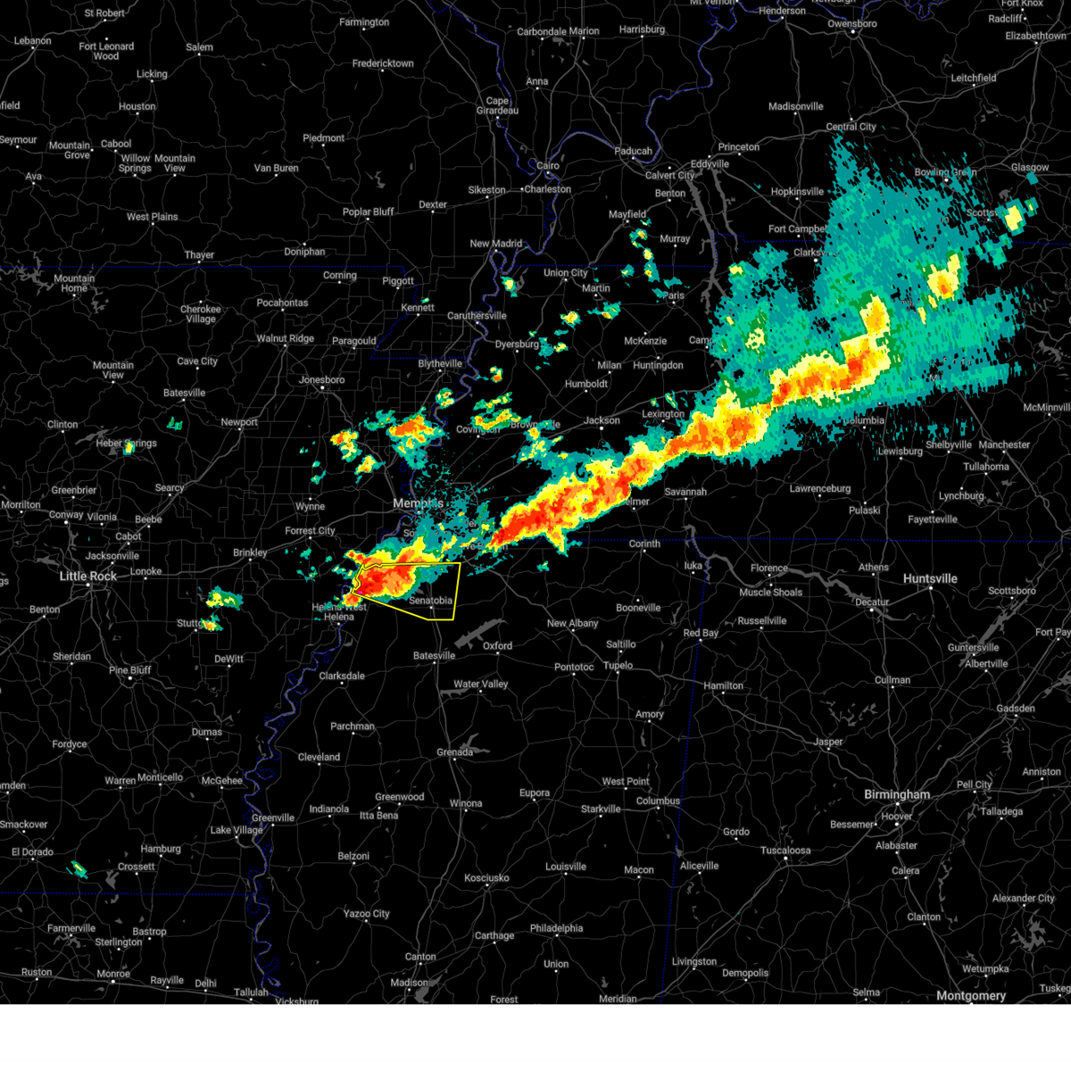 At 1116 pm cdt, a severe thunderstorm was located near phillipp, or 17 miles southwest of hernando, moving east at 45 mph. this is a destructive storm for tunica (radar indicated). Hazards include baseball size hail and 60 mph wind gusts. People and animals outdoors will be severely injured. expect shattered windows, extensive damage to roofs, siding, and vehicles. Locations impacted include, tunica, clack, trinity, cockrum, savage, frees corners, commerce, crossroad, senatobia, bright, phillipp, strayhorn, prichard, sarah, eudora, coldwater, banks, poagville, bowdre, and bluff. At 1116 pm cdt, a severe thunderstorm was located near phillipp, or 17 miles southwest of hernando, moving east at 45 mph. this is a destructive storm for tunica (radar indicated). Hazards include baseball size hail and 60 mph wind gusts. People and animals outdoors will be severely injured. expect shattered windows, extensive damage to roofs, siding, and vehicles. Locations impacted include, tunica, clack, trinity, cockrum, savage, frees corners, commerce, crossroad, senatobia, bright, phillipp, strayhorn, prichard, sarah, eudora, coldwater, banks, poagville, bowdre, and bluff.
|
| 3/30/2025 11:11 PM CDT | At 1110 pm cdt, a severe thunderstorm was located near north tunica, or 15 miles southeast of hughes, moving east at 35 mph (radar indicated). Hazards include ping pong ball size hail and 60 mph wind gusts. People and animals outdoors will be injured. expect hail damage to roofs, siding, windows, and vehicles. expect wind damage to roofs, siding, and trees. Locations impacted include, tunica, clack, trinity, cockrum, savage, frees corners, commerce, crossroad, senatobia, bright, phillipp, strayhorn, prichard, sarah, eudora, coldwater, banks, poagville, bowdre, and bluff. |
| 3/30/2025 11:11 PM CDT | the severe thunderstorm warning has been cancelled and is no longer in effect |
| 3/30/2025 11:01 PM CDT | A few power poles down on old hwy 61 near bowdr in tunica county MS, 2.2 miles N of Tunica Resorts, MS |
| 3/30/2025 10:58 PM CDT |
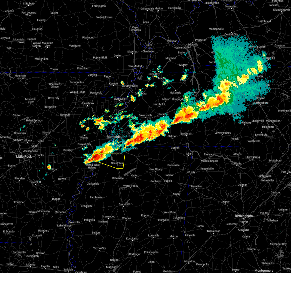 Svrmeg the national weather service in memphis has issued a * severe thunderstorm warning for, east central lee county in eastern arkansas, southern desoto county in northwestern mississippi, northern tunica county in northwestern mississippi, tate county in northwestern mississippi, * until 1145 pm cdt. * at 1057 pm cdt, a severe thunderstorm was located 7 miles west of robinsonville, or 9 miles south of hughes, moving east at 40 mph (radar indicated). Hazards include ping pong ball size hail and 60 mph wind gusts. People and animals outdoors will be injured. expect hail damage to roofs, siding, windows, and vehicles. Expect wind damage to roofs, siding, and trees. Svrmeg the national weather service in memphis has issued a * severe thunderstorm warning for, east central lee county in eastern arkansas, southern desoto county in northwestern mississippi, northern tunica county in northwestern mississippi, tate county in northwestern mississippi, * until 1145 pm cdt. * at 1057 pm cdt, a severe thunderstorm was located 7 miles west of robinsonville, or 9 miles south of hughes, moving east at 40 mph (radar indicated). Hazards include ping pong ball size hail and 60 mph wind gusts. People and animals outdoors will be injured. expect hail damage to roofs, siding, windows, and vehicles. Expect wind damage to roofs, siding, and trees.
|
| 3/30/2025 10:41 PM CDT |
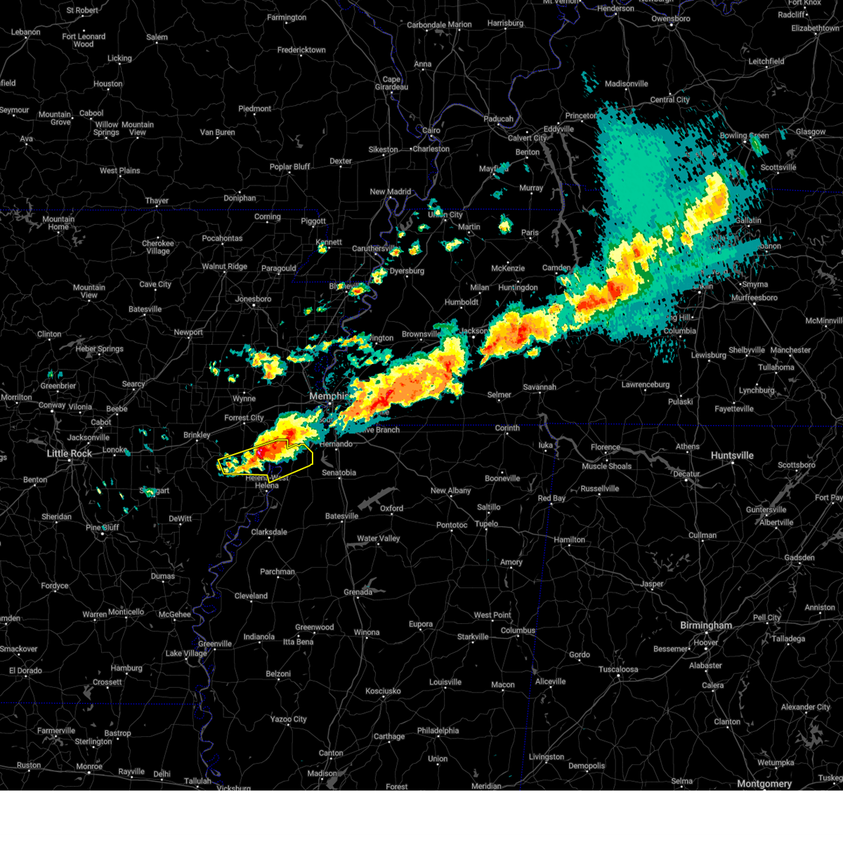 At 1040 pm cdt, severe thunderstorms were located along a line extending from near hughes to near aubrey, moving southeast at 15 mph (trained weather spotters). Hazards include two inch hail and 60 mph wind gusts. People and animals outdoors will be injured. expect hail damage to roofs, siding, windows, and vehicles. expect wind damage to roofs, siding, and trees. Locations impacted include, jeffersonville, cody, tunica, clack, lagrange, haleside, commerce, austin, rondo, soudan, peters, council, aubrey, vineyard, diamond woods, brickeys, banks, whitehall, cypress corner, and bowdre. At 1040 pm cdt, severe thunderstorms were located along a line extending from near hughes to near aubrey, moving southeast at 15 mph (trained weather spotters). Hazards include two inch hail and 60 mph wind gusts. People and animals outdoors will be injured. expect hail damage to roofs, siding, windows, and vehicles. expect wind damage to roofs, siding, and trees. Locations impacted include, jeffersonville, cody, tunica, clack, lagrange, haleside, commerce, austin, rondo, soudan, peters, council, aubrey, vineyard, diamond woods, brickeys, banks, whitehall, cypress corner, and bowdre.
|
| 3/30/2025 10:41 PM CDT |
 the severe thunderstorm warning has been cancelled and is no longer in effect the severe thunderstorm warning has been cancelled and is no longer in effect
|
| 3/30/2025 10:29 PM CDT | At 1029 pm cdt, severe thunderstorms were located along a line extending from hughes to near aubrey, moving southeast at 15 mph (trained weather spotters). Hazards include ping pong ball size hail and 60 mph wind gusts. People and animals outdoors will be injured. expect hail damage to roofs, siding, windows, and vehicles. expect wind damage to roofs, siding, and trees. Locations impacted include, jeffersonville, cody, tunica, hughes, clack, kokomo, oak forest, lagrange, haleside, commerce, austin, rondo, mud lake, soudan, peters, council, aubrey, bruins, vineyard, and beck. |
| 3/30/2025 10:16 PM CDT |
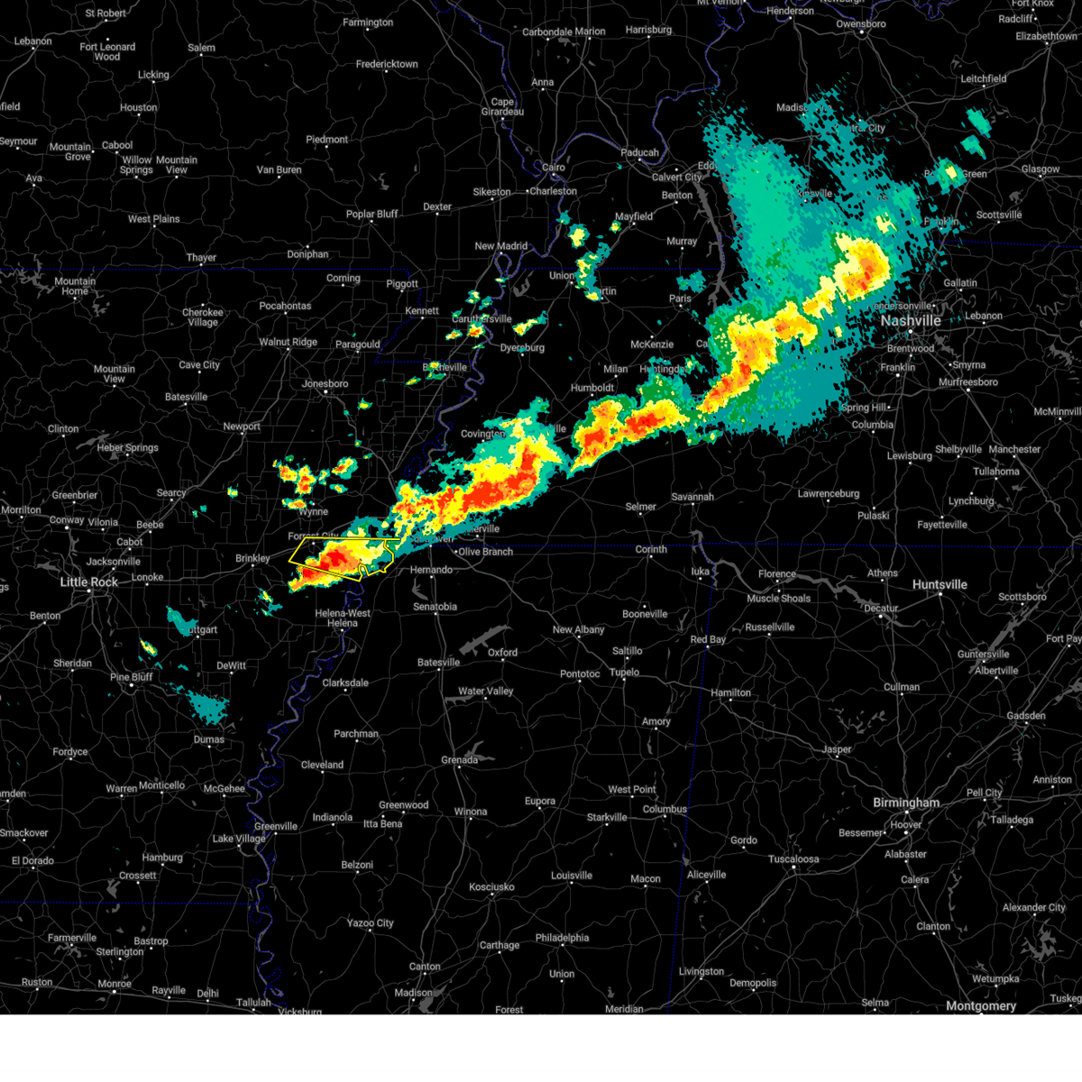 the severe thunderstorm warning has been cancelled and is no longer in effect the severe thunderstorm warning has been cancelled and is no longer in effect
|
| 3/30/2025 10:11 PM CDT | Svrmeg the national weather service in memphis has issued a * severe thunderstorm warning for, lee county in eastern arkansas, southeastern st. francis county in eastern arkansas, southwestern crittenden county in eastern arkansas, northern tunica county in northwestern mississippi, * until 1100 pm cdt. * at 1011 pm cdt, severe thunderstorms were located along a line extending from near hughes to near moro, moving southeast at 20 mph (trained weather spotters). Hazards include ping pong ball size hail and 60 mph wind gusts. People and animals outdoors will be injured. expect hail damage to roofs, siding, windows, and vehicles. Expect wind damage to roofs, siding, and trees. |
| 3/30/2025 9:54 PM CDT | At 953 pm cdt, a severe thunderstorm was located near haynes, or near forrest city, moving east at 25 mph (radar indicated). Hazards include ping pong ball size hail and 60 mph wind gusts. People and animals outdoors will be injured. expect hail damage to roofs, siding, windows, and vehicles. expect wind damage to roofs, siding, and trees. Locations impacted include, madison, cody, hughes, kokomo, pinckney, forrest city, mud lake, new castle, peters, council, widener, bruins, beck, simsboro, democrat, heustess, north hughes, brickeys, ball point, and shannondale. |
| 3/30/2025 9:39 PM CDT |
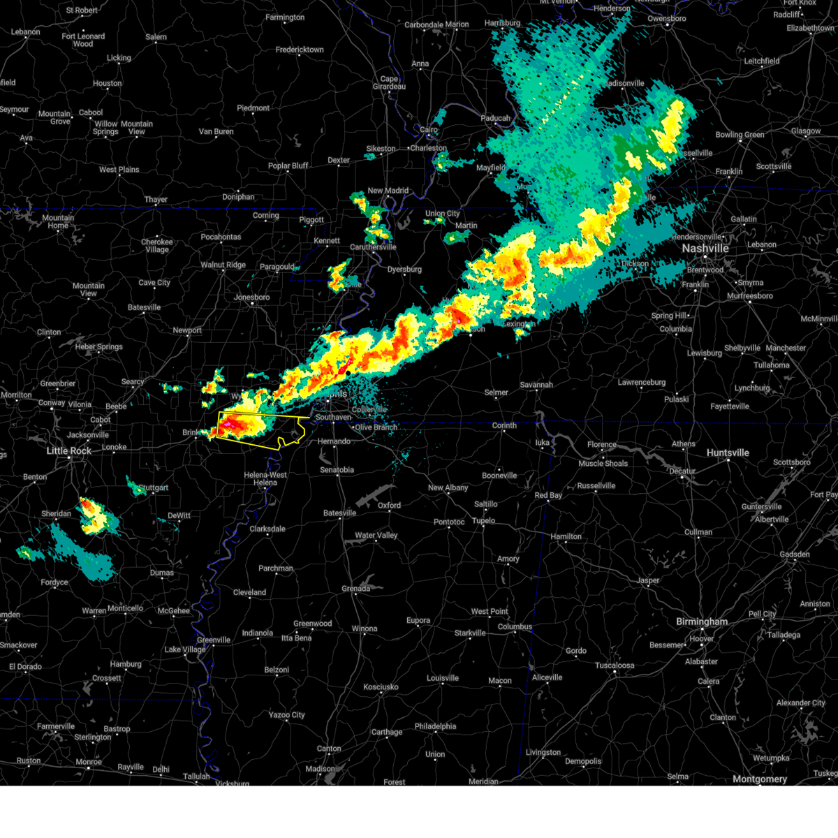 Svrmeg the national weather service in memphis has issued a * severe thunderstorm warning for, northeastern lee county in eastern arkansas, central st. francis county in eastern arkansas, southwestern crittenden county in eastern arkansas, * until 1030 pm cdt. * at 939 pm cdt, a severe thunderstorm was located over palestine, moving east at 30 mph (radar indicated). Hazards include two inch hail and 60 mph wind gusts. People and animals outdoors will be injured. expect hail damage to roofs, siding, windows, and vehicles. Expect wind damage to roofs, siding, and trees. Svrmeg the national weather service in memphis has issued a * severe thunderstorm warning for, northeastern lee county in eastern arkansas, central st. francis county in eastern arkansas, southwestern crittenden county in eastern arkansas, * until 1030 pm cdt. * at 939 pm cdt, a severe thunderstorm was located over palestine, moving east at 30 mph (radar indicated). Hazards include two inch hail and 60 mph wind gusts. People and animals outdoors will be injured. expect hail damage to roofs, siding, windows, and vehicles. Expect wind damage to roofs, siding, and trees.
|
| 3/15/2025 9:06 AM CDT |
 The storm which prompted the warning has moved out of the area. therefore, the warning will be allowed to expire. however, small hail and gusty winds are still possible with this thunderstorm. The storm which prompted the warning has moved out of the area. therefore, the warning will be allowed to expire. however, small hail and gusty winds are still possible with this thunderstorm.
|
| 3/15/2025 9:00 AM CDT |
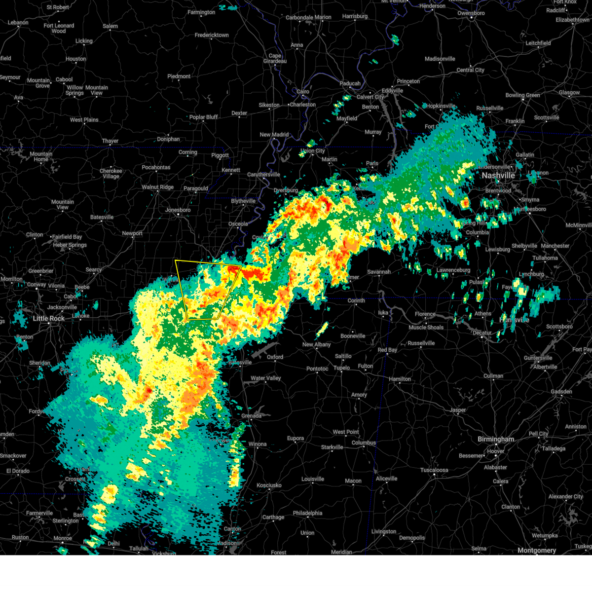 At 900 am cdt, a severe thunderstorm was located over edmondson, or near west memphis, moving north at 55 mph (radar indicated). Hazards include 60 mph wind gusts and quarter size hail. Hail damage to vehicles is expected. expect wind damage to roofs, siding, and trees. Locations impacted include, three forks, lake cormorant, browns, commerce, louise, edmondson, st clair, round pond, presidents island, beck, simsboro, glover, brickeys, river front, julius, duvall, gilestown, clarks corner, walls, and norfolk. At 900 am cdt, a severe thunderstorm was located over edmondson, or near west memphis, moving north at 55 mph (radar indicated). Hazards include 60 mph wind gusts and quarter size hail. Hail damage to vehicles is expected. expect wind damage to roofs, siding, and trees. Locations impacted include, three forks, lake cormorant, browns, commerce, louise, edmondson, st clair, round pond, presidents island, beck, simsboro, glover, brickeys, river front, julius, duvall, gilestown, clarks corner, walls, and norfolk.
|
| 3/15/2025 8:39 AM CDT |
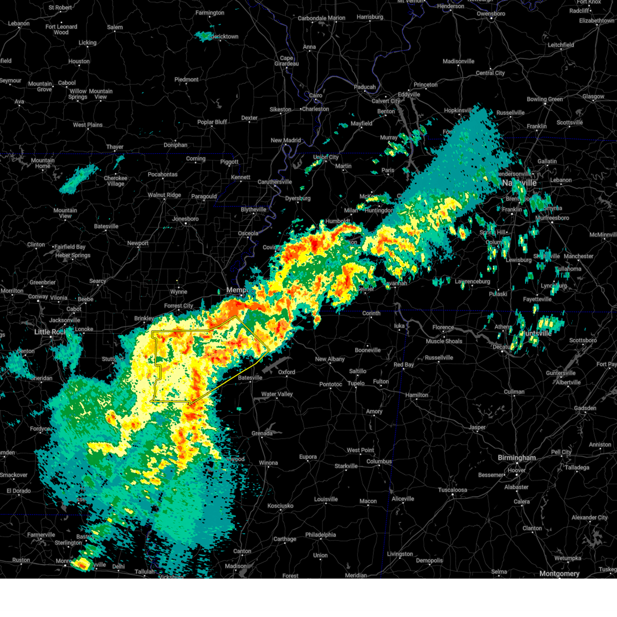 The storm which prompted the warning has moved out of the area. therefore, the warning will be allowed to expire. a tornado watch remains in effect until 100 pm cdt for northwestern mississippi. The storm which prompted the warning has moved out of the area. therefore, the warning will be allowed to expire. a tornado watch remains in effect until 100 pm cdt for northwestern mississippi.
|
| 3/15/2025 8:31 AM CDT |
 Svrmeg the national weather service in memphis has issued a * severe thunderstorm warning for, northern lee county in eastern arkansas, st. francis county in eastern arkansas, crittenden county in eastern arkansas, cross county in eastern arkansas, northwestern desoto county in northwestern mississippi, northern tunica county in northwestern mississippi, western shelby county in west tennessee, * until 915 am cdt. * at 831 am cdt, a severe thunderstorm was located near robinsonville, or 7 miles south of hughes, moving northeast at 45 mph (radar indicated). Hazards include 60 mph wind gusts and quarter size hail. Hail damage to vehicles is expected. Expect wind damage to roofs, siding, and trees. Svrmeg the national weather service in memphis has issued a * severe thunderstorm warning for, northern lee county in eastern arkansas, st. francis county in eastern arkansas, crittenden county in eastern arkansas, cross county in eastern arkansas, northwestern desoto county in northwestern mississippi, northern tunica county in northwestern mississippi, western shelby county in west tennessee, * until 915 am cdt. * at 831 am cdt, a severe thunderstorm was located near robinsonville, or 7 miles south of hughes, moving northeast at 45 mph (radar indicated). Hazards include 60 mph wind gusts and quarter size hail. Hail damage to vehicles is expected. Expect wind damage to roofs, siding, and trees.
|
| 3/15/2025 8:12 AM CDT |
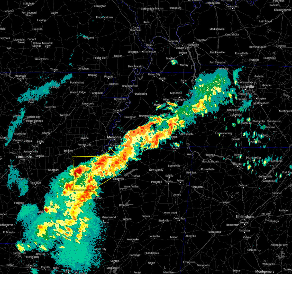 At 812 am cdt, a cluster of severe thunderstorms was located over marvell, moving north at 45 mph (radar indicated). Hazards include 60 mph wind gusts and half dollar size hail. Hail damage to vehicles is expected. expect wind damage to roofs, siding, and trees. Locations impacted include, rena lara, askew, belen, rudyard, moon, savage, haleside, commerce, senatobia, austin, hoop spur, westover, falcon, como, clarksdale, strayhorn, prichard, jonestown, dubbs, and lundell. At 812 am cdt, a cluster of severe thunderstorms was located over marvell, moving north at 45 mph (radar indicated). Hazards include 60 mph wind gusts and half dollar size hail. Hail damage to vehicles is expected. expect wind damage to roofs, siding, and trees. Locations impacted include, rena lara, askew, belen, rudyard, moon, savage, haleside, commerce, senatobia, austin, hoop spur, westover, falcon, como, clarksdale, strayhorn, prichard, jonestown, dubbs, and lundell.
|
| 3/15/2025 7:51 AM CDT |
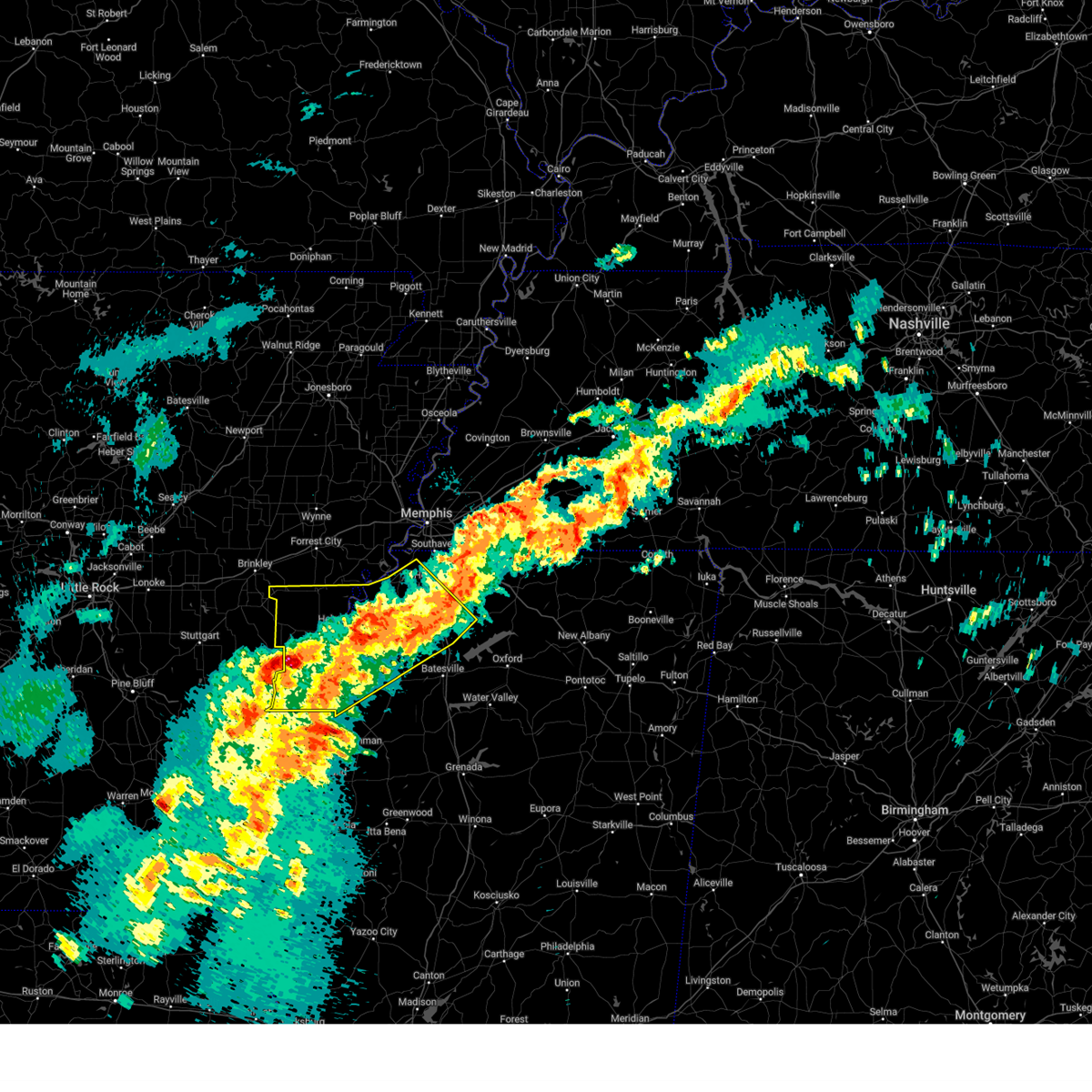 Svrmeg the national weather service in memphis has issued a * severe thunderstorm warning for, southern lee county in eastern arkansas, phillips county in eastern arkansas, central desoto county in northwestern mississippi, coahoma county in northwestern mississippi, tunica county in northwestern mississippi, tate county in northwestern mississippi, northern quitman county in northwestern mississippi, northwestern panola county in northwestern mississippi, * until 845 am cdt. * at 751 am cdt, a severe thunderstorm was located near dubbs, or 18 miles east of st francis national park, moving northeast at 45 mph (radar indicated). Hazards include 60 mph wind gusts and quarter size hail. Hail damage to vehicles is expected. Expect wind damage to roofs, siding, and trees. Svrmeg the national weather service in memphis has issued a * severe thunderstorm warning for, southern lee county in eastern arkansas, phillips county in eastern arkansas, central desoto county in northwestern mississippi, coahoma county in northwestern mississippi, tunica county in northwestern mississippi, tate county in northwestern mississippi, northern quitman county in northwestern mississippi, northwestern panola county in northwestern mississippi, * until 845 am cdt. * at 751 am cdt, a severe thunderstorm was located near dubbs, or 18 miles east of st francis national park, moving northeast at 45 mph (radar indicated). Hazards include 60 mph wind gusts and quarter size hail. Hail damage to vehicles is expected. Expect wind damage to roofs, siding, and trees.
|
| 2/15/2025 7:57 PM CST |
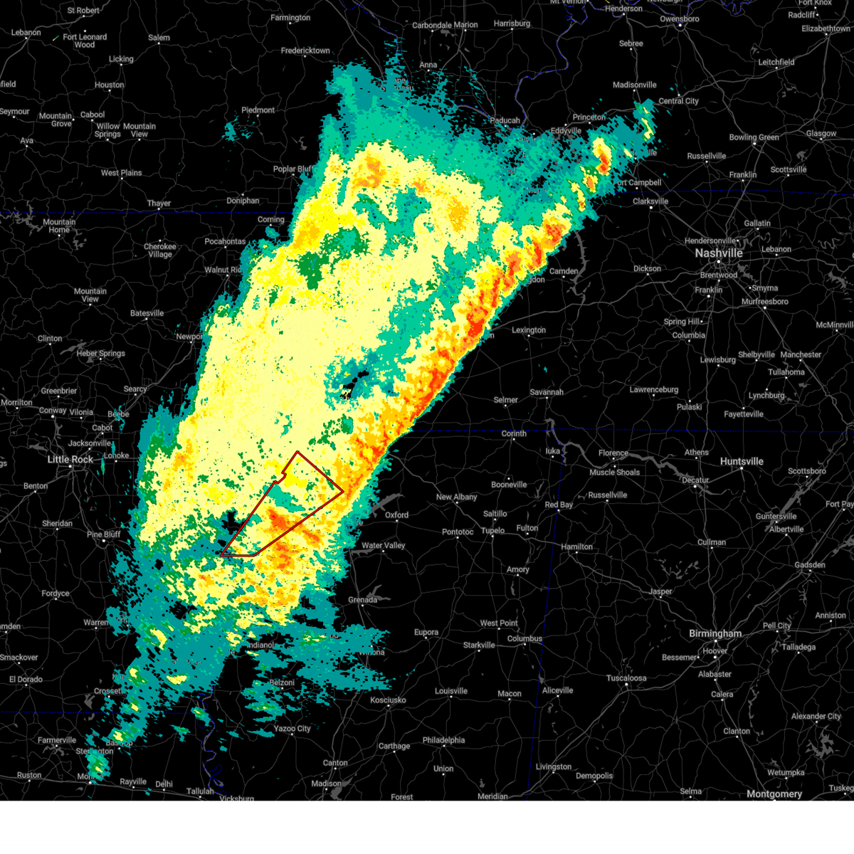 the tornado warning has been cancelled and is no longer in effect the tornado warning has been cancelled and is no longer in effect
|
| 2/15/2025 7:40 PM CST |
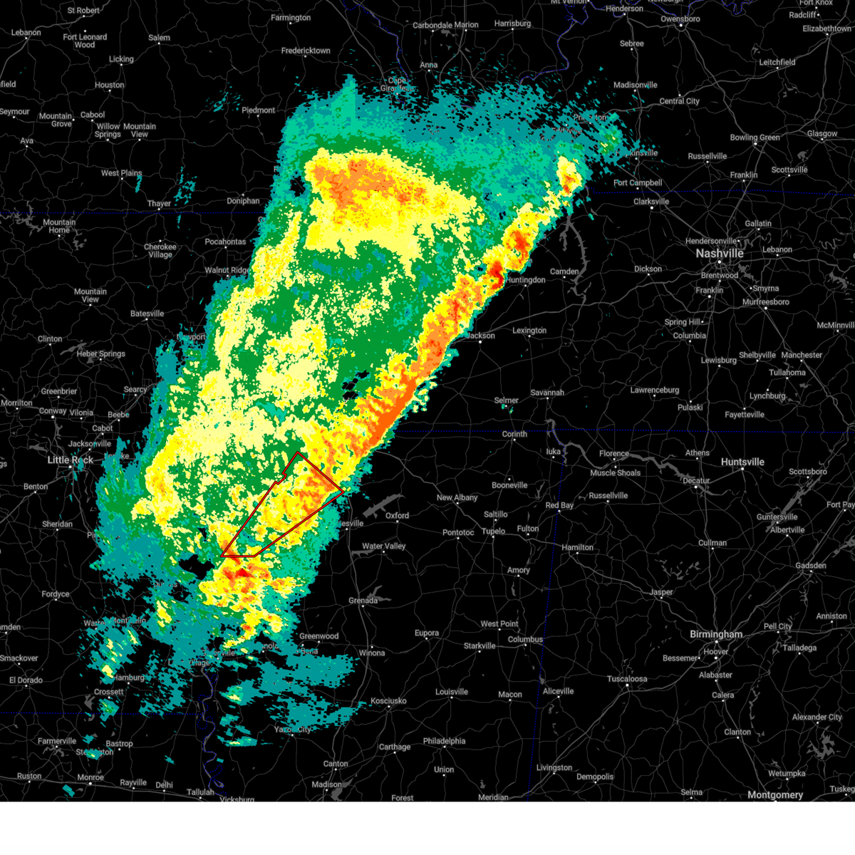 Tormeg the national weather service in memphis has issued a * tornado warning for, southeastern phillips county in eastern arkansas, coahoma county in northwestern mississippi, tunica county in northwestern mississippi, southwestern tate county in northwestern mississippi, northern quitman county in northwestern mississippi, northwestern panola county in northwestern mississippi, * until 815 pm cst. * at 740 pm cst, a severe thunderstorm capable of producing a tornado was located near sherard, or near elaine, moving northeast at 50 mph (radar indicated rotation). Hazards include tornado and quarter size hail. Flying debris will be dangerous to those caught without shelter. mobile homes will be damaged or destroyed. damage to roofs, windows, and vehicles will occur. Tree damage is likely. Tormeg the national weather service in memphis has issued a * tornado warning for, southeastern phillips county in eastern arkansas, coahoma county in northwestern mississippi, tunica county in northwestern mississippi, southwestern tate county in northwestern mississippi, northern quitman county in northwestern mississippi, northwestern panola county in northwestern mississippi, * until 815 pm cst. * at 740 pm cst, a severe thunderstorm capable of producing a tornado was located near sherard, or near elaine, moving northeast at 50 mph (radar indicated rotation). Hazards include tornado and quarter size hail. Flying debris will be dangerous to those caught without shelter. mobile homes will be damaged or destroyed. damage to roofs, windows, and vehicles will occur. Tree damage is likely.
|
| 2/15/2025 6:03 PM CST |
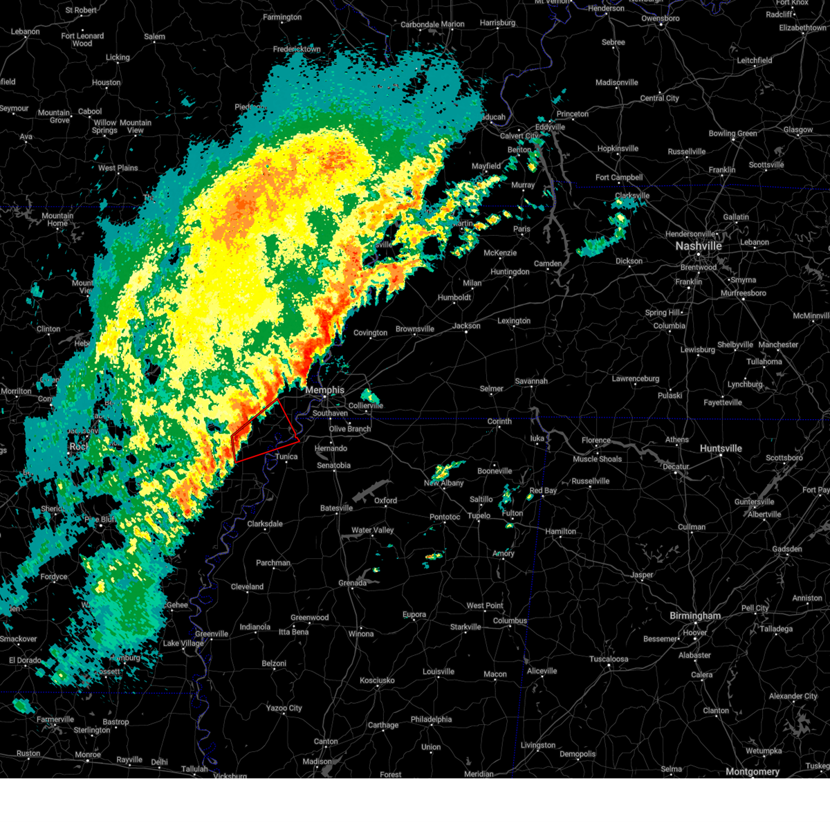 At 602 pm cst, a severe thunderstorm capable of producing a tornado was located near haynes, or 8 miles northeast of marianna, moving northeast at 55 mph (radar indicated rotation). Hazards include tornado. Flying debris will be dangerous to those caught without shelter. mobile homes will be damaged or destroyed. damage to roofs, windows, and vehicles will occur. tree damage is likely. Locations impacted include, marianna, hughes, haynes, brickeys, new home, simsboro, robinsonville, cody, clack, kokomo, commerce, jonquil, mud lake, soudan, peters, council, bruins, beck, democrat, and north hughes. At 602 pm cst, a severe thunderstorm capable of producing a tornado was located near haynes, or 8 miles northeast of marianna, moving northeast at 55 mph (radar indicated rotation). Hazards include tornado. Flying debris will be dangerous to those caught without shelter. mobile homes will be damaged or destroyed. damage to roofs, windows, and vehicles will occur. tree damage is likely. Locations impacted include, marianna, hughes, haynes, brickeys, new home, simsboro, robinsonville, cody, clack, kokomo, commerce, jonquil, mud lake, soudan, peters, council, bruins, beck, democrat, and north hughes.
|
| 2/15/2025 5:47 PM CST |
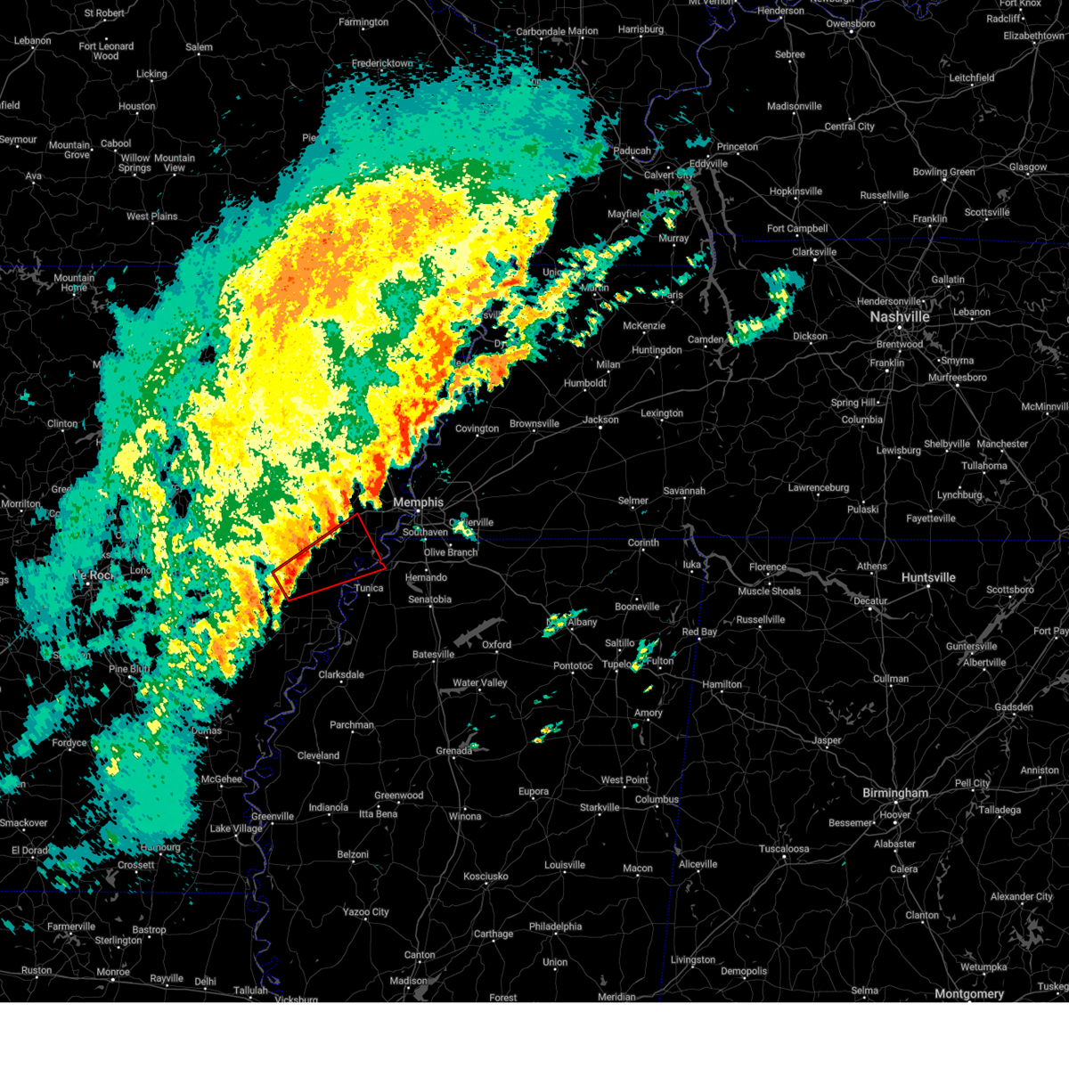 Tormeg the national weather service in memphis has issued a * tornado warning for, lee county in eastern arkansas, eastern st. francis county in eastern arkansas, southwestern crittenden county in eastern arkansas, northwestern tunica county in northwestern mississippi, * until 615 pm cst. * at 547 pm cst, a severe thunderstorm capable of producing a tornado was located near aubrey, or 7 miles west of marianna, moving northeast at 55 mph (radar indicated rotation). Hazards include tornado. Flying debris will be dangerous to those caught without shelter. mobile homes will be damaged or destroyed. damage to roofs, windows, and vehicles will occur. Tree damage is likely. Tormeg the national weather service in memphis has issued a * tornado warning for, lee county in eastern arkansas, eastern st. francis county in eastern arkansas, southwestern crittenden county in eastern arkansas, northwestern tunica county in northwestern mississippi, * until 615 pm cst. * at 547 pm cst, a severe thunderstorm capable of producing a tornado was located near aubrey, or 7 miles west of marianna, moving northeast at 55 mph (radar indicated rotation). Hazards include tornado. Flying debris will be dangerous to those caught without shelter. mobile homes will be damaged or destroyed. damage to roofs, windows, and vehicles will occur. Tree damage is likely.
|
| 1/5/2025 3:33 PM CST |
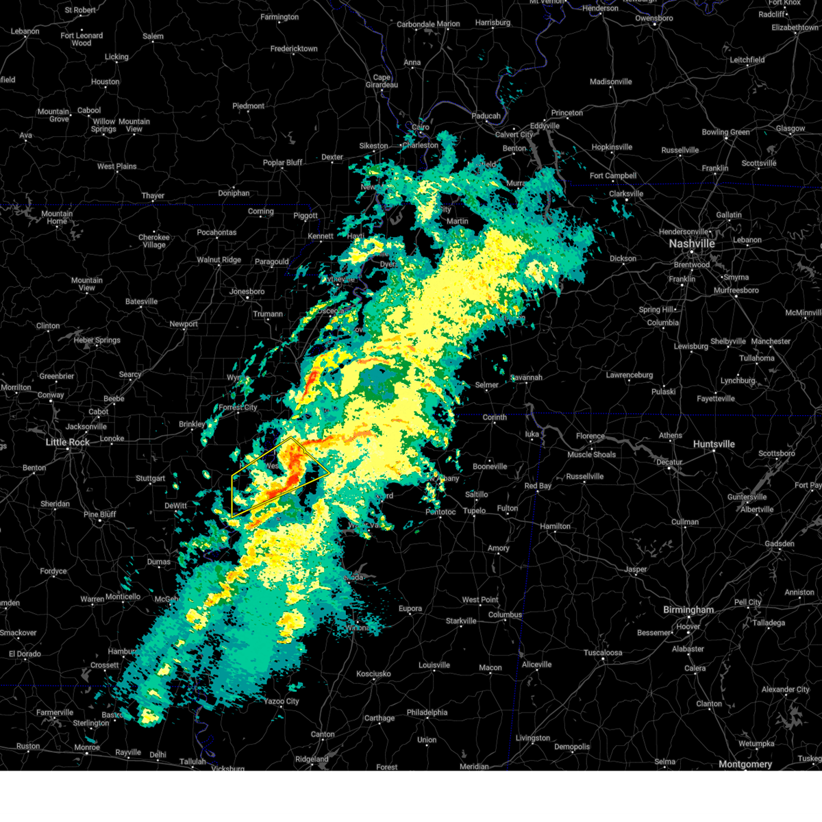 the severe thunderstorm warning has been cancelled and is no longer in effect the severe thunderstorm warning has been cancelled and is no longer in effect
|
| 1/5/2025 3:32 PM CST |
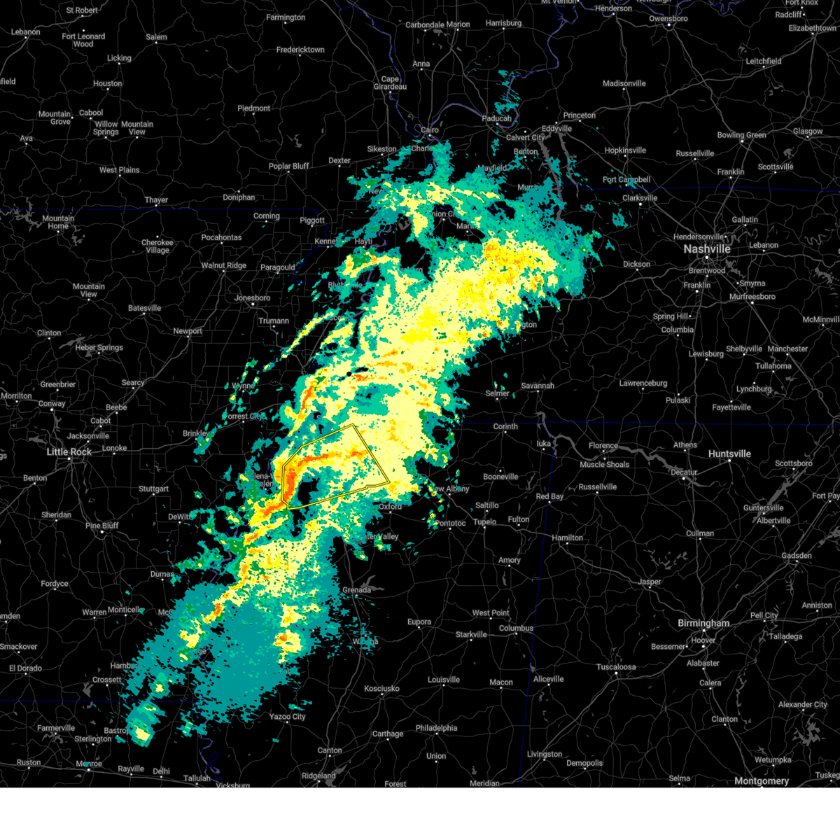 Svrmeg the national weather service in memphis has issued a * severe thunderstorm warning for, desoto county in northwestern mississippi, southwestern marshall county in northwestern mississippi, tunica county in northwestern mississippi, tate county in northwestern mississippi, northern quitman county in northwestern mississippi, northern panola county in northwestern mississippi, * until 415 pm cst. * at 332 pm cst, a severe thunderstorm was located over little texas, or 15 miles west of senatobia, moving northeast at 60 mph (radar indicated). Hazards include 60 mph wind gusts and penny size hail. expect damage to roofs, siding, and trees Svrmeg the national weather service in memphis has issued a * severe thunderstorm warning for, desoto county in northwestern mississippi, southwestern marshall county in northwestern mississippi, tunica county in northwestern mississippi, tate county in northwestern mississippi, northern quitman county in northwestern mississippi, northern panola county in northwestern mississippi, * until 415 pm cst. * at 332 pm cst, a severe thunderstorm was located over little texas, or 15 miles west of senatobia, moving northeast at 60 mph (radar indicated). Hazards include 60 mph wind gusts and penny size hail. expect damage to roofs, siding, and trees
|
| 1/5/2025 3:08 PM CST |
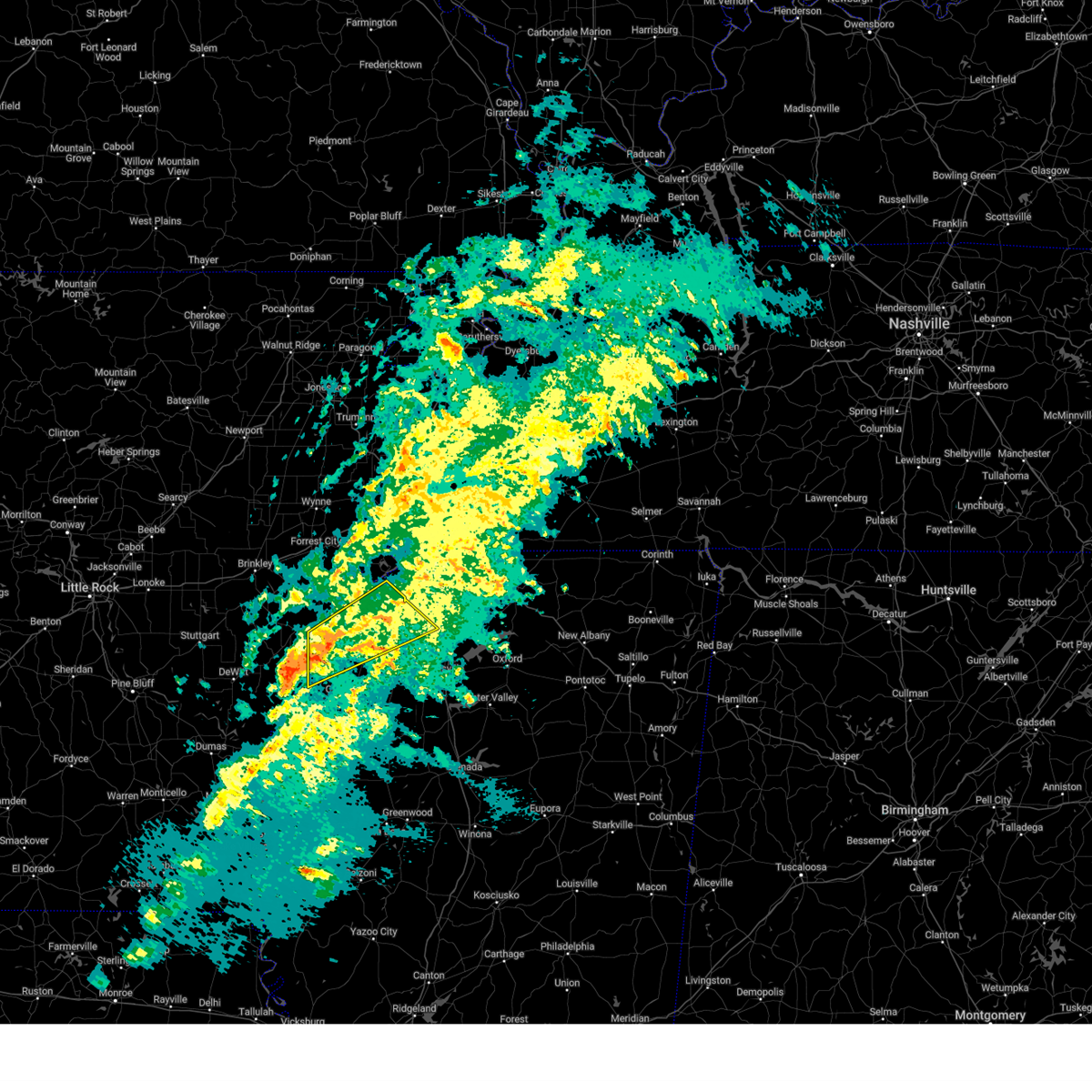 Svrmeg the national weather service in memphis has issued a * severe thunderstorm warning for, southeastern lee county in eastern arkansas, northeastern phillips county in eastern arkansas, northeastern coahoma county in northwestern mississippi, tunica county in northwestern mississippi, southwestern tate county in northwestern mississippi, northwestern quitman county in northwestern mississippi, northwestern panola county in northwestern mississippi, * until 400 pm cst. * at 308 pm cst, a severe thunderstorm was located near friars point, or 8 miles southwest of helena-west helena, moving northeast at 55 mph (radar indicated). Hazards include 60 mph wind gusts. expect damage to roofs, siding, and trees Svrmeg the national weather service in memphis has issued a * severe thunderstorm warning for, southeastern lee county in eastern arkansas, northeastern phillips county in eastern arkansas, northeastern coahoma county in northwestern mississippi, tunica county in northwestern mississippi, southwestern tate county in northwestern mississippi, northwestern quitman county in northwestern mississippi, northwestern panola county in northwestern mississippi, * until 400 pm cst. * at 308 pm cst, a severe thunderstorm was located near friars point, or 8 miles southwest of helena-west helena, moving northeast at 55 mph (radar indicated). Hazards include 60 mph wind gusts. expect damage to roofs, siding, and trees
|
| 5/24/2024 5:52 PM CDT |
 The storm which prompted the warning has weakened below severe limits, and no longer poses an immediate threat to life or property. therefore, the warning will be allowed to expire. however, small hail and gusty winds are still possible with this thunderstorm. The storm which prompted the warning has weakened below severe limits, and no longer poses an immediate threat to life or property. therefore, the warning will be allowed to expire. however, small hail and gusty winds are still possible with this thunderstorm.
|
| 5/24/2024 5:47 PM CDT |
 At 547 pm cdt, a severe thunderstorm was located near eudora, or 7 miles southwest of horn lake, moving southeast at 10 mph (radar indicated). Hazards include 60 mph wind gusts and nickel size hail. Expect damage to roofs, siding, and trees. Locations impacted include, eudora and trinity. At 547 pm cdt, a severe thunderstorm was located near eudora, or 7 miles southwest of horn lake, moving southeast at 10 mph (radar indicated). Hazards include 60 mph wind gusts and nickel size hail. Expect damage to roofs, siding, and trees. Locations impacted include, eudora and trinity.
|
| 5/24/2024 5:47 PM CDT |
 the severe thunderstorm warning has been cancelled and is no longer in effect the severe thunderstorm warning has been cancelled and is no longer in effect
|
| 5/24/2024 5:30 PM CDT |
 At 529 pm cdt, a severe thunderstorm was located over lake cormorant, or 9 miles southwest of horn lake, moving southeast at 20 mph (radar indicated). Hazards include 60 mph wind gusts and quarter size hail. Hail damage to vehicles is expected. expect wind damage to roofs, siding, and trees. Locations impacted include, horn lake, walls, horseshoe lake, lake cormorant, lynchburg, eudora, newport, trinity, twin lakes, west days, seyppel, glover, penton, and norfolk. At 529 pm cdt, a severe thunderstorm was located over lake cormorant, or 9 miles southwest of horn lake, moving southeast at 20 mph (radar indicated). Hazards include 60 mph wind gusts and quarter size hail. Hail damage to vehicles is expected. expect wind damage to roofs, siding, and trees. Locations impacted include, horn lake, walls, horseshoe lake, lake cormorant, lynchburg, eudora, newport, trinity, twin lakes, west days, seyppel, glover, penton, and norfolk.
|
| 5/24/2024 5:15 PM CDT |
 At 514 pm cdt, a severe thunderstorm was located near arkabutla, or near hernando, moving east at 25 mph (radar indicated). Hazards include 60 mph wind gusts and quarter size hail. Hail damage to vehicles is expected. expect wind damage to roofs, siding, and trees. Locations impacted include, hernando, senatobia, coldwater, independence, arkabutla, phillipp, strayhorn, eudora, robinson gin, trinity, lurline, dooley, alphaba, frees corners, bright, lost lake, prichard, love, banks, and poagville. At 514 pm cdt, a severe thunderstorm was located near arkabutla, or near hernando, moving east at 25 mph (radar indicated). Hazards include 60 mph wind gusts and quarter size hail. Hail damage to vehicles is expected. expect wind damage to roofs, siding, and trees. Locations impacted include, hernando, senatobia, coldwater, independence, arkabutla, phillipp, strayhorn, eudora, robinson gin, trinity, lurline, dooley, alphaba, frees corners, bright, lost lake, prichard, love, banks, and poagville.
|
| 5/24/2024 5:12 PM CDT |
 Svrmeg the national weather service in memphis has issued a * severe thunderstorm warning for, south central crittenden county in eastern arkansas, northwestern desoto county in northwestern mississippi, * until 600 pm cdt. * at 511 pm cdt, a severe thunderstorm was located over pinckney, or 9 miles east of hughes, moving southeast at 10 mph (radar indicated). Hazards include 60 mph wind gusts and quarter size hail. Hail damage to vehicles is expected. Expect wind damage to roofs, siding, and trees. Svrmeg the national weather service in memphis has issued a * severe thunderstorm warning for, south central crittenden county in eastern arkansas, northwestern desoto county in northwestern mississippi, * until 600 pm cdt. * at 511 pm cdt, a severe thunderstorm was located over pinckney, or 9 miles east of hughes, moving southeast at 10 mph (radar indicated). Hazards include 60 mph wind gusts and quarter size hail. Hail damage to vehicles is expected. Expect wind damage to roofs, siding, and trees.
|
| 5/24/2024 4:55 PM CDT |
 Svrmeg the national weather service in memphis has issued a * severe thunderstorm warning for, southern desoto county in northwestern mississippi, northeastern tunica county in northwestern mississippi, central tate county in northwestern mississippi, * until 545 pm cdt. * at 455 pm cdt, a severe thunderstorm was located over phillipp, or 13 miles southwest of hernando, moving east at 25 mph (radar indicated). Hazards include 60 mph wind gusts and half dollar size hail. Hail damage to vehicles is expected. Expect wind damage to roofs, siding, and trees. Svrmeg the national weather service in memphis has issued a * severe thunderstorm warning for, southern desoto county in northwestern mississippi, northeastern tunica county in northwestern mississippi, central tate county in northwestern mississippi, * until 545 pm cdt. * at 455 pm cdt, a severe thunderstorm was located over phillipp, or 13 miles southwest of hernando, moving east at 25 mph (radar indicated). Hazards include 60 mph wind gusts and half dollar size hail. Hail damage to vehicles is expected. Expect wind damage to roofs, siding, and trees.
|
| 5/22/2024 2:37 PM CDT |
 At 237 pm cdt, a severe thunderstorm was located 7 miles north of st francis national park, moving east at 30 mph (radar indicated). Hazards include 60 mph wind gusts and quarter size hail. Hail damage to vehicles is expected. expect wind damage to roofs, siding, and trees. Locations impacted include, marianna, marvell, helena-west helena, st francis national park, tunica, lexa, rondo, dubbs, north tunica, dundee, watkins corner, robinsonville, little texas, lagrange, clack, haleside, quarles, commerce, austin, and vineyard. At 237 pm cdt, a severe thunderstorm was located 7 miles north of st francis national park, moving east at 30 mph (radar indicated). Hazards include 60 mph wind gusts and quarter size hail. Hail damage to vehicles is expected. expect wind damage to roofs, siding, and trees. Locations impacted include, marianna, marvell, helena-west helena, st francis national park, tunica, lexa, rondo, dubbs, north tunica, dundee, watkins corner, robinsonville, little texas, lagrange, clack, haleside, quarles, commerce, austin, and vineyard.
|
| 5/22/2024 2:26 PM CDT |
 Svrmeg the national weather service in memphis has issued a * severe thunderstorm warning for, southern lee county in eastern arkansas, northern phillips county in eastern arkansas, tunica county in northwestern mississippi, * until 315 pm cdt. * at 226 pm cdt, a severe thunderstorm was located near lexa, or 7 miles southeast of marianna, moving east at 30 mph (radar indicated). Hazards include 60 mph wind gusts and quarter size hail. Hail damage to vehicles is expected. Expect wind damage to roofs, siding, and trees. Svrmeg the national weather service in memphis has issued a * severe thunderstorm warning for, southern lee county in eastern arkansas, northern phillips county in eastern arkansas, tunica county in northwestern mississippi, * until 315 pm cdt. * at 226 pm cdt, a severe thunderstorm was located near lexa, or 7 miles southeast of marianna, moving east at 30 mph (radar indicated). Hazards include 60 mph wind gusts and quarter size hail. Hail damage to vehicles is expected. Expect wind damage to roofs, siding, and trees.
|
| 5/22/2024 2:02 PM CDT |
 At 202 pm cdt, a severe thunderstorm was located near brickeys, or 8 miles east of marianna, moving east at 30 mph (radar indicated). Hazards include 60 mph wind gusts and quarter size hail. Hail damage to vehicles is expected. expect wind damage to roofs, siding, and trees. Locations impacted include, marianna, hughes, st francis national park, tunica, lexa, moro, rondo, aubrey, garret grove, brickeys, north tunica, lagrange, cody, haleside, commerce, austin, soudan, vineyard, beck, and ball point. At 202 pm cdt, a severe thunderstorm was located near brickeys, or 8 miles east of marianna, moving east at 30 mph (radar indicated). Hazards include 60 mph wind gusts and quarter size hail. Hail damage to vehicles is expected. expect wind damage to roofs, siding, and trees. Locations impacted include, marianna, hughes, st francis national park, tunica, lexa, moro, rondo, aubrey, garret grove, brickeys, north tunica, lagrange, cody, haleside, commerce, austin, soudan, vineyard, beck, and ball point.
|
| 5/22/2024 1:44 PM CDT |
 Svrmeg the national weather service in memphis has issued a * severe thunderstorm warning for, lee county in eastern arkansas, southeastern st. francis county in eastern arkansas, northern phillips county in eastern arkansas, southwestern crittenden county in eastern arkansas, central tunica county in northwestern mississippi, * until 230 pm cdt. * at 143 pm cdt, a severe thunderstorm was located over marianna, moving east at 30 mph (radar indicated). Hazards include ping pong ball size hail and 60 mph wind gusts. People and animals outdoors will be injured. expect hail damage to roofs, siding, windows, and vehicles. Expect wind damage to roofs, siding, and trees. Svrmeg the national weather service in memphis has issued a * severe thunderstorm warning for, lee county in eastern arkansas, southeastern st. francis county in eastern arkansas, northern phillips county in eastern arkansas, southwestern crittenden county in eastern arkansas, central tunica county in northwestern mississippi, * until 230 pm cdt. * at 143 pm cdt, a severe thunderstorm was located over marianna, moving east at 30 mph (radar indicated). Hazards include ping pong ball size hail and 60 mph wind gusts. People and animals outdoors will be injured. expect hail damage to roofs, siding, windows, and vehicles. Expect wind damage to roofs, siding, and trees.
|
| 5/18/2024 5:20 AM CDT |
 The storm which prompted the warning has weakened below severe limits, and no longer poses an immediate threat to life or property. therefore, the warning will be allowed to expire. The storm which prompted the warning has weakened below severe limits, and no longer poses an immediate threat to life or property. therefore, the warning will be allowed to expire.
|
| 5/18/2024 4:57 AM CDT |
 At 457 am cdt, a severe thunderstorm was located near robinsonville, or 14 miles west of hernando, moving east at 20 mph (radar indicated). Hazards include 60 mph wind gusts and nickel size hail. Expect damage to roofs, siding, and trees. Locations impacted include, horn lake, hernando, lake cormorant, phillipp, eudora, robinsonville, robinson gin, newport, clack, trinity, alden, twin lakes, frees corners, commerce, nesbit, west days, lost lake, prichard, banks, and penton. At 457 am cdt, a severe thunderstorm was located near robinsonville, or 14 miles west of hernando, moving east at 20 mph (radar indicated). Hazards include 60 mph wind gusts and nickel size hail. Expect damage to roofs, siding, and trees. Locations impacted include, horn lake, hernando, lake cormorant, phillipp, eudora, robinsonville, robinson gin, newport, clack, trinity, alden, twin lakes, frees corners, commerce, nesbit, west days, lost lake, prichard, banks, and penton.
|
| 5/18/2024 4:40 AM CDT |
 Svrmeg the national weather service in memphis has issued a * severe thunderstorm warning for, western desoto county in northwestern mississippi, northeastern tunica county in northwestern mississippi, northwestern tate county in northwestern mississippi, * until 530 am cdt. * at 440 am cdt, a severe thunderstorm was located near robinsonville, or 14 miles southeast of hughes, moving east at 20 mph (radar indicated). Hazards include 60 mph wind gusts and quarter size hail. Hail damage to vehicles is expected. Expect wind damage to roofs, siding, and trees. Svrmeg the national weather service in memphis has issued a * severe thunderstorm warning for, western desoto county in northwestern mississippi, northeastern tunica county in northwestern mississippi, northwestern tate county in northwestern mississippi, * until 530 am cdt. * at 440 am cdt, a severe thunderstorm was located near robinsonville, or 14 miles southeast of hughes, moving east at 20 mph (radar indicated). Hazards include 60 mph wind gusts and quarter size hail. Hail damage to vehicles is expected. Expect wind damage to roofs, siding, and trees.
|
| 5/9/2024 3:36 AM CDT |
 At 336 am cdt, a severe thunderstorm was located over hughes, moving east at 45 mph (radar indicated). Hazards include 60 mph wind gusts and quarter size hail. Hail damage to vehicles is expected. expect wind damage to roofs, siding, and trees. Locations impacted include, west memphis, forrest city, marion, hughes, madison, caldwell, edmondson, horseshoe lake, widener, anthonyville, haynes, jennette, simsboro, pinckney, new home, crittenden, cottonwood corner, browns, louise, and new castle. At 336 am cdt, a severe thunderstorm was located over hughes, moving east at 45 mph (radar indicated). Hazards include 60 mph wind gusts and quarter size hail. Hail damage to vehicles is expected. expect wind damage to roofs, siding, and trees. Locations impacted include, west memphis, forrest city, marion, hughes, madison, caldwell, edmondson, horseshoe lake, widener, anthonyville, haynes, jennette, simsboro, pinckney, new home, crittenden, cottonwood corner, browns, louise, and new castle.
|
| 5/9/2024 3:13 AM CDT |
 Svrmeg the national weather service in memphis has issued a * severe thunderstorm warning for, northeastern lee county in eastern arkansas, st. francis county in eastern arkansas, southwestern crittenden county in eastern arkansas, * until 400 am cdt. * at 313 am cdt, a severe thunderstorm was located over forrest city, moving east at 45 mph (radar indicated). Hazards include 60 mph wind gusts and quarter size hail. Hail damage to vehicles is expected. Expect wind damage to roofs, siding, and trees. Svrmeg the national weather service in memphis has issued a * severe thunderstorm warning for, northeastern lee county in eastern arkansas, st. francis county in eastern arkansas, southwestern crittenden county in eastern arkansas, * until 400 am cdt. * at 313 am cdt, a severe thunderstorm was located over forrest city, moving east at 45 mph (radar indicated). Hazards include 60 mph wind gusts and quarter size hail. Hail damage to vehicles is expected. Expect wind damage to roofs, siding, and trees.
|
| 4/2/2024 7:46 AM CDT |
 the severe thunderstorm warning has been cancelled and is no longer in effect the severe thunderstorm warning has been cancelled and is no longer in effect
|
| 4/2/2024 7:46 AM CDT |
 At 746 am cdt, a severe thunderstorm was located over southwest memphis, or over t o fuller state park, moving northeast at 55 mph (radar indicated). Hazards include 60 mph wind gusts and quarter size hail. Hail damage to vehicles is expected. expect wind damage to roofs, siding, and trees. Locations impacted include, bartlett, southaven, collierville, germantown, olive branch, west memphis, horn lake, hernando, marion, millington, t o fuller state park, meeman shelby forest state park, cordova, memphis, lakeland, arlington, walls, edmondson, horseshoe lake, and sunset. At 746 am cdt, a severe thunderstorm was located over southwest memphis, or over t o fuller state park, moving northeast at 55 mph (radar indicated). Hazards include 60 mph wind gusts and quarter size hail. Hail damage to vehicles is expected. expect wind damage to roofs, siding, and trees. Locations impacted include, bartlett, southaven, collierville, germantown, olive branch, west memphis, horn lake, hernando, marion, millington, t o fuller state park, meeman shelby forest state park, cordova, memphis, lakeland, arlington, walls, edmondson, horseshoe lake, and sunset.
|
| 4/2/2024 7:29 AM CDT |
 Svrmeg the national weather service in memphis has issued a * severe thunderstorm warning for, northeastern lee county in eastern arkansas, southeastern st. francis county in eastern arkansas, southern crittenden county in eastern arkansas, northern desoto county in northwestern mississippi, northern tunica county in northwestern mississippi, shelby county in west tennessee, * until 815 am cdt. * at 729 am cdt, a severe thunderstorm was located over horseshoe lake, or 9 miles east of hughes, moving northeast at 70 mph (radar indicated). Hazards include 60 mph wind gusts and half dollar size hail. Hail damage to vehicles is expected. Expect wind damage to roofs, siding, and trees. Svrmeg the national weather service in memphis has issued a * severe thunderstorm warning for, northeastern lee county in eastern arkansas, southeastern st. francis county in eastern arkansas, southern crittenden county in eastern arkansas, northern desoto county in northwestern mississippi, northern tunica county in northwestern mississippi, shelby county in west tennessee, * until 815 am cdt. * at 729 am cdt, a severe thunderstorm was located over horseshoe lake, or 9 miles east of hughes, moving northeast at 70 mph (radar indicated). Hazards include 60 mph wind gusts and half dollar size hail. Hail damage to vehicles is expected. Expect wind damage to roofs, siding, and trees.
|
| 1/12/2024 7:39 AM CST |
 The severe thunderstorm warning for desoto, northeastern tunica, northwestern tate and eastern shelby counties will expire at 745 am cst, the storms which prompted the warning have weakened below severe limits, and no longer pose an immediate threat to life or property. therefore, the warning will be allowed to expire. however, gusty winds and heavy rain are still possible with these thunderstorms. a tornado watch remains in effect until 1100 am cst for northwestern mississippi, and west tennessee. The severe thunderstorm warning for desoto, northeastern tunica, northwestern tate and eastern shelby counties will expire at 745 am cst, the storms which prompted the warning have weakened below severe limits, and no longer pose an immediate threat to life or property. therefore, the warning will be allowed to expire. however, gusty winds and heavy rain are still possible with these thunderstorms. a tornado watch remains in effect until 1100 am cst for northwestern mississippi, and west tennessee.
|
| 1/12/2024 7:19 AM CST |
 At 718 am cst, severe thunderstorms were located along a line extending from near meeman shelby forest state park to near little texas, moving northeast at 65 mph (radar indicated). Hazards include 60 mph wind gusts. Expect damage to roofs, siding, and trees. locations impacted include, bartlett, southaven, germantown, olive branch, horn lake, hernando, millington, cordova, memphis, lakeland, arlington, coldwater, walls, lake cormorant, ellendale, eudora, lewisburg, arkabutla, lynchburg, and phillipp. hail threat, radar indicated max hail size, <. 75 in wind threat, radar indicated max wind gust, 60 mph. At 718 am cst, severe thunderstorms were located along a line extending from near meeman shelby forest state park to near little texas, moving northeast at 65 mph (radar indicated). Hazards include 60 mph wind gusts. Expect damage to roofs, siding, and trees. locations impacted include, bartlett, southaven, germantown, olive branch, horn lake, hernando, millington, cordova, memphis, lakeland, arlington, coldwater, walls, lake cormorant, ellendale, eudora, lewisburg, arkabutla, lynchburg, and phillipp. hail threat, radar indicated max hail size, <. 75 in wind threat, radar indicated max wind gust, 60 mph.
|
| 1/12/2024 6:56 AM CST |
 At 656 am cst, severe thunderstorms were located along a line extending from near jennette to near helena-west helena, moving northeast at 60 mph (radar indicated). Hazards include 60 mph wind gusts. expect damage to roofs, siding, and trees At 656 am cst, severe thunderstorms were located along a line extending from near jennette to near helena-west helena, moving northeast at 60 mph (radar indicated). Hazards include 60 mph wind gusts. expect damage to roofs, siding, and trees
|
| 1/12/2024 6:37 AM CST |
 At 622 am cst, a severe thunderstorm was located over marvell, moving east at 50 mph (radar indicated). Hazards include 70 mph wind gusts. Expect considerable tree damage. damage is likely to mobile homes, roofs, and outbuildings. Locations impacted include, marianna, hughes, marvell, helena-west helena, st francis national park, tunica, lexa, rondo, aubrey, dubbs, brickeys, north tunica, dundee, watkins corner, little texas, lake view, lagrange, cody, preston place, and haleside. At 622 am cst, a severe thunderstorm was located over marvell, moving east at 50 mph (radar indicated). Hazards include 70 mph wind gusts. Expect considerable tree damage. damage is likely to mobile homes, roofs, and outbuildings. Locations impacted include, marianna, hughes, marvell, helena-west helena, st francis national park, tunica, lexa, rondo, aubrey, dubbs, brickeys, north tunica, dundee, watkins corner, little texas, lake view, lagrange, cody, preston place, and haleside.
|
| 1/12/2024 6:37 AM CST |
 At 636 am cst, severe thunderstorms were located along a line extending from marianna to near watkins corner, moving northeast at 60 mph (radar indicated). Hazards include 70 mph wind gusts. Expect considerable tree damage. damage is likely to mobile homes, roofs, and outbuildings. locations impacted include, marianna, hughes, marvell, helena-west helena, st francis national park, tunica, lexa, rondo, dubbs, brickeys, north tunica, dundee, lake view, lagrange, cody, preston place, haleside, quarles, austin, and soudan. thunderstorm damage threat, considerable hail threat, radar indicated max hail size, <. 75 in wind threat, radar indicated max wind gust, 70 mph. At 636 am cst, severe thunderstorms were located along a line extending from marianna to near watkins corner, moving northeast at 60 mph (radar indicated). Hazards include 70 mph wind gusts. Expect considerable tree damage. damage is likely to mobile homes, roofs, and outbuildings. locations impacted include, marianna, hughes, marvell, helena-west helena, st francis national park, tunica, lexa, rondo, dubbs, brickeys, north tunica, dundee, lake view, lagrange, cody, preston place, haleside, quarles, austin, and soudan. thunderstorm damage threat, considerable hail threat, radar indicated max hail size, <. 75 in wind threat, radar indicated max wind gust, 70 mph.
|
| 1/12/2024 6:22 AM CST |
 At 622 am cst, a severe thunderstorm was located over marvell, moving east at 50 mph (radar indicated). Hazards include 70 mph wind gusts. Expect considerable tree damage. damage is likely to mobile homes, roofs, and outbuildings. Locations impacted include, marianna, hughes, marvell, helena-west helena, st francis national park, tunica, lexa, rondo, aubrey, dubbs, brickeys, north tunica, dundee, watkins corner, little texas, lake view, lagrange, cody, preston place, and haleside. At 622 am cst, a severe thunderstorm was located over marvell, moving east at 50 mph (radar indicated). Hazards include 70 mph wind gusts. Expect considerable tree damage. damage is likely to mobile homes, roofs, and outbuildings. Locations impacted include, marianna, hughes, marvell, helena-west helena, st francis national park, tunica, lexa, rondo, aubrey, dubbs, brickeys, north tunica, dundee, watkins corner, little texas, lake view, lagrange, cody, preston place, and haleside.
|
| 1/12/2024 6:11 AM CST |
 At 611 am cst, a severe thunderstorm was located near palmer, or 10 miles west of marvell, moving northeast at 65 mph (radar indicated). Hazards include 60 mph wind gusts and nickel size hail. expect damage to roofs, siding, and trees At 611 am cst, a severe thunderstorm was located near palmer, or 10 miles west of marvell, moving northeast at 65 mph (radar indicated). Hazards include 60 mph wind gusts and nickel size hail. expect damage to roofs, siding, and trees
|
| 12/9/2023 1:39 PM CST |
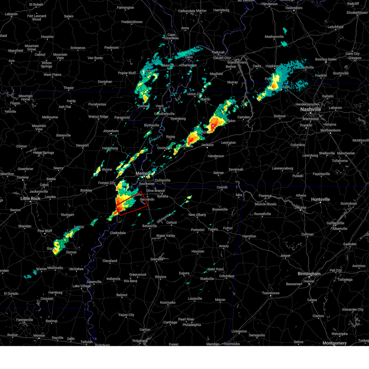 At 138 pm cst, a severe thunderstorm capable of producing a tornado was located near tunica, or 8 miles northeast of st francis national park, moving northeast at 45 mph (radar indicated rotation). Hazards include tornado and ping pong ball size hail. Flying debris will be dangerous to those caught without shelter. mobile homes will be damaged or destroyed. damage to roofs, windows, and vehicles will occur. tree damage is likely. Locations impacted include, coldwater, tunica, north tunica, arkabutla, phillipp, eudora, dubbs, little texas, trinity, dooley, savage, maud, fox island, frees corners, austin, clayton, hollywood, lost lake, prichard, and banks. At 138 pm cst, a severe thunderstorm capable of producing a tornado was located near tunica, or 8 miles northeast of st francis national park, moving northeast at 45 mph (radar indicated rotation). Hazards include tornado and ping pong ball size hail. Flying debris will be dangerous to those caught without shelter. mobile homes will be damaged or destroyed. damage to roofs, windows, and vehicles will occur. tree damage is likely. Locations impacted include, coldwater, tunica, north tunica, arkabutla, phillipp, eudora, dubbs, little texas, trinity, dooley, savage, maud, fox island, frees corners, austin, clayton, hollywood, lost lake, prichard, and banks.
|
| 12/9/2023 1:24 PM CST |
 At 123 pm cst, a severe thunderstorm capable of producing a tornado was located near st francis national park, moving northeast at 45 mph (radar indicated rotation). Hazards include tornado and quarter size hail. Flying debris will be dangerous to those caught without shelter. mobile homes will be damaged or destroyed. damage to roofs, windows, and vehicles will occur. Tree damage is likely. At 123 pm cst, a severe thunderstorm capable of producing a tornado was located near st francis national park, moving northeast at 45 mph (radar indicated rotation). Hazards include tornado and quarter size hail. Flying debris will be dangerous to those caught without shelter. mobile homes will be damaged or destroyed. damage to roofs, windows, and vehicles will occur. Tree damage is likely.
|
| 8/5/2023 5:09 PM CDT |
 The severe thunderstorm warning for western desoto and southwestern shelby counties will expire at 515 pm cdt, the storm which prompted the warning has weakened below severe limits, and no longer poses an immediate threat to life or property. therefore, the warning will be allowed to expire. however gusty winds are still possible with this thunderstorm. a severe thunderstorm watch remains in effect until 900 pm cdt for eastern arkansas, northwestern mississippi, and west tennessee. The severe thunderstorm warning for western desoto and southwestern shelby counties will expire at 515 pm cdt, the storm which prompted the warning has weakened below severe limits, and no longer poses an immediate threat to life or property. therefore, the warning will be allowed to expire. however gusty winds are still possible with this thunderstorm. a severe thunderstorm watch remains in effect until 900 pm cdt for eastern arkansas, northwestern mississippi, and west tennessee.
|
| 8/5/2023 4:51 PM CDT |
 At 451 pm cdt, a severe thunderstorm was located over walls, or near horn lake, moving east at 30 mph (radar indicated). Hazards include 60 mph wind gusts. Expect damage to roofs, siding, and trees. locations impacted include, southaven, horn lake, hernando, memphis, walls, lake cormorant, lynchburg, whitehaven, eudora, robinson gin, newport, trinity, alden, twin lakes, frees corners, nesbit, west days, lake view, glover and jago. hail threat, radar indicated max hail size, <. 75 in wind threat, radar indicated max wind gust, 60 mph. At 451 pm cdt, a severe thunderstorm was located over walls, or near horn lake, moving east at 30 mph (radar indicated). Hazards include 60 mph wind gusts. Expect damage to roofs, siding, and trees. locations impacted include, southaven, horn lake, hernando, memphis, walls, lake cormorant, lynchburg, whitehaven, eudora, robinson gin, newport, trinity, alden, twin lakes, frees corners, nesbit, west days, lake view, glover and jago. hail threat, radar indicated max hail size, <. 75 in wind threat, radar indicated max wind gust, 60 mph.
|
| 8/5/2023 4:26 PM CDT |
 At 425 pm cdt, a severe thunderstorm was located near horseshoe lake, or near hughes, moving east at 30 mph (radar indicated). Hazards include 60 mph wind gusts. expect damage to roofs, siding, and trees At 425 pm cdt, a severe thunderstorm was located near horseshoe lake, or near hughes, moving east at 30 mph (radar indicated). Hazards include 60 mph wind gusts. expect damage to roofs, siding, and trees
|
| 7/21/2023 1:38 PM CDT |
 At 138 pm cdt, severe thunderstorms were located along a line extending from near manila to millington to hernando, moving east at 50 mph. these are destructive storms for extreme northern shelby county and southern tipton county (radar indicated). Hazards include 80 mph wind gusts. Flying debris will be dangerous to those caught without shelter. mobile homes will be heavily damaged. expect considerable damage to roofs, windows, and vehicles. extensive tree damage and power outages are likely. locations impacted include, jonesboro, bartlett, southaven, collierville, germantown, olive branch, west memphis, horn lake, blytheville, hernando, marion, millington, covington, ripley, osceola, holly springs, trumann, manila, marked tree and lake city. thunderstorm damage threat, destructive hail threat, radar indicated max hail size, <. 75 in wind threat, radar indicated max wind gust, 80 mph. At 138 pm cdt, severe thunderstorms were located along a line extending from near manila to millington to hernando, moving east at 50 mph. these are destructive storms for extreme northern shelby county and southern tipton county (radar indicated). Hazards include 80 mph wind gusts. Flying debris will be dangerous to those caught without shelter. mobile homes will be heavily damaged. expect considerable damage to roofs, windows, and vehicles. extensive tree damage and power outages are likely. locations impacted include, jonesboro, bartlett, southaven, collierville, germantown, olive branch, west memphis, horn lake, blytheville, hernando, marion, millington, covington, ripley, osceola, holly springs, trumann, manila, marked tree and lake city. thunderstorm damage threat, destructive hail threat, radar indicated max hail size, <. 75 in wind threat, radar indicated max wind gust, 80 mph.
|
| 7/21/2023 1:16 PM CDT |
 At 115 pm cdt, severe thunderstorms were located along a line extending from near lake city to near jericho to near horseshoe lake, moving east at 50 mph (radar indicated). Hazards include 60 mph wind gusts and penny size hail. expect damage to roofs, siding, and trees At 115 pm cdt, severe thunderstorms were located along a line extending from near lake city to near jericho to near horseshoe lake, moving east at 50 mph (radar indicated). Hazards include 60 mph wind gusts and penny size hail. expect damage to roofs, siding, and trees
|
| 7/21/2023 1:00 PM CDT |
 At 1259 pm cdt, severe thunderstorms were located along a line extending from near jonesboro to 6 miles north of parkin to near hughes, moving east at 55 mph (radar indicated). Hazards include 60 mph wind gusts. Expect damage to roofs, siding, and trees. locations impacted include, jonesboro, west memphis, marion, trumann, marked tree, earle, lake city, lepanto, bay, hughes, caraway, parkin, tyronza, keiser, joiner, crawfordsville, edmondson, dyess, horseshoe lake and sunset. hail threat, radar indicated max hail size, <. 75 in wind threat, radar indicated max wind gust, 60 mph. At 1259 pm cdt, severe thunderstorms were located along a line extending from near jonesboro to 6 miles north of parkin to near hughes, moving east at 55 mph (radar indicated). Hazards include 60 mph wind gusts. Expect damage to roofs, siding, and trees. locations impacted include, jonesboro, west memphis, marion, trumann, marked tree, earle, lake city, lepanto, bay, hughes, caraway, parkin, tyronza, keiser, joiner, crawfordsville, edmondson, dyess, horseshoe lake and sunset. hail threat, radar indicated max hail size, <. 75 in wind threat, radar indicated max wind gust, 60 mph.
|
| 7/21/2023 12:42 PM CDT |
 At 1241 pm cdt, severe thunderstorms were located along a line extending from egypt to near cherry valley to near haynes, moving east at 50 mph (radar indicated). Hazards include 60 mph wind gusts and penny size hail. expect damage to roofs, siding, and trees At 1241 pm cdt, severe thunderstorms were located along a line extending from egypt to near cherry valley to near haynes, moving east at 50 mph (radar indicated). Hazards include 60 mph wind gusts and penny size hail. expect damage to roofs, siding, and trees
|
| 6/11/2023 7:47 PM CDT |
 At 747 pm cdt, a severe thunderstorm was located near north tunica, or 14 miles northeast of st francis national park, moving southeast at 30 mph (radar indicated). Hazards include golf ball size hail and 60 mph wind gusts. People and animals outdoors will be injured. expect hail damage to roofs, siding, windows, and vehicles. Expect wind damage to roofs, siding, and trees. At 747 pm cdt, a severe thunderstorm was located near north tunica, or 14 miles northeast of st francis national park, moving southeast at 30 mph (radar indicated). Hazards include golf ball size hail and 60 mph wind gusts. People and animals outdoors will be injured. expect hail damage to roofs, siding, windows, and vehicles. Expect wind damage to roofs, siding, and trees.
|
| 6/11/2023 7:30 PM CDT |
 At 729 pm cdt, severe thunderstorms were located along a line extending from near olive branch to near phillipp, moving east at 45 mph (radar indicated). Hazards include 60 mph wind gusts and quarter size hail. Hail damage to vehicles is expected. expect wind damage to roofs, siding, and trees. locations impacted include, southaven, olive branch, horn lake, hernando, coldwater, byhalia, phillipp, strayhorn, eudora, lewisburg, arkabutla, robinsonville, coal oil corner, clack, trinity, cockrum, frees corners, commerce, cedarview and bright. hail threat, radar indicated max hail size, 1. 00 in wind threat, radar indicated max wind gust, 60 mph. At 729 pm cdt, severe thunderstorms were located along a line extending from near olive branch to near phillipp, moving east at 45 mph (radar indicated). Hazards include 60 mph wind gusts and quarter size hail. Hail damage to vehicles is expected. expect wind damage to roofs, siding, and trees. locations impacted include, southaven, olive branch, horn lake, hernando, coldwater, byhalia, phillipp, strayhorn, eudora, lewisburg, arkabutla, robinsonville, coal oil corner, clack, trinity, cockrum, frees corners, commerce, cedarview and bright. hail threat, radar indicated max hail size, 1. 00 in wind threat, radar indicated max wind gust, 60 mph.
|
| 6/11/2023 7:13 PM CDT |
 At 713 pm cdt, severe thunderstorms were located along a line extending from lynchburg to 6 miles west of robinsonville, moving east at 40 mph (radar indicated). Hazards include 60 mph wind gusts and quarter size hail. Hail damage to vehicles is expected. Expect wind damage to roofs, siding, and trees. At 713 pm cdt, severe thunderstorms were located along a line extending from lynchburg to 6 miles west of robinsonville, moving east at 40 mph (radar indicated). Hazards include 60 mph wind gusts and quarter size hail. Hail damage to vehicles is expected. Expect wind damage to roofs, siding, and trees.
|
| 6/11/2023 6:15 PM CDT |
 At 615 pm cdt, a severe thunderstorm was located near pinckney, or 8 miles west of t o fuller state park, moving southeast at 35 mph (radar indicated). Hazards include ping pong ball size hail and 60 mph wind gusts. People and animals outdoors will be injured. expect hail damage to roofs, siding, windows, and vehicles. expect wind damage to roofs, siding, and trees. locations impacted include, southaven, west memphis, horn lake, t o fuller state park, memphis, walls, edmondson, horseshoe lake, anthonyville, pinckney, lake cormorant, southwest memphis, lynchburg, eudora, simsboro, whitehaven, crittenden, newport, trinity and kate. hail threat, radar indicated max hail size, 1. 50 in wind threat, radar indicated max wind gust, 60 mph. At 615 pm cdt, a severe thunderstorm was located near pinckney, or 8 miles west of t o fuller state park, moving southeast at 35 mph (radar indicated). Hazards include ping pong ball size hail and 60 mph wind gusts. People and animals outdoors will be injured. expect hail damage to roofs, siding, windows, and vehicles. expect wind damage to roofs, siding, and trees. locations impacted include, southaven, west memphis, horn lake, t o fuller state park, memphis, walls, edmondson, horseshoe lake, anthonyville, pinckney, lake cormorant, southwest memphis, lynchburg, eudora, simsboro, whitehaven, crittenden, newport, trinity and kate. hail threat, radar indicated max hail size, 1. 50 in wind threat, radar indicated max wind gust, 60 mph.
|
| 6/11/2023 6:09 PM CDT |
 At 609 pm cdt, a severe thunderstorm was located over anthonyville, or 9 miles southwest of west memphis, moving southeast at 35 mph (radar indicated). Hazards include 60 mph wind gusts and quarter size hail. Hail damage to vehicles is expected. expect wind damage to roofs, siding, and trees. locations impacted include, southaven, west memphis, horn lake, t o fuller state park, memphis, walls, edmondson, horseshoe lake, anthonyville, pinckney, lake cormorant, southwest memphis, lynchburg, eudora, simsboro, whitehaven, crittenden, newport, trinity and kate. hail threat, radar indicated max hail size, 1. 00 in wind threat, radar indicated max wind gust, 60 mph. At 609 pm cdt, a severe thunderstorm was located over anthonyville, or 9 miles southwest of west memphis, moving southeast at 35 mph (radar indicated). Hazards include 60 mph wind gusts and quarter size hail. Hail damage to vehicles is expected. expect wind damage to roofs, siding, and trees. locations impacted include, southaven, west memphis, horn lake, t o fuller state park, memphis, walls, edmondson, horseshoe lake, anthonyville, pinckney, lake cormorant, southwest memphis, lynchburg, eudora, simsboro, whitehaven, crittenden, newport, trinity and kate. hail threat, radar indicated max hail size, 1. 00 in wind threat, radar indicated max wind gust, 60 mph.
|
| 6/11/2023 5:58 PM CDT |
 At 557 pm cdt, a severe thunderstorm was located near anthonyville, or 10 miles north of hughes, moving southeast at 35 mph (radar indicated). Hazards include 60 mph wind gusts and quarter size hail. Hail damage to vehicles is expected. Expect wind damage to roofs, siding, and trees. At 557 pm cdt, a severe thunderstorm was located near anthonyville, or 10 miles north of hughes, moving southeast at 35 mph (radar indicated). Hazards include 60 mph wind gusts and quarter size hail. Hail damage to vehicles is expected. Expect wind damage to roofs, siding, and trees.
|
| 6/11/2023 5:35 PM CDT |
 At 535 pm cdt, a severe thunderstorm was located near village creek state park, moving southeast at 40 mph (radar indicated). Hazards include 60 mph wind gusts and quarter size hail. Hail damage to vehicles is expected. Expect wind damage to roofs, siding, and trees. At 535 pm cdt, a severe thunderstorm was located near village creek state park, moving southeast at 40 mph (radar indicated). Hazards include 60 mph wind gusts and quarter size hail. Hail damage to vehicles is expected. Expect wind damage to roofs, siding, and trees.
|
| 6/6/2023 3:54 PM CDT |
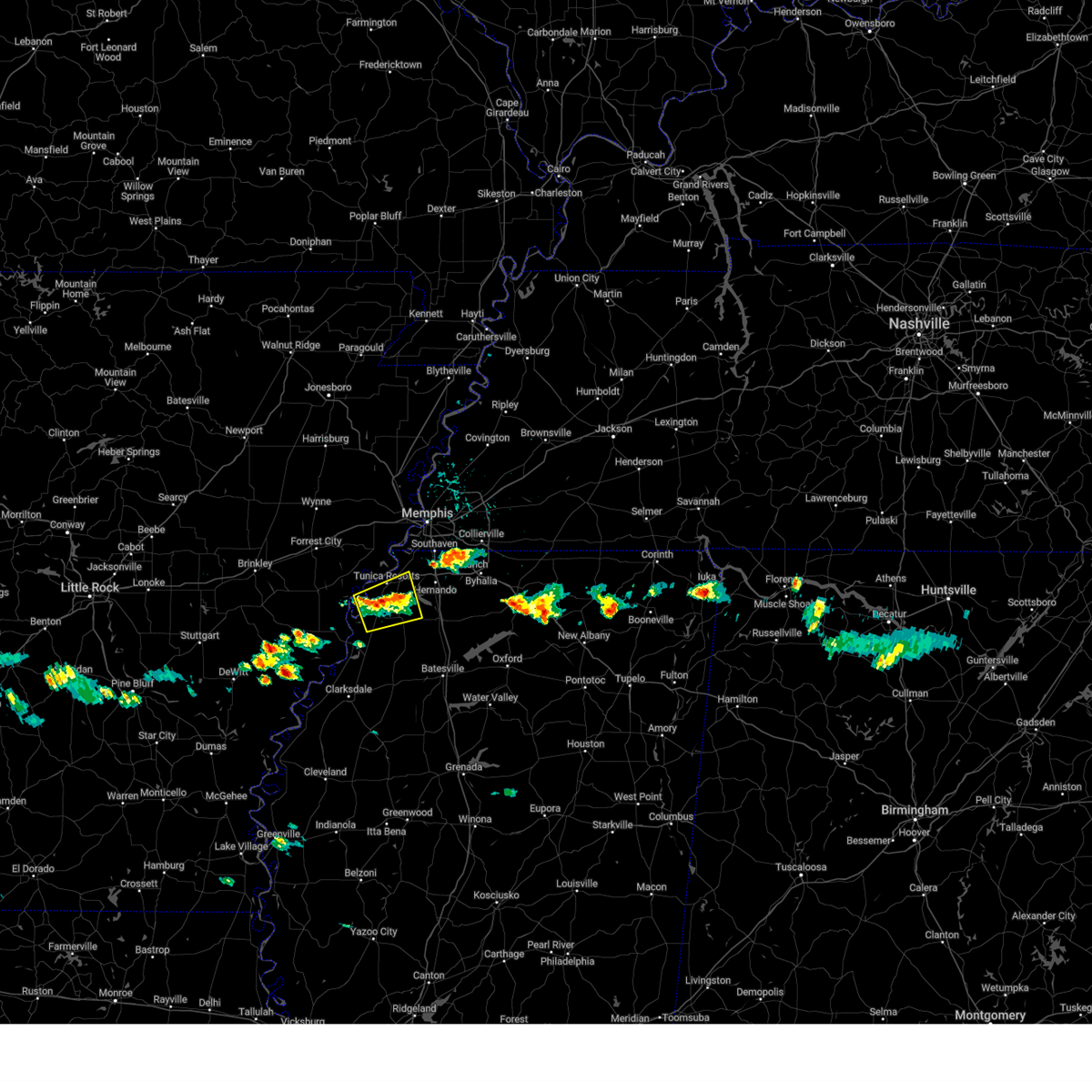 The severe thunderstorm warning for southeastern lee, southwestern desoto, central tunica and northwestern tate counties will expire at 400 pm cdt, the storm which prompted the warning has weakened below severe limits, and no longer poses an immediate threat to life or property. therefore, the warning will be allowed to expire. however small hail and gusty winds are still possible with this thunderstorm. The severe thunderstorm warning for southeastern lee, southwestern desoto, central tunica and northwestern tate counties will expire at 400 pm cdt, the storm which prompted the warning has weakened below severe limits, and no longer poses an immediate threat to life or property. therefore, the warning will be allowed to expire. however small hail and gusty winds are still possible with this thunderstorm.
|
| 6/6/2023 3:36 PM CDT |
 At 335 pm cdt, a severe thunderstorm was located near north tunica, or 18 miles northeast of st francis national park, moving northeast at 15 mph (radar indicated). Hazards include 60 mph wind gusts and quarter size hail. Hail damage to vehicles is expected. Expect wind damage to roofs, siding, and trees. At 335 pm cdt, a severe thunderstorm was located near north tunica, or 18 miles northeast of st francis national park, moving northeast at 15 mph (radar indicated). Hazards include 60 mph wind gusts and quarter size hail. Hail damage to vehicles is expected. Expect wind damage to roofs, siding, and trees.
|
| 6/6/2023 3:36 PM CDT |
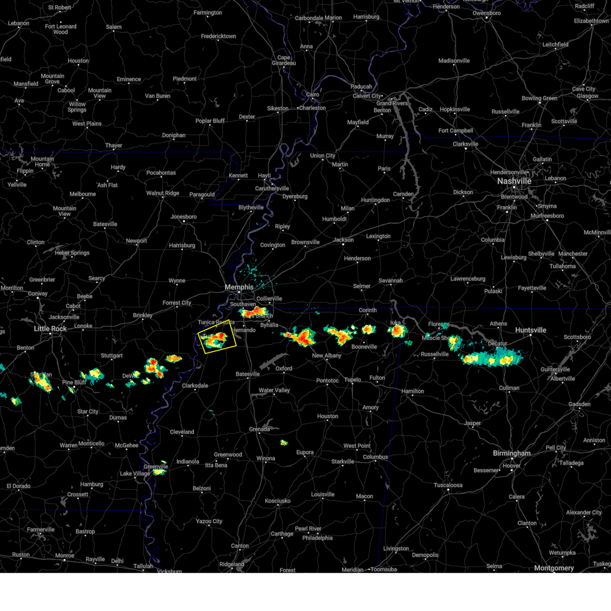 At 335 pm cdt, a severe thunderstorm was located near north tunica, or 18 miles northeast of st francis national park, moving northeast at 15 mph (radar indicated). Hazards include 60 mph wind gusts and quarter size hail. Hail damage to vehicles is expected. Expect wind damage to roofs, siding, and trees. At 335 pm cdt, a severe thunderstorm was located near north tunica, or 18 miles northeast of st francis national park, moving northeast at 15 mph (radar indicated). Hazards include 60 mph wind gusts and quarter size hail. Hail damage to vehicles is expected. Expect wind damage to roofs, siding, and trees.
|
| 5/11/2023 3:52 PM CDT |
 At 352 pm cdt, a severe thunderstorm was located near walls, or 8 miles southwest of t o fuller state park, moving north at 35 mph (radar indicated). Hazards include 60 mph wind gusts. Expect damage to roofs, siding, and trees. locations impacted include, bartlett, southaven, west memphis, horn lake, hernando, marion, t o fuller state park, memphis, walls, crawfordsville, edmondson, horseshoe lake, sunset, anthonyville, jericho, lake cormorant, southwest memphis, eudora, whitehaven and frayser. hail threat, radar indicated max hail size, <. 75 in wind threat, radar indicated max wind gust, 60 mph. At 352 pm cdt, a severe thunderstorm was located near walls, or 8 miles southwest of t o fuller state park, moving north at 35 mph (radar indicated). Hazards include 60 mph wind gusts. Expect damage to roofs, siding, and trees. locations impacted include, bartlett, southaven, west memphis, horn lake, hernando, marion, t o fuller state park, memphis, walls, crawfordsville, edmondson, horseshoe lake, sunset, anthonyville, jericho, lake cormorant, southwest memphis, eudora, whitehaven and frayser. hail threat, radar indicated max hail size, <. 75 in wind threat, radar indicated max wind gust, 60 mph.
|
| 5/11/2023 3:42 PM CDT |
 At 342 pm cdt, a severe thunderstorm was located over lake cormorant, or 11 miles southwest of horn lake, moving north at 35 mph (radar indicated). Hazards include 60 mph wind gusts. expect damage to roofs, siding, and trees At 342 pm cdt, a severe thunderstorm was located over lake cormorant, or 11 miles southwest of horn lake, moving north at 35 mph (radar indicated). Hazards include 60 mph wind gusts. expect damage to roofs, siding, and trees
|
| 5/11/2023 3:19 PM CDT |
 At 319 pm cdt, a severe thunderstorm was located over little texas, or 15 miles west of senatobia, moving north at 40 mph (radar indicated). Hazards include 60 mph wind gusts. expect damage to roofs, siding, and trees At 319 pm cdt, a severe thunderstorm was located over little texas, or 15 miles west of senatobia, moving north at 40 mph (radar indicated). Hazards include 60 mph wind gusts. expect damage to roofs, siding, and trees
|
| 4/15/2023 9:10 PM CDT |
 At 908 pm cdt, severe thunderstorms were located along a line extending from 9 miles southeast of covington to germantown to robinsonville, moving east at 50 mph. strong outflow winds will precede this line of thunderstorms (radar indicated). Hazards include 60 mph wind gusts and penny size hail. expect damage to roofs, siding, and trees At 908 pm cdt, severe thunderstorms were located along a line extending from 9 miles southeast of covington to germantown to robinsonville, moving east at 50 mph. strong outflow winds will precede this line of thunderstorms (radar indicated). Hazards include 60 mph wind gusts and penny size hail. expect damage to roofs, siding, and trees
|
| 4/15/2023 8:57 PM CDT |
 At 856 pm cdt, severe thunderstorms were located along a line extending from near frayser to near brickeys, moving east at 45 mph (radar indicated). Hazards include 60 mph wind gusts and quarter size hail. Hail damage to vehicles is expected. expect wind damage to roofs, siding, and trees. locations impacted include, bartlett, southaven, collierville, germantown, olive branch, west memphis, horn lake, hernando, marion, hughes, t o fuller state park, cordova, memphis, lakeland, arlington, walls, crawfordsville, edmondson, horseshoe lake and widener. hail threat, radar indicated max hail size, 1. 00 in wind threat, radar indicated max wind gust, 60 mph. At 856 pm cdt, severe thunderstorms were located along a line extending from near frayser to near brickeys, moving east at 45 mph (radar indicated). Hazards include 60 mph wind gusts and quarter size hail. Hail damage to vehicles is expected. expect wind damage to roofs, siding, and trees. locations impacted include, bartlett, southaven, collierville, germantown, olive branch, west memphis, horn lake, hernando, marion, hughes, t o fuller state park, cordova, memphis, lakeland, arlington, walls, crawfordsville, edmondson, horseshoe lake and widener. hail threat, radar indicated max hail size, 1. 00 in wind threat, radar indicated max wind gust, 60 mph.
|
| 4/15/2023 8:45 PM CDT |
 At 845 pm cdt, severe thunderstorms were located along a line extending from near sunset to near brickeys, moving east at 50 mph. strong outflow winds will precede this line of storms (radar indicated). Hazards include 60 mph wind gusts and quarter size hail. Hail damage to vehicles is expected. expect wind damage to roofs, siding, and trees. locations impacted include, bartlett, southaven, collierville, germantown, olive branch, west memphis, horn lake, forrest city, hernando, marion, marianna, earle, hughes, parkin, madison, t o fuller state park, cordova, memphis, lakeland and arlington. hail threat, radar indicated max hail size, 1. 00 in wind threat, radar indicated max wind gust, 60 mph. At 845 pm cdt, severe thunderstorms were located along a line extending from near sunset to near brickeys, moving east at 50 mph. strong outflow winds will precede this line of storms (radar indicated). Hazards include 60 mph wind gusts and quarter size hail. Hail damage to vehicles is expected. expect wind damage to roofs, siding, and trees. locations impacted include, bartlett, southaven, collierville, germantown, olive branch, west memphis, horn lake, forrest city, hernando, marion, marianna, earle, hughes, parkin, madison, t o fuller state park, cordova, memphis, lakeland and arlington. hail threat, radar indicated max hail size, 1. 00 in wind threat, radar indicated max wind gust, 60 mph.
|
| 4/15/2023 8:29 PM CDT |
 At 828 pm cdt, a line of severe thunderstorm was located near widener, or near village creek state park, moving east at 45 mph (radar indicated). Hazards include 60 mph wind gusts and quarter size hail. Hail damage to vehicles is expected. Expect wind damage to roofs, siding, and trees. At 828 pm cdt, a line of severe thunderstorm was located near widener, or near village creek state park, moving east at 45 mph (radar indicated). Hazards include 60 mph wind gusts and quarter size hail. Hail damage to vehicles is expected. Expect wind damage to roofs, siding, and trees.
|
| 2/15/2023 8:52 PM CST |
 At 851 pm cst, a severe thunderstorm was located near lake cormorant, or 11 miles southwest of t o fuller state park, moving north at 50 mph (radar indicated). Hazards include 60 mph wind gusts and quarter size hail. Hail damage to vehicles is expected. Expect wind damage to roofs, siding, and trees. At 851 pm cst, a severe thunderstorm was located near lake cormorant, or 11 miles southwest of t o fuller state park, moving north at 50 mph (radar indicated). Hazards include 60 mph wind gusts and quarter size hail. Hail damage to vehicles is expected. Expect wind damage to roofs, siding, and trees.
|
| 1/3/2023 5:32 AM CST |
 At 532 am cst, a severe thunderstorm was located over walls, or 7 miles west of horn lake, moving northeast at 30 mph (radar indicated). Hazards include 60 mph wind gusts. expect damage to roofs, siding, and trees At 532 am cst, a severe thunderstorm was located over walls, or 7 miles west of horn lake, moving northeast at 30 mph (radar indicated). Hazards include 60 mph wind gusts. expect damage to roofs, siding, and trees
|
| 11/29/2022 7:21 PM CST |
 At 720 pm cst, a cluster of severe thunderstorms were located over southeast memphis, or 7 miles northeast of southaven, moving northeast at 60 mph (radar indicated). Hazards include 60 mph wind gusts and quarter size hail. Hail damage to vehicles is expected. expect wind damage to roofs, siding, and trees. locations impacted include, bartlett, southaven, collierville, germantown, olive branch, horn lake, hernando, t o fuller state park, cordova, memphis, lakeland, arlington, walls, horseshoe lake, lake cormorant, southwest memphis, ellendale, eudora, lewisburg and whitehaven. hail threat, radar indicated max hail size, 1. 00 in wind threat, radar indicated max wind gust, 60 mph. At 720 pm cst, a cluster of severe thunderstorms were located over southeast memphis, or 7 miles northeast of southaven, moving northeast at 60 mph (radar indicated). Hazards include 60 mph wind gusts and quarter size hail. Hail damage to vehicles is expected. expect wind damage to roofs, siding, and trees. locations impacted include, bartlett, southaven, collierville, germantown, olive branch, horn lake, hernando, t o fuller state park, cordova, memphis, lakeland, arlington, walls, horseshoe lake, lake cormorant, southwest memphis, ellendale, eudora, lewisburg and whitehaven. hail threat, radar indicated max hail size, 1. 00 in wind threat, radar indicated max wind gust, 60 mph.
|
| 11/29/2022 7:08 PM CST |
 At 708 pm cst, a severe thunderstorm was located near tunica, or 10 miles northeast of st francis national park, moving northeast at 50 mph (radar indicated). Hazards include 60 mph wind gusts and quarter size hail. Hail damage to vehicles is expected. expect wind damage to roofs, siding, and trees. locations impacted include, helena-west helena, st francis national park, tunica, lexa, phillipp, dubbs, north tunica, dundee, arkabutla, robinsonville, little texas, preston place, quarles, commerce, austin, jeffries, peters, wycamp, latour and prichard. hail threat, radar indicated max hail size, 1. 00 in wind threat, radar indicated max wind gust, 60 mph. At 708 pm cst, a severe thunderstorm was located near tunica, or 10 miles northeast of st francis national park, moving northeast at 50 mph (radar indicated). Hazards include 60 mph wind gusts and quarter size hail. Hail damage to vehicles is expected. expect wind damage to roofs, siding, and trees. locations impacted include, helena-west helena, st francis national park, tunica, lexa, phillipp, dubbs, north tunica, dundee, arkabutla, robinsonville, little texas, preston place, quarles, commerce, austin, jeffries, peters, wycamp, latour and prichard. hail threat, radar indicated max hail size, 1. 00 in wind threat, radar indicated max wind gust, 60 mph.
|
| 11/29/2022 7:06 PM CST |
 At 706 pm cst, a cluster of severe thunderstorms were located over walls, or near horn lake, moving northeast at 60 mph (radar indicated). Hazards include quarter size hail. damage to vehicles is expected At 706 pm cst, a cluster of severe thunderstorms were located over walls, or near horn lake, moving northeast at 60 mph (radar indicated). Hazards include quarter size hail. damage to vehicles is expected
|
| 11/29/2022 6:50 PM CST |
 At 649 pm cst, a severe thunderstorm was located near helena-west helena, moving northeast at 50 mph (radar indicated). Hazards include 60 mph wind gusts and quarter size hail. Hail damage to vehicles is expected. Expect wind damage to roofs, siding, and trees. At 649 pm cst, a severe thunderstorm was located near helena-west helena, moving northeast at 50 mph (radar indicated). Hazards include 60 mph wind gusts and quarter size hail. Hail damage to vehicles is expected. Expect wind damage to roofs, siding, and trees.
|
| 6/8/2022 9:23 AM CDT |
 At 923 am cdt, a severe thunderstorm was located 7 miles northeast of lexa, or 7 miles southeast of marianna, moving southeast at 35 mph (radar indicated). Hazards include 60 mph wind gusts. Expect damage to roofs, siding, and trees. locations impacted include, forrest city, marianna, hughes, helena-west helena, st francis national park, tunica, lexa, rondo, aubrey, haynes, dubbs, brickeys, north tunica, dundee, robinsonville, lagrange, cody, clack, preston place and haleside. hail threat, radar indicated max hail size, <. 75 in wind threat, radar indicated max wind gust, 60 mph. At 923 am cdt, a severe thunderstorm was located 7 miles northeast of lexa, or 7 miles southeast of marianna, moving southeast at 35 mph (radar indicated). Hazards include 60 mph wind gusts. Expect damage to roofs, siding, and trees. locations impacted include, forrest city, marianna, hughes, helena-west helena, st francis national park, tunica, lexa, rondo, aubrey, haynes, dubbs, brickeys, north tunica, dundee, robinsonville, lagrange, cody, clack, preston place and haleside. hail threat, radar indicated max hail size, <. 75 in wind threat, radar indicated max wind gust, 60 mph.
|
| 6/8/2022 9:12 AM CDT |
 At 912 am cdt, a severe thunderstorm was located over marianna, moving southeast at 35 mph (radar indicated). Hazards include 60 mph wind gusts. Expect damage to roofs, siding, and trees. locations impacted include, forrest city, marianna, hughes, madison, palestine, st francis national park, helena-west helena, tunica, caldwell, colt, horseshoe lake, lexa, widener, moro, rondo, aubrey, haynes, dubbs, brickeys and north tunica. hail threat, radar indicated max hail size, <. 75 in wind threat, radar indicated max wind gust, 60 mph. At 912 am cdt, a severe thunderstorm was located over marianna, moving southeast at 35 mph (radar indicated). Hazards include 60 mph wind gusts. Expect damage to roofs, siding, and trees. locations impacted include, forrest city, marianna, hughes, madison, palestine, st francis national park, helena-west helena, tunica, caldwell, colt, horseshoe lake, lexa, widener, moro, rondo, aubrey, haynes, dubbs, brickeys and north tunica. hail threat, radar indicated max hail size, <. 75 in wind threat, radar indicated max wind gust, 60 mph.
|
| 6/8/2022 8:43 AM CDT |
 At 842 am cdt, a severe thunderstorm was located over new salem, or 8 miles east of brinkley, moving southeast at 35 mph (radar indicated). Hazards include 60 mph wind gusts. expect damage to roofs, siding, and trees At 842 am cdt, a severe thunderstorm was located over new salem, or 8 miles east of brinkley, moving southeast at 35 mph (radar indicated). Hazards include 60 mph wind gusts. expect damage to roofs, siding, and trees
|
| 5/21/2022 8:00 PM CDT | Ping Pong Ball sized hail reported 5.3 miles W of Tunica Resorts, MS, ping-pong ball sized hail near the intersection of highway 3 and highway 713. |
| 5/21/2022 7:32 PM CDT |
 At 732 pm cdt, a severe thunderstorm was located near robinsonville, or 15 miles west of hernando, moving northeast at 25 mph (radar indicated). Hazards include 60 mph wind gusts and quarter size hail. Hail damage to vehicles is expected. Expect wind damage to roofs, siding, and trees. At 732 pm cdt, a severe thunderstorm was located near robinsonville, or 15 miles west of hernando, moving northeast at 25 mph (radar indicated). Hazards include 60 mph wind gusts and quarter size hail. Hail damage to vehicles is expected. Expect wind damage to roofs, siding, and trees.
|
| 5/13/2022 1:40 PM CDT |
 At 140 pm cdt, a severe thunderstorm was located near brickeys, or 9 miles east of marianna, moving northeast at 5 mph (radar indicated). Hazards include 60 mph wind gusts and quarter size hail. Hail damage to vehicles is expected. expect wind damage to roofs, siding, and trees. locations impacted include, brickeys, jeffersonville, raggio, cody, gassett, kokomo, haleside, dansby, soudan, peters, council, diamond woods, ball point, whitehall, tongin and mississippi river state park. hail threat, radar indicated max hail size, 1. 00 in wind threat, radar indicated max wind gust, 60 mph. At 140 pm cdt, a severe thunderstorm was located near brickeys, or 9 miles east of marianna, moving northeast at 5 mph (radar indicated). Hazards include 60 mph wind gusts and quarter size hail. Hail damage to vehicles is expected. expect wind damage to roofs, siding, and trees. locations impacted include, brickeys, jeffersonville, raggio, cody, gassett, kokomo, haleside, dansby, soudan, peters, council, diamond woods, ball point, whitehall, tongin and mississippi river state park. hail threat, radar indicated max hail size, 1. 00 in wind threat, radar indicated max wind gust, 60 mph.
|
| 5/13/2022 1:40 PM CDT |
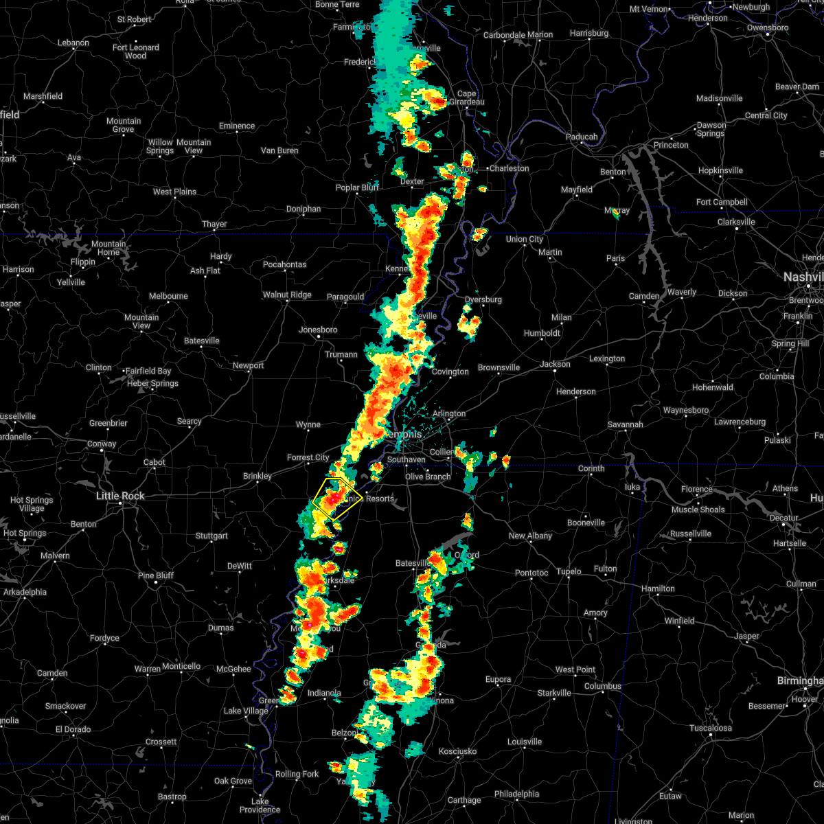 At 140 pm cdt, a severe thunderstorm was located near brickeys, or 9 miles east of marianna, moving northeast at 5 mph (radar indicated). Hazards include 60 mph wind gusts and quarter size hail. Hail damage to vehicles is expected. expect wind damage to roofs, siding, and trees. locations impacted include, brickeys, jeffersonville, raggio, cody, gassett, kokomo, haleside, dansby, soudan, peters, council, diamond woods, ball point, whitehall, tongin and mississippi river state park. hail threat, radar indicated max hail size, 1. 00 in wind threat, radar indicated max wind gust, 60 mph. At 140 pm cdt, a severe thunderstorm was located near brickeys, or 9 miles east of marianna, moving northeast at 5 mph (radar indicated). Hazards include 60 mph wind gusts and quarter size hail. Hail damage to vehicles is expected. expect wind damage to roofs, siding, and trees. locations impacted include, brickeys, jeffersonville, raggio, cody, gassett, kokomo, haleside, dansby, soudan, peters, council, diamond woods, ball point, whitehall, tongin and mississippi river state park. hail threat, radar indicated max hail size, 1. 00 in wind threat, radar indicated max wind gust, 60 mph.
|
| 5/13/2022 1:30 PM CDT |
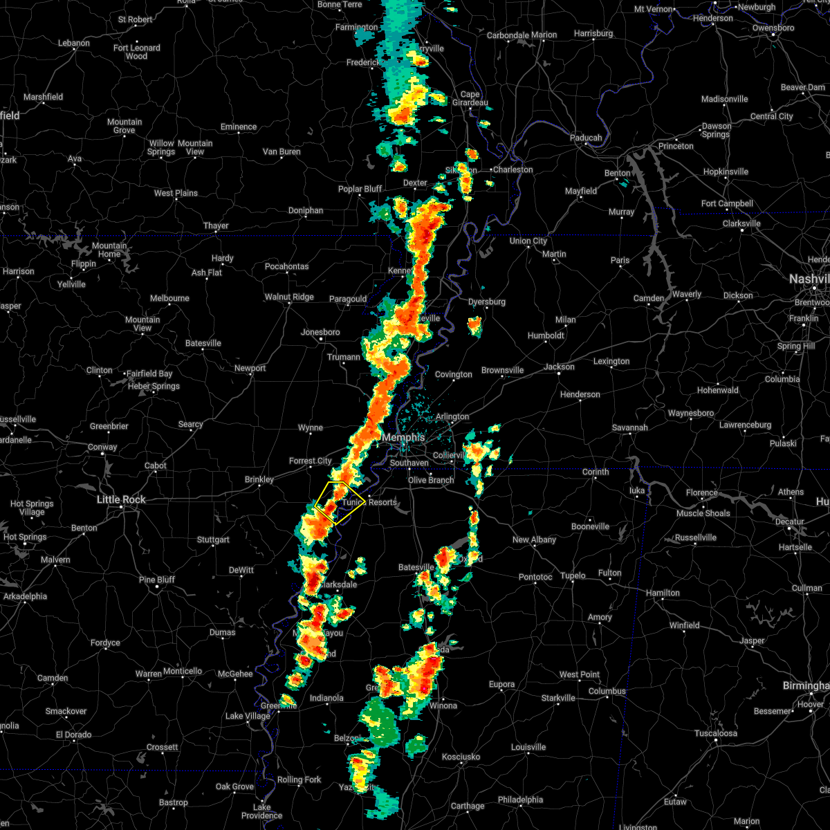 At 129 pm cdt, a severe thunderstorm was located 7 miles south of brickeys, or 8 miles east of marianna, moving northeast at 5 mph (radar indicated). Hazards include 60 mph wind gusts and quarter size hail. Hail damage to vehicles is expected. Expect wind damage to roofs, siding, and trees. At 129 pm cdt, a severe thunderstorm was located 7 miles south of brickeys, or 8 miles east of marianna, moving northeast at 5 mph (radar indicated). Hazards include 60 mph wind gusts and quarter size hail. Hail damage to vehicles is expected. Expect wind damage to roofs, siding, and trees.
|
| 5/13/2022 1:30 PM CDT |
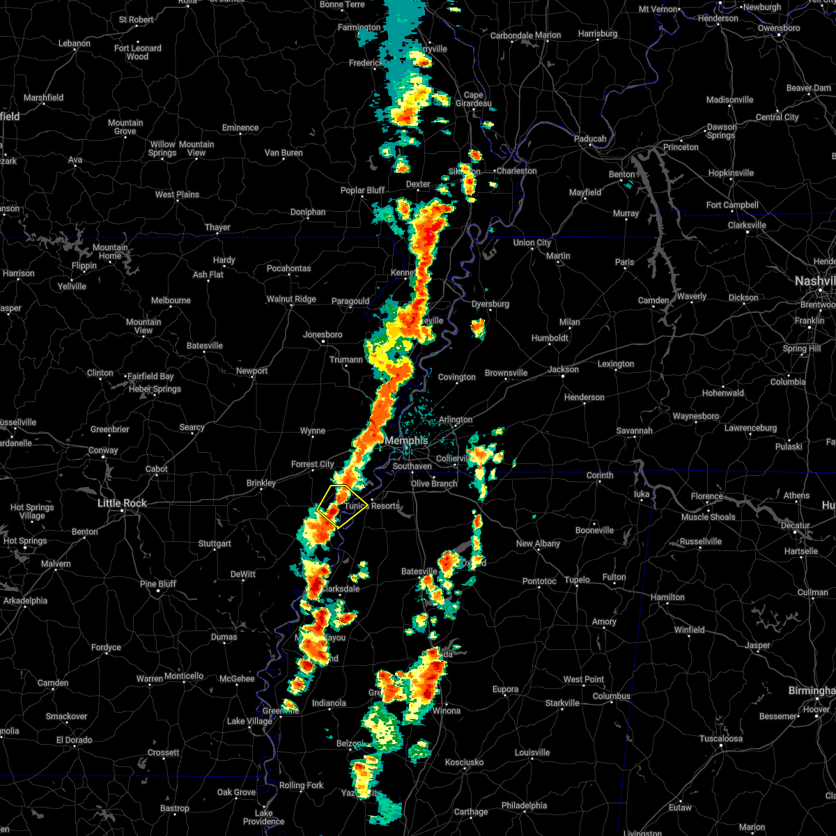 At 129 pm cdt, a severe thunderstorm was located 7 miles south of brickeys, or 8 miles east of marianna, moving northeast at 5 mph (radar indicated). Hazards include 60 mph wind gusts and quarter size hail. Hail damage to vehicles is expected. Expect wind damage to roofs, siding, and trees. At 129 pm cdt, a severe thunderstorm was located 7 miles south of brickeys, or 8 miles east of marianna, moving northeast at 5 mph (radar indicated). Hazards include 60 mph wind gusts and quarter size hail. Hail damage to vehicles is expected. Expect wind damage to roofs, siding, and trees.
|
| 5/5/2022 2:39 PM CDT |
 At 237 pm cdt, a severe thunderstorm was located near helena-west helena, moving northeast at 40 mph (public. at 233 pm cdt, quarter-sized hail was reported 2 miles northwest of helena-west helena). Hazards include 60 mph wind gusts and quarter size hail. Hail damage to vehicles is expected. expect wind damage to roofs, siding, and trees. locations impacted include, helena-west helena, st francis national park, tunica, dubbs, north tunica, dundee, little texas, lula, gerlach mill, preston place, quarles, austin, jeffries, helena crossing, bowdre, huma, maud, fox island, clayton and tibbs. hail threat, observed max hail size, 1. 00 in wind threat, radar indicated max wind gust, 60 mph. At 237 pm cdt, a severe thunderstorm was located near helena-west helena, moving northeast at 40 mph (public. at 233 pm cdt, quarter-sized hail was reported 2 miles northwest of helena-west helena). Hazards include 60 mph wind gusts and quarter size hail. Hail damage to vehicles is expected. expect wind damage to roofs, siding, and trees. locations impacted include, helena-west helena, st francis national park, tunica, dubbs, north tunica, dundee, little texas, lula, gerlach mill, preston place, quarles, austin, jeffries, helena crossing, bowdre, huma, maud, fox island, clayton and tibbs. hail threat, observed max hail size, 1. 00 in wind threat, radar indicated max wind gust, 60 mph.
|
| 5/5/2022 2:18 PM CDT |
 At 218 pm cdt, a severe thunderstorm was located 7 miles south of lexa, or 8 miles west of helena-west helena, moving east at 40 mph (radar indicated). Hazards include ping pong ball size hail and 60 mph wind gusts. People and animals outdoors will be injured. expect hail damage to roofs, siding, windows, and vehicles. Expect wind damage to roofs, siding, and trees. At 218 pm cdt, a severe thunderstorm was located 7 miles south of lexa, or 8 miles west of helena-west helena, moving east at 40 mph (radar indicated). Hazards include ping pong ball size hail and 60 mph wind gusts. People and animals outdoors will be injured. expect hail damage to roofs, siding, windows, and vehicles. Expect wind damage to roofs, siding, and trees.
|
| 4/30/2022 10:11 PM CDT |
 At 1010 pm cdt, a severe thunderstorm was located 7 miles southeast of brickeys, or 13 miles south of hughes, moving east at 25 mph (radar indicated). Hazards include 60 mph wind gusts and quarter size hail. Hail damage to vehicles is expected. expect wind damage to roofs, siding, and trees. locations impacted include, tunica, north tunica, dubbs, little texas, maud, fox island, commerce, austin, clayton, hollywood, diamond woods, whitehall, evansville and bowdre. hail threat, radar indicated max hail size, 1. 00 in wind threat, radar indicated max wind gust, 60 mph. At 1010 pm cdt, a severe thunderstorm was located 7 miles southeast of brickeys, or 13 miles south of hughes, moving east at 25 mph (radar indicated). Hazards include 60 mph wind gusts and quarter size hail. Hail damage to vehicles is expected. expect wind damage to roofs, siding, and trees. locations impacted include, tunica, north tunica, dubbs, little texas, maud, fox island, commerce, austin, clayton, hollywood, diamond woods, whitehall, evansville and bowdre. hail threat, radar indicated max hail size, 1. 00 in wind threat, radar indicated max wind gust, 60 mph.
|
| 4/30/2022 10:11 PM CDT |
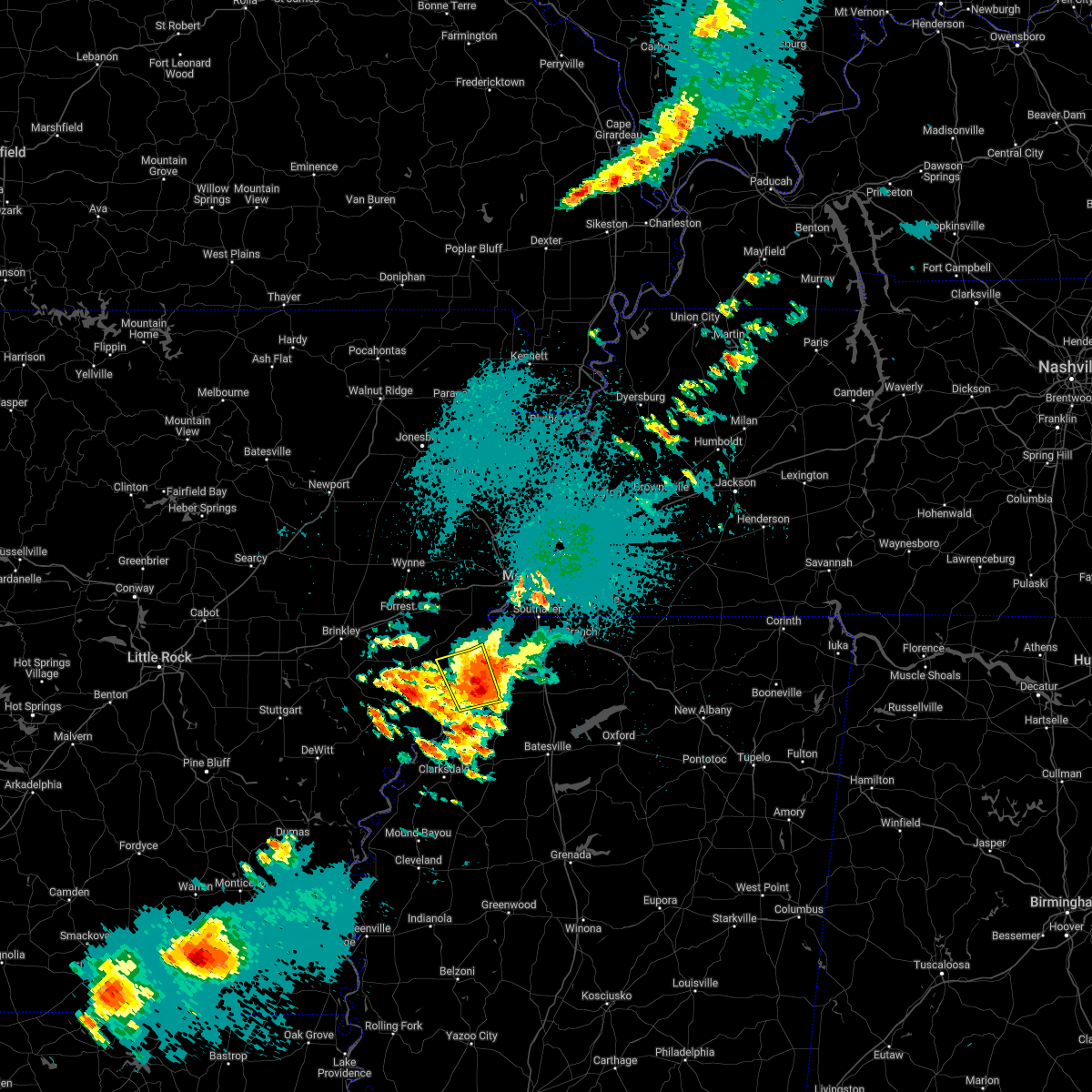 At 1010 pm cdt, a severe thunderstorm was located 7 miles southeast of brickeys, or 13 miles south of hughes, moving east at 25 mph (radar indicated). Hazards include 60 mph wind gusts and quarter size hail. Hail damage to vehicles is expected. expect wind damage to roofs, siding, and trees. locations impacted include, tunica, north tunica, dubbs, little texas, maud, fox island, commerce, austin, clayton, hollywood, diamond woods, whitehall, evansville and bowdre. hail threat, radar indicated max hail size, 1. 00 in wind threat, radar indicated max wind gust, 60 mph. At 1010 pm cdt, a severe thunderstorm was located 7 miles southeast of brickeys, or 13 miles south of hughes, moving east at 25 mph (radar indicated). Hazards include 60 mph wind gusts and quarter size hail. Hail damage to vehicles is expected. expect wind damage to roofs, siding, and trees. locations impacted include, tunica, north tunica, dubbs, little texas, maud, fox island, commerce, austin, clayton, hollywood, diamond woods, whitehall, evansville and bowdre. hail threat, radar indicated max hail size, 1. 00 in wind threat, radar indicated max wind gust, 60 mph.
|
| 4/30/2022 9:53 PM CDT |
 At 953 pm cdt, a severe thunderstorm was located 8 miles south of brickeys, or 8 miles east of marianna, moving east at 25 mph (radar indicated). Hazards include 60 mph wind gusts and quarter size hail. Hail damage to vehicles is expected. Expect wind damage to roofs, siding, and trees. At 953 pm cdt, a severe thunderstorm was located 8 miles south of brickeys, or 8 miles east of marianna, moving east at 25 mph (radar indicated). Hazards include 60 mph wind gusts and quarter size hail. Hail damage to vehicles is expected. Expect wind damage to roofs, siding, and trees.
|
| 4/16/2022 12:04 AM CDT |
 At 1203 am cdt, a severe thunderstorm was located near olive branch, moving east at 60 mph (radar indicated). Hazards include 60 mph wind gusts and quarter size hail. Hail damage to vehicles is expected. expect wind damage to roofs, siding, and trees. locations impacted include, southaven, olive branch, horn lake, hernando, senatobia, holly springs, wall doxey state park, coldwater, byhalia, walls, mt pleasant, lake cormorant, eudora, lewisburg, arkabutla, red banks, laws hill, barr, lynchburg and phillipp. hail threat, radar indicated max hail size, 1. 00 in wind threat, radar indicated max wind gust, 60 mph. At 1203 am cdt, a severe thunderstorm was located near olive branch, moving east at 60 mph (radar indicated). Hazards include 60 mph wind gusts and quarter size hail. Hail damage to vehicles is expected. expect wind damage to roofs, siding, and trees. locations impacted include, southaven, olive branch, horn lake, hernando, senatobia, holly springs, wall doxey state park, coldwater, byhalia, walls, mt pleasant, lake cormorant, eudora, lewisburg, arkabutla, red banks, laws hill, barr, lynchburg and phillipp. hail threat, radar indicated max hail size, 1. 00 in wind threat, radar indicated max wind gust, 60 mph.
|
| 4/15/2022 11:56 PM CDT |
 At 1156 pm cdt, a severe thunderstorm was located near horn lake, moving east at 60 mph (radar indicated). Hazards include 60 mph wind gusts and quarter size hail. Hail damage to vehicles is expected. Expect wind damage to roofs, siding, and trees. At 1156 pm cdt, a severe thunderstorm was located near horn lake, moving east at 60 mph (radar indicated). Hazards include 60 mph wind gusts and quarter size hail. Hail damage to vehicles is expected. Expect wind damage to roofs, siding, and trees.
|
| 4/13/2022 5:18 PM CDT |
 At 518 pm cdt, severe thunderstorms were located along a line extending from near robinsonville to near jonestown to 6 miles southwest of clarksdale, moving east at 45 mph (radar indicated). Hazards include 70 mph wind gusts. Expect considerable tree damage. damage is likely to mobile homes, roofs, and outbuildings. locations impacted include, southaven, horn lake, clarksdale, hernando, elaine, helena-west helena, st francis national park, jonestown, friars point, walls, tunica, crenshaw, belen, lake cormorant, strayhorn, eudora, dubbs, north tunica, dundee and arkabutla. thunderstorm damage threat, considerable hail threat, radar indicated max hail size, <. 75 in wind threat, radar indicated max wind gust, 70 mph. At 518 pm cdt, severe thunderstorms were located along a line extending from near robinsonville to near jonestown to 6 miles southwest of clarksdale, moving east at 45 mph (radar indicated). Hazards include 70 mph wind gusts. Expect considerable tree damage. damage is likely to mobile homes, roofs, and outbuildings. locations impacted include, southaven, horn lake, clarksdale, hernando, elaine, helena-west helena, st francis national park, jonestown, friars point, walls, tunica, crenshaw, belen, lake cormorant, strayhorn, eudora, dubbs, north tunica, dundee and arkabutla. thunderstorm damage threat, considerable hail threat, radar indicated max hail size, <. 75 in wind threat, radar indicated max wind gust, 70 mph.
|
| 4/13/2022 5:16 PM CDT |
 At 516 pm cdt, severe thunderstorms were located along a line extending from walls to phillipp to near dubbs, moving east at 40 mph (radar indicated). Hazards include 70 mph wind gusts. Expect considerable tree damage. Damage is likely to mobile homes, roofs, and outbuildings. At 516 pm cdt, severe thunderstorms were located along a line extending from walls to phillipp to near dubbs, moving east at 40 mph (radar indicated). Hazards include 70 mph wind gusts. Expect considerable tree damage. Damage is likely to mobile homes, roofs, and outbuildings.
|
| 4/13/2022 4:58 PM CDT |
 At 458 pm cdt, severe thunderstorms were located along a line extending from near hughes to near helena-west helena to elaine, moving east at 50 mph (radar indicated). Hazards include 70 mph wind gusts. Expect considerable tree damage. Damage is likely to mobile homes, roofs, and outbuildings. At 458 pm cdt, severe thunderstorms were located along a line extending from near hughes to near helena-west helena to elaine, moving east at 50 mph (radar indicated). Hazards include 70 mph wind gusts. Expect considerable tree damage. Damage is likely to mobile homes, roofs, and outbuildings.
|
| 4/13/2022 4:48 PM CDT |
 At 448 pm cdt, severe thunderstorms were located along a line extending from midtown memphis to near eudora to near north tunica, moving east at 40 mph (radar indicated). Hazards include 60 mph wind gusts. Expect damage to roofs, siding, and trees. locations impacted include, southaven, olive branch, horn lake, hernando, hughes, t o fuller state park, memphis, coldwater, walls, tunica, horseshoe lake, lake cormorant, southwest memphis, eudora, brickeys, north tunica, whitehaven, arkabutla, frayser and midtown memphis. hail threat, radar indicated max hail size, <. 75 in wind threat, radar indicated max wind gust, 60 mph. At 448 pm cdt, severe thunderstorms were located along a line extending from midtown memphis to near eudora to near north tunica, moving east at 40 mph (radar indicated). Hazards include 60 mph wind gusts. Expect damage to roofs, siding, and trees. locations impacted include, southaven, olive branch, horn lake, hernando, hughes, t o fuller state park, memphis, coldwater, walls, tunica, horseshoe lake, lake cormorant, southwest memphis, eudora, brickeys, north tunica, whitehaven, arkabutla, frayser and midtown memphis. hail threat, radar indicated max hail size, <. 75 in wind threat, radar indicated max wind gust, 60 mph.
|
| 4/13/2022 4:30 PM CDT |
 At 430 pm cdt, severe thunderstorms were located along a line extending from west memphis to near eudora to near north tunica, moving east at 65 mph (radar indicated). Hazards include 60 mph wind gusts. Expect damage to roofs, siding, and trees. locations impacted include, southaven, olive branch, west memphis, horn lake, hernando, marion, hughes, t o fuller state park, memphis, coldwater, walls, tunica, edmondson, horseshoe lake, anthonyville, jennette, lake cormorant, southwest memphis, simsboro and brickeys. hail threat, radar indicated max hail size, <. 75 in wind threat, radar indicated max wind gust, 60 mph. At 430 pm cdt, severe thunderstorms were located along a line extending from west memphis to near eudora to near north tunica, moving east at 65 mph (radar indicated). Hazards include 60 mph wind gusts. Expect damage to roofs, siding, and trees. locations impacted include, southaven, olive branch, west memphis, horn lake, hernando, marion, hughes, t o fuller state park, memphis, coldwater, walls, tunica, edmondson, horseshoe lake, anthonyville, jennette, lake cormorant, southwest memphis, simsboro and brickeys. hail threat, radar indicated max hail size, <. 75 in wind threat, radar indicated max wind gust, 60 mph.
|
| 4/13/2022 4:08 PM CDT |
 At 407 pm cdt, severe thunderstorms were located along a line extending from near village creek state park to brickeys to near lexa, moving east at 65 mph (radar indicated). Hazards include 60 mph wind gusts. expect damage to roofs, siding, and trees At 407 pm cdt, severe thunderstorms were located along a line extending from near village creek state park to brickeys to near lexa, moving east at 65 mph (radar indicated). Hazards include 60 mph wind gusts. expect damage to roofs, siding, and trees
|
| 4/13/2022 3:37 PM CDT |
 At 337 pm cdt, severe thunderstorms were located along a line extending from near gilmore to near west memphis to near robinsonville, moving east at 65 mph (radar indicated). Hazards include 70 mph wind gusts. Expect considerable tree damage. damage is likely to mobile homes, roofs, and outbuildings. locations impacted include, bartlett, southaven, collierville, germantown, olive branch, west memphis, horn lake, hernando, marion, millington, t o fuller state park, meeman shelby forest state park, cordova, memphis, lakeland, arlington, munford, brighton, walls and crawfordsville. thunderstorm damage threat, considerable hail threat, radar indicated max hail size, <. 75 in wind threat, radar indicated max wind gust, 70 mph. At 337 pm cdt, severe thunderstorms were located along a line extending from near gilmore to near west memphis to near robinsonville, moving east at 65 mph (radar indicated). Hazards include 70 mph wind gusts. Expect considerable tree damage. damage is likely to mobile homes, roofs, and outbuildings. locations impacted include, bartlett, southaven, collierville, germantown, olive branch, west memphis, horn lake, hernando, marion, millington, t o fuller state park, meeman shelby forest state park, cordova, memphis, lakeland, arlington, munford, brighton, walls and crawfordsville. thunderstorm damage threat, considerable hail threat, radar indicated max hail size, <. 75 in wind threat, radar indicated max wind gust, 70 mph.
|
| 4/13/2022 3:20 PM CDT |
 At 320 pm cdt, severe thunderstorms were located along a line extending from 7 miles north of earle to near simsboro to near brickeys, moving east at 65 mph (radar indicated). Hazards include 70 mph wind gusts. Expect considerable tree damage. Damage is likely to mobile homes, roofs, and outbuildings. At 320 pm cdt, severe thunderstorms were located along a line extending from 7 miles north of earle to near simsboro to near brickeys, moving east at 65 mph (radar indicated). Hazards include 70 mph wind gusts. Expect considerable tree damage. Damage is likely to mobile homes, roofs, and outbuildings.
|
| 4/13/2022 3:15 PM CDT |
 At 314 pm cdt, severe thunderstorms were located along a line extending from gilmore to near hughes, moving northeast at 65 mph (radar indicated). Hazards include 60 mph wind gusts and quarter size hail. Hail damage to vehicles is expected. expect wind damage to roofs, siding, and trees. locations impacted include, west memphis, forrest city, marion, marianna, earle, hughes, parkin, madison, village creek state park, crawfordsville, edmondson, horseshoe lake, widener, sunset, anthonyville, haynes, jericho, jennette, simsboro and brickeys. hail threat, radar indicated max hail size, 1. 00 in wind threat, radar indicated max wind gust, 60 mph. At 314 pm cdt, severe thunderstorms were located along a line extending from gilmore to near hughes, moving northeast at 65 mph (radar indicated). Hazards include 60 mph wind gusts and quarter size hail. Hail damage to vehicles is expected. expect wind damage to roofs, siding, and trees. locations impacted include, west memphis, forrest city, marion, marianna, earle, hughes, parkin, madison, village creek state park, crawfordsville, edmondson, horseshoe lake, widener, sunset, anthonyville, haynes, jericho, jennette, simsboro and brickeys. hail threat, radar indicated max hail size, 1. 00 in wind threat, radar indicated max wind gust, 60 mph.
|
| 4/13/2022 2:46 PM CDT |
 At 246 pm cdt, severe thunderstorms were located along a line extending from wynne to moro, moving northeast at 65 mph (radar indicated). Hazards include 60 mph wind gusts and penny size hail. expect damage to roofs, siding, and trees At 246 pm cdt, severe thunderstorms were located along a line extending from wynne to moro, moving northeast at 65 mph (radar indicated). Hazards include 60 mph wind gusts and penny size hail. expect damage to roofs, siding, and trees
|
| 4/11/2022 11:43 PM CDT | Quarter sized hail reported 1.1 miles NW of Tunica Resorts, MS |
| 4/11/2022 11:24 PM CDT |
 At 1124 pm cdt, a severe thunderstorm was located near north tunica, or 14 miles south of hughes, moving east at 35 mph (radar indicated). Hazards include 60 mph wind gusts and quarter size hail. Hail damage to vehicles is expected. expect wind damage to roofs, siding, and trees. locations impacted include, north tunica, raggio, hollywood, diamond woods, commerce, whitehall and peters. hail threat, radar indicated max hail size, 1. 00 in wind threat, radar indicated max wind gust, 60 mph. At 1124 pm cdt, a severe thunderstorm was located near north tunica, or 14 miles south of hughes, moving east at 35 mph (radar indicated). Hazards include 60 mph wind gusts and quarter size hail. Hail damage to vehicles is expected. expect wind damage to roofs, siding, and trees. locations impacted include, north tunica, raggio, hollywood, diamond woods, commerce, whitehall and peters. hail threat, radar indicated max hail size, 1. 00 in wind threat, radar indicated max wind gust, 60 mph.
|
| 4/11/2022 11:11 PM CDT |
 At 1111 pm cdt, a severe thunderstorm was located 7 miles south of brickeys, or 12 miles east of marianna, moving east at 35 mph (radar indicated). Hazards include 60 mph wind gusts and quarter size hail. Hail damage to vehicles is expected. expect wind damage to roofs, siding, and trees. locations impacted include, north tunica, raggio, hollywood, diamond woods, commerce, soudan, whitehall, peters and mississippi river state park. hail threat, radar indicated max hail size, 1. 00 in wind threat, radar indicated max wind gust, 60 mph. At 1111 pm cdt, a severe thunderstorm was located 7 miles south of brickeys, or 12 miles east of marianna, moving east at 35 mph (radar indicated). Hazards include 60 mph wind gusts and quarter size hail. Hail damage to vehicles is expected. expect wind damage to roofs, siding, and trees. locations impacted include, north tunica, raggio, hollywood, diamond woods, commerce, soudan, whitehall, peters and mississippi river state park. hail threat, radar indicated max hail size, 1. 00 in wind threat, radar indicated max wind gust, 60 mph.
|
| 4/11/2022 11:01 PM CDT |
 At 1101 pm cdt, a severe thunderstorm was located near marianna, moving east at 35 mph (radar indicated). Hazards include 60 mph wind gusts and quarter size hail. Hail damage to vehicles is expected. expect wind damage to roofs, siding, and trees. locations impacted include, marianna, tunica, rondo, north tunica, lagrange, jeffersonville, raggio, maud, haleside, fox island, commerce, austin, soudan, peters, clayton, phillips bayou, hollywood, felton, diamond woods and scott valley. hail threat, radar indicated max hail size, 1. 00 in wind threat, radar indicated max wind gust, 60 mph. At 1101 pm cdt, a severe thunderstorm was located near marianna, moving east at 35 mph (radar indicated). Hazards include 60 mph wind gusts and quarter size hail. Hail damage to vehicles is expected. expect wind damage to roofs, siding, and trees. locations impacted include, marianna, tunica, rondo, north tunica, lagrange, jeffersonville, raggio, maud, haleside, fox island, commerce, austin, soudan, peters, clayton, phillips bayou, hollywood, felton, diamond woods and scott valley. hail threat, radar indicated max hail size, 1. 00 in wind threat, radar indicated max wind gust, 60 mph.
|
| 4/11/2022 10:40 PM CDT |
 At 1039 pm cdt, a severe thunderstorm was located over aubrey, or 8 miles west of marianna, moving east at 35 mph (radar indicated). Hazards include 60 mph wind gusts and quarter size hail. Hail damage to vehicles is expected. Expect wind damage to roofs, siding, and trees. At 1039 pm cdt, a severe thunderstorm was located over aubrey, or 8 miles west of marianna, moving east at 35 mph (radar indicated). Hazards include 60 mph wind gusts and quarter size hail. Hail damage to vehicles is expected. Expect wind damage to roofs, siding, and trees.
|
| 3/30/2022 4:42 PM CDT |
 At 442 pm cdt, severe thunderstorms were located along a line extending from near t o fuller state park to near eudora to near senatobia, moving northeast at 45 mph (radar indicated). Hazards include 60 mph wind gusts. expect damage to roofs, siding, and trees At 442 pm cdt, severe thunderstorms were located along a line extending from near t o fuller state park to near eudora to near senatobia, moving northeast at 45 mph (radar indicated). Hazards include 60 mph wind gusts. expect damage to roofs, siding, and trees
|
| 3/30/2022 4:26 PM CDT |
 At 426 pm cdt, severe thunderstorms were located along a line extending from near pinckney to near phillipp to near crenshaw, moving northeast at 50 mph (radar indicated). Hazards include 70 mph wind gusts. Expect considerable tree damage. damage is likely to mobile homes, roofs, and outbuildings. locations impacted include, bartlett, southaven, collierville, germantown, olive branch, west memphis, horn lake, hernando, marion, millington, senatobia, t o fuller state park, cordova, memphis, lakeland, coldwater, como, walls, tunica and crenshaw. thunderstorm damage threat, considerable hail threat, radar indicated max hail size, <. 75 in wind threat, radar indicated max wind gust, 70 mph. At 426 pm cdt, severe thunderstorms were located along a line extending from near pinckney to near phillipp to near crenshaw, moving northeast at 50 mph (radar indicated). Hazards include 70 mph wind gusts. Expect considerable tree damage. damage is likely to mobile homes, roofs, and outbuildings. locations impacted include, bartlett, southaven, collierville, germantown, olive branch, west memphis, horn lake, hernando, marion, millington, senatobia, t o fuller state park, cordova, memphis, lakeland, coldwater, como, walls, tunica and crenshaw. thunderstorm damage threat, considerable hail threat, radar indicated max hail size, <. 75 in wind threat, radar indicated max wind gust, 70 mph.
|
| 3/30/2022 4:04 PM CDT |
 At 404 pm cdt, a severe thunderstorm was located over tunica, or 13 miles northeast of st francis national park, moving northeast at 60 mph (radar indicated). Hazards include 70 mph wind gusts. Expect considerable tree damage. Damage is likely to mobile homes, roofs, and outbuildings. At 404 pm cdt, a severe thunderstorm was located over tunica, or 13 miles northeast of st francis national park, moving northeast at 60 mph (radar indicated). Hazards include 70 mph wind gusts. Expect considerable tree damage. Damage is likely to mobile homes, roofs, and outbuildings.
|
| 3/30/2022 3:45 PM CDT |
 At 345 pm cdt, a severe thunderstorm producing a tornado was located near helena-west helena, moving northeast at 40 mph (radar indicated rotation). Hazards include tornado. Flying debris will be dangerous to those caught without shelter. mobile homes will be damaged or destroyed. damage to roofs, windows, and vehicles will occur. Tree damage is likely. At 345 pm cdt, a severe thunderstorm producing a tornado was located near helena-west helena, moving northeast at 40 mph (radar indicated rotation). Hazards include tornado. Flying debris will be dangerous to those caught without shelter. mobile homes will be damaged or destroyed. damage to roofs, windows, and vehicles will occur. Tree damage is likely.
|
| 12/11/2021 1:20 AM CST |
 The severe thunderstorm warning for eastern lee, southeastern st. francis, southwestern crittenden, northern desoto and northern tunica counties will expire at 130 am cst, the storm which prompted the warning has weakened below severe limits, and no longer poses an immediate threat to life or property. therefore, the warning will be allowed to expire. a tornado watch remains in effect until 500 am cst for eastern arkansas, and northwestern mississippi. The severe thunderstorm warning for eastern lee, southeastern st. francis, southwestern crittenden, northern desoto and northern tunica counties will expire at 130 am cst, the storm which prompted the warning has weakened below severe limits, and no longer poses an immediate threat to life or property. therefore, the warning will be allowed to expire. a tornado watch remains in effect until 500 am cst for eastern arkansas, and northwestern mississippi.
|
| 12/11/2021 12:48 AM CST |
 At 1248 am cst, a severe thunderstorm was located over lake cormorant, or 12 miles east of hughes, moving east at 85 mph (radar indicated). Hazards include 60 mph wind gusts and penny size hail. expect damage to roofs, siding, and trees At 1248 am cst, a severe thunderstorm was located over lake cormorant, or 12 miles east of hughes, moving east at 85 mph (radar indicated). Hazards include 60 mph wind gusts and penny size hail. expect damage to roofs, siding, and trees
|
| 12/10/2021 11:25 PM CST |
 At 1124 pm cst, a severe thunderstorm was located near new home, or 7 miles west of hughes, moving northeast at 60 mph (radar indicated). Hazards include 60 mph wind gusts and quarter size hail. Hail damage to vehicles is expected. Expect wind damage to roofs, siding, and trees. At 1124 pm cst, a severe thunderstorm was located near new home, or 7 miles west of hughes, moving northeast at 60 mph (radar indicated). Hazards include 60 mph wind gusts and quarter size hail. Hail damage to vehicles is expected. Expect wind damage to roofs, siding, and trees.
|
| 10/15/2021 6:21 PM CDT |
 At 621 pm cdt, a severe thunderstorm was located near eudora, or 12 miles west of hernando, moving east at 35 mph (radar indicated). Hazards include 60 mph wind gusts and penny size hail. expect damage to roofs, siding, and trees At 621 pm cdt, a severe thunderstorm was located near eudora, or 12 miles west of hernando, moving east at 35 mph (radar indicated). Hazards include 60 mph wind gusts and penny size hail. expect damage to roofs, siding, and trees
|
| 10/15/2021 5:56 PM CDT |
 At 556 pm cdt, a severe thunderstorm producing a tornado was located near brickeys, or near hughes, moving east at 45 mph (radar indicated rotation). Hazards include tornado. Flying debris will be dangerous to those caught without shelter. mobile homes will be damaged or destroyed. damage to roofs, windows, and vehicles will occur. tree damage is likely. this dangerous storm will be near, horseshoe lake and robinsonville around 610 pm cdt. lake cormorant around 620 pm cdt. eudora around 625 pm cdt. Other locations impacted by this tornadic thunderstorm include newport, gassett, clack, kokomo, trinity, commerce, mud lake, peters, council and west days. At 556 pm cdt, a severe thunderstorm producing a tornado was located near brickeys, or near hughes, moving east at 45 mph (radar indicated rotation). Hazards include tornado. Flying debris will be dangerous to those caught without shelter. mobile homes will be damaged or destroyed. damage to roofs, windows, and vehicles will occur. tree damage is likely. this dangerous storm will be near, horseshoe lake and robinsonville around 610 pm cdt. lake cormorant around 620 pm cdt. eudora around 625 pm cdt. Other locations impacted by this tornadic thunderstorm include newport, gassett, clack, kokomo, trinity, commerce, mud lake, peters, council and west days.
|
| 10/15/2021 5:46 PM CDT |
 At 545 pm cdt, a severe thunderstorm was located over brickeys, or 7 miles southwest of hughes, moving east at 45 mph (radar indicated). Hazards include 60 mph wind gusts and quarter size hail. Hail damage to vehicles is expected. expect wind damage to roofs, siding, and trees. locations impacted include, horn lake, forrest city, marianna, hughes, madison, walls, horseshoe lake, widener, haynes, lake cormorant, eudora, brickeys, arkabutla, pinckney, lynchburg, phillipp, robinsonville, cody, clack and trinity. hail threat, radar indicated max hail size, 1. 00 in wind threat, radar indicated max wind gust, 60 mph. At 545 pm cdt, a severe thunderstorm was located over brickeys, or 7 miles southwest of hughes, moving east at 45 mph (radar indicated). Hazards include 60 mph wind gusts and quarter size hail. Hail damage to vehicles is expected. expect wind damage to roofs, siding, and trees. locations impacted include, horn lake, forrest city, marianna, hughes, madison, walls, horseshoe lake, widener, haynes, lake cormorant, eudora, brickeys, arkabutla, pinckney, lynchburg, phillipp, robinsonville, cody, clack and trinity. hail threat, radar indicated max hail size, 1. 00 in wind threat, radar indicated max wind gust, 60 mph.
|
| 10/15/2021 5:31 PM CDT |
 At 531 pm cdt, a severe thunderstorm was located over haynes, or near forrest city, moving east at 45 mph (radar indicated). Hazards include 60 mph wind gusts and quarter size hail. Hail damage to vehicles is expected. Expect wind damage to roofs, siding, and trees. At 531 pm cdt, a severe thunderstorm was located over haynes, or near forrest city, moving east at 45 mph (radar indicated). Hazards include 60 mph wind gusts and quarter size hail. Hail damage to vehicles is expected. Expect wind damage to roofs, siding, and trees.
|
| 7/9/2021 1:47 PM CDT |
 At 147 pm cdt, a severe thunderstorm was located over lake cormorant, or 8 miles west of horn lake, moving southeast at 15 mph (radar indicated). Hazards include 60 mph wind gusts and penny size hail. Expect damage to roofs, siding, and trees. Locations impacted include, southaven, horn lake, hernando, walls, horseshoe lake, pinckney, lake cormorant, lynchburg, phillipp, eudora, arkabutla, newport, clack, trinity, frees corners, nesbit, bruins, beck, glover and banks. At 147 pm cdt, a severe thunderstorm was located over lake cormorant, or 8 miles west of horn lake, moving southeast at 15 mph (radar indicated). Hazards include 60 mph wind gusts and penny size hail. Expect damage to roofs, siding, and trees. Locations impacted include, southaven, horn lake, hernando, walls, horseshoe lake, pinckney, lake cormorant, lynchburg, phillipp, eudora, arkabutla, newport, clack, trinity, frees corners, nesbit, bruins, beck, glover and banks.
|
| 7/9/2021 1:19 PM CDT |
 At 119 pm cdt, a severe thunderstorm was located over pinckney, or 11 miles east of hughes, moving southeast at 15 mph (radar indicated). Hazards include 60 mph wind gusts and penny size hail. expect damage to roofs, siding, and trees At 119 pm cdt, a severe thunderstorm was located over pinckney, or 11 miles east of hughes, moving southeast at 15 mph (radar indicated). Hazards include 60 mph wind gusts and penny size hail. expect damage to roofs, siding, and trees
|
| 6/7/2021 8:09 PM CDT |
 At 809 pm cdt, a severe thunderstorm was located over olive branch, moving northeast at 45 mph (radar indicated). Hazards include 60 mph wind gusts. Expect damage to roofs, siding, and trees. Locations impacted include, southaven, collierville, olive branch, horn lake, hernando, t o fuller state park, memphis, coldwater, byhalia, walls, lake cormorant, southwest memphis, eudora, lewisburg, whitehaven, red banks, barr, lynchburg, southeast memphis and independence. At 809 pm cdt, a severe thunderstorm was located over olive branch, moving northeast at 45 mph (radar indicated). Hazards include 60 mph wind gusts. Expect damage to roofs, siding, and trees. Locations impacted include, southaven, collierville, olive branch, horn lake, hernando, t o fuller state park, memphis, coldwater, byhalia, walls, lake cormorant, southwest memphis, eudora, lewisburg, whitehaven, red banks, barr, lynchburg, southeast memphis and independence.
|
| 6/7/2021 7:40 PM CDT |
 At 740 pm cdt, a severe thunderstorm was located near arkabutla, or near senatobia, moving northeast at 45 mph (radar indicated). Hazards include 60 mph wind gusts. expect damage to roofs, siding, and trees At 740 pm cdt, a severe thunderstorm was located near arkabutla, or near senatobia, moving northeast at 45 mph (radar indicated). Hazards include 60 mph wind gusts. expect damage to roofs, siding, and trees
|
| 6/7/2021 7:31 PM CDT |
 At 731 pm cdt, severe thunderstorms were located along a line extending from near rondo to strayhorn to near batesville, moving northeast at 60 mph (radar indicated). Hazards include 60 mph wind gusts. Expect damage to roofs, siding, and trees. Locations impacted include, hernando, senatobia, batesville, john w kyle state park, sardis, coldwater, como, tunica, crenshaw, sledge, strayhorn, pleasant grove, eudora, dubbs, curtis station, north tunica, arkabutla, barr, phillipp and independence. At 731 pm cdt, severe thunderstorms were located along a line extending from near rondo to strayhorn to near batesville, moving northeast at 60 mph (radar indicated). Hazards include 60 mph wind gusts. Expect damage to roofs, siding, and trees. Locations impacted include, hernando, senatobia, batesville, john w kyle state park, sardis, coldwater, como, tunica, crenshaw, sledge, strayhorn, pleasant grove, eudora, dubbs, curtis station, north tunica, arkabutla, barr, phillipp and independence.
|
| 6/7/2021 7:17 PM CDT |
 At 717 pm cdt, severe thunderstorms were located along a line extending from near marvell to near crenshaw to near enid, moving northeast at 55 mph (radar indicated). Hazards include 60 mph wind gusts. Expect damage to roofs, siding, and trees. Locations impacted include, hernando, senatobia, batesville, john w kyle state park, sardis, coldwater, como, tunica, crenshaw, crowder, sledge, lake cormorant, strayhorn, pleasant grove, eudora, dubbs, curtis station, north tunica, arkabutla and barr. At 717 pm cdt, severe thunderstorms were located along a line extending from near marvell to near crenshaw to near enid, moving northeast at 55 mph (radar indicated). Hazards include 60 mph wind gusts. Expect damage to roofs, siding, and trees. Locations impacted include, hernando, senatobia, batesville, john w kyle state park, sardis, coldwater, como, tunica, crenshaw, crowder, sledge, lake cormorant, strayhorn, pleasant grove, eudora, dubbs, curtis station, north tunica, arkabutla and barr.
|
| 6/7/2021 7:02 PM CDT |
 At 701 pm cdt, severe thunderstorms were located along a line extending from near watkins corner to near darling to near charleston, moving northeast at 60 mph (radar indicated). Hazards include 60 mph wind gusts. Expect damage to roofs, siding, and trees. Locations impacted include, hernando, senatobia, batesville, john w kyle state park, sardis, coldwater, como, tunica, crenshaw, crowder, sledge, lake cormorant, strayhorn, pleasant grove, eudora, dubbs, curtis station, north tunica, arkabutla and barr. At 701 pm cdt, severe thunderstorms were located along a line extending from near watkins corner to near darling to near charleston, moving northeast at 60 mph (radar indicated). Hazards include 60 mph wind gusts. Expect damage to roofs, siding, and trees. Locations impacted include, hernando, senatobia, batesville, john w kyle state park, sardis, coldwater, como, tunica, crenshaw, crowder, sledge, lake cormorant, strayhorn, pleasant grove, eudora, dubbs, curtis station, north tunica, arkabutla and barr.
|
| 6/7/2021 6:54 PM CDT |
 At 654 pm cdt, severe thunderstorms were located along a line extending from 6 miles southeast of st. charles to near jonestown to charleston, moving northeast at 60 mph (radar indicated). Hazards include 60 mph wind gusts. expect damage to roofs, siding, and trees At 654 pm cdt, severe thunderstorms were located along a line extending from 6 miles southeast of st. charles to near jonestown to charleston, moving northeast at 60 mph (radar indicated). Hazards include 60 mph wind gusts. expect damage to roofs, siding, and trees
|
| 5/9/2021 5:40 PM CDT |
 The severe thunderstorm warning for eastern lee, southwestern desoto, tunica and western tate counties will expire at 545 pm cdt, the storm which prompted the warning has weakened below severe limits, and no longer poses an immediate threat to life or property. therefore, the warning will be allowed to expire. a severe thunderstorm watch remains in effect until 900 pm cdt for eastern arkansas, and northwestern mississippi. remember, a severe thunderstorm warning still remains in effect. The severe thunderstorm warning for eastern lee, southwestern desoto, tunica and western tate counties will expire at 545 pm cdt, the storm which prompted the warning has weakened below severe limits, and no longer poses an immediate threat to life or property. therefore, the warning will be allowed to expire. a severe thunderstorm watch remains in effect until 900 pm cdt for eastern arkansas, and northwestern mississippi. remember, a severe thunderstorm warning still remains in effect.
|
| 5/9/2021 5:40 PM CDT |
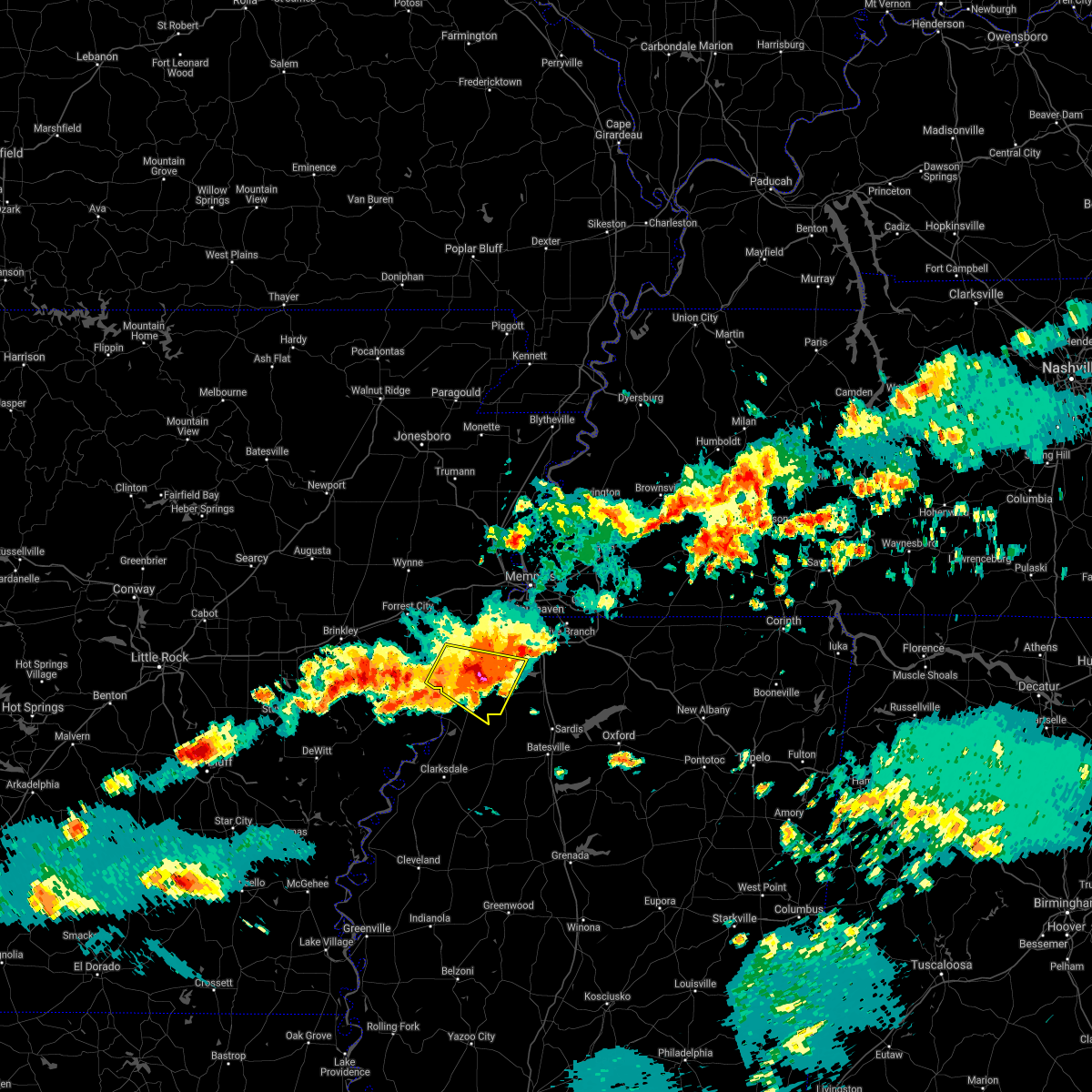 The severe thunderstorm warning for eastern lee, southwestern desoto, tunica and western tate counties will expire at 545 pm cdt, the storm which prompted the warning has weakened below severe limits, and no longer poses an immediate threat to life or property. therefore, the warning will be allowed to expire. a severe thunderstorm watch remains in effect until 900 pm cdt for eastern arkansas, and northwestern mississippi. remember, a severe thunderstorm warning still remains in effect. The severe thunderstorm warning for eastern lee, southwestern desoto, tunica and western tate counties will expire at 545 pm cdt, the storm which prompted the warning has weakened below severe limits, and no longer poses an immediate threat to life or property. therefore, the warning will be allowed to expire. a severe thunderstorm watch remains in effect until 900 pm cdt for eastern arkansas, and northwestern mississippi. remember, a severe thunderstorm warning still remains in effect.
|
| 5/9/2021 5:39 PM CDT |
 At 539 pm cdt, a severe thunderstorm was located over little texas, or 18 miles west of senatobia, moving east at 35 mph (radar indicated). Hazards include 60 mph wind gusts and quarter size hail. Hail damage to vehicles is expected. Expect wind damage to roofs, siding, and trees. At 539 pm cdt, a severe thunderstorm was located over little texas, or 18 miles west of senatobia, moving east at 35 mph (radar indicated). Hazards include 60 mph wind gusts and quarter size hail. Hail damage to vehicles is expected. Expect wind damage to roofs, siding, and trees.
|
| 5/9/2021 5:22 PM CDT |
 The severe thunderstorm warning for lee, st. francis, southwestern crittenden, southeastern cross and northwestern tunica counties will expire at 530 pm cdt, the storm which prompted the warning has weakened below severe limits, and no longer poses an immediate threat to life or property. therefore, the warning will be allowed to expire. a severe thunderstorm watch remains in effect until 900 pm cdt for eastern arkansas, and northwestern mississippi. The severe thunderstorm warning for lee, st. francis, southwestern crittenden, southeastern cross and northwestern tunica counties will expire at 530 pm cdt, the storm which prompted the warning has weakened below severe limits, and no longer poses an immediate threat to life or property. therefore, the warning will be allowed to expire. a severe thunderstorm watch remains in effect until 900 pm cdt for eastern arkansas, and northwestern mississippi.
|
| 5/9/2021 5:21 PM CDT |
 The national weather service in memphis has issued a * severe thunderstorm warning for. eastern lee county in eastern arkansas. southwestern desoto county in northwestern mississippi. tunica county in northwestern mississippi. Western tate county in northwestern mississippi. The national weather service in memphis has issued a * severe thunderstorm warning for. eastern lee county in eastern arkansas. southwestern desoto county in northwestern mississippi. tunica county in northwestern mississippi. Western tate county in northwestern mississippi.
|
| 5/9/2021 5:21 PM CDT |
 At 521 pm cdt, a severe thunderstorm was located 8 miles west of north tunica, or 11 miles northeast of st francis national park, moving southeast at 25 mph (radar indicated). Hazards include 60 mph wind gusts and quarter size hail. Hail damage to vehicles is expected. Expect wind damage to roofs, siding, and trees. At 521 pm cdt, a severe thunderstorm was located 8 miles west of north tunica, or 11 miles northeast of st francis national park, moving southeast at 25 mph (radar indicated). Hazards include 60 mph wind gusts and quarter size hail. Hail damage to vehicles is expected. Expect wind damage to roofs, siding, and trees.
|
| 5/9/2021 4:50 PM CDT |
 At 450 pm cdt, a severe thunderstorm was located near haynes, or near palestine, moving southeast at 30 mph (radar indicated). Hazards include 60 mph wind gusts and quarter size hail. Hail damage to vehicles is expected. Expect wind damage to roofs, siding, and trees. At 450 pm cdt, a severe thunderstorm was located near haynes, or near palestine, moving southeast at 30 mph (radar indicated). Hazards include 60 mph wind gusts and quarter size hail. Hail damage to vehicles is expected. Expect wind damage to roofs, siding, and trees.
|
| 3/27/2021 9:53 PM CDT |
 At 953 pm cdt, severe thunderstorms were located along a line extending from near jennette to near robinsonville, moving northeast at 65 mph (radar indicated). Hazards include 60 mph wind gusts. expect damage to roofs, siding, and trees At 953 pm cdt, severe thunderstorms were located along a line extending from near jennette to near robinsonville, moving northeast at 65 mph (radar indicated). Hazards include 60 mph wind gusts. expect damage to roofs, siding, and trees
|
| 3/27/2021 8:26 PM CDT |
 At 826 pm cdt, a severe thunderstorm was located near horseshoe lake, or near hughes, moving northeast at 30 mph (radar indicated). Hazards include 60 mph wind gusts and quarter size hail. Hail damage to vehicles is expected. Expect wind damage to roofs, siding, and trees. At 826 pm cdt, a severe thunderstorm was located near horseshoe lake, or near hughes, moving northeast at 30 mph (radar indicated). Hazards include 60 mph wind gusts and quarter size hail. Hail damage to vehicles is expected. Expect wind damage to roofs, siding, and trees.
|
| 3/27/2021 8:09 PM CDT |
 At 809 pm cdt, doppler radar indicated a severe thunderstorm producing a tornado was located over brickeys, or 10 miles southwest of hughes, moving northeast at 40 mph (radar indicated rotation). Hazards include tornado and golf ball size hail. Flying debris will be dangerous to those caught without shelter. mobile homes will be damaged or destroyed. damage to roofs, windows, and vehicles will occur. tree damage is likely. Locations impacted include, hughes, horseshoe lake, pinckney, brickeys, robinsonville, cody, clack, kokomo, haleside, commerce, mud lake, soudan, peters, council, bruins, beck, north hughes, diamond woods, ball point and whitehall. At 809 pm cdt, doppler radar indicated a severe thunderstorm producing a tornado was located over brickeys, or 10 miles southwest of hughes, moving northeast at 40 mph (radar indicated rotation). Hazards include tornado and golf ball size hail. Flying debris will be dangerous to those caught without shelter. mobile homes will be damaged or destroyed. damage to roofs, windows, and vehicles will occur. tree damage is likely. Locations impacted include, hughes, horseshoe lake, pinckney, brickeys, robinsonville, cody, clack, kokomo, haleside, commerce, mud lake, soudan, peters, council, bruins, beck, north hughes, diamond woods, ball point and whitehall.
|
| 3/27/2021 7:56 PM CDT |
 At 755 pm cdt, doppler radar indicated a severe thunderstorm producing a tornado was located over marianna, moving northeast at 35 mph (radar indicated rotation). Hazards include tornado and baseball size hail. Flying debris will be dangerous to those caught without shelter. mobile homes will be damaged or destroyed. damage to roofs, windows, and vehicles will occur. tree damage is likely. Locations impacted include, marianna, hughes, horseshoe lake, rondo, aubrey, haynes, pinckney, brickeys, robinsonville, lagrange, jeffersonville, cody, clack, kokomo, oak forest, westor, haleside, commerce, mud lake and soudan. At 755 pm cdt, doppler radar indicated a severe thunderstorm producing a tornado was located over marianna, moving northeast at 35 mph (radar indicated rotation). Hazards include tornado and baseball size hail. Flying debris will be dangerous to those caught without shelter. mobile homes will be damaged or destroyed. damage to roofs, windows, and vehicles will occur. tree damage is likely. Locations impacted include, marianna, hughes, horseshoe lake, rondo, aubrey, haynes, pinckney, brickeys, robinsonville, lagrange, jeffersonville, cody, clack, kokomo, oak forest, westor, haleside, commerce, mud lake and soudan.
|
| 3/27/2021 7:50 PM CDT |
 At 749 pm cdt, doppler radar indicated a severe thunderstorm producing a tornado was located near marianna, moving northeast at 35 mph (radar indicated rotation). Hazards include tornado and hail up to two inches in diameter. Flying debris will be dangerous to those caught without shelter. mobile homes will be damaged or destroyed. damage to roofs, windows, and vehicles will occur. Tree damage is likely. At 749 pm cdt, doppler radar indicated a severe thunderstorm producing a tornado was located near marianna, moving northeast at 35 mph (radar indicated rotation). Hazards include tornado and hail up to two inches in diameter. Flying debris will be dangerous to those caught without shelter. mobile homes will be damaged or destroyed. damage to roofs, windows, and vehicles will occur. Tree damage is likely.
|
| 9/2/2020 7:43 PM CDT |
 At 743 pm cdt, a severe thunderstorm was located over phillipp, or 10 miles southwest of hernando, moving northeast at 45 mph (radar indicated). Hazards include 70 mph wind gusts. Expect considerable tree damage. damage is likely to mobile homes, roofs, and outbuildings. Locations impacted include, southaven, olive branch, horn lake, hernando, coldwater, walls, lake cormorant, lynchburg, phillipp, strayhorn, eudora, lewisburg, arkabutla, newport, trinity, cockrum, frees corners, cedarview, bright and nesbit. At 743 pm cdt, a severe thunderstorm was located over phillipp, or 10 miles southwest of hernando, moving northeast at 45 mph (radar indicated). Hazards include 70 mph wind gusts. Expect considerable tree damage. damage is likely to mobile homes, roofs, and outbuildings. Locations impacted include, southaven, olive branch, horn lake, hernando, coldwater, walls, lake cormorant, lynchburg, phillipp, strayhorn, eudora, lewisburg, arkabutla, newport, trinity, cockrum, frees corners, cedarview, bright and nesbit.
|
| 9/2/2020 7:34 PM CDT |
 At 734 pm cdt, a severe thunderstorm was located near phillipp, or 16 miles west of senatobia, moving northeast at 50 mph (radar indicated). Hazards include 60 mph wind gusts. expect damage to roofs, siding, and trees At 734 pm cdt, a severe thunderstorm was located near phillipp, or 16 miles west of senatobia, moving northeast at 50 mph (radar indicated). Hazards include 60 mph wind gusts. expect damage to roofs, siding, and trees
|
| 8/27/2020 7:26 PM CDT |
 The tornado warning for northeastern lee, southeastern st. francis and northwestern tunica counties will expire at 730 pm cdt, the storm which prompted the warning has weakened below severe limits, and has exited the warned area. therefore, the warning will be allowed to expire. a tornado watch remains in effect until 900 pm cdt for eastern arkansas, and northwestern mississippi. The tornado warning for northeastern lee, southeastern st. francis and northwestern tunica counties will expire at 730 pm cdt, the storm which prompted the warning has weakened below severe limits, and has exited the warned area. therefore, the warning will be allowed to expire. a tornado watch remains in effect until 900 pm cdt for eastern arkansas, and northwestern mississippi.
|
| 8/27/2020 7:08 PM CDT |
 At 708 pm cdt, doppler radar indicated a severe thunderstorm producing a tornado was located near north tunica, or 13 miles south of hughes, moving north at 40 mph (radar indicated rotation). Hazards include tornado. Flying debris will be dangerous to those caught without shelter. mobile homes will be damaged or destroyed. damage to roofs, windows, and vehicles will occur. tree damage is likely. Locations impacted include, hughes, brickeys, rawlinson, raggio, cody, gassett, kokomo, penjur, mud lake, dansby, peters, council, north hughes, diamond woods, whitehall, shannondale and tongin. At 708 pm cdt, doppler radar indicated a severe thunderstorm producing a tornado was located near north tunica, or 13 miles south of hughes, moving north at 40 mph (radar indicated rotation). Hazards include tornado. Flying debris will be dangerous to those caught without shelter. mobile homes will be damaged or destroyed. damage to roofs, windows, and vehicles will occur. tree damage is likely. Locations impacted include, hughes, brickeys, rawlinson, raggio, cody, gassett, kokomo, penjur, mud lake, dansby, peters, council, north hughes, diamond woods, whitehall, shannondale and tongin.
|
| 8/27/2020 7:00 PM CDT |
 At 700 pm cdt, doppler radar indicated a severe thunderstorm producing a tornado was located near tunica, or 12 miles northeast of st francis national park, moving north at 40 mph (radar indicated rotation). Hazards include tornado. Flying debris will be dangerous to those caught without shelter. mobile homes will be damaged or destroyed. damage to roofs, windows, and vehicles will occur. Tree damage is likely. At 700 pm cdt, doppler radar indicated a severe thunderstorm producing a tornado was located near tunica, or 12 miles northeast of st francis national park, moving north at 40 mph (radar indicated rotation). Hazards include tornado. Flying debris will be dangerous to those caught without shelter. mobile homes will be damaged or destroyed. damage to roofs, windows, and vehicles will occur. Tree damage is likely.
|
| 7/9/2020 2:08 PM CDT |
 The severe thunderstorm warning for western desoto and northeastern tunica counties will expire at 215 pm cdt, the storm which prompted the warning has weakened below severe limits, and no longer poses an immediate threat to life or property. therefore, the warning will be allowed to expire. The severe thunderstorm warning for western desoto and northeastern tunica counties will expire at 215 pm cdt, the storm which prompted the warning has weakened below severe limits, and no longer poses an immediate threat to life or property. therefore, the warning will be allowed to expire.
|
| 7/9/2020 1:56 PM CDT |
 At 155 pm cdt, a severe thunderstorm was located near eudora, or 8 miles southwest of horn lake, moving east at 25 mph (radar indicated). Hazards include 60 mph wind gusts. Expect damage to roofs, siding, and trees. Locations impacted include, southaven, horn lake, hernando, walls, lake cormorant, eudora, robinsonville, lynchburg, robinson gin, newport, clack, trinity, alden, twin lakes, frees corners, nesbit, west days, glover, banks and penton. At 155 pm cdt, a severe thunderstorm was located near eudora, or 8 miles southwest of horn lake, moving east at 25 mph (radar indicated). Hazards include 60 mph wind gusts. Expect damage to roofs, siding, and trees. Locations impacted include, southaven, horn lake, hernando, walls, lake cormorant, eudora, robinsonville, lynchburg, robinson gin, newport, clack, trinity, alden, twin lakes, frees corners, nesbit, west days, glover, banks and penton.
|
| 7/9/2020 1:45 PM CDT |
 At 145 pm cdt, a severe thunderstorm was located near lake cormorant, or 11 miles southwest of horn lake, moving east at 30 mph (radar indicated). Hazards include 60 mph wind gusts. expect damage to roofs, siding, and trees At 145 pm cdt, a severe thunderstorm was located near lake cormorant, or 11 miles southwest of horn lake, moving east at 30 mph (radar indicated). Hazards include 60 mph wind gusts. expect damage to roofs, siding, and trees
|
| 7/9/2020 1:45 PM CDT |
 The national weather service in memphis has issued a * severe thunderstorm warning for. south central crittenden county in eastern arkansas. western desoto county in northwestern mississippi. northeastern tunica county in northwestern mississippi. Until 215 pm cdt. The national weather service in memphis has issued a * severe thunderstorm warning for. south central crittenden county in eastern arkansas. western desoto county in northwestern mississippi. northeastern tunica county in northwestern mississippi. Until 215 pm cdt.
|
| 6/5/2020 2:21 PM CDT |
 At 221 pm cdt, severe thunderstorms were located along a line extending from near gravestown to near harmontown to near crenshaw, moving south at 35 mph (radar indicated). Hazards include 60 mph wind gusts and penny size hail. Expect damage to roofs, siding, and trees. Locations impacted include, hernando, senatobia, holly springs, wall doxey state park, john w kyle state park, lamar, sardis, coldwater, byhalia, como, tunica, crenshaw, sledge, snow lake shores, strayhorn, dubbs, bethlehem, north tunica, red banks and laws hill. At 221 pm cdt, severe thunderstorms were located along a line extending from near gravestown to near harmontown to near crenshaw, moving south at 35 mph (radar indicated). Hazards include 60 mph wind gusts and penny size hail. Expect damage to roofs, siding, and trees. Locations impacted include, hernando, senatobia, holly springs, wall doxey state park, john w kyle state park, lamar, sardis, coldwater, byhalia, como, tunica, crenshaw, sledge, snow lake shores, strayhorn, dubbs, bethlehem, north tunica, red banks and laws hill.
|
| 6/5/2020 2:12 PM CDT |
 The severe thunderstorm warning for crittenden, desoto, northern marshall, northeastern tunica, northwestern benton, southern fayette and shelby counties will expire at 215 pm cdt, the storms which prompted the warning have moved out of the area. therefore, the warning will be allowed to expire. however gusty winds are still possible with these thunderstorms. a severe thunderstorm watch remains in effect until 600 pm cdt for eastern arkansas, northeastern and northwestern mississippi, and western tennessee. The severe thunderstorm warning for crittenden, desoto, northern marshall, northeastern tunica, northwestern benton, southern fayette and shelby counties will expire at 215 pm cdt, the storms which prompted the warning have moved out of the area. therefore, the warning will be allowed to expire. however gusty winds are still possible with these thunderstorms. a severe thunderstorm watch remains in effect until 600 pm cdt for eastern arkansas, northeastern and northwestern mississippi, and western tennessee.
|
| 6/5/2020 1:54 PM CDT |
 At 154 pm cdt, severe thunderstorms were located along a line extending from near lamar to near byhalia to near north tunica, moving south at 40 mph (radar indicated). Hazards include 60 mph wind gusts. expect damage to roofs, siding, and trees At 154 pm cdt, severe thunderstorms were located along a line extending from near lamar to near byhalia to near north tunica, moving south at 40 mph (radar indicated). Hazards include 60 mph wind gusts. expect damage to roofs, siding, and trees
|
| 6/5/2020 1:41 PM CDT |
 At 141 pm cdt, severe thunderstorms were located along a line extending from near pinckney to near olive branch to 9 miles south of somerville, moving southeast at 40 mph (radar indicated). Hazards include 60 mph wind gusts and penny size hail. Expect damage to roofs, siding, and trees. Locations impacted include, bartlett, southaven, collierville, germantown, olive branch, west memphis, horn lake, hernando, marion, millington, t o fuller state park, cordova, memphis, lamar, lakeland, arlington, somerville, byhalia, walls and crawfordsville. At 141 pm cdt, severe thunderstorms were located along a line extending from near pinckney to near olive branch to 9 miles south of somerville, moving southeast at 40 mph (radar indicated). Hazards include 60 mph wind gusts and penny size hail. Expect damage to roofs, siding, and trees. Locations impacted include, bartlett, southaven, collierville, germantown, olive branch, west memphis, horn lake, hernando, marion, millington, t o fuller state park, cordova, memphis, lamar, lakeland, arlington, somerville, byhalia, walls and crawfordsville.
|
| 6/5/2020 1:27 PM CDT |
 At 127 pm cdt, severe thunderstorms were located along a line extending from near simsboro to near midtown memphis to 7 miles east of eads, moving southeast at 35 mph (radar indicated). Hazards include 60 mph wind gusts. expect damage to roofs, siding, and trees At 127 pm cdt, severe thunderstorms were located along a line extending from near simsboro to near midtown memphis to 7 miles east of eads, moving southeast at 35 mph (radar indicated). Hazards include 60 mph wind gusts. expect damage to roofs, siding, and trees
|
| 4/29/2020 12:57 AM CDT |
 The severe thunderstorm warning for southeastern crittenden, desoto, northeastern tunica, northwestern tate and southern shelby counties will expire at 100 am cdt, the storms which prompted the warning have weakened below severe limits, and have exited the warned area. therefore, the warning will be allowed to expire. however gusty winds are still possible with these thunderstorms. a severe thunderstorm watch remains in effect until 300 am cdt for eastern arkansas, northwestern mississippi, and western tennessee. The severe thunderstorm warning for southeastern crittenden, desoto, northeastern tunica, northwestern tate and southern shelby counties will expire at 100 am cdt, the storms which prompted the warning have weakened below severe limits, and have exited the warned area. therefore, the warning will be allowed to expire. however gusty winds are still possible with these thunderstorms. a severe thunderstorm watch remains in effect until 300 am cdt for eastern arkansas, northwestern mississippi, and western tennessee.
|
| 4/29/2020 12:36 AM CDT |
 At 1236 am cdt, severe thunderstorms were located along a line extending from near southeast memphis to near north tunica, moving east at 55 mph (radar indicated). Hazards include 70 mph wind gusts. Expect considerable tree damage. damage is likely to mobile homes, roofs, and outbuildings. Locations impacted include, southaven, collierville, germantown, olive branch, west memphis, horn lake, hernando, t o fuller state park, memphis, coldwater, walls, horseshoe lake, lake cormorant, southwest memphis, eudora, lewisburg, whitehaven, arkabutla, pinckney and lynchburg. At 1236 am cdt, severe thunderstorms were located along a line extending from near southeast memphis to near north tunica, moving east at 55 mph (radar indicated). Hazards include 70 mph wind gusts. Expect considerable tree damage. damage is likely to mobile homes, roofs, and outbuildings. Locations impacted include, southaven, collierville, germantown, olive branch, west memphis, horn lake, hernando, t o fuller state park, memphis, coldwater, walls, horseshoe lake, lake cormorant, southwest memphis, eudora, lewisburg, whitehaven, arkabutla, pinckney and lynchburg.
|
| 4/29/2020 12:22 AM CDT |
 At 1222 am cdt, severe thunderstorms were located along a line extending from near downtown memphis to 7 miles west of north tunica, moving east at 55 mph (radar indicated). Hazards include 70 mph wind gusts. Expect considerable tree damage. damage is likely to mobile homes, roofs, and outbuildings. Locations impacted include, bartlett, southaven, collierville, germantown, olive branch, west memphis, horn lake, hernando, marion, hughes, t o fuller state park, cordova, memphis, coldwater, walls, edmondson, horseshoe lake, sunset, anthonyville and lake cormorant. At 1222 am cdt, severe thunderstorms were located along a line extending from near downtown memphis to 7 miles west of north tunica, moving east at 55 mph (radar indicated). Hazards include 70 mph wind gusts. Expect considerable tree damage. damage is likely to mobile homes, roofs, and outbuildings. Locations impacted include, bartlett, southaven, collierville, germantown, olive branch, west memphis, horn lake, hernando, marion, hughes, t o fuller state park, cordova, memphis, coldwater, walls, edmondson, horseshoe lake, sunset, anthonyville and lake cormorant.
|
| 4/29/2020 12:11 AM CDT |
 At 1210 am cdt, severe thunderstorms were located along a line extending from near edmondson to near marianna, moving east at 55 mph (radar indicated). Hazards include 60 mph wind gusts. expect damage to roofs, siding, and trees At 1210 am cdt, severe thunderstorms were located along a line extending from near edmondson to near marianna, moving east at 55 mph (radar indicated). Hazards include 60 mph wind gusts. expect damage to roofs, siding, and trees
|
| 4/12/2020 10:17 PM CDT |
 At 1017 pm cdt, severe thunderstorms were located along a line extending from whitehaven to 6 miles north of burgess to coffeeville, moving northeast at 75 mph (radar indicated). Hazards include 70 mph wind gusts. Expect considerable tree damage. damage is likely to mobile homes, roofs, and outbuildings. Locations impacted include, southaven, horn lake, oxford, hernando, senatobia, batesville, water valley, george payne state park, holly springs national forest, john w kyle state park, sardis, coldwater, como, walls, coffeeville, pope, lake cormorant, enid, harmontown and eudora. At 1017 pm cdt, severe thunderstorms were located along a line extending from whitehaven to 6 miles north of burgess to coffeeville, moving northeast at 75 mph (radar indicated). Hazards include 70 mph wind gusts. Expect considerable tree damage. damage is likely to mobile homes, roofs, and outbuildings. Locations impacted include, southaven, horn lake, oxford, hernando, senatobia, batesville, water valley, george payne state park, holly springs national forest, john w kyle state park, sardis, coldwater, como, walls, coffeeville, pope, lake cormorant, enid, harmontown and eudora.
|
| 4/12/2020 10:06 PM CDT |
 At 1006 pm cdt, severe thunderstorms were located along a line extending from near parkin to near robinsonville to near darling, moving northeast at 65 mph (radar indicated). Hazards include 70 mph wind gusts. Expect considerable tree damage. damage is likely to mobile homes, roofs, and outbuildings. Locations impacted include, tunica, crenshaw, curtis station, north tunica, dubbs, robinsonville, little texas, askew, dooley, buxton, savage, fox island, commerce, peters, council, hollywood, lost lake, prichard, diamond woods and banks. At 1006 pm cdt, severe thunderstorms were located along a line extending from near parkin to near robinsonville to near darling, moving northeast at 65 mph (radar indicated). Hazards include 70 mph wind gusts. Expect considerable tree damage. damage is likely to mobile homes, roofs, and outbuildings. Locations impacted include, tunica, crenshaw, curtis station, north tunica, dubbs, robinsonville, little texas, askew, dooley, buxton, savage, fox island, commerce, peters, council, hollywood, lost lake, prichard, diamond woods and banks.
|
| 4/12/2020 10:03 PM CDT |
 At 1001 pm cdt, severe thunderstorms were located along a line extending from near horseshoe lake to near batesville to near paynes, moving east at 75 mph (radar indicated. tunica airport reported 60 mph winds at 10 pm). Hazards include 70 mph wind gusts. Expect considerable tree damage. damage is likely to mobile homes, roofs, and outbuildings. Locations impacted include, southaven, horn lake, oxford, hernando, senatobia, batesville, water valley, charleston, george payne state park, holly springs national forest, john w kyle state park, sardis, coldwater, como, walls, tunica, coffeeville, crenshaw, crowder and pope. At 1001 pm cdt, severe thunderstorms were located along a line extending from near horseshoe lake to near batesville to near paynes, moving east at 75 mph (radar indicated. tunica airport reported 60 mph winds at 10 pm). Hazards include 70 mph wind gusts. Expect considerable tree damage. damage is likely to mobile homes, roofs, and outbuildings. Locations impacted include, southaven, horn lake, oxford, hernando, senatobia, batesville, water valley, charleston, george payne state park, holly springs national forest, john w kyle state park, sardis, coldwater, como, walls, tunica, coffeeville, crenshaw, crowder and pope.
|
| 4/12/2020 9:52 PM CDT |
 At 952 pm cdt, severe thunderstorms were located along a line extending from widener to 7 miles north of dundee to near belen, moving northeast at 65 mph (radar indicated). Hazards include 70 mph wind gusts. Expect considerable tree damage. damage is likely to mobile homes, roofs, and outbuildings. Locations impacted include, st francis national park, marks, lambert, tunica, crenshaw, crowder, sledge, dubbs, brickeys, curtis station, north tunica, dundee, vance, darling, robinsonville, little texas, lula, falcon, glendora and cody. At 952 pm cdt, severe thunderstorms were located along a line extending from widener to 7 miles north of dundee to near belen, moving northeast at 65 mph (radar indicated). Hazards include 70 mph wind gusts. Expect considerable tree damage. damage is likely to mobile homes, roofs, and outbuildings. Locations impacted include, st francis national park, marks, lambert, tunica, crenshaw, crowder, sledge, dubbs, brickeys, curtis station, north tunica, dundee, vance, darling, robinsonville, little texas, lula, falcon, glendora and cody.
|
| 4/12/2020 9:50 PM CDT |
 At 950 pm cdt, severe thunderstorms were located along a line extending from madison to 6 miles southeast of dundee to tutwiler, moving northeast at 70 mph (radar indicated). Hazards include 70 mph wind gusts. Expect considerable tree damage. Damage is likely to mobile homes, roofs, and outbuildings. At 950 pm cdt, severe thunderstorms were located along a line extending from madison to 6 miles southeast of dundee to tutwiler, moving northeast at 70 mph (radar indicated). Hazards include 70 mph wind gusts. Expect considerable tree damage. Damage is likely to mobile homes, roofs, and outbuildings.
|
| 4/12/2020 9:47 PM CDT |
 At 947 pm cdt, severe thunderstorms were located along a line extending from near madison to near dundee to near dublin, moving northeast at 65 mph (radar indicated). Hazards include 70 mph wind gusts. Expect considerable tree damage. damage is likely to mobile homes, roofs, and outbuildings. Locations impacted include, clarksdale, marianna, elaine, st francis national park, helena-west helena, tutwiler, marks, lambert, jonestown, friars point, tunica, crenshaw, crowder, webb, sledge, sumner, lexa, rondo, haynes and belen. At 947 pm cdt, severe thunderstorms were located along a line extending from near madison to near dundee to near dublin, moving northeast at 65 mph (radar indicated). Hazards include 70 mph wind gusts. Expect considerable tree damage. damage is likely to mobile homes, roofs, and outbuildings. Locations impacted include, clarksdale, marianna, elaine, st francis national park, helena-west helena, tutwiler, marks, lambert, jonestown, friars point, tunica, crenshaw, crowder, webb, sledge, sumner, lexa, rondo, haynes and belen.
|
| 4/12/2020 9:31 PM CDT |
 At 931 pm cdt, severe thunderstorms were located along a line extending from near wheatley to near marvell to 6 miles south of sherard, moving northeast at 65 mph (radar indicated). Hazards include 70 mph wind gusts. Expect considerable tree damage. Damage is likely to mobile homes, roofs, and outbuildings. At 931 pm cdt, severe thunderstorms were located along a line extending from near wheatley to near marvell to 6 miles south of sherard, moving northeast at 65 mph (radar indicated). Hazards include 70 mph wind gusts. Expect considerable tree damage. Damage is likely to mobile homes, roofs, and outbuildings.
|
| 3/28/2020 7:24 PM CDT |
 The tornado warning for south central crittenden, northwestern desoto and northeastern tunica counties will expire at 730 pm cdt, the tornado threat has diminished and the tornado warning has been cancelled. however, damaging winds remain likely and a severe thunderstorm warning remains in effect for the area. a tornado watch remains in effect until 200 am cdt for eastern arkansas, and northwestern mississippi. The tornado warning for south central crittenden, northwestern desoto and northeastern tunica counties will expire at 730 pm cdt, the tornado threat has diminished and the tornado warning has been cancelled. however, damaging winds remain likely and a severe thunderstorm warning remains in effect for the area. a tornado watch remains in effect until 200 am cdt for eastern arkansas, and northwestern mississippi.
|
| 3/28/2020 7:24 PM CDT |
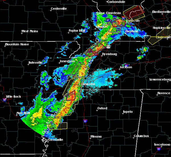 The tornado warning for south central crittenden, northwestern desoto and northeastern tunica counties will expire at 730 pm cdt, the tornado threat has diminished and the tornado warning has been cancelled. however, damaging winds remain likely and a severe thunderstorm warning remains in effect for the area. a tornado watch remains in effect until 200 am cdt for eastern arkansas, and northwestern mississippi. The tornado warning for south central crittenden, northwestern desoto and northeastern tunica counties will expire at 730 pm cdt, the tornado threat has diminished and the tornado warning has been cancelled. however, damaging winds remain likely and a severe thunderstorm warning remains in effect for the area. a tornado watch remains in effect until 200 am cdt for eastern arkansas, and northwestern mississippi.
|
| 3/28/2020 7:16 PM CDT |
 At 716 pm cdt, severe thunderstorms were located along a line extending from robinsonville to near dubbs to near clarksdale, moving east at 35 mph (radar indicated). Hazards include 70 mph wind gusts. Expect considerable tree damage. damage is likely to mobile homes, roofs, and outbuildings. Locations impacted include, clarksdale, helena-west helena, jonestown, friars point, tunica, crenshaw, sledge, belen, strayhorn, eudora, dubbs, north tunica, dundee, arkabutla, darling, kings, phillipp, sherard, robinsonville and little texas. At 716 pm cdt, severe thunderstorms were located along a line extending from robinsonville to near dubbs to near clarksdale, moving east at 35 mph (radar indicated). Hazards include 70 mph wind gusts. Expect considerable tree damage. damage is likely to mobile homes, roofs, and outbuildings. Locations impacted include, clarksdale, helena-west helena, jonestown, friars point, tunica, crenshaw, sledge, belen, strayhorn, eudora, dubbs, north tunica, dundee, arkabutla, darling, kings, phillipp, sherard, robinsonville and little texas.
|
| 3/28/2020 7:14 PM CDT |
 At 714 pm cdt, a severe thunderstorm producing a tornado was located near north tunica, or 12 miles northeast of st francis national park, moving northeast at 45 mph (weather spotters reported a funnel cloud). Hazards include tornado. Flying debris will be dangerous to those caught without shelter. mobile homes will be damaged or destroyed. damage to roofs, windows, and vehicles will occur. tree damage is likely. Locations impacted include, tunica, horseshoe lake, lake cormorant, north tunica, robinsonville, newport, clack, fox island, commerce, hollywood, lost lake, seyppel, prichard, bruins, banks, penton, bowdre and norfolk. At 714 pm cdt, a severe thunderstorm producing a tornado was located near north tunica, or 12 miles northeast of st francis national park, moving northeast at 45 mph (weather spotters reported a funnel cloud). Hazards include tornado. Flying debris will be dangerous to those caught without shelter. mobile homes will be damaged or destroyed. damage to roofs, windows, and vehicles will occur. tree damage is likely. Locations impacted include, tunica, horseshoe lake, lake cormorant, north tunica, robinsonville, newport, clack, fox island, commerce, hollywood, lost lake, seyppel, prichard, bruins, banks, penton, bowdre and norfolk.
|
| 3/28/2020 7:14 PM CDT |
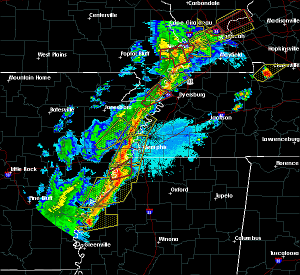 At 714 pm cdt, a severe thunderstorm producing a tornado was located near north tunica, or 12 miles northeast of st francis national park, moving northeast at 45 mph (weather spotters reported a funnel cloud). Hazards include tornado. Flying debris will be dangerous to those caught without shelter. mobile homes will be damaged or destroyed. damage to roofs, windows, and vehicles will occur. tree damage is likely. Locations impacted include, tunica, horseshoe lake, lake cormorant, north tunica, robinsonville, newport, clack, fox island, commerce, hollywood, lost lake, seyppel, prichard, bruins, banks, penton, bowdre and norfolk. At 714 pm cdt, a severe thunderstorm producing a tornado was located near north tunica, or 12 miles northeast of st francis national park, moving northeast at 45 mph (weather spotters reported a funnel cloud). Hazards include tornado. Flying debris will be dangerous to those caught without shelter. mobile homes will be damaged or destroyed. damage to roofs, windows, and vehicles will occur. tree damage is likely. Locations impacted include, tunica, horseshoe lake, lake cormorant, north tunica, robinsonville, newport, clack, fox island, commerce, hollywood, lost lake, seyppel, prichard, bruins, banks, penton, bowdre and norfolk.
|
| 3/28/2020 7:11 PM CDT |
 At 711 pm cdt, severe thunderstorms were located along a line extending from near jericho to near edmondson to near hughes, moving east at 40 mph (radar indicated). Hazards include 60 mph wind gusts. Expect damage to roofs, siding, and trees. Locations impacted include, southaven, west memphis, horn lake, marion, millington, hughes, t o fuller state park, meeman shelby forest state park, memphis, walls, crawfordsville, edmondson, horseshoe lake, sunset, anthonyville, jericho, jennette, lake cormorant, southwest memphis and simsboro. At 711 pm cdt, severe thunderstorms were located along a line extending from near jericho to near edmondson to near hughes, moving east at 40 mph (radar indicated). Hazards include 60 mph wind gusts. Expect damage to roofs, siding, and trees. Locations impacted include, southaven, west memphis, horn lake, marion, millington, hughes, t o fuller state park, meeman shelby forest state park, memphis, walls, crawfordsville, edmondson, horseshoe lake, sunset, anthonyville, jericho, jennette, lake cormorant, southwest memphis and simsboro.
|
| 3/28/2020 7:06 PM CDT |
 At 706 pm cdt, severe thunderstorms were located along a line extending from near hughes to dundee to near sherard, moving east at 35 mph (radar indicated). Hazards include 60 mph wind gusts. Expect damage to roofs, siding, and trees. Locations impacted include, clarksdale, helena-west helena, st francis national park, jonestown, friars point, tunica, crenshaw, sledge, belen, strayhorn, eudora, dubbs, north tunica, dundee, arkabutla, darling, kings, phillipp, sherard and robinsonville. At 706 pm cdt, severe thunderstorms were located along a line extending from near hughes to dundee to near sherard, moving east at 35 mph (radar indicated). Hazards include 60 mph wind gusts. Expect damage to roofs, siding, and trees. Locations impacted include, clarksdale, helena-west helena, st francis national park, jonestown, friars point, tunica, crenshaw, sledge, belen, strayhorn, eudora, dubbs, north tunica, dundee, arkabutla, darling, kings, phillipp, sherard and robinsonville.
|
| 3/28/2020 7:05 PM CDT |
 At 704 pm cdt, doppler radar indicated severe thunderstorms producing both tornadoes and extensive straight line wind damage were located 7 miles west of tunica, or 10 miles northeast of st francis national park, moving northeast at 40 mph (radar indicated rotation). Hazards include tornado. Flying debris will be dangerous to those caught without shelter. mobile homes will be damaged or destroyed. damage to roofs, windows, and vehicles will occur. Tree damage is likely. At 704 pm cdt, doppler radar indicated severe thunderstorms producing both tornadoes and extensive straight line wind damage were located 7 miles west of tunica, or 10 miles northeast of st francis national park, moving northeast at 40 mph (radar indicated rotation). Hazards include tornado. Flying debris will be dangerous to those caught without shelter. mobile homes will be damaged or destroyed. damage to roofs, windows, and vehicles will occur. Tree damage is likely.
|
| 3/28/2020 7:05 PM CDT |
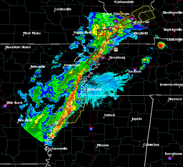 At 704 pm cdt, doppler radar indicated severe thunderstorms producing both tornadoes and extensive straight line wind damage were located 7 miles west of tunica, or 10 miles northeast of st francis national park, moving northeast at 40 mph (radar indicated rotation). Hazards include tornado. Flying debris will be dangerous to those caught without shelter. mobile homes will be damaged or destroyed. damage to roofs, windows, and vehicles will occur. Tree damage is likely. At 704 pm cdt, doppler radar indicated severe thunderstorms producing both tornadoes and extensive straight line wind damage were located 7 miles west of tunica, or 10 miles northeast of st francis national park, moving northeast at 40 mph (radar indicated rotation). Hazards include tornado. Flying debris will be dangerous to those caught without shelter. mobile homes will be damaged or destroyed. damage to roofs, windows, and vehicles will occur. Tree damage is likely.
|
| 3/28/2020 7:02 PM CDT |
 At 701 pm cdt, severe thunderstorms were located along a line extending from near crawfordsville to near brickeys, moving northeast at 35 mph (radar indicated). Hazards include 60 mph wind gusts. expect damage to roofs, siding, and trees At 701 pm cdt, severe thunderstorms were located along a line extending from near crawfordsville to near brickeys, moving northeast at 35 mph (radar indicated). Hazards include 60 mph wind gusts. expect damage to roofs, siding, and trees
|
| 3/28/2020 6:57 PM CDT |
 At 657 pm cdt, severe thunderstorms were located along a line extending from near hughes to near dundee to sherard, moving east at 35 mph (radar indicated). Hazards include 60 mph wind gusts and quarter size hail. Hail damage to vehicles is expected. Expect wind damage to roofs, siding, and trees. At 657 pm cdt, severe thunderstorms were located along a line extending from near hughes to near dundee to sherard, moving east at 35 mph (radar indicated). Hazards include 60 mph wind gusts and quarter size hail. Hail damage to vehicles is expected. Expect wind damage to roofs, siding, and trees.
|
| 1/11/2020 4:40 AM CST |
 At 439 am cst, a severe thunderstorm was located over phillipp, or 12 miles southwest of hernando, moving northeast at 60 mph. this is a very dangerous storm (radar indicated). Hazards include 80 mph wind gusts. Flying debris will be dangerous to those caught without shelter. mobile homes will be heavily damaged. expect considerable damage to roofs, windows, and vehicles. Extensive tree damage and power outages are likely. At 439 am cst, a severe thunderstorm was located over phillipp, or 12 miles southwest of hernando, moving northeast at 60 mph. this is a very dangerous storm (radar indicated). Hazards include 80 mph wind gusts. Flying debris will be dangerous to those caught without shelter. mobile homes will be heavily damaged. expect considerable damage to roofs, windows, and vehicles. Extensive tree damage and power outages are likely.
|
| 1/11/2020 4:18 AM CST |
 At 418 am cst, a severe thunderstorm was located over pinckney, or 9 miles east of hughes, moving northeast at 25 mph (radar indicated). Hazards include 60 mph wind gusts. Expect damage to roofs, siding, and trees. Locations impacted include, tunica, horseshoe lake, anthonyville, pinckney, lake cormorant, eudora, simsboro, north tunica, robinsonville, newport, clack, trinity, kate, commerce, peters, bruins, beck, neuhardt, diamond woods and banks. At 418 am cst, a severe thunderstorm was located over pinckney, or 9 miles east of hughes, moving northeast at 25 mph (radar indicated). Hazards include 60 mph wind gusts. Expect damage to roofs, siding, and trees. Locations impacted include, tunica, horseshoe lake, anthonyville, pinckney, lake cormorant, eudora, simsboro, north tunica, robinsonville, newport, clack, trinity, kate, commerce, peters, bruins, beck, neuhardt, diamond woods and banks.
|
| 1/11/2020 4:16 AM CST |
 At 416 am cst, a severe thunderstorm was located near tunica, or 12 miles northeast of st francis national park, moving northeast at 35 mph (radar indicated). Hazards include 60 mph wind gusts. expect damage to roofs, siding, and trees At 416 am cst, a severe thunderstorm was located near tunica, or 12 miles northeast of st francis national park, moving northeast at 35 mph (radar indicated). Hazards include 60 mph wind gusts. expect damage to roofs, siding, and trees
|
| 1/11/2020 3:55 AM CST |
 At 355 am cst, a severe thunderstorm was located near hughes, moving east at 40 mph (radar indicated). Hazards include 60 mph wind gusts. Expect damage to roofs, siding, and trees. Locations impacted include, hughes, tunica, horseshoe lake, anthonyville, lake cormorant, eudora, simsboro, brickeys, north tunica, pinckney, robinsonville, cody, clack, trinity, browns, haleside, commerce, soudan, beck and democrat. At 355 am cst, a severe thunderstorm was located near hughes, moving east at 40 mph (radar indicated). Hazards include 60 mph wind gusts. Expect damage to roofs, siding, and trees. Locations impacted include, hughes, tunica, horseshoe lake, anthonyville, lake cormorant, eudora, simsboro, brickeys, north tunica, pinckney, robinsonville, cody, clack, trinity, browns, haleside, commerce, soudan, beck and democrat.
|
| 1/11/2020 3:45 AM CST |
 At 345 am cst, a severe thunderstorm was located over brickeys, or 9 miles southwest of hughes, moving northeast at 25 mph (radar indicated). Hazards include 60 mph wind gusts. expect damage to roofs, siding, and trees At 345 am cst, a severe thunderstorm was located over brickeys, or 9 miles southwest of hughes, moving northeast at 25 mph (radar indicated). Hazards include 60 mph wind gusts. expect damage to roofs, siding, and trees
|
| 1/11/2020 3:37 AM CST |
 At 337 am cst, a severe thunderstorm was located 8 miles north of st francis national park, moving northeast at 50 mph (radar indicated). Hazards include 60 mph wind gusts. Expect damage to roofs, siding, and trees. Locations impacted include, marianna, hughes, marvell, helena-west helena, st francis national park, tunica, lexa, rondo, brickeys, north tunica, little texas, lake view, lagrange, cody, preston place, haleside, quarles, commerce, austin and soudan. At 337 am cst, a severe thunderstorm was located 8 miles north of st francis national park, moving northeast at 50 mph (radar indicated). Hazards include 60 mph wind gusts. Expect damage to roofs, siding, and trees. Locations impacted include, marianna, hughes, marvell, helena-west helena, st francis national park, tunica, lexa, rondo, brickeys, north tunica, little texas, lake view, lagrange, cody, preston place, haleside, quarles, commerce, austin and soudan.
|
| 1/11/2020 3:16 AM CST |
 At 316 am cst, a severe thunderstorm was located over marvell, moving northeast at 65 mph (radar indicated). Hazards include 60 mph wind gusts. expect damage to roofs, siding, and trees At 316 am cst, a severe thunderstorm was located over marvell, moving northeast at 65 mph (radar indicated). Hazards include 60 mph wind gusts. expect damage to roofs, siding, and trees
|
| 1/11/2020 2:50 AM CST |
 At 249 am cst, severe thunderstorms were located along a line extending from keiser to earle to near aubrey, moving east at 45 mph (radar indicated). Hazards include 70 mph wind gusts. Expect considerable tree damage. damage is likely to mobile homes, roofs, and outbuildings. Locations impacted include, west memphis, forrest city, marion, wynne, marianna, marked tree, earle, lepanto, hughes, parkin, wilson, madison, tyronza, palestine, village creek state park, fort pillow state park, joiner, caldwell, crawfordsville and edmondson. At 249 am cst, severe thunderstorms were located along a line extending from keiser to earle to near aubrey, moving east at 45 mph (radar indicated). Hazards include 70 mph wind gusts. Expect considerable tree damage. damage is likely to mobile homes, roofs, and outbuildings. Locations impacted include, west memphis, forrest city, marion, wynne, marianna, marked tree, earle, lepanto, hughes, parkin, wilson, madison, tyronza, palestine, village creek state park, fort pillow state park, joiner, caldwell, crawfordsville and edmondson.
|
| 1/11/2020 2:23 AM CST |
 At 222 am cst, severe thunderstorms were located along a line extending from lepanto to wynne to garret grove, moving northeast at 45 mph (radar indicated). Hazards include 70 mph wind gusts. Expect considerable tree damage. Damage is likely to mobile homes, roofs, and outbuildings. At 222 am cst, severe thunderstorms were located along a line extending from lepanto to wynne to garret grove, moving northeast at 45 mph (radar indicated). Hazards include 70 mph wind gusts. Expect considerable tree damage. Damage is likely to mobile homes, roofs, and outbuildings.
|
| 10/21/2019 6:35 AM CDT |
 At 635 am cdt, severe thunderstorms were located along a line extending from munford to horn lake, moving east at 45 mph (radar indicated). Hazards include 60 mph wind gusts and quarter size hail. Hail damage to vehicles is expected. expect wind damage to roofs, siding, and trees. Locations impacted include, southaven, west memphis, horn lake, hernando, millington, t o fuller state park, meeman shelby forest state park, memphis, walls, horseshoe lake, lake cormorant, southwest memphis, lynchburg, eudora, downtown memphis, whitehaven, frayser, robinsonville, midtown memphis and newport. At 635 am cdt, severe thunderstorms were located along a line extending from munford to horn lake, moving east at 45 mph (radar indicated). Hazards include 60 mph wind gusts and quarter size hail. Hail damage to vehicles is expected. expect wind damage to roofs, siding, and trees. Locations impacted include, southaven, west memphis, horn lake, hernando, millington, t o fuller state park, meeman shelby forest state park, memphis, walls, horseshoe lake, lake cormorant, southwest memphis, lynchburg, eudora, downtown memphis, whitehaven, frayser, robinsonville, midtown memphis and newport.
|
| 10/21/2019 6:20 AM CDT |
 At 619 am cdt, severe thunderstorms were located along a line extending from near meeman shelby forest state park to near horseshoe lake, moving east at 35 mph (radar indicated). Hazards include 60 mph wind gusts. expect damage to roofs, siding, and trees At 619 am cdt, severe thunderstorms were located along a line extending from near meeman shelby forest state park to near horseshoe lake, moving east at 35 mph (radar indicated). Hazards include 60 mph wind gusts. expect damage to roofs, siding, and trees
|
| 10/21/2019 5:56 AM CDT |
 At 556 am cdt, severe thunderstorms were located along a line extending from near gilmore to near brickeys, moving east at 45 mph (radar indicated). Hazards include 60 mph wind gusts and quarter size hail. Hail damage to vehicles is expected. Expect wind damage to roofs, siding, and trees. At 556 am cdt, severe thunderstorms were located along a line extending from near gilmore to near brickeys, moving east at 45 mph (radar indicated). Hazards include 60 mph wind gusts and quarter size hail. Hail damage to vehicles is expected. Expect wind damage to roofs, siding, and trees.
|
| 8/13/2019 7:24 PM CDT |
 At 724 pm cdt, a severe thunderstorm was located near t o fuller state park, moving southeast at 25 mph (radar indicated). Hazards include 70 mph wind gusts and quarter size hail. Hail damage to vehicles is expected. expect considerable tree damage. wind damage is also likely to mobile homes, roofs, and outbuildings. Locations impacted include, southaven, olive branch, west memphis, horn lake, hernando, marion, t o fuller state park, memphis, walls, edmondson, horseshoe lake, sunset, anthonyville, lake cormorant, southwest memphis, eudora, simsboro, whitehaven, pinckney and lynchburg. At 724 pm cdt, a severe thunderstorm was located near t o fuller state park, moving southeast at 25 mph (radar indicated). Hazards include 70 mph wind gusts and quarter size hail. Hail damage to vehicles is expected. expect considerable tree damage. wind damage is also likely to mobile homes, roofs, and outbuildings. Locations impacted include, southaven, olive branch, west memphis, horn lake, hernando, marion, t o fuller state park, memphis, walls, edmondson, horseshoe lake, sunset, anthonyville, lake cormorant, southwest memphis, eudora, simsboro, whitehaven, pinckney and lynchburg.
|
| 8/13/2019 7:13 PM CDT |
 At 713 pm cdt, a severe thunderstorm was located near edmondson, or 7 miles southwest of west memphis, moving southeast at 50 mph (radar indicated). Hazards include 60 mph wind gusts and quarter size hail. Hail damage to vehicles is expected. Expect wind damage to roofs, siding, and trees. At 713 pm cdt, a severe thunderstorm was located near edmondson, or 7 miles southwest of west memphis, moving southeast at 50 mph (radar indicated). Hazards include 60 mph wind gusts and quarter size hail. Hail damage to vehicles is expected. Expect wind damage to roofs, siding, and trees.
|
| 6/19/2019 11:35 PM CDT |
 At 1134 pm cdt, severe thunderstorms were located along a line extending from near gilmore to phillipp, moving east at 60 mph (radar indicated). Hazards include 70 mph wind gusts. Expect considerable tree damage. damage is likely to mobile homes, roofs, and outbuildings. Locations impacted include, bartlett, southaven, collierville, germantown, olive branch, west memphis, horn lake, hernando, marion, millington, covington, marked tree, earle, hughes, parkin, tyronza, t o fuller state park, meeman shelby forest state park, cordova and memphis. At 1134 pm cdt, severe thunderstorms were located along a line extending from near gilmore to phillipp, moving east at 60 mph (radar indicated). Hazards include 70 mph wind gusts. Expect considerable tree damage. damage is likely to mobile homes, roofs, and outbuildings. Locations impacted include, bartlett, southaven, collierville, germantown, olive branch, west memphis, horn lake, hernando, marion, millington, covington, marked tree, earle, hughes, parkin, tyronza, t o fuller state park, meeman shelby forest state park, cordova and memphis.
|
| 6/19/2019 11:15 PM CDT |
 At 1115 pm cdt, severe thunderstorms were located along a line extending from 7 miles southwest of marked tree to 7 miles northwest of north tunica, moving east at 60 mph (radar indicated). Hazards include 70 mph wind gusts. Expect considerable tree damage. Damage is likely to mobile homes, roofs, and outbuildings. At 1115 pm cdt, severe thunderstorms were located along a line extending from 7 miles southwest of marked tree to 7 miles northwest of north tunica, moving east at 60 mph (radar indicated). Hazards include 70 mph wind gusts. Expect considerable tree damage. Damage is likely to mobile homes, roofs, and outbuildings.
|
| 6/19/2019 11:02 PM CDT |
 At 1101 pm cdt, severe thunderstorms were located along a line extending from 6 miles south of tyronza to near little texas, moving east at 75 mph (radar indicated). Hazards include 70 mph wind gusts. Expect considerable tree damage. damage is likely to mobile homes, roofs, and outbuildings. Locations impacted include, west memphis, forrest city, marion, wynne, marianna, marked tree, earle, hughes, parkin, madison, tyronza, palestine, village creek state park, tunica, cherry valley, caldwell, crawfordsville, edmondson, colt and horseshoe lake. At 1101 pm cdt, severe thunderstorms were located along a line extending from 6 miles south of tyronza to near little texas, moving east at 75 mph (radar indicated). Hazards include 70 mph wind gusts. Expect considerable tree damage. damage is likely to mobile homes, roofs, and outbuildings. Locations impacted include, west memphis, forrest city, marion, wynne, marianna, marked tree, earle, hughes, parkin, madison, tyronza, palestine, village creek state park, tunica, cherry valley, caldwell, crawfordsville, edmondson, colt and horseshoe lake.
|
| 6/19/2019 10:32 PM CDT |
 At 1031 pm cdt, severe thunderstorms were located along a line extending from near fair oaks to near palmer, moving east at 75 mph (radar indicated). Hazards include 70 mph wind gusts. Expect considerable tree damage. Damage is likely to mobile homes, roofs, and outbuildings. At 1031 pm cdt, severe thunderstorms were located along a line extending from near fair oaks to near palmer, moving east at 75 mph (radar indicated). Hazards include 70 mph wind gusts. Expect considerable tree damage. Damage is likely to mobile homes, roofs, and outbuildings.
|
| 6/19/2019 10:32 PM CDT |
 The national weather service in memphis has issued a * severe thunderstorm warning for. lee county in eastern arkansas. st. francis county in eastern arkansas. southeastern poinsett county in eastern arkansas. Northern phillips county in eastern arkansas. The national weather service in memphis has issued a * severe thunderstorm warning for. lee county in eastern arkansas. st. francis county in eastern arkansas. southeastern poinsett county in eastern arkansas. Northern phillips county in eastern arkansas.
|
| 5/18/2019 8:23 PM CDT |
 At 822 pm cdt, severe thunderstorms were located along a line extending from near meeman shelby forest state park to memphis to horn lake, moving northeast at 50 mph (radar indicated). Hazards include 60 mph wind gusts. Expect damage to roofs, siding, and trees. Locations impacted include, bartlett, southaven, olive branch, west memphis, horn lake, hernando, marion, millington, t o fuller state park, meeman shelby forest state park, memphis, walls, crawfordsville, edmondson, sunset, jericho, lake cormorant, southwest memphis, eudora and whitehaven. At 822 pm cdt, severe thunderstorms were located along a line extending from near meeman shelby forest state park to memphis to horn lake, moving northeast at 50 mph (radar indicated). Hazards include 60 mph wind gusts. Expect damage to roofs, siding, and trees. Locations impacted include, bartlett, southaven, olive branch, west memphis, horn lake, hernando, marion, millington, t o fuller state park, meeman shelby forest state park, memphis, walls, crawfordsville, edmondson, sunset, jericho, lake cormorant, southwest memphis, eudora and whitehaven.
|
| 5/18/2019 8:11 PM CDT |
 The severe thunderstorm warning for eastern lee, eastern st. francis, southwestern crittenden, northwestern desoto and tunica counties will expire at 815 pm cdt, the storms which prompted the warning have moved out of the area. therefore, the warning will be allowed to expire. however gusty winds are still possible with these thunderstorms. a severe thunderstorm watch remains in effect until midnight cdt for eastern arkansas, northwestern mississippi, and western tennessee. The severe thunderstorm warning for eastern lee, eastern st. francis, southwestern crittenden, northwestern desoto and tunica counties will expire at 815 pm cdt, the storms which prompted the warning have moved out of the area. therefore, the warning will be allowed to expire. however gusty winds are still possible with these thunderstorms. a severe thunderstorm watch remains in effect until midnight cdt for eastern arkansas, northwestern mississippi, and western tennessee.
|
| 5/18/2019 7:59 PM CDT |
 At 759 pm cdt, severe thunderstorms were located along a line extending from near jennette to near phillipp, moving northeast at 40 mph (radar indicated). Hazards include 60 mph wind gusts. expect damage to roofs, siding, and trees At 759 pm cdt, severe thunderstorms were located along a line extending from near jennette to near phillipp, moving northeast at 40 mph (radar indicated). Hazards include 60 mph wind gusts. expect damage to roofs, siding, and trees
|
| 5/18/2019 7:59 PM CDT |
 The national weather service in memphis has issued a * severe thunderstorm warning for. central crittenden county in eastern arkansas. desoto county in northwestern mississippi. northeastern tunica county in northwestern mississippi. Central shelby county in western tennessee. The national weather service in memphis has issued a * severe thunderstorm warning for. central crittenden county in eastern arkansas. desoto county in northwestern mississippi. northeastern tunica county in northwestern mississippi. Central shelby county in western tennessee.
|
| 5/18/2019 7:52 PM CDT |
 At 751 pm cdt, severe thunderstorms were located along a line extending from near jennette to near horseshoe lake to near robinsonville, moving northeast at 55 mph (radar indicated). Hazards include 60 mph wind gusts. Expect damage to roofs, siding, and trees. Locations impacted include, hughes, tunica, edmondson, horseshoe lake, anthonyville, jennette, lake cormorant, simsboro, brickeys, north tunica, pinckney, new home, robinsonville, clack, browns, commerce, louise, austin, round pond and beck. At 751 pm cdt, severe thunderstorms were located along a line extending from near jennette to near horseshoe lake to near robinsonville, moving northeast at 55 mph (radar indicated). Hazards include 60 mph wind gusts. Expect damage to roofs, siding, and trees. Locations impacted include, hughes, tunica, edmondson, horseshoe lake, anthonyville, jennette, lake cormorant, simsboro, brickeys, north tunica, pinckney, new home, robinsonville, clack, browns, commerce, louise, austin, round pond and beck.
|
| 5/18/2019 7:36 PM CDT |
 At 736 pm cdt, severe thunderstorms were located along a line extending from new home to near brickeys to near tunica, moving northeast at 45 mph (radar indicated). Hazards include 60 mph wind gusts. Expect damage to roofs, siding, and trees. Locations impacted include, forrest city, hughes, madison, helena-west helena, st francis national park, tunica, edmondson, horseshoe lake, widener, anthonyville, jennette, lake cormorant, simsboro, brickeys, north tunica, pinckney, new home, robinsonville, cody and clack. At 736 pm cdt, severe thunderstorms were located along a line extending from new home to near brickeys to near tunica, moving northeast at 45 mph (radar indicated). Hazards include 60 mph wind gusts. Expect damage to roofs, siding, and trees. Locations impacted include, forrest city, hughes, madison, helena-west helena, st francis national park, tunica, edmondson, horseshoe lake, widener, anthonyville, jennette, lake cormorant, simsboro, brickeys, north tunica, pinckney, new home, robinsonville, cody and clack.
|
| 5/18/2019 7:27 PM CDT |
 At 727 pm cdt, severe thunderstorms were located along a line extending from near haynes to 9 miles southeast of marianna to st francis national park, moving northeast at 40 mph (radar indicated). Hazards include 60 mph wind gusts. expect damage to roofs, siding, and trees At 727 pm cdt, severe thunderstorms were located along a line extending from near haynes to 9 miles southeast of marianna to st francis national park, moving northeast at 40 mph (radar indicated). Hazards include 60 mph wind gusts. expect damage to roofs, siding, and trees
|
| 5/18/2019 7:17 PM CDT |
 At 717 pm cdt, a severe thunderstorm was located near marianna, moving northeast at 60 mph (radar indicated). Hazards include 60 mph wind gusts. Expect damage to roofs, siding, and trees. Locations impacted include, forrest city, marianna, hughes, marvell, madison, palestine, lexa, widener, moro, rondo, aubrey, haynes, brickeys, watkins corner, new salem, new home, lagrange, cody, cottonwood corner and haleside. At 717 pm cdt, a severe thunderstorm was located near marianna, moving northeast at 60 mph (radar indicated). Hazards include 60 mph wind gusts. Expect damage to roofs, siding, and trees. Locations impacted include, forrest city, marianna, hughes, marvell, madison, palestine, lexa, widener, moro, rondo, aubrey, haynes, brickeys, watkins corner, new salem, new home, lagrange, cody, cottonwood corner and haleside.
|
| 5/18/2019 7:06 PM CDT |
 At 706 pm cdt, a severe thunderstorm was located near moro, or 10 miles west of marianna, moving northeast at 45 mph (radar indicated). Hazards include 60 mph wind gusts. Expect damage to roofs, siding, and trees. Locations impacted include, forrest city, marianna, hughes, marvell, madison, palestine, lexa, widener, moro, rondo, aubrey, haynes, garret grove, brickeys, watkins corner, new salem, new home, lagrange, cody and cottonwood corner. At 706 pm cdt, a severe thunderstorm was located near moro, or 10 miles west of marianna, moving northeast at 45 mph (radar indicated). Hazards include 60 mph wind gusts. Expect damage to roofs, siding, and trees. Locations impacted include, forrest city, marianna, hughes, marvell, madison, palestine, lexa, widener, moro, rondo, aubrey, haynes, garret grove, brickeys, watkins corner, new salem, new home, lagrange, cody and cottonwood corner.
|
| 5/18/2019 6:47 PM CDT |
 At 646 pm cdt, a severe thunderstorm was located near palmer, or 12 miles northwest of marvell, moving northeast at 65 mph (radar indicated). Hazards include 60 mph wind gusts. expect damage to roofs, siding, and trees At 646 pm cdt, a severe thunderstorm was located near palmer, or 12 miles northwest of marvell, moving northeast at 65 mph (radar indicated). Hazards include 60 mph wind gusts. expect damage to roofs, siding, and trees
|
| 4/6/2019 8:49 PM CDT |
 At 849 pm cdt, doppler radar indicated a severe thunderstorm producing a tornado was located over lake cormorant, or 12 miles east of hughes, moving northeast at 50 mph (radar indicated rotation). Hazards include tornado. Flying debris will be dangerous to those caught without shelter. mobile homes will be damaged or destroyed. damage to roofs, windows, and vehicles will occur. Tree damage is likely. At 849 pm cdt, doppler radar indicated a severe thunderstorm producing a tornado was located over lake cormorant, or 12 miles east of hughes, moving northeast at 50 mph (radar indicated rotation). Hazards include tornado. Flying debris will be dangerous to those caught without shelter. mobile homes will be damaged or destroyed. damage to roofs, windows, and vehicles will occur. Tree damage is likely.
|
| 4/6/2019 8:47 PM CDT |
 At 847 pm cdt, a severe thunderstorm was located over lake cormorant, or 12 miles west of horn lake, moving northeast at 50 mph (radar indicated). Hazards include 60 mph wind gusts. Expect damage to roofs, siding, and trees. Locations impacted include, southaven, horn lake, hernando, walls, tunica, horseshoe lake, lake cormorant, strayhorn, eudora, dubbs, north tunica, arkabutla, pinckney, lynchburg, phillipp, robinsonville, little texas, clack, trinity and savage. At 847 pm cdt, a severe thunderstorm was located over lake cormorant, or 12 miles west of horn lake, moving northeast at 50 mph (radar indicated). Hazards include 60 mph wind gusts. Expect damage to roofs, siding, and trees. Locations impacted include, southaven, horn lake, hernando, walls, tunica, horseshoe lake, lake cormorant, strayhorn, eudora, dubbs, north tunica, arkabutla, pinckney, lynchburg, phillipp, robinsonville, little texas, clack, trinity and savage.
|
| 4/6/2019 8:37 PM CDT |
 At 837 pm cdt, a severe thunderstorm was located near robinsonville, or 9 miles southeast of hughes, moving northeast at 50 mph (radar indicated). Hazards include 60 mph wind gusts. expect damage to roofs, siding, and trees At 837 pm cdt, a severe thunderstorm was located near robinsonville, or 9 miles southeast of hughes, moving northeast at 50 mph (radar indicated). Hazards include 60 mph wind gusts. expect damage to roofs, siding, and trees
|
| 3/13/2019 8:25 PM CDT |
 The severe thunderstorm warning for northeastern tunica county will expire at 830 pm cdt, the storms which prompted the warning have moved out of the area. therefore, the warning will be allowed to expire. The severe thunderstorm warning for northeastern tunica county will expire at 830 pm cdt, the storms which prompted the warning have moved out of the area. therefore, the warning will be allowed to expire.
|
| 3/13/2019 8:12 PM CDT |
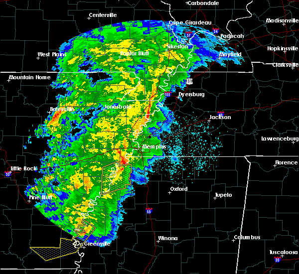 At 811 pm cdt, severe thunderstorms were located along a line extending from near horseshoe lake to near dundee, moving northeast at 40 mph (radar indicated). Hazards include 70 mph wind gusts. Expect considerable tree damage. damage is likely to mobile homes, roofs, and outbuildings. Locations impacted include, tunica, north tunica, robinsonville, little texas, clack, dooley, fox island, commerce, austin, hollywood, lost lake, prichard, banks, evansville and bowdre. At 811 pm cdt, severe thunderstorms were located along a line extending from near horseshoe lake to near dundee, moving northeast at 40 mph (radar indicated). Hazards include 70 mph wind gusts. Expect considerable tree damage. damage is likely to mobile homes, roofs, and outbuildings. Locations impacted include, tunica, north tunica, robinsonville, little texas, clack, dooley, fox island, commerce, austin, hollywood, lost lake, prichard, banks, evansville and bowdre.
|
| 3/13/2019 7:48 PM CDT |
 At 747 pm cdt, severe thunderstorms were located along a line extending from near brickeys to near friars point, moving northeast at 40 mph (radar indicated). Hazards include 70 mph wind gusts. Expect considerable tree damage. Damage is likely to mobile homes, roofs, and outbuildings. At 747 pm cdt, severe thunderstorms were located along a line extending from near brickeys to near friars point, moving northeast at 40 mph (radar indicated). Hazards include 70 mph wind gusts. Expect considerable tree damage. Damage is likely to mobile homes, roofs, and outbuildings.
|
| 3/9/2019 12:29 PM CST |
 At 1228 pm cst, severe thunderstorms were located along a line extending from near brickeys to near st francis national park to near elaine, moving east at 45 mph (radar indicated). Hazards include 60 mph wind gusts. expect damage to roofs, siding, and trees At 1228 pm cst, severe thunderstorms were located along a line extending from near brickeys to near st francis national park to near elaine, moving east at 45 mph (radar indicated). Hazards include 60 mph wind gusts. expect damage to roofs, siding, and trees
|
| 2/23/2019 4:21 PM CST |
 The severe thunderstorm warning for south central crittenden, desoto, tunica, western tate and northwestern panola counties will expire at 430 pm cst, the storm which prompted the warning has weakened below severe limits, and no longer poses an immediate threat to life or property. therefore, the warning will be allowed to expire. a tornado watch remains in effect until 800 pm cst for eastern arkansas, northwestern mississippi, and western tennessee. The severe thunderstorm warning for south central crittenden, desoto, tunica, western tate and northwestern panola counties will expire at 430 pm cst, the storm which prompted the warning has weakened below severe limits, and no longer poses an immediate threat to life or property. therefore, the warning will be allowed to expire. a tornado watch remains in effect until 800 pm cst for eastern arkansas, northwestern mississippi, and western tennessee.
|
| 2/23/2019 3:52 PM CST |
 At 351 pm cst, a severe thunderstorm was located over dubbs, or 13 miles east of st francis national park, moving northeast at 55 mph (radar indicated). Hazards include 60 mph wind gusts. expect damage to roofs, siding, and trees At 351 pm cst, a severe thunderstorm was located over dubbs, or 13 miles east of st francis national park, moving northeast at 55 mph (radar indicated). Hazards include 60 mph wind gusts. expect damage to roofs, siding, and trees
|
| 1/19/2019 5:41 AM CST |
 At 541 am cst, a severe thunderstorm was located over horn lake, moving northeast at 70 mph (radar indicated). Hazards include 60 mph wind gusts. Expect damage to roofs, siding, and trees. Locations impacted include, southaven, olive branch, horn lake, hernando, helena-west helena, friars point, walls, tunica, crenshaw, sledge, lake cormorant, strayhorn, eudora, dubbs, north tunica, dundee, arkabutla, lynchburg, phillipp and robinsonville. At 541 am cst, a severe thunderstorm was located over horn lake, moving northeast at 70 mph (radar indicated). Hazards include 60 mph wind gusts. Expect damage to roofs, siding, and trees. Locations impacted include, southaven, olive branch, horn lake, hernando, helena-west helena, friars point, walls, tunica, crenshaw, sledge, lake cormorant, strayhorn, eudora, dubbs, north tunica, dundee, arkabutla, lynchburg, phillipp and robinsonville.
|
| 1/19/2019 5:30 AM CST |
 At 530 am cst, a severe thunderstorm was located near lake cormorant, or 13 miles southwest of horn lake, moving northeast at 55 mph (radar indicated). Hazards include 60 mph wind gusts. Expect damage to roofs, siding, and trees. Locations impacted include, southaven, olive branch, horn lake, hernando, helena-west helena, st francis national park, friars point, walls, tunica, crenshaw, sledge, horseshoe lake, lake cormorant, strayhorn, eudora, dubbs, north tunica, dundee, arkabutla and pinckney. At 530 am cst, a severe thunderstorm was located near lake cormorant, or 13 miles southwest of horn lake, moving northeast at 55 mph (radar indicated). Hazards include 60 mph wind gusts. Expect damage to roofs, siding, and trees. Locations impacted include, southaven, olive branch, horn lake, hernando, helena-west helena, st francis national park, friars point, walls, tunica, crenshaw, sledge, horseshoe lake, lake cormorant, strayhorn, eudora, dubbs, north tunica, dundee, arkabutla and pinckney.
|
| 1/19/2019 5:24 AM CST |
 At 524 am cst, a severe thunderstorm was located over robinsonville, or 12 miles southeast of hughes, moving northeast at 70 mph (radar indicated). Hazards include 60 mph wind gusts. expect damage to roofs, siding, and trees At 524 am cst, a severe thunderstorm was located over robinsonville, or 12 miles southeast of hughes, moving northeast at 70 mph (radar indicated). Hazards include 60 mph wind gusts. expect damage to roofs, siding, and trees
|
| 1/19/2019 5:13 AM CST |
 At 513 am cst, a severe thunderstorm was located near robinsonville, or near hughes, moving northeast at 55 mph (radar indicated). Hazards include 60 mph wind gusts. Expect damage to roofs, siding, and trees. Locations impacted include, west memphis, hughes, st francis national park, helena-west helena, tunica, edmondson, horseshoe lake, lexa, anthonyville, jennette, lake cormorant, simsboro, brickeys, north tunica, pinckney, robinsonville, little texas, crittenden, lagrange and cody. At 513 am cst, a severe thunderstorm was located near robinsonville, or near hughes, moving northeast at 55 mph (radar indicated). Hazards include 60 mph wind gusts. Expect damage to roofs, siding, and trees. Locations impacted include, west memphis, hughes, st francis national park, helena-west helena, tunica, edmondson, horseshoe lake, lexa, anthonyville, jennette, lake cormorant, simsboro, brickeys, north tunica, pinckney, robinsonville, little texas, crittenden, lagrange and cody.
|
| 1/19/2019 4:54 AM CST |
 At 454 am cst, a severe thunderstorm was located over brickeys, or 8 miles northeast of marianna, moving east at 50 mph (radar indicated). Hazards include 60 mph wind gusts. expect damage to roofs, siding, and trees At 454 am cst, a severe thunderstorm was located over brickeys, or 8 miles northeast of marianna, moving east at 50 mph (radar indicated). Hazards include 60 mph wind gusts. expect damage to roofs, siding, and trees
|
| 12/1/2018 6:09 AM CST |
 At 608 am cst, a severe thunderstorm was located near horn lake, moving northeast at 65 mph (radar indicated). Hazards include 60 mph wind gusts. Expect damage to roofs, siding, and trees. Locations impacted include, southaven, olive branch, horn lake, hernando, walls, lake cormorant, lynchburg, eudora, lewisburg, newport, trinity, frees corners, cedarview, bright, nesbit, handy corner, glover, jago, robinson gin and alden. At 608 am cst, a severe thunderstorm was located near horn lake, moving northeast at 65 mph (radar indicated). Hazards include 60 mph wind gusts. Expect damage to roofs, siding, and trees. Locations impacted include, southaven, olive branch, horn lake, hernando, walls, lake cormorant, lynchburg, eudora, lewisburg, newport, trinity, frees corners, cedarview, bright, nesbit, handy corner, glover, jago, robinson gin and alden.
|
| 12/1/2018 5:56 AM CST |
 At 556 am cst, a severe thunderstorm was located near robinsonville, or 14 miles west of hernando, moving northeast at 65 mph (radar indicated). Hazards include 60 mph wind gusts. expect damage to roofs, siding, and trees At 556 am cst, a severe thunderstorm was located near robinsonville, or 14 miles west of hernando, moving northeast at 65 mph (radar indicated). Hazards include 60 mph wind gusts. expect damage to roofs, siding, and trees
|
| 8/20/2018 6:30 PM CDT |
 At 629 pm cdt, a severe thunderstorm was located over marianna, moving east at 30 mph (radar indicated). Hazards include 60 mph wind gusts. expect damage to roofs, siding, and trees At 629 pm cdt, a severe thunderstorm was located over marianna, moving east at 30 mph (radar indicated). Hazards include 60 mph wind gusts. expect damage to roofs, siding, and trees
|
| 8/20/2018 6:26 PM CDT |
 The severe thunderstorm warning for northeastern lee, eastern st. francis, southern crittenden, northern desoto, northeastern tunica and southwestern shelby counties will expire at 630 pm cdt, the storms which prompted the warning have moved out of the area. therefore, the warning will be allowed to expire. however gusty winds are still possible with these thunderstorms. a severe thunderstorm watch remains in effect until 800 pm cdt for eastern arkansas, and northwestern mississippi. a severe thunderstorm watch also remains in effect until midnight cdt for northwestern mississippi, and southwestern tennessee. The severe thunderstorm warning for northeastern lee, eastern st. francis, southern crittenden, northern desoto, northeastern tunica and southwestern shelby counties will expire at 630 pm cdt, the storms which prompted the warning have moved out of the area. therefore, the warning will be allowed to expire. however gusty winds are still possible with these thunderstorms. a severe thunderstorm watch remains in effect until 800 pm cdt for eastern arkansas, and northwestern mississippi. a severe thunderstorm watch also remains in effect until midnight cdt for northwestern mississippi, and southwestern tennessee.
|
| 8/20/2018 5:41 PM CDT |
 At 541 pm cdt, severe thunderstorms were located along a line extending from near jennette to simsboro to 6 miles southeast of hughes, moving east at 40 mph (radar indicated). Hazards include 60 mph wind gusts. expect damage to roofs, siding, and trees At 541 pm cdt, severe thunderstorms were located along a line extending from near jennette to simsboro to 6 miles southeast of hughes, moving east at 40 mph (radar indicated). Hazards include 60 mph wind gusts. expect damage to roofs, siding, and trees
|
| 8/20/2018 3:20 PM CDT |
 At 319 pm cdt, a severe thunderstorm was located near west helena, moving east at 30 mph (radar indicated). Hazards include 60 mph wind gusts and quarter size hail. Hail damage to vehicles is expected. Expect wind damage to roofs, siding, and trees. At 319 pm cdt, a severe thunderstorm was located near west helena, moving east at 30 mph (radar indicated). Hazards include 60 mph wind gusts and quarter size hail. Hail damage to vehicles is expected. Expect wind damage to roofs, siding, and trees.
|
| 7/4/2018 6:09 PM CDT |
 The severe thunderstorm warning for central desoto, northeastern tunica and northwestern tate counties will expire at 615 pm cdt, the severe thunderstorm which prompted the warning has weakened. therefore, the warning will be allowed to expire. The severe thunderstorm warning for central desoto, northeastern tunica and northwestern tate counties will expire at 615 pm cdt, the severe thunderstorm which prompted the warning has weakened. therefore, the warning will be allowed to expire.
|
| 7/4/2018 6:01 PM CDT |
 The national weather service in memphis has issued a * severe thunderstorm warning for. south central crittenden county in eastern arkansas. desoto county in northwestern mississippi. northeastern tunica county in northwestern mississippi. Southwestern shelby county in southwestern tennessee. The national weather service in memphis has issued a * severe thunderstorm warning for. south central crittenden county in eastern arkansas. desoto county in northwestern mississippi. northeastern tunica county in northwestern mississippi. Southwestern shelby county in southwestern tennessee.
|
| 7/4/2018 6:01 PM CDT |
 At 600 pm cdt, a severe thunderstorm was located over hernando, moving west at 25 mph (radar indicated). Hazards include 60 mph wind gusts. expect damage to roofs, siding, and trees At 600 pm cdt, a severe thunderstorm was located over hernando, moving west at 25 mph (radar indicated). Hazards include 60 mph wind gusts. expect damage to roofs, siding, and trees
|
| 7/4/2018 5:54 PM CDT |
 At 553 pm cdt, a severe thunderstorm was located near coldwater, or 7 miles southwest of hernando, moving west at 25 mph (radar indicated). Hazards include 60 mph wind gusts. Expect damage to roofs, siding, and trees. Locations impacted include, hernando, coldwater, lake cormorant, arkabutla, phillipp, eudora, robinson gin, newport, trinity, dooley, frees corners, bright, nesbit, west days, lost lake, prichard, love, glover, banks and memphis. At 553 pm cdt, a severe thunderstorm was located near coldwater, or 7 miles southwest of hernando, moving west at 25 mph (radar indicated). Hazards include 60 mph wind gusts. Expect damage to roofs, siding, and trees. Locations impacted include, hernando, coldwater, lake cormorant, arkabutla, phillipp, eudora, robinson gin, newport, trinity, dooley, frees corners, bright, nesbit, west days, lost lake, prichard, love, glover, banks and memphis.
|
| 7/4/2018 5:41 PM CDT |
 At 540 pm cdt, a severe thunderstorm was located over coldwater, or 7 miles north of senatobia, moving west at 25 mph (radar indicated). Hazards include 60 mph wind gusts. Expect damage to roofs, siding, and trees. Locations impacted include, hernando, coldwater, lake cormorant, arkabutla, phillipp, eudora, robinson gin, newport, trinity, lurline, dooley, alphaba, cockrum, frees corners, bright, nesbit, west days, lost lake, prichard and love. At 540 pm cdt, a severe thunderstorm was located over coldwater, or 7 miles north of senatobia, moving west at 25 mph (radar indicated). Hazards include 60 mph wind gusts. Expect damage to roofs, siding, and trees. Locations impacted include, hernando, coldwater, lake cormorant, arkabutla, phillipp, eudora, robinson gin, newport, trinity, lurline, dooley, alphaba, cockrum, frees corners, bright, nesbit, west days, lost lake, prichard and love.
|
| 7/4/2018 5:27 PM CDT |
 At 526 pm cdt, a severe thunderstorm was located over independence, or 9 miles northeast of senatobia, moving west at 25 mph (radar indicated). Hazards include 60 mph wind gusts. expect damage to roofs, siding, and trees At 526 pm cdt, a severe thunderstorm was located over independence, or 9 miles northeast of senatobia, moving west at 25 mph (radar indicated). Hazards include 60 mph wind gusts. expect damage to roofs, siding, and trees
|
| 6/24/2018 2:57 AM CDT |
 At 257 am cdt, a severe thunderstorm was located over phillipp, or 10 miles southwest of hernando, moving east at 15 mph (radar indicated). Hazards include 60 mph wind gusts and quarter size hail. Hail damage to vehicles is expected. expect wind damage to roofs, siding, and trees. Locations impacted include, hernando, senatobia, coldwater, arkabutla, phillipp, eudora, strayhorn, robinson gin, trinity, dooley, frees corners, nesbit, lost lake, prichard, banks and savage. At 257 am cdt, a severe thunderstorm was located over phillipp, or 10 miles southwest of hernando, moving east at 15 mph (radar indicated). Hazards include 60 mph wind gusts and quarter size hail. Hail damage to vehicles is expected. expect wind damage to roofs, siding, and trees. Locations impacted include, hernando, senatobia, coldwater, arkabutla, phillipp, eudora, strayhorn, robinson gin, trinity, dooley, frees corners, nesbit, lost lake, prichard, banks and savage.
|
| 6/24/2018 2:27 AM CDT |
 At 226 am cdt, a severe thunderstorm was located near phillipp, or 17 miles west of hernando, moving east at 15 mph (radar indicated). Hazards include 60 mph wind gusts and quarter size hail. Hail damage to vehicles is expected. Expect wind damage to roofs, siding, and trees. At 226 am cdt, a severe thunderstorm was located near phillipp, or 17 miles west of hernando, moving east at 15 mph (radar indicated). Hazards include 60 mph wind gusts and quarter size hail. Hail damage to vehicles is expected. Expect wind damage to roofs, siding, and trees.
|
| 6/24/2018 2:05 AM CDT |
 At 204 am cdt, a severe thunderstorm was located near north tunica, or 15 miles southeast of hughes, moving east at 15 mph (radar indicated). Hazards include 60 mph wind gusts and quarter size hail. Hail damage to vehicles is expected. expect wind damage to roofs, siding, and trees. Locations impacted include, horn lake, walls, horseshoe lake, lake cormorant, phillipp, eudora, arkabutla, robinsonville, lynchburg, north tunica, newport, clack, trinity, frees corners, commerce, prichard, bruins, glover, banks and memphis. At 204 am cdt, a severe thunderstorm was located near north tunica, or 15 miles southeast of hughes, moving east at 15 mph (radar indicated). Hazards include 60 mph wind gusts and quarter size hail. Hail damage to vehicles is expected. expect wind damage to roofs, siding, and trees. Locations impacted include, horn lake, walls, horseshoe lake, lake cormorant, phillipp, eudora, arkabutla, robinsonville, lynchburg, north tunica, newport, clack, trinity, frees corners, commerce, prichard, bruins, glover, banks and memphis.
|
| 6/24/2018 1:46 AM CDT |
 The national weather service in memphis has issued a * severe thunderstorm warning for. south central crittenden county in eastern arkansas. western desoto county in northwestern mississippi. northeastern tunica county in northwestern mississippi. Northwestern tate county in northwestern mississippi. The national weather service in memphis has issued a * severe thunderstorm warning for. south central crittenden county in eastern arkansas. western desoto county in northwestern mississippi. northeastern tunica county in northwestern mississippi. Northwestern tate county in northwestern mississippi.
|
| 6/24/2018 1:46 AM CDT |
 At 146 am cdt, a severe thunderstorm was located near robinsonville, or 12 miles south of hughes, moving east at 20 mph (radar indicated). Hazards include 60 mph wind gusts and quarter size hail. Hail damage to vehicles is expected. Expect wind damage to roofs, siding, and trees. At 146 am cdt, a severe thunderstorm was located near robinsonville, or 12 miles south of hughes, moving east at 20 mph (radar indicated). Hazards include 60 mph wind gusts and quarter size hail. Hail damage to vehicles is expected. Expect wind damage to roofs, siding, and trees.
|
| 6/23/2018 7:46 AM CDT |
 At 746 am cdt, a severe thunderstorm was located over pinckney, or 11 miles southwest of t o fuller state park, moving east at 50 mph (radar indicated). Hazards include 60 mph wind gusts. Expect damage to roofs, siding, and trees. Locations impacted include, southaven, west memphis, horn lake, hernando, hughes, t o fuller state park, walls, horseshoe lake, anthonyville, lake cormorant, southwest memphis, eudora, simsboro, whitehaven, pinckney, lynchburg, downtown memphis, robinsonville, clack and trinity. At 746 am cdt, a severe thunderstorm was located over pinckney, or 11 miles southwest of t o fuller state park, moving east at 50 mph (radar indicated). Hazards include 60 mph wind gusts. Expect damage to roofs, siding, and trees. Locations impacted include, southaven, west memphis, horn lake, hernando, hughes, t o fuller state park, walls, horseshoe lake, anthonyville, lake cormorant, southwest memphis, eudora, simsboro, whitehaven, pinckney, lynchburg, downtown memphis, robinsonville, clack and trinity.
|
| 6/23/2018 7:24 AM CDT |
 At 723 am cdt, a severe thunderstorm was located near brickeys, or 8 miles west of hughes, moving east at 50 mph (radar indicated). Hazards include 60 mph wind gusts. expect damage to roofs, siding, and trees At 723 am cdt, a severe thunderstorm was located near brickeys, or 8 miles west of hughes, moving east at 50 mph (radar indicated). Hazards include 60 mph wind gusts. expect damage to roofs, siding, and trees
|
| 4/3/2018 7:06 PM CDT |
 At 705 pm cdt, a severe thunderstorm was located near lake cormorant, or 12 miles southwest of horn lake, moving east at 55 mph (radar indicated). Hazards include 60 mph wind gusts. expect damage to roofs, siding, and trees At 705 pm cdt, a severe thunderstorm was located near lake cormorant, or 12 miles southwest of horn lake, moving east at 55 mph (radar indicated). Hazards include 60 mph wind gusts. expect damage to roofs, siding, and trees
|
| 4/3/2018 6:57 PM CDT |
 At 656 pm cdt, a severe thunderstorm was located near north tunica, or 14 miles southeast of hughes, moving east at 60 mph (radar indicated). Hazards include 60 mph wind gusts and quarter size hail. Hail damage to vehicles is expected. expect wind damage to roofs, siding, and trees. locations impacted include, st francis national park, helena, west helena, tunica, lake cormorant, dubbs, north tunica, dundee, robinsonville, little texas, newport, clack, gerlach mill, kokomo, savage, commerce, austin, peters, council and prichard. A tornado watch remains in effect until 800 pm cdt for eastern arkansas, and northwestern mississippi. At 656 pm cdt, a severe thunderstorm was located near north tunica, or 14 miles southeast of hughes, moving east at 60 mph (radar indicated). Hazards include 60 mph wind gusts and quarter size hail. Hail damage to vehicles is expected. expect wind damage to roofs, siding, and trees. locations impacted include, st francis national park, helena, west helena, tunica, lake cormorant, dubbs, north tunica, dundee, robinsonville, little texas, newport, clack, gerlach mill, kokomo, savage, commerce, austin, peters, council and prichard. A tornado watch remains in effect until 800 pm cdt for eastern arkansas, and northwestern mississippi.
|
| 4/3/2018 6:33 PM CDT |
 At 633 pm cdt, a severe thunderstorm was located over marianna, moving east at 55 mph (radar indicated). Hazards include 60 mph wind gusts and quarter size hail. Hail damage to vehicles is expected. Expect wind damage to roofs, siding, and trees. At 633 pm cdt, a severe thunderstorm was located over marianna, moving east at 55 mph (radar indicated). Hazards include 60 mph wind gusts and quarter size hail. Hail damage to vehicles is expected. Expect wind damage to roofs, siding, and trees.
|
| 3/19/2018 9:26 AM CDT |
 The severe thunderstorm warning for southeastern lee and tunica counties will expire at 930 am cdt, the storm which prompted the warning has weakened below severe limits, and no longer pose an immediate threat to life or property. therefore, the warning will be allowed to expire. however small hail is still possible with this thunderstorm. The severe thunderstorm warning for southeastern lee and tunica counties will expire at 930 am cdt, the storm which prompted the warning has weakened below severe limits, and no longer pose an immediate threat to life or property. therefore, the warning will be allowed to expire. however small hail is still possible with this thunderstorm.
|
| 3/19/2018 9:26 AM CDT |
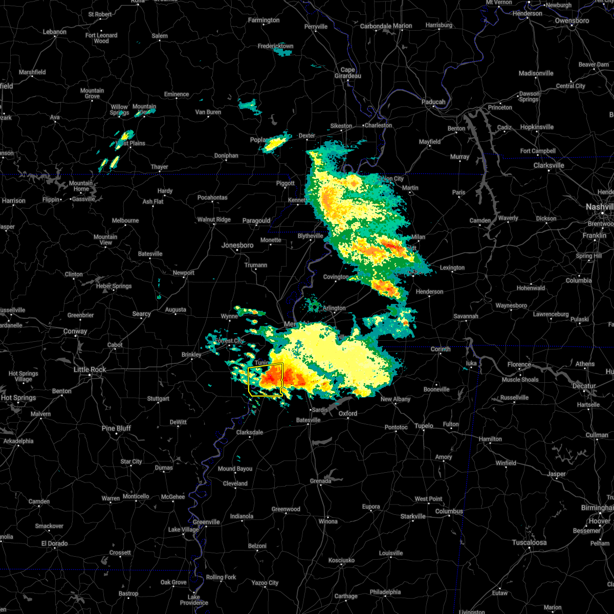 The severe thunderstorm warning for southeastern lee and tunica counties will expire at 930 am cdt, the storm which prompted the warning has weakened below severe limits, and no longer pose an immediate threat to life or property. therefore, the warning will be allowed to expire. however small hail is still possible with this thunderstorm. The severe thunderstorm warning for southeastern lee and tunica counties will expire at 930 am cdt, the storm which prompted the warning has weakened below severe limits, and no longer pose an immediate threat to life or property. therefore, the warning will be allowed to expire. however small hail is still possible with this thunderstorm.
|
| 3/19/2018 9:17 AM CDT |
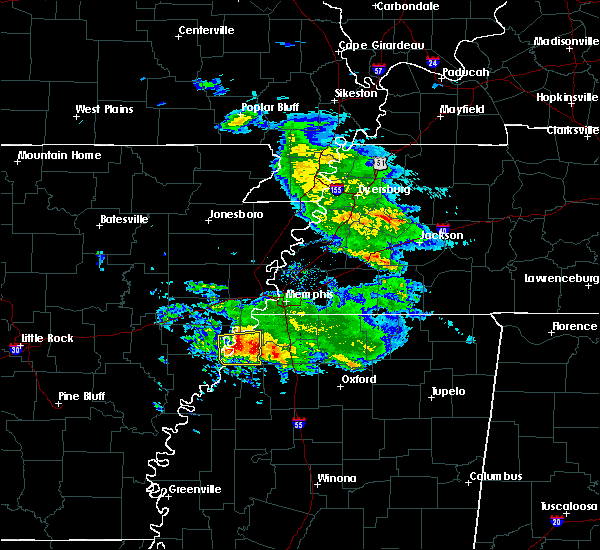 At 916 am cdt, a severe thunderstorm was located near tunica, or 10 miles northeast of st francis national park, moving east at 45 mph (radar indicated). Hazards include 60 mph wind gusts and quarter size hail. Hail damage to vehicles is expected. expect wind damage to roofs, siding, and trees. Locations impacted include, tunica, north tunica, dubbs, robinsonville, little texas, dooley, maud, fox island, commerce, austin, peters, clayton, hollywood, lost lake, prichard, diamond woods, banks, whitehall, evansville and bowdre. At 916 am cdt, a severe thunderstorm was located near tunica, or 10 miles northeast of st francis national park, moving east at 45 mph (radar indicated). Hazards include 60 mph wind gusts and quarter size hail. Hail damage to vehicles is expected. expect wind damage to roofs, siding, and trees. Locations impacted include, tunica, north tunica, dubbs, robinsonville, little texas, dooley, maud, fox island, commerce, austin, peters, clayton, hollywood, lost lake, prichard, diamond woods, banks, whitehall, evansville and bowdre.
|
| 3/19/2018 8:57 AM CDT |
 At 856 am cdt, a severe thunderstorm was located near lexa, or 8 miles northwest of st francis national park, moving east at 45 mph (radar indicated). Hazards include 60 mph wind gusts and quarter size hail. Hail damage to vehicles is expected. Expect wind damage to roofs, siding, and trees. At 856 am cdt, a severe thunderstorm was located near lexa, or 8 miles northwest of st francis national park, moving east at 45 mph (radar indicated). Hazards include 60 mph wind gusts and quarter size hail. Hail damage to vehicles is expected. Expect wind damage to roofs, siding, and trees.
|
| 8/31/2017 12:33 PM CDT |
 At 1233 pm cdt, a severe thunderstorm producing a tornado was located over crenshaw, or 12 miles southwest of senatobia, moving northwest at 25 mph (radar indicated rotation). Hazards include tornado. Flying debris will be dangerous to those caught without shelter. mobile homes will be damaged or destroyed. damage to roofs, windows, and vehicles will occur. tree damage is likely. this dangerous storm will be near, little texas around 100 pm cdt. tunica, north tunica and robinsonville around 115 pm cdt. Other locations impacted by this tornadic thunderstorm include clack, askew, dooley, buxton, savage, fox island, commerce, longtown, hollywood and prichard. At 1233 pm cdt, a severe thunderstorm producing a tornado was located over crenshaw, or 12 miles southwest of senatobia, moving northwest at 25 mph (radar indicated rotation). Hazards include tornado. Flying debris will be dangerous to those caught without shelter. mobile homes will be damaged or destroyed. damage to roofs, windows, and vehicles will occur. tree damage is likely. this dangerous storm will be near, little texas around 100 pm cdt. tunica, north tunica and robinsonville around 115 pm cdt. Other locations impacted by this tornadic thunderstorm include clack, askew, dooley, buxton, savage, fox island, commerce, longtown, hollywood and prichard.
|
| 6/18/2017 2:52 PM CDT |
 The severe thunderstorm warning for southeastern crittenden, northern desoto and southwestern shelby counties will expire at 300 pm cdt, the storm which prompted the warning has weakened below severe limits, and no longer pose an immediate threat to life or property. therefore, the warning will be allowed to expire. a severe thunderstorm watch remains in effect until 400 pm cdt for eastern arkansas, northwestern mississippi, and west tennessee. The severe thunderstorm warning for southeastern crittenden, northern desoto and southwestern shelby counties will expire at 300 pm cdt, the storm which prompted the warning has weakened below severe limits, and no longer pose an immediate threat to life or property. therefore, the warning will be allowed to expire. a severe thunderstorm watch remains in effect until 400 pm cdt for eastern arkansas, northwestern mississippi, and west tennessee.
|
| 6/18/2017 2:44 PM CDT |
 At 243 pm cdt, a severe thunderstorm was located over memphis, or near t o fuller state park, moving east at 45 mph (radar indicated). Hazards include 60 mph wind gusts. Expect damage to roofs, siding, and trees. Locations impacted include, bartlett, southaven, olive branch, west memphis, horn lake, hernando, t o fuller state park, walls, edmondson, horseshoe lake, lake cormorant, southwest memphis, whitehaven, midtown memphis, pinckney, lynchburg, southeast memphis, downtown memphis, crittenden and louise. At 243 pm cdt, a severe thunderstorm was located over memphis, or near t o fuller state park, moving east at 45 mph (radar indicated). Hazards include 60 mph wind gusts. Expect damage to roofs, siding, and trees. Locations impacted include, bartlett, southaven, olive branch, west memphis, horn lake, hernando, t o fuller state park, walls, edmondson, horseshoe lake, lake cormorant, southwest memphis, whitehaven, midtown memphis, pinckney, lynchburg, southeast memphis, downtown memphis, crittenden and louise.
|
| 6/18/2017 2:27 PM CDT |
 At 226 pm cdt, a severe thunderstorm was located near pinckney, or 7 miles southwest of t o fuller state park, moving east at 45 mph (radar indicated). Hazards include 60 mph wind gusts. Expect damage to roofs, siding, and trees. Locations impacted include, bartlett, southaven, olive branch, west memphis, horn lake, hernando, marion, t o fuller state park, walls, edmondson, horseshoe lake, anthonyville, lake cormorant, southwest memphis, eudora, simsboro, whitehaven, midtown memphis, pinckney and lynchburg. At 226 pm cdt, a severe thunderstorm was located near pinckney, or 7 miles southwest of t o fuller state park, moving east at 45 mph (radar indicated). Hazards include 60 mph wind gusts. Expect damage to roofs, siding, and trees. Locations impacted include, bartlett, southaven, olive branch, west memphis, horn lake, hernando, marion, t o fuller state park, walls, edmondson, horseshoe lake, anthonyville, lake cormorant, southwest memphis, eudora, simsboro, whitehaven, midtown memphis, pinckney and lynchburg.
|
| 6/18/2017 2:10 PM CDT |
 At 209 pm cdt, a severe thunderstorm was located over hughes, moving east at 45 mph (radar indicated). Hazards include 60 mph wind gusts. expect damage to roofs, siding, and trees At 209 pm cdt, a severe thunderstorm was located over hughes, moving east at 45 mph (radar indicated). Hazards include 60 mph wind gusts. expect damage to roofs, siding, and trees
|
| 6/16/2017 1:54 PM CDT |
 At 153 pm cdt, severe thunderstorms were located along a line extending from near lynchburg to phillipp, moving northeast at 15 mph (radar indicated). Hazards include 60 mph wind gusts. Expect damage to roofs, siding, and trees. Locations impacted include, southaven, horn lake, hernando, t o fuller state park, walls, lake cormorant, southwest memphis, lynchburg, eudora, whitehaven, newport, trinity, frees corners, nesbit, glover, memphis, jago, robinson gin, alden and twin lakes. At 153 pm cdt, severe thunderstorms were located along a line extending from near lynchburg to phillipp, moving northeast at 15 mph (radar indicated). Hazards include 60 mph wind gusts. Expect damage to roofs, siding, and trees. Locations impacted include, southaven, horn lake, hernando, t o fuller state park, walls, lake cormorant, southwest memphis, lynchburg, eudora, whitehaven, newport, trinity, frees corners, nesbit, glover, memphis, jago, robinson gin, alden and twin lakes.
|
| 6/16/2017 1:33 PM CDT |
 At 133 pm cdt, a severe thunderstorm was located near walls, or near t o fuller state park, moving east at 20 mph (radar indicated). Hazards include 60 mph wind gusts. expect damage to roofs, siding, and trees At 133 pm cdt, a severe thunderstorm was located near walls, or near t o fuller state park, moving east at 20 mph (radar indicated). Hazards include 60 mph wind gusts. expect damage to roofs, siding, and trees
|
| 5/27/2017 11:57 PM CDT |
 At 1157 pm cdt, a severe thunderstorm was located 7 miles east of wall doxey state park, moving southeast at 65 mph (radar indicated). Hazards include 60 mph wind gusts and quarter size hail. Hail damage to vehicles is expected. expect wind damage to roofs, siding, and trees. locations impacted include, southaven, olive branch, horn lake, oxford, hernando, senatobia, holly springs, wall doxey state park, john w kyle state park, lamar, sardis, coldwater, byhalia, como, walls, tunica, crenshaw, sledge, snow lake shores and horseshoe lake. A tornado watch remains in effect until 500 am cdt for eastern arkansas, and northeastern and northwestern mississippi. At 1157 pm cdt, a severe thunderstorm was located 7 miles east of wall doxey state park, moving southeast at 65 mph (radar indicated). Hazards include 60 mph wind gusts and quarter size hail. Hail damage to vehicles is expected. expect wind damage to roofs, siding, and trees. locations impacted include, southaven, olive branch, horn lake, oxford, hernando, senatobia, holly springs, wall doxey state park, john w kyle state park, lamar, sardis, coldwater, byhalia, como, walls, tunica, crenshaw, sledge, snow lake shores and horseshoe lake. A tornado watch remains in effect until 500 am cdt for eastern arkansas, and northeastern and northwestern mississippi.
|
| 5/27/2017 11:41 PM CDT |
 At 1141 pm cdt, a severe thunderstorm was located near mt pleasant, or 10 miles northwest of holly springs, moving southeast at 65 mph (radar indicated). Hazards include 70 mph wind gusts and quarter size hail. Hail damage to vehicles is expected. expect considerable tree damage. Wind damage is also likely to mobile homes, roofs, and outbuildings. At 1141 pm cdt, a severe thunderstorm was located near mt pleasant, or 10 miles northwest of holly springs, moving southeast at 65 mph (radar indicated). Hazards include 70 mph wind gusts and quarter size hail. Hail damage to vehicles is expected. expect considerable tree damage. Wind damage is also likely to mobile homes, roofs, and outbuildings.
|
| 5/27/2017 11:04 PM CDT |
 At 1104 pm cdt, a severe thunderstorm was located over southwest memphis, or over t o fuller state park, moving southeast at 50 mph. this is a very dangerous storm (radar indicated). Hazards include 80 mph wind gusts and quarter size hail. Flying debris will be dangerous to those caught without shelter. mobile homes will be heavily damaged. expect considerable damage to roofs, windows, and vehicles. Extensive tree damage and power outages are likely. At 1104 pm cdt, a severe thunderstorm was located over southwest memphis, or over t o fuller state park, moving southeast at 50 mph. this is a very dangerous storm (radar indicated). Hazards include 80 mph wind gusts and quarter size hail. Flying debris will be dangerous to those caught without shelter. mobile homes will be heavily damaged. expect considerable damage to roofs, windows, and vehicles. Extensive tree damage and power outages are likely.
|
| 5/19/2017 4:50 PM CDT |
 At 450 pm cdt, a severe thunderstorm was located over phillipp, or 14 miles northwest of senatobia, moving northeast at 10 mph (radar indicated). Hazards include 60 mph wind gusts and half dollar size hail. Hail damage to vehicles is expected. expect wind damage to roofs, siding, and trees. Locations impacted include, southaven, horn lake, hernando, senatobia, coldwater, tunica, phillipp, strayhorn, eudora, independence, north tunica, arkabutla, little texas, trinity, savage, frees corners, bright, nesbit, prichard and banks. At 450 pm cdt, a severe thunderstorm was located over phillipp, or 14 miles northwest of senatobia, moving northeast at 10 mph (radar indicated). Hazards include 60 mph wind gusts and half dollar size hail. Hail damage to vehicles is expected. expect wind damage to roofs, siding, and trees. Locations impacted include, southaven, horn lake, hernando, senatobia, coldwater, tunica, phillipp, strayhorn, eudora, independence, north tunica, arkabutla, little texas, trinity, savage, frees corners, bright, nesbit, prichard and banks.
|
| 5/19/2017 4:34 PM CDT |
 At 434 pm cdt, a severe thunderstorm was located near phillipp, or 14 miles west of senatobia, moving northeast at 20 mph (radar indicated). Hazards include 60 mph wind gusts and half dollar size hail. Hail damage to vehicles is expected. Expect wind damage to roofs, siding, and trees. At 434 pm cdt, a severe thunderstorm was located near phillipp, or 14 miles west of senatobia, moving northeast at 20 mph (radar indicated). Hazards include 60 mph wind gusts and half dollar size hail. Hail damage to vehicles is expected. Expect wind damage to roofs, siding, and trees.
|
| 4/30/2017 1:15 AM CDT |
 At 115 am cdt, severe thunderstorms were located along a line extending from near cash to near brinkley, moving east at 85 mph (radar indicated). Hazards include 60 mph wind gusts. expect damage to roofs, siding, and trees At 115 am cdt, severe thunderstorms were located along a line extending from near cash to near brinkley, moving east at 85 mph (radar indicated). Hazards include 60 mph wind gusts. expect damage to roofs, siding, and trees
|
| 12/17/2016 8:50 PM CST | Power poles down at hwy 61 and bowdry. cars with windows blown out near kirby estate in tunica county MS, 5 miles WNW of Tunica Resorts, MS |
| 3/31/2016 4:54 PM CDT |
 At 453 pm cdt, a severe thunderstorm was located over robinsonville, or 12 miles southeast of hughes, moving northeast at 55 mph (radar indicated). Hazards include 60 mph wind gusts and quarter size hail. Hail damage to vehicles is expected. expect wind damage to roofs, siding, and trees. locations impacted include, southaven, horn lake, hernando, walls, tunica, horseshoe lake, eudora, robinsonville, lynchburg, north tunica, lake cormorant, fox island, trinity, frees corners, penton, west days, newport, alden, lake view and lost lake. A tornado watch remains in effect until 1000 pm cdt for eastern arkansas and northwestern mississippi. At 453 pm cdt, a severe thunderstorm was located over robinsonville, or 12 miles southeast of hughes, moving northeast at 55 mph (radar indicated). Hazards include 60 mph wind gusts and quarter size hail. Hail damage to vehicles is expected. expect wind damage to roofs, siding, and trees. locations impacted include, southaven, horn lake, hernando, walls, tunica, horseshoe lake, eudora, robinsonville, lynchburg, north tunica, lake cormorant, fox island, trinity, frees corners, penton, west days, newport, alden, lake view and lost lake. A tornado watch remains in effect until 1000 pm cdt for eastern arkansas and northwestern mississippi.
|
| 3/31/2016 4:42 PM CDT |
 At 442 pm cdt, a severe thunderstorm was located 7 miles northwest of north tunica, or 12 miles south of hughes, moving northeast at 55 mph (radar indicated). Hazards include 60 mph wind gusts and quarter size hail. Hail damage to vehicles is expected. expect wind damage to roofs, siding, and trees. locations impacted include, southaven, horn lake, hernando, marianna, walls, tunica, horseshoe lake, eudora, lynchburg, north tunica, lake cormorant, robinsonville, brickeys, trinity, newport, alden, lake view, bowdre, diamond woods and commerce. A tornado watch remains in effect until 1000 pm cdt for eastern arkansas and northwestern mississippi. At 442 pm cdt, a severe thunderstorm was located 7 miles northwest of north tunica, or 12 miles south of hughes, moving northeast at 55 mph (radar indicated). Hazards include 60 mph wind gusts and quarter size hail. Hail damage to vehicles is expected. expect wind damage to roofs, siding, and trees. locations impacted include, southaven, horn lake, hernando, marianna, walls, tunica, horseshoe lake, eudora, lynchburg, north tunica, lake cormorant, robinsonville, brickeys, trinity, newport, alden, lake view, bowdre, diamond woods and commerce. A tornado watch remains in effect until 1000 pm cdt for eastern arkansas and northwestern mississippi.
|
| 3/31/2016 4:33 PM CDT |
 At 433 pm cdt, a severe thunderstorm was located 8 miles south of brickeys, or 9 miles east of marianna, moving northeast at 55 mph (radar indicated). Hazards include 60 mph wind gusts and quarter size hail. Hail damage to vehicles is expected. Expect wind damage to roofs, siding, and trees. At 433 pm cdt, a severe thunderstorm was located 8 miles south of brickeys, or 9 miles east of marianna, moving northeast at 55 mph (radar indicated). Hazards include 60 mph wind gusts and quarter size hail. Hail damage to vehicles is expected. Expect wind damage to roofs, siding, and trees.
|
| 3/13/2016 9:22 PM CDT |
 The tornado warning for east central st. francis. southwestern crittenden and northwestern desoto counties will expire at 930 pm cdt. the storm which prompted the warning has weakened below severe limits. and no longer appears producing a tornado. therefore the warning will be allowed to expire. However gusty winds are still. The tornado warning for east central st. francis. southwestern crittenden and northwestern desoto counties will expire at 930 pm cdt. the storm which prompted the warning has weakened below severe limits. and no longer appears producing a tornado. therefore the warning will be allowed to expire. However gusty winds are still.
|
| 3/13/2016 9:22 PM CDT |
 The tornado warning for east central st. francis, southwestern crittenden and northwestern desoto counties will expire at 930 pm cdt, the storm which prompted the warning has weakened below severe limits, and no longer appears producing a tornado. therefore the warning will be allowed to expire. however gusty winds are still possible with this thunderstorm. a tornado watch remains in effect until 200 am cdt for eastern arkansas, northwestern mississippi and western tennessee. The tornado warning for east central st. francis, southwestern crittenden and northwestern desoto counties will expire at 930 pm cdt, the storm which prompted the warning has weakened below severe limits, and no longer appears producing a tornado. therefore the warning will be allowed to expire. however gusty winds are still possible with this thunderstorm. a tornado watch remains in effect until 200 am cdt for eastern arkansas, northwestern mississippi and western tennessee.
|
| 3/13/2016 9:19 PM CDT |
 At 918 pm cdt, a severe thunderstorm was located over pinckney, or 11 miles southwest of t o fuller state park, moving northeast at 35 mph (radar indicated). Hazards include 60 mph wind gusts and quarter size hail. Hail damage to vehicles is expected. Expect wind damage to roofs, siding, and trees. At 918 pm cdt, a severe thunderstorm was located over pinckney, or 11 miles southwest of t o fuller state park, moving northeast at 35 mph (radar indicated). Hazards include 60 mph wind gusts and quarter size hail. Hail damage to vehicles is expected. Expect wind damage to roofs, siding, and trees.
|
| 3/13/2016 9:17 PM CDT |
 A tornado warning remains in effect until 930 pm cdt for east central st. francis. southwestern crittenden and northwestern desoto counties. at 917 pm cdt. a severe thunderstorm producing a tornado was located over pinckney. or 9 miles east of hughes. Moving northeast at 35 mph. A tornado warning remains in effect until 930 pm cdt for east central st. francis. southwestern crittenden and northwestern desoto counties. at 917 pm cdt. a severe thunderstorm producing a tornado was located over pinckney. or 9 miles east of hughes. Moving northeast at 35 mph.
|
| 3/13/2016 8:57 PM CDT |
 At 857 pm cdt, a severe thunderstorm producing a tornado was located near brickeys, or near hughes, moving northeast at 35 mph (radar indicated rotation). Hazards include tornado and quarter size hail. Flying debris will be dangerous to those caught without shelter. mobile homes will be damaged or destroyed. damage to roofs, windows, and vehicles will occur. tree damage is likely. this dangerous storm will be near, hughes around 905 pm cdt. robinsonville around 910 pm cdt. horseshoe lake and simsboro around 915 pm cdt. anthonyville, pinckney and lake cormorant around 920 pm cdt. Other locations impacted by this tornadic thunderstorm include council, raggio, penton, kokomo, greasy corner, north hughes, newport, penjur, peters and diamond woods. At 857 pm cdt, a severe thunderstorm producing a tornado was located near brickeys, or near hughes, moving northeast at 35 mph (radar indicated rotation). Hazards include tornado and quarter size hail. Flying debris will be dangerous to those caught without shelter. mobile homes will be damaged or destroyed. damage to roofs, windows, and vehicles will occur. tree damage is likely. this dangerous storm will be near, hughes around 905 pm cdt. robinsonville around 910 pm cdt. horseshoe lake and simsboro around 915 pm cdt. anthonyville, pinckney and lake cormorant around 920 pm cdt. Other locations impacted by this tornadic thunderstorm include council, raggio, penton, kokomo, greasy corner, north hughes, newport, penjur, peters and diamond woods.
|
| 3/13/2016 8:38 PM CDT |
 At 838 pm cdt, a confirmed tornado was located near brickeys, or near marianna, moving northeast at 35 mph (weather spotters confirmed tornado). Hazards include damaging tornado and quarter size hail. Flying debris will be dangerous to those caught without shelter. mobile homes will be damaged or destroyed. damage to roofs, windows, and vehicles will occur. tree damage is likely. the tornado will be near, brickeys around 850 pm cdt. hughes around 905 pm cdt. robinsonville around 910 pm cdt. horseshoe lake and simsboro around 915 pm cdt. anthonyville, pinckney and lake cormorant around 920 pm cdt. Other locations impacted by this tornadic thunderstorm include council, raggio, penton, kokomo, greasy corner, north hughes, newport, soudan, penjur and rawlinson. At 838 pm cdt, a confirmed tornado was located near brickeys, or near marianna, moving northeast at 35 mph (weather spotters confirmed tornado). Hazards include damaging tornado and quarter size hail. Flying debris will be dangerous to those caught without shelter. mobile homes will be damaged or destroyed. damage to roofs, windows, and vehicles will occur. tree damage is likely. the tornado will be near, brickeys around 850 pm cdt. hughes around 905 pm cdt. robinsonville around 910 pm cdt. horseshoe lake and simsboro around 915 pm cdt. anthonyville, pinckney and lake cormorant around 920 pm cdt. Other locations impacted by this tornadic thunderstorm include council, raggio, penton, kokomo, greasy corner, north hughes, newport, soudan, penjur and rawlinson.
|
| 12/28/2015 6:23 AM CST |
 At 623 am cst, severe thunderstorms were located along a line extending from near horseshoe lake to sledge, moving northeast at 55 mph (radar indicated). Hazards include 60 mph wind gusts and penny size hail. Expect damage to roofs. Siding and trees. At 623 am cst, severe thunderstorms were located along a line extending from near horseshoe lake to sledge, moving northeast at 55 mph (radar indicated). Hazards include 60 mph wind gusts and penny size hail. Expect damage to roofs. Siding and trees.
|
| 12/28/2015 6:16 AM CST |
 At 616 am cst, a severe thunderstorm was located near trumann, moving north at 50 mph (radar indicated). Hazards include 60 mph wind gusts and nickel size hail. Expect damage to roofs. siding and trees. locations impacted include, jonesboro, west memphis, marion, trumann, marked tree, earle, lake city, lepanto, bay, brookland, monette, hughes, caraway, parkin, madison, tyronza, village creek state park, crawfordsville, edmondson and horseshoe lake. A tornado watch remains in effect until 800 am cst for eastern arkansas and northwestern mississippi. At 616 am cst, a severe thunderstorm was located near trumann, moving north at 50 mph (radar indicated). Hazards include 60 mph wind gusts and nickel size hail. Expect damage to roofs. siding and trees. locations impacted include, jonesboro, west memphis, marion, trumann, marked tree, earle, lake city, lepanto, bay, brookland, monette, hughes, caraway, parkin, madison, tyronza, village creek state park, crawfordsville, edmondson and horseshoe lake. A tornado watch remains in effect until 800 am cst for eastern arkansas and northwestern mississippi.
|
| 12/28/2015 5:51 AM CST |
 At 551 am cst, severe thunderstorms were located along a line extending from near tunica to near minter city, moving north at 160 mph (radar indicated). Hazards include 60 mph wind gusts and penny size hail. Expect damage to roofs. Siding and trees. At 551 am cst, severe thunderstorms were located along a line extending from near tunica to near minter city, moving north at 160 mph (radar indicated). Hazards include 60 mph wind gusts and penny size hail. Expect damage to roofs. Siding and trees.
|
| 12/28/2015 5:41 AM CST |
 At 540 am cst, a severe thunderstorm was located near parkin, moving north at 50 mph (radar indicated). Hazards include 60 mph wind gusts and nickel size hail. Expect damage to roofs. Siding and trees. At 540 am cst, a severe thunderstorm was located near parkin, moving north at 50 mph (radar indicated). Hazards include 60 mph wind gusts and nickel size hail. Expect damage to roofs. Siding and trees.
|
| 12/28/2015 4:59 AM CST |
 At 459 am cst, severe thunderstorms were located along a line extending from 6 miles northwest of st francis national park to near friars point to 6 miles west of dublin, moving east at 60 mph (radar indicated). Hazards include 60 mph wind gusts and penny size hail. Expect damage to roofs. Siding and trees. At 459 am cst, severe thunderstorms were located along a line extending from 6 miles northwest of st francis national park to near friars point to 6 miles west of dublin, moving east at 60 mph (radar indicated). Hazards include 60 mph wind gusts and penny size hail. Expect damage to roofs. Siding and trees.
|
| 12/25/2015 1:14 AM CST |
 At 114 am cst, a severe thunderstorm was located over phillipp, or 15 miles southwest of hernando, moving northeast at 35 mph (radar indicated). Hazards include 60 mph wind gusts and quarter size hail. Hail damage to vehicles is expected. Expect wind damage to roofs, siding and trees. At 114 am cst, a severe thunderstorm was located over phillipp, or 15 miles southwest of hernando, moving northeast at 35 mph (radar indicated). Hazards include 60 mph wind gusts and quarter size hail. Hail damage to vehicles is expected. Expect wind damage to roofs, siding and trees.
|
| 8/7/2015 8:34 AM CDT |
 At 833 am cdt, severe thunderstorms were located along a line extending from lake cormorant to near brickeys to near marianna, moving southeast at 65 mph (radar indicated). Hazards include 60 mph wind gusts. Expect damage to roofs. siding and trees. Locations impacted include, forrest city, marianna, hughes, madison, palestine, tunica, caldwell, wheatley, widener, moro, rondo, aubrey, haynes, north tunica, garret grove, new home, brickeys, new salem, lagrange and dodsons corner. At 833 am cdt, severe thunderstorms were located along a line extending from lake cormorant to near brickeys to near marianna, moving southeast at 65 mph (radar indicated). Hazards include 60 mph wind gusts. Expect damage to roofs. siding and trees. Locations impacted include, forrest city, marianna, hughes, madison, palestine, tunica, caldwell, wheatley, widener, moro, rondo, aubrey, haynes, north tunica, garret grove, new home, brickeys, new salem, lagrange and dodsons corner.
|
| 8/7/2015 8:09 AM CDT |
 At 809 am cdt, severe thunderstorms were located along a line extending from near jennette to caldwell to 7 miles east of hunter, moving southeast at 65 mph (radar indicated). Hazards include 60 mph wind gusts. Expect damage to roofs. Siding and trees. At 809 am cdt, severe thunderstorms were located along a line extending from near jennette to caldwell to 7 miles east of hunter, moving southeast at 65 mph (radar indicated). Hazards include 60 mph wind gusts. Expect damage to roofs. Siding and trees.
|
| 7/14/2015 4:16 PM CDT |
 At 414 pm cdt, a severe thunderstorm was located over eads, or near cordova, moving southeast at 50 mph (trained weather spotters). Hazards include 70 mph wind gusts. Expect considerable tree damage. damage is likely to mobile homes, roofs and outbuildings. Locations impacted include, bartlett, southaven, collierville, germantown, olive branch, west memphis, horn lake, marion, millington, covington, wilson, meeman shelby forest state park, fort pillow state park, t o fuller state park, cordova, lakeland, arlington, munford, somerville and brighton. At 414 pm cdt, a severe thunderstorm was located over eads, or near cordova, moving southeast at 50 mph (trained weather spotters). Hazards include 70 mph wind gusts. Expect considerable tree damage. damage is likely to mobile homes, roofs and outbuildings. Locations impacted include, bartlett, southaven, collierville, germantown, olive branch, west memphis, horn lake, marion, millington, covington, wilson, meeman shelby forest state park, fort pillow state park, t o fuller state park, cordova, lakeland, arlington, munford, somerville and brighton.
|
| 7/14/2015 3:52 PM CDT |
 At 351 pm cdt, a severe thunderstorm was located near millington, moving southeast at 50 mph (trained weather spotters). Hazards include 70 mph wind gusts. Expect considerable tree damage. Damage is likely to mobile homes, roofs and outbuildings. At 351 pm cdt, a severe thunderstorm was located near millington, moving southeast at 50 mph (trained weather spotters). Hazards include 70 mph wind gusts. Expect considerable tree damage. Damage is likely to mobile homes, roofs and outbuildings.
|
| 6/24/2015 5:07 PM CDT | Powerlines down near intersection of perry road and indian mound road in tunica county MS, 5.8 miles NNE of Tunica Resorts, MS |
| 5/24/2015 5:37 PM CDT | The severe thunderstorm warning for southwestern desoto, northwestern tate and northeastern tunica counties will expire at 545 pm cdt, the storm which prompted the warning has moved out of the area. therefore the warning will be allowed to expire. a tornado watch remains in effect until 1000 pm cdt for eastern arkansas and northwestern mississippi. |
| 5/24/2015 5:26 PM CDT | At 526 pm cdt, a severe thunderstorm was located near eudora, or 7 miles west of hernando, and is nearly stationary (radar indicated). Hazards include 60 mph wind gusts and penny size hail. Expect damage to roofs. siding and trees. locations impacted include, phillipp, eudora, robinsonville, clack, trinity, lost lake, frees corners, bowdre, banks, hollywood and penton. A tornado watch remains in effect until 1000 pm cdt for eastern arkansas and northwestern mississippi. |
| 5/24/2015 5:23 PM CDT | At 523 pm cdt, a severe thunderstorm was located over eudora, or 10 miles west of hernando, moving north at 45 mph (radar indicated). Hazards include 60 mph wind gusts and penny size hail. Expect damage to roofs. Siding and trees. |
| 5/24/2015 5:23 PM CDT | At 523 pm cdt, a severe thunderstorm was located over eudora, or 10 miles west of hernando, moving north at 45 mph (radar indicated). Hazards include 60 mph wind gusts and penny size hail. Expect damage to roofs. Siding and trees. |
| 5/24/2015 5:23 PM CDT | At 523 pm cdt, a severe thunderstorm was located over eudora, or 10 miles west of hernando, moving north at 45 mph (radar indicated). Hazards include 60 mph wind gusts and penny size hail. Expect damage to roofs. Siding and trees. |
| 5/24/2015 5:17 PM CDT | At 516 pm cdt, a severe thunderstorm was located over phillipp, or 10 miles southwest of hernando, moving north at 55 mph (radar indicated). Hazards include 60 mph wind gusts and penny size hail. Expect damage to roofs. siding and trees. locations impacted include, hernando, senatobia, coldwater, little texas, arkabutla, eudora, robinsonville, phillipp, dubbs, strayhorn, dooley, trinity, frees corners, sarah, hollywood, penton, prichard, clack, robinson gin and savage. A tornado watch remains in effect until 1000 pm cdt for eastern arkansas and northwestern mississippi. |
| 5/24/2015 5:01 PM CDT | At 500 pm cdt, a severe thunderstorm was located near little texas, or 14 miles west of senatobia, moving north at 55 mph (radar indicated). Hazards include 60 mph wind gusts and penny size hail. Expect damage to roofs. Siding and trees. |
| 5/24/2015 5:01 PM CDT | At 500 pm cdt, a severe thunderstorm was located near little texas, or 14 miles west of senatobia, moving north at 55 mph (radar indicated). Hazards include 60 mph wind gusts and penny size hail. Expect damage to roofs. Siding and trees. |
| 3/31/2015 9:15 PM CST | Ping Pong Ball sized hail reported 13.3 miles ENE of Tunica Resorts, MS, ping pong size hail near whitehall |
| 5/27/2014 1:25 PM CDT | 12 powerlines downed in robinsonville near casino strip in tunica county MS, 0.8 miles NNW of Tunica Resorts, MS |
| 5/27/2014 1:22 PM CDT | Mobile home overturned near kirby road and hambric in tunica county MS, 3.8 miles NW of Tunica Resorts, MS |
| 4/28/2014 7:00 AM CDT | Tree down on austin roa in tunica county MS, 0.8 miles NNW of Tunica Resorts, MS |
| 4/4/2014 2:26 AM CDT | Storm damage reported in tunica county MS, 0.8 miles NNW of Tunica Resorts, MS |
| 2/20/2014 4:20 PM CST | Tractor trailer overturned on side near highway 6 in desoto county MS, 8.2 miles W of Tunica Resorts, MS |
| 6/9/2013 5:14 PM CDT | Powerlines down on casino strip resort blvd. cars blown off road. irrigation systems turned ove in tunica county MS, 3.3 miles ENE of Tunica Resorts, MS |
| 6/9/2013 5:14 PM CDT | Twenty-eight power poles down on casino strip resort blvd. one car found in a ditch. three other cars had their windows blown out. irrigation system turned over. one bu in tunica county MS, 3.3 miles ENE of Tunica Resorts, MS |
| 1/1/0001 12:00 AM | Power lines down near robinsonville in tunica county MS, 0.8 miles NNW of Tunica Resorts, MS |
Hail Maps for Tunica Resorts, MS
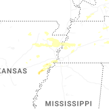
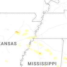
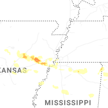


Connect with Interactive Hail Maps