

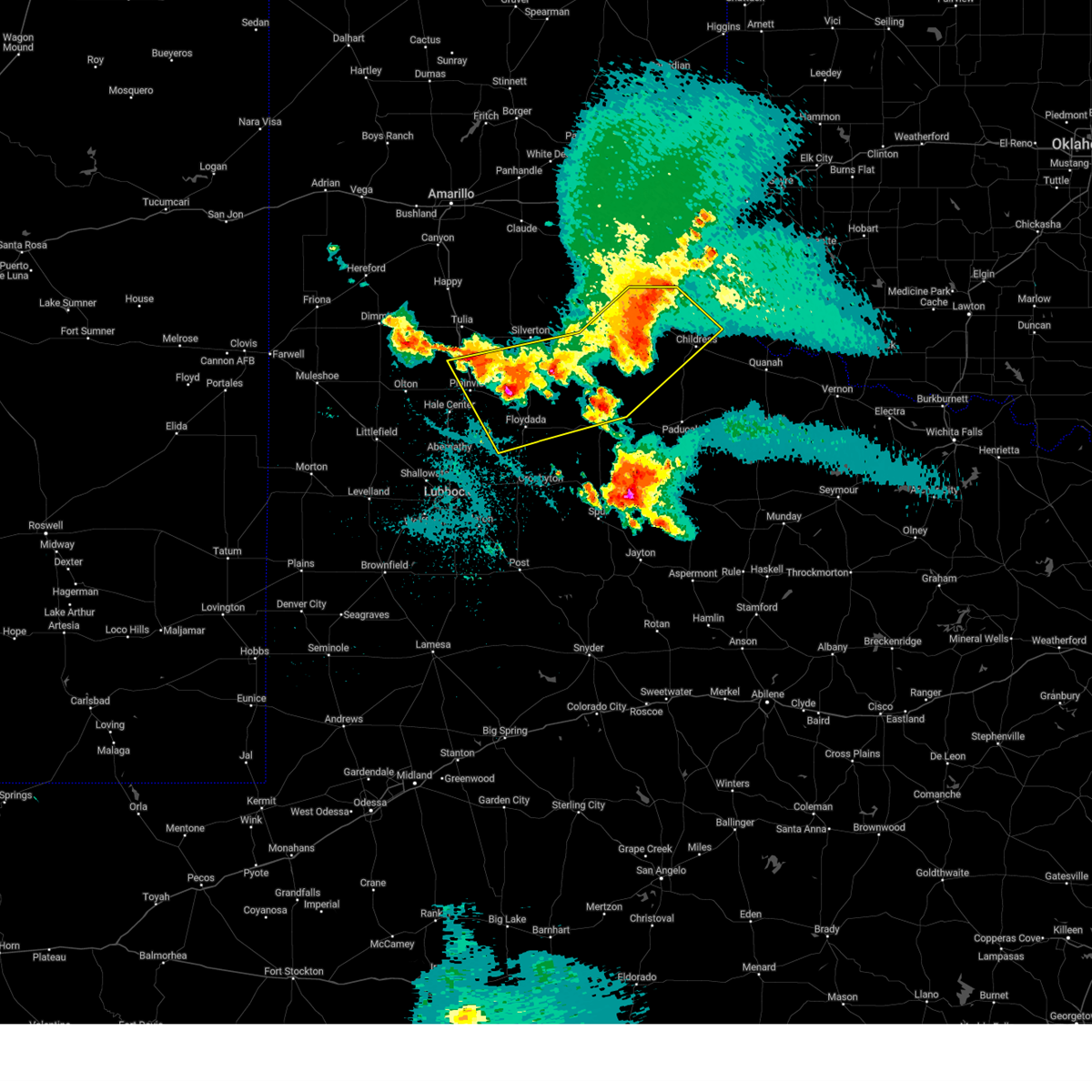
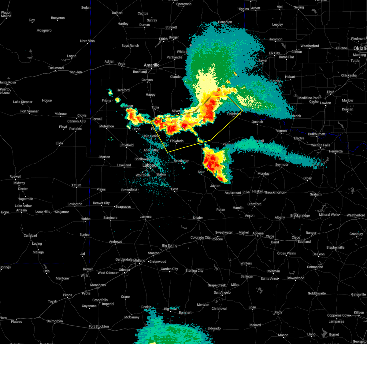
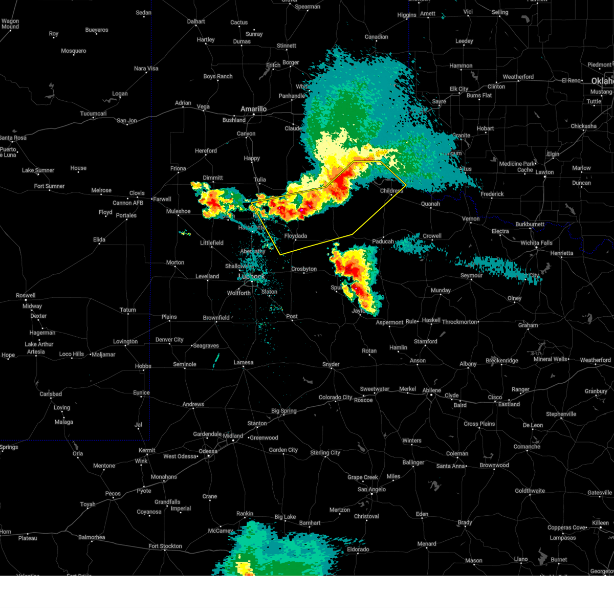
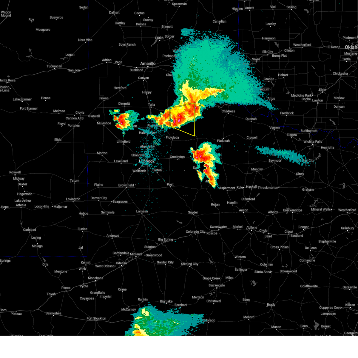
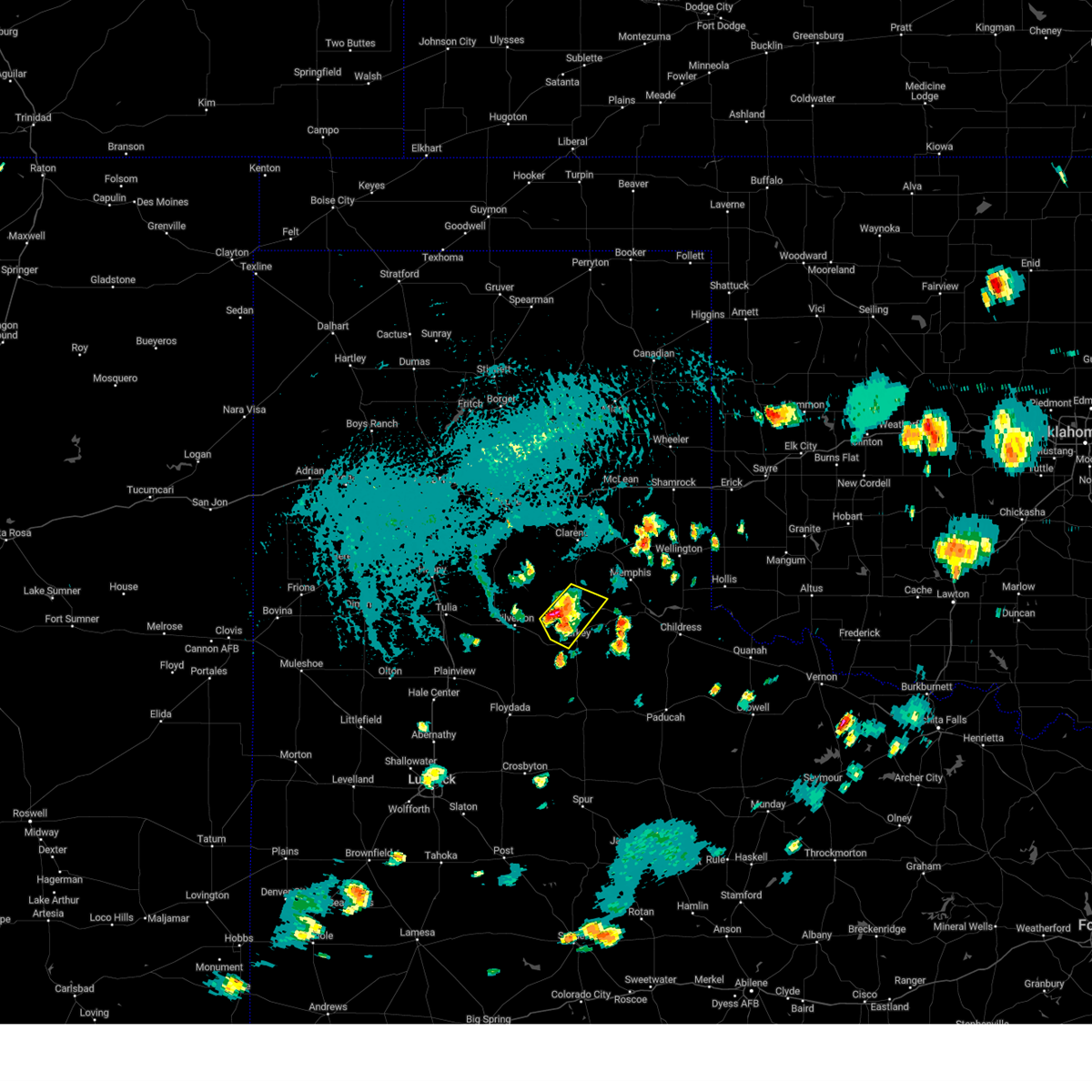
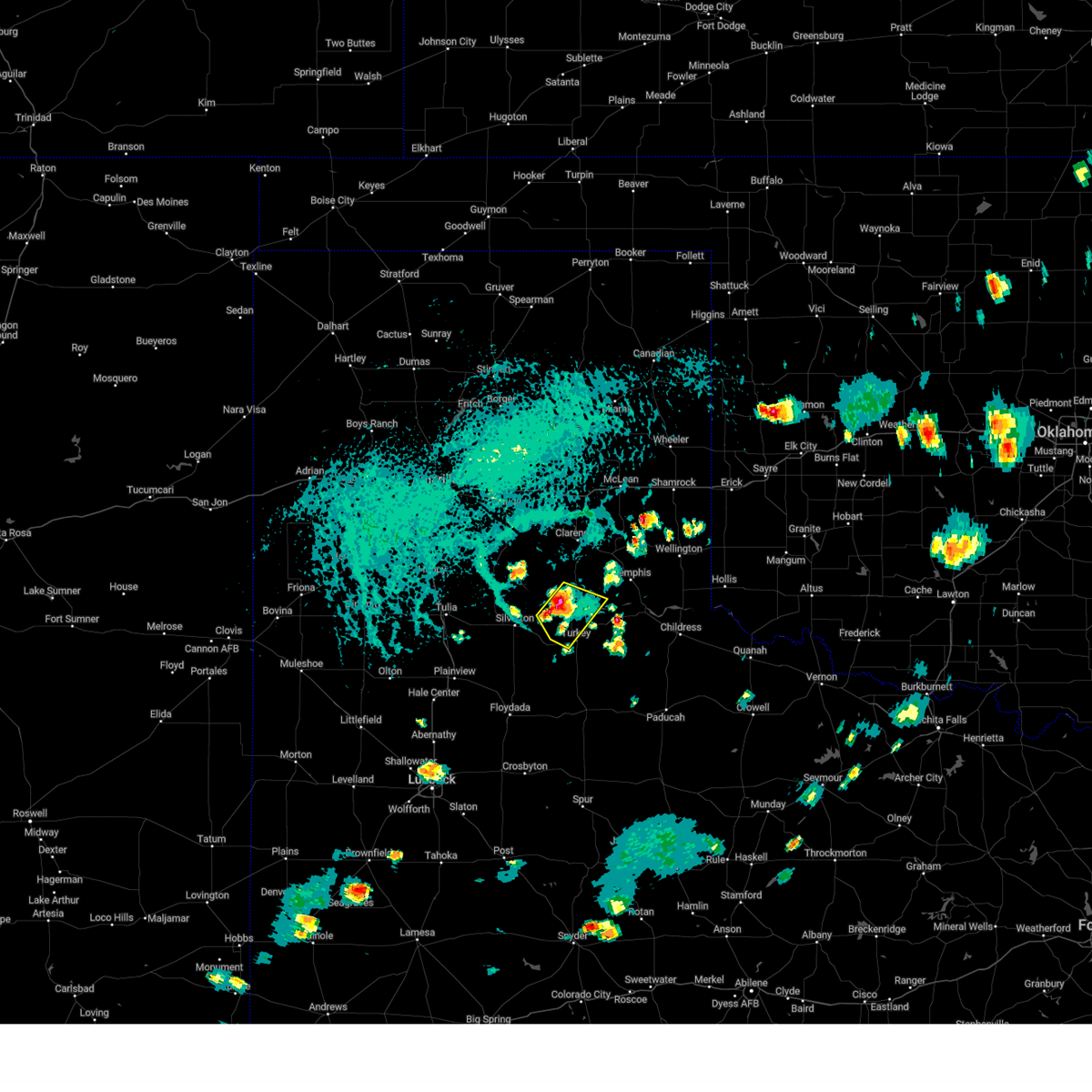
Hail Map for Turkey, TX
The Turkey, TX area has had 25 reports of on-the-ground hail by trained spotters, and has been under severe weather warnings 35 times during the past 12 months. Doppler radar has detected hail at or near Turkey, TX on 107 occasions, including 6 occasions during the past year.
| Name: | Turkey, TX |
| Where Located: | 39 miles W of Childress, TX |
| Map: | Google Map for Turkey, TX |
| Population: | 421 |
| Housing Units: | 267 |
| More Info: | Search Google for Turkey, TX |
2
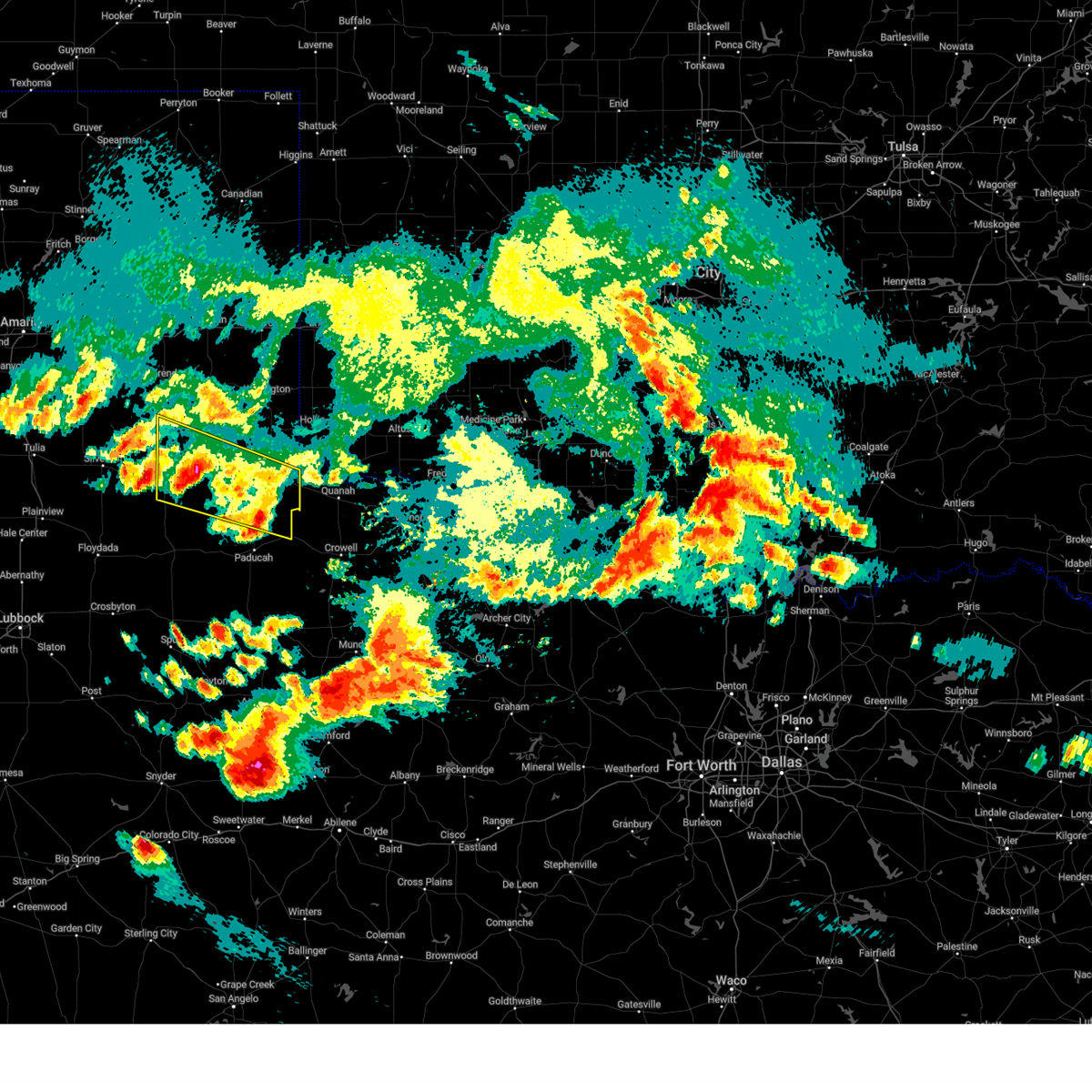
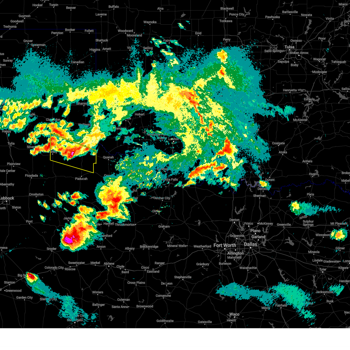
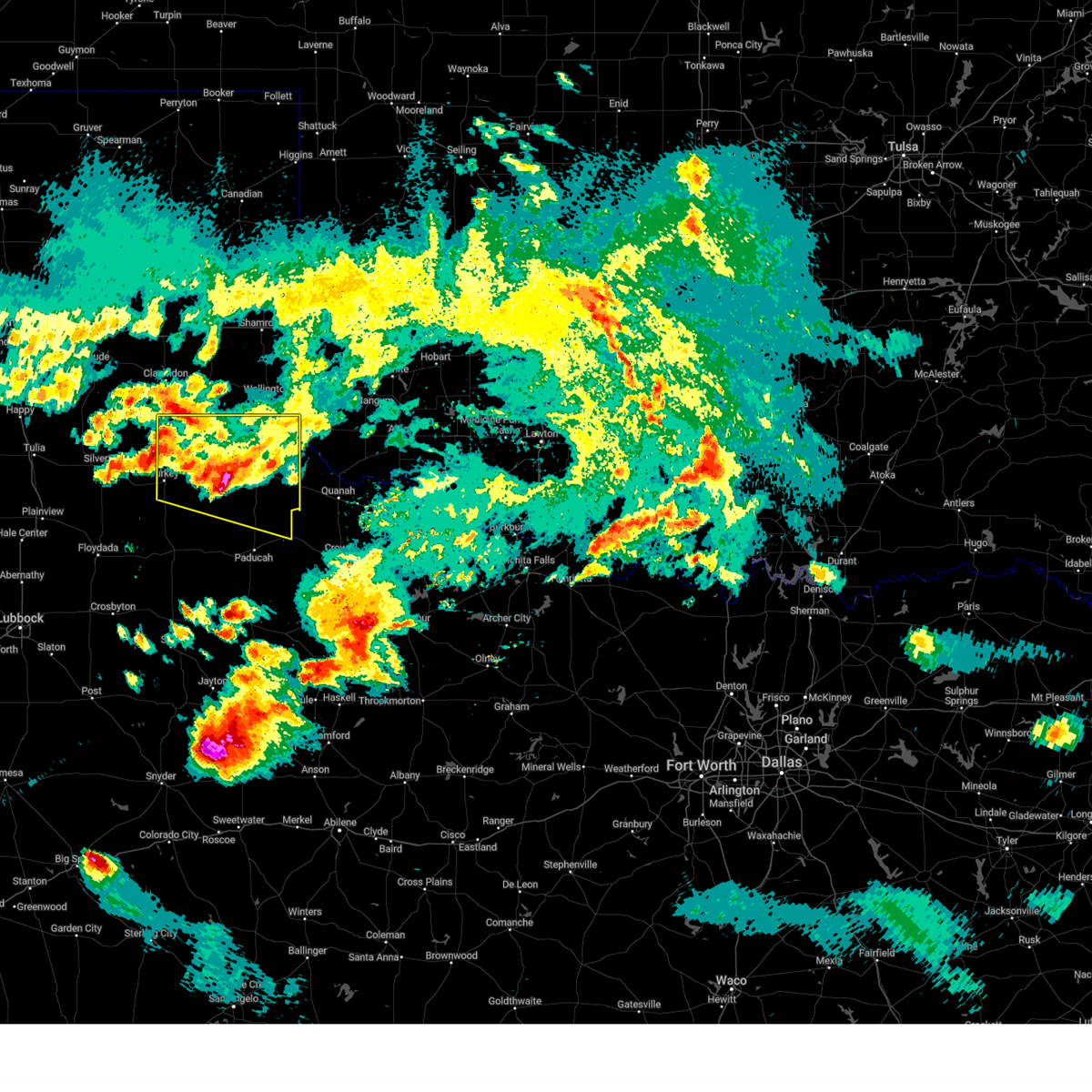
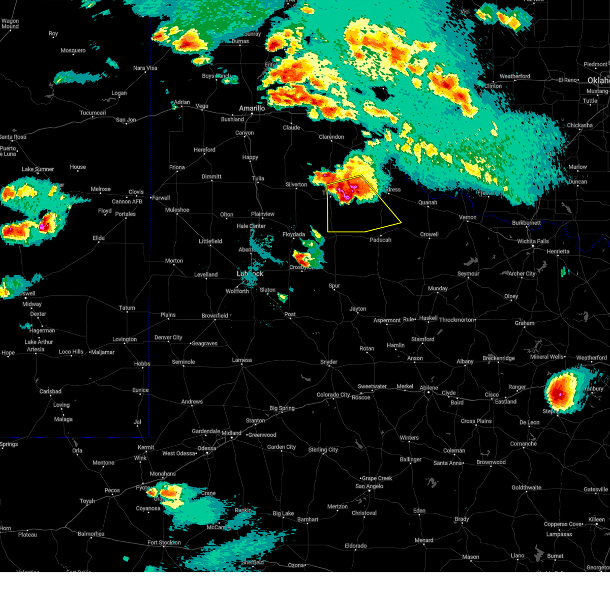
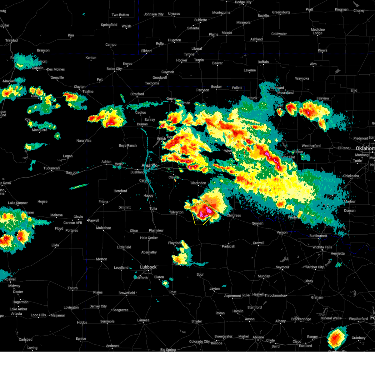
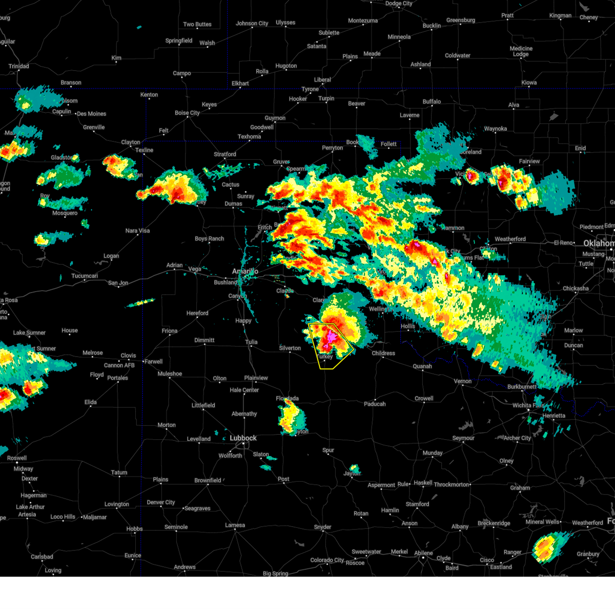
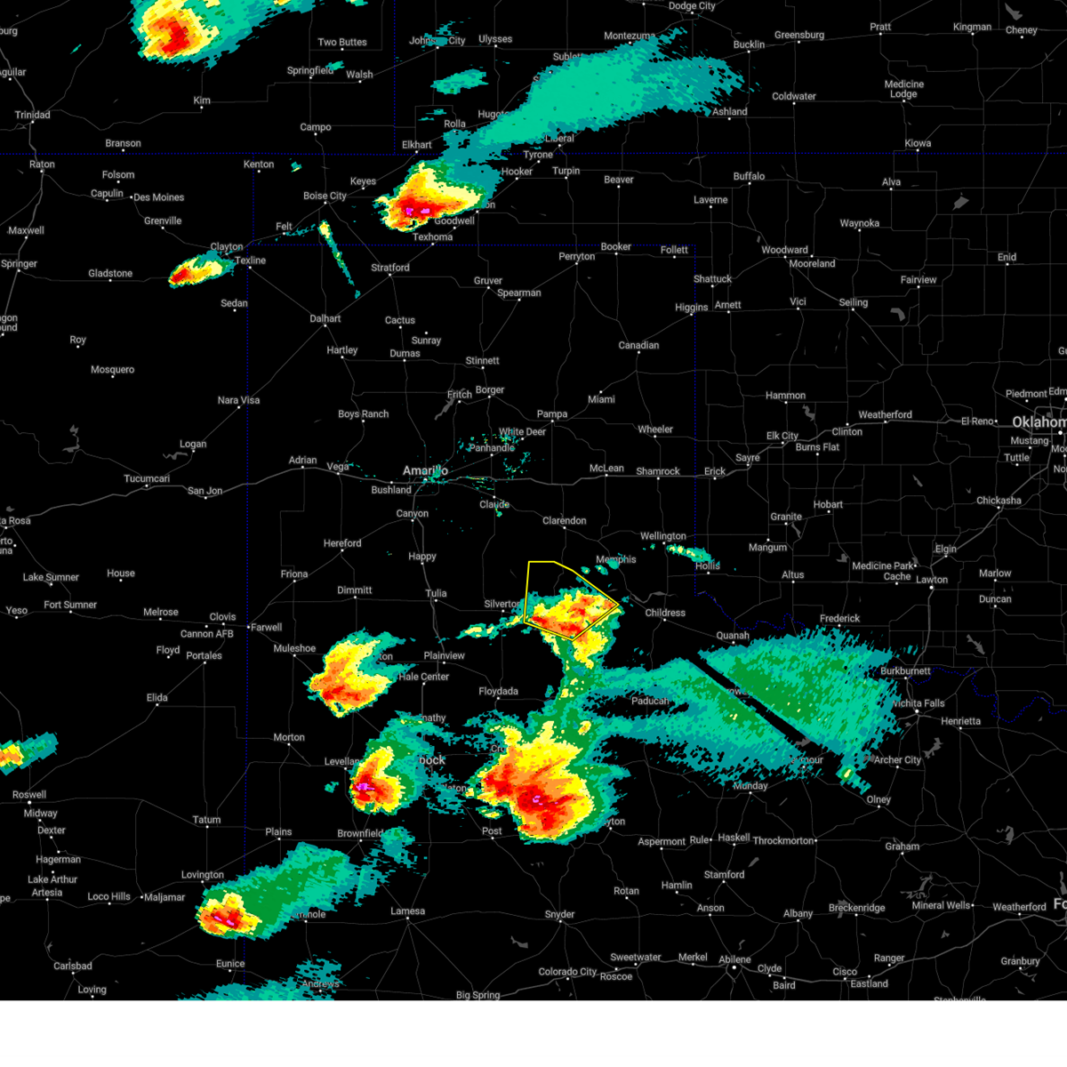
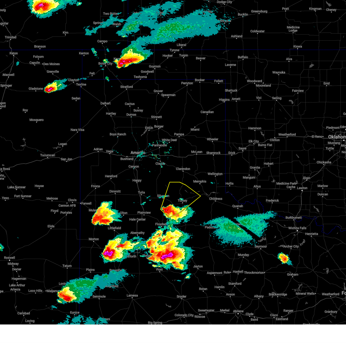
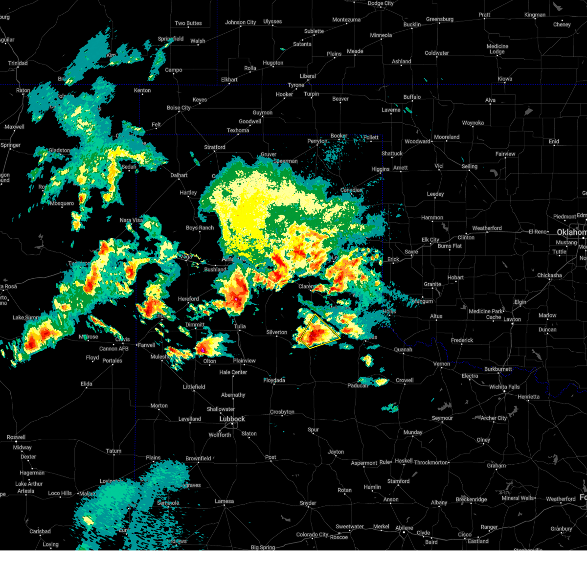
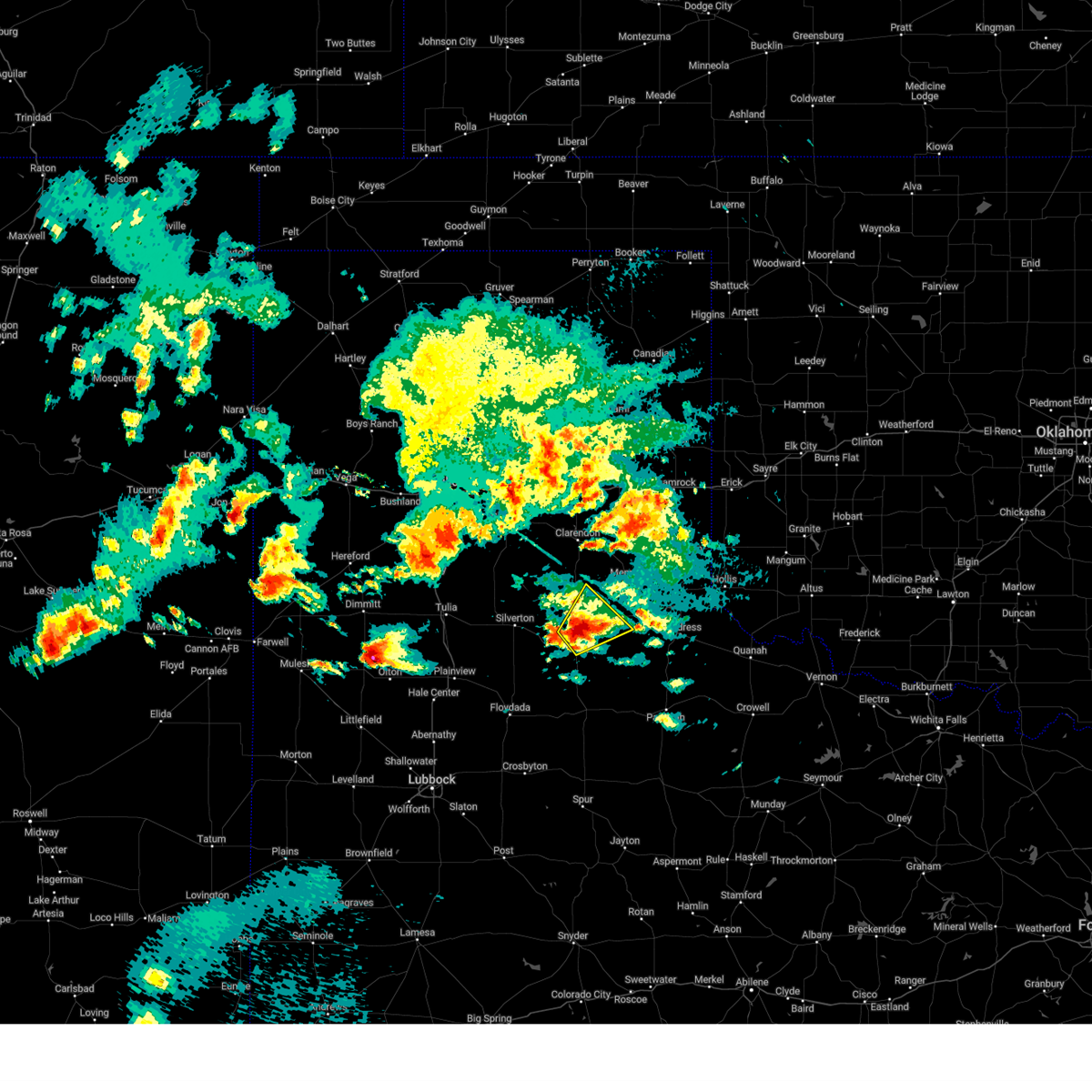
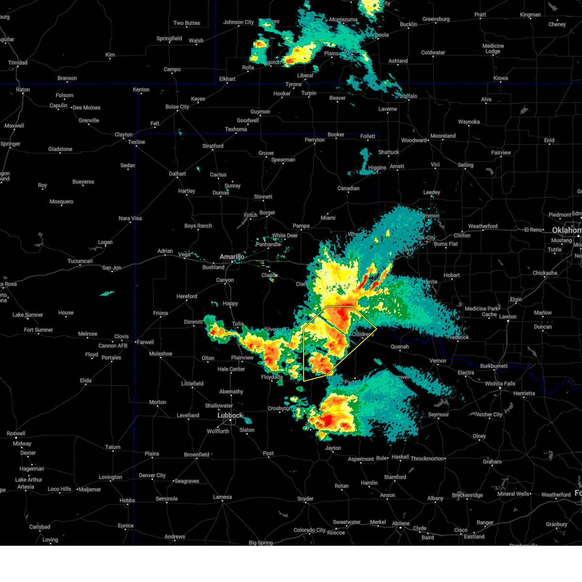
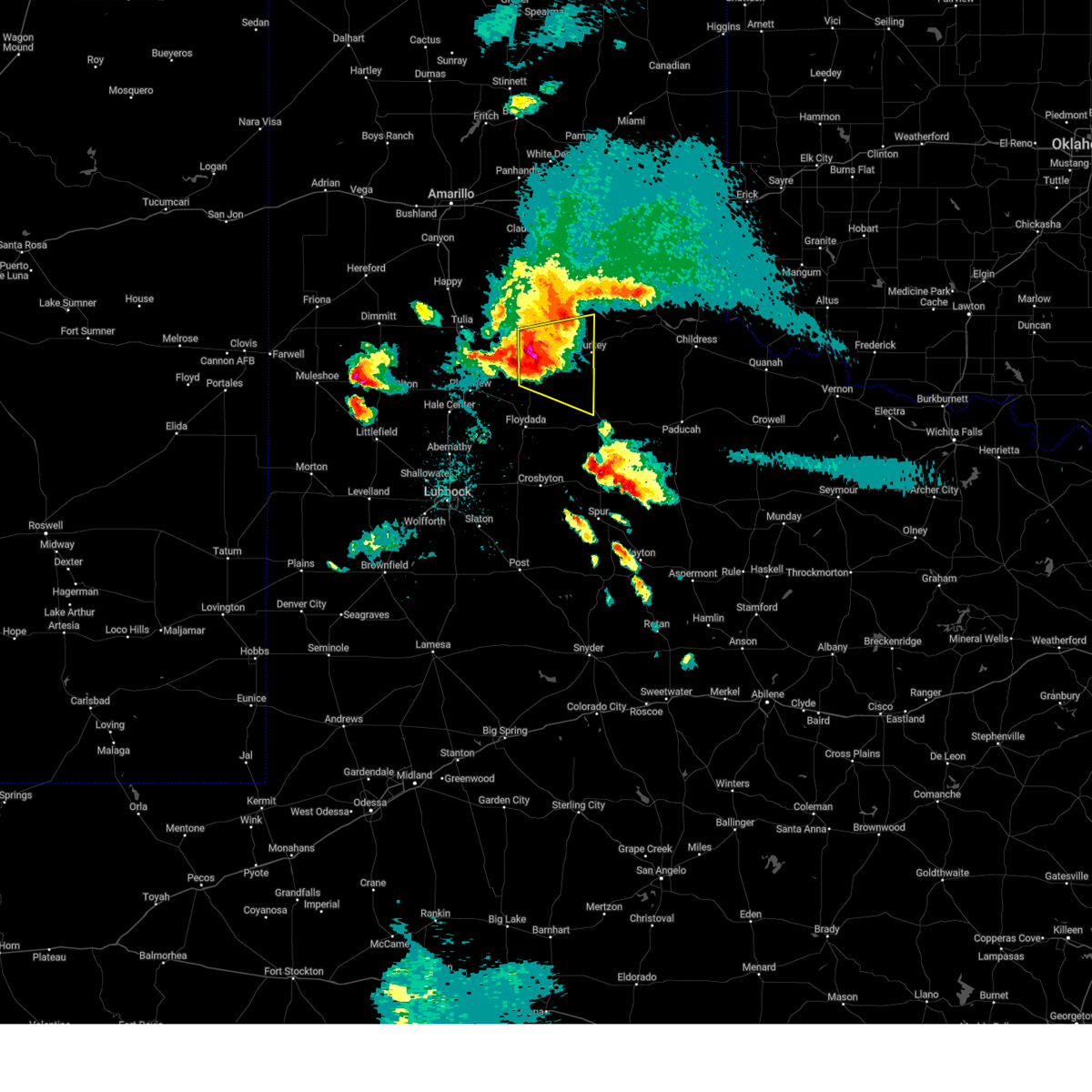
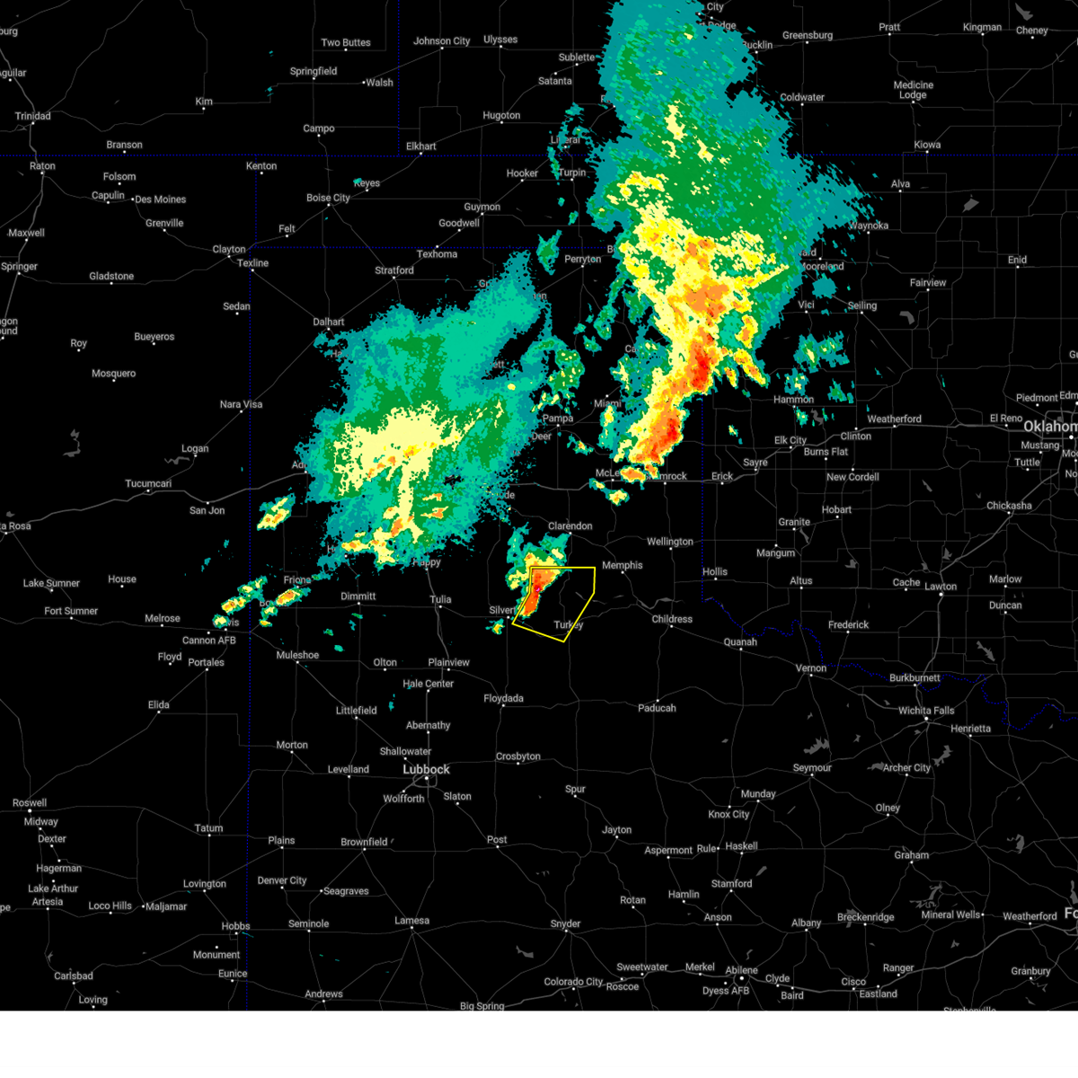
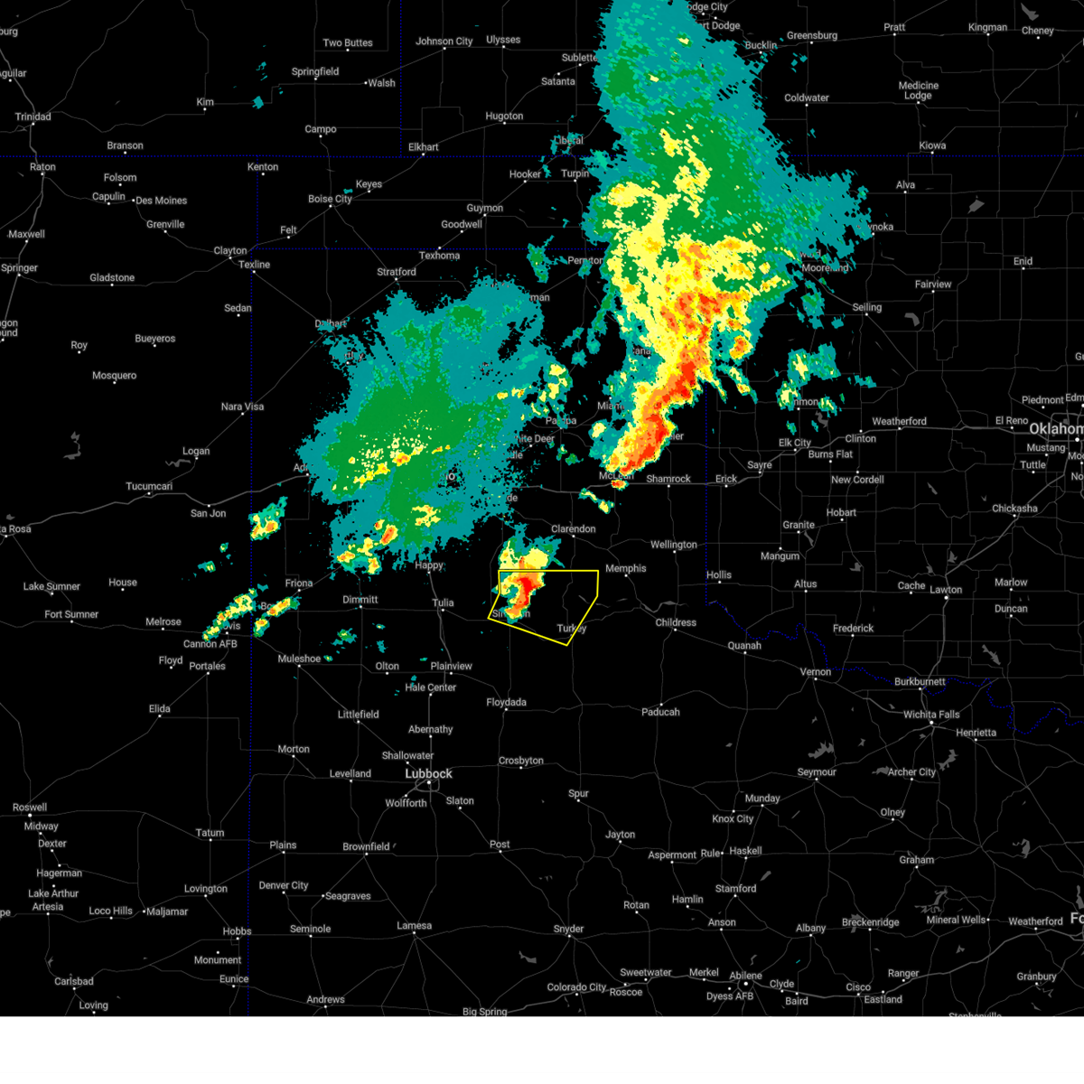
The Top Recent Hail Date for Turkey, TX is Sunday, June 8, 2025 (9th out of 107)
Hail and Wind Damage Spotted near Turkey, TX
| Date / Time | Report Details |
|---|---|
| 6/8/2025 8:29 PM CDT |
 The storm which prompted the warning has weakened below severe limits, and no longer poses an immediate threat to life or property. therefore, the warning will be allowed to expire. however, small hail, gusty winds and heavy rain are still possible with this thunderstorm. a severe thunderstorm watch remains in effect until 1100 pm cdt for the panhandle of and northwestern texas. The storm which prompted the warning has weakened below severe limits, and no longer poses an immediate threat to life or property. therefore, the warning will be allowed to expire. however, small hail, gusty winds and heavy rain are still possible with this thunderstorm. a severe thunderstorm watch remains in effect until 1100 pm cdt for the panhandle of and northwestern texas.
|
| 6/8/2025 8:14 PM CDT |
 At 814 pm cdt, a severe thunderstorm was located 6 miles east of turkey, moving east at 50 mph (radar indicated). Hazards include 60 mph wind gusts and quarter size hail. Hail damage to vehicles is expected. expect wind damage to roofs, siding, and trees. Locations impacted include, childress, turkey, cee vee, tell, kirkland, northfield, brice, swearingen, estelline, lakeview, and plaska community. At 814 pm cdt, a severe thunderstorm was located 6 miles east of turkey, moving east at 50 mph (radar indicated). Hazards include 60 mph wind gusts and quarter size hail. Hail damage to vehicles is expected. expect wind damage to roofs, siding, and trees. Locations impacted include, childress, turkey, cee vee, tell, kirkland, northfield, brice, swearingen, estelline, lakeview, and plaska community.
|
| 6/8/2025 8:07 PM CDT |
 At 807 pm cdt, a severe thunderstorm was located over tell, or 8 miles southwest of childress, moving east at 35 mph (radar indicated). Hazards include 70 mph wind gusts and quarter size hail. Hail damage to vehicles is expected. expect considerable tree damage. wind damage is also likely to mobile homes, roofs, and outbuildings. Locations impacted include, childress, memphis, turkey, cee vee, tell, kirkland, northfield, brice, swearingen, estelline, lakeview, and plaska community. At 807 pm cdt, a severe thunderstorm was located over tell, or 8 miles southwest of childress, moving east at 35 mph (radar indicated). Hazards include 70 mph wind gusts and quarter size hail. Hail damage to vehicles is expected. expect considerable tree damage. wind damage is also likely to mobile homes, roofs, and outbuildings. Locations impacted include, childress, memphis, turkey, cee vee, tell, kirkland, northfield, brice, swearingen, estelline, lakeview, and plaska community.
|
| 6/8/2025 8:00 PM CDT |
 At 800 pm cdt, a severe thunderstorm was located near tell, or 12 miles west of childress, moving southeast at 40 mph (radar indicated). Hazards include 70 mph wind gusts and quarter size hail. Hail damage to vehicles is expected. expect considerable tree damage. wind damage is also likely to mobile homes, roofs, and outbuildings. Locations impacted include, childress, memphis, turkey, cee vee, tell, kirkland, northfield, brice, swearingen, estelline, lakeview, and plaska community. At 800 pm cdt, a severe thunderstorm was located near tell, or 12 miles west of childress, moving southeast at 40 mph (radar indicated). Hazards include 70 mph wind gusts and quarter size hail. Hail damage to vehicles is expected. expect considerable tree damage. wind damage is also likely to mobile homes, roofs, and outbuildings. Locations impacted include, childress, memphis, turkey, cee vee, tell, kirkland, northfield, brice, swearingen, estelline, lakeview, and plaska community.
|
| 6/8/2025 7:45 PM CDT | At 745 pm cdt, a severe thunderstorm was located 9 miles north of northfield, or 15 miles east of turkey, moving east at 35 mph (radar indicated). Hazards include ping pong ball size hail and 60 mph wind gusts. People and animals outdoors will be injured. expect hail damage to roofs, siding, windows, and vehicles. expect wind damage to roofs, siding, and trees. Locations impacted include, childress, memphis, turkey, cee vee, tell, kirkland, northfield, brice, swearingen, estelline, lakeview, and plaska community. |
| 6/8/2025 7:35 PM CDT | Svrlub the national weather service in lubbock texas has issued a * severe thunderstorm warning for, childress county in the panhandle of texas, northeastern motley county in northwestern texas, northern cottle county in northwestern texas, hall county in the panhandle of texas, * until 830 pm cdt. * at 735 pm cdt, a severe thunderstorm was located 11 miles northeast of turkey, moving east at 35 mph (radar indicated). Hazards include 60 mph wind gusts and quarter size hail. Hail damage to vehicles is expected. Expect wind damage to roofs, siding, and trees. |
| 6/8/2025 5:53 PM CDT | At 553 pm cdt, a severe thunderstorm was located 10 miles north of turkey, moving east at 25 mph (radar indicated). Hazards include 70 mph wind gusts and half dollar size hail. Hail damage to vehicles is expected. expect considerable tree damage. wind damage is also likely to mobile homes, roofs, and outbuildings. Locations impacted include, turkey and caprock canyon state park. |
| 6/8/2025 5:39 PM CDT | At 538 pm cdt, a severe thunderstorm was located 11 miles north of northfield, or 13 miles east of turkey, moving southeast at 30 mph. this is a destructive storm for turkey (trained weather spotters). Hazards include 80 mph wind gusts and baseball size hail. Flying debris will be dangerous to those caught without shelter. mobile homes will be heavily damaged. expect considerable damage to roofs, windows, and vehicles. extensive tree damage and power outages are likely. Locations impacted include, turkey and caprock canyon state park. |
| 6/8/2025 5:37 PM CDT |
 Svrlub the national weather service in lubbock texas has issued a * severe thunderstorm warning for, southwestern childress county in the panhandle of texas, northern motley county in northwestern texas, northern cottle county in northwestern texas, southern hall county in the panhandle of texas, * until 645 pm cdt. * at 537 pm cdt, a severe thunderstorm was located 10 miles north of northfield, or 13 miles east of turkey, moving southeast at 35 mph. this is a destructive storm for northfield (radar indicated). Hazards include 80 mph wind gusts and baseball size hail. Flying debris will be dangerous to those caught without shelter. mobile homes will be heavily damaged. expect considerable damage to roofs, windows, and vehicles. Extensive tree damage and power outages are likely. Svrlub the national weather service in lubbock texas has issued a * severe thunderstorm warning for, southwestern childress county in the panhandle of texas, northern motley county in northwestern texas, northern cottle county in northwestern texas, southern hall county in the panhandle of texas, * until 645 pm cdt. * at 537 pm cdt, a severe thunderstorm was located 10 miles north of northfield, or 13 miles east of turkey, moving southeast at 35 mph. this is a destructive storm for northfield (radar indicated). Hazards include 80 mph wind gusts and baseball size hail. Flying debris will be dangerous to those caught without shelter. mobile homes will be heavily damaged. expect considerable damage to roofs, windows, and vehicles. Extensive tree damage and power outages are likely.
|
| 6/8/2025 5:30 PM CDT |
 At 529 pm cdt, a severe thunderstorm was located 11 miles northeast of turkey, moving southeast at 30 mph. this is a destructive storm for turkey (trained weather spotters measured a 90 mph wind gust near brice). Hazards include 90 mph wind gusts and three inch hail. You are in a life-threatening situation. flying debris may be deadly to those caught without shelter. mobile homes will be heavily damaged or destroyed. homes and businesses will have substantial roof and window damage. expect extensive tree damage and power outages. Locations impacted include, turkey and caprock canyon state park. At 529 pm cdt, a severe thunderstorm was located 11 miles northeast of turkey, moving southeast at 30 mph. this is a destructive storm for turkey (trained weather spotters measured a 90 mph wind gust near brice). Hazards include 90 mph wind gusts and three inch hail. You are in a life-threatening situation. flying debris may be deadly to those caught without shelter. mobile homes will be heavily damaged or destroyed. homes and businesses will have substantial roof and window damage. expect extensive tree damage and power outages. Locations impacted include, turkey and caprock canyon state park.
|
| 6/8/2025 5:20 PM CDT |
 At 518 pm cdt, a severe thunderstorm was located 8 miles south of brice, or 13 miles north of turkey, moving southeast at 20 mph. this is a destructive storm for turkey (trained weather spotters measured 90 mph wind gusts south of brice at 509 pm cdt). Hazards include 90 mph wind gusts and softball size hail. You are in a life-threatening situation. flying debris may be deadly to those caught without shelter. mobile homes will be heavily damaged or destroyed. homes and businesses will have substantial roof and window damage. expect extensive tree damage and power outages. Locations impacted include, turkey, caprock canyon state park, and brice. At 518 pm cdt, a severe thunderstorm was located 8 miles south of brice, or 13 miles north of turkey, moving southeast at 20 mph. this is a destructive storm for turkey (trained weather spotters measured 90 mph wind gusts south of brice at 509 pm cdt). Hazards include 90 mph wind gusts and softball size hail. You are in a life-threatening situation. flying debris may be deadly to those caught without shelter. mobile homes will be heavily damaged or destroyed. homes and businesses will have substantial roof and window damage. expect extensive tree damage and power outages. Locations impacted include, turkey, caprock canyon state park, and brice.
|
| 6/8/2025 5:05 PM CDT | At 504 pm cdt, a severe thunderstorm was located 4 miles southwest of brice, or 16 miles northeast of caprock canyon state park, moving southeast at 30 mph. this is a destructive storm for brice caprock canyon state park (radar indicated). Hazards include 80 mph wind gusts and softball size hail. Flying debris will be dangerous to those caught without shelter. mobile homes will be heavily damaged. expect considerable damage to roofs, windows, and vehicles. extensive tree damage and power outages are likely. Locations impacted include, turkey, caprock canyon state park, quitaque, valley schools, and brice. |
| 6/8/2025 4:52 PM CDT | At 451 pm cdt, a severe thunderstorm was located 10 miles west of brice, or 16 miles southwest of clarendon, moving southeast at 25 mph. this is a destructive storm for brice and caprock canyon state park (radar indicated). Hazards include 80 mph wind gusts and softball size hail. Flying debris will be dangerous to those caught without shelter. mobile homes will be heavily damaged. expect considerable damage to roofs, windows, and vehicles. extensive tree damage and power outages are likely. Locations impacted include, turkey, caprock canyon state park, quitaque, valley schools, and brice. |
| 6/8/2025 4:38 PM CDT | Svrlub the national weather service in lubbock texas has issued a * severe thunderstorm warning for, western hall county in the panhandle of texas, briscoe county in the panhandle of texas, * until 600 pm cdt. * at 438 pm cdt, a severe thunderstorm was located 15 miles south of goodnight, or 18 miles southwest of clarendon, moving southeast at 20 mph. this is a destructive storm for caprock canyon state park (radar indicated). Hazards include grapefruit size hail and 70 mph wind gusts. People and animals outdoors will be severely injured. Expect shattered windows, extensive damage to roofs, siding, and vehicles. |
| 6/6/2025 7:35 PM CDT |
 the severe thunderstorm warning has been cancelled and is no longer in effect the severe thunderstorm warning has been cancelled and is no longer in effect
|
| 6/6/2025 7:35 PM CDT |
 At 733 pm cdt, a severe thunderstorm was located over caprock canyon state park, moving northeast at 40 mph (radar indicated). Hazards include 60 mph wind gusts and quarter size hail. Hail damage to vehicles is expected. expect wind damage to roofs, siding, and trees. Locations impacted include, turkey, caprock canyon state park, valley schools, and brice. At 733 pm cdt, a severe thunderstorm was located over caprock canyon state park, moving northeast at 40 mph (radar indicated). Hazards include 60 mph wind gusts and quarter size hail. Hail damage to vehicles is expected. expect wind damage to roofs, siding, and trees. Locations impacted include, turkey, caprock canyon state park, valley schools, and brice.
|
| 6/6/2025 7:10 PM CDT |
 Svrlub the national weather service in lubbock texas has issued a * severe thunderstorm warning for, northeastern floyd county in northwestern texas, northwestern motley county in northwestern texas, southwestern hall county in the panhandle of texas, eastern briscoe county in the panhandle of texas, * until 815 pm cdt. * at 710 pm cdt, a severe thunderstorm was located 6 miles northeast of south plains, or 12 miles south of silverton, moving northeast at 30 mph (radar indicated). Hazards include 60 mph wind gusts and quarter size hail. Hail damage to vehicles is expected. Expect wind damage to roofs, siding, and trees. Svrlub the national weather service in lubbock texas has issued a * severe thunderstorm warning for, northeastern floyd county in northwestern texas, northwestern motley county in northwestern texas, southwestern hall county in the panhandle of texas, eastern briscoe county in the panhandle of texas, * until 815 pm cdt. * at 710 pm cdt, a severe thunderstorm was located 6 miles northeast of south plains, or 12 miles south of silverton, moving northeast at 30 mph (radar indicated). Hazards include 60 mph wind gusts and quarter size hail. Hail damage to vehicles is expected. Expect wind damage to roofs, siding, and trees.
|
| 4/26/2025 2:13 AM CDT |
 the severe thunderstorm warning has been cancelled and is no longer in effect the severe thunderstorm warning has been cancelled and is no longer in effect
|
| 4/26/2025 2:13 AM CDT |
 At 213 am cdt, a severe thunderstorm was located 4 miles northeast of turkey, moving northeast at 10 mph (radar indicated). Hazards include 60 mph wind gusts and quarter size hail. Hail damage to vehicles is expected. expect wind damage to roofs, siding, and trees. Locations impacted include, turkey and caprock canyon state park. At 213 am cdt, a severe thunderstorm was located 4 miles northeast of turkey, moving northeast at 10 mph (radar indicated). Hazards include 60 mph wind gusts and quarter size hail. Hail damage to vehicles is expected. expect wind damage to roofs, siding, and trees. Locations impacted include, turkey and caprock canyon state park.
|
| 4/26/2025 1:58 AM CDT |
 Svrlub the national weather service in lubbock texas has issued a * severe thunderstorm warning for, northwestern motley county in northwestern texas, southwestern hall county in the panhandle of texas, east central briscoe county in the panhandle of texas, * until 300 am cdt. * at 158 am cdt, a severe thunderstorm was located over turkey, moving northeast at 10 mph (radar indicated). Hazards include 60 mph wind gusts and quarter size hail. Hail damage to vehicles is expected. Expect wind damage to roofs, siding, and trees. Svrlub the national weather service in lubbock texas has issued a * severe thunderstorm warning for, northwestern motley county in northwestern texas, southwestern hall county in the panhandle of texas, east central briscoe county in the panhandle of texas, * until 300 am cdt. * at 158 am cdt, a severe thunderstorm was located over turkey, moving northeast at 10 mph (radar indicated). Hazards include 60 mph wind gusts and quarter size hail. Hail damage to vehicles is expected. Expect wind damage to roofs, siding, and trees.
|
| 4/23/2025 11:40 PM CDT |
 the severe thunderstorm warning has been cancelled and is no longer in effect the severe thunderstorm warning has been cancelled and is no longer in effect
|
| 4/23/2025 11:40 PM CDT |
 At 1140 pm cdt, severe thunderstorms were located along a line extending from 9 miles east of memphis to 3 miles northwest of cee vee to 11 miles northeast of matador, moving southeast at 20 mph (radar indicated). Hazards include 60 mph wind gusts and quarter size hail. Hail damage to vehicles is expected. expect wind damage to roofs, siding, and trees. Locations impacted include, matador, turkey, cee vee, plaska community, tell, lakeview, estelline, northfield, memphis, and childress. At 1140 pm cdt, severe thunderstorms were located along a line extending from 9 miles east of memphis to 3 miles northwest of cee vee to 11 miles northeast of matador, moving southeast at 20 mph (radar indicated). Hazards include 60 mph wind gusts and quarter size hail. Hail damage to vehicles is expected. expect wind damage to roofs, siding, and trees. Locations impacted include, matador, turkey, cee vee, plaska community, tell, lakeview, estelline, northfield, memphis, and childress.
|
| 4/23/2025 11:27 PM CDT |
 At 1126 pm cdt, severe thunderstorms were located along a line extending from 13 miles south of wellington to 5 miles east of northfield to 3 miles southeast of lockney, moving southeast at 30 mph (radar indicated). Hazards include 60 mph wind gusts and quarter size hail. Hail damage to vehicles is expected. expect wind damage to roofs, siding, and trees. Locations impacted include, cee vee, lakeview, south plains, claytonville, estelline, kress, caprock canyon state park, aiken, seth ward, flomot, valley schools, matador, turkey, plaska community, tell, northfield, quitaque, memphis, childress, and lockney. At 1126 pm cdt, severe thunderstorms were located along a line extending from 13 miles south of wellington to 5 miles east of northfield to 3 miles southeast of lockney, moving southeast at 30 mph (radar indicated). Hazards include 60 mph wind gusts and quarter size hail. Hail damage to vehicles is expected. expect wind damage to roofs, siding, and trees. Locations impacted include, cee vee, lakeview, south plains, claytonville, estelline, kress, caprock canyon state park, aiken, seth ward, flomot, valley schools, matador, turkey, plaska community, tell, northfield, quitaque, memphis, childress, and lockney.
|
| 4/23/2025 11:09 PM CDT |
 At 1108 pm cdt, severe thunderstorms were located along a line extending from 9 miles east of memphis to 6 miles north of northfield to aiken, moving southeast at 30 mph (radar indicated). Hazards include 60 mph wind gusts and quarter size hail. Hail damage to vehicles is expected. expect wind damage to roofs, siding, and trees. Locations impacted include, cee vee, lakeview, south plains, claytonville, estelline, kress, caprock canyon state park, aiken, seth ward, flomot, valley schools, matador, turkey, plaska community, tell, northfield, quitaque, memphis, childress, and lockney. At 1108 pm cdt, severe thunderstorms were located along a line extending from 9 miles east of memphis to 6 miles north of northfield to aiken, moving southeast at 30 mph (radar indicated). Hazards include 60 mph wind gusts and quarter size hail. Hail damage to vehicles is expected. expect wind damage to roofs, siding, and trees. Locations impacted include, cee vee, lakeview, south plains, claytonville, estelline, kress, caprock canyon state park, aiken, seth ward, flomot, valley schools, matador, turkey, plaska community, tell, northfield, quitaque, memphis, childress, and lockney.
|
| 4/23/2025 10:53 PM CDT |
 Svrlub the national weather service in lubbock texas has issued a * severe thunderstorm warning for, floyd county in northwestern texas, childress county in the panhandle of texas, northwestern cottle county in northwestern texas, motley county in northwestern texas, northeastern hale county in northwestern texas, hall county in the panhandle of texas, southeastern swisher county in the panhandle of texas, southern briscoe county in the panhandle of texas, * until midnight cdt. * at 1053 pm cdt, severe thunderstorms were located along a line extending from 7 miles south of quail to near turkey to 6 miles northwest of aiken, moving southeast at 25 mph (radar indicated). Hazards include 60 mph wind gusts and quarter size hail. Hail damage to vehicles is expected. Expect wind damage to roofs, siding, and trees. Svrlub the national weather service in lubbock texas has issued a * severe thunderstorm warning for, floyd county in northwestern texas, childress county in the panhandle of texas, northwestern cottle county in northwestern texas, motley county in northwestern texas, northeastern hale county in northwestern texas, hall county in the panhandle of texas, southeastern swisher county in the panhandle of texas, southern briscoe county in the panhandle of texas, * until midnight cdt. * at 1053 pm cdt, severe thunderstorms were located along a line extending from 7 miles south of quail to near turkey to 6 miles northwest of aiken, moving southeast at 25 mph (radar indicated). Hazards include 60 mph wind gusts and quarter size hail. Hail damage to vehicles is expected. Expect wind damage to roofs, siding, and trees.
|
| 4/23/2025 10:38 PM CDT |
 At 1038 pm cdt, a severe thunderstorm was located 6 miles west of quitaque, or 9 miles southwest of caprock canyon state park, moving east at 15 mph (airport weather station). Hazards include 70 mph wind gusts and quarter size hail. Hail damage to vehicles is expected. expect considerable tree damage. wind damage is also likely to mobile homes, roofs, and outbuildings. Locations impacted include, flomot, valley schools, turkey, south plains, caprock canyon state park, quitaque, and silverton. At 1038 pm cdt, a severe thunderstorm was located 6 miles west of quitaque, or 9 miles southwest of caprock canyon state park, moving east at 15 mph (airport weather station). Hazards include 70 mph wind gusts and quarter size hail. Hail damage to vehicles is expected. expect considerable tree damage. wind damage is also likely to mobile homes, roofs, and outbuildings. Locations impacted include, flomot, valley schools, turkey, south plains, caprock canyon state park, quitaque, and silverton.
|
| 4/23/2025 10:17 PM CDT |
 At 1017 pm cdt, a severe thunderstorm was located 7 miles southeast of silverton, moving east at 20 mph. this is a destructive storm for silverton and quitaque (radar indicated). Hazards include 80 mph wind gusts and two inch hail. Flying debris will be dangerous to those caught without shelter. mobile homes will be heavily damaged. expect considerable damage to roofs, windows, and vehicles. extensive tree damage and power outages are likely. Locations impacted include, flomot, valley schools, turkey, south plains, caprock canyon state park, quitaque, and silverton. At 1017 pm cdt, a severe thunderstorm was located 7 miles southeast of silverton, moving east at 20 mph. this is a destructive storm for silverton and quitaque (radar indicated). Hazards include 80 mph wind gusts and two inch hail. Flying debris will be dangerous to those caught without shelter. mobile homes will be heavily damaged. expect considerable damage to roofs, windows, and vehicles. extensive tree damage and power outages are likely. Locations impacted include, flomot, valley schools, turkey, south plains, caprock canyon state park, quitaque, and silverton.
|
| 4/23/2025 10:13 PM CDT |
 Svrlub the national weather service in lubbock texas has issued a * severe thunderstorm warning for, northeastern floyd county in northwestern texas, northwestern motley county in northwestern texas, southwestern hall county in the panhandle of texas, southern briscoe county in the panhandle of texas, * until 1115 pm cdt. * at 1013 pm cdt, a severe thunderstorm was located 6 miles south of silverton, moving east at 20 mph (radar indicated). Hazards include two inch hail and 70 mph wind gusts. People and animals outdoors will be injured. expect hail damage to roofs, siding, windows, and vehicles. expect considerable tree damage. Wind damage is also likely to mobile homes, roofs, and outbuildings. Svrlub the national weather service in lubbock texas has issued a * severe thunderstorm warning for, northeastern floyd county in northwestern texas, northwestern motley county in northwestern texas, southwestern hall county in the panhandle of texas, southern briscoe county in the panhandle of texas, * until 1115 pm cdt. * at 1013 pm cdt, a severe thunderstorm was located 6 miles south of silverton, moving east at 20 mph (radar indicated). Hazards include two inch hail and 70 mph wind gusts. People and animals outdoors will be injured. expect hail damage to roofs, siding, windows, and vehicles. expect considerable tree damage. Wind damage is also likely to mobile homes, roofs, and outbuildings.
|
| 9/22/2024 3:22 AM CDT |
 At 321 am cdt, severe thunderstorms were located along a line extending from 8 miles northwest of brice to 16 miles north of valley schools to 5 miles west of caprock canyon state park, moving east at 35 mph (radar indicated). Hazards include 60 mph wind gusts and quarter size hail. Hail damage to vehicles is expected. expect wind damage to roofs, siding, and trees. Locations impacted include, turkey, caprock canyon state park, valley schools, and brice. At 321 am cdt, severe thunderstorms were located along a line extending from 8 miles northwest of brice to 16 miles north of valley schools to 5 miles west of caprock canyon state park, moving east at 35 mph (radar indicated). Hazards include 60 mph wind gusts and quarter size hail. Hail damage to vehicles is expected. expect wind damage to roofs, siding, and trees. Locations impacted include, turkey, caprock canyon state park, valley schools, and brice.
|
| 9/22/2024 3:07 AM CDT |
 Svrlub the national weather service in lubbock texas has issued a * severe thunderstorm warning for, northwestern hall county in the panhandle of texas, briscoe county in the panhandle of texas, * until 345 am cdt. * at 307 am cdt, severe thunderstorms were located along a line extending from 14 miles south of goodnight to 15 miles northwest of caprock canyon state park to near silverton, moving east at 35 mph (radar indicated). Hazards include 60 mph wind gusts and quarter size hail. Hail damage to vehicles is expected. Expect wind damage to roofs, siding, and trees. Svrlub the national weather service in lubbock texas has issued a * severe thunderstorm warning for, northwestern hall county in the panhandle of texas, briscoe county in the panhandle of texas, * until 345 am cdt. * at 307 am cdt, severe thunderstorms were located along a line extending from 14 miles south of goodnight to 15 miles northwest of caprock canyon state park to near silverton, moving east at 35 mph (radar indicated). Hazards include 60 mph wind gusts and quarter size hail. Hail damage to vehicles is expected. Expect wind damage to roofs, siding, and trees.
|
| 8/15/2024 6:06 PM CDT |
 The storm which prompted the warning has weakened below severe limits, and no longer poses an immediate threat to life or property. therefore, the warning will be allowed to expire. however, gusty winds are still possible with this thunderstorm. The storm which prompted the warning has weakened below severe limits, and no longer poses an immediate threat to life or property. therefore, the warning will be allowed to expire. however, gusty winds are still possible with this thunderstorm.
|
| 8/15/2024 5:59 PM CDT |
 At 558 pm cdt, a severe thunderstorm was located 4 miles northeast of caprock canyon state park, moving southeast at 10 mph (radar indicated). Hazards include 60 mph wind gusts. Expect damage to roofs, siding, and trees. Locations impacted include, caprock canyon state park and valley schools. At 558 pm cdt, a severe thunderstorm was located 4 miles northeast of caprock canyon state park, moving southeast at 10 mph (radar indicated). Hazards include 60 mph wind gusts. Expect damage to roofs, siding, and trees. Locations impacted include, caprock canyon state park and valley schools.
|
| 8/15/2024 5:48 PM CDT |
 At 548 pm cdt, a severe thunderstorm was located 10 miles northeast of caprock canyon state park, moving southeast at 10 mph (radar indicated). Hazards include 60 mph wind gusts. Expect damage to roofs, siding, and trees. Locations impacted include, caprock canyon state park and valley schools. At 548 pm cdt, a severe thunderstorm was located 10 miles northeast of caprock canyon state park, moving southeast at 10 mph (radar indicated). Hazards include 60 mph wind gusts. Expect damage to roofs, siding, and trees. Locations impacted include, caprock canyon state park and valley schools.
|
| 8/15/2024 5:39 PM CDT |
 At 539 pm cdt, a severe thunderstorm was located 10 miles southwest of brice, or 10 miles north of caprock canyon state park, moving southeast at 10 mph (radar indicated). Hazards include 60 mph wind gusts and quarter size hail. Hail damage to vehicles is expected. expect wind damage to roofs, siding, and trees. Locations impacted include, caprock canyon state park and valley schools. At 539 pm cdt, a severe thunderstorm was located 10 miles southwest of brice, or 10 miles north of caprock canyon state park, moving southeast at 10 mph (radar indicated). Hazards include 60 mph wind gusts and quarter size hail. Hail damage to vehicles is expected. expect wind damage to roofs, siding, and trees. Locations impacted include, caprock canyon state park and valley schools.
|
| 8/15/2024 5:30 PM CDT |
 Svrlub the national weather service in lubbock texas has issued a * severe thunderstorm warning for, northwestern hall county in the panhandle of texas, eastern briscoe county in the panhandle of texas, * until 615 pm cdt. * at 530 pm cdt, a severe thunderstorm was located 10 miles southwest of brice, or 12 miles north of caprock canyon state park, moving southeast at 10 mph (radar indicated). Hazards include 70 mph wind gusts and quarter size hail. Hail damage to vehicles is expected. expect considerable tree damage. Wind damage is also likely to mobile homes, roofs, and outbuildings. Svrlub the national weather service in lubbock texas has issued a * severe thunderstorm warning for, northwestern hall county in the panhandle of texas, eastern briscoe county in the panhandle of texas, * until 615 pm cdt. * at 530 pm cdt, a severe thunderstorm was located 10 miles southwest of brice, or 12 miles north of caprock canyon state park, moving southeast at 10 mph (radar indicated). Hazards include 70 mph wind gusts and quarter size hail. Hail damage to vehicles is expected. expect considerable tree damage. Wind damage is also likely to mobile homes, roofs, and outbuildings.
|
| 6/2/2024 9:45 PM CDT |
 At 944 pm cdt, a severe thunderstorm was located 8 miles east of turkey, moving east at 25 mph (radar indicated). Hazards include two inch hail and 60 mph wind gusts. People and animals outdoors will be injured. expect hail damage to roofs, siding, windows, and vehicles. expect wind damage to roofs, siding, and trees. Locations impacted include, turkey, estelline, and plaska community. At 944 pm cdt, a severe thunderstorm was located 8 miles east of turkey, moving east at 25 mph (radar indicated). Hazards include two inch hail and 60 mph wind gusts. People and animals outdoors will be injured. expect hail damage to roofs, siding, windows, and vehicles. expect wind damage to roofs, siding, and trees. Locations impacted include, turkey, estelline, and plaska community.
|
| 6/2/2024 9:45 PM CDT |
 the severe thunderstorm warning has been cancelled and is no longer in effect the severe thunderstorm warning has been cancelled and is no longer in effect
|
| 6/2/2024 9:37 PM CDT |
 At 937 pm cdt, a severe thunderstorm was located 5 miles northeast of turkey, moving east at 25 mph (radar indicated). Hazards include tennis ball size hail and 60 mph wind gusts. People and animals outdoors will be injured. expect hail damage to roofs, siding, windows, and vehicles. expect wind damage to roofs, siding, and trees. Locations impacted include, turkey, caprock canyon state park, valley schools, estelline, and plaska community. At 937 pm cdt, a severe thunderstorm was located 5 miles northeast of turkey, moving east at 25 mph (radar indicated). Hazards include tennis ball size hail and 60 mph wind gusts. People and animals outdoors will be injured. expect hail damage to roofs, siding, windows, and vehicles. expect wind damage to roofs, siding, and trees. Locations impacted include, turkey, caprock canyon state park, valley schools, estelline, and plaska community.
|
| 6/2/2024 9:27 PM CDT |
 At 926 pm cdt, a severe thunderstorm was located near turkey, moving southeast at 20 mph. this is a destructive storm for western hall county (radar indicated). Hazards include three inch hail and 60 mph wind gusts. People and animals outdoors will be severely injured. expect shattered windows, extensive damage to roofs, siding, and vehicles. Locations impacted include, turkey, caprock canyon state park, valley schools, estelline, and plaska community. At 926 pm cdt, a severe thunderstorm was located near turkey, moving southeast at 20 mph. this is a destructive storm for western hall county (radar indicated). Hazards include three inch hail and 60 mph wind gusts. People and animals outdoors will be severely injured. expect shattered windows, extensive damage to roofs, siding, and vehicles. Locations impacted include, turkey, caprock canyon state park, valley schools, estelline, and plaska community.
|
| 6/2/2024 9:13 PM CDT |
 At 913 pm cdt, a severe thunderstorm was located 7 miles north of turkey, moving east at 25 mph. this is a destructive storm for eastern brisco and western hall counties (radar indicated). Hazards include three inch hail and 60 mph wind gusts. People and animals outdoors will be severely injured. expect shattered windows, extensive damage to roofs, siding, and vehicles. Locations impacted include, turkey, caprock canyon state park, valley schools, estelline, and plaska community. At 913 pm cdt, a severe thunderstorm was located 7 miles north of turkey, moving east at 25 mph. this is a destructive storm for eastern brisco and western hall counties (radar indicated). Hazards include three inch hail and 60 mph wind gusts. People and animals outdoors will be severely injured. expect shattered windows, extensive damage to roofs, siding, and vehicles. Locations impacted include, turkey, caprock canyon state park, valley schools, estelline, and plaska community.
|
| 6/2/2024 9:10 PM CDT |
 At 910 pm cdt, a severe thunderstorm was located 7 miles northeast of caprock canyon state park, moving east at 25 mph (radar indicated). Hazards include two inch hail and 60 mph wind gusts. People and animals outdoors will be injured. expect hail damage to roofs, siding, windows, and vehicles. expect wind damage to roofs, siding, and trees. Locations impacted include, turkey, caprock canyon state park, valley schools, estelline, and plaska community. At 910 pm cdt, a severe thunderstorm was located 7 miles northeast of caprock canyon state park, moving east at 25 mph (radar indicated). Hazards include two inch hail and 60 mph wind gusts. People and animals outdoors will be injured. expect hail damage to roofs, siding, windows, and vehicles. expect wind damage to roofs, siding, and trees. Locations impacted include, turkey, caprock canyon state park, valley schools, estelline, and plaska community.
|
| 6/2/2024 9:00 PM CDT |
 Svrlub the national weather service in lubbock texas has issued a * severe thunderstorm warning for, hall county in the panhandle of texas, southeastern briscoe county in the panhandle of texas, * until 1000 pm cdt. * at 900 pm cdt, a severe thunderstorm was located 5 miles northeast of caprock canyon state park, moving east at 25 mph (radar indicated). Hazards include tennis ball size hail and 60 mph wind gusts. People and animals outdoors will be injured. expect hail damage to roofs, siding, windows, and vehicles. Expect wind damage to roofs, siding, and trees. Svrlub the national weather service in lubbock texas has issued a * severe thunderstorm warning for, hall county in the panhandle of texas, southeastern briscoe county in the panhandle of texas, * until 1000 pm cdt. * at 900 pm cdt, a severe thunderstorm was located 5 miles northeast of caprock canyon state park, moving east at 25 mph (radar indicated). Hazards include tennis ball size hail and 60 mph wind gusts. People and animals outdoors will be injured. expect hail damage to roofs, siding, windows, and vehicles. Expect wind damage to roofs, siding, and trees.
|
| 6/1/2024 12:01 AM CDT |
 the severe thunderstorm warning has been cancelled and is no longer in effect the severe thunderstorm warning has been cancelled and is no longer in effect
|
| 6/1/2024 12:01 AM CDT |
 At 1201 am cdt, a severe thunderstorm was located 11 miles south of brice, or 12 miles north of turkey, moving east at 35 mph (radar indicated). Hazards include 60 mph wind gusts and quarter size hail. Hail damage to vehicles is expected. expect wind damage to roofs, siding, and trees. Locations impacted include, memphis, turkey, brice, estelline, lakeview, and plaska community. At 1201 am cdt, a severe thunderstorm was located 11 miles south of brice, or 12 miles north of turkey, moving east at 35 mph (radar indicated). Hazards include 60 mph wind gusts and quarter size hail. Hail damage to vehicles is expected. expect wind damage to roofs, siding, and trees. Locations impacted include, memphis, turkey, brice, estelline, lakeview, and plaska community.
|
| 5/31/2024 11:45 PM CDT |
 At 1144 pm cdt, a severe thunderstorm was located 8 miles northeast of caprock canyon state park, moving east at 35 mph (radar indicated). Hazards include 60 mph wind gusts and quarter size hail. Hail damage to vehicles is expected. expect wind damage to roofs, siding, and trees. Locations impacted include, turkey, caprock canyon state park, quitaque, valley schools, and brice. At 1144 pm cdt, a severe thunderstorm was located 8 miles northeast of caprock canyon state park, moving east at 35 mph (radar indicated). Hazards include 60 mph wind gusts and quarter size hail. Hail damage to vehicles is expected. expect wind damage to roofs, siding, and trees. Locations impacted include, turkey, caprock canyon state park, quitaque, valley schools, and brice.
|
| 5/31/2024 11:43 PM CDT |
 Svrlub the national weather service in lubbock texas has issued a * severe thunderstorm warning for, hall county in the panhandle of texas, eastern briscoe county in the panhandle of texas, * until 1245 am cdt. * at 1143 pm cdt, a severe thunderstorm was located 8 miles north of caprock canyon state park, moving east at 35 mph (radar indicated). Hazards include 60 mph wind gusts and quarter size hail. Hail damage to vehicles is expected. Expect wind damage to roofs, siding, and trees. Svrlub the national weather service in lubbock texas has issued a * severe thunderstorm warning for, hall county in the panhandle of texas, eastern briscoe county in the panhandle of texas, * until 1245 am cdt. * at 1143 pm cdt, a severe thunderstorm was located 8 miles north of caprock canyon state park, moving east at 35 mph (radar indicated). Hazards include 60 mph wind gusts and quarter size hail. Hail damage to vehicles is expected. Expect wind damage to roofs, siding, and trees.
|
| 5/31/2024 11:37 PM CDT |
 At 1137 pm cdt, a severe thunderstorm was located 7 miles north of caprock canyon state park, moving east at 40 mph (radar indicated). Hazards include 60 mph wind gusts and quarter size hail. Hail damage to vehicles is expected. expect wind damage to roofs, siding, and trees. Locations impacted include, silverton, turkey, caprock canyon state park, quitaque, valley schools, and brice. At 1137 pm cdt, a severe thunderstorm was located 7 miles north of caprock canyon state park, moving east at 40 mph (radar indicated). Hazards include 60 mph wind gusts and quarter size hail. Hail damage to vehicles is expected. expect wind damage to roofs, siding, and trees. Locations impacted include, silverton, turkey, caprock canyon state park, quitaque, valley schools, and brice.
|
| 5/31/2024 11:24 PM CDT |
 the severe thunderstorm warning has been cancelled and is no longer in effect the severe thunderstorm warning has been cancelled and is no longer in effect
|
| 5/31/2024 11:24 PM CDT |
 At 1124 pm cdt, a severe thunderstorm was located 10 miles northeast of silverton, moving east at 45 mph (radar indicated). Hazards include 60 mph wind gusts and quarter size hail. Hail damage to vehicles is expected. expect wind damage to roofs, siding, and trees. Locations impacted include, silverton, turkey, caprock canyon state park, quitaque, valley schools, and brice. At 1124 pm cdt, a severe thunderstorm was located 10 miles northeast of silverton, moving east at 45 mph (radar indicated). Hazards include 60 mph wind gusts and quarter size hail. Hail damage to vehicles is expected. expect wind damage to roofs, siding, and trees. Locations impacted include, silverton, turkey, caprock canyon state park, quitaque, valley schools, and brice.
|
| 5/31/2024 11:07 PM CDT |
 At 1107 pm cdt, a severe thunderstorm was located near mackenzie reservoir, or 7 miles northwest of silverton, moving east at 40 mph (radar indicated). Hazards include 60 mph wind gusts and quarter size hail. Hail damage to vehicles is expected. expect wind damage to roofs, siding, and trees. Locations impacted include, silverton, turkey, caprock canyon state park, quitaque, vigo park, valley schools, mackenzie reservoir, and brice. At 1107 pm cdt, a severe thunderstorm was located near mackenzie reservoir, or 7 miles northwest of silverton, moving east at 40 mph (radar indicated). Hazards include 60 mph wind gusts and quarter size hail. Hail damage to vehicles is expected. expect wind damage to roofs, siding, and trees. Locations impacted include, silverton, turkey, caprock canyon state park, quitaque, vigo park, valley schools, mackenzie reservoir, and brice.
|
| 5/31/2024 11:00 PM CDT |
 Svrlub the national weather service in lubbock texas has issued a * severe thunderstorm warning for, western hall county in the panhandle of texas, northeastern swisher county in the panhandle of texas, briscoe county in the panhandle of texas, * until midnight cdt. * at 1100 pm cdt, a severe thunderstorm was located over mackenzie reservoir, or 8 miles northwest of silverton, moving east at 45 mph (radar indicated). Hazards include 60 mph wind gusts and quarter size hail. Hail damage to vehicles is expected. Expect wind damage to roofs, siding, and trees. Svrlub the national weather service in lubbock texas has issued a * severe thunderstorm warning for, western hall county in the panhandle of texas, northeastern swisher county in the panhandle of texas, briscoe county in the panhandle of texas, * until midnight cdt. * at 1100 pm cdt, a severe thunderstorm was located over mackenzie reservoir, or 8 miles northwest of silverton, moving east at 45 mph (radar indicated). Hazards include 60 mph wind gusts and quarter size hail. Hail damage to vehicles is expected. Expect wind damage to roofs, siding, and trees.
|
| 5/30/2024 3:43 AM CDT |
 The storms which prompted the warning have weakened below severe limits, and no longer pose an immediate threat to life or property. therefore, the warning will be allowed to expire. however, small hail, gusty winds and heavy rain are still possible with these thunderstorms. The storms which prompted the warning have weakened below severe limits, and no longer pose an immediate threat to life or property. therefore, the warning will be allowed to expire. however, small hail, gusty winds and heavy rain are still possible with these thunderstorms.
|
| 5/30/2024 3:37 AM CDT |
 the severe thunderstorm warning has been cancelled and is no longer in effect the severe thunderstorm warning has been cancelled and is no longer in effect
|
| 5/30/2024 3:37 AM CDT |
 At 336 am cdt, severe thunderstorms were located along a line extending from 10 miles northwest of swearingen to 6 miles east of matador to 9 miles northeast of floydada, moving southeast at 15 mph (radar indicated). Hazards include 60 mph wind gusts and quarter size hail. Hail damage to vehicles is expected. expect wind damage to roofs, siding, and trees. Locations impacted include, childress, paducah, matador, turkey, caprock canyon state park, lockney, quitaque, cee vee, south plains, kirkland, swearingen, valley schools, flomot, tell, northfield, and hackberry. At 336 am cdt, severe thunderstorms were located along a line extending from 10 miles northwest of swearingen to 6 miles east of matador to 9 miles northeast of floydada, moving southeast at 15 mph (radar indicated). Hazards include 60 mph wind gusts and quarter size hail. Hail damage to vehicles is expected. expect wind damage to roofs, siding, and trees. Locations impacted include, childress, paducah, matador, turkey, caprock canyon state park, lockney, quitaque, cee vee, south plains, kirkland, swearingen, valley schools, flomot, tell, northfield, and hackberry.
|
| 5/30/2024 3:06 AM CDT |
 At 306 am cdt, severe thunderstorms were located along a line extending from 3 miles southwest of childress to 10 miles south of northfield to 4 miles south of south plains, moving east at 60 mph (radar indicated). Hazards include 70 mph wind gusts and half dollar size hail. Hail damage to vehicles is expected. expect considerable tree damage. wind damage is also likely to mobile homes, roofs, and outbuildings. Locations impacted include, childress, paducah, matador, turkey, caprock canyon state park, lockney, quitaque, cee vee, south plains, kirkland, aiken, swearingen, valley schools, flomot, tell, northfield, hackberry, estelline, lakeview, and plaska community. At 306 am cdt, severe thunderstorms were located along a line extending from 3 miles southwest of childress to 10 miles south of northfield to 4 miles south of south plains, moving east at 60 mph (radar indicated). Hazards include 70 mph wind gusts and half dollar size hail. Hail damage to vehicles is expected. expect considerable tree damage. wind damage is also likely to mobile homes, roofs, and outbuildings. Locations impacted include, childress, paducah, matador, turkey, caprock canyon state park, lockney, quitaque, cee vee, south plains, kirkland, aiken, swearingen, valley schools, flomot, tell, northfield, hackberry, estelline, lakeview, and plaska community.
|
| 5/30/2024 2:47 AM CDT |
 Svrlub the national weather service in lubbock texas has issued a * severe thunderstorm warning for, northern floyd county in northwestern texas, southern childress county in the panhandle of texas, cottle county in northwestern texas, motley county in northwestern texas, northeastern hale county in northwestern texas, hall county in the panhandle of texas, southeastern briscoe county in the panhandle of texas, * until 345 am cdt. * at 247 am cdt, severe thunderstorms were located along a line extending from 6 miles north of northfield to 6 miles south of flomot to 5 miles west of aiken, moving east at 60 mph (radar indicated). Hazards include 60 mph wind gusts and half dollar size hail. Hail damage to vehicles is expected. Expect wind damage to roofs, siding, and trees. Svrlub the national weather service in lubbock texas has issued a * severe thunderstorm warning for, northern floyd county in northwestern texas, southern childress county in the panhandle of texas, cottle county in northwestern texas, motley county in northwestern texas, northeastern hale county in northwestern texas, hall county in the panhandle of texas, southeastern briscoe county in the panhandle of texas, * until 345 am cdt. * at 247 am cdt, severe thunderstorms were located along a line extending from 6 miles north of northfield to 6 miles south of flomot to 5 miles west of aiken, moving east at 60 mph (radar indicated). Hazards include 60 mph wind gusts and half dollar size hail. Hail damage to vehicles is expected. Expect wind damage to roofs, siding, and trees.
|
| 5/30/2024 2:39 AM CDT |
 At 238 am cdt, severe thunderstorms were located along a line extending from 3 miles east of memphis to 3 miles northeast of turkey to 7 miles north of south plains, moving east at 25 mph (radar indicated). Hazards include 60 mph wind gusts and quarter size hail. Hail damage to vehicles is expected. expect wind damage to roofs, siding, and trees. Locations impacted include, memphis, silverton, turkey, caprock canyon state park, quitaque, valley schools, flomot, estelline, lakeview, and plaska community. At 238 am cdt, severe thunderstorms were located along a line extending from 3 miles east of memphis to 3 miles northeast of turkey to 7 miles north of south plains, moving east at 25 mph (radar indicated). Hazards include 60 mph wind gusts and quarter size hail. Hail damage to vehicles is expected. expect wind damage to roofs, siding, and trees. Locations impacted include, memphis, silverton, turkey, caprock canyon state park, quitaque, valley schools, flomot, estelline, lakeview, and plaska community.
|
| 5/30/2024 2:16 AM CDT |
 At 216 am cdt, severe thunderstorms were located along a line extending from 4 miles west of memphis to 3 miles north of valley schools to 6 miles southeast of claytonville, moving east at 25 mph (radar indicated). Hazards include 60 mph wind gusts and quarter size hail. Hail damage to vehicles is expected. expect wind damage to roofs, siding, and trees. Locations impacted include, memphis, silverton, turkey, caprock canyon state park, quitaque, claytonville, mackenzie reservoir, brice, valley schools, flomot, estelline, lakeview, and plaska community. At 216 am cdt, severe thunderstorms were located along a line extending from 4 miles west of memphis to 3 miles north of valley schools to 6 miles southeast of claytonville, moving east at 25 mph (radar indicated). Hazards include 60 mph wind gusts and quarter size hail. Hail damage to vehicles is expected. expect wind damage to roofs, siding, and trees. Locations impacted include, memphis, silverton, turkey, caprock canyon state park, quitaque, claytonville, mackenzie reservoir, brice, valley schools, flomot, estelline, lakeview, and plaska community.
|
| 5/30/2024 1:46 AM CDT |
 Svrlub the national weather service in lubbock texas has issued a * severe thunderstorm warning for, northern floyd county in northwestern texas, northwestern motley county in northwestern texas, hall county in the panhandle of texas, southeastern swisher county in the panhandle of texas, briscoe county in the panhandle of texas, * until 245 am cdt. * at 146 am cdt, severe thunderstorms were located along a line extending from 4 miles east of brice to 6 miles west of caprock canyon state park to 4 miles southeast of kress, moving east at 25 mph (radar indicated). Hazards include 60 mph wind gusts and half dollar size hail. Hail damage to vehicles is expected. Expect wind damage to roofs, siding, and trees. Svrlub the national weather service in lubbock texas has issued a * severe thunderstorm warning for, northern floyd county in northwestern texas, northwestern motley county in northwestern texas, hall county in the panhandle of texas, southeastern swisher county in the panhandle of texas, briscoe county in the panhandle of texas, * until 245 am cdt. * at 146 am cdt, severe thunderstorms were located along a line extending from 4 miles east of brice to 6 miles west of caprock canyon state park to 4 miles southeast of kress, moving east at 25 mph (radar indicated). Hazards include 60 mph wind gusts and half dollar size hail. Hail damage to vehicles is expected. Expect wind damage to roofs, siding, and trees.
|
| 5/15/2024 5:25 PM CDT |
 At 525 pm cdt, a severe thunderstorm was located 6 miles southwest of silverton, moving northeast at 25 mph (radar indicated). Hazards include 60 mph wind gusts and quarter size hail. Hail damage to vehicles is expected. expect wind damage to roofs, siding, and trees. Locations impacted include, silverton, turkey, caprock canyon state park, quitaque, and valley schools. At 525 pm cdt, a severe thunderstorm was located 6 miles southwest of silverton, moving northeast at 25 mph (radar indicated). Hazards include 60 mph wind gusts and quarter size hail. Hail damage to vehicles is expected. expect wind damage to roofs, siding, and trees. Locations impacted include, silverton, turkey, caprock canyon state park, quitaque, and valley schools.
|
| 5/15/2024 5:25 PM CDT |
 the severe thunderstorm warning has been cancelled and is no longer in effect the severe thunderstorm warning has been cancelled and is no longer in effect
|
| 5/15/2024 5:09 PM CDT |
 Svrlub the national weather service in lubbock texas has issued a * severe thunderstorm warning for, northern floyd county in northwestern texas, northeastern hale county in northwestern texas, southwestern hall county in the panhandle of texas, southeastern swisher county in the panhandle of texas, briscoe county in the panhandle of texas, * until 615 pm cdt. * at 509 pm cdt, a severe thunderstorm was located 7 miles southeast of claytonville, or 14 miles southwest of silverton, moving northeast at 20 mph (radar indicated). Hazards include 60 mph wind gusts and quarter size hail. Hail damage to vehicles is expected. Expect wind damage to roofs, siding, and trees. Svrlub the national weather service in lubbock texas has issued a * severe thunderstorm warning for, northern floyd county in northwestern texas, northeastern hale county in northwestern texas, southwestern hall county in the panhandle of texas, southeastern swisher county in the panhandle of texas, briscoe county in the panhandle of texas, * until 615 pm cdt. * at 509 pm cdt, a severe thunderstorm was located 7 miles southeast of claytonville, or 14 miles southwest of silverton, moving northeast at 20 mph (radar indicated). Hazards include 60 mph wind gusts and quarter size hail. Hail damage to vehicles is expected. Expect wind damage to roofs, siding, and trees.
|
| 5/15/2024 4:51 PM CDT |
 the severe thunderstorm warning has been cancelled and is no longer in effect the severe thunderstorm warning has been cancelled and is no longer in effect
|
| 5/15/2024 4:37 PM CDT |
 At 437 pm cdt, a severe thunderstorm was located over quitaque, or near caprock canyon state park, moving northeast at 25 mph (radar indicated). Hazards include 60 mph wind gusts and penny size hail. Expect damage to roofs, siding, and trees. Locations impacted include, turkey, caprock canyon state park, quitaque, and valley schools. At 437 pm cdt, a severe thunderstorm was located over quitaque, or near caprock canyon state park, moving northeast at 25 mph (radar indicated). Hazards include 60 mph wind gusts and penny size hail. Expect damage to roofs, siding, and trees. Locations impacted include, turkey, caprock canyon state park, quitaque, and valley schools.
|
| 5/15/2024 4:29 PM CDT |
 At 429 pm cdt, a severe thunderstorm was located over quitaque, or 6 miles south of caprock canyon state park, moving northeast at 30 mph (radar indicated). Hazards include 60 mph wind gusts and quarter size hail. Hail damage to vehicles is expected. expect wind damage to roofs, siding, and trees. Locations impacted include, turkey, caprock canyon state park, quitaque, and valley schools. At 429 pm cdt, a severe thunderstorm was located over quitaque, or 6 miles south of caprock canyon state park, moving northeast at 30 mph (radar indicated). Hazards include 60 mph wind gusts and quarter size hail. Hail damage to vehicles is expected. expect wind damage to roofs, siding, and trees. Locations impacted include, turkey, caprock canyon state park, quitaque, and valley schools.
|
| 5/15/2024 4:16 PM CDT |
 Svrlub the national weather service in lubbock texas has issued a * severe thunderstorm warning for, northern floyd county in northwestern texas, northwestern motley county in northwestern texas, southwestern hall county in the panhandle of texas, eastern briscoe county in the panhandle of texas, * until 515 pm cdt. * at 416 pm cdt, a severe thunderstorm was located 7 miles northeast of south plains, or 14 miles southwest of caprock canyon state park, moving northeast at 25 mph (radar indicated). Hazards include 60 mph wind gusts and quarter size hail. Hail damage to vehicles is expected. Expect wind damage to roofs, siding, and trees. Svrlub the national weather service in lubbock texas has issued a * severe thunderstorm warning for, northern floyd county in northwestern texas, northwestern motley county in northwestern texas, southwestern hall county in the panhandle of texas, eastern briscoe county in the panhandle of texas, * until 515 pm cdt. * at 416 pm cdt, a severe thunderstorm was located 7 miles northeast of south plains, or 14 miles southwest of caprock canyon state park, moving northeast at 25 mph (radar indicated). Hazards include 60 mph wind gusts and quarter size hail. Hail damage to vehicles is expected. Expect wind damage to roofs, siding, and trees.
|
| 5/3/2024 7:34 PM CDT |
 At 733 pm cdt, severe thunderstorms were located along a line extending from near valley schools to 7 miles northwest of northfield, moving northeast at 40 mph (radar indicated). Hazards include tennis ball size hail and 60 mph wind gusts. People and animals outdoors will be injured. expect hail damage to roofs, siding, windows, and vehicles. expect wind damage to roofs, siding, and trees. Locations impacted include, turkey, caprock canyon state park, quitaque, and valley schools. At 733 pm cdt, severe thunderstorms were located along a line extending from near valley schools to 7 miles northwest of northfield, moving northeast at 40 mph (radar indicated). Hazards include tennis ball size hail and 60 mph wind gusts. People and animals outdoors will be injured. expect hail damage to roofs, siding, windows, and vehicles. expect wind damage to roofs, siding, and trees. Locations impacted include, turkey, caprock canyon state park, quitaque, and valley schools.
|
| 5/3/2024 7:34 PM CDT |
 the severe thunderstorm warning has been cancelled and is no longer in effect the severe thunderstorm warning has been cancelled and is no longer in effect
|
| 5/3/2024 7:33 PM CDT |
 Svrlub the national weather service in lubbock texas has issued a * severe thunderstorm warning for, western hall county in the panhandle of texas, eastern briscoe county in the panhandle of texas, * until 830 pm cdt. * at 733 pm cdt, a severe thunderstorm was located 4 miles northwest of turkey, moving northeast at 35 mph (radar indicated). Hazards include tennis ball size hail and 60 mph wind gusts. People and animals outdoors will be injured. expect hail damage to roofs, siding, windows, and vehicles. Expect wind damage to roofs, siding, and trees. Svrlub the national weather service in lubbock texas has issued a * severe thunderstorm warning for, western hall county in the panhandle of texas, eastern briscoe county in the panhandle of texas, * until 830 pm cdt. * at 733 pm cdt, a severe thunderstorm was located 4 miles northwest of turkey, moving northeast at 35 mph (radar indicated). Hazards include tennis ball size hail and 60 mph wind gusts. People and animals outdoors will be injured. expect hail damage to roofs, siding, windows, and vehicles. Expect wind damage to roofs, siding, and trees.
|
| 5/3/2024 7:23 PM CDT |
 At 723 pm cdt, severe thunderstorms were located along a line extending from near quitaque to 9 miles west of northfield, moving northeast at 40 mph (radar indicated). Hazards include tennis ball size hail and 60 mph wind gusts. People and animals outdoors will be injured. expect hail damage to roofs, siding, windows, and vehicles. expect wind damage to roofs, siding, and trees. Locations impacted include, turkey, caprock canyon state park, quitaque, valley schools, flomot, and northfield. At 723 pm cdt, severe thunderstorms were located along a line extending from near quitaque to 9 miles west of northfield, moving northeast at 40 mph (radar indicated). Hazards include tennis ball size hail and 60 mph wind gusts. People and animals outdoors will be injured. expect hail damage to roofs, siding, windows, and vehicles. expect wind damage to roofs, siding, and trees. Locations impacted include, turkey, caprock canyon state park, quitaque, valley schools, flomot, and northfield.
|
| 5/3/2024 7:12 PM CDT |
 At 711 pm cdt, severe thunderstorms were located along a line extending from 5 miles west of flomot to 10 miles west of northfield, moving northeast at 40 mph (radar indicated). Hazards include 60 mph wind gusts and half dollar size hail. Hail damage to vehicles is expected. expect wind damage to roofs, siding, and trees. Locations impacted include, turkey, caprock canyon state park, quitaque, valley schools, flomot, and northfield. At 711 pm cdt, severe thunderstorms were located along a line extending from 5 miles west of flomot to 10 miles west of northfield, moving northeast at 40 mph (radar indicated). Hazards include 60 mph wind gusts and half dollar size hail. Hail damage to vehicles is expected. expect wind damage to roofs, siding, and trees. Locations impacted include, turkey, caprock canyon state park, quitaque, valley schools, flomot, and northfield.
|
| 5/3/2024 6:55 PM CDT |
 At 655 pm cdt, severe thunderstorms were located along a line extending from 11 miles southeast of south plains to 6 miles northwest of matador, moving northeast at 40 mph (radar indicated). Hazards include 60 mph wind gusts and half dollar size hail. Hail damage to vehicles is expected. expect wind damage to roofs, siding, and trees. Locations impacted include, turkey, caprock canyon state park, quitaque, valley schools, flomot, and northfield. At 655 pm cdt, severe thunderstorms were located along a line extending from 11 miles southeast of south plains to 6 miles northwest of matador, moving northeast at 40 mph (radar indicated). Hazards include 60 mph wind gusts and half dollar size hail. Hail damage to vehicles is expected. expect wind damage to roofs, siding, and trees. Locations impacted include, turkey, caprock canyon state park, quitaque, valley schools, flomot, and northfield.
|
| 5/3/2024 6:42 PM CDT |
 Svrlub the national weather service in lubbock texas has issued a * severe thunderstorm warning for, eastern floyd county in northwestern texas, motley county in northwestern texas, southern hall county in the panhandle of texas, southeastern briscoe county in the panhandle of texas, * until 745 pm cdt. * at 642 pm cdt, severe thunderstorms were located along a line extending from 3 miles east of floydada to 4 miles southwest of matador, moving northeast at 40 mph (radar indicated). Hazards include 60 mph wind gusts and half dollar size hail. Hail damage to vehicles is expected. Expect wind damage to roofs, siding, and trees. Svrlub the national weather service in lubbock texas has issued a * severe thunderstorm warning for, eastern floyd county in northwestern texas, motley county in northwestern texas, southern hall county in the panhandle of texas, southeastern briscoe county in the panhandle of texas, * until 745 pm cdt. * at 642 pm cdt, severe thunderstorms were located along a line extending from 3 miles east of floydada to 4 miles southwest of matador, moving northeast at 40 mph (radar indicated). Hazards include 60 mph wind gusts and half dollar size hail. Hail damage to vehicles is expected. Expect wind damage to roofs, siding, and trees.
|
| 5/1/2024 8:58 PM CDT |
 Torlub the national weather service in lubbock texas has issued a * tornado warning for, northwestern motley county in northwestern texas, southwestern hall county in the panhandle of texas, east central briscoe county in the panhandle of texas, * until 930 pm cdt. * at 858 pm cdt, a severe thunderstorm capable of producing a tornado was located 4 miles northeast of turkey, moving north at 15 mph (radar indicated rotation). Hazards include tornado and quarter size hail. Flying debris will be dangerous to those caught without shelter. mobile homes will be damaged or destroyed. damage to roofs, windows, and vehicles will occur. tree damage is likely. This tornadic thunderstorm will remain over mainly rural areas of northwestern motley, southwestern hall and east central briscoe counties. Torlub the national weather service in lubbock texas has issued a * tornado warning for, northwestern motley county in northwestern texas, southwestern hall county in the panhandle of texas, east central briscoe county in the panhandle of texas, * until 930 pm cdt. * at 858 pm cdt, a severe thunderstorm capable of producing a tornado was located 4 miles northeast of turkey, moving north at 15 mph (radar indicated rotation). Hazards include tornado and quarter size hail. Flying debris will be dangerous to those caught without shelter. mobile homes will be damaged or destroyed. damage to roofs, windows, and vehicles will occur. tree damage is likely. This tornadic thunderstorm will remain over mainly rural areas of northwestern motley, southwestern hall and east central briscoe counties.
|
| 5/1/2024 8:45 PM CDT |
 Svrlub the national weather service in lubbock texas has issued a * severe thunderstorm warning for, southwestern childress county in the panhandle of texas, northwestern cottle county in northwestern texas, northeastern motley county in northwestern texas, hall county in the panhandle of texas, east central briscoe county in the panhandle of texas, * until 945 pm cdt. * at 845 pm cdt, a severe thunderstorm was located 13 miles southwest of memphis, moving northeast at 15 mph (radar indicated). Hazards include 60 mph wind gusts and quarter size hail. Hail damage to vehicles is expected. Expect wind damage to roofs, siding, and trees. Svrlub the national weather service in lubbock texas has issued a * severe thunderstorm warning for, southwestern childress county in the panhandle of texas, northwestern cottle county in northwestern texas, northeastern motley county in northwestern texas, hall county in the panhandle of texas, east central briscoe county in the panhandle of texas, * until 945 pm cdt. * at 845 pm cdt, a severe thunderstorm was located 13 miles southwest of memphis, moving northeast at 15 mph (radar indicated). Hazards include 60 mph wind gusts and quarter size hail. Hail damage to vehicles is expected. Expect wind damage to roofs, siding, and trees.
|
| 5/1/2024 8:37 PM CDT | Torlub the national weather service in lubbock texas has issued a * tornado warning for, north central motley county in northwestern texas, southwestern hall county in the panhandle of texas, * until 900 pm cdt. * at 837 pm cdt, a severe thunderstorm capable of producing a tornado was located 4 miles southeast of turkey, and is nearly stationary (radar indicated rotation). Hazards include tornado and ping pong ball size hail. Flying debris will be dangerous to those caught without shelter. mobile homes will be damaged or destroyed. damage to roofs, windows, and vehicles will occur. tree damage is likely. This tornadic thunderstorm will remain over mainly rural areas of north central motley and southwestern hall counties. |
| 5/1/2024 8:22 PM CDT | West texas mesone in hall county TX, 2.4 miles ENE of Turkey, TX |
| 5/1/2024 8:15 PM CDT |
 At 815 pm cdt, a confirmed tornado was located northeast of turkey, and is nearly stationary (public confirmed tornado). Hazards include damaging tornado and ping pong ball size hail. Flying debris will be dangerous to those caught without shelter. mobile homes will be damaged or destroyed. damage to roofs, windows, and vehicles will occur. tree damage is likely. Locations impacted include, turkey, caprock canyon state park, quitaque, and valley schools. At 815 pm cdt, a confirmed tornado was located northeast of turkey, and is nearly stationary (public confirmed tornado). Hazards include damaging tornado and ping pong ball size hail. Flying debris will be dangerous to those caught without shelter. mobile homes will be damaged or destroyed. damage to roofs, windows, and vehicles will occur. tree damage is likely. Locations impacted include, turkey, caprock canyon state park, quitaque, and valley schools.
|
| 5/1/2024 8:11 PM CDT |
 At 811 pm cdt, a severe thunderstorm was located over turkey, moving east at 20 mph (radar indicated). Hazards include ping pong ball size hail and 60 mph wind gusts. People and animals outdoors will be injured. expect hail damage to roofs, siding, windows, and vehicles. expect wind damage to roofs, siding, and trees. Locations impacted include, turkey, caprock canyon state park, valley schools, and plaska community. At 811 pm cdt, a severe thunderstorm was located over turkey, moving east at 20 mph (radar indicated). Hazards include ping pong ball size hail and 60 mph wind gusts. People and animals outdoors will be injured. expect hail damage to roofs, siding, windows, and vehicles. expect wind damage to roofs, siding, and trees. Locations impacted include, turkey, caprock canyon state park, valley schools, and plaska community.
|
| 5/1/2024 8:08 PM CDT |
 At 808 pm cdt, a severe thunderstorm capable of producing a tornado was located over turkey, and is nearly stationary (radar indicated rotation). Hazards include tornado and ping pong ball size hail. Flying debris will be dangerous to those caught without shelter. mobile homes will be damaged or destroyed. damage to roofs, windows, and vehicles will occur. tree damage is likely. Locations impacted include, turkey, caprock canyon state park, quitaque, and valley schools. At 808 pm cdt, a severe thunderstorm capable of producing a tornado was located over turkey, and is nearly stationary (radar indicated rotation). Hazards include tornado and ping pong ball size hail. Flying debris will be dangerous to those caught without shelter. mobile homes will be damaged or destroyed. damage to roofs, windows, and vehicles will occur. tree damage is likely. Locations impacted include, turkey, caprock canyon state park, quitaque, and valley schools.
|
| 5/1/2024 8:05 PM CDT | Storm damage reported in hall county TX, 2.4 miles ENE of Turkey, TX |
| 5/1/2024 7:58 PM CDT |
 Torlub the national weather service in lubbock texas has issued a * tornado warning for, southwestern hall county in the panhandle of texas, southeastern briscoe county in the panhandle of texas, * until 830 pm cdt. * at 757 pm cdt, a confirmed tornado was located 4 miles northeast of turkey, moving northeast at 10 mph (public confirmed tornado). Hazards include damaging tornado and ping pong ball size hail. Flying debris will be dangerous to those caught without shelter. mobile homes will be damaged or destroyed. damage to roofs, windows, and vehicles will occur. tree damage is likely. This tornadic thunderstorm will remain over mainly rural areas of southwestern hall and southeastern briscoe counties. Torlub the national weather service in lubbock texas has issued a * tornado warning for, southwestern hall county in the panhandle of texas, southeastern briscoe county in the panhandle of texas, * until 830 pm cdt. * at 757 pm cdt, a confirmed tornado was located 4 miles northeast of turkey, moving northeast at 10 mph (public confirmed tornado). Hazards include damaging tornado and ping pong ball size hail. Flying debris will be dangerous to those caught without shelter. mobile homes will be damaged or destroyed. damage to roofs, windows, and vehicles will occur. tree damage is likely. This tornadic thunderstorm will remain over mainly rural areas of southwestern hall and southeastern briscoe counties.
|
| 5/1/2024 7:53 PM CDT |
 At 753 pm cdt, a severe thunderstorm was located 14 miles southwest of memphis, moving east at 20 mph (radar indicated). Hazards include ping pong ball size hail and 60 mph wind gusts. People and animals outdoors will be injured. expect hail damage to roofs, siding, windows, and vehicles. expect wind damage to roofs, siding, and trees. Locations impacted include, turkey, caprock canyon state park, valley schools, brice, lakeview, and plaska community. At 753 pm cdt, a severe thunderstorm was located 14 miles southwest of memphis, moving east at 20 mph (radar indicated). Hazards include ping pong ball size hail and 60 mph wind gusts. People and animals outdoors will be injured. expect hail damage to roofs, siding, windows, and vehicles. expect wind damage to roofs, siding, and trees. Locations impacted include, turkey, caprock canyon state park, valley schools, brice, lakeview, and plaska community.
|
| 5/1/2024 7:37 PM CDT |
 At 737 pm cdt, a severe thunderstorm was located 12 miles northeast of turkey, moving east at 15 mph (radar indicated). Hazards include 60 mph wind gusts and quarter size hail. Hail damage to vehicles is expected. expect wind damage to roofs, siding, and trees. Locations impacted include, turkey, caprock canyon state park, valley schools, brice, lakeview, and plaska community. At 737 pm cdt, a severe thunderstorm was located 12 miles northeast of turkey, moving east at 15 mph (radar indicated). Hazards include 60 mph wind gusts and quarter size hail. Hail damage to vehicles is expected. expect wind damage to roofs, siding, and trees. Locations impacted include, turkey, caprock canyon state park, valley schools, brice, lakeview, and plaska community.
|
| 5/1/2024 7:26 PM CDT |
 Svrlub the national weather service in lubbock texas has issued a * severe thunderstorm warning for, southwestern childress county in the panhandle of texas, hall county in the panhandle of texas, eastern briscoe county in the panhandle of texas, * until 845 pm cdt. * at 725 pm cdt, a severe thunderstorm was located 10 miles north of turkey, moving east at 20 mph (radar indicated). Hazards include 60 mph wind gusts and quarter size hail. Hail damage to vehicles is expected. Expect wind damage to roofs, siding, and trees. Svrlub the national weather service in lubbock texas has issued a * severe thunderstorm warning for, southwestern childress county in the panhandle of texas, hall county in the panhandle of texas, eastern briscoe county in the panhandle of texas, * until 845 pm cdt. * at 725 pm cdt, a severe thunderstorm was located 10 miles north of turkey, moving east at 20 mph (radar indicated). Hazards include 60 mph wind gusts and quarter size hail. Hail damage to vehicles is expected. Expect wind damage to roofs, siding, and trees.
|
| 5/1/2024 6:57 PM CDT |
 At 656 pm cdt, a severe thunderstorm was located 5 miles north of turkey, and is nearly stationary (radar indicated). Hazards include two inch hail and 60 mph wind gusts. People and animals outdoors will be injured. expect hail damage to roofs, siding, windows, and vehicles. expect wind damage to roofs, siding, and trees. Locations impacted include, turkey, caprock canyon state park, and valley schools. At 656 pm cdt, a severe thunderstorm was located 5 miles north of turkey, and is nearly stationary (radar indicated). Hazards include two inch hail and 60 mph wind gusts. People and animals outdoors will be injured. expect hail damage to roofs, siding, windows, and vehicles. expect wind damage to roofs, siding, and trees. Locations impacted include, turkey, caprock canyon state park, and valley schools.
|
| 5/1/2024 6:28 PM CDT |
 Svrlub the national weather service in lubbock texas has issued a * severe thunderstorm warning for, western hall county in the panhandle of texas, southeastern briscoe county in the panhandle of texas, * until 730 pm cdt. * at 627 pm cdt, a severe thunderstorm was located 4 miles east of caprock canyon state park, moving northeast at 10 mph. this is a destructive storm for caprock canyon state park and rural portions of eastern briscoe and western hall counties. (public). Hazards include three inch hail and 60 mph wind gusts. People and animals outdoors will be severely injured. Expect shattered windows, extensive damage to roofs, siding, and vehicles. Svrlub the national weather service in lubbock texas has issued a * severe thunderstorm warning for, western hall county in the panhandle of texas, southeastern briscoe county in the panhandle of texas, * until 730 pm cdt. * at 627 pm cdt, a severe thunderstorm was located 4 miles east of caprock canyon state park, moving northeast at 10 mph. this is a destructive storm for caprock canyon state park and rural portions of eastern briscoe and western hall counties. (public). Hazards include three inch hail and 60 mph wind gusts. People and animals outdoors will be severely injured. Expect shattered windows, extensive damage to roofs, siding, and vehicles.
|
| 5/1/2024 6:21 PM CDT | Tea Cup sized hail reported 0.3 miles SSW of Turkey, TX, measured 3.1 inches with a micrometer. |
| 5/1/2024 6:06 PM CDT | the severe thunderstorm warning has been cancelled and is no longer in effect |
| 5/1/2024 6:06 PM CDT | At 606 pm cdt, a severe thunderstorm was located over caprock canyon state park, moving northeast at 15 mph (radar indicated). Hazards include golf ball size hail and 60 mph wind gusts. People and animals outdoors will be injured. expect hail damage to roofs, siding, windows, and vehicles. expect wind damage to roofs, siding, and trees. Locations impacted include, turkey, caprock canyon state park, quitaque, and valley schools. |
| 5/1/2024 5:47 PM CDT | At 546 pm cdt, a severe thunderstorm was located near quitaque, or 5 miles southwest of caprock canyon state park, moving northeast at 15 mph (radar indicated). Hazards include ping pong ball size hail and 60 mph wind gusts. People and animals outdoors will be injured. expect hail damage to roofs, siding, windows, and vehicles. expect wind damage to roofs, siding, and trees. Locations impacted include, turkey, caprock canyon state park, quitaque, and valley schools. |
| 5/1/2024 5:35 PM CDT | Svrlub the national weather service in lubbock texas has issued a * severe thunderstorm warning for, northeastern floyd county in northwestern texas, northwestern motley county in northwestern texas, southwestern hall county in the panhandle of texas, southeastern briscoe county in the panhandle of texas, * until 630 pm cdt. * at 535 pm cdt, a severe thunderstorm was located over valley schools, or 4 miles southeast of caprock canyon state park, moving northeast at 15 mph (radar indicated). Hazards include 60 mph wind gusts and quarter size hail. Hail damage to vehicles is expected. Expect wind damage to roofs, siding, and trees. |
| 5/1/2024 5:14 PM CDT | Golf Ball sized hail reported 0.6 miles SE of Turkey, TX |
| 5/1/2024 5:14 PM CDT | Golf Ball sized hail reported 9.5 miles SSE of Turkey, TX, re-issued to correct location of previous hail report from turkey. |
| 4/27/2024 9:08 AM CDT |
 Svrlub the national weather service in lubbock texas has issued a * severe thunderstorm warning for, northwestern hall county in the panhandle of texas, * until 1000 am cdt. * at 908 am cdt, a severe thunderstorm was located 11 miles north of turkey, moving northeast at 55 mph (radar indicated). Hazards include ping pong ball size hail and 60 mph wind gusts. People and animals outdoors will be injured. expect hail damage to roofs, siding, windows, and vehicles. Expect wind damage to roofs, siding, and trees. Svrlub the national weather service in lubbock texas has issued a * severe thunderstorm warning for, northwestern hall county in the panhandle of texas, * until 1000 am cdt. * at 908 am cdt, a severe thunderstorm was located 11 miles north of turkey, moving northeast at 55 mph (radar indicated). Hazards include ping pong ball size hail and 60 mph wind gusts. People and animals outdoors will be injured. expect hail damage to roofs, siding, windows, and vehicles. Expect wind damage to roofs, siding, and trees.
|
| 2/2/2024 5:27 PM CST | Quarter sized hail reported 11.9 miles WSW of Turkey, TX, social media video shows hail near or just above quarter size between turkey and estelline. time and location estimated from radar. |
| 9/11/2023 3:42 PM CDT |
 At 342 pm cdt, severe thunderstorms were located along a line extending from 9 miles southeast of turkey to flomot to 4 miles east of south plains, moving southeast at 25 mph (radar indicated). Hazards include 60 mph wind gusts and quarter size hail. Hail damage to vehicles is expected. expect wind damage to roofs, siding, and trees. locations impacted include, turkey, valley schools, flomot, northfield, and south plains. hail threat, radar indicated max hail size, 1. 00 in wind threat, radar indicated max wind gust, 60 mph. At 342 pm cdt, severe thunderstorms were located along a line extending from 9 miles southeast of turkey to flomot to 4 miles east of south plains, moving southeast at 25 mph (radar indicated). Hazards include 60 mph wind gusts and quarter size hail. Hail damage to vehicles is expected. expect wind damage to roofs, siding, and trees. locations impacted include, turkey, valley schools, flomot, northfield, and south plains. hail threat, radar indicated max hail size, 1. 00 in wind threat, radar indicated max wind gust, 60 mph.
|
| 9/11/2023 3:32 PM CDT |
 At 332 pm cdt, severe thunderstorms were located along a line extending from 6 miles southeast of turkey to near flomot to 6 miles northwest of south plains, moving southeast at 25 mph (radar indicated). Hazards include 60 mph wind gusts and quarter size hail. Hail damage to vehicles is expected. expect wind damage to roofs, siding, and trees. locations impacted include, turkey, quitaque, valley schools, flomot, northfield, and south plains. hail threat, radar indicated max hail size, 1. 00 in wind threat, radar indicated max wind gust, 60 mph. At 332 pm cdt, severe thunderstorms were located along a line extending from 6 miles southeast of turkey to near flomot to 6 miles northwest of south plains, moving southeast at 25 mph (radar indicated). Hazards include 60 mph wind gusts and quarter size hail. Hail damage to vehicles is expected. expect wind damage to roofs, siding, and trees. locations impacted include, turkey, quitaque, valley schools, flomot, northfield, and south plains. hail threat, radar indicated max hail size, 1. 00 in wind threat, radar indicated max wind gust, 60 mph.
|
| 9/11/2023 3:23 PM CDT |
 At 322 pm cdt, severe thunderstorms were located along a line extending from 7 miles west of northfield to 6 miles south of quitaque to 7 miles southeast of claytonville, moving southeast at 25 mph (radar indicated). Hazards include 60 mph wind gusts and quarter size hail. Hail damage to vehicles is expected. expect wind damage to roofs, siding, and trees. locations impacted include, turkey, caprock canyon state park, quitaque, valley schools, flomot, south plains, and northfield. hail threat, radar indicated max hail size, 1. 00 in wind threat, radar indicated max wind gust, 60 mph. At 322 pm cdt, severe thunderstorms were located along a line extending from 7 miles west of northfield to 6 miles south of quitaque to 7 miles southeast of claytonville, moving southeast at 25 mph (radar indicated). Hazards include 60 mph wind gusts and quarter size hail. Hail damage to vehicles is expected. expect wind damage to roofs, siding, and trees. locations impacted include, turkey, caprock canyon state park, quitaque, valley schools, flomot, south plains, and northfield. hail threat, radar indicated max hail size, 1. 00 in wind threat, radar indicated max wind gust, 60 mph.
|
| 9/11/2023 3:13 PM CDT |
 At 313 pm cdt, severe thunderstorms were located along a line extending from 4 miles southeast of turkey to 8 miles southwest of quitaque to 3 miles south of claytonville, moving east at 25 mph (radar indicated). Hazards include 60 mph wind gusts and quarter size hail. Hail damage to vehicles is expected. Expect wind damage to roofs, siding, and trees. At 313 pm cdt, severe thunderstorms were located along a line extending from 4 miles southeast of turkey to 8 miles southwest of quitaque to 3 miles south of claytonville, moving east at 25 mph (radar indicated). Hazards include 60 mph wind gusts and quarter size hail. Hail damage to vehicles is expected. Expect wind damage to roofs, siding, and trees.
|
| 9/11/2023 12:25 AM CDT |
 At 1225 am cdt, a severe thunderstorm was located 4 miles south of memphis, moving east at 30 mph (radar indicated). Hazards include 60 mph wind gusts and penny size hail. Expect damage to roofs, siding, and trees. locations impacted include, childress, memphis, turkey, tell, kirkland, estelline, lakeview, and plaska community. hail threat, radar indicated max hail size, 0. 75 in wind threat, radar indicated max wind gust, 60 mph. At 1225 am cdt, a severe thunderstorm was located 4 miles south of memphis, moving east at 30 mph (radar indicated). Hazards include 60 mph wind gusts and penny size hail. Expect damage to roofs, siding, and trees. locations impacted include, childress, memphis, turkey, tell, kirkland, estelline, lakeview, and plaska community. hail threat, radar indicated max hail size, 0. 75 in wind threat, radar indicated max wind gust, 60 mph.
|
| 9/11/2023 12:00 AM CDT |
 At 1200 am cdt, a severe thunderstorm was located 6 miles southeast of brice, or 14 miles west of memphis, moving east at 40 mph (radar indicated). Hazards include 60 mph wind gusts and penny size hail. expect damage to roofs, siding, and trees At 1200 am cdt, a severe thunderstorm was located 6 miles southeast of brice, or 14 miles west of memphis, moving east at 40 mph (radar indicated). Hazards include 60 mph wind gusts and penny size hail. expect damage to roofs, siding, and trees
|
| 8/8/2023 10:50 PM CDT |
 At 1047 pm cdt, a severe thunderstorm was located 4 miles southeast of memphis, moving east at 50 mph (west texas mesonet. a mesonet station near memphis recorded a wind gust to 61 mph at 1040 pm cdt). Hazards include 70 mph wind gusts and penny size hail. Expect considerable tree damage. damage is likely to mobile homes, roofs, and outbuildings. locations impacted include, childress, memphis, turkey, tell, kirkland, estelline, lakeview and plaska community. thunderstorm damage threat, considerable hail threat, radar indicated max hail size, 0. 75 in wind threat, observed max wind gust, 70 mph. At 1047 pm cdt, a severe thunderstorm was located 4 miles southeast of memphis, moving east at 50 mph (west texas mesonet. a mesonet station near memphis recorded a wind gust to 61 mph at 1040 pm cdt). Hazards include 70 mph wind gusts and penny size hail. Expect considerable tree damage. damage is likely to mobile homes, roofs, and outbuildings. locations impacted include, childress, memphis, turkey, tell, kirkland, estelline, lakeview and plaska community. thunderstorm damage threat, considerable hail threat, radar indicated max hail size, 0. 75 in wind threat, observed max wind gust, 70 mph.
|
| 8/8/2023 10:31 PM CDT |
 At 1030 pm cdt, a severe thunderstorm was located 4 miles east of brice, or 15 miles west of memphis, moving east at 45 mph (west texas mesonet. a mesonet site near lesley recorded a wind gust to 66 mph at 1021 pm cdt ). Hazards include 70 mph wind gusts and penny size hail. Expect considerable tree damage. Damage is likely to mobile homes, roofs, and outbuildings. At 1030 pm cdt, a severe thunderstorm was located 4 miles east of brice, or 15 miles west of memphis, moving east at 45 mph (west texas mesonet. a mesonet site near lesley recorded a wind gust to 66 mph at 1021 pm cdt ). Hazards include 70 mph wind gusts and penny size hail. Expect considerable tree damage. Damage is likely to mobile homes, roofs, and outbuildings.
|
| 8/4/2023 8:28 PM CDT | West texas mesonet. additional severe gusts recorded from 827 pm to 829 p in hall county TX, 2.4 miles ENE of Turkey, TX |
| 7/16/2023 1:31 AM CDT |
 At 131 am cdt, a severe thunderstorm was located 7 miles southeast of south plains, or 10 miles northeast of floydada, moving east at 30 mph (radar indicated). Hazards include 60 mph wind gusts. Expect damage to roofs, siding, and trees. locations impacted include, plainview, turkey, caprock canyon state park, lockney, quitaque, valley schools, flomot, south plains, aiken and seth ward. hail threat, radar indicated max hail size, <. 75 in wind threat, radar indicated max wind gust, 60 mph. At 131 am cdt, a severe thunderstorm was located 7 miles southeast of south plains, or 10 miles northeast of floydada, moving east at 30 mph (radar indicated). Hazards include 60 mph wind gusts. Expect damage to roofs, siding, and trees. locations impacted include, plainview, turkey, caprock canyon state park, lockney, quitaque, valley schools, flomot, south plains, aiken and seth ward. hail threat, radar indicated max hail size, <. 75 in wind threat, radar indicated max wind gust, 60 mph.
|
| 7/16/2023 1:15 AM CDT |
 At 115 am cdt, a severe thunderstorm was located 4 miles east of lockney, or 10 miles north of floydada, moving southeast at 35 mph (radar indicated). Hazards include 60 mph wind gusts. Expect damage to roofs, siding, and trees. locations impacted include, plainview, silverton, turkey, caprock canyon state park, lockney, kress, quitaque, south plains, claytonville, aiken, valley schools, flomot and seth ward. hail threat, radar indicated max hail size, <. 75 in wind threat, radar indicated max wind gust, 60 mph. At 115 am cdt, a severe thunderstorm was located 4 miles east of lockney, or 10 miles north of floydada, moving southeast at 35 mph (radar indicated). Hazards include 60 mph wind gusts. Expect damage to roofs, siding, and trees. locations impacted include, plainview, silverton, turkey, caprock canyon state park, lockney, kress, quitaque, south plains, claytonville, aiken, valley schools, flomot and seth ward. hail threat, radar indicated max hail size, <. 75 in wind threat, radar indicated max wind gust, 60 mph.
|
| 7/16/2023 1:03 AM CDT |
 At 102 am cdt, a severe thunderstorm was located 7 miles south of silverton, moving southeast at 30 mph (radar indicated). Hazards include 60 mph wind gusts. Expect damage to roofs, siding, and trees. locations impacted include, plainview, tulia, silverton, turkey, caprock canyon state park, lockney, kress, quitaque, vigo park, south plains, claytonville, mackenzie reservoir, aiken, valley schools, flomot and seth ward. hail threat, radar indicated max hail size, <. 75 in wind threat, radar indicated max wind gust, 60 mph. At 102 am cdt, a severe thunderstorm was located 7 miles south of silverton, moving southeast at 30 mph (radar indicated). Hazards include 60 mph wind gusts. Expect damage to roofs, siding, and trees. locations impacted include, plainview, tulia, silverton, turkey, caprock canyon state park, lockney, kress, quitaque, vigo park, south plains, claytonville, mackenzie reservoir, aiken, valley schools, flomot and seth ward. hail threat, radar indicated max hail size, <. 75 in wind threat, radar indicated max wind gust, 60 mph.
|
| 7/16/2023 12:44 AM CDT |
 At 1244 am cdt, a severe thunderstorm was located near mackenzie reservoir, or 8 miles west of silverton, moving southeast at 25 mph (west texas mesonet). Hazards include 60 mph wind gusts. expect damage to roofs, siding, and trees At 1244 am cdt, a severe thunderstorm was located near mackenzie reservoir, or 8 miles west of silverton, moving southeast at 25 mph (west texas mesonet). Hazards include 60 mph wind gusts. expect damage to roofs, siding, and trees
|
| 7/13/2023 5:12 PM CDT |
 The severe thunderstorm warning for northeastern floyd, northwestern motley, southwestern hall and southeastern briscoe counties will expire at 515 pm cdt, the storm which prompted the warning has weakened below severe limits, and no longer poses an immediate threat to life or property. therefore, the warning will be allowed to expire. however, small hail, gusty winds and heavy rain are still possible with this thunderstorm. to report severe weather, contact your nearest law enforcement agency. they will relay your report to the national weather service lubbock texas. The severe thunderstorm warning for northeastern floyd, northwestern motley, southwestern hall and southeastern briscoe counties will expire at 515 pm cdt, the storm which prompted the warning has weakened below severe limits, and no longer poses an immediate threat to life or property. therefore, the warning will be allowed to expire. however, small hail, gusty winds and heavy rain are still possible with this thunderstorm. to report severe weather, contact your nearest law enforcement agency. they will relay your report to the national weather service lubbock texas.
|
| 7/13/2023 5:06 PM CDT |
 At 506 pm cdt, a severe thunderstorm was located over valley schools, or near turkey, moving east at 10 mph (radar indicated). Hazards include 60 mph wind gusts. Expect damage to roofs, siding, and trees. locations impacted include, turkey, caprock canyon state park, quitaque, and valley schools. hail threat, radar indicated max hail size, <. 75 in wind threat, radar indicated max wind gust, 60 mph. At 506 pm cdt, a severe thunderstorm was located over valley schools, or near turkey, moving east at 10 mph (radar indicated). Hazards include 60 mph wind gusts. Expect damage to roofs, siding, and trees. locations impacted include, turkey, caprock canyon state park, quitaque, and valley schools. hail threat, radar indicated max hail size, <. 75 in wind threat, radar indicated max wind gust, 60 mph.
|
| 7/13/2023 4:51 PM CDT |
 At 451 pm cdt, a severe thunderstorm was located over valley schools, or 5 miles west of turkey, moving northeast at 10 mph (radar indicated). Hazards include 60 mph wind gusts. Expect damage to roofs, siding, and trees. locations impacted include, turkey, caprock canyon state park, quitaque, and valley schools. hail threat, radar indicated max hail size, <. 75 in wind threat, radar indicated max wind gust, 60 mph. At 451 pm cdt, a severe thunderstorm was located over valley schools, or 5 miles west of turkey, moving northeast at 10 mph (radar indicated). Hazards include 60 mph wind gusts. Expect damage to roofs, siding, and trees. locations impacted include, turkey, caprock canyon state park, quitaque, and valley schools. hail threat, radar indicated max hail size, <. 75 in wind threat, radar indicated max wind gust, 60 mph.
|
| 7/13/2023 4:37 PM CDT |
 At 437 pm cdt, a severe thunderstorm was located over quitaque, or 6 miles south of caprock canyon state park, moving southeast at 10 mph (radar indicated). Hazards include 60 mph wind gusts. Expect damage to roofs, siding, and trees. locations impacted include, turkey, caprock canyon state park, quitaque, and valley schools. hail threat, radar indicated max hail size, <. 75 in wind threat, radar indicated max wind gust, 60 mph. At 437 pm cdt, a severe thunderstorm was located over quitaque, or 6 miles south of caprock canyon state park, moving southeast at 10 mph (radar indicated). Hazards include 60 mph wind gusts. Expect damage to roofs, siding, and trees. locations impacted include, turkey, caprock canyon state park, quitaque, and valley schools. hail threat, radar indicated max hail size, <. 75 in wind threat, radar indicated max wind gust, 60 mph.
|
| 7/13/2023 4:28 PM CDT |
 At 428 pm cdt, a severe thunderstorm was located over valley schools, or near caprock canyon state park, moving east at 15 mph (radar indicated). Hazards include 60 mph wind gusts. expect damage to roofs, siding, and trees At 428 pm cdt, a severe thunderstorm was located over valley schools, or near caprock canyon state park, moving east at 15 mph (radar indicated). Hazards include 60 mph wind gusts. expect damage to roofs, siding, and trees
|
| 7/7/2023 7:00 PM CDT |
 At 700 pm cdt, severe thunderstorms were located along a line extending from 11 miles west of brice to 8 miles west of flomot to 3 miles north of cone to downtown lubbock, moving east at 60 mph (radar indicated). Hazards include 60 mph wind gusts. Expect damage to roofs, siding, and trees. locations impacted include, lubbock, plainview, levelland, slaton, tulia, floydada, abernathy, memphis, hale center, crosbyton, silverton, matador, turkey, caprock canyon state park, wolfforth, shallowater, idalou, ralls, lockney and sundown. hail threat, radar indicated max hail size, <. 75 in wind threat, radar indicated max wind gust, 60 mph. At 700 pm cdt, severe thunderstorms were located along a line extending from 11 miles west of brice to 8 miles west of flomot to 3 miles north of cone to downtown lubbock, moving east at 60 mph (radar indicated). Hazards include 60 mph wind gusts. Expect damage to roofs, siding, and trees. locations impacted include, lubbock, plainview, levelland, slaton, tulia, floydada, abernathy, memphis, hale center, crosbyton, silverton, matador, turkey, caprock canyon state park, wolfforth, shallowater, idalou, ralls, lockney and sundown. hail threat, radar indicated max hail size, <. 75 in wind threat, radar indicated max wind gust, 60 mph.
|
| 7/7/2023 6:31 PM CDT |
 At 631 pm cdt, severe thunderstorms were located along a line extending from 4 miles northwest of vigo park to 4 miles northwest of aiken to abernathy to 6 miles southeast of levelland, moving east at 60 mph (radar indicated). Hazards include 70 mph wind gusts. Expect considerable tree damage. Damage is likely to mobile homes, roofs, and outbuildings. At 631 pm cdt, severe thunderstorms were located along a line extending from 4 miles northwest of vigo park to 4 miles northwest of aiken to abernathy to 6 miles southeast of levelland, moving east at 60 mph (radar indicated). Hazards include 70 mph wind gusts. Expect considerable tree damage. Damage is likely to mobile homes, roofs, and outbuildings.
|
| 6/21/2023 7:52 PM CDT | Storm damage reported in hall county TX, 2.4 miles ENE of Turkey, TX |
| 6/21/2023 7:50 PM CDT |
 At 749 pm cdt, a severe thunderstorm was located 9 miles north of matador, moving southeast at 25 mph (radar indicated). Hazards include two inch hail and 60 mph wind gusts. People and animals outdoors will be injured. expect hail damage to roofs, siding, windows, and vehicles. expect wind damage to roofs, siding, and trees. Locations impacted include, turkey, flomot and northfield. At 749 pm cdt, a severe thunderstorm was located 9 miles north of matador, moving southeast at 25 mph (radar indicated). Hazards include two inch hail and 60 mph wind gusts. People and animals outdoors will be injured. expect hail damage to roofs, siding, windows, and vehicles. expect wind damage to roofs, siding, and trees. Locations impacted include, turkey, flomot and northfield.
|
| 6/21/2023 7:25 PM CDT |
 At 724 pm cdt, a severe thunderstorm was located 5 miles northeast of flomot, or 7 miles south of turkey, moving southeast at 25 mph (radar indicated). Hazards include two inch hail and 60 mph wind gusts. People and animals outdoors will be injured. expect hail damage to roofs, siding, windows, and vehicles. Expect wind damage to roofs, siding, and trees. At 724 pm cdt, a severe thunderstorm was located 5 miles northeast of flomot, or 7 miles south of turkey, moving southeast at 25 mph (radar indicated). Hazards include two inch hail and 60 mph wind gusts. People and animals outdoors will be injured. expect hail damage to roofs, siding, windows, and vehicles. Expect wind damage to roofs, siding, and trees.
|
| 6/17/2023 5:22 PM CDT |
 At 522 pm cdt, a severe thunderstorm was located 4 miles northeast of turkey, moving east at 30 mph (radar indicated). Hazards include 60 mph wind gusts and quarter size hail. Hail damage to vehicles is expected. expect wind damage to roofs, siding, and trees. locations impacted include, turkey and northfield. hail threat, radar indicated max hail size, 1. 00 in wind threat, radar indicated max wind gust, 60 mph. At 522 pm cdt, a severe thunderstorm was located 4 miles northeast of turkey, moving east at 30 mph (radar indicated). Hazards include 60 mph wind gusts and quarter size hail. Hail damage to vehicles is expected. expect wind damage to roofs, siding, and trees. locations impacted include, turkey and northfield. hail threat, radar indicated max hail size, 1. 00 in wind threat, radar indicated max wind gust, 60 mph.
|
| 6/17/2023 5:21 PM CDT |
 At 521 pm cdt, a severe thunderstorm was located 4 miles northeast of turkey, moving east at 30 mph (radar indicated). Hazards include ping pong ball size hail and 60 mph wind gusts. People and animals outdoors will be injured. expect hail damage to roofs, siding, windows, and vehicles. expect wind damage to roofs, siding, and trees. locations impacted include, turkey and northfield. hail threat, radar indicated max hail size, 1. 50 in wind threat, radar indicated max wind gust, 60 mph. At 521 pm cdt, a severe thunderstorm was located 4 miles northeast of turkey, moving east at 30 mph (radar indicated). Hazards include ping pong ball size hail and 60 mph wind gusts. People and animals outdoors will be injured. expect hail damage to roofs, siding, windows, and vehicles. expect wind damage to roofs, siding, and trees. locations impacted include, turkey and northfield. hail threat, radar indicated max hail size, 1. 50 in wind threat, radar indicated max wind gust, 60 mph.
|
| 6/17/2023 5:00 PM CDT |
 At 500 pm cdt, a severe thunderstorm was located over caprock canyon state park, moving east at 30 mph (radar indicated). Hazards include ping pong ball size hail and 60 mph wind gusts. People and animals outdoors will be injured. expect hail damage to roofs, siding, windows, and vehicles. Expect wind damage to roofs, siding, and trees. At 500 pm cdt, a severe thunderstorm was located over caprock canyon state park, moving east at 30 mph (radar indicated). Hazards include ping pong ball size hail and 60 mph wind gusts. People and animals outdoors will be injured. expect hail damage to roofs, siding, windows, and vehicles. Expect wind damage to roofs, siding, and trees.
|
| 6/11/2023 10:26 PM CDT |
 At 1025 pm cdt, a severe thunderstorm was located 6 miles east of turkey, moving east at 30 mph (radar indicated). Hazards include tennis ball size hail and 60 mph wind gusts. People and animals outdoors will be injured. expect hail damage to roofs, siding, windows, and vehicles. expect wind damage to roofs, siding, and trees. locations impacted include, childress, northfield, cee vee and tell. thunderstorm damage threat, considerable hail threat, radar indicated max hail size, 2. 50 in wind threat, radar indicated max wind gust, 60 mph. At 1025 pm cdt, a severe thunderstorm was located 6 miles east of turkey, moving east at 30 mph (radar indicated). Hazards include tennis ball size hail and 60 mph wind gusts. People and animals outdoors will be injured. expect hail damage to roofs, siding, windows, and vehicles. expect wind damage to roofs, siding, and trees. locations impacted include, childress, northfield, cee vee and tell. thunderstorm damage threat, considerable hail threat, radar indicated max hail size, 2. 50 in wind threat, radar indicated max wind gust, 60 mph.
|
| 6/11/2023 10:15 PM CDT | Hen Egg sized hail reported 2.1 miles SW of Turkey, TX |
| 6/11/2023 10:14 PM CDT |
 At 1013 pm cdt, a severe thunderstorm was located over turkey, moving southeast at 25 mph (radar indicated). Hazards include tennis ball size hail and 60 mph wind gusts. People and animals outdoors will be injured. expect hail damage to roofs, siding, windows, and vehicles. Expect wind damage to roofs, siding, and trees. At 1013 pm cdt, a severe thunderstorm was located over turkey, moving southeast at 25 mph (radar indicated). Hazards include tennis ball size hail and 60 mph wind gusts. People and animals outdoors will be injured. expect hail damage to roofs, siding, windows, and vehicles. Expect wind damage to roofs, siding, and trees.
|
| 6/11/2023 10:08 PM CDT |
 At 1007 pm cdt, a severe thunderstorm was located 5 miles north of turkey, moving southeast at 30 mph (radar indicated). Hazards include tennis ball size hail and 60 mph wind gusts. People and animals outdoors will be injured. expect hail damage to roofs, siding, windows, and vehicles. expect wind damage to roofs, siding, and trees. locations impacted include, turkey, caprock canyon state park and valley schools. thunderstorm damage threat, considerable hail threat, radar indicated max hail size, 2. 50 in wind threat, radar indicated max wind gust, 60 mph. At 1007 pm cdt, a severe thunderstorm was located 5 miles north of turkey, moving southeast at 30 mph (radar indicated). Hazards include tennis ball size hail and 60 mph wind gusts. People and animals outdoors will be injured. expect hail damage to roofs, siding, windows, and vehicles. expect wind damage to roofs, siding, and trees. locations impacted include, turkey, caprock canyon state park and valley schools. thunderstorm damage threat, considerable hail threat, radar indicated max hail size, 2. 50 in wind threat, radar indicated max wind gust, 60 mph.
|
| 6/11/2023 9:56 PM CDT |
 At 956 pm cdt, a severe thunderstorm was located 5 miles northeast of caprock canyon state park, moving southeast at 30 mph. this is a destructive storm for east central briscoe county, including caprock canyon state park (radar indicated). Hazards include baseball size hail and 60 mph wind gusts. People and animals outdoors will be severely injured. expect shattered windows, extensive damage to roofs, siding, and vehicles. locations impacted include, turkey, caprock canyon state park and valley schools. thunderstorm damage threat, destructive hail threat, radar indicated max hail size, 2. 75 in wind threat, radar indicated max wind gust, 60 mph. At 956 pm cdt, a severe thunderstorm was located 5 miles northeast of caprock canyon state park, moving southeast at 30 mph. this is a destructive storm for east central briscoe county, including caprock canyon state park (radar indicated). Hazards include baseball size hail and 60 mph wind gusts. People and animals outdoors will be severely injured. expect shattered windows, extensive damage to roofs, siding, and vehicles. locations impacted include, turkey, caprock canyon state park and valley schools. thunderstorm damage threat, destructive hail threat, radar indicated max hail size, 2. 75 in wind threat, radar indicated max wind gust, 60 mph.
|
| 6/11/2023 9:39 PM CDT |
 At 938 pm cdt, a severe thunderstorm was located 10 miles northeast of silverton, moving southeast at 30 mph. this is a destructive storm for central briscoe county, northeast of silverton (radar indicated). Hazards include baseball size hail and 60 mph wind gusts. People and animals outdoors will be severely injured. expect shattered windows, extensive damage to roofs, siding, and vehicles. Locations impacted include, turkey, caprock canyon state park, quitaque and valley schools. At 938 pm cdt, a severe thunderstorm was located 10 miles northeast of silverton, moving southeast at 30 mph. this is a destructive storm for central briscoe county, northeast of silverton (radar indicated). Hazards include baseball size hail and 60 mph wind gusts. People and animals outdoors will be severely injured. expect shattered windows, extensive damage to roofs, siding, and vehicles. Locations impacted include, turkey, caprock canyon state park, quitaque and valley schools.
|
| 6/11/2023 9:33 PM CDT |
 At 932 pm cdt, a severe thunderstorm was located 9 miles northeast of silverton, moving southeast at 30 mph. this is a destructive storm for central briscoe county, north of silverton (public). Hazards include baseball size hail and 60 mph wind gusts. People and animals outdoors will be severely injured. expect shattered windows, extensive damage to roofs, siding, and vehicles. locations impacted include, silverton, turkey, caprock canyon state park, quitaque and valley schools. thunderstorm damage threat, destructive hail threat, radar indicated max hail size, 2. 75 in wind threat, radar indicated max wind gust, 60 mph. At 932 pm cdt, a severe thunderstorm was located 9 miles northeast of silverton, moving southeast at 30 mph. this is a destructive storm for central briscoe county, north of silverton (public). Hazards include baseball size hail and 60 mph wind gusts. People and animals outdoors will be severely injured. expect shattered windows, extensive damage to roofs, siding, and vehicles. locations impacted include, silverton, turkey, caprock canyon state park, quitaque and valley schools. thunderstorm damage threat, destructive hail threat, radar indicated max hail size, 2. 75 in wind threat, radar indicated max wind gust, 60 mph.
|
| 6/11/2023 9:22 PM CDT |
 At 921 pm cdt, a severe thunderstorm was located 10 miles northeast of mackenzie reservoir, or 10 miles north of silverton, moving east at 30 mph (radar indicated). Hazards include 60 mph wind gusts and quarter size hail. Hail damage to vehicles is expected. expect wind damage to roofs, siding, and trees. locations impacted include, silverton, turkey, caprock canyon state park, quitaque and valley schools. hail threat, radar indicated max hail size, 1. 00 in wind threat, radar indicated max wind gust, 60 mph. At 921 pm cdt, a severe thunderstorm was located 10 miles northeast of mackenzie reservoir, or 10 miles north of silverton, moving east at 30 mph (radar indicated). Hazards include 60 mph wind gusts and quarter size hail. Hail damage to vehicles is expected. expect wind damage to roofs, siding, and trees. locations impacted include, silverton, turkey, caprock canyon state park, quitaque and valley schools. hail threat, radar indicated max hail size, 1. 00 in wind threat, radar indicated max wind gust, 60 mph.
|
| 6/11/2023 9:14 PM CDT |
 At 914 pm cdt, a severe thunderstorm was located 6 miles east of vigo park, or 12 miles north of silverton, moving southeast at 30 mph (radar indicated). Hazards include 70 mph wind gusts and ping pong ball size hail. People and animals outdoors will be injured. expect hail damage to roofs, siding, windows, and vehicles. expect considerable tree damage. Wind damage is also likely to mobile homes, roofs, and outbuildings. At 914 pm cdt, a severe thunderstorm was located 6 miles east of vigo park, or 12 miles north of silverton, moving southeast at 30 mph (radar indicated). Hazards include 70 mph wind gusts and ping pong ball size hail. People and animals outdoors will be injured. expect hail damage to roofs, siding, windows, and vehicles. expect considerable tree damage. Wind damage is also likely to mobile homes, roofs, and outbuildings.
|
| 5/28/2023 8:43 PM CDT |
 At 842 pm cdt, a severe thunderstorm was located 8 miles east of south plains, or 14 miles southwest of caprock canyon state park, moving southeast at 10 mph (radar indicated). Hazards include 60 mph wind gusts and quarter size hail. Hail damage to vehicles is expected. expect wind damage to roofs, siding, and trees. locations impacted include, turkey, caprock canyon state park, quitaque, valley schools, flomot and south plains. hail threat, radar indicated max hail size, 1. 00 in wind threat, radar indicated max wind gust, 60 mph. At 842 pm cdt, a severe thunderstorm was located 8 miles east of south plains, or 14 miles southwest of caprock canyon state park, moving southeast at 10 mph (radar indicated). Hazards include 60 mph wind gusts and quarter size hail. Hail damage to vehicles is expected. expect wind damage to roofs, siding, and trees. locations impacted include, turkey, caprock canyon state park, quitaque, valley schools, flomot and south plains. hail threat, radar indicated max hail size, 1. 00 in wind threat, radar indicated max wind gust, 60 mph.
|
| 5/28/2023 8:14 PM CDT |
 At 814 pm cdt, a severe thunderstorm was located 6 miles northeast of south plains, or 12 miles south of silverton, moving southeast at 10 mph (radar indicated). Hazards include 60 mph wind gusts and half dollar size hail. Hail damage to vehicles is expected. expect wind damage to roofs, siding, and trees. locations impacted include, turkey, caprock canyon state park, quitaque, valley schools, flomot and south plains. hail threat, radar indicated max hail size, 1. 25 in wind threat, radar indicated max wind gust, 60 mph. At 814 pm cdt, a severe thunderstorm was located 6 miles northeast of south plains, or 12 miles south of silverton, moving southeast at 10 mph (radar indicated). Hazards include 60 mph wind gusts and half dollar size hail. Hail damage to vehicles is expected. expect wind damage to roofs, siding, and trees. locations impacted include, turkey, caprock canyon state park, quitaque, valley schools, flomot and south plains. hail threat, radar indicated max hail size, 1. 25 in wind threat, radar indicated max wind gust, 60 mph.
|
| 5/28/2023 8:01 PM CDT |
 At 800 pm cdt, a severe thunderstorm was located 6 miles north of south plains, or 10 miles south of silverton, moving southeast at 10 mph (radar indicated). Hazards include tennis ball size hail and 60 mph wind gusts. People and animals outdoors will be injured. expect hail damage to roofs, siding, windows, and vehicles. Expect wind damage to roofs, siding, and trees. At 800 pm cdt, a severe thunderstorm was located 6 miles north of south plains, or 10 miles south of silverton, moving southeast at 10 mph (radar indicated). Hazards include tennis ball size hail and 60 mph wind gusts. People and animals outdoors will be injured. expect hail damage to roofs, siding, windows, and vehicles. Expect wind damage to roofs, siding, and trees.
|
| 5/23/2023 9:13 PM CDT |
 At 913 pm cdt, severe thunderstorms were located along a line extending from 11 miles south of memphis to 4 miles west of tell to 10 miles southwest of northfield, moving east at 55 mph (radar indicated). Hazards include 70 mph wind gusts and half dollar size hail. Hail damage to vehicles is expected. expect considerable tree damage. Wind damage is also likely to mobile homes, roofs, and outbuildings. At 913 pm cdt, severe thunderstorms were located along a line extending from 11 miles south of memphis to 4 miles west of tell to 10 miles southwest of northfield, moving east at 55 mph (radar indicated). Hazards include 70 mph wind gusts and half dollar size hail. Hail damage to vehicles is expected. expect considerable tree damage. Wind damage is also likely to mobile homes, roofs, and outbuildings.
|
| 5/23/2023 8:59 PM CDT |
 At 859 pm cdt, severe thunderstorms were located along a line extending from 10 miles east of brice to 9 miles northwest of northfield to 4 miles northeast of flomot, moving southeast at 40 mph (radar indicated). Hazards include two inch hail and 70 mph wind gusts. People and animals outdoors will be injured. expect hail damage to roofs, siding, windows, and vehicles. expect considerable tree damage. wind damage is also likely to mobile homes, roofs, and outbuildings. locations impacted include, memphis, turkey, caprock canyon state park, quitaque, valley schools, northfield, brice, estelline, lakeview and plaska community. thunderstorm damage threat, considerable hail threat, radar indicated max hail size, 2. 00 in wind threat, radar indicated max wind gust, 70 mph. At 859 pm cdt, severe thunderstorms were located along a line extending from 10 miles east of brice to 9 miles northwest of northfield to 4 miles northeast of flomot, moving southeast at 40 mph (radar indicated). Hazards include two inch hail and 70 mph wind gusts. People and animals outdoors will be injured. expect hail damage to roofs, siding, windows, and vehicles. expect considerable tree damage. wind damage is also likely to mobile homes, roofs, and outbuildings. locations impacted include, memphis, turkey, caprock canyon state park, quitaque, valley schools, northfield, brice, estelline, lakeview and plaska community. thunderstorm damage threat, considerable hail threat, radar indicated max hail size, 2. 00 in wind threat, radar indicated max wind gust, 70 mph.
|
| 5/23/2023 8:53 PM CDT |
 At 853 pm cdt, severe thunderstorms were located along a line extending from 6 miles southeast of brice to 5 miles east of turkey to 4 miles north of flomot, moving southeast at 40 mph. an additional storm was located approximately 5 miles northwest of northfield, moving north (radar indicated). Hazards include 70 mph wind gusts and ping pong ball size hail. People and animals outdoors will be injured. expect hail damage to roofs, siding, windows, and vehicles. expect considerable tree damage. wind damage is also likely to mobile homes, roofs, and outbuildings. locations impacted include, memphis, turkey, caprock canyon state park, quitaque, valley schools, northfield, brice, estelline, lakeview and plaska community. thunderstorm damage threat, considerable hail threat, radar indicated max hail size, 1. 50 in wind threat, radar indicated max wind gust, 70 mph. At 853 pm cdt, severe thunderstorms were located along a line extending from 6 miles southeast of brice to 5 miles east of turkey to 4 miles north of flomot, moving southeast at 40 mph. an additional storm was located approximately 5 miles northwest of northfield, moving north (radar indicated). Hazards include 70 mph wind gusts and ping pong ball size hail. People and animals outdoors will be injured. expect hail damage to roofs, siding, windows, and vehicles. expect considerable tree damage. wind damage is also likely to mobile homes, roofs, and outbuildings. locations impacted include, memphis, turkey, caprock canyon state park, quitaque, valley schools, northfield, brice, estelline, lakeview and plaska community. thunderstorm damage threat, considerable hail threat, radar indicated max hail size, 1. 50 in wind threat, radar indicated max wind gust, 70 mph.
|
| 5/23/2023 8:46 PM CDT |
 At 845 pm cdt, a severe thunderstorm was located 7 miles north of turkey, moving southeast at 40 mph. an additional thunderstorm is located just east of turkey, moving northward (radar indicated). Hazards include 70 mph wind gusts and half dollar size hail. Hail damage to vehicles is expected. expect considerable tree damage. wind damage is also likely to mobile homes, roofs, and outbuildings. locations impacted include, memphis, turkey, caprock canyon state park, quitaque, valley schools, northfield, brice, estelline, lakeview and plaska community. thunderstorm damage threat, considerable hail threat, radar indicated max hail size, 1. 25 in wind threat, radar indicated max wind gust, 70 mph. At 845 pm cdt, a severe thunderstorm was located 7 miles north of turkey, moving southeast at 40 mph. an additional thunderstorm is located just east of turkey, moving northward (radar indicated). Hazards include 70 mph wind gusts and half dollar size hail. Hail damage to vehicles is expected. expect considerable tree damage. wind damage is also likely to mobile homes, roofs, and outbuildings. locations impacted include, memphis, turkey, caprock canyon state park, quitaque, valley schools, northfield, brice, estelline, lakeview and plaska community. thunderstorm damage threat, considerable hail threat, radar indicated max hail size, 1. 25 in wind threat, radar indicated max wind gust, 70 mph.
|
| 5/23/2023 8:38 PM CDT |
 At 838 pm cdt, a severe thunderstorm was located 8 miles northeast of caprock canyon state park, moving southeast at 40 mph (radar indicated). Hazards include 70 mph wind gusts and half dollar size hail. Hail damage to vehicles is expected. expect considerable tree damage. wind damage is also likely to mobile homes, roofs, and outbuildings. locations impacted include, memphis, silverton, turkey, caprock canyon state park, quitaque, valley schools, northfield, brice, estelline, lakeview and plaska community. thunderstorm damage threat, considerable hail threat, radar indicated max hail size, 1. 25 in wind threat, radar indicated max wind gust, 70 mph. At 838 pm cdt, a severe thunderstorm was located 8 miles northeast of caprock canyon state park, moving southeast at 40 mph (radar indicated). Hazards include 70 mph wind gusts and half dollar size hail. Hail damage to vehicles is expected. expect considerable tree damage. wind damage is also likely to mobile homes, roofs, and outbuildings. locations impacted include, memphis, silverton, turkey, caprock canyon state park, quitaque, valley schools, northfield, brice, estelline, lakeview and plaska community. thunderstorm damage threat, considerable hail threat, radar indicated max hail size, 1. 25 in wind threat, radar indicated max wind gust, 70 mph.
|
| 5/23/2023 8:29 PM CDT |
 At 829 pm cdt, a severe thunderstorm was located 8 miles north of caprock canyon state park, moving southeast at 40 mph (radar indicated). Hazards include 60 mph wind gusts and quarter size hail. Hail damage to vehicles is expected. Expect wind damage to roofs, siding, and trees. At 829 pm cdt, a severe thunderstorm was located 8 miles north of caprock canyon state park, moving southeast at 40 mph (radar indicated). Hazards include 60 mph wind gusts and quarter size hail. Hail damage to vehicles is expected. Expect wind damage to roofs, siding, and trees.
|
| 5/22/2023 4:43 PM CDT | Half Dollar sized hail reported 9 miles WNW of Turkey, TX |
| 2/26/2023 6:36 PM CST |
 At 635 pm cst, severe thunderstorms were located along a line extending from 8 miles north of hedley to 4 miles southwest of memphis to 8 miles northwest of matador, moving east at 55 mph. these are destructive storms for hall and childress counties, and northern motley and cottle counties (radar indicated). Hazards include 80 mph wind gusts and quarter size hail. Flying debris will be dangerous to those caught without shelter. mobile homes will be heavily damaged. expect considerable damage to roofs, windows, and vehicles. extensive tree damage and power outages are likely. Locations impacted include, childress, memphis, turkey, cee vee, kirkland, brice, swearingen, flomot, tell, northfield, estelline, lakeview, and plaska community. At 635 pm cst, severe thunderstorms were located along a line extending from 8 miles north of hedley to 4 miles southwest of memphis to 8 miles northwest of matador, moving east at 55 mph. these are destructive storms for hall and childress counties, and northern motley and cottle counties (radar indicated). Hazards include 80 mph wind gusts and quarter size hail. Flying debris will be dangerous to those caught without shelter. mobile homes will be heavily damaged. expect considerable damage to roofs, windows, and vehicles. extensive tree damage and power outages are likely. Locations impacted include, childress, memphis, turkey, cee vee, kirkland, brice, swearingen, flomot, tell, northfield, estelline, lakeview, and plaska community.
|
| 2/26/2023 6:28 PM CST |
 At 627 pm cst, severe thunderstorms were located along a line extending from 5 miles north of lelia lake to 9 miles southwest of memphis to 9 miles north of dougherty, moving east at 55 mph. these are destructive storms for far eastern briscoe county, hall and childress county, far northeastern floyd county, and northern motley and cottle counties (radar indicated). Hazards include 80 mph wind gusts and quarter size hail. Flying debris will be dangerous to those caught without shelter. mobile homes will be heavily damaged. expect considerable damage to roofs, windows, and vehicles. extensive tree damage and power outages are likely. Locations impacted include, childress, memphis, turkey, caprock canyon state park, quitaque, cee vee, kirkland, brice, swearingen, valley schools, flomot, tell, northfield, estelline, lakeview, and plaska community. At 627 pm cst, severe thunderstorms were located along a line extending from 5 miles north of lelia lake to 9 miles southwest of memphis to 9 miles north of dougherty, moving east at 55 mph. these are destructive storms for far eastern briscoe county, hall and childress county, far northeastern floyd county, and northern motley and cottle counties (radar indicated). Hazards include 80 mph wind gusts and quarter size hail. Flying debris will be dangerous to those caught without shelter. mobile homes will be heavily damaged. expect considerable damage to roofs, windows, and vehicles. extensive tree damage and power outages are likely. Locations impacted include, childress, memphis, turkey, caprock canyon state park, quitaque, cee vee, kirkland, brice, swearingen, valley schools, flomot, tell, northfield, estelline, lakeview, and plaska community.
|
| 2/26/2023 6:25 PM CST | Measured by the west texas mesonet as a quick-moving thunderstorm went throug in hall county TX, 2.4 miles ENE of Turkey, TX |
| 2/26/2023 6:10 PM CST |
 At 609 pm cst, severe thunderstorms were located along a line extending from 8 miles west of greenbelt lake to 6 miles southwest of brice to 5 miles north of floydada, moving east at 55 mph. these are destructive storms for eastern briscoe county, hall and childress county, northeastern floyd county, and northern motley and cottle counties (radar indicated). Hazards include 80 mph wind gusts and quarter size hail. Flying debris will be dangerous to those caught without shelter. mobile homes will be heavily damaged. expect considerable damage to roofs, windows, and vehicles. Extensive tree damage and power outages are likely. At 609 pm cst, severe thunderstorms were located along a line extending from 8 miles west of greenbelt lake to 6 miles southwest of brice to 5 miles north of floydada, moving east at 55 mph. these are destructive storms for eastern briscoe county, hall and childress county, northeastern floyd county, and northern motley and cottle counties (radar indicated). Hazards include 80 mph wind gusts and quarter size hail. Flying debris will be dangerous to those caught without shelter. mobile homes will be heavily damaged. expect considerable damage to roofs, windows, and vehicles. Extensive tree damage and power outages are likely.
|
| 8/29/2022 5:50 PM CDT | West texas mesonet in hall county TX, 2.4 miles ENE of Turkey, TX |
| 7/5/2022 7:44 PM CDT | West texas mesonet report in hall county TX, 2.4 miles ENE of Turkey, TX |
| 6/9/2022 11:21 PM CDT |
 At 1120 pm cdt, severe thunderstorms were located along a line extending from 7 miles east of memphis to 8 miles north of northfield to turkey, moving east at 50 mph. these are destructive storms for memphis and estelline (west texas mesonet. at 1103 pm cdt, the west texas mesonet near memphis measured a wind gust of 75 mph). Hazards include 80 mph wind gusts and nickel size hail. Flying debris will be dangerous to those caught without shelter. mobile homes will be heavily damaged. expect considerable damage to roofs, windows, and vehicles. extensive tree damage and power outages are likely. locations impacted include, childress, memphis, turkey, tell, kirkland, estelline, lakeview, and plaska community. thunderstorm damage threat, destructive hail threat, radar indicated max hail size, 0. 88 in wind threat, observed max wind gust, 80 mph. At 1120 pm cdt, severe thunderstorms were located along a line extending from 7 miles east of memphis to 8 miles north of northfield to turkey, moving east at 50 mph. these are destructive storms for memphis and estelline (west texas mesonet. at 1103 pm cdt, the west texas mesonet near memphis measured a wind gust of 75 mph). Hazards include 80 mph wind gusts and nickel size hail. Flying debris will be dangerous to those caught without shelter. mobile homes will be heavily damaged. expect considerable damage to roofs, windows, and vehicles. extensive tree damage and power outages are likely. locations impacted include, childress, memphis, turkey, tell, kirkland, estelline, lakeview, and plaska community. thunderstorm damage threat, destructive hail threat, radar indicated max hail size, 0. 88 in wind threat, observed max wind gust, 80 mph.
|
| 6/9/2022 11:12 PM CDT |
 At 1111 pm cdt, severe thunderstorms were located along a line extending from near memphis to 11 miles northwest of northfield to 3 miles north of valley schools, moving southeast at 35 mph. these are destructive storms for memphis, lakeview, and estelline (west texas mesonet. at 1103 pm cdt, the west texas mesonet near memphis measured a wind gust of 75 mph). Hazards include 80 mph wind gusts and nickel size hail. Flying debris will be dangerous to those caught without shelter. mobile homes will be heavily damaged. expect considerable damage to roofs, windows, and vehicles. extensive tree damage and power outages are likely. locations impacted include, childress, memphis, turkey, tell, kirkland, brice, estelline, lakeview, and plaska community. thunderstorm damage threat, destructive hail threat, radar indicated max hail size, 0. 88 in wind threat, radar indicated max wind gust, 80 mph. At 1111 pm cdt, severe thunderstorms were located along a line extending from near memphis to 11 miles northwest of northfield to 3 miles north of valley schools, moving southeast at 35 mph. these are destructive storms for memphis, lakeview, and estelline (west texas mesonet. at 1103 pm cdt, the west texas mesonet near memphis measured a wind gust of 75 mph). Hazards include 80 mph wind gusts and nickel size hail. Flying debris will be dangerous to those caught without shelter. mobile homes will be heavily damaged. expect considerable damage to roofs, windows, and vehicles. extensive tree damage and power outages are likely. locations impacted include, childress, memphis, turkey, tell, kirkland, brice, estelline, lakeview, and plaska community. thunderstorm damage threat, destructive hail threat, radar indicated max hail size, 0. 88 in wind threat, radar indicated max wind gust, 80 mph.
|
| 6/9/2022 11:05 PM CDT |
 At 1104 pm cdt, severe thunderstorms were located along a line extending from 5 miles southwest of dozier to 4 miles south of memphis to 8 miles northeast of caprock canyon state park, moving east at 50 mph (west texas mesonet. at 1056 pm cdt, the west texas mesonet near turkey measured a wind gust of 64 mph). Hazards include 65 mph wind gusts and nickel size hail. Expect damage to roofs, siding, and trees. locations impacted include, childress, memphis, turkey, caprock canyon state park, quitaque, valley schools, tell, kirkland, brice, estelline, lakeview, and plaska community. hail threat, radar indicated max hail size, 0. 88 in wind threat, radar indicated max wind gust, 60 mph. At 1104 pm cdt, severe thunderstorms were located along a line extending from 5 miles southwest of dozier to 4 miles south of memphis to 8 miles northeast of caprock canyon state park, moving east at 50 mph (west texas mesonet. at 1056 pm cdt, the west texas mesonet near turkey measured a wind gust of 64 mph). Hazards include 65 mph wind gusts and nickel size hail. Expect damage to roofs, siding, and trees. locations impacted include, childress, memphis, turkey, caprock canyon state park, quitaque, valley schools, tell, kirkland, brice, estelline, lakeview, and plaska community. hail threat, radar indicated max hail size, 0. 88 in wind threat, radar indicated max wind gust, 60 mph.
|
| 6/9/2022 11:01 PM CDT |
 At 1059 pm cdt, severe thunderstorms were located along a line extending from 7 miles west of dozier to 4 miles southwest of memphis to 8 miles north of caprock canyon state park, moving east at 50 mph (west texas mesonet. at 1055 pm cdt, the west texas mesonet near turkey measured a wind gust of 60 mph. a wind gust of 64 mph was measured near lesley at 1045 pm cdt). Hazards include 65 mph wind gusts and quarter size hail. Hail damage to vehicles is expected. expect wind damage to roofs, siding, and trees. locations impacted include, childress, memphis, turkey, caprock canyon state park, quitaque, valley schools, tell, kirkland, brice, estelline, lakeview, and plaska community. hail threat, radar indicated max hail size, 1. 00 in wind threat, radar indicated max wind gust, 60 mph. At 1059 pm cdt, severe thunderstorms were located along a line extending from 7 miles west of dozier to 4 miles southwest of memphis to 8 miles north of caprock canyon state park, moving east at 50 mph (west texas mesonet. at 1055 pm cdt, the west texas mesonet near turkey measured a wind gust of 60 mph. a wind gust of 64 mph was measured near lesley at 1045 pm cdt). Hazards include 65 mph wind gusts and quarter size hail. Hail damage to vehicles is expected. expect wind damage to roofs, siding, and trees. locations impacted include, childress, memphis, turkey, caprock canyon state park, quitaque, valley schools, tell, kirkland, brice, estelline, lakeview, and plaska community. hail threat, radar indicated max hail size, 1. 00 in wind threat, radar indicated max wind gust, 60 mph.
|
| 6/9/2022 10:55 PM CDT | West texas mesonet 2wsw turke in hall county TX, 2.4 miles ENE of Turkey, TX |
| 6/9/2022 10:51 PM CDT |
 At 1050 pm cdt, severe thunderstorms were located along a line extending from 11 miles south of mclean to 7 miles west of memphis to 9 miles north of caprock canyon state park, moving east at 50 mph (west texas mesonet. at 1045 pm cdt, the west texas mesonet near lesley measured a wind gust of 64 mph). Hazards include 65 mph wind gusts and quarter size hail. Hail damage to vehicles is expected. expect wind damage to roofs, siding, and trees. locations impacted include, childress, memphis, turkey, caprock canyon state park, quitaque, valley schools, tell, kirkland, brice, estelline, lakeview, and plaska community. hail threat, radar indicated max hail size, 1. 00 in wind threat, radar indicated max wind gust, 60 mph. At 1050 pm cdt, severe thunderstorms were located along a line extending from 11 miles south of mclean to 7 miles west of memphis to 9 miles north of caprock canyon state park, moving east at 50 mph (west texas mesonet. at 1045 pm cdt, the west texas mesonet near lesley measured a wind gust of 64 mph). Hazards include 65 mph wind gusts and quarter size hail. Hail damage to vehicles is expected. expect wind damage to roofs, siding, and trees. locations impacted include, childress, memphis, turkey, caprock canyon state park, quitaque, valley schools, tell, kirkland, brice, estelline, lakeview, and plaska community. hail threat, radar indicated max hail size, 1. 00 in wind threat, radar indicated max wind gust, 60 mph.
|
| 6/9/2022 10:38 PM CDT |
 At 1037 pm cdt, severe thunderstorms were located along a line extending from 7 miles south of alanreed to 3 miles east of brice to 10 miles north of silverton, moving east at 50 mph (radar indicated). Hazards include 60 mph wind gusts and quarter size hail. Hail damage to vehicles is expected. Expect wind damage to roofs, siding, and trees. At 1037 pm cdt, severe thunderstorms were located along a line extending from 7 miles south of alanreed to 3 miles east of brice to 10 miles north of silverton, moving east at 50 mph (radar indicated). Hazards include 60 mph wind gusts and quarter size hail. Hail damage to vehicles is expected. Expect wind damage to roofs, siding, and trees.
|
| 6/8/2022 9:24 AM CDT |
 The severe thunderstorm warning for northeastern floyd, childress, northern motley, northern cottle, hall and eastern briscoe counties will expire at 930 am cdt, the storms which prompted the warning have weakened below severe limits, and no longer pose an immediate threat to life or property. therefore, the warning will be allowed to expire. however gusty winds are still possible with these thunderstorms. a severe thunderstorm watch remains in effect until 100 pm cdt for the panhandle of and northwestern texas. The severe thunderstorm warning for northeastern floyd, childress, northern motley, northern cottle, hall and eastern briscoe counties will expire at 930 am cdt, the storms which prompted the warning have weakened below severe limits, and no longer pose an immediate threat to life or property. therefore, the warning will be allowed to expire. however gusty winds are still possible with these thunderstorms. a severe thunderstorm watch remains in effect until 100 pm cdt for the panhandle of and northwestern texas.
|
| 6/8/2022 8:57 AM CDT |
 At 856 am cdt, severe thunderstorms were located along a line extending from 10 miles west of eldorado to 8 miles southwest of flomot, moving southeast at 60 mph (radar indicated). Hazards include 60 mph wind gusts. Expect damage to roofs, siding, and trees. locations impacted include, childress, memphis, turkey, caprock canyon state park, quitaque, cee vee, south plains, kirkland, brice, swearingen, valley schools, flomot, tell, northfield, estelline, lakeview and plaska community. hail threat, radar indicated max hail size, <. 75 in wind threat, radar indicated max wind gust, 60 mph. At 856 am cdt, severe thunderstorms were located along a line extending from 10 miles west of eldorado to 8 miles southwest of flomot, moving southeast at 60 mph (radar indicated). Hazards include 60 mph wind gusts. Expect damage to roofs, siding, and trees. locations impacted include, childress, memphis, turkey, caprock canyon state park, quitaque, cee vee, south plains, kirkland, brice, swearingen, valley schools, flomot, tell, northfield, estelline, lakeview and plaska community. hail threat, radar indicated max hail size, <. 75 in wind threat, radar indicated max wind gust, 60 mph.
|
| 6/8/2022 8:44 AM CDT |
 At 844 am cdt, severe thunderstorms were located along a line extending from 6 miles southwest of hollis to 5 miles east of south plains, moving southeast at 65 mph (radar indicated). Hazards include 70 mph wind gusts. Expect considerable tree damage. Damage is likely to mobile homes, roofs, and outbuildings. At 844 am cdt, severe thunderstorms were located along a line extending from 6 miles southwest of hollis to 5 miles east of south plains, moving southeast at 65 mph (radar indicated). Hazards include 70 mph wind gusts. Expect considerable tree damage. Damage is likely to mobile homes, roofs, and outbuildings.
|
| 6/8/2022 8:21 AM CDT |
 At 820 am cdt, severe thunderstorms were located along a line extending from 8 miles west of flomot to 5 miles northeast of northfield, moving southeast at 100 mph. these are destructive storms for briscoe and hall counties (radar indicated. at 812 am cdt the west texas mesonet in turkey reported a wind gust of 82 mph). Hazards include 80 mph wind gusts. Flying debris will be dangerous to those caught without shelter. mobile homes will be heavily damaged. expect considerable damage to roofs, windows, and vehicles. extensive tree damage and power outages are likely. locations impacted include, silverton, turkey, caprock canyon state park, quitaque, valley schools, mackenzie reservoir, brice, lakeview and plaska community. thunderstorm damage threat, destructive hail threat, radar indicated max hail size, <. 75 in wind threat, radar indicated max wind gust, 80 mph. At 820 am cdt, severe thunderstorms were located along a line extending from 8 miles west of flomot to 5 miles northeast of northfield, moving southeast at 100 mph. these are destructive storms for briscoe and hall counties (radar indicated. at 812 am cdt the west texas mesonet in turkey reported a wind gust of 82 mph). Hazards include 80 mph wind gusts. Flying debris will be dangerous to those caught without shelter. mobile homes will be heavily damaged. expect considerable damage to roofs, windows, and vehicles. extensive tree damage and power outages are likely. locations impacted include, silverton, turkey, caprock canyon state park, quitaque, valley schools, mackenzie reservoir, brice, lakeview and plaska community. thunderstorm damage threat, destructive hail threat, radar indicated max hail size, <. 75 in wind threat, radar indicated max wind gust, 80 mph.
|
| 6/8/2022 8:15 AM CDT |
 At 814 am cdt, severe thunderstorms were located along a line extending from 8 miles northeast of south plains to 7 miles north of northfield, moving southeast at 70 mph (radar indicated). Hazards include 70 mph wind gusts. Expect considerable tree damage. Damage is likely to mobile homes, roofs, and outbuildings. At 814 am cdt, severe thunderstorms were located along a line extending from 8 miles northeast of south plains to 7 miles north of northfield, moving southeast at 70 mph (radar indicated). Hazards include 70 mph wind gusts. Expect considerable tree damage. Damage is likely to mobile homes, roofs, and outbuildings.
|
| 6/8/2022 8:12 AM CDT | Peak gust measured by the turkey west texas mesonet. wind gusts of 58 to 82 mph occurred from 8:10 am to 8:16 am... with another severe gust at 8:20 a in hall county TX, 2.4 miles ENE of Turkey, TX |
| 6/8/2022 8:10 AM CDT | West texas mesone in hall county TX, 2.4 miles ENE of Turkey, TX |
| 6/8/2022 8:07 AM CDT |
 At 806 am cdt, severe thunderstorms were located along a line extending from 4 miles north of plainview to 11 miles northeast of turkey, moving southeast at 55 mph (radar indicated. at 759 am cdt the west texas mesonet at silverton reported a wind gust of 65 mph). Hazards include 70 mph wind gusts. Expect considerable tree damage. damage is likely to mobile homes, roofs, and outbuildings. locations impacted include, tulia, hart, silverton, turkey, caprock canyon state park, kress, happy, quitaque, vigo park, claytonville, mackenzie reservoir, brice, valley schools, nazareth, lakeview and plaska community. thunderstorm damage threat, considerable hail threat, radar indicated max hail size, <. 75 in wind threat, radar indicated max wind gust, 70 mph. At 806 am cdt, severe thunderstorms were located along a line extending from 4 miles north of plainview to 11 miles northeast of turkey, moving southeast at 55 mph (radar indicated. at 759 am cdt the west texas mesonet at silverton reported a wind gust of 65 mph). Hazards include 70 mph wind gusts. Expect considerable tree damage. damage is likely to mobile homes, roofs, and outbuildings. locations impacted include, tulia, hart, silverton, turkey, caprock canyon state park, kress, happy, quitaque, vigo park, claytonville, mackenzie reservoir, brice, valley schools, nazareth, lakeview and plaska community. thunderstorm damage threat, considerable hail threat, radar indicated max hail size, <. 75 in wind threat, radar indicated max wind gust, 70 mph.
|
| 6/8/2022 7:49 AM CDT |
 At 748 am cdt, severe thunderstorms were located along a line extending from 7 miles east of hart to 8 miles south of brice, moving south at 55 mph (radar indicated. at 731 am cdt the west texas mesonet in happy reported a wind gust of 63 mph). Hazards include 70 mph wind gusts. Expect considerable tree damage. damage is likely to mobile homes, roofs, and outbuildings. locations impacted include, tulia, hart, silverton, turkey, caprock canyon state park, kress, happy, quitaque, vigo park, claytonville, mackenzie reservoir, brice, valley schools, nazareth, lakeview and plaska community. thunderstorm damage threat, considerable hail threat, radar indicated max hail size, <. 75 in wind threat, radar indicated max wind gust, 70 mph. At 748 am cdt, severe thunderstorms were located along a line extending from 7 miles east of hart to 8 miles south of brice, moving south at 55 mph (radar indicated. at 731 am cdt the west texas mesonet in happy reported a wind gust of 63 mph). Hazards include 70 mph wind gusts. Expect considerable tree damage. damage is likely to mobile homes, roofs, and outbuildings. locations impacted include, tulia, hart, silverton, turkey, caprock canyon state park, kress, happy, quitaque, vigo park, claytonville, mackenzie reservoir, brice, valley schools, nazareth, lakeview and plaska community. thunderstorm damage threat, considerable hail threat, radar indicated max hail size, <. 75 in wind threat, radar indicated max wind gust, 70 mph.
|
| 6/8/2022 7:36 AM CDT |
 At 735 am cdt, severe thunderstorms were located along a line extending from 6 miles northwest of tulia to 7 miles east of brice, moving southeast at 70 mph (radar indicated). Hazards include 70 mph wind gusts. Expect considerable tree damage. damage is likely to mobile homes, roofs, and outbuildings. locations impacted include, tulia, hart, silverton, turkey, caprock canyon state park, kress, happy, quitaque, vigo park, claytonville, mackenzie reservoir, brice, valley schools, nazareth, lakeview and plaska community. thunderstorm damage threat, considerable hail threat, radar indicated max hail size, <. 75 in wind threat, radar indicated max wind gust, 70 mph. At 735 am cdt, severe thunderstorms were located along a line extending from 6 miles northwest of tulia to 7 miles east of brice, moving southeast at 70 mph (radar indicated). Hazards include 70 mph wind gusts. Expect considerable tree damage. damage is likely to mobile homes, roofs, and outbuildings. locations impacted include, tulia, hart, silverton, turkey, caprock canyon state park, kress, happy, quitaque, vigo park, claytonville, mackenzie reservoir, brice, valley schools, nazareth, lakeview and plaska community. thunderstorm damage threat, considerable hail threat, radar indicated max hail size, <. 75 in wind threat, radar indicated max wind gust, 70 mph.
|
| 6/8/2022 7:21 AM CDT |
 At 720 am cdt, severe thunderstorms were located along a line extending from 8 miles southeast of buffalo lake to 8 miles east of memphis, moving southeast at 55 mph (radar indicated). Hazards include 70 mph wind gusts. Expect considerable tree damage. Damage is likely to mobile homes, roofs, and outbuildings. At 720 am cdt, severe thunderstorms were located along a line extending from 8 miles southeast of buffalo lake to 8 miles east of memphis, moving southeast at 55 mph (radar indicated). Hazards include 70 mph wind gusts. Expect considerable tree damage. Damage is likely to mobile homes, roofs, and outbuildings.
|
| 6/1/2022 10:58 PM CDT |
 At 1058 pm cdt, a severe thunderstorm was located 5 miles south of turkey, moving southeast at 15 mph (radar indicated). Hazards include golf ball size hail and 60 mph wind gusts. People and animals outdoors will be injured. expect hail damage to roofs, siding, windows, and vehicles. Expect wind damage to roofs, siding, and trees. At 1058 pm cdt, a severe thunderstorm was located 5 miles south of turkey, moving southeast at 15 mph (radar indicated). Hazards include golf ball size hail and 60 mph wind gusts. People and animals outdoors will be injured. expect hail damage to roofs, siding, windows, and vehicles. Expect wind damage to roofs, siding, and trees.
|
| 6/1/2022 10:56 PM CDT | Quarter sized hail reported 0.6 miles NE of Turkey, TX, time estimated by radar |
| 6/1/2022 10:06 PM CDT |
 At 1006 pm cdt, a severe thunderstorm was located over valley schools, or 4 miles southeast of caprock canyon state park, and is nearly stationary (radar indicated). Hazards include 60 mph wind gusts and quarter size hail. Hail damage to vehicles is expected. Expect wind damage to roofs, siding, and trees. At 1006 pm cdt, a severe thunderstorm was located over valley schools, or 4 miles southeast of caprock canyon state park, and is nearly stationary (radar indicated). Hazards include 60 mph wind gusts and quarter size hail. Hail damage to vehicles is expected. Expect wind damage to roofs, siding, and trees.
|
| 6/1/2022 9:42 PM CDT |
 The severe thunderstorm warning for southwestern hall and southeastern briscoe counties will expire at 945 pm cdt, the storm which prompted the warning has weakened below severe limits, and no longer poses an immediate threat to life or property. therefore, the warning will be allowed to expire. however heavy rain is still possible with this thunderstorm. The severe thunderstorm warning for southwestern hall and southeastern briscoe counties will expire at 945 pm cdt, the storm which prompted the warning has weakened below severe limits, and no longer poses an immediate threat to life or property. therefore, the warning will be allowed to expire. however heavy rain is still possible with this thunderstorm.
|
| 6/1/2022 9:33 PM CDT |
 At 932 pm cdt, a severe thunderstorm was located 4 miles north of valley schools, or 4 miles northwest of turkey, moving east at 15 mph (radar indicated). Hazards include 60 mph wind gusts and quarter size hail. Hail damage to vehicles is expected. expect wind damage to roofs, siding, and trees. locations impacted include, turkey, caprock canyon state park, quitaque and valley schools. hail threat, radar indicated max hail size, 1. 00 in wind threat, radar indicated max wind gust, 60 mph. At 932 pm cdt, a severe thunderstorm was located 4 miles north of valley schools, or 4 miles northwest of turkey, moving east at 15 mph (radar indicated). Hazards include 60 mph wind gusts and quarter size hail. Hail damage to vehicles is expected. expect wind damage to roofs, siding, and trees. locations impacted include, turkey, caprock canyon state park, quitaque and valley schools. hail threat, radar indicated max hail size, 1. 00 in wind threat, radar indicated max wind gust, 60 mph.
|
| 6/1/2022 9:14 PM CDT |
 At 914 pm cdt, a severe thunderstorm was located over caprock canyon state park, moving east at 15 mph (radar indicated). Hazards include 60 mph wind gusts and half dollar size hail. Hail damage to vehicles is expected. expect wind damage to roofs, siding, and trees. locations impacted include, turkey, caprock canyon state park, quitaque and valley schools. hail threat, radar indicated max hail size, 1. 25 in wind threat, radar indicated max wind gust, 60 mph. At 914 pm cdt, a severe thunderstorm was located over caprock canyon state park, moving east at 15 mph (radar indicated). Hazards include 60 mph wind gusts and half dollar size hail. Hail damage to vehicles is expected. expect wind damage to roofs, siding, and trees. locations impacted include, turkey, caprock canyon state park, quitaque and valley schools. hail threat, radar indicated max hail size, 1. 25 in wind threat, radar indicated max wind gust, 60 mph.
|
| 6/1/2022 9:00 PM CDT |
 At 859 pm cdt, a severe thunderstorm was located over caprock canyon state park, moving east at 15 mph (radar indicated). Hazards include golf ball size hail and 60 mph wind gusts. People and animals outdoors will be injured. expect hail damage to roofs, siding, windows, and vehicles. Expect wind damage to roofs, siding, and trees. At 859 pm cdt, a severe thunderstorm was located over caprock canyon state park, moving east at 15 mph (radar indicated). Hazards include golf ball size hail and 60 mph wind gusts. People and animals outdoors will be injured. expect hail damage to roofs, siding, windows, and vehicles. Expect wind damage to roofs, siding, and trees.
|
| 5/31/2022 9:45 PM CDT |
 At 944 pm cdt, a severe thunderstorm was located 6 miles northeast of flomot, or 7 miles south of turkey, moving northeast at 25 mph (radar indicated). Hazards include 60 mph wind gusts and quarter size hail. Hail damage to vehicles is expected. Expect wind damage to roofs, siding, and trees. At 944 pm cdt, a severe thunderstorm was located 6 miles northeast of flomot, or 7 miles south of turkey, moving northeast at 25 mph (radar indicated). Hazards include 60 mph wind gusts and quarter size hail. Hail damage to vehicles is expected. Expect wind damage to roofs, siding, and trees.
|
| 5/31/2022 9:25 PM CDT |
 At 925 pm cdt, a severe thunderstorm was located near flomot, or 13 miles southwest of turkey, moving east at 10 mph (radar indicated). Hazards include ping pong ball size hail and 60 mph wind gusts. People and animals outdoors will be injured. expect hail damage to roofs, siding, windows, and vehicles. expect wind damage to roofs, siding, and trees. locations impacted include, turkey, caprock canyon state park, quitaque, valley schools, flomot and northfield. hail threat, radar indicated max hail size, 1. 50 in wind threat, radar indicated max wind gust, 60 mph. At 925 pm cdt, a severe thunderstorm was located near flomot, or 13 miles southwest of turkey, moving east at 10 mph (radar indicated). Hazards include ping pong ball size hail and 60 mph wind gusts. People and animals outdoors will be injured. expect hail damage to roofs, siding, windows, and vehicles. expect wind damage to roofs, siding, and trees. locations impacted include, turkey, caprock canyon state park, quitaque, valley schools, flomot and northfield. hail threat, radar indicated max hail size, 1. 50 in wind threat, radar indicated max wind gust, 60 mph.
|
| 5/31/2022 9:00 PM CDT |
 At 900 pm cdt, a severe thunderstorm was located 8 miles west of flomot, or 13 miles south of caprock canyon state park, moving east at 10 mph (radar indicated). Hazards include two inch hail and 60 mph wind gusts. People and animals outdoors will be injured. expect hail damage to roofs, siding, windows, and vehicles. expect wind damage to roofs, siding, and trees. locations impacted include, turkey, caprock canyon state park, quitaque, valley schools, flomot, dougherty and northfield. thunderstorm damage threat, considerable hail threat, radar indicated max hail size, 2. 00 in wind threat, radar indicated max wind gust, 60 mph. At 900 pm cdt, a severe thunderstorm was located 8 miles west of flomot, or 13 miles south of caprock canyon state park, moving east at 10 mph (radar indicated). Hazards include two inch hail and 60 mph wind gusts. People and animals outdoors will be injured. expect hail damage to roofs, siding, windows, and vehicles. expect wind damage to roofs, siding, and trees. locations impacted include, turkey, caprock canyon state park, quitaque, valley schools, flomot, dougherty and northfield. thunderstorm damage threat, considerable hail threat, radar indicated max hail size, 2. 00 in wind threat, radar indicated max wind gust, 60 mph.
|
| 5/31/2022 8:40 PM CDT |
 At 840 pm cdt, a severe thunderstorm was located 7 miles northeast of south plains, or 14 miles southwest of caprock canyon state park, moving east at 10 mph (radar indicated). Hazards include two inch hail and 60 mph wind gusts. People and animals outdoors will be injured. expect hail damage to roofs, siding, windows, and vehicles. Expect wind damage to roofs, siding, and trees. At 840 pm cdt, a severe thunderstorm was located 7 miles northeast of south plains, or 14 miles southwest of caprock canyon state park, moving east at 10 mph (radar indicated). Hazards include two inch hail and 60 mph wind gusts. People and animals outdoors will be injured. expect hail damage to roofs, siding, windows, and vehicles. Expect wind damage to roofs, siding, and trees.
|
| 5/10/2022 11:13 PM CDT |
 At 1112 pm cdt, severe thunderstorms were located along a line extending from 4 miles south of lelia lake to 13 miles east of memphis, moving north at 60 mph (public reported quarter size hail 2 miles east-northeast of childress at 1111 pm cdt). Hazards include 70 mph wind gusts and quarter size hail. Hail damage to vehicles is expected. expect considerable tree damage. wind damage is also likely to mobile homes, roofs, and outbuildings. locations impacted include, childress, memphis, turkey, cee vee, tell, kirkland, northfield, estelline, lakeview, and plaska community. thunderstorm damage threat, considerable hail threat, radar indicated max hail size, 1. 00 in wind threat, radar indicated max wind gust, 70 mph. At 1112 pm cdt, severe thunderstorms were located along a line extending from 4 miles south of lelia lake to 13 miles east of memphis, moving north at 60 mph (public reported quarter size hail 2 miles east-northeast of childress at 1111 pm cdt). Hazards include 70 mph wind gusts and quarter size hail. Hail damage to vehicles is expected. expect considerable tree damage. wind damage is also likely to mobile homes, roofs, and outbuildings. locations impacted include, childress, memphis, turkey, cee vee, tell, kirkland, northfield, estelline, lakeview, and plaska community. thunderstorm damage threat, considerable hail threat, radar indicated max hail size, 1. 00 in wind threat, radar indicated max wind gust, 70 mph.
|
| 5/10/2022 11:10 PM CDT |
 At 1110 pm cdt, severe thunderstorms were located along a line extending from 7 miles west of northfield to 8 miles south of cee vee, moving northeast at 50 mph (radar indicated). Hazards include 60 mph wind gusts. Expect damage to roofs, siding, and trees. locations impacted include, turkey, northfield, and cee vee. hail threat, radar indicated max hail size, <. 75 in wind threat, radar indicated max wind gust, 60 mph. At 1110 pm cdt, severe thunderstorms were located along a line extending from 7 miles west of northfield to 8 miles south of cee vee, moving northeast at 50 mph (radar indicated). Hazards include 60 mph wind gusts. Expect damage to roofs, siding, and trees. locations impacted include, turkey, northfield, and cee vee. hail threat, radar indicated max hail size, <. 75 in wind threat, radar indicated max wind gust, 60 mph.
|
| 5/10/2022 11:05 PM CDT |
 At 1105 pm cdt, severe thunderstorms were located along a line extending from 5 miles east of brice to 10 miles northwest of childress, moving north at 60 mph (radar indicated). Hazards include 70 mph wind gusts and quarter size hail. Hail damage to vehicles is expected. expect considerable tree damage. wind damage is also likely to mobile homes, roofs, and outbuildings. locations impacted include, childress, memphis, turkey, cee vee, tell, kirkland, northfield, estelline, lakeview, and plaska community. thunderstorm damage threat, considerable hail threat, radar indicated max hail size, 1. 00 in wind threat, radar indicated max wind gust, 70 mph. At 1105 pm cdt, severe thunderstorms were located along a line extending from 5 miles east of brice to 10 miles northwest of childress, moving north at 60 mph (radar indicated). Hazards include 70 mph wind gusts and quarter size hail. Hail damage to vehicles is expected. expect considerable tree damage. wind damage is also likely to mobile homes, roofs, and outbuildings. locations impacted include, childress, memphis, turkey, cee vee, tell, kirkland, northfield, estelline, lakeview, and plaska community. thunderstorm damage threat, considerable hail threat, radar indicated max hail size, 1. 00 in wind threat, radar indicated max wind gust, 70 mph.
|
| 5/10/2022 11:02 PM CDT |
 At 1102 pm cdt, severe thunderstorms were located along a line extending from 10 miles east of flomot to 13 miles southwest of cee vee, moving northeast at 50 mph (radar indicated). Hazards include 60 mph wind gusts. Expect damage to roofs, siding, and trees. locations impacted include, matador, turkey, northfield and cee vee. hail threat, radar indicated max hail size, <. 75 in wind threat, radar indicated max wind gust, 60 mph. At 1102 pm cdt, severe thunderstorms were located along a line extending from 10 miles east of flomot to 13 miles southwest of cee vee, moving northeast at 50 mph (radar indicated). Hazards include 60 mph wind gusts. Expect damage to roofs, siding, and trees. locations impacted include, matador, turkey, northfield and cee vee. hail threat, radar indicated max hail size, <. 75 in wind threat, radar indicated max wind gust, 60 mph.
|
| 5/10/2022 10:52 PM CDT |
 At 1052 pm cdt, severe thunderstorms were located along a line extending from 8 miles northwest of matador to 13 miles northwest of dumont, moving northeast at 35 mph (radar indicated). Hazards include 60 mph wind gusts. Expect damage to roofs, siding, and trees. locations impacted include, matador, turkey, northfield and cee vee. hail threat, radar indicated max hail size, <. 75 in wind threat, radar indicated max wind gust, 60 mph. At 1052 pm cdt, severe thunderstorms were located along a line extending from 8 miles northwest of matador to 13 miles northwest of dumont, moving northeast at 35 mph (radar indicated). Hazards include 60 mph wind gusts. Expect damage to roofs, siding, and trees. locations impacted include, matador, turkey, northfield and cee vee. hail threat, radar indicated max hail size, <. 75 in wind threat, radar indicated max wind gust, 60 mph.
|
| 5/10/2022 10:49 PM CDT |
 At 1047 pm cdt, severe thunderstorms were located along a line extending from 7 miles northeast of turkey to 4 miles south of tell, moving north at 60 mph. these storms have a history of producing destructive wind gusts (radar indicated). Hazards include 70 mph wind gusts and quarter size hail. Hail damage to vehicles is expected. expect considerable tree damage. Wind damage is also likely to mobile homes, roofs, and outbuildings. At 1047 pm cdt, severe thunderstorms were located along a line extending from 7 miles northeast of turkey to 4 miles south of tell, moving north at 60 mph. these storms have a history of producing destructive wind gusts (radar indicated). Hazards include 70 mph wind gusts and quarter size hail. Hail damage to vehicles is expected. expect considerable tree damage. Wind damage is also likely to mobile homes, roofs, and outbuildings.
|
| 5/10/2022 10:40 PM CDT | West texas mesonet in hall county TX, 2.4 miles ENE of Turkey, TX |
| 5/10/2022 10:40 PM CDT |
 At 1038 pm cdt, severe thunderstorms were located along a line extending from 3 miles southeast of flomot to 13 miles northwest of delwin, moving northeast at 55 mph. these storms have a history of producing destructive wind gusts to nearly 80 mph. these are destructive storms for much of motley county, including the cities of matador and northfield (west texas mesonet). Hazards include 80 mph wind gusts and quarter size hail. Flying debris will be dangerous to those caught without shelter. mobile homes will be heavily damaged. expect considerable damage to roofs, windows, and vehicles. extensive tree damage and power outages are likely. locations impacted include, matador, turkey, flomot, northfield, cee vee and roaring springs. thunderstorm damage threat, destructive hail threat, radar indicated max hail size, 1. 00 in wind threat, radar indicated max wind gust, 80 mph. At 1038 pm cdt, severe thunderstorms were located along a line extending from 3 miles southeast of flomot to 13 miles northwest of delwin, moving northeast at 55 mph. these storms have a history of producing destructive wind gusts to nearly 80 mph. these are destructive storms for much of motley county, including the cities of matador and northfield (west texas mesonet). Hazards include 80 mph wind gusts and quarter size hail. Flying debris will be dangerous to those caught without shelter. mobile homes will be heavily damaged. expect considerable damage to roofs, windows, and vehicles. extensive tree damage and power outages are likely. locations impacted include, matador, turkey, flomot, northfield, cee vee and roaring springs. thunderstorm damage threat, destructive hail threat, radar indicated max hail size, 1. 00 in wind threat, radar indicated max wind gust, 80 mph.
|
| 5/10/2022 10:30 PM CDT |
 At 1029 pm cdt, severe thunderstorms were located along a line extending from 5 miles south of flomot to 9 miles northwest of dumont, moving northeast at 50 mph. at 1008 pm, a wind gust to 77 mph was measured by the west texas mesonet near roaring springs. these are destructive storms for much of motley county, including the city of matador! (west texas mesonet). Hazards include 80 mph wind gusts and quarter size hail. Flying debris will be dangerous to those caught without shelter. mobile homes will be heavily damaged. expect considerable damage to roofs, windows, and vehicles. Extensive tree damage and power outages are likely. At 1029 pm cdt, severe thunderstorms were located along a line extending from 5 miles south of flomot to 9 miles northwest of dumont, moving northeast at 50 mph. at 1008 pm, a wind gust to 77 mph was measured by the west texas mesonet near roaring springs. these are destructive storms for much of motley county, including the city of matador! (west texas mesonet). Hazards include 80 mph wind gusts and quarter size hail. Flying debris will be dangerous to those caught without shelter. mobile homes will be heavily damaged. expect considerable damage to roofs, windows, and vehicles. Extensive tree damage and power outages are likely.
|
| 5/10/2022 10:27 PM CDT |
 At 1025 pm cdt, severe thunderstorms were located along a line extending from 7 miles south of flomot to 9 miles northwest of dumont, moving northeast at 50 mph. at 108 pm, a wind gust to 77 mph was measured by the west texas mesonet near roaring springs. these are destructive storms for much of motley county, including the city of matador (radar indicated). Hazards include 80 mph wind gusts and quarter size hail. Flying debris will be dangerous to those caught without shelter. mobile homes will be heavily damaged. expect considerable damage to roofs, windows, and vehicles. Extensive tree damage and power outages are likely. At 1025 pm cdt, severe thunderstorms were located along a line extending from 7 miles south of flomot to 9 miles northwest of dumont, moving northeast at 50 mph. at 108 pm, a wind gust to 77 mph was measured by the west texas mesonet near roaring springs. these are destructive storms for much of motley county, including the city of matador (radar indicated). Hazards include 80 mph wind gusts and quarter size hail. Flying debris will be dangerous to those caught without shelter. mobile homes will be heavily damaged. expect considerable damage to roofs, windows, and vehicles. Extensive tree damage and power outages are likely.
|
| 5/10/2022 10:07 PM CDT |
 At 1006 pm cdt, severe thunderstorms were located along a line extending from 3 miles northeast of memphis to 8 miles east of turkey, moving northeast at 25 mph (radar indicated). Hazards include 60 mph wind gusts and penny size hail. Expect damage to roofs, siding, and trees. locations impacted include, memphis, turkey, tell, estelline, lakeview and plaska community. hail threat, radar indicated max hail size, 0. 75 in wind threat, radar indicated max wind gust, 60 mph. At 1006 pm cdt, severe thunderstorms were located along a line extending from 3 miles northeast of memphis to 8 miles east of turkey, moving northeast at 25 mph (radar indicated). Hazards include 60 mph wind gusts and penny size hail. Expect damage to roofs, siding, and trees. locations impacted include, memphis, turkey, tell, estelline, lakeview and plaska community. hail threat, radar indicated max hail size, 0. 75 in wind threat, radar indicated max wind gust, 60 mph.
|
| 5/10/2022 9:56 PM CDT |
 At 955 pm cdt, severe thunderstorms were located along a line extending from memphis to 6 miles southeast of turkey, moving northeast at 25 mph. quarter size hail was reported near turkey at 948 pm (public). Hazards include 60 mph wind gusts and quarter size hail. Hail damage to vehicles is expected. expect wind damage to roofs, siding, and trees. locations impacted include, memphis, turkey, tell, estelline, lakeview and plaska community. hail threat, radar indicated max hail size, 1. 00 in wind threat, radar indicated max wind gust, 60 mph. At 955 pm cdt, severe thunderstorms were located along a line extending from memphis to 6 miles southeast of turkey, moving northeast at 25 mph. quarter size hail was reported near turkey at 948 pm (public). Hazards include 60 mph wind gusts and quarter size hail. Hail damage to vehicles is expected. expect wind damage to roofs, siding, and trees. locations impacted include, memphis, turkey, tell, estelline, lakeview and plaska community. hail threat, radar indicated max hail size, 1. 00 in wind threat, radar indicated max wind gust, 60 mph.
|
| 5/10/2022 9:48 PM CDT | Quarter sized hail reported 1.2 miles NNE of Turkey, TX, hail slightly larger than a quarter reported. |
| 5/10/2022 9:37 PM CDT |
 At 937 pm cdt, severe thunderstorms were located along a line extending from 9 miles southeast of brice to 5 miles northwest of northfield, moving northeast at 25 mph (radar indicated). Hazards include 60 mph wind gusts and quarter size hail. Hail damage to vehicles is expected. Expect wind damage to roofs, siding, and trees. At 937 pm cdt, severe thunderstorms were located along a line extending from 9 miles southeast of brice to 5 miles northwest of northfield, moving northeast at 25 mph (radar indicated). Hazards include 60 mph wind gusts and quarter size hail. Hail damage to vehicles is expected. Expect wind damage to roofs, siding, and trees.
|
| 5/10/2022 7:59 PM CDT |
 At 759 pm cdt, severe thunderstorms were located along a line extending from 8 miles northwest of brice to 4 miles north of flomot to 6 miles northeast of cone, moving east at 55 mph (radar indicated). Hazards include 60 mph wind gusts and penny size hail. Expect damage to roofs, siding, and trees. locations impacted include, floydada, memphis, silverton, matador, turkey, caprock canyon state park, lockney, quitaque, south plains, dougherty, brice, flomot, valley schools, northfield, roaring springs, lakeview, and plaska community. hail threat, radar indicated max hail size, 0. 75 in wind threat, radar indicated max wind gust, 60 mph. At 759 pm cdt, severe thunderstorms were located along a line extending from 8 miles northwest of brice to 4 miles north of flomot to 6 miles northeast of cone, moving east at 55 mph (radar indicated). Hazards include 60 mph wind gusts and penny size hail. Expect damage to roofs, siding, and trees. locations impacted include, floydada, memphis, silverton, matador, turkey, caprock canyon state park, lockney, quitaque, south plains, dougherty, brice, flomot, valley schools, northfield, roaring springs, lakeview, and plaska community. hail threat, radar indicated max hail size, 0. 75 in wind threat, radar indicated max wind gust, 60 mph.
|
| 5/10/2022 7:49 PM CDT |
 At 749 pm cdt, severe thunderstorms were located along a line extending from 13 miles northwest of brice to 5 miles south of quitaque to 4 miles north of cone, moving east at 55 mph (radar indicated). Hazards include 60 mph wind gusts and penny size hail. Expect damage to roofs, siding, and trees. locations impacted include, floydada, memphis, silverton, matador, turkey, caprock canyon state park, lockney, quitaque, south plains, dougherty, mackenzie reservoir, brice, flomot, valley schools, northfield, roaring springs, lakeview, and plaska community. hail threat, radar indicated max hail size, 0. 75 in wind threat, radar indicated max wind gust, 60 mph. At 749 pm cdt, severe thunderstorms were located along a line extending from 13 miles northwest of brice to 5 miles south of quitaque to 4 miles north of cone, moving east at 55 mph (radar indicated). Hazards include 60 mph wind gusts and penny size hail. Expect damage to roofs, siding, and trees. locations impacted include, floydada, memphis, silverton, matador, turkey, caprock canyon state park, lockney, quitaque, south plains, dougherty, mackenzie reservoir, brice, flomot, valley schools, northfield, roaring springs, lakeview, and plaska community. hail threat, radar indicated max hail size, 0. 75 in wind threat, radar indicated max wind gust, 60 mph.
|
| 5/10/2022 7:40 PM CDT |
 At 739 pm cdt, severe thunderstorms were located along a line extending from 16 miles south of goodnight to 8 miles northeast of south plains to 4 miles east of petersburg, moving east at 55 mph (radar indicated). Hazards include 70 mph wind gusts and penny size hail. Expect considerable tree damage. Damage is likely to mobile homes, roofs, and outbuildings. At 739 pm cdt, severe thunderstorms were located along a line extending from 16 miles south of goodnight to 8 miles northeast of south plains to 4 miles east of petersburg, moving east at 55 mph (radar indicated). Hazards include 70 mph wind gusts and penny size hail. Expect considerable tree damage. Damage is likely to mobile homes, roofs, and outbuildings.
|
| 5/4/2022 5:52 PM CDT |
 At 551 pm cdt, a severe thunderstorm was located 7 miles east of turkey, moving north at 55 mph (radar indicated). Hazards include 60 mph wind gusts and half dollar size hail. Hail damage to vehicles is expected. expect wind damage to roofs, siding, and trees. locations impacted include, memphis, turkey, lakeview and plaska community. hail threat, radar indicated max hail size, 1. 25 in wind threat, radar indicated max wind gust, 60 mph. At 551 pm cdt, a severe thunderstorm was located 7 miles east of turkey, moving north at 55 mph (radar indicated). Hazards include 60 mph wind gusts and half dollar size hail. Hail damage to vehicles is expected. expect wind damage to roofs, siding, and trees. locations impacted include, memphis, turkey, lakeview and plaska community. hail threat, radar indicated max hail size, 1. 25 in wind threat, radar indicated max wind gust, 60 mph.
|
| 5/4/2022 5:38 PM CDT |
 At 538 pm cdt, a severe thunderstorm was located 9 miles east of flomot, or 11 miles southeast of turkey, moving north at 50 mph (radar indicated). Hazards include golf ball size hail and 60 mph wind gusts. People and animals outdoors will be injured. expect hail damage to roofs, siding, windows, and vehicles. Expect wind damage to roofs, siding, and trees. At 538 pm cdt, a severe thunderstorm was located 9 miles east of flomot, or 11 miles southeast of turkey, moving north at 50 mph (radar indicated). Hazards include golf ball size hail and 60 mph wind gusts. People and animals outdoors will be injured. expect hail damage to roofs, siding, windows, and vehicles. Expect wind damage to roofs, siding, and trees.
|
| 5/1/2022 7:34 PM CDT |
 At 734 pm cdt, a severe thunderstorm was located over flomot, or 11 miles southwest of turkey, moving northeast at 25 mph (radar indicated). Hazards include 60 mph wind gusts. Expect damage to roofs, siding, and trees. locations impacted include, turkey and flomot. hail threat, radar indicated max hail size, <. 75 in wind threat, radar indicated max wind gust, 60 mph. At 734 pm cdt, a severe thunderstorm was located over flomot, or 11 miles southwest of turkey, moving northeast at 25 mph (radar indicated). Hazards include 60 mph wind gusts. Expect damage to roofs, siding, and trees. locations impacted include, turkey and flomot. hail threat, radar indicated max hail size, <. 75 in wind threat, radar indicated max wind gust, 60 mph.
|
| 5/1/2022 7:25 PM CDT |
 At 725 pm cdt, a severe thunderstorm was located 4 miles west of flomot, or 14 miles south of caprock canyon state park, moving northeast at 30 mph (radar indicated). Hazards include 60 mph wind gusts and penny size hail. Expect damage to roofs, siding, and trees. locations impacted include, turkey, caprock canyon state park, quitaque, flomot and valley schools. hail threat, radar indicated max hail size, 0. 75 in wind threat, radar indicated max wind gust, 60 mph. At 725 pm cdt, a severe thunderstorm was located 4 miles west of flomot, or 14 miles south of caprock canyon state park, moving northeast at 30 mph (radar indicated). Hazards include 60 mph wind gusts and penny size hail. Expect damage to roofs, siding, and trees. locations impacted include, turkey, caprock canyon state park, quitaque, flomot and valley schools. hail threat, radar indicated max hail size, 0. 75 in wind threat, radar indicated max wind gust, 60 mph.
|
| 5/1/2022 7:19 PM CDT |
 At 719 pm cdt, a severe thunderstorm was located 7 miles west of flomot, or 17 miles south of caprock canyon state park, moving northeast at 30 mph (radar indicated). Hazards include 60 mph wind gusts and nickel size hail. Expect damage to roofs, siding, and trees. locations impacted include, turkey, caprock canyon state park, quitaque, flomot and valley schools. hail threat, radar indicated max hail size, 0. 88 in wind threat, radar indicated max wind gust, 60 mph. At 719 pm cdt, a severe thunderstorm was located 7 miles west of flomot, or 17 miles south of caprock canyon state park, moving northeast at 30 mph (radar indicated). Hazards include 60 mph wind gusts and nickel size hail. Expect damage to roofs, siding, and trees. locations impacted include, turkey, caprock canyon state park, quitaque, flomot and valley schools. hail threat, radar indicated max hail size, 0. 88 in wind threat, radar indicated max wind gust, 60 mph.
|
| 5/1/2022 7:14 PM CDT |
 At 714 pm cdt, a severe thunderstorm was located 10 miles southwest of flomot, or 16 miles northeast of floydada, moving northeast at 30 mph (radar indicated). Hazards include 60 mph wind gusts and nickel size hail. expect damage to roofs, siding, and trees At 714 pm cdt, a severe thunderstorm was located 10 miles southwest of flomot, or 16 miles northeast of floydada, moving northeast at 30 mph (radar indicated). Hazards include 60 mph wind gusts and nickel size hail. expect damage to roofs, siding, and trees
|
| 7/18/2021 9:25 PM CDT |
 The severe thunderstorm warning for childress, northwestern cottle and hall counties will expire at 930 pm cdt, the storms which prompted the warning have weakened below severe limits, and no longer pose an immediate threat to life or property. therefore, the warning will be allowed to expire. however gusty winds and heavy rain are still possible with these thunderstorms. The severe thunderstorm warning for childress, northwestern cottle and hall counties will expire at 930 pm cdt, the storms which prompted the warning have weakened below severe limits, and no longer pose an immediate threat to life or property. therefore, the warning will be allowed to expire. however gusty winds and heavy rain are still possible with these thunderstorms.
|
| 7/18/2021 9:10 PM CDT |
 At 910 pm cdt, severe thunderstorms were located along a line extending from near kirkland to 10 miles north of tell to 3 miles north of turkey, moving south at 20 mph (radar indicated). Hazards include 60 mph wind gusts and nickel size hail. Expect damage to roofs, siding, and trees. Locations impacted include, childress, turkey, tell, kirkland, estelline and plaska community. At 910 pm cdt, severe thunderstorms were located along a line extending from near kirkland to 10 miles north of tell to 3 miles north of turkey, moving south at 20 mph (radar indicated). Hazards include 60 mph wind gusts and nickel size hail. Expect damage to roofs, siding, and trees. Locations impacted include, childress, turkey, tell, kirkland, estelline and plaska community.
|
| 7/18/2021 8:54 PM CDT |
 At 854 pm cdt, severe thunderstorms were located along a line extending from 10 miles southwest of hollis to 9 miles northeast of caprock canyon state park, moving south at 25 mph (radar indicated). Hazards include 60 mph wind gusts and nickel size hail. Expect damage to roofs, siding, and trees. Locations impacted include, childress, memphis, turkey, tell, kirkland, brice, estelline, lakeview and plaska community. At 854 pm cdt, severe thunderstorms were located along a line extending from 10 miles southwest of hollis to 9 miles northeast of caprock canyon state park, moving south at 25 mph (radar indicated). Hazards include 60 mph wind gusts and nickel size hail. Expect damage to roofs, siding, and trees. Locations impacted include, childress, memphis, turkey, tell, kirkland, brice, estelline, lakeview and plaska community.
|
| 7/18/2021 8:35 PM CDT |
 At 833 pm cdt, severe thunderstorms were located along a line extending from 5 miles northeast of gould to 8 miles southwest of hedley, moving southeast at 30 mph (58 mph wind gust measured at the wellington, tx west texas mesonet). Hazards include 60 mph wind gusts and nickel size hail. expect damage to roofs, siding, and trees At 833 pm cdt, severe thunderstorms were located along a line extending from 5 miles northeast of gould to 8 miles southwest of hedley, moving southeast at 30 mph (58 mph wind gust measured at the wellington, tx west texas mesonet). Hazards include 60 mph wind gusts and nickel size hail. expect damage to roofs, siding, and trees
|
| 7/15/2021 10:57 PM CDT |
 At 1056 pm cdt, a severe thunderstorm was located 5 miles northwest of flomot, or 11 miles south of caprock canyon state park, moving northeast at 30 mph (radar indicated). Hazards include 70 mph wind gusts and nickel size hail. Expect considerable tree damage. Damage is likely to mobile homes, roofs, and outbuildings. At 1056 pm cdt, a severe thunderstorm was located 5 miles northwest of flomot, or 11 miles south of caprock canyon state park, moving northeast at 30 mph (radar indicated). Hazards include 70 mph wind gusts and nickel size hail. Expect considerable tree damage. Damage is likely to mobile homes, roofs, and outbuildings.
|
| 7/15/2021 7:20 PM CDT |
 At 719 pm cdt, a severe thunderstorm was located over quitaque, or 6 miles south of caprock canyon state park, and is nearly stationary (west texas mesonet at caprock canyon state park measured wind gust of 70 mph at 7:09 pm). Hazards include 70 mph wind gusts and quarter size hail. Hail damage to vehicles is expected. expect considerable tree damage. wind damage is also likely to mobile homes, roofs, and outbuildings. Locations impacted include, turkey, caprock canyon state park, quitaque, flomot and valley schools. At 719 pm cdt, a severe thunderstorm was located over quitaque, or 6 miles south of caprock canyon state park, and is nearly stationary (west texas mesonet at caprock canyon state park measured wind gust of 70 mph at 7:09 pm). Hazards include 70 mph wind gusts and quarter size hail. Hail damage to vehicles is expected. expect considerable tree damage. wind damage is also likely to mobile homes, roofs, and outbuildings. Locations impacted include, turkey, caprock canyon state park, quitaque, flomot and valley schools.
|
| 7/15/2021 6:56 PM CDT |
 At 655 pm cdt, a severe thunderstorm was located over quitaque, or 6 miles southwest of caprock canyon state park, and is nearly stationary (radar indicated). Hazards include 60 mph wind gusts and quarter size hail. Hail damage to vehicles is expected. Expect wind damage to roofs, siding, and trees. At 655 pm cdt, a severe thunderstorm was located over quitaque, or 6 miles southwest of caprock canyon state park, and is nearly stationary (radar indicated). Hazards include 60 mph wind gusts and quarter size hail. Hail damage to vehicles is expected. Expect wind damage to roofs, siding, and trees.
|
| 7/15/2021 6:47 PM CDT |
 At 646 pm cdt, a severe thunderstorm was located over quitaque, or 4 miles southwest of caprock canyon state park, moving southeast at 10 mph (radar indicated). Hazards include 60 mph wind gusts and quarter size hail. Hail damage to vehicles is expected. expect wind damage to roofs, siding, and trees. Locations impacted include, turkey, caprock canyon state park, quitaque and valley schools. At 646 pm cdt, a severe thunderstorm was located over quitaque, or 4 miles southwest of caprock canyon state park, moving southeast at 10 mph (radar indicated). Hazards include 60 mph wind gusts and quarter size hail. Hail damage to vehicles is expected. expect wind damage to roofs, siding, and trees. Locations impacted include, turkey, caprock canyon state park, quitaque and valley schools.
|
| 7/15/2021 6:29 PM CDT |
 At 628 pm cdt, a severe thunderstorm was located near quitaque, or 4 miles southwest of caprock canyon state park, moving southeast at 15 mph (radar indicated). Hazards include 60 mph wind gusts and quarter size hail. Hail damage to vehicles is expected. expect wind damage to roofs, siding, and trees. Locations impacted include, turkey, caprock canyon state park, quitaque and valley schools. At 628 pm cdt, a severe thunderstorm was located near quitaque, or 4 miles southwest of caprock canyon state park, moving southeast at 15 mph (radar indicated). Hazards include 60 mph wind gusts and quarter size hail. Hail damage to vehicles is expected. expect wind damage to roofs, siding, and trees. Locations impacted include, turkey, caprock canyon state park, quitaque and valley schools.
|
| 7/15/2021 6:14 PM CDT |
 At 613 pm cdt, a severe thunderstorm was located 4 miles west of caprock canyon state park, moving east at 10 mph (west texas mesonet site at silverton reported a wind gust to 59 mph at 6:04 pm). Hazards include 60 mph wind gusts and quarter size hail. Hail damage to vehicles is expected. Expect wind damage to roofs, siding, and trees. At 613 pm cdt, a severe thunderstorm was located 4 miles west of caprock canyon state park, moving east at 10 mph (west texas mesonet site at silverton reported a wind gust to 59 mph at 6:04 pm). Hazards include 60 mph wind gusts and quarter size hail. Hail damage to vehicles is expected. Expect wind damage to roofs, siding, and trees.
|
| 6/26/2021 10:57 PM CDT |
 At 1056 pm cdt, severe thunderstorms were located along a line extending from 8 miles west of matador to 9 miles northeast of lake alan henry, moving east at 30 mph (radar indicated). Hazards include 70 mph wind gusts and quarter size hail. Hail damage to vehicles is expected. expect considerable tree damage. Wind damage is also likely to mobile homes, roofs, and outbuildings. At 1056 pm cdt, severe thunderstorms were located along a line extending from 8 miles west of matador to 9 miles northeast of lake alan henry, moving east at 30 mph (radar indicated). Hazards include 70 mph wind gusts and quarter size hail. Hail damage to vehicles is expected. expect considerable tree damage. Wind damage is also likely to mobile homes, roofs, and outbuildings.
|
| 6/7/2021 1:27 AM CDT |
 At 127 am cdt, severe thunderstorms were located along a line extending from 7 miles east of turkey to 8 miles southwest of dougherty, moving southeast at 25 mph (radar indicated). Hazards include 60 mph wind gusts and quarter size hail. Hail damage to vehicles is expected. expect wind damage to roofs, siding, and trees. Locations impacted include, turkey and dougherty. At 127 am cdt, severe thunderstorms were located along a line extending from 7 miles east of turkey to 8 miles southwest of dougherty, moving southeast at 25 mph (radar indicated). Hazards include 60 mph wind gusts and quarter size hail. Hail damage to vehicles is expected. expect wind damage to roofs, siding, and trees. Locations impacted include, turkey and dougherty.
|
| 6/7/2021 1:21 AM CDT |
 At 120 am cdt, severe thunderstorms were located along a line extending from 5 miles east of turkey to 8 miles southwest of dougherty, moving southeast at 25 mph. the strongest activity remains between turkey and northfield and between floydada and mcadoo (radar indicated). Hazards include 60 mph wind gusts and quarter size hail. Hail damage to vehicles is expected. expect wind damage to roofs, siding, and trees. Locations impacted include, floydada, turkey, caprock canyon state park, dougherty and valley schools. At 120 am cdt, severe thunderstorms were located along a line extending from 5 miles east of turkey to 8 miles southwest of dougherty, moving southeast at 25 mph. the strongest activity remains between turkey and northfield and between floydada and mcadoo (radar indicated). Hazards include 60 mph wind gusts and quarter size hail. Hail damage to vehicles is expected. expect wind damage to roofs, siding, and trees. Locations impacted include, floydada, turkey, caprock canyon state park, dougherty and valley schools.
|
| 6/7/2021 1:09 AM CDT |
 At 108 am cdt, severe thunderstorms were located along a line extending from 10 miles east of turkey to 6 miles east of cone, moving east at 30 mph. the most intense activity was located just east of turkey and just southeast of floydada (radar indicated). Hazards include 60 mph wind gusts and quarter size hail. Hail damage to vehicles is expected. expect wind damage to roofs, siding, and trees. Locations impacted include, floydada, turkey, caprock canyon state park, quitaque, dougherty and valley schools. At 108 am cdt, severe thunderstorms were located along a line extending from 10 miles east of turkey to 6 miles east of cone, moving east at 30 mph. the most intense activity was located just east of turkey and just southeast of floydada (radar indicated). Hazards include 60 mph wind gusts and quarter size hail. Hail damage to vehicles is expected. expect wind damage to roofs, siding, and trees. Locations impacted include, floydada, turkey, caprock canyon state park, quitaque, dougherty and valley schools.
|
| 6/7/2021 12:56 AM CDT |
 At 1254 am cdt, severe thunderstorms were located along a line extending from 7 miles northeast of turkey to cone, moving east at 30 mph. the strongest storms are near floydada and turkey (radar indicated). Hazards include 60 mph wind gusts and quarter size hail. Hail damage to vehicles is expected. expect wind damage to roofs, siding, and trees. Locations impacted include, floydada, turkey, caprock canyon state park, quitaque, flomot, valley schools, south plains, dougherty, lakeview and plaska community. At 1254 am cdt, severe thunderstorms were located along a line extending from 7 miles northeast of turkey to cone, moving east at 30 mph. the strongest storms are near floydada and turkey (radar indicated). Hazards include 60 mph wind gusts and quarter size hail. Hail damage to vehicles is expected. expect wind damage to roofs, siding, and trees. Locations impacted include, floydada, turkey, caprock canyon state park, quitaque, flomot, valley schools, south plains, dougherty, lakeview and plaska community.
|
| 6/7/2021 12:43 AM CDT |
 At 1243 am cdt, severe thunderstorms were located along a line extending from 8 miles west of brice to near cone, moving northeast at 30 mph (radar indicated). Hazards include 60 mph wind gusts and quarter size hail. Hail damage to vehicles is expected. Expect wind damage to roofs, siding, and trees. At 1243 am cdt, severe thunderstorms were located along a line extending from 8 miles west of brice to near cone, moving northeast at 30 mph (radar indicated). Hazards include 60 mph wind gusts and quarter size hail. Hail damage to vehicles is expected. Expect wind damage to roofs, siding, and trees.
|
| 5/28/2021 7:25 AM CDT | Quarter sized hail reported 9.1 miles NNE of Turkey, TX |
| 5/27/2021 7:13 PM CDT |
 At 712 pm cdt, a severe thunderstorm was located 5 miles south of turkey, moving southeast at 25 mph (trained weather spotters). Hazards include ping pong ball size hail and 60 mph wind gusts. People and animals outdoors will be injured. expect hail damage to roofs, siding, windows, and vehicles. expect wind damage to roofs, siding, and trees. Locations impacted include, turkey, flomot and northfield. At 712 pm cdt, a severe thunderstorm was located 5 miles south of turkey, moving southeast at 25 mph (trained weather spotters). Hazards include ping pong ball size hail and 60 mph wind gusts. People and animals outdoors will be injured. expect hail damage to roofs, siding, windows, and vehicles. expect wind damage to roofs, siding, and trees. Locations impacted include, turkey, flomot and northfield.
|
| 5/27/2021 7:07 PM CDT | Ping Pong Ball sized hail reported 1.1 miles N of Turkey, TX |
| 5/27/2021 7:05 PM CDT |
 At 705 pm cdt, a severe thunderstorm was located near valley schools, or 4 miles southwest of turkey, moving southeast at 25 mph (trained weather spotters). Hazards include 60 mph wind gusts and quarter size hail. Hail damage to vehicles is expected. expect wind damage to roofs, siding, and trees. Locations impacted include, turkey, caprock canyon state park, flomot, valley schools and northfield. At 705 pm cdt, a severe thunderstorm was located near valley schools, or 4 miles southwest of turkey, moving southeast at 25 mph (trained weather spotters). Hazards include 60 mph wind gusts and quarter size hail. Hail damage to vehicles is expected. expect wind damage to roofs, siding, and trees. Locations impacted include, turkey, caprock canyon state park, flomot, valley schools and northfield.
|
| 5/27/2021 7:01 PM CDT | Quarter sized hail reported 1 miles S of Turkey, TX |
| 5/27/2021 6:55 PM CDT |
 At 655 pm cdt, a severe thunderstorm was located over valley schools, or 4 miles southeast of caprock canyon state park, moving southeast at 25 mph (radar indicated). Hazards include 60 mph wind gusts and quarter size hail. Hail damage to vehicles is expected. Expect wind damage to roofs, siding, and trees. At 655 pm cdt, a severe thunderstorm was located over valley schools, or 4 miles southeast of caprock canyon state park, moving southeast at 25 mph (radar indicated). Hazards include 60 mph wind gusts and quarter size hail. Hail damage to vehicles is expected. Expect wind damage to roofs, siding, and trees.
|
| 5/17/2021 9:51 PM CDT |
 At 950 pm cdt, severe thunderstorms were located along a line extending from 4 miles southwest of lelia lake to 8 miles south of brice to 3 miles northwest of quitaque, moving east at 30 mph (radar indicated). Hazards include 60 mph wind gusts and quarter size hail. Hail damage to vehicles is expected. expect wind damage to roofs, siding, and trees. Locations impacted include, turkey, caprock canyon state park, quitaque, valley schools, brice and lakeview. At 950 pm cdt, severe thunderstorms were located along a line extending from 4 miles southwest of lelia lake to 8 miles south of brice to 3 miles northwest of quitaque, moving east at 30 mph (radar indicated). Hazards include 60 mph wind gusts and quarter size hail. Hail damage to vehicles is expected. expect wind damage to roofs, siding, and trees. Locations impacted include, turkey, caprock canyon state park, quitaque, valley schools, brice and lakeview.
|
| 5/17/2021 9:45 PM CDT |
 At 945 pm cdt, severe thunderstorms were located along a line extending from 5 miles south of clarendon to 9 miles southwest of brice to 5 miles west of quitaque, moving east at 30 mph (radar indicated). Hazards include 60 mph wind gusts and quarter size hail. Hail damage to vehicles is expected. expect wind damage to roofs, siding, and trees. Locations impacted include, turkey, caprock canyon state park, quitaque, valley schools, brice and lakeview. At 945 pm cdt, severe thunderstorms were located along a line extending from 5 miles south of clarendon to 9 miles southwest of brice to 5 miles west of quitaque, moving east at 30 mph (radar indicated). Hazards include 60 mph wind gusts and quarter size hail. Hail damage to vehicles is expected. expect wind damage to roofs, siding, and trees. Locations impacted include, turkey, caprock canyon state park, quitaque, valley schools, brice and lakeview.
|
| 5/17/2021 9:44 PM CDT |
 At 944 pm cdt, severe thunderstorms were located along a line extending from 4 miles south of lelia lake to 9 miles north of turkey to 7 miles northeast of south plains, moving east at 40 mph (radar indicated). Hazards include 60 mph wind gusts and quarter size hail. Hail damage to vehicles is expected. Expect wind damage to roofs, siding, and trees. At 944 pm cdt, severe thunderstorms were located along a line extending from 4 miles south of lelia lake to 9 miles north of turkey to 7 miles northeast of south plains, moving east at 40 mph (radar indicated). Hazards include 60 mph wind gusts and quarter size hail. Hail damage to vehicles is expected. Expect wind damage to roofs, siding, and trees.
|
| 5/17/2021 9:18 PM CDT |
 At 918 pm cdt, severe thunderstorms were located along a line extending from 13 miles south of goodnight to 12 miles northwest of caprock canyon state park to 7 miles southwest of silverton, moving east at 30 mph (radar indicated). Hazards include 60 mph wind gusts and quarter size hail. Hail damage to vehicles is expected. Expect wind damage to roofs, siding, and trees. At 918 pm cdt, severe thunderstorms were located along a line extending from 13 miles south of goodnight to 12 miles northwest of caprock canyon state park to 7 miles southwest of silverton, moving east at 30 mph (radar indicated). Hazards include 60 mph wind gusts and quarter size hail. Hail damage to vehicles is expected. Expect wind damage to roofs, siding, and trees.
|
| 5/17/2021 8:25 PM CDT |
 At 824 pm cdt, a severe thunderstorm was located 12 miles southeast of brice, or 13 miles northeast of turkey, moving northeast at 10 mph. a second thunderstorm core was increasing near caprock canyons state park (radar indicated). Hazards include 60 mph wind gusts and half dollar size hail. Hail damage to vehicles is expected. Expect wind damage to roofs, siding, and trees. At 824 pm cdt, a severe thunderstorm was located 12 miles southeast of brice, or 13 miles northeast of turkey, moving northeast at 10 mph. a second thunderstorm core was increasing near caprock canyons state park (radar indicated). Hazards include 60 mph wind gusts and half dollar size hail. Hail damage to vehicles is expected. Expect wind damage to roofs, siding, and trees.
|
| 5/17/2021 8:07 PM CDT |
 At 807 pm cdt, a severe thunderstorm was located over quitaque, or over caprock canyon state park, moving northeast at 30 mph (radar indicated). Hazards include 60 mph wind gusts and quarter size hail. Hail damage to vehicles is expected. Expect wind damage to roofs, siding, and trees. At 807 pm cdt, a severe thunderstorm was located over quitaque, or over caprock canyon state park, moving northeast at 30 mph (radar indicated). Hazards include 60 mph wind gusts and quarter size hail. Hail damage to vehicles is expected. Expect wind damage to roofs, siding, and trees.
|
| 5/17/2021 7:38 PM CDT |
 At 738 pm cdt, a severe thunderstorm was located 11 miles northeast of turkey, moving northeast at 20 mph (radar indicated). Hazards include 60 mph wind gusts and quarter size hail. Hail damage to vehicles is expected. expect wind damage to roofs, siding, and trees. Locations impacted include, turkey. At 738 pm cdt, a severe thunderstorm was located 11 miles northeast of turkey, moving northeast at 20 mph (radar indicated). Hazards include 60 mph wind gusts and quarter size hail. Hail damage to vehicles is expected. expect wind damage to roofs, siding, and trees. Locations impacted include, turkey.
|
| 5/17/2021 7:36 PM CDT | Hen Egg sized hail reported 0.6 miles NE of Turkey, TX |
| 5/17/2021 7:35 PM CDT |
 At 735 pm cdt, a severe thunderstorm was located 10 miles east of turkey, moving northeast at 20 mph (radar indicated). Hazards include 60 mph wind gusts and quarter size hail. Hail damage to vehicles is expected. expect wind damage to roofs, siding, and trees. Locations impacted include, turkey. At 735 pm cdt, a severe thunderstorm was located 10 miles east of turkey, moving northeast at 20 mph (radar indicated). Hazards include 60 mph wind gusts and quarter size hail. Hail damage to vehicles is expected. expect wind damage to roofs, siding, and trees. Locations impacted include, turkey.
|
| 5/17/2021 7:31 PM CDT |
 At 731 pm cdt, a severe thunderstorm was located 10 miles northeast of caprock canyon state park, moving northeast at 35 mph (radar indicated). Hazards include 60 mph wind gusts and quarter size hail. Hail damage to vehicles is expected. expect wind damage to roofs, siding, and trees. Locations impacted include, memphis, turkey, caprock canyon state park, valley schools, brice, lakeview and plaska community. At 731 pm cdt, a severe thunderstorm was located 10 miles northeast of caprock canyon state park, moving northeast at 35 mph (radar indicated). Hazards include 60 mph wind gusts and quarter size hail. Hail damage to vehicles is expected. expect wind damage to roofs, siding, and trees. Locations impacted include, memphis, turkey, caprock canyon state park, valley schools, brice, lakeview and plaska community.
|
| 5/17/2021 7:08 PM CDT |
 At 708 pm cdt, a severe thunderstorm was located 6 miles southeast of turkey, moving northeast at 20 mph (radar indicated). Hazards include 60 mph wind gusts and quarter size hail. Hail damage to vehicles is expected. expect wind damage to roofs, siding, and trees. Locations impacted include, turkey. At 708 pm cdt, a severe thunderstorm was located 6 miles southeast of turkey, moving northeast at 20 mph (radar indicated). Hazards include 60 mph wind gusts and quarter size hail. Hail damage to vehicles is expected. expect wind damage to roofs, siding, and trees. Locations impacted include, turkey.
|
| 5/17/2021 7:08 PM CDT |
 At 707 pm cdt, a severe thunderstorm was located over valley schools, or 5 miles southeast of caprock canyon state park, moving northeast at 35 mph (radar indicated). Hazards include 60 mph wind gusts and quarter size hail. Hail damage to vehicles is expected. Expect wind damage to roofs, siding, and trees. At 707 pm cdt, a severe thunderstorm was located over valley schools, or 5 miles southeast of caprock canyon state park, moving northeast at 35 mph (radar indicated). Hazards include 60 mph wind gusts and quarter size hail. Hail damage to vehicles is expected. Expect wind damage to roofs, siding, and trees.
|
| 5/17/2021 6:49 PM CDT |
 At 649 pm cdt, a severe thunderstorm was located 6 miles east of flomot, or 10 miles south of turkey, moving northeast at 20 mph (radar indicated). Hazards include 60 mph wind gusts and quarter size hail. Hail damage to vehicles is expected. Expect wind damage to roofs, siding, and trees. At 649 pm cdt, a severe thunderstorm was located 6 miles east of flomot, or 10 miles south of turkey, moving northeast at 20 mph (radar indicated). Hazards include 60 mph wind gusts and quarter size hail. Hail damage to vehicles is expected. Expect wind damage to roofs, siding, and trees.
|
| 5/16/2021 9:40 PM CDT |
 At 939 pm cdt, severe thunderstorms were located along a line extending from 5 miles northeast of memphis to 9 miles northwest of northfield to 11 miles southeast of south plains, moving east at 45 mph. these are very dangerous storms (west texas mesonet. at 928 pm, the mesonet near lesley recorded sustained winds of 61 mph with gusts to 73 mph). Hazards include 80 mph wind gusts and quarter size hail. Flying debris will be dangerous to those caught without shelter. mobile homes will be heavily damaged. expect considerable damage to roofs, windows, and vehicles. Extensive tree damage and power outages are likely. At 939 pm cdt, severe thunderstorms were located along a line extending from 5 miles northeast of memphis to 9 miles northwest of northfield to 11 miles southeast of south plains, moving east at 45 mph. these are very dangerous storms (west texas mesonet. at 928 pm, the mesonet near lesley recorded sustained winds of 61 mph with gusts to 73 mph). Hazards include 80 mph wind gusts and quarter size hail. Flying debris will be dangerous to those caught without shelter. mobile homes will be heavily damaged. expect considerable damage to roofs, windows, and vehicles. Extensive tree damage and power outages are likely.
|
| 5/16/2021 9:31 PM CDT |
 At 930 pm cdt, severe thunderstorms were located along a line extending from 5 miles west of memphis to 6 miles east of turkey to 6 miles southwest of flomot, moving southeast at 35 mph (west texas mesonet. at 924 pm, the mesonet near lesley recorded a gust of 62 mph). Hazards include 70 mph wind gusts and ping pong ball size hail. People and animals outdoors will be injured. expect hail damage to roofs, siding, windows, and vehicles. expect considerable tree damage. wind damage is also likely to mobile homes, roofs, and outbuildings. Locations impacted include, memphis, turkey, caprock canyon state park, quitaque, flomot, valley schools, northfield, brice, lakeview and plaska community. At 930 pm cdt, severe thunderstorms were located along a line extending from 5 miles west of memphis to 6 miles east of turkey to 6 miles southwest of flomot, moving southeast at 35 mph (west texas mesonet. at 924 pm, the mesonet near lesley recorded a gust of 62 mph). Hazards include 70 mph wind gusts and ping pong ball size hail. People and animals outdoors will be injured. expect hail damage to roofs, siding, windows, and vehicles. expect considerable tree damage. wind damage is also likely to mobile homes, roofs, and outbuildings. Locations impacted include, memphis, turkey, caprock canyon state park, quitaque, flomot, valley schools, northfield, brice, lakeview and plaska community.
|
| 5/16/2021 9:21 PM CDT |
 At 920 pm cdt, severe thunderstorms were located along a line extending from 9 miles south of hedley to 4 miles northeast of turkey to 8 miles east of south plains, moving southeast at 35 mph (west texas mesonet. at 908 pm, the mesonet near lesley recorded a gust of 67 mph). Hazards include 70 mph wind gusts and ping pong ball size hail. People and animals outdoors will be injured. expect hail damage to roofs, siding, windows, and vehicles. expect considerable tree damage. wind damage is also likely to mobile homes, roofs, and outbuildings. Locations impacted include, memphis, turkey, caprock canyon state park, quitaque, flomot, valley schools, northfield, brice, lakeview and plaska community. At 920 pm cdt, severe thunderstorms were located along a line extending from 9 miles south of hedley to 4 miles northeast of turkey to 8 miles east of south plains, moving southeast at 35 mph (west texas mesonet. at 908 pm, the mesonet near lesley recorded a gust of 67 mph). Hazards include 70 mph wind gusts and ping pong ball size hail. People and animals outdoors will be injured. expect hail damage to roofs, siding, windows, and vehicles. expect considerable tree damage. wind damage is also likely to mobile homes, roofs, and outbuildings. Locations impacted include, memphis, turkey, caprock canyon state park, quitaque, flomot, valley schools, northfield, brice, lakeview and plaska community.
|
| 5/16/2021 9:17 PM CDT |
 At 916 pm cdt, severe thunderstorms were located along a line extending from 9 miles southwest of hedley to 5 miles north of turkey to 7 miles east of south plains, moving southeast at 35 mph (west texas mesonet. at 908 pm, the mesonet near lesley recorded a gust of 67 mph). Hazards include 70 mph wind gusts and ping pong ball size hail. People and animals outdoors will be injured. expect hail damage to roofs, siding, windows, and vehicles. expect considerable tree damage. wind damage is also likely to mobile homes, roofs, and outbuildings. Locations impacted include, memphis, turkey, caprock canyon state park, quitaque, flomot, valley schools, northfield, brice, lakeview and plaska community. At 916 pm cdt, severe thunderstorms were located along a line extending from 9 miles southwest of hedley to 5 miles north of turkey to 7 miles east of south plains, moving southeast at 35 mph (west texas mesonet. at 908 pm, the mesonet near lesley recorded a gust of 67 mph). Hazards include 70 mph wind gusts and ping pong ball size hail. People and animals outdoors will be injured. expect hail damage to roofs, siding, windows, and vehicles. expect considerable tree damage. wind damage is also likely to mobile homes, roofs, and outbuildings. Locations impacted include, memphis, turkey, caprock canyon state park, quitaque, flomot, valley schools, northfield, brice, lakeview and plaska community.
|
| 5/16/2021 9:11 PM CDT |
 At 911 pm cdt, severe thunderstorms were located along a line extending from 7 miles northeast of brice to 6 miles north of turkey to 5 miles northeast of south plains, moving southeast at 35 mph (radar indicated). Hazards include ping pong ball size hail and 60 mph wind gusts. People and animals outdoors will be injured. expect hail damage to roofs, siding, windows, and vehicles. expect wind damage to roofs, siding, and trees. Locations impacted include, memphis, turkey, caprock canyon state park, quitaque, flomot, valley schools, northfield, brice, lakeview and plaska community. At 911 pm cdt, severe thunderstorms were located along a line extending from 7 miles northeast of brice to 6 miles north of turkey to 5 miles northeast of south plains, moving southeast at 35 mph (radar indicated). Hazards include ping pong ball size hail and 60 mph wind gusts. People and animals outdoors will be injured. expect hail damage to roofs, siding, windows, and vehicles. expect wind damage to roofs, siding, and trees. Locations impacted include, memphis, turkey, caprock canyon state park, quitaque, flomot, valley schools, northfield, brice, lakeview and plaska community.
|
| 5/16/2021 8:48 PM CDT |
 At 848 pm cdt, severe thunderstorms were located along a line extending from 5 miles southwest of clarendon to 10 miles north of caprock canyon state park to 9 miles southwest of silverton, moving southeast at 35 mph (radar indicated). Hazards include ping pong ball size hail and 60 mph wind gusts. People and animals outdoors will be injured. expect hail damage to roofs, siding, windows, and vehicles. Expect wind damage to roofs, siding, and trees. At 848 pm cdt, severe thunderstorms were located along a line extending from 5 miles southwest of clarendon to 10 miles north of caprock canyon state park to 9 miles southwest of silverton, moving southeast at 35 mph (radar indicated). Hazards include ping pong ball size hail and 60 mph wind gusts. People and animals outdoors will be injured. expect hail damage to roofs, siding, windows, and vehicles. Expect wind damage to roofs, siding, and trees.
|
| 4/23/2021 6:01 PM CDT |
 At 601 pm cdt, a severe thunderstorm was located 12 miles northwest of tell, or 17 miles south of memphis, moving east at 35 mph (radar indicated). Hazards include ping pong ball size hail and 60 mph wind gusts. People and animals outdoors will be injured. expect hail damage to roofs, siding, windows, and vehicles. expect wind damage to roofs, siding, and trees. Locations impacted include, memphis, turkey, tell, estelline, lakeview and plaska community. At 601 pm cdt, a severe thunderstorm was located 12 miles northwest of tell, or 17 miles south of memphis, moving east at 35 mph (radar indicated). Hazards include ping pong ball size hail and 60 mph wind gusts. People and animals outdoors will be injured. expect hail damage to roofs, siding, windows, and vehicles. expect wind damage to roofs, siding, and trees. Locations impacted include, memphis, turkey, tell, estelline, lakeview and plaska community.
|
| 4/23/2021 5:47 PM CDT |
 At 547 pm cdt, a severe thunderstorm was located 15 miles northeast of turkey, moving east at 30 mph (radar indicated). Hazards include ping pong ball size hail and 60 mph wind gusts. People and animals outdoors will be injured. expect hail damage to roofs, siding, windows, and vehicles. expect wind damage to roofs, siding, and trees. Locations impacted include, memphis, turkey, tell, estelline, lakeview and plaska community. At 547 pm cdt, a severe thunderstorm was located 15 miles northeast of turkey, moving east at 30 mph (radar indicated). Hazards include ping pong ball size hail and 60 mph wind gusts. People and animals outdoors will be injured. expect hail damage to roofs, siding, windows, and vehicles. expect wind damage to roofs, siding, and trees. Locations impacted include, memphis, turkey, tell, estelline, lakeview and plaska community.
|
| 4/23/2021 5:28 PM CDT |
 At 528 pm cdt, a severe thunderstorm was located 10 miles southeast of brice, or 13 miles northeast of turkey, moving east at 35 mph (radar indicated). Hazards include ping pong ball size hail and 60 mph wind gusts. People and animals outdoors will be injured. expect hail damage to roofs, siding, windows, and vehicles. Expect wind damage to roofs, siding, and trees. At 528 pm cdt, a severe thunderstorm was located 10 miles southeast of brice, or 13 miles northeast of turkey, moving east at 35 mph (radar indicated). Hazards include ping pong ball size hail and 60 mph wind gusts. People and animals outdoors will be injured. expect hail damage to roofs, siding, windows, and vehicles. Expect wind damage to roofs, siding, and trees.
|
| 8/29/2020 11:55 PM CDT |
 At 1154 pm cdt, a severe thunderstorm was located over turkey, moving east at 50 mph (mesonet site in caprock canyons had a gust to 58 mph at 1145 pm). Hazards include 60 mph wind gusts. expect damage to roofs, siding, and trees At 1154 pm cdt, a severe thunderstorm was located over turkey, moving east at 50 mph (mesonet site in caprock canyons had a gust to 58 mph at 1145 pm). Hazards include 60 mph wind gusts. expect damage to roofs, siding, and trees
|
| 8/29/2020 11:11 PM CDT |
 At 1110 pm cdt, a severe thunderstorm was located 14 miles southwest of memphis, moving east at 40 mph (mesonet site in turkey had a gust to 59 mph at 1055 pm). Hazards include 60 mph wind gusts and quarter size hail. Hail damage to vehicles is expected. expect wind damage to roofs, siding, and trees. Locations impacted include, turkey, northfield, cee vee, tell and swearingen. At 1110 pm cdt, a severe thunderstorm was located 14 miles southwest of memphis, moving east at 40 mph (mesonet site in turkey had a gust to 59 mph at 1055 pm). Hazards include 60 mph wind gusts and quarter size hail. Hail damage to vehicles is expected. expect wind damage to roofs, siding, and trees. Locations impacted include, turkey, northfield, cee vee, tell and swearingen.
|
| 8/29/2020 10:55 PM CDT | Storm damage reported in hall county TX, 2.4 miles ENE of Turkey, TX |
| 8/29/2020 10:47 PM CDT |
 At 1046 pm cdt, a severe thunderstorm was located 9 miles south of brice, or 11 miles northeast of caprock canyon state park, moving east at 40 mph (radar indicated). Hazards include 70 mph wind gusts and quarter size hail. Hail damage to vehicles is expected. expect considerable tree damage. Wind damage is also likely to mobile homes, roofs, and outbuildings. At 1046 pm cdt, a severe thunderstorm was located 9 miles south of brice, or 11 miles northeast of caprock canyon state park, moving east at 40 mph (radar indicated). Hazards include 70 mph wind gusts and quarter size hail. Hail damage to vehicles is expected. expect considerable tree damage. Wind damage is also likely to mobile homes, roofs, and outbuildings.
|
| 8/29/2020 10:30 PM CDT |
 At 1029 pm cdt, severe thunderstorms were located along a line extending from 4 miles south of south plains to 8 miles west of northfield, moving southeast at 70 mph (mesonet site in silverton had a gust to 60 mph at 1025 pm). Hazards include 60 mph wind gusts. Expect damage to roofs, siding, and trees. Locations impacted include, plainview, floydada, silverton, turkey, caprock canyon state park, lockney, quitaque, south plains, claytonville, aiken, flomot, valley schools and seth ward. At 1029 pm cdt, severe thunderstorms were located along a line extending from 4 miles south of south plains to 8 miles west of northfield, moving southeast at 70 mph (mesonet site in silverton had a gust to 60 mph at 1025 pm). Hazards include 60 mph wind gusts. Expect damage to roofs, siding, and trees. Locations impacted include, plainview, floydada, silverton, turkey, caprock canyon state park, lockney, quitaque, south plains, claytonville, aiken, flomot, valley schools and seth ward.
|
| 8/29/2020 10:00 PM CDT |
 At 1000 pm cdt, severe thunderstorms were located along a line extending from 3 miles northwest of kress to 6 miles northeast of silverton, moving southeast at 75 mph (west texas mesonet gust to 66 mph at tulia at 9:45 pm). Hazards include 70 mph wind gusts. Expect considerable tree damage. Damage is likely to mobile homes, roofs, and outbuildings. At 1000 pm cdt, severe thunderstorms were located along a line extending from 3 miles northwest of kress to 6 miles northeast of silverton, moving southeast at 75 mph (west texas mesonet gust to 66 mph at tulia at 9:45 pm). Hazards include 70 mph wind gusts. Expect considerable tree damage. Damage is likely to mobile homes, roofs, and outbuildings.
|
| 8/16/2020 5:14 PM CDT |
 At 514 pm cdt, a severe thunderstorm was located 8 miles southwest of northfield, or 14 miles northeast of matador, moving south at 25 mph (radar indicated). Hazards include 70 mph wind gusts and quarter size hail. Hail damage to vehicles is expected. expect considerable tree damage. wind damage is also likely to mobile homes, roofs, and outbuildings. Locations impacted include, turkey, caprock canyon state park and valley schools. At 514 pm cdt, a severe thunderstorm was located 8 miles southwest of northfield, or 14 miles northeast of matador, moving south at 25 mph (radar indicated). Hazards include 70 mph wind gusts and quarter size hail. Hail damage to vehicles is expected. expect considerable tree damage. wind damage is also likely to mobile homes, roofs, and outbuildings. Locations impacted include, turkey, caprock canyon state park and valley schools.
|
| 8/16/2020 4:52 PM CDT |
 At 451 pm cdt, a severe thunderstorm was located 7 miles southeast of turkey, moving south at 25 mph (radar indicated). Hazards include 70 mph wind gusts and quarter size hail. Hail damage to vehicles is expected. expect considerable tree damage. wind damage is also likely to mobile homes, roofs, and outbuildings. Locations impacted include, turkey, caprock canyon state park and valley schools. At 451 pm cdt, a severe thunderstorm was located 7 miles southeast of turkey, moving south at 25 mph (radar indicated). Hazards include 70 mph wind gusts and quarter size hail. Hail damage to vehicles is expected. expect considerable tree damage. wind damage is also likely to mobile homes, roofs, and outbuildings. Locations impacted include, turkey, caprock canyon state park and valley schools.
|
| 8/16/2020 4:42 PM CDT |
 At 441 pm cdt, a severe thunderstorm was located 4 miles east of turkey, moving south at 20 mph (radar indicated). Hazards include 70 mph wind gusts and quarter size hail. Hail damage to vehicles is expected. expect considerable tree damage. Wind damage is also likely to mobile homes, roofs, and outbuildings. At 441 pm cdt, a severe thunderstorm was located 4 miles east of turkey, moving south at 20 mph (radar indicated). Hazards include 70 mph wind gusts and quarter size hail. Hail damage to vehicles is expected. expect considerable tree damage. Wind damage is also likely to mobile homes, roofs, and outbuildings.
|
| 8/10/2020 11:00 PM CDT | Measured by the west texas mesonet in hall county TX, 2.4 miles ENE of Turkey, TX |
| 8/10/2020 10:59 PM CDT |
 At 1058 pm cdt, a severe thunderstorm was located 5 miles east of flomot, or 11 miles south of turkey, moving southeast at 45 mph. this storm produced a 73 mph wind gust near silverton at 1030pm (radar indicated). Hazards include 70 mph wind gusts. Expect considerable tree damage. damage is likely to mobile homes, roofs, and outbuildings. Locations impacted include, turkey, caprock canyon state park, quitaque, flomot, valley schools and northfield. At 1058 pm cdt, a severe thunderstorm was located 5 miles east of flomot, or 11 miles south of turkey, moving southeast at 45 mph. this storm produced a 73 mph wind gust near silverton at 1030pm (radar indicated). Hazards include 70 mph wind gusts. Expect considerable tree damage. damage is likely to mobile homes, roofs, and outbuildings. Locations impacted include, turkey, caprock canyon state park, quitaque, flomot, valley schools and northfield.
|
| 8/10/2020 10:37 PM CDT |
 At 1036 pm cdt, a severe thunderstorm was located over caprock canyon state park, moving southeast at 45 mph. the west texas mesonet station near silverton reported a gust to 73 mph at 1030 pm (radar indicated). Hazards include 75 mph wind gusts. Expect considerable tree damage. Damage is likely to mobile homes, roofs, and outbuildings. At 1036 pm cdt, a severe thunderstorm was located over caprock canyon state park, moving southeast at 45 mph. the west texas mesonet station near silverton reported a gust to 73 mph at 1030 pm (radar indicated). Hazards include 75 mph wind gusts. Expect considerable tree damage. Damage is likely to mobile homes, roofs, and outbuildings.
|
| 8/2/2020 5:11 PM CDT |
 At 511 pm cdt, a severe thunderstorm was located 9 miles southwest of memphis, moving south at 15 mph (radar indicated). Hazards include 60 mph wind gusts and quarter size hail. Hail damage to vehicles is expected. expect wind damage to roofs, siding, and trees. Locations impacted include, memphis, turkey, brice, estelline, lakeview and plaska community. At 511 pm cdt, a severe thunderstorm was located 9 miles southwest of memphis, moving south at 15 mph (radar indicated). Hazards include 60 mph wind gusts and quarter size hail. Hail damage to vehicles is expected. expect wind damage to roofs, siding, and trees. Locations impacted include, memphis, turkey, brice, estelline, lakeview and plaska community.
|
| 8/2/2020 4:46 PM CDT |
 At 445 pm cdt, a severe thunderstorm was located 7 miles southwest of hedley, or 10 miles west of memphis, moving south at 15 mph (radar indicated). Hazards include 70 mph wind gusts and quarter size hail. Hail damage to vehicles is expected. expect considerable tree damage. Wind damage is also likely to mobile homes, roofs, and outbuildings. At 445 pm cdt, a severe thunderstorm was located 7 miles southwest of hedley, or 10 miles west of memphis, moving south at 15 mph (radar indicated). Hazards include 70 mph wind gusts and quarter size hail. Hail damage to vehicles is expected. expect considerable tree damage. Wind damage is also likely to mobile homes, roofs, and outbuildings.
|
| 7/20/2020 3:26 PM CDT |
 The severe thunderstorm warning for northeastern floyd, northwestern motley, hall and eastern briscoe counties will expire at 330 pm cdt, the severe thunderstorm which prompted the warning has weakened, therefore the warning is cancelled. however gusty winds and heavy rain are still possible with this thunderstorm. The severe thunderstorm warning for northeastern floyd, northwestern motley, hall and eastern briscoe counties will expire at 330 pm cdt, the severe thunderstorm which prompted the warning has weakened, therefore the warning is cancelled. however gusty winds and heavy rain are still possible with this thunderstorm.
|
| 7/20/2020 2:58 PM CDT |
 At 257 pm cdt, a severe thunderstorm was located over flomot, or 13 miles southwest of turkey, moving north at 10 mph. other strong to severe thunderstorms were located near caprock canyon state park, 10 miles west of estelline, and 10 miles northeast of south plains (radar indicated). Hazards include 70 mph wind gusts. Expect considerable tree damage. damage is likely to mobile homes, roofs, and outbuildings. Locations impacted include, memphis, turkey, caprock canyon state park, quitaque, flomot, valley schools, brice, lakeview and plaska community. At 257 pm cdt, a severe thunderstorm was located over flomot, or 13 miles southwest of turkey, moving north at 10 mph. other strong to severe thunderstorms were located near caprock canyon state park, 10 miles west of estelline, and 10 miles northeast of south plains (radar indicated). Hazards include 70 mph wind gusts. Expect considerable tree damage. damage is likely to mobile homes, roofs, and outbuildings. Locations impacted include, memphis, turkey, caprock canyon state park, quitaque, flomot, valley schools, brice, lakeview and plaska community.
|
| 7/20/2020 2:33 PM CDT |
 At 233 pm cdt, a severe thunderstorm was located 4 miles west of caprock canyon state park, moving northeast at 10 mph (radar indicated). Hazards include 70 mph wind gusts. Expect considerable tree damage. Damage is likely to mobile homes, roofs, and outbuildings. At 233 pm cdt, a severe thunderstorm was located 4 miles west of caprock canyon state park, moving northeast at 10 mph (radar indicated). Hazards include 70 mph wind gusts. Expect considerable tree damage. Damage is likely to mobile homes, roofs, and outbuildings.
|
| 7/20/2020 2:15 PM CDT | Mesured by west texas mesonet station in hall county TX, 2.4 miles ENE of Turkey, TX |
| 6/22/2020 10:22 PM CDT |
 At 1022 pm cdt, severe thunderstorms were located along a line extending from 4 miles west of memphis to 6 miles east of silverton, moving southeast at 40 mph (radar indicated). Hazards include 60 mph wind gusts and quarter size hail. Hail damage to vehicles is expected. expect wind damage to roofs, siding, and trees. Locations impacted include, childress, memphis, silverton, turkey, caprock canyon state park, quitaque, kirkland, brice, valley schools, tell, estelline, lakeview and plaska community. At 1022 pm cdt, severe thunderstorms were located along a line extending from 4 miles west of memphis to 6 miles east of silverton, moving southeast at 40 mph (radar indicated). Hazards include 60 mph wind gusts and quarter size hail. Hail damage to vehicles is expected. expect wind damage to roofs, siding, and trees. Locations impacted include, childress, memphis, silverton, turkey, caprock canyon state park, quitaque, kirkland, brice, valley schools, tell, estelline, lakeview and plaska community.
|
| 6/22/2020 9:57 PM CDT |
 At 956 pm cdt, severe thunderstorms were located along a line extending from near lelia lake to 9 miles east of vigo park, moving east at 50 mph (radar indicated). Hazards include 60 mph wind gusts and quarter size hail. Hail damage to vehicles is expected. Expect wind damage to roofs, siding, and trees. At 956 pm cdt, severe thunderstorms were located along a line extending from near lelia lake to 9 miles east of vigo park, moving east at 50 mph (radar indicated). Hazards include 60 mph wind gusts and quarter size hail. Hail damage to vehicles is expected. Expect wind damage to roofs, siding, and trees.
|
| 6/4/2020 5:18 PM CDT |
 At 517 pm cdt, a severe thunderstorm was located over caprock canyon state park, moving east at 35 mph (radar indicated). Hazards include 70 mph wind gusts and quarter size hail. large amounts of small hail are also possible with this storm. Hail damage to vehicles is expected. expect considerable tree damage. wind damage is also likely to mobile homes, roofs, and outbuildings. Locations impacted include, turkey, caprock canyon state park and valley schools. At 517 pm cdt, a severe thunderstorm was located over caprock canyon state park, moving east at 35 mph (radar indicated). Hazards include 70 mph wind gusts and quarter size hail. large amounts of small hail are also possible with this storm. Hail damage to vehicles is expected. expect considerable tree damage. wind damage is also likely to mobile homes, roofs, and outbuildings. Locations impacted include, turkey, caprock canyon state park and valley schools.
|
| 6/4/2020 5:16 PM CDT |
 At 515 pm cdt, a severe thunderstorm was located over caprock canyon state park, moving southeast at 35 mph (radar indicated). Hazards include 60 mph wind gusts and quarter size hail. large amounts of small hail are also possible with this storm. Hail damage to vehicles is expected. expect wind damage to roofs, siding, and trees. Locations impacted include, turkey, caprock canyon state park and valley schools. At 515 pm cdt, a severe thunderstorm was located over caprock canyon state park, moving southeast at 35 mph (radar indicated). Hazards include 60 mph wind gusts and quarter size hail. large amounts of small hail are also possible with this storm. Hail damage to vehicles is expected. expect wind damage to roofs, siding, and trees. Locations impacted include, turkey, caprock canyon state park and valley schools.
|
| 6/4/2020 4:50 PM CDT |
 At 449 pm cdt, a severe thunderstorm was located 14 miles northeast of silverton, moving east at 30 mph (radar indicated). Hazards include 60 mph wind gusts and quarter size hail. Hail damage to vehicles is expected. Expect wind damage to roofs, siding, and trees. At 449 pm cdt, a severe thunderstorm was located 14 miles northeast of silverton, moving east at 30 mph (radar indicated). Hazards include 60 mph wind gusts and quarter size hail. Hail damage to vehicles is expected. Expect wind damage to roofs, siding, and trees.
|
| 5/15/2020 5:42 PM CDT |
 At 541 pm cdt, a severe thunderstorm was located 10 miles southeast of turkey, moving east at 10 mph. additional severe thunderstorms were located near cee vee and kirkland (radar indicated). Hazards include ping pong ball size hail and 60 mph wind gusts. People and animals outdoors will be injured. expect hail damage to roofs, siding, windows, and vehicles. Expect wind damage to roofs, siding, and trees. At 541 pm cdt, a severe thunderstorm was located 10 miles southeast of turkey, moving east at 10 mph. additional severe thunderstorms were located near cee vee and kirkland (radar indicated). Hazards include ping pong ball size hail and 60 mph wind gusts. People and animals outdoors will be injured. expect hail damage to roofs, siding, windows, and vehicles. Expect wind damage to roofs, siding, and trees.
|
| 5/15/2020 4:03 PM CDT |
 At 402 pm cdt, a severe thunderstorm was located 5 miles east of turkey, moving northeast at 15 mph (radar indicated). Hazards include 60 mph wind gusts and quarter size hail. Hail damage to vehicles is expected. expect wind damage to roofs, siding, and trees. Locations impacted include, turkey. At 402 pm cdt, a severe thunderstorm was located 5 miles east of turkey, moving northeast at 15 mph (radar indicated). Hazards include 60 mph wind gusts and quarter size hail. Hail damage to vehicles is expected. expect wind damage to roofs, siding, and trees. Locations impacted include, turkey.
|
| 5/15/2020 3:52 PM CDT |
 At 349 pm cdt, a severe thunderstorm was located 4 miles east of turkey, moving northeast at 10 mph (radar indicated). Hazards include ping pong ball size hail and 60 mph wind gusts. People and animals outdoors will be injured. expect hail damage to roofs, siding, windows, and vehicles. expect wind damage to roofs, siding, and trees. Locations impacted include, turkey and valley schools. At 349 pm cdt, a severe thunderstorm was located 4 miles east of turkey, moving northeast at 10 mph (radar indicated). Hazards include ping pong ball size hail and 60 mph wind gusts. People and animals outdoors will be injured. expect hail damage to roofs, siding, windows, and vehicles. expect wind damage to roofs, siding, and trees. Locations impacted include, turkey and valley schools.
|
| 5/15/2020 3:20 PM CDT |
 At 320 pm cdt, a severe thunderstorm was located over turkey, moving northeast at 25 mph (radar indicated). Hazards include ping pong ball size hail and 60 mph wind gusts. People and animals outdoors will be injured. expect hail damage to roofs, siding, windows, and vehicles. Expect wind damage to roofs, siding, and trees. At 320 pm cdt, a severe thunderstorm was located over turkey, moving northeast at 25 mph (radar indicated). Hazards include ping pong ball size hail and 60 mph wind gusts. People and animals outdoors will be injured. expect hail damage to roofs, siding, windows, and vehicles. Expect wind damage to roofs, siding, and trees.
|
| 5/11/2020 9:08 PM CDT |
 At 908 pm cdt, a severe thunderstorm was located 6 miles northwest of caprock canyon state park, moving southeast at 30 mph (radar indicated). Hazards include ping pong ball size hail and 60 mph wind gusts. People and animals outdoors will be injured. expect hail damage to roofs, siding, windows, and vehicles. Expect wind damage to roofs, siding, and trees. At 908 pm cdt, a severe thunderstorm was located 6 miles northwest of caprock canyon state park, moving southeast at 30 mph (radar indicated). Hazards include ping pong ball size hail and 60 mph wind gusts. People and animals outdoors will be injured. expect hail damage to roofs, siding, windows, and vehicles. Expect wind damage to roofs, siding, and trees.
|
| 8/15/2019 8:25 PM CDT | Storm damage reported in hall county TX, 2.4 miles ENE of Turkey, TX |
| 8/15/2019 8:15 PM CDT |
 At 815 pm cdt, a severe thunderstorm was located 7 miles southeast of turkey, moving southeast at 15 mph. this storm has a history of producing 66 mph winds, along with wind damage (law enforcement). Hazards include 70 mph wind gusts. Expect considerable tree damage. Damage is likely to mobile homes, roofs, and outbuildings. At 815 pm cdt, a severe thunderstorm was located 7 miles southeast of turkey, moving southeast at 15 mph. this storm has a history of producing 66 mph winds, along with wind damage (law enforcement). Hazards include 70 mph wind gusts. Expect considerable tree damage. Damage is likely to mobile homes, roofs, and outbuildings.
|
| 8/15/2019 8:00 PM CDT | Storm damage reported in hall county TX, 2.4 miles ENE of Turkey, TX |
| 8/15/2019 8:00 PM CDT | Tree damage... dumpsters blown ove in hall county TX, 0.6 miles NE of Turkey, TX |
| 8/15/2019 7:59 PM CDT |
 At 758 pm cdt, a severe thunderstorm was located 9 miles northwest of northfield, or 10 miles east of turkey, moving east at 10 mph. at 755pm, the west texas mesonet site at turkey gusted to 53 mph, outside of the main core of the storm (radar indicated). Hazards include 60 mph wind gusts and quarter size hail. Hail damage to vehicles is expected. expect wind damage to roofs, siding, and trees. Locations impacted include, turkey, northfield, lakeview and plaska community. At 758 pm cdt, a severe thunderstorm was located 9 miles northwest of northfield, or 10 miles east of turkey, moving east at 10 mph. at 755pm, the west texas mesonet site at turkey gusted to 53 mph, outside of the main core of the storm (radar indicated). Hazards include 60 mph wind gusts and quarter size hail. Hail damage to vehicles is expected. expect wind damage to roofs, siding, and trees. Locations impacted include, turkey, northfield, lakeview and plaska community.
|
| 8/15/2019 7:30 PM CDT |
 The national weather service in lubbock texas has issued a * severe thunderstorm warning for. northeastern motley county in northwestern texas. hall county in the panhandle of texas. until 815 pm cdt. At 730 pm cdt, a severe thunderstorm was located 5 miles east of. The national weather service in lubbock texas has issued a * severe thunderstorm warning for. northeastern motley county in northwestern texas. hall county in the panhandle of texas. until 815 pm cdt. At 730 pm cdt, a severe thunderstorm was located 5 miles east of.
|
| 7/11/2019 4:02 AM CDT |
 The national weather service in lubbock texas has issued a * severe thunderstorm warning for. northeastern floyd county in northwestern texas. northwestern motley county in northwestern texas. western hall county in the panhandle of texas. Briscoe county in the panhandle of texas. The national weather service in lubbock texas has issued a * severe thunderstorm warning for. northeastern floyd county in northwestern texas. northwestern motley county in northwestern texas. western hall county in the panhandle of texas. Briscoe county in the panhandle of texas.
|
| 6/25/2019 7:57 PM CDT |
 At 757 pm cdt, a severe thunderstorm was located 4 miles west of caprock canyon state park, moving southeast at 20 mph (radar indicated). Hazards include 70 mph wind gusts and quarter size hail. Hail damage to vehicles is expected. expect considerable tree damage. wind damage is also likely to mobile homes, roofs, and outbuildings. Locations impacted include, tulia, silverton, turkey, caprock canyon state park, happy, quitaque, valley schools, claytonville, mackenzie reservoir, brice, lakeview and plaska community. At 757 pm cdt, a severe thunderstorm was located 4 miles west of caprock canyon state park, moving southeast at 20 mph (radar indicated). Hazards include 70 mph wind gusts and quarter size hail. Hail damage to vehicles is expected. expect considerable tree damage. wind damage is also likely to mobile homes, roofs, and outbuildings. Locations impacted include, tulia, silverton, turkey, caprock canyon state park, happy, quitaque, valley schools, claytonville, mackenzie reservoir, brice, lakeview and plaska community.
|
| 6/25/2019 7:35 PM CDT |
 At 734 pm cdt, a severe thunderstorm was located 7 miles northeast of silverton, moving southeast at 20 mph (radar indicated). Hazards include 70 mph wind gusts and quarter size hail. Hail damage to vehicles is expected. expect considerable tree damage. wind damage is also likely to mobile homes, roofs, and outbuildings. Locations impacted include, tulia, silverton, turkey, caprock canyon state park, happy, quitaque, valley schools, claytonville, mackenzie reservoir, brice, lakeview and plaska community. At 734 pm cdt, a severe thunderstorm was located 7 miles northeast of silverton, moving southeast at 20 mph (radar indicated). Hazards include 70 mph wind gusts and quarter size hail. Hail damage to vehicles is expected. expect considerable tree damage. wind damage is also likely to mobile homes, roofs, and outbuildings. Locations impacted include, tulia, silverton, turkey, caprock canyon state park, happy, quitaque, valley schools, claytonville, mackenzie reservoir, brice, lakeview and plaska community.
|
| 6/25/2019 7:13 PM CDT |
 At 713 pm cdt, a severe thunderstorm was located 5 miles northwest of caprock canyon state park, moving southeast at 25 mph (radar indicated). Hazards include 70 mph wind gusts and quarter size hail. Hail damage to vehicles is expected. expect considerable tree damage. Wind damage is also likely to mobile homes, roofs, and outbuildings. At 713 pm cdt, a severe thunderstorm was located 5 miles northwest of caprock canyon state park, moving southeast at 25 mph (radar indicated). Hazards include 70 mph wind gusts and quarter size hail. Hail damage to vehicles is expected. expect considerable tree damage. Wind damage is also likely to mobile homes, roofs, and outbuildings.
|
| 6/25/2019 6:58 PM CDT |
 At 657 pm cdt, a severe thunderstorm was located 7 miles northwest of caprock canyon state park, moving southeast at 30 mph (radar indicated). Hazards include 70 mph wind gusts and quarter size hail. Hail damage to vehicles is expected. expect considerable tree damage. wind damage is also likely to mobile homes, roofs, and outbuildings. Locations impacted include, silverton, turkey, caprock canyon state park, quitaque, valley schools, mackenzie reservoir and brice. At 657 pm cdt, a severe thunderstorm was located 7 miles northwest of caprock canyon state park, moving southeast at 30 mph (radar indicated). Hazards include 70 mph wind gusts and quarter size hail. Hail damage to vehicles is expected. expect considerable tree damage. wind damage is also likely to mobile homes, roofs, and outbuildings. Locations impacted include, silverton, turkey, caprock canyon state park, quitaque, valley schools, mackenzie reservoir and brice.
|
| 6/25/2019 6:40 PM CDT |
 At 640 pm cdt, a severe thunderstorm was located 13 miles north of caprock canyon state park, moving southeast at 20 mph (radar indicated). Hazards include two inch hail and 70 mph wind gusts. People and animals outdoors will be injured. expect hail damage to roofs, siding, windows, and vehicles. expect considerable tree damage. wind damage is also likely to mobile homes, roofs, and outbuildings. Locations impacted include, silverton, turkey, caprock canyon state park, quitaque, valley schools, mackenzie reservoir and brice. At 640 pm cdt, a severe thunderstorm was located 13 miles north of caprock canyon state park, moving southeast at 20 mph (radar indicated). Hazards include two inch hail and 70 mph wind gusts. People and animals outdoors will be injured. expect hail damage to roofs, siding, windows, and vehicles. expect considerable tree damage. wind damage is also likely to mobile homes, roofs, and outbuildings. Locations impacted include, silverton, turkey, caprock canyon state park, quitaque, valley schools, mackenzie reservoir and brice.
|
| 6/25/2019 6:17 PM CDT |
 At 616 pm cdt, a severe thunderstorm was located 15 miles west of brice, or 16 miles northeast of silverton, moving southeast at 35 mph (radar indicated). Hazards include two inch hail and 70 mph wind gusts. People and animals outdoors will be injured. expect hail damage to roofs, siding, windows, and vehicles. expect considerable tree damage. Wind damage is also likely to mobile homes, roofs, and outbuildings. At 616 pm cdt, a severe thunderstorm was located 15 miles west of brice, or 16 miles northeast of silverton, moving southeast at 35 mph (radar indicated). Hazards include two inch hail and 70 mph wind gusts. People and animals outdoors will be injured. expect hail damage to roofs, siding, windows, and vehicles. expect considerable tree damage. Wind damage is also likely to mobile homes, roofs, and outbuildings.
|
| 6/24/2019 9:36 PM CDT |
 At 935 pm cdt, a severe thunderstorm was located 9 miles east of south plains, or 17 miles northeast of floydada, moving northeast at 25 mph (radar indicated). Hazards include quarter size hail. Damage to vehicles is expected. Locations impacted include, turkey, caprock canyon state park, quitaque, flomot and valley schools. At 935 pm cdt, a severe thunderstorm was located 9 miles east of south plains, or 17 miles northeast of floydada, moving northeast at 25 mph (radar indicated). Hazards include quarter size hail. Damage to vehicles is expected. Locations impacted include, turkey, caprock canyon state park, quitaque, flomot and valley schools.
|
| 6/24/2019 9:20 PM CDT |
 At 919 pm cdt, a severe thunderstorm was located 6 miles south of south plains, or 11 miles north of floydada, moving northeast at 30 mph (radar indicated). Hazards include 60 mph wind gusts and half dollar size hail. Hail damage to vehicles is expected. expect wind damage to roofs, siding, and trees. Locations impacted include, cedar hill, caprock canyon state park, quitaque, flomot and south plains. At 919 pm cdt, a severe thunderstorm was located 6 miles south of south plains, or 11 miles north of floydada, moving northeast at 30 mph (radar indicated). Hazards include 60 mph wind gusts and half dollar size hail. Hail damage to vehicles is expected. expect wind damage to roofs, siding, and trees. Locations impacted include, cedar hill, caprock canyon state park, quitaque, flomot and south plains.
|
| 6/24/2019 8:55 PM CDT |
 At 854 pm cdt, a severe thunderstorm was located near floydada, moving northeast at 35 mph (radar indicated). Hazards include two inch hail and 60 mph wind gusts. People and animals outdoors will be injured. expect hail damage to roofs, siding, windows, and vehicles. Expect wind damage to roofs, siding, and trees. At 854 pm cdt, a severe thunderstorm was located near floydada, moving northeast at 35 mph (radar indicated). Hazards include two inch hail and 60 mph wind gusts. People and animals outdoors will be injured. expect hail damage to roofs, siding, windows, and vehicles. Expect wind damage to roofs, siding, and trees.
|
| 6/15/2019 7:23 PM CDT |
 At 722 pm cdt, a severe thunderstorm was located 7 miles east of flomot, or 12 miles south of turkey, moving northeast at 25 mph (radar indicated). Hazards include 60 mph wind gusts and quarter size hail. Hail damage to vehicles is expected. expect wind damage to roofs, siding, and trees. Locations impacted include, turkey, flomot and valley schools. At 722 pm cdt, a severe thunderstorm was located 7 miles east of flomot, or 12 miles south of turkey, moving northeast at 25 mph (radar indicated). Hazards include 60 mph wind gusts and quarter size hail. Hail damage to vehicles is expected. expect wind damage to roofs, siding, and trees. Locations impacted include, turkey, flomot and valley schools.
|
| 6/15/2019 7:12 PM CDT |
 At 712 pm cdt, a severe thunderstorm was located near flomot, or 13 miles northwest of matador, moving northeast at 20 mph (radar indicated). Hazards include 60 mph wind gusts and quarter size hail. Hail damage to vehicles is expected. expect wind damage to roofs, siding, and trees. Locations impacted include, turkey, quitaque, flomot and valley schools. At 712 pm cdt, a severe thunderstorm was located near flomot, or 13 miles northwest of matador, moving northeast at 20 mph (radar indicated). Hazards include 60 mph wind gusts and quarter size hail. Hail damage to vehicles is expected. expect wind damage to roofs, siding, and trees. Locations impacted include, turkey, quitaque, flomot and valley schools.
|
| 6/15/2019 6:59 PM CDT |
 At 658 pm cdt, a severe thunderstorm was located 5 miles southwest of flomot, or 17 miles northwest of matador, moving north at 30 mph. a second severe thunderstorm was located 5 miles northeast of floydada, moving east at 25 mph (radar indicated). Hazards include 60 mph wind gusts and quarter size hail. Hail damage to vehicles is expected. Expect wind damage to roofs, siding, and trees. At 658 pm cdt, a severe thunderstorm was located 5 miles southwest of flomot, or 17 miles northwest of matador, moving north at 30 mph. a second severe thunderstorm was located 5 miles northeast of floydada, moving east at 25 mph (radar indicated). Hazards include 60 mph wind gusts and quarter size hail. Hail damage to vehicles is expected. Expect wind damage to roofs, siding, and trees.
|
| 6/11/2019 8:46 PM CDT |
 At 846 pm cdt, a severe thunderstorm was located 9 miles southwest of quitaque, or 13 miles south of caprock canyon state park, moving southeast at 20 mph. a second storm was centered four miles south of turkey (radar indicated). Hazards include 60 mph wind gusts and nickel size hail. Expect damage to roofs, siding, and trees. Locations impacted include, turkey, caprock canyon state park, quitaque, flomot and valley schools. At 846 pm cdt, a severe thunderstorm was located 9 miles southwest of quitaque, or 13 miles south of caprock canyon state park, moving southeast at 20 mph. a second storm was centered four miles south of turkey (radar indicated). Hazards include 60 mph wind gusts and nickel size hail. Expect damage to roofs, siding, and trees. Locations impacted include, turkey, caprock canyon state park, quitaque, flomot and valley schools.
|
| 6/11/2019 8:40 PM CDT |
 At 839 pm cdt, a severe thunderstorm was located 8 miles southwest of quitaque, or 12 miles southwest of caprock canyon state park, moving southeast at 20 mph. a second core was located south of valley schools or just southwest of turkey (radar indicated). Hazards include 70 mph wind gusts and quarter size hail. Hail damage to vehicles is expected. expect considerable tree damage. wind damage is also likely to mobile homes, roofs, and outbuildings. Locations impacted include, turkey, caprock canyon state park, quitaque, flomot and valley schools. At 839 pm cdt, a severe thunderstorm was located 8 miles southwest of quitaque, or 12 miles southwest of caprock canyon state park, moving southeast at 20 mph. a second core was located south of valley schools or just southwest of turkey (radar indicated). Hazards include 70 mph wind gusts and quarter size hail. Hail damage to vehicles is expected. expect considerable tree damage. wind damage is also likely to mobile homes, roofs, and outbuildings. Locations impacted include, turkey, caprock canyon state park, quitaque, flomot and valley schools.
|
| 6/11/2019 8:28 PM CDT |
 At 828 pm cdt, a severe thunderstorm was located 8 miles west of quitaque, or 8 miles southeast of silverton, moving southeast at 20 mph (radar indicated). Hazards include 70 mph wind gusts and ping pong ball size hail. People and animals outdoors will be injured. expect hail damage to roofs, siding, windows, and vehicles. expect considerable tree damage. Wind damage is also likely to mobile homes, roofs, and outbuildings. At 828 pm cdt, a severe thunderstorm was located 8 miles west of quitaque, or 8 miles southeast of silverton, moving southeast at 20 mph (radar indicated). Hazards include 70 mph wind gusts and ping pong ball size hail. People and animals outdoors will be injured. expect hail damage to roofs, siding, windows, and vehicles. expect considerable tree damage. Wind damage is also likely to mobile homes, roofs, and outbuildings.
|
| 6/5/2019 8:14 PM CDT |
 At 813 pm cdt, severe thunderstorms were located along a line extending from 3 miles southwest of brice to 8 miles southeast of turkey to 7 miles north of afton, moving east at 30 mph (radar indicated). Hazards include 70 mph wind gusts. Expect considerable tree damage. damage is likely to mobile homes, roofs, and outbuildings. Locations impacted include, memphis, matador, turkey, caprock canyon state park, quitaque, flomot, valley schools, northfield, brice, roaring springs, lakeview and plaska community. At 813 pm cdt, severe thunderstorms were located along a line extending from 3 miles southwest of brice to 8 miles southeast of turkey to 7 miles north of afton, moving east at 30 mph (radar indicated). Hazards include 70 mph wind gusts. Expect considerable tree damage. damage is likely to mobile homes, roofs, and outbuildings. Locations impacted include, memphis, matador, turkey, caprock canyon state park, quitaque, flomot, valley schools, northfield, brice, roaring springs, lakeview and plaska community.
|
| 6/5/2019 7:52 PM CDT |
 At 751 pm cdt, severe thunderstorms were located along a line extending from 12 miles west of brice to 4 miles north of flomot to 6 miles southeast of dougherty, moving east at 35 mph (radar indicated. at 744 pm cdt, the west texas mesonet site at caprock canyons state park reported a wind gust to 61 mph). Hazards include 70 mph wind gusts. Expect considerable tree damage. damage is likely to mobile homes, roofs, and outbuildings. Locations impacted include, memphis, silverton, matador, turkey, caprock canyon state park, quitaque, dougherty, brice, flomot, valley schools, northfield, roaring springs, lakeview and plaska community. At 751 pm cdt, severe thunderstorms were located along a line extending from 12 miles west of brice to 4 miles north of flomot to 6 miles southeast of dougherty, moving east at 35 mph (radar indicated. at 744 pm cdt, the west texas mesonet site at caprock canyons state park reported a wind gust to 61 mph). Hazards include 70 mph wind gusts. Expect considerable tree damage. damage is likely to mobile homes, roofs, and outbuildings. Locations impacted include, memphis, silverton, matador, turkey, caprock canyon state park, quitaque, dougherty, brice, flomot, valley schools, northfield, roaring springs, lakeview and plaska community.
|
| 6/5/2019 7:36 PM CDT |
 At 735 pm cdt, severe thunderstorms were located along a line extending from 16 miles west of brice to near dougherty, moving east at 30 mph (radar indicated). Hazards include 70 mph wind gusts. Expect considerable tree damage. Damage is likely to mobile homes, roofs, and outbuildings. At 735 pm cdt, severe thunderstorms were located along a line extending from 16 miles west of brice to near dougherty, moving east at 30 mph (radar indicated). Hazards include 70 mph wind gusts. Expect considerable tree damage. Damage is likely to mobile homes, roofs, and outbuildings.
|
| 5/25/2019 7:58 PM CDT |
 At 756 pm cdt, a severe thunderstorm was located 4 miles south of memphis, moving northeast at 35 mph. another severe thunderstorm was located near caprock canyons state park also moving northeast at 35 mph (radar indicated). Hazards include 60 mph wind gusts and ping pong ball size hail. People and animals outdoors will be injured. expect hail damage to roofs, siding, windows, and vehicles. expect considerable tree damage. Wind damage is also likely to mobile homes, roofs, and outbuildings. At 756 pm cdt, a severe thunderstorm was located 4 miles south of memphis, moving northeast at 35 mph. another severe thunderstorm was located near caprock canyons state park also moving northeast at 35 mph (radar indicated). Hazards include 60 mph wind gusts and ping pong ball size hail. People and animals outdoors will be injured. expect hail damage to roofs, siding, windows, and vehicles. expect considerable tree damage. Wind damage is also likely to mobile homes, roofs, and outbuildings.
|
| 5/25/2019 7:27 PM CDT |
 At 726 pm cdt, a severe thunderstorm was located 9 miles north of turkey, moving east at 30 mph (radar indicated). Hazards include 60 mph wind gusts and quarter size hail. Hail damage to vehicles is expected. expect wind damage to roofs, siding, and trees. Locations impacted include, memphis, turkey, caprock canyon state park, quitaque, valley schools, lakeview and plaska community. At 726 pm cdt, a severe thunderstorm was located 9 miles north of turkey, moving east at 30 mph (radar indicated). Hazards include 60 mph wind gusts and quarter size hail. Hail damage to vehicles is expected. expect wind damage to roofs, siding, and trees. Locations impacted include, memphis, turkey, caprock canyon state park, quitaque, valley schools, lakeview and plaska community.
|
| 5/25/2019 6:53 PM CDT |
 At 653 pm cdt, a severe thunderstorm was located 4 miles west of caprock canyon state park, moving east at 30 mph (radar indicated). Hazards include two inch hail and 70 mph wind gusts. People and animals outdoors will be injured. expect hail damage to roofs, siding, windows, and vehicles. expect considerable tree damage. Wind damage is also likely to mobile homes, roofs, and outbuildings. At 653 pm cdt, a severe thunderstorm was located 4 miles west of caprock canyon state park, moving east at 30 mph (radar indicated). Hazards include two inch hail and 70 mph wind gusts. People and animals outdoors will be injured. expect hail damage to roofs, siding, windows, and vehicles. expect considerable tree damage. Wind damage is also likely to mobile homes, roofs, and outbuildings.
|
| 5/25/2019 6:34 PM CDT |
 At 634 pm cdt, a severe thunderstorm capable of producing a tornado was located 6 miles northwest of south plains, or 11 miles south of silverton, moving east at 30 mph (radar indicated rotation). Hazards include tornado and hail up to two inches in diameter. Flying debris will be dangerous to those caught without shelter. mobile homes will be damaged or destroyed. damage to roofs, windows, and vehicles will occur. Tree damage is likely. At 634 pm cdt, a severe thunderstorm capable of producing a tornado was located 6 miles northwest of south plains, or 11 miles south of silverton, moving east at 30 mph (radar indicated rotation). Hazards include tornado and hail up to two inches in diameter. Flying debris will be dangerous to those caught without shelter. mobile homes will be damaged or destroyed. damage to roofs, windows, and vehicles will occur. Tree damage is likely.
|
| 5/24/2019 3:33 PM CDT |
 At 332 pm cdt, a severe thunderstorm was located over dougherty, or 14 miles west of matador, moving northeast at 25 mph (radar indicated). Hazards include golf ball size hail and 60 mph wind gusts. People and animals outdoors will be injured. expect hail damage to roofs, siding, windows, and vehicles. Expect wind damage to roofs, siding, and trees. At 332 pm cdt, a severe thunderstorm was located over dougherty, or 14 miles west of matador, moving northeast at 25 mph (radar indicated). Hazards include golf ball size hail and 60 mph wind gusts. People and animals outdoors will be injured. expect hail damage to roofs, siding, windows, and vehicles. Expect wind damage to roofs, siding, and trees.
|
| 5/24/2019 1:18 AM CDT |
 At 118 am cdt, a severe thunderstorm was located 7 miles north of turkey, moving northeast at 40 mph (radar indicated). Hazards include 60 mph wind gusts and half dollar size hail. Hail damage to vehicles is expected. expect wind damage to roofs, siding, and trees. Locations impacted include, turkey and brice. At 118 am cdt, a severe thunderstorm was located 7 miles north of turkey, moving northeast at 40 mph (radar indicated). Hazards include 60 mph wind gusts and half dollar size hail. Hail damage to vehicles is expected. expect wind damage to roofs, siding, and trees. Locations impacted include, turkey and brice.
|
| 5/24/2019 1:08 AM CDT |
 At 107 am cdt, a severe thunderstorm was located 5 miles north of valley schools, or 5 miles northwest of turkey, moving northeast at 35 mph (radar indicated). Hazards include ping pong ball size hail and 60 mph wind gusts. People and animals outdoors will be injured. expect hail damage to roofs, siding, windows, and vehicles. expect wind damage to roofs, siding, and trees. Locations impacted include, turkey, caprock canyon state park, quitaque, valley schools and brice. At 107 am cdt, a severe thunderstorm was located 5 miles north of valley schools, or 5 miles northwest of turkey, moving northeast at 35 mph (radar indicated). Hazards include ping pong ball size hail and 60 mph wind gusts. People and animals outdoors will be injured. expect hail damage to roofs, siding, windows, and vehicles. expect wind damage to roofs, siding, and trees. Locations impacted include, turkey, caprock canyon state park, quitaque, valley schools and brice.
|
| 5/24/2019 12:54 AM CDT |
 At 1254 am cdt, a severe thunderstorm was located over quitaque, or 7 miles south of caprock canyon state park, moving northeast at 45 mph (radar indicated). Hazards include 60 mph wind gusts and half dollar size hail. Hail damage to vehicles is expected. Expect wind damage to roofs, siding, and trees. At 1254 am cdt, a severe thunderstorm was located over quitaque, or 7 miles south of caprock canyon state park, moving northeast at 45 mph (radar indicated). Hazards include 60 mph wind gusts and half dollar size hail. Hail damage to vehicles is expected. Expect wind damage to roofs, siding, and trees.
|
| 5/24/2019 12:13 AM CDT |
 At 1213 am cdt, a severe thunderstorm was located over valley schools, or 4 miles southeast of caprock canyon state park, moving northeast at 30 mph (radar indicated). Hazards include ping pong ball size hail and 60 mph wind gusts. People and animals outdoors will be injured. expect hail damage to roofs, siding, windows, and vehicles. expect wind damage to roofs, siding, and trees. Locations impacted include, turkey, caprock canyon state park, quitaque and valley schools. At 1213 am cdt, a severe thunderstorm was located over valley schools, or 4 miles southeast of caprock canyon state park, moving northeast at 30 mph (radar indicated). Hazards include ping pong ball size hail and 60 mph wind gusts. People and animals outdoors will be injured. expect hail damage to roofs, siding, windows, and vehicles. expect wind damage to roofs, siding, and trees. Locations impacted include, turkey, caprock canyon state park, quitaque and valley schools.
|
| 5/24/2019 12:00 AM CDT |
 At 1200 am cdt, a severe thunderstorm was located near quitaque, or 8 miles south of caprock canyon state park, moving northeast at 30 mph (radar indicated). Hazards include ping pong ball size hail and 60 mph wind gusts. People and animals outdoors will be injured. expect hail damage to roofs, siding, windows, and vehicles. expect wind damage to roofs, siding, and trees. Locations impacted include, turkey, caprock canyon state park, quitaque, flomot and valley schools. At 1200 am cdt, a severe thunderstorm was located near quitaque, or 8 miles south of caprock canyon state park, moving northeast at 30 mph (radar indicated). Hazards include ping pong ball size hail and 60 mph wind gusts. People and animals outdoors will be injured. expect hail damage to roofs, siding, windows, and vehicles. expect wind damage to roofs, siding, and trees. Locations impacted include, turkey, caprock canyon state park, quitaque, flomot and valley schools.
|
| 5/23/2019 11:49 PM CDT |
 At 1149 pm cdt, a severe thunderstorm was located 7 miles west of flomot, or 13 miles south of caprock canyon state park, moving northeast at 35 mph (radar indicated). Hazards include golf ball size hail and 60 mph wind gusts. People and animals outdoors will be injured. expect hail damage to roofs, siding, windows, and vehicles. expect wind damage to roofs, siding, and trees. Locations impacted include, turkey, caprock canyon state park, quitaque, flomot and valley schools. At 1149 pm cdt, a severe thunderstorm was located 7 miles west of flomot, or 13 miles south of caprock canyon state park, moving northeast at 35 mph (radar indicated). Hazards include golf ball size hail and 60 mph wind gusts. People and animals outdoors will be injured. expect hail damage to roofs, siding, windows, and vehicles. expect wind damage to roofs, siding, and trees. Locations impacted include, turkey, caprock canyon state park, quitaque, flomot and valley schools.
|
| 5/23/2019 11:40 PM CDT |
 At 1140 pm cdt, a severe thunderstorm was located 7 miles east of south plains, or 17 miles northeast of floydada, moving northeast at 35 mph (radar indicated). Hazards include two inch hail and 60 mph wind gusts. People and animals outdoors will be injured. expect hail damage to roofs, siding, windows, and vehicles. Expect wind damage to roofs, siding, and trees. At 1140 pm cdt, a severe thunderstorm was located 7 miles east of south plains, or 17 miles northeast of floydada, moving northeast at 35 mph (radar indicated). Hazards include two inch hail and 60 mph wind gusts. People and animals outdoors will be injured. expect hail damage to roofs, siding, windows, and vehicles. Expect wind damage to roofs, siding, and trees.
|
| 5/23/2019 10:57 PM CDT |
 At 1056 pm cdt, a severe thunderstorm was located over turkey, moving northeast at 40 mph (radar indicated). Hazards include 60 mph wind gusts and quarter size hail. Hail damage to vehicles is expected. expect wind damage to roofs, siding, and trees. Locations impacted include, turkey, caprock canyon state park, quitaque, brice, estelline, and lakeview. At 1056 pm cdt, a severe thunderstorm was located over turkey, moving northeast at 40 mph (radar indicated). Hazards include 60 mph wind gusts and quarter size hail. Hail damage to vehicles is expected. expect wind damage to roofs, siding, and trees. Locations impacted include, turkey, caprock canyon state park, quitaque, brice, estelline, and lakeview.
|
| 5/23/2019 10:43 PM CDT |
 At 1042 pm cdt, a severe thunderstorm was located over flomot, or 10 miles southwest of turkey, moving northeast at 40 mph (radar indicated). Hazards include 60 mph wind gusts and quarter size hail. Hail damage to vehicles is expected. Expect wind damage to roofs, siding, and trees. At 1042 pm cdt, a severe thunderstorm was located over flomot, or 10 miles southwest of turkey, moving northeast at 40 mph (radar indicated). Hazards include 60 mph wind gusts and quarter size hail. Hail damage to vehicles is expected. Expect wind damage to roofs, siding, and trees.
|
| 5/23/2019 10:27 PM CDT |
 At 1027 pm cdt, a severe thunderstorm was located near flomot, or 14 miles southwest of turkey, moving northeast at 40 mph (radar indicated). Hazards include 60 mph wind gusts and quarter size hail. Hail damage to vehicles is expected. expect wind damage to roofs, siding, and trees. Locations impacted include, turkey, caprock canyon state park, quitaque, flomot and valley schools. At 1027 pm cdt, a severe thunderstorm was located near flomot, or 14 miles southwest of turkey, moving northeast at 40 mph (radar indicated). Hazards include 60 mph wind gusts and quarter size hail. Hail damage to vehicles is expected. expect wind damage to roofs, siding, and trees. Locations impacted include, turkey, caprock canyon state park, quitaque, flomot and valley schools.
|
| 5/23/2019 10:05 PM CDT |
 At 1004 pm cdt, a severe thunderstorm was located 8 miles northeast of floydada, moving northeast at 40 mph (radar indicated). Hazards include 60 mph wind gusts and quarter size hail. Hail damage to vehicles is expected. Expect wind damage to roofs, siding, and trees. At 1004 pm cdt, a severe thunderstorm was located 8 miles northeast of floydada, moving northeast at 40 mph (radar indicated). Hazards include 60 mph wind gusts and quarter size hail. Hail damage to vehicles is expected. Expect wind damage to roofs, siding, and trees.
|
| 5/20/2019 4:23 PM CDT |
 At 400 pm cdt, a severe thunderstorm was located over flomot, or 10 miles south of turkey, moving northeast at 40 mph (radar indicated). Hazards include golf ball size hail and 60 mph wind gusts. People and animals outdoors will be injured. expect hail damage to roofs, siding, windows, and vehicles. expect wind damage to roofs, siding, and trees. Locations impacted include, turkey, caprock canyon state park, quitaque, flomot and valley schools. At 400 pm cdt, a severe thunderstorm was located over flomot, or 10 miles south of turkey, moving northeast at 40 mph (radar indicated). Hazards include golf ball size hail and 60 mph wind gusts. People and animals outdoors will be injured. expect hail damage to roofs, siding, windows, and vehicles. expect wind damage to roofs, siding, and trees. Locations impacted include, turkey, caprock canyon state park, quitaque, flomot and valley schools.
|
| 5/20/2019 4:00 PM CDT |
 At 400 pm cdt, a severe thunderstorm was located over flomot, or 10 miles south of turkey, moving northeast at 40 mph (radar indicated). Hazards include golf ball size hail and 60 mph wind gusts. People and animals outdoors will be injured. expect hail damage to roofs, siding, windows, and vehicles. expect wind damage to roofs, siding, and trees. Locations impacted include, turkey, caprock canyon state park, quitaque, flomot and valley schools. At 400 pm cdt, a severe thunderstorm was located over flomot, or 10 miles south of turkey, moving northeast at 40 mph (radar indicated). Hazards include golf ball size hail and 60 mph wind gusts. People and animals outdoors will be injured. expect hail damage to roofs, siding, windows, and vehicles. expect wind damage to roofs, siding, and trees. Locations impacted include, turkey, caprock canyon state park, quitaque, flomot and valley schools.
|
| 5/20/2019 3:46 PM CDT |
 At 345 pm cdt, a severe thunderstorm was located 8 miles southwest of flomot, or 17 miles northwest of matador, moving northeast at 40 mph (radar indicated). Hazards include golf ball size hail and 60 mph wind gusts. People and animals outdoors will be injured. expect hail damage to roofs, siding, windows, and vehicles. Expect wind damage to roofs, siding, and trees. At 345 pm cdt, a severe thunderstorm was located 8 miles southwest of flomot, or 17 miles northwest of matador, moving northeast at 40 mph (radar indicated). Hazards include golf ball size hail and 60 mph wind gusts. People and animals outdoors will be injured. expect hail damage to roofs, siding, windows, and vehicles. Expect wind damage to roofs, siding, and trees.
|
| 5/20/2019 3:29 PM CDT |
 At 329 pm cdt, a severe thunderstorm was located over flomot, or 10 miles southwest of turkey, moving northeast at 60 mph (radar indicated). Hazards include golf ball size hail and 60 mph wind gusts. People and animals outdoors will be injured. expect hail damage to roofs, siding, windows, and vehicles. expect wind damage to roofs, siding, and trees. Locations impacted include, turkey, flomot and valley schools. At 329 pm cdt, a severe thunderstorm was located over flomot, or 10 miles southwest of turkey, moving northeast at 60 mph (radar indicated). Hazards include golf ball size hail and 60 mph wind gusts. People and animals outdoors will be injured. expect hail damage to roofs, siding, windows, and vehicles. expect wind damage to roofs, siding, and trees. Locations impacted include, turkey, flomot and valley schools.
|
| 5/20/2019 3:17 PM CDT |
 At 316 pm cdt, a severe thunderstorm was located 8 miles southwest of flomot, or 17 miles northeast of floydada, moving northeast at 70 mph (radar indicated). Hazards include golf ball size hail and 60 mph wind gusts. People and animals outdoors will be injured. expect hail damage to roofs, siding, windows, and vehicles. Expect wind damage to roofs, siding, and trees. At 316 pm cdt, a severe thunderstorm was located 8 miles southwest of flomot, or 17 miles northeast of floydada, moving northeast at 70 mph (radar indicated). Hazards include golf ball size hail and 60 mph wind gusts. People and animals outdoors will be injured. expect hail damage to roofs, siding, windows, and vehicles. Expect wind damage to roofs, siding, and trees.
|
| 5/20/2019 3:02 PM CDT |
 At 301 pm cdt, a severe thunderstorm was located 8 miles south of brice, or 13 miles north of turkey, moving northeast at 50 mph. a second severe storm was located just west of estelline (radar indicated). Hazards include golf ball size hail and 60 mph wind gusts. People and animals outdoors will be injured. expect hail damage to roofs, siding, windows, and vehicles. expect wind damage to roofs, siding, and trees. Locations impacted include, memphis, turkey, caprock canyon state park, quitaque, valley schools, brice, estelline, lakeview and plaska community. At 301 pm cdt, a severe thunderstorm was located 8 miles south of brice, or 13 miles north of turkey, moving northeast at 50 mph. a second severe storm was located just west of estelline (radar indicated). Hazards include golf ball size hail and 60 mph wind gusts. People and animals outdoors will be injured. expect hail damage to roofs, siding, windows, and vehicles. expect wind damage to roofs, siding, and trees. Locations impacted include, memphis, turkey, caprock canyon state park, quitaque, valley schools, brice, estelline, lakeview and plaska community.
|
| 5/20/2019 2:49 PM CDT |
 At 249 pm cdt, a severe thunderstorm was located 6 miles northeast of caprock canyon state park, moving northeast at 50 mph (radar indicated). Hazards include 60 mph wind gusts and quarter size hail. Hail damage to vehicles is expected. Expect wind damage to roofs, siding, and trees. At 249 pm cdt, a severe thunderstorm was located 6 miles northeast of caprock canyon state park, moving northeast at 50 mph (radar indicated). Hazards include 60 mph wind gusts and quarter size hail. Hail damage to vehicles is expected. Expect wind damage to roofs, siding, and trees.
|
| 3/9/2019 3:24 AM CST |
 The severe thunderstorm warning for central floyd, northwestern motley, western hall and briscoe counties will expire at 330 am cst, the storms which prompted the warning have moved out of the area. therefore, the warning will be allowed to expire. The severe thunderstorm warning for central floyd, northwestern motley, western hall and briscoe counties will expire at 330 am cst, the storms which prompted the warning have moved out of the area. therefore, the warning will be allowed to expire.
|
| 3/9/2019 3:01 AM CST |
 At 300 am cst, severe thunderstorms with a history of damaging wind gusts were located along a line extending from 4 miles southeast of memphis to near dougherty, moving east at 65 mph (radar indicated). Hazards include 70 mph wind gusts. Expect considerable tree damage. Damage is likely to mobile homes, roofs and outbuildings. At 300 am cst, severe thunderstorms with a history of damaging wind gusts were located along a line extending from 4 miles southeast of memphis to near dougherty, moving east at 65 mph (radar indicated). Hazards include 70 mph wind gusts. Expect considerable tree damage. Damage is likely to mobile homes, roofs and outbuildings.
|
| 3/9/2019 2:53 AM CST |
 At 252 am cst, severe thunderstorms were located along a line extending from 6 miles west of memphis to 5 miles northeast of dougherty, moving east at 60 mph. a recent wind gust of 80 mph was measured by a west texas mesonet near turkey. these are very dangerous storms! (radar and mesonet indicated). Hazards include 80 mph wind gusts. Mobile homes will be heavily damaged. flying debris will be dangerous to people and animals. expect considerable damage to roofs, windows and vehicles. extensive tree damage and power outages are likely. Locations impacted include, floydada, silverton, turkey, caprock canyon state park, lockney and quitaque. At 252 am cst, severe thunderstorms were located along a line extending from 6 miles west of memphis to 5 miles northeast of dougherty, moving east at 60 mph. a recent wind gust of 80 mph was measured by a west texas mesonet near turkey. these are very dangerous storms! (radar and mesonet indicated). Hazards include 80 mph wind gusts. Mobile homes will be heavily damaged. flying debris will be dangerous to people and animals. expect considerable damage to roofs, windows and vehicles. extensive tree damage and power outages are likely. Locations impacted include, floydada, silverton, turkey, caprock canyon state park, lockney and quitaque.
|
| 3/9/2019 2:45 AM CST | Sustained 53 mph. measured by west texas mesone in hall county TX, 2.4 miles ENE of Turkey, TX |
| 3/9/2019 2:29 AM CST |
 At 226 am cst, severe thunderstorms with a history of producing damaging wind gusts were located along a line extending from 7 miles northeast of petersburg northeast to caprock canyons state park, moving east at 35 mph (radar indicated). Hazards include 60 mph wind gusts. Expect damage to roofs. Siding and trees. At 226 am cst, severe thunderstorms with a history of producing damaging wind gusts were located along a line extending from 7 miles northeast of petersburg northeast to caprock canyons state park, moving east at 35 mph (radar indicated). Hazards include 60 mph wind gusts. Expect damage to roofs. Siding and trees.
|
| 8/16/2018 4:15 PM CDT |
 At 414 pm cdt, a severe thunderstorm was located 8 miles northeast of turkey, moving southeast at 5 mph (radar indicated). Hazards include 60 mph wind gusts and quarter size hail. Hail damage to vehicles is expected. expect wind damage to roofs, siding, and trees. Locations impacted include, turkey. At 414 pm cdt, a severe thunderstorm was located 8 miles northeast of turkey, moving southeast at 5 mph (radar indicated). Hazards include 60 mph wind gusts and quarter size hail. Hail damage to vehicles is expected. expect wind damage to roofs, siding, and trees. Locations impacted include, turkey.
|
| 8/16/2018 3:49 PM CDT |
 At 349 pm cdt, a severe thunderstorm was located 8 miles north of turkey, moving southeast at 5 mph (radar indicated). Hazards include 70 mph wind gusts and quarter size hail. Hail damage to vehicles is expected. expect considerable tree damage. Wind damage is also likely to mobile homes, roofs, and outbuildings. At 349 pm cdt, a severe thunderstorm was located 8 miles north of turkey, moving southeast at 5 mph (radar indicated). Hazards include 70 mph wind gusts and quarter size hail. Hail damage to vehicles is expected. expect considerable tree damage. Wind damage is also likely to mobile homes, roofs, and outbuildings.
|
| 7/29/2018 9:00 PM CDT |
 At 858 pm cdt, a severe thunderstorm was located 5 miles west of quitaque, or 6 miles southwest of caprock canyon state park, moving southeast at 25 mph. a 66mph wind gust was recorded at the silverton west texas mesonet at 850pm (west texas mesonet indicated). Hazards include 70 mph wind gusts and nickel size hail. Expect considerable tree damage. Damage is likely to mobile homes, roofs, and outbuildings. At 858 pm cdt, a severe thunderstorm was located 5 miles west of quitaque, or 6 miles southwest of caprock canyon state park, moving southeast at 25 mph. a 66mph wind gust was recorded at the silverton west texas mesonet at 850pm (west texas mesonet indicated). Hazards include 70 mph wind gusts and nickel size hail. Expect considerable tree damage. Damage is likely to mobile homes, roofs, and outbuildings.
|
| 5/18/2018 6:10 PM CDT |
 The severe thunderstorm warning for northwestern hall and eastern briscoe counties will expire at 615 pm cdt, the storm which prompted the warning has weakened below severe limits, and no longer poses an immediate threat to life or property. therefore the warning will be allowed to expire. however gusty winds are still possible with this thunderstorm as it approaches brice. a severe thunderstorm watch remains in effect until 1000 pm cdt for the panhandle of texas. The severe thunderstorm warning for northwestern hall and eastern briscoe counties will expire at 615 pm cdt, the storm which prompted the warning has weakened below severe limits, and no longer poses an immediate threat to life or property. therefore the warning will be allowed to expire. however gusty winds are still possible with this thunderstorm as it approaches brice. a severe thunderstorm watch remains in effect until 1000 pm cdt for the panhandle of texas.
|
| 5/18/2018 5:52 PM CDT |
 At 552 pm cdt, a severe thunderstorm was located over caprock canyon state park, moving northeast at 50 mph (radar indicated). Hazards include 70 mph wind gusts and quarter size hail. Hail damage to vehicles is expected. expect considerable tree damage. Wind damage is likely to mobile homes, roofs and outbuildings. At 552 pm cdt, a severe thunderstorm was located over caprock canyon state park, moving northeast at 50 mph (radar indicated). Hazards include 70 mph wind gusts and quarter size hail. Hail damage to vehicles is expected. expect considerable tree damage. Wind damage is likely to mobile homes, roofs and outbuildings.
|
| 5/17/2018 6:26 PM CDT |
 At 626 pm cdt, severe thunderstorms were located along a line extending from near memphis to 7 miles northeast of afton, moving east at 20 mph (radar indicated). Hazards include 70 mph wind gusts and quarter size hail. Hail damage to vehicles is expected. expect considerable tree damage. Wind damage is also likely to mobile homes, roofs, and outbuildings. At 626 pm cdt, severe thunderstorms were located along a line extending from near memphis to 7 miles northeast of afton, moving east at 20 mph (radar indicated). Hazards include 70 mph wind gusts and quarter size hail. Hail damage to vehicles is expected. expect considerable tree damage. Wind damage is also likely to mobile homes, roofs, and outbuildings.
|
| 5/17/2018 6:12 PM CDT |
 At 610 pm cdt, a severe thunderstorm was located over flomot, or 10 miles southwest of turkey, moving northeast at 40 mph. at 552 pm quarter size hail was reported 1 mile east of cedar hill (trained weather spotters). Hazards include 70 mph wind gusts and quarter size hail. Hail damage to vehicles is expected. expect considerable tree damage. wind damage is also likely to mobile homes, roofs, and outbuildings. Locations impacted include, turkey, caprock canyon state park, quitaque, valley schools, flomot and northfield. At 610 pm cdt, a severe thunderstorm was located over flomot, or 10 miles southwest of turkey, moving northeast at 40 mph. at 552 pm quarter size hail was reported 1 mile east of cedar hill (trained weather spotters). Hazards include 70 mph wind gusts and quarter size hail. Hail damage to vehicles is expected. expect considerable tree damage. wind damage is also likely to mobile homes, roofs, and outbuildings. Locations impacted include, turkey, caprock canyon state park, quitaque, valley schools, flomot and northfield.
|
| 5/17/2018 5:58 PM CDT |
 At 557 pm cdt, a severe thunderstorm was located near flomot, or 17 miles southwest of turkey, moving northeast at 40 mph (radar indicated). Hazards include 60 mph wind gusts and quarter size hail. Hail damage to vehicles is expected. expect wind damage to roofs, siding, and trees. Locations impacted include, matador, turkey, caprock canyon state park, quitaque, valley schools, flomot and northfield. At 557 pm cdt, a severe thunderstorm was located near flomot, or 17 miles southwest of turkey, moving northeast at 40 mph (radar indicated). Hazards include 60 mph wind gusts and quarter size hail. Hail damage to vehicles is expected. expect wind damage to roofs, siding, and trees. Locations impacted include, matador, turkey, caprock canyon state park, quitaque, valley schools, flomot and northfield.
|
| 5/17/2018 5:32 PM CDT |
 At 531 pm cdt, a severe thunderstorm was located over floydada, moving northeast at 45 mph (radar indicated). Hazards include golf ball size hail and 60 mph wind gusts. People and animals outdoors will be injured. expect hail damage to roofs, siding, windows, and vehicles. Expect wind damage to roofs, siding, and trees. At 531 pm cdt, a severe thunderstorm was located over floydada, moving northeast at 45 mph (radar indicated). Hazards include golf ball size hail and 60 mph wind gusts. People and animals outdoors will be injured. expect hail damage to roofs, siding, windows, and vehicles. Expect wind damage to roofs, siding, and trees.
|
| 5/15/2018 9:57 PM CDT |
 At 956 pm cdt, severe thunderstorms were located along a line extending from 8 miles southeast of turkey to 6 miles northwest of mcadoo, moving east at 50 mph (radar indicated. at 945 pm the west texas mesonet station located 2 miles west southwest of turkey reported a 66 mph wind gust). Hazards include 70 mph wind gusts. Expect considerable tree damage. damage is likely to mobile homes, roofs, and outbuildings. Locations impacted include, floydada, matador, turkey, caprock canyon state park, quitaque, valley schools, flomot, cone, dougherty, mcadoo and roaring springs. At 956 pm cdt, severe thunderstorms were located along a line extending from 8 miles southeast of turkey to 6 miles northwest of mcadoo, moving east at 50 mph (radar indicated. at 945 pm the west texas mesonet station located 2 miles west southwest of turkey reported a 66 mph wind gust). Hazards include 70 mph wind gusts. Expect considerable tree damage. damage is likely to mobile homes, roofs, and outbuildings. Locations impacted include, floydada, matador, turkey, caprock canyon state park, quitaque, valley schools, flomot, cone, dougherty, mcadoo and roaring springs.
|
| 5/15/2018 9:47 PM CDT |
 At 945 pm cdt, severe thunderstorms were located along a line extending from near valley schools to near cone, moving southeast at 45 mph (radar indicated. at 935 pm the west texas mesonet station located 2 miles north northeast of floydada reported a 60 mph wind gust). Hazards include 70 mph wind gusts. Expect considerable tree damage. damage is likely to mobile homes, roofs, and outbuildings. Locations impacted include, floydada, silverton, matador, turkey, caprock canyon state park, lockney, quitaque, south plains, dougherty, valley schools, flomot, mcadoo, cone and roaring springs. At 945 pm cdt, severe thunderstorms were located along a line extending from near valley schools to near cone, moving southeast at 45 mph (radar indicated. at 935 pm the west texas mesonet station located 2 miles north northeast of floydada reported a 60 mph wind gust). Hazards include 70 mph wind gusts. Expect considerable tree damage. damage is likely to mobile homes, roofs, and outbuildings. Locations impacted include, floydada, silverton, matador, turkey, caprock canyon state park, lockney, quitaque, south plains, dougherty, valley schools, flomot, mcadoo, cone and roaring springs.
|
| 5/15/2018 9:45 PM CDT | Storm damage reported in hall county TX, 2.4 miles ENE of Turkey, TX |
| 5/15/2018 9:27 PM CDT |
 At 927 pm cdt, severe thunderstorms were located along a line extending from near silverton to near south plains to 7 miles north of petersburg, moving southeast at 40 mph. these are very dangerous storms (radar indicated). Hazards include 80 mph wind gusts. Flying debris will be dangerous to those caught without shelter. mobile homes will be heavily damaged. expect considerable damage to roofs, windows, and vehicles. Extensive tree damage and power outages are likely. At 927 pm cdt, severe thunderstorms were located along a line extending from near silverton to near south plains to 7 miles north of petersburg, moving southeast at 40 mph. these are very dangerous storms (radar indicated). Hazards include 80 mph wind gusts. Flying debris will be dangerous to those caught without shelter. mobile homes will be heavily damaged. expect considerable damage to roofs, windows, and vehicles. Extensive tree damage and power outages are likely.
|
| 5/13/2018 6:28 PM CDT |
 At 627 pm cdt, a severe thunderstorm was located over turkey, moving northeast at 20 mph (radar indicated). Hazards include two inch hail and 60 mph wind gusts. People and animals outdoors will be injured. expect hail damage to roofs, siding, windows, and vehicles. Expect wind damage to roofs, siding, and trees. At 627 pm cdt, a severe thunderstorm was located over turkey, moving northeast at 20 mph (radar indicated). Hazards include two inch hail and 60 mph wind gusts. People and animals outdoors will be injured. expect hail damage to roofs, siding, windows, and vehicles. Expect wind damage to roofs, siding, and trees.
|
| 10/6/2017 10:59 PM CDT |
 At 1058 pm cdt, a severe thunderstorm was located over turkey, moving east at 50 mph (radar indicated). Hazards include 70 mph wind gusts and nickel size hail. Expect considerable tree damage. Damage is likely to mobile homes, roofs, and outbuildings. At 1058 pm cdt, a severe thunderstorm was located over turkey, moving east at 50 mph (radar indicated). Hazards include 70 mph wind gusts and nickel size hail. Expect considerable tree damage. Damage is likely to mobile homes, roofs, and outbuildings.
|
| 10/6/2017 10:43 PM CDT |
 At 1042 pm cdt, a severe thunderstorm was located near valley schools, or near caprock canyon state park, moving east at 50 mph (radar indicated). Hazards include 70 mph wind gusts and quarter size hail. Hail damage to vehicles is expected. expect considerable tree damage. wind damage is also likely to mobile homes, roofs, and outbuildings. Locations impacted include, plainview, floydada, memphis, silverton, matador, turkey, caprock canyon state park, quitaque, dougherty, aiken, brice, flomot, northfield, roaring springs and estelline. At 1042 pm cdt, a severe thunderstorm was located near valley schools, or near caprock canyon state park, moving east at 50 mph (radar indicated). Hazards include 70 mph wind gusts and quarter size hail. Hail damage to vehicles is expected. expect considerable tree damage. wind damage is also likely to mobile homes, roofs, and outbuildings. Locations impacted include, plainview, floydada, memphis, silverton, matador, turkey, caprock canyon state park, quitaque, dougherty, aiken, brice, flomot, northfield, roaring springs and estelline.
|
| 10/6/2017 10:26 PM CDT |
 The national weather service in lubbock texas has issued a * severe thunderstorm warning for. floyd county in northwestern texas. motley county in northwestern texas. hall county in the panhandle of texas. Northeastern hale county in northwestern texas. The national weather service in lubbock texas has issued a * severe thunderstorm warning for. floyd county in northwestern texas. motley county in northwestern texas. hall county in the panhandle of texas. Northeastern hale county in northwestern texas.
|
| 8/13/2017 10:00 PM CDT | Extensive wind damage to structures and trees reported in turkey by hall county s. in hall county TX, 0.6 miles NE of Turkey, TX |
| 8/13/2017 9:55 PM CDT |
 At 954 pm cdt, severe thunderstorms were located along a line extending from near childress to quitaque, moving southeast at 20 mph. a 945 pm the west texas mesonet site near turkey recorded a wind gust to 68 mph (radar indicated). Hazards include two inch hail and 70 mph wind gusts. People and animals outdoors will be injured. expect hail damage to roofs, siding, windows, and vehicles. expect considerable tree damage. wind damage is also likely to mobile homes, roofs, and outbuildings. Locations impacted include, childress, memphis, turkey, caprock canyon state park, quitaque, cee vee, kirkland, brice, flomot, valley schools, tell, northfield, estelline, lakeview and plaska community. At 954 pm cdt, severe thunderstorms were located along a line extending from near childress to quitaque, moving southeast at 20 mph. a 945 pm the west texas mesonet site near turkey recorded a wind gust to 68 mph (radar indicated). Hazards include two inch hail and 70 mph wind gusts. People and animals outdoors will be injured. expect hail damage to roofs, siding, windows, and vehicles. expect considerable tree damage. wind damage is also likely to mobile homes, roofs, and outbuildings. Locations impacted include, childress, memphis, turkey, caprock canyon state park, quitaque, cee vee, kirkland, brice, flomot, valley schools, tell, northfield, estelline, lakeview and plaska community.
|
| 8/13/2017 9:45 PM CDT | Severe gusts from 940 to 950 pm in hall county TX, 2.4 miles ENE of Turkey, TX |
| 8/13/2017 9:26 PM CDT |
 At 925 pm cdt, severe thunderstorms were located along a line extending from 6 miles northwest of childress to near caprock canyon state park, moving southeast at 20 mph (radar indicated). Hazards include golf ball size hail and 60 mph wind gusts. People and animals outdoors will be injured. expect hail damage to roofs, siding, windows, and vehicles. Expect wind damage to roofs, siding, and trees. At 925 pm cdt, severe thunderstorms were located along a line extending from 6 miles northwest of childress to near caprock canyon state park, moving southeast at 20 mph (radar indicated). Hazards include golf ball size hail and 60 mph wind gusts. People and animals outdoors will be injured. expect hail damage to roofs, siding, windows, and vehicles. Expect wind damage to roofs, siding, and trees.
|
| 8/13/2017 9:17 PM CDT |
 At 917 pm cdt, a severe thunderstorm was located 8 miles north of turkey, moving southeast at 15 mph (radar indicated). Hazards include two inch hail and 60 mph wind gusts. People and animals outdoors will be injured. expect hail damage to roofs, siding, windows, and vehicles. expect wind damage to roofs, siding, and trees. Locations impacted include, turkey, caprock canyon state park, brice, lakeview and plaska community. At 917 pm cdt, a severe thunderstorm was located 8 miles north of turkey, moving southeast at 15 mph (radar indicated). Hazards include two inch hail and 60 mph wind gusts. People and animals outdoors will be injured. expect hail damage to roofs, siding, windows, and vehicles. expect wind damage to roofs, siding, and trees. Locations impacted include, turkey, caprock canyon state park, brice, lakeview and plaska community.
|
| 8/13/2017 8:59 PM CDT |
 At 858 pm cdt, a severe thunderstorm capable of producing a tornado was located 10 miles north of turkey, moving southeast at 15 mph (radar indicated rotation). Hazards include tornado and tennis ball size hail. Flying debris will be dangerous to those caught without shelter. mobile homes will be damaged or destroyed. damage to roofs, windows, and vehicles will occur. tree damage is likely. This dangerous storm will be near, turkey around 915 pm cdt. At 858 pm cdt, a severe thunderstorm capable of producing a tornado was located 10 miles north of turkey, moving southeast at 15 mph (radar indicated rotation). Hazards include tornado and tennis ball size hail. Flying debris will be dangerous to those caught without shelter. mobile homes will be damaged or destroyed. damage to roofs, windows, and vehicles will occur. tree damage is likely. This dangerous storm will be near, turkey around 915 pm cdt.
|
| 8/13/2017 8:48 PM CDT |
 At 847 pm cdt, a severe thunderstorm capable of producing a tornado was located 10 miles northeast of caprock canyon state park, moving southeast at 20 mph (radar indicated rotation). Hazards include tornado and hail up to two inches in diameter. Flying debris will be dangerous to those caught without shelter. mobile homes will be damaged or destroyed. damage to roofs, windows, and vehicles will occur. tree damage is likely. This dangerous storm will be near, turkey around 915 pm cdt. At 847 pm cdt, a severe thunderstorm capable of producing a tornado was located 10 miles northeast of caprock canyon state park, moving southeast at 20 mph (radar indicated rotation). Hazards include tornado and hail up to two inches in diameter. Flying debris will be dangerous to those caught without shelter. mobile homes will be damaged or destroyed. damage to roofs, windows, and vehicles will occur. tree damage is likely. This dangerous storm will be near, turkey around 915 pm cdt.
|
| 8/13/2017 8:44 PM CDT |
 At 844 pm cdt, a severe thunderstorm was located 9 miles southwest of brice, or 11 miles northeast of caprock canyon state park, moving southeast at 10 mph (radar indicated). Hazards include two inch hail and 60 mph wind gusts. People and animals outdoors will be injured. expect hail damage to roofs, siding, windows, and vehicles. Expect wind damage to roofs, siding, and trees. At 844 pm cdt, a severe thunderstorm was located 9 miles southwest of brice, or 11 miles northeast of caprock canyon state park, moving southeast at 10 mph (radar indicated). Hazards include two inch hail and 60 mph wind gusts. People and animals outdoors will be injured. expect hail damage to roofs, siding, windows, and vehicles. Expect wind damage to roofs, siding, and trees.
|
| 7/4/2017 10:28 PM CDT |
 At 1027 pm cdt, a severe thunderstorm was located near quitaque, or near caprock canyon state park, moving northeast at 10 mph (radar indicated). Hazards include 60 mph wind gusts and quarter size hail. Hail damage to vehicles is expected. Expect wind damage to roofs, siding, and trees. At 1027 pm cdt, a severe thunderstorm was located near quitaque, or near caprock canyon state park, moving northeast at 10 mph (radar indicated). Hazards include 60 mph wind gusts and quarter size hail. Hail damage to vehicles is expected. Expect wind damage to roofs, siding, and trees.
|
| 6/30/2017 10:41 PM CDT |
 At 1041 pm cdt, a severe thunderstorm was located near turkey, moving southeast at 20 mph (radar indicated). Hazards include golf ball size hail and 60 mph wind gusts. People and animals outdoors will be injured. expect hail damage to roofs, siding, windows, and vehicles. expect wind damage to roofs, siding, and trees. Locations impacted include, turkey and caprock canyon state park. At 1041 pm cdt, a severe thunderstorm was located near turkey, moving southeast at 20 mph (radar indicated). Hazards include golf ball size hail and 60 mph wind gusts. People and animals outdoors will be injured. expect hail damage to roofs, siding, windows, and vehicles. expect wind damage to roofs, siding, and trees. Locations impacted include, turkey and caprock canyon state park.
|
| 6/30/2017 10:26 PM CDT |
 At 1026 pm cdt, a severe thunderstorm was located 7 miles northeast of caprock canyon state park, moving southeast at 20 mph (radar indicated). Hazards include golf ball size hail and 60 mph wind gusts. People and animals outdoors will be injured. expect hail damage to roofs, siding, windows, and vehicles. Expect wind damage to roofs, siding, and trees. At 1026 pm cdt, a severe thunderstorm was located 7 miles northeast of caprock canyon state park, moving southeast at 20 mph (radar indicated). Hazards include golf ball size hail and 60 mph wind gusts. People and animals outdoors will be injured. expect hail damage to roofs, siding, windows, and vehicles. Expect wind damage to roofs, siding, and trees.
|
| 6/15/2017 6:05 PM CDT | Half Dollar sized hail reported 1.1 miles ESE of Turkey, TX |
| 6/15/2017 5:49 PM CDT |
 At 548 pm cdt, a severe thunderstorm was located 10 miles southeast of brice, or 13 miles northeast of turkey, moving southeast at 20 mph (radar indicated). Hazards include ping pong ball size hail and 60 mph wind gusts. People and animals outdoors will be injured. expect hail damage to roofs, siding, windows, and vehicles. expect wind damage to roofs, siding, and trees. Locations impacted include, turkey and plaska community. At 548 pm cdt, a severe thunderstorm was located 10 miles southeast of brice, or 13 miles northeast of turkey, moving southeast at 20 mph (radar indicated). Hazards include ping pong ball size hail and 60 mph wind gusts. People and animals outdoors will be injured. expect hail damage to roofs, siding, windows, and vehicles. expect wind damage to roofs, siding, and trees. Locations impacted include, turkey and plaska community.
|
| 6/15/2017 5:37 PM CDT |
 At 537 pm cdt, a severe thunderstorm was located near brice, or 17 miles north of turkey, moving southeast at 15 mph (radar indicated). Hazards include ping pong ball size hail and 60 mph wind gusts. People and animals outdoors will be injured. expect hail damage to roofs, siding, windows, and vehicles. expect wind damage to roofs, siding, and trees. Locations impacted include, turkey, caprock canyon state park, brice and plaska community. At 537 pm cdt, a severe thunderstorm was located near brice, or 17 miles north of turkey, moving southeast at 15 mph (radar indicated). Hazards include ping pong ball size hail and 60 mph wind gusts. People and animals outdoors will be injured. expect hail damage to roofs, siding, windows, and vehicles. expect wind damage to roofs, siding, and trees. Locations impacted include, turkey, caprock canyon state park, brice and plaska community.
|
| 6/15/2017 5:27 PM CDT |
 At 526 pm cdt, a severe thunderstorm was located 7 miles southwest of brice, or 13 miles northeast of caprock canyon state park, moving southeast at 15 mph (radar indicated). Hazards include 60 mph wind gusts. expect damage to roofs, siding, and trees At 526 pm cdt, a severe thunderstorm was located 7 miles southwest of brice, or 13 miles northeast of caprock canyon state park, moving southeast at 15 mph (radar indicated). Hazards include 60 mph wind gusts. expect damage to roofs, siding, and trees
|
| 6/8/2017 10:57 PM CDT |
 At 1028 pm cdt, severe thunderstorms were located along a line extending from near tulia to turkey, moving south at 30 mph (radar indicated). Hazards include 60 mph wind gusts and half dollar size hail. Hail damage to vehicles is expected. Expect wind damage to roofs, siding and trees. At 1028 pm cdt, severe thunderstorms were located along a line extending from near tulia to turkey, moving south at 30 mph (radar indicated). Hazards include 60 mph wind gusts and half dollar size hail. Hail damage to vehicles is expected. Expect wind damage to roofs, siding and trees.
|
| 6/8/2017 10:29 PM CDT |
 At 1028 pm cdt, severe thunderstorms were located along a line extending from near tulia to turkey, moving south at 30 mph (radar indicated). Hazards include 60 mph wind gusts and half dollar size hail. Hail damage to vehicles is expected. Expect wind damage to roofs, siding and trees. At 1028 pm cdt, severe thunderstorms were located along a line extending from near tulia to turkey, moving south at 30 mph (radar indicated). Hazards include 60 mph wind gusts and half dollar size hail. Hail damage to vehicles is expected. Expect wind damage to roofs, siding and trees.
|
| 6/8/2017 10:17 PM CDT |
 At 1015 pm cdt, severe thunderstorms were located along a line extending from near tulia, to 6 miles north of turkey, moving south at 25 mph. the largest hail and strongest winds are expected near turkey (radar indicated). Hazards include golf ball size hail and 70 mph wind gusts. People and animals outdoors will be injured. expect hail damage to roofs, siding, windows and vehicles. expect considerable tree damage. wind damage is likely to mobile homes, roofs and outbuildings. Locations impacted include, tulia, silverton, turkey, caprock canyon state park, kress and happy. At 1015 pm cdt, severe thunderstorms were located along a line extending from near tulia, to 6 miles north of turkey, moving south at 25 mph. the largest hail and strongest winds are expected near turkey (radar indicated). Hazards include golf ball size hail and 70 mph wind gusts. People and animals outdoors will be injured. expect hail damage to roofs, siding, windows and vehicles. expect considerable tree damage. wind damage is likely to mobile homes, roofs and outbuildings. Locations impacted include, tulia, silverton, turkey, caprock canyon state park, kress and happy.
|
| 6/8/2017 10:04 PM CDT |
 At 1002 pm cdt, severe thunderstorms were located along a line extending from just south of brice to near tulia, moving south at 25 mph. the most dangerous storm was located 5 miles southwest of brice and could produce hail up to 2 inches in diameter (radar indicated). Hazards include two inch hail and 60 mph wind gusts. People and animals outdoors will be injured. expect hail damage to roofs, siding, windows and vehicles. expect wind damage to roofs, siding and trees. Locations impacted include, tulia, hart, silverton, turkey, caprock canyon state park and kress. At 1002 pm cdt, severe thunderstorms were located along a line extending from just south of brice to near tulia, moving south at 25 mph. the most dangerous storm was located 5 miles southwest of brice and could produce hail up to 2 inches in diameter (radar indicated). Hazards include two inch hail and 60 mph wind gusts. People and animals outdoors will be injured. expect hail damage to roofs, siding, windows and vehicles. expect wind damage to roofs, siding and trees. Locations impacted include, tulia, hart, silverton, turkey, caprock canyon state park and kress.
|
| 6/8/2017 9:49 PM CDT |
 At 948 pm cdt, severe thunderstorms were located along a line extending from near brice to near happy, moving south at 25 mph (radar indicated). Hazards include 60 mph wind gusts and quarter size hail. Hail damage to vehicles is expected. expect wind damage to roofs, siding and trees. Locations impacted include, tulia, hart, silverton, turkey, caprock canyon state park and kress. At 948 pm cdt, severe thunderstorms were located along a line extending from near brice to near happy, moving south at 25 mph (radar indicated). Hazards include 60 mph wind gusts and quarter size hail. Hail damage to vehicles is expected. expect wind damage to roofs, siding and trees. Locations impacted include, tulia, hart, silverton, turkey, caprock canyon state park and kress.
|
| 6/8/2017 9:33 PM CDT |
 At 931 pm cdt, severe thunderstorms were located along a line extending from brice, moving south at 25 mph (radar indicated). Hazards include ping pong ball size hail and 60 mph wind gusts. Expect hail damage to roofs. siding. Windows and vehicles. At 931 pm cdt, severe thunderstorms were located along a line extending from brice, moving south at 25 mph (radar indicated). Hazards include ping pong ball size hail and 60 mph wind gusts. Expect hail damage to roofs. siding. Windows and vehicles.
|
| 4/14/2017 9:05 PM CDT |
 At 904 pm cdt, a severe thunderstorm was located 10 miles north of turkey, moving east at 25 mph (radar indicated). Hazards include 60 mph wind gusts and half dollar size hail. Hail damage to vehicles is expected. Expect wind damage to roofs, siding, and trees. At 904 pm cdt, a severe thunderstorm was located 10 miles north of turkey, moving east at 25 mph (radar indicated). Hazards include 60 mph wind gusts and half dollar size hail. Hail damage to vehicles is expected. Expect wind damage to roofs, siding, and trees.
|
| 3/28/2017 4:26 PM CDT |
 At 426 pm cdt, a severe thunderstorm capable of producing a tornado was located 8 miles east of turkey, moving northeast at 20 mph (radar indicated rotation). Hazards include tornado and quarter size hail. Flying debris will be dangerous to those caught without shelter. mobile homes will be damaged or destroyed. damage to roofs, windows, and vehicles will occur. tree damage is likely. Locations impacted include, turkey. At 426 pm cdt, a severe thunderstorm capable of producing a tornado was located 8 miles east of turkey, moving northeast at 20 mph (radar indicated rotation). Hazards include tornado and quarter size hail. Flying debris will be dangerous to those caught without shelter. mobile homes will be damaged or destroyed. damage to roofs, windows, and vehicles will occur. tree damage is likely. Locations impacted include, turkey.
|
| 3/28/2017 4:18 PM CDT |
 At 418 pm cdt, a severe thunderstorm capable of producing a tornado was located 8 miles southeast of turkey, moving northeast at 35 mph (radar indicated rotation). Hazards include tornado and quarter size hail. Flying debris will be dangerous to those caught without shelter. mobile homes will be damaged or destroyed. damage to roofs, windows, and vehicles will occur. tree damage is likely. This tornadic thunderstorm will remain over mainly rural areas of north central motley and southern hall counties. At 418 pm cdt, a severe thunderstorm capable of producing a tornado was located 8 miles southeast of turkey, moving northeast at 35 mph (radar indicated rotation). Hazards include tornado and quarter size hail. Flying debris will be dangerous to those caught without shelter. mobile homes will be damaged or destroyed. damage to roofs, windows, and vehicles will occur. tree damage is likely. This tornadic thunderstorm will remain over mainly rural areas of north central motley and southern hall counties.
|
| 3/28/2017 4:10 PM CDT |
 At 409 pm cdt, a severe thunderstorm capable of producing a tornado was located 9 miles east of flomot, or 11 miles south of turkey, moving northeast at 35 mph (radar indicated rotation). Hazards include tornado and quarter size hail. Flying debris will be dangerous to those caught without shelter. mobile homes will be damaged or destroyed. damage to roofs, windows, and vehicles will occur. tree damage is likely. This dangerous storm will be near, northfield around 430 pm cdt. At 409 pm cdt, a severe thunderstorm capable of producing a tornado was located 9 miles east of flomot, or 11 miles south of turkey, moving northeast at 35 mph (radar indicated rotation). Hazards include tornado and quarter size hail. Flying debris will be dangerous to those caught without shelter. mobile homes will be damaged or destroyed. damage to roofs, windows, and vehicles will occur. tree damage is likely. This dangerous storm will be near, northfield around 430 pm cdt.
|
| 7/13/2016 8:21 PM CDT |
 At 821 pm cdt, a severe thunderstorm was located 9 miles southeast of turkey, moving northeast at 10 mph. a second severe thunderstorm was located near turkey (radar indicated). Hazards include golf ball size hail and 60 mph wind gusts. People and animals outdoors will be injured. expect hail damage to roofs, siding, windows and vehicles. Expect wind damage to roofs, siding and trees. At 821 pm cdt, a severe thunderstorm was located 9 miles southeast of turkey, moving northeast at 10 mph. a second severe thunderstorm was located near turkey (radar indicated). Hazards include golf ball size hail and 60 mph wind gusts. People and animals outdoors will be injured. expect hail damage to roofs, siding, windows and vehicles. Expect wind damage to roofs, siding and trees.
|
| 7/13/2016 7:38 PM CDT |
 At 738 pm cdt, a severe thunderstorm was located near turkey, and is nearly stationary (radar indicated). Hazards include 60 mph wind gusts and quarter size hail. Hail damage to vehicles is expected. expect wind damage to roofs, siding and trees. Locations impacted include, turkey and northfield. At 738 pm cdt, a severe thunderstorm was located near turkey, and is nearly stationary (radar indicated). Hazards include 60 mph wind gusts and quarter size hail. Hail damage to vehicles is expected. expect wind damage to roofs, siding and trees. Locations impacted include, turkey and northfield.
|
| 7/13/2016 7:30 PM CDT | Reported by west texas mesonet in hall county TX, 2.4 miles ENE of Turkey, TX |
| 7/13/2016 7:26 PM CDT |
 At 726 pm cdt, a severe thunderstorm was located near turkey, and is nearly stationary (radar indicated). Hazards include golf ball size hail and 60 mph wind gusts. People and animals outdoors will be injured. expect hail damage to roofs, siding, windows and vehicles. Expect wind damage to roofs, siding and trees. At 726 pm cdt, a severe thunderstorm was located near turkey, and is nearly stationary (radar indicated). Hazards include golf ball size hail and 60 mph wind gusts. People and animals outdoors will be injured. expect hail damage to roofs, siding, windows and vehicles. Expect wind damage to roofs, siding and trees.
|
| 7/13/2016 7:24 PM CDT | Law enforcement reported portion of roof blown off house and power lines dow in hall county TX, 0.6 miles NE of Turkey, TX |
| 7/13/2016 7:06 PM CDT |
 At 706 pm cdt, a severe thunderstorm was located 8 miles southeast of turkey, moving east at 25 mph (radar indicated). Hazards include golf ball size hail and 60 mph wind gusts. People and animals outdoors will be injured. expect hail damage to roofs, siding, windows and vehicles. Expect wind damage to roofs, siding and trees. At 706 pm cdt, a severe thunderstorm was located 8 miles southeast of turkey, moving east at 25 mph (radar indicated). Hazards include golf ball size hail and 60 mph wind gusts. People and animals outdoors will be injured. expect hail damage to roofs, siding, windows and vehicles. Expect wind damage to roofs, siding and trees.
|
| 7/2/2016 6:22 PM CDT |
 At 621 pm cdt, a severe thunderstorm was located near turkey, moving northeast at 30 mph (mesonet station wind gust and radar). Hazards include 60 mph wind gusts. Expect damage to roofs. siding and trees. Locations impacted include, turkey, caprock canyon state park, quitaque, flomot and valley schools. At 621 pm cdt, a severe thunderstorm was located near turkey, moving northeast at 30 mph (mesonet station wind gust and radar). Hazards include 60 mph wind gusts. Expect damage to roofs. siding and trees. Locations impacted include, turkey, caprock canyon state park, quitaque, flomot and valley schools.
|
| 7/2/2016 6:05 PM CDT | Storm damage reported in hall county TX, 2.4 miles ENE of Turkey, TX |
| 7/2/2016 5:55 PM CDT |
 At 554 pm cdt, a severe thunderstorm was located over valley schools, or near turkey, moving northeast at 50 mph (radar indicated). Hazards include 70 mph wind gusts. Expect considerable tree damage. Damage is likely to mobile homes, roofs and outbuildings. At 554 pm cdt, a severe thunderstorm was located over valley schools, or near turkey, moving northeast at 50 mph (radar indicated). Hazards include 70 mph wind gusts. Expect considerable tree damage. Damage is likely to mobile homes, roofs and outbuildings.
|
| 6/15/2016 9:31 PM CDT |
 At 930 pm cdt, a severe thunderstorm was located 7 miles northwest of northfield, or 12 miles east of turkey, moving east at 25 mph (radar indicated). Hazards include 60 mph wind gusts and quarter size hail. Hail damage to vehicles is expected. expect wind damage to roofs, siding and trees. Locations impacted include, memphis, turkey, tell, northfield, estelline, lakeview and plaska community. At 930 pm cdt, a severe thunderstorm was located 7 miles northwest of northfield, or 12 miles east of turkey, moving east at 25 mph (radar indicated). Hazards include 60 mph wind gusts and quarter size hail. Hail damage to vehicles is expected. expect wind damage to roofs, siding and trees. Locations impacted include, memphis, turkey, tell, northfield, estelline, lakeview and plaska community.
|
| 6/15/2016 9:13 PM CDT |
 At 913 pm cdt, a severe thunderstorm was located over turkey, moving northeast at 20 mph (radar indicated). Hazards include 60 mph wind gusts and quarter size hail. Hail damage to vehicles is expected. Expect wind damage to roofs, siding and trees. At 913 pm cdt, a severe thunderstorm was located over turkey, moving northeast at 20 mph (radar indicated). Hazards include 60 mph wind gusts and quarter size hail. Hail damage to vehicles is expected. Expect wind damage to roofs, siding and trees.
|
| 6/15/2016 9:02 PM CDT |
 At 902 pm cdt, a severe thunderstorm was located over turkey, moving east at 20 mph (radar indicated). Hazards include 60 mph wind gusts and penny size hail. Expect damage to roofs. siding and trees. Locations impacted include, turkey, caprock canyon state park, quitaque, valley schools, flomot, northfield, brice, lakeview and plaska community. At 902 pm cdt, a severe thunderstorm was located over turkey, moving east at 20 mph (radar indicated). Hazards include 60 mph wind gusts and penny size hail. Expect damage to roofs. siding and trees. Locations impacted include, turkey, caprock canyon state park, quitaque, valley schools, flomot, northfield, brice, lakeview and plaska community.
|
| 6/15/2016 9:00 PM CDT | Storm damage reported in hall county TX, 2.4 miles ENE of Turkey, TX |
| 6/15/2016 8:43 PM CDT |
 At 842 pm cdt, a severe thunderstorm was located over valley schools, or near caprock canyon state park, moving northeast at 20 mph. this thunderstorm produced a measured wind gust to 62 mph as it moved through caprock canyons state park at 825 pm (radar indicated). Hazards include 70 mph wind gusts and quarter size hail. Hail damage to vehicles is expected. expect considerable tree damage. wind damage is also likely to mobile homes, roofs and outbuildings. Locations impacted include, turkey, caprock canyon state park, quitaque, valley schools, flomot, northfield, brice, lakeview and plaska community. At 842 pm cdt, a severe thunderstorm was located over valley schools, or near caprock canyon state park, moving northeast at 20 mph. this thunderstorm produced a measured wind gust to 62 mph as it moved through caprock canyons state park at 825 pm (radar indicated). Hazards include 70 mph wind gusts and quarter size hail. Hail damage to vehicles is expected. expect considerable tree damage. wind damage is also likely to mobile homes, roofs and outbuildings. Locations impacted include, turkey, caprock canyon state park, quitaque, valley schools, flomot, northfield, brice, lakeview and plaska community.
|
| 6/15/2016 8:27 PM CDT |
 At 826 pm cdt, a severe thunderstorm was located over quitaque, or near caprock canyon state park, moving northeast at 20 mph (radar indicated). Hazards include 70 mph wind gusts and ping pong ball size hail. People and animals outdoors will be injured. expect hail damage to roofs, siding, windows and vehicles. expect considerable tree damage. Wind damage is also likely to mobile homes, roofs and outbuildings. At 826 pm cdt, a severe thunderstorm was located over quitaque, or near caprock canyon state park, moving northeast at 20 mph (radar indicated). Hazards include 70 mph wind gusts and ping pong ball size hail. People and animals outdoors will be injured. expect hail damage to roofs, siding, windows and vehicles. expect considerable tree damage. Wind damage is also likely to mobile homes, roofs and outbuildings.
|
| 6/15/2016 8:17 PM CDT |
 At 816 pm cdt, a severe thunderstorm was located 7 miles southeast of silverton, moving northeast at 20 mph. this is a very dangerous storm (radar indicated). Hazards include baseball size hail and 70 mph wind gusts. People and animals outdoors will be severely injured. expect shattered windows, extensive damage to roofs, siding and vehicles. Locations impacted include, floydada, silverton, turkey, caprock canyon state park, lockney, quitaque, mackenzie reservoir, valley schools, flomot and south plains. At 816 pm cdt, a severe thunderstorm was located 7 miles southeast of silverton, moving northeast at 20 mph. this is a very dangerous storm (radar indicated). Hazards include baseball size hail and 70 mph wind gusts. People and animals outdoors will be severely injured. expect shattered windows, extensive damage to roofs, siding and vehicles. Locations impacted include, floydada, silverton, turkey, caprock canyon state park, lockney, quitaque, mackenzie reservoir, valley schools, flomot and south plains.
|
| 6/15/2016 8:04 PM CDT |
 At 804 pm cdt, severe thunderstorms were located along a line extending from 6 miles northwest of caprock canyon state park to 7 miles east of lockney, moving east at 30 mph (radar indicated). Hazards include golf ball size hail and 70 mph wind gusts. People and animals outdoors will be injured. expect hail damage to roofs, siding, windows and vehicles. expect considerable tree damage. Wind damage is also likely to mobile homes, roofs and outbuildings. At 804 pm cdt, severe thunderstorms were located along a line extending from 6 miles northwest of caprock canyon state park to 7 miles east of lockney, moving east at 30 mph (radar indicated). Hazards include golf ball size hail and 70 mph wind gusts. People and animals outdoors will be injured. expect hail damage to roofs, siding, windows and vehicles. expect considerable tree damage. Wind damage is also likely to mobile homes, roofs and outbuildings.
|
| 6/15/2016 5:29 PM CDT |
 At 528 pm cdt, a severe thunderstorm was located 7 miles north of turkey, moving northeast at 10 mph (radar indicated). Hazards include tennis ball size hail and 70 mph wind gusts. People and animals outdoors will be injured. expect hail damage to roofs, siding, windows and vehicles. expect considerable tree damage. Wind damage is also likely to mobile homes, roofs and outbuildings. At 528 pm cdt, a severe thunderstorm was located 7 miles north of turkey, moving northeast at 10 mph (radar indicated). Hazards include tennis ball size hail and 70 mph wind gusts. People and animals outdoors will be injured. expect hail damage to roofs, siding, windows and vehicles. expect considerable tree damage. Wind damage is also likely to mobile homes, roofs and outbuildings.
|
| 6/15/2016 5:20 PM CDT |
 At 519 pm cdt, a severe thunderstorm was located 8 miles north of turkey, moving northeast at 15 mph (radar indicated). Hazards include two inch hail and 60 mph wind gusts. People and animals outdoors will be injured. expect hail damage to roofs, siding, windows and vehicles. expect wind damage to roofs, siding and trees. Locations impacted include, turkey, brice and lakeview. At 519 pm cdt, a severe thunderstorm was located 8 miles north of turkey, moving northeast at 15 mph (radar indicated). Hazards include two inch hail and 60 mph wind gusts. People and animals outdoors will be injured. expect hail damage to roofs, siding, windows and vehicles. expect wind damage to roofs, siding and trees. Locations impacted include, turkey, brice and lakeview.
|
| 6/15/2016 4:55 PM CDT |
 At 454 pm cdt, a cluster of severe thunderstorm was centered 11 miles southeast of brice, or 12 miles northeast of turkey, moving east at 5 mph (radar indicated). Hazards include ping pong ball size hail and 60 mph wind gusts. People and animals outdoors will be injured. expect hail damage to roofs, siding, windows and vehicles. expect wind damage to roofs, siding and trees. Locations impacted include, turkey, valley schools, brice, lakeview and plaska community. At 454 pm cdt, a cluster of severe thunderstorm was centered 11 miles southeast of brice, or 12 miles northeast of turkey, moving east at 5 mph (radar indicated). Hazards include ping pong ball size hail and 60 mph wind gusts. People and animals outdoors will be injured. expect hail damage to roofs, siding, windows and vehicles. expect wind damage to roofs, siding and trees. Locations impacted include, turkey, valley schools, brice, lakeview and plaska community.
|
| 6/15/2016 4:33 PM CDT |
 At 433 pm cdt, a severe thunderstorm was located 11 miles south of brice, or 11 miles north of turkey, moving east at 5 mph (radar indicated). Hazards include golf ball size hail and 60 mph wind gusts. People and animals outdoors will be injured. expect hail damage to roofs, siding, windows and vehicles. Expect wind damage to roofs, siding and trees. At 433 pm cdt, a severe thunderstorm was located 11 miles south of brice, or 11 miles north of turkey, moving east at 5 mph (radar indicated). Hazards include golf ball size hail and 60 mph wind gusts. People and animals outdoors will be injured. expect hail damage to roofs, siding, windows and vehicles. Expect wind damage to roofs, siding and trees.
|
| 5/29/2016 4:04 PM CDT |
 At 404 pm cdt, a severe thunderstorm was located 7 miles northeast of turkey, moving east at 15 mph (radar indicated). Hazards include 60 mph wind gusts and half dollar size hail. Hail damage to vehicles is expected. expect wind damage to roofs, siding and trees. Locations impacted include, turkey and plaska community. At 404 pm cdt, a severe thunderstorm was located 7 miles northeast of turkey, moving east at 15 mph (radar indicated). Hazards include 60 mph wind gusts and half dollar size hail. Hail damage to vehicles is expected. expect wind damage to roofs, siding and trees. Locations impacted include, turkey and plaska community.
|
| 5/29/2016 3:54 PM CDT |
 At 354 pm cdt, a severe thunderstorm was located near turkey, moving east at 15 mph (radar indicated). Hazards include 60 mph wind gusts and half dollar size hail. Hail damage to vehicles is expected. Expect wind damage to roofs, siding and trees. At 354 pm cdt, a severe thunderstorm was located near turkey, moving east at 15 mph (radar indicated). Hazards include 60 mph wind gusts and half dollar size hail. Hail damage to vehicles is expected. Expect wind damage to roofs, siding and trees.
|
| 5/23/2016 10:11 PM CDT |
 At 1009 pm cdt, a possible tornado was indicated by radar about 3 miles east of turkey, moving northwest at 15 mph. spotter reports and radar indicate the earlier large tornado has weakened (radar indicated rotation). Hazards include tornado and golf ball size hail. Mobile homes will be damaged or destroyed. damage to roofs, windows and vehicles will occur. flying debris will be deadly to people and animals. tree damage is likely. This tornadic thunderstorm should remain just east and northeast of turkey. At 1009 pm cdt, a possible tornado was indicated by radar about 3 miles east of turkey, moving northwest at 15 mph. spotter reports and radar indicate the earlier large tornado has weakened (radar indicated rotation). Hazards include tornado and golf ball size hail. Mobile homes will be damaged or destroyed. damage to roofs, windows and vehicles will occur. flying debris will be deadly to people and animals. tree damage is likely. This tornadic thunderstorm should remain just east and northeast of turkey.
|
| 5/23/2016 10:03 PM CDT |
 At 1009 pm cdt, a possible tornado was indicated by radar about 3 miles east of turkey, moving northwest at 15 mph. spotter reports and radar indicate the earlier large tornado has weakened (radar indicated rotation). Hazards include tornado and golf ball size hail. Mobile homes will be damaged or destroyed. damage to roofs, windows and vehicles will occur. flying debris will be deadly to people and animals. tree damage is likely. This tornadic thunderstorm should remain just east and northeast of turkey. At 1009 pm cdt, a possible tornado was indicated by radar about 3 miles east of turkey, moving northwest at 15 mph. spotter reports and radar indicate the earlier large tornado has weakened (radar indicated rotation). Hazards include tornado and golf ball size hail. Mobile homes will be damaged or destroyed. damage to roofs, windows and vehicles will occur. flying debris will be deadly to people and animals. tree damage is likely. This tornadic thunderstorm should remain just east and northeast of turkey.
|
| 5/23/2016 9:45 PM CDT |
 At 943 pm cdt, a severe thunderstorm was located near northfield, or 19 miles northwest of paducah, moving northeast at 40 mph. a second storm, producing a tornado, was located 6 miles southeast of turkey (radar indicated). Hazards include two inch hail and 60 mph wind gusts. People and animals outdoors will be injured. expect hail damage to roofs, siding, windows and vehicles. expect wind damage to roofs, siding and trees. locations impacted include, childress, turkey, tell, cee vee and northfield. A tornado watch remains in effect until 1000 pm cdt for northwestern texas. At 943 pm cdt, a severe thunderstorm was located near northfield, or 19 miles northwest of paducah, moving northeast at 40 mph. a second storm, producing a tornado, was located 6 miles southeast of turkey (radar indicated). Hazards include two inch hail and 60 mph wind gusts. People and animals outdoors will be injured. expect hail damage to roofs, siding, windows and vehicles. expect wind damage to roofs, siding and trees. locations impacted include, childress, turkey, tell, cee vee and northfield. A tornado watch remains in effect until 1000 pm cdt for northwestern texas.
|
| 5/23/2016 8:00 PM CDT | Quarter sized hail reported 4.6 miles SSW of Turkey, TX |
| 5/23/2016 5:37 PM CDT | A severe thunderstorm warning remains in effect until 600 pm cdt for northeastern briscoe and west central hall counties. at 536 pm cdt. a severe thunderstorm was located near caprock canyon state park. moving northeast at 30 mph. hazard. 60 mph wind gusts and half dollar size hail. source. Radar indicated. |
| 5/22/2016 7:34 PM CDT | 15 inch limbs ripped off trees. winds estimated at 70 mp in hall county TX, 2.4 miles ENE of Turkey, TX |
| 5/22/2016 7:25 PM CDT | West texas mesonet in hall county TX, 2.4 miles ENE of Turkey, TX |
| 5/22/2016 7:05 PM CDT | The national weather service in lubbock has issued a * severe thunderstorm warning for. northwestern motley county in northwestern texas. southeastern briscoe county in the panhandle of texas. southwestern hall county in the panhandle of texas. Until 745 pm cdt. |
| 5/17/2016 1:06 AM CDT |
 At 105 am cdt, a severe thunderstorm was located 8 miles north of tell, or 9 miles northwest of childress, moving east at 30 mph (radar indicated). Hazards include golf ball size hail and 60 mph wind gusts. People and animals outdoors will be injured. expect hail damage to roofs, siding, windows and vehicles. expect wind damage to roofs, siding and trees. Locations impacted include, childress, memphis, turkey, tell, estelline, lakeview and plaska community. At 105 am cdt, a severe thunderstorm was located 8 miles north of tell, or 9 miles northwest of childress, moving east at 30 mph (radar indicated). Hazards include golf ball size hail and 60 mph wind gusts. People and animals outdoors will be injured. expect hail damage to roofs, siding, windows and vehicles. expect wind damage to roofs, siding and trees. Locations impacted include, childress, memphis, turkey, tell, estelline, lakeview and plaska community.
|
| 5/17/2016 12:46 AM CDT |
 At 1245 am cdt, a severe thunderstorm was located 9 miles south of memphis, moving southeast at 40 mph (radar indicated). Hazards include 60 mph wind gusts and half dollar size hail. Hail damage to vehicles is expected. Expect wind damage to roofs, siding and trees. At 1245 am cdt, a severe thunderstorm was located 9 miles south of memphis, moving southeast at 40 mph (radar indicated). Hazards include 60 mph wind gusts and half dollar size hail. Hail damage to vehicles is expected. Expect wind damage to roofs, siding and trees.
|
| 5/17/2016 12:38 AM CDT |
 At 1233 am cdt, severe thunderstorms were located along a line extending from near wellington to caprock canyon state park, moving southeast at 30 mph. the strongest storm embedded in the line was located near lakeview (radar indicated). Hazards include two inch hail and 60 mph wind gusts. People and animals outdoors will be injured. expect hail damage to roofs, siding, windows and vehicles. expect wind damage to roofs, siding and trees. Locations impacted include, memphis, turkey, caprock canyon state park, quitaque, valley schools, brice, estelline, lakeview and plaska community. At 1233 am cdt, severe thunderstorms were located along a line extending from near wellington to caprock canyon state park, moving southeast at 30 mph. the strongest storm embedded in the line was located near lakeview (radar indicated). Hazards include two inch hail and 60 mph wind gusts. People and animals outdoors will be injured. expect hail damage to roofs, siding, windows and vehicles. expect wind damage to roofs, siding and trees. Locations impacted include, memphis, turkey, caprock canyon state park, quitaque, valley schools, brice, estelline, lakeview and plaska community.
|
| 5/17/2016 12:17 AM CDT |
 At 1215 am cdt, severe thunderstorms were located along a line extending from near quail to near silverton, moving south at 30 mph. the most intense storm was located near brice (radar indicated). Hazards include two inch hail and 60 mph wind gusts. People and animals outdoors will be injured. expect hail damage to roofs, siding, windows and vehicles. expect wind damage to roofs, siding and trees. Locations impacted include, memphis, silverton, turkey, caprock canyon state park, quitaque, valley schools, brice, estelline, lakeview and plaska community. At 1215 am cdt, severe thunderstorms were located along a line extending from near quail to near silverton, moving south at 30 mph. the most intense storm was located near brice (radar indicated). Hazards include two inch hail and 60 mph wind gusts. People and animals outdoors will be injured. expect hail damage to roofs, siding, windows and vehicles. expect wind damage to roofs, siding and trees. Locations impacted include, memphis, silverton, turkey, caprock canyon state park, quitaque, valley schools, brice, estelline, lakeview and plaska community.
|
| 5/16/2016 11:49 PM CDT |
 At 1149 pm cdt, severe thunderstorms were located along a line extending from near dozier to 12 miles north of silverton, moving south at 30 mph (radar indicated). Hazards include ping pong ball size hail and 60 mph wind gusts. People and animals outdoors will be injured. expect hail damage to roofs, siding, windows and vehicles. Expect wind damage to roofs, siding and trees. At 1149 pm cdt, severe thunderstorms were located along a line extending from near dozier to 12 miles north of silverton, moving south at 30 mph (radar indicated). Hazards include ping pong ball size hail and 60 mph wind gusts. People and animals outdoors will be injured. expect hail damage to roofs, siding, windows and vehicles. Expect wind damage to roofs, siding and trees.
|
| 4/28/2016 5:52 PM CDT |
 At 552 pm cdt, a severe thunderstorm was located 10 miles north of northfield, or 19 miles west of childress, moving east at 35 mph (trained weather spotters). Hazards include golf ball size hail and 70 mph wind gusts. People and animals outdoors will be injured. expect hail damage to roofs, siding, windows and vehicles. expect considerable tree damage. wind damage is also likely to mobile homes, roofs and outbuildings. locations impacted include, turkey and plaska community. A tornado watch remains in effect until 1100 pm cdt for central texas. At 552 pm cdt, a severe thunderstorm was located 10 miles north of northfield, or 19 miles west of childress, moving east at 35 mph (trained weather spotters). Hazards include golf ball size hail and 70 mph wind gusts. People and animals outdoors will be injured. expect hail damage to roofs, siding, windows and vehicles. expect considerable tree damage. wind damage is also likely to mobile homes, roofs and outbuildings. locations impacted include, turkey and plaska community. A tornado watch remains in effect until 1100 pm cdt for central texas.
|
| 4/28/2016 5:29 PM CDT |
 At 529 pm cdt, a severe thunderstorm was located 8 miles east of valley schools, or 12 miles east of quitaque, moving east at 35 mph (radar indicated). Hazards include golf ball size hail and 70 mph wind gusts. People and animals outdoors will be injured. expect hail damage to roofs, siding, windows and vehicles. expect considerable tree damage. Wind damage is also likely to mobile homes, roofs and outbuildings. At 529 pm cdt, a severe thunderstorm was located 8 miles east of valley schools, or 12 miles east of quitaque, moving east at 35 mph (radar indicated). Hazards include golf ball size hail and 70 mph wind gusts. People and animals outdoors will be injured. expect hail damage to roofs, siding, windows and vehicles. expect considerable tree damage. Wind damage is also likely to mobile homes, roofs and outbuildings.
|
| 4/28/2016 5:24 PM CDT | Quarter sized hail reported 0.6 miles NE of Turkey, TX |
| 4/28/2016 5:11 PM CDT |
 At 511 pm cdt, a severe thunderstorm was located near valley schools, or near quitaque, moving east at 25 mph (radar indicated). Hazards include two inch hail and 70 mph wind gusts. People and animals outdoors will be injured. expect hail damage to roofs, siding, windows and vehicles. expect considerable tree damage. wind damage is also likely to mobile homes, roofs and outbuildings. locations impacted include, quitaque, flomot, valley schools, caprock canyon state park and turkey. A tornado watch remains in effect until 1100 pm cdt for northwestern texas. At 511 pm cdt, a severe thunderstorm was located near valley schools, or near quitaque, moving east at 25 mph (radar indicated). Hazards include two inch hail and 70 mph wind gusts. People and animals outdoors will be injured. expect hail damage to roofs, siding, windows and vehicles. expect considerable tree damage. wind damage is also likely to mobile homes, roofs and outbuildings. locations impacted include, quitaque, flomot, valley schools, caprock canyon state park and turkey. A tornado watch remains in effect until 1100 pm cdt for northwestern texas.
|
| 4/28/2016 4:49 PM CDT |
 At 449 pm cdt, a severe thunderstorm was located 9 miles east of south plains, or 9 miles southwest of quitaque, moving northeast at 30 mph (radar indicated). Hazards include two inch hail and 70 mph wind gusts. People and animals outdoors will be injured. expect hail damage to roofs, siding, windows and vehicles. expect considerable tree damage. Wind damage is also likely to mobile homes, roofs and outbuildings. At 449 pm cdt, a severe thunderstorm was located 9 miles east of south plains, or 9 miles southwest of quitaque, moving northeast at 30 mph (radar indicated). Hazards include two inch hail and 70 mph wind gusts. People and animals outdoors will be injured. expect hail damage to roofs, siding, windows and vehicles. expect considerable tree damage. Wind damage is also likely to mobile homes, roofs and outbuildings.
|
| 4/16/2016 4:46 PM CDT |
 At 446 pm cdt, a severe thunderstorm was located over caprock canyon state park, or near quitaque, moving northeast at 25 mph (radar indicated). Hazards include 60 mph wind gusts and quarter size hail. Hail damage to vehicles is expected. expect wind damage to roofs, siding and trees. this severe thunderstorm will remain over mainly rural areas of southeastern briscoe and west central hall counties, including the following locations: turkey. A tornado watch remains in effect until 900 pm cdt for central texas. At 446 pm cdt, a severe thunderstorm was located over caprock canyon state park, or near quitaque, moving northeast at 25 mph (radar indicated). Hazards include 60 mph wind gusts and quarter size hail. Hail damage to vehicles is expected. expect wind damage to roofs, siding and trees. this severe thunderstorm will remain over mainly rural areas of southeastern briscoe and west central hall counties, including the following locations: turkey. A tornado watch remains in effect until 900 pm cdt for central texas.
|
| 4/16/2016 4:31 PM CDT |
 At 430 pm cdt, a severe thunderstorm was located near quitaque, moving northeast at 35 mph (radar indicated). Hazards include 60 mph wind gusts and half dollar size hail. Hail damage to vehicles is expected. expect wind damage to roofs, siding and trees. this severe storm will be near, quitaque around 435 pm cdt. valley schools around 440 pm cdt. caprock canyon state park around 445 pm cdt. other locations impacted by this severe thunderstorm include turkey. A tornado watch remains in effect until 900 pm cdt for northwestern texas. At 430 pm cdt, a severe thunderstorm was located near quitaque, moving northeast at 35 mph (radar indicated). Hazards include 60 mph wind gusts and half dollar size hail. Hail damage to vehicles is expected. expect wind damage to roofs, siding and trees. this severe storm will be near, quitaque around 435 pm cdt. valley schools around 440 pm cdt. caprock canyon state park around 445 pm cdt. other locations impacted by this severe thunderstorm include turkey. A tornado watch remains in effect until 900 pm cdt for northwestern texas.
|
| 4/16/2016 4:13 PM CDT |
 At 412 pm cdt, a severe thunderstorm was located near south plains, or 11 miles southwest of quitaque, moving northeast at 55 mph. a wall cloud has been reported with this storm (radar indicated). Hazards include 60 mph wind gusts and half dollar size hail. Hail damage to vehicles is expected. expect wind damage to roofs, siding, and trees. this severe thunderstorm will be near, quitaque around 425 pm cdt. caprock canyon state park around 430 pm cdt. other locations impacted by this severe thunderstorm include turkey. A tornado watch remains in effect until 900 pm cdt for northwestern texas. At 412 pm cdt, a severe thunderstorm was located near south plains, or 11 miles southwest of quitaque, moving northeast at 55 mph. a wall cloud has been reported with this storm (radar indicated). Hazards include 60 mph wind gusts and half dollar size hail. Hail damage to vehicles is expected. expect wind damage to roofs, siding, and trees. this severe thunderstorm will be near, quitaque around 425 pm cdt. caprock canyon state park around 430 pm cdt. other locations impacted by this severe thunderstorm include turkey. A tornado watch remains in effect until 900 pm cdt for northwestern texas.
|
| 4/10/2016 8:53 PM CDT |
 At 851 pm cdt, a severe thunderstorm was located 9 miles northwest of northfield, or 22 miles east of quitaque, moving east at 35 mph. at 845 pm cdt, a spotter reported golf ball-sized hail in turkey (trained weather spotters). Hazards include golf ball size hail and 60 mph wind gusts. People and animals outdoors will be injured. expect hail damage to roofs, siding, windows and vehicles. expect wind damage to roofs, siding and trees. Locations impacted include, northfield, turkey, lakeview and plaska community. At 851 pm cdt, a severe thunderstorm was located 9 miles northwest of northfield, or 22 miles east of quitaque, moving east at 35 mph. at 845 pm cdt, a spotter reported golf ball-sized hail in turkey (trained weather spotters). Hazards include golf ball size hail and 60 mph wind gusts. People and animals outdoors will be injured. expect hail damage to roofs, siding, windows and vehicles. expect wind damage to roofs, siding and trees. Locations impacted include, northfield, turkey, lakeview and plaska community.
|
| 4/10/2016 8:40 PM CDT |
 At 840 pm cdt, a severe thunderstorm was located 11 miles east of valley schools, or 15 miles east of quitaque, moving east at 40 mph (radar indicated). Hazards include 60 mph wind gusts and half dollar size hail. Hail damage to vehicles is expected. expect wind damage to roofs, siding and trees. Locations impacted include, valley schools, northfield, caprock canyon state park, turkey, lakeview and plaska community. At 840 pm cdt, a severe thunderstorm was located 11 miles east of valley schools, or 15 miles east of quitaque, moving east at 40 mph (radar indicated). Hazards include 60 mph wind gusts and half dollar size hail. Hail damage to vehicles is expected. expect wind damage to roofs, siding and trees. Locations impacted include, valley schools, northfield, caprock canyon state park, turkey, lakeview and plaska community.
|
| 4/10/2016 8:30 PM CDT | Golf Ball sized hail reported 0.6 miles NE of Turkey, TX, time estimated from radar. |
| 4/10/2016 8:25 PM CDT |
 At 825 pm cdt, a severe thunderstorm was located near caprock canyon state park, or near quitaque, moving east at 35 mph (radar indicated). Hazards include 60 mph wind gusts and half dollar size hail. Hail damage to vehicles is expected. Expect wind damage to roofs, siding and trees. At 825 pm cdt, a severe thunderstorm was located near caprock canyon state park, or near quitaque, moving east at 35 mph (radar indicated). Hazards include 60 mph wind gusts and half dollar size hail. Hail damage to vehicles is expected. Expect wind damage to roofs, siding and trees.
|
| 5/28/2015 1:17 AM CDT | At 117 am cdt, a severe thunderstorm was located over flomot, or 11 miles southeast of quitaque, moving northeast at 20 mph (radar indicated). Hazards include quarter size hail and 70 mph wind gusts. Hail damage to vehicles is expected. expect considerable tree damage. wind damage is also likely to mobile homes, roofs and outbuildings. Locations impacted include, quitaque, flomot, valley schools, northfield, caprock canyon state park and turkey. |
| 5/28/2015 1:05 AM CDT | At 104 am cdt, a severe thunderstorm was located over flomot, or 7 miles south of quitaque, moving northeast at 30 mph. this is a very dangerous storm (radar indicated). Hazards include half dollar size hail and 80 mph wind gusts. Mobile homes will be heavily damaged. flying debris will be dangerous to people and animals. expect considerable damage to roofs, windows and vehicles. extensive tree damage and power outages are likely. Locations impacted include, quitaque, flomot, valley schools, northfield, caprock canyon state park and turkey. |
| 5/28/2015 12:51 AM CDT | At 1250 am cdt, a severe thunderstorm was located near flomot, or near quitaque, moving northeast at 45 mph. this is a very dangerous storm (radar indicated). Hazards include 80 mph wind gusts and half dollar size hail. Mobile homes will be heavily damaged. flying debris will be dangerous to people and animals. expect considerable damage to roofs, windows and vehicles. Extensive tree damage and power outages are likely. |
| 5/28/2015 12:45 AM CDT | West texas mesonet repor in hall county TX, 2.4 miles ENE of Turkey, TX |
| 5/16/2015 3:09 PM CDT | At 307 pm cdt, a severe thunderstorm was located 13 miles northwest of northfield, or 18 miles east of quitaque, moving northeast at 65 mph (trained weather spotters. at 301 pm...hail to the size of quarters was reported in turkey). Hazards include quarter size hail and 70 mph wind gusts. Hail damage to vehicles is expected. expect considerable tree damage. wind damage is also likely to mobile homes, roofs and outbuildings. locations impacted include, turkey. a tornado watch remains in effect until 800 pm cdt for northwestern texas. Possible. |
| 5/16/2015 3:00 PM CDT | Quarter sized hail reported 0.6 miles NE of Turkey, TX |
| 5/16/2015 2:55 PM CDT | At 254 pm cdt, a severe thunderstorm was located near valley schools, or 9 miles southeast of quitaque, moving northeast at 45 mph (radar indicated). Hazards include golf ball size hail and 70 mph wind gusts. People and animals outdoors will be injured. expect hail damage to roofs, siding, windows and vehicles. expect considerable tree damage. Wind damage is also likely to mobile homes, roofs and outbuildings. |
| 5/9/2015 9:58 AM CDT | Quarter sized hail reported 0.6 miles NE of Turkey, TX, coop observer reported dime to quarter size hail. |
| 5/9/2015 9:54 AM CDT | At 954 am cdt, a severe thunderstorm was located 8 miles northeast of valley schools, or 12 miles east of quitaque, moving northeast at 45 mph (radar indicated). Hazards include quarter size hail. damage to vehicles is expected |
| 5/8/2015 12:23 PM CDT | At 1223 pm cdt, a severe thunderstorm was located near valley schools, or 10 miles east of quitaque, moving northeast at 40 mph (radar indicated). Hazards include quarter size hail and 60 mph wind gusts. Hail damage to vehicles is expected. expect wind damage to roofs, siding and trees. locations impacted include, valley schools, northfield, caprock canyon state park and turkey. a tornado watch remains in effect until 500 pm cdt for northwestern texas. 1. 00in. |
| 5/8/2015 12:16 PM CDT | At 1215 pm cdt, a severe thunderstorm was located near valley schools, or 7 miles east of quitaque, moving northeast at 50 mph (law enforcement). Hazards include quarter size hail and 60 mph wind gusts. Hail damage to vehicles is expected. expect wind damage to roofs, siding and trees. locations impacted include, flomot, valley schools, northfield, brice, caprock canyon state park and turkey. a tornado watch remains in effect until 500 pm cdt for northwestern texas. 1. 00in. |
| 5/8/2015 11:57 AM CDT | At 1157 am cdt, a severe thunderstorm was located 9 miles southwest of quitaque, moving northeast at 25 mph (law enforcement). Hazards include half dollar size hail and 60 mph wind gusts. Hail damage to vehicles is expected. expect wind damage to roofs, siding and trees. locations impacted include, quitaque, caprock canyon state park, valley schools, flomot, northfield, south plains, brice and turkey. a tornado watch remains in effect until 500 pm cdt for northwestern texas. 1. 25in. |
| 5/8/2015 11:49 AM CDT | At 1148 am cdt, a severe thunderstorm was located near south plains, or 12 miles southwest of quitaque, moving northeast at 30 mph. a tornado may be possible with this storm (law enforcement). Hazards include half dollar size hail and 60 mph wind gusts. Hail damage to vehicles is expected. expect wind damage to roofs, siding and trees. locations impacted include, quitaque, caprock canyon state park, valley schools, flomot, northfield, south plains, brice and turkey. a tornado watch remains in effect until 500 pm cdt for northwestern texas. Possible. |
| 5/8/2015 11:46 AM CDT | Ping Pong Ball sized hail reported 18.2 miles WNW of Turkey, TX |
| 5/8/2015 11:43 AM CDT | At 1142 am cdt, a severe thunderstorm was located over south plains, or 14 miles southwest of quitaque, moving northeast at 25 mph. this storm has a history of large hail. the tornado threat is increasing across the warned area. additional storms are also located from caprock canyons state partk to northfield (law enforcement). Hazards include 60 mph wind gusts and half dollar size hail. Hail damage to vehicles is expected. Expect wind damage to roofs, siding and trees. |
| 4/24/2015 1:10 PM CDT | Measured by the west tx mesonet near northfiel in motley county TX, 18.8 miles WNW of Turkey, TX |
| 4/22/2015 8:00 PM CDT | At 758 pm cdt, a severe thunderstorm was located 7 miles southwest of quitaque, moving southeast at 30 mph. at 752 pm, law enforcement reported destructive 2 inch diameter hail 6 miles south of quitaque (law enforcement). Hazards include two inch hail and 70 mph wind gusts. People and animals outdoors will be injured. expect hail damage to roofs, siding, windows and vehicles. expect considerable tree damage. wind damage is also likely to mobile homes, roofs and outbuildings. locations impacted include, matador, quitaque, valley schools, dougherty, flomot, northfield, south plains, turkey and roaring springs. a tornado watch remains in effect until 1000 pm cdt for northwestern texas. Possible. |
| 4/22/2015 7:42 PM CDT | At 741 pm cdt, a severe thunderstorm was located 8 miles south of silverton, moving southeast at 30 mph (radar indicated). Hazards include two inch hail and 70 mph wind gusts. People and animals outdoors will be injured. expect hail damage to roofs, siding, windows and vehicles. expect considerable tree damage. Wind damage is also likely to mobile homes, roofs and outbuildings. |
| 8/28/2014 4:55 PM CDT | Storm damage reported in motley county TX, 18.8 miles WNW of Turkey, TX |
| 8/28/2014 4:50 PM CDT | Storm damage reported in motley county TX, 18.8 miles WNW of Turkey, TX |
| 6/6/2014 10:35 PM CDT | West texas mesonet in hall county TX, 2.4 miles ENE of Turkey, TX |
| 4/23/2014 4:30 PM CDT | Quarter sized hail reported 13.5 miles N of Turkey, TX |
| 8/11/2013 5:00 PM CDT | Time is estimated... stock trailer blown 200 ft....shingles blown off roof with limbs broke off trees...blew off and twisted lawn mover hood in motley county TX, 18.2 miles WNW of Turkey, TX |
| 6/16/2013 8:20 PM CDT | Tennis Ball sized hail reported 8.6 miles S of Turkey, TX |
| 6/16/2013 8:10 PM CDT | Golf Ball sized hail reported 4.5 miles S of Turkey, TX, along hwy 70 n of turkey. hail covering the road conditions very slick. |
| 4/1/2013 5:25 PM CDT | West texas mesonet reported 67mph wind gust in motley county TX, 18.8 miles WNW of Turkey, TX |
| 3/29/2013 6:45 PM CDT | Golf Ball sized hail reported 0.6 miles NE of Turkey, TX, reported on the ground |
| 3/29/2013 6:42 PM CDT | Golf Ball sized hail reported 0.6 miles NE of Turkey, TX, reported by local fire department |
| 2/9/2013 8:32 PM CST | Quarter sized hail reported 0.6 miles NE of Turkey, TX |
| 12/14/2012 5:20 PM CST | Storm damage reported in motley county TX, 18.8 miles WNW of Turkey, TX |
| 8/20/2012 9:20 PM CDT | West texas mesonet report in hall county TX, 2.4 miles ENE of Turkey, TX |
| 6/14/2012 8:05 PM CDT | West texas mesonet report in hall county TX, 2.4 miles ENE of Turkey, TX |
| 3/19/2012 1:25 AM CDT | Storm damage reported in hall county TX, 2.4 miles ENE of Turkey, TX |
Hail Maps for Turkey, TX


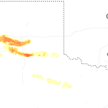
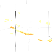
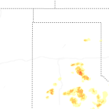


Connect with Interactive Hail Maps