

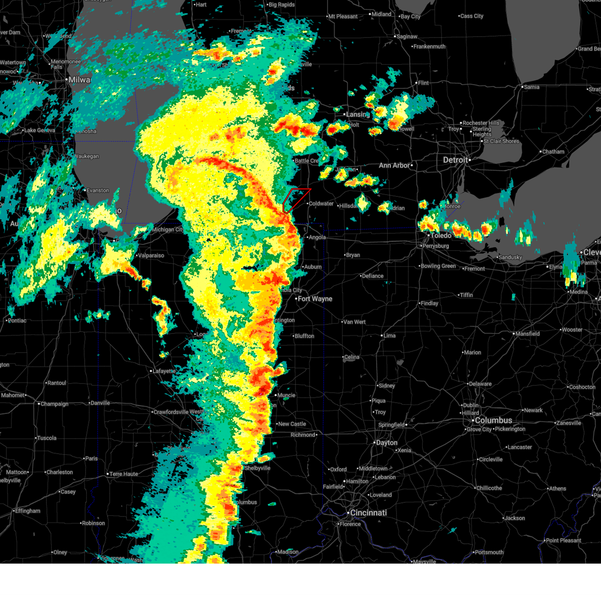
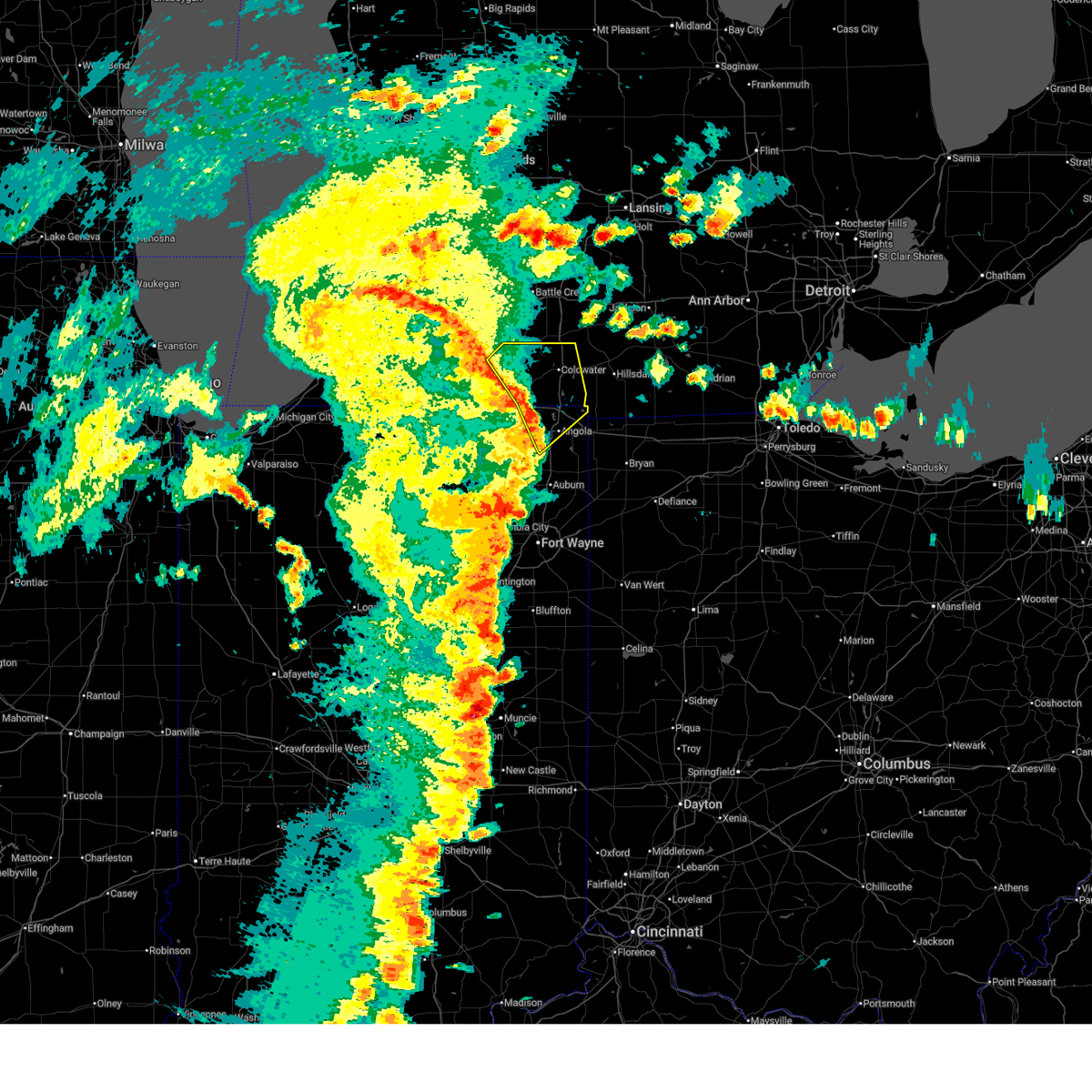
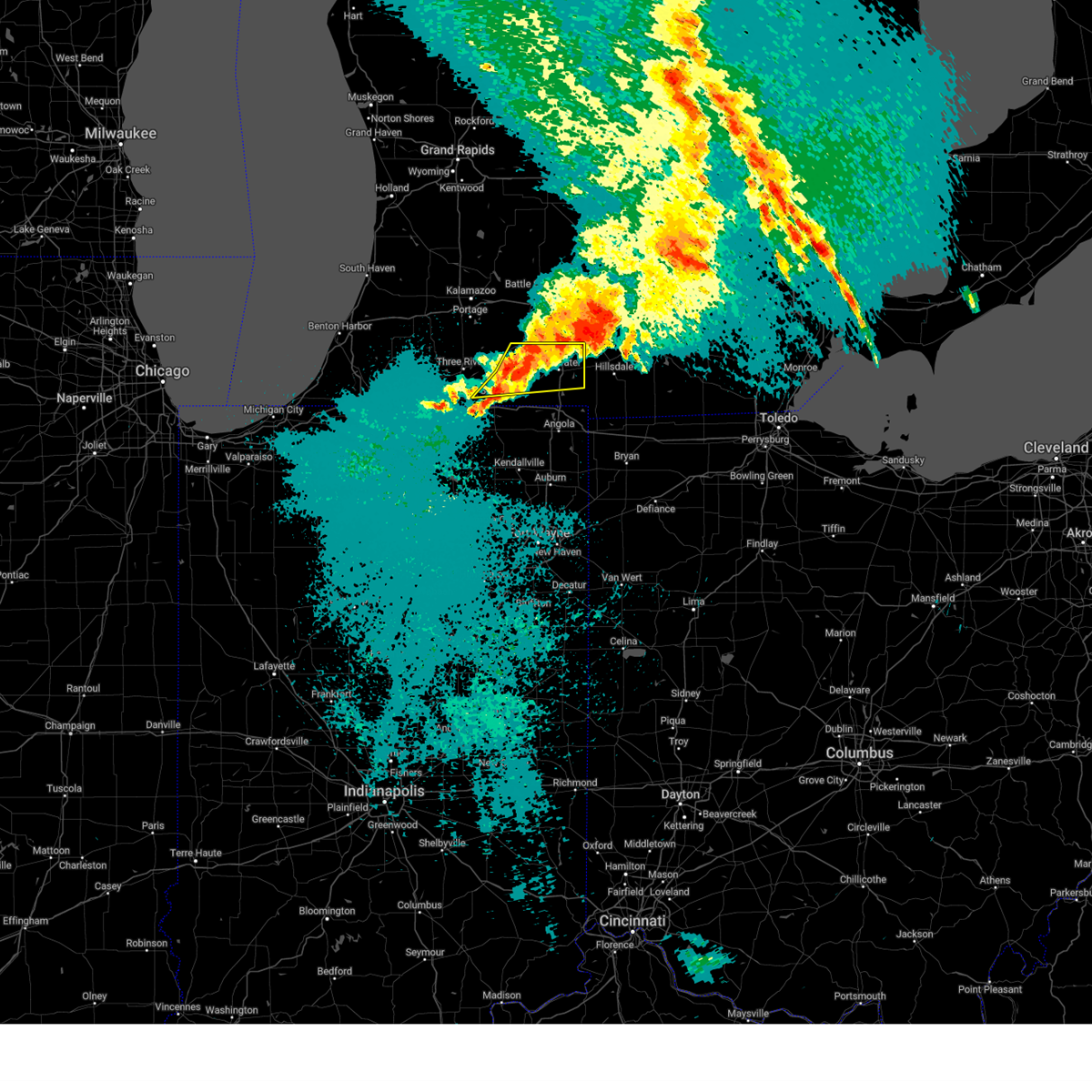
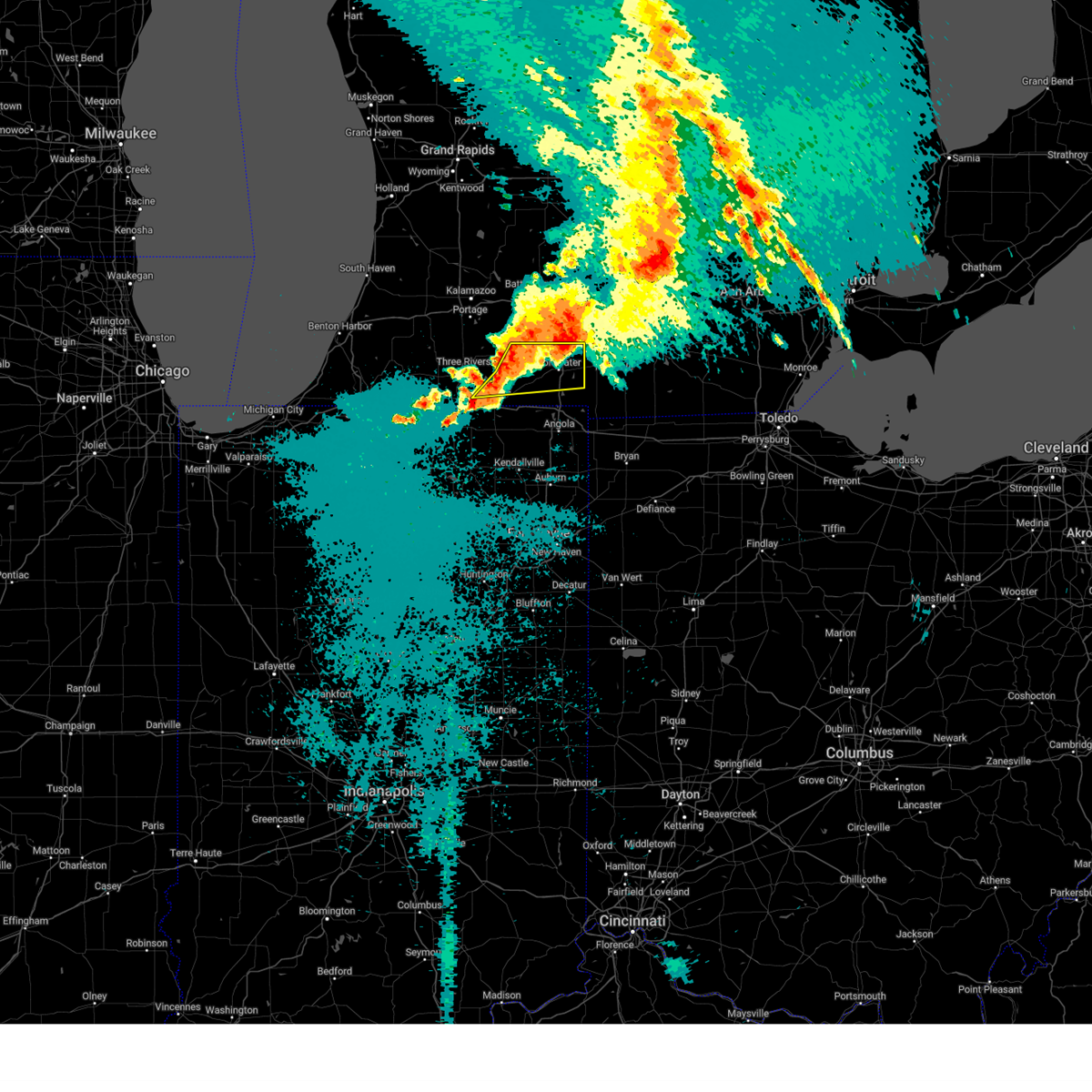
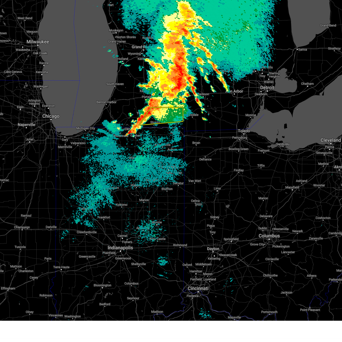
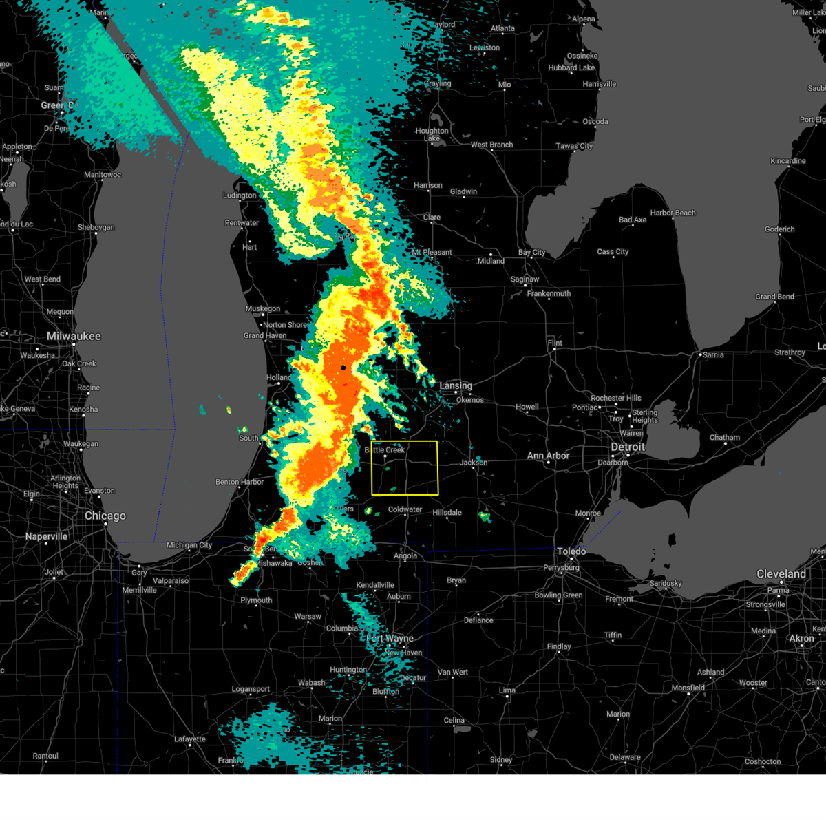
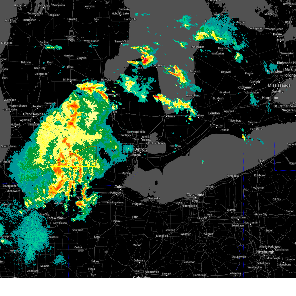
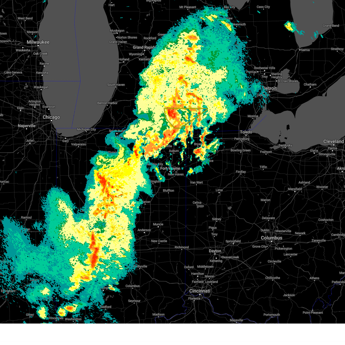
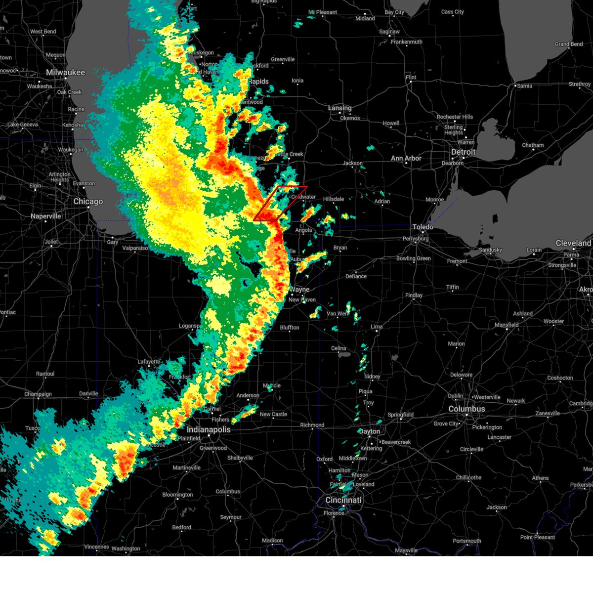
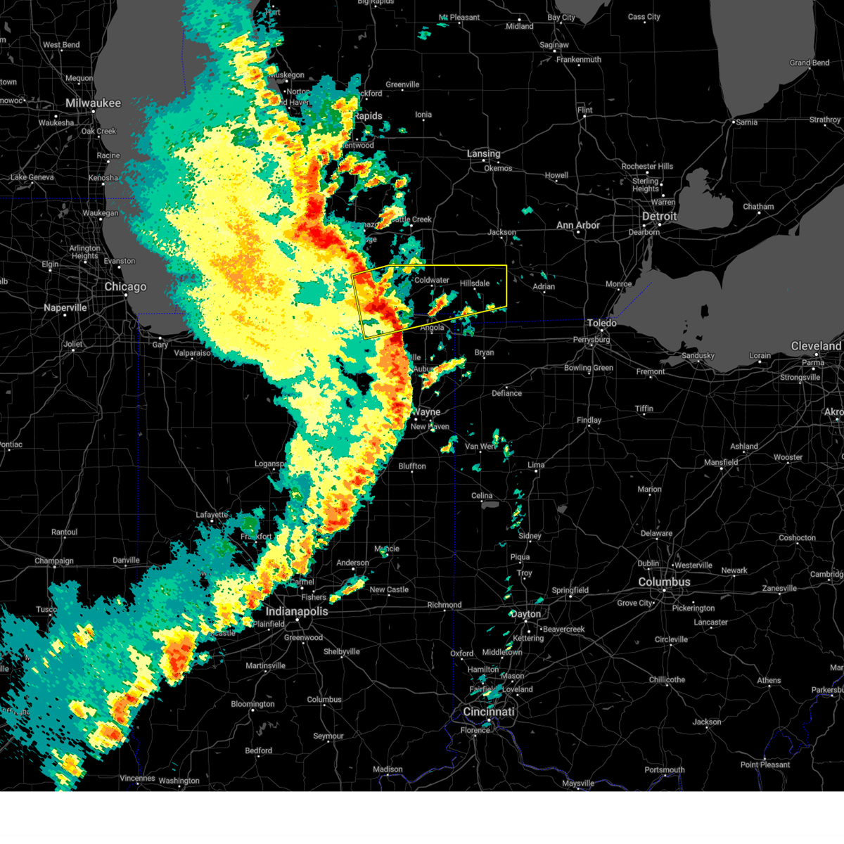
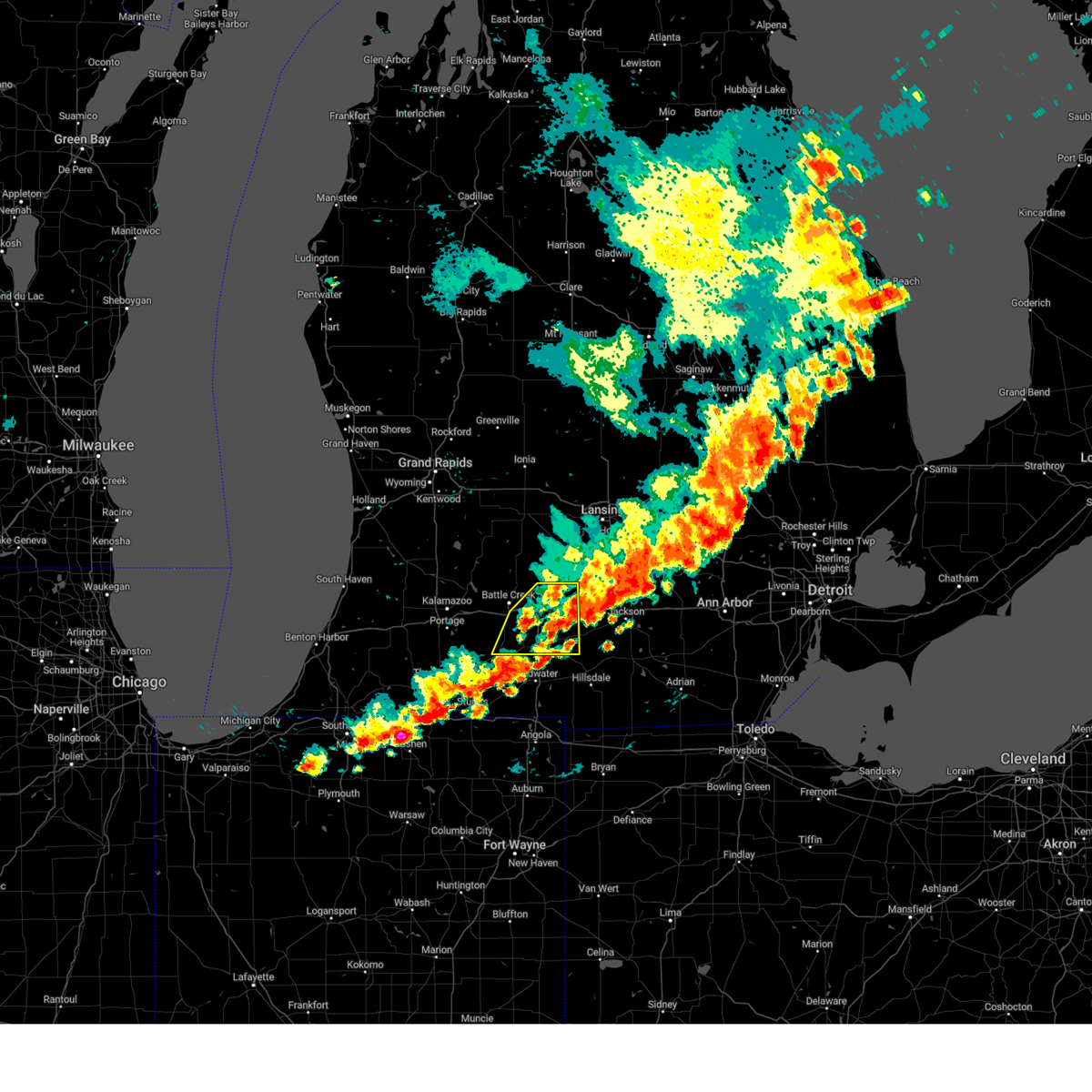
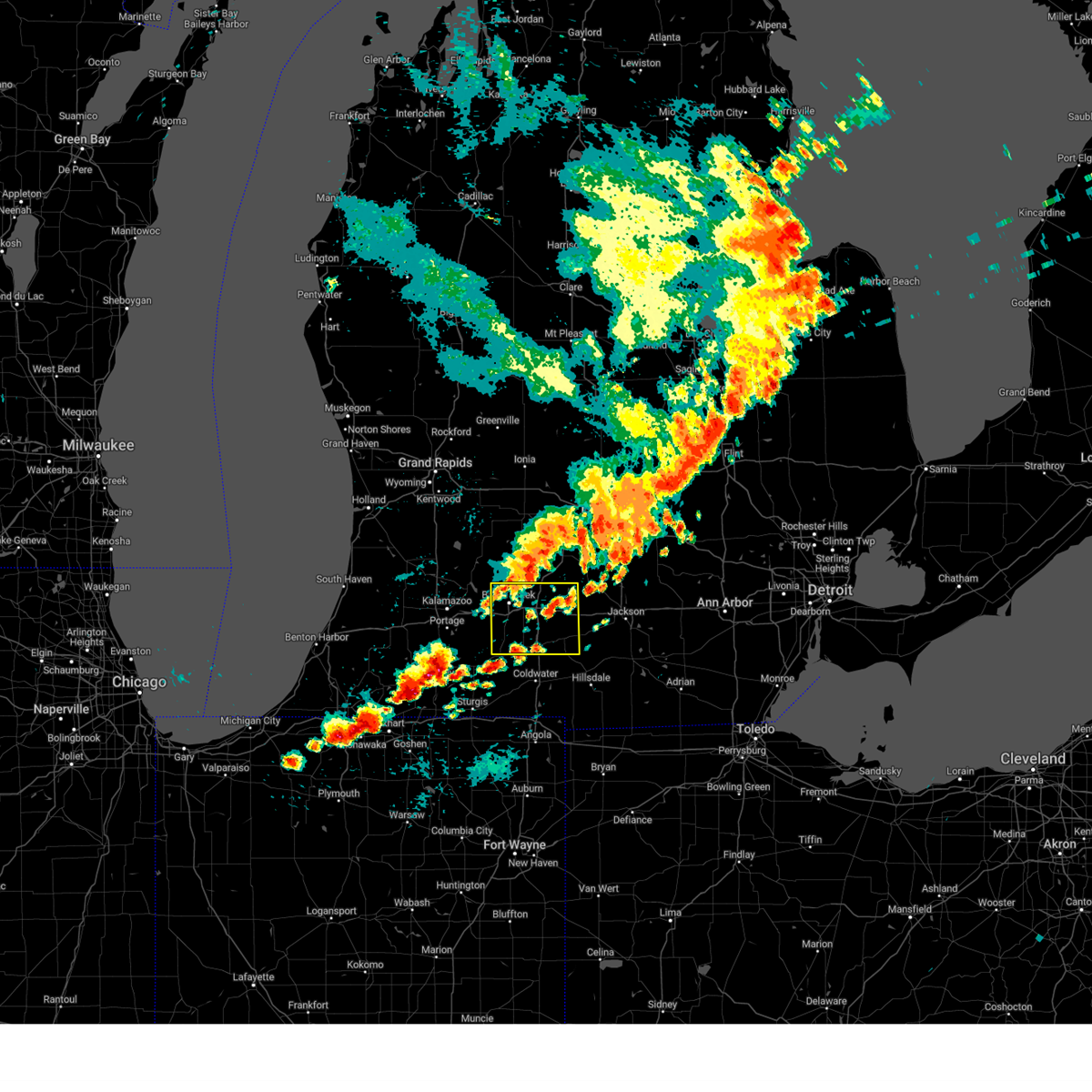
Hail Map for Union City, MI
The Union City, MI area has had 1 report of on-the-ground hail by trained spotters, and has been under severe weather warnings 24 times during the past 12 months. Doppler radar has detected hail at or near Union City, MI on 37 occasions.
| Name: | Union City, MI |
| Where Located: | 67.6 miles SSE of Grand Rapids, MI |
| Map: | Google Map for Union City, MI |
| Population: | 1599 |
| Housing Units: | 725 |
| More Info: | Search Google for Union City, MI |
2
The Top Recent Hail Date for Union City, MI is Tuesday, June 25, 2024 (7th out of 37)

Hail and Wind Damage Spotted near Union City, MI
| Date / Time | Report Details |
|---|---|
| 6/18/2025 5:47 PM EDT | the severe thunderstorm warning has been cancelled and is no longer in effect |
| 6/18/2025 5:47 PM EDT | At 547 pm edt, severe thunderstorms were located along a line extending from climax to near union city to near fremont, moving north at 55 mph (trained weather spotters). Hazards include 60 mph wind gusts. Expect damage to roofs, siding, and trees. locations impacted include, coldwater, angola, fremont, quincy, union city, ray, girard, kinderhook, batavia, california, clear lake, sherwood, crooked lake, golden lake, south butler, lake james, lake of the woods, marble lake, hodunk, and coldwater lake. this includes the following highways, interstate 69 in indiana between mile markers 343 and 357. interstate 69 in michigan between mile markers 1 and 21. Interstate 80 in indiana between mile markers 140 and 151. |
| 6/18/2025 5:37 PM EDT | At 537 pm edt, a severe thunderstorm capable of producing a tornado was located near union city, or 8 miles northwest of coldwater, moving northeast at 50 mph (radar indicated rotation). Hazards include tornado. Flying debris will be dangerous to those caught without shelter. mobile homes will be damaged or destroyed. damage to roofs, windows, and vehicles will occur. tree damage is likely. this dangerous storm will be near, union city around 545 pm edt. other locations impacted by this tornadic thunderstorm include hodunk. This includes interstate 69 in michigan near mile marker 21. |
| 6/18/2025 5:28 PM EDT |
 Toriwx the national weather service in northern indiana has issued a * tornado warning for, northwestern branch county in southwestern michigan, * until 600 pm edt. * at 528 pm edt, a severe thunderstorm capable of producing a tornado was located near bronson, or 11 miles northeast of sturgis, moving northeast at 50 mph (radar indicated rotation). Hazards include tornado. Flying debris will be dangerous to those caught without shelter. mobile homes will be damaged or destroyed. damage to roofs, windows, and vehicles will occur. tree damage is likely. this dangerous storm will be near, union city around 540 pm edt. other locations impacted by this tornadic thunderstorm include hodunk, matteson lake, and sherwood. This includes interstate 69 in michigan near mile marker 21. Toriwx the national weather service in northern indiana has issued a * tornado warning for, northwestern branch county in southwestern michigan, * until 600 pm edt. * at 528 pm edt, a severe thunderstorm capable of producing a tornado was located near bronson, or 11 miles northeast of sturgis, moving northeast at 50 mph (radar indicated rotation). Hazards include tornado. Flying debris will be dangerous to those caught without shelter. mobile homes will be damaged or destroyed. damage to roofs, windows, and vehicles will occur. tree damage is likely. this dangerous storm will be near, union city around 540 pm edt. other locations impacted by this tornadic thunderstorm include hodunk, matteson lake, and sherwood. This includes interstate 69 in michigan near mile marker 21.
|
| 6/18/2025 5:25 PM EDT |
 Svriwx the national weather service in northern indiana has issued a * severe thunderstorm warning for, steuben county in northeastern indiana, northeastern lagrange county in northeastern indiana, northeastern st. joseph county in southwestern michigan, branch county in southwestern michigan, * until 615 pm edt. * at 525 pm edt, severe thunderstorms were located along a line extending from 6 miles northwest of colon to near bronson to 8 miles southwest of angola, moving north at 55 mph (trained weather spotters). Hazards include 60 mph wind gusts. expect damage to roofs, siding, and trees Svriwx the national weather service in northern indiana has issued a * severe thunderstorm warning for, steuben county in northeastern indiana, northeastern lagrange county in northeastern indiana, northeastern st. joseph county in southwestern michigan, branch county in southwestern michigan, * until 615 pm edt. * at 525 pm edt, severe thunderstorms were located along a line extending from 6 miles northwest of colon to near bronson to 8 miles southwest of angola, moving north at 55 mph (trained weather spotters). Hazards include 60 mph wind gusts. expect damage to roofs, siding, and trees
|
| 5/16/2025 12:11 AM EDT |
 The storms which prompted the warning have weakened below severe limits, and no longer pose an immediate threat to life or property. therefore, the warning will be allowed to expire. however, gusty winds are still possible with these thunderstorms. a tornado watch remains in effect until 300 am edt for southwestern michigan. The storms which prompted the warning have weakened below severe limits, and no longer pose an immediate threat to life or property. therefore, the warning will be allowed to expire. however, gusty winds are still possible with these thunderstorms. a tornado watch remains in effect until 300 am edt for southwestern michigan.
|
| 5/15/2025 11:59 PM EDT |
 At 1159 pm edt, severe thunderstorms were located along a line extending from near union city to sturgis, moving east at 45 mph (radar indicated). Hazards include 60 mph wind gusts and nickel size hail. Expect damage to roofs, siding, and trees. locations impacted include, sturgis, coldwater, bronson, quincy, union city, colon, girard, batavia, leonidas, burr oak, sherwood, klinger lake, fairfax, south butler, findley, matteson lake, lake of the woods, marble lake, and hodunk. This includes interstate 69 in michigan between mile markers 6 and 21. At 1159 pm edt, severe thunderstorms were located along a line extending from near union city to sturgis, moving east at 45 mph (radar indicated). Hazards include 60 mph wind gusts and nickel size hail. Expect damage to roofs, siding, and trees. locations impacted include, sturgis, coldwater, bronson, quincy, union city, colon, girard, batavia, leonidas, burr oak, sherwood, klinger lake, fairfax, south butler, findley, matteson lake, lake of the woods, marble lake, and hodunk. This includes interstate 69 in michigan between mile markers 6 and 21.
|
| 5/15/2025 11:28 PM EDT |
 Svriwx the national weather service in northern indiana has issued a * severe thunderstorm warning for, st. joseph county in southwestern michigan, branch county in southwestern michigan, * until 1215 am edt. * at 1127 pm edt, severe thunderstorms were located along a line extending from 6 miles north of centreville to near constantine, moving east at 45 mph (radar indicated). Hazards include 60 mph wind gusts and nickel size hail. expect damage to roofs, siding, and trees Svriwx the national weather service in northern indiana has issued a * severe thunderstorm warning for, st. joseph county in southwestern michigan, branch county in southwestern michigan, * until 1215 am edt. * at 1127 pm edt, severe thunderstorms were located along a line extending from 6 miles north of centreville to near constantine, moving east at 45 mph (radar indicated). Hazards include 60 mph wind gusts and nickel size hail. expect damage to roofs, siding, and trees
|
| 5/15/2025 11:01 PM EDT |
 Svrgrr the national weather service in grand rapids has issued a * severe thunderstorm warning for, calhoun county in south central michigan, * until midnight edt. * at 1101 pm edt, severe thunderstorms were located along a line extending from near freeport to near gull lake to vicksburg, moving east at 50 mph (radar indicated). Hazards include 60 mph wind gusts. expect damage to roofs, siding, and trees Svrgrr the national weather service in grand rapids has issued a * severe thunderstorm warning for, calhoun county in south central michigan, * until midnight edt. * at 1101 pm edt, severe thunderstorms were located along a line extending from near freeport to near gull lake to vicksburg, moving east at 50 mph (radar indicated). Hazards include 60 mph wind gusts. expect damage to roofs, siding, and trees
|
| 4/2/2025 8:55 PM EDT |
 Svrgrr the national weather service in grand rapids has issued a * severe thunderstorm warning for, southeastern calhoun county in south central michigan, jackson county in south central michigan, * until 945 pm edt. * at 855 pm edt, severe thunderstorms were located along a line extending from 6 miles south of union city to near coldwater to near fremont, moving northeast at 70 mph (radar indicated). Hazards include 70 mph wind gusts. Expect considerable tree damage. Damage is likely to mobile homes, roofs, and outbuildings. Svrgrr the national weather service in grand rapids has issued a * severe thunderstorm warning for, southeastern calhoun county in south central michigan, jackson county in south central michigan, * until 945 pm edt. * at 855 pm edt, severe thunderstorms were located along a line extending from 6 miles south of union city to near coldwater to near fremont, moving northeast at 70 mph (radar indicated). Hazards include 70 mph wind gusts. Expect considerable tree damage. Damage is likely to mobile homes, roofs, and outbuildings.
|
| 4/2/2025 8:54 PM EDT |
 Svriwx the national weather service in northern indiana has issued a * severe thunderstorm warning for, branch county in southwestern michigan, northern hillsdale county in southeastern michigan, * until 1000 pm edt. * at 853 pm edt, severe thunderstorms were located along a line extending from 7 miles west of burlington to near union city to near coldwater to near fremont, moving northeast at 70 mph (radar indicated). Hazards include 60 mph wind gusts. expect damage to roofs, siding, and trees Svriwx the national weather service in northern indiana has issued a * severe thunderstorm warning for, branch county in southwestern michigan, northern hillsdale county in southeastern michigan, * until 1000 pm edt. * at 853 pm edt, severe thunderstorms were located along a line extending from 7 miles west of burlington to near union city to near coldwater to near fremont, moving northeast at 70 mph (radar indicated). Hazards include 60 mph wind gusts. expect damage to roofs, siding, and trees
|
| 3/30/2025 5:56 PM EDT | At 554 pm edt, severe thunderstorms were located along a line extending from near sparta to 7 miles southwest of hastings to near marshall, moving northeast at 60 mph. these are destructive storms for southwest michigan (at 5:50 pm grand rapids asos reported 80 mph winds). Hazards include 80 mph wind gusts and penny size hail. Flying debris will be dangerous to those caught without shelter. mobile homes will be heavily damaged. expect considerable damage to roofs, windows, and vehicles. extensive tree damage and power outages are likely. Locations impacted include, cutlerville, wyoming, battle creek, belmont, grandville, duck lake, yankee springs, hickory corners, grattan, alto, brownlee park, dutton, sparta, banfield, comstock park, walker, marshall, nashville, athens, tekonsha,. |
| 3/30/2025 5:51 PM EDT | At 549 pm edt, severe thunderstorms were located along a line extending from near burlington to near quincy, moving northeast at 75 mph. there have been numerous reports of damage in st joseph county, mi of trees and powerlines down as well as power outages (public). Hazards include 60 mph wind gusts and nickel size hail. Expect damage to roofs, siding, and trees. locations impacted include, quincy, girard, north adams, lake wilson, ray, union city, moscow, kinderhook, shadyside, osseo, coldwater, lake of the woods, bear lake, hodunk, coldwater lake, fremont, somerset, camden, hillsdale, and cambria. this includes the following highways, interstate 69 in michigan between mile markers 1 and 21. Interstate 80 in indiana near mile marker 145. |
| 3/30/2025 5:51 PM EDT | the severe thunderstorm warning has been cancelled and is no longer in effect |
| 3/30/2025 5:48 PM EDT | At 547 pm edt, severe thunderstorms were located along a line extending from 6 miles southwest of sparta to 5 miles east of martin to near burlington, moving northeast at 60 mph (radar indicated). Hazards include 70 mph wind gusts and penny size hail. Expect considerable tree damage. damage is likely to mobile homes, roofs, and outbuildings. Locations impacted include, cutlerville, wyoming, battle creek, belmont, grandville, duck lake, yankee springs, hickory corners, grattan, alto, brownlee park, dutton, sparta, banfield, comstock park, walker, marshall, nashville, athens, tekonsha,. |
| 3/30/2025 5:45 PM EDT | The storm which prompted the warning has weakened below severe limits, and has exited the warned area. therefore, the warning has been allowed to expire. however, gusty winds are still possible with this thunderstorm. a tornado watch remains in effect until 800 pm edt for southwestern michigan. |
| 3/30/2025 5:30 PM EDT | At 529 pm edt, severe thunderstorms were located along a line extending from 6 miles west of colon to near sturgis, moving northeast at 75 mph. at 529 pm edt, the public reported trees down and a center pivot flipped and twisted in sturgis (public). Hazards include 60 mph wind gusts and nickel size hail. Expect damage to roofs, siding, and trees. locations impacted include, nottawa, girard, ray, sturgis, leonidas, kinderhook, shadyside, howe, coldwater, matteson lake, hodunk, coldwater lake, camden, mongo, montgomery, orland, burr oak, california, allen, and fairfax. this includes the following highways, interstate 69 in indiana between mile markers 355 and 357. interstate 69 in michigan between mile markers 1 and 21. Interstate 80 in indiana between mile markers 120 and 146. |
| 3/30/2025 5:24 PM EDT | Svrgrr the national weather service in grand rapids has issued a * severe thunderstorm warning for, calhoun county in south central michigan, kent county in southwestern michigan, barry county in southwestern michigan, * until 630 pm edt. * at 523 pm edt, severe thunderstorms were located along a line extending from near beechwood to near schoolcraft, moving northeast at 65 mph (radar indicated). Hazards include 70 mph wind gusts and penny size hail. Expect considerable tree damage. Damage is likely to mobile homes, roofs, and outbuildings. |
| 3/30/2025 5:24 PM EDT |
 the tornado warning has been cancelled and is no longer in effect the tornado warning has been cancelled and is no longer in effect
|
| 3/30/2025 5:24 PM EDT |
 At 523 pm edt, a confirmed tornado was located near sturgis, moving northeast at 60 mph (law enforcement confirmed tornado). Hazards include damaging tornado. Flying debris will be dangerous to those caught without shelter. mobile homes will be damaged or destroyed. damage to roofs, windows, and vehicles will occur. tree damage is likely. this tornado will be near, colon around 530 pm edt. union city around 540 pm edt. other locations impacted by this tornadic thunderstorm include nottawa, leonidas, fawn river, findley, burr oak, matteson lake, klinger lake, hodunk, sherwood, and fairfax. This includes interstate 69 in michigan near mile marker 21. At 523 pm edt, a confirmed tornado was located near sturgis, moving northeast at 60 mph (law enforcement confirmed tornado). Hazards include damaging tornado. Flying debris will be dangerous to those caught without shelter. mobile homes will be damaged or destroyed. damage to roofs, windows, and vehicles will occur. tree damage is likely. this tornado will be near, colon around 530 pm edt. union city around 540 pm edt. other locations impacted by this tornadic thunderstorm include nottawa, leonidas, fawn river, findley, burr oak, matteson lake, klinger lake, hodunk, sherwood, and fairfax. This includes interstate 69 in michigan near mile marker 21.
|
| 3/30/2025 5:20 PM EDT |
 Svriwx the national weather service in northern indiana has issued a * severe thunderstorm warning for, northern steuben county in northeastern indiana, northern lagrange county in northeastern indiana, st. joseph county in southwestern michigan, branch county in southwestern michigan, hillsdale county in southeastern michigan, * until 615 pm edt. * at 520 pm edt, severe thunderstorms were located along a line extending from three rivers to near white pigeon, moving east at 75 mph (radar indicated). Hazards include 60 mph wind gusts and nickel size hail. expect damage to roofs, siding, and trees Svriwx the national weather service in northern indiana has issued a * severe thunderstorm warning for, northern steuben county in northeastern indiana, northern lagrange county in northeastern indiana, st. joseph county in southwestern michigan, branch county in southwestern michigan, hillsdale county in southeastern michigan, * until 615 pm edt. * at 520 pm edt, severe thunderstorms were located along a line extending from three rivers to near white pigeon, moving east at 75 mph (radar indicated). Hazards include 60 mph wind gusts and nickel size hail. expect damage to roofs, siding, and trees
|
| 3/30/2025 5:15 PM EDT | Toriwx the national weather service in northern indiana has issued a * tornado warning for, northwestern lagrange county in northeastern indiana, eastern st. joseph county in southwestern michigan, northwestern branch county in southwestern michigan, * until 545 pm edt. * at 514 pm edt, a severe thunderstorm capable of producing a tornado was located near sturgis, moving northeast at 60 mph (radar indicated rotation). Hazards include tornado. Flying debris will be dangerous to those caught without shelter. mobile homes will be damaged or destroyed. damage to roofs, windows, and vehicles will occur. tree damage is likely. this dangerous storm will be near, sturgis around 520 pm edt. colon around 530 pm edt. union city around 540 pm edt. other locations impacted by this tornadic thunderstorm include nottawa, burr oak, klinger lake, sherwood, fairfax, leonidas, fawn river, howe, findley, and matteson lake. this includes the following highways, interstate 69 in michigan near mile marker 21. Interstate 80 in indiana between mile markers 110 and 124. |
| 8/27/2024 5:12 PM EDT |
 At 512 pm edt, severe thunderstorms were located along a line extending from 8 miles south of eaton rapids to near marshall, moving east at 50 mph (radar indicated). Hazards include 60 mph wind gusts and penny size hail. Expect damage to roofs, siding, and trees. Locations impacted include, albion, marshall, homer, union city, burlington, marengo, athens, tekonsha, ceresco, duck lake,. At 512 pm edt, severe thunderstorms were located along a line extending from 8 miles south of eaton rapids to near marshall, moving east at 50 mph (radar indicated). Hazards include 60 mph wind gusts and penny size hail. Expect damage to roofs, siding, and trees. Locations impacted include, albion, marshall, homer, union city, burlington, marengo, athens, tekonsha, ceresco, duck lake,.
|
| 8/27/2024 4:50 PM EDT |
 Svrgrr the national weather service in grand rapids has issued a * severe thunderstorm warning for, calhoun county in south central michigan, * until 545 pm edt. * at 449 pm edt, severe thunderstorms were located along a line extending from bellevue to near climax, moving east at 45 mph. other scattered strong cells were developing out ahead of this line (radar indicated). Hazards include 60 mph wind gusts and penny size hail. expect damage to roofs, siding, and trees Svrgrr the national weather service in grand rapids has issued a * severe thunderstorm warning for, calhoun county in south central michigan, * until 545 pm edt. * at 449 pm edt, severe thunderstorms were located along a line extending from bellevue to near climax, moving east at 45 mph. other scattered strong cells were developing out ahead of this line (radar indicated). Hazards include 60 mph wind gusts and penny size hail. expect damage to roofs, siding, and trees
|
| 7/16/2024 1:04 AM EDT |
 the severe thunderstorm warning has been cancelled and is no longer in effect the severe thunderstorm warning has been cancelled and is no longer in effect
|
| 7/16/2024 12:51 AM EDT |
 At 1250 am edt, severe thunderstorms were located along a line extending from near battle creek to near union city, moving east at 35 mph (radar indicated). Hazards include 60 mph wind gusts. Expect damage to roofs, siding, and trees. Locations impacted include, battle creek, union city, burlington, brownlee park, athens, pine creek, bedford,. At 1250 am edt, severe thunderstorms were located along a line extending from near battle creek to near union city, moving east at 35 mph (radar indicated). Hazards include 60 mph wind gusts. Expect damage to roofs, siding, and trees. Locations impacted include, battle creek, union city, burlington, brownlee park, athens, pine creek, bedford,.
|
| 7/16/2024 12:51 AM EDT |
 the severe thunderstorm warning has been cancelled and is no longer in effect the severe thunderstorm warning has been cancelled and is no longer in effect
|
| 7/16/2024 12:25 AM EDT |
 Svrgrr the national weather service in grand rapids has issued a * severe thunderstorm warning for, western calhoun county in south central michigan, southeastern barry county in southwestern michigan, eastern kalamazoo county in southwestern michigan, * until 130 am edt. * at 1224 am edt, severe thunderstorms were located along a line extending from near richland to near galesburg to near vicksburg, moving northeast at 50 mph (radar indicated). Hazards include 60 mph wind gusts. expect damage to roofs, siding, and trees Svrgrr the national weather service in grand rapids has issued a * severe thunderstorm warning for, western calhoun county in south central michigan, southeastern barry county in southwestern michigan, eastern kalamazoo county in southwestern michigan, * until 130 am edt. * at 1224 am edt, severe thunderstorms were located along a line extending from near richland to near galesburg to near vicksburg, moving northeast at 50 mph (radar indicated). Hazards include 60 mph wind gusts. expect damage to roofs, siding, and trees
|
| 7/15/2024 11:56 PM EDT |
 The storm which prompted the warning has weakened below severe limits, and no longer poses an immediate threat to life or property. therefore, the warning will be allowed to expire. however, gusty winds and heavy rain are still possible with this thunderstorm. a tornado watch remains in effect until 200 am edt for southwestern michigan. The storm which prompted the warning has weakened below severe limits, and no longer poses an immediate threat to life or property. therefore, the warning will be allowed to expire. however, gusty winds and heavy rain are still possible with this thunderstorm. a tornado watch remains in effect until 200 am edt for southwestern michigan.
|
| 7/15/2024 11:37 PM EDT |
 At 1137 pm edt, a severe thunderstorm was located near colon, or 9 miles northeast of sturgis, moving northeast at 45 mph (radar indicated). Hazards include 60 mph wind gusts. Expect damage to roofs, siding, and trees. this severe storm will be near, bronson and colon around 1140 pm edt. coldwater around 1150 pm edt. other locations impacted by this severe thunderstorm include nottawa, girard, burr oak, mendon, sherwood, fairfax, leonidas, fawn river, batavia, and wasepi. This includes interstate 69 in michigan between mile markers 6 and 21. At 1137 pm edt, a severe thunderstorm was located near colon, or 9 miles northeast of sturgis, moving northeast at 45 mph (radar indicated). Hazards include 60 mph wind gusts. Expect damage to roofs, siding, and trees. this severe storm will be near, bronson and colon around 1140 pm edt. coldwater around 1150 pm edt. other locations impacted by this severe thunderstorm include nottawa, girard, burr oak, mendon, sherwood, fairfax, leonidas, fawn river, batavia, and wasepi. This includes interstate 69 in michigan between mile markers 6 and 21.
|
| 7/15/2024 11:21 PM EDT |
 Svriwx the national weather service in northern indiana has issued a * severe thunderstorm warning for, st. joseph county in southwestern michigan, branch county in southwestern michigan, * until midnight edt. * at 1121 pm edt, a severe thunderstorm was located near sturgis, moving northeast at 45 mph (radar indicated). Hazards include 60 mph wind gusts. Expect damage to roofs, siding, and trees. this severe thunderstorm will be near, sturgis around 1125 pm edt. colon around 1135 pm edt. bronson around 1140 pm edt. coldwater around 1150 pm edt. other locations impacted by this severe thunderstorm include nottawa, girard, burr oak, klinger lake, sherwood, fairfax, leonidas, fawn river, batavia, and wasepi. This includes interstate 69 in michigan between mile markers 6 and 21. Svriwx the national weather service in northern indiana has issued a * severe thunderstorm warning for, st. joseph county in southwestern michigan, branch county in southwestern michigan, * until midnight edt. * at 1121 pm edt, a severe thunderstorm was located near sturgis, moving northeast at 45 mph (radar indicated). Hazards include 60 mph wind gusts. Expect damage to roofs, siding, and trees. this severe thunderstorm will be near, sturgis around 1125 pm edt. colon around 1135 pm edt. bronson around 1140 pm edt. coldwater around 1150 pm edt. other locations impacted by this severe thunderstorm include nottawa, girard, burr oak, klinger lake, sherwood, fairfax, leonidas, fawn river, batavia, and wasepi. This includes interstate 69 in michigan between mile markers 6 and 21.
|
| 6/25/2024 8:16 AM EDT |
 At 814 am edt, doppler radar indicated thunderstorms located along a line extending from 6 miles southwest of marcellus to centreville to near coldwater, moving south at 35 mph (observed). Hazards include 60 mph wind gusts and small hail. Expect damage to roofs, siding, and trees. locations impacted include, sturgis, coldwater, three rivers, bronson, constantine, quincy, union city, white pigeon, centreville, marcellus, colon, union, nottawa, girard, flowerfield, fawn river, mottville, batavia, leonidas, and mendon. This includes interstate 69 in michigan between mile markers 4 and 21. At 814 am edt, doppler radar indicated thunderstorms located along a line extending from 6 miles southwest of marcellus to centreville to near coldwater, moving south at 35 mph (observed). Hazards include 60 mph wind gusts and small hail. Expect damage to roofs, siding, and trees. locations impacted include, sturgis, coldwater, three rivers, bronson, constantine, quincy, union city, white pigeon, centreville, marcellus, colon, union, nottawa, girard, flowerfield, fawn river, mottville, batavia, leonidas, and mendon. This includes interstate 69 in michigan between mile markers 4 and 21.
|
| 6/25/2024 8:09 AM EDT |
 The storms which prompted the warning were moving out of the area. therefore, the warning will be allowed to expire. a severe thunderstorm watch remains in effect until 900 am edt for south central and southwestern michigan. The storms which prompted the warning were moving out of the area. therefore, the warning will be allowed to expire. a severe thunderstorm watch remains in effect until 900 am edt for south central and southwestern michigan.
|
| 6/25/2024 8:03 AM EDT | At 801 am edt, severe thunderstorms were located along a line extending from 5 miles south of schoolcraft to near union city to near albion, moving southeast at 40 mph (radar indicated. at 735 am, battle creek executive airport the wind gusted to 60 mph.). Hazards include 60 mph wind gusts. Expect damage to roofs, siding, and trees. Locations impacted include, portage, albion, marshall, vicksburg, homer, union city, schoolcraft, burlington, fulton, athens, tekonsha, pine creek,. |
| 6/25/2024 7:51 AM EDT |
 At 751 am edt, severe thunderstorms were located along a line extending from near schoolcraft to near climax to near albion, moving southeast at 35 mph (radar indicated). Hazards include 60 mph wind gusts. Expect damage to roofs, siding, and trees. Locations impacted include, kalamazoo, portage, albion, marshall, battle creek, vicksburg, galesburg, homer, union city, schoolcraft, climax, burlington, westwood, brownlee park, comstock northwest, fulton, marengo, athens, augusta, tekonsha,. At 751 am edt, severe thunderstorms were located along a line extending from near schoolcraft to near climax to near albion, moving southeast at 35 mph (radar indicated). Hazards include 60 mph wind gusts. Expect damage to roofs, siding, and trees. Locations impacted include, kalamazoo, portage, albion, marshall, battle creek, vicksburg, galesburg, homer, union city, schoolcraft, climax, burlington, westwood, brownlee park, comstock northwest, fulton, marengo, athens, augusta, tekonsha,.
|
| 6/25/2024 7:50 AM EDT |
 Svriwx the national weather service in northern indiana has issued a * severe thunderstorm warning for, eastern cass county in southwestern michigan, st. joseph county in southwestern michigan, branch county in southwestern michigan, * until 830 am edt. * at 749 am edt, severe thunderstorms were located along a line extending from lawton to vicksburg to near marshall, moving south at 50 mph (observed). Hazards include 60 mph wind gusts. expect damage to roofs, siding, and trees Svriwx the national weather service in northern indiana has issued a * severe thunderstorm warning for, eastern cass county in southwestern michigan, st. joseph county in southwestern michigan, branch county in southwestern michigan, * until 830 am edt. * at 749 am edt, severe thunderstorms were located along a line extending from lawton to vicksburg to near marshall, moving south at 50 mph (observed). Hazards include 60 mph wind gusts. expect damage to roofs, siding, and trees
|
| 6/25/2024 7:27 AM EDT |
 Svrgrr the national weather service in grand rapids has issued a * severe thunderstorm warning for, calhoun county in south central michigan, kalamazoo county in southwestern michigan, * until 815 am edt. * at 726 am edt, severe thunderstorms were located along a line extending from near westwood to near bellevue, moving southeast at 40 mph (radar indicated). Hazards include 60 mph wind gusts. expect damage to roofs, siding, and trees Svrgrr the national weather service in grand rapids has issued a * severe thunderstorm warning for, calhoun county in south central michigan, kalamazoo county in southwestern michigan, * until 815 am edt. * at 726 am edt, severe thunderstorms were located along a line extending from near westwood to near bellevue, moving southeast at 40 mph (radar indicated). Hazards include 60 mph wind gusts. expect damage to roofs, siding, and trees
|
| 6/17/2024 12:30 AM EDT |
 The storms which prompted the warning have weakened below severe limits, and no longer pose an immediate threat to life or property. therefore, the warning has been allowed to expire. The storms which prompted the warning have weakened below severe limits, and no longer pose an immediate threat to life or property. therefore, the warning has been allowed to expire.
|
| 6/16/2024 11:30 PM EDT |
 Svrgrr the national weather service in grand rapids has issued a * severe thunderstorm warning for, western calhoun county in south central michigan, eastern kalamazoo county in southwestern michigan, * until 1230 am edt. * at 1129 pm edt, severe thunderstorms were located along a line extending from near comstock northwest to near schoolcraft, moving northeast at 30 mph (radar indicated). Hazards include 60 mph wind gusts and penny size hail. expect damage to roofs, siding, and trees Svrgrr the national weather service in grand rapids has issued a * severe thunderstorm warning for, western calhoun county in south central michigan, eastern kalamazoo county in southwestern michigan, * until 1230 am edt. * at 1129 pm edt, severe thunderstorms were located along a line extending from near comstock northwest to near schoolcraft, moving northeast at 30 mph (radar indicated). Hazards include 60 mph wind gusts and penny size hail. expect damage to roofs, siding, and trees
|
| 6/16/2024 10:23 PM EDT |
 Svrgrr the national weather service in grand rapids has issued a * severe thunderstorm warning for, calhoun county in south central michigan, eaton county in south central michigan, * until 1130 pm edt. * at 1022 pm edt, severe thunderstorms were located along a line extending from 5 miles east of lake odessa to near vicksburg, moving east at 35 mph (radar indicated). Hazards include 60 mph wind gusts and penny size hail. expect damage to roofs, siding, and trees Svrgrr the national weather service in grand rapids has issued a * severe thunderstorm warning for, calhoun county in south central michigan, eaton county in south central michigan, * until 1130 pm edt. * at 1022 pm edt, severe thunderstorms were located along a line extending from 5 miles east of lake odessa to near vicksburg, moving east at 35 mph (radar indicated). Hazards include 60 mph wind gusts and penny size hail. expect damage to roofs, siding, and trees
|
| 5/7/2024 8:48 PM EDT |
 the severe thunderstorm warning has been cancelled and is no longer in effect the severe thunderstorm warning has been cancelled and is no longer in effect
|
| 5/7/2024 8:34 PM EDT |
 At 834 pm edt, a severe thunderstorm was located over homer, or 7 miles south of albion, moving east at 25 mph (radar indicated). Hazards include 60 mph wind gusts and quarter size hail. Hail damage to vehicles is expected. expect wind damage to roofs, siding, and trees. Locations impacted include, albion, marshall, homer, union city, burlington, marengo, tekonsha,. At 834 pm edt, a severe thunderstorm was located over homer, or 7 miles south of albion, moving east at 25 mph (radar indicated). Hazards include 60 mph wind gusts and quarter size hail. Hail damage to vehicles is expected. expect wind damage to roofs, siding, and trees. Locations impacted include, albion, marshall, homer, union city, burlington, marengo, tekonsha,.
|
| 5/7/2024 8:26 PM EDT |
 At 826 pm edt, a severe thunderstorm was located over homer, or 8 miles southwest of albion, moving east at 40 mph (radar indicated). Hazards include 60 mph wind gusts and quarter size hail. Hail damage to vehicles is expected. expect wind damage to roofs, siding, and trees. Locations impacted include, albion, marshall, battle creek, homer, union city, burlington, brownlee park, marengo, athens, tekonsha, duck lake, pine creek, ceresco,. At 826 pm edt, a severe thunderstorm was located over homer, or 8 miles southwest of albion, moving east at 40 mph (radar indicated). Hazards include 60 mph wind gusts and quarter size hail. Hail damage to vehicles is expected. expect wind damage to roofs, siding, and trees. Locations impacted include, albion, marshall, battle creek, homer, union city, burlington, brownlee park, marengo, athens, tekonsha, duck lake, pine creek, ceresco,.
|
| 5/7/2024 8:13 PM EDT |
 At 813 pm edt, a severe thunderstorm was located over marshall, moving northeast at 25 mph (radar indicated). Hazards include 60 mph wind gusts and quarter size hail. Hail damage to vehicles is expected. expect wind damage to roofs, siding, and trees. Locations impacted include, albion, marshall, battle creek, homer, union city, burlington, brownlee park, marengo, athens, tekonsha, duck lake, pine creek, bedford, ceresco,. At 813 pm edt, a severe thunderstorm was located over marshall, moving northeast at 25 mph (radar indicated). Hazards include 60 mph wind gusts and quarter size hail. Hail damage to vehicles is expected. expect wind damage to roofs, siding, and trees. Locations impacted include, albion, marshall, battle creek, homer, union city, burlington, brownlee park, marengo, athens, tekonsha, duck lake, pine creek, bedford, ceresco,.
|
| 5/7/2024 7:26 PM EDT |
 Svrgrr the national weather service in grand rapids has issued a * severe thunderstorm warning for, calhoun county in south central michigan, * until 900 pm edt. * at 725 pm edt, a severe thunderstorm was located near burlington, or 7 miles north of coldwater, moving northeast at 25 mph (radar indicated). Hazards include 60 mph wind gusts and quarter size hail. Hail damage to vehicles is expected. Expect wind damage to roofs, siding, and trees. Svrgrr the national weather service in grand rapids has issued a * severe thunderstorm warning for, calhoun county in south central michigan, * until 900 pm edt. * at 725 pm edt, a severe thunderstorm was located near burlington, or 7 miles north of coldwater, moving northeast at 25 mph (radar indicated). Hazards include 60 mph wind gusts and quarter size hail. Hail damage to vehicles is expected. Expect wind damage to roofs, siding, and trees.
|
| 5/7/2024 7:14 PM EDT |
 The storms which prompted the tornado warning had weakened slightly. a severe thunderstorm warning does remain in effect for calhoun county. residents should monitor the latest severe weather warnings closely. a tornado watch remains in effect until 1100 pm edt for south central michigan. remember, a severe thunderstorm warning still remains in effect for for calhoun county. The storms which prompted the tornado warning had weakened slightly. a severe thunderstorm warning does remain in effect for calhoun county. residents should monitor the latest severe weather warnings closely. a tornado watch remains in effect until 1100 pm edt for south central michigan. remember, a severe thunderstorm warning still remains in effect for for calhoun county.
|
| 5/7/2024 7:03 PM EDT |
 At 702 pm edt, a severe thunderstorm capable of producing a tornado was located near burlington, or 8 miles south of marshall, moving east at 30 mph (radar indicated rotation). Hazards include tornado and quarter size hail. Flying debris will be dangerous to those caught without shelter. mobile homes will be damaged or destroyed. damage to roofs, windows, and vehicles will occur. tree damage is likely. this dangerous storm will be near, homer around 715 pm edt. albion around 725 pm edt. Other locations impacted by this tornadic thunderstorm include ceresco, duck lake, marengo, and tekonsha. At 702 pm edt, a severe thunderstorm capable of producing a tornado was located near burlington, or 8 miles south of marshall, moving east at 30 mph (radar indicated rotation). Hazards include tornado and quarter size hail. Flying debris will be dangerous to those caught without shelter. mobile homes will be damaged or destroyed. damage to roofs, windows, and vehicles will occur. tree damage is likely. this dangerous storm will be near, homer around 715 pm edt. albion around 725 pm edt. Other locations impacted by this tornadic thunderstorm include ceresco, duck lake, marengo, and tekonsha.
|
| 5/7/2024 6:50 PM EDT |
 At 648 pm edt, a severe thunderstorm capable of producing a tornado was located over brownlee park, or northeast of battle creek, moving northeast at 25 mph. a second severe thunderstorm south of albion was also capable of producing a tornado. both of the storms have had a history of producing damaging tornadoes (radar indicated rotation). Hazards include tornado and quarter size hail. Flying debris will be dangerous to those caught without shelter. mobile homes will be damaged or destroyed. damage to roofs, windows, and vehicles will occur. tree damage is likely. This tornadic thunderstorm will remain over mainly rural areas of calhoun county, including the following locations, ceresco, duck lake, marengo, and tekonsha. At 648 pm edt, a severe thunderstorm capable of producing a tornado was located over brownlee park, or northeast of battle creek, moving northeast at 25 mph. a second severe thunderstorm south of albion was also capable of producing a tornado. both of the storms have had a history of producing damaging tornadoes (radar indicated rotation). Hazards include tornado and quarter size hail. Flying debris will be dangerous to those caught without shelter. mobile homes will be damaged or destroyed. damage to roofs, windows, and vehicles will occur. tree damage is likely. This tornadic thunderstorm will remain over mainly rural areas of calhoun county, including the following locations, ceresco, duck lake, marengo, and tekonsha.
|
| 5/7/2024 6:35 PM EDT |
 At 633 pm edt, a severe thunderstorm capable of producing a tornado was located near battle creek, moving northeast at 30 mph. a second severe thunderstorm in south central calhoun county was approaching homer. both of these storms have had a history of producing damaging tornadoes (radar indicated rotation). Hazards include tornado and golf ball size hail. Flying debris will be dangerous to those caught without shelter. mobile homes will be damaged or destroyed. damage to roofs, windows, and vehicles will occur. tree damage is likely. this dangerous storm will be near, battle creek and brownlee park around 640 pm edt. Other locations impacted by this tornadic thunderstorm include pine creek, marengo, bedford, athens, ceresco, duck lake, and tekonsha. At 633 pm edt, a severe thunderstorm capable of producing a tornado was located near battle creek, moving northeast at 30 mph. a second severe thunderstorm in south central calhoun county was approaching homer. both of these storms have had a history of producing damaging tornadoes (radar indicated rotation). Hazards include tornado and golf ball size hail. Flying debris will be dangerous to those caught without shelter. mobile homes will be damaged or destroyed. damage to roofs, windows, and vehicles will occur. tree damage is likely. this dangerous storm will be near, battle creek and brownlee park around 640 pm edt. Other locations impacted by this tornadic thunderstorm include pine creek, marengo, bedford, athens, ceresco, duck lake, and tekonsha.
|
| 5/7/2024 6:24 PM EDT |
 The storm which prompted the warning has moved out of the area. therefore, the warning will be allowed to expire. a tornado watch remains in effect until 1100 pm edt for southwestern michigan. remember, a tornado warning still remains in effect for northwest branch county until 645 pm edt. The storm which prompted the warning has moved out of the area. therefore, the warning will be allowed to expire. a tornado watch remains in effect until 1100 pm edt for southwestern michigan. remember, a tornado warning still remains in effect for northwest branch county until 645 pm edt.
|
| 5/7/2024 6:22 PM EDT |
 At 620 pm edt, a confirmed large and extremely dangerous tornado was located near burlington, or 11 miles south of marshall, moving northeast at 40 mph. this is a particularly dangerous situation. take cover now! (radar confirmed tornado). Hazards include damaging tornado. You are in a life-threatening situation. flying debris may be deadly to those caught without shelter. mobile homes will be destroyed. considerable damage to homes, businesses, and vehicles is likely and complete destruction is possible. the tornado will be near, albion, tekonsha and homer around 635 pm edt. Other locations impacted by this tornadic thunderstorm include pine creek, marengo, bedford, athens, ceresco, duck lake, and tekonsha. At 620 pm edt, a confirmed large and extremely dangerous tornado was located near burlington, or 11 miles south of marshall, moving northeast at 40 mph. this is a particularly dangerous situation. take cover now! (radar confirmed tornado). Hazards include damaging tornado. You are in a life-threatening situation. flying debris may be deadly to those caught without shelter. mobile homes will be destroyed. considerable damage to homes, businesses, and vehicles is likely and complete destruction is possible. the tornado will be near, albion, tekonsha and homer around 635 pm edt. Other locations impacted by this tornadic thunderstorm include pine creek, marengo, bedford, athens, ceresco, duck lake, and tekonsha.
|
| 5/7/2024 6:13 PM EDT |
 Torgrr the national weather service in grand rapids has issued a * tornado warning for, calhoun county in south central michigan, * until 715 pm edt. * at 613 pm edt, a confirmed large and extremely dangerous tornado was located near burlington, or 9 miles northwest of coldwater, moving northeast at 45 mph. this is a particularly dangerous situation. take cover now! (radar confirmed tornado). Hazards include damaging tornado. You are in a life-threatening situation. flying debris may be deadly to those caught without shelter. mobile homes will be destroyed. considerable damage to homes, businesses, and vehicles is likely and complete destruction is possible. the tornado will be near, homer around 630 pm edt. albion around 635 pm edt. Other locations impacted by this tornadic thunderstorm include pine creek, marengo, bedford, athens, ceresco, duck lake, and tekonsha. Torgrr the national weather service in grand rapids has issued a * tornado warning for, calhoun county in south central michigan, * until 715 pm edt. * at 613 pm edt, a confirmed large and extremely dangerous tornado was located near burlington, or 9 miles northwest of coldwater, moving northeast at 45 mph. this is a particularly dangerous situation. take cover now! (radar confirmed tornado). Hazards include damaging tornado. You are in a life-threatening situation. flying debris may be deadly to those caught without shelter. mobile homes will be destroyed. considerable damage to homes, businesses, and vehicles is likely and complete destruction is possible. the tornado will be near, homer around 630 pm edt. albion around 635 pm edt. Other locations impacted by this tornadic thunderstorm include pine creek, marengo, bedford, athens, ceresco, duck lake, and tekonsha.
|
| 5/7/2024 6:11 PM EDT | Grapefruit sized hail reported 0.3 miles SW of Union City, MI, picture shared on twitter of hail stone measuring upwards of 4 inches. |
| 5/7/2024 6:11 PM EDT |
 At 611 pm edt, a confirmed large and destructive tornado was located over union city, or 10 miles northwest of coldwater, moving northeast at 45 mph. tornado emergency for union city, mi. this is a particularly dangerous situation. take cover now! (weather spotters confirmed tornado). Hazards include deadly tornado. You are in a life-threatening situation. flying debris may be deadly to those caught without shelter. mobile homes will be destroyed. considerable damage to homes, businesses, and vehicles is likely and complete destruction is possible. the tornado will be near, union city around 615 pm edt. other locations impacted by this tornadic thunderstorm include hodunk, sherwood, south butler, and girard. This includes interstate 69 in michigan between mile markers 16 and 21. At 611 pm edt, a confirmed large and destructive tornado was located over union city, or 10 miles northwest of coldwater, moving northeast at 45 mph. tornado emergency for union city, mi. this is a particularly dangerous situation. take cover now! (weather spotters confirmed tornado). Hazards include deadly tornado. You are in a life-threatening situation. flying debris may be deadly to those caught without shelter. mobile homes will be destroyed. considerable damage to homes, businesses, and vehicles is likely and complete destruction is possible. the tornado will be near, union city around 615 pm edt. other locations impacted by this tornadic thunderstorm include hodunk, sherwood, south butler, and girard. This includes interstate 69 in michigan between mile markers 16 and 21.
|
| 5/7/2024 6:11 PM EDT |
 the tornado warning has been cancelled and is no longer in effect the tornado warning has been cancelled and is no longer in effect
|
| 5/7/2024 5:57 PM EDT |
 Toriwx the national weather service in northern indiana has issued a * tornado warning for, northeastern st. joseph county in southwestern michigan, northern branch county in southwestern michigan, * until 630 pm edt. * at 557 pm edt, a confirmed large and extremely dangerous tornado was located over colon, or 13 miles north of sturgis, moving northeast at 45 mph. this is a particularly dangerous situation. take cover now! (weather spotters confirmed tornado). Hazards include damaging tornado. You are in a life-threatening situation. flying debris may be deadly to those caught without shelter. mobile homes will be destroyed. considerable damage to homes, businesses, and vehicles is likely and complete destruction is possible. the tornado will be near, union city around 605 pm edt. other locations impacted by this tornadic thunderstorm include leonidas, hodunk, sherwood, south butler, girard, and mendon. This includes interstate 69 in michigan between mile markers 16 and 21. Toriwx the national weather service in northern indiana has issued a * tornado warning for, northeastern st. joseph county in southwestern michigan, northern branch county in southwestern michigan, * until 630 pm edt. * at 557 pm edt, a confirmed large and extremely dangerous tornado was located over colon, or 13 miles north of sturgis, moving northeast at 45 mph. this is a particularly dangerous situation. take cover now! (weather spotters confirmed tornado). Hazards include damaging tornado. You are in a life-threatening situation. flying debris may be deadly to those caught without shelter. mobile homes will be destroyed. considerable damage to homes, businesses, and vehicles is likely and complete destruction is possible. the tornado will be near, union city around 605 pm edt. other locations impacted by this tornadic thunderstorm include leonidas, hodunk, sherwood, south butler, girard, and mendon. This includes interstate 69 in michigan between mile markers 16 and 21.
|
| 5/7/2024 5:55 PM EDT |
 Svrgrr the national weather service in grand rapids has issued a * severe thunderstorm warning for, calhoun county in south central michigan, * until 730 pm edt. * at 555 pm edt, a severe thunderstorm was located near union city, or 14 miles south of battle creek, moving northeast at 55 mph (radar indicated). Hazards include golf ball size hail and 60 mph wind gusts. People and animals outdoors will be injured. expect hail damage to roofs, siding, windows, and vehicles. Expect wind damage to roofs, siding, and trees. Svrgrr the national weather service in grand rapids has issued a * severe thunderstorm warning for, calhoun county in south central michigan, * until 730 pm edt. * at 555 pm edt, a severe thunderstorm was located near union city, or 14 miles south of battle creek, moving northeast at 55 mph (radar indicated). Hazards include golf ball size hail and 60 mph wind gusts. People and animals outdoors will be injured. expect hail damage to roofs, siding, windows, and vehicles. Expect wind damage to roofs, siding, and trees.
|
| 7/26/2023 7:39 PM EDT | Twitter report of trees and powerlines down in union city. m60 is shut down by michigan state police as it is almost impassable in spot in branch county MI, 0.3 miles SW of Union City, MI |
| 7/26/2023 6:28 PM EDT |
 At 627 pm edt, a severe thunderstorm was located near burlington, or 10 miles north of coldwater, moving east at 40 mph (radar indicated). Hazards include 60 mph wind gusts and penny size hail. Expect damage to roofs, siding, and trees. Locations impacted include, albion, marshall, homer, union city, burlington, marengo, athens, tekonsha,. At 627 pm edt, a severe thunderstorm was located near burlington, or 10 miles north of coldwater, moving east at 40 mph (radar indicated). Hazards include 60 mph wind gusts and penny size hail. Expect damage to roofs, siding, and trees. Locations impacted include, albion, marshall, homer, union city, burlington, marengo, athens, tekonsha,.
|
| 7/26/2023 6:18 PM EDT |
 At 617 pm edt, a severe thunderstorm was located near union city, or 9 miles west of coldwater, moving east at 55 mph. storm spotters reported 70 mph winds and tree damage in colon michigan at 611 pm edt (trained spotters). Hazards include 70 mph wind gusts. Expect considerable tree damage. damage is likely to mobile homes, roofs, and outbuildings. this severe storm will be near, coldwater around 620 pm edt. quincy around 630 pm edt. other locations impacted by this severe thunderstorm include nottawa, girard, burr oak, allen, sherwood, fairfax, leonidas, batavia, south butler, and wasepi. This includes interstate 69 in michigan between mile markers 6 and 21. At 617 pm edt, a severe thunderstorm was located near union city, or 9 miles west of coldwater, moving east at 55 mph. storm spotters reported 70 mph winds and tree damage in colon michigan at 611 pm edt (trained spotters). Hazards include 70 mph wind gusts. Expect considerable tree damage. damage is likely to mobile homes, roofs, and outbuildings. this severe storm will be near, coldwater around 620 pm edt. quincy around 630 pm edt. other locations impacted by this severe thunderstorm include nottawa, girard, burr oak, allen, sherwood, fairfax, leonidas, batavia, south butler, and wasepi. This includes interstate 69 in michigan between mile markers 6 and 21.
|
| 7/26/2023 6:11 PM EDT |
 At 611 pm edt, a severe thunderstorm was located near colon, or 14 miles northeast of sturgis, moving east at 55 mph (radar indicated). Hazards include 60 mph wind gusts. Expect damage to roofs, siding, and trees. this severe thunderstorm will be near, coldwater around 620 pm edt. quincy around 630 pm edt. Other locations impacted by this severe thunderstorm include nottawa, girard, burr oak, allen, sherwood, fairfax, leonidas, batavia, south butler, and wasepi. At 611 pm edt, a severe thunderstorm was located near colon, or 14 miles northeast of sturgis, moving east at 55 mph (radar indicated). Hazards include 60 mph wind gusts. Expect damage to roofs, siding, and trees. this severe thunderstorm will be near, coldwater around 620 pm edt. quincy around 630 pm edt. Other locations impacted by this severe thunderstorm include nottawa, girard, burr oak, allen, sherwood, fairfax, leonidas, batavia, south butler, and wasepi.
|
| 7/26/2023 6:06 PM EDT |
 At 606 pm edt, a severe thunderstorm was located 8 miles west of union city, or 16 miles southeast of portage, moving east at 40 mph (radar indicated). Hazards include 60 mph wind gusts. expect damage to roofs, siding, and trees At 606 pm edt, a severe thunderstorm was located 8 miles west of union city, or 16 miles southeast of portage, moving east at 40 mph (radar indicated). Hazards include 60 mph wind gusts. expect damage to roofs, siding, and trees
|
| 7/26/2023 1:45 PM EDT | Delayed report. trained spotter estimates wind gusts 60 mph at olds rd and union city r in branch county MI, 4.6 miles NW of Union City, MI |
| 7/20/2023 3:14 PM EDT |
 At 313 pm edt, a severe thunderstorm was located near union city, or near coldwater, moving east at 45 mph (radar indicated). Hazards include two inch hail and 60 mph wind gusts. People and animals outdoors will be injured. expect hail damage to roofs, siding, windows, and vehicles. Expect wind damage to roofs, siding, and trees. At 313 pm edt, a severe thunderstorm was located near union city, or near coldwater, moving east at 45 mph (radar indicated). Hazards include two inch hail and 60 mph wind gusts. People and animals outdoors will be injured. expect hail damage to roofs, siding, windows, and vehicles. Expect wind damage to roofs, siding, and trees.
|
| 7/20/2023 3:13 PM EDT |
 At 312 pm edt, a severe thunderstorm was located near union city, or 7 miles northwest of coldwater, moving east at 45 mph (radar indicated). Hazards include two inch hail and 60 mph wind gusts. People and animals outdoors will be injured. expect hail damage to roofs, siding, windows, and vehicles. Expect wind damage to roofs, siding, and trees. At 312 pm edt, a severe thunderstorm was located near union city, or 7 miles northwest of coldwater, moving east at 45 mph (radar indicated). Hazards include two inch hail and 60 mph wind gusts. People and animals outdoors will be injured. expect hail damage to roofs, siding, windows, and vehicles. Expect wind damage to roofs, siding, and trees.
|
| 6/3/2023 6:12 PM EDT |
 At 611 pm edt, a severe thunderstorm was located near marshall, moving southwest at 15 mph (radar indicated). Hazards include 60 mph wind gusts and quarter size hail. Hail damage to vehicles is expected. expect wind damage to roofs, siding, and trees. locations impacted include, albion, marshall, homer, union city, burlington, fulton, marengo, athens, tekonsha, pine creek, ceresco, hail threat, radar indicated max hail size, 1. 00 in wind threat, radar indicated max wind gust, 60 mph. At 611 pm edt, a severe thunderstorm was located near marshall, moving southwest at 15 mph (radar indicated). Hazards include 60 mph wind gusts and quarter size hail. Hail damage to vehicles is expected. expect wind damage to roofs, siding, and trees. locations impacted include, albion, marshall, homer, union city, burlington, fulton, marengo, athens, tekonsha, pine creek, ceresco, hail threat, radar indicated max hail size, 1. 00 in wind threat, radar indicated max wind gust, 60 mph.
|
| 6/3/2023 5:50 PM EDT |
 At 549 pm edt, an area of severe thunderstorm was located near marshall and albion, moving southwest at 10 mph (radar indicated). Hazards include 60 mph wind gusts and quarter size hail. Hail damage to vehicles is expected. Expect wind damage to roofs, siding, and trees. At 549 pm edt, an area of severe thunderstorm was located near marshall and albion, moving southwest at 10 mph (radar indicated). Hazards include 60 mph wind gusts and quarter size hail. Hail damage to vehicles is expected. Expect wind damage to roofs, siding, and trees.
|
| 4/5/2023 11:50 AM EDT |
 At 1150 am edt, severe thunderstorms were located along a line extending from near union city to 7 miles north of albion, moving northeast at 55 mph (radar indicated). Hazards include 60 mph wind gusts. Expect damage to roofs, siding, and trees. locations impacted include, albion, marshall, homer, union city, burlington, marengo, athens, tekonsha, hail threat, radar indicated max hail size, <. 75 in wind threat, radar indicated max wind gust, 60 mph. At 1150 am edt, severe thunderstorms were located along a line extending from near union city to 7 miles north of albion, moving northeast at 55 mph (radar indicated). Hazards include 60 mph wind gusts. Expect damage to roofs, siding, and trees. locations impacted include, albion, marshall, homer, union city, burlington, marengo, athens, tekonsha, hail threat, radar indicated max hail size, <. 75 in wind threat, radar indicated max wind gust, 60 mph.
|
| 4/5/2023 11:26 AM EDT |
 At 1126 am edt, severe thunderstorms were located along a line extending from 5 miles southwest of climax to 8 miles northwest of union city to 7 miles northwest of colon, moving northeast at 60 mph (radar indicated). Hazards include 60 mph wind gusts. expect damage to roofs, siding, and trees At 1126 am edt, severe thunderstorms were located along a line extending from 5 miles southwest of climax to 8 miles northwest of union city to 7 miles northwest of colon, moving northeast at 60 mph (radar indicated). Hazards include 60 mph wind gusts. expect damage to roofs, siding, and trees
|
| 3/31/2023 11:44 PM EDT | Trained spotter estimates wind gusts of 60 mph at olds rd and union city r in branch county MI, 0.3 miles SW of Union City, MI |
| 8/29/2022 4:27 PM EDT |
 At 427 pm edt, severe thunderstorms were located along a line extending from near union city to near rome city, moving east at 60 mph (radar indicated). Hazards include 60 mph wind gusts. Expect damage to roofs, siding, and trees. locations impacted include, sturgis, coldwater, kendallville, angola, lagrange, bronson, fremont, quincy, union city, hamilton, rome city, colon, topeka, ray, girard, kinderhook, fawn river, batavia, leonidas and california. this includes the following highways, interstate 69 in indiana between mile markers 335 and 357. interstate 69 in michigan between mile markers 1 and 21. interstate 80 in indiana between mile markers 119 and 156. interstate 80 in ohio near mile marker 0. hail threat, radar indicated max hail size, <. 75 in wind threat, radar indicated max wind gust, 60 mph. At 427 pm edt, severe thunderstorms were located along a line extending from near union city to near rome city, moving east at 60 mph (radar indicated). Hazards include 60 mph wind gusts. Expect damage to roofs, siding, and trees. locations impacted include, sturgis, coldwater, kendallville, angola, lagrange, bronson, fremont, quincy, union city, hamilton, rome city, colon, topeka, ray, girard, kinderhook, fawn river, batavia, leonidas and california. this includes the following highways, interstate 69 in indiana between mile markers 335 and 357. interstate 69 in michigan between mile markers 1 and 21. interstate 80 in indiana between mile markers 119 and 156. interstate 80 in ohio near mile marker 0. hail threat, radar indicated max hail size, <. 75 in wind threat, radar indicated max wind gust, 60 mph.
|
| 8/29/2022 4:07 PM EDT |
 At 407 pm edt, severe thunderstorms were located along a line extending from 6 miles north of centreville to millersburg, moving east at 55 mph (radar indicated). Hazards include 60 mph wind gusts. expect damage to roofs, siding, and trees At 407 pm edt, severe thunderstorms were located along a line extending from 6 miles north of centreville to millersburg, moving east at 55 mph (radar indicated). Hazards include 60 mph wind gusts. expect damage to roofs, siding, and trees
|
| 8/3/2022 5:47 PM EDT |
 At 546 pm edt, a severe thunderstorm was located near leslie, or 10 miles southeast of eaton rapids, moving east at 60 mph (radar indicated). Hazards include 60 mph wind gusts. Expect damage to roofs, siding, and trees. locations impacted include, albion, marshall, homer, union city, burlington, marengo, athens, tekonsha, hail threat, radar indicated max hail size, <. 75 in wind threat, radar indicated max wind gust, 60 mph. At 546 pm edt, a severe thunderstorm was located near leslie, or 10 miles southeast of eaton rapids, moving east at 60 mph (radar indicated). Hazards include 60 mph wind gusts. Expect damage to roofs, siding, and trees. locations impacted include, albion, marshall, homer, union city, burlington, marengo, athens, tekonsha, hail threat, radar indicated max hail size, <. 75 in wind threat, radar indicated max wind gust, 60 mph.
|
| 8/3/2022 5:39 PM EDT |
 At 539 pm edt, severe thunderstorms were located along a line extending from near union city to near sturgis, moving east at 35 mph (radar indicated). Hazards include 60 mph wind gusts. Expect damage to roofs, siding, and trees. locations impacted include, sturgis, coldwater, bronson, constantine, quincy, union city, white pigeon, centreville, colon, nottawa, girard, fawn river, batavia, leonidas, mendon, burr oak, gilead, sherwood, klinger lake and matteson lake. this includes interstate 69 in michigan between mile markers 5 and 21. hail threat, radar indicated max hail size, <. 75 in wind threat, radar indicated max wind gust, 60 mph. At 539 pm edt, severe thunderstorms were located along a line extending from near union city to near sturgis, moving east at 35 mph (radar indicated). Hazards include 60 mph wind gusts. Expect damage to roofs, siding, and trees. locations impacted include, sturgis, coldwater, bronson, constantine, quincy, union city, white pigeon, centreville, colon, nottawa, girard, fawn river, batavia, leonidas, mendon, burr oak, gilead, sherwood, klinger lake and matteson lake. this includes interstate 69 in michigan between mile markers 5 and 21. hail threat, radar indicated max hail size, <. 75 in wind threat, radar indicated max wind gust, 60 mph.
|
| 8/3/2022 5:09 PM EDT |
 At 509 pm edt, severe thunderstorms were located along a line extending from near vicksburg to bristol, moving east at 45 mph (radar indicated). Hazards include 60 mph wind gusts. expect damage to roofs, siding, and trees At 509 pm edt, severe thunderstorms were located along a line extending from near vicksburg to bristol, moving east at 45 mph (radar indicated). Hazards include 60 mph wind gusts. expect damage to roofs, siding, and trees
|
| 8/3/2022 5:05 PM EDT |
 At 505 pm edt, a severe thunderstorm was located near climax, or near battle creek, moving east at 60 mph (radar indicated). Hazards include 60 mph wind gusts. expect damage to roofs, siding, and trees At 505 pm edt, a severe thunderstorm was located near climax, or near battle creek, moving east at 60 mph (radar indicated). Hazards include 60 mph wind gusts. expect damage to roofs, siding, and trees
|
| 6/14/2022 12:54 AM EDT |
 At 1253 am edt, severe thunderstorms were located along a line extending from near albion to 8 miles south of climax to near hartford, moving east at 35 mph (radar indicated). Hazards include 60 mph wind gusts and quarter size hail. Hail damage to vehicles is expected. expect wind damage to roofs, siding, and trees. locations impacted include, portage, paw paw, vicksburg, hartford, mattawan, lawton, decatur, homer, union city, schoolcraft, burlington, fulton, keeler, athens, lawrence, tekonsha, pine creek, scotts, hail threat, radar indicated max hail size, 1. 00 in wind threat, radar indicated max wind gust, 60 mph. At 1253 am edt, severe thunderstorms were located along a line extending from near albion to 8 miles south of climax to near hartford, moving east at 35 mph (radar indicated). Hazards include 60 mph wind gusts and quarter size hail. Hail damage to vehicles is expected. expect wind damage to roofs, siding, and trees. locations impacted include, portage, paw paw, vicksburg, hartford, mattawan, lawton, decatur, homer, union city, schoolcraft, burlington, fulton, keeler, athens, lawrence, tekonsha, pine creek, scotts, hail threat, radar indicated max hail size, 1. 00 in wind threat, radar indicated max wind gust, 60 mph.
|
| 6/14/2022 12:33 AM EDT |
 At 1233 am edt, severe thunderstorms were located along a line extending from 5 miles southeast of bellevue to near galesburg to near paw paw lake, moving east at 40 mph (radar indicated). Hazards include 60 mph wind gusts and quarter size hail. Hail damage to vehicles is expected. expect wind damage to roofs, siding, and trees. locations impacted include, kalamazoo, portage, albion, marshall, battle creek, paw paw, vicksburg, hartford, galesburg, mattawan, lawton, bangor, decatur, homer, union city, schoolcraft, climax, richland, burlington, brownlee park, hail threat, radar indicated max hail size, 1. 00 in wind threat, radar indicated max wind gust, 60 mph. At 1233 am edt, severe thunderstorms were located along a line extending from 5 miles southeast of bellevue to near galesburg to near paw paw lake, moving east at 40 mph (radar indicated). Hazards include 60 mph wind gusts and quarter size hail. Hail damage to vehicles is expected. expect wind damage to roofs, siding, and trees. locations impacted include, kalamazoo, portage, albion, marshall, battle creek, paw paw, vicksburg, hartford, galesburg, mattawan, lawton, bangor, decatur, homer, union city, schoolcraft, climax, richland, burlington, brownlee park, hail threat, radar indicated max hail size, 1. 00 in wind threat, radar indicated max wind gust, 60 mph.
|
| 6/14/2022 12:21 AM EDT |
 At 1221 am edt, severe thunderstorms were located along a line extending from near bellevue to near galesburg to near van buren sp, moving southeast at 35 mph (radar indicated). Hazards include 60 mph wind gusts and quarter size hail. Hail damage to vehicles is expected. Expect wind damage to roofs, siding, and trees. At 1221 am edt, severe thunderstorms were located along a line extending from near bellevue to near galesburg to near van buren sp, moving southeast at 35 mph (radar indicated). Hazards include 60 mph wind gusts and quarter size hail. Hail damage to vehicles is expected. Expect wind damage to roofs, siding, and trees.
|
| 9/7/2021 5:24 PM EDT |
 At 523 pm edt, severe thunderstorms were located along a line extending from near vicksburg to near centreville, moving east at 45 mph (radar indicated). Hazards include 60 mph wind gusts and quarter size hail. Hail damage to vehicles is expected. Expect wind damage to roofs, siding, and trees. At 523 pm edt, severe thunderstorms were located along a line extending from near vicksburg to near centreville, moving east at 45 mph (radar indicated). Hazards include 60 mph wind gusts and quarter size hail. Hail damage to vehicles is expected. Expect wind damage to roofs, siding, and trees.
|
| 8/12/2021 5:52 AM EDT |
 At 552 am edt, severe thunderstorms were located along a line extending from centreville to bronson, moving northeast at 45 mph (radar indicated). Hazards include 60 mph wind gusts. Expect damage to roofs, siding, and trees. severe thunderstorms will be near, bronson around 555 am edt. coldwater around 605 am edt. other locations in the path of these severe thunderstorms include quincy, union city and litchfield. this includes interstate 69 in michigan between mile markers 11 and 21. hail threat, radar indicated max hail size, <. 75 in wind threat, radar indicated max wind gust, 60 mph. At 552 am edt, severe thunderstorms were located along a line extending from centreville to bronson, moving northeast at 45 mph (radar indicated). Hazards include 60 mph wind gusts. Expect damage to roofs, siding, and trees. severe thunderstorms will be near, bronson around 555 am edt. coldwater around 605 am edt. other locations in the path of these severe thunderstorms include quincy, union city and litchfield. this includes interstate 69 in michigan between mile markers 11 and 21. hail threat, radar indicated max hail size, <. 75 in wind threat, radar indicated max wind gust, 60 mph.
|
| 8/11/2021 1:59 PM EDT |
 At 159 pm edt, severe thunderstorms were located along a line extending from 6 miles southeast of climax to near coldwater to 6 miles northwest of fremont, moving northeast at 50 mph (radar indicated). Hazards include 60 mph wind gusts. Expect damage to roofs, siding, and trees. locations impacted include, coldwater, bronson, fremont, quincy, union city, litchfield, reading, long lake, ray, girard, kinderhook, batavia, california, montgomery, sherwood, allen, east gilead, nevada mills, south butler and marble lake. this includes the following highways, interstate 69 in indiana between mile markers 356 and 357. interstate 69 in michigan between mile markers 1 and 21. interstate 80 in indiana between mile markers 137 and 145. hail threat, radar indicated max hail size, <. 75 in wind threat, radar indicated max wind gust, 60 mph. At 159 pm edt, severe thunderstorms were located along a line extending from 6 miles southeast of climax to near coldwater to 6 miles northwest of fremont, moving northeast at 50 mph (radar indicated). Hazards include 60 mph wind gusts. Expect damage to roofs, siding, and trees. locations impacted include, coldwater, bronson, fremont, quincy, union city, litchfield, reading, long lake, ray, girard, kinderhook, batavia, california, montgomery, sherwood, allen, east gilead, nevada mills, south butler and marble lake. this includes the following highways, interstate 69 in indiana between mile markers 356 and 357. interstate 69 in michigan between mile markers 1 and 21. interstate 80 in indiana between mile markers 137 and 145. hail threat, radar indicated max hail size, <. 75 in wind threat, radar indicated max wind gust, 60 mph.
|
| 8/11/2021 1:39 PM EDT |
 At 139 pm edt, severe thunderstorms were located along a line extending from near vicksburg to near bronson to 7 miles northeast of lagrange, moving northeast at 50 mph (radar indicated). Hazards include 60 mph wind gusts. expect damage to roofs, siding, and trees At 139 pm edt, severe thunderstorms were located along a line extending from near vicksburg to near bronson to 7 miles northeast of lagrange, moving northeast at 50 mph (radar indicated). Hazards include 60 mph wind gusts. expect damage to roofs, siding, and trees
|
| 8/6/2021 8:33 PM EDT |
 At 832 pm edt, a severe thunderstorm was located near coldwater, moving northeast at 30 mph (radar indicated). Hazards include 60 mph wind gusts. expect damage to roofs, siding, and trees At 832 pm edt, a severe thunderstorm was located near coldwater, moving northeast at 30 mph (radar indicated). Hazards include 60 mph wind gusts. expect damage to roofs, siding, and trees
|
| 7/24/2021 8:25 PM EDT |
 At 825 pm edt, a severe thunderstorm was located near homer, or 8 miles south of marshall, moving east at 35 mph (radar indicated). Hazards include 60 mph wind gusts. Expect damage to roofs, siding, and trees. Locations impacted include, albion, marshall, homer, union city, burlington, athens, tekonsha, pine creek,. At 825 pm edt, a severe thunderstorm was located near homer, or 8 miles south of marshall, moving east at 35 mph (radar indicated). Hazards include 60 mph wind gusts. Expect damage to roofs, siding, and trees. Locations impacted include, albion, marshall, homer, union city, burlington, athens, tekonsha, pine creek,.
|
| 7/24/2021 8:07 PM EDT |
 At 806 pm edt, a severe thunderstorm was located 7 miles north of burlington, or 8 miles southwest of marshall, moving east at 30 mph (radar indicated). Hazards include 60 mph wind gusts. expect damage to roofs, siding, and trees At 806 pm edt, a severe thunderstorm was located 7 miles north of burlington, or 8 miles southwest of marshall, moving east at 30 mph (radar indicated). Hazards include 60 mph wind gusts. expect damage to roofs, siding, and trees
|
| 6/26/2021 6:18 PM EDT |
 At 618 pm edt, a severe thunderstorm capable of producing a tornado was located near marshall, moving northeast at 30 mph (radar indicated rotation). Hazards include tornado. Flying debris will be dangerous to those caught without shelter. mobile homes will be damaged or destroyed. damage to roofs, windows, and vehicles will occur. tree damage is likely. Locations impacted include, albion, marshall, union city, burlington, marengo, athens,. At 618 pm edt, a severe thunderstorm capable of producing a tornado was located near marshall, moving northeast at 30 mph (radar indicated rotation). Hazards include tornado. Flying debris will be dangerous to those caught without shelter. mobile homes will be damaged or destroyed. damage to roofs, windows, and vehicles will occur. tree damage is likely. Locations impacted include, albion, marshall, union city, burlington, marengo, athens,.
|
| 6/26/2021 5:58 PM EDT |
 A tornado warning remains in effect until 630 pm edt for calhoun county. at 558 pm edt, a severe thunderstorm capable of producing a tornado was located near marshall, moving northeast at 40 mph. hazard. tornado. source. Radar indicated rotation. A tornado warning remains in effect until 630 pm edt for calhoun county. at 558 pm edt, a severe thunderstorm capable of producing a tornado was located near marshall, moving northeast at 40 mph. hazard. tornado. source. Radar indicated rotation.
|
| 6/26/2021 5:29 PM EDT |
 At 528 pm edt, a severe thunderstorm capable of producing a tornado was located 9 miles south of climax, or 15 miles south of battle creek, moving northeast at 35 mph (radar indicated rotation). Hazards include tornado. Flying debris will be dangerous to those caught without shelter. mobile homes will be damaged or destroyed. damage to roofs, windows, and vehicles will occur. tree damage is likely. this dangerous storm will be near, union city around 540 pm edt. burlington around 545 pm edt. Other locations in the path of this tornadic thunderstorm include marshall and albion. At 528 pm edt, a severe thunderstorm capable of producing a tornado was located 9 miles south of climax, or 15 miles south of battle creek, moving northeast at 35 mph (radar indicated rotation). Hazards include tornado. Flying debris will be dangerous to those caught without shelter. mobile homes will be damaged or destroyed. damage to roofs, windows, and vehicles will occur. tree damage is likely. this dangerous storm will be near, union city around 540 pm edt. burlington around 545 pm edt. Other locations in the path of this tornadic thunderstorm include marshall and albion.
|
| 6/26/2021 4:55 PM EDT |
 At 454 pm edt, severe thunderstorms were located along a line extending from 8 miles southwest of portland to near vicksburg, moving northeast at 35 mph. another severe storm was located just northeast of battle creek (radar indicated). Hazards include 60 mph wind gusts. expect damage to roofs, siding, and trees At 454 pm edt, severe thunderstorms were located along a line extending from 8 miles southwest of portland to near vicksburg, moving northeast at 35 mph. another severe storm was located just northeast of battle creek (radar indicated). Hazards include 60 mph wind gusts. expect damage to roofs, siding, and trees
|
| 6/21/2021 2:27 AM EDT |
 The severe thunderstorm warning for calhoun county will expire at 230 am edt, the storm which prompted the warning has weakened below severe limits, and no longer poses an immediate threat to life or property. therefore, the warning will be allowed to expire. a severe thunderstorm watch remains in effect until 600 am edt for south central michigan. The severe thunderstorm warning for calhoun county will expire at 230 am edt, the storm which prompted the warning has weakened below severe limits, and no longer poses an immediate threat to life or property. therefore, the warning will be allowed to expire. a severe thunderstorm watch remains in effect until 600 am edt for south central michigan.
|
| 6/21/2021 1:44 AM EDT |
 At 144 am edt, a severe thunderstorm was located near burlington, or 12 miles southwest of marshall, moving east at 30 mph (radar indicated). Hazards include 60 mph wind gusts. Expect damage to roofs, siding, and trees. Locations impacted include, albion, marshall, battle creek, homer, union city, burlington, marengo, athens, tekonsha, pine creek, ceresco,. At 144 am edt, a severe thunderstorm was located near burlington, or 12 miles southwest of marshall, moving east at 30 mph (radar indicated). Hazards include 60 mph wind gusts. Expect damage to roofs, siding, and trees. Locations impacted include, albion, marshall, battle creek, homer, union city, burlington, marengo, athens, tekonsha, pine creek, ceresco,.
|
| 6/21/2021 1:33 AM EDT |
 At 133 am edt, a severe thunderstorm was located near union city, or 15 miles south of battle creek, moving east at 30 mph (radar indicated). Hazards include 60 mph wind gusts. expect damage to roofs, siding, and trees At 133 am edt, a severe thunderstorm was located near union city, or 15 miles south of battle creek, moving east at 30 mph (radar indicated). Hazards include 60 mph wind gusts. expect damage to roofs, siding, and trees
|
| 6/20/2021 8:40 PM EDT |
 At 839 pm edt, severe thunderstorms were located along a line extending from near marshall to 6 miles west of litchfield to near quincy, moving northeast at 50 mph (radar indicated). Hazards include 60 mph wind gusts and penny size hail. Expect damage to roofs, siding, and trees. Locations impacted include, coldwater, quincy, union city, girard, south butler, marble lake and hodunk. At 839 pm edt, severe thunderstorms were located along a line extending from near marshall to 6 miles west of litchfield to near quincy, moving northeast at 50 mph (radar indicated). Hazards include 60 mph wind gusts and penny size hail. Expect damage to roofs, siding, and trees. Locations impacted include, coldwater, quincy, union city, girard, south butler, marble lake and hodunk.
|
| 6/20/2021 8:28 PM EDT |
 At 826 pm edt, severe thunderstorms were located along a line extending from near burlington to near coldwater to near bronson, moving northeast at 50 mph (radar indicated). Hazards include 60 mph wind gusts and penny size hail. Expect damage to roofs, siding, and trees. Locations impacted include, coldwater, quincy, union city, girard, batavia, sherwood, south butler, marble lake, matteson lake, lake of the woods and hodunk. At 826 pm edt, severe thunderstorms were located along a line extending from near burlington to near coldwater to near bronson, moving northeast at 50 mph (radar indicated). Hazards include 60 mph wind gusts and penny size hail. Expect damage to roofs, siding, and trees. Locations impacted include, coldwater, quincy, union city, girard, batavia, sherwood, south butler, marble lake, matteson lake, lake of the woods and hodunk.
|
| 6/20/2021 8:24 PM EDT |
 At 824 pm edt, severe thunderstorms were located along a line extending from near allegan to near comstock northwest to near union city, moving northeast at 40 mph (radar indicated). Hazards include 60 mph wind gusts and quarter size hail. Hail damage to vehicles is expected. expect wind damage to roofs, siding, and trees. Locations impacted include, kalamazoo, portage, albion, hastings, marshall, battle creek, allegan, wayland, otsego, plainwell, galesburg, homer, union city, fennville, climax, richland, martin, burlington, brownlee park, comstock northwest,. At 824 pm edt, severe thunderstorms were located along a line extending from near allegan to near comstock northwest to near union city, moving northeast at 40 mph (radar indicated). Hazards include 60 mph wind gusts and quarter size hail. Hail damage to vehicles is expected. expect wind damage to roofs, siding, and trees. Locations impacted include, kalamazoo, portage, albion, hastings, marshall, battle creek, allegan, wayland, otsego, plainwell, galesburg, homer, union city, fennville, climax, richland, martin, burlington, brownlee park, comstock northwest,.
|
| 6/20/2021 8:11 PM EDT |
 At 810 pm edt, severe thunderstorms were located along a line extending from 6 miles west of union city to near bronson to 8 miles east of sturgis, moving northeast at 50 mph (fire department reported power lines down in sturgis near 800 pm edt). Hazards include 60 mph wind gusts and penny size hail. expect damage to roofs, siding, and trees At 810 pm edt, severe thunderstorms were located along a line extending from 6 miles west of union city to near bronson to 8 miles east of sturgis, moving northeast at 50 mph (fire department reported power lines down in sturgis near 800 pm edt). Hazards include 60 mph wind gusts and penny size hail. expect damage to roofs, siding, and trees
|
| 6/20/2021 8:05 PM EDT |
 At 803 pm edt, severe thunderstorms were located along a line extending from 9 miles east of vicksburg to near colon to near sturgis, moving northeast at 50 mph (fire department reported power lines down in sturgis near 800 pm edt). Hazards include 60 mph wind gusts and penny size hail. Expect damage to roofs, siding, and trees. Locations impacted include, sturgis, coldwater, bronson, quincy, union city, centreville, colon, ray, nottawa, girard, kinderhook, fawn river, batavia, leonidas, california, mendon, burr oak, gilead, sherwood and fishers lake. At 803 pm edt, severe thunderstorms were located along a line extending from 9 miles east of vicksburg to near colon to near sturgis, moving northeast at 50 mph (fire department reported power lines down in sturgis near 800 pm edt). Hazards include 60 mph wind gusts and penny size hail. Expect damage to roofs, siding, and trees. Locations impacted include, sturgis, coldwater, bronson, quincy, union city, centreville, colon, ray, nottawa, girard, kinderhook, fawn river, batavia, leonidas, california, mendon, burr oak, gilead, sherwood and fishers lake.
|
| 6/20/2021 7:58 PM EDT |
 At 758 pm edt, severe thunderstorms were located along a line extending from 7 miles northwest of colon to near sturgis, moving northeast at 50 mph (radar indicated). Hazards include 60 mph wind gusts and penny size hail. expect damage to roofs, siding, and trees At 758 pm edt, severe thunderstorms were located along a line extending from 7 miles northwest of colon to near sturgis, moving northeast at 50 mph (radar indicated). Hazards include 60 mph wind gusts and penny size hail. expect damage to roofs, siding, and trees
|
| 6/20/2021 7:56 PM EDT |
 At 755 pm edt, severe thunderstorms were located along a line extending from near south haven to near mattawan to 5 miles northeast of centreville, moving northeast at 35 mph (radar indicated). Hazards include 60 mph wind gusts and quarter size hail. Hail damage to vehicles is expected. Expect wind damage to roofs, siding, and trees. At 755 pm edt, severe thunderstorms were located along a line extending from near south haven to near mattawan to 5 miles northeast of centreville, moving northeast at 35 mph (radar indicated). Hazards include 60 mph wind gusts and quarter size hail. Hail damage to vehicles is expected. Expect wind damage to roofs, siding, and trees.
|
| 8/28/2020 11:53 PM EDT |
 At 1153 pm edt, severe thunderstorms were located along a line extending from near albion to 5 miles south of marshall to 6 miles northwest of union city, moving southeast at 35 mph (radar indicated). Hazards include 60 mph wind gusts and penny size hail. Expect damage to roofs, siding, and trees. Locations impacted include, albion, marshall, battle creek, homer, union city, burlington, marengo, athens, tekonsha, pine creek, ceresco,. At 1153 pm edt, severe thunderstorms were located along a line extending from near albion to 5 miles south of marshall to 6 miles northwest of union city, moving southeast at 35 mph (radar indicated). Hazards include 60 mph wind gusts and penny size hail. Expect damage to roofs, siding, and trees. Locations impacted include, albion, marshall, battle creek, homer, union city, burlington, marengo, athens, tekonsha, pine creek, ceresco,.
|
| 8/28/2020 11:25 PM EDT |
 At 1125 pm edt, severe thunderstorms were located along a line extending from near brownlee park to near battle creek to near kalamazoo, moving southeast at 40 mph (radar indicated). Hazards include 60 mph wind gusts and penny size hail. expect damage to roofs, siding, and trees At 1125 pm edt, severe thunderstorms were located along a line extending from near brownlee park to near battle creek to near kalamazoo, moving southeast at 40 mph (radar indicated). Hazards include 60 mph wind gusts and penny size hail. expect damage to roofs, siding, and trees
|
| 6/26/2020 10:26 PM EDT |
 At 1026 pm edt, severe thunderstorms were located along a line extending from union city to near sturgis, moving east at 50 mph (radar indicated). Hazards include 70 mph wind gusts. Expect considerable tree damage. damage is likely to mobile homes, roofs, and outbuildings. severe thunderstorms will be near, union city around 1030 pm edt. coldwater around 1045 pm edt. litchfield around 1050 pm edt. jonesville and quincy around 1055 pm edt. reading around 1100 pm edt. hillsdale around 1105 pm edt. hudson around 1125 pm edt. other locations impacted by these severe thunderstorms include prattville, girard, north adams, lake wilson, waldron, ransom, moscow, kinderhook, shadyside and osseo. This includes interstate 69 in michigan between mile markers 3 and 21. At 1026 pm edt, severe thunderstorms were located along a line extending from union city to near sturgis, moving east at 50 mph (radar indicated). Hazards include 70 mph wind gusts. Expect considerable tree damage. damage is likely to mobile homes, roofs, and outbuildings. severe thunderstorms will be near, union city around 1030 pm edt. coldwater around 1045 pm edt. litchfield around 1050 pm edt. jonesville and quincy around 1055 pm edt. reading around 1100 pm edt. hillsdale around 1105 pm edt. hudson around 1125 pm edt. other locations impacted by these severe thunderstorms include prattville, girard, north adams, lake wilson, waldron, ransom, moscow, kinderhook, shadyside and osseo. This includes interstate 69 in michigan between mile markers 3 and 21.
|
| 6/26/2020 9:54 PM EDT |
 At 953 pm edt, a severe thunderstorm was located near galesburg, or 9 miles east of kalamazoo, moving east at 50 mph (radar indicated). Hazards include 60 mph wind gusts. expect damage to roofs, siding, and trees At 953 pm edt, a severe thunderstorm was located near galesburg, or 9 miles east of kalamazoo, moving east at 50 mph (radar indicated). Hazards include 60 mph wind gusts. expect damage to roofs, siding, and trees
|
| 6/10/2020 2:43 PM EDT |
 At 242 pm edt, a severe thunderstorm was located near marshall, moving northeast at 65 mph. this is a very dangerous storm (radar indicated). Hazards include 85 mph wind gusts and quarter size hail. You are in a life-threatening situation. flying debris may be deadly to those caught without shelter. mobile homes will be heavily damaged or destroyed. homes and businesses will have substantial roof and window damage. expect extensive tree damage and power outages. Locations impacted include, albion, marshall, battle creek, homer, union city, burlington, brownlee park, marengo, concord, athens, springport, parma, tekonsha, tompkins, ceresco,. At 242 pm edt, a severe thunderstorm was located near marshall, moving northeast at 65 mph. this is a very dangerous storm (radar indicated). Hazards include 85 mph wind gusts and quarter size hail. You are in a life-threatening situation. flying debris may be deadly to those caught without shelter. mobile homes will be heavily damaged or destroyed. homes and businesses will have substantial roof and window damage. expect extensive tree damage and power outages. Locations impacted include, albion, marshall, battle creek, homer, union city, burlington, brownlee park, marengo, concord, athens, springport, parma, tekonsha, tompkins, ceresco,.
|
| 6/10/2020 2:29 PM EDT |
 At 229 pm edt, a severe thunderstorm was located near coldwater, moving northeast at 60 mph (radar indicated). Hazards include 70 mph wind gusts and penny size hail. Expect considerable tree damage. damage is likely to mobile homes, roofs, and outbuildings. this severe thunderstorm will remain over mainly rural areas of northern branch and northwestern hillsdale counties, including the following locations, batavia, south butler, girard, marble lake, hodunk, sherwood and allen. This includes interstate 69 in michigan between mile markers 8 and 21. At 229 pm edt, a severe thunderstorm was located near coldwater, moving northeast at 60 mph (radar indicated). Hazards include 70 mph wind gusts and penny size hail. Expect considerable tree damage. damage is likely to mobile homes, roofs, and outbuildings. this severe thunderstorm will remain over mainly rural areas of northern branch and northwestern hillsdale counties, including the following locations, batavia, south butler, girard, marble lake, hodunk, sherwood and allen. This includes interstate 69 in michigan between mile markers 8 and 21.
|
| 6/10/2020 2:25 PM EDT |
 At 225 pm edt, a severe thunderstorm was located near coldwater, moving northeast at 50 mph. this is a very dangerous storm (radar indicated). Hazards include 85 mph wind gusts. You are in a life-threatening situation. flying debris may be deadly to those caught without shelter. mobile homes will be heavily damaged or destroyed. homes and businesses will have substantial roof and window damage. Expect extensive tree damage and power outages. At 225 pm edt, a severe thunderstorm was located near coldwater, moving northeast at 50 mph. this is a very dangerous storm (radar indicated). Hazards include 85 mph wind gusts. You are in a life-threatening situation. flying debris may be deadly to those caught without shelter. mobile homes will be heavily damaged or destroyed. homes and businesses will have substantial roof and window damage. Expect extensive tree damage and power outages.
|
| 6/10/2020 2:06 PM EDT |
 At 205 pm edt, severe thunderstorms were located along a line extending from near colon to 6 miles northeast of lagrange to near south whitley, moving northeast at 75 mph. these are very dangerous storms (radar indicated). Hazards include 80 mph wind gusts and quarter size hail. Flying debris will be dangerous to those caught without shelter. mobile homes will be heavily damaged. expect considerable damage to roofs, windows, and vehicles. extensive tree damage and power outages are likely. these severe storms will be near, colon around 210 pm edt. bronson around 215 pm edt. tri-lakes around 220 pm edt. coldwater and albion around 225 pm edt. kendallville and rome city around 235 pm edt. Other locations impacted by these severe thunderstorms include nottawa, girard, blue lake, larwill, big long lake, leonidas, howe, plato, matteson lake and hodunk. At 205 pm edt, severe thunderstorms were located along a line extending from near colon to 6 miles northeast of lagrange to near south whitley, moving northeast at 75 mph. these are very dangerous storms (radar indicated). Hazards include 80 mph wind gusts and quarter size hail. Flying debris will be dangerous to those caught without shelter. mobile homes will be heavily damaged. expect considerable damage to roofs, windows, and vehicles. extensive tree damage and power outages are likely. these severe storms will be near, colon around 210 pm edt. bronson around 215 pm edt. tri-lakes around 220 pm edt. coldwater and albion around 225 pm edt. kendallville and rome city around 235 pm edt. Other locations impacted by these severe thunderstorms include nottawa, girard, blue lake, larwill, big long lake, leonidas, howe, plato, matteson lake and hodunk.
|
| 6/10/2020 2:02 PM EDT |
 At 201 pm edt, a severe thunderstorm was located near battle creek, moving northeast at 40 mph (radar indicated). Hazards include 60 mph wind gusts and quarter size hail. Hail damage to vehicles is expected. expect wind damage to roofs, siding, and trees. Locations impacted include, marshall, battle creek, union city, burlington, level park-oak park, brownlee park, athens, pine creek, bedford, ceresco,. At 201 pm edt, a severe thunderstorm was located near battle creek, moving northeast at 40 mph (radar indicated). Hazards include 60 mph wind gusts and quarter size hail. Hail damage to vehicles is expected. expect wind damage to roofs, siding, and trees. Locations impacted include, marshall, battle creek, union city, burlington, level park-oak park, brownlee park, athens, pine creek, bedford, ceresco,.
|
| 6/10/2020 1:50 PM EDT |
 At 149 pm edt, severe thunderstorms were located along a line extending from near centreville to near north webster, moving northeast at 50 mph. these are very dangerous storms (radar indicated). Hazards include 80 mph wind gusts and quarter size hail. Flying debris will be dangerous to those caught without shelter. mobile homes will be heavily damaged. expect considerable damage to roofs, windows, and vehicles. extensive tree damage and power outages are likely. these severe storms will be near, centreville around 155 pm edt. ligonier around 205 pm edt. topeka and millersburg around 210 pm edt. lagrange around 225 pm edt. sturgis around 235 pm edt. bronson and colon around 245 pm edt. Other locations impacted by these severe thunderstorms include honeyville, nottawa, girard, liberty mills, blue lake, klinger lake, fishers lake, larwill, big long lake and leonidas. At 149 pm edt, severe thunderstorms were located along a line extending from near centreville to near north webster, moving northeast at 50 mph. these are very dangerous storms (radar indicated). Hazards include 80 mph wind gusts and quarter size hail. Flying debris will be dangerous to those caught without shelter. mobile homes will be heavily damaged. expect considerable damage to roofs, windows, and vehicles. extensive tree damage and power outages are likely. these severe storms will be near, centreville around 155 pm edt. ligonier around 205 pm edt. topeka and millersburg around 210 pm edt. lagrange around 225 pm edt. sturgis around 235 pm edt. bronson and colon around 245 pm edt. Other locations impacted by these severe thunderstorms include honeyville, nottawa, girard, liberty mills, blue lake, klinger lake, fishers lake, larwill, big long lake and leonidas.
|
| 6/10/2020 1:47 PM EDT |
 At 146 pm edt, a severe thunderstorm was located 6 miles southeast of climax, or 12 miles south of battle creek, moving northeast at 50 mph (radar indicated). Hazards include 60 mph wind gusts. expect damage to roofs, siding, and trees At 146 pm edt, a severe thunderstorm was located 6 miles southeast of climax, or 12 miles south of battle creek, moving northeast at 50 mph (radar indicated). Hazards include 60 mph wind gusts. expect damage to roofs, siding, and trees
|
| 6/10/2020 1:41 PM EDT |
 At 140 pm edt, severe thunderstorms were located along a line extending from constantine to near pierceton, moving northeast at 50 mph (radar indicated). Hazards include 70 mph wind gusts and quarter size hail. Hail damage to vehicles is expected. expect considerable tree damage. wind damage is also likely to mobile homes, roofs, and outbuildings. severe thunderstorms will be near, centreville around 150 pm edt. ligonier and millersburg around 205 pm edt. topeka around 210 pm edt. lagrange around 225 pm edt. sturgis around 230 pm edt. other locations impacted by these severe thunderstorms include honeyville, nottawa, girard, liberty mills, blue lake, klinger lake, fishers lake, larwill, big long lake and leonidas. this includes the following highways, interstate 69 in michigan between mile markers 20 and 21. Interstate 80 in indiana between mile markers 110 and 137. At 140 pm edt, severe thunderstorms were located along a line extending from constantine to near pierceton, moving northeast at 50 mph (radar indicated). Hazards include 70 mph wind gusts and quarter size hail. Hail damage to vehicles is expected. expect considerable tree damage. wind damage is also likely to mobile homes, roofs, and outbuildings. severe thunderstorms will be near, centreville around 150 pm edt. ligonier and millersburg around 205 pm edt. topeka around 210 pm edt. lagrange around 225 pm edt. sturgis around 230 pm edt. other locations impacted by these severe thunderstorms include honeyville, nottawa, girard, liberty mills, blue lake, klinger lake, fishers lake, larwill, big long lake and leonidas. this includes the following highways, interstate 69 in michigan between mile markers 20 and 21. Interstate 80 in indiana between mile markers 110 and 137.
|
| 6/9/2020 5:45 PM EDT |
 At 544 pm edt, a severe thunderstorm was located 6 miles northwest of union city, or 11 miles south of battle creek, moving north at 45 mph (radar indicated). Hazards include 60 mph wind gusts. expect damage to roofs, siding, and trees At 544 pm edt, a severe thunderstorm was located 6 miles northwest of union city, or 11 miles south of battle creek, moving north at 45 mph (radar indicated). Hazards include 60 mph wind gusts. expect damage to roofs, siding, and trees
|
| 4/7/2020 9:57 PM EDT |
 At 957 pm edt, a severe thunderstorm was located near litchfield, or 11 miles northeast of coldwater, moving southeast at 50 mph (radar indicated). Hazards include ping pong ball size hail and 60 mph wind gusts. People and animals outdoors will be injured. expect hail damage to roofs, siding, windows, and vehicles. Expect wind damage to roofs, siding, and trees. At 957 pm edt, a severe thunderstorm was located near litchfield, or 11 miles northeast of coldwater, moving southeast at 50 mph (radar indicated). Hazards include ping pong ball size hail and 60 mph wind gusts. People and animals outdoors will be injured. expect hail damage to roofs, siding, windows, and vehicles. Expect wind damage to roofs, siding, and trees.
|
| 4/7/2020 9:54 PM EDT |
 At 954 pm edt, severe thunderstorms were located along a line extending from near albion to near burlington, moving southeast at 45 mph (radar indicated). Hazards include 60 mph wind gusts and quarter size hail. Hail damage to vehicles is expected. expect wind damage to roofs, siding, and trees. Locations impacted include, albion, marshall, homer, union city, burlington, marengo, tekonsha, ceresco,. At 954 pm edt, severe thunderstorms were located along a line extending from near albion to near burlington, moving southeast at 45 mph (radar indicated). Hazards include 60 mph wind gusts and quarter size hail. Hail damage to vehicles is expected. expect wind damage to roofs, siding, and trees. Locations impacted include, albion, marshall, homer, union city, burlington, marengo, tekonsha, ceresco,.
|
| 4/7/2020 9:44 PM EDT |
 At 943 pm edt, severe thunderstorms were located along a line extending from 5 miles north of marshall to 5 miles west of athens, moving southeast at 55 mph (radar indicated). Hazards include 60 mph wind gusts and quarter size hail. Hail damage to vehicles is expected. expect wind damage to roofs, siding, and trees. Locations impacted include, albion, marshall, battle creek, homer, union city, climax, burlington, brownlee park, fulton, marengo, athens, tekonsha, pine creek, ceresco,. At 943 pm edt, severe thunderstorms were located along a line extending from 5 miles north of marshall to 5 miles west of athens, moving southeast at 55 mph (radar indicated). Hazards include 60 mph wind gusts and quarter size hail. Hail damage to vehicles is expected. expect wind damage to roofs, siding, and trees. Locations impacted include, albion, marshall, battle creek, homer, union city, climax, burlington, brownlee park, fulton, marengo, athens, tekonsha, pine creek, ceresco,.
|
| 4/7/2020 9:29 PM EDT |
 At 927 pm edt, severe thunderstorms were located along a line extending from north of battle creek, to richland, to schoolcraft, moving southeast at 40 mph (radar indicated). Hazards include golf ball size hail and 60 mph wind gusts. People and animals outdoors will be injured. expect hail damage to roofs, siding, windows, and vehicles. expect wind damage to roofs, siding, and trees. Locations impacted include, kalamazoo, portage, albion, marshall, westwood, battle creek, vicksburg, galesburg, homer, union city, schoolcraft, climax, richland, burlington, brownlee park, comstock northwest, level park-oak park, south gull lake, fulton, marengo,. At 927 pm edt, severe thunderstorms were located along a line extending from north of battle creek, to richland, to schoolcraft, moving southeast at 40 mph (radar indicated). Hazards include golf ball size hail and 60 mph wind gusts. People and animals outdoors will be injured. expect hail damage to roofs, siding, windows, and vehicles. expect wind damage to roofs, siding, and trees. Locations impacted include, kalamazoo, portage, albion, marshall, westwood, battle creek, vicksburg, galesburg, homer, union city, schoolcraft, climax, richland, burlington, brownlee park, comstock northwest, level park-oak park, south gull lake, fulton, marengo,.
|
| 4/7/2020 9:13 PM EDT |
 At 913 pm edt, severe thunderstorms were located along a line extending from near hastings to 7 miles north of paw paw, moving southeast at 40 mph (radar indicated). Hazards include golf ball size hail and 60 mph wind gusts. People and animals outdoors will be injured. expect hail damage to roofs, siding, windows, and vehicles. Expect wind damage to roofs, siding, and trees. At 913 pm edt, severe thunderstorms were located along a line extending from near hastings to 7 miles north of paw paw, moving southeast at 40 mph (radar indicated). Hazards include golf ball size hail and 60 mph wind gusts. People and animals outdoors will be injured. expect hail damage to roofs, siding, windows, and vehicles. Expect wind damage to roofs, siding, and trees.
|
| 7/20/2019 3:26 AM EDT |
 The severe thunderstorm warning for calhoun, van buren, kalamazoo and southern eaton counties will expire at 330 am edt, the storms which prompted the warning have moved out of the area. therefore, the warning will be allowed to expire. The severe thunderstorm warning for calhoun, van buren, kalamazoo and southern eaton counties will expire at 330 am edt, the storms which prompted the warning have moved out of the area. therefore, the warning will be allowed to expire.
|
| 7/20/2019 3:26 AM EDT |
 At 324 am edt, severe thunderstorms were located along a line extending from near grass lake to near colon to near centreville, moving southeast at 55 mph (radar indicated). Hazards include 60 mph wind gusts. Expect damage to roofs, siding, and trees. Locations impacted include, sturgis, coldwater, hillsdale, bronson, jonesville, quincy, union city, centreville, litchfield, colon, long lake, jerome, somerset, nottawa, girard, moscow, batavia, leonidas, mendon and burr oak. At 324 am edt, severe thunderstorms were located along a line extending from near grass lake to near colon to near centreville, moving southeast at 55 mph (radar indicated). Hazards include 60 mph wind gusts. Expect damage to roofs, siding, and trees. Locations impacted include, sturgis, coldwater, hillsdale, bronson, jonesville, quincy, union city, centreville, litchfield, colon, long lake, jerome, somerset, nottawa, girard, moscow, batavia, leonidas, mendon and burr oak.
|
| 7/20/2019 2:58 AM EDT |
 At 257 am edt, severe thunderstorms were located along a line extending from 5 miles northwest of leslie to near dowagiac, moving southeast at 45 mph (mesonets and numerous reports of tree damage. a 57 mph wind gust was measured in kalamazoo. additionally, a large tree branch fell on a house in eaton rapids. you may not hear thunder with these damaging winds). Hazards include 60 mph wind gusts. Expect damage to roofs, siding, and trees. Locations impacted include, kalamazoo, portage, charlotte, albion, marshall, eaton rapids, south haven, paw paw, van buren sp, westwood, battle creek, vicksburg, hartford, galesburg, mattawan, lawton, bangor, decatur, homer, union city,. At 257 am edt, severe thunderstorms were located along a line extending from 5 miles northwest of leslie to near dowagiac, moving southeast at 45 mph (mesonets and numerous reports of tree damage. a 57 mph wind gust was measured in kalamazoo. additionally, a large tree branch fell on a house in eaton rapids. you may not hear thunder with these damaging winds). Hazards include 60 mph wind gusts. Expect damage to roofs, siding, and trees. Locations impacted include, kalamazoo, portage, charlotte, albion, marshall, eaton rapids, south haven, paw paw, van buren sp, westwood, battle creek, vicksburg, hartford, galesburg, mattawan, lawton, bangor, decatur, homer, union city,.
|
| 7/20/2019 2:56 AM EDT |
 At 255 am edt, severe thunderstorms were located along a line extending from near leslie to near battle creek to near mattawan, moving southeast at 65 mph (radar indicated). Hazards include 60 mph wind gusts. expect damage to roofs, siding, and trees At 255 am edt, severe thunderstorms were located along a line extending from near leslie to near battle creek to near mattawan, moving southeast at 65 mph (radar indicated). Hazards include 60 mph wind gusts. expect damage to roofs, siding, and trees
|
| 7/20/2019 2:39 AM EDT |
 At 238 am edt, severe thunderstorms were located along a line extending from near waverly to near hartford, moving southeast at 45 mph (radar indicated. there are numerous power outages across allegan and barry counties likely due to downed tree limbs on power lines). Hazards include 60 mph wind gusts. Expect damage to roofs, siding, and trees. Locations impacted include, lansing, kalamazoo, portage, charlotte, albion, marshall, eaton rapids, south haven, paw paw, waverly, van buren sp, westwood, grand ledge, battle creek, vicksburg, hartford, potterville, galesburg, mattawan, lawton,. At 238 am edt, severe thunderstorms were located along a line extending from near waverly to near hartford, moving southeast at 45 mph (radar indicated. there are numerous power outages across allegan and barry counties likely due to downed tree limbs on power lines). Hazards include 60 mph wind gusts. Expect damage to roofs, siding, and trees. Locations impacted include, lansing, kalamazoo, portage, charlotte, albion, marshall, eaton rapids, south haven, paw paw, waverly, van buren sp, westwood, grand ledge, battle creek, vicksburg, hartford, potterville, galesburg, mattawan, lawton,.
|
| 7/20/2019 2:05 AM EDT |
 At 203 am edt, severe thunderstorms were located along a line extending from 10 miles north of portland to 8 miles northwest of south haven, moving southeast at 45 mph (radar indicated). Hazards include 60 mph wind gusts. expect damage to roofs, siding, and trees At 203 am edt, severe thunderstorms were located along a line extending from 10 miles north of portland to 8 miles northwest of south haven, moving southeast at 45 mph (radar indicated). Hazards include 60 mph wind gusts. expect damage to roofs, siding, and trees
|
| 6/1/2019 8:04 PM EDT |
 At 804 pm edt, severe thunderstorms were located along a line extending from near vandercook lake to near jonesville to near union city, moving east at 30 mph (radar indicated). Hazards include 60 mph wind gusts and half dollar size hail. Hail damage to vehicles is expected. expect wind damage to roofs, siding, and trees. Locations impacted include, coldwater, hillsdale, jonesville, quincy, union city, litchfield, jerome, somerset, girard, moscow, north adams, allen, south butler, somerset center and hodunk. At 804 pm edt, severe thunderstorms were located along a line extending from near vandercook lake to near jonesville to near union city, moving east at 30 mph (radar indicated). Hazards include 60 mph wind gusts and half dollar size hail. Hail damage to vehicles is expected. expect wind damage to roofs, siding, and trees. Locations impacted include, coldwater, hillsdale, jonesville, quincy, union city, litchfield, jerome, somerset, girard, moscow, north adams, allen, south butler, somerset center and hodunk.
|
| 6/1/2019 8:00 PM EDT |
 At 759 pm edt, severe thunderstorms were located along a line extending from 10 miles west of vandercook lake to near burlington, moving east at 20 mph (radar indicated). Hazards include 60 mph wind gusts and penny size hail. Expect damage to roofs, siding, and trees. Locations impacted include, albion, marshall, homer, union city, burlington, spring arbor, sandstone, pulaski, concord, horton, parma, tekonsha, hanover,. At 759 pm edt, severe thunderstorms were located along a line extending from 10 miles west of vandercook lake to near burlington, moving east at 20 mph (radar indicated). Hazards include 60 mph wind gusts and penny size hail. Expect damage to roofs, siding, and trees. Locations impacted include, albion, marshall, homer, union city, burlington, spring arbor, sandstone, pulaski, concord, horton, parma, tekonsha, hanover,.
|
| 6/1/2019 7:39 PM EDT |
 At 738 pm edt, severe thunderstorms were located along a line extending from 6 miles east of albion to near homer to near union city, moving east at 30 mph (radar indicated). Hazards include 60 mph wind gusts and half dollar size hail. Hail damage to vehicles is expected. Expect wind damage to roofs, siding, and trees. At 738 pm edt, severe thunderstorms were located along a line extending from 6 miles east of albion to near homer to near union city, moving east at 30 mph (radar indicated). Hazards include 60 mph wind gusts and half dollar size hail. Hail damage to vehicles is expected. Expect wind damage to roofs, siding, and trees.
|
| 6/1/2019 7:24 PM EDT |
 At 721 pm edt, severe thunderstorms were located along a line extending from near albion to near burlington, moving east at 20 mph (radar indicated). Hazards include golf ball size hail and 60 mph wind gusts. People and animals outdoors will be injured. expect hail damage to roofs, siding, windows, and vehicles. Expect wind damage to roofs, siding, and trees. At 721 pm edt, severe thunderstorms were located along a line extending from near albion to near burlington, moving east at 20 mph (radar indicated). Hazards include golf ball size hail and 60 mph wind gusts. People and animals outdoors will be injured. expect hail damage to roofs, siding, windows, and vehicles. Expect wind damage to roofs, siding, and trees.
|
| 5/23/2019 5:19 AM EDT |
 At 518 am edt, severe thunderstorms were located along a line extending from near burlington to near fremont to near grabill, moving east at 65 mph (radar indicated). Hazards include 60 mph wind gusts. expect damage to roofs, siding, and trees At 518 am edt, severe thunderstorms were located along a line extending from near burlington to near fremont to near grabill, moving east at 65 mph (radar indicated). Hazards include 60 mph wind gusts. expect damage to roofs, siding, and trees
|
| 9/2/2018 12:36 AM EDT |
 The severe thunderstorm warning for northwestern branch county will expire at 1245 am edt, the storm which prompted the warning has weakened below severe limits, and has exited the warned area. therefore, the warning will be allowed to expire. The severe thunderstorm warning for northwestern branch county will expire at 1245 am edt, the storm which prompted the warning has weakened below severe limits, and has exited the warned area. therefore, the warning will be allowed to expire.
|
| 9/2/2018 12:16 AM EDT |
 At 1214 am edt, a severe thunderstorm was located near sherwood, or 8 miles west of coldwater, moving east at 20 mph (radar indicated). Hazards include 60 mph wind gusts. Expect damage to roofs, siding, and trees. Locations impacted include, union city, batavia, sherwood, matteson lake and hodunk. At 1214 am edt, a severe thunderstorm was located near sherwood, or 8 miles west of coldwater, moving east at 20 mph (radar indicated). Hazards include 60 mph wind gusts. Expect damage to roofs, siding, and trees. Locations impacted include, union city, batavia, sherwood, matteson lake and hodunk.
|
| 9/1/2018 11:54 PM EDT |
 At 1153 pm edt, a severe thunderstorm was located over colon, or 14 miles north of sturgis, moving east at 15 mph (radar indicated). Hazards include 60 mph wind gusts and quarter size hail. Hail damage to vehicles is expected. Expect wind damage to roofs, siding, and trees. At 1153 pm edt, a severe thunderstorm was located over colon, or 14 miles north of sturgis, moving east at 15 mph (radar indicated). Hazards include 60 mph wind gusts and quarter size hail. Hail damage to vehicles is expected. Expect wind damage to roofs, siding, and trees.
|
| 9/1/2018 7:28 PM EDT | Tree down on north broadway street just north of the branch county line in union city. time estimated from rada in calhoun county MI, 0.3 miles SW of Union City, MI |
| 9/1/2018 7:27 PM EDT |
 At 727 pm edt, a severe thunderstorm capable of producing a tornado was located over union city, or 12 miles northwest of coldwater, moving east at 20 mph (radar indicated rotation). Hazards include tornado and quarter size hail. Flying debris will be dangerous to those caught without shelter. mobile homes will be damaged or destroyed. damage to roofs, windows, and vehicles will occur. tree damage is likely. this dangerous storm will be near, burlington around 735 pm edt. tekonsha around 750 pm edt. Albion and homer around 815 pm edt. At 727 pm edt, a severe thunderstorm capable of producing a tornado was located over union city, or 12 miles northwest of coldwater, moving east at 20 mph (radar indicated rotation). Hazards include tornado and quarter size hail. Flying debris will be dangerous to those caught without shelter. mobile homes will be damaged or destroyed. damage to roofs, windows, and vehicles will occur. tree damage is likely. this dangerous storm will be near, burlington around 735 pm edt. tekonsha around 750 pm edt. Albion and homer around 815 pm edt.
|
| 9/1/2018 7:21 PM EDT |
 At 721 pm edt, a severe thunderstorm was located over union city, or 10 miles northwest of coldwater, moving east at 25 mph (radar indicated). Hazards include 60 mph wind gusts and quarter size hail. Hail damage to vehicles is expected. Expect wind damage to roofs, siding, and trees. At 721 pm edt, a severe thunderstorm was located over union city, or 10 miles northwest of coldwater, moving east at 25 mph (radar indicated). Hazards include 60 mph wind gusts and quarter size hail. Hail damage to vehicles is expected. Expect wind damage to roofs, siding, and trees.
|
| 5/2/2018 9:02 PM EDT |
 At 901 pm edt, a severe thunderstorm was located near bronson, or near coldwater, moving east at 40 mph (radar indicated). Hazards include 70 mph wind gusts. Expect considerable tree damage. Damage is likely to mobile homes, roofs, and outbuildings. At 901 pm edt, a severe thunderstorm was located near bronson, or near coldwater, moving east at 40 mph (radar indicated). Hazards include 70 mph wind gusts. Expect considerable tree damage. Damage is likely to mobile homes, roofs, and outbuildings.
|
| 9/4/2017 4:31 PM EDT |
 At 431 pm edt, a severe thunderstorm was located near colon, or 13 miles west of coldwater, moving east at 45 mph (radar indicated). Hazards include 60 mph wind gusts and quarter size hail. Hail damage to vehicles is expected. Expect wind damage to roofs, siding, and trees. At 431 pm edt, a severe thunderstorm was located near colon, or 13 miles west of coldwater, moving east at 45 mph (radar indicated). Hazards include 60 mph wind gusts and quarter size hail. Hail damage to vehicles is expected. Expect wind damage to roofs, siding, and trees.
|
| 7/7/2017 4:46 AM EDT |
 At 446 am edt, severe thunderstorms were located along a line extending from near union city to near wakarusa, moving southeast at 40 mph (radar indicated). Hazards include 60 mph wind gusts and quarter size hail. Hail damage to vehicles is expected. Expect wind damage to roofs, siding, and trees. At 446 am edt, severe thunderstorms were located along a line extending from near union city to near wakarusa, moving southeast at 40 mph (radar indicated). Hazards include 60 mph wind gusts and quarter size hail. Hail damage to vehicles is expected. Expect wind damage to roofs, siding, and trees.
|
| 4/20/2017 2:34 PM EDT |
 At 233 pm edt, a severe thunderstorm was located near homer, moving east at 40 mph. this storm had weakened somewhat but is still capable of producing penny sized hail, with some quarter size hail possible as well (radar indicated). Hazards include quarter size hail. Damage to vehicles is expected. Locations impacted include, albion, marshall, homer, union city, burlington, marengo, tekonsha,. At 233 pm edt, a severe thunderstorm was located near homer, moving east at 40 mph. this storm had weakened somewhat but is still capable of producing penny sized hail, with some quarter size hail possible as well (radar indicated). Hazards include quarter size hail. Damage to vehicles is expected. Locations impacted include, albion, marshall, homer, union city, burlington, marengo, tekonsha,.
|
| 4/20/2017 2:16 PM EDT |
 At 215 pm edt, a severe thunderstorm was located near burlington, moving east at 35 mph. this storm had already produced quarter sized hail around east leroy (trained weather spotters). Hazards include quarter size hail. Damage to vehicles is expected. Locations impacted include, albion, marshall, homer, union city, burlington, marengo, athens, tekonsha, pine creek,. At 215 pm edt, a severe thunderstorm was located near burlington, moving east at 35 mph. this storm had already produced quarter sized hail around east leroy (trained weather spotters). Hazards include quarter size hail. Damage to vehicles is expected. Locations impacted include, albion, marshall, homer, union city, burlington, marengo, athens, tekonsha, pine creek,.
|
| 4/20/2017 1:54 PM EDT |
 At 154 pm edt, a severe thunderstorm was located near climax, moving east at 40 mph (radar indicated). Hazards include quarter size hail. damage to vehicles is expected At 154 pm edt, a severe thunderstorm was located near climax, moving east at 40 mph (radar indicated). Hazards include quarter size hail. damage to vehicles is expected
|
| 3/1/2017 1:35 AM EST |
 At 134 am est, severe thunderstorms were located along a line extending from near schoolcraft to near simonton lake, moving east at 60 mph (radar indicated). Hazards include 60 mph wind gusts and penny size hail. expect damage to roofs, siding, and trees At 134 am est, severe thunderstorms were located along a line extending from near schoolcraft to near simonton lake, moving east at 60 mph (radar indicated). Hazards include 60 mph wind gusts and penny size hail. expect damage to roofs, siding, and trees
|
| 2/28/2017 10:05 PM EST |
 At 1004 pm est, a severe thunderstorm was located over marshall, moving northeast at 60 mph. the marshall, marengo, and albion areas are at greatest risk for damaging winds (radar indicated). Hazards include 60 mph wind gusts. Expect damage to roofs, siding, and trees. Locations impacted include, albion, marshall, battle creek, homer, union city, burlington, brownlee park, marengo, athens, tekonsha, pine creek, ceresco,. At 1004 pm est, a severe thunderstorm was located over marshall, moving northeast at 60 mph. the marshall, marengo, and albion areas are at greatest risk for damaging winds (radar indicated). Hazards include 60 mph wind gusts. Expect damage to roofs, siding, and trees. Locations impacted include, albion, marshall, battle creek, homer, union city, burlington, brownlee park, marengo, athens, tekonsha, pine creek, ceresco,.
|
| 2/28/2017 9:54 PM EST |
 At 954 pm est, severe thunderstorms capable of producing a tornado were located along a line extending from union city to bronson to near sturgis, moving east at 40 mph (radar indicated rotation). Hazards include tornado. Flying debris will be dangerous to those caught without shelter. mobile homes will be damaged or destroyed. damage to roofs, windows, and vehicles will occur. tree damage is likely. these dangerous storms will be near, union city around 1000 pm est. coldwater around 1010 pm est. quincy around 1020 pm est. litchfield around 1025 pm est. hillsdale, jonesville and reading around 1030 pm est. Other locations impacted by these tornadic storms include montgomery, girard, east gilead, california, allen, kinderhook, batavia, south butler, long lake and matteson lake. At 954 pm est, severe thunderstorms capable of producing a tornado were located along a line extending from union city to bronson to near sturgis, moving east at 40 mph (radar indicated rotation). Hazards include tornado. Flying debris will be dangerous to those caught without shelter. mobile homes will be damaged or destroyed. damage to roofs, windows, and vehicles will occur. tree damage is likely. these dangerous storms will be near, union city around 1000 pm est. coldwater around 1010 pm est. quincy around 1020 pm est. litchfield around 1025 pm est. hillsdale, jonesville and reading around 1030 pm est. Other locations impacted by these tornadic storms include montgomery, girard, east gilead, california, allen, kinderhook, batavia, south butler, long lake and matteson lake.
|
| 2/28/2017 9:50 PM EST |
 At 950 pm est, a severe thunderstorm was located near climax, moving northeast at 55 mph (radar indicated). Hazards include 60 mph wind gusts. expect damage to roofs, siding, and trees At 950 pm est, a severe thunderstorm was located near climax, moving northeast at 55 mph (radar indicated). Hazards include 60 mph wind gusts. expect damage to roofs, siding, and trees
|
| 2/28/2017 9:40 PM EST |
 At 940 pm est, severe thunderstorms were located along a line extending from 9 miles west of union city to 6 miles south of colon to near sturgis, moving east at 50 mph (radar indicated). Hazards include 60 mph wind gusts and penny size hail. expect damage to roofs, siding, and trees At 940 pm est, severe thunderstorms were located along a line extending from 9 miles west of union city to 6 miles south of colon to near sturgis, moving east at 50 mph (radar indicated). Hazards include 60 mph wind gusts and penny size hail. expect damage to roofs, siding, and trees
|
| 7/18/2016 2:08 AM EDT |
 At 206 am edt, a severe thunderstorm was located near marshall, moving east at 40 mph (radar indicated). Hazards include 60 mph wind gusts. Expect damage to roofs. siding and trees. Locations impacted include, battle creek, springfield, union city, burlington, level park-oak park, brownlee park, athens, ceresco, pine creek, bedford,. At 206 am edt, a severe thunderstorm was located near marshall, moving east at 40 mph (radar indicated). Hazards include 60 mph wind gusts. Expect damage to roofs. siding and trees. Locations impacted include, battle creek, springfield, union city, burlington, level park-oak park, brownlee park, athens, ceresco, pine creek, bedford,.
|
| 7/18/2016 1:34 AM EDT |
 At 133 am edt, a severe thunderstorm was located near portage, moving east at 40 mph (radar indicated). Hazards include 60 mph wind gusts and quarter size hail. Hail damage to vehicles is expected. Expect wind damage to roofs, siding and trees. At 133 am edt, a severe thunderstorm was located near portage, moving east at 40 mph (radar indicated). Hazards include 60 mph wind gusts and quarter size hail. Hail damage to vehicles is expected. Expect wind damage to roofs, siding and trees.
|
| 3/24/2016 4:21 PM EDT |
 At 420 pm edt, a line of showers producing damaging winds were located along a line extending from near union city to near bronson to 8 miles east of lagrange, moving northeast at 45 mph (radar indicated). Hazards include 60 mph wind gusts. Expect damage to roofs. siding and trees. locations impacted include, coldwater, angola, bronson, fremont, quincy, union city, ray, girard, kinderhook, batavia, california, gilead, orland, clear lake, sherwood, adams lake, marble lake, brighton, nevada mills and lake of the woods. this includes the following highways, interstate 69 in indiana between mile markers 344 and 357. interstate 69 in michigan between mile markers 1 and 21. Interstate 80 in indiana between mile markers 125 and 154. At 420 pm edt, a line of showers producing damaging winds were located along a line extending from near union city to near bronson to 8 miles east of lagrange, moving northeast at 45 mph (radar indicated). Hazards include 60 mph wind gusts. Expect damage to roofs. siding and trees. locations impacted include, coldwater, angola, bronson, fremont, quincy, union city, ray, girard, kinderhook, batavia, california, gilead, orland, clear lake, sherwood, adams lake, marble lake, brighton, nevada mills and lake of the woods. this includes the following highways, interstate 69 in indiana between mile markers 344 and 357. interstate 69 in michigan between mile markers 1 and 21. Interstate 80 in indiana between mile markers 125 and 154.
|
| 3/24/2016 3:55 PM EDT |
 At 354 pm edt, a line of showers producing wind damage were located along a line extending from near schoolcraft to near white pigeon to near millersburg, moving east at 45 mph (radar indicated). Hazards include 60 mph wind gusts. Expect damage to roofs. Siding and trees. At 354 pm edt, a line of showers producing wind damage were located along a line extending from near schoolcraft to near white pigeon to near millersburg, moving east at 45 mph (radar indicated). Hazards include 60 mph wind gusts. Expect damage to roofs. Siding and trees.
|
| 7/18/2015 8:10 PM EDT |
 At 806 pm edt, severe thunderstorms were located along a line extending from near homer to 8 miles west of angola, moving east at 40 mph (trained spotters. at 805 pm edt...trained spotters reported numerous trees down in and near coldwater). Hazards include 60 mph wind gusts. Expect damage to roofs. siding and trees. locations impacted include, coldwater, angola, hillsdale, lagrange, bronson, hudson, jonesville, fremont, quincy, union city, pioneer, litchfield, reading, holiday city, long lake, jerome, somerset, columbia, ray and cambria. this includes the following highways, interstate 69 in indiana between mile markers 346 and 357. interstate 69 in michigan between mile markers 1 and 21. interstate 80 in indiana between mile markers 124 and 156. interstate 80 in ohio between mile markers 0 and 15. A tornado watch remains in effect until midnight edt for northeastern indiana, southern michigan and northwestern ohio. At 806 pm edt, severe thunderstorms were located along a line extending from near homer to 8 miles west of angola, moving east at 40 mph (trained spotters. at 805 pm edt...trained spotters reported numerous trees down in and near coldwater). Hazards include 60 mph wind gusts. Expect damage to roofs. siding and trees. locations impacted include, coldwater, angola, hillsdale, lagrange, bronson, hudson, jonesville, fremont, quincy, union city, pioneer, litchfield, reading, holiday city, long lake, jerome, somerset, columbia, ray and cambria. this includes the following highways, interstate 69 in indiana between mile markers 346 and 357. interstate 69 in michigan between mile markers 1 and 21. interstate 80 in indiana between mile markers 124 and 156. interstate 80 in ohio between mile markers 0 and 15. A tornado watch remains in effect until midnight edt for northeastern indiana, southern michigan and northwestern ohio.
|
| 7/18/2015 7:57 PM EDT |
 At 756 pm edt, severe thunderstorms were located along a line extending from near burlington to 7 miles east of lagrange, moving east at 40 mph (radar indicated). Hazards include 60 mph wind gusts. Expect damage to roofs. Siding and trees. At 756 pm edt, severe thunderstorms were located along a line extending from near burlington to 7 miles east of lagrange, moving east at 40 mph (radar indicated). Hazards include 60 mph wind gusts. Expect damage to roofs. Siding and trees.
|
| 7/18/2015 7:33 PM EDT |
 At 731 pm edt, severe thunderstorms were located along a line extending from near vicksburg to 6 miles east of middlebury, moving east at 35 mph (trained weather spotters. at 720 pm edt...numerous downed trees were reported east southeast of white pigeon, with estimated wind gusts to 65 mph). Hazards include 70 mph wind gusts. Expect considerable tree damage. damage is likely to mobile homes, roofs and outbuildings. locations impacted include, sturgis, coldwater, three rivers, middlebury, bronson, constantine, quincy, union city, white pigeon, centreville, colon, nottawa, girard, scott, kinderhook, fawn river, batavia, leonidas, california and mendon. this includes the following highways, interstate 69 in michigan between mile markers 1 and 21. interstate 80 in indiana between mile markers 104 and 132. A tornado watch remains in effect until midnight edt for northeastern indiana and southwestern michigan. At 731 pm edt, severe thunderstorms were located along a line extending from near vicksburg to 6 miles east of middlebury, moving east at 35 mph (trained weather spotters. at 720 pm edt...numerous downed trees were reported east southeast of white pigeon, with estimated wind gusts to 65 mph). Hazards include 70 mph wind gusts. Expect considerable tree damage. damage is likely to mobile homes, roofs and outbuildings. locations impacted include, sturgis, coldwater, three rivers, middlebury, bronson, constantine, quincy, union city, white pigeon, centreville, colon, nottawa, girard, scott, kinderhook, fawn river, batavia, leonidas, california and mendon. this includes the following highways, interstate 69 in michigan between mile markers 1 and 21. interstate 80 in indiana between mile markers 104 and 132. A tornado watch remains in effect until midnight edt for northeastern indiana and southwestern michigan.
|
| 7/18/2015 7:14 PM EDT |
 At 714 pm edt, severe thunderstorms were located along a line extending from near schoolcraft to near middlebury, moving east at 35 mph (radar indicated). Hazards include 60 mph wind gusts. Expect damage to roofs. Siding and trees. At 714 pm edt, severe thunderstorms were located along a line extending from near schoolcraft to near middlebury, moving east at 35 mph (radar indicated). Hazards include 60 mph wind gusts. Expect damage to roofs. Siding and trees.
|
| 7/13/2015 11:52 PM EDT |
 At 1152 pm edt, a severe thunderstorm was located 8 miles east of vicksburg, moving east at 25 mph (radar indicated). Hazards include 60 mph wind gusts and quarter size hail. Hail damage to vehicles is expected. Expect wind damage to roofs, siding and trees. At 1152 pm edt, a severe thunderstorm was located 8 miles east of vicksburg, moving east at 25 mph (radar indicated). Hazards include 60 mph wind gusts and quarter size hail. Hail damage to vehicles is expected. Expect wind damage to roofs, siding and trees.
|
| 6/22/2015 3:11 PM EDT |
 At 310 pm edt, severe thunderstorms were located along a line extending from 9 miles north of albion to near union city, moving east at 40 mph (radar indicated). Hazards include 60 mph wind gusts and quarter size hail. Hail damage to vehicles is expected. expect wind damage to roofs, siding and trees. Locations impacted include, albion, marshall, homer, burlington, marengo, athens, tekonsha, pine creek, ceresco,. At 310 pm edt, severe thunderstorms were located along a line extending from 9 miles north of albion to near union city, moving east at 40 mph (radar indicated). Hazards include 60 mph wind gusts and quarter size hail. Hail damage to vehicles is expected. expect wind damage to roofs, siding and trees. Locations impacted include, albion, marshall, homer, burlington, marengo, athens, tekonsha, pine creek, ceresco,.
|
| 6/22/2015 2:59 PM EDT |
 At 258 pm edt, severe thunderstorms were located along a line extending from 7 miles southeast of bellevue to 8 miles north of colon, moving east at 40 mph. the strongest storm was near fulton (radar indicated). Hazards include 60 mph wind gusts. Expect damage to roofs. Siding and trees. At 258 pm edt, severe thunderstorms were located along a line extending from 7 miles southeast of bellevue to 8 miles north of colon, moving east at 40 mph. the strongest storm was near fulton (radar indicated). Hazards include 60 mph wind gusts. Expect damage to roofs. Siding and trees.
|
| 6/13/2015 10:08 PM EDT |
 The severe thunderstorm warning for southern calhoun county will expire at 1015 pm edt, the storm which prompted the warning has weakened below severe limits, and no longer pose an immediate threat to life or property. therefore the warning will be allowed to expire. however gusty winds and heavy rain are still possible with this thunderstorm. The severe thunderstorm warning for southern calhoun county will expire at 1015 pm edt, the storm which prompted the warning has weakened below severe limits, and no longer pose an immediate threat to life or property. therefore the warning will be allowed to expire. however gusty winds and heavy rain are still possible with this thunderstorm.
|
| 6/13/2015 9:53 PM EDT |
 At 952 pm edt, a severe thunderstorm was located near burlington, moving east at 25 mph (radar indicated). Hazards include 60 mph wind gusts. Expect damage to roofs. siding and trees. Locations impacted include, albion, marshall, homer, burlington, athens, tekonsha, pine creek,. At 952 pm edt, a severe thunderstorm was located near burlington, moving east at 25 mph (radar indicated). Hazards include 60 mph wind gusts. Expect damage to roofs. siding and trees. Locations impacted include, albion, marshall, homer, burlington, athens, tekonsha, pine creek,.
|
| 6/13/2015 9:30 PM EDT |
 At 929 pm edt, a severe thunderstorm was located near burlington, moving east at 5 mph (radar indicated). Hazards include 60 mph wind gusts. Expect damage to roofs. siding and trees. Locations impacted include, southern battle cree, albion, marshall, homer, burlington, marengo, athens, tekonsha, pine creek, ceresco,. At 929 pm edt, a severe thunderstorm was located near burlington, moving east at 5 mph (radar indicated). Hazards include 60 mph wind gusts. Expect damage to roofs. siding and trees. Locations impacted include, southern battle cree, albion, marshall, homer, burlington, marengo, athens, tekonsha, pine creek, ceresco,.
|
| 6/13/2015 9:13 PM EDT |
 At 913 pm edt, a severe thunderstorm was located near burlington, moving east at 25 mph (radar indicated). Hazards include 60 mph wind gusts and quarter size hail. Hail damage to vehicles is expected. Expect wind damage to roofs, siding and trees. At 913 pm edt, a severe thunderstorm was located near burlington, moving east at 25 mph (radar indicated). Hazards include 60 mph wind gusts and quarter size hail. Hail damage to vehicles is expected. Expect wind damage to roofs, siding and trees.
|
| 4/9/2015 7:06 PM EDT | 2.5 foot diameter tree uprooted. time estimated from rada in branch county MI, 1.2 miles N of Union City, MI |
| 4/9/2015 7:00 PM EDT | A tornado warning remains in effect for north central branch county until 715 pm edt. at 658 pm edt. a severe thunderstorm capable of producing a tornado was located near union city. and moving east at 50 mph. hazard. tornado. source. Radar indicated rotation. |
| 4/9/2015 6:39 PM EDT | The national weather service in northern indiana has issued a * tornado warning for. northwestern branch county in southwest michigan. northeastern st. joseph county in southwest michigan. until 715 pm edt * at 636 pm edt. A severe thunderstorm capable of producing a. |
| 7/1/2014 1:36 AM EDT | Power line down in branch county MI, 2.4 miles E of Union City, MI |
| 11/17/2013 4:38 PM EST | Several trees down near union lake in branch county MI, 0.6 miles NNE of Union City, MI |
| 11/17/2013 4:10 PM EST | Several trees down near union lake. time estimated from rada in branch county MI, 0.6 miles NNE of Union City, MI |
| 1/1/0001 12:00 AM | Tree down across road in branch county MI, 1.9 miles N of Union City, MI |
| 1/1/0001 12:00 AM | Tree limbs down on power lines. a transformer caught on fire in branch county MI, 0.3 miles SW of Union City, MI |
| 1/1/0001 12:00 AM | Barn damaged and billboard blown dow in branch county MI, 0.8 miles ESE of Union City, MI |
| 1/1/0001 12:00 AM | Barn damaged and billboard blown down. event time correcte in branch county MI, 0.8 miles ESE of Union City, MI |
| 1/1/0001 12:00 AM | Tree down across adolph road at clay road...about a half mile south of union city in branch county MI, 0.3 miles SW of Union City, MI |
| 1/1/0001 12:00 AM | Power lines down in union city in branch county MI, 0.3 miles SW of Union City, MI |
| 1/1/0001 12:00 AM | Trees down at 1 se union city and 5 se union city...time estimated from radar in branch county MI, 1.4 miles WNW of Union City, MI |
Hail Maps for Union City, MI


Connect with Interactive Hail Maps