

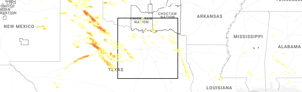
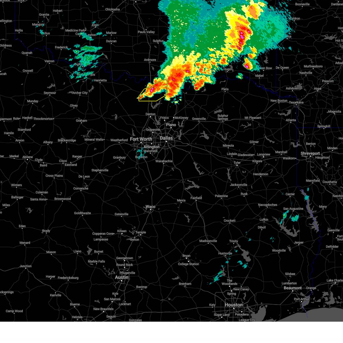
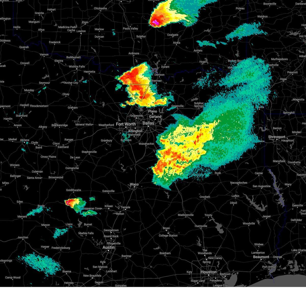
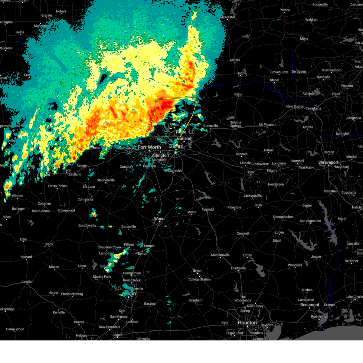
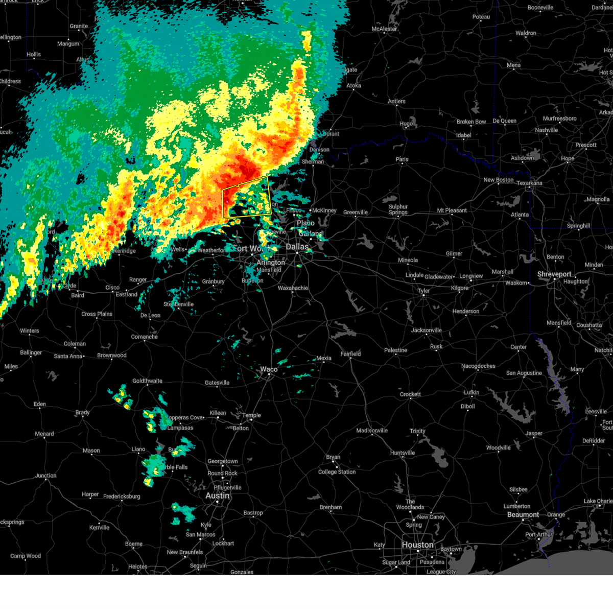
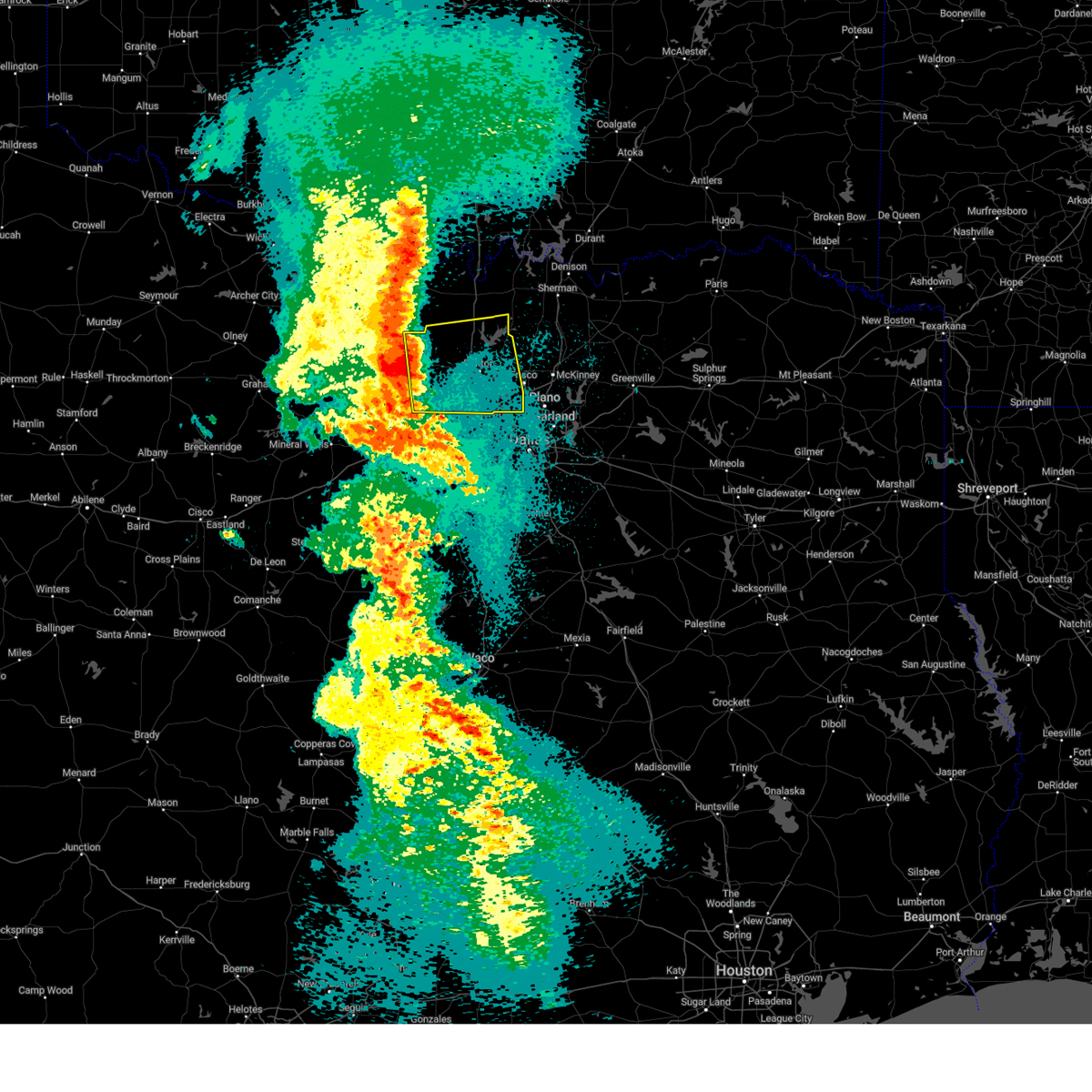
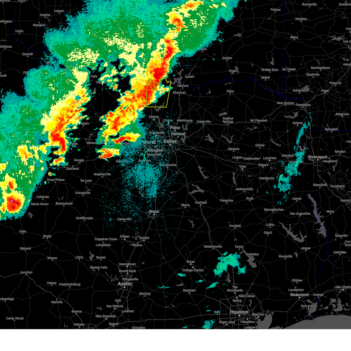
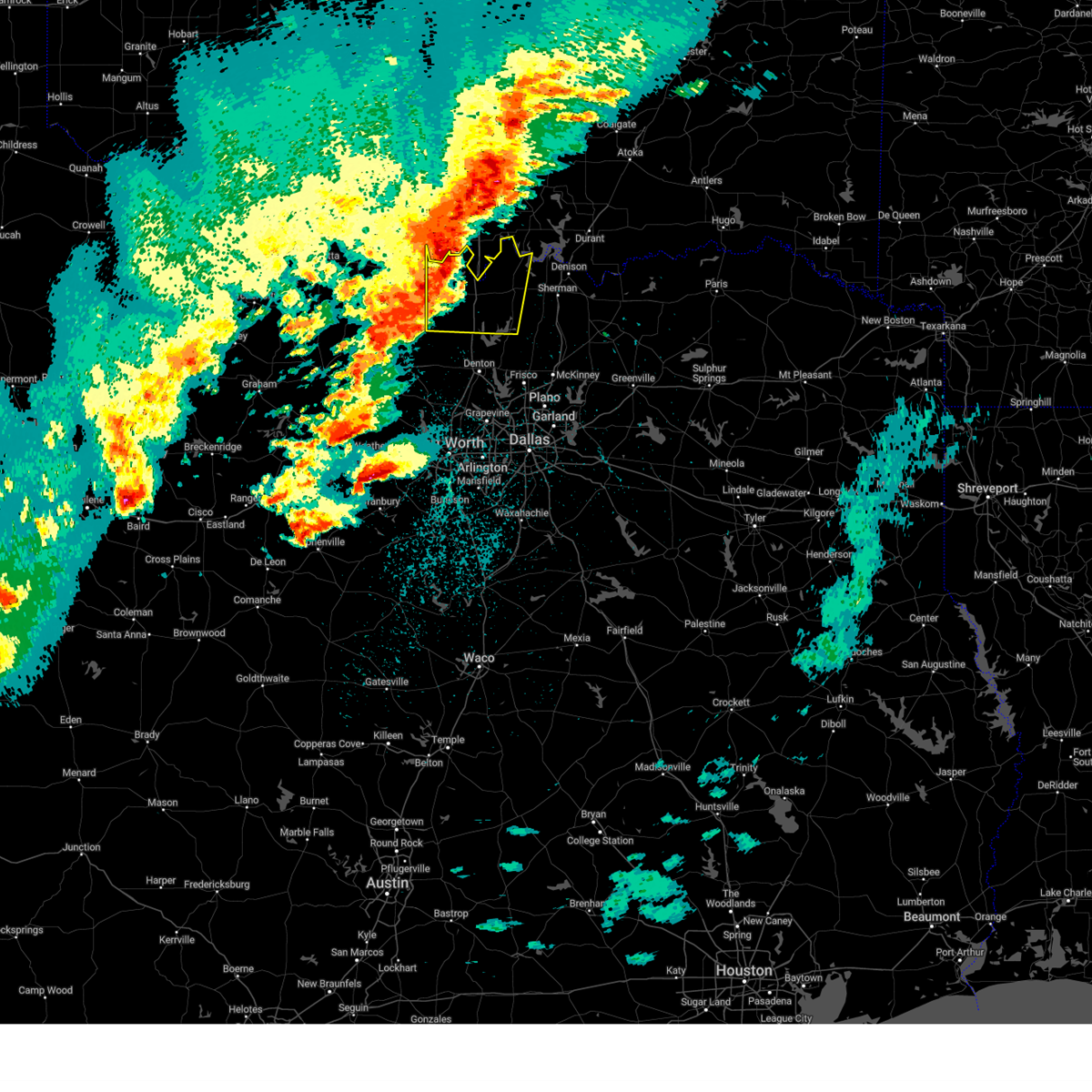
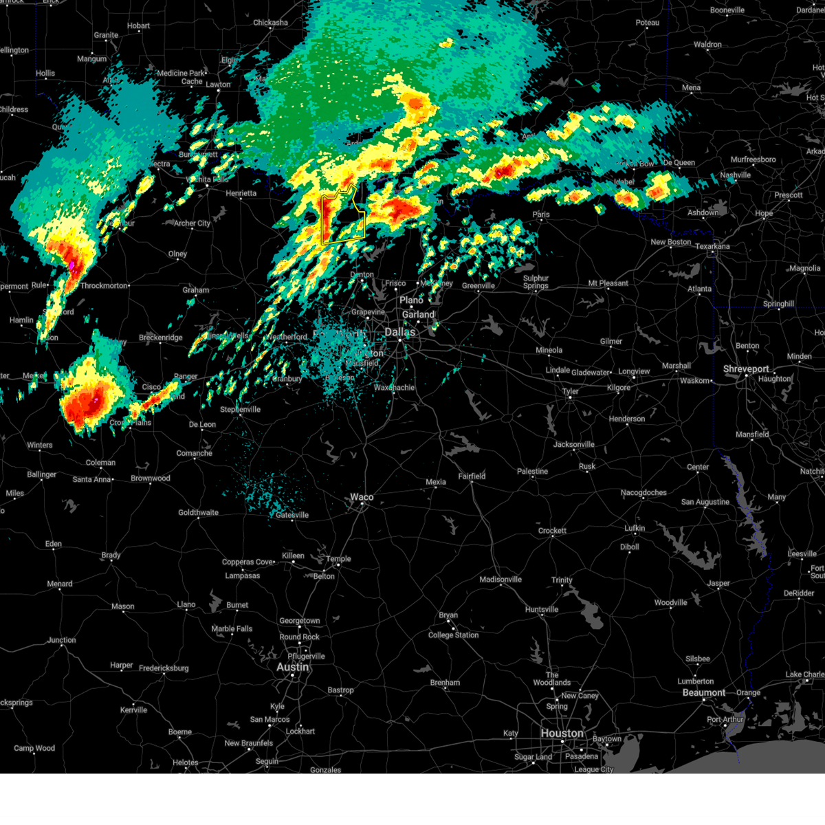
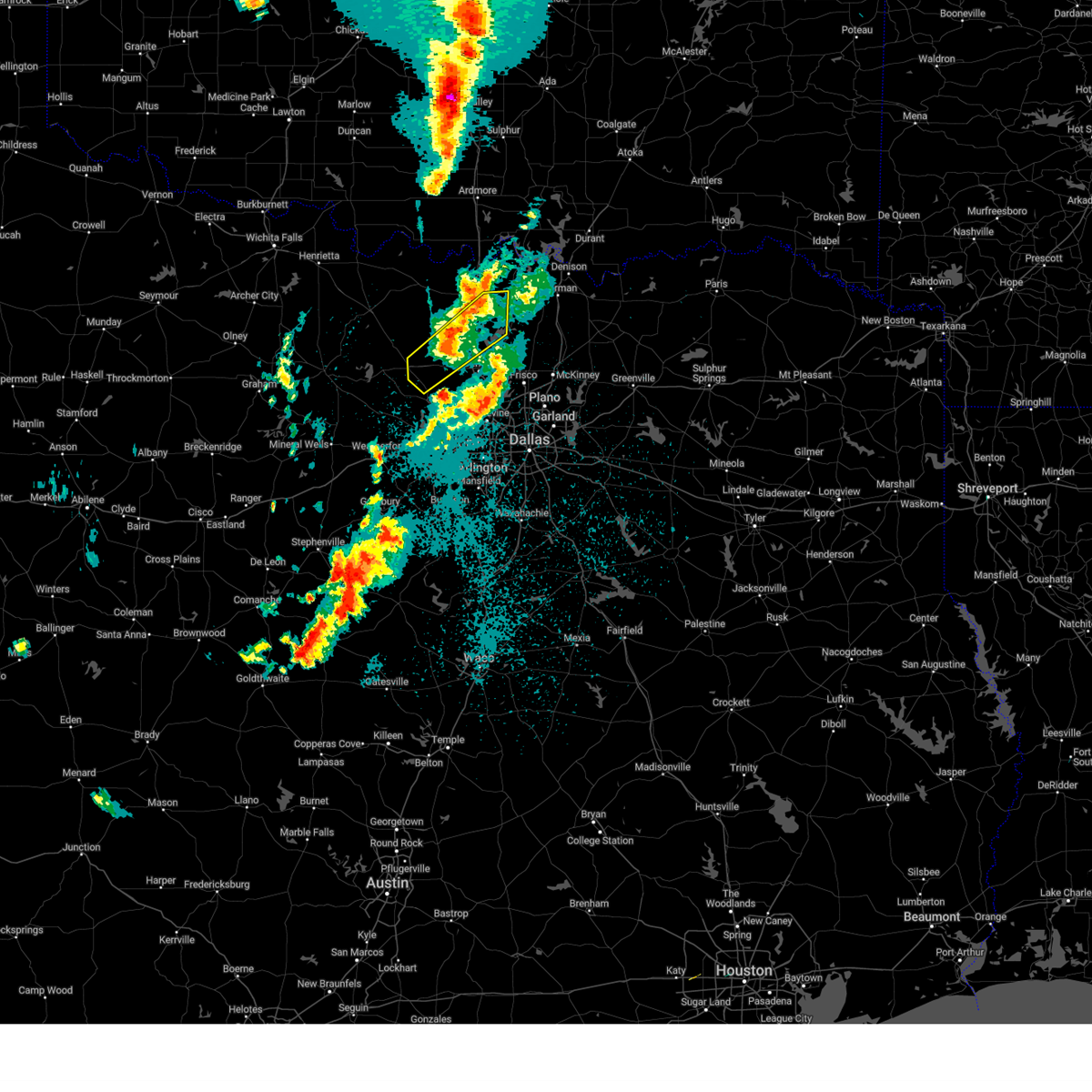
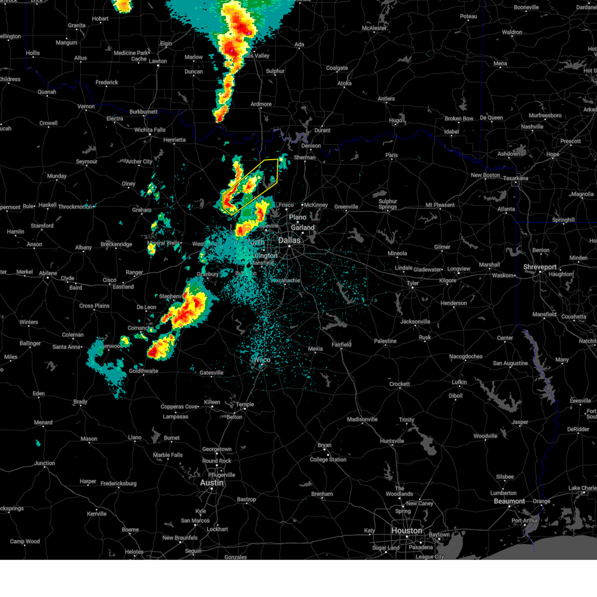
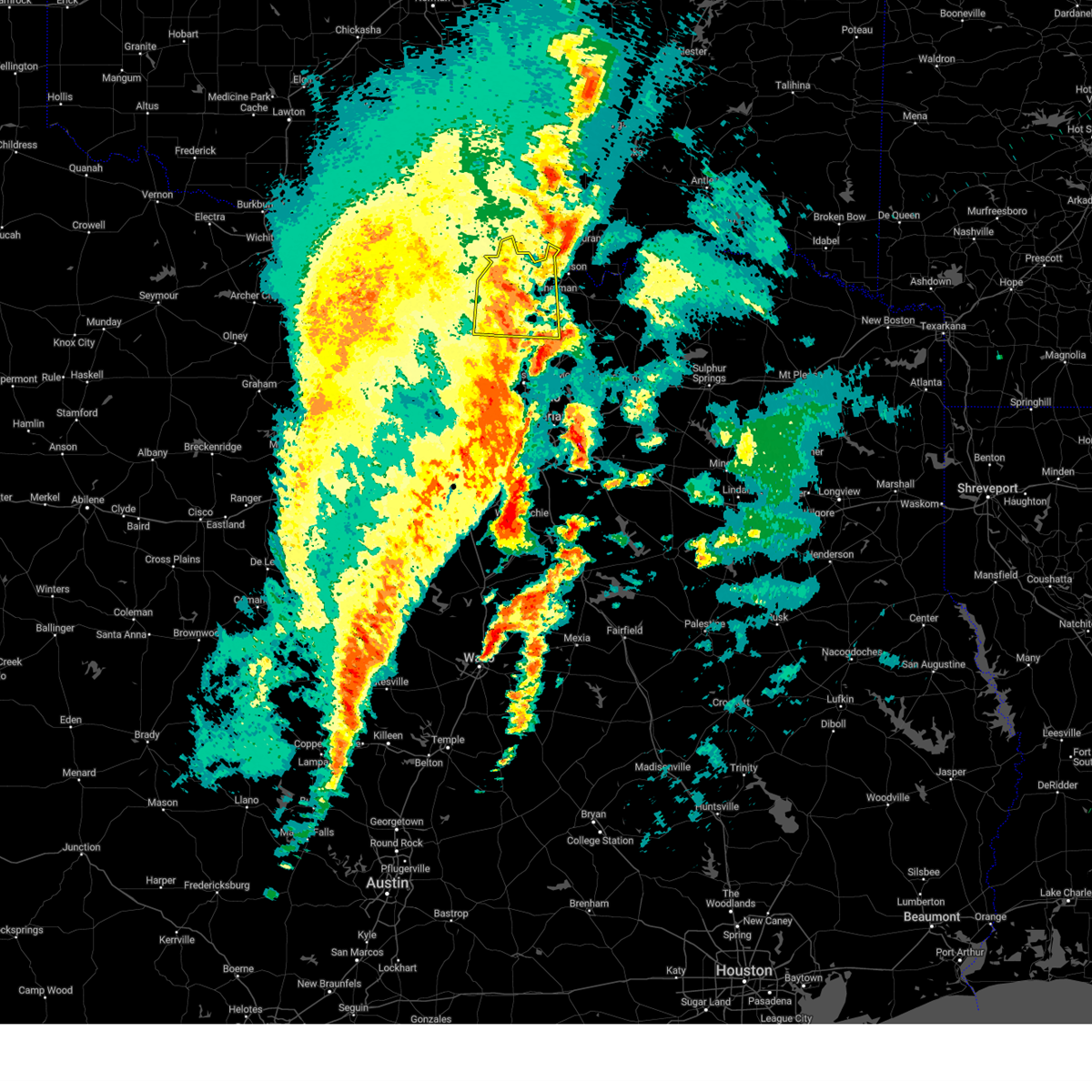
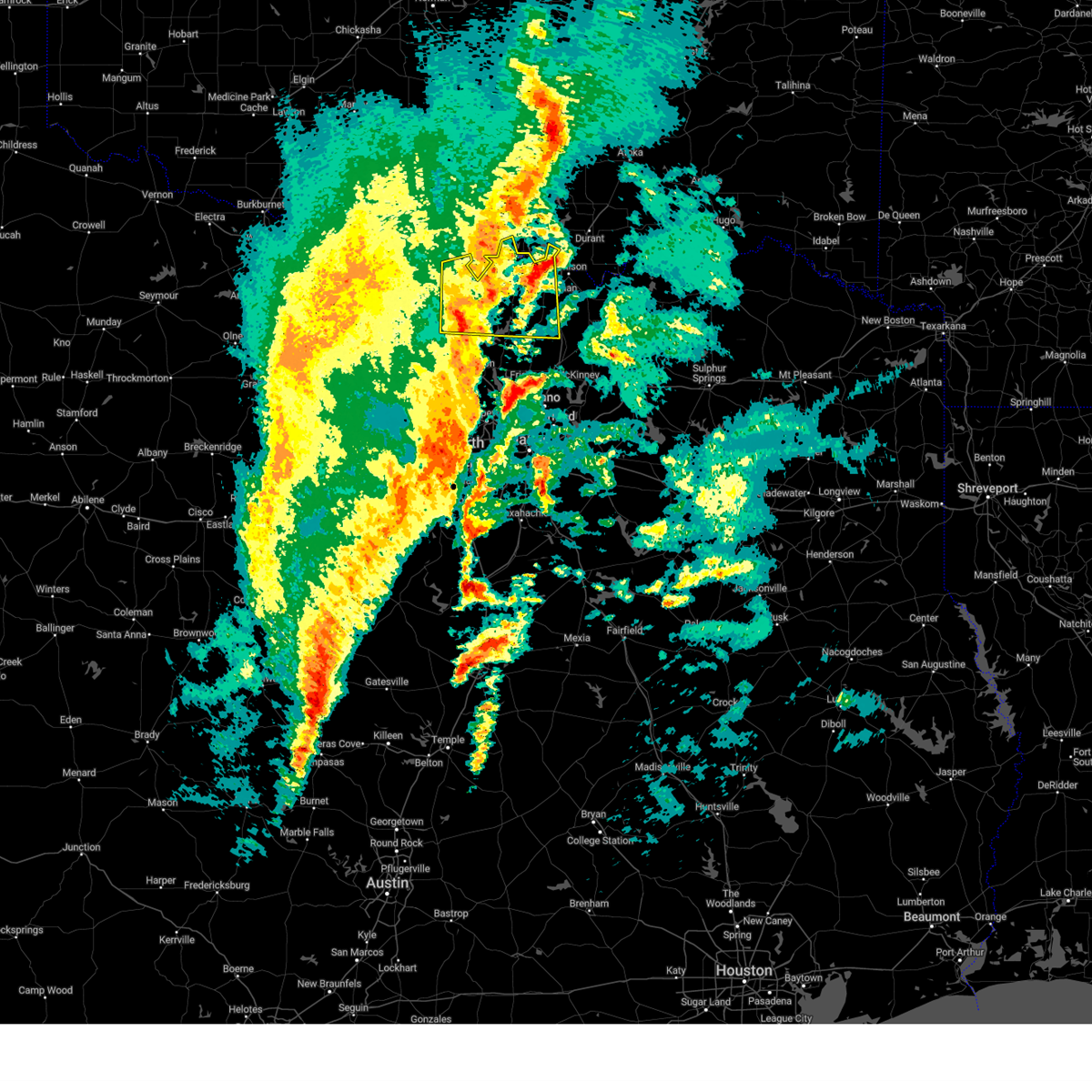
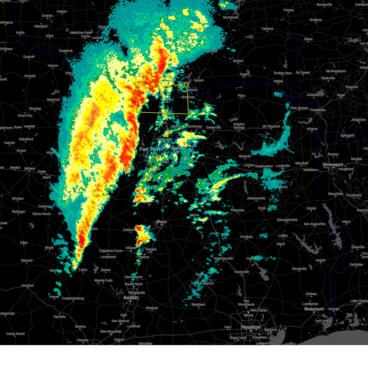
Hail Map for Valley View, TX
The Valley View, TX area has had 21 reports of on-the-ground hail by trained spotters, and has been under severe weather warnings 44 times during the past 12 months. Doppler radar has detected hail at or near Valley View, TX on 113 occasions, including 6 occasions during the past year.
| Name: | Valley View, TX |
| Where Located: | 53.1 miles NNW of Dallas, TX |
| Map: | Google Map for Valley View, TX |
| Population: | 757 |
| Housing Units: | 314 |
| More Info: | Search Google for Valley View, TX |
1
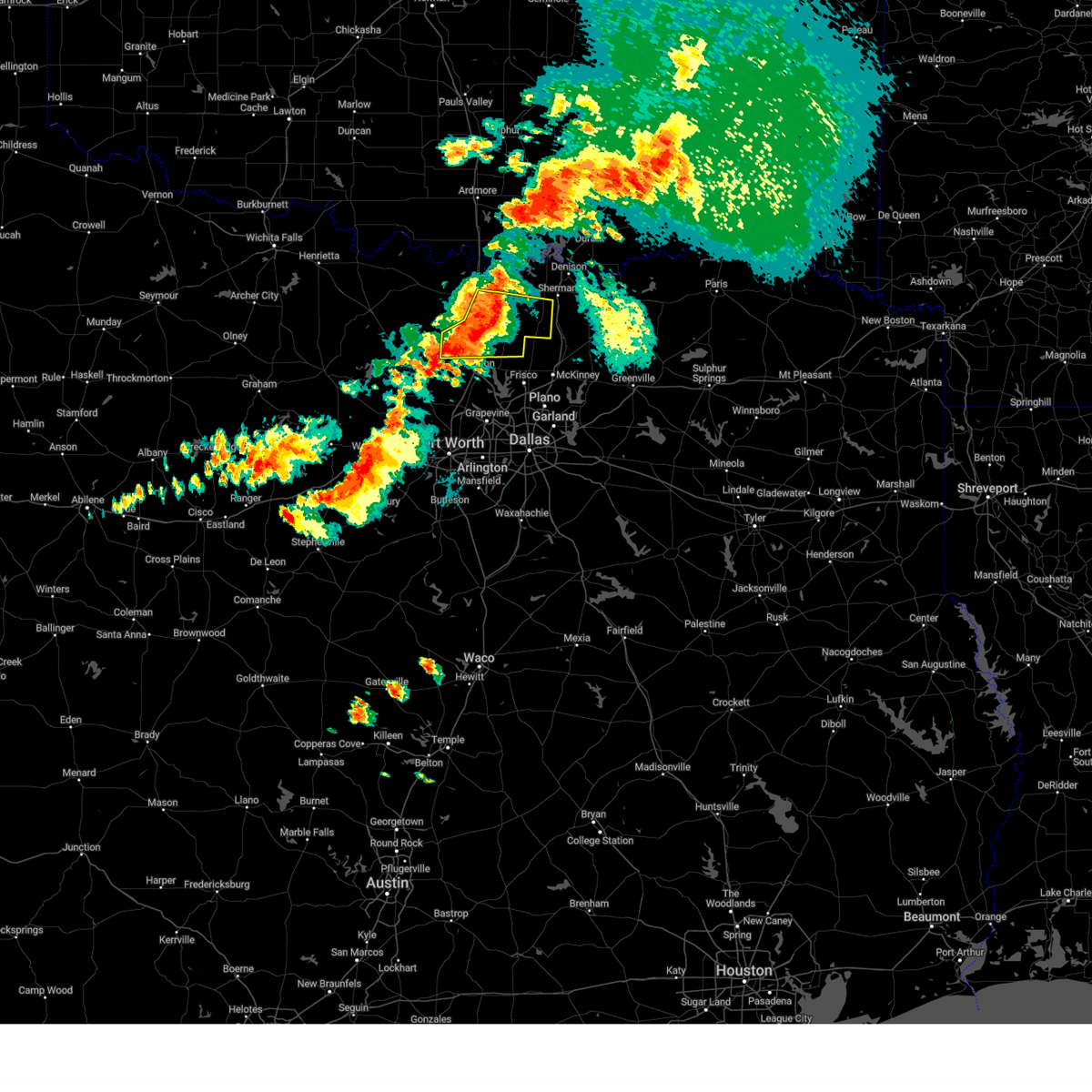
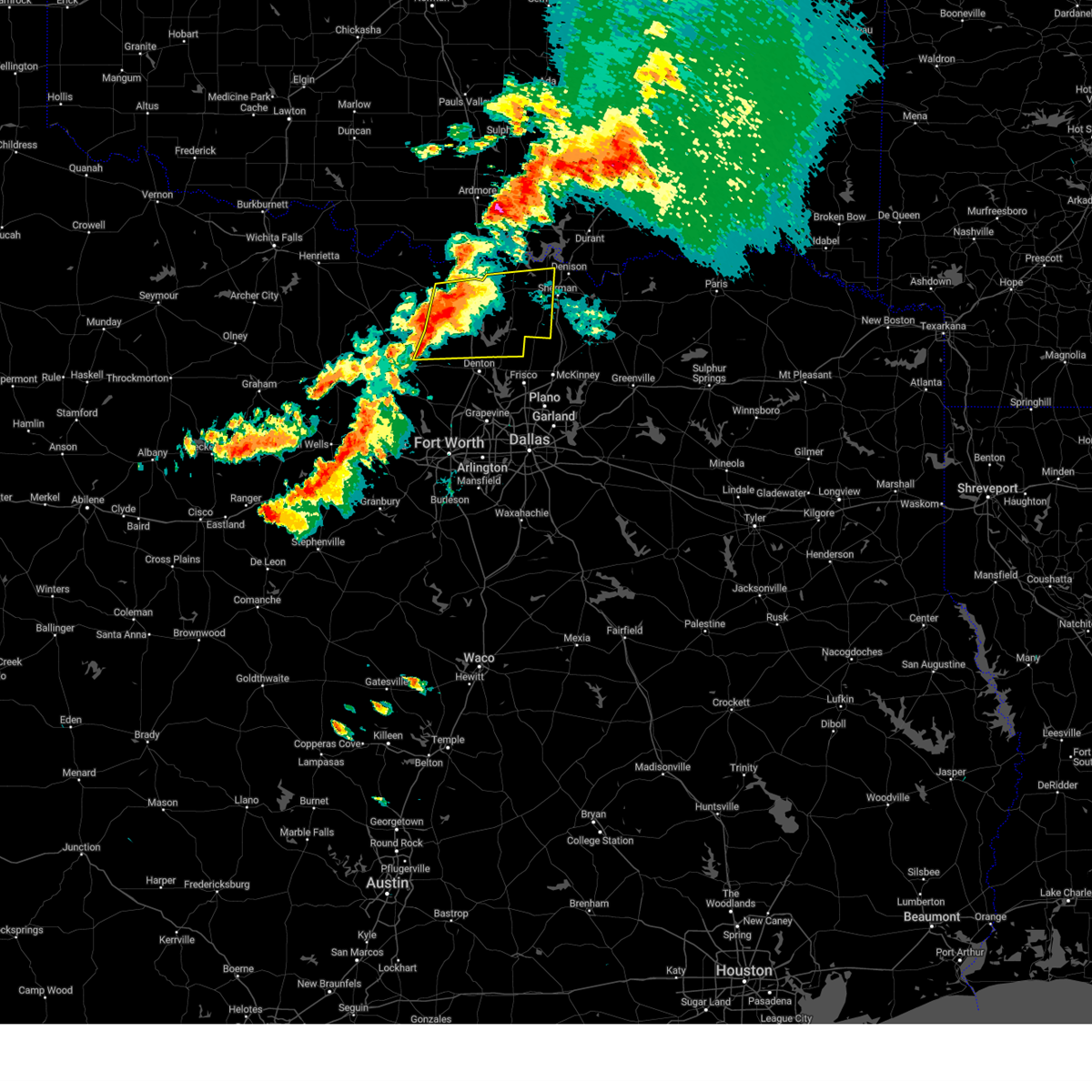
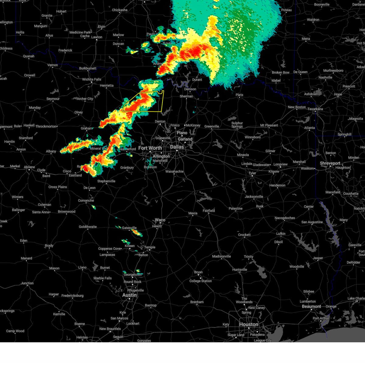
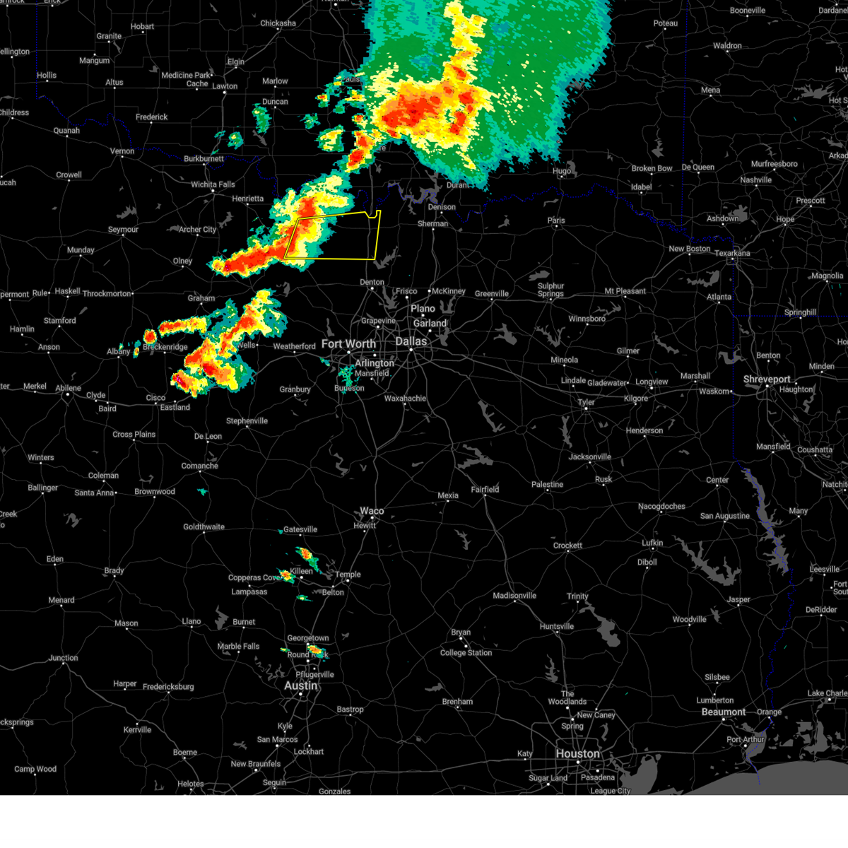
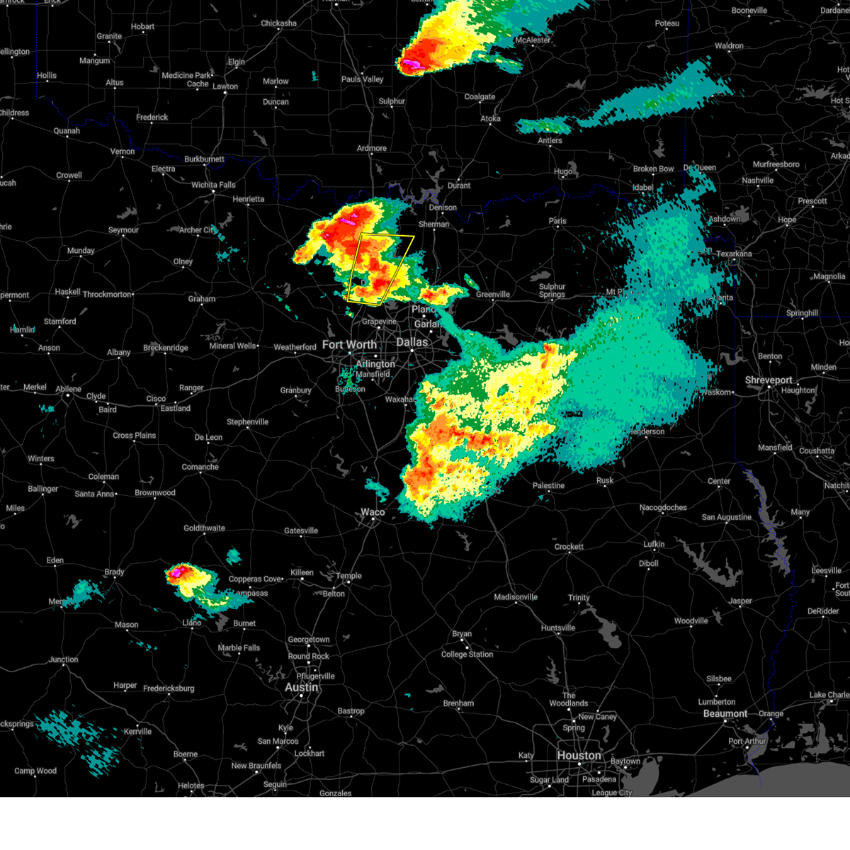
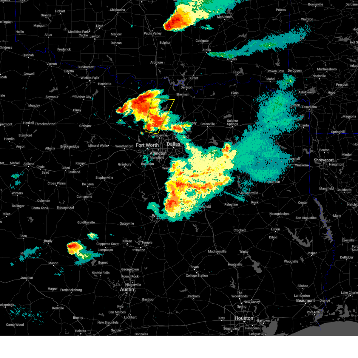
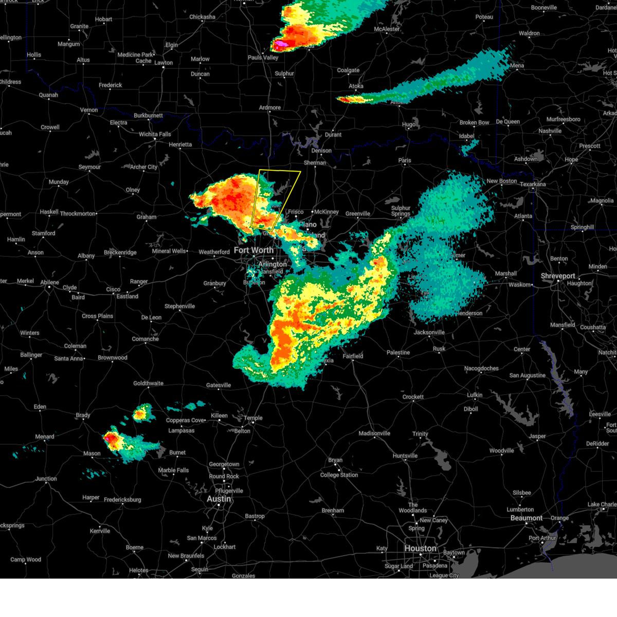
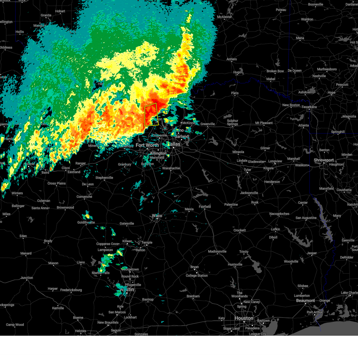
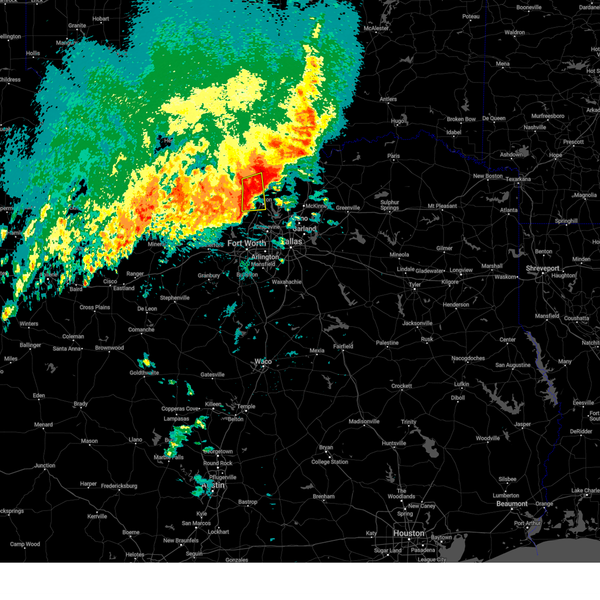
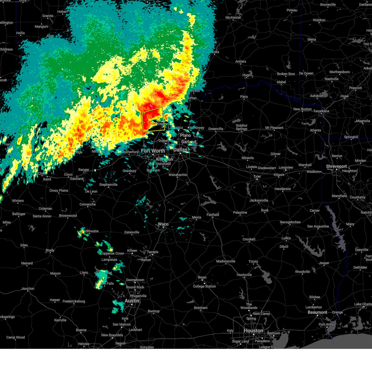
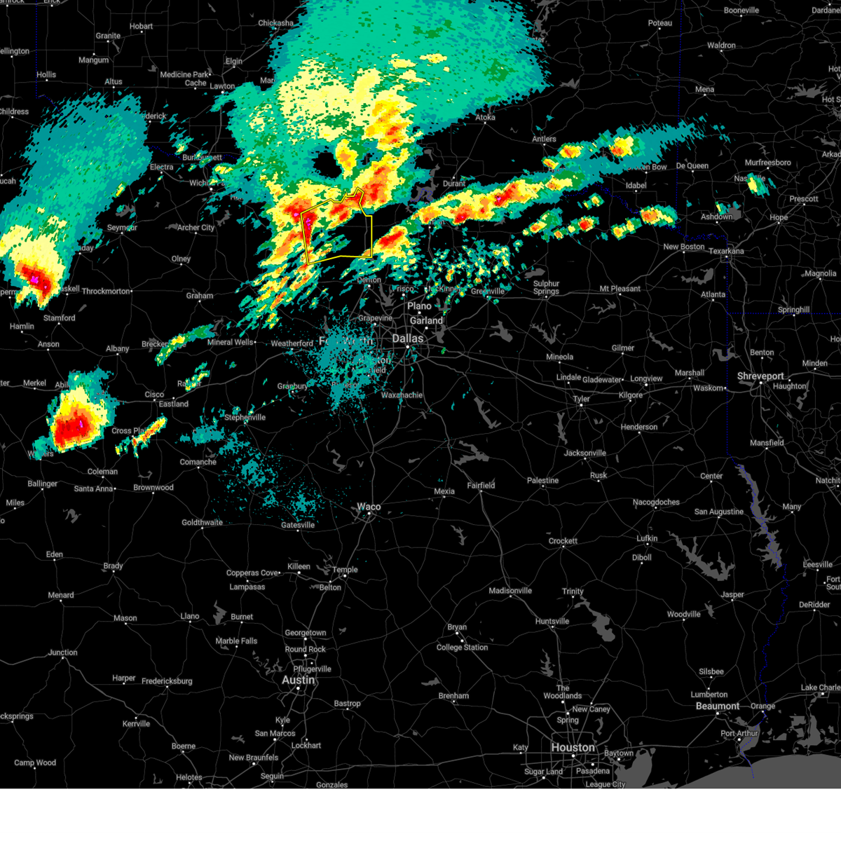
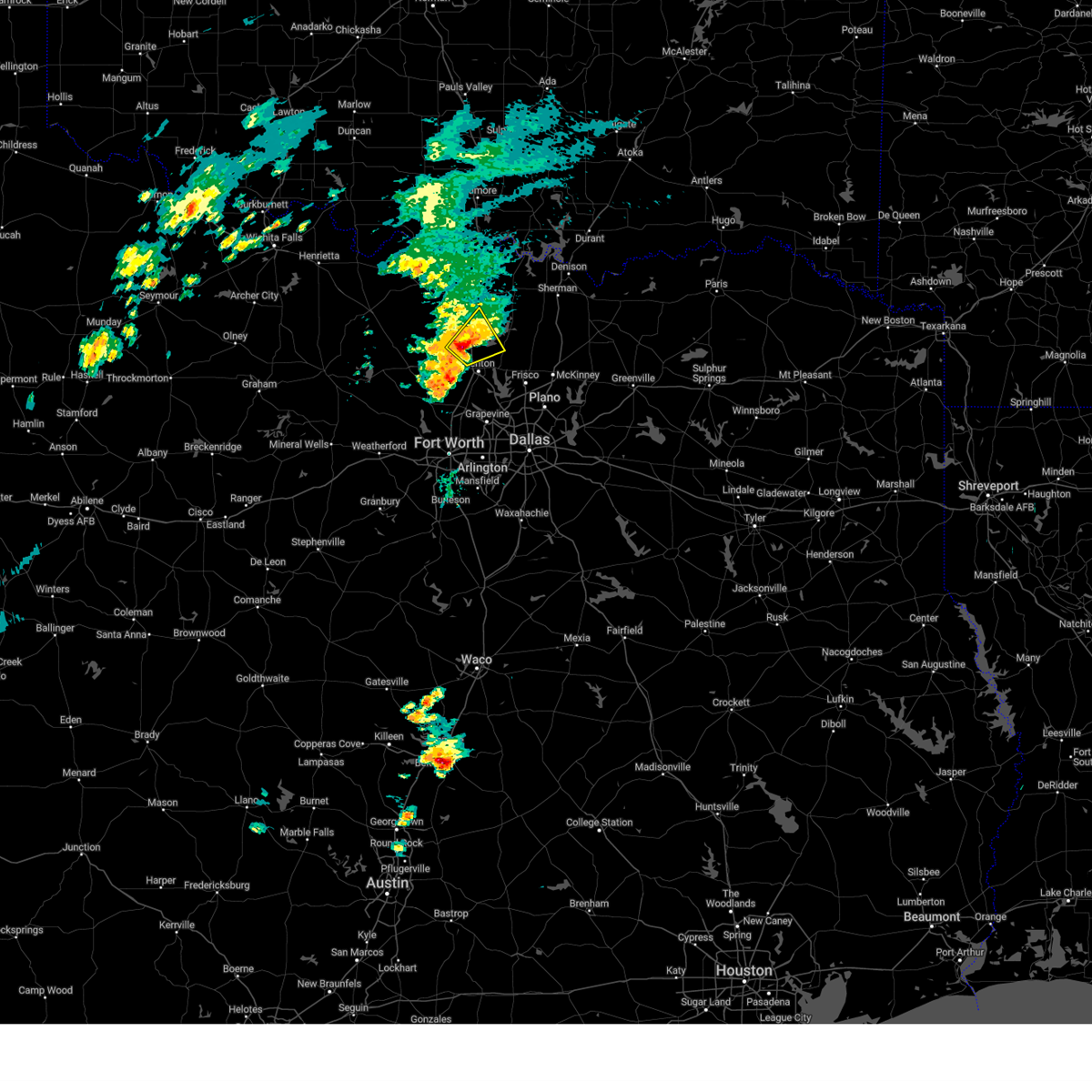
The Top Recent Hail Date for Valley View, TX is Sunday, June 8, 2025 (26th out of 113)
Hail and Wind Damage Spotted near Valley View, TX
| Date / Time | Report Details |
|---|---|
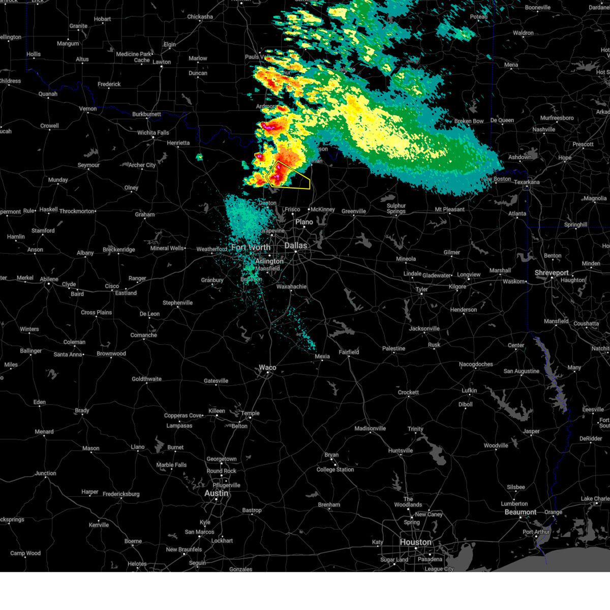
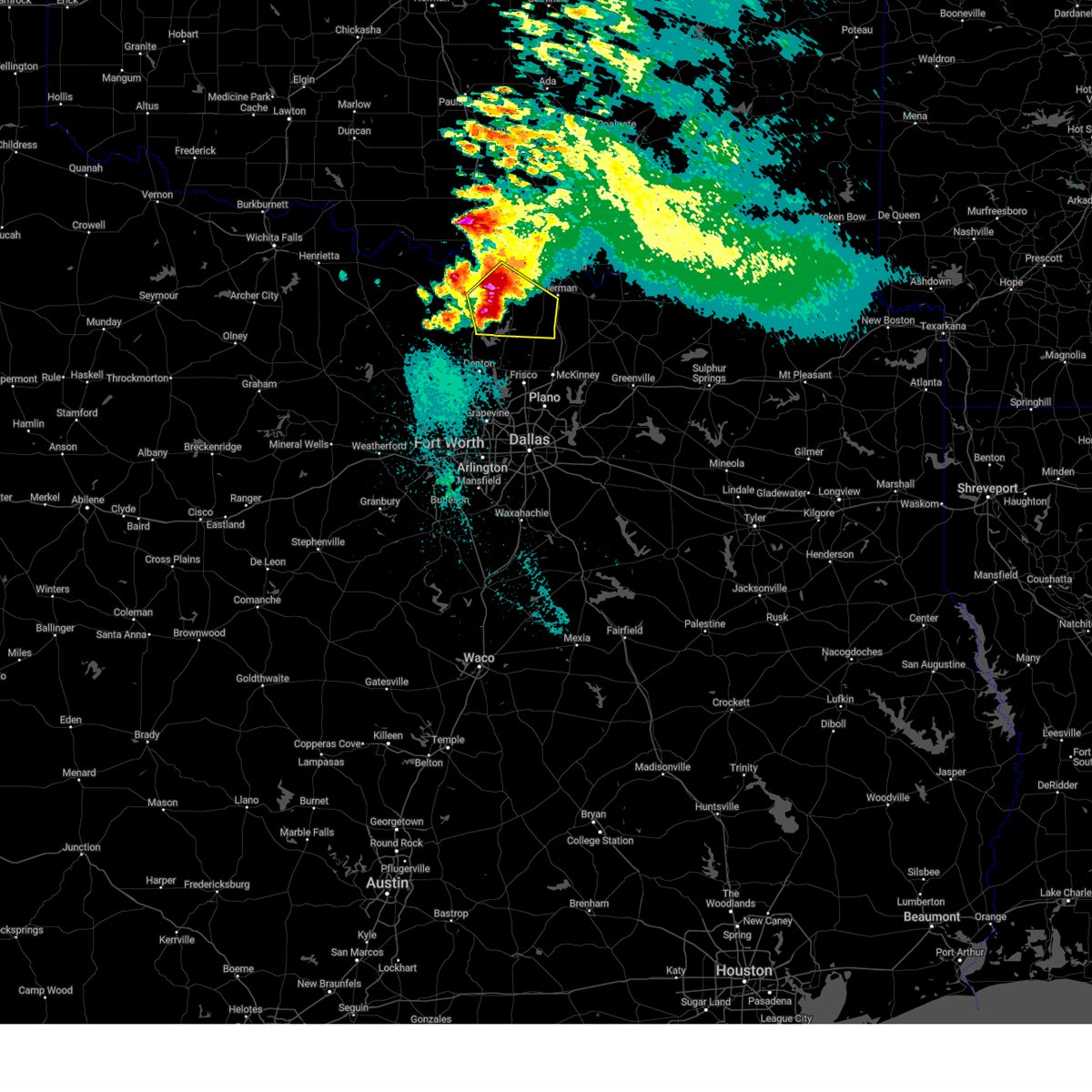
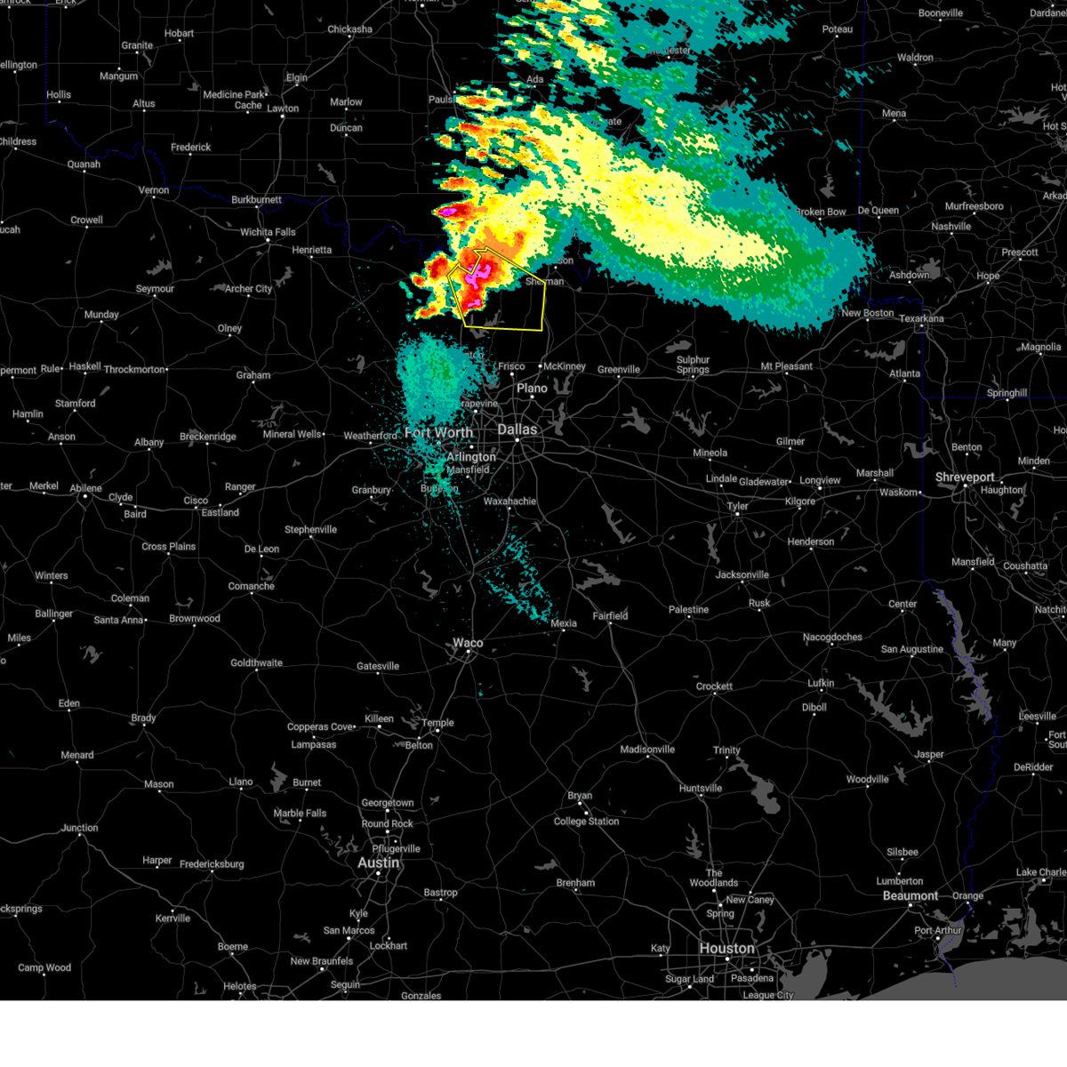
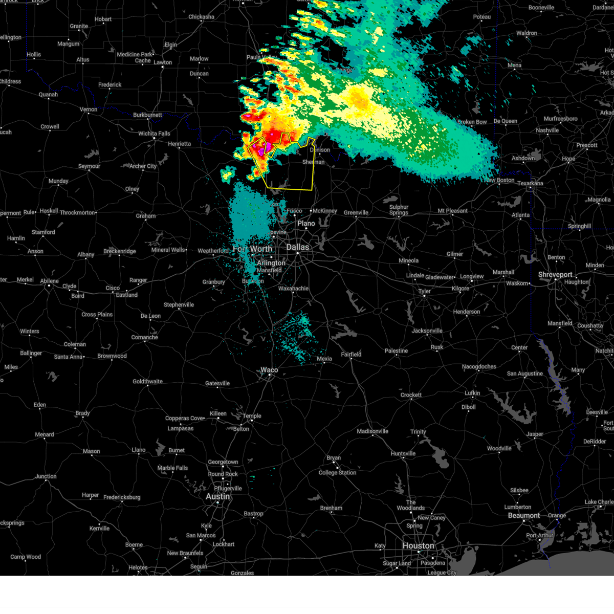
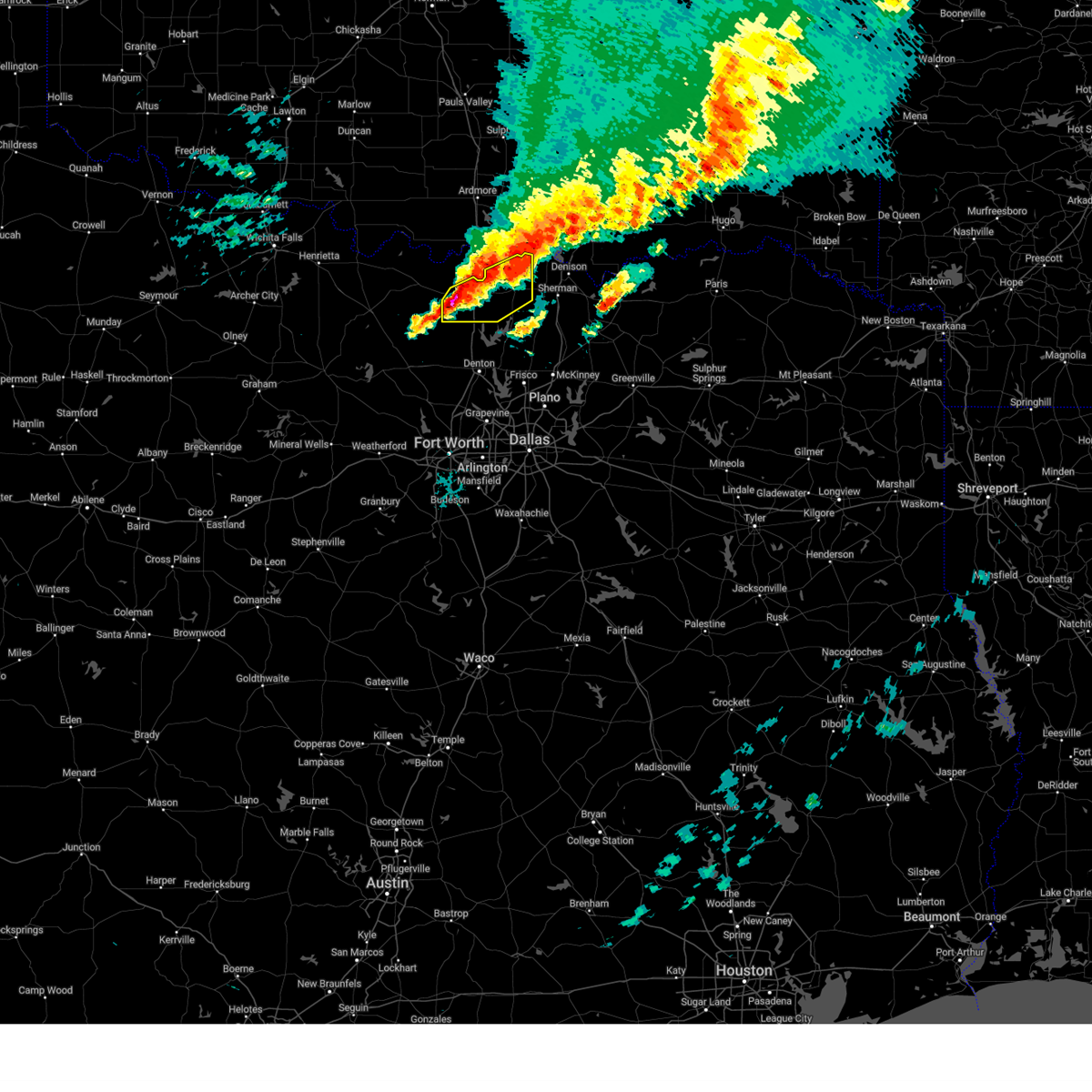
| 6/8/2025 9:42 PM CDT | Trained spotter reports a measured wind gust of 82 mph near the fm922 and fm2848 intersection north of sange in cooke county TX, 1.7 miles ESE of Valley View, TX |
| 6/8/2025 9:41 PM CDT |
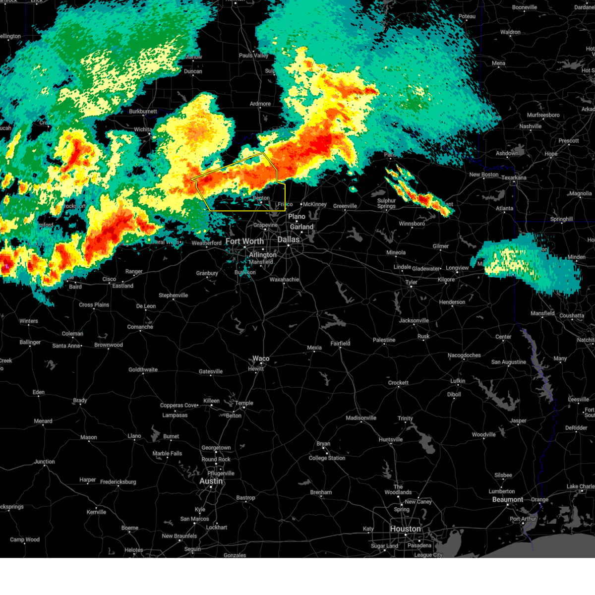 At 940 pm cdt, severe thunderstorms were located along a line extending from near ray roberts park johnson branch to near chico, moving southeast at 35 mph (radar indicated). Hazards include 70 mph wind gusts and quarter size hail. Hail damage to vehicles is expected. expect considerable tree damage. wind damage is also likely to mobile homes, roofs, and outbuildings. these severe storms will be near, sanger, bridgeport, ray roberts park isle du bois, decatur, and ray roberts park johnson branch around 945 pm cdt. denton and pilot point around 950 pm cdt. paradise, aubrey, and krum around 955 pm cdt. krugerville, new fairview, and cross roads around 1000 pm cdt. hackberry, and little elm around 1015 pm cdt. the colony around 1020 pm cdt. Other locations impacted by these severe thunderstorms include rosston, valley view, park springs, crafton, providence village, stony, ponder, lake ray roberts, bolivar, and lincoln park. At 940 pm cdt, severe thunderstorms were located along a line extending from near ray roberts park johnson branch to near chico, moving southeast at 35 mph (radar indicated). Hazards include 70 mph wind gusts and quarter size hail. Hail damage to vehicles is expected. expect considerable tree damage. wind damage is also likely to mobile homes, roofs, and outbuildings. these severe storms will be near, sanger, bridgeport, ray roberts park isle du bois, decatur, and ray roberts park johnson branch around 945 pm cdt. denton and pilot point around 950 pm cdt. paradise, aubrey, and krum around 955 pm cdt. krugerville, new fairview, and cross roads around 1000 pm cdt. hackberry, and little elm around 1015 pm cdt. the colony around 1020 pm cdt. Other locations impacted by these severe thunderstorms include rosston, valley view, park springs, crafton, providence village, stony, ponder, lake ray roberts, bolivar, and lincoln park.
|
| 6/8/2025 9:04 PM CDT | Svrfwd the national weather service in fort worth has issued a * severe thunderstorm warning for, southern montague county in north central texas, wise county in north central texas, denton county in north central texas, cooke county in north central texas, * until 1000 pm cdt. * at 904 pm cdt, severe thunderstorms were located along a line extending from near lindsay to bowie, moving southeast at 45 mph (radar indicated). Hazards include 70 mph wind gusts and quarter size hail. Hail damage to vehicles is expected. expect considerable tree damage. wind damage is also likely to mobile homes, roofs, and outbuildings. severe thunderstorms will be near, lindsay, sunset, and gainesville around 910 pm cdt. lake kiowa around 915 pm cdt. alvord around 920 pm cdt. sanger and ray roberts park johnson branch around 925 pm cdt. ray roberts park isle du bois and pilot point around 930 pm cdt. denton and decatur around 935 pm cdt. aubrey and krum around 940 pm cdt. krugerville, new fairview, celina, and cross roads around 945 pm cdt. other locations impacted by these severe thunderstorms include rosston, valley view, park springs, crafton, providence village, stony, ponder, lake ray roberts, bolivar, and lincoln park. this includes the following highways, interstate 35 between mile markers 468 and 503. interstate 35w between mile markers 79 and 85. Interstate 35e between mile markers 458 and 466. |
| 6/3/2025 9:26 PM CDT |
 the severe thunderstorm warning has been cancelled and is no longer in effect the severe thunderstorm warning has been cancelled and is no longer in effect
|
| 6/3/2025 9:26 PM CDT |
 At 925 pm cdt, severe thunderstorms were located along a line extending from 7 miles east of ray roberts park isle du bois to pilot point to near aubrey, moving east at 40 mph (radar indicated). Hazards include 60 mph wind gusts and quarter size hail. Hail damage to vehicles is expected. expect wind damage to roofs, siding, and trees. Locations impacted include, aubrey, ray roberts park isle du bois, bolivar, sanger, pilot point, lake ray roberts, ray roberts park johnson branch, and denton. At 925 pm cdt, severe thunderstorms were located along a line extending from 7 miles east of ray roberts park isle du bois to pilot point to near aubrey, moving east at 40 mph (radar indicated). Hazards include 60 mph wind gusts and quarter size hail. Hail damage to vehicles is expected. expect wind damage to roofs, siding, and trees. Locations impacted include, aubrey, ray roberts park isle du bois, bolivar, sanger, pilot point, lake ray roberts, ray roberts park johnson branch, and denton.
|
| 6/3/2025 9:08 PM CDT |
 At 907 pm cdt, severe thunderstorms were located along a line extending from near lake kiowa to near ray roberts park johnson branch to krum, moving east at 40 mph (radar indicated). Hazards include 60 mph wind gusts and quarter size hail. Hail damage to vehicles is expected. expect wind damage to roofs, siding, and trees. Locations impacted include, ethel, ray roberts park isle du bois, tioga, road runner, valley view, collinsville, pilot point, lois, ray roberts park johnson branch, gunter, lake ray roberts, aubrey, gainesville, bolivar, lake kiowa, sanger, woodbine, burns, dorchester, and southmayd. At 907 pm cdt, severe thunderstorms were located along a line extending from near lake kiowa to near ray roberts park johnson branch to krum, moving east at 40 mph (radar indicated). Hazards include 60 mph wind gusts and quarter size hail. Hail damage to vehicles is expected. expect wind damage to roofs, siding, and trees. Locations impacted include, ethel, ray roberts park isle du bois, tioga, road runner, valley view, collinsville, pilot point, lois, ray roberts park johnson branch, gunter, lake ray roberts, aubrey, gainesville, bolivar, lake kiowa, sanger, woodbine, burns, dorchester, and southmayd.
|
| 6/3/2025 9:08 PM CDT |
 the severe thunderstorm warning has been cancelled and is no longer in effect the severe thunderstorm warning has been cancelled and is no longer in effect
|
| 6/3/2025 8:39 PM CDT |
 Svrfwd the national weather service in fort worth has issued a * severe thunderstorm warning for, northeastern wise county in north central texas, northern denton county in north central texas, cooke county in north central texas, southwestern grayson county in north central texas, * until 945 pm cdt. * at 839 pm cdt, severe thunderstorms were located along a line extending from lindsay to leo to near slidell, moving east at 45 mph (radar indicated). Hazards include 65 mph wind gusts and quarter size hail. Hail damage to vehicles is expected. expect wind damage to roofs, siding, and trees. severe thunderstorms will be near, lindsay and gainesville around 845 pm cdt. sanger and callisburg around 850 pm cdt. lake kiowa and whitesboro around 855 pm cdt. ray roberts park johnson branch around 900 pm cdt. collinsville and ray roberts park isle du bois around 905 pm cdt. pilot point and lake texoma around 910 pm cdt. sherman and aubrey around 915 pm cdt. dorchester and pottsboro around 920 pm cdt. other locations impacted by these severe thunderstorms include dixie, prairie point, ethel, greenwood, tioga, rosston, southmayd, road runner, valley view, and sturgeon. This includes interstate 35 between mile markers 473 and 503. Svrfwd the national weather service in fort worth has issued a * severe thunderstorm warning for, northeastern wise county in north central texas, northern denton county in north central texas, cooke county in north central texas, southwestern grayson county in north central texas, * until 945 pm cdt. * at 839 pm cdt, severe thunderstorms were located along a line extending from lindsay to leo to near slidell, moving east at 45 mph (radar indicated). Hazards include 65 mph wind gusts and quarter size hail. Hail damage to vehicles is expected. expect wind damage to roofs, siding, and trees. severe thunderstorms will be near, lindsay and gainesville around 845 pm cdt. sanger and callisburg around 850 pm cdt. lake kiowa and whitesboro around 855 pm cdt. ray roberts park johnson branch around 900 pm cdt. collinsville and ray roberts park isle du bois around 905 pm cdt. pilot point and lake texoma around 910 pm cdt. sherman and aubrey around 915 pm cdt. dorchester and pottsboro around 920 pm cdt. other locations impacted by these severe thunderstorms include dixie, prairie point, ethel, greenwood, tioga, rosston, southmayd, road runner, valley view, and sturgeon. This includes interstate 35 between mile markers 473 and 503.
|
| 6/3/2025 8:21 PM CDT |
 At 821 pm cdt, severe thunderstorms were located along a line near muenster, moving east at 50 mph (radar indicated). Hazards include 70 mph wind gusts and quarter size hail. Hail damage to vehicles is expected. expect considerable tree damage. wind damage is also likely to mobile homes, roofs, and outbuildings. these severe storms will be near, lindsay, gainesville, and hubert h moss lake around 825 pm cdt. Other locations impacted by these severe thunderstorms include prairie point, era, rosston, mallard, valley view, leo, fruitland, lois, hood, and myra. At 821 pm cdt, severe thunderstorms were located along a line near muenster, moving east at 50 mph (radar indicated). Hazards include 70 mph wind gusts and quarter size hail. Hail damage to vehicles is expected. expect considerable tree damage. wind damage is also likely to mobile homes, roofs, and outbuildings. these severe storms will be near, lindsay, gainesville, and hubert h moss lake around 825 pm cdt. Other locations impacted by these severe thunderstorms include prairie point, era, rosston, mallard, valley view, leo, fruitland, lois, hood, and myra.
|
| 6/3/2025 8:12 PM CDT | At 812 pm cdt, severe thunderstorms were located along a line extending from near lake muenster to sunset, moving east at 40 mph (radar indicated). Hazards include 60 mph wind gusts and quarter size hail. Hail damage to vehicles is expected. expect wind damage to roofs, siding, and trees. these severe storms will be near, lake muenster and muenster around 815 pm cdt. lindsay and gainesville around 830 pm cdt. Other locations impacted by these severe thunderstorms include prairie point, era, rosston, mallard, valley view, leo, fruitland, lois, hood, and myra. |
| 6/3/2025 7:46 PM CDT |
 Svrfwd the national weather service in fort worth has issued a * severe thunderstorm warning for, southeastern montague county in north central texas, southern cooke county in north central texas, * until 845 pm cdt. * at 745 pm cdt, severe thunderstorms were located along a line extending from 7 miles northeast of bowie to sunset, moving east at 35 mph (public. at 740 pm cdt, a 65 mph wind gust was reported 10 miles northwest of bowie). Hazards include 65 mph wind gusts and quarter size hail. Hail damage to vehicles is expected. expect wind damage to roofs, siding, and trees. severe thunderstorms will be near, sunset around 750 pm cdt. st. jo around 800 pm cdt. lake muenster around 810 pm cdt. muenster around 815 pm cdt. lindsay and gainesville around 830 pm cdt. other locations impacted by these severe thunderstorms include prairie point, rosston, valley view, fruitland, lois, montague, forestburg, era, mallard, and leo. This includes interstate 35 between mile markers 482 and 503. Svrfwd the national weather service in fort worth has issued a * severe thunderstorm warning for, southeastern montague county in north central texas, southern cooke county in north central texas, * until 845 pm cdt. * at 745 pm cdt, severe thunderstorms were located along a line extending from 7 miles northeast of bowie to sunset, moving east at 35 mph (public. at 740 pm cdt, a 65 mph wind gust was reported 10 miles northwest of bowie). Hazards include 65 mph wind gusts and quarter size hail. Hail damage to vehicles is expected. expect wind damage to roofs, siding, and trees. severe thunderstorms will be near, sunset around 750 pm cdt. st. jo around 800 pm cdt. lake muenster around 810 pm cdt. muenster around 815 pm cdt. lindsay and gainesville around 830 pm cdt. other locations impacted by these severe thunderstorms include prairie point, rosston, valley view, fruitland, lois, montague, forestburg, era, mallard, and leo. This includes interstate 35 between mile markers 482 and 503.
|
| 5/22/2025 1:22 PM CDT |
 At 122 pm cdt, a severe thunderstorm was located over collinsville, or 8 miles south of whitesboro, moving southeast at 35 mph (radar indicated). Hazards include 60 mph wind gusts and quarter size hail. Hail damage to vehicles is expected. expect wind damage to roofs, siding, and trees. Locations impacted include, ethel, tioga, road runner, collinsville, elmont, ray roberts park johnson branch, gunter, lake ray roberts, lake kiowa, woodbine, farmington, burns, dorchester, and pilot point. At 122 pm cdt, a severe thunderstorm was located over collinsville, or 8 miles south of whitesboro, moving southeast at 35 mph (radar indicated). Hazards include 60 mph wind gusts and quarter size hail. Hail damage to vehicles is expected. expect wind damage to roofs, siding, and trees. Locations impacted include, ethel, tioga, road runner, collinsville, elmont, ray roberts park johnson branch, gunter, lake ray roberts, lake kiowa, woodbine, farmington, burns, dorchester, and pilot point.
|
| 5/22/2025 1:12 PM CDT |
 At 112 pm cdt, a severe thunderstorm was located near lake kiowa, or near whitesboro, moving southeast at 30 mph (radar indicated). Hazards include 60 mph wind gusts and quarter size hail. Hail damage to vehicles is expected. expect wind damage to roofs, siding, and trees. Locations impacted include, tioga, callisburg, valley view, collinsville, sadler, elmont, gunter, lake ray roberts, lake kiowa, whitesboro, sandusky, dorchester, dixie, ethel, southmayd, road runner, sturgeon, ray roberts park johnson branch, gainesville, and woodbine. At 112 pm cdt, a severe thunderstorm was located near lake kiowa, or near whitesboro, moving southeast at 30 mph (radar indicated). Hazards include 60 mph wind gusts and quarter size hail. Hail damage to vehicles is expected. expect wind damage to roofs, siding, and trees. Locations impacted include, tioga, callisburg, valley view, collinsville, sadler, elmont, gunter, lake ray roberts, lake kiowa, whitesboro, sandusky, dorchester, dixie, ethel, southmayd, road runner, sturgeon, ray roberts park johnson branch, gainesville, and woodbine.
|
| 5/22/2025 1:01 PM CDT |
 At 100 pm cdt, a severe thunderstorm was located over callisburg, or 7 miles west of whitesboro, moving southeast at 40 mph (radar indicated. at 1251 pm, ping-pong sized hail was reported 3 miles northwest of gainesville). Hazards include golf ball size hail and 70 mph wind gusts. People and animals outdoors will be injured. expect hail damage to roofs, siding, windows, and vehicles. expect considerable tree damage. wind damage is also likely to mobile homes, roofs, and outbuildings. Locations impacted include, tioga, callisburg, valley view, collinsville, sadler, elmont, gunter, lake ray roberts, lake kiowa, whitesboro, dexter, sandusky, dorchester, dixie, ethel, southmayd, road runner, sturgeon, ray roberts park johnson branch, and gainesville. At 100 pm cdt, a severe thunderstorm was located over callisburg, or 7 miles west of whitesboro, moving southeast at 40 mph (radar indicated. at 1251 pm, ping-pong sized hail was reported 3 miles northwest of gainesville). Hazards include golf ball size hail and 70 mph wind gusts. People and animals outdoors will be injured. expect hail damage to roofs, siding, windows, and vehicles. expect considerable tree damage. wind damage is also likely to mobile homes, roofs, and outbuildings. Locations impacted include, tioga, callisburg, valley view, collinsville, sadler, elmont, gunter, lake ray roberts, lake kiowa, whitesboro, dexter, sandusky, dorchester, dixie, ethel, southmayd, road runner, sturgeon, ray roberts park johnson branch, and gainesville.
|
| 5/22/2025 12:44 PM CDT |
 Svrfwd the national weather service in fort worth has issued a * severe thunderstorm warning for, cooke county in north central texas, grayson county in north central texas, * until 145 pm cdt. * at 1244 pm cdt, a severe thunderstorm was located over thackerville, or 8 miles north of gainesville, moving southeast at 35 mph (radar indicated). Hazards include golf ball size hail and 70 mph wind gusts. People and animals outdoors will be injured. expect hail damage to roofs, siding, windows, and vehicles. expect considerable tree damage. Wind damage is also likely to mobile homes, roofs, and outbuildings. Svrfwd the national weather service in fort worth has issued a * severe thunderstorm warning for, cooke county in north central texas, grayson county in north central texas, * until 145 pm cdt. * at 1244 pm cdt, a severe thunderstorm was located over thackerville, or 8 miles north of gainesville, moving southeast at 35 mph (radar indicated). Hazards include golf ball size hail and 70 mph wind gusts. People and animals outdoors will be injured. expect hail damage to roofs, siding, windows, and vehicles. expect considerable tree damage. Wind damage is also likely to mobile homes, roofs, and outbuildings.
|
| 5/19/2025 8:19 PM CDT |
 At 819 pm cdt, a severe thunderstorm was located near callisburg, or near gainesville, moving east at 30 mph (emergency management). Hazards include 65 mph wind gusts and half dollar size hail. Hail damage to vehicles is expected. expect wind damage to roofs, siding, and trees. this severe storm will be near, callisburg around 825 pm cdt. whitesboro around 835 pm cdt. lake texoma and lake texoma around 845 pm cdt. Other locations impacted by this severe thunderstorm include dixie, sturgeon, sadler, gordonville, walnut bend, era, woodbine, dexter, sandusky, and burns. At 819 pm cdt, a severe thunderstorm was located near callisburg, or near gainesville, moving east at 30 mph (emergency management). Hazards include 65 mph wind gusts and half dollar size hail. Hail damage to vehicles is expected. expect wind damage to roofs, siding, and trees. this severe storm will be near, callisburg around 825 pm cdt. whitesboro around 835 pm cdt. lake texoma and lake texoma around 845 pm cdt. Other locations impacted by this severe thunderstorm include dixie, sturgeon, sadler, gordonville, walnut bend, era, woodbine, dexter, sandusky, and burns.
|
| 5/19/2025 7:57 PM CDT |
 Svrfwd the national weather service in fort worth has issued a * severe thunderstorm warning for, southern cooke county in north central texas, northwestern grayson county in north central texas, * until 900 pm cdt. * at 756 pm cdt, a severe thunderstorm was located over lindsay, or near gainesville, moving east at 30 mph (radar indicated). Hazards include 60 mph wind gusts and half dollar size hail. Hail damage to vehicles is expected. expect wind damage to roofs, siding, and trees. this severe thunderstorm will be near, lindsay and gainesville around 800 pm cdt. callisburg around 815 pm cdt. whitesboro around 830 pm cdt. lake texoma around 840 pm cdt. lake texoma around 845 pm cdt. other locations impacted by this severe thunderstorm include dixie, sturgeon, sadler, gordonville, walnut bend, era, woodbine, dexter, sandusky, and burns. This includes interstate 35 between mile markers 487 and 503. Svrfwd the national weather service in fort worth has issued a * severe thunderstorm warning for, southern cooke county in north central texas, northwestern grayson county in north central texas, * until 900 pm cdt. * at 756 pm cdt, a severe thunderstorm was located over lindsay, or near gainesville, moving east at 30 mph (radar indicated). Hazards include 60 mph wind gusts and half dollar size hail. Hail damage to vehicles is expected. expect wind damage to roofs, siding, and trees. this severe thunderstorm will be near, lindsay and gainesville around 800 pm cdt. callisburg around 815 pm cdt. whitesboro around 830 pm cdt. lake texoma around 840 pm cdt. lake texoma around 845 pm cdt. other locations impacted by this severe thunderstorm include dixie, sturgeon, sadler, gordonville, walnut bend, era, woodbine, dexter, sandusky, and burns. This includes interstate 35 between mile markers 487 and 503.
|
| 5/17/2025 6:58 PM CDT |
 the severe thunderstorm warning has been cancelled and is no longer in effect the severe thunderstorm warning has been cancelled and is no longer in effect
|
| 5/17/2025 6:55 PM CDT |
 Svrfwd the national weather service in fort worth has issued a * severe thunderstorm warning for, eastern cooke county in north central texas, western grayson county in north central texas, * until 800 pm cdt. * at 654 pm cdt, severe thunderstorms were located along a line extending from near gainesville to near pilot point, moving north at 40 mph (radar indicated). Hazards include 60 mph wind gusts and quarter size hail. Hail damage to vehicles is expected. Expect wind damage to roofs, siding, and trees. Svrfwd the national weather service in fort worth has issued a * severe thunderstorm warning for, eastern cooke county in north central texas, western grayson county in north central texas, * until 800 pm cdt. * at 654 pm cdt, severe thunderstorms were located along a line extending from near gainesville to near pilot point, moving north at 40 mph (radar indicated). Hazards include 60 mph wind gusts and quarter size hail. Hail damage to vehicles is expected. Expect wind damage to roofs, siding, and trees.
|
| 5/17/2025 6:51 PM CDT |
 At 651 pm cdt, severe thunderstorms were located along a line extending from 6 miles south of gainesville to pilot point, moving north at 35 mph (radar indicated). Hazards include 65 mph wind gusts and quarter size hail. Hail damage to vehicles is expected. expect wind damage to roofs, siding, and trees. Locations impacted include, ethel, ray roberts park isle du bois, tioga, road runner, valley view, collinsville, pilot point, lois, ray roberts park johnson branch, lake ray roberts, aubrey, lake kiowa, burns, krugerville, gainesville, and sanger. At 651 pm cdt, severe thunderstorms were located along a line extending from 6 miles south of gainesville to pilot point, moving north at 35 mph (radar indicated). Hazards include 65 mph wind gusts and quarter size hail. Hail damage to vehicles is expected. expect wind damage to roofs, siding, and trees. Locations impacted include, ethel, ray roberts park isle du bois, tioga, road runner, valley view, collinsville, pilot point, lois, ray roberts park johnson branch, lake ray roberts, aubrey, lake kiowa, burns, krugerville, gainesville, and sanger.
|
| 5/17/2025 6:38 PM CDT |
 At 638 pm cdt, a severe thunderstorm was located 7 miles north of sanger, or near valley view, moving north at 45 mph (radar indicated). Hazards include 65 mph wind gusts and quarter size hail. Hail damage to vehicles is expected. expect wind damage to roofs, siding, and trees. Locations impacted include, ray roberts park isle du bois, tioga, valley view, collinsville, pilot point, denton, ponder, lake ray roberts, aubrey, cross roads, bolivar, lake kiowa, dish, corinth, ethel, road runner, lois, ray roberts park johnson branch, krugerville, and shady shores. At 638 pm cdt, a severe thunderstorm was located 7 miles north of sanger, or near valley view, moving north at 45 mph (radar indicated). Hazards include 65 mph wind gusts and quarter size hail. Hail damage to vehicles is expected. expect wind damage to roofs, siding, and trees. Locations impacted include, ray roberts park isle du bois, tioga, valley view, collinsville, pilot point, denton, ponder, lake ray roberts, aubrey, cross roads, bolivar, lake kiowa, dish, corinth, ethel, road runner, lois, ray roberts park johnson branch, krugerville, and shady shores.
|
| 5/17/2025 6:30 PM CDT |
 At 629 pm cdt, a severe thunderstorm was located near sanger, moving north at 35 mph (radar indicated. at 621 pm cdt...a wind gust of 67 mph was measured at the denton airport with this storm). Hazards include 65 mph wind gusts and quarter size hail. Hail damage to vehicles is expected. expect wind damage to roofs, siding, and trees. Locations impacted include, copper canyon, ray roberts park isle du bois, tioga, valley view, collinsville, corral city, pilot point, denton, ponder, lake ray roberts, aubrey, cross roads, northlake, bolivar, lake kiowa, bartonville, dish, justin, corinth, and argyle. At 629 pm cdt, a severe thunderstorm was located near sanger, moving north at 35 mph (radar indicated. at 621 pm cdt...a wind gust of 67 mph was measured at the denton airport with this storm). Hazards include 65 mph wind gusts and quarter size hail. Hail damage to vehicles is expected. expect wind damage to roofs, siding, and trees. Locations impacted include, copper canyon, ray roberts park isle du bois, tioga, valley view, collinsville, corral city, pilot point, denton, ponder, lake ray roberts, aubrey, cross roads, northlake, bolivar, lake kiowa, bartonville, dish, justin, corinth, and argyle.
|
| 5/17/2025 6:08 PM CDT |
 Svrfwd the national weather service in fort worth has issued a * severe thunderstorm warning for, central denton county in north central texas, southeastern cooke county in north central texas, southwestern grayson county in north central texas, * until 715 pm cdt. * at 608 pm cdt, a severe thunderstorm was located over northlake, or 7 miles north of roanoke, moving north at 35 mph (radar indicated). Hazards include 65 mph wind gusts and quarter size hail. Hail damage to vehicles is expected. Expect wind damage to roofs, siding, and trees. Svrfwd the national weather service in fort worth has issued a * severe thunderstorm warning for, central denton county in north central texas, southeastern cooke county in north central texas, southwestern grayson county in north central texas, * until 715 pm cdt. * at 608 pm cdt, a severe thunderstorm was located over northlake, or 7 miles north of roanoke, moving north at 35 mph (radar indicated). Hazards include 65 mph wind gusts and quarter size hail. Hail damage to vehicles is expected. Expect wind damage to roofs, siding, and trees.
|
| 4/30/2025 9:20 AM CDT |
 Svrfwd the national weather service in fort worth has issued a * severe thunderstorm warning for, denton county in north central texas, western collin county in north central texas, southeastern cooke county in north central texas, southern grayson county in north central texas, * until 1015 am cdt. * at 920 am cdt, severe thunderstorms were located along a line extending from near whitesboro to ray roberts park isle du bois to near justin, moving east at 25 mph (radar indicated). Hazards include 60 mph wind gusts and nickel size hail. expect damage to roofs, siding, and trees Svrfwd the national weather service in fort worth has issued a * severe thunderstorm warning for, denton county in north central texas, western collin county in north central texas, southeastern cooke county in north central texas, southern grayson county in north central texas, * until 1015 am cdt. * at 920 am cdt, severe thunderstorms were located along a line extending from near whitesboro to ray roberts park isle du bois to near justin, moving east at 25 mph (radar indicated). Hazards include 60 mph wind gusts and nickel size hail. expect damage to roofs, siding, and trees
|
| 4/30/2025 9:08 AM CDT |
 the severe thunderstorm warning has been cancelled and is no longer in effect the severe thunderstorm warning has been cancelled and is no longer in effect
|
| 4/30/2025 9:08 AM CDT |
 At 908 am cdt, a severe thunderstorm was located near krum, or 9 miles west of denton, moving east at 40 mph (radar indicated). Hazards include 60 mph wind gusts and nickel size hail. Expect damage to roofs, siding, and trees. Locations impacted include, stony, ponder, bolivar, era, valley view, sanger, lois, denton, and krum. At 908 am cdt, a severe thunderstorm was located near krum, or 9 miles west of denton, moving east at 40 mph (radar indicated). Hazards include 60 mph wind gusts and nickel size hail. Expect damage to roofs, siding, and trees. Locations impacted include, stony, ponder, bolivar, era, valley view, sanger, lois, denton, and krum.
|
| 4/30/2025 8:56 AM CDT |
 At 855 am cdt, a severe thunderstorm was located 10 miles west of krum, or 12 miles northeast of decatur, moving east at 40 mph (radar indicated). Hazards include 60 mph wind gusts and nickel size hail. Expect damage to roofs, siding, and trees. Locations impacted include, greenwood, valley view, lois, denton, stony, ponder, bolivar, era, slidell, leo, sanger, krum, and new fairview. At 855 am cdt, a severe thunderstorm was located 10 miles west of krum, or 12 miles northeast of decatur, moving east at 40 mph (radar indicated). Hazards include 60 mph wind gusts and nickel size hail. Expect damage to roofs, siding, and trees. Locations impacted include, greenwood, valley view, lois, denton, stony, ponder, bolivar, era, slidell, leo, sanger, krum, and new fairview.
|
| 4/30/2025 8:39 AM CDT |
 Svrfwd the national weather service in fort worth has issued a * severe thunderstorm warning for, northeastern wise county in north central texas, northwestern denton county in north central texas, southwestern cooke county in north central texas, * until 930 am cdt. * at 839 am cdt, a severe thunderstorm was located near decatur, moving east at 40 mph (radar indicated). Hazards include 60 mph wind gusts and nickel size hail. expect damage to roofs, siding, and trees Svrfwd the national weather service in fort worth has issued a * severe thunderstorm warning for, northeastern wise county in north central texas, northwestern denton county in north central texas, southwestern cooke county in north central texas, * until 930 am cdt. * at 839 am cdt, a severe thunderstorm was located near decatur, moving east at 40 mph (radar indicated). Hazards include 60 mph wind gusts and nickel size hail. expect damage to roofs, siding, and trees
|
| 4/23/2025 4:27 AM CDT |
 Svrfwd the national weather service in fort worth has issued a * severe thunderstorm warning for, eastern wise county in north central texas, denton county in north central texas, southern cooke county in north central texas, * until 530 am cdt. * at 427 am cdt, severe thunderstorms were located along a line extending from near alvord to aurora, moving east at 30 mph (radar indicated). Hazards include 60 mph wind gusts and quarter size hail. Hail damage to vehicles is expected. expect wind damage to roofs, siding, and trees. severe thunderstorms will be near, aurora, pecan acres, new fairview, decatur, and rhome around 430 am cdt. fort worth around 440 am cdt. justin and northlake around 445 am cdt. denton, flower mound, and argyle around 450 am cdt. bartonville, roanoke, corral city, and krum around 455 am cdt. sanger around 500 am cdt. double oak and copper canyon around 505 am cdt. corinth, highland village, hickory creek, and shady shores around 510 am cdt. other locations impacted by these severe thunderstorms include greenwood, road runner, valley view, oak point, lois, providence village, westlake, stony, ponder, and lake ray roberts. this includes the following highways, interstate 35 between mile markers 468 and 487. interstate 35w between mile markers 68 and 85. Interstate 35e between mile markers 446 and 466. Svrfwd the national weather service in fort worth has issued a * severe thunderstorm warning for, eastern wise county in north central texas, denton county in north central texas, southern cooke county in north central texas, * until 530 am cdt. * at 427 am cdt, severe thunderstorms were located along a line extending from near alvord to aurora, moving east at 30 mph (radar indicated). Hazards include 60 mph wind gusts and quarter size hail. Hail damage to vehicles is expected. expect wind damage to roofs, siding, and trees. severe thunderstorms will be near, aurora, pecan acres, new fairview, decatur, and rhome around 430 am cdt. fort worth around 440 am cdt. justin and northlake around 445 am cdt. denton, flower mound, and argyle around 450 am cdt. bartonville, roanoke, corral city, and krum around 455 am cdt. sanger around 500 am cdt. double oak and copper canyon around 505 am cdt. corinth, highland village, hickory creek, and shady shores around 510 am cdt. other locations impacted by these severe thunderstorms include greenwood, road runner, valley view, oak point, lois, providence village, westlake, stony, ponder, and lake ray roberts. this includes the following highways, interstate 35 between mile markers 468 and 487. interstate 35w between mile markers 68 and 85. Interstate 35e between mile markers 446 and 466.
|
| 4/19/2025 10:21 PM CDT |
 At 1021 pm cdt, a severe thunderstorm was located near gainesville, moving east at 55 mph (radar indicated). Hazards include 60 mph wind gusts and quarter size hail. Hail damage to vehicles is expected. expect wind damage to roofs, siding, and trees. this severe storm will be near, whitesboro and callisburg around 1025 pm cdt. Other locations impacted by this severe thunderstorm include dixie, tioga, road runner, valley view, sturgeon, lois, sadler, sivells bend, gordonville, and walnut bend. At 1021 pm cdt, a severe thunderstorm was located near gainesville, moving east at 55 mph (radar indicated). Hazards include 60 mph wind gusts and quarter size hail. Hail damage to vehicles is expected. expect wind damage to roofs, siding, and trees. this severe storm will be near, whitesboro and callisburg around 1025 pm cdt. Other locations impacted by this severe thunderstorm include dixie, tioga, road runner, valley view, sturgeon, lois, sadler, sivells bend, gordonville, and walnut bend.
|
| 4/19/2025 9:43 PM CDT |
 Svrfwd the national weather service in fort worth has issued a * severe thunderstorm warning for, cooke county in north central texas, western grayson county in north central texas, * until 1045 pm cdt. * at 941 pm cdt, a severe thunderstorm was located near hubert h moss lake, or 14 miles northwest of gainesville, moving east at 35 mph (radar indicated). Hazards include 70 mph wind gusts and quarter size hail. Hail damage to vehicles is expected. expect considerable tree damage. wind damage is also likely to mobile homes, roofs, and outbuildings. this severe thunderstorm will be near, hubert h moss lake around 945 pm cdt. lake texoma around 1005 pm cdt. lake texoma around 1020 pm cdt. other locations impacted by this severe thunderstorm include tioga, rosston, valley view, bulcher, sadler, dexter, sandusky, sherwood shores, hood, and myra. This includes interstate 35 between mile markers 483 and 503. Svrfwd the national weather service in fort worth has issued a * severe thunderstorm warning for, cooke county in north central texas, western grayson county in north central texas, * until 1045 pm cdt. * at 941 pm cdt, a severe thunderstorm was located near hubert h moss lake, or 14 miles northwest of gainesville, moving east at 35 mph (radar indicated). Hazards include 70 mph wind gusts and quarter size hail. Hail damage to vehicles is expected. expect considerable tree damage. wind damage is also likely to mobile homes, roofs, and outbuildings. this severe thunderstorm will be near, hubert h moss lake around 945 pm cdt. lake texoma around 1005 pm cdt. lake texoma around 1020 pm cdt. other locations impacted by this severe thunderstorm include tioga, rosston, valley view, bulcher, sadler, dexter, sandusky, sherwood shores, hood, and myra. This includes interstate 35 between mile markers 483 and 503.
|
| 4/3/2025 5:21 AM CDT | The storm which prompted the warning has weakened below severe limits. therefore the warning will be allowed to expire. a severe thunderstorm watch remains in effect until 800 am cdt for north central texas. |
| 4/3/2025 5:07 AM CDT |
 the severe thunderstorm warning has been cancelled and is no longer in effect the severe thunderstorm warning has been cancelled and is no longer in effect
|
| 4/3/2025 5:07 AM CDT |
 At 507 am cdt, a severe thunderstorm was located near muenster, or 10 miles west of gainesville, moving northeast at 55 mph (radar indicated). Hazards include 60 mph wind gusts and quarter size hail. Hail damage to vehicles is expected. expect wind damage to roofs, siding, and trees. this severe storm will be near, gainesville and hubert h moss lake around 515 am cdt. Other locations impacted by this severe thunderstorm include marysville, prairie point, sivells bend, bulcher, hood, myra, rosston, and valley view. At 507 am cdt, a severe thunderstorm was located near muenster, or 10 miles west of gainesville, moving northeast at 55 mph (radar indicated). Hazards include 60 mph wind gusts and quarter size hail. Hail damage to vehicles is expected. expect wind damage to roofs, siding, and trees. this severe storm will be near, gainesville and hubert h moss lake around 515 am cdt. Other locations impacted by this severe thunderstorm include marysville, prairie point, sivells bend, bulcher, hood, myra, rosston, and valley view.
|
| 4/3/2025 4:52 AM CDT |
 At 451 am cdt, a severe thunderstorm was located 7 miles south of st. jo, moving northeast at 55 mph (radar indicated). Hazards include 60 mph wind gusts and quarter size hail. Hail damage to vehicles is expected. expect wind damage to roofs, siding, and trees. this severe storm will be near, lake muenster and muenster around 500 am cdt. hubert h moss lake around 510 am cdt. gainesville around 515 am cdt. Other locations impacted by this severe thunderstorm include prairie point, rosston, valley view, lois, bulcher, capps corner, forestburg, marysville, sivells bend, and era. At 451 am cdt, a severe thunderstorm was located 7 miles south of st. jo, moving northeast at 55 mph (radar indicated). Hazards include 60 mph wind gusts and quarter size hail. Hail damage to vehicles is expected. expect wind damage to roofs, siding, and trees. this severe storm will be near, lake muenster and muenster around 500 am cdt. hubert h moss lake around 510 am cdt. gainesville around 515 am cdt. Other locations impacted by this severe thunderstorm include prairie point, rosston, valley view, lois, bulcher, capps corner, forestburg, marysville, sivells bend, and era.
|
| 4/3/2025 4:40 AM CDT |
 At 439 am cdt, a severe thunderstorm was located near sunset, or 7 miles east of bowie, moving northeast at 55 mph (radar indicated). Hazards include 60 mph wind gusts and half dollar size hail. Hail damage to vehicles is expected. expect wind damage to roofs, siding, and trees. this severe storm will be near, lake muenster and muenster around 500 am cdt. lindsay and gainesville around 510 am cdt. hubert h moss lake around 515 am cdt. Other locations impacted by this severe thunderstorm include prairie point, rosston, valley view, fruitland, lois, bulcher, park springs, capps corner, montague, and forestburg. At 439 am cdt, a severe thunderstorm was located near sunset, or 7 miles east of bowie, moving northeast at 55 mph (radar indicated). Hazards include 60 mph wind gusts and half dollar size hail. Hail damage to vehicles is expected. expect wind damage to roofs, siding, and trees. this severe storm will be near, lake muenster and muenster around 500 am cdt. lindsay and gainesville around 510 am cdt. hubert h moss lake around 515 am cdt. Other locations impacted by this severe thunderstorm include prairie point, rosston, valley view, fruitland, lois, bulcher, park springs, capps corner, montague, and forestburg.
|
| 4/3/2025 4:22 AM CDT |
 Svrfwd the national weather service in fort worth has issued a * severe thunderstorm warning for, montague county in north central texas, northern wise county in north central texas, cooke county in north central texas, * until 530 am cdt. * at 422 am cdt, a severe thunderstorm was located over newport, or 12 miles southwest of bowie, moving northeast at 55 mph (radar indicated). Hazards include golf ball size hail and 60 mph wind gusts. People and animals outdoors will be injured. expect hail damage to roofs, siding, windows, and vehicles. expect wind damage to roofs, siding, and trees. this severe thunderstorm will be near, lake amon g carter around 425 am cdt. bowie and sunset around 430 am cdt. lake muenster and muenster around 500 am cdt. lindsay and gainesville around 510 am cdt. hubert h moss lake around 515 am cdt. other locations impacted by this severe thunderstorm include prairie point, rosston, valley view, fruitland, lois, bulcher, park springs, capps corner, montague, and crafton. This includes interstate 35 between mile markers 482 and 503. Svrfwd the national weather service in fort worth has issued a * severe thunderstorm warning for, montague county in north central texas, northern wise county in north central texas, cooke county in north central texas, * until 530 am cdt. * at 422 am cdt, a severe thunderstorm was located over newport, or 12 miles southwest of bowie, moving northeast at 55 mph (radar indicated). Hazards include golf ball size hail and 60 mph wind gusts. People and animals outdoors will be injured. expect hail damage to roofs, siding, windows, and vehicles. expect wind damage to roofs, siding, and trees. this severe thunderstorm will be near, lake amon g carter around 425 am cdt. bowie and sunset around 430 am cdt. lake muenster and muenster around 500 am cdt. lindsay and gainesville around 510 am cdt. hubert h moss lake around 515 am cdt. other locations impacted by this severe thunderstorm include prairie point, rosston, valley view, fruitland, lois, bulcher, park springs, capps corner, montague, and crafton. This includes interstate 35 between mile markers 482 and 503.
|
| 3/29/2025 10:47 PM CDT |
 the severe thunderstorm warning has been cancelled and is no longer in effect the severe thunderstorm warning has been cancelled and is no longer in effect
|
| 3/29/2025 10:25 PM CDT |
 Svrfwd the national weather service in fort worth has issued a * severe thunderstorm warning for, northeastern wise county in north central texas, northwestern denton county in north central texas, southeastern cooke county in north central texas, * until 1130 pm cdt. * at 1025 pm cdt, a severe thunderstorm was located near decatur, moving northeast at 45 mph (radar indicated). Hazards include 60 mph wind gusts and half dollar size hail. Hail damage to vehicles is expected. expect wind damage to roofs, siding, and trees. this severe thunderstorm will be near, krum around 1040 pm cdt. sanger around 1045 pm cdt. ray roberts park isle du bois and ray roberts park johnson branch around 1055 pm cdt. other locations impacted by this severe thunderstorm include stony, lake ray roberts, greenwood, bolivar, era, slidell, road runner, valley view, woodbine, and lois. This includes interstate 35 between mile markers 473 and 495. Svrfwd the national weather service in fort worth has issued a * severe thunderstorm warning for, northeastern wise county in north central texas, northwestern denton county in north central texas, southeastern cooke county in north central texas, * until 1130 pm cdt. * at 1025 pm cdt, a severe thunderstorm was located near decatur, moving northeast at 45 mph (radar indicated). Hazards include 60 mph wind gusts and half dollar size hail. Hail damage to vehicles is expected. expect wind damage to roofs, siding, and trees. this severe thunderstorm will be near, krum around 1040 pm cdt. sanger around 1045 pm cdt. ray roberts park isle du bois and ray roberts park johnson branch around 1055 pm cdt. other locations impacted by this severe thunderstorm include stony, lake ray roberts, greenwood, bolivar, era, slidell, road runner, valley view, woodbine, and lois. This includes interstate 35 between mile markers 473 and 495.
|
| 3/4/2025 5:36 AM CST |
 At 536 am cst, a severe thunderstorm was located near whitesboro, moving east at 55 mph (radar indicated). Hazards include 60 mph wind gusts and quarter size hail. Hail damage to vehicles is expected. expect wind damage to roofs, siding, and trees. this severe storm will be near, sherman and dorchester around 540 am cst. knollwood around 545 am cst. Other locations impacted by this severe thunderstorm include dixie, ethel, preston, tioga, southmayd, road runner, valley view, sturgeon, sadler, and elmont. At 536 am cst, a severe thunderstorm was located near whitesboro, moving east at 55 mph (radar indicated). Hazards include 60 mph wind gusts and quarter size hail. Hail damage to vehicles is expected. expect wind damage to roofs, siding, and trees. this severe storm will be near, sherman and dorchester around 540 am cst. knollwood around 545 am cst. Other locations impacted by this severe thunderstorm include dixie, ethel, preston, tioga, southmayd, road runner, valley view, sturgeon, sadler, and elmont.
|
| 3/4/2025 5:14 AM CST |
 the severe thunderstorm warning has been cancelled and is no longer in effect the severe thunderstorm warning has been cancelled and is no longer in effect
|
| 3/4/2025 5:14 AM CST |
 At 514 am cst, a severe thunderstorm was located near gainesville, moving east at 50 mph (radar indicated). Hazards include 60 mph wind gusts and quarter size hail. Hail damage to vehicles is expected. expect wind damage to roofs, siding, and trees. this severe storm will be near, lake kiowa around 520 am cst. collinsville around 525 am cst. whitesboro around 530 am cst. sherman and dorchester around 540 am cst. Other locations impacted by this severe thunderstorm include preston, tioga, valley view, sadler, elmont, locust, lake ray roberts, dexter, sandusky, and sherwood shores. At 514 am cst, a severe thunderstorm was located near gainesville, moving east at 50 mph (radar indicated). Hazards include 60 mph wind gusts and quarter size hail. Hail damage to vehicles is expected. expect wind damage to roofs, siding, and trees. this severe storm will be near, lake kiowa around 520 am cst. collinsville around 525 am cst. whitesboro around 530 am cst. sherman and dorchester around 540 am cst. Other locations impacted by this severe thunderstorm include preston, tioga, valley view, sadler, elmont, locust, lake ray roberts, dexter, sandusky, and sherwood shores.
|
| 3/4/2025 4:46 AM CST |
 Svrfwd the national weather service in fort worth has issued a * severe thunderstorm warning for, eastern montague county in north central texas, cooke county in north central texas, grayson county in north central texas, * until 545 am cst. * at 445 am cst, severe thunderstorms were located along a line extending from near lake nocona to 9 miles northeast of alvord, moving east at 55 mph (radar indicated). Hazards include 60 mph wind gusts and quarter size hail. Hail damage to vehicles is expected. expect wind damage to roofs, siding, and trees. severe thunderstorms will be near, st. jo around 450 am cst. lake muenster and muenster around 455 am cst. lindsay, gainesville, and hubert h moss lake around 505 am cst. lake texoma around 515 am cst. lake kiowa and callisburg around 520 am cst. lake texoma, collinsville, and whitesboro around 525 am cst. pottsboro around 535 am cst. dorchester around 540 am cst. other locations impacted by these severe thunderstorms include preston, tioga, rosston, valley view, bulcher, sadler, elmont, capps corner, locust, and lake ray roberts. This includes interstate 35 between mile markers 482 and 503. Svrfwd the national weather service in fort worth has issued a * severe thunderstorm warning for, eastern montague county in north central texas, cooke county in north central texas, grayson county in north central texas, * until 545 am cst. * at 445 am cst, severe thunderstorms were located along a line extending from near lake nocona to 9 miles northeast of alvord, moving east at 55 mph (radar indicated). Hazards include 60 mph wind gusts and quarter size hail. Hail damage to vehicles is expected. expect wind damage to roofs, siding, and trees. severe thunderstorms will be near, st. jo around 450 am cst. lake muenster and muenster around 455 am cst. lindsay, gainesville, and hubert h moss lake around 505 am cst. lake texoma around 515 am cst. lake kiowa and callisburg around 520 am cst. lake texoma, collinsville, and whitesboro around 525 am cst. pottsboro around 535 am cst. dorchester around 540 am cst. other locations impacted by these severe thunderstorms include preston, tioga, rosston, valley view, bulcher, sadler, elmont, capps corner, locust, and lake ray roberts. This includes interstate 35 between mile markers 482 and 503.
|
| 11/7/2024 4:41 PM CST |
 At 441 pm cst, a severe thunderstorm was located over sanger, moving northeast at 15 mph (radar indicated). Hazards include quarter size hail. Damage to vehicles is possible. this severe storm will be near, sanger around 445 pm cst. Other locations impacted by this severe thunderstorm include lois, lake ray roberts, bolivar, road runner, and valley view. At 441 pm cst, a severe thunderstorm was located over sanger, moving northeast at 15 mph (radar indicated). Hazards include quarter size hail. Damage to vehicles is possible. this severe storm will be near, sanger around 445 pm cst. Other locations impacted by this severe thunderstorm include lois, lake ray roberts, bolivar, road runner, and valley view.
|
| 11/7/2024 4:18 PM CST |
 Svrfwd the national weather service in fort worth has issued a * severe thunderstorm warning for, northern denton county in north central texas, south central cooke county in north central texas, * until 500 pm cst. * at 417 pm cst, a severe thunderstorm was located near krum, or 8 miles southwest of sanger, moving northeast at 20 mph (radar indicated). Hazards include quarter size hail. Damage to vehicles is possible. this severe thunderstorm will be near, sanger and krum around 425 pm cst. other locations impacted by this severe thunderstorm include lake ray roberts, bolivar, road runner, valley view, lois, providence village, and ponder. This includes interstate 35 between mile markers 468 and 489. Svrfwd the national weather service in fort worth has issued a * severe thunderstorm warning for, northern denton county in north central texas, south central cooke county in north central texas, * until 500 pm cst. * at 417 pm cst, a severe thunderstorm was located near krum, or 8 miles southwest of sanger, moving northeast at 20 mph (radar indicated). Hazards include quarter size hail. Damage to vehicles is possible. this severe thunderstorm will be near, sanger and krum around 425 pm cst. other locations impacted by this severe thunderstorm include lake ray roberts, bolivar, road runner, valley view, lois, providence village, and ponder. This includes interstate 35 between mile markers 468 and 489.
|
| 6/26/2024 9:05 PM CDT |
 The storm which prompted the warning has weakened below severe limits. therefore the warning will be allowed to expire. a severe thunderstorm watch remains in effect until 1100 pm cdt for north central texas. The storm which prompted the warning has weakened below severe limits. therefore the warning will be allowed to expire. a severe thunderstorm watch remains in effect until 1100 pm cdt for north central texas.
|
| 6/26/2024 8:54 PM CDT |
 At 854 pm cdt, a severe thunderstorm was located near callisburg and whitesboro, moving southwest at 30 mph (radar indicated). Hazards include 60 mph wind gusts and quarter size hail. Hail damage to vehicles is expected. expect wind damage to roofs, siding, and trees. this severe storm will be near, callisburg around 900 pm cdt. gainesville and lake kiowa around 905 pm cdt. Other locations impacted by this severe thunderstorm include dixie, lake ray roberts, tioga, road runner, valley view, woodbine, sturgeon, sadler, and burns. At 854 pm cdt, a severe thunderstorm was located near callisburg and whitesboro, moving southwest at 30 mph (radar indicated). Hazards include 60 mph wind gusts and quarter size hail. Hail damage to vehicles is expected. expect wind damage to roofs, siding, and trees. this severe storm will be near, callisburg around 900 pm cdt. gainesville and lake kiowa around 905 pm cdt. Other locations impacted by this severe thunderstorm include dixie, lake ray roberts, tioga, road runner, valley view, woodbine, sturgeon, sadler, and burns.
|
| 6/26/2024 8:36 PM CDT |
 Svrfwd the national weather service in fort worth has issued a * severe thunderstorm warning for, southeastern cooke county in north central texas, west central grayson county in north central texas, * until 915 pm cdt. * at 836 pm cdt, a severe thunderstorm was located 7 miles north of whitesboro, moving southwest at 30 mph (radar indicated). Hazards include 60 mph wind gusts and half dollar size hail. Hail damage to vehicles is expected. expect wind damage to roofs, siding, and trees. this severe thunderstorm will be near, whitesboro around 840 pm cdt. callisburg around 850 pm cdt. lake kiowa around 900 pm cdt. other locations impacted by this severe thunderstorm include dixie, tioga, road runner, valley view, sturgeon, sadler, locust, lake ray roberts, gordonville, and woodbine. This includes interstate 35 between mile markers 484 and 500. Svrfwd the national weather service in fort worth has issued a * severe thunderstorm warning for, southeastern cooke county in north central texas, west central grayson county in north central texas, * until 915 pm cdt. * at 836 pm cdt, a severe thunderstorm was located 7 miles north of whitesboro, moving southwest at 30 mph (radar indicated). Hazards include 60 mph wind gusts and half dollar size hail. Hail damage to vehicles is expected. expect wind damage to roofs, siding, and trees. this severe thunderstorm will be near, whitesboro around 840 pm cdt. callisburg around 850 pm cdt. lake kiowa around 900 pm cdt. other locations impacted by this severe thunderstorm include dixie, tioga, road runner, valley view, sturgeon, sadler, locust, lake ray roberts, gordonville, and woodbine. This includes interstate 35 between mile markers 484 and 500.
|
| 6/26/2024 8:23 PM CDT |
 Svrfwd the national weather service in fort worth has issued a * severe thunderstorm warning for, northeastern denton county in north central texas, northwestern collin county in north central texas, southeastern cooke county in north central texas, southwestern grayson county in north central texas, * until 930 pm cdt. * at 822 pm cdt, a severe thunderstorm was located near whitesboro, moving southwest at 30 mph (radar indicated). Hazards include golf ball size hail and 60 mph wind gusts. People and animals outdoors will be injured. expect hail damage to roofs, siding, windows, and vehicles. expect wind damage to roofs, siding, and trees. this severe thunderstorm will be near, collinsville around 835 pm cdt. pilot point around 850 pm cdt. aubrey and ray roberts park isle du bois around 900 pm cdt. denton and krugerville around 910 pm cdt. cross roads around 915 pm cdt. other locations impacted by this severe thunderstorm include dixie, lake ray roberts, ethel, tioga, southmayd, road runner, valley view, woodbine, sadler, and burns. This includes interstate 35 between mile markers 476 and 486. Svrfwd the national weather service in fort worth has issued a * severe thunderstorm warning for, northeastern denton county in north central texas, northwestern collin county in north central texas, southeastern cooke county in north central texas, southwestern grayson county in north central texas, * until 930 pm cdt. * at 822 pm cdt, a severe thunderstorm was located near whitesboro, moving southwest at 30 mph (radar indicated). Hazards include golf ball size hail and 60 mph wind gusts. People and animals outdoors will be injured. expect hail damage to roofs, siding, windows, and vehicles. expect wind damage to roofs, siding, and trees. this severe thunderstorm will be near, collinsville around 835 pm cdt. pilot point around 850 pm cdt. aubrey and ray roberts park isle du bois around 900 pm cdt. denton and krugerville around 910 pm cdt. cross roads around 915 pm cdt. other locations impacted by this severe thunderstorm include dixie, lake ray roberts, ethel, tioga, southmayd, road runner, valley view, woodbine, sadler, and burns. This includes interstate 35 between mile markers 476 and 486.
|
| 6/5/2024 2:47 AM CDT |
 Svrfwd the national weather service in fort worth has issued a * severe thunderstorm warning for, northeastern denton county in north central texas, southern cooke county in north central texas, southwestern grayson county in north central texas, * until 330 am cdt. * at 247 am cdt, a severe thunderstorm was located near lindsay, moving southeast at 35 mph (radar indicated). Hazards include 60 mph wind gusts and quarter size hail. Hail damage to vehicles is expected. expect wind damage to roofs, siding, and trees. this severe thunderstorm will be near, ray roberts park johnson branch around 300 am cdt. ray roberts park isle du bois around 305 am cdt. pilot point around 310 am cdt. aubrey around 315 am cdt. krugerville around 320 am cdt. other locations impacted by this severe thunderstorm include ethel, tioga, road runner, valley view, lois, providence village, lake ray roberts, bolivar, era, and woodbine. This includes interstate 35 between mile markers 469 and 503. Svrfwd the national weather service in fort worth has issued a * severe thunderstorm warning for, northeastern denton county in north central texas, southern cooke county in north central texas, southwestern grayson county in north central texas, * until 330 am cdt. * at 247 am cdt, a severe thunderstorm was located near lindsay, moving southeast at 35 mph (radar indicated). Hazards include 60 mph wind gusts and quarter size hail. Hail damage to vehicles is expected. expect wind damage to roofs, siding, and trees. this severe thunderstorm will be near, ray roberts park johnson branch around 300 am cdt. ray roberts park isle du bois around 305 am cdt. pilot point around 310 am cdt. aubrey around 315 am cdt. krugerville around 320 am cdt. other locations impacted by this severe thunderstorm include ethel, tioga, road runner, valley view, lois, providence village, lake ray roberts, bolivar, era, and woodbine. This includes interstate 35 between mile markers 469 and 503.
|
| 6/5/2024 2:15 AM CDT |
 Svrfwd the national weather service in fort worth has issued a * severe thunderstorm warning for, eastern denton county in north central texas, northern collin county in north central texas, southeastern cooke county in north central texas, southwestern grayson county in north central texas, * until 315 am cdt. * at 214 am cdt, severe thunderstorms were located along a line extending from near whitesboro to 6 miles north of sanger, moving southeast at 25 mph. at 210 am, 60 mph winds were reported with this storm in collinsville (radar indicated). Hazards include 60 mph wind gusts and quarter size hail. Hail damage to vehicles is expected. expect wind damage to roofs, siding, and trees. severe thunderstorms will be near, sanger, collinsville, and ray roberts park johnson branch around 220 am cdt. pilot point, dorchester, and ray roberts park isle du bois around 225 am cdt. denton around 230 am cdt. aubrey and gunter around 235 am cdt. celina and krugerville around 240 am cdt. howe and cross roads around 245 am cdt. van alstyne around 250 am cdt. prosper around 255 am cdt. other locations impacted by these severe thunderstorms include westminster, ethel, tioga, road runner, valley view, oak point, lois, elmont, providence village, and lake ray roberts. this includes the following highways, interstate 35 between mile markers 471 and 489. Interstate 35e between mile markers 447 and 464. Svrfwd the national weather service in fort worth has issued a * severe thunderstorm warning for, eastern denton county in north central texas, northern collin county in north central texas, southeastern cooke county in north central texas, southwestern grayson county in north central texas, * until 315 am cdt. * at 214 am cdt, severe thunderstorms were located along a line extending from near whitesboro to 6 miles north of sanger, moving southeast at 25 mph. at 210 am, 60 mph winds were reported with this storm in collinsville (radar indicated). Hazards include 60 mph wind gusts and quarter size hail. Hail damage to vehicles is expected. expect wind damage to roofs, siding, and trees. severe thunderstorms will be near, sanger, collinsville, and ray roberts park johnson branch around 220 am cdt. pilot point, dorchester, and ray roberts park isle du bois around 225 am cdt. denton around 230 am cdt. aubrey and gunter around 235 am cdt. celina and krugerville around 240 am cdt. howe and cross roads around 245 am cdt. van alstyne around 250 am cdt. prosper around 255 am cdt. other locations impacted by these severe thunderstorms include westminster, ethel, tioga, road runner, valley view, oak point, lois, elmont, providence village, and lake ray roberts. this includes the following highways, interstate 35 between mile markers 471 and 489. Interstate 35e between mile markers 447 and 464.
|
| 6/5/2024 2:01 AM CDT |
 At 200 am cdt, severe thunderstorms were located along a line extending from whitesboro to 11 miles south of muenster, moving southeast at 30 mph (radar indicated). Hazards include 60 mph wind gusts and quarter size hail. Hail damage to vehicles is expected. expect wind damage to roofs, siding, and trees. these severe storms will be near, whitesboro, collinsville, and lake kiowa around 205 am cdt. ray roberts park johnson branch around 215 am cdt. dorchester around 220 am cdt. Other locations impacted by these severe thunderstorms include dixie, ethel, tioga, rosston, road runner, valley view, lois, sturgeon, sadler, and walnut bend. At 200 am cdt, severe thunderstorms were located along a line extending from whitesboro to 11 miles south of muenster, moving southeast at 30 mph (radar indicated). Hazards include 60 mph wind gusts and quarter size hail. Hail damage to vehicles is expected. expect wind damage to roofs, siding, and trees. these severe storms will be near, whitesboro, collinsville, and lake kiowa around 205 am cdt. ray roberts park johnson branch around 215 am cdt. dorchester around 220 am cdt. Other locations impacted by these severe thunderstorms include dixie, ethel, tioga, rosston, road runner, valley view, lois, sturgeon, sadler, and walnut bend.
|
| 6/5/2024 2:01 AM CDT |
 the severe thunderstorm warning has been cancelled and is no longer in effect the severe thunderstorm warning has been cancelled and is no longer in effect
|
| 6/5/2024 1:36 AM CDT |
 At 136 am cdt, severe thunderstorms were located near callisburg to near muenster, moving southeast at 25 mph (radar indicated). Hazards include 60 mph wind gusts and quarter size hail. Hail damage to vehicles is expected. expect wind damage to roofs, siding, and trees. these severe storms will be near, gainesville, whitesboro, lindsay, and callisburg around 140 am cdt. lake kiowa around 150 am cdt. collinsville around 155 am cdt. ray roberts park johnson branch around 210 am cdt. dorchester around 215 am cdt. Other locations impacted by these severe thunderstorms include dixie, prairie point, ethel, tioga, rosston, road runner, valley view, lois, sturgeon, and sadler. At 136 am cdt, severe thunderstorms were located near callisburg to near muenster, moving southeast at 25 mph (radar indicated). Hazards include 60 mph wind gusts and quarter size hail. Hail damage to vehicles is expected. expect wind damage to roofs, siding, and trees. these severe storms will be near, gainesville, whitesboro, lindsay, and callisburg around 140 am cdt. lake kiowa around 150 am cdt. collinsville around 155 am cdt. ray roberts park johnson branch around 210 am cdt. dorchester around 215 am cdt. Other locations impacted by these severe thunderstorms include dixie, prairie point, ethel, tioga, rosston, road runner, valley view, lois, sturgeon, and sadler.
|
| 6/5/2024 1:10 AM CDT |
 Svrfwd the national weather service in fort worth has issued a * severe thunderstorm warning for, east central montague county in north central texas, cooke county in north central texas, southwestern grayson county in north central texas, * until 215 am cdt. * at 110 am cdt, severe thunderstorms were located near marietta and st. jo, moving southeast at 30 mph (radar indicated). Hazards include 60 mph wind gusts and quarter size hail. Hail damage to vehicles is expected. expect wind damage to roofs, siding, and trees. severe thunderstorms will be near, muenster, st. jo, lake muenster, and hubert h moss lake around 115 am cdt. gainesville around 125 am cdt. lindsay around 130 am cdt. callisburg around 135 am cdt. whitesboro around 150 am cdt. lake kiowa around 155 am cdt. collinsville around 200 am cdt. other locations impacted by these severe thunderstorms include tioga, rosston, valley view, bulcher, sadler, capps corner, dexter, sandusky, hood, and myra. This includes interstate 35 between mile markers 482 and 503. Svrfwd the national weather service in fort worth has issued a * severe thunderstorm warning for, east central montague county in north central texas, cooke county in north central texas, southwestern grayson county in north central texas, * until 215 am cdt. * at 110 am cdt, severe thunderstorms were located near marietta and st. jo, moving southeast at 30 mph (radar indicated). Hazards include 60 mph wind gusts and quarter size hail. Hail damage to vehicles is expected. expect wind damage to roofs, siding, and trees. severe thunderstorms will be near, muenster, st. jo, lake muenster, and hubert h moss lake around 115 am cdt. gainesville around 125 am cdt. lindsay around 130 am cdt. callisburg around 135 am cdt. whitesboro around 150 am cdt. lake kiowa around 155 am cdt. collinsville around 200 am cdt. other locations impacted by these severe thunderstorms include tioga, rosston, valley view, bulcher, sadler, capps corner, dexter, sandusky, hood, and myra. This includes interstate 35 between mile markers 482 and 503.
|
| 6/2/2024 6:04 PM CDT |
 the severe thunderstorm warning has been cancelled and is no longer in effect the severe thunderstorm warning has been cancelled and is no longer in effect
|
| 6/2/2024 5:31 PM CDT |
 At 530 pm cdt, there were two severe thunderstorm cores within the warned area. one was near melissa in collin county, and the other was near justin in denton county. both were moving east at 20 mph (radar indicated). Hazards include 60 mph wind gusts and quarter size hail. Hail damage to vehicles is expected. Expect wind damage to roofs, siding, and trees. At 530 pm cdt, there were two severe thunderstorm cores within the warned area. one was near melissa in collin county, and the other was near justin in denton county. both were moving east at 20 mph (radar indicated). Hazards include 60 mph wind gusts and quarter size hail. Hail damage to vehicles is expected. Expect wind damage to roofs, siding, and trees.
|
| 6/2/2024 5:15 PM CDT |
 Svrfwd the national weather service in fort worth has issued a * severe thunderstorm warning for, denton county in north central texas, collin county in north central texas, * until 615 pm cdt. * at 515 pm cdt, severe thunderstorms were located near melissa and near little elm, moving east at 25 mph (radar indicated). Hazards include 60 mph wind gusts and quarter size hail. Hail damage to vehicles is expected. expect wind damage to roofs, siding, and trees. severe thunderstorms will be near, mckinney, frisco, little elm, prosper, princeton, celina, melissa, and hackberry around 520 pm cdt. Anna around 545 pm cdt. Svrfwd the national weather service in fort worth has issued a * severe thunderstorm warning for, denton county in north central texas, collin county in north central texas, * until 615 pm cdt. * at 515 pm cdt, severe thunderstorms were located near melissa and near little elm, moving east at 25 mph (radar indicated). Hazards include 60 mph wind gusts and quarter size hail. Hail damage to vehicles is expected. expect wind damage to roofs, siding, and trees. severe thunderstorms will be near, mckinney, frisco, little elm, prosper, princeton, celina, melissa, and hackberry around 520 pm cdt. Anna around 545 pm cdt.
|
| 6/2/2024 4:58 PM CDT |
 At 454 pm cdt, a large cluster of severe thunderstorms continues to impact the warned area. the strongest cores were located near pilot point and near denton. the activity is moving east at 25 mph (radar indicated). Hazards include ping pong ball size hail and 60 mph wind gusts. People and animals outdoors will be injured. expect hail damage to roofs, siding, windows, and vehicles. expect wind damage to roofs, siding, and trees. large hail may be near, celina, aubrey, krugerville, and cross roads around 500 pm cdt. prosper around 505 pm cdt. frisco around 515 pm cdt. mckinney and little elm around 520 pm cdt. ping pong ball size hail was reported in denton with these storms. In addition, there have been multiple reports of winds in excess of 50 mph. At 454 pm cdt, a large cluster of severe thunderstorms continues to impact the warned area. the strongest cores were located near pilot point and near denton. the activity is moving east at 25 mph (radar indicated). Hazards include ping pong ball size hail and 60 mph wind gusts. People and animals outdoors will be injured. expect hail damage to roofs, siding, windows, and vehicles. expect wind damage to roofs, siding, and trees. large hail may be near, celina, aubrey, krugerville, and cross roads around 500 pm cdt. prosper around 505 pm cdt. frisco around 515 pm cdt. mckinney and little elm around 520 pm cdt. ping pong ball size hail was reported in denton with these storms. In addition, there have been multiple reports of winds in excess of 50 mph.
|
| 6/2/2024 4:58 PM CDT |
 the severe thunderstorm warning has been cancelled and is no longer in effect the severe thunderstorm warning has been cancelled and is no longer in effect
|
| 6/2/2024 4:22 PM CDT |
 Svrfwd the national weather service in fort worth has issued a * severe thunderstorm warning for, denton county in north central texas, northwestern collin county in north central texas, southeastern cooke county in north central texas, southwestern grayson county in north central texas, * until 515 pm cdt. * at 420 pm cdt, the leading edge of outflow associated with a cluster of severe thunderstorms was located along a line extending from near collinsville to near ray roberts park isle du bois to near krum, moving south at 25 mph (radar indicated). Hazards include 60 mph wind gusts and quarter size hail. Hail damage to vehicles is expected. expect wind damage to roofs, siding, and trees. the strong outflow winds will be near, denton, krum, pilot point, aubrey, krugerville, and cross roads around 425 pm cdt. northlake around 430 pm cdt. corinth, celina, argyle, and shady shores around 435 pm cdt. Flower mound, lake dallas, little elm, prosper, justin, and corral city around 440 pm cdt. Svrfwd the national weather service in fort worth has issued a * severe thunderstorm warning for, denton county in north central texas, northwestern collin county in north central texas, southeastern cooke county in north central texas, southwestern grayson county in north central texas, * until 515 pm cdt. * at 420 pm cdt, the leading edge of outflow associated with a cluster of severe thunderstorms was located along a line extending from near collinsville to near ray roberts park isle du bois to near krum, moving south at 25 mph (radar indicated). Hazards include 60 mph wind gusts and quarter size hail. Hail damage to vehicles is expected. expect wind damage to roofs, siding, and trees. the strong outflow winds will be near, denton, krum, pilot point, aubrey, krugerville, and cross roads around 425 pm cdt. northlake around 430 pm cdt. corinth, celina, argyle, and shady shores around 435 pm cdt. Flower mound, lake dallas, little elm, prosper, justin, and corral city around 440 pm cdt.
|
| 5/28/2024 5:11 AM CDT |
 At 510 am cdt, a severe thunderstorm was located near bridgeport, moving southeast at 30 mph (radar indicated). Hazards include golf ball size hail and 65 mph wind gusts. People and animals outdoors will be injured. expect hail damage to roofs, siding, windows, and vehicles. expect wind damage to roofs, siding, and trees. this severe storm will be near, decatur and paradise around 515 am cdt. boyd around 525 am cdt. briar and aurora around 530 am cdt. pecan acres around 535 am cdt. reno and rhome around 540 am cdt. Other locations impacted by this severe thunderstorm include rosston, cottondale, providence village, ponder, stony, lake ray roberts, agnes, boonsville, bolivar, and lincoln park. At 510 am cdt, a severe thunderstorm was located near bridgeport, moving southeast at 30 mph (radar indicated). Hazards include golf ball size hail and 65 mph wind gusts. People and animals outdoors will be injured. expect hail damage to roofs, siding, windows, and vehicles. expect wind damage to roofs, siding, and trees. this severe storm will be near, decatur and paradise around 515 am cdt. boyd around 525 am cdt. briar and aurora around 530 am cdt. pecan acres around 535 am cdt. reno and rhome around 540 am cdt. Other locations impacted by this severe thunderstorm include rosston, cottondale, providence village, ponder, stony, lake ray roberts, agnes, boonsville, bolivar, and lincoln park.
|
| 5/28/2024 5:00 AM CDT |
 Svrfwd the national weather service in fort worth has issued a * severe thunderstorm warning for, wise county in north central texas, denton county in north central texas, northeastern parker county in north central texas, southwestern cooke county in north central texas, * until 600 am cdt. * at 459 am cdt, a severe thunderstorm was located 8 miles east of alvord, or 9 miles north of decatur, moving southeast at 25 mph (radar indicated). Hazards include 65 mph wind gusts and quarter size hail. Hail damage to vehicles is expected. expect wind damage to roofs, siding, and trees. this severe thunderstorm will be near, northlake around 535 am cdt. denton and justin around 540 am cdt. flower mound, argyle, and corral city around 545 am cdt. other locations impacted by this severe thunderstorm include rosston, cottondale, providence village, ponder, stony, lake ray roberts, agnes, boonsville, bolivar, and lincoln park. this includes the following highways, interstate 35 between mile markers 468 and 484. interstate 35w between mile markers 75 and 85. Interstate 35e between mile markers 460 and 466. Svrfwd the national weather service in fort worth has issued a * severe thunderstorm warning for, wise county in north central texas, denton county in north central texas, northeastern parker county in north central texas, southwestern cooke county in north central texas, * until 600 am cdt. * at 459 am cdt, a severe thunderstorm was located 8 miles east of alvord, or 9 miles north of decatur, moving southeast at 25 mph (radar indicated). Hazards include 65 mph wind gusts and quarter size hail. Hail damage to vehicles is expected. expect wind damage to roofs, siding, and trees. this severe thunderstorm will be near, northlake around 535 am cdt. denton and justin around 540 am cdt. flower mound, argyle, and corral city around 545 am cdt. other locations impacted by this severe thunderstorm include rosston, cottondale, providence village, ponder, stony, lake ray roberts, agnes, boonsville, bolivar, and lincoln park. this includes the following highways, interstate 35 between mile markers 468 and 484. interstate 35w between mile markers 75 and 85. Interstate 35e between mile markers 460 and 466.
|
| 5/25/2024 10:56 PM CDT |
 Svrfwd the national weather service in fort worth has issued a * severe thunderstorm warning for, southeastern cooke county in north central texas, grayson county in north central texas, * until midnight cdt. * at 1055 pm cdt, a severe thunderstorm was located near lake kiowa, or 9 miles south of whitesboro, moving east at 40 mph (radar indicated). Hazards include golf ball size hail and 65 mph wind gusts. People and animals outdoors will be injured. expect hail damage to roofs, siding, windows, and vehicles. expect wind damage to roofs, siding, and trees. this severe thunderstorm will be near, collinsville around 1100 pm cdt. gunter and dorchester around 1110 pm cdt. sherman and howe around 1115 pm cdt. van alstyne around 1120 pm cdt. tom bean around 1130 pm cdt. whitewright around 1135 pm cdt. other locations impacted by this severe thunderstorm include dixie, ethel, cannon, boddie, tioga, southmayd, road runner, ida, valley view, and carpenters bluff. This includes interstate 35 between mile markers 483 and 503. Svrfwd the national weather service in fort worth has issued a * severe thunderstorm warning for, southeastern cooke county in north central texas, grayson county in north central texas, * until midnight cdt. * at 1055 pm cdt, a severe thunderstorm was located near lake kiowa, or 9 miles south of whitesboro, moving east at 40 mph (radar indicated). Hazards include golf ball size hail and 65 mph wind gusts. People and animals outdoors will be injured. expect hail damage to roofs, siding, windows, and vehicles. expect wind damage to roofs, siding, and trees. this severe thunderstorm will be near, collinsville around 1100 pm cdt. gunter and dorchester around 1110 pm cdt. sherman and howe around 1115 pm cdt. van alstyne around 1120 pm cdt. tom bean around 1130 pm cdt. whitewright around 1135 pm cdt. other locations impacted by this severe thunderstorm include dixie, ethel, cannon, boddie, tioga, southmayd, road runner, ida, valley view, and carpenters bluff. This includes interstate 35 between mile markers 483 and 503.
|
| 5/25/2024 10:50 PM CDT | Golf Ball sized hail reported 3.8 miles S of Valley View, TX, delayed report golf ball sized hail reported north of valley view. |
| 5/25/2024 10:48 PM CDT |
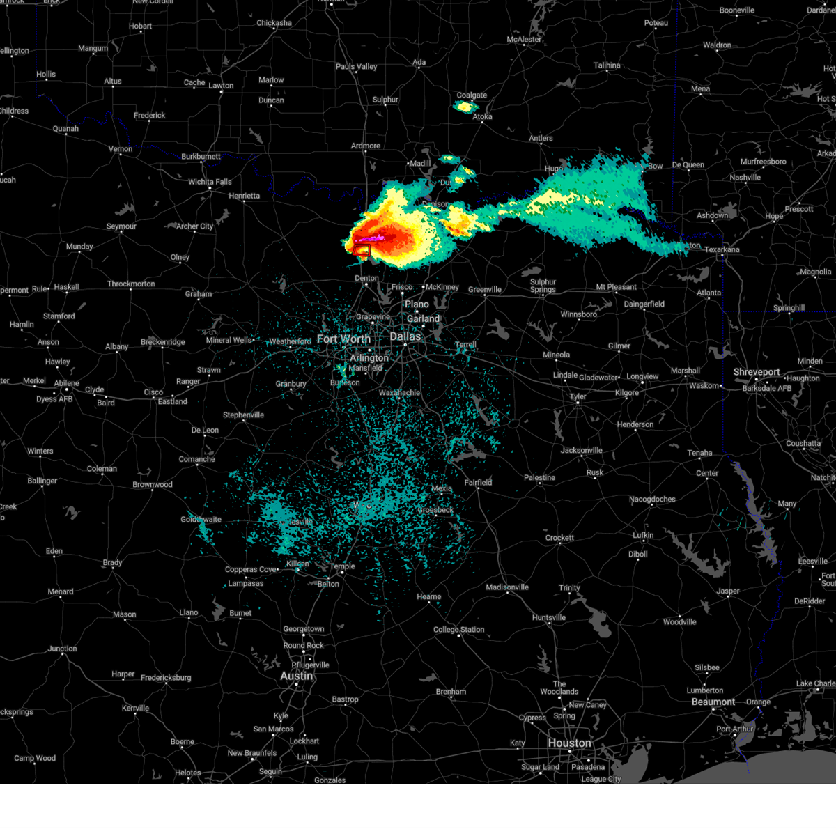 At 1048 pm cdt, a confirmed tornado was located near ray roberts park johnson branch, or near sanger, moving east at 35 mph. this is a particularly dangerous situation. take cover now! (radar confirmed tornado). Hazards include damaging tornado. You are in a life-threatening situation. flying debris may be deadly to those caught without shelter. mobile homes will be destroyed. considerable damage to homes, businesses, and vehicles is likely and complete destruction is possible. Locations impacted include, valley view, lois, and lake ray roberts. At 1048 pm cdt, a confirmed tornado was located near ray roberts park johnson branch, or near sanger, moving east at 35 mph. this is a particularly dangerous situation. take cover now! (radar confirmed tornado). Hazards include damaging tornado. You are in a life-threatening situation. flying debris may be deadly to those caught without shelter. mobile homes will be destroyed. considerable damage to homes, businesses, and vehicles is likely and complete destruction is possible. Locations impacted include, valley view, lois, and lake ray roberts.
|
| 5/25/2024 10:44 PM CDT |
 At 1044 pm cdt, a confirmed tornado was located near sanger, moving east at 30 mph. this is a particularly dangerous situation. take cover now! (radar confirmed tornado). Hazards include damaging tornado. You are in a life-threatening situation. flying debris may be deadly to those caught without shelter. mobile homes will be destroyed. considerable damage to homes, businesses, and vehicles is likely and complete destruction is possible. the tornado will be near, ray roberts park johnson branch around 1050 pm cdt. ray roberts park isle du bois around 1055 pm cdt. pilot point around 1100 pm cdt. Other locations impacted by this tornadic thunderstorm include lake ray roberts, tioga, bolivar, road runner, valley view, lois, lincoln park, providence village, and lewisville lake. At 1044 pm cdt, a confirmed tornado was located near sanger, moving east at 30 mph. this is a particularly dangerous situation. take cover now! (radar confirmed tornado). Hazards include damaging tornado. You are in a life-threatening situation. flying debris may be deadly to those caught without shelter. mobile homes will be destroyed. considerable damage to homes, businesses, and vehicles is likely and complete destruction is possible. the tornado will be near, ray roberts park johnson branch around 1050 pm cdt. ray roberts park isle du bois around 1055 pm cdt. pilot point around 1100 pm cdt. Other locations impacted by this tornadic thunderstorm include lake ray roberts, tioga, bolivar, road runner, valley view, lois, lincoln park, providence village, and lewisville lake.
|
| 5/25/2024 10:40 PM CDT | Tea Cup sized hail reported 4.8 miles W of Valley View, TX, delayed report 3 inch hail reported in mountain springs... east of valley view. |
| 5/25/2024 10:38 PM CDT |
 At 1038 pm cdt, a confirmed tornado was located near valley view, moving east at 40 mph (weather spotters confirmed tornado). Hazards include damaging tornado and golf ball size hail. Flying debris will be dangerous to those caught without shelter. mobile homes will be damaged or destroyed. damage to roofs, windows, and vehicles will occur. tree damage is likely. this tornado will be near, ray roberts park johnson branch around 1045 pm cdt. pilot point and ray roberts park isle du bois around 1050 pm cdt. Other locations impacted by this tornadic thunderstorm include lake ray roberts, tioga, bolivar, era, road runner, valley view, lois, lincoln park, providence village, and lewisville lake. At 1038 pm cdt, a confirmed tornado was located near valley view, moving east at 40 mph (weather spotters confirmed tornado). Hazards include damaging tornado and golf ball size hail. Flying debris will be dangerous to those caught without shelter. mobile homes will be damaged or destroyed. damage to roofs, windows, and vehicles will occur. tree damage is likely. this tornado will be near, ray roberts park johnson branch around 1045 pm cdt. pilot point and ray roberts park isle du bois around 1050 pm cdt. Other locations impacted by this tornadic thunderstorm include lake ray roberts, tioga, bolivar, era, road runner, valley view, lois, lincoln park, providence village, and lewisville lake.
|
| 5/25/2024 10:33 PM CDT |
 At 1033 pm cdt, a severe thunderstorm capable of producing a tornado was located 7 miles northwest of sanger, moving east at 40 mph. this will cross i 35 just south of valley view (radar indicated rotation). Hazards include tornado and golf ball size hail. Flying debris will be dangerous to those caught without shelter. mobile homes will be damaged or destroyed. damage to roofs, windows, and vehicles will occur. tree damage is likely. Locations impacted include, gainesville, lindsay, valley view, era, lois, hood, myra, and lake ray roberts. At 1033 pm cdt, a severe thunderstorm capable of producing a tornado was located 7 miles northwest of sanger, moving east at 40 mph. this will cross i 35 just south of valley view (radar indicated rotation). Hazards include tornado and golf ball size hail. Flying debris will be dangerous to those caught without shelter. mobile homes will be damaged or destroyed. damage to roofs, windows, and vehicles will occur. tree damage is likely. Locations impacted include, gainesville, lindsay, valley view, era, lois, hood, myra, and lake ray roberts.
|
| 5/25/2024 10:30 PM CDT |
 Torfwd the national weather service in fort worth has issued a * tornado warning for, northern denton county in north central texas, southeastern cooke county in north central texas, southwestern grayson county in north central texas, * until 1115 pm cdt. * at 1030 pm cdt, a severe thunderstorm capable of producing a tornado was located 9 miles northwest of sanger, moving east at 45 mph. this will cross i 35 just south of valley view (radar indicated rotation). Hazards include tornado and golf ball size hail. Flying debris will be dangerous to those caught without shelter. mobile homes will be damaged or destroyed. damage to roofs, windows, and vehicles will occur. tree damage is likely. this dangerous storm will be near, sanger around 1035 pm cdt. ray roberts park johnson branch around 1045 pm cdt. ray roberts park isle du bois around 1050 pm cdt. pilot point and aubrey around 1055 pm cdt. celina around 1100 pm cdt. other locations impacted by this tornadic thunderstorm include lake ray roberts, tioga, bolivar, era, road runner, valley view, lois, lincoln park, providence village, and lewisville lake. This includes interstate 35 between mile markers 473 and 487. Torfwd the national weather service in fort worth has issued a * tornado warning for, northern denton county in north central texas, southeastern cooke county in north central texas, southwestern grayson county in north central texas, * until 1115 pm cdt. * at 1030 pm cdt, a severe thunderstorm capable of producing a tornado was located 9 miles northwest of sanger, moving east at 45 mph. this will cross i 35 just south of valley view (radar indicated rotation). Hazards include tornado and golf ball size hail. Flying debris will be dangerous to those caught without shelter. mobile homes will be damaged or destroyed. damage to roofs, windows, and vehicles will occur. tree damage is likely. this dangerous storm will be near, sanger around 1035 pm cdt. ray roberts park johnson branch around 1045 pm cdt. ray roberts park isle du bois around 1050 pm cdt. pilot point and aubrey around 1055 pm cdt. celina around 1100 pm cdt. other locations impacted by this tornadic thunderstorm include lake ray roberts, tioga, bolivar, era, road runner, valley view, lois, lincoln park, providence village, and lewisville lake. This includes interstate 35 between mile markers 473 and 487.
|
| 5/25/2024 10:21 PM CDT |
 At 1020 pm cdt, a severe thunderstorm capable of producing a tornado was located 12 miles south of muenster, or 15 miles northwest of sanger, moving east at 25 mph. era and valley view are in the immediate path. a strong tornado could develop at any moment (radar indicated rotation). Hazards include tornado and golf ball size hail. Flying debris will be dangerous to those caught without shelter. mobile homes will be damaged or destroyed. damage to roofs, windows, and vehicles will occur. tree damage is likely. Locations impacted include, gainesville, muenster, lindsay, valley view, prairie point, leo, rosston, era, lois, hood, myra, and lake ray roberts. At 1020 pm cdt, a severe thunderstorm capable of producing a tornado was located 12 miles south of muenster, or 15 miles northwest of sanger, moving east at 25 mph. era and valley view are in the immediate path. a strong tornado could develop at any moment (radar indicated rotation). Hazards include tornado and golf ball size hail. Flying debris will be dangerous to those caught without shelter. mobile homes will be damaged or destroyed. damage to roofs, windows, and vehicles will occur. tree damage is likely. Locations impacted include, gainesville, muenster, lindsay, valley view, prairie point, leo, rosston, era, lois, hood, myra, and lake ray roberts.
|
| 5/25/2024 10:18 PM CDT |
 the severe thunderstorm warning has been cancelled and is no longer in effect the severe thunderstorm warning has been cancelled and is no longer in effect
|
| 5/25/2024 10:18 PM CDT |
 At 1017 pm cdt, a severe thunderstorm was located near muenster, or 13 miles west of gainesville, moving east at 35 mph (radar indicated). Hazards include golf ball size hail and 60 mph wind gusts. People and animals outdoors will be injured. expect hail damage to roofs, siding, windows, and vehicles. expect wind damage to roofs, siding, and trees. this severe storm will be near, gainesville and lindsay around 1030 pm cdt. lake kiowa around 1045 pm cdt. collinsville around 1055 pm cdt. Other locations impacted by this severe thunderstorm include tioga, rosston, valley view, bulcher, sadler, lake ray roberts, dexter, sandusky, sherwood shores, and hood. At 1017 pm cdt, a severe thunderstorm was located near muenster, or 13 miles west of gainesville, moving east at 35 mph (radar indicated). Hazards include golf ball size hail and 60 mph wind gusts. People and animals outdoors will be injured. expect hail damage to roofs, siding, windows, and vehicles. expect wind damage to roofs, siding, and trees. this severe storm will be near, gainesville and lindsay around 1030 pm cdt. lake kiowa around 1045 pm cdt. collinsville around 1055 pm cdt. Other locations impacted by this severe thunderstorm include tioga, rosston, valley view, bulcher, sadler, lake ray roberts, dexter, sandusky, sherwood shores, and hood.
|
| 5/25/2024 9:56 PM CDT |
 Torfwd the national weather service in fort worth has issued a * tornado warning for, southwestern cooke county in north central texas, * until 1100 pm cdt. * at 956 pm cdt, a severe thunderstorm capable of producing a tornado was located 11 miles east of sunset, or 15 miles east of bowie, moving east at 35 mph (radar indicated rotation). Hazards include tornado and golf ball size hail. Flying debris will be dangerous to those caught without shelter. mobile homes will be damaged or destroyed. damage to roofs, windows, and vehicles will occur. tree damage is likely. this tornadic thunderstorm will remain over mainly rural areas of southwestern cooke county, including the following locations, prairie point, rosston, era, valley view, leo, lois, hood, myra, and lake ray roberts. This includes interstate 35 between mile markers 482 and 502. Torfwd the national weather service in fort worth has issued a * tornado warning for, southwestern cooke county in north central texas, * until 1100 pm cdt. * at 956 pm cdt, a severe thunderstorm capable of producing a tornado was located 11 miles east of sunset, or 15 miles east of bowie, moving east at 35 mph (radar indicated rotation). Hazards include tornado and golf ball size hail. Flying debris will be dangerous to those caught without shelter. mobile homes will be damaged or destroyed. damage to roofs, windows, and vehicles will occur. tree damage is likely. this tornadic thunderstorm will remain over mainly rural areas of southwestern cooke county, including the following locations, prairie point, rosston, era, valley view, leo, lois, hood, myra, and lake ray roberts. This includes interstate 35 between mile markers 482 and 502.
|
| 5/25/2024 9:54 PM CDT |
 the severe thunderstorm warning has been cancelled and is no longer in effect the severe thunderstorm warning has been cancelled and is no longer in effect
|
| 5/25/2024 9:54 PM CDT |
 At 954 pm cdt, a severe thunderstorm was located near st. jo, or 15 miles southeast of nocona, moving east at 35 mph (radar indicated). Hazards include golf ball size hail and 60 mph wind gusts. People and animals outdoors will be injured. expect hail damage to roofs, siding, windows, and vehicles. expect wind damage to roofs, siding, and trees. this severe storm will be near, muenster and lake muenster around 1000 pm cdt. lindsay around 1015 pm cdt. gainesville around 1020 pm cdt. callisburg around 1035 pm cdt. whitesboro around 1050 pm cdt. Other locations impacted by this severe thunderstorm include tioga, rosston, valley view, bulcher, sadler, capps corner, lake ray roberts, dexter, sandusky, and sherwood shores. At 954 pm cdt, a severe thunderstorm was located near st. jo, or 15 miles southeast of nocona, moving east at 35 mph (radar indicated). Hazards include golf ball size hail and 60 mph wind gusts. People and animals outdoors will be injured. expect hail damage to roofs, siding, windows, and vehicles. expect wind damage to roofs, siding, and trees. this severe storm will be near, muenster and lake muenster around 1000 pm cdt. lindsay around 1015 pm cdt. gainesville around 1020 pm cdt. callisburg around 1035 pm cdt. whitesboro around 1050 pm cdt. Other locations impacted by this severe thunderstorm include tioga, rosston, valley view, bulcher, sadler, capps corner, lake ray roberts, dexter, sandusky, and sherwood shores.
|
| 5/25/2024 9:38 PM CDT |
 Svrfwd the national weather service in fort worth has issued a * severe thunderstorm warning for, montague county in north central texas, northern wise county in north central texas, northern denton county in north central texas, cooke county in north central texas, western grayson county in north central texas, * until 1045 pm cdt. * at 938 pm cdt, a severe thunderstorm was located 9 miles east of bowie, moving east at 35 mph (radar indicated). Hazards include golf ball size hail and 60 mph wind gusts. People and animals outdoors will be injured. expect hail damage to roofs, siding, windows, and vehicles. expect wind damage to roofs, siding, and trees. this severe thunderstorm will be near, st. jo around 950 pm cdt. muenster and lake muenster around 1000 pm cdt. lindsay around 1015 pm cdt. gainesville around 1020 pm cdt. callisburg around 1035 pm cdt. other locations impacted by this severe thunderstorm include tioga, rosston, valley view, bulcher, sadler, park springs, capps corner, lake ray roberts, dexter, and sandusky. This includes interstate 35 between mile markers 478 and 503. Svrfwd the national weather service in fort worth has issued a * severe thunderstorm warning for, montague county in north central texas, northern wise county in north central texas, northern denton county in north central texas, cooke county in north central texas, western grayson county in north central texas, * until 1045 pm cdt. * at 938 pm cdt, a severe thunderstorm was located 9 miles east of bowie, moving east at 35 mph (radar indicated). Hazards include golf ball size hail and 60 mph wind gusts. People and animals outdoors will be injured. expect hail damage to roofs, siding, windows, and vehicles. expect wind damage to roofs, siding, and trees. this severe thunderstorm will be near, st. jo around 950 pm cdt. muenster and lake muenster around 1000 pm cdt. lindsay around 1015 pm cdt. gainesville around 1020 pm cdt. callisburg around 1035 pm cdt. other locations impacted by this severe thunderstorm include tioga, rosston, valley view, bulcher, sadler, park springs, capps corner, lake ray roberts, dexter, and sandusky. This includes interstate 35 between mile markers 478 and 503.
|
| 5/23/2024 10:02 PM CDT |
 Svrfwd the national weather service in fort worth has issued a * severe thunderstorm warning for, eastern cooke county in north central texas, western grayson county in north central texas, * until 1100 pm cdt. * at 1002 pm cdt, a severe thunderstorm was located near ray roberts park johnson branch, or 12 miles northeast of sanger, moving northeast at 35 mph (radar indicated). Hazards include half dollar size hail. Damage to vehicles is possible. this severe thunderstorm will be near, lake kiowa around 1005 pm cdt. collinsville around 1010 pm cdt. whitesboro around 1020 pm cdt. lake texoma around 1030 pm cdt. southern lake texoma around 1035 pm cdt. pottsboro around 1045 pm cdt. Other locations impacted by this severe thunderstorm include dixie, ethel, preston, tioga, southmayd, road runner, sturgeon, sadler, locust, and lake ray roberts. Svrfwd the national weather service in fort worth has issued a * severe thunderstorm warning for, eastern cooke county in north central texas, western grayson county in north central texas, * until 1100 pm cdt. * at 1002 pm cdt, a severe thunderstorm was located near ray roberts park johnson branch, or 12 miles northeast of sanger, moving northeast at 35 mph (radar indicated). Hazards include half dollar size hail. Damage to vehicles is possible. this severe thunderstorm will be near, lake kiowa around 1005 pm cdt. collinsville around 1010 pm cdt. whitesboro around 1020 pm cdt. lake texoma around 1030 pm cdt. southern lake texoma around 1035 pm cdt. pottsboro around 1045 pm cdt. Other locations impacted by this severe thunderstorm include dixie, ethel, preston, tioga, southmayd, road runner, sturgeon, sadler, locust, and lake ray roberts.
|
| 5/22/2024 1:17 PM CDT |
 At 115 pm cdt, severe thunderstorms were located along a line extending from near sanger to bartonville, moving northeast at 40 mph (trained weather spotters). Hazards include 60 mph wind gusts and quarter size hail. Hail damage to vehicles is expected. expect wind damage to roofs, siding, and trees. these severe storms will be near, denton, lewisville, flower mound, corinth, highland village, lake dallas, pilot point, hickory creek, shady shores, and aubrey around 120 pm cdt. the colony, lake lewisville, and little elm around 125 pm cdt. frisco, prosper, celina, and hackberry around 130 pm cdt. mckinney around 145 pm cdt. Other locations impacted by these severe thunderstorms include road runner, valley view, oak point, lois, providence village, ponder, stony, lake ray roberts, lewisville lake, and bolivar. At 115 pm cdt, severe thunderstorms were located along a line extending from near sanger to bartonville, moving northeast at 40 mph (trained weather spotters). Hazards include 60 mph wind gusts and quarter size hail. Hail damage to vehicles is expected. expect wind damage to roofs, siding, and trees. these severe storms will be near, denton, lewisville, flower mound, corinth, highland village, lake dallas, pilot point, hickory creek, shady shores, and aubrey around 120 pm cdt. the colony, lake lewisville, and little elm around 125 pm cdt. frisco, prosper, celina, and hackberry around 130 pm cdt. mckinney around 145 pm cdt. Other locations impacted by these severe thunderstorms include road runner, valley view, oak point, lois, providence village, ponder, stony, lake ray roberts, lewisville lake, and bolivar.
|
| 5/22/2024 1:17 PM CDT |
 the severe thunderstorm warning has been cancelled and is no longer in effect the severe thunderstorm warning has been cancelled and is no longer in effect
|
| 5/22/2024 1:02 PM CDT |
 Svrfwd the national weather service in fort worth has issued a * severe thunderstorm warning for, denton county in north central texas, northeastern tarrant county in north central texas, southwestern collin county in north central texas, south central cooke county in north central texas, * until 200 pm cdt. * at 101 pm cdt, severe thunderstorms were located along a line extending from krum to near northlake, moving northeast at 35 mph (radar indicated). Hazards include 60 mph wind gusts and quarter size hail. Hail damage to vehicles is expected. expect wind damage to roofs, siding, and trees. severe thunderstorms will be near, denton, flower mound, sanger, krum, argyle, double oak, northlake, bartonville, copper canyon, and corral city around 105 pm cdt. corinth, highland village, and hickory creek around 110 pm cdt. lake dallas, shady shores, and ray roberts park johnson branch around 115 pm cdt. aubrey, krugerville, cross roads, and ray roberts park isle du bois around 120 pm cdt. little elm and pilot point around 125 pm cdt. frisco, prosper, and celina around 135 pm cdt. other locations impacted by these severe thunderstorms include road runner, valley view, oak point, lois, providence village, westlake, ponder, stony, lake ray roberts, and lewisville lake. this includes the following highways, interstate 35 between mile markers 468 and 487. interstate 35w between mile markers 62 and 85. Interstate 35e between mile markers 446 and 466. Svrfwd the national weather service in fort worth has issued a * severe thunderstorm warning for, denton county in north central texas, northeastern tarrant county in north central texas, southwestern collin county in north central texas, south central cooke county in north central texas, * until 200 pm cdt. * at 101 pm cdt, severe thunderstorms were located along a line extending from krum to near northlake, moving northeast at 35 mph (radar indicated). Hazards include 60 mph wind gusts and quarter size hail. Hail damage to vehicles is expected. expect wind damage to roofs, siding, and trees. severe thunderstorms will be near, denton, flower mound, sanger, krum, argyle, double oak, northlake, bartonville, copper canyon, and corral city around 105 pm cdt. corinth, highland village, and hickory creek around 110 pm cdt. lake dallas, shady shores, and ray roberts park johnson branch around 115 pm cdt. aubrey, krugerville, cross roads, and ray roberts park isle du bois around 120 pm cdt. little elm and pilot point around 125 pm cdt. frisco, prosper, and celina around 135 pm cdt. other locations impacted by these severe thunderstorms include road runner, valley view, oak point, lois, providence village, westlake, ponder, stony, lake ray roberts, and lewisville lake. this includes the following highways, interstate 35 between mile markers 468 and 487. interstate 35w between mile markers 62 and 85. Interstate 35e between mile markers 446 and 466.
|
| 5/22/2024 11:59 AM CDT |
 Svrfwd the national weather service in fort worth has issued a * severe thunderstorm warning for, denton county in north central texas, northwestern collin county in north central texas, southeastern cooke county in north central texas, southwestern grayson county in north central texas, * until 100 pm cdt. * at 1158 am cdt, a severe thunderstorm was located over sanger, moving east at 40 mph (radar indicated). Hazards include 60 mph wind gusts and quarter size hail. Hail damage to vehicles is expected. expect wind damage to roofs, siding, and trees. this severe thunderstorm will be near, sanger and ray roberts park johnson branch around 1205 pm cdt. ray roberts park isle du bois around 1210 pm cdt. pilot point and aubrey around 1215 pm cdt. celina around 1230 pm cdt. gunter around 1235 pm cdt. van alstyne, howe, and dorchester around 1245 pm cdt. other locations impacted by this severe thunderstorm include ethel, tioga, road runner, oak point, lois, elmont, providence village, ponder, stony, and lake ray roberts. this includes the following highways, interstate 35 between mile markers 468 and 485. interstate 35w between mile markers 79 and 85. Interstate 35e between mile markers 457 and 466. Svrfwd the national weather service in fort worth has issued a * severe thunderstorm warning for, denton county in north central texas, northwestern collin county in north central texas, southeastern cooke county in north central texas, southwestern grayson county in north central texas, * until 100 pm cdt. * at 1158 am cdt, a severe thunderstorm was located over sanger, moving east at 40 mph (radar indicated). Hazards include 60 mph wind gusts and quarter size hail. Hail damage to vehicles is expected. expect wind damage to roofs, siding, and trees. this severe thunderstorm will be near, sanger and ray roberts park johnson branch around 1205 pm cdt. ray roberts park isle du bois around 1210 pm cdt. pilot point and aubrey around 1215 pm cdt. celina around 1230 pm cdt. gunter around 1235 pm cdt. van alstyne, howe, and dorchester around 1245 pm cdt. other locations impacted by this severe thunderstorm include ethel, tioga, road runner, oak point, lois, elmont, providence village, ponder, stony, and lake ray roberts. this includes the following highways, interstate 35 between mile markers 468 and 485. interstate 35w between mile markers 79 and 85. Interstate 35e between mile markers 457 and 466.
|
| 5/9/2024 5:08 PM CDT |
 At 508 pm cdt, a severe thunderstorm was located near dorchester, or 9 miles west of sherman, moving east at 40 mph (radar indicated). Hazards include half dollar size hail. Damage to vehicles is possible. this severe storm will be near, sherman, howe, and dorchester around 515 pm cdt. bells and tom bean around 530 pm cdt. savoy and valley lake around 535 pm cdt. Other locations impacted by this severe thunderstorm include dixie, ethel, boddie, preston, southmayd, ida, carpenters bluff, sturgeon, ambrose, and sadler. At 508 pm cdt, a severe thunderstorm was located near dorchester, or 9 miles west of sherman, moving east at 40 mph (radar indicated). Hazards include half dollar size hail. Damage to vehicles is possible. this severe storm will be near, sherman, howe, and dorchester around 515 pm cdt. bells and tom bean around 530 pm cdt. savoy and valley lake around 535 pm cdt. Other locations impacted by this severe thunderstorm include dixie, ethel, boddie, preston, southmayd, ida, carpenters bluff, sturgeon, ambrose, and sadler.
|
| 5/9/2024 4:42 PM CDT |
 Svrfwd the national weather service in fort worth has issued a * severe thunderstorm warning for, southeastern cooke county in north central texas, grayson county in north central texas, * until 545 pm cdt. * at 442 pm cdt, a severe thunderstorm was located near lake kiowa, or near gainesville, moving east at 45 mph (radar indicated). Hazards include half dollar size hail. Damage to vehicles is possible. this severe thunderstorm will be near, lake kiowa around 445 pm cdt. whitesboro and collinsville around 450 pm cdt. sherman and dorchester around 505 pm cdt. knollwood around 515 pm cdt. bells around 525 pm cdt. valley lake around 530 pm cdt. savoy around 535 pm cdt. Other locations impacted by this severe thunderstorm include dixie, ethel, boddie, preston, southmayd, ida, carpenters bluff, sturgeon, ambrose, and sadler. Svrfwd the national weather service in fort worth has issued a * severe thunderstorm warning for, southeastern cooke county in north central texas, grayson county in north central texas, * until 545 pm cdt. * at 442 pm cdt, a severe thunderstorm was located near lake kiowa, or near gainesville, moving east at 45 mph (radar indicated). Hazards include half dollar size hail. Damage to vehicles is possible. this severe thunderstorm will be near, lake kiowa around 445 pm cdt. whitesboro and collinsville around 450 pm cdt. sherman and dorchester around 505 pm cdt. knollwood around 515 pm cdt. bells around 525 pm cdt. valley lake around 530 pm cdt. savoy around 535 pm cdt. Other locations impacted by this severe thunderstorm include dixie, ethel, boddie, preston, southmayd, ida, carpenters bluff, sturgeon, ambrose, and sadler.
|
| 5/9/2024 2:56 PM CDT |
 Svrfwd the national weather service in fort worth has issued a * severe thunderstorm warning for, southeastern montague county in north central texas, cooke county in north central texas, * until 400 pm cdt. * at 255 pm cdt, a severe thunderstorm was located 9 miles south of st. jo, or 16 miles east of bowie, moving northeast at 30 mph (radar indicated). Hazards include quarter size hail. Damage to vehicles is possible. this severe thunderstorm will be near, muenster and lake muenster around 310 pm cdt. hubert h moss lake around 335 pm cdt. other locations impacted by this severe thunderstorm include prairie point, rosston, bulcher, capps corner, montague, forestburg, marysville, sivells bend, walnut bend, and era. This includes interstate 35 between mile markers 491 and 503. Svrfwd the national weather service in fort worth has issued a * severe thunderstorm warning for, southeastern montague county in north central texas, cooke county in north central texas, * until 400 pm cdt. * at 255 pm cdt, a severe thunderstorm was located 9 miles south of st. jo, or 16 miles east of bowie, moving northeast at 30 mph (radar indicated). Hazards include quarter size hail. Damage to vehicles is possible. this severe thunderstorm will be near, muenster and lake muenster around 310 pm cdt. hubert h moss lake around 335 pm cdt. other locations impacted by this severe thunderstorm include prairie point, rosston, bulcher, capps corner, montague, forestburg, marysville, sivells bend, walnut bend, and era. This includes interstate 35 between mile markers 491 and 503.
|
| 5/9/2024 2:30 PM CDT |
 At 229 pm cdt, a severe thunderstorm was located over ray roberts park johnson branch, or near sanger, moving east at 35 mph (radar indicated). Hazards include golf ball size hail and 60 mph wind gusts. People and animals outdoors will be injured. expect hail damage to roofs, siding, windows, and vehicles. expect wind damage to roofs, siding, and trees. this severe storm will be near, pilot point, ray roberts park isle du bois, and ray roberts park johnson branch around 235 pm cdt. Other locations impacted by this severe thunderstorm include woodbine, lake ray roberts, burns, road runner, and valley view. At 229 pm cdt, a severe thunderstorm was located over ray roberts park johnson branch, or near sanger, moving east at 35 mph (radar indicated). Hazards include golf ball size hail and 60 mph wind gusts. People and animals outdoors will be injured. expect hail damage to roofs, siding, windows, and vehicles. expect wind damage to roofs, siding, and trees. this severe storm will be near, pilot point, ray roberts park isle du bois, and ray roberts park johnson branch around 235 pm cdt. Other locations impacted by this severe thunderstorm include woodbine, lake ray roberts, burns, road runner, and valley view.
|
| 5/9/2024 2:12 PM CDT |
 the severe thunderstorm warning has been cancelled and is no longer in effect the severe thunderstorm warning has been cancelled and is no longer in effect
|
| 5/9/2024 2:12 PM CDT |
 At 210 pm cdt, a severe thunderstorm was located near valley view, moving east at 30 mph (public). Hazards include golf ball size hail and 60 mph wind gusts. People and animals outdoors will be injured. expect damage to roofs, siding, windows, and vehicles. this severe storm will be near, sanger around 215 pm cdt. ray roberts park johnson branch around 230 pm cdt. lake kiowa around 240 pm cdt. other locations impacted by this severe thunderstorm include lake ray roberts, bolivar, era, road runner, valley view, woodbine, lois, burns, hood, and slidell. This includes interstate 35 between mile markers 475 and 499. At 210 pm cdt, a severe thunderstorm was located near valley view, moving east at 30 mph (public). Hazards include golf ball size hail and 60 mph wind gusts. People and animals outdoors will be injured. expect damage to roofs, siding, windows, and vehicles. this severe storm will be near, sanger around 215 pm cdt. ray roberts park johnson branch around 230 pm cdt. lake kiowa around 240 pm cdt. other locations impacted by this severe thunderstorm include lake ray roberts, bolivar, era, road runner, valley view, woodbine, lois, burns, hood, and slidell. This includes interstate 35 between mile markers 475 and 499.
|
| 5/9/2024 1:41 PM CDT |
 Svrfwd the national weather service in fort worth has issued a * severe thunderstorm warning for, southeastern montague county in north central texas, northeastern wise county in north central texas, northern denton county in north central texas, southern cooke county in north central texas, * until 245 pm cdt. * at 140 pm cdt, a severe thunderstorm was located 8 miles east of alvord, or 10 miles north of decatur, moving east at 35 mph (public). Hazards include golf ball size hail and 60 mph wind gusts. People and animals outdoors will be injured. expect hail damage to roofs, siding, windows, and vehicles. expect wind damage to roofs, siding, and trees. this severe thunderstorm will be near, lake kiowa around 230 pm cdt. other locations impacted by this severe thunderstorm include prairie point, rosston, greenwood, road runner, valley view, lois, lake ray roberts, bolivar, era, and slidell. This includes interstate 35 between mile markers 475 and 499. Svrfwd the national weather service in fort worth has issued a * severe thunderstorm warning for, southeastern montague county in north central texas, northeastern wise county in north central texas, northern denton county in north central texas, southern cooke county in north central texas, * until 245 pm cdt. * at 140 pm cdt, a severe thunderstorm was located 8 miles east of alvord, or 10 miles north of decatur, moving east at 35 mph (public). Hazards include golf ball size hail and 60 mph wind gusts. People and animals outdoors will be injured. expect hail damage to roofs, siding, windows, and vehicles. expect wind damage to roofs, siding, and trees. this severe thunderstorm will be near, lake kiowa around 230 pm cdt. other locations impacted by this severe thunderstorm include prairie point, rosston, greenwood, road runner, valley view, lois, lake ray roberts, bolivar, era, and slidell. This includes interstate 35 between mile markers 475 and 499.
|
| 4/20/2024 5:57 AM CDT |
 Svrfwd the national weather service in fort worth has issued a * severe thunderstorm warning for, northeastern denton county in north central texas, northwestern collin county in north central texas, southeastern cooke county in north central texas, southwestern grayson county in north central texas, * until 700 am cdt. * at 557 am cdt, a severe thunderstorm was located near sanger, moving east at 30 mph (radar indicated). Hazards include quarter size hail. Damage to vehicles is possible. this severe thunderstorm will be near, ray roberts park isle du bois and ray roberts park johnson branch around 600 am cdt. pilot point around 610 am cdt. gunter around 635 am cdt. dorchester around 645 am cdt. sherman around 650 am cdt. howe around 655 am cdt. other locations impacted by this severe thunderstorm include lake ray roberts, ethel, weston, tioga, southmayd, road runner, valley view, lois, farmington, and burns. This includes interstate 35 between mile markers 473 and 487. Svrfwd the national weather service in fort worth has issued a * severe thunderstorm warning for, northeastern denton county in north central texas, northwestern collin county in north central texas, southeastern cooke county in north central texas, southwestern grayson county in north central texas, * until 700 am cdt. * at 557 am cdt, a severe thunderstorm was located near sanger, moving east at 30 mph (radar indicated). Hazards include quarter size hail. Damage to vehicles is possible. this severe thunderstorm will be near, ray roberts park isle du bois and ray roberts park johnson branch around 600 am cdt. pilot point around 610 am cdt. gunter around 635 am cdt. dorchester around 645 am cdt. sherman around 650 am cdt. howe around 655 am cdt. other locations impacted by this severe thunderstorm include lake ray roberts, ethel, weston, tioga, southmayd, road runner, valley view, lois, farmington, and burns. This includes interstate 35 between mile markers 473 and 487.
|
| 4/9/2024 1:01 AM CDT |
 the severe thunderstorm warning has been cancelled and is no longer in effect the severe thunderstorm warning has been cancelled and is no longer in effect
|
| 4/9/2024 12:45 AM CDT |
 Svrfwd the national weather service in fort worth has issued a * severe thunderstorm warning for, southeastern montague county in north central texas, eastern wise county in north central texas, western denton county in north central texas, southwestern cooke county in north central texas, * until 130 am cdt. * at 1245 am cdt, severe thunderstorms were located along a line extending from near st. jo to 10 miles east of alvord to near boyd, moving east at 30 mph (radar indicated). Hazards include 60 mph wind gusts and quarter size hail. Hail damage to vehicles is expected. Expect wind damage to roofs, siding, and trees. Svrfwd the national weather service in fort worth has issued a * severe thunderstorm warning for, southeastern montague county in north central texas, eastern wise county in north central texas, western denton county in north central texas, southwestern cooke county in north central texas, * until 130 am cdt. * at 1245 am cdt, severe thunderstorms were located along a line extending from near st. jo to 10 miles east of alvord to near boyd, moving east at 30 mph (radar indicated). Hazards include 60 mph wind gusts and quarter size hail. Hail damage to vehicles is expected. Expect wind damage to roofs, siding, and trees.
|
| 4/9/2024 12:21 AM CDT |
 At 1220 am cdt, a cluster of severe thunderstorms was located from near sanger to argyle, moving northeast at 40 mph (radar indicated). Hazards include 60 mph wind gusts and quarter size hail. Hail damage to vehicles is expected. expect wind damage to roofs, siding, and trees. Locations impacted include, frisco, denton, flower mound, the colony, corinth, highland village, lake dallas, sanger, lake lewisville, little elm, prosper, celina, krum, pilot point, argyle, hickory creek, justin, shady shores, aubrey, and northlake. At 1220 am cdt, a cluster of severe thunderstorms was located from near sanger to argyle, moving northeast at 40 mph (radar indicated). Hazards include 60 mph wind gusts and quarter size hail. Hail damage to vehicles is expected. expect wind damage to roofs, siding, and trees. Locations impacted include, frisco, denton, flower mound, the colony, corinth, highland village, lake dallas, sanger, lake lewisville, little elm, prosper, celina, krum, pilot point, argyle, hickory creek, justin, shady shores, aubrey, and northlake.
|
| 4/9/2024 12:02 AM CDT |
 At 1201 am cdt, a severe thunderstorm was located near krum, or 8 miles west of denton, moving northeast at 35 mph (radar indicated). Hazards include ping pong ball size hail and 60 mph wind gusts. People and animals outdoors will be injured. expect hail damage to roofs, siding, windows, and vehicles. expect wind damage to roofs, siding, and trees. Locations impacted include, frisco, denton, flower mound, the colony, corinth, highland village, lake dallas, sanger, lake lewisville, little elm, prosper, celina, krum, pilot point, argyle, hickory creek, justin, shady shores, aubrey, and northlake. At 1201 am cdt, a severe thunderstorm was located near krum, or 8 miles west of denton, moving northeast at 35 mph (radar indicated). Hazards include ping pong ball size hail and 60 mph wind gusts. People and animals outdoors will be injured. expect hail damage to roofs, siding, windows, and vehicles. expect wind damage to roofs, siding, and trees. Locations impacted include, frisco, denton, flower mound, the colony, corinth, highland village, lake dallas, sanger, lake lewisville, little elm, prosper, celina, krum, pilot point, argyle, hickory creek, justin, shady shores, aubrey, and northlake.
|
| 4/9/2024 12:02 AM CDT |
 the severe thunderstorm warning has been cancelled and is no longer in effect the severe thunderstorm warning has been cancelled and is no longer in effect
|
| 4/8/2024 11:50 PM CDT |
 Svrfwd the national weather service in fort worth has issued a * severe thunderstorm warning for, southeastern wise county in north central texas, denton county in north central texas, southeastern cooke county in north central texas, * until 1245 am cdt. * at 1150 pm cdt, a severe thunderstorm was located near justin, or 12 miles west of denton, moving northeast at 40 mph (radar indicated). Hazards include golf ball size hail and 60 mph wind gusts. People and animals outdoors will be injured. expect hail damage to roofs, siding, windows, and vehicles. Expect wind damage to roofs, siding, and trees. Svrfwd the national weather service in fort worth has issued a * severe thunderstorm warning for, southeastern wise county in north central texas, denton county in north central texas, southeastern cooke county in north central texas, * until 1245 am cdt. * at 1150 pm cdt, a severe thunderstorm was located near justin, or 12 miles west of denton, moving northeast at 40 mph (radar indicated). Hazards include golf ball size hail and 60 mph wind gusts. People and animals outdoors will be injured. expect hail damage to roofs, siding, windows, and vehicles. Expect wind damage to roofs, siding, and trees.
|
| 4/8/2024 10:32 PM CDT |
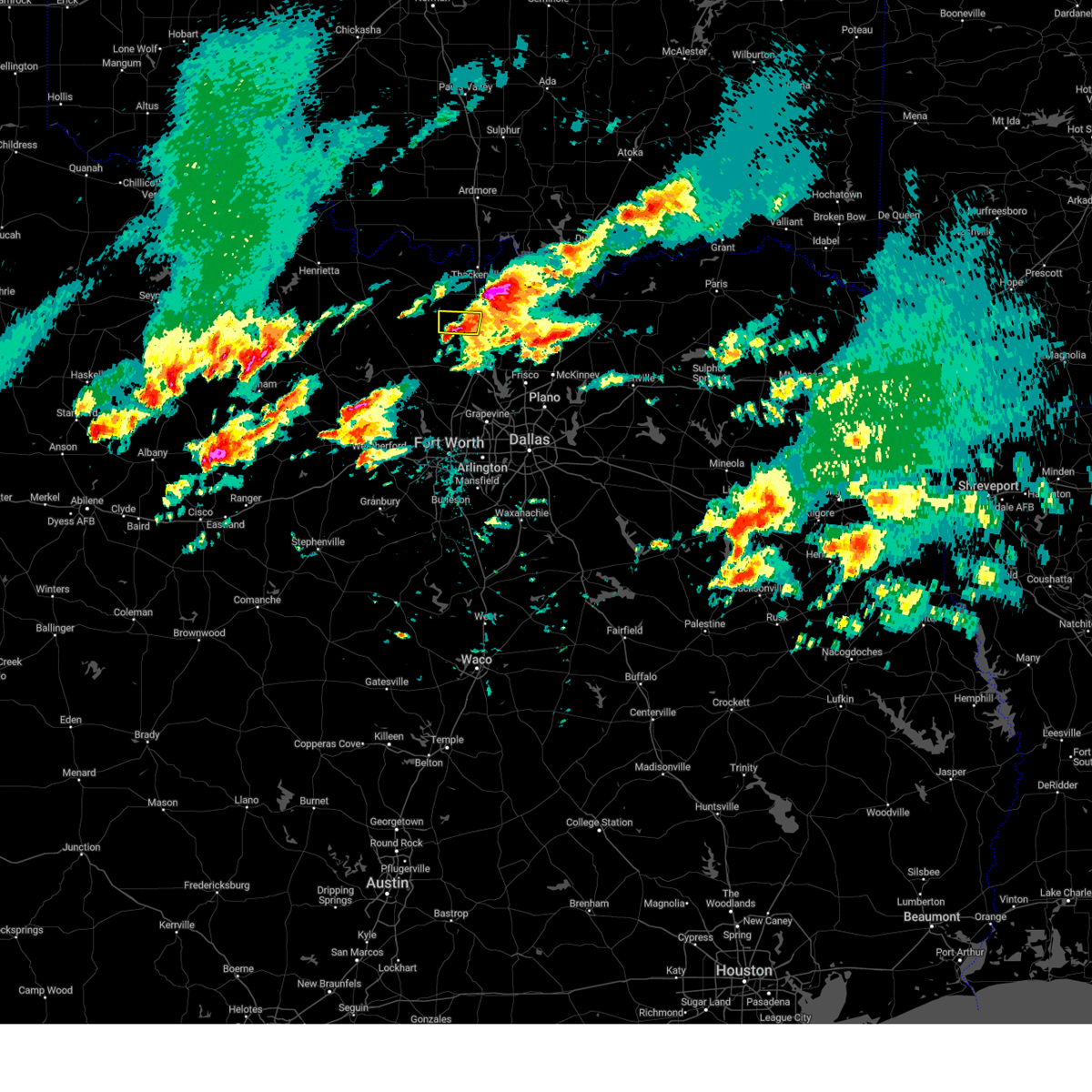 the severe thunderstorm warning has been cancelled and is no longer in effect the severe thunderstorm warning has been cancelled and is no longer in effect
|
| 4/8/2024 10:32 PM CDT |
 At 1032 pm cdt, a severe thunderstorm was located 10 miles northwest of sanger, moving north at 30 mph (radar indicated). Hazards include 60 mph wind gusts and half dollar size hail. Hail damage to vehicles is expected. expect wind damage to roofs, siding, and trees. Locations impacted include, valley view, leo, lois, era, and hood. At 1032 pm cdt, a severe thunderstorm was located 10 miles northwest of sanger, moving north at 30 mph (radar indicated). Hazards include 60 mph wind gusts and half dollar size hail. Hail damage to vehicles is expected. expect wind damage to roofs, siding, and trees. Locations impacted include, valley view, leo, lois, era, and hood.
|
| 4/8/2024 10:23 PM CDT |
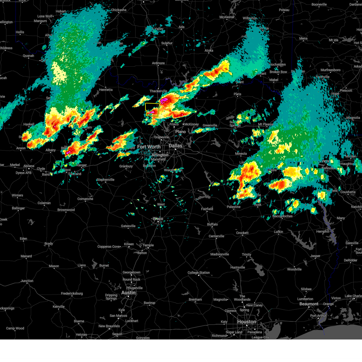 At 1023 pm cdt, a severe thunderstorm was located near sanger, moving north at 35 mph (radar indicated). Hazards include 60 mph wind gusts and half dollar size hail. Hail damage to vehicles is expected. expect wind damage to roofs, siding, and trees. Locations impacted include, sanger, valley view, leo, bolivar, era, lois, and hood. At 1023 pm cdt, a severe thunderstorm was located near sanger, moving north at 35 mph (radar indicated). Hazards include 60 mph wind gusts and half dollar size hail. Hail damage to vehicles is expected. expect wind damage to roofs, siding, and trees. Locations impacted include, sanger, valley view, leo, bolivar, era, lois, and hood.
|
| 4/8/2024 10:14 PM CDT |
 Svrfwd the national weather service in fort worth has issued a * severe thunderstorm warning for, northwestern denton county in north central texas, southwestern cooke county in north central texas, * until 1045 pm cdt. * at 1014 pm cdt, a severe thunderstorm was located near krum, or near sanger, moving north at 30 mph (radar indicated). Hazards include 60 mph wind gusts and half dollar size hail. Hail damage to vehicles is expected. Expect wind damage to roofs, siding, and trees. Svrfwd the national weather service in fort worth has issued a * severe thunderstorm warning for, northwestern denton county in north central texas, southwestern cooke county in north central texas, * until 1045 pm cdt. * at 1014 pm cdt, a severe thunderstorm was located near krum, or near sanger, moving north at 30 mph (radar indicated). Hazards include 60 mph wind gusts and half dollar size hail. Hail damage to vehicles is expected. Expect wind damage to roofs, siding, and trees.
|
| 4/8/2024 10:13 PM CDT |
 the severe thunderstorm warning has been cancelled and is no longer in effect the severe thunderstorm warning has been cancelled and is no longer in effect
|
| 4/8/2024 10:13 PM CDT |
 At 1012 pm cdt, a severe thunderstorm was located near lake kiowa, or 9 miles southeast of gainesville, moving north at 35 mph (radar indicated). Hazards include two inch hail and 60 mph wind gusts. People and animals outdoors will be injured. expect hail damage to roofs, siding, windows, and vehicles. expect wind damage to roofs, siding, and trees. Locations impacted include, gainesville, whitesboro, collinsville, lindsay, lake kiowa, ray roberts park johnson branch, tioga, road runner, valley view, sadler, woodbine, burns, and lake ray roberts. At 1012 pm cdt, a severe thunderstorm was located near lake kiowa, or 9 miles southeast of gainesville, moving north at 35 mph (radar indicated). Hazards include two inch hail and 60 mph wind gusts. People and animals outdoors will be injured. expect hail damage to roofs, siding, windows, and vehicles. expect wind damage to roofs, siding, and trees. Locations impacted include, gainesville, whitesboro, collinsville, lindsay, lake kiowa, ray roberts park johnson branch, tioga, road runner, valley view, sadler, woodbine, burns, and lake ray roberts.
|
| 4/8/2024 10:04 PM CDT |
 At 1003 pm cdt, a severe thunderstorm was located over ray roberts park johnson branch, or 8 miles northeast of sanger, moving north at 35 mph (radar indicated). Hazards include golf ball size hail and 60 mph wind gusts. People and animals outdoors will be injured. expect hail damage to roofs, siding, windows, and vehicles. expect wind damage to roofs, siding, and trees. Locations impacted include, gainesville, sanger, whitesboro, pilot point, aubrey, collinsville, lindsay, ray roberts park isle du bois, ray roberts park johnson branch, lake kiowa, tioga, road runner, valley view, sadler, lois, lake ray roberts, woodbine, burns, and bolivar. At 1003 pm cdt, a severe thunderstorm was located over ray roberts park johnson branch, or 8 miles northeast of sanger, moving north at 35 mph (radar indicated). Hazards include golf ball size hail and 60 mph wind gusts. People and animals outdoors will be injured. expect hail damage to roofs, siding, windows, and vehicles. expect wind damage to roofs, siding, and trees. Locations impacted include, gainesville, sanger, whitesboro, pilot point, aubrey, collinsville, lindsay, ray roberts park isle du bois, ray roberts park johnson branch, lake kiowa, tioga, road runner, valley view, sadler, lois, lake ray roberts, woodbine, burns, and bolivar.
|
| 4/8/2024 9:58 PM CDT |
 Svrfwd the national weather service in fort worth has issued a * severe thunderstorm warning for, northeastern denton county in north central texas, southeastern cooke county in north central texas, west central grayson county in north central texas, * until 1045 pm cdt. * at 957 pm cdt, a severe thunderstorm was located near ray roberts park johnson branch, or near sanger, moving north at 35 mph (radar indicated). Hazards include 60 mph wind gusts and half dollar size hail. Hail damage to vehicles is expected. Expect wind damage to roofs, siding, and trees. Svrfwd the national weather service in fort worth has issued a * severe thunderstorm warning for, northeastern denton county in north central texas, southeastern cooke county in north central texas, west central grayson county in north central texas, * until 1045 pm cdt. * at 957 pm cdt, a severe thunderstorm was located near ray roberts park johnson branch, or near sanger, moving north at 35 mph (radar indicated). Hazards include 60 mph wind gusts and half dollar size hail. Hail damage to vehicles is expected. Expect wind damage to roofs, siding, and trees.
|
| 10/4/2023 7:14 PM CDT |
 At 714 pm cdt, severe thunderstorms were located along a line extending from near gainesville to near sanger to 8 miles northwest of krum, moving east at 35 mph (radar indicated). Hazards include 60 mph wind gusts and quarter size hail. Hail damage to vehicles is expected. Expect wind damage to roofs, siding, and trees. At 714 pm cdt, severe thunderstorms were located along a line extending from near gainesville to near sanger to 8 miles northwest of krum, moving east at 35 mph (radar indicated). Hazards include 60 mph wind gusts and quarter size hail. Hail damage to vehicles is expected. Expect wind damage to roofs, siding, and trees.
|
| 9/19/2023 5:16 PM CDT |
 At 515 pm cdt, a severe thunderstorm was located 9 miles west of sanger, moving east at 20 mph (radar indicated). Hazards include 60 mph wind gusts and quarter size hail. Hail damage to vehicles is expected. expect wind damage to roofs, siding, and trees. locations impacted include, sanger, pilot point, aubrey, ray roberts park isle du bois, ray roberts park johnson branch, lake ray roberts, and bolivar. hail threat, radar indicated max hail size, 1. 00 in wind threat, radar indicated max wind gust, 60 mph. At 515 pm cdt, a severe thunderstorm was located 9 miles west of sanger, moving east at 20 mph (radar indicated). Hazards include 60 mph wind gusts and quarter size hail. Hail damage to vehicles is expected. expect wind damage to roofs, siding, and trees. locations impacted include, sanger, pilot point, aubrey, ray roberts park isle du bois, ray roberts park johnson branch, lake ray roberts, and bolivar. hail threat, radar indicated max hail size, 1. 00 in wind threat, radar indicated max wind gust, 60 mph.
|
| 9/19/2023 5:03 PM CDT |
 At 503 pm cdt, a severe thunderstorm was located 10 miles west of sanger, moving east at 20 mph (radar indicated). Hazards include 60 mph wind gusts and half dollar size hail. Hail damage to vehicles is expected. Expect wind damage to roofs, siding, and trees. At 503 pm cdt, a severe thunderstorm was located 10 miles west of sanger, moving east at 20 mph (radar indicated). Hazards include 60 mph wind gusts and half dollar size hail. Hail damage to vehicles is expected. Expect wind damage to roofs, siding, and trees.
|
| 9/19/2023 4:55 PM CDT |
 At 454 pm cdt, a severe thunderstorm was located 15 miles northwest of sanger, moving east at 25 mph (radar indicated). Hazards include 60 mph wind gusts and half dollar size hail. Hail damage to vehicles is expected. expect wind damage to roofs, siding, and trees. locations impacted include, gainesville, sanger, pilot point, aubrey, ray roberts park isle du bois, ray roberts park johnson branch, lake kiowa, road runner, valley view, prairie point, leo, rosston, lois, lake ray roberts, era, woodbine, burns, hood, and bolivar. hail threat, radar indicated max hail size, 1. 25 in wind threat, radar indicated max wind gust, 60 mph. At 454 pm cdt, a severe thunderstorm was located 15 miles northwest of sanger, moving east at 25 mph (radar indicated). Hazards include 60 mph wind gusts and half dollar size hail. Hail damage to vehicles is expected. expect wind damage to roofs, siding, and trees. locations impacted include, gainesville, sanger, pilot point, aubrey, ray roberts park isle du bois, ray roberts park johnson branch, lake kiowa, road runner, valley view, prairie point, leo, rosston, lois, lake ray roberts, era, woodbine, burns, hood, and bolivar. hail threat, radar indicated max hail size, 1. 25 in wind threat, radar indicated max wind gust, 60 mph.
|
| 9/19/2023 4:32 PM CDT |
 At 431 pm cdt, a severe thunderstorm was located 11 miles south of st. jo, or 18 miles east of bowie, moving east at 35 mph (radar indicated). Hazards include 60 mph wind gusts and half dollar size hail. Hail damage to vehicles is expected. Expect wind damage to roofs, siding, and trees. At 431 pm cdt, a severe thunderstorm was located 11 miles south of st. jo, or 18 miles east of bowie, moving east at 35 mph (radar indicated). Hazards include 60 mph wind gusts and half dollar size hail. Hail damage to vehicles is expected. Expect wind damage to roofs, siding, and trees.
|
| 9/8/2023 7:49 PM CDT |
 At 748 pm cdt, a severe thunderstorm was located near lake kiowa, or near gainesville, moving southeast at 10 mph (radar indicated). Hazards include 60 mph wind gusts and quarter size hail. Hail damage to vehicles is expected. expect wind damage to roofs, siding, and trees. locations impacted include, gainesville, lindsay, callisburg, lake kiowa, ray roberts park johnson branch, hubert h moss lake, road runner, valley view, lake ray roberts, woodbine, burns, and myra. hail threat, radar indicated max hail size, 1. 00 in wind threat, radar indicated max wind gust, 60 mph. At 748 pm cdt, a severe thunderstorm was located near lake kiowa, or near gainesville, moving southeast at 10 mph (radar indicated). Hazards include 60 mph wind gusts and quarter size hail. Hail damage to vehicles is expected. expect wind damage to roofs, siding, and trees. locations impacted include, gainesville, lindsay, callisburg, lake kiowa, ray roberts park johnson branch, hubert h moss lake, road runner, valley view, lake ray roberts, woodbine, burns, and myra. hail threat, radar indicated max hail size, 1. 00 in wind threat, radar indicated max wind gust, 60 mph.
|
| 9/8/2023 7:32 PM CDT |
 At 732 pm cdt, a severe thunderstorm was located near gainesville, moving east at 15 mph (radar indicated). Hazards include 60 mph wind gusts and penny size hail. expect damage to roofs, siding, and trees At 732 pm cdt, a severe thunderstorm was located near gainesville, moving east at 15 mph (radar indicated). Hazards include 60 mph wind gusts and penny size hail. expect damage to roofs, siding, and trees
|
| 8/10/2023 9:12 PM CDT |
 At 912 pm cdt, a severe thunderstorm was located near st. jo, or 15 miles southeast of nocona, moving east at 20 mph (radar indicated). Hazards include 60 mph wind gusts and quarter size hail. Hail damage to vehicles is expected. Expect wind damage to roofs, siding, and trees. At 912 pm cdt, a severe thunderstorm was located near st. jo, or 15 miles southeast of nocona, moving east at 20 mph (radar indicated). Hazards include 60 mph wind gusts and quarter size hail. Hail damage to vehicles is expected. Expect wind damage to roofs, siding, and trees.
|
| 7/9/2023 5:57 AM CDT |
 The severe thunderstorm warning for montague and cooke counties will expire at 600 am cdt, the storms which prompted the warning have weakened below severe limits. therefore the warning will be allowed to expire. however gusty winds are still possible with these thunderstorms. a severe thunderstorm watch remains in effect until 1000 am cdt for north central texas. The severe thunderstorm warning for montague and cooke counties will expire at 600 am cdt, the storms which prompted the warning have weakened below severe limits. therefore the warning will be allowed to expire. however gusty winds are still possible with these thunderstorms. a severe thunderstorm watch remains in effect until 1000 am cdt for north central texas.
|
| 7/9/2023 5:01 AM CDT |
 At 501 am cdt, severe thunderstorms were located along a line extending from near ringling to near ryan, moving southeast at 55 mph (radar indicated). Hazards include 60 mph wind gusts. expect damage to roofs, siding, and trees At 501 am cdt, severe thunderstorms were located along a line extending from near ringling to near ryan, moving southeast at 55 mph (radar indicated). Hazards include 60 mph wind gusts. expect damage to roofs, siding, and trees
|
| 7/3/2023 7:37 PM CDT |
 The severe thunderstorm warning for southern cooke county will expire at 745 pm cdt, the storms which prompted the warning have moved out of the area. therefore the warning will be allowed to expire. The severe thunderstorm warning for southern cooke county will expire at 745 pm cdt, the storms which prompted the warning have moved out of the area. therefore the warning will be allowed to expire.
|
| 7/3/2023 7:23 PM CDT |
 At 722 pm cdt, severe thunderstorms were located along a line extending from near muenster to near lake kiowa, moving east at 5 mph (radar indicated). Hazards include 60 mph wind gusts. Expect damage to roofs, siding, and trees. locations impacted include, gainesville, muenster, lindsay, callisburg, lake kiowa, ray roberts park johnson branch, road runner, valley view, lois, era, woodbine, burns, hood, myra and lake ray roberts. hail threat, radar indicated max hail size, <. 75 in wind threat, radar indicated max wind gust, 60 mph. At 722 pm cdt, severe thunderstorms were located along a line extending from near muenster to near lake kiowa, moving east at 5 mph (radar indicated). Hazards include 60 mph wind gusts. Expect damage to roofs, siding, and trees. locations impacted include, gainesville, muenster, lindsay, callisburg, lake kiowa, ray roberts park johnson branch, road runner, valley view, lois, era, woodbine, burns, hood, myra and lake ray roberts. hail threat, radar indicated max hail size, <. 75 in wind threat, radar indicated max wind gust, 60 mph.
|
| 7/3/2023 6:52 PM CDT |
 At 652 pm cdt, a severe thunderstorm was located near lindsay, or near gainesville, moving east at 5 mph (radar indicated). Hazards include 60 mph wind gusts and penny size hail. expect damage to roofs, siding, and trees At 652 pm cdt, a severe thunderstorm was located near lindsay, or near gainesville, moving east at 5 mph (radar indicated). Hazards include 60 mph wind gusts and penny size hail. expect damage to roofs, siding, and trees
|
| 6/15/2023 11:47 PM CDT |
 At 1146 pm cdt, a severe thunderstorm was located over sanger, moving east at 45 mph (radar indicated). Hazards include 60 mph wind gusts and quarter size hail. Hail damage to vehicles is expected. expect wind damage to roofs, siding, and trees. locations impacted include, mckinney, frisco, denton, allen, sherman, sanger, prosper, celina, pilot point, howe, aubrey, krugerville, collinsville, cross roads, gunter, dorchester, ray roberts park isle du bois, ray roberts park johnson branch, lake kiowa and tioga. hail threat, radar indicated max hail size, 1. 00 in wind threat, radar indicated max wind gust, 60 mph. At 1146 pm cdt, a severe thunderstorm was located over sanger, moving east at 45 mph (radar indicated). Hazards include 60 mph wind gusts and quarter size hail. Hail damage to vehicles is expected. expect wind damage to roofs, siding, and trees. locations impacted include, mckinney, frisco, denton, allen, sherman, sanger, prosper, celina, pilot point, howe, aubrey, krugerville, collinsville, cross roads, gunter, dorchester, ray roberts park isle du bois, ray roberts park johnson branch, lake kiowa and tioga. hail threat, radar indicated max hail size, 1. 00 in wind threat, radar indicated max wind gust, 60 mph.
|
| 6/15/2023 11:33 PM CDT |
 At 1133 pm cdt, a severe thunderstorm was located 11 miles northwest of sanger, moving east at 40 mph (radar indicated). Hazards include 60 mph wind gusts and half dollar size hail. Hail damage to vehicles is expected. Expect wind damage to roofs, siding, and trees. At 1133 pm cdt, a severe thunderstorm was located 11 miles northwest of sanger, moving east at 40 mph (radar indicated). Hazards include 60 mph wind gusts and half dollar size hail. Hail damage to vehicles is expected. Expect wind damage to roofs, siding, and trees.
|
| 6/15/2023 10:43 PM CDT |
 At 1042 pm cdt, a severe thunderstorm was located near pilot point, or 13 miles northeast of sanger, moving east at 50 mph (radar indicated). Hazards include ping pong ball size hail and 60 mph wind gusts. People and animals outdoors will be injured. expect damage to roofs, siding, windows, and vehicles. locations impacted include, pilot point, aubrey, collinsville, ray roberts park isle du bois, ray roberts park johnson branch, lake kiowa, southmayd, tioga, road runner, ethel, lake ray roberts, woodbine and burns. hail threat, radar indicated max hail size, 1. 50 in wind threat, radar indicated max wind gust, 60 mph. At 1042 pm cdt, a severe thunderstorm was located near pilot point, or 13 miles northeast of sanger, moving east at 50 mph (radar indicated). Hazards include ping pong ball size hail and 60 mph wind gusts. People and animals outdoors will be injured. expect damage to roofs, siding, windows, and vehicles. locations impacted include, pilot point, aubrey, collinsville, ray roberts park isle du bois, ray roberts park johnson branch, lake kiowa, southmayd, tioga, road runner, ethel, lake ray roberts, woodbine and burns. hail threat, radar indicated max hail size, 1. 50 in wind threat, radar indicated max wind gust, 60 mph.
|
| 6/15/2023 10:28 PM CDT |
 At 1028 pm cdt, a severe thunderstorm was located near lindsay, or 7 miles south of gainesville, moving southeast at 25 mph (radar indicated). Hazards include ping pong ball size hail and 60 mph wind gusts. People and animals outdoors will be injured. expect hail damage to roofs, siding, windows, and vehicles. Expect wind damage to roofs, siding, and trees. At 1028 pm cdt, a severe thunderstorm was located near lindsay, or 7 miles south of gainesville, moving southeast at 25 mph (radar indicated). Hazards include ping pong ball size hail and 60 mph wind gusts. People and animals outdoors will be injured. expect hail damage to roofs, siding, windows, and vehicles. Expect wind damage to roofs, siding, and trees.
|
| 6/15/2023 10:10 PM CDT |
 At 1009 pm cdt, severe thunderstorms were located along a line extending from new hope to southmayd, moving southeast at 35 mph. another severe thunderstorm is located near lindsay moving southeast at 30 mph. at 1005 pm cdt, tennis ball size hail was reported near sanger (radar indicated). Hazards include tennis ball size hail and 70 mph wind gusts. People and animals outdoors will be injured. expect hail damage to roofs, siding, windows, and vehicles. expect considerable tree damage. wind damage is also likely to mobile homes, roofs, and outbuildings. locations impacted include, mckinney, frisco, denton, the colony, corinth, gainesville, lake dallas, sanger, whitesboro, little elm, prosper, celina, krum, pilot point, shady shores, aubrey, krugerville, collinsville, cross roads and lindsay. thunderstorm damage threat, considerable hail threat, observed max hail size, 2. 50 in wind threat, radar indicated max wind gust, 70 mph. At 1009 pm cdt, severe thunderstorms were located along a line extending from new hope to southmayd, moving southeast at 35 mph. another severe thunderstorm is located near lindsay moving southeast at 30 mph. at 1005 pm cdt, tennis ball size hail was reported near sanger (radar indicated). Hazards include tennis ball size hail and 70 mph wind gusts. People and animals outdoors will be injured. expect hail damage to roofs, siding, windows, and vehicles. expect considerable tree damage. wind damage is also likely to mobile homes, roofs, and outbuildings. locations impacted include, mckinney, frisco, denton, the colony, corinth, gainesville, lake dallas, sanger, whitesboro, little elm, prosper, celina, krum, pilot point, shady shores, aubrey, krugerville, collinsville, cross roads and lindsay. thunderstorm damage threat, considerable hail threat, observed max hail size, 2. 50 in wind threat, radar indicated max wind gust, 70 mph.
|
| 6/15/2023 9:56 PM CDT |
 At 956 pm cdt, severe thunderstorms were located along a line extending from near whitesboro to near denton, moving southeast at 30 mph. at 955 pm cdt, ping pong ball size hail was reported near sanger (radar indicated). Hazards include 70 mph wind gusts and ping pong ball size hail. People and animals outdoors will be injured. expect hail damage to roofs, siding, windows, and vehicles. expect considerable tree damage. wind damage is also likely to mobile homes, roofs, and outbuildings. locations impacted include, mckinney, frisco, denton, the colony, corinth, gainesville, lake dallas, sanger, whitesboro, little elm, prosper, celina, krum, pilot point, shady shores, aubrey, krugerville, collinsville, cross roads and lindsay. thunderstorm damage threat, considerable hail threat, observed max hail size, 1. 50 in wind threat, radar indicated max wind gust, 70 mph. At 956 pm cdt, severe thunderstorms were located along a line extending from near whitesboro to near denton, moving southeast at 30 mph. at 955 pm cdt, ping pong ball size hail was reported near sanger (radar indicated). Hazards include 70 mph wind gusts and ping pong ball size hail. People and animals outdoors will be injured. expect hail damage to roofs, siding, windows, and vehicles. expect considerable tree damage. wind damage is also likely to mobile homes, roofs, and outbuildings. locations impacted include, mckinney, frisco, denton, the colony, corinth, gainesville, lake dallas, sanger, whitesboro, little elm, prosper, celina, krum, pilot point, shady shores, aubrey, krugerville, collinsville, cross roads and lindsay. thunderstorm damage threat, considerable hail threat, observed max hail size, 1. 50 in wind threat, radar indicated max wind gust, 70 mph.
|
| 6/15/2023 9:37 PM CDT |
 At 937 pm cdt, a severe thunderstorm was located near lake kiowa, or 9 miles southeast of gainesville, moving southeast at 35 mph (radar indicated). Hazards include 70 mph wind gusts and quarter size hail. Hail damage to vehicles is expected. expect considerable tree damage. Wind damage is also likely to mobile homes, roofs, and outbuildings. At 937 pm cdt, a severe thunderstorm was located near lake kiowa, or 9 miles southeast of gainesville, moving southeast at 35 mph (radar indicated). Hazards include 70 mph wind gusts and quarter size hail. Hail damage to vehicles is expected. expect considerable tree damage. Wind damage is also likely to mobile homes, roofs, and outbuildings.
|
| 6/15/2023 9:30 PM CDT |
 At 929 pm cdt, a severe thunderstorm was located over central cooke county, moving east at 35 mph (radar indicated). Hazards include 60 mph wind gusts and quarter size hail. Hail damage to vehicles is expected. expect wind damage to roofs, siding, and trees. locations impacted include, gainesville, muenster, lindsay, lake muenster, hubert h moss lake, road runner, valley view, walnut bend, prairie point, leo, rosston, lois, marysville, sivells bend, era, hood, myra and lake ray roberts. hail threat, radar indicated max hail size, 1. 00 in wind threat, radar indicated max wind gust, 60 mph. At 929 pm cdt, a severe thunderstorm was located over central cooke county, moving east at 35 mph (radar indicated). Hazards include 60 mph wind gusts and quarter size hail. Hail damage to vehicles is expected. expect wind damage to roofs, siding, and trees. locations impacted include, gainesville, muenster, lindsay, lake muenster, hubert h moss lake, road runner, valley view, walnut bend, prairie point, leo, rosston, lois, marysville, sivells bend, era, hood, myra and lake ray roberts. hail threat, radar indicated max hail size, 1. 00 in wind threat, radar indicated max wind gust, 60 mph.
|
| 6/15/2023 8:59 PM CDT |
 At 859 pm cdt, a severe thunderstorm was located near st. jo, or 9 miles southeast of nocona, moving east at 35 mph (radar indicated). Hazards include 60 mph wind gusts and quarter size hail. Hail damage to vehicles is expected. Expect wind damage to roofs, siding, and trees. At 859 pm cdt, a severe thunderstorm was located near st. jo, or 9 miles southeast of nocona, moving east at 35 mph (radar indicated). Hazards include 60 mph wind gusts and quarter size hail. Hail damage to vehicles is expected. Expect wind damage to roofs, siding, and trees.
|
| 5/5/2023 5:08 PM CDT |
 The severe thunderstorm warning for southeastern cooke county will expire at 515 pm cdt, the storm which prompted the warning has weakened below severe limits. therefore the warning will be allowed to expire. however, a severe thunderstorm warning remains in effect for western cooke county until 545 pm. a severe thunderstorm watch remains in effect until 1000 pm cdt for north central texas. The severe thunderstorm warning for southeastern cooke county will expire at 515 pm cdt, the storm which prompted the warning has weakened below severe limits. therefore the warning will be allowed to expire. however, a severe thunderstorm warning remains in effect for western cooke county until 545 pm. a severe thunderstorm watch remains in effect until 1000 pm cdt for north central texas.
|
| 5/5/2023 4:54 PM CDT |
 At 453 pm cdt, a severe thunderstorm was located 7 miles southwest of lindsay, or 9 miles southwest of gainesville, moving northeast at 25 mph (radar indicated). Hazards include 60 mph wind gusts and quarter size hail. Hail damage to vehicles is expected. expect wind damage to roofs, siding, and trees. locations impacted include, gainesville, lindsay, callisburg, hubert h moss lake, lake kiowa, valley view, walnut bend, leo, lois, sturgeon, era, woodbine, dexter, hood and myra. hail threat, radar indicated max hail size, 1. 00 in wind threat, radar indicated max wind gust, 60 mph. At 453 pm cdt, a severe thunderstorm was located 7 miles southwest of lindsay, or 9 miles southwest of gainesville, moving northeast at 25 mph (radar indicated). Hazards include 60 mph wind gusts and quarter size hail. Hail damage to vehicles is expected. expect wind damage to roofs, siding, and trees. locations impacted include, gainesville, lindsay, callisburg, hubert h moss lake, lake kiowa, valley view, walnut bend, leo, lois, sturgeon, era, woodbine, dexter, hood and myra. hail threat, radar indicated max hail size, 1. 00 in wind threat, radar indicated max wind gust, 60 mph.
|
| 5/5/2023 4:31 PM CDT |
 At 431 pm cdt, a severe thunderstorm was located 11 miles south of muenster, or 13 miles northwest of sanger, moving northeast at 40 mph (radar indicated). Hazards include 65 mph wind gusts and quarter size hail. Hail damage to vehicles is expected. Expect wind damage to roofs, siding, and trees. At 431 pm cdt, a severe thunderstorm was located 11 miles south of muenster, or 13 miles northwest of sanger, moving northeast at 40 mph (radar indicated). Hazards include 65 mph wind gusts and quarter size hail. Hail damage to vehicles is expected. Expect wind damage to roofs, siding, and trees.
|
| 5/4/2023 9:28 PM CDT |
 At 928 pm cdt, a severe thunderstorm was located near sanger, moving east at 30 mph (radar indicated). Hazards include tennis ball size hail and 60 mph wind gusts. People and animals outdoors will be injured. expect hail damage to roofs, siding, windows, and vehicles. expect wind damage to roofs, siding, and trees. locations impacted include, sanger, ray roberts park johnson branch, ray roberts park isle du bois, valley view, lake ray roberts, bolivar and slidell. thunderstorm damage threat, considerable hail threat, radar indicated max hail size, 2. 50 in wind threat, radar indicated max wind gust, 60 mph. At 928 pm cdt, a severe thunderstorm was located near sanger, moving east at 30 mph (radar indicated). Hazards include tennis ball size hail and 60 mph wind gusts. People and animals outdoors will be injured. expect hail damage to roofs, siding, windows, and vehicles. expect wind damage to roofs, siding, and trees. locations impacted include, sanger, ray roberts park johnson branch, ray roberts park isle du bois, valley view, lake ray roberts, bolivar and slidell. thunderstorm damage threat, considerable hail threat, radar indicated max hail size, 2. 50 in wind threat, radar indicated max wind gust, 60 mph.
|
| 5/4/2023 9:08 PM CDT |
 At 907 pm cdt, a severe thunderstorm was located 12 miles west of sanger, moving east at 30 mph (radar indicated). Hazards include 60 mph wind gusts and half dollar size hail. Hail damage to vehicles is expected. expect wind damage to roofs, siding, and trees. locations impacted include, sanger, ray roberts park johnson branch, ray roberts park isle du bois, valley view, leo, lake ray roberts, bolivar, greenwood and slidell. hail threat, radar indicated max hail size, 1. 25 in wind threat, radar indicated max wind gust, 60 mph. At 907 pm cdt, a severe thunderstorm was located 12 miles west of sanger, moving east at 30 mph (radar indicated). Hazards include 60 mph wind gusts and half dollar size hail. Hail damage to vehicles is expected. expect wind damage to roofs, siding, and trees. locations impacted include, sanger, ray roberts park johnson branch, ray roberts park isle du bois, valley view, leo, lake ray roberts, bolivar, greenwood and slidell. hail threat, radar indicated max hail size, 1. 25 in wind threat, radar indicated max wind gust, 60 mph.
|
| 5/4/2023 8:54 PM CDT |
 At 854 pm cdt, a severe thunderstorm was located 14 miles east of alvord, or 15 miles northeast of decatur, moving east at 35 mph (radar indicated). Hazards include 60 mph wind gusts and quarter size hail. Hail damage to vehicles is expected. expect wind damage to roofs, siding, and trees. locations impacted include, sanger, ray roberts park johnson branch, ray roberts park isle du bois, valley view, leo, lake ray roberts, bolivar, greenwood, slidell and rosston. hail threat, radar indicated max hail size, 1. 00 in wind threat, radar indicated max wind gust, 60 mph. At 854 pm cdt, a severe thunderstorm was located 14 miles east of alvord, or 15 miles northeast of decatur, moving east at 35 mph (radar indicated). Hazards include 60 mph wind gusts and quarter size hail. Hail damage to vehicles is expected. expect wind damage to roofs, siding, and trees. locations impacted include, sanger, ray roberts park johnson branch, ray roberts park isle du bois, valley view, leo, lake ray roberts, bolivar, greenwood, slidell and rosston. hail threat, radar indicated max hail size, 1. 00 in wind threat, radar indicated max wind gust, 60 mph.
|
| 5/4/2023 8:43 PM CDT |
 At 841 pm cdt, a severe thunderstorm was located 7 miles northeast of alvord, or 13 miles north of decatur, moving east at 30 mph (radar indicated). Hazards include 60 mph wind gusts and quarter size hail. Hail damage to vehicles is expected. Expect wind damage to roofs, siding, and trees. At 841 pm cdt, a severe thunderstorm was located 7 miles northeast of alvord, or 13 miles north of decatur, moving east at 30 mph (radar indicated). Hazards include 60 mph wind gusts and quarter size hail. Hail damage to vehicles is expected. Expect wind damage to roofs, siding, and trees.
|
| 5/4/2023 8:34 PM CDT |
 At 834 pm cdt, severe thunderstorms were located along a line extending from near thackerville to gainesville to near lindsay to 12 miles northeast of alvord, moving east at 45 mph (radar indicated). Hazards include 65 mph wind gusts and quarter size hail. Hail damage to vehicles is expected. expect wind damage to roofs, siding, and trees. locations impacted include, gainesville, muenster, lindsay, callisburg, ray roberts park johnson branch, lake muenster, hubert h moss lake, lake kiowa, road runner, valley view, prairie point, leo, rosston, lois, forestburg, marysville, lake ray roberts, era, woodbine and burns. hail threat, radar indicated max hail size, 1. 00 in wind threat, radar indicated max wind gust, 65 mph. At 834 pm cdt, severe thunderstorms were located along a line extending from near thackerville to gainesville to near lindsay to 12 miles northeast of alvord, moving east at 45 mph (radar indicated). Hazards include 65 mph wind gusts and quarter size hail. Hail damage to vehicles is expected. expect wind damage to roofs, siding, and trees. locations impacted include, gainesville, muenster, lindsay, callisburg, ray roberts park johnson branch, lake muenster, hubert h moss lake, lake kiowa, road runner, valley view, prairie point, leo, rosston, lois, forestburg, marysville, lake ray roberts, era, woodbine and burns. hail threat, radar indicated max hail size, 1. 00 in wind threat, radar indicated max wind gust, 65 mph.
|
| 5/4/2023 8:04 PM CDT |
 At 803 pm cdt, severe thunderstorms were located along a line extending from 7 miles south of leon to near st. jo to near sunset, moving east at 40 mph (radar indicated). Hazards include 60 mph wind gusts and half dollar size hail. Hail damage to vehicles is expected. Expect wind damage to roofs, siding, and trees. At 803 pm cdt, severe thunderstorms were located along a line extending from 7 miles south of leon to near st. jo to near sunset, moving east at 40 mph (radar indicated). Hazards include 60 mph wind gusts and half dollar size hail. Hail damage to vehicles is expected. Expect wind damage to roofs, siding, and trees.
|
| 4/2/2023 6:43 PM CDT |
 At 642 pm cdt, a severe thunderstorm was located over sanger, moving east at 30 mph (radar indicated). Hazards include 60 mph wind gusts and quarter size hail. Hail damage to vehicles is expected. Expect wind damage to roofs, siding, and trees. At 642 pm cdt, a severe thunderstorm was located over sanger, moving east at 30 mph (radar indicated). Hazards include 60 mph wind gusts and quarter size hail. Hail damage to vehicles is expected. Expect wind damage to roofs, siding, and trees.
|
| 4/2/2023 5:42 PM CDT |
 At 542 pm cdt, a severe thunderstorm was located near lake kiowa, or near whitesboro, moving east at 45 mph (radar indicated). Hazards include 60 mph wind gusts and quarter size hail. Hail damage to vehicles is expected. Expect wind damage to roofs, siding, and trees. At 542 pm cdt, a severe thunderstorm was located near lake kiowa, or near whitesboro, moving east at 45 mph (radar indicated). Hazards include 60 mph wind gusts and quarter size hail. Hail damage to vehicles is expected. Expect wind damage to roofs, siding, and trees.
|
| 4/2/2023 4:24 PM CDT |
 The severe thunderstorm warning for southern cooke county will expire at 430 pm cdt, the storm which prompted the warning has weakened below severe limits. therefore the warning will be allowed to expire. however small hail is still possible with this thunderstorm. a tornado watch remains in effect until 1100 pm cdt for north central texas. The severe thunderstorm warning for southern cooke county will expire at 430 pm cdt, the storm which prompted the warning has weakened below severe limits. therefore the warning will be allowed to expire. however small hail is still possible with this thunderstorm. a tornado watch remains in effect until 1100 pm cdt for north central texas.
|
| 4/2/2023 4:13 PM CDT |
 At 413 pm cdt, a severe thunderstorm was located 8 miles north of sanger, moving northeast at 50 mph (radar indicated). Hazards include 60 mph wind gusts and quarter size hail. Hail damage to vehicles is expected. expect wind damage to roofs, siding, and trees. locations impacted include, gainesville, lindsay, callisburg, lake kiowa, ray roberts park johnson branch, road runner, valley view, lois, era, woodbine, burns, hood, myra and lake ray roberts. hail threat, radar indicated max hail size, 1. 00 in wind threat, radar indicated max wind gust, 60 mph. At 413 pm cdt, a severe thunderstorm was located 8 miles north of sanger, moving northeast at 50 mph (radar indicated). Hazards include 60 mph wind gusts and quarter size hail. Hail damage to vehicles is expected. expect wind damage to roofs, siding, and trees. locations impacted include, gainesville, lindsay, callisburg, lake kiowa, ray roberts park johnson branch, road runner, valley view, lois, era, woodbine, burns, hood, myra and lake ray roberts. hail threat, radar indicated max hail size, 1. 00 in wind threat, radar indicated max wind gust, 60 mph.
|
| 4/2/2023 4:03 PM CDT |
 At 403 pm cdt, a severe thunderstorm was located 10 miles northwest of sanger, moving northeast at 40 mph (radar indicated). Hazards include 60 mph wind gusts and half dollar size hail. Hail damage to vehicles is expected. expect wind damage to roofs, siding, and trees. locations impacted include, gainesville, sanger, lindsay, callisburg, ray roberts park johnson branch, lake kiowa, road runner, valley view, leo, rosston, lois, lake ray roberts, bolivar, era, woodbine, burns, hood, myra and slidell. hail threat, radar indicated max hail size, 1. 25 in wind threat, radar indicated max wind gust, 60 mph. At 403 pm cdt, a severe thunderstorm was located 10 miles northwest of sanger, moving northeast at 40 mph (radar indicated). Hazards include 60 mph wind gusts and half dollar size hail. Hail damage to vehicles is expected. expect wind damage to roofs, siding, and trees. locations impacted include, gainesville, sanger, lindsay, callisburg, ray roberts park johnson branch, lake kiowa, road runner, valley view, leo, rosston, lois, lake ray roberts, bolivar, era, woodbine, burns, hood, myra and slidell. hail threat, radar indicated max hail size, 1. 25 in wind threat, radar indicated max wind gust, 60 mph.
|
| 4/2/2023 3:41 PM CDT |
 At 341 pm cdt, a severe thunderstorm was located near decatur, moving northeast at 50 mph (radar indicated). Hazards include ping pong ball size hail and 60 mph wind gusts. People and animals outdoors will be injured. expect hail damage to roofs, siding, windows, and vehicles. Expect wind damage to roofs, siding, and trees. At 341 pm cdt, a severe thunderstorm was located near decatur, moving northeast at 50 mph (radar indicated). Hazards include ping pong ball size hail and 60 mph wind gusts. People and animals outdoors will be injured. expect hail damage to roofs, siding, windows, and vehicles. Expect wind damage to roofs, siding, and trees.
|
| 3/24/2023 6:08 AM CDT |
 The severe thunderstorm warning for denton, southeastern cooke and southwestern grayson counties will expire at 615 am cdt, the storm which prompted the warning has weakened below severe limits. therefore the warning will be allowed to expire. however gusty winds are still possible with this thunderstorm. a severe thunderstorm watch remains in effect until 700 am cdt for north central texas. a severe thunderstorm watch also remains in effect until 900 am cdt for north central texas. The severe thunderstorm warning for denton, southeastern cooke and southwestern grayson counties will expire at 615 am cdt, the storm which prompted the warning has weakened below severe limits. therefore the warning will be allowed to expire. however gusty winds are still possible with this thunderstorm. a severe thunderstorm watch remains in effect until 700 am cdt for north central texas. a severe thunderstorm watch also remains in effect until 900 am cdt for north central texas.
|
| 3/24/2023 6:03 AM CDT |
 At 602 am cdt, a severe thunderstorm was located over cross roads, or 8 miles north of lake lewisville, moving east at 45 mph (radar indicated). Hazards include 60 mph wind gusts. Expect damage to roofs, siding, and trees. locations impacted include, plano, carrollton, frisco, denton, lewisville, flower mound, coppell, the colony, southlake, corinth, gainesville, highland village, trophy club, lake dallas, sanger, whitesboro, lake lewisville, little elm, prosper and celina. hail threat, radar indicated max hail size, <. 75 in wind threat, radar indicated max wind gust, 60 mph. At 602 am cdt, a severe thunderstorm was located over cross roads, or 8 miles north of lake lewisville, moving east at 45 mph (radar indicated). Hazards include 60 mph wind gusts. Expect damage to roofs, siding, and trees. locations impacted include, plano, carrollton, frisco, denton, lewisville, flower mound, coppell, the colony, southlake, corinth, gainesville, highland village, trophy club, lake dallas, sanger, whitesboro, lake lewisville, little elm, prosper and celina. hail threat, radar indicated max hail size, <. 75 in wind threat, radar indicated max wind gust, 60 mph.
|
| 3/24/2023 5:54 AM CDT |
 At 553 am cdt, a severe thunderstorm was located near ray roberts park johnson branch, or 13 miles northeast of sanger, moving northeast at 65 mph (radar indicated). Hazards include 60 mph wind gusts. Expect damage to roofs, siding, and trees. locations impacted include, plano, carrollton, frisco, denton, lewisville, flower mound, coppell, the colony, southlake, corinth, gainesville, highland village, trophy club, lake dallas, sanger, whitesboro, lake lewisville, little elm, prosper and celina. hail threat, radar indicated max hail size, <. 75 in wind threat, radar indicated max wind gust, 60 mph. At 553 am cdt, a severe thunderstorm was located near ray roberts park johnson branch, or 13 miles northeast of sanger, moving northeast at 65 mph (radar indicated). Hazards include 60 mph wind gusts. Expect damage to roofs, siding, and trees. locations impacted include, plano, carrollton, frisco, denton, lewisville, flower mound, coppell, the colony, southlake, corinth, gainesville, highland village, trophy club, lake dallas, sanger, whitesboro, lake lewisville, little elm, prosper and celina. hail threat, radar indicated max hail size, <. 75 in wind threat, radar indicated max wind gust, 60 mph.
|
| 3/24/2023 5:23 AM CDT |
 At 522 am cdt, a severe thunderstorm was located near new fairview, or near decatur, moving northeast at 65 mph (radar indicated). Hazards include 65 mph wind gusts. expect damage to roofs, siding, and trees At 522 am cdt, a severe thunderstorm was located near new fairview, or near decatur, moving northeast at 65 mph (radar indicated). Hazards include 65 mph wind gusts. expect damage to roofs, siding, and trees
|
| 3/24/2023 1:33 AM CDT |
 At 133 am cdt, a severe thunderstorm was located over callisburg, or 8 miles northeast of gainesville, moving east at 60 mph (radar indicated). Hazards include golf ball size hail and 65 mph wind gusts. People and animals outdoors will be injured. expect hail damage to roofs, siding, windows, and vehicles. expect wind damage to roofs, siding, and trees. Locations impacted include, gainesville, whitesboro, pottsboro, collinsville, lindsay, callisburg, dorchester, hubert h moss lake, lake kiowa, lake texoma, southmayd, valley view, sadler, walnut bend, locust, sandusky, dexter, sherwood shores, dixie and ethel. At 133 am cdt, a severe thunderstorm was located over callisburg, or 8 miles northeast of gainesville, moving east at 60 mph (radar indicated). Hazards include golf ball size hail and 65 mph wind gusts. People and animals outdoors will be injured. expect hail damage to roofs, siding, windows, and vehicles. expect wind damage to roofs, siding, and trees. Locations impacted include, gainesville, whitesboro, pottsboro, collinsville, lindsay, callisburg, dorchester, hubert h moss lake, lake kiowa, lake texoma, southmayd, valley view, sadler, walnut bend, locust, sandusky, dexter, sherwood shores, dixie and ethel.
|
| 3/24/2023 1:25 AM CDT |
 At 124 am cdt, a severe thunderstorm was located over lindsay, or over gainesville, moving east at 60 mph (radar indicated). Hazards include 65 mph wind gusts and half dollar size hail. Hail damage to vehicles is expected. Expect wind damage to roofs, siding, and trees. At 124 am cdt, a severe thunderstorm was located over lindsay, or over gainesville, moving east at 60 mph (radar indicated). Hazards include 65 mph wind gusts and half dollar size hail. Hail damage to vehicles is expected. Expect wind damage to roofs, siding, and trees.
|
| 3/24/2023 1:02 AM CDT |
 At 101 am cdt, a severe thunderstorm was located near st. jo, or 16 miles southeast of nocona, moving northeast at 60 mph (radar indicated). Hazards include 60 mph wind gusts and quarter size hail. Hail damage to vehicles is expected. expect wind damage to roofs, siding, and trees. locations impacted include, gainesville, muenster, st. jo, lindsay, lake muenster, hubert h moss lake, road runner, valley view, prairie point, leo, rosston, bulcher, capps corner, forestburg, illinois bend, marysville, sivells bend, era, bonita and hood. hail threat, radar indicated max hail size, 1. 00 in wind threat, radar indicated max wind gust, 60 mph. At 101 am cdt, a severe thunderstorm was located near st. jo, or 16 miles southeast of nocona, moving northeast at 60 mph (radar indicated). Hazards include 60 mph wind gusts and quarter size hail. Hail damage to vehicles is expected. expect wind damage to roofs, siding, and trees. locations impacted include, gainesville, muenster, st. jo, lindsay, lake muenster, hubert h moss lake, road runner, valley view, prairie point, leo, rosston, bulcher, capps corner, forestburg, illinois bend, marysville, sivells bend, era, bonita and hood. hail threat, radar indicated max hail size, 1. 00 in wind threat, radar indicated max wind gust, 60 mph.
|
| 3/24/2023 12:48 AM CDT |
 At 1248 am cdt, a severe thunderstorm was located near sunset, or near bowie, moving east at 55 mph (radar indicated). Hazards include quarter size hail. damage to vehicles is possible At 1248 am cdt, a severe thunderstorm was located near sunset, or near bowie, moving east at 55 mph (radar indicated). Hazards include quarter size hail. damage to vehicles is possible
|
| 3/16/2023 5:38 PM CDT |
 The severe thunderstorm warning for southeastern cooke and grayson counties will expire at 545 pm cdt, the storms which prompted the warning have weakened below severe limits. therefore the warning will be allowed to expire. however small hail and gusty winds are still possible with these thunderstorms. a tornado watch remains in effect until 800 pm cdt for north central texas. The severe thunderstorm warning for southeastern cooke and grayson counties will expire at 545 pm cdt, the storms which prompted the warning have weakened below severe limits. therefore the warning will be allowed to expire. however small hail and gusty winds are still possible with these thunderstorms. a tornado watch remains in effect until 800 pm cdt for north central texas.
|
| 3/16/2023 5:27 PM CDT |
 At 527 pm cdt, severe thunderstorms were located along a line extending from lake texoma to 8 miles east of whitesboro to near pilot point, moving east at 50 mph (radar indicated). Hazards include 60 mph wind gusts and quarter size hail. Hail damage to vehicles is expected. expect wind damage to roofs, siding, and trees. locations impacted include, sherman, whitesboro, denison, van alstyne, howe, pottsboro, collinsville, gunter, knollwood, dorchester, randell lake, lake kiowa, eisenhower state park, ray roberts park johnson branch, lake texoma, preston, southmayd, tioga, road runner and valley view. hail threat, radar indicated max hail size, 1. 00 in wind threat, radar indicated max wind gust, 60 mph. At 527 pm cdt, severe thunderstorms were located along a line extending from lake texoma to 8 miles east of whitesboro to near pilot point, moving east at 50 mph (radar indicated). Hazards include 60 mph wind gusts and quarter size hail. Hail damage to vehicles is expected. expect wind damage to roofs, siding, and trees. locations impacted include, sherman, whitesboro, denison, van alstyne, howe, pottsboro, collinsville, gunter, knollwood, dorchester, randell lake, lake kiowa, eisenhower state park, ray roberts park johnson branch, lake texoma, preston, southmayd, tioga, road runner and valley view. hail threat, radar indicated max hail size, 1. 00 in wind threat, radar indicated max wind gust, 60 mph.
|
| 3/16/2023 5:01 PM CDT |
 At 501 pm cdt, severe thunderstorms were located along a line extending from 7 miles north of callisburg to gainesville to 11 miles northwest of sanger, moving east at 45 mph (radar indicated). Hazards include 60 mph wind gusts and quarter size hail. Hail damage to vehicles is expected. expect wind damage to roofs, siding, and trees. locations impacted include, sherman, gainesville, whitesboro, denison, van alstyne, howe, pottsboro, collinsville, gunter, lindsay, callisburg, knollwood, dorchester, randell lake, lake kiowa, eisenhower state park, ray roberts park johnson branch, lake texoma, preston and southmayd. hail threat, radar indicated max hail size, 1. 00 in wind threat, radar indicated max wind gust, 60 mph. At 501 pm cdt, severe thunderstorms were located along a line extending from 7 miles north of callisburg to gainesville to 11 miles northwest of sanger, moving east at 45 mph (radar indicated). Hazards include 60 mph wind gusts and quarter size hail. Hail damage to vehicles is expected. expect wind damage to roofs, siding, and trees. locations impacted include, sherman, gainesville, whitesboro, denison, van alstyne, howe, pottsboro, collinsville, gunter, lindsay, callisburg, knollwood, dorchester, randell lake, lake kiowa, eisenhower state park, ray roberts park johnson branch, lake texoma, preston and southmayd. hail threat, radar indicated max hail size, 1. 00 in wind threat, radar indicated max wind gust, 60 mph.
|
| 3/16/2023 4:45 PM CDT |
 At 444 pm cdt, severe thunderstorms were located along a line extending from near hubert h moss lake to 10 miles south of muenster, moving east at 50 mph (radar indicated). Hazards include 65 mph wind gusts and quarter size hail. Hail damage to vehicles is expected. Expect wind damage to roofs, siding, and trees. At 444 pm cdt, severe thunderstorms were located along a line extending from near hubert h moss lake to 10 miles south of muenster, moving east at 50 mph (radar indicated). Hazards include 65 mph wind gusts and quarter size hail. Hail damage to vehicles is expected. Expect wind damage to roofs, siding, and trees.
|
| 3/2/2023 6:03 PM CST |
 At 602 pm cst, a severe thunderstorm was located over cross roads, or near lake dallas, moving east at 40 mph (radar indicated). Hazards include 70 mph wind gusts and nickel size hail. Expect considerable tree damage. damage is likely to mobile homes, roofs, and outbuildings. locations impacted include, plano, carrollton, frisco, denton, lewisville, flower mound, coppell, the colony, southlake, corinth, highland village, trophy club, lake dallas, sanger, lake lewisville, little elm, prosper, celina, roanoke and krum. thunderstorm damage threat, considerable hail threat, radar indicated max hail size, 0. 88 in wind threat, radar indicated max wind gust, 70 mph. At 602 pm cst, a severe thunderstorm was located over cross roads, or near lake dallas, moving east at 40 mph (radar indicated). Hazards include 70 mph wind gusts and nickel size hail. Expect considerable tree damage. damage is likely to mobile homes, roofs, and outbuildings. locations impacted include, plano, carrollton, frisco, denton, lewisville, flower mound, coppell, the colony, southlake, corinth, highland village, trophy club, lake dallas, sanger, lake lewisville, little elm, prosper, celina, roanoke and krum. thunderstorm damage threat, considerable hail threat, radar indicated max hail size, 0. 88 in wind threat, radar indicated max wind gust, 70 mph.
|
| 3/2/2023 5:27 PM CST |
 At 527 pm cst, a line of severe thunderstorms was located from alvord to boyd, moving east at 40 mph (radar indicated). Hazards include 60 mph wind gusts and nickel size hail. expect damage to roofs, siding, and trees At 527 pm cst, a line of severe thunderstorms was located from alvord to boyd, moving east at 40 mph (radar indicated). Hazards include 60 mph wind gusts and nickel size hail. expect damage to roofs, siding, and trees
|
| 3/2/2023 3:25 PM CST | Quarter sized hail reported 7.1 miles W of Valley View, TX, quarter-size hail in mountain springs. |
| 3/2/2023 3:20 PM CST |
 At 320 pm cst, a severe thunderstorm was located near ray roberts park johnson branch, or 8 miles northeast of sanger, moving east at 35 mph (radar indicated). Hazards include 60 mph wind gusts and half dollar size hail. Hail damage to vehicles is expected. expect wind damage to roofs, siding, and trees. locations impacted include, gainesville, collinsville, lake kiowa, ray roberts park johnson branch, tioga, road runner, valley view, lake ray roberts, ethel, lois, burns and woodbine. hail threat, radar indicated max hail size, 1. 25 in wind threat, radar indicated max wind gust, 60 mph. At 320 pm cst, a severe thunderstorm was located near ray roberts park johnson branch, or 8 miles northeast of sanger, moving east at 35 mph (radar indicated). Hazards include 60 mph wind gusts and half dollar size hail. Hail damage to vehicles is expected. expect wind damage to roofs, siding, and trees. locations impacted include, gainesville, collinsville, lake kiowa, ray roberts park johnson branch, tioga, road runner, valley view, lake ray roberts, ethel, lois, burns and woodbine. hail threat, radar indicated max hail size, 1. 25 in wind threat, radar indicated max wind gust, 60 mph.
|
| 3/2/2023 3:18 PM CST | Quarter sized hail reported 0.4 miles SSW of Valley View, TX, quarter-size hail in valley view. |
| 3/2/2023 3:15 PM CST | Quarter sized hail reported 1.1 miles ESE of Valley View, TX, nickel to quarter hail. |
| 3/2/2023 3:10 PM CST |
 At 310 pm cst, a severe thunderstorm was located near sanger, moving east at 30 mph (radar indicated). Hazards include 60 mph wind gusts and half dollar size hail. Hail damage to vehicles is expected. Expect wind damage to roofs, siding, and trees. At 310 pm cst, a severe thunderstorm was located near sanger, moving east at 30 mph (radar indicated). Hazards include 60 mph wind gusts and half dollar size hail. Hail damage to vehicles is expected. Expect wind damage to roofs, siding, and trees.
|
| 3/2/2023 2:51 PM CST |
 At 250 pm cst, a severe thunderstorm was located 9 miles west of krum, or 12 miles east of decatur, moving northeast at 35 mph (radar indicated). Hazards include ping pong ball size hail and 60 mph wind gusts. People and animals outdoors will be injured. expect hail damage to roofs, siding, windows, and vehicles. Expect wind damage to roofs, siding, and trees. At 250 pm cst, a severe thunderstorm was located 9 miles west of krum, or 12 miles east of decatur, moving northeast at 35 mph (radar indicated). Hazards include ping pong ball size hail and 60 mph wind gusts. People and animals outdoors will be injured. expect hail damage to roofs, siding, windows, and vehicles. Expect wind damage to roofs, siding, and trees.
|
| 3/2/2023 2:51 PM CST |
 At 250 pm cst, a severe thunderstorm was located near callisburg, or 9 miles northeast of gainesville, moving northeast at 45 mph (radar indicated). Hazards include 60 mph wind gusts and half dollar size hail. Hail damage to vehicles is expected. expect wind damage to roofs, siding, and trees. locations impacted include, gainesville, lindsay, callisburg, ray roberts park johnson branch, hubert h moss lake, lake kiowa, road runner, valley view, walnut bend, lois, sturgeon, lake ray roberts, sivells bend, era, woodbine, dexter, burns, hood and myra. hail threat, radar indicated max hail size, 1. 25 in wind threat, radar indicated max wind gust, 60 mph. At 250 pm cst, a severe thunderstorm was located near callisburg, or 9 miles northeast of gainesville, moving northeast at 45 mph (radar indicated). Hazards include 60 mph wind gusts and half dollar size hail. Hail damage to vehicles is expected. expect wind damage to roofs, siding, and trees. locations impacted include, gainesville, lindsay, callisburg, ray roberts park johnson branch, hubert h moss lake, lake kiowa, road runner, valley view, walnut bend, lois, sturgeon, lake ray roberts, sivells bend, era, woodbine, dexter, burns, hood and myra. hail threat, radar indicated max hail size, 1. 25 in wind threat, radar indicated max wind gust, 60 mph.
|
| 3/2/2023 2:18 PM CST |
 At 218 pm cst, a severe thunderstorm was located near sanger, moving northeast at 40 mph (radar indicated). Hazards include ping pong ball size hail and 60 mph wind gusts. People and animals outdoors will be injured. expect hail damage to roofs, siding, windows, and vehicles. expect wind damage to roofs, siding, and trees. locations impacted include, gainesville, sanger, lindsay, callisburg, ray roberts park johnson branch, hubert h moss lake, lake kiowa, road runner, valley view, walnut bend, lois, sturgeon, lake ray roberts, sivells bend, bolivar, era, woodbine, dexter, burns and hood. hail threat, radar indicated max hail size, 1. 50 in wind threat, radar indicated max wind gust, 60 mph. At 218 pm cst, a severe thunderstorm was located near sanger, moving northeast at 40 mph (radar indicated). Hazards include ping pong ball size hail and 60 mph wind gusts. People and animals outdoors will be injured. expect hail damage to roofs, siding, windows, and vehicles. expect wind damage to roofs, siding, and trees. locations impacted include, gainesville, sanger, lindsay, callisburg, ray roberts park johnson branch, hubert h moss lake, lake kiowa, road runner, valley view, walnut bend, lois, sturgeon, lake ray roberts, sivells bend, bolivar, era, woodbine, dexter, burns and hood. hail threat, radar indicated max hail size, 1. 50 in wind threat, radar indicated max wind gust, 60 mph.
|
| 3/2/2023 2:12 PM CST |
 At 212 pm cst, a severe thunderstorm was located near sanger, moving northeast at 45 mph (radar indicated). Hazards include 60 mph wind gusts and half dollar size hail. Hail damage to vehicles is expected. Expect wind damage to roofs, siding, and trees. At 212 pm cst, a severe thunderstorm was located near sanger, moving northeast at 45 mph (radar indicated). Hazards include 60 mph wind gusts and half dollar size hail. Hail damage to vehicles is expected. Expect wind damage to roofs, siding, and trees.
|
| 8/10/2022 5:21 PM CDT |
 The severe thunderstorm warning for central denton county will expire at 530 pm cdt, the storm which prompted the warning has weakened below severe limits. therefore the warning will be allowed to expire. however gusty winds and heavy rain are still possible with this thunderstorm. The severe thunderstorm warning for central denton county will expire at 530 pm cdt, the storm which prompted the warning has weakened below severe limits. therefore the warning will be allowed to expire. however gusty winds and heavy rain are still possible with this thunderstorm.
|
| 8/10/2022 5:05 PM CDT |
 At 505 pm cdt, a severe thunderstorm was located near denton, moving southeast at 25 mph (radar indicated). Hazards include 60 mph wind gusts. Expect damage to roofs, siding, and trees. locations impacted include, frisco, denton, the colony, corinth, lake dallas, sanger, lake lewisville, little elm, krum, pilot point, argyle, hickory creek, shady shores, aubrey, northlake, krugerville, cross roads, hackberry, ray roberts park isle du bois and ray roberts park johnson branch. hail threat, radar indicated max hail size, <. 75 in wind threat, radar indicated max wind gust, 60 mph. At 505 pm cdt, a severe thunderstorm was located near denton, moving southeast at 25 mph (radar indicated). Hazards include 60 mph wind gusts. Expect damage to roofs, siding, and trees. locations impacted include, frisco, denton, the colony, corinth, lake dallas, sanger, lake lewisville, little elm, krum, pilot point, argyle, hickory creek, shady shores, aubrey, northlake, krugerville, cross roads, hackberry, ray roberts park isle du bois and ray roberts park johnson branch. hail threat, radar indicated max hail size, <. 75 in wind threat, radar indicated max wind gust, 60 mph.
|
| 8/10/2022 4:51 PM CDT |
 At 451 pm cdt, a severe thunderstorm was located over sanger, moving south at 20 mph (radar indicated). Hazards include 60 mph wind gusts. expect damage to roofs, siding, and trees At 451 pm cdt, a severe thunderstorm was located over sanger, moving south at 20 mph (radar indicated). Hazards include 60 mph wind gusts. expect damage to roofs, siding, and trees
|
| 7/20/2022 5:47 PM CDT |
 At 546 pm cdt, a severe thunderstorm was located over lindsay, or 2 mile west of gainesville, moving southeast at 5 mph (radar indicated). Hazards include 60 mph wind gusts and penny size hail. Expect damage to roofs, siding, and trees. locations impacted include, gainesville, muenster, lindsay and valley view. hail threat, radar indicated max hail size, 0. 75 in wind threat, radar indicated max wind gust, 60 mph. At 546 pm cdt, a severe thunderstorm was located over lindsay, or 2 mile west of gainesville, moving southeast at 5 mph (radar indicated). Hazards include 60 mph wind gusts and penny size hail. Expect damage to roofs, siding, and trees. locations impacted include, gainesville, muenster, lindsay and valley view. hail threat, radar indicated max hail size, 0. 75 in wind threat, radar indicated max wind gust, 60 mph.
|
| 7/20/2022 5:26 PM CDT |
 At 525 pm cdt, a severe thunderstorm was located near muenster, or 11 miles west of gainesville, moving southeast at 5 mph (radar indicated). Hazards include 60 mph wind gusts and nickel size hail. expect damage to roofs, siding, and trees At 525 pm cdt, a severe thunderstorm was located near muenster, or 11 miles west of gainesville, moving southeast at 5 mph (radar indicated). Hazards include 60 mph wind gusts and nickel size hail. expect damage to roofs, siding, and trees
|
| 5/16/2022 1:09 AM CDT |
 At 109 am cdt, a severe thunderstorm was located over lindsay, or near gainesville, moving southeast at 20 mph (radar indicated). Hazards include quarter size hail. damage to vehicles is possible At 109 am cdt, a severe thunderstorm was located over lindsay, or near gainesville, moving southeast at 20 mph (radar indicated). Hazards include quarter size hail. damage to vehicles is possible
|
| 5/16/2022 12:06 AM CDT |
 At 1206 am cdt, a severe thunderstorm was located near lindsay, or 7 miles northwest of gainesville, moving southeast at 25 mph (radar indicated). Hazards include quarter size hail. Damage to vehicles is possible. locations impacted include, gainesville, lindsay and callisburg. hail threat, radar indicated max hail size, 1. 00 in wind threat, radar indicated max wind gust, <50 mph. At 1206 am cdt, a severe thunderstorm was located near lindsay, or 7 miles northwest of gainesville, moving southeast at 25 mph (radar indicated). Hazards include quarter size hail. Damage to vehicles is possible. locations impacted include, gainesville, lindsay and callisburg. hail threat, radar indicated max hail size, 1. 00 in wind threat, radar indicated max wind gust, <50 mph.
|
| 5/15/2022 11:48 PM CDT |
 At 1148 pm cdt, a severe thunderstorm was located near leon, or 15 miles southwest of marietta, moving southeast at 25 mph (radar indicated). Hazards include quarter size hail. damage to vehicles is possible At 1148 pm cdt, a severe thunderstorm was located near leon, or 15 miles southwest of marietta, moving southeast at 25 mph (radar indicated). Hazards include quarter size hail. damage to vehicles is possible
|
| 5/15/2022 11:17 PM CDT |
 At 1117 pm cdt, a severe thunderstorm was located over krum, or near denton, moving southeast at 35 mph (radar indicated). Hazards include 60 mph wind gusts and quarter size hail. Hail damage to vehicles is expected. expect wind damage to roofs, siding, and trees. locations impacted include, carrollton, denton, lewisville, flower mound, the colony, corinth, highland village, lake dallas, sanger, lake lewisville, little elm, krum, pilot point, argyle, hickory creek, justin, double oak, shady shores, aubrey and northlake. hail threat, radar indicated max hail size, 1. 00 in wind threat, radar indicated max wind gust, 60 mph. At 1117 pm cdt, a severe thunderstorm was located over krum, or near denton, moving southeast at 35 mph (radar indicated). Hazards include 60 mph wind gusts and quarter size hail. Hail damage to vehicles is expected. expect wind damage to roofs, siding, and trees. locations impacted include, carrollton, denton, lewisville, flower mound, the colony, corinth, highland village, lake dallas, sanger, lake lewisville, little elm, krum, pilot point, argyle, hickory creek, justin, double oak, shady shores, aubrey and northlake. hail threat, radar indicated max hail size, 1. 00 in wind threat, radar indicated max wind gust, 60 mph.
|
| 5/15/2022 10:51 PM CDT |
 At 1050 pm cdt, a severe thunderstorm was located 8 miles northwest of sanger, moving south at 30 mph (radar indicated). Hazards include golf ball size hail and 60 mph wind gusts. People and animals outdoors will be injured. expect hail damage to roofs, siding, windows, and vehicles. expect wind damage to roofs, siding, and trees. locations impacted include, gainesville, muenster, lindsay, callisburg, lake kiowa and valley view. thunderstorm damage threat, considerable hail threat, radar indicated max hail size, 1. 75 in wind threat, radar indicated max wind gust, 60 mph. At 1050 pm cdt, a severe thunderstorm was located 8 miles northwest of sanger, moving south at 30 mph (radar indicated). Hazards include golf ball size hail and 60 mph wind gusts. People and animals outdoors will be injured. expect hail damage to roofs, siding, windows, and vehicles. expect wind damage to roofs, siding, and trees. locations impacted include, gainesville, muenster, lindsay, callisburg, lake kiowa and valley view. thunderstorm damage threat, considerable hail threat, radar indicated max hail size, 1. 75 in wind threat, radar indicated max wind gust, 60 mph.
|
| 5/15/2022 10:41 PM CDT |
 At 1040 pm cdt, a severe thunderstorm was located 9 miles northwest of sanger, moving south at 40 mph (radar indicated). Hazards include ping pong ball size hail and 60 mph wind gusts. People and animals outdoors will be injured. expect hail damage to roofs, siding, windows, and vehicles. Expect wind damage to roofs, siding, and trees. At 1040 pm cdt, a severe thunderstorm was located 9 miles northwest of sanger, moving south at 40 mph (radar indicated). Hazards include ping pong ball size hail and 60 mph wind gusts. People and animals outdoors will be injured. expect hail damage to roofs, siding, windows, and vehicles. Expect wind damage to roofs, siding, and trees.
|
| 5/15/2022 10:12 PM CDT |
 At 1011 pm cdt, a pair of severe thunderstorms were located along a line extending from near callisburg to near muenster, moving southeast at 30 mph (radar indicated). Hazards include golf ball size hail and 60 mph wind gusts. People and animals outdoors will be injured. expect hail damage to roofs, siding, windows, and vehicles. Expect wind damage to roofs, siding, and trees. At 1011 pm cdt, a pair of severe thunderstorms were located along a line extending from near callisburg to near muenster, moving southeast at 30 mph (radar indicated). Hazards include golf ball size hail and 60 mph wind gusts. People and animals outdoors will be injured. expect hail damage to roofs, siding, windows, and vehicles. Expect wind damage to roofs, siding, and trees.
|
| 4/4/2022 8:30 PM CDT |
 At 830 pm cdt, a severe thunderstorm was located 7 miles northwest of ray roberts park johnson branch, or 9 miles south of gainesville, moving east at 25 mph (radar indicated). Hazards include 60 mph wind gusts. Expect damage to roofs, siding, and trees. locations impacted include, gainesville, callisburg, lake kiowa, ray roberts park johnson branch and valley view. hail threat, radar indicated max hail size, <. 75 in wind threat, radar indicated max wind gust, 60 mph. At 830 pm cdt, a severe thunderstorm was located 7 miles northwest of ray roberts park johnson branch, or 9 miles south of gainesville, moving east at 25 mph (radar indicated). Hazards include 60 mph wind gusts. Expect damage to roofs, siding, and trees. locations impacted include, gainesville, callisburg, lake kiowa, ray roberts park johnson branch and valley view. hail threat, radar indicated max hail size, <. 75 in wind threat, radar indicated max wind gust, 60 mph.
|
| 4/4/2022 8:27 PM CDT |
 At 827 pm cdt, severe thunderstorms were located along a line extending from near krum to near new fairview, moving east at 35 mph (radar indicated). Hazards include tennis ball size hail and 60 mph wind gusts. People and animals outdoors will be injured. expect hail damage to roofs, siding, windows, and vehicles. expect wind damage to roofs, siding, and trees. locations impacted include, frisco, denton, lewisville, flower mound, grapevine, the colony, southlake, corinth, highland village, trophy club, lake dallas, sanger, northwestern lake lewisville, briar, little elm, roanoke, pecan acres, krum, pilot point and argyle. thunderstorm damage threat, considerable hail threat, radar indicated max hail size, 2. 50 in wind threat, radar indicated max wind gust, 60 mph. At 827 pm cdt, severe thunderstorms were located along a line extending from near krum to near new fairview, moving east at 35 mph (radar indicated). Hazards include tennis ball size hail and 60 mph wind gusts. People and animals outdoors will be injured. expect hail damage to roofs, siding, windows, and vehicles. expect wind damage to roofs, siding, and trees. locations impacted include, frisco, denton, lewisville, flower mound, grapevine, the colony, southlake, corinth, highland village, trophy club, lake dallas, sanger, northwestern lake lewisville, briar, little elm, roanoke, pecan acres, krum, pilot point and argyle. thunderstorm damage threat, considerable hail threat, radar indicated max hail size, 2. 50 in wind threat, radar indicated max wind gust, 60 mph.
|
| 4/4/2022 8:15 PM CDT |
 At 815 pm cdt, a severe thunderstorm was located 7 miles south of lindsay, or 8 miles southwest of gainesville, moving east at 30 mph (radar indicated). Hazards include 60 mph wind gusts. Expect damage to roofs, siding, and trees. locations impacted include, gainesville, lindsay, callisburg, lake kiowa and valley view. hail threat, radar indicated max hail size, <. 75 in wind threat, radar indicated max wind gust, 60 mph. At 815 pm cdt, a severe thunderstorm was located 7 miles south of lindsay, or 8 miles southwest of gainesville, moving east at 30 mph (radar indicated). Hazards include 60 mph wind gusts. Expect damage to roofs, siding, and trees. locations impacted include, gainesville, lindsay, callisburg, lake kiowa and valley view. hail threat, radar indicated max hail size, <. 75 in wind threat, radar indicated max wind gust, 60 mph.
|
| 4/4/2022 7:57 PM CDT |
 At 757 pm cdt, a severe thunderstorm was located 8 miles south of muenster, or 13 miles southwest of gainesville, moving east at 30 mph (radar indicated). Hazards include 60 mph wind gusts and quarter size hail. Hail damage to vehicles is expected. Expect wind damage to roofs, siding, and trees. At 757 pm cdt, a severe thunderstorm was located 8 miles south of muenster, or 13 miles southwest of gainesville, moving east at 30 mph (radar indicated). Hazards include 60 mph wind gusts and quarter size hail. Hail damage to vehicles is expected. Expect wind damage to roofs, siding, and trees.
|
| 3/21/2022 5:32 PM CDT |
 At 532 pm cdt, a confirmed tornado was located 7 miles south of lindsay, or 10 miles southwest of gainesville, moving northeast at 40 mph (weather spotters confirmed tornado). Hazards include damaging tornado and ping pong ball size hail. Flying debris will be dangerous to those caught without shelter. mobile homes will be damaged or destroyed. damage to roofs, windows, and vehicles will occur. tree damage is likely. this tornado will be near, lindsay around 545 pm cdt. gainesville around 550 pm cdt. callisburg around 600 pm cdt. Other locations impacted by this tornadic thunderstorm include valley view. At 532 pm cdt, a confirmed tornado was located 7 miles south of lindsay, or 10 miles southwest of gainesville, moving northeast at 40 mph (weather spotters confirmed tornado). Hazards include damaging tornado and ping pong ball size hail. Flying debris will be dangerous to those caught without shelter. mobile homes will be damaged or destroyed. damage to roofs, windows, and vehicles will occur. tree damage is likely. this tornado will be near, lindsay around 545 pm cdt. gainesville around 550 pm cdt. callisburg around 600 pm cdt. Other locations impacted by this tornadic thunderstorm include valley view.
|
| 3/21/2022 5:12 PM CDT |
 At 512 pm cdt, a severe thunderstorm capable of producing a tornado was located 15 miles west of sanger, moving northeast at 50 mph (radar indicated rotation). Hazards include tornado and ping pong ball size hail. Flying debris will be dangerous to those caught without shelter. mobile homes will be damaged or destroyed. damage to roofs, windows, and vehicles will occur. tree damage is likely. this dangerous storm will be near, lindsay around 535 pm cdt. gainesville around 540 pm cdt. callisburg around 545 pm cdt. other locations impacted by this tornadic thunderstorm include valley view. This includes interstate 35 between mile markers 486 and 503. At 512 pm cdt, a severe thunderstorm capable of producing a tornado was located 15 miles west of sanger, moving northeast at 50 mph (radar indicated rotation). Hazards include tornado and ping pong ball size hail. Flying debris will be dangerous to those caught without shelter. mobile homes will be damaged or destroyed. damage to roofs, windows, and vehicles will occur. tree damage is likely. this dangerous storm will be near, lindsay around 535 pm cdt. gainesville around 540 pm cdt. callisburg around 545 pm cdt. other locations impacted by this tornadic thunderstorm include valley view. This includes interstate 35 between mile markers 486 and 503.
|
| 2/21/2022 11:50 PM CST |
 The severe thunderstorm warning for northeastern denton and southeastern cooke counties will expire at midnight cst, the storm which prompted the warning has moved out of the area. therefore the warning will be allowed to expire. a severe thunderstorm watch remains in effect until 200 am cst for north central texas. The severe thunderstorm warning for northeastern denton and southeastern cooke counties will expire at midnight cst, the storm which prompted the warning has moved out of the area. therefore the warning will be allowed to expire. a severe thunderstorm watch remains in effect until 200 am cst for north central texas.
|
| 2/21/2022 11:36 PM CST |
 At 1136 pm cst, a severe thunderstorm was located over ray roberts park johnson branch, or 10 miles northeast of sanger, moving east at 50 mph (radar indicated). Hazards include quarter size hail. Damage to vehicles is possible. locations impacted include, denton, sanger, krum, pilot point, aubrey, ray roberts park isle du bois, lake kiowa, ray roberts park johnson branch and valley view. hail threat, radar indicated max hail size, 1. 00 in wind threat, radar indicated max wind gust, <50 mph. At 1136 pm cst, a severe thunderstorm was located over ray roberts park johnson branch, or 10 miles northeast of sanger, moving east at 50 mph (radar indicated). Hazards include quarter size hail. Damage to vehicles is possible. locations impacted include, denton, sanger, krum, pilot point, aubrey, ray roberts park isle du bois, lake kiowa, ray roberts park johnson branch and valley view. hail threat, radar indicated max hail size, 1. 00 in wind threat, radar indicated max wind gust, <50 mph.
|
| 2/21/2022 11:21 PM CST |
 At 1121 pm cst, a severe thunderstorm was located near sanger, moving east at 50 mph (radar indicated). Hazards include quarter size hail. Damage to vehicles is possible. locations impacted include, denton, gainesville, sanger, krum, pilot point, aubrey, ray roberts park isle du bois, lake kiowa, ray roberts park johnson branch and valley view. hail threat, radar indicated max hail size, 1. 00 in wind threat, radar indicated max wind gust, <50 mph. At 1121 pm cst, a severe thunderstorm was located near sanger, moving east at 50 mph (radar indicated). Hazards include quarter size hail. Damage to vehicles is possible. locations impacted include, denton, gainesville, sanger, krum, pilot point, aubrey, ray roberts park isle du bois, lake kiowa, ray roberts park johnson branch and valley view. hail threat, radar indicated max hail size, 1. 00 in wind threat, radar indicated max wind gust, <50 mph.
|
| 2/21/2022 11:00 PM CST |
 At 1059 pm cst, a severe thunderstorm was located 10 miles northeast of decatur, moving east at 50 mph (radar indicated). Hazards include quarter size hail. damage to vehicles is possible At 1059 pm cst, a severe thunderstorm was located 10 miles northeast of decatur, moving east at 50 mph (radar indicated). Hazards include quarter size hail. damage to vehicles is possible
|
| 2/21/2022 9:11 PM CST |
 The severe thunderstorm warning for northeastern denton, northwestern collin, southeastern cooke and southwestern grayson counties will expire at 915 pm cst, the storm which prompted the warning has weakened below severe limits. therefore the warning will be allowed to expire. however small hail and gusty winds are still possible with this thunderstorm. a severe thunderstorm watch remains in effect until 200 am cst for north central texas. The severe thunderstorm warning for northeastern denton, northwestern collin, southeastern cooke and southwestern grayson counties will expire at 915 pm cst, the storm which prompted the warning has weakened below severe limits. therefore the warning will be allowed to expire. however small hail and gusty winds are still possible with this thunderstorm. a severe thunderstorm watch remains in effect until 200 am cst for north central texas.
|
| 2/21/2022 8:50 PM CST |
 At 849 pm cst, a severe thunderstorm was located over ray roberts park isle du bois, or 8 miles east of sanger, moving east at 55 mph (radar indicated). Hazards include 60 mph wind gusts and quarter size hail. Hail damage to vehicles is expected. expect wind damage to roofs, siding, and trees. locations impacted include, denton, sherman, sanger, celina, pilot point, aubrey, gunter, dorchester, ray roberts park isle du bois, ray roberts park johnson branch, tioga, valley view and weston. hail threat, observed max hail size, 1. 00 in wind threat, radar indicated max wind gust, 60 mph. At 849 pm cst, a severe thunderstorm was located over ray roberts park isle du bois, or 8 miles east of sanger, moving east at 55 mph (radar indicated). Hazards include 60 mph wind gusts and quarter size hail. Hail damage to vehicles is expected. expect wind damage to roofs, siding, and trees. locations impacted include, denton, sherman, sanger, celina, pilot point, aubrey, gunter, dorchester, ray roberts park isle du bois, ray roberts park johnson branch, tioga, valley view and weston. hail threat, observed max hail size, 1. 00 in wind threat, radar indicated max wind gust, 60 mph.
|
| 2/21/2022 8:39 PM CST |
 At 839 pm cst, a severe thunderstorm was located over sanger, moving northeast at 45 mph (radar indicated). Hazards include 60 mph wind gusts and half dollar size hail. Hail damage to vehicles is expected. expect wind damage to roofs, siding, and trees. locations impacted include, denton, sherman, sanger, celina, krum, pilot point, aubrey, krugerville, gunter, dorchester, ray roberts park isle du bois, ray roberts park johnson branch, ponder, tioga, valley view and weston. hail threat, observed max hail size, 1. 25 in wind threat, radar indicated max wind gust, 60 mph. At 839 pm cst, a severe thunderstorm was located over sanger, moving northeast at 45 mph (radar indicated). Hazards include 60 mph wind gusts and half dollar size hail. Hail damage to vehicles is expected. expect wind damage to roofs, siding, and trees. locations impacted include, denton, sherman, sanger, celina, krum, pilot point, aubrey, krugerville, gunter, dorchester, ray roberts park isle du bois, ray roberts park johnson branch, ponder, tioga, valley view and weston. hail threat, observed max hail size, 1. 25 in wind threat, radar indicated max wind gust, 60 mph.
|
| 2/21/2022 8:15 PM CST | At 813 pm cst, a severe thunderstorm was located near new fairview, or 7 miles southeast of decatur, moving east at 50 mph (radar indicated). Hazards include half dollar size hail. damage to vehicles is possible |
| 11/10/2021 7:56 PM CST |
 At 755 pm cst, severe thunderstorms were located along a line extending from near thackerville to near chico, moving east at 50 mph (radar indicated). Hazards include 60 mph wind gusts and quarter size hail. Hail damage to vehicles is expected. Expect wind damage to roofs, siding, and trees. At 755 pm cst, severe thunderstorms were located along a line extending from near thackerville to near chico, moving east at 50 mph (radar indicated). Hazards include 60 mph wind gusts and quarter size hail. Hail damage to vehicles is expected. Expect wind damage to roofs, siding, and trees.
|
| 11/10/2021 7:52 PM CST |
 At 752 pm cst, a severe thunderstorm was located over sanger, moving southeast at 20 mph (emergency management). Hazards include golf ball size hail and 60 mph wind gusts. People and animals outdoors will be injured. expect hail damage to roofs, siding, windows, and vehicles. Expect wind damage to roofs, siding, and trees. At 752 pm cst, a severe thunderstorm was located over sanger, moving southeast at 20 mph (emergency management). Hazards include golf ball size hail and 60 mph wind gusts. People and animals outdoors will be injured. expect hail damage to roofs, siding, windows, and vehicles. Expect wind damage to roofs, siding, and trees.
|
| 11/10/2021 7:31 PM CST | Half Dollar sized hail reported 3.8 miles N of Valley View, TX, report from mping: half dollar (1.25 in.). |
| 11/10/2021 7:30 PM CST |
 At 730 pm cst, a severe thunderstorm was located near sanger, moving southeast at 25 mph (emergency management). Hazards include 60 mph wind gusts and half dollar size hail. Hail damage to vehicles is expected. expect wind damage to roofs, siding, and trees. locations impacted include, sanger, celina, pilot point, aubrey, gunter, dorchester, ray roberts park isle du bois, ray roberts park johnson branch, tioga, valley view and weston. hail threat, radar indicated max hail size, 1. 25 in wind threat, radar indicated max wind gust, 60 mph. At 730 pm cst, a severe thunderstorm was located near sanger, moving southeast at 25 mph (emergency management). Hazards include 60 mph wind gusts and half dollar size hail. Hail damage to vehicles is expected. expect wind damage to roofs, siding, and trees. locations impacted include, sanger, celina, pilot point, aubrey, gunter, dorchester, ray roberts park isle du bois, ray roberts park johnson branch, tioga, valley view and weston. hail threat, radar indicated max hail size, 1. 25 in wind threat, radar indicated max wind gust, 60 mph.
|
| 11/10/2021 7:25 PM CST | Quarter sized hail reported 1.8 miles SSE of Valley View, TX, report from mping: quarter (1.00 in.). |
| 11/10/2021 7:24 PM CST | Golf Ball sized hail reported 2.4 miles SE of Valley View, TX, golf ball size hail reported 2nw of valley view. |
| 11/10/2021 7:14 PM CST |
 At 714 pm cst, a severe thunderstorm was located 8 miles south of lindsay, or 8 miles south of gainesville, moving east at 40 mph (radar indicated). Hazards include 60 mph wind gusts and half dollar size hail. Hail damage to vehicles is expected. Expect wind damage to roofs, siding, and trees. At 714 pm cst, a severe thunderstorm was located 8 miles south of lindsay, or 8 miles south of gainesville, moving east at 40 mph (radar indicated). Hazards include 60 mph wind gusts and half dollar size hail. Hail damage to vehicles is expected. Expect wind damage to roofs, siding, and trees.
|
| 11/10/2021 7:04 PM CST |
 At 704 pm cst, a severe thunderstorm was located near lake kiowa, or near gainesville, moving east at 25 mph (radar indicated). Hazards include 60 mph wind gusts and quarter size hail. Hail damage to vehicles is expected. expect wind damage to roofs, siding, and trees. Locations impacted include, gainesville, whitesboro, collinsville, lindsay, callisburg, lake kiowa and sadler. At 704 pm cst, a severe thunderstorm was located near lake kiowa, or near gainesville, moving east at 25 mph (radar indicated). Hazards include 60 mph wind gusts and quarter size hail. Hail damage to vehicles is expected. expect wind damage to roofs, siding, and trees. Locations impacted include, gainesville, whitesboro, collinsville, lindsay, callisburg, lake kiowa and sadler.
|
| 11/10/2021 6:28 PM CST |
 At 627 pm cst, a severe thunderstorm was located over lindsay, or near gainesville, moving east at 30 mph (radar indicated). Hazards include 60 mph wind gusts and quarter size hail. Hail damage to vehicles is expected. Expect wind damage to roofs, siding, and trees. At 627 pm cst, a severe thunderstorm was located over lindsay, or near gainesville, moving east at 30 mph (radar indicated). Hazards include 60 mph wind gusts and quarter size hail. Hail damage to vehicles is expected. Expect wind damage to roofs, siding, and trees.
|
| 10/10/2021 9:33 PM CDT |
 At 933 pm cdt, severe thunderstorms were located along a line extending from near willis to lewisville to burleson, moving east at 45 mph (radar indicated). Hazards include 60 mph wind gusts and quarter size hail. Hail damage to vehicles is expected. expect wind damage to roofs, siding, and trees. locations impacted include, dallas, fort worth, arlington, plano, garland, irving, grand prairie, mesquite, mckinney, carrollton, frisco, denton, richardson, lewisville, allen, flower mound, mansfield, rowlett, euless and desoto. hail threat, radar indicated max hail size, 1. 00 in wind threat, radar indicated max wind gust, 60 mph. At 933 pm cdt, severe thunderstorms were located along a line extending from near willis to lewisville to burleson, moving east at 45 mph (radar indicated). Hazards include 60 mph wind gusts and quarter size hail. Hail damage to vehicles is expected. expect wind damage to roofs, siding, and trees. locations impacted include, dallas, fort worth, arlington, plano, garland, irving, grand prairie, mesquite, mckinney, carrollton, frisco, denton, richardson, lewisville, allen, flower mound, mansfield, rowlett, euless and desoto. hail threat, radar indicated max hail size, 1. 00 in wind threat, radar indicated max wind gust, 60 mph.
|
| 10/10/2021 9:06 PM CDT |
 At 905 pm cdt, a severe thunderstorm was located over krum, or near denton, moving east at 55 mph (radar indicated). Hazards include 70 mph wind gusts. Expect considerable tree damage. Damage is likely to mobile homes, roofs, and outbuildings. At 905 pm cdt, a severe thunderstorm was located over krum, or near denton, moving east at 55 mph (radar indicated). Hazards include 70 mph wind gusts. Expect considerable tree damage. Damage is likely to mobile homes, roofs, and outbuildings.
|
| 10/10/2021 8:50 PM CDT |
 At 850 pm cdt, severe thunderstorms were located along a line extending from 8 miles south of burneyville to aurora to oak trail shores, moving east at 50 mph (radar indicated). Hazards include 60 mph wind gusts and quarter size hail. Hail damage to vehicles is expected. Expect wind damage to roofs, siding, and trees. At 850 pm cdt, severe thunderstorms were located along a line extending from 8 miles south of burneyville to aurora to oak trail shores, moving east at 50 mph (radar indicated). Hazards include 60 mph wind gusts and quarter size hail. Hail damage to vehicles is expected. Expect wind damage to roofs, siding, and trees.
|
| 7/11/2021 12:38 AM CDT |
 At 1237 am cdt, a severe thunderstorm was located over grady, or 15 miles north of nocona, moving southeast at 40 mph (radar indicated). Hazards include 60 mph wind gusts. expect damage to roofs, siding, and trees At 1237 am cdt, a severe thunderstorm was located over grady, or 15 miles north of nocona, moving southeast at 40 mph (radar indicated). Hazards include 60 mph wind gusts. expect damage to roofs, siding, and trees
|
| 6/12/2021 4:40 AM CDT |
 At 436 am cdt, severe thunderstorms were located along a line extending from near wilson to 7 miles northeast of grady to near terral, moving southeast at 40 mph (multiple automated weather sites in southern oklahoma have measured 55 mph to 65 mph winds). Hazards include 65 mph wind gusts and quarter size hail. Hail damage to vehicles is expected. Expect wind damage to roofs, siding, and trees. At 436 am cdt, severe thunderstorms were located along a line extending from near wilson to 7 miles northeast of grady to near terral, moving southeast at 40 mph (multiple automated weather sites in southern oklahoma have measured 55 mph to 65 mph winds). Hazards include 65 mph wind gusts and quarter size hail. Hail damage to vehicles is expected. Expect wind damage to roofs, siding, and trees.
|
| 5/3/2021 9:11 PM CDT |
 At 911 pm cdt, a severe thunderstorm was located over pilot point, or 10 miles east of sanger, moving northeast at 40 mph (radar indicated). Hazards include ping pong ball size hail and 60 mph wind gusts. People and animals outdoors will be injured. expect hail damage to roofs, siding, windows, and vehicles. Expect wind damage to roofs, siding, and trees. At 911 pm cdt, a severe thunderstorm was located over pilot point, or 10 miles east of sanger, moving northeast at 40 mph (radar indicated). Hazards include ping pong ball size hail and 60 mph wind gusts. People and animals outdoors will be injured. expect hail damage to roofs, siding, windows, and vehicles. Expect wind damage to roofs, siding, and trees.
|
| 5/3/2021 7:29 PM CDT |
 At 729 pm cdt, a cluster of severe thunderstorms were located over celina, or 12 miles northwest of mckinney, moving northeast at 20 mph (radar indicated). Hazards include 60 mph wind gusts and half dollar size hail. Hail damage to vehicles is expected. Expect wind damage to roofs, siding, and trees. At 729 pm cdt, a cluster of severe thunderstorms were located over celina, or 12 miles northwest of mckinney, moving northeast at 20 mph (radar indicated). Hazards include 60 mph wind gusts and half dollar size hail. Hail damage to vehicles is expected. Expect wind damage to roofs, siding, and trees.
|
| 5/3/2021 6:53 PM CDT |
 At 651 pm cdt, a severe thunderstorm was located near corinth, moving northeast at 25 mph. broad rotation was observed over oak point and new hope associated with this thunderstorm (radar indicated). Hazards include 60 mph wind gusts and quarter size hail. Hail damage to vehicles is expected. expect wind damage to roofs, siding, and trees. locations impacted include, plano, carrollton, frisco, denton, lewisville, flower mound, sherman, the colony, southlake, corinth, gainesville, highland village, trophy club, lake dallas, sanger, whitesboro, lake lewisville, little elm, prosper and celina. A tornado watch remains in effect until 1100 pm cdt for north central texas. At 651 pm cdt, a severe thunderstorm was located near corinth, moving northeast at 25 mph. broad rotation was observed over oak point and new hope associated with this thunderstorm (radar indicated). Hazards include 60 mph wind gusts and quarter size hail. Hail damage to vehicles is expected. expect wind damage to roofs, siding, and trees. locations impacted include, plano, carrollton, frisco, denton, lewisville, flower mound, sherman, the colony, southlake, corinth, gainesville, highland village, trophy club, lake dallas, sanger, whitesboro, lake lewisville, little elm, prosper and celina. A tornado watch remains in effect until 1100 pm cdt for north central texas.
|
| 5/3/2021 6:32 PM CDT |
 At 632 pm cdt, a severe thunderstorm was located near justin, or 10 miles southwest of denton, moving northeast at 30 mph (radar indicated). Hazards include 60 mph wind gusts and half dollar size hail. Hail damage to vehicles is expected. expect wind damage to roofs, siding, and trees. locations impacted include, denton, flower mound, gainesville, sanger, roanoke, krum, argyle, justin, northlake, lindsay, callisburg, corral city, lake kiowa, ponder and valley view. A tornado watch remains in effect until 1100 pm cdt for north central texas. At 632 pm cdt, a severe thunderstorm was located near justin, or 10 miles southwest of denton, moving northeast at 30 mph (radar indicated). Hazards include 60 mph wind gusts and half dollar size hail. Hail damage to vehicles is expected. expect wind damage to roofs, siding, and trees. locations impacted include, denton, flower mound, gainesville, sanger, roanoke, krum, argyle, justin, northlake, lindsay, callisburg, corral city, lake kiowa, ponder and valley view. A tornado watch remains in effect until 1100 pm cdt for north central texas.
|
| 5/3/2021 6:26 PM CDT |
 At 625 pm cdt, a severe thunderstorm was located over denton, moving northeast at 30 mph (radar indicated). Hazards include 60 mph wind gusts and quarter size hail. Hail damage to vehicles is expected. Expect wind damage to roofs, siding, and trees. At 625 pm cdt, a severe thunderstorm was located over denton, moving northeast at 30 mph (radar indicated). Hazards include 60 mph wind gusts and quarter size hail. Hail damage to vehicles is expected. Expect wind damage to roofs, siding, and trees.
|
| 5/3/2021 6:16 PM CDT |
 At 616 pm cdt, a severe thunderstorm was located near justin, or 10 miles west of trophy club, moving northeast at 20 mph. this storm does have some rotation (radar indicated). Hazards include 60 mph wind gusts and half dollar size hail. Hail damage to vehicles is expected. expect wind damage to roofs, siding, and trees. locations impacted include, denton, flower mound, gainesville, sanger, roanoke, pecan acres, krum, argyle, justin, northlake, muenster, new fairview, aurora, lindsay, callisburg, corral city, rhome, ponder, newark and valley view. A tornado watch remains in effect until 1100 pm cdt for north central texas. At 616 pm cdt, a severe thunderstorm was located near justin, or 10 miles west of trophy club, moving northeast at 20 mph. this storm does have some rotation (radar indicated). Hazards include 60 mph wind gusts and half dollar size hail. Hail damage to vehicles is expected. expect wind damage to roofs, siding, and trees. locations impacted include, denton, flower mound, gainesville, sanger, roanoke, pecan acres, krum, argyle, justin, northlake, muenster, new fairview, aurora, lindsay, callisburg, corral city, rhome, ponder, newark and valley view. A tornado watch remains in effect until 1100 pm cdt for north central texas.
|
| 5/3/2021 5:46 PM CDT |
 At 545 pm cdt, a cluster of severe thunderstorms were located along a line extending from meunster to slidell to briar, with each storm moving northeast at 30 mph (radar indicated). Hazards include 60 mph wind gusts and half dollar size hail. Hail damage to vehicles is expected. Expect wind damage to roofs, siding, and trees. At 545 pm cdt, a cluster of severe thunderstorms were located along a line extending from meunster to slidell to briar, with each storm moving northeast at 30 mph (radar indicated). Hazards include 60 mph wind gusts and half dollar size hail. Hail damage to vehicles is expected. Expect wind damage to roofs, siding, and trees.
|
| 2/28/2021 11:18 AM CST |
 At 1117 am cst, a severe thunderstorm was located near krum, or near denton, moving northeast at 40 mph (radar indicated). Hazards include quarter size hail. damage to vehicles is possible At 1117 am cst, a severe thunderstorm was located near krum, or near denton, moving northeast at 40 mph (radar indicated). Hazards include quarter size hail. damage to vehicles is possible
|
| 11/24/2020 7:29 PM CST |
 At 729 pm cst, a severe thunderstorm was located near decatur, moving east at 40 mph (radar indicated). Hazards include 60 mph wind gusts. expect damage to roofs, siding, and trees At 729 pm cst, a severe thunderstorm was located near decatur, moving east at 40 mph (radar indicated). Hazards include 60 mph wind gusts. expect damage to roofs, siding, and trees
|
| 8/16/2020 6:30 PM CDT |
 At 629 pm cdt, severe thunderstorms were located along a line extending from whitesboro to near princeton, moving southeast at 20 mph (radar indicated). Hazards include 60 mph wind gusts and quarter size hail. Hail damage to vehicles is expected. Expect wind damage to roofs, siding, and trees. At 629 pm cdt, severe thunderstorms were located along a line extending from whitesboro to near princeton, moving southeast at 20 mph (radar indicated). Hazards include 60 mph wind gusts and quarter size hail. Hail damage to vehicles is expected. Expect wind damage to roofs, siding, and trees.
|
| 8/16/2020 5:49 PM CDT |
 At 549 pm cdt, a cluster of severe thunderstorms was located near the red river, moving south at 30 mph (radar indicated). Hazards include 70 mph wind gusts and quarter size hail. Hail damage to vehicles is expected. expect considerable tree damage. wind damage is also likely to mobile homes, roofs, and outbuildings. locations impacted include, sherman, gainesville, bowie, whitesboro, nocona, pilot point, van alstyne, howe, pottsboro, collinsville, muenster, gunter, st. Jo, lindsay, callisburg, knollwood, dorchester, lake kiowa, ray roberts park johnson branch and forestburg. At 549 pm cdt, a cluster of severe thunderstorms was located near the red river, moving south at 30 mph (radar indicated). Hazards include 70 mph wind gusts and quarter size hail. Hail damage to vehicles is expected. expect considerable tree damage. wind damage is also likely to mobile homes, roofs, and outbuildings. locations impacted include, sherman, gainesville, bowie, whitesboro, nocona, pilot point, van alstyne, howe, pottsboro, collinsville, muenster, gunter, st. Jo, lindsay, callisburg, knollwood, dorchester, lake kiowa, ray roberts park johnson branch and forestburg.
|
| 8/16/2020 5:38 PM CDT |
 At 537 pm cdt, a cluster of severe thunderstorms was located near the red river, moving south at 30 mph (radar indicated). Hazards include 60 mph wind gusts and quarter size hail. Hail damage to vehicles is expected. Expect wind damage to roofs, siding, and trees. At 537 pm cdt, a cluster of severe thunderstorms was located near the red river, moving south at 30 mph (radar indicated). Hazards include 60 mph wind gusts and quarter size hail. Hail damage to vehicles is expected. Expect wind damage to roofs, siding, and trees.
|
| 7/12/2020 2:05 AM CDT |
 At 204 am cdt, severe thunderstorms were located along a line extending from 6 miles southwest of terral to 7 miles north of muenster to near madill, moving south at 50 mph (radar indicated). Hazards include 60 mph wind gusts. Expect damage to roofs, siding, and trees. locations impacted include, gainesville, bowie, whitesboro, nocona, collinsville, muenster, st. Jo, lindsay, callisburg, dorchester, forestburg, sunset, stoneburg, lake kiowa, southwestern lake texoma, southmayd, tioga, valley view and sadler. At 204 am cdt, severe thunderstorms were located along a line extending from 6 miles southwest of terral to 7 miles north of muenster to near madill, moving south at 50 mph (radar indicated). Hazards include 60 mph wind gusts. Expect damage to roofs, siding, and trees. locations impacted include, gainesville, bowie, whitesboro, nocona, collinsville, muenster, st. Jo, lindsay, callisburg, dorchester, forestburg, sunset, stoneburg, lake kiowa, southwestern lake texoma, southmayd, tioga, valley view and sadler.
|
| 7/12/2020 1:56 AM CDT |
 The national weather service in fort worth has issued a * severe thunderstorm warning for. montague county in north central texas. cooke county in north central texas. western grayson county in north central texas. Until 230 am cdt. The national weather service in fort worth has issued a * severe thunderstorm warning for. montague county in north central texas. cooke county in north central texas. western grayson county in north central texas. Until 230 am cdt.
|
| 6/22/2020 2:41 AM CDT |
 The severe thunderstorm warning for montague, cooke and northwestern grayson counties will expire at 245 am cdt, the storms which prompted the warning have weakened below severe limits. therefore the warning will be allowed to expire. however gusty winds up to 40 mph and heavy rain are still possible with these thunderstorms. The severe thunderstorm warning for montague, cooke and northwestern grayson counties will expire at 245 am cdt, the storms which prompted the warning have weakened below severe limits. therefore the warning will be allowed to expire. however gusty winds up to 40 mph and heavy rain are still possible with these thunderstorms.
|
| 6/22/2020 2:23 AM CDT |
 At 223 am cdt, severe thunderstorms were located along a line extending from bowie to whitesboro, moving south at 30 mph (radar indicated). Hazards include 60 mph wind gusts. Expect damage to roofs, siding, and trees. locations impacted include, gainesville, bowie, whitesboro, nocona, collinsville, muenster, st. Jo, lindsay, callisburg, ray roberts park johnson branch, forestburg, stoneburg, lake kiowa, southwestern lake texoma, southmayd, tioga, valley view and sadler. At 223 am cdt, severe thunderstorms were located along a line extending from bowie to whitesboro, moving south at 30 mph (radar indicated). Hazards include 60 mph wind gusts. Expect damage to roofs, siding, and trees. locations impacted include, gainesville, bowie, whitesboro, nocona, collinsville, muenster, st. Jo, lindsay, callisburg, ray roberts park johnson branch, forestburg, stoneburg, lake kiowa, southwestern lake texoma, southmayd, tioga, valley view and sadler.
|
| 6/22/2020 1:28 AM CDT |
 At 126 am cdt, severe thunderstorms were located along a line extending from near terral to near ardmore, moving southeast at 40 mph. winds over 60 mph have been observed (automated weather observations). Hazards include 60 mph wind gusts and penny size hail. expect damage to roofs, siding, and trees At 126 am cdt, severe thunderstorms were located along a line extending from near terral to near ardmore, moving southeast at 40 mph. winds over 60 mph have been observed (automated weather observations). Hazards include 60 mph wind gusts and penny size hail. expect damage to roofs, siding, and trees
|
| 6/21/2020 7:21 AM CDT |
 At 720 am cdt, a severe thunderstorm was located 8 miles northwest of sanger, moving south at 50 mph (radar indicated). Hazards include 60 mph wind gusts and quarter size hail. Hail damage to vehicles is expected. Expect wind damage to roofs, siding, and trees. At 720 am cdt, a severe thunderstorm was located 8 miles northwest of sanger, moving south at 50 mph (radar indicated). Hazards include 60 mph wind gusts and quarter size hail. Hail damage to vehicles is expected. Expect wind damage to roofs, siding, and trees.
|
| 5/23/2020 1:25 AM CDT |
 The severe thunderstorm warning for cooke and grayson counties will expire at 130 am cdt, the storm which prompted the warning has weakened below severe limits, and has exited the warned area. therefore, the warning will be allowed to expire. however heavy rain is still possible with this thunderstorm. a severe thunderstorm watch remains in effect until 200 am cdt for north central texas. The severe thunderstorm warning for cooke and grayson counties will expire at 130 am cdt, the storm which prompted the warning has weakened below severe limits, and has exited the warned area. therefore, the warning will be allowed to expire. however heavy rain is still possible with this thunderstorm. a severe thunderstorm watch remains in effect until 200 am cdt for north central texas.
|
| 5/23/2020 12:10 AM CDT |
 At 1209 am cdt, a line of severe thunderstorms was located 7 miles south of lindsay, or 8 miles southwest of gainesville, moving east at 25 mph (radar indicated). Hazards include 60 mph wind gusts and quarter size hail. Hail damage to vehicles is expected. Expect wind damage to roofs, siding, and trees. At 1209 am cdt, a line of severe thunderstorms was located 7 miles south of lindsay, or 8 miles southwest of gainesville, moving east at 25 mph (radar indicated). Hazards include 60 mph wind gusts and quarter size hail. Hail damage to vehicles is expected. Expect wind damage to roofs, siding, and trees.
|
| 5/22/2020 11:49 PM CDT |
 At 1148 pm cdt, a severe thunderstorm was located 8 miles northeast of decatur, moving east at 45 mph (radar indicated). Hazards include 60 mph wind gusts and quarter size hail. Hail damage to vehicles is expected. Expect wind damage to roofs, siding, and trees. At 1148 pm cdt, a severe thunderstorm was located 8 miles northeast of decatur, moving east at 45 mph (radar indicated). Hazards include 60 mph wind gusts and quarter size hail. Hail damage to vehicles is expected. Expect wind damage to roofs, siding, and trees.
|
| 5/22/2020 11:47 PM CDT |
 At 1146 pm cdt, a severe thunderstorm was located over sherman, moving east at 40 mph (emergency management reported wind damage near whitesboro. gusts of 55 mph have been measured with this storm). Hazards include 60 mph wind gusts and penny size hail. Expect damage to roofs, siding, and trees. Locations impacted include, sherman, denison, gainesville, whitesboro, van alstyne, howe, pottsboro, collinsville, whitewright, muenster, gunter, bells, tom bean, lindsay, callisburg, knollwood, dorchester, lake kiowa, ray roberts park johnson branch and eisenhower state park. At 1146 pm cdt, a severe thunderstorm was located over sherman, moving east at 40 mph (emergency management reported wind damage near whitesboro. gusts of 55 mph have been measured with this storm). Hazards include 60 mph wind gusts and penny size hail. Expect damage to roofs, siding, and trees. Locations impacted include, sherman, denison, gainesville, whitesboro, van alstyne, howe, pottsboro, collinsville, whitewright, muenster, gunter, bells, tom bean, lindsay, callisburg, knollwood, dorchester, lake kiowa, ray roberts park johnson branch and eisenhower state park.
|
| 5/22/2020 11:17 PM CDT |
 At 1116 pm cdt, a severe thunderstorm was located near lake kiowa, or near whitesboro, moving east at 45 mph (radar indicated). Hazards include 60 mph wind gusts and quarter size hail. Hail damage to vehicles is expected. Expect wind damage to roofs, siding, and trees. At 1116 pm cdt, a severe thunderstorm was located near lake kiowa, or near whitesboro, moving east at 45 mph (radar indicated). Hazards include 60 mph wind gusts and quarter size hail. Hail damage to vehicles is expected. Expect wind damage to roofs, siding, and trees.
|
| 5/22/2020 10:31 PM CDT |
 At 1031 pm cdt, a severe thunderstorm was located 8 miles northeast of decatur, moving southeast at 30 mph (radar indicated). Hazards include 65 mph wind gusts and half dollar size hail. Hail damage to vehicles is expected. expect wind damage to roofs, siding, and trees. Locations impacted include, denton, flower mound, sanger, decatur, bridgeport, bowie, briar, roanoke, pecan acres, krum, pilot point, argyle, justin, aubrey, northlake, muenster, haslet, alvord, new fairview and aurora. At 1031 pm cdt, a severe thunderstorm was located 8 miles northeast of decatur, moving southeast at 30 mph (radar indicated). Hazards include 65 mph wind gusts and half dollar size hail. Hail damage to vehicles is expected. expect wind damage to roofs, siding, and trees. Locations impacted include, denton, flower mound, sanger, decatur, bridgeport, bowie, briar, roanoke, pecan acres, krum, pilot point, argyle, justin, aubrey, northlake, muenster, haslet, alvord, new fairview and aurora.
|
| 5/22/2020 10:09 PM CDT |
 At 1009 pm cdt, a severe thunderstorm was located near alvord, or 13 miles north of decatur, moving southeast at 30 mph (radar indicated). Hazards include golf ball size hail and 65 mph wind gusts. People and animals outdoors will be injured. expect hail damage to roofs, siding, windows, and vehicles. Expect wind damage to roofs, siding, and trees. At 1009 pm cdt, a severe thunderstorm was located near alvord, or 13 miles north of decatur, moving southeast at 30 mph (radar indicated). Hazards include golf ball size hail and 65 mph wind gusts. People and animals outdoors will be injured. expect hail damage to roofs, siding, windows, and vehicles. Expect wind damage to roofs, siding, and trees.
|
| 5/8/2020 4:08 AM CDT |
 At 407 am cdt, severe thunderstorms were located along a line extending from near blossom to 7 miles north of dodd city to 6 miles west of knollwood to lindsay, moving southeast at 30 mph (radar indicated). Hazards include 60 mph wind gusts and quarter size hail. Hail damage to vehicles is expected. Expect wind damage to roofs, siding, and trees. At 407 am cdt, severe thunderstorms were located along a line extending from near blossom to 7 miles north of dodd city to 6 miles west of knollwood to lindsay, moving southeast at 30 mph (radar indicated). Hazards include 60 mph wind gusts and quarter size hail. Hail damage to vehicles is expected. Expect wind damage to roofs, siding, and trees.
|
| 5/8/2020 3:46 AM CDT |
 At 345 am cdt, severe thunderstorms were located along a line extending from near hendrix to near callisburg to near muenster, moving southeast at 40 mph (radar indicated). Hazards include ping pong ball size hail and 60 mph wind gusts. People and animals outdoors will be injured. expect hail damage to roofs, siding, windows, and vehicles. expect wind damage to roofs, siding, and trees. Locations impacted include, sherman, denison, gainesville, whitesboro, van alstyne, howe, pottsboro, collinsville, whitewright, muenster, gunter, bells, tom bean, lindsay, callisburg, knollwood, dorchester, lake kiowa, eisenhower state park and ray roberts park johnson branch. At 345 am cdt, severe thunderstorms were located along a line extending from near hendrix to near callisburg to near muenster, moving southeast at 40 mph (radar indicated). Hazards include ping pong ball size hail and 60 mph wind gusts. People and animals outdoors will be injured. expect hail damage to roofs, siding, windows, and vehicles. expect wind damage to roofs, siding, and trees. Locations impacted include, sherman, denison, gainesville, whitesboro, van alstyne, howe, pottsboro, collinsville, whitewright, muenster, gunter, bells, tom bean, lindsay, callisburg, knollwood, dorchester, lake kiowa, eisenhower state park and ray roberts park johnson branch.
|
| 5/8/2020 3:16 AM CDT |
 At 316 am cdt, severe thunderstorms were located along a line extending from near woodville to near marietta to 7 miles southeast of oscar, moving southeast at 40 mph (radar indicated). Hazards include 60 mph wind gusts and quarter size hail. Hail damage to vehicles is expected. Expect wind damage to roofs, siding, and trees. At 316 am cdt, severe thunderstorms were located along a line extending from near woodville to near marietta to 7 miles southeast of oscar, moving southeast at 40 mph (radar indicated). Hazards include 60 mph wind gusts and quarter size hail. Hail damage to vehicles is expected. Expect wind damage to roofs, siding, and trees.
|
| 5/4/2020 10:12 PM CDT |
 At 1009 pm cdt, severe thunderstorms were located along a line extending from callisburg to near lindsay to 6 miles northeast of alvord, moving east at 20 mph. another potentially severe thunderstorm was located near sivells bend and will move northeast at 40 mph (emergency management reported golf ball size hail in muenster and the gainesville airport measured 60 mph winds). Hazards include golf ball size hail and 60 mph wind gusts. People and animals outdoors will be injured. expect hail damage to roofs, siding, windows, and vehicles. expect wind damage to roofs, siding, and trees. locations impacted include, gainesville, whitesboro, pilot point, collinsville, muenster, st. Jo, lindsay, callisburg, ray roberts park johnson branch, forestburg, lake kiowa, southwestern lake texoma, tioga, valley view, sivells bend and sadler. At 1009 pm cdt, severe thunderstorms were located along a line extending from callisburg to near lindsay to 6 miles northeast of alvord, moving east at 20 mph. another potentially severe thunderstorm was located near sivells bend and will move northeast at 40 mph (emergency management reported golf ball size hail in muenster and the gainesville airport measured 60 mph winds). Hazards include golf ball size hail and 60 mph wind gusts. People and animals outdoors will be injured. expect hail damage to roofs, siding, windows, and vehicles. expect wind damage to roofs, siding, and trees. locations impacted include, gainesville, whitesboro, pilot point, collinsville, muenster, st. Jo, lindsay, callisburg, ray roberts park johnson branch, forestburg, lake kiowa, southwestern lake texoma, tioga, valley view, sivells bend and sadler.
|
| 5/4/2020 9:39 PM CDT |
 At 937 pm cdt, a cluster of severe thunderstorms were located along a line extending from thackerville to near muenster to near bowie, moving east at 20 mph (emergency management reported golf ball sized hail in muenster. hail up to 2" in diameter will be possible with this severe thunderstorm cluster between muenster and gainesville!). Hazards include two inch hail and 60 mph wind gusts. People and animals outdoors will be injured. expect hail damage to roofs, siding, windows, and vehicles. expect wind damage to roofs, siding, and trees. locations impacted include, gainesville, bowie, whitesboro, pilot point, collinsville, muenster, st. Jo, lindsay, callisburg, ray roberts park johnson branch, forestburg, sunset, lake kiowa, southwestern lake texoma, tioga, valley view and sadler. At 937 pm cdt, a cluster of severe thunderstorms were located along a line extending from thackerville to near muenster to near bowie, moving east at 20 mph (emergency management reported golf ball sized hail in muenster. hail up to 2" in diameter will be possible with this severe thunderstorm cluster between muenster and gainesville!). Hazards include two inch hail and 60 mph wind gusts. People and animals outdoors will be injured. expect hail damage to roofs, siding, windows, and vehicles. expect wind damage to roofs, siding, and trees. locations impacted include, gainesville, bowie, whitesboro, pilot point, collinsville, muenster, st. Jo, lindsay, callisburg, ray roberts park johnson branch, forestburg, sunset, lake kiowa, southwestern lake texoma, tioga, valley view and sadler.
|
| 5/4/2020 9:28 PM CDT |
 At 927 pm cdt, severe thunderstorms were located along a line extending from near thackerville to near muenster to 7 miles east of bowie, moving east at 20 mph (radar indicated). Hazards include two inch hail and 60 mph wind gusts. People and animals outdoors will be injured. expect hail damage to roofs, siding, windows, and vehicles. expect wind damage to roofs, siding, and trees. locations impacted include, gainesville, bowie, whitesboro, pilot point, collinsville, muenster, st. Jo, lindsay, callisburg, ray roberts park johnson branch, forestburg, sunset, lake kiowa, southwestern lake texoma, tioga, valley view and sadler. At 927 pm cdt, severe thunderstorms were located along a line extending from near thackerville to near muenster to 7 miles east of bowie, moving east at 20 mph (radar indicated). Hazards include two inch hail and 60 mph wind gusts. People and animals outdoors will be injured. expect hail damage to roofs, siding, windows, and vehicles. expect wind damage to roofs, siding, and trees. locations impacted include, gainesville, bowie, whitesboro, pilot point, collinsville, muenster, st. Jo, lindsay, callisburg, ray roberts park johnson branch, forestburg, sunset, lake kiowa, southwestern lake texoma, tioga, valley view and sadler.
|
| 5/4/2020 9:12 PM CDT |
 At 911 pm cdt, severe thunderstorms were located along a line extending from near thackerville to near st. jo to near bowie, moving east at 20 mph (radar indicated. 70mph winds were measured near burneyville, oklahoma with numerous storm spotter reports of golf ball to hen egg sized hail). Hazards include two inch hail and 70 mph wind gusts. People and animals outdoors will be injured. expect hail damage to roofs, siding, windows, and vehicles. expect considerable tree damage. Wind damage is also likely to mobile homes, roofs, and outbuildings. At 911 pm cdt, severe thunderstorms were located along a line extending from near thackerville to near st. jo to near bowie, moving east at 20 mph (radar indicated. 70mph winds were measured near burneyville, oklahoma with numerous storm spotter reports of golf ball to hen egg sized hail). Hazards include two inch hail and 70 mph wind gusts. People and animals outdoors will be injured. expect hail damage to roofs, siding, windows, and vehicles. expect considerable tree damage. Wind damage is also likely to mobile homes, roofs, and outbuildings.
|
| 5/4/2020 8:57 PM CDT |
 At 855 pm cdt, a cluster of severe thunderstorms were located along a line extending from near thackerville to near leon to near nocona, moving southeast at 30 mph (radar indicated...multiple reports of large hail have been reported in southern oklahoma. 72 mph winds were measured near burneyville, oklahoma). Hazards include two inch hail and 70 mph wind gusts. People and animals outdoors will be injured. expect hail damage to roofs, siding, windows, and vehicles. expect considerable tree damage. wind damage is also likely to mobile homes, roofs, and outbuildings. locations impacted include, gainesville, nocona, muenster, st. Jo, lindsay, callisburg, lake kiowa, forestburg, ray roberts park johnson branch and valley view. At 855 pm cdt, a cluster of severe thunderstorms were located along a line extending from near thackerville to near leon to near nocona, moving southeast at 30 mph (radar indicated...multiple reports of large hail have been reported in southern oklahoma. 72 mph winds were measured near burneyville, oklahoma). Hazards include two inch hail and 70 mph wind gusts. People and animals outdoors will be injured. expect hail damage to roofs, siding, windows, and vehicles. expect considerable tree damage. wind damage is also likely to mobile homes, roofs, and outbuildings. locations impacted include, gainesville, nocona, muenster, st. Jo, lindsay, callisburg, lake kiowa, forestburg, ray roberts park johnson branch and valley view.
|
| 5/4/2020 8:19 PM CDT |
 At 819 pm cdt, a severe thunderstorm was located over rubottom, or 18 miles west of marietta, moving southeast at 35 mph (radar indicated). Hazards include two inch hail and 65 mph wind gusts. People and animals outdoors will be injured. expect hail damage to roofs, siding, windows, and vehicles. Expect wind damage to roofs, siding, and trees. At 819 pm cdt, a severe thunderstorm was located over rubottom, or 18 miles west of marietta, moving southeast at 35 mph (radar indicated). Hazards include two inch hail and 65 mph wind gusts. People and animals outdoors will be injured. expect hail damage to roofs, siding, windows, and vehicles. Expect wind damage to roofs, siding, and trees.
|
| 4/28/2020 10:16 PM CDT |
 At 1013 pm cdt, severe thunderstorms were located along a line extending from valley view to greenwild, moving south at 40 mph. an area of strong winds may be capable of producing 70 to 80 mph winds over northern denton county west of i-35 including the sanger, bolivar, and krum areas (radar indicated). Hazards include 70 to 80 mph wind gusts and quarter size hail. Hail damage to vehicles is expected. expect considerable tree damage. wind damage is also likely to mobile homes, roofs, and outbuildings. Locations impacted include, plano, frisco, denton, lewisville, flower mound, the colony, corinth, highland village, lake dallas, sanger, lake lewisville, little elm, krum, pilot point, argyle, hickory creek, justin, double oak, shady shores and aubrey. At 1013 pm cdt, severe thunderstorms were located along a line extending from valley view to greenwild, moving south at 40 mph. an area of strong winds may be capable of producing 70 to 80 mph winds over northern denton county west of i-35 including the sanger, bolivar, and krum areas (radar indicated). Hazards include 70 to 80 mph wind gusts and quarter size hail. Hail damage to vehicles is expected. expect considerable tree damage. wind damage is also likely to mobile homes, roofs, and outbuildings. Locations impacted include, plano, frisco, denton, lewisville, flower mound, the colony, corinth, highland village, lake dallas, sanger, lake lewisville, little elm, krum, pilot point, argyle, hickory creek, justin, double oak, shady shores and aubrey.
|
| 4/28/2020 9:55 PM CDT |
 At 954 pm cdt, severe thunderstorms were located along a line extending from near gainesville to near forestburg, moving south at 35 mph (radar indicated). Hazards include 70 mph wind gusts and quarter size hail. Hail damage to vehicles is expected. expect considerable tree damage. Wind damage is also likely to mobile homes, roofs, and outbuildings. At 954 pm cdt, severe thunderstorms were located along a line extending from near gainesville to near forestburg, moving south at 35 mph (radar indicated). Hazards include 70 mph wind gusts and quarter size hail. Hail damage to vehicles is expected. expect considerable tree damage. Wind damage is also likely to mobile homes, roofs, and outbuildings.
|
| 4/28/2020 9:49 PM CDT |
 At 948 pm cdt, severe thunderstorms were located along a line extending from near thackerville to near st. jo, moving southeast at 45 mph (radar indicated). Hazards include 70 mph wind gusts and quarter size hail. Hail damage to vehicles is expected. expect considerable tree damage. wind damage is also likely to mobile homes, roofs, and outbuildings. these severe storms will be near, gainesville around 955 pm cdt. callisburg around 1000 pm cdt. Lake kiowa around 1010 pm cdt. At 948 pm cdt, severe thunderstorms were located along a line extending from near thackerville to near st. jo, moving southeast at 45 mph (radar indicated). Hazards include 70 mph wind gusts and quarter size hail. Hail damage to vehicles is expected. expect considerable tree damage. wind damage is also likely to mobile homes, roofs, and outbuildings. these severe storms will be near, gainesville around 955 pm cdt. callisburg around 1000 pm cdt. Lake kiowa around 1010 pm cdt.
|
| 4/28/2020 9:34 PM CDT |
 At 934 pm cdt, severe thunderstorms were located along a line extending from near thackerville to near st. jo, moving southeast at 45 mph (radar indicated). Hazards include 65 mph wind gusts and quarter size hail. Hail damage to vehicles is expected. expect wind damage to roofs, siding, and trees. Locations impacted include, gainesville, muenster, lindsay, callisburg, lake kiowa and valley view. At 934 pm cdt, severe thunderstorms were located along a line extending from near thackerville to near st. jo, moving southeast at 45 mph (radar indicated). Hazards include 65 mph wind gusts and quarter size hail. Hail damage to vehicles is expected. expect wind damage to roofs, siding, and trees. Locations impacted include, gainesville, muenster, lindsay, callisburg, lake kiowa and valley view.
|
| 4/28/2020 9:24 PM CDT |
 At 923 pm cdt, severe thunderstorms were located along a line extending from near marietta to 6 miles west of leon, moving southeast at 40 mph (radar indicated). Hazards include 60 mph wind gusts and quarter size hail. Hail damage to vehicles is expected. Expect wind damage to roofs, siding, and trees. At 923 pm cdt, severe thunderstorms were located along a line extending from near marietta to 6 miles west of leon, moving southeast at 40 mph (radar indicated). Hazards include 60 mph wind gusts and quarter size hail. Hail damage to vehicles is expected. Expect wind damage to roofs, siding, and trees.
|
| 3/18/2020 10:43 PM CDT |
 At 1042 pm cdt, a severe thunderstorm was located near muenster, or 10 miles west of gainesville, moving northeast at 30 mph. this storm has had a history of producing damage (radar indicated). Hazards include 65 mph wind gusts and quarter size hail. Hail damage to vehicles is expected. Expect wind damage to roofs, siding, and trees. At 1042 pm cdt, a severe thunderstorm was located near muenster, or 10 miles west of gainesville, moving northeast at 30 mph. this storm has had a history of producing damage (radar indicated). Hazards include 65 mph wind gusts and quarter size hail. Hail damage to vehicles is expected. Expect wind damage to roofs, siding, and trees.
|
| 3/18/2020 10:22 PM CDT |
 At 1021 pm cdt, a severe thunderstorm capable of producing a tornado was located near forestburg, or 19 miles southwest of gainesville, moving northeast at 35 mph (radar indicated rotation). Hazards include tornado and quarter size hail. Flying debris will be dangerous to those caught without shelter. mobile homes will be damaged or destroyed. damage to roofs, windows, and vehicles will occur. tree damage is likely. Locations impacted include, muenster, lindsay, forestburg and valley view. At 1021 pm cdt, a severe thunderstorm capable of producing a tornado was located near forestburg, or 19 miles southwest of gainesville, moving northeast at 35 mph (radar indicated rotation). Hazards include tornado and quarter size hail. Flying debris will be dangerous to those caught without shelter. mobile homes will be damaged or destroyed. damage to roofs, windows, and vehicles will occur. tree damage is likely. Locations impacted include, muenster, lindsay, forestburg and valley view.
|
| 3/18/2020 10:01 PM CDT |
 At 1001 pm cdt, a severe thunderstorm capable of producing a tornado was located near alvord, or 12 miles north of decatur, moving northeast at 35 mph (radar indicated rotation). Hazards include tornado and half dollar size hail. Flying debris will be dangerous to those caught without shelter. mobile homes will be damaged or destroyed. damage to roofs, windows, and vehicles will occur. Tree damage is likely. At 1001 pm cdt, a severe thunderstorm capable of producing a tornado was located near alvord, or 12 miles north of decatur, moving northeast at 35 mph (radar indicated rotation). Hazards include tornado and half dollar size hail. Flying debris will be dangerous to those caught without shelter. mobile homes will be damaged or destroyed. damage to roofs, windows, and vehicles will occur. Tree damage is likely.
|
| 1/10/2020 4:31 PM CST |
 At 430 pm cst, a severe thunderstorm was located near whitesboro, moving northeast at 50 mph (radar indicated). Hazards include 60 mph wind gusts and penny size hail. Expect damage to roofs, siding, and trees. locations impacted include, callisburg and whitesboro. A tornado watch remains in effect until 9 pm. At 430 pm cst, a severe thunderstorm was located near whitesboro, moving northeast at 50 mph (radar indicated). Hazards include 60 mph wind gusts and penny size hail. Expect damage to roofs, siding, and trees. locations impacted include, callisburg and whitesboro. A tornado watch remains in effect until 9 pm.
|
| 1/10/2020 4:11 PM CST |
 At 411 pm cst, severe thunderstorms were located along a line extending from near willis to near sanger, moving east at 20 mph (radar indicated). Hazards include 60 mph wind gusts and penny size hail. expect damage to roofs, siding, and trees At 411 pm cst, severe thunderstorms were located along a line extending from near willis to near sanger, moving east at 20 mph (radar indicated). Hazards include 60 mph wind gusts and penny size hail. expect damage to roofs, siding, and trees
|
| 1/10/2020 3:52 PM CST |
 At 351 pm cst, a severe squall line capable of producing both tornadoes and straight line wind damage was located along a line extending from near gainesville to 8 miles southeast of lindsay, moving northeast at 55 mph (radar indicated rotation). Hazards include tornado. Flying debris will be dangerous to those caught without shelter. mobile homes will be damaged or destroyed. damage to roofs, windows, and vehicles will occur. tree damage is likely. these dangerous storms will be near, callisburg around 405 pm cst. Other locations impacted by these tornadic storms include valley view. At 351 pm cst, a severe squall line capable of producing both tornadoes and straight line wind damage was located along a line extending from near gainesville to 8 miles southeast of lindsay, moving northeast at 55 mph (radar indicated rotation). Hazards include tornado. Flying debris will be dangerous to those caught without shelter. mobile homes will be damaged or destroyed. damage to roofs, windows, and vehicles will occur. tree damage is likely. these dangerous storms will be near, callisburg around 405 pm cst. Other locations impacted by these tornadic storms include valley view.
|
| 1/10/2020 3:33 PM CST |
 At 333 pm cst, a severe thunderstorm capable of producing a tornado was located near lindsay, or 7 miles southwest of gainesville, moving northeast at 65 mph (radar indicated rotation). Hazards include tornado. Flying debris will be dangerous to those caught without shelter. mobile homes will be damaged or destroyed. damage to roofs, windows, and vehicles will occur. tree damage is likely. this dangerous storm will be near, gainesville around 340 pm cst. callisburg around 345 pm cst. other locations impacted by this tornadic thunderstorm include valley view. This includes interstate 35 between mile markers 484 and 503. At 333 pm cst, a severe thunderstorm capable of producing a tornado was located near lindsay, or 7 miles southwest of gainesville, moving northeast at 65 mph (radar indicated rotation). Hazards include tornado. Flying debris will be dangerous to those caught without shelter. mobile homes will be damaged or destroyed. damage to roofs, windows, and vehicles will occur. tree damage is likely. this dangerous storm will be near, gainesville around 340 pm cst. callisburg around 345 pm cst. other locations impacted by this tornadic thunderstorm include valley view. This includes interstate 35 between mile markers 484 and 503.
|
| 1/10/2020 3:30 PM CST | Rv blown over. roof damage to home and outbuildings on fm road 51 south of er in cooke county TX, 8 miles E of Valley View, TX |
| 10/20/2019 8:05 PM CDT |
 At 805 pm cdt, a severe thunderstorm was located near gainesville, moving northeast at 55 mph (radar indicated). Hazards include golf ball size hail. People and animals outdoors will be injured. expect damage to roofs, siding, windows, and vehicles. locations impacted include, gainesville, lindsay, callisburg, lake kiowa and valley view. A tornado watch remains in effect until 200 am cdt for north central texas. At 805 pm cdt, a severe thunderstorm was located near gainesville, moving northeast at 55 mph (radar indicated). Hazards include golf ball size hail. People and animals outdoors will be injured. expect damage to roofs, siding, windows, and vehicles. locations impacted include, gainesville, lindsay, callisburg, lake kiowa and valley view. A tornado watch remains in effect until 200 am cdt for north central texas.
|
| 10/20/2019 7:58 PM CDT |
 At 757 pm cdt, a severe thunderstorm was located 8 miles south of gainesville, moving northeast at 60 mph. golf ball size hail was reported just west of valley view (radar indicated). Hazards include golf ball size hail. People and animals outdoors will be injured. expect damage to roofs, siding, windows, and vehicles. locations impacted include, gainesville, lindsay, callisburg, lake kiowa, ray roberts park johnson branch and valley view. A tornado watch remains in effect until 200 am cdt for north central texas. At 757 pm cdt, a severe thunderstorm was located 8 miles south of gainesville, moving northeast at 60 mph. golf ball size hail was reported just west of valley view (radar indicated). Hazards include golf ball size hail. People and animals outdoors will be injured. expect damage to roofs, siding, windows, and vehicles. locations impacted include, gainesville, lindsay, callisburg, lake kiowa, ray roberts park johnson branch and valley view. A tornado watch remains in effect until 200 am cdt for north central texas.
|
| 10/20/2019 7:55 PM CDT |
 At 754 pm cdt, a severe thunderstorm was located near valley view, moving northeast at 55 mph (radar indicated). Hazards include ping pong ball size hail. People and animals outdoors will be injured. expect damage to roofs, siding, windows, and vehicles. locations impacted include, gainesville, lindsay, callisburg, lake kiowa, ray roberts park johnson branch and valley view. A tornado watch remains in effect until 200 am cdt for north central texas. At 754 pm cdt, a severe thunderstorm was located near valley view, moving northeast at 55 mph (radar indicated). Hazards include ping pong ball size hail. People and animals outdoors will be injured. expect damage to roofs, siding, windows, and vehicles. locations impacted include, gainesville, lindsay, callisburg, lake kiowa, ray roberts park johnson branch and valley view. A tornado watch remains in effect until 200 am cdt for north central texas.
|
| 10/20/2019 7:36 PM CDT |
 At 736 pm cdt, a severe thunderstorm was located between decatur and denton, moving northeast at 55 mph (radar indicated). Hazards include golf ball size hail. People and animals outdoors will be injured. Expect damage to roofs, siding, windows, and vehicles. At 736 pm cdt, a severe thunderstorm was located between decatur and denton, moving northeast at 55 mph (radar indicated). Hazards include golf ball size hail. People and animals outdoors will be injured. Expect damage to roofs, siding, windows, and vehicles.
|
| 10/10/2019 8:43 PM CDT |
 The severe thunderstorm warning for north central denton, eastern cooke and northwestern grayson counties will expire at 845 pm cdt, the storm which prompted the warning has weakened below severe limits, and has exited the warned area. therefore, the warning will be allowed to expire. a severe thunderstorm watch remains in effect until 100 am cdt for north central texas. The severe thunderstorm warning for north central denton, eastern cooke and northwestern grayson counties will expire at 845 pm cdt, the storm which prompted the warning has weakened below severe limits, and has exited the warned area. therefore, the warning will be allowed to expire. a severe thunderstorm watch remains in effect until 100 am cdt for north central texas.
|
| 10/10/2019 8:05 PM CDT |
 At 804 pm cdt, a severe thunderstorm was located near lake kiowa, or near whitesboro, moving northeast at 40 mph (radar indicated). Hazards include ping pong ball size hail and 60 mph wind gusts. People and animals outdoors will be injured. expect hail damage to roofs, siding, windows, and vehicles. expect wind damage to roofs, siding, and trees. Locations impacted include, gainesville, sanger, whitesboro, pilot point, pottsboro, collinsville, callisburg, ray roberts park isle du bois, ray roberts park johnson branch, lake kiowa, eisenhower state park, southern lake texoma, southmayd, tioga, valley view and sadler. At 804 pm cdt, a severe thunderstorm was located near lake kiowa, or near whitesboro, moving northeast at 40 mph (radar indicated). Hazards include ping pong ball size hail and 60 mph wind gusts. People and animals outdoors will be injured. expect hail damage to roofs, siding, windows, and vehicles. expect wind damage to roofs, siding, and trees. Locations impacted include, gainesville, sanger, whitesboro, pilot point, pottsboro, collinsville, callisburg, ray roberts park isle du bois, ray roberts park johnson branch, lake kiowa, eisenhower state park, southern lake texoma, southmayd, tioga, valley view and sadler.
|
| 10/10/2019 7:55 PM CDT |
 At 755 pm cdt, a severe thunderstorm was located over corral city, or 7 miles north of trophy club, moving northeast at 35 mph (radar indicated). Hazards include 60 mph wind gusts and quarter size hail. Hail damage to vehicles is expected. Expect wind damage to roofs, siding, and trees. At 755 pm cdt, a severe thunderstorm was located over corral city, or 7 miles north of trophy club, moving northeast at 35 mph (radar indicated). Hazards include 60 mph wind gusts and quarter size hail. Hail damage to vehicles is expected. Expect wind damage to roofs, siding, and trees.
|
| 7/10/2019 5:24 PM CDT |
 At 523 pm cdt, severe thunderstorms were located along a line extending from aubrey to near denton to krum, moving south at 25 mph (radar indicated). Hazards include 70 mph wind gusts and nickel size hail. Expect considerable tree damage. damage is likely to mobile homes, roofs, and outbuildings. Locations impacted include, plano, carrollton, frisco, denton, lewisville, flower mound, coppell, the colony, southlake, corinth, highland village, lake dallas, sanger, lake lewisville, little elm, krum, pilot point, argyle, hickory creek and double oak. At 523 pm cdt, severe thunderstorms were located along a line extending from aubrey to near denton to krum, moving south at 25 mph (radar indicated). Hazards include 70 mph wind gusts and nickel size hail. Expect considerable tree damage. damage is likely to mobile homes, roofs, and outbuildings. Locations impacted include, plano, carrollton, frisco, denton, lewisville, flower mound, coppell, the colony, southlake, corinth, highland village, lake dallas, sanger, lake lewisville, little elm, krum, pilot point, argyle, hickory creek and double oak.
|
| 7/10/2019 5:08 PM CDT |
 At 507 pm cdt, a severe thunderstorm was located near sanger, moving south at 25 mph (radar indicated). Hazards include 70 mph wind gusts and nickel size hail. Expect considerable tree damage. damage is likely to mobile homes, roofs, and outbuildings. Locations impacted include, plano, carrollton, frisco, denton, lewisville, flower mound, coppell, the colony, corinth, highland village, lake dallas, sanger, lake lewisville, little elm, krum, pilot point, argyle, hickory creek and double oak. At 507 pm cdt, a severe thunderstorm was located near sanger, moving south at 25 mph (radar indicated). Hazards include 70 mph wind gusts and nickel size hail. Expect considerable tree damage. damage is likely to mobile homes, roofs, and outbuildings. Locations impacted include, plano, carrollton, frisco, denton, lewisville, flower mound, coppell, the colony, corinth, highland village, lake dallas, sanger, lake lewisville, little elm, krum, pilot point, argyle, hickory creek and double oak.
|
| 7/10/2019 4:58 PM CDT |
 At 457 pm cdt, a severe thunderstorm was located 7 miles south of lindsay, or 8 miles southwest of gainesville, moving south at 20 mph (radar indicated). Hazards include 60 mph wind gusts and nickel size hail. expect damage to roofs, siding, and trees At 457 pm cdt, a severe thunderstorm was located 7 miles south of lindsay, or 8 miles southwest of gainesville, moving south at 20 mph (radar indicated). Hazards include 60 mph wind gusts and nickel size hail. expect damage to roofs, siding, and trees
|
| 7/10/2019 4:29 PM CDT |
 At 429 pm cdt, a severe thunderstorm was located 8 miles northeast of muenster, or 12 miles northwest of gainesville, moving south at 5 mph (radar indicated). Hazards include 60 mph wind gusts and nickel size hail. expect damage to roofs, siding, and trees At 429 pm cdt, a severe thunderstorm was located 8 miles northeast of muenster, or 12 miles northwest of gainesville, moving south at 5 mph (radar indicated). Hazards include 60 mph wind gusts and nickel size hail. expect damage to roofs, siding, and trees
|
| 7/10/2019 4:13 PM CDT |
 At 412 pm cdt, a severe thunderstorm was located over callisburg, or 7 miles northeast of gainesville, moving southwest at 10 mph (radar indicated). Hazards include 60 mph wind gusts and nickel size hail. expect damage to roofs, siding, and trees At 412 pm cdt, a severe thunderstorm was located over callisburg, or 7 miles northeast of gainesville, moving southwest at 10 mph (radar indicated). Hazards include 60 mph wind gusts and nickel size hail. expect damage to roofs, siding, and trees
|
| 6/9/2019 1:09 PM CDT |
 At 107 pm cdt, severe thunderstorms were located along a line extending from near anna to near little elm to 7 miles west of krum, moving south at 45 mph (radar indicated. at 1257 pm, a wind gust to 60 mph was reported at denton enterprise airport). Hazards include 60 mph wind gusts and nickel size hail. Expect damage to roofs, siding, and trees. Locations impacted include, plano, mckinney, carrollton, frisco, denton, richardson, lewisville, allen, flower mound, wylie, coppell, the colony, southlake, sachse, corinth, highland village, addison, trophy club, lake dallas and sanger. At 107 pm cdt, severe thunderstorms were located along a line extending from near anna to near little elm to 7 miles west of krum, moving south at 45 mph (radar indicated. at 1257 pm, a wind gust to 60 mph was reported at denton enterprise airport). Hazards include 60 mph wind gusts and nickel size hail. Expect damage to roofs, siding, and trees. Locations impacted include, plano, mckinney, carrollton, frisco, denton, richardson, lewisville, allen, flower mound, wylie, coppell, the colony, southlake, sachse, corinth, highland village, addison, trophy club, lake dallas and sanger.
|
| 6/9/2019 12:51 PM CDT |
 The severe thunderstorm warning for southern cooke and grayson counties will expire at 100 pm cdt, the storms which prompted the warning have moved out of the area. therefore the warning will be allowed to expire. however gusty winds and heavy rain are still possible with these thunderstorms. a severe thunderstorm watch remains in effect until 700 pm cdt for north central texas. The severe thunderstorm warning for southern cooke and grayson counties will expire at 100 pm cdt, the storms which prompted the warning have moved out of the area. therefore the warning will be allowed to expire. however gusty winds and heavy rain are still possible with these thunderstorms. a severe thunderstorm watch remains in effect until 700 pm cdt for north central texas.
|
| 6/9/2019 12:42 PM CDT |
 At 1241 pm cdt, severe thunderstorms were located along a line extending from near howe to near ray roberts park johnson branch to 10 miles northwest of sanger, moving southeast at 35 mph (radar indicated). Hazards include 60 mph wind gusts and quarter size hail. Hail damage to vehicles is expected. Expect wind damage to roofs, siding, and trees. At 1241 pm cdt, severe thunderstorms were located along a line extending from near howe to near ray roberts park johnson branch to 10 miles northwest of sanger, moving southeast at 35 mph (radar indicated). Hazards include 60 mph wind gusts and quarter size hail. Hail damage to vehicles is expected. Expect wind damage to roofs, siding, and trees.
|
| 6/9/2019 12:33 PM CDT |
 At 1233 pm cdt, severe thunderstorms were located along a line extending from near sherman to near lake kiowa to 9 miles south of muenster, moving southeast at 35 mph (radar indicated). Hazards include 60 mph wind gusts and quarter size hail. Hail damage to vehicles is expected. expect wind damage to roofs, siding, and trees. Locations impacted include, sherman, denison, gainesville, whitesboro, van alstyne, howe, pottsboro, collinsville, whitewright, muenster, gunter, bells, tom bean, lindsay, knollwood, dorchester, lake kiowa, eisenhower state park, southeastern lake texoma and southmayd. At 1233 pm cdt, severe thunderstorms were located along a line extending from near sherman to near lake kiowa to 9 miles south of muenster, moving southeast at 35 mph (radar indicated). Hazards include 60 mph wind gusts and quarter size hail. Hail damage to vehicles is expected. expect wind damage to roofs, siding, and trees. Locations impacted include, sherman, denison, gainesville, whitesboro, van alstyne, howe, pottsboro, collinsville, whitewright, muenster, gunter, bells, tom bean, lindsay, knollwood, dorchester, lake kiowa, eisenhower state park, southeastern lake texoma and southmayd.
|
| 6/9/2019 11:58 AM CDT |
 At 1157 am cdt, severe thunderstorms were located along a line extending from near willis to thackerville to 6 miles southwest of leon, moving southeast at 35 mph (radar indicated. a wind gust to 63 mph was recently reported in burneyville, oklahoma). Hazards include 60 mph wind gusts and quarter size hail. Hail damage to vehicles is expected. Expect wind damage to roofs, siding, and trees. At 1157 am cdt, severe thunderstorms were located along a line extending from near willis to thackerville to 6 miles southwest of leon, moving southeast at 35 mph (radar indicated. a wind gust to 63 mph was recently reported in burneyville, oklahoma). Hazards include 60 mph wind gusts and quarter size hail. Hail damage to vehicles is expected. Expect wind damage to roofs, siding, and trees.
|
| 6/1/2019 6:09 PM CDT |
 A severe thunderstorm warning remains in effect until 630 pm cdt for northern denton county. at 609 pm cdt, a severe thunderstorm was located near sanger, moving south at 15 mph. hazard. 60 mph wind gusts and nickel size hail. source. Radar indicated. A severe thunderstorm warning remains in effect until 630 pm cdt for northern denton county. at 609 pm cdt, a severe thunderstorm was located near sanger, moving south at 15 mph. hazard. 60 mph wind gusts and nickel size hail. source. Radar indicated.
|
| 6/1/2019 5:48 PM CDT |
 At 548 pm cdt, a severe thunderstorm was located over sanger, moving south at 15 mph (radar indicated). Hazards include 60 mph wind gusts and quarter size hail. Hail damage to vehicles is expected. expect wind damage to roofs, siding, and trees. Locations impacted include, denton, sanger, krum, pilot point, aubrey, krugerville, cross roads, ray roberts park isle du bois, ray roberts park johnson branch, lake kiowa, valley view and lincoln park. At 548 pm cdt, a severe thunderstorm was located over sanger, moving south at 15 mph (radar indicated). Hazards include 60 mph wind gusts and quarter size hail. Hail damage to vehicles is expected. expect wind damage to roofs, siding, and trees. Locations impacted include, denton, sanger, krum, pilot point, aubrey, krugerville, cross roads, ray roberts park isle du bois, ray roberts park johnson branch, lake kiowa, valley view and lincoln park.
|
| 6/1/2019 5:32 PM CDT |
 At 532 pm cdt, a severe thunderstorm was located near sanger, moving south at 15 mph (radar indicated). Hazards include 60 mph wind gusts and quarter size hail. Hail damage to vehicles is expected. Expect wind damage to roofs, siding, and trees. At 532 pm cdt, a severe thunderstorm was located near sanger, moving south at 15 mph (radar indicated). Hazards include 60 mph wind gusts and quarter size hail. Hail damage to vehicles is expected. Expect wind damage to roofs, siding, and trees.
|
| 5/1/2019 6:18 PM CDT |
 At 617 pm cdt, severe thunderstorms were located along a line extending from near pottsboro to 7 miles northwest of ray roberts park johnson branch, moving east at 45 mph (trained weather spotters). Hazards include 60 mph wind gusts and nickel size hail. Expect damage to roofs, siding, and trees. Locations impacted include, sherman, denison, gainesville, whitesboro, howe, pottsboro, collinsville, whitewright, bells, tom bean, lindsay, savoy, callisburg, knollwood, dorchester, lake kiowa, southern lake texoma, eisenhower state park, southmayd and tioga. At 617 pm cdt, severe thunderstorms were located along a line extending from near pottsboro to 7 miles northwest of ray roberts park johnson branch, moving east at 45 mph (trained weather spotters). Hazards include 60 mph wind gusts and nickel size hail. Expect damage to roofs, siding, and trees. Locations impacted include, sherman, denison, gainesville, whitesboro, howe, pottsboro, collinsville, whitewright, bells, tom bean, lindsay, savoy, callisburg, knollwood, dorchester, lake kiowa, southern lake texoma, eisenhower state park, southmayd and tioga.
|
| 5/1/2019 6:02 PM CDT |
 At 601 pm cdt, a severe thunderstorm was located over gainesville, moving east at 45 mph. a wind gust of 73 mph was reported in lindsay by emergency management (emergency management). Hazards include 70 mph wind gusts and nickel size hail. Expect considerable tree damage. Damage is likely to mobile homes, roofs, and outbuildings. At 601 pm cdt, a severe thunderstorm was located over gainesville, moving east at 45 mph. a wind gust of 73 mph was reported in lindsay by emergency management (emergency management). Hazards include 70 mph wind gusts and nickel size hail. Expect considerable tree damage. Damage is likely to mobile homes, roofs, and outbuildings.
|
| 5/1/2019 5:28 PM CDT |
 At 527 pm cdt, a severe thunderstorm was located near burneyville, or 11 miles southwest of marietta, moving east at 50 mph. another severe storm will move into the western portions of the county by 545 pm (radar indicated). Hazards include 60 mph wind gusts and penny size hail. Expect damage to roofs, siding, and trees. Locations impacted include, gainesville, muenster, lindsay, callisburg, lake kiowa and valley view. At 527 pm cdt, a severe thunderstorm was located near burneyville, or 11 miles southwest of marietta, moving east at 50 mph. another severe storm will move into the western portions of the county by 545 pm (radar indicated). Hazards include 60 mph wind gusts and penny size hail. Expect damage to roofs, siding, and trees. Locations impacted include, gainesville, muenster, lindsay, callisburg, lake kiowa and valley view.
|
| 5/1/2019 5:10 PM CDT |
 At 510 pm cdt, a severe thunderstorm was located near st. jo, or 10 miles east of nocona, moving east at 45 mph (radar indicated). Hazards include 65 mph wind gusts and quarter size hail. Hail damage to vehicles is expected. Expect wind damage to roofs, siding, and trees. At 510 pm cdt, a severe thunderstorm was located near st. jo, or 10 miles east of nocona, moving east at 45 mph (radar indicated). Hazards include 65 mph wind gusts and quarter size hail. Hail damage to vehicles is expected. Expect wind damage to roofs, siding, and trees.
|
| 4/17/2019 9:58 PM CDT |
 At 957 pm cdt, a severe thunderstorm was located 8 miles east of alvord, or 8 miles north of decatur, moving northeast at 5 mph. another strong to severe storm was located near tioga in southern cooke county. this storm was also moving slowly to the northeast at 5 to 10 mph (radar indicated). Hazards include 60 mph wind gusts and quarter size hail. Hail damage to vehicles is expected. Expect wind damage to roofs, siding, and trees. At 957 pm cdt, a severe thunderstorm was located 8 miles east of alvord, or 8 miles north of decatur, moving northeast at 5 mph. another strong to severe storm was located near tioga in southern cooke county. this storm was also moving slowly to the northeast at 5 to 10 mph (radar indicated). Hazards include 60 mph wind gusts and quarter size hail. Hail damage to vehicles is expected. Expect wind damage to roofs, siding, and trees.
|
| 4/17/2019 9:20 PM CDT |
 At 919 pm cdt, a severe thunderstorm was located over lake kiowa, or near callisburg, moving northeast at 25 mph (radar indicated). Hazards include ping pong ball size hail and 60 mph wind gusts. People and animals outdoors will be injured. expect hail damage to roofs, siding, windows, and vehicles. expect wind damage to roofs, siding, and trees. Locations impacted include, gainesville, whitesboro, pilot point, pottsboro, collinsville, muenster, gunter, lindsay, callisburg, dorchester, ray roberts park johnson branch, lake kiowa, southwestern lake texoma, southmayd, tioga, valley view and sadler. At 919 pm cdt, a severe thunderstorm was located over lake kiowa, or near callisburg, moving northeast at 25 mph (radar indicated). Hazards include ping pong ball size hail and 60 mph wind gusts. People and animals outdoors will be injured. expect hail damage to roofs, siding, windows, and vehicles. expect wind damage to roofs, siding, and trees. Locations impacted include, gainesville, whitesboro, pilot point, pottsboro, collinsville, muenster, gunter, lindsay, callisburg, dorchester, ray roberts park johnson branch, lake kiowa, southwestern lake texoma, southmayd, tioga, valley view and sadler.
|
| 4/17/2019 8:57 PM CDT |
 At 856 pm cdt, a severe thunderstorm was located 10 miles northeast of decatur, moving east at 25 mph (radar indicated). Hazards include 60 mph wind gusts and quarter size hail. Hail damage to vehicles is expected. Expect wind damage to roofs, siding, and trees. At 856 pm cdt, a severe thunderstorm was located 10 miles northeast of decatur, moving east at 25 mph (radar indicated). Hazards include 60 mph wind gusts and quarter size hail. Hail damage to vehicles is expected. Expect wind damage to roofs, siding, and trees.
|
| 4/17/2019 8:46 PM CDT |
 At 846 pm cdt, a severe thunderstorm was located over lindsay, or near gainesville, moving northeast at 30 mph. this thunderstorm has a history of producing large hail (radar indicated). Hazards include golf ball size hail and 60 mph wind gusts. People and animals outdoors will be injured. expect hail damage to roofs, siding, windows, and vehicles. Expect wind damage to roofs, siding, and trees. At 846 pm cdt, a severe thunderstorm was located over lindsay, or near gainesville, moving northeast at 30 mph. this thunderstorm has a history of producing large hail (radar indicated). Hazards include golf ball size hail and 60 mph wind gusts. People and animals outdoors will be injured. expect hail damage to roofs, siding, windows, and vehicles. Expect wind damage to roofs, siding, and trees.
|
| 4/13/2019 11:10 AM CDT |
 At 1110 am cdt, a severe thunderstorm was located over shady shores, or over corinth, moving north at 50 mph (radar indicated). Hazards include quarter size hail. Damage to vehicles is possible. Locations impacted include, frisco, denton, lewisville, the colony, corinth, highland village, lake dallas, sanger, lake lewisville, little elm, krum, pilot point, argyle, hickory creek, shady shores, aubrey, krugerville, cross roads, bartonville and copper canyon. At 1110 am cdt, a severe thunderstorm was located over shady shores, or over corinth, moving north at 50 mph (radar indicated). Hazards include quarter size hail. Damage to vehicles is possible. Locations impacted include, frisco, denton, lewisville, the colony, corinth, highland village, lake dallas, sanger, lake lewisville, little elm, krum, pilot point, argyle, hickory creek, shady shores, aubrey, krugerville, cross roads, bartonville and copper canyon.
|
| 4/13/2019 10:52 AM CDT |
 At 1052 am cdt, a severe thunderstorm was located over coppell, moving north at 50 mph (radar indicated). Hazards include quarter size hail. damage to vehicles is possible At 1052 am cdt, a severe thunderstorm was located over coppell, moving north at 50 mph (radar indicated). Hazards include quarter size hail. damage to vehicles is possible
|
| 4/13/2019 10:21 AM CDT |
 The severe thunderstorm warning for northwestern denton and cooke counties will expire at 1030 am cdt, the storm which prompted the warning has weakened below severe limits. therefore the warning will be allowed to expire. however small hail is still possible with this thunderstorm. The severe thunderstorm warning for northwestern denton and cooke counties will expire at 1030 am cdt, the storm which prompted the warning has weakened below severe limits. therefore the warning will be allowed to expire. however small hail is still possible with this thunderstorm.
|
| 4/13/2019 10:00 AM CDT |
 At 1000 am cdt, a severe thunderstorm was located near krum, or near sanger, moving north at 45 mph (radar indicated). Hazards include ping pong ball size hail and 60 mph wind gusts. People and animals outdoors will be injured. expect hail damage to roofs, siding, windows, and vehicles. expect wind damage to roofs, siding, and trees. Locations impacted include, denton, gainesville, sanger, krum, aubrey, krugerville, muenster, lindsay, callisburg, ray roberts park isle du bois, ray roberts park johnson branch, lake kiowa and valley view. At 1000 am cdt, a severe thunderstorm was located near krum, or near sanger, moving north at 45 mph (radar indicated). Hazards include ping pong ball size hail and 60 mph wind gusts. People and animals outdoors will be injured. expect hail damage to roofs, siding, windows, and vehicles. expect wind damage to roofs, siding, and trees. Locations impacted include, denton, gainesville, sanger, krum, aubrey, krugerville, muenster, lindsay, callisburg, ray roberts park isle du bois, ray roberts park johnson branch, lake kiowa and valley view.
|
| 4/13/2019 9:47 AM CDT |
 At 947 am cdt, a severe thunderstorm was located near krum, or near denton, moving north at 45 mph (radar indicated). Hazards include half dollar size hail. damage to vehicles is possible At 947 am cdt, a severe thunderstorm was located near krum, or near denton, moving north at 45 mph (radar indicated). Hazards include half dollar size hail. damage to vehicles is possible
|
| 3/9/2019 4:52 AM CST |
 The severe thunderstorm warning for east central wise, northwestern denton, southeastern cooke and grayson counties will expire at 500 am cst, the storm which prompted the warning has weakened below severe limits. therefore the warning will be allowed to expire. however heavy rain is still possible with this thunderstorm. a severe thunderstorm watch remains in effect until 1100 am cst for north central texas. The severe thunderstorm warning for east central wise, northwestern denton, southeastern cooke and grayson counties will expire at 500 am cst, the storm which prompted the warning has weakened below severe limits. therefore the warning will be allowed to expire. however heavy rain is still possible with this thunderstorm. a severe thunderstorm watch remains in effect until 1100 am cst for north central texas.
|
| 3/9/2019 4:17 AM CST |
 At 415 am cst, a severe thunderstorm was located near krum, or 8 miles west of denton, moving northeast at 65 mph (radar indicated). Hazards include quarter size hail. damage to vehicles is possible At 415 am cst, a severe thunderstorm was located near krum, or 8 miles west of denton, moving northeast at 65 mph (radar indicated). Hazards include quarter size hail. damage to vehicles is possible
|
| 8/18/2018 6:55 PM CDT |
 The severe thunderstorm warning for northwestern denton county will expire at 700 pm cdt, the storm which prompted the warning has weakened below severe limits, and has exited the warned area. therefore, the warning will be allowed to expire. however gusty winds and heavy rain are still possible with this thunderstorm. The severe thunderstorm warning for northwestern denton county will expire at 700 pm cdt, the storm which prompted the warning has weakened below severe limits, and has exited the warned area. therefore, the warning will be allowed to expire. however gusty winds and heavy rain are still possible with this thunderstorm.
|
| 8/18/2018 6:19 PM CDT |
 At 619 pm cdt, a severe thunderstorm was located over sanger, moving east at 10 mph (radar indicated). Hazards include 60 mph wind gusts. Expect damage to roofs, siding, and trees. Locations impacted include, denton, sanger, krum and ponder. At 619 pm cdt, a severe thunderstorm was located over sanger, moving east at 10 mph (radar indicated). Hazards include 60 mph wind gusts. Expect damage to roofs, siding, and trees. Locations impacted include, denton, sanger, krum and ponder.
|
| 8/18/2018 5:53 PM CDT |
 At 552 pm cdt, a severe thunderstorm was located near sanger, moving southeast at 5 mph (radar indicated). Hazards include 60 mph wind gusts and quarter size hail. Hail damage to vehicles is expected. Expect wind damage to roofs, siding, and trees. At 552 pm cdt, a severe thunderstorm was located near sanger, moving southeast at 5 mph (radar indicated). Hazards include 60 mph wind gusts and quarter size hail. Hail damage to vehicles is expected. Expect wind damage to roofs, siding, and trees.
|
| 6/7/2018 5:04 PM CDT |
 At 503 pm cdt, a severe thunderstorm was located near aubrey, or 8 miles northeast of denton, moving southeast at 30 mph (radar indicated). Hazards include 65 mph wind gusts and quarter size hail. Hail damage to vehicles is expected. expect wind damage to roofs, siding, and trees. Locations impacted include, denton, sanger, krum, cross roads, oak point and ponder. At 503 pm cdt, a severe thunderstorm was located near aubrey, or 8 miles northeast of denton, moving southeast at 30 mph (radar indicated). Hazards include 65 mph wind gusts and quarter size hail. Hail damage to vehicles is expected. expect wind damage to roofs, siding, and trees. Locations impacted include, denton, sanger, krum, cross roads, oak point and ponder.
|
| 6/7/2018 4:22 PM CDT |
 At 421 pm cdt, a severe thunderstorm was located 7 miles northwest of sanger, moving south at 25 mph (radar indicated). Hazards include 65 mph wind gusts and quarter size hail. Hail damage to vehicles is expected. Expect wind damage to roofs, siding, and trees. At 421 pm cdt, a severe thunderstorm was located 7 miles northwest of sanger, moving south at 25 mph (radar indicated). Hazards include 65 mph wind gusts and quarter size hail. Hail damage to vehicles is expected. Expect wind damage to roofs, siding, and trees.
|
| 4/13/2018 3:43 PM CDT |
 At 342 pm cdt, a severe thunderstorm was located near ray roberts park johnson branch, or 7 miles northeast of sanger, moving northeast at 25 mph (radar indicated). Hazards include 60 mph wind gusts and quarter size hail. Hail damage to vehicles is expected. expect wind damage to roofs, siding, and trees. locations impacted include, denton, sanger, whitesboro, krum, pilot point, aubrey, collinsville, ray roberts park isle du bois, ray roberts park johnson branch, lake kiowa, ponder, tioga and valley view. A tornado watch remains in effect until 1000 pm cdt for north central texas. At 342 pm cdt, a severe thunderstorm was located near ray roberts park johnson branch, or 7 miles northeast of sanger, moving northeast at 25 mph (radar indicated). Hazards include 60 mph wind gusts and quarter size hail. Hail damage to vehicles is expected. expect wind damage to roofs, siding, and trees. locations impacted include, denton, sanger, whitesboro, krum, pilot point, aubrey, collinsville, ray roberts park isle du bois, ray roberts park johnson branch, lake kiowa, ponder, tioga and valley view. A tornado watch remains in effect until 1000 pm cdt for north central texas.
|
| 4/13/2018 3:04 PM CDT |
 At 303 pm cdt, a severe thunderstorm was located 7 miles west of krum, or 10 miles west of sanger, moving northeast at 25 mph (radar indicated). Hazards include 60 mph wind gusts and quarter size hail. Hail damage to vehicles is expected. Expect wind damage to roofs, siding, and trees. At 303 pm cdt, a severe thunderstorm was located 7 miles west of krum, or 10 miles west of sanger, moving northeast at 25 mph (radar indicated). Hazards include 60 mph wind gusts and quarter size hail. Hail damage to vehicles is expected. Expect wind damage to roofs, siding, and trees.
|
| 4/13/2018 2:21 PM CDT |
 At 220 pm cdt, a severe thunderstorm was located near muenster, or 11 miles west of gainesville, moving northeast at 30 mph (radar indicated). Hazards include half dollar size hail. Damage to vehicles is possible. locations impacted include, gainesville, muenster, lindsay, callisburg and valley view. A tornado watch remains in effect until 1000 pm cdt for north central texas. At 220 pm cdt, a severe thunderstorm was located near muenster, or 11 miles west of gainesville, moving northeast at 30 mph (radar indicated). Hazards include half dollar size hail. Damage to vehicles is possible. locations impacted include, gainesville, muenster, lindsay, callisburg and valley view. A tornado watch remains in effect until 1000 pm cdt for north central texas.
|
| 4/13/2018 2:04 PM CDT |
 At 203 pm cdt, a severe thunderstorm was located near forestburg, or 20 miles west of gainesville, moving northeast at 30 mph (radar indicated). Hazards include half dollar size hail. damage to vehicles is possible At 203 pm cdt, a severe thunderstorm was located near forestburg, or 20 miles west of gainesville, moving northeast at 30 mph (radar indicated). Hazards include half dollar size hail. damage to vehicles is possible
|
| 4/6/2018 4:41 PM CDT |
 At 440 pm cdt, a severe thunderstorm was located over pilot point, or 13 miles east of sanger, moving east at 30 mph (radar indicated). Hazards include 60 mph wind gusts and quarter size hail. Hail damage to vehicles is expected. Expect wind damage to roofs, siding, and trees. At 440 pm cdt, a severe thunderstorm was located over pilot point, or 13 miles east of sanger, moving east at 30 mph (radar indicated). Hazards include 60 mph wind gusts and quarter size hail. Hail damage to vehicles is expected. Expect wind damage to roofs, siding, and trees.
|
| 6/30/2017 10:56 PM CDT |
 At 1056 pm cdt, a severe thunderstorm was located near lake kiowa, or 7 miles west of whitesboro, moving east at 30 mph (radar indicated). Hazards include 60 mph wind gusts. Expect damage to roofs, siding, and trees. Locations impacted include, sherman, denison, gainesville, whitesboro, van alstyne, howe, pottsboro, collinsville, whitewright, gunter, bells, tom bean, lindsay, callisburg, knollwood, dorchester, lake kiowa, southern lake texoma, eisenhower state park and ray roberts park johnson branch. At 1056 pm cdt, a severe thunderstorm was located near lake kiowa, or 7 miles west of whitesboro, moving east at 30 mph (radar indicated). Hazards include 60 mph wind gusts. Expect damage to roofs, siding, and trees. Locations impacted include, sherman, denison, gainesville, whitesboro, van alstyne, howe, pottsboro, collinsville, whitewright, gunter, bells, tom bean, lindsay, callisburg, knollwood, dorchester, lake kiowa, southern lake texoma, eisenhower state park and ray roberts park johnson branch.
|
| 6/30/2017 10:36 PM CDT |
 At 1035 pm cdt, a severe thunderstorm was located northwest of whitesboro, moving east at 45 mph. strong outflow winds near 60 mph are occurring well ahead of the thunderstorms (radar indicated). Hazards include 60 mph wind gusts. Expect damage to roofs, siding, and trees. Locations impacted include, sherman, denison, gainesville, whitesboro, van alstyne, howe, pottsboro, collinsville, whitewright, muenster, gunter, bells, tom bean, lindsay, callisburg, knollwood, dorchester, lake kiowa, southern lake texoma and eisenhower state park. At 1035 pm cdt, a severe thunderstorm was located northwest of whitesboro, moving east at 45 mph. strong outflow winds near 60 mph are occurring well ahead of the thunderstorms (radar indicated). Hazards include 60 mph wind gusts. Expect damage to roofs, siding, and trees. Locations impacted include, sherman, denison, gainesville, whitesboro, van alstyne, howe, pottsboro, collinsville, whitewright, muenster, gunter, bells, tom bean, lindsay, callisburg, knollwood, dorchester, lake kiowa, southern lake texoma and eisenhower state park.
|
| 6/30/2017 10:22 PM CDT |
 At 1021 pm cdt, a severe thunderstorm was located near gainesville, moving east at 45 mph. outflow winds near 60 mph can be expected ahead of the line of storms (radar indicated). Hazards include 60 mph wind gusts. expect damage to roofs, siding, and trees At 1021 pm cdt, a severe thunderstorm was located near gainesville, moving east at 45 mph. outflow winds near 60 mph can be expected ahead of the line of storms (radar indicated). Hazards include 60 mph wind gusts. expect damage to roofs, siding, and trees
|
| 5/28/2017 3:37 AM CDT |
 At 337 am cdt, a severe thunderstorm was located near muenster, or 10 miles west of gainesville, moving northeast at 40 mph (radar indicated). Hazards include half dollar size hail. Damage to vehicles is possible. Locations impacted include, gainesville, muenster, lindsay, callisburg, lake kiowa and valley view. At 337 am cdt, a severe thunderstorm was located near muenster, or 10 miles west of gainesville, moving northeast at 40 mph (radar indicated). Hazards include half dollar size hail. Damage to vehicles is possible. Locations impacted include, gainesville, muenster, lindsay, callisburg, lake kiowa and valley view.
|
| 5/28/2017 3:27 AM CDT |
 At 327 am cdt, a severe thunderstorm was located near muenster, or 14 miles west of gainesville, moving northeast at 40 mph (radar indicated). Hazards include quarter size hail. damage to vehicles is possible At 327 am cdt, a severe thunderstorm was located near muenster, or 14 miles west of gainesville, moving northeast at 40 mph (radar indicated). Hazards include quarter size hail. damage to vehicles is possible
|
| 5/28/2017 2:25 AM CDT |
 At 224 am cdt, severe thunderstorms were located along a line extending from near pottsboro to near muenster to near sunset, moving east at 35 mph. in addition, locally very heavy rainfall is occurring with these storms (radar indicated). Hazards include quarter size hail. Damage to vehicles is possible. locations impacted include, sherman, denison, gainesville, bowie, whitesboro, pottsboro, muenster, st. Jo, lindsay, callisburg, knollwood, forestburg, sunset, lake kiowa, eisenhower state park, southern lake texoma, southmayd, valley view and sadler. At 224 am cdt, severe thunderstorms were located along a line extending from near pottsboro to near muenster to near sunset, moving east at 35 mph. in addition, locally very heavy rainfall is occurring with these storms (radar indicated). Hazards include quarter size hail. Damage to vehicles is possible. locations impacted include, sherman, denison, gainesville, bowie, whitesboro, pottsboro, muenster, st. Jo, lindsay, callisburg, knollwood, forestburg, sunset, lake kiowa, eisenhower state park, southern lake texoma, southmayd, valley view and sadler.
|
| 5/28/2017 1:45 AM CDT |
 At 145 am cdt, severe thunderstorms were located along a line extending from near willis to near st. jo to near bowie, moving southeast at 20 mph (radar indicated). Hazards include quarter size hail. damage to vehicles is possible At 145 am cdt, severe thunderstorms were located along a line extending from near willis to near st. jo to near bowie, moving southeast at 20 mph (radar indicated). Hazards include quarter size hail. damage to vehicles is possible
|
| 4/21/2017 9:16 PM CDT |
 At 915 pm cdt, a severe thunderstorm was located near lake kiowa, or 10 miles southeast of gainesville, moving east at 35 mph (radar indicated). Hazards include half dollar size hail. Damage to vehicles is possible. this severe thunderstorm will be near, collinsville around 930 pm cdt. gunter around 945 pm cdt. van alstyne around 1000 pm cdt. whitewright around 1015 pm cdt. other locations impacted by this severe thunderstorm include tioga, luella and southmayd. A tornado watch remains in effect until 100 am cdt for north central texas. At 915 pm cdt, a severe thunderstorm was located near lake kiowa, or 10 miles southeast of gainesville, moving east at 35 mph (radar indicated). Hazards include half dollar size hail. Damage to vehicles is possible. this severe thunderstorm will be near, collinsville around 930 pm cdt. gunter around 945 pm cdt. van alstyne around 1000 pm cdt. whitewright around 1015 pm cdt. other locations impacted by this severe thunderstorm include tioga, luella and southmayd. A tornado watch remains in effect until 100 am cdt for north central texas.
|
| 4/21/2017 8:10 PM CDT |
 At 808 pm cdt, a severe thunderstorm was located over lake ray roberts, or 10 miles east of sanger, moving east at 40 mph (radar indicated). Hazards include golf ball size hail and 60 mph wind gusts. People and animals outdoors will be injured. expect hail damage to roofs, siding, windows, and vehicles. expect wind damage to roofs, siding, and trees. locations impacted include, mckinney, frisco, denton, sanger, little elm, prosper, celina, pilot point, aubrey, krugerville, cross roads, ray roberts park isle du bois, ray roberts park johnson branch, oak point, valley view, weston and lincoln park. A tornado watch remains in effect until 100 am cdt for north central texas. At 808 pm cdt, a severe thunderstorm was located over lake ray roberts, or 10 miles east of sanger, moving east at 40 mph (radar indicated). Hazards include golf ball size hail and 60 mph wind gusts. People and animals outdoors will be injured. expect hail damage to roofs, siding, windows, and vehicles. expect wind damage to roofs, siding, and trees. locations impacted include, mckinney, frisco, denton, sanger, little elm, prosper, celina, pilot point, aubrey, krugerville, cross roads, ray roberts park isle du bois, ray roberts park johnson branch, oak point, valley view, weston and lincoln park. A tornado watch remains in effect until 100 am cdt for north central texas.
|
| 4/21/2017 7:55 PM CDT |
 At 754 pm cdt, a severe thunderstorm was located near gunter, or 15 miles south of whitesboro, moving southeast at 30 mph (radar indicated). Hazards include golf ball size hail and 60 mph wind gusts. People and animals outdoors will be injured. expect hail damage to roofs, siding, windows, and vehicles. Expect wind damage to roofs, siding, and trees. At 754 pm cdt, a severe thunderstorm was located near gunter, or 15 miles south of whitesboro, moving southeast at 30 mph (radar indicated). Hazards include golf ball size hail and 60 mph wind gusts. People and animals outdoors will be injured. expect hail damage to roofs, siding, windows, and vehicles. Expect wind damage to roofs, siding, and trees.
|
| 4/21/2017 7:42 PM CDT |
 At 741 pm cdt, a severe thunderstorm was located near pilot point, or 13 miles south of whitesboro, moving east at 35 mph (radar indicated). Hazards include 60 mph wind gusts and half dollar size hail. Hail damage to vehicles is expected. Expect wind damage to roofs, siding, and trees. At 741 pm cdt, a severe thunderstorm was located near pilot point, or 13 miles south of whitesboro, moving east at 35 mph (radar indicated). Hazards include 60 mph wind gusts and half dollar size hail. Hail damage to vehicles is expected. Expect wind damage to roofs, siding, and trees.
|
| 4/21/2017 7:28 PM CDT |
 At 726 pm cdt, a confirmed tornado was located north of valley view, and south of gainesville, moving east at 30 mph. baseball size hail has been reported (weather spotters confirmed tornado). Hazards include damaging tornado and baseball size hail. Flying debris will be dangerous to those caught without shelter. mobile homes will be damaged or destroyed. damage to roofs, windows, and vehicles will occur. tree damage is likely. this tornado will be near, lake kiowa around 735 pm cdt. Other locations impacted by this tornadic thunderstorm include valley view. At 726 pm cdt, a confirmed tornado was located north of valley view, and south of gainesville, moving east at 30 mph. baseball size hail has been reported (weather spotters confirmed tornado). Hazards include damaging tornado and baseball size hail. Flying debris will be dangerous to those caught without shelter. mobile homes will be damaged or destroyed. damage to roofs, windows, and vehicles will occur. tree damage is likely. this tornado will be near, lake kiowa around 735 pm cdt. Other locations impacted by this tornadic thunderstorm include valley view.
|
| 4/21/2017 7:22 PM CDT |
 At 721 pm cdt, a confirmed tornado was located near gainesville, moving east at 30 mph. the confirmed tornado is located just west of interstate 35 between valley view and gainesville (weather spotters confirmed tornado). Hazards include damaging tornado and golf ball size hail. Flying debris will be dangerous to those caught without shelter. mobile homes will be damaged or destroyed. damage to roofs, windows, and vehicles will occur. tree damage is likely. this tornado will be near, lake kiowa around 735 pm cdt. Other locations impacted by this tornadic thunderstorm include valley view. At 721 pm cdt, a confirmed tornado was located near gainesville, moving east at 30 mph. the confirmed tornado is located just west of interstate 35 between valley view and gainesville (weather spotters confirmed tornado). Hazards include damaging tornado and golf ball size hail. Flying debris will be dangerous to those caught without shelter. mobile homes will be damaged or destroyed. damage to roofs, windows, and vehicles will occur. tree damage is likely. this tornado will be near, lake kiowa around 735 pm cdt. Other locations impacted by this tornadic thunderstorm include valley view.
|
| 4/21/2017 7:16 PM CDT |
 At 716 pm cdt, a severe thunderstorm capable of producing a tornado was located near lindsay, or near gainesville, moving east at 30 mph (radar indicated rotation). Hazards include tornado and golf ball size hail. Flying debris will be dangerous to those caught without shelter. mobile homes will be damaged or destroyed. damage to roofs, windows, and vehicles will occur. tree damage is likely. this dangerous storm will be near, lake kiowa around 735 pm cdt. other locations impacted by this tornadic thunderstorm include valley view. This includes interstate 35 between mile markers 486 and 497. At 716 pm cdt, a severe thunderstorm capable of producing a tornado was located near lindsay, or near gainesville, moving east at 30 mph (radar indicated rotation). Hazards include tornado and golf ball size hail. Flying debris will be dangerous to those caught without shelter. mobile homes will be damaged or destroyed. damage to roofs, windows, and vehicles will occur. tree damage is likely. this dangerous storm will be near, lake kiowa around 735 pm cdt. other locations impacted by this tornadic thunderstorm include valley view. This includes interstate 35 between mile markers 486 and 497.
|
| 4/21/2017 7:13 PM CDT |
 At 712 pm cdt, a severe thunderstorm was located over gainesville, moving east at 35 mph (radar indicated). Hazards include golf ball size hail and 60 mph wind gusts. People and animals outdoors will be injured. expect hail damage to roofs, siding, windows, and vehicles. Expect wind damage to roofs, siding, and trees. At 712 pm cdt, a severe thunderstorm was located over gainesville, moving east at 35 mph (radar indicated). Hazards include golf ball size hail and 60 mph wind gusts. People and animals outdoors will be injured. expect hail damage to roofs, siding, windows, and vehicles. Expect wind damage to roofs, siding, and trees.
|
| 4/21/2017 3:19 AM CDT |
 At 319 am cdt, a severe thunderstorm was located near forestburg, or 19 miles west of gainesville, moving east at 25 mph (radar indicated). Hazards include 60 mph wind gusts and quarter size hail. Hail damage to vehicles is expected. Expect wind damage to roofs, siding, and trees. At 319 am cdt, a severe thunderstorm was located near forestburg, or 19 miles west of gainesville, moving east at 25 mph (radar indicated). Hazards include 60 mph wind gusts and quarter size hail. Hail damage to vehicles is expected. Expect wind damage to roofs, siding, and trees.
|
| 3/29/2017 2:47 AM CDT |
 At 247 am cdt, severe thunderstorms were located along a line extending from 8 miles southeast of leon to sanger, moving east at 40 mph (radar indicated). Hazards include 60 mph wind gusts and nickel size hail. Expect damage to roofs, siding, and trees. severe thunderstorms will be near, ray roberts park johnson branch around 300 am cdt. collinsville around 315 am cdt. gunter around 325 am cdt. van alstyne, howe and dorchester around 335 am cdt. tom bean around 345 am cdt. other locations impacted by these severe thunderstorms include sadler, tioga, luella, southmayd and valley view. This includes interstate 35 between mile markers 483 and 503. At 247 am cdt, severe thunderstorms were located along a line extending from 8 miles southeast of leon to sanger, moving east at 40 mph (radar indicated). Hazards include 60 mph wind gusts and nickel size hail. Expect damage to roofs, siding, and trees. severe thunderstorms will be near, ray roberts park johnson branch around 300 am cdt. collinsville around 315 am cdt. gunter around 325 am cdt. van alstyne, howe and dorchester around 335 am cdt. tom bean around 345 am cdt. other locations impacted by these severe thunderstorms include sadler, tioga, luella, southmayd and valley view. This includes interstate 35 between mile markers 483 and 503.
|
| 3/26/2017 9:29 PM CDT |
 At 928 pm cdt, a severe thunderstorm was located near celina, or 14 miles northwest of mckinney, moving east at 25 mph (radar indicated). Hazards include 60 mph wind gusts and half dollar size hail. Hail damage to vehicles is expected. expect wind damage to roofs, siding, and trees. this severe thunderstorm will be near, anna and van alstyne around 1000 pm cdt. other locations impacted by this severe thunderstorm include melissa, weston, westminster and valley view. this includes interstate 35 between mile markers 481 and 483. A tornado watch remains in effect until 1100 pm cdt for north central texas. At 928 pm cdt, a severe thunderstorm was located near celina, or 14 miles northwest of mckinney, moving east at 25 mph (radar indicated). Hazards include 60 mph wind gusts and half dollar size hail. Hail damage to vehicles is expected. expect wind damage to roofs, siding, and trees. this severe thunderstorm will be near, anna and van alstyne around 1000 pm cdt. other locations impacted by this severe thunderstorm include melissa, weston, westminster and valley view. this includes interstate 35 between mile markers 481 and 483. A tornado watch remains in effect until 1100 pm cdt for north central texas.
|
| 3/26/2017 9:02 PM CDT |
 At 902 pm cdt, a severe thunderstorm was located over sanger, moving northeast at 30 mph (radar indicated). Hazards include 60 mph wind gusts and half dollar size hail. Hail damage to vehicles is expected. expect wind damage to roofs, siding, and trees. A tornado watch remains in effect until 1100 pm cdt for north central texas. At 902 pm cdt, a severe thunderstorm was located over sanger, moving northeast at 30 mph (radar indicated). Hazards include 60 mph wind gusts and half dollar size hail. Hail damage to vehicles is expected. expect wind damage to roofs, siding, and trees. A tornado watch remains in effect until 1100 pm cdt for north central texas.
|
| 3/26/2017 8:46 PM CDT |
 At 846 pm cdt, a severe thunderstorm was located over sanger, moving northeast at 30 mph (radar indicated). Hazards include golf ball size hail and 60 mph wind gusts. People and animals outdoors will be injured. expect hail damage to roofs, siding, windows, and vehicles. expect wind damage to roofs, siding, and trees. A tornado watch remains in effect until 1100 pm cdt for north central texas. At 846 pm cdt, a severe thunderstorm was located over sanger, moving northeast at 30 mph (radar indicated). Hazards include golf ball size hail and 60 mph wind gusts. People and animals outdoors will be injured. expect hail damage to roofs, siding, windows, and vehicles. expect wind damage to roofs, siding, and trees. A tornado watch remains in effect until 1100 pm cdt for north central texas.
|
| 3/26/2017 8:23 PM CDT |
 At 823 pm cdt, a severe thunderstorm was located near sanger, moving northeast at 40 mph (radar indicated). Hazards include golf ball size hail and 60 mph wind gusts. People and animals outdoors will be injured. expect hail damage to roofs, siding, windows, and vehicles. expect wind damage to roofs, siding, and trees. this severe thunderstorm will be near, ray roberts park johnson branch around 840 pm cdt. other locations impacted by this severe thunderstorm include valley view and krum. this includes interstate 35 between mile markers 469 and 491. A tornado watch remains in effect until 1100 pm cdt for north central texas. At 823 pm cdt, a severe thunderstorm was located near sanger, moving northeast at 40 mph (radar indicated). Hazards include golf ball size hail and 60 mph wind gusts. People and animals outdoors will be injured. expect hail damage to roofs, siding, windows, and vehicles. expect wind damage to roofs, siding, and trees. this severe thunderstorm will be near, ray roberts park johnson branch around 840 pm cdt. other locations impacted by this severe thunderstorm include valley view and krum. this includes interstate 35 between mile markers 469 and 491. A tornado watch remains in effect until 1100 pm cdt for north central texas.
|
| 3/26/2017 7:21 PM CDT |
 At 721 pm cdt, a severe thunderstorm was located over krum, or near denton, moving northeast at 25 mph (radar indicated). Hazards include golf ball size hail and 70 mph wind gusts. People and animals outdoors will be injured. expect hail damage to roofs, siding, windows, and vehicles. expect considerable tree damage. wind damage is also likely to mobile homes, roofs, and outbuildings. this severe thunderstorm will be near, krugerville and cross roads around 745 pm cdt. denton and ray roberts park isle du bois around 750 pm cdt. aubrey around 755 pm cdt. pilot point around 800 pm cdt. other locations impacted by this severe thunderstorm include ponder, rhome, oak point, lincoln park, marshall creek, lakewood village, newark and westlake. A tornado watch remains in effect until 1100 pm cdt for north central texas. At 721 pm cdt, a severe thunderstorm was located over krum, or near denton, moving northeast at 25 mph (radar indicated). Hazards include golf ball size hail and 70 mph wind gusts. People and animals outdoors will be injured. expect hail damage to roofs, siding, windows, and vehicles. expect considerable tree damage. wind damage is also likely to mobile homes, roofs, and outbuildings. this severe thunderstorm will be near, krugerville and cross roads around 745 pm cdt. denton and ray roberts park isle du bois around 750 pm cdt. aubrey around 755 pm cdt. pilot point around 800 pm cdt. other locations impacted by this severe thunderstorm include ponder, rhome, oak point, lincoln park, marshall creek, lakewood village, newark and westlake. A tornado watch remains in effect until 1100 pm cdt for north central texas.
|
| 3/26/2017 6:59 PM CDT |
 At 658 pm cdt, a severe thunderstorm was located near krum, or 10 miles west of denton, moving east at 35 mph (radar indicated). Hazards include golf ball size hail and 65 mph wind gusts. People and animals outdoors will be injured. expect hail damage to roofs, siding, windows, and vehicles. expect wind damage to roofs, siding, and trees. this severe storm will be near, krum around 705 pm cdt. argyle around 710 pm cdt. corinth around 720 pm cdt. denton around 730 pm cdt. other locations impacted by this severe thunderstorm include ponder and rhome. A tornado watch remains in effect until 1100 pm cdt for north central texas. At 658 pm cdt, a severe thunderstorm was located near krum, or 10 miles west of denton, moving east at 35 mph (radar indicated). Hazards include golf ball size hail and 65 mph wind gusts. People and animals outdoors will be injured. expect hail damage to roofs, siding, windows, and vehicles. expect wind damage to roofs, siding, and trees. this severe storm will be near, krum around 705 pm cdt. argyle around 710 pm cdt. corinth around 720 pm cdt. denton around 730 pm cdt. other locations impacted by this severe thunderstorm include ponder and rhome. A tornado watch remains in effect until 1100 pm cdt for north central texas.
|
| 3/26/2017 6:26 PM CDT |
 At 625 pm cdt, a severe thunderstorm was located near decatur, moving east at 30 mph. this storm has had a history of producing large hail (radar indicated). Hazards include golf ball size hail and 65 mph wind gusts. People and animals outdoors will be injured. expect hail damage to roofs, siding, windows, and vehicles. expect wind damage to roofs, siding, and trees. this severe thunderstorm will be near, krum around 700 pm cdt. denton around 725 pm cdt. other locations impacted by this severe thunderstorm include ponder and rhome. A tornado watch remains in effect until 1100 pm cdt for north central texas. At 625 pm cdt, a severe thunderstorm was located near decatur, moving east at 30 mph. this storm has had a history of producing large hail (radar indicated). Hazards include golf ball size hail and 65 mph wind gusts. People and animals outdoors will be injured. expect hail damage to roofs, siding, windows, and vehicles. expect wind damage to roofs, siding, and trees. this severe thunderstorm will be near, krum around 700 pm cdt. denton around 725 pm cdt. other locations impacted by this severe thunderstorm include ponder and rhome. A tornado watch remains in effect until 1100 pm cdt for north central texas.
|
| 10/26/2016 7:52 PM CDT |
 The severe thunderstorm warning for central cooke county will expire at 800 pm cdt, the storm which prompted the warning has weakened below severe limits. therefore the warning will be allowed to expire. however gusty winds and heavy rain are still possible with this thunderstorm. The severe thunderstorm warning for central cooke county will expire at 800 pm cdt, the storm which prompted the warning has weakened below severe limits. therefore the warning will be allowed to expire. however gusty winds and heavy rain are still possible with this thunderstorm.
|
| 10/26/2016 7:37 PM CDT |
 At 736 pm cdt, a severe thunderstorm was located near thackerville, or 8 miles north of gainesville, moving south at 15 mph (radar indicated). Hazards include 60 mph wind gusts and quarter size hail. Hail damage to vehicles is expected. expect wind damage to roofs, siding, and trees. this severe storm will be near, gainesville around 755 pm cdt. lindsay around 800 pm cdt. Other locations impacted by this severe thunderstorm include valley view. At 736 pm cdt, a severe thunderstorm was located near thackerville, or 8 miles north of gainesville, moving south at 15 mph (radar indicated). Hazards include 60 mph wind gusts and quarter size hail. Hail damage to vehicles is expected. expect wind damage to roofs, siding, and trees. this severe storm will be near, gainesville around 755 pm cdt. lindsay around 800 pm cdt. Other locations impacted by this severe thunderstorm include valley view.
|
| 10/26/2016 7:13 PM CDT |
 At 713 pm cdt, a severe thunderstorm was located over thackerville, or 8 miles south of marietta, moving south at 25 mph (radar indicated). Hazards include 60 mph wind gusts and quarter size hail. Hail damage to vehicles is expected. expect wind damage to roofs, siding, and trees. this severe thunderstorm will be near, gainesville around 735 pm cdt. lindsay around 745 pm cdt. other locations impacted by this severe thunderstorm include valley view. This includes interstate 35 between mile markers 490 and 503. At 713 pm cdt, a severe thunderstorm was located over thackerville, or 8 miles south of marietta, moving south at 25 mph (radar indicated). Hazards include 60 mph wind gusts and quarter size hail. Hail damage to vehicles is expected. expect wind damage to roofs, siding, and trees. this severe thunderstorm will be near, gainesville around 735 pm cdt. lindsay around 745 pm cdt. other locations impacted by this severe thunderstorm include valley view. This includes interstate 35 between mile markers 490 and 503.
|
| 10/20/2016 1:07 AM CDT |
 At 106 am cdt, a severe thunderstorm was located near lindsay, or 9 miles southwest of gainesville, moving east at 25 mph (radar indicated). Hazards include 60 mph wind gusts and quarter size hail. Hail damage to vehicles is expected. expect wind damage to roofs, siding, and trees. this severe thunderstorm will be near, lindsay around 110 am cdt. lake kiowa around 135 am cdt. ray roberts park johnson branch around 145 am cdt. ray roberts park isle du bois around 150 am cdt. pilot point around 155 am cdt. other locations impacted by this severe thunderstorm include valley view. This includes interstate 35 between mile markers 478 and 498. At 106 am cdt, a severe thunderstorm was located near lindsay, or 9 miles southwest of gainesville, moving east at 25 mph (radar indicated). Hazards include 60 mph wind gusts and quarter size hail. Hail damage to vehicles is expected. expect wind damage to roofs, siding, and trees. this severe thunderstorm will be near, lindsay around 110 am cdt. lake kiowa around 135 am cdt. ray roberts park johnson branch around 145 am cdt. ray roberts park isle du bois around 150 am cdt. pilot point around 155 am cdt. other locations impacted by this severe thunderstorm include valley view. This includes interstate 35 between mile markers 478 and 498.
|
| 4/29/2016 5:19 PM CDT |
 At 518 pm cdt, a severe thunderstorm was located near denton, moving north at 50 mph (radar indicated. spotters report quarter to golfball size hail occurring in and around the city of denton). Hazards include ping pong ball size hail and 60 mph wind gusts. People and animals outdoors will be injured. expect hail damage to roofs, siding, windows, and vehicles. expect wind damage to roofs, siding, and trees. this severe storm will be near, ray roberts park isle du bois around 525 pm cdt. pilot point and ray roberts park johnson branch around 530 pm cdt. lake kiowa around 540 pm cdt. callisburg around 550 pm cdt. other locations impacted by this severe thunderstorm include valley view. A tornado watch remains in effect until 1000 pm cdt for north central texas. At 518 pm cdt, a severe thunderstorm was located near denton, moving north at 50 mph (radar indicated. spotters report quarter to golfball size hail occurring in and around the city of denton). Hazards include ping pong ball size hail and 60 mph wind gusts. People and animals outdoors will be injured. expect hail damage to roofs, siding, windows, and vehicles. expect wind damage to roofs, siding, and trees. this severe storm will be near, ray roberts park isle du bois around 525 pm cdt. pilot point and ray roberts park johnson branch around 530 pm cdt. lake kiowa around 540 pm cdt. callisburg around 550 pm cdt. other locations impacted by this severe thunderstorm include valley view. A tornado watch remains in effect until 1000 pm cdt for north central texas.
|
| 4/29/2016 5:06 PM CDT |
 At 505 pm cdt, a severe thunderstorm was located over argyle, or near corinth, moving north at 40 mph (radar indicated). Hazards include 60 mph wind gusts and quarter size hail. Hail damage to vehicles is expected. expect wind damage to roofs, siding, and trees. this severe thunderstorm will be near, krum around 520 pm cdt. denton around 530 pm cdt. sanger, ray roberts park johnson branch and ray roberts park isle du bois around 535 pm cdt. pilot point around 540 pm cdt. lake kiowa around 550 pm cdt. callisburg around 600 pm cdt. other locations impacted by this severe thunderstorm include ponder and valley view. this includes the following interstates, interstate 35 between mile markers 468 and 500. interstate 35w between mile markers 78 and 85. interstate 35e between mile markers 462 and 466. A tornado watch remains in effect until 1000 pm cdt for north central texas. At 505 pm cdt, a severe thunderstorm was located over argyle, or near corinth, moving north at 40 mph (radar indicated). Hazards include 60 mph wind gusts and quarter size hail. Hail damage to vehicles is expected. expect wind damage to roofs, siding, and trees. this severe thunderstorm will be near, krum around 520 pm cdt. denton around 530 pm cdt. sanger, ray roberts park johnson branch and ray roberts park isle du bois around 535 pm cdt. pilot point around 540 pm cdt. lake kiowa around 550 pm cdt. callisburg around 600 pm cdt. other locations impacted by this severe thunderstorm include ponder and valley view. this includes the following interstates, interstate 35 between mile markers 468 and 500. interstate 35w between mile markers 78 and 85. interstate 35e between mile markers 462 and 466. A tornado watch remains in effect until 1000 pm cdt for north central texas.
|
| 4/26/2016 9:33 PM CDT |
 At 932 pm cdt, a cluster of severe thunderstorms were located across eastern cooke and western grayson counties, moving northeast at 45 mph (radar indicated). Hazards include 60 mph wind gusts and nickel size hail. Expect damage to roofs. siding. and trees. this severe thunderstorm will be near, sherman and knollwood around 950 pm cdt. denison, pottsboro and eisenhower state park around 955 pm cdt. other locations impacted by this severe thunderstorm include luella, sadler, valley view, southmayd and tioga. A tornado watch remains in effect until midnight cdt for north central texas. At 932 pm cdt, a cluster of severe thunderstorms were located across eastern cooke and western grayson counties, moving northeast at 45 mph (radar indicated). Hazards include 60 mph wind gusts and nickel size hail. Expect damage to roofs. siding. and trees. this severe thunderstorm will be near, sherman and knollwood around 950 pm cdt. denison, pottsboro and eisenhower state park around 955 pm cdt. other locations impacted by this severe thunderstorm include luella, sadler, valley view, southmayd and tioga. A tornado watch remains in effect until midnight cdt for north central texas.
|
| 4/26/2016 8:57 PM CDT |
 At 856 pm cdt, a severe thunderstorm capable of producing a tornado was located near lindsay, or 7 miles west of gainesville, moving north at 30 mph. this potential tornado will cross highway 82 between lindsay and muenster (radar indicated rotation). Hazards include tornado and golf ball size hail. Flying debris will be dangerous to those caught without shelter. mobile homes will be damaged or destroyed. damage to roofs, windows, and vehicles will occur. tree damage is likely. This dangerous storm will be near, lindsay around 900 pm cdt. At 856 pm cdt, a severe thunderstorm capable of producing a tornado was located near lindsay, or 7 miles west of gainesville, moving north at 30 mph. this potential tornado will cross highway 82 between lindsay and muenster (radar indicated rotation). Hazards include tornado and golf ball size hail. Flying debris will be dangerous to those caught without shelter. mobile homes will be damaged or destroyed. damage to roofs, windows, and vehicles will occur. tree damage is likely. This dangerous storm will be near, lindsay around 900 pm cdt.
|
| 4/26/2016 8:46 PM CDT |
 At 845 pm cdt, a severe thunderstorm capable of producing a tornado was located 8 miles southwest of lindsay, or 10 miles southwest of gainesville, moving northeast at 25 mph (radar indicated rotation). Hazards include tornado and golf ball size hail. Flying debris will be dangerous to those caught without shelter. mobile homes will be damaged or destroyed. damage to roofs, windows, and vehicles will occur. tree damage is likely. this dangerous storm will be near, lindsay around 905 pm cdt. gainesville around 915 pm cdt. Other locations impacted by this tornadic thunderstorm include valley view. At 845 pm cdt, a severe thunderstorm capable of producing a tornado was located 8 miles southwest of lindsay, or 10 miles southwest of gainesville, moving northeast at 25 mph (radar indicated rotation). Hazards include tornado and golf ball size hail. Flying debris will be dangerous to those caught without shelter. mobile homes will be damaged or destroyed. damage to roofs, windows, and vehicles will occur. tree damage is likely. this dangerous storm will be near, lindsay around 905 pm cdt. gainesville around 915 pm cdt. Other locations impacted by this tornadic thunderstorm include valley view.
|
| 4/26/2016 8:28 PM CDT |
 At 827 pm cdt, a severe thunderstorm was located between leo and valley view , or 10 miles northwest of sanger, moving north at 30 mph (radar indicated). Hazards include golf ball size hail and 65 mph wind gusts. People and animals outdoors will be injured. expect hail damage to roofs, siding, windows, and vehicles. expect wind damage to roofs, siding, and trees. this severe thunderstorm will be near, muenster around 850 pm cdt. lindsay around 855 pm cdt. gainesville around 900 pm cdt. other locations impacted by this severe thunderstorm include valley view. this includes interstate 35 between mile markers 483 and 503. A tornado watch remains in effect until midnight cdt for north central texas. At 827 pm cdt, a severe thunderstorm was located between leo and valley view , or 10 miles northwest of sanger, moving north at 30 mph (radar indicated). Hazards include golf ball size hail and 65 mph wind gusts. People and animals outdoors will be injured. expect hail damage to roofs, siding, windows, and vehicles. expect wind damage to roofs, siding, and trees. this severe thunderstorm will be near, muenster around 850 pm cdt. lindsay around 855 pm cdt. gainesville around 900 pm cdt. other locations impacted by this severe thunderstorm include valley view. this includes interstate 35 between mile markers 483 and 503. A tornado watch remains in effect until midnight cdt for north central texas.
|
| 4/20/2016 12:16 AM CDT |
 At 1215 am cdt, a severe thunderstorm was located near ray roberts park johnson branch, or 11 miles northeast of sanger, moving east at 35 mph (radar indicated). Hazards include 60 mph wind gusts and nickel size hail. Expect damage to roofs. siding. and trees. This severe thunderstorm will remain over mainly rural areas of southeastern cooke county, including the following locations: valley view. At 1215 am cdt, a severe thunderstorm was located near ray roberts park johnson branch, or 11 miles northeast of sanger, moving east at 35 mph (radar indicated). Hazards include 60 mph wind gusts and nickel size hail. Expect damage to roofs. siding. and trees. This severe thunderstorm will remain over mainly rural areas of southeastern cooke county, including the following locations: valley view.
|
| 4/20/2016 12:10 AM CDT | Wind gusts 50 to 60 mph and nickel sized hail in cooke county TX, 6.5 miles W of Valley View, TX |
| 4/20/2016 12:10 AM CDT | Quarter sized hail reported 0.6 miles NE of Valley View, TX, just east of i-35 in valley view |
| 4/20/2016 12:10 AM CDT | 60 mph winds in cooke county TX, 0.6 miles NE of Valley View, TX |
| 4/20/2016 12:05 AM CDT | Numerous trees and power lines down near i-35 and fm922. some trees on homes... some blocking roads. winds est 60 mp in cooke county TX, 0.6 miles NE of Valley View, TX |
| 4/19/2016 11:41 PM CDT |
 At 1140 pm cdt, a severe thunderstorm was located 10 miles east of forestburg, or 14 miles northwest of sanger, moving east at 35 mph (radar indicated). Hazards include 60 mph wind gusts and quarter size hail. Hail damage to vehicles is expected. expect wind damage to roofs, siding, and trees. this severe thunderstorm will be near, ray roberts park johnson branch and lake kiowa around 1215 am cdt. other locations impacted by this severe thunderstorm include valley view. This includes interstate 35 between mile markers 482 and 497. At 1140 pm cdt, a severe thunderstorm was located 10 miles east of forestburg, or 14 miles northwest of sanger, moving east at 35 mph (radar indicated). Hazards include 60 mph wind gusts and quarter size hail. Hail damage to vehicles is expected. expect wind damage to roofs, siding, and trees. this severe thunderstorm will be near, ray roberts park johnson branch and lake kiowa around 1215 am cdt. other locations impacted by this severe thunderstorm include valley view. This includes interstate 35 between mile markers 482 and 497.
|
| 4/11/2016 5:02 PM CDT |
 At 500 pm cdt, a severe thunderstorm was located 7 miles west of krum, or 11 miles southwest of sanger, moving east at 45 mph (radar indicated. at 456 pm 62 mph winds and wind driven golfball size hail were reported south of slidell). Hazards include tennis ball size hail and 70 mph wind gusts. People and animals outdoors will be injured. expect hail damage to roofs, siding, windows, and vehicles. expect considerable tree damage. wind damage is also likely to mobile homes, roofs, and outbuildings. this severe storm will be near, krum around 510 pm cdt. denton around 520 pm cdt. Other locations impacted by this severe thunderstorm include ponder. At 500 pm cdt, a severe thunderstorm was located 7 miles west of krum, or 11 miles southwest of sanger, moving east at 45 mph (radar indicated. at 456 pm 62 mph winds and wind driven golfball size hail were reported south of slidell). Hazards include tennis ball size hail and 70 mph wind gusts. People and animals outdoors will be injured. expect hail damage to roofs, siding, windows, and vehicles. expect considerable tree damage. wind damage is also likely to mobile homes, roofs, and outbuildings. this severe storm will be near, krum around 510 pm cdt. denton around 520 pm cdt. Other locations impacted by this severe thunderstorm include ponder.
|
| 4/11/2016 4:43 PM CDT |
 At 443 pm cdt, a severe thunderstorm was located near alvord, or 10 miles north of decatur, moving east at 35 mph (radar indicated). Hazards include tennis ball size hail and 60 mph wind gusts. People and animals outdoors will be injured. expect hail damage to roofs, siding, windows, and vehicles. expect wind damage to roofs, siding, and trees. this severe thunderstorm will be near, krum around 515 pm cdt. sanger around 520 pm cdt. denton, ray roberts park isle du bois and ray roberts park johnson branch around 535 pm cdt. other locations impacted by this severe thunderstorm include ponder and valley view. this includes the following interstates, interstate 35 between mile markers 468 and 488. interstate 35w between mile markers 80 and 85. Interstate 35e between mile markers 461 and 466. At 443 pm cdt, a severe thunderstorm was located near alvord, or 10 miles north of decatur, moving east at 35 mph (radar indicated). Hazards include tennis ball size hail and 60 mph wind gusts. People and animals outdoors will be injured. expect hail damage to roofs, siding, windows, and vehicles. expect wind damage to roofs, siding, and trees. this severe thunderstorm will be near, krum around 515 pm cdt. sanger around 520 pm cdt. denton, ray roberts park isle du bois and ray roberts park johnson branch around 535 pm cdt. other locations impacted by this severe thunderstorm include ponder and valley view. this includes the following interstates, interstate 35 between mile markers 468 and 488. interstate 35w between mile markers 80 and 85. Interstate 35e between mile markers 461 and 466.
|
| 3/23/2016 9:08 PM CDT |
 The severe thunderstorm warning for grayson and eastern cooke counties will expire at 915 pm cdt, the storm which prompted the warning has weakened below severe limits, and no longer pose an immediate threat to life or property. therefore the warning will be allowed to expire. however, small hail and gusty winds are still possible with this thunderstorm. a severe thunderstorm watch remains in effect until midnight cdt for north central texas. The severe thunderstorm warning for grayson and eastern cooke counties will expire at 915 pm cdt, the storm which prompted the warning has weakened below severe limits, and no longer pose an immediate threat to life or property. therefore the warning will be allowed to expire. however, small hail and gusty winds are still possible with this thunderstorm. a severe thunderstorm watch remains in effect until midnight cdt for north central texas.
|
| 3/23/2016 8:33 PM CDT |
 At 833 pm cdt, a severe thunderstorm was located over whitesboro, moving east at 40 mph (radar indicated). Hazards include 60 mph wind gusts and quarter size hail. Hail damage to vehicles is expected. expect wind damage to roofs, siding, and trees. Locations impacted include, sherman, denison, gainesville, whitesboro, pottsboro, collinsville, gunter, lindsay, callisburg, knollwood, dorchester, lake kiowa, eisenhower state park, ray roberts park johnson branch, southern lake texoma, southmayd, tioga, valley view and sadler. At 833 pm cdt, a severe thunderstorm was located over whitesboro, moving east at 40 mph (radar indicated). Hazards include 60 mph wind gusts and quarter size hail. Hail damage to vehicles is expected. expect wind damage to roofs, siding, and trees. Locations impacted include, sherman, denison, gainesville, whitesboro, pottsboro, collinsville, gunter, lindsay, callisburg, knollwood, dorchester, lake kiowa, eisenhower state park, ray roberts park johnson branch, southern lake texoma, southmayd, tioga, valley view and sadler.
|
| 3/23/2016 8:10 PM CDT |
 At 810 pm cdt, a severe thunderstorm was located over gainesville, moving northeast at 50 mph (radar indicated). Hazards include ping pong ball size hail and 60 mph wind gusts. People and animals outdoors will be injured. expect hail damage to roofs, siding, windows, and vehicles. Expect wind damage to roofs, siding, and trees. At 810 pm cdt, a severe thunderstorm was located over gainesville, moving northeast at 50 mph (radar indicated). Hazards include ping pong ball size hail and 60 mph wind gusts. People and animals outdoors will be injured. expect hail damage to roofs, siding, windows, and vehicles. Expect wind damage to roofs, siding, and trees.
|
| 3/23/2016 7:54 PM CDT |
 At 754 pm cdt, a severe thunderstorm was located over lindsay, or near gainesville, moving northeast at 35 mph (radar indicated). Hazards include 60 mph wind gusts and half dollar size hail. Hail damage to vehicles is expected. expect wind damage to roofs, siding, and trees. Locations impacted include, gainesville, lindsay and callisburg. At 754 pm cdt, a severe thunderstorm was located over lindsay, or near gainesville, moving northeast at 35 mph (radar indicated). Hazards include 60 mph wind gusts and half dollar size hail. Hail damage to vehicles is expected. expect wind damage to roofs, siding, and trees. Locations impacted include, gainesville, lindsay and callisburg.
|
| 3/23/2016 7:37 PM CDT |
 At 736 pm cdt, a severe thunderstorm was located near muenster, or 12 miles west of gainesville, moving northeast at 45 mph (radar indicated). Hazards include 60 mph wind gusts and quarter size hail. Hail damage to vehicles is expected. expect wind damage to roofs, siding, and trees. Locations impacted include, gainesville, muenster, lindsay and callisburg. At 736 pm cdt, a severe thunderstorm was located near muenster, or 12 miles west of gainesville, moving northeast at 45 mph (radar indicated). Hazards include 60 mph wind gusts and quarter size hail. Hail damage to vehicles is expected. expect wind damage to roofs, siding, and trees. Locations impacted include, gainesville, muenster, lindsay and callisburg.
|
| 3/23/2016 7:25 PM CDT |
 At 725 pm cdt, a severe thunderstorm was located 8 miles northeast of thackerville, or 8 miles southeast of marietta, moving northeast at 45 mph (radar indicated). Hazards include 60 mph wind gusts and quarter size hail. Hail damage to vehicles is expected. Expect wind damage to roofs, siding, and trees. At 725 pm cdt, a severe thunderstorm was located 8 miles northeast of thackerville, or 8 miles southeast of marietta, moving northeast at 45 mph (radar indicated). Hazards include 60 mph wind gusts and quarter size hail. Hail damage to vehicles is expected. Expect wind damage to roofs, siding, and trees.
|
| 3/17/2016 9:06 AM CDT |
 At 905 am cdt, a severe thunderstorm was located near ray roberts park johnson branch, or 9 miles south of gainesville, moving northeast at 40 mph. golf ball size hail has been reported in valley view with this storm (radar indicated). Hazards include golf ball size hail and 60 mph wind gusts. People and animals outdoors will be injured. expect hail damage to roofs, siding, windows, and vehicles. Expect wind damage to roofs, siding, and trees. At 905 am cdt, a severe thunderstorm was located near ray roberts park johnson branch, or 9 miles south of gainesville, moving northeast at 40 mph. golf ball size hail has been reported in valley view with this storm (radar indicated). Hazards include golf ball size hail and 60 mph wind gusts. People and animals outdoors will be injured. expect hail damage to roofs, siding, windows, and vehicles. Expect wind damage to roofs, siding, and trees.
|
| 3/17/2016 9:01 AM CDT |
 At 901 am cdt, a severe thunderstorm was located near ray roberts park johnson branch, or 11 miles northeast of sanger, moving northeast at 40 mph (radar indicated). Hazards include golf ball size hail. People and animals outdoors will be injured. expect damage to roofs, siding, windows, and vehicles. Locations impacted include, denton, sanger, krum, pilot point, aubrey, krugerville, ray roberts park johnson branch, ray roberts park isle du bois and valley view. At 901 am cdt, a severe thunderstorm was located near ray roberts park johnson branch, or 11 miles northeast of sanger, moving northeast at 40 mph (radar indicated). Hazards include golf ball size hail. People and animals outdoors will be injured. expect damage to roofs, siding, windows, and vehicles. Locations impacted include, denton, sanger, krum, pilot point, aubrey, krugerville, ray roberts park johnson branch, ray roberts park isle du bois and valley view.
|
| 3/17/2016 8:35 AM CDT |
 At 834 am cdt, a severe thunderstorm was located 8 miles northwest of krum, or 11 miles west of sanger, moving northeast at 40 mph (radar indicated). Hazards include quarter size hail. damage to vehicles is expected At 834 am cdt, a severe thunderstorm was located 8 miles northwest of krum, or 11 miles west of sanger, moving northeast at 40 mph (radar indicated). Hazards include quarter size hail. damage to vehicles is expected
|
| 3/17/2016 6:29 AM CDT |
 At 629 am cdt, a severe thunderstorm was located near lindsay, or 8 miles west of gainesville, moving northeast at 45 mph (radar indicated). Hazards include quarter size hail. damage to vehicles is expected At 629 am cdt, a severe thunderstorm was located near lindsay, or 8 miles west of gainesville, moving northeast at 45 mph (radar indicated). Hazards include quarter size hail. damage to vehicles is expected
|
| 3/7/2016 8:23 PM CST |
 At 822 pm cst, a severe thunderstorm was located near lake kiowa, or near gainesville, moving east at 30 mph (radar indicated). Hazards include 60 mph wind gusts and quarter size hail. Hail damage to vehicles is expected. expect wind damage to roofs, siding, and trees. locations impacted include, gainesville, callisburg, lake kiowa and valley view. This includes interstate 35 between mile markers 483 and 501. At 822 pm cst, a severe thunderstorm was located near lake kiowa, or near gainesville, moving east at 30 mph (radar indicated). Hazards include 60 mph wind gusts and quarter size hail. Hail damage to vehicles is expected. expect wind damage to roofs, siding, and trees. locations impacted include, gainesville, callisburg, lake kiowa and valley view. This includes interstate 35 between mile markers 483 and 501.
|
| 3/7/2016 8:00 PM CST |
 At 759 pm cst, a severe thunderstorm was located 10 miles south of lindsay, or 10 miles northwest of sanger, moving east at 30 mph (radar indicated). Hazards include 60 mph wind gusts and half dollar size hail. Hail damage to vehicles is expected. Expect wind damage to roofs, siding, and trees. At 759 pm cst, a severe thunderstorm was located 10 miles south of lindsay, or 10 miles northwest of sanger, moving east at 30 mph (radar indicated). Hazards include 60 mph wind gusts and half dollar size hail. Hail damage to vehicles is expected. Expect wind damage to roofs, siding, and trees.
|
| 3/7/2016 7:58 PM CST | Golf Ball sized hail reported 8 miles E of Valley View, TX, quarter to golfball size hail reported in era. |
| 11/17/2015 3:42 AM CST |
 At 341 am cst, a severe thunderstorm was located over lake kiowa, or 7 miles southwest of whitesboro, moving east at 25 mph (emergency manager). Hazards include 60 mph wind gusts. Expect damage to roofs. siding and trees. cooke county emergency management reports that several large trees have been downed near gainesville. some mobile homes have been moved off of their foundation as well. locations impacted include, sherman, denison, gainesville, whitesboro, van alstyne, howe, pottsboro, collinsville, whitewright, gunter, bells, tom bean, callisburg, knollwood, dorchester, lake kiowa, eisenhower state park, southern lake texoma, southmayd and tioga. A tornado watch remains in effect until 600 am cst for north central texas. At 341 am cst, a severe thunderstorm was located over lake kiowa, or 7 miles southwest of whitesboro, moving east at 25 mph (emergency manager). Hazards include 60 mph wind gusts. Expect damage to roofs. siding and trees. cooke county emergency management reports that several large trees have been downed near gainesville. some mobile homes have been moved off of their foundation as well. locations impacted include, sherman, denison, gainesville, whitesboro, van alstyne, howe, pottsboro, collinsville, whitewright, gunter, bells, tom bean, callisburg, knollwood, dorchester, lake kiowa, eisenhower state park, southern lake texoma, southmayd and tioga. A tornado watch remains in effect until 600 am cst for north central texas.
|
| 11/17/2015 3:28 AM CST |
 At 328 am cst, a severe thunderstorm was located near gainesville, moving east at 35 mph (emergency management). Hazards include 60 mph wind gusts. Expect damage to roofs. Siding and trees. At 328 am cst, a severe thunderstorm was located near gainesville, moving east at 35 mph (emergency management). Hazards include 60 mph wind gusts. Expect damage to roofs. Siding and trees.
|
| 11/17/2015 3:27 AM CST |
 At 326 am cst, a severe thunderstorm was located over krum, or near denton, moving east at 35 mph (radar indicated). Hazards include 60 mph wind gusts. Expect damage to roofs. siding and trees. locations impacted include, plano, carrollton, frisco, denton, lewisville, flower mound, coppell, the colony, southlake, corinth, highland village, trophy club, lake dallas, sanger, lake lewisville, little elm, roanoke, krum, pilot point and argyle. A tornado watch remains in effect until 600 am cst for north central texas. At 326 am cst, a severe thunderstorm was located over krum, or near denton, moving east at 35 mph (radar indicated). Hazards include 60 mph wind gusts. Expect damage to roofs. siding and trees. locations impacted include, plano, carrollton, frisco, denton, lewisville, flower mound, coppell, the colony, southlake, corinth, highland village, trophy club, lake dallas, sanger, lake lewisville, little elm, roanoke, krum, pilot point and argyle. A tornado watch remains in effect until 600 am cst for north central texas.
|
| 11/5/2015 5:58 PM CST |
 The national weather service in fort worth has issued a * severe thunderstorm warning for. northern denton county in north central texas. until 630 pm cst * at 558 pm cst. a severe thunderstorm was located over denton. Moving northeast at 50 mph. The national weather service in fort worth has issued a * severe thunderstorm warning for. northern denton county in north central texas. until 630 pm cst * at 558 pm cst. a severe thunderstorm was located over denton. Moving northeast at 50 mph.
|
| 11/5/2015 5:54 PM CST |
 At 553 pm cst, a severe thunderstorm was located over knollwood, or near sherman, moving northeast at 45 mph (radar indicated). Hazards include 60 mph wind gusts and quarter size hail. Hail damage to vehicles is expected. expect wind damage to roofs, siding and trees. locations impacted include, sherman, denison, sanger, whitesboro, pilot point, van alstyne, howe, pottsboro, collinsville, whitewright, gunter, bells, tom bean, knollwood, dorchester, eisenhower state park, ray roberts park johnson branch, ray roberts park isle du bois, southern lake texoma and southmayd. this includes the following interstates, interstate 35 between mile markers 477 and 482. interstate 30 between mile markers 477 and 482. A tornado watch remains in effect until 800 pm cst for north central texas. At 553 pm cst, a severe thunderstorm was located over knollwood, or near sherman, moving northeast at 45 mph (radar indicated). Hazards include 60 mph wind gusts and quarter size hail. Hail damage to vehicles is expected. expect wind damage to roofs, siding and trees. locations impacted include, sherman, denison, sanger, whitesboro, pilot point, van alstyne, howe, pottsboro, collinsville, whitewright, gunter, bells, tom bean, knollwood, dorchester, eisenhower state park, ray roberts park johnson branch, ray roberts park isle du bois, southern lake texoma and southmayd. this includes the following interstates, interstate 35 between mile markers 477 and 482. interstate 30 between mile markers 477 and 482. A tornado watch remains in effect until 800 pm cst for north central texas.
|
| 11/5/2015 5:09 PM CST | Quarter sized hail reported 0.6 miles NE of Valley View, TX, quarter size hail just se of valley view. |
| 11/5/2015 5:08 PM CST |
 At 508 pm cst, a severe thunderstorm capable of producing a tornado was located near ray roberts park johnson branch, or 8 miles northeast of sanger, moving east at 50 mph (radar indicated rotation). Hazards include tornado and quarter size hail. Flying debris will be dangerous to those caught without shelter. mobile homes will be damaged or destroyed. damage to roofs, windows and vehicles will occur. tree damage is likely. this dangerous storm will be near, lake kiowa around 515 pm cst. collinsville around 525 pm cst. gunter around 530 pm cst. dorchester around 540 pm cst. Other locations impacted by this tornadic thunderstorm include tioga, sadler and southmayd. At 508 pm cst, a severe thunderstorm capable of producing a tornado was located near ray roberts park johnson branch, or 8 miles northeast of sanger, moving east at 50 mph (radar indicated rotation). Hazards include tornado and quarter size hail. Flying debris will be dangerous to those caught without shelter. mobile homes will be damaged or destroyed. damage to roofs, windows and vehicles will occur. tree damage is likely. this dangerous storm will be near, lake kiowa around 515 pm cst. collinsville around 525 pm cst. gunter around 530 pm cst. dorchester around 540 pm cst. Other locations impacted by this tornadic thunderstorm include tioga, sadler and southmayd.
|
| 11/5/2015 4:59 PM CST |
 At 459 pm cst, a severe thunderstorm was located near sanger, moving northeast at 45 mph (radar indicated). Hazards include 60 mph wind gusts and quarter size hail. Hail damage to vehicles is expected. Expect wind damage to roofs, siding and trees. At 459 pm cst, a severe thunderstorm was located near sanger, moving northeast at 45 mph (radar indicated). Hazards include 60 mph wind gusts and quarter size hail. Hail damage to vehicles is expected. Expect wind damage to roofs, siding and trees.
|
| 11/5/2015 4:54 PM CST |
 A tornado warning remains in effect until 500 pm cst for northwestern denton and south central cooke counties. at 454 pm cst. a severe thunderstorm capable of producing a tornado was located 8 miles northwest of sanger. moving northeast at 45 mph. hazard. tornado and quarter size hail. source. Radar indicated rotation. A tornado warning remains in effect until 500 pm cst for northwestern denton and south central cooke counties. at 454 pm cst. a severe thunderstorm capable of producing a tornado was located 8 miles northwest of sanger. moving northeast at 45 mph. hazard. tornado and quarter size hail. source. Radar indicated rotation.
|
| 11/5/2015 4:33 PM CST |
 At 433 pm cst, a severe thunderstorm capable of producing a tornado was located 7 miles northeast of decatur, moving northeast at 45 mph (radar indicated rotation). Hazards include tornado and quarter size hail. Flying debris will be dangerous to those caught without shelter. mobile homes will be damaged or destroyed. damage to roofs, windows and vehicles will occur. tree damage is likely. this dangerous storm will be near, sanger around 500 pm cst. other locations impacted by this tornadic thunderstorm include valley view. this includes the following interstates, interstate 35 between mile markers 473 and 495. Interstate 30 between mile markers 473 and 495. At 433 pm cst, a severe thunderstorm capable of producing a tornado was located 7 miles northeast of decatur, moving northeast at 45 mph (radar indicated rotation). Hazards include tornado and quarter size hail. Flying debris will be dangerous to those caught without shelter. mobile homes will be damaged or destroyed. damage to roofs, windows and vehicles will occur. tree damage is likely. this dangerous storm will be near, sanger around 500 pm cst. other locations impacted by this tornadic thunderstorm include valley view. this includes the following interstates, interstate 35 between mile markers 473 and 495. Interstate 30 between mile markers 473 and 495.
|
| 11/5/2015 3:40 PM CST |
 At 338 pm cst, a severe thunderstorm was located over lake kiowa, or 8 miles southeast of gainesville, moving northeast at 40 mph (radar indicated). Hazards include ping pong ball size hail and 60 mph wind gusts. People and animals outdoors could be injured. locations impacted include, gainesville, callisburg, lake kiowa and valley view. this includes the following interstates, interstate 35 between mile markers 483 and 498. A tornado watch remains in effect until 800 pm cst for north central texas. At 338 pm cst, a severe thunderstorm was located over lake kiowa, or 8 miles southeast of gainesville, moving northeast at 40 mph (radar indicated). Hazards include ping pong ball size hail and 60 mph wind gusts. People and animals outdoors could be injured. locations impacted include, gainesville, callisburg, lake kiowa and valley view. this includes the following interstates, interstate 35 between mile markers 483 and 498. A tornado watch remains in effect until 800 pm cst for north central texas.
|
| 11/5/2015 3:23 PM CST |
 At 323 pm cst, a severe thunderstorm was located 8 miles north of sanger, moving northeast at 40 mph (radar indicated). Hazards include ping pong ball size hail and 60 mph wind gusts. People and animals outdoors will be injured. expect hail damage to roofs, siding, windows and vehicles. Expect wind damage to roofs, siding and trees. At 323 pm cst, a severe thunderstorm was located 8 miles north of sanger, moving northeast at 40 mph (radar indicated). Hazards include ping pong ball size hail and 60 mph wind gusts. People and animals outdoors will be injured. expect hail damage to roofs, siding, windows and vehicles. Expect wind damage to roofs, siding and trees.
|
| 5/28/2015 8:49 PM CDT | At 848 pm cdt, a severe thunderstorm was located near muenster, or 11 miles northwest of gainesville, moving northeast at 35 mph (public). Hazards include 70 mph wind gusts and quarter size hail. Hail damage to vehicles is expected. expect considerable tree damage. wind damage is also likely to mobile homes, roofs and outbuildings. locations impacted include, gainesville, muenster, lindsay and callisburg. This includes interstate 35 between mile markers 491 and 503. |
| 5/28/2015 8:29 PM CDT | At 829 pm cdt, a severe thunderstorm was located near forestburg, or 18 miles west of gainesville, moving northeast at 30 mph (public). Hazards include 70 mph wind gusts and quarter size hail. Hail damage to vehicles is expected. expect considerable tree damage. Wind damage is also likely to mobile homes, roofs and outbuildings. |
| 5/25/2015 3:22 PM CDT | The severe thunderstorm warning for western grayson and eastern cooke counties will expire at 330 pm cdt, the storm which prompted the warning has weakened below severe limits, and no longer pose an immediate threat to life or property. therefore the warning will be allowed to expire. however heavy rain is still possible with this thunderstorm. a tornado watch remains in effect until 600 pm cdt for north central texas. |
| 5/25/2015 2:24 PM CDT | At 224 pm cdt, a severe thunderstorm was located over ray roberts park johnson branch, or 10 miles northeast of sanger, moving northeast at 40 mph (radar indicated). Hazards include 60 mph wind gusts and quarter size hail. Hail damage to vehicles is expected. Expect wind damage to roofs, siding and trees. |
| 5/10/2015 12:32 PM CDT | At 1231 pm cdt, a severe thunderstorm was located 8 miles west of sanger, moving northeast at 35 mph (radar indicated). Hazards include quarter size hail. Damage to vehicles is expected. locations impacted include, denton, sanger, krum, pilot point, northlake, ray roberts park johnson branch, ray roberts park isle du bois, ponder and valley view. this includes the following interstates, interstate 35 between mile markers 468 and 490. interstate 35w between mile markers 80 and 85. interstate 35e between mile markers 464 and 466. a tornado watch remains in effect until 900 pm cdt for north central texas. 1. 00in. |
| 5/10/2015 12:07 PM CDT | At 1206 pm cdt, a severe thunderstorm was located near decatur, moving northeast at 35 mph (radar indicated). Hazards include quarter size hail. damage to vehicles is expected |
| 5/9/2015 5:20 PM CDT | At 519 pm cdt, a severe thunderstorm was located near lake kiowa, or 9 miles south of gainesville, moving north at 30 mph (radar indicated). Hazards include 60 mph wind gusts and quarter size hail. Hail damage to vehicles is expected. Expect wind damage to roofs, siding and trees. |
| 5/8/2015 8:35 PM CDT | At 834 pm cdt, a severe thunderstorm was located near st. jo, or 15 miles east of nocona, moving east at 30 mph (radar indicated). Hazards include 60 mph wind gusts and quarter size hail. Hail damage to vehicles is expected. Expect wind damage to roofs, siding and trees. |
| 5/7/2015 9:21 PM CDT | At 920 pm cdt, a severe thunderstorm capable of producing a tornado was located near ray roberts park johnson branch, or near sanger, moving east at 25 mph (radar indicated rotation). Hazards include tornado and ping pong ball size hail. Flying debris will be dangerous to those caught without shelter. mobile homes will be damaged or destroyed. damage to roofs, windows and vehicles will occur. tree damage is likely. this dangerous storm will be near, ray roberts park johnson branch and ray roberts park isle du bois around 930 pm cdt. pilot point around 940 pm cdt. other locations impacted by this tornadic thunderstorm include valley view and tioga. this includes interstate 35 between mile markers 482 and 492. Radar indicated. |
| 5/7/2015 9:15 PM CDT | Quarter sized hail reported 0.6 miles NE of Valley View, TX |
| 5/7/2015 8:42 PM CDT | At 841 pm cdt, a severe thunderstorm was located 7 miles south of lindsay, or 8 miles southwest of gainesville, moving northeast at 15 mph (radar indicated). Hazards include ping pong ball size hail and 60 mph wind gusts. People and animals outdoors will be injured. expect hail damage to roofs, siding, windows and vehicles. Expect wind damage to roofs, siding and trees. |
| 5/7/2015 7:59 PM CDT | At 759 pm cdt, a severe thunderstorm capable of producing a tornado was located 9 miles northwest of sanger, moving north at 10 mph (radar indicated rotation). Hazards include tornado and golf ball size hail. Flying debris will be dangerous to those caught without shelter. mobile homes will be damaged or destroyed. damage to roofs, windows and vehicles will occur. tree damage is likely. this tornadic thunderstorm will remain over mainly rural areas of south central cooke county, including the following locations, valley view. this includes interstate 35 between mile markers 482 and 492. Radar indicated. |
| 5/7/2015 7:41 PM CDT | At 740 pm cdt, a severe thunderstorm was located near lindsay, or near gainesville, moving northeast at 35 mph (radar indicated). Hazards include golf ball size hail and 60 mph wind gusts. People and animals outdoors will be injured. expect hail damage to roofs, siding, windows and vehicles. Expect wind damage to roofs, siding and trees. |
| 5/7/2015 7:34 PM CDT | At 733 pm cdt, a confirmed tornado was located 7 miles west of sanger, moving northeast at 20 mph (weather spotters confirmed tornado). Hazards include damaging tornado and golf ball size hail. Flying debris will be dangerous to those caught without shelter. mobile homes will be damaged or destroyed. damage to roofs, windows and vehicles will occur. tree damage is likely. this tornadic thunderstorm will remain over mainly rural areas of south central cooke county, including the following locations, valley view. this includes interstate 35 between mile markers 482 and 487. Observed. |
| 5/7/2015 7:32 PM CDT | Golf Ball sized hail reported 2.3 miles NE of Valley View, TX, golf ball sized hail |
| 5/7/2015 7:06 PM CDT | At 704 pm cdt, a severe thunderstorm was located 8 miles west of krum, or 11 miles west of sanger, moving northeast at 25 mph (trained weather spotters. at 7 pm golfball sized hail was reported with this storm). Hazards include golf ball size hail and 60 mph wind gusts. People and animals outdoors will be injured. expect hail damage to roofs, siding, windows and vehicles. expect wind damage to roofs, siding and trees. locations impacted include, denton, sanger, krum, pilot point, northlake, ray roberts park isle du bois, ray roberts park johnson branch and ponder. this includes the following interstates, interstate 35 between mile markers 468 and 482. interstate 35w between mile markers 83 and 85. interstate 35e near mile marker 466. 1. 75in. |
| 5/7/2015 6:36 PM CDT | At 636 pm cdt, a severe thunderstorm was located over new fairview, or 8 miles southeast of decatur, moving northeast at 30 mph (radar indicated). Hazards include tennis ball size hail and 60 mph wind gusts. People and animals outdoors will be injured. expect hail damage to roofs, siding, windows and vehicles. expect wind damage to roofs, siding and trees. locations impacted include, denton, sanger, decatur, krum, pilot point, justin, northlake, new fairview, aurora, boyd, ray roberts park isle du bois, ray roberts park johnson branch, rhome and ponder. this includes the following interstates, interstate 35 between mile markers 468 and 482. interstate 35w between mile markers 83 and 85. interstate 35e near mile marker 466. 2. 50in. |
| 5/7/2015 6:25 PM CDT | At 624 pm cdt, a severe thunderstorm was located over aurora, or 7 miles northeast of briar, moving northeast at 35 mph (radar indicated). Hazards include ping pong ball size hail and 60 mph wind gusts. People and animals outdoors will be injured. expect hail damage to roofs, siding, windows and vehicles. Expect wind damage to roofs, siding and trees. |
| 4/3/2014 8:36 AM CDT | Quarter sized hail reported 8 miles E of Valley View, TX, era |
| 8/12/2012 5:35 PM CDT | Quarter sized hail reported 0.6 miles NE of Valley View, TX |
| 8/12/2012 5:34 PM CDT | Golf Ball sized hail reported 0.8 miles WNW of Valley View, TX |
| 8/12/2012 5:32 PM CDT | Estimated 60 mph winds blew a semi-truck onto a pickup on southbound i-35 at exit 491. interstate closed at this tim in cooke county TX, 3.8 miles S of Valley View, TX |
| 5/30/2012 2:34 AM CDT | Quarter sized hail reported 0.6 miles NE of Valley View, TX, quarter size hail in valley view |
| 5/30/2012 2:29 AM CDT | Quarter sized hail reported 8 miles E of Valley View, TX, quarter size hail covering the ground in era |
| 5/30/2012 2:27 AM CDT | Electric poles and lots of tree limbs knocked down in southern valley view near lone oak road. also metal from barns blown of in cooke county TX, 0.6 miles NE of Valley View, TX |
| 5/4/2012 9:37 PM CDT | 4 inch tree limb down in valley view in cooke county TX, 0.6 miles NE of Valley View, TX |
| 1/1/0001 12:00 AM | Storm damage reported in cooke county TX, 0.6 miles NE of Valley View, TX |
| 1/1/0001 12:00 AM | Large trees down across roads south of gainesvill in cooke county TX, 5.2 miles S of Valley View, TX |
| 1/1/0001 12:00 AM | Quarter sized hail reported 8.8 miles WNW of Valley View, TX |
| 1/1/0001 12:00 AM | 70-85 mph wind in cooke county TX, 1.8 miles SSE of Valley View, TX |
| 5/24/2011 7:19 PM CDT | Storm damage reported in cooke county TX, 8 miles E of Valley View, TX |
| 4/14/2011 9:37 PM CDT | Quarter sized hail reported 2.4 miles N of Valley View, TX, quarter size hail 2 south of valley view |
| 1/1/0001 12:00 AM | Quarter sized hail reported 8 miles E of Valley View, TX, quarter size hail in era |
Hail Maps for Valley View, TX

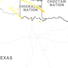
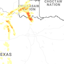
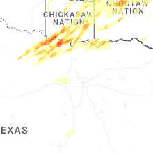
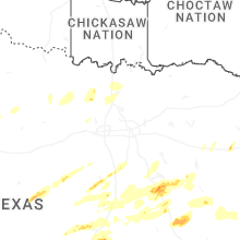


Connect with Interactive Hail Maps