

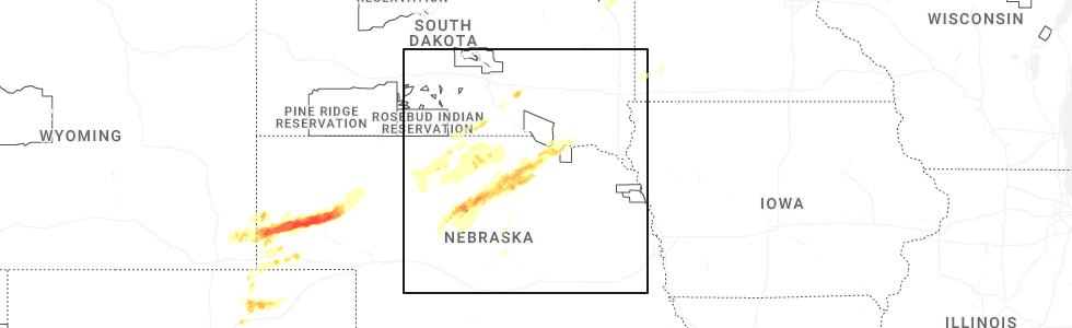
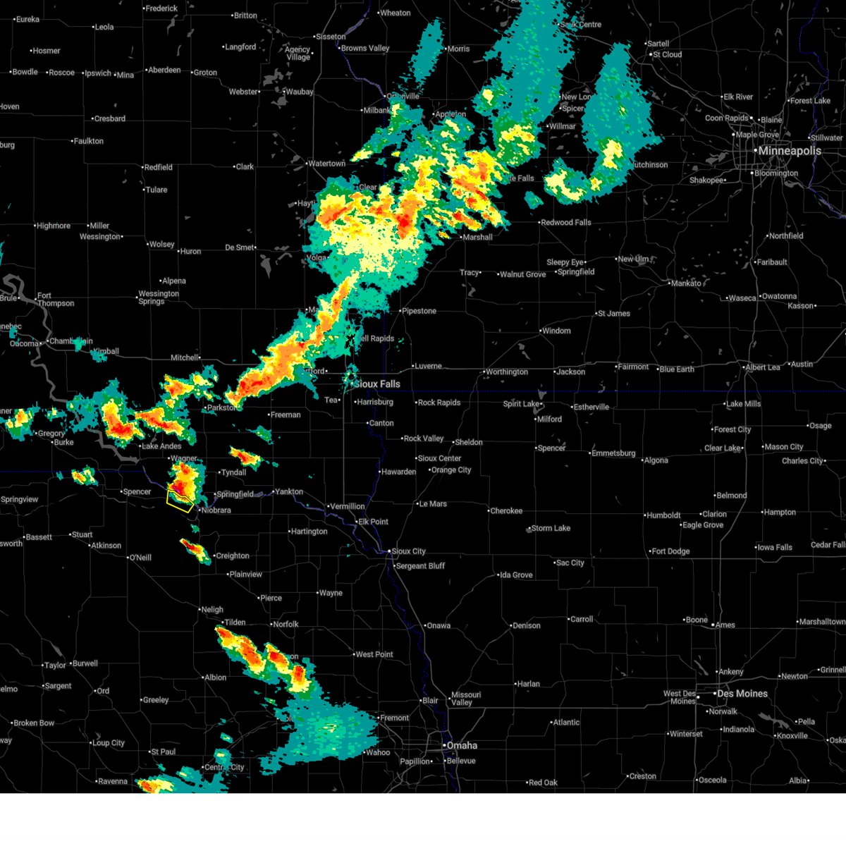
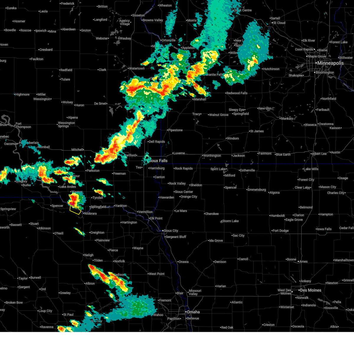
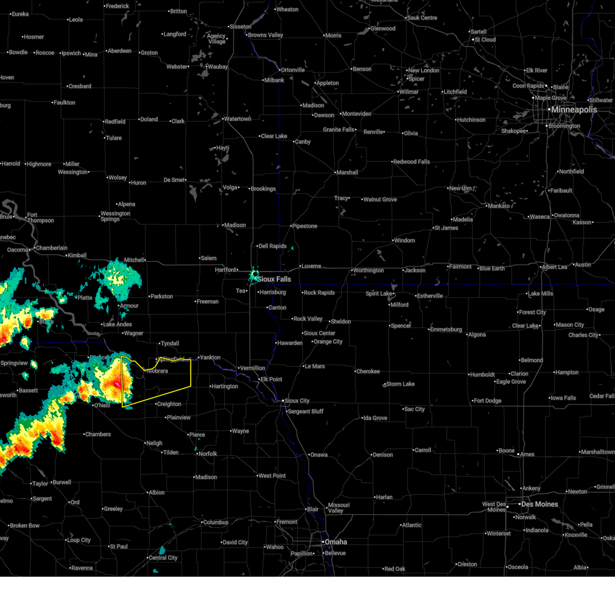
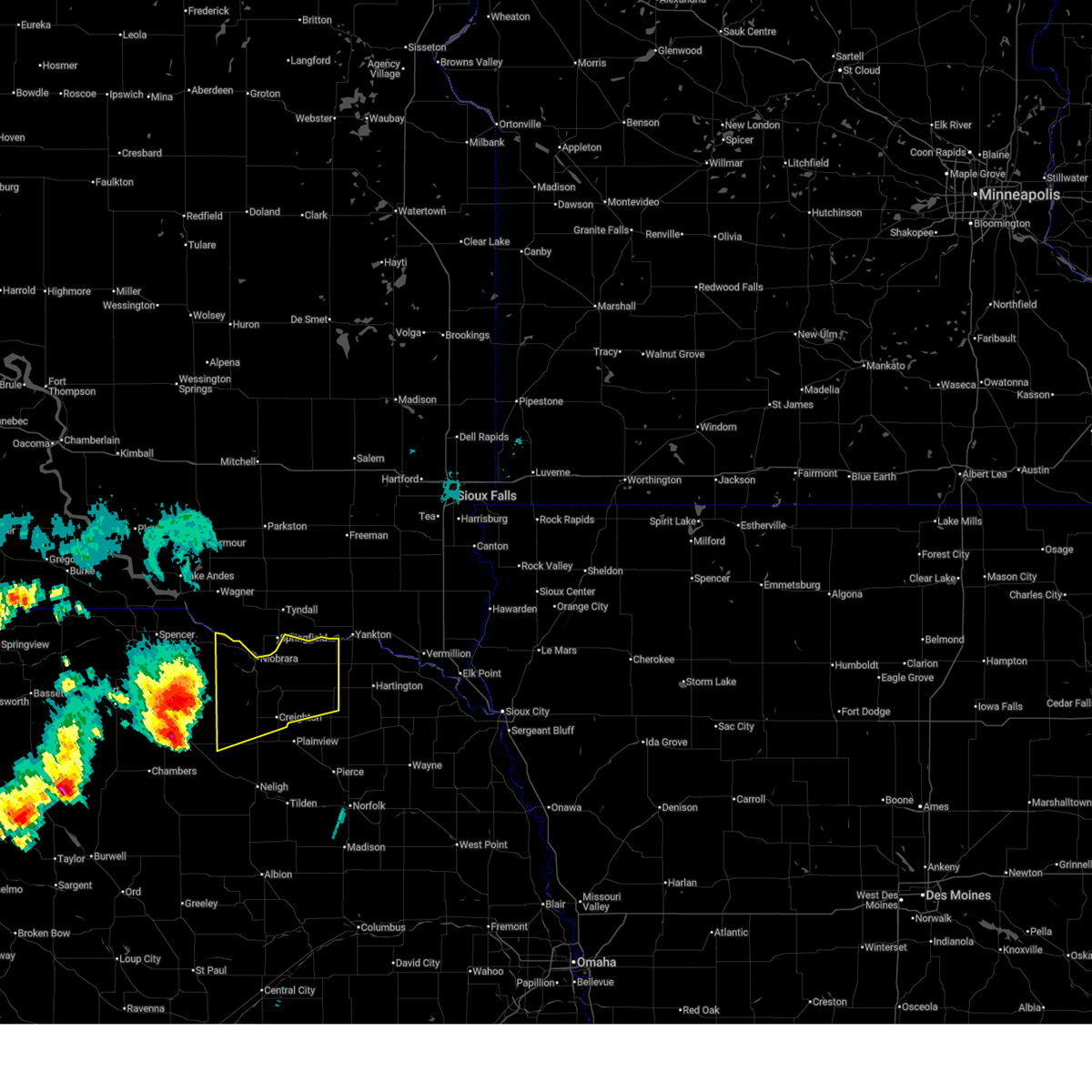
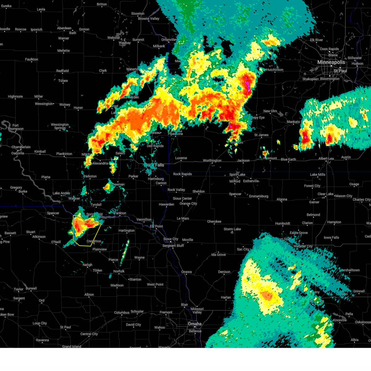
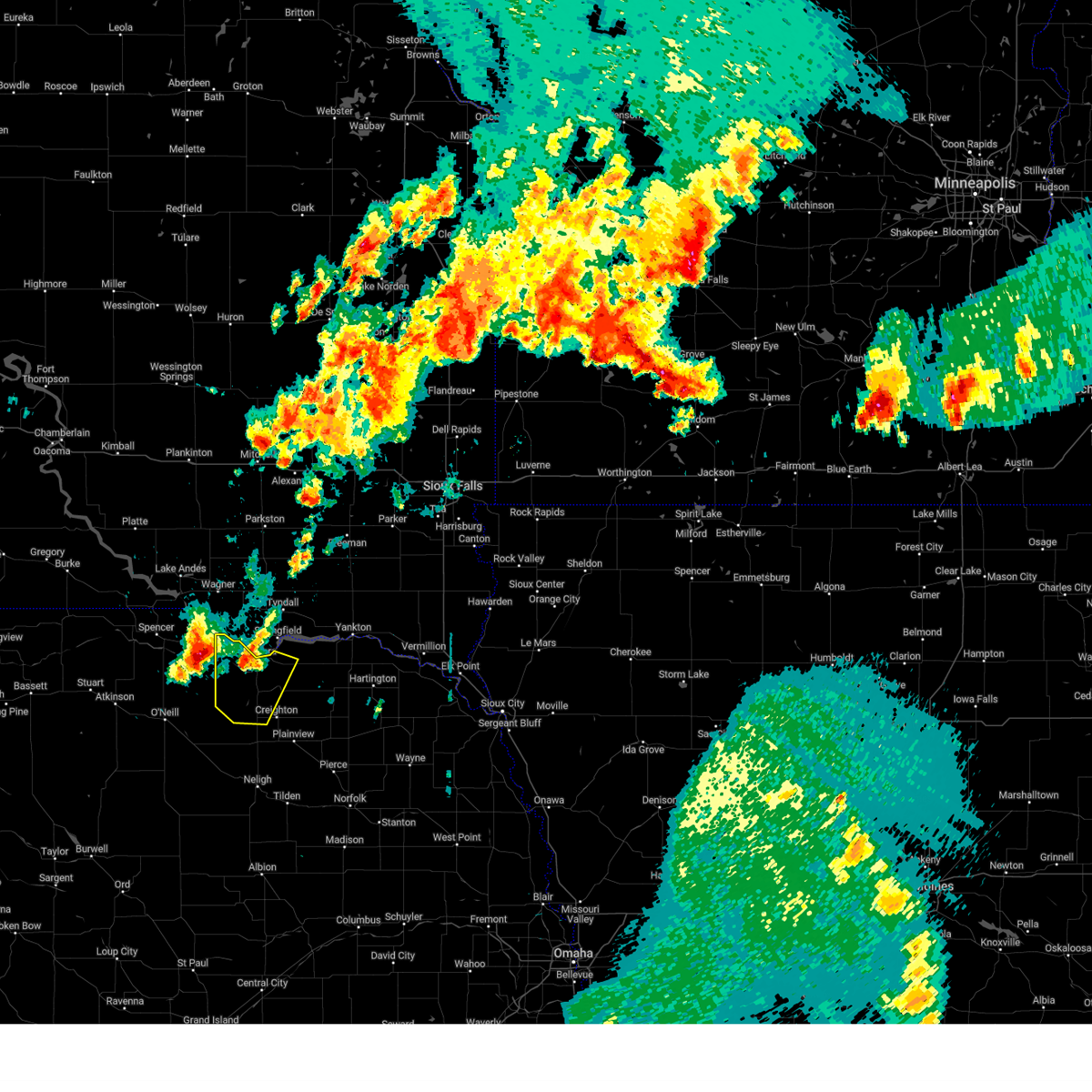
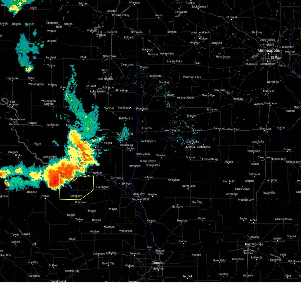
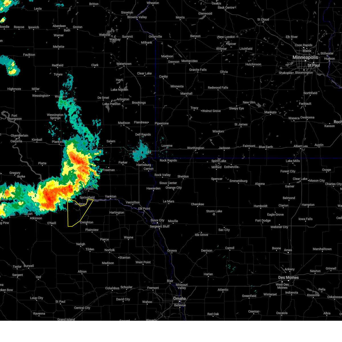
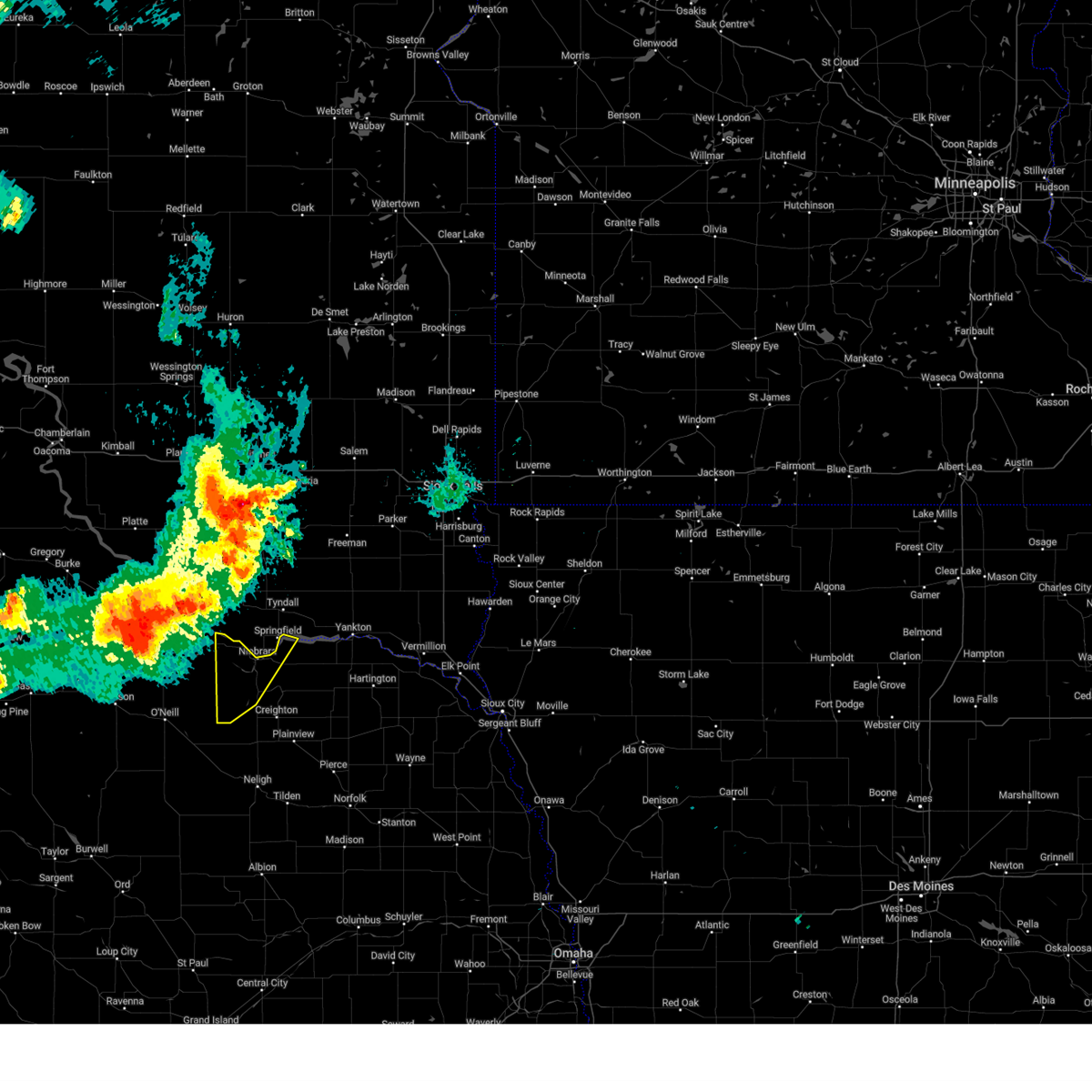
Hail Map for Verdel, NE
The Verdel, NE area has had 0 reports of on-the-ground hail by trained spotters, and has been under severe weather warnings 16 times during the past 12 months. Doppler radar has detected hail at or near Verdel, NE on 53 occasions, including 6 occasions during the past year.
| Name: | Verdel, NE |
| Where Located: | 33.6 miles NE of Oneill, NE |
| Map: | Google Map for Verdel, NE |
| Population: | 30 |
| Housing Units: | 36 |
| More Info: | Search Google for Verdel, NE |
3
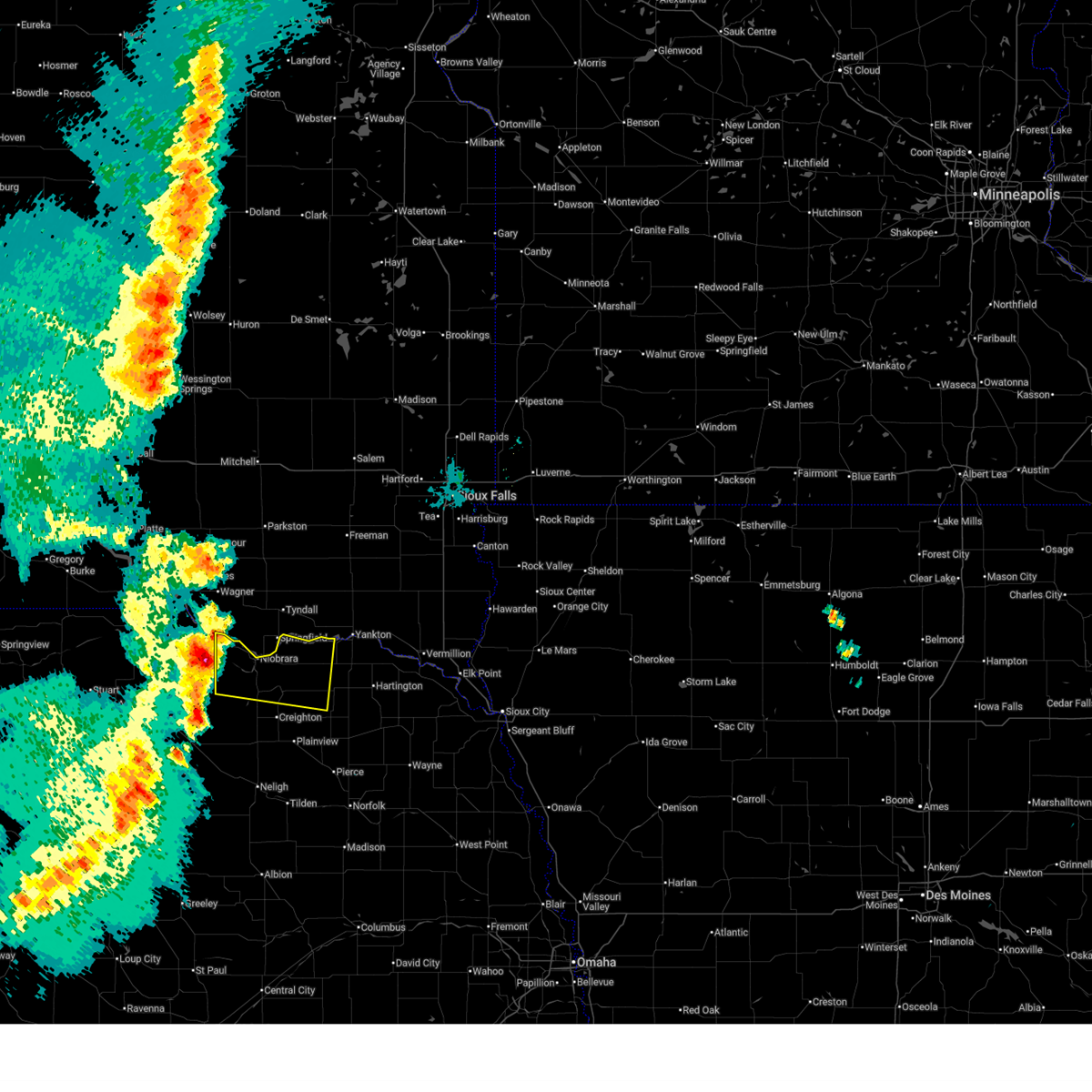
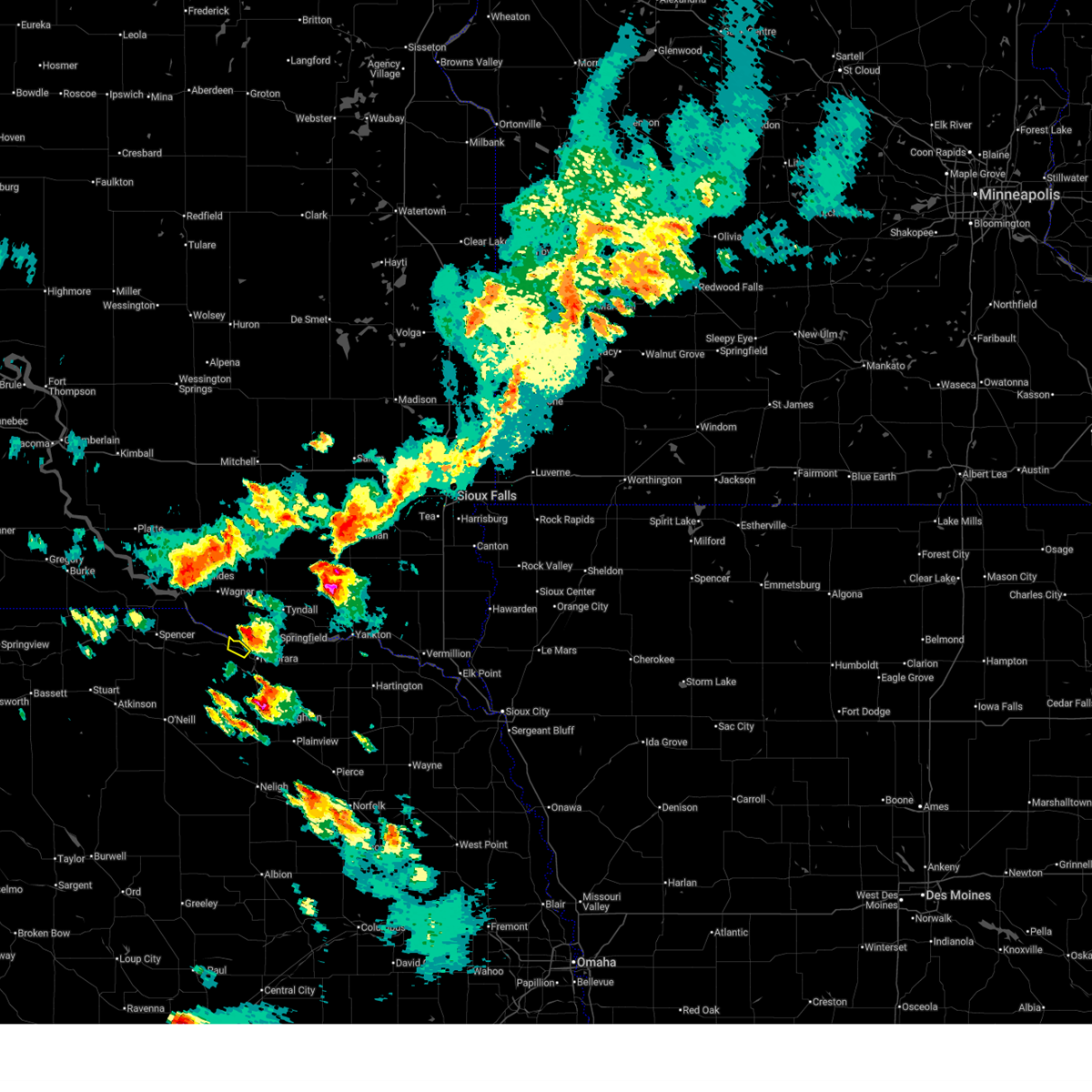
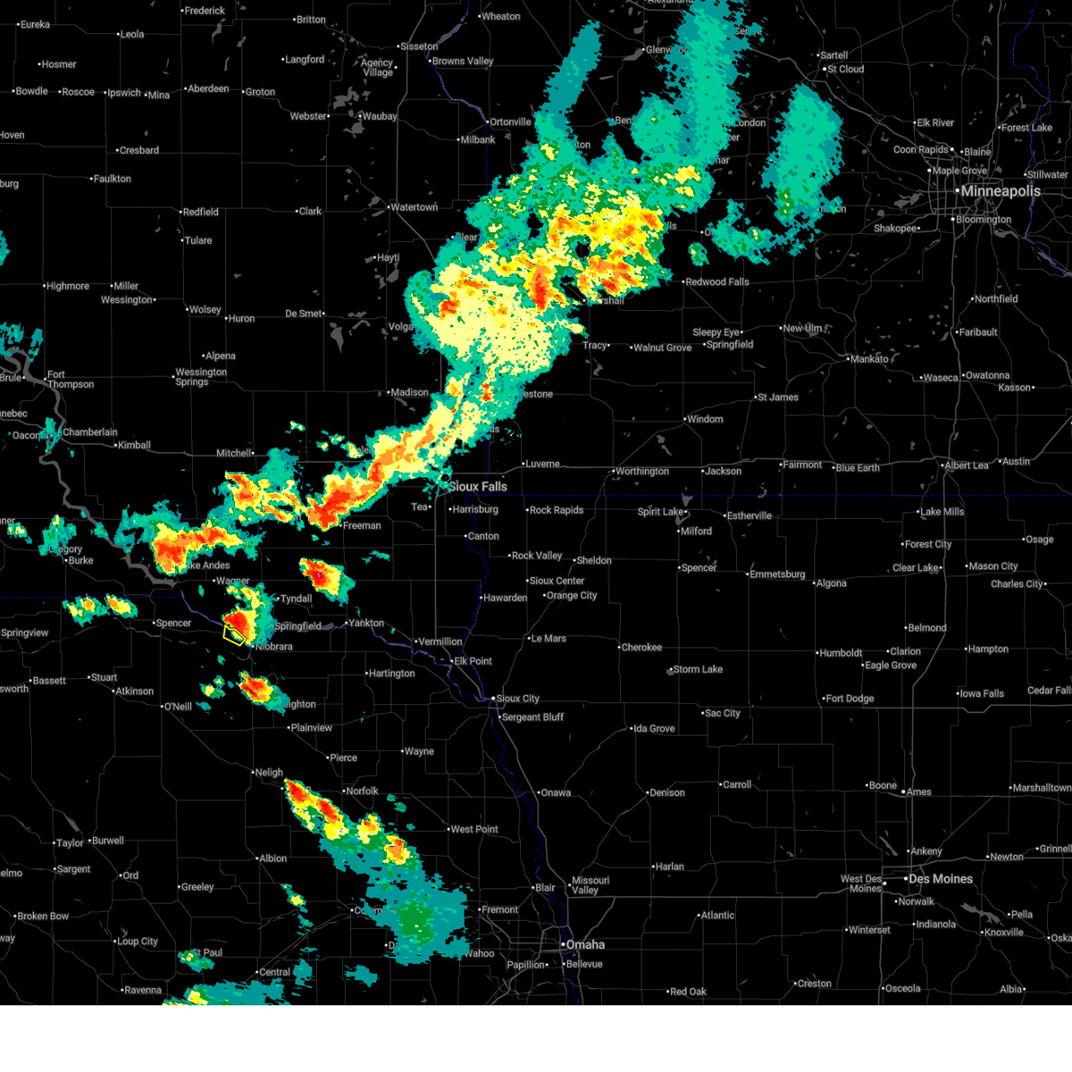
The Top Recent Hail Date for Verdel, NE is Sunday, June 22, 2025 (16th out of 53)
Hail and Wind Damage Spotted near Verdel, NE
| Date / Time | Report Details |
|---|---|
| 7/9/2025 10:15 PM CDT |
 Svroax the national weather service in omaha has issued a * severe thunderstorm warning for, knox county in northeastern nebraska, * until 1100 pm cdt. * at 1015 pm cdt, a severe thunderstorm was located 5 miles southwest of verdel, or 23 miles east of spencer, moving east at 40 mph (radar indicated). Hazards include 60 mph wind gusts and quarter size hail. Hail damage to vehicles is expected. expect wind damage to roofs, siding, and trees. this severe thunderstorm will be near, verdel around 1020 pm cdt. Niobrara around 1025 pm cdt. Svroax the national weather service in omaha has issued a * severe thunderstorm warning for, knox county in northeastern nebraska, * until 1100 pm cdt. * at 1015 pm cdt, a severe thunderstorm was located 5 miles southwest of verdel, or 23 miles east of spencer, moving east at 40 mph (radar indicated). Hazards include 60 mph wind gusts and quarter size hail. Hail damage to vehicles is expected. expect wind damage to roofs, siding, and trees. this severe thunderstorm will be near, verdel around 1020 pm cdt. Niobrara around 1025 pm cdt.
|
| 7/7/2025 5:56 PM CDT |
 The storm which prompted the warning has moved out of the area. therefore, the warning will be allowed to expire. a severe thunderstorm watch remains in effect until 1000 pm cdt for northeastern nebraska. The storm which prompted the warning has moved out of the area. therefore, the warning will be allowed to expire. a severe thunderstorm watch remains in effect until 1000 pm cdt for northeastern nebraska.
|
| 7/7/2025 5:45 PM CDT |
 At 544 pm cdt, a severe thunderstorm was located 3 miles northeast of verdel, or 16 miles southwest of tyndall, moving east at 15 mph (radar indicated). Hazards include 60 mph wind gusts and quarter size hail. Hail damage to vehicles is expected. expect wind damage to roofs, siding, and trees. This severe thunderstorm will remain over mainly rural areas of northwestern knox county. At 544 pm cdt, a severe thunderstorm was located 3 miles northeast of verdel, or 16 miles southwest of tyndall, moving east at 15 mph (radar indicated). Hazards include 60 mph wind gusts and quarter size hail. Hail damage to vehicles is expected. expect wind damage to roofs, siding, and trees. This severe thunderstorm will remain over mainly rural areas of northwestern knox county.
|
| 7/7/2025 5:29 PM CDT |
 At 529 pm cdt, a severe thunderstorm was located 3 miles north of verdel, or 18 miles southwest of tyndall, moving east at 15 mph (radar indicated). Hazards include 60 mph wind gusts and quarter size hail. Hail damage to vehicles is expected. expect wind damage to roofs, siding, and trees. This severe storm will be near, verdel around 535 pm cdt. At 529 pm cdt, a severe thunderstorm was located 3 miles north of verdel, or 18 miles southwest of tyndall, moving east at 15 mph (radar indicated). Hazards include 60 mph wind gusts and quarter size hail. Hail damage to vehicles is expected. expect wind damage to roofs, siding, and trees. This severe storm will be near, verdel around 535 pm cdt.
|
| 7/7/2025 5:17 PM CDT |
 Svroax the national weather service in omaha has issued a * severe thunderstorm warning for, northwestern knox county in northeastern nebraska, * until 600 pm cdt. * at 516 pm cdt, a severe thunderstorm was located 5 miles northwest of verdel, or 19 miles southeast of pickstown, moving southeast at 15 mph (radar indicated). Hazards include 60 mph wind gusts and quarter size hail. Hail damage to vehicles is expected. expect wind damage to roofs, siding, and trees. This severe thunderstorm will be near, verdel around 520 pm cdt. Svroax the national weather service in omaha has issued a * severe thunderstorm warning for, northwestern knox county in northeastern nebraska, * until 600 pm cdt. * at 516 pm cdt, a severe thunderstorm was located 5 miles northwest of verdel, or 19 miles southeast of pickstown, moving southeast at 15 mph (radar indicated). Hazards include 60 mph wind gusts and quarter size hail. Hail damage to vehicles is expected. expect wind damage to roofs, siding, and trees. This severe thunderstorm will be near, verdel around 520 pm cdt.
|
| 6/22/2025 8:18 PM CDT |
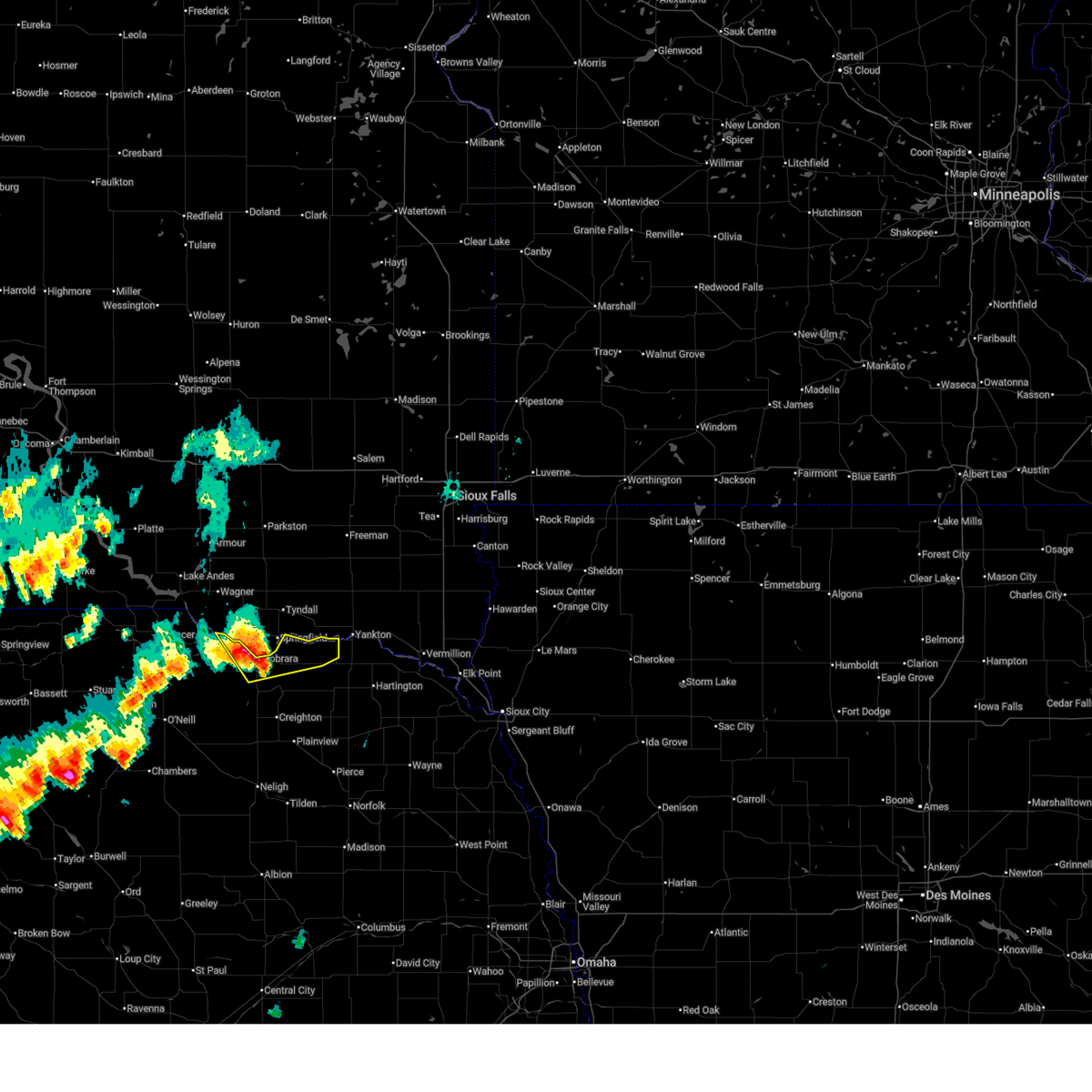 At 817 pm cdt, a severe thunderstorm was located near santee, or 12 miles south of tyndall, moving northeast at 55 mph (radar indicated). Hazards include 60 mph wind gusts and quarter size hail. Hail damage to vehicles is expected. expect wind damage to roofs, siding, and trees. Locations impacted include, niobrara, santee, verdel, lindy, santee reservation, weigand marina, lewis and clark state recreation area, and niobrara state park. At 817 pm cdt, a severe thunderstorm was located near santee, or 12 miles south of tyndall, moving northeast at 55 mph (radar indicated). Hazards include 60 mph wind gusts and quarter size hail. Hail damage to vehicles is expected. expect wind damage to roofs, siding, and trees. Locations impacted include, niobrara, santee, verdel, lindy, santee reservation, weigand marina, lewis and clark state recreation area, and niobrara state park.
|
| 6/22/2025 8:07 PM CDT |
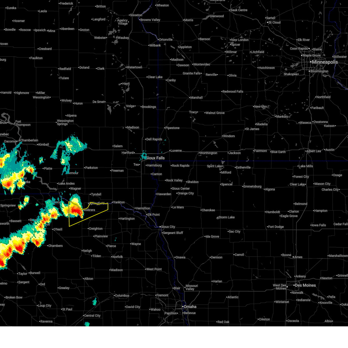 At 806 pm cdt, a severe thunderstorm was located over niobrara, or 18 miles southwest of tyndall, moving northeast at 55 mph (weather instrument measurement wind gust of 61 mph in o'neill at 7:28 pm). Hazards include ping pong ball size hail and 60 mph wind gusts. People and animals outdoors will be injured. expect hail damage to roofs, siding, windows, and vehicles. expect wind damage to roofs, siding, and trees. Locations impacted include, verdigre, niobrara, santee, verdel, lindy, santee reservation, weigand marina, lewis and clark state recreation area, and niobrara state park. At 806 pm cdt, a severe thunderstorm was located over niobrara, or 18 miles southwest of tyndall, moving northeast at 55 mph (weather instrument measurement wind gust of 61 mph in o'neill at 7:28 pm). Hazards include ping pong ball size hail and 60 mph wind gusts. People and animals outdoors will be injured. expect hail damage to roofs, siding, windows, and vehicles. expect wind damage to roofs, siding, and trees. Locations impacted include, verdigre, niobrara, santee, verdel, lindy, santee reservation, weigand marina, lewis and clark state recreation area, and niobrara state park.
|
| 6/22/2025 7:51 PM CDT |
 At 750 pm cdt, a severe thunderstorm was located 9 miles southwest of verdigre, or 23 miles east of o'neill, moving northeast at 60 mph (weather instrument measurement wind gust of 61 mph in o'neill at 7:28 pm). Hazards include ping pong ball size hail and 60 mph wind gusts. People and animals outdoors will be injured. expect hail damage to roofs, siding, windows, and vehicles. expect wind damage to roofs, siding, and trees. Locations impacted include, bloomfield, crofton, verdigre, niobrara, santee, center, winnetoon, verdel, lindy, santee reservation, weigand marina, lewis and clark state recreation area, and niobrara state park. At 750 pm cdt, a severe thunderstorm was located 9 miles southwest of verdigre, or 23 miles east of o'neill, moving northeast at 60 mph (weather instrument measurement wind gust of 61 mph in o'neill at 7:28 pm). Hazards include ping pong ball size hail and 60 mph wind gusts. People and animals outdoors will be injured. expect hail damage to roofs, siding, windows, and vehicles. expect wind damage to roofs, siding, and trees. Locations impacted include, bloomfield, crofton, verdigre, niobrara, santee, center, winnetoon, verdel, lindy, santee reservation, weigand marina, lewis and clark state recreation area, and niobrara state park.
|
| 6/22/2025 7:51 PM CDT |
 the severe thunderstorm warning has been cancelled and is no longer in effect the severe thunderstorm warning has been cancelled and is no longer in effect
|
| 6/22/2025 7:35 PM CDT |
 At 734 pm cdt, a severe thunderstorm was located near page, or 11 miles east of o'neill, moving northeast at 55 mph (weather instrument measurement wind gust of 61 mph in o'neill at 7:28 pm). Hazards include ping pong ball size hail and 60 mph wind gusts. People and animals outdoors will be injured. expect hail damage to roofs, siding, windows, and vehicles. expect wind damage to roofs, siding, and trees. Locations impacted include, creighton, bloomfield, crofton, wausa, verdigre, orchard, niobrara, santee, center, winnetoon, verdel, bazile mills, lindy, santee reservation, weigand marina, lewis and clark state recreation area, ashfall fossil beds state historical park, the highway 14 and 59 junction, grove lake recreation area, and niobrara state park. At 734 pm cdt, a severe thunderstorm was located near page, or 11 miles east of o'neill, moving northeast at 55 mph (weather instrument measurement wind gust of 61 mph in o'neill at 7:28 pm). Hazards include ping pong ball size hail and 60 mph wind gusts. People and animals outdoors will be injured. expect hail damage to roofs, siding, windows, and vehicles. expect wind damage to roofs, siding, and trees. Locations impacted include, creighton, bloomfield, crofton, wausa, verdigre, orchard, niobrara, santee, center, winnetoon, verdel, bazile mills, lindy, santee reservation, weigand marina, lewis and clark state recreation area, ashfall fossil beds state historical park, the highway 14 and 59 junction, grove lake recreation area, and niobrara state park.
|
| 6/22/2025 7:31 PM CDT |
 Svroax the national weather service in omaha has issued a * severe thunderstorm warning for, northern antelope county in northeastern nebraska, knox county in northeastern nebraska, * until 830 pm cdt. * at 731 pm cdt, a severe thunderstorm was located near page, or 9 miles east of o'neill, moving northeast at 55 mph (radar indicated). Hazards include ping pong ball size hail and 60 mph wind gusts. People and animals outdoors will be injured. expect hail damage to roofs, siding, windows, and vehicles. Expect wind damage to roofs, siding, and trees. Svroax the national weather service in omaha has issued a * severe thunderstorm warning for, northern antelope county in northeastern nebraska, knox county in northeastern nebraska, * until 830 pm cdt. * at 731 pm cdt, a severe thunderstorm was located near page, or 9 miles east of o'neill, moving northeast at 55 mph (radar indicated). Hazards include ping pong ball size hail and 60 mph wind gusts. People and animals outdoors will be injured. expect hail damage to roofs, siding, windows, and vehicles. Expect wind damage to roofs, siding, and trees.
|
| 7/31/2024 8:40 PM CDT |
 At 840 pm cdt, a severe thunderstorm was located 4 miles north of verdigre, or 25 miles southwest of tyndall, moving east at 40 mph (trained weather spotters. this storm has a history of producing golf ball sized hail). Hazards include golf ball size hail and 60 mph wind gusts. People and animals outdoors will be injured. expect hail damage to roofs, siding, windows, and vehicles. expect wind damage to roofs, siding, and trees. Locations impacted include, verdigre, niobrara, center, winnetoon, verdel, bazile mills, the highway 14 and 59 junction, santee reservation, and niobrara state park. At 840 pm cdt, a severe thunderstorm was located 4 miles north of verdigre, or 25 miles southwest of tyndall, moving east at 40 mph (trained weather spotters. this storm has a history of producing golf ball sized hail). Hazards include golf ball size hail and 60 mph wind gusts. People and animals outdoors will be injured. expect hail damage to roofs, siding, windows, and vehicles. expect wind damage to roofs, siding, and trees. Locations impacted include, verdigre, niobrara, center, winnetoon, verdel, bazile mills, the highway 14 and 59 junction, santee reservation, and niobrara state park.
|
| 7/31/2024 8:22 PM CDT |
 Svroax the national weather service in omaha has issued a * severe thunderstorm warning for, western knox county in northeastern nebraska, * until 915 pm cdt. * at 822 pm cdt, a severe thunderstorm was located 9 miles southeast of lynch, or 20 miles southeast of spencer, moving southeast at 35 mph (trained weather spotters. at 812 pm, golf ball sized hail was reported 5 miles southwest of lynch). Hazards include golf ball size hail and 60 mph wind gusts. People and animals outdoors will be injured. expect hail damage to roofs, siding, windows, and vehicles. Expect wind damage to roofs, siding, and trees. Svroax the national weather service in omaha has issued a * severe thunderstorm warning for, western knox county in northeastern nebraska, * until 915 pm cdt. * at 822 pm cdt, a severe thunderstorm was located 9 miles southeast of lynch, or 20 miles southeast of spencer, moving southeast at 35 mph (trained weather spotters. at 812 pm, golf ball sized hail was reported 5 miles southwest of lynch). Hazards include golf ball size hail and 60 mph wind gusts. People and animals outdoors will be injured. expect hail damage to roofs, siding, windows, and vehicles. Expect wind damage to roofs, siding, and trees.
|
| 7/29/2024 9:53 PM CDT |
 Svroax the national weather service in omaha has issued a * severe thunderstorm warning for, knox county in northeastern nebraska, * until 1045 pm cdt. * at 952 pm cdt, severe thunderstorms were located along a line extending from 2 miles southeast of tyndall to near verdel to 13 miles south of lynch, moving southeast at 35 mph (radar indicated). Hazards include 60 mph wind gusts and quarter size hail. Hail damage to vehicles is expected. Expect wind damage to roofs, siding, and trees. Svroax the national weather service in omaha has issued a * severe thunderstorm warning for, knox county in northeastern nebraska, * until 1045 pm cdt. * at 952 pm cdt, severe thunderstorms were located along a line extending from 2 miles southeast of tyndall to near verdel to 13 miles south of lynch, moving southeast at 35 mph (radar indicated). Hazards include 60 mph wind gusts and quarter size hail. Hail damage to vehicles is expected. Expect wind damage to roofs, siding, and trees.
|
| 7/29/2024 9:32 PM CDT |
 At 932 pm cdt, severe thunderstorms were located along a line extending from 5 miles southwest of dante to near lynch to 14 miles south of spencer, moving east at 35 mph (public. at 925 pm cdt, a 65 mph wind gust was recorded 5 miles southwest of butte). Hazards include 70 mph wind gusts and quarter size hail. Hail damage to vehicles is expected. expect considerable tree damage. wind damage is also likely to mobile homes, roofs, and outbuildings. Locations impacted include, verdigre, niobrara, santee, verdel, niobrara state park, and santee reservation. At 932 pm cdt, severe thunderstorms were located along a line extending from 5 miles southwest of dante to near lynch to 14 miles south of spencer, moving east at 35 mph (public. at 925 pm cdt, a 65 mph wind gust was recorded 5 miles southwest of butte). Hazards include 70 mph wind gusts and quarter size hail. Hail damage to vehicles is expected. expect considerable tree damage. wind damage is also likely to mobile homes, roofs, and outbuildings. Locations impacted include, verdigre, niobrara, santee, verdel, niobrara state park, and santee reservation.
|
| 7/29/2024 9:21 PM CDT |
 Svroax the national weather service in omaha has issued a * severe thunderstorm warning for, western knox county in northeastern nebraska, * until 1000 pm cdt. * at 921 pm cdt, severe thunderstorms were located along a line extending from 3 miles southwest of wagner to 4 miles northwest of lynch to 12 miles southwest of spencer, moving southeast at 35 mph (radar indicated). Hazards include 60 mph wind gusts and quarter size hail. Hail damage to vehicles is expected. Expect wind damage to roofs, siding, and trees. Svroax the national weather service in omaha has issued a * severe thunderstorm warning for, western knox county in northeastern nebraska, * until 1000 pm cdt. * at 921 pm cdt, severe thunderstorms were located along a line extending from 3 miles southwest of wagner to 4 miles northwest of lynch to 12 miles southwest of spencer, moving southeast at 35 mph (radar indicated). Hazards include 60 mph wind gusts and quarter size hail. Hail damage to vehicles is expected. Expect wind damage to roofs, siding, and trees.
|
| 7/14/2024 4:13 AM CDT |
 The storms which prompted the warning have weakened below severe limits, and no longer pose an immediate threat to life or property. therefore, the warning will be allowed to expire. however, gusty winds are still possible with these thunderstorms. a severe thunderstorm watch remains in effect until 800 am cdt for northeastern nebraska. to report severe weather, contact your nearest law enforcement agency. they will relay your report to the national weather service omaha. The storms which prompted the warning have weakened below severe limits, and no longer pose an immediate threat to life or property. therefore, the warning will be allowed to expire. however, gusty winds are still possible with these thunderstorms. a severe thunderstorm watch remains in effect until 800 am cdt for northeastern nebraska. to report severe weather, contact your nearest law enforcement agency. they will relay your report to the national weather service omaha.
|
| 7/14/2024 3:37 AM CDT |
 Svroax the national weather service in omaha has issued a * severe thunderstorm warning for, northern antelope county in northeastern nebraska, knox county in northeastern nebraska, northwestern cedar county in northeastern nebraska, * until 415 am cdt. * at 337 am cdt, severe thunderstorms were located along a line extending from 5 miles southwest of kaylor to 7 miles northeast of o'neill, moving southeast at 60 mph (radar indicated). Hazards include 60 mph wind gusts. expect damage to roofs, siding, and trees Svroax the national weather service in omaha has issued a * severe thunderstorm warning for, northern antelope county in northeastern nebraska, knox county in northeastern nebraska, northwestern cedar county in northeastern nebraska, * until 415 am cdt. * at 337 am cdt, severe thunderstorms were located along a line extending from 5 miles southwest of kaylor to 7 miles northeast of o'neill, moving southeast at 60 mph (radar indicated). Hazards include 60 mph wind gusts. expect damage to roofs, siding, and trees
|
| 6/25/2024 9:46 PM CDT |
 the severe thunderstorm warning has been cancelled and is no longer in effect the severe thunderstorm warning has been cancelled and is no longer in effect
|
| 6/25/2024 9:33 PM CDT |
 Svroax the national weather service in omaha has issued a * severe thunderstorm warning for, northwestern knox county in northeastern nebraska, * until 1015 pm cdt. * at 933 pm cdt, a severe thunderstorm was located near verdel, or 19 miles southwest of tyndall, moving southeast at 10 mph (radar indicated). Hazards include half dollar size hail. damage to vehicles is expected Svroax the national weather service in omaha has issued a * severe thunderstorm warning for, northwestern knox county in northeastern nebraska, * until 1015 pm cdt. * at 933 pm cdt, a severe thunderstorm was located near verdel, or 19 miles southwest of tyndall, moving southeast at 10 mph (radar indicated). Hazards include half dollar size hail. damage to vehicles is expected
|
| 4/26/2024 10:14 AM CDT |
 the severe thunderstorm warning has been cancelled and is no longer in effect the severe thunderstorm warning has been cancelled and is no longer in effect
|
| 4/26/2024 10:08 AM CDT |
 At 1008 am cdt, a severe thunderstorm was located 5 miles south of verdel, or 23 miles southwest of tyndall, moving north at 50 mph (radar indicated). Hazards include quarter size hail. Damage to vehicles is expected. Locations impacted include, niobrara, verdel, and niobrara state park. At 1008 am cdt, a severe thunderstorm was located 5 miles south of verdel, or 23 miles southwest of tyndall, moving north at 50 mph (radar indicated). Hazards include quarter size hail. Damage to vehicles is expected. Locations impacted include, niobrara, verdel, and niobrara state park.
|
| 4/26/2024 10:01 AM CDT |
 At 1001 am cdt, a severe thunderstorm was located 9 miles northwest of verdigre, or 26 miles northeast of o'neill, moving north at 55 mph (radar indicated). Hazards include quarter size hail. Damage to vehicles is expected. Locations impacted include, niobrara, verdel, and niobrara state park. At 1001 am cdt, a severe thunderstorm was located 9 miles northwest of verdigre, or 26 miles northeast of o'neill, moving north at 55 mph (radar indicated). Hazards include quarter size hail. Damage to vehicles is expected. Locations impacted include, niobrara, verdel, and niobrara state park.
|
| 4/26/2024 9:56 AM CDT |
 Svroax the national weather service in omaha has issued a * severe thunderstorm warning for, western knox county in northeastern nebraska, * until 1030 am cdt. * at 956 am cdt, a severe thunderstorm was located 9 miles west of verdigre, or 24 miles northeast of o'neill, moving north at 60 mph (radar indicated). Hazards include quarter size hail. damage to vehicles is expected Svroax the national weather service in omaha has issued a * severe thunderstorm warning for, western knox county in northeastern nebraska, * until 1030 am cdt. * at 956 am cdt, a severe thunderstorm was located 9 miles west of verdigre, or 24 miles northeast of o'neill, moving north at 60 mph (radar indicated). Hazards include quarter size hail. damage to vehicles is expected
|
| 4/15/2024 11:59 PM CDT |
 the severe thunderstorm warning has been cancelled and is no longer in effect the severe thunderstorm warning has been cancelled and is no longer in effect
|
| 4/15/2024 11:36 PM CDT |
 the severe thunderstorm warning has been cancelled and is no longer in effect the severe thunderstorm warning has been cancelled and is no longer in effect
|
| 4/15/2024 11:36 PM CDT |
 At 1136 pm cdt, a severe thunderstorm was located 4 miles west of verdigre, or 28 miles east of o'neill, moving north at 45 mph (radar indicated). Hazards include quarter size hail. Damage to vehicles is expected. Locations impacted include, creighton, verdigre, niobrara, winnetoon, verdel, the highway 14 and 59 junction, and niobrara state park. At 1136 pm cdt, a severe thunderstorm was located 4 miles west of verdigre, or 28 miles east of o'neill, moving north at 45 mph (radar indicated). Hazards include quarter size hail. Damage to vehicles is expected. Locations impacted include, creighton, verdigre, niobrara, winnetoon, verdel, the highway 14 and 59 junction, and niobrara state park.
|
| 4/15/2024 11:23 PM CDT |
 Svroax the national weather service in omaha has issued a * severe thunderstorm warning for, north central antelope county in northeastern nebraska, western knox county in northeastern nebraska, * until 1215 am cdt. * at 1123 pm cdt, a severe thunderstorm was located 7 miles west of winnetoon, or 25 miles north of neligh, moving north at 45 mph (radar indicated). Hazards include quarter size hail. damage to vehicles is expected Svroax the national weather service in omaha has issued a * severe thunderstorm warning for, north central antelope county in northeastern nebraska, western knox county in northeastern nebraska, * until 1215 am cdt. * at 1123 pm cdt, a severe thunderstorm was located 7 miles west of winnetoon, or 25 miles north of neligh, moving north at 45 mph (radar indicated). Hazards include quarter size hail. damage to vehicles is expected
|
| 7/12/2023 3:44 AM CDT |
 At 343 am cdt, severe thunderstorms were located along a line extending from 6 miles northwest of tyndall to 13 miles east of rose, moving southeast at 75 mph (radar indicated). Hazards include 60 mph wind gusts and quarter size hail. Hail damage to vehicles is expected. Expect wind damage to roofs, siding, and trees. At 343 am cdt, severe thunderstorms were located along a line extending from 6 miles northwest of tyndall to 13 miles east of rose, moving southeast at 75 mph (radar indicated). Hazards include 60 mph wind gusts and quarter size hail. Hail damage to vehicles is expected. Expect wind damage to roofs, siding, and trees.
|
| 7/10/2023 3:35 PM CDT |
 At 335 pm cdt, a severe thunderstorm was located 5 miles north of verdel, or 17 miles southwest of tyndall, moving southeast at 30 mph (radar indicated). Hazards include 60 mph wind gusts and quarter size hail. Hail damage to vehicles is expected. expect wind damage to roofs, siding, and trees. locations impacted include, niobrara, verdel, niobrara state park and santee reservation. hail threat, radar indicated max hail size, 1. 00 in wind threat, radar indicated max wind gust, 60 mph. At 335 pm cdt, a severe thunderstorm was located 5 miles north of verdel, or 17 miles southwest of tyndall, moving southeast at 30 mph (radar indicated). Hazards include 60 mph wind gusts and quarter size hail. Hail damage to vehicles is expected. expect wind damage to roofs, siding, and trees. locations impacted include, niobrara, verdel, niobrara state park and santee reservation. hail threat, radar indicated max hail size, 1. 00 in wind threat, radar indicated max wind gust, 60 mph.
|
| 7/10/2023 3:15 PM CDT |
 At 315 pm cdt, a severe thunderstorm was located 5 miles southeast of marty, or 12 miles southeast of pickstown, moving southeast at 30 mph (radar indicated). Hazards include 60 mph wind gusts and quarter size hail. Hail damage to vehicles is expected. Expect wind damage to roofs, siding, and trees. At 315 pm cdt, a severe thunderstorm was located 5 miles southeast of marty, or 12 miles southeast of pickstown, moving southeast at 30 mph (radar indicated). Hazards include 60 mph wind gusts and quarter size hail. Hail damage to vehicles is expected. Expect wind damage to roofs, siding, and trees.
|
| 6/24/2023 4:41 PM CDT | At 441 pm cdt, a severe thunderstorm was located 3 miles northwest of niobrara, or 17 miles southwest of tyndall, moving east at 45 mph (radar indicated). Hazards include golf ball size hail and 60 mph wind gusts. People and animals outdoors will be injured. expect hail damage to roofs, siding, windows, and vehicles. expect wind damage to roofs, siding, and trees. this severe thunderstorm will be near, santee around 455 pm cdt. other locations in the path of this severe thunderstorm include crofton. thunderstorm damage threat, considerable hail threat, radar indicated max hail size, 1. 75 in wind threat, radar indicated max wind gust, 60 mph. |
| 6/24/2023 4:36 PM CDT | At 436 pm cdt, a severe thunderstorm was located 3 miles northeast of verdel, or 17 miles southwest of tyndall, and is nearly stationary (radar indicated). Hazards include ping pong ball size hail and 60 mph wind gusts. People and animals outdoors will be injured. expect hail damage to roofs, siding, windows, and vehicles. expect wind damage to roofs, siding, and trees. locations impacted include, niobrara. hail threat, radar indicated max hail size, 1. 50 in wind threat, radar indicated max wind gust, 60 mph. |
| 6/24/2023 4:20 PM CDT | At 420 pm cdt, a severe thunderstorm was located 7 miles east of lynch, or 18 miles southeast of pickstown, moving east at 45 mph (radar indicated). Hazards include 60 mph wind gusts and half dollar size hail. Hail damage to vehicles is expected. expect wind damage to roofs, siding, and trees. this severe thunderstorm will be near, verdel around 430 pm cdt. niobrara around 440 pm cdt. hail threat, radar indicated max hail size, 1. 25 in wind threat, radar indicated max wind gust, 60 mph. |
| 6/24/2023 3:04 AM CDT |
 At 304 am cdt, severe thunderstorms were located along a line extending from 2 miles southeast of dante to 4 miles southwest of verdigre to 6 miles northeast of orchard, moving east at 65 mph (radar indicated). Hazards include 70 mph wind gusts and quarter size hail. Hail damage to vehicles is expected. expect considerable tree damage. wind damage is also likely to mobile homes, roofs, and outbuildings. these severe storms will be near, winnetoon around 310 am cdt. other locations in the path of these severe thunderstorms include creighton, center, plainview, bloomfield, osmond and wausa. thunderstorm damage threat, considerable hail threat, radar indicated max hail size, 1. 00 in wind threat, radar indicated max wind gust, 70 mph. At 304 am cdt, severe thunderstorms were located along a line extending from 2 miles southeast of dante to 4 miles southwest of verdigre to 6 miles northeast of orchard, moving east at 65 mph (radar indicated). Hazards include 70 mph wind gusts and quarter size hail. Hail damage to vehicles is expected. expect considerable tree damage. wind damage is also likely to mobile homes, roofs, and outbuildings. these severe storms will be near, winnetoon around 310 am cdt. other locations in the path of these severe thunderstorms include creighton, center, plainview, bloomfield, osmond and wausa. thunderstorm damage threat, considerable hail threat, radar indicated max hail size, 1. 00 in wind threat, radar indicated max wind gust, 70 mph.
|
| 6/24/2023 2:52 AM CDT |
 At 252 am cdt, severe thunderstorms were located along a line extending from 2 miles east of marty to 13 miles north of orchard to 3 miles southeast of page, moving east at 55 mph (radar indicated). Hazards include 70 mph wind gusts and quarter size hail. Hail damage to vehicles is expected. expect considerable tree damage. wind damage is also likely to mobile homes, roofs, and outbuildings. severe thunderstorms will be near, verdigre around 305 am cdt. winnetoon around 310 am cdt. other locations in the path of these severe thunderstorms include creighton, center, plainview, bloomfield, osmond and wausa. thunderstorm damage threat, considerable hail threat, radar indicated max hail size, 1. 00 in wind threat, radar indicated max wind gust, 70 mph. At 252 am cdt, severe thunderstorms were located along a line extending from 2 miles east of marty to 13 miles north of orchard to 3 miles southeast of page, moving east at 55 mph (radar indicated). Hazards include 70 mph wind gusts and quarter size hail. Hail damage to vehicles is expected. expect considerable tree damage. wind damage is also likely to mobile homes, roofs, and outbuildings. severe thunderstorms will be near, verdigre around 305 am cdt. winnetoon around 310 am cdt. other locations in the path of these severe thunderstorms include creighton, center, plainview, bloomfield, osmond and wausa. thunderstorm damage threat, considerable hail threat, radar indicated max hail size, 1. 00 in wind threat, radar indicated max wind gust, 70 mph.
|
| 6/24/2023 12:27 AM CDT |
 At 1227 am cdt, a severe thunderstorm was located 7 miles southwest of niobrara, or 25 miles southwest of tyndall, moving north at 25 mph (radar indicated). Hazards include quarter size hail. Damage to vehicles is expected. this severe thunderstorm will be near, niobrara around 1240 am cdt. verdel around 1245 am cdt. hail threat, radar indicated max hail size, 1. 00 in wind threat, radar indicated max wind gust, <50 mph. At 1227 am cdt, a severe thunderstorm was located 7 miles southwest of niobrara, or 25 miles southwest of tyndall, moving north at 25 mph (radar indicated). Hazards include quarter size hail. Damage to vehicles is expected. this severe thunderstorm will be near, niobrara around 1240 am cdt. verdel around 1245 am cdt. hail threat, radar indicated max hail size, 1. 00 in wind threat, radar indicated max wind gust, <50 mph.
|
| 8/1/2022 8:33 PM CDT |
 At 833 pm cdt, a severe thunderstorm was located over lynch, or 12 miles east of spencer, moving east at 35 mph (radar indicated). Hazards include 60 mph wind gusts and quarter size hail. Hail damage to vehicles is expected. Expect wind damage to roofs, siding, and trees. At 833 pm cdt, a severe thunderstorm was located over lynch, or 12 miles east of spencer, moving east at 35 mph (radar indicated). Hazards include 60 mph wind gusts and quarter size hail. Hail damage to vehicles is expected. Expect wind damage to roofs, siding, and trees.
|
| 7/5/2022 3:42 PM CDT |
 At 340 pm cdt, severe thunderstorms were located along a line extending from 6 miles east of wakonda to near orchard, moving southeast at 40 mph (radar indicated). Hazards include 60 mph wind gusts and quarter size hail. Hail damage to vehicles is expected. expect wind damage to roofs, siding, and trees. these severe thunderstorms will remain over mainly rural areas of northwestern pierce, northern antelope, knox and northern cedar counties, including the following locations, brunswick, lindy, pleasant valley, santee reservation, weigand marina, lewis and clark state recreation area, brooky bottom, bow valley, menominee and royal. hail threat, radar indicated max hail size, 1. 00 in wind threat, radar indicated max wind gust, 60 mph. At 340 pm cdt, severe thunderstorms were located along a line extending from 6 miles east of wakonda to near orchard, moving southeast at 40 mph (radar indicated). Hazards include 60 mph wind gusts and quarter size hail. Hail damage to vehicles is expected. expect wind damage to roofs, siding, and trees. these severe thunderstorms will remain over mainly rural areas of northwestern pierce, northern antelope, knox and northern cedar counties, including the following locations, brunswick, lindy, pleasant valley, santee reservation, weigand marina, lewis and clark state recreation area, brooky bottom, bow valley, menominee and royal. hail threat, radar indicated max hail size, 1. 00 in wind threat, radar indicated max wind gust, 60 mph.
|
| 7/5/2022 3:25 PM CDT |
 At 324 pm cdt, severe thunderstorms were located along a line extending from 2 miles north of wakonda to page, moving southeast at 45 mph (radar indicated). Hazards include 60 mph wind gusts and quarter size hail. Hail damage to vehicles is expected. expect wind damage to roofs, siding, and trees. these severe thunderstorms will remain over mainly rural areas of northwestern pierce, northern antelope, knox and northern cedar counties, including the following locations, brunswick, lindy, pleasant valley, santee reservation, weigand marina, lewis and clark state recreation area, brooky bottom, bow valley, menominee and royal. hail threat, radar indicated max hail size, 1. 00 in wind threat, radar indicated max wind gust, 60 mph. At 324 pm cdt, severe thunderstorms were located along a line extending from 2 miles north of wakonda to page, moving southeast at 45 mph (radar indicated). Hazards include 60 mph wind gusts and quarter size hail. Hail damage to vehicles is expected. expect wind damage to roofs, siding, and trees. these severe thunderstorms will remain over mainly rural areas of northwestern pierce, northern antelope, knox and northern cedar counties, including the following locations, brunswick, lindy, pleasant valley, santee reservation, weigand marina, lewis and clark state recreation area, brooky bottom, bow valley, menominee and royal. hail threat, radar indicated max hail size, 1. 00 in wind threat, radar indicated max wind gust, 60 mph.
|
| 7/5/2022 3:14 PM CDT |
 At 313 pm cdt, severe thunderstorms were located along a line extending from 2 miles north of yankton to 5 miles northeast of page, moving southeast at 50 mph (radar indicated). Hazards include 60 mph wind gusts and quarter size hail. Hail damage to vehicles is expected. expect wind damage to roofs, siding, and trees. locations impacted include, yankton, verdigre, niobrara, santee, center, verdel, lindy, santee reservation, weigand marina, lewis and clark state recreation area, gavins point dam and campgrounds and niobrara state park. hail threat, radar indicated max hail size, 1. 00 in wind threat, radar indicated max wind gust, 60 mph. At 313 pm cdt, severe thunderstorms were located along a line extending from 2 miles north of yankton to 5 miles northeast of page, moving southeast at 50 mph (radar indicated). Hazards include 60 mph wind gusts and quarter size hail. Hail damage to vehicles is expected. expect wind damage to roofs, siding, and trees. locations impacted include, yankton, verdigre, niobrara, santee, center, verdel, lindy, santee reservation, weigand marina, lewis and clark state recreation area, gavins point dam and campgrounds and niobrara state park. hail threat, radar indicated max hail size, 1. 00 in wind threat, radar indicated max wind gust, 60 mph.
|
| 7/5/2022 2:58 PM CDT |
 At 257 pm cdt, severe thunderstorms were located along a line extending from 4 miles north of utica to 12 miles northeast of o`neill, moving southeast at 50 mph (radar indicated). Hazards include 60 mph wind gusts and quarter size hail. Hail damage to vehicles is expected. expect wind damage to roofs, siding, and trees. locations impacted include, yankton, verdigre, niobrara, santee, center, verdel, lindy, santee reservation, weigand marina, lewis and clark state recreation area, gavins point dam and campgrounds and niobrara state park. hail threat, radar indicated max hail size, 1. 00 in wind threat, radar indicated max wind gust, 60 mph. At 257 pm cdt, severe thunderstorms were located along a line extending from 4 miles north of utica to 12 miles northeast of o`neill, moving southeast at 50 mph (radar indicated). Hazards include 60 mph wind gusts and quarter size hail. Hail damage to vehicles is expected. expect wind damage to roofs, siding, and trees. locations impacted include, yankton, verdigre, niobrara, santee, center, verdel, lindy, santee reservation, weigand marina, lewis and clark state recreation area, gavins point dam and campgrounds and niobrara state park. hail threat, radar indicated max hail size, 1. 00 in wind threat, radar indicated max wind gust, 60 mph.
|
| 7/5/2022 2:44 PM CDT |
 At 242 pm cdt, severe thunderstorms were located along a line extending from 7 miles southwest of kaylor to 8 miles northeast of atkinson, moving southeast at 45 mph (radar indicated). Hazards include 60 mph wind gusts and quarter size hail. Hail damage to vehicles is expected. Expect wind damage to roofs, siding, and trees. At 242 pm cdt, severe thunderstorms were located along a line extending from 7 miles southwest of kaylor to 8 miles northeast of atkinson, moving southeast at 45 mph (radar indicated). Hazards include 60 mph wind gusts and quarter size hail. Hail damage to vehicles is expected. Expect wind damage to roofs, siding, and trees.
|
| 5/30/2022 12:21 PM CDT |
 At 1220 pm cdt, a severe thunderstorm was located over verdel, or 20 miles southwest of tyndall, moving north at 40 mph (radar indicated). Hazards include ping pong ball size hail and 60 mph wind gusts. People and animals outdoors will be injured. expect hail damage to roofs, siding, windows, and vehicles. expect wind damage to roofs, siding, and trees. locations impacted include, verdel. hail threat, radar indicated max hail size, 1. 50 in wind threat, radar indicated max wind gust, 60 mph. At 1220 pm cdt, a severe thunderstorm was located over verdel, or 20 miles southwest of tyndall, moving north at 40 mph (radar indicated). Hazards include ping pong ball size hail and 60 mph wind gusts. People and animals outdoors will be injured. expect hail damage to roofs, siding, windows, and vehicles. expect wind damage to roofs, siding, and trees. locations impacted include, verdel. hail threat, radar indicated max hail size, 1. 50 in wind threat, radar indicated max wind gust, 60 mph.
|
| 5/30/2022 12:00 PM CDT |
 At 1200 pm cdt, a severe thunderstorm was located 9 miles west of verdigre, or 23 miles northeast of o`neill, moving north at 35 mph (radar indicated). Hazards include 60 mph wind gusts and quarter size hail. Hail damage to vehicles is expected. Expect wind damage to roofs, siding, and trees. At 1200 pm cdt, a severe thunderstorm was located 9 miles west of verdigre, or 23 miles northeast of o`neill, moving north at 35 mph (radar indicated). Hazards include 60 mph wind gusts and quarter size hail. Hail damage to vehicles is expected. Expect wind damage to roofs, siding, and trees.
|
| 5/12/2022 4:04 PM CDT |
 At 403 pm cdt, severe thunderstorms were located along a line extending from 3 miles southeast of marty to 4 miles north of niobrara to 5 miles west of bloomfield, moving north at 75 mph. these are destructive storms! (radar indicated). Hazards include 90 mph wind gusts and quarter size hail. You are in a life-threatening situation. flying debris may be deadly to those caught without shelter. mobile homes will be heavily damaged or destroyed. homes and businesses will have substantial roof and window damage. expect extensive tree damage and power outages. these severe thunderstorms will remain over mainly rural areas of knox county, including the following locations, santee reservation, niobrara state park, bazile mills and lindy. thunderstorm damage threat, destructive hail threat, radar indicated max hail size, 1. 00 in wind threat, radar indicated max wind gust, 90 mph. At 403 pm cdt, severe thunderstorms were located along a line extending from 3 miles southeast of marty to 4 miles north of niobrara to 5 miles west of bloomfield, moving north at 75 mph. these are destructive storms! (radar indicated). Hazards include 90 mph wind gusts and quarter size hail. You are in a life-threatening situation. flying debris may be deadly to those caught without shelter. mobile homes will be heavily damaged or destroyed. homes and businesses will have substantial roof and window damage. expect extensive tree damage and power outages. these severe thunderstorms will remain over mainly rural areas of knox county, including the following locations, santee reservation, niobrara state park, bazile mills and lindy. thunderstorm damage threat, destructive hail threat, radar indicated max hail size, 1. 00 in wind threat, radar indicated max wind gust, 90 mph.
|
| 5/12/2022 3:42 PM CDT |
 At 341 pm cdt, severe thunderstorms were located along a line extending from 7 miles south of lynch to 9 miles southwest of creighton, moving north at 70 mph. these are destructive storms for knox county (radar indicated). Hazards include 90 mph wind gusts and quarter size hail. You are in a life-threatening situation. flying debris may be deadly to those caught without shelter. mobile homes will be heavily damaged or destroyed. homes and businesses will have substantial roof and window damage. expect extensive tree damage and power outages. these severe storms will be near, verdigre around 350 pm cdt. center around 355 pm cdt. other locations in the path of these severe thunderstorms include niobrara and santee. thunderstorm damage threat, destructive hail threat, radar indicated max hail size, 1. 00 in wind threat, radar indicated max wind gust, 90 mph. At 341 pm cdt, severe thunderstorms were located along a line extending from 7 miles south of lynch to 9 miles southwest of creighton, moving north at 70 mph. these are destructive storms for knox county (radar indicated). Hazards include 90 mph wind gusts and quarter size hail. You are in a life-threatening situation. flying debris may be deadly to those caught without shelter. mobile homes will be heavily damaged or destroyed. homes and businesses will have substantial roof and window damage. expect extensive tree damage and power outages. these severe storms will be near, verdigre around 350 pm cdt. center around 355 pm cdt. other locations in the path of these severe thunderstorms include niobrara and santee. thunderstorm damage threat, destructive hail threat, radar indicated max hail size, 1. 00 in wind threat, radar indicated max wind gust, 90 mph.
|
| 5/12/2022 3:36 PM CDT |
 At 335 pm cdt, severe thunderstorms were located along a line extending from 12 miles northeast of o`neill to 6 miles north of neligh, moving north at 70 mph (radar indicated). Hazards include 70 mph wind gusts and quarter size hail. Hail damage to vehicles is expected. expect considerable tree damage. wind damage is also likely to mobile homes, roofs, and outbuildings. severe thunderstorms will be near, verdigre and winnetoon around 350 pm cdt. center around 355 pm cdt. other locations in the path of these severe thunderstorms include niobrara and santee. thunderstorm damage threat, considerable hail threat, radar indicated max hail size, 1. 00 in wind threat, radar indicated max wind gust, 70 mph. At 335 pm cdt, severe thunderstorms were located along a line extending from 12 miles northeast of o`neill to 6 miles north of neligh, moving north at 70 mph (radar indicated). Hazards include 70 mph wind gusts and quarter size hail. Hail damage to vehicles is expected. expect considerable tree damage. wind damage is also likely to mobile homes, roofs, and outbuildings. severe thunderstorms will be near, verdigre and winnetoon around 350 pm cdt. center around 355 pm cdt. other locations in the path of these severe thunderstorms include niobrara and santee. thunderstorm damage threat, considerable hail threat, radar indicated max hail size, 1. 00 in wind threat, radar indicated max wind gust, 70 mph.
|
| 6/11/2021 5:38 AM CDT |
 At 538 am cdt, a severe thunderstorm was located over niobrara, or 20 miles southwest of tyndall, moving southeast at 40 mph (radar indicated). Hazards include 60 mph wind gusts and quarter size hail. Hail damage to vehicles is expected. expect wind damage to roofs, siding, and trees. Locations impacted include, verdigre. At 538 am cdt, a severe thunderstorm was located over niobrara, or 20 miles southwest of tyndall, moving southeast at 40 mph (radar indicated). Hazards include 60 mph wind gusts and quarter size hail. Hail damage to vehicles is expected. expect wind damage to roofs, siding, and trees. Locations impacted include, verdigre.
|
| 6/11/2021 5:27 AM CDT |
 At 527 am cdt, a severe thunderstorm was located 7 miles northwest of niobrara, or 15 miles southwest of tyndall, moving southeast at 40 mph (radar indicated). Hazards include 60 mph wind gusts and quarter size hail. Hail damage to vehicles is expected. expect wind damage to roofs, siding, and trees. this severe thunderstorm will be near, niobrara around 540 am cdt. Other locations in the path of this severe thunderstorm include verdigre. At 527 am cdt, a severe thunderstorm was located 7 miles northwest of niobrara, or 15 miles southwest of tyndall, moving southeast at 40 mph (radar indicated). Hazards include 60 mph wind gusts and quarter size hail. Hail damage to vehicles is expected. expect wind damage to roofs, siding, and trees. this severe thunderstorm will be near, niobrara around 540 am cdt. Other locations in the path of this severe thunderstorm include verdigre.
|
| 8/10/2020 6:41 AM CDT |
 The severe thunderstorm warning for northern knox county will expire at 645 am cdt, the storms which prompted the warning have moved out of the area. therefore, the warning will be allowed to expire. a severe thunderstorm watch remains in effect until 1100 am cdt for northeastern nebraska. remember, a severe thunderstorm warning still remains in effect for parts of central and eastern knox county until 730 am cdt. The severe thunderstorm warning for northern knox county will expire at 645 am cdt, the storms which prompted the warning have moved out of the area. therefore, the warning will be allowed to expire. a severe thunderstorm watch remains in effect until 1100 am cdt for northeastern nebraska. remember, a severe thunderstorm warning still remains in effect for parts of central and eastern knox county until 730 am cdt.
|
| 8/10/2020 6:28 AM CDT |
 At 627 am cdt, severe thunderstorms were located along a line extending from 4 miles northeast of tyndall to 7 miles northwest of verdigre, moving east at 40 mph (radar indicated). Hazards include 60 mph wind gusts and quarter size hail. Hail damage to vehicles is expected. expect wind damage to roofs, siding, and trees. Locations impacted include, niobrara, santee, verdel and lindy. At 627 am cdt, severe thunderstorms were located along a line extending from 4 miles northeast of tyndall to 7 miles northwest of verdigre, moving east at 40 mph (radar indicated). Hazards include 60 mph wind gusts and quarter size hail. Hail damage to vehicles is expected. expect wind damage to roofs, siding, and trees. Locations impacted include, niobrara, santee, verdel and lindy.
|
| 8/10/2020 6:12 AM CDT |
 At 611 am cdt, severe thunderstorms were located along a line extending from 6 miles southwest of tripp to 10 miles west of niobrara, moving east at 40 mph (radar indicated). Hazards include 60 mph wind gusts and quarter size hail. Hail damage to vehicles is expected. expect wind damage to roofs, siding, and trees. Locations impacted include, niobrara, santee, verdel and lindy. At 611 am cdt, severe thunderstorms were located along a line extending from 6 miles southwest of tripp to 10 miles west of niobrara, moving east at 40 mph (radar indicated). Hazards include 60 mph wind gusts and quarter size hail. Hail damage to vehicles is expected. expect wind damage to roofs, siding, and trees. Locations impacted include, niobrara, santee, verdel and lindy.
|
| 8/10/2020 5:55 AM CDT |
 At 555 am cdt, severe thunderstorms were located along a line extending from 4 miles northeast of wagner to 7 miles southeast of lynch, moving east at 40 mph (radar indicated). Hazards include 60 mph wind gusts and quarter size hail. Hail damage to vehicles is expected. Expect wind damage to roofs, siding, and trees. At 555 am cdt, severe thunderstorms were located along a line extending from 4 miles northeast of wagner to 7 miles southeast of lynch, moving east at 40 mph (radar indicated). Hazards include 60 mph wind gusts and quarter size hail. Hail damage to vehicles is expected. Expect wind damage to roofs, siding, and trees.
|
| 8/9/2020 12:53 AM CDT |
 The severe thunderstorm warning for northwestern pierce, northern antelope and knox counties will expire at 100 am cdt, the storms which prompted the warning have weakened below severe limits, and no longer pose an immediate threat to life or property. therefore, the warning will be allowed to expire. however gusty winds up to 50 mph and heavy rain are still possible with these thunderstorms through 130 am. a severe thunderstorm watch remains in effect until 500 am cdt for northeastern nebraska. The severe thunderstorm warning for northwestern pierce, northern antelope and knox counties will expire at 100 am cdt, the storms which prompted the warning have weakened below severe limits, and no longer pose an immediate threat to life or property. therefore, the warning will be allowed to expire. however gusty winds up to 50 mph and heavy rain are still possible with these thunderstorms through 130 am. a severe thunderstorm watch remains in effect until 500 am cdt for northeastern nebraska.
|
| 8/9/2020 12:39 AM CDT |
 At 1220 am cdt, severe thunderstorms were located along a line extending from 4 miles southeast of marty to 10 miles southwest of clearwater, moving east at 55 mph (radar indicated). Hazards include 60 mph wind gusts and penny size hail. expect damage to roofs, siding, and trees At 1220 am cdt, severe thunderstorms were located along a line extending from 4 miles southeast of marty to 10 miles southwest of clearwater, moving east at 55 mph (radar indicated). Hazards include 60 mph wind gusts and penny size hail. expect damage to roofs, siding, and trees
|
| 8/9/2020 12:21 AM CDT |
 At 1220 am cdt, severe thunderstorms were located along a line extending from 4 miles southeast of marty to 10 miles southwest of clearwater, moving east at 55 mph (radar indicated). Hazards include 60 mph wind gusts and penny size hail. expect damage to roofs, siding, and trees At 1220 am cdt, severe thunderstorms were located along a line extending from 4 miles southeast of marty to 10 miles southwest of clearwater, moving east at 55 mph (radar indicated). Hazards include 60 mph wind gusts and penny size hail. expect damage to roofs, siding, and trees
|
| 7/7/2020 2:03 AM CDT |
 At 202 am cdt, severe thunderstorms were located along a line extending from 7 miles south of delmont to 10 miles east of lynch to o`neill, moving east at 50 mph (radar indicated). Hazards include 65 mph wind gusts and penny size hail. Expect damage to roofs, siding, and trees. Locations impacted include, verdigre, niobrara, santee, winnetoon, verdel, ashfall fossil beds state historical park and the highway 14 and 59 junction. At 202 am cdt, severe thunderstorms were located along a line extending from 7 miles south of delmont to 10 miles east of lynch to o`neill, moving east at 50 mph (radar indicated). Hazards include 65 mph wind gusts and penny size hail. Expect damage to roofs, siding, and trees. Locations impacted include, verdigre, niobrara, santee, winnetoon, verdel, ashfall fossil beds state historical park and the highway 14 and 59 junction.
|
| 7/7/2020 1:51 AM CDT |
 At 150 am cdt, severe thunderstorms were located along a line extending from 4 miles southwest of delmont to 6 miles east of lynch to 8 miles east of atkinson, moving east at 45 mph (radar indicated). Hazards include 65 mph wind gusts and nickel size hail. expect damage to roofs, siding, and trees At 150 am cdt, severe thunderstorms were located along a line extending from 4 miles southwest of delmont to 6 miles east of lynch to 8 miles east of atkinson, moving east at 45 mph (radar indicated). Hazards include 65 mph wind gusts and nickel size hail. expect damage to roofs, siding, and trees
|
| 6/20/2020 11:08 PM CDT |
 The severe thunderstorm warning for northwestern knox county will expire at 1115 pm cdt, the storm which prompted the warning has weakened below severe limits, and no longer poses an immediate threat to life or property. therefore, the warning will be allowed to expire. The severe thunderstorm warning for northwestern knox county will expire at 1115 pm cdt, the storm which prompted the warning has weakened below severe limits, and no longer poses an immediate threat to life or property. therefore, the warning will be allowed to expire.
|
| 6/20/2020 10:55 PM CDT |
 At 1054 pm cdt, a severe thunderstorm was located 7 miles west of verdigre, or 25 miles east of o`neill, moving southeast at 25 mph (radar indicated). Hazards include 60 mph wind gusts and quarter size hail. Hail damage to vehicles is expected. expect wind damage to roofs, siding, and trees. Locations impacted include, verdel. At 1054 pm cdt, a severe thunderstorm was located 7 miles west of verdigre, or 25 miles east of o`neill, moving southeast at 25 mph (radar indicated). Hazards include 60 mph wind gusts and quarter size hail. Hail damage to vehicles is expected. expect wind damage to roofs, siding, and trees. Locations impacted include, verdel.
|
| 6/20/2020 10:25 PM CDT |
 At 1024 pm cdt, a severe thunderstorm was located 8 miles southeast of lynch, or 19 miles southeast of spencer, moving southeast at 25 mph (radar indicated). Hazards include 60 mph wind gusts and quarter size hail. Hail damage to vehicles is expected. Expect wind damage to roofs, siding, and trees. At 1024 pm cdt, a severe thunderstorm was located 8 miles southeast of lynch, or 19 miles southeast of spencer, moving southeast at 25 mph (radar indicated). Hazards include 60 mph wind gusts and quarter size hail. Hail damage to vehicles is expected. Expect wind damage to roofs, siding, and trees.
|
| 9/10/2019 7:36 PM CDT |
 At 736 pm cdt, a severe thunderstorm was located 10 miles northwest of niobrara, or 19 miles southwest of tyndall, moving north at 30 mph (radar indicated). Hazards include 60 mph wind gusts and quarter size hail. Hail damage to vehicles is expected. expect wind damage to roofs, siding, and trees. Locations impacted include, verdel. At 736 pm cdt, a severe thunderstorm was located 10 miles northwest of niobrara, or 19 miles southwest of tyndall, moving north at 30 mph (radar indicated). Hazards include 60 mph wind gusts and quarter size hail. Hail damage to vehicles is expected. expect wind damage to roofs, siding, and trees. Locations impacted include, verdel.
|
| 9/10/2019 7:26 PM CDT |
 The national weather service in omaha has issued a * severe thunderstorm warning for. northwestern knox county in northeastern nebraska. until 800 pm cdt. At 726 pm cdt, a severe thunderstorm was located 9 miles west of niobrara, or 22 miles southwest of tyndall, moving north at 30 mph. The national weather service in omaha has issued a * severe thunderstorm warning for. northwestern knox county in northeastern nebraska. until 800 pm cdt. At 726 pm cdt, a severe thunderstorm was located 9 miles west of niobrara, or 22 miles southwest of tyndall, moving north at 30 mph.
|
| 7/17/2019 5:56 AM CDT |
 The severe thunderstorm warning for northern knox county will expire at 600 am cdt, the storms which prompted the warning have weakened slightly to below severe limits. therefore, the warning will be allowed to expire. however hail up to around nickel size and winds up to around 50 mph will still possible with these thunderstorms. a severe thunderstorm watch remains in effect until 1000 am cdt for northeastern nebraska. The severe thunderstorm warning for northern knox county will expire at 600 am cdt, the storms which prompted the warning have weakened slightly to below severe limits. therefore, the warning will be allowed to expire. however hail up to around nickel size and winds up to around 50 mph will still possible with these thunderstorms. a severe thunderstorm watch remains in effect until 1000 am cdt for northeastern nebraska.
|
| 7/17/2019 5:49 AM CDT |
 At 548 am cdt, severe thunderstorms were located along a line extending from near santee to 4 miles north of verdigre, moving east at 45 mph. the strongest part of this area of storms will continue to track east across about the northern half of knox county. this warning may need to be extended (radar indicated). Hazards include 60 mph wind gusts and nickel size hail. Expect damage to roofs, siding, and trees. Locations impacted include, niobrara, santee, crofton, verdel and lindy. At 548 am cdt, severe thunderstorms were located along a line extending from near santee to 4 miles north of verdigre, moving east at 45 mph. the strongest part of this area of storms will continue to track east across about the northern half of knox county. this warning may need to be extended (radar indicated). Hazards include 60 mph wind gusts and nickel size hail. Expect damage to roofs, siding, and trees. Locations impacted include, niobrara, santee, crofton, verdel and lindy.
|
| 7/17/2019 5:39 AM CDT |
 At 538 am cdt, a severe thunderstorm was located over niobrara, or 16 miles southwest of tyndall, moving east at 45 mph (radar indicated). Hazards include 60 mph wind gusts and nickel size hail. Expect damage to roofs, siding, and trees. Locations impacted include, niobrara, santee, crofton, verdel, lewis and clark state recreation area and lindy. At 538 am cdt, a severe thunderstorm was located over niobrara, or 16 miles southwest of tyndall, moving east at 45 mph (radar indicated). Hazards include 60 mph wind gusts and nickel size hail. Expect damage to roofs, siding, and trees. Locations impacted include, niobrara, santee, crofton, verdel, lewis and clark state recreation area and lindy.
|
| 7/17/2019 5:29 AM CDT |
 At 517 am cdt, a severe thunderstorm was located 10 miles southeast of marty, or 17 miles southeast of pickstown, moving east at 55 mph. this storm will affect verdel and niobrara initially, then move east across the northern part of the county (radar indicated). Hazards include 60 mph wind gusts and nickel size hail. Expect damage to roofs, siding, and trees. Locations impacted include, niobrara, santee, crofton, verdel, lewis and clark state recreation area and lindy. At 517 am cdt, a severe thunderstorm was located 10 miles southeast of marty, or 17 miles southeast of pickstown, moving east at 55 mph. this storm will affect verdel and niobrara initially, then move east across the northern part of the county (radar indicated). Hazards include 60 mph wind gusts and nickel size hail. Expect damage to roofs, siding, and trees. Locations impacted include, niobrara, santee, crofton, verdel, lewis and clark state recreation area and lindy.
|
| 7/17/2019 5:17 AM CDT |
 At 517 am cdt, a severe thunderstorm was located 10 miles southeast of marty, or 17 miles southeast of pickstown, moving east at 55 mph. this storm will affect verdel and niobrara initially, then move east across the northern part of the county (radar indicated). Hazards include 60 mph wind gusts and nickel size hail. Expect damage to roofs, siding, and trees. Locations impacted include, niobrara, santee, crofton, verdel, lewis and clark state recreation area and lindy. At 517 am cdt, a severe thunderstorm was located 10 miles southeast of marty, or 17 miles southeast of pickstown, moving east at 55 mph. this storm will affect verdel and niobrara initially, then move east across the northern part of the county (radar indicated). Hazards include 60 mph wind gusts and nickel size hail. Expect damage to roofs, siding, and trees. Locations impacted include, niobrara, santee, crofton, verdel, lewis and clark state recreation area and lindy.
|
| 7/17/2019 5:03 AM CDT |
 At 503 am cdt, a severe thunderstorm was located over marty, or 8 miles southeast of pickstown, moving east at 45 mph (radar indicated). Hazards include 65 mph wind gusts and quarter size hail. Hail damage to vehicles is expected. Expect wind damage to roofs, siding, and trees. At 503 am cdt, a severe thunderstorm was located over marty, or 8 miles southeast of pickstown, moving east at 45 mph (radar indicated). Hazards include 65 mph wind gusts and quarter size hail. Hail damage to vehicles is expected. Expect wind damage to roofs, siding, and trees.
|
| 7/5/2019 4:03 AM CDT |
 At 403 am cdt, severe thunderstorms were located along a line extending from 8 miles northeast of amelia to 12 miles north of bartlett to 7 miles southeast of ericson, moving east at 35 mph (radar indicated). Hazards include 60 mph wind gusts. expect damage to roofs, siding, and trees At 403 am cdt, severe thunderstorms were located along a line extending from 8 miles northeast of amelia to 12 miles north of bartlett to 7 miles southeast of ericson, moving east at 35 mph (radar indicated). Hazards include 60 mph wind gusts. expect damage to roofs, siding, and trees
|
| 6/17/2018 7:58 PM CDT |
 At 757 pm cdt, severe thunderstorms were located along a line extending from 4 miles east of santee to 8 miles east of verdigre, moving northeast at 35 mph (radar indicated). Hazards include tennis ball size hail and 60 mph wind gusts. People and animals outdoors will be injured. expect hail damage to roofs, siding, windows, and vehicles. expect wind damage to roofs, siding, and trees. Locations impacted include, verdigre, niobrara, santee, crofton, center, verdel, lindy and lewis and clark state recreation area. At 757 pm cdt, severe thunderstorms were located along a line extending from 4 miles east of santee to 8 miles east of verdigre, moving northeast at 35 mph (radar indicated). Hazards include tennis ball size hail and 60 mph wind gusts. People and animals outdoors will be injured. expect hail damage to roofs, siding, windows, and vehicles. expect wind damage to roofs, siding, and trees. Locations impacted include, verdigre, niobrara, santee, crofton, center, verdel, lindy and lewis and clark state recreation area.
|
| 6/17/2018 7:53 PM CDT |
 At 752 pm cdt, a severe thunderstorm was located 9 miles southeast of niobrara, or 20 miles southwest of lewis and clark state recreation area, moving northeast at 25 mph (radar indicated). Hazards include tennis ball size hail and 60 mph wind gusts. People and animals outdoors will be injured. expect hail damage to roofs, siding, windows, and vehicles. expect wind damage to roofs, siding, and trees. Locations impacted include, verdigre, niobrara, santee, crofton, center, verdel, lindy and lewis and clark state recreation area. At 752 pm cdt, a severe thunderstorm was located 9 miles southeast of niobrara, or 20 miles southwest of lewis and clark state recreation area, moving northeast at 25 mph (radar indicated). Hazards include tennis ball size hail and 60 mph wind gusts. People and animals outdoors will be injured. expect hail damage to roofs, siding, windows, and vehicles. expect wind damage to roofs, siding, and trees. Locations impacted include, verdigre, niobrara, santee, crofton, center, verdel, lindy and lewis and clark state recreation area.
|
| 6/17/2018 7:48 PM CDT |
 At 748 pm cdt, a severe thunderstorm was located 7 miles southeast of niobrara, or 21 miles south of tyndall, moving northeast at 30 mph (radar indicated). Hazards include tennis ball size hail and 60 mph wind gusts. People and animals outdoors will be injured. expect hail damage to roofs, siding, windows, and vehicles. expect wind damage to roofs, siding, and trees. Locations impacted include, verdigre, niobrara, santee, crofton, center, verdel, lindy and lewis and clark state recreation area. At 748 pm cdt, a severe thunderstorm was located 7 miles southeast of niobrara, or 21 miles south of tyndall, moving northeast at 30 mph (radar indicated). Hazards include tennis ball size hail and 60 mph wind gusts. People and animals outdoors will be injured. expect hail damage to roofs, siding, windows, and vehicles. expect wind damage to roofs, siding, and trees. Locations impacted include, verdigre, niobrara, santee, crofton, center, verdel, lindy and lewis and clark state recreation area.
|
| 6/17/2018 7:44 PM CDT |
 At 748 pm cdt, a severe thunderstorm was located 7 miles southeast of niobrara, or 21 miles south of tyndall, moving northeast at 30 mph (radar indicated). Hazards include tennis ball size hail and 60 mph wind gusts. People and animals outdoors will be injured. expect hail damage to roofs, siding, windows, and vehicles. expect wind damage to roofs, siding, and trees. Locations impacted include, verdigre, niobrara, santee, crofton, center, verdel, lindy and lewis and clark state recreation area. At 748 pm cdt, a severe thunderstorm was located 7 miles southeast of niobrara, or 21 miles south of tyndall, moving northeast at 30 mph (radar indicated). Hazards include tennis ball size hail and 60 mph wind gusts. People and animals outdoors will be injured. expect hail damage to roofs, siding, windows, and vehicles. expect wind damage to roofs, siding, and trees. Locations impacted include, verdigre, niobrara, santee, crofton, center, verdel, lindy and lewis and clark state recreation area.
|
| 6/17/2018 7:39 PM CDT |
 At 739 pm cdt, a severe thunderstorm was located 5 miles northeast of verdigre, or 23 miles south of tyndall, moving northeast at 30 mph (radar indicated). Hazards include 60 mph wind gusts and quarter size hail. Hail damage to vehicles is expected. Expect wind damage to roofs, siding, and trees. At 739 pm cdt, a severe thunderstorm was located 5 miles northeast of verdigre, or 23 miles south of tyndall, moving northeast at 30 mph (radar indicated). Hazards include 60 mph wind gusts and quarter size hail. Hail damage to vehicles is expected. Expect wind damage to roofs, siding, and trees.
|
| 6/17/2018 7:34 PM CDT |
 At 733 pm cdt, a severe thunderstorm was located near verdigre, or 25 miles southwest of tyndall, moving east at 30 mph. the storm was starting to weaken (radar indicated). Hazards include 60 mph wind gusts and penny size hail. Expect damage to roofs, siding, and trees. Locations impacted include, creighton, verdigre, niobrara, winnetoon, verdel, bazile mills and the highway 14 and 59 junction. At 733 pm cdt, a severe thunderstorm was located near verdigre, or 25 miles southwest of tyndall, moving east at 30 mph. the storm was starting to weaken (radar indicated). Hazards include 60 mph wind gusts and penny size hail. Expect damage to roofs, siding, and trees. Locations impacted include, creighton, verdigre, niobrara, winnetoon, verdel, bazile mills and the highway 14 and 59 junction.
|
| 6/17/2018 7:28 PM CDT |
 At 728 pm cdt, severe thunderstorms were located along a line extending from 5 miles west of niobrara to 6 miles south of verdigre, moving east at 35 mph (radar indicated). Hazards include 60 mph wind gusts and quarter size hail. Hail damage to vehicles is expected. expect wind damage to roofs, siding, and trees. Locations impacted include, creighton, verdigre, niobrara, winnetoon, verdel, bazile mills and the highway 14 and 59 junction. At 728 pm cdt, severe thunderstorms were located along a line extending from 5 miles west of niobrara to 6 miles south of verdigre, moving east at 35 mph (radar indicated). Hazards include 60 mph wind gusts and quarter size hail. Hail damage to vehicles is expected. expect wind damage to roofs, siding, and trees. Locations impacted include, creighton, verdigre, niobrara, winnetoon, verdel, bazile mills and the highway 14 and 59 junction.
|
| 6/17/2018 7:23 PM CDT |
 At 723 pm cdt, severe thunderstorms were located along a line extending from 8 miles west of niobrara to 9 miles southwest of verdigre, moving east at 30 mph (radar indicated). Hazards include 60 mph wind gusts and half dollar size hail. Hail damage to vehicles is expected. expect wind damage to roofs, siding, and trees. Locations impacted include, creighton, verdigre, niobrara, winnetoon, verdel, bazile mills and the highway 14 and 59 junction. At 723 pm cdt, severe thunderstorms were located along a line extending from 8 miles west of niobrara to 9 miles southwest of verdigre, moving east at 30 mph (radar indicated). Hazards include 60 mph wind gusts and half dollar size hail. Hail damage to vehicles is expected. expect wind damage to roofs, siding, and trees. Locations impacted include, creighton, verdigre, niobrara, winnetoon, verdel, bazile mills and the highway 14 and 59 junction.
|
| 6/17/2018 7:17 PM CDT |
 At 716 pm cdt, severe thunderstorms were located along a line extending from 9 miles west of niobrara to 11 miles northeast of page, moving northeast at 20 mph (radar indicated). Hazards include 60 mph wind gusts and quarter size hail. Hail damage to vehicles is expected. expect wind damage to roofs, siding, and trees. Locations impacted include, creighton, verdigre, niobrara, winnetoon, verdel, bazile mills and the highway 14 and 59 junction. At 716 pm cdt, severe thunderstorms were located along a line extending from 9 miles west of niobrara to 11 miles northeast of page, moving northeast at 20 mph (radar indicated). Hazards include 60 mph wind gusts and quarter size hail. Hail damage to vehicles is expected. expect wind damage to roofs, siding, and trees. Locations impacted include, creighton, verdigre, niobrara, winnetoon, verdel, bazile mills and the highway 14 and 59 junction.
|
| 6/17/2018 7:12 PM CDT |
 At 711 pm cdt, severe thunderstorms were located along a line extending from 11 miles west of niobrara to 7 miles northeast of page, moving northeast at 15 mph (radar indicated). Hazards include 60 mph wind gusts and quarter size hail. Hail damage to vehicles is expected. expect wind damage to roofs, siding, and trees. Locations impacted include, creighton, verdigre, niobrara, winnetoon, verdel, bazile mills and the highway 14 and 59 junction. At 711 pm cdt, severe thunderstorms were located along a line extending from 11 miles west of niobrara to 7 miles northeast of page, moving northeast at 15 mph (radar indicated). Hazards include 60 mph wind gusts and quarter size hail. Hail damage to vehicles is expected. expect wind damage to roofs, siding, and trees. Locations impacted include, creighton, verdigre, niobrara, winnetoon, verdel, bazile mills and the highway 14 and 59 junction.
|
| 6/17/2018 7:05 PM CDT |
 At 705 pm cdt, a severe thunderstorm was located 12 miles north of page, or 18 miles northeast of o`neill, moving east at 30 mph (radar indicated). Hazards include 60 mph wind gusts and quarter size hail. Hail damage to vehicles is expected. Expect wind damage to roofs, siding, and trees. At 705 pm cdt, a severe thunderstorm was located 12 miles north of page, or 18 miles northeast of o`neill, moving east at 30 mph (radar indicated). Hazards include 60 mph wind gusts and quarter size hail. Hail damage to vehicles is expected. Expect wind damage to roofs, siding, and trees.
|
| 6/1/2018 8:35 PM CDT |
 At 808 pm cdt, severe thunderstorms were located along a line extending from 9 miles south of dante to near ewing, moving northeast at 45 mph (radar indicated). Hazards include 60 mph wind gusts and quarter size hail. Hail damage to vehicles is expected. Expect wind damage to roofs, siding, and trees. At 808 pm cdt, severe thunderstorms were located along a line extending from 9 miles south of dante to near ewing, moving northeast at 45 mph (radar indicated). Hazards include 60 mph wind gusts and quarter size hail. Hail damage to vehicles is expected. Expect wind damage to roofs, siding, and trees.
|
| 6/1/2018 8:09 PM CDT |
 At 808 pm cdt, severe thunderstorms were located along a line extending from 9 miles south of dante to near ewing, moving northeast at 45 mph (radar indicated). Hazards include 60 mph wind gusts and quarter size hail. Hail damage to vehicles is expected. Expect wind damage to roofs, siding, and trees. At 808 pm cdt, severe thunderstorms were located along a line extending from 9 miles south of dante to near ewing, moving northeast at 45 mph (radar indicated). Hazards include 60 mph wind gusts and quarter size hail. Hail damage to vehicles is expected. Expect wind damage to roofs, siding, and trees.
|
| 8/21/2017 1:02 PM CDT |
 At 101 pm cdt, severe thunderstorms were located along a line extending from near freeman to 5 miles northeast of springfield to 7 miles south of lynch, moving east at 45 mph (radar indicated). Hazards include 60 mph wind gusts and quarter size hail. Hail damage to vehicles is expected. Expect wind damage to roofs, siding, and trees. At 101 pm cdt, severe thunderstorms were located along a line extending from near freeman to 5 miles northeast of springfield to 7 miles south of lynch, moving east at 45 mph (radar indicated). Hazards include 60 mph wind gusts and quarter size hail. Hail damage to vehicles is expected. Expect wind damage to roofs, siding, and trees.
|
| 8/13/2017 6:34 PM CDT |
 At 633 pm cdt, a severe thunderstorm was located 5 miles northwest of niobrara, or 15 miles southwest of tyndall, moving southeast at 20 mph (radar indicated). Hazards include 60 mph wind gusts and quarter size hail. Hail damage to vehicles is expected. Expect wind damage to roofs, siding, and trees. At 633 pm cdt, a severe thunderstorm was located 5 miles northwest of niobrara, or 15 miles southwest of tyndall, moving southeast at 20 mph (radar indicated). Hazards include 60 mph wind gusts and quarter size hail. Hail damage to vehicles is expected. Expect wind damage to roofs, siding, and trees.
|
| 6/13/2017 6:50 PM CDT |
 The severe thunderstorm warning for northwestern knox county will expire at 700 pm cdt, the storm which prompted the warning has moved out of the area. therefore the warning will be allowed to expire. a tornado watch remains in effect until 1000 pm cdt for northeastern nebraska. The severe thunderstorm warning for northwestern knox county will expire at 700 pm cdt, the storm which prompted the warning has moved out of the area. therefore the warning will be allowed to expire. a tornado watch remains in effect until 1000 pm cdt for northeastern nebraska.
|
| 6/13/2017 6:44 PM CDT |
 At 644 pm cdt, a severe thunderstorm was located 10 miles east of lynch, or 21 miles southeast of pickstown, moving north at 35 mph (radar indicated). Hazards include quarter size hail. Damage to vehicles is expected. locations impacted include, verdel. A tornado watch remains in effect until 1000 pm cdt for northeastern nebraska. At 644 pm cdt, a severe thunderstorm was located 10 miles east of lynch, or 21 miles southeast of pickstown, moving north at 35 mph (radar indicated). Hazards include quarter size hail. Damage to vehicles is expected. locations impacted include, verdel. A tornado watch remains in effect until 1000 pm cdt for northeastern nebraska.
|
| 6/13/2017 6:31 PM CDT |
 At 630 pm cdt, a severe thunderstorm was located 7 miles east of lynch, or 19 miles southeast of pickstown, moving north at 25 mph (radar indicated). Hazards include quarter size hail. damage to vehicles is expected At 630 pm cdt, a severe thunderstorm was located 7 miles east of lynch, or 19 miles southeast of pickstown, moving north at 25 mph (radar indicated). Hazards include quarter size hail. damage to vehicles is expected
|
| 5/15/2017 11:32 PM CDT |
 At 1132 pm cdt, a severe thunderstorm was located 6 miles southeast of niobrara, or 19 miles south of tyndall, moving northeast at 40 mph (radar indicated). Hazards include 60 mph wind gusts and penny size hail. Expect damage to roofs, siding, and trees. Locations impacted include, bloomfield, verdigre, niobrara, santee, crofton, center, verdel, lindy, santee reservation and lewis and clark state recreation area. At 1132 pm cdt, a severe thunderstorm was located 6 miles southeast of niobrara, or 19 miles south of tyndall, moving northeast at 40 mph (radar indicated). Hazards include 60 mph wind gusts and penny size hail. Expect damage to roofs, siding, and trees. Locations impacted include, bloomfield, verdigre, niobrara, santee, crofton, center, verdel, lindy, santee reservation and lewis and clark state recreation area.
|
| 5/15/2017 11:16 PM CDT |
 At 1115 pm cdt, a severe thunderstorm was located 4 miles southeast of verdigre, or 31 miles south of tyndall, moving northeast at 40 mph (radar indicated). Hazards include 60 mph wind gusts and penny size hail. expect damage to roofs, siding, and trees At 1115 pm cdt, a severe thunderstorm was located 4 miles southeast of verdigre, or 31 miles south of tyndall, moving northeast at 40 mph (radar indicated). Hazards include 60 mph wind gusts and penny size hail. expect damage to roofs, siding, and trees
|
| 7/6/2016 9:30 PM CDT |
 At 930 pm cdt, severe thunderstorms were located along a line extending from near santee to 4 miles south of verdigre, moving east at 50 mph (radar indicated). Hazards include 70 mph wind gusts and nickel size hail. Expect considerable tree damage. damage is likely to mobile homes, roofs and outbuildings. Locations impacted include, creighton, verdigre, niobrara, santee, center, winnetoon, verdel, bazile mills, the highway 14 and 59 junction and lindy. At 930 pm cdt, severe thunderstorms were located along a line extending from near santee to 4 miles south of verdigre, moving east at 50 mph (radar indicated). Hazards include 70 mph wind gusts and nickel size hail. Expect considerable tree damage. damage is likely to mobile homes, roofs and outbuildings. Locations impacted include, creighton, verdigre, niobrara, santee, center, winnetoon, verdel, bazile mills, the highway 14 and 59 junction and lindy.
|
| 7/6/2016 9:25 PM CDT |
 At 925 pm cdt, severe thunderstorms were located along a line extending from 3 miles south of springfield to 4 miles southwest of verdigre, moving east at 50 mph (radar indicated). Hazards include 70 mph wind gusts and nickel size hail. Expect considerable tree damage. damage is likely to mobile homes, roofs and outbuildings. Locations impacted include, creighton, verdigre, niobrara, santee, center, winnetoon, verdel, bazile mills, the highway 14 and 59 junction and lindy. At 925 pm cdt, severe thunderstorms were located along a line extending from 3 miles south of springfield to 4 miles southwest of verdigre, moving east at 50 mph (radar indicated). Hazards include 70 mph wind gusts and nickel size hail. Expect considerable tree damage. damage is likely to mobile homes, roofs and outbuildings. Locations impacted include, creighton, verdigre, niobrara, santee, center, winnetoon, verdel, bazile mills, the highway 14 and 59 junction and lindy.
|
| 7/6/2016 9:17 PM CDT |
 At 917 pm cdt, severe thunderstorms were located along a line extending from near niobrara to 9 miles southwest of verdigre, moving east at 45 mph (radar indicated). Hazards include 70 mph wind gusts and nickel size hail. Expect considerable tree damage. damage is likely to mobile homes, roofs and outbuildings. Locations impacted include, creighton, verdigre, niobrara, santee, center, winnetoon, verdel, bazile mills, the highway 14 and 59 junction and lindy. At 917 pm cdt, severe thunderstorms were located along a line extending from near niobrara to 9 miles southwest of verdigre, moving east at 45 mph (radar indicated). Hazards include 70 mph wind gusts and nickel size hail. Expect considerable tree damage. damage is likely to mobile homes, roofs and outbuildings. Locations impacted include, creighton, verdigre, niobrara, santee, center, winnetoon, verdel, bazile mills, the highway 14 and 59 junction and lindy.
|
| 7/6/2016 9:14 PM CDT |
 At 913 pm cdt, severe thunderstorms were located along a line extending from 4 miles south of avon to 12 miles northeast of page, moving east at 50 mph (radar indicated). Hazards include 70 mph wind gusts and nickel size hail. Expect considerable tree damage. damage is likely to mobile homes, roofs and outbuildings. Locations impacted include, creighton, verdigre, niobrara, santee, center, winnetoon, verdel, bazile mills, the highway 14 and 59 junction and lindy. At 913 pm cdt, severe thunderstorms were located along a line extending from 4 miles south of avon to 12 miles northeast of page, moving east at 50 mph (radar indicated). Hazards include 70 mph wind gusts and nickel size hail. Expect considerable tree damage. damage is likely to mobile homes, roofs and outbuildings. Locations impacted include, creighton, verdigre, niobrara, santee, center, winnetoon, verdel, bazile mills, the highway 14 and 59 junction and lindy.
|
| 7/6/2016 8:57 PM CDT |
 At 856 pm cdt, severe thunderstorms were located along a line extending from 6 miles southeast of marty to 7 miles northeast of o`neill, moving east at 50 mph. this storm may produce winds from 60 to 70 mph (radar indicated). Hazards include 70 mph wind gusts and nickel size hail. Expect considerable tree damage. Damage is likely to mobile homes, roofs and outbuildings. At 856 pm cdt, severe thunderstorms were located along a line extending from 6 miles southeast of marty to 7 miles northeast of o`neill, moving east at 50 mph. this storm may produce winds from 60 to 70 mph (radar indicated). Hazards include 70 mph wind gusts and nickel size hail. Expect considerable tree damage. Damage is likely to mobile homes, roofs and outbuildings.
|
| 6/17/2016 10:05 PM CDT |
 At 1004 pm cdt, severe thunderstorms were located along a line extending from 3 miles north of emerson to 6 miles northwest of verdigre, moving southwest at 30 mph (radar indicated). Hazards include 60 mph wind gusts and nickel size hail. Expect damage to roofs. siding and trees. locations impacted include, hartington, plainview, creighton, bloomfield, randolph, osmond, wausa, verdigre, coleridge, orchard, niobrara, santee, wynot, laurel, crofton, pleasant valley, fordyce, brunswick, belden and st. helena. this includes the following highways, highway 81 in nebraska between milemarkers 177 and 215. Highway 20 in nebraska between mile markers 329 and 398. At 1004 pm cdt, severe thunderstorms were located along a line extending from 3 miles north of emerson to 6 miles northwest of verdigre, moving southwest at 30 mph (radar indicated). Hazards include 60 mph wind gusts and nickel size hail. Expect damage to roofs. siding and trees. locations impacted include, hartington, plainview, creighton, bloomfield, randolph, osmond, wausa, verdigre, coleridge, orchard, niobrara, santee, wynot, laurel, crofton, pleasant valley, fordyce, brunswick, belden and st. helena. this includes the following highways, highway 81 in nebraska between milemarkers 177 and 215. Highway 20 in nebraska between mile markers 329 and 398.
|
| 6/17/2016 9:44 PM CDT |
 At 944 pm cdt, severe thunderstorms were located along a line extending from 3 miles west of jackson in dakota county to near niobrara, moving southwest at 35 mph (radar indicated). Hazards include 60 mph wind gusts and nickel size hail. Expect damage to roofs. Siding and trees. At 944 pm cdt, severe thunderstorms were located along a line extending from 3 miles west of jackson in dakota county to near niobrara, moving southwest at 35 mph (radar indicated). Hazards include 60 mph wind gusts and nickel size hail. Expect damage to roofs. Siding and trees.
|
| 5/25/2016 8:26 PM CDT |
 At 826 pm cdt, a severe thunderstorm was located 5 miles northwest of verdigre, or 24 miles southwest of tyndall, moving east at 25 mph (radar indicated). Hazards include ping pong ball size hail and 60 mph wind gusts. People and animals outdoors will be injured. expect hail damage to roofs, siding, windows and vehicles. expect wind damage to roofs, siding and trees. Locations impacted include, verdigre, niobrara, center and verdel. At 826 pm cdt, a severe thunderstorm was located 5 miles northwest of verdigre, or 24 miles southwest of tyndall, moving east at 25 mph (radar indicated). Hazards include ping pong ball size hail and 60 mph wind gusts. People and animals outdoors will be injured. expect hail damage to roofs, siding, windows and vehicles. expect wind damage to roofs, siding and trees. Locations impacted include, verdigre, niobrara, center and verdel.
|
| 5/25/2016 8:13 PM CDT |
 The national weather service in omaha has issued a * severe thunderstorm warning for. northwestern knox county in northeastern nebraska. until 845 pm cdt * at 813 pm cdt. a severe thunderstorm was located 7 miles northwest of verdigre. or 27 miles southwest of tyndall. Moving east at 30. The national weather service in omaha has issued a * severe thunderstorm warning for. northwestern knox county in northeastern nebraska. until 845 pm cdt * at 813 pm cdt. a severe thunderstorm was located 7 miles northwest of verdigre. or 27 miles southwest of tyndall. Moving east at 30.
|
| 9/9/2015 3:42 PM CDT |
 At 339 pm cdt, a severe thunderstorm was located 7 miles west of niobrara, or 23 miles southwest of tyndall, moving northeast at 35 mph. a second storm was moving east along the south dakota border just north of santee. this storm could also produce large hail and damaging winds. at 337 pm, a large tree was uprooted from strong thunderstorm winds, and quarter size hail occurred, 10 miles west southwest of niobrara (trained weather spotters). Hazards include golf ball size hail and 60 mph wind gusts. People and animals outdoors will be injured. expect hail damage to roofs, siding, windows and vehicles. expect wind damage to roofs, siding and trees. torrential rain will also occur. Locations impacted include, niobrara, santee and verdel. At 339 pm cdt, a severe thunderstorm was located 7 miles west of niobrara, or 23 miles southwest of tyndall, moving northeast at 35 mph. a second storm was moving east along the south dakota border just north of santee. this storm could also produce large hail and damaging winds. at 337 pm, a large tree was uprooted from strong thunderstorm winds, and quarter size hail occurred, 10 miles west southwest of niobrara (trained weather spotters). Hazards include golf ball size hail and 60 mph wind gusts. People and animals outdoors will be injured. expect hail damage to roofs, siding, windows and vehicles. expect wind damage to roofs, siding and trees. torrential rain will also occur. Locations impacted include, niobrara, santee and verdel.
|
| 9/9/2015 3:37 PM CDT | Large tree uproote in knox county NE, 6.4 miles NNE of Verdel, NE |
| 9/9/2015 3:27 PM CDT |
 At 326 pm cdt, a severe thunderstorm was located near dorsey, or 23 miles northeast of oneill, moving northeast at 40 mph (radar indicated). Hazards include golf ball size hail and 60 mph wind gusts. People and animals outdoors will be injured. expect hail damage to roofs, siding, windows and vehicles. Expect wind damage to roofs, siding and trees. At 326 pm cdt, a severe thunderstorm was located near dorsey, or 23 miles northeast of oneill, moving northeast at 40 mph (radar indicated). Hazards include golf ball size hail and 60 mph wind gusts. People and animals outdoors will be injured. expect hail damage to roofs, siding, windows and vehicles. Expect wind damage to roofs, siding and trees.
|
| 7/17/2015 9:46 PM CDT |
 At 945 pm cdt, a severe thunderstorm was located near santee, or 13 miles south of tyndall, moving northeast at 30 mph (radar indicated). Hazards include 60 mph wind gusts and quarter size hail. Hail damage to vehicles is expected. expect wind damage to roofs, siding and trees. Locations impacted include, niobrara, santee, center and verdel. At 945 pm cdt, a severe thunderstorm was located near santee, or 13 miles south of tyndall, moving northeast at 30 mph (radar indicated). Hazards include 60 mph wind gusts and quarter size hail. Hail damage to vehicles is expected. expect wind damage to roofs, siding and trees. Locations impacted include, niobrara, santee, center and verdel.
|
| 7/17/2015 9:25 PM CDT |
 At 925 pm cdt, a severe thunderstorm was located near verdigre, or 23 miles south of tyndall, moving northeast at 20 mph (radar indicated). Hazards include ping pong ball size hail and 60 mph wind gusts. People and animals outdoors will be injured. expect hail damage to roofs, siding, windows and vehicles. Expect wind damage to roofs, siding and trees. At 925 pm cdt, a severe thunderstorm was located near verdigre, or 23 miles south of tyndall, moving northeast at 20 mph (radar indicated). Hazards include ping pong ball size hail and 60 mph wind gusts. People and animals outdoors will be injured. expect hail damage to roofs, siding, windows and vehicles. Expect wind damage to roofs, siding and trees.
|
| 7/17/2015 8:46 PM CDT |
 At 846 pm cdt, a severe thunderstorm was located 8 miles southeast of dorsey, or 21 miles east of oneill, moving northeast at 25 mph (radar indicated). Hazards include ping pong ball size hail and 60 mph wind gusts. People and animals outdoors will be injured. expect hail damage to roofs, siding, windows and vehicles. Expect wind damage to roofs, siding and trees. At 846 pm cdt, a severe thunderstorm was located 8 miles southeast of dorsey, or 21 miles east of oneill, moving northeast at 25 mph (radar indicated). Hazards include ping pong ball size hail and 60 mph wind gusts. People and animals outdoors will be injured. expect hail damage to roofs, siding, windows and vehicles. Expect wind damage to roofs, siding and trees.
|
| 6/20/2015 2:52 AM CDT |
 At 252 am cdt, severe thunderstorms were located along a line extending from near santee to near dorsey, moving east at 60 mph (radar indicated). Hazards include 60 mph wind gusts. Expect damage to roofs. siding and trees. Locations impacted include, creighton, bloomfield, verdigre, niobrara, santee, crofton, center, winnetoon, verdel, bazile mills, gavins point dam and campgrounds, lewis and clark state recreation area, the highway 14 and 59 junction and lindy. At 252 am cdt, severe thunderstorms were located along a line extending from near santee to near dorsey, moving east at 60 mph (radar indicated). Hazards include 60 mph wind gusts. Expect damage to roofs. siding and trees. Locations impacted include, creighton, bloomfield, verdigre, niobrara, santee, crofton, center, winnetoon, verdel, bazile mills, gavins point dam and campgrounds, lewis and clark state recreation area, the highway 14 and 59 junction and lindy.
|
| 6/20/2015 2:36 AM CDT |
 At 236 am cdt, severe thunderstorms were located along a line extending from near tyndall to near emmet, moving east at 60 mph (radar indicated). Hazards include 60 mph wind gusts. Expect damage to roofs. Siding and trees. At 236 am cdt, severe thunderstorms were located along a line extending from near tyndall to near emmet, moving east at 60 mph (radar indicated). Hazards include 60 mph wind gusts. Expect damage to roofs. Siding and trees.
|
Hail Maps for Verdel, NE
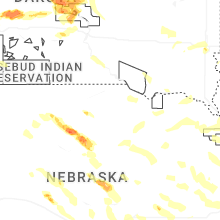

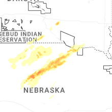


Connect with Interactive Hail Maps