

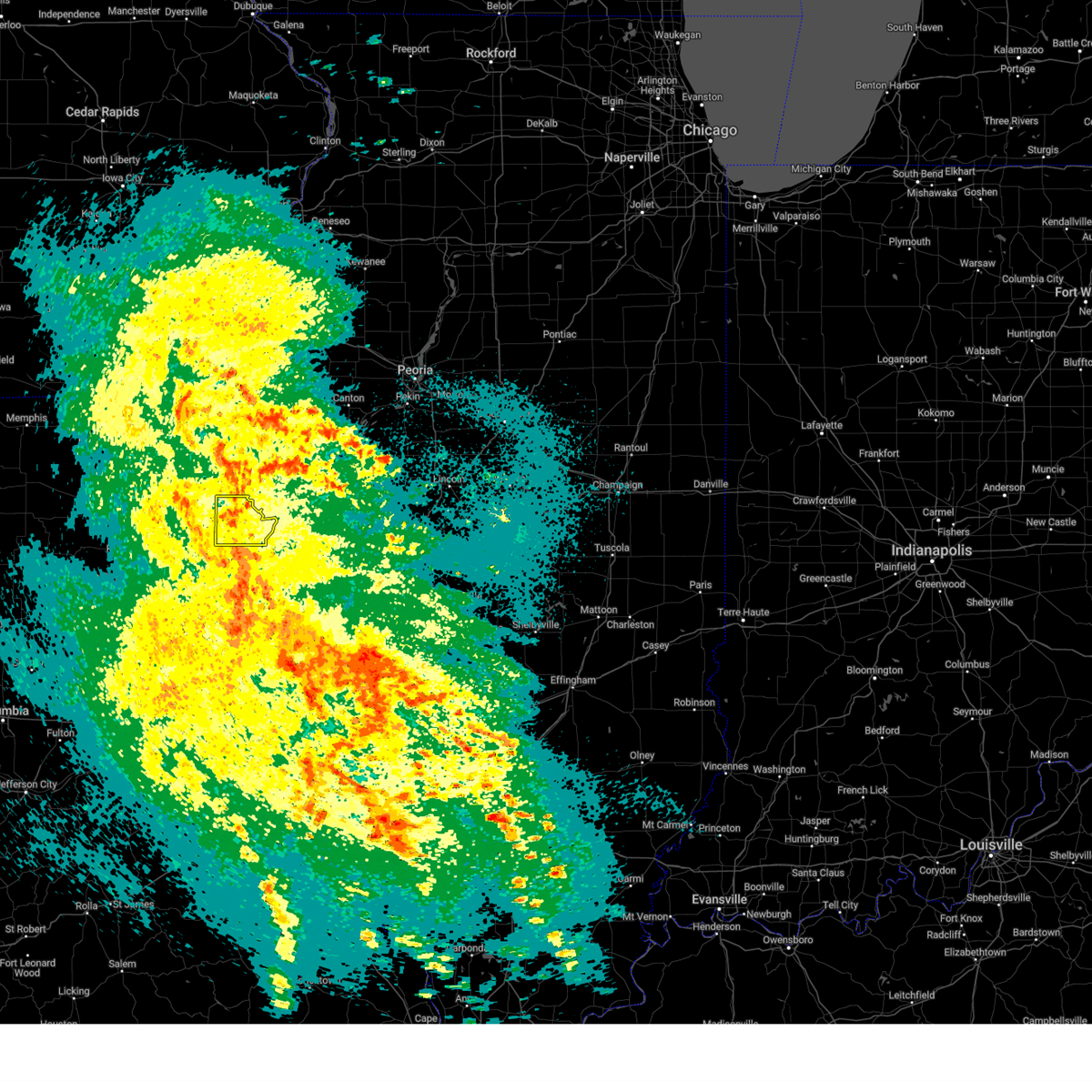
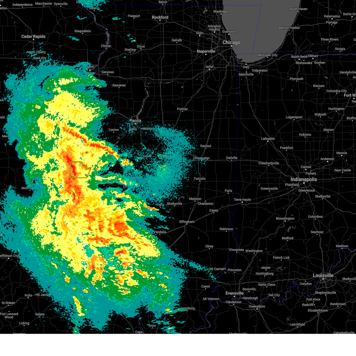
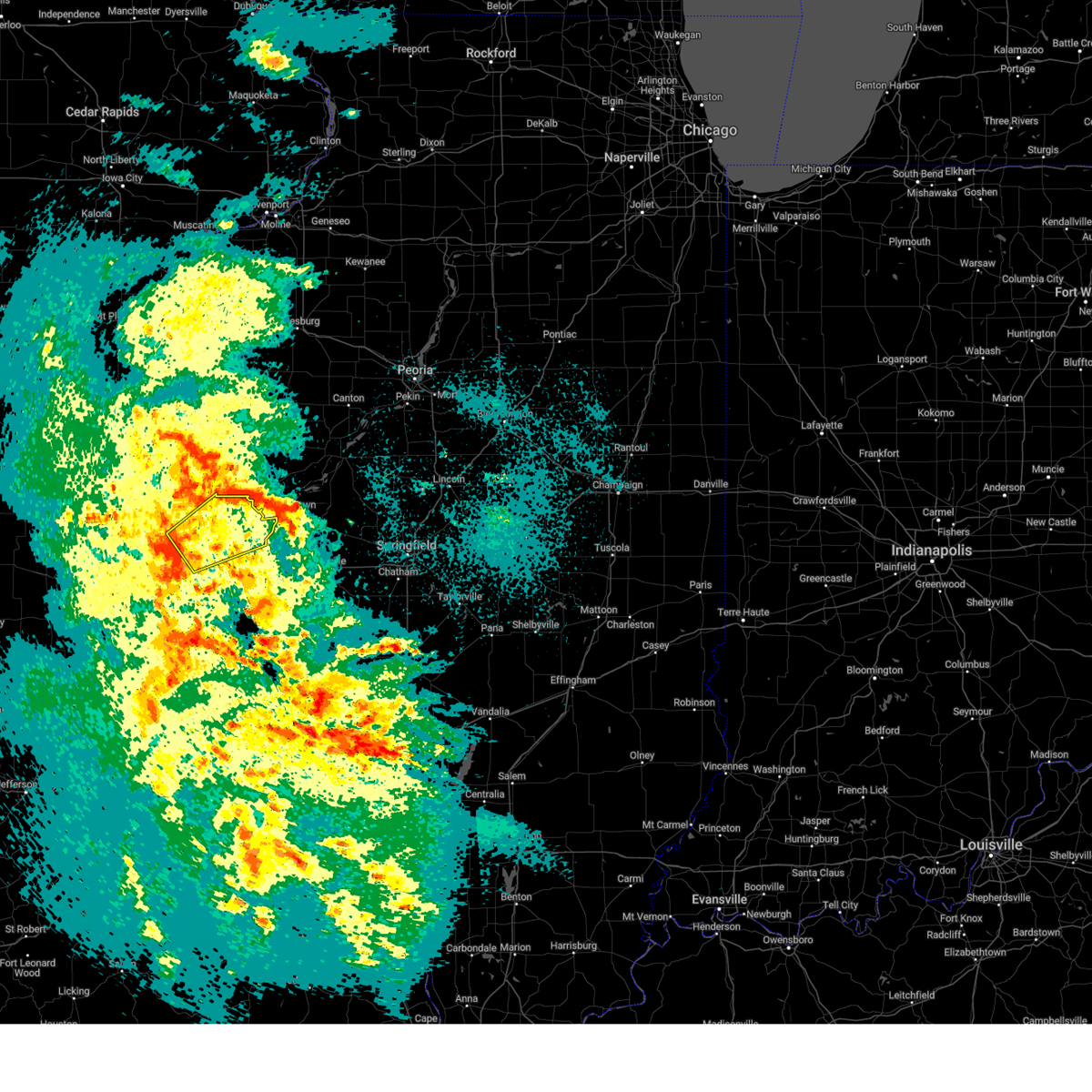
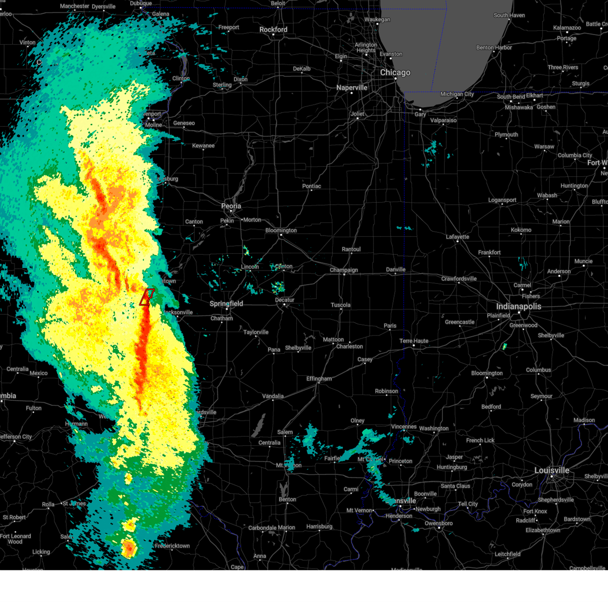
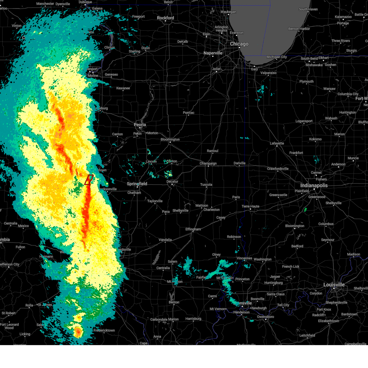
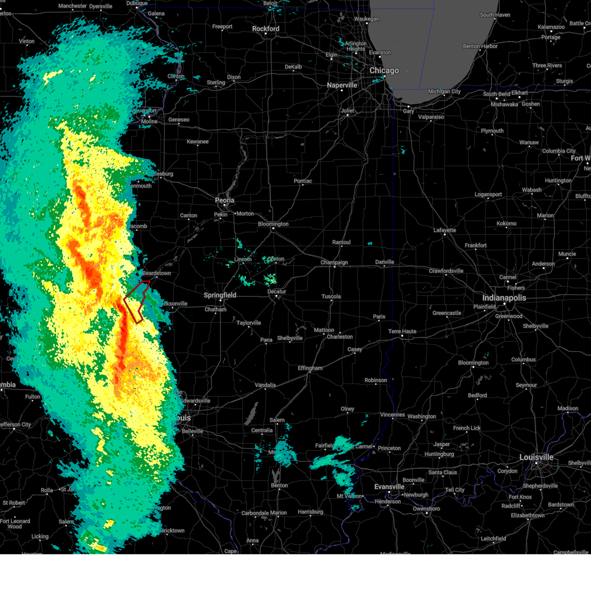
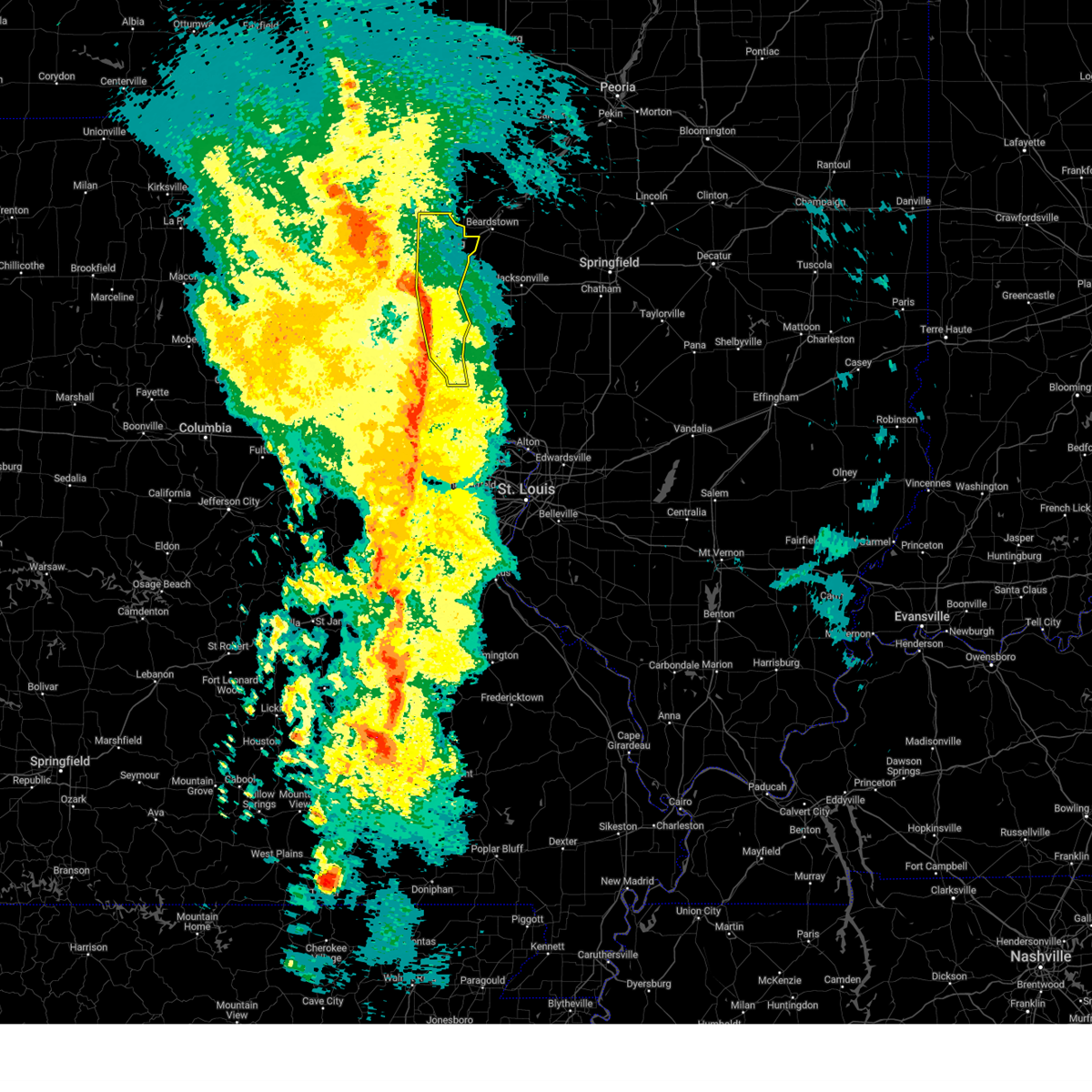
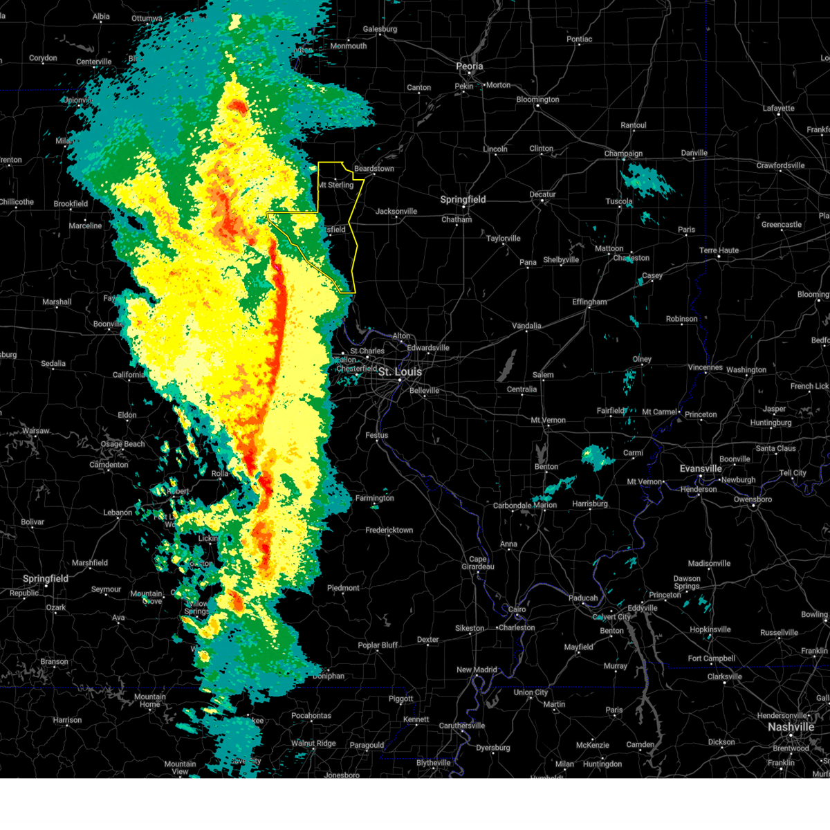
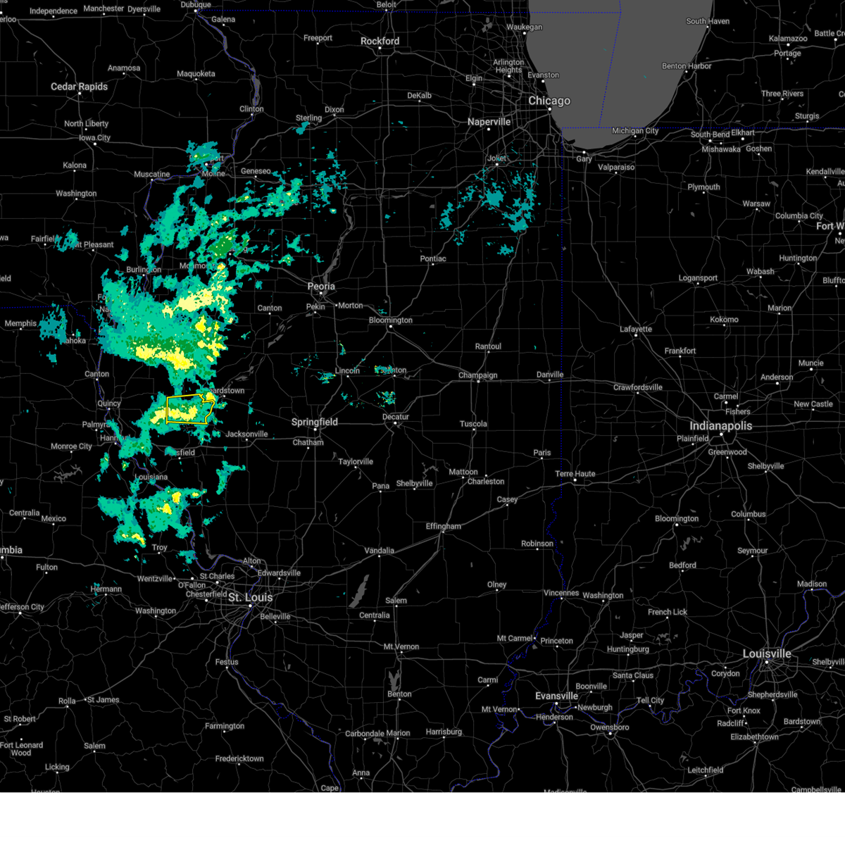
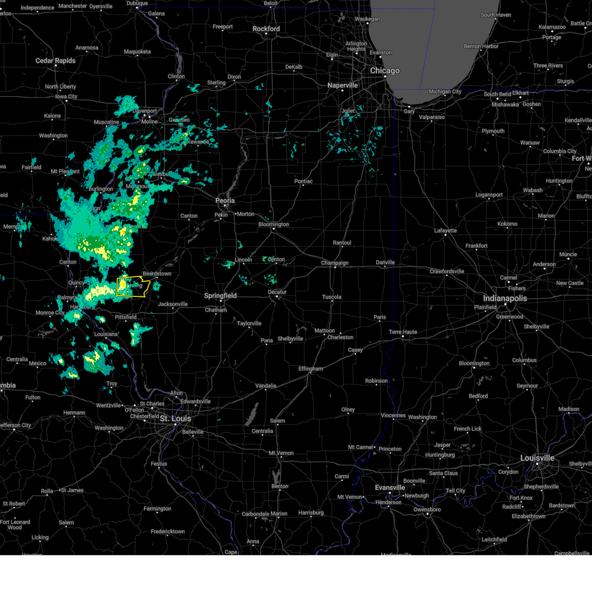
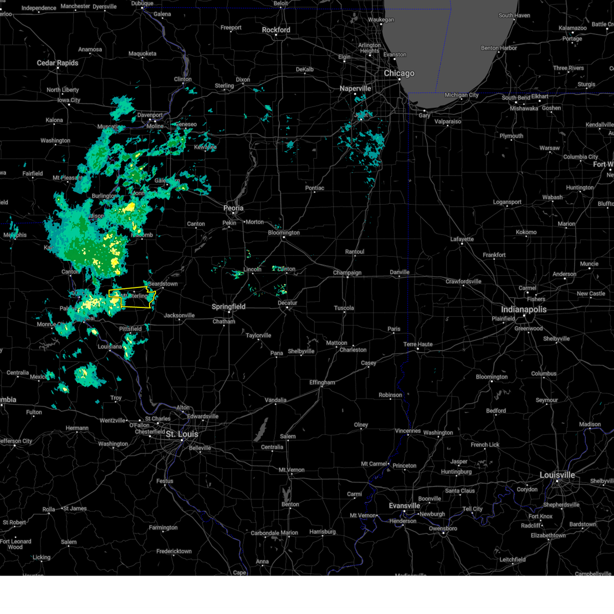
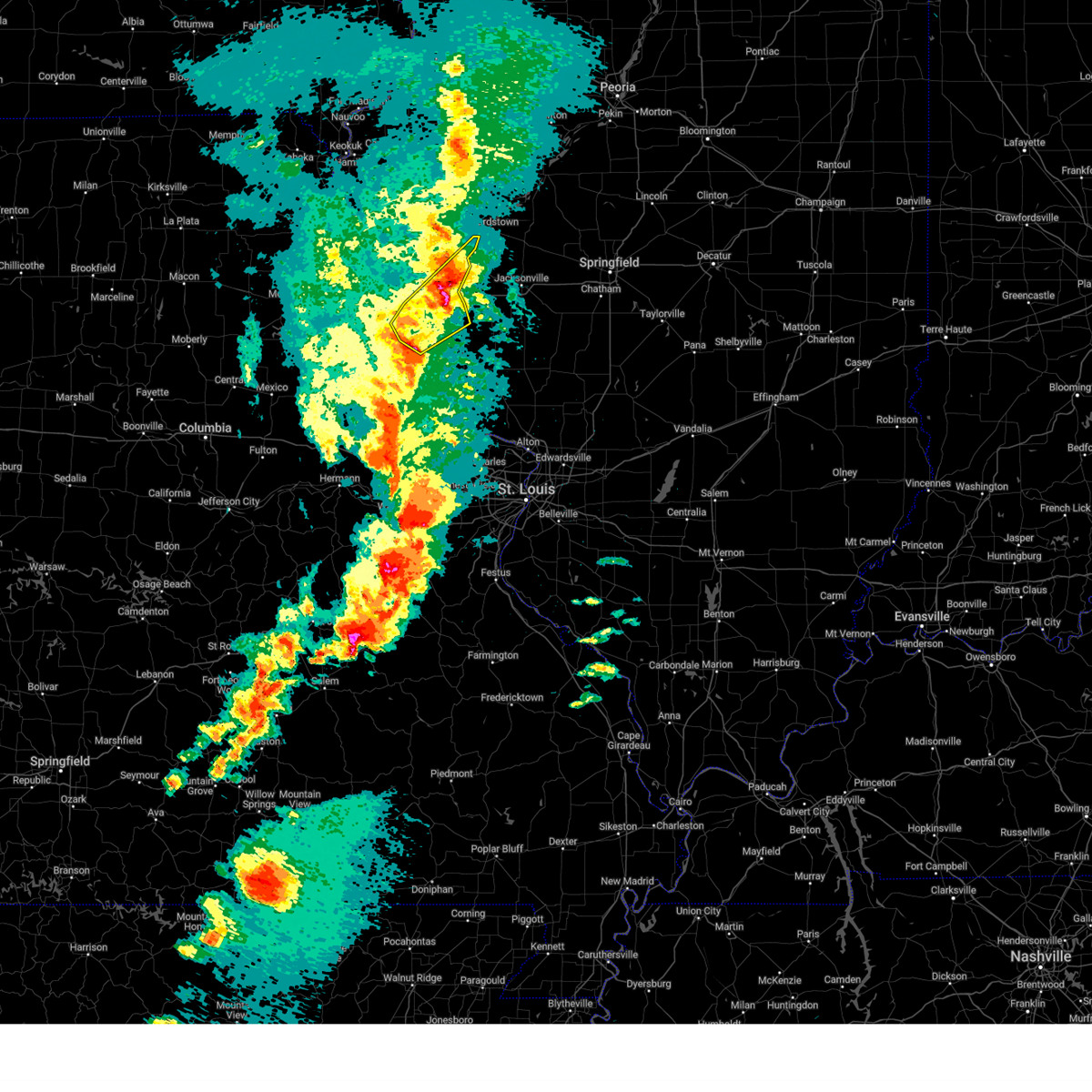
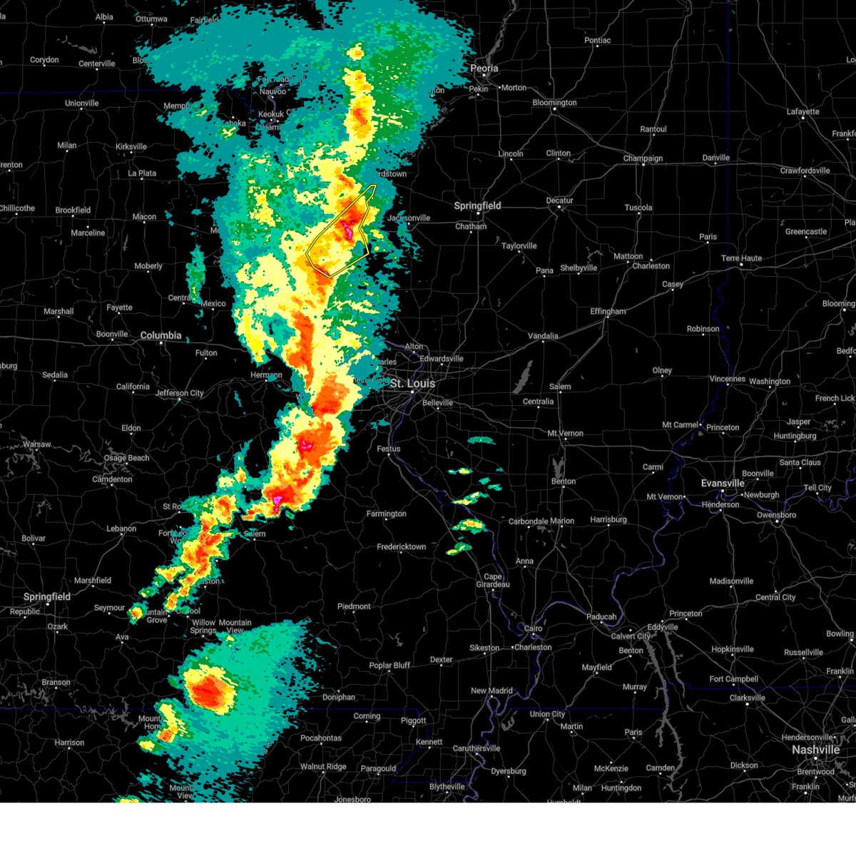
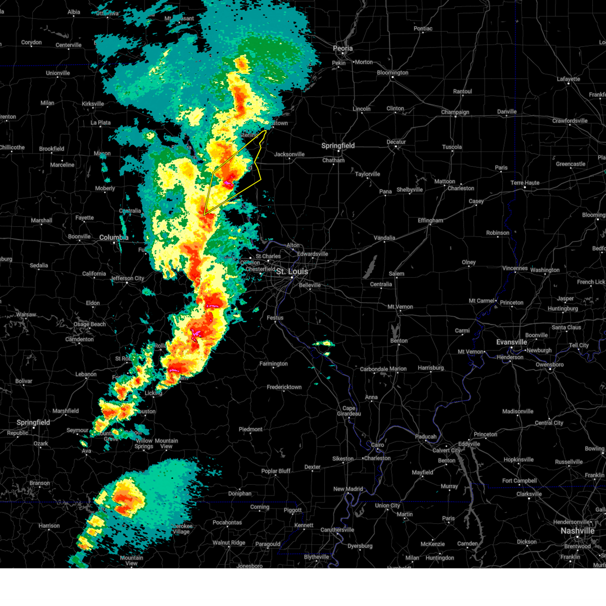
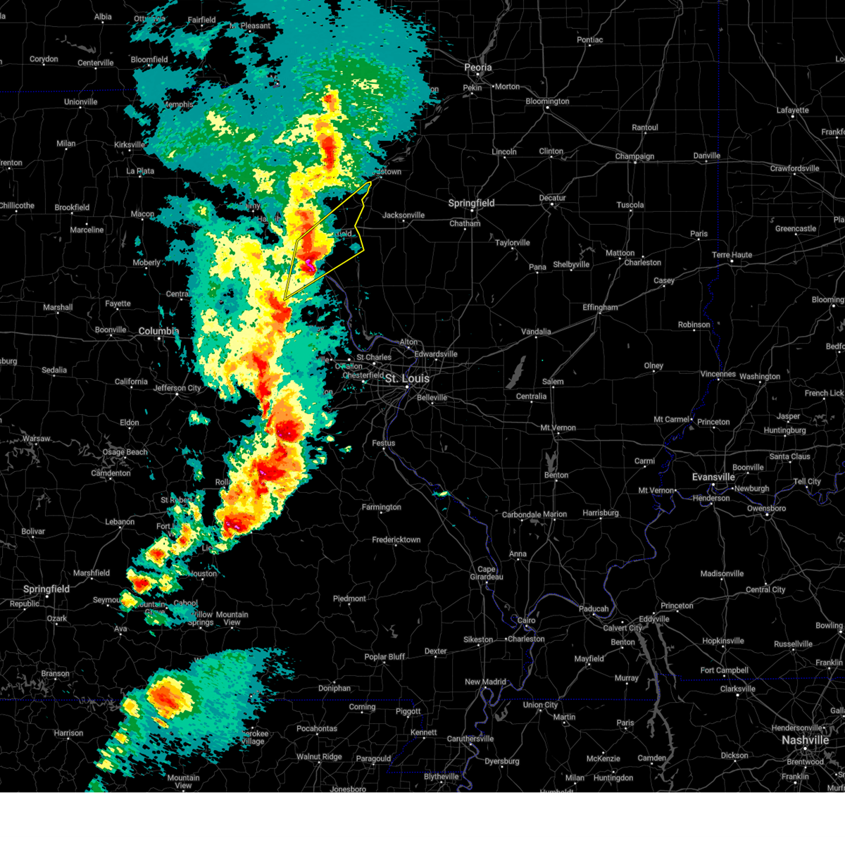
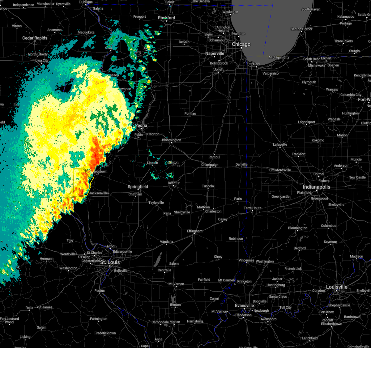
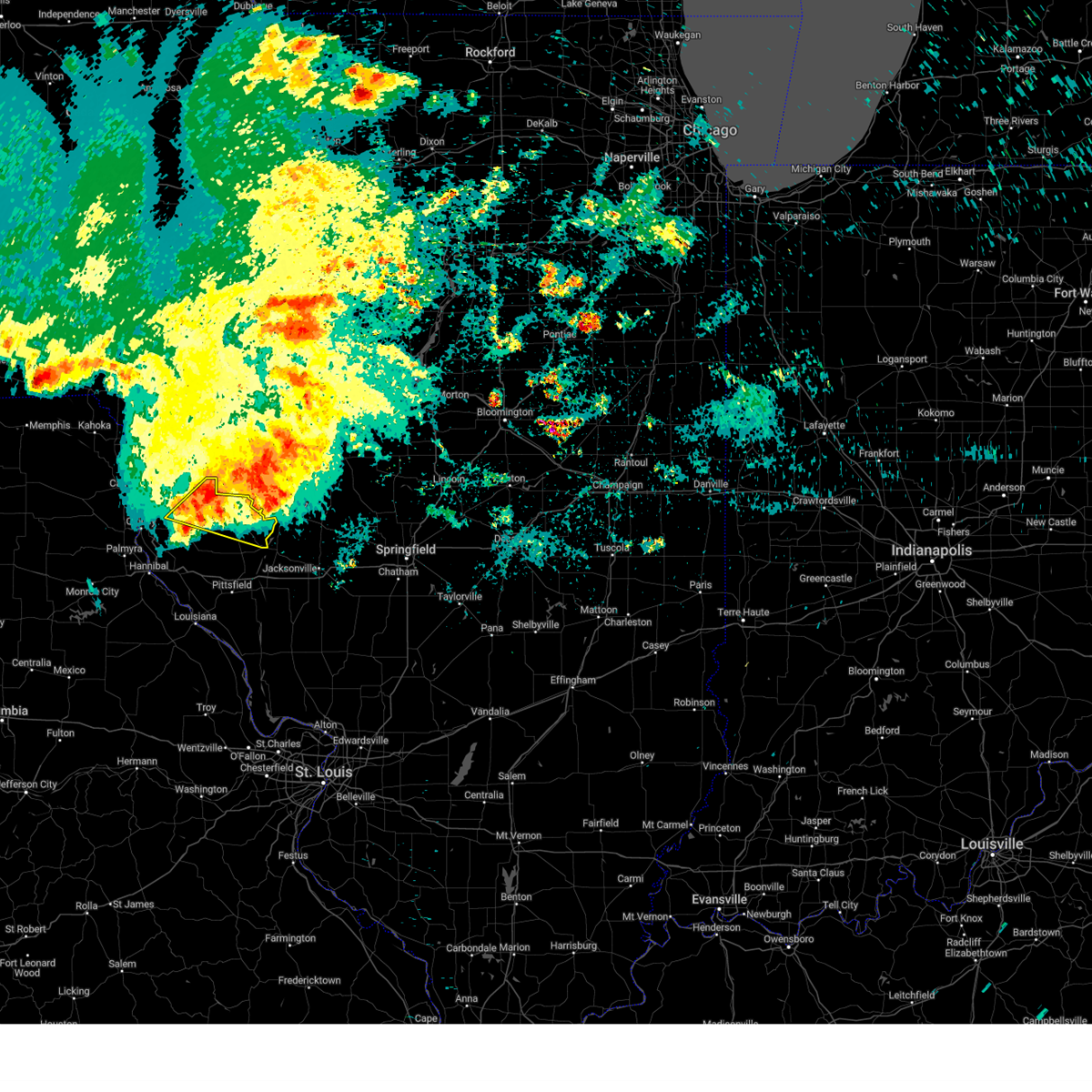
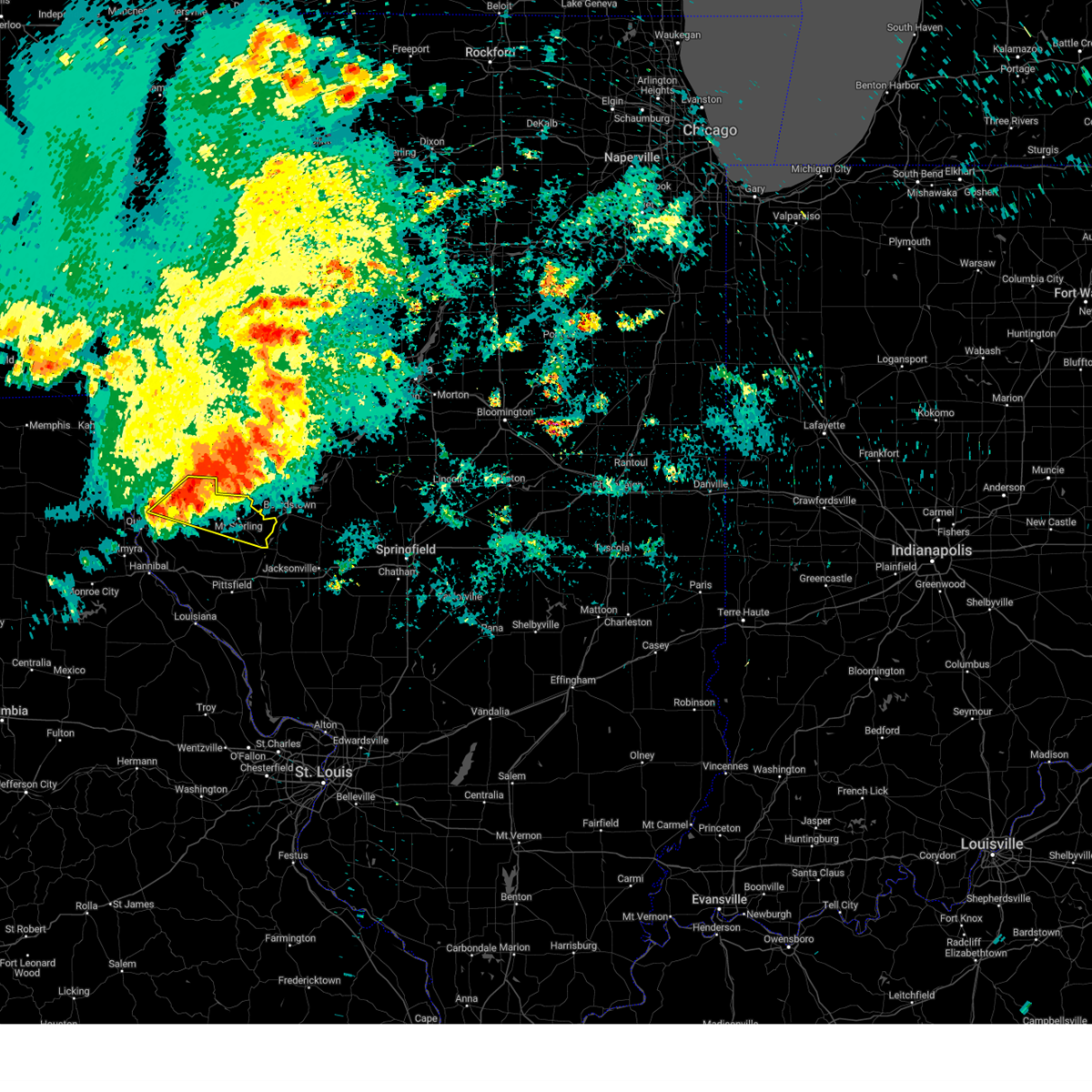
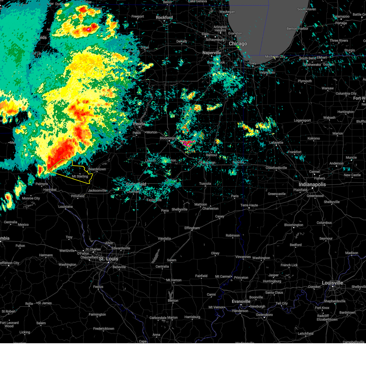
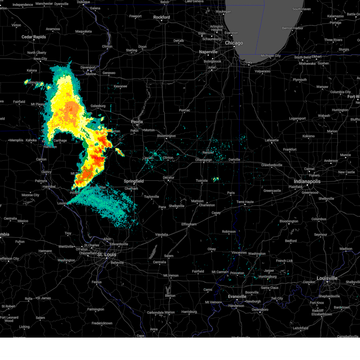
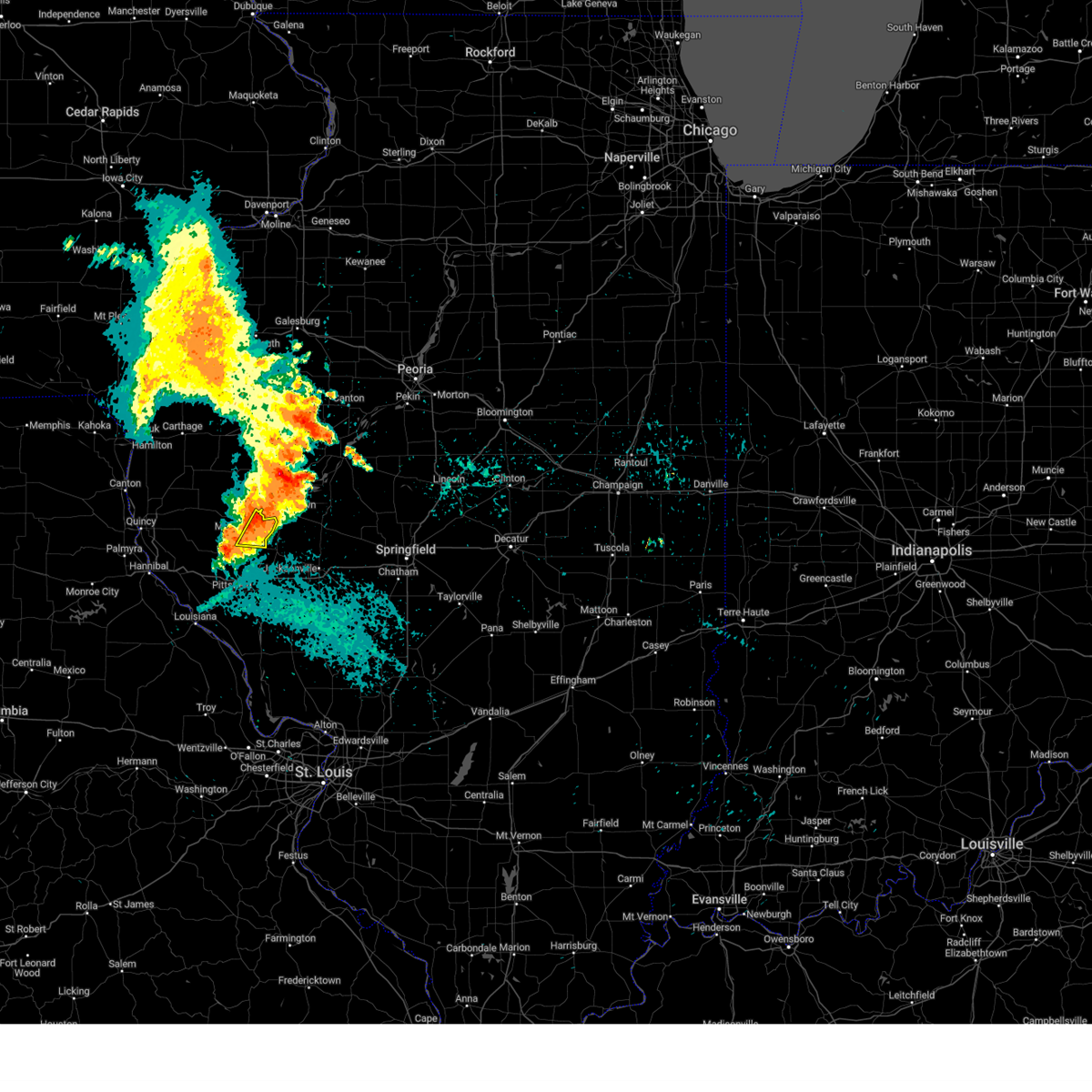
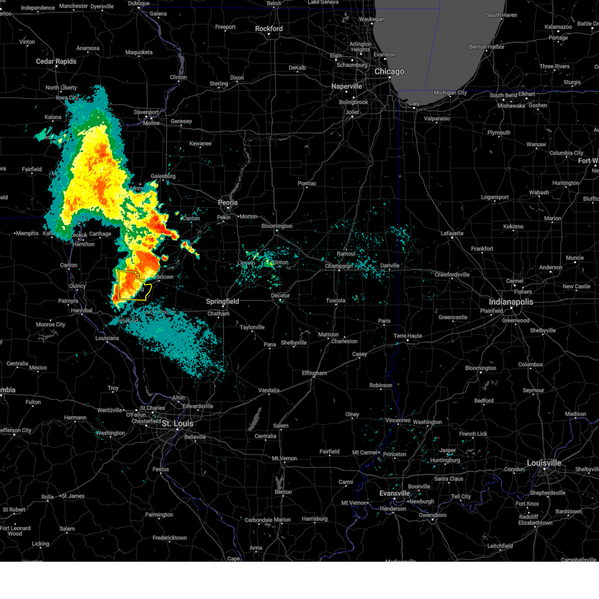
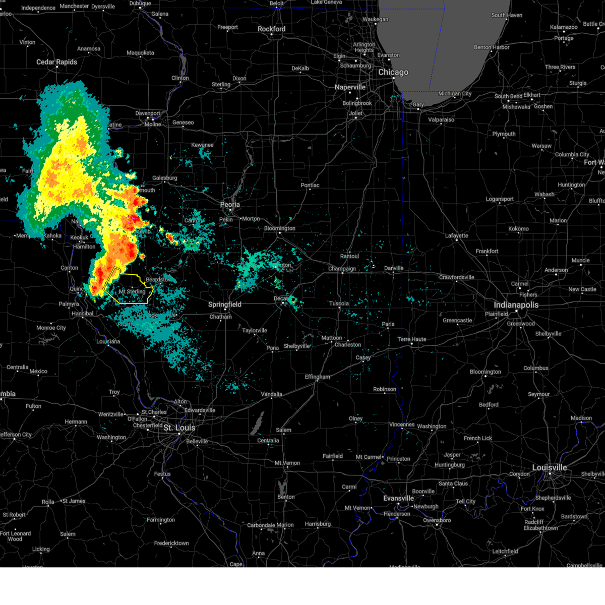
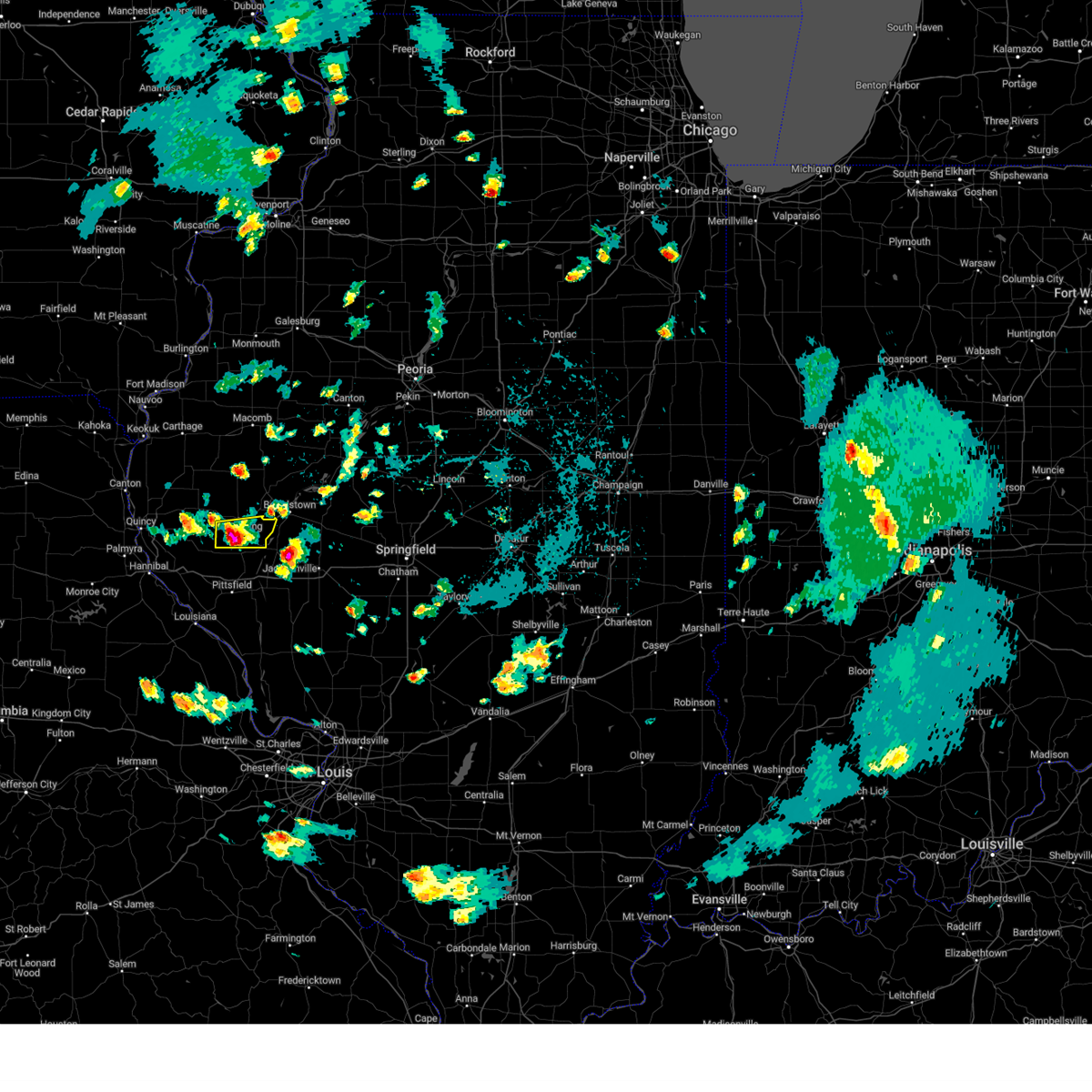
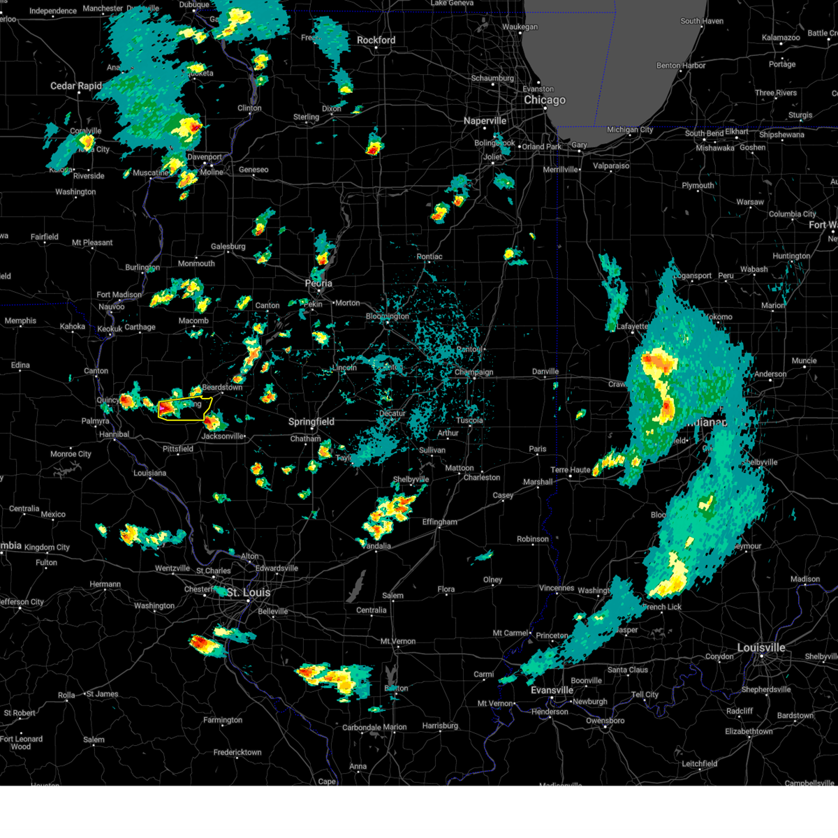
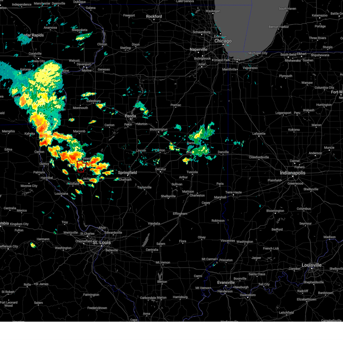
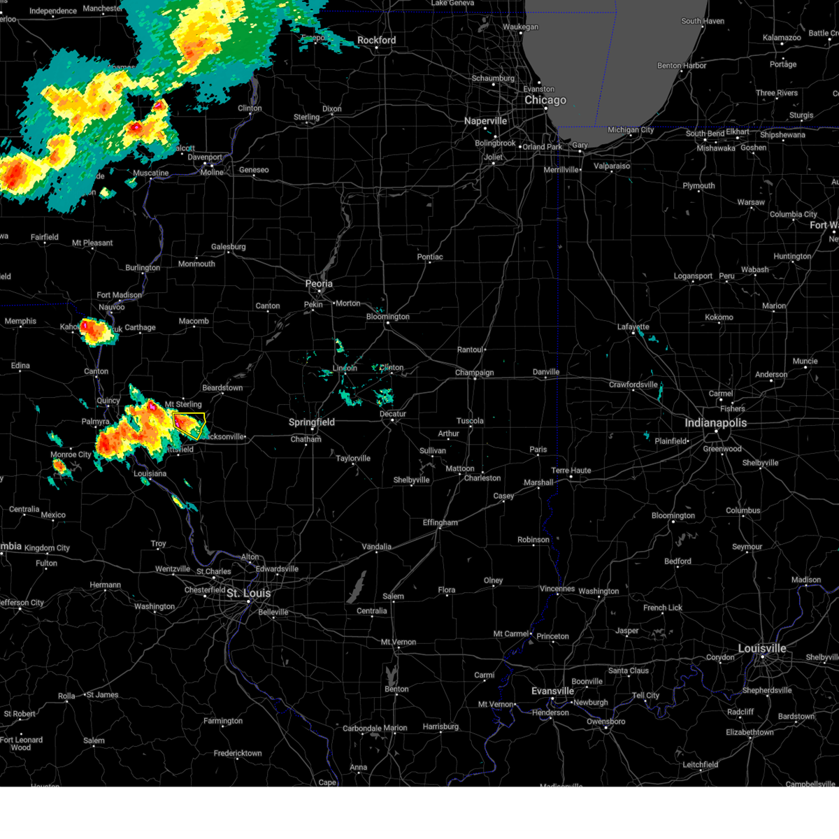
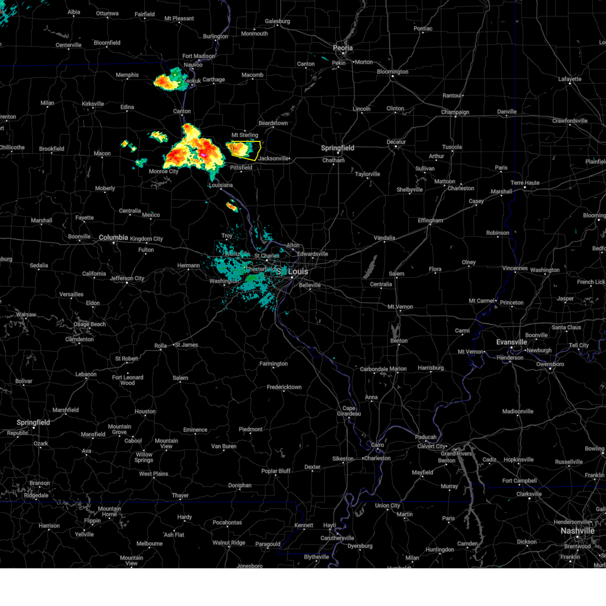
Hail Map for Versailles, IL
The Versailles, IL area has had 3 reports of on-the-ground hail by trained spotters, and has been under severe weather warnings 35 times during the past 12 months. Doppler radar has detected hail at or near Versailles, IL on 68 occasions, including 4 occasions during the past year.
| Name: | Versailles, IL |
| Where Located: | 67.3 miles SE of Kahoka, MO |
| Map: | Google Map for Versailles, IL |
| Population: | 478 |
| Housing Units: | 248 |
| More Info: | Search Google for Versailles, IL |
1
The Top Recent Hail Date for Versailles, IL is Friday, October 4, 2024 (23rd out of 68)

Hail and Wind Damage Spotted near Versailles, IL
| Date / Time | Report Details |
|---|---|
| 5/19/2025 11:53 PM CDT |
 the severe thunderstorm warning has been cancelled and is no longer in effect the severe thunderstorm warning has been cancelled and is no longer in effect
|
| 5/19/2025 11:31 PM CDT |
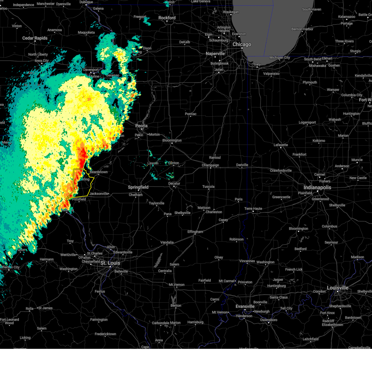
 At 1131 pm cdt, a severe thunderstorm was located over mount sterling, or 21 miles east of quincy regional airport, moving northeast at 35 mph (radar indicated). Hazards include 60 mph wind gusts. Expect damage to roofs, siding, and trees. Locations impacted include, mount sterling, buckhorn, la grange, versailles, mound station, ripley and coopertown. At 1131 pm cdt, a severe thunderstorm was located over mount sterling, or 21 miles east of quincy regional airport, moving northeast at 35 mph (radar indicated). Hazards include 60 mph wind gusts. Expect damage to roofs, siding, and trees. Locations impacted include, mount sterling, buckhorn, la grange, versailles, mound station, ripley and coopertown.
|
| 5/19/2025 11:31 PM CDT |
 the severe thunderstorm warning has been cancelled and is no longer in effect the severe thunderstorm warning has been cancelled and is no longer in effect
|
| 5/19/2025 11:21 PM CDT | At 1121 pm cdt, a severe thunderstorm was located over buckhorn, or 17 miles east of quincy regional airport, moving northeast at 35 mph (radar indicated). Hazards include 60 mph wind gusts. Expect damage to roofs, siding, and trees. locations impacted include, mount sterling, clayton, buckhorn, la grange, versailles, mound station, ripley, kellerville, fishhook and coopertown. This includes the following state parks, siloam springs state park. |
| 5/19/2025 10:56 PM CDT |
 Svrlsx the national weather service in st louis has issued a * severe thunderstorm warning for, southeastern adams county in west central illinois, brown county in west central illinois, north central pike county in west central illinois, * until 1215 am cdt. * at 1056 pm cdt, a severe thunderstorm was located 7 miles west of beverly, or 9 miles southeast of quincy regional airport, moving northeast at 25 mph (radar indicated). Hazards include 60 mph wind gusts. expect damage to roofs, siding, and trees Svrlsx the national weather service in st louis has issued a * severe thunderstorm warning for, southeastern adams county in west central illinois, brown county in west central illinois, north central pike county in west central illinois, * until 1215 am cdt. * at 1056 pm cdt, a severe thunderstorm was located 7 miles west of beverly, or 9 miles southeast of quincy regional airport, moving northeast at 25 mph (radar indicated). Hazards include 60 mph wind gusts. expect damage to roofs, siding, and trees
|
| 4/20/2025 7:25 PM CDT | The storms which prompted the warning have moved out of the area. therefore, the warning will be allowed to expire. however, gusty winds are still possible with these thunderstorms. a tornado watch remains in effect until 1100 pm cdt for portions of southwest and west central illinois. |
| 4/20/2025 7:24 PM CDT | the tornado warning has been cancelled and is no longer in effect |
| 4/20/2025 7:17 PM CDT |
 the tornado warning has been cancelled and is no longer in effect the tornado warning has been cancelled and is no longer in effect
|
| 4/20/2025 7:17 PM CDT |
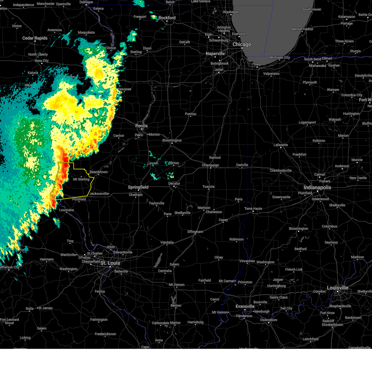
 At 717 pm cdt, a severe thunderstorm capable of producing a tornado was located 13 miles southeast of mount sterling, or 25 miles northeast of pittsfield, moving northeast at 60 mph (radar indicated rotation). Hazards include tornado and quarter size hail. Flying debris will be dangerous to those caught without shelter. mobile homes will be damaged or destroyed. damage to roofs, windows and vehicles will occur. tree damage is likely. Other locations impacted by the tornado include versailles, la grange and coopertown. At 717 pm cdt, a severe thunderstorm capable of producing a tornado was located 13 miles southeast of mount sterling, or 25 miles northeast of pittsfield, moving northeast at 60 mph (radar indicated rotation). Hazards include tornado and quarter size hail. Flying debris will be dangerous to those caught without shelter. mobile homes will be damaged or destroyed. damage to roofs, windows and vehicles will occur. tree damage is likely. Other locations impacted by the tornado include versailles, la grange and coopertown.
|
| 4/20/2025 7:06 PM CDT |
 At 706 pm cdt, a severe thunderstorm capable of producing a tornado was located 6 miles north of griggsville, or 14 miles northeast of pittsfield, moving northeast at 60 mph (radar indicated rotation). Hazards include tornado and quarter size hail. Flying debris will be dangerous to those caught without shelter. mobile homes will be damaged or destroyed. damage to roofs, windows and vehicles will occur. tree damage is likely. this tornado will be near, griggsville around 700 pm cdt. Other locations impacted by the tornado include perry, valley city, chambersburg, versailles, la grange and coopertown. At 706 pm cdt, a severe thunderstorm capable of producing a tornado was located 6 miles north of griggsville, or 14 miles northeast of pittsfield, moving northeast at 60 mph (radar indicated rotation). Hazards include tornado and quarter size hail. Flying debris will be dangerous to those caught without shelter. mobile homes will be damaged or destroyed. damage to roofs, windows and vehicles will occur. tree damage is likely. this tornado will be near, griggsville around 700 pm cdt. Other locations impacted by the tornado include perry, valley city, chambersburg, versailles, la grange and coopertown.
|
| 4/20/2025 7:04 PM CDT |
 At 704 pm cdt, severe thunderstorms were located along a line from over beverly to near belleview, or along a line from 16 miles southeast of quincy regional airport to 10 miles north of elsberry, moving northeast at 50 mph (trained spotters reported. at 6:50 pm power poles were blown down near hull, il). Hazards include 70 mph wind gusts and quarter size hail. Hail damage to vehicles is expected. expect considerable tree damage. wind damage is also likely to mobile homes, roofs, and outbuildings. other locations impacted by the severe thunderstorm include martinsburg, new salem, baylis, nebo, mozier, independence, hamburg, time, fishhook and michael. This includes interstate 72 between exits 31 and 35. At 704 pm cdt, severe thunderstorms were located along a line from over beverly to near belleview, or along a line from 16 miles southeast of quincy regional airport to 10 miles north of elsberry, moving northeast at 50 mph (trained spotters reported. at 6:50 pm power poles were blown down near hull, il). Hazards include 70 mph wind gusts and quarter size hail. Hail damage to vehicles is expected. expect considerable tree damage. wind damage is also likely to mobile homes, roofs, and outbuildings. other locations impacted by the severe thunderstorm include martinsburg, new salem, baylis, nebo, mozier, independence, hamburg, time, fishhook and michael. This includes interstate 72 between exits 31 and 35.
|
| 4/20/2025 6:56 PM CDT |
 Torlsx the national weather service in st louis has issued a * tornado warning for, southeastern brown county in west central illinois, northeastern pike county in west central illinois, * until 745 pm cdt. * at 656 pm cdt, a severe thunderstorm capable of producing a tornado was located near pittsfield, moving northeast at 50 mph (radar indicated rotation). Hazards include tornado and quarter size hail. Flying debris will be dangerous to those caught without shelter. mobile homes will be damaged or destroyed. damage to roofs, windows and vehicles will occur. tree damage is likely. this tornado will be near, pittsfield around 700 pm cdt. griggsville around 705 pm cdt. other locations impacted by the tornado include new salem, detroit, baylis, perry, valley city, chambersburg, versailles and la grange. This includes interstate 72 between exits 31 and 35. Torlsx the national weather service in st louis has issued a * tornado warning for, southeastern brown county in west central illinois, northeastern pike county in west central illinois, * until 745 pm cdt. * at 656 pm cdt, a severe thunderstorm capable of producing a tornado was located near pittsfield, moving northeast at 50 mph (radar indicated rotation). Hazards include tornado and quarter size hail. Flying debris will be dangerous to those caught without shelter. mobile homes will be damaged or destroyed. damage to roofs, windows and vehicles will occur. tree damage is likely. this tornado will be near, pittsfield around 700 pm cdt. griggsville around 705 pm cdt. other locations impacted by the tornado include new salem, detroit, baylis, perry, valley city, chambersburg, versailles and la grange. This includes interstate 72 between exits 31 and 35.
|
| 4/20/2025 6:27 PM CDT |
 Svrlsx the national weather service in st louis has issued a * severe thunderstorm warning for, northwestern calhoun county in southwestern illinois, brown county in west central illinois, pike county in west central illinois, * until 730 pm cdt. * at 627 pm cdt, severe thunderstorms were located along a line from near center to 6 miles southwest of eolia, or along a line from 12 miles south of hannibal to 11 miles southeast of bowling green, moving northeast at 60 mph (radar indicated). Hazards include 70 mph wind gusts and quarter size hail. Hail damage to vehicles is expected. expect considerable tree damage. wind damage is also likely to mobile homes, roofs, and outbuildings. this severe thunderstorm will be near, pike around 635 pm cdt. other locations impacted by the severe thunderstorm include rockport, summer hill, hull, new canton, new hartford, el dara, kinderhook, seehorn, mozier and martinsburg. This includes interstate 72 between exits 10 and 35. Svrlsx the national weather service in st louis has issued a * severe thunderstorm warning for, northwestern calhoun county in southwestern illinois, brown county in west central illinois, pike county in west central illinois, * until 730 pm cdt. * at 627 pm cdt, severe thunderstorms were located along a line from near center to 6 miles southwest of eolia, or along a line from 12 miles south of hannibal to 11 miles southeast of bowling green, moving northeast at 60 mph (radar indicated). Hazards include 70 mph wind gusts and quarter size hail. Hail damage to vehicles is expected. expect considerable tree damage. wind damage is also likely to mobile homes, roofs, and outbuildings. this severe thunderstorm will be near, pike around 635 pm cdt. other locations impacted by the severe thunderstorm include rockport, summer hill, hull, new canton, new hartford, el dara, kinderhook, seehorn, mozier and martinsburg. This includes interstate 72 between exits 10 and 35.
|
| 3/21/2025 8:50 PM CDT |
 The storm which prompted the warning has moved out of the area. therefore, the warning will be allowed to expire. The storm which prompted the warning has moved out of the area. therefore, the warning will be allowed to expire.
|
| 3/21/2025 8:35 PM CDT |
 At 835 pm cdt, a severe thunderstorm was located 5 miles south of mount sterling, or 21 miles north of pittsfield, moving east at 55 mph (emergency management reported). Hazards include 60 mph wind gusts. Expect damage to roofs, siding, and trees. Locations impacted include, mount sterling, buckhorn, la grange, versailles, mound station, ripley and coopertown. At 835 pm cdt, a severe thunderstorm was located 5 miles south of mount sterling, or 21 miles north of pittsfield, moving east at 55 mph (emergency management reported). Hazards include 60 mph wind gusts. Expect damage to roofs, siding, and trees. Locations impacted include, mount sterling, buckhorn, la grange, versailles, mound station, ripley and coopertown.
|
| 3/21/2025 8:35 PM CDT |
 the severe thunderstorm warning has been cancelled and is no longer in effect the severe thunderstorm warning has been cancelled and is no longer in effect
|
| 3/21/2025 8:21 PM CDT |
 Svrlsx the national weather service in st louis has issued a * severe thunderstorm warning for, east central adams county in west central illinois, brown county in west central illinois, * until 900 pm cdt. * at 821 pm cdt, a severe thunderstorm was located 8 miles south of clayton, or 12 miles east of quincy regional airport, moving east at 55 mph (broadcast media reported). Hazards include 60 mph wind gusts. expect damage to roofs, siding, and trees Svrlsx the national weather service in st louis has issued a * severe thunderstorm warning for, east central adams county in west central illinois, brown county in west central illinois, * until 900 pm cdt. * at 821 pm cdt, a severe thunderstorm was located 8 miles south of clayton, or 12 miles east of quincy regional airport, moving east at 55 mph (broadcast media reported). Hazards include 60 mph wind gusts. expect damage to roofs, siding, and trees
|
| 3/14/2025 8:55 PM CDT |
 the severe thunderstorm warning has been cancelled and is no longer in effect the severe thunderstorm warning has been cancelled and is no longer in effect
|
| 3/14/2025 8:55 PM CDT |
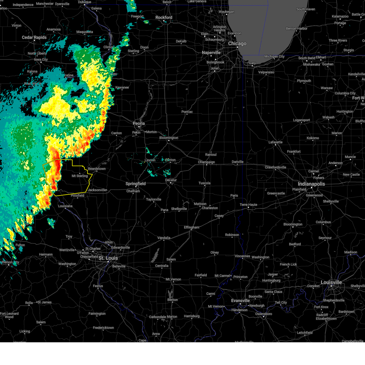
 At 855 pm cdt, a severe thunderstorm was located near griggsville, or 11 miles northeast of pittsfield, moving northeast at 60 mph (radar indicated). Hazards include 70 mph wind gusts and half dollar size hail. Hail damage to vehicles is expected. expect considerable tree damage. wind damage is also likely to mobile homes, roofs, and outbuildings. this severe thunderstorm will remain over mainly rural areas of northern calhoun county in southwestern illinois and southeastern brown and pike counties in west central illinois. This includes interstate 72 between exits 31 and 35. At 855 pm cdt, a severe thunderstorm was located near griggsville, or 11 miles northeast of pittsfield, moving northeast at 60 mph (radar indicated). Hazards include 70 mph wind gusts and half dollar size hail. Hail damage to vehicles is expected. expect considerable tree damage. wind damage is also likely to mobile homes, roofs, and outbuildings. this severe thunderstorm will remain over mainly rural areas of northern calhoun county in southwestern illinois and southeastern brown and pike counties in west central illinois. This includes interstate 72 between exits 31 and 35.
|
| 3/14/2025 8:35 PM CDT |
 At 835 pm cdt, a severe thunderstorm was located near atlas, or 9 miles southwest of pittsfield, moving northeast at 70 mph (radar indicated). Hazards include 70 mph wind gusts and ping pong ball size hail. People and animals outdoors will be injured. expect hail damage to roofs, siding, windows, and vehicles. expect considerable tree damage. wind damage is also likely to mobile homes, roofs, and outbuildings. this severe thunderstorm will remain over mainly rural areas of northwestern calhoun county in southwestern illinois, southeastern brown and pike counties in west central illinois and central pike county in northeastern missouri. This includes interstate 72 between exits 31 and 35. At 835 pm cdt, a severe thunderstorm was located near atlas, or 9 miles southwest of pittsfield, moving northeast at 70 mph (radar indicated). Hazards include 70 mph wind gusts and ping pong ball size hail. People and animals outdoors will be injured. expect hail damage to roofs, siding, windows, and vehicles. expect considerable tree damage. wind damage is also likely to mobile homes, roofs, and outbuildings. this severe thunderstorm will remain over mainly rural areas of northwestern calhoun county in southwestern illinois, southeastern brown and pike counties in west central illinois and central pike county in northeastern missouri. This includes interstate 72 between exits 31 and 35.
|
| 3/14/2025 8:27 PM CDT |
 Svrlsx the national weather service in st louis has issued a * severe thunderstorm warning for, northwestern calhoun county in southwestern illinois, southeastern brown county in west central illinois, pike county in west central illinois, central pike county in northeastern missouri, * until 915 pm cdt. * at 827 pm cdt, a severe thunderstorm was located over pike, or over louisiana, moving northeast at 75 mph (radar indicated). Hazards include 70 mph wind gusts and quarter size hail. Hail damage to vehicles is expected. expect considerable tree damage. wind damage is also likely to mobile homes, roofs, and outbuildings. this severe thunderstorm will be near, louisiana, pike, atlas, pleasant hill and clarksville around 830 pm cdt. pittsfield around 840 pm cdt. other locations impacted by the severe thunderstorm include rockport, summer hill, martinsburg, new hartford, nebo, independence, time, detroit, milton and new salem. This includes interstate 72 between exits 31 and 35. Svrlsx the national weather service in st louis has issued a * severe thunderstorm warning for, northwestern calhoun county in southwestern illinois, southeastern brown county in west central illinois, pike county in west central illinois, central pike county in northeastern missouri, * until 915 pm cdt. * at 827 pm cdt, a severe thunderstorm was located over pike, or over louisiana, moving northeast at 75 mph (radar indicated). Hazards include 70 mph wind gusts and quarter size hail. Hail damage to vehicles is expected. expect considerable tree damage. wind damage is also likely to mobile homes, roofs, and outbuildings. this severe thunderstorm will be near, louisiana, pike, atlas, pleasant hill and clarksville around 830 pm cdt. pittsfield around 840 pm cdt. other locations impacted by the severe thunderstorm include rockport, summer hill, martinsburg, new hartford, nebo, independence, time, detroit, milton and new salem. This includes interstate 72 between exits 31 and 35.
|
| 10/31/2024 12:31 AM CDT |
 The storms which prompted the warning have weakened below severe limits, and no longer pose an immediate threat to life or property. therefore, the warning has been allowed to expire. to report severe weather, contact your nearest law enforcement agency. they will send your report to the national weather service office. The storms which prompted the warning have weakened below severe limits, and no longer pose an immediate threat to life or property. therefore, the warning has been allowed to expire. to report severe weather, contact your nearest law enforcement agency. they will send your report to the national weather service office.
|
| 10/31/2024 12:16 AM CDT |
 the severe thunderstorm warning has been cancelled and is no longer in effect the severe thunderstorm warning has been cancelled and is no longer in effect
|
| 10/31/2024 12:16 AM CDT |
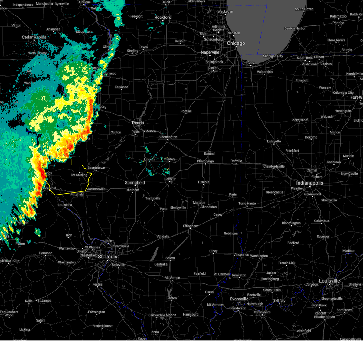
 At 1216 am cdt, severe thunderstorms were located along a line from 22 miles north of mount sterling to over mount sterling, or along a line from 34 miles northeast of quincy regional airport to 22 miles east of quincy regional airport, moving east at 50 mph (radar indicated). Hazards include 60 mph wind gusts and small hail. Expect damage to roofs, siding, and trees. Locations impacted include, mount sterling, griggsville, buckhorn, la grange, versailles, perry, baylis, chambersburg, new salem, mound station, ripley, valley city, fishhook and coopertown. At 1216 am cdt, severe thunderstorms were located along a line from 22 miles north of mount sterling to over mount sterling, or along a line from 34 miles northeast of quincy regional airport to 22 miles east of quincy regional airport, moving east at 50 mph (radar indicated). Hazards include 60 mph wind gusts and small hail. Expect damage to roofs, siding, and trees. Locations impacted include, mount sterling, griggsville, buckhorn, la grange, versailles, perry, baylis, chambersburg, new salem, mound station, ripley, valley city, fishhook and coopertown.
|
| 10/30/2024 11:53 PM CDT |
 At 1153 pm cdt, severe thunderstorms were located along a line from 8 miles northwest of golden to 7 miles southeast of quincy regional airport, or along a line from 19 miles north of quincy regional airport to 7 miles southeast of quincy regional airport, moving east at 50 mph (public reported). Hazards include 70 mph wind gusts. Expect considerable tree damage. damage is likely to mobile homes, roofs, and outbuildings. locations impacted include, hannibal, quincy regional airport, mount sterling, barry, griggsville, camp point, payson, clayton, golden, fall creek, beverly, buckhorn, adams, la grange, kingston, burton, liberty, versailles, hull and richfield. this includes the following state parks, siloam springs state park. this includes the following highways, interstate 72 between exits 4 and 20. Interstate 172 near exit 2. At 1153 pm cdt, severe thunderstorms were located along a line from 8 miles northwest of golden to 7 miles southeast of quincy regional airport, or along a line from 19 miles north of quincy regional airport to 7 miles southeast of quincy regional airport, moving east at 50 mph (public reported). Hazards include 70 mph wind gusts. Expect considerable tree damage. damage is likely to mobile homes, roofs, and outbuildings. locations impacted include, hannibal, quincy regional airport, mount sterling, barry, griggsville, camp point, payson, clayton, golden, fall creek, beverly, buckhorn, adams, la grange, kingston, burton, liberty, versailles, hull and richfield. this includes the following state parks, siloam springs state park. this includes the following highways, interstate 72 between exits 4 and 20. Interstate 172 near exit 2.
|
| 10/30/2024 11:48 PM CDT |
 At 1148 pm cdt, severe thunderstorms were located along a line from 8 miles northwest of golden to 6 miles south of quincy regional airport, or along a line from 17 miles north of quincy regional airport to 6 miles south of quincy regional airport, moving east at 55 mph (automated observing station at quincy (kuin) reported a wind gust of 81 mph). Hazards include 70 mph wind gusts. Expect considerable tree damage. damage is likely to mobile homes, roofs, and outbuildings. locations impacted include, quincy, hannibal, quincy regional airport, mount sterling, barry, griggsville, camp point, payson, mendon, clayton, golden, fall creek, beverly, buckhorn, adams, la grange, kingston, burton, ursa and liberty. this includes the following state parks, siloam springs state park. this includes the following highways, interstate 72 between exits 4 and 20. Interstate 172 between exits 2 and 19. At 1148 pm cdt, severe thunderstorms were located along a line from 8 miles northwest of golden to 6 miles south of quincy regional airport, or along a line from 17 miles north of quincy regional airport to 6 miles south of quincy regional airport, moving east at 55 mph (automated observing station at quincy (kuin) reported a wind gust of 81 mph). Hazards include 70 mph wind gusts. Expect considerable tree damage. damage is likely to mobile homes, roofs, and outbuildings. locations impacted include, quincy, hannibal, quincy regional airport, mount sterling, barry, griggsville, camp point, payson, mendon, clayton, golden, fall creek, beverly, buckhorn, adams, la grange, kingston, burton, ursa and liberty. this includes the following state parks, siloam springs state park. this includes the following highways, interstate 72 between exits 4 and 20. Interstate 172 between exits 2 and 19.
|
| 10/30/2024 11:25 PM CDT |
 Svrlsx the national weather service in st louis has issued a * severe thunderstorm warning for, adams county in west central illinois, brown county in west central illinois, northern pike county in west central illinois, * until 1230 am cdt. * at 1125 pm cdt, severe thunderstorms were located along a line from over la grange to near palmyra, or along a line from near canton to near palmyra, moving east at 60 mph (radar indicated). Hazards include 60 mph wind gusts. expect damage to roofs, siding, and trees Svrlsx the national weather service in st louis has issued a * severe thunderstorm warning for, adams county in west central illinois, brown county in west central illinois, northern pike county in west central illinois, * until 1230 am cdt. * at 1125 pm cdt, severe thunderstorms were located along a line from over la grange to near palmyra, or along a line from near canton to near palmyra, moving east at 60 mph (radar indicated). Hazards include 60 mph wind gusts. expect damage to roofs, siding, and trees
|
| 7/31/2024 6:43 AM CDT |
 At 643 am cdt, severe thunderstorms were located along a line extending from 6 miles northeast of mount sterling to near buckhorn, moving east at 40 mph (radar indicated). Hazards include 60 mph wind gusts and nickel size hail. Expect damage to roofs, siding, and trees. Locations impacted include, mount sterling, camp point, clayton, golden, buckhorn, la grange, versailles, coatsburg, mound station, columbus, ripley, la prairie, paloma, kellerville, coopertown, and chatton. At 643 am cdt, severe thunderstorms were located along a line extending from 6 miles northeast of mount sterling to near buckhorn, moving east at 40 mph (radar indicated). Hazards include 60 mph wind gusts and nickel size hail. Expect damage to roofs, siding, and trees. Locations impacted include, mount sterling, camp point, clayton, golden, buckhorn, la grange, versailles, coatsburg, mound station, columbus, ripley, la prairie, paloma, kellerville, coopertown, and chatton.
|
| 7/31/2024 6:32 AM CDT |
 At 631 am cdt, severe thunderstorms were located along a line extending from 7 miles northeast of clayton to near quincy regional airport, moving southeast at 35 mph (radar indicated). Hazards include 60 mph wind gusts and nickel size hail. Expect damage to roofs, siding, and trees. locations impacted include, mount sterling, camp point, clayton, golden, buckhorn, la grange, versailles, coatsburg, mound station, columbus, ripley, la prairie, paloma, fowler, kellerville, coopertown, and chatton. This includes interstate 172 near exit 19. At 631 am cdt, severe thunderstorms were located along a line extending from 7 miles northeast of clayton to near quincy regional airport, moving southeast at 35 mph (radar indicated). Hazards include 60 mph wind gusts and nickel size hail. Expect damage to roofs, siding, and trees. locations impacted include, mount sterling, camp point, clayton, golden, buckhorn, la grange, versailles, coatsburg, mound station, columbus, ripley, la prairie, paloma, fowler, kellerville, coopertown, and chatton. This includes interstate 172 near exit 19.
|
| 7/31/2024 6:12 AM CDT |
 Svrlsx the national weather service in st louis has issued a * severe thunderstorm warning for, northern adams county in west central illinois, brown county in west central illinois, * until 700 am cdt. * at 611 am cdt, severe thunderstorms were located along a line extending from augusta to near quincy, moving east at 40 mph (radar indicated). Hazards include 60 mph wind gusts and nickel size hail. expect damage to roofs, siding, and trees Svrlsx the national weather service in st louis has issued a * severe thunderstorm warning for, northern adams county in west central illinois, brown county in west central illinois, * until 700 am cdt. * at 611 am cdt, severe thunderstorms were located along a line extending from augusta to near quincy, moving east at 40 mph (radar indicated). Hazards include 60 mph wind gusts and nickel size hail. expect damage to roofs, siding, and trees
|
| 7/30/2024 6:57 AM CDT |
 The storm which prompted the warning has weakened below severe limits, and has exited the warned area. therefore, the warning will be allowed to expire. The storm which prompted the warning has weakened below severe limits, and has exited the warned area. therefore, the warning will be allowed to expire.
|
| 7/30/2024 6:53 AM CDT |
 At 652 am cdt, a severe thunderstorm was located near chapin, moving southeast at 50 mph (radar indicated). Hazards include 60 mph wind gusts. Expect damage to roofs, siding, and trees. Locations impacted include, la grange, versailles, ripley, and coopertown. At 652 am cdt, a severe thunderstorm was located near chapin, moving southeast at 50 mph (radar indicated). Hazards include 60 mph wind gusts. Expect damage to roofs, siding, and trees. Locations impacted include, la grange, versailles, ripley, and coopertown.
|
| 7/30/2024 6:41 AM CDT |
 the severe thunderstorm warning has been cancelled and is no longer in effect the severe thunderstorm warning has been cancelled and is no longer in effect
|
| 7/30/2024 6:41 AM CDT |
 At 641 am cdt, a severe thunderstorm was located 7 miles southeast of mount sterling, moving southeast at 50 mph (radar indicated). Hazards include 60 mph wind gusts. Expect damage to roofs, siding, and trees. Locations impacted include, mount sterling, buckhorn, la grange, versailles, mound station, ripley, and coopertown. At 641 am cdt, a severe thunderstorm was located 7 miles southeast of mount sterling, moving southeast at 50 mph (radar indicated). Hazards include 60 mph wind gusts. Expect damage to roofs, siding, and trees. Locations impacted include, mount sterling, buckhorn, la grange, versailles, mound station, ripley, and coopertown.
|
| 7/30/2024 6:20 AM CDT |
 Svrlsx the national weather service in st louis has issued a * severe thunderstorm warning for, northeastern adams county in west central illinois, brown county in west central illinois, * until 700 am cdt. * at 620 am cdt, a severe thunderstorm was located over clayton, moving southeast at 45 mph (radar indicated). Hazards include 60 mph wind gusts. expect damage to roofs, siding, and trees Svrlsx the national weather service in st louis has issued a * severe thunderstorm warning for, northeastern adams county in west central illinois, brown county in west central illinois, * until 700 am cdt. * at 620 am cdt, a severe thunderstorm was located over clayton, moving southeast at 45 mph (radar indicated). Hazards include 60 mph wind gusts. expect damage to roofs, siding, and trees
|
| 7/7/2024 5:56 PM CDT |
 The storms which prompted the warning have weakened below severe limits, and no longer pose an immediate threat to life or property. therefore, the warning will be allowed to expire. however, gusty winds are still possible with these thunderstorms. The storms which prompted the warning have weakened below severe limits, and no longer pose an immediate threat to life or property. therefore, the warning will be allowed to expire. however, gusty winds are still possible with these thunderstorms.
|
| 7/7/2024 5:38 PM CDT |
 the severe thunderstorm warning has been cancelled and is no longer in effect the severe thunderstorm warning has been cancelled and is no longer in effect
|
| 7/7/2024 5:38 PM CDT |
 At 538 pm cdt, severe thunderstorms were located along a line extending from 10 miles southeast of augusta to mount sterling to near buckhorn, moving east at 30 mph (radar indicated). Hazards include 60 mph wind gusts. Expect damage to roofs, siding, and trees. These severe thunderstorms will remain over mainly rural areas of brown county, including the following locations, versailles, coopertown, mound station, la grange, and ripley. At 538 pm cdt, severe thunderstorms were located along a line extending from 10 miles southeast of augusta to mount sterling to near buckhorn, moving east at 30 mph (radar indicated). Hazards include 60 mph wind gusts. Expect damage to roofs, siding, and trees. These severe thunderstorms will remain over mainly rural areas of brown county, including the following locations, versailles, coopertown, mound station, la grange, and ripley.
|
| 7/7/2024 5:08 PM CDT |
 Svrlsx the national weather service in st louis has issued a * severe thunderstorm warning for, eastern adams county in west central illinois, brown county in west central illinois, * until 600 pm cdt. * at 508 pm cdt, severe thunderstorms were located along a line extending from near golden to near camp point to 6 miles east of payson, moving east at 30 mph (radar indicated). Hazards include 60 mph wind gusts and quarter size hail. Hail damage to vehicles is expected. expect wind damage to roofs, siding, and trees. severe thunderstorms will be near, clayton and golden around 515 pm cdt. buckhorn around 525 pm cdt. other locations in the path of these severe thunderstorms include mount sterling. This also includes siloam springs state park. Svrlsx the national weather service in st louis has issued a * severe thunderstorm warning for, eastern adams county in west central illinois, brown county in west central illinois, * until 600 pm cdt. * at 508 pm cdt, severe thunderstorms were located along a line extending from near golden to near camp point to 6 miles east of payson, moving east at 30 mph (radar indicated). Hazards include 60 mph wind gusts and quarter size hail. Hail damage to vehicles is expected. expect wind damage to roofs, siding, and trees. severe thunderstorms will be near, clayton and golden around 515 pm cdt. buckhorn around 525 pm cdt. other locations in the path of these severe thunderstorms include mount sterling. This also includes siloam springs state park.
|
| 6/25/2024 2:57 PM CDT |
 At 256 pm cdt, severe thunderstorms were located along a line extending from 8 miles north of meredosia to near buckhorn, moving east at 30 mph (emergency management. at 255 pm emergency management reported trees and power lines down in versailles). Hazards include 60 mph wind gusts and quarter size hail. Hail damage to vehicles is expected. expect wind damage to roofs, siding, and trees. These severe thunderstorms will remain over mainly rural areas of northeastern pike and southern brown counties in west central illinois, including the following locations, versailles, perry, valley city, chambersburg, and la grange. At 256 pm cdt, severe thunderstorms were located along a line extending from 8 miles north of meredosia to near buckhorn, moving east at 30 mph (emergency management. at 255 pm emergency management reported trees and power lines down in versailles). Hazards include 60 mph wind gusts and quarter size hail. Hail damage to vehicles is expected. expect wind damage to roofs, siding, and trees. These severe thunderstorms will remain over mainly rural areas of northeastern pike and southern brown counties in west central illinois, including the following locations, versailles, perry, valley city, chambersburg, and la grange.
|
| 6/25/2024 2:57 PM CDT |
 the severe thunderstorm warning has been cancelled and is no longer in effect the severe thunderstorm warning has been cancelled and is no longer in effect
|
| 6/25/2024 2:39 PM CDT | Em reported power poles and trees down over the north side of town. time estimated from rada in brown county IL, 0.4 miles S of Versailles, IL |
| 6/25/2024 2:38 PM CDT |
 Svrlsx the national weather service in st louis has issued a * severe thunderstorm warning for, northeastern pike county in west central illinois, east central adams county in west central illinois, brown county in west central illinois, * until 330 pm cdt. * at 238 pm cdt, severe thunderstorms were located along a line extending from mount sterling to 7 miles northwest of beverly, moving east at 35 mph (radar indicated). Hazards include 60 mph wind gusts and quarter size hail. Hail damage to vehicles is expected. expect wind damage to roofs, siding, and trees. severe thunderstorms will be near, mount sterling and buckhorn around 245 pm cdt. This also includes siloam springs state park. Svrlsx the national weather service in st louis has issued a * severe thunderstorm warning for, northeastern pike county in west central illinois, east central adams county in west central illinois, brown county in west central illinois, * until 330 pm cdt. * at 238 pm cdt, severe thunderstorms were located along a line extending from mount sterling to 7 miles northwest of beverly, moving east at 35 mph (radar indicated). Hazards include 60 mph wind gusts and quarter size hail. Hail damage to vehicles is expected. expect wind damage to roofs, siding, and trees. severe thunderstorms will be near, mount sterling and buckhorn around 245 pm cdt. This also includes siloam springs state park.
|
| 6/13/2024 7:01 PM CDT |
 the severe thunderstorm warning has been cancelled and is no longer in effect the severe thunderstorm warning has been cancelled and is no longer in effect
|
| 6/13/2024 6:38 PM CDT |
 At 638 pm cdt, severe thunderstorms were located along a line extending from near clayton to buckhorn to 8 miles northeast of beverly, moving east at 45 mph (trained weather spotters). Hazards include 60 mph wind gusts and quarter size hail. Hail damage to vehicles is expected. expect wind damage to roofs, siding, and trees. Locations impacted include, mount sterling, buckhorn, la grange, versailles, mound station, ripley, and coopertown. At 638 pm cdt, severe thunderstorms were located along a line extending from near clayton to buckhorn to 8 miles northeast of beverly, moving east at 45 mph (trained weather spotters). Hazards include 60 mph wind gusts and quarter size hail. Hail damage to vehicles is expected. expect wind damage to roofs, siding, and trees. Locations impacted include, mount sterling, buckhorn, la grange, versailles, mound station, ripley, and coopertown.
|
| 6/13/2024 6:38 PM CDT |
 the severe thunderstorm warning has been cancelled and is no longer in effect the severe thunderstorm warning has been cancelled and is no longer in effect
|
| 6/13/2024 6:12 PM CDT |
 Svrlsx the national weather service in st louis has issued a * severe thunderstorm warning for, southeastern adams county in west central illinois, brown county in west central illinois, * until 715 pm cdt. * at 612 pm cdt, severe thunderstorms were located along a line extending from near mendon to quincy regional airport to near payson, moving east at 35 mph (trained weather spotters reported tree limbs down in quincy). Hazards include 60 mph wind gusts and penny size hail. expect damage to roofs, siding, and trees Svrlsx the national weather service in st louis has issued a * severe thunderstorm warning for, southeastern adams county in west central illinois, brown county in west central illinois, * until 715 pm cdt. * at 612 pm cdt, severe thunderstorms were located along a line extending from near mendon to quincy regional airport to near payson, moving east at 35 mph (trained weather spotters reported tree limbs down in quincy). Hazards include 60 mph wind gusts and penny size hail. expect damage to roofs, siding, and trees
|
| 9/26/2023 4:32 PM CDT |
 At 432 pm cdt, a severe thunderstorm was located over buckhorn, moving east at 25 mph (radar indicated). Hazards include 60 mph wind gusts and quarter size hail. Hail damage to vehicles is expected. expect wind damage to roofs, siding, and trees. locations impacted include, mount sterling, buckhorn, la grange, versailles, and coopertown. hail threat, radar indicated max hail size, 1. 00 in wind threat, radar indicated max wind gust, 60 mph. At 432 pm cdt, a severe thunderstorm was located over buckhorn, moving east at 25 mph (radar indicated). Hazards include 60 mph wind gusts and quarter size hail. Hail damage to vehicles is expected. expect wind damage to roofs, siding, and trees. locations impacted include, mount sterling, buckhorn, la grange, versailles, and coopertown. hail threat, radar indicated max hail size, 1. 00 in wind threat, radar indicated max wind gust, 60 mph.
|
| 9/26/2023 4:20 PM CDT |
 At 420 pm cdt, a severe thunderstorm was located near buckhorn, moving east at 25 mph (radar indicated). Hazards include 60 mph wind gusts and quarter size hail. Hail damage to vehicles is expected. Expect wind damage to roofs, siding, and trees. At 420 pm cdt, a severe thunderstorm was located near buckhorn, moving east at 25 mph (radar indicated). Hazards include 60 mph wind gusts and quarter size hail. Hail damage to vehicles is expected. Expect wind damage to roofs, siding, and trees.
|
| 8/6/2023 4:33 PM CDT |
 At 433 pm cdt, a severe thunderstorm capable of producing a tornado was located 7 miles southeast of mount sterling, moving east at 20 mph (radar indicated rotation). Hazards include tornado. Flying debris will be dangerous to those caught without shelter. mobile homes will be damaged or destroyed. damage to roofs, windows, and vehicles will occur. tree damage is likely. This tornadic thunderstorm will remain over mainly rural areas of southeastern brown county, including the following locations, versailles, la grange, and coopertown. At 433 pm cdt, a severe thunderstorm capable of producing a tornado was located 7 miles southeast of mount sterling, moving east at 20 mph (radar indicated rotation). Hazards include tornado. Flying debris will be dangerous to those caught without shelter. mobile homes will be damaged or destroyed. damage to roofs, windows, and vehicles will occur. tree damage is likely. This tornadic thunderstorm will remain over mainly rural areas of southeastern brown county, including the following locations, versailles, la grange, and coopertown.
|
| 7/14/2023 4:57 PM CDT |
 The severe thunderstorm warning for southeastern brown county will expire at 500 pm cdt, the storm which prompted the warning has moved out of the area. therefore, the warning will be allowed to expire. The severe thunderstorm warning for southeastern brown county will expire at 500 pm cdt, the storm which prompted the warning has moved out of the area. therefore, the warning will be allowed to expire.
|
| 7/14/2023 4:41 PM CDT |
 At 441 pm cdt, a severe thunderstorm was located near meredosia, moving northeast at 20 mph (radar indicated). Hazards include 60 mph wind gusts and quarter size hail. Hail damage to vehicles is expected. expect wind damage to roofs, siding, and trees. this severe thunderstorm will remain over mainly rural areas of southeastern brown county, including the following locations, versailles, coopertown, ripley, and la grange. hail threat, radar indicated max hail size, 1. 00 in wind threat, radar indicated max wind gust, 60 mph. At 441 pm cdt, a severe thunderstorm was located near meredosia, moving northeast at 20 mph (radar indicated). Hazards include 60 mph wind gusts and quarter size hail. Hail damage to vehicles is expected. expect wind damage to roofs, siding, and trees. this severe thunderstorm will remain over mainly rural areas of southeastern brown county, including the following locations, versailles, coopertown, ripley, and la grange. hail threat, radar indicated max hail size, 1. 00 in wind threat, radar indicated max wind gust, 60 mph.
|
| 7/1/2023 3:16 AM CDT |
 At 316 am cdt, a severe thunderstorm was located near mount sterling, moving east at 55 mph (public). Hazards include 60 mph wind gusts. Expect damage to roofs, siding, and trees. locations impacted include, mount sterling, buckhorn, la grange, versailles, chambersburg, mound station, ripley, and coopertown. hail threat, observed max hail size, <. 75 in wind threat, radar indicated max wind gust, 60 mph. At 316 am cdt, a severe thunderstorm was located near mount sterling, moving east at 55 mph (public). Hazards include 60 mph wind gusts. Expect damage to roofs, siding, and trees. locations impacted include, mount sterling, buckhorn, la grange, versailles, chambersburg, mound station, ripley, and coopertown. hail threat, observed max hail size, <. 75 in wind threat, radar indicated max wind gust, 60 mph.
|
| 7/1/2023 3:12 AM CDT |
 At 311 am cdt, a severe thunderstorm was located over mount sterling, moving east at 55 mph. this storm has a history of producing strong winds (public). Hazards include 60 mph wind gusts. Expect damage to roofs, siding, and trees. locations impacted include, mount sterling, buckhorn, la grange, versailles, chambersburg, mound station, ripley, fishhook, and coopertown. hail threat, observed max hail size, <. 75 in wind threat, radar indicated max wind gust, 60 mph. At 311 am cdt, a severe thunderstorm was located over mount sterling, moving east at 55 mph. this storm has a history of producing strong winds (public). Hazards include 60 mph wind gusts. Expect damage to roofs, siding, and trees. locations impacted include, mount sterling, buckhorn, la grange, versailles, chambersburg, mound station, ripley, fishhook, and coopertown. hail threat, observed max hail size, <. 75 in wind threat, radar indicated max wind gust, 60 mph.
|
| 7/1/2023 3:02 AM CDT |
 At 301 am cdt, a severe thunderstorm was located near buckhorn, moving east at 50 mph. this storm has a history of producing 62 mph wind gusts at the quincy airport (public). Hazards include 60 mph wind gusts. Expect damage to roofs, siding, and trees. locations impacted include, mount sterling, camp point, clayton, beverly, buckhorn, la grange, kingston, liberty, versailles, richfield, chambersburg, coatsburg, mound station, columbus, ripley, kellerville, fishhook, and coopertown. this also includes siloam springs state park. hail threat, observed max hail size, <. 75 in wind threat, radar indicated max wind gust, 60 mph. At 301 am cdt, a severe thunderstorm was located near buckhorn, moving east at 50 mph. this storm has a history of producing 62 mph wind gusts at the quincy airport (public). Hazards include 60 mph wind gusts. Expect damage to roofs, siding, and trees. locations impacted include, mount sterling, camp point, clayton, beverly, buckhorn, la grange, kingston, liberty, versailles, richfield, chambersburg, coatsburg, mound station, columbus, ripley, kellerville, fishhook, and coopertown. this also includes siloam springs state park. hail threat, observed max hail size, <. 75 in wind threat, radar indicated max wind gust, 60 mph.
|
| 7/1/2023 2:53 AM CDT |
 At 253 am cdt, a severe thunderstorm was located 7 miles south of camp point, moving east at 55 mph (radar indicated). Hazards include 60 mph wind gusts. expect damage to roofs, siding, and trees At 253 am cdt, a severe thunderstorm was located 7 miles south of camp point, moving east at 55 mph (radar indicated). Hazards include 60 mph wind gusts. expect damage to roofs, siding, and trees
|
| 6/29/2023 11:52 AM CDT |
 The severe thunderstorm warning for eastern brown county will expire at noon cdt, the storms which prompted the warning have moved out of the area. therefore, the warning will be allowed to expire. The severe thunderstorm warning for eastern brown county will expire at noon cdt, the storms which prompted the warning have moved out of the area. therefore, the warning will be allowed to expire.
|
| 6/29/2023 11:40 AM CDT |
 At 1140 am cdt, severe thunderstorms were located along a line extending from near rushville to near meredosia to griggsville, moving east at 50 mph (radar indicated). Hazards include 60 mph wind gusts and quarter size hail. Hail damage to vehicles is expected. expect wind damage to roofs, siding, and trees. locations impacted include, mount sterling, la grange, versailles, ripley, and coopertown. hail threat, radar indicated max hail size, 1. 00 in wind threat, radar indicated max wind gust, 60 mph. At 1140 am cdt, severe thunderstorms were located along a line extending from near rushville to near meredosia to griggsville, moving east at 50 mph (radar indicated). Hazards include 60 mph wind gusts and quarter size hail. Hail damage to vehicles is expected. expect wind damage to roofs, siding, and trees. locations impacted include, mount sterling, la grange, versailles, ripley, and coopertown. hail threat, radar indicated max hail size, 1. 00 in wind threat, radar indicated max wind gust, 60 mph.
|
| 6/29/2023 11:35 AM CDT | Report of a few trees down near versailles. time estimated from rada in brown county IL, 0.7 miles SW of Versailles, IL |
| 6/29/2023 11:31 AM CDT |
 At 1131 am cdt, severe thunderstorms were located along a line extending from near rushville to near mount sterling to 7 miles west of griggsville, moving east at 60 mph (radar indicated). Hazards include 60 mph wind gusts and quarter size hail. Hail damage to vehicles is expected. expect wind damage to roofs, siding, and trees. locations impacted include, mount sterling, beverly, buckhorn, la grange, kingston, versailles, mound station, ripley, coopertown, and kellerville. this also includes siloam springs state park. hail threat, radar indicated max hail size, 1. 00 in wind threat, radar indicated max wind gust, 60 mph. At 1131 am cdt, severe thunderstorms were located along a line extending from near rushville to near mount sterling to 7 miles west of griggsville, moving east at 60 mph (radar indicated). Hazards include 60 mph wind gusts and quarter size hail. Hail damage to vehicles is expected. expect wind damage to roofs, siding, and trees. locations impacted include, mount sterling, beverly, buckhorn, la grange, kingston, versailles, mound station, ripley, coopertown, and kellerville. this also includes siloam springs state park. hail threat, radar indicated max hail size, 1. 00 in wind threat, radar indicated max wind gust, 60 mph.
|
| 6/29/2023 11:22 AM CDT |
 The severe thunderstorm warning for adams and brown counties will expire at 1130 am cdt, the storms which prompted the warning have moved out of the warned area. therefore, the warning will be allowed to expire. a severe thunderstorm watch remains in effect until 100 pm cdt for west central illinois, and northeastern missouri. remember, a severe thunderstorm warning still remains in effect for eastern adams county and brown county until 1200 pm cdt. The severe thunderstorm warning for adams and brown counties will expire at 1130 am cdt, the storms which prompted the warning have moved out of the warned area. therefore, the warning will be allowed to expire. a severe thunderstorm watch remains in effect until 100 pm cdt for west central illinois, and northeastern missouri. remember, a severe thunderstorm warning still remains in effect for eastern adams county and brown county until 1200 pm cdt.
|
| 6/29/2023 11:20 AM CDT |
 At 1120 am cdt, severe thunderstorms were located along a line extending from 9 miles southwest of littleton to buckhorn to near barry, moving east at 50 mph (radar indicated). Hazards include 60 mph wind gusts and quarter size hail. Hail damage to vehicles is expected. Expect wind damage to roofs, siding, and trees. At 1120 am cdt, severe thunderstorms were located along a line extending from 9 miles southwest of littleton to buckhorn to near barry, moving east at 50 mph (radar indicated). Hazards include 60 mph wind gusts and quarter size hail. Hail damage to vehicles is expected. Expect wind damage to roofs, siding, and trees.
|
| 6/29/2023 10:51 AM CDT |
 At 1051 am cdt, severe thunderstorms were located along a line extending from near west point to near quincy to near palmyra, moving east at 50 mph (radar indicated). Hazards include 60 mph wind gusts and quarter size hail. Hail damage to vehicles is expected. Expect wind damage to roofs, siding, and trees. At 1051 am cdt, severe thunderstorms were located along a line extending from near west point to near quincy to near palmyra, moving east at 50 mph (radar indicated). Hazards include 60 mph wind gusts and quarter size hail. Hail damage to vehicles is expected. Expect wind damage to roofs, siding, and trees.
|
| 6/24/2023 9:20 PM CDT |
 At 919 pm cdt, a severe thunderstorm was located 7 miles north of griggsville, moving east at 15 mph (radar indicated). Hazards include 60 mph wind gusts and quarter size hail. Hail damage to vehicles is expected. expect wind damage to roofs, siding, and trees. this severe thunderstorm will remain over mainly rural areas of northeastern pike and southern brown counties in west central illinois, including the following locations, versailles, chambersburg, and perry. hail threat, radar indicated max hail size, 1. 00 in wind threat, radar indicated max wind gust, 60 mph. At 919 pm cdt, a severe thunderstorm was located 7 miles north of griggsville, moving east at 15 mph (radar indicated). Hazards include 60 mph wind gusts and quarter size hail. Hail damage to vehicles is expected. expect wind damage to roofs, siding, and trees. this severe thunderstorm will remain over mainly rural areas of northeastern pike and southern brown counties in west central illinois, including the following locations, versailles, chambersburg, and perry. hail threat, radar indicated max hail size, 1. 00 in wind threat, radar indicated max wind gust, 60 mph.
|
| 6/24/2023 9:05 PM CDT |
 At 905 pm cdt, a severe thunderstorm was located 7 miles east of beverly, moving east at 20 mph (radar indicated). Hazards include 60 mph wind gusts and quarter size hail. Hail damage to vehicles is expected. expect wind damage to roofs, siding, and trees. this severe thunderstorm will remain over mainly rural areas of northeastern pike and southern brown counties in west central illinois, including the following locations, versailles, perry, fishhook, and chambersburg. hail threat, radar indicated max hail size, 1. 00 in wind threat, radar indicated max wind gust, 60 mph. At 905 pm cdt, a severe thunderstorm was located 7 miles east of beverly, moving east at 20 mph (radar indicated). Hazards include 60 mph wind gusts and quarter size hail. Hail damage to vehicles is expected. expect wind damage to roofs, siding, and trees. this severe thunderstorm will remain over mainly rural areas of northeastern pike and southern brown counties in west central illinois, including the following locations, versailles, perry, fishhook, and chambersburg. hail threat, radar indicated max hail size, 1. 00 in wind threat, radar indicated max wind gust, 60 mph.
|
| 4/4/2023 5:43 PM CDT |
 At 543 pm cdt, a severe thunderstorm was located near mount sterling, moving northeast at 50 mph (radar indicated). Hazards include 60 mph wind gusts and half dollar size hail. Hail damage to vehicles is expected. expect wind damage to roofs, siding, and trees. this severe thunderstorm will remain over mainly rural areas of central brown county, including the following locations, versailles, coopertown, la grange and ripley. hail threat, radar indicated max hail size, 1. 25 in wind threat, radar indicated max wind gust, 60 mph. At 543 pm cdt, a severe thunderstorm was located near mount sterling, moving northeast at 50 mph (radar indicated). Hazards include 60 mph wind gusts and half dollar size hail. Hail damage to vehicles is expected. expect wind damage to roofs, siding, and trees. this severe thunderstorm will remain over mainly rural areas of central brown county, including the following locations, versailles, coopertown, la grange and ripley. hail threat, radar indicated max hail size, 1. 25 in wind threat, radar indicated max wind gust, 60 mph.
|
| 4/4/2023 5:32 PM CDT |
 At 532 pm cdt, a severe thunderstorm was located near buckhorn, moving northeast at 55 mph (radar indicated). Hazards include ping pong ball size hail and 60 mph wind gusts. People and animals outdoors will be injured. expect hail damage to roofs, siding, windows, and vehicles. expect wind damage to roofs, siding, and trees. this severe storm will be near, buckhorn around 535 pm cdt. mount sterling around 540 pm cdt. hail threat, radar indicated max hail size, 1. 50 in wind threat, radar indicated max wind gust, 60 mph. At 532 pm cdt, a severe thunderstorm was located near buckhorn, moving northeast at 55 mph (radar indicated). Hazards include ping pong ball size hail and 60 mph wind gusts. People and animals outdoors will be injured. expect hail damage to roofs, siding, windows, and vehicles. expect wind damage to roofs, siding, and trees. this severe storm will be near, buckhorn around 535 pm cdt. mount sterling around 540 pm cdt. hail threat, radar indicated max hail size, 1. 50 in wind threat, radar indicated max wind gust, 60 mph.
|
| 4/4/2023 5:24 PM CDT |
 At 524 pm cdt, a severe thunderstorm was located over beverly, moving northeast at 55 mph (radar indicated). Hazards include 60 mph wind gusts and quarter size hail. Hail damage to vehicles is expected. expect wind damage to roofs, siding, and trees. this severe thunderstorm will be near, buckhorn around 535 pm cdt. other locations in the path of this severe thunderstorm include mount sterling. this also includes siloam springs state park. hail threat, radar indicated max hail size, 1. 00 in wind threat, radar indicated max wind gust, 60 mph. At 524 pm cdt, a severe thunderstorm was located over beverly, moving northeast at 55 mph (radar indicated). Hazards include 60 mph wind gusts and quarter size hail. Hail damage to vehicles is expected. expect wind damage to roofs, siding, and trees. this severe thunderstorm will be near, buckhorn around 535 pm cdt. other locations in the path of this severe thunderstorm include mount sterling. this also includes siloam springs state park. hail threat, radar indicated max hail size, 1. 00 in wind threat, radar indicated max wind gust, 60 mph.
|
| 3/31/2023 4:53 PM CDT | Hen Egg sized hail reported 3.3 miles SE of Versailles, IL, corrects previous hail report from 3 nw versailles. delayed report... time estimated from radar. |
| 3/31/2023 4:48 PM CDT | Delayed report... time estimated from radar. open sided car port flipped ove in brown county IL, 2.7 miles E of Versailles, IL |
| 5/25/2022 6:21 PM CDT |
 At 620 pm cdt, a severe thunderstorm was located over mount sterling, moving north at 40 mph (radar indicated). Hazards include 60 mph wind gusts. Expect damage to roofs, siding, and trees. this severe thunderstorm will remain over mainly rural areas of brown county, including the following locations, coopertown, mound station, ripley and versailles. hail threat, radar indicated max hail size, <. 75 in wind threat, radar indicated max wind gust, 60 mph. At 620 pm cdt, a severe thunderstorm was located over mount sterling, moving north at 40 mph (radar indicated). Hazards include 60 mph wind gusts. Expect damage to roofs, siding, and trees. this severe thunderstorm will remain over mainly rural areas of brown county, including the following locations, coopertown, mound station, ripley and versailles. hail threat, radar indicated max hail size, <. 75 in wind threat, radar indicated max wind gust, 60 mph.
|
| 5/25/2022 6:12 PM CDT |
 At 612 pm cdt, a severe thunderstorm was located over buckhorn, moving north at 45 mph (radar indicated). Hazards include 60 mph wind gusts. Expect damage to roofs, siding, and trees. this severe thunderstorm will be near, mount sterling around 620 pm cdt. hail threat, radar indicated max hail size, <. 75 in wind threat, radar indicated max wind gust, 60 mph. At 612 pm cdt, a severe thunderstorm was located over buckhorn, moving north at 45 mph (radar indicated). Hazards include 60 mph wind gusts. Expect damage to roofs, siding, and trees. this severe thunderstorm will be near, mount sterling around 620 pm cdt. hail threat, radar indicated max hail size, <. 75 in wind threat, radar indicated max wind gust, 60 mph.
|
| 5/25/2022 6:09 PM CDT | 12 inch maple tree top snapped off tre in brown county IL, 2.7 miles NE of Versailles, IL |
| 12/15/2021 10:24 PM CST |
 The severe thunderstorm warning for northwestern calhoun county in southwestern illinois, pike and brown counties in west central illinois, northwestern lincoln, northeastern montgomery counties in east central missouri and pike counties in northeastern missouri will expire at 1030 pm cst, the storms which prompted the warning have weakened below severe limits, and no longer pose an immediate threat to life or property. therefore, the warning will be allowed to expire. however gusty winds are still possible with these thunderstorms. a severe thunderstorm watch remains in effect until midnight cst for southwestern and west central illinois, and northeastern and east central missouri. The severe thunderstorm warning for northwestern calhoun county in southwestern illinois, pike and brown counties in west central illinois, northwestern lincoln, northeastern montgomery counties in east central missouri and pike counties in northeastern missouri will expire at 1030 pm cst, the storms which prompted the warning have weakened below severe limits, and no longer pose an immediate threat to life or property. therefore, the warning will be allowed to expire. however gusty winds are still possible with these thunderstorms. a severe thunderstorm watch remains in effect until midnight cst for southwestern and west central illinois, and northeastern and east central missouri.
|
| 8/8/2021 3:24 PM CDT |
 At 324 pm cdt, a severe thunderstorm was located near buckhorn, moving northeast at 35 mph (radar indicated). Hazards include 60 mph wind gusts and penny size hail. Expect damage to roofs, siding, and trees. locations impacted include, mount sterling. hail threat, radar indicated max hail size, 0. 75 in wind threat, radar indicated max wind gust, 60 mph. At 324 pm cdt, a severe thunderstorm was located near buckhorn, moving northeast at 35 mph (radar indicated). Hazards include 60 mph wind gusts and penny size hail. Expect damage to roofs, siding, and trees. locations impacted include, mount sterling. hail threat, radar indicated max hail size, 0. 75 in wind threat, radar indicated max wind gust, 60 mph.
|
| 8/8/2021 2:54 PM CDT |
 At 254 pm cdt, a severe thunderstorm was located over barry, moving northeast at 35 mph (radar indicated). Hazards include 60 mph wind gusts and quarter size hail. Hail damage to vehicles is expected. expect wind damage to roofs, siding, and trees. this severe thunderstorm will be near, beverly around 305 pm cdt. other locations in the path of this severe thunderstorm include buckhorn and mount sterling. this includes interstate 72 near exit 20. this also includes siloam springs state park. hail threat, radar indicated max hail size, 1. 00 in wind threat, radar indicated max wind gust, 60 mph. At 254 pm cdt, a severe thunderstorm was located over barry, moving northeast at 35 mph (radar indicated). Hazards include 60 mph wind gusts and quarter size hail. Hail damage to vehicles is expected. expect wind damage to roofs, siding, and trees. this severe thunderstorm will be near, beverly around 305 pm cdt. other locations in the path of this severe thunderstorm include buckhorn and mount sterling. this includes interstate 72 near exit 20. this also includes siloam springs state park. hail threat, radar indicated max hail size, 1. 00 in wind threat, radar indicated max wind gust, 60 mph.
|
| 7/9/2021 9:41 PM CDT |
 At 941 pm cdt, a severe thunderstorm was located near griggsville, moving southeast at 25 mph (radar indicated). Hazards include two inch hail and 60 mph wind gusts. People and animals outdoors will be injured. expect hail damage to roofs, siding, windows, and vehicles. expect wind damage to roofs, siding, and trees. locations impacted include, pittsfield, griggsville, independence, bedford, montezuma, versailles, perry, milton, baylis, chambersburg, new salem, detroit, florence, time, valley city, new hartford, fishhook and summer hill. This includes interstate 72 between exits 31 and 35. At 941 pm cdt, a severe thunderstorm was located near griggsville, moving southeast at 25 mph (radar indicated). Hazards include two inch hail and 60 mph wind gusts. People and animals outdoors will be injured. expect hail damage to roofs, siding, windows, and vehicles. expect wind damage to roofs, siding, and trees. locations impacted include, pittsfield, griggsville, independence, bedford, montezuma, versailles, perry, milton, baylis, chambersburg, new salem, detroit, florence, time, valley city, new hartford, fishhook and summer hill. This includes interstate 72 between exits 31 and 35.
|
| 7/9/2021 9:17 PM CDT |
 At 917 pm cdt, a severe thunderstorm was located near buckhorn, moving southeast at 20 mph (radar indicated). Hazards include two inch hail and 60 mph wind gusts. People and animals outdoors will be injured. expect hail damage to roofs, siding, windows, and vehicles. Expect wind damage to roofs, siding, and trees. At 917 pm cdt, a severe thunderstorm was located near buckhorn, moving southeast at 20 mph (radar indicated). Hazards include two inch hail and 60 mph wind gusts. People and animals outdoors will be injured. expect hail damage to roofs, siding, windows, and vehicles. Expect wind damage to roofs, siding, and trees.
|
| 7/9/2021 9:02 PM CDT |
 At 902 pm cdt, a severe thunderstorm was located over buckhorn, moving south at 30 mph (trained weather spotters reported golf ball size hail in mt. sterling). Hazards include tennis ball size hail and 60 mph wind gusts. People and animals outdoors will be injured. expect hail damage to roofs, siding, windows, and vehicles. expect wind damage to roofs, siding, and trees. This severe thunderstorm will remain over mainly rural areas of brown county, including the following locations, versailles, coopertown, mound station, la grange and ripley. At 902 pm cdt, a severe thunderstorm was located over buckhorn, moving south at 30 mph (trained weather spotters reported golf ball size hail in mt. sterling). Hazards include tennis ball size hail and 60 mph wind gusts. People and animals outdoors will be injured. expect hail damage to roofs, siding, windows, and vehicles. expect wind damage to roofs, siding, and trees. This severe thunderstorm will remain over mainly rural areas of brown county, including the following locations, versailles, coopertown, mound station, la grange and ripley.
|
| 7/9/2021 8:43 PM CDT |
 At 842 pm cdt, a severe thunderstorm was located near mount sterling, moving southeast at 30 mph (trained weather spotters). Hazards include tennis ball size hail and 60 mph wind gusts. People and animals outdoors will be injured. expect hail damage to roofs, siding, windows, and vehicles. expect wind damage to roofs, siding, and trees. this severe thunderstorm will be near, mount sterling around 850 pm cdt. Buckhorn around 855 pm cdt. At 842 pm cdt, a severe thunderstorm was located near mount sterling, moving southeast at 30 mph (trained weather spotters). Hazards include tennis ball size hail and 60 mph wind gusts. People and animals outdoors will be injured. expect hail damage to roofs, siding, windows, and vehicles. expect wind damage to roofs, siding, and trees. this severe thunderstorm will be near, mount sterling around 850 pm cdt. Buckhorn around 855 pm cdt.
|
| 7/9/2021 8:27 PM CDT |
 At 827 pm cdt, a severe thunderstorm was located near augusta, moving southeast at 35 mph (trained weather spotters). Hazards include two inch hail and 60 mph wind gusts. People and animals outdoors will be injured. expect hail damage to roofs, siding, windows, and vehicles. expect wind damage to roofs, siding, and trees. locations impacted include, mount sterling, camp point, clayton, golden, buckhorn, la grange, versailles, mound station, ripley, la prairie, kellerville, coopertown and chatton. This also includes siloam springs state park. At 827 pm cdt, a severe thunderstorm was located near augusta, moving southeast at 35 mph (trained weather spotters). Hazards include two inch hail and 60 mph wind gusts. People and animals outdoors will be injured. expect hail damage to roofs, siding, windows, and vehicles. expect wind damage to roofs, siding, and trees. locations impacted include, mount sterling, camp point, clayton, golden, buckhorn, la grange, versailles, mound station, ripley, la prairie, kellerville, coopertown and chatton. This also includes siloam springs state park.
|
| 7/9/2021 8:07 PM CDT |
 At 806 pm cdt, a severe thunderstorm was located near colmar, moving southeast at 40 mph (trained weather spotters). Hazards include two inch hail and 60 mph wind gusts. People and animals outdoors will be injured. expect hail damage to roofs, siding, windows, and vehicles. Expect wind damage to roofs, siding, and trees. At 806 pm cdt, a severe thunderstorm was located near colmar, moving southeast at 40 mph (trained weather spotters). Hazards include two inch hail and 60 mph wind gusts. People and animals outdoors will be injured. expect hail damage to roofs, siding, windows, and vehicles. Expect wind damage to roofs, siding, and trees.
|
| 6/25/2021 12:57 AM CDT |
 At 1257 am cdt, severe thunderstorms were located along a line extending from 7 miles southwest of littleton to 8 miles east of pleasant hill to near hawk point, moving east at 40 mph (radar indicated). Hazards include 60 mph wind gusts. expect damage to roofs, siding, and trees At 1257 am cdt, severe thunderstorms were located along a line extending from 7 miles southwest of littleton to 8 miles east of pleasant hill to near hawk point, moving east at 40 mph (radar indicated). Hazards include 60 mph wind gusts. expect damage to roofs, siding, and trees
|
| 6/25/2021 12:46 AM CDT |
 At 1246 am cdt, severe thunderstorms were located along a line extending from 9 miles north of mount sterling to near griggsville to near eolia to 6 miles north of hawk point, moving east at 40 mph (radar indicated). Hazards include 60 mph wind gusts. Expect damage to roofs, siding, and trees. locations impacted include, pittsfield, griggsville, elsberry and belleview. this also includes siloam springs state park. This includes interstate 72 between exits 20 and 35. At 1246 am cdt, severe thunderstorms were located along a line extending from 9 miles north of mount sterling to near griggsville to near eolia to 6 miles north of hawk point, moving east at 40 mph (radar indicated). Hazards include 60 mph wind gusts. Expect damage to roofs, siding, and trees. locations impacted include, pittsfield, griggsville, elsberry and belleview. this also includes siloam springs state park. This includes interstate 72 between exits 20 and 35.
|
| 6/25/2021 12:17 AM CDT |
 At 1216 am cdt, severe thunderstorms were located along a line extending from near mendon to 6 miles southeast of fall creek to near curryville to near martinsburg, moving east at 65 mph (radar indicated). Hazards include 60 mph wind gusts. Expect damage to roofs, siding, and trees. severe thunderstorms will be near, mendon around 1220 am cdt. bowling green, barry and camp point around 1225 am cdt. golden, beverly and tarrants around 1230 am cdt. other locations in the path of these severe thunderstorms include griggsville, clarksville, pleasant hill, eolia, belleview and elsberry. this includes the following highways, interstate 172 near exit 2, and between exits 14 and 19. interstate 72 between exits 4 and 35. This also includes siloam springs state park. At 1216 am cdt, severe thunderstorms were located along a line extending from near mendon to 6 miles southeast of fall creek to near curryville to near martinsburg, moving east at 65 mph (radar indicated). Hazards include 60 mph wind gusts. Expect damage to roofs, siding, and trees. severe thunderstorms will be near, mendon around 1220 am cdt. bowling green, barry and camp point around 1225 am cdt. golden, beverly and tarrants around 1230 am cdt. other locations in the path of these severe thunderstorms include griggsville, clarksville, pleasant hill, eolia, belleview and elsberry. this includes the following highways, interstate 172 near exit 2, and between exits 14 and 19. interstate 72 between exits 4 and 35. This also includes siloam springs state park.
|
| 5/3/2021 4:21 PM CDT |
 At 421 pm cdt, a severe thunderstorm was located near mount sterling, moving east at 45 mph (radar indicated). Hazards include golf ball size hail and 60 mph wind gusts. People and animals outdoors will be injured. expect hail damage to roofs, siding, windows, and vehicles. expect wind damage to roofs, siding, and trees. Locations impacted include, la grange, versailles, ripley and coopertown. At 421 pm cdt, a severe thunderstorm was located near mount sterling, moving east at 45 mph (radar indicated). Hazards include golf ball size hail and 60 mph wind gusts. People and animals outdoors will be injured. expect hail damage to roofs, siding, windows, and vehicles. expect wind damage to roofs, siding, and trees. Locations impacted include, la grange, versailles, ripley and coopertown.
|
| 5/3/2021 4:13 PM CDT |
 At 412 pm cdt, a severe thunderstorm was located over buckhorn, moving east at 45 mph (radar indicated). Hazards include 60 mph wind gusts and half dollar size hail. Hail damage to vehicles is expected. Expect wind damage to roofs, siding, and trees. At 412 pm cdt, a severe thunderstorm was located over buckhorn, moving east at 45 mph (radar indicated). Hazards include 60 mph wind gusts and half dollar size hail. Hail damage to vehicles is expected. Expect wind damage to roofs, siding, and trees.
|
| 5/3/2021 4:05 PM CDT |
 At 405 pm cdt, a severe thunderstorm was located over buckhorn, moving east at 45 mph (radar indicated). Hazards include 60 mph wind gusts and half dollar size hail. Hail damage to vehicles is expected. expect wind damage to roofs, siding, and trees. Locations impacted include, mount sterling, buckhorn, la grange, versailles, mound station, ripley and coopertown. At 405 pm cdt, a severe thunderstorm was located over buckhorn, moving east at 45 mph (radar indicated). Hazards include 60 mph wind gusts and half dollar size hail. Hail damage to vehicles is expected. expect wind damage to roofs, siding, and trees. Locations impacted include, mount sterling, buckhorn, la grange, versailles, mound station, ripley and coopertown.
|
| 5/3/2021 3:59 PM CDT |
 At 359 pm cdt, a severe thunderstorm was located near buckhorn, moving east at 45 mph (radar indicated). Hazards include 60 mph wind gusts and half dollar size hail. Hail damage to vehicles is expected. expect wind damage to roofs, siding, and trees. locations impacted include, mount sterling, clayton, buckhorn, la grange, versailles, mound station, ripley, coopertown and kellerville. This also includes siloam springs state park. At 359 pm cdt, a severe thunderstorm was located near buckhorn, moving east at 45 mph (radar indicated). Hazards include 60 mph wind gusts and half dollar size hail. Hail damage to vehicles is expected. expect wind damage to roofs, siding, and trees. locations impacted include, mount sterling, clayton, buckhorn, la grange, versailles, mound station, ripley, coopertown and kellerville. This also includes siloam springs state park.
|
| 5/3/2021 3:50 PM CDT |
 At 350 pm cdt, a severe thunderstorm was located near clayton, moving east at 45 mph (public reported tree damage between clayton and camp point). Hazards include 60 mph wind gusts and half dollar size hail. Hail damage to vehicles is expected. expect wind damage to roofs, siding, and trees. locations impacted include, mount sterling, camp point, clayton, buckhorn, la grange, liberty, versailles, mound station, ripley, coopertown and kellerville. This also includes siloam springs state park. At 350 pm cdt, a severe thunderstorm was located near clayton, moving east at 45 mph (public reported tree damage between clayton and camp point). Hazards include 60 mph wind gusts and half dollar size hail. Hail damage to vehicles is expected. expect wind damage to roofs, siding, and trees. locations impacted include, mount sterling, camp point, clayton, buckhorn, la grange, liberty, versailles, mound station, ripley, coopertown and kellerville. This also includes siloam springs state park.
|
| 5/3/2021 3:39 PM CDT |
 At 338 pm cdt, a severe thunderstorm was located near clayton, moving east at 55 mph (trained weather spotters reported nearly half dollar size hail 3 miles southwest of coatsburg). Hazards include 60 mph wind gusts and half dollar size hail. Hail damage to vehicles is expected. expect wind damage to roofs, siding, and trees. locations impacted include, mount sterling, camp point, clayton, buckhorn, la grange, liberty, versailles, mound station, ripley, coopertown and kellerville. This also includes siloam springs state park. At 338 pm cdt, a severe thunderstorm was located near clayton, moving east at 55 mph (trained weather spotters reported nearly half dollar size hail 3 miles southwest of coatsburg). Hazards include 60 mph wind gusts and half dollar size hail. Hail damage to vehicles is expected. expect wind damage to roofs, siding, and trees. locations impacted include, mount sterling, camp point, clayton, buckhorn, la grange, liberty, versailles, mound station, ripley, coopertown and kellerville. This also includes siloam springs state park.
|
| 5/3/2021 3:27 PM CDT |
 At 327 pm cdt, a severe thunderstorm was located near quincy regional airport, moving east at 45 mph (radar indicated). Hazards include 60 mph wind gusts and quarter size hail. Hail damage to vehicles is expected. Expect wind damage to roofs, siding, and trees. At 327 pm cdt, a severe thunderstorm was located near quincy regional airport, moving east at 45 mph (radar indicated). Hazards include 60 mph wind gusts and quarter size hail. Hail damage to vehicles is expected. Expect wind damage to roofs, siding, and trees.
|
| 4/7/2021 6:38 PM CDT |
 At 638 pm cdt, severe thunderstorms were located along a line extending from near carthage to near clayton to near barry, moving northeast at 45 mph (radar indicated). Hazards include 60 mph wind gusts and penny size hail. expect damage to roofs, siding, and trees At 638 pm cdt, severe thunderstorms were located along a line extending from near carthage to near clayton to near barry, moving northeast at 45 mph (radar indicated). Hazards include 60 mph wind gusts and penny size hail. expect damage to roofs, siding, and trees
|
| 11/10/2020 2:44 PM CST |
 At 243 pm cst, severe thunderstorms were located along a line extending from near vermont to near naples, moving northeast at 75 mph (radar indicated). Hazards include 60 mph wind gusts. expect damage to roofs, siding, and trees At 243 pm cst, severe thunderstorms were located along a line extending from near vermont to near naples, moving northeast at 75 mph (radar indicated). Hazards include 60 mph wind gusts. expect damage to roofs, siding, and trees
|
| 11/10/2020 2:30 PM CST |
 At 229 pm cst, severe thunderstorms were located along a line extending from near adair to near pittsfield, moving northeast at 60 mph (radar indicated). Hazards include 60 mph wind gusts. Expect damage to roofs, siding, and trees. Locations impacted include, mount sterling, griggsville, buckhorn, la grange, versailles, perry, baylis, chambersburg, new salem, mound station, ripley, fishhook and coopertown. At 229 pm cst, severe thunderstorms were located along a line extending from near adair to near pittsfield, moving northeast at 60 mph (radar indicated). Hazards include 60 mph wind gusts. Expect damage to roofs, siding, and trees. Locations impacted include, mount sterling, griggsville, buckhorn, la grange, versailles, perry, baylis, chambersburg, new salem, mound station, ripley, fishhook and coopertown.
|
| 11/10/2020 2:18 PM CST |
 At 216 pm cst, severe thunderstorms were located along a line extending from near industry to near atlas, moving northeast at 60 mph (law enforcement reported 12 inch diameter tree across the road 1 to 2 miles south of hannibal, missouri. a semi-truck flipped over along i-172 in adams county, illinois). Hazards include 60 mph wind gusts. Expect damage to roofs, siding, and trees. locations impacted include, mount sterling, barry, griggsville, clayton, beverly, buckhorn, la grange, kingston, versailles, richfield, perry, new canton, kinderhook, baylis, chambersburg, new salem, mound station, ripley, kellerville and fishhook. this also includes siloam springs state park. This includes interstate 72 near exit 20. At 216 pm cst, severe thunderstorms were located along a line extending from near industry to near atlas, moving northeast at 60 mph (law enforcement reported 12 inch diameter tree across the road 1 to 2 miles south of hannibal, missouri. a semi-truck flipped over along i-172 in adams county, illinois). Hazards include 60 mph wind gusts. Expect damage to roofs, siding, and trees. locations impacted include, mount sterling, barry, griggsville, clayton, beverly, buckhorn, la grange, kingston, versailles, richfield, perry, new canton, kinderhook, baylis, chambersburg, new salem, mound station, ripley, kellerville and fishhook. this also includes siloam springs state park. This includes interstate 72 near exit 20.
|
| 11/10/2020 2:03 PM CST |
 At 202 pm cst, severe thunderstorms were located along a line extending from near augusta to 6 miles east of frankford, moving northeast at 55 mph (radar indicated). Hazards include 60 mph wind gusts. Expect damage to roofs, siding, and trees. locations impacted include, mount sterling, barry, griggsville, camp point, clayton, golden, beverly, buckhorn, la grange, kingston, liberty, versailles, richfield, perry, new canton, kinderhook, baylis, chambersburg, new salem and mound station. this also includes siloam springs state park. This includes interstate 72 near exit 20. At 202 pm cst, severe thunderstorms were located along a line extending from near augusta to 6 miles east of frankford, moving northeast at 55 mph (radar indicated). Hazards include 60 mph wind gusts. Expect damage to roofs, siding, and trees. locations impacted include, mount sterling, barry, griggsville, camp point, clayton, golden, beverly, buckhorn, la grange, kingston, liberty, versailles, richfield, perry, new canton, kinderhook, baylis, chambersburg, new salem and mound station. this also includes siloam springs state park. This includes interstate 72 near exit 20.
|
| 11/10/2020 1:45 PM CST |
 At 145 pm cst, severe thunderstorms were located along a line extending from near golden to near vandalia, moving northeast at 60 mph (radar indicated). Hazards include 60 mph wind gusts. expect damage to roofs, siding, and trees At 145 pm cst, severe thunderstorms were located along a line extending from near golden to near vandalia, moving northeast at 60 mph (radar indicated). Hazards include 60 mph wind gusts. expect damage to roofs, siding, and trees
|
| 6/28/2020 10:19 AM CDT |
 At 1018 am cdt, a severe thunderstorm was located over naples, moving southeast at 30 mph (radar indicated). Hazards include 60 mph wind gusts. Expect damage to roofs, siding, and trees. Locations impacted include, griggsville, versailles, perry, chambersburg, detroit, florence and valley city. At 1018 am cdt, a severe thunderstorm was located over naples, moving southeast at 30 mph (radar indicated). Hazards include 60 mph wind gusts. Expect damage to roofs, siding, and trees. Locations impacted include, griggsville, versailles, perry, chambersburg, detroit, florence and valley city.
|
| 6/28/2020 10:04 AM CDT |
 At 1003 am cdt, a severe thunderstorm was located near griggsville, moving southeast at 35 mph (radar indicated). Hazards include 60 mph wind gusts and nickel size hail. Expect damage to roofs, siding, and trees. locations impacted include, griggsville, buckhorn, versailles, perry, baylis, chambersburg, new salem, detroit, florence, valley city and fishhook. This includes interstate 72 near exit 35. At 1003 am cdt, a severe thunderstorm was located near griggsville, moving southeast at 35 mph (radar indicated). Hazards include 60 mph wind gusts and nickel size hail. Expect damage to roofs, siding, and trees. locations impacted include, griggsville, buckhorn, versailles, perry, baylis, chambersburg, new salem, detroit, florence, valley city and fishhook. This includes interstate 72 near exit 35.
|
| 6/28/2020 9:46 AM CDT |
 At 946 am cdt, a severe thunderstorm was located near beverly, moving southeast at 35 mph (radar indicated). Hazards include 60 mph wind gusts and nickel size hail. expect damage to roofs, siding, and trees At 946 am cdt, a severe thunderstorm was located near beverly, moving southeast at 35 mph (radar indicated). Hazards include 60 mph wind gusts and nickel size hail. expect damage to roofs, siding, and trees
|
| 6/3/2020 2:47 PM CDT |
 At 247 pm cdt, a severe thunderstorm was located over clayton, moving southeast at 35 mph (radar indicated). Hazards include 60 mph wind gusts and penny size hail. expect damage to roofs, siding, and trees At 247 pm cdt, a severe thunderstorm was located over clayton, moving southeast at 35 mph (radar indicated). Hazards include 60 mph wind gusts and penny size hail. expect damage to roofs, siding, and trees
|
| 4/8/2020 4:43 PM CDT |
 At 443 pm cdt, a severe thunderstorm was located over quincy regional airport, moving east at 40 mph (reported at quincy regional airport). Hazards include 60 mph wind gusts and penny size hail. expect damage to roofs, siding, and trees At 443 pm cdt, a severe thunderstorm was located over quincy regional airport, moving east at 40 mph (reported at quincy regional airport). Hazards include 60 mph wind gusts and penny size hail. expect damage to roofs, siding, and trees
|
| 11/26/2019 11:25 PM CST |
 The severe thunderstorm warning for brown county will expire at 1130 pm cst, the storms which prompted the warning have weakened below severe limits, and have exited the warned area. therefore, the warning will be allowed to expire. a tornado watch remains in effect until 300 am cst for west central illinois. The severe thunderstorm warning for brown county will expire at 1130 pm cst, the storms which prompted the warning have weakened below severe limits, and have exited the warned area. therefore, the warning will be allowed to expire. a tornado watch remains in effect until 300 am cst for west central illinois.
|
| 11/26/2019 11:10 PM CST |
 At 1109 pm cst, severe thunderstorms were located along a line extending from 10 miles northeast of clayton to mount sterling to near buckhorn, moving east at 45 mph (radar indicated). Hazards include 60 mph wind gusts. Expect damage to roofs, siding, and trees. Locations impacted include, mount sterling, buckhorn, la grange, versailles, mound station, ripley and coopertown. At 1109 pm cst, severe thunderstorms were located along a line extending from 10 miles northeast of clayton to mount sterling to near buckhorn, moving east at 45 mph (radar indicated). Hazards include 60 mph wind gusts. Expect damage to roofs, siding, and trees. Locations impacted include, mount sterling, buckhorn, la grange, versailles, mound station, ripley and coopertown.
|
| 11/26/2019 10:55 PM CST |
 At 1054 pm cst, severe thunderstorms were located along a line extending from golden to near clayton to near beverly, moving east at 40 mph (radar indicated). Hazards include 60 mph wind gusts and penny size hail. expect damage to roofs, siding, and trees At 1054 pm cst, severe thunderstorms were located along a line extending from golden to near clayton to near beverly, moving east at 40 mph (radar indicated). Hazards include 60 mph wind gusts and penny size hail. expect damage to roofs, siding, and trees
|
| 9/27/2019 10:38 PM CDT |
 At 1037 pm cdt, severe thunderstorms were located along a line extending from 6 miles north of mount sterling to near payson, moving east at 50 mph (radar indicated). Hazards include 60 mph wind gusts and penny size hail. Expect damage to roofs, siding, and trees. locations impacted include, quincy regional airport, mount sterling, camp point, payson, clayton, beverly, buckhorn, adams, la grange, kingston, burton, liberty, versailles, richfield, perry, plainville, chambersburg, mound station, columbus and ripley. This also includes siloam springs state park. At 1037 pm cdt, severe thunderstorms were located along a line extending from 6 miles north of mount sterling to near payson, moving east at 50 mph (radar indicated). Hazards include 60 mph wind gusts and penny size hail. Expect damage to roofs, siding, and trees. locations impacted include, quincy regional airport, mount sterling, camp point, payson, clayton, beverly, buckhorn, adams, la grange, kingston, burton, liberty, versailles, richfield, perry, plainville, chambersburg, mound station, columbus and ripley. This also includes siloam springs state park.
|
| 9/27/2019 10:26 PM CDT |
 At 1026 pm cdt, severe thunderstorms were located along a line extending from near golden to near quincy, moving east at 50 mph (radar indicated). Hazards include 60 mph wind gusts and quarter size hail. Hail damage to vehicles is expected. expect wind damage to roofs, siding, and trees. locations impacted include, quincy, hannibal, palmyra, quincy regional airport, mount sterling, barry, griggsville, camp point, payson, clayton, golden, fall creek, beverly, buckhorn, adams, la grange, kingston, burton, liberty and versailles. this also includes siloam springs state park. this includes the following highways, interstate 172 between exits 2 and 19. Interstate 72 between exits 4 and 20. At 1026 pm cdt, severe thunderstorms were located along a line extending from near golden to near quincy, moving east at 50 mph (radar indicated). Hazards include 60 mph wind gusts and quarter size hail. Hail damage to vehicles is expected. expect wind damage to roofs, siding, and trees. locations impacted include, quincy, hannibal, palmyra, quincy regional airport, mount sterling, barry, griggsville, camp point, payson, clayton, golden, fall creek, beverly, buckhorn, adams, la grange, kingston, burton, liberty and versailles. this also includes siloam springs state park. this includes the following highways, interstate 172 between exits 2 and 19. Interstate 72 between exits 4 and 20.
|
| 9/27/2019 10:14 PM CDT |
 At 1014 pm cdt, severe thunderstorms were located along a line extending from near camp point to near palmyra, moving east at 55 mph (radar indicated). Hazards include 60 mph wind gusts and quarter size hail. Hail damage to vehicles is expected. Expect wind damage to roofs, siding, and trees. At 1014 pm cdt, severe thunderstorms were located along a line extending from near camp point to near palmyra, moving east at 55 mph (radar indicated). Hazards include 60 mph wind gusts and quarter size hail. Hail damage to vehicles is expected. Expect wind damage to roofs, siding, and trees.
|
| 8/20/2019 9:48 AM CDT |
 At 948 am cdt, severe thunderstorms were located along a line extending from bluff springs to near new london, moving southeast at 35 mph (radar indicated). Hazards include 60 mph wind gusts and quarter size hail. Hail damage to vehicles is expected. expect wind damage to roofs, siding, and trees. locations impacted include, hannibal, quincy regional airport, mount sterling, barry, camp point, payson, new london, clayton, golden, fall creek, beverly, buckhorn, adams, la grange, kingston, burton, liberty, versailles, hull and richfield. this also includes siloam springs state park. this includes the following highways, interstate 172 near exit 2. Interstate 72 between exits 4 and 20. At 948 am cdt, severe thunderstorms were located along a line extending from bluff springs to near new london, moving southeast at 35 mph (radar indicated). Hazards include 60 mph wind gusts and quarter size hail. Hail damage to vehicles is expected. expect wind damage to roofs, siding, and trees. locations impacted include, hannibal, quincy regional airport, mount sterling, barry, camp point, payson, new london, clayton, golden, fall creek, beverly, buckhorn, adams, la grange, kingston, burton, liberty, versailles, hull and richfield. this also includes siloam springs state park. this includes the following highways, interstate 172 near exit 2. Interstate 72 between exits 4 and 20.
|
| 8/20/2019 9:32 AM CDT |
 At 931 am cdt, severe thunderstorms were located along a line extending from near rushville to near rensselaer, moving southeast at 35 mph (law enforcement). Hazards include 60 mph wind gusts and quarter size hail. Hail damage to vehicles is expected. expect wind damage to roofs, siding, and trees. locations impacted include, quincy, hannibal, palmyra, monroe city, quincy regional airport, mount sterling, barry, camp point, payson, new london, mendon, clayton, golden, fall creek, beverly, rensselaer, buckhorn, spaulding, adams and la grange. this also includes siloam springs state park. this includes the following highways, interstate 172 between exits 2 and 19. Interstate 72 between exits 4 and 20. At 931 am cdt, severe thunderstorms were located along a line extending from near rushville to near rensselaer, moving southeast at 35 mph (law enforcement). Hazards include 60 mph wind gusts and quarter size hail. Hail damage to vehicles is expected. expect wind damage to roofs, siding, and trees. locations impacted include, quincy, hannibal, palmyra, monroe city, quincy regional airport, mount sterling, barry, camp point, payson, new london, mendon, clayton, golden, fall creek, beverly, rensselaer, buckhorn, spaulding, adams and la grange. this also includes siloam springs state park. this includes the following highways, interstate 172 between exits 2 and 19. Interstate 72 between exits 4 and 20.
|
| 8/20/2019 9:19 AM CDT |
 At 853 am cdt, severe thunderstorms were located along a line extending from near fandon to near philadelphia, moving southeast at 35 mph (radar indicated). Hazards include 60 mph wind gusts and quarter size hail. Hail damage to vehicles is expected. Expect wind damage to roofs, siding, and trees. At 853 am cdt, severe thunderstorms were located along a line extending from near fandon to near philadelphia, moving southeast at 35 mph (radar indicated). Hazards include 60 mph wind gusts and quarter size hail. Hail damage to vehicles is expected. Expect wind damage to roofs, siding, and trees.
|
| 8/20/2019 8:54 AM CDT |
 At 853 am cdt, severe thunderstorms were located along a line extending from near fandon to near philadelphia, moving southeast at 35 mph (radar indicated). Hazards include 60 mph wind gusts and quarter size hail. Hail damage to vehicles is expected. Expect wind damage to roofs, siding, and trees. At 853 am cdt, severe thunderstorms were located along a line extending from near fandon to near philadelphia, moving southeast at 35 mph (radar indicated). Hazards include 60 mph wind gusts and quarter size hail. Hail damage to vehicles is expected. Expect wind damage to roofs, siding, and trees.
|
| 7/17/2019 4:32 PM CDT |
 At 431 pm cdt, severe thunderstorms were located along a line extending from near meredosia to 8 miles east of pittsfield to near frankford, moving southeast at 55 mph (emergency management reported trees down in pittsfield at about 425 pm). Hazards include 60 mph wind gusts and penny size hail. Expect damage to roofs, siding, and trees. locations impacted include, bowling green, pittsfield, louisiana, white hall, carrollton, roodhouse, barry, griggsville, greenfield, new london, hardin, pleasant hill, atlas, eolia, clarksville, athensville, frankford, pike, curryville and spencerburg. This includes interstate 72 between exits 31 and 35. At 431 pm cdt, severe thunderstorms were located along a line extending from near meredosia to 8 miles east of pittsfield to near frankford, moving southeast at 55 mph (emergency management reported trees down in pittsfield at about 425 pm). Hazards include 60 mph wind gusts and penny size hail. Expect damage to roofs, siding, and trees. locations impacted include, bowling green, pittsfield, louisiana, white hall, carrollton, roodhouse, barry, griggsville, greenfield, new london, hardin, pleasant hill, atlas, eolia, clarksville, athensville, frankford, pike, curryville and spencerburg. This includes interstate 72 between exits 31 and 35.
|
| 7/17/2019 4:29 PM CDT |
 At 428 pm cdt, severe thunderstorms were located along a line extending from near meredosia to 6 miles southeast of griggsville to near frankford, moving southeast at 45 mph (radar indicated). Hazards include 60 mph wind gusts and penny size hail. Expect damage to roofs, siding, and trees. locations impacted include, bowling green, pittsfield, louisiana, white hall, carrollton, roodhouse, barry, griggsville, greenfield, new london, hardin, pleasant hill, atlas, eolia, clarksville, athensville, frankford, pike, curryville and spencerburg. This includes interstate 72 between exits 31 and 35. At 428 pm cdt, severe thunderstorms were located along a line extending from near meredosia to 6 miles southeast of griggsville to near frankford, moving southeast at 45 mph (radar indicated). Hazards include 60 mph wind gusts and penny size hail. Expect damage to roofs, siding, and trees. locations impacted include, bowling green, pittsfield, louisiana, white hall, carrollton, roodhouse, barry, griggsville, greenfield, new london, hardin, pleasant hill, atlas, eolia, clarksville, athensville, frankford, pike, curryville and spencerburg. This includes interstate 72 between exits 31 and 35.
|
| 7/17/2019 4:13 PM CDT |
 At 413 pm cdt, severe thunderstorms were located along a line extending from 6 miles east of mount sterling to near griggsville to spaulding, moving southeast at 55 mph (law enforcement reported power outages and tree damage in hannibal). Hazards include 60 mph wind gusts and penny size hail. Expect damage to roofs, siding, and trees. locations impacted include, hannibal, bowling green, pittsfield, louisiana, white hall, carrollton, mount sterling, roodhouse, barry, griggsville, greenfield, new london, hardin, pleasant hill, atlas, eolia, clarksville, athensville, frankford and pike. This includes interstate 72 between exits 10 and 35. At 413 pm cdt, severe thunderstorms were located along a line extending from 6 miles east of mount sterling to near griggsville to spaulding, moving southeast at 55 mph (law enforcement reported power outages and tree damage in hannibal). Hazards include 60 mph wind gusts and penny size hail. Expect damage to roofs, siding, and trees. locations impacted include, hannibal, bowling green, pittsfield, louisiana, white hall, carrollton, mount sterling, roodhouse, barry, griggsville, greenfield, new london, hardin, pleasant hill, atlas, eolia, clarksville, athensville, frankford and pike. This includes interstate 72 between exits 10 and 35.
|
| 7/17/2019 4:11 PM CDT |
 At 411 pm cdt, severe thunderstorms were located along a line extending from 6 miles east of mount sterling to near griggsville to spaulding, moving southeast at 55 mph (radar indicated). Hazards include 60 mph wind gusts and penny size hail. expect damage to roofs, siding, and trees At 411 pm cdt, severe thunderstorms were located along a line extending from 6 miles east of mount sterling to near griggsville to spaulding, moving southeast at 55 mph (radar indicated). Hazards include 60 mph wind gusts and penny size hail. expect damage to roofs, siding, and trees
|
| 7/17/2019 3:56 PM CDT |
 At 356 pm cdt, severe thunderstorms were located along a line extending from near golden to 6 miles north of beverly to payson, moving southeast at 40 mph (radar indicated). Hazards include 60 mph wind gusts and nickel size hail. Expect damage to roofs, siding, and trees. locations impacted include, quincy, pittsfield, quincy regional airport, mount sterling, barry, griggsville, camp point, payson, clayton, golden, fall creek, beverly, buckhorn, adams, la grange, kingston, burton, liberty, versailles and hull. this also includes siloam springs state park. this includes the following highways, interstate 172 between exits 2 and 15. Interstate 72 between exits 4 and 35. At 356 pm cdt, severe thunderstorms were located along a line extending from near golden to 6 miles north of beverly to payson, moving southeast at 40 mph (radar indicated). Hazards include 60 mph wind gusts and nickel size hail. Expect damage to roofs, siding, and trees. locations impacted include, quincy, pittsfield, quincy regional airport, mount sterling, barry, griggsville, camp point, payson, clayton, golden, fall creek, beverly, buckhorn, adams, la grange, kingston, burton, liberty, versailles and hull. this also includes siloam springs state park. this includes the following highways, interstate 172 between exits 2 and 15. Interstate 72 between exits 4 and 35.
|
| 7/17/2019 3:36 PM CDT |
 At 336 pm cdt, severe thunderstorms were located along a line extending from near bowen to near mendon to near quincy, moving southeast at 40 mph (radar indicated). Hazards include 60 mph wind gusts and penny size hail. expect damage to roofs, siding, and trees At 336 pm cdt, severe thunderstorms were located along a line extending from near bowen to near mendon to near quincy, moving southeast at 40 mph (radar indicated). Hazards include 60 mph wind gusts and penny size hail. expect damage to roofs, siding, and trees
|
| 6/28/2019 2:20 PM CDT |
 At 220 pm cdt, severe thunderstorms were located along a line extending from near mount sterling to 9 miles northwest of meredosia to near buckhorn to near beverly, moving southeast at 15 mph (radar indicated). Hazards include 60 mph wind gusts. Expect damage to roofs, siding, and trees. Locations impacted include, griggsville, naples, la grange, versailles, perry, chambersburg, ripley, fishhook and coopertown. At 220 pm cdt, severe thunderstorms were located along a line extending from near mount sterling to 9 miles northwest of meredosia to near buckhorn to near beverly, moving southeast at 15 mph (radar indicated). Hazards include 60 mph wind gusts. Expect damage to roofs, siding, and trees. Locations impacted include, griggsville, naples, la grange, versailles, perry, chambersburg, ripley, fishhook and coopertown.
|
| 6/28/2019 2:05 PM CDT |
 At 205 pm cdt, severe thunderstorms were located along a line extending from 9 miles southwest of rushville to near mount sterling to buckhorn to near beverly, moving southeast at 15 mph (radar indicated). Hazards include 60 mph wind gusts and penny size hail. expect damage to roofs, siding, and trees At 205 pm cdt, severe thunderstorms were located along a line extending from 9 miles southwest of rushville to near mount sterling to buckhorn to near beverly, moving southeast at 15 mph (radar indicated). Hazards include 60 mph wind gusts and penny size hail. expect damage to roofs, siding, and trees
|
| 6/21/2019 11:07 AM CDT |
 At 1106 am cdt, severe thunderstorms capable of producing tornadoes were located along a line extending from near buckhorn to 8 miles southeast of pittsfield, moving east at 45 mph (radar indicated rotation). Hazards include tornado. Flying debris will be dangerous to those caught without shelter. mobile homes will be damaged or destroyed. damage to roofs, windows, and vehicles will occur. tree damage is likely. these tornadic storms will remain over mainly rural areas of eastern pike and southeastern brown counties in west central illinois, including the following locations, pearl, perry, detroit, montezuma, la grange, versailles, bedford, time, chambersburg and milton. This includes interstate 72 near exit 35. At 1106 am cdt, severe thunderstorms capable of producing tornadoes were located along a line extending from near buckhorn to 8 miles southeast of pittsfield, moving east at 45 mph (radar indicated rotation). Hazards include tornado. Flying debris will be dangerous to those caught without shelter. mobile homes will be damaged or destroyed. damage to roofs, windows, and vehicles will occur. tree damage is likely. these tornadic storms will remain over mainly rural areas of eastern pike and southeastern brown counties in west central illinois, including the following locations, pearl, perry, detroit, montezuma, la grange, versailles, bedford, time, chambersburg and milton. This includes interstate 72 near exit 35.
|
| 6/21/2019 11:05 AM CDT |
 At 1105 am cdt, severe thunderstorms were located along a line extending from 7 miles north of griggsville to 9 miles west of winchester to near belleview, moving east at 60 mph (trained weather spotters reported 60 mph wind gusts and quarter size hail in pittsfield). Hazards include 60 mph wind gusts and quarter size hail. Hail damage to vehicles is expected. expect wind damage to roofs, siding, and trees. locations impacted include, pittsfield, mount sterling, griggsville, buckhorn, belleview, la grange, independence, bedford, montezuma, versailles, perry, nebo, kampsville, milton, baylis, chambersburg, pearl, new salem, hamburg and ripley. this also includes siloam springs state park. This includes interstate 72 between exits 31 and 35. At 1105 am cdt, severe thunderstorms were located along a line extending from 7 miles north of griggsville to 9 miles west of winchester to near belleview, moving east at 60 mph (trained weather spotters reported 60 mph wind gusts and quarter size hail in pittsfield). Hazards include 60 mph wind gusts and quarter size hail. Hail damage to vehicles is expected. expect wind damage to roofs, siding, and trees. locations impacted include, pittsfield, mount sterling, griggsville, buckhorn, belleview, la grange, independence, bedford, montezuma, versailles, perry, nebo, kampsville, milton, baylis, chambersburg, pearl, new salem, hamburg and ripley. this also includes siloam springs state park. This includes interstate 72 between exits 31 and 35.
|
| 6/21/2019 10:50 AM CDT |
 At 1050 am cdt, severe thunderstorms capable of producing tornadoes were located along a line extending from beverly to near pleasant hill, moving northeast at 40 mph (radar indicated rotation). Hazards include tornado. Flying debris will be dangerous to those caught without shelter. mobile homes will be damaged or destroyed. damage to roofs, windows, and vehicles will occur. tree damage is likely. these dangerous storms will be near, buckhorn around 1110 am cdt. other locations impacted by these tornadic storms include nebo, detroit, martinsburg, independence, la grange, kingston, time, chambersburg, new hartford and summer hill. this also includes siloam springs state park. This includes interstate 72 between exits 31 and 35. At 1050 am cdt, severe thunderstorms capable of producing tornadoes were located along a line extending from beverly to near pleasant hill, moving northeast at 40 mph (radar indicated rotation). Hazards include tornado. Flying debris will be dangerous to those caught without shelter. mobile homes will be damaged or destroyed. damage to roofs, windows, and vehicles will occur. tree damage is likely. these dangerous storms will be near, buckhorn around 1110 am cdt. other locations impacted by these tornadic storms include nebo, detroit, martinsburg, independence, la grange, kingston, time, chambersburg, new hartford and summer hill. this also includes siloam springs state park. This includes interstate 72 between exits 31 and 35.
|
| 6/21/2019 10:48 AM CDT |
 At 1048 am cdt, severe thunderstorms were located along a line extending from near beverly to near pittsfield to near clarksville, moving east at 45 mph (trained weather spotters reported trees and power lines down in new canton, illinois and hannibal, missouri). Hazards include 60 mph wind gusts and nickel size hail. Expect damage to roofs, siding, and trees. locations impacted include, pittsfield, louisiana, mount sterling, barry, griggsville, pleasant hill, atlas, eolia, clarksville, beverly, pike, buckhorn, belleview, la grange, kingston, independence, bedford, montezuma, versailles and martinsburg. this also includes siloam springs state park. This includes interstate 72 between exits 20 and 35. At 1048 am cdt, severe thunderstorms were located along a line extending from near beverly to near pittsfield to near clarksville, moving east at 45 mph (trained weather spotters reported trees and power lines down in new canton, illinois and hannibal, missouri). Hazards include 60 mph wind gusts and nickel size hail. Expect damage to roofs, siding, and trees. locations impacted include, pittsfield, louisiana, mount sterling, barry, griggsville, pleasant hill, atlas, eolia, clarksville, beverly, pike, buckhorn, belleview, la grange, kingston, independence, bedford, montezuma, versailles and martinsburg. this also includes siloam springs state park. This includes interstate 72 between exits 20 and 35.
|
| 6/21/2019 10:35 AM CDT |
 At 1035 am cdt, severe thunderstorms capable of producing a tornado were located along a line extending from 6 miles southeast of payson to near tarrants, moving east at 45 mph (radar indicated rotation). Hazards include tornado. Flying debris will be dangerous to those caught without shelter. mobile homes will be damaged or destroyed. damage to roofs, windows, and vehicles will occur. tree damage is likely. these dangerous storms will be near, barry around 1040 am cdt. beverly around 1045 am cdt. atlas around 1050 am cdt. pleasant hill around 1055 am cdt. buckhorn around 1100 am cdt. other locations impacted by these tornadic storms include nebo, detroit, martinsburg, la grange, kingston, time, chambersburg, new hartford, perry and kinderhook. this also includes siloam springs state park. This includes interstate 72 between exits 20 and 35. At 1035 am cdt, severe thunderstorms capable of producing a tornado were located along a line extending from 6 miles southeast of payson to near tarrants, moving east at 45 mph (radar indicated rotation). Hazards include tornado. Flying debris will be dangerous to those caught without shelter. mobile homes will be damaged or destroyed. damage to roofs, windows, and vehicles will occur. tree damage is likely. these dangerous storms will be near, barry around 1040 am cdt. beverly around 1045 am cdt. atlas around 1050 am cdt. pleasant hill around 1055 am cdt. buckhorn around 1100 am cdt. other locations impacted by these tornadic storms include nebo, detroit, martinsburg, la grange, kingston, time, chambersburg, new hartford, perry and kinderhook. this also includes siloam springs state park. This includes interstate 72 between exits 20 and 35.
|
| 6/21/2019 10:27 AM CDT |
 At 1027 am cdt, severe thunderstorms were located along a line extending from near fall creek to 9 miles northeast of frankford to near curryville, moving east at 55 mph (radar indicated). Hazards include 60 mph wind gusts and nickel size hail. expect damage to roofs, siding, and trees At 1027 am cdt, severe thunderstorms were located along a line extending from near fall creek to 9 miles northeast of frankford to near curryville, moving east at 55 mph (radar indicated). Hazards include 60 mph wind gusts and nickel size hail. expect damage to roofs, siding, and trees
|
| 6/5/2019 3:42 PM CDT |
 The severe thunderstorm warning for brown county will expire at 345 pm cdt, the storms which prompted the warning have weakened below severe limits, and no longer pose an immediate threat to life or property. therefore, the warning will be allowed to expire. however gusty winds are still possible with these thunderstorms. a severe thunderstorm watch remains in effect until 1000 pm cdt for west central illinois. The severe thunderstorm warning for brown county will expire at 345 pm cdt, the storms which prompted the warning have weakened below severe limits, and no longer pose an immediate threat to life or property. therefore, the warning will be allowed to expire. however gusty winds are still possible with these thunderstorms. a severe thunderstorm watch remains in effect until 1000 pm cdt for west central illinois.
|
| 6/5/2019 3:32 PM CDT |
 At 331 pm cdt, severe thunderstorms were located along a line extending from 6 miles west of arenzville to near mount sterling to buckhorn, moving southeast at 10 mph (radar indicated). Hazards include 60 mph wind gusts and quarter size hail. Hail damage to vehicles is expected. expect wind damage to roofs, siding, and trees. Locations impacted include, mount sterling, buckhorn, la grange, versailles, mound station, ripley and coopertown. At 331 pm cdt, severe thunderstorms were located along a line extending from 6 miles west of arenzville to near mount sterling to buckhorn, moving southeast at 10 mph (radar indicated). Hazards include 60 mph wind gusts and quarter size hail. Hail damage to vehicles is expected. expect wind damage to roofs, siding, and trees. Locations impacted include, mount sterling, buckhorn, la grange, versailles, mound station, ripley and coopertown.
|
| 6/5/2019 3:13 PM CDT |
 At 312 pm cdt, severe thunderstorms were located along a line extending from near beardstown to near mount sterling to near buckhorn, moving southeast at 15 mph (radar indicated). Hazards include 60 mph wind gusts and quarter size hail. Hail damage to vehicles is expected. expect wind damage to roofs, siding, and trees. Locations impacted include, mount sterling, buckhorn, la grange, versailles, mound station, ripley and coopertown. At 312 pm cdt, severe thunderstorms were located along a line extending from near beardstown to near mount sterling to near buckhorn, moving southeast at 15 mph (radar indicated). Hazards include 60 mph wind gusts and quarter size hail. Hail damage to vehicles is expected. expect wind damage to roofs, siding, and trees. Locations impacted include, mount sterling, buckhorn, la grange, versailles, mound station, ripley and coopertown.
|
| 6/5/2019 3:02 PM CDT |
 At 302 pm cdt, severe thunderstorms were located along a line extending from 6 miles west of beardstown to near clayton, moving southeast at 10 mph (radar indicated). Hazards include 60 mph wind gusts and quarter size hail. Hail damage to vehicles is expected. Expect wind damage to roofs, siding, and trees. At 302 pm cdt, severe thunderstorms were located along a line extending from 6 miles west of beardstown to near clayton, moving southeast at 10 mph (radar indicated). Hazards include 60 mph wind gusts and quarter size hail. Hail damage to vehicles is expected. Expect wind damage to roofs, siding, and trees.
|
| 5/25/2019 10:51 PM CDT |
 At 1051 pm cdt, severe thunderstorms were located along a line extending from 7 miles east of golden to near quincy regional airport, moving east at 40 mph (radar indicated). Hazards include 60 mph wind gusts and penny size hail. expect damage to roofs, siding, and trees At 1051 pm cdt, severe thunderstorms were located along a line extending from 7 miles east of golden to near quincy regional airport, moving east at 40 mph (radar indicated). Hazards include 60 mph wind gusts and penny size hail. expect damage to roofs, siding, and trees
|
| 5/22/2019 11:06 PM CDT |
 At 1106 pm cdt, a severe thunderstorm was located 7 miles northwest of griggsville, moving east at 35 mph (radar indicated). Hazards include 70 mph wind gusts and quarter size hail. Hail damage to vehicles is expected. expect considerable tree damage. wind damage is also likely to mobile homes, roofs, and outbuildings. Locations impacted include, mount sterling, griggsville, buckhorn, la grange, versailles, perry, baylis, chambersburg, new salem, ripley, fishhook and coopertown. At 1106 pm cdt, a severe thunderstorm was located 7 miles northwest of griggsville, moving east at 35 mph (radar indicated). Hazards include 70 mph wind gusts and quarter size hail. Hail damage to vehicles is expected. expect considerable tree damage. wind damage is also likely to mobile homes, roofs, and outbuildings. Locations impacted include, mount sterling, griggsville, buckhorn, la grange, versailles, perry, baylis, chambersburg, new salem, ripley, fishhook and coopertown.
|
| 5/22/2019 10:38 PM CDT |
 At 1037 pm cdt, a severe thunderstorm was located near barry, moving northeast at 45 mph (radar indicated). Hazards include 70 mph wind gusts and half dollar size hail. Hail damage to vehicles is expected. expect considerable tree damage. Wind damage is also likely to mobile homes, roofs, and outbuildings. At 1037 pm cdt, a severe thunderstorm was located near barry, moving northeast at 45 mph (radar indicated). Hazards include 70 mph wind gusts and half dollar size hail. Hail damage to vehicles is expected. expect considerable tree damage. Wind damage is also likely to mobile homes, roofs, and outbuildings.
|
| 12/1/2018 3:00 PM CST | Quarter sized hail reported 3.5 miles WNW of Versailles, IL |
| 7/19/2018 8:25 PM CDT |
 At 825 pm cdt, a severe thunderstorm was located near griggsville, moving southeast at 40 mph (public). Hazards include 60 mph wind gusts and quarter size hail. Hail damage to vehicles is expected. expect wind damage to roofs, siding, and trees. locations impacted include, pittsfield, barry, griggsville, beverly, buckhorn, kingston, independence, versailles, martinsburg, richfield, perry, baylis, chambersburg, new salem, detroit, florence, time, valley city, new hartford and fishhook. this also includes siloam springs state park. This includes interstate 72 between exits 31 and 35. At 825 pm cdt, a severe thunderstorm was located near griggsville, moving southeast at 40 mph (public). Hazards include 60 mph wind gusts and quarter size hail. Hail damage to vehicles is expected. expect wind damage to roofs, siding, and trees. locations impacted include, pittsfield, barry, griggsville, beverly, buckhorn, kingston, independence, versailles, martinsburg, richfield, perry, baylis, chambersburg, new salem, detroit, florence, time, valley city, new hartford and fishhook. this also includes siloam springs state park. This includes interstate 72 between exits 31 and 35.
|
| 7/19/2018 8:04 PM CDT |
 At 804 pm cdt, a severe thunderstorm was located near buckhorn, moving southeast at 40 mph (public). Hazards include 60 mph wind gusts and quarter size hail. Hail damage to vehicles is expected. expect wind damage to roofs, siding, and trees. locations impacted include, pittsfield, quincy regional airport, mount sterling, barry, griggsville, camp point, clayton, golden, beverly, buckhorn, kingston, independence, liberty, versailles, martinsburg, richfield, perry, baylis, chambersburg and coatsburg. this also includes siloam springs state park. This includes interstate 72 between exits 31 and 35. At 804 pm cdt, a severe thunderstorm was located near buckhorn, moving southeast at 40 mph (public). Hazards include 60 mph wind gusts and quarter size hail. Hail damage to vehicles is expected. expect wind damage to roofs, siding, and trees. locations impacted include, pittsfield, quincy regional airport, mount sterling, barry, griggsville, camp point, clayton, golden, beverly, buckhorn, kingston, independence, liberty, versailles, martinsburg, richfield, perry, baylis, chambersburg and coatsburg. this also includes siloam springs state park. This includes interstate 72 between exits 31 and 35.
|
| 7/19/2018 7:53 PM CDT |
 At 753 pm cdt, a severe thunderstorm was located over camp point, moving southeast at 40 mph (radar indicated). Hazards include 60 mph wind gusts and half dollar size hail. Hail damage to vehicles is expected. Expect wind damage to roofs, siding, and trees. At 753 pm cdt, a severe thunderstorm was located over camp point, moving southeast at 40 mph (radar indicated). Hazards include 60 mph wind gusts and half dollar size hail. Hail damage to vehicles is expected. Expect wind damage to roofs, siding, and trees.
|
| 6/28/2018 4:03 PM CDT |
 At 403 pm cdt, severe thunderstorms were located along a line extending from beardstown to near griggsville to 7 miles southwest of monroe city, moving southeast at 50 mph (radar indicated). Hazards include 60 mph wind gusts and nickel size hail. Expect damage to roofs, siding, and trees. locations impacted include, hannibal, pittsfield, palmyra, monroe city, paris, warren, barry, griggsville, new london, atlas, center, frankford, rensselaer, spaulding, la grange, independence, bedford, montezuma, versailles and hull. this also includes mark twain lake recreational area. This includes interstate 72 between exits 4 and 35. At 403 pm cdt, severe thunderstorms were located along a line extending from beardstown to near griggsville to 7 miles southwest of monroe city, moving southeast at 50 mph (radar indicated). Hazards include 60 mph wind gusts and nickel size hail. Expect damage to roofs, siding, and trees. locations impacted include, hannibal, pittsfield, palmyra, monroe city, paris, warren, barry, griggsville, new london, atlas, center, frankford, rensselaer, spaulding, la grange, independence, bedford, montezuma, versailles and hull. this also includes mark twain lake recreational area. This includes interstate 72 between exits 4 and 35.
|
| 6/28/2018 4:03 PM CDT |
 A severe thunderstorm warning remains in effect until 430 pm cdt for pike and southeastern brown counties in west central illinois. ralls. southern marion. northeastern monroe and northwestern pike counties in northeastern missouri. At 403 pm cdt, severe thunderstorms were located along a line extending from beardstown to near griggsville to 7 miles southwest of. A severe thunderstorm warning remains in effect until 430 pm cdt for pike and southeastern brown counties in west central illinois. ralls. southern marion. northeastern monroe and northwestern pike counties in northeastern missouri. At 403 pm cdt, severe thunderstorms were located along a line extending from beardstown to near griggsville to 7 miles southwest of.
|
| 6/28/2018 3:51 PM CDT |
 At 350 pm cdt, severe thunderstorms were located along a line extending from rushville to near griggsville to near shelbina, moving southeast at 40 mph (trained weather spotters. a 57 mph wind gust was reported at the quincy airport at 308 pm cdt). Hazards include 60 mph wind gusts and nickel size hail. Expect damage to roofs, siding, and trees. locations impacted include, hannibal, pittsfield, palmyra, monroe city, shelbina, paris, quincy regional airport, warren, mount sterling, barry, griggsville, payson, new london, clayton, atlas, shelbyville, fall creek, center, beverly and frankford. this also includes mark twain lake recreational area and siloam springs state park. this includes the following highways, interstate 172 near exit 2. Interstate 72 between exits 4 and 35. At 350 pm cdt, severe thunderstorms were located along a line extending from rushville to near griggsville to near shelbina, moving southeast at 40 mph (trained weather spotters. a 57 mph wind gust was reported at the quincy airport at 308 pm cdt). Hazards include 60 mph wind gusts and nickel size hail. Expect damage to roofs, siding, and trees. locations impacted include, hannibal, pittsfield, palmyra, monroe city, shelbina, paris, quincy regional airport, warren, mount sterling, barry, griggsville, payson, new london, clayton, atlas, shelbyville, fall creek, center, beverly and frankford. this also includes mark twain lake recreational area and siloam springs state park. this includes the following highways, interstate 172 near exit 2. Interstate 72 between exits 4 and 35.
|
| 6/28/2018 3:21 PM CDT |
 The national weather service in st louis has issued a * severe thunderstorm warning for. pike county in west central illinois. adams county in west central illinois. brown county in west central illinois. Ralls county in northeastern missouri. The national weather service in st louis has issued a * severe thunderstorm warning for. pike county in west central illinois. adams county in west central illinois. brown county in west central illinois. Ralls county in northeastern missouri.
|
| 6/28/2018 3:21 PM CDT |
 At 320 pm cdt, severe thunderstorms were located along a line extending from near colmar to 6 miles south of camp point to 9 miles north of clarence, moving southeast at 55 mph (trained weather spotters. a 57 mph wind gust was reported at the quincy airport at 308 pm cdt). Hazards include 60 mph wind gusts and nickel size hail. expect damage to roofs, siding, and trees At 320 pm cdt, severe thunderstorms were located along a line extending from near colmar to 6 miles south of camp point to 9 miles north of clarence, moving southeast at 55 mph (trained weather spotters. a 57 mph wind gust was reported at the quincy airport at 308 pm cdt). Hazards include 60 mph wind gusts and nickel size hail. expect damage to roofs, siding, and trees
|
| 6/14/2018 2:19 PM CDT |
 At 219 pm cdt, a severe thunderstorm was located over mount sterling, moving southeast at 25 mph (radar indicated). Hazards include 60 mph wind gusts and quarter size hail. Hail damage to vehicles is expected. expect wind damage to roofs, siding, and trees. Locations impacted include, mount sterling, buckhorn, la grange, versailles, mound station, ripley and coopertown. At 219 pm cdt, a severe thunderstorm was located over mount sterling, moving southeast at 25 mph (radar indicated). Hazards include 60 mph wind gusts and quarter size hail. Hail damage to vehicles is expected. expect wind damage to roofs, siding, and trees. Locations impacted include, mount sterling, buckhorn, la grange, versailles, mound station, ripley and coopertown.
|
| 6/14/2018 2:03 PM CDT |
 At 202 pm cdt, a severe thunderstorm was located near clayton, moving southeast at 40 mph (radar indicated). Hazards include 60 mph wind gusts and quarter size hail. Hail damage to vehicles is expected. Expect wind damage to roofs, siding, and trees. At 202 pm cdt, a severe thunderstorm was located near clayton, moving southeast at 40 mph (radar indicated). Hazards include 60 mph wind gusts and quarter size hail. Hail damage to vehicles is expected. Expect wind damage to roofs, siding, and trees.
|
| 6/10/2018 5:32 PM CDT |
 At 531 pm cdt, a severe thunderstorm was located over buckhorn, moving east at 20 mph (radar indicated). Hazards include 60 mph wind gusts and quarter size hail. Hail damage to vehicles is expected. expect wind damage to roofs, siding, and trees. Locations impacted include, mount sterling, buckhorn, la grange, versailles, mound station, ripley and coopertown. At 531 pm cdt, a severe thunderstorm was located over buckhorn, moving east at 20 mph (radar indicated). Hazards include 60 mph wind gusts and quarter size hail. Hail damage to vehicles is expected. expect wind damage to roofs, siding, and trees. Locations impacted include, mount sterling, buckhorn, la grange, versailles, mound station, ripley and coopertown.
|
| 6/10/2018 5:15 PM CDT |
 At 515 pm cdt, a severe thunderstorm was located near clayton, moving east at 25 mph (radar indicated). Hazards include 60 mph wind gusts and quarter size hail. Hail damage to vehicles is expected. Expect wind damage to roofs, siding, and trees. At 515 pm cdt, a severe thunderstorm was located near clayton, moving east at 25 mph (radar indicated). Hazards include 60 mph wind gusts and quarter size hail. Hail damage to vehicles is expected. Expect wind damage to roofs, siding, and trees.
|
| 5/26/2018 5:28 PM CDT |
 At 527 pm cdt, severe thunderstorms were located along a line extending from near mendon to near mount sterling, moving southeast at 30 mph (radar indicated). Hazards include 60 mph wind gusts and quarter size hail. Hail damage to vehicles is expected. Expect wind damage to roofs, siding, and trees. At 527 pm cdt, severe thunderstorms were located along a line extending from near mendon to near mount sterling, moving southeast at 30 mph (radar indicated). Hazards include 60 mph wind gusts and quarter size hail. Hail damage to vehicles is expected. Expect wind damage to roofs, siding, and trees.
|
| 5/14/2018 6:20 PM CDT |
 At 619 pm cdt, severe thunderstorms were located along a line extending from near beardstown to near jacksonville, moving northeast at 45 mph (trained weather spotters). Hazards include 60 mph wind gusts. Expect damage to roofs, siding, and trees. Locations impacted include, mount sterling, buckhorn, la grange, versailles, perry, chambersburg, ripley and coopertown. At 619 pm cdt, severe thunderstorms were located along a line extending from near beardstown to near jacksonville, moving northeast at 45 mph (trained weather spotters). Hazards include 60 mph wind gusts. Expect damage to roofs, siding, and trees. Locations impacted include, mount sterling, buckhorn, la grange, versailles, perry, chambersburg, ripley and coopertown.
|
| 5/14/2018 6:12 PM CDT | Two large trees blown dow in brown county IL, 0.4 miles S of Versailles, IL |
| 5/14/2018 6:02 PM CDT |
 At 602 pm cdt, severe thunderstorms were located along a line extending from near mount sterling to near exeter, moving northeast at 45 mph (trained weather spotters). Hazards include 60 mph wind gusts. Expect damage to roofs, siding, and trees. locations impacted include, pittsfield, mount sterling, griggsville, buckhorn, la grange, versailles, perry, milton, chambersburg, pearl, new salem, mound station, ripley, detroit, florence, time, valley city, fishhook and coopertown. This includes interstate 72 between exits 31 and 35. At 602 pm cdt, severe thunderstorms were located along a line extending from near mount sterling to near exeter, moving northeast at 45 mph (trained weather spotters). Hazards include 60 mph wind gusts. Expect damage to roofs, siding, and trees. locations impacted include, pittsfield, mount sterling, griggsville, buckhorn, la grange, versailles, perry, milton, chambersburg, pearl, new salem, mound station, ripley, detroit, florence, time, valley city, fishhook and coopertown. This includes interstate 72 between exits 31 and 35.
|
| 5/14/2018 5:42 PM CDT |
 At 541 pm cdt, severe thunderstorms were located along a line extending from 6 miles southwest of buckhorn to near pittsfield, moving northeast at 45 mph (trained weather spotters). Hazards include 60 mph wind gusts. Expect damage to roofs, siding, and trees. locations impacted include, pittsfield, quincy regional airport, mount sterling, barry, griggsville, payson, pleasant hill, clayton, atlas, fall creek, beverly, pike, buckhorn, adams, la grange, kingston, independence, liberty, versailles and hull. this also includes siloam springs state park. this includes the following highways, interstate 172 near exit 2. Interstate 72 between exits 4 and 35. At 541 pm cdt, severe thunderstorms were located along a line extending from 6 miles southwest of buckhorn to near pittsfield, moving northeast at 45 mph (trained weather spotters). Hazards include 60 mph wind gusts. Expect damage to roofs, siding, and trees. locations impacted include, pittsfield, quincy regional airport, mount sterling, barry, griggsville, payson, pleasant hill, clayton, atlas, fall creek, beverly, pike, buckhorn, adams, la grange, kingston, independence, liberty, versailles and hull. this also includes siloam springs state park. this includes the following highways, interstate 172 near exit 2. Interstate 72 between exits 4 and 35.
|
| 5/14/2018 5:15 PM CDT |
 At 515 pm cdt, severe thunderstorms were located along a line extending from near payson to louisiana, moving northeast at 45 mph (trained weather spotters). Hazards include 70 mph wind gusts. Expect considerable tree damage. Damage is likely to mobile homes, roofs, and outbuildings. At 515 pm cdt, severe thunderstorms were located along a line extending from near payson to louisiana, moving northeast at 45 mph (trained weather spotters). Hazards include 70 mph wind gusts. Expect considerable tree damage. Damage is likely to mobile homes, roofs, and outbuildings.
|
| 6/17/2017 9:55 PM CDT | Ema director reported minor roof damage in la grang in brown county IL, 7.4 miles WSW of Versailles, IL |
| 6/17/2017 9:39 PM CDT |
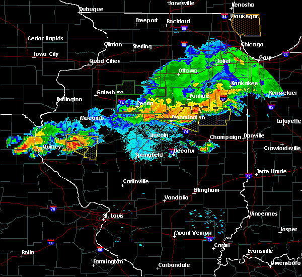 At 939 pm cdt, a severe thunderstorm was located over mount sterling, moving southeast at 30 mph (radar indicated). Hazards include 60 mph wind gusts and quarter size hail. Hail damage to vehicles is expected. expect wind damage to roofs, siding, and trees. Locations impacted include, mount sterling, la grange, versailles, mound station, ripley and coopertown. At 939 pm cdt, a severe thunderstorm was located over mount sterling, moving southeast at 30 mph (radar indicated). Hazards include 60 mph wind gusts and quarter size hail. Hail damage to vehicles is expected. expect wind damage to roofs, siding, and trees. Locations impacted include, mount sterling, la grange, versailles, mound station, ripley and coopertown.
|
| 6/17/2017 9:20 PM CDT |
 At 920 pm cdt, a severe thunderstorm was located near clayton, moving east at 20 mph (radar indicated). Hazards include 60 mph wind gusts and quarter size hail. Hail damage to vehicles is expected. Expect wind damage to roofs, siding, and trees. At 920 pm cdt, a severe thunderstorm was located near clayton, moving east at 20 mph (radar indicated). Hazards include 60 mph wind gusts and quarter size hail. Hail damage to vehicles is expected. Expect wind damage to roofs, siding, and trees.
|
| 6/14/2017 5:09 PM CDT |
 At 508 pm cdt, a severe thunderstorm was located near beverly, moving northeast at 25 mph (radar indicated). Hazards include 60 mph wind gusts and quarter size hail. Hail damage to vehicles is expected. expect wind damage to roofs, siding, and trees. locations impacted include, quincy regional airport, mount sterling, barry, camp point, payson, clayton, golden, fall creek, beverly, buckhorn, adams, kingston, burton, liberty, versailles, hull, richfield, plainville, kinderhook and coatsburg. this also includes siloam springs state park. this includes the following highways, interstate 172 between exits 2 and 10. Interstate 72 between exits 10 and 20. At 508 pm cdt, a severe thunderstorm was located near beverly, moving northeast at 25 mph (radar indicated). Hazards include 60 mph wind gusts and quarter size hail. Hail damage to vehicles is expected. expect wind damage to roofs, siding, and trees. locations impacted include, quincy regional airport, mount sterling, barry, camp point, payson, clayton, golden, fall creek, beverly, buckhorn, adams, kingston, burton, liberty, versailles, hull, richfield, plainville, kinderhook and coatsburg. this also includes siloam springs state park. this includes the following highways, interstate 172 between exits 2 and 10. Interstate 72 between exits 10 and 20.
|
| 6/14/2017 4:48 PM CDT |
 At 448 pm cdt, a severe thunderstorm was located near payson, moving northeast at 25 mph (radar indicated). Hazards include 60 mph wind gusts and quarter size hail. Hail damage to vehicles is expected. Expect wind damage to roofs, siding, and trees. At 448 pm cdt, a severe thunderstorm was located near payson, moving northeast at 25 mph (radar indicated). Hazards include 60 mph wind gusts and quarter size hail. Hail damage to vehicles is expected. Expect wind damage to roofs, siding, and trees.
|
| 6/14/2017 2:04 PM CDT |
 At 203 pm cdt, a severe thunderstorm was located over buckhorn, moving east at 30 mph (radar indicated). Hazards include 60 mph wind gusts and nickel size hail. expect damage to roofs, siding, and trees At 203 pm cdt, a severe thunderstorm was located over buckhorn, moving east at 30 mph (radar indicated). Hazards include 60 mph wind gusts and nickel size hail. expect damage to roofs, siding, and trees
|
| 3/6/2017 11:10 PM CST |
 The severe thunderstorm warning for northern pike, adams and brown counties in west central illinois will expire at 1115 pm cst, the storms which prompted the warning have weakened below severe limits, and no longer poses an immediate threat to life or property. therefore, the warning will be allowed to expire. however gusty winds are still possible with these thunderstorms. a tornado watch remains in effect until 400 am cst for west central illinois, and northeastern missouri. The severe thunderstorm warning for northern pike, adams and brown counties in west central illinois will expire at 1115 pm cst, the storms which prompted the warning have weakened below severe limits, and no longer poses an immediate threat to life or property. therefore, the warning will be allowed to expire. however gusty winds are still possible with these thunderstorms. a tornado watch remains in effect until 400 am cst for west central illinois, and northeastern missouri.
|
| 3/6/2017 10:49 PM CST |
 At 1048 pm cst, severe thunderstorms were located along a line extending from 7 miles northwest of colmar to camp point to near payson, moving east at 65 mph (trained weather spotters. a 60 mph wind gust was reported at the quincy airport). Hazards include 60 mph wind gusts and quarter size hail. Hail damage to vehicles is expected. expect wind damage to roofs, siding, and trees. locations impacted include, quincy, pittsfield, quincy regional airport, mount sterling, barry, griggsville, camp point, payson, mendon, clayton, golden, fall creek, beverly, buckhorn, adams, la grange, kingston, burton, ursa and liberty. this also includes siloam springs state park. this includes the following highways, interstate 172 between exits 2 and 19. interstate 72 between exits 4 and 35. A tornado watch remains in effect until 400 am cst for west central illinois, and northeastern missouri. At 1048 pm cst, severe thunderstorms were located along a line extending from 7 miles northwest of colmar to camp point to near payson, moving east at 65 mph (trained weather spotters. a 60 mph wind gust was reported at the quincy airport). Hazards include 60 mph wind gusts and quarter size hail. Hail damage to vehicles is expected. expect wind damage to roofs, siding, and trees. locations impacted include, quincy, pittsfield, quincy regional airport, mount sterling, barry, griggsville, camp point, payson, mendon, clayton, golden, fall creek, beverly, buckhorn, adams, la grange, kingston, burton, ursa and liberty. this also includes siloam springs state park. this includes the following highways, interstate 172 between exits 2 and 19. interstate 72 between exits 4 and 35. A tornado watch remains in effect until 400 am cst for west central illinois, and northeastern missouri.
|
| 3/6/2017 10:20 PM CST |
 At 1020 pm cst, severe thunderstorms were located along a line extending from near alexandria to maywood to near monroe city, moving east at 65 mph (radar indicated). Hazards include 60 mph wind gusts and quarter size hail. Hail damage to vehicles is expected. Expect wind damage to roofs, siding, and trees. At 1020 pm cst, severe thunderstorms were located along a line extending from near alexandria to maywood to near monroe city, moving east at 65 mph (radar indicated). Hazards include 60 mph wind gusts and quarter size hail. Hail damage to vehicles is expected. Expect wind damage to roofs, siding, and trees.
|
| 2/28/2017 9:41 PM CST |
 The tornado warning for southeastern brown county will expire at 945 pm cst, the storm which prompted the warning has moved out of the area. therefore the warning will be allowed to expire. a tornado watch remains in effect until 400 am cst for west central illinois. The tornado warning for southeastern brown county will expire at 945 pm cst, the storm which prompted the warning has moved out of the area. therefore the warning will be allowed to expire. a tornado watch remains in effect until 400 am cst for west central illinois.
|
| 2/28/2017 9:33 PM CST |
 At 932 pm cst, a severe thunderstorm capable of producing a tornado was located 7 miles northwest of meredosia, moving east at 50 mph (radar indicated rotation). Hazards include tornado and quarter size hail. Flying debris will be dangerous to those caught without shelter. mobile homes will be damaged or destroyed. damage to roofs, windows, and vehicles will occur. tree damage is likely. Locations impacted include, la grange, versailles and coopertown. At 932 pm cst, a severe thunderstorm capable of producing a tornado was located 7 miles northwest of meredosia, moving east at 50 mph (radar indicated rotation). Hazards include tornado and quarter size hail. Flying debris will be dangerous to those caught without shelter. mobile homes will be damaged or destroyed. damage to roofs, windows, and vehicles will occur. tree damage is likely. Locations impacted include, la grange, versailles and coopertown.
|
| 2/28/2017 9:30 PM CST | Several mobile homes overturned in brown county IL, 0.3 miles N of Versailles, IL |
| 2/28/2017 9:23 PM CST |
 At 923 pm cst, a severe thunderstorm capable of producing a tornado was located near buckhorn, moving east at 55 mph (radar indicated rotation). Hazards include tornado and quarter size hail. Flying debris will be dangerous to those caught without shelter. mobile homes will be damaged or destroyed. damage to roofs, windows, and vehicles will occur. tree damage is likely. This tornadic thunderstorm will remain over mainly rural areas of northeastern pike and southern brown counties in west central illinois, including the following locations: versailles, perry, coopertown, chambersburg and la grange. At 923 pm cst, a severe thunderstorm capable of producing a tornado was located near buckhorn, moving east at 55 mph (radar indicated rotation). Hazards include tornado and quarter size hail. Flying debris will be dangerous to those caught without shelter. mobile homes will be damaged or destroyed. damage to roofs, windows, and vehicles will occur. tree damage is likely. This tornadic thunderstorm will remain over mainly rural areas of northeastern pike and southern brown counties in west central illinois, including the following locations: versailles, perry, coopertown, chambersburg and la grange.
|
| 2/28/2017 9:07 PM CST |
 At 907 pm cst, a severe thunderstorm was located near beverly, moving east at 55 mph (radar indicated). Hazards include 60 mph wind gusts and quarter size hail. Hail damage to vehicles is expected. Expect wind damage to roofs, siding, and trees. At 907 pm cst, a severe thunderstorm was located near beverly, moving east at 55 mph (radar indicated). Hazards include 60 mph wind gusts and quarter size hail. Hail damage to vehicles is expected. Expect wind damage to roofs, siding, and trees.
|
| 7/19/2016 6:39 PM CDT | The severe thunderstorm warning for northeastern pike and brown counties in west central illinois will expire at 645 pm cdt, the storms which prompted the warning have weakened below severe limits, and have exited the warned area. therefore the warning will be allowed to expire. a severe thunderstorm watch remains in effect until 800 pm cdt for west central illinois. |
| 7/19/2016 6:20 PM CDT |
 At 620 pm cdt, severe thunderstorms were located along a line extending from near littleton to near naples, moving east at 50 mph (radar indicated). Hazards include 60 mph wind gusts. Expect damage to roofs. siding. and trees. Locations impacted include, mount sterling, buckhorn, la grange, versailles, perry, chambersburg, mound station, ripley, fishhook and coopertown. At 620 pm cdt, severe thunderstorms were located along a line extending from near littleton to near naples, moving east at 50 mph (radar indicated). Hazards include 60 mph wind gusts. Expect damage to roofs. siding. and trees. Locations impacted include, mount sterling, buckhorn, la grange, versailles, perry, chambersburg, mound station, ripley, fishhook and coopertown.
|
| 7/19/2016 6:10 PM CDT | 5 to 6 trees downed on highway 99 in brown county IL, 0.3 miles N of Versailles, IL |
| 7/19/2016 6:01 PM CDT |
 At 600 pm cdt, severe thunderstorms were located along a line extending from near augusta to near beverly, moving east at 50 mph (quincy asos reported a peak wind gust of 62 mph with this line of storms). Hazards include 60 mph wind gusts. Expect damage to roofs. siding. And trees. At 600 pm cdt, severe thunderstorms were located along a line extending from near augusta to near beverly, moving east at 50 mph (quincy asos reported a peak wind gust of 62 mph with this line of storms). Hazards include 60 mph wind gusts. Expect damage to roofs. siding. And trees.
|
| 7/19/2016 5:53 PM CDT |
 At 553 pm cdt, a severe thunderstorm was located near meredosia, moving southeast at 15 mph (radar indicated). Hazards include 60 mph wind gusts and quarter size hail. Hail damage to vehicles is expected. expect wind damage to roofs, siding, and trees. Locations impacted include, la grange, versailles and coopertown. At 553 pm cdt, a severe thunderstorm was located near meredosia, moving southeast at 15 mph (radar indicated). Hazards include 60 mph wind gusts and quarter size hail. Hail damage to vehicles is expected. expect wind damage to roofs, siding, and trees. Locations impacted include, la grange, versailles and coopertown.
|
| 7/19/2016 5:38 PM CDT |
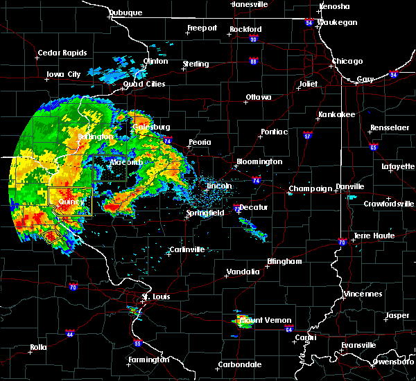 At 538 pm cdt, a severe thunderstorm was located 7 miles northwest of meredosia, moving east at 20 mph (radar indicated). Hazards include 60 mph wind gusts and quarter size hail. Hail damage to vehicles is expected. Expect wind damage to roofs, siding, and trees. At 538 pm cdt, a severe thunderstorm was located 7 miles northwest of meredosia, moving east at 20 mph (radar indicated). Hazards include 60 mph wind gusts and quarter size hail. Hail damage to vehicles is expected. Expect wind damage to roofs, siding, and trees.
|
| 7/13/2016 3:05 PM CDT |
 At 305 pm cdt, a severe thunderstorm was located near mount sterling, moving east at 40 mph (trained weather spotters). Hazards include 60 mph wind gusts. Expect damage to roofs. siding. and trees. Locations impacted include, mount sterling, buckhorn, la grange, versailles, perry, chambersburg, ripley and coopertown. At 305 pm cdt, a severe thunderstorm was located near mount sterling, moving east at 40 mph (trained weather spotters). Hazards include 60 mph wind gusts. Expect damage to roofs. siding. and trees. Locations impacted include, mount sterling, buckhorn, la grange, versailles, perry, chambersburg, ripley and coopertown.
|
| 7/13/2016 2:46 PM CDT |
 At 245 pm cdt, a severe thunderstorm was located near camp point, moving east at 35 mph (trained weather spotters. large tree limbs down). Hazards include 60 mph wind gusts. Expect damage to roofs. siding. and trees. locations impacted include, quincy, mount sterling, camp point, payson, mendon, clayton, golden, fall creek, beverly, buckhorn, adams, la grange, kingston, burton, ursa, liberty, versailles, richfield, perry and loraine. this also includes siloam springs state park. This includes interstate 172 between exits 2 and 19. At 245 pm cdt, a severe thunderstorm was located near camp point, moving east at 35 mph (trained weather spotters. large tree limbs down). Hazards include 60 mph wind gusts. Expect damage to roofs. siding. and trees. locations impacted include, quincy, mount sterling, camp point, payson, mendon, clayton, golden, fall creek, beverly, buckhorn, adams, la grange, kingston, burton, ursa, liberty, versailles, richfield, perry and loraine. this also includes siloam springs state park. This includes interstate 172 between exits 2 and 19.
|
| 7/13/2016 2:21 PM CDT |
 At 221 pm cdt, a severe thunderstorm was located near payson, moving east at 35 mph (radar indicated). Hazards include 60 mph wind gusts. Expect damage to roofs. siding. And trees. At 221 pm cdt, a severe thunderstorm was located near payson, moving east at 35 mph (radar indicated). Hazards include 60 mph wind gusts. Expect damage to roofs. siding. And trees.
|
| 7/7/2016 8:56 AM CDT | The severe thunderstorm warning for northeastern pike, eastern adams and brown counties in west central illinois will expire at 900 am cdt, the storms which prompted the warning have moved out of the area. therefore the warning will be allowed to expire. however gusty winds are still possible with these thunderstorms. a severe thunderstorm watch remains in effect until 100 pm cdt for west central illinois. |
| 7/7/2016 8:26 AM CDT |
 At 826 am cdt, severe thunderstorms were located along a line extending from 7 miles northeast of clayton to 6 miles northwest of pittsfield, moving east at 40 mph (trained weather spotters). Hazards include 60 mph wind gusts and penny size hail. Expect damage to roofs. siding. And trees. At 826 am cdt, severe thunderstorms were located along a line extending from 7 miles northeast of clayton to 6 miles northwest of pittsfield, moving east at 40 mph (trained weather spotters). Hazards include 60 mph wind gusts and penny size hail. Expect damage to roofs. siding. And trees.
|
| 7/7/2016 8:07 AM CDT |
 At 807 am cdt, severe thunderstorms were located along a line extending from west point to 7 miles west of barry, moving east at 50 mph (radar indicated). Hazards include 60 mph wind gusts and penny size hail. Expect damage to roofs. siding. and trees. locations impacted include, quincy, mount sterling, barry, griggsville, camp point, payson, mendon, clayton, golden, fall creek, beverly, buckhorn, adams, la grange, kingston, burton, ursa, liberty, versailles and hull. this also includes siloam springs state park. this includes the following highways, interstate 172 between exits 2 and 19. Interstate 72 between exits 4 and 35. At 807 am cdt, severe thunderstorms were located along a line extending from west point to 7 miles west of barry, moving east at 50 mph (radar indicated). Hazards include 60 mph wind gusts and penny size hail. Expect damage to roofs. siding. and trees. locations impacted include, quincy, mount sterling, barry, griggsville, camp point, payson, mendon, clayton, golden, fall creek, beverly, buckhorn, adams, la grange, kingston, burton, ursa, liberty, versailles and hull. this also includes siloam springs state park. this includes the following highways, interstate 172 between exits 2 and 19. Interstate 72 between exits 4 and 35.
|
| 7/7/2016 7:43 AM CDT |
 At 743 am cdt, severe thunderstorms were located along a line extending from 7 miles north of canton to near rensselaer, moving east at 45 mph (radar indicated). Hazards include 60 mph wind gusts and penny size hail. Expect damage to roofs. siding. and trees. locations impacted include, quincy, mount sterling, barry, griggsville, camp point, payson, mendon, clayton, golden, fall creek, beverly, buckhorn, adams, la grange, kingston, burton, ursa, liberty, versailles and hull. this also includes siloam springs state park. this includes the following highways, interstate 172 between exits 2 and 19. Interstate 72 between exits 4 and 35. At 743 am cdt, severe thunderstorms were located along a line extending from 7 miles north of canton to near rensselaer, moving east at 45 mph (radar indicated). Hazards include 60 mph wind gusts and penny size hail. Expect damage to roofs. siding. and trees. locations impacted include, quincy, mount sterling, barry, griggsville, camp point, payson, mendon, clayton, golden, fall creek, beverly, buckhorn, adams, la grange, kingston, burton, ursa, liberty, versailles and hull. this also includes siloam springs state park. this includes the following highways, interstate 172 between exits 2 and 19. Interstate 72 between exits 4 and 35.
|
| 7/7/2016 7:32 AM CDT |
 At 732 am cdt, severe thunderstorms were located along a line extending from 8 miles south of wayland to near rensselaer, moving east at 75 mph (radar indicated). Hazards include 60 mph wind gusts and penny size hail. Expect damage to roofs. siding. And trees. At 732 am cdt, severe thunderstorms were located along a line extending from 8 miles south of wayland to near rensselaer, moving east at 75 mph (radar indicated). Hazards include 60 mph wind gusts and penny size hail. Expect damage to roofs. siding. And trees.
|
| 5/11/2016 8:28 PM CDT |
 At 827 pm cdt, a severe thunderstorm was located near mount sterling, moving northeast at 40 mph (radar indicated). Hazards include quarter size hail. damage to vehicles is expected At 827 pm cdt, a severe thunderstorm was located near mount sterling, moving northeast at 40 mph (radar indicated). Hazards include quarter size hail. damage to vehicles is expected
|
| 5/11/2016 7:25 PM CDT |
 At 724 pm cdt, a severe thunderstorm was located over payson, moving northeast at 20 mph (trained weather spotters). Hazards include golf ball size hail. People and animals outdoors will be injured. expect damage to roofs, siding, windows, and vehicles. locations impacted include, mount sterling, barry, camp point, payson, clayton, fall creek, beverly, buckhorn, adams, kingston, burton, liberty, versailles, hull, richfield, perry, new canton, plainville, kinderhook and baylis. this also includes siloam springs state park. this includes the following highways, interstate 172 between exits 2 and 10. Interstate 72 between exits 4 and 20. At 724 pm cdt, a severe thunderstorm was located over payson, moving northeast at 20 mph (trained weather spotters). Hazards include golf ball size hail. People and animals outdoors will be injured. expect damage to roofs, siding, windows, and vehicles. locations impacted include, mount sterling, barry, camp point, payson, clayton, fall creek, beverly, buckhorn, adams, kingston, burton, liberty, versailles, hull, richfield, perry, new canton, plainville, kinderhook and baylis. this also includes siloam springs state park. this includes the following highways, interstate 172 between exits 2 and 10. Interstate 72 between exits 4 and 20.
|
| 5/11/2016 7:08 PM CDT |
 At 708 pm cdt, a severe thunderstorm was located over fall creek, moving northeast at 30 mph (radar indicated). Hazards include 60 mph wind gusts and half dollar size hail. Hail damage to vehicles is expected. Expect wind damage to roofs, siding, and trees. At 708 pm cdt, a severe thunderstorm was located over fall creek, moving northeast at 30 mph (radar indicated). Hazards include 60 mph wind gusts and half dollar size hail. Hail damage to vehicles is expected. Expect wind damage to roofs, siding, and trees.
|
| 7/13/2015 7:06 PM CDT |
 At 706 pm cdt, severe thunderstorms were located along a line extending from near arenzville to near winchester, moving east at 60 mph (trained weather spotters). Hazards include 70 mph wind gusts. Expect considerable tree damage. damage is likely to mobile homes, roofs and outbuildings. locations impacted include, griggsville, versailles, perry, chambersburg, new salem, florence and valley city. This includes interstate 72 between exits 31 and 35. At 706 pm cdt, severe thunderstorms were located along a line extending from near arenzville to near winchester, moving east at 60 mph (trained weather spotters). Hazards include 70 mph wind gusts. Expect considerable tree damage. damage is likely to mobile homes, roofs and outbuildings. locations impacted include, griggsville, versailles, perry, chambersburg, new salem, florence and valley city. This includes interstate 72 between exits 31 and 35.
|
| 7/13/2015 6:58 PM CDT |
 At 657 pm cdt, severe thunderstorms were located along a line extending from 7 miles northwest of meredosia to near griggsville, moving east at 55 mph (trained weather spotters). Hazards include 70 mph wind gusts. Expect considerable tree damage. damage is likely to mobile homes, roofs and outbuildings. locations impacted include, mount sterling, barry, griggsville, beverly, buckhorn, la grange, versailles, perry, baylis, chambersburg, new salem, mound station, ripley, florence, valley city, fishhook, kellerville and coopertown. this warning also includes siloam springs state park. This includes interstate 72 between exits 20 and 35. At 657 pm cdt, severe thunderstorms were located along a line extending from 7 miles northwest of meredosia to near griggsville, moving east at 55 mph (trained weather spotters). Hazards include 70 mph wind gusts. Expect considerable tree damage. damage is likely to mobile homes, roofs and outbuildings. locations impacted include, mount sterling, barry, griggsville, beverly, buckhorn, la grange, versailles, perry, baylis, chambersburg, new salem, mound station, ripley, florence, valley city, fishhook, kellerville and coopertown. this warning also includes siloam springs state park. This includes interstate 72 between exits 20 and 35.
|
| 7/13/2015 6:55 PM CDT | Several large tree limbs dow in brown county IL, 0.3 miles N of Versailles, IL |
| 7/13/2015 6:47 PM CDT |
 At 646 pm cdt, a large severe thunderstorm was located along a line extending from near mount sterling to 7 miles west of griggsville, moving east at 55 mph (trained weather spotters). Hazards include 70 mph wind gusts. Expect considerable tree damage. damage is likely to mobile homes, roofs and outbuildings. locations impacted include, mount sterling, barry, griggsville, camp point, payson, clayton, beverly, buckhorn, adams, la grange, kingston, liberty, versailles, hull, richfield, perry, plainville, kinderhook, baylis and chambersburg. this warning also includes siloam springs state park. This includes interstate 72 between exits 10 and 35. At 646 pm cdt, a large severe thunderstorm was located along a line extending from near mount sterling to 7 miles west of griggsville, moving east at 55 mph (trained weather spotters). Hazards include 70 mph wind gusts. Expect considerable tree damage. damage is likely to mobile homes, roofs and outbuildings. locations impacted include, mount sterling, barry, griggsville, camp point, payson, clayton, beverly, buckhorn, adams, la grange, kingston, liberty, versailles, hull, richfield, perry, plainville, kinderhook, baylis and chambersburg. this warning also includes siloam springs state park. This includes interstate 72 between exits 10 and 35.
|
| 7/13/2015 6:37 PM CDT |
 At 636 pm cdt, a severe thunderstorm was located near buckhorn, moving east at 55 mph (trained weather spotters). Hazards include 70 mph wind gusts. Expect considerable tree damage. damage is likely to mobile homes, roofs and outbuildings. locations impacted include, mount sterling, barry, griggsville, camp point, payson, clayton, golden, fall creek, beverly, buckhorn, adams, la grange, kingston, burton, liberty, versailles, hull, richfield, perry and loraine. this warning also includes siloam springs state park. this includes the following highways, interstate 172 near exit 2. Interstate 72 between exits 4 and 35. At 636 pm cdt, a severe thunderstorm was located near buckhorn, moving east at 55 mph (trained weather spotters). Hazards include 70 mph wind gusts. Expect considerable tree damage. damage is likely to mobile homes, roofs and outbuildings. locations impacted include, mount sterling, barry, griggsville, camp point, payson, clayton, golden, fall creek, beverly, buckhorn, adams, la grange, kingston, burton, liberty, versailles, hull, richfield, perry and loraine. this warning also includes siloam springs state park. this includes the following highways, interstate 172 near exit 2. Interstate 72 between exits 4 and 35.
|
| 7/13/2015 6:20 PM CDT |
 At 620 pm cdt, a severe thunderstorm was located near camp point, moving east at 60 mph (trained weather spotters). Hazards include 70 mph wind gusts. Expect considerable tree damage. Damage is likely to mobile homes, roofs and outbuildings. At 620 pm cdt, a severe thunderstorm was located near camp point, moving east at 60 mph (trained weather spotters). Hazards include 70 mph wind gusts. Expect considerable tree damage. Damage is likely to mobile homes, roofs and outbuildings.
|
| 7/11/2015 6:39 PM CDT |
 At 639 pm cdt, a severe thunderstorm was located 8 miles east of mount sterling, moving southeast at 25 mph (radar indicated). Hazards include 60 mph wind gusts and quarter size hail. Hail damage to vehicles is expected. Expect wind damage to roofs, siding and trees. At 639 pm cdt, a severe thunderstorm was located 8 miles east of mount sterling, moving southeast at 25 mph (radar indicated). Hazards include 60 mph wind gusts and quarter size hail. Hail damage to vehicles is expected. Expect wind damage to roofs, siding and trees.
|
| 7/11/2015 2:28 PM CDT |
 At 228 pm cdt, a severe thunderstorm was located near meredosia, moving east at 40 mph (radar indicated). Hazards include 60 mph wind gusts and quarter size hail. Hail damage to vehicles is expected. expect wind damage to roofs, siding and trees. Locations impacted include, griggsville, buckhorn, la grange, versailles, perry, chambersburg, new salem, florence, valley city and fishhook. At 228 pm cdt, a severe thunderstorm was located near meredosia, moving east at 40 mph (radar indicated). Hazards include 60 mph wind gusts and quarter size hail. Hail damage to vehicles is expected. expect wind damage to roofs, siding and trees. Locations impacted include, griggsville, buckhorn, la grange, versailles, perry, chambersburg, new salem, florence, valley city and fishhook.
|
| 7/11/2015 2:14 PM CDT |
 At 214 pm cdt, a severe thunderstorm was located 8 miles southeast of buckhorn, moving east at 35 mph (radar indicated). Hazards include 60 mph wind gusts and quarter size hail. Hail damage to vehicles is expected. Expect wind damage to roofs, siding and trees. At 214 pm cdt, a severe thunderstorm was located 8 miles southeast of buckhorn, moving east at 35 mph (radar indicated). Hazards include 60 mph wind gusts and quarter size hail. Hail damage to vehicles is expected. Expect wind damage to roofs, siding and trees.
|
| 7/11/2015 1:38 PM CDT |
 At 138 pm cdt, a severe thunderstorm was located near buckhorn, moving east at 35 mph (radar indicated). Hazards include 60 mph wind gusts and quarter size hail. Hail damage to vehicles is expected. expect wind damage to roofs, siding and trees. locations impacted include, mount sterling, clayton, buckhorn, la grange, versailles, mound station, ripley, kellerville and coopertown. This warning also includes siloam springs state park. At 138 pm cdt, a severe thunderstorm was located near buckhorn, moving east at 35 mph (radar indicated). Hazards include 60 mph wind gusts and quarter size hail. Hail damage to vehicles is expected. expect wind damage to roofs, siding and trees. locations impacted include, mount sterling, clayton, buckhorn, la grange, versailles, mound station, ripley, kellerville and coopertown. This warning also includes siloam springs state park.
|
| 7/11/2015 1:07 PM CDT |
 At 106 pm cdt, a severe thunderstorm was located near camp point, moving east at 35 mph (radar indicated). Hazards include 60 mph wind gusts and quarter size hail. Hail damage to vehicles is expected. Expect wind damage to roofs, siding and trees. At 106 pm cdt, a severe thunderstorm was located near camp point, moving east at 35 mph (radar indicated). Hazards include 60 mph wind gusts and quarter size hail. Hail damage to vehicles is expected. Expect wind damage to roofs, siding and trees.
|
| 6/22/2015 9:25 PM CDT |
 The severe thunderstorm warning for brown and east central adams counties will expire at 930 pm cdt, the storm which prompted the warning has weakened below severe limits, and no longer poses an immediate threat to life or property. however, gusty winds are still possible with this thunderstorm. in addition, strong thunderstorms may redevelop, and a severe thunderstorm watch remains in effect until midnight. The severe thunderstorm warning for brown and east central adams counties will expire at 930 pm cdt, the storm which prompted the warning has weakened below severe limits, and no longer poses an immediate threat to life or property. however, gusty winds are still possible with this thunderstorm. in addition, strong thunderstorms may redevelop, and a severe thunderstorm watch remains in effect until midnight.
|
| 6/22/2015 8:52 PM CDT |
 At 849 pm cdt, a severe thunderstorm was located near golden, and moving east at 55 mph (trained weather spotters reported 60 mph wind gusts near lorraine and storm damage in mendon). Hazards include 60 mph wind gusts. Expect damage to roofs. Siding and trees. At 849 pm cdt, a severe thunderstorm was located near golden, and moving east at 55 mph (trained weather spotters reported 60 mph wind gusts near lorraine and storm damage in mendon). Hazards include 60 mph wind gusts. Expect damage to roofs. Siding and trees.
|
| 6/20/2015 9:50 PM CDT |
 The severe thunderstorm warning for northern shelby, northern marion, southern lewis, southern knox, brown and central adams counties will expire at 1000 pm cdt, the line of storms which prompted the warning has weakened below severe limits, and no longer poses an immediate threat to life or property. however, gusty winds and heavy rain are still possible with these thunderstorms. in addition, strong thunderstorms may redevelop, and a tornado watch remains in effect until 11 pm. The severe thunderstorm warning for northern shelby, northern marion, southern lewis, southern knox, brown and central adams counties will expire at 1000 pm cdt, the line of storms which prompted the warning has weakened below severe limits, and no longer poses an immediate threat to life or property. however, gusty winds and heavy rain are still possible with these thunderstorms. in addition, strong thunderstorms may redevelop, and a tornado watch remains in effect until 11 pm.
|
| 6/20/2015 8:55 PM CDT |
 At 853 pm cdt, severe thunderstorms were located along a line extending from vermont to 5 miles southwest of west point to green city, and moving southeast at 25 mph (radar indicated). Hazards include 60 mph wind gusts. Expect damage to roofs. Siding and trees. At 853 pm cdt, severe thunderstorms were located along a line extending from vermont to 5 miles southwest of west point to green city, and moving southeast at 25 mph (radar indicated). Hazards include 60 mph wind gusts. Expect damage to roofs. Siding and trees.
|
| 6/21/2014 4:35 PM CDT | Quarter sized hail reported 0.9 miles N of Versailles, IL |
| 1/1/0001 12:00 AM | Roof blown off an outbuilding near route 99 and county road 1300 e...three poles clipped off and power lines also down....time approximat in brown county IL, 2 miles SE of Versailles, IL |
Hail Maps for Versailles, IL


Connect with Interactive Hail Maps