

Hail Map for Warwick, GA
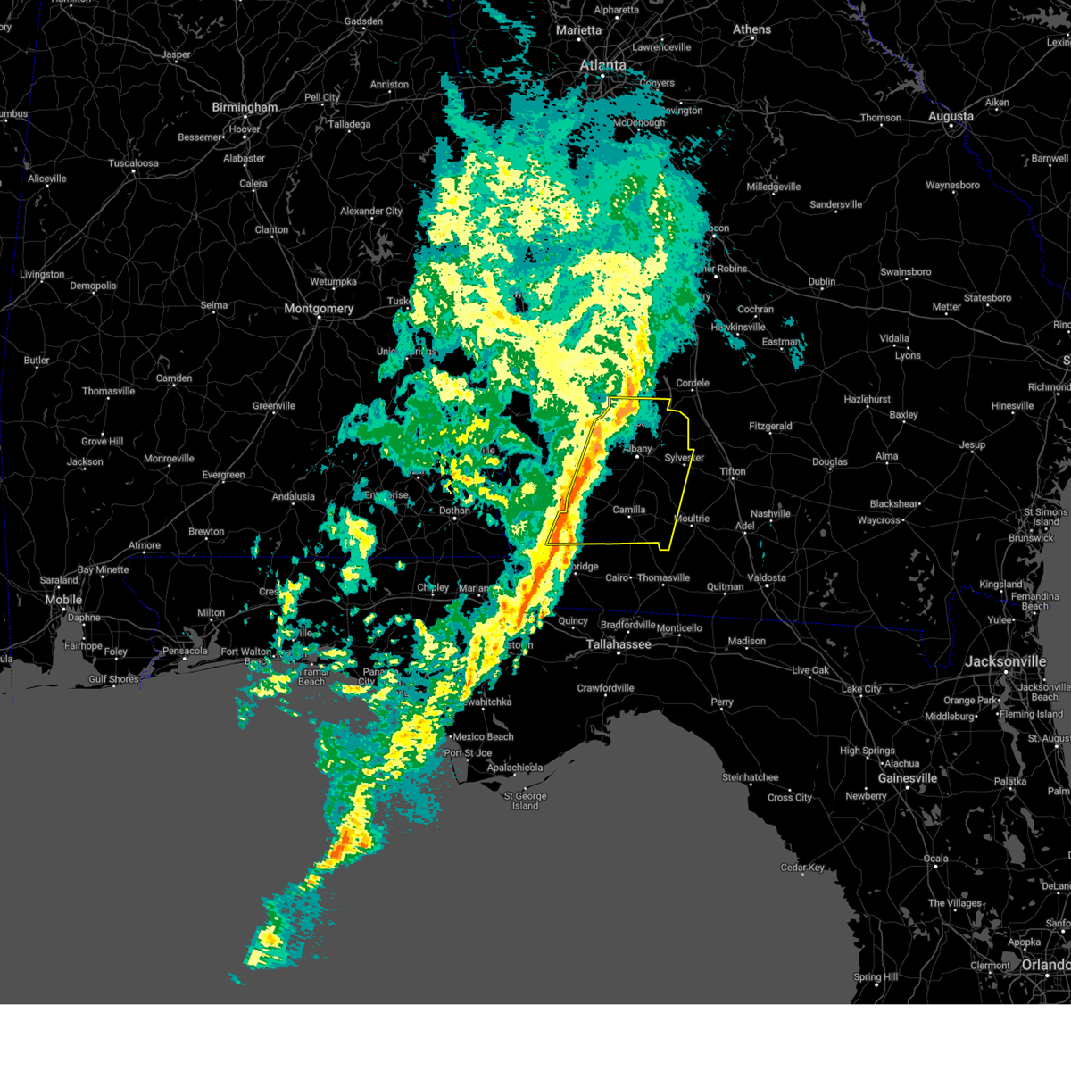
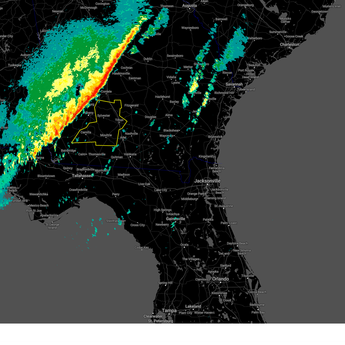
The Warwick, GA area has had 1 report of on-the-ground hail by trained spotters, and has been under severe weather warnings 14 times during the past 12 months. Doppler radar has detected hail at or near Warwick, GA on 53 occasions, including 3 occasions during the past year.
| Name: | Warwick, GA |
| Where Located: | 67 miles WNW of Douglas, GA |
| Map: | Google Map for Warwick, GA |
| Population: | 423 |
| Housing Units: | 174 |
| More Info: | Search Google for Warwick, GA |
0
The Top Recent Hail Date for Warwick, GA is Wednesday, June 25, 2025 (53rd out of 53)

Hail and Wind Damage Spotted near Warwick, GA
| Date / Time | Report Details |
|---|---|
| 6/26/2025 2:37 AM EDT |
 The storms which prompted the warning have weakened below severe limits, and no longer pose an immediate threat to life or property. therefore, the warning will be allowed to expire. however, gusty winds are still possible with these thunderstorms. a severe thunderstorm watch remains in effect until 400 am edt for south central and southwestern georgia. to report severe weather, contact your nearest law enforcement agency. they will relay your report to the national weather service tallahassee. The storms which prompted the warning have weakened below severe limits, and no longer pose an immediate threat to life or property. therefore, the warning will be allowed to expire. however, gusty winds are still possible with these thunderstorms. a severe thunderstorm watch remains in effect until 400 am edt for south central and southwestern georgia. to report severe weather, contact your nearest law enforcement agency. they will relay your report to the national weather service tallahassee.
|
| 6/26/2025 2:32 AM EDT |
 the severe thunderstorm warning has been cancelled and is no longer in effect the severe thunderstorm warning has been cancelled and is no longer in effect
|
| 6/26/2025 2:32 AM EDT |
 At 232 am edt, severe thunderstorms were located along a line extending from 7 miles south of de soto to near willacoochee, moving southwest at 35 mph (radar indicated). Hazards include 60 mph wind gusts and penny size hail. Expect damage to roofs, siding, and trees. Locations impacted include, sylvester, tifton, ashburn, ocilla, nashville, enigma, poulan, ty ty, alapaha, mystic, unionville, phillipsburg, worth, terrell, sycamore, sumner, warwick, eldorado, gladys, and sylvester airport. At 232 am edt, severe thunderstorms were located along a line extending from 7 miles south of de soto to near willacoochee, moving southwest at 35 mph (radar indicated). Hazards include 60 mph wind gusts and penny size hail. Expect damage to roofs, siding, and trees. Locations impacted include, sylvester, tifton, ashburn, ocilla, nashville, enigma, poulan, ty ty, alapaha, mystic, unionville, phillipsburg, worth, terrell, sycamore, sumner, warwick, eldorado, gladys, and sylvester airport.
|
| 6/26/2025 1:36 AM EDT |
 Svrtae the national weather service in tallahassee has issued a * severe thunderstorm warning for, irwin county in south central georgia, berrien county in south central georgia, turner county in south central georgia, tift county in south central georgia, ben hill county in south central georgia, central worth county in south central georgia, * until 245 am edt. * at 136 am edt, severe thunderstorms were located along a line extending from 6 miles east of pinehurst to 8 miles northwest of alma, moving southwest at 35 mph (radar indicated). Hazards include 60 mph wind gusts and penny size hail. expect damage to roofs, siding, and trees Svrtae the national weather service in tallahassee has issued a * severe thunderstorm warning for, irwin county in south central georgia, berrien county in south central georgia, turner county in south central georgia, tift county in south central georgia, ben hill county in south central georgia, central worth county in south central georgia, * until 245 am edt. * at 136 am edt, severe thunderstorms were located along a line extending from 6 miles east of pinehurst to 8 miles northwest of alma, moving southwest at 35 mph (radar indicated). Hazards include 60 mph wind gusts and penny size hail. expect damage to roofs, siding, and trees
|
| 3/31/2025 3:10 PM EDT | 511ga reports tree limbs on sr 313 both directions at davis mill road blocking all lane in worth county GA, 5.2 miles NNW of Warwick, GA |
| 3/31/2025 2:54 PM EDT |
 Svrtae the national weather service in tallahassee has issued a * severe thunderstorm warning for, western irwin county in south central georgia, turner county in south central georgia, dougherty county in southwestern georgia, northeastern mitchell county in southwestern georgia, lee county in southwestern georgia, northeastern baker county in southwestern georgia, eastern calhoun county in southwestern georgia, tift county in south central georgia, southeastern terrell county in southwestern georgia, western ben hill county in south central georgia, worth county in south central georgia, * until 400 pm edt. * at 254 pm edt, severe thunderstorms were located along a line extending from 6 miles southeast of smithville to 9 miles west of albany to near leary, moving east at 45 mph (radar indicated). Hazards include 60 mph wind gusts. expect damage to roofs, siding, and trees Svrtae the national weather service in tallahassee has issued a * severe thunderstorm warning for, western irwin county in south central georgia, turner county in south central georgia, dougherty county in southwestern georgia, northeastern mitchell county in southwestern georgia, lee county in southwestern georgia, northeastern baker county in southwestern georgia, eastern calhoun county in southwestern georgia, tift county in south central georgia, southeastern terrell county in southwestern georgia, western ben hill county in south central georgia, worth county in south central georgia, * until 400 pm edt. * at 254 pm edt, severe thunderstorms were located along a line extending from 6 miles southeast of smithville to 9 miles west of albany to near leary, moving east at 45 mph (radar indicated). Hazards include 60 mph wind gusts. expect damage to roofs, siding, and trees
|
| 3/5/2025 4:05 AM EST |
 the severe thunderstorm warning has been cancelled and is no longer in effect the severe thunderstorm warning has been cancelled and is no longer in effect
|
| 3/5/2025 4:05 AM EST |
 At 405 am est, severe thunderstorms were located along a line extending from near cordele to pelham, moving east at 40 mph (radar indicated). Hazards include 60 mph wind gusts. Expect damage to roofs, siding, and trees. Locations impacted include, bridgeboro, sylvester, sylvester airport, anderson city, parkerville, cotton, red rock, lester, pritchetts, poplar arbor church, crestwood, shingler, greenough, gordy, doerun, livingston, ticknor, minnesota, laney, and freeman. At 405 am est, severe thunderstorms were located along a line extending from near cordele to pelham, moving east at 40 mph (radar indicated). Hazards include 60 mph wind gusts. Expect damage to roofs, siding, and trees. Locations impacted include, bridgeboro, sylvester, sylvester airport, anderson city, parkerville, cotton, red rock, lester, pritchetts, poplar arbor church, crestwood, shingler, greenough, gordy, doerun, livingston, ticknor, minnesota, laney, and freeman.
|
| 3/5/2025 3:52 AM EST |
 At 352 am est, severe thunderstorms were located along a line extending from 6 miles southwest of cordele to 8 miles west of pelham, moving east at 40 mph (radar indicated). Hazards include 60 mph wind gusts. Expect damage to roofs, siding, and trees. Locations impacted include, bridgeboro, warwick, sylvester, flint, stocks, radium springs, sylvester airport, anderson city, parkerville, cotton, red rock, acree, lester, pritchetts, poplar arbor church, crestwood, shingler, williamsburg, branchville, and greenough. At 352 am est, severe thunderstorms were located along a line extending from 6 miles southwest of cordele to 8 miles west of pelham, moving east at 40 mph (radar indicated). Hazards include 60 mph wind gusts. Expect damage to roofs, siding, and trees. Locations impacted include, bridgeboro, warwick, sylvester, flint, stocks, radium springs, sylvester airport, anderson city, parkerville, cotton, red rock, acree, lester, pritchetts, poplar arbor church, crestwood, shingler, williamsburg, branchville, and greenough.
|
| 3/5/2025 3:34 AM EST |
 At 334 am est, severe thunderstorms were located along a line extending from near de soto to 13 miles northeast of west bainbridge, moving east at 35 mph (radar indicated). Hazards include 60 mph wind gusts. Expect damage to roofs, siding, and trees. Locations impacted include, stocks, radium springs, sylvester airport, anderson city, parkerville, lester, pritchetts, crestwood, greenough, albany, hopeful, hoggard mill, walker, ticknor, pecan city, laney, newton, gammage, mitchell co a/p, and baconton. At 334 am est, severe thunderstorms were located along a line extending from near de soto to 13 miles northeast of west bainbridge, moving east at 35 mph (radar indicated). Hazards include 60 mph wind gusts. Expect damage to roofs, siding, and trees. Locations impacted include, stocks, radium springs, sylvester airport, anderson city, parkerville, lester, pritchetts, crestwood, greenough, albany, hopeful, hoggard mill, walker, ticknor, pecan city, laney, newton, gammage, mitchell co a/p, and baconton.
|
| 3/5/2025 3:34 AM EST |
 the severe thunderstorm warning has been cancelled and is no longer in effect the severe thunderstorm warning has been cancelled and is no longer in effect
|
| 3/5/2025 3:14 AM EST |
 At 314 am est, severe thunderstorms were located along a line extending from near smithville to 6 miles southeast of colquitt, moving east at 40 mph (radar indicated). Hazards include 60 mph wind gusts. Expect damage to roofs, siding, and trees. Locations impacted include, iveys mill, stocks, radium springs, smithville, sylvester airport, anderson city, parkerville, dawson municipal a/p, lester, pritchetts, crestwood, neyami, greenough, chickasawhatchee, bellview, albany, vada, hopeful, hoggard mill, and walker. At 314 am est, severe thunderstorms were located along a line extending from near smithville to 6 miles southeast of colquitt, moving east at 40 mph (radar indicated). Hazards include 60 mph wind gusts. Expect damage to roofs, siding, and trees. Locations impacted include, iveys mill, stocks, radium springs, smithville, sylvester airport, anderson city, parkerville, dawson municipal a/p, lester, pritchetts, crestwood, neyami, greenough, chickasawhatchee, bellview, albany, vada, hopeful, hoggard mill, and walker.
|
| 3/5/2025 3:14 AM EST |
 the severe thunderstorm warning has been cancelled and is no longer in effect the severe thunderstorm warning has been cancelled and is no longer in effect
|
| 3/5/2025 2:53 AM EST |
 Svrtae the national weather service in tallahassee has issued a * severe thunderstorm warning for, miller county in southwestern georgia, dougherty county in southwestern georgia, southeastern randolph county in southwestern georgia, mitchell county in southwestern georgia, lee county in southwestern georgia, baker county in southwestern georgia, calhoun county in southwestern georgia, eastern early county in southwestern georgia, western colquitt county in south central georgia, terrell county in southwestern georgia, worth county in south central georgia, * until 430 am est. * at 253 am est, severe thunderstorms were located along a line extending from 8 miles north of dawson to near donalsonville, moving east at 40 mph (radar indicated). Hazards include 60 mph wind gusts. expect damage to roofs, siding, and trees Svrtae the national weather service in tallahassee has issued a * severe thunderstorm warning for, miller county in southwestern georgia, dougherty county in southwestern georgia, southeastern randolph county in southwestern georgia, mitchell county in southwestern georgia, lee county in southwestern georgia, baker county in southwestern georgia, calhoun county in southwestern georgia, eastern early county in southwestern georgia, western colquitt county in south central georgia, terrell county in southwestern georgia, worth county in south central georgia, * until 430 am est. * at 253 am est, severe thunderstorms were located along a line extending from 8 miles north of dawson to near donalsonville, moving east at 40 mph (radar indicated). Hazards include 60 mph wind gusts. expect damage to roofs, siding, and trees
|
| 2/16/2025 6:17 AM EST |
 Svrtae the national weather service in tallahassee has issued a * severe thunderstorm warning for, turner county in south central georgia, mitchell county in southwestern georgia, colquitt county in south central georgia, tift county in south central georgia, worth county in south central georgia, * until 745 am est. * at 616 am est, severe thunderstorms were located along a line extending from near leslie to 7 miles northwest of donalsonville, moving east at 45 mph (radar indicated). Hazards include 60 mph wind gusts. expect damage to roofs, siding, and trees Svrtae the national weather service in tallahassee has issued a * severe thunderstorm warning for, turner county in south central georgia, mitchell county in southwestern georgia, colquitt county in south central georgia, tift county in south central georgia, worth county in south central georgia, * until 745 am est. * at 616 am est, severe thunderstorms were located along a line extending from near leslie to 7 miles northwest of donalsonville, moving east at 45 mph (radar indicated). Hazards include 60 mph wind gusts. expect damage to roofs, siding, and trees
|
| 6/10/2024 4:16 PM EDT |
 Svrtae the national weather service in tallahassee has issued a * severe thunderstorm warning for, lee county in southwestern georgia, northwestern worth county in south central georgia, * until 500 pm edt. * at 416 pm edt, a severe thunderstorm was located near leesburg, moving east at 15 mph (radar indicated). Hazards include 60 mph wind gusts and quarter size hail. Hail damage to vehicles is expected. Expect wind damage to roofs, siding, and trees. Svrtae the national weather service in tallahassee has issued a * severe thunderstorm warning for, lee county in southwestern georgia, northwestern worth county in south central georgia, * until 500 pm edt. * at 416 pm edt, a severe thunderstorm was located near leesburg, moving east at 15 mph (radar indicated). Hazards include 60 mph wind gusts and quarter size hail. Hail damage to vehicles is expected. Expect wind damage to roofs, siding, and trees.
|
| 6/10/2024 3:31 PM EDT |
 Svrtae the national weather service in tallahassee has issued a * severe thunderstorm warning for, northeastern lee county in southwestern georgia, northwestern worth county in south central georgia, * until 415 pm edt. * at 331 pm edt, a severe thunderstorm was located 9 miles northeast of leesburg, moving east at 15 mph (radar indicated). Hazards include 60 mph wind gusts and quarter size hail. Hail damage to vehicles is expected. Expect wind damage to roofs, siding, and trees. Svrtae the national weather service in tallahassee has issued a * severe thunderstorm warning for, northeastern lee county in southwestern georgia, northwestern worth county in south central georgia, * until 415 pm edt. * at 331 pm edt, a severe thunderstorm was located 9 miles northeast of leesburg, moving east at 15 mph (radar indicated). Hazards include 60 mph wind gusts and quarter size hail. Hail damage to vehicles is expected. Expect wind damage to roofs, siding, and trees.
|
| 6/10/2024 2:23 PM EDT |
 Svrtae the national weather service in tallahassee has issued a * severe thunderstorm warning for, northern turner county in south central georgia, eastern lee county in southwestern georgia, northwestern worth county in south central georgia, * until 315 pm edt. * at 223 pm edt, a severe thunderstorm was located 10 miles east of leesburg, moving east at 35 mph (radar indicated). Hazards include 60 mph wind gusts and quarter size hail. Hail damage to vehicles is expected. Expect wind damage to roofs, siding, and trees. Svrtae the national weather service in tallahassee has issued a * severe thunderstorm warning for, northern turner county in south central georgia, eastern lee county in southwestern georgia, northwestern worth county in south central georgia, * until 315 pm edt. * at 223 pm edt, a severe thunderstorm was located 10 miles east of leesburg, moving east at 35 mph (radar indicated). Hazards include 60 mph wind gusts and quarter size hail. Hail damage to vehicles is expected. Expect wind damage to roofs, siding, and trees.
|
| 3/15/2024 7:06 PM EDT |
 The storm which prompted the warning has moved out of the area. therefore, the warning will be allowed to expire. however, gusty winds are still possible with this thunderstorm. The storm which prompted the warning has moved out of the area. therefore, the warning will be allowed to expire. however, gusty winds are still possible with this thunderstorm.
|
| 3/15/2024 6:46 PM EDT |
 At 646 pm edt, a severe thunderstorm was located 7 miles south of de soto, or 10 miles northeast of leesburg, moving east at 40 mph (radar indicated). Hazards include 60 mph wind gusts and quarter size hail. Hail damage to vehicles is expected. expect wind damage to roofs, siding, and trees. Locations impacted include, warwick, oakfield, and chokee. At 646 pm edt, a severe thunderstorm was located 7 miles south of de soto, or 10 miles northeast of leesburg, moving east at 40 mph (radar indicated). Hazards include 60 mph wind gusts and quarter size hail. Hail damage to vehicles is expected. expect wind damage to roofs, siding, and trees. Locations impacted include, warwick, oakfield, and chokee.
|
| 3/15/2024 6:29 PM EDT |
 Svrtae the national weather service in tallahassee has issued a * severe thunderstorm warning for, northern lee county in southwestern georgia, northwestern worth county in south central georgia, * until 715 pm edt. * at 629 pm edt, a severe thunderstorm was located near smithville, or near leesburg, moving east at 40 mph (radar indicated). Hazards include 60 mph wind gusts and quarter size hail. Hail damage to vehicles is expected. Expect wind damage to roofs, siding, and trees. Svrtae the national weather service in tallahassee has issued a * severe thunderstorm warning for, northern lee county in southwestern georgia, northwestern worth county in south central georgia, * until 715 pm edt. * at 629 pm edt, a severe thunderstorm was located near smithville, or near leesburg, moving east at 40 mph (radar indicated). Hazards include 60 mph wind gusts and quarter size hail. Hail damage to vehicles is expected. Expect wind damage to roofs, siding, and trees.
|
| 1/9/2024 11:09 AM EST | Tree across ga highway 33n at long lonesome roa in worth county GA, 9 miles NW of Warwick, GA |
| 1/9/2024 9:50 AM EST |
 At 949 am est, severe thunderstorms were located along a line extending from 6 miles south of weston to 6 miles southwest of colquitt, moving east at 50 mph (radar indicated). Hazards include 70 mph wind gusts. Expect considerable tree damage. Damage is likely to mobile homes, roofs, and outbuildings. At 949 am est, severe thunderstorms were located along a line extending from 6 miles south of weston to 6 miles southwest of colquitt, moving east at 50 mph (radar indicated). Hazards include 70 mph wind gusts. Expect considerable tree damage. Damage is likely to mobile homes, roofs, and outbuildings.
|
| 9/7/2023 3:37 PM EDT |
 At 336 pm edt, severe thunderstorms were located along a line extending from 6 miles west of arabi to near leesburg, moving east at 15 mph (radar indicated). Hazards include 60 mph wind gusts. Expect damage to roofs, siding, and trees. locations impacted include, warwick, dakota, sibley, and doles. hail threat, radar indicated max hail size, <. 75 in wind threat, radar indicated max wind gust, 60 mph. At 336 pm edt, severe thunderstorms were located along a line extending from 6 miles west of arabi to near leesburg, moving east at 15 mph (radar indicated). Hazards include 60 mph wind gusts. Expect damage to roofs, siding, and trees. locations impacted include, warwick, dakota, sibley, and doles. hail threat, radar indicated max hail size, <. 75 in wind threat, radar indicated max wind gust, 60 mph.
|
| 9/7/2023 3:08 PM EDT |
 At 308 pm edt, severe thunderstorms were located along a line extending from 11 miles west of arabi to near leesburg, moving east at 10 mph (radar indicated). Hazards include 60 mph wind gusts and penny size hail. expect damage to roofs, siding, and trees At 308 pm edt, severe thunderstorms were located along a line extending from 11 miles west of arabi to near leesburg, moving east at 10 mph (radar indicated). Hazards include 60 mph wind gusts and penny size hail. expect damage to roofs, siding, and trees
|
| 8/8/2023 5:39 PM EDT | Numerous trees down countywid in worth county GA, 9.2 miles NNW of Warwick, GA |
| 8/8/2023 5:12 PM EDT |
 At 512 pm edt, a severe thunderstorm was located near leesburg, moving east at 45 mph (radar indicated). Hazards include 60 mph wind gusts. expect damage to roofs, siding, and trees At 512 pm edt, a severe thunderstorm was located near leesburg, moving east at 45 mph (radar indicated). Hazards include 60 mph wind gusts. expect damage to roofs, siding, and trees
|
| 8/6/2023 9:51 PM EDT |
 At 951 pm edt, severe thunderstorms were located along a line extending from 8 miles northeast of leesburg to 8 miles west of newton, moving east at 40 mph (radar indicated). Hazards include 60 mph wind gusts. expect damage to roofs, siding, and trees At 951 pm edt, severe thunderstorms were located along a line extending from 8 miles northeast of leesburg to 8 miles west of newton, moving east at 40 mph (radar indicated). Hazards include 60 mph wind gusts. expect damage to roofs, siding, and trees
|
| 7/30/2023 4:54 PM EDT |
 At 454 pm edt, severe thunderstorms were located along a line extending from 7 miles west of arabi to near pitts, moving southeast at 10 mph (radar indicated). Hazards include 60 mph wind gusts. expect damage to roofs, siding, and trees At 454 pm edt, severe thunderstorms were located along a line extending from 7 miles west of arabi to near pitts, moving southeast at 10 mph (radar indicated). Hazards include 60 mph wind gusts. expect damage to roofs, siding, and trees
|
| 7/22/2023 12:16 PM EDT |
 At 1216 pm edt, severe thunderstorms were located along a line extending from 6 miles west of cordele to 12 miles southeast of desoto to leesburg, moving east at 15 mph (radar indicated). Hazards include 60 mph wind gusts and penny size hail. expect damage to roofs, siding, and trees At 1216 pm edt, severe thunderstorms were located along a line extending from 6 miles west of cordele to 12 miles southeast of desoto to leesburg, moving east at 15 mph (radar indicated). Hazards include 60 mph wind gusts and penny size hail. expect damage to roofs, siding, and trees
|
| 7/2/2023 8:41 PM EDT |
 The severe thunderstorm warning for northeastern dougherty, western turner, eastern lee and northern worth counties will expire at 845 pm edt, the storm which prompted the warning has weakened below severe limits, and no longer poses an immediate threat to life or property. therefore, the warning will be allowed to expire. however gusty winds are still possible with this thunderstorm. to report severe weather, contact your nearest law enforcement agency. they will relay your report to the national weather service tallahassee. The severe thunderstorm warning for northeastern dougherty, western turner, eastern lee and northern worth counties will expire at 845 pm edt, the storm which prompted the warning has weakened below severe limits, and no longer poses an immediate threat to life or property. therefore, the warning will be allowed to expire. however gusty winds are still possible with this thunderstorm. to report severe weather, contact your nearest law enforcement agency. they will relay your report to the national weather service tallahassee.
|
| 7/2/2023 7:24 PM EDT |
 At 724 pm edt, a severe thunderstorm was located near marine corps logistics base, or 8 miles northwest of sylvester, moving north at 10 mph (radar indicated). Hazards include 60 mph wind gusts. expect damage to roofs, siding, and trees At 724 pm edt, a severe thunderstorm was located near marine corps logistics base, or 8 miles northwest of sylvester, moving north at 10 mph (radar indicated). Hazards include 60 mph wind gusts. expect damage to roofs, siding, and trees
|
| 6/22/2023 5:40 PM EDT |
 At 539 pm edt, a severe thunderstorm was located near leesburg, moving northeast at 30 mph (radar indicated). Hazards include 60 mph wind gusts. Expect damage to roofs, siding, and trees. locations impacted include, leesburg, warwick, starksville, scrutchins, chokee, neyami, philema, jordan place, mossy dell and oakfield. hail threat, radar indicated max hail size, <. 75 in wind threat, radar indicated max wind gust, 60 mph. At 539 pm edt, a severe thunderstorm was located near leesburg, moving northeast at 30 mph (radar indicated). Hazards include 60 mph wind gusts. Expect damage to roofs, siding, and trees. locations impacted include, leesburg, warwick, starksville, scrutchins, chokee, neyami, philema, jordan place, mossy dell and oakfield. hail threat, radar indicated max hail size, <. 75 in wind threat, radar indicated max wind gust, 60 mph.
|
| 6/22/2023 5:19 PM EDT |
 At 518 pm edt, a severe thunderstorm was located 8 miles southwest of leesburg, moving northeast at 30 mph (radar indicated). Hazards include 60 mph wind gusts. Expect damage to roofs, siding, and trees. locations impacted include, leesburg, albany, warwick, sasser, chokee, forrester, palmyra, century, jordan place, starksville, byne crossroads, scrutchins, armena, neyami, philema, chickasawhatchee, mossy dell and oakfield. hail threat, radar indicated max hail size, <. 75 in wind threat, radar indicated max wind gust, 60 mph. At 518 pm edt, a severe thunderstorm was located 8 miles southwest of leesburg, moving northeast at 30 mph (radar indicated). Hazards include 60 mph wind gusts. Expect damage to roofs, siding, and trees. locations impacted include, leesburg, albany, warwick, sasser, chokee, forrester, palmyra, century, jordan place, starksville, byne crossroads, scrutchins, armena, neyami, philema, chickasawhatchee, mossy dell and oakfield. hail threat, radar indicated max hail size, <. 75 in wind threat, radar indicated max wind gust, 60 mph.
|
| 6/22/2023 5:07 PM EDT |
 At 507 pm edt, a severe thunderstorm was located 10 miles southeast of dawson, moving northeast at 25 mph (radar indicated). Hazards include 60 mph wind gusts. expect damage to roofs, siding, and trees At 507 pm edt, a severe thunderstorm was located 10 miles southeast of dawson, moving northeast at 25 mph (radar indicated). Hazards include 60 mph wind gusts. expect damage to roofs, siding, and trees
|
| 6/19/2023 8:39 AM EDT |
 At 837 am edt, severe thunderstorms were located along a line extending from 11 miles southwest of arabi to putney to near newton to 16 miles west of camilla, moving east at 45 mph (radar indicated). Hazards include 60 mph wind gusts. Expect damage to roofs, siding, and trees. locations impacted include, newton, albany, sylvester, leesburg, putney, baconton, poulan, doerun, east albany, marine corps logistics base, turner city, walker, worth, terrell, sumner, warwick, minton, stocks, radium springs and sylvester airport. hail threat, radar indicated max hail size, <. 75 in wind threat, radar indicated max wind gust, 60 mph. At 837 am edt, severe thunderstorms were located along a line extending from 11 miles southwest of arabi to putney to near newton to 16 miles west of camilla, moving east at 45 mph (radar indicated). Hazards include 60 mph wind gusts. Expect damage to roofs, siding, and trees. locations impacted include, newton, albany, sylvester, leesburg, putney, baconton, poulan, doerun, east albany, marine corps logistics base, turner city, walker, worth, terrell, sumner, warwick, minton, stocks, radium springs and sylvester airport. hail threat, radar indicated max hail size, <. 75 in wind threat, radar indicated max wind gust, 60 mph.
|
| 6/19/2023 8:00 AM EDT | At 759 am edt, severe thunderstorms were located along a line extending from near dawson to 6 miles southwest of leary to 7 miles southwest of arlington to 7 miles northwest of donalsonville, moving east at 45 mph (radar indicated). Hazards include 60 mph wind gusts. expect damage to roofs, siding, and trees |
| 6/15/2023 9:13 AM EDT |
 At 912 am edt, severe thunderstorms were located along a line extending from 8 miles south of lilly to near smithville to near shellman, moving east at 50 mph (radar indicated). Hazards include 60 mph wind gusts and quarter size hail. Hail damage to vehicles is expected. expect wind damage to roofs, siding, and trees. locations impacted include, dawson, leesburg, albany, smithville, warwick, sasser, bronwood, parrott, chokee, stocks, forrester, palmyra, clarks mill, dawson municipal a/p, chambliss, olivers mill, neyami, chickasawhatchee, bridges crossroad and century. hail threat, radar indicated max hail size, 1. 00 in wind threat, radar indicated max wind gust, 60 mph. At 912 am edt, severe thunderstorms were located along a line extending from 8 miles south of lilly to near smithville to near shellman, moving east at 50 mph (radar indicated). Hazards include 60 mph wind gusts and quarter size hail. Hail damage to vehicles is expected. expect wind damage to roofs, siding, and trees. locations impacted include, dawson, leesburg, albany, smithville, warwick, sasser, bronwood, parrott, chokee, stocks, forrester, palmyra, clarks mill, dawson municipal a/p, chambliss, olivers mill, neyami, chickasawhatchee, bridges crossroad and century. hail threat, radar indicated max hail size, 1. 00 in wind threat, radar indicated max wind gust, 60 mph.
|
| 6/15/2023 8:55 AM EDT |
 At 855 am edt, severe thunderstorms were located along a line extending from near americus to 7 miles southwest of plains to near cuthbert, moving southeast at 40 mph (radar indicated). Hazards include 60 mph wind gusts and quarter size hail. Hail damage to vehicles is expected. Expect wind damage to roofs, siding, and trees. At 855 am edt, severe thunderstorms were located along a line extending from near americus to 7 miles southwest of plains to near cuthbert, moving southeast at 40 mph (radar indicated). Hazards include 60 mph wind gusts and quarter size hail. Hail damage to vehicles is expected. Expect wind damage to roofs, siding, and trees.
|
| 6/14/2023 3:26 PM EDT |
 At 326 pm edt, a severe thunderstorm capable of producing a tornado was located 12 miles southwest of arabi, or 12 miles north of sylvester, moving east at 35 mph (radar indicated rotation). Hazards include tornado and half dollar size hail. Flying debris will be dangerous to those caught without shelter. mobile homes will be damaged or destroyed. damage to roofs, windows, and vehicles will occur. tree damage is likely. Locations impacted include, warwick, hobby and doles. At 326 pm edt, a severe thunderstorm capable of producing a tornado was located 12 miles southwest of arabi, or 12 miles north of sylvester, moving east at 35 mph (radar indicated rotation). Hazards include tornado and half dollar size hail. Flying debris will be dangerous to those caught without shelter. mobile homes will be damaged or destroyed. damage to roofs, windows, and vehicles will occur. tree damage is likely. Locations impacted include, warwick, hobby and doles.
|
| 6/14/2023 3:11 PM EDT |
 At 311 pm edt, a severe thunderstorm capable of producing a tornado was located near turner city, or 10 miles northeast of albany, moving east at 35 mph (radar indicated rotation). Hazards include tornado and half dollar size hail. Flying debris will be dangerous to those caught without shelter. mobile homes will be damaged or destroyed. damage to roofs, windows, and vehicles will occur. tree damage is likely. Locations impacted include, albany, terrell, warwick, coverdale, stocks, hobby, philema, doles and oakfield. At 311 pm edt, a severe thunderstorm capable of producing a tornado was located near turner city, or 10 miles northeast of albany, moving east at 35 mph (radar indicated rotation). Hazards include tornado and half dollar size hail. Flying debris will be dangerous to those caught without shelter. mobile homes will be damaged or destroyed. damage to roofs, windows, and vehicles will occur. tree damage is likely. Locations impacted include, albany, terrell, warwick, coverdale, stocks, hobby, philema, doles and oakfield.
|
| 6/14/2023 2:59 PM EDT |
 At 259 pm edt, a severe thunderstorm capable of producing a tornado was located near albany, moving east at 35 mph (radar indicated rotation). Hazards include tornado. Flying debris will be dangerous to those caught without shelter. mobile homes will be damaged or destroyed. damage to roofs, windows, and vehicles will occur. tree damage is likely. This tornadic thunderstorm will remain over mainly rural areas of northeastern dougherty, southwestern turner, southeastern lee and northern worth counties, including the following locations, warwick, stocks, forrester, south albany, palmyra, century, coverdale, terrell, hobby and philema. At 259 pm edt, a severe thunderstorm capable of producing a tornado was located near albany, moving east at 35 mph (radar indicated rotation). Hazards include tornado. Flying debris will be dangerous to those caught without shelter. mobile homes will be damaged or destroyed. damage to roofs, windows, and vehicles will occur. tree damage is likely. This tornadic thunderstorm will remain over mainly rural areas of northeastern dougherty, southwestern turner, southeastern lee and northern worth counties, including the following locations, warwick, stocks, forrester, south albany, palmyra, century, coverdale, terrell, hobby and philema.
|
| 6/13/2023 4:45 PM EDT | Worth 911 reporting a church steeple in the roadway on hwy 32 1 mile west of dole in worth county GA, 9.2 miles NNW of Warwick, GA |
| 6/13/2023 4:45 PM EDT | Worth 911 reports hwy 313 multiple pine tree down just north of hwy 3 in worth county GA, 8.5 miles NNW of Warwick, GA |
| 6/13/2023 4:21 PM EDT |
 At 421 pm edt, a severe thunderstorm was located near leesburg, moving east at 45 mph (law enforcement. numerous trees have been blown down in randolph county). Hazards include 70 mph wind gusts and quarter size hail. Hail damage to vehicles is expected. expect considerable tree damage. wind damage is also likely to mobile homes, roofs, and outbuildings. locations impacted include, fitzgerald, sylvester, ashburn, ocilla, tifton, poulan, mystic, worth, terrell, sycamore, sumner, warwick, rebecca, amboy, osierfield, sylvester airport, harding, waterloo, pinetta and inaha. thunderstorm damage threat, considerable hail threat, radar indicated max hail size, 1. 00 in wind threat, observed max wind gust, 70 mph. At 421 pm edt, a severe thunderstorm was located near leesburg, moving east at 45 mph (law enforcement. numerous trees have been blown down in randolph county). Hazards include 70 mph wind gusts and quarter size hail. Hail damage to vehicles is expected. expect considerable tree damage. wind damage is also likely to mobile homes, roofs, and outbuildings. locations impacted include, fitzgerald, sylvester, ashburn, ocilla, tifton, poulan, mystic, worth, terrell, sycamore, sumner, warwick, rebecca, amboy, osierfield, sylvester airport, harding, waterloo, pinetta and inaha. thunderstorm damage threat, considerable hail threat, radar indicated max hail size, 1. 00 in wind threat, observed max wind gust, 70 mph.
|
| 6/13/2023 3:30 PM EDT |
 At 329 pm edt, a severe thunderstorm was located near marine corps logistics base, or 8 miles east of albany, moving east at 30 mph (radar indicated). Hazards include 60 mph wind gusts and quarter size hail. Hail damage to vehicles is expected. Expect wind damage to roofs, siding, and trees. At 329 pm edt, a severe thunderstorm was located near marine corps logistics base, or 8 miles east of albany, moving east at 30 mph (radar indicated). Hazards include 60 mph wind gusts and quarter size hail. Hail damage to vehicles is expected. Expect wind damage to roofs, siding, and trees.
|
| 6/12/2023 5:15 AM EDT |
 At 514 am edt, severe thunderstorms were located along a line extending from near cordele to 12 miles north of sylvester to near marine corps logistics base to 7 miles southwest of albany, moving east at 45 mph (radar indicated). Hazards include 60 mph wind gusts. expect damage to roofs, siding, and trees At 514 am edt, severe thunderstorms were located along a line extending from near cordele to 12 miles north of sylvester to near marine corps logistics base to 7 miles southwest of albany, moving east at 45 mph (radar indicated). Hazards include 60 mph wind gusts. expect damage to roofs, siding, and trees
|
| 4/1/2023 1:51 PM EDT |
 The severe thunderstorm warning for northern lee and northwestern worth counties will expire at 200 pm edt, the storms which prompted the warning have moved out of the area. therefore, the warning will be allowed to expire. however gusty winds are still possible with these thunderstorms. a severe thunderstorm watch remains in effect until 800 pm edt for south central and southwestern georgia. The severe thunderstorm warning for northern lee and northwestern worth counties will expire at 200 pm edt, the storms which prompted the warning have moved out of the area. therefore, the warning will be allowed to expire. however gusty winds are still possible with these thunderstorms. a severe thunderstorm watch remains in effect until 800 pm edt for south central and southwestern georgia.
|
| 4/1/2023 1:48 PM EDT |
 At 148 pm edt, severe thunderstorms were located along a line extending from near cordele to 8 miles east of leesburg, moving east at 50 mph (radar indicated). Hazards include 60 mph wind gusts and penny size hail. Expect damage to roofs, siding, and trees. locations impacted include, warwick, starksville and oakfield. hail threat, radar indicated max hail size, 0. 75 in wind threat, radar indicated max wind gust, 60 mph. At 148 pm edt, severe thunderstorms were located along a line extending from near cordele to 8 miles east of leesburg, moving east at 50 mph (radar indicated). Hazards include 60 mph wind gusts and penny size hail. Expect damage to roofs, siding, and trees. locations impacted include, warwick, starksville and oakfield. hail threat, radar indicated max hail size, 0. 75 in wind threat, radar indicated max wind gust, 60 mph.
|
| 4/1/2023 1:47 PM EDT | Tree down near the intersection of main street and schoolhouse street in warwic in worth county GA, 0.1 miles NW of Warwick, GA |
| 4/1/2023 1:46 PM EDT |
 At 146 pm edt, severe thunderstorms were located along a line extending from near cordele to near arabi to 10 miles south of de soto, moving east at 55 mph (radar indicated). Hazards include 60 mph wind gusts and penny size hail. expect damage to roofs, siding, and trees At 146 pm edt, severe thunderstorms were located along a line extending from near cordele to near arabi to 10 miles south of de soto, moving east at 55 mph (radar indicated). Hazards include 60 mph wind gusts and penny size hail. expect damage to roofs, siding, and trees
|
| 4/1/2023 1:32 PM EDT |
 At 132 pm edt, severe thunderstorms were located along a line extending from near desoto to near leesburg, moving east at 50 mph (radar indicated). Hazards include 60 mph wind gusts and quarter size hail. Hail damage to vehicles is expected. expect wind damage to roofs, siding, and trees. locations impacted include, leesburg, smithville, warwick, bronwood, chokee, jordan place, starksville, scrutchins, olivers mill, neyami, philema, mossy dell and oakfield. hail threat, radar indicated max hail size, 1. 00 in wind threat, radar indicated max wind gust, 60 mph. At 132 pm edt, severe thunderstorms were located along a line extending from near desoto to near leesburg, moving east at 50 mph (radar indicated). Hazards include 60 mph wind gusts and quarter size hail. Hail damage to vehicles is expected. expect wind damage to roofs, siding, and trees. locations impacted include, leesburg, smithville, warwick, bronwood, chokee, jordan place, starksville, scrutchins, olivers mill, neyami, philema, mossy dell and oakfield. hail threat, radar indicated max hail size, 1. 00 in wind threat, radar indicated max wind gust, 60 mph.
|
| 4/1/2023 1:13 PM EDT |
 At 113 pm edt, severe thunderstorms were located along a line extending from near americus to near dawson, moving east at 50 mph (radar indicated). Hazards include 60 mph wind gusts and quarter size hail. Hail damage to vehicles is expected. Expect wind damage to roofs, siding, and trees. At 113 pm edt, severe thunderstorms were located along a line extending from near americus to near dawson, moving east at 50 mph (radar indicated). Hazards include 60 mph wind gusts and quarter size hail. Hail damage to vehicles is expected. Expect wind damage to roofs, siding, and trees.
|
| 1/12/2023 6:37 PM EST | Trees and powerlines down on acorn pond roa in worth county GA, 4.2 miles WNW of Warwick, GA |
| 1/12/2023 6:36 PM EST |
 At 636 pm est, severe thunderstorms were located along a line extending from near pineview to near arabi to 8 miles east of leesburg, moving east at 80 mph (radar indicated). Hazards include 60 mph wind gusts and quarter size hail. Hail damage to vehicles is expected. Expect wind damage to roofs, siding, and trees. At 636 pm est, severe thunderstorms were located along a line extending from near pineview to near arabi to 8 miles east of leesburg, moving east at 80 mph (radar indicated). Hazards include 60 mph wind gusts and quarter size hail. Hail damage to vehicles is expected. Expect wind damage to roofs, siding, and trees.
|
| 8/10/2022 4:51 PM EDT |
 The severe thunderstorm warning for lee, eastern terrell and northwestern worth counties will expire at 500 pm edt, the storm which prompted the warning has weakened below severe limits, and no longer poses an immediate threat to life or property. therefore, the warning will be allowed to expire. to report severe weather, contact your nearest law enforcement agency. they will relay your report to the national weather service tallahassee. The severe thunderstorm warning for lee, eastern terrell and northwestern worth counties will expire at 500 pm edt, the storm which prompted the warning has weakened below severe limits, and no longer poses an immediate threat to life or property. therefore, the warning will be allowed to expire. to report severe weather, contact your nearest law enforcement agency. they will relay your report to the national weather service tallahassee.
|
| 8/10/2022 4:27 PM EDT |
 At 427 pm edt, a severe thunderstorm was located near leesburg, moving north at 25 mph (radar indicated). Hazards include 60 mph wind gusts. Expect damage to roofs, siding, and trees. locations impacted include, leesburg, albany, smithville, warwick, chokee, stocks, forrester, palmyra, century, jordan place, starksville, byne crossroads, scrutchins, armena, olivers mill, neyami, philema, mossy dell and oakfield. hail threat, radar indicated max hail size, <. 75 in wind threat, radar indicated max wind gust, 60 mph. At 427 pm edt, a severe thunderstorm was located near leesburg, moving north at 25 mph (radar indicated). Hazards include 60 mph wind gusts. Expect damage to roofs, siding, and trees. locations impacted include, leesburg, albany, smithville, warwick, chokee, stocks, forrester, palmyra, century, jordan place, starksville, byne crossroads, scrutchins, armena, olivers mill, neyami, philema, mossy dell and oakfield. hail threat, radar indicated max hail size, <. 75 in wind threat, radar indicated max wind gust, 60 mph.
|
| 8/10/2022 3:59 PM EDT |
 At 359 pm edt, a severe thunderstorm was located near east albany, or near albany, moving north at 15 mph (radar indicated). Hazards include 60 mph wind gusts. expect damage to roofs, siding, and trees At 359 pm edt, a severe thunderstorm was located near east albany, or near albany, moving north at 15 mph (radar indicated). Hazards include 60 mph wind gusts. expect damage to roofs, siding, and trees
|
| 6/24/2022 3:39 PM EDT |
 At 339 pm edt, a severe thunderstorm was located near leesburg, moving southeast at 25 mph (radar indicated). Hazards include 60 mph wind gusts. expect damage to roofs, siding, and trees At 339 pm edt, a severe thunderstorm was located near leesburg, moving southeast at 25 mph (radar indicated). Hazards include 60 mph wind gusts. expect damage to roofs, siding, and trees
|
| 6/14/2022 3:09 PM EDT |
 At 309 pm edt, severe thunderstorms were located along a line extending from 12 miles east of leesburg to near alapaha, moving south at 10 mph (radar indicated). Hazards include 60 mph wind gusts. expect damage to roofs, siding, and trees At 309 pm edt, severe thunderstorms were located along a line extending from 12 miles east of leesburg to near alapaha, moving south at 10 mph (radar indicated). Hazards include 60 mph wind gusts. expect damage to roofs, siding, and trees
|
| 5/6/2022 2:10 PM EDT |
 The severe thunderstorm warning for northeastern dougherty, northwestern turner, lee and northwestern worth counties will expire at 215 pm edt, the storms which prompted the warning have weakened below severe limits, and have exited the warned area. therefore, the warning will be allowed to expire. however gusty winds are still possible with these thunderstorms. a tornado watch remains in effect until 700 pm edt for south central and southwestern georgia. to report severe weather, contact your nearest law enforcement agency. they will relay your report to the national weather service tallahassee. The severe thunderstorm warning for northeastern dougherty, northwestern turner, lee and northwestern worth counties will expire at 215 pm edt, the storms which prompted the warning have weakened below severe limits, and have exited the warned area. therefore, the warning will be allowed to expire. however gusty winds are still possible with these thunderstorms. a tornado watch remains in effect until 700 pm edt for south central and southwestern georgia. to report severe weather, contact your nearest law enforcement agency. they will relay your report to the national weather service tallahassee.
|
| 5/6/2022 2:03 PM EDT |
 At 202 pm edt, severe thunderstorms were located along a line extending from near smithville to 6 miles northeast of turner city, moving northeast at 50 mph (radar indicated). Hazards include 60 mph wind gusts and quarter size hail. Hail damage to vehicles is expected. expect wind damage to roofs, siding, and trees. locations impacted include, leesburg, ashburn, albany, smithville, marine corps logistics base, turner city, worth, sycamore, warwick, chokee, stocks, forrester, red rock, acree, hobby, turner co airport, neyami, century, sibley and jordan place. hail threat, radar indicated max hail size, 1. 00 in wind threat, radar indicated max wind gust, 60 mph. At 202 pm edt, severe thunderstorms were located along a line extending from near smithville to 6 miles northeast of turner city, moving northeast at 50 mph (radar indicated). Hazards include 60 mph wind gusts and quarter size hail. Hail damage to vehicles is expected. expect wind damage to roofs, siding, and trees. locations impacted include, leesburg, ashburn, albany, smithville, marine corps logistics base, turner city, worth, sycamore, warwick, chokee, stocks, forrester, red rock, acree, hobby, turner co airport, neyami, century, sibley and jordan place. hail threat, radar indicated max hail size, 1. 00 in wind threat, radar indicated max wind gust, 60 mph.
|
| 5/6/2022 1:41 PM EDT |
 At 141 pm edt, severe thunderstorms were located along a line extending from dawson to 7 miles southwest of albany, moving northeast at 45 mph (radar indicated). Hazards include 60 mph wind gusts and quarter size hail. Hail damage to vehicles is expected. expect wind damage to roofs, siding, and trees. locations impacted include, dawson, leesburg, albany, ashburn, smithville, east albany, marine corps logistics base, turner city, walker, worth, sycamore, warwick, sasser, bronwood, chokee, stocks, radium springs, forrester, lockett crossing and south albany. hail threat, radar indicated max hail size, 1. 00 in wind threat, radar indicated max wind gust, 60 mph. At 141 pm edt, severe thunderstorms were located along a line extending from dawson to 7 miles southwest of albany, moving northeast at 45 mph (radar indicated). Hazards include 60 mph wind gusts and quarter size hail. Hail damage to vehicles is expected. expect wind damage to roofs, siding, and trees. locations impacted include, dawson, leesburg, albany, ashburn, smithville, east albany, marine corps logistics base, turner city, walker, worth, sycamore, warwick, sasser, bronwood, chokee, stocks, radium springs, forrester, lockett crossing and south albany. hail threat, radar indicated max hail size, 1. 00 in wind threat, radar indicated max wind gust, 60 mph.
|
| 5/6/2022 1:21 PM EDT |
 At 121 pm edt, severe thunderstorms were located along a line extending from 7 miles southwest of shellman to near leary, moving northeast at 45 mph (radar indicated). Hazards include 60 mph wind gusts and quarter size hail. Hail damage to vehicles is expected. Expect wind damage to roofs, siding, and trees. At 121 pm edt, severe thunderstorms were located along a line extending from 7 miles southwest of shellman to near leary, moving northeast at 45 mph (radar indicated). Hazards include 60 mph wind gusts and quarter size hail. Hail damage to vehicles is expected. Expect wind damage to roofs, siding, and trees.
|
| 4/6/2022 4:37 PM EDT |
 At 436 pm edt, a severe thunderstorm was located 8 miles southeast of desoto, or 11 miles southwest of cordele, moving northeast at 45 mph (radar indicated). Hazards include 60 mph wind gusts and quarter size hail. Hail damage to vehicles is expected. expect wind damage to roofs, siding, and trees. locations impacted include, warwick, oakfield and chokee. hail threat, radar indicated max hail size, 1. 00 in wind threat, radar indicated max wind gust, 60 mph. At 436 pm edt, a severe thunderstorm was located 8 miles southeast of desoto, or 11 miles southwest of cordele, moving northeast at 45 mph (radar indicated). Hazards include 60 mph wind gusts and quarter size hail. Hail damage to vehicles is expected. expect wind damage to roofs, siding, and trees. locations impacted include, warwick, oakfield and chokee. hail threat, radar indicated max hail size, 1. 00 in wind threat, radar indicated max wind gust, 60 mph.
|
| 4/6/2022 4:21 PM EDT |
 At 421 pm edt, a severe thunderstorm was located 10 miles southwest of arabi, or 13 miles west of ashburn, moving northeast at 45 mph (radar indicated). Hazards include golf ball size hail and 60 mph wind gusts. People and animals outdoors will be injured. expect hail damage to roofs, siding, windows, and vehicles. expect wind damage to roofs, siding, and trees. Locations impacted include, leesburg, warwick, philema, century, mossy dell and oakfield. At 421 pm edt, a severe thunderstorm was located 10 miles southwest of arabi, or 13 miles west of ashburn, moving northeast at 45 mph (radar indicated). Hazards include golf ball size hail and 60 mph wind gusts. People and animals outdoors will be injured. expect hail damage to roofs, siding, windows, and vehicles. expect wind damage to roofs, siding, and trees. Locations impacted include, leesburg, warwick, philema, century, mossy dell and oakfield.
|
| 4/6/2022 4:20 PM EDT |
 At 419 pm edt, a severe thunderstorm was located near leesburg, moving northeast at 45 mph (radar indicated). Hazards include golf ball size hail and 60 mph wind gusts. People and animals outdoors will be injured. expect hail damage to roofs, siding, windows, and vehicles. Expect wind damage to roofs, siding, and trees. At 419 pm edt, a severe thunderstorm was located near leesburg, moving northeast at 45 mph (radar indicated). Hazards include golf ball size hail and 60 mph wind gusts. People and animals outdoors will be injured. expect hail damage to roofs, siding, windows, and vehicles. Expect wind damage to roofs, siding, and trees.
|
| 4/6/2022 3:58 PM EDT |
 At 357 pm edt, a severe thunderstorm was located over east albany, or over albany, moving northeast at 45 mph (radar indicated). Hazards include 60 mph wind gusts and quarter size hail. Hail damage to vehicles is expected. expect wind damage to roofs, siding, and trees. locations impacted include, sylvester, albany, putney, leesburg, poulan, east albany, marine corps logistics base, turner city, sumner, warwick, stocks, radium springs, forrester, lockett crossing, sylvester airport, south albany, southwest ga regional a/p, palmyra, red rock and acree. hail threat, radar indicated max hail size, 1. 00 in wind threat, radar indicated max wind gust, 60 mph. At 357 pm edt, a severe thunderstorm was located over east albany, or over albany, moving northeast at 45 mph (radar indicated). Hazards include 60 mph wind gusts and quarter size hail. Hail damage to vehicles is expected. expect wind damage to roofs, siding, and trees. locations impacted include, sylvester, albany, putney, leesburg, poulan, east albany, marine corps logistics base, turner city, sumner, warwick, stocks, radium springs, forrester, lockett crossing, sylvester airport, south albany, southwest ga regional a/p, palmyra, red rock and acree. hail threat, radar indicated max hail size, 1. 00 in wind threat, radar indicated max wind gust, 60 mph.
|
| 4/6/2022 3:46 PM EDT |
 At 345 pm edt, a severe thunderstorm was located 8 miles southwest of albany, moving northeast at 45 mph (radar indicated). Hazards include 60 mph wind gusts and quarter size hail. Hail damage to vehicles is expected. Expect wind damage to roofs, siding, and trees. At 345 pm edt, a severe thunderstorm was located 8 miles southwest of albany, moving northeast at 45 mph (radar indicated). Hazards include 60 mph wind gusts and quarter size hail. Hail damage to vehicles is expected. Expect wind damage to roofs, siding, and trees.
|
| 4/5/2022 3:46 PM EDT |
 At 346 pm edt, severe thunderstorms were located along a line extending from 7 miles southwest of cordele to 8 miles northwest of baconton, moving east at 50 mph (radar indicated). Hazards include 70 mph wind gusts. Expect considerable tree damage. Damage is likely to mobile homes, roofs, and outbuildings. At 346 pm edt, severe thunderstorms were located along a line extending from 7 miles southwest of cordele to 8 miles northwest of baconton, moving east at 50 mph (radar indicated). Hazards include 70 mph wind gusts. Expect considerable tree damage. Damage is likely to mobile homes, roofs, and outbuildings.
|
| 1/2/2022 4:43 PM EST |
 At 443 pm est, severe thunderstorms were located along a line extending from 6 miles southwest of cordele to 7 miles southeast of marine corps logistics base, moving east at 45 mph (radar indicated). Hazards include 60 mph wind gusts. Expect damage to roofs, siding, and trees. locations impacted include, fitzgerald, sylvester, putney, ashburn, poulan, marine corps logistics base, worth, terrell, sycamore, sumner, warwick, rebecca, amboy, sylvester airport, waterloo, inaha, red rock, acree, irwinville and crestwood. hail threat, radar indicated max hail size, <. 75 in wind threat, radar indicated max wind gust, 60 mph. At 443 pm est, severe thunderstorms were located along a line extending from 6 miles southwest of cordele to 7 miles southeast of marine corps logistics base, moving east at 45 mph (radar indicated). Hazards include 60 mph wind gusts. Expect damage to roofs, siding, and trees. locations impacted include, fitzgerald, sylvester, putney, ashburn, poulan, marine corps logistics base, worth, terrell, sycamore, sumner, warwick, rebecca, amboy, sylvester airport, waterloo, inaha, red rock, acree, irwinville and crestwood. hail threat, radar indicated max hail size, <. 75 in wind threat, radar indicated max wind gust, 60 mph.
|
| 1/2/2022 4:27 PM EST |
 At 427 pm est, severe thunderstorms were located along a line extending from 6 miles southeast of desoto to putney, moving northeast at 55 mph (radar indicated). Hazards include 60 mph wind gusts. expect damage to roofs, siding, and trees At 427 pm est, severe thunderstorms were located along a line extending from 6 miles southeast of desoto to putney, moving northeast at 55 mph (radar indicated). Hazards include 60 mph wind gusts. expect damage to roofs, siding, and trees
|
| 8/1/2021 9:46 PM EDT |
 At 946 pm edt, severe thunderstorms were located along a line extending from 7 miles west of cordele to 7 miles southwest of leslie to 6 miles south of plains, moving southeast at 20 mph (radar indicated). Hazards include 60 mph wind gusts and penny size hail. expect damage to roofs, siding, and trees At 946 pm edt, severe thunderstorms were located along a line extending from 7 miles west of cordele to 7 miles southwest of leslie to 6 miles south of plains, moving southeast at 20 mph (radar indicated). Hazards include 60 mph wind gusts and penny size hail. expect damage to roofs, siding, and trees
|
| 6/29/2021 6:30 PM EDT |
 At 630 pm edt, severe thunderstorms were located along a line extending from 7 miles south of pitts to 6 miles southwest of sylvester, moving northwest at 25 mph (radar indicated). Hazards include 60 mph wind gusts. Expect damage to roofs, siding, and trees. Locations impacted include, sylvester, ashburn, poulan, worth, terrell, warwick, gordy, amboy, sylvester airport, sibley, red rock, coverdale, gammage, hobby, turner co airport, shingler, isabella, dakota, doles and oakfield. At 630 pm edt, severe thunderstorms were located along a line extending from 7 miles south of pitts to 6 miles southwest of sylvester, moving northwest at 25 mph (radar indicated). Hazards include 60 mph wind gusts. Expect damage to roofs, siding, and trees. Locations impacted include, sylvester, ashburn, poulan, worth, terrell, warwick, gordy, amboy, sylvester airport, sibley, red rock, coverdale, gammage, hobby, turner co airport, shingler, isabella, dakota, doles and oakfield.
|
| 6/29/2021 5:54 PM EDT |
 At 554 pm edt, severe thunderstorms were located along a line extending from 9 miles north of fitzgerald to 8 miles northwest of norman park, moving north at 45 mph (radar indicated). Hazards include 60 mph wind gusts. expect damage to roofs, siding, and trees At 554 pm edt, severe thunderstorms were located along a line extending from 9 miles north of fitzgerald to 8 miles northwest of norman park, moving north at 45 mph (radar indicated). Hazards include 60 mph wind gusts. expect damage to roofs, siding, and trees
|
| 5/4/2021 10:07 PM EDT |
 At 1007 pm edt, severe thunderstorms were located along a line extending from 8 miles east of desoto to 10 miles east of leary, moving east at 65 mph (radar indicated). Hazards include 60 mph wind gusts. expect damage to roofs, siding, and trees At 1007 pm edt, severe thunderstorms were located along a line extending from 8 miles east of desoto to 10 miles east of leary, moving east at 65 mph (radar indicated). Hazards include 60 mph wind gusts. expect damage to roofs, siding, and trees
|
| 4/24/2021 8:30 PM EDT |
 At 830 pm edt, a severe thunderstorm was located 7 miles east of leary, or 11 miles east of morgan, moving east at 55 mph (radar indicated). Hazards include 60 mph wind gusts. expect damage to roofs, siding, and trees At 830 pm edt, a severe thunderstorm was located 7 miles east of leary, or 11 miles east of morgan, moving east at 55 mph (radar indicated). Hazards include 60 mph wind gusts. expect damage to roofs, siding, and trees
|
| 9/16/2020 5:17 PM EDT |
 At 517 pm edt, a severe thunderstorm capable of producing a tornado was located near sylvester, moving north at 25 mph (radar indicated rotation). Hazards include tornado. Flying debris will be dangerous to those caught without shelter. mobile homes will be damaged or destroyed. damage to roofs, windows, and vehicles will occur. tree damage is likely. This tornadic thunderstorm will remain over mainly rural areas of northwestern worth county, including the following locations, red rock, warwick, gammage, sylvester airport, isabella, doles, oakfield and acree. At 517 pm edt, a severe thunderstorm capable of producing a tornado was located near sylvester, moving north at 25 mph (radar indicated rotation). Hazards include tornado. Flying debris will be dangerous to those caught without shelter. mobile homes will be damaged or destroyed. damage to roofs, windows, and vehicles will occur. tree damage is likely. This tornadic thunderstorm will remain over mainly rural areas of northwestern worth county, including the following locations, red rock, warwick, gammage, sylvester airport, isabella, doles, oakfield and acree.
|
| 6/24/2020 5:20 PM EDT | One powerline down on hwy 32w. hail was also noted but the size was unknow in worth county GA, 9.2 miles NNW of Warwick, GA |
| 6/24/2020 5:04 PM EDT |
 At 504 pm edt, a severe thunderstorm was located 8 miles east of leesburg, moving east at 35 mph (radar indicated). Hazards include 60 mph wind gusts and quarter size hail. Hail damage to vehicles is expected. Expect wind damage to roofs, siding, and trees. At 504 pm edt, a severe thunderstorm was located 8 miles east of leesburg, moving east at 35 mph (radar indicated). Hazards include 60 mph wind gusts and quarter size hail. Hail damage to vehicles is expected. Expect wind damage to roofs, siding, and trees.
|
| 6/22/2020 7:21 PM EDT |
 The severe thunderstorm warning for eastern dougherty, northeastern mitchell, lee, northeastern baker and worth counties will expire at 730 pm edt, the storms which prompted the warning have weakened below severe limits, and no longer pose an immediate threat to life or property. therefore, the warning will be allowed to expire. to report severe weather, contact your nearest law enforcement agency. they will relay your report to the national weather service tallahassee. The severe thunderstorm warning for eastern dougherty, northeastern mitchell, lee, northeastern baker and worth counties will expire at 730 pm edt, the storms which prompted the warning have weakened below severe limits, and no longer pose an immediate threat to life or property. therefore, the warning will be allowed to expire. to report severe weather, contact your nearest law enforcement agency. they will relay your report to the national weather service tallahassee.
|
| 6/22/2020 6:48 PM EDT |
 At 647 pm edt, severe thunderstorms were located along a line extending from near leesburg to near putney, moving northeast at 35 mph (radar indicated). Hazards include 60 mph wind gusts. Expect damage to roofs, siding, and trees. Locations impacted include, sylvester, leesburg, albany, putney, baconton, poulan, east albany, marine corps logistics base, turner city, warwick, chokee, stocks, radium springs, forrester, sylvester airport, south albany, southwest ga regional a/p, parkerville, palmyra and red rock. At 647 pm edt, severe thunderstorms were located along a line extending from near leesburg to near putney, moving northeast at 35 mph (radar indicated). Hazards include 60 mph wind gusts. Expect damage to roofs, siding, and trees. Locations impacted include, sylvester, leesburg, albany, putney, baconton, poulan, east albany, marine corps logistics base, turner city, warwick, chokee, stocks, radium springs, forrester, sylvester airport, south albany, southwest ga regional a/p, parkerville, palmyra and red rock.
|
| 6/22/2020 6:24 PM EDT |
 At 624 pm edt, severe thunderstorms were located along a line extending from 8 miles southeast of dawson to newton, moving northeast at 35 mph (radar indicated). Hazards include 60 mph wind gusts. expect damage to roofs, siding, and trees At 624 pm edt, severe thunderstorms were located along a line extending from 8 miles southeast of dawson to newton, moving northeast at 35 mph (radar indicated). Hazards include 60 mph wind gusts. expect damage to roofs, siding, and trees
|
| 4/20/2020 2:28 AM EDT |
 At 228 am edt, severe thunderstorms were located along a line extending from near cordele to 7 miles northeast of doerun to 6 miles west of riverside, moving east at 50 mph (radar indicated). Hazards include 70 mph wind gusts and quarter size hail. Hail damage to vehicles is expected. expect considerable tree damage. wind damage is also likely to mobile homes, roofs, and outbuildings. Locations impacted include, newton, tifton, albany, putney, ashburn, sylvester, leesburg, camilla, moultrie, sparks, omega, norman park, baconton, lenox, poulan, doerun, ty ty, phillipsburg, unionville and east albany. At 228 am edt, severe thunderstorms were located along a line extending from near cordele to 7 miles northeast of doerun to 6 miles west of riverside, moving east at 50 mph (radar indicated). Hazards include 70 mph wind gusts and quarter size hail. Hail damage to vehicles is expected. expect considerable tree damage. wind damage is also likely to mobile homes, roofs, and outbuildings. Locations impacted include, newton, tifton, albany, putney, ashburn, sylvester, leesburg, camilla, moultrie, sparks, omega, norman park, baconton, lenox, poulan, doerun, ty ty, phillipsburg, unionville and east albany.
|
| 4/20/2020 2:14 AM EDT |
 At 214 am edt, severe thunderstorms were located along a line extending from 6 miles east of desoto to 6 miles northwest of doerun to 7 miles east of camilla, moving east at 50 mph (radar indicated). Hazards include 70 mph wind gusts. Expect considerable tree damage. damage is likely to mobile homes, roofs, and outbuildings. Locations impacted include, newton, tifton, albany, putney, ashburn, sylvester, leesburg, camilla, moultrie, sparks, omega, norman park, baconton, lenox, poulan, doerun, ty ty, phillipsburg, unionville and east albany. At 214 am edt, severe thunderstorms were located along a line extending from 6 miles east of desoto to 6 miles northwest of doerun to 7 miles east of camilla, moving east at 50 mph (radar indicated). Hazards include 70 mph wind gusts. Expect considerable tree damage. damage is likely to mobile homes, roofs, and outbuildings. Locations impacted include, newton, tifton, albany, putney, ashburn, sylvester, leesburg, camilla, moultrie, sparks, omega, norman park, baconton, lenox, poulan, doerun, ty ty, phillipsburg, unionville and east albany.
|
| 4/20/2020 1:38 AM EDT |
 At 138 am edt, severe thunderstorms were located along a line extending from near plains to 8 miles east of leary to 7 miles west of newton, moving east at 50 mph (radar indicated). Hazards include 70 mph wind gusts. Expect considerable tree damage. Damage is likely to mobile homes, roofs, and outbuildings. At 138 am edt, severe thunderstorms were located along a line extending from near plains to 8 miles east of leary to 7 miles west of newton, moving east at 50 mph (radar indicated). Hazards include 70 mph wind gusts. Expect considerable tree damage. Damage is likely to mobile homes, roofs, and outbuildings.
|
| 4/13/2020 5:27 AM EDT |
 At 526 am edt, a severe thunderstorm was located over sylvester, moving east at 50 mph (radar indicated). Hazards include 70 mph wind gusts. Expect considerable tree damage. damage is likely to mobile homes, roofs, and outbuildings. Locations impacted include, sylvester, ashburn, poulan, worth, terrell, sycamore, sumner, warwick, rebecca, bridgeboro, minton, scooterville, amboy, sylvester airport, anderson city, tempy, parkerville, inaha, red rock and pritchetts. At 526 am edt, a severe thunderstorm was located over sylvester, moving east at 50 mph (radar indicated). Hazards include 70 mph wind gusts. Expect considerable tree damage. damage is likely to mobile homes, roofs, and outbuildings. Locations impacted include, sylvester, ashburn, poulan, worth, terrell, sycamore, sumner, warwick, rebecca, bridgeboro, minton, scooterville, amboy, sylvester airport, anderson city, tempy, parkerville, inaha, red rock and pritchetts.
|
| 4/13/2020 4:24 AM EDT |
 At 424 am edt, a severe thunderstorm capable of producing a tornado was located near leesburg, moving east at 65 mph (radar indicated rotation). Hazards include tornado. Flying debris will be dangerous to those caught without shelter. mobile homes will be damaged or destroyed. damage to roofs, windows, and vehicles will occur. tree damage is likely. This tornadic thunderstorm will remain over mainly rural areas of central lee and northwestern worth counties, including the following locations, warwick, starksville, scrutchins, chokee, neyami, philema, jordan place, mossy dell and oakfield. At 424 am edt, a severe thunderstorm capable of producing a tornado was located near leesburg, moving east at 65 mph (radar indicated rotation). Hazards include tornado. Flying debris will be dangerous to those caught without shelter. mobile homes will be damaged or destroyed. damage to roofs, windows, and vehicles will occur. tree damage is likely. This tornadic thunderstorm will remain over mainly rural areas of central lee and northwestern worth counties, including the following locations, warwick, starksville, scrutchins, chokee, neyami, philema, jordan place, mossy dell and oakfield.
|
| 4/13/2020 4:21 AM EDT |
 At 421 am edt, a severe thunderstorm was located over leesburg, moving east at 65 mph (radar indicated). Hazards include 60 mph wind gusts. expect damage to roofs, siding, and trees At 421 am edt, a severe thunderstorm was located over leesburg, moving east at 65 mph (radar indicated). Hazards include 60 mph wind gusts. expect damage to roofs, siding, and trees
|
| 3/31/2020 2:20 PM EDT |
 At 219 pm edt, severe thunderstorms were located along a line extending from 6 miles southeast of pineview to 6 miles northwest of doerun to 10 miles southwest of newton, moving east at 70 mph (radar indicated). Hazards include 60 mph wind gusts. Expect damage to roofs, siding, and trees. Locations impacted include, newton, bainbridge, cairo, pelham, putney, camilla, sylvester, albany, baconton, doerun, whigham, west bainbridge, east albany, marine corps logistics base, turner city, attapulgus, warwick, sale city, climax and brinson. At 219 pm edt, severe thunderstorms were located along a line extending from 6 miles southeast of pineview to 6 miles northwest of doerun to 10 miles southwest of newton, moving east at 70 mph (radar indicated). Hazards include 60 mph wind gusts. Expect damage to roofs, siding, and trees. Locations impacted include, newton, bainbridge, cairo, pelham, putney, camilla, sylvester, albany, baconton, doerun, whigham, west bainbridge, east albany, marine corps logistics base, turner city, attapulgus, warwick, sale city, climax and brinson.
|
| 3/31/2020 1:43 PM EDT |
 At 143 pm edt, severe thunderstorms were located along a line extending from leslie to 7 miles north of colquitt to 10 miles southeast of ashford, moving east at 70 mph (radar indicated). Hazards include 60 mph wind gusts. expect damage to roofs, siding, and trees At 143 pm edt, severe thunderstorms were located along a line extending from leslie to 7 miles north of colquitt to 10 miles southeast of ashford, moving east at 70 mph (radar indicated). Hazards include 60 mph wind gusts. expect damage to roofs, siding, and trees
|
| 3/4/2020 10:20 AM EST | Tree down at 200 smoak bridge circle in the warwick are in worth county GA, 0.1 miles NW of Warwick, GA |
| 3/4/2020 10:08 AM EST |
 At 1008 am est, a severe thunderstorm was located near marine corps logistics base, or 9 miles east of albany, moving east at 55 mph (radar indicated). Hazards include 60 mph wind gusts. expect damage to roofs, siding, and trees At 1008 am est, a severe thunderstorm was located near marine corps logistics base, or 9 miles east of albany, moving east at 55 mph (radar indicated). Hazards include 60 mph wind gusts. expect damage to roofs, siding, and trees
|
| 2/6/2020 3:27 PM EST | Tree down on power lines on the 100 block of washington street in warwic in worth county GA, 0.1 miles NW of Warwick, GA |
| 2/6/2020 3:20 PM EST |
 At 320 pm est, a severe thunderstorm was located near leary, or 11 miles east of morgan, moving northeast at 70 mph (radar indicated). Hazards include 60 mph wind gusts. expect damage to roofs, siding, and trees At 320 pm est, a severe thunderstorm was located near leary, or 11 miles east of morgan, moving northeast at 70 mph (radar indicated). Hazards include 60 mph wind gusts. expect damage to roofs, siding, and trees
|
| 1/11/2020 8:23 PM EST |
 The severe thunderstorm warning for lee and northwestern worth counties will expire at 830 pm est, the storm which prompted the warning has weakened below severe limits, and no longer poses an immediate threat to life or property. therefore, the warning will be allowed to expire. a tornado watch remains in effect until 900 pm est for south central and southwestern georgia. to report severe weather, contact your nearest law enforcement agency. they will relay your report to the national weather service tallahassee. The severe thunderstorm warning for lee and northwestern worth counties will expire at 830 pm est, the storm which prompted the warning has weakened below severe limits, and no longer poses an immediate threat to life or property. therefore, the warning will be allowed to expire. a tornado watch remains in effect until 900 pm est for south central and southwestern georgia. to report severe weather, contact your nearest law enforcement agency. they will relay your report to the national weather service tallahassee.
|
| 1/11/2020 7:33 PM EST |
 At 732 pm est, a severe thunderstorm was located over leesburg, moving east at 50 mph (radar indicated). Hazards include 60 mph wind gusts. expect damage to roofs, siding, and trees At 732 pm est, a severe thunderstorm was located over leesburg, moving east at 50 mph (radar indicated). Hazards include 60 mph wind gusts. expect damage to roofs, siding, and trees
|
| 7/18/2019 5:45 PM EDT |
 At 545 pm edt, a severe thunderstorm was located 7 miles southwest of leesburg, moving southeast at 35 mph (radar indicated). Hazards include 60 mph wind gusts and nickel size hail. expect damage to roofs, siding, and trees At 545 pm edt, a severe thunderstorm was located 7 miles southwest of leesburg, moving southeast at 35 mph (radar indicated). Hazards include 60 mph wind gusts and nickel size hail. expect damage to roofs, siding, and trees
|
| 6/20/2019 5:45 PM EDT |
 At 545 pm edt, severe thunderstorms were located along a line extending from pitts to near leslie, moving east at 40 mph (radar indicated). Hazards include 60 mph wind gusts and penny size hail. expect damage to roofs, siding, and trees At 545 pm edt, severe thunderstorms were located along a line extending from pitts to near leslie, moving east at 40 mph (radar indicated). Hazards include 60 mph wind gusts and penny size hail. expect damage to roofs, siding, and trees
|
| 5/12/2019 1:48 PM EDT | Trees down on highway 32 near mile marker in worth county GA, 7 miles N of Warwick, GA |
| 5/12/2019 1:43 PM EDT |
 At 143 pm edt, a severe thunderstorm was located 10 miles northeast of leesburg, moving east at 40 mph (radar indicated). Hazards include 60 mph wind gusts. expect damage to roofs, siding, and trees At 143 pm edt, a severe thunderstorm was located 10 miles northeast of leesburg, moving east at 40 mph (radar indicated). Hazards include 60 mph wind gusts. expect damage to roofs, siding, and trees
|
| 5/11/2019 3:27 PM EDT |
 At 327 pm edt, a severe thunderstorm was located 7 miles southwest of leslie, or 8 miles north of leesburg, moving northeast at 35 mph (radar indicated). Hazards include 60 mph wind gusts. expect damage to roofs, siding, and trees At 327 pm edt, a severe thunderstorm was located 7 miles southwest of leslie, or 8 miles north of leesburg, moving northeast at 35 mph (radar indicated). Hazards include 60 mph wind gusts. expect damage to roofs, siding, and trees
|
| 4/19/2019 9:03 AM EDT |
 At 903 am edt, severe thunderstorms were located along a line extending from near arabi to near riverside, moving northeast at 60 mph (radar indicated). Hazards include 60 mph wind gusts. Expect damage to roofs, siding, and trees. locations impacted include, moultrie, ashburn, sylvester, putney, albany, norman park, baconton, poulan, doerun, ty ty, east albany, marine corps logistics base, turner city, riverside, worth, terrell, schley, sycamore, funston and sumner. A tornado watch remains in effect until 1100 am edt for south central and southwestern georgia. At 903 am edt, severe thunderstorms were located along a line extending from near arabi to near riverside, moving northeast at 60 mph (radar indicated). Hazards include 60 mph wind gusts. Expect damage to roofs, siding, and trees. locations impacted include, moultrie, ashburn, sylvester, putney, albany, norman park, baconton, poulan, doerun, ty ty, east albany, marine corps logistics base, turner city, riverside, worth, terrell, schley, sycamore, funston and sumner. A tornado watch remains in effect until 1100 am edt for south central and southwestern georgia.
|
| 4/19/2019 8:37 AM EDT |
 At 837 am edt, severe thunderstorms were located along a line extending from near marine corps logistics base to near thomasville, moving northeast at 60 mph (radar indicated). Hazards include 60 mph wind gusts. expect damage to roofs, siding, and trees At 837 am edt, severe thunderstorms were located along a line extending from near marine corps logistics base to near thomasville, moving northeast at 60 mph (radar indicated). Hazards include 60 mph wind gusts. expect damage to roofs, siding, and trees
|
| 4/14/2019 12:57 PM EDT |
 At 1257 pm edt, severe thunderstorms were located along a line extending from near desoto to 8 miles west of arabi to 7 miles northeast of marine corps logistics base to near newton, moving northeast at 50 mph (radar indicated). Hazards include 60 mph wind gusts. expect damage to roofs, siding, and trees At 1257 pm edt, severe thunderstorms were located along a line extending from near desoto to 8 miles west of arabi to 7 miles northeast of marine corps logistics base to near newton, moving northeast at 50 mph (radar indicated). Hazards include 60 mph wind gusts. expect damage to roofs, siding, and trees
|
| 4/14/2019 12:52 PM EDT |
 At 1252 pm edt, severe thunderstorms were located along a line extending from near lilly to 7 miles west of cordele to 8 miles east of leesburg, moving northeast at 80 mph (radar indicated). Hazards include 60 mph wind gusts. Expect damage to roofs, siding, and trees. locations impacted include, newton, albany, ashburn, sylvester, leesburg, putney, camilla, baconton, poulan, doerun, east albany, marine corps logistics base, turner city, walker, terrell, warwick, sale city, stocks, radium springs and sylvester airport. A tornado watch remains in effect until 400 pm edt for south central and southwestern georgia. At 1252 pm edt, severe thunderstorms were located along a line extending from near lilly to 7 miles west of cordele to 8 miles east of leesburg, moving northeast at 80 mph (radar indicated). Hazards include 60 mph wind gusts. Expect damage to roofs, siding, and trees. locations impacted include, newton, albany, ashburn, sylvester, leesburg, putney, camilla, baconton, poulan, doerun, east albany, marine corps logistics base, turner city, walker, terrell, warwick, sale city, stocks, radium springs and sylvester airport. A tornado watch remains in effect until 400 pm edt for south central and southwestern georgia.
|
| 4/14/2019 12:22 PM EDT |
 At 1222 pm edt, severe thunderstorms were located along a line extending from 6 miles west of leesburg to 10 miles northwest of baconton to 6 miles west of newton, moving northeast at 80 mph (radar indicated). Hazards include 60 mph wind gusts. expect damage to roofs, siding, and trees At 1222 pm edt, severe thunderstorms were located along a line extending from 6 miles west of leesburg to 10 miles northwest of baconton to 6 miles west of newton, moving northeast at 80 mph (radar indicated). Hazards include 60 mph wind gusts. expect damage to roofs, siding, and trees
|
| 3/3/2019 6:49 PM EST |
 At 648 pm est, severe thunderstorms were located along a line extending from 11 miles north of sylvester to 6 miles west of donalsonville, moving east at 30 mph (radar indicated). Hazards include 60 mph wind gusts. Expect damage to roofs, siding, and trees. locations impacted include, colquitt, newton, albany, donalsonville, pelham, putney, camilla, baconton, east albany, marine corps logistics base, turner city, walker, douglasville, centerville, warwick, iron city, damascus, brinson, jakin and iveys mill. A tornado watch remains in effect until 1000 pm est for southeastern alabama, and south central and southwestern georgia. At 648 pm est, severe thunderstorms were located along a line extending from 11 miles north of sylvester to 6 miles west of donalsonville, moving east at 30 mph (radar indicated). Hazards include 60 mph wind gusts. Expect damage to roofs, siding, and trees. locations impacted include, colquitt, newton, albany, donalsonville, pelham, putney, camilla, baconton, east albany, marine corps logistics base, turner city, walker, douglasville, centerville, warwick, iron city, damascus, brinson, jakin and iveys mill. A tornado watch remains in effect until 1000 pm est for southeastern alabama, and south central and southwestern georgia.
|
| 3/3/2019 6:27 PM EST |
 At 627 pm est/527 pm cst/, severe thunderstorms were located along a line extending from near arabi to 11 miles west of donalsonville, moving east at 60 mph (radar indicated). Hazards include 60 mph wind gusts. expect damage to roofs, siding, and trees At 627 pm est/527 pm cst/, severe thunderstorms were located along a line extending from near arabi to 11 miles west of donalsonville, moving east at 60 mph (radar indicated). Hazards include 60 mph wind gusts. expect damage to roofs, siding, and trees
|
| 3/3/2019 4:14 PM EST |
 At 414 pm est, a severe thunderstorm capable of producing a tornado was located 9 miles southwest of arabi, or 13 miles west of ashburn, moving northeast at 45 mph (radar indicated rotation). Hazards include tornado and quarter size hail. Flying debris will be dangerous to those caught without shelter. mobile homes will be damaged or destroyed. damage to roofs, windows, and vehicles will occur. tree damage is likely. This tornadic thunderstorm will remain over mainly rural areas of northwestern turner and northwestern worth counties, including the following locations, dakota, sibley, doles, oakfield and warwick. At 414 pm est, a severe thunderstorm capable of producing a tornado was located 9 miles southwest of arabi, or 13 miles west of ashburn, moving northeast at 45 mph (radar indicated rotation). Hazards include tornado and quarter size hail. Flying debris will be dangerous to those caught without shelter. mobile homes will be damaged or destroyed. damage to roofs, windows, and vehicles will occur. tree damage is likely. This tornadic thunderstorm will remain over mainly rural areas of northwestern turner and northwestern worth counties, including the following locations, dakota, sibley, doles, oakfield and warwick.
|
| 12/2/2018 4:50 AM EST |
 At 449 am est, a severe thunderstorm was located 10 miles southwest of arabi, or 10 miles west of ashburn, moving east at 45 mph (radar indicated). Hazards include 60 mph wind gusts. expect damage to roofs, siding, and trees At 449 am est, a severe thunderstorm was located 10 miles southwest of arabi, or 10 miles west of ashburn, moving east at 45 mph (radar indicated). Hazards include 60 mph wind gusts. expect damage to roofs, siding, and trees
|
| 12/2/2018 4:27 AM EST |
 At 427 am est, a severe thunderstorm capable of producing a tornado was located near leesburg, moving northeast at 35 mph (radar indicated rotation). Hazards include tornado. Flying debris will be dangerous to those caught without shelter. mobile homes will be damaged or destroyed. damage to roofs, windows, and vehicles will occur. tree damage is likely. This tornadic thunderstorm will remain over mainly rural areas of west central turner, northeastern dougherty, lee and northwestern worth counties, including the following locations, warwick, chokee, stocks, forrester, south albany, palmyra, century, jordan place, starksville and byne crossroads. At 427 am est, a severe thunderstorm capable of producing a tornado was located near leesburg, moving northeast at 35 mph (radar indicated rotation). Hazards include tornado. Flying debris will be dangerous to those caught without shelter. mobile homes will be damaged or destroyed. damage to roofs, windows, and vehicles will occur. tree damage is likely. This tornadic thunderstorm will remain over mainly rural areas of west central turner, northeastern dougherty, lee and northwestern worth counties, including the following locations, warwick, chokee, stocks, forrester, south albany, palmyra, century, jordan place, starksville and byne crossroads.
|
| 7/22/2018 5:40 PM EDT |
 At 540 pm edt, a severe thunderstorm was located 9 miles east of leesburg, moving east at 35 mph (radar indicated). Hazards include 60 mph wind gusts and quarter size hail. Hail damage to vehicles is expected. expect wind damage to roofs, siding, and trees. Locations impacted include, albany, warwick, stocks, philema, doles, mossy dell and oakfield. At 540 pm edt, a severe thunderstorm was located 9 miles east of leesburg, moving east at 35 mph (radar indicated). Hazards include 60 mph wind gusts and quarter size hail. Hail damage to vehicles is expected. expect wind damage to roofs, siding, and trees. Locations impacted include, albany, warwick, stocks, philema, doles, mossy dell and oakfield.
|
| 7/22/2018 5:19 PM EDT |
 At 519 pm edt, doppler radar indicated a severe thunderstorm capable of producing large hail up to ping pong ball size and destructive winds in excess of 70 mph. this storm was located over leesburg, and moving east at 35 mph. At 519 pm edt, doppler radar indicated a severe thunderstorm capable of producing large hail up to ping pong ball size and destructive winds in excess of 70 mph. this storm was located over leesburg, and moving east at 35 mph.
|
| 8/30/2017 3:53 PM EDT |
 At 326 pm edt, a severe thunderstorm was located near leesburg, moving northeast at 20 mph (radar indicated). Hazards include 60 mph wind gusts. expect damage to roofs, siding, and trees At 326 pm edt, a severe thunderstorm was located near leesburg, moving northeast at 20 mph (radar indicated). Hazards include 60 mph wind gusts. expect damage to roofs, siding, and trees
|
| 8/30/2017 3:26 PM EDT |
 At 326 pm edt, a severe thunderstorm was located near leesburg, moving northeast at 20 mph (radar indicated). Hazards include 60 mph wind gusts. expect damage to roofs, siding, and trees At 326 pm edt, a severe thunderstorm was located near leesburg, moving northeast at 20 mph (radar indicated). Hazards include 60 mph wind gusts. expect damage to roofs, siding, and trees
|
| 8/30/2017 2:52 PM EDT |
 At 252 pm edt, a severe thunderstorm was located 10 miles southeast of dawson, moving northeast at 40 mph (radar indicated). Hazards include 60 mph wind gusts. expect damage to roofs, siding, and trees At 252 pm edt, a severe thunderstorm was located 10 miles southeast of dawson, moving northeast at 40 mph (radar indicated). Hazards include 60 mph wind gusts. expect damage to roofs, siding, and trees
|
| 7/16/2017 3:08 PM EDT |
 The severe thunderstorm warning for lee, eastern terrell and northwestern worth counties will expire at 315 pm edt, the storms which prompted the warning have weakened below severe limits, and no longer pose an immediate threat to life or property. therefore the warning will be allowed to expire. to report severe weather, contact your nearest law enforcement agency. they will relay your report to the national weather service tallahassee. The severe thunderstorm warning for lee, eastern terrell and northwestern worth counties will expire at 315 pm edt, the storms which prompted the warning have weakened below severe limits, and no longer pose an immediate threat to life or property. therefore the warning will be allowed to expire. to report severe weather, contact your nearest law enforcement agency. they will relay your report to the national weather service tallahassee.
|
| 7/16/2017 2:41 PM EDT |
 At 241 pm edt, severe thunderstorms were located along a line extending from dawson to 6 miles north of sylvester, moving northeast at 20 mph (radar indicated). Hazards include 60 mph wind gusts. Expect damage to roofs, siding, and trees. Locations impacted include, dawson, leesburg, albany, smithville, warwick, sasser, bronwood, chokee, stocks, forrester, dawson municipal a/p, olivers mill, neyami, chickasawhatchee, bridges crossroad, century, herod, jordan place, yeomans and starksville. At 241 pm edt, severe thunderstorms were located along a line extending from dawson to 6 miles north of sylvester, moving northeast at 20 mph (radar indicated). Hazards include 60 mph wind gusts. Expect damage to roofs, siding, and trees. Locations impacted include, dawson, leesburg, albany, smithville, warwick, sasser, bronwood, chokee, stocks, forrester, dawson municipal a/p, olivers mill, neyami, chickasawhatchee, bridges crossroad, century, herod, jordan place, yeomans and starksville.
|
| 7/16/2017 2:14 PM EDT |
 At 214 pm edt, a severe thunderstorm was located near albany, moving north at 20 mph (radar indicated). Hazards include 60 mph wind gusts. expect damage to roofs, siding, and trees At 214 pm edt, a severe thunderstorm was located near albany, moving north at 20 mph (radar indicated). Hazards include 60 mph wind gusts. expect damage to roofs, siding, and trees
|
| 7/15/2017 4:57 PM EDT |
 At 457 pm edt, severe thunderstorms were located along a line extending from near marine corps logistics base to near ashburn, moving northeast at 15 mph (radar indicated). Hazards include 60 mph wind gusts. Expect damage to roofs, siding, and trees. Locations impacted include, ashburn, sylvester, marine corps logistics base, worth, terrell, sycamore, warwick, rebecca, amboy, sylvester airport, sibley, inaha, red rock, acree, coverdale, gammage, hobby, turner co airport, shingler and isabella. At 457 pm edt, severe thunderstorms were located along a line extending from near marine corps logistics base to near ashburn, moving northeast at 15 mph (radar indicated). Hazards include 60 mph wind gusts. Expect damage to roofs, siding, and trees. Locations impacted include, ashburn, sylvester, marine corps logistics base, worth, terrell, sycamore, warwick, rebecca, amboy, sylvester airport, sibley, inaha, red rock, acree, coverdale, gammage, hobby, turner co airport, shingler and isabella.
|
| 7/15/2017 4:42 PM EDT |
 At 441 pm edt, severe thunderstorms were located along a line extending from near marine corps logistics base to 7 miles north of ty ty, moving northeast at 10 mph (radar indicated). Hazards include 60 mph wind gusts. expect damage to roofs, siding, and trees At 441 pm edt, severe thunderstorms were located along a line extending from near marine corps logistics base to 7 miles north of ty ty, moving northeast at 10 mph (radar indicated). Hazards include 60 mph wind gusts. expect damage to roofs, siding, and trees
|
| 7/8/2017 5:32 PM EDT |
 At 532 pm edt, a severe thunderstorm was located 7 miles east of leesburg, moving east at 25 mph (radar indicated). Hazards include 60 mph wind gusts and penny size hail. expect damage to roofs, siding, and trees At 532 pm edt, a severe thunderstorm was located 7 miles east of leesburg, moving east at 25 mph (radar indicated). Hazards include 60 mph wind gusts and penny size hail. expect damage to roofs, siding, and trees
|
| 7/8/2017 4:59 PM EDT |
 At 459 pm edt, a severe thunderstorm was located near leesburg, moving east at 20 mph (radar indicated). Hazards include 60 mph wind gusts and quarter size hail. Hail damage to vehicles is expected. Expect wind damage to roofs, siding, and trees. At 459 pm edt, a severe thunderstorm was located near leesburg, moving east at 20 mph (radar indicated). Hazards include 60 mph wind gusts and quarter size hail. Hail damage to vehicles is expected. Expect wind damage to roofs, siding, and trees.
|
| 5/23/2017 1:27 PM EDT | Trees... powerlines and street signs down near county road 30 in worth county GA, 4.5 miles NE of Warwick, GA |
| 5/23/2017 1:22 PM EDT |
 At 122 pm edt, a severe thunderstorm capable of producing a tornado was located 12 miles west of arabi, or 14 miles east of leesburg, moving northeast at 35 mph (radar indicated rotation). Hazards include tornado. Flying debris will be dangerous to those caught without shelter. mobile homes will be damaged or destroyed. damage to roofs, windows, and vehicles will occur. tree damage is likely. This tornadic thunderstorm will remain over mainly rural areas of northeastern lee and northwestern worth counties, including the following locations: warwick, philema and oakfield. At 122 pm edt, a severe thunderstorm capable of producing a tornado was located 12 miles west of arabi, or 14 miles east of leesburg, moving northeast at 35 mph (radar indicated rotation). Hazards include tornado. Flying debris will be dangerous to those caught without shelter. mobile homes will be damaged or destroyed. damage to roofs, windows, and vehicles will occur. tree damage is likely. This tornadic thunderstorm will remain over mainly rural areas of northeastern lee and northwestern worth counties, including the following locations: warwick, philema and oakfield.
|
| 5/13/2017 11:00 AM EDT |
 At 1059 am edt, a severe thunderstorm was located 8 miles northeast of leesburg, moving east at 30 mph (radar indicated). Hazards include 60 mph wind gusts and penny size hail. Expect damage to roofs, siding, and trees. Locations impacted include, leesburg, warwick, starksville, scrutchins, chokee, neyami, philema, jordan place, mossy dell and oakfield. At 1059 am edt, a severe thunderstorm was located 8 miles northeast of leesburg, moving east at 30 mph (radar indicated). Hazards include 60 mph wind gusts and penny size hail. Expect damage to roofs, siding, and trees. Locations impacted include, leesburg, warwick, starksville, scrutchins, chokee, neyami, philema, jordan place, mossy dell and oakfield.
|
| 5/13/2017 10:36 AM EDT |
 At 1035 am edt, a severe thunderstorm was located near leesburg, moving east at 35 mph (radar indicated). Hazards include 60 mph wind gusts and penny size hail. expect damage to roofs, siding, and trees At 1035 am edt, a severe thunderstorm was located near leesburg, moving east at 35 mph (radar indicated). Hazards include 60 mph wind gusts and penny size hail. expect damage to roofs, siding, and trees
|
| 4/5/2017 2:37 PM EDT |
 At 237 pm edt, a severe thunderstorm capable of producing a tornado was located near leesburg, moving east at 40 mph (radar indicated rotation). Hazards include tornado and half dollar size hail. Flying debris will be dangerous to those caught without shelter. mobile homes will be damaged or destroyed. damage to roofs, windows, and vehicles will occur. tree damage is likely. This tornadic thunderstorm will remain over mainly rural areas of northwestern turner, central lee and northwestern worth counties, including the following locations: worth, warwick, starksville, philema, dakota, sibley, mossy dell and oakfield. At 237 pm edt, a severe thunderstorm capable of producing a tornado was located near leesburg, moving east at 40 mph (radar indicated rotation). Hazards include tornado and half dollar size hail. Flying debris will be dangerous to those caught without shelter. mobile homes will be damaged or destroyed. damage to roofs, windows, and vehicles will occur. tree damage is likely. This tornadic thunderstorm will remain over mainly rural areas of northwestern turner, central lee and northwestern worth counties, including the following locations: worth, warwick, starksville, philema, dakota, sibley, mossy dell and oakfield.
|
| 4/3/2017 2:13 PM EDT |
 At 212 pm edt, severe thunderstorms were located along a line extending from near cordele to near doerun, moving east at 40 mph (radar indicated). Hazards include 60 mph wind gusts. Expect damage to roofs, siding, and trees. Locations impacted include, sylvester, ashburn, tifton, poulan, ty ty, marine corps logistics base, worth, terrell, sycamore, sumner, warwick, bridgeboro, amboy, sylvester airport, tempy, parkerville, inaha, red rock, pritchetts and crestwood. At 212 pm edt, severe thunderstorms were located along a line extending from near cordele to near doerun, moving east at 40 mph (radar indicated). Hazards include 60 mph wind gusts. Expect damage to roofs, siding, and trees. Locations impacted include, sylvester, ashburn, tifton, poulan, ty ty, marine corps logistics base, worth, terrell, sycamore, sumner, warwick, bridgeboro, amboy, sylvester airport, tempy, parkerville, inaha, red rock, pritchetts and crestwood.
|
| 4/3/2017 1:54 PM EDT |
 At 153 pm edt, severe thunderstorms were located along a line extending from near desoto to 6 miles southeast of baconton, moving northeast at 45 mph (radar indicated). Hazards include 60 mph wind gusts. expect damage to roofs, siding, and trees At 153 pm edt, severe thunderstorms were located along a line extending from near desoto to 6 miles southeast of baconton, moving northeast at 45 mph (radar indicated). Hazards include 60 mph wind gusts. expect damage to roofs, siding, and trees
|
| 4/3/2017 1:22 PM EDT |
 At 121 pm edt, severe thunderstorms were located along a line extending from 10 miles southeast of dawson to 8 miles southwest of newton, moving northeast at 50 mph (radar indicated). Hazards include 60 mph wind gusts. expect damage to roofs, siding, and trees At 121 pm edt, severe thunderstorms were located along a line extending from 10 miles southeast of dawson to 8 miles southwest of newton, moving northeast at 50 mph (radar indicated). Hazards include 60 mph wind gusts. expect damage to roofs, siding, and trees
|
| 1/22/2017 10:55 AM EST |
 At 1054 am est, a severe thunderstorm was located over leesburg, moving northeast at 55 mph (radar indicated). Hazards include 60 mph wind gusts and quarter size hail. Hail damage to vehicles is expected. Expect wind damage to roofs, siding, and trees. At 1054 am est, a severe thunderstorm was located over leesburg, moving northeast at 55 mph (radar indicated). Hazards include 60 mph wind gusts and quarter size hail. Hail damage to vehicles is expected. Expect wind damage to roofs, siding, and trees.
|
| 1/22/2017 12:10 AM EST |
 At 1210 am est, doppler radar indicated a line of severe thunderstorms capable of producing quarter size hail and damaging winds in excess of 60 mph. these storms were located along a line extending from 6 miles south of shellman to 6 miles east of arlington, and moving east at 50 mph. At 1210 am est, doppler radar indicated a line of severe thunderstorms capable of producing quarter size hail and damaging winds in excess of 60 mph. these storms were located along a line extending from 6 miles south of shellman to 6 miles east of arlington, and moving east at 50 mph.
|
| 1/21/2017 12:07 PM EST |
 At 1207 pm est, severe thunderstorms were located along a line extending from smithville to near arlington, moving east at 75 mph (radar indicated). Hazards include 60 mph wind gusts. expect damage to roofs, siding, and trees At 1207 pm est, severe thunderstorms were located along a line extending from smithville to near arlington, moving east at 75 mph (radar indicated). Hazards include 60 mph wind gusts. expect damage to roofs, siding, and trees
|
| 1/2/2017 10:09 PM EST |
 At 1008 pm est, severe thunderstorms were located along a line extending from near leesburg to 10 miles southwest of thomasville, moving east at 50 mph (radar indicated). Hazards include 70 mph wind gusts. Expect considerable tree damage. Damage is likely to mobile homes, roofs, and outbuildings. At 1008 pm est, severe thunderstorms were located along a line extending from near leesburg to 10 miles southwest of thomasville, moving east at 50 mph (radar indicated). Hazards include 70 mph wind gusts. Expect considerable tree damage. Damage is likely to mobile homes, roofs, and outbuildings.
|
| 7/6/2016 4:07 PM EDT |
 At 407 pm edt, severe thunderstorms were located along a line extending from near desoto to 6 miles east of leesburg, moving east at 20 mph (radar indicated). Hazards include 60 mph wind gusts. Expect damage to roofs. siding. And trees. At 407 pm edt, severe thunderstorms were located along a line extending from near desoto to 6 miles east of leesburg, moving east at 20 mph (radar indicated). Hazards include 60 mph wind gusts. Expect damage to roofs. siding. And trees.
|
| 5/3/2016 11:18 PM EDT |
 At 1118 pm edt, a severe thunderstorm was located 9 miles northeast of marine corps logistics base, or 12 miles east of leesburg, moving northeast at 40 mph (radar indicated). Hazards include 60 mph wind gusts and quarter size hail. Hail damage to vehicles is expected. expect wind damage to roofs, siding, and trees. Locations impacted include, ashburn, worth, sycamore, warwick, hobby, sibley, five points, oakfield, red rock, doles, dakota, turner co airport and coverdale. At 1118 pm edt, a severe thunderstorm was located 9 miles northeast of marine corps logistics base, or 12 miles east of leesburg, moving northeast at 40 mph (radar indicated). Hazards include 60 mph wind gusts and quarter size hail. Hail damage to vehicles is expected. expect wind damage to roofs, siding, and trees. Locations impacted include, ashburn, worth, sycamore, warwick, hobby, sibley, five points, oakfield, red rock, doles, dakota, turner co airport and coverdale.
|
| 5/3/2016 11:04 PM EDT |
 At 1104 pm edt, a severe thunderstorm was located over turner city, or near albany, moving northeast at 40 mph (radar indicated). Hazards include 60 mph wind gusts and quarter size hail. Hail damage to vehicles is expected. Expect wind damage to roofs, siding, and trees. At 1104 pm edt, a severe thunderstorm was located over turner city, or near albany, moving northeast at 40 mph (radar indicated). Hazards include 60 mph wind gusts and quarter size hail. Hail damage to vehicles is expected. Expect wind damage to roofs, siding, and trees.
|
| 5/3/2016 7:28 PM EDT |
 At 728 pm edt, a severe thunderstorm was located 9 miles northeast of leesburg, moving northeast at 30 mph (radar indicated). Hazards include 60 mph wind gusts and quarter size hail. Hail damage to vehicles is expected. Expect wind damage to roofs, siding, and trees. At 728 pm edt, a severe thunderstorm was located 9 miles northeast of leesburg, moving northeast at 30 mph (radar indicated). Hazards include 60 mph wind gusts and quarter size hail. Hail damage to vehicles is expected. Expect wind damage to roofs, siding, and trees.
|
| 2/24/2016 2:52 AM EST |
 At 251 am est, severe thunderstorms were located along a line extending from near pitts to near baconton, moving east at 50 mph (radar indicated). Hazards include 60 mph wind gusts. Expect damage to roofs. siding and trees. locations impacted include, ashburn, putney, sylvester, albany, marine corps logistics base, east albany, turner city, poulan, worth, terrell, warwick, isabella, crestwood, sylvester airport, dakota, acree, pecan city, amboy, coverdale and sibley. A tornado watch remains in effect until 600 am est for southwestern georgia. At 251 am est, severe thunderstorms were located along a line extending from near pitts to near baconton, moving east at 50 mph (radar indicated). Hazards include 60 mph wind gusts. Expect damage to roofs. siding and trees. locations impacted include, ashburn, putney, sylvester, albany, marine corps logistics base, east albany, turner city, poulan, worth, terrell, warwick, isabella, crestwood, sylvester airport, dakota, acree, pecan city, amboy, coverdale and sibley. A tornado watch remains in effect until 600 am est for southwestern georgia.
|
| 2/24/2016 2:42 AM EST |
 At 242 am est, a severe thunderstorm capable of producing a tornado was located near marine corps logistics base, or 10 miles northwest of sylvester, moving northeast at 55 mph (radar indicated rotation). Hazards include tornado. Flying debris will be dangerous to those caught without shelter. mobile homes will be damaged or destroyed. damage to roofs, windows and vehicles will occur. tree damage is likely. this dangerous storm will be near, ashburn around 305 am est. Other locations impacted by this tornadic thunderstorm include sibley, sylvester airport, oakfield, doles, red rock, dakota, acree, pecan city, hobby and amboy. At 242 am est, a severe thunderstorm capable of producing a tornado was located near marine corps logistics base, or 10 miles northwest of sylvester, moving northeast at 55 mph (radar indicated rotation). Hazards include tornado. Flying debris will be dangerous to those caught without shelter. mobile homes will be damaged or destroyed. damage to roofs, windows and vehicles will occur. tree damage is likely. this dangerous storm will be near, ashburn around 305 am est. Other locations impacted by this tornadic thunderstorm include sibley, sylvester airport, oakfield, doles, red rock, dakota, acree, pecan city, hobby and amboy.
|
| 2/24/2016 2:39 AM EST |
 At 239 am est, severe thunderstorms were located along a line extending from near arabi to newton, moving northeast at 45 mph (radar indicated). Hazards include 60 mph wind gusts. Expect damage to roofs. siding and trees. locations impacted include, newton, albany, ashburn, putney, sylvester, baconton, marine corps logistics base, east albany, turner city, poulan, worth, terrell, warwick, isabella, crestwood, sylvester airport, dakota, lester, livingston and acree. A tornado watch remains in effect until 600 am est for southwestern georgia. At 239 am est, severe thunderstorms were located along a line extending from near arabi to newton, moving northeast at 45 mph (radar indicated). Hazards include 60 mph wind gusts. Expect damage to roofs. siding and trees. locations impacted include, newton, albany, ashburn, putney, sylvester, baconton, marine corps logistics base, east albany, turner city, poulan, worth, terrell, warwick, isabella, crestwood, sylvester airport, dakota, lester, livingston and acree. A tornado watch remains in effect until 600 am est for southwestern georgia.
|
| 2/24/2016 2:12 AM EST |
 At 212 am est, severe thunderstorms were located along a line extending from near arabi to near newton, moving east at 50 mph (radar indicated). Hazards include 60 mph wind gusts. Expect damage to roofs. Siding and trees. At 212 am est, severe thunderstorms were located along a line extending from near arabi to near newton, moving east at 50 mph (radar indicated). Hazards include 60 mph wind gusts. Expect damage to roofs. Siding and trees.
|
| 2/24/2016 1:56 AM EST |
 At 155 am est, severe thunderstorms were located along a line extending from 6 miles east of arabi to near ty ty to 6 miles south of doerun, moving east at 45 mph (radar indicated). Hazards include 70 mph wind gusts and penny size hail. Expect considerable tree damage. damage is likely to mobile homes, roofs and outbuildings. locations impacted include, newton, putney, albany, sylvester, leesburg, baconton, marine corps logistics base, turner city, east albany, walker, warwick, forrester, sylvester airport, livingston, pecan city, palmyra, red store crossroads, elmodel wma, pretoria and philema. A tornado watch remains in effect until 400 am est for southwestern georgia. At 155 am est, severe thunderstorms were located along a line extending from 6 miles east of arabi to near ty ty to 6 miles south of doerun, moving east at 45 mph (radar indicated). Hazards include 70 mph wind gusts and penny size hail. Expect considerable tree damage. damage is likely to mobile homes, roofs and outbuildings. locations impacted include, newton, putney, albany, sylvester, leesburg, baconton, marine corps logistics base, turner city, east albany, walker, warwick, forrester, sylvester airport, livingston, pecan city, palmyra, red store crossroads, elmodel wma, pretoria and philema. A tornado watch remains in effect until 400 am est for southwestern georgia.
|
| 2/24/2016 1:10 AM EST |
 At 109 am est, severe thunderstorms were located along a line extending from near smithville to 6 miles southwest of albany to 9 miles west of newton, moving east at 45 mph (radar indicated). Hazards include 70 mph wind gusts and penny size hail. Expect considerable tree damage. Damage is likely to mobile homes, roofs and outbuildings. At 109 am est, severe thunderstorms were located along a line extending from near smithville to 6 miles southwest of albany to 9 miles west of newton, moving east at 45 mph (radar indicated). Hazards include 70 mph wind gusts and penny size hail. Expect considerable tree damage. Damage is likely to mobile homes, roofs and outbuildings.
|
| 2/24/2016 12:52 AM EST |
 At 1252 am est, a severe thunderstorm capable of producing a tornado was located 10 miles south of dawson, moving northeast at 55 mph (radar indicated rotation). Hazards include tornado. Flying debris will be dangerous to those caught without shelter. mobile homes will be damaged or destroyed. damage to roofs, windows and vehicles will occur. tree damage is likely. this dangerous storm will be near, leesburg around 110 am est. Other locations impacted by this tornadic thunderstorm include neyami, oak hill, chokee, oakfield, clarks mill, starksville, herod, mossy dell, century and jordan place. At 1252 am est, a severe thunderstorm capable of producing a tornado was located 10 miles south of dawson, moving northeast at 55 mph (radar indicated rotation). Hazards include tornado. Flying debris will be dangerous to those caught without shelter. mobile homes will be damaged or destroyed. damage to roofs, windows and vehicles will occur. tree damage is likely. this dangerous storm will be near, leesburg around 110 am est. Other locations impacted by this tornadic thunderstorm include neyami, oak hill, chokee, oakfield, clarks mill, starksville, herod, mossy dell, century and jordan place.
|
| 2/24/2016 12:50 AM EST |
 At 1250 am est, a severe thunderstorm was located 7 miles southeast of dawson, moving northeast at 55 mph (radar indicated). Hazards include 70 mph wind gusts. Expect considerable tree damage. Damage is likely to mobile homes, roofs and outbuildings. At 1250 am est, a severe thunderstorm was located 7 miles southeast of dawson, moving northeast at 55 mph (radar indicated). Hazards include 70 mph wind gusts. Expect considerable tree damage. Damage is likely to mobile homes, roofs and outbuildings.
|
| 7/31/2015 6:18 PM EDT |
 At 616 pm edt, doppler radar indicated a line of severe thunderstorms capable of producing damaging winds up to 60 mph. these storms were located along a line extending from 6 miles southwest of cordele to near arabi to near pitts, and moving south at 30 mph. At 616 pm edt, doppler radar indicated a line of severe thunderstorms capable of producing damaging winds up to 60 mph. these storms were located along a line extending from 6 miles southwest of cordele to near arabi to near pitts, and moving south at 30 mph.
|
| 7/19/2015 6:55 PM EDT | Tree down near jb odom rd and champion r in worth county GA, 5.9 miles NW of Warwick, GA |
| 7/19/2015 6:47 PM EDT | Goat barn blown down and a few uprooted trees near warwick in worth county GA, 0.1 miles NW of Warwick, GA |
| 7/19/2015 6:45 PM EDT |
 At 645 pm edt, the national weather service has detected a severe thunderstorm capable of producing damaging winds in excess of 60 mph. this storm was located 8 miles west of arabi, or 12 miles southwest of cordele, and moving southeast at 25 mph. At 645 pm edt, the national weather service has detected a severe thunderstorm capable of producing damaging winds in excess of 60 mph. this storm was located 8 miles west of arabi, or 12 miles southwest of cordele, and moving southeast at 25 mph.
|
| 7/15/2015 10:24 PM EDT |
 The severe thunderstorm warning for terrell, northwestern worth and lee counties will expire at 1030 pm edt, the storms which prompted the warning have weakened below severe limits, and no longer poses an immediate threat to life or property. therefore the warning will be allowed to expire. to report severe weather, contact your nearest law enforcement agency. they will relay your report to the national weather service tallahassee. The severe thunderstorm warning for terrell, northwestern worth and lee counties will expire at 1030 pm edt, the storms which prompted the warning have weakened below severe limits, and no longer poses an immediate threat to life or property. therefore the warning will be allowed to expire. to report severe weather, contact your nearest law enforcement agency. they will relay your report to the national weather service tallahassee.
|
| 7/15/2015 9:27 PM EDT |
 At 927 pm edt, the national weather service has detected a line of severe thunderstorms capable of producing damaging winds in excess of 60 mph. these storms were located along a line extending from 7 miles north of shellman to 6 miles south of de soto, and moving southeast at 30 mph. At 927 pm edt, the national weather service has detected a line of severe thunderstorms capable of producing damaging winds in excess of 60 mph. these storms were located along a line extending from 7 miles north of shellman to 6 miles south of de soto, and moving southeast at 30 mph.
|
| 7/15/2015 4:47 PM EDT |
 At 447 pm edt, doppler radar indicated a line of severe thunderstorms capable of producing damaging winds in excess of 60 mph. these storms were located along a line extending from near shellman to 6 miles west of arabi, moving southeast at 30 mph. locations impacted include, cuthbert, leesburg, dawson, albany, shellman, warwick, sasser, bronwood, dawson municipal a/p, forrester, springvale, starksville, shivers mill, herod, wades, palmyra, peterson hill, carnegie, philema and fountain bridge. At 447 pm edt, doppler radar indicated a line of severe thunderstorms capable of producing damaging winds in excess of 60 mph. these storms were located along a line extending from near shellman to 6 miles west of arabi, moving southeast at 30 mph. locations impacted include, cuthbert, leesburg, dawson, albany, shellman, warwick, sasser, bronwood, dawson municipal a/p, forrester, springvale, starksville, shivers mill, herod, wades, palmyra, peterson hill, carnegie, philema and fountain bridge.
|
| 7/15/2015 4:20 PM EDT |
 At 419 pm edt, the national weather service has detected a line of severe thunderstorms capable of producing damaging winds in excess of 60 mph. these storms were located along a line extending from 6 miles northwest of shellman to near desoto, and moving southeast at 35 mph. At 419 pm edt, the national weather service has detected a line of severe thunderstorms capable of producing damaging winds in excess of 60 mph. these storms were located along a line extending from 6 miles northwest of shellman to near desoto, and moving southeast at 35 mph.
|
| 7/13/2015 4:21 PM EDT |
 At 421 pm edt, the national weather service has detected a severe thunderstorm capable of producing damaging winds in excess of 60 mph. this storm was located over desoto, or 14 miles southeast of americus, and moving southeast at 25 mph. At 421 pm edt, the national weather service has detected a severe thunderstorm capable of producing damaging winds in excess of 60 mph. this storm was located over desoto, or 14 miles southeast of americus, and moving southeast at 25 mph.
|
| 7/4/2015 1:33 PM EDT |
 At 133 pm edt, doppler radar indicated a line of severe thunderstorms capable of producing damaging winds in excess of 60 mph. these storms were located along a line extending from 11 miles southeast of desoto to near sylvester, moving east at 30 mph. locations impacted include, sylvester, poulan, terrell, sumner, warwick, sibley, isabella, crestwood, sylvester airport, gammage, oakfield, red rock, doles, dakota, gordy, shingler, hobby, five points and coverdale. At 133 pm edt, doppler radar indicated a line of severe thunderstorms capable of producing damaging winds in excess of 60 mph. these storms were located along a line extending from 11 miles southeast of desoto to near sylvester, moving east at 30 mph. locations impacted include, sylvester, poulan, terrell, sumner, warwick, sibley, isabella, crestwood, sylvester airport, gammage, oakfield, red rock, doles, dakota, gordy, shingler, hobby, five points and coverdale.
|
| 7/4/2015 1:19 PM EDT |
 At 119 pm edt, doppler radar indicated a line of severe thunderstorms capable of producing damaging winds in excess of 60 mph. these storms were located along a line extending from near desoto to 6 miles southeast of marine corps logistics base, moving east at 30 mph. locations impacted include, sylvester, poulan, terrell, sumner, warwick, sibley, isabella, crestwood, chokee, sylvester airport, gammage, oakfield, red rock, doles, dakota, gordy, shingler, hobby, five points and coverdale. At 119 pm edt, doppler radar indicated a line of severe thunderstorms capable of producing damaging winds in excess of 60 mph. these storms were located along a line extending from near desoto to 6 miles southeast of marine corps logistics base, moving east at 30 mph. locations impacted include, sylvester, poulan, terrell, sumner, warwick, sibley, isabella, crestwood, chokee, sylvester airport, gammage, oakfield, red rock, doles, dakota, gordy, shingler, hobby, five points and coverdale.
|
| 7/4/2015 1:05 PM EDT |
 At 105 pm edt, doppler radar indicated a line of severe thunderstorms capable of producing damaging winds in excess of 60 mph. these storms were located along a line extending from near leslie to putney, moving east at 30 mph. locations impacted include, putney, sylvester, leesburg, albany, poulan, marine corps logistics base, east albany, turner city, terrell, sumner, warwick, forrester, isabella, crestwood, sylvester airport, starksville, dakota, mossy dell, acree and pecan city. At 105 pm edt, doppler radar indicated a line of severe thunderstorms capable of producing damaging winds in excess of 60 mph. these storms were located along a line extending from near leslie to putney, moving east at 30 mph. locations impacted include, putney, sylvester, leesburg, albany, poulan, marine corps logistics base, east albany, turner city, terrell, sumner, warwick, forrester, isabella, crestwood, sylvester airport, starksville, dakota, mossy dell, acree and pecan city.
|
| 7/4/2015 12:52 PM EDT |
 At 1252 pm edt, the national weather service has detected a line of severe thunderstorms capable of producing damaging winds in excess of 60 mph. these storms were located along a line extending from near smithville to near baconton, and moving east at 30 mph. At 1252 pm edt, the national weather service has detected a line of severe thunderstorms capable of producing damaging winds in excess of 60 mph. these storms were located along a line extending from near smithville to near baconton, and moving east at 30 mph.
|
| 7/2/2015 3:58 PM EDT |
 At 358 pm edt, doppler radar indicated a line of severe thunderstorms capable of producing damaging winds in excess of 60 mph. these storms were located along a line extending from 12 miles southwest of arabi to near sylvester, moving east at 45 mph. locations impacted include, tifton, ashburn, sylvester, poulan, ty ty, unionville, phillipsburg, worth, terrell, sycamore, sumner, warwick, rebecca, isabella, crestwood, sylvester airport, dakota, inaha, tempy and amboy. At 358 pm edt, doppler radar indicated a line of severe thunderstorms capable of producing damaging winds in excess of 60 mph. these storms were located along a line extending from 12 miles southwest of arabi to near sylvester, moving east at 45 mph. locations impacted include, tifton, ashburn, sylvester, poulan, ty ty, unionville, phillipsburg, worth, terrell, sycamore, sumner, warwick, rebecca, isabella, crestwood, sylvester airport, dakota, inaha, tempy and amboy.
|
| 7/2/2015 3:28 PM EDT |
 At 328 pm edt, the national weather service has detected a line of severe thunderstorms capable of producing damaging winds in excess of 60 mph. these storms were located along a line extending from near leesburg to 7 miles southwest of albany, and moving east at 50 mph. At 328 pm edt, the national weather service has detected a line of severe thunderstorms capable of producing damaging winds in excess of 60 mph. these storms were located along a line extending from near leesburg to 7 miles southwest of albany, and moving east at 50 mph.
|
| 6/30/2015 4:11 PM EDT | Tree down on railroad street in worth county GA, 4.5 miles NE of Warwick, GA |
| 6/30/2015 3:32 PM EDT |
 At 332 pm edt, the national weather service has detected a line of severe thunderstorms capable of producing damaging winds in excess of 60 mph. these storms were located along a line extending from smithville to 7 miles southeast of shellman, and moving east at 50 mph. At 332 pm edt, the national weather service has detected a line of severe thunderstorms capable of producing damaging winds in excess of 60 mph. these storms were located along a line extending from smithville to 7 miles southeast of shellman, and moving east at 50 mph.
|
| 6/30/2015 2:41 PM EDT |
 At 241 pm edt, doppler radar indicated a severe thunderstorm capable of producing damaging winds in excess of 60 mph. this storm was located 11 miles north of sylvester, moving east at 35 mph. locations impacted include, tifton, ashburn, sylvester, poulan, ty ty, phillipsburg, unionville, marine corps logistics base, worth, terrell, sycamore, sumner, warwick, rebecca, sylvester airport, arp, livingston, tempy, coverdale and powelltown. At 241 pm edt, doppler radar indicated a severe thunderstorm capable of producing damaging winds in excess of 60 mph. this storm was located 11 miles north of sylvester, moving east at 35 mph. locations impacted include, tifton, ashburn, sylvester, poulan, ty ty, phillipsburg, unionville, marine corps logistics base, worth, terrell, sycamore, sumner, warwick, rebecca, sylvester airport, arp, livingston, tempy, coverdale and powelltown.
|
| 6/30/2015 2:15 PM EDT | Couple trees down near oakfield near ga-30 in worth county GA, 4.5 miles NE of Warwick, GA |
| 6/30/2015 2:07 PM EDT |
 At 207 pm edt, the national weather service has detected a line of severe thunderstorms capable of producing damaging winds in excess of 60 mph. these storms were located along a line extending from 9 miles southeast of desoto to near putney, and moving east at 30 mph. At 207 pm edt, the national weather service has detected a line of severe thunderstorms capable of producing damaging winds in excess of 60 mph. these storms were located along a line extending from 9 miles southeast of desoto to near putney, and moving east at 30 mph.
|
| 6/3/2015 5:50 PM EDT | At 550 pm edt, the national weather service has detected a severe thunderstorm capable of producing damaging winds in excess of 60 mph. this storm was located near smithville, or 7 miles north of leesburg, and moving east at 30 mph. |
| 5/31/2015 5:00 PM EDT | Tree down on highway 313 just south of warwick in worth county GA, 1 miles NW of Warwick, GA |
| 5/31/2015 4:54 PM EDT | At 454 pm edt, doppler radar indicated a line of severe thunderstorms capable of producing damaging winds in excess of 60 mph. these storms were located along a line extending from near smithville to 8 miles southwest of arabi, moving north at 25 mph. locations impacted include, leesburg, smithville, warwick, neyami, chokee, oakfield, starksville, doles, mossy dell, olivers mill, century, jordan place, scrutchins, philema and byne crossroads. |
| 5/31/2015 4:37 PM EDT | At 437 pm edt, the national weather service has detected a severe thunderstorm capable of producing damaging winds in excess of 60 mph. this storm was located near turner city, or near albany, and moving north at 20 mph. |
| 4/25/2015 7:14 PM EDT | At 714 pm edt, the national weather service has detected a line of severe thunderstorms capable of producing destructive winds in excess of 70 mph. these storms were located along a line extending from near arabi to near newton, and moving east at 50 mph. |
| 4/25/2015 7:07 PM EDT | Tree down in oakfield in worth county GA, 4.5 miles NE of Warwick, GA |
| 4/25/2015 6:48 PM EDT | At 647 pm edt, the national weather service has detected a line of severe thunderstorms capable of producing quarter size hail and damaging winds in excess of 60 mph. these storms were located along a line extending from leslie to near leary, and moving east at 40 mph. |
| 9/22/2014 2:28 PM EDT | Emergency manager reported several trees blown down...with one on a house...on scenic route roa in crisp county GA, 6.2 miles S of Warwick, GA |
| 6/6/2014 7:52 PM EDT | Tree down on a power line along batts road in lee county GA, 6.7 miles ESE of Warwick, GA |
| 8/16/2012 4:53 PM EDT | Quarter sized hail reported 6.4 miles WNW of Warwick, GA, quarter size hail reported on e. gleaton rd. power outage as well. |
| 7/3/2012 6:18 PM EDT | Trees down along new york roa in lee county GA, 5.3 miles SE of Warwick, GA |
Hail Maps for Warwick, GA


Connect with Interactive Hail Maps