

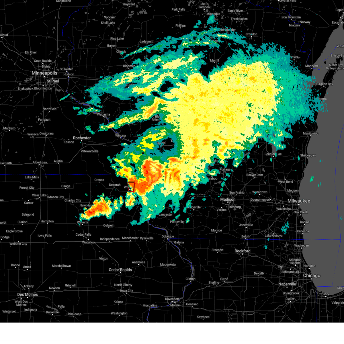
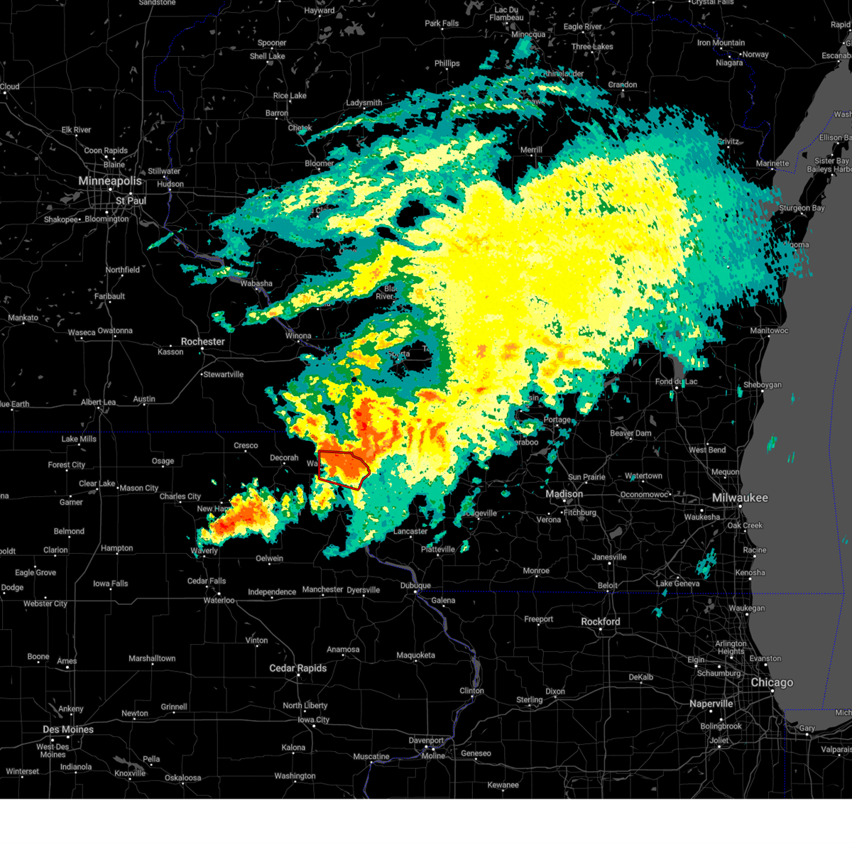
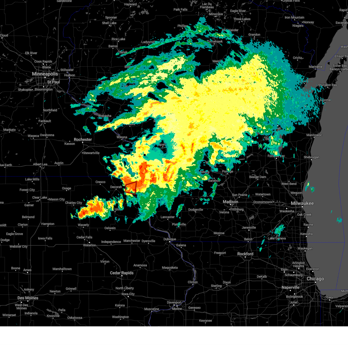
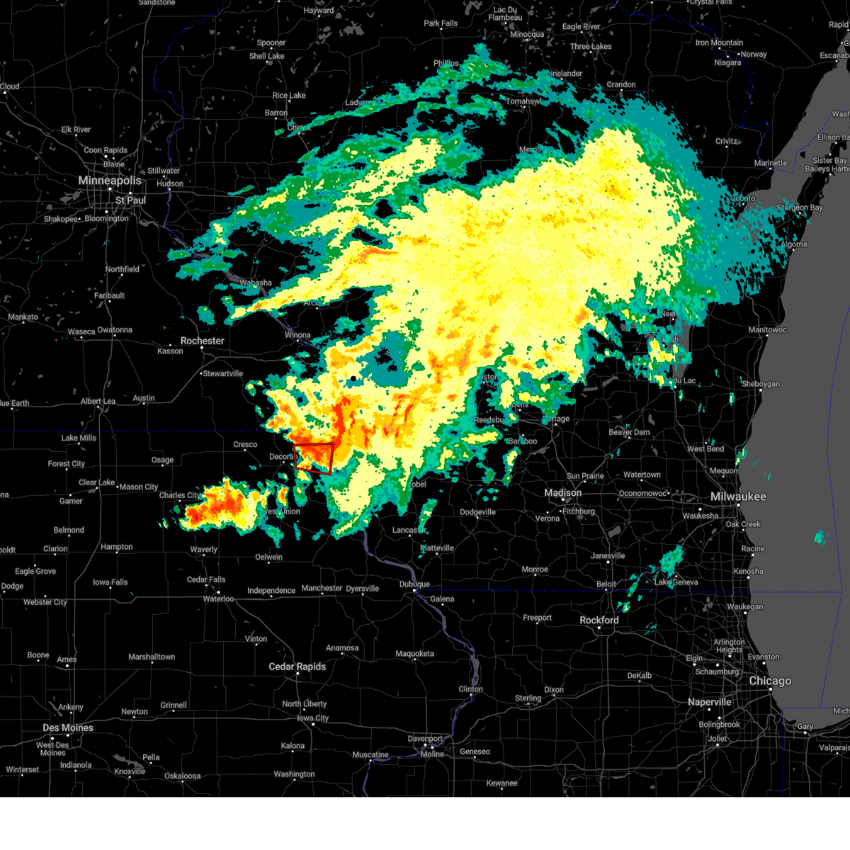
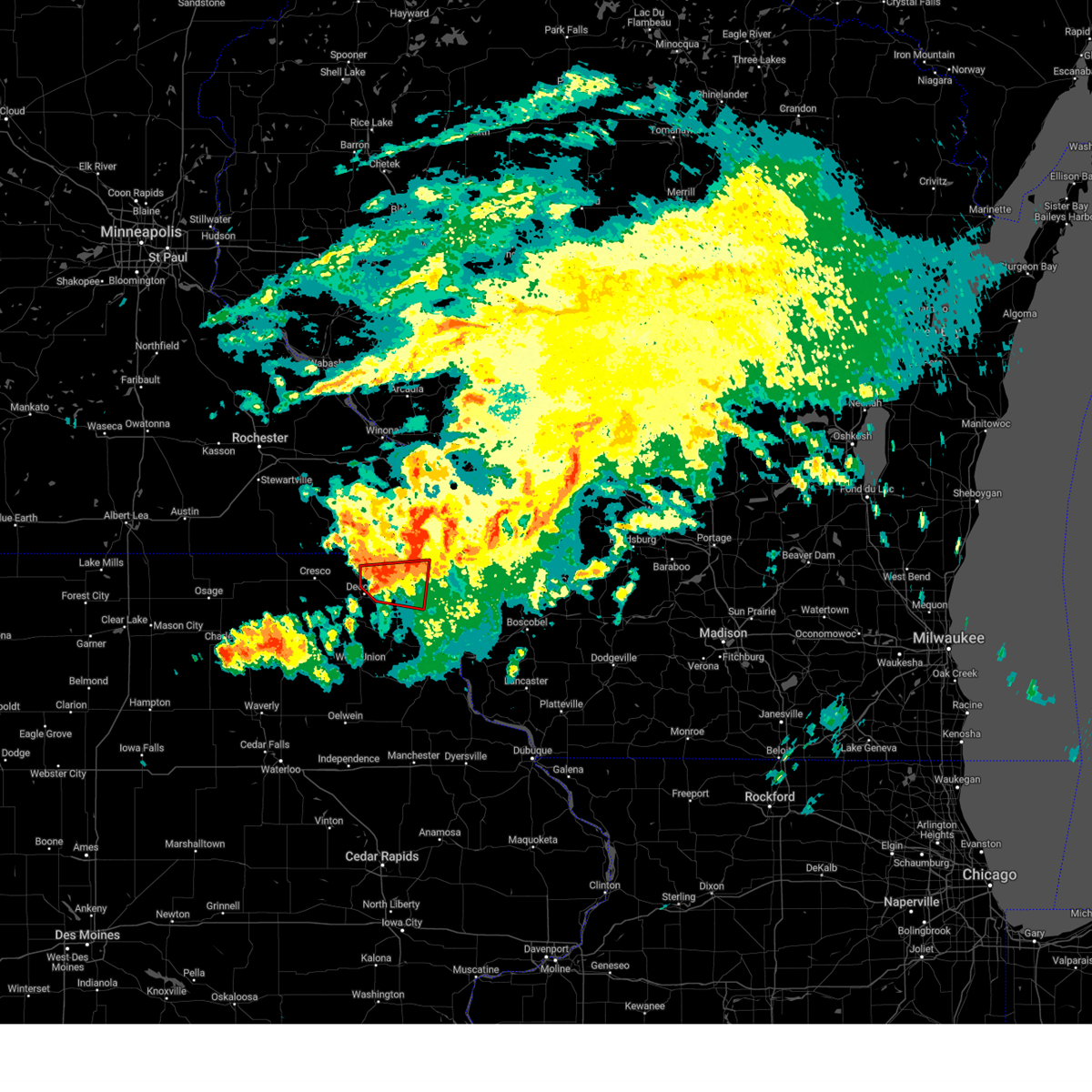
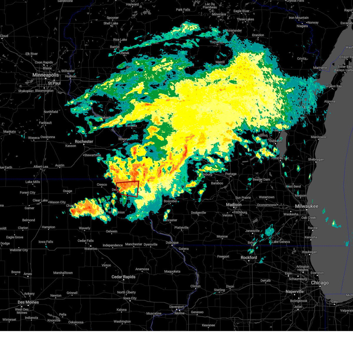
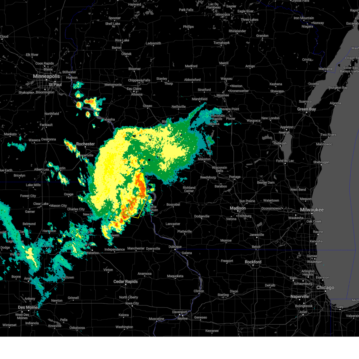
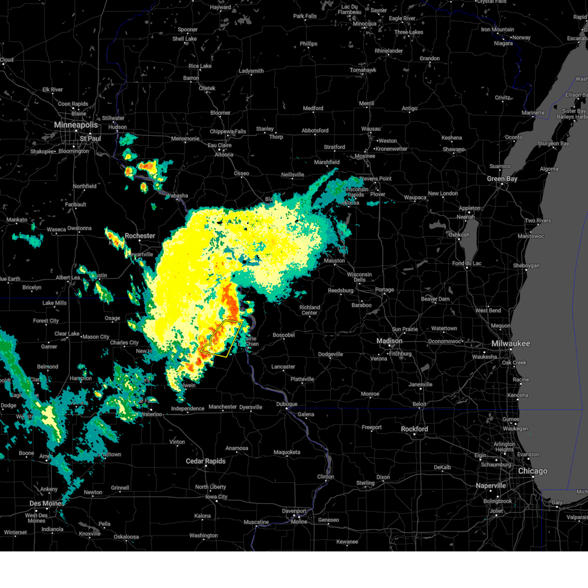
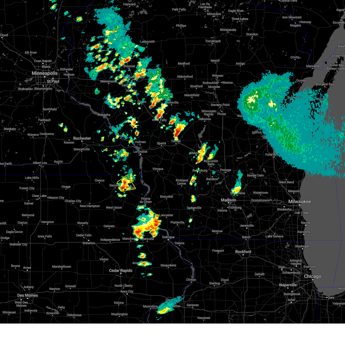
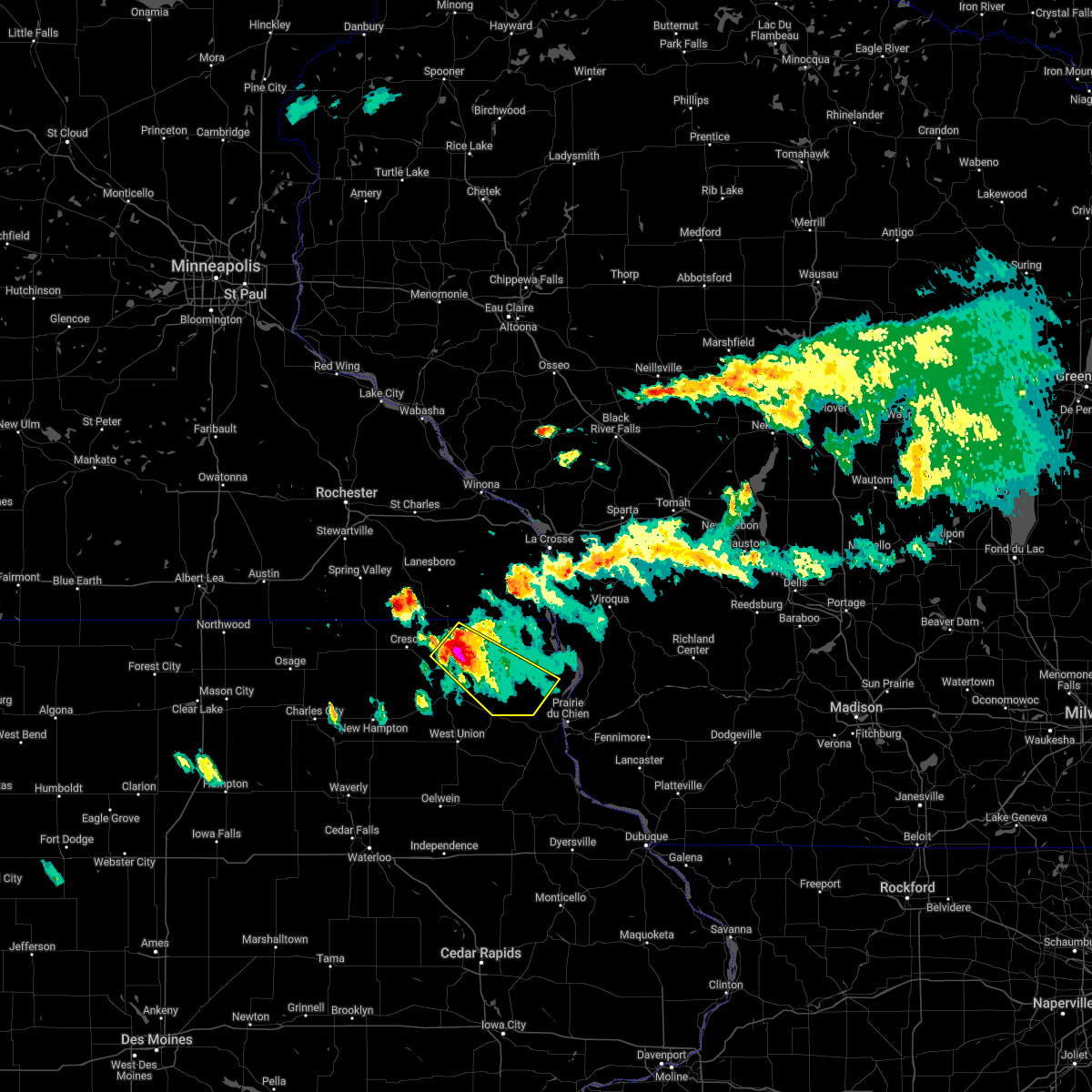
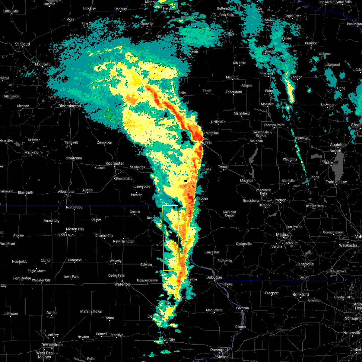
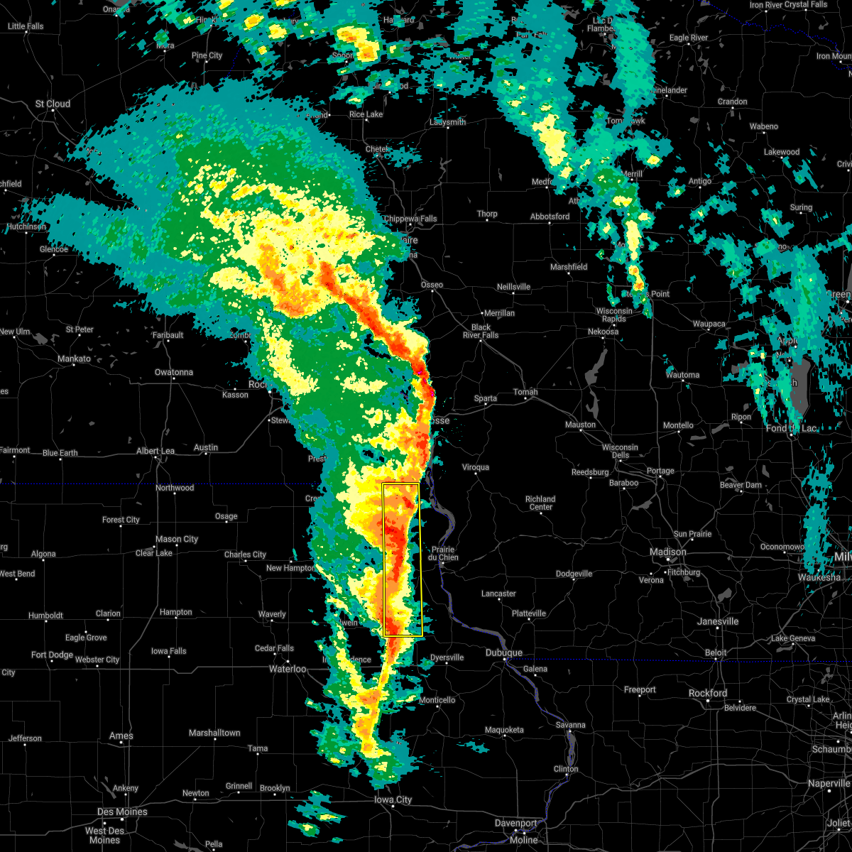
Hail Map for Waukon, IA
The Waukon, IA area has had 1 report of on-the-ground hail by trained spotters, and has been under severe weather warnings 7 times during the past 12 months. Doppler radar has detected hail at or near Waukon, IA on 40 occasions, including 4 occasions during the past year.
| Name: | Waukon, IA |
| Where Located: | 39.2 miles SSW of La Crosse, WI |
| Map: | Google Map for Waukon, IA |
| Population: | 3897 |
| Housing Units: | 1946 |
| More Info: | Search Google for Waukon, IA |
1
The Top Recent Hail Date for Waukon, IA is Saturday, September 21, 2024 (16th out of 40)

Hail and Wind Damage Spotted near Waukon, IA
| Date / Time | Report Details |
|---|---|
| 8/5/2024 10:44 PM CDT |
 At 1044 pm cdt, a confirmed tornado was located near waukon, moving east at 25 mph (radar confirmed tornado). Hazards include damaging tornado. Flying debris will be dangerous to those caught without shelter. mobile homes will be damaged or destroyed. damage to roofs, windows, and vehicles will occur. tree damage is likely. Locations impacted include, waukon and state road 9 and county x 20. At 1044 pm cdt, a confirmed tornado was located near waukon, moving east at 25 mph (radar confirmed tornado). Hazards include damaging tornado. Flying debris will be dangerous to those caught without shelter. mobile homes will be damaged or destroyed. damage to roofs, windows, and vehicles will occur. tree damage is likely. Locations impacted include, waukon and state road 9 and county x 20.
|
| 8/5/2024 10:43 PM CDT |
 Torarx the national weather service in la crosse has issued a * tornado warning for, central allamakee county in northeastern iowa, * until 1130 pm cdt. * at 1042 pm cdt, a tornado producing storm was located near waukon, moving east at 30 mph (radar confirmed tornado). Hazards include damaging tornado. Flying debris will be dangerous to those caught without shelter. mobile homes will be damaged or destroyed. damage to roofs, windows, and vehicles will occur. tree damage is likely. this tornadic storm will be near, lansing around 1105 pm cdt. Other locations impacted by this tornadic thunderstorm include county roads a 52 and x 52, state road 9 and county x 20, waterville, state road 76 and county x 16, elon, maud, and red barn campground. Torarx the national weather service in la crosse has issued a * tornado warning for, central allamakee county in northeastern iowa, * until 1130 pm cdt. * at 1042 pm cdt, a tornado producing storm was located near waukon, moving east at 30 mph (radar confirmed tornado). Hazards include damaging tornado. Flying debris will be dangerous to those caught without shelter. mobile homes will be damaged or destroyed. damage to roofs, windows, and vehicles will occur. tree damage is likely. this tornadic storm will be near, lansing around 1105 pm cdt. Other locations impacted by this tornadic thunderstorm include county roads a 52 and x 52, state road 9 and county x 20, waterville, state road 76 and county x 16, elon, maud, and red barn campground.
|
| 8/5/2024 10:32 PM CDT |
 the tornado warning has been cancelled and is no longer in effect the tornado warning has been cancelled and is no longer in effect
|
| 8/5/2024 10:32 PM CDT |
 At 1032 pm cdt, a confirmed tornado was located near waukon, moving east at 10 mph (radar confirmed tornado). Hazards include damaging tornado. Flying debris will be dangerous to those caught without shelter. mobile homes will be damaged or destroyed. damage to roofs, windows, and vehicles will occur. tree damage is likely. Locations impacted include, waukon, hanover, county roads a 52 and w 60, and state road 9 and county x 20. At 1032 pm cdt, a confirmed tornado was located near waukon, moving east at 10 mph (radar confirmed tornado). Hazards include damaging tornado. Flying debris will be dangerous to those caught without shelter. mobile homes will be damaged or destroyed. damage to roofs, windows, and vehicles will occur. tree damage is likely. Locations impacted include, waukon, hanover, county roads a 52 and w 60, and state road 9 and county x 20.
|
| 8/5/2024 10:26 PM CDT |
 At 1025 pm cdt, a severe thunderstorm capable of producing a tornado was located near waukon, moving east at 30 mph (radar indicated rotation). Hazards include tornado. Flying debris will be dangerous to those caught without shelter. mobile homes will be damaged or destroyed. damage to roofs, windows, and vehicles will occur. tree damage is likely. Locations impacted include, waukon, hanover, county roads a 52 and w 60, state road 9 and county x 20, glenwood church, and sattre. At 1025 pm cdt, a severe thunderstorm capable of producing a tornado was located near waukon, moving east at 30 mph (radar indicated rotation). Hazards include tornado. Flying debris will be dangerous to those caught without shelter. mobile homes will be damaged or destroyed. damage to roofs, windows, and vehicles will occur. tree damage is likely. Locations impacted include, waukon, hanover, county roads a 52 and w 60, state road 9 and county x 20, glenwood church, and sattre.
|
| 8/5/2024 10:15 PM CDT |
 At 1014 pm cdt, a confirmed tornado was located near decorah, moving east at 25 mph (radar confirmed tornado). Hazards include damaging tornado. Flying debris will be dangerous to those caught without shelter. mobile homes will be damaged or destroyed. damage to roofs, windows, and vehicles will occur. tree damage is likely. This tornadic thunderstorm will remain over mainly rural areas of northwestern allamakee and northeastern winneshiek counties, including the following locations, hanover, county roads a 26 and x 6 a, county roads a 52 and w 60, state road 9 and county x 20, quandahl, glenwood church, and locust. At 1014 pm cdt, a confirmed tornado was located near decorah, moving east at 25 mph (radar confirmed tornado). Hazards include damaging tornado. Flying debris will be dangerous to those caught without shelter. mobile homes will be damaged or destroyed. damage to roofs, windows, and vehicles will occur. tree damage is likely. This tornadic thunderstorm will remain over mainly rural areas of northwestern allamakee and northeastern winneshiek counties, including the following locations, hanover, county roads a 26 and x 6 a, county roads a 52 and w 60, state road 9 and county x 20, quandahl, glenwood church, and locust.
|
| 8/5/2024 10:13 PM CDT |
 Torarx the national weather service in la crosse has issued a * tornado warning for, northwestern allamakee county in northeastern iowa, northeastern winneshiek county in northeastern iowa, * until 1100 pm cdt. * at 1013 pm cdt, a severe thunderstorm capable of producing a tornado was located near decorah, moving east at 25 mph (radar indicated rotation). Hazards include tornado. Flying debris will be dangerous to those caught without shelter. mobile homes will be damaged or destroyed. damage to roofs, windows, and vehicles will occur. tree damage is likely. this dangerous storm will be near, waukon around 1050 pm cdt. Other locations impacted by this tornadic thunderstorm include hanover, county roads a 26 and x 6 a, county roads a 52 and w 60, state road 9 and county x 20, quandahl, glenwood church, and locust. Torarx the national weather service in la crosse has issued a * tornado warning for, northwestern allamakee county in northeastern iowa, northeastern winneshiek county in northeastern iowa, * until 1100 pm cdt. * at 1013 pm cdt, a severe thunderstorm capable of producing a tornado was located near decorah, moving east at 25 mph (radar indicated rotation). Hazards include tornado. Flying debris will be dangerous to those caught without shelter. mobile homes will be damaged or destroyed. damage to roofs, windows, and vehicles will occur. tree damage is likely. this dangerous storm will be near, waukon around 1050 pm cdt. Other locations impacted by this tornadic thunderstorm include hanover, county roads a 26 and x 6 a, county roads a 52 and w 60, state road 9 and county x 20, quandahl, glenwood church, and locust.
|
| 7/13/2024 8:55 PM CDT |
 At 854 pm cdt, severe thunderstorms were located along a line extending from near lansing to 8 miles west of harpers ferry to near postville, moving southeast at 40 mph (radar indicated). Hazards include 60 mph wind gusts. Expect damage to roofs, siding, and trees. these severe storms will be near, lansing, postville, and harpers ferry around 900 pm cdt. Other locations impacted by these severe thunderstorms include county roads a 52 and x 52, volney, county roads a 52 and w 60, waterville, state road 76 and county x 16, festina, and nordness. At 854 pm cdt, severe thunderstorms were located along a line extending from near lansing to 8 miles west of harpers ferry to near postville, moving southeast at 40 mph (radar indicated). Hazards include 60 mph wind gusts. Expect damage to roofs, siding, and trees. these severe storms will be near, lansing, postville, and harpers ferry around 900 pm cdt. Other locations impacted by these severe thunderstorms include county roads a 52 and x 52, volney, county roads a 52 and w 60, waterville, state road 76 and county x 16, festina, and nordness.
|
| 7/13/2024 8:55 PM CDT |
 the severe thunderstorm warning has been cancelled and is no longer in effect the severe thunderstorm warning has been cancelled and is no longer in effect
|
| 7/13/2024 8:15 PM CDT |
 Svrarx the national weather service in la crosse has issued a * severe thunderstorm warning for, southeastern howard county in northeastern iowa, allamakee county in northeastern iowa, winneshiek county in northeastern iowa, southern houston county in southeastern minnesota, * until 915 pm cdt. * at 815 pm cdt, severe thunderstorms were located along a line extending from near spring grove to 7 miles northeast of decorah to near ridgeway, moving southeast at 40 mph (radar indicated). Hazards include 60 mph wind gusts. Expect damage to roofs, siding, and trees. severe thunderstorms will be near, decorah, spring grove, spillville, and ridgeway around 820 pm cdt. calmar around 825 pm cdt. waukon around 830 pm cdt. ossian around 835 pm cdt. postville around 845 pm cdt. lansing around 850 pm cdt. harpers ferry around 900 pm cdt. other locations impacted by these severe thunderstorms include volney, vernon springs county park, county roads a 52 and w 60, festina, vernon springs, nordness, and county roads v 58 and a 46. People attending the winneshiek county fair should seek safe shelter immediately!. Svrarx the national weather service in la crosse has issued a * severe thunderstorm warning for, southeastern howard county in northeastern iowa, allamakee county in northeastern iowa, winneshiek county in northeastern iowa, southern houston county in southeastern minnesota, * until 915 pm cdt. * at 815 pm cdt, severe thunderstorms were located along a line extending from near spring grove to 7 miles northeast of decorah to near ridgeway, moving southeast at 40 mph (radar indicated). Hazards include 60 mph wind gusts. Expect damage to roofs, siding, and trees. severe thunderstorms will be near, decorah, spring grove, spillville, and ridgeway around 820 pm cdt. calmar around 825 pm cdt. waukon around 830 pm cdt. ossian around 835 pm cdt. postville around 845 pm cdt. lansing around 850 pm cdt. harpers ferry around 900 pm cdt. other locations impacted by these severe thunderstorms include volney, vernon springs county park, county roads a 52 and w 60, festina, vernon springs, nordness, and county roads v 58 and a 46. People attending the winneshiek county fair should seek safe shelter immediately!.
|
| 6/22/2024 5:26 PM CDT |
 At 525 pm cdt, severe thunderstorms were located along a line extending from near lansing to 6 miles west of harpers ferry to near postville, moving east at 40 mph (radar indicated). Hazards include 60 mph wind gusts and penny size hail. Expect damage to roofs, siding, and trees. Locations impacted include, lansing, red barn campground, village creek, elon, and maud. At 525 pm cdt, severe thunderstorms were located along a line extending from near lansing to 6 miles west of harpers ferry to near postville, moving east at 40 mph (radar indicated). Hazards include 60 mph wind gusts and penny size hail. Expect damage to roofs, siding, and trees. Locations impacted include, lansing, red barn campground, village creek, elon, and maud.
|
| 6/22/2024 5:26 PM CDT |
 the severe thunderstorm warning has been cancelled and is no longer in effect the severe thunderstorm warning has been cancelled and is no longer in effect
|
| 6/22/2024 5:19 PM CDT |
 Svrarx the national weather service in la crosse has issued a * severe thunderstorm warning for, southeastern allamakee county in northeastern iowa, northeastern grant county in southwestern wisconsin, southern richland county in southwestern wisconsin, crawford county in southwestern wisconsin, * until 615 pm cdt. * at 519 pm cdt, severe thunderstorms were located along a line extending from near lansing to 9 miles northwest of harpers ferry to near waukon, moving east at 40 mph (radar indicated). Hazards include 60 mph wind gusts and penny size hail. expect damage to roofs, siding, and trees Svrarx the national weather service in la crosse has issued a * severe thunderstorm warning for, southeastern allamakee county in northeastern iowa, northeastern grant county in southwestern wisconsin, southern richland county in southwestern wisconsin, crawford county in southwestern wisconsin, * until 615 pm cdt. * at 519 pm cdt, severe thunderstorms were located along a line extending from near lansing to 9 miles northwest of harpers ferry to near waukon, moving east at 40 mph (radar indicated). Hazards include 60 mph wind gusts and penny size hail. expect damage to roofs, siding, and trees
|
| 6/22/2024 5:12 PM CDT |
 At 512 pm cdt, severe thunderstorms were located along a line extending from 6 miles west of lansing to waukon to near ossian, moving east at 35 mph (radar indicated). Hazards include 60 mph wind gusts and penny size hail. Expect damage to roofs, siding, and trees. Locations impacted include, waukon, lansing, hanover, elon, maud, ludlow, glenwood church, red barn campground, churchtown, frankville, and village creek. At 512 pm cdt, severe thunderstorms were located along a line extending from 6 miles west of lansing to waukon to near ossian, moving east at 35 mph (radar indicated). Hazards include 60 mph wind gusts and penny size hail. Expect damage to roofs, siding, and trees. Locations impacted include, waukon, lansing, hanover, elon, maud, ludlow, glenwood church, red barn campground, churchtown, frankville, and village creek.
|
| 6/22/2024 4:54 PM CDT |
 At 454 pm cdt, severe thunderstorms were located along a line extending from 9 miles southeast of spring grove to near decorah, moving east at 40 mph (radar indicated). Hazards include 70 mph wind gusts. Expect considerable tree damage. damage is likely to mobile homes, roofs, and outbuildings. Locations impacted include, decorah, waukon, lansing, hanover, nordness, highlandville, elon, quandahl, ludlow, red barn campground, churchtown, locust, sattre, and dorchester. At 454 pm cdt, severe thunderstorms were located along a line extending from 9 miles southeast of spring grove to near decorah, moving east at 40 mph (radar indicated). Hazards include 70 mph wind gusts. Expect considerable tree damage. damage is likely to mobile homes, roofs, and outbuildings. Locations impacted include, decorah, waukon, lansing, hanover, nordness, highlandville, elon, quandahl, ludlow, red barn campground, churchtown, locust, sattre, and dorchester.
|
| 6/22/2024 4:38 PM CDT |
 Svrarx the national weather service in la crosse has issued a * severe thunderstorm warning for, northwestern allamakee county in northeastern iowa, winneshiek county in northeastern iowa, * until 545 pm cdt. * at 437 pm cdt, severe thunderstorms were located along a line extending from near mabel to near protivin, moving east at 30 mph (radar indicated). Hazards include 60 mph wind gusts. expect damage to roofs, siding, and trees Svrarx the national weather service in la crosse has issued a * severe thunderstorm warning for, northwestern allamakee county in northeastern iowa, winneshiek county in northeastern iowa, * until 545 pm cdt. * at 437 pm cdt, severe thunderstorms were located along a line extending from near mabel to near protivin, moving east at 30 mph (radar indicated). Hazards include 60 mph wind gusts. expect damage to roofs, siding, and trees
|
| 6/12/2024 3:27 PM CDT |
 At 325 pm cdt, severe thunderstorms were located along a line extending from 6 miles west of harpers ferry to near farmersburg, moving southeast at 45 mph (trained weather spotters have reported blowing dust with higher wind gusts near ferryville. trees were downed on the yellow river near postville around 315 pm). Hazards include 60 mph wind gusts. Expect damage to roofs, siding, and trees. These severe thunderstorms will remain over mainly rural areas of northwestern clayton, northeastern fayette and southwestern allamakee counties, including the following locations, volney, waterville, county roads x 16 and b 38, state road 76 and county x 16, elon, maud, and county roads b 56 and x 16. At 325 pm cdt, severe thunderstorms were located along a line extending from 6 miles west of harpers ferry to near farmersburg, moving southeast at 45 mph (trained weather spotters have reported blowing dust with higher wind gusts near ferryville. trees were downed on the yellow river near postville around 315 pm). Hazards include 60 mph wind gusts. Expect damage to roofs, siding, and trees. These severe thunderstorms will remain over mainly rural areas of northwestern clayton, northeastern fayette and southwestern allamakee counties, including the following locations, volney, waterville, county roads x 16 and b 38, state road 76 and county x 16, elon, maud, and county roads b 56 and x 16.
|
| 6/12/2024 3:27 PM CDT |
 the severe thunderstorm warning has been cancelled and is no longer in effect the severe thunderstorm warning has been cancelled and is no longer in effect
|
| 6/12/2024 3:15 PM CDT |
 At 314 pm cdt, severe thunderstorms were located along a line extending from near waukon to elgin, moving east at 55 mph (trained weather spotters reported a large amount of dust being kicked up ahead of the storms near frankville around 3 pm with gusts estimated at 50 to 60 mph). Hazards include 60 mph wind gusts. Expect damage to roofs, siding, and trees. these severe storms will be near, monona around 320 pm cdt. Other locations impacted by these severe thunderstorms include volney, county roads a 52 and w 60, waterville, county roads x 16 and b 38, state road 76 and county x 16, elon, and maud. At 314 pm cdt, severe thunderstorms were located along a line extending from near waukon to elgin, moving east at 55 mph (trained weather spotters reported a large amount of dust being kicked up ahead of the storms near frankville around 3 pm with gusts estimated at 50 to 60 mph). Hazards include 60 mph wind gusts. Expect damage to roofs, siding, and trees. these severe storms will be near, monona around 320 pm cdt. Other locations impacted by these severe thunderstorms include volney, county roads a 52 and w 60, waterville, county roads x 16 and b 38, state road 76 and county x 16, elon, and maud.
|
| 6/12/2024 2:56 PM CDT |
 Svrarx the national weather service in la crosse has issued a * severe thunderstorm warning for, northwestern clayton county in northeastern iowa, northeastern fayette county in northeastern iowa, southwestern allamakee county in northeastern iowa, southern winneshiek county in northeastern iowa, * until 345 pm cdt. * at 255 pm cdt, a severe thunderstorm was located near decorah, moving east at 50 mph (trained weather spotters reported 10 inch diameter tree limbs broken in calmar at around 250 pm). Hazards include 60 mph wind gusts. Expect damage to roofs, siding, and trees. this severe thunderstorm will be near, waukon around 305 pm cdt. Other locations impacted by this severe thunderstorm include volney, county roads a 52 and w 60, waterville, state road 76 and county x 16, festina, eldorado, and nordness. Svrarx the national weather service in la crosse has issued a * severe thunderstorm warning for, northwestern clayton county in northeastern iowa, northeastern fayette county in northeastern iowa, southwestern allamakee county in northeastern iowa, southern winneshiek county in northeastern iowa, * until 345 pm cdt. * at 255 pm cdt, a severe thunderstorm was located near decorah, moving east at 50 mph (trained weather spotters reported 10 inch diameter tree limbs broken in calmar at around 250 pm). Hazards include 60 mph wind gusts. Expect damage to roofs, siding, and trees. this severe thunderstorm will be near, waukon around 305 pm cdt. Other locations impacted by this severe thunderstorm include volney, county roads a 52 and w 60, waterville, state road 76 and county x 16, festina, eldorado, and nordness.
|
| 5/21/2024 7:33 PM CDT |
 the severe thunderstorm warning has been cancelled and is no longer in effect the severe thunderstorm warning has been cancelled and is no longer in effect
|
| 5/21/2024 7:14 PM CDT |
 At 713 pm cdt, severe thunderstorms were located along a line extending from 7 miles south of waukon to 6 miles northeast of monona to near mcgregor, moving northeast at 70 mph (radar indicated). Hazards include 70 mph wind gusts and penny size hail. Expect considerable tree damage. damage is likely to mobile homes, roofs, and outbuildings. these severe storms will be near, harpers ferry around 720 pm cdt. lansing around 725 pm cdt. Other locations impacted by these severe thunderstorms include volney, county roads a 52 and w 60, watson, county roads x 16 and w 48, fairview, ferryville, and state road 51 and county w 48. At 713 pm cdt, severe thunderstorms were located along a line extending from 7 miles south of waukon to 6 miles northeast of monona to near mcgregor, moving northeast at 70 mph (radar indicated). Hazards include 70 mph wind gusts and penny size hail. Expect considerable tree damage. damage is likely to mobile homes, roofs, and outbuildings. these severe storms will be near, harpers ferry around 720 pm cdt. lansing around 725 pm cdt. Other locations impacted by these severe thunderstorms include volney, county roads a 52 and w 60, watson, county roads x 16 and w 48, fairview, ferryville, and state road 51 and county w 48.
|
| 5/21/2024 7:14 PM CDT |
 the severe thunderstorm warning has been cancelled and is no longer in effect the severe thunderstorm warning has been cancelled and is no longer in effect
|
| 5/21/2024 7:00 PM CDT | Tree split in half and a recreational vehicle destroyed. time estimated from rada in allamakee county IA, 0.4 miles W of Waukon, IA |
| 5/21/2024 6:41 PM CDT |
 Svrarx the national weather service in la crosse has issued a * severe thunderstorm warning for, northwestern clayton county in northeastern iowa, allamakee county in northeastern iowa, southern winneshiek county in northeastern iowa, northern crawford county in southwestern wisconsin, * until 745 pm cdt. * at 641 pm cdt, severe thunderstorms were located along a line extending from near hawkeye to near west union to near arlington, moving northeast at 70 mph (radar indicated). Hazards include 70 mph wind gusts and penny size hail. Expect considerable tree damage. damage is likely to mobile homes, roofs, and outbuildings. severe thunderstorms will be near, postville, calmar, and ossian around 650 pm cdt. monona around 655 pm cdt. waukon around 700 pm cdt. lansing and harpers ferry around 710 pm cdt. Other locations impacted by these severe thunderstorms include volney, county roads a 52 and w 60, festina, watson, county road w 46 and centennial road, county roads x 16 and w 48, and fairview. Svrarx the national weather service in la crosse has issued a * severe thunderstorm warning for, northwestern clayton county in northeastern iowa, allamakee county in northeastern iowa, southern winneshiek county in northeastern iowa, northern crawford county in southwestern wisconsin, * until 745 pm cdt. * at 641 pm cdt, severe thunderstorms were located along a line extending from near hawkeye to near west union to near arlington, moving northeast at 70 mph (radar indicated). Hazards include 70 mph wind gusts and penny size hail. Expect considerable tree damage. damage is likely to mobile homes, roofs, and outbuildings. severe thunderstorms will be near, postville, calmar, and ossian around 650 pm cdt. monona around 655 pm cdt. waukon around 700 pm cdt. lansing and harpers ferry around 710 pm cdt. Other locations impacted by these severe thunderstorms include volney, county roads a 52 and w 60, festina, watson, county road w 46 and centennial road, county roads x 16 and w 48, and fairview.
|
| 5/7/2024 5:31 PM CDT |
 At 531 pm cdt, a severe thunderstorm was located near waukon, moving northeast at 25 mph (radar indicated). Hazards include quarter size hail. Damage to vehicles is expected. This severe thunderstorm will remain over mainly rural areas of northwestern allamakee and east central winneshiek counties, including the following locations, hanover, county roads a 52 and w 60, state road 9 and county x 20, quandahl, glenwood church, dorchester, and sattre. At 531 pm cdt, a severe thunderstorm was located near waukon, moving northeast at 25 mph (radar indicated). Hazards include quarter size hail. Damage to vehicles is expected. This severe thunderstorm will remain over mainly rural areas of northwestern allamakee and east central winneshiek counties, including the following locations, hanover, county roads a 52 and w 60, state road 9 and county x 20, quandahl, glenwood church, dorchester, and sattre.
|
| 5/7/2024 5:03 PM CDT |
 Svrarx the national weather service in la crosse has issued a * severe thunderstorm warning for, northwestern allamakee county in northeastern iowa, southeastern winneshiek county in northeastern iowa, * until 545 pm cdt. * at 503 pm cdt, a severe thunderstorm was located near decorah, moving northeast at 25 mph (radar indicated). Hazards include quarter size hail. Damage to vehicles is expected. this severe thunderstorm will be near, decorah around 510 pm cdt. Other locations impacted by this severe thunderstorm include hanover, county roads a 52 and w 60, state road 9 and county x 20, nordness, quandahl, ludlow, and glenwood church. Svrarx the national weather service in la crosse has issued a * severe thunderstorm warning for, northwestern allamakee county in northeastern iowa, southeastern winneshiek county in northeastern iowa, * until 545 pm cdt. * at 503 pm cdt, a severe thunderstorm was located near decorah, moving northeast at 25 mph (radar indicated). Hazards include quarter size hail. Damage to vehicles is expected. this severe thunderstorm will be near, decorah around 510 pm cdt. Other locations impacted by this severe thunderstorm include hanover, county roads a 52 and w 60, state road 9 and county x 20, nordness, quandahl, ludlow, and glenwood church.
|
| 9/3/2022 12:35 AM CDT |
 The severe thunderstorm warning for central allamakee county will expire at 1245 am cdt, the storm which prompted the warning has weakened below severe limits, and no longer poses an immediate threat to life or property. therefore, the warning will be allowed to expire. to report severe weather, contact your nearest law enforcement agency. they will relay your report to the national weather service la crosse. The severe thunderstorm warning for central allamakee county will expire at 1245 am cdt, the storm which prompted the warning has weakened below severe limits, and no longer poses an immediate threat to life or property. therefore, the warning will be allowed to expire. to report severe weather, contact your nearest law enforcement agency. they will relay your report to the national weather service la crosse.
|
| 9/3/2022 12:20 AM CDT |
 At 1220 am cdt, a severe thunderstorm was located 8 miles east of waukon, moving east at 20 mph (radar indicated). Hazards include 60 mph wind gusts and penny size hail. Expect damage to roofs, siding, and trees. locations impacted include, waukon, lansing, waterville, state road 9 and county x 20, state road 76 and county x 16, elon, maud, churchtown, dalby, yellow river state forest, thompson corner, rossville and village creek. hail threat, radar indicated max hail size, 0. 75 in wind threat, radar indicated max wind gust, 60 mph. At 1220 am cdt, a severe thunderstorm was located 8 miles east of waukon, moving east at 20 mph (radar indicated). Hazards include 60 mph wind gusts and penny size hail. Expect damage to roofs, siding, and trees. locations impacted include, waukon, lansing, waterville, state road 9 and county x 20, state road 76 and county x 16, elon, maud, churchtown, dalby, yellow river state forest, thompson corner, rossville and village creek. hail threat, radar indicated max hail size, 0. 75 in wind threat, radar indicated max wind gust, 60 mph.
|
| 9/3/2022 12:07 AM CDT |
 At 1207 am cdt, a severe thunderstorm was located near waukon, moving east at 20 mph (radar indicated). Hazards include 60 mph wind gusts and penny size hail. Expect damage to roofs, siding, and trees. this severe thunderstorm will remain over mainly rural areas of central allamakee county, including the following locations, hanover, volney, county roads a 52 and w 60, state road 9 and county x 20, waterville, state road 76 and county x 16 and elon. hail threat, radar indicated max hail size, 0. 75 in wind threat, radar indicated max wind gust, 60 mph. At 1207 am cdt, a severe thunderstorm was located near waukon, moving east at 20 mph (radar indicated). Hazards include 60 mph wind gusts and penny size hail. Expect damage to roofs, siding, and trees. this severe thunderstorm will remain over mainly rural areas of central allamakee county, including the following locations, hanover, volney, county roads a 52 and w 60, state road 9 and county x 20, waterville, state road 76 and county x 16 and elon. hail threat, radar indicated max hail size, 0. 75 in wind threat, radar indicated max wind gust, 60 mph.
|
| 9/2/2022 11:44 PM CDT |
 At 1143 pm cdt, a severe thunderstorm was located 7 miles northwest of waukon, moving east at 20 mph (radar indicated). Hazards include 60 mph wind gusts and penny size hail. Expect damage to roofs, siding, and trees. this severe thunderstorm will be near, waukon around 1205 am cdt. lansing around 1235 am cdt. other locations impacted by this severe thunderstorm include hanover, volney, county roads a 52 and w 60, state road 9 and county x 20, waterville, county roads x 16 and b 38 and state road 76 and county x 16. hail threat, radar indicated max hail size, 0. 75 in wind threat, radar indicated max wind gust, 60 mph. At 1143 pm cdt, a severe thunderstorm was located 7 miles northwest of waukon, moving east at 20 mph (radar indicated). Hazards include 60 mph wind gusts and penny size hail. Expect damage to roofs, siding, and trees. this severe thunderstorm will be near, waukon around 1205 am cdt. lansing around 1235 am cdt. other locations impacted by this severe thunderstorm include hanover, volney, county roads a 52 and w 60, state road 9 and county x 20, waterville, county roads x 16 and b 38 and state road 76 and county x 16. hail threat, radar indicated max hail size, 0. 75 in wind threat, radar indicated max wind gust, 60 mph.
|
| 8/27/2022 8:11 PM CDT | The severe thunderstorm warning for west central allamakee and eastern winneshiek counties will expire at 815 pm cdt, the storm which prompted the warning has weakened below severe limits, and no longer poses an immediate threat to life or property. therefore, the warning will be allowed to expire. however gusty winds and heavy rain are still possible with this thunderstorm. |
| 8/27/2022 7:51 PM CDT | At 751 pm cdt, a severe thunderstorm was located near ossian, or 8 miles southeast of decorah, moving north at 15 mph (radar indicated). Hazards include 60 mph wind gusts. Expect damage to roofs, siding, and trees. this severe storm will be near, decorah around 810 pm cdt. other locations impacted by this severe thunderstorm include hanover, county roads a 52 and w 60, state road 9 and county x 20, state road 76 and county x 16, frankville, state road 9 and frankville road and nordness. hail threat, radar indicated max hail size, <. 75 in wind threat, radar indicated max wind gust, 60 mph. |
| 8/27/2022 7:35 PM CDT | At 735 pm cdt, a severe thunderstorm was located over ossian, or 10 miles south of decorah, moving north at 15 mph (radar indicated). Hazards include 60 mph wind gusts and quarter size hail. Hail damage to vehicles is expected. expect wind damage to roofs, siding, and trees. this severe thunderstorm will be near, decorah around 810 pm cdt. Other locations impacted by this severe thunderstorm include hanover, county roads a 52 and w 60, state road 9 and county x 20, state road 76 and county x 16, frankville, state road 9 and frankville road and nordness. |
| 7/23/2022 11:45 PM CDT | Small branches down in town along with some minor floodin in allamakee county IA, 0.1 miles ESE of Waukon, IA |
| 7/23/2022 11:44 PM CDT |
 At 1143 pm cdt, severe thunderstorms were located along a line extending from near new albin to near waukon, moving east at 70 mph (radar indicated). Hazards include 60 mph wind gusts. Possible damage to roofs, siding, and trees. these severe storms will be near, new albin around 1150 pm cdt. lansing around 1155 pm cdt. harpers ferry around 1200 am cdt. other locations impacted by these severe thunderstorms include hanover, county roads a 52 and x 52, county roads a 26 and x 6 a, county roads a 52 and w 60, state road 9 and county x 20, waterville and state road 76 and county x 16. hail threat, radar indicated max hail size, <. 75 in wind threat, radar indicated max wind gust, 60 mph. At 1143 pm cdt, severe thunderstorms were located along a line extending from near new albin to near waukon, moving east at 70 mph (radar indicated). Hazards include 60 mph wind gusts. Possible damage to roofs, siding, and trees. these severe storms will be near, new albin around 1150 pm cdt. lansing around 1155 pm cdt. harpers ferry around 1200 am cdt. other locations impacted by these severe thunderstorms include hanover, county roads a 52 and x 52, county roads a 26 and x 6 a, county roads a 52 and w 60, state road 9 and county x 20, waterville and state road 76 and county x 16. hail threat, radar indicated max hail size, <. 75 in wind threat, radar indicated max wind gust, 60 mph.
|
| 7/23/2022 11:41 PM CDT | Deputy estimated at intersection of highways 9 and 51 in allamakee county IA, 4.1 miles E of Waukon, IA |
| 7/23/2022 11:32 PM CDT |
 At 1131 pm cdt, severe thunderstorms were located along a line extending from 9 miles south of spring grove to near decorah, moving east at 45 mph (radar indicated). Hazards include 60 mph wind gusts. Expect damage to roofs, siding, and trees. these severe storms will be near, waukon and new albin around 1150 pm cdt. lansing around 1155 pm cdt. harpers ferry around 1215 am cdt. other locations impacted by these severe thunderstorms include hanover, county roads a 52 and x 52, county roads a 26 and x 6 a, county roads a 52 and w 60, state road 9 and county x 20, waterville and state road 76 and county x 16. hail threat, radar indicated max hail size, <. 75 in wind threat, radar indicated max wind gust, 60 mph. At 1131 pm cdt, severe thunderstorms were located along a line extending from 9 miles south of spring grove to near decorah, moving east at 45 mph (radar indicated). Hazards include 60 mph wind gusts. Expect damage to roofs, siding, and trees. these severe storms will be near, waukon and new albin around 1150 pm cdt. lansing around 1155 pm cdt. harpers ferry around 1215 am cdt. other locations impacted by these severe thunderstorms include hanover, county roads a 52 and x 52, county roads a 26 and x 6 a, county roads a 52 and w 60, state road 9 and county x 20, waterville and state road 76 and county x 16. hail threat, radar indicated max hail size, <. 75 in wind threat, radar indicated max wind gust, 60 mph.
|
| 7/23/2022 11:24 PM CDT |
 At 1124 pm cdt, severe thunderstorms were located along a line extending from near spring grove to near decorah, moving east at 70 mph (radar indicated). Hazards include 60 mph wind gusts. Expect damage to roofs, siding, and trees. severe thunderstorms will be near, waukon and new albin around 1140 pm cdt. lansing around 1150 pm cdt. other locations impacted by these severe thunderstorms include hanover, county roads a 52 and x 52, county roads a 52 and w 60, waterville, state road 76 and county x 16, nordness and highlandville. hail threat, radar indicated max hail size, <. 75 in wind threat, radar indicated max wind gust, 60 mph. At 1124 pm cdt, severe thunderstorms were located along a line extending from near spring grove to near decorah, moving east at 70 mph (radar indicated). Hazards include 60 mph wind gusts. Expect damage to roofs, siding, and trees. severe thunderstorms will be near, waukon and new albin around 1140 pm cdt. lansing around 1150 pm cdt. other locations impacted by these severe thunderstorms include hanover, county roads a 52 and x 52, county roads a 52 and w 60, waterville, state road 76 and county x 16, nordness and highlandville. hail threat, radar indicated max hail size, <. 75 in wind threat, radar indicated max wind gust, 60 mph.
|
| 6/28/2022 7:39 PM CDT |
 At 739 pm cdt, a severe thunderstorm was located near decorah, moving southeast at 35 mph (radar indicated). Hazards include ping pong ball size hail and 60 mph wind gusts. People and animals outdoors will be injured. expect hail damage to roofs, siding, windows, and vehicles. expect wind damage to roofs, siding, and trees. this severe thunderstorm will be near, waukon around 800 pm cdt. other locations impacted by this severe thunderstorm include hanover, volney, waterville, hesper and nordness. hail threat, radar indicated max hail size, 1. 50 in wind threat, radar indicated max wind gust, 60 mph. At 739 pm cdt, a severe thunderstorm was located near decorah, moving southeast at 35 mph (radar indicated). Hazards include ping pong ball size hail and 60 mph wind gusts. People and animals outdoors will be injured. expect hail damage to roofs, siding, windows, and vehicles. expect wind damage to roofs, siding, and trees. this severe thunderstorm will be near, waukon around 800 pm cdt. other locations impacted by this severe thunderstorm include hanover, volney, waterville, hesper and nordness. hail threat, radar indicated max hail size, 1. 50 in wind threat, radar indicated max wind gust, 60 mph.
|
| 4/12/2022 11:51 PM CDT |
 At 1151 pm cdt, severe thunderstorms were located along a line extending from near mabel to 6 miles northeast of decorah to near ossian, moving east at 50 mph (radar indicated). Hazards include 60 mph wind gusts. Expect damage to roofs, siding, and trees. severe thunderstorms will be near, waukon around 1215 am cdt. lansing and new albin around 1220 am cdt. harpers ferry around 1230 am cdt. other locations impacted by these severe thunderstorms include hanover, county roads a 52 and x 52, county roads a 52 and w 60, waterville, state road 76 and county x 16, hesper and nordness. hail threat, radar indicated max hail size, <. 75 in wind threat, radar indicated max wind gust, 60 mph. At 1151 pm cdt, severe thunderstorms were located along a line extending from near mabel to 6 miles northeast of decorah to near ossian, moving east at 50 mph (radar indicated). Hazards include 60 mph wind gusts. Expect damage to roofs, siding, and trees. severe thunderstorms will be near, waukon around 1215 am cdt. lansing and new albin around 1220 am cdt. harpers ferry around 1230 am cdt. other locations impacted by these severe thunderstorms include hanover, county roads a 52 and x 52, county roads a 52 and w 60, waterville, state road 76 and county x 16, hesper and nordness. hail threat, radar indicated max hail size, <. 75 in wind threat, radar indicated max wind gust, 60 mph.
|
| 12/15/2021 8:55 PM CST |
 The severe thunderstorm warning for western clayton and allamakee counties will expire at 900 pm cst, the storms which prompted the warning have moved out of the area. therefore, the warning will be allowed to expire. a tornado watch remains in effect until 1100 pm cst for northeastern iowa. The severe thunderstorm warning for western clayton and allamakee counties will expire at 900 pm cst, the storms which prompted the warning have moved out of the area. therefore, the warning will be allowed to expire. a tornado watch remains in effect until 1100 pm cst for northeastern iowa.
|
| 12/15/2021 8:29 PM CST |
 At 829 pm cst, severe thunderstorms were located along a line extending from new albin to near postville to strawberry point, moving northeast at 65 mph (radar indicated). Hazards include 70 mph wind gusts. Expect considerable tree damage. damage is likely to mobile homes, roofs, and outbuildings. severe thunderstorms will be near, elkader around 840 pm cst. Other locations impacted by these severe thunderstorms include hanover, volney, county roads a 52 and w 60, state road 76 and county x 16, mederville, elon and quandahl. At 829 pm cst, severe thunderstorms were located along a line extending from new albin to near postville to strawberry point, moving northeast at 65 mph (radar indicated). Hazards include 70 mph wind gusts. Expect considerable tree damage. damage is likely to mobile homes, roofs, and outbuildings. severe thunderstorms will be near, elkader around 840 pm cst. Other locations impacted by these severe thunderstorms include hanover, volney, county roads a 52 and w 60, state road 76 and county x 16, mederville, elon and quandahl.
|
| 12/15/2021 8:23 PM CST | Tree down. time estimated from rada in allamakee county IA, 0.1 miles ESE of Waukon, IA |
| 12/15/2021 7:46 PM CST |
 At 746 pm cst, severe thunderstorms were located along a line extending from near harmony to near decorah to 6 miles south of sumner, moving east at 50 mph (radar indicated). Hazards include 70 mph wind gusts. Expect considerable tree damage. damage is likely to mobile homes, roofs, and outbuildings. Locations impacted include, decorah, oelwein, fayette, arlington, volga, elkader and farmersburg. At 746 pm cst, severe thunderstorms were located along a line extending from near harmony to near decorah to 6 miles south of sumner, moving east at 50 mph (radar indicated). Hazards include 70 mph wind gusts. Expect considerable tree damage. damage is likely to mobile homes, roofs, and outbuildings. Locations impacted include, decorah, oelwein, fayette, arlington, volga, elkader and farmersburg.
|
| 12/15/2021 7:29 PM CST |
 At 729 pm cst, severe thunderstorms were located along a line extending from lime springs to near protivin to near tripoli, moving northeast at 70 mph (radar indicated). Hazards include 70 mph wind gusts. Expect considerable tree damage. damage is likely to mobile homes, roofs, and outbuildings. severe thunderstorms will be near, spillville and ridgeway around 740 pm cst. hawkeye and waucoma around 745 pm cst. Decorah and west union around 750 pm cst. At 729 pm cst, severe thunderstorms were located along a line extending from lime springs to near protivin to near tripoli, moving northeast at 70 mph (radar indicated). Hazards include 70 mph wind gusts. Expect considerable tree damage. damage is likely to mobile homes, roofs, and outbuildings. severe thunderstorms will be near, spillville and ridgeway around 740 pm cst. hawkeye and waucoma around 745 pm cst. Decorah and west union around 750 pm cst.
|
| 8/27/2021 7:11 PM CDT |
 At 710 pm cdt, a severe thunderstorm was located over ossian, or 10 miles south of decorah, moving east at 35 mph (radar indicated). Hazards include 60 mph wind gusts and quarter size hail. Hail damage to vehicles is expected. expect wind damage to roofs, siding, and trees. Locations impacted include, waukon, postville, calmar, ossian, castalia, volney, county roads x 16 and b 38, state road 76 and county x 16, nordness, maud, ludlow, county road w 46 and centennial road, county roads x 16 and w 48, frankville, state road 9 and frankville road, state road 51 and county w 48, rossville, county roads a 52 and w 60 and festina. At 710 pm cdt, a severe thunderstorm was located over ossian, or 10 miles south of decorah, moving east at 35 mph (radar indicated). Hazards include 60 mph wind gusts and quarter size hail. Hail damage to vehicles is expected. expect wind damage to roofs, siding, and trees. Locations impacted include, waukon, postville, calmar, ossian, castalia, volney, county roads x 16 and b 38, state road 76 and county x 16, nordness, maud, ludlow, county road w 46 and centennial road, county roads x 16 and w 48, frankville, state road 9 and frankville road, state road 51 and county w 48, rossville, county roads a 52 and w 60 and festina.
|
| 8/27/2021 6:52 PM CDT |
 At 651 pm cdt, a severe thunderstorm was located over calmar, or 9 miles southwest of decorah, moving east at 40 mph (radar indicated). Hazards include 60 mph wind gusts and quarter size hail. Hail damage to vehicles is expected. Expect wind damage to roofs, siding, and trees. At 651 pm cdt, a severe thunderstorm was located over calmar, or 9 miles southwest of decorah, moving east at 40 mph (radar indicated). Hazards include 60 mph wind gusts and quarter size hail. Hail damage to vehicles is expected. Expect wind damage to roofs, siding, and trees.
|
| 8/10/2021 3:50 PM CDT |
 At 349 pm cdt, severe thunderstorms were located along a line extending from 9 miles east of lansing to 6 miles northeast of balltown, moving east at 45 mph (law enforcement). Hazards include 60 mph wind gusts and nickel size hail. Expect damage to roofs, siding, and trees. locations impacted include, prairie du chien, waukon, lancaster, guttenberg, lansing, boscobel, cassville, mcgregor, bloomington, marquette, harpers ferry, bridgeport, seneca, beetown, wauzeka, potosi, soldiers grove, mount ida, gays mills and eastman. hail threat, radar indicated max hail size, 0. 88 in wind threat, observed max wind gust, 60 mph. At 349 pm cdt, severe thunderstorms were located along a line extending from 9 miles east of lansing to 6 miles northeast of balltown, moving east at 45 mph (law enforcement). Hazards include 60 mph wind gusts and nickel size hail. Expect damage to roofs, siding, and trees. locations impacted include, prairie du chien, waukon, lancaster, guttenberg, lansing, boscobel, cassville, mcgregor, bloomington, marquette, harpers ferry, bridgeport, seneca, beetown, wauzeka, potosi, soldiers grove, mount ida, gays mills and eastman. hail threat, radar indicated max hail size, 0. 88 in wind threat, observed max wind gust, 60 mph.
|
| 8/10/2021 3:23 PM CDT |
 At 322 pm cdt, severe thunderstorms were located along a line extending from 8 miles east of waukon to near strawberry point, moving east at 50 mph (law enforcement). Hazards include 60 mph wind gusts and quarter size hail. Hail damage to vehicles is expected. Expect wind damage to roofs, siding, and trees. At 322 pm cdt, severe thunderstorms were located along a line extending from 8 miles east of waukon to near strawberry point, moving east at 50 mph (law enforcement). Hazards include 60 mph wind gusts and quarter size hail. Hail damage to vehicles is expected. Expect wind damage to roofs, siding, and trees.
|
| 7/9/2020 2:29 PM CDT |
 At 228 pm cdt, severe thunderstorms were located along a line extending from 7 miles southeast of spring grove to near marquette, moving northeast at 45 mph (radar indicated). Hazards include 60 mph wind gusts. Expect damage to roofs, siding, and trees. severe thunderstorms will be near, new albin and harpers ferry around 240 pm cdt. stoddard and brownsville around 255 pm cdt. Other locations impacted by these severe thunderstorms include volney, county roads a 52 and w 60, eastman, giard, quandahl, county 5 and peyton road and highway 14 61 and county n. At 228 pm cdt, severe thunderstorms were located along a line extending from 7 miles southeast of spring grove to near marquette, moving northeast at 45 mph (radar indicated). Hazards include 60 mph wind gusts. Expect damage to roofs, siding, and trees. severe thunderstorms will be near, new albin and harpers ferry around 240 pm cdt. stoddard and brownsville around 255 pm cdt. Other locations impacted by these severe thunderstorms include volney, county roads a 52 and w 60, eastman, giard, quandahl, county 5 and peyton road and highway 14 61 and county n.
|
| 7/9/2020 2:22 PM CDT | Tree and powerline damage in the waukon area. time estimate in allamakee county IA, 0.1 miles ESE of Waukon, IA |
| 6/2/2020 7:23 PM CDT |
 At 722 pm cdt, severe thunderstorms were located along a line extending from 9 miles northwest of richland center to 6 miles northeast of harpers ferry to near waukon, moving southeast at 45 mph. at 715 pm a 63 mph wind gust was reported at viroqua (radar indicated). Hazards include 60 mph wind gusts and quarter size hail. Hail damage to vehicles is expected. expect wind damage to roofs, siding, and trees. these severe storms will be near, postville around 740 pm cdt. Other locations impacted by these severe thunderstorms include volney, county roads a 52 and w 60, eastman, horrigan ridge, quandahl, watson and red barn campground. At 722 pm cdt, severe thunderstorms were located along a line extending from 9 miles northwest of richland center to 6 miles northeast of harpers ferry to near waukon, moving southeast at 45 mph. at 715 pm a 63 mph wind gust was reported at viroqua (radar indicated). Hazards include 60 mph wind gusts and quarter size hail. Hail damage to vehicles is expected. expect wind damage to roofs, siding, and trees. these severe storms will be near, postville around 740 pm cdt. Other locations impacted by these severe thunderstorms include volney, county roads a 52 and w 60, eastman, horrigan ridge, quandahl, watson and red barn campground.
|
| 6/2/2020 7:07 PM CDT |
 At 706 pm cdt, severe thunderstorms were located along a line extending from la farge to near lansing to 6 miles southeast of mabel, moving southeast at 45 mph (radar indicated). Hazards include 60 mph wind gusts and quarter size hail. Hail damage to vehicles is expected. expect wind damage to roofs, siding, and trees. severe thunderstorms will be near, lansing around 710 pm cdt. waukon and harpers ferry around 725 pm cdt. postville around 740 pm cdt. Other locations impacted by these severe thunderstorms include volney, county roads a 52 and w 60, eastman, horrigan ridge, quandahl, watson and red barn campground. At 706 pm cdt, severe thunderstorms were located along a line extending from la farge to near lansing to 6 miles southeast of mabel, moving southeast at 45 mph (radar indicated). Hazards include 60 mph wind gusts and quarter size hail. Hail damage to vehicles is expected. expect wind damage to roofs, siding, and trees. severe thunderstorms will be near, lansing around 710 pm cdt. waukon and harpers ferry around 725 pm cdt. postville around 740 pm cdt. Other locations impacted by these severe thunderstorms include volney, county roads a 52 and w 60, eastman, horrigan ridge, quandahl, watson and red barn campground.
|
| 9/12/2019 5:04 PM CDT |
 The national weather service in la crosse has issued a * severe thunderstorm warning for. southwestern allamakee county in northeastern iowa. southeastern winneshiek county in northeastern iowa. until 545 pm cdt. At 503 pm cdt, a severe thunderstorm was located near ossian, or 13. The national weather service in la crosse has issued a * severe thunderstorm warning for. southwestern allamakee county in northeastern iowa. southeastern winneshiek county in northeastern iowa. until 545 pm cdt. At 503 pm cdt, a severe thunderstorm was located near ossian, or 13.
|
| 9/9/2019 7:43 PM CDT |
 At 741 pm cdt, severe thunderstorms were located along a line extending from 6 miles north of postville to near volga, moving northeast at 50 mph (radar indicated. these storms did produced 62 mph winds at waterloo around 7 pm and 35 mph winds at oelwein around 715 pm). Hazards include 60 mph wind gusts. Expect damage to roofs, siding, and trees. these severe storms will be near, waukon and elkader around 750 pm cdt. garnavillo around 800 pm cdt. guttenberg, lansing and harpers ferry around 805 pm cdt. Other locations impacted by these severe thunderstorms include volney, mederville, giard, watson, red barn campground, county roads x 16 and w 48 and highway 13 and county c 24. At 741 pm cdt, severe thunderstorms were located along a line extending from 6 miles north of postville to near volga, moving northeast at 50 mph (radar indicated. these storms did produced 62 mph winds at waterloo around 7 pm and 35 mph winds at oelwein around 715 pm). Hazards include 60 mph wind gusts. Expect damage to roofs, siding, and trees. these severe storms will be near, waukon and elkader around 750 pm cdt. garnavillo around 800 pm cdt. guttenberg, lansing and harpers ferry around 805 pm cdt. Other locations impacted by these severe thunderstorms include volney, mederville, giard, watson, red barn campground, county roads x 16 and w 48 and highway 13 and county c 24.
|
| 9/9/2019 7:27 PM CDT |
 The national weather service in la crosse has issued a * severe thunderstorm warning for. clayton county in northeastern iowa. southern allamakee county in northeastern iowa. southeastern winneshiek county in northeastern iowa. Until 815 pm cdt. The national weather service in la crosse has issued a * severe thunderstorm warning for. clayton county in northeastern iowa. southern allamakee county in northeastern iowa. southeastern winneshiek county in northeastern iowa. Until 815 pm cdt.
|
| 1/1/0001 12:00 AM | Several reports of tree/crop damage near waukon. a camper was rolled over and there was damage to a house... including windows shattered. time estimated from rada in allamakee county IA, 0.1 miles ESE of Waukon, IA |
| 7/20/2019 12:40 PM CDT |
 At 1240 pm cdt, severe thunderstorms were located along a line extending from near new albin to elgin, moving east at 45 mph (radar indicated). Hazards include 60 mph wind gusts. Expect damage to roofs, siding, and trees. these severe storms will be near, new albin around 1245 pm cdt. elkader around 1255 pm cdt. monona and farmersburg around 100 pm cdt. mcgregor and marquette around 115 pm cdt. Other locations impacted by these severe thunderstorms include volney, county roads a 52 and w 60, festina, nordness, giard, quandahl and watson. At 1240 pm cdt, severe thunderstorms were located along a line extending from near new albin to elgin, moving east at 45 mph (radar indicated). Hazards include 60 mph wind gusts. Expect damage to roofs, siding, and trees. these severe storms will be near, new albin around 1245 pm cdt. elkader around 1255 pm cdt. monona and farmersburg around 100 pm cdt. mcgregor and marquette around 115 pm cdt. Other locations impacted by these severe thunderstorms include volney, county roads a 52 and w 60, festina, nordness, giard, quandahl and watson.
|
| 7/20/2019 12:12 PM CDT |
 At 1212 pm cdt, severe thunderstorms were located along a line extending from 8 miles southeast of lanesboro to fredericksburg, moving east at 55 mph (radar indicated). Hazards include 70 mph wind gusts. Expect considerable tree damage. damage is likely to mobile homes, roofs, and outbuildings. severe thunderstorms will be near, waucoma around 1220 pm cdt. hawkeye around 1225 pm cdt. west union around 1235 pm cdt. clermont around 1240 pm cdt. elgin around 1245 pm cdt. elkader around 1255 pm cdt. farmersburg around 100 pm cdt. garnavillo around 105 pm cdt. other locations impacted by these severe thunderstorms include volney, county roads a 52 and w 60, festina, nordness, giard, quandahl and watson. People attending the allamakee county fair should seek safe shelter immediately!. At 1212 pm cdt, severe thunderstorms were located along a line extending from 8 miles southeast of lanesboro to fredericksburg, moving east at 55 mph (radar indicated). Hazards include 70 mph wind gusts. Expect considerable tree damage. damage is likely to mobile homes, roofs, and outbuildings. severe thunderstorms will be near, waucoma around 1220 pm cdt. hawkeye around 1225 pm cdt. west union around 1235 pm cdt. clermont around 1240 pm cdt. elgin around 1245 pm cdt. elkader around 1255 pm cdt. farmersburg around 100 pm cdt. garnavillo around 105 pm cdt. other locations impacted by these severe thunderstorms include volney, county roads a 52 and w 60, festina, nordness, giard, quandahl and watson. People attending the allamakee county fair should seek safe shelter immediately!.
|
| 6/30/2019 4:40 PM CDT | Lots of trees and power lines down across the northern part of the county. too many reports to relay specific location in allamakee county IA, 0.1 miles ESE of Waukon, IA |
| 6/30/2019 4:25 PM CDT |
 At 425 pm cdt, severe thunderstorms were located along a line extending from near rockford to monona to near harpers ferry, moving south at 35 mph (radar indicated). Hazards include 60 mph wind gusts. Expect damage to roofs, siding, and trees. these severe storms will be near, monona around 430 pm cdt. prairie du chien around 435 pm cdt. mcgregor, marquette, marble rock and farmersburg around 440 pm cdt. Other locations impacted by these severe thunderstorms include volney, bradford, nordness, chickasaw, giard, county roads v 56 and b 33 and waucoma campground. At 425 pm cdt, severe thunderstorms were located along a line extending from near rockford to monona to near harpers ferry, moving south at 35 mph (radar indicated). Hazards include 60 mph wind gusts. Expect damage to roofs, siding, and trees. these severe storms will be near, monona around 430 pm cdt. prairie du chien around 435 pm cdt. mcgregor, marquette, marble rock and farmersburg around 440 pm cdt. Other locations impacted by these severe thunderstorms include volney, bradford, nordness, chickasaw, giard, county roads v 56 and b 33 and waucoma campground.
|
| 6/30/2019 4:09 PM CDT |
 The national weather service in la crosse has issued a * severe thunderstorm warning for. northwestern clayton county in northeastern iowa. northern fayette county in northeastern iowa. southern allamakee county in northeastern iowa. Floyd county in north central iowa. The national weather service in la crosse has issued a * severe thunderstorm warning for. northwestern clayton county in northeastern iowa. northern fayette county in northeastern iowa. southern allamakee county in northeastern iowa. Floyd county in north central iowa.
|
| 5/24/2019 8:39 PM CDT |
 At 838 pm cdt, a severe thunderstorm capable of producing a tornado was located over waukon, moving northeast at 35 mph (radar indicated rotation). Hazards include tornado. Flying debris will be dangerous to those caught without shelter. mobile homes will be damaged or destroyed. damage to roofs, windows, and vehicles will occur. tree damage is likely. this dangerous storm will be near, lansing around 900 pm cdt. Other locations impacted by this tornadic thunderstorm include state road 9 and county x 20, red barn campground, churchtown and village creek. At 838 pm cdt, a severe thunderstorm capable of producing a tornado was located over waukon, moving northeast at 35 mph (radar indicated rotation). Hazards include tornado. Flying debris will be dangerous to those caught without shelter. mobile homes will be damaged or destroyed. damage to roofs, windows, and vehicles will occur. tree damage is likely. this dangerous storm will be near, lansing around 900 pm cdt. Other locations impacted by this tornadic thunderstorm include state road 9 and county x 20, red barn campground, churchtown and village creek.
|
| 5/24/2019 8:38 PM CDT |
 At 835 pm cdt, a severe thunderstorm was located 8 miles north of waukon, moving northeast at 30 mph. a tornado warning also remains in effect for portions of allamakee county (radar indicated). Hazards include 60 mph wind gusts. Expect damage to roofs, siding, and trees. this severe storm will be near, lansing around 850 pm cdt. new albin around 855 pm cdt. Other locations impacted by this severe thunderstorm include hanover, county roads a 26 and x 6 a, county roads a 52 and w 60, state road 9 and county x 20, ludlow, red barn campground and churchtown. At 835 pm cdt, a severe thunderstorm was located 8 miles north of waukon, moving northeast at 30 mph. a tornado warning also remains in effect for portions of allamakee county (radar indicated). Hazards include 60 mph wind gusts. Expect damage to roofs, siding, and trees. this severe storm will be near, lansing around 850 pm cdt. new albin around 855 pm cdt. Other locations impacted by this severe thunderstorm include hanover, county roads a 26 and x 6 a, county roads a 52 and w 60, state road 9 and county x 20, ludlow, red barn campground and churchtown.
|
| 5/24/2019 8:30 PM CDT |
 At 830 pm cdt, a severe thunderstorm capable of producing a tornado was located near waukon, moving northeast at 35 mph (radar indicated rotation). Hazards include tornado. Flying debris will be dangerous to those caught without shelter. mobile homes will be damaged or destroyed. damage to roofs, windows, and vehicles will occur. tree damage is likely. this dangerous storm will be near, waukon around 835 pm cdt. lansing around 900 pm cdt. Other locations impacted by this tornadic thunderstorm include ludlow, county roads a 52 and w 60, state road 9 and county x 20, red barn campground, churchtown and village creek. At 830 pm cdt, a severe thunderstorm capable of producing a tornado was located near waukon, moving northeast at 35 mph (radar indicated rotation). Hazards include tornado. Flying debris will be dangerous to those caught without shelter. mobile homes will be damaged or destroyed. damage to roofs, windows, and vehicles will occur. tree damage is likely. this dangerous storm will be near, waukon around 835 pm cdt. lansing around 900 pm cdt. Other locations impacted by this tornadic thunderstorm include ludlow, county roads a 52 and w 60, state road 9 and county x 20, red barn campground, churchtown and village creek.
|
| 5/24/2019 8:26 PM CDT |
 At 826 pm cdt, a severe thunderstorm was located near waukon, moving northeast at 30 mph (radar indicated). Hazards include 60 mph wind gusts. Expect damage to roofs, siding, and trees. this severe thunderstorm will be near, lansing around 850 pm cdt. new albin around 855 pm cdt. Other locations impacted by this severe thunderstorm include hanover, county roads a 26 and x 6 a, county roads a 52 and w 60, state road 9 and county x 20, ludlow, glenwood church and red barn campground. At 826 pm cdt, a severe thunderstorm was located near waukon, moving northeast at 30 mph (radar indicated). Hazards include 60 mph wind gusts. Expect damage to roofs, siding, and trees. this severe thunderstorm will be near, lansing around 850 pm cdt. new albin around 855 pm cdt. Other locations impacted by this severe thunderstorm include hanover, county roads a 26 and x 6 a, county roads a 52 and w 60, state road 9 and county x 20, ludlow, glenwood church and red barn campground.
|
| 10/9/2018 5:01 PM CDT |
 At 501 pm cdt, a severe thunderstorm capable of producing a tornado was located near waukon, moving northeast at 30 mph (radar indicated rotation). Hazards include tornado and quarter size hail. Flying debris will be dangerous to those caught without shelter. mobile homes will be damaged or destroyed. damage to roofs, windows, and vehicles will occur. tree damage is likely. this dangerous storm will be near, new albin around 540 pm cdt. Other locations impacted by this tornadic thunderstorm include hanover, quandahl, county roads a 26 and x 6 a, county roads a 52 and w 60 and state road 9 and county x 20. At 501 pm cdt, a severe thunderstorm capable of producing a tornado was located near waukon, moving northeast at 30 mph (radar indicated rotation). Hazards include tornado and quarter size hail. Flying debris will be dangerous to those caught without shelter. mobile homes will be damaged or destroyed. damage to roofs, windows, and vehicles will occur. tree damage is likely. this dangerous storm will be near, new albin around 540 pm cdt. Other locations impacted by this tornadic thunderstorm include hanover, quandahl, county roads a 26 and x 6 a, county roads a 52 and w 60 and state road 9 and county x 20.
|
| 8/28/2018 10:31 AM CDT |
 At 1030 am cdt, a severe thunderstorm was located 7 miles northeast of monona, or 9 miles northwest of prairie du chien, moving east at 40 mph (trained weather spotters. this storm has a history of prodcuing golf ball size hail and wind damage to trees and power lines). Hazards include 60 mph wind gusts and quarter size hail. Hail damage to vehicles is expected. expect wind damage to roofs, siding, and trees. this severe storm will be near, marquette and mcgregor around 1040 am cdt. harpers ferry around 1045 am cdt. Other locations impacted by this severe thunderstorm include hardin, luana, waterville, county roads a 52 and x 52 and volney. At 1030 am cdt, a severe thunderstorm was located 7 miles northeast of monona, or 9 miles northwest of prairie du chien, moving east at 40 mph (trained weather spotters. this storm has a history of prodcuing golf ball size hail and wind damage to trees and power lines). Hazards include 60 mph wind gusts and quarter size hail. Hail damage to vehicles is expected. expect wind damage to roofs, siding, and trees. this severe storm will be near, marquette and mcgregor around 1040 am cdt. harpers ferry around 1045 am cdt. Other locations impacted by this severe thunderstorm include hardin, luana, waterville, county roads a 52 and x 52 and volney.
|
| 8/28/2018 10:08 AM CDT |
 At 1008 am cdt, a severe thunderstorm was located over postville, or 12 miles south of waukon, moving east at 50 mph (trained weather spotters. this storm has a history of producing golf ball size hail and wind damage to trees and power lines). Hazards include golf ball size hail and 60 mph wind gusts. People and animals outdoors will be injured. expect hail damage to roofs, siding, windows, and vehicles. expect wind damage to roofs, siding, and trees. this severe thunderstorm will be near, monona around 1015 am cdt. farmersburg around 1020 am cdt. marquette and mcgregor around 1030 am cdt. harpers ferry around 1035 am cdt. other locations impacted by this severe thunderstorm include hardin, luana, waterville, st. Olaf and clayton. At 1008 am cdt, a severe thunderstorm was located over postville, or 12 miles south of waukon, moving east at 50 mph (trained weather spotters. this storm has a history of producing golf ball size hail and wind damage to trees and power lines). Hazards include golf ball size hail and 60 mph wind gusts. People and animals outdoors will be injured. expect hail damage to roofs, siding, windows, and vehicles. expect wind damage to roofs, siding, and trees. this severe thunderstorm will be near, monona around 1015 am cdt. farmersburg around 1020 am cdt. marquette and mcgregor around 1030 am cdt. harpers ferry around 1035 am cdt. other locations impacted by this severe thunderstorm include hardin, luana, waterville, st. Olaf and clayton.
|
| 6/30/2018 5:12 PM CDT |
 The severe thunderstorm warning for allamakee and southeastern houston counties will expire at 515 pm cdt, the storms which prompted the warning have weakened below severe limits, and no longer pose an immediate threat to life or property. therefore the warning will be allowed to expire. a severe thunderstorm warning does still remain in effect for extreme northeastern houston county. a severe thunderstorm watch remains in effect until 900 pm cdt for northeastern iowa, southeastern minnesota, and southwestern wisconsin. The severe thunderstorm warning for allamakee and southeastern houston counties will expire at 515 pm cdt, the storms which prompted the warning have weakened below severe limits, and no longer pose an immediate threat to life or property. therefore the warning will be allowed to expire. a severe thunderstorm warning does still remain in effect for extreme northeastern houston county. a severe thunderstorm watch remains in effect until 900 pm cdt for northeastern iowa, southeastern minnesota, and southwestern wisconsin.
|
| 6/30/2018 5:07 PM CDT |
 At 506 pm cdt, severe thunderstorms were located along a line extending from near stoddard to 6 miles west of harpers ferry, moving east at 35 mph (law enforcement. these storms have a history of producing damage to trees and power lines). Hazards include 60 mph wind gusts. Expect damage to roofs, siding, and trees. these severe storms will be near, harpers ferry around 515 pm cdt. Other locations impacted by these severe thunderstorms include hardin, reno, eitzen, waterville and county roads a 52 and x 52. At 506 pm cdt, severe thunderstorms were located along a line extending from near stoddard to 6 miles west of harpers ferry, moving east at 35 mph (law enforcement. these storms have a history of producing damage to trees and power lines). Hazards include 60 mph wind gusts. Expect damage to roofs, siding, and trees. these severe storms will be near, harpers ferry around 515 pm cdt. Other locations impacted by these severe thunderstorms include hardin, reno, eitzen, waterville and county roads a 52 and x 52.
|
| 6/30/2018 4:57 PM CDT |
 At 456 pm cdt, severe thunderstorms were located along a line extending from 7 miles southeast of caledonia to 7 miles north of monona, moving east at 35 mph (law enforcement. this storm has a history of producing damage to trees and power lines). Hazards include 60 mph wind gusts. Expect damage to roofs, siding, and trees. these severe storms will be near, new albin around 500 pm cdt. lansing and harpers ferry around 515 pm cdt. Other locations impacted by these severe thunderstorms include hardin, wilmington, reno, black hammer and eitzen. At 456 pm cdt, severe thunderstorms were located along a line extending from 7 miles southeast of caledonia to 7 miles north of monona, moving east at 35 mph (law enforcement. this storm has a history of producing damage to trees and power lines). Hazards include 60 mph wind gusts. Expect damage to roofs, siding, and trees. these severe storms will be near, new albin around 500 pm cdt. lansing and harpers ferry around 515 pm cdt. Other locations impacted by these severe thunderstorms include hardin, wilmington, reno, black hammer and eitzen.
|
| 6/30/2018 4:38 PM CDT |
 At 436 pm cdt, severe thunderstorms were located along a line extending from near spring grove to near postville, moving east at 35 mph (law enforcement. at 433 pm cdt, power lines and trees were reported down in many parts of the county). Hazards include 60 mph wind gusts. Expect damage to roofs, siding, and trees. severe thunderstorms will be near, caledonia around 445 pm cdt. waukon around 450 pm cdt. new albin around 500 pm cdt. lansing and harpers ferry around 515 pm cdt. Other locations impacted by these severe thunderstorms include hardin, wilmington, reno, newburg and black hammer. At 436 pm cdt, severe thunderstorms were located along a line extending from near spring grove to near postville, moving east at 35 mph (law enforcement. at 433 pm cdt, power lines and trees were reported down in many parts of the county). Hazards include 60 mph wind gusts. Expect damage to roofs, siding, and trees. severe thunderstorms will be near, caledonia around 445 pm cdt. waukon around 450 pm cdt. new albin around 500 pm cdt. lansing and harpers ferry around 515 pm cdt. Other locations impacted by these severe thunderstorms include hardin, wilmington, reno, newburg and black hammer.
|
| 6/9/2018 8:12 PM CDT |
 The severe thunderstorm warning for allamakee county will expire at 815 pm cdt, the storms which prompted the warning have weakened below severe limits, and have exited the warned area. therefore the warning will be allowed to expire. The severe thunderstorm warning for allamakee county will expire at 815 pm cdt, the storms which prompted the warning have weakened below severe limits, and have exited the warned area. therefore the warning will be allowed to expire.
|
| 6/9/2018 7:55 PM CDT |
 At 755 pm cdt, severe thunderstorms were located along a line extending from near waukon to 8 miles northeast of monona to near marquette, moving northeast at 35 mph (radar indicated). Hazards include 60 mph wind gusts. Expect damage to roofs, siding, and trees. these severe storms will be near, harpers ferry around 810 pm cdt. lansing around 815 pm cdt. Other locations impacted by these severe thunderstorms include hardin, waterville, hanover, county roads a 52 and x 52 and volney. At 755 pm cdt, severe thunderstorms were located along a line extending from near waukon to 8 miles northeast of monona to near marquette, moving northeast at 35 mph (radar indicated). Hazards include 60 mph wind gusts. Expect damage to roofs, siding, and trees. these severe storms will be near, harpers ferry around 810 pm cdt. lansing around 815 pm cdt. Other locations impacted by these severe thunderstorms include hardin, waterville, hanover, county roads a 52 and x 52 and volney.
|
| 6/9/2018 7:28 PM CDT |
 At 728 pm cdt, severe thunderstorms were located along a line extending from 10 miles southwest of new albin to 8 miles west of lansing to near waukon, moving east at 35 mph (radar indicated). Hazards include 60 mph wind gusts. Expect damage to roofs, siding, and trees. severe thunderstorms will be near, lansing around 745 pm cdt. harpers ferry around 750 pm cdt. other locations impacted by these severe thunderstorms include hardin, waterville, hanover, county roads a 52 and x 52 and volney. This warning extends the previous warning. At 728 pm cdt, severe thunderstorms were located along a line extending from 10 miles southwest of new albin to 8 miles west of lansing to near waukon, moving east at 35 mph (radar indicated). Hazards include 60 mph wind gusts. Expect damage to roofs, siding, and trees. severe thunderstorms will be near, lansing around 745 pm cdt. harpers ferry around 750 pm cdt. other locations impacted by these severe thunderstorms include hardin, waterville, hanover, county roads a 52 and x 52 and volney. This warning extends the previous warning.
|
| 6/9/2018 6:45 PM CDT |
 At 645 pm cdt, severe thunderstorms were located along a line extending from near ridgeway to near calmar to near ossian, moving northeast at 35 mph (radar indicated). Hazards include 60 mph wind gusts. Expect damage to roofs, siding, and trees. severe thunderstorms will be near, postville around 700 pm cdt. waukon around 720 pm cdt. lansing around 730 pm cdt. other locations impacted by these severe thunderstorms include hardin, waterville, hanover, county roads a 52 and x 52 and volney. A tornado watch remains in effect until 1000 pm cdt for northeastern iowa. At 645 pm cdt, severe thunderstorms were located along a line extending from near ridgeway to near calmar to near ossian, moving northeast at 35 mph (radar indicated). Hazards include 60 mph wind gusts. Expect damage to roofs, siding, and trees. severe thunderstorms will be near, postville around 700 pm cdt. waukon around 720 pm cdt. lansing around 730 pm cdt. other locations impacted by these severe thunderstorms include hardin, waterville, hanover, county roads a 52 and x 52 and volney. A tornado watch remains in effect until 1000 pm cdt for northeastern iowa.
|
| 5/25/2018 7:04 PM CDT | Numerous reports of additional trees down across central and southern allamakee count in allamakee county IA, 0.1 miles ESE of Waukon, IA |
| 5/25/2018 7:00 PM CDT |
 At 648 pm cdt, a severe thunderstorm was located near waukon, moving southeast at 30 mph (law enforcement). Hazards include 60 mph wind gusts and quarter size hail. Hail damage to vehicles is expected. expect wind damage to roofs, siding, and trees. This severe thunderstorm will remain over mainly rural areas of southwestern allamakee county, including the following locations: hardin, hanover, volney, county roads a 52 and w 60 and county roads x 16 and b 38. At 648 pm cdt, a severe thunderstorm was located near waukon, moving southeast at 30 mph (law enforcement). Hazards include 60 mph wind gusts and quarter size hail. Hail damage to vehicles is expected. expect wind damage to roofs, siding, and trees. This severe thunderstorm will remain over mainly rural areas of southwestern allamakee county, including the following locations: hardin, hanover, volney, county roads a 52 and w 60 and county roads x 16 and b 38.
|
| 5/25/2018 6:48 PM CDT |
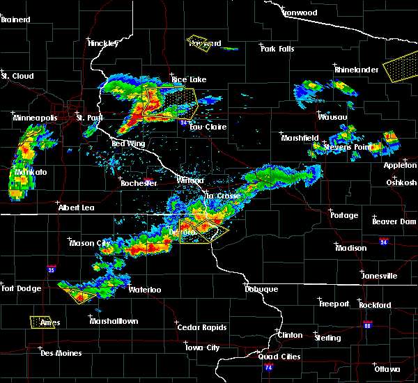 At 648 pm cdt, a severe thunderstorm was located near waukon, moving southeast at 30 mph (law enforcement). Hazards include 60 mph wind gusts and quarter size hail. Hail damage to vehicles is expected. expect wind damage to roofs, siding, and trees. This severe thunderstorm will remain over mainly rural areas of southwestern allamakee county, including the following locations: hardin, hanover, volney, county roads a 52 and w 60 and county roads x 16 and b 38. At 648 pm cdt, a severe thunderstorm was located near waukon, moving southeast at 30 mph (law enforcement). Hazards include 60 mph wind gusts and quarter size hail. Hail damage to vehicles is expected. expect wind damage to roofs, siding, and trees. This severe thunderstorm will remain over mainly rural areas of southwestern allamakee county, including the following locations: hardin, hanover, volney, county roads a 52 and w 60 and county roads x 16 and b 38.
|
| 4/13/2018 7:37 AM CDT |
 The severe thunderstorm warning for central allamakee county will expire at 745 am cdt, the storm which prompted the warning has weakened below severe limits, and no longer poses an immediate threat to life or property. therefore the warning will be allowed to expire. The severe thunderstorm warning for central allamakee county will expire at 745 am cdt, the storm which prompted the warning has weakened below severe limits, and no longer poses an immediate threat to life or property. therefore the warning will be allowed to expire.
|
| 4/13/2018 7:21 AM CDT |
 At 720 am cdt, a severe thunderstorm was located near waukon, moving east at 50 mph (law enforcement). Hazards include quarter size hail. Damage to vehicles is expected. this severe storm will be near, lansing around 735 am cdt. Other locations impacted by this severe thunderstorm include thompson corner and elon. At 720 am cdt, a severe thunderstorm was located near waukon, moving east at 50 mph (law enforcement). Hazards include quarter size hail. Damage to vehicles is expected. this severe storm will be near, lansing around 735 am cdt. Other locations impacted by this severe thunderstorm include thompson corner and elon.
|
| 4/13/2018 7:08 AM CDT |
 At 707 am cdt, a severe thunderstorm was located 7 miles northeast of ossian, or 9 miles southwest of waukon, moving northeast at 50 mph (law enforcement. quarter size hail was estimated near ossian at 705 am cdt). Hazards include quarter size hail. Damage to vehicles is expected. this severe thunderstorm will be near, waukon around 720 am cdt. lansing around 735 am cdt. Other locations impacted by this severe thunderstorm include elon and maud. At 707 am cdt, a severe thunderstorm was located 7 miles northeast of ossian, or 9 miles southwest of waukon, moving northeast at 50 mph (law enforcement. quarter size hail was estimated near ossian at 705 am cdt). Hazards include quarter size hail. Damage to vehicles is expected. this severe thunderstorm will be near, waukon around 720 am cdt. lansing around 735 am cdt. Other locations impacted by this severe thunderstorm include elon and maud.
|
| 7/19/2017 6:21 PM CDT |
 At 619 pm cdt, severe thunderstorms were located along a line extending from near new albin to 6 miles north of guttenberg to greeley, moving east at 75 mph (trained weather spotters. these storms have a history of wind damage with northern fayette county reporting widespread damage. extreme winds were reported in waukon at 620 pm). Hazards include 70 mph wind gusts. Expect considerable tree damage. damage is likely to mobile homes, roofs, and outbuildings. these severe storms will be near, guttenberg around 625 pm cdt. other locations impacted by these severe thunderstorms include hardin, luana, wadena, westgate and castalia. People attending the allamakee county fair should seek safe shelter immediately!. At 619 pm cdt, severe thunderstorms were located along a line extending from near new albin to 6 miles north of guttenberg to greeley, moving east at 75 mph (trained weather spotters. these storms have a history of wind damage with northern fayette county reporting widespread damage. extreme winds were reported in waukon at 620 pm). Hazards include 70 mph wind gusts. Expect considerable tree damage. damage is likely to mobile homes, roofs, and outbuildings. these severe storms will be near, guttenberg around 625 pm cdt. other locations impacted by these severe thunderstorms include hardin, luana, wadena, westgate and castalia. People attending the allamakee county fair should seek safe shelter immediately!.
|
| 7/19/2017 6:14 PM CDT | Corn blown down. shed damage. tree blown on hous in allamakee county IA, 3.7 miles NNW of Waukon, IA |
| 7/19/2017 6:12 PM CDT | Part of a roof removed from an outbuilding and corn pushed over. time estimated based on radar. received via social medi in allamakee county IA, 0.1 miles ESE of Waukon, IA |
| 7/19/2017 6:06 PM CDT |
 At 606 pm cdt, severe thunderstorms were located along a line extending from 7 miles southwest of new albin to near farmersburg to near strawberry point, moving east at 70 mph (trained weather spotters. wind damage and power outages continue to be reported with these storms). Hazards include 70 mph wind gusts. Expect considerable tree damage. damage is likely to mobile homes, roofs, and outbuildings. these severe storms will be near, new albin and garnavillo around 610 pm cdt. lansing, mcgregor and marquette around 615 pm cdt. guttenberg around 625 pm cdt. People attending the allamakee county fair should seek safe shelter immediately!. At 606 pm cdt, severe thunderstorms were located along a line extending from 7 miles southwest of new albin to near farmersburg to near strawberry point, moving east at 70 mph (trained weather spotters. wind damage and power outages continue to be reported with these storms). Hazards include 70 mph wind gusts. Expect considerable tree damage. damage is likely to mobile homes, roofs, and outbuildings. these severe storms will be near, new albin and garnavillo around 610 pm cdt. lansing, mcgregor and marquette around 615 pm cdt. guttenberg around 625 pm cdt. People attending the allamakee county fair should seek safe shelter immediately!.
|
| 7/19/2017 5:52 PM CDT |
 At 551 pm cdt, severe thunderstorms were located along a line extending from near mabel to clermont to oelwein, moving east at 70 mph (trained weather spotters. power lines are downed in cresco from these storms. trees were downed in waucoma about 535 pm). Hazards include 70 mph wind gusts. Expect considerable tree damage. damage is likely to mobile homes, roofs, and outbuildings. these severe storms will be near, elgin, clermont and postville around 555 pm cdt. monona and arlington around 600 pm cdt. elkader, waukon around 605 pm garnavillo, mcgregor, new albin and marquette around 610 pm cdt. lansing around 615 pm cdt. guttenberg and harpers ferry around 620 pm cdt. People attending the allamakee county fair should seek safe shelter immediately!. At 551 pm cdt, severe thunderstorms were located along a line extending from near mabel to clermont to oelwein, moving east at 70 mph (trained weather spotters. power lines are downed in cresco from these storms. trees were downed in waucoma about 535 pm). Hazards include 70 mph wind gusts. Expect considerable tree damage. damage is likely to mobile homes, roofs, and outbuildings. these severe storms will be near, elgin, clermont and postville around 555 pm cdt. monona and arlington around 600 pm cdt. elkader, waukon around 605 pm garnavillo, mcgregor, new albin and marquette around 610 pm cdt. lansing around 615 pm cdt. guttenberg and harpers ferry around 620 pm cdt. People attending the allamakee county fair should seek safe shelter immediately!.
|
| 7/19/2017 5:25 PM CDT |
 At 523 pm cdt, severe thunderstorms were located along a line extending from lime springs to jerico to near nashua, moving east at 70 mph (trained weather spotters). Hazards include 70 mph wind gusts. Expect considerable tree damage. damage is likely to mobile homes, roofs, and outbuildings. severe thunderstorms will be near, spillville and waucoma around 535 pm cdt. decorah around 545 pm cdt. west union, fayette around 555 pm cdt. waukon, monona around 600 pm cdt. volga, new albin and strawberry point around 605 pm cdt. lansing, elkader, harpers ferry and marquette around 610 pm cdt. other locations impacted by these severe thunderstorms include hardin, luana, wadena, westgate and castalia. People attending the allamakee county fair should seek safe shelter immediately!. At 523 pm cdt, severe thunderstorms were located along a line extending from lime springs to jerico to near nashua, moving east at 70 mph (trained weather spotters). Hazards include 70 mph wind gusts. Expect considerable tree damage. damage is likely to mobile homes, roofs, and outbuildings. severe thunderstorms will be near, spillville and waucoma around 535 pm cdt. decorah around 545 pm cdt. west union, fayette around 555 pm cdt. waukon, monona around 600 pm cdt. volga, new albin and strawberry point around 605 pm cdt. lansing, elkader, harpers ferry and marquette around 610 pm cdt. other locations impacted by these severe thunderstorms include hardin, luana, wadena, westgate and castalia. People attending the allamakee county fair should seek safe shelter immediately!.
|
| 5/17/2017 7:25 PM CDT |
 At 725 pm cdt, severe thunderstorms were located along a line extending from 6 miles northwest of harpers ferry to dickeyville, moving northeast at 65 mph (law enforcement. 75 mph winds were reported at patch grove in southwet wisconsin and 70 mph winds in glen haven wisconsin between 710 and 720 pm). Hazards include 70 mph wind gusts. Expect considerable tree damage. damage is likely to mobile homes, roofs, and outbuildings. these severe storms will be near, cuba city and hazel green around 730 pm cdt. platteville around 735 pm cdt. other locations impacted by these severe thunderstorms include hardin, preston, bridgeport, georgetown and seneca. A tornado watch remains in effect until 1100 pm cdt for northeastern iowa, southeastern minnesota, and southwestern wisconsin. At 725 pm cdt, severe thunderstorms were located along a line extending from 6 miles northwest of harpers ferry to dickeyville, moving northeast at 65 mph (law enforcement. 75 mph winds were reported at patch grove in southwet wisconsin and 70 mph winds in glen haven wisconsin between 710 and 720 pm). Hazards include 70 mph wind gusts. Expect considerable tree damage. damage is likely to mobile homes, roofs, and outbuildings. these severe storms will be near, cuba city and hazel green around 730 pm cdt. platteville around 735 pm cdt. other locations impacted by these severe thunderstorms include hardin, preston, bridgeport, georgetown and seneca. A tornado watch remains in effect until 1100 pm cdt for northeastern iowa, southeastern minnesota, and southwestern wisconsin.
|
| 5/17/2017 7:19 PM CDT |
 At 717 pm cdt, severe thunderstorms were located along a line extending from near waukon to durango, moving northeast at 70 mph (law enforcement. 70 mph winds were reported at garber...60- 70 mph winds in glen haven wisconsin, and guttenberg reported 50 mph all around 710 pm). Hazards include 70 mph wind gusts. Expect considerable tree damage. damage is likely to mobile homes, roofs, and outbuildings. these severe storms will be near, harpers ferry around 725 pm cdt. lansing and cuba city around 730 pm cdt. platteville, lancaster and new albin around 735 pm cdt. fennimore around 740 pm cdt. other locations impacted by these severe thunderstorms include hardin, preston, bridgeport, georgetown and seneca. A tornado watch remains in effect until 1100 pm cdt for northeastern iowa, southeastern minnesota, and southwestern wisconsin. At 717 pm cdt, severe thunderstorms were located along a line extending from near waukon to durango, moving northeast at 70 mph (law enforcement. 70 mph winds were reported at garber...60- 70 mph winds in glen haven wisconsin, and guttenberg reported 50 mph all around 710 pm). Hazards include 70 mph wind gusts. Expect considerable tree damage. damage is likely to mobile homes, roofs, and outbuildings. these severe storms will be near, harpers ferry around 725 pm cdt. lansing and cuba city around 730 pm cdt. platteville, lancaster and new albin around 735 pm cdt. fennimore around 740 pm cdt. other locations impacted by these severe thunderstorms include hardin, preston, bridgeport, georgetown and seneca. A tornado watch remains in effect until 1100 pm cdt for northeastern iowa, southeastern minnesota, and southwestern wisconsin.
|
| 5/17/2017 7:09 PM CDT |
 At 706 pm cdt, severe thunderstorms were located along a line extending from near decorah to 10 miles southwest of dubuque, moving northeast at 50 mph (law enforcement. these storms have a history of wind damage from gusts to 70 mph). Hazards include 70 mph wind gusts. Expect considerable tree damage. damage is likely to mobile homes, roofs, and outbuildings. these severe storms will be near, monona around 720 pm cdt. waukon around 730 pm cdt. dickeyville around 735 pm cdt. hazel green and harpers ferry around 740 pm cdt. lansing and cuba city around 745 pm cdt. platteville and new albin around 750 pm cdt. other locations impacted by these severe thunderstorms include hardin, preston, bridgeport, georgetown and seneca. A tornado watch remains in effect until 1100 pm cdt for northeastern iowa, southeastern minnesota, and southwestern wisconsin. At 706 pm cdt, severe thunderstorms were located along a line extending from near decorah to 10 miles southwest of dubuque, moving northeast at 50 mph (law enforcement. these storms have a history of wind damage from gusts to 70 mph). Hazards include 70 mph wind gusts. Expect considerable tree damage. damage is likely to mobile homes, roofs, and outbuildings. these severe storms will be near, monona around 720 pm cdt. waukon around 730 pm cdt. dickeyville around 735 pm cdt. hazel green and harpers ferry around 740 pm cdt. lansing and cuba city around 745 pm cdt. platteville and new albin around 750 pm cdt. other locations impacted by these severe thunderstorms include hardin, preston, bridgeport, georgetown and seneca. A tornado watch remains in effect until 1100 pm cdt for northeastern iowa, southeastern minnesota, and southwestern wisconsin.
|
| 5/17/2017 7:00 PM CDT |
 At 659 pm cdt, severe thunderstorms were located along a line extending from near clermont to near bernard, moving northeast at 50 mph (law enforcement). Hazards include 70 mph wind gusts. Expect considerable tree damage. damage is likely to mobile homes, roofs, and outbuildings. severe thunderstorms will be near, postville around 715 pm cdt. monona around 720 pm cdt. waukon around 730 pm cdt. hazel green and dickeyville around 735 pm cdt. cuba city and harpers ferry around 740 pm cdt. lansing around 745 pm cdt. platteville and new albin around 750 pm cdt. other locations impacted by these severe thunderstorms include hardin, preston, bridgeport, georgetown and seneca. A tornado watch remains in effect until 1100 pm cdt for northeastern iowa, southeastern minnesota, and southwestern wisconsin. At 659 pm cdt, severe thunderstorms were located along a line extending from near clermont to near bernard, moving northeast at 50 mph (law enforcement). Hazards include 70 mph wind gusts. Expect considerable tree damage. damage is likely to mobile homes, roofs, and outbuildings. severe thunderstorms will be near, postville around 715 pm cdt. monona around 720 pm cdt. waukon around 730 pm cdt. hazel green and dickeyville around 735 pm cdt. cuba city and harpers ferry around 740 pm cdt. lansing around 745 pm cdt. platteville and new albin around 750 pm cdt. other locations impacted by these severe thunderstorms include hardin, preston, bridgeport, georgetown and seneca. A tornado watch remains in effect until 1100 pm cdt for northeastern iowa, southeastern minnesota, and southwestern wisconsin.
|
| 5/17/2017 4:37 PM CDT |
 At 436 pm cdt, a severe thunderstorm was located 8 miles southeast of waukon, moving north at 55 mph (law enforcement). Hazards include 60 mph wind gusts and quarter size hail. Hail damage to vehicles is expected. expect wind damage to roofs, siding, and trees. this severe storm will be near, harpers ferry around 440 pm cdt. lansing around 450 pm cdt. new albin around 500 pm cdt. other locations impacted by this severe thunderstorm include hardin, de soto, ferryville, waterville and volney. A tornado watch remains in effect until 1100 pm cdt for northeastern iowa, and southwestern wisconsin. At 436 pm cdt, a severe thunderstorm was located 8 miles southeast of waukon, moving north at 55 mph (law enforcement). Hazards include 60 mph wind gusts and quarter size hail. Hail damage to vehicles is expected. expect wind damage to roofs, siding, and trees. this severe storm will be near, harpers ferry around 440 pm cdt. lansing around 450 pm cdt. new albin around 500 pm cdt. other locations impacted by this severe thunderstorm include hardin, de soto, ferryville, waterville and volney. A tornado watch remains in effect until 1100 pm cdt for northeastern iowa, and southwestern wisconsin.
|
| 5/17/2017 4:26 PM CDT | Very strong winds reported just north of town...speed estimated in allamakee county IA, 2.8 miles S of Waukon, IA |
| 5/17/2017 4:22 PM CDT |
 At 421 pm cdt, a severe thunderstorm was located near monona, or 11 miles north of elkader, moving north at 55 mph (law enforcement. large tree limbs have been downed in volga, in clayton county iowa 411 pm). Hazards include 70 mph wind gusts and quarter size hail. Hail damage to vehicles is expected. expect considerable tree damage. wind damage is also likely to mobile homes, roofs, and outbuildings. this severe thunderstorm will be near, waukon and harpers ferry around 440 pm cdt. lansing around 450 pm cdt. new albin around 500 pm cdt. other locations impacted by this severe thunderstorm include hardin, de soto, ferryville, waterville and lynxville. A tornado watch remains in effect until 1100 pm cdt for northeastern iowa, and southwestern wisconsin. At 421 pm cdt, a severe thunderstorm was located near monona, or 11 miles north of elkader, moving north at 55 mph (law enforcement. large tree limbs have been downed in volga, in clayton county iowa 411 pm). Hazards include 70 mph wind gusts and quarter size hail. Hail damage to vehicles is expected. expect considerable tree damage. wind damage is also likely to mobile homes, roofs, and outbuildings. this severe thunderstorm will be near, waukon and harpers ferry around 440 pm cdt. lansing around 450 pm cdt. new albin around 500 pm cdt. other locations impacted by this severe thunderstorm include hardin, de soto, ferryville, waterville and lynxville. A tornado watch remains in effect until 1100 pm cdt for northeastern iowa, and southwestern wisconsin.
|
| 5/15/2017 7:16 PM CDT |
 At 715 pm cdt, severe thunderstorms were located along a line extending from 6 miles west of waukon to 6 miles west of farmersburg to near arlington, moving east at 70 mph (trained weather spotters). Hazards include two inch hail and 70 mph wind gusts. People and animals outdoors will be injured. expect hail damage to roofs, siding, windows, and vehicles. expect considerable tree damage. wind damage is also likely to mobile homes, roofs, and outbuildings. these severe storms will be near, lansing around 730 pm cdt. other locations impacted by these severe thunderstorms include hardin, wadena, westgate, castalia and st. Lucas. At 715 pm cdt, severe thunderstorms were located along a line extending from 6 miles west of waukon to 6 miles west of farmersburg to near arlington, moving east at 70 mph (trained weather spotters). Hazards include two inch hail and 70 mph wind gusts. People and animals outdoors will be injured. expect hail damage to roofs, siding, windows, and vehicles. expect considerable tree damage. wind damage is also likely to mobile homes, roofs, and outbuildings. these severe storms will be near, lansing around 730 pm cdt. other locations impacted by these severe thunderstorms include hardin, wadena, westgate, castalia and st. Lucas.
|
| 5/15/2017 6:46 PM CDT |
 At 644 pm cdt, severe thunderstorms were located along a line extending from near decorah to near nashua, and are nearly stationary. two inch hail was reported 4 miles south of protivin at 640 pm cdt (trained weather spotters). Hazards include two inch hail and 70 mph wind gusts. People and animals outdoors will be injured. expect hail damage to roofs, siding, windows, and vehicles. expect considerable tree damage. wind damage is also likely to mobile homes, roofs, and outbuildings. these severe storms will be near, decorah around 650 pm cdt. waukon around 705 pm cdt. fredericksburg around 715 pm cdt. lansing around 730 pm cdt. hawkeye around 735 pm cdt. maynard around 740 pm cdt. west union, fayette and arlington around 745 pm cdt. other locations impacted by these severe thunderstorms include hardin, wadena, westgate, castalia and st. Lucas. At 644 pm cdt, severe thunderstorms were located along a line extending from near decorah to near nashua, and are nearly stationary. two inch hail was reported 4 miles south of protivin at 640 pm cdt (trained weather spotters). Hazards include two inch hail and 70 mph wind gusts. People and animals outdoors will be injured. expect hail damage to roofs, siding, windows, and vehicles. expect considerable tree damage. wind damage is also likely to mobile homes, roofs, and outbuildings. these severe storms will be near, decorah around 650 pm cdt. waukon around 705 pm cdt. fredericksburg around 715 pm cdt. lansing around 730 pm cdt. hawkeye around 735 pm cdt. maynard around 740 pm cdt. west union, fayette and arlington around 745 pm cdt. other locations impacted by these severe thunderstorms include hardin, wadena, westgate, castalia and st. Lucas.
|
| 5/15/2017 6:40 PM CDT |
 At 640 pm cdt, severe thunderstorms were located along a line extending from near decorah to near nashua, moving east at 35 mph (radar indicated). Hazards include ping pong ball size hail and 60 mph wind gusts. People and animals outdoors will be injured. expect hail damage to roofs, siding, windows, and vehicles. expect wind damage to roofs, siding, and trees. severe thunderstorms will be near, decorah around 645 pm cdt. waukon around 705 pm cdt. fredericksburg around 710 pm cdt. lansing around 725 pm cdt. hawkeye around 730 pm cdt. maynard around 740 pm cdt. west union, fayette, arlington and elgin around 745 pm cdt. other locations impacted by these severe thunderstorms include hardin, wadena, westgate, castalia and st. Lucas. At 640 pm cdt, severe thunderstorms were located along a line extending from near decorah to near nashua, moving east at 35 mph (radar indicated). Hazards include ping pong ball size hail and 60 mph wind gusts. People and animals outdoors will be injured. expect hail damage to roofs, siding, windows, and vehicles. expect wind damage to roofs, siding, and trees. severe thunderstorms will be near, decorah around 645 pm cdt. waukon around 705 pm cdt. fredericksburg around 710 pm cdt. lansing around 725 pm cdt. hawkeye around 730 pm cdt. maynard around 740 pm cdt. west union, fayette, arlington and elgin around 745 pm cdt. other locations impacted by these severe thunderstorms include hardin, wadena, westgate, castalia and st. Lucas.
|
| 9/19/2016 2:24 PM CDT |
 At 223 pm cdt, a severe thunderstorm was located near waukon, moving east at 35 mph (radar indicated). Hazards include 60 mph wind gusts and quarter size hail. Hail damage is possible. this severe thunderstorm will be near, lansing around 240 pm cdt. harpers ferry around 245 pm cdt. Hail is the main threat from this storm. At 223 pm cdt, a severe thunderstorm was located near waukon, moving east at 35 mph (radar indicated). Hazards include 60 mph wind gusts and quarter size hail. Hail damage is possible. this severe thunderstorm will be near, lansing around 240 pm cdt. harpers ferry around 245 pm cdt. Hail is the main threat from this storm.
|
| 8/4/2016 6:38 PM CDT |
 At 636 pm cdt, severe thunderstorms were located along a line extending from near new albin to near postville, moving east at 45 mph (law enforcement reported wind damage in decorah around 610pm, however no further reports of damage were received since that time). Hazards include 60 mph wind gusts. Expect damage to roofs. siding. and trees. these severe storms will be near, lansing and new albin around 640 pm cdt. harpers ferry around 650 pm cdt. Other locations impacted by these severe thunderstorms include waterville, village creek, waukon jct, county roads x 16 and w 48 and county roads a 52 and x 52. At 636 pm cdt, severe thunderstorms were located along a line extending from near new albin to near postville, moving east at 45 mph (law enforcement reported wind damage in decorah around 610pm, however no further reports of damage were received since that time). Hazards include 60 mph wind gusts. Expect damage to roofs. siding. and trees. these severe storms will be near, lansing and new albin around 640 pm cdt. harpers ferry around 650 pm cdt. Other locations impacted by these severe thunderstorms include waterville, village creek, waukon jct, county roads x 16 and w 48 and county roads a 52 and x 52.
|
| 8/4/2016 6:22 PM CDT |
 At 619 pm cdt, severe thunderstorms were located along a line extending from dorchester to ossian, moving east at 45 mph (law enforcement and the public have reported trees down in the decorah area over the past 15 minutes). Hazards include 60 mph wind gusts. Expect damage to roofs. siding. and trees. these severe storms will be near, waukon around 625 pm. new albin around 630 pm. lansing around 635 pm. harpers ferry around 650 pm. Other locations impacted by these severe thunderstorms include castalia, waterville, village creek, county roads a 26 and x 6 a and state road 9 and county x 20. At 619 pm cdt, severe thunderstorms were located along a line extending from dorchester to ossian, moving east at 45 mph (law enforcement and the public have reported trees down in the decorah area over the past 15 minutes). Hazards include 60 mph wind gusts. Expect damage to roofs. siding. and trees. these severe storms will be near, waukon around 625 pm. new albin around 630 pm. lansing around 635 pm. harpers ferry around 650 pm. Other locations impacted by these severe thunderstorms include castalia, waterville, village creek, county roads a 26 and x 6 a and state road 9 and county x 20.
|
| 8/4/2016 6:09 PM CDT |
 At 608 pm cdt, severe thunderstorms were located along a line extending from near spring grove to near ossian, moving east at 50 mph (law enforcement. trees and power lines were downed in decorah at 610 pm). Hazards include 60 mph wind gusts. Expect damage to roofs. siding. and trees. severe thunderstorms will be near, postville around 620 pm cdt. waukon around 625 pm cdt. new albin around 630 pm cdt. lansing around 635 pm cdt. harpers ferry around 645 pm cdt. Other locations impacted by these severe thunderstorms include castalia, waterville, village creek, state road 9 and 245th street and county roads a 26 and x 6 a. At 608 pm cdt, severe thunderstorms were located along a line extending from near spring grove to near ossian, moving east at 50 mph (law enforcement. trees and power lines were downed in decorah at 610 pm). Hazards include 60 mph wind gusts. Expect damage to roofs. siding. and trees. severe thunderstorms will be near, postville around 620 pm cdt. waukon around 625 pm cdt. new albin around 630 pm cdt. lansing around 635 pm cdt. harpers ferry around 645 pm cdt. Other locations impacted by these severe thunderstorms include castalia, waterville, village creek, state road 9 and 245th street and county roads a 26 and x 6 a.
|
| 8/4/2016 4:30 PM CDT |
 At 430 pm cdt, a severe thunderstorm was located near lansing, moving east at 35 mph (radar indicated). Hazards include 60 mph wind gusts and quarter size hail. Hail damage to vehicles is expected. expect wind damage to roofs, siding, and trees. this severe storm will be near, lansing around 435 pm cdt. Other locations impacted by this severe thunderstorm include village creek, county roads a 52 and x 52, county roads a 26 and x 6 a, elon and red barn campground. At 430 pm cdt, a severe thunderstorm was located near lansing, moving east at 35 mph (radar indicated). Hazards include 60 mph wind gusts and quarter size hail. Hail damage to vehicles is expected. expect wind damage to roofs, siding, and trees. this severe storm will be near, lansing around 435 pm cdt. Other locations impacted by this severe thunderstorm include village creek, county roads a 52 and x 52, county roads a 26 and x 6 a, elon and red barn campground.
|
| 8/4/2016 4:18 PM CDT |
 At 418 pm cdt, a severe thunderstorm was located 7 miles north of waukon, moving east at 35 mph (radar indicated). Hazards include 60 mph wind gusts and half dollar size hail. Hail damage to vehicles is expected. expect wind damage to roofs, siding, and trees. this severe thunderstorm will be near, new albin around 425 pm cdt. lansing around 435 pm cdt. Other locations impacted by this severe thunderstorm include village creek, county roads a 52 and x 52, county roads a 26 and x 6 a, elon and red barn campground. At 418 pm cdt, a severe thunderstorm was located 7 miles north of waukon, moving east at 35 mph (radar indicated). Hazards include 60 mph wind gusts and half dollar size hail. Hail damage to vehicles is expected. expect wind damage to roofs, siding, and trees. this severe thunderstorm will be near, new albin around 425 pm cdt. lansing around 435 pm cdt. Other locations impacted by this severe thunderstorm include village creek, county roads a 52 and x 52, county roads a 26 and x 6 a, elon and red barn campground.
|
| 7/7/2016 4:51 AM CDT |
 At 451 am cdt, severe thunderstorms were located along a line extending from near trempealeau to near brownsville to near lansing, moving east at 35 mph (radar indicated). Hazards include 60 mph wind gusts and penny size hail. Expect damage to roofs. siding. and trees. these severe storms will be near, brownsville around 455 am cdt. lansing, la crescent and dakota around 500 am cdt. la crosse around 510 am cdt. Other locations impacted by these severe thunderstorms include new hartford, mound prairie, dresbach, reno and eitzen. At 451 am cdt, severe thunderstorms were located along a line extending from near trempealeau to near brownsville to near lansing, moving east at 35 mph (radar indicated). Hazards include 60 mph wind gusts and penny size hail. Expect damage to roofs. siding. and trees. these severe storms will be near, brownsville around 455 am cdt. lansing, la crescent and dakota around 500 am cdt. la crosse around 510 am cdt. Other locations impacted by these severe thunderstorms include new hartford, mound prairie, dresbach, reno and eitzen.
|
| 7/7/2016 4:34 AM CDT |
 At 434 am cdt, severe thunderstorms were located along a line extending from 7 miles northeast of rushford to caledonia to 6 miles north of waukon, moving east at 55 mph (radar indicated). Hazards include 60 mph wind gusts and penny size hail. Expect damage to roofs. siding. and trees. these severe storms will be near, brownsville and hokah around 445 am cdt. lansing, dakota and new albin around 450 am cdt. la crosse and la crescent around 455 am cdt. Other locations impacted by these severe thunderstorms include new hartford, rushford village, mound prairie, money creek and dresbach. At 434 am cdt, severe thunderstorms were located along a line extending from 7 miles northeast of rushford to caledonia to 6 miles north of waukon, moving east at 55 mph (radar indicated). Hazards include 60 mph wind gusts and penny size hail. Expect damage to roofs. siding. and trees. these severe storms will be near, brownsville and hokah around 445 am cdt. lansing, dakota and new albin around 450 am cdt. la crosse and la crescent around 455 am cdt. Other locations impacted by these severe thunderstorms include new hartford, rushford village, mound prairie, money creek and dresbach.
|
| 7/7/2016 4:11 AM CDT |
 At 409 am cdt, severe thunderstorms were located along a line extending from 9 miles north of lanesboro to near decorah, moving east at 35 mph (trained weather spotters). Hazards include 60 mph wind gusts and penny size hail. Expect damage to roofs. siding. and trees. severe thunderstorms will be near, rushford around 425 am cdt. waukon around 435 am cdt. houston around 440 am cdt. new albin around 455 am cdt. lansing, la crescent and dakota around 500 am cdt. la crosse around 505 am cdt. other locations impacted by these severe thunderstorms include new hartford, rushford village, mound prairie, money creek and highland. Wind gusts near 60 mph have been reported along this line, including a wind gust of 62 mph at preston minnesota. At 409 am cdt, severe thunderstorms were located along a line extending from 9 miles north of lanesboro to near decorah, moving east at 35 mph (trained weather spotters). Hazards include 60 mph wind gusts and penny size hail. Expect damage to roofs. siding. and trees. severe thunderstorms will be near, rushford around 425 am cdt. waukon around 435 am cdt. houston around 440 am cdt. new albin around 455 am cdt. lansing, la crescent and dakota around 500 am cdt. la crosse around 505 am cdt. other locations impacted by these severe thunderstorms include new hartford, rushford village, mound prairie, money creek and highland. Wind gusts near 60 mph have been reported along this line, including a wind gust of 62 mph at preston minnesota.
|
| 5/26/2016 5:51 AM CDT |
 At 549 am cdt, severe thunderstorms were located along a line extending from 8 miles east of new albin to 10 miles west of clayton, moving northeast at 55 mph. around 5 am, power lines were downed in monona in northern clayton county. since that time, .no additional reports have been received (law enforcement). Hazards include 60 mph wind gusts. Expect damage to roofs. siding. and trees. these severe storms will be near, clayton around 600 am cdt. Other locations impacted by these severe thunderstorms include hardin, seneca, viola, soldiers grove and gays mills. At 549 am cdt, severe thunderstorms were located along a line extending from 8 miles east of new albin to 10 miles west of clayton, moving northeast at 55 mph. around 5 am, power lines were downed in monona in northern clayton county. since that time, .no additional reports have been received (law enforcement). Hazards include 60 mph wind gusts. Expect damage to roofs. siding. and trees. these severe storms will be near, clayton around 600 am cdt. Other locations impacted by these severe thunderstorms include hardin, seneca, viola, soldiers grove and gays mills.
|
| 5/26/2016 5:28 AM CDT |
 At 528 am cdt, severe thunderstorms were located along a line extending from near waukon to near prairie du chien, moving northeast at 70 mph (radar indicated). Hazards include 60 mph wind gusts. Expect damage to roofs. siding. and trees. severe thunderstorms will be near, lansing around 545 am cdt. clayton around 550 am cdt. Other locations impacted by these severe thunderstorms include hardin, seneca, viola, soldiers grove and gays mills. At 528 am cdt, severe thunderstorms were located along a line extending from near waukon to near prairie du chien, moving northeast at 70 mph (radar indicated). Hazards include 60 mph wind gusts. Expect damage to roofs. siding. and trees. severe thunderstorms will be near, lansing around 545 am cdt. clayton around 550 am cdt. Other locations impacted by these severe thunderstorms include hardin, seneca, viola, soldiers grove and gays mills.
|
| 6/22/2015 8:23 AM CDT | Trees down in the waukon area. location in the waukon area based on rada in allamakee county IA, 3.5 miles N of Waukon, IA |
| 6/22/2015 8:14 AM CDT | Trees down in the waukon area. location in the waukon area based on rada in allamakee county IA, 3.5 miles N of Waukon, IA |
| 6/29/2014 9:13 PM CDT | Three large trees down on highway 9. trees were 2 foot in diamete in allamakee county IA, 3.8 miles SSW of Waukon, IA |
| 4/12/2014 4:15 PM CDT | Quarter sized hail reported 0.1 miles ESE of Waukon, IA |
| 5/19/2013 10:10 PM CDT | Trees down in waukon in allamakee county IA, 0.1 miles ESE of Waukon, IA |
| 5/19/2013 10:09 PM CDT | One tree down...ten inch trunk snapped off in allamakee county IA, 5 miles W of Waukon, IA |
| 9/4/2012 7:11 PM CDT | Debris on the highway on the east side of town in allamakee county IA, 0.1 miles ESE of Waukon, IA |
| 6/11/2012 1:47 AM CDT | Tree down on dug road. time estimate in allamakee county IA, 4.1 miles SW of Waukon, IA |
| 6/11/2012 1:40 AM CDT | Tree down on old stage road. time estimate in allamakee county IA, 3.9 miles ESE of Waukon, IA |
| 3/19/2012 8:50 PM CDT | Law enforcement reported a power pole down in the city of waukon in allamakee county IA, 0.1 miles ESE of Waukon, IA |
Hail Maps for Waukon, IA


Connect with Interactive Hail Maps